REMOTE SENSING BASED POST-DISASTER DAMAGE MAPPING WITH COLLABORATIVE METHODS & THE ROLE OF COGNITIVE SYSTEMS ENGINEERING Norman Kerle 1 & Robert R. Hoffman 2 1 Faculty of Geoinformation Science and Earth Observation, University of Twente, The Netherlands 2 Institute for Human and Machine Cognition, Pensacola, Fl, USA

Welcome message from author
This document is posted to help you gain knowledge. Please leave a comment to let me know what you think about it! Share it to your friends and learn new things together.
Transcript

REMOTE SENSING BASED POST-DISASTERDAMAGE MAPPING WITH COLLABORATIVE
METHODS & THE ROLE OF COGNITIVE SYSTEMS ENGINEERING
Norman Kerle1 & Robert R. Hoffman2
1 Faculty of Geoinformation Science and Earth Observation, University of Twente, The Netherlands
2 Institute for Human and Machine Cognition, Pensacola, Fl, USA

POINTS OF DEPARTURE
Growing importance of image data in disaster response –diverse data sources and growth in number and diversity of information users
Increasing mashing of satellite, airborne, and ground data
The Disaster Charter “Space and Major Disasters” has matured (reached limit of capacity?)
Operational disaster mapping is still mostly done manually
8thGi4DM - 14 Dec 2012 2

COLLABORATIVE MAPPING TRENDS
© Ushahidi.com
Collaborative mapping is most significant recent development (Web 2.0 philosophy and tools) Begin in 2008 (Nargis and Wenchuan) 2 main approaches: Mapping in traditional sense
Visualizing of provided information(e.g., Ushahidi)
2 main mapping types Open mapping by lay persons
Mapping by experts
3

GOOGLE MAP MAKER VS GEO-CAN*
Largely base mapping with GMM/OSM
Detailed and accurate
‘Closed’ community of ca. 600 experts in GEO-CAN
Building damage mapping in different phases
* Global Earth Observation-Catastrophe Assessment Network48thGi4DM - 14 Dec 2012

SUCCESS OF GEO-CAN
GEO-CAN work is widely seen as a success
600+ volunteers
Rapid mapping
See Barrington et al. (2011)*
Validation with JRC and UNOSAT
Internal screening and error checking, integration and validation (see Ghosh et al., 2011)#
* Barrington, L., Ghosh, S., Greene, M., Har-Noy, S., Berger, J., Gill, S., Lin, A.Y.M., Huyck, C., 2011. Crowdsourcing earthquake damage assessment using remote sensing imagery. Annals of Geophysics 54, 680-687.
# Ghosh, S., Huyck, C.K., Greene, M., Gill, S.P., Bevington, J., Svekla, W., DesRoches, R., Eguchi, R.T., 2011. Crowdsourcing for rapid damage assessment: the Global Earth Observation Catastrophe Assessment Network (GEO-CAN). Earthquake Spectra 27, S179-S198.
8thGi4DM - 14 Dec 2012 5

OPEN ISSUES
2 types of main problem
Image-based damage mapping per se
The collaborative approach of GEO-CAN
8thGi4DM - 14 Dec 2012 6

OPEN ISSUES
Problems with image-based damage mapping
Lack of universal map standard
Growing number of map makers (duplication, confusion)
Static Charter maps (pdf format)
Manual mapping
Typically limited or no validation
Limits as to what can be mapped (in any image type)
Lack of understanding of map users and their needs
8thGi4DM - 14 Dec 2012 7

OPEN ISSUES
Examples of damage maps
for Port-au-Prince
8thGi4DM - 14 Dec 2012 8

OPEN ISSUES
Problems with collaborative mapping
How do we best instruct volunteers?
How can organizers know that mappers understand the instructions and implement them optimally?
How best to merge and validate results?
There are 3 factions involved: mapping organizers, volunteer, and map user. Neither understands much about the other 2
8thGi4DM - 14 Dec 2012 9

INSTRUCTING A VOLUNTEER
Image-based mapping is challenging, even for simpler features
Albrecht, F., Lang, S., Hölbling, D., 2009. Spatial accuracy assessment of object boundaries for object-based image analysis, VALgEO, JRC, Ispra, Italy.
Here 22 students mapped basic
landcover features at a fixed scale
8thGi4DM - 14 Dec 2012 10

INSTRUCTING A VOLUNTEER
Tomnod (tomnod.com) gets some of these issues right
Focus on refugee shelter mapping
11

INSTRUCTING A VOLUNTEER
CrowdRank tests reliability of mapper
Live instruction/discussion/feedback document
© Tomnod
8thGi4DM - 14 Dec 2012 12

CHALLENGES IN DAMAGE MAPPING
Structural damage mapping is substantially more difficult “Damage” is a concept
Heavy use of proxies (e.g. changes in shadow)
Reliance on both saliency and semantics
Characteristic rubble (left) vs.
misleading texture/pattern
(right)
8thGi4DM - 14 Dec 2012 13

CHALLENGES IN DAMAGE MAPPING
3D phenomenon largely reduced to 2D
Use of a scale (EMS98*) designed for ground-based assessment
Instructing for such mapping is a challenge
* European Macroseismic Scale of 19988thGi4DM - 14 Dec 2012 14

THE ROLE OF COGNITIVE TASK ANALYSIS (CTA)
All 3 factions engaged in complex cognitive work Map users have specific views, experiences, preferences –
may or may not understand the map content, legends, etc.
The volunteer has variable experience; may or may not understand instructions
Organizers have assumptions about what damage information the user needs and understands, and about the volunteers and his/her abilities to map
Study and design of complex cognitive systems in Cognitive Systems Engineering
8thGi4DM - 14 Dec 2012 15
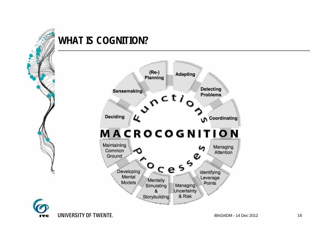
WHAT IS COGNITION?
8thGi4DM - 14 Dec 2012 16

SPECIFIC CTA METHODS
Knowledge AuditCritical Decision MethodCognitive Modeling Concept-MappingThink-aloud Problem SolvingSituation Awareness TestRecent Case WalkthroughWorkspace AnalysisWork Patterns Analysis
8thGi4DM - 14 Dec 2012 17

“Design-centereddesign”
188thGi4DM - 14 Dec 2012

DESIGN-CENTERED DESIGN
Force the human user [mapping volunteer] to execute the designer’s plan
Computers limit users’ ability to explore and integrate information
VirtualDisasterViewer/GEO-CAN provides no corrective feedback
We need a work-centered design instead
8thGi4DM - 14 Dec 2012 19

WORK-CENTERED DESIGN
CTA methods can be used to understand How the volunteers interpret instructions How they allow the job to be performed (or hinder it) How communication and corrective feedback can be integrated Whether working in virtual teams (possible with a coach for
several mappers) is useful How to capture knowledge of the volunteer
understand better the map user and the organizer
8thGi4DM - 14 Dec 2012 20

NEXT STEPS
Design a set of experiments involving former GEO-CAN volunteers
Focus on understanding of instructions and provision of feedback
For details see:Kerle, N. and Hoffman, R.R., Collaborative damage mapping for emergency response: The role of Cognitive Systems Engineering, in press for Natural Hazards and Earth System Sciences (NHESS)
8thGi4DM - 14 Dec 2012 21

AUTUMN OF CROWDSOURCING
New COST Action started last week: Mapping and the Citizen Sensor(organized by Giles Foody at UniNottingham) – additional partners can still join
8thGi4DM - 14 Dec 2012 22
UNSPIDER - United Nations International Expert Meeting on Crowdsource Mapping for Disaster Risk Management and Emergency Responsefor presentations see http://www.un-spider.org/crowdsource-mapping

THANK YOU
8thGi4DM - 14 Dec 2012 23
Related Documents


