Rayonier Advanced Materials Confidential and Proprietary Information Remote Sensing Applications for Strategic and Operational Forestry Grant McCartney, MSA Forest Information Systems Coordinator Chief Forester's Group - Ontario

Welcome message from author
This document is posted to help you gain knowledge. Please leave a comment to let me know what you think about it! Share it to your friends and learn new things together.
Transcript
Rayonier Advanced Materials Confidential and Proprietary Information
Remote Sensing Applications for Strategic and Operational Forestry
Grant McCartney, MSA
Forest Information Systems Coordinator
Chief Forester's Group - Ontario

Rayonier Advanced Materials Confidential and Proprietary Information
OUTLINE
▪ Rayonier Advanced Materials
▪ Tembec LiDAR Legacy
▪ Optical Remote Sensing
▪ LiDAR Remote Sensing
▪ Operational Tools
▪ Research & Development
2
RAYONIER ADVANCED MATERIALS

Rayonier Advanced Materials Confidential and Proprietary Information
RAYONIER ADVANCED MATERIALS
▪ Purchased Tembec in 2017
▪ Headquarters in Jacksonville, Florida
▪ Manufacturing operations in the United Sates of America, Canada and France
▪ Forestry Operations in Ontario & Quebec, Canada.
▪ Leading global supplier of high-purity, cellulose specialties, lumber, paper pulp, paper and paperboard products.
4

Rayonier Advanced Materials Confidential and Proprietary Information
Cellulose Specialties
▪ High purity cellulose specialties is a broad product spectrum that includes:
– Acetates used in plastics, films, textiles and filter products;
– Ethers used in paint, industrial coatings, food and pharmaceutical products;
– Specialty products used in tires, food products and automotive filters;
– Fluff pulp used in baby diapers and other personal hygiene products and food grade absorbent pads
5

Rayonier Advanced Materials Confidential and Proprietary Information6

Optical Remote Sensing

Rayonier Advanced Materials Confidential and Proprietary Information
Ontario’s enhanced Forest Inventory (eFRI)
8

Rayonier Advanced Materials Confidential and Proprietary Information
Soft Copy Stereo Viewing
9

Rayonier Advanced Materials Confidential and Proprietary Information
Digital Aerial PhotogrammetryRegeneration Trials
10

Rayonier Advanced Materials Confidential and Proprietary Information
UAV LiDAR
11

Tembec LiDAR Legacy

Rayonier Advanced Materials Confidential and Proprietary Information
Tembec LiDAR Legacy
▪ ‘Wall to Wall’ LiDAR Acquisitions:
– Romeo Malette 2004
– Hearst Forest 2007
▪ Operational LiDAR Acquisitions:
– Gordon Cosens Forest
– Martel Forest
▪ Used for the production of enhanced Forest Inventory (EFI)
13
Rayonier Advanced Materials Confidential and Proprietary Information
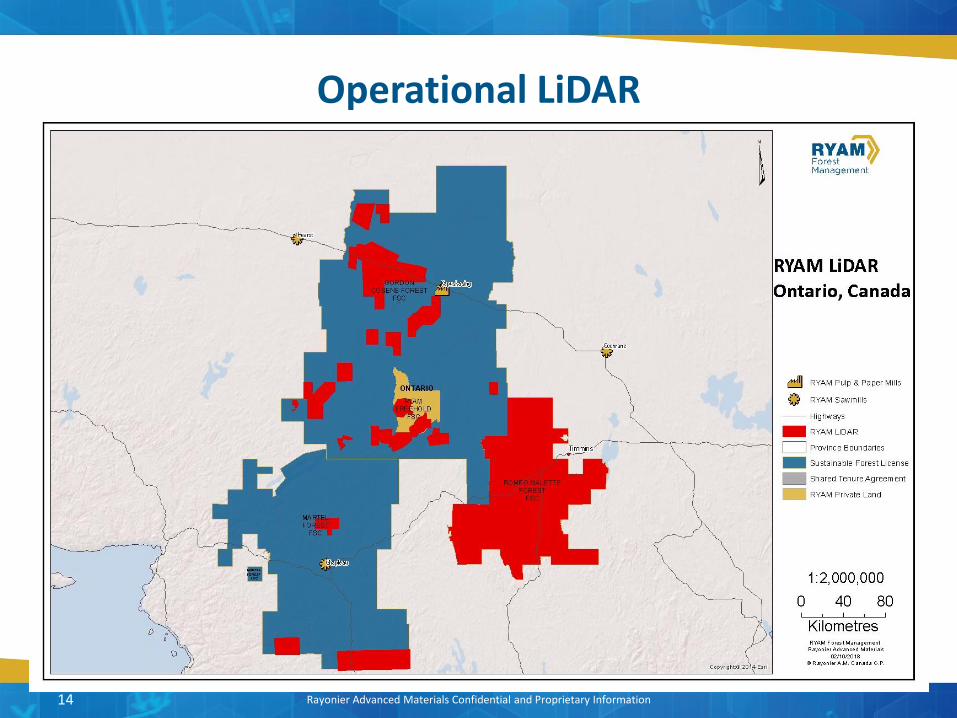
Operational LiDAR
14

Rayonier Advanced Materials Confidential and Proprietary Information
Operational Implementation of a LiDAR Inventory in Boreal Ontario
15
Forestry Chronicle 87: 512-528

Rayonier Advanced Materials Confidential and Proprietary Information
Romeo Malette Forest Metric Predictions
16
Source: Woods et al. (2011)

Rayonier Advanced Materials Confidential and Proprietary Information
LiDAR Benefits
FPInnovations Advantage 14(1)
17

Rayonier Advanced Materials Confidential and Proprietary Information
Improved Planning with EFI
Cost Centres
Inventory Acquisition and Processing -$0.10/m3
Forest Operations $1.38/m3
Mill Operations $0.30/m3
Total Savings: $1.58/m3
x 500,000 m3/year: $800,000/year
Payback : 1.3 years
18

LiDAR – Topography, Hydrology, Height

Rayonier Advanced Materials Confidential and Proprietary Information
LiDAR Topography
20

Rayonier Advanced Materials Confidential and Proprietary Information
LiDAR Hydrology
21
Provincial Hydrology LiDAR Hydrology
Rayonier Advanced Materials Confidential and Proprietary Information
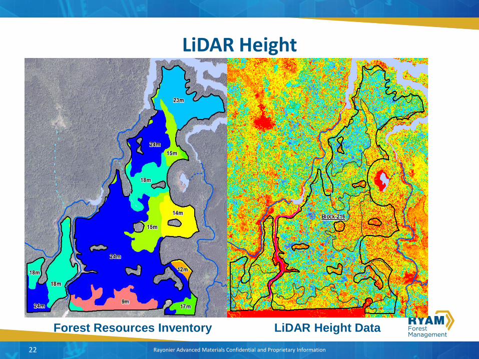
LiDAR Height
22
Forest Resources Inventory LiDAR Height Data

Rayonier Advanced Materials Confidential and Proprietary Information
Roads Planning – Sweet Lake
▪ Roads planning using eFRI imagery
– 45 km of operational roads
▪ Roads planning using LiDAR
– 27 km of operational road
23
LiDAR Forest Metrics

Rayonier Advanced Materials Confidential and Proprietary Information
LiDAR Volume – Clear Cut
25
• Harvested Area –
187 hectares
• Planned Forest
Inventory Volume –
32,000m³
• LiDAR derived
Volume – 43,000m³
• Actual Scaled
Volume – 45,000m³
• LiDAR derived
volume is within 4%
of actual delivered
volume
20m x 20m Cells for GMV
Rayonier Advanced Materials Confidential and Proprietary Information
LiDAR Volume - Careful Logging
26
• Harvested Area –
342 hectares
• Planned Forest
Inventory Volume –
37,000m³
• LiDAR derived
Volume – 59,000m³
• Actual Scaled
Volume – 52,000m³
• LiDAR derived
volume was about
12% over actual
delivered volume
20m x 20m Cells for GMV
Small Birch
White Pine

Rayonier Advanced Materials Confidential and Proprietary Information
LiDAR Quadratic Mean DBH
27
20m x 20m Cells for Diameter
• Very easy to
identify small
wood (bypass)
• Classify Sawlog,
Pulpwood &
Oversize within
harvest block
• OSB / Veneer sort
for HWD species
• Minimize roads
built to lower
productive sites
(big cost savings)
• Design blocks to
be mill specific
Rayonier Advanced Materials Confidential and Proprietary Information
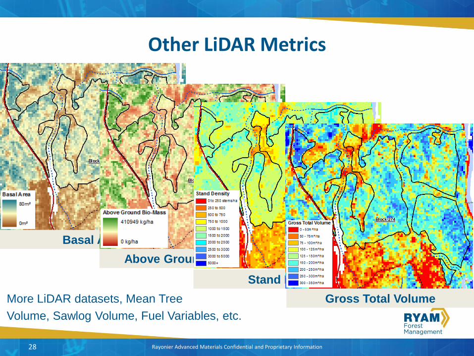
Other LiDAR Metrics
28
Basal Area
Above Ground Bio-Mass
Stand Density
Gross Total VolumeMore LiDAR datasets, Mean Tree
Volume, Sawlog Volume, Fuel Variables, etc.

Operational Tools

Rayonier Advanced Materials Confidential and Proprietary Information
LIM Geomatics
▪ Advanced Forest Resource Inventory Decision Support – AFRIDS
▪ Op Tracker
▪ Water crossing tool
30
Rayonier Advanced Materials Confidential and Proprietary Information
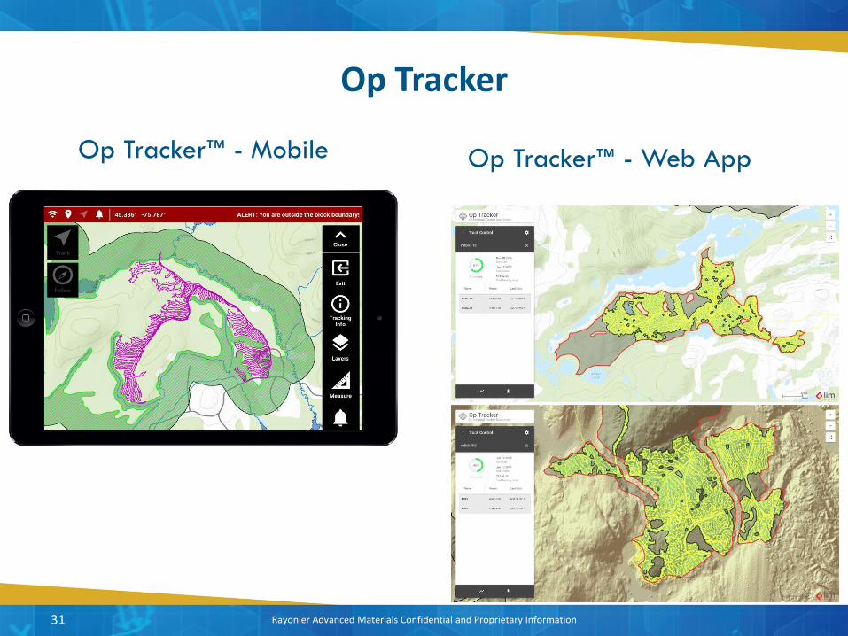
Op Tracker
31
Op Tracker™ - Mobile Op Tracker™ - Web App

Rayonier Advanced Materials Confidential and Proprietary Information
Business Benefits
▪ Operators utilize liDAR predicted forest inventory metrics and elevation models to better plan their harvest activities.
▪ Improved operator experience and productivity that leverage lidar information products.
▪ Simplified data management as instead chasing operators to download GPX files from various recreational GPS units, Op Tracker™ track data are synced.
▪ Tracking information is now used to provide a first cut of depletion mapping prior to flying photography with focus shifted on QC instead of digitization.
▪ Web app provides staff with up-to-date cut progress to inform planning and silviculture activities and analytics for insight in to business operations.
32

Research & Development

Rayonier Advanced Materials Confidential and Proprietary Information
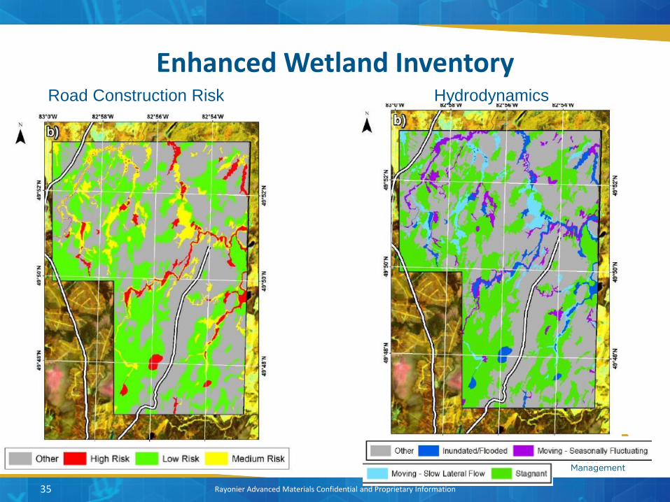
Enhanced Wetland Inventory
34
Rayonier Advanced Materials Confidential and Proprietary Information
Enhanced Wetland Inventory
35
Road Construction Risk Hydrodynamics

Rayonier Advanced Materials Confidential and Proprietary Information
Assessment of Wood Attributes for REmotesensing (AWARE)
▪ Model Transferability
▪ Forest Health
▪ Growth & Yield
▪ Hydrology & Surficial geology
▪ Individual Tree Inventory
▪ Species Identification
▪ Ecosystem Services
36
Rayonier Advanced Materials Confidential and Proprietary Information
Development Of A Forest Inventory Using Single Photon LiDAR & Assessing Decadal Forest Change
Grant McCartney – RYAM Forest ManagementDr. Nicholas Coops – UBC Forestry IRSSMartin Queinnec – UBC Forestry IRSS

Rayonier Advanced Materials Confidential and Proprietary Information
Project Objectives
▪ This project has four main objectives: – (i) propose a structurally guided sampling design for locating and
collecting FRI calibration plots for model development for the 2018 SPL. [COMPLETE]
– (ii) Coordinate procurement and delivery of field data collection services using the draft Integrated Monitoring Framework (IMF) design specifications,
– (iii) develop an EFI and examine the utility of both Area Based Approach (ABA) and Individual Tree Detection (ITD) approaches using SPL data and
– (iv) assess growth and change using previous acquired 2005 LIDAR data.
38

Rayonier Advanced Materials Confidential and Proprietary Information
Structurally Guided Sampling for Locating Plots
▪ SPL metrics have been calculated over the entire RMF on a 20m x 20m grid (400 m2, corresponding to plot area with r=11.28 m)
▪ Height percentile metrics: p05, p10, p20, …, p90, p95, p99
▪ Average height of first returns / Average square height
▪ Cover: % first returns above 1.3 m, 5 m, 10 m and 15 m
▪ Structural Variability: standard deviation
39

Rayonier Advanced Materials Confidential and Proprietary Information
Principle Components Analysis
40
▪ PCA was performed on 20 SPL metrics:
▪ FORESTED polygons only
– PCA1 -> 76% of variance
– PCA2 -> 11% of variance
– PCA3 -> 7% of variance
▪ 182 existing plots, incl. 20 IMF plots
94
%
88
%

Rayonier Advanced Materials Confidential and Proprietary Information
Determine Candidate Cells For Sampling
▪ Between 30m and 200 m of roads (90% of existing plots are within 200 m of roads)
▪ Within 200 m of any existing plot accessible via 2x4 truck or 4x4 truck but > 200 m from roads
▪ Remove 100 m wide band around power lines
▪ Keep only cells located within FOR polygon (productive forest stands)
▪ 3,383,903 candidate cells for sampling
41
Example where the road to access the IMF plot (square shaped) is
not in the database.

Rayonier Advanced Materials Confidential and Proprietary Information
Methods to select new plots
42
Minimum distance between samples having the same strata of
500 m
1) Select as much as possible samples located within 3x3
clusters (45/160 new plots)
2) If not enough clusters are available, consider neighbouring
strata in the 3x3 clusters (93/160 new plots)
3) Finally, isolated cells are considered for sampling only if
additional samples are required after steps 1 and 2 (22/160
new plots)
After random selection, inspection of orthoimages and point
cloud:
• Flag plots having similar PC1/PC2 values and located
too close to each other
• Flag plots located too close to a stand border, wetland,
river …
• Flag plots having very isolated trees
1
2 3
4
2
3
2 4
21
36
4
3
2

Rayonier Advanced Materials Confidential and Proprietary Information
Comparison of wall-to-wall and candidate cells
43
Rayonier Advanced Materials Confidential and Proprietary Information
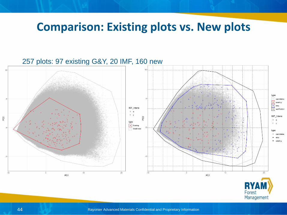
Comparison: Existing plots vs. New plots
44
257 plots: 97 existing G&Y, 20 IMF, 160 new

Rayonier Advanced Materials Confidential and Proprietary Information
Plot by Species Group
45
Working Group (WG)
# plots
% plots % RMF area
PO (Poplar) 110 42.5 15.2
Sb (Black spruce) 62 15.2 49.9
Pj (Jack pine) 41 11.9 11.2
BW (White birch) 36 11.8 14
SW (White spruce) 4 1.5 2.2
CE (Cedar) 2 0.8 3.7
LA (Eastern Larch) 2 0.8 1.9
BF (Balsam Fir) 1 0.4 1
Sx (Spruce mix) 1 0.4 0.5

Rayonier Advanced Materials Confidential and Proprietary Information
Romeo Malette Forest – Plot Locations
46
▪ ~630,000 ha
▪ Boreal Ecoregion 3E
Timmins

Rayonier Advanced Materials Confidential and Proprietary Information
Final Product ▪ A shapefile /geodatabase with the 258 plots and their associated point clouds (side and top view)
attached
47
Attribute Type Description
PlotID Integer Unique ID
PlotKey Integer ID corresponding to existing plots
X / Y Float XY coordinates of plots
IMF_Intens Text Is it an IMF plot ? ‘y’ / ‘n’
STEMMAP Text Stem mapping? ‘y’/’n’
PC1/PC2 Float PC1 and PC2 values
strata Integer Corresponding strata in the 10x5 matrix
p95 / cov / std
Float 95th elevation percentile, cover above 1.3 m, std of returns
Comments Text Additional comments concerning the plot location

Rayonier Advanced Materials Confidential and Proprietary Information48
Strata 45
Strata 52
Strata 44Strata 54
Strata 85
Strata 63
Rayonier Advanced Materials Confidential and Proprietary Information49
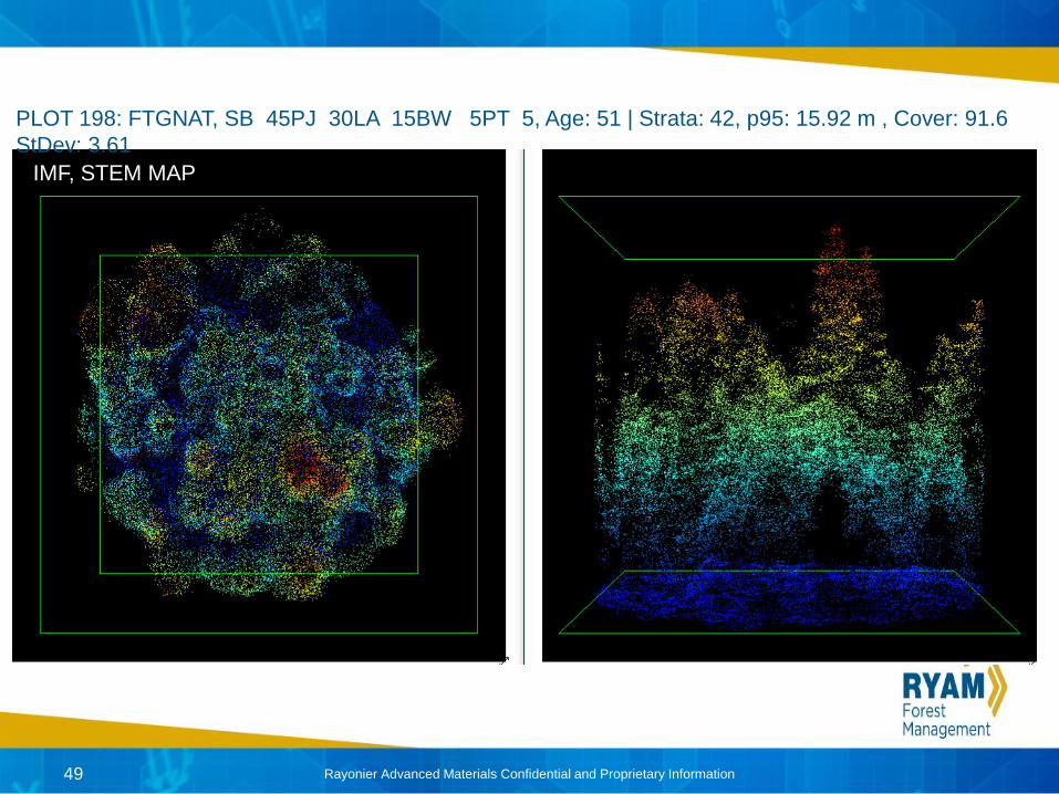
PLOT 198: FTGNAT, SB 45PJ 30LA 15BW 5PT 5, Age: 51 | Strata: 42, p95: 15.92 m , Cover: 91.6
StDev: 3.61
IMF, STEM MAP

Rayonier Advanced Materials Confidential and Proprietary Information50
Plot 44: FTGNAT, PJ 80SB15 BF 5, AGE 104 | Strata: 54, p95: 21.69 m , Cover:
81.4 StDev: 7.32

Rayonier Advanced Materials Confidential and Proprietary Information51
Plot 166: FTGNAT, PO 80PJ 10SB 10, AGE 94 | Strata: 102, p95: 29.26 m , Cover:
97.1 StDev: 5.71

Thank You
Related Documents