- Remaining faithful in the outhouse: an introduction to the utopian archaeology of the Amana Colonies. Haunton, Christian Jeffrey https://iro.uiowa.edu/discovery/delivery/01IOWA_INST:ResearchRepository/12730681180002771?l#13730804310002771 Haunton, C. J. (2017). Remaining faithful in the outhouse: an introduction to the utopian archaeology of the Amana Colonies (University of Iowa). https://doi.org/10.17077/etd.nfbotn0u Downloaded on 2022/08/08 00:33:34 -0500 Copyright © 2017 Christian Jeffrey Haunton Free to read and download https://iro.uiowa.edu -

Welcome message from author
This document is posted to help you gain knowledge. Please leave a comment to let me know what you think about it! Share it to your friends and learn new things together.
Transcript

-
Remaining faithful in the outhouse: anintroduction to the utopian archaeology of theAmana Colonies.Haunton, Christian Jeffreyhttps://iro.uiowa.edu/discovery/delivery/01IOWA_INST:ResearchRepository/12730681180002771?l#13730804310002771
Haunton, C. J. (2017). Remaining faithful in the outhouse: an introduction to the utopian archaeology ofthe Amana Colonies (University of Iowa). https://doi.org/10.17077/etd.nfbotn0u
Downloaded on 2022/08/08 00:33:34 -0500Copyright © 2017 Christian Jeffrey HauntonFree to read and downloadhttps://iro.uiowa.edu
-

REMAINING FAITHFUL IN THE OUTHOUSE An Introduction to the Utopian Archaeology of the Amana Colonies
by
Christian Jeffrey Haunton
A thesis submitted in partial fulfillment of the requirements for the Doctor of Philosophy
degree in Anthropology in the Graduate College of
The University of Iowa
August 2017
Thesis Supervisor: Associate Professor Glenn Storey

Copyright by
CHRISTIAN JEFFREY HAUNTON
2017
All Rights Reserved

Graduate College The University of Iowa
Iowa City, Iowa
CERTIFICATE OF APPROVAL
____________________________
PH.D. THESIS
_________________
This is to certify that the Ph.D. thesis of
Christian Jeffrey Haunton
has been approved by the Examining Committee for the thesis requirement for the Doctor of Philosophy degree in Anthropology at the August 2017 graduation. Thesis Committee: ____________________________________________ Glenn Storey, Thesis Supervisor ____________________________________________ Katina Lillios ____________________________________________ Margaret Beck ____________________________________________ Scott Schnell ____________________________________________ J. Kenneth Kuntz

ii
To my parents, from whom all my best qualities originate, to Sara by whom all my worst
qualities are endured, and to George, Ira, Dave, and Teddy—just for being good cats.

iii
“Behold, thou art fair, my love; behold, thou art fair; thou hast doves' eyes within thy locks:
thy hair is as a flock of goats, that appear from mount Gilead. Thy teeth are like a flock of
sheep that are even shorn, which came up from the washing; whereof every one bear twins,
and none is barren among them. Thy lips are like a thread of scarlet, and thy speech is
comely: thy temples are like a piece of a pomegranate within thy locks. Thy neck is like
the tower of David built for an armory, whereon there hang a thousand bucklers, all shields
of mighty men. Thy two breasts are like two young roes that are twins, which feed among
the lilies. Until the day break, and the shadows flee away, I will get me to the mountain of
myrrh, and to the hill of frankincense. Thou art all fair, my love; there is no spot in thee.
Come with me from Lebanon, my spouse, with me from Lebanon: look from the top of
Amana…”
Song of Solomon
King James Translation Chapter 4, Verses 1-8

iv
ACKNOWLEDGEMENTS
Exceeding thanks first and foremost to Glenn Storey for his guidance throughout
this project (and for several years before). This document would not exist without his help
and supervision. Thanks also to all the members of my committee--Katina Lillios,
Margaret Beck, Scott Schnell, and J. Kenneth Kuntz. In small and large ways, each has
done their part to make me a better student, instructor, and scholar.
Thanks to all those students who participated in this project— Sara Anderson,
Jordan Bennett, Karen Brunso, Jennifer Conry, Delany Cooley, Maureen Darby, Carissa
Dewaele, Ian Dunshee, Catherine Edgerton, Megan Farlow, Mitch Fischels, Jacob
Foubert, Deidre Funk, Christian Gonzales, Rachel Gonzales, Kevin Hoffman, Sara Lane,
François Lanoë, Robert Lepcin, Elisabeth Lowe, Sydney Mason, Leslie Nemo, Christina
Nicholas, Henry Qian, John Reighard, Kaitlin Schlotfelt, Jill Scott, Kara Simmons, Rachel
Sutcliffe, Spencer Usher, Tyler Teske, Tracy Vo, and Meredith Wismer. To say this would
not have been possible without them is a profound understatement. Special thanks to Sarah
Trabert, whose desire to get a little extra field leadership experience led to the most
enjoyable collaboration of my career.
Thank you to Lanny Haldy, Barbara Hoehnle, Christine Williams, and most
especially to Peter Hoehnle for sharing their knowledge, memories, and property access to
help me explore the Amanas as they were and as they are today.
Finally, thank you to the University of Iowa Graduate College, Department of
Anthropology, and the estate of Dr. Marcus Bach for their commitment of financial and
educational resources to this project.

v
ABSTRACT
This study considers how fundamental shifts in the relationship between religion,
community, and public life are reflected in the archaeological record of four excavation
sites in the Amana Colonies—a former school (1870-present), a church (1865-present), a
domestic outhouse (1860s-present), and a remote farmstead (1860s-1890s). The Colonies
are a collection of seven villages founded and settled by German pietists in the mid-
nineteenth century. In 1932 this community voluntarily abandoned the religiously-led
communal lifestyle that it had practiced in Iowa for 76 years—a fundamental alteration in
community structure that became known as the Great Change. This study was initially
formulated to examine material culture—specifically privy refuse—from before and after
the Great Change with an eye toward identifying shifts in the kinds, amounts, or origins
of material goods used and discarded by Amana citizens. Though the original questions
posed by the study could not be fully addressed with the data available, the sampled sites
did offer several insights into the ways that the Amana citizens used space and material
culture before and after the communal period. Artifacts collected at a domestic outhouse
suggest that the structure had been repurposed for use in the disposal of food preparation
waste after the Great Change. A comparison of artifact densities between the sites
indicated a high intensity of use of the grounds of the church, likely reflective of the
community’s organization around religious identity. Finally, an analysis of the relative
frequency of three types of artifacts found in quantity at all sites (metal, glass, and
ceramic) led to the conclusion that the remote farmstead likely reflects a lifeway outside
the Amana norm, and may suggest the ways in which Amana material usage was shaped
by communal living.

vi
PUBLIC ABSTRACT
The Amana colonies were formed when a group of German Pietist immigrants
settled in East Central Iowa beginning in 1856. The group, which called themselves the
Community of True Inspiration (or simply Inspirationists) lived a communal life that was
directed by a group of church elders and ultimately guided by the prophecies of their
spiritual leader or Werkzeuge. This lifestyle lasted three quarters of a century until 1932
when a vote was taken up by the Inspirationists to abandon their communal lifestyle and
separate church leadership from business and political matters. This project explores the
ways that the 1932 transition away from a religious-communal lifestyle can or cannot be
seen in the artifacts found at four Amana sites. Excavations at a school, a church, a
residence, and a farmstead located outside the community proper are compared to build a
better picture of how Amana community members lived, and how those lives changed
over time.

vii
TABLE OF CONTENTS
LIST OF TABLES ............................................................................................................ ix
LIST OF FIGURES ........................................................................................................... x
CHAPTER ONE: A BRIEF OVERVIEW OF THE AMANA COLONIES ...................... 1
History.............................................................................................................................. 1
The Amanas as Utopian Community ............................................................................... 9
The Problem ................................................................................................................... 11
The Solution ................................................................................................................... 12
“Utopian” as a Relevant Term ....................................................................................... 12
CHAPTER TWO: THE ARCHAEOLOGY OF UTOPIAN COMMUNITIES ............... 15
Utopian Archaeology within the Context of Historical Archaeology ........................... 15
Utopian Communities .................................................................................................... 17
CHAPTER THREE: METHODOLOGY ......................................................................... 25
Research Questions and Hypotheses ............................................................................. 26
Stage 1: Artifact Collection ........................................................................................... 29
Excavation Methods....................................................................................................... 31
The Amana School (2012) ............................................................................................. 32
The Homestead Church (2012, 2013, 2016) .................................................................. 37
Homestead Hoehnle House (2012) ................................................................................ 42
The Schaup Site (2013) .................................................................................................. 46
Stage 2: Dating Artifacts ................................................................................................ 60
Stage 3: Chronological Distribution of Artifacts ........................................................... 61
Stage 4: Historical Comparison ..................................................................................... 62
CHAPTER FOUR: RESULTS ......................................................................................... 64
Amana School ................................................................................................................ 64
Homestead Church ......................................................................................................... 65
Homestead Hoehnle House ............................................................................................ 72
Faunal Remains .............................................................................................................. 72
Refitting ............................................................................................................................ 77
Dateable Material ........................................................................................................... 80
The Schaup Site ............................................................................................................. 90
Artifacts Among and Between Sites .............................................................................. 91
CHAPTER FIVE: CONCLUSIONS ................................................................................ 94
Amana School ................................................................................................................ 95

viii
Homestead Church ......................................................................................................... 96
Homestead Hoehnle House ............................................................................................ 97
The Schaup Site ........................................................................................................... 100
The Sites in Conversation ............................................................................................ 102
Significance of the Project and Future Research ......................................................... 108
Archaeology and Community Value ........................................................................... 112
BIBLIOGRAPHY ........................................................................................................... 121
APPENDIX A: SELECTED ARTIFACT PHOTOS ...................................................... 130
APPENDIX B: ARTIFACT COLLECTION DATA ..................................................... 135
Level Form Information by Site .................................................................................. 135
Piece Plotted Artifacts by Site ..................................................................................... 140
Homestead Hoehnle House Artifacts by Unit and Type (Non-Piece Plotted Only) .... 148

ix
LIST OF TABLES
Table 1: Auger pulls from the Schaup Site ....................................................................... 57
Table 2: Artifacts from Test Pits A-K at Homestead Church ........................................... 69
Table 3: Size and Damage comparison of ceramic fragments .......................................... 91
Table 4: Artifact Density and Ratio by Site ...................................................................... 92
Table 5: Dateable material from Homestead Hoehnle House .......................................... 98
Table 6: Four Site Variables Compared.......................................................................... 103

x
LIST OF FIGURES
Figure 1: Satellite photo of Amana ................................................................................... 30
Figure 2: The Communities of Middle Amana, Amana, and Homestead, Iowa .............. 32
Figure 3: Overview of Amana schoolhouse site ............................................................... 34
Figure 4: Foundation of Amana School privy .................................................................. 35
Figure 5: An outbuilding at Homestead Church ............................................................... 38
Figure 6: Aerial view behind Homestead Church............................................................. 39
Figure 7: Overview of test pits A-K and other large features at Homestead Church ....... 41
Figure 8: Overview of relationship between three excavation units. ................................ 43
Figure 9: Units 1, 2, and 2.5 (from L to R) at Homestead Hoehnle House. ..................... 44
Figure 10: Layer of bricks at Homestead Hoehnle House ................................................ 46
Figure 11: Canadian tax document for Schaup farm in 1843 ........................................... 48
Figure 12:Samuel Schaup ................................................................................................. 49
Figure 13: Relocated and expanded house from the Schaup Site ..................................... 50
Figure 14: Amana, Middle Amana, and the Schaup Site .................................................. 50
Figure 15: Hand-drawn overview of Schaup farm ........................................................... 55
Figure 16: Aerial view of the Schaup Site. ....................................................................... 57
Figure 17: Lower altitude photo of the area framed in white in Figure 15. ...................... 59
Figure 18: Chicken and catfish bones from Amana School ............................................. 65
Figure 19: Test Pit 3 at Homestead Church ...................................................................... 66
Figure 20: Test Pit 2 and Homestead Church ................................................................... 66
Figure 21: Test Pit 1 at Homestead Church (expanded to the south and east) ................. 67
Figure 22: Homestead Church Test unit C (North is top) ................................................. 70

xi
Figure 23: Overlay of GPR results at Homestead Church at 20cm depth ........................ 71
Figure 24: Overlay of GPR results at Homestead Church at 40cm depth ........................ 72
Figure 25: Cut marks on bone consistent with the use of a power saw. ........................... 74
Figure 26: Chicken heads and chicken feet by Level ....................................................... 75
Figure 27: Bovine carpal bones from HHH Unit 2, Level 5 ............................................. 76
Figure 28: Peach pits from Homestead Hoehnle House Unit 2, Level 5 .......................... 77
Figure 29: Broken ceramic egg from HHH Unit 2, Level 5 ............................................. 79
Figure 30: Three ceramic cups Homestead Hoehnle House ............................................. 80
Figure 31: Broken bottle from HHH Unit 1, Level 5 ....................................................... 81
Figure 32: Diagram of markings from Broken bottle (enhanced for readability)............. 81
Figure 33: Blue Bromo-Seltzer bottle from HHH Unit 2, Level 5 ................................... 83
Figure 34: Marble from HHH Unit 2, Level 5 .................................................................. 84
Figure 35: Excavation of HHH Unit 2, Level 5 on June 14th, 2012. ................................ 84
Figure 36: Scrap of comic from HHH Unit 1, Level 5 ..................................................... 85
Figure 37: Lu-Ray Pastels backmark from HHH Unit 1, Level 3 .................................... 88
Figure 38: Ironstone China backmark from HHH ............................................................ 89
Figure 39: Example of Ironstone China mark ................................................................... 90
Figure 40: Diagram of outhouse orientation with respect to stone slab/dead grass .......... 97
Figure 41: Profile illustration of Hoehnle privy facing north-northeast. .......................... 99
Figure 42: The young volunteer working ...................................................................... 117
Figure 43: Puffball mushroom skewered on PVC pipe .................................................. 119

1
CHAPTER ONE A BRIEF OVERVIEW OF THE AMANA COLONIES
History
In order to understand the Amana Colonies as they exist today, it is necessary first
to turn one's attention to two men living in Germany in the 18th century. Eberhard
Ludwig Gruber and Johann Friedrich Rock were Christians who became a part of the
pietist movement inspired by the teachings of Philipp Jakob Spener half a century earlier
(Shambaugh 1971). Pietism refers broadly to a collection of beliefs and practices
intended to return Christian communities to a more worship-centered life of simple piety,
in opposition to more academically rigorous, theological modes of Christianity that had
developed as a byproduct of the Protestant reformation and its regional consequences
(Barthel 1984). Pietism most frequently presented itself as a rejection of elaborate
ecclesiastical dress, architecture, and bureaucratic organization, and a general concern
regarding “the world” as a source of distracting and potentially dangerous influences on
the faithful Christian soul. Further, both Gruber and Rock were inspirationists, meaning
that they subscribed to the belief that living people in the community could pronounce
contemporary revelations of the word of God in the manner of the prophets found in the
Old and New Testaments (Hoehnle 2003). Specifically, Gruber and Rock believed in the
role of Werkzeuge--instruments of divine will--who would be overtaken by the Holy
Spirit with the gift of inspiration, and would therefore be able to guide the community in
accordance with the will of God. Rock was one such Werkzeuge (Shambaugh 1971).

2
In 1714 the two men founded what they called the Community of True Inspiration
(Wahre Inspirations Gemiende) (Hoehnle 2003, p. 11). The word “community” would
ultimately become the most significant aspect of that title, but at the time it was the word
“true” that held the greatest meaning. Gruber and Rock were attempting to distinguish
themselves from other pietist, inspirationist Christianities who might share essentially all
beliefs and practices with the Community of True Inspiration, but who were led by a
“false” spirit rather than the “true” spirit of the Lord (Hoehnle 2003). The line from
Gruber and Rock’s foundation of the Community to the present-day Amana Colonies is
unbroken, but it is not without significant twists and turns along the way.
The first, and perhaps most expected, of these developments was a general decline
in fervor and membership that accompanied the decades following the deaths of Gruber
(in 1728) and Rock (in 1749) (Hoehnle 2003). It was not until well into the 19th century
that a new generation of Werkzeuge emerged who would lead to a reawakening of the
Community of True Inspiration. These (sometimes overlapping) Werkzeuge oversaw a
period of resurgence and numeric growth in the ranks of the Community. Two such
Werkzeuge, Christian Metz and Barbara Heinemann, would survive long enough to see
the community come to North America and eventually establish the villages of the
Amana colonies (Hayden 1976).
By the 1830s several Inspirationist communities existed throughout Germany,
focused in the principality of Hess (Shambaugh 1971). It was during this time that the
Community of True Inspiration began to pool labor and economic resources in order to
pay rent to their landlords. However, magisterial expectations in the region (particularly

3
those pertaining to military service and the education of children) caused continual
tensions between the Inspirationists and the ruling government (Hoehnle 2016). As rent
costs continued to rise, the decision was made to transplant the entire community to the
United States, where inexpensive land and religious freedoms were more plentiful. Under
the direction of the Community’s most influential leader, Christian Metz, a party was sent
to North America to locate suitable property (Andelson 1997).
The location chosen was in western New York near the town of Buffalo (Hoehnle
2016). The Community purchased 5,000 acres of Native American reservation land that
had recently been opened up for European settlement. Here they built a series of villages,
starting in 1843. The settlements were called Ebenezer after a name in the first book of
Samuel translated to mean, “thus far the Lord has helped us” (Shambaugh 1971). As
would occur later in Iowa, all the villages but one shared the same name, being called
Lower Ebenezer, Middle Ebenezer, Upper Ebenezer, New Ebenezer, Canada Ebenezer,
and Kenneburg. Over the course of about a year and a half almost all practicing members
of the Community of True Inspiration had relocated from Germany to North America.
Ebenezer is most important to this story as an illustration of the fact that the
Amanas were not unique in the history of the Community of True Inspiration. In fact,
they are probably best seen as a second iteration of the same plan that had brought the
community across the Atlantic. The naming of the communities, their layout, the types of
industries in which they engaged, and their modes of interaction (or lack thereof) with
neighboring communities would all be representative of the same decisions made in Iowa
in the decades to follow.

4
It was during, and as a direct result of, the move to Ebenezer that the Community
of True Inspiration took its most significant official step toward communal living.
Because of the need to pool community resources, not only to develop the new villages,
but also to pay the transportation of European members to the new location, the decision
was made to officially adopt communal living as the standard for all Inspirationist
members (Hoehnle 2003). Whether it was the intention of Christian Metz and the other
church leadership or not, there seem to have been many who thought that this
development was only a temporary measure during a time of need, but it would become
the governing principle of the Community for nearly 100 years (Shambaugh 1908).
Though the Community’s time in Ebenezer was measurably successful from an
economic point of view, it suffered insurmountable challenges in terms of its ability to
grow and accommodate the particular tastes of the Inspirationists. Its proximity to the
successful and expanding community of Buffalo, New York created a twofold strain.
First, it meant that buying or renting additional property to accommodate the growth of
the community was prohibitively expensive. Second, it meant that “the world” was
problematically close, and the influences that the community sought to avoid were
encroaching with greater and greater rapidity. The logical solution to this double
constraint was to move somewhere where land was even more abundant and development
even sparser. That meant a move to the Midwest.
An initial foray was made into Kansas, but the land there was not found to be
suitable, and concerns about the state's ambivalent position on slavery led the
Inspirationists to seek land elsewhere. In 1854, only 11 years after the establishment of

5
the Ebenezer villages, the Community of True Inspiration began its move to a spread of
26,000 acres about 20 miles northwest of Iowa City, which was, at the time, the capital of
the state of Iowa. The move was accomplished over several years, with a new village
being founded in Iowa as each old village was shut down and sold in New York
(Holloway 1966, p. 170). These new villages shared the name Amana, a name taken from
the Song of Solomon 4:8, interpreted as meaning, “remain faithful” (Forster 2000).
Specifically, the villages were named Amana, East Amana, Middle Amana, High Amana,
West Amana, South Amana, and Homestead. Homestead was the only village not
founded and laid out by the Community of True Inspiration, a fact which is evident in its
orientation along a single long street, rather than in the grid pattern shared by all other
Amana communities (Hoehnle 2003).
The Community provided essentially all of its own foods from livestock and
fields surrounding the villages and kitchen-house gardens planted throughout.
Construction was done with locally mined stone and locally harvested wood (the
availability of which was a factor in selecting the Amana site). The community
constructed its own public buildings such as churches and schools, but also general
stores, bakeries, butchers, flour mills, sawmills, a tannery, a soap works, two woolen
mills, and a calico print works (Anderson 1997). Individuals from outside the community
were allowed to purchase items and the woolen mills and calico print works were
specifically set up for the purpose of exporting products outside of the Community.
It was this period in Iowa, from 1854 until 1932, that is the most written about,
the most wistfully remembered, and likely the most important in the history of the

6
Community of True Inspiration. During these decades, the Inspirationists would enjoy
their greatest stability; they would see their last Werkzeuge pass on without replacement;
and eventually, they would dissolve their model of religiously-guided communal life
(Shambaugh 1971).
Life in Amana during this time followed a broad-reaching pattern of top-down
communal life. Residences and jobs were assigned by the church Elders, and meals were
shared in communal kitchens (houses did not include their own kitchens). Contact with
“the world” at large was minimized wherever possible. Significant exceptions were made
to this latter guideline in the form of both non-Community labor which was hired
seasonally as necessary, and also the occasional assignment of young men to study
specialized fields at the University of Iowa (specifically medicine and dentistry). The
model was intended to provide maximum care and guidance for the community and
seems, from the observations of outsiders who visited the Amanas, to have led to a quite
leisurely lifestyle (Hoehnle 2003).
Of course, the Amanas were not an unqualified paradise on earth. Many members
of the community, particularly the younger generations who had no experience with
moving or with the Old Country, found the broad powers of the church Elders chafing. It
is significant to note that these generations were also the first who spoke English from
childhood, meaning that their ability to interact with (and by extension, to be influenced
by) “the world” outside of the Colonies was developed to an extent that had never existed
in Ebenezer or in the earliest years at the Amanas. There was no prohibition against
members leaving the community if they so chose (though some suspicion might be felt if

7
they later tried to return), which contributed to the fact that, with time, the growth of the
Community began to fall short of the population it was losing to “the world” outside
(Shambaugh 1971).
The early 1930s were clearly not the best time to be struggling economically in
any part of the United States, but the hardships felt by the nation were not the only
challenges facing the Inspirationists. They had suffered several specific setbacks that
made their financial situation particularly precarious. The blue dye used to produce their
calico prints had been sourced from Germany—a fact which created obvious
complications during and after World War I (Carman 1987, p. 162). Additionally, the
demand for calico prints dropped significantly as the fashions of the late 19th and early
20th century were replaced by the styles of the 1920s. Finally, a fire had destroyed the
Community’s woolen mill, and the community did not maintain any kind of insurance
policies, so all of the loss and cost of replacement had to be absorbed by profits from
other endeavors (Hoehnle 2016).
By 1931 the church Elders had come to the realization that something would have
to be done. All voting members of the community (meaning all adult males and all
unmarried females over the age of 30) were asked two questions via paper ballot.
1. Is it, in your opinion, possible to go back to the old lifestyle of denial wholly
and completely, as it is prescribed, and are you and your family willing to tread this path
without reservation?
2. Is it, in your opinion, possible that by reorganization (which is described as
fully as it can be at this time in the accompanying letter), the building-up of our

8
community can be affected according to Article V of our present Constitution, and are
you and your family willing to present your plans and views before the Committee and
then to assist in carrying out the plan approved by the trustees and the majority of
brothers and sisters? (Hoehnle 2003)
The astute reader will likely note that these two options are not mutually
exclusive, since they are phrased in terms of “is it possible” rather than “is it preferable.”
Nonetheless, it was the decision of the church Elders, upon reading the responses to the
ballot, that it was time for fundamental change to be made. This transformation became
known as The Great Change.
In practical terms, the Great Change meant that what had once simply been the
Community of True Inspiration, run by the church Elders, was separated into two
governing bodies. The first, the Amana Society Inc., would be responsible for the
financial management of what was once commonly held property now transformed into a
for-profit joint-stock company. The second, the appropriately named Amana Church
Society, would be in charge of the religious aspects of the community (Shambaugh
1971). This separation was a moment of fundamental transformation for the Community.
It essentially marked a point at which “church” and “state” become separated for the first
time since the founding of the villages.
Since the Great Change the development of the Amana Colonies has been deeply
tied with two industries--appliance manufacturing and tourism. Amana Refrigeration Inc.
(which operated under a variety of names over the decades) produced early, successful
versions of the upright freezer and microwave oven among other commercial and

9
industrial appliances. Though the company now belongs to Whirlpool (and before that to
Maytag) it continues to be an important source of employment in Middle Amana.
Today, the Amana colonies are populated by a mixture of families who have been
present since the villages were first founded (such as the Hoehnles, discussed in Chapter
Six), newer members to the Community of True Inspiration who joined in the generations
since the Great Change, and many citizens who do not practice the faith of the
Community, but live in the Amanas out of convenience or a personal attraction to the feel
of the place. Although only half of what it was at its height, the number of tourists to visit
the Amana Colonies annually is around half a million (Peter Hoehnle Spring 2012,
pers.comm.), meaning that on pleasant summer days and throughout the holiday season
the streets and shops are filled with non-locals who continue to spend their dollars at the
colonies. While this engagement with the historical past of the community is financially
beneficial, Barthel (2001) suggests that only heritage professionals are invested in
advancing historical authenticity in these engagements, while other social shareholders
are more interested in the approximation of the historical for advertising or entertainment
purposes.
The Amanas as Utopian Community
The Amana Colonies have certain distinct qualities worth bearing in mind when
considering their place within the broader context of archaeological investigation of
utopian communities in the United States. First, the Amana sites have been occupied
without interruption, and in their original location, from their founding in the mid-

10
nineteenth century until the present day. Generally, utopian communities which have
attracted archaeological investigation have been in locations that have served their
purpose and been abandoned or otherwise driven to disuse. As such, it is less a matter of
rediscovering and recovering past structures and use areas as it is a matter of rewinding
the decades of adjustments and alterations made by the (few) generations of residents.
The disadvantage (archaeologically speaking) to the condition of the Amana Colonies is
that the structures of the original community have been replaced and built over in parts,
abandoned in others, and maintained in still others. This creates a mosaic environment
that requires a degree of sorting and historical research to establish the parameters (and
perimeters) of the community as it existed at any particular time in its history. The
advantage, of course, to the Amanas’ continued occupation is that living descendants of
the original settlers are often quite easy to come by, sometimes (see Chapter Four) still
occupying the same structures that their family was originally assigned at the founding of
the community. This makes a rich, and rather entrenched, oral history relatively easy to
access.
This leads to a second consideration, which is that the current generation of those
residents is in some meaningful sense the same culture group that initially produced the
site. There is no doubt that the modern resident of the Amana colonies is likely to exhibit
significant differences from the 19th century community founders. (In fact, it is this
change in culture that was initially of central interest to this project.) However, there is an
unbroken line of cultural descent dating back to the founding origins of the community.

11
Considerations, both practical and interpersonal, need to be taken into account that might
not be particularly relevant when excavating sites associated with more short-lived and
long-passed communities.
The Problem
The Amanas offer an unusual perspective into the realm of religious corporate
identity, particularly in the ways in which a rupture in long-held patterns is reflected in
the lives of community members. Though the history of the Amanas is well documented
and valued within the contemporary community as an integral part of its identity, that
history (as with all written or oral records) is a testament to only those aspects of
community life that had conscious relevance for the authors. The Great Change affected
all aspects of Amana life to greater or lesser degrees, and should be at least a visible, and
perhaps even a significant factor in the way that the community members engaged with
the material world around them. Not all aspects of this engagement are detectable
anymore, but changes in material disposal should be, and should be able to lend an
additional perspective to the model of pre/post Great Change life at the Amanas. It should
be said that there is no argument being made here that the material aspects of the Great
Change are necessarily the most interesting or important aspects of the transformation
and its effect on the community, only that they are (among) the most under-studied, and
certainly the most relevant from the perspective of archaeological investigation.

12
The Solution
In pursuing a view into changes in material culture over the course of the Great
Change, the solution proposed by this project was simply to seek out material artifacts
from before and after the Great Change. Though the premise is simple in explanation, it
is considerably more complex in implementation, as it necessitates first finding such
materials, then arranging them in chronologically useful ways, in order to look finally at
changes over time and relate those changes to what was going on within the community.
Chapter Three goes into detail regarding the specific strategy employed, but the overall
solution proposed was to seek out concentrations of refuse as the source of this material
data.
“Utopian” as a Relevant Term
A final factor that bears mentioning is that there is apparently some debate about
whether the Amana colonies (or its predecessors, the Ebenezers) really constitute utopian
communities at all (Peter Hoehnle Spring 2012, pers.comm.). This gets into a discussion
of the subtleties of the definition, and the particulars of the community at various
moments in its fluid history. Sarah Tarlow (2002) identifies six features shared by
communities that fall within the “utopian” category:
1. They are practical critiques of the society that surrounds them. They are born out of
profound dissatisfaction with the values and practices of their societies.
13
2. They challenge those values and practices at a fundamental level by pursuing
alternatives to central aspects of “normal” social practice in the wider society, such as the
family or the capitalist system.
3. They are both visionary and missionary. They believe that their way of life represents a
better (in fact, the best possible) future for everybody and that if other people were to
witness its advantages they would voluntarily abandon their accustomed ways and join
the utopians…
4. Utopian communards have made voluntary and conscious decisions to live differently
and apart from the society around them.
5. Utopian communities are often highly designed, communally organized, and life in
them is tightly ordered…
6. They are communities of utopian thinkers: people who believe in the basic goodness of
humankind and our innate capacity for harmonious social organization. (pp. 304-305)
It is the third feature that is not consistent with the Community of True
Inspiration. The argument goes that inherent in the concept of a utopian community is the
notion that its model of organization and lifestyle should be broadly adopted (across the
region, nation, planet) in order to improve the world at large, or, at the very least, that the
community should be a refuge for those seeking escape from the discordant world
outside. The Community of True Inspiration never seems to have adopted either of these
views. They generally seem to have felt like the role of their community was to provide a
place for the small number of families who held their particular spiritual views
(Shambaugh 1908). The idea of religious proselytization was never a tenant of the

14
community’s tradition, and the idea that the model of life observed in the Amanas was
something that should be shared and spread with the world at large could not have been
less of a priority.
Perhaps the simplest way that people have dealt with this slight discrepancy from
the traditional definition of “utopian community” has been to simply abandon the term
itself and replace it with the broader (and perhaps less meaningful) “intentional
community” which clearly encompasses towns like the Amanas, as well as a host of other
non-utopian groups. The term is effective and accurate, but abandons the crucial notion
of trying not only to establish a community, but to establish a community in accordance
with social ideals of perfection. As such, the term utopian community will be used
throughout this document with an acknowledgment of the fact that it might not reflect
perfectly the way that the original Amana founders would have seen themselves. When it
is used, the term “intentional community” is meant to refer to the wider body of all
communities that are intentionally founded in a preplanned arrangement, whether for
utopian ideals or not.

15
CHAPTER TWO THE ARCHAEOLOGY OF UTOPIAN COMMUNITIES
Utopian Archaeology within the Context of Historical Archaeology
Defining historical archaeology in an operational sense begins with the titular
concern—is it history or is it archaeology, or more specifically, anthropology (Deagan
1982, 1988)? While there are valid methodological issues tied up with this question, it is
a concern that has lost relevancy as interdisciplinary solutions have become the norm
rather than the exception. In trying to relate the goals of historical archaeology, Barbara
Little (2007) offers the following summary:
Broadly conceived, they fit under the rubrics of preserving and interpreting sites,
supplementing and challenging the history we know through documents, reconstructing
people’s ways of life, improving archaeological methods, and understanding
modernization and globalization. Connecting all of these goals is the thread of finding
present-day meaning of the historical past and making the past meaningful and useful. (p.
22)
Much of this is not unique to historical archaeology. All archaeologists are likely
interested, to one extent or another, in preserving and interpreting sites, reconstructing
people’s ways of life, and improving archaeological methods. If this is the case, then
supplementing and challenging the history we know through documents, and
understanding modernization and globalization are the two features that most
prominently figure into an interest in historical archaeology.

16
When Orser (2010) attempts to evaluate the changing face of historical
archaeology in the twenty-first century, he concentrates on “four areas of research
currently being pursued by historical archaeologists: analytical scale, capitalism, social
inequality, and heritage and memory” (p. 111). Orser himself acknowledges that, “issues
of scale in historical archaeology have been embedded in the field since its inception, and
considerations of scale will always be pertinent in archaeological thinking” (2010, p.
116). As such, it seems like this may also be considered so applicable to all forms of
archaeology that it is not necessary to consider as relevant to historical archaeology in
particular. Blending these two lists suggests that the limits of historical documentation,
modernization, globalization, capitalism, social inequality, and heritage/memory are all
aspects of what define historical archaeology in the 21st century.
What makes utopian communities so unusual is that they were created with an eye
toward many of these very aspects of culture that historical archaeologists are interested
in examining. That is to say, while walls, battlefields, hearths, and graveyards all
undoubtedly offer windows into politics, economics, gender, class, and scores of other
aspects of human behavior they are all created out of a practical necessity, and these
aspects become secondary readings of the material that remains. Utopian communities
are frequently (if not always) established with the express purpose of demonstrating
certain aspects of culture. By building their identity into their surroundings, these
communities are not doing something different than non-utopian (mainstream) cultures,
but they are often doing it with a greater intensity. As such, they produce little,
concentrated pockets of meaning in whatever environment they occupy. Further, because

17
of their scale and defined nature, utopian communities inform our awareness of
expansion and sustainability (Levitas 2013). (Both of these matters, not coincidentally,
shaped the Community of True Inspiration’s journey from Europe to New York and from
New York to Iowa.)
Utopian archaeology is not peripheral to the interests of historical archaeology.
Rather, it is in many ways the bull’s-eye of the field—the small target that offers the most
concentrated potential for examining the kinds of questions that historical archaeology is
based on.
Utopian Communities
It may be a mistake trying to group utopian communities together for the sake of
study, as (almost by definition) each community is founded because of a belief that there
is nothing like it elsewhere in the world. As such, each community has its own distinct
character not only in the subtleties of its specific rules and mores, but also in its most
fundamental founding and organizing principles. Still, there is something to the fact that
all such communities share a drive to excuse themselves from mainstream society in an
attempt to try something different. The work presented here falls within a larger body of
archaeological research that is focused specifically on the remains of utopian
communities under the umbrella of the larger area of study of historical archaeology. It
may also be worth noting that this project focuses on a utopian community in the United
States. While it is likely true that utopian communities around the world share some

18
important commonalities, it is also worth recognizing that the United States in particular
experienced a nineteenth century boom in such communities, and that the idea of
retreating to form a society free to live in accordance with outlying beliefs and practices
(particularly of a religious nature) has a particular resonance with US American identity
and shared history (Sargent 2010).
Archaeological investigations of utopian communities remain relatively
infrequent, to the extent that in 2002 Sarah Tarlow wrote an article for Historical
Archaeology urging archaeologists to consider the usefulness of "ideal" communities as
an object of study (Tarlow 2002). This was followed up four years later by her article in
the same publication with Thad Van Bueren which continued to promote the interpretive
potential of these communities (Van Bueren and Tarlow 2006). These calls to action have
not fallen entirely on deaf ears, as evidenced by subsequent work such as Communion in
the South Union: An Archaeological Analysis of a Shaker Colony (Talent 2009), and the
Master’s thesis of Joseph Grygas, who several years ago, wrote about life at
the Watervliet Shaker Village, noting, “To date Shaker archaeology is currently in a
relatively primitive stage. Most investigation at Shaker sites has resulted from
construction projects and these surveys say very little about Shaker life” (Grygas
2011:ii). The irony in this statement is that while it is certainly true, the largest portion of
the archaeological investigation of utopian communities that has been done has actually
focused on Shaker villages (Janzen 1981, Wylie 1985, Starbuck 1990, Savulis 1992,
Stein 1992, McBride 1995, Starbuck 1998, Tallent 2009, Starbuck 2010, Grygas 2011).
They are poorly represented in archaeological research broadly speaking, but also the

19
best represented available. The Shakers make an excellent group for study because they
were relatively numerous, widespread, long-lived (for a utopian community), and almost
entirely gone today (Stein 1992). These factors contribute to the ease with which Shaker
sites can be found and investigated. Still, utopian archaeology remains relatively
uncommon when compared to other subfields of historical archaeology such as slave
archaeology or battlefield archaeology.
Archaeological investigations of Shaker communities provide an excellent
roadmap and in some instances described below, counterpoint, to this project as it was
intended. Starbuck (1990) describes years of preliminary fieldwork at Canterbury Shaker
Village intended to help establish a big-picture view of how the community used space
over an extensive period of occupation. In fact, Starbuck observes that, "we deliberately
resisted the urge to excavate Shaker dumps or foundations because we wanted first to
understand how the total landscape had been utilized and to identify which sites had the
most research potential” (Starbuck 1998:7). The excavators of Canterbury Village were
rightly concerned with establishing the broad strokes of the environment before plunging
into specific, targeted excavation. Their strategy is not an uncommon one, and in some
sense, is always necessary if archaeologists wish to gather enough information to make
targeted excavation productive. However, a considerable amount of this preliminary work
can be shifted from the field to the written page or oral tradition in the case of historical
archaeology. This is one instance where history (and living memory) can contribute
meaningfully to the shaping of research plans. Of course, a point that is made elsewhere
in this document (and throughout the project) is that the historical record may not always

20
match precisely the behavior pattern suggested by archaeological investigation. However,
for the purposes of preliminary outline, the historical record provided a worthwhile
jumping-off point.
Elsewhere, one of the primary interests of utopian archaeologists has been the
built environment of the communities. Savulis (1992), for example, offers a look at
Shaker social order through the lens of social/physical space and community
organization. Her work focuses on gender, a division of "domestic" and "public" spaces,
and an interest in the buildings, spaces, distances, and directions involved in day-to-day
Shaker life. The Amana project, while initially focused on the small scale, artifact-
oriented behaviors of groups and individuals in relationship to their material goods,
ended up looking at questions of space specifically. While this modification was not
methodologically motivated, it did have significant methodological consequences in
terms of the practical requirements of the project. A focus on built environment may be
primarily based on maps, measurements, and documentary descriptions of spatial use,
with archaeological excavation reserved for those situations where small pits may be
helpful in determining the behaviors associated with a particular spot. These activities
can be accomplished with minimal personnel in the field and minimal intrusion into the
modern site. Since this project was initially more interested in a focus on artifact
distribution than spatial use, it required an entirely different strategy—one that
necessarily involved a greater expenditure of labor in the field and considerably more
disruptive (and, to be fair, destructive) kinds of activities being carried out at the site. It
seems likely that the reason that many investigations of utopian communities have

21
focused on the distribution of community structures across the landscape is that
investigators are, in some part, motivated by the concerns described above.
Non-Shaker projects do exist, such as Kozakavich’s (2006) investigation of the
Doukhobors in Saskatchewan (a Russian Christian group that immigrated to the New
World). This project has similarities to the Amana project in that it was focused almost
entirely on artifacts from privies, buried middens, trenches, and cellars. In the case of the
Doukhobor project this was a necessity as all surface features had been obliterated by
right-of-way clearing activity before a cultural resource management project was
established to help preserve the remaining material from the site. The data recovered
were used to examine the extent to which the material remains of the community
reflected their stated practices of vegetarianism and abstinence from alcohol and tobacco.
Perhaps unsurprisingly, the study revealed that evidence of meat, alcohol, and tobacco
were present at the site, but relatively infrequent (Kozakavich 2006). While this project
has clear parallels to the Amana project (as initially intended), it is important to note that
the present project was constructed to consider the contrasting of stated practices with
material remains a secondary byproduct of the work being done (with an interest in
community change over time being primary). While such comparisons might be
interesting (and occasionally provocative), they are deeply entangled in the complexities
of belief/practice/identity, and as such, are likely to reflect the expectations of the
investigator as much as they do the intentions of the individuals being investigated.
Preucel & Pendery’s (2006) investigation of the Transcendentalist/Fourierist
community at Brook Farm in West Roxbury, Massachusetts offers another non-Shaker

22
view into the archaeology of a utopian community. Initial investigation of the utopian
phase of the site was centered on resolving conflicts in the historical record about the
locations of various buildings. While this project involved extensive excavation, it was
excavation for the purpose of feature-identification and not primarily for the sake of
artifact recovery. The site also has distinct differences from the Amana Colonies, in that
the utopian period at Brook Farm is relatively short, spanning only six years and the
site includes other occupation layers of interest such as an alms house, orphans’ home,
and military training center (Preucell and Pender 2006). For these reasons, the practical
negotiations involved in how and why various aspects of the site could be excavated were
considerably more complex than they were at the Amanas.
The removal of 64 burials from a Quaker burying ground in Alexandria, Virginia
provided considerable information about the variation in burial practices within the
Quaker community (Bromberg and Shepard 2006). The project was prompted by the
sinking of the foundation for a new library expansion and permitted access to remains
that would otherwise not have been excavated. The Amana project was initially seeking,
in a sense, to get at similar issues of variation in practice among people who espouse
consistency in principle. The (huge) methodological difference being, obviously, that the
Amana project sought to do so without involving the skeletal remains of the people
themselves. This is a double-edged sword; on the one hand, it removes the extraordinary
amount of headache and complication associated with the process of dealing with human
remains, on the other hand, it eliminates the presence of the best kind of demographic
information available in the archaeological record.

23
Of all the utopian communities that have been investigated archaeologically in the
United States, perhaps the most interesting comparison and counterpoint to the Amanas is
the Pullman Community of Pullman, Illinois (Bader 1967). It is geographically and
chronologically similar to the Amanas, founded 30 years later and only 220 miles due
east. However, the Pullman Community was founded on almost diametrically opposite
principles from the Amanas. It was an idealized capitalist community where workers
could live at the factory site without having to leave to meet any of their basic needs, not
unlike the Lowell Boott Mill Complex (Beaudry 1989). It was designed (and populated)
out of economic rather than spiritual motivations, though the end results were remarkably
similar—communal housing, on-site living amenities, and eventual public resistance to
the lifestyle (in Pullman’s case this took the form of a large-scale worker strike).
Additionally, the Pullman Community shares with the Amana Colonies the fact that it has
continued in use from its construction until the present day, though its identity as a
planned, utopian community lasted only a decade, until 1900 (Newcomen 1998).
Domestic excavations done at the Pullman Community (Baxter 2011) reveal a
relatively sparse material assemblage, with almost no material found in backyards until
after the end of the utopian period (Baxter 2011). Frustratingly (with regard to this
particular Amana project at least), the very nature of the Pullman Community has left it a
poor point of comparison for the Amanas. One of the defining elements of the Pullman
Community was its commitment to thoroughly modern living, including electrical
lighting and indoor plumbing. This means that no privies existed, and that the largest

24
concentration of small finds have been along the edges of alleyway spaces where
cleaning crews likely missed them (Baxter 2011).
In a broad sense, excavations at the planned industrial community of Feltville,
New Jersey offer a general roadmap to productive fieldwork at a utopian site (Tomaso, et
al. 2006). Initial efforts were focused on determining, "how well, if at all, archaeological
deposits at Feltville would allow an in-depth examination of the daily lives of the people
who inhabit the community as...changes took place" (Tomaso, et al. 2006, p. 26).
Subsequent field seasons focused in on the specific interests of the researchers involved
as limited by the archaeological contexts that were being uncovered. After several
seasons, the project transitioned from field-based collection to lab-based analysis in order
to make meaningful use of the data already gathered. Though the Feltville project is
larger in duration than the Amana project described here, the general process remains
largely the same—initial work focused on determining what kinds of deposits of material
culture remain (and prove accessible). The initial phase of the Amana project was
primarily concerned with the identification of areas of human activity that were most
likely to have left extensive remains. Only after a period of that kind of work was the
project shifted to a more limited, targeted excavation strategy designed to help provide
specialized, comparative data to better test the stated project goals. The initial outline of
this project and the shift in focus are the subject of Chapter Three.

25
CHAPTER THREE METHODOLOGY
Broadly, the project described here was expected to serve as a contribution to
ongoing interest in the ways that the changes in intentional or utopian communities over
time are reflected in the material record. These changes are frequently examined
exclusively using historical documents, and as such, may be more fully understood
through the addition of archaeological evidence. On a more specific scale, this project
was also intended to contribute directly to the body of work focused on the history of the
Amana Colonies and the Community of True Inspiration in Iowa. Because the majority of
original community structures are still in use today (a byproduct of the fact that the
community has been continually occupied since its founding) there has been less interest
in historical archaeology at the site than might occur at a disused site. However, while
land use and community layout are relatively well understood at the Amanas, daily,
household use of material goods has been somewhat overlooked. This study seeks to
focus a different lens on the community’s past, and to improve both general
understanding of the history of the Amanas, and the resources available to the
community’s museums and interpretive centers which could be used by the community to
tell its own story.
That religious belief systems take on material forms is not a matter of debate.
From small, personal prayer items and votive objects to massive religious structures and
monumental art, the history of the human race is seasoned with the traces of religious
intentions made materially manifest. Works like Colleen McDannell’s Material

26
Christianity: Religion and Popular Culture in America (1996) tend to focus on the
materialization of religion itself in the sometimes sacred and often kitschy products made
for the explicit purpose of reflecting religious ideas or topics. While it was possible that
the intended project would be dealing with those kinds of materials, that possibility was
slim. What was of greater interest was the connection between the religious beliefs and
identity of a group of people and the ways in which those people engaged the material
world around them. That is to say, how, if at all, was religious belief reflected in non-
(overtly) religious material remains? The assumption of this study was that it was
reflected in numerous subtle ways of which Community members may or may not have
been conscious.
It should be noted that even if a connection of the sort described above was not
observed in the material record left by the Amana Community during the first half of the
20th century, that itself would have been a noteworthy observation meriting further
investigation. The Community was so thoroughly guided by religious standards (at least
in principle) that a fundamental shift like the Great Change could hardly be expected not
to leave ripples in the material lives of Community members. Explaining the absence of
such ripples would be just as valuable an enterprise as explaining their presence.
Research Questions and Hypotheses
This investigation was intended to test several overlapping hypotheses all of
which were geared toward addressing the general research questions: What does
significant, chronologically-specific religious and social change in a community look like

27
in the archaeological record? And to what extent, if any, is the material culture of the
community in the midst of religious and social change able to reflect the causes, nature,
and repercussions of that change?
Hypothesis 1: The Great Change in the Amana Society is visible in the material goods of
the community.
The adjustments associated with the Great Change were broad and significant
enough that it is reasonable to expect that the material culture of the community
underwent a shift during this time period. Even if that was the case, however, it does not
necessarily mean that that change will be evident in the archaeological remains that can
be recovered today. This first hypothesis was by far the simplest and most direct. It is
worth noting that the project as proposed was dependent on each of the first two
hypotheses being true. If the data were to reveal that one or both were not true it will be
necessary to reformulate any hypotheses which might come after. The first such
reformulation would take the form of a simple "why not?" as both of the first two
hypotheses proposed relatively expected results.
Hypothesis 2: The material reflection of the Great Change is not a single event but a
process both leading up to and continuing after 1932.
Social transformation does not occur in a vacuum, and it is known that the Great
Change was in part a response to events and policies that dated back decades before the
change itself was made. This hypothesis was intended to explore the extent to which the

28
decades that preceded the Great Change were already a period of change in the material
culture of the Amana communities. It was anticipated that variations in the types and
frequencies of material goods used by the community altered gradually as social norms
and household practices approached the specific historical moment when the Great
Change was both socially feasible and communally desirable. Likewise, it was expected
that though the change itself acted relatively quickly to legally change the community’s
identity, the household practices of community members (ideally reflected to some extent
in their material behavior) changed more gradually over the decades that followed.
Hypothesis 3: This process of change in the material record can lead to meaningful
inferences about the nature of the religious and social change occurring in the
community during this period.
It was with its third hypothesis that this project entered its most subjective phase.
It was anticipated that the material record recovered during this project would reveal
aspects of community change that may or may not be tested in historical documents.
Aspects of material behavior that may prove relevant in addressing this hypothesis are the
ratio of locally produced to commercially available goods being used, the amount of
reuse evident in material items before discard, the relative rates of production and/or
consumption of material goods over time, and most broadly, the types of goods being
used and discarded.

29
This project’s methodology and course of analysis was made up of four major
stages: artifact collection, artifact dating, analysis of temporal distribution of artifacts,
and comparison to known events in community history.
Stage 1: Artifact Collection
As mentioned above, this project was focused on collecting refuse materials from
the Amana community with a focus on the decades preceding and following the Great
Change in 1932. In pursuit of these artifacts, a variety of source locations were
considered as areas with potential to generate the greatest density of datable material.
Under consideration were two factors discussed by Boone (1987, p. 337)—population
and time—and the further limitation that some percentage of community refuse was
probably disposed of in unsanctioned locations (Staski 1991). Given these
considerations, possible excavation targets included a canal which, once dry, was used as
a local trash dump within living memory and a local sandstone quarry which historical
sources suggest was used as a town dump at some time in the past. Additionally, several
outhouses that served from the earliest periods of the community settlement until as late
(in some cases) as the 1950s were identified. As outhouses have been found to be
common receptacles for household waste, these were also considered as useful potential
excavation sites. All of these targets were located in the villages of Amana or Homestead.
This was a strategic decision made in the hope that the historical differences in the
origins of these two communities (described in Chapter One) might provide another
opportunity for comparative study.

30
Figure 1: Satellite photo of Amana. Red dots indicate outhouse locations that were originally targeted as best-case targets. Green dots were secondary targets (for backup or extended excavations). Areas in yellow ovals represent the
quarry (a) and the canal channel (b) selected for test pit auguring and possible GPR investigation.
Before the first season even began, it became apparent that the permissions
needed to access the canal and quarry might be prohibitively difficult to get. Since the
first phase at those sites was only likely to include test pit augering anyway, attention was
shifted solely to the excavation of known outhouses. Outhouses had the additional
advantage of substantially limiting catchment area. For example, in the instance of the

31
only domestic privy excavated in this study, the complexities involved in connecting
midden waste with family groups identified by Beck and Hill (2004) was all but
eliminated by the fact that the structure had served the Hoehnle family since its
construction in the mid nineteenth century. As such, all material could be intimately
associated with a particular lineage and the guests thereof.
Excavation Methods
Throughout this document, material will be divided between the four sites
excavated during this project. The first three—Amana School, Homestead Church, and
Homestead Hoehnle House—were excavated in an effort to address the research
questions already discussed. A fourth—Schaup Site—offered an opportunity to excavate
a unique site that was both outside the physical range of typical Amana sites and
abandoned for over a century.
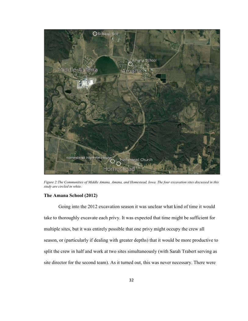
32
Figure 2:The Communities of Middle Amana, Amana, and Homestead, Iowa. The four excavation sites discussed in this study are circled in white.
The Amana School (2012)
Going into the 2012 excavation season it was unclear what kind of time it would
take to thoroughly excavate each privy. It was expected that time might be sufficient for
multiple sites, but it was entirely possible that one privy might occupy the crew all
season, or (particularly if dealing with greater depths) that it would be more productive to
split the crew in half and work at two sites simultaneously (with Sarah Trabert serving as
site director for the second team). As it turned out, this was never necessary. There were

33
one or two days where the crew was a bit larger than necessary, but this was rarely the
case, and when it was, full-time screeners would be set up to utilize the extra volunteer-
power.
The first site selected for excavation during the summer of 2012 was the semi-
public privy at the site of the former school in Amana. The Amana schoolhouse is located
at 4310 220th Trail in the village of Amana. The schoolhouse, along with the Noé House
and a washhouse/woodshed, make up the grounds of the Amana Heritage Museum, with
the schoolhouse housing the offices of the Amana Heritage Society. Built in 1870, the
schoolhouse was in use until 1954. This was the first site selected because it had several
qualities that suggested it would be easy to excavate, and therefore a good starting point
for the crew that consisted largely of first time excavation participants. First, because it
was located on the property of the Amana Heritage Society Museum, parking, bathrooms,
and running water were all on hand, and directions could be reliably given to students
without much risk of anyone ending up at the wrong location. This proximity to the
museum also meant that Museum Director Lanny Haldy and Program Director Christine
Williams were only meters away from the excavation site, so any questions or concerns
could be brought to them almost immediately. Finally, the rear (business) portion of the
outhouse itself, while no longer extant had been defined by a cement foundation which
was being used as a flower bed (see Figure 3). This meant that no effort would need to be
spent on probing for the limits of the outhouse pit, and that excavation could begin in
earnest immediately.

34
Figure 3: Overview of Amana schoolhouse site. Original schoolhouse (now the offices of the Amana Heritage Society) is shown in relation to the pergola/patio to the east. The outhouse/planter on the east side of the pergola/patio was divided into three units, designated North, Middle, and South.
The site was given the designation Amana School (abbreviated to AS on most
forms), and the flower planter, which measured 139cm x 382cm, was divided into three
units designated Planter North, Planter South, and Planter Middle—where North began at
the northern edge and measured 94cm to the center, South began at the south edge and
measured 96cm to the center, and Middle was marked off at the 192cm portion left in the
middle. The strange measurements (94cm, 96cm, etc. are because the distances were
based on physical landmarks on the planter (see Figure 4). The reason for adding the third
unit, which was not strictly necessary from an excavation point of view (as simply
dividing the area into two roughly 2m x 1.3m units would likely have produced the same
results), was to provide opportunities for three teams to be working on units at any given
time. This distribution of labor would continue to be an issue throughout much of the
2012 season since all of the sites were of relatively narrow physical scope.

35
Figure 4: Foundation of Amana School privy. To the left of frame is the edge of the patio/pergola area that has been installed for museum guests. To the right, a board keeps the dirt from spilling out.
A tarp was set up ~10m to the north-east of the planter where all removed
material was screened through ¼” (~6mm) wire mesh. Students typically worked in two
person teams taking turns screening as the other person continued to excavate. Whether
they saw it in the unit or found it in the screen, students were instructed to manually
collect broken material of human manufacture smaller than a half dollar and place it in a

36
paper bag labeled with unit, level, date, and excavator. Anything larger than a half dollar,
or any intact artifacts were to be piece-plotted and given their own sub-bag.
The Amana Heritage Society had removed all the plants from the outhouse area,
and on May 23rd, 2012 shovel scraping of the surface level began in all three units
(recorded as Level 0). On May 24th there was a change to a higher brown clay content in
the soil at ~23cm, so this became the demarcation for Level 2 in all units. (All depths
were measured from the top of the concrete that formed the outhouse/planter perimeter,
which makes the depths seem deeper than they actually are.) At 33cm Level 1 was closed
in all units and Level 2 opened. The decision was not based on any observable difference
within the units, but on a desire that once past the surface, each subsequent level should
be no more than 10cm deep (for the sake of spatial organization of artifacts). On May
25th Level 2 was closed at 43cm and Level 3 was opened, by end-of-day, Unit 3 was
closed in the South and Middle units. On May 28th Level 4 was opened in the North and
Middle units, and Level 3 was closed in the North unit. At this point it became apparent
that Level 4 was not producing artifacts in either unit, so all excavation was stopped and
auger pulls were taken. A 3” auger bucket was used to pull from random quadrants of all
three units down to a depth of 1.2m (from the top of the planter concrete), or just under
80cm below the lowest level of excavation. No artifacts were present in any of the 6
pulls. The decision was made to close the site, and on May 29th a rotted board was
replaced that had been holding the dirt in on one side of the planter, the units were
backfilled, the tools gathered and the crew headed to Homestead.

37
The Homestead Church (2012, 2013, 2016)
2012
The second site selected for excavation during the summer of 2012 was the
former location of a semi-public privy at the church in Homestead, IA. Located at 4210 V
Street in Homestead, IA, the Homestead church was one of the seven village churches
that served the colonies. It was built in 1865, and in addition to a large central room for
church services, it was constructed with residential units on both ends of the building.
Though it is now owned by the Amana Heritage Society, the central room is still used for
church services on Sundays. The Homestead Church site (designated HS in excavation
records) was always the problem child of this project. Even though it received the most
seasons of investigation, it produced the fewest results in terms of artifact assemblage.
The site was chosen after learning that the Amana Heritage Society owned several other
properties in the Colonies, all of which were available for excavation. The church privy
was particularly appealing because of the overt (proximal) connection that it had with
religious practice. While neither the outhouse, nor the building that it had once been
attached to remain, a photograph was available that included extant landmarks that could
be used to estimate the outhouse’s location with considerable precision (see Figure 5).
The date is unknown, but it was taken before the living memory of the informants (Lanny
Haldy & Peter Hoehnle Spring 2012, pers.comm.), and shows a building being
disassembled. The bell tower in the background and the presence of extant scars in the

38
Figure 5: An outbuilding used for pressing wine at the south-west corner behind Homestead Church. Note the bell tower, which remains extant.
grass at the site (see Figure 6) allowed for a high degree of confidence in situating the
former structure on the ground. Based on buildings with the same layout elsewhere in the
colonies, the light space to the left of the third window on the intact wall is the scar where
the outhouse has already been stripped off the back of the building (Lanny Haldy Spring
2012, pers.comm.). However, because of the foreshortening caused by the angle of the
photograph, it is difficult to tell precisely where the outhouse would have stood in
relation to the corner of the building. A slight depression in the grass could be observed
in the general area, and this was the strongest candidate for the location of the privy.

39
Figure 6: Aerial view behind Homestead Church. North is left. The elements of Figure 5 (the church, the bell tower, and the outbuilding—now only detectable through discoloration of grass) are still visible here.
It was the task of locating this feature that dominated 2012 investigation at the
site. On May 25th, a preliminary probe of the area was made. The hope was that the
outhouse had been constructed with a cement perimeter similar to the example in Amana,
and that probing around the depression in the grass would be able to define the
boundaries. Probing began with a ¾” soil probe, but it was nott able to penetrate the soil
more than ~10cm, so rebar and steel spikes were used instead, in the hope that their
thinner diameter would do a better job of getting some depth. Even with these tools, no
progress was made, so a second attempt was made on the 28th with a 3” auger, which

40
pulled three samples down to a depth of ~10cm. The samples came up with bits of red
brick, and whatever the auger was scraping against at 10cm was too substantial to get
loose.
After the Amana School site was closed, the whole crew was brought over to the
Homestead Church to dig shovel test pits. Only three pits were dug—all -14° off of north
so that they were oriented parallel to the foundation of the outbuilding—and they
revealed that the sub-surface situation at the Homestead Church was considerably more
complicated than initially imagined. Pit 1 was dug directly into the depression in the
grass that was interpreted as the likeliest location for the outhouse. Pit 2 was dug just
outside the north-west corner of the building outline, and pit three was dug directly in the
center of the building outline. Each pit was 25cm square.
2013
Because permission delays were restricting access to the Schaup Site, in the fall of
2013 the crew found themselves in a field school without a field. For three days the crew
was brought out to the Homestead church to take a more systematic approach to the
question of the demolished building and its surrounding area. A 24m north\south line was
laid out with the north end 3.9m from the SW corner of the church (~41°45’37.90” N,
91°52’33.59” W) and the south end 3.8m from the tree (~41°45’37.31” N, 91°52’33.55”
W). Both ends were marked with galvanized steel spikes which were driven into the
ground after the survey so that they may be relocated by metal detector in the future, if
desired. A random number generator was then used to generate: 1) a number from 0-10 to

41
represent a number of yards from the north end of the line; 2) a number from 1-2 to
represent the west or east side of the line respectively; and 3) a number from 1-6 to
represent a number of yards away from the line at a 90° angle. By this process random
sites for test pits were selected. These pits were labeled alphabetically from A-K (see
Figure 7). The decision to do eleven pits was not strategic, the crew simply began digging
pits and continued until the permission for the Schaup Site came through.
Students were instructed to use the bottom of their five-gallon buckets (~26cm in
diameter) as a guide for each pit. Each pit was dug to a depth of 50 cm (or until
obstructions prevented further depth, each unit was recorded as a single layer.
Figure 7: Overview of relationship between test pits A-K and other large features at the Homestead Church site, including the church, the bell tower, and a patch of exposed concrete.

42
2016
On November 16th, 2016 a session of ground penetrating radar investigation,
conducted with the assistance of Dr. Glenn Storey, was carried out at the Homestead
church in the area of the proposed outhouse and associated structure. The goal was to
help fill in the picture of the extent of the debris underground. A 7m x 7m area square
was set up such that it overlapped much of the building interior and the area to the west
of the building where the outhouse is suspected to have been.
A 900 MHz antenna was used in conjunction with a SIR-3000 processing unit to
run profiles at 25 cm intervals. Profiles were run both north-south and east-west with the
x,y datum at the southwest corner of the grid. The grid was set up 14° off true north in
order to match the foundation angles of the church itself and the demolished building (the
orientation of which is still visible through the pattern of dead grass seen in Figure 6).
The data recorded during this session was then processed in RADAN 7.4.16.0623.
Homestead Hoehnle House (2012)
The third and final site selected for excavation during the summer of 2012 was the
domestic privy at the Hoehnle residence in Homestead. This was the site with the greatest
potential. The house as it exists today consists of three segments—the original house and
barn, built in 1864, and a twentieth century addition which connects the two structures
(see Figure 8). The privy, located at the east end of the south wall of the barn, had been
the only facilities until the construction of a bathroom in 1942 (Peter & Barbara Hoehnle
2012, pers.comm). The privy was located at the back (south) of the Hoehnle barn/garage.

43
The structure of the outhouse had been torn down in the 1990s, but wooden doors on the
back of the barn where the outhouse entrance had been provided a clear indicator of
exactly where to excavate.
Figure 8: Overview of relationship between the Hoehnle House and the three excavation units.
On June 1st, 2012 three units were opened at the Homestead Hoehnle House
(recorded as HHH on most documents) directly to the south of the doors to the outhouse
and approximately 75 cm away from the base of the barn. Unit one (to the west) and unit
two (in the center) were both 1 m x 1 m square. A third half unit was opened up on the
east end and was designated unit 2.5, measuring 1 m north to south and 50 cm west to
east (see Figure 9). After clearing vegetation, surface finds were collected in all units and

44
were recorded as Level 0. On June 4th Level 1 was opened in all three units. As at the
Amana school site, a tarp and screening station were set up and students were told to
collect any artifact fragments found in the units and in the screens and to piece plot any
intact artifacts or fragments larger than a half-dollar.1
Figure 9: Units 1, 2, and 2.5 (from L to R) at Homestead Hoehnle House.
Level 1 was heavy with broken and intact bricks, particularly in Units 1 and 2.5.
This was interpreted as rubble from when the outhouse was torn down, and the decision
1 At this site piece plot records were recorded on a laptop loaded with the EDMWIN geospatial data collection program. However, on June 8th we were locked out of the laptop because of a password update error, and when we returned the laptop to ITS, it was upgraded to a new operating system which wiped out all of our site data. No information was ultimately lost as redundant paper copies had been made on site.

45
was made to extend the Level until the crew was through the bricks. On June 5 Level 1
was closed at 30cm in all three units. On June 6th Level 2 was opened in all units first
thing in the morning and closed (at 40cm) at the end of the day. Level 3 was completed
even more quickly, opening first thing on June 7 and closing at (50cm) just before lunch.
Level 3 was only opened in Units 1 and 2, and Unit 2.5 would remain closed for the
remainder of the season as the remaining time was needed to get Units 1 and 2 down to
the bottom of the outhouse.
Level 4 was opened at 50cm on June 7th. Two boards spanning parts of both Units
1 and 2 had been visible since the second half of Level 3. These boards, which were fully
excavated by ~50cm became the de facto threshold for the final two levels of the
outhouse. One end of one board was inside a hemispherical metal basin that turned out to
be a urinal that had once been attached to the interior wall of the outhouse (Barbara
Hoehnle 2012, pers.comm.) Level 4 (~50-60cm) and particularly Level 5 (60-70cm)
contained substantially more large (larger than a half dollar) finds than anywhere else in
the entire project. This meant that excavation slowed to a near standstill because of the
additional time need to fill out so many piece plot forms. While Level 3 had taken only
an afternoon to excavate, Levels 4 and 5 took the entire remaining week of the season.
On midafternoon of June 14th the crew was able to clear and photograph the bottom of
the outhouse (see Figure 10), after which both units were closed and the site was
backfilled.

46
Figure 10: Layer of bricks at Homestead Hoehnle House. The bricks were used to determine the end of level 1 at 30cm.
The Schaup Site (2013)
When first meeting with Peter Hoehnle in preparation for this project,
conversation naturally turned to archaeological curiosities that he himself had had over
the years. There were two stories that he was interested in corroborating. The first was
that during the time of the Werkzeuge a pronouncement had been made that pewter dishes
were no longer acceptable. Pewter was not produced on-site in the Amanas, so these
vessels would represent purchases or heirlooms that had come from outside of the
community and were being preserved as (perhaps overly worldly) keepsakes. The story
went that all of the pewter vessels from the community were gathered up and dumped in

47
a dry well or cistern somewhere (Peter Hoehnle Spring 2012, pers.comm.). While this
story was an absolutely perfect intersection of religion and material culture (and what
archaeologist does not secretly dream of excavating a hidden horde), there was simply
not enough information about where this potential cache might be to justify taking on the
project with the limited resources available.
The second story concerned a family named Schaup (sometimes Shoup) who had
left property in Canada to follow the Community of True Inspiration when it moved from
Ebenezer, New York to found the Amana Colonies. The story went that the patriarch of
the family, Martin, struck a deal with the Amana elders. He was willing to contribute his
considerable wealth to the communal funds, but he did not want to live with the rest of
the community. So, the Schaup family built their home about 1km north of the Lily Pond
between Amana and Middle Amana. This lasted until Martin’s death, at which time the
house was physically moved to the location where it stands to this day, at 4303 220th
Trail, along the northern edge of Amana (see Figure 13). The original location of the
Schaup house was known generally by the absence of trees in a corner of a wooded area
(see Figure 14)—the result of deer browsing since the Schaup era, preventing trees from
growing tall. This was the second mystery; where, within that denuded patch had the
Schaup house been?

48
Figure 11: Canadian tax document for Schaup farm in 1843. (Note earlier spelling, Shoup). This offers some sense of the resources that Martin Shoup was giving up to become part of the Community of True Inspiration. (Photo provided courtesy of Peter Hoehnle.)

49
Figure 12: Photo of Samuel Schaup. Though no photographs of Martin Schaup/Shoup exist, this is his son, Samuel, ca. 1900. (Photo provided courtesy of Peter Hoehnle.)
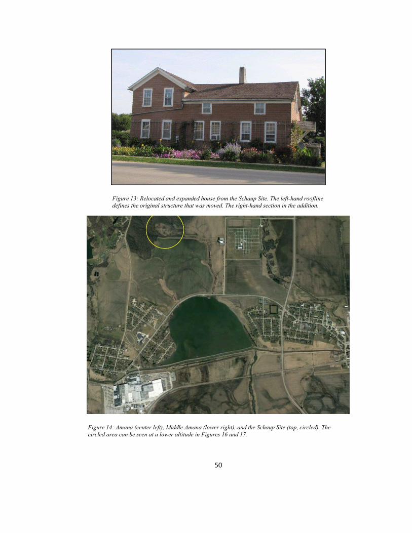
50
Figure 13: Relocated and expanded house from the Schaup Site. The left-hand roofline defines the original structure that was moved. The right-hand section in the addition.
Figure 14: Amana (center left), Middle Amana (lower right), and the Schaup Site (top, circled). The circled area can be seen at a lower altitude in Figures 16 and 17.

51
Pursuing this matter seemed desirable for several reasons. While it would be
virtually impossible to fully reconstruct the relationships and motivations at the heart of
the story (since the only version of the story that survives is sparse on details), it might
still prove intellectually rewarding to help fill out the recoverable details of the tale.
Additionally, it seemed that undertaking this search might contribute to a sense of
reciprocity with Peter Hoehnle (and to a lesser extent Lanny Haldy). Both men had been
hugely generous with their time and property permissions, and both remained interested
and engaging observers of the work that was done in 2012. However, that work was done
in an attempt to answer questions that neither of these men were particularly concerned
with. By making a go of locating the Schaup homestead, it seemed like it might
accomplish something that might be of genuine (if largely anecdotal) interest to them.
Schaup Site also offered a useful addition to the project, in that it possessed a
substantially different set of qualities. For one thing, it had a much narrower and earlier
period of occupation, having been used only from the 1860s to the 1890s. Second, and
most obviously, it existed outside of the communal structure of the Amana’s (at least
geographically). For these reasons, the site provided a comparative perspective that was
not available among the three sites excavated in 2012.
While the question motivating the excavation was more simple, the logistics of
setting up the season were considerably more complicated. The first hurdle was the
question of permission. The three sites previously discussed are all owned by either the
Amana Heritage society or the Hoehnle family—all of whom supported the idea of
archaeological excavation for the sake of curiosity. The area where the Schaup house was

52
thought to stand belongs to the Amana Society Inc.—the financial/social entity created
when the economic concerns of the community were separated from the church after the
Great Change. They had no particular reason to grant access, and certainly did not have
any interest in a situation where they could be held libel if something happened to
students at the site. The process of getting permission to access the property was
somewhat drawn out as waiver language was approved by both University of Iowa legal
counsel and by the Amana Society.
Official permission to excavate at the site came through, and on Friday,
September 27, 2013 Peter Hoehnle, Larry Gnewikow (from Amana forestry), Sarah
Trabert, and I joined in visiting the site for the first time. It was immediately apparent that
the site as it appeared in satellite photos and the site as it appeared on the ground were
two very different things. First of all, the site was considerably less accessible than it had
been made to seem. Originally, the plan had been to drive along field access roads
coming at the site from the south. Because of the condition of the soil (relatively soft and
wet) the farmers were concerned that a caravan of cars coming and going each day would
cause too much damage. Instead, the approach to the site was made via a forestry truck
trail from the north. The path was muddy and relatively difficult. A two-wheel-drive
vehicle would not have been able to make it in and out. In fact, once work at the site
begin in earnest, the students simply hiked down to the site while a four-wheel-drive
vehicle with the equipment was driven down. Because of the slowness of the truck trail,
the vehicle would arrive at the site about the same time as the students who were hiking.

53
Additionally, the clearing that had looked like the size of a large parking lot
turned out to be about fifteen acres. It was not flat, but on a considerable hillside, and the
brush was thick, woody, and in many places chest high or higher. There was 0% visibility
from eye-level to the ground; everything was obscured by plant life of some kind. There
had been a hope going in that it would be possible to use pin flags to mark features (and
that features might be visually identified). The site however was in no condition for that
particular approach. Larry suggested that a brush cutter, or even a controlled burn, could
be used to clear the area, but either approach would have required additional time,
equipment, labor, and most significantly, permissions.
There were several limiting factors which necessitated a quick and novel solution.
First, the season was already off to a slow start. While waiting for permissions, work was
being done at the Homestead Church, but September was essentially over, and work on
the Schaup Site (which was the goal for the 2013 season) had not even begun. There was
no way to know how many weeks of excavation it would be possible to complete before
weather would close the site for the season, so every day spent searching the fifteen acres
was a day that units were not being opened. It was important to develop a solution that
did not require a lot of time or any additional postponement of excavation.
It was necessary to survey a large area quickly, and markings on the ground were
not going to be practical because of visibility. The forecast suggested drizzle at least and
rain at worst the next day, which meant there was no chance of bringing out handheld
GPS units for the students to record test pit locations. A total station was also out, in part
because of the weather conditions, but more prohibitively because of the combination of

54
the raked hillside with the high brush. There would be no line of sight over distances
more than a few yards. The problem was going to be creating a usable map to try to zero
in on the likeliest candidates for the occupation site.
Before returning to the site the next day, twenty-five 12’ lengths of 1” PVC pipe
and seven rolls of duct tape in different colors were purchased at the building supply
store. In the parking lot, all the poles were cut down to 6 foot lengths. These fifty 6’ long
lengths of pipe were brought to the site the next day to serve as markers that would be
visible despite the heavy, woody brush. The system was implemented as follows: a pair
of students with a 3” auger would pull a 50 cm sample. After screening, all the artifacts
from that sample would be tallied and the hole would be assigned a color code based on
how many artifacts had been found. Black indicated zero artifacts, purple indicated 1-2
artifacts, blue indicated 3-4 artifacts, green indicated 5-6 artifacts and so on through the
rainbow. (Because of the absolute dearth of material across the site, nothing higher than
purple was ever necessary.) Once the auger pull had been screened, the artifacts
collected, and the log filled in, the students returned to their hole with a 6 foot PVC pipe
with the appropriate colored tape at the end. They would refill their hole with the PVC
pipe in it. Since the pipes were 6’ long and the holes were 50cm deep, this left a marker
of about 4 feet (or 1.3m) at each of the pull sites.
There were two clues that helped suggest where to begin. The first was a hand-
drawn diagram of the site made in 2004 and provided to the Amana Heritage Society (see
Figure 15). It was drawn over a hundred years after the occupation of the site, and its
creator no longer survived. It had apparently been based on stories told by his parents

55
who had been children when the Schaup Site had been occupied. It was a poor copy, and
difficult to decipher, but it clearly showed an extensive site with several structures. The
second clue was a horribly low resolution fax that claimed to identify a cistern that had
been found on the site in recent years.
Figure 15: Hand-drawn overview of Schaup farm. Note number of buildings.
The hand-drawn diagram could be roughly correlated with the fax, since both
identified the cistern, and the fax could be roughly correlated with Google Earth images
of the site. This meant that as long as it was possible to roughly correlate landmarks on
the ground with the satellite imagery, it was possible to get a rough (times three) sense of

56
where the site had been. Starting in this area, students were encouraged to simply pick a
spot and start augering. If the students found nothing (black tape) they were asked to
select another site at least 15m away from any other holes, if they found anything they
were encouraged to select another spot within 5m (to determine whether the artifacts
were part of a high-density area, or just statistical chance). The work was incredibly slow
because of a great deal of clay present in the soil and the rainy conditions of the day. This
was compounded by the fact that only two augers and two screens were available, so
teams would have to switch off. As soon as an auger was clean enough to use again, it
would be passed on to the next team. Over the course of four hours only 15 holes were
probed.
The result was effectively a real-world full-scale map with colored pins in it.
After twenty-eight pulls, only ten had produced artifacts of any kind and only five of
those had produced anything from the era that the Schaup family was believed to be
present at the site (see Table 1). Even with this limited number of data points one area
stood out as the most likely place to start.

57
Figure 16: Aerial view of the Schaup Site. In the upper-left portion of the clearing is a square stand of trees. These are protected by a chain link fence. Attempts have been made by the Amana Society, Inc. to replant this area, but unless the trees are fenced off, deer eat them before they are able to mature. The white box in the middle is the area where excavations took place. This can be seen more clearly in Figure 17.
Table 1: Auger pulls from the Schaup Site
No. Color Finds soil 1 purple Lithic flake Light brown clay 2 black --- Light brown clay 3 black --- Light brown clay 4 black --- Black soil 5 purple Clinker (not collected) Brown clay 6 black --- Brown clay 7 purple White ware Black Soil 8 black --- Black Soil 9 black --- Black Soil 10 black --- Brown clay 11 black --- Light brown less clay 12 black --- Light brown lots of clay 13 purple Clinker (not collected) and flake Light brown, less clay 14 Blue 2 nails unidentified metal, seed? Very light brown, no clay 15 Purple Lithic flake Light brown soil 16 Black --- Wet clay, brick -colored grit 17 Black --- Dry clay 18 Black --- Dry clay

58
Table 1 continued 19 Black --- Dry clay 20 purple Rusted metal (nail?) Dark, semi-crumbly clay 21 Black --- Medium brown clay 22 Purple Flat glass Medium brown clay 23 Purple Tiny square of ceramic Dark brown clay 24 Black --- Lighter, dryer clay 25 Black --- Reddish-brown clay w/sandy intrusion 26 Black --- Darker clay 27 Black --- Black soil 28 Purple nail Light, dry soil, little clay
Since there was still some question regarding how effective this process was
going to be, rather than opening units, the students were instead asked to use a Fisher m-
scope CZ-7 metal detector to focus on the area of highest artifact incidence. They were
told not to attempt to dig anything up, but to simply use an orange pin flag to mark any
place where the detector indicated the presence of metal. (Because this was done over a
small area the pin flags were relatively visible.) At the end of the afternoon the metal
detector had found so many hits in the area of highest incidence that the pin flags (~50)
had run out.
Unit 1 was laid out with its southwest corner at approximately 41°48’43.63” N,
91°53’41.40” W and Unit 2 nearby with its southwest corner at approximately
41°48’43.64” N, 91°53’41.08” W. Both were laid out in alignment with magnetic north,
but they were not on a grid with one another as brush and trees prevented orientation to a
shared line. Each unit was placed such that three metal detector flags were within its
borders (the maximum number possible with the distribution of the flags). It is worth
noting that 24 metal objects were found in Unit 1 and over 35 in Unit 2—as we shall see,
metal detectors are a fantastic tool for historical survey work, but they are no substitute
for excavation. A third unit was eventually opened. Its southwest corner was at

59
approximately 41°48’43.58” N, 91°53’41.14” W. Only Unit 1 was excavated to sterile
soil (at just under 50cm). All three units turned up remarkably consistent material, nails,
and mangled ware (a few bits of glass too, particularly near the surface).
Figure 17:This is a lower altitude photo of the area framed in white in Figure 16. The red oval represents the area of high metal signal density, while the yellow area is lower density, but still massively higher than the area surrounding . Units 1, 2, and 3 are marked, and each white square represents a 1m x 1m area.
When it became evident that the two units that had been opened up were not
producing any structural features and only small, fragmentary artifacts, there was some
concern that the units had been placed in such a way that they had missed the site and
were in a corner of the property. On October 26th, one of the students was sent out with
the metal detector for the day with instructions to begin with an area that had been
suggested as an alternate possible location for the house by one of the Amana residents

60
who had taken an interest in the project. After searching that area specifically, the student
was instructed to simply wander the whole area and make broad sweeps. If he found
anything he was encouraged to search nearby to see if he could find any other hits, and if
so, then he should mark the area with orange flags. After a day of searching, he found
only two areas in the entire site where there were multiple metal hits close together.
The next day in the field (November 2nd), a group examined both of those areas in closer
detail, probing to see if it was possible to determine what had caused the hits. In both
cases, metal was found on the surface of the ground (beneath the underbrush) that was
clearly of modern origin. In one case, it was a row of rusty chicken wire, and in the other
it was bolts and metal that appeared to have come from a modern truck or tractor.
Stage 2: Dating Artifacts
Central to the purpose of this project was the ability to date reliably the materials
gathered during artifact collection. While it was always possible that date-stamped
materials like coins would be recovered, it was presumed that most of the dating process
would be based on the fragments of bottles and any labeled commercial goods that
remained legible. Several strategies for dating glass bottles exist, including T. Stell
Newman’s “A Dating Key for Post-Eighteenth Century Bottles” (1970) and several
improvements that have been derived in the years since (White 1978, Staski 1984). Other
commercial goods would potentially be dated through the use of catalogues, either online,
or in paper form.

61
Initial curation of these artifacts was expected to take place at The University of
Iowa in Macbride Hall room 209. It was also possible that suitable space for large,
difficult to transport items (which were not expected in outhouse excavations) might be
made available at the Amanas, either through the Amana Heritage Society or Iowa Valley
Resource, Conservation and Development.
Stage 3: Chronological Distribution of Artifacts
It was possible, even probable, that simply dividing the artifacts into pre and post
1932 would reveal changes in the material life of the community as a result of the Great
Change. While this might have been true, it was not sufficient for the intended scope of
this project. Rather, the interest here was in looking at what sort of social (and material)
changes preceded the Great Change, as well as those that followed it in the ensuing
decades. Ultimately, these data were likely to be more revelatory since they had a greater
chance of reflecting the changes in community behavior that led to (or least coincided
with) the community's desire to fundamentally change the relationship between their
religious beliefs and their social/economic structure. Those shifts in material behavior
which followed the Great Change were also likely to reflect the speed and interest with
which the newly-defined community adopted/imitated/rejected the behaviors and material
culture of the outside world.
For these reasons, the greater the level of chronological distinction available, the
subtler the changes that were predicted to be observed in the material record, and by

62
extension, the community’s behavior. As such, it would prove valuable to use the data
established during the dating of the artifacts to construct as tight and thorough a
chronological pattern as possible.
Stage 4: Historical Comparison
The fourth stage was to consist of taking the tight chronology established during
the third stage and compare it to the historical resources available regarding the
community in the relevant decades. The specifics of the methodology used during this
stage would remain somewhat undefined until it was clearer what the data would show in
earlier stages of the work. For example, if specific dramatic changes in material culture
could be associated with particular years (or short year ranges) they might merit intensive
examination of community documents and available personal journals and diaries from
this time to specifically examine the thoughts and feelings of the people involved at the
time of these changes. If, however, more general and gradual changes were observed, it
would be more likely that a different tactic would be taken with historical materials.
Specifically, there might be a greater need to examine the historical records with an eye
towards breadth, rather than depth.
The proposed project sought to apply one of the most traditional methods of field
archaeology—the midden/trash pit survey—to one of the more complicated areas of
human behavior—religious change over time. The presumption was that by working with
a relatively stable and identifiable data set, the complexities of the topic could be
observed more clearly in reflection than they could be in direct observation. If this project

63
were successful, it would serve to add that voice to the historical chorus of sources that
describe the reasons for and consequences of the dramatic changes made by the
Community of True Inspiration at the Amana Colonies.

64
CHAPTER FOUR RESULTS
Amana School
The artifacts from the three units and four levels were remarkable for their
homogeneity. There was no sense of depositional layers or of significant differences in
artifact type associated with depth. Datable material was almost entirely absent, and the
one securely datable object found at the site—a 1926 penny—was found in the first few
centimeters of surface dirt. Overall, out of over five square meters excavated to a depth
of 50cm, only about 800g of material was recovered from the entire privy. (By way of
comparison, over 1000g were recovered from a single layer of a single unit at the
Homestead Hoehnle House.) Faunal remains are exceedingly sparse—notably a chicken
femur (drumstick) and a catfish whisker found in North Planter Level 1 (see Figure 18).
Not photographed or collected, but noted in the paperwork was the presence of green
plastic Easter grass. This was found in every level from the surface to Level 3.

65
Figure 18: Chicken and catfish bones from Amana School
Homestead Church
2012
Pit 3 (outside the structure) revealed only soil with some bits of brick (see Figure
18), while Pit 2 (inside) revealed mostly soil, but also the edge of a substantial rock (see
Figure 20). It was Pit 1 that had the most unexpected result. At a depth of just over 10cm
the pit ran into a solid, light-gray, slightly chalky stone. It filled the bottom of the pit, so
additional 25cm squares were opened contiguously to the north, south, and west. Both the
north and west squares revealed the continuation of the stone, while the south extension,
revealed an edge (see Figure 21). The stone was ~20cm thick and extended at least half a
meter in two directions. At the time, this was interpreted as some kind of debris that
remained from the demolition of the larger outbuilding. There was concern that if this
slab continued in either direction it would be beyond the scope of the crew to remove it
without additional machinery.

66
Figure 19: Test Pit 3 at Homestead Church—some brick inclusions, but no obstructions.
Figure 20: Test Pit 2 and Homestead Church—in lower-left of pit (north edge) a corner of stone is visible.

67
Figure 21: Test Pit 1 at Homestead Church (expanded to the south and east)—substantial stone object takes up most of the expanded unit.
It was at this point that the decision was made to abandon the attempt to excavate
the site during the 2012 season. No artifacts were collected and the test units were
refilled. It was (and remains) disappointing to have lost the opportunity to explore the
only outhouse adjacent to a religious structure that I had access to, but after the results of
the Amana School excavation, and given the time limitations of the season, it was most
logical to focus on a site with the highest possible chance of producing data relevant to
the project in the time remaining, which was the Hoehnle house. Continued interest in the
Homestead Church site is evidenced by the following attempts to better understand the
debris situation underground.

68
2013
The test pits that the students excavated turned up artifacts familiar from all other
sites in the project—nails, ceramic sherds, glass shards, and the occasional bit of bone
(see Table 3). There were also other materials more consistent with the exposed,
communal nature of the space. Soda can tabs and spent .22 caliber shell casings suggest
the kinds of activities not seen at the other sites in the project. Most units (A, B, C, D, E,
G, J, K) reported some presence of building materials, and Test Unit C has a piece of
curved brick and mortar structure running through it N-S (see Figure 22). The object was
cleared enough to see that it was a broken piece and not connected to a larger structure,
but its presence does confirm that larges pieces of material from some demolition phase
(presumable the outbuilding) remain.

69
Table 2: Artifacts from Test Pits A-K at Homestead Church
Test pit
from N
from line
E/W Collected
A 5m 5m W 2 Pop tabs, 9+ modern nails, 6 clear class, 1 colored glass
B 7m 2m E 4 pieces clear glass C 7m 6m W 5 modern nails, 2 buttons, 2 pieces clear glass, 1 piece
colored glass, 3 chips of ceramic D 6m 2m W 2 modern nails, piece of brick, burned wood E 4m 1m E 8 modern nails, 1 button, 2 pieces of clear glass, 6
pieces of ceramic F 10m 1m E 2 modern nails, 1 button, one .22 bullet casing, 3 pieces
of ceramic G 3m 3m W 2 nails, 2 pieces of clear glass, one piece of ceramic H 18m 1m E 1 nail, one .22 bullet casing, 13 unidentified pieces of
metal I 19m 1m W 5 nails, 2 pieces of metal, 2 pieces of bone, 1 piece of
ceramic J 5m 2m W 1 pop tab, 1 screw, 4 pieces of wire, 18 nails, 2 pieces
of ceramic, 17 pieces of colorless flat glass, 1 piece of brown curved glass
K 10m 1m W 1 pop tab, 3 nails, 3 pieces of metal, 1 piece of colorless flat glass, 1 piece of colorless curved glass

70
Figure 22: Homestead Church Test unit C (North is top)
2016
The ground penetrating radar results can be seen below in Figure 23 (at a depth of 20cm)
superimposed over the Homestead Church site. The most dramatically visible features are
seen along the northern and eastern edges of the radar results. These are clearly the
foundation remains of the demolished outbuilding which are also apparent to the naked
eye because of the pattern of dead grass that they create (see Figure 6). The lettered dots
in Figure 23 represent the test pits dug and refilled in 2013. Only A, D, G, and J are
within the area being probed, but there is no obvious evidence of the holes themselves at
20cm or at 40cm (see Figure 24).
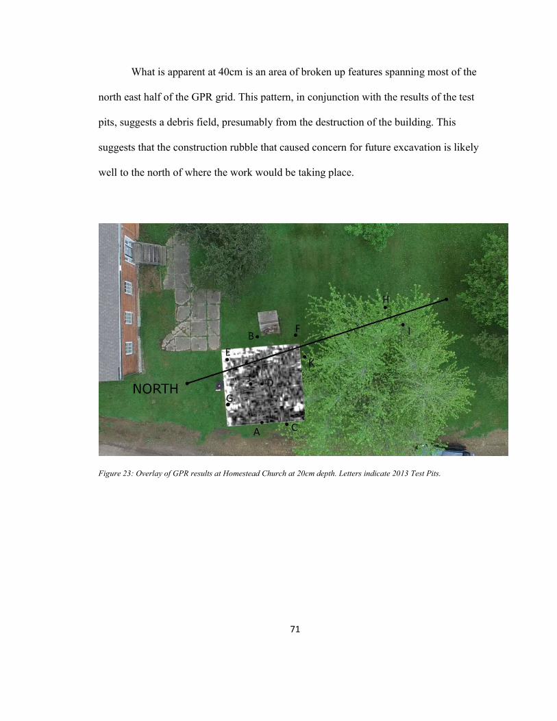
71
What is apparent at 40cm is an area of broken up features spanning most of the
north east half of the GPR grid. This pattern, in conjunction with the results of the test
pits, suggests a debris field, presumably from the destruction of the building. This
suggests that the construction rubble that caused concern for future excavation is likely
well to the north of where the work would be taking place.
Figure 23: Overlay of GPR results at Homestead Church at 20cm depth. Letters indicate 2013 Test Pits.

72
Figure 24: Overlay of GPR results at Homestead Church at 40cm depth. Letters indicate 2013 Test Pits.
Homestead Hoehnle House
The Homestead Hoehnle House provided by far the most material out of any site
excavated during the project (see photos on Appendix A). Not all materials lent
themselves to meaningful analysis; those that did are discussed below.
Faunal Remains
Animal remains (all skeletal) at the site can be broadly divided into four
categories, 1) rodents, 2) poultry, 3) fish, 4) large mammals. All of the rodent, poultry,
and fish bones were found relatively intact (with many exceptions for breakage of various
kinds). All of the large animal bones were found sawn by mechanical means into very
small reductions of their original form.

73
Rodent bones were unique in that in most cases many bones were found in a
single layer level of a single unit suggesting that the entire animal had once been present.
Rodent remains were found in Units 1 and 2 in Level 5. The only fully intact maxillary
dentition showed a 1.0.0.3 dental formula (only incisors and three molars) which is
consistent with a rat or mouse, but not a squirrel or rabbit. Poultry remains all seem to be
from chickens, and were often found in isolated groups that did not seem to represent
whole animals. Chicken remains were found in Unit 1, Levels 4 and 5, and in Unit 2,
Levels 3, 4, and 5. Fish bones were very rare, and only vertebrae were found. Fish
vertebrae were found in Unit 2, Level 3. Large mammal bones were found in Unit 1,
Levels 1, 2, and 5, Unit 2, Levels 0, 4, and 5, and Unit 2.5, Level 02. All, as mentioned
above, were mechanically cut. On those bones where the cut striations are still visible,
they are all in parallel with one another suggesting a power saw was used to butcher the
animal (Symes et al. 2010) (see Figure 25).
2 Recall that Unit 2.5 was not excavated past Level 2, so it is possible that large animal bones were present in the lower levels.

74
Figure 25: Cut marks on bone consistent with the use of a power saw.
Obviously, the fish and large animals were never present alive in the privy. It is
not inconceivable that a chicken could become trapped in an outhouse and die without
anyone noticing, but the scattering of bones, in parallel with the presence of clearly
butchered large animal bones, suggests that the chicken bones are the result of domestic
food waste. The presence of several chicken heads likely indicates that for a period of
time the outhouse served as a receptacle when chickens were slaughtered. The
distribution of chicken bones by level dramatically indicates that Level 5 is associated
with the vast majority of chicken remains, and that almost all identifiable chicken
remains are found beneath the board/urinal ~50cm threshold (see Figure 26). Further, the
presence of so many heads and feet, but the complete absence of sterna and ilia strongly
indicates that the outhouse was used to dispose of undesirable parts after killing chickens.

75
Figure 26: Chicken heads and chicken feet by Level (All Units Combined) at Homestead Hoehnle House
Additionally, in Unit 2, at a depth of 62cm, several bovine carpal bones were
found. Like the chicken heads and chicken feet described above, these are bones found in
the waste portion of a cow, specifically the lower foreleg. At some time, and for some
reason, the “ankle” of a cow was deposited in the privy. While human behavior is infinite
in its permutations, the most parsimonious explanation is that this was waste from the
preparation of a beef shank.
0
2
4
6
8
10
12
14
16
Level 1 Level 2 Level 3 Level 4 Level 5
Chicken Skulls Chicken Metatarsi/2

76
Figure 27: Bovine carpal bones from HHH Unit 2, Level 5
Though not faunal, another avenue of evidence supports the interpretation that the
privy was used (at least for a time) for disposal of food preparation waste. Fruit pits were
found in Level 5 in considerable quantity (see Figure 28). Over 100 were collected intact
with many more fragments observed. All, but three of these were in Unit 2, suggesting
that a large number of pits were deposited around the same time. Peach trees still grow on
the Hoehnle property, so the origin of the pits is not mysterious. While it is entirely
possible that the pits represent many instances of serial peach-snacking, disposing of the
pits in this manner would necessitate entering the barn, then entering the privy from the
barn, and then dropping the pit into the outhouse hole. It seems more likely that these are
the byproduct of one (or more) events where a large number of pits were produced at
once, perhaps as a byproduct of canning (as two canning jar lids were found in the same
unit and level), and then thrown out as a group.

77
Figure 28: Peach pits from Homestead Hoehnle House Unit 2, Level 5
Refitting
Little refitting was possible given the artifact assemblage from the Homestead
Hoehnle privy. This is consistent with the idea that the privy would not have contained
intentionally any intact objects. There were several instances of flat glass where it was
apparent that some of the pieces could be refit. No attempt was made to carry out these
re-fittings as in all cases it was clear that they would simply refit to produce a larger piece
of broken flat glass.

78
Unlike lithic refitting, there is no chaîne opératoire or complex behavior to reveal
with refitting of other artifact categories. In each case the overwhelming likelihood is that
either, 1) an object was broken as it was dropped into the outhouse, or 2) the various parts
of a broken object were all thrown into the outhouse at the same time for disposal. The
purpose of refitting in this context is only to determine how objects that enter the
outhouse at the same time are distributed across units and layers.
Two re-fittings were carried out, the first was the very simple reassembly of two
halves of a broken ceramic egg (see Figure 29). These are the style of dummy egg used to
train young chickens where to lay eggs, and plastic or Styrofoam versions can still be
purchased at farm supply stores. The two pieces were found three days apart in Unit 2,
Level 5 at depths of 61cm and 68.5cm. As the rest of the egg is missing, it is easy to
imagine that the egg was damaged and part of it was thrown into the outhouse for
disposal.

79
Figure 29: Broken ceramic egg from HHH Unit 2, Level 5
The second refitting was considerably more complicated and consisted of 23
pieces of three matching teacups that were all found in the outhouse (see Figure 30). The
teacup pieces were almost all in Unit 2 at depths ranging from 55cm to 69cm. The
teacups suggest an interesting course of events. It seems to me the most likely
explanation is that the missing pieces are in the unexcavated portion of unit 2.5. This still
does not answer whether all three cups were damaged at once, or why they were put in
the outhouse. With the exception of the blue bottle and the marble described below, these

80
are far and away the most complete artifacts at the site.
Figure 30: Three ceramic cups Homestead Hoehnle House
Dateable Material
The Broken Bottle
The broken base of a large, clear glass bottle was recovered from Unit 1, Level 5
at a depth of 67cm (see Figures 31 & 32). The base bears the stamp of the Brockway
Glass Co., specifically a circle around a B with 2 serifs which was used from 1933 until
1988 (Lockhart, et al. 2016a). Moreover, the 2-digit number on the right side of the base
represents the year of production (Lockhart, et al. 2016a), giving a secure date of 1942
for the production of this bottle.

81
Figure 31: Broken bottle from HHH Unit 1, Level 5
Figure 32: Diagram of markings from Broken bottle (enhanced for readability)

82
The Blue Bottle
A small, cobalt-blue bottle was recovered from Unit 2, Level 5 at a depth of
68.5cm (see Figure 33). The bottle measures 6.6 cm in height, 2.8mm at the base, and
2.0mm at the mouth. While bromo-seltzer bottles of this size and color were produced
from 1891 until sometime in the 1950s, three diagnostic features are present on the bottle
which can aid in more specific dating— the manufacturer, the text, and the type of
closure finishing present at the top of the bottle (Lockhart, et al. 2016b). Seven
manufacturers were employed in the production of such bottles, but the presence of the
letter M within a circle that is molded onto the bottom of the bottle indicates that this
particular example was produced by the Maryland Glass Corporation, further limiting the
time window of production to 1907-1950s (Lockhart, et al. 2016b). Molded into the
bottle are the words, “BROMO-SELTZER EMMERSON DRUG CO.” These words ring
the heel of the bottle. The mouth of the bottle is secured with three lugs (as opposed to a
single ring, or a continuous thread). These factors further limit the possible time of
production to 1920-1950s. This 30+ year window is the narrowest dating possible from
the bottle alone. Given that the span sits neatly astride the 1932 date for the Great
Change, it is impossible to be certain whether this bottle made its way to Homestead
while it still existed as part of a communal society.

83
Figure 33: Blue Bromo-Seltzer bottle from HHH Unit 2, Level 5
The Marble
A single green-swirled marble was recovered from Unit 2, Level 5 at a depth of
68cm (see Figure 34). It was posted on a marble collectors forum and almost immediately
identified as a Rainbo marble made by the Peltier Glass Co. in Ottawa, Illinois from the
late 1930s through early 1950s (IowaMarble 2016). The bottle and marble were found only
centimeters apart at the same level, so the fact that their time ranges match up so well is
consistent with a similar time of deposit (see Figure 35).

84
Figure 34: Marble from HHH Unit 2, Level 5
Figure 35: Excavation of HHH Unit 2, Level 5 on June 14th, 2012. Marble and Bromo-Seltzer bottle are visible in the center of the unit.

85
The Comic
In Unit 1, Level 5, at a depth of 69cm a rust-colored stain and a small stack of
paper was identified. Only the top sheet was visible, and it was photographed in situ with
the expectation that it would not survive removal. The paper seemed to be part of a comic
strip or comic book. No pictures were visible, but it was possible to make out parts of two
speech bubbles. (See Figure 36) the rightmost bubble contained only a half dozen
readable characters, but the leftmost was still somewhat legible. It read, “[…]INALLY
MEET […]E CANY[…] AND […] FIRS[…] HE […] ORDER ME […]RESTED!” and
was interpreted this to mean, “I finally meet […]E CANY[…] And the first thing he does
is order me arrested!”
Figure 36: Scrap of comic from HHH Unit 1, Level 5

86
Frustratingly, the key to identifying this particular comic lay in the proper name
or title in the middle of the sentence. In the English language, the only words that begin
with C-A-N-Y are “canyon” and its derivations. Steve Canyon was a comic strip
adventurer created by Milton Caniff and syndicated in over 160 newspapers (Caniff,
Mullaney, & Canwell 2012). He was immensely popular in the 1940s and 50s, and
appeared on the cover of both Time (Jan 13, 1947) and Newsweek (April 24, 1950).
Given the limitations of the visible characters and the popularity and wide distribution of
Steve Canyon comic strips, it is likely that the text is, “I finally meet Steve Canyon—and
the first thing he does is order me arrested!” If this is correct, this scrap of paper can be
dated securely to post January 13, 1947 and pre June 4, 1988, based on the publication
run of the comic strip (Caniff, Mullaney, & Canwell 2012).
Steve Canyon comic strips from 1947 until 1960 are available in collected
editions (Steve Canyon Volumes 1-7, 2012-2016). The panel does not appear during
these years, which suggest that the date may be further narrowed to between 1961 and
1988, and further still to between 1961 and 1979, since the outhouse was torn down
sometime in the 1970s (Hoehnle family May 2012, pers.comm.). Though this is an
attractively narrow range, it is dependent on too many variables to engender a particularly
high degree of confidence. If the word “CANY[…]” does not read “Canyon,” or if the
word “Canyon” does not refer to Steve Canyon, or if the collected editions of the daily
strip do not include all panels from 1947-1960, or if Steve Canyon appeared in some
other print format (advertising, crossover, etc.) then the security of this date is

87
undermined. While it is a good date that fits reasonably well with all surrounding
material, it should nonetheless be considered at least partially uncertain.
Backmarks
On June 6th, 2012, a broken piece of cream/yellow glazed ceramic ware was
recovered while screening soil excavated from Unit 1, Level 3 at a depth of 40-50cm (see
Figure 37). The piece included a partial maker’s stamp which can be positively identified
as the logo of Taylor, Smith & Taylor’s Lu-Ray Pastels line of serving ware (Meehan &
Meehan 2000). Lu-Ray only came in four colors, so the piece can be further identified as
“Persian Cream” which was produced from 1938 to 1961 (Meehan & Meehan 2000).
Frustratingly, the two marks in the lower-right corner of the piece are the year of
manufacture, but they are so blobby that a positive identification is virtually impossible.
Given the shape of the blobs—the first seeming heavier on the top than the bottom, and
the second appearing to have rounded elements both top and bottom, and given the fact
that they must read somewhere between 38 and 61 (inclusive), the best estimation is that
they read either “48” or “43.”

88
Figure 37: Lu-Ray Pastels backmark from HHH Unit 1, Level 3
A broken piece of an earthenware saucer was recovered from Unit 2.5, Level 2
(see Figure 38). The back of the piece included a partial maker’s stamp, which was
initially hoped to be enough to generate a date. Unfortunately, the information available
is only sufficient to conclude that the mark is most likely part of the Ironstone China
logo. One of their logos included a lion and unicorn on opposite sides of a central crest
topped with a crown (see Figure 39). This is almost certainly what is seen on the back of
the partial saucer.
Ironstone was originally produced in Great Britain, but eventually became quite
popular within the United States. This alone is not enough information to provide a

89
secure date or location of production, however one of the four US locations where
Ironware China was produced is located in Syracuse, New York, just over 160 miles
away from Ebenezer, the original home of the Community of True Inspiration in the
United States. Of course, it is sheer supposition to imagine that that is the origin of this
dish, but it is a parsimonious explanation of its presence here.
Figure 38: Ironstone China backmark from HHH

90
Figure 39: Example of Ironstone China mark
The Schaup Site
Ceramic remains at the site are notable for their size and condition. By way of
comparison, Table 3 shows the fragments found at the Schaup Site in comparison with
those found at the Homestead Church (which was selected since all other artifacts
recovered during this project were from enclosed environments. Fragment size was
determined by placing each fragment on a sheet of ¼” graph paper and counting roughly
how many squares it covered. Condition was estimated by looking for surface damage on
each sherd. This was used to generate a number from 0 (no damage to either surface) to 2
(damage on both surfaces). The numbers of artifacts are small (15 for Homestead Church
and 52 for the Schaup Site), but they seem to support the conclusion that the material
coming out of the Schaup Site tends to be in smaller, more damaged fragments.

91
Table 3: Size and Damage comparison of ceramic fragments at Homestead Church and Schaup Site
Ten ¼” squares or fewer
Eleven squares or greater
0 surface damage
1 surface damage
2 surface damage
Homestead Church
40% 60% 60% 10% 30%
Schaup Site 90% 10% 4% 42% 54%
Artifacts Among and Between Sites
Collected artifacts from all four sites fell mainly into three material categories—
metal, glass, and ceramic—with bone making up a fourth common collected material.
There were a small number of plastic items at the Amana and Homestead sites, and wood
(mostly boards) at the Homestead Hoehnle House. All sites had bricks or the remains
thereof. Two patterns of artifact type distribution bear special mention. Lithic flakes were
recovered only at the Schaup Site and made up about 5% (by count) of the total artifacts
collected at the site. All flakes were small (~1cm2) and did not appear to have come from
one source. Bones, while present at all excavated sites, were found in quantity only at the
Homestead Hoehnle House. Other differences between sites, were primarily those of
number, size, and condition.
By taking the total number of artifacts (metal, glass, and ceramic) screen-
collected from each unit and then dividing that number by the total volume of earth
excavated, it was possible to produce an estimate of artifact density for each site3. This
produced four distinct values, each approximately double the next lowest value (see
3 These figures do not include piece plotted artifacts. This was done so that all sites and units were comparing like to like, but had those artifacts been included, they would only have magnified the differences seen here.

92
Table 2). The Amana School had the lowest density of artifacts, followed closely by the
Schaup Site. The Homestead Hoehnle House had a substantially higher density of
material from all levels. The Homestead Church site saw the least excavation, but what
was excavated produced the second-highest density of artifacts.
Table 4: Artifact Density and Ratio by Site
Site Artifact* density
(artifact count/m3)
Artifact frequency by count
(metal:glass:ceramic)
Amana School 116 62%/30%/8%
Homestead Church 651 63%/28%/9%
Homestead House 1079 41%/51%/8%
Schaup Site 332 43%/20%/37%
In addition to a higher density of artifacts, the HHH units also produced the
largest and most intact artifacts of all the excavation sites. At the Amana School, The
Homestead Church, and the Schaup Site, almost no non-metal artifacts were no larger
than 5cm in any dimension, and most were far smaller. At the Homestead Hoehnle
House, while most pieces were also small, there were many larger pieces, most of flat
glass that had remained relatively intact. The opposite was true at the Schaup Site where
pieces tended to be smaller and in worse condition than at any other excavation site.
There was also variation in the relative frequency of each type of artifact. The
total counts of all metal, glass, and ceramic pieces found were compared to produce a
percent frequency for each site (see Table 2). So, for example, adding up all of the metal,
glass, and ceramic pieces collected at the Amana School, one finds that 62% of those

93
pieces are metal, 30% are glass, and only 8% are ceramic. These differences in artifact
density, condition, and relative frequency of occurrence each likely reflect differences in
human behavior either during or after the deposit of these artifacts. These differences will
be addressed in greater detail in the next chapter.

94
CHAPTER FIVE CONCLUSIONS
At this point it is necessary to address the unanticipated results reflected in the
preceding chapter. Of the two outhouses successfully excavated, neither produced data
relevant to the timeframe being investigated—those years surrounding the Great Change
of 1932. Such are the risks of archaeological investigation, but something much more
fundamental was at play here. All of the 2012 season, and aspects of 2013, were guided
by the plan outlined in Chapter Three, however that plan, from before stage one, balanced
on a premise, the implications of which did not become fully apparent until the fieldwork
was complete.
Based not on any archaeological data, but on personal experience with
Midwestern privies, this project had been set up with an anticipation of deep privy holes.
Logistical preparations were made in order to dig those deep holes. A meeting was held
with Marlin Ingalls at the Office of the State Archaeologist regarding his experience
digging deep outhouses. OSHA guidelines were consulted regarding how deep a hole
could be dug before it was necessary to open up access ramps to combat cave-ins. An
Iowa One Call request was placed to check for buried utilities in the places where those
ramps were going to be put in. Every step of the way, this project was structured around
one kind of privy, but the excavations unexpectedly revealed a completely different kind.
With the privilege of 20/20 hindsight it seems obvious that the Amana facilities
would not be deep. The types of privies that are deep are maintained by physically
moving the outhouse structure to a new pit when the old pit is filled. However, at the

95
Amana colonies, privies are not freestanding, or if they are, they are built on a concrete
foundation. This means that clearly they were not relocated at any point in the expected
use life of the facility. Instead, they were scooped out periodically of what was
traditionally and euphemistically called night soil (Crane 2000, p. 20). Without deep
privies there are no deep chronologies. Without deep chronologies there are no before
and after assemblages to compare, and without those assemblages the original questions
posed in this study cannot be meaningfully addressed by the data available. What remains
is to look at what this data can address.
Amana School
Unfortunately, there are few firm conclusions to be drawn from the artifacts at the
Amana School site. What dating that was possible (the coin) in combination with the
ubiquity of the Easter grass at all levels suggests strongly that what was in the
planter/outhouse foundation was earth that had been used to fill in the space. There was
no suggestion of multiple depositional layers, so it was likely just a cleaned out privy that
had been backfilled with dirt at some point in the last several decades. It is not
unreasonable to assume that, out of expediency, this dirt was moved from a relatively
close location, but there is no specific evidence to suggest or support a nearby origin.

96
Homestead Church
Based on the test probes, the GPR data, and experience from the other two privy
excavations, it seems most likely that the prohibitively large stone that was initially
interpreted as an obstacle to excavation of the Homestead Church outhouse was never
actually a problem. The misinterpretation was based on one false assumption—that the
low spot in the grass was caused by the settling of materials in the void of the outhouse
pit, meaning the part of the outhouse that was intended to be excavated. It now seems that
in actuality the low spot in the grass was over the front part of the outhouse—the area
where a person would stand as they entered the outhouse, between the door and the actual
seats/holes (see Figure 40). This interpretation is supported by the nearness of the low
grass spot/light gray stone slab to the foundation perimeter of the outbuilding. At both the
Amana School and the Hoehnle House sites, substantial materials had been used to
construct this platform—concrete at the school and bricks at the house. Something
similar was likely used here and that material is what was encountered in 2012 test pit
one at the Homestead church. If this is correct, it means that one would only need to
move away from the projected foundation line of the outbuilding by about 50cm to be
over the privy pit. This further complicates future excavation as that would put the units
in extreme proximity to the gravel road that runs west of the site.

97
Figure 40: Diagram of outhouse orientation with respect to stone slab/dead grass. The dead grass was initially interpreted as being over the privy receptacle (red). The 2012 and 2013 test units and the 2016 GPR survey suggest that the dead grass is over the privy foundation slab (green).
Homestead Hoehnle House
The dates which could be secured with relative confidence can be seen in Table 4.
The fact that the comic is the only artifact that does not share a range with everything else
may be explained in two ways. First, as mentioned above, the narrowed dating of the
comic may be inaccurate. If the panel does refer to Steve Canyon, but does not originally
come from a daily strip, then the range of dates may be expanded to include everything
from 1947 on. (If it does not refer to Steve Canyon at all, then the dates established are

98
not relevant.) Second, the use-life for a comic strip is typically on the order of one day,
while all other dated materials in this list might be expected to last years, decades or
generations. As such, it should be expected that, if all artifacts were deposited only after
they were no longer wanted, a comic panel would share a level with more durable goods
that had been made further in the past. This leads to an unfortunate circumstance—the
only artifact with an unsecure date range was likely made very nearly the same time as it
was deposited. All the other artifacts, with more secure dates of production, may have
been in use for any amount of that time before finding their way to the privy.
Table 5: Dateable material from Homestead Hoehnle House
Artifact Depth Level Date Lu-Ray
Backmark 40-50cm 3 1938-1961
Blue Bottle 68cm 5 1920-1959 Marble 68cm 5 1936-1955
Broken Bottle 67cm 5 1942 Comic Panel 69cm 5 1961-79
Based on these dates, the poultry evidence, and the boards in association with the urinal,
it is suggested here that this outhouse is best interpreted as having effectively two levels.
The lowest, from the bottom of the Units (~70 cm) up to the bottom of the boards seems
most consistent with dumping activities in the decades after the Great Change and after
the outhouse was no longer in regular use as a toilet largely because of the survival of the
fragmentary comic panel. Almost all the dateable materials from this level were produced
only after the 1932 Great Change. The exception is the blue bottle, which was produced
for 12 years before and 27 years after. The second level, beginning with the boards and

99
continuing essentially to the surface represents fill from when the outhouse was torn
down. The urinal and the boards were likely broken free while removing reusable wood
from the structure and the bricks are almost certainly the original lip that held the
outhouse at the same level as the barn.
Figure 41: Profile illustration of Hoehnle privy facing north-northeast (toward barn/house/street. Elements included are the layer of bricks at the bottom of Level 0, the dividing line (in green) between the two apparent use levels—below this line, the privy was likely intact, though perhaps not in frequent use, above this line likely represents the demolition of the privy structure, and the datable material from the site—the Lu-Ray backmark (A), the glass bottle base (B), the blue bottle (C), the marble (D), and the piece of comic (E).
From the refitting of the ceramic cups, it is evident that in the Level 4-5 range
objects that were likely deposited together could end up 14 vertical centimeters apart.
Since the entire Level 4-5 range is only 20cm deep, and all of the dateable material
overlaps, this dumping likely took place over a narrow period of time (probably in the
1950s). This two-level interpretation means that the chronology of the site is limited in
the extreme.

100
The Schaup Site
Since the uneven ground and dense, woody undergrowth made ground penetrating
radar a virtual impossibility, the metal detector survey proved the strongest evidence that
the 2013 season did correctly locate the site of the Schaup house. In the three units where
the metal detector hits were excavated, most metal artifacts turned out to be nails. Sixty-
seven pieces of metal were recovered from the three units. Of those 67 artifacts, 68%
were identifiable as nails, 19% were unidentifiable, but consistent with nails, and only
3% were inconsistent with nails. If metal detector signals are accepted as a proxy for the
presence of nails, and nails are accepted as a proxy for historical construction, this
suggests that wherever metal detector signals are greatest is the area of occupation, and
where they are absent, there may have been little or no construction.
The density of metal detector signals was around 1-2 per acre over most of the 15-
acre site, while it was closer to 1 per meter over the small area where the excavation was
focused. From this information, it seems reasonable to propose that the other metal
signals in the area represent a similar density of nails. Since there are lots of nails in only
one area, and few or no nails in the surrounding area, it is most likely that the area with
the high density of metal signals is the site of the only significant construction in the area.
This conclusion, while unassailably straightforward, does conflict with one of the pieces
of data that had been guiding the search for the site—the diagram. The drawing provided
shows several outbuildings at the site. It seems that this cannot be reconciled with the
metal detector results. It is clear that there was an occupation here making use of metal
nails of several sizes (see Figures in Appendix A). For there to have been as many as six

101
buildings, but for all the metal to be concentrated around just one of them seems
fundamentally problematic. Further, the other piece of data—the extant house in
Amana—seems to corroborate the metal detector findings. The area of high metal
detector signal density ranged over a generally oval shape of about 15 x 20 meters. The
measurements of the original portion of the Schaup house that is still standing are
approximately 10 x 15m fitting neatly into the center of the metal detector signal area.
There is one part of the area that was impossible to metal detect—a low, wet,
marshy area directly south of the units. One or more structures could easily go undetected
if they were all packed together in this area, but that only raises the question of what
would have caused that marsh to appear and grow during the years since the site’s
occupation (or why construction would have been centered on it).
Given the small number of units open at the site, it is still possible that some kind
of foundation could be detected, but the likelihood is that any foundation material at the
site, whether wood or stone, was removed in order to cultivate after the Schaup family
had moved. Before excavation it was never the understanding that this area had been
cultivated after the Schaups left, but given the nature of the finds (the relatively small,
relatively homogenous condition of the ceramic ware in particular), it seems most likely
that this site has been plowed several times since its last human occupation.

102
The Sites in Conversation
Artifact Densities Between Sites
While each individual site offers data relevant to its own particular circumstances,
there is additional information that can be drawn from the differences and similarities
seen between the sites. For example, the disparity of artifact density values suggests that
the mechanisms which produced these four assemblages likely had a fair amount of
variability. Several factors can contribute to the density of artifacts deposited at a given
site, but generally speaking, density is affected by the number of people using a site at
any given time, the duration of time that a site was used, the intensity of use during that
duration of time, and the nature of the activity that happened at the site. Trying to fully
unpack the variables that affected these four sites may not be reasonable given the scope
of the data, but some general conclusions are certainly possible.
Table 6 restates the information from Table 2, but with the addition of two other
variables—the kind of property where the assemblage was found, and the presence or
absence of a physical enclosure surrounding the place where the artifacts were deposited.

103
Table 6: Four Site Variables Compared
Site Access during occupation
Physical boundaries
Artifact density
(artifacts/m3)
Artifact frequency by count
(metal:glass:ceramic)
Amana School*4
Public Open 116 62%/30%/8%
Homestead Church
Public Open 651 63%/28%/9%
Homestead House
Domestic Enclosed 1079 41%/51%/8%
Schaup Site Domestic Open 332 43%/20%/37%
It is clear that the Hoehnle House outhouse represents a unique kind of excavation
within this project, since it is the only site where the artifacts recovered were deposited
intentionally, or otherwise within the confines of an enclosed space. It is also the site with
the highest density of artifacts. From the relatively narrow dating of artifacts found in the
privy and the assumption that only residents of the house and their guests were
contributing to the assemblage, it is unlikely that either long use-life or a high number of
users are responsible for the high density of artifacts found in the privy. Instead, it is
likely a consequence of the way that the site was being used. If, as suggested above, the
privy was being used for waste disposal, it should come as no surprise that a high number
of artifacts are present in a relatively limited space. Here the results of the artifact density
calculations match well with expectations.
4 Because excavation suggests that the Amana school privy was filled with dirt from another location, for the purposes of this table in the analysis that follows it assumed that the artifacts found at the Amana school originate from a public, open environment, rather than from the confines of the privy itself.

104
There is, however, an unexpected result that invites further interpretation when
the artifact densities from the Amana School and Homestead Church assemblages are
compared. The two sites—which is to say the contents of the test pits at the church and
the fill dirt that was excavated from the school privy—should share most characteristics.
Both are from public/community environments and both (presuming the fill dirt
interpretation is correct) are from non-enclosed environments. Both also seem likely to
represent the same general rage of time, as both were from the grounds of early
community structures that are still in use today. Finally, both have a nearly identical
artifact makeup—about 62% metal artifacts, 29% glass, and 9% ceramic. Why then,
should the artifact density at the church be over five times greater than that found at the
school?
Several possibilities exist, particularly since the original location of the fill dirt
used at the school privy is unknown. That said, there are two interesting avenues of
consideration prompted by this variation in densities. First, with further excavation, it
may be possible to use these artifact density numbers to better estimate where the fill dirt
from the school privy originated, by sampling the grounds surrounding the school and
seeing if they produce similar densities of artifacts. If they do, then it might be reasonable
to conclude that the fill dirt was taken from a nearby source. If, however, the grounds
around the school produced densities closer to the Homestead Church site, that would
suggest that perhaps the fill dirt is the outlier, and that it comes from a location more
distant from day-to-day community traffic.

105
Second, it may be that these substantial differences in artifact density are
attributable to the relationships these two environments had with members of the
community. There is certainly no doubt that the Church was the de facto center of
Community of True Inspiration culture, so perhaps it should come as no surprise that the
physical church would reflect a higher intensity of use over the course of its history.
Perhaps there’s substantially more material at the church site because the church site was
substantially more significant in the lives of the Amana citizenry.
There’s a danger in taking this interpretation too far, as we know from experience
that a lot of stuff in one place doesn’t mean that that place is particularly important.
Broom closets and storage units have lots of stuff in them, but that doesn’t mean that they
are in any way centers of either the community or the lives of the individuals who
maintain them. However, in the absence of other evidence, and in the presence of
historical and cultural indicators regarding the centrality of church life within the
community, it is reasonable to suggest that this behavior may be the cause of the high
artifact density.
Artifact Proportion Between Sites
Both the fill dirt excavated from the Amana School and the test pits dug at the homestead
church share an almost identical ratio of metal:glass:ceramic artifacts. As these two sites
were the only public and open sources of artifacts, it is not surprising that they share this
trait. The Hoehnle house site had approximately the same proportion of ceramic artifacts,
but a greatly increased percentage of glass artifacts. Though not reflected in the numbers,

106
this increase is attributable in some part to the much greater prevalence of flat/window
glass found at the Hoehnle site. This increase is also not unexpected, as it is consistent
with the interpretation of the privy as a site for intentional disposal.
What is less easily explained is a pronounced elevation in the percentage of ceramic
artifacts found at the Schaup Site. At all other sites, ceramics made up only a small, and
hugely consistent, minority of the artifacts recovered—8% at the Amana School, 9% at
Homestead Church, and 8% at the Hoehnle House. At the Schaup Site, however, ceramic
artifacts made up 37% of the total assemblage, more than four times greater than that
found at any other site. Further, the fact that this higher percentage of ceramic is not
matched by an equally lower percentage of glassware suggests that this difference is not
(at least entirely) attributable to the lower prevalence of glassware at this earlier date. The
data suggests that not only were the vessels that were being used much more likely to be
ceramic, but that, in general, more ceramic items were being used (or at least making
their way into the artifact assemblage).
The abundance of ceramic material found at the Schaup Site suggests that some
difference in behavior may be responsible for the dramatic difference in ceramic
proportion when compared to the three other sites. This is consistent with the fact that the
Schaup Site is unusual within the context of the Amanas. It represents a single family
that, while identifying as part of the Community of True Inspiration, effectively lived
outside of it and its communal norms. Further, Martin Shoup/Schaup was wealthy, at
least to an extent, whereas all of the Amana citizens who moved from either Ebenezer in

107
New York or directly from Germany had already been living communal lives of shared
responsibility and no personal wealth.
Ceramic remains were found at every site, and, most significantly for the purposes
of comparison, at the only other domestic site excavated, the Hoehnle House. However,
there is a crucial difference between the ceramics found at the Schaup Site and those
found at the Hoehnle House. All dateable material at the Hoehnle House comes from
after the 1932 Great Change, meaning that any ceramic materials could have been bought
through traditional commercial exchange outside the community, through catalog sales,
or from traveling salespeople. The ceramics found at the Schaup Site are far more likely
to have been brought to the site from Canada, and as such effectively predate the Amana
colonies. The poor condition of materials at the Schaup Site render comparison of the
ceramics by type difficult. However, comparing the ceramics by proportion is obviously
possible.
These two ceramic assemblages represent endpoints on the life-cycle of
communal living. The ceramic goods present at the Schaup Site likely came with the
Schaup family and were purchased during the days before their membership in the
Community of True Inspiration. The ceramic goods present at the Hoehnle House likely
come from after the Great Change. Both are the remains of specialist wares produced
outside the community, but the whole of the communal experiment carried out at the
Amana Colonies lies between these two artifact assemblages.

108
This bracketing invites the interpretation that these two assemblages represent two
poles of a continuum. The Amana norm is the 8-9% found at every other site, communal
or domestic, open or enclosed. The 37% is a reflection of the fact that the people living at
the Schaup Site were living outside the norm. In effect, these numbers are showing more
than simply before (37%) and after (8-9%) snapshots of ceramic use, but are reflective of
cultural distinctions—non-communal/semi-non-communal vs. communal. Since the
Schaup Site is the only one of its kind, there is clearly a possibility that any differences
are idiosyncratic, and not the result of generalizable trends, but given the artifact data
present and the histories of the sites the interpretation above offers a theory consistent
with the available information.
Significance of the Project and Future Research
In the final analysis, the contributions made by this project to the subject of utopian
archaeology generally and to Amana archaeology specifically are modest but significant.
Artifacts collected at the Hoehnle outhouse suggest that the structure had been re-purposed
for use in the disposal of food preparation waste after the Great Change. A comparison of
artifact densities between the school and church indicated a high intensity of use of the
grounds of the latter, likely reflective of the community’s organization around religious
identity. Finally, an analysis of the relative frequency of three types of artifacts found in
quantity at all sites (metal, glass, and ceramic) led to the conclusion that the Schaup Site
likely reflects a lifeway outside the Amana norm, and suggests the ways in which Amana

109
material usage was shaped by communal living. Further, these excavations were the first
of their kind at the Amanas and offer foundation for several future lines of inquiry.
First, the preparatory phase of this project (outlined in Chapter Three) still
establishes a valid groundwork for pursuing the original question of material change over
time—specifically over the span of the Great Change. Though the decision to focus on
outhouse middens ultimately led to an understanding of how those features would not be
useful in answering these questions, other opportunities to examine long-term trash
deposits at the Amanas still exist. The quarry area (identified as “a” in Figure 1) in
particular still represents a likely resource for addressing these questions. Such a project
would be complicated by the size of the feature in question and by the fact that, while the
Amana Society Inc. (which owns the relevant property) has shown a willingness to allow
archaeological excavations on their properties, this area is much less remote and much
more likely to create a potential danger or disruption if not handled carefully. These are the
reasons that excavation of this area was not pursued in the current project, and these
challenges will mean that any future projects that pursue this line of inquiry will require a
substantial investment of time and labor.
The second opportunity afforded by this project is a look at a different (but entirely
related) set of questions having less to do with changes from before and after 1932, and
more to do with the development of idiosyncratic household culture after the Great Change.
With the exception of the blue bottle, all of the datable material found at the Homestead

110
Hoehnle House was produced after the 1932 Great Change.5 That means that what the privy
record describes is not, as Shambaugh (1971) would parse it, “Amana that was,” but
“Amana that is.” These are the artifacts of a post-communal household. As such, they are
likely to reflect the aspirations and apprehensions of a post-communal experience. In fact,
because outhouses were the norm before the Great Change and indoor plumbing arrived
after, these privies—particularly those attached to domestic structures—are an almost-too-
perfect metaphor for the vestigial remains of communal life that remain connected but
ultimately repurposed or abandoned.
To pursue this line of inquiry by building upon the research done in this project
could be as simple as conducting a series of Amana privy excavations. In the same way
that Wormer and Gross (2006) were able to look for the material idiosyncrasies unique to
members of the Theosophical Institute in San Diego, so too could such comparisons be
made between households and between colonies to help tell the stories of a population
engaging with the outside world and material possessions in a new way.
Other opportunities for further investigation abound at the Amana Colonies.
Excavations at other communal and domestic sites could help support or refute the idea
that the high density of artifacts found at the Homestead Church site is reflective of the
high intensity of use that church facilities served in the Amanas. It may be that when
other sites are included in the calculations, what seems like an unusually high density of
artifacts is in fact well within the variation present. Though the granting of permissions
5 …and, as described above, it is more likely that the blue bottle was produced after 1932 than that it was produced before.

111
might be complex, it would also be productive to sample artifact densities at the other six
Amana churches, to see if they reflect this proposed high intensity of use.
The use of the Hoehnle privy as a food preparation waste disposal area prompts
two specific directions of further inquiry. The first, and most obvious, is to look at other
disused outhouses (within Homestead and the other colonies) to see if the findings at the
Hoehnle house are idiosyncratic or representative of a pattern of behavior throughout the
communities. The second direction would be to excavate the grounds of the Middle
Amana kitchen house (owned by the Amana Heritage Society) to determine the extent to
which the kinds of food preparation patterns detectable there are similar or dissimilar to
those found in post-Great Change domestic privies. This information could help to
determine whether the privy findings represent a continuation of behavior patterns that
were established during the communal period (albeit in other kinds of spaces), or whether
they are more indicative of a discontinuity—a new set of behaviors to adapt to a new
lifestyle.
The surface has barely been scratched at the Schaup Site. The goals of this study—to
isolate the location of the structure on the site, and to gather comparative material to
analyze with respect to the other excavations—were achieved with relatively minimal
excavation. Since the material collected suggests that the Scaup Site may be reflective of
behavior patterns not found elsewhere in the Amanas, a more thorough excavation might
further fill out this picture. However, the more highly degraded condition of artifacts and
the site may serve to complicate such an effort.

112
It would not be difficult, however, to test the hypothesis that the dramatically increased
proportion of ceramic ware remains found at the Schaup Site are indicative of a lifestyle
that fell outside the communal norms of the Amana colonies. Since the relocation site of
the Schaup house is known (see Figure 13), it would be possible to sample the artifact
assemblage of the grounds there in order to see how the artifact proportions relate to the
Schaup Site. If the stated hypothesis is correct it seems likely that ceramics would be
more highly represented at the relocated house then at other Amana sites, but less highly
represented than at the original Schaup Site—reflecting a shift from Schaup family norms
to communal norms over time.
Perhaps the most significant part of studying utopian communities is examining
the ways in which they end. The story of the Amana Colonies is one that has not ended
yet, but a shifted form in order to adapt to a changing world. While this study modestly
contributes to an understanding of that adaptation, it will serve best as a foundation or
inspiration for future explorations of the subject.
Archaeology and Community Value
There is one final aspect of this project that should not pass by without mention.
Cornelius Holtorf (2007) suggests that there are three strategies for public engagement in
the field of archaeology.
The Education Model, which involves the gaining of reliable knowledge by an elite of scientists and its subsequent dissemination to those with knowledge “deficits” contributing to their enlightenment and competence as citizens;

113
The Public Relations Model, which seeks to improve the public image of science in order to secure its license to practice and increase social and political support for science spending and science legislation….;
The Democratic Model, which emphasizes scientific responsibility and sustainable development and is based on participatory processes in which nonscientists predominate. (p. 107)
These are useful distinctions, and good tools for thinking about the relationship between
archaeologists and the community, but the list of strategies is far from exhaustive, and it
focuses on a kind of engagement that is intended to produce a particular result. There is a
tendency to imagine that the mechanism of public engagement produces the good of
increased cultural heritage awareness. While increased cultural heritage awareness is an
undisputed good (at least in the context of this document), it is not the only good that can
develop from public engagement. Many of these other goods may not directly benefit the
archaeologist as an individual or anthropology as a discipline, but an understanding of these
goods is still crucial to recognizing the complex impact that the archaeologist—and more
specifically, the active excavation—has on the broader social environment.
Gavin Lucas points out that, “in so far as archaeology enhances people’s lives and
society in general, its major impact might be said to lie in popular culture rather than any
noble vision of improving self-awareness” (2004, p. 119). While this is probably true, it is
only true in one sense of the word “major.” If one is considering the broadest impact of
archaeology as the most major, popular culture is almost certainly where that impact can
be found, but if one is interested in the deepest or most direct form of impact, that is almost
certainly from direct personal encounters that people have with archaeological
environments.

114
Throughout the project, various members of the community engaged with the
work being done in a variety of ways. Though these were often lumped together in notes
and recollections as “visitors to the site,” there were actually a number of distinct
interactions going on. It seemed worthwhile to briefly describe these interactions and
acknowledge the various ways that this project functioned in the lives of non-
archaeologists.
The Amana Heritage Society
As soon as Lanny Haldy and Christine Williams found out that excavations were
going to be taking place on museum property, they asked if it would be alright to send
visitors over to see what was going on. Of course, they were welcome (it was taking
place entirely on heritage society property, after all), and on the first day of excavation
the heritage society revealed an A-frame sign that they had made (reading “Archaeology
Happening Today”) that they would set out on the sidewalk when the excavation was
active.
The Tourists
The sidewalk sign worked, and tourist observers regularly visited the excavation.
They were interested, to be sure, but their reactions were somewhat disappointing. They
seemed surprisingly unengaged in the fact that this was something temporary happening
in their presence. Everything else that was available to see in the museum was part of a
display that would remain relatively unchanged from day to day, week to week, month to

115
month, and year to year. What was happening at the site was revealing new information
every hour. That is the great joy of archaeology that is not necessarily present in any
other (less destructive) form of historic/prehistoric investigation.
Only after a few encounters with these groups did it become apparent that the
value these people were taking from the experience was measured in terms of
entertainment. While it is easy to defend archaeological fieldwork as interesting or
engaging, it is hard to argue against the perspective that it is not terribly entertaining to
watch. After this shift in outlook, a new approach was taken with regard to encounters
with the tourists. Instead of simply continuing to work and answering any questions that
they had, instead, one person was sent over to give a little streamlined presentation on
what was going on. These presentations leaned heavily on the outhouse angle, which was
always good for a bit of a snicker. This almost invariably increased the degree of
engagement and prompted more and better questions from the tourists.
Barbara Hoehnle and her Friends
It was rare for Barbara Hoehnle, owner of the property with her husband Charles,
not to come out to visit while the crew was excavating. In fact, she would give warning
ahead of time if she was going to be gone so that no one wondered why she was not
present. Barbara was friendly and generous in the extreme, so it was no surprise that
often she was joined at the site by her friends and neighbors. They would sit or stand with
her and watch the work, sharing their own stories of their families’ pasts.

116
The neighbors tended not to question the crew about finds. The artifacts
themselves, and, to a significantly larger degree, the process of excavation served the role
of a conversational mnemonic. The value of the archaeological work was in the memories
that it stirred and the conversations it provoked. It gave them license to reminisce and
compare histories. The what of what was being recovered was not nearly so meaningful
as the where—literally in their own backyards. This certainly had a practical aspect from
an archaeologist’s perspective. Several of the neighbors seemed to get a charge out of the
idea of finding out what was in their own outhouses. It created a small, self-expanding
group of interested people who were likely to be good candidates for future permissions.
Local Volunteers
This project had not been set up with any mechanism for attracting or utilizing
local volunteers (because it had always been framed as a kind of alternative field school),
but on May 31, 2012— a day before the beginning of excavations at the Hoehnle house—
Kelly Oates, the Curator of Historical Collections for the Amana Heritage Society
reached out about the possibility of having a young volunteer come out to visit the site.
The student, who was just entering high school was interested in a career in archaeology,
and when his family had found out about the excavation they had wondered if he could
have an opportunity to participate for an afternoon.
He spent half a day on the site on this date. It was a surprisingly busy date
because three archaeology graduate students were also at the site. This turned out to be an
excellent formula because there was a surfeit of relatively knowledgeable people to talk

117
about various aspects of archaeology as a career. The young volunteer did not seem to
enjoy excavating very much, and seems probable that, if anything, the experience may
have dissuaded him from pursuing a career in archaeology.
Figure 42: The young volunteer, here seen (center) working with graduate and undergraduate volunteers
This young volunteer was the first, but by no means the only, visitor that the sites
had. Once word got out that local volunteers were welcome, several other Amana natives
joined for a morning or an afternoon. What was most heartening was that there was quite
a bit of variation in the age of the people who came. The Schaup Site alone (which was
not a spot that was casually accessible) had a married couple, a shockingly fit retiree
(frankly, one of the most capable volunteers of the entire project), and a mother with

118
three children of high school, middle school, and preschool ages. For the young volunteer
and the other local volunteers that came after, the value was experience, either for
edification or novelty.
The Hikers
One morning, at the Schaup Site, the crew returned to find a giant white sphere on
the top of one of the marker polls that had been used for the auger pits. The nature of the
object was genuinely mystifying until someone poked and prodded enough to determine
that it was a huge puffball mushroom. It made for a strange (and frankly unsettling)
beginning to the day. It was the first evidence that someone (at the time assumed to be
hunters) was accessing the relatively remote site when the crew was not there.

119
Figure 43: Puffball mushroom skewered on PVC pipe marker pole at the Schaup Site
It was eventually discovered that the puffball had been placed by a couple, Larry
and Caroline, who hiked through the property on a regular basis. Because Amana
Society, Inc. property is something akin to public land, Amana residents use it freely. The
couple became very engaged and interested in what was going on, and it was evident that
it was not the archaeological significance (or even the historical significance) that spoke
to them. Rather, it was the way in which this was transforming their hiking space. The
excavation had effectively added a new landmark or point of interest to their regular
routine. When they spoke about their hikes they always spoke about them in terms of
landmarks – large rocks or old fence lines or dead-fall trees. Based on their experience of
the space they offered alternative locations for the Schaup house on the property.

120
The Academic Participants
There is also obviously the value put on this project by the student volunteers.
This is the most unambiguous example of Holtorf’s Education Model at work. Everyone
was pursuing the same overall goal of expanding their experience with archaeological
fieldwork, but it was remarkable the variation among the students in their personal goals.
Some had strictly academic goals; they were looking to bolster graduate school
applications or fulfill credit requirements. Several others were testing the waters as they
considered careers in archaeology. Others just wanted to broaden their perspectives—one
writer’s workshop student wanted new inspiration for her poetry.
There is a tendency to see an undertaking like this as a kind of data-generating
engine—a project formulated to produce information relevant within specific
predetermined parameters. The archaeological record is particularly well-suited to
keeping its secrets, and, as this project demonstrates, unanticipated results are always a
possibility. Within this context, it is tempting to lose sight of the fact that an
archaeological excavation (or archaeology in general, for that matter) does not serve a
single purpose or clarify a single perspective. It is work to some, research to others, but it
is also entertainment, mnemonic, experience, and political act. Seeking to build
continuity to the past, archaeology cannot help but weave community in the present.

121
BIBLIOGRAPHY
Andelson, J.G. (1997) The Community of True Inspiration from Germany to the Amana Colonies. in America's Communal Utopias, Donald E. Pitzer (ed.) University of North Carolina Press, Chapel Hill. Andrén, Anders (1998) Between artifacts and texts : historical archaeology in global perspective. Translated by Alan Crozier. Plenum Press, New York Barber, Russell (1994) Doing Historical Archaeology: Exercises Using Documentary, Oral, And Material Evidence. Prentice-Hall, Upper Saddle River, New Jersey. Barthel, D. (2001) Authenticity and Identity: Theme-Parking the Amanas. In International Sociology. Vol 16(2): 221–239 ______ (1984) Amana: from Pietist sect to American community. University of Nebraska Press, Lincoln. Baxter, J. E. (2011) DePaul University Excavations at Pullman Volume 4: Backyard
Archaeology 2008- The Echols and Sexton Sites, Illinois Historic Preservation Agency, Springfield.
Beck, Margaret E. (2006) Midden ceramic assemblage formation: a case study from Kalinga, Philippines. American Antiquity 71(1): 27-51 Beck, Margaret and Matthew Hill (2004) Rubbish, Relatives, and Residence: The Family Use of Middens. Journal of Archaeological Method and Theory 11(3): 297-333. Beaudry, M. C. (1989) The Lowell Boott Mill complex and its housing: Material expressions of a corporate ideology. Historical Archaeology 23: 19–33. Boivin, Nicole (2009) Grasping the elusive and unknowable: material culture in ritual practice. Material Religion 5(3): 266-287. Boone, James L. III (1987) Defining and Measuring Midden Catchment. American Antiquity 52(2): 336-345. Bromberg, Francine W. and Steven J. Shephard (2006) The Quaker Burying Ground in Alexandria, Virginia: A Study of Burial Practices of the Religious Society of Friends. Historical Archaeology 40(1): 57-88. Carman, D.G. (1987) The Amana colonies' change from communalism to capitalism in 1932. in The Social Science Journal. Volume 24, Issue 2: 157-167

122
Crane, Brian D. (2000) Filth, Garbage, and Rubbish: Refuse Disposal, Sanitary Reform, and Nineteenth-Century Yard Deposits in Washington, D. C. Historical Archaeology 34(1): 20-38 Crist, Thomas A. (2005) Babies in the Privy: Prostitution, Infanticide, and Abortion in New York City's Five Points District. Historical Archaeology 39(1): 19-46. Deagan, Kathleen (1982) Avenues of Inquiry in Historical Archaeology. Advances in Archaeological Method and Theory 5: 151-177. Deagan, Kathleen (1988) Neither History nor Prehistory: The Questions That Count in Historical Archaeology. Historical Archaeology 22(1): 7-12. Deetz, James and Edwin Dethlefsen ( 1967) Deaths Head, Cherub, Urn and Willow. Natural History 76(3): 29-37. Di Zerega Wall, Diana (1991) Sacred Dinners and Secular Teas: Constructing Domesticity in Mid-19th-Century New York. Historical Archaeology 25(4): 69- 81. Dublin, S. A., and Rothschild, N. A. (1994) Deep trash: A tale of two middens. Exploring Social, Political and Economic Organization in the Zuni Region. Edited by T. Howell and T. Stone, Arizona State University Anthropological Research Papers No. 46, Tempe, pp. 91-102. Fogelin, Lars (2007) Inference to the Best Explanation: A Common and Effective Form of Archaeological Reasoning. American Antiquity 72: 603 -625. Geertz, Clifford (1972) Deep Play: Notes on the Balinese Cockfight. Daedalus 101(1): 1-37. Geertz, Clifford (1973) The interpretation of cultures selected essays, Basic Books, New York. Geertz, Clifford (1979) From the Native’s Point of View: On the Nature of Anthropological Understanding. In Interpretive Social Science: A Reader P. Rabinow and W. M. Sullivan editors. University of California Press, Berkeley. 225–242. Geismar, Joan H. (1993) Where Is Night Soil? Thoughts on an Urban Privy. Historical Archaeology 27(2): 57-70.

123
Grygas, Joseph (2011) Life at the Watervliet Shaker Village: An Archaeological and Historical Approach. Unpublished M.A. thesis, Department of Anthropology, University at Albany, State University of New York. Hicks, Dan and Mary C. Beaudry (editors) (2006) The Cambridge companion to historical archaeology. Cambridge University Press, New York. Harrison, J. F. C. (1989) The legacy of Robert Owen. In Hardy, D., and Davidson, L. (eds.), Utopian Thought and Communal Experience (Geography and Planning Paper, no 24), Middlesex Polytechnic, Enfield, England, pp. 11–16. Hayden, D. (1976) Seven American Utopias: The Architecture of Communitarian Socialism, 1790–1975, MIT Press, Cambridge. Hinds, W. A. (1975 [1908]) American Communities and Cooperative Colonies (reprint of 2nd edn.), Porcupine Press, Philadelphia. Hodder, Ian (1982) Symbols in Action. Cambridge University Press, New York. Hodder, Ian (1983) Archaeology, Ideology and Contemporary Society.
RAIN 56: 6-7. Hodder, Ian. (1987) The Meaning of Discard: Ash and Domestic Space in Baringo. Method and Theory for Activity Area Research: An Ethnoarchaeological Approach. Edited by Susan Kent Columbia University Press. New York. Hodder, Ian (1991) Reading the past : current approaches to interpretation in archaeology. Cambridge University Press, New York. Hoehnle, Peter A. (2003) The Amana People: The History of a Religious Community. Penfield Books, Iowa City, Iowa. ______ (2016) Amana Colonies: 1932-1945 (Images of America). Arcadia Publishing, Charleston, SC. Holloway, M. (1966) Heavens on Earth: Utopian Communities in America 1680 – 1880 (2nd ed.) Dover Publications Inc., New York. Holtorf, Cornelius (2007) Archaeology is a Brand: The Meaning of Archaeology in Contemporary Popular Culture. Left Coast Press, Walnut Creek, CA. Insoll, Timothy (2009) Materiality, Belief, Ritual—Archaeology and Material Religion: An Introduction. Material Religion 5(3) 260-264.

124
IowaMarble (2016) All About Marbles http://www.allaboutmarbles.com/viewtopic.php?f=7&t=34232 Janzen, D. E. (1981) The Shaker Mills on Shawnee Run: Historical Archaeology at Shakertown at Pleasant Hill, Pleasant Hill Press, Pleasant Hill, CA. Kosso, Peter (2001) Knowing the Past: Philosophical Issues of History and Archaeology. Humanity Books, Amherst, New York. Kozakavich, Stacy C. (2006) Doukhobor Identity and Communalism at Kirilovka Village Site. Historical Archaeology 40(1): 119-132. Kozakavich, S. (2001) The Doukhobor Movement and Kirilovka Village Site: Material Culture, Activity, and Identity in a Dissident Sect, Paper presented at the Society for Historical Archaeology Conference, Long Beach, CA, 2001. Leone, M. (1978) Archaeology as the science of technology: Mormon town plans and fences. In Schuyler, R. L. (ed.), Historical Archaeology: A Guide to Substantive and Theoretical Contributions, Baywood Publishing Co., Farmingdale, pp. 191–200. Leone, M. (1981) The relationship between artifacts and the public in outdoor history museums. Annals of the New York Academy of Sciences: 301–313. Leone, Mark (1988) The Relationship between Archaeological Data and the Documentary Record: 18th Century Gardens in Annapolis, Maryland. Historical Archaeology: 22(1): 29-35. Levitas, Ruth (2013) Utopia as Method: The Imaginary Reconstruction of Society. University of Bristol, UK. Little, Barbara J. (1994) People with History: An Update on Historical Archaeology in the United States. Journal of Archaeological Method and Theory 1( 1): 5-40. Little, Barbara J. (2007) Historical archaeology : why the past matters. Left Coast Press, Walnut Creek, California Lockhart, Bill, Schulz, P, Lindsey, B, Schriever, B, & and Serr, C. (2016) Bromo-Seltzer in the Cobalt Blue Bottles, Society for Historical Archaeology. https://sha.org/bottle/pdffiles/Bromo-Seltzer.pdf. ______ (2016) Brockway Machine Bottle Co. and Brockway Glass Co. https://sha.org/bottle/pdffiles/Brockway.pdf.

125
Lockwood, M. (1965) The experimental utopia in America. In Manuel, F. (ed.), Utopias and Utopian Thought, Houghton Mifflin, Boston, pp. 183–200. Lucas, Gavin (2004) Modern Disturbances: On the Ambiguities of Archaeology. Modernism/modernity 11, 109-120. Mandelker, I. L. (1984) Religion, Society and Utopia in Nineteenth-Century America, University of Massachussetts Press, Amherst. Mannheim, K. (1991 [1936]). Ideology and Utopia, Routledge, London. Manuel, F. (1965) Introduction. In Manuel, F. (ed.), Utopias and Utopian Thought, Houghton Mifflin, Boston, pp. i–xxiv. Mayne, Alan (2008) On the Edges of History: Reflections on Historical Archaeology. The American Historical Review 113: 1: 93-118. McBride, K. A. (1995) Archaeology at the Shaker village at Pleasant Hill, Kentucky: Rediscovering the importance of order. In McBride, K. A., McBride, W. S., and Pollack, D. (eds.), Historical Archaeology in Kentucky, Kentucky Heritage Council, Frankfort, pp. 391–408. McBride, W. S. and Esarey, M. E. (1995) The archaeology of the Ashland privy, Lexington, Kentucky. Historical Archaeology in Kentucky edited by K. McBride, W. S. McBride and D. Pollack). Frankfort: Kentucky Heritage Council, pp. 265– 95. McDannell, C. (1996) Material Christianity: Religion and Popular Culture in America Yale University Press Meehan, Kathy, and Bill Meehan. (2000) "T.S.&T. LU-RAY PASTELS." Country Living 23, no. 5 (May 2000): 31. Preucel, Robert W. and Steven R. Pendery (2006) Envisioning Utopia: Transcendentalist and Fourierist Landscapes at Brook Farm, WestRoxbury, Massachusetts. Historical Archaeology 40(1): 6-19. Newman, T. S. (1970) A Dating Key for Post-Eighteenth Century Bottles. Historical Archaeology. Vol. 4: pp. 70-75 Orser Charles Jr. (editor) (1996) Images of the recent past : readings in historical archaeology. Alta Mira Press, Walnut Creek, California.

126
Orser, Charles E. (2004) Historical archaeology. Second Edition. Pearson Prentice Hall Upper Saddle River, New Jersey. Orser, Charles Jr. (2010) Twenty-First-Century Historical Archaeology. Journal of Archaeological Research 18: 111–150. Pauketat, Tim (2001) Practice and history in archaeology: An emerging paradigm. Anthropological Theory 1: 73-98. Paynter, Robert (2000) Historical and Anthropological Archaeology: Forging Alliances Source. Journal of archaeological research 8(1):1 -37. Pendery, Steven R. (1991) Archaeological Testing at Brook Farm. Report to the Massachusetts Historical Commission, Boston, from Steven R. Pendery, Boston City Archaeology Program, Boston, MA. Pendery, Steven R., and Robert W. Preucel (1992) The Archaeology of Social Reform: Report of the Excavations of the Brook Farm Hive Archaeological Project. Report to the Massachusetts Historical Commission, Boston, from Steven R. Pendery and Robert W. Preucel, Boston City Archaeology Program, Boston, MA, and Harvard University, Cambridge, MA. Pitzer, D. (ed.), (1997) America’s Communal Utopias, University of North Carolina Press, Chapel Hill, pp. 3–13. Porter, P., and Lukerman, F. (1976) The geography of Utopia. Geographies of the Mind edited by D. Lowenthal and M.J. Bowden, Oxford University Press, Oxford, pp. 197–223. Preucel, Robert W. and Steven R. Pendery (2006) Envisioning Utopia: Transcendentalist and Fourierist Landscapes at Brook Farm, WestRoxbury, Massachusetts. Historical Archaeology 40(1): 6-19. Savulis, E. (1992) Alternative visions and landscapes: Archaeology of the Shaker social order and built environment. In Little, B. (ed.), Text-Aided Archaeology, CRC Press, Boca Raton, FL, pp. 195–203. Schuyler Robert (1970) Historical and Historic Sites Archaeology as Anthropology: Basic Definitions and Relationships. Historical Archaeology 4: 83-89. Schuyler, Robert L. (editor) (1978) Historical archaeology : a guide to substantive and theoretical contributions. Baywood Pub. Co. Farmingdale, New York.

127
Shambaugh, B. M. H. (1908) Amana: The Community of True Inspiration. State Historical Society of Iowa. ______(1971) Amana that was and Amana that is. State Historical Society of Iowa. Spencer-Wood, Suzanne M. (2006) A Feminist Theoretical Approach to the Historical Archaeology of Utopian Communities. Historical Archaeology 40 (1): 152-185. Staski, Edward (1991) Where and How the Litterbug Bites: Unauthorized Refuse Disposal in Late 19th Century American Cities. The Ethnoarchaeology of Refuse Disposal, edited by Edward Staski & Livingston D. Sutro, Tempe, Ariz. : Arizona State University. Starbuck, D. R. (1990) Canterbury Shaker Village: Archaeology and landscape. The New Hampshire Archaeologist 31(1): 1–163. ______(1998) New perspectives on Shaker life: An archaeologist discovers “hog heaven” at Canterbury Shaker Village. Expedition 40(3): 3–16. Starbuck, D. R. & Davis, P.J. (2010) The Dynamics of Shaker Landscape in Canterbury, New Hampshire. in Archaeology and Preservation of Gendered Landscapes, edited by S. Baugher and S.M. Spencer-Wood Springer Science+Business Media, LLC Staski, E. (1984) Just what can a 19th-century bottle tell us? in Historical Archaeology. Vol. 18, No. 1: 51. Stein, Stephen J. (1992) The Shaker Experience in America. New Haven: Yale University Press. Symes, S, Chapman, E, Rainwater, C, Cabo, L, & Myster, S (2010) “Knife and Saw Toolmark Analysis in Bone: A Manual Designed for the Examination of Criminal Mutilation and Dismemberment” Unpublished report to the U.S. Department of Justice, Mercyhurst College Tallent, Daniel (2009) "Communion in the South Union: An Archaeological Analysis of a Shaker Colony” Honors College Capstone Experience/Thesis Projects. Paper 220. http://digitalcommons.wku.edu/stu_hon_theses/220 Tarlow, Sarah (2002) Excavating Utopia: Why Archaeologists Should Study “Ideal” Communities of the Nineteenth Century. International Journal of Historical Archaeology 6(4): 299-323.

128
Thomas, Julian (2007) The Trouble with Material Culture. Journal of Iberian Archaeology 9/10: 11-23. Tomaso, Matthew S., Richard F. Veit, Carissa A. DeRooy, Stanley L. Walling (2006) Social Status and Landscape in a Nineteenth-Century Planned Industrial Alternative Community: Archaeology and Geography of Feltville, New Jersey. Historical Archaeology 40(1): 20-36. Tomaso, M. S., Veit, R. F., and Walling, S. L. (2001) Ideological and economic change in A Nineteenth Century Industrial Utopia: The Archaeology of Feltville, New Jersey. Paper presented at the Society for Historical Archaeology Conference, Long Beach, CA, 2001. Van Bueren, Thad M. (2006) Between Vision and Practice: Archaeological Perspectives on the Llano del Rio Cooperative. Historical Archaeology 40(1): 133-151. Van Bueren, Thad M. and Sarah A. Tarlow (2006) The Interpretive Potential of Utopian Settlements. Historical Archaeology 40(1): 1-5. Van Wormer. Heather M. (2006) The Ties That Bind: Ideology, Material Culture, and the Utopian Ideal. Historical Archaeology 40(1): 37-56. Van Wormer, S., and Gross, G. T. (2006) Archaeological Identification of an idiosyncratic lifestyle: Excavation and analysis of (CA-SDI-10,531h) the Theosophical Society Dump, San Diego, CA. Historical Archaeology, Vol. 40, No. 1, pp. 100-118. Walker, Iain C. (1967) Historic Archaeology—Methods and Principles. Historical Archaeology 1: 23-34. Warfel, S. G. (1994) Historical Archaeology at Ephrata Cloister: A report on 1993 investigations, Pennsylvania Historical and Museum Commission, Harrisburg, PA. Wheeler, Kathleen (2000) Theoretical and Methodological Considerations for Excavating Privies. Historical Archaeology 34(1): 3-19. ______(2000) View from the Outhouse: What We Can Learn from the Excavation of Privies. Historical Archaeology 34(1): 1-2. White, J. R. (1978) Bottle Nomenclature: A Glossary of Landmark Terminology for the Archaeologist. in Historical Archaeology, Vol. 12: pp. 58-67

129
Wylie, Alison (1985). Putting Shakertown back together: Critical theory in archaeology. Journal of Anthropological Archaeology 4: 133–147. Wylie, Alison (1993) Invented Lands/Discovered Pasts: The Westward Expansion of Myth and History. Historical Archaeology 27 (4): 1-19. Wylie, Alison (2002) Thinking from Things: Essays in the Philosophy of Archaeology. University of California Press, Berkeley

130
APPENDIX A SELECTED ARTIFACT PHOTOS
Figure A1: One hundred selected artifacts from Amana School

131
Figure A2: One hundred selected artifacts from Homestead Church

132
Figure A3: One hundred selected artifacts from Homestead Hoehnle House Levels 1-3

133
Figure A4: One hundred selected artifacts from Homestead Hoehnle House Levels 4-5
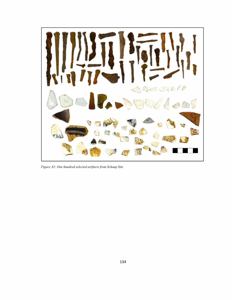
134
Figure A5: One hundred selected artifacts from Schaup Site

135
APPENDIX B ARTIFACT COLLECTION DATA
Level Form Information by Site
Amana School
Table B1: Level Form Information, Amana School, Planter North Unit
North Change in depth Level Dates SE SW NW NE CT Notes 1 10/23/12 -
10/24/12 23-33cm
23-33cm
23-33cm
23-33cm
23-33cm
Collected bone, metal, glass. Noticeable color change/mottling in the soil after the start of digging. Roots and rocks.
2 10/24/12 – 10/25/12
33-44cm
33-43cm
33-46.5cm
33-47cm
33-45cm
Collected metal, glass, bone, ceramic. Uncollected - brick. Lighter soil color. Some bug holes, few roots throughout.
3 10/25/12 -10/28/12
44-53cm
43-53cm
46.5-53cm
47-53cm
45-53cm
Collected metal, ceramic, glass. Uncollected - balloon, Plastic tape, Easter grass. Sand deposits fewer bug holes, some roots throughout. Sterile soil begins ~50cm.
Table B2: Level Form Information, Amana School, Planter Middle Unit
Middle Change in depth Level Dates SE SW NW NE CT Notes 1 10/23/12 -
10/24/12 23-33cm
23-33cm
23-33cm
23-33cm
23-33cm
Collected screw, metal, glass, bone, ceramic. Uncollected – limestone, brick, concrete. Bug holes, two large rocks, begin red/orange mottling.
2 10/24/12 – 10/25/12
33-40cm
33-43.5cm
33-44cm
33-43.5cm
33-45.5cm
Collected glass, ceramic, nails, metal, washer (?), rivets. Roots around edges, medium number of bug holes, localized sand deposits, W of big rock soil is lighter.
3 10/25/12 -10/28/12
40-53cm
43.5-53cm
44-53cm
43.5-53cm
45.5-53cm
Collected ceramic, metal, glass, rock concretion. Sterile soil begins ~50cm.

136
Table B3: Level Form Information, Amana School, Planter South Unit
South Change in depth Level Dates SE SW NW NE CT Notes 1 10/23/12 -
10/24/12 23-33cm
23-33cm
23-33cm
23-33cm
23-33cm
Collected ceramic, glass, nail, fabric. Uncollected – degraded bricks and limestone, few large bricks. Roots throughout, light mottling.
2 10/24/12 – 10/25/12
33-42cm
33-44cm
33-44cm
33-40cm
33-41cm
Collected ceramic, glass, metal, balloon. Uncollected – one or two midsize bricks. Roots adjacent to walls, bug holes, light color to soil, more clay.
3 10/25/12 -10/28/12
42-53cm
44-53cm
44-53cm
40-53cm
41-53cm
Collected metal, rodent teeth(?). Sterile soil begins ~50cm.
Homestead Hoehnle House
Table B4: Level Form Information, Homestead Hoehnle House, Unit 1
Unit 1
Change in depth
Level Dates SE SW NW NE CT Notes 1 6/4/12 -
6/5/12 15-29.5cm
16-33cm
14-29.5cm
10-30cm
19-30cm
Collected ceramic, glass pipe, bone, nails. Uncollected – slate, brick, limestone. Some pieces stuck in wall.
2 6/6/12 -6/6/12
29.5-38.5cm
33-40cm
29.5-39.5cm
30-39cm
30-40cm
Ceramic, glass, shingles, bones. Uncollected – brick and limestone. NE quadrant wood block.
3 6/6/12 -6/7/12
38.5-48cm
40-48.5cm
39.5-50cm
39-44.5cm
40-50cm
Collected metal can, glass, ceramic, shingles, bones, nails, metal. NE corner wooden board, W 1/3 large rock.
4 6/7/12 -6/11/12
48-58cm
48.5-54cm
50-54cm
44.5-58cm
50-59cm
Collected metal can, glass, ceramic, shingles, bones, nails, metal. Level was closed early to open new level for artifact accumulation in E center of unit.
5 6/11/12 -6/14/12
58-69cm
54-56cm
54-56cm
58-67cm
59-67.5cm
Collected bones, glass, ceramic, metal. Uncollected – boards in N & S walls. Hit concrete stone bottom that matches “step” in N side

137
Table B5: Level Form Information, Homestead Hoehnle House, Unit 2
Unit 2
Change in depth
Level Dates SE SW NW NE CT Notes 1 6/4/12 -
6/5/12 22-28cm
18-29.5cm
12-31cm
16-29.5cm
18-30cm Collected metal, glass, ceramic, bottle cap. Bricks in N wall, most large/complete, lots of roots. No soil color or texture change.
2 6/6/12 -6/6/12
28-37cm
29.5-38cm
31-39cm
29.5-39cm
30-40.5cm Collected shingles, wood, nails, glass, ceramic, caning jar top, metal chunks. Roots throughout, one brick in center, other bricks in N wall. No color or texture changes, wood appearing at bottom of level right under shingles.
3 6/7/12 -6/7/12
37-48cm
38-53cm
39-50cm
39-50cm
40.5cm-wood intrusion
Collected glass, ceramics, bones, nails. Bell-shaped metal object in SE corner, waiting to excavate.
4 6/7/12 -6/8/12
48-59cm
53-56cm (wood)
50-59cm
50-60cm
wood intrusion-59.5cm
Collected bell-shaped object, ceramic, glass metal, nails, bones. Uncollected – wood, metal pipe. Sand very fine, light color & river sand, fine, but with larger pieces.
5 6/9/12 -6/14/12
59-69cm
56-68cm
59-70cm
60-68.5cm
59.5-69cm Collected lots of glass, ceramic, shower cap, blue bottle, paper, metal, marble. Sand around pipe near center of unit, and along walls and corners. More clinker and coal pieces in center and towards E wall.
Table B6: Level Form Information, Homestead Hoehnle House, Unit 2.5
Unit 2.5
Change in depth
Level Dates SE SW NW NE CT Notes 1 6/4/12
-6/4/12 22-30cm
25-30cm
18-30cm
24-30cm
22-30cm
Collected metal, whetstone, glass, ceramic. Uncollected – bricks throughout hole, krotovina adjacent to E wall. Intact bricks left at bottom of level,
2 6/6/12 -6/6/12
30-40cm
30-40cm
30-42cm
30-39cm
30-40cm
Collected ceramic, egg, figurine, nails, metal, wood. Roots throughout, bricks through center & towards W wall. Sandy soil between bricks in center—richer, darker soil E of “brick wall.”
3 6/8/12 -6/8/12
40-50cm
brick brick brick 40-50cm
Collected glass, ceramic, claw tip (?), metal. Bricks along N & W walls, root in S wall. Started hitting gray/orange mottling and higher clay concentration.

138
Schaup Site
Table B7: Level Form Information, Schaup Site, Unit 1
Unit 1
Change in depth
Level Dates SE SW NW NE CT Notes 1 10/12/13
-10/18/13 2.5-6cm
2-4.5cm
2-4.5cm
1.5-6cm
0-5cm Collected white ware, nails, metal, ceramics, glass, bone. Uncollected - clinker, 8cm from NE corner, brick pieces, charcoal, cluster of sandstone in N 1/3 of unit. Large roots in SW & NE corners, small roots throughout, worms, grubs.
2 10/18/13 - 10/25/13
6-11cm 4.5-12cm
4.5-10cm
6-11.5cm
5-10cm Collected nails, metal, bone, ceramic, glass. Uncollected – clinkers, bits of brick and sandstone. Black/ashy soil in NE corner of unit.
3 10/25/13 - 10/26/13
11-14cm
12-15cm
10-14.5cm
11.5-14cm
10-15cm
Collected ceramic, glass nails, metal charcoal. Uncollected - sandstone
4 10/26/13 - 10/26/13
14-21cm
15-19cm
14.5-20cm
14-19cm
15-19cm
Collected ceramic, meta, bone? Uncollected – Sandstone in N 1/3 of unit along E wall, brick throughout. Soil wetter and darker, still just a little clay. Small roots throughout, worms, cluster of ants.
5 11/2/13 -11/9/13
21-26.5cm
19-25cm
20-25cm
19-26cm
19-24.5cm
Collected glass, ceramic, metal (almost no artifacts). Uncollected – degraded limestone, 3-5mm pieces of charcoal

139
Table B8: Level Form Information, Schaup Site, Unit 2
Unit 2
Change in depth
Level Dates SE SW NW NE CT Notes 1 10/12/13 -
10/19/13 0-5cm
0-7.5cm
0-6.5cm 0-4.5cm
0-5.5cm
Collected glass, ceramic, nails, lithic flakes. Uncollected – walnut, sandstone and brick pieces. Roots in S half of unit.
2 10/19/13 -10/26/13
5-13cm
7.5-11cm
6.5-10.5cm
4.5-9cm
5.5-10.5cm
Collected glass, ceramic, nails, metal, bits of brick, clinker. Uncollected – walnuts. High clay content with rusty mottling. One long thin root.
3 10/26/13 -11/8/13
13-17cm
11-18cm
10.5-14.5cm
9-16cm
10.5-16cm
Collected glass, ceramic, nails, metal, bits of brick. Uncollected – clinker, possible mortar. Mottled, rusty soil and clay continue.
Table B9: Level Form Information, Schaup Site, Unit 3
Unit 3
Change in depth
Level Dates SE SW NW NE CT Notes 1 10/25/13 -
10/26/13 0-6.5cm
0-5cm
0-4cm 0-5cm
0-5cm Collected glass, ceramic, nails (one found vertical), lithic flakes. Uncollected – sandstone in NE corner, brick in W wall. Roots in N, hard clay.
2 10/26/13 -11/8/13
6-5-8cm
5-6cm
4-4.5cm
5-6cm
5-5.5cm
End of Season: Level just started. Collected 1 ceramic fragment

140
Piece Plotted Artifacts by Site
Table B10: Amana School Planter North Piece Plotted Artifacts
Form No.
Date Subject From N edge
From E edge
From Surface
Dimensions Notes
104 5/24/12 Nail 61cm 100cm -35 8x0.5cm Charcoal to E 105 5/24/12 Ceramic
Base 23cm 5.5cm -32.5cm 5x2.5cm Color on bottom
107 5/24/12 Metal 75.5cm 117cm -41.5cm 9.1x3x0.03cm 2-3 cm N of rock in Middle Unit - Oxidized Folded Broke during excavation
109 5/25/12 Metal 22cm 27cm -38cm 5.5x0.5cm Oxidized 115 5/28/12 Metal 27cm 32cm -49cm 2.7x1.1cm Oxidized 116 5/28/12 Easter
Grass 30cm 50cm -49 5x0.2cm -
117 5/28/12 Metal 79cm 28cm -48cm 11x1.5cm Oxidized 118 5/28/12 Metal 94cm 35cm -46cm 10.7x1.8cm Brick associated
Table B11: Amana School Planter Middle Piece Plotted Artifacts
Form No.
Date Subject From N edge
From E edge
From Surface
Dimensions Notes
101 5/24/12 Bone 29cm 12cm -30.5cm 9.1x3.5x1cm Can associated, Sheer cut
103 5/24/12 Partial can 25cm 7cm -30cm 9.5x8cm Bone associated Folded,
5/24/12 - 108 5/25/12 6 metal
pieces Screws/nails
153cm 7.5cm -31cm 17x14.5cm pile
Oxidized
110 5/25/12 Metal circular
139cm 62cm -32cm 3.7cm diameter
Hole in middle
112 5/25/12 Metal cylinder
153cm 2cm -32cm 8.5x1cm Objects from form 108 associated
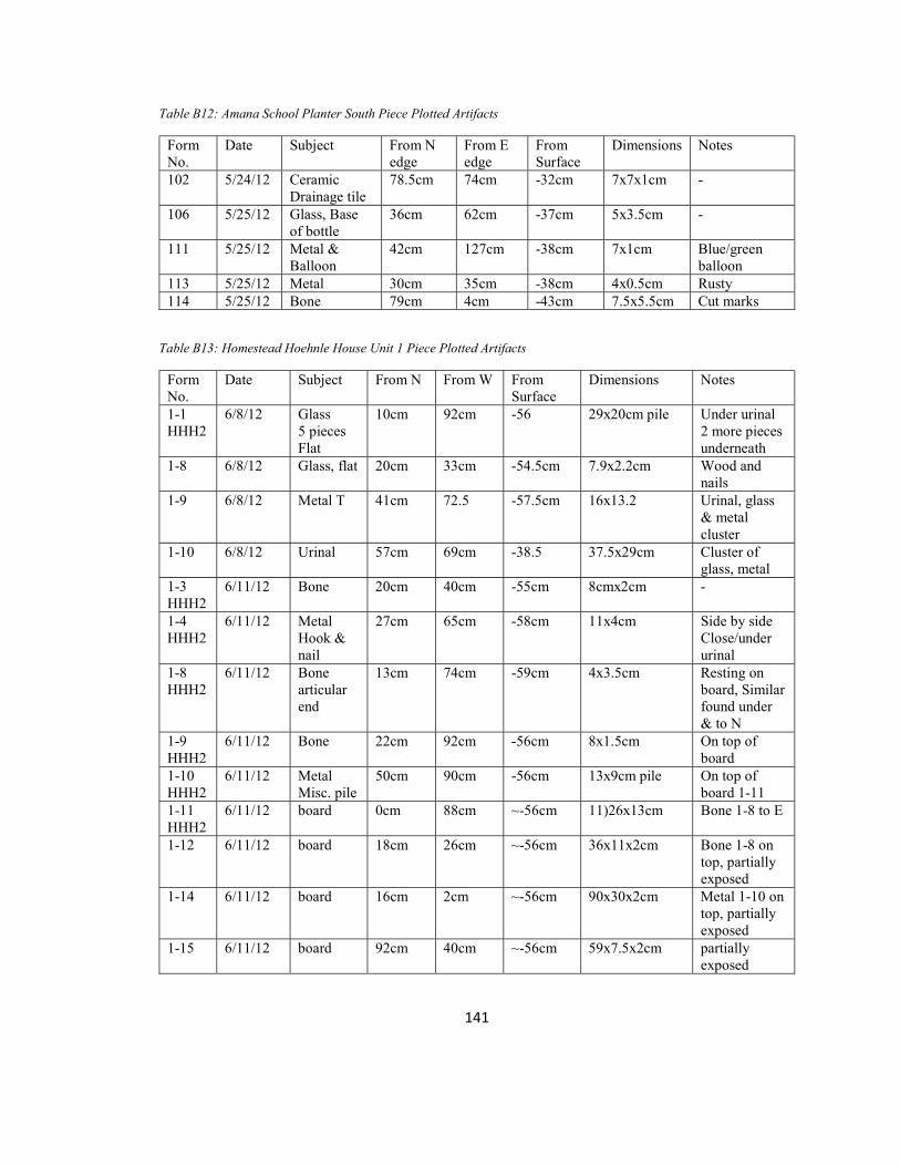
141
Table B12: Amana School Planter South Piece Plotted Artifacts
Form No.
Date Subject From N edge
From E edge
From Surface
Dimensions Notes
102 5/24/12 Ceramic Drainage tile
78.5cm 74cm -32cm 7x7x1cm -
106 5/25/12 Glass, Base of bottle
36cm 62cm -37cm 5x3.5cm -
111 5/25/12 Metal & Balloon
42cm 127cm -38cm 7x1cm Blue/green balloon
113 5/25/12 Metal 30cm 35cm -38cm 4x0.5cm Rusty 114 5/25/12 Bone 79cm 4cm -43cm 7.5x5.5cm Cut marks
Table B13: Homestead Hoehnle House Unit 1 Piece Plotted Artifacts
Form No.
Date Subject From N From W From Surface
Dimensions Notes
1-1 HHH2
6/8/12 Glass 5 pieces Flat
10cm 92cm -56 29x20cm pile Under urinal 2 more pieces underneath
1-8 6/8/12 Glass, flat 20cm 33cm -54.5cm 7.9x2.2cm Wood and nails
1-9 6/8/12 Metal T 41cm 72.5 -57.5cm 16x13.2 Urinal, glass & metal cluster
1-10 6/8/12 Urinal 57cm 69cm -38.5 37.5x29cm Cluster of glass, metal
1-3 HHH2
6/11/12 Bone 20cm 40cm -55cm 8cmx2cm -
1-4 HHH2
6/11/12 Metal Hook & nail
27cm 65cm -58cm 11x4cm Side by side Close/under urinal
1-8 HHH2
6/11/12 Bone articular end
13cm 74cm -59cm 4x3.5cm Resting on board, Similar found under & to N
1-9 HHH2
6/11/12 Bone 22cm 92cm -56cm 8x1.5cm On top of board
1-10 HHH2
6/11/12 Metal Misc. pile
50cm 90cm -56cm 13x9cm pile On top of board 1-11
1-11 HHH2
6/11/12 board 0cm 88cm ~-56cm 11)26x13cm
Bone 1-8 to E
1-12
6/11/12 board 18cm 26cm ~-56cm 36x11x2cm Bone 1-8 on top, partially exposed
1-14
6/11/12 board 16cm 2cm ~-56cm 90x30x2cm Metal 1-10 on top, partially exposed
1-15 6/11/12 board 92cm 40cm ~-56cm 59x7.5x2cm partially exposed

142
Table B13 continued 1-16 HHH2
6/11/12 Bone articular end
90cm 60cm -54cm 5.5x4x2cm Right under board, unfuses
1-17 HHH2
6/11/12 Bone 13.5cm 64cm -60cm 7x5.5cm -
1-18 HHH2
6/11/12 Flat glass 2 pieces
24cm 100cm -58cm 9x2.5cm 9x1.5cm
N of can under large board
1-19 HHH2
6/11/12 Glass, curved
33cm 67cm -59cm 24x11cm pile Recorded with 1-20 & 1-21
1-20 HHH2
6/11/12 Glass, flat 33cm 67cm -59cm 24x11cm pile Recorded with 1-19 & 1-21
1-21 HHH2
6/11/12 2 bones 33cm 67cm -59cm 24x11cm pile Recorded with 1-19 & 1-20
1-22 HHH2
6/11/12 12 bones 29cm 74cm -62cm 30x20.5 cluster 23cm N of can, cow carpals, chicken beak/feet, rodent humerus
1-24 HHH2
6/12/12 3 Bones, chicken 2 Glass pieces, flat
61cm 84cm -65cm 27x14 cluster Directly S of pan
1-25 HHH2
6/12/12 Glass, curved
64cm 60cm -57cm Found in cluster w/1-24, 1-26
1-26 HHH2
6/12/12 Ceramic, 64cm 60cm -57cm Found in cluster w/1-24, 1-25
1-28 HHH2
6/12/12 Bone, Partial
81cm 71cm -58cm 5x1.5cm chicken
1-34 6/13/12 Glass, bottle neck
0cm 82cm -61cm 10x8cm Coming out of N wall
1-35 6/13/12 Marble 26cm 49cm -66.5cm 2x2cm - 1-36 6/13/12 Glass 40cm 36cm -62.5cm 11x6cm Cluster w/ 1-
37 1-37 6/13/12 bone 40cm 36cm -62.5cm 11x6cm Cluster w/ 1-
37 1-38 6/13/12 Glass,
4 pieces 38cm 86cm -65cm 10x5cm -
1-39 6/13/12 Bone 12cm 40cm -64.5cm 3x2.5cm - 1-40 6/13/12 Bone 17cm 60cm -65.5cm 5x2cm -

143
Table B13 continued 1-41 6/13/12 Bones, 2 14cm 57cm -66cm 7x8cm - 1-42 6/13/12 Glass, 5
pieces Ceramic, 1 piece
12.5cm 71cm -66.5cm 24x12 cm cluster
Directly under plank
1-43 6/13/12 metal, flat glass, curved glass, bones
0cm 65.5cm -67cm 51x30cm cluster
~1-2cm above floor

144
Table B14: Homestead Hoehnle House Unit 2 Piece Plotted Artifacts
Form No.
Date Subject From S From W
From Surface
Dimensions Notes
2-6 HHH2
6/7/12 Glass 4 flat pieces
25cm 68cm -61cm 7x5cm 1-7 HHH2, 1-8 HHH2
2-7 HHH2
6/7/12 Bone 25cm 68cm -61cm 3x2cm 1-6 HHH2, 1-8 HHH2
2-7 6/7/12 Metal, lamp base?
43.5 96.5 Not recorded
9x9cm Tiny paper fragments
2-8 6/7/12 bone 25cm 68cm -61cm 4x4cm 1-6 HHH2, 1-7 HHH2
2-8 (1-8)
6/7/12 Can 16cm 20cm -51cm 13x7cm Wood piece associated, Looks intact
2-8b 6/7/12 Wood, large
85cm 70cm -50cm 80x21cm Brick, metal, smaller wood
2-9 6/7/12 Wood 11.5cm 35cm -47cm 29.5x10x7.5cm Perpendicular to 2-8b
2-10 6/8/12 Ceramic, thick
10cm 59cm -47.5cm 7.5x4.5x1cm -
2-11 6/8/12 Metal, thin
11.5cm 62cm -51.5cm 20.5x16cm Wood under, Three holes
2-11 (1-11)
6/8/12 Glass, flat
47cm 7cm -56cm 11x10cm Near urinal, glass/meta/wood cluster
2-12 (1-12)
6/8/12 Glass, flat
7cm 3.5cm -53cm 12.5x4.8cm -
2-12 6/8/12 Bone 15cm n.r. -55cm 9x2cm - 2-13 6/8/12 Ceramic, 4.5cm n.r. -56cm 5.5x5cm - 2-14 6/8/12 Bone 28cm n.r. -57.5cm 9.5x1.75cm - 2-15 6/8/12 Bone 90cm 45.5cm -51cm 8x7x3cm - 2-16 6/8/12 Skull 67cm n.r -53.5cm 4.5x3cm - 2-17b 6/8/12 Glass,
flat 9cm 2.5cm -55cm 12x8cm -
2-1 HHH2
6/11/12 Ceramic cup 4 pieces
20cm 85cm -60.5cm - Handle on one
2-3 HHH2
6/11/12 Bone, cut
24cm 25cm -58cm 4.2x3cm Wooden board
2-4 HHH2
6/11/12 Skull 11cm 80cm -59cm 3.3x2.6cm Fruit pit associated
2-5 HHH2
6/11/12 Glass clear curved
18cm 23cm -59cm 6x3cm pattern
2-14 6/12/12 Bone cluster
76cm 68cm -61 27x18cm N of metal pipe
2-15 6/12/12 Ceramic 2 cup pieces
0cm 61.5cm -61.5cm 7x6cm Under Shower cap

145
Table B14 continued 2-16 6/12/12 Skull 11.5cm 24.5cm -64.5cm 4.8x3cm - 2-17
6/12/12 3 bones 33cm 41cm -63.5cm 6x3cm Metal circular disk and pipe
2-18 6/12/12 Bone cluster
2.5cm 34.5cm -62.5cm 11x8cm Metal object underneath
2-19 6/12/12 Metal cluster
2.5cm 34.5cm -62.5cm 11x8cm Metal object underneath
2-21 6/12/12 skull 33cm 36cm -65cm 14x8.2cm Cluster w/2-22 2-22 6/12/12 Metal,
lid & piece
33cm 36cm -65cm 14x8.2cm Cluster w/2-21
2-23 6/12/12 Ceramic cup piece
17cm 54.5cm -63cm 4.9x4.1cm -
2-24 6/12/12 Ceramic 2 cup pieces
2cm 73cm -55cm 11x5cm -
2-26 6/12/12 Bone cluster
67cm 27cm -62.5cm 12x9cm Metal pipe
2-28 6/12/12 Bones, 4 tiny
93.5cm 36cm -65cm 6x3.5cm By front (W) of pipe
2_29 6/12/12 Glass flat
2cm 11cm -57cm 7x5cm -
2_30 6/12/12 Bone 2cm 11cm -57cm 5x3cm - 2-32 6/12/12 Jar lid n.r. n.r -66.5cm Photo only 2-34 6/13/12 Glass,
flat 59cm 3cm -57cm 9x3cm -
2-35 6/13/12 Bone cluster
16cm 11cm 62.5cm 32x15cm Under flat glass
2-36 6/13/12 Metal cluster
7cm 9cm -59cm 17x16.5cm Under flat glass
2-37 6/13/12 Shower cap
8cm 48cm -59.5cm 21-16cm Small metal pieces under cap, In S wall
2-38 6/13/12 Skull 17cm 18cm -64cm 3.5x3.5cm - 2-40 6/13/12 Bones 63.5cm 38cm -67.5cm 7.5x5cm N of metal pipe 2-41 6/13/12 ??? 2-43 6/13/12 Bones 47cm 8cm -64cm 3x2cm - 2-44 6/13/12 Ceramic
2 pieces 2cm 54cm -57.5cm 7x5.5cm
3.5x3cm Under shower cap
2-46 6/13/12 Ceramic 33cm 95cm -60cm 5.5x2cm Gold rim 2-48 6/13/12 Ceramic 0cm 22cm -63.5cm 5.5x3cm - 2-49 6/13/12 Ceramic
cup bottom
83.5cm 18cm -65cm 22x13cm cluster
8cm W of pipe
2-50 6/13/12 Bone 83.5cm 0cm -65cm 22x13cm cluster
On wood board
2-52 6/14/12 Bones 37cm 25cm -66cm 22x7cm cluster - 2-53 6/14/12 Paper
clump 57cm 32cm -64cm 17x13cm Up against/under
pipe

146
Table B14 continued 2-54 6/14/12 Ceramic
with handle
85cm 47cm -67cm 7x5cm 12cm E of pipe
2-55 6/14/12 Bone, broken in 3
100cm 67cm -63cm 9cmx1.5cm -
2-56 6/14/12 Metal cap
47cm 96cm -61.5cm 34x12cm cluster
Collected w/ 2-57, 2-58
2-57 6/14/12 Bone 47cm 96cm -61.5cm 34x12cm cluster
Collected w/ 2-56, 2-58
2-58 6/14/12 Ceramic
47cm 96cm -61.5cm 34x12cm cluster
Collected w/ 2-56, 2-57
2-59 6/14/12 Metal cap
18cm 69.5cm -63.5cm 33.5x11cm cluster
In wall, Collected with 2-60, 2-61
2-60 6/14/12 Skull 18cm 69.5cm -63.5cm 33.5x11cm cluster
Collected with 2-59, 2-61
2-61 6/14/12 Ceramic 18cm 69.5cm -63.5cm 33.5x11cm cluster
Collected with 2-59, 2-60
2-62 6/14/12 Jar lid 77cm 24cm -66.5cm 14x9cm cluster Collected with 2-63
2-63 6/14/12 Glass curved
83cm 24cm -66.5cm 14x9cm cluster Collected with 2-62
2-64 6/14/12 Glass 3 flat pieces
60cm 10cm -68.5cm 14x11cm cluster
Collected with 2-65
2-65 6/14/12 Bone 60cm 10cm -68.5cm 14x11cm cluster
Collected with 2-64
2-66 6/14/12 Bones 58cm 86cm -61cm 13x11cm cluster
Collected with 2-67
2-67 6/14/12 Bottle cap
58cm 86cm -61cm 13x11cm cluster
Collected with 2-66
2-68 6/14/12 Metal disk
87cm 68cm -69cm 44x17cm cluster
Collected with 2-70, 2-72
2-69 6/14/12 2-70 6/14/12 Glass 7
pieces 87cm 68cm -69cm 44x17cm
cluster Collected with 2-68, 2-72
2-71 6/14/12 Skull 20cm 76cm -64cm 5x3cm - 2-72 6/14/12 Ceramic
3 pieces 87cm 68cm -69cm 44x17cm
cluster Collected with 2-68, 2-70
2-73 6/14/12 Bone 57cm 81cm -64cm 10x2cm - 2-74 6/14/12 Metal 41cm 95cm -62cm 14x6cm cluster - 2-75 6/14/12 Ceramic
4 pieces 45cm 68cm -66cm 40x32cm
cluster -
2-76 6/14/12 Metal 100cm 37cm -70cm 12x4.5cm - 2-77 6/14/12 Ceramic 51.5cm 55cm -67cm 5.5x4cm - 2-78 6/14/12 Ceramic 7.5cm 48.5cm -63.5cm 5x4cm - 2-79 6/14/12 Bones 37.5cm 38.5cm -68cm 6x4cm - 2-80 6/14/12 Bottle
cap 0cm 62cm -64cm 3.5x3.5cm -

147
Table B14 continued 2-81 6/14/12 Bottle
cap 35cm 100cm -64cm 3.5x3.5cm -
2-82 6/14/12 Skull 10cm 36cm -68.5 5x3cm Bottom of unit 2-83 6/14/12 marble 29cm 68cm -68.5 1.5x1.5cm Bottom of unit 2-84 6/14/12 Blue
bottle 49cm 71cm -68.5 7x4.5cm Bottom of unit
2-85 6/14/12 ceramic 58cm 67cm -68.5 n.r. Bottom of unit 2-86 6/14/12 Glass 58cm 67cm -68.5 4x2.5cm Bottom of unit 2-87 6/14/12 Glass
curved 84cm 80cm -68.5 3.5x2.5 Bottom of unit
Table A14 continued 2-88 6/14/12 Jar lid 100cm 100cm -66.5 7x7cm - 2-89 6/14/12 Metal
disk 69cm 100cm -68.5 5x5cm -
2-90 6/14/12 Bottle cap
36cm 82cm -68.5 3.5x3.5 Fused to floor of unit
2-91 6/14/12 Metal rod
28cm 71cm -69.5 10.5x2.5cm -

148
Homestead Hoehnle House Artifacts by Unit and Type (Non-Piece Plotted Only)
Table B15: Homestead Hoehnle House Unit 1
Level Depth Date Type Number Weight(g) 0 surface 06/01/12 Glass, curved 18 150 0 surface 06/01/12 Glass, curved & colored 5 35 0 surface 06/01/12 Glass, flat 3 10 0 surface 06/01/12 Ceramic 5 35 0 surface 06/01/12 Metal 34 1020 0 surface 06/01/12 Bone - - 0 surface 06/01/12 pottery 18 380 0 surface 06/04/12 Glass, curved 11 37 0 surface 06/04/12 Glass, curved & colored 6 22.5 0 surface 06/04/12 Glass, flat 23 48 0 surface 06/04/12 Ceramic 8 126 0 surface 06/04/12 Metal 18 46.5 0 surface 06/04/12 Bone 1 .5 0 surface 06/04/12 Green cap 1 2.5 0 surface 06/04/12 Gray plastic fragment 1 13 0 surface 06/04/12 White plastic handle 3 9 0 surface 06/04/12 Ceramic drainpipe fragment 1 337 1 0-30 06/04/12 Glass, curved 13 34.5 1 0-30 06/04/12 Glass, curved & colored 3 14.5 1 0-30 06/04/12 Glass, flat 14 35.5 1 0-30 06/04/12 Ceramic 3 4 1 0-30 06/04/12 Metal 7 35 1 0-30 06/04/12 Bone - - 1 0-30cm 06/04/12 brick 1 11 1 0-30cm 06/05/12 Glass, curved 30 116 1 0-30cm 06/05/12 Glass, curved & colored 10 72 1 0-30cm 06/05/12 Glass, flat 30 36.5 1 0-30cm 06/05/12 Ceramic 13 118 1 0-30cm 06/05/12 Metal 27 70.5 1 0-30cm 06/05/12 Bone 2 39.5 1 0-30cm 06/05/12 Slate 2 Not weighed 1 0-30cm 06/05/12 Slag 2 Not weighed 1 0-30cm 06/05/12 Ceramic drainpipe 1 368 1 0-30cm 06/05/12 paper 1 Not weighed 2 30-40 06/06/12 Glass, curved 72 86.5 2 30-40 06/06/12 Glass, curved & colored 9 16 2 30-40 06/06/12 Glass, flat 13 26.5

149
Table B15 continued 2 30-40 06/06/12 Ceramic 19 27 2 30-40 06/06/12 Metal 12 2 30-40 06/06/12 Bone 4 5.5 2 30-40 06/06/12 slate 1 Not weighed 2 30-40 06/06/12 Roofing material 56 76 2 30-40 06/06/12 Unknown, porous stone Not weighed 2 30-40 06/06/12 clinker 1 Not weighed 3 40-50 06/06-07/12 Glass, curved 27 41 3 40-50 06/06-07/12 Glass, curved & colored 5 6.5 3 40-50 06/06-07/12 Glass, flat 15 23.5 3 40-50 06/06-07/12 Ceramic 7 11 3 40-50 06/06-07/12 Metal 20 62.5 3 40-50 06/06-07/12 Bone 12 5 3 40-50 06/06-07/12 clinker 2 7.5 3 40-50 06/06-07/12 Roofing material 23 29 4 50-60 06/07/12 Glass, curved 11 21 4 50-60 06/07/12 Glass, curved & colored 1 3.5 4 50-60 06/07/12 Glass, flat - - 4 50-60 06/07/12 Ceramic 1 1.5 4 50-60 06/07/12 Metal 6 15 4 50-60 06/07/12 Bone 1 2 4 50-60 06/07/12 Button 1 1 4 50-60 06/08/2012 Glass, curved 16 26 4 50-60 06/08/2012 Glass, curved & colored 4 5.5 4 50-60 06/08/2012 Glass, flat 4 17 4 50-60 06/08/2012 Ceramic 3 3.5 4 50-60 06/08/2012 Metal 19 69.5 4 50-60 06/08/2012 Bone 2 .5 4 50-60 06/08/2012 Glass, curved 4 4.5 4 50-60 06/08/2012 Glass, curved & colored 1 1 4 50-60 06/08/2012 Glass, flat - - 4 50-60 06/08/2012 Ceramic 1 .5 4 50-60 06/08/2012 Metal 12 32.5 4 50-60 06/08/2012 Bone 6 1.5 4 50-60 06/11/12 Glass, curved 14 17.5 4 50-60 06/11/12 Glass, curved & colored 2 1 4 50-60 06/11/12 Glass, flat 45 309.5

150
Table B15 continued 4 50-60 06/11/12 Ceramic 2 1 4 50-60 06/11/12 Metal 15 96 4 50-60 06/11/12 Bone 12 4 5 60-70 06/11/12 CG Glass, curved 1 5.5 5 60-70 06/11/12 Glass, curved & colored - - 5 60-70 06/11/12 Glass, flat 20 48.5 5 60-70 06/11/12 Ceramic - - 5 60-70 06/11/12 Metal 42 60 5 60-70 06/11/12 Bone 25 130 5 60-70 06/12/12 Glass, curved 38 37 5 60-70 06/12/12 Glass, curved & colored 1 3.5 5 60-70 06/12/12 Glass, flat - - 5 60-70 06/12/12 Ceramic 5 4.5 5 60-70 06/12/12 Metal 37 94 5 60-70 06/12/12 Bone 238 47.5 5 60-70 06/12/12 Woody material 8 .5 5 60-70 06/12/12 Foil 8 .5 5 60-70 06/12/12 Fruit pits 2 1.5 5 60-70 06/12/12 brick 5 51.5 5 60-70 06/13/12 Glass, curved 23 137 5 60-70 06/13/12 Glass, curved & colored - - 5 60-70 06/13/12 Glass, flat 5 84.5 5 60-70 06/13/12 Ceramic 2 9 5 60-70 06/13/12 Metal 8 4.5 5 60-70 06/13/12 Bone 72 23.7 5 60-70 06/13/12 Marble (toy) 1 9.5 5 60-70 06/13/12 Glass top of bottle 1 100 5 60-70 06/13/12 Fruit pit 1 2.5 5 60-70 06/13/12 Paper 1 2 5 60-70 06/13/12 Foil 1 .5 5 60-70 06/13/12 Plastic seal 1 .5

151
Table B16: Homestead Hoehnle House Unit 2
Level Depth Date Type Number Weight(g) 0 Surface 06/01/12 Glass, curved 24 27.5 0 Surface 06/01/12 Glass, curved & colored 7 6.5 0 Surface 06/01/12 Glass, flat 8 6.5 0 Surface 06/01/12 Ceramic 4 9.0 0 Surface 06/01/12 Metal 29 114.5 0 Surface 06/01/12 Bone 3 2.5 0 Surface 06/01/12 terra cotta 4 41 0 Surface 06/01/12 shell 5 1.5 0 Surface 06/01/12 Plastic cups 4 9.5 0 Surface 06/01/12 Plastic fragments 4 1.0 0 Surface 06/01/12 Easter grass 1 0.0 0 Surface 06/04/12 Glass, curved 21 38.0 0 Surface 06/04/12 Glass, curved & colored 8 12.5 0 Surface 06/04/12 Glass, flat 7 6.5 0 Surface 06/04/12 Ceramic 5 14.0 0 Surface 06/04/12 Metal 25 48.5 0 Surface 06/04/12 Bone 3 65.0 0 Surface 06/04/12 plastic 4 4.5 0 Surface 06/04/12 Easter grass 1 - 1 0-10cm 06/04/12 Glass, curved 41 87.5 1 0-10cm 06/04/12 Glass, curved & colored 9 12.0 1 0-10cm 06/04/12 Glass, flat 14 20.0 1 0-10cm 06/04/12 Ceramic 2 1.0 1 0-10cm 06/04/12 Metal 10 83.0 1 0-10cm 06/04/12 Bone 0 - 1 0-10cm 06/04/12 Plastic tube w/ flat end 1 - 1 10-30cm 06/05/12 Glass, curved 41 98.5 1 10-30cm 06/05/12 Glass, curved & colored 8 29.5 1 10-30cm 06/05/12 Glass, flat 27 30.5 1 10-30cm 06/05/12 Ceramic 9 54.0 1 10-30cm 06/05/12 Metal 31 96.0 1 10-30cm 06/05/12 Bone 0 - 1 10-30cm 06/05/12 wood 2 0.5 1 10-30cm 06/05/12 roofing 1 2.0 2 30-40cm 06/06/12 Glass, curved 123 261.5 2 30-40cm 06/06/12 Glass, curved & colored 25 83.5 2 30-40cm 06/06/12 Glass, flat 26 30.0 2 30-40cm 06/06/12 Ceramic 17 105.5 2 30-40cm 06/06/12 Metal 106 339.0

152
Table B16 continued 2 30-40cm 06/06/12 Bone 3 1.0 2 30-40cm 06/06/12 Wood w/nail 1 13.0 2 30-40cm 06/06/12 roofing 80 148.5 2 30-40cm 06/06/12 Canning lid 1 51.0 3 40-50 06/07/12 Glass, curved 66 90.0 3 40-50 06/07/12 Glass, curved & colored 8 25.0 3 40-50 06/07/12 Glass, flat 11 7.5 3 40-50 06/07/12 Ceramic 6 21.5 3 40-50 06/07/12 Metal 55 227.5 3 40-50 06/07/12 Bone 9 5.0 3 40-50 06/07/12 Black button 1 - 3 40-50 06/07/12 Piece of wood 1 - 3 40-50 06/07/12 Roof flashing - - 3 40-50 06/07/12 Roofing material - 178.0 4 50-60cm 06/07/12 Glass, curved 11 11.5 4 50-60cm 06/07/12 Glass, curved & colored 4 5.0 4 50-60cm 06/07/12 Glass, flat 3 116.5 4 50-60cm 06/07/12 Ceramic 8 111.5 4 50-60cm 06/07/12 Metal 11 40.5 4 50-60cm 06/07/12 Bone 4 42.5 4 50-60cm 06/07/12 plastic 2 - 4 50-60cm 06/07/12 Roof flashing 1 - 4 50-60cm 06/07/12 shell 1 - 4 50-60cm 06/08/12 Glass, curved 37 39.0 4 50-60cm 06/08/12 Glass, curved & colored 8 12.0 4 50-60cm 06/08/12 Glass, flat 13 7.5 4 50-60cm 06/08/12 Ceramic 4 8.5 4 50-60cm 06/08/12 Metal 50 129.5 4 50-60cm 06/08/12 Bone 15 4.0 4 50-60cm 06/08/12 Button 1 0.5 4 50-60cm 06/08/12 Rock metal? 1 26 4 50-60cm 06/08/12 Fruit pits 3 4.0 4 50-60cm 06/08/12 Bottle caps 5 7.5 4 50-60cm 06/08/12 Foil wrapper 3 0.0 4 50-60cm 06/08/12 Bottle cap w/bone 1 4.5 5 60-70cm 06/11/12 Glass, curved 4 29.0 5 60-70cm 06/11/12 Glass, curved & colored 1 4.0 5 60-70cm 06/11/12 Glass, flat 14 275.0 5 60-70cm 06/11/12 Ceramic 5 83.5

153
Table B16 continued 5 60-70cm 06/11/12 Metal 29 125.0 5 60-70cm 06/11/12 Bone 45 196.0 5 60-70cm 06/11/12 Plastic 3 - 5 60-70cm 06/11/12 fibers - - 5 60-70cm 06/11/12 Fruit pits 33 24.0 5 60-70cm 06/11/12 Nut piece 1 - 5 60-70cm 06/12/12 Glass, curved 0 - 5 60-70cm 06/12/12 Glass, curved & colored 0 - 5 60-70cm 06/12/12 Glass, flat 0 - 5 60-70cm 06/12/12 Ceramic 0 - 5 60-70cm 06/12/12 Metal 25 54.5 5 60-70cm 06/12/12 Bone 209 53.5 5 60-70cm 06/12/12 Fruit pits 24 13.0 5 60-70cm 06/12/12 Blue plastic 3 15.0 5 60-70cm 06/13/12 Glass, curved 4 0.5 5 60-70cm 06/13/12 Glass, curved & colored 0 - 5 60-70cm 06/13/12 Glass, flat 6 2.5 5 60-70cm 06/13/12 Ceramic 4 49.5 5 60-70cm 06/13/12 Metal 13 35.0 5 60-70cm 06/13/12 Bone 73 15.0 5 60-70cm 06/13/12 Fruit pits 11 3.5 5 60-70cm 06/14/12 Glass, curved 20 22.5 5 60-70cm 06/14/12 Glass, curved & colored 3 6.0 5 60-70cm 06/14/12 Glass, flat 2 6.5 5 60-70cm 06/14/12 Ceramic 4 2.5 5 60-70cm 06/14/12 Metal 120 163.5 5 60-70cm 06/14/12 Bone 330 56.0 5 60-70cm 06/14/12 Fruit cores 26 8.0 5 60-70cm 06/14/12 Square blue plastic 1 - 5 60-70cm 06/14/12 seeds - - 5 60-70cm 06/14/12 Paper w/ writing - - 5 60-70cm 06/14/12 Pen pieces - - 5 60-70cm 06/14/12 Glass, curved 2 15.0 5 60-70cm 06/14/12 Glass, curved & colored 0 0 5 60-70cm 06/14/12 Glass, flat 3 72.5 5 60-70cm 06/14/12 Ceramic 11 193 5 60-70cm 06/14/12 Metal 11 110.5 5 60-70cm 06/14/12 Bone 11 13.5 5 60-70cm 06/14/12 Jar lid 1 49.0
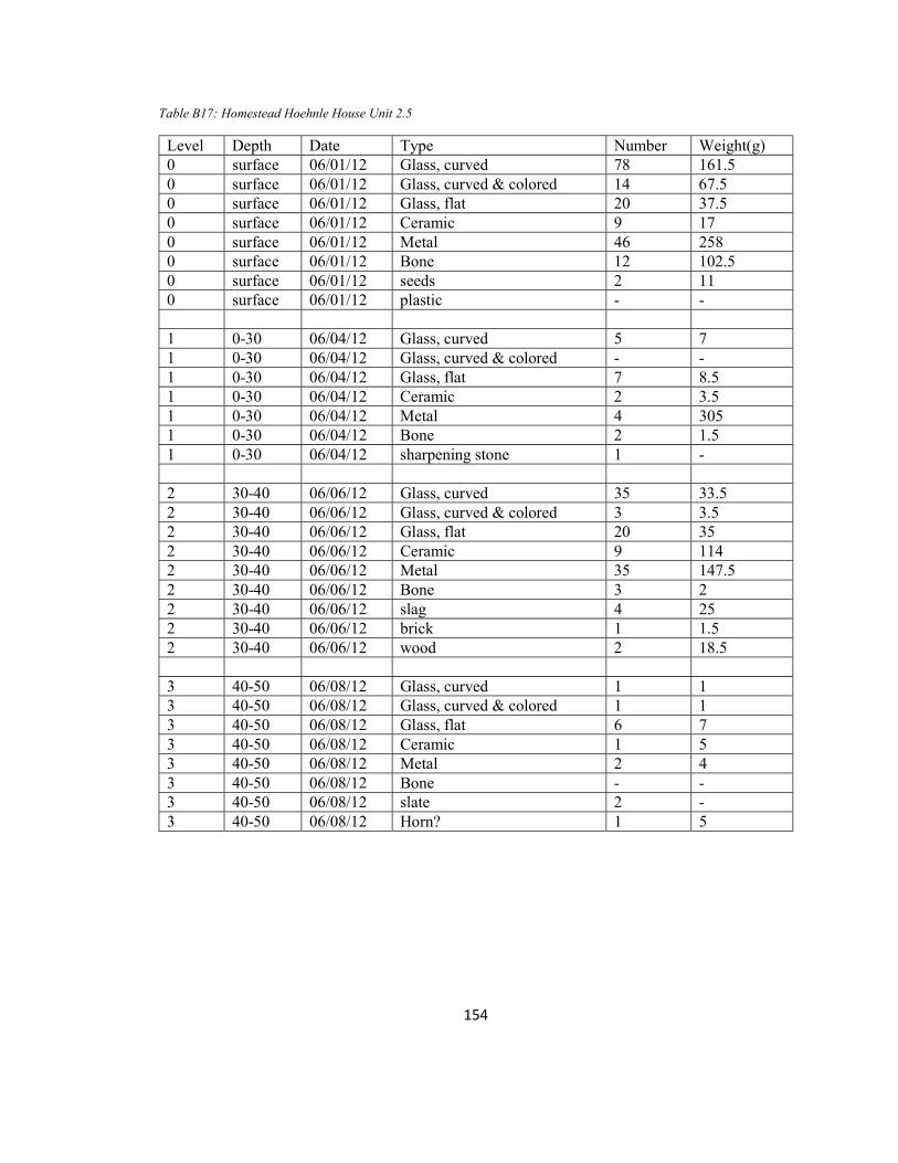
154
Table B17: Homestead Hoehnle House Unit 2.5
Level Depth Date Type Number Weight(g) 0 surface 06/01/12 Glass, curved 78 161.5 0 surface 06/01/12 Glass, curved & colored 14 67.5 0 surface 06/01/12 Glass, flat 20 37.5 0 surface 06/01/12 Ceramic 9 17 0 surface 06/01/12 Metal 46 258 0 surface 06/01/12 Bone 12 102.5 0 surface 06/01/12 seeds 2 11 0 surface 06/01/12 plastic - - 1 0-30 06/04/12 Glass, curved 5 7 1 0-30 06/04/12 Glass, curved & colored - - 1 0-30 06/04/12 Glass, flat 7 8.5 1 0-30 06/04/12 Ceramic 2 3.5 1 0-30 06/04/12 Metal 4 305 1 0-30 06/04/12 Bone 2 1.5 1 0-30 06/04/12 sharpening stone 1 - 2 30-40 06/06/12 Glass, curved 35 33.5 2 30-40 06/06/12 Glass, curved & colored 3 3.5 2 30-40 06/06/12 Glass, flat 20 35 2 30-40 06/06/12 Ceramic 9 114 2 30-40 06/06/12 Metal 35 147.5 2 30-40 06/06/12 Bone 3 2 2 30-40 06/06/12 slag 4 25 2 30-40 06/06/12 brick 1 1.5 2 30-40 06/06/12 wood 2 18.5 3 40-50 06/08/12 Glass, curved 1 1 3 40-50 06/08/12 Glass, curved & colored 1 1 3 40-50 06/08/12 Glass, flat 6 7 3 40-50 06/08/12 Ceramic 1 5 3 40-50 06/08/12 Metal 2 4 3 40-50 06/08/12 Bone - - 3 40-50 06/08/12 slate 2 - 3 40-50 06/08/12 Horn? 1 5
Related Documents