Relative sea-level changes in the Basque coast (northern Spain, Bay of Biscay) during the Holocene and Anthropocene: The Urdaibai estuary case Ane García-Artola a, b, * , Alejandro Cearreta a , Eduardo Leorri c a Departamento de Estratigrafía y Paleontología, Facultad de Ciencia y Tecnología, Universidad del País Vasco UPV/EHU, Apartado 644, 48080 Bilbao, Spain b Sociedad de Ciencias Aranzadi, Zorroagagaina kalea 11, 20014 Donostia-San Sebastian, Spain c Department of Geological Sciences, East Carolina University, Greenville, NC 27858-4353, USA article info Article history: Available online 13 July 2014 Keywords: Foraminifera Sea-level changes Holocene Anthropocene Northern Spain abstract In order to reconstruct the environmental evolution process of the Urdaibai estuary in response to sea- level changes in the Basque coast (northern Spain, Bay of Biscay) during the last 8500 years, 10 boreholes were drilled in different estuarine areas using a rotary drill until the pre-Quaternary basement was reached. One manual short core (50 cm) was obtained from a salt marsh environment located in the middle part of the estuary. Micropalaeontological (benthic foraminifera), sedimentological (grain size) and geochemical ( 14 C, 210 Pb and 137 Cs radioisotopes and total Pb and Zn) analyses were performed on these materials aiming to quantify the sea-level changes both of natural origin (Holocene) or derived from recent human activities (Anthropocene). Based on the obtained results, and by comparison with previously published information for this coastal area, the Holocene environmental evolution of the Urdaibai estuary has been interpreted as the result of relative sea-level variation that exhibits a rapid rise until 7000 cal BP followed by a moderate rise since then, and a stabilization during the last 3000 years until modern rates of sea-level rise (20th century: 1.7 ± 0.2 mm y 1 ) were reached. © 2014 Elsevier Ltd and INQUA. All rights reserved. 1. Introduction A substantial and rapidly increasing proportion of global pop- ulation lives in the coast (within 100 km of a shoreline and 100 m above sea level; Small and Nicholls, 2003), which occupies 18% of the world's land mass (Smith et al., 2005). In Spain, 44% of people live in coastal cities and towns that represent only 7% of the total national land area (Dias et al., 2013). As a result of the great human concentration in this coastal fringe, it is essential to understand the anthropogenic impacts on coastal zones derived from major drivers such as recent global sea-level rise (1.7 ± 0.2 mm y 1 during the period 1900e2009 following Church and White, 2011), resulting from thermal expansion of seawater due to ocean warming and water mass input from land ice melt and land water reservoirs (IPCC, 2014). More recently, the analysis of satellite altimeter records (available since 1993) provided a global sea-level rise rate of 3.1 ± 0.4 mm y 1 for the period 1993e2012 (Henry et al., 2013), suggesting an acceleration in the last few decades. The IPCC AR5 report (2014) predicted that global mean sea-level rise rate during the 21st century (median values: 4.4e11.2 mm y 1 ) will exceed the observed rate for the period 1971e2010 of 2.0 (1.7e2.3) mm y 1 under all Representative Concentration Pathways (RCP) scenarios. Regional factors such as tectonic and glacial isostatic movements need to be considered (Gehrels et al., 2011, 2012; Engelhart and Horton, 2012). Results obtained by Marcos et al. (2012) predict that mean sea level (MSL) might increase by up to 40 cm by the end of the 21st century with respect to modern values in northern Spain, resulting in up to 202 ha of supratidal coastal areas under risk of flooding. Hence, sea-level rise presents a hazard and elevated economic costs regarding coastal flood dam- age and adaptation. Bosello et al. (2012) estimated US$ 13.52 million of land losses by floods and US$ 2.95 million needed for coastal protection in Spain by 2085. The variability in costs of flooding and damage are related in part to the imprecision of the projections. These future estimates are constrained by the tide-gauge instrumental records which are geographically-limited and * Corresponding author. Departamento de Estratigrafía y Paleontología, Facultad de Ciencia y Tecnología, Universidad del País Vasco UPV/EHU, Apartado 644, 48080 Bilbao, Spain. E-mail addresses: [email protected] (A. García-Artola), alejandro.cearreta@ehu. es (A. Cearreta), [email protected] (E. Leorri). Contents lists available at ScienceDirect Quaternary International journal homepage: www.elsevier.com/locate/quaint http://dx.doi.org/10.1016/j.quaint.2014.06.040 1040-6182/© 2014 Elsevier Ltd and INQUA. All rights reserved. Quaternary International 364 (2015) 172e180

Welcome message from author
This document is posted to help you gain knowledge. Please leave a comment to let me know what you think about it! Share it to your friends and learn new things together.
Transcript
lable at ScienceDirect
Quaternary International 364 (2015) 172e180
Contents lists avai
Quaternary International
journal homepage: www.elsevier .com/locate/quaint
Relative sea-level changes in the Basque coast (northern Spain, Bay ofBiscay) during the Holocene and Anthropocene: The Urdaibai estuarycase
Ane García-Artola a, b, *, Alejandro Cearreta a, Eduardo Leorri c
a Departamento de Estratigrafía y Paleontología, Facultad de Ciencia y Tecnología, Universidad del País Vasco UPV/EHU, Apartado 644, 48080 Bilbao, Spainb Sociedad de Ciencias Aranzadi, Zorroagagaina kalea 11, 20014 Donostia-San Sebastian, Spainc Department of Geological Sciences, East Carolina University, Greenville, NC 27858-4353, USA
a r t i c l e i n f o
Article history:Available online 13 July 2014
Keywords:ForaminiferaSea-level changesHoloceneAnthropoceneNorthern Spain
* Corresponding author. Departamento de Estratigrde Ciencia y Tecnología, Universidad del País Vasco UPBilbao, Spain.
E-mail addresses: [email protected] (A. García-Artes (A. Cearreta), [email protected] (E. Leorri).
http://dx.doi.org/10.1016/j.quaint.2014.06.0401040-6182/© 2014 Elsevier Ltd and INQUA. All rights
a b s t r a c t
In order to reconstruct the environmental evolution process of the Urdaibai estuary in response to sea-level changes in the Basque coast (northern Spain, Bay of Biscay) during the last 8500 years, 10 boreholeswere drilled in different estuarine areas using a rotary drill until the pre-Quaternary basement wasreached. One manual short core (50 cm) was obtained from a salt marsh environment located in themiddle part of the estuary. Micropalaeontological (benthic foraminifera), sedimentological (grain size)and geochemical (14C, 210Pb and 137Cs radioisotopes and total Pb and Zn) analyses were performed onthese materials aiming to quantify the sea-level changes both of natural origin (Holocene) or derivedfrom recent human activities (Anthropocene). Based on the obtained results, and by comparison withpreviously published information for this coastal area, the Holocene environmental evolution of theUrdaibai estuary has been interpreted as the result of relative sea-level variation that exhibits a rapid riseuntil 7000 cal BP followed by a moderate rise since then, and a stabilization during the last 3000 yearsuntil modern rates of sea-level rise (20th century: 1.7 ± 0.2 mm y�1) were reached.
© 2014 Elsevier Ltd and INQUA. All rights reserved.
1. Introduction
A substantial and rapidly increasing proportion of global pop-ulation lives in the coast (within 100 km of a shoreline and 100 mabove sea level; Small and Nicholls, 2003), which occupies 18% ofthe world's land mass (Smith et al., 2005). In Spain, 44% of peoplelive in coastal cities and towns that represent only 7% of the totalnational land area (Dias et al., 2013). As a result of the great humanconcentration in this coastal fringe, it is essential to understand theanthropogenic impacts on coastal zones derived frommajor driverssuch as recent global sea-level rise (1.7 ± 0.2 mm y�1 during theperiod 1900e2009 following Church and White, 2011), resultingfrom thermal expansion of seawater due to ocean warming andwater mass input from land ice melt and land water reservoirs(IPCC, 2014). More recently, the analysis of satellite altimeter
afía y Paleontología, FacultadV/EHU, Apartado 644, 48080
ola), alejandro.cearreta@ehu.
reserved.
records (available since 1993) provided a global sea-level rise rateof 3.1 ± 0.4 mm y�1 for the period 1993e2012 (Henry et al., 2013),suggesting an acceleration in the last few decades.
The IPCC AR5 report (2014) predicted that global mean sea-levelrise rate during the 21st century (median values: 4.4e11.2 mm y�1)will exceed the observed rate for the period 1971e2010 of 2.0(1.7e2.3) mmy�1 under all Representative Concentration Pathways(RCP) scenarios. Regional factors such as tectonic and glacialisostatic movements need to be considered (Gehrels et al., 2011,2012; Engelhart and Horton, 2012). Results obtained by Marcoset al. (2012) predict that mean sea level (MSL) might increase byup to 40 cm by the end of the 21st century with respect to modernvalues in northern Spain, resulting in up to 202 ha of supratidalcoastal areas under risk of flooding. Hence, sea-level rise presents ahazard and elevated economic costs regarding coastal flood dam-age and adaptation. Bosello et al. (2012) estimated US$ 13.52million of land losses by floods and US$ 2.95 million needed forcoastal protection in Spain by 2085. The variability in costs offlooding and damage are related in part to the imprecision of theprojections.
These future estimates are constrained by the tide-gaugeinstrumental records which are geographically-limited and
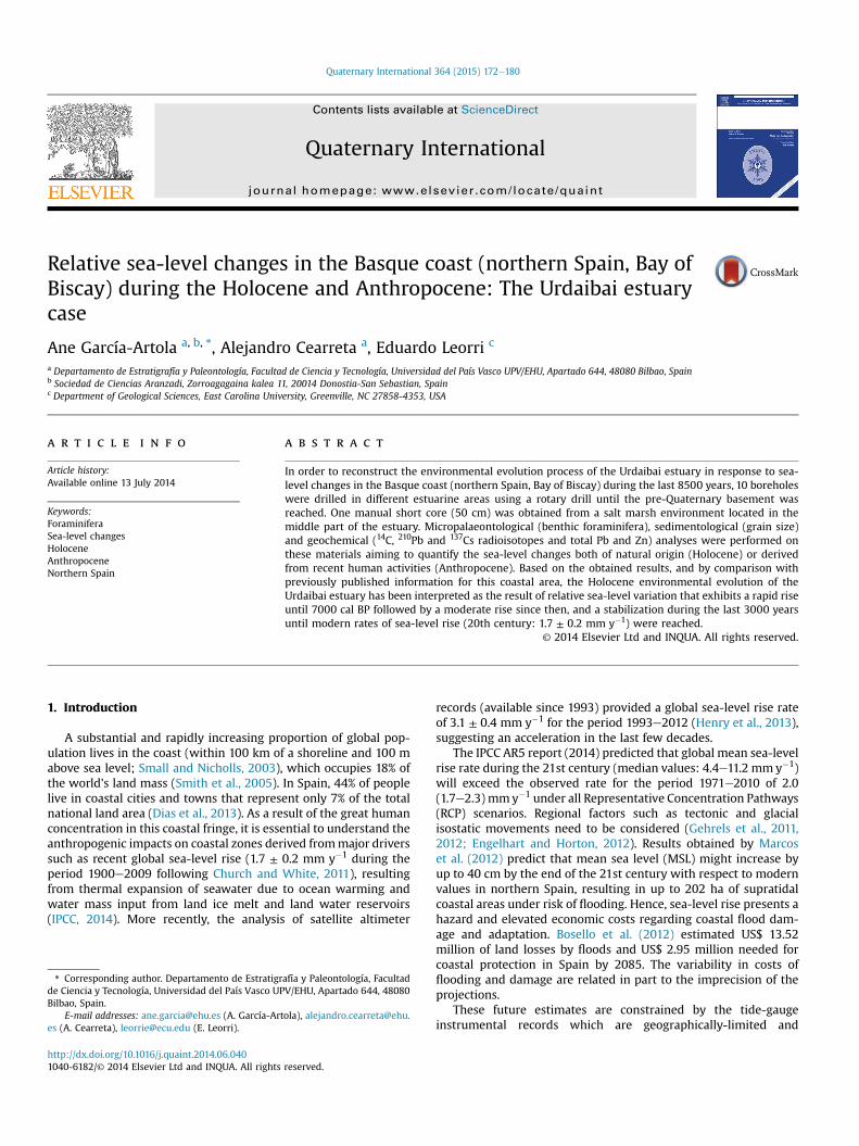
Fig. 1. Geographic location of the Urdaibai estuary in the Basque coast (northern Spain,Bay of Biscay), collected boreholes and short core. 1: Brest tide gauge. 2: Santander tidegauge.
A. García-Artola et al. / Quaternary International 364 (2015) 172e180 173
usually cover only the last 60 years (even a shorter period coveredby satellite altimetry), with the exception of a few tide-gauge re-cords concentrated in the northern hemisphere that can reach up tothe last 150 years (Woodworth et al., 2011). The brief instrumentalperiod captures only a single mode of rising sea level. Geologicalreconstructions extend the instrumental records of sea level back intime and, therefore, can capturemultiple phases of climate and sea-level behaviour for model calibration (Bittermann et al., 2013) andpredictions.
Holocene coastal peats have been widely used as sea-level in-dicators in other regions (Allen, 1995), but in northern Spain theyare not present. Therefore, precise sea-level indicators (SLIPS: sea-level index points) were obtained by combining the indicativedepositional meaning (micropalaeontological and sand content)and radiocarbon ages (Leorri et al., 2012). Scott and Medioli (1978)first explained qualitatively, and later quantitatively (Scott andMedioli, 1980), the vertical distribution of salt marsh forami-nifera, together with plants, with respect to the tidal frame, provingtheir value as proxies for salt marsh elevation. In recent decades,quantitative studies have developed into transfer functions, in or-der to obtain high-resolution reconstructions (e.g. Horton et al.,1999; Gehrels, 2000; Gehrels et al., 2005; Kemp et al., 2011b),which are the most used tool to reconstruct past sea-level varia-tions in temperate regions. Foraminiferal distribution in estuariesfrom northern Spain was determined by both elevation respect tothe tidal frame and salinity, which represent the main controlsrespect to other environmental variables (Cearreta et al., 2002;Leorri and Cearreta, 2009a). Elevation is the dominant environ-mental parameter in foraminiferal distribution in salt marshes onthe SW European coast (Leorri et al., 2010). Foraminifera present insedimentary records from salt marshes have been used as in-dicators of salt marsh palaeoelevational changes based on thequantification of the modern relationship between these microor-ganisms (the relative abundance of different species) and theenvironmental data (elevation as a proxy of tidal floodingfrequency).
In this work, the analysis of foraminiferal assemblages togetherwith radiometric dating (radiocarbon and short-lived radionu-clides) and heavy metals of various Holocene and Anthropocenesedimentary sequences have allowed the reconstruction of relativesea level (RSL) in northern Spain. Based on the micro-palaeontological and sedimentological content of modern sedi-mentary environments and their relationship with topographicelevation, the original depositional environment of the boreholesamples (depositional elevation range of the SLIPs) were deductedby Leorri et al. (2012) following Gehrels et al. (2006) and Mauz andBungenstock (2007).
Previous studies in northern Spain have shown that forami-nifera correlate to elevation with respect to mean tidal level(Cearreta and Murray, 1996; Leorri and Cearreta, 2004; Leorri et al.,2008b). To date, only regional transfer functions have been carriedout in the Basque coast (Leorri et al., 2008a,b, 2010) and used for thereconstruction of sea level in different salt marshes from this region(Leorri et al., 2008b; García-Artola et al., 2009; Leorri and Cearreta,2009b). Therefore, it has been demonstrated that the observedrecent sea-level rise during the 20th century represents a regionalrather than a local process (García-Artola et al., 2011). Woodroffeand Long (2010) concluded that local transfer functions are moreappropriate than regional ones. In this work, relative sea level isreconstructed using a short core obtained from recent materials bycomparison with the modern distribution of similar elevation localsurface samples. These results were compared with Holocene re-cords from 10 long boreholes obtained in the Urdaibai estuary, withthe aim to study the sea-level changes during the last 8500 years innorthern Spain.
Table 1Geographical location of boreholes, short core and surface samples from theUrdaibai estuary. X, Y: ED50 UTM coordinates; Z: m above LOD (see text).
Coordinate X Coordinate Y Coordinate Z
BoreholesLA 525,428.556 4,805,410.499 4.700SK 525,660.058 4,802,137.528 5.290AN 526,362.994 4,801,715.831 3.510MU 526,703.438 4,800,533.678 4.130S2P 527,019.780 4,798,361.520 4.680ER1 526,320.441 4,796,642.703 5.490ER3 526,360.201 4,796,626.788 6.390ER6 526,387.007 4,796,622.489 6.380GK4 526,413.524 4,795,971.361 7.200S9 526,379.117 4,795,889.287 7.730Short coreMUc 526,802.569 4,800,597.458 4.128Surface samples1 526,827.528 4,800,589.605 4.0572 526,816.239 4,800,567.973 4.1003 526,795.276 4,800,559.135 4.1804 526,783.436 4,800,574.667 4.0885 526,778.928 4,800,592.849 4.0656 526,791.666 4,800,607.952 4.0577 526,803.214 4,800,614.118 4.0268 526,818.468 4,800,633.504 4.0099 526,843.827 4,800,611.543 4.03910 526,845.816 4,800,583.283 4.169
A. García-Artola et al. / Quaternary International 364 (2015) 172e180174
2. Study area: northern Spain
2.1. Geomorphological and geological features
The northern coast of Spain lies in an EeW orientation and ischaracterized by an erosive feature with continuous cliffs (Meso-zoic-Caenozoic age), derived from tectonical activity (mountainbuilding and uplifting) during most of the Cenozoic (Cearreta et al.,2002), limiting the natural space for estuaries to areas of structuralweakness where sediment deposition takes place. Hence, shelteredsalt marshes are confined to the inner parts of those small estuaries.In this coast, detrital sediment supply is the main control of saltmarsh vertical accretion. Sediment depositional rates are a functionof elevation and slow down as the salt marsh surface gains eleva-tion in response to reduction of the frequency and duration of tidalinundation (Allen, 2000). As a consequence, salt marsh accretion isrelatively slow and these environments appear underrepresentedin the Holocene sedimentary sequences.
Along the northern coast of Spain, estuaries discharge theirwaters through their western side, while the eastern side is occu-pied by sand bars, beaches and dunes, controlled by the generalEeWorientation of the coast and the dominant NWwind directionand wave approach (Cearreta et al., 2004). The powerful littoraldynamics, although dominated by NW winds, are also defined bywestward transport of sediment due to less significant NE wind(Diez, 1999; Monge-Ganuzas et al., 2015).
The Urdaibai estuary (Fig. 1), located in the Basque coast(northern Spain, Bay of Biscay), is formed by the tidal part of theOka River, showing a wedge shape in the inner zone and broad-ening and deepening seaward. The estuary covers an area of 765 ha,overlying an 11.6 km long and 1 km wide alluvial valley. The lowerestuary is dominated by sand, while in the upper estuary mudbecomes dominant, where salt marshes are more abundant.
The estuary has a semidiurnal tidal regime and a mesotidalrange, with amean tidal range of 2.5m, aminimumvariation of 1m(neap tides) and the maximum variation of 4.5 m (spring tides)(Monge-Ganuzas, 2008). The average surface flow from the Okariver catchment area is 3.74 m3 s�1 (Monge-Ganuzas, 2008) andrainfall varies seasonally from 145 mm during the wet season(NovembereApril) to 74 mm during the dry season (MayeOctober)(averages for the period 2001e2013; Gobierno Vasco, 2002e2014).The lower estuary presents higher salinity values throughout theyear (31e42‰) reflecting the seawater entrancewith tidal currentsand waves, while the mid and upper estuary show variations as aconsequence of the seasonal rainfall regime with lower values(1e25‰) during winter and increasing values (27e40‰) duringsummer, when the rainfall reaches its minimum (Cearreta, 1988).
2.2. Recent human impact
There is a large human pressure on the Basque coast, where 69%of people live within 15 km of the sea (Collet and Engelbert, 2013),causing an important human impact in the area since Roman times(Irabien et al., 2012). During the last three centuries, coastal eco-systems have been occupied initially with agricultural purposesand later to support the more recent urban and industrial settle-ment, covering around 50% of the original salt marshes (Cearretaet al., 2002). This human occupation has led to the destruction,size reduction and degradation of the environmental quality ofthese coastal areas. Rivas and Cendrero (1991) concluded that hu-man occupation of salt marshes and other coastal intertidal areashas been the main geomorphological process in this coastal areaduring the last three centuries, creating new space for human ac-tivity and changes in the productivity of affected environments.This, in turn, has been proposed as a cause for the acceleration of
geomorphic processes and the related increase in natural disastersat a global scale (Bruschi et al., 2013).
Since the agricultural decline during the 1950s, these previouslyreclaimed lands have been naturally regenerated and recolonisedby halophytic vegetation, due to the lack of dyke maintenance andthe entrance of estuarine water that invaded these once artificiallyisolated areas. In the last three decades, local authorities haveimplemented political decisions for their preservation, due to theirecological importance as highly productive environments. Hence,the Spanish Coastal Law passed in 1988 includes these coastal areasinto the public domain, promoting their conservation. Furthermore,in 1984 the Urdaibai estuary was given UNESCO Biosphere Reservestatus (Monge-Ganuzas et al., 2008).
3. Material and methods
3.1. Field techniques
3.1.1. Boreholes and short core extractionIn order to study the environmental evolution of the estuary
during the Holocene, 10 boreholes (LA, SK, AN, MU, S2P, ER1, ER3,ER6, GK4 and S9) have been collected from different estuarine areas(Fig. 1; Table 1) using a rotary drill and obtaining a continuous re-cord of approximately 10 cm in diameter. All boreholes reached theMesozoic basement rock down to 49 m depth (Cearreta andMonge-Ganuzas, 2013).
Furthermore, in order to reconstruct the recent evolution (lastca 150 years), a short core (MUc) was collected in the central part ofthe Murueta salt marsh (Fig. 1; Table 1), in a small unvegetated areasurrounded by halophytic vegetation, where two 50-cm long and12.5-cm diameter PVC tubes were inserted by hand into thesediment.
The boreholes and short core were split longitudinally in twohalves and different analytical methods were carried out. Oncevisually described and photographed, the boreholes were sampledat 30 cm intervals and the short core was divided in 1-cm thicksamples.
A. García-Artola et al. / Quaternary International 364 (2015) 172e180 175
Compaction of the sediment during the sampling process for theboreholes was corrected by measuring individual sections at thetime of coring. This effect is considered negligible in the case of theshort core due to the detrital nature of the sediment (Cearreta et al.,2002, 2013; Irabien et al., 2008). The effect that autocompaction canhave in Holocene sea-level reconstruction was corrected by Leorriand Cearreta (2009c) by comparing samples with statisticallysimilar radiocarbon ages recovered at different elevations above thebasement-Quaternary contact, while in Anthropocene sea-level es-timates the effect of autocompaction is considered negligible(Cearreta et al., 2013). Brain et al. (2012) analysed detrital sedimentsfrom salt marshes and concluded that autocompaction influence canbe minimised by selecting short <1 m uniform successions.
3.1.2. Surface sample collectionIn 2010, ten surface samples were collected randomly around
the Murueta short core (MUc; Fig. 1) and within the completeelevation range covered by the Murueta salt marsh (Table 1), inorder to avoid possible autocorrelation between environmentalvariables (Telford and Birks, 2005). At each sampling site, twopseudoreplicates of 40 cm2 each were collected by pressing a hardplastic ring into the sediment to minimize the patchiness of theforaminiferal distribution (Swallow, 2000; Kemp et al., 2011a). Thetop 1 cm of sediment, wheremodern foraminifera are concentrated(Cearreta et al., 2002; Leorri et al., 2008b), was placed in a plasticbottle containing ethanol for preservation until preparation in thelaboratory for foraminiferal analysis.
3.1.3. Geographic location and topographic elevation measurementPrecise location and elevation of boreholes, short core and sur-
face samples were determined in the field using a Global Posi-tioning System-Real Time Kinematic (GPS-RTK) and a total station,with a horizontal precision of ±0.020 m and a vertical accuracy of±0.035m. UTM coordinates X, Yof samples are referred to the ED50geographical system in planimetry and coordinate Z is referred tothe local ordnance datum (LOD) (lowest tide at the Bilbao Harbouron 27th September 1878) in altimetry (Table 1), which is located2.40 m below Bilbao MSL (Puertos del Estado, 2005, 2009).
3.2. Laboratory analyses
3.2.1. Micropalaeontological analysisSamples were wet sieved through 1 mm and 63-micron sieves
to remove large organic fragments and fine-grained sedimentsrespectively. Sand size material (retained in 63-micron sieve) wasoven dried at 50 �C and weighed. Foraminifera were concentratedby flotation in trichloroethylene as described by Murray (1979).Holocene samples were subdivided into fractions using a splitterand all specimens contained in a fraction were picked, and surfacesamples were stained using rose Bengal in order to recognise in-dividuals that were alive at the time of collection following Walton(1952). In the surface samples, only dead assemblages were ana-lysed because they are considered better analogues for past envi-ronmental reconstructions (Horton, 1999), since they represent atime-averaged accumulation of foraminifera. Foraminiferal testswere picked until a representative number of at least 300 in-dividuals for each sample was obtained. Otherwise, all the availabletests were picked and studied under a stereoscopic binocular mi-croscope using reflected light. Short core foraminiferal results areexpressed as number of foraminiferal tests per 50 g of dry sedimentfor standardisation.
3.2.2. Sedimentological analysisSand content (percentage of total dry weight) was determined
during samples preparation for foraminiferal analysis by weighing
the dry sediment retained at the 63-micron sieve after washing thewhole sample to remove fine-grained material.
3.2.3. Geochemical analysesBeta Analytic Inc. (Miami, USA) carried out radiocarbon dating
and calibration of Holocene samples (12 shell, 6 wood, and 1 bonesamples) and results were published in Leorri et al. (2012). Four ofthem were sufficiently abundant for standard radiometric analysisand the 14C was quantified by measuring the amount of radioac-tivity produced during the radioactive transformation. The other 15samples were dated through accelerator mass spectrometry (AMS)which permits the use of smaller samples and shorter countingperiods, by separating and counting of 14C atoms. Age estimateswere calibrated using CALIB 5.0.1 (Stuiver et al., 2005) and reportedas radiocarbon calibrated years before present (present ¼ 1950 CE).The dates obtained on shell material were also corrected for themarine reservoir effect (apparent surface-water age), which hasbeen estimated to be around 400 years on the Bay of Biscay(Cearreta and Murray, 2000).
Recent sediments (less than 120 years) from the Murueta shortcore were dated through the short-lived isotope 210Pb and sup-ported by 137Cs and total concentrations of Pb and Zn (see Leorriet al., 2008b and 2014 for discussion). 210Pb and 137Cs wereanalyzed at the Universitat Aut�onoma de Barcelona (Spain). Sam-ples were dried in an oven at 60 �C until constant weight, dry bulkdensity and water content were determined. The activities of 137Csand 226Rawere determined by gamma spectrometry using a coaxialhigh-purity Germanium detector (EG&G Ortec). Determination oftotal 210Pb activities was carried out through the measurement ofits daughter nuclide 210Po by alpha spectrometry, following themethodology described in Sanchez-Cabeza et al. (1998). Excess210Pb activities were determined by subtracting the 226Ra activity(assumed to equal the supported 210Pb activity) from the total 210Pbactivity. The Constant Rate of Supply (CRS) model (Appleby andOldfield, 1978) was applied to develop 210Pb chronologies.
Metal concentrations were determined at Activation Labora-tories Ltd. (Canada) by inductively coupled plasma-optic emissionspectrometry (ICP-OES) after microwave digestion with aqua regia(Leorri et al., 2013).
3.3. Tide-gauge records analysis
Past sea-level reconstructions based on foraminiferal analysiswere compared with tide-gauge records from Santander and Brest(locations indicated in Fig.1) provided by the Permanent Service forMean Sea Level (PMSL; Woodworth and Player, 2003).
4. Results and discussion
4.1. Relative sea-level changes during the Holocene
The foraminiferal assemblages found in 10 borehole sedimen-tary records from the Urdaibai estuary allowed the study of itsenvironmental transformation (Cearreta and Monge-Ganuzas,2013) and the reconstruction of relative Holocene sea level(Leorri et al., 2012). Cearreta and Monge-Ganuzas (2013) identifiedthree systems tracts characterised by specific foraminiferal as-semblages relative to their location within the upper, middle orlower estuary, and separated by a continuous stratigraphic surfacethat permits correlation. During low sea-level conditions sedi-mentary deposits (lowstand systems tract) were characterized byfluvial gravels and coarse sands without foraminifera and othermarine fauna. As the marine transgression took place (locally datedbetween 8500 and 3000 cal BP; Leorri and Cearreta, 2004), coarsesediments were preserved by overlying estuarine deposits moving
A. García-Artola et al. / Quaternary International 364 (2015) 172e180176
towards the continent (transgressive systems tract). The bottompart of this systems tract is represented by large volumes of marinesediments in the lower estuary, a mixture of marine and brackishsediments in the middle estuary and brackish materials in theupper estuary, and the top part (seaward), by open sea materials(such as abundant allochthonous foraminiferal tests) until amaximum flooding surface was reached at its upper limit. Finally,the highstand systems tract, that was deposited during the lateHolocene (since 3000 cal BP until the salt marsh occupation at thebeginning of the 18th century), represents intertidal and supratidalbrackish conditions in the inner estuary, since this sedimentarysequences were formed during stable sea-level conditions, whenmodern salt marshes developed (Leorri and Cearreta, 2004;Cearreta and Monge-Ganuzas, 2013).
Leorri et al. (2012) selected representative samples of differentestuarine environments and topographic elevations from theseboreholes collected in the Urdaibai estuary (together with samplesfrom the Bilbao and Deba estuaries), that combined with radio-carbon dating were used as sea-level index points (SLIPs) in orderto reconstruct the relative sea-level curve over the last 10,000 yearsin northern Spain that shows two main phases: 1- rapid relativesea-level rise from �27 m asl at ca 10,000 cal BP to �5 m asl at ca7000 cal BP; 2- a relatively slow sea-level rise since ca 7000 cal BPbetween 0.3 and 0.7 mm y�1 (apparently stabilised around3000 cal BP) until present anthropogenic rates were reached at thebeginning of the 20th century. These results agree with previousstudies that did not show evidence of sea levels above presentposition during the late Holocene in the Basque coast (Leorri andCearreta, 2004). Furthermore, these are also similar to back-ground rates shown for southwest England and the Netherlands(Gehrels and Woodworth, 2013).
4.2. Relative sea-level changes during the Anthropocene
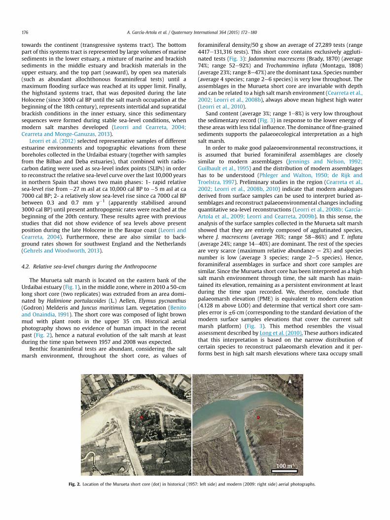
The Murueta salt marsh is located on the eastern bank of theUrdaibai estuary (Fig. 1), in the middle zone, where in 2010 a 50-cmlong short core (two replicates) was extruded from an area domi-nated by Halimione portulacoides (L.) Aellen, Elymus pycnanthus(Godron) Melderis and Juncus maritimus Lam. vegetation (Benitoand Onaindia, 1991). The short core was composed of light brownmud with plant roots in the upper 35 cm. Historical aerialphotography shows no evidence of human impact in the recentpast (Fig. 2), hence a natural evolution of the salt marsh at leastduring the time span between 1957 and 2008 was expected.
Benthic foraminiferal tests are abundant, considering the saltmarsh environment, throughout the short core, as values of
Fig. 2. Location of the Murueta short core (dot) in historical (1957
foraminiferal density/50 g show an average of 27,289 tests (range4417e131,316 tests). This short core contains exclusively aggluti-nated tests (Fig. 3): Jadammina macrescens (Brady, 1870) (average74%; range 52e92%) and Trochammina inflata (Montagu, 1808)(average 23%; range 8e47%) are the dominant taxa. Species number(average 4 species; range 2e6 species) is very low throughout. Theassemblages in the Murueta short core are invariable with depthand can be related to a high salt marsh environment (Cearreta et al.,2002; Leorri et al., 2008b), always above mean highest high water(Leorri et al., 2010).
Sand content (average 3%; range 1e8%) is very low throughoutthe sedimentary record (Fig. 3) in response to the lower energy ofthese areas with less tidal influence. The dominance of fine-grainedsediments supports the palaeoecological interpretation as a highsalt marsh.
In order to make good palaeoenvironmental reconstructions, itis assumed that buried foraminiferal assemblages are closelysimilar to modern assemblages (Jennings and Nelson, 1992;Guilbault et al., 1995) and the distribution of modern assemblageshas to be understood (Phleger and Walton, 1950; de Rijk andTroelstra, 1997). Preliminary studies in the region (Cearreta et al.,2002; Leorri et al., 2008b, 2010) indicate that modern analoguesderived from surface samples can be used to interpret buried as-semblages and reconstruct palaeoenvironmental changes includingquantitative sea-level reconstructions (Leorri et al., 2008b; García-Artola et al., 2009; Leorri and Cearreta, 2009b). In this sense, theanalysis of the surface samples collected in the Murueta salt marshshowed that they are entirely composed of agglutinated species,where J. macrescens (average 76%; range 58e86%) and T. inflata(average 24%; range 14e40%) are dominant. The rest of the speciesare very scarce (maximum relative abundance ¼ 2%) and speciesnumber is low (average 3 species; range 2e5 species). Hence,foraminiferal assemblages in surface and short core samples aresimilar. Since the Murueta short core has been interpreted as a highsalt marsh environment through time, the salt marsh has main-tained its elevation, remaining as a persistent environment at leastduring the time span recorded. We, therefore, conclude thatpalaeomarsh elevation (PME) is equivalent to modern elevation(4.128 m above LOD) and determine that vertical short core sam-ples error is ±6 cm (corresponding to the standard deviation of themodern surface samples elevations that cover the current saltmarsh platform) (Fig. 3). This method resembles the visualassessment described by Long et al. (2010). These authors indicatedthat this interpretation is based on the narrow distribution ofcertain species to reconstruct palaeomarsh elevation and it per-forms best in high salt marsh elevations where taxa occupy small
: left side) and modern (2009: right side) aerial photographs.
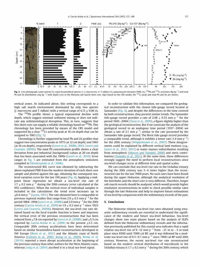
Fig. 3. Core photograph, sand content (%), main foraminiferal species (1: J. macrescens; 2: T. inflata) (%), palaeomarsh elevation (PME, m), 210Pb and 137Cs activities (Bq kg�1) and totalPb and Zn distribution (mg kg�1) with depth (cm) in the Murueta salt marsh short core. Ages based on the CRS model, the 137Cs peak and total Pb and Zn are shown.
A. García-Artola et al. / Quaternary International 364 (2015) 172e180 177
vertical zones. As indicated above, this setting corresponds to ahigh salt marsh environment dominated by only two species(J. macrescens and T. inflata) with a vertical range of 4.13 ± 0.06 m.
The 210Pb profile shows a typical exponential decline withdepth, which suggest minimal sediment mixing or does not indi-cate any sedimentological disruption. This, in turn, suggests thatthis short core can supply a reliable chronology based on 210Pb. Thischronology has been provided by means of the CRS model andsupported by a clear 137Cs activity peak at 16 cm depth that can beassigned to 1963 (Fig. 3).
Chronology is further supported by total Pb and Zn profiles thatsuggest two concentration peaks in 1975 (at 12 cm depth) and 1965(at 16 cm depth), respectively (Leorri et al., 2008b, 2014; Leorri andCearreta, 2009b). The total Pb concentration profile shows a cleardeviation from pre-industrial (background) values at 20 cm depththat has been associated with the 1900s (Leorri et al., 2014). Errorranges in Fig. 3 are estimated from the atmospheric emissionscompiled in Olendrzy�nski et al. (1996).
The reconstructed RSL curve was obtained by subtracting theabove explained PME from the modern elevation of each short coresample and plotted against the age, obtaining the consequent sea-level variation curve for the last 150 years (Fig. 4). Applying a mid-point linear regression we obtain a sea-level rise rate of1.7 ± 0.2 mm y�1 during the 20th century (error calculated at the95% confidence). When the vertical error of individual samples isincluded in the calculations the trend error increases up to±0.4 mmy�1 (Lyons, 1991). The rate obtained here is comparable toprevious regional studies that range from 2.0 ± 0.3 mm y�1 for theperiod 1884e1994 (Leorri et al., 2008b) and 2.0mmy�1 for the 20thcentury (García-Artola et al., 2009) to 1.9 ± 0.3 mm y�1 since 1923(Leorri and Cearreta, 2009b). However, the sea-level rise rate ob-tained based on the local transfer function is lower and improvesthe vertical error of the previous reconstructions that has beenreduced from ±7.8 cm reported by Leorri et al. (2008b) and ±5.3 cmreported by García-Artola et al. (2009) to the present ±3.5 cm.Comparable 20th century accelerations have been determinedbased on similar foraminifera-based reconstructions developed inSW Europe (Rossi et al., 2011) and the Atlantic coast of NorthAmerica (Gehrels et al., 2005; Kemp et al., 2009). Kemp et al.(2011b) reported a more abrupt acceleration at the beginning ofthe previous century than other authors for theWest Atlantic coast,whereas Long et al. (2014) ascribed it to a local sea-level signal.
In order to validate this information, we compared the geolog-ical reconstruction with the closest tide-gauge record located atSantander (Fig. 4), and despite the differences in the time coveredby both reconstructions, they present similar trends. The Santandertide-gauge record provides a rate of 2.08 ± 0.33 mm y�1 for theperiod 1943e2004 (Chust et al., 2009), a figure slightly higher thanthe geological reconstruction. But if we constrain the analysis of thegeological record to an analogous time period (1937e2004) weobtain a rate of 2.1 mm y�1, similar to the rate presented by theSantander tide-gauge record. The Brest tide-gauge record providesa comparable trend, although it exhibits a lower rate (1.4 mm y�1)for the 20th century (W€oppelmann et al., 2007). These disagree-ments could be explained by different vertical land motions (e.g.,Leorri et al., 2012, 2013) or water masses redistribution resultingfrom atmospheric (Marcos and Tsimplis, 2008) and steric contri-butions (Tsimplis et al., 2011). At the same time, these differencesstrongly suggest the need to perform local reconstructions sincesea-level changes occur at different time and spatial scales.
We can conclude that sea-level rise rate in the Urdaibai estuaryduring the 20th century was 3e6 times higher than the recon-structed rate for the last 7000 years. No such rates have been foundduring the upper Holocene, although the analytical resolution ofthe boreholes and the short core is very different. Therefore, longersalt marsh records should be analysed, which would provide higherresolution reconstructions in order to check possible similar ratesthrough the late Holocene and help to improve future estimationsof sea level by comparisonwith the sedimentary records of the past.
5. Conclusions
The Holocene relative sea-level rise rates obtained using estu-arine sedimentary records are essential to understand the signifi-cance of the modern and future sea-level behaviour. Sea-levelchanges show two main phases based on the analysis of SLIPsdefined from the Holocene sedimentary records and the informa-tion previously published for this coastal area indicates that a rapidrelative sea-level rise of 9e12 mm y�1 from �21 m to �5 m tookplace since 8500 until 7000 cal BP, and it was followed by a mod-erate sea-level rise of 0.3e0.7 mm y�1 since 7000 cal BP until 20thcentury. However, the recent sea-level rise rate reconstructedbased on the modern vertical distribution of microfossils in theUrdaibai estuary is 1.7 ± 0.2 mmy�1 during the 20th century, which
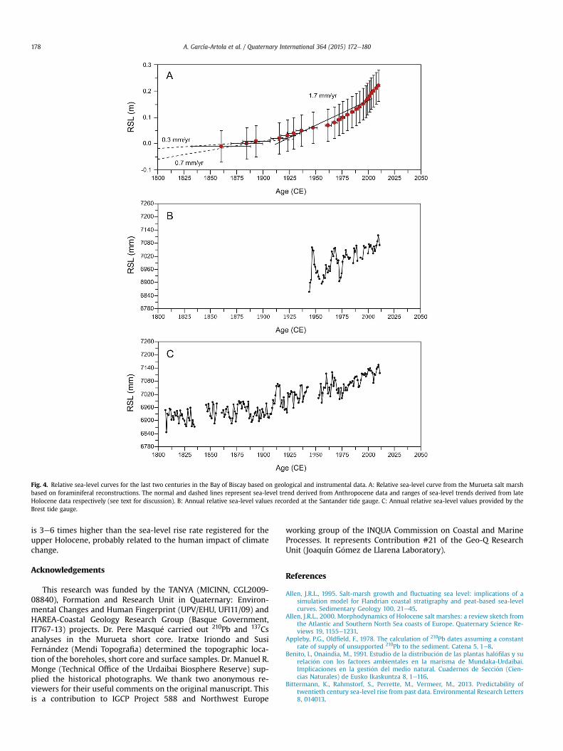
Fig. 4. Relative sea-level curves for the last two centuries in the Bay of Biscay based on geological and instrumental data. A: Relative sea-level curve from the Murueta salt marshbased on foraminiferal reconstructions. The normal and dashed lines represent sea-level trend derived from Anthropocene data and ranges of sea-level trends derived from lateHolocene data respectively (see text for discussion). B: Annual relative sea-level values recorded at the Santander tide gauge. C: Annual relative sea-level values provided by theBrest tide gauge.
A. García-Artola et al. / Quaternary International 364 (2015) 172e180178
is 3e6 times higher than the sea-level rise rate registered for theupper Holocene, probably related to the human impact of climatechange.
Acknowledgements
This research was funded by the TANYA (MICINN, CGL2009-08840), Formation and Research Unit in Quaternary: Environ-mental Changes and Human Fingerprint (UPV/EHU, UFI11/09) andHAREA-Coastal Geology Research Group (Basque Government,IT767-13) projects. Dr. Pere Masqu�e carried out 210Pb and 137Csanalyses in the Murueta short core. Iratxe Iriondo and SusiFern�andez (Mendi Topografia) determined the topographic loca-tion of the boreholes, short core and surface samples. Dr. Manuel R.Monge (Technical Office of the Urdaibai Biosphere Reserve) sup-plied the historical photographs. We thank two anonymous re-viewers for their useful comments on the original manuscript. Thisis a contribution to IGCP Project 588 and Northwest Europe
working group of the INQUA Commission on Coastal and MarineProcesses. It represents Contribution #21 of the Geo-Q ResearchUnit (Joaquín G�omez de Llarena Laboratory).
References
Allen, J.R.L., 1995. Salt-marsh growth and fluctuating sea level: implications of asimulation model for Flandrian coastal stratigraphy and peat-based sea-levelcurves. Sedimentary Geology 100, 21e45.
Allen, J.R.L., 2000. Morphodynamics of Holocene salt marshes: a review sketch fromthe Atlantic and Southern North Sea coasts of Europe. Quaternary Science Re-views 19, 1155e1231.
Appleby, P.G., Oldfield, F., 1978. The calculation of 210Pb dates assuming a constantrate of supply of unsupported 210Pb to the sediment. Catena 5, 1e8.
Benito, I., Onaindia, M., 1991. Estudio de la distribuci�on de las plantas hal�ofilas y surelaci�on con los factores ambientales en la marisma de Mundaka-Urdaibai.Implicaciones en la gesti�on del medio natural. Cuadernos de Secci�on (Cien-cias Naturales) de Eusko Ikaskuntza 8, 1e116.
Bittermann, K., Rahmstorf, S., Perrette, M., Vermeer, M., 2013. Predictability oftwentieth century sea-level rise from past data. Environmental Research Letters8, 014013.
A. García-Artola et al. / Quaternary International 364 (2015) 172e180 179
Bosello, F., Nicholls, R., Richards, J., Roson, R., Tol, R.J., 2012. Economic impacts ofclimate change in Europe: sea-level rise. Climatic Change 112, 63e81.
Brain, M.J., Long, A.J., Woodroffe, S.A., Petley, D.N., Milledge, D.G., Parnell, A.C., 2012.Modelling the effects of sediment compaction on salt marsh reconstructions ofrecent sea-level rise. Earth and Planetary Science Letters 345e348, 180e193.
Bruschi, V.M., Bonachea, J., Remondo, J., G�omez-Arozamena, J., Rivas, V., M�endez, G.,Naredo, J.M., Cendrero, A., 2013. Analysis of geomorphic systems' response tonatural and human drivers in northern Spain: Implications for globalgeomorphic change. Geomorphology 196, 267e279.
Cearreta, A., 1988. Distribution and ecology of benthic foraminifera in the Santo~naestuary, Spain. Revista Espa~nola de Paleontología 3, 23e38.
Cearreta, A., Murray, J.W., 1996. Holocene paleoenvironmental and relative sea-levelchanges in the Santo~na estuary, Spain. Journal of Foraminiferal Research 26,289e299.
Cearreta, A., Murray, J.W., 2000. AMS 14C dating of Holocene estuarine deposits:consequences of high energy and reworked foraminifera. The Holocene 10,155e159.
Cearreta, A., Monge-Ganuzas, M., 2013. Evoluci�on paleoambiental del estuario delOka (Reserva de la Biosfera de Urdaibai, Vizcaya): respuesta al ascenso del nivelmarino durante el Holoceno. Geo-temas 14, 163e166.
Cearreta, A., Irabien, M.J., Ulibarri, I., Yusta, I., Croudace, I.W., Cundy, A.B., 2002.Recent salt marsh development and natural regeneration of reclaimed areas inthe Plentzia estuary, N. Spain. Estuarine, Coastal and Shelf Science 54, 863e886.
Cearreta, A., Irabien, M.J., Pascual, A., 2004. Human activities along the Basque coastduring the last two centuries: geological perspective of recent anthropogenicimpact on the coast and its environmental consequences. In: Borja, �A.,Collins, M. (Eds.), Oceanography and Marine Environment of the BasqueCountry, Elsevier Oceanography Series, vol. 70. Elsevier, Amsterdam, pp. 27e50.
Cearreta, A., García-Artola, A., Leorri, E., Irabien, M.J., Masque, P., 2013. Recentenvironmental evolution of regenerated salt marshes in the southern Bay ofBiscay: anthropogenic evidences in their sedimentary record. Journal of MarineSystems 109e110 (Supplement), S203eS212.
Church, J., White, N., 2011. Sea-level rise from the late 19th to the Early 21st Century.Surveys in Geophysics 32, 585e602.
Chust, G., Borja, A., Liria, P., Galparsoro, I., Marcos, M., Caballero, A., Castro, R., 2009.Human impacts overwhelm the effects of sea-level rise on Basque coastalhabitats (N Spain) between 1954 and 2004. Estuarine, Coastal and Shelf Science84, 453e462.
Collet, I., Engelbert, A., 2013. Coastal Regions e Population Statistics. Eurostat.http://epp.eurostat.ec.europa.eu/statistics_explained/index.php/Coastal_regions_-_population_statistics#.
de Rijk, S., Troelstra, S.R., 1997. Salt marsh foraminifera from the Great Marshes,Massachusetts: environmental controls. Palaeogeography, Palaeoclimatology,Palaeoecology 130, 81e112.
Dias, J.A., Cearreta, A., Isla, F.I., de Mahiques, M.M., 2013. Anthropogenic impacts onIberoamerican coastal areas: historical processes, present challenges, and conse-quences for coastal zone management. Ocean & Coastal Management 77, 80e88.
Diez, J.J., 1999. Morphodynamics of spanish Cantabrian Rias. Journal of CoastalResearch 15, 1072e1082.
Engelhart, S.E., Horton, B.P., 2012. Holocene sea level database for the Atlantic coastof the United States. Quaternary Science Reviews 54, 12e25.
García-Artola, A., Cearreta, A., Leorri, E., Irabien, M.J., Blake, W.H., 2009. Las mar-ismas costeras como archivos geol�ogicos de las variaciones recientes en el nivelmarino. Geogaceta 47, 109e112.
García-Artola, A., Cearreta, A., Leorri, E., 2011. Cambios en el nivel marino y trans-formaci�on ambiental del estuario de la Reserva de la Biosfera de Urdaibai (PaísVasco, Espa~na) durante el Holoceno y Antropoceno. Boletín de la Real SociedadEspa~nola de Historia Natural, Secci�on Geol�ogica 105, 45e51.
Gehrels, W.R., 2000. Using foraminiferal transfer functions to produce high-resolution sea-level records from salt-marsh deposits, Maine, USA. The Holo-cene 10, 367e376.
Gehrels, W.R., Woodworth, P.L., 2013. When did modern rates of sea-level rise start?Global and Planetary Change 100, 263e277.
Gehrels, W.R., Kirby, J.R., Prokoph, A., Newnham, R.M., Achterberg, E.P., Evans, H.,Black, S., Scott, D.B., 2005. Onset of recent rapid sea-level rise in the westernAtlantic Ocean. Quaternary Science Reviews 24, 2083e2100.
Gehrels, W.R., Szkornik, K., Bartholdy, J., Kirby, J.R., Bradley, S.L., Marshall, W.A.,Heinemeier, J., Pedersen, J.B.T., 2006. Late Holocene sea-level changes andisostasy in western Denmark. Quaternary Research 66, 288e302.
Gehrels, W.R., Dawson, D.A., Shaw, J., Marshall, W.A., 2011. Using Holocene relativesea-level data to inform future sea-level predictions: an example from south-west England. Global and Planetary Change 78, 116e126.
Gehrels, W.R., Callard, S.L., Moss, P.T., Marshall, W.A., Blaauw, M., Hunter, J.,Milton, J.A., Garnett, M.H., 2012. Nineteenth and twentieth century sea-levelchanges in Tasmania and New Zealand. Earth and Planetary Science Letters315e316, 94e102.
Gobierno, Vasco, 2002e2014. Informes Meteorol�ogicos A~nos 2001, 2002, 2003,2004, 2005, 2006, 2007, 2008, 2009, 2010, 2011, 2012 y 2013. Servicio Centralde Publicaciones del Gobierno Vasco, Vitoria-Gasteiz.
Guilbault, J.-P., Clague, J.J., Lapointe, M., 1995. Amount of subsidence during a lateHolocene earthquake-evidence from fossil tidal marsh foraminifera at Van-couver Island, west coast of Canada. Palaeogeography, Palaeoclimatology,Palaeoecology 118, 49e71.
Henry, O., Ablain, M., Meyssignac, B., Cazenave, A., Masters, D., Nerem, S., Garric, G.,2013. Effect of the processing methodology on satellite altimetry-based global
mean sea level rise over the Jason-1 operating period. Journal of Geodesy 88,351e361.
Horton, B.P., 1999. The distribution of contemporary intertidal foraminifera atCowpen Marsh, Tees Estuary, UK: implications for studies of Holocene sea-levelchanges. Palaeogeography, Palaeoclimatology, Palaeoecology 149, 127e149.
Horton, B.P., Edwards, R., Lloyd, J.M., 1999. Reconstruction of former sea levels usinga foraminiferal-based transfer function. Journal of Foraminiferal Research 29,117e129.
IPCC, 2014. Climate Change 2013: the Physical Science Basis. Working Group 1Contribution to the Fifth Assessment Report of the International Panel onClimate Change, Cambridge, New York.
Irabien, M.J., Rada, M., G�omez, J., Soto, J., Ma~nanes, A., Viguri, J., 2008. An assessmentof anthropogenic impact in a nature reserve: the Santo~na Marshes (NorthernSpain). Journal of Iberian Geology 34, 235e242.
Irabien, M.J., Cearreta, A., Urteaga, M., 2012. Historical signature of Roman miningactivities in the Bidasoa estuary (Basque Country, northern Spain): an inte-grated micropalaeontological, geochemical and archaeological approach. Jour-nal of Archaeological Science 39, 2361e2370.
Jennings, A.E., Nelson, A.R., 1992. Foraminiferal assemblage zones in Oregon tidalmarshes; relation to marsh floral zones and sea level. Journal of ForaminiferalResearch 22, 13e29.
Kemp, A.C., Horton, B.P., Culver, S.J., Corbett, D.R., van de Plassche, O., Gehrels, W.R.,Douglas, B.C., Parnell, A.C., 2009. Timing and magnitude of recent acceleratedsea-level rise (North Carolina, United States). Geology 37, 1035e1038.
Kemp, A.C., Buzas, M.A., Horton, B.P., Culver, S.J., 2011a. Influence of patchiness onmodern salt-marsh foraminifera used in sea-level studies (North Carolina, USA).Journal of Foraminiferal Research 41, 114e123.
Kemp, A.C., Horton, B.P., Donnelly, J.P., Mann, M.E., Vermeer, M., Rahmstorf, S.,2011b. Climate related sea-level variations over the past two millennia. Pro-ceedings of the National Academy of Sciences 108, 11017e11022.
Leorri, E., Cearreta, A., 2004. Holocene environmental development of the Bilbaoestuary, northern Spain: sequence stratigraphy and foraminiferal interpreta-tion. Marine Micropaleontology 51, 75e94.
Leorri, E., Cearreta, A., 2009a. Quantitative assessment of the salinity gradientwithin the estuarine systems in the southern Bay of Biscay using benthicforaminifera. Continental Shelf Research 29, 1226e1239.
Leorri, E., Cearreta, A., 2009b. Recent sea-level changes in the southern Bay ofBiscay: transfer function reconstructions from salt-marshes compared withinstrumental data. Scientia Marina 73, 287e296.
Leorri, E., Cearreta, A., 2009c. Anthropocene versus Holocene relative sea-level riserates in the southern Bay of Biscay. Geogaceta 46, 127e130.
Leorri, E., Cearreta, A., Horton, B.P., 2008a. A foraminifera-based transfer function asa tool for sea-level reconstructions in the southern Bay of Biscay. Geobios 41,787e797.
Leorri, E., Horton, B.P., Cearreta, A., 2008b. Development of a foraminifera-basedtransfer function in the Basque marshes, N. Spain: Implications for sea-levelstudies in the Bay of Biscay. Marine Geology 251, 60e74.
Leorri, E., Gehrels, W.R., Horton, B.P., Fatela, F., Cearreta, A., 2010. Distribution offoraminifera in salt marshes along the Atlantic coast of SW Europe: tools toreconstruct past sea-level variations. Quaternary International 221, 104e115.
Leorri, E., Cearreta, A., Milne, G., 2012. Field observations and modelling of Holocenesea-level changes in the southern Bay of Biscay: implication for understandingcurrent rates of relative sea-level change and vertical land motion along theAtlantic coast of SW Europe. Quaternary Science Reviews 42, 59e73.
Leorri, E., Fatela, F., Drago, T., Bradley, S.L., Moreno, J., Cearreta, A., 2013. Lateglacialand Holocene coastal evolution in the Minho estuary (N Portugal): Implicationsfor understanding sea-level changes in Atlantic Iberia. The Holocene 23,353e363.
Leorri, E., Mitra, S., Irabien, M.J., Zimmerman, A.R., Blake, W.H., Cearreta, A., 2014.A 700 year record of combustion-derived pollution in northern Spain: tools toidentify the Holocene/Anthropocene transition in coastal environments.Science of the Total Environment 470e471, 240e247.
Long, A.J., Woodroffe, S.A., Milne, G.A., Bryant, C.L., Wake, L.M., 2010. Relative sealevel change in west Greenland during the last millennium. Quaternary ScienceReviews 29, 367e383.
Long, A.J., Barlow, N.L.M., Gehrels, W.R., Saher, M.H., Woodworth, P.L., Scaife, R.G.,Brain, M.J., Cahill, N., 2014. Contrasting records of sea-level change in theeastern and western North Atlantic during the last 300 years. Earth and Plan-etary Science Letters 388, 110e122.
Lyons, L., 1991. A Practical Guide to Data Analysis for Physical Science Students.Cambridge University Press, Cambridge.
Marcos, M., Tsimplis, M.N., 2008. Coastal sea level trends in Southern Europe.Geophysical Journal International 175, 70e82.
Marcos, M., Chust, G., Jord�a, G., Caballero, A., 2012. Effect of sea level extremes onthe western Basque coast during the 21st century. Climate Research 51,237e248.
Mauz, B., Bungenstock, F., 2007. How to reconstruct trends of late Holocene relativesea level: a new approach using tidal flat clastic sediments and optical dating.Marine Geology 237, 225e237.
Monge-Ganuzas, M., 2008. Evoluci�on temporal de la din�amica sedimentaria en elestuario inferior del Oka (Reserva de la Biosfera de Urdaibai): una herramientageol�ogica para la Gesti�on Integrada de Zonas Costeras (PhD dissertation). Uni-versidad del País Vasco UPV/EHU.
Monge-Ganuzas, M., Cearreta, A., Iriarte, E., 2008. Consequences of estuarine sanddredging and dumping on the Urdaibai Reserve of the Biosphere (Bay of
A. García-Artola et al. / Quaternary International 364 (2015) 172e180180
Biscay): the case of the “Mundaka left wave”. Journal of Iberian Geology 34,215e234.
Monge-Ganuzas, M., Evans, G., Cearreta, A., 2015. Sand-spit accumulation at themouths of the eastern Cantabrian estuaries: the example of the Oka estuary(Urdaibai Biosphere Reserve). Quaternary International 364, 206e216.
Murray, J.W., 1979. British Nearshore Foraminiferids. In: Synopses of the BritishFauna (New Series), vol. 16. Academic Press, London.
Olendrzy�nski, K., Anderberg, S., Stigliani, W., Bartnicki, J., Pacyna, J., 1996. Atmo-spheric emissions and depositions of cadmium, lead, and zinc in Europe duringthe period 1955e1987. Environmental Reviews 4, 300e320.
Phleger, F.B., Walton, W.R., 1950. Ecology of marsh and bay foraminifera, Barnstable,Massachusetts. American Journal of Science 248, 274e294.
Puertos del Estado, 2005. Informaci�on clim�atica del nivel del mar. Mare�ografo deBilbao e Conjunto de datos REDMAR (No. CODIGO BD: 3110). Ministerio deFomento.
Puertos del Estado, 2009. REDMAR: Red de Mare�ografos de Puertos del Estado,Informe Anual. Ministerio de Fomento.
Rivas, V., Cendrero, A., 1991. Use of natural and artificial accretion on the north coastof Spain: historical trends and assessment of some environmental and eco-nomic consequences. Journal of Coastal Research 7, 491e507.
Rossi, V., Horton, B.P., Corbett, D.R., Leorri, E., Perez-Belmonte, L., Douglas, B.C., 2011.The application of foraminifera to reconstruct the rate of 20th century sea levelrise, Morbihan Golfe, Brittany, France. Quaternary Research 75, 24e35.
Sanchez-Cabeza, J.A., Masqu�e, P., Ani-Ragolta, I., 1998. 210Pb and 210Po analysis insediments and soils by microwave acid digestion. Journal of Radioanalytical andNuclear Chemistry 227, 19e22.
Scott, D.B., Medioli, F.S., 1978. Vertical zonations of marsh foraminifera as accurateindicators of former sea-levels. Nature 272, 528e531.
Scott, D.B., Medioli, F.S., 1980. Quantitative Studies of Marsh Foraminifera Distri-bution in Nova Scotia: Implications for sea-level Studies, vol. 17. CushmanFoundation for Foraminiferal Research Special Publication, pp. 1e57.
Small, C., Nicholls, R.J., 2003. A global analysis of human settlement in coastal zones.Journal of Coastal Research 19, 584e599.
Smith, S.V., Buddemeier, R.W., Wulff, F., Swaney, D.P., 2005. C, N, P fluxes in thecoastal zone. In: Crossland, C.J., Kremer, H.H., Lindeboom, H.J., MarshallCrossland, J.I., Le Tissier, M.D.A. (Eds.), Coastal Fluxes in the Anthropocene.Springer, Berlin, pp. 95e143.
Stuiver, M., Reimer, P.J., Reimer, R., 2005. Radiocarbon Calibration Program Revision5.0.1. Copyright 1986e2005.
Swallow, J.E., 2000. Intra-annual variability and patchiness in living assemblages ofsalt-marsh foraminifera from Mill Rythe Creek, Chichester Harbour, England.Journal of Micropalaeontology 19, 9e22.
Telford, R.J., Birks, H.J.B., 2005. The secret assumption of transfer functions: prob-lems with spatial autocorrelation in evaluating model performance. QuaternaryScience Reviews 24, 2173e2179.
Tsimplis, M., Spada, G., Marcos, M., Flemming, N., 2011. Multi-decadal sea leveltrends and land movements in the Mediterranean Sea with estimates of factorsperturbing tide gauge data and cumulative uncertainties. Global and PlanetaryChange 76, 63e76.
Walton, W.R., 1952. Techniques for recognition of living foraminifera. Contributionsfrom the Cushman Foundation for Foraminiferal Research 3, 56e60.
Woodroffe, S.A., Long, A.J., 2010. Reconstructing recent relative sea-level changes inWest Greenland: local diatom-based transfer functions are superior to regionalmodels. Quaternary International 221, 91e103.
Woodworth, P.L., Player, R., 2003. The permanent service for mean sea level: anupdate to the 21st century. Journal of Coastal Research 19, 287e295.
Woodworth, P.L., Gehrels, W.R., Nerem, R.S., 2011. Nineteenth and twentieth cen-tury changes in sea level. Oceanography 24, 80e93.
W€oppelmann, G., Martin Miguez, B., Bouin, M.-N., Altamimi, Z., 2007. Geocentricsea-level trend estimates from GPS analyses at relevant tide gauges world-wide. Global and Planetary Change 57, 396e406.
Related Documents