Regulatory Division June 23, 2020 CENAE-RDC Ms. Anna Harris Maine Fish & Wildlife Service Complex PO Box A 306 Hatchery Road East Orland, Maine 04431 RE: Request for Informal Section 7 Consultation: Central Maine Power Company; New England Clean Energy Connect; Beattie Township to Lewiston, Maine; Corps File No. NAE- 2017-01342 Dear Ms. Harris: The Army Corps of Engineers (“Corps”) requests informal consultation pursuant to Section 7 of the Endangered Species Act (“ESA”) as amended (16 U.S.C. 1531et seq.), for a proposal by Central Maine Power Company (CMP) to place temporary and permanent fill in numerous waterways and wetlands between Beattie Township and Lewiston, Maine in order to construct and maintain an aerial electrical transmission line. This project is known as the New England Clean Energy Connect (NECEC) and will deliver up to 1,200 megawatts of electrical power from hydroelectric sources in Quebec to the New England Control Area, specifically in response to a Request for Proposals for Long-Term Contracts for Clean Energy Projects from the State of Massachusetts. The project will also require a Presidential Permit from the Department of Energy (DOE) for the border crossing at Beattie Township. As such, consider this a joint consultation request by the Corps and DOE. The following listed species and critical habitats are known to occur within the Action Area of the NECEC project: Atlantic salmon (Salmo salar), Atlantic salmon critical habitat, small whorled pogonia (Isotria medeoloides), Canada lynx (Lynx canadensis), Canada lynx critical habitat, and the northern long-eared bat (Myotis septentrionalis). The applicant’s most recent Official Species List is dated January 15, 2020 (Consultation Code 05E1ME00-2017-SLI- 0579). Attached is a Biological Assessment (BA) detailing the effects of the proposed project on listed species and critical habitats. We greatly appreciate the contributions of your staff to date in their reviews of multiple draft documents and attendance at various coordination meetings. Based upon the information presented in the BA, the Corps has made the following determinations:

Welcome message from author
This document is posted to help you gain knowledge. Please leave a comment to let me know what you think about it! Share it to your friends and learn new things together.
Transcript

Regulatory Division June 23 2020 CENAE-RDC
Ms Anna Harris Maine Fish amp Wildlife Service Complex PO Box A 306 Hatchery Road East Orland Maine 04431
RE Request for Informal Section 7 Consultation Central Maine Power Company New England Clean Energy Connect Beattie Township to Lewiston Maine Corps File No NAE-2017-01342
Dear Ms Harris
The Army Corps of Engineers (ldquoCorpsrdquo) requests informal consultation pursuant to Section 7 of the Endangered Species Act (ldquoESArdquo) as amended (16 USC 1531et seq) for a proposal by Central Maine Power Company (CMP) to place temporary and permanent fill in numerous waterways and wetlands between Beattie Township and Lewiston Maine in order to construct and maintain an aerial electrical transmission line
This project is known as the New England Clean Energy Connect (NECEC) and will deliver up to 1200 megawatts of electrical power from hydroelectric sources in Quebec to the New England Control Area specifically in response to a Request for Proposals for Long-Term Contracts for Clean Energy Projects from the State of Massachusetts The project will also require a Presidential Permit from the Department of Energy (DOE) for the border crossing at Beattie Township As such consider this a joint consultation request by the Corps and DOE
The following listed species and critical habitats are known to occur within the Action Area of the NECEC project Atlantic salmon (Salmo salar) Atlantic salmon critical habitat small whorled pogonia (Isotria medeoloides) Canada lynx (Lynx canadensis) Canada lynx critical habitat and the northern long-eared bat (Myotis septentrionalis) The applicantrsquos most recent Official Species List is dated January 15 2020 (Consultation Code 05E1ME00-2017-SLI-0579)
Attached is a Biological Assessment (BA) detailing the effects of the proposed project on listed species and critical habitats We greatly appreciate the contributions of your staff to date in their reviews of multiple draft documents and attendance at various coordination meetings Based upon the information presented in the BA the Corps has made the following determinations
2
bull Atlantic salmon ndash May affect but not likely to adversely affect There is no proposed instream activity related to the clearing and installation of transmission line structures and substation site development Access across streams will be entirely spanned with temporary stream crossings constructed and maintained in a manner to minimize the potential for sedimentation and turbidity Environmental controls will be implemented to avoid and minimize the potential for water quality degradation associated with soil erosion and sedimentation and other pollutants Replacements of culverts either in support of construction or as part of DEP mandated compensation will not occur within the designated critical habitat Post construction operations and maintenance will avoid and minimize fording and other actions to the maximum extent practicable
bull Small whorled pogonia ndash No Effect An engineering solution proposed by the applicant has eliminated the need for tree clearing and associated impacts in the vicinity of the SWP occurrence The proposed shifting of the transmission line and elimination of tree clearing in the vicinity of the occurrence and prohibition on herbicide application adjacent to (ie within 100 feet of) the 174-acre tract containing the occurrence will avoid any direct or indirect impact to the species Proposed activities are all located downgradient of the occurrence therefore habitat degradation associated with potential soil erosion and sedimentation will not occur
bull Canada lynx ndash May affect but not likely to adversely affect Habitat loss habitat fragmentation and reductions in habitat connectivity have been avoided and minimized through the proposed maintenance of early successional vegetation within the corridor Modification of habitat associated with the maintenance of the corridor in early successional cover will not degrade habitat for snowshoe hare the Canada lynxrsquos primary food source Increases in traffic volume will be minimal and temporary and project personnel will be instructed to obey posted speed limits as well as the 30 MPH restrictions on logging roads to minimize potential impacts to Canada lynx
bull Northern Long-Eared Bat - May affect Known hibernacula occur from approximately 21 to 64 miles away from the Project area Tree clearing will be avoided during the maternity roost season of June 1 to July 31
bull Atlantic salmon Critical Habitat ndash May affect but not likely to adversely affect No in-stream construction is proposed within any stream located within Atlantic salmon critical habitat The removal of forest cover within the riparian areas of streams located in designated critical habitat has been minimized through the maintenance of early successional vegetation which will reduce the impact of increased insolation Effects on water quality within critical habitat will be avoided and minimized through the implementation of environmental control requirements and erosion and sedimentation control by the applicant Post construction operations and maintenance will be restricted to avoid and minimize fording to the maximum extent practicable
3
bull Canada lynx Critical Habitat ndash May affect but not likely to adversely affect The quantity and quality of habitat within the designated critical habitat available for Canada lynx and its primary food source the snowshoe hare will not be adversely modified by the project
This letter serves as the Corpsrsquo request to initiate informal consultation under Section 7 of the ESA The attached BA includes all information as required under Section 7(a)(2) of the ESA and 50 CFR 40214(c) Per 50 CFR 40212(j) the Corps is requesting informal consultation be immediately initiated concurrently with the submission of this BA
Any future Corps permit for the work is likely to contain conditions to avoid or minimize potential impacts to the listed species and critical habitats Attached are suggested conditions for you to consider as part of this consultation request Please note that they are based on formal and informal consultations with your agency pursuant to previous proposals from this and many other applicants The Corps stands ready to incorporate these conditions or others you may recommend
If you have any questions concerning this matter please contact Jay Clement of my Regulatory Division staff at our Augusta Maine Project Office (207-623-8367 ext 1)
Sincerely
For Frank J Del Giudice Chief Permits amp Enforcement Section Regulatory Division
Attachment Copies Furnished Wende Mahaney amp Mark McCollough ndash USFWS Melissa Pauley amp Julie Smith ndash DOE Gerry Mirabile ndash CMP Mark Goodwin ndash BampM
4
US Army Corps of Engineerrsquos Proposed Permit Conditions for the NECEC Project Beattie Township - Lewiston ME
(Corps Application NAE-2017-01342)
Provided below are the conditions that the US Army Corps of Engineers proposes as a complement to our June 23 2020 informal consultation initiation request filed with the US Fish amp Wildlife Service
bull The permittee shall assure that a copy of this permit is at the work site whenever work is being performed and that all personnel performing work at the site of the work authorized by this permit are fully aware of the terms and conditions of the permit This permit including its drawings and any appendices and other attachments shall be made a part of any and all contracts and sub-contracts for work which affects areas of Corps of Engineers jurisdiction at the site of the work authorized by this permit This shall be done by including the entire permit in the specifications for the work If the permit is issued after construction specifications but before receipt of bids or quotes the entire permit shall be included as an addendum to the specifications The term entire permit includes permit amendments Although the permittee may assign various aspects of the work to different contractors or sub-contractors all contractors and sub-contractors shall be obligated by contract to comply with all environmental protection provisions of the entire permit and no contract or sub-contract shall require or allow unauthorized work in areas of Corps of Engineers jurisdiction
bull Adequate sedimentation and erosion control devices such as geo-textile silt fences or other devices capable of filtering the fines involved shall be installed and properly maintained to minimize impacts during construction These devices must be removed upon completion of work but not before stabilization of disturbed areas The sediment collected by these devices must also be removed and placed upland in a manner that will prevent its later erosion and transport to a waterway or wetland Erosion controls temporary access ways and crane mats will be installed in accordance with CMPrsquos Environmental Guidelines for Construction and Maintenance Activities on Transmission Line and Substation Projects (ldquoEnvironmental Guidelinesrdquo) included in Exhibit B of the BA
bull Prior to tree clearing or construction activities the NECEC team will walk the length of the transmission line with the construction contractors to identify critical areas where construction and construction access may be difficult due to terrain wetlands and water course conditions or the location of protected or sensitive natural resources Erosion control placement access road layout wetlands and stream crossing locations will be addressed with the construction contractors with avoidance and minimization of wetland and waterbody impacts a priority The type and location of erosion controls as well as the approach to wetlands stream crossings and other protected or sensitive natural resources will be communicated to the construction contractors during the initial walk-through Access areas and environmental resources will be flagged with a specified color of surveyor tape and ldquono-access or special restrictionrdquo areas (such as certain stream
5
buffers) will also be marked using appropriate color-coded tape
bull The permittee shall implement all terms and conditions contained in the water quality certification from the Maine Dept of Environmental Protection dated ldquoMay 11 2020rdquo and subsequent revisions Copies of all required submittals shall also be provided to the Corps and DOE
bull For unavoidable stream crossings crane mats or other means will be used to span the streams (See Section 40 Installation of Crossings within Exhibit B) Appropriate erosion controls will be installed at each stream crossing including water bars used in conjunction with sediment traps in addition to sediment barriers located upstream and downstream on both sides of the crossing (See Figure 2-5 of the BA) Where necessary construction mats will be placed on the upland parallel to the ordinary high water line as abutments to further protect stream banks and to establish stability Streams that are too wide to cross by spanning with crane mats will be avoided Under no circumstances (including in Atlantic salmon streams within the GOM DPS and those that provide critical habitat for Atlantic salmon) will any stream crossing technique be used that involves in-stream work or the discharge of temporary or permanent fills
bull All wetland and waterbody crossings will be restored to natural conditions any material or structure used at temporary crossings will be removed and the banks will be stabilized and revegetated consistent with the NECEC Environmental Guidelines
bull No in-stream construction work is authorized within any stream that might currently support Atlantic salmon This includes both temporary and permanent work The permittee shall implement protections within a 100-foot riparian buffer of these water bodies further discussed in Section 51 page 82 of the BA
bull Any span structures on streams identified as having ldquorestricted accessrdquo shall be installed and maintained to prevent soil and other material from washing into the stream This shall include cleaning the travel surface of the span to prevent accumulated material from washing into the stream At each of these crossings clearing of non-capable woody vegetation shall be minimized to the maximum extent practicable and the roots allowed to remain in order to reduce indirect impacts and to promote natural re-vegetation
bull To minimize the spread of noxious weeds into the riparian zone all off-road equipment and vehicles (operating off of existing open and maintained roads) must be cleaned prior to entering the construction site to remove all soil seeds vegetation or other debris that could contain seeds or reproductive portions of plants All equipment will be inspected prior to off-loading to ensure that they are clean
bull Disturbed areas adjacent to the stream will be stabilized and re-vegetated with a seed mix appropriate for riparian areas in Maine If the root stock of the removed vegetation is minimally disturbed the site may be allowed to naturally re-vegetate
bull All areas of wetlands which are disturbed during construction shall be restored to their
6
approximate original elevation (but not higher) and condition by careful protection andor removal and replacement of existing soil and vegetation In addition if upland clearing grubbing or other construction activity results in or may result in soil erosion with transport and deposition into wetlands or waterways devices such as geotextile silt fences sediment trenches etc shall be installed and properly maintained to minimize such impacts during construction These devices with the exception of erosion control mix must be removed upon completion of work but not before stabilization of disturbed areas The sediment collected by these devices must also be removed and placed upland in a manner that will prevent its later erosion and transport to waterway or wetland
bull No temporary fill (eg access roads cofferdams) may be placed in waters or wetlands unless specifically authorized by this permit If temporary fill is used it shall be disposed of at an upland site and suitably contained to prevent its subsequent erosion into a water of the US and the area shall be restored to its original contours (but not higher) and character upon completion of the project During use such temporary fill must be stabilized to prevent erosion or in the case of flowing water (rivers or streams) clean washed stone should be used
bull All construction areas shall be open for inspection by the permitting agency(ies) as well as federal resource agency personnel during working hours
bull The permittee shall take all reasonable and prudent measures to minimize the risk of accidental spills of petroleum or other hazardous contaminants from construction equipment at waterway and wetland crossings Minimum specific spill management measures are contained in Exhibit B entitled ldquoEnvironmental Guidelines For Construction and Maintenance Activities on Transmission Line And Substation Projectsrdquo last revised ldquoJune 29 2018rdquo which is contained in the administrative record
bull Initial tree clearing and long-term vegetation maintenance which will be performed in accordance with the NECEC Construction Vegetation Clearing Plan (ldquoVCPrdquo) and Post-Construction Vegetation Maintenance Plan (ldquoVMPrdquo) provided in Exhibit C and D of the BA respectively
bull Clearing and maintenance of Segment 1 will include a 3902-mile-long 54-foot-wide cleared scrub-shrub maintained portion of the ROW with tapered vegetation beyond at 16-foot intervals The forested intervals will have height steps of 15 feet 25 feet and 35 feet as one moves from the edge of the 54-foot-wide area to the edge of the 150-foot corridor except in specific areas where the Project will maintain either full height canopy vegetation vegetation with a minimum height of 35 feet or taller vegetation managed for deer travel corridors The MDEP has established several Wildlife Areas where vegetation will be maintained in a forest condition for the full width of the ROW over the 1408 miles of the 531-mile Segment 1 The identified areas with a required minimum vegetation height of 35 feet are listed in Exhibit C and identified as Wildlife Areas 1 through 5 and 7 through 10 in Table 2-1 of the BA
7
bull The permittee shall conduct all tree cutting shall between October 16 and April 19 of any year to the maximum extent practicable and no tree cutting shall occur between June 1 and July 31 of any year in order to minimize potential impacts to federally threatened northern long-eared bats
bull For each successive year of construction beyond 2020 until project completion the permittee shall submit to the Corps and the US Fish amp Wildlife Service an updated Official Species List from the IPaC website httpsecosfwsgovipac The Corps shall re-initiate Section 7 consultation with the Service as necessary for any construction not completed
bull In accordance with Exhibit B entitled ldquoEnvironmental Guidelines For Construction and Maintenance Activities on Transmission Line And Substation Projectsrdquo last revised ldquoJune 29 2018rdquo application of herbicides within 75rsquo of any waterbody is prohibited In streams supporting Atlantic salmon or salmon critical habitat herbicide application is prohibited within 100rsquo No herbicides shall be applied within Section 1 as a whole
bull In order to minimize the potential for secondary impacts to federally threatened small whorled pogonia the permittee is prohibited from herbicide application adjacent to (ie within 100 feet of) the 174-acre tract containing the occurrence of the plant or potential habitat at Greene Maine
bull Prior to the start of construction the permittee shall conduct environmental training for all contractors sub-contractors and inspectors Federal and state resource and regulatory staff shall be invited to attend andor assist in the presentations At a minimum this training shall include actions to be taken to avoid and minimize direct and indirect impacts to aquatic resources such as wetlands streams Atlantic salmon streams small whorled pogonia habitat and vernal pools
bull ATV usage for operations and maintenance activities by CMP will be limited to the maximum extent practicable and potential ground or resource disturbance will be minimized by utilizing existing upland access ways and snowmobile trail bridges To avoid or minimize effects to Atlantic salmon and its listed Critical Habitat from ATV usage for operations and maintenance activities CMP will adopt the following procedures
1 No fording of streams within the Sheepscot River and Sandy River watersheds or within 1000 feet of these watersheds will occur unless under frozen conditions Within these watersheds mechanized equipment may only cross unfrozen streams using mats or bridges that completely span the waterway
2 Within mapped Critical Habitat outside the Sheepscot River and Sandy River watersheds fording of unfrozen streams may occur under the following conditions
o To the maximum extent practicable the crossing is dry shallow or exhibits low flows (note - low flows typically occur from July 15 to September 30 of any year)
8
o To the maximum extent practicable the substrate at the crossing consists exclusively of coarse grained gravel cobbles rocks or ledge
o Destruction of riparian vegetation is avoided to the maximum extent practicable o The stream is crossed at the narrowest practicable location o The crossing frequency is limited to one to two transits or to the minimum
number required o Erosion and sedimentation controls will be installed in areas of soil disturbance
and any disturbed banks are promptly stabilized to prevent secondary effects
3 Within the GOM DPS but outside mapped Critical Habitat CMP operations and maintenance personnel will still make every effort to cross streams under frozen conditions to avoid the crossing or to utilize mats or bridges (temporary or permanent) that span the waterway For crossings that cannot be avoided during unfrozen conditions CMP will still generally apply the best management practices listed above but they are no longer prescriptive unless the crossing is within 1000 feet of mapped Critical Habitat
4 CMP will take reasonable measures to discourage impact to sensitive resources from public ATV use during and after construction of the project including
o Communication with local organized clubs through the State of Maine Department of Agriculture Conservation and Forestryrsquos Bureau of Parks and Lands Off-Road Recreational Vehicle Office
o Use of signage and deterrents (eg boulders gates etc) in areas of high ATV activity with noted associated environmental impacts
o Reporting of unauthorized ATV travel to law enforcement (eg Maine Warden Service) as needed to halt excessive disturbance of recently restored and stabilized areas or in instances Final Biological Assessment Potential Impacts on Listed Species and Critical Habitats where environmental impact associated with public use persists following the implementation of deterrents
bull For any inadvertent release of drilling mud during the directional drill beneath the Kennebec River the permittee shall comply with ldquoRequirements for Inadvertent Fluid Release Prevention Monitoring and Contingency Plan for HDD Operationsrdquo (Exhibit F of the BA) In the event that an inadvertent release occurs the USACE USFWS and the MDEP will be notified as specified in Exhibit F
bull To minimize the projects potential impact to the federally threatened Canada lynx and its Critical Habitat the permittee shall implement the following measures
o Traffic speeds on unimproved access roads during construction shall be kept less than 30 mph (road design speed) to minimize chance of collisions with lynx and other wildlife
o To the maximum extent practicable the permittee shall gate roads under their control to vehicle traffic (not foot traffic) with approval from the landowner during the fall trapping and hunting seasons to further reduce the likelihood of incidental take of lynx
9
o Any Canada lynx road collisions or mortalities will be reported to the US Fish amp Wildlife Servicersquos Ecological Services Maine Field Office and the Corps of Engineers Maine Project Office within 48 hours Points of contact are Mark McCollough at mark_mccolloughfwsgov 207-902-1570 and Jay Clement at jaylclementusacearmymil 207-623-8367 respectively
o Should Canada lynx be observed during construction within the right-of-way contractors and subcontractors will immediately suspend all activity in the vicinity of the occurrence immediately leave the area unless it poses a safety concern and notify project supervisors and environmental inspector(s) Environmental inspector(s) will notify state wildlife officials as well as the DOE USFWS and USACE prior to proceeding with construction The environmental training provided to all project personnel will include a discussion of these measures and any other specific protocols determined necessary for the protection of Canada lynx
o For any period of time where drilled or excavated holes for pole installation will remain open pending the sequential installation of the pole(s) the holes shall be completely covered by any means in order to minimize the risk of entrapment to lynx and other wildlife
o To the maximum extent practicable cleared areas beneath the transmission line shall be allowedencouraged to develop a dense growth of low ground cover shrub and conifer tree species
o Routine vegetation management of the transmission line corridor shall be in accordance with the applicants post-construction vegetation management plan
bull The permittee shall permanently record all natural resource buffers upon completion of construction (eg GPS coordinates) and shall further highlight them with flagging prior to any future maintenance activities
Regulatory Division September 22 2020 CENAE-RDC
Ms Anna Harris Maine Fish amp Wildlife Service Complex PO Box A 306 Hatchery Road East Orland Maine 04431
RE Re-initiation of Informal Section 7 Consultation - Central Maine Power Company New England Clean Energy Connect Beattie Township to Lewiston Maine Corps File No NAE-2017-01342
Dear Ms Harris
The Army Corps of Engineers (USACE) is re-initiating informal consultation pursuant to Section 7 of the Endangered Species Act (ESA) as amended (16 USC 1531et seq) for the proposal by Central Maine Power Company (CMP) to place temporary and permanent fill in numerous waterways and wetlands between Beattie Township and Lewiston Maine in order to construct and maintain an aerial electrical transmission line This project is known as the New England Clean Energy Connect (NECEC)
Informal consultation was initiated by the USACE on June 23 2020 The Service responded with a concurrence letter on July 7 2020 The purpose of this re-initiation request is to advise the Service of proposed changes to draft permit special conditions
Attached are revised permit conditions with changes indicated in red It is the Corps determination that these changes do not alter the effects determination in our Biological Assessment or your analysis thereof More specifically and in accordance with recent coordination with your staff
bull ESA Condition 4 We have added a reference to stream crossings using I-beams covered with timber construction mats at the applicantrsquos request Such crossings were discussed in our pre-consultation coordination but were not specifically called out in the original condition We believe such crossings were captured sufficiently by the original condition and your analysis of effects but have added them for greater clarity
bull ESA Condition 26 We acknowledge that CMP only has direct control over its employees contractors and subcontractors relative to traffic speeds on unimproved roads in the project area during construction and maintenance of the project The Corps has no authority to restrict other property owners or recreationalists using these lands with owner
2
permission nor can we require CMP to enforce restrictions on those entities The condition has been modified to better reflect this
bull ESA Condition 35 We acknowledge that our permit does not convey any property rights or rights of trespass on to lands that CMP does not own or control The condition has been modified to better focus future monitoring for potential secondary effects to small whorled pogonia on to lands that CMP controls The monitoring provisions do not otherwise change
bull Corps Condition 8 This is a new condition added at the applicantrsquos request to address the process by which future project changes will be processed While this condition does not affect our previous Section 7 consultation per se the Corps is fully aware that if such changes result in unanticipated new effects to listed species or critical habitat we have an obligation to re-initiate consultation with the Service
bull Former Corps Condition 3 Please note that former condition 3 pertaining to the need for the Presidential Permit has been removed based on coordination between the USACE the applicantrsquos team and DOE
The USACE requests your concurrence with the above determination If you have any questions concerning this matter please contact Jay Clement of my Regulatory Division staff at our Augusta Maine Project Office (207-623-8367 ext 1)
Sincerely
For Frank J Del Giudice Chief Permits amp Enforcement Section Regulatory Division
Attachment Copies Furnished Wende Mahaney amp Mark McCollough ndash USFWS Melissa Pauley ndash DOE Gerry Mirabile ndash CMP Mark Goodwin ndash BampM
3
Revised Draft Permit Special Conditions
1 The permittee shall ensure that a copy of this permit is at the work site (and the project office) authorized by this permit whenever work is being performed and that all personnel with operational control of the site ensure that all appropriate personnel performing work are fully aware of its terms and conditions Although the permittee may assign various aspects of the work to different contractors or sub-contractors all contractors and sub-contractors shall be obligated by contract to comply with all environmental protection provisions contained within the entire permit and no contract or sub-contract shall require or allow unauthorized work in areas of USACE jurisdiction
If the permit is issued after the construction specifications but before receipt of bids or quotes the entire permit shall be included as an addendum to the specifications If the permit is issued after receipt of bids or quotes the entire permit shall be included in the contract or sub-contract as a change order The term ldquoentire permitrdquo includes permit amendments Although the permittee may assign various aspects of the work to different contractors or sub-contractors all contractors and sub-contractors shall be obligated by contract to comply with all environmental protection provisions of the entire permit and no contract or sub-contract shall require or allow unauthorized work in areas of Corps jurisdiction
2 This authorization requires you to 1) notify us before beginning work so we may inspect the project and 2) submit a Compliance Certification Form You must complete and return the enclosed Work Start Notification Form(s) to this office at least two weeks before the anticipated starting date You must complete and return the enclosed Compliance Certification Form within one month following the completion of the authorized work and any required mitigation (but not mitigation monitoring which requires separate submittals)
3 The permittee shall implement all terms and conditions contained in the attached water quality certification from the Maine Dept of Environmental Protection dated ldquoMay 11 2020rdquo and the Maine Land Use Regulation Commission Final Development Plan Permit dated ldquoJanuary 8 2020rdquo Copies of all required submittals shall also be provided to the USACE
4 In order to fulfill the requirements of Section 106 of the National Historic Preservation Act of 1966 the permittee shall implement the stipulations contained in the attached Memorandum of Agreement signed ldquoJune 19 2020rdquo
5 The permittee shall generate 17263 wetland credits by means of preservation in accordance with the attached mitigation plan entitled ldquoCompensation Planrdquo and upated ldquoJuly 2020rdquo Prior to any work commencing for each Corps mitigation site the permittee shall provide a Corps approved site protective instrument and long-term management plan The long-term management plan will identify the long-term steward and provide evidence that an escrow has been established or a letter from the long-term steward stating that stewardship fund is not required to provide the long-term management as outlined in the long-term management agreement
4
6 In addition to the permittee responsible mitigation the permittee shall purchase 13361 In-Lieu Fee credits from the Maine Natural Resource Conservation Fund As of the date of this permit the current cost to purchase these credits is $ $304664837 The permittee must send a cashierrsquos check or bank draft for this amount to ME DEP Attn ILF Program Administrator State House Station 17 Augusta ME 04333 The check must include the USACE file number ldquoNAE-2017-01342rdquo and the statement ldquoFor ILF account onlyrdquo No impacts authorized by this permit shall begin until the USACE receives a copy of the letter from the Maine Department of Environmental Protection (ME DEP) to the permittee stating that the ME DEP has received the check and accepts responsibility for mitigation The in-lieu fee amount is valid for one year from the date of this permit and is subject to change
7 Prior to being onsite the contractor(s) shall thoroughly inspect and remove seeds plant material soil mud insects and other invertebrates on all equipment including construction mats to be used on the project site to prohibit introduction of invasive organisms At a minimum the following shall be inspected and cleaned on terrestrial vehicles where applicable
Rubber Tired Vehicles - Crevices in upper surface and panels tires rims and fender wells spare tire mounting area bumpers front and rear quarter panels around and behind grills bottom of radiator vent openings brake mechanisms transmission stabilizer bar shock absorbers front and rear axles beds suspension units exhaust systems light casings and mirrors
Tracked Land Vehicles - Crevices in upper surface and panels top of axles and tensioners support rollers between rubber or gridded areas beneath fenders hatches under casings and grills
Interiors of All Vehicles - Beneath seats beneath floor mats upholstery beneath foot pedals inside folds of gear shift cover
8 Prior to construction in any areas in which the final design plans deviate from the approved design plans the permittee shall submit the final design plans to the Corps for review and approval
9 Except where stated otherwise reports drawings correspondence and any other submittals required by this permit shall be marked with the words ldquoPermit No (NAE-2017-01342)rdquo and submitted via a) MAIL PATS Branch - Regulatory Division Corps of Engineers New England District 696 Virginia Road Concord MA 01742-2751 b) EMAIL jaylclementusacearmymil and cenae-rusacearmymil or c) FAX (978) 318-8303 Documents which are not marked and addressed in this manner may not reach their intended destination and do not comply with the requirements of this permit Requirements for immediate notification to the Corps shall be done by telephone to (978) 318-8338
5
Corps of Engineers Permit No NAE-2017-01342 Revised Permit Special Conditions Resulting From
Informal Endangered Species Act Consultation Between the US Army Corps of Engineers and
the US Fish amp Wildlife Service (USFWS) (Reference USACE Biological Assessment (BA) dated ldquoJune 23 2020rdquo)
Provided below are the conditions based on informal consultation with the US Fish amp Wildlife Service to minimize effects to threatened and endangered species and their critical habitat within the Action Area as defined by the USACE
1 Adequate sedimentation and erosion control devices such as geo-textile silt fences or other devices capable of filtering the fines involved shall be installed and properly maintained to minimize impacts during construction These devices must be removed upon completion of work but not before stabilization of disturbed areas The sediment collected by these devices must also be removed and placed upland in a manner that will prevent its later erosion and transport to a waterway or wetland Erosion controls temporary access ways and crane mats will be installed in accordance with CMPrsquos Environmental Guidelines for Construction and Maintenance Activities on Transmission Line and Substation Projects (ldquoEnvironmental Guidelinesrdquo) included in Exhibit B entitled ldquoEnvironmental Guidelines For Construction and Maintenance Activities on Transmission Line And Substation Projectsrdquo last revised ldquoJune 29 2018rdquo which is contained in the administrative record
2 Prior to any tree clearing or construction activities the NECEC team shall walk the length of the transmission line with the construction contractors to identify critical areas where construction and construction access may be difficult due to terrain wetlands and water course conditions or the location of protected or sensitive natural resources Erosion control placement access road layout wetlands and stream crossing locations shall be addressed with the construction contractors with avoidance and minimization of wetland and waterbody impacts a priority The type and location of erosion controls as well as the approach to wetlands stream crossings and other protected or sensitive natural resources shall be communicated to the construction contractors during the initial walk-through Access areas and environmental resources shall be flagged with a specified color of surveyor tape as identified in Table 2-4 of the BA and ldquono-access or special restrictionrdquo areas (such as certain stream buffers) will also be marked using appropriate color-coded tape Flagging and any special management or protection requirements associated with federally-listed species shall be highlighted during the pre-construction walk through
3 The permittee shall implement all terms and conditions contained in the water quality certification from the Maine Dept of Environmental Protection dated ldquoMay 11 2020rdquo and subsequent revisions Copies of all required submittals shall also be provided to the Corps and DOE
4 For unavoidable stream crossings crane mats or other means shall be used to span the streams (See Section 40 Installation of Crossings within Exhibit B) Appropriate erosion
6
controls will be installed at each stream crossing including water bars used in conjunction with sediment traps in addition to sediment barriers located upstream and downstream on both sides of the crossing (See Figure 2-5 of the BA) Where necessary construction mats will be placed on the upland parallel to the ordinary high water line as abutments to further protect stream banks and to establish stability Streams that are too wide to cross by spanning with crane mats or I-beams combined with crane mats will be avoided Under no circumstances (including in all intermittent and perennial streams within the Atlantic salmon GOM DPS and those that provide critical habitat for Atlantic salmon) will any stream crossing technique be used that involves in-stream work or the discharge of temporary or permanent fills
5 All wetland and waterbody crossings will be restored to preconstruction conditions any material or structure used at temporary crossings will be removed and the banks will be stabilized and revegetated consistent with the NECEC Environmental Guidelines Stream crossings shall be removed as soon as they are no longer needed for construction activities All restored stream crossings will be inspected either as part of the final project inspection or earlier with particular attention paid to erosion and sedimentation issues and regrowth of riparian vegetation
6 No in-water construction work is authorized within any stream either intermittent or perennial This includes both temporary and permanent work Furthermore the permittee shall implement protections within a 100-foot riparian buffer of all intermittent and perennial streams within the GOM DPS This is further discussed in Section 51 page 82 of the BA
7 Any span structures on all intermittent and perennial streams shall be installed and maintained to prevent soil and other material from washing into the stream This shall include cleaning the travel surface of the span to prevent accumulated material from washing into the stream At each of these crossings clearing of non-capable woody vegetation shall be minimized to the maximum extent practicable and the roots allowed to remain in order to reduce indirect impacts and to promote natural re-vegetation
8 For all transmission line poles located within the 100-foot buffer of all streams within the GOM DPS a site specific erosion and sediment control plan designed to minimize the potential for secondary impacts to the stream shall be submitted to the Corps for review and approval prior to installation of poles
9 To minimize the spread of invasive plant species within the Project all off-road equipment and vehicles (operating off of existing open and maintained roads) must be cleaned prior to entering the construction site to remove all soil seeds vegetation or other debris that could contain seeds or reproductive portions of plants All equipment will be inspected prior to off-loading to ensure that they are clean
10 All areas of wetlands which are disturbed during construction shall be restored to their approximate preconstruction elevation (but not higher) and condition by careful protection andor removal and replacement of existing soil and vegetation In addition if upland clearing grubbing or other construction activity results in or may result in soil erosion with transport and deposition into wetlands or waterways devices such as geotextile silt fences sediment
7
trenches etc shall be installed and properly maintained to minimize such impacts during construction These devices with the exception of erosion control mix must be removed upon completion of work but not before stabilization of disturbed areas The sediment collected by these devices must also be removed and placed upland in a manner that will prevent its later erosion and transport to waterway or wetland
11 No temporary fill (eg access roads cofferdams) may be placed in waters or wetlands unless specifically authorized by this permit If temporary fill is used it shall be disposed of at an upland site and suitably contained to prevent its subsequent erosion into a water of the US and the area shall be restored to its preconstruction contours (but not higher) and character upon completion of the project During use such temporary fill must be stabilized to prevent erosion
12 Pull-pads for conductor installation shall only be located in Atlantic salmon 100-foot stream buffer zones when there is no practicable alternative Grubbing and grading within the stream buffer will be kept to the minimum necessary and will only occur after installation of an additional row of erosion and sedimentation controls between the area of disturbance and the stream After removal of the pull-pad the stream buffer will be restored to its original grade and stabilized to prevent erosion while the riparian zone becomes revegetated Plantings will be installed as necessary to ensure the riparian zone vegetation is adequately restored
13 All construction areas shall be open for inspection by the permitting agency(ies) as well as federal resource agency personnel during working hours
14 The permittee shall take all reasonable and prudent measures to minimize the risk of accidental spills of petroleum or other hazardous contaminants from construction equipment at waterway and wetland crossings Minimum specific spill management measures are contained in Exhibit B
15 Initial tree clearing and long-term vegetation maintenance which will be performed in accordance with the NECEC Construction Vegetation Clearing Plan (VCP) and Post-Construction Vegetation Maintenance Plan (VMP) provided in Exhibit C and D of the BA respectively and updated on June 25 2020
16 Clearing and maintenance of Segment 1 shall include a 3902-mile-long 54-foot-wide cleared scrub-shrub maintained portion of the ROW with tapered vegetation beyond at 16-foot intervals The forested intervals shall have height steps of 15 feet 25 feet and 35 feet as one moves from the edge of the 54-foot-wide area to the edge of the 150-foot corridor except in specific areas where the Project will maintain either full height canopy vegetation vegetation with a minimum height of 35 feet or taller vegetation managed for deer travel corridors The Maine DEP has established several Wildlife Areas where vegetation will be maintained in a forest condition for the full width of the Right of Way (ROW) over the 1408 miles of the 531-mile Segment 1 The identified areas with a required minimum vegetation height of 35 feet are listed in Exhibit C
8
17 The permittee shall conduct all tree cutting between October 16 and April 19 of any year to the maximum extent practicable and no tree cutting shall occur between June 1 and July 31 of any year to minimize potential impacts to federally threatened northern long-eared bats
18 For each successive year of construction beyond 2020 until project completion the permittee shall submit to the Corps and the US Fish amp Wildlife Service an updated Official Species List from the IPaC website httpsecosfwsgovipac The updated species list shall be obtained and submitted between January 1 and January 31 of each year Concurrently the permittee shall update and resubmit the streamlined consultation form for NLEB to the Corps and the Fish and Wildlife Service If any new species are federally listed before the NECEC project is completed the Corps shall re-initiate Section 7 consultation with the Service as necessary to evaluate avoid and minimize effects from any construction not completed
19 In accordance with Exhibit B entitled ldquoEnvironmental Guidelines For Construction and Maintenance Activities on Transmission Line And Substation Projectsrdquo last revised ldquoJune 29 2018rdquo application of herbicides within 75rsquo of any waterbody is prohibited In all intermittent or perennial streams within the GOM DPS herbicide application is prohibited within 100rsquo No herbicides shall be applied within Section 1 as a whole
20 To minimize the potential for impacts to federally threatened small whorled pogonia the permittee is prohibited from herbicide application within 100 feet of the 174-acre tract containing the occurrence of the plant at Greene Maine (The No Herbicide Zone is depicted in Figure 3-3 p 69 of the BA)
21 Prior to the start of construction the permittee shall conduct environmental training for all contractors sub-contractors and inspectors Federal and state resource and regulatory staff shall be invited to attend andor assist in the presentations At a minimum this training shall include actions to be taken to avoid and minimize direct and indirect impacts to aquatic resources such as wetlands streams Atlantic salmon streams and vernal pools small whorled pogonia habitat and actions to be taken relative to interactions with Canada lynx
22 Construction equipment that needs to access the transmission line during operations for repair or maintenance activities will follow the same procedures regarding stream crossings as employed during construction No instream work is allowed in any intermittent or perennial stream within the GOM DPS Temporary stream crossings may only use crane mats or bridges that completely span the waterway
23 ATV usage for operations and maintenance activities by CMP will be limited to the maximum extent practicable and potential ground or resource disturbance will be minimized by utilizing existing upland access ways and snowmobile trail bridges To avoid or minimize effects to Atlantic salmon and its listed Critical Habitat from ATV usage for operations and maintenance activities CMP will adopt the following procedures
a No fording of streams within the Sheepscot River and Sandy River watersheds or within 1000 feet upstream of these watersheds will occur unless under frozen conditions Within
9
these watersheds ATVs may only cross unfrozen streams using mats or bridges that completely span the waterway
b Within mapped Critical Habitat but outside the Sheepscot River and Sandy River watersheds fording of unfrozen streams may only occur under the following conditions
1) To the maximum extent practicable the crossing is dry shallow or exhibits low flows (note - low flows typically occur from July 15 to September 30 of any year) To the maximum extent practicable the substrate at the crossing consists exclusively of coarse grained gravel cobbles rocks or ledge
2) Destruction of riparian vegetation is avoided to the maximum extent practicable
3) The stream is crossed at the narrowest practicable location 4) The crossing frequency is limited to one to two transits per maintenance cycle
or to the minimum number required 5) Erosion and sedimentation controls will be installed in areas of soil disturbance
and any disturbed banks are promptly stabilized and revegetated as necessary c Within the GOM DPS but outside mapped Critical Habitat CMP operations and
maintenance personnel shall still make every effort to cross streams under frozen conditions to avoid the crossing or to utilize mats or bridges (temporary or permanent) that span the waterway For crossings that cannot be avoided during unfrozen conditions CMP will still generally apply the best management practices listed above but they are no longer prescriptive unless the crossing is within 1000 feet upstream of mapped Critical Habitat
d CMP shall take all available and practicable measures to discourage impacts to sensitive resources from public ATV and snowmobile use during and after construction of the project including
1) Communication and coordination with landowners ATV and snowmobile clubs sporting camps and others that maintain recreational trails on or near the NECEC ROW especially forest landowners in segments 1 2 and 3
2) Communication with local organized clubs through the State of Maine Department of Agriculture Conservation and Forestryrsquos Bureau of Parks and Lands Off-Road Recreational Vehicle Office
3) Use of signage and deterrents (eg boulders gates etc) in areas of ATV activity with noted associated environmental impacts At a minimum the permittee shall install advisory signage on all identified trail crossings of perennial and intermittent streams within the ROW in the Sheepscot River and Sandy River watersheds or within 1000 feet upstream of these watersheds
4) Reporting of unauthorized ATV and snowmobile travel to law enforcement (eg Maine Warden Service) as needed to halt excessive disturbance of recently restored and stabilized areas or in instances where environmental impact associated with public use persists following the implementation of deterrents Excessive disturbance and damage to streams and riparian areas within the GOM DPS must be reported to the USFWS Maine Field Office
24 For any inadvertent release of drilling mud during the directional drill beneath the Kennebec River the permittee shall comply with ldquoRequirements for Inadvertent Fluid Release Prevention Monitoring and Contingency Plan for HDD Operationsrdquo (Exhibit F of the BA) In the event that an inadvertent release occurs the USACE and the MDEP will be notified as specified in Exhibit
10
F The USFWS Maine Field Office will also be notified (Wende Mahaney at 207-902-1569 or wende_mahaneyfwsgov)
25 To minimize the projects potential impact to the federally threatened Canada lynx and its Critical Habitat between Starks to Beattie Township the permittee shall implement the following measures
26 CMP and CMP contractorsubcontractor vehicle traffic speeds on unimproved access roads during construction shall be kept less than 30 mph (road design speed) to minimize chance of collisions with lynx and other wildlife
27 To the maximum extent practicable the permittee shall gate access roads under CMPrsquos direct control to vehicle traffic (not foot traffic) with approval from the landowner during the fall trapping and hunting seasons to further reduce the likelihood of incidental take of lynx
28 Any Canada lynx road collisions or mortalities will be reported to the US Fish amp Wildlife Servicersquos Ecological Services Maine Field Office and the USACE Maine Project Office within 48 hours Points of contact are Mark McCollough at mark_mccolloughfwsgov 207-902-1570 and Jay Clement at jaylclementusacearmymil 207-623-8367 respectively Carcasses shall be collected tagged with location and date found and by whom (with contact information) and frozen immediately and transferred to the Service The Corps will immediately reinitiate consultation with the Service if there is any take of Canada lynx
29 Should Canada lynx be observed during construction within the right-of-way during the denning season May1 to July 15 contractors and subcontractors will immediately suspend all activity in the vicinity of the occurrence immediately leave the area unless it poses a safety concern and notify project supervisors and environmental inspector(s) Environmental inspector(s) will consult with state wildlife officials as well as the DOE USFWS and the USACE prior to proceeding with construction The environmental training provided to all project personnel will include a discussion of these measures and any other specific protocols determined necessary for the protection of Canada lynx
30 In the absence of active human activity for any period of time where drilled or excavated holes for pole installation will remain open pending the sequential installation of the pole(s) the holes shall be completely covered by any means to minimize the risk of entrapment to lynx and other wildlife
31 To avoid entrapment of lynx in fenced areas (eg substations in Segments 1 2 and northern part of 3) fencing mesh size will be less than 2 inches by 2 inches (ie standard chain link fencing) Lynx escaping devices consisting of two leaning poles (trees with bark or rough surface greater than 5 inches in diameter) will be placed at a shallow angle (less than 35 degrees) in each corner of the fenced area Any lynx found alive in fenced areas will be released immediately and reported to the Service within 48 hours Any lynx found dead will be reported within 48 hours to the US Fish amp Wildlife Servicersquos Ecological Services Maine Field Office and the Corps of Engineers Maine Project Office within 48 hours Points of contact are Mark McCollough at mark_mccolloughfwsgov 207-902-1570 and Jay Clement at jaylclementusacearmymil 207-623-8367 respectively
11
32 To the maximum extent practicable cleared areas beneath the transmission line shall beallowedencouraged to develop a dense growth of low ground cover shrub and conifer tree species
33 Routine vegetation management of the transmission line corridor shall be in accordance with the applicants post-construction vegetation management plan in Exhibit D updated June 25 2020
34 Future commitments by CMP (Maine DEP order p 81) to mitigate wildlife and fisheries impacts of the NECEC include a Conservation Plan and management plans for 40000 acres to be conserved by conservation easement or fee title acquisition in the vicinity of Segment 1 To ensure that these plans do not adversely affect or take federally listed species and to promote the conservation of Canada lynx northern long-eared bats and other federally listed species the permittee shall furnish the USFWS with copies of all submittals required by the Maine DEP to solicit Service review and comment and participation in future interagency discussions
35 To assess impact to the small whorled pogonia the permittee shall monitor small whorled pogonia within the property owned by CMP adjacent to the 174-acre tract in Greene each year during construction for the three consecutive years following completion of the NECEC and every third year thereafter until such time that the Service and Maine Natural Areas Program deem monitoring no longer necessary
36 The permittee shall permanently record all natural resource buffers including those related to Atlantic salmon and small whorled pogonia upon completion of construction (eg GPS coordinates) and shall further highlight them with flagging prior to any future maintenance activities
United States Department of the Interior US FISH AND WILDLIFE SERVICE
Maine-New Hampshire Fish and Wildlife Service Complex Ecological Services Maine Field Office
PO Box A 306 Hatchery Road
East Orland Maine 04431 207469-7300 Fax 207902-1588
September 30 2020 Frank J Del Giudice US Army Corps of Engineers New England District 696 Virginia Road Concord Massachusetts 01742-2751
RE New England Clean Energy Connect project 05EME00-2017-I-0579
Dear Mr Del Giudice
Thank you for your letter dated September 22 2020 seeking to re-initiate consultation with the US Fish and Wildlife Service (Service) concerning the Central Maine Power Company New England Energy Connect project (NECEC) pursuant to Section 7 of the Endangered Species Act (ESA) as amended (16 USC 1531et seq) The Army Corps of Engineers (Corps) provided the Service with revised permit conditions for this project The Corps determined that these revised permit conditions do not alter the determination of effects to any federally listed species as previously provided in the Corpsrsquo June 2020 Biological Assessment for the NECEC project
The Service reviewed these revised permit conditions and discussed them with the Corps and the Department of Energy (DOE) We agree with these proposed revisions to your permit conditions As previously discussed with the Corps and the DOE on September 15 2020 these revisions do not alter our analysis of effects to federally listed species as presented in our July 07 2020 ESA section 7 consultation concurrence letter Therefore we do not need to re-initiate informal consultation pursuant to the section 7 of the ESA If you have any questions please contact me by email at Anna_Harris fwsgov or by telephone at 207902-1567
Sincerely
Anna Harris Project Leader Maine Field Office Maine-NH Fish and Wildlife Complex
cc Jay Clement USACE Maine Project Office Melissa Pauley ndash Department of Energy Gerry Mirabile ndash Central Maine Power
2
FINAL BIOLOGICAL ASSESSMENT
For the Proposed
New England Clean Energy Connect (NECEC)
Project
Prepared by
Central Maine Power Company and
Burns amp McDonnell Engineering Company Inc
for
Department of the Army
New England District Corps of Engineers
Application No NAE-2017-01342
United States Department of Energy
Office of Electricity
1000 Independence Avenue SW
Washington DC 20585
Presidential Permit Docket PP-438
June 2020
Final Biological Assessment Table of Contents
TABLE OF CONTENTS
Page No PROJECT SUMMARY 1 10 INTRODUCTION 2
11 Purpose of the BA2 12 Requirements of ESA 2 13 Agency Consultation3
20 DESCRIPTION OF THE PROPOSED ACTION 9 21 Overview of Project Segments and Transmission Line Route 9 22 Overview of Project Substations20
221 Merrill Road Converter Station +-320kV HVDC to 345kV HVAC 1200MW20
222 Fickett Road Substation 345kV +-200 MVAR STATCOM 20 223 Moxie Gore and West Forks Termination Stations 20
23 Overview of the Action Area22 24 Description of Construction Plan and Phases 22
241 Transmission Line Construction Sequence23 242 Substation Construction Sequence43 243 HDD Construction Sequence46 244 Long Term Operation and Maintenance Activities 52
30 FEDERALLY LISTED SPECIES AND DESIGNATED CRITICAL HABITAT 55 31 Aquatic Species55
311 Atlantic Salmon 55 32 Terrestrial Species66
321 Small Whorled Pogonia 66 322 Canada Lynx 70 323 Northern Long-Eared Bat 73
40 ENVIRONMENTAL BASELINE CONDITIONS 74 41 Segment 1 (Beattie Twp to The Forks Plt) 74 42 Segment 2 (The Forks Plt to Moscow) 76 43 Segment 3 (Concord Twp to Lewiston)77 44 Segment 4 (Lewiston to Pownal)79 45 Segment 5 (Windsor to Woolwich) 80
50 POTENTIAL IMPACTS ON LISTED SPECIES AND CRITICAL HABITATS 82 51 Atlantic Salmon 82
511 Clearing82 512 Equipment Access89 513 Impacts from Structure and Underground Installation 93 514 Restoration 95 515 Long Term Operation and Maintenance 95 516 Avoidance and Minimization Measures 96
52 Small Whorled Pogonia 99 521 Clearing100 522 Equipment Access100 523 Impacts from Structure Installation 100 524 Restoration 101 525 Long Term Operation and Maintenance 101
TOC-1
Final Biological Assessment Table of Contents
526 Avoidance and Minimization Measures 102 53 Canada Lynx 102
531 Clearing105 532 Equipment Access109 533 Potential Impacts from Structure Installation 109 534 Restoration 110 535 Long Term Operation and Maintenance 110 536 Avoidance and Minimization Measures 110
54 Northern Long-Eared Bat 111 60 CONCLUSION 113
61 Effects Determination for Listed Species 113 62 Effects Determination for Critical Habitats 114
REFERENCES 116
EXHIBIT A AGENCY CORRESPONDENCE EXHIBIT B CMP ENVIRONMENTAL GUIDELINES FOR CONSTRUCTION
AND MAINTENANCE ACTIVITIES ON TRANSMISSION LINE AND SUBSTATION PROJECTS
EXHIBIT C NEW ENGLAND CLEAN ENERGY CONNECT PLAN FOR PROTECTION OF SENSITIVE NATURAL RESOURCES DURING INITIAL VEGETATION CLEARING
EXHIBIT D NEW ENGLAND CLEAN ENERGY CONNECT POST-CONSTRUCTION VEGETATION MAINTENANCE PLAN
EXHIBIT E NEW ENGLAND CLEAN ENERGY CONNECT PROJECT DEWATERING PLAN
EXHIBIT F REQUIREMENTS FOR INADVERTENT FLUID RELEASE PREVENTION MONITORING AND CONTINGENCY PLAN FOR HDD OPERATION
EXHIBIT G ATLANTIC SALMON WATERBODY TABLE EXHIBIT H RARE PLANT SURVEY NARRATIVE REPORT EXHIBIT I CULVERT REPLACEMENT PROGRAM EXHIBIT J NLEB VERIFICATION LETTER EXHIBIT K ENVIRONMENTAL INSPECTOR SPECIFICATIONS EXHIBIT L SUMMARY OF COMPENSATION TABLES
TOC-2
Final Biological Assessment List of Abbreviations
LIST OF ABBREVIATIONS
Abbreviation TermPhraseName
4(d) rule Section 4(d) of the ESA
AADT Annual Average Daily Traffic
BA Biological Assessment
BMPs Best Management Practices
BO Biological Opinion
Burns amp McDonnell Burns amp McDonnell Engineering Company Inc
CFR Code of Federal Regulations
CMP Central Maine Power Company
DOE United States Department of Energy
EA Environmental Assessment
EFH Essential Fish Habitat
EIS Environmental Impact Statement
ESA US Endangered Species Act
GOM DPS Gulf of Maine Distinct Population Segment
HDD Horizontal Directional Drill
HQT Hydro Queacutebec TransEnergie Inc
HRE Hydro Renewable Energy Inc
HUC Hydrologic Unit Code
HVDC High Voltage Direct Current
MBPC Maine Board of Pesticides Control
MDEP Maine Department of Environmental Protection
i
Final Biological Assessment List of Abbreviations
Abbreviation TermPhraseName
MDIFW Maine Department of Inland Fisheries and Wildlife
MDOT Maine Department of Transportation
MESA Maine Endangered Species Act
MNAP Maine Natural Areas Program
MVCD Minimum Vegetation Clearing Distance
MW Megawatt
NECEC New England Clean Energy Connect
NEPA National Environmental Policy Act of 1969
NERC North American Electric Reliability Corporation
NLEB Northern long-eared bat
NMFS National Marine Fisheries Service
NOAA National Oceanic and Atmospheric Administration
OHWM Ordinary High Water Mark
Plt Plantation
PBO Programmatic Biological Opinion
ROW Right-of-Way
RTE Rare Threatened and Endangered
SWP Small whorled pogonia
TampE Species Federally listed threatened and endangered species
Twp Township
US United States
USACE United States Army Corps of Engineers
ii
Final Biological Assessment List of Abbreviations
Abbreviation TermPhraseName
USDA United States Department of Agriculture
USFWS United States Fish and Wildlife Service
VCP CMPrsquos Construction Vegetation Clearing Plan
VMP CMPrsquos Post-Construction Vegetation Management Plan
WNS White-Nose Syndrome
WNSZ White-Nose Syndrome Zone
iii
Final Biological Assessment Project Summary
This document is intended to act as a stand-alone information package for Central Maine Power
Companyrsquos (ldquoCMPrsquosrdquo or the ldquoApplicantrsquosrdquo) New England Clean Energy Connect (ldquoNECECrdquo) Project
(ldquoNECEC Projectrdquo or the ldquoProjectrdquo) to assist the United States (ldquoUSrdquo) Army Corps of Engineers
(ldquoUSACErdquo) US Department of Energy (ldquoDOErdquo) and US Fish and Wildlife Service (ldquoUSFWSrdquo) with
the Endangered Species Act (ldquoESArdquo) Section 7 consultation for the Atlantic salmon small whorled
pogonia (ldquoSWPrdquo) Canada lynx and northern long-eared bat (ldquoNLEBrdquo) The Atlantic salmon designated
critical habitat and Canada lynx designated critical habitat will also be addressed in this Biological
Assessment (ldquoBArdquo)
PROJECT SUMMARY
CMP as the Applicant proposes to construct the NECEC Project a High Voltage Direct Current
(ldquoHVDCrdquo) transmission line and related facilities capable of delivering up to 1200 megawatts (ldquoMWrdquo) of
electric generation from the Queacutebec-Maine border to the point of first interconnection with the New
England Transmission System at CMPrsquos existing Larrabee Road Substation in Lewiston Maine
(ldquoLarrabee Road Substationrdquo) CMP is the developer of the portion of the NECEC Project from the
Queacutebec-Maine border to the Lewiston Maine area and all transmission upgrades on the US side of the
border The facilities on the US side of the border are entirely located in Maine The NECEC Project
will cross the Queacutebec-Maine border in Beattie Township (ldquoTwprdquo) The Queacutebec portion of the NECEC
Project will be constructed owned and operated by Hydro Queacutebec TransEnergie Inc (ldquoHQTrdquo) an
affiliate of Hydro Queacutebec and Hydro Renewable Energy Inc (ldquoHRErdquo)
This BA has been prepared to assist the USACE the lead federal Action Agency and DOE a cooperating
agency in assessing the effects of the proposed Project on federally endangered andor threatened species
and any associated critical habitat
The findings of this BA include
Atlantic salmon (Salmo solar) ndash May affect but not likely to adversely affect
Small whorled pogonia (Isotria medeoloides) ndash No effect
Canada lynx (Lynx canadensis) ndash May affect but not likely to adversely affect
Northern long-eared bat (Myotis septentrionalis) ndash May affect
Critical Habitat for the Atlantic salmon ndash May affect but not likely to adversely affect
Critical Habitat for the Canada lynx ndash May affect but not likely to adversely affect
1
Final Biological Assessment Introduction
10 INTRODUCTION
11 Purpose of the BA BAs may serve many purposes but the primary purpose as stated in 50 CFR sect40212 is to ldquoevaluate the
potential effects of the action on listed and proposed species and designated and proposed critical habitat
and determine whether any such species or habitat are likely to be adversely affected by the actionrdquo and
the BA ldquois used in determining whether formal consultation or a conference is necessaryrdquo The ldquoactionrdquo
or ldquoMajor Federal actionrdquo (40 CFR sect 150818) to be undertaken for the NECEC Project is the issuance of
a permit under Section 404 of the Clean Water Act and Section 10 of the Rivers amp Harbors Act
(Individual Permit) by the USACE and the issuance of a Presidential permit by the DOE
When there is a project where more than one federal agency is involved the agencies will determine
which agency will be the ldquolead federal action agencyrdquo The lead federal action agency will conduct
Section 7 consultation a requirement of the ESA (16 USC sectsect 1531 et seq) The USACE and DOE
determined that the USACE would be the lead action agency for the NECEC Project and will conduct
consultation with the USFWS under Section 7 of the ESA This BA will also serve to fulfill the DOErsquos
responsibilities as a cooperating agency This BA will serve to evaluate the potential impacts of the
NECEC Project on federally listed threatened and endangered species (ldquoTampE Speciesrdquo) for consultation
with the USFWS
Additionally the National Environmental Policy Act of 1969 (ldquoNEPArdquo) (42 USC sect 4321 et seq)
process is triggered when a major federal action is to be undertaken Under NEPA the federal action
agency will prepare an Environmental Assessment (ldquoEArdquo) or an Environmental Impact Statement
(ldquoEISrdquo) and the findings of this BA will assist the USACE and DOE in preparation of that document A
thorough analysis of alternate actions considered by the USACE for the proposed action will be included
in the EA or EIS prepared for the Project and is incorporated herein by reference
12 Requirements of ESA The ESA enacted in 1973 gave federal authority for the purposes of providing ldquoa means whereby
threatened and endangered species and the ecosystems upon which they depend may be conservedrdquo (16
USC sectsect 1531 et seq) Under the ESA federal agencies are required to ldquoutilize their authoritieshellipto
carry out programs for the conservation of endangered species and threatened species and to ldquoinsure that
any action authorized funded or carried outhellipis not likely to jeopardize the continued existence of any
endangered species or threatened species or result in the destruction or adverse modification of habitat of
such speciesrdquo 16 USC sectsect 1531 7(a)(1) and 7(a)(2) The USFWS and the National Oceanic and
2
Final Biological Assessment Introduction
Atmospheric Administration (ldquoNOAArdquo) are the federal agencies that are responsible for administering the
ESA Typically the USFWS is the lead agency in issues dealing with inland wildlife species and habitat
while NOAA takes the lead with marine fish species and habitat
Section 7 of the ESA ldquoInteragency Cooperationrdquo is the instrument or process by which federal agencies
execute consultation with other federal agencies to insure they do not harm endangered or threatened
species by undertaking a ldquoMajor Federal actionrdquo For the NECEC Project consultation under Section 7
occurs between the USACE the lead federal action agency DOE the cooperating agency and the
USFWS The preparation and findings of this BA serve as the groundwork of the consultation process
13 Agency Consultation The Applicant contacted federal natural resource agencies to obtain existing data on wildlife and fisheries
resources near the NECEC Project components The Official Species List obtained through the ECOS-IPaC
website fulfills the requirement for federal agencies to ldquorequest of the Secretary of the Interior whether any species
which is listed or proposed to be listed may be present in the area of the proposed action under 7(c) of the ESA as
amended (16 USC sectsect 1531 et seq)
The Official Species List provided by the USFWS on January 15 2020 did not identify any candidate or
proposed species or proposed critical habitats as occurring within the boundary of the proposed action or
potentially affected by the proposed action The Official Species List identifies four (4) threatened or endangered
species that may be present in the area of the proposed action as follows
Atlantic salmon (Salmo salar) ndash Endangered
Small whorled pogonia (Isotria medeoloides) ndash Threatened
Canada lynx (Lynx canadensis) ndash Threatened
Northern long-eared bat (Myotis septentrionalis) ndash Threatened
The list also identifies two (2) final designated critical habitats
Critical Habitat for the Atlantic salmon (Salmo salar)
Critical Habitat for the Canada lynx (Lynx canadensis)
Prior to filing applications for approval under the Maine Site Law and Natural Resources Protection Act
(ldquoNRPArdquo) (September 2017) the Applicant consulted several times with the USFWS regarding federally
listed species and their designated critical habitats Additionally CMP USFWS USACE and DOE held
a NECEC Project Update and Section 7 Process Meeting on June 1 2018 to discuss the requirements of
3
Final Biological Assessment Introduction
the BA In that meeting the USACE asked the Applicant to assist it in providing a draft of the BA which
would be submitted by the USACE to the USFWS
The Applicant also consulted with the Maine Department of Inland Fisheries and Wildlife (ldquoMDIFWrdquo)
central office and regional biologists and the Maine Natural Areas Program (ldquoMNAPrdquo) and participated
in consultation meetings held jointly with multiple resource agencies for those species that are also state
listed under the Maine Endangered Species Act (ldquoMESArdquo) Those state resource agencies provided
relevant occurrence data previously gathered through research initiatives or permit applicant-funded
studies
A summary of consultations with the USACE DOE USFWS MDIFW and MNAP is provided below
Copies of the correspondence and meeting notes are located in Exhibit A of the BA
May 9 2017 ndash Initial ECOS-IPAC Official Species List from USFWS An up to date ECOS-
IPAC Official Species List dated January 15 2020 is included in Exhibit A
June 6 2017 - Memo of conversation with attendees Lauren Johnston (Burns amp McDonnell)
Wende Mahaney (USFWS) and Mark McCollough (USFWS) to discuss how to best prepare for
the Interagency Resource Consultation Meeting on June 7 2017 Topics included Canada lynx
SWP bald eagle NLEB Atlantic salmon rusty patch bumblebee and yellow banded bumblebee
June 7 2017 - Interagency Resource Consultation Meeting (minutes prepared by Burns amp
McDonnell) with representatives from MDIFW Wende MahaneyUSFWS and Mark
McColloughUSFWS CMP and Burns amp McDonnell to discuss wildlife rare plants and fishery
resources in the Project area
June 23 2017 - Email from Wende MahaneyUSFWS to Lauren JohnstonBMcD Subject QMI
Canada lynx Section 7 review area shapefile Email originated from Lauren Johnston to Mark
McCollough on June 22 2017 requesting a shapefile from USFWS for the Canada lynx Section 7
review area
August 14 2017 ndash Email from Wende MahaneyUSFWS to Lauren JohnstonBMcD Subject
Northern Long-eared Bat Hibernacula Email chain originated from Mark Goodwin (Burns amp
McDonnell) and sent to Cory Mosby (MDIFW) on February 27 2017 to discuss locations of the
4
Final Biological Assessment Introduction
hibernacula seven other bat species identified in MDIFW letter dated 652017 and maternity
roost trees for the bats
September 12 2017 - Email forwarded from James MorinBMcD to Lauren JohnstonBMcD
Subject Canada Lynx Habitat Includes discussion in email originating from James Morin and
sent to Jennifer Vashon (MDIFW) on June 27 2017 to discuss the Canada lynx habitat along
proposed Project corridor
April 24 2018 NECEC MNAP Working Session Meeting with Gerry MirabileCMP Mark
GoodwinBMcD Lauren JohnstonBMcD Kristen PuryearMNAP Mark McColloughUSFWS
(phone) Melissa PauleyUSDOE (phone)
May 22 2018 - Email response from Mark McColloughUSFWS to Mark GoodwinBMcD
Subject NECEC Draft Landscape Analysis and Field Survey Protocol- Rare Threatened and
Endangered (ldquoRTErdquo) Plant and Exemplary Natural Communities Email originated on May 21
2018 by Mark Goodwin with an attachment of the draft landscape analysis which Mark
McCollough responded to with comments on May 22 2018
May 31 2018 - Email from Mark McColloughUSFWS to Wende MahaneyUSFWS forwarded
to Mark GoodwinBMcD and Gerry Mirabile (CMP) by Jay Clement (USACE) on June 4 2018
Subject Metrics for lynx assessment NECEC Project Email discussed the proposed Project
corridor and Canada lynx critical habitat and Section 7 review area It was requested that the
effects of the NECEC Project on the lynx be documented in the USACE Biological Assessment
and to include evaluation of 5 metrics and 4 best management practices to minimize impacts to
lynx
June 1 2018 - USFWS Update and Section 7 Process Meeting with Gerry MirabileCMP Mark
GoodwinBMcD Lauren JohnstonBMcD Jay ClementUSACE Wendy MahaneyUSFWS
Melissa PauleyUSDOE (via phone) (minutes prepared by Burns amp McDonnell)
June 4 2018 NECEC State-listed species working session with Gerry MirabileCMP Mark
GoodwinBMcD Lauren JohnstonBMcD John PerryMDIFW Robert StrattonMDIFW Charlie
ToddMDIFW Phillip deMaynadierMDIFW
5
Final Biological Assessment Introduction
June 19 2018 - Email response from Mark McColloughUSFWS to Mark GoodwinBMcD
Subject NECEC Landscape Analysis Shapefiles Email originated on June 15 2018 from Mark
Goodwin attaching the zip file containing the data sources for unique habitat features as well as
survey blocks proposed for rare plant surveys for review which Mark McCollough affirmed was
adequate on June 19 2018
September 6 2018 - Email from Wende MahaneyUSFWS to Jay ClementUSACE Subject
NECEC Biological Assessment Draft TOC Email originated from Mark Goodwin providing the
draft TOC for the NECEC Biological Assessment for review and comment to the USACE and
DOE Comments from both agencies were relayed back to Mark Goodwin
October 3 2018 -Meeting with CMP BMcD MNAP MDEP and Mark McColloughUSFWS to
discuss rare plant locations including SWP and unusual natural communities and avoidance and
minimization measures (minutes prepared by Burns amp McDonnell)
November 16 2018 -Memo of Conversation by Mark McColloughUSFWS to Jim
MorinBMcD to discuss Canada lynx and determine the southern extent of habitat analysis
USFWS requested that CMP request any new track data from MDIFW for the last few years in
the towns south of the Section 7 review area
December 7 2018 - Response letter from Kristen PuryearMNAP to Gerry MirabileCMP and
Mark GoodwinBMcD regarding MNAPrsquos receipt and review of CMPlsquos summary of proposed
avoidance minimization and mitigation measures for rare plants and natural communities within
the NECEC project as well as the Compensation Plan submitted to the Maine Department of
Environmental Protection and US Army Corps of Engineers on October 19 2018
December 27 2018 - Email from Jennifer VashonMDIFW to Jim MorinBMcD cc John Perry
Mark Goodwin Robert Stratton and Amy Meehan Subject Guidance and protocols for the
Canada Lynx habitat desktop analysis
March 19 2019 - Federal Agency Coordination Project Status and Section 7 Consultation
Meeting (minutes prepared by Burns amp McDonnell)
6
Final Biological Assessment Introduction
March 20 2019 - Email from Mark McColloughUSFWS to Lauren JohnstonBMcD Mark
GoodwinBMcD and Don Cameron (MNAP) Subject Small whorled pogonia survey timing
March 21 2019 - Conference call with the CMP team USFWS ACOE MNAP to discuss small
whorled pogonia with an emphasis on CMPs engineered solution to avoiding impacts to the one
occurrence and exploring other options for returning to the original alignment including
mitigation in the form of land preservation where known populations exist Discussed upcoming
presenceabsence surveys on the parcel adjacent to the occurrence
April 5 2019 - Email response from Mark McColloughUSFWS to Jim MorinBMcD Subject
Guidance and protocols for the Canada lynx habitat desktop analysis On March 25 2019 Jim
Morin responded to Mark McColloughrsquos November 6 2018 email with delineation of the forest
into stand types along the NECEC Project corridor in the Critical Habitat area and Section 7
review area giving a foundation of the lynxhare habitat analysis Mark responded on April 5
2019 stating Jimrsquos data will form the basis of the BA and offered a few requestsuggestions
May 29 2019 - Letter from USFWS Subject Updated list (Official Species List) of threatened
and endangered species that may occur in the proposed Project location andor may be affected
by the proposed Project No new listed or proposed species or critical habitats were identified
beyond those considered in this draft BA
December 17 2019 - Teleconference with Wende MahaneyUSFWS Jay ClementUSACE Julie
Smith (DOE) Melissa Pauley (DOE) Burns amp McDonnell and CMP to discuss edits and
comments on the draft BA (minutes prepared by Burns amp McDonnell)
January 6 2020 - Email from Mark McColloughUSFWS to Jay ClementUSACE Subject
[Non-DoD Source] Re [External] FW examples in other BArsquos The email references an
agreement between Mark and Jay that a 1-mile buffer for the action area would be adequate for the
Canada lynx in Maine
January 15 2020 - Letter from USFWS Subject Updated list (Official Species List) of
threatened and endangered species that may occur in the proposed Project location andor may be
affected by the proposed Project No new listed or proposed species or critical habitats were
identified beyond those considered in this draft BA
7
Final Biological Assessment Introduction
April 2 2020 - Email from Mark McColloughUSFWS to Jim MorinBMcD cc Wende
MahaneyUSFWS Gerry MirabileCMP Mark GoodwinBMcD and Lauren JohnstonUSFWS
Subject Reducing speed limits on logging road to avoid impacts to lynx
May 29 2020 - Letter from USFWS Subject Updated list (Official Species List) of threatened
and endangered species that may occur in the proposed Project location andor may be affected
by the proposed Project No new listed or proposed species or critical habitats were identified
beyond those considered in this draft BA
May 29 2020 Letter from USFWS Subject Verification letter for the lsquoNew England Clean
Energy Connectrsquo project under the January 5 2016 Programmatic Biological Opinion on Final
4(d) Rule for the Northern Long-eared Bat and Activities Expected from the Take Prohibition
8
Final Biological Assessment Description of the Proposed Action
20 DESCRIPTION OF THE PROPOSED ACTION
21 Overview of Project Segments and Transmission Line Route The NECEC Project consists of a HVDC electric transmission line from the Queacutebec-Maine border to the
point of first interconnection with the New England Transmission System at CMPrsquos existing Larrabee
Road Substation in Lewiston Maine and related facilities and modifications to existing facilities The new
facilities and modifications to existing facilities are further described below
Segments 1 2 amp 3 ndash HVDC Components and Associated Upgrades
bull New 1451-mile +-320kV HVDC transmission line from the Canadian border to a new converter
substation located north of Merrill Road in Lewiston with 531 miles of the 1451 miles in a new
corridor from the Canadian border to The Forks Plantation (ldquoPltrdquo) (Segment 1) The HVDC
transmission line will also pass beneath the Kennebec River via a horizontal directional drill
(ldquoHDDrdquo) which will require termination stations on both sides of the river in Moxie Gore and
West Forks as discussed further in Section 223 pages 20-21 of the BA)
bull New 12-mile 345kV HVAC transmission line from the new Merrill Road Converter Station to
the existing Larrabee Road Substation
bull Partial rebuild of 08 mile of 345kV Section 72 AC transmission line outside of the Larrabee
Road Substation to make room in the corridor for the 12-mile 345kV Transmission Line
bull New +-320kV HVDC to 345kV HVAC 1200MW Merrill Road Converter Station
bull Addition of 345kV transmission line terminal at the existing Larrabee Road Substation
Segment 4 ndash 345kV STATCOM Substation and 115kV Rebuilds
bull New 345kV +-200MVAR STATCOM Fickett Road Substation
bull New 03-mile 345kV AC transmission line from the existing Surowiec Substation in Pownal to
the new STATCOM Substation on Fickett Road in Pownal
bull Rebuild 161 miles of 115kV Section 64 AC transmission line from the existing Larrabee Road
Substation to the existing Surowiec Substation
bull Rebuild 93 miles of 115kV Section 62 AC transmission line from the existing Crowley Road
Substation in Lewiston to the existing Surowiec Substation
Segment 5 ndash New 345kV Transmission Line and Associated Rebuilds
bull New 265-mile 345kV AC transmission line from the existing Coopers Mills Substation in
Windsor to the existing Maine Yankee Substation in Wiscasset
9
Final Biological Assessment Description of the Proposed Action
bull Partial rebuild of 03 mile of 345kV Section 3025 between Larrabee Road Substation and
Coopers Mills Substation
bull Partial rebuild of 08 mile of 345kV Section 392 between Maine Yankee Substation and Coopers
Mills Substation and
bull Partial rebuild of 08 mile each of 115kV Section 6088 outside of Coopers Mills Substation
Additional equipment installation and upgrades will be required at Larrabee Road Substation (Lewiston)
Crowleyrsquos Substation (Lewiston) Surowiec Substation (Pownal) Raven Farm Substation (Cumberland)
Coopers Mills Substation (Windsor) and Maine Yankee Substation (Wiscasset) as detailed in Section
22 Substations termination stations and the converter station facilities are collectively referenced herein
as ldquosubstationsrdquo
Maps dividing the Project into segments for ease of reference are provided in Figures 2-1 to 2-4 on pages
11-14 within the BA Table 2-1 pages 15-19 within the BA provides specific attributes by Project
segment Additionally Section 40 pages 74-81 of the BA provides the environmental baseline
conditions per segment
10
Final Biological Assessment Description of the Proposed Action
Figure 2-1
11
Final Biological Assessment Description of the Proposed Action
12
Final Biological Assessment Description of the Proposed Action
13
Final Biological Assessment Description of the Proposed Action
14
Final Biological Assessment Description of the Proposed Action
Table 2-1 Specific Attributes by Project Segment
Segment Segment
Length (miles)
Corridor Type
Municipalities CMP Section
Voltage (kV)
New Rebuild
Section Length (miles)
Location
Existing Cleared
ROW Width (Typicalfeet)
Additional Clearing Width required
(Typicalfeet)
Clearing Acres
1 531 New
Beattie Twp
Merrill Strip Twp
Skinner Twp
Appleton Twp T5
R7 BKP WKR
Hobbstown Twp
Bradstreet Twp
Parlin Pond Twp
Johnston
Mountain Twp
West Forks Plt
Moxie Gore The
Forks Plt
3006 320kV New 531
From the
Canadian
Border
within
Beattie Twp
to an
intersect with
the existing
Section 222
corridor in
The Forks Plt
0 54 3035
2 219 Existing
The Forks Plt
Caratunk Bald
Mtn Twp T2 R3
Moscow
3006 320kV New 219
From the
intersect with
the Section
222 corridor
to Wyman
150 75 1768
15
Final Biological Assessment Description of the Proposed Action
Segment Segment
Length (miles)
Corridor Type
Municipalities CMP Section
Voltage (kV)
New Rebuild
Section Length (miles)
Location
Existing Cleared
ROW Width (Typicalfeet)
Additional Clearing Width required
(Typicalfeet)
Clearing Acres
Hydro
Substation in
Moscow
3 711 Existing
Concord Twp
Embden Anson
Starks Industry
Farmington New
Sharon
Chesterville
Wilton Jay
Livermore Falls
Leeds Greene
Lewiston
3006 320kV New 699
Wyman
Hydro
Substation in
Moscow to
the new
Merrill Road
Converter
Substation in
Lewiston 150 to 200 75 537
3007 345kV New 12
Merrill Road
Converter
Substation to
the existing
Larrabee
Road
Substation
16
Final Biological Assessment Description of the Proposed Action
Segment Segment
Length (miles)
Corridor Type
Municipalities CMP Section
Voltage (kV)
New Rebuild
Section Length (miles)
Location
Existing Cleared
ROW Width (Typicalfeet)
Additional Clearing Width required
(Typicalfeet)
Clearing Acres
72 345kV Rebuild 08
Rebuild
outside of the
Larrabee
Road
Substation
4 164 Existing Lewiston Auburn
Durham Pownal
62 115kV Rebuild 93
Crowley
Road
Substation in
Lewiston to
the existing
Surowiec
Substation 350 to 400 0 14
64 115kV Rebuild 161
Larrabee
Road
Substation to
the existing
Surowiec
Substation in
Pownal
17
Final Biological Assessment Description of the Proposed Action
Segment Segment
Length (miles)
Corridor Type
Municipalities CMP Section
Voltage (kV)
New Rebuild
Section Length (miles)
Location
Existing Cleared
ROW Width (Typicalfeet)
Additional Clearing Width required
(Typicalfeet)
Clearing Acres
3005 345kV New 03
Adjacent to
Surowiec
Substation in
Pownal
5 265 Existing
Windsor
Whitefield Alna
Wiscasset
Woolwich
3027 345kV New 265
From the
existing
Coopers
Mills
Substation in
Windsor to
the existing
Maine
Yankee
Substation in
Wiscasset
300 0 to 75 193
3025 345kV Rebuild 03
Partial
rebuild near
Coopers
18
Final Biological Assessment Description of the Proposed Action
Segment Segment
Length (miles)
Corridor Type
Municipalities CMP Section
Voltage (kV)
New Rebuild
Section Length (miles)
Location
Existing Cleared
ROW Width (Typicalfeet)
Additional Clearing Width required
(Typicalfeet)
Clearing Acres
Mills
Substation
Partial
rebuild near
392 345kV Rebuild 08 Coopers
Mills
Substation
Rebuild
outside of
6088 115kV Rebuild 08 Coopers
Mills
Substation
19
Final Biological Assessment Description of the Proposed Action
22 Overview of Project Substations The NECEC Project will require new substation facilities and modifications and upgrades to existing
facilities Modifications to six existing CMP substation facilities as follows will occur within the
existing substation footprints with no site expansion or tree clearing required
Coopers Mills Substation in Windsor
Crowleyrsquos Substation in Lewiston
Larrabee Road Substation in Lewiston
Maine Yankee Substation in Wiscasset
Surowiec Substation in Pownal and
Raven Farm Substation in Cumberland
The following subsections discuss the new substation facilities Table 2-2 on page 21 of the BA
summarizes those new facilities
221 Merrill Road Converter Station +-320kV HVDC to 345kV HVAC 1200MW A new DC to AC converter substation is proposed north of Merrill Road in Lewiston approximately 12
miles north of Larrabee Road Substation The substation will sit on a 542-acre parcel of mostly wooded
land that is a mix of somewhat steep terrain and low-lying wetlands and includes an existing electric
transmission line corridor The substation footprint will be approximately 710 acres and will be fenced
and finished with a crushed stone surface The yard will consist of electrical equipment and associated
foundations The access road will consist of gravel The site will consist of 1071 acres of developed area
including the fenced substation yard and access road
222 Fickett Road Substation 345kV +-200 MVAR STATCOM The proposed Fickett Road Substation will be located directly across Allen Road from the existing
Surowiec Substation and will occupy a footprint of approximately 375 acres on a 1961-acre parcel that is
occupied by existing 345kV and 115kV transmission lines The substation will be fenced and finished
with crushed stone and will include the installation of a 345kV +-200MVAR STATCOM three 345kV
100MVAR capacitor banks and related bus and site work The total developed area which includes a
gravel access road and substation yard will be 487 acres
223 Moxie Gore and West Forks Termination Stations As part of the HDD to install the transmission line under the Upper Kennebec River termination stations
will be required on each side of the river to transition the transmission line from below ground to
overhead The Moxie Gore Termination Station (east side) and the West Forks Termination Station (west
side) will be nearly identical in size and structure each designed with a minimal footprint of 135 feet by
20
Final Biological Assessment Description of the Proposed Action
135 feet The yards will be fenced and finished with a crushed stone surface typical of CMPrsquos substation
yards The yards will consist of electrical equipment and associated foundations (conduit riser bus
support equipment support transmission dead-end structures etc) arranged to perform the required
functionality in a compact footprint The termination stations will be passive and will contain no sound
producing or light emitting equipment A gravel access road will be constructed at each termination
station which will connect to existing logging roads
The West Forks Termination Station will occupy approximately 077 acre Approximately 248 acres will
be disturbed during construction The land disturbance will be required for the access road termination
station and the temporary working platformlaydown for the HDD receiving site Following construction
approximately 103 acres will remain as a permanently developed area and will contain the new
termination station access road and associated impervious areas (foundations and steel structures)
The Moxie Gore Termination Station will occupy approximately 072 acre Approximately 230 acres will
be disturbed during construction The land disturbance will be required for the access road termination
station and the temporary working platform for the HDD drilling operations site Following construction
approximately 144 acres of the disturbed area will be restored and revegetated Approximately 086 acre
will remain as a permanently developed area and will contain the new termination station access road
and associated impervious areas (foundations and steel structures)
Table 2-2 Substation Facility Development
NECEC Project Substation Facilities
Facility Municipality MegawattVoltage
Proposed Tree
Clearing (acres)
Substation Footprint (acres)
Total Development Area (acres)
Merrill Road Converter Station Lewiston 1200MW 1142 710 1071
Fickett Road STATCOM Pownal 345kV 141 375 487
Moxie Gore Termination Station Moxie Gore 1200MW 179 077 103
West Forks Termination Station West Forks 1200MW 113 072 086
21
Final Biological Assessment Description of the Proposed Action
23 Overview of the Action Area The Action Area is defined in 50 CFR Part 40202 as ldquoall areas to be affected directly or indirectly by the
Federal action and not merely the immediate area involved in the actionrdquo The Action Area for the
proposed Project includes both the aquatic and terrestrial habitats for the ESA-listed species for those
segments that are affected The Action Area includes not only the actual footprint of the proposed Project
but also the area within which a species or community might occur and experience the effects from a
Project activity that extends beyond the footprint of the proposed Project such as noise or downstream
sedimentation
For the purposes of this BA the term Project Area which is included within the Action Area refers to the
area within which construction activities will occur for the Proposed Action within the six Maine counties
and 38 municipalities or townships The Project Area does not contain any marine species however
Atlantic salmon habitat exists within the Project Area
For this BA the Action Area includes designated critical habitat for Atlantic salmon and Canada lynx
beyond the Project Area associated with protected terrestrial and aquatic species The Action Area for
aquatic and terrestrial species includes the footprint of the proposed Project Area access roads used for
ingress and egress to the Project right-of-way (ldquoROWrdquo) substation development footprints and planned
laydown areas for equipment storage and the areas adjacent to the ROW Laydown areas would be
located within non-jurisdictional upland locations within the Project ROW and existing developed areas
associated with logging yards and commercial uses Through email correspondence on January 6 2020
between the USACE and the USFWS (Exhibit A) it was agreed that the Action Area also includes a 1-
mile buffer for the lynx
The Action Area also includes the distance that sediment plumes can travel within a waterbody resource
In comments made by the USFWS to the draft version of this BA it was requested that an area 1000 feet
downstream of waterbodies in the Project Area be included in the Action Area as it relates to Atlantic
salmon and sediment plumes as this is ldquogenerally what we use for salmon consultationrdquo
24 Description of Construction Plan and Phases The following construction plan provides an overview of the transmission line and substation construction
techniques that will be implemented during construction of the NECEC Project This plan is based on
established transmission line and substation construction methods and is designed to minimize impacts to
natural resources and expedite restoration after completion of construction activities Construction will be
performed in such a manner that 1) natural resources are protected to the greatest extent practicable 2)
22
Final Biological Assessment Description of the Proposed Action
construction crews safely construct the transmission lines and substations 3) erosion and sedimentation is
minimized and 4) areas temporarily disturbed by construction are restored to original contours to the
extent practicable and permanently stabilized
The Project will not unreasonably interfere with natural water flow violate any water quality law or
unreasonably cause or increase flooding (Ref Maine DEP PermitWQC) In addition this plan
minimizes the potential for long-term adverse harm to wildlife habitats including fisheries
This plan focuses on the established transmission line and substation construction methods that will be
employed when traversing uplands waterbodies and wetlands when clearing and when constructing
Project components This plan also provides for flexibility to allow application of the most appropriate
construction methods based on site-specific conditions however such flexibility will not result in any
new or damaging effects to the listed species or their habitat as described in this BA Additionally the
flexibility to allow application of the most appropriate construction methods will not involve under any
circumstances instream work of any kind at any location at any time or for any size stream unless
otherwise approved by the USACE and MDEP
It is estimated that construction of the NECEC transmission lines and substations will take place over 24
months as shown on Table 2-3 Construction activities are described in Section 241
Table 2-3 NECEC Project Construction Schedule
CMPs Proposed Construction Schedule by Segment Segment Approximate Start Date Approximate Finish Date
1 August 2020 March 2022
2 February 2021 March 2022
3 August 2020 July 2022
4 December 2021 May 2022
5 May 2021 May 2022
241 Transmission Line Construction Sequence The construction contractors will generally follow the conventional transmission line construction
sequence listed below Each item listed is independently discussed in the following subsections
23
Final Biological Assessment Description of the Proposed Action
bull Establish construction yards and on-site staging areas3
bull Flag environmental resources and buffers including the use of distinct colors andor patterns to
identify rare threatened and endangered species habitats
bull Complete the initial Project ldquowalk-throughrdquo with the NECEC environmental inspector and
construction superintendent MDEP third party inspector and construction contractor(s)
bull Plan and install erosion and sedimentation controls and access at protected resources such as
water bodies wetlands areas of saturated soils and areas susceptible to erosion
bull Establish temporary short-term (typically eighteen months or less) construction access ways4
including installation of crane mats (also known as construction or timber mats) to cross streams
bull Clear capable vegetation ie species and specimens that are capable of growing into the
conductor safety zone as necessary (note clearing activities are often concurrent with erosion
and sedimentation control installation and access way establishment)
bull Perform grading as necessary to accommodate construction equipment access roads and install
erosion and sedimentation controls
bull Move poles and materials to structure installation and laydown locations
bull Complete test diggingdrilling at various pole locations
bull Install erosion and sedimentation controls at structure locations
bull Excavate structure holes
bull Install structures
bull Complete restoration and grading around the structures
bull Establish ldquopull-padrdquo locations and move tensioning and pulling equipment into place
bull Thread and install pull ropes conductor and fiber optic wire
bull Clip conductor and remove blocks
bull Complete the construction inspection clean-up and restoration and energize the line
bull Complete the final Project ldquowalk-throughrdquo and restoration
2411 Establishing Construction Yards and On-Site Staging Areas CMP will establish two principal working construction yards both of which are existing developed lots
one of which is located in the Town of Madison and the other in the Town of Bingham The construction
yards will include temporary facilities such as an office trailer and portable toilet Primary use of the
3 Construction yards and on-site staging areas will be located in previously cleared locations and will not involve additional tree clearing4 Construction access ways will be located within the ROW and are included in tree clearing calculations If access is necessary from off-ROW locations only locations that were previously cleared will be utilized
24
Final Biological Assessment Description of the Proposed Action
laydown yards will be for steel pole staging Equipment used would include tractor trailer combos
forklifts cranes box trucks etc for receipt off-load laydown inventory and distribution to the field
The construction yards will be sized at approximately 350000 square feet and will be used year-round
Additionally site-specific staging areas utilized for temporary storage of construction equipment
materials and supplies will be established by the contractors at strategic locations along the ROW often
where the transmission line crosses roads The quantity size and location of the staging areas is currently
unknown but CMP estimates that 10 staging areas will be in use at the height of construction Staging
areas will be predeveloped sites where no additional clearing or site grading will be necessary (eg
gravel pits logging yards etc) and located away from protected natural resources and required riparian
buffers Staging areas will be used year-round Staging areas may also be sited in cleared upland portions
of the ROW All contractor yards and staging areas will be restored to their original condition or better
Any staging area sited within the ROW will be restored per the requirements of CMPrsquos Environmental
Guidelines (Refer to Section 9 of Exhibit B)
2412 Completing the Initial ldquoWalk-Throughrdquo and Planning ROW Access Prior to tree clearing or construction activities the NECEC team will walk the length of the transmission
line with the construction contractors to identify critical areas where construction and construction access
may be difficult due to terrain (ie steep slopes unstable soils) wetlands and water course conditions or
the location of protected or sensitive natural resources Available logging farm or access roads as well
as other existing rights-of-way will be utilized for access to and from transmission line rights-of-way
with permission of the respective landowners In order to minimize ground disturbance existing roads
within the right-of-way and existing wetlandstream crossings will be used whenever possible for travel
during construction unless a route with less environmental impacts is identified and agreed upon during
the walk-through The movement of equipment and materials within the transmission line right-of-way
will be confined as much as possible to a single road or travel path
Erosion control placement access road layout wetlands and stream crossing locations will be addressed
with the construction contractors with avoidance and minimization of wetland and waterbody impacts a
priority The type and location of erosion controls as well as the approach to wetlands and stream
crossings will be communicated to the construction contractors during the initial walk-through Access
areas and environmental resources will be flagged with a specified color of surveyor tape and ldquono-access
or special restrictionrdquo areas (such as certain stream buffers) will also be marked using appropriate color-
coded tape See Table 2-4
25
Final Biological Assessment Description of the Proposed Action
Table 2-4 NECEC Project Resource Flagging Convention
Resources To Be Flagged Recommended ColorPattern1
Wetlands Pink glow marked wetland delineation
Stream edge Blue
75rsquo Riparian buffer (outside of GOM DPS) Glow pink wblack stripe
100rsquo Riparian buffer for all perennial streams in Segment 1 all
Atlantic salmon streams in the GOM DPS waterbodies located within
designated critical habitat for Atlantic salmon all streams containing
RTEs all brook trout habitat all steams with the designation of an
outstanding river segment and all steams west of Moxie Pond
Glow pink wblack stripe and white
flagging
Rusty blackbird or Bicknellrsquos thrush habitat Yellow wred dot
Maine significant vernal pool depressions Yellow
Maine significant vernal pool 250-foot zone Yellow wblack stripe
USACE vernal pool depression Yellow wblack checkered
Inland wading bird amp waterfowl habitats Blue wblack stripe
Deer wintering areas Green wwhite stripe
Bald eagle White wblack stripe
Mapped significant sand amp gravel aquifers White wgreen dot
Rare plants2 Yellow wblack dot
No entry areas Red
Wood turtle Red wblack stripe
Tapered vegetation area Red wblack dot
No clearing areas Redblack checkered
Invasive plants Greenblack checkered
Other Flagging Types Used
Edge of right of way Orange
Edge of travel wayaccess road White wred stripe
Clearing limit White wblue stripe
Centerline of access road White 1 Flagging colors and patterns subject to change depending on availability Flagging in bold highlight indicates an
ESA resource 2 Rare plants include state listed species and the state and federally listed small-whorled pogonia
2413 Planning the Installation of Erosion Controls and Access Installation of erosion controls and construction of temporary access ways including installation of crane
mats to cross streams and wetlands will be the first tasks completed Erosion controls temporary access
26
Final Biological Assessment Description of the Proposed Action
ways and crane mats will be installed in accordance with CMPrsquos Environmental Guidelines for
Construction and Maintenance Activities on Transmission Line and Substation Projects (ldquoEnvironmental
Guidelinesrdquo) included in Exhibit B of the BA CMPrsquos guidelines include detailed erosion and sedimentation
control measures resource identification procedures access road and equipment travel impact minimization
measures and restoration and stabilization measures that will reduce potential impacts to waterbody resources
2414 Establishing Temporary Construction Access Ways Temporary Shorter-term Access Ways (typically eighteen months or less)
Temporary access ways will be established within the ROW to provide construction equipment access to
the structure locations This will be an ongoing process as access will be established to areas undergoing
immediate construction As construction progresses new access ways will be established and obsolete
ones will be discontinued and restored as specified in CMPrsquos application and regulatory approvals
During frozen ground conditions without snow paths will be designated and crane mats will be installed
in order to fully span streams Crane mat spans will typically not exceed 20 feet in width Stream spans
greater than 20 feet will be avoided Streams that cannot be safely spanned andor whose crossing cannot
minimize sedimentation will be avoided In a situation where a wider stream is an impediment to safe
crossing access to structures on the opposite side of the stream would be accomplished from other
directions on the ROW rather than attempting to span the stream During frozen ground conditions
access through most wetlands can be completed without the use of mats Crane mats either timber or
fiberglass composite will be used in wetland areas where the ground is not sufficiently frozen to support
equipment During winter construction with snow cover packed snow paths (ldquosnow roadsrdquo) and ice paths
may be created to provide a solid surface for heavy equipment to traverse The need for crane mats to
cross wetlands will be evaluated and discussed among CMPrsquos environmental inspectors the Maine
Department of Environmental Protection (ldquoMDEPrdquo) third party inspectors and the construction
contractors on a location-specific basis The role responsibilities skills education and experience
required to be an environmental inspector for CMP are detailed in Exhibit K
During non-frozen ground conditions crane mats will be utilized to cross wetlands with standing water
andor organic soils as well as streams and other areas particularly susceptible to rutting and erosion This
may require extensive utilization of crane mats There may be instances where CMPrsquos environmental
inspectors the MDEP third party inspectors and the construction contractors conclude that crane mat
installation use and removal would cause more disturbance than if no crane mats were used in these
cases construction mats may not be used No in water work will occur in streams including those
providing habitat for Atlantic salmon No construction mats will be placed within these streams
27
Final Biological Assessment Description of the Proposed Action
The typical use of crane mats to cross wetlands is depicted in the Environmental Guidelines Cutting of
non-capable vegetation such as shrubs in wetlands will be limited to those areas necessary for safe
access In these areas cutting will be selective It is a priority to lay construction mats on top of shrub
vegetation No extensive grubbing (grading to remove root systems) within wetland crossing areas will be
done prior to mat placement However some minor grading may be required to ensure mat stability and
construction access safety Such grading will be limited and only with prior approval from a CMP
environmental inspector
Stream crossings will be avoided to the maximum extent practicable For crossings that cannot be
avoided stream width will be evaluated Streams that can be spanned will be done so using either crane
mats or steel I-beams overlain with crane mats (See Section 40 Installation of Crossings within Exhibit
B) Streams that are too wide to cross by spanning will be avoided No in-stream work is proposed At
all stream crossings crane mats and I-beams would be placed outside the stream on uplands landward of
the Ordinary High Water Mark (OHWM) such that the mats will be elevated over the stream
Appropriate erosion controls will be installed at each stream crossing including water bars used in
conjunction with sediment traps as necessary in addition to sediment barriers located upstream and
downstream on both sides of the crossing (See Figure 2-5) If necessary crane mats will be placed
parallel to the upland edge as abutments to further protect stream banks and to establish stability Under
no circumstances (including in Atlantic salmon streams within the GOM DPS and those that provide
critical habitat for Atlantic salmon) will any stream crossing technique be used that involves in-stream
work or the discharge of temporary or permanent fill
28
Final Biological Assessment Description of the Proposed Action
29
Final Biological Assessment Description of the Proposed Action
Temporary Longer-term Access Ways (typically more than eighteen months)
Construction of the NECEC Project is scheduled to take place over 34 months Project construction will
not require leaving longer-term access roads including crane mats as a means of crossing streams in
place for longer than 18 consecutive months
2415 Clearing Canopy Vegetation and Grading Some of the NECEC transmission line corridor will require initial tree clearing and long-term vegetation
maintenance which will be performed in accordance with the NECEC Construction Vegetation Clearing
Plan (ldquoVCPrdquo) and Post-Construction Vegetation Maintenance Plan (ldquoVMPrdquo) provided in Exhibit C and D
of the BA respectively At the time of the writing of this BA (April 2020) and as a result of the
anticipated timing of permit decisions and the construction schedule in relation to the NECEC in-service
date it is estimated that approximately 45 of tree clearing will occur during winter conditions
specifically within the December to March timeframe However tree clearing may occur at any location
regardless of the time of year with the exception of the June 1 to July 31 time of year restriction for the
NLEB and subject to the timing of state federal and local permit issuance and the construction schedule
Equipment used for tree clearing may include chainsaws feller bunchers timber forwarders skidders
hydro-axes and excavators Trees and shrubs will be disposed of or chipped on site consistent with the
Maine Slash Law (12 MRS sect9333)
As required by the MDEP Final Permit issued for the NECEC Project on May 11 2020 the standards for
clearing in Segment 1 are significantly different than the other segments Segment 1 will include a 3902-
mile-long 54-foot-wide cleared scrub-shrub maintained portion of the ROW with tapered vegetation
beyond at 16-foot intervals The forested intervals will have height steps of 15 feet 25 feet and 35 feet as
one moves from the edge of the 54-foot-wide area to the edge of the 150-foot corridor except in specific
areas where the Project will maintain either full height canopy vegetation vegetation with a minimum
height of 35 feet or taller vegetation managed for deer travel corridors The MDEP has established
several Wildlife Areas where vegetation will be maintained in a forest condition for the full width of the
ROW over the 1408 miles of the 531-mile Segment 1 The identified areas with a required minimum
vegetation height of 35 feet are listed in Exhibit C and identified as Wildlife Areas 1 through 5 and 7
through 10 in Table 2-1
A tapered corridor as presented in Exhibit C includes a 54-foot wide area under the conductors (the wire
zone) that is cleared during construction and maintained as scrub-shrub habitat during operation of the
project Outside the 54-foot wire zone taller vegetation will be maintained within the 150-foot wide
30
Final Biological Assessment Description of the Proposed Action
ROW This taller vegetation increases from 15 feet to 35 feet in height as the distance from the wire zone
toward the edges of the ROW increases
Initial clearing may be necessary in the tapered portions of the corridor beyond the 54-foot wide area
under the conductors if tree heights exceed the various height steps discussed above or are anticipated to
exceed these heights before the next maintenance cycle or in Wildlife Areas 1 through 5 where even-
aged stands are at a height that pose a danger to the line and warrants removal After this initial clearing
trees will be allowed to grow into the long-term tapered and wildlife configurations described above and
in Exhibit C
Per the book Forest Trees of Maine Centennial Edition 1908 - 2008 written in collaboration with the
Maine Forest Service a tree is defined as ldquoa woody plant generally single-stemmed that reaches a height
of more than 15 feet at maturity and a diameter of 3 inches or more measured at 4frac12 feet above the
groundrdquo Additionally the US Forest Service defines forest land as ldquoLand at least 10 percent occupied by
forest trees of any size or formerly having had such tree cover and not currently developed for non-forest
uses Lands developed for non-forest use include areas for crops improved pasture residential or
administrative areas improved roads of any width and adjoining road clearing and power line clearings
of any widthrdquo (36 CFR Part 219 Section 21919) Therefore any area beyond the 54-foot cleared and
maintained portion of the 150-wide ROW containing trees occupying at least 10 percent of the land
cover is considered forest land
Danger trees will also be identified and cut down during tree clearing activity ldquoDanger treesrdquo are
standing dead damaged or dying trees located adjacent to the right-of-way itself that due to their
location pose a risk of contact with the transmission line Some danger trees may be within or adjacent to
protected natural resources Danger trees will be removed in accordance with the VCP and VMP (Exhibit
C and D respectively)
Construction of the NECEC Project will be performed in a wide array of vegetative cover types As in
past CMP projects the height of cover will dictate the extent of transmission structure site preparation
needed In general vegetation less than approximately 30 inches high will require little structure site
preparation Typically construction personnel will drive over the vegetation and perform their work
However in wet areas where moderate to severe rutting could occur construction mats will be needed to
minimize or avoid unnecessary environmental impacts In these areas some vegetation treatment will be
necessary in order to set the construction mats in place so that they are flat and provide a safe work
31
Final Biological Assessment Description of the Proposed Action
platform Vegetative treatment will remove vegetation to near ground level but typically will not impact
the plantrsquos roots Vegetative material removal may be performed using a mulching head commonly
referred to as a ldquobrontosaurusrdquo attached to a small tracked low-ground-pressure equipment such as a
Caterpillar Bobcat or may be removed by hand typically with a chainsaw This approach allows for a
safe work platform and is preferred because it causes less environmental damage and promotes a more
rapid regrowth than uprooting woody growth by driving over it a danger that is exacerbated by wet soils
Areas that have vegetation higher than 30 inches will require more significant transmission structure site
preparation In these areas the use of heavy equipment including excavators bulldozers and dump trucks
to grub the area and place clean fill may be required Stumps in these areas will be removed if they are
within the structure installation footprint present an unsafe working condition or prohibit the
establishment of a level working area Grinding with a brontosaurus attachment or cutting stumps with a
chainsaw so that they are flush with the ground surface will be the preferred method in wetland areas and
adjacent to waterbodies
The area requiring site preparation will vary by structure type Basically there will be six categories of
structure types used on the NECEC Project wood H-frame wood monopole steel monopole steel H-
frame and three-pole dead-end and angle structures Figure 2-6 depicts the typical transmission structure
types Figures 2-7A B and C depicts the necessary structure preparation areas with the respective square
footage for each type Note that the shapes depicted are representative The construction contractor(s) will
be restricted to the square footage depicted but the shape may vary based on need The designs in Figures
2-7A B and C consider the equipment needed to perform the work As the structure members get larger
larger equipment is needed to perform the work Also larger structures require greater clearances For
example a typical three pole wooden structure (EBR-2 in Figure 2-6) requires bucket trucks
(approximately 50 feet long) cranes (approximately 40 feet long) andor an excavator (approximately 20
feet long) for pole installation with clearance between outer conductors of 28 feet Steel monopoles
require much larger equipment and some require the use of concrete trucks (for pouring foundations)
requiring stable roads and larger work pads
In addition to structure site preparation vegetation removal will be required for installation of guy wires
for some structure types Guy wires are used to provide additional support for the poles in high stress
conditions In most cases the distance the guy wire anchors are set from the base of the pole is equal to
the height of the lowest conductor arm above the ground surface which typically will be approximately
60 feet On heavy angle (greater than 75 degrees) steel monopole structures the distance the guy wire
32
Final Biological Assessment Description of the Proposed Action
anchors are set from the base of the pole is equal to the height of the static (topmost) wire above the
ground surface which typically will be approximately 100 to 120 feet This additional workspace will
normally only be needed on one of the two outer poles The guy wire anchor for the remaining structures
will be located in the work area prepared for the pole installation Electric code requires the construction
mats to be set in place so that they are flat and provide a safe work platform Guy wires must be
grounded so a narrow lane between the guy wire anchor locations will require vegetative treatment to
allow for installation of the counterpoise or grounding wire
In general grading may be required where terrain is uneven for developing and stabilizing access roads
and at excavation and pull-pad sites to establish safe access and working conditions Conductor pull-pad
setup locations may require leveling by limited grading in an approximately 175-foot by 100-foot area to
assure equipment stability These sites will typically be located in uplands if absolutely necessary
however sites may be set up in wetlands using construction mats
33
Final Biological Assessment Description of the Proposed Action
34
Final Biological Assessment Description of the Proposed Action
Temporary Impact Areas Figure 2-6 Page 1
35
Final Biological Assessment Description of the Proposed Action
Temporary Impact Areas Figure 2-6 Page 2
36
Final Biological Assessment Description of the Proposed Action
Temporary Impact Areas Figure 2-6 Page 3
37
Final Biological Assessment Description of the Proposed Action
2416 Moving Construction Materials in Place Poles will either be hauled in by truck or skidder or flown in via helicopter In areas where access is
suitable (eg level uplands near roads) trucks may be used In areas with more difficult access skidders
or forwarders may be used to bring the poles to the proposed pole locations In very remote areas or areas
with extreme terrain or during time-constrained construction helicopter transportation may be used
2417 Completing Test Drilling Proposed pole placement locations may be pre-dug or drilled prior to a pole setting crew mobilizing to the
area in order to determine if blasting will be required to set the poles Holes must be dug to a depth of 10
percent of the pole length plus two feet For example an 85-foot pole requires a hole 85 feet plus 2 feet
deep or 105 feet total in depth Blasting may be necessary if bedrock is encountered before the required
depth for the placement of a specified pole is reached To avoid the potential for wildlife mortality and to
prevent personnel injury a cover will be placed over any excavated hole left unattended overnight and
will remain in place until the pole(s) are set and the excavation has been backfilled
2418 Establishing Erosion Controls As access to each structure site is completed and prior to the construction contractor(s) commencing
excavation erosion controls will be installed per the direction of the CMP environmental inspector(s) and
will adhere to standards as described in the Environmental Guidelines These controls are in addition to
the controls established during the initial site walk The locations of erosion control devices will be
marked using flagging tape or spray paint
2419 Excavating Structure Holes Excavation for the structure holes will be completed using an excavator with a bucket or an auger
attachment or drilled in the ground using a truck- or track-mounted auger Depending on the volume and
suitability excavated materials may be transferred to a dump truck for reuse or disposal elsewhere There
is a predetermined size and depth and location for each structure In locations where rock is encountered
the structure hole is excavated to the rock depth and the contractor will use other approved methods to
remove the rock including ripping hoe ramming or blasting (discussed more below) to achieve the
required depth De-watering of the hole during excavation may be necessary in areas with a high-water
table Pole placement will permanently disturb an area ranging from 30 square feet to 195 square feet
depending on the structure type required Grubbing if needed will generally be done with an excavator
bucket and will temporarily disturb an additional area of approximately 60 square feet Disturbance will
be slightly greater in areas where angle poles are installed due to the need to excavate for one or more
guy wire anchors Topsoil will be set aside for use during restoration Following backfill with spoils or
38
Final Biological Assessment Description of the Proposed Action
select materials to fill the void around the structure the topsoil will be replaced around the base of the
pole and spread out evenly by an excavator Excavation operations typically occur for two to five days at
each structure location To avoid the potential for wildlife mortality and to prevent personnel injury if an
excavated structure hole will be unattended prior to structure installation and backfill a cover will be
placed over the hole overnight and will remain in place until crews return to set the poles in place
Some controlled blasting may be required if bedrock is encountered Blasting activity will be limited to
the small volume of material needed to be removed to fit and plumb the pole structures Only small
charges are required for the installation of transmission structures If blasting is required proper
safeguards will be employed to protect personnel and property in the vicinity of the blasting Blasting
mats will be used to prevent shot rock from scattering Blasting for transmission line construction if
required will use relatively small charges and will be limited to the small volume of material needed to
be removed to fit and plumb pole structures When encountering hard rock the preferred methods of
removal will be hoe-ramming and core drilling followed by blasting when these methods are not
feasible Of this CMP estimates that blasting will account for 5 of hard rock removal Blasting
precautions will be the contractual responsibility of the construction contractors
24110 Installing Structures Once a hole is prepared to the proper depth to direct-embed a structure a crane sometimes assisted by an
excavator is used to place the pole in proper alignment The construction crew aligns and plumbs each
pole before filling the hole using an excavator The hole is filled with the spoil and is mounded up at the
base of the pole and compacted In wet areas crushed rock is used to replace some of the soil The spoil is
removed and disposed of in an upland site spread out and mulched
In areas where more than one pole is required (eg specific transmission line designs and certain angle
structures) the area of disturbance for the poles will overlap Angle poles require guy wire anchor
placement which may slightly increase the area of disturbance around these locations
For single pole structures davit arms ie the arms supporting insulators to which the conductor is
connected are attached before the pole is set in place For structures with multiple poles cross braces are
hoisted into place using a crane the braces are then affixed by workers climbing each pole In each case
the insulators and blocks are subsequently attached
39
Final Biological Assessment Description of the Proposed Action
Structures that require concrete caisson foundations will require excavation to the appropriate depth based
on soil conditions insertion of a rebar and anchor bolt cage and pouring of concrete Concrete will be
mobilized to the site through the use of concrete trucks which may be assisted by concrete pumping
trucks for pouring of concrete into the excavation Large cranes concrete trucks concrete pumping trucks
and any other associated equipment will travel to the appropriate structure sites on the same access roads
built for construction as they are built to accommodate the heaviest of equipment Concrete foundation
installation that will be avoided during the mud season which usually occurs in the month of April
Concrete wash out stations will be established in non-jurisdictional upland areas and excess concrete will
be removed and disposed of at an approved facility (eg Casella Waste Systems Inc) When the water
table is shallow relative to the excavation or in the event that stormwater fills an excavation a dewatering
system will be installed to reduce the risk of water being displaced allowing for concrete or turbid water
to flow from the excavation The NECEC Project dewatering plan is included as Exhibit E of the BA
Once the concrete has cured the steel pole will be bolted in sections onto the foundation
The transmission line has been designed and sited to locate poles outside of wetlands and riparian buffers
to the maximum extent possible but engineering limitations necessitate that 83 poles will be placed
within the 100-foot buffer of streams within the GOM DPS Forty-five (45) poles will be placed within
the 100-foot buffer of streams within the Atlantic salmon designated critical habitat Site-specific erosion
and sedimentation control plans required by the MDEP Final Permit for all structures located within a
riparian buffer will be prepared by CMP and provided to the MDEP and USACE for review and approval
prior to installation of these poles In these cases erosion control measures will be used grubbing will be
kept to a minimum and the disturbed areas will be restored to the original contour in order to maintain the
original drainage and vegetation patterns Depending on the foundation type required (ie direct-embed or
concrete caisson foundation) pole placement is expected to be completed within a number of hours or up
to a few days
24111 Restoration of Transmission Structure Locations Once poles are installed construction crews will grade any disturbed areas around the pole and apply
temporary erosion controls Disturbed areas in uplands are typically restored with permanent grass and
legume seeding andor mulched with hay or straw as described in the VMP (Exhibit D) Areas in wetlands
are not seeded and are mulched with straw for permanent restoration Temporary erosion control in
wetlands may also be provided by applying straw over the exposed soil
40
Final Biological Assessment Description of the Proposed Action
24112 Establish Pull-pad Locations Move Equipment into Place Pull-pads typically 175 feet by 100 feet serve as level staging areas for installing pull ropes and
conductor (see discussion below) Pull-pad sites vary in size and location and are normally aligned with
the conductors being pulled Suitable locations and anticipated durations for pull-pads will be determined
by construction contractor(s) during pre-construction walkovers Pulling angles the length of the
conductor on the reels the type of equipment required protected and sensitive natural resources
topography and access restrictions determine the locations and sizes of the pull-pads These sites must be
level to support the weight of the equipment as such some grading may be needed as described in
Section 2415 Where soils are saturated or soft construction mats will be used for stability Should
unusual site conditions (eg steep slopes) be encountered on-site consultation will be performed with
CMPrsquos environmental inspector(s) andor MDEP third-party inspector(s) prior to locating any portion of a
pulling set-up in or near a protected natural resource including within the riparian buffer of any stream
containing threatened or endangered species (eg Atlantic salmon) Pull-pads will be established in
upland non-jurisdictional areas whenever possible If there is no practicable alternative and the pull-pad
must be installed within an Atlantic salmon stream riparian buffer due to site property rights or
engineering constraints CMP will minimize grubbing and grading to the extent practicable and will
install an additional row of erosion and sedimentation controls between the area of disturbance and
adjacent undisturbed areas including Atlantic salmon streams Additionally secondary containment will
be established around all pull-pad equipment parked overnight within these riparian buffers to prevent
accidental deposition of any spilled fuels or lubricants into Atlantic salmon streams
The pullers and tensioners are typically mounted on large flat bed-type tractor-trailer rigs and can weigh
in excess of 80000 pounds They frequently need to be anchored by a large bulldozer
Pull-pads can be used during any time of the year and on average pull pads may take approximately one
week to set up two months of use for pullingclipping and one week to remove and restore The use of
pull-pads will follow all time of year restriction requirements
24113 Installing Pull Ropes Conductor and Tensioning The conductor installation process involves three basic steps A polypropylene line is first pulled through
blocks on the insulators by using a helicopter almost 100 of the time and in rare instances by workers
on ATVs andor bucket equipped vehicles Construction contractors prefer to install this pull line with a
helicopter instead of installing via ground vehicles However ground vehicles will still be required as part
of the wire stringing sagging and clipping of wire process Next a steel pulling wire is connected to the
41
Final Biological Assessment Description of the Proposed Action
polypropylene line and is pulled from the conductor puller The conductor puller then pulls the conductor
through the blocks and the tension is set on the far end of the pull by equipment called tensioners Typical
conductor pulls are between 5500 and 11000 feet in length Conductor pullers and tensioners require a
large level area for their setup as discussed in Section 24112 There is a schedule advantage to using
helicopters for installation of the pull line due to the topography and distance of the overall project This
type of installation procedure will likely occur year-round assuming safe weather parameters are
accounted for eg cloud cover visibility and wind speed and direction
24114 Clipping Conductor and Removing Blocks Clipping the conductor involves removing the wire from the blocks and permanently clipping it in place
at the bottoms of the insulators There are three approaches applied workers access each pole on foot and
climb the poles to clip the wires workers clip wires from bucket trucks or workers access the poles from
a helicopter The bucket truck access requires that crane mats remain in place or are repositioned to
support the equipment There is a temporal lag ranging from several weeks to a few months between
pole installation and clipping The amount of time between pole installation and clipping varies but is
typically dictated by the length of the conductor pull which is determined by the running angle structures
and the locations of dead-end structures within the section being pulled During this time crane mats will
be left in place until the entire length of wire has been pulled-in and clipped Use of the bucket truck is the
preferred method because it is generally more efficient for clipping than climbing the poles Depending
on the Project schedule and access difficulties workers can be flown in by helicopter eliminating the
need for access by bucket trucks
24115 Completing the Construction Inspection and Energizing the Line After wire is pulled and clipped into place a utility inspector checks the newly installed line for
construction deficiencies Any deficiencies that are found during the final construction inspection will be
fixed by a construction ldquoclean-uprdquo crew These crews typically require limited use of heavy equipment
and reach the Project poles from the construction access road on foot Impacts from these crews will be
minimal to none Once engineers have determined that the transmission line is in place and conductor is
connected at each substation the line is energized and brought into service
24116 Completing the Final Restoration and Walk-Through The construction access travel paths and conductor-pulling setup locations within wetlands will be
restored as closely as possible to pre-construction conditions Contours and drainages will be restored
Disturbed wetland soils will be mulched with straw for final restoration in accordance with the CMP
Environmental Guidelines (Exhibit B) Upland areas not adjacent to wetlands and streams are sometimes
42
Final Biological Assessment Description of the Proposed Action
seeded with a suitable annual seed mix and mulched with hay Seeding of wetlands will typically not be
necessary but the need for this activity will be determined by the environmental inspector and third party
inspector Wetland areas will have minimal disturbance since crossing occurs during frozen conditions or
with construction mats As a result plant roots and seed banks remain intact and typically wetland
vegetation is quickly reestablished In wetland areas requiring reseeding native wetland seed mixes
approved by resource agencies (MDEP USACE) will be used Excess construction debris (litter
hardware bracing) will be removed from the ROW and properly disposed of at a licensed recycling or
solid waste disposal facility Erosion and sedimentation controls will be installed as needed and
maintained through the duration of the restoration efforts These devices will be removed and properly
disposed of once the area has adequately revegetated Adequate revegetation will be determined by CMP
environmental inspector(s) in consultation with the MDEP and USACE
CMP personnel andor qualified representative(s) including the CMP environmental inspector(s) will
walk through the completed Project site and check for any potential erosion problems or areas that require
further restoration work Any identified problem areas will be permanently stabilized as soon as possible
242 Substation Construction Sequence Construction of the substation and equipment installation will generally consist of the steps listed below
bull Installation of erosion and sedimentation controls
bull Construction of the stormwater management areas
bull Clearing and rough earthwork to prepare the construction area
bull Establishment of the construction pad to include the grounding mat gravel and crushed stone
base
bull Establishment of the new entrance road if needed and completion of final grading for the site
footprint
bull Placement of concrete foundations
bull Construction of structures and electric equipment
bull Installation of the perimeter fence
bull Final electrical installation and testing
bull Connection of electrical lines to new equipment and energizing of the new equipment
(commissioning) and
bull Completion of site stabilization and permanent restoration
43
Final Biological Assessment Description of the Proposed Action
2421 Installation of Erosion and Sedimentation Controls Erosion control measures will be installed prior to the initiation of any construction or grading activities
Sediment barriers (ie erosion control mix hay bales andor silt fences) will be installed between
wetlandswaterbodies and all disturbed areas unless land contour conditions slope away from these
resources All erosion control measures will be routinely inspected and maintained throughout the
duration of construction to verify that they are functioning properly Any measures that appear to be
failing will promptly be corrected andor replaced
2422 Construct Stormwater Management Areas Components of the stormwater management system will be graded and established as site grading is
completed Drainage will be maintained and culverts installed as needed Equipment generally used for
site development including the construction of stormwater management systems will be excavators dump
trucks and bulldozers CMP will establish sediment detention basins prior to full site development at
proposed substations for use as temporary sediment traps The use of sediment basins as temporary
sediment traps will be discontinued when the site is determined to be stabilized by a CMP environmental
inspector in consultation with MDEP andor a MDEP third party inspector All grade cuts whether in a
transmission line ROW or a proposed substation site will be temporarily or permanently stabilized within
48 hours of initial soil disturbance or before any predicted storm event whichever occurs first To the
extent practicable CMP will limit the extent and duration of exposed soils during site development at
proposed substations and during the construction of temporary access roads within transmission line
corridors The extent of soil disturbance at transmission line structure locations will be the minimum
required to safely install the structures as depicted in Figure 2-6 on pages 34-37 of the BA
2423 Clearing and Earthwork Clearing and earthwork at substations sites can begin after construction roads are established to the sites
New substations will require new access roads and existing entrance roads will be used as appropriate at
existing substation sites New roads will be graded and filled and drainage will be established prior to
being put into service
Clearing will include the establishment of 16-foot-wide travel lanes located within the clearing limits of
the ROW to facilitate the removal of timber while providing the smallest footprint of disturbance
Construction access roads will act as the primary haul road for removing timber from the ROW
Equipment used during clearing will include feller bunchers skidders forwarders mowers and
excavators Clearing will generally entail the removal of capable species and in some instances will
44
Final Biological Assessment Description of the Proposed Action
require mowing of the access roads to provide safe ingress and egress Clearing activities will not require
grubbing or removal of stumps Clearing is generally preferred within winter months during frozen
ground conditions but may occur at any time of the year except in June and July to avoid impacts to
NLEB
Earthwork will be required to accommodate the proposed new substation construction This will require
the use of heavy equipment including excavators bulldozers concrete trucks and dump trucks to grub the
proposed substation yards and place clean fill The limits of the proposed work zone will be clearly staked
before the commencement of earthwork activities Although blasting is not anticipated some controlled
blasting may be required if bedrock is encountered If blasting is required proper safeguards will be
employed to protect personnel and property in the vicinity of the blasting Blasting mats will be used to
prevent shot rock from scattering Vegetated areas will be cleared and grubbed Trees and shrubs will be
disposed of or chipped on site consistent with the Maine Slash Law (12 MRS sect9333) The sites will be
graded and filled as needed to build the sites up to the necessary elevations to establish drainage and a
level building surface Ground disturbance associated with the Project may occur during all seasons
2424 Concrete Foundation Placement Concrete foundations (either precast or cast in place) will be installed to create pads for the new
substationsrsquo equipment These concrete pads will be constructed to engineering specifications and will not
cause erosion or sedimentation
2425 Fence Installation Following the completion of earthwork and placement of the concrete pads a new chain-link fence will
be installed around the perimeter of each new substation This fence will be the standard fencing (eight
feet tall with three strand barbed wire pitched at a 45-degree angle) installed at other CMP substations
2426 Electrical Equipment Installation and Energizing The bulk of the electrical equipment including transformers termination structures switchgear circuit
switchers regulators reclosers and the control building will be installed after the main footings and
structures are in place All of this work will be completed within the substation footprint (fenced area)
2427 Site Stabilization and Permanent Restoration In accordance with the CMP Environmental Guidelines (Exhibit B) at the completion of project
construction in an area CMP personnel andor qualified representatives including the CMP
environmental inspector(s) and MDEP third party inspector will review the projectrsquos restoration needs
45
Final Biological Assessment Description of the Proposed Action
and prioritize the areas This prioritization should consider time of year ground conditions re-vegetation
probabilities and equipment availability In many cases a site can and will be restored within hours of
when the soil disturbance originally occurred Temporary stabilization measures may be installed if a
contractor needs to return at a later date to perform final stabilization measures Disturbed soils in
sensitive areas ie within 100 feet of wetlands or water bodies will be restored to pre-existing contours
and stabilized through mulching and establishing native vegetation within 7 days
Upland areas will be seeded and mulched andor stabilized with an approved erosion control fabric or
erosion control mulch Areas of exposed soils in uplands will be mulched with hay and those in wetlands
will be mulched with straw Any construction debris (litter hardware and bracing) will be removed from
the site and properly disposed of at a licensed disposal or recycling facility Erosion and sedimentation
controls will be installed as needed and maintained through the duration of the restoration efforts These
devices will be removed once the area has adequately revegetated
The contractor will be responsible for the proper maintenance of all revegetated areas until the Project has
been completed and accepted Where seeded areas have become eroded or damaged by construction
operations the affected areas will be promptly regraded limed fertilized and re-seeded as originally
required
At the end of the project CMP personnel andor qualified representatives including the CMP
environmental inspector(s) and MDEP third party environmental inspector will walk through the
completed project site and check for any potential erosion problems or areas that require further
restoration work Any problem areas identified during the final inspection will be permanently stabilized
in accordance with the CMP Environmental Guidelines (Exhibit B)
243 HDD Construction Sequence The following construction plan provides an overview of the process and techniques that will be
implemented during construction of the transmission line to be installed beneath the Kennebec River
utilizing HDD This plan is based on established HDD construction methods and is designed to minimize
impacts to natural resources and expedite restoration after construction activities are completed
Generally the construction sequence for the HDD will be conducted in the following steps
Installation of erosion control devices
Initial clearing and grubbing
Access road improvements and construction
46
Final Biological Assessment Description of the Proposed Action
Grading of temporary drilling sites
HDD boring amp conduit installation
Termination yard grading
Trench excavation and direct buried conduit installation
Termination station foundation conduit and ground grid installation
Termination station structure and equipment installation
Cable installation
Restoration and revegetation of temporary construction areas
Removal of erosion control devices upon permanent stabilization
It is estimated that construction using HDD will occur spring of 2021 through fall of 2021 See Figure 2-8
which shows the Kennebec River HDD crossing Cable installation is estimated to occur during the
summer of 2022 Construction of the termination stations will require approximately 6 months It is
preferred to avoid the winter timeframe for HDD drilling and cable installation5
Tree clearing to accommodate the termination stations and temporary work areas will occur during
transmission line clearing activities as described in Section 2415 pages 30-33 of the BA Road
improvements and extensions needed to gain access to the corridor will also occur during this time Once
clearing has been completed access roads and temporary laydown areas established erosion controls
installed and the temporary drill pads established the construction process for the HDD boring and
conduit installation will consist of four main steps (1) pre-site planning (2) boring a pilot hole (3)
expanding the pilot hole by reaming and (4) pull-back of drill rig with simultaneous installation of casing
(casing may or may not be required based on geotechnical study results) These four steps are discussed
below
5 HDD construction during winter can be challenging for the following reasons 1) operations rely on water and water based drilling mud 2) handling cleaning and recycling the mud in below freezing weather is difficult and would most likely require the use of additives some of which may be considered hazardous to prevent freezing 3) without electrical power supplied to the construction site the use of immersion and blanket heaters is not possible 4) performing HDD installations in the winter could also hinder implementation of the inadvertent fluid release contingency plan (Exhibit F in the BA) in that an inadvertent release could be obscured by snow and ice
47
Final Biological Assessment Description of the Proposed Action
Figure 2-8
48
Final Biological Assessment Description of the Proposed Action
2431 Pre-Site Planning The HDD process begins with conceptual engineering and a variety of data gathering activities including
but not limited to area topographic survey wetland and protected natural resource surveys and mapping
and geotechnical borings Once the necessary data are accumulated a conceptual bore hole alignment is
defined With the conceptual bore alignment defined conceptual design is performed for the temporary
construction areas and adjacent termination stations Conceptual design of the construction areas and
termination stations includes grading and drainage design erosion and sedimentation control design pre-
and post-construction storm water management design and site restoration design The conceptual
engineering phase has emphasized avoidance and impact minimization to wetlands vernal pools forested
communities and sensitive wildlife areas Conceptual engineering design will continue to be performed
by engineering firm Black and Veatch in conjunction with the HDD contractor to ensure that the proposed
bore alignment is achievable given geotechnical conditions as well as available equipment The results of
the pre-site planning phase will be used to determine the required size of drill rig the number of drill head
extensions the conduit material and the length and size of the conduit
2432 Drilling Pilot Hole Upon completion of the pre-site planning phase HDD construction activities will begin with the drilling
of the pilot hole This is accomplished using a drill rig fitted with a steel drill pipe and cutting head The
drill rig will be set on a level working area behind a temporary fluid return pit and will be anchored The
drill rig will elevate itself to achieve the required entrance angle in accordance with the design bore
alignment As the drilling commences a slurry composed of primarily water (95) and a small amount of
bentonite (approximately 5) commonly called drilling mud is pumped down the drill steel to the
cutting head Bentonite in the mud is a non-hazardous shrink-swell clay material which helps keep the
borehole stable and helps lubricate the drilling operations The pressurized mud drives the cutting head
through a device called a ldquomud motorrdquo then it is expelled in front of the drill By injecting the mud at the
drill head the drill cuttings are suspended within the mud and pushed back out of the bore hole to the
fluid return pit adjacent to the HDD drill rig Once the drill head has bored the full length of the drill steel
segment into the earth another segment of drill steel is added and drilling commences this process is
repeated until the full length of the pilot hole is achieved
Given the anticipated subgrade material at this site it is expected that the bore process will advance
between 150 feet and 200 feet per day For the length of the proposed bore (approximately 3000 feet) the
HDD operation will take approximately 6 months to complete the pilot hole and reaming operation The
duration of the operation could increase if very hard rock is encountered
49
Final Biological Assessment Description of the Proposed Action
As described above HDD requires the use of drilling mud CMP has considered that during the HDD
activity there is a small possibility of drilling fluids reaching the ground surface by following vertical
bedrock fractures which could occur during the various phases of the HDD process including pilot hole
drilling expanding the pilot hole and subsequent drilling phases This is also known as an inadvertent
release CMP has developed a Requirements for Inadvertent Fluid Release Prevention Monitoring and
Contingency Plan for HDD Operations (Exhibit F of the BA) The HDD plan document outlines the
details of the HDD process the monitoring and prevention procedures and the measures that would be in
place to respond to an inadvertent release of drilling fluids during all HDD phases In the event that an
inadvertent release occurs the USACE USFWS and the MDEP will be notified as specified in Exhibit
F
The Plan includes
bull typical scenarios under which inadvertent release of drilling fluid could occur and measures to
prevent it (as specified in Exhibit F)
bull the required reporting process to Project personnel CMP and Federal and state regulatory
agencies
bull procedural measures that would be taken to mitigate for a release
bull the type of drilling operation adjustments that could be made to minimize or prevent any
additional releases and
bull equipment or supplies available to contain an inadvertent release and the disposal process for all
collected directional drilling fluids
MDEP approved CMPrsquos application on May 11 2020 which included the contingency plan for HDD
operations CMP will work with MDEP and the USACE to ensure that all permit requirements are
satisfied
2433 Expanding the Pilot Hole Once the drill head emerges at the far end of the planned bore (ie at the exit point) the drill head will be
removed and a reamer head will be attached to the drill steel The reamer head is a device that is a larger
diameter than the drill head with similar cutting teeth The reamer head is pulled back through the length
of the bore hole to the original entry point This operation incrementally increases the diameter of the
bore Depending on the final bore diameter multiple pushpull passes may be taken with reamer heads of
increasing diameter
50
Final Biological Assessment Description of the Proposed Action
2434 Installation of Conduit Usually during the final reaming pass when the bore hole is almost at its final diameter a casing duct or
sometimes the cable is pulled into the bore hole by attaching it to a swivel behind the reamer In this way
the final reaming pass also pulls the casing conduit or cable into the borehole The need for casing is a
function of the geological formation and construction schedule If the hole is cased it can be left open for
some time which will provide some level of flexibility in the construction schedule Additionally in the
event that a cable fails a cased hole will allow the old cable to be pulled out and a new cable to be
installed For this project the HDD bore hole will be cased to act as an electrical conduit for the HVDC
transmission cables Casings usually consist of thick-walled high-density polyethylene fusible PVC or
steel pipe The selection of the casing material and required strength of such material is a function of the
bore geometry length geology and intended function The final selection of the casing material is made
when the geotechnical borings have been analyzed and the final bore geometry designed For this
application it is assumed a steel pipe or similar casing will be required
With the drill rig completely extended to the end of the bore hole sticking out of the earth at the receiving
end a pulling head is attached as previously stated sometimes directly behind the reaming head The
conduit is attached to a swivel at the pulling head and the drilling rig retracts back through the boring
hole pulling the conduit An area approximately equal to the length of the bore path and approximately
50 feet wide will be required in-line with the bore entry hole This area is required for the fabrication of
the casing and equipment used to suspend it as it is pulled into the HDD bore The casing fabrication area
will be within the transmission ROW as currently proposed and no additional land will be impacted In
addition since the casing will be under considerable strain during the pulling operation it is necessary
that a significant length of pipe be exposed above ground at each end of the completed bore when the
pulling operation is complete Once the stress is removed the casing will begin to relax and shrink back
into the bore hole
After the conduit is completely installed and allowed to relax the transmission cables are pulled through
using common cable pulling techniques The conduit remains in place permanently to protect the
transmission cables
2435 Trenching and Drilling Work Plan The HDD drill rig will be set on a level graded working area This temporary working area will be
arranged in conjunction with the contractor to promote a safe and efficient workflow The drill rig will be
set behind an excavated pit that will collect and retain the drilling fluid (mud) The pit is estimated to be
approximately 15 feet wide by 25 feet long and 5 feet deep The drill fluid and cuttings will be collected
51
Final Biological Assessment Description of the Proposed Action
in this pit and removed as necessary to keep drilling operations active A system will be established to
retain process and recirculate drilling fluids throughout HDD activities Cuttings from the boring will be
removed from the drilling fluid through gravity separation cyclonic separation or with a shaker table
The cuttings will be temporarily stored on site in a cutting pit or a dumpster The cuttings will be
removed from the site and disposed of at an approved location The receiving pit will be a similar but
slightly smaller pit Both pits must be installed before drilling operations begin
In an effort to minimize the length of the HDD bore buried conduit will be used to carry the transmission
cables from the HDD bore to the termination structures in the termination station Less than 400 feet of
temporary open trenching is anticipated between each termination station and the HDD points of entry
Trenching required to install conduit will be performed by a wheeled or tracked excavator to the greatest
extent possible Typical trench dimensions will be 4 to 8 feet wide by 5 to 10 feet deep If rock is
encountered it will be removed by the most suitable technique (eg hydraulic rock hammer or blasting)
given the material characteristics of the rock The preferred method for rock removal will be rock
hammer Trenches will be temporary and will be backfilled and revegetated after construction according
to the VMP (Exhibit D)
244 Long Term Operation and Maintenance Activities Long term post-construction maintenance of the NECEC Project facilities will be necessary to ensure safe
and reliable operation throughout its lifespan (a minimum of 40 years) Maintenance includes conducting
routine inspection of structures and facilities completing repairs when necessary and performing
vegetation management in the transmission line corridor which is fully detailed in CMPrsquos Post-
Construction Vegetation Maintenance Plan (ldquoVMPrdquo) (Exhibit D) The goal of the VMP is to provide
maintenance personnel and contractors a cohesive set of vegetation maintenance specifications for
transmission line corridors Below is an outline of the VMP included as Exhibit D
bull Right-Of-Way Vegetation Maintenance Procedures
bull Vegetation Management ndash Segment 1 Specific
bull Vegetation Maintenance
o Methods for All Transmission Line Corridor Areas
o Freshwater Wetlands
o Stream Buffers (including Atlantic salmon streams)
o Significant Vernal Pool Buffers
o Inland Waterfowl and Wading Bird Habitat
o Mapped Deer Wintering Areas
o State Mapped Rusty Blackbird Habitat
52
Final Biological Assessment Description of the Proposed Action
o Rare Plant Locations
o Procedures for Mapped Significant Sand and Gravel Aquifers
o Procedures in Tapered Vegetation Management Areas
bull Locating and Marking Buffers and Habitats
bull Maintenance Personnel Training
CMPrsquos general practices for maintenance and inspection of transmission lines are as follows
bull Groundline Inspection wood poles are inspected up to six feet above the ground for any damage
or issues on a ten-year cycle This inspection determines a rating of good fair reject or damage
for the pole Poles identified as a fair rating are inspected every five years For steel poles
groundline inspection includes detailed visual documenting of deterioration of steel or damage to
concrete foundations
bull Crossarm Inspection wood poles are inspected from six feet above the ground to the top of the
structure to determine the depth of rot This inspection is performed on a ten-year cycle partnered
with the Groundline Inspection A rating of good fair reject or danger is given to the arm(s) or
structure Arms and structures identified as a fair rating are inspected every five years Crossarm
inspection for steel poles includes a detailed visual inspection of the pole and documentation of
any issues with the steel conductors and insulators
bull 345kV Foot Patrol annually a visual inspection is done on the entire 345kV system in Maine
Wood poles will be inspected for woodpecker damage large cracks in poles or arms insulator
damage repair of down grounds that are broken or any other issue identified that needs to be
corrected Any deterioration of steel poles would be documented as well
bull Helicopter Inspection every spring and fall the entire CMPrsquos transmission system is visually
inspected by helicopter
bull Transmission Infrared on a four-year cycle transmission infrared inspections are conducted on
all transmission lines
Following any of the above long term operations and maintenance inspections identified issues are
repaired or replaced immediately
CMP also will incorporate construction best management practices into CMPrsquos operations plans to avoid
and minimize potential impacts associated with inspection and maintenance activities Inspection and
maintenance activities may utilize all-terrain vehicles (ldquoATVsrdquo) Natural resource mapping including
Atlantic salmon habitat will be incorporated into CMP Smart Map System such that CMPrsquos maintenance
53
Final Biological Assessment Description of the Proposed Action
and operations activities will avoid crossing Atlantic streams within the Atlantic salmon DPS and that
support Atlantic salmon critical habitat with ATVs (see Section 516 of the BA for additional
information related to ATV use) The CMP Smart Map System is a utility geodata model (geodatabase)
hosted on a web map application The geodatabase and web mapping application is used to provide a
geographic representation of CMPrsquos electric utility information for electric distribution and transmission
systems It is an Esri-based GIS platform that supports various activities including OampM storm
response emergency preparedness and utility management
The USACE is consulting with the USFWS on permit conditions and conservation measures to avoid or
minimize potential direct indirect and cumulative effects on listed species and critical habitats All
permit conditions required by the USACE will be followed by CMP maintenance and operations
personnel to ensure that all conservation measures related to federally-listed species are properly
implemented throughout the life of the Project
54
Final Biological Assessment Federally Listed Species and Designated Critical Habitat
30 FEDERALLY LISTED SPECIES AND DESIGNATED CRITICAL HABITAT
The Applicant received the Official Species List in a letter dated May 9 2017 from the USFWS online
system (See Exhibit A of the BA) of threatened and endangered species that may occur in the proposed
Project location andor may be affected by the proposed Project In the letter the following ESA-listed
species are listed as potentially occurring within or near the proposed Project Atlantic salmon (Salmo
salar) small whorled pogonia (Isotria medeoloides) Canada lynx (Lynx canadensis) and the northern
long-eared bat (Myotis septentrionalis) The Applicant requested the most recent Official Species List
which was provided by the USFWS on January 15 2020 The species and habitats originally identified by
the USFWS in 2017 have remain unchanged
31 Aquatic Species 311 Atlantic Salmon The Atlantic salmon (Salmo salar) is an anadromous fish which was once present in most major rivers
north of the Hudson River The Atlantic salmon is federally listed as endangered Remnant populations
are now known to exist in a limited number of rivers across the state of Maine Atlantic salmon typically
spend two to three years in freshwater and then migrate to the ocean where they spend an additional two
to three years before returning to their natal river to spawn While at sea the salmon grow very quickly
Those that return to spawn after one year at sea are called grilse whereas those that return after two or
more years are called salmon After spawning in the fall the spent adults (known as kelts or black
salmon) may overwinter in the river or return immediately to sea
3111 Designated Critical Habitat The Gulf of Maine Distinct Population Segment (GOM DPS) of Atlantic salmon is listed as federally
endangered under the joint jurisdiction of the USFWS and the National Marine Fisheries Service
(ldquoNMFSrdquo) (74 FR 29344 June 19 2009) however the USFWS has lead agency status for ESA Section 7
consultations for those projects and activities that occur within the freshwater habitat of Atlantic salmon
(except those related to dams) See Figure 3-1 on page 58
The Atlantic salmon GOM DPS encompasses all naturally spawned and conservation hatchery
populations of anadromous Atlantic salmon whose freshwater range occurs in the watersheds from the
Androscoggin River northward along the Maine coast to the Dennys River and wherever these fish occur
in the estuarine and marine environment The upstream extent of the freshwater range of the GOM DPS
is delimited by seven impassable natural falls located within the Androscoggin Kennebec and Penobscot
55
Final Biological Assessment Federally Listed Species and Designated Critical Habitat
drainages7 Also included in the GOM DPS are all associated conservation hatchery populations used to
supplement natural populations Excluded are landlocked Atlantic salmon (also Salmo salar) and those
Atlantic salmon raised in commercial hatcheries for aquaculture purposes
On June 19 2009 the NMFS designated critical habitat for listed Atlantic salmon pursuant to section
4(b)(2) of the ESA8 The critical habitat designation for the GOM DPS includes 45 specific areas
occupied by Atlantic salmon at the time of listing that include approximately 12161 miles of perennial
river stream and estuary habitat and 308 square miles of lake habitat within the range of the GOM DPS
and within which are found those physical and biological features essential to the conservation of the
species At the time that critical habitat for Atlantic salmon was designated these essential features of
critical habitat were described using two terms primary constituent elements (PCEs) and physical and
biological features (PBFs) Since that time new critical habitat regulations (81 FR 7414 February 11
2016) eliminate use of the term PCE but retain and define the term PBF In this BA however we
continue to use the term PCE for consistency sake and because there is no implication for any conclusions
in this BA by doing so
Critical habitat for Atlantic salmon includes two PCEs as follows 1) sites for spawning and rearing and
2) sites for migration both of which include several PBFs All designated critical habitat is considered
occupied by endangered Atlantic salmon at the HUC-10 watershed level although not all water bodies
within a given watershed are necessarily occupied by Atlantic salmon at any given time
Approximately 31 of the 743 waterbodies intersected by the transmission line corridor in Segments 3 4
and 5 of the Project have been identified as NOAA designated Atlantic salmon critical habitat
Additionally portions of Segments 1 and 4 and all of Segments 2 3 and 5 of the Project cross a total of
575 waterbodies located within the geographic range of the GOM DPS (of which 233 are within
designated critical habitat) However no waterbodies in Segments 1 or 2 of the Project are located in
NOAA-designated Atlantic salmon critical habitat See Figure 3-1 on the following page
The NECEC Project corridor crosses the following watersheds within the GOM DPS Upper and Lower
Kennebec St GeorgeSheepscot and the Lower Androscoggin However upstream fish passage on the
Kennebec River system is limited as salmon cannot get above the dams in AnsonMadison and therefore
are unable to get to Segments 1 2 and portions of Segment 3 Smaller rivers crossed by the Project within
the GOM DPS include the West Branch of the Sheepscot River and the Sandy River a drainage to the
7 See the final rule listing the Gulf of Maine Distinct Population Segment as an endangered species for the specific locations of the seven impassable falls (74 FR 29346 June 19 2009)8 The designation of critical habitat for Atlantic salmon was revised on August 10 2009 (74 FR 39903)
56
Final Biological Assessment Federally Listed Species and Designated Critical Habitat
Lower Kennebec In addition critical habitat within the designated HUC-10 watersheds include all
perennial streams However even intermittent stream can sometimes provide habitat particularly for
juvenile salmon in wet years The NECEC Project Atlantic salmon Waterbody Table included as Exhibit
G of the BA provides a comprehensive list and information regarding the water bodies intersected by the
Project including whether they are located within the GOM DPS or the designated critical habitat
No in-stream construction work is proposed within any stream located within Atlantic salmon designated
critical habitat With respect to streams that might support Atlantic salmon CMP has proposed
protections within a 100-foot riparian buffer This applies to any stream within the GOM DPS including
all streams designated as critical habitat as further discussed in Section 51 page 82 CMP has proposed a
Culvert Replacement Program as part of the NECEC Project Compensation Plan which will enhance
coldwater fishery habitat through the removal andor replacement of non-functional damaged
undersized and improperly installed culverts in the vicinity of Segments 1 and 2 however no culvert
replacements would occur in existing Atlantic salmon streams or designated critical habitat This plan is
described in more detail in Section 512 pages 89-91 within the BA Summary tables of the
compensation plan are provided in Exhibit L
57
Final Biological Assessment Federally Listed Species and Designated Critical Habitat
58
Final Biological Assessment Federally Listed Species and Designated Critical Habitat
59
Final Biological Assessment Federally Listed Species and Designated Critical Habitat
60
Final Biological Assessment Federally Listed Species and Designated Critical Habitat
61
Final Biological Assessment Federally Listed Species and Designated Critical Habitat
62
Final Biological Assessment Federally Listed Species and Designated Critical Habitat
63
Final Biological Assessment Federally Listed Species and Designated Critical Habitat
64
Final Biological Assessment Federally Listed Species and Designated Critical Habitat
65
Final Biological Assessment Federally Listed Species and Designated Critical Habitat
32 Terrestrial Species 321 Small Whorled Pogonia Numerous plant species in Maine are considered rare threatened or endangered (ldquoRTErdquo) and are
protected under the ESA andor the MNAP through statute (12 MRS sectsect 544 544-B amp 544- C) The
Official Species List obtained through the ECOS-IPaC website identifies the SWP (federally threatened)
and its possible presence within the boundaries of the NECEC Project
SWP is a long-lived perennial orchid having an appearance similar to Indian cucumber (Medeola
virginiana) with a fleshy glabrous stem approximately 10 to 15 inches tall and with typically 5 (though
possibly also 4 or 6) elliptical leaves arranged in a pseudo whorl at the top of the stem Flowering
individuals have a single (rarely two) pale greenish-yellow flower on a very short stalk arising from the
center of the leaf whorl It occurs in mid-successional forests often with little groundcover and often in
areas near small seasonal streams on soil with a hardpan layer It has been documented in five counties in
Maine Androscoggin Cumberland Kennebec Oxford and York (MNAP 2018b)
As further discussed in Section 52 pages 99-102 of the BA and in the NECEC Project Rare Plants
Survey Narrative Report (Exhibit H of the BA) the Applicant conducted targeted surveys for the SWP on
Segment 3 between Jay and Lewiston where MNAP modeling results10 from a landscape analysis
predicted the potential presence of this species Surveyors performed targeted detailed searches within
these search areas The general forest communities consisted of sparse overstory and relatively closed
forest canopy The model sometimes included open ROW habitat covered in juniper and other open
habitats These habitats are unsuitable for small-whorled pogonia so surveys focused on the forested
habitats though a walk-through was also conducted through the open ROW where the model indicated
potential occurrence Refer to the email between Mark McColloughUSFWS and Mark GoodwinBMcD
dated 06192018 in Exhibit A
Surveys were conducted in July 2018 utilizing the survey11 protocol provided by MNAP A non-
flowering but quite robust individual SWP was identified within the 8 miles of the targeted search area
The occurrence was located west of the south end of Allen Pond in Greene approximately 87 feet and
upgradient from the existing transmission line clearing (see Figure 3-2 on page 68 of the BA)
Additionally to further evaluate potential options for avoidance andor mitigation CMP conducted
10 The MNAP model and field survey methods are described further in Exhibit A of the BA in the notes from the June 7 2017 meeting between USFWS USACE MNAP MDIFW CMP and BMcD DOE was not present at this meeting11 Survey protocol are described in Exhibit H of the BA
66
Final Biological Assessment Federally Listed Species and Designated Critical Habitat
surveys on the 174-acre parcel to the west of the corridor in 2019 and found no additional specimens but
portions of this parcel contained suitable habitat for SWP
Dormancy studies were not part of the survey effort because as noted later in the BA in Section 512 on
page 89 no clearing activity will occur within the search area of the identified SWP occurrence and CMP
will prohibit the use of herbicides within the entire width of the transmission line corridor adjacent to the
174-acre parcel adjacent to Allen Pond in Greene ie the portion of the corridor containing transmission
line structures 3006-24 to 3006-291 (see Figure 3-3 on page 69 of the BA) to prevent any potential effect
to the known occurrence or any dormant occurrences of the SWP The western edge of the Project
corridor in this area between 3006-24 and 3006-291 will be flagged with redblack checkered tape
indicating a ldquoNo Clearing Areardquo in accordance with Table 2-4 NECEC Project Resource Flagging
Convention
67
Final Biological Assessment Federally Listed Species and Designated Critical Habitat
68
Final Biological Assessment Federally Listed Species and Designated Critical Habitat
69
Final Biological Assessment Federally Listed Species and Designated Critical Habitat
322 Canada Lynx The Canada lynx was listed in 2000 as threatened under the ESA and is also a State Species of Special
Concern in Maine The Canada lynx in the contiguous US was designated a DPS qualifying portions of
northern Maine northeastern Minnesota northwestern Montananorthern Idaho and north-central
Washington as federally listed critical habitat under the ESA Species-specific details are discussed in
Section 3221 pages 70-71 within the BA
A January 11 2018 news release by the US Fish amp Wildlife Service states that the agency ldquois
announcing the completion of a scientific review of the Canada lynx in the contiguous United States The
review concludes that the Canada lynx may no longer warrant protection under the Endangered Species
Act (ESA) and should be considered for delisting due to recoveryrdquo The news release goes on to say that
the ldquorecommendations does not remove or negate the Endangered Species Act protection currently in
place for the Canada lynx To delist a species the Service must follow a process similar to what is used in
considering whether to list a species The next step is for the Service to publish a proposed rule in the
Federal Register receive public comment review and analyze those comments conduct a peer review
and then announce a final decisionrdquo (USFWS Jan 2018)
Thus the Canada lynx remains federally threatened under the ESA Consultation with USFWS and
MDIFW has supported CMPrsquos efforts to assess the presence of the Canada lynx within the Project area
and to develop a plan to minimize impacts during construction
3221 Designated Critical Habitat and Expanded Section 7 Review Area The critical habitat for the Canada lynx DPS is federally designated under the ESA Critical habitat is
defined as a specific geographic area that contains features essential to the conservation of an endangered
or threatened species and may require special management and protection Critical habitat may include
areas that are not currently occupied by the species but whose protection is essential to the species
recovery Canada lynx habitat covers northwestern portions of the State of Maine and includes Aroostook
and Piscataquis counties and northern Penobscot Somerset and Franklin counties where snow depths are
highest in the state (MDIFW 2017)
During an interagency meeting held with the Applicant on June 7 2017 the USFWS requested that the
BA also include an expanded review area extending the lynx area of review in Segments 1 amp 2 south into
Segment 3 of the Project to a point near Across Town Road in Embden Figure 3-4 on page 72 of the BA
depicts the limits of the critical habitat and the expanded Section 7 Review Area in relation to the
NECEC transmission corridor (USFWS Shapefile 2017)
70
Final Biological Assessment Federally Listed Species and Designated Critical Habitat
Lynx are common throughout the boreal forests of Alaska and Canada and the southern portion of their
range once extended into the Rocky Mountains Great Lakes states and the northeast US Breeding
populations are strongly correlated to the abundance of snowshoe hare (Lepus americanus) their primary
food source Dense conifer forest understory in a regenerating sapling spruce-fir forest (15-35 years old)
is preferred by both the snowshoe hare and the lynx Today resident breeding populations of lynx are
found in Maine The NECEC Project corridor enters the Canada lynx critical habitat at the southern
border of Johnson Mountain Twp extending to the Canadian border in Beattie Twp Based on
information provided by MDIFW documented occurrences of the Canada lynx have been reported near
the Project corridor
71
Final Biological Assessment Federally Listed Species and Designated Critical Habitat
Figure 3-4 Canada Lynx
72
Final Biological Assessment Federally Listed Species and Designated Critical Habitat
323 Northern Long-Eared Bat Of the eight species of myotis bats that occur in Maine only the NLEB is listed as threatened under the
ESA The overarching threat to the listed species of myotis bats is the invasive fungus that is the causal
agent for the White-Nose Syndrome (ldquoWNSrdquo) which is known to predominantly affect hibernating bats
Because of the rapid population decline due to WNS this species was federally listed as threatened in
2015 Section 4(d) of the ESA (ldquo4(d) rulerdquo) was finalized in January of 2016 The 4(d) rule while it does
not designate a critical habitat prohibits ldquopurposeful takerdquo unless authorized by a permit except under
specific circumstances ldquoTakerdquo is defined by the ESA as ldquoto harass harm pursue hunt shoot wound
kill trap capture or collectrdquo ldquoPurposeful takerdquo is when the reason for some activity or action is to
conduct some form of take ldquoIncidental takerdquo is take that is incidental to and not the purpose of an
otherwise lawful activity The White Nose Syndrome Zone (ldquoWNSZrdquo) established by the Final 4(d)
Rule includes the entire State of Maine and most areas of the eastern and midwestern United States
Inside the WNSZ which includes the NECEC Project all ldquotakerdquo within known hibernacula is prohibited
and incidental take caused by tree removal is prohibited (without a permit) if the tree removal occurs
within frac14 mile of a known hibernacula at any time of year and tree removal cuts or destroys a known
occupied maternity roost tree or any other trees within a 150-foot radius of the maternity roost tree during
pup-season (June 1 through July 31) (81 FR 1900 January 14 2016)
NLEB is found across much of the eastern and north central United States and all Canadian provinces
from the Atlantic coast west to southern Northwest Territory and eastern British Columbia This species
hibernates during the winter in caves and mines called hibernacula In the spring and summer they are
forest-dwelling and roost singly or in colonies underneath bark in cavities or in crevices of both live and
dead trees Breeding begins in late summer or early fall when males swarm the hibernacula After a
hibernation period females establish ldquomaternity roostrdquo trees in the spring and pups are generally born
between late May and late July (USFWS 2017) According to Cory Mosby MDIFW Furbearer and Small
Mammal Biologist there are three known hibernacula sites in the State of Maine two in Oxford County
and one in Piscataquis County all well outside of the Project area MDIFW reported that the only known
maternity roost trees for the NLEB in Maine are located on Mount Desert Island within Acadia National
Park in Hancock County (Mosby C personal communication July 18 2017) Since the location of
maternity roost trees is largely unstudied there is presumed occurrence of roosting bats in the northern
hardwood and conifer forests consistent with areas found along the NECEC Project route12
12The location of maternity roost trees in Maine for the Northern long-eared bat are largely unknown because of the lack of appropriate research being done in the State of Maine to track reproductive females to roost trees
73
Final Biological Assessment Environmental Baseline Conditions
40 ENVIRONMENTAL BASELINE CONDITIONS
As discussed above in Section 21 pages 9-10 within the BA the proposed Project was divided into five
segments To assess the effects of an action on listed species an analysis of how the proposed action
would affect the environmental baseline is required The environmental baseline for the action area was
established as defined in 50 CFR 40202 and ldquoincludes the past and present impacts of all Federal State
or private actions and other human activities in the action areas the anticipated impacts of all proposed
Federal projects in the action area that have already undergone formal or early Section 7 consultation and
the impact of State or private actions which are contemporaneous with the consultation processrdquo
41 Segment 1 (Beattie Twp to The Forks Plt) Segment 1 is 531 miles and extends from the border of Queacutebec Canada in Beattie Twp Maine to The
Forks Plt Maine Part of Segment 1 will be located within a proposed 54-foot wide cleared and
maintained portion of the right-of-way with tapered vegetation beyond the 54-foot cleared area to 48 feet
beyond the edges of the 54-foot area in each direction in a previously undeveloped transmission line
corridor This 54-foot wide cleared area for 3902 miles equals 3035 acres The remaining 1408 miles
will include 35-foot tall or full height vegetation as stated in Section 2415 and presented in Exhibit C
Townships and towns traversed by Segment 1 include Beattie Twp Merrill Strip Twp Skinner Twp
Appleton Twp T5 R6 BKP WKR T5 R7 BKP WKR Hobbstown Twp Bradstreet Twp Parlin Pond
Twp Johnson Mountain Twp West Forks Plt Moxie Gore and The Forks Plt This new corridor segment
includes previously undeveloped land historically and currently extensively used for commercial timber
production with typical cutting cycles of 30 to 50 years depending on the silvicultural prescription
Managed forest stands range from landscape scale clear-cuts and regenerating forest of planted and
naturally occurring species to well-stocked mature stands of softwood and hardwood Segment 1 is near
the impoundment on the Kennebec River associated with the Indian Pond Hydroelectric Project Federal
Energy Regulatory Commission (FERC) Project No 2142 There are no other known ongoing or previous
projects requiring Federal or state actions in this portion of the action area However it is expected that
private logging activities will continue on private lands adjacent to the corridor
Segment 1 is located within the Upper Kennebec River Watershed and the Dead River Watershed
Hydrologic Unit Code 10 (HUC10) and crosses 85 perennial and 214 intermittent waterbodies Segment 1
is generally characterized as a mountainous area that is located within a transitional region between boreal
spruce-fir forests to the north and broadleaf deciduous forests to the south Forest vegetation includes
spruce-fir maple-beech-birch and aspen-birch cover types
74
Final Biological Assessment Environmental Baseline Conditions
The following provides a brief status of the federally listed species and designated critical habitat in
Segment 1
Atlantic Salmon and its Designated Critical Habitat
The GOM DPS extends into portions of Segment 1 as shown on Figure 3-1 on page 58 of the BA
However of the 300 streams in Segment 1 none are located within the area designated as critical habitat
of the Atlantic salmon Presently fish passage on the Kennebec River to the upper reaches of the GOM
DPS is restricted by the dams in Anson and Madison There are currently two other dams on the
Kennebec River that also restrict salmon passage the Shawmut Dam north of Fairfield and the Weston
Dam in Skowhegan The Hydro-Kennebec dam has a fish passage but it is not being used at this time
and the Lockwood Dam in Winslow has a fish lift that is aided by a trap-and-truck process to facilitate
salmon passage Some of the salmon caught from the Lockwood Dam have been transported to the Sandy
River (2020 DPS-SHRU Annual Report) Based on Maine Inland Fisheries and Wildlife fish stocking
reports there is no stocking of Atlantic salmon upstream of the dams in Anson and Madison
(Mainegovifw)
Small Whorled Pogonia
There is no documented occurrence of the SWP in Segment 1 Additionally as noted by MNAP this
section of the Project in not in an area that has a high occurrence of documented rare plant species and
the undeveloped portion of the corridor is in a working commercial forest that is routinely disturbed by
timber harvesting activities13 such as multi-acre clear-cuts on a +- 30 to 50 year cutting cycle Segment 1
is located within Somerset and Franklin counties As noted earlier in this BA on pages 66-67 in Section
321 in Maine the SWP has only been documented in Androscoggin Cumberland Kennebec Oxford
and York counties
Canada Lynx and its Designated Critical Habitat
As stated earlier on page 70 in Section 322 of this BA the first 441 miles of Segment 1 is located in the
designated critical habitat area and completely located in the Section 7 Review Area The last nine-mile
section of Segment 1 south of Johnson Mountain Twp is outside the designated critical habitat Segment 1
is located in the most remote area compared to other segments of the Project and based on annual snow
depths and forest conditions that support snowshoe hare provides the most suitable habitat for the Canada
lynx Based on information provided by Jennifer Vashon biologist with the MDIFW Segment 1 has the
13 A review of Google Earth imagery from 2016 of the Segment 1 area including public reserved lands clearly shows harvest activities estimated to have occurred within the last +- 20 years
75
Final Biological Assessment Environmental Baseline Conditions
most point occurrence data within the vicinity of the Project corridor Refer to the email between Jennifer
VashonMDIFW and James MorinBMcD dated 12272018 in Exhibit A
42 Segment 2 (The Forks Plt to Moscow) Segment 2 extends from The Forks Plt Maine to the Wyman hydropower station in Moscow Maine
from Project mile 536 to 755 for a total of 219 miles and will require 17676 acres of clearing Towns
associated with Segment 2 include The Forks Plt Bald Mountain Twp T2 R3 Caratunk and Moscow
This segment will be co-located within an existing 300-foot-wide transmission line ROW that currently is
cleared to a width of 150 feet and contains a 115kV H-frame transmission line Clearing width in most
locations is approximately 75 feet depending on current conditions Segment 2 is adjacent to hundreds of
acres of undeveloped land historically and currently used for commercial timber production Commercial
timber production generally involves the process of managing stands of trees to maximize woody output
and harvesting those stands of trees for sale generally to pulp and paper mills or other wood buyers
Timber harvesting activity generally occurs on a 20+ year cutting cycle depending on the silvicultural
prescription A portion of Segment 2 abuts the former Moscow Air Force Station which was deactivated
in 2002 There are no other known ongoing or previous projects in this portion of the action area that
require State or Federal actions However it is expected that private logging activities will continue on
private lands adjacent to the corridor
Segment 2 is located within the Upper Kennebec and Lower Kennebec River watersheds (HUC 10) and
crosses 29 perennial and 42 intermittent waterbodies Segment 2 is similar in topography and vegetation
to Segment 1
The following provides a brief status of the federally listed species and designated critical habitat in
Segment 2
Atlantic Salmon and its Designated Critical Habitat
Segment 2 is wholly within the GOM DPS as shown on Figure 3-1 on page 58 of the BA Of the 71
streams in Segment 2 none is located within the area designated as critical habitat As noted earlier in
Section 41 fish passage on the Kennebec River to the upper reaches of the GOM DPS is restricted by the
dams in Anson and Madison Based on MDIFW fish stocking reports there is no stocking of Atlantic
salmon upstream of the dams in Anson and Madison(Mainegovifw)
76
Final Biological Assessment Environmental Baseline Conditions
Small Whorled Pogonia
Modeling results that predict the potential presence of this species there is no documented occurrence of
the SWP in Segment 2 Segment 2 is located in Somerset County As noted earlier on page 66 of the BA
in Section 321 in Maine the SWP has only been documented in Androscoggin Cumberland Kennebec
Oxford and York counties Refer to the email between Mark McColloughUSFWS and Mark
GoodwinBMcD dated 06192018 in Exhibit A
Canada Lynx and its Designated Critical Habitat
Segment 2 is located outside of the designated critical habitat area but within the Section 7 Review Area
This segment of the Project offers suitable habitat for the Canada lynx but has less MDIFW point
occurrence data than Segment 1
43 Segment 3 (Concord Twp to Lewiston) Segment 3 approximately 711 miles in length extends from the terminus of Segment 2 near the Wyman
hydropower station (FERC Project No 2329) in Moscow Maine to the proposed Merrill Road Converter
Station in Lewiston Maine Segment 3 will be co-located within an existing 400-foot-wide transmission
line ROW Clearing width in most locations is proposed to be approximately 75 feet depending on
current conditions This 75-foot width for 711 miles will result of 53698 acres of clearing Towns
associated with NECEC Project Segment 3 include Moscow Concord Embden Anson Starks Industry
New Sharon Farmington Wilton Chesterville Jay Livermore Falls Leeds Greene and Lewiston There
are no other known ongoing or previous State or Federal jurisdictional projects within this portion of the
action area
Segment 3 is located within the Lower Kennebec River and Lower Androscoggin River Watersheds
(HUC 10) and crosses 92 perennial and 142 intermittent streams Topography in Segment 3 is generally
characterized as ranging from flat to gently rolling with higher hills Vegetation is transitional between
boreal forests to the north and deciduous forest to the south and includes spruce-fir oak and maple-
beech-birch cover types
The following provides a brief status of the federally listed species and designated critical habitat in
Segment 3
77
Final Biological Assessment Environmental Baseline Conditions
Atlantic Salmon and its Designated Critical Habitat
Segment 3 is wholly within the GOM DPS as shown on Figure 3-1 on page 58 of the BA Of the 234
streams in Segment 3 113 streams (approximately 48 percent) are in areas mapped as designated critical
habitat for Atlantic salmon As noted earlier in Sections 41 and 42 fish passage on the Kennebec River
to the upper reaches of the GOM DPS is restricted by the dams in Anson and Madison There are two
other dams on the Kennebec River that also restrict salmon passage the Shawmut Dam north of Fairfield
and the Weston Dam in Skowhegan The Hydro-Kennebec has a fish passage but it is not being used at
this time and the Lockwood Dam in Winslow has a fish lift that is aided by a trap-and-truck process to
facilitate salmon passage Some of the salmon caught from the Lockwood Dam have been transported to
the Sandy River (2020 DPS-SHRU Annual Report) The Maine Inland Fisheries and Wildlife is not
actively stocking Atlantic salmon in the Sandy River as noted in the current and historic stocking reports
(Mainegovifw) However recently in 2019 the Maine Department of Marine Resources with support
from students from the University of Maine at Farmington deposited eggs of Atlantic Salmon into a
tributary of the Sandy River (Pakulski April 5 2019)
Small Whorled Pogonia
Segment 3 traverses three counties Androscoggin Franklin and Somerset There is no documented
occurrence of the SWP in Franklin or Somerset county However based on MNAP modeling results that
predicts the potential presence of the SWP the Applicant conducted targeted surveys in July 2018
between Jay and Lewiston As noted on page 66 in Section 321 of this BA the July 2018 surveys
identified a single non-flowering SWP The occurrence was located in the town of Greene west of the
south end of Allen Pond Other than this occurrence no other SWP was noted across the Project corridor
Canada Lynx and its Designated Critical Habitat
Segment 3 does not contain any portion of the designated critical habitat for the Canada lynx and only the
northern portion of this segment north of Across Town Road in Embden is within the Section 7 Review
Areas as shown on Figure 3-4 on page 72 of the BA Data provided by the MDIFW show very low point
occurrence data which may correlate to less suitable habitat for the Canada lynx Refer to the email
between Jennifer VashonMDIFW and James MorinBMcD dated 12272018 in Exhibit A
78
Final Biological Assessment Environmental Baseline Conditions
44 Segment 4 (Lewiston to Pownal) Segment 4 approximately 164 miles in length extends from Larrabee Road Substation in Lewiston
Maine to Surowiec Substation in Pownal Maine and will require 14 acres of additional clearing Towns
associated with NECEC Project Segment 4 include Lewiston Auburn Durham and Pownal Segment 4
includes the rebuilding of the existing Section 62 and Section 64 115kV transmission lines between
Crowleyrsquos Substation in Lewiston and Surowiec Substation in Pownal and between Larrabee Road
Substation in Lewiston and Surowiec Substation respectively Segment 4 also includes the proposed
Fickett Road Substation opposite Surowiec Substation on Allen Road A small group of white pine
adjacent to Fickett Road will be cleared to facilitate the construction of the substation No tree clearing is
proposed on the transmission line portions of Segment 4 There are no other known ongoing or previous
projects within this portion of the action area that would require State or Federal action
Segment 4 is located within the Lower Androscoggin River and Presumpscot River Watersheds (HUC
10) and crosses 23 perennial and 10 intermittent streams Topography in Segment 4 ranges from flat to
gently rolling with small hills Vegetation is characterized as a transition from boreal forest to the north to
broadleaf deciduous forest to the south and includes spruce-fir oak and maple-beech-birch cover types
The following provides a brief status of the federally listed species and designated critical habitat in
Segment 4
Atlantic Salmon and its Designated Critical Habitat
Of the 33 streams located in Segment 4 24 streams are within the GOM DPS Of those 24 streams 21
streams (approximately 64 percent of the total) are within the area of designated critical habitat for the
Atlantic salmon Fish passage on the Androscoggin is supported by a fishway at the Brunswick dam as
well as at the dams between Brunswick and Lewiston However the dam at Lewiston Falls does not
support fish passage Additionally the Maine Dept of Marine Resources does not consider the
Androscoggin River suitable for Atlantic salmon restoration (Maineriversorg) and Atlantic salmon is not
stocked in the Androscoggin by MDIFW (Mainegovifw)
Small Whorled Pogonia
SWP has been previously documented in Androscoggin and Cumberland counties as noted on page 66 of
in Section 321 of this BA However the Project in Segment 4 will only occur in the middle of the
existing cleared transmission line corridor and therefore there is limited or no potential habitat for forest
79
Final Biological Assessment Environmental Baseline Conditions
species such as the SWP Additionally there are no previously documented occurrences of the SWP in
this section of the Project corridor
Canada Lynx and its Designated Critical Habitat
Segment 4 is outside the designated critical habitat and outside the Section 7 Review Area There is no
MDIFW point occurrence data within the vicinity of this segment of the Project
45 Segment 5 (Windsor to Woolwich) Segment 5 approximately 265 miles extends from Coopers Mills Substation in Windsor Maine to
Maine Yankee Substation in Wiscasset Maine near the site of the former Maine Yankee Nuclear Power
Plant Towns associated with NECEC Project Segment 5 include Windsor Whitefield Alna Wiscasset
and Woolwich Segment 5 will be co-located within an existing 270-foot-wide transmission line corridor
that is mostly cleared Approximately 193 acres of tree clearing will be required ranging from 75 to100
feet wide in various locations over a total of 162 miles of the Segment 5 corridor
Segment 5 includes the West Branch of the Sheepscot River and Montsweag Brook The Coopers Mills
Dam on the nearby Sheepscot River was removed by the Town of Whitefield in 2018 to restore riparian
habitat and diadromous fish passage The modification of the Head of Tide Dam on the Sheepscot River
in Alna to improve fish passage is proposed for 2020 Both projects are being funded by the Atlantic
salmon Federation partnered with The Nature Conservancy Midcoast Conservancy the National
Oceanic and Atmospheric Administration the USFWS and the ME DMR along with other smaller
entities Additionally the Lower Montsweag Brook Dam was removed in 2010 by the Chewonki
Foundation as part of the Montsweag Brook Restoration Project restoring riparian habitat and making
approximately three miles of free-flowing stream accessible to diadromous fish That project received
funding and support from federal and state agencies Key partners included the Gulf of Maine
CouncilNOAA Habitat Restoration Program USDA Natural Resources Conservation Service Maine
Natural Resource Conservation Program and the American RiversNOAA Community-Based
Restoration Program
Segment 5 is located within the Lower Kennebec River and St George-Sheepscot River Watersheds
(HUC 10) and crosses 33 perennial and 71 intermittent streams Topography in Segment 5 is generally
flat to gently rolling Vegetation is characterized as a transition from boreal forest to the north to
broadleaf deciduous forest to the south and includes spruce-fir oak and maple-beech-birch cover types
80
Final Biological Assessment Environmental Baseline Conditions
The following provides a brief status of the federally listed species and designated critical habitat in
Segment 5
Atlantic Salmon and its Designated Critical Habitat
All of the 104 streams in Segment 5 crossed by the Project are located within the GOM DPS and are
within the area designated as critical habitat for Atlantic salmon The Sheepscot River is the southernmost
river in the United States where endangered Atlantic salmon consistently spawn in the wild Fish passage
barriers have been removed at the two lowermost dams on the river The Coopers Mills dam in Whitefield
was fully removed in 2018 The Head Tide dam in Alna was partially removed and fish passage rebuilt in
2019 In the fall 2019 biologists from the Maine Department of Marine Resources confirmed that adult
salmon were freely swimming upstream of both the Head Tide and Coopers Mills dams
(fisheriesnoaagov)
Small Whorled Pogonia
There are no documented occurrences of the SWP in Segment 5 The majority of the transmission line
proposed within Segment 5 is located within existing maintained corridor where there is no suitable
habitat for SWP Clearing is limited to a few forested areas (approximately 2567 acres) on Segment 5
none of which was identified by MNAP habitat modeling as potential habitat for SWP Refer to the email
between Mark McColloughUSFWS and Mark GoodwinBMcD dated 06192018 in Exhibit A
Canada Lynx and its Designated Critical Habitat
Segment 5 is outside the designated critical habitat and outside the Section 7 Review Area There is no
MDIFW point occurrence data within the vicinity of this segment of the Project
81
Final Biological Assessment Potential Impacts on Listed Species and Critical Habitats
50 POTENTIAL IMPACTS ON LISTED SPECIES AND CRITICAL HABITATS
51 Atlantic Salmon Impacts to Atlantic salmon populations and fishery resources in general will be minimal for the NECEC
Project Atlantic salmon critical habitat occurs within a number of water bodies crossed by the NECEC
Project primarily located in Segments 3 4 and 5 However no waterbodies in Segments 1 or 2 of the
Project are located in NOAA-designated Atlantic salmon critical habitat See Exhibit G of the BA
As designed construction of the Project will not involve any in-stream construction work including
within all streams in the GOM DPS unless otherwise allowed as a special permit condition by the
USACE and overseen by CMP and MDEP third party environmental inspectors Potential effects to
Atlantic salmon and their critical habitat include stream insolation due to tree removal sedimentation and
turbidity and the introduction of pollutants from construction-related activities All are factors that could
negatively impact biological communities in Atlantic salmon critical habitat
The following Sections of the BA (511 to 515 pages 82-96) provide a descriptive overview of each
activity and the possible effects to the Atlantic salmon and their habitat including the physical and
biological features of critical habitat This section also describes the avoidance minimization and
conservation measures that will be implemented to reduce or eliminate potential impacts and demonstrate
a finding of ldquomay affect but not likely to adversely affectrdquo
511 Clearing All riparian buffers including those for Atlantic salmon streams will be flagged with distinct flagging
prior to the commencement of clearing See Table 2-4 of this BA Capable vegetation (those woody plant
species and individual specimens are capable of impacting transmission infrastructure) will be removed
and controlled within the NECEC Project area As stated earlier in Section 2415 a new 54-foot-wide
cleared and maintained portion of the 150rsquo transmission line corridor with varying degrees of tapered
vegetation beyond the 54 feet will be established in Segment 1 (See Figure 5-1) and vegetation will be
cleared in accordance with CMPrsquos VCP Segments 2 through 5 will be co-located within an existing
transmission line corridor and necessary clearing (those species capable of impacting transmission
infrastructure) has been minimized to generally 75 feet of additional corridor width and in some locations
(primarily Segments 4 and 5) there will be minimal or no clearing necessary Tree clearing will occur for
the site development of the substations However none of them are within 100 feet of any Atlantic
salmon habitat streams Potential effects related to tree clearing adjacent to Atlantic salmon habitat
82
Final Biological Assessment Potential Impacts on Listed Species and Critical Habitats
include sedimentation and turbidity introduction of pollutants increased stream insolation and reduction
of woody debris (potential instream habitat) input into streams
Sun exposure on smaller water bodies can result in a negative impact due to an increase in water
temperature (insolation) which can pose problems for cold water fisheries AM Peterson (1993) has
reported that the removal of tree canopy (on new transmission line corridors) increases stream insolation
during the short term but within two years the areas are bordered by dense shrubs and emergent
vegetation and water temperatures are not significantly higher than upstream forested reaches The VCP
requires that capable species or trees within the corridor that have the potential to grow up into the
conductor safety zone be removed However throughout clearing and construction shrub and herbaceous
vegetation will remain in place to the extent practicable The VCP also establishes a 100-foot riparian
buffer as measured from the top of each bank for all streams in the GOM DPS crossed by the
transmission line corridor In Segments 2 through 5 to further mitigate the potential impacts of insolation
and provide shading CMP will allow non-capable species14 exceeding 10 feet in height to remain within
the stream buffer and outside the wire zone (as shown on Figure 5-2) unless it is determined that they
may encroach into the conductor safety zone prior to the next maintenance cycle Inside the wire zone
(but not including Segment 1) all woody vegetation over 10 feet in height whether capable or non-
capable will be cut to ground level to maintain the Minimum Vegetation Clearing Distance (ldquoMVCDrdquo or
conductor safety zone) as well as safety and reliability of the transmission line See Figure 5-2 on page
88 of the BA for Typical Vegetation Maintenance Detail As noted earlier in Section 2415 Segment 1
will incorporate a 54-foot-wide cleared corridor with tapered vegetation 48 feet beyond each side of the
54 feet with exceptions referenced in Exhibit C
Potential sedimentation associated with soil disturbance from equipment use and vehicle access can result
in temporary short-term impacts to fishery resources Sedimentation can result in reduced light
penetration smothering of aquatic feeding and spawning areas and impairment of aquatic respiration
Sedimentation can also impact the quality of fish habitat in water bodies by increasing the level of
substrate embeddedness15 reducing habitat complexity and altering stream channels To avoid these
problems CMP will implement its Environmental Guidelines during the construction of the NECEC
Project to minimize the potential for sedimentation and to protect fishery resources
14 Non-capable species are defined as those species and specimens that are not capable of growing tall enough to violate the required clearance between the conductors and vegetation established by NERC15 Substrate embeddedness is defined as the extent to which larger particles are buried by finer sediments (MacDonald et al 1991)
83
Final Biological Assessment Potential Impacts on Listed Species and Critical Habitats
The Environmental Guidelines contain standards and methods used to protect soil and water resources
during the construction and maintenance of transmission lines and substations They are based on
practical methods developed for construction in utility corridors and their use is enforced by both State of
Maine and Federal regulatory agencies The construction practices ie BMPs described in the
Environmental Guidelines are required by the regulatory agencies for all projects including the NECEC
Illustrations are provided as part of this document which demonstrate both the proper and improper
techniques used for the more common construction activities All contracts for work performed on CMP
transmission line rights-of-way and substation sites including for NECEC include these specific
guidelines to ensure the project is constructed in an environmentally conscious manner CMP personnel
or their designated representatives (environmental inspectors and third party inspectors) will ensure that
the guidelines are followed by inspecting all work and prescribing corrective steps to be taken where
necessary
Additionally more stringent restrictions apply to certain activities such as vegetation clearing within
100-foot stream buffers to minimize erosion and sedimentation and impacts to water quality also
described in more detail in Section 51 pages 9-10 within the VCP (Exhibit C) Initial clearing will occur
during frozen ground conditions whenever practicable to minimize soil disturbance and to preserve non-
capable vegetation If not practicable the recommendations of the CMP environmental inspector(s) will
be followed regarding the appropriate techniques to minimize disturbance such as the use of selectively
placed travel lanes within the stream buffer Removal of capable vegetation and dead or hazard trees
within the buffer will typically be accomplished by hand cutting However if necessary mechanized
timber harvesting equipment if supported by construction matting will be used To further minimize these
potential sedimentation impacts from clearing activities CMP will install appropriate sedimentation
controls as described in the Environmental Guidelines
To protect water quality foliar herbicide will not be used within the 100-foot buffer Additionally all
refuelingmaintenance of equipment will be excluded from the buffer unless it occurs on an existing
paved road or if secondary containment is used with oversight from CMPrsquos environmental inspector(s)
Refueling on an existing paved road is safer since it avoids having the fuel truck travel down the ROW
for potentially long distances on uneven surfaces to find a location outside of the buffer In addition it is
easier for a spill to be cleaned up on an existing paved road Secondary containment is often required in
instances where stationary equipment (eg dewatering pumps) cannot be located outside of the riparian
buffer due to the presence of transmission line structures and associated excavations that cannot be sited
outside of the buffer Secondary containment is not required if fueling is performed on a paved road
84
Final Biological Assessment Potential Impacts on Listed Species and Critical Habitats
because spills can be more easily contained and cleaned up on paved surfaces due to their impervious
nature
Effects to Atlantic salmon and its designated critical habitat have been minimized through siting much of
the Project within existing corridors establishing more stringent restrictions and protections within 100-
foot riparian buffers associated with Atlantic salmon habitat and the implementation of erosion and
sedimentation controls to protect these water bodies Therefore the impacts associated with tree clearing
activities will be minimal
Rivers and streams adjacent to areas of clearing will have reduced woody and leaf debris input Woody
debris can create microhabitat for Atlantic salmon The benefits of woody debris include the deflection of
stream flow which scours stream pools creates river and stream meanders and anchors banks when high
flows occur by fixing sediment which reduces erosion and sedimentation downstream (Zimmer 2008)
Woody debris also creates attachment sites for benthic macroinvertebrates such as caddisflies and
mayflies (Brown et al 2005) that are an important food source for Atlantic salmon A lack of large
woody debris as a result of the long history of timber harvest near many salmon streams in Maine is a
recognized factor contributing to the reduced quality of salmon habitat including the lack of habitat
complexity Leaves that fall into streams are an important component of the aquatic food web and also
provide habitat as ldquoleaf packsrdquo that can be particularly important for a streamrsquos macroinvertebrate
community
The designated critical habitat only occurs within certain portions of Segments 3 4 and 5 Clearing
within these segments will be limited to a width of 75 feet of the transmission line corridor including
those areas containing designated critical habitat This is a minimal distance compared to total stream
length The loss of wood and leaf debris from this small area of stream bank will be limited overall
considering these streams will retain a healthy forest along most of their banks outside the cleared
transmission line corridor The scrub-shrub vegetation that will be allowed to grow within the stream
buffers of the transmission line corridor will also continue to provide cover shade and leaf litter
Therefore effects associated with the reduction of woody debris input are expected to be minimal In
addition AM Peterson (1993) concluded that trout were more abundant in stream reaches within ROWs
and that the increase in incident sunshine resulted in a denser forb and shrub root mass which further
stabilized stream banks resulting in less stream bank erosion deeper channels and higher populations of
trout These positive impacts may help to offset the minimal negative impacts that the loss of woody
85
Final Biological Assessment Potential Impacts on Listed Species and Critical Habitats
debris input creates in these areas for the Atlantic salmon as trout belong to the same taxonomic family
(Salmonidae)
86
Final Biological Assessment Potential Impacts on Listed Species and Critical Habitats
87
Final Biological Assessment Potential Impacts on Listed Species and Critical Habitats
88
Final Biological Assessment Potential Impacts on Listed Species and Critical Habitats
512 Equipment Access All equipment crossings are temporary will completely span each stream and will be constructed and
maintained in a manner that will significantly minimize sediment from entering water bodies
Additionally CMP will follow its Environmental Guidelines which contains effective and proven erosion
and sedimentation control best management practices that will be used to protect soil and water resources
during construction of the various NECEC Project components As documented during the construction
of CMPrsquos Maine Power Reliability Program (MPRP) USACE No Permit NAE-2008-03017 which
resulted in no violations of the Clean Water Act the establishment of temporary access roads and stream
crossings using the methods described below will significantly minimize potential impacts to Atlantic
salmon and its habitat
Construction of the NECEC Project will require temporary equipment access across certain water bodies
to perform the necessary clearing and to reach pole locations and site developments associated with new
substation construction CMP has designed access routes to minimize the number of crossings that will be
required Exhibit G identifies the waterbodies requiring temporary crossings and those proposed for
avoidance Seventy-eight (78) perennial and 75 intermittent streams within the GOM DPS will require
temporary crossings Thirty-one (31) perennial and 26 intermittent streams within the Atlantic salmon
designated critical habitat will require temporary crossings Where crossing a water body or stream is
unavoidable CMP has committed to detailed measures that minimize potential sedimentation and
turbidity associated with equipment crossings which are explained in detail in the Environmental
Guidelines CMP will utilize existing access roads where it has access rights Where CMP does not have
access rights access road approaches and temporary equipment spans have been designed to cross water
bodies at the narrowest point in a perpendicular fashion to limit the disturbance of vegetation and soils
immediately adjacent to water bodies
Stream crossings (see Figure 2-5 on page 29) also known as equipment spans will be utilized when it is
necessary to cross waterbodies or streams Bridge construction minimizes potential disturbance to the
waterbody bed and banks Stream crossings can be quickly removed and reused without affecting the
stream or its banks and without interfering with fish migration or spawning areas The guidance for
positioning and installing stream crossings outlines three factors (1) access roads will cross streams at
right angles to the channel at a location with firm banks and level approaches (whenever possible)16 (2)
16 When crossing a stream at a right angle is not possible additional mats and or longer mats will be utilized to structure the stream crossing to create a level firm and safe passage
89
Final Biological Assessment Potential Impacts on Listed Species and Critical Habitats
abutments will be placed at an appropriate grade on firm ground such that existing stream banks do not
become compromised and (3) the temporary access road approach to all stream crossings will be
stabilized with construction mats or large angular stone and runoff will be directed away from the
equipment bridgewaterbody into appropriate erosion and sedimentation controls as identified in the CMP
Environmental Guidelines All equipment stream crossings and approaches will be routinely cleaned of
accumulated sediment deposited by construction traffic and removed sediment will be placed in an
upland area to prevent its introduction into a waterbody Sedimentation and erosion control methods will
also be implemented where ground disturbance is adjacent to wetlands and waterbodies
Culvert Removals and Replacements
Temporary access road construction will not require the use of temporary or permanent culverts for
crossing streams during construction However as part of the NECEC Project Compensation Plan CMP
has proposed a Culvert Replacement Program (Exhibit I of the BA) in order to improve the habitat
connectivity of coldwater fisheries in a number of locations with improperly installed undersized or
damaged culverts (Summary tables of the compensation plan are provided in Exhibit L) The proposed
Culvert Replacement Program consists of two primary components 1) during construction activities
within the Project right-of-way and along unimproved project access roads (eg off-corridor logging
roads to be used for construction access) within the vicinity of Segments 1 and 2 CMP will replace
existing culverts found to be damaged installed improperly or non-functioning consistent with Stream
Smart Principles to improve or maintain habitat connectivity and 2) CMP will dedicate $1875000 to
replace culverts on lands outside of CMPrsquos ownership also in the vicinity of Segments 1 or 2 which is
outside the designated Atlantic salmon critical habitat as required by the MDEP CMP proposes to work
with MDEP MDIFW and interested environmental non-governmental organizations to grant this money
to appropriate entities that can identify those culverts most beneficial to replace and to manage and
oversee their replacement Culvert projects and the entities that will utilize the funding have not been
identified at this time However entities that utilize the funding will not be allowed to do so in streams
that occur within watersheds that are designated as Atlantic Salmon critical habitat or in any streams
within the GOM DPS
For culvert replacements on CMP-controlled lands or along unimproved access roads used for
construction access CMP will replace or remove all culverts that are deemed to be barriers to fish
passage including within transmission line corridors mitigation parcels (see Figure 5-3) and access
easements held by CMP within the vicinity of Segments 1 and 2 where there is no Atlantic salmon
habitat Currently CMP has only identified twelve (12) culverts requiring replacement all of which are
within Segment 1 of the Project and outside of the designated critical habitat of the Atlantic salmon All
90
Final Biological Assessment Potential Impacts on Listed Species and Critical Habitats
projects completed under the Culvert Replacement Program are subject to independent USACE and
Maine DEP permitting and must have no effect on endangered Atlantic salmon and their critical habitat
91
Final Biological Assessment Potential Impacts on Listed Species and Critical Habitats
92
Final Biological Assessment Potential Impacts on Listed Species and Critical Habitats
513 Impacts from Structure and Underground Installation The transmission line has been designed to site structures outside of stream buffers to the maximum
extent practicable For known or potential Atlantic salmon streams no new poles will be installed in or
within 100 feet of a stream crossing unless specifically authorized by the MDEP and USACE Eighty-
three (83) new poles will be installed within 100 feet of a stream crossing and will be accompanied by a
site-specific erosion and sedimentation control plan that will be developed after pre-construction site
walks The 100 protective buffers will minimize the potential for erosion or sedimentation to occur
during structure installation The installation of erosion and sedimentation controls at structure locations
adjacent to Atlantic salmon waterbodies will proceed prior to site disturbance associated with structure
installation Environmental inspector(s) will routinely monitor the erosion and sedimentation controls17
Erosion and sedimentation controls will be maintained and not removed until the environmental
inspector(s) has confirmed that the area has been revegetated or otherwise stabilized Through proper
installation and maintenance of site-specific erosion and sedimentation controls and a vegetated riparian
buffer strip adverse effects to Atlantic salmon from sedimentation associated with structure installation
will be avoided Identical measures implemented on CMPs MPRP project were highly successful at
reducing sediment discharges to rare events and insignificant levels
The NECEC Project includes an HDD crossing beneath the Upper Kennebec River between West Forks
Plt and Moxie Gore The HDD bore will extend underground approximately 3000 feet from the Moxie
Gore Termination Station on the east side of the Kennebec River to the West Forks Termination Station
on the west side of the river Approximately 1450 feet of forested buffer on the east side and 1160 feet
of forested buffer on the west side riverbanks and adjacent uplands will be retained The depth of the
HDD bore beneath the riverbed will range from approximately 55 to 75 feet and will follow the
construction plan and phases as described in Section 243 pages 46-47 of the BA
As discussed in Section 2432 pages 49-50 within the BA the HDD process uses a drilling fluid (mud)
composed of water and clay particles consisting of bentonite The main component of bentonite is
montmorillonite clay which has a high shrink-swell capacity The bentonite and water work together to
lubricate and cool the drill head seal and fill pore spaces surrounding the hole and prevent the drill hole
from collapsing It also suspends the cuttings of the native material and removes them Additives are
sometimes used in the drilling fluid to adjust the viscosity improve hole integrity and to prevent or
reduce fluid release Additionally handling cleaning and recycling the drilling mud in below freezing
17 The contractor is responsible for inspecting all temporary erosion and sedimentation control barriers at least once per week or after rainstorms producing at least frac12 inch of rainfall whichever is more frequent in accordance with the CMP Environmental Guidelines and resource agency requirements In addition the environmental inspectors and third party inspectors will be conducting frequent (at least weekly) inspections of erosion and sedimentation controls
93
Final Biological Assessment Potential Impacts on Listed Species and Critical Habitats
weather is difficult and would most likely require the use of additives some of which may be considered
hazardous to prevent freezing Petroleum-based additives shall not be used (See Section 41 of Exhibit
F) During the HDD process there is a potential for drilling fluids to reach the ground surface by
following a vertical bedrock fracture and thereby the potential of a release to the Upper Kennebec The
Requirements for Inadvertent Fluid Release Prevention Monitoring and Contingency Plan (Exhibit F of
the BA) outlines the details of the HDD process the monitoring and prevention procedures and the
measures that would be in place to respond to an inadvertent release of drilling fluids for both land and
aquatic scenarios
The Upper Kennebec River at the point of the HDD crossing is not within the Atlantic salmon critical
habitat However because the Biological Assessment looks at the Action Area defined in 50 CFR Part
40202 as ldquoall areas to be affected directly or indirectly by the Federal action and not merely the
immediate area involved in the actionrdquo it provides inaccessible salmon habitat until existing downstream
dams were removed or retrofitted to allow for fish passage The Action Area also includes the distance
that sediment plumes can travel within a waterbody resource and the distance that each fish species can
travel through the entire body of water associated with a segment
As described in Exhibit F of the BA the Plan includes monitoring along and downstream of the drilling
path including along the river The Plan includes procedures for continuous monitoring of loss or
reduction of circulation of drilling fluid and response procedures in the event that a problem is detected
The Plan also describes river low-flow and high-flow conditions and how release monitoring will be
coordinated with and shall occur during low river flow conditions Actual drilling is scheduled to occur
from May through November 2021 and cable installation is scheduled to occur from May through
November 2022 The Plan is designed to reflect the variable flow conditions present during these
construction time frames The Plan documents the communication process including chain of command
responsible parties and reporting and remediation time frames
Drilling fluid is heavier than water and is typically released at low velocities and settles in low areas The
Plan details how to place barriers around a release in the river how to divert the river flow away from the
release site how to create a sump within the river diversion how to pump the release fluid out of the
sump how to collect and transport fluid for disposal how the inadvertent fluid release site is restored
and how the river diversion is removed The Plan also includes an inspection of the riverbed a minimum
of 500 feet downstream from the fluid release site to look for pockets of slower moving water where
drilling fluid may have been collected
94
Final Biological Assessment Potential Impacts on Listed Species and Critical Habitats
The nearest location where Atlantic salmon critical habitat is mapped for this waterbody segment is
upstream of the confluence of the Kennebec and Carrabassett Rivers in Anson approximately 41 miles
downriver of the HDD site It is unlikely that with the close monitoring and timely response procedures in
place along with the low-velocity physical properties of the drilling fluid and the significant distance any
remaining sediment must travel downstream before reaching potential Atlantic salmon habitat that there
will be an impact to Atlantic salmon or their critical habitat Additionally the Wyman dam impoundment
is located approximately 25 miles downstream of the HDD site and if any measurable suspended
sediment were not captured by the response efforts the dam would block any remaining sediment
transport For these reasons in the unlikely event of a drilling fluid release from the HDD activity it is
not likely to affect Atlantic salmon or its critical habitat
514 Restoration Upon the completion of construction in either a given area or for the entire Project CMP or a designated
representative the construction contractor(s) or a third-party inspector will review the Projectrsquos
restoration needs and prioritize areas in accordance with the CMP Environmental Guidelines (Exhibit B)
All wetland and waterbody crossings will be restored to natural conditions any material or structure used
at temporary crossings will be removed when no longer needed and the banks will be stabilized and
revegetated consistent with the Environmental Guidelines Final stabilization measures will be monitored
for compliance by CMP and MDEP (See Section 9 of Exhibit B)
515 Long Term Operation and Maintenance Long term post-construction maintenance of the NECEC Project facilities will be necessary to ensure safe
and reliable operation throughout its lifespan (40 years minimum) Maintenance includes conducting
routine inspection of structures and facilities completing repairs when necessary and performing
vegetation management in the transmission line corridor
CMPrsquos VMP provided in Exhibit D of the BA outlines parameters for vegetation maintenance within
stream buffers A 100-foot buffer as measured from the top of each stream bank will be established for
vegetation maintenance for designated cold-water streams including all streams that provide Atlantic
salmon habitat and are located within the GOM DPS Vegetation maintenance in the stream buffer areas
will consist of cutting back to ground level those vegetative species that are capable of growing into the
conductor safety zone before the next maintenance cycle (not to exceed 3 years for Segment 1 and four
years for the other segments) No other vegetation other than dead or hazard trees will be removed The
vegetation removal will decrease woody debris input into surrounding streams which serves as instream
habitat to Atlantic salmon Any capable dead or hazard trees within the stream buffer will be removed by
95
Final Biological Assessment Potential Impacts on Listed Species and Critical Habitats
hand-cutting methods only and no slash will be left within 50 feet of any stream edge Otherwise stream-
side vegetation will not be disturbed during future vegetation maintenance activities
Other potential impacts can occur through the use of herbicide in close proximity to Atlantic salmon
habitat Introducing herbicides directly to salmon waters could negatively impact fish aquatic organisms
and vegetation found within the salmon habitat However for streams containing threatened or
endangered species (including those containing andor providing habitat for Atlantic salmon) herbicides
will not be applied within a 100-foot buffer See Exhibit D Section 32 Herbicide Application for more
information regarding the procedures and restrictions that will be implemented during herbicide
applications
Potential effects to Atlantic salmon habitat that can occur from operation and maintenance activities
although minimal and infrequent in nature are primarily associated with access along the existing
corridor CMP workers use ATVs to aid with inspection and maintenance of the transmission lines along
the corridor ATVs are used periodically to transport equipment and crews for vegetative maintenance and
inspection of the transmission lines ATVs have the potential to cause soil disturbance if used during non-
frozen ground conditions ATVrsquos that ford streams could potentially displace Atlantic salmon within the
waterbody and could temporarily affect the physical and biological features of the habitat ATVrsquos can
disturb the stream banks and bottom causing short term localized sedimentation that can disturb salmon
and potentially effect spawning habitat Depending on the time of year the crossing is conducted ATVrsquos
could directly impact redds (salmon egg laying depressions) within the localized crossing area
Atlantic salmon and designated critical habitat does not exist outside of the GOM DPS Similarly streams
within the GOM DPS but outside designated critical habitat or greater than 1000 feet upstream of
designated critical habitat are not likely to contain Atlantic salmon Therefore there will be no effect to
Atlantic salmon or designated critical habitat resulting from the fording of streams in these areas
Avoidance and minimization measures associated with ATV travel and Atlantic salmon and its designated
critical habitat is provided in Section 516
516 Avoidance and Minimization Measures CMP will apply a 100-foot riparian buffer to all perennial streams in Segment 1 all streams west of
Moxie Pond in Segment 2 all project-wide coldwater fishery habitats outstanding river segments RTE
waterbodies (eg Atlantic Salmon) and all streams within the GOM DPS which also includes the
Atlantic salmon critical habitat All other streams that do not meet these criteria will have a riparian buffer
96
Final Biological Assessment Potential Impacts on Listed Species and Critical Habitats
of 75 feet Segments 2 through 5 will be co-located within an existing transmission line corridor and
necessary clearing has been minimized to generally 75 feet of additional corridor width and in some
locations (primarily Segments 4 and 5) minimal or no additional clearing will be necessary To further
mitigate the potential impacts of increased insolation and to provide shading CMP will allow non-
capable species exceeding 10 feet in height to remain within all stream buffer and outside the wire zone
unless it is determined that they may encroach into the conductor safety zone prior to the next
maintenance cycle Refer to Exhibit D
To protect water quality and minimize potential impact to Atlantic salmon foliar herbicide use will be
prohibited in all areas within Segment 1 and will not be used within riparian buffers in Segments 2
through 5 See Section 25 in Exhibit D Herbicide usage will be compliant with all label requirements
and standards established by the Maine Board of Pesticides Control (MBPC) Herbicides will be
selectively applied (using a low-pressure backpack applicator) to capable species to prevent growth of
individual plants (or re-growth of a cut plant) No broadcast application will be used and CMP will not
use herbicides within riparian buffers or in areas of standing water Furthermore CMP will not store mix
or load any herbicide within 100 feet of any surface water including wetlands Only trained applicators
working under the supervision of MBPC licensed supervisors will apply herbicides Finally herbicides
will be applied only during periods when potential for rain wash off is minimal and only when wind
speeds are 15 miles per hour or lower to prevent and minimize off-corridor drift
Additionally all refuelingmaintenance of equipment will be excluded from the buffer zone unless it
occurs on an existing paved road or if secondary containment is used with oversight from CMPrsquos
environmental inspector(s) Furthermore the implementation of erosion and sedimentation controls will
protect water quality during tree clearing activities access road construction structure installation and
restoration
ATV usage for operations and maintenance activities by CMP will be limited to the greatest extent
practicable and potential ground or resource disturbance will be significantly minimized by utilizing
existing upland access ways and snowmobile trail bridges CMP will maintain the project corridors on a
two to four year cycle so travel along the corridor will be infrequent and generally moves sequentially
along the length of the corridor and therefore does not create disturbance sometimes found along
frequently and well-traveled pathways
97
Final Biological Assessment Potential Impacts on Listed Species and Critical Habitats
To avoid or minimize effects to Atlantic salmon and its listed Critical Habitat CMP will adopt the
following procedures
1 No fording of streams within the Sheepscot River and Sandy River watersheds or within 1000 feet
of these watersheds will occur unless under frozen conditions Within these watersheds mechanized
equipment may only cross unfrozen streams using mats or bridges that completely span the waterway
2 Within mapped Critical Habitat outside the Sheepscot River and Sandy River watersheds fording of
unfrozen streams may occur under the following conditions
To the maximum extent practicable the crossing is dry shallow or exhibits low flows (note -
low flows typically occur from July 15 to September 30 of any year)
To the maximum extent practicable the substrate at the crossing consists exclusively of coarse-
grained gravel cobbles rocks or ledge
Destruction of riparian vegetation is avoided to the maximum extent practicable
The stream is crossed at the narrowest practicable location
The crossing frequency is limited to one to two transits or to the minimum number required
Erosion and sedimentation controls will be installed in areas of soil disturbance and any disturbed banks are promptly stabilized to prevent secondary effects
3 Within the GOM DPS but outside mapped Critical Habitat CMP operations and maintenance
personnel will still make every effort to cross streams under frozen conditions to avoid the crossing or
to utilize mats or bridges (temporary or permanent) that span the waterway For crossings that cannot
be avoided during unfrozen conditions CMP will still generally apply the best management practices
listed above but they are no longer prescriptive unless the crossing is within 1000 feet of mapped
Critical Habitat
4 CMP will take reasonable measures to discourage impact to sensitive resources from public ATV use
during and after construction of the project including
bull Communication with local organized clubs through the State of Maine Department of
Agriculture Conservation and Forestryrsquos Bureau of Parks and Lands Off-Road Recreational
Vehicle Office
bull Use of signage and deterrents (eg boulders gates etc) in areas of high ATV activity with noted
associated environmental impacts
Reporting of unauthorized ATV travel to law enforcement (eg Maine Warden Service) as
needed to halt excessive disturbance of recently restored and stabilized areas or in instances
98
Final Biological Assessment Potential Impacts on Listed Species and Critical Habitats
where environmental impact associated with public use persists following the implementation of
deterrents
Implementation of the above procedures is expected to avoid adverse impacts to listed Critical Habitat
particularly within watersheds deemed most sensitive to Atlantic salmon recovery efforts in the State of
Maine Outside mapped Critical Habitat but within affected portions of the GOM DPS no effect to the
species is expected because neither salmon nor Critical Habitat are present and potential direct and
indirect impacts are insignificant and discountable
52 Small Whorled Pogonia Most of the NECEC Project involves work within existing cleared transmission line corridors and
therefore there is limited potential habitat along the Project route for forest species such as the federally
threatened SWP The forested portion of Segment 1 had not been previously surveyed by CMP for rare
threatened or endangered plants However during a June 7 2017 consultation meeting with CMP
USFWS and MNAP Don Cameron (MNAP) suggested that the northern portion of the Project is not an
area that has a high occurrence of documented rare plant species and that the undeveloped portion of the
HVDC transmission line is a working commercial forest that is routinely disturbed by timber harvesting
activities Further CMP and the consulting agencies agreed that previous survey efforts were sufficient
for general rare plant surveys However new targeted surveys should be performed in areas in Segment 3
between Jay and Lewiston where habitat modeling completed by MNAP predicted the potential presence
of SWP (Isotria medeoloides) Refer to the email between Mark McColloughUSFWS and Mark
GoodwinBMcD dated 06192018 in Exhibit A of the BA
Surveys were conducted per the MNAP protocol to account for potential SWP habitat areas (Appendix E
of the NECEC Rare Plant Survey Narrative Report [Exhibit H of the BA]) A single non-flowering but
quite robust individual was identified within a total of 8 miles of targeted search areas The occurrence
was located west of the south end of Allen Pond in Greene Maine The plant was growing on a relatively
steep northeast-facing embankment of a small intermittent stream within an Oak-Pine Forest community
in an area adjacent to the existing transmission line corridor As shown on Figure 3-2 on page 68 of the
BA the occurrence is located 87 feet west of the existing cleared transmission line ROW Because there
will be no tree clearing or herbicide application adjacent to the entire 174-acre tract containing the known
occurrence and the suitable habitat containing potentially dormant individuals the NECEC Project will
have no effect on the SWP (See Figure 3-3 on page 69 of the BA)
99
Final Biological Assessment Potential Impacts on Listed Species and Critical Habitats
521 Clearing As originally proposed in the 2017 draft state and federal permit applications tree clearing would occur
within approximately 12 feet of this SWP occurrence There would be no direct impact to the single plant
located outside of the clearing limits However indirect impact from tree clearing is possible due to the
potential additional sunlight intrusion In an October 3 2018 meeting between CMP USFWS and
MNAP Don Cameron (MNAP) indicated that any amount of tree clearing could potentially imperil the
SWP occurrence due to the altered habitat conditions ie edge effects when the tree canopy is removed
He also noted that transplanting was not a practical solution due to the existing microclimate and because
the SWP is dependent on site-specific soil conditions fungus and association with adjacent trees
CMP proposed an engineering solution re-aligning the transmission line within the existing corridor to
eliminate the need for tree clearing and associated impacts on the SWP occurrence (January 30 2019
Compensation Plan) See Figure 3-3 on page 69 of the BA Shifting the transmission line and eliminating
clearing in the vicinity of the occurrence will avoid any direct or indirect impact to the species This
position is further supported in a December 7 2018 letter from Kristen PuryearEcologist MNAP to Gerry
MirabileCMP and Mark GoodwinBMcD where she writes ldquoIt appears that the realignment of the Project
Centerline and elimination of associated clearing will avoid any project-related impacts to the
documented small whorled pogonia occurrencerdquo In the same letter MNAP recommends a yearly SWP
presenceabsence survey for the first three years following construction and every three years thereafter
or until no SWP plants are found for three consecutive surveys CMP has committed to this effort as
referenced on page 7-15 in Section 7711 of the July 1 2019 NECEC USACE Updated Section 404
Clean Water Act Application Package
522 Equipment Access Temporary access roads will be used to gain access to the structure locations and will be constructed in
accordance with the Environmental Guidelines If necessary timber mats will be used in wetlands or
saturated areas and erosion and sedimentation controls will also be maintained consistent with these
guidelines The SWP occurrence is located outside the proposed clearing area in a wooded portion of
CMPrsquos transmission line corridor The closest temporary access road is located in the existing cleared
corridor approximately 130 feet from the occurrence No vegetation removal will be required for
construction access in this location and equipment access will therefore not impact the SWP occurrence
523 Impacts from Structure Installation The nearest structure is located approximately 185 feet from this SWP occurrence No vegetation clearing
will be required for the installation of this new structure Temporary impacts from installation of this steel
100
Final Biological Assessment Potential Impacts on Listed Species and Critical Habitats
monopole structure is approximately 7854 square feet Permanent impacts associated with the structure
will be approximately 40 square feet Erosion and sedimentation controls will be installed in accordance
with the Environmental Guidelines to minimize the potential for soil movement or stormwater runoff
from exposed areas Additionally the point location data and the surrounding topography for the SWP
occurrence shows that its location is either on the opposite side of a small stream or upslope from the
project corridor and any proposed project activities so the risk of impacts from runoff or sedimentation is
virtually nonexistent (see Figure 3-2) Structure installation in this location will also not have an impact
on this SWP occurrence
524 Restoration Once construction is complete construction related materials will be removed access roads will be
restored and disturbed areas will be graded to pre-construction contours Temporary erosion controls will
remain in place until the disturbed site(s) are fully stabilized with vegetation The right-of-way will be
maintained in an early successional scrub-shrub condition as it currently is Restoration activities will not
impact this SWP occurrence
525 Long Term Operation and Maintenance CMPrsquos transmission line corridor maintenance practices will encourage the growth of herbaceous and
scrub-shrub vegetation that will not present safety or electrical reliability problems The corridor near this
SWP occurrence will be maintained in its current condition location and configuration consistent with
the requirements described in the VMP (Exhibit D of the BA)
Vegetation within the corridor that has the potential to grow up into the conductor safety zone (eg
capable species and specimens) will be removed for safety and reliability reasons CMP will use a
selective herbicide and mechanical maintenance program to treat areas once every four years (once every
two years mechanical only in Segment 1 where no herbicides will be used) to maintain an early
successional (ie scrub-shrub and herbaceous) stage of vegetation All herbicide usage will comply with
all label requirements and standards established by the Maine Board of Pesticides Control (ldquoMBPCrdquo)
Herbicides will be selectively applied to capable species using low-pressure (hand-pressurized) backpack
applicators to prevent growth of individual capable specimens and to prevent regrowth of cut capable
specimens Individual capable specimens will be treated with herbicides and no broadcast application
will be done Applications of herbicide will be prohibited when wind speeds exceed 15 MPH to minimize
drift CMP will not use herbicides in areas adjacent to the known occurrence of SWP and suitable habitat
potentially containing dormant individuals (Figure 3-3) or within the riparian buffers of any waterbody
or in areas of standing water Only trained applicators working under the supervision of MBPC-licensed
supervisors 101
Final Biological Assessment Potential Impacts on Listed Species and Critical Habitats
will apply herbicides Herbicides will be applied only during periods when potential for rain wash off is
minimal
The continued management of capable vegetation and selective use of herbicides on the adjacent existing
transmission line corridor outside of the herbicide prohibition buffer will not pose a threat to this SWP
occurrence
526 Avoidance and Minimization Measures CMP has developed and proposed an engineering solution that results in no impact outside of the existing
maintained corridor To ensure that construction activities avoid any disturbance outside of the existing
maintained corridor and consequently to the SWP CMP will install flagging (yellow with black dots)
along the edge of the corridor adjacent to the documented SWP occurrence in the Town of Greene In
addition CMP will employ best management practices during construction to minimize potential impacts
from pollution or herbicide application resulting from construction or operation of the Project including
the prohibition on herbicide application adjacent to the 174-acre tract containing the known occurrence
of SWP
53 Canada Lynx Construction of the NECEC Project may affect but is not likely to adversely affect the Canada lynx its
critical habitat or the expanded Section 7 review area The proposed transmission corridor in the northern
section of the NECEC Project between Beattie Twp and Johnson Mountain Twp is located in the critical
habitat area a very remote predominantly forested area which is heavily managed for commercial timber
production As noted earlier in Section 42 commercial timber production generally involves growing
trees for harvest and sale generally to pulp and paper mills or other wood buyers with a 20+- year
cutting cycle As shown on Figure 3-4 in Section 3221 page 72 of the BA the USFWS has identified a
Section 7 review area that includes the Canada lynx designated critical habitat and most of northern
Maine The Section 7 review area beyond the boundary of the designated critical habitat includes
Segments 1 2 and portions of Segment 3 of the Project between Johnson Mountain Twp and the Town of
Embden The southern limit of the Section 7 review area extends to a location near Town Road in
Embden see Figure 3-4 on page 72 of the BA
Jennifer Vashon Black Bear and Canada Lynx Biologist from the MDIFW provided lynx occurrence
data that included 197 observation points for the MDIFW (email between Jennifer VashonMDIFW and
James MorinBMcD 12272018) The northernmost data point includes a January 2012 sighting
approximately 34 miles north of the Project corridor located along the Golden Road The southernmost
102
Final Biological Assessment Potential Impacts on Listed Species and Critical Habitats
data point which occurred within 15 miles of the Project corridor includes a February 2010 sighting in
the Town of Starks An ldquoincidental takerdquo by vehicle collision was also recorded in September 2007 along
Route 2 in Palmyra approximately 27 miles east of the Project corridor As shown on Figure 3-4 on page
72 within the designated critical habitat area two sightings were noted in 2005 within one-half mile of
the Project corridor approximately three miles from the Canadian border 10 sightings (one recorded in
1975) were recorded within five miles of the middle section of the northern portion of the Project corridor
(south and east of Whipple Pond) and 15 sightings were recorded within five miles of the Project corridor
east of Route 201 There are 14 occurrence data points within five miles of the Project corridor located
beyond the critical habitat within the Section 7 review area extending to the southernmost occurrence in
Starks
Over the past 100+ years a majority of the landscape directly adjacent to and including the northern
sections of the NECEC Project have undergone repeated timber harvest operations which directly affects
the habitat of many wildlife species A recent study suggested that habitat suitability for the Canada lynx
is more affected by habitat loss which is defined as a reduction in the amount of suitable habitat than
habitat fragmentation which involves the breaking apart of habitat independent of habitat loss and that
the instances of use are flexible and dependent on landscape conditions (Hornseth et al 2014) The study
further states that lynx may modify their choice of habitat depending on local conditions thus lowering
their sensitivity to habitat alterations caused by humans
According to the Canada Lynx Conservation Assessment and Strategy report (Interagency Lynx Biology
Team 2013) utility corridors can have both short and long-term impacts to lynx habitats One effect is
the disturbance to the connectivity of lynx habitat When located adjacent to highways and railroads
utility corridors can further widen the right-of-way thus increasing the likelihood of impeding lynx
movement However remote narrow utility corridors may have little or no effect on lynx and may
enhance habitat in certain vegetation types and conditions The NECEC Project corridor which will be
cleared to a width of 54 feet within Canada lynx habitat of Segment 1 with some areas having 35-foot tall
vegetation or full vegetation as presented in Exhibit C is not directly abutting other linear features Once
constructed the 54-foot-wide cleared corridor centered under the conductor will be allowed to revegetate
to early successional (scrubshrub) habitat therefore making it unlikely to impede lynx movements
The lynx ability to survive and thrive in this region is also heavily dependent on the availability of their
primary food source the snowshoe hare The USFWS October 2017 Species Status Assessment for the
Canada Lynx Continuous United States Distinct Population Segment (DPS) states that ldquoalthough forest
types and the effects of forest (vegetation) management vary geographically hare abundance throughout
103
Final Biological Assessment Potential Impacts on Listed Species and Critical Habitats
the DPS range is strongly correlated with a single common denominator ndash dense horizontal cover at
ground and snow level Such cover provides hares with a source of browse protects them from predation
and is the most important structure characteristic for hares throughout their rangerdquo (USFWS 2017) CMP
manages vegetation in its corridors in a manner that promotes early successional growth that would
typically be found in the Project corridor shortly following construction of the Project
A study completed by Brocke et al (1993) for the United States Department of Agriculture (ldquoUSDArdquo)
Forest Service indicated that the causes of lynx extirpation in the White Mountain National Forest in New
Hampshire was the result of losses from highway kills along with trapping and loss of habitat Recent
studies have not been conducted to assess traffic volume and their effect on lynx mortality and dispersal
However recent research on other carnivores on highways in Canada suggests that highway traffic
volumes of 2000 to 3000 vehicles per day may be problematic due to a higher incidence of animal
collisions Traffic volumes of 4000 vehicles or more per day create more serious impacts in terms of
mortality and effective fragmentation (Ruediger et al 2000)
The Canada Lynx Assessment by Vashon et al (2012) states that 27 lynx were killed when struck by
vehicles in Maine between 2000 and 2011 of which approximately fifteen were struck on dirt roads used
for logging activity The report continues to state that ldquoalthough roads do not appear to limit the core lynx
population in Maine high speedtraffic roads may limit the lynx ability to colonize new area Future
construction or improvements to existing roads that increase traffic volumes and speeds (ie paved and
maintained roads) in lynx range could result in increased vehicle collision with lynxrdquo It is important to
note that any increases in traffic volumes caused by the Project will be minimal and temporary in nature
and that speeds on logging roads will not increase as a result of the Project All Project personal will be
instructed during CMP-conducted training to obey posted speed limits and reduce speeds to 30 mph or
less when driving on logging roads to minimize potential impacts to Canada lynx and other wildlife
(Mark McColloughUSFWS email to James MorinBMcD 04022020) On those roads heavily used by
logging companies (eg Spencer Road) CMP will consult with the land management companies to
ensure that the reduced speed limits will not pose unsafe conditions associated with logging traffic and
will adjust the speed limit accordingly
The Maine Department of Transportation (ldquoMDOTrdquo) 2017 Traffic Volume Annual Report shows Annual
Average Daily Traffic (ldquoAADTrdquo) counts from years 2012 to 2017 In years 2012 and 2015 the AADT
count for US Route 201 at Parlin Pond Twp Town line was 1660 This monitoring station is located
within the Canada lynx designated critical habitat area and within one mile of where the Project corridor
104
Final Biological Assessment Potential Impacts on Listed Species and Critical Habitats
crosses US Route 201 The traffic count numbers reported by the MDOT for this monitoring location are
well below the numbers stated as ldquoproblematicrdquo in the Ruediger article It is reasonable to assume that
traffic counts along secondary roads and logging roads would be considerably less than what is reported
by the MDOT for this US Route 201 monitoring location (MDOT 2017) and thus the slight and
temporary increase in traffic generated by the construction and operation of the Project would have no
additional effect on lynx mortality
531 Clearing As shown in Figure 3-4 on page 72 of the BA the USFWS Section 7 review area is a much broader area
than the designated critical habitat Approximately 3375 acres of the Project area is in the Canada lynx
expanded Section 7 review area of which 1586 acres are located in designated critical habitat Of the
3375 acres of Project corridor in the Section 7 review area 6301 acres will be cleared 2833 acres of
which are in the designated critical habitat The cleared ROW from the Canada border in Beattie Twp to
just south of Lake Moxie Road in East Moxie Twp will be 54 feet wide in most areas with tapered
vegetation beyond the 54 feet as discussed in Section 2415 and referenced in Exhibit C Once the
Project enters the existing corridor just south of Lake Moxie Road the additional clearing will be 75 feet
wide
To further quantify the impacts of clearing on snowshoe hareCanada lynx habitat the forested corridor in
both the designated critical habitat and the Section 7 review area were delineated based on forest stand
types Forest stand maps provided by Weyerhaeuser a private forest and land management company and
3D color aerial photo interpretation were used to delineate and map the forest into stand types
Determination of the forest stands was based on evidence of hardwood species verses softwood species
evidence of forest management practices and visual observations of tree size structure and forest
densities Table 5-1 defines how the forest stand types were categorized and quality groups assigned
105
Final Biological Assessment Potential Impacts on Listed Species and Critical Habitats
Table 5-1 Forest Stand Code Characterization
Forest Stand Types S Softwood gt75 H Hardwood gt75 SH Mixed (heavy to softwood) gt50 Softwood HS Mixed (heavy to hardwood) gt50 Hardwood NP Non-Productive water open wetlands woodyard gravel pit rock slope
roads agricultural field utility lines etc
Forest Stand Age 1 Clear CutOpen Productive 0 years old 2 SeedlingNew Stock lt12 years old 3 SaplingYoung Stock 12-26 years old 4 Pole TimberGrowing Stock 26-40 years old 5 Saw TimberMature Stock gt40 years old Forest Stand StructureDensityCrown Closure A OpenNo-Stocking lt20 B Semi-OpenLow Stocking 20-50 C MediumModerate Stocking 50-80 D DenseHigh Stocking gt80 Quality Groups (categories) for lynx and their critical habitat Current High Quality Snowshoe Hare Habitat S3C S3D S4C S4D SH3C SH3D SH4C SH4D Future High Quality Snowshoe Hare Habitat S1A S2A S2B S2C S2D S5C S5D SH2C SH2D
SH5C SH5D Matrix Low Quality or Not Ideal Snowshoe Hare Habitat All H and HS and remaining low stocking A amp B stands Other Non-Productive Land NP
Based on consultation with Mark McColloughUSFWS (email between Mark McColloughUSFWS and
James MorinBMcD 1162018) current high-quality snowshoe hare habitat consists of dense young (12
- 40-year-old) predominantly mixed wood (gt50 softwood) or pure softwood stands (gt75) primarily
spruce-fir types These stand codes include S3C S3D S4C S4D SH3C SH3D SH4C and SH4D
Future high-quality snowshoe hare habitat would be all other predominantly (gt50) mixed wood or pure
softwood (sprucefir types) stands lt12 years old (new clear-cuts formerly softwood expected to
regenerate to softwood) and gt40 years old (mature softwood stands that may also include cedar-
dominated forest) These stand codes include S1A S2A S2B S2C S2D S5C S5D SH2C SH2D
SH5C and SH5D Matrix forest which would be low quality or not ideal snowshoe hare habitat would
include mixed forest (lt50 softwood) and pure hardwood stands regardless of age and structure These
stand codes would include all H and HS and any other low stocking stands (A and B) Non-productive
stands are coded as NP and include roads open wetlands gravel pits and woodyards
106
Final Biological Assessment Potential Impacts on Listed Species and Critical Habitats
In addition point location data for lynx occurrence provided by Jennifer VashonMDIFW helped
determine the southernmost town to map forest stands and conduct the lynx habitat analysis beyond the
limits of the Section 7 review area The data provided by the MDIFW show that the southernmost town
where a lynx sighting occurred was Starks in 2010 The notes for the data point state that it ldquocrossed
Route 43 in Starks and headed across a hayfield to a patch of woodsrdquo There is no point location data
south of Starks
Using the forest stand data current and future high-quality snowshoe hare habitat to be cleared and
converted to scrub shrub habitat comprise 34 of the Project corridor (approximately 2579 acres of
7683 acres) from the Canada border to the Town of Starks The breakdown of current and future high-
quality snowshoe hare habitat acreage to be cleared within the critical habitat the portion of Section 7
review area located outside of the critical habitat area and the area south of the Section 7 review area are
shown in the Table 5-2 on page 108 of the BA
107
Final Biological Assessment Potential Impacts on Listed Species and Critical Habitats
Table 5-2 Summary Of Acres To Be Cleared In Snowshoe Hare Habitat
Current High Quality Hare Habitat
Future High Quality Hare Habitat
Total Hare Habitat (current + future)
Matrix Habitat (all other
forested habitat)
Non-Habitat (roads gravel pits open
wetlands etc) Total
Critical Habitat 561 368 929 1797 107 2833
Section 7 Review Area (outside Critical Habitat Area) 798 639 1437 1904 131 3472
South of Section 7 Review Area to Starks 161 52 213 988 177 1378
Total 1520 1059 2579 4689 415 768318
Research indicates it is unlikely that the creation of a cleared and maintained scrub-shrub 54-foot wide
transmission corridor with tapered vegetation beyond will negatively affect Canada lynx or snowshoe
hare habitat Both species may benefit from the creation of a varied successional landscape and an edge
effect for hunting or foraging (Ruediger et al 2000) South of Segment 1 outside the critical habitat in
Segments 2 and 3 the additional clearing width of 75 feet will occur adjacent to a pre-existing cleared
and maintained scrub-shrub corridor so the expanded ROW in these areas will not fragment the lynx
habitat any more than what already exists
In an email dated 5312018 to Wende MahaneyUSFWS and Jay ClementUSACE Mark
McColloughUSFWS stated ldquoTypically we consider the construction (clearing of the rights of way and
potential access roads) and existence of a cleared (revegetated) right of way to not have adverse effects on
lynx themselves The noise and activity associated with construction may have short-term temporary
effects on lynx behavior possibly causing them to avoid some feeding areas but they have large home
ranges (as much as a township for males and 13 township for females) that provide alternate locations for
feeding sheltering etc while construction occurs There may be a slight chance that construction during
May and early June could affect female lynx and their dens Lynx are known to relocate kittens when
there is human activity such as forest cutting Project plans should specify whether construction will
18As required by the MDEP Final Permit issued for the NECEC Project on May 11 2020 the reduced clearing width taller vegetation to 48 feet beyond the clearing and tapering of vegetation in Segment 1 will substantially minimize visual impacts as well as effects on protected listed species Segment 1 will also include 12 Wildlife Management Areas within 1408 miles that will be maintained with taller vegetation in accordance with Table C-1 of Appendix C of the MDEP Order
108
Final Biological Assessment Potential Impacts on Listed Species and Critical Habitats
occur during May or June in the aforementioned townships and what contingencies will be taken if female
lynx acting unusually tame (typical behavior when around a den) or lynx kittens are encounteredrdquo
As noted in Section 2415 of this BA the Project will not include tree clearing in June and July which
will benefit the NLEB This will also benefit the Canada lynx as part of the lynx denning season occurs in
June when kittens are relatively immobile
Clearing and construction activities may occur within the designated critical habitat and the extended
Section 7 review area at any time of the year As a conservative measure and in an effort to protect the
lynx should an occurrence within the ROW be observed contractors and subcontractors will immediately
suspend all activity in the vicinity of the occurrence immediately leave the area unless it poses a safety
concern and notify Project supervisors and environmental inspector(s) Environmental inspector(s) will
notify state wildlife officials as well as the USFWS and USACE prior to proceeding with construction
The environmental training provided to all Project personnel will include a discussion of these measures
and any other specific protocols determined necessary for the protection of Canada lynx
532 Equipment Access Access to structure locations for the Project in the critical habitat area and structure locations south to
Lake Moxie Road in The Forks Plt will be in the newly cleared ROW South of Lake Moxie Road all new
structures will be co-located within an existing CMP transmission line ROW
The NECEC Project corridor within the lynx critical habitat area and the Section 7 review area are in
remote areas of the state with no major interstate highways or heavy vehicular traffic The road network
in this area consists of two-lane state or county roads and gravel logging roads Construction of the
NECEC Project will temporarily increase local traffic during construction but construction activity will
not be concentrated in a particular area for extended durations The likelihood of an impact to lynx
mortality due to vehicular traffic is low however the Project will reduce this potential risk by minimizing
night travel as well as travel at dusk and dawn when lynx are most active All Project personal will be
instructed during CMP-conducted training to travel at appropriate speed limits and improve general
awareness of the potential presence of this protected species
533 Potential Impacts from Structure Installation Once the clearing activity is complete and the temporary access roads are in place for structure
installation the risk for interaction with the Canada lynx would be relatively low considering that the lynx
is an elusive species that would likely avoid the noise and activity associated with structure installation
109
Final Biological Assessment Potential Impacts on Listed Species and Critical Habitats
534 Restoration Once construction is complete and the wire is clipped into the poles the restoration process will primarily
include removing all construction related debris removing mats from the access road restoring any
disturbed areas and installing temporary erosion controls The temporary erosion controls will remain in
place until the disturbed site(s) are fully stabilized with vegetation CMPrsquos objective is to allow the ROW
to revegetate to a natural early successional state of scrubshrub habitat that benefits a wide array of
wildlife while not interfering with the transmission line infrastructure It is anticipated that it will take
one to two years for the natural vegetation to fill in thus having a short-term effect on the snowshoe
harersquos preferred dense scrubshrub habitat However over the long-term as the natural vegetation fills in
and become denser it will provide forage and cover that will benefit the snowshoe hare which is directly
correlated to the Canada lynxrsquos ability to survive and thrive in the region
535 Long Term Operation and Maintenance In an email dated 5312018 to Wende MahaneyUSFWS and Jay ClementUSACE Mark
McColloughUSFWS stated ldquoMost rights of way are kept in a shrubby or young forest condition This
forest condition would facilitate the dispersal and movement of lynx across the right of way and may
provide minimal value for feeding habitatrdquo
CMPrsquos plan is to maintain its transmission line corridors in a manner that encourages growth of non-
capable early successional shrub and herbaceous vegetation that will provide important habitat and
forage for a wide variety of wildlife species and be in accordance with the CMP Post-Construction
Vegetation Management Plan and Environmental Guidelines
536 Avoidance and Minimization Measures Of the 3375 acres of Project corridor in the Section 7 review area 6301 acres will be cleared 2833
acres of which are in the designated critical habitat The cleared ROW from the Canada border in Beattie
Twp to just south of Lake Moxie Road in East Moxie Twp will be 54 feet wide in most locations as
indicated earlier in this document in Section 2415 This clearing width is a significant reduction from
what was originally proposed (150 feet) which will result in fewer forested acres being converted to
cleared and maintained scrub-shrub acres This further minimizes the potential impacts by leaving more
dense cover for the lynx and its primary food source the snowshoe hare Once the Project enters the
existing corridor just south of Lake Moxie Road the additional clearing will be 75 feet wide
As required by the MDEP Order issued to NECEC on May 11 2020 CMP has significantly reduced the
clearing width in Segment 1 from 150 feet to 54 feet for approximately 39 miles with taller tapered
110
Final Biological Assessment Potential Impacts on Listed Species and Critical Habitats
vegetation to 48 feet beyond Segment 1 will also include 12 Wildlife Management Areas within 1408
miles that will be maintained with taller vegetation in accordance with Table C-1 of Appendix C of the
MDEP Order As a result approximately 69823 acres in the NECEC Project corridor in Segment 1 will
be managed in a tapered configuration or selectively cut in order to minimize wildlife and visual impacts
These areas include areas near Coburn Mountain Rock PondThree Slide Mountain the Upper Kennebec
Deer Wintering Area and the rusty blackbird habitat As described in the VMP vegetation outside of the
wire zone in these areas will be managed such that capable vegetation will be maintained in a tapered
configuration to the extent practicable with heights ranging from 15 feet (from the outer edges of the wire
zone toward the corridor edges for a distance of approximately 16 feet on each side) to 25 feet (from the
outer edges of the 15-foot tall areas for a distance of approximately 16 feet on each side) to 35 feet (from
the outer edges of the 25 foot tall areas to the edges of the maintained right of way for a distance of
approximately 16 feet on each side) Vegetation tapering and taller vegetation within 12 Wildlife
Management Area will result in vegetation retention positively affecting the Canada lynx
Through consultation with MDIFW CMP agreed to modify its project design to include taller structures
near Mountain Brook in Johnson Mountain Twp and Gold Brook in Appleton Twp to avoid and minimize
impacts by allowing full height canopy to be retained within the conservation management areas
associated with species including the Roaring brook mayfly (state threatened) and the northern spring
salamander (state species of special concern) in these locations which will ultimately benefit the Canada
lynx as well through vegetation retention
54 Northern Long-Eared Bat The NECEC Project may affect the NLEB that could be present along the Project route As discussed in
Section 323 the primary threat to bats is WNS particularly in the northeast where some bat species
populations have declined up to 99 percent (USFWS 2017) As described previously in this BA the
WNSZ includes the entire State of Maine and most areas of the eastern and midwestern United States In
2011 it was discovered that bats at the three known hibernacula sites in Maine have visible signs of the
WNS fungus on their wings and muzzles This disease has been reported to cause 90 to 100-percent
mortality in hibernaculum in other areas of the country
The USFWS under the 4(d) rule has offered a streamlined consultation framework for the NLEB This
optional framework allows federal agencies to rely upon the USFSW January 5 2016 intra-Service
Programmatic Biological Opinion (ldquoPBOrdquo) in the Final 4(d) Rule for the NLEB for section 7(a)(2)
compliance by (1) notifying the USFWS that an action agency will use the streamlined framework (2)
111
Final Biological Assessment Potential Impacts on Listed Species and Critical Habitats
describing the Project with sufficient detail to support the required determination and (3) enabling the
USFWS to track effects and determine if re-initiation of consultation is required per 50 CFR sect 40216
The NECEC Project obtained a Verification Letter dated May 29 2020 through the IPAC submission
The letter determined that ldquothe Action is consistent with the activities analyzed in the PBOrdquo The letter
concluded that ldquoUnless the Service advises you within 30 days of the date of this letter that your IPAC-
assisted determination was incorrect this letter verifies that the PBO satisfies and concludes your
responsibilities for this Action under the ESA Section 7(a)(2 with respect to the NLEBrdquo The verification
letter is attached to this BA in Exhibit J
112
Final Biological Assessment Conclusion
60 CONCLUSION
61 Effects Determination for Listed Species The findings of this BA include
bull Atlantic salmon ndash May affect but not likely to adversely affect There is no proposed instream
activity for any stream at any time at any location related to clearing activity installation of
transmission line structures or for substation site development Construction access across any
stream (when needed) will be provided by a temporary crossing that entirely spans the stream
and is constructed and maintained in a manner to minimize the potential for sedimentation and
turbidity Access to the transmission line corridor for maintenance and operational activities after
construction is complete will be infrequent will utilize existing upland access ways and
snowmobile trail bridges to the greatest extent possible and will only ford streams following the
best management practices prescribed in Section 516 Environmental controls will be
implemented and maintained before during construction to avoid and minimize the potential for
water quality degradation associated with soil erosion and sedimentation and other pollutants
Environmental controls will remain in place until the site is fully stabilized per CMP guidelines
and MDEP inspections Herbicide application will be precluded from 100 feet of all streams
within the GOM DPS which includes the designated critical habitat Replacements of culverts
will not occur within the designated critical habitat All replacement of culverts outside the
project area will only be in the vicinity of Segments 1 and 2 Since impacts to Atlantic salmon
streams are completely avoided or minimized to the point of insignificance as described herein
construction of the Project as proposed is not likely to have adverse effects on Atlantic salmon
bull Small whorled pogonia ndash No Effect An engineering solution proposed by the Applicant has
eliminated the need for tree clearing and associated impacts in the vicinity of the SWP
occurrence The proposed shifting of the transmission line and elimination of tree clearing in the
vicinity of the occurrence and prohibition on herbicide application from structure 3006-24 to
3006-291 will avoid any effect to the known specimen Additionally all proposed construction
activities are located downgradient of the occurrence therefore habitat degradation associated
with potential soil erosion and sedimentation will not occur As a result no adverse effects to
SWP are expected
bull Canada lynx ndash May affect but not likely to adversely affect Total Forest cover removal has
been minimized through the reduced clearing width in Segment 1 which will significantly
113
Final Biological Assessment Conclusion
minimize the Projectrsquos effect on the Canada lynx Project construction will be short term and
construction activities in the critical habitat and the Section 7 review area will be less than 24
months Increases in traffic volume will be minimal and temporary and Project personnel will be
instructed to obey posted speed limits as well as reduced speed limits on logging roads CMP
will closely coordinate speed limit reductions with the land management companies who own and
or operate these roads to facilitate safe travel and minimize potential impacts to Canada lynx For
these reasons the proposed action is not expected to have adverse effects on Canada lynx
bull Northern Long-Eared Bat- May affect The USACE and DOE are proposing to use the
streamlined consultation process which allows for adverse effects and authorizes take Although
tree clearing will be avoided during the maternity roost season of June 1 to July 31 as a
conservation measure NLEB could occur anywhere in the Action Area where there is forested
habitat Tree clearing will affect habitat and to the extent that NLEB are present it may
adversely affect roosting NLEB expected
62 Effects Determination for Critical Habitats The findings of this BA include
bull Atlantic salmon ndash May affect but not likely to adversely affect No in-stream construction is
proposed within any stream at any time in any location within the Atlantic salmon critical
habitat area and the GOM DPS Culvert replacements will take place outside of Atlantic salmon
critical habitat and the GOM DPS therefore the destruction of habitat will not take place The
removal of forest cover within the 100-foot riparian areas of streams located in designated critical
habitat and the GOM DPS has been minimized through the maintenance of early successional
vegetation which will reduce the impact of increased insolation Effects on water quality within
critical habitat and the GOM DPS will be avoided and minimized through temporary stream
crossing procedures (when needed) with timber mats and the implementation of environmental
control requirements and erosion and sedimentation control by the Applicant Additionally
herbicide application will not occur within 100 feet of any stream within the GOM DPS As a
result adverse modifications to substrate water quality and quantity cover forage and
biological communities in Atlantic salmon critical habitat are not likely Therefore the effects of
the Project on the Atlantic salmonrsquos critical habitat will likely not preclude or significantly delay
the development of the physical or biological features that support the life-history needs of this
species for recovery
114
Final Biological Assessment Conclusion
bull Canada lynx ndash May affect but not likely to adversely affect Habitat loss habitat
fragmentation and reductions in habitat connectivity have been avoided and minimized through
the proposed tapered vegetation and limited clearing width in Segment 1 and the maintenance of
early successional scrub-shrub vegetation within the cleared portion of the corridor for all
segments Modification of habitat associated with the maintenance of the corridor in early
successional cover will not degrade habitat for snowshoe hare the Canada lynxrsquos primary food
source Additionally the effects of the Project on the Canada lynxrsquos critical habitat will likely not
preclude or significantly delay the development of the physical or biological features that support
the life-history needs of this species for recovery Therefore the quantity and quality of habitat
within the designated critical habitat available for Canada lynx and its primary food source the
snowshoe hare will not likely be destroyed or adversely modified by the Project
115
Final Biological Assessment References
REFERENCES
Atlantic Salmon and Sea-run Fish Restoration in Maine Collaborative management Strategy for the Gulf of Maine Distinct Population Segment of Atlantic 2020 Report of 2019 Activities httpsatlanticsalmonrestorationorgnews-announcementsatlantic-salmon-recovery-news-releasescms-reports-for-2020index_html
Brocke R J Belant and K Gustafson 1993 Lynx population and habitat survey in the White Mountain National Forest New Hampshire State Univ of New York College of Environmental Sciences and Forestry Syracuse NY 95pp
Brown AV Brown KB Jackson DC amp Pierson WK (2005) Lower Mississippi River and Its Tributaries In Rivers of North America DOI 101016b978-012088253-350009-2 230-291 pp
Bruchs C Atlantic salmon habitat GISVIEWMEGISAshab3_new 2016 Maine Office of GIS Data Catalog Edition 2016-03-31 httpwwwmainegovmegiscatalog Accessed May 16 2017
CMP (Central Maine Power) 2018 New England Clean Energy Connect (NECEC) Project Rare Plant and Exemplary Natural Community Landscape Analysis and Field Survey Protocol
Cushing E Atlantic Salmon Critical Habitat dataset 2009 National Oceanic Atmospheric Administration (NOAA) National Marine Fisheries Services (NMFS) httpwwwnmfsnoaagovgisdatacriticalhtmne Accessed May 16 2017
Department of Agriculture Forest Service 36 CFR Part 219 National Forest System Land Management Planning Section 21919 Definitions Forest Land httpswwwfsusdagovInternetFSE_DOCUMENTSstelprdb5359591pdf
Hornseth ML Walpole AA Walton LR Bowman J Ray JC et al (2014) Habitat Loss Not Fragmentation Drives Occurrence Patterns of Canada Lynx at the Southern Range Periphery PLoS ONE 9(11) e113511 doi101371journalpone0113511
Interagency Lynx Biology Team 2013 Canada lynx conservation assessment and strategy 3rd edition USDA Forest Service USDI Fish and Wildlife Service USDI Bureau of Land Management USDI National Park Service Forest Service Publication RI-13-19 Missoula MT 128 pp
Johnson CM and RA King eds 2018 Beneficial Forest Management Practices for WNS-affected Bats Voluntary Guidance for Land Managers and Woodland Owners in the Eastern United States A product of the White-nose Syndrome Conservation and Recovery Working Group established by the White-nose Syndrome National Plan (wwwwhitenosesyndromeorg) 39 pp
MacDonald LH AS Smart and RC Wissmar 1991 Monitoring Guidelines to evaluate the effects of forestry activities on streams in the Pacific Northwest and Alaska US Environmental Protection Agency Water Division
Maine Department of Inland Fisheries amp Wildlife (MDIFW) Fish Stocking Report current and historic httpswwwmainegovifwfishing-boatingfishingfishing-resourcesfish-stocking-reporthtml
Maine Department of Inland Fisheries amp Wildlife (MDIFW) Canada lynx Federally Threatened State Species of Special Concern httpswwwmainegovIFWfish-wildlifewildlifespecies-informationmammalscanada-lynxhtml
116
Final Biological Assessment References
Maine Department of Transportation (MDOT) Traffic Volume Annual Report 2017 httpswwwmainegovmdottrafficdocsytc2017CountReport_Franklin2017pdf
Maine Forest Service Department of Conservation Forest Trees of Maine Centennial Edition 1908 2008 wwwmaineforestservicegov
MNAP 2018b Maine Natural Areas Program ndash Maine Rare Plant List and Rare Plant Fact Sheets Maine Department of Agriculture Conservation and Forestry Species fact sheets (accessed August 2018) from the website httpswwwmainegovdacfmnapfeaturesrare_plantsplantlisthtm
NOAA Fisheries Celebrating Fish Passage Milestones on the Sheepscot River March 23 2020 httpswwwfisheriesnoaagovfeature-storycelebrating-fish-passage-milestones-sheepscot-river
Pakulski Nolan April 5 2019 Salmon in the Sandy University of Maine at Farmington Farmington Flyer News httpsflyerumfmaineedu20190405salmon-in-the-sandy
Peterson AM 1993 Effects of Electric Transmission Rights-of-Way on Trout in Forested Headwater Streams in New York North American Journal of Fisheries Management vol 13 pp 581-585
Ruediger B Claar J Gniadek S Holt B Lewis L Mighton S Naney B Patton G Rinaldi A Trick J Vandehey A Wahl F Warren N Wenger R and Williamson A 2000 Canada lynx conservation assessment and strategy Missoula MT USFW USFW USBLM and NPS Publication R1-00-53 142
United States Fish and Wildlife Service (USFWS) Canada lynx New Release January 2018 httpswwwfwsgovmountain-prairieescanadaLynxphp
United States Fish and Wildlife Service (USFWS) ldquoSpecies Profile for Northern Long-eared Bat (Myotis Septentrionalis)rdquo Electronic document httpsecosfwsgovecp0profilespeciesProfilesId=9045 accessed May 16 2017
United States Fish and Wildlife Service 2014 White-Nose Syndrome The devastating disease of hibernating bats in North America Electronic Document httpdigitalcommonsunleducgiviewcontentcgiarticle=1457ampcontext=usfwspubs Accessed July 27 2017
United States Fish and Wildlife Service 2017 Endangered Species Act Section 7 Consultation Programmatic Consultation Package and Biological Opinion ldquoStream Connectivity Restoration Activities to Benefit Atlantic Salmon Recovery in Mainerdquo httpsatlanticsalmonrestorationorgatlantic-salmon-recovery-projectprojectsstream-crossing-projectsection-7-programmatic-consultation-package-and-biological-opinionindex_html
United States Fish and Wildlife Service 2017 Species Status Assessment for the Canada lynx (Lynx canadensis) Contiguous United States Distinct Population Segment Version 10 October 2017 Lakewood Colorado
United States Fish and Wildlife Service Bats affected by WNS Electronic Document httpswwwwhitenosesyndromeorgaboutbats-affected-wns Accessed July 17 2017
117
Final Biological Assessment References
United States Fish and Wildlife Service (USFWS) Environmental Conservation Online System Information Planning and Conservation System (ECOS-IPaC) httpsecosfwsgovipac Accessed May 29 2019
Vashon J S McLellan S Crowley A Meehan and K Laustsen 2012 Canada lynx assessment Maine Department of Inland Fisheries and Wildlife Research and Assessment Section Bangor ME
Zimmer M 2008 Detritus In Encyclopedia of Ecology Elsevier DOI 101016b978-008045405-400475-4 903ndash11 pp
Watts Doug A Brief History Watershed Profile Androscoggin Maine Rivers httpsmaineriversorgwatershed-profilesandroscoggin-watershed
118
- Final Biological Opinion
-
- Project Summary
- 10 Introduction
-
- 11 Purpose of the BA
- 12 Requirements of ESA
- 13 Agency Consultation
-
- 20 Description of the Proposed Action
-
- 21 Overview of Project Segments and Transmission Line Route
- 22 Overview of Project Substations
-
- 221 Merrill Road Converter Station +-320kV HVDC to 345kV HVAC 1200MW
- 222 Fickett Road Substation 345kV +-200 MVAR STATCOM
- 223 Moxie Gore and West Forks Termination Stations
-
- 23 Overview of the Action Area
- 24 Description of Construction Plan and Phases
-
- 241 Transmission Line Construction Sequence
-
- 2411 Establishing Construction Yards and On-Site Staging Areas
- 2412 Completing the Initial ldquoWalk-Throughrdquo and Planning ROW Access
- 2413 Planning the Installation of Erosion Controls and Access
- 2414 Establishing Temporary Construction Access Ways
- 2415 Clearing Canopy Vegetation and Grading
- 2416 Moving Construction Materials in Place
- 2417 Completing Test Drilling
- 2418 Establishing Erosion Controls
- 2419 Excavating Structure Holes
- 24110 Installing Structures
- 24111 Restoration of Transmission Structure Locations
- 24112 Establish Pull-pad Locations Move Equipment into Place
- 24113 Installing Pull Ropes Conductor and Tensioning
- 24114 Clipping Conductor and Removing Blocks
- 24115 Completing the Construction Inspection and Energizing the Line
- 24116 Completing the Final Restoration and Walk-Through
-
- 242 Substation Construction Sequence
-
- 2421 Installation of Erosion and Sedimentation Controls
- 2422 Construct Stormwater Management Areas
- 2423 Clearing and Earthwork
- 2424 Concrete Foundation Placement
- 2425 Fence Installation
- 2426 Electrical Equipment Installation and Energizing
- 2427 Site Stabilization and Permanent Restoration
-
- 243 HDD Construction Sequence
-
- 2431 Pre-Site Planning
- 2432 Drilling Pilot Hole
- 2433 Expanding the Pilot Hole
- 2434 Installation of Conduit
- 2435 Trenching and Drilling Work Plan
-
- 244 Long Term Operation and Maintenance Activities
-
- 30 Federally Listed Species and Designated Critical Habitat
-
- 31 Aquatic Species
-
- 311 Atlantic Salmon
-
- 3111 Designated Critical Habitat
-
- 32 Terrestrial Species
-
- 321 Small Whorled Pogonia
- 322 Canada Lynx
-
- 3221 Designated Critical Habitat and Expanded Section 7 Review Area
-
- 323 Northern Long-Eared Bat
-
- 40 Environmental Baseline Conditions
-
- 41 Segment 1 (Beattie Twp to The Forks Plt)
- 42 Segment 2 (The Forks Plt to Moscow)
- 43 Segment 3 (Concord Twp to Lewiston)
- 44 Segment 4 (Lewiston to Pownal)
- 45 Segment 5 (Windsor to Woolwich)
-
- 50 Potential Impacts on Listed Species and Critical Habitats
-
- 51 Atlantic Salmon
-
- 511 Clearing
- 512 Equipment Access
- 513 Impacts from Structure and Underground Installation
- 514 Restoration
- 515 Long Term Operation and Maintenance
- 516 Avoidance and Minimization Measures
-
- 52 Small Whorled Pogonia
-
- 521 Clearing
- 522 Equipment Access
- 523 Impacts from Structure Installation
- 524 Restoration
- 525 Long Term Operation and Maintenance
- 526 Avoidance and Minimization Measures
-
- 53 Canada Lynx
-
- 531 Clearing
- 532 Equipment Access
- 533 Potential Impacts from Structure Installation
- 534 Restoration
- 535 Long Term Operation and Maintenance
- 536 Avoidance and Minimization Measures
-
- 54 Northern Long-Eared Bat
-
- 60 Conclusion
-
- 61 Effects Determination for Listed Species
- 62 Effects Determination for Critical Habitats
-
- References
-

2
bull Atlantic salmon ndash May affect but not likely to adversely affect There is no proposed instream activity related to the clearing and installation of transmission line structures and substation site development Access across streams will be entirely spanned with temporary stream crossings constructed and maintained in a manner to minimize the potential for sedimentation and turbidity Environmental controls will be implemented to avoid and minimize the potential for water quality degradation associated with soil erosion and sedimentation and other pollutants Replacements of culverts either in support of construction or as part of DEP mandated compensation will not occur within the designated critical habitat Post construction operations and maintenance will avoid and minimize fording and other actions to the maximum extent practicable
bull Small whorled pogonia ndash No Effect An engineering solution proposed by the applicant has eliminated the need for tree clearing and associated impacts in the vicinity of the SWP occurrence The proposed shifting of the transmission line and elimination of tree clearing in the vicinity of the occurrence and prohibition on herbicide application adjacent to (ie within 100 feet of) the 174-acre tract containing the occurrence will avoid any direct or indirect impact to the species Proposed activities are all located downgradient of the occurrence therefore habitat degradation associated with potential soil erosion and sedimentation will not occur
bull Canada lynx ndash May affect but not likely to adversely affect Habitat loss habitat fragmentation and reductions in habitat connectivity have been avoided and minimized through the proposed maintenance of early successional vegetation within the corridor Modification of habitat associated with the maintenance of the corridor in early successional cover will not degrade habitat for snowshoe hare the Canada lynxrsquos primary food source Increases in traffic volume will be minimal and temporary and project personnel will be instructed to obey posted speed limits as well as the 30 MPH restrictions on logging roads to minimize potential impacts to Canada lynx
bull Northern Long-Eared Bat - May affect Known hibernacula occur from approximately 21 to 64 miles away from the Project area Tree clearing will be avoided during the maternity roost season of June 1 to July 31
bull Atlantic salmon Critical Habitat ndash May affect but not likely to adversely affect No in-stream construction is proposed within any stream located within Atlantic salmon critical habitat The removal of forest cover within the riparian areas of streams located in designated critical habitat has been minimized through the maintenance of early successional vegetation which will reduce the impact of increased insolation Effects on water quality within critical habitat will be avoided and minimized through the implementation of environmental control requirements and erosion and sedimentation control by the applicant Post construction operations and maintenance will be restricted to avoid and minimize fording to the maximum extent practicable
3
bull Canada lynx Critical Habitat ndash May affect but not likely to adversely affect The quantity and quality of habitat within the designated critical habitat available for Canada lynx and its primary food source the snowshoe hare will not be adversely modified by the project
This letter serves as the Corpsrsquo request to initiate informal consultation under Section 7 of the ESA The attached BA includes all information as required under Section 7(a)(2) of the ESA and 50 CFR 40214(c) Per 50 CFR 40212(j) the Corps is requesting informal consultation be immediately initiated concurrently with the submission of this BA
Any future Corps permit for the work is likely to contain conditions to avoid or minimize potential impacts to the listed species and critical habitats Attached are suggested conditions for you to consider as part of this consultation request Please note that they are based on formal and informal consultations with your agency pursuant to previous proposals from this and many other applicants The Corps stands ready to incorporate these conditions or others you may recommend
If you have any questions concerning this matter please contact Jay Clement of my Regulatory Division staff at our Augusta Maine Project Office (207-623-8367 ext 1)
Sincerely
For Frank J Del Giudice Chief Permits amp Enforcement Section Regulatory Division
Attachment Copies Furnished Wende Mahaney amp Mark McCollough ndash USFWS Melissa Pauley amp Julie Smith ndash DOE Gerry Mirabile ndash CMP Mark Goodwin ndash BampM
4
US Army Corps of Engineerrsquos Proposed Permit Conditions for the NECEC Project Beattie Township - Lewiston ME
(Corps Application NAE-2017-01342)
Provided below are the conditions that the US Army Corps of Engineers proposes as a complement to our June 23 2020 informal consultation initiation request filed with the US Fish amp Wildlife Service
bull The permittee shall assure that a copy of this permit is at the work site whenever work is being performed and that all personnel performing work at the site of the work authorized by this permit are fully aware of the terms and conditions of the permit This permit including its drawings and any appendices and other attachments shall be made a part of any and all contracts and sub-contracts for work which affects areas of Corps of Engineers jurisdiction at the site of the work authorized by this permit This shall be done by including the entire permit in the specifications for the work If the permit is issued after construction specifications but before receipt of bids or quotes the entire permit shall be included as an addendum to the specifications The term entire permit includes permit amendments Although the permittee may assign various aspects of the work to different contractors or sub-contractors all contractors and sub-contractors shall be obligated by contract to comply with all environmental protection provisions of the entire permit and no contract or sub-contract shall require or allow unauthorized work in areas of Corps of Engineers jurisdiction
bull Adequate sedimentation and erosion control devices such as geo-textile silt fences or other devices capable of filtering the fines involved shall be installed and properly maintained to minimize impacts during construction These devices must be removed upon completion of work but not before stabilization of disturbed areas The sediment collected by these devices must also be removed and placed upland in a manner that will prevent its later erosion and transport to a waterway or wetland Erosion controls temporary access ways and crane mats will be installed in accordance with CMPrsquos Environmental Guidelines for Construction and Maintenance Activities on Transmission Line and Substation Projects (ldquoEnvironmental Guidelinesrdquo) included in Exhibit B of the BA
bull Prior to tree clearing or construction activities the NECEC team will walk the length of the transmission line with the construction contractors to identify critical areas where construction and construction access may be difficult due to terrain wetlands and water course conditions or the location of protected or sensitive natural resources Erosion control placement access road layout wetlands and stream crossing locations will be addressed with the construction contractors with avoidance and minimization of wetland and waterbody impacts a priority The type and location of erosion controls as well as the approach to wetlands stream crossings and other protected or sensitive natural resources will be communicated to the construction contractors during the initial walk-through Access areas and environmental resources will be flagged with a specified color of surveyor tape and ldquono-access or special restrictionrdquo areas (such as certain stream
5
buffers) will also be marked using appropriate color-coded tape
bull The permittee shall implement all terms and conditions contained in the water quality certification from the Maine Dept of Environmental Protection dated ldquoMay 11 2020rdquo and subsequent revisions Copies of all required submittals shall also be provided to the Corps and DOE
bull For unavoidable stream crossings crane mats or other means will be used to span the streams (See Section 40 Installation of Crossings within Exhibit B) Appropriate erosion controls will be installed at each stream crossing including water bars used in conjunction with sediment traps in addition to sediment barriers located upstream and downstream on both sides of the crossing (See Figure 2-5 of the BA) Where necessary construction mats will be placed on the upland parallel to the ordinary high water line as abutments to further protect stream banks and to establish stability Streams that are too wide to cross by spanning with crane mats will be avoided Under no circumstances (including in Atlantic salmon streams within the GOM DPS and those that provide critical habitat for Atlantic salmon) will any stream crossing technique be used that involves in-stream work or the discharge of temporary or permanent fills
bull All wetland and waterbody crossings will be restored to natural conditions any material or structure used at temporary crossings will be removed and the banks will be stabilized and revegetated consistent with the NECEC Environmental Guidelines
bull No in-stream construction work is authorized within any stream that might currently support Atlantic salmon This includes both temporary and permanent work The permittee shall implement protections within a 100-foot riparian buffer of these water bodies further discussed in Section 51 page 82 of the BA
bull Any span structures on streams identified as having ldquorestricted accessrdquo shall be installed and maintained to prevent soil and other material from washing into the stream This shall include cleaning the travel surface of the span to prevent accumulated material from washing into the stream At each of these crossings clearing of non-capable woody vegetation shall be minimized to the maximum extent practicable and the roots allowed to remain in order to reduce indirect impacts and to promote natural re-vegetation
bull To minimize the spread of noxious weeds into the riparian zone all off-road equipment and vehicles (operating off of existing open and maintained roads) must be cleaned prior to entering the construction site to remove all soil seeds vegetation or other debris that could contain seeds or reproductive portions of plants All equipment will be inspected prior to off-loading to ensure that they are clean
bull Disturbed areas adjacent to the stream will be stabilized and re-vegetated with a seed mix appropriate for riparian areas in Maine If the root stock of the removed vegetation is minimally disturbed the site may be allowed to naturally re-vegetate
bull All areas of wetlands which are disturbed during construction shall be restored to their
6
approximate original elevation (but not higher) and condition by careful protection andor removal and replacement of existing soil and vegetation In addition if upland clearing grubbing or other construction activity results in or may result in soil erosion with transport and deposition into wetlands or waterways devices such as geotextile silt fences sediment trenches etc shall be installed and properly maintained to minimize such impacts during construction These devices with the exception of erosion control mix must be removed upon completion of work but not before stabilization of disturbed areas The sediment collected by these devices must also be removed and placed upland in a manner that will prevent its later erosion and transport to waterway or wetland
bull No temporary fill (eg access roads cofferdams) may be placed in waters or wetlands unless specifically authorized by this permit If temporary fill is used it shall be disposed of at an upland site and suitably contained to prevent its subsequent erosion into a water of the US and the area shall be restored to its original contours (but not higher) and character upon completion of the project During use such temporary fill must be stabilized to prevent erosion or in the case of flowing water (rivers or streams) clean washed stone should be used
bull All construction areas shall be open for inspection by the permitting agency(ies) as well as federal resource agency personnel during working hours
bull The permittee shall take all reasonable and prudent measures to minimize the risk of accidental spills of petroleum or other hazardous contaminants from construction equipment at waterway and wetland crossings Minimum specific spill management measures are contained in Exhibit B entitled ldquoEnvironmental Guidelines For Construction and Maintenance Activities on Transmission Line And Substation Projectsrdquo last revised ldquoJune 29 2018rdquo which is contained in the administrative record
bull Initial tree clearing and long-term vegetation maintenance which will be performed in accordance with the NECEC Construction Vegetation Clearing Plan (ldquoVCPrdquo) and Post-Construction Vegetation Maintenance Plan (ldquoVMPrdquo) provided in Exhibit C and D of the BA respectively
bull Clearing and maintenance of Segment 1 will include a 3902-mile-long 54-foot-wide cleared scrub-shrub maintained portion of the ROW with tapered vegetation beyond at 16-foot intervals The forested intervals will have height steps of 15 feet 25 feet and 35 feet as one moves from the edge of the 54-foot-wide area to the edge of the 150-foot corridor except in specific areas where the Project will maintain either full height canopy vegetation vegetation with a minimum height of 35 feet or taller vegetation managed for deer travel corridors The MDEP has established several Wildlife Areas where vegetation will be maintained in a forest condition for the full width of the ROW over the 1408 miles of the 531-mile Segment 1 The identified areas with a required minimum vegetation height of 35 feet are listed in Exhibit C and identified as Wildlife Areas 1 through 5 and 7 through 10 in Table 2-1 of the BA
7
bull The permittee shall conduct all tree cutting shall between October 16 and April 19 of any year to the maximum extent practicable and no tree cutting shall occur between June 1 and July 31 of any year in order to minimize potential impacts to federally threatened northern long-eared bats
bull For each successive year of construction beyond 2020 until project completion the permittee shall submit to the Corps and the US Fish amp Wildlife Service an updated Official Species List from the IPaC website httpsecosfwsgovipac The Corps shall re-initiate Section 7 consultation with the Service as necessary for any construction not completed
bull In accordance with Exhibit B entitled ldquoEnvironmental Guidelines For Construction and Maintenance Activities on Transmission Line And Substation Projectsrdquo last revised ldquoJune 29 2018rdquo application of herbicides within 75rsquo of any waterbody is prohibited In streams supporting Atlantic salmon or salmon critical habitat herbicide application is prohibited within 100rsquo No herbicides shall be applied within Section 1 as a whole
bull In order to minimize the potential for secondary impacts to federally threatened small whorled pogonia the permittee is prohibited from herbicide application adjacent to (ie within 100 feet of) the 174-acre tract containing the occurrence of the plant or potential habitat at Greene Maine
bull Prior to the start of construction the permittee shall conduct environmental training for all contractors sub-contractors and inspectors Federal and state resource and regulatory staff shall be invited to attend andor assist in the presentations At a minimum this training shall include actions to be taken to avoid and minimize direct and indirect impacts to aquatic resources such as wetlands streams Atlantic salmon streams small whorled pogonia habitat and vernal pools
bull ATV usage for operations and maintenance activities by CMP will be limited to the maximum extent practicable and potential ground or resource disturbance will be minimized by utilizing existing upland access ways and snowmobile trail bridges To avoid or minimize effects to Atlantic salmon and its listed Critical Habitat from ATV usage for operations and maintenance activities CMP will adopt the following procedures
1 No fording of streams within the Sheepscot River and Sandy River watersheds or within 1000 feet of these watersheds will occur unless under frozen conditions Within these watersheds mechanized equipment may only cross unfrozen streams using mats or bridges that completely span the waterway
2 Within mapped Critical Habitat outside the Sheepscot River and Sandy River watersheds fording of unfrozen streams may occur under the following conditions
o To the maximum extent practicable the crossing is dry shallow or exhibits low flows (note - low flows typically occur from July 15 to September 30 of any year)
8
o To the maximum extent practicable the substrate at the crossing consists exclusively of coarse grained gravel cobbles rocks or ledge
o Destruction of riparian vegetation is avoided to the maximum extent practicable o The stream is crossed at the narrowest practicable location o The crossing frequency is limited to one to two transits or to the minimum
number required o Erosion and sedimentation controls will be installed in areas of soil disturbance
and any disturbed banks are promptly stabilized to prevent secondary effects
3 Within the GOM DPS but outside mapped Critical Habitat CMP operations and maintenance personnel will still make every effort to cross streams under frozen conditions to avoid the crossing or to utilize mats or bridges (temporary or permanent) that span the waterway For crossings that cannot be avoided during unfrozen conditions CMP will still generally apply the best management practices listed above but they are no longer prescriptive unless the crossing is within 1000 feet of mapped Critical Habitat
4 CMP will take reasonable measures to discourage impact to sensitive resources from public ATV use during and after construction of the project including
o Communication with local organized clubs through the State of Maine Department of Agriculture Conservation and Forestryrsquos Bureau of Parks and Lands Off-Road Recreational Vehicle Office
o Use of signage and deterrents (eg boulders gates etc) in areas of high ATV activity with noted associated environmental impacts
o Reporting of unauthorized ATV travel to law enforcement (eg Maine Warden Service) as needed to halt excessive disturbance of recently restored and stabilized areas or in instances Final Biological Assessment Potential Impacts on Listed Species and Critical Habitats where environmental impact associated with public use persists following the implementation of deterrents
bull For any inadvertent release of drilling mud during the directional drill beneath the Kennebec River the permittee shall comply with ldquoRequirements for Inadvertent Fluid Release Prevention Monitoring and Contingency Plan for HDD Operationsrdquo (Exhibit F of the BA) In the event that an inadvertent release occurs the USACE USFWS and the MDEP will be notified as specified in Exhibit F
bull To minimize the projects potential impact to the federally threatened Canada lynx and its Critical Habitat the permittee shall implement the following measures
o Traffic speeds on unimproved access roads during construction shall be kept less than 30 mph (road design speed) to minimize chance of collisions with lynx and other wildlife
o To the maximum extent practicable the permittee shall gate roads under their control to vehicle traffic (not foot traffic) with approval from the landowner during the fall trapping and hunting seasons to further reduce the likelihood of incidental take of lynx
9
o Any Canada lynx road collisions or mortalities will be reported to the US Fish amp Wildlife Servicersquos Ecological Services Maine Field Office and the Corps of Engineers Maine Project Office within 48 hours Points of contact are Mark McCollough at mark_mccolloughfwsgov 207-902-1570 and Jay Clement at jaylclementusacearmymil 207-623-8367 respectively
o Should Canada lynx be observed during construction within the right-of-way contractors and subcontractors will immediately suspend all activity in the vicinity of the occurrence immediately leave the area unless it poses a safety concern and notify project supervisors and environmental inspector(s) Environmental inspector(s) will notify state wildlife officials as well as the DOE USFWS and USACE prior to proceeding with construction The environmental training provided to all project personnel will include a discussion of these measures and any other specific protocols determined necessary for the protection of Canada lynx
o For any period of time where drilled or excavated holes for pole installation will remain open pending the sequential installation of the pole(s) the holes shall be completely covered by any means in order to minimize the risk of entrapment to lynx and other wildlife
o To the maximum extent practicable cleared areas beneath the transmission line shall be allowedencouraged to develop a dense growth of low ground cover shrub and conifer tree species
o Routine vegetation management of the transmission line corridor shall be in accordance with the applicants post-construction vegetation management plan
bull The permittee shall permanently record all natural resource buffers upon completion of construction (eg GPS coordinates) and shall further highlight them with flagging prior to any future maintenance activities
Regulatory Division September 22 2020 CENAE-RDC
Ms Anna Harris Maine Fish amp Wildlife Service Complex PO Box A 306 Hatchery Road East Orland Maine 04431
RE Re-initiation of Informal Section 7 Consultation - Central Maine Power Company New England Clean Energy Connect Beattie Township to Lewiston Maine Corps File No NAE-2017-01342
Dear Ms Harris
The Army Corps of Engineers (USACE) is re-initiating informal consultation pursuant to Section 7 of the Endangered Species Act (ESA) as amended (16 USC 1531et seq) for the proposal by Central Maine Power Company (CMP) to place temporary and permanent fill in numerous waterways and wetlands between Beattie Township and Lewiston Maine in order to construct and maintain an aerial electrical transmission line This project is known as the New England Clean Energy Connect (NECEC)
Informal consultation was initiated by the USACE on June 23 2020 The Service responded with a concurrence letter on July 7 2020 The purpose of this re-initiation request is to advise the Service of proposed changes to draft permit special conditions
Attached are revised permit conditions with changes indicated in red It is the Corps determination that these changes do not alter the effects determination in our Biological Assessment or your analysis thereof More specifically and in accordance with recent coordination with your staff
bull ESA Condition 4 We have added a reference to stream crossings using I-beams covered with timber construction mats at the applicantrsquos request Such crossings were discussed in our pre-consultation coordination but were not specifically called out in the original condition We believe such crossings were captured sufficiently by the original condition and your analysis of effects but have added them for greater clarity
bull ESA Condition 26 We acknowledge that CMP only has direct control over its employees contractors and subcontractors relative to traffic speeds on unimproved roads in the project area during construction and maintenance of the project The Corps has no authority to restrict other property owners or recreationalists using these lands with owner
2
permission nor can we require CMP to enforce restrictions on those entities The condition has been modified to better reflect this
bull ESA Condition 35 We acknowledge that our permit does not convey any property rights or rights of trespass on to lands that CMP does not own or control The condition has been modified to better focus future monitoring for potential secondary effects to small whorled pogonia on to lands that CMP controls The monitoring provisions do not otherwise change
bull Corps Condition 8 This is a new condition added at the applicantrsquos request to address the process by which future project changes will be processed While this condition does not affect our previous Section 7 consultation per se the Corps is fully aware that if such changes result in unanticipated new effects to listed species or critical habitat we have an obligation to re-initiate consultation with the Service
bull Former Corps Condition 3 Please note that former condition 3 pertaining to the need for the Presidential Permit has been removed based on coordination between the USACE the applicantrsquos team and DOE
The USACE requests your concurrence with the above determination If you have any questions concerning this matter please contact Jay Clement of my Regulatory Division staff at our Augusta Maine Project Office (207-623-8367 ext 1)
Sincerely
For Frank J Del Giudice Chief Permits amp Enforcement Section Regulatory Division
Attachment Copies Furnished Wende Mahaney amp Mark McCollough ndash USFWS Melissa Pauley ndash DOE Gerry Mirabile ndash CMP Mark Goodwin ndash BampM
3
Revised Draft Permit Special Conditions
1 The permittee shall ensure that a copy of this permit is at the work site (and the project office) authorized by this permit whenever work is being performed and that all personnel with operational control of the site ensure that all appropriate personnel performing work are fully aware of its terms and conditions Although the permittee may assign various aspects of the work to different contractors or sub-contractors all contractors and sub-contractors shall be obligated by contract to comply with all environmental protection provisions contained within the entire permit and no contract or sub-contract shall require or allow unauthorized work in areas of USACE jurisdiction
If the permit is issued after the construction specifications but before receipt of bids or quotes the entire permit shall be included as an addendum to the specifications If the permit is issued after receipt of bids or quotes the entire permit shall be included in the contract or sub-contract as a change order The term ldquoentire permitrdquo includes permit amendments Although the permittee may assign various aspects of the work to different contractors or sub-contractors all contractors and sub-contractors shall be obligated by contract to comply with all environmental protection provisions of the entire permit and no contract or sub-contract shall require or allow unauthorized work in areas of Corps jurisdiction
2 This authorization requires you to 1) notify us before beginning work so we may inspect the project and 2) submit a Compliance Certification Form You must complete and return the enclosed Work Start Notification Form(s) to this office at least two weeks before the anticipated starting date You must complete and return the enclosed Compliance Certification Form within one month following the completion of the authorized work and any required mitigation (but not mitigation monitoring which requires separate submittals)
3 The permittee shall implement all terms and conditions contained in the attached water quality certification from the Maine Dept of Environmental Protection dated ldquoMay 11 2020rdquo and the Maine Land Use Regulation Commission Final Development Plan Permit dated ldquoJanuary 8 2020rdquo Copies of all required submittals shall also be provided to the USACE
4 In order to fulfill the requirements of Section 106 of the National Historic Preservation Act of 1966 the permittee shall implement the stipulations contained in the attached Memorandum of Agreement signed ldquoJune 19 2020rdquo
5 The permittee shall generate 17263 wetland credits by means of preservation in accordance with the attached mitigation plan entitled ldquoCompensation Planrdquo and upated ldquoJuly 2020rdquo Prior to any work commencing for each Corps mitigation site the permittee shall provide a Corps approved site protective instrument and long-term management plan The long-term management plan will identify the long-term steward and provide evidence that an escrow has been established or a letter from the long-term steward stating that stewardship fund is not required to provide the long-term management as outlined in the long-term management agreement
4
6 In addition to the permittee responsible mitigation the permittee shall purchase 13361 In-Lieu Fee credits from the Maine Natural Resource Conservation Fund As of the date of this permit the current cost to purchase these credits is $ $304664837 The permittee must send a cashierrsquos check or bank draft for this amount to ME DEP Attn ILF Program Administrator State House Station 17 Augusta ME 04333 The check must include the USACE file number ldquoNAE-2017-01342rdquo and the statement ldquoFor ILF account onlyrdquo No impacts authorized by this permit shall begin until the USACE receives a copy of the letter from the Maine Department of Environmental Protection (ME DEP) to the permittee stating that the ME DEP has received the check and accepts responsibility for mitigation The in-lieu fee amount is valid for one year from the date of this permit and is subject to change
7 Prior to being onsite the contractor(s) shall thoroughly inspect and remove seeds plant material soil mud insects and other invertebrates on all equipment including construction mats to be used on the project site to prohibit introduction of invasive organisms At a minimum the following shall be inspected and cleaned on terrestrial vehicles where applicable
Rubber Tired Vehicles - Crevices in upper surface and panels tires rims and fender wells spare tire mounting area bumpers front and rear quarter panels around and behind grills bottom of radiator vent openings brake mechanisms transmission stabilizer bar shock absorbers front and rear axles beds suspension units exhaust systems light casings and mirrors
Tracked Land Vehicles - Crevices in upper surface and panels top of axles and tensioners support rollers between rubber or gridded areas beneath fenders hatches under casings and grills
Interiors of All Vehicles - Beneath seats beneath floor mats upholstery beneath foot pedals inside folds of gear shift cover
8 Prior to construction in any areas in which the final design plans deviate from the approved design plans the permittee shall submit the final design plans to the Corps for review and approval
9 Except where stated otherwise reports drawings correspondence and any other submittals required by this permit shall be marked with the words ldquoPermit No (NAE-2017-01342)rdquo and submitted via a) MAIL PATS Branch - Regulatory Division Corps of Engineers New England District 696 Virginia Road Concord MA 01742-2751 b) EMAIL jaylclementusacearmymil and cenae-rusacearmymil or c) FAX (978) 318-8303 Documents which are not marked and addressed in this manner may not reach their intended destination and do not comply with the requirements of this permit Requirements for immediate notification to the Corps shall be done by telephone to (978) 318-8338
5
Corps of Engineers Permit No NAE-2017-01342 Revised Permit Special Conditions Resulting From
Informal Endangered Species Act Consultation Between the US Army Corps of Engineers and
the US Fish amp Wildlife Service (USFWS) (Reference USACE Biological Assessment (BA) dated ldquoJune 23 2020rdquo)
Provided below are the conditions based on informal consultation with the US Fish amp Wildlife Service to minimize effects to threatened and endangered species and their critical habitat within the Action Area as defined by the USACE
1 Adequate sedimentation and erosion control devices such as geo-textile silt fences or other devices capable of filtering the fines involved shall be installed and properly maintained to minimize impacts during construction These devices must be removed upon completion of work but not before stabilization of disturbed areas The sediment collected by these devices must also be removed and placed upland in a manner that will prevent its later erosion and transport to a waterway or wetland Erosion controls temporary access ways and crane mats will be installed in accordance with CMPrsquos Environmental Guidelines for Construction and Maintenance Activities on Transmission Line and Substation Projects (ldquoEnvironmental Guidelinesrdquo) included in Exhibit B entitled ldquoEnvironmental Guidelines For Construction and Maintenance Activities on Transmission Line And Substation Projectsrdquo last revised ldquoJune 29 2018rdquo which is contained in the administrative record
2 Prior to any tree clearing or construction activities the NECEC team shall walk the length of the transmission line with the construction contractors to identify critical areas where construction and construction access may be difficult due to terrain wetlands and water course conditions or the location of protected or sensitive natural resources Erosion control placement access road layout wetlands and stream crossing locations shall be addressed with the construction contractors with avoidance and minimization of wetland and waterbody impacts a priority The type and location of erosion controls as well as the approach to wetlands stream crossings and other protected or sensitive natural resources shall be communicated to the construction contractors during the initial walk-through Access areas and environmental resources shall be flagged with a specified color of surveyor tape as identified in Table 2-4 of the BA and ldquono-access or special restrictionrdquo areas (such as certain stream buffers) will also be marked using appropriate color-coded tape Flagging and any special management or protection requirements associated with federally-listed species shall be highlighted during the pre-construction walk through
3 The permittee shall implement all terms and conditions contained in the water quality certification from the Maine Dept of Environmental Protection dated ldquoMay 11 2020rdquo and subsequent revisions Copies of all required submittals shall also be provided to the Corps and DOE
4 For unavoidable stream crossings crane mats or other means shall be used to span the streams (See Section 40 Installation of Crossings within Exhibit B) Appropriate erosion
6
controls will be installed at each stream crossing including water bars used in conjunction with sediment traps in addition to sediment barriers located upstream and downstream on both sides of the crossing (See Figure 2-5 of the BA) Where necessary construction mats will be placed on the upland parallel to the ordinary high water line as abutments to further protect stream banks and to establish stability Streams that are too wide to cross by spanning with crane mats or I-beams combined with crane mats will be avoided Under no circumstances (including in all intermittent and perennial streams within the Atlantic salmon GOM DPS and those that provide critical habitat for Atlantic salmon) will any stream crossing technique be used that involves in-stream work or the discharge of temporary or permanent fills
5 All wetland and waterbody crossings will be restored to preconstruction conditions any material or structure used at temporary crossings will be removed and the banks will be stabilized and revegetated consistent with the NECEC Environmental Guidelines Stream crossings shall be removed as soon as they are no longer needed for construction activities All restored stream crossings will be inspected either as part of the final project inspection or earlier with particular attention paid to erosion and sedimentation issues and regrowth of riparian vegetation
6 No in-water construction work is authorized within any stream either intermittent or perennial This includes both temporary and permanent work Furthermore the permittee shall implement protections within a 100-foot riparian buffer of all intermittent and perennial streams within the GOM DPS This is further discussed in Section 51 page 82 of the BA
7 Any span structures on all intermittent and perennial streams shall be installed and maintained to prevent soil and other material from washing into the stream This shall include cleaning the travel surface of the span to prevent accumulated material from washing into the stream At each of these crossings clearing of non-capable woody vegetation shall be minimized to the maximum extent practicable and the roots allowed to remain in order to reduce indirect impacts and to promote natural re-vegetation
8 For all transmission line poles located within the 100-foot buffer of all streams within the GOM DPS a site specific erosion and sediment control plan designed to minimize the potential for secondary impacts to the stream shall be submitted to the Corps for review and approval prior to installation of poles
9 To minimize the spread of invasive plant species within the Project all off-road equipment and vehicles (operating off of existing open and maintained roads) must be cleaned prior to entering the construction site to remove all soil seeds vegetation or other debris that could contain seeds or reproductive portions of plants All equipment will be inspected prior to off-loading to ensure that they are clean
10 All areas of wetlands which are disturbed during construction shall be restored to their approximate preconstruction elevation (but not higher) and condition by careful protection andor removal and replacement of existing soil and vegetation In addition if upland clearing grubbing or other construction activity results in or may result in soil erosion with transport and deposition into wetlands or waterways devices such as geotextile silt fences sediment
7
trenches etc shall be installed and properly maintained to minimize such impacts during construction These devices with the exception of erosion control mix must be removed upon completion of work but not before stabilization of disturbed areas The sediment collected by these devices must also be removed and placed upland in a manner that will prevent its later erosion and transport to waterway or wetland
11 No temporary fill (eg access roads cofferdams) may be placed in waters or wetlands unless specifically authorized by this permit If temporary fill is used it shall be disposed of at an upland site and suitably contained to prevent its subsequent erosion into a water of the US and the area shall be restored to its preconstruction contours (but not higher) and character upon completion of the project During use such temporary fill must be stabilized to prevent erosion
12 Pull-pads for conductor installation shall only be located in Atlantic salmon 100-foot stream buffer zones when there is no practicable alternative Grubbing and grading within the stream buffer will be kept to the minimum necessary and will only occur after installation of an additional row of erosion and sedimentation controls between the area of disturbance and the stream After removal of the pull-pad the stream buffer will be restored to its original grade and stabilized to prevent erosion while the riparian zone becomes revegetated Plantings will be installed as necessary to ensure the riparian zone vegetation is adequately restored
13 All construction areas shall be open for inspection by the permitting agency(ies) as well as federal resource agency personnel during working hours
14 The permittee shall take all reasonable and prudent measures to minimize the risk of accidental spills of petroleum or other hazardous contaminants from construction equipment at waterway and wetland crossings Minimum specific spill management measures are contained in Exhibit B
15 Initial tree clearing and long-term vegetation maintenance which will be performed in accordance with the NECEC Construction Vegetation Clearing Plan (VCP) and Post-Construction Vegetation Maintenance Plan (VMP) provided in Exhibit C and D of the BA respectively and updated on June 25 2020
16 Clearing and maintenance of Segment 1 shall include a 3902-mile-long 54-foot-wide cleared scrub-shrub maintained portion of the ROW with tapered vegetation beyond at 16-foot intervals The forested intervals shall have height steps of 15 feet 25 feet and 35 feet as one moves from the edge of the 54-foot-wide area to the edge of the 150-foot corridor except in specific areas where the Project will maintain either full height canopy vegetation vegetation with a minimum height of 35 feet or taller vegetation managed for deer travel corridors The Maine DEP has established several Wildlife Areas where vegetation will be maintained in a forest condition for the full width of the Right of Way (ROW) over the 1408 miles of the 531-mile Segment 1 The identified areas with a required minimum vegetation height of 35 feet are listed in Exhibit C
8
17 The permittee shall conduct all tree cutting between October 16 and April 19 of any year to the maximum extent practicable and no tree cutting shall occur between June 1 and July 31 of any year to minimize potential impacts to federally threatened northern long-eared bats
18 For each successive year of construction beyond 2020 until project completion the permittee shall submit to the Corps and the US Fish amp Wildlife Service an updated Official Species List from the IPaC website httpsecosfwsgovipac The updated species list shall be obtained and submitted between January 1 and January 31 of each year Concurrently the permittee shall update and resubmit the streamlined consultation form for NLEB to the Corps and the Fish and Wildlife Service If any new species are federally listed before the NECEC project is completed the Corps shall re-initiate Section 7 consultation with the Service as necessary to evaluate avoid and minimize effects from any construction not completed
19 In accordance with Exhibit B entitled ldquoEnvironmental Guidelines For Construction and Maintenance Activities on Transmission Line And Substation Projectsrdquo last revised ldquoJune 29 2018rdquo application of herbicides within 75rsquo of any waterbody is prohibited In all intermittent or perennial streams within the GOM DPS herbicide application is prohibited within 100rsquo No herbicides shall be applied within Section 1 as a whole
20 To minimize the potential for impacts to federally threatened small whorled pogonia the permittee is prohibited from herbicide application within 100 feet of the 174-acre tract containing the occurrence of the plant at Greene Maine (The No Herbicide Zone is depicted in Figure 3-3 p 69 of the BA)
21 Prior to the start of construction the permittee shall conduct environmental training for all contractors sub-contractors and inspectors Federal and state resource and regulatory staff shall be invited to attend andor assist in the presentations At a minimum this training shall include actions to be taken to avoid and minimize direct and indirect impacts to aquatic resources such as wetlands streams Atlantic salmon streams and vernal pools small whorled pogonia habitat and actions to be taken relative to interactions with Canada lynx
22 Construction equipment that needs to access the transmission line during operations for repair or maintenance activities will follow the same procedures regarding stream crossings as employed during construction No instream work is allowed in any intermittent or perennial stream within the GOM DPS Temporary stream crossings may only use crane mats or bridges that completely span the waterway
23 ATV usage for operations and maintenance activities by CMP will be limited to the maximum extent practicable and potential ground or resource disturbance will be minimized by utilizing existing upland access ways and snowmobile trail bridges To avoid or minimize effects to Atlantic salmon and its listed Critical Habitat from ATV usage for operations and maintenance activities CMP will adopt the following procedures
a No fording of streams within the Sheepscot River and Sandy River watersheds or within 1000 feet upstream of these watersheds will occur unless under frozen conditions Within
9
these watersheds ATVs may only cross unfrozen streams using mats or bridges that completely span the waterway
b Within mapped Critical Habitat but outside the Sheepscot River and Sandy River watersheds fording of unfrozen streams may only occur under the following conditions
1) To the maximum extent practicable the crossing is dry shallow or exhibits low flows (note - low flows typically occur from July 15 to September 30 of any year) To the maximum extent practicable the substrate at the crossing consists exclusively of coarse grained gravel cobbles rocks or ledge
2) Destruction of riparian vegetation is avoided to the maximum extent practicable
3) The stream is crossed at the narrowest practicable location 4) The crossing frequency is limited to one to two transits per maintenance cycle
or to the minimum number required 5) Erosion and sedimentation controls will be installed in areas of soil disturbance
and any disturbed banks are promptly stabilized and revegetated as necessary c Within the GOM DPS but outside mapped Critical Habitat CMP operations and
maintenance personnel shall still make every effort to cross streams under frozen conditions to avoid the crossing or to utilize mats or bridges (temporary or permanent) that span the waterway For crossings that cannot be avoided during unfrozen conditions CMP will still generally apply the best management practices listed above but they are no longer prescriptive unless the crossing is within 1000 feet upstream of mapped Critical Habitat
d CMP shall take all available and practicable measures to discourage impacts to sensitive resources from public ATV and snowmobile use during and after construction of the project including
1) Communication and coordination with landowners ATV and snowmobile clubs sporting camps and others that maintain recreational trails on or near the NECEC ROW especially forest landowners in segments 1 2 and 3
2) Communication with local organized clubs through the State of Maine Department of Agriculture Conservation and Forestryrsquos Bureau of Parks and Lands Off-Road Recreational Vehicle Office
3) Use of signage and deterrents (eg boulders gates etc) in areas of ATV activity with noted associated environmental impacts At a minimum the permittee shall install advisory signage on all identified trail crossings of perennial and intermittent streams within the ROW in the Sheepscot River and Sandy River watersheds or within 1000 feet upstream of these watersheds
4) Reporting of unauthorized ATV and snowmobile travel to law enforcement (eg Maine Warden Service) as needed to halt excessive disturbance of recently restored and stabilized areas or in instances where environmental impact associated with public use persists following the implementation of deterrents Excessive disturbance and damage to streams and riparian areas within the GOM DPS must be reported to the USFWS Maine Field Office
24 For any inadvertent release of drilling mud during the directional drill beneath the Kennebec River the permittee shall comply with ldquoRequirements for Inadvertent Fluid Release Prevention Monitoring and Contingency Plan for HDD Operationsrdquo (Exhibit F of the BA) In the event that an inadvertent release occurs the USACE and the MDEP will be notified as specified in Exhibit
10
F The USFWS Maine Field Office will also be notified (Wende Mahaney at 207-902-1569 or wende_mahaneyfwsgov)
25 To minimize the projects potential impact to the federally threatened Canada lynx and its Critical Habitat between Starks to Beattie Township the permittee shall implement the following measures
26 CMP and CMP contractorsubcontractor vehicle traffic speeds on unimproved access roads during construction shall be kept less than 30 mph (road design speed) to minimize chance of collisions with lynx and other wildlife
27 To the maximum extent practicable the permittee shall gate access roads under CMPrsquos direct control to vehicle traffic (not foot traffic) with approval from the landowner during the fall trapping and hunting seasons to further reduce the likelihood of incidental take of lynx
28 Any Canada lynx road collisions or mortalities will be reported to the US Fish amp Wildlife Servicersquos Ecological Services Maine Field Office and the USACE Maine Project Office within 48 hours Points of contact are Mark McCollough at mark_mccolloughfwsgov 207-902-1570 and Jay Clement at jaylclementusacearmymil 207-623-8367 respectively Carcasses shall be collected tagged with location and date found and by whom (with contact information) and frozen immediately and transferred to the Service The Corps will immediately reinitiate consultation with the Service if there is any take of Canada lynx
29 Should Canada lynx be observed during construction within the right-of-way during the denning season May1 to July 15 contractors and subcontractors will immediately suspend all activity in the vicinity of the occurrence immediately leave the area unless it poses a safety concern and notify project supervisors and environmental inspector(s) Environmental inspector(s) will consult with state wildlife officials as well as the DOE USFWS and the USACE prior to proceeding with construction The environmental training provided to all project personnel will include a discussion of these measures and any other specific protocols determined necessary for the protection of Canada lynx
30 In the absence of active human activity for any period of time where drilled or excavated holes for pole installation will remain open pending the sequential installation of the pole(s) the holes shall be completely covered by any means to minimize the risk of entrapment to lynx and other wildlife
31 To avoid entrapment of lynx in fenced areas (eg substations in Segments 1 2 and northern part of 3) fencing mesh size will be less than 2 inches by 2 inches (ie standard chain link fencing) Lynx escaping devices consisting of two leaning poles (trees with bark or rough surface greater than 5 inches in diameter) will be placed at a shallow angle (less than 35 degrees) in each corner of the fenced area Any lynx found alive in fenced areas will be released immediately and reported to the Service within 48 hours Any lynx found dead will be reported within 48 hours to the US Fish amp Wildlife Servicersquos Ecological Services Maine Field Office and the Corps of Engineers Maine Project Office within 48 hours Points of contact are Mark McCollough at mark_mccolloughfwsgov 207-902-1570 and Jay Clement at jaylclementusacearmymil 207-623-8367 respectively
11
32 To the maximum extent practicable cleared areas beneath the transmission line shall beallowedencouraged to develop a dense growth of low ground cover shrub and conifer tree species
33 Routine vegetation management of the transmission line corridor shall be in accordance with the applicants post-construction vegetation management plan in Exhibit D updated June 25 2020
34 Future commitments by CMP (Maine DEP order p 81) to mitigate wildlife and fisheries impacts of the NECEC include a Conservation Plan and management plans for 40000 acres to be conserved by conservation easement or fee title acquisition in the vicinity of Segment 1 To ensure that these plans do not adversely affect or take federally listed species and to promote the conservation of Canada lynx northern long-eared bats and other federally listed species the permittee shall furnish the USFWS with copies of all submittals required by the Maine DEP to solicit Service review and comment and participation in future interagency discussions
35 To assess impact to the small whorled pogonia the permittee shall monitor small whorled pogonia within the property owned by CMP adjacent to the 174-acre tract in Greene each year during construction for the three consecutive years following completion of the NECEC and every third year thereafter until such time that the Service and Maine Natural Areas Program deem monitoring no longer necessary
36 The permittee shall permanently record all natural resource buffers including those related to Atlantic salmon and small whorled pogonia upon completion of construction (eg GPS coordinates) and shall further highlight them with flagging prior to any future maintenance activities
United States Department of the Interior US FISH AND WILDLIFE SERVICE
Maine-New Hampshire Fish and Wildlife Service Complex Ecological Services Maine Field Office
PO Box A 306 Hatchery Road
East Orland Maine 04431 207469-7300 Fax 207902-1588
September 30 2020 Frank J Del Giudice US Army Corps of Engineers New England District 696 Virginia Road Concord Massachusetts 01742-2751
RE New England Clean Energy Connect project 05EME00-2017-I-0579
Dear Mr Del Giudice
Thank you for your letter dated September 22 2020 seeking to re-initiate consultation with the US Fish and Wildlife Service (Service) concerning the Central Maine Power Company New England Energy Connect project (NECEC) pursuant to Section 7 of the Endangered Species Act (ESA) as amended (16 USC 1531et seq) The Army Corps of Engineers (Corps) provided the Service with revised permit conditions for this project The Corps determined that these revised permit conditions do not alter the determination of effects to any federally listed species as previously provided in the Corpsrsquo June 2020 Biological Assessment for the NECEC project
The Service reviewed these revised permit conditions and discussed them with the Corps and the Department of Energy (DOE) We agree with these proposed revisions to your permit conditions As previously discussed with the Corps and the DOE on September 15 2020 these revisions do not alter our analysis of effects to federally listed species as presented in our July 07 2020 ESA section 7 consultation concurrence letter Therefore we do not need to re-initiate informal consultation pursuant to the section 7 of the ESA If you have any questions please contact me by email at Anna_Harris fwsgov or by telephone at 207902-1567
Sincerely
Anna Harris Project Leader Maine Field Office Maine-NH Fish and Wildlife Complex
cc Jay Clement USACE Maine Project Office Melissa Pauley ndash Department of Energy Gerry Mirabile ndash Central Maine Power
2
FINAL BIOLOGICAL ASSESSMENT
For the Proposed
New England Clean Energy Connect (NECEC)
Project
Prepared by
Central Maine Power Company and
Burns amp McDonnell Engineering Company Inc
for
Department of the Army
New England District Corps of Engineers
Application No NAE-2017-01342
United States Department of Energy
Office of Electricity
1000 Independence Avenue SW
Washington DC 20585
Presidential Permit Docket PP-438
June 2020
Final Biological Assessment Table of Contents
TABLE OF CONTENTS
Page No PROJECT SUMMARY 1 10 INTRODUCTION 2
11 Purpose of the BA2 12 Requirements of ESA 2 13 Agency Consultation3
20 DESCRIPTION OF THE PROPOSED ACTION 9 21 Overview of Project Segments and Transmission Line Route 9 22 Overview of Project Substations20
221 Merrill Road Converter Station +-320kV HVDC to 345kV HVAC 1200MW20
222 Fickett Road Substation 345kV +-200 MVAR STATCOM 20 223 Moxie Gore and West Forks Termination Stations 20
23 Overview of the Action Area22 24 Description of Construction Plan and Phases 22
241 Transmission Line Construction Sequence23 242 Substation Construction Sequence43 243 HDD Construction Sequence46 244 Long Term Operation and Maintenance Activities 52
30 FEDERALLY LISTED SPECIES AND DESIGNATED CRITICAL HABITAT 55 31 Aquatic Species55
311 Atlantic Salmon 55 32 Terrestrial Species66
321 Small Whorled Pogonia 66 322 Canada Lynx 70 323 Northern Long-Eared Bat 73
40 ENVIRONMENTAL BASELINE CONDITIONS 74 41 Segment 1 (Beattie Twp to The Forks Plt) 74 42 Segment 2 (The Forks Plt to Moscow) 76 43 Segment 3 (Concord Twp to Lewiston)77 44 Segment 4 (Lewiston to Pownal)79 45 Segment 5 (Windsor to Woolwich) 80
50 POTENTIAL IMPACTS ON LISTED SPECIES AND CRITICAL HABITATS 82 51 Atlantic Salmon 82
511 Clearing82 512 Equipment Access89 513 Impacts from Structure and Underground Installation 93 514 Restoration 95 515 Long Term Operation and Maintenance 95 516 Avoidance and Minimization Measures 96
52 Small Whorled Pogonia 99 521 Clearing100 522 Equipment Access100 523 Impacts from Structure Installation 100 524 Restoration 101 525 Long Term Operation and Maintenance 101
TOC-1
Final Biological Assessment Table of Contents
526 Avoidance and Minimization Measures 102 53 Canada Lynx 102
531 Clearing105 532 Equipment Access109 533 Potential Impacts from Structure Installation 109 534 Restoration 110 535 Long Term Operation and Maintenance 110 536 Avoidance and Minimization Measures 110
54 Northern Long-Eared Bat 111 60 CONCLUSION 113
61 Effects Determination for Listed Species 113 62 Effects Determination for Critical Habitats 114
REFERENCES 116
EXHIBIT A AGENCY CORRESPONDENCE EXHIBIT B CMP ENVIRONMENTAL GUIDELINES FOR CONSTRUCTION
AND MAINTENANCE ACTIVITIES ON TRANSMISSION LINE AND SUBSTATION PROJECTS
EXHIBIT C NEW ENGLAND CLEAN ENERGY CONNECT PLAN FOR PROTECTION OF SENSITIVE NATURAL RESOURCES DURING INITIAL VEGETATION CLEARING
EXHIBIT D NEW ENGLAND CLEAN ENERGY CONNECT POST-CONSTRUCTION VEGETATION MAINTENANCE PLAN
EXHIBIT E NEW ENGLAND CLEAN ENERGY CONNECT PROJECT DEWATERING PLAN
EXHIBIT F REQUIREMENTS FOR INADVERTENT FLUID RELEASE PREVENTION MONITORING AND CONTINGENCY PLAN FOR HDD OPERATION
EXHIBIT G ATLANTIC SALMON WATERBODY TABLE EXHIBIT H RARE PLANT SURVEY NARRATIVE REPORT EXHIBIT I CULVERT REPLACEMENT PROGRAM EXHIBIT J NLEB VERIFICATION LETTER EXHIBIT K ENVIRONMENTAL INSPECTOR SPECIFICATIONS EXHIBIT L SUMMARY OF COMPENSATION TABLES
TOC-2
Final Biological Assessment List of Abbreviations
LIST OF ABBREVIATIONS
Abbreviation TermPhraseName
4(d) rule Section 4(d) of the ESA
AADT Annual Average Daily Traffic
BA Biological Assessment
BMPs Best Management Practices
BO Biological Opinion
Burns amp McDonnell Burns amp McDonnell Engineering Company Inc
CFR Code of Federal Regulations
CMP Central Maine Power Company
DOE United States Department of Energy
EA Environmental Assessment
EFH Essential Fish Habitat
EIS Environmental Impact Statement
ESA US Endangered Species Act
GOM DPS Gulf of Maine Distinct Population Segment
HDD Horizontal Directional Drill
HQT Hydro Queacutebec TransEnergie Inc
HRE Hydro Renewable Energy Inc
HUC Hydrologic Unit Code
HVDC High Voltage Direct Current
MBPC Maine Board of Pesticides Control
MDEP Maine Department of Environmental Protection
i
Final Biological Assessment List of Abbreviations
Abbreviation TermPhraseName
MDIFW Maine Department of Inland Fisheries and Wildlife
MDOT Maine Department of Transportation
MESA Maine Endangered Species Act
MNAP Maine Natural Areas Program
MVCD Minimum Vegetation Clearing Distance
MW Megawatt
NECEC New England Clean Energy Connect
NEPA National Environmental Policy Act of 1969
NERC North American Electric Reliability Corporation
NLEB Northern long-eared bat
NMFS National Marine Fisheries Service
NOAA National Oceanic and Atmospheric Administration
OHWM Ordinary High Water Mark
Plt Plantation
PBO Programmatic Biological Opinion
ROW Right-of-Way
RTE Rare Threatened and Endangered
SWP Small whorled pogonia
TampE Species Federally listed threatened and endangered species
Twp Township
US United States
USACE United States Army Corps of Engineers
ii
Final Biological Assessment List of Abbreviations
Abbreviation TermPhraseName
USDA United States Department of Agriculture
USFWS United States Fish and Wildlife Service
VCP CMPrsquos Construction Vegetation Clearing Plan
VMP CMPrsquos Post-Construction Vegetation Management Plan
WNS White-Nose Syndrome
WNSZ White-Nose Syndrome Zone
iii
Final Biological Assessment Project Summary
This document is intended to act as a stand-alone information package for Central Maine Power
Companyrsquos (ldquoCMPrsquosrdquo or the ldquoApplicantrsquosrdquo) New England Clean Energy Connect (ldquoNECECrdquo) Project
(ldquoNECEC Projectrdquo or the ldquoProjectrdquo) to assist the United States (ldquoUSrdquo) Army Corps of Engineers
(ldquoUSACErdquo) US Department of Energy (ldquoDOErdquo) and US Fish and Wildlife Service (ldquoUSFWSrdquo) with
the Endangered Species Act (ldquoESArdquo) Section 7 consultation for the Atlantic salmon small whorled
pogonia (ldquoSWPrdquo) Canada lynx and northern long-eared bat (ldquoNLEBrdquo) The Atlantic salmon designated
critical habitat and Canada lynx designated critical habitat will also be addressed in this Biological
Assessment (ldquoBArdquo)
PROJECT SUMMARY
CMP as the Applicant proposes to construct the NECEC Project a High Voltage Direct Current
(ldquoHVDCrdquo) transmission line and related facilities capable of delivering up to 1200 megawatts (ldquoMWrdquo) of
electric generation from the Queacutebec-Maine border to the point of first interconnection with the New
England Transmission System at CMPrsquos existing Larrabee Road Substation in Lewiston Maine
(ldquoLarrabee Road Substationrdquo) CMP is the developer of the portion of the NECEC Project from the
Queacutebec-Maine border to the Lewiston Maine area and all transmission upgrades on the US side of the
border The facilities on the US side of the border are entirely located in Maine The NECEC Project
will cross the Queacutebec-Maine border in Beattie Township (ldquoTwprdquo) The Queacutebec portion of the NECEC
Project will be constructed owned and operated by Hydro Queacutebec TransEnergie Inc (ldquoHQTrdquo) an
affiliate of Hydro Queacutebec and Hydro Renewable Energy Inc (ldquoHRErdquo)
This BA has been prepared to assist the USACE the lead federal Action Agency and DOE a cooperating
agency in assessing the effects of the proposed Project on federally endangered andor threatened species
and any associated critical habitat
The findings of this BA include
Atlantic salmon (Salmo solar) ndash May affect but not likely to adversely affect
Small whorled pogonia (Isotria medeoloides) ndash No effect
Canada lynx (Lynx canadensis) ndash May affect but not likely to adversely affect
Northern long-eared bat (Myotis septentrionalis) ndash May affect
Critical Habitat for the Atlantic salmon ndash May affect but not likely to adversely affect
Critical Habitat for the Canada lynx ndash May affect but not likely to adversely affect
1
Final Biological Assessment Introduction
10 INTRODUCTION
11 Purpose of the BA BAs may serve many purposes but the primary purpose as stated in 50 CFR sect40212 is to ldquoevaluate the
potential effects of the action on listed and proposed species and designated and proposed critical habitat
and determine whether any such species or habitat are likely to be adversely affected by the actionrdquo and
the BA ldquois used in determining whether formal consultation or a conference is necessaryrdquo The ldquoactionrdquo
or ldquoMajor Federal actionrdquo (40 CFR sect 150818) to be undertaken for the NECEC Project is the issuance of
a permit under Section 404 of the Clean Water Act and Section 10 of the Rivers amp Harbors Act
(Individual Permit) by the USACE and the issuance of a Presidential permit by the DOE
When there is a project where more than one federal agency is involved the agencies will determine
which agency will be the ldquolead federal action agencyrdquo The lead federal action agency will conduct
Section 7 consultation a requirement of the ESA (16 USC sectsect 1531 et seq) The USACE and DOE
determined that the USACE would be the lead action agency for the NECEC Project and will conduct
consultation with the USFWS under Section 7 of the ESA This BA will also serve to fulfill the DOErsquos
responsibilities as a cooperating agency This BA will serve to evaluate the potential impacts of the
NECEC Project on federally listed threatened and endangered species (ldquoTampE Speciesrdquo) for consultation
with the USFWS
Additionally the National Environmental Policy Act of 1969 (ldquoNEPArdquo) (42 USC sect 4321 et seq)
process is triggered when a major federal action is to be undertaken Under NEPA the federal action
agency will prepare an Environmental Assessment (ldquoEArdquo) or an Environmental Impact Statement
(ldquoEISrdquo) and the findings of this BA will assist the USACE and DOE in preparation of that document A
thorough analysis of alternate actions considered by the USACE for the proposed action will be included
in the EA or EIS prepared for the Project and is incorporated herein by reference
12 Requirements of ESA The ESA enacted in 1973 gave federal authority for the purposes of providing ldquoa means whereby
threatened and endangered species and the ecosystems upon which they depend may be conservedrdquo (16
USC sectsect 1531 et seq) Under the ESA federal agencies are required to ldquoutilize their authoritieshellipto
carry out programs for the conservation of endangered species and threatened species and to ldquoinsure that
any action authorized funded or carried outhellipis not likely to jeopardize the continued existence of any
endangered species or threatened species or result in the destruction or adverse modification of habitat of
such speciesrdquo 16 USC sectsect 1531 7(a)(1) and 7(a)(2) The USFWS and the National Oceanic and
2
Final Biological Assessment Introduction
Atmospheric Administration (ldquoNOAArdquo) are the federal agencies that are responsible for administering the
ESA Typically the USFWS is the lead agency in issues dealing with inland wildlife species and habitat
while NOAA takes the lead with marine fish species and habitat
Section 7 of the ESA ldquoInteragency Cooperationrdquo is the instrument or process by which federal agencies
execute consultation with other federal agencies to insure they do not harm endangered or threatened
species by undertaking a ldquoMajor Federal actionrdquo For the NECEC Project consultation under Section 7
occurs between the USACE the lead federal action agency DOE the cooperating agency and the
USFWS The preparation and findings of this BA serve as the groundwork of the consultation process
13 Agency Consultation The Applicant contacted federal natural resource agencies to obtain existing data on wildlife and fisheries
resources near the NECEC Project components The Official Species List obtained through the ECOS-IPaC
website fulfills the requirement for federal agencies to ldquorequest of the Secretary of the Interior whether any species
which is listed or proposed to be listed may be present in the area of the proposed action under 7(c) of the ESA as
amended (16 USC sectsect 1531 et seq)
The Official Species List provided by the USFWS on January 15 2020 did not identify any candidate or
proposed species or proposed critical habitats as occurring within the boundary of the proposed action or
potentially affected by the proposed action The Official Species List identifies four (4) threatened or endangered
species that may be present in the area of the proposed action as follows
Atlantic salmon (Salmo salar) ndash Endangered
Small whorled pogonia (Isotria medeoloides) ndash Threatened
Canada lynx (Lynx canadensis) ndash Threatened
Northern long-eared bat (Myotis septentrionalis) ndash Threatened
The list also identifies two (2) final designated critical habitats
Critical Habitat for the Atlantic salmon (Salmo salar)
Critical Habitat for the Canada lynx (Lynx canadensis)
Prior to filing applications for approval under the Maine Site Law and Natural Resources Protection Act
(ldquoNRPArdquo) (September 2017) the Applicant consulted several times with the USFWS regarding federally
listed species and their designated critical habitats Additionally CMP USFWS USACE and DOE held
a NECEC Project Update and Section 7 Process Meeting on June 1 2018 to discuss the requirements of
3
Final Biological Assessment Introduction
the BA In that meeting the USACE asked the Applicant to assist it in providing a draft of the BA which
would be submitted by the USACE to the USFWS
The Applicant also consulted with the Maine Department of Inland Fisheries and Wildlife (ldquoMDIFWrdquo)
central office and regional biologists and the Maine Natural Areas Program (ldquoMNAPrdquo) and participated
in consultation meetings held jointly with multiple resource agencies for those species that are also state
listed under the Maine Endangered Species Act (ldquoMESArdquo) Those state resource agencies provided
relevant occurrence data previously gathered through research initiatives or permit applicant-funded
studies
A summary of consultations with the USACE DOE USFWS MDIFW and MNAP is provided below
Copies of the correspondence and meeting notes are located in Exhibit A of the BA
May 9 2017 ndash Initial ECOS-IPAC Official Species List from USFWS An up to date ECOS-
IPAC Official Species List dated January 15 2020 is included in Exhibit A
June 6 2017 - Memo of conversation with attendees Lauren Johnston (Burns amp McDonnell)
Wende Mahaney (USFWS) and Mark McCollough (USFWS) to discuss how to best prepare for
the Interagency Resource Consultation Meeting on June 7 2017 Topics included Canada lynx
SWP bald eagle NLEB Atlantic salmon rusty patch bumblebee and yellow banded bumblebee
June 7 2017 - Interagency Resource Consultation Meeting (minutes prepared by Burns amp
McDonnell) with representatives from MDIFW Wende MahaneyUSFWS and Mark
McColloughUSFWS CMP and Burns amp McDonnell to discuss wildlife rare plants and fishery
resources in the Project area
June 23 2017 - Email from Wende MahaneyUSFWS to Lauren JohnstonBMcD Subject QMI
Canada lynx Section 7 review area shapefile Email originated from Lauren Johnston to Mark
McCollough on June 22 2017 requesting a shapefile from USFWS for the Canada lynx Section 7
review area
August 14 2017 ndash Email from Wende MahaneyUSFWS to Lauren JohnstonBMcD Subject
Northern Long-eared Bat Hibernacula Email chain originated from Mark Goodwin (Burns amp
McDonnell) and sent to Cory Mosby (MDIFW) on February 27 2017 to discuss locations of the
4
Final Biological Assessment Introduction
hibernacula seven other bat species identified in MDIFW letter dated 652017 and maternity
roost trees for the bats
September 12 2017 - Email forwarded from James MorinBMcD to Lauren JohnstonBMcD
Subject Canada Lynx Habitat Includes discussion in email originating from James Morin and
sent to Jennifer Vashon (MDIFW) on June 27 2017 to discuss the Canada lynx habitat along
proposed Project corridor
April 24 2018 NECEC MNAP Working Session Meeting with Gerry MirabileCMP Mark
GoodwinBMcD Lauren JohnstonBMcD Kristen PuryearMNAP Mark McColloughUSFWS
(phone) Melissa PauleyUSDOE (phone)
May 22 2018 - Email response from Mark McColloughUSFWS to Mark GoodwinBMcD
Subject NECEC Draft Landscape Analysis and Field Survey Protocol- Rare Threatened and
Endangered (ldquoRTErdquo) Plant and Exemplary Natural Communities Email originated on May 21
2018 by Mark Goodwin with an attachment of the draft landscape analysis which Mark
McCollough responded to with comments on May 22 2018
May 31 2018 - Email from Mark McColloughUSFWS to Wende MahaneyUSFWS forwarded
to Mark GoodwinBMcD and Gerry Mirabile (CMP) by Jay Clement (USACE) on June 4 2018
Subject Metrics for lynx assessment NECEC Project Email discussed the proposed Project
corridor and Canada lynx critical habitat and Section 7 review area It was requested that the
effects of the NECEC Project on the lynx be documented in the USACE Biological Assessment
and to include evaluation of 5 metrics and 4 best management practices to minimize impacts to
lynx
June 1 2018 - USFWS Update and Section 7 Process Meeting with Gerry MirabileCMP Mark
GoodwinBMcD Lauren JohnstonBMcD Jay ClementUSACE Wendy MahaneyUSFWS
Melissa PauleyUSDOE (via phone) (minutes prepared by Burns amp McDonnell)
June 4 2018 NECEC State-listed species working session with Gerry MirabileCMP Mark
GoodwinBMcD Lauren JohnstonBMcD John PerryMDIFW Robert StrattonMDIFW Charlie
ToddMDIFW Phillip deMaynadierMDIFW
5
Final Biological Assessment Introduction
June 19 2018 - Email response from Mark McColloughUSFWS to Mark GoodwinBMcD
Subject NECEC Landscape Analysis Shapefiles Email originated on June 15 2018 from Mark
Goodwin attaching the zip file containing the data sources for unique habitat features as well as
survey blocks proposed for rare plant surveys for review which Mark McCollough affirmed was
adequate on June 19 2018
September 6 2018 - Email from Wende MahaneyUSFWS to Jay ClementUSACE Subject
NECEC Biological Assessment Draft TOC Email originated from Mark Goodwin providing the
draft TOC for the NECEC Biological Assessment for review and comment to the USACE and
DOE Comments from both agencies were relayed back to Mark Goodwin
October 3 2018 -Meeting with CMP BMcD MNAP MDEP and Mark McColloughUSFWS to
discuss rare plant locations including SWP and unusual natural communities and avoidance and
minimization measures (minutes prepared by Burns amp McDonnell)
November 16 2018 -Memo of Conversation by Mark McColloughUSFWS to Jim
MorinBMcD to discuss Canada lynx and determine the southern extent of habitat analysis
USFWS requested that CMP request any new track data from MDIFW for the last few years in
the towns south of the Section 7 review area
December 7 2018 - Response letter from Kristen PuryearMNAP to Gerry MirabileCMP and
Mark GoodwinBMcD regarding MNAPrsquos receipt and review of CMPlsquos summary of proposed
avoidance minimization and mitigation measures for rare plants and natural communities within
the NECEC project as well as the Compensation Plan submitted to the Maine Department of
Environmental Protection and US Army Corps of Engineers on October 19 2018
December 27 2018 - Email from Jennifer VashonMDIFW to Jim MorinBMcD cc John Perry
Mark Goodwin Robert Stratton and Amy Meehan Subject Guidance and protocols for the
Canada Lynx habitat desktop analysis
March 19 2019 - Federal Agency Coordination Project Status and Section 7 Consultation
Meeting (minutes prepared by Burns amp McDonnell)
6
Final Biological Assessment Introduction
March 20 2019 - Email from Mark McColloughUSFWS to Lauren JohnstonBMcD Mark
GoodwinBMcD and Don Cameron (MNAP) Subject Small whorled pogonia survey timing
March 21 2019 - Conference call with the CMP team USFWS ACOE MNAP to discuss small
whorled pogonia with an emphasis on CMPs engineered solution to avoiding impacts to the one
occurrence and exploring other options for returning to the original alignment including
mitigation in the form of land preservation where known populations exist Discussed upcoming
presenceabsence surveys on the parcel adjacent to the occurrence
April 5 2019 - Email response from Mark McColloughUSFWS to Jim MorinBMcD Subject
Guidance and protocols for the Canada lynx habitat desktop analysis On March 25 2019 Jim
Morin responded to Mark McColloughrsquos November 6 2018 email with delineation of the forest
into stand types along the NECEC Project corridor in the Critical Habitat area and Section 7
review area giving a foundation of the lynxhare habitat analysis Mark responded on April 5
2019 stating Jimrsquos data will form the basis of the BA and offered a few requestsuggestions
May 29 2019 - Letter from USFWS Subject Updated list (Official Species List) of threatened
and endangered species that may occur in the proposed Project location andor may be affected
by the proposed Project No new listed or proposed species or critical habitats were identified
beyond those considered in this draft BA
December 17 2019 - Teleconference with Wende MahaneyUSFWS Jay ClementUSACE Julie
Smith (DOE) Melissa Pauley (DOE) Burns amp McDonnell and CMP to discuss edits and
comments on the draft BA (minutes prepared by Burns amp McDonnell)
January 6 2020 - Email from Mark McColloughUSFWS to Jay ClementUSACE Subject
[Non-DoD Source] Re [External] FW examples in other BArsquos The email references an
agreement between Mark and Jay that a 1-mile buffer for the action area would be adequate for the
Canada lynx in Maine
January 15 2020 - Letter from USFWS Subject Updated list (Official Species List) of
threatened and endangered species that may occur in the proposed Project location andor may be
affected by the proposed Project No new listed or proposed species or critical habitats were
identified beyond those considered in this draft BA
7
Final Biological Assessment Introduction
April 2 2020 - Email from Mark McColloughUSFWS to Jim MorinBMcD cc Wende
MahaneyUSFWS Gerry MirabileCMP Mark GoodwinBMcD and Lauren JohnstonUSFWS
Subject Reducing speed limits on logging road to avoid impacts to lynx
May 29 2020 - Letter from USFWS Subject Updated list (Official Species List) of threatened
and endangered species that may occur in the proposed Project location andor may be affected
by the proposed Project No new listed or proposed species or critical habitats were identified
beyond those considered in this draft BA
May 29 2020 Letter from USFWS Subject Verification letter for the lsquoNew England Clean
Energy Connectrsquo project under the January 5 2016 Programmatic Biological Opinion on Final
4(d) Rule for the Northern Long-eared Bat and Activities Expected from the Take Prohibition
8
Final Biological Assessment Description of the Proposed Action
20 DESCRIPTION OF THE PROPOSED ACTION
21 Overview of Project Segments and Transmission Line Route The NECEC Project consists of a HVDC electric transmission line from the Queacutebec-Maine border to the
point of first interconnection with the New England Transmission System at CMPrsquos existing Larrabee
Road Substation in Lewiston Maine and related facilities and modifications to existing facilities The new
facilities and modifications to existing facilities are further described below
Segments 1 2 amp 3 ndash HVDC Components and Associated Upgrades
bull New 1451-mile +-320kV HVDC transmission line from the Canadian border to a new converter
substation located north of Merrill Road in Lewiston with 531 miles of the 1451 miles in a new
corridor from the Canadian border to The Forks Plantation (ldquoPltrdquo) (Segment 1) The HVDC
transmission line will also pass beneath the Kennebec River via a horizontal directional drill
(ldquoHDDrdquo) which will require termination stations on both sides of the river in Moxie Gore and
West Forks as discussed further in Section 223 pages 20-21 of the BA)
bull New 12-mile 345kV HVAC transmission line from the new Merrill Road Converter Station to
the existing Larrabee Road Substation
bull Partial rebuild of 08 mile of 345kV Section 72 AC transmission line outside of the Larrabee
Road Substation to make room in the corridor for the 12-mile 345kV Transmission Line
bull New +-320kV HVDC to 345kV HVAC 1200MW Merrill Road Converter Station
bull Addition of 345kV transmission line terminal at the existing Larrabee Road Substation
Segment 4 ndash 345kV STATCOM Substation and 115kV Rebuilds
bull New 345kV +-200MVAR STATCOM Fickett Road Substation
bull New 03-mile 345kV AC transmission line from the existing Surowiec Substation in Pownal to
the new STATCOM Substation on Fickett Road in Pownal
bull Rebuild 161 miles of 115kV Section 64 AC transmission line from the existing Larrabee Road
Substation to the existing Surowiec Substation
bull Rebuild 93 miles of 115kV Section 62 AC transmission line from the existing Crowley Road
Substation in Lewiston to the existing Surowiec Substation
Segment 5 ndash New 345kV Transmission Line and Associated Rebuilds
bull New 265-mile 345kV AC transmission line from the existing Coopers Mills Substation in
Windsor to the existing Maine Yankee Substation in Wiscasset
9
Final Biological Assessment Description of the Proposed Action
bull Partial rebuild of 03 mile of 345kV Section 3025 between Larrabee Road Substation and
Coopers Mills Substation
bull Partial rebuild of 08 mile of 345kV Section 392 between Maine Yankee Substation and Coopers
Mills Substation and
bull Partial rebuild of 08 mile each of 115kV Section 6088 outside of Coopers Mills Substation
Additional equipment installation and upgrades will be required at Larrabee Road Substation (Lewiston)
Crowleyrsquos Substation (Lewiston) Surowiec Substation (Pownal) Raven Farm Substation (Cumberland)
Coopers Mills Substation (Windsor) and Maine Yankee Substation (Wiscasset) as detailed in Section
22 Substations termination stations and the converter station facilities are collectively referenced herein
as ldquosubstationsrdquo
Maps dividing the Project into segments for ease of reference are provided in Figures 2-1 to 2-4 on pages
11-14 within the BA Table 2-1 pages 15-19 within the BA provides specific attributes by Project
segment Additionally Section 40 pages 74-81 of the BA provides the environmental baseline
conditions per segment
10
Final Biological Assessment Description of the Proposed Action
Figure 2-1
11
Final Biological Assessment Description of the Proposed Action
12
Final Biological Assessment Description of the Proposed Action
13
Final Biological Assessment Description of the Proposed Action
14
Final Biological Assessment Description of the Proposed Action
Table 2-1 Specific Attributes by Project Segment
Segment Segment
Length (miles)
Corridor Type
Municipalities CMP Section
Voltage (kV)
New Rebuild
Section Length (miles)
Location
Existing Cleared
ROW Width (Typicalfeet)
Additional Clearing Width required
(Typicalfeet)
Clearing Acres
1 531 New
Beattie Twp
Merrill Strip Twp
Skinner Twp
Appleton Twp T5
R7 BKP WKR
Hobbstown Twp
Bradstreet Twp
Parlin Pond Twp
Johnston
Mountain Twp
West Forks Plt
Moxie Gore The
Forks Plt
3006 320kV New 531
From the
Canadian
Border
within
Beattie Twp
to an
intersect with
the existing
Section 222
corridor in
The Forks Plt
0 54 3035
2 219 Existing
The Forks Plt
Caratunk Bald
Mtn Twp T2 R3
Moscow
3006 320kV New 219
From the
intersect with
the Section
222 corridor
to Wyman
150 75 1768
15
Final Biological Assessment Description of the Proposed Action
Segment Segment
Length (miles)
Corridor Type
Municipalities CMP Section
Voltage (kV)
New Rebuild
Section Length (miles)
Location
Existing Cleared
ROW Width (Typicalfeet)
Additional Clearing Width required
(Typicalfeet)
Clearing Acres
Hydro
Substation in
Moscow
3 711 Existing
Concord Twp
Embden Anson
Starks Industry
Farmington New
Sharon
Chesterville
Wilton Jay
Livermore Falls
Leeds Greene
Lewiston
3006 320kV New 699
Wyman
Hydro
Substation in
Moscow to
the new
Merrill Road
Converter
Substation in
Lewiston 150 to 200 75 537
3007 345kV New 12
Merrill Road
Converter
Substation to
the existing
Larrabee
Road
Substation
16
Final Biological Assessment Description of the Proposed Action
Segment Segment
Length (miles)
Corridor Type
Municipalities CMP Section
Voltage (kV)
New Rebuild
Section Length (miles)
Location
Existing Cleared
ROW Width (Typicalfeet)
Additional Clearing Width required
(Typicalfeet)
Clearing Acres
72 345kV Rebuild 08
Rebuild
outside of the
Larrabee
Road
Substation
4 164 Existing Lewiston Auburn
Durham Pownal
62 115kV Rebuild 93
Crowley
Road
Substation in
Lewiston to
the existing
Surowiec
Substation 350 to 400 0 14
64 115kV Rebuild 161
Larrabee
Road
Substation to
the existing
Surowiec
Substation in
Pownal
17
Final Biological Assessment Description of the Proposed Action
Segment Segment
Length (miles)
Corridor Type
Municipalities CMP Section
Voltage (kV)
New Rebuild
Section Length (miles)
Location
Existing Cleared
ROW Width (Typicalfeet)
Additional Clearing Width required
(Typicalfeet)
Clearing Acres
3005 345kV New 03
Adjacent to
Surowiec
Substation in
Pownal
5 265 Existing
Windsor
Whitefield Alna
Wiscasset
Woolwich
3027 345kV New 265
From the
existing
Coopers
Mills
Substation in
Windsor to
the existing
Maine
Yankee
Substation in
Wiscasset
300 0 to 75 193
3025 345kV Rebuild 03
Partial
rebuild near
Coopers
18
Final Biological Assessment Description of the Proposed Action
Segment Segment
Length (miles)
Corridor Type
Municipalities CMP Section
Voltage (kV)
New Rebuild
Section Length (miles)
Location
Existing Cleared
ROW Width (Typicalfeet)
Additional Clearing Width required
(Typicalfeet)
Clearing Acres
Mills
Substation
Partial
rebuild near
392 345kV Rebuild 08 Coopers
Mills
Substation
Rebuild
outside of
6088 115kV Rebuild 08 Coopers
Mills
Substation
19
Final Biological Assessment Description of the Proposed Action
22 Overview of Project Substations The NECEC Project will require new substation facilities and modifications and upgrades to existing
facilities Modifications to six existing CMP substation facilities as follows will occur within the
existing substation footprints with no site expansion or tree clearing required
Coopers Mills Substation in Windsor
Crowleyrsquos Substation in Lewiston
Larrabee Road Substation in Lewiston
Maine Yankee Substation in Wiscasset
Surowiec Substation in Pownal and
Raven Farm Substation in Cumberland
The following subsections discuss the new substation facilities Table 2-2 on page 21 of the BA
summarizes those new facilities
221 Merrill Road Converter Station +-320kV HVDC to 345kV HVAC 1200MW A new DC to AC converter substation is proposed north of Merrill Road in Lewiston approximately 12
miles north of Larrabee Road Substation The substation will sit on a 542-acre parcel of mostly wooded
land that is a mix of somewhat steep terrain and low-lying wetlands and includes an existing electric
transmission line corridor The substation footprint will be approximately 710 acres and will be fenced
and finished with a crushed stone surface The yard will consist of electrical equipment and associated
foundations The access road will consist of gravel The site will consist of 1071 acres of developed area
including the fenced substation yard and access road
222 Fickett Road Substation 345kV +-200 MVAR STATCOM The proposed Fickett Road Substation will be located directly across Allen Road from the existing
Surowiec Substation and will occupy a footprint of approximately 375 acres on a 1961-acre parcel that is
occupied by existing 345kV and 115kV transmission lines The substation will be fenced and finished
with crushed stone and will include the installation of a 345kV +-200MVAR STATCOM three 345kV
100MVAR capacitor banks and related bus and site work The total developed area which includes a
gravel access road and substation yard will be 487 acres
223 Moxie Gore and West Forks Termination Stations As part of the HDD to install the transmission line under the Upper Kennebec River termination stations
will be required on each side of the river to transition the transmission line from below ground to
overhead The Moxie Gore Termination Station (east side) and the West Forks Termination Station (west
side) will be nearly identical in size and structure each designed with a minimal footprint of 135 feet by
20
Final Biological Assessment Description of the Proposed Action
135 feet The yards will be fenced and finished with a crushed stone surface typical of CMPrsquos substation
yards The yards will consist of electrical equipment and associated foundations (conduit riser bus
support equipment support transmission dead-end structures etc) arranged to perform the required
functionality in a compact footprint The termination stations will be passive and will contain no sound
producing or light emitting equipment A gravel access road will be constructed at each termination
station which will connect to existing logging roads
The West Forks Termination Station will occupy approximately 077 acre Approximately 248 acres will
be disturbed during construction The land disturbance will be required for the access road termination
station and the temporary working platformlaydown for the HDD receiving site Following construction
approximately 103 acres will remain as a permanently developed area and will contain the new
termination station access road and associated impervious areas (foundations and steel structures)
The Moxie Gore Termination Station will occupy approximately 072 acre Approximately 230 acres will
be disturbed during construction The land disturbance will be required for the access road termination
station and the temporary working platform for the HDD drilling operations site Following construction
approximately 144 acres of the disturbed area will be restored and revegetated Approximately 086 acre
will remain as a permanently developed area and will contain the new termination station access road
and associated impervious areas (foundations and steel structures)
Table 2-2 Substation Facility Development
NECEC Project Substation Facilities
Facility Municipality MegawattVoltage
Proposed Tree
Clearing (acres)
Substation Footprint (acres)
Total Development Area (acres)
Merrill Road Converter Station Lewiston 1200MW 1142 710 1071
Fickett Road STATCOM Pownal 345kV 141 375 487
Moxie Gore Termination Station Moxie Gore 1200MW 179 077 103
West Forks Termination Station West Forks 1200MW 113 072 086
21
Final Biological Assessment Description of the Proposed Action
23 Overview of the Action Area The Action Area is defined in 50 CFR Part 40202 as ldquoall areas to be affected directly or indirectly by the
Federal action and not merely the immediate area involved in the actionrdquo The Action Area for the
proposed Project includes both the aquatic and terrestrial habitats for the ESA-listed species for those
segments that are affected The Action Area includes not only the actual footprint of the proposed Project
but also the area within which a species or community might occur and experience the effects from a
Project activity that extends beyond the footprint of the proposed Project such as noise or downstream
sedimentation
For the purposes of this BA the term Project Area which is included within the Action Area refers to the
area within which construction activities will occur for the Proposed Action within the six Maine counties
and 38 municipalities or townships The Project Area does not contain any marine species however
Atlantic salmon habitat exists within the Project Area
For this BA the Action Area includes designated critical habitat for Atlantic salmon and Canada lynx
beyond the Project Area associated with protected terrestrial and aquatic species The Action Area for
aquatic and terrestrial species includes the footprint of the proposed Project Area access roads used for
ingress and egress to the Project right-of-way (ldquoROWrdquo) substation development footprints and planned
laydown areas for equipment storage and the areas adjacent to the ROW Laydown areas would be
located within non-jurisdictional upland locations within the Project ROW and existing developed areas
associated with logging yards and commercial uses Through email correspondence on January 6 2020
between the USACE and the USFWS (Exhibit A) it was agreed that the Action Area also includes a 1-
mile buffer for the lynx
The Action Area also includes the distance that sediment plumes can travel within a waterbody resource
In comments made by the USFWS to the draft version of this BA it was requested that an area 1000 feet
downstream of waterbodies in the Project Area be included in the Action Area as it relates to Atlantic
salmon and sediment plumes as this is ldquogenerally what we use for salmon consultationrdquo
24 Description of Construction Plan and Phases The following construction plan provides an overview of the transmission line and substation construction
techniques that will be implemented during construction of the NECEC Project This plan is based on
established transmission line and substation construction methods and is designed to minimize impacts to
natural resources and expedite restoration after completion of construction activities Construction will be
performed in such a manner that 1) natural resources are protected to the greatest extent practicable 2)
22
Final Biological Assessment Description of the Proposed Action
construction crews safely construct the transmission lines and substations 3) erosion and sedimentation is
minimized and 4) areas temporarily disturbed by construction are restored to original contours to the
extent practicable and permanently stabilized
The Project will not unreasonably interfere with natural water flow violate any water quality law or
unreasonably cause or increase flooding (Ref Maine DEP PermitWQC) In addition this plan
minimizes the potential for long-term adverse harm to wildlife habitats including fisheries
This plan focuses on the established transmission line and substation construction methods that will be
employed when traversing uplands waterbodies and wetlands when clearing and when constructing
Project components This plan also provides for flexibility to allow application of the most appropriate
construction methods based on site-specific conditions however such flexibility will not result in any
new or damaging effects to the listed species or their habitat as described in this BA Additionally the
flexibility to allow application of the most appropriate construction methods will not involve under any
circumstances instream work of any kind at any location at any time or for any size stream unless
otherwise approved by the USACE and MDEP
It is estimated that construction of the NECEC transmission lines and substations will take place over 24
months as shown on Table 2-3 Construction activities are described in Section 241
Table 2-3 NECEC Project Construction Schedule
CMPs Proposed Construction Schedule by Segment Segment Approximate Start Date Approximate Finish Date
1 August 2020 March 2022
2 February 2021 March 2022
3 August 2020 July 2022
4 December 2021 May 2022
5 May 2021 May 2022
241 Transmission Line Construction Sequence The construction contractors will generally follow the conventional transmission line construction
sequence listed below Each item listed is independently discussed in the following subsections
23
Final Biological Assessment Description of the Proposed Action
bull Establish construction yards and on-site staging areas3
bull Flag environmental resources and buffers including the use of distinct colors andor patterns to
identify rare threatened and endangered species habitats
bull Complete the initial Project ldquowalk-throughrdquo with the NECEC environmental inspector and
construction superintendent MDEP third party inspector and construction contractor(s)
bull Plan and install erosion and sedimentation controls and access at protected resources such as
water bodies wetlands areas of saturated soils and areas susceptible to erosion
bull Establish temporary short-term (typically eighteen months or less) construction access ways4
including installation of crane mats (also known as construction or timber mats) to cross streams
bull Clear capable vegetation ie species and specimens that are capable of growing into the
conductor safety zone as necessary (note clearing activities are often concurrent with erosion
and sedimentation control installation and access way establishment)
bull Perform grading as necessary to accommodate construction equipment access roads and install
erosion and sedimentation controls
bull Move poles and materials to structure installation and laydown locations
bull Complete test diggingdrilling at various pole locations
bull Install erosion and sedimentation controls at structure locations
bull Excavate structure holes
bull Install structures
bull Complete restoration and grading around the structures
bull Establish ldquopull-padrdquo locations and move tensioning and pulling equipment into place
bull Thread and install pull ropes conductor and fiber optic wire
bull Clip conductor and remove blocks
bull Complete the construction inspection clean-up and restoration and energize the line
bull Complete the final Project ldquowalk-throughrdquo and restoration
2411 Establishing Construction Yards and On-Site Staging Areas CMP will establish two principal working construction yards both of which are existing developed lots
one of which is located in the Town of Madison and the other in the Town of Bingham The construction
yards will include temporary facilities such as an office trailer and portable toilet Primary use of the
3 Construction yards and on-site staging areas will be located in previously cleared locations and will not involve additional tree clearing4 Construction access ways will be located within the ROW and are included in tree clearing calculations If access is necessary from off-ROW locations only locations that were previously cleared will be utilized
24
Final Biological Assessment Description of the Proposed Action
laydown yards will be for steel pole staging Equipment used would include tractor trailer combos
forklifts cranes box trucks etc for receipt off-load laydown inventory and distribution to the field
The construction yards will be sized at approximately 350000 square feet and will be used year-round
Additionally site-specific staging areas utilized for temporary storage of construction equipment
materials and supplies will be established by the contractors at strategic locations along the ROW often
where the transmission line crosses roads The quantity size and location of the staging areas is currently
unknown but CMP estimates that 10 staging areas will be in use at the height of construction Staging
areas will be predeveloped sites where no additional clearing or site grading will be necessary (eg
gravel pits logging yards etc) and located away from protected natural resources and required riparian
buffers Staging areas will be used year-round Staging areas may also be sited in cleared upland portions
of the ROW All contractor yards and staging areas will be restored to their original condition or better
Any staging area sited within the ROW will be restored per the requirements of CMPrsquos Environmental
Guidelines (Refer to Section 9 of Exhibit B)
2412 Completing the Initial ldquoWalk-Throughrdquo and Planning ROW Access Prior to tree clearing or construction activities the NECEC team will walk the length of the transmission
line with the construction contractors to identify critical areas where construction and construction access
may be difficult due to terrain (ie steep slopes unstable soils) wetlands and water course conditions or
the location of protected or sensitive natural resources Available logging farm or access roads as well
as other existing rights-of-way will be utilized for access to and from transmission line rights-of-way
with permission of the respective landowners In order to minimize ground disturbance existing roads
within the right-of-way and existing wetlandstream crossings will be used whenever possible for travel
during construction unless a route with less environmental impacts is identified and agreed upon during
the walk-through The movement of equipment and materials within the transmission line right-of-way
will be confined as much as possible to a single road or travel path
Erosion control placement access road layout wetlands and stream crossing locations will be addressed
with the construction contractors with avoidance and minimization of wetland and waterbody impacts a
priority The type and location of erosion controls as well as the approach to wetlands and stream
crossings will be communicated to the construction contractors during the initial walk-through Access
areas and environmental resources will be flagged with a specified color of surveyor tape and ldquono-access
or special restrictionrdquo areas (such as certain stream buffers) will also be marked using appropriate color-
coded tape See Table 2-4
25
Final Biological Assessment Description of the Proposed Action
Table 2-4 NECEC Project Resource Flagging Convention
Resources To Be Flagged Recommended ColorPattern1
Wetlands Pink glow marked wetland delineation
Stream edge Blue
75rsquo Riparian buffer (outside of GOM DPS) Glow pink wblack stripe
100rsquo Riparian buffer for all perennial streams in Segment 1 all
Atlantic salmon streams in the GOM DPS waterbodies located within
designated critical habitat for Atlantic salmon all streams containing
RTEs all brook trout habitat all steams with the designation of an
outstanding river segment and all steams west of Moxie Pond
Glow pink wblack stripe and white
flagging
Rusty blackbird or Bicknellrsquos thrush habitat Yellow wred dot
Maine significant vernal pool depressions Yellow
Maine significant vernal pool 250-foot zone Yellow wblack stripe
USACE vernal pool depression Yellow wblack checkered
Inland wading bird amp waterfowl habitats Blue wblack stripe
Deer wintering areas Green wwhite stripe
Bald eagle White wblack stripe
Mapped significant sand amp gravel aquifers White wgreen dot
Rare plants2 Yellow wblack dot
No entry areas Red
Wood turtle Red wblack stripe
Tapered vegetation area Red wblack dot
No clearing areas Redblack checkered
Invasive plants Greenblack checkered
Other Flagging Types Used
Edge of right of way Orange
Edge of travel wayaccess road White wred stripe
Clearing limit White wblue stripe
Centerline of access road White 1 Flagging colors and patterns subject to change depending on availability Flagging in bold highlight indicates an
ESA resource 2 Rare plants include state listed species and the state and federally listed small-whorled pogonia
2413 Planning the Installation of Erosion Controls and Access Installation of erosion controls and construction of temporary access ways including installation of crane
mats to cross streams and wetlands will be the first tasks completed Erosion controls temporary access
26
Final Biological Assessment Description of the Proposed Action
ways and crane mats will be installed in accordance with CMPrsquos Environmental Guidelines for
Construction and Maintenance Activities on Transmission Line and Substation Projects (ldquoEnvironmental
Guidelinesrdquo) included in Exhibit B of the BA CMPrsquos guidelines include detailed erosion and sedimentation
control measures resource identification procedures access road and equipment travel impact minimization
measures and restoration and stabilization measures that will reduce potential impacts to waterbody resources
2414 Establishing Temporary Construction Access Ways Temporary Shorter-term Access Ways (typically eighteen months or less)
Temporary access ways will be established within the ROW to provide construction equipment access to
the structure locations This will be an ongoing process as access will be established to areas undergoing
immediate construction As construction progresses new access ways will be established and obsolete
ones will be discontinued and restored as specified in CMPrsquos application and regulatory approvals
During frozen ground conditions without snow paths will be designated and crane mats will be installed
in order to fully span streams Crane mat spans will typically not exceed 20 feet in width Stream spans
greater than 20 feet will be avoided Streams that cannot be safely spanned andor whose crossing cannot
minimize sedimentation will be avoided In a situation where a wider stream is an impediment to safe
crossing access to structures on the opposite side of the stream would be accomplished from other
directions on the ROW rather than attempting to span the stream During frozen ground conditions
access through most wetlands can be completed without the use of mats Crane mats either timber or
fiberglass composite will be used in wetland areas where the ground is not sufficiently frozen to support
equipment During winter construction with snow cover packed snow paths (ldquosnow roadsrdquo) and ice paths
may be created to provide a solid surface for heavy equipment to traverse The need for crane mats to
cross wetlands will be evaluated and discussed among CMPrsquos environmental inspectors the Maine
Department of Environmental Protection (ldquoMDEPrdquo) third party inspectors and the construction
contractors on a location-specific basis The role responsibilities skills education and experience
required to be an environmental inspector for CMP are detailed in Exhibit K
During non-frozen ground conditions crane mats will be utilized to cross wetlands with standing water
andor organic soils as well as streams and other areas particularly susceptible to rutting and erosion This
may require extensive utilization of crane mats There may be instances where CMPrsquos environmental
inspectors the MDEP third party inspectors and the construction contractors conclude that crane mat
installation use and removal would cause more disturbance than if no crane mats were used in these
cases construction mats may not be used No in water work will occur in streams including those
providing habitat for Atlantic salmon No construction mats will be placed within these streams
27
Final Biological Assessment Description of the Proposed Action
The typical use of crane mats to cross wetlands is depicted in the Environmental Guidelines Cutting of
non-capable vegetation such as shrubs in wetlands will be limited to those areas necessary for safe
access In these areas cutting will be selective It is a priority to lay construction mats on top of shrub
vegetation No extensive grubbing (grading to remove root systems) within wetland crossing areas will be
done prior to mat placement However some minor grading may be required to ensure mat stability and
construction access safety Such grading will be limited and only with prior approval from a CMP
environmental inspector
Stream crossings will be avoided to the maximum extent practicable For crossings that cannot be
avoided stream width will be evaluated Streams that can be spanned will be done so using either crane
mats or steel I-beams overlain with crane mats (See Section 40 Installation of Crossings within Exhibit
B) Streams that are too wide to cross by spanning will be avoided No in-stream work is proposed At
all stream crossings crane mats and I-beams would be placed outside the stream on uplands landward of
the Ordinary High Water Mark (OHWM) such that the mats will be elevated over the stream
Appropriate erosion controls will be installed at each stream crossing including water bars used in
conjunction with sediment traps as necessary in addition to sediment barriers located upstream and
downstream on both sides of the crossing (See Figure 2-5) If necessary crane mats will be placed
parallel to the upland edge as abutments to further protect stream banks and to establish stability Under
no circumstances (including in Atlantic salmon streams within the GOM DPS and those that provide
critical habitat for Atlantic salmon) will any stream crossing technique be used that involves in-stream
work or the discharge of temporary or permanent fill
28
Final Biological Assessment Description of the Proposed Action
29
Final Biological Assessment Description of the Proposed Action
Temporary Longer-term Access Ways (typically more than eighteen months)
Construction of the NECEC Project is scheduled to take place over 34 months Project construction will
not require leaving longer-term access roads including crane mats as a means of crossing streams in
place for longer than 18 consecutive months
2415 Clearing Canopy Vegetation and Grading Some of the NECEC transmission line corridor will require initial tree clearing and long-term vegetation
maintenance which will be performed in accordance with the NECEC Construction Vegetation Clearing
Plan (ldquoVCPrdquo) and Post-Construction Vegetation Maintenance Plan (ldquoVMPrdquo) provided in Exhibit C and D
of the BA respectively At the time of the writing of this BA (April 2020) and as a result of the
anticipated timing of permit decisions and the construction schedule in relation to the NECEC in-service
date it is estimated that approximately 45 of tree clearing will occur during winter conditions
specifically within the December to March timeframe However tree clearing may occur at any location
regardless of the time of year with the exception of the June 1 to July 31 time of year restriction for the
NLEB and subject to the timing of state federal and local permit issuance and the construction schedule
Equipment used for tree clearing may include chainsaws feller bunchers timber forwarders skidders
hydro-axes and excavators Trees and shrubs will be disposed of or chipped on site consistent with the
Maine Slash Law (12 MRS sect9333)
As required by the MDEP Final Permit issued for the NECEC Project on May 11 2020 the standards for
clearing in Segment 1 are significantly different than the other segments Segment 1 will include a 3902-
mile-long 54-foot-wide cleared scrub-shrub maintained portion of the ROW with tapered vegetation
beyond at 16-foot intervals The forested intervals will have height steps of 15 feet 25 feet and 35 feet as
one moves from the edge of the 54-foot-wide area to the edge of the 150-foot corridor except in specific
areas where the Project will maintain either full height canopy vegetation vegetation with a minimum
height of 35 feet or taller vegetation managed for deer travel corridors The MDEP has established
several Wildlife Areas where vegetation will be maintained in a forest condition for the full width of the
ROW over the 1408 miles of the 531-mile Segment 1 The identified areas with a required minimum
vegetation height of 35 feet are listed in Exhibit C and identified as Wildlife Areas 1 through 5 and 7
through 10 in Table 2-1
A tapered corridor as presented in Exhibit C includes a 54-foot wide area under the conductors (the wire
zone) that is cleared during construction and maintained as scrub-shrub habitat during operation of the
project Outside the 54-foot wire zone taller vegetation will be maintained within the 150-foot wide
30
Final Biological Assessment Description of the Proposed Action
ROW This taller vegetation increases from 15 feet to 35 feet in height as the distance from the wire zone
toward the edges of the ROW increases
Initial clearing may be necessary in the tapered portions of the corridor beyond the 54-foot wide area
under the conductors if tree heights exceed the various height steps discussed above or are anticipated to
exceed these heights before the next maintenance cycle or in Wildlife Areas 1 through 5 where even-
aged stands are at a height that pose a danger to the line and warrants removal After this initial clearing
trees will be allowed to grow into the long-term tapered and wildlife configurations described above and
in Exhibit C
Per the book Forest Trees of Maine Centennial Edition 1908 - 2008 written in collaboration with the
Maine Forest Service a tree is defined as ldquoa woody plant generally single-stemmed that reaches a height
of more than 15 feet at maturity and a diameter of 3 inches or more measured at 4frac12 feet above the
groundrdquo Additionally the US Forest Service defines forest land as ldquoLand at least 10 percent occupied by
forest trees of any size or formerly having had such tree cover and not currently developed for non-forest
uses Lands developed for non-forest use include areas for crops improved pasture residential or
administrative areas improved roads of any width and adjoining road clearing and power line clearings
of any widthrdquo (36 CFR Part 219 Section 21919) Therefore any area beyond the 54-foot cleared and
maintained portion of the 150-wide ROW containing trees occupying at least 10 percent of the land
cover is considered forest land
Danger trees will also be identified and cut down during tree clearing activity ldquoDanger treesrdquo are
standing dead damaged or dying trees located adjacent to the right-of-way itself that due to their
location pose a risk of contact with the transmission line Some danger trees may be within or adjacent to
protected natural resources Danger trees will be removed in accordance with the VCP and VMP (Exhibit
C and D respectively)
Construction of the NECEC Project will be performed in a wide array of vegetative cover types As in
past CMP projects the height of cover will dictate the extent of transmission structure site preparation
needed In general vegetation less than approximately 30 inches high will require little structure site
preparation Typically construction personnel will drive over the vegetation and perform their work
However in wet areas where moderate to severe rutting could occur construction mats will be needed to
minimize or avoid unnecessary environmental impacts In these areas some vegetation treatment will be
necessary in order to set the construction mats in place so that they are flat and provide a safe work
31
Final Biological Assessment Description of the Proposed Action
platform Vegetative treatment will remove vegetation to near ground level but typically will not impact
the plantrsquos roots Vegetative material removal may be performed using a mulching head commonly
referred to as a ldquobrontosaurusrdquo attached to a small tracked low-ground-pressure equipment such as a
Caterpillar Bobcat or may be removed by hand typically with a chainsaw This approach allows for a
safe work platform and is preferred because it causes less environmental damage and promotes a more
rapid regrowth than uprooting woody growth by driving over it a danger that is exacerbated by wet soils
Areas that have vegetation higher than 30 inches will require more significant transmission structure site
preparation In these areas the use of heavy equipment including excavators bulldozers and dump trucks
to grub the area and place clean fill may be required Stumps in these areas will be removed if they are
within the structure installation footprint present an unsafe working condition or prohibit the
establishment of a level working area Grinding with a brontosaurus attachment or cutting stumps with a
chainsaw so that they are flush with the ground surface will be the preferred method in wetland areas and
adjacent to waterbodies
The area requiring site preparation will vary by structure type Basically there will be six categories of
structure types used on the NECEC Project wood H-frame wood monopole steel monopole steel H-
frame and three-pole dead-end and angle structures Figure 2-6 depicts the typical transmission structure
types Figures 2-7A B and C depicts the necessary structure preparation areas with the respective square
footage for each type Note that the shapes depicted are representative The construction contractor(s) will
be restricted to the square footage depicted but the shape may vary based on need The designs in Figures
2-7A B and C consider the equipment needed to perform the work As the structure members get larger
larger equipment is needed to perform the work Also larger structures require greater clearances For
example a typical three pole wooden structure (EBR-2 in Figure 2-6) requires bucket trucks
(approximately 50 feet long) cranes (approximately 40 feet long) andor an excavator (approximately 20
feet long) for pole installation with clearance between outer conductors of 28 feet Steel monopoles
require much larger equipment and some require the use of concrete trucks (for pouring foundations)
requiring stable roads and larger work pads
In addition to structure site preparation vegetation removal will be required for installation of guy wires
for some structure types Guy wires are used to provide additional support for the poles in high stress
conditions In most cases the distance the guy wire anchors are set from the base of the pole is equal to
the height of the lowest conductor arm above the ground surface which typically will be approximately
60 feet On heavy angle (greater than 75 degrees) steel monopole structures the distance the guy wire
32
Final Biological Assessment Description of the Proposed Action
anchors are set from the base of the pole is equal to the height of the static (topmost) wire above the
ground surface which typically will be approximately 100 to 120 feet This additional workspace will
normally only be needed on one of the two outer poles The guy wire anchor for the remaining structures
will be located in the work area prepared for the pole installation Electric code requires the construction
mats to be set in place so that they are flat and provide a safe work platform Guy wires must be
grounded so a narrow lane between the guy wire anchor locations will require vegetative treatment to
allow for installation of the counterpoise or grounding wire
In general grading may be required where terrain is uneven for developing and stabilizing access roads
and at excavation and pull-pad sites to establish safe access and working conditions Conductor pull-pad
setup locations may require leveling by limited grading in an approximately 175-foot by 100-foot area to
assure equipment stability These sites will typically be located in uplands if absolutely necessary
however sites may be set up in wetlands using construction mats
33
Final Biological Assessment Description of the Proposed Action
34
Final Biological Assessment Description of the Proposed Action
Temporary Impact Areas Figure 2-6 Page 1
35
Final Biological Assessment Description of the Proposed Action
Temporary Impact Areas Figure 2-6 Page 2
36
Final Biological Assessment Description of the Proposed Action
Temporary Impact Areas Figure 2-6 Page 3
37
Final Biological Assessment Description of the Proposed Action
2416 Moving Construction Materials in Place Poles will either be hauled in by truck or skidder or flown in via helicopter In areas where access is
suitable (eg level uplands near roads) trucks may be used In areas with more difficult access skidders
or forwarders may be used to bring the poles to the proposed pole locations In very remote areas or areas
with extreme terrain or during time-constrained construction helicopter transportation may be used
2417 Completing Test Drilling Proposed pole placement locations may be pre-dug or drilled prior to a pole setting crew mobilizing to the
area in order to determine if blasting will be required to set the poles Holes must be dug to a depth of 10
percent of the pole length plus two feet For example an 85-foot pole requires a hole 85 feet plus 2 feet
deep or 105 feet total in depth Blasting may be necessary if bedrock is encountered before the required
depth for the placement of a specified pole is reached To avoid the potential for wildlife mortality and to
prevent personnel injury a cover will be placed over any excavated hole left unattended overnight and
will remain in place until the pole(s) are set and the excavation has been backfilled
2418 Establishing Erosion Controls As access to each structure site is completed and prior to the construction contractor(s) commencing
excavation erosion controls will be installed per the direction of the CMP environmental inspector(s) and
will adhere to standards as described in the Environmental Guidelines These controls are in addition to
the controls established during the initial site walk The locations of erosion control devices will be
marked using flagging tape or spray paint
2419 Excavating Structure Holes Excavation for the structure holes will be completed using an excavator with a bucket or an auger
attachment or drilled in the ground using a truck- or track-mounted auger Depending on the volume and
suitability excavated materials may be transferred to a dump truck for reuse or disposal elsewhere There
is a predetermined size and depth and location for each structure In locations where rock is encountered
the structure hole is excavated to the rock depth and the contractor will use other approved methods to
remove the rock including ripping hoe ramming or blasting (discussed more below) to achieve the
required depth De-watering of the hole during excavation may be necessary in areas with a high-water
table Pole placement will permanently disturb an area ranging from 30 square feet to 195 square feet
depending on the structure type required Grubbing if needed will generally be done with an excavator
bucket and will temporarily disturb an additional area of approximately 60 square feet Disturbance will
be slightly greater in areas where angle poles are installed due to the need to excavate for one or more
guy wire anchors Topsoil will be set aside for use during restoration Following backfill with spoils or
38
Final Biological Assessment Description of the Proposed Action
select materials to fill the void around the structure the topsoil will be replaced around the base of the
pole and spread out evenly by an excavator Excavation operations typically occur for two to five days at
each structure location To avoid the potential for wildlife mortality and to prevent personnel injury if an
excavated structure hole will be unattended prior to structure installation and backfill a cover will be
placed over the hole overnight and will remain in place until crews return to set the poles in place
Some controlled blasting may be required if bedrock is encountered Blasting activity will be limited to
the small volume of material needed to be removed to fit and plumb the pole structures Only small
charges are required for the installation of transmission structures If blasting is required proper
safeguards will be employed to protect personnel and property in the vicinity of the blasting Blasting
mats will be used to prevent shot rock from scattering Blasting for transmission line construction if
required will use relatively small charges and will be limited to the small volume of material needed to
be removed to fit and plumb pole structures When encountering hard rock the preferred methods of
removal will be hoe-ramming and core drilling followed by blasting when these methods are not
feasible Of this CMP estimates that blasting will account for 5 of hard rock removal Blasting
precautions will be the contractual responsibility of the construction contractors
24110 Installing Structures Once a hole is prepared to the proper depth to direct-embed a structure a crane sometimes assisted by an
excavator is used to place the pole in proper alignment The construction crew aligns and plumbs each
pole before filling the hole using an excavator The hole is filled with the spoil and is mounded up at the
base of the pole and compacted In wet areas crushed rock is used to replace some of the soil The spoil is
removed and disposed of in an upland site spread out and mulched
In areas where more than one pole is required (eg specific transmission line designs and certain angle
structures) the area of disturbance for the poles will overlap Angle poles require guy wire anchor
placement which may slightly increase the area of disturbance around these locations
For single pole structures davit arms ie the arms supporting insulators to which the conductor is
connected are attached before the pole is set in place For structures with multiple poles cross braces are
hoisted into place using a crane the braces are then affixed by workers climbing each pole In each case
the insulators and blocks are subsequently attached
39
Final Biological Assessment Description of the Proposed Action
Structures that require concrete caisson foundations will require excavation to the appropriate depth based
on soil conditions insertion of a rebar and anchor bolt cage and pouring of concrete Concrete will be
mobilized to the site through the use of concrete trucks which may be assisted by concrete pumping
trucks for pouring of concrete into the excavation Large cranes concrete trucks concrete pumping trucks
and any other associated equipment will travel to the appropriate structure sites on the same access roads
built for construction as they are built to accommodate the heaviest of equipment Concrete foundation
installation that will be avoided during the mud season which usually occurs in the month of April
Concrete wash out stations will be established in non-jurisdictional upland areas and excess concrete will
be removed and disposed of at an approved facility (eg Casella Waste Systems Inc) When the water
table is shallow relative to the excavation or in the event that stormwater fills an excavation a dewatering
system will be installed to reduce the risk of water being displaced allowing for concrete or turbid water
to flow from the excavation The NECEC Project dewatering plan is included as Exhibit E of the BA
Once the concrete has cured the steel pole will be bolted in sections onto the foundation
The transmission line has been designed and sited to locate poles outside of wetlands and riparian buffers
to the maximum extent possible but engineering limitations necessitate that 83 poles will be placed
within the 100-foot buffer of streams within the GOM DPS Forty-five (45) poles will be placed within
the 100-foot buffer of streams within the Atlantic salmon designated critical habitat Site-specific erosion
and sedimentation control plans required by the MDEP Final Permit for all structures located within a
riparian buffer will be prepared by CMP and provided to the MDEP and USACE for review and approval
prior to installation of these poles In these cases erosion control measures will be used grubbing will be
kept to a minimum and the disturbed areas will be restored to the original contour in order to maintain the
original drainage and vegetation patterns Depending on the foundation type required (ie direct-embed or
concrete caisson foundation) pole placement is expected to be completed within a number of hours or up
to a few days
24111 Restoration of Transmission Structure Locations Once poles are installed construction crews will grade any disturbed areas around the pole and apply
temporary erosion controls Disturbed areas in uplands are typically restored with permanent grass and
legume seeding andor mulched with hay or straw as described in the VMP (Exhibit D) Areas in wetlands
are not seeded and are mulched with straw for permanent restoration Temporary erosion control in
wetlands may also be provided by applying straw over the exposed soil
40
Final Biological Assessment Description of the Proposed Action
24112 Establish Pull-pad Locations Move Equipment into Place Pull-pads typically 175 feet by 100 feet serve as level staging areas for installing pull ropes and
conductor (see discussion below) Pull-pad sites vary in size and location and are normally aligned with
the conductors being pulled Suitable locations and anticipated durations for pull-pads will be determined
by construction contractor(s) during pre-construction walkovers Pulling angles the length of the
conductor on the reels the type of equipment required protected and sensitive natural resources
topography and access restrictions determine the locations and sizes of the pull-pads These sites must be
level to support the weight of the equipment as such some grading may be needed as described in
Section 2415 Where soils are saturated or soft construction mats will be used for stability Should
unusual site conditions (eg steep slopes) be encountered on-site consultation will be performed with
CMPrsquos environmental inspector(s) andor MDEP third-party inspector(s) prior to locating any portion of a
pulling set-up in or near a protected natural resource including within the riparian buffer of any stream
containing threatened or endangered species (eg Atlantic salmon) Pull-pads will be established in
upland non-jurisdictional areas whenever possible If there is no practicable alternative and the pull-pad
must be installed within an Atlantic salmon stream riparian buffer due to site property rights or
engineering constraints CMP will minimize grubbing and grading to the extent practicable and will
install an additional row of erosion and sedimentation controls between the area of disturbance and
adjacent undisturbed areas including Atlantic salmon streams Additionally secondary containment will
be established around all pull-pad equipment parked overnight within these riparian buffers to prevent
accidental deposition of any spilled fuels or lubricants into Atlantic salmon streams
The pullers and tensioners are typically mounted on large flat bed-type tractor-trailer rigs and can weigh
in excess of 80000 pounds They frequently need to be anchored by a large bulldozer
Pull-pads can be used during any time of the year and on average pull pads may take approximately one
week to set up two months of use for pullingclipping and one week to remove and restore The use of
pull-pads will follow all time of year restriction requirements
24113 Installing Pull Ropes Conductor and Tensioning The conductor installation process involves three basic steps A polypropylene line is first pulled through
blocks on the insulators by using a helicopter almost 100 of the time and in rare instances by workers
on ATVs andor bucket equipped vehicles Construction contractors prefer to install this pull line with a
helicopter instead of installing via ground vehicles However ground vehicles will still be required as part
of the wire stringing sagging and clipping of wire process Next a steel pulling wire is connected to the
41
Final Biological Assessment Description of the Proposed Action
polypropylene line and is pulled from the conductor puller The conductor puller then pulls the conductor
through the blocks and the tension is set on the far end of the pull by equipment called tensioners Typical
conductor pulls are between 5500 and 11000 feet in length Conductor pullers and tensioners require a
large level area for their setup as discussed in Section 24112 There is a schedule advantage to using
helicopters for installation of the pull line due to the topography and distance of the overall project This
type of installation procedure will likely occur year-round assuming safe weather parameters are
accounted for eg cloud cover visibility and wind speed and direction
24114 Clipping Conductor and Removing Blocks Clipping the conductor involves removing the wire from the blocks and permanently clipping it in place
at the bottoms of the insulators There are three approaches applied workers access each pole on foot and
climb the poles to clip the wires workers clip wires from bucket trucks or workers access the poles from
a helicopter The bucket truck access requires that crane mats remain in place or are repositioned to
support the equipment There is a temporal lag ranging from several weeks to a few months between
pole installation and clipping The amount of time between pole installation and clipping varies but is
typically dictated by the length of the conductor pull which is determined by the running angle structures
and the locations of dead-end structures within the section being pulled During this time crane mats will
be left in place until the entire length of wire has been pulled-in and clipped Use of the bucket truck is the
preferred method because it is generally more efficient for clipping than climbing the poles Depending
on the Project schedule and access difficulties workers can be flown in by helicopter eliminating the
need for access by bucket trucks
24115 Completing the Construction Inspection and Energizing the Line After wire is pulled and clipped into place a utility inspector checks the newly installed line for
construction deficiencies Any deficiencies that are found during the final construction inspection will be
fixed by a construction ldquoclean-uprdquo crew These crews typically require limited use of heavy equipment
and reach the Project poles from the construction access road on foot Impacts from these crews will be
minimal to none Once engineers have determined that the transmission line is in place and conductor is
connected at each substation the line is energized and brought into service
24116 Completing the Final Restoration and Walk-Through The construction access travel paths and conductor-pulling setup locations within wetlands will be
restored as closely as possible to pre-construction conditions Contours and drainages will be restored
Disturbed wetland soils will be mulched with straw for final restoration in accordance with the CMP
Environmental Guidelines (Exhibit B) Upland areas not adjacent to wetlands and streams are sometimes
42
Final Biological Assessment Description of the Proposed Action
seeded with a suitable annual seed mix and mulched with hay Seeding of wetlands will typically not be
necessary but the need for this activity will be determined by the environmental inspector and third party
inspector Wetland areas will have minimal disturbance since crossing occurs during frozen conditions or
with construction mats As a result plant roots and seed banks remain intact and typically wetland
vegetation is quickly reestablished In wetland areas requiring reseeding native wetland seed mixes
approved by resource agencies (MDEP USACE) will be used Excess construction debris (litter
hardware bracing) will be removed from the ROW and properly disposed of at a licensed recycling or
solid waste disposal facility Erosion and sedimentation controls will be installed as needed and
maintained through the duration of the restoration efforts These devices will be removed and properly
disposed of once the area has adequately revegetated Adequate revegetation will be determined by CMP
environmental inspector(s) in consultation with the MDEP and USACE
CMP personnel andor qualified representative(s) including the CMP environmental inspector(s) will
walk through the completed Project site and check for any potential erosion problems or areas that require
further restoration work Any identified problem areas will be permanently stabilized as soon as possible
242 Substation Construction Sequence Construction of the substation and equipment installation will generally consist of the steps listed below
bull Installation of erosion and sedimentation controls
bull Construction of the stormwater management areas
bull Clearing and rough earthwork to prepare the construction area
bull Establishment of the construction pad to include the grounding mat gravel and crushed stone
base
bull Establishment of the new entrance road if needed and completion of final grading for the site
footprint
bull Placement of concrete foundations
bull Construction of structures and electric equipment
bull Installation of the perimeter fence
bull Final electrical installation and testing
bull Connection of electrical lines to new equipment and energizing of the new equipment
(commissioning) and
bull Completion of site stabilization and permanent restoration
43
Final Biological Assessment Description of the Proposed Action
2421 Installation of Erosion and Sedimentation Controls Erosion control measures will be installed prior to the initiation of any construction or grading activities
Sediment barriers (ie erosion control mix hay bales andor silt fences) will be installed between
wetlandswaterbodies and all disturbed areas unless land contour conditions slope away from these
resources All erosion control measures will be routinely inspected and maintained throughout the
duration of construction to verify that they are functioning properly Any measures that appear to be
failing will promptly be corrected andor replaced
2422 Construct Stormwater Management Areas Components of the stormwater management system will be graded and established as site grading is
completed Drainage will be maintained and culverts installed as needed Equipment generally used for
site development including the construction of stormwater management systems will be excavators dump
trucks and bulldozers CMP will establish sediment detention basins prior to full site development at
proposed substations for use as temporary sediment traps The use of sediment basins as temporary
sediment traps will be discontinued when the site is determined to be stabilized by a CMP environmental
inspector in consultation with MDEP andor a MDEP third party inspector All grade cuts whether in a
transmission line ROW or a proposed substation site will be temporarily or permanently stabilized within
48 hours of initial soil disturbance or before any predicted storm event whichever occurs first To the
extent practicable CMP will limit the extent and duration of exposed soils during site development at
proposed substations and during the construction of temporary access roads within transmission line
corridors The extent of soil disturbance at transmission line structure locations will be the minimum
required to safely install the structures as depicted in Figure 2-6 on pages 34-37 of the BA
2423 Clearing and Earthwork Clearing and earthwork at substations sites can begin after construction roads are established to the sites
New substations will require new access roads and existing entrance roads will be used as appropriate at
existing substation sites New roads will be graded and filled and drainage will be established prior to
being put into service
Clearing will include the establishment of 16-foot-wide travel lanes located within the clearing limits of
the ROW to facilitate the removal of timber while providing the smallest footprint of disturbance
Construction access roads will act as the primary haul road for removing timber from the ROW
Equipment used during clearing will include feller bunchers skidders forwarders mowers and
excavators Clearing will generally entail the removal of capable species and in some instances will
44
Final Biological Assessment Description of the Proposed Action
require mowing of the access roads to provide safe ingress and egress Clearing activities will not require
grubbing or removal of stumps Clearing is generally preferred within winter months during frozen
ground conditions but may occur at any time of the year except in June and July to avoid impacts to
NLEB
Earthwork will be required to accommodate the proposed new substation construction This will require
the use of heavy equipment including excavators bulldozers concrete trucks and dump trucks to grub the
proposed substation yards and place clean fill The limits of the proposed work zone will be clearly staked
before the commencement of earthwork activities Although blasting is not anticipated some controlled
blasting may be required if bedrock is encountered If blasting is required proper safeguards will be
employed to protect personnel and property in the vicinity of the blasting Blasting mats will be used to
prevent shot rock from scattering Vegetated areas will be cleared and grubbed Trees and shrubs will be
disposed of or chipped on site consistent with the Maine Slash Law (12 MRS sect9333) The sites will be
graded and filled as needed to build the sites up to the necessary elevations to establish drainage and a
level building surface Ground disturbance associated with the Project may occur during all seasons
2424 Concrete Foundation Placement Concrete foundations (either precast or cast in place) will be installed to create pads for the new
substationsrsquo equipment These concrete pads will be constructed to engineering specifications and will not
cause erosion or sedimentation
2425 Fence Installation Following the completion of earthwork and placement of the concrete pads a new chain-link fence will
be installed around the perimeter of each new substation This fence will be the standard fencing (eight
feet tall with three strand barbed wire pitched at a 45-degree angle) installed at other CMP substations
2426 Electrical Equipment Installation and Energizing The bulk of the electrical equipment including transformers termination structures switchgear circuit
switchers regulators reclosers and the control building will be installed after the main footings and
structures are in place All of this work will be completed within the substation footprint (fenced area)
2427 Site Stabilization and Permanent Restoration In accordance with the CMP Environmental Guidelines (Exhibit B) at the completion of project
construction in an area CMP personnel andor qualified representatives including the CMP
environmental inspector(s) and MDEP third party inspector will review the projectrsquos restoration needs
45
Final Biological Assessment Description of the Proposed Action
and prioritize the areas This prioritization should consider time of year ground conditions re-vegetation
probabilities and equipment availability In many cases a site can and will be restored within hours of
when the soil disturbance originally occurred Temporary stabilization measures may be installed if a
contractor needs to return at a later date to perform final stabilization measures Disturbed soils in
sensitive areas ie within 100 feet of wetlands or water bodies will be restored to pre-existing contours
and stabilized through mulching and establishing native vegetation within 7 days
Upland areas will be seeded and mulched andor stabilized with an approved erosion control fabric or
erosion control mulch Areas of exposed soils in uplands will be mulched with hay and those in wetlands
will be mulched with straw Any construction debris (litter hardware and bracing) will be removed from
the site and properly disposed of at a licensed disposal or recycling facility Erosion and sedimentation
controls will be installed as needed and maintained through the duration of the restoration efforts These
devices will be removed once the area has adequately revegetated
The contractor will be responsible for the proper maintenance of all revegetated areas until the Project has
been completed and accepted Where seeded areas have become eroded or damaged by construction
operations the affected areas will be promptly regraded limed fertilized and re-seeded as originally
required
At the end of the project CMP personnel andor qualified representatives including the CMP
environmental inspector(s) and MDEP third party environmental inspector will walk through the
completed project site and check for any potential erosion problems or areas that require further
restoration work Any problem areas identified during the final inspection will be permanently stabilized
in accordance with the CMP Environmental Guidelines (Exhibit B)
243 HDD Construction Sequence The following construction plan provides an overview of the process and techniques that will be
implemented during construction of the transmission line to be installed beneath the Kennebec River
utilizing HDD This plan is based on established HDD construction methods and is designed to minimize
impacts to natural resources and expedite restoration after construction activities are completed
Generally the construction sequence for the HDD will be conducted in the following steps
Installation of erosion control devices
Initial clearing and grubbing
Access road improvements and construction
46
Final Biological Assessment Description of the Proposed Action
Grading of temporary drilling sites
HDD boring amp conduit installation
Termination yard grading
Trench excavation and direct buried conduit installation
Termination station foundation conduit and ground grid installation
Termination station structure and equipment installation
Cable installation
Restoration and revegetation of temporary construction areas
Removal of erosion control devices upon permanent stabilization
It is estimated that construction using HDD will occur spring of 2021 through fall of 2021 See Figure 2-8
which shows the Kennebec River HDD crossing Cable installation is estimated to occur during the
summer of 2022 Construction of the termination stations will require approximately 6 months It is
preferred to avoid the winter timeframe for HDD drilling and cable installation5
Tree clearing to accommodate the termination stations and temporary work areas will occur during
transmission line clearing activities as described in Section 2415 pages 30-33 of the BA Road
improvements and extensions needed to gain access to the corridor will also occur during this time Once
clearing has been completed access roads and temporary laydown areas established erosion controls
installed and the temporary drill pads established the construction process for the HDD boring and
conduit installation will consist of four main steps (1) pre-site planning (2) boring a pilot hole (3)
expanding the pilot hole by reaming and (4) pull-back of drill rig with simultaneous installation of casing
(casing may or may not be required based on geotechnical study results) These four steps are discussed
below
5 HDD construction during winter can be challenging for the following reasons 1) operations rely on water and water based drilling mud 2) handling cleaning and recycling the mud in below freezing weather is difficult and would most likely require the use of additives some of which may be considered hazardous to prevent freezing 3) without electrical power supplied to the construction site the use of immersion and blanket heaters is not possible 4) performing HDD installations in the winter could also hinder implementation of the inadvertent fluid release contingency plan (Exhibit F in the BA) in that an inadvertent release could be obscured by snow and ice
47
Final Biological Assessment Description of the Proposed Action
Figure 2-8
48
Final Biological Assessment Description of the Proposed Action
2431 Pre-Site Planning The HDD process begins with conceptual engineering and a variety of data gathering activities including
but not limited to area topographic survey wetland and protected natural resource surveys and mapping
and geotechnical borings Once the necessary data are accumulated a conceptual bore hole alignment is
defined With the conceptual bore alignment defined conceptual design is performed for the temporary
construction areas and adjacent termination stations Conceptual design of the construction areas and
termination stations includes grading and drainage design erosion and sedimentation control design pre-
and post-construction storm water management design and site restoration design The conceptual
engineering phase has emphasized avoidance and impact minimization to wetlands vernal pools forested
communities and sensitive wildlife areas Conceptual engineering design will continue to be performed
by engineering firm Black and Veatch in conjunction with the HDD contractor to ensure that the proposed
bore alignment is achievable given geotechnical conditions as well as available equipment The results of
the pre-site planning phase will be used to determine the required size of drill rig the number of drill head
extensions the conduit material and the length and size of the conduit
2432 Drilling Pilot Hole Upon completion of the pre-site planning phase HDD construction activities will begin with the drilling
of the pilot hole This is accomplished using a drill rig fitted with a steel drill pipe and cutting head The
drill rig will be set on a level working area behind a temporary fluid return pit and will be anchored The
drill rig will elevate itself to achieve the required entrance angle in accordance with the design bore
alignment As the drilling commences a slurry composed of primarily water (95) and a small amount of
bentonite (approximately 5) commonly called drilling mud is pumped down the drill steel to the
cutting head Bentonite in the mud is a non-hazardous shrink-swell clay material which helps keep the
borehole stable and helps lubricate the drilling operations The pressurized mud drives the cutting head
through a device called a ldquomud motorrdquo then it is expelled in front of the drill By injecting the mud at the
drill head the drill cuttings are suspended within the mud and pushed back out of the bore hole to the
fluid return pit adjacent to the HDD drill rig Once the drill head has bored the full length of the drill steel
segment into the earth another segment of drill steel is added and drilling commences this process is
repeated until the full length of the pilot hole is achieved
Given the anticipated subgrade material at this site it is expected that the bore process will advance
between 150 feet and 200 feet per day For the length of the proposed bore (approximately 3000 feet) the
HDD operation will take approximately 6 months to complete the pilot hole and reaming operation The
duration of the operation could increase if very hard rock is encountered
49
Final Biological Assessment Description of the Proposed Action
As described above HDD requires the use of drilling mud CMP has considered that during the HDD
activity there is a small possibility of drilling fluids reaching the ground surface by following vertical
bedrock fractures which could occur during the various phases of the HDD process including pilot hole
drilling expanding the pilot hole and subsequent drilling phases This is also known as an inadvertent
release CMP has developed a Requirements for Inadvertent Fluid Release Prevention Monitoring and
Contingency Plan for HDD Operations (Exhibit F of the BA) The HDD plan document outlines the
details of the HDD process the monitoring and prevention procedures and the measures that would be in
place to respond to an inadvertent release of drilling fluids during all HDD phases In the event that an
inadvertent release occurs the USACE USFWS and the MDEP will be notified as specified in Exhibit
F
The Plan includes
bull typical scenarios under which inadvertent release of drilling fluid could occur and measures to
prevent it (as specified in Exhibit F)
bull the required reporting process to Project personnel CMP and Federal and state regulatory
agencies
bull procedural measures that would be taken to mitigate for a release
bull the type of drilling operation adjustments that could be made to minimize or prevent any
additional releases and
bull equipment or supplies available to contain an inadvertent release and the disposal process for all
collected directional drilling fluids
MDEP approved CMPrsquos application on May 11 2020 which included the contingency plan for HDD
operations CMP will work with MDEP and the USACE to ensure that all permit requirements are
satisfied
2433 Expanding the Pilot Hole Once the drill head emerges at the far end of the planned bore (ie at the exit point) the drill head will be
removed and a reamer head will be attached to the drill steel The reamer head is a device that is a larger
diameter than the drill head with similar cutting teeth The reamer head is pulled back through the length
of the bore hole to the original entry point This operation incrementally increases the diameter of the
bore Depending on the final bore diameter multiple pushpull passes may be taken with reamer heads of
increasing diameter
50
Final Biological Assessment Description of the Proposed Action
2434 Installation of Conduit Usually during the final reaming pass when the bore hole is almost at its final diameter a casing duct or
sometimes the cable is pulled into the bore hole by attaching it to a swivel behind the reamer In this way
the final reaming pass also pulls the casing conduit or cable into the borehole The need for casing is a
function of the geological formation and construction schedule If the hole is cased it can be left open for
some time which will provide some level of flexibility in the construction schedule Additionally in the
event that a cable fails a cased hole will allow the old cable to be pulled out and a new cable to be
installed For this project the HDD bore hole will be cased to act as an electrical conduit for the HVDC
transmission cables Casings usually consist of thick-walled high-density polyethylene fusible PVC or
steel pipe The selection of the casing material and required strength of such material is a function of the
bore geometry length geology and intended function The final selection of the casing material is made
when the geotechnical borings have been analyzed and the final bore geometry designed For this
application it is assumed a steel pipe or similar casing will be required
With the drill rig completely extended to the end of the bore hole sticking out of the earth at the receiving
end a pulling head is attached as previously stated sometimes directly behind the reaming head The
conduit is attached to a swivel at the pulling head and the drilling rig retracts back through the boring
hole pulling the conduit An area approximately equal to the length of the bore path and approximately
50 feet wide will be required in-line with the bore entry hole This area is required for the fabrication of
the casing and equipment used to suspend it as it is pulled into the HDD bore The casing fabrication area
will be within the transmission ROW as currently proposed and no additional land will be impacted In
addition since the casing will be under considerable strain during the pulling operation it is necessary
that a significant length of pipe be exposed above ground at each end of the completed bore when the
pulling operation is complete Once the stress is removed the casing will begin to relax and shrink back
into the bore hole
After the conduit is completely installed and allowed to relax the transmission cables are pulled through
using common cable pulling techniques The conduit remains in place permanently to protect the
transmission cables
2435 Trenching and Drilling Work Plan The HDD drill rig will be set on a level graded working area This temporary working area will be
arranged in conjunction with the contractor to promote a safe and efficient workflow The drill rig will be
set behind an excavated pit that will collect and retain the drilling fluid (mud) The pit is estimated to be
approximately 15 feet wide by 25 feet long and 5 feet deep The drill fluid and cuttings will be collected
51
Final Biological Assessment Description of the Proposed Action
in this pit and removed as necessary to keep drilling operations active A system will be established to
retain process and recirculate drilling fluids throughout HDD activities Cuttings from the boring will be
removed from the drilling fluid through gravity separation cyclonic separation or with a shaker table
The cuttings will be temporarily stored on site in a cutting pit or a dumpster The cuttings will be
removed from the site and disposed of at an approved location The receiving pit will be a similar but
slightly smaller pit Both pits must be installed before drilling operations begin
In an effort to minimize the length of the HDD bore buried conduit will be used to carry the transmission
cables from the HDD bore to the termination structures in the termination station Less than 400 feet of
temporary open trenching is anticipated between each termination station and the HDD points of entry
Trenching required to install conduit will be performed by a wheeled or tracked excavator to the greatest
extent possible Typical trench dimensions will be 4 to 8 feet wide by 5 to 10 feet deep If rock is
encountered it will be removed by the most suitable technique (eg hydraulic rock hammer or blasting)
given the material characteristics of the rock The preferred method for rock removal will be rock
hammer Trenches will be temporary and will be backfilled and revegetated after construction according
to the VMP (Exhibit D)
244 Long Term Operation and Maintenance Activities Long term post-construction maintenance of the NECEC Project facilities will be necessary to ensure safe
and reliable operation throughout its lifespan (a minimum of 40 years) Maintenance includes conducting
routine inspection of structures and facilities completing repairs when necessary and performing
vegetation management in the transmission line corridor which is fully detailed in CMPrsquos Post-
Construction Vegetation Maintenance Plan (ldquoVMPrdquo) (Exhibit D) The goal of the VMP is to provide
maintenance personnel and contractors a cohesive set of vegetation maintenance specifications for
transmission line corridors Below is an outline of the VMP included as Exhibit D
bull Right-Of-Way Vegetation Maintenance Procedures
bull Vegetation Management ndash Segment 1 Specific
bull Vegetation Maintenance
o Methods for All Transmission Line Corridor Areas
o Freshwater Wetlands
o Stream Buffers (including Atlantic salmon streams)
o Significant Vernal Pool Buffers
o Inland Waterfowl and Wading Bird Habitat
o Mapped Deer Wintering Areas
o State Mapped Rusty Blackbird Habitat
52
Final Biological Assessment Description of the Proposed Action
o Rare Plant Locations
o Procedures for Mapped Significant Sand and Gravel Aquifers
o Procedures in Tapered Vegetation Management Areas
bull Locating and Marking Buffers and Habitats
bull Maintenance Personnel Training
CMPrsquos general practices for maintenance and inspection of transmission lines are as follows
bull Groundline Inspection wood poles are inspected up to six feet above the ground for any damage
or issues on a ten-year cycle This inspection determines a rating of good fair reject or damage
for the pole Poles identified as a fair rating are inspected every five years For steel poles
groundline inspection includes detailed visual documenting of deterioration of steel or damage to
concrete foundations
bull Crossarm Inspection wood poles are inspected from six feet above the ground to the top of the
structure to determine the depth of rot This inspection is performed on a ten-year cycle partnered
with the Groundline Inspection A rating of good fair reject or danger is given to the arm(s) or
structure Arms and structures identified as a fair rating are inspected every five years Crossarm
inspection for steel poles includes a detailed visual inspection of the pole and documentation of
any issues with the steel conductors and insulators
bull 345kV Foot Patrol annually a visual inspection is done on the entire 345kV system in Maine
Wood poles will be inspected for woodpecker damage large cracks in poles or arms insulator
damage repair of down grounds that are broken or any other issue identified that needs to be
corrected Any deterioration of steel poles would be documented as well
bull Helicopter Inspection every spring and fall the entire CMPrsquos transmission system is visually
inspected by helicopter
bull Transmission Infrared on a four-year cycle transmission infrared inspections are conducted on
all transmission lines
Following any of the above long term operations and maintenance inspections identified issues are
repaired or replaced immediately
CMP also will incorporate construction best management practices into CMPrsquos operations plans to avoid
and minimize potential impacts associated with inspection and maintenance activities Inspection and
maintenance activities may utilize all-terrain vehicles (ldquoATVsrdquo) Natural resource mapping including
Atlantic salmon habitat will be incorporated into CMP Smart Map System such that CMPrsquos maintenance
53
Final Biological Assessment Description of the Proposed Action
and operations activities will avoid crossing Atlantic streams within the Atlantic salmon DPS and that
support Atlantic salmon critical habitat with ATVs (see Section 516 of the BA for additional
information related to ATV use) The CMP Smart Map System is a utility geodata model (geodatabase)
hosted on a web map application The geodatabase and web mapping application is used to provide a
geographic representation of CMPrsquos electric utility information for electric distribution and transmission
systems It is an Esri-based GIS platform that supports various activities including OampM storm
response emergency preparedness and utility management
The USACE is consulting with the USFWS on permit conditions and conservation measures to avoid or
minimize potential direct indirect and cumulative effects on listed species and critical habitats All
permit conditions required by the USACE will be followed by CMP maintenance and operations
personnel to ensure that all conservation measures related to federally-listed species are properly
implemented throughout the life of the Project
54
Final Biological Assessment Federally Listed Species and Designated Critical Habitat
30 FEDERALLY LISTED SPECIES AND DESIGNATED CRITICAL HABITAT
The Applicant received the Official Species List in a letter dated May 9 2017 from the USFWS online
system (See Exhibit A of the BA) of threatened and endangered species that may occur in the proposed
Project location andor may be affected by the proposed Project In the letter the following ESA-listed
species are listed as potentially occurring within or near the proposed Project Atlantic salmon (Salmo
salar) small whorled pogonia (Isotria medeoloides) Canada lynx (Lynx canadensis) and the northern
long-eared bat (Myotis septentrionalis) The Applicant requested the most recent Official Species List
which was provided by the USFWS on January 15 2020 The species and habitats originally identified by
the USFWS in 2017 have remain unchanged
31 Aquatic Species 311 Atlantic Salmon The Atlantic salmon (Salmo salar) is an anadromous fish which was once present in most major rivers
north of the Hudson River The Atlantic salmon is federally listed as endangered Remnant populations
are now known to exist in a limited number of rivers across the state of Maine Atlantic salmon typically
spend two to three years in freshwater and then migrate to the ocean where they spend an additional two
to three years before returning to their natal river to spawn While at sea the salmon grow very quickly
Those that return to spawn after one year at sea are called grilse whereas those that return after two or
more years are called salmon After spawning in the fall the spent adults (known as kelts or black
salmon) may overwinter in the river or return immediately to sea
3111 Designated Critical Habitat The Gulf of Maine Distinct Population Segment (GOM DPS) of Atlantic salmon is listed as federally
endangered under the joint jurisdiction of the USFWS and the National Marine Fisheries Service
(ldquoNMFSrdquo) (74 FR 29344 June 19 2009) however the USFWS has lead agency status for ESA Section 7
consultations for those projects and activities that occur within the freshwater habitat of Atlantic salmon
(except those related to dams) See Figure 3-1 on page 58
The Atlantic salmon GOM DPS encompasses all naturally spawned and conservation hatchery
populations of anadromous Atlantic salmon whose freshwater range occurs in the watersheds from the
Androscoggin River northward along the Maine coast to the Dennys River and wherever these fish occur
in the estuarine and marine environment The upstream extent of the freshwater range of the GOM DPS
is delimited by seven impassable natural falls located within the Androscoggin Kennebec and Penobscot
55
Final Biological Assessment Federally Listed Species and Designated Critical Habitat
drainages7 Also included in the GOM DPS are all associated conservation hatchery populations used to
supplement natural populations Excluded are landlocked Atlantic salmon (also Salmo salar) and those
Atlantic salmon raised in commercial hatcheries for aquaculture purposes
On June 19 2009 the NMFS designated critical habitat for listed Atlantic salmon pursuant to section
4(b)(2) of the ESA8 The critical habitat designation for the GOM DPS includes 45 specific areas
occupied by Atlantic salmon at the time of listing that include approximately 12161 miles of perennial
river stream and estuary habitat and 308 square miles of lake habitat within the range of the GOM DPS
and within which are found those physical and biological features essential to the conservation of the
species At the time that critical habitat for Atlantic salmon was designated these essential features of
critical habitat were described using two terms primary constituent elements (PCEs) and physical and
biological features (PBFs) Since that time new critical habitat regulations (81 FR 7414 February 11
2016) eliminate use of the term PCE but retain and define the term PBF In this BA however we
continue to use the term PCE for consistency sake and because there is no implication for any conclusions
in this BA by doing so
Critical habitat for Atlantic salmon includes two PCEs as follows 1) sites for spawning and rearing and
2) sites for migration both of which include several PBFs All designated critical habitat is considered
occupied by endangered Atlantic salmon at the HUC-10 watershed level although not all water bodies
within a given watershed are necessarily occupied by Atlantic salmon at any given time
Approximately 31 of the 743 waterbodies intersected by the transmission line corridor in Segments 3 4
and 5 of the Project have been identified as NOAA designated Atlantic salmon critical habitat
Additionally portions of Segments 1 and 4 and all of Segments 2 3 and 5 of the Project cross a total of
575 waterbodies located within the geographic range of the GOM DPS (of which 233 are within
designated critical habitat) However no waterbodies in Segments 1 or 2 of the Project are located in
NOAA-designated Atlantic salmon critical habitat See Figure 3-1 on the following page
The NECEC Project corridor crosses the following watersheds within the GOM DPS Upper and Lower
Kennebec St GeorgeSheepscot and the Lower Androscoggin However upstream fish passage on the
Kennebec River system is limited as salmon cannot get above the dams in AnsonMadison and therefore
are unable to get to Segments 1 2 and portions of Segment 3 Smaller rivers crossed by the Project within
the GOM DPS include the West Branch of the Sheepscot River and the Sandy River a drainage to the
7 See the final rule listing the Gulf of Maine Distinct Population Segment as an endangered species for the specific locations of the seven impassable falls (74 FR 29346 June 19 2009)8 The designation of critical habitat for Atlantic salmon was revised on August 10 2009 (74 FR 39903)
56
Final Biological Assessment Federally Listed Species and Designated Critical Habitat
Lower Kennebec In addition critical habitat within the designated HUC-10 watersheds include all
perennial streams However even intermittent stream can sometimes provide habitat particularly for
juvenile salmon in wet years The NECEC Project Atlantic salmon Waterbody Table included as Exhibit
G of the BA provides a comprehensive list and information regarding the water bodies intersected by the
Project including whether they are located within the GOM DPS or the designated critical habitat
No in-stream construction work is proposed within any stream located within Atlantic salmon designated
critical habitat With respect to streams that might support Atlantic salmon CMP has proposed
protections within a 100-foot riparian buffer This applies to any stream within the GOM DPS including
all streams designated as critical habitat as further discussed in Section 51 page 82 CMP has proposed a
Culvert Replacement Program as part of the NECEC Project Compensation Plan which will enhance
coldwater fishery habitat through the removal andor replacement of non-functional damaged
undersized and improperly installed culverts in the vicinity of Segments 1 and 2 however no culvert
replacements would occur in existing Atlantic salmon streams or designated critical habitat This plan is
described in more detail in Section 512 pages 89-91 within the BA Summary tables of the
compensation plan are provided in Exhibit L
57
Final Biological Assessment Federally Listed Species and Designated Critical Habitat
58
Final Biological Assessment Federally Listed Species and Designated Critical Habitat
59
Final Biological Assessment Federally Listed Species and Designated Critical Habitat
60
Final Biological Assessment Federally Listed Species and Designated Critical Habitat
61
Final Biological Assessment Federally Listed Species and Designated Critical Habitat
62
Final Biological Assessment Federally Listed Species and Designated Critical Habitat
63
Final Biological Assessment Federally Listed Species and Designated Critical Habitat
64
Final Biological Assessment Federally Listed Species and Designated Critical Habitat
65
Final Biological Assessment Federally Listed Species and Designated Critical Habitat
32 Terrestrial Species 321 Small Whorled Pogonia Numerous plant species in Maine are considered rare threatened or endangered (ldquoRTErdquo) and are
protected under the ESA andor the MNAP through statute (12 MRS sectsect 544 544-B amp 544- C) The
Official Species List obtained through the ECOS-IPaC website identifies the SWP (federally threatened)
and its possible presence within the boundaries of the NECEC Project
SWP is a long-lived perennial orchid having an appearance similar to Indian cucumber (Medeola
virginiana) with a fleshy glabrous stem approximately 10 to 15 inches tall and with typically 5 (though
possibly also 4 or 6) elliptical leaves arranged in a pseudo whorl at the top of the stem Flowering
individuals have a single (rarely two) pale greenish-yellow flower on a very short stalk arising from the
center of the leaf whorl It occurs in mid-successional forests often with little groundcover and often in
areas near small seasonal streams on soil with a hardpan layer It has been documented in five counties in
Maine Androscoggin Cumberland Kennebec Oxford and York (MNAP 2018b)
As further discussed in Section 52 pages 99-102 of the BA and in the NECEC Project Rare Plants
Survey Narrative Report (Exhibit H of the BA) the Applicant conducted targeted surveys for the SWP on
Segment 3 between Jay and Lewiston where MNAP modeling results10 from a landscape analysis
predicted the potential presence of this species Surveyors performed targeted detailed searches within
these search areas The general forest communities consisted of sparse overstory and relatively closed
forest canopy The model sometimes included open ROW habitat covered in juniper and other open
habitats These habitats are unsuitable for small-whorled pogonia so surveys focused on the forested
habitats though a walk-through was also conducted through the open ROW where the model indicated
potential occurrence Refer to the email between Mark McColloughUSFWS and Mark GoodwinBMcD
dated 06192018 in Exhibit A
Surveys were conducted in July 2018 utilizing the survey11 protocol provided by MNAP A non-
flowering but quite robust individual SWP was identified within the 8 miles of the targeted search area
The occurrence was located west of the south end of Allen Pond in Greene approximately 87 feet and
upgradient from the existing transmission line clearing (see Figure 3-2 on page 68 of the BA)
Additionally to further evaluate potential options for avoidance andor mitigation CMP conducted
10 The MNAP model and field survey methods are described further in Exhibit A of the BA in the notes from the June 7 2017 meeting between USFWS USACE MNAP MDIFW CMP and BMcD DOE was not present at this meeting11 Survey protocol are described in Exhibit H of the BA
66
Final Biological Assessment Federally Listed Species and Designated Critical Habitat
surveys on the 174-acre parcel to the west of the corridor in 2019 and found no additional specimens but
portions of this parcel contained suitable habitat for SWP
Dormancy studies were not part of the survey effort because as noted later in the BA in Section 512 on
page 89 no clearing activity will occur within the search area of the identified SWP occurrence and CMP
will prohibit the use of herbicides within the entire width of the transmission line corridor adjacent to the
174-acre parcel adjacent to Allen Pond in Greene ie the portion of the corridor containing transmission
line structures 3006-24 to 3006-291 (see Figure 3-3 on page 69 of the BA) to prevent any potential effect
to the known occurrence or any dormant occurrences of the SWP The western edge of the Project
corridor in this area between 3006-24 and 3006-291 will be flagged with redblack checkered tape
indicating a ldquoNo Clearing Areardquo in accordance with Table 2-4 NECEC Project Resource Flagging
Convention
67
Final Biological Assessment Federally Listed Species and Designated Critical Habitat
68
Final Biological Assessment Federally Listed Species and Designated Critical Habitat
69
Final Biological Assessment Federally Listed Species and Designated Critical Habitat
322 Canada Lynx The Canada lynx was listed in 2000 as threatened under the ESA and is also a State Species of Special
Concern in Maine The Canada lynx in the contiguous US was designated a DPS qualifying portions of
northern Maine northeastern Minnesota northwestern Montananorthern Idaho and north-central
Washington as federally listed critical habitat under the ESA Species-specific details are discussed in
Section 3221 pages 70-71 within the BA
A January 11 2018 news release by the US Fish amp Wildlife Service states that the agency ldquois
announcing the completion of a scientific review of the Canada lynx in the contiguous United States The
review concludes that the Canada lynx may no longer warrant protection under the Endangered Species
Act (ESA) and should be considered for delisting due to recoveryrdquo The news release goes on to say that
the ldquorecommendations does not remove or negate the Endangered Species Act protection currently in
place for the Canada lynx To delist a species the Service must follow a process similar to what is used in
considering whether to list a species The next step is for the Service to publish a proposed rule in the
Federal Register receive public comment review and analyze those comments conduct a peer review
and then announce a final decisionrdquo (USFWS Jan 2018)
Thus the Canada lynx remains federally threatened under the ESA Consultation with USFWS and
MDIFW has supported CMPrsquos efforts to assess the presence of the Canada lynx within the Project area
and to develop a plan to minimize impacts during construction
3221 Designated Critical Habitat and Expanded Section 7 Review Area The critical habitat for the Canada lynx DPS is federally designated under the ESA Critical habitat is
defined as a specific geographic area that contains features essential to the conservation of an endangered
or threatened species and may require special management and protection Critical habitat may include
areas that are not currently occupied by the species but whose protection is essential to the species
recovery Canada lynx habitat covers northwestern portions of the State of Maine and includes Aroostook
and Piscataquis counties and northern Penobscot Somerset and Franklin counties where snow depths are
highest in the state (MDIFW 2017)
During an interagency meeting held with the Applicant on June 7 2017 the USFWS requested that the
BA also include an expanded review area extending the lynx area of review in Segments 1 amp 2 south into
Segment 3 of the Project to a point near Across Town Road in Embden Figure 3-4 on page 72 of the BA
depicts the limits of the critical habitat and the expanded Section 7 Review Area in relation to the
NECEC transmission corridor (USFWS Shapefile 2017)
70
Final Biological Assessment Federally Listed Species and Designated Critical Habitat
Lynx are common throughout the boreal forests of Alaska and Canada and the southern portion of their
range once extended into the Rocky Mountains Great Lakes states and the northeast US Breeding
populations are strongly correlated to the abundance of snowshoe hare (Lepus americanus) their primary
food source Dense conifer forest understory in a regenerating sapling spruce-fir forest (15-35 years old)
is preferred by both the snowshoe hare and the lynx Today resident breeding populations of lynx are
found in Maine The NECEC Project corridor enters the Canada lynx critical habitat at the southern
border of Johnson Mountain Twp extending to the Canadian border in Beattie Twp Based on
information provided by MDIFW documented occurrences of the Canada lynx have been reported near
the Project corridor
71
Final Biological Assessment Federally Listed Species and Designated Critical Habitat
Figure 3-4 Canada Lynx
72
Final Biological Assessment Federally Listed Species and Designated Critical Habitat
323 Northern Long-Eared Bat Of the eight species of myotis bats that occur in Maine only the NLEB is listed as threatened under the
ESA The overarching threat to the listed species of myotis bats is the invasive fungus that is the causal
agent for the White-Nose Syndrome (ldquoWNSrdquo) which is known to predominantly affect hibernating bats
Because of the rapid population decline due to WNS this species was federally listed as threatened in
2015 Section 4(d) of the ESA (ldquo4(d) rulerdquo) was finalized in January of 2016 The 4(d) rule while it does
not designate a critical habitat prohibits ldquopurposeful takerdquo unless authorized by a permit except under
specific circumstances ldquoTakerdquo is defined by the ESA as ldquoto harass harm pursue hunt shoot wound
kill trap capture or collectrdquo ldquoPurposeful takerdquo is when the reason for some activity or action is to
conduct some form of take ldquoIncidental takerdquo is take that is incidental to and not the purpose of an
otherwise lawful activity The White Nose Syndrome Zone (ldquoWNSZrdquo) established by the Final 4(d)
Rule includes the entire State of Maine and most areas of the eastern and midwestern United States
Inside the WNSZ which includes the NECEC Project all ldquotakerdquo within known hibernacula is prohibited
and incidental take caused by tree removal is prohibited (without a permit) if the tree removal occurs
within frac14 mile of a known hibernacula at any time of year and tree removal cuts or destroys a known
occupied maternity roost tree or any other trees within a 150-foot radius of the maternity roost tree during
pup-season (June 1 through July 31) (81 FR 1900 January 14 2016)
NLEB is found across much of the eastern and north central United States and all Canadian provinces
from the Atlantic coast west to southern Northwest Territory and eastern British Columbia This species
hibernates during the winter in caves and mines called hibernacula In the spring and summer they are
forest-dwelling and roost singly or in colonies underneath bark in cavities or in crevices of both live and
dead trees Breeding begins in late summer or early fall when males swarm the hibernacula After a
hibernation period females establish ldquomaternity roostrdquo trees in the spring and pups are generally born
between late May and late July (USFWS 2017) According to Cory Mosby MDIFW Furbearer and Small
Mammal Biologist there are three known hibernacula sites in the State of Maine two in Oxford County
and one in Piscataquis County all well outside of the Project area MDIFW reported that the only known
maternity roost trees for the NLEB in Maine are located on Mount Desert Island within Acadia National
Park in Hancock County (Mosby C personal communication July 18 2017) Since the location of
maternity roost trees is largely unstudied there is presumed occurrence of roosting bats in the northern
hardwood and conifer forests consistent with areas found along the NECEC Project route12
12The location of maternity roost trees in Maine for the Northern long-eared bat are largely unknown because of the lack of appropriate research being done in the State of Maine to track reproductive females to roost trees
73
Final Biological Assessment Environmental Baseline Conditions
40 ENVIRONMENTAL BASELINE CONDITIONS
As discussed above in Section 21 pages 9-10 within the BA the proposed Project was divided into five
segments To assess the effects of an action on listed species an analysis of how the proposed action
would affect the environmental baseline is required The environmental baseline for the action area was
established as defined in 50 CFR 40202 and ldquoincludes the past and present impacts of all Federal State
or private actions and other human activities in the action areas the anticipated impacts of all proposed
Federal projects in the action area that have already undergone formal or early Section 7 consultation and
the impact of State or private actions which are contemporaneous with the consultation processrdquo
41 Segment 1 (Beattie Twp to The Forks Plt) Segment 1 is 531 miles and extends from the border of Queacutebec Canada in Beattie Twp Maine to The
Forks Plt Maine Part of Segment 1 will be located within a proposed 54-foot wide cleared and
maintained portion of the right-of-way with tapered vegetation beyond the 54-foot cleared area to 48 feet
beyond the edges of the 54-foot area in each direction in a previously undeveloped transmission line
corridor This 54-foot wide cleared area for 3902 miles equals 3035 acres The remaining 1408 miles
will include 35-foot tall or full height vegetation as stated in Section 2415 and presented in Exhibit C
Townships and towns traversed by Segment 1 include Beattie Twp Merrill Strip Twp Skinner Twp
Appleton Twp T5 R6 BKP WKR T5 R7 BKP WKR Hobbstown Twp Bradstreet Twp Parlin Pond
Twp Johnson Mountain Twp West Forks Plt Moxie Gore and The Forks Plt This new corridor segment
includes previously undeveloped land historically and currently extensively used for commercial timber
production with typical cutting cycles of 30 to 50 years depending on the silvicultural prescription
Managed forest stands range from landscape scale clear-cuts and regenerating forest of planted and
naturally occurring species to well-stocked mature stands of softwood and hardwood Segment 1 is near
the impoundment on the Kennebec River associated with the Indian Pond Hydroelectric Project Federal
Energy Regulatory Commission (FERC) Project No 2142 There are no other known ongoing or previous
projects requiring Federal or state actions in this portion of the action area However it is expected that
private logging activities will continue on private lands adjacent to the corridor
Segment 1 is located within the Upper Kennebec River Watershed and the Dead River Watershed
Hydrologic Unit Code 10 (HUC10) and crosses 85 perennial and 214 intermittent waterbodies Segment 1
is generally characterized as a mountainous area that is located within a transitional region between boreal
spruce-fir forests to the north and broadleaf deciduous forests to the south Forest vegetation includes
spruce-fir maple-beech-birch and aspen-birch cover types
74
Final Biological Assessment Environmental Baseline Conditions
The following provides a brief status of the federally listed species and designated critical habitat in
Segment 1
Atlantic Salmon and its Designated Critical Habitat
The GOM DPS extends into portions of Segment 1 as shown on Figure 3-1 on page 58 of the BA
However of the 300 streams in Segment 1 none are located within the area designated as critical habitat
of the Atlantic salmon Presently fish passage on the Kennebec River to the upper reaches of the GOM
DPS is restricted by the dams in Anson and Madison There are currently two other dams on the
Kennebec River that also restrict salmon passage the Shawmut Dam north of Fairfield and the Weston
Dam in Skowhegan The Hydro-Kennebec dam has a fish passage but it is not being used at this time
and the Lockwood Dam in Winslow has a fish lift that is aided by a trap-and-truck process to facilitate
salmon passage Some of the salmon caught from the Lockwood Dam have been transported to the Sandy
River (2020 DPS-SHRU Annual Report) Based on Maine Inland Fisheries and Wildlife fish stocking
reports there is no stocking of Atlantic salmon upstream of the dams in Anson and Madison
(Mainegovifw)
Small Whorled Pogonia
There is no documented occurrence of the SWP in Segment 1 Additionally as noted by MNAP this
section of the Project in not in an area that has a high occurrence of documented rare plant species and
the undeveloped portion of the corridor is in a working commercial forest that is routinely disturbed by
timber harvesting activities13 such as multi-acre clear-cuts on a +- 30 to 50 year cutting cycle Segment 1
is located within Somerset and Franklin counties As noted earlier in this BA on pages 66-67 in Section
321 in Maine the SWP has only been documented in Androscoggin Cumberland Kennebec Oxford
and York counties
Canada Lynx and its Designated Critical Habitat
As stated earlier on page 70 in Section 322 of this BA the first 441 miles of Segment 1 is located in the
designated critical habitat area and completely located in the Section 7 Review Area The last nine-mile
section of Segment 1 south of Johnson Mountain Twp is outside the designated critical habitat Segment 1
is located in the most remote area compared to other segments of the Project and based on annual snow
depths and forest conditions that support snowshoe hare provides the most suitable habitat for the Canada
lynx Based on information provided by Jennifer Vashon biologist with the MDIFW Segment 1 has the
13 A review of Google Earth imagery from 2016 of the Segment 1 area including public reserved lands clearly shows harvest activities estimated to have occurred within the last +- 20 years
75
Final Biological Assessment Environmental Baseline Conditions
most point occurrence data within the vicinity of the Project corridor Refer to the email between Jennifer
VashonMDIFW and James MorinBMcD dated 12272018 in Exhibit A
42 Segment 2 (The Forks Plt to Moscow) Segment 2 extends from The Forks Plt Maine to the Wyman hydropower station in Moscow Maine
from Project mile 536 to 755 for a total of 219 miles and will require 17676 acres of clearing Towns
associated with Segment 2 include The Forks Plt Bald Mountain Twp T2 R3 Caratunk and Moscow
This segment will be co-located within an existing 300-foot-wide transmission line ROW that currently is
cleared to a width of 150 feet and contains a 115kV H-frame transmission line Clearing width in most
locations is approximately 75 feet depending on current conditions Segment 2 is adjacent to hundreds of
acres of undeveloped land historically and currently used for commercial timber production Commercial
timber production generally involves the process of managing stands of trees to maximize woody output
and harvesting those stands of trees for sale generally to pulp and paper mills or other wood buyers
Timber harvesting activity generally occurs on a 20+ year cutting cycle depending on the silvicultural
prescription A portion of Segment 2 abuts the former Moscow Air Force Station which was deactivated
in 2002 There are no other known ongoing or previous projects in this portion of the action area that
require State or Federal actions However it is expected that private logging activities will continue on
private lands adjacent to the corridor
Segment 2 is located within the Upper Kennebec and Lower Kennebec River watersheds (HUC 10) and
crosses 29 perennial and 42 intermittent waterbodies Segment 2 is similar in topography and vegetation
to Segment 1
The following provides a brief status of the federally listed species and designated critical habitat in
Segment 2
Atlantic Salmon and its Designated Critical Habitat
Segment 2 is wholly within the GOM DPS as shown on Figure 3-1 on page 58 of the BA Of the 71
streams in Segment 2 none is located within the area designated as critical habitat As noted earlier in
Section 41 fish passage on the Kennebec River to the upper reaches of the GOM DPS is restricted by the
dams in Anson and Madison Based on MDIFW fish stocking reports there is no stocking of Atlantic
salmon upstream of the dams in Anson and Madison(Mainegovifw)
76
Final Biological Assessment Environmental Baseline Conditions
Small Whorled Pogonia
Modeling results that predict the potential presence of this species there is no documented occurrence of
the SWP in Segment 2 Segment 2 is located in Somerset County As noted earlier on page 66 of the BA
in Section 321 in Maine the SWP has only been documented in Androscoggin Cumberland Kennebec
Oxford and York counties Refer to the email between Mark McColloughUSFWS and Mark
GoodwinBMcD dated 06192018 in Exhibit A
Canada Lynx and its Designated Critical Habitat
Segment 2 is located outside of the designated critical habitat area but within the Section 7 Review Area
This segment of the Project offers suitable habitat for the Canada lynx but has less MDIFW point
occurrence data than Segment 1
43 Segment 3 (Concord Twp to Lewiston) Segment 3 approximately 711 miles in length extends from the terminus of Segment 2 near the Wyman
hydropower station (FERC Project No 2329) in Moscow Maine to the proposed Merrill Road Converter
Station in Lewiston Maine Segment 3 will be co-located within an existing 400-foot-wide transmission
line ROW Clearing width in most locations is proposed to be approximately 75 feet depending on
current conditions This 75-foot width for 711 miles will result of 53698 acres of clearing Towns
associated with NECEC Project Segment 3 include Moscow Concord Embden Anson Starks Industry
New Sharon Farmington Wilton Chesterville Jay Livermore Falls Leeds Greene and Lewiston There
are no other known ongoing or previous State or Federal jurisdictional projects within this portion of the
action area
Segment 3 is located within the Lower Kennebec River and Lower Androscoggin River Watersheds
(HUC 10) and crosses 92 perennial and 142 intermittent streams Topography in Segment 3 is generally
characterized as ranging from flat to gently rolling with higher hills Vegetation is transitional between
boreal forests to the north and deciduous forest to the south and includes spruce-fir oak and maple-
beech-birch cover types
The following provides a brief status of the federally listed species and designated critical habitat in
Segment 3
77
Final Biological Assessment Environmental Baseline Conditions
Atlantic Salmon and its Designated Critical Habitat
Segment 3 is wholly within the GOM DPS as shown on Figure 3-1 on page 58 of the BA Of the 234
streams in Segment 3 113 streams (approximately 48 percent) are in areas mapped as designated critical
habitat for Atlantic salmon As noted earlier in Sections 41 and 42 fish passage on the Kennebec River
to the upper reaches of the GOM DPS is restricted by the dams in Anson and Madison There are two
other dams on the Kennebec River that also restrict salmon passage the Shawmut Dam north of Fairfield
and the Weston Dam in Skowhegan The Hydro-Kennebec has a fish passage but it is not being used at
this time and the Lockwood Dam in Winslow has a fish lift that is aided by a trap-and-truck process to
facilitate salmon passage Some of the salmon caught from the Lockwood Dam have been transported to
the Sandy River (2020 DPS-SHRU Annual Report) The Maine Inland Fisheries and Wildlife is not
actively stocking Atlantic salmon in the Sandy River as noted in the current and historic stocking reports
(Mainegovifw) However recently in 2019 the Maine Department of Marine Resources with support
from students from the University of Maine at Farmington deposited eggs of Atlantic Salmon into a
tributary of the Sandy River (Pakulski April 5 2019)
Small Whorled Pogonia
Segment 3 traverses three counties Androscoggin Franklin and Somerset There is no documented
occurrence of the SWP in Franklin or Somerset county However based on MNAP modeling results that
predicts the potential presence of the SWP the Applicant conducted targeted surveys in July 2018
between Jay and Lewiston As noted on page 66 in Section 321 of this BA the July 2018 surveys
identified a single non-flowering SWP The occurrence was located in the town of Greene west of the
south end of Allen Pond Other than this occurrence no other SWP was noted across the Project corridor
Canada Lynx and its Designated Critical Habitat
Segment 3 does not contain any portion of the designated critical habitat for the Canada lynx and only the
northern portion of this segment north of Across Town Road in Embden is within the Section 7 Review
Areas as shown on Figure 3-4 on page 72 of the BA Data provided by the MDIFW show very low point
occurrence data which may correlate to less suitable habitat for the Canada lynx Refer to the email
between Jennifer VashonMDIFW and James MorinBMcD dated 12272018 in Exhibit A
78
Final Biological Assessment Environmental Baseline Conditions
44 Segment 4 (Lewiston to Pownal) Segment 4 approximately 164 miles in length extends from Larrabee Road Substation in Lewiston
Maine to Surowiec Substation in Pownal Maine and will require 14 acres of additional clearing Towns
associated with NECEC Project Segment 4 include Lewiston Auburn Durham and Pownal Segment 4
includes the rebuilding of the existing Section 62 and Section 64 115kV transmission lines between
Crowleyrsquos Substation in Lewiston and Surowiec Substation in Pownal and between Larrabee Road
Substation in Lewiston and Surowiec Substation respectively Segment 4 also includes the proposed
Fickett Road Substation opposite Surowiec Substation on Allen Road A small group of white pine
adjacent to Fickett Road will be cleared to facilitate the construction of the substation No tree clearing is
proposed on the transmission line portions of Segment 4 There are no other known ongoing or previous
projects within this portion of the action area that would require State or Federal action
Segment 4 is located within the Lower Androscoggin River and Presumpscot River Watersheds (HUC
10) and crosses 23 perennial and 10 intermittent streams Topography in Segment 4 ranges from flat to
gently rolling with small hills Vegetation is characterized as a transition from boreal forest to the north to
broadleaf deciduous forest to the south and includes spruce-fir oak and maple-beech-birch cover types
The following provides a brief status of the federally listed species and designated critical habitat in
Segment 4
Atlantic Salmon and its Designated Critical Habitat
Of the 33 streams located in Segment 4 24 streams are within the GOM DPS Of those 24 streams 21
streams (approximately 64 percent of the total) are within the area of designated critical habitat for the
Atlantic salmon Fish passage on the Androscoggin is supported by a fishway at the Brunswick dam as
well as at the dams between Brunswick and Lewiston However the dam at Lewiston Falls does not
support fish passage Additionally the Maine Dept of Marine Resources does not consider the
Androscoggin River suitable for Atlantic salmon restoration (Maineriversorg) and Atlantic salmon is not
stocked in the Androscoggin by MDIFW (Mainegovifw)
Small Whorled Pogonia
SWP has been previously documented in Androscoggin and Cumberland counties as noted on page 66 of
in Section 321 of this BA However the Project in Segment 4 will only occur in the middle of the
existing cleared transmission line corridor and therefore there is limited or no potential habitat for forest
79
Final Biological Assessment Environmental Baseline Conditions
species such as the SWP Additionally there are no previously documented occurrences of the SWP in
this section of the Project corridor
Canada Lynx and its Designated Critical Habitat
Segment 4 is outside the designated critical habitat and outside the Section 7 Review Area There is no
MDIFW point occurrence data within the vicinity of this segment of the Project
45 Segment 5 (Windsor to Woolwich) Segment 5 approximately 265 miles extends from Coopers Mills Substation in Windsor Maine to
Maine Yankee Substation in Wiscasset Maine near the site of the former Maine Yankee Nuclear Power
Plant Towns associated with NECEC Project Segment 5 include Windsor Whitefield Alna Wiscasset
and Woolwich Segment 5 will be co-located within an existing 270-foot-wide transmission line corridor
that is mostly cleared Approximately 193 acres of tree clearing will be required ranging from 75 to100
feet wide in various locations over a total of 162 miles of the Segment 5 corridor
Segment 5 includes the West Branch of the Sheepscot River and Montsweag Brook The Coopers Mills
Dam on the nearby Sheepscot River was removed by the Town of Whitefield in 2018 to restore riparian
habitat and diadromous fish passage The modification of the Head of Tide Dam on the Sheepscot River
in Alna to improve fish passage is proposed for 2020 Both projects are being funded by the Atlantic
salmon Federation partnered with The Nature Conservancy Midcoast Conservancy the National
Oceanic and Atmospheric Administration the USFWS and the ME DMR along with other smaller
entities Additionally the Lower Montsweag Brook Dam was removed in 2010 by the Chewonki
Foundation as part of the Montsweag Brook Restoration Project restoring riparian habitat and making
approximately three miles of free-flowing stream accessible to diadromous fish That project received
funding and support from federal and state agencies Key partners included the Gulf of Maine
CouncilNOAA Habitat Restoration Program USDA Natural Resources Conservation Service Maine
Natural Resource Conservation Program and the American RiversNOAA Community-Based
Restoration Program
Segment 5 is located within the Lower Kennebec River and St George-Sheepscot River Watersheds
(HUC 10) and crosses 33 perennial and 71 intermittent streams Topography in Segment 5 is generally
flat to gently rolling Vegetation is characterized as a transition from boreal forest to the north to
broadleaf deciduous forest to the south and includes spruce-fir oak and maple-beech-birch cover types
80
Final Biological Assessment Environmental Baseline Conditions
The following provides a brief status of the federally listed species and designated critical habitat in
Segment 5
Atlantic Salmon and its Designated Critical Habitat
All of the 104 streams in Segment 5 crossed by the Project are located within the GOM DPS and are
within the area designated as critical habitat for Atlantic salmon The Sheepscot River is the southernmost
river in the United States where endangered Atlantic salmon consistently spawn in the wild Fish passage
barriers have been removed at the two lowermost dams on the river The Coopers Mills dam in Whitefield
was fully removed in 2018 The Head Tide dam in Alna was partially removed and fish passage rebuilt in
2019 In the fall 2019 biologists from the Maine Department of Marine Resources confirmed that adult
salmon were freely swimming upstream of both the Head Tide and Coopers Mills dams
(fisheriesnoaagov)
Small Whorled Pogonia
There are no documented occurrences of the SWP in Segment 5 The majority of the transmission line
proposed within Segment 5 is located within existing maintained corridor where there is no suitable
habitat for SWP Clearing is limited to a few forested areas (approximately 2567 acres) on Segment 5
none of which was identified by MNAP habitat modeling as potential habitat for SWP Refer to the email
between Mark McColloughUSFWS and Mark GoodwinBMcD dated 06192018 in Exhibit A
Canada Lynx and its Designated Critical Habitat
Segment 5 is outside the designated critical habitat and outside the Section 7 Review Area There is no
MDIFW point occurrence data within the vicinity of this segment of the Project
81
Final Biological Assessment Potential Impacts on Listed Species and Critical Habitats
50 POTENTIAL IMPACTS ON LISTED SPECIES AND CRITICAL HABITATS
51 Atlantic Salmon Impacts to Atlantic salmon populations and fishery resources in general will be minimal for the NECEC
Project Atlantic salmon critical habitat occurs within a number of water bodies crossed by the NECEC
Project primarily located in Segments 3 4 and 5 However no waterbodies in Segments 1 or 2 of the
Project are located in NOAA-designated Atlantic salmon critical habitat See Exhibit G of the BA
As designed construction of the Project will not involve any in-stream construction work including
within all streams in the GOM DPS unless otherwise allowed as a special permit condition by the
USACE and overseen by CMP and MDEP third party environmental inspectors Potential effects to
Atlantic salmon and their critical habitat include stream insolation due to tree removal sedimentation and
turbidity and the introduction of pollutants from construction-related activities All are factors that could
negatively impact biological communities in Atlantic salmon critical habitat
The following Sections of the BA (511 to 515 pages 82-96) provide a descriptive overview of each
activity and the possible effects to the Atlantic salmon and their habitat including the physical and
biological features of critical habitat This section also describes the avoidance minimization and
conservation measures that will be implemented to reduce or eliminate potential impacts and demonstrate
a finding of ldquomay affect but not likely to adversely affectrdquo
511 Clearing All riparian buffers including those for Atlantic salmon streams will be flagged with distinct flagging
prior to the commencement of clearing See Table 2-4 of this BA Capable vegetation (those woody plant
species and individual specimens are capable of impacting transmission infrastructure) will be removed
and controlled within the NECEC Project area As stated earlier in Section 2415 a new 54-foot-wide
cleared and maintained portion of the 150rsquo transmission line corridor with varying degrees of tapered
vegetation beyond the 54 feet will be established in Segment 1 (See Figure 5-1) and vegetation will be
cleared in accordance with CMPrsquos VCP Segments 2 through 5 will be co-located within an existing
transmission line corridor and necessary clearing (those species capable of impacting transmission
infrastructure) has been minimized to generally 75 feet of additional corridor width and in some locations
(primarily Segments 4 and 5) there will be minimal or no clearing necessary Tree clearing will occur for
the site development of the substations However none of them are within 100 feet of any Atlantic
salmon habitat streams Potential effects related to tree clearing adjacent to Atlantic salmon habitat
82
Final Biological Assessment Potential Impacts on Listed Species and Critical Habitats
include sedimentation and turbidity introduction of pollutants increased stream insolation and reduction
of woody debris (potential instream habitat) input into streams
Sun exposure on smaller water bodies can result in a negative impact due to an increase in water
temperature (insolation) which can pose problems for cold water fisheries AM Peterson (1993) has
reported that the removal of tree canopy (on new transmission line corridors) increases stream insolation
during the short term but within two years the areas are bordered by dense shrubs and emergent
vegetation and water temperatures are not significantly higher than upstream forested reaches The VCP
requires that capable species or trees within the corridor that have the potential to grow up into the
conductor safety zone be removed However throughout clearing and construction shrub and herbaceous
vegetation will remain in place to the extent practicable The VCP also establishes a 100-foot riparian
buffer as measured from the top of each bank for all streams in the GOM DPS crossed by the
transmission line corridor In Segments 2 through 5 to further mitigate the potential impacts of insolation
and provide shading CMP will allow non-capable species14 exceeding 10 feet in height to remain within
the stream buffer and outside the wire zone (as shown on Figure 5-2) unless it is determined that they
may encroach into the conductor safety zone prior to the next maintenance cycle Inside the wire zone
(but not including Segment 1) all woody vegetation over 10 feet in height whether capable or non-
capable will be cut to ground level to maintain the Minimum Vegetation Clearing Distance (ldquoMVCDrdquo or
conductor safety zone) as well as safety and reliability of the transmission line See Figure 5-2 on page
88 of the BA for Typical Vegetation Maintenance Detail As noted earlier in Section 2415 Segment 1
will incorporate a 54-foot-wide cleared corridor with tapered vegetation 48 feet beyond each side of the
54 feet with exceptions referenced in Exhibit C
Potential sedimentation associated with soil disturbance from equipment use and vehicle access can result
in temporary short-term impacts to fishery resources Sedimentation can result in reduced light
penetration smothering of aquatic feeding and spawning areas and impairment of aquatic respiration
Sedimentation can also impact the quality of fish habitat in water bodies by increasing the level of
substrate embeddedness15 reducing habitat complexity and altering stream channels To avoid these
problems CMP will implement its Environmental Guidelines during the construction of the NECEC
Project to minimize the potential for sedimentation and to protect fishery resources
14 Non-capable species are defined as those species and specimens that are not capable of growing tall enough to violate the required clearance between the conductors and vegetation established by NERC15 Substrate embeddedness is defined as the extent to which larger particles are buried by finer sediments (MacDonald et al 1991)
83
Final Biological Assessment Potential Impacts on Listed Species and Critical Habitats
The Environmental Guidelines contain standards and methods used to protect soil and water resources
during the construction and maintenance of transmission lines and substations They are based on
practical methods developed for construction in utility corridors and their use is enforced by both State of
Maine and Federal regulatory agencies The construction practices ie BMPs described in the
Environmental Guidelines are required by the regulatory agencies for all projects including the NECEC
Illustrations are provided as part of this document which demonstrate both the proper and improper
techniques used for the more common construction activities All contracts for work performed on CMP
transmission line rights-of-way and substation sites including for NECEC include these specific
guidelines to ensure the project is constructed in an environmentally conscious manner CMP personnel
or their designated representatives (environmental inspectors and third party inspectors) will ensure that
the guidelines are followed by inspecting all work and prescribing corrective steps to be taken where
necessary
Additionally more stringent restrictions apply to certain activities such as vegetation clearing within
100-foot stream buffers to minimize erosion and sedimentation and impacts to water quality also
described in more detail in Section 51 pages 9-10 within the VCP (Exhibit C) Initial clearing will occur
during frozen ground conditions whenever practicable to minimize soil disturbance and to preserve non-
capable vegetation If not practicable the recommendations of the CMP environmental inspector(s) will
be followed regarding the appropriate techniques to minimize disturbance such as the use of selectively
placed travel lanes within the stream buffer Removal of capable vegetation and dead or hazard trees
within the buffer will typically be accomplished by hand cutting However if necessary mechanized
timber harvesting equipment if supported by construction matting will be used To further minimize these
potential sedimentation impacts from clearing activities CMP will install appropriate sedimentation
controls as described in the Environmental Guidelines
To protect water quality foliar herbicide will not be used within the 100-foot buffer Additionally all
refuelingmaintenance of equipment will be excluded from the buffer unless it occurs on an existing
paved road or if secondary containment is used with oversight from CMPrsquos environmental inspector(s)
Refueling on an existing paved road is safer since it avoids having the fuel truck travel down the ROW
for potentially long distances on uneven surfaces to find a location outside of the buffer In addition it is
easier for a spill to be cleaned up on an existing paved road Secondary containment is often required in
instances where stationary equipment (eg dewatering pumps) cannot be located outside of the riparian
buffer due to the presence of transmission line structures and associated excavations that cannot be sited
outside of the buffer Secondary containment is not required if fueling is performed on a paved road
84
Final Biological Assessment Potential Impacts on Listed Species and Critical Habitats
because spills can be more easily contained and cleaned up on paved surfaces due to their impervious
nature
Effects to Atlantic salmon and its designated critical habitat have been minimized through siting much of
the Project within existing corridors establishing more stringent restrictions and protections within 100-
foot riparian buffers associated with Atlantic salmon habitat and the implementation of erosion and
sedimentation controls to protect these water bodies Therefore the impacts associated with tree clearing
activities will be minimal
Rivers and streams adjacent to areas of clearing will have reduced woody and leaf debris input Woody
debris can create microhabitat for Atlantic salmon The benefits of woody debris include the deflection of
stream flow which scours stream pools creates river and stream meanders and anchors banks when high
flows occur by fixing sediment which reduces erosion and sedimentation downstream (Zimmer 2008)
Woody debris also creates attachment sites for benthic macroinvertebrates such as caddisflies and
mayflies (Brown et al 2005) that are an important food source for Atlantic salmon A lack of large
woody debris as a result of the long history of timber harvest near many salmon streams in Maine is a
recognized factor contributing to the reduced quality of salmon habitat including the lack of habitat
complexity Leaves that fall into streams are an important component of the aquatic food web and also
provide habitat as ldquoleaf packsrdquo that can be particularly important for a streamrsquos macroinvertebrate
community
The designated critical habitat only occurs within certain portions of Segments 3 4 and 5 Clearing
within these segments will be limited to a width of 75 feet of the transmission line corridor including
those areas containing designated critical habitat This is a minimal distance compared to total stream
length The loss of wood and leaf debris from this small area of stream bank will be limited overall
considering these streams will retain a healthy forest along most of their banks outside the cleared
transmission line corridor The scrub-shrub vegetation that will be allowed to grow within the stream
buffers of the transmission line corridor will also continue to provide cover shade and leaf litter
Therefore effects associated with the reduction of woody debris input are expected to be minimal In
addition AM Peterson (1993) concluded that trout were more abundant in stream reaches within ROWs
and that the increase in incident sunshine resulted in a denser forb and shrub root mass which further
stabilized stream banks resulting in less stream bank erosion deeper channels and higher populations of
trout These positive impacts may help to offset the minimal negative impacts that the loss of woody
85
Final Biological Assessment Potential Impacts on Listed Species and Critical Habitats
debris input creates in these areas for the Atlantic salmon as trout belong to the same taxonomic family
(Salmonidae)
86
Final Biological Assessment Potential Impacts on Listed Species and Critical Habitats
87
Final Biological Assessment Potential Impacts on Listed Species and Critical Habitats
88
Final Biological Assessment Potential Impacts on Listed Species and Critical Habitats
512 Equipment Access All equipment crossings are temporary will completely span each stream and will be constructed and
maintained in a manner that will significantly minimize sediment from entering water bodies
Additionally CMP will follow its Environmental Guidelines which contains effective and proven erosion
and sedimentation control best management practices that will be used to protect soil and water resources
during construction of the various NECEC Project components As documented during the construction
of CMPrsquos Maine Power Reliability Program (MPRP) USACE No Permit NAE-2008-03017 which
resulted in no violations of the Clean Water Act the establishment of temporary access roads and stream
crossings using the methods described below will significantly minimize potential impacts to Atlantic
salmon and its habitat
Construction of the NECEC Project will require temporary equipment access across certain water bodies
to perform the necessary clearing and to reach pole locations and site developments associated with new
substation construction CMP has designed access routes to minimize the number of crossings that will be
required Exhibit G identifies the waterbodies requiring temporary crossings and those proposed for
avoidance Seventy-eight (78) perennial and 75 intermittent streams within the GOM DPS will require
temporary crossings Thirty-one (31) perennial and 26 intermittent streams within the Atlantic salmon
designated critical habitat will require temporary crossings Where crossing a water body or stream is
unavoidable CMP has committed to detailed measures that minimize potential sedimentation and
turbidity associated with equipment crossings which are explained in detail in the Environmental
Guidelines CMP will utilize existing access roads where it has access rights Where CMP does not have
access rights access road approaches and temporary equipment spans have been designed to cross water
bodies at the narrowest point in a perpendicular fashion to limit the disturbance of vegetation and soils
immediately adjacent to water bodies
Stream crossings (see Figure 2-5 on page 29) also known as equipment spans will be utilized when it is
necessary to cross waterbodies or streams Bridge construction minimizes potential disturbance to the
waterbody bed and banks Stream crossings can be quickly removed and reused without affecting the
stream or its banks and without interfering with fish migration or spawning areas The guidance for
positioning and installing stream crossings outlines three factors (1) access roads will cross streams at
right angles to the channel at a location with firm banks and level approaches (whenever possible)16 (2)
16 When crossing a stream at a right angle is not possible additional mats and or longer mats will be utilized to structure the stream crossing to create a level firm and safe passage
89
Final Biological Assessment Potential Impacts on Listed Species and Critical Habitats
abutments will be placed at an appropriate grade on firm ground such that existing stream banks do not
become compromised and (3) the temporary access road approach to all stream crossings will be
stabilized with construction mats or large angular stone and runoff will be directed away from the
equipment bridgewaterbody into appropriate erosion and sedimentation controls as identified in the CMP
Environmental Guidelines All equipment stream crossings and approaches will be routinely cleaned of
accumulated sediment deposited by construction traffic and removed sediment will be placed in an
upland area to prevent its introduction into a waterbody Sedimentation and erosion control methods will
also be implemented where ground disturbance is adjacent to wetlands and waterbodies
Culvert Removals and Replacements
Temporary access road construction will not require the use of temporary or permanent culverts for
crossing streams during construction However as part of the NECEC Project Compensation Plan CMP
has proposed a Culvert Replacement Program (Exhibit I of the BA) in order to improve the habitat
connectivity of coldwater fisheries in a number of locations with improperly installed undersized or
damaged culverts (Summary tables of the compensation plan are provided in Exhibit L) The proposed
Culvert Replacement Program consists of two primary components 1) during construction activities
within the Project right-of-way and along unimproved project access roads (eg off-corridor logging
roads to be used for construction access) within the vicinity of Segments 1 and 2 CMP will replace
existing culverts found to be damaged installed improperly or non-functioning consistent with Stream
Smart Principles to improve or maintain habitat connectivity and 2) CMP will dedicate $1875000 to
replace culverts on lands outside of CMPrsquos ownership also in the vicinity of Segments 1 or 2 which is
outside the designated Atlantic salmon critical habitat as required by the MDEP CMP proposes to work
with MDEP MDIFW and interested environmental non-governmental organizations to grant this money
to appropriate entities that can identify those culverts most beneficial to replace and to manage and
oversee their replacement Culvert projects and the entities that will utilize the funding have not been
identified at this time However entities that utilize the funding will not be allowed to do so in streams
that occur within watersheds that are designated as Atlantic Salmon critical habitat or in any streams
within the GOM DPS
For culvert replacements on CMP-controlled lands or along unimproved access roads used for
construction access CMP will replace or remove all culverts that are deemed to be barriers to fish
passage including within transmission line corridors mitigation parcels (see Figure 5-3) and access
easements held by CMP within the vicinity of Segments 1 and 2 where there is no Atlantic salmon
habitat Currently CMP has only identified twelve (12) culverts requiring replacement all of which are
within Segment 1 of the Project and outside of the designated critical habitat of the Atlantic salmon All
90
Final Biological Assessment Potential Impacts on Listed Species and Critical Habitats
projects completed under the Culvert Replacement Program are subject to independent USACE and
Maine DEP permitting and must have no effect on endangered Atlantic salmon and their critical habitat
91
Final Biological Assessment Potential Impacts on Listed Species and Critical Habitats
92
Final Biological Assessment Potential Impacts on Listed Species and Critical Habitats
513 Impacts from Structure and Underground Installation The transmission line has been designed to site structures outside of stream buffers to the maximum
extent practicable For known or potential Atlantic salmon streams no new poles will be installed in or
within 100 feet of a stream crossing unless specifically authorized by the MDEP and USACE Eighty-
three (83) new poles will be installed within 100 feet of a stream crossing and will be accompanied by a
site-specific erosion and sedimentation control plan that will be developed after pre-construction site
walks The 100 protective buffers will minimize the potential for erosion or sedimentation to occur
during structure installation The installation of erosion and sedimentation controls at structure locations
adjacent to Atlantic salmon waterbodies will proceed prior to site disturbance associated with structure
installation Environmental inspector(s) will routinely monitor the erosion and sedimentation controls17
Erosion and sedimentation controls will be maintained and not removed until the environmental
inspector(s) has confirmed that the area has been revegetated or otherwise stabilized Through proper
installation and maintenance of site-specific erosion and sedimentation controls and a vegetated riparian
buffer strip adverse effects to Atlantic salmon from sedimentation associated with structure installation
will be avoided Identical measures implemented on CMPs MPRP project were highly successful at
reducing sediment discharges to rare events and insignificant levels
The NECEC Project includes an HDD crossing beneath the Upper Kennebec River between West Forks
Plt and Moxie Gore The HDD bore will extend underground approximately 3000 feet from the Moxie
Gore Termination Station on the east side of the Kennebec River to the West Forks Termination Station
on the west side of the river Approximately 1450 feet of forested buffer on the east side and 1160 feet
of forested buffer on the west side riverbanks and adjacent uplands will be retained The depth of the
HDD bore beneath the riverbed will range from approximately 55 to 75 feet and will follow the
construction plan and phases as described in Section 243 pages 46-47 of the BA
As discussed in Section 2432 pages 49-50 within the BA the HDD process uses a drilling fluid (mud)
composed of water and clay particles consisting of bentonite The main component of bentonite is
montmorillonite clay which has a high shrink-swell capacity The bentonite and water work together to
lubricate and cool the drill head seal and fill pore spaces surrounding the hole and prevent the drill hole
from collapsing It also suspends the cuttings of the native material and removes them Additives are
sometimes used in the drilling fluid to adjust the viscosity improve hole integrity and to prevent or
reduce fluid release Additionally handling cleaning and recycling the drilling mud in below freezing
17 The contractor is responsible for inspecting all temporary erosion and sedimentation control barriers at least once per week or after rainstorms producing at least frac12 inch of rainfall whichever is more frequent in accordance with the CMP Environmental Guidelines and resource agency requirements In addition the environmental inspectors and third party inspectors will be conducting frequent (at least weekly) inspections of erosion and sedimentation controls
93
Final Biological Assessment Potential Impacts on Listed Species and Critical Habitats
weather is difficult and would most likely require the use of additives some of which may be considered
hazardous to prevent freezing Petroleum-based additives shall not be used (See Section 41 of Exhibit
F) During the HDD process there is a potential for drilling fluids to reach the ground surface by
following a vertical bedrock fracture and thereby the potential of a release to the Upper Kennebec The
Requirements for Inadvertent Fluid Release Prevention Monitoring and Contingency Plan (Exhibit F of
the BA) outlines the details of the HDD process the monitoring and prevention procedures and the
measures that would be in place to respond to an inadvertent release of drilling fluids for both land and
aquatic scenarios
The Upper Kennebec River at the point of the HDD crossing is not within the Atlantic salmon critical
habitat However because the Biological Assessment looks at the Action Area defined in 50 CFR Part
40202 as ldquoall areas to be affected directly or indirectly by the Federal action and not merely the
immediate area involved in the actionrdquo it provides inaccessible salmon habitat until existing downstream
dams were removed or retrofitted to allow for fish passage The Action Area also includes the distance
that sediment plumes can travel within a waterbody resource and the distance that each fish species can
travel through the entire body of water associated with a segment
As described in Exhibit F of the BA the Plan includes monitoring along and downstream of the drilling
path including along the river The Plan includes procedures for continuous monitoring of loss or
reduction of circulation of drilling fluid and response procedures in the event that a problem is detected
The Plan also describes river low-flow and high-flow conditions and how release monitoring will be
coordinated with and shall occur during low river flow conditions Actual drilling is scheduled to occur
from May through November 2021 and cable installation is scheduled to occur from May through
November 2022 The Plan is designed to reflect the variable flow conditions present during these
construction time frames The Plan documents the communication process including chain of command
responsible parties and reporting and remediation time frames
Drilling fluid is heavier than water and is typically released at low velocities and settles in low areas The
Plan details how to place barriers around a release in the river how to divert the river flow away from the
release site how to create a sump within the river diversion how to pump the release fluid out of the
sump how to collect and transport fluid for disposal how the inadvertent fluid release site is restored
and how the river diversion is removed The Plan also includes an inspection of the riverbed a minimum
of 500 feet downstream from the fluid release site to look for pockets of slower moving water where
drilling fluid may have been collected
94
Final Biological Assessment Potential Impacts on Listed Species and Critical Habitats
The nearest location where Atlantic salmon critical habitat is mapped for this waterbody segment is
upstream of the confluence of the Kennebec and Carrabassett Rivers in Anson approximately 41 miles
downriver of the HDD site It is unlikely that with the close monitoring and timely response procedures in
place along with the low-velocity physical properties of the drilling fluid and the significant distance any
remaining sediment must travel downstream before reaching potential Atlantic salmon habitat that there
will be an impact to Atlantic salmon or their critical habitat Additionally the Wyman dam impoundment
is located approximately 25 miles downstream of the HDD site and if any measurable suspended
sediment were not captured by the response efforts the dam would block any remaining sediment
transport For these reasons in the unlikely event of a drilling fluid release from the HDD activity it is
not likely to affect Atlantic salmon or its critical habitat
514 Restoration Upon the completion of construction in either a given area or for the entire Project CMP or a designated
representative the construction contractor(s) or a third-party inspector will review the Projectrsquos
restoration needs and prioritize areas in accordance with the CMP Environmental Guidelines (Exhibit B)
All wetland and waterbody crossings will be restored to natural conditions any material or structure used
at temporary crossings will be removed when no longer needed and the banks will be stabilized and
revegetated consistent with the Environmental Guidelines Final stabilization measures will be monitored
for compliance by CMP and MDEP (See Section 9 of Exhibit B)
515 Long Term Operation and Maintenance Long term post-construction maintenance of the NECEC Project facilities will be necessary to ensure safe
and reliable operation throughout its lifespan (40 years minimum) Maintenance includes conducting
routine inspection of structures and facilities completing repairs when necessary and performing
vegetation management in the transmission line corridor
CMPrsquos VMP provided in Exhibit D of the BA outlines parameters for vegetation maintenance within
stream buffers A 100-foot buffer as measured from the top of each stream bank will be established for
vegetation maintenance for designated cold-water streams including all streams that provide Atlantic
salmon habitat and are located within the GOM DPS Vegetation maintenance in the stream buffer areas
will consist of cutting back to ground level those vegetative species that are capable of growing into the
conductor safety zone before the next maintenance cycle (not to exceed 3 years for Segment 1 and four
years for the other segments) No other vegetation other than dead or hazard trees will be removed The
vegetation removal will decrease woody debris input into surrounding streams which serves as instream
habitat to Atlantic salmon Any capable dead or hazard trees within the stream buffer will be removed by
95
Final Biological Assessment Potential Impacts on Listed Species and Critical Habitats
hand-cutting methods only and no slash will be left within 50 feet of any stream edge Otherwise stream-
side vegetation will not be disturbed during future vegetation maintenance activities
Other potential impacts can occur through the use of herbicide in close proximity to Atlantic salmon
habitat Introducing herbicides directly to salmon waters could negatively impact fish aquatic organisms
and vegetation found within the salmon habitat However for streams containing threatened or
endangered species (including those containing andor providing habitat for Atlantic salmon) herbicides
will not be applied within a 100-foot buffer See Exhibit D Section 32 Herbicide Application for more
information regarding the procedures and restrictions that will be implemented during herbicide
applications
Potential effects to Atlantic salmon habitat that can occur from operation and maintenance activities
although minimal and infrequent in nature are primarily associated with access along the existing
corridor CMP workers use ATVs to aid with inspection and maintenance of the transmission lines along
the corridor ATVs are used periodically to transport equipment and crews for vegetative maintenance and
inspection of the transmission lines ATVs have the potential to cause soil disturbance if used during non-
frozen ground conditions ATVrsquos that ford streams could potentially displace Atlantic salmon within the
waterbody and could temporarily affect the physical and biological features of the habitat ATVrsquos can
disturb the stream banks and bottom causing short term localized sedimentation that can disturb salmon
and potentially effect spawning habitat Depending on the time of year the crossing is conducted ATVrsquos
could directly impact redds (salmon egg laying depressions) within the localized crossing area
Atlantic salmon and designated critical habitat does not exist outside of the GOM DPS Similarly streams
within the GOM DPS but outside designated critical habitat or greater than 1000 feet upstream of
designated critical habitat are not likely to contain Atlantic salmon Therefore there will be no effect to
Atlantic salmon or designated critical habitat resulting from the fording of streams in these areas
Avoidance and minimization measures associated with ATV travel and Atlantic salmon and its designated
critical habitat is provided in Section 516
516 Avoidance and Minimization Measures CMP will apply a 100-foot riparian buffer to all perennial streams in Segment 1 all streams west of
Moxie Pond in Segment 2 all project-wide coldwater fishery habitats outstanding river segments RTE
waterbodies (eg Atlantic Salmon) and all streams within the GOM DPS which also includes the
Atlantic salmon critical habitat All other streams that do not meet these criteria will have a riparian buffer
96
Final Biological Assessment Potential Impacts on Listed Species and Critical Habitats
of 75 feet Segments 2 through 5 will be co-located within an existing transmission line corridor and
necessary clearing has been minimized to generally 75 feet of additional corridor width and in some
locations (primarily Segments 4 and 5) minimal or no additional clearing will be necessary To further
mitigate the potential impacts of increased insolation and to provide shading CMP will allow non-
capable species exceeding 10 feet in height to remain within all stream buffer and outside the wire zone
unless it is determined that they may encroach into the conductor safety zone prior to the next
maintenance cycle Refer to Exhibit D
To protect water quality and minimize potential impact to Atlantic salmon foliar herbicide use will be
prohibited in all areas within Segment 1 and will not be used within riparian buffers in Segments 2
through 5 See Section 25 in Exhibit D Herbicide usage will be compliant with all label requirements
and standards established by the Maine Board of Pesticides Control (MBPC) Herbicides will be
selectively applied (using a low-pressure backpack applicator) to capable species to prevent growth of
individual plants (or re-growth of a cut plant) No broadcast application will be used and CMP will not
use herbicides within riparian buffers or in areas of standing water Furthermore CMP will not store mix
or load any herbicide within 100 feet of any surface water including wetlands Only trained applicators
working under the supervision of MBPC licensed supervisors will apply herbicides Finally herbicides
will be applied only during periods when potential for rain wash off is minimal and only when wind
speeds are 15 miles per hour or lower to prevent and minimize off-corridor drift
Additionally all refuelingmaintenance of equipment will be excluded from the buffer zone unless it
occurs on an existing paved road or if secondary containment is used with oversight from CMPrsquos
environmental inspector(s) Furthermore the implementation of erosion and sedimentation controls will
protect water quality during tree clearing activities access road construction structure installation and
restoration
ATV usage for operations and maintenance activities by CMP will be limited to the greatest extent
practicable and potential ground or resource disturbance will be significantly minimized by utilizing
existing upland access ways and snowmobile trail bridges CMP will maintain the project corridors on a
two to four year cycle so travel along the corridor will be infrequent and generally moves sequentially
along the length of the corridor and therefore does not create disturbance sometimes found along
frequently and well-traveled pathways
97
Final Biological Assessment Potential Impacts on Listed Species and Critical Habitats
To avoid or minimize effects to Atlantic salmon and its listed Critical Habitat CMP will adopt the
following procedures
1 No fording of streams within the Sheepscot River and Sandy River watersheds or within 1000 feet
of these watersheds will occur unless under frozen conditions Within these watersheds mechanized
equipment may only cross unfrozen streams using mats or bridges that completely span the waterway
2 Within mapped Critical Habitat outside the Sheepscot River and Sandy River watersheds fording of
unfrozen streams may occur under the following conditions
To the maximum extent practicable the crossing is dry shallow or exhibits low flows (note -
low flows typically occur from July 15 to September 30 of any year)
To the maximum extent practicable the substrate at the crossing consists exclusively of coarse-
grained gravel cobbles rocks or ledge
Destruction of riparian vegetation is avoided to the maximum extent practicable
The stream is crossed at the narrowest practicable location
The crossing frequency is limited to one to two transits or to the minimum number required
Erosion and sedimentation controls will be installed in areas of soil disturbance and any disturbed banks are promptly stabilized to prevent secondary effects
3 Within the GOM DPS but outside mapped Critical Habitat CMP operations and maintenance
personnel will still make every effort to cross streams under frozen conditions to avoid the crossing or
to utilize mats or bridges (temporary or permanent) that span the waterway For crossings that cannot
be avoided during unfrozen conditions CMP will still generally apply the best management practices
listed above but they are no longer prescriptive unless the crossing is within 1000 feet of mapped
Critical Habitat
4 CMP will take reasonable measures to discourage impact to sensitive resources from public ATV use
during and after construction of the project including
bull Communication with local organized clubs through the State of Maine Department of
Agriculture Conservation and Forestryrsquos Bureau of Parks and Lands Off-Road Recreational
Vehicle Office
bull Use of signage and deterrents (eg boulders gates etc) in areas of high ATV activity with noted
associated environmental impacts
Reporting of unauthorized ATV travel to law enforcement (eg Maine Warden Service) as
needed to halt excessive disturbance of recently restored and stabilized areas or in instances
98
Final Biological Assessment Potential Impacts on Listed Species and Critical Habitats
where environmental impact associated with public use persists following the implementation of
deterrents
Implementation of the above procedures is expected to avoid adverse impacts to listed Critical Habitat
particularly within watersheds deemed most sensitive to Atlantic salmon recovery efforts in the State of
Maine Outside mapped Critical Habitat but within affected portions of the GOM DPS no effect to the
species is expected because neither salmon nor Critical Habitat are present and potential direct and
indirect impacts are insignificant and discountable
52 Small Whorled Pogonia Most of the NECEC Project involves work within existing cleared transmission line corridors and
therefore there is limited potential habitat along the Project route for forest species such as the federally
threatened SWP The forested portion of Segment 1 had not been previously surveyed by CMP for rare
threatened or endangered plants However during a June 7 2017 consultation meeting with CMP
USFWS and MNAP Don Cameron (MNAP) suggested that the northern portion of the Project is not an
area that has a high occurrence of documented rare plant species and that the undeveloped portion of the
HVDC transmission line is a working commercial forest that is routinely disturbed by timber harvesting
activities Further CMP and the consulting agencies agreed that previous survey efforts were sufficient
for general rare plant surveys However new targeted surveys should be performed in areas in Segment 3
between Jay and Lewiston where habitat modeling completed by MNAP predicted the potential presence
of SWP (Isotria medeoloides) Refer to the email between Mark McColloughUSFWS and Mark
GoodwinBMcD dated 06192018 in Exhibit A of the BA
Surveys were conducted per the MNAP protocol to account for potential SWP habitat areas (Appendix E
of the NECEC Rare Plant Survey Narrative Report [Exhibit H of the BA]) A single non-flowering but
quite robust individual was identified within a total of 8 miles of targeted search areas The occurrence
was located west of the south end of Allen Pond in Greene Maine The plant was growing on a relatively
steep northeast-facing embankment of a small intermittent stream within an Oak-Pine Forest community
in an area adjacent to the existing transmission line corridor As shown on Figure 3-2 on page 68 of the
BA the occurrence is located 87 feet west of the existing cleared transmission line ROW Because there
will be no tree clearing or herbicide application adjacent to the entire 174-acre tract containing the known
occurrence and the suitable habitat containing potentially dormant individuals the NECEC Project will
have no effect on the SWP (See Figure 3-3 on page 69 of the BA)
99
Final Biological Assessment Potential Impacts on Listed Species and Critical Habitats
521 Clearing As originally proposed in the 2017 draft state and federal permit applications tree clearing would occur
within approximately 12 feet of this SWP occurrence There would be no direct impact to the single plant
located outside of the clearing limits However indirect impact from tree clearing is possible due to the
potential additional sunlight intrusion In an October 3 2018 meeting between CMP USFWS and
MNAP Don Cameron (MNAP) indicated that any amount of tree clearing could potentially imperil the
SWP occurrence due to the altered habitat conditions ie edge effects when the tree canopy is removed
He also noted that transplanting was not a practical solution due to the existing microclimate and because
the SWP is dependent on site-specific soil conditions fungus and association with adjacent trees
CMP proposed an engineering solution re-aligning the transmission line within the existing corridor to
eliminate the need for tree clearing and associated impacts on the SWP occurrence (January 30 2019
Compensation Plan) See Figure 3-3 on page 69 of the BA Shifting the transmission line and eliminating
clearing in the vicinity of the occurrence will avoid any direct or indirect impact to the species This
position is further supported in a December 7 2018 letter from Kristen PuryearEcologist MNAP to Gerry
MirabileCMP and Mark GoodwinBMcD where she writes ldquoIt appears that the realignment of the Project
Centerline and elimination of associated clearing will avoid any project-related impacts to the
documented small whorled pogonia occurrencerdquo In the same letter MNAP recommends a yearly SWP
presenceabsence survey for the first three years following construction and every three years thereafter
or until no SWP plants are found for three consecutive surveys CMP has committed to this effort as
referenced on page 7-15 in Section 7711 of the July 1 2019 NECEC USACE Updated Section 404
Clean Water Act Application Package
522 Equipment Access Temporary access roads will be used to gain access to the structure locations and will be constructed in
accordance with the Environmental Guidelines If necessary timber mats will be used in wetlands or
saturated areas and erosion and sedimentation controls will also be maintained consistent with these
guidelines The SWP occurrence is located outside the proposed clearing area in a wooded portion of
CMPrsquos transmission line corridor The closest temporary access road is located in the existing cleared
corridor approximately 130 feet from the occurrence No vegetation removal will be required for
construction access in this location and equipment access will therefore not impact the SWP occurrence
523 Impacts from Structure Installation The nearest structure is located approximately 185 feet from this SWP occurrence No vegetation clearing
will be required for the installation of this new structure Temporary impacts from installation of this steel
100
Final Biological Assessment Potential Impacts on Listed Species and Critical Habitats
monopole structure is approximately 7854 square feet Permanent impacts associated with the structure
will be approximately 40 square feet Erosion and sedimentation controls will be installed in accordance
with the Environmental Guidelines to minimize the potential for soil movement or stormwater runoff
from exposed areas Additionally the point location data and the surrounding topography for the SWP
occurrence shows that its location is either on the opposite side of a small stream or upslope from the
project corridor and any proposed project activities so the risk of impacts from runoff or sedimentation is
virtually nonexistent (see Figure 3-2) Structure installation in this location will also not have an impact
on this SWP occurrence
524 Restoration Once construction is complete construction related materials will be removed access roads will be
restored and disturbed areas will be graded to pre-construction contours Temporary erosion controls will
remain in place until the disturbed site(s) are fully stabilized with vegetation The right-of-way will be
maintained in an early successional scrub-shrub condition as it currently is Restoration activities will not
impact this SWP occurrence
525 Long Term Operation and Maintenance CMPrsquos transmission line corridor maintenance practices will encourage the growth of herbaceous and
scrub-shrub vegetation that will not present safety or electrical reliability problems The corridor near this
SWP occurrence will be maintained in its current condition location and configuration consistent with
the requirements described in the VMP (Exhibit D of the BA)
Vegetation within the corridor that has the potential to grow up into the conductor safety zone (eg
capable species and specimens) will be removed for safety and reliability reasons CMP will use a
selective herbicide and mechanical maintenance program to treat areas once every four years (once every
two years mechanical only in Segment 1 where no herbicides will be used) to maintain an early
successional (ie scrub-shrub and herbaceous) stage of vegetation All herbicide usage will comply with
all label requirements and standards established by the Maine Board of Pesticides Control (ldquoMBPCrdquo)
Herbicides will be selectively applied to capable species using low-pressure (hand-pressurized) backpack
applicators to prevent growth of individual capable specimens and to prevent regrowth of cut capable
specimens Individual capable specimens will be treated with herbicides and no broadcast application
will be done Applications of herbicide will be prohibited when wind speeds exceed 15 MPH to minimize
drift CMP will not use herbicides in areas adjacent to the known occurrence of SWP and suitable habitat
potentially containing dormant individuals (Figure 3-3) or within the riparian buffers of any waterbody
or in areas of standing water Only trained applicators working under the supervision of MBPC-licensed
supervisors 101
Final Biological Assessment Potential Impacts on Listed Species and Critical Habitats
will apply herbicides Herbicides will be applied only during periods when potential for rain wash off is
minimal
The continued management of capable vegetation and selective use of herbicides on the adjacent existing
transmission line corridor outside of the herbicide prohibition buffer will not pose a threat to this SWP
occurrence
526 Avoidance and Minimization Measures CMP has developed and proposed an engineering solution that results in no impact outside of the existing
maintained corridor To ensure that construction activities avoid any disturbance outside of the existing
maintained corridor and consequently to the SWP CMP will install flagging (yellow with black dots)
along the edge of the corridor adjacent to the documented SWP occurrence in the Town of Greene In
addition CMP will employ best management practices during construction to minimize potential impacts
from pollution or herbicide application resulting from construction or operation of the Project including
the prohibition on herbicide application adjacent to the 174-acre tract containing the known occurrence
of SWP
53 Canada Lynx Construction of the NECEC Project may affect but is not likely to adversely affect the Canada lynx its
critical habitat or the expanded Section 7 review area The proposed transmission corridor in the northern
section of the NECEC Project between Beattie Twp and Johnson Mountain Twp is located in the critical
habitat area a very remote predominantly forested area which is heavily managed for commercial timber
production As noted earlier in Section 42 commercial timber production generally involves growing
trees for harvest and sale generally to pulp and paper mills or other wood buyers with a 20+- year
cutting cycle As shown on Figure 3-4 in Section 3221 page 72 of the BA the USFWS has identified a
Section 7 review area that includes the Canada lynx designated critical habitat and most of northern
Maine The Section 7 review area beyond the boundary of the designated critical habitat includes
Segments 1 2 and portions of Segment 3 of the Project between Johnson Mountain Twp and the Town of
Embden The southern limit of the Section 7 review area extends to a location near Town Road in
Embden see Figure 3-4 on page 72 of the BA
Jennifer Vashon Black Bear and Canada Lynx Biologist from the MDIFW provided lynx occurrence
data that included 197 observation points for the MDIFW (email between Jennifer VashonMDIFW and
James MorinBMcD 12272018) The northernmost data point includes a January 2012 sighting
approximately 34 miles north of the Project corridor located along the Golden Road The southernmost
102
Final Biological Assessment Potential Impacts on Listed Species and Critical Habitats
data point which occurred within 15 miles of the Project corridor includes a February 2010 sighting in
the Town of Starks An ldquoincidental takerdquo by vehicle collision was also recorded in September 2007 along
Route 2 in Palmyra approximately 27 miles east of the Project corridor As shown on Figure 3-4 on page
72 within the designated critical habitat area two sightings were noted in 2005 within one-half mile of
the Project corridor approximately three miles from the Canadian border 10 sightings (one recorded in
1975) were recorded within five miles of the middle section of the northern portion of the Project corridor
(south and east of Whipple Pond) and 15 sightings were recorded within five miles of the Project corridor
east of Route 201 There are 14 occurrence data points within five miles of the Project corridor located
beyond the critical habitat within the Section 7 review area extending to the southernmost occurrence in
Starks
Over the past 100+ years a majority of the landscape directly adjacent to and including the northern
sections of the NECEC Project have undergone repeated timber harvest operations which directly affects
the habitat of many wildlife species A recent study suggested that habitat suitability for the Canada lynx
is more affected by habitat loss which is defined as a reduction in the amount of suitable habitat than
habitat fragmentation which involves the breaking apart of habitat independent of habitat loss and that
the instances of use are flexible and dependent on landscape conditions (Hornseth et al 2014) The study
further states that lynx may modify their choice of habitat depending on local conditions thus lowering
their sensitivity to habitat alterations caused by humans
According to the Canada Lynx Conservation Assessment and Strategy report (Interagency Lynx Biology
Team 2013) utility corridors can have both short and long-term impacts to lynx habitats One effect is
the disturbance to the connectivity of lynx habitat When located adjacent to highways and railroads
utility corridors can further widen the right-of-way thus increasing the likelihood of impeding lynx
movement However remote narrow utility corridors may have little or no effect on lynx and may
enhance habitat in certain vegetation types and conditions The NECEC Project corridor which will be
cleared to a width of 54 feet within Canada lynx habitat of Segment 1 with some areas having 35-foot tall
vegetation or full vegetation as presented in Exhibit C is not directly abutting other linear features Once
constructed the 54-foot-wide cleared corridor centered under the conductor will be allowed to revegetate
to early successional (scrubshrub) habitat therefore making it unlikely to impede lynx movements
The lynx ability to survive and thrive in this region is also heavily dependent on the availability of their
primary food source the snowshoe hare The USFWS October 2017 Species Status Assessment for the
Canada Lynx Continuous United States Distinct Population Segment (DPS) states that ldquoalthough forest
types and the effects of forest (vegetation) management vary geographically hare abundance throughout
103
Final Biological Assessment Potential Impacts on Listed Species and Critical Habitats
the DPS range is strongly correlated with a single common denominator ndash dense horizontal cover at
ground and snow level Such cover provides hares with a source of browse protects them from predation
and is the most important structure characteristic for hares throughout their rangerdquo (USFWS 2017) CMP
manages vegetation in its corridors in a manner that promotes early successional growth that would
typically be found in the Project corridor shortly following construction of the Project
A study completed by Brocke et al (1993) for the United States Department of Agriculture (ldquoUSDArdquo)
Forest Service indicated that the causes of lynx extirpation in the White Mountain National Forest in New
Hampshire was the result of losses from highway kills along with trapping and loss of habitat Recent
studies have not been conducted to assess traffic volume and their effect on lynx mortality and dispersal
However recent research on other carnivores on highways in Canada suggests that highway traffic
volumes of 2000 to 3000 vehicles per day may be problematic due to a higher incidence of animal
collisions Traffic volumes of 4000 vehicles or more per day create more serious impacts in terms of
mortality and effective fragmentation (Ruediger et al 2000)
The Canada Lynx Assessment by Vashon et al (2012) states that 27 lynx were killed when struck by
vehicles in Maine between 2000 and 2011 of which approximately fifteen were struck on dirt roads used
for logging activity The report continues to state that ldquoalthough roads do not appear to limit the core lynx
population in Maine high speedtraffic roads may limit the lynx ability to colonize new area Future
construction or improvements to existing roads that increase traffic volumes and speeds (ie paved and
maintained roads) in lynx range could result in increased vehicle collision with lynxrdquo It is important to
note that any increases in traffic volumes caused by the Project will be minimal and temporary in nature
and that speeds on logging roads will not increase as a result of the Project All Project personal will be
instructed during CMP-conducted training to obey posted speed limits and reduce speeds to 30 mph or
less when driving on logging roads to minimize potential impacts to Canada lynx and other wildlife
(Mark McColloughUSFWS email to James MorinBMcD 04022020) On those roads heavily used by
logging companies (eg Spencer Road) CMP will consult with the land management companies to
ensure that the reduced speed limits will not pose unsafe conditions associated with logging traffic and
will adjust the speed limit accordingly
The Maine Department of Transportation (ldquoMDOTrdquo) 2017 Traffic Volume Annual Report shows Annual
Average Daily Traffic (ldquoAADTrdquo) counts from years 2012 to 2017 In years 2012 and 2015 the AADT
count for US Route 201 at Parlin Pond Twp Town line was 1660 This monitoring station is located
within the Canada lynx designated critical habitat area and within one mile of where the Project corridor
104
Final Biological Assessment Potential Impacts on Listed Species and Critical Habitats
crosses US Route 201 The traffic count numbers reported by the MDOT for this monitoring location are
well below the numbers stated as ldquoproblematicrdquo in the Ruediger article It is reasonable to assume that
traffic counts along secondary roads and logging roads would be considerably less than what is reported
by the MDOT for this US Route 201 monitoring location (MDOT 2017) and thus the slight and
temporary increase in traffic generated by the construction and operation of the Project would have no
additional effect on lynx mortality
531 Clearing As shown in Figure 3-4 on page 72 of the BA the USFWS Section 7 review area is a much broader area
than the designated critical habitat Approximately 3375 acres of the Project area is in the Canada lynx
expanded Section 7 review area of which 1586 acres are located in designated critical habitat Of the
3375 acres of Project corridor in the Section 7 review area 6301 acres will be cleared 2833 acres of
which are in the designated critical habitat The cleared ROW from the Canada border in Beattie Twp to
just south of Lake Moxie Road in East Moxie Twp will be 54 feet wide in most areas with tapered
vegetation beyond the 54 feet as discussed in Section 2415 and referenced in Exhibit C Once the
Project enters the existing corridor just south of Lake Moxie Road the additional clearing will be 75 feet
wide
To further quantify the impacts of clearing on snowshoe hareCanada lynx habitat the forested corridor in
both the designated critical habitat and the Section 7 review area were delineated based on forest stand
types Forest stand maps provided by Weyerhaeuser a private forest and land management company and
3D color aerial photo interpretation were used to delineate and map the forest into stand types
Determination of the forest stands was based on evidence of hardwood species verses softwood species
evidence of forest management practices and visual observations of tree size structure and forest
densities Table 5-1 defines how the forest stand types were categorized and quality groups assigned
105
Final Biological Assessment Potential Impacts on Listed Species and Critical Habitats
Table 5-1 Forest Stand Code Characterization
Forest Stand Types S Softwood gt75 H Hardwood gt75 SH Mixed (heavy to softwood) gt50 Softwood HS Mixed (heavy to hardwood) gt50 Hardwood NP Non-Productive water open wetlands woodyard gravel pit rock slope
roads agricultural field utility lines etc
Forest Stand Age 1 Clear CutOpen Productive 0 years old 2 SeedlingNew Stock lt12 years old 3 SaplingYoung Stock 12-26 years old 4 Pole TimberGrowing Stock 26-40 years old 5 Saw TimberMature Stock gt40 years old Forest Stand StructureDensityCrown Closure A OpenNo-Stocking lt20 B Semi-OpenLow Stocking 20-50 C MediumModerate Stocking 50-80 D DenseHigh Stocking gt80 Quality Groups (categories) for lynx and their critical habitat Current High Quality Snowshoe Hare Habitat S3C S3D S4C S4D SH3C SH3D SH4C SH4D Future High Quality Snowshoe Hare Habitat S1A S2A S2B S2C S2D S5C S5D SH2C SH2D
SH5C SH5D Matrix Low Quality or Not Ideal Snowshoe Hare Habitat All H and HS and remaining low stocking A amp B stands Other Non-Productive Land NP
Based on consultation with Mark McColloughUSFWS (email between Mark McColloughUSFWS and
James MorinBMcD 1162018) current high-quality snowshoe hare habitat consists of dense young (12
- 40-year-old) predominantly mixed wood (gt50 softwood) or pure softwood stands (gt75) primarily
spruce-fir types These stand codes include S3C S3D S4C S4D SH3C SH3D SH4C and SH4D
Future high-quality snowshoe hare habitat would be all other predominantly (gt50) mixed wood or pure
softwood (sprucefir types) stands lt12 years old (new clear-cuts formerly softwood expected to
regenerate to softwood) and gt40 years old (mature softwood stands that may also include cedar-
dominated forest) These stand codes include S1A S2A S2B S2C S2D S5C S5D SH2C SH2D
SH5C and SH5D Matrix forest which would be low quality or not ideal snowshoe hare habitat would
include mixed forest (lt50 softwood) and pure hardwood stands regardless of age and structure These
stand codes would include all H and HS and any other low stocking stands (A and B) Non-productive
stands are coded as NP and include roads open wetlands gravel pits and woodyards
106
Final Biological Assessment Potential Impacts on Listed Species and Critical Habitats
In addition point location data for lynx occurrence provided by Jennifer VashonMDIFW helped
determine the southernmost town to map forest stands and conduct the lynx habitat analysis beyond the
limits of the Section 7 review area The data provided by the MDIFW show that the southernmost town
where a lynx sighting occurred was Starks in 2010 The notes for the data point state that it ldquocrossed
Route 43 in Starks and headed across a hayfield to a patch of woodsrdquo There is no point location data
south of Starks
Using the forest stand data current and future high-quality snowshoe hare habitat to be cleared and
converted to scrub shrub habitat comprise 34 of the Project corridor (approximately 2579 acres of
7683 acres) from the Canada border to the Town of Starks The breakdown of current and future high-
quality snowshoe hare habitat acreage to be cleared within the critical habitat the portion of Section 7
review area located outside of the critical habitat area and the area south of the Section 7 review area are
shown in the Table 5-2 on page 108 of the BA
107
Final Biological Assessment Potential Impacts on Listed Species and Critical Habitats
Table 5-2 Summary Of Acres To Be Cleared In Snowshoe Hare Habitat
Current High Quality Hare Habitat
Future High Quality Hare Habitat
Total Hare Habitat (current + future)
Matrix Habitat (all other
forested habitat)
Non-Habitat (roads gravel pits open
wetlands etc) Total
Critical Habitat 561 368 929 1797 107 2833
Section 7 Review Area (outside Critical Habitat Area) 798 639 1437 1904 131 3472
South of Section 7 Review Area to Starks 161 52 213 988 177 1378
Total 1520 1059 2579 4689 415 768318
Research indicates it is unlikely that the creation of a cleared and maintained scrub-shrub 54-foot wide
transmission corridor with tapered vegetation beyond will negatively affect Canada lynx or snowshoe
hare habitat Both species may benefit from the creation of a varied successional landscape and an edge
effect for hunting or foraging (Ruediger et al 2000) South of Segment 1 outside the critical habitat in
Segments 2 and 3 the additional clearing width of 75 feet will occur adjacent to a pre-existing cleared
and maintained scrub-shrub corridor so the expanded ROW in these areas will not fragment the lynx
habitat any more than what already exists
In an email dated 5312018 to Wende MahaneyUSFWS and Jay ClementUSACE Mark
McColloughUSFWS stated ldquoTypically we consider the construction (clearing of the rights of way and
potential access roads) and existence of a cleared (revegetated) right of way to not have adverse effects on
lynx themselves The noise and activity associated with construction may have short-term temporary
effects on lynx behavior possibly causing them to avoid some feeding areas but they have large home
ranges (as much as a township for males and 13 township for females) that provide alternate locations for
feeding sheltering etc while construction occurs There may be a slight chance that construction during
May and early June could affect female lynx and their dens Lynx are known to relocate kittens when
there is human activity such as forest cutting Project plans should specify whether construction will
18As required by the MDEP Final Permit issued for the NECEC Project on May 11 2020 the reduced clearing width taller vegetation to 48 feet beyond the clearing and tapering of vegetation in Segment 1 will substantially minimize visual impacts as well as effects on protected listed species Segment 1 will also include 12 Wildlife Management Areas within 1408 miles that will be maintained with taller vegetation in accordance with Table C-1 of Appendix C of the MDEP Order
108
Final Biological Assessment Potential Impacts on Listed Species and Critical Habitats
occur during May or June in the aforementioned townships and what contingencies will be taken if female
lynx acting unusually tame (typical behavior when around a den) or lynx kittens are encounteredrdquo
As noted in Section 2415 of this BA the Project will not include tree clearing in June and July which
will benefit the NLEB This will also benefit the Canada lynx as part of the lynx denning season occurs in
June when kittens are relatively immobile
Clearing and construction activities may occur within the designated critical habitat and the extended
Section 7 review area at any time of the year As a conservative measure and in an effort to protect the
lynx should an occurrence within the ROW be observed contractors and subcontractors will immediately
suspend all activity in the vicinity of the occurrence immediately leave the area unless it poses a safety
concern and notify Project supervisors and environmental inspector(s) Environmental inspector(s) will
notify state wildlife officials as well as the USFWS and USACE prior to proceeding with construction
The environmental training provided to all Project personnel will include a discussion of these measures
and any other specific protocols determined necessary for the protection of Canada lynx
532 Equipment Access Access to structure locations for the Project in the critical habitat area and structure locations south to
Lake Moxie Road in The Forks Plt will be in the newly cleared ROW South of Lake Moxie Road all new
structures will be co-located within an existing CMP transmission line ROW
The NECEC Project corridor within the lynx critical habitat area and the Section 7 review area are in
remote areas of the state with no major interstate highways or heavy vehicular traffic The road network
in this area consists of two-lane state or county roads and gravel logging roads Construction of the
NECEC Project will temporarily increase local traffic during construction but construction activity will
not be concentrated in a particular area for extended durations The likelihood of an impact to lynx
mortality due to vehicular traffic is low however the Project will reduce this potential risk by minimizing
night travel as well as travel at dusk and dawn when lynx are most active All Project personal will be
instructed during CMP-conducted training to travel at appropriate speed limits and improve general
awareness of the potential presence of this protected species
533 Potential Impacts from Structure Installation Once the clearing activity is complete and the temporary access roads are in place for structure
installation the risk for interaction with the Canada lynx would be relatively low considering that the lynx
is an elusive species that would likely avoid the noise and activity associated with structure installation
109
Final Biological Assessment Potential Impacts on Listed Species and Critical Habitats
534 Restoration Once construction is complete and the wire is clipped into the poles the restoration process will primarily
include removing all construction related debris removing mats from the access road restoring any
disturbed areas and installing temporary erosion controls The temporary erosion controls will remain in
place until the disturbed site(s) are fully stabilized with vegetation CMPrsquos objective is to allow the ROW
to revegetate to a natural early successional state of scrubshrub habitat that benefits a wide array of
wildlife while not interfering with the transmission line infrastructure It is anticipated that it will take
one to two years for the natural vegetation to fill in thus having a short-term effect on the snowshoe
harersquos preferred dense scrubshrub habitat However over the long-term as the natural vegetation fills in
and become denser it will provide forage and cover that will benefit the snowshoe hare which is directly
correlated to the Canada lynxrsquos ability to survive and thrive in the region
535 Long Term Operation and Maintenance In an email dated 5312018 to Wende MahaneyUSFWS and Jay ClementUSACE Mark
McColloughUSFWS stated ldquoMost rights of way are kept in a shrubby or young forest condition This
forest condition would facilitate the dispersal and movement of lynx across the right of way and may
provide minimal value for feeding habitatrdquo
CMPrsquos plan is to maintain its transmission line corridors in a manner that encourages growth of non-
capable early successional shrub and herbaceous vegetation that will provide important habitat and
forage for a wide variety of wildlife species and be in accordance with the CMP Post-Construction
Vegetation Management Plan and Environmental Guidelines
536 Avoidance and Minimization Measures Of the 3375 acres of Project corridor in the Section 7 review area 6301 acres will be cleared 2833
acres of which are in the designated critical habitat The cleared ROW from the Canada border in Beattie
Twp to just south of Lake Moxie Road in East Moxie Twp will be 54 feet wide in most locations as
indicated earlier in this document in Section 2415 This clearing width is a significant reduction from
what was originally proposed (150 feet) which will result in fewer forested acres being converted to
cleared and maintained scrub-shrub acres This further minimizes the potential impacts by leaving more
dense cover for the lynx and its primary food source the snowshoe hare Once the Project enters the
existing corridor just south of Lake Moxie Road the additional clearing will be 75 feet wide
As required by the MDEP Order issued to NECEC on May 11 2020 CMP has significantly reduced the
clearing width in Segment 1 from 150 feet to 54 feet for approximately 39 miles with taller tapered
110
Final Biological Assessment Potential Impacts on Listed Species and Critical Habitats
vegetation to 48 feet beyond Segment 1 will also include 12 Wildlife Management Areas within 1408
miles that will be maintained with taller vegetation in accordance with Table C-1 of Appendix C of the
MDEP Order As a result approximately 69823 acres in the NECEC Project corridor in Segment 1 will
be managed in a tapered configuration or selectively cut in order to minimize wildlife and visual impacts
These areas include areas near Coburn Mountain Rock PondThree Slide Mountain the Upper Kennebec
Deer Wintering Area and the rusty blackbird habitat As described in the VMP vegetation outside of the
wire zone in these areas will be managed such that capable vegetation will be maintained in a tapered
configuration to the extent practicable with heights ranging from 15 feet (from the outer edges of the wire
zone toward the corridor edges for a distance of approximately 16 feet on each side) to 25 feet (from the
outer edges of the 15-foot tall areas for a distance of approximately 16 feet on each side) to 35 feet (from
the outer edges of the 25 foot tall areas to the edges of the maintained right of way for a distance of
approximately 16 feet on each side) Vegetation tapering and taller vegetation within 12 Wildlife
Management Area will result in vegetation retention positively affecting the Canada lynx
Through consultation with MDIFW CMP agreed to modify its project design to include taller structures
near Mountain Brook in Johnson Mountain Twp and Gold Brook in Appleton Twp to avoid and minimize
impacts by allowing full height canopy to be retained within the conservation management areas
associated with species including the Roaring brook mayfly (state threatened) and the northern spring
salamander (state species of special concern) in these locations which will ultimately benefit the Canada
lynx as well through vegetation retention
54 Northern Long-Eared Bat The NECEC Project may affect the NLEB that could be present along the Project route As discussed in
Section 323 the primary threat to bats is WNS particularly in the northeast where some bat species
populations have declined up to 99 percent (USFWS 2017) As described previously in this BA the
WNSZ includes the entire State of Maine and most areas of the eastern and midwestern United States In
2011 it was discovered that bats at the three known hibernacula sites in Maine have visible signs of the
WNS fungus on their wings and muzzles This disease has been reported to cause 90 to 100-percent
mortality in hibernaculum in other areas of the country
The USFWS under the 4(d) rule has offered a streamlined consultation framework for the NLEB This
optional framework allows federal agencies to rely upon the USFSW January 5 2016 intra-Service
Programmatic Biological Opinion (ldquoPBOrdquo) in the Final 4(d) Rule for the NLEB for section 7(a)(2)
compliance by (1) notifying the USFWS that an action agency will use the streamlined framework (2)
111
Final Biological Assessment Potential Impacts on Listed Species and Critical Habitats
describing the Project with sufficient detail to support the required determination and (3) enabling the
USFWS to track effects and determine if re-initiation of consultation is required per 50 CFR sect 40216
The NECEC Project obtained a Verification Letter dated May 29 2020 through the IPAC submission
The letter determined that ldquothe Action is consistent with the activities analyzed in the PBOrdquo The letter
concluded that ldquoUnless the Service advises you within 30 days of the date of this letter that your IPAC-
assisted determination was incorrect this letter verifies that the PBO satisfies and concludes your
responsibilities for this Action under the ESA Section 7(a)(2 with respect to the NLEBrdquo The verification
letter is attached to this BA in Exhibit J
112
Final Biological Assessment Conclusion
60 CONCLUSION
61 Effects Determination for Listed Species The findings of this BA include
bull Atlantic salmon ndash May affect but not likely to adversely affect There is no proposed instream
activity for any stream at any time at any location related to clearing activity installation of
transmission line structures or for substation site development Construction access across any
stream (when needed) will be provided by a temporary crossing that entirely spans the stream
and is constructed and maintained in a manner to minimize the potential for sedimentation and
turbidity Access to the transmission line corridor for maintenance and operational activities after
construction is complete will be infrequent will utilize existing upland access ways and
snowmobile trail bridges to the greatest extent possible and will only ford streams following the
best management practices prescribed in Section 516 Environmental controls will be
implemented and maintained before during construction to avoid and minimize the potential for
water quality degradation associated with soil erosion and sedimentation and other pollutants
Environmental controls will remain in place until the site is fully stabilized per CMP guidelines
and MDEP inspections Herbicide application will be precluded from 100 feet of all streams
within the GOM DPS which includes the designated critical habitat Replacements of culverts
will not occur within the designated critical habitat All replacement of culverts outside the
project area will only be in the vicinity of Segments 1 and 2 Since impacts to Atlantic salmon
streams are completely avoided or minimized to the point of insignificance as described herein
construction of the Project as proposed is not likely to have adverse effects on Atlantic salmon
bull Small whorled pogonia ndash No Effect An engineering solution proposed by the Applicant has
eliminated the need for tree clearing and associated impacts in the vicinity of the SWP
occurrence The proposed shifting of the transmission line and elimination of tree clearing in the
vicinity of the occurrence and prohibition on herbicide application from structure 3006-24 to
3006-291 will avoid any effect to the known specimen Additionally all proposed construction
activities are located downgradient of the occurrence therefore habitat degradation associated
with potential soil erosion and sedimentation will not occur As a result no adverse effects to
SWP are expected
bull Canada lynx ndash May affect but not likely to adversely affect Total Forest cover removal has
been minimized through the reduced clearing width in Segment 1 which will significantly
113
Final Biological Assessment Conclusion
minimize the Projectrsquos effect on the Canada lynx Project construction will be short term and
construction activities in the critical habitat and the Section 7 review area will be less than 24
months Increases in traffic volume will be minimal and temporary and Project personnel will be
instructed to obey posted speed limits as well as reduced speed limits on logging roads CMP
will closely coordinate speed limit reductions with the land management companies who own and
or operate these roads to facilitate safe travel and minimize potential impacts to Canada lynx For
these reasons the proposed action is not expected to have adverse effects on Canada lynx
bull Northern Long-Eared Bat- May affect The USACE and DOE are proposing to use the
streamlined consultation process which allows for adverse effects and authorizes take Although
tree clearing will be avoided during the maternity roost season of June 1 to July 31 as a
conservation measure NLEB could occur anywhere in the Action Area where there is forested
habitat Tree clearing will affect habitat and to the extent that NLEB are present it may
adversely affect roosting NLEB expected
62 Effects Determination for Critical Habitats The findings of this BA include
bull Atlantic salmon ndash May affect but not likely to adversely affect No in-stream construction is
proposed within any stream at any time in any location within the Atlantic salmon critical
habitat area and the GOM DPS Culvert replacements will take place outside of Atlantic salmon
critical habitat and the GOM DPS therefore the destruction of habitat will not take place The
removal of forest cover within the 100-foot riparian areas of streams located in designated critical
habitat and the GOM DPS has been minimized through the maintenance of early successional
vegetation which will reduce the impact of increased insolation Effects on water quality within
critical habitat and the GOM DPS will be avoided and minimized through temporary stream
crossing procedures (when needed) with timber mats and the implementation of environmental
control requirements and erosion and sedimentation control by the Applicant Additionally
herbicide application will not occur within 100 feet of any stream within the GOM DPS As a
result adverse modifications to substrate water quality and quantity cover forage and
biological communities in Atlantic salmon critical habitat are not likely Therefore the effects of
the Project on the Atlantic salmonrsquos critical habitat will likely not preclude or significantly delay
the development of the physical or biological features that support the life-history needs of this
species for recovery
114
Final Biological Assessment Conclusion
bull Canada lynx ndash May affect but not likely to adversely affect Habitat loss habitat
fragmentation and reductions in habitat connectivity have been avoided and minimized through
the proposed tapered vegetation and limited clearing width in Segment 1 and the maintenance of
early successional scrub-shrub vegetation within the cleared portion of the corridor for all
segments Modification of habitat associated with the maintenance of the corridor in early
successional cover will not degrade habitat for snowshoe hare the Canada lynxrsquos primary food
source Additionally the effects of the Project on the Canada lynxrsquos critical habitat will likely not
preclude or significantly delay the development of the physical or biological features that support
the life-history needs of this species for recovery Therefore the quantity and quality of habitat
within the designated critical habitat available for Canada lynx and its primary food source the
snowshoe hare will not likely be destroyed or adversely modified by the Project
115
Final Biological Assessment References
REFERENCES
Atlantic Salmon and Sea-run Fish Restoration in Maine Collaborative management Strategy for the Gulf of Maine Distinct Population Segment of Atlantic 2020 Report of 2019 Activities httpsatlanticsalmonrestorationorgnews-announcementsatlantic-salmon-recovery-news-releasescms-reports-for-2020index_html
Brocke R J Belant and K Gustafson 1993 Lynx population and habitat survey in the White Mountain National Forest New Hampshire State Univ of New York College of Environmental Sciences and Forestry Syracuse NY 95pp
Brown AV Brown KB Jackson DC amp Pierson WK (2005) Lower Mississippi River and Its Tributaries In Rivers of North America DOI 101016b978-012088253-350009-2 230-291 pp
Bruchs C Atlantic salmon habitat GISVIEWMEGISAshab3_new 2016 Maine Office of GIS Data Catalog Edition 2016-03-31 httpwwwmainegovmegiscatalog Accessed May 16 2017
CMP (Central Maine Power) 2018 New England Clean Energy Connect (NECEC) Project Rare Plant and Exemplary Natural Community Landscape Analysis and Field Survey Protocol
Cushing E Atlantic Salmon Critical Habitat dataset 2009 National Oceanic Atmospheric Administration (NOAA) National Marine Fisheries Services (NMFS) httpwwwnmfsnoaagovgisdatacriticalhtmne Accessed May 16 2017
Department of Agriculture Forest Service 36 CFR Part 219 National Forest System Land Management Planning Section 21919 Definitions Forest Land httpswwwfsusdagovInternetFSE_DOCUMENTSstelprdb5359591pdf
Hornseth ML Walpole AA Walton LR Bowman J Ray JC et al (2014) Habitat Loss Not Fragmentation Drives Occurrence Patterns of Canada Lynx at the Southern Range Periphery PLoS ONE 9(11) e113511 doi101371journalpone0113511
Interagency Lynx Biology Team 2013 Canada lynx conservation assessment and strategy 3rd edition USDA Forest Service USDI Fish and Wildlife Service USDI Bureau of Land Management USDI National Park Service Forest Service Publication RI-13-19 Missoula MT 128 pp
Johnson CM and RA King eds 2018 Beneficial Forest Management Practices for WNS-affected Bats Voluntary Guidance for Land Managers and Woodland Owners in the Eastern United States A product of the White-nose Syndrome Conservation and Recovery Working Group established by the White-nose Syndrome National Plan (wwwwhitenosesyndromeorg) 39 pp
MacDonald LH AS Smart and RC Wissmar 1991 Monitoring Guidelines to evaluate the effects of forestry activities on streams in the Pacific Northwest and Alaska US Environmental Protection Agency Water Division
Maine Department of Inland Fisheries amp Wildlife (MDIFW) Fish Stocking Report current and historic httpswwwmainegovifwfishing-boatingfishingfishing-resourcesfish-stocking-reporthtml
Maine Department of Inland Fisheries amp Wildlife (MDIFW) Canada lynx Federally Threatened State Species of Special Concern httpswwwmainegovIFWfish-wildlifewildlifespecies-informationmammalscanada-lynxhtml
116
Final Biological Assessment References
Maine Department of Transportation (MDOT) Traffic Volume Annual Report 2017 httpswwwmainegovmdottrafficdocsytc2017CountReport_Franklin2017pdf
Maine Forest Service Department of Conservation Forest Trees of Maine Centennial Edition 1908 2008 wwwmaineforestservicegov
MNAP 2018b Maine Natural Areas Program ndash Maine Rare Plant List and Rare Plant Fact Sheets Maine Department of Agriculture Conservation and Forestry Species fact sheets (accessed August 2018) from the website httpswwwmainegovdacfmnapfeaturesrare_plantsplantlisthtm
NOAA Fisheries Celebrating Fish Passage Milestones on the Sheepscot River March 23 2020 httpswwwfisheriesnoaagovfeature-storycelebrating-fish-passage-milestones-sheepscot-river
Pakulski Nolan April 5 2019 Salmon in the Sandy University of Maine at Farmington Farmington Flyer News httpsflyerumfmaineedu20190405salmon-in-the-sandy
Peterson AM 1993 Effects of Electric Transmission Rights-of-Way on Trout in Forested Headwater Streams in New York North American Journal of Fisheries Management vol 13 pp 581-585
Ruediger B Claar J Gniadek S Holt B Lewis L Mighton S Naney B Patton G Rinaldi A Trick J Vandehey A Wahl F Warren N Wenger R and Williamson A 2000 Canada lynx conservation assessment and strategy Missoula MT USFW USFW USBLM and NPS Publication R1-00-53 142
United States Fish and Wildlife Service (USFWS) Canada lynx New Release January 2018 httpswwwfwsgovmountain-prairieescanadaLynxphp
United States Fish and Wildlife Service (USFWS) ldquoSpecies Profile for Northern Long-eared Bat (Myotis Septentrionalis)rdquo Electronic document httpsecosfwsgovecp0profilespeciesProfilesId=9045 accessed May 16 2017
United States Fish and Wildlife Service 2014 White-Nose Syndrome The devastating disease of hibernating bats in North America Electronic Document httpdigitalcommonsunleducgiviewcontentcgiarticle=1457ampcontext=usfwspubs Accessed July 27 2017
United States Fish and Wildlife Service 2017 Endangered Species Act Section 7 Consultation Programmatic Consultation Package and Biological Opinion ldquoStream Connectivity Restoration Activities to Benefit Atlantic Salmon Recovery in Mainerdquo httpsatlanticsalmonrestorationorgatlantic-salmon-recovery-projectprojectsstream-crossing-projectsection-7-programmatic-consultation-package-and-biological-opinionindex_html
United States Fish and Wildlife Service 2017 Species Status Assessment for the Canada lynx (Lynx canadensis) Contiguous United States Distinct Population Segment Version 10 October 2017 Lakewood Colorado
United States Fish and Wildlife Service Bats affected by WNS Electronic Document httpswwwwhitenosesyndromeorgaboutbats-affected-wns Accessed July 17 2017
117
Final Biological Assessment References
United States Fish and Wildlife Service (USFWS) Environmental Conservation Online System Information Planning and Conservation System (ECOS-IPaC) httpsecosfwsgovipac Accessed May 29 2019
Vashon J S McLellan S Crowley A Meehan and K Laustsen 2012 Canada lynx assessment Maine Department of Inland Fisheries and Wildlife Research and Assessment Section Bangor ME
Zimmer M 2008 Detritus In Encyclopedia of Ecology Elsevier DOI 101016b978-008045405-400475-4 903ndash11 pp
Watts Doug A Brief History Watershed Profile Androscoggin Maine Rivers httpsmaineriversorgwatershed-profilesandroscoggin-watershed
118
- Final Biological Opinion
-
- Project Summary
- 10 Introduction
-
- 11 Purpose of the BA
- 12 Requirements of ESA
- 13 Agency Consultation
-
- 20 Description of the Proposed Action
-
- 21 Overview of Project Segments and Transmission Line Route
- 22 Overview of Project Substations
-
- 221 Merrill Road Converter Station +-320kV HVDC to 345kV HVAC 1200MW
- 222 Fickett Road Substation 345kV +-200 MVAR STATCOM
- 223 Moxie Gore and West Forks Termination Stations
-
- 23 Overview of the Action Area
- 24 Description of Construction Plan and Phases
-
- 241 Transmission Line Construction Sequence
-
- 2411 Establishing Construction Yards and On-Site Staging Areas
- 2412 Completing the Initial ldquoWalk-Throughrdquo and Planning ROW Access
- 2413 Planning the Installation of Erosion Controls and Access
- 2414 Establishing Temporary Construction Access Ways
- 2415 Clearing Canopy Vegetation and Grading
- 2416 Moving Construction Materials in Place
- 2417 Completing Test Drilling
- 2418 Establishing Erosion Controls
- 2419 Excavating Structure Holes
- 24110 Installing Structures
- 24111 Restoration of Transmission Structure Locations
- 24112 Establish Pull-pad Locations Move Equipment into Place
- 24113 Installing Pull Ropes Conductor and Tensioning
- 24114 Clipping Conductor and Removing Blocks
- 24115 Completing the Construction Inspection and Energizing the Line
- 24116 Completing the Final Restoration and Walk-Through
-
- 242 Substation Construction Sequence
-
- 2421 Installation of Erosion and Sedimentation Controls
- 2422 Construct Stormwater Management Areas
- 2423 Clearing and Earthwork
- 2424 Concrete Foundation Placement
- 2425 Fence Installation
- 2426 Electrical Equipment Installation and Energizing
- 2427 Site Stabilization and Permanent Restoration
-
- 243 HDD Construction Sequence
-
- 2431 Pre-Site Planning
- 2432 Drilling Pilot Hole
- 2433 Expanding the Pilot Hole
- 2434 Installation of Conduit
- 2435 Trenching and Drilling Work Plan
-
- 244 Long Term Operation and Maintenance Activities
-
- 30 Federally Listed Species and Designated Critical Habitat
-
- 31 Aquatic Species
-
- 311 Atlantic Salmon
-
- 3111 Designated Critical Habitat
-
- 32 Terrestrial Species
-
- 321 Small Whorled Pogonia
- 322 Canada Lynx
-
- 3221 Designated Critical Habitat and Expanded Section 7 Review Area
-
- 323 Northern Long-Eared Bat
-
- 40 Environmental Baseline Conditions
-
- 41 Segment 1 (Beattie Twp to The Forks Plt)
- 42 Segment 2 (The Forks Plt to Moscow)
- 43 Segment 3 (Concord Twp to Lewiston)
- 44 Segment 4 (Lewiston to Pownal)
- 45 Segment 5 (Windsor to Woolwich)
-
- 50 Potential Impacts on Listed Species and Critical Habitats
-
- 51 Atlantic Salmon
-
- 511 Clearing
- 512 Equipment Access
- 513 Impacts from Structure and Underground Installation
- 514 Restoration
- 515 Long Term Operation and Maintenance
- 516 Avoidance and Minimization Measures
-
- 52 Small Whorled Pogonia
-
- 521 Clearing
- 522 Equipment Access
- 523 Impacts from Structure Installation
- 524 Restoration
- 525 Long Term Operation and Maintenance
- 526 Avoidance and Minimization Measures
-
- 53 Canada Lynx
-
- 531 Clearing
- 532 Equipment Access
- 533 Potential Impacts from Structure Installation
- 534 Restoration
- 535 Long Term Operation and Maintenance
- 536 Avoidance and Minimization Measures
-
- 54 Northern Long-Eared Bat
-
- 60 Conclusion
-
- 61 Effects Determination for Listed Species
- 62 Effects Determination for Critical Habitats
-
- References
-

3
bull Canada lynx Critical Habitat ndash May affect but not likely to adversely affect The quantity and quality of habitat within the designated critical habitat available for Canada lynx and its primary food source the snowshoe hare will not be adversely modified by the project
This letter serves as the Corpsrsquo request to initiate informal consultation under Section 7 of the ESA The attached BA includes all information as required under Section 7(a)(2) of the ESA and 50 CFR 40214(c) Per 50 CFR 40212(j) the Corps is requesting informal consultation be immediately initiated concurrently with the submission of this BA
Any future Corps permit for the work is likely to contain conditions to avoid or minimize potential impacts to the listed species and critical habitats Attached are suggested conditions for you to consider as part of this consultation request Please note that they are based on formal and informal consultations with your agency pursuant to previous proposals from this and many other applicants The Corps stands ready to incorporate these conditions or others you may recommend
If you have any questions concerning this matter please contact Jay Clement of my Regulatory Division staff at our Augusta Maine Project Office (207-623-8367 ext 1)
Sincerely
For Frank J Del Giudice Chief Permits amp Enforcement Section Regulatory Division
Attachment Copies Furnished Wende Mahaney amp Mark McCollough ndash USFWS Melissa Pauley amp Julie Smith ndash DOE Gerry Mirabile ndash CMP Mark Goodwin ndash BampM
4
US Army Corps of Engineerrsquos Proposed Permit Conditions for the NECEC Project Beattie Township - Lewiston ME
(Corps Application NAE-2017-01342)
Provided below are the conditions that the US Army Corps of Engineers proposes as a complement to our June 23 2020 informal consultation initiation request filed with the US Fish amp Wildlife Service
bull The permittee shall assure that a copy of this permit is at the work site whenever work is being performed and that all personnel performing work at the site of the work authorized by this permit are fully aware of the terms and conditions of the permit This permit including its drawings and any appendices and other attachments shall be made a part of any and all contracts and sub-contracts for work which affects areas of Corps of Engineers jurisdiction at the site of the work authorized by this permit This shall be done by including the entire permit in the specifications for the work If the permit is issued after construction specifications but before receipt of bids or quotes the entire permit shall be included as an addendum to the specifications The term entire permit includes permit amendments Although the permittee may assign various aspects of the work to different contractors or sub-contractors all contractors and sub-contractors shall be obligated by contract to comply with all environmental protection provisions of the entire permit and no contract or sub-contract shall require or allow unauthorized work in areas of Corps of Engineers jurisdiction
bull Adequate sedimentation and erosion control devices such as geo-textile silt fences or other devices capable of filtering the fines involved shall be installed and properly maintained to minimize impacts during construction These devices must be removed upon completion of work but not before stabilization of disturbed areas The sediment collected by these devices must also be removed and placed upland in a manner that will prevent its later erosion and transport to a waterway or wetland Erosion controls temporary access ways and crane mats will be installed in accordance with CMPrsquos Environmental Guidelines for Construction and Maintenance Activities on Transmission Line and Substation Projects (ldquoEnvironmental Guidelinesrdquo) included in Exhibit B of the BA
bull Prior to tree clearing or construction activities the NECEC team will walk the length of the transmission line with the construction contractors to identify critical areas where construction and construction access may be difficult due to terrain wetlands and water course conditions or the location of protected or sensitive natural resources Erosion control placement access road layout wetlands and stream crossing locations will be addressed with the construction contractors with avoidance and minimization of wetland and waterbody impacts a priority The type and location of erosion controls as well as the approach to wetlands stream crossings and other protected or sensitive natural resources will be communicated to the construction contractors during the initial walk-through Access areas and environmental resources will be flagged with a specified color of surveyor tape and ldquono-access or special restrictionrdquo areas (such as certain stream
5
buffers) will also be marked using appropriate color-coded tape
bull The permittee shall implement all terms and conditions contained in the water quality certification from the Maine Dept of Environmental Protection dated ldquoMay 11 2020rdquo and subsequent revisions Copies of all required submittals shall also be provided to the Corps and DOE
bull For unavoidable stream crossings crane mats or other means will be used to span the streams (See Section 40 Installation of Crossings within Exhibit B) Appropriate erosion controls will be installed at each stream crossing including water bars used in conjunction with sediment traps in addition to sediment barriers located upstream and downstream on both sides of the crossing (See Figure 2-5 of the BA) Where necessary construction mats will be placed on the upland parallel to the ordinary high water line as abutments to further protect stream banks and to establish stability Streams that are too wide to cross by spanning with crane mats will be avoided Under no circumstances (including in Atlantic salmon streams within the GOM DPS and those that provide critical habitat for Atlantic salmon) will any stream crossing technique be used that involves in-stream work or the discharge of temporary or permanent fills
bull All wetland and waterbody crossings will be restored to natural conditions any material or structure used at temporary crossings will be removed and the banks will be stabilized and revegetated consistent with the NECEC Environmental Guidelines
bull No in-stream construction work is authorized within any stream that might currently support Atlantic salmon This includes both temporary and permanent work The permittee shall implement protections within a 100-foot riparian buffer of these water bodies further discussed in Section 51 page 82 of the BA
bull Any span structures on streams identified as having ldquorestricted accessrdquo shall be installed and maintained to prevent soil and other material from washing into the stream This shall include cleaning the travel surface of the span to prevent accumulated material from washing into the stream At each of these crossings clearing of non-capable woody vegetation shall be minimized to the maximum extent practicable and the roots allowed to remain in order to reduce indirect impacts and to promote natural re-vegetation
bull To minimize the spread of noxious weeds into the riparian zone all off-road equipment and vehicles (operating off of existing open and maintained roads) must be cleaned prior to entering the construction site to remove all soil seeds vegetation or other debris that could contain seeds or reproductive portions of plants All equipment will be inspected prior to off-loading to ensure that they are clean
bull Disturbed areas adjacent to the stream will be stabilized and re-vegetated with a seed mix appropriate for riparian areas in Maine If the root stock of the removed vegetation is minimally disturbed the site may be allowed to naturally re-vegetate
bull All areas of wetlands which are disturbed during construction shall be restored to their
6
approximate original elevation (but not higher) and condition by careful protection andor removal and replacement of existing soil and vegetation In addition if upland clearing grubbing or other construction activity results in or may result in soil erosion with transport and deposition into wetlands or waterways devices such as geotextile silt fences sediment trenches etc shall be installed and properly maintained to minimize such impacts during construction These devices with the exception of erosion control mix must be removed upon completion of work but not before stabilization of disturbed areas The sediment collected by these devices must also be removed and placed upland in a manner that will prevent its later erosion and transport to waterway or wetland
bull No temporary fill (eg access roads cofferdams) may be placed in waters or wetlands unless specifically authorized by this permit If temporary fill is used it shall be disposed of at an upland site and suitably contained to prevent its subsequent erosion into a water of the US and the area shall be restored to its original contours (but not higher) and character upon completion of the project During use such temporary fill must be stabilized to prevent erosion or in the case of flowing water (rivers or streams) clean washed stone should be used
bull All construction areas shall be open for inspection by the permitting agency(ies) as well as federal resource agency personnel during working hours
bull The permittee shall take all reasonable and prudent measures to minimize the risk of accidental spills of petroleum or other hazardous contaminants from construction equipment at waterway and wetland crossings Minimum specific spill management measures are contained in Exhibit B entitled ldquoEnvironmental Guidelines For Construction and Maintenance Activities on Transmission Line And Substation Projectsrdquo last revised ldquoJune 29 2018rdquo which is contained in the administrative record
bull Initial tree clearing and long-term vegetation maintenance which will be performed in accordance with the NECEC Construction Vegetation Clearing Plan (ldquoVCPrdquo) and Post-Construction Vegetation Maintenance Plan (ldquoVMPrdquo) provided in Exhibit C and D of the BA respectively
bull Clearing and maintenance of Segment 1 will include a 3902-mile-long 54-foot-wide cleared scrub-shrub maintained portion of the ROW with tapered vegetation beyond at 16-foot intervals The forested intervals will have height steps of 15 feet 25 feet and 35 feet as one moves from the edge of the 54-foot-wide area to the edge of the 150-foot corridor except in specific areas where the Project will maintain either full height canopy vegetation vegetation with a minimum height of 35 feet or taller vegetation managed for deer travel corridors The MDEP has established several Wildlife Areas where vegetation will be maintained in a forest condition for the full width of the ROW over the 1408 miles of the 531-mile Segment 1 The identified areas with a required minimum vegetation height of 35 feet are listed in Exhibit C and identified as Wildlife Areas 1 through 5 and 7 through 10 in Table 2-1 of the BA
7
bull The permittee shall conduct all tree cutting shall between October 16 and April 19 of any year to the maximum extent practicable and no tree cutting shall occur between June 1 and July 31 of any year in order to minimize potential impacts to federally threatened northern long-eared bats
bull For each successive year of construction beyond 2020 until project completion the permittee shall submit to the Corps and the US Fish amp Wildlife Service an updated Official Species List from the IPaC website httpsecosfwsgovipac The Corps shall re-initiate Section 7 consultation with the Service as necessary for any construction not completed
bull In accordance with Exhibit B entitled ldquoEnvironmental Guidelines For Construction and Maintenance Activities on Transmission Line And Substation Projectsrdquo last revised ldquoJune 29 2018rdquo application of herbicides within 75rsquo of any waterbody is prohibited In streams supporting Atlantic salmon or salmon critical habitat herbicide application is prohibited within 100rsquo No herbicides shall be applied within Section 1 as a whole
bull In order to minimize the potential for secondary impacts to federally threatened small whorled pogonia the permittee is prohibited from herbicide application adjacent to (ie within 100 feet of) the 174-acre tract containing the occurrence of the plant or potential habitat at Greene Maine
bull Prior to the start of construction the permittee shall conduct environmental training for all contractors sub-contractors and inspectors Federal and state resource and regulatory staff shall be invited to attend andor assist in the presentations At a minimum this training shall include actions to be taken to avoid and minimize direct and indirect impacts to aquatic resources such as wetlands streams Atlantic salmon streams small whorled pogonia habitat and vernal pools
bull ATV usage for operations and maintenance activities by CMP will be limited to the maximum extent practicable and potential ground or resource disturbance will be minimized by utilizing existing upland access ways and snowmobile trail bridges To avoid or minimize effects to Atlantic salmon and its listed Critical Habitat from ATV usage for operations and maintenance activities CMP will adopt the following procedures
1 No fording of streams within the Sheepscot River and Sandy River watersheds or within 1000 feet of these watersheds will occur unless under frozen conditions Within these watersheds mechanized equipment may only cross unfrozen streams using mats or bridges that completely span the waterway
2 Within mapped Critical Habitat outside the Sheepscot River and Sandy River watersheds fording of unfrozen streams may occur under the following conditions
o To the maximum extent practicable the crossing is dry shallow or exhibits low flows (note - low flows typically occur from July 15 to September 30 of any year)
8
o To the maximum extent practicable the substrate at the crossing consists exclusively of coarse grained gravel cobbles rocks or ledge
o Destruction of riparian vegetation is avoided to the maximum extent practicable o The stream is crossed at the narrowest practicable location o The crossing frequency is limited to one to two transits or to the minimum
number required o Erosion and sedimentation controls will be installed in areas of soil disturbance
and any disturbed banks are promptly stabilized to prevent secondary effects
3 Within the GOM DPS but outside mapped Critical Habitat CMP operations and maintenance personnel will still make every effort to cross streams under frozen conditions to avoid the crossing or to utilize mats or bridges (temporary or permanent) that span the waterway For crossings that cannot be avoided during unfrozen conditions CMP will still generally apply the best management practices listed above but they are no longer prescriptive unless the crossing is within 1000 feet of mapped Critical Habitat
4 CMP will take reasonable measures to discourage impact to sensitive resources from public ATV use during and after construction of the project including
o Communication with local organized clubs through the State of Maine Department of Agriculture Conservation and Forestryrsquos Bureau of Parks and Lands Off-Road Recreational Vehicle Office
o Use of signage and deterrents (eg boulders gates etc) in areas of high ATV activity with noted associated environmental impacts
o Reporting of unauthorized ATV travel to law enforcement (eg Maine Warden Service) as needed to halt excessive disturbance of recently restored and stabilized areas or in instances Final Biological Assessment Potential Impacts on Listed Species and Critical Habitats where environmental impact associated with public use persists following the implementation of deterrents
bull For any inadvertent release of drilling mud during the directional drill beneath the Kennebec River the permittee shall comply with ldquoRequirements for Inadvertent Fluid Release Prevention Monitoring and Contingency Plan for HDD Operationsrdquo (Exhibit F of the BA) In the event that an inadvertent release occurs the USACE USFWS and the MDEP will be notified as specified in Exhibit F
bull To minimize the projects potential impact to the federally threatened Canada lynx and its Critical Habitat the permittee shall implement the following measures
o Traffic speeds on unimproved access roads during construction shall be kept less than 30 mph (road design speed) to minimize chance of collisions with lynx and other wildlife
o To the maximum extent practicable the permittee shall gate roads under their control to vehicle traffic (not foot traffic) with approval from the landowner during the fall trapping and hunting seasons to further reduce the likelihood of incidental take of lynx
9
o Any Canada lynx road collisions or mortalities will be reported to the US Fish amp Wildlife Servicersquos Ecological Services Maine Field Office and the Corps of Engineers Maine Project Office within 48 hours Points of contact are Mark McCollough at mark_mccolloughfwsgov 207-902-1570 and Jay Clement at jaylclementusacearmymil 207-623-8367 respectively
o Should Canada lynx be observed during construction within the right-of-way contractors and subcontractors will immediately suspend all activity in the vicinity of the occurrence immediately leave the area unless it poses a safety concern and notify project supervisors and environmental inspector(s) Environmental inspector(s) will notify state wildlife officials as well as the DOE USFWS and USACE prior to proceeding with construction The environmental training provided to all project personnel will include a discussion of these measures and any other specific protocols determined necessary for the protection of Canada lynx
o For any period of time where drilled or excavated holes for pole installation will remain open pending the sequential installation of the pole(s) the holes shall be completely covered by any means in order to minimize the risk of entrapment to lynx and other wildlife
o To the maximum extent practicable cleared areas beneath the transmission line shall be allowedencouraged to develop a dense growth of low ground cover shrub and conifer tree species
o Routine vegetation management of the transmission line corridor shall be in accordance with the applicants post-construction vegetation management plan
bull The permittee shall permanently record all natural resource buffers upon completion of construction (eg GPS coordinates) and shall further highlight them with flagging prior to any future maintenance activities
Regulatory Division September 22 2020 CENAE-RDC
Ms Anna Harris Maine Fish amp Wildlife Service Complex PO Box A 306 Hatchery Road East Orland Maine 04431
RE Re-initiation of Informal Section 7 Consultation - Central Maine Power Company New England Clean Energy Connect Beattie Township to Lewiston Maine Corps File No NAE-2017-01342
Dear Ms Harris
The Army Corps of Engineers (USACE) is re-initiating informal consultation pursuant to Section 7 of the Endangered Species Act (ESA) as amended (16 USC 1531et seq) for the proposal by Central Maine Power Company (CMP) to place temporary and permanent fill in numerous waterways and wetlands between Beattie Township and Lewiston Maine in order to construct and maintain an aerial electrical transmission line This project is known as the New England Clean Energy Connect (NECEC)
Informal consultation was initiated by the USACE on June 23 2020 The Service responded with a concurrence letter on July 7 2020 The purpose of this re-initiation request is to advise the Service of proposed changes to draft permit special conditions
Attached are revised permit conditions with changes indicated in red It is the Corps determination that these changes do not alter the effects determination in our Biological Assessment or your analysis thereof More specifically and in accordance with recent coordination with your staff
bull ESA Condition 4 We have added a reference to stream crossings using I-beams covered with timber construction mats at the applicantrsquos request Such crossings were discussed in our pre-consultation coordination but were not specifically called out in the original condition We believe such crossings were captured sufficiently by the original condition and your analysis of effects but have added them for greater clarity
bull ESA Condition 26 We acknowledge that CMP only has direct control over its employees contractors and subcontractors relative to traffic speeds on unimproved roads in the project area during construction and maintenance of the project The Corps has no authority to restrict other property owners or recreationalists using these lands with owner
2
permission nor can we require CMP to enforce restrictions on those entities The condition has been modified to better reflect this
bull ESA Condition 35 We acknowledge that our permit does not convey any property rights or rights of trespass on to lands that CMP does not own or control The condition has been modified to better focus future monitoring for potential secondary effects to small whorled pogonia on to lands that CMP controls The monitoring provisions do not otherwise change
bull Corps Condition 8 This is a new condition added at the applicantrsquos request to address the process by which future project changes will be processed While this condition does not affect our previous Section 7 consultation per se the Corps is fully aware that if such changes result in unanticipated new effects to listed species or critical habitat we have an obligation to re-initiate consultation with the Service
bull Former Corps Condition 3 Please note that former condition 3 pertaining to the need for the Presidential Permit has been removed based on coordination between the USACE the applicantrsquos team and DOE
The USACE requests your concurrence with the above determination If you have any questions concerning this matter please contact Jay Clement of my Regulatory Division staff at our Augusta Maine Project Office (207-623-8367 ext 1)
Sincerely
For Frank J Del Giudice Chief Permits amp Enforcement Section Regulatory Division
Attachment Copies Furnished Wende Mahaney amp Mark McCollough ndash USFWS Melissa Pauley ndash DOE Gerry Mirabile ndash CMP Mark Goodwin ndash BampM
3
Revised Draft Permit Special Conditions
1 The permittee shall ensure that a copy of this permit is at the work site (and the project office) authorized by this permit whenever work is being performed and that all personnel with operational control of the site ensure that all appropriate personnel performing work are fully aware of its terms and conditions Although the permittee may assign various aspects of the work to different contractors or sub-contractors all contractors and sub-contractors shall be obligated by contract to comply with all environmental protection provisions contained within the entire permit and no contract or sub-contract shall require or allow unauthorized work in areas of USACE jurisdiction
If the permit is issued after the construction specifications but before receipt of bids or quotes the entire permit shall be included as an addendum to the specifications If the permit is issued after receipt of bids or quotes the entire permit shall be included in the contract or sub-contract as a change order The term ldquoentire permitrdquo includes permit amendments Although the permittee may assign various aspects of the work to different contractors or sub-contractors all contractors and sub-contractors shall be obligated by contract to comply with all environmental protection provisions of the entire permit and no contract or sub-contract shall require or allow unauthorized work in areas of Corps jurisdiction
2 This authorization requires you to 1) notify us before beginning work so we may inspect the project and 2) submit a Compliance Certification Form You must complete and return the enclosed Work Start Notification Form(s) to this office at least two weeks before the anticipated starting date You must complete and return the enclosed Compliance Certification Form within one month following the completion of the authorized work and any required mitigation (but not mitigation monitoring which requires separate submittals)
3 The permittee shall implement all terms and conditions contained in the attached water quality certification from the Maine Dept of Environmental Protection dated ldquoMay 11 2020rdquo and the Maine Land Use Regulation Commission Final Development Plan Permit dated ldquoJanuary 8 2020rdquo Copies of all required submittals shall also be provided to the USACE
4 In order to fulfill the requirements of Section 106 of the National Historic Preservation Act of 1966 the permittee shall implement the stipulations contained in the attached Memorandum of Agreement signed ldquoJune 19 2020rdquo
5 The permittee shall generate 17263 wetland credits by means of preservation in accordance with the attached mitigation plan entitled ldquoCompensation Planrdquo and upated ldquoJuly 2020rdquo Prior to any work commencing for each Corps mitigation site the permittee shall provide a Corps approved site protective instrument and long-term management plan The long-term management plan will identify the long-term steward and provide evidence that an escrow has been established or a letter from the long-term steward stating that stewardship fund is not required to provide the long-term management as outlined in the long-term management agreement
4
6 In addition to the permittee responsible mitigation the permittee shall purchase 13361 In-Lieu Fee credits from the Maine Natural Resource Conservation Fund As of the date of this permit the current cost to purchase these credits is $ $304664837 The permittee must send a cashierrsquos check or bank draft for this amount to ME DEP Attn ILF Program Administrator State House Station 17 Augusta ME 04333 The check must include the USACE file number ldquoNAE-2017-01342rdquo and the statement ldquoFor ILF account onlyrdquo No impacts authorized by this permit shall begin until the USACE receives a copy of the letter from the Maine Department of Environmental Protection (ME DEP) to the permittee stating that the ME DEP has received the check and accepts responsibility for mitigation The in-lieu fee amount is valid for one year from the date of this permit and is subject to change
7 Prior to being onsite the contractor(s) shall thoroughly inspect and remove seeds plant material soil mud insects and other invertebrates on all equipment including construction mats to be used on the project site to prohibit introduction of invasive organisms At a minimum the following shall be inspected and cleaned on terrestrial vehicles where applicable
Rubber Tired Vehicles - Crevices in upper surface and panels tires rims and fender wells spare tire mounting area bumpers front and rear quarter panels around and behind grills bottom of radiator vent openings brake mechanisms transmission stabilizer bar shock absorbers front and rear axles beds suspension units exhaust systems light casings and mirrors
Tracked Land Vehicles - Crevices in upper surface and panels top of axles and tensioners support rollers between rubber or gridded areas beneath fenders hatches under casings and grills
Interiors of All Vehicles - Beneath seats beneath floor mats upholstery beneath foot pedals inside folds of gear shift cover
8 Prior to construction in any areas in which the final design plans deviate from the approved design plans the permittee shall submit the final design plans to the Corps for review and approval
9 Except where stated otherwise reports drawings correspondence and any other submittals required by this permit shall be marked with the words ldquoPermit No (NAE-2017-01342)rdquo and submitted via a) MAIL PATS Branch - Regulatory Division Corps of Engineers New England District 696 Virginia Road Concord MA 01742-2751 b) EMAIL jaylclementusacearmymil and cenae-rusacearmymil or c) FAX (978) 318-8303 Documents which are not marked and addressed in this manner may not reach their intended destination and do not comply with the requirements of this permit Requirements for immediate notification to the Corps shall be done by telephone to (978) 318-8338
5
Corps of Engineers Permit No NAE-2017-01342 Revised Permit Special Conditions Resulting From
Informal Endangered Species Act Consultation Between the US Army Corps of Engineers and
the US Fish amp Wildlife Service (USFWS) (Reference USACE Biological Assessment (BA) dated ldquoJune 23 2020rdquo)
Provided below are the conditions based on informal consultation with the US Fish amp Wildlife Service to minimize effects to threatened and endangered species and their critical habitat within the Action Area as defined by the USACE
1 Adequate sedimentation and erosion control devices such as geo-textile silt fences or other devices capable of filtering the fines involved shall be installed and properly maintained to minimize impacts during construction These devices must be removed upon completion of work but not before stabilization of disturbed areas The sediment collected by these devices must also be removed and placed upland in a manner that will prevent its later erosion and transport to a waterway or wetland Erosion controls temporary access ways and crane mats will be installed in accordance with CMPrsquos Environmental Guidelines for Construction and Maintenance Activities on Transmission Line and Substation Projects (ldquoEnvironmental Guidelinesrdquo) included in Exhibit B entitled ldquoEnvironmental Guidelines For Construction and Maintenance Activities on Transmission Line And Substation Projectsrdquo last revised ldquoJune 29 2018rdquo which is contained in the administrative record
2 Prior to any tree clearing or construction activities the NECEC team shall walk the length of the transmission line with the construction contractors to identify critical areas where construction and construction access may be difficult due to terrain wetlands and water course conditions or the location of protected or sensitive natural resources Erosion control placement access road layout wetlands and stream crossing locations shall be addressed with the construction contractors with avoidance and minimization of wetland and waterbody impacts a priority The type and location of erosion controls as well as the approach to wetlands stream crossings and other protected or sensitive natural resources shall be communicated to the construction contractors during the initial walk-through Access areas and environmental resources shall be flagged with a specified color of surveyor tape as identified in Table 2-4 of the BA and ldquono-access or special restrictionrdquo areas (such as certain stream buffers) will also be marked using appropriate color-coded tape Flagging and any special management or protection requirements associated with federally-listed species shall be highlighted during the pre-construction walk through
3 The permittee shall implement all terms and conditions contained in the water quality certification from the Maine Dept of Environmental Protection dated ldquoMay 11 2020rdquo and subsequent revisions Copies of all required submittals shall also be provided to the Corps and DOE
4 For unavoidable stream crossings crane mats or other means shall be used to span the streams (See Section 40 Installation of Crossings within Exhibit B) Appropriate erosion
6
controls will be installed at each stream crossing including water bars used in conjunction with sediment traps in addition to sediment barriers located upstream and downstream on both sides of the crossing (See Figure 2-5 of the BA) Where necessary construction mats will be placed on the upland parallel to the ordinary high water line as abutments to further protect stream banks and to establish stability Streams that are too wide to cross by spanning with crane mats or I-beams combined with crane mats will be avoided Under no circumstances (including in all intermittent and perennial streams within the Atlantic salmon GOM DPS and those that provide critical habitat for Atlantic salmon) will any stream crossing technique be used that involves in-stream work or the discharge of temporary or permanent fills
5 All wetland and waterbody crossings will be restored to preconstruction conditions any material or structure used at temporary crossings will be removed and the banks will be stabilized and revegetated consistent with the NECEC Environmental Guidelines Stream crossings shall be removed as soon as they are no longer needed for construction activities All restored stream crossings will be inspected either as part of the final project inspection or earlier with particular attention paid to erosion and sedimentation issues and regrowth of riparian vegetation
6 No in-water construction work is authorized within any stream either intermittent or perennial This includes both temporary and permanent work Furthermore the permittee shall implement protections within a 100-foot riparian buffer of all intermittent and perennial streams within the GOM DPS This is further discussed in Section 51 page 82 of the BA
7 Any span structures on all intermittent and perennial streams shall be installed and maintained to prevent soil and other material from washing into the stream This shall include cleaning the travel surface of the span to prevent accumulated material from washing into the stream At each of these crossings clearing of non-capable woody vegetation shall be minimized to the maximum extent practicable and the roots allowed to remain in order to reduce indirect impacts and to promote natural re-vegetation
8 For all transmission line poles located within the 100-foot buffer of all streams within the GOM DPS a site specific erosion and sediment control plan designed to minimize the potential for secondary impacts to the stream shall be submitted to the Corps for review and approval prior to installation of poles
9 To minimize the spread of invasive plant species within the Project all off-road equipment and vehicles (operating off of existing open and maintained roads) must be cleaned prior to entering the construction site to remove all soil seeds vegetation or other debris that could contain seeds or reproductive portions of plants All equipment will be inspected prior to off-loading to ensure that they are clean
10 All areas of wetlands which are disturbed during construction shall be restored to their approximate preconstruction elevation (but not higher) and condition by careful protection andor removal and replacement of existing soil and vegetation In addition if upland clearing grubbing or other construction activity results in or may result in soil erosion with transport and deposition into wetlands or waterways devices such as geotextile silt fences sediment
7
trenches etc shall be installed and properly maintained to minimize such impacts during construction These devices with the exception of erosion control mix must be removed upon completion of work but not before stabilization of disturbed areas The sediment collected by these devices must also be removed and placed upland in a manner that will prevent its later erosion and transport to waterway or wetland
11 No temporary fill (eg access roads cofferdams) may be placed in waters or wetlands unless specifically authorized by this permit If temporary fill is used it shall be disposed of at an upland site and suitably contained to prevent its subsequent erosion into a water of the US and the area shall be restored to its preconstruction contours (but not higher) and character upon completion of the project During use such temporary fill must be stabilized to prevent erosion
12 Pull-pads for conductor installation shall only be located in Atlantic salmon 100-foot stream buffer zones when there is no practicable alternative Grubbing and grading within the stream buffer will be kept to the minimum necessary and will only occur after installation of an additional row of erosion and sedimentation controls between the area of disturbance and the stream After removal of the pull-pad the stream buffer will be restored to its original grade and stabilized to prevent erosion while the riparian zone becomes revegetated Plantings will be installed as necessary to ensure the riparian zone vegetation is adequately restored
13 All construction areas shall be open for inspection by the permitting agency(ies) as well as federal resource agency personnel during working hours
14 The permittee shall take all reasonable and prudent measures to minimize the risk of accidental spills of petroleum or other hazardous contaminants from construction equipment at waterway and wetland crossings Minimum specific spill management measures are contained in Exhibit B
15 Initial tree clearing and long-term vegetation maintenance which will be performed in accordance with the NECEC Construction Vegetation Clearing Plan (VCP) and Post-Construction Vegetation Maintenance Plan (VMP) provided in Exhibit C and D of the BA respectively and updated on June 25 2020
16 Clearing and maintenance of Segment 1 shall include a 3902-mile-long 54-foot-wide cleared scrub-shrub maintained portion of the ROW with tapered vegetation beyond at 16-foot intervals The forested intervals shall have height steps of 15 feet 25 feet and 35 feet as one moves from the edge of the 54-foot-wide area to the edge of the 150-foot corridor except in specific areas where the Project will maintain either full height canopy vegetation vegetation with a minimum height of 35 feet or taller vegetation managed for deer travel corridors The Maine DEP has established several Wildlife Areas where vegetation will be maintained in a forest condition for the full width of the Right of Way (ROW) over the 1408 miles of the 531-mile Segment 1 The identified areas with a required minimum vegetation height of 35 feet are listed in Exhibit C
8
17 The permittee shall conduct all tree cutting between October 16 and April 19 of any year to the maximum extent practicable and no tree cutting shall occur between June 1 and July 31 of any year to minimize potential impacts to federally threatened northern long-eared bats
18 For each successive year of construction beyond 2020 until project completion the permittee shall submit to the Corps and the US Fish amp Wildlife Service an updated Official Species List from the IPaC website httpsecosfwsgovipac The updated species list shall be obtained and submitted between January 1 and January 31 of each year Concurrently the permittee shall update and resubmit the streamlined consultation form for NLEB to the Corps and the Fish and Wildlife Service If any new species are federally listed before the NECEC project is completed the Corps shall re-initiate Section 7 consultation with the Service as necessary to evaluate avoid and minimize effects from any construction not completed
19 In accordance with Exhibit B entitled ldquoEnvironmental Guidelines For Construction and Maintenance Activities on Transmission Line And Substation Projectsrdquo last revised ldquoJune 29 2018rdquo application of herbicides within 75rsquo of any waterbody is prohibited In all intermittent or perennial streams within the GOM DPS herbicide application is prohibited within 100rsquo No herbicides shall be applied within Section 1 as a whole
20 To minimize the potential for impacts to federally threatened small whorled pogonia the permittee is prohibited from herbicide application within 100 feet of the 174-acre tract containing the occurrence of the plant at Greene Maine (The No Herbicide Zone is depicted in Figure 3-3 p 69 of the BA)
21 Prior to the start of construction the permittee shall conduct environmental training for all contractors sub-contractors and inspectors Federal and state resource and regulatory staff shall be invited to attend andor assist in the presentations At a minimum this training shall include actions to be taken to avoid and minimize direct and indirect impacts to aquatic resources such as wetlands streams Atlantic salmon streams and vernal pools small whorled pogonia habitat and actions to be taken relative to interactions with Canada lynx
22 Construction equipment that needs to access the transmission line during operations for repair or maintenance activities will follow the same procedures regarding stream crossings as employed during construction No instream work is allowed in any intermittent or perennial stream within the GOM DPS Temporary stream crossings may only use crane mats or bridges that completely span the waterway
23 ATV usage for operations and maintenance activities by CMP will be limited to the maximum extent practicable and potential ground or resource disturbance will be minimized by utilizing existing upland access ways and snowmobile trail bridges To avoid or minimize effects to Atlantic salmon and its listed Critical Habitat from ATV usage for operations and maintenance activities CMP will adopt the following procedures
a No fording of streams within the Sheepscot River and Sandy River watersheds or within 1000 feet upstream of these watersheds will occur unless under frozen conditions Within
9
these watersheds ATVs may only cross unfrozen streams using mats or bridges that completely span the waterway
b Within mapped Critical Habitat but outside the Sheepscot River and Sandy River watersheds fording of unfrozen streams may only occur under the following conditions
1) To the maximum extent practicable the crossing is dry shallow or exhibits low flows (note - low flows typically occur from July 15 to September 30 of any year) To the maximum extent practicable the substrate at the crossing consists exclusively of coarse grained gravel cobbles rocks or ledge
2) Destruction of riparian vegetation is avoided to the maximum extent practicable
3) The stream is crossed at the narrowest practicable location 4) The crossing frequency is limited to one to two transits per maintenance cycle
or to the minimum number required 5) Erosion and sedimentation controls will be installed in areas of soil disturbance
and any disturbed banks are promptly stabilized and revegetated as necessary c Within the GOM DPS but outside mapped Critical Habitat CMP operations and
maintenance personnel shall still make every effort to cross streams under frozen conditions to avoid the crossing or to utilize mats or bridges (temporary or permanent) that span the waterway For crossings that cannot be avoided during unfrozen conditions CMP will still generally apply the best management practices listed above but they are no longer prescriptive unless the crossing is within 1000 feet upstream of mapped Critical Habitat
d CMP shall take all available and practicable measures to discourage impacts to sensitive resources from public ATV and snowmobile use during and after construction of the project including
1) Communication and coordination with landowners ATV and snowmobile clubs sporting camps and others that maintain recreational trails on or near the NECEC ROW especially forest landowners in segments 1 2 and 3
2) Communication with local organized clubs through the State of Maine Department of Agriculture Conservation and Forestryrsquos Bureau of Parks and Lands Off-Road Recreational Vehicle Office
3) Use of signage and deterrents (eg boulders gates etc) in areas of ATV activity with noted associated environmental impacts At a minimum the permittee shall install advisory signage on all identified trail crossings of perennial and intermittent streams within the ROW in the Sheepscot River and Sandy River watersheds or within 1000 feet upstream of these watersheds
4) Reporting of unauthorized ATV and snowmobile travel to law enforcement (eg Maine Warden Service) as needed to halt excessive disturbance of recently restored and stabilized areas or in instances where environmental impact associated with public use persists following the implementation of deterrents Excessive disturbance and damage to streams and riparian areas within the GOM DPS must be reported to the USFWS Maine Field Office
24 For any inadvertent release of drilling mud during the directional drill beneath the Kennebec River the permittee shall comply with ldquoRequirements for Inadvertent Fluid Release Prevention Monitoring and Contingency Plan for HDD Operationsrdquo (Exhibit F of the BA) In the event that an inadvertent release occurs the USACE and the MDEP will be notified as specified in Exhibit
10
F The USFWS Maine Field Office will also be notified (Wende Mahaney at 207-902-1569 or wende_mahaneyfwsgov)
25 To minimize the projects potential impact to the federally threatened Canada lynx and its Critical Habitat between Starks to Beattie Township the permittee shall implement the following measures
26 CMP and CMP contractorsubcontractor vehicle traffic speeds on unimproved access roads during construction shall be kept less than 30 mph (road design speed) to minimize chance of collisions with lynx and other wildlife
27 To the maximum extent practicable the permittee shall gate access roads under CMPrsquos direct control to vehicle traffic (not foot traffic) with approval from the landowner during the fall trapping and hunting seasons to further reduce the likelihood of incidental take of lynx
28 Any Canada lynx road collisions or mortalities will be reported to the US Fish amp Wildlife Servicersquos Ecological Services Maine Field Office and the USACE Maine Project Office within 48 hours Points of contact are Mark McCollough at mark_mccolloughfwsgov 207-902-1570 and Jay Clement at jaylclementusacearmymil 207-623-8367 respectively Carcasses shall be collected tagged with location and date found and by whom (with contact information) and frozen immediately and transferred to the Service The Corps will immediately reinitiate consultation with the Service if there is any take of Canada lynx
29 Should Canada lynx be observed during construction within the right-of-way during the denning season May1 to July 15 contractors and subcontractors will immediately suspend all activity in the vicinity of the occurrence immediately leave the area unless it poses a safety concern and notify project supervisors and environmental inspector(s) Environmental inspector(s) will consult with state wildlife officials as well as the DOE USFWS and the USACE prior to proceeding with construction The environmental training provided to all project personnel will include a discussion of these measures and any other specific protocols determined necessary for the protection of Canada lynx
30 In the absence of active human activity for any period of time where drilled or excavated holes for pole installation will remain open pending the sequential installation of the pole(s) the holes shall be completely covered by any means to minimize the risk of entrapment to lynx and other wildlife
31 To avoid entrapment of lynx in fenced areas (eg substations in Segments 1 2 and northern part of 3) fencing mesh size will be less than 2 inches by 2 inches (ie standard chain link fencing) Lynx escaping devices consisting of two leaning poles (trees with bark or rough surface greater than 5 inches in diameter) will be placed at a shallow angle (less than 35 degrees) in each corner of the fenced area Any lynx found alive in fenced areas will be released immediately and reported to the Service within 48 hours Any lynx found dead will be reported within 48 hours to the US Fish amp Wildlife Servicersquos Ecological Services Maine Field Office and the Corps of Engineers Maine Project Office within 48 hours Points of contact are Mark McCollough at mark_mccolloughfwsgov 207-902-1570 and Jay Clement at jaylclementusacearmymil 207-623-8367 respectively
11
32 To the maximum extent practicable cleared areas beneath the transmission line shall beallowedencouraged to develop a dense growth of low ground cover shrub and conifer tree species
33 Routine vegetation management of the transmission line corridor shall be in accordance with the applicants post-construction vegetation management plan in Exhibit D updated June 25 2020
34 Future commitments by CMP (Maine DEP order p 81) to mitigate wildlife and fisheries impacts of the NECEC include a Conservation Plan and management plans for 40000 acres to be conserved by conservation easement or fee title acquisition in the vicinity of Segment 1 To ensure that these plans do not adversely affect or take federally listed species and to promote the conservation of Canada lynx northern long-eared bats and other federally listed species the permittee shall furnish the USFWS with copies of all submittals required by the Maine DEP to solicit Service review and comment and participation in future interagency discussions
35 To assess impact to the small whorled pogonia the permittee shall monitor small whorled pogonia within the property owned by CMP adjacent to the 174-acre tract in Greene each year during construction for the three consecutive years following completion of the NECEC and every third year thereafter until such time that the Service and Maine Natural Areas Program deem monitoring no longer necessary
36 The permittee shall permanently record all natural resource buffers including those related to Atlantic salmon and small whorled pogonia upon completion of construction (eg GPS coordinates) and shall further highlight them with flagging prior to any future maintenance activities
United States Department of the Interior US FISH AND WILDLIFE SERVICE
Maine-New Hampshire Fish and Wildlife Service Complex Ecological Services Maine Field Office
PO Box A 306 Hatchery Road
East Orland Maine 04431 207469-7300 Fax 207902-1588
September 30 2020 Frank J Del Giudice US Army Corps of Engineers New England District 696 Virginia Road Concord Massachusetts 01742-2751
RE New England Clean Energy Connect project 05EME00-2017-I-0579
Dear Mr Del Giudice
Thank you for your letter dated September 22 2020 seeking to re-initiate consultation with the US Fish and Wildlife Service (Service) concerning the Central Maine Power Company New England Energy Connect project (NECEC) pursuant to Section 7 of the Endangered Species Act (ESA) as amended (16 USC 1531et seq) The Army Corps of Engineers (Corps) provided the Service with revised permit conditions for this project The Corps determined that these revised permit conditions do not alter the determination of effects to any federally listed species as previously provided in the Corpsrsquo June 2020 Biological Assessment for the NECEC project
The Service reviewed these revised permit conditions and discussed them with the Corps and the Department of Energy (DOE) We agree with these proposed revisions to your permit conditions As previously discussed with the Corps and the DOE on September 15 2020 these revisions do not alter our analysis of effects to federally listed species as presented in our July 07 2020 ESA section 7 consultation concurrence letter Therefore we do not need to re-initiate informal consultation pursuant to the section 7 of the ESA If you have any questions please contact me by email at Anna_Harris fwsgov or by telephone at 207902-1567
Sincerely
Anna Harris Project Leader Maine Field Office Maine-NH Fish and Wildlife Complex
cc Jay Clement USACE Maine Project Office Melissa Pauley ndash Department of Energy Gerry Mirabile ndash Central Maine Power
2
FINAL BIOLOGICAL ASSESSMENT
For the Proposed
New England Clean Energy Connect (NECEC)
Project
Prepared by
Central Maine Power Company and
Burns amp McDonnell Engineering Company Inc
for
Department of the Army
New England District Corps of Engineers
Application No NAE-2017-01342
United States Department of Energy
Office of Electricity
1000 Independence Avenue SW
Washington DC 20585
Presidential Permit Docket PP-438
June 2020
Final Biological Assessment Table of Contents
TABLE OF CONTENTS
Page No PROJECT SUMMARY 1 10 INTRODUCTION 2
11 Purpose of the BA2 12 Requirements of ESA 2 13 Agency Consultation3
20 DESCRIPTION OF THE PROPOSED ACTION 9 21 Overview of Project Segments and Transmission Line Route 9 22 Overview of Project Substations20
221 Merrill Road Converter Station +-320kV HVDC to 345kV HVAC 1200MW20
222 Fickett Road Substation 345kV +-200 MVAR STATCOM 20 223 Moxie Gore and West Forks Termination Stations 20
23 Overview of the Action Area22 24 Description of Construction Plan and Phases 22
241 Transmission Line Construction Sequence23 242 Substation Construction Sequence43 243 HDD Construction Sequence46 244 Long Term Operation and Maintenance Activities 52
30 FEDERALLY LISTED SPECIES AND DESIGNATED CRITICAL HABITAT 55 31 Aquatic Species55
311 Atlantic Salmon 55 32 Terrestrial Species66
321 Small Whorled Pogonia 66 322 Canada Lynx 70 323 Northern Long-Eared Bat 73
40 ENVIRONMENTAL BASELINE CONDITIONS 74 41 Segment 1 (Beattie Twp to The Forks Plt) 74 42 Segment 2 (The Forks Plt to Moscow) 76 43 Segment 3 (Concord Twp to Lewiston)77 44 Segment 4 (Lewiston to Pownal)79 45 Segment 5 (Windsor to Woolwich) 80
50 POTENTIAL IMPACTS ON LISTED SPECIES AND CRITICAL HABITATS 82 51 Atlantic Salmon 82
511 Clearing82 512 Equipment Access89 513 Impacts from Structure and Underground Installation 93 514 Restoration 95 515 Long Term Operation and Maintenance 95 516 Avoidance and Minimization Measures 96
52 Small Whorled Pogonia 99 521 Clearing100 522 Equipment Access100 523 Impacts from Structure Installation 100 524 Restoration 101 525 Long Term Operation and Maintenance 101
TOC-1
Final Biological Assessment Table of Contents
526 Avoidance and Minimization Measures 102 53 Canada Lynx 102
531 Clearing105 532 Equipment Access109 533 Potential Impacts from Structure Installation 109 534 Restoration 110 535 Long Term Operation and Maintenance 110 536 Avoidance and Minimization Measures 110
54 Northern Long-Eared Bat 111 60 CONCLUSION 113
61 Effects Determination for Listed Species 113 62 Effects Determination for Critical Habitats 114
REFERENCES 116
EXHIBIT A AGENCY CORRESPONDENCE EXHIBIT B CMP ENVIRONMENTAL GUIDELINES FOR CONSTRUCTION
AND MAINTENANCE ACTIVITIES ON TRANSMISSION LINE AND SUBSTATION PROJECTS
EXHIBIT C NEW ENGLAND CLEAN ENERGY CONNECT PLAN FOR PROTECTION OF SENSITIVE NATURAL RESOURCES DURING INITIAL VEGETATION CLEARING
EXHIBIT D NEW ENGLAND CLEAN ENERGY CONNECT POST-CONSTRUCTION VEGETATION MAINTENANCE PLAN
EXHIBIT E NEW ENGLAND CLEAN ENERGY CONNECT PROJECT DEWATERING PLAN
EXHIBIT F REQUIREMENTS FOR INADVERTENT FLUID RELEASE PREVENTION MONITORING AND CONTINGENCY PLAN FOR HDD OPERATION
EXHIBIT G ATLANTIC SALMON WATERBODY TABLE EXHIBIT H RARE PLANT SURVEY NARRATIVE REPORT EXHIBIT I CULVERT REPLACEMENT PROGRAM EXHIBIT J NLEB VERIFICATION LETTER EXHIBIT K ENVIRONMENTAL INSPECTOR SPECIFICATIONS EXHIBIT L SUMMARY OF COMPENSATION TABLES
TOC-2
Final Biological Assessment List of Abbreviations
LIST OF ABBREVIATIONS
Abbreviation TermPhraseName
4(d) rule Section 4(d) of the ESA
AADT Annual Average Daily Traffic
BA Biological Assessment
BMPs Best Management Practices
BO Biological Opinion
Burns amp McDonnell Burns amp McDonnell Engineering Company Inc
CFR Code of Federal Regulations
CMP Central Maine Power Company
DOE United States Department of Energy
EA Environmental Assessment
EFH Essential Fish Habitat
EIS Environmental Impact Statement
ESA US Endangered Species Act
GOM DPS Gulf of Maine Distinct Population Segment
HDD Horizontal Directional Drill
HQT Hydro Queacutebec TransEnergie Inc
HRE Hydro Renewable Energy Inc
HUC Hydrologic Unit Code
HVDC High Voltage Direct Current
MBPC Maine Board of Pesticides Control
MDEP Maine Department of Environmental Protection
i
Final Biological Assessment List of Abbreviations
Abbreviation TermPhraseName
MDIFW Maine Department of Inland Fisheries and Wildlife
MDOT Maine Department of Transportation
MESA Maine Endangered Species Act
MNAP Maine Natural Areas Program
MVCD Minimum Vegetation Clearing Distance
MW Megawatt
NECEC New England Clean Energy Connect
NEPA National Environmental Policy Act of 1969
NERC North American Electric Reliability Corporation
NLEB Northern long-eared bat
NMFS National Marine Fisheries Service
NOAA National Oceanic and Atmospheric Administration
OHWM Ordinary High Water Mark
Plt Plantation
PBO Programmatic Biological Opinion
ROW Right-of-Way
RTE Rare Threatened and Endangered
SWP Small whorled pogonia
TampE Species Federally listed threatened and endangered species
Twp Township
US United States
USACE United States Army Corps of Engineers
ii
Final Biological Assessment List of Abbreviations
Abbreviation TermPhraseName
USDA United States Department of Agriculture
USFWS United States Fish and Wildlife Service
VCP CMPrsquos Construction Vegetation Clearing Plan
VMP CMPrsquos Post-Construction Vegetation Management Plan
WNS White-Nose Syndrome
WNSZ White-Nose Syndrome Zone
iii
Final Biological Assessment Project Summary
This document is intended to act as a stand-alone information package for Central Maine Power
Companyrsquos (ldquoCMPrsquosrdquo or the ldquoApplicantrsquosrdquo) New England Clean Energy Connect (ldquoNECECrdquo) Project
(ldquoNECEC Projectrdquo or the ldquoProjectrdquo) to assist the United States (ldquoUSrdquo) Army Corps of Engineers
(ldquoUSACErdquo) US Department of Energy (ldquoDOErdquo) and US Fish and Wildlife Service (ldquoUSFWSrdquo) with
the Endangered Species Act (ldquoESArdquo) Section 7 consultation for the Atlantic salmon small whorled
pogonia (ldquoSWPrdquo) Canada lynx and northern long-eared bat (ldquoNLEBrdquo) The Atlantic salmon designated
critical habitat and Canada lynx designated critical habitat will also be addressed in this Biological
Assessment (ldquoBArdquo)
PROJECT SUMMARY
CMP as the Applicant proposes to construct the NECEC Project a High Voltage Direct Current
(ldquoHVDCrdquo) transmission line and related facilities capable of delivering up to 1200 megawatts (ldquoMWrdquo) of
electric generation from the Queacutebec-Maine border to the point of first interconnection with the New
England Transmission System at CMPrsquos existing Larrabee Road Substation in Lewiston Maine
(ldquoLarrabee Road Substationrdquo) CMP is the developer of the portion of the NECEC Project from the
Queacutebec-Maine border to the Lewiston Maine area and all transmission upgrades on the US side of the
border The facilities on the US side of the border are entirely located in Maine The NECEC Project
will cross the Queacutebec-Maine border in Beattie Township (ldquoTwprdquo) The Queacutebec portion of the NECEC
Project will be constructed owned and operated by Hydro Queacutebec TransEnergie Inc (ldquoHQTrdquo) an
affiliate of Hydro Queacutebec and Hydro Renewable Energy Inc (ldquoHRErdquo)
This BA has been prepared to assist the USACE the lead federal Action Agency and DOE a cooperating
agency in assessing the effects of the proposed Project on federally endangered andor threatened species
and any associated critical habitat
The findings of this BA include
Atlantic salmon (Salmo solar) ndash May affect but not likely to adversely affect
Small whorled pogonia (Isotria medeoloides) ndash No effect
Canada lynx (Lynx canadensis) ndash May affect but not likely to adversely affect
Northern long-eared bat (Myotis septentrionalis) ndash May affect
Critical Habitat for the Atlantic salmon ndash May affect but not likely to adversely affect
Critical Habitat for the Canada lynx ndash May affect but not likely to adversely affect
1
Final Biological Assessment Introduction
10 INTRODUCTION
11 Purpose of the BA BAs may serve many purposes but the primary purpose as stated in 50 CFR sect40212 is to ldquoevaluate the
potential effects of the action on listed and proposed species and designated and proposed critical habitat
and determine whether any such species or habitat are likely to be adversely affected by the actionrdquo and
the BA ldquois used in determining whether formal consultation or a conference is necessaryrdquo The ldquoactionrdquo
or ldquoMajor Federal actionrdquo (40 CFR sect 150818) to be undertaken for the NECEC Project is the issuance of
a permit under Section 404 of the Clean Water Act and Section 10 of the Rivers amp Harbors Act
(Individual Permit) by the USACE and the issuance of a Presidential permit by the DOE
When there is a project where more than one federal agency is involved the agencies will determine
which agency will be the ldquolead federal action agencyrdquo The lead federal action agency will conduct
Section 7 consultation a requirement of the ESA (16 USC sectsect 1531 et seq) The USACE and DOE
determined that the USACE would be the lead action agency for the NECEC Project and will conduct
consultation with the USFWS under Section 7 of the ESA This BA will also serve to fulfill the DOErsquos
responsibilities as a cooperating agency This BA will serve to evaluate the potential impacts of the
NECEC Project on federally listed threatened and endangered species (ldquoTampE Speciesrdquo) for consultation
with the USFWS
Additionally the National Environmental Policy Act of 1969 (ldquoNEPArdquo) (42 USC sect 4321 et seq)
process is triggered when a major federal action is to be undertaken Under NEPA the federal action
agency will prepare an Environmental Assessment (ldquoEArdquo) or an Environmental Impact Statement
(ldquoEISrdquo) and the findings of this BA will assist the USACE and DOE in preparation of that document A
thorough analysis of alternate actions considered by the USACE for the proposed action will be included
in the EA or EIS prepared for the Project and is incorporated herein by reference
12 Requirements of ESA The ESA enacted in 1973 gave federal authority for the purposes of providing ldquoa means whereby
threatened and endangered species and the ecosystems upon which they depend may be conservedrdquo (16
USC sectsect 1531 et seq) Under the ESA federal agencies are required to ldquoutilize their authoritieshellipto
carry out programs for the conservation of endangered species and threatened species and to ldquoinsure that
any action authorized funded or carried outhellipis not likely to jeopardize the continued existence of any
endangered species or threatened species or result in the destruction or adverse modification of habitat of
such speciesrdquo 16 USC sectsect 1531 7(a)(1) and 7(a)(2) The USFWS and the National Oceanic and
2
Final Biological Assessment Introduction
Atmospheric Administration (ldquoNOAArdquo) are the federal agencies that are responsible for administering the
ESA Typically the USFWS is the lead agency in issues dealing with inland wildlife species and habitat
while NOAA takes the lead with marine fish species and habitat
Section 7 of the ESA ldquoInteragency Cooperationrdquo is the instrument or process by which federal agencies
execute consultation with other federal agencies to insure they do not harm endangered or threatened
species by undertaking a ldquoMajor Federal actionrdquo For the NECEC Project consultation under Section 7
occurs between the USACE the lead federal action agency DOE the cooperating agency and the
USFWS The preparation and findings of this BA serve as the groundwork of the consultation process
13 Agency Consultation The Applicant contacted federal natural resource agencies to obtain existing data on wildlife and fisheries
resources near the NECEC Project components The Official Species List obtained through the ECOS-IPaC
website fulfills the requirement for federal agencies to ldquorequest of the Secretary of the Interior whether any species
which is listed or proposed to be listed may be present in the area of the proposed action under 7(c) of the ESA as
amended (16 USC sectsect 1531 et seq)
The Official Species List provided by the USFWS on January 15 2020 did not identify any candidate or
proposed species or proposed critical habitats as occurring within the boundary of the proposed action or
potentially affected by the proposed action The Official Species List identifies four (4) threatened or endangered
species that may be present in the area of the proposed action as follows
Atlantic salmon (Salmo salar) ndash Endangered
Small whorled pogonia (Isotria medeoloides) ndash Threatened
Canada lynx (Lynx canadensis) ndash Threatened
Northern long-eared bat (Myotis septentrionalis) ndash Threatened
The list also identifies two (2) final designated critical habitats
Critical Habitat for the Atlantic salmon (Salmo salar)
Critical Habitat for the Canada lynx (Lynx canadensis)
Prior to filing applications for approval under the Maine Site Law and Natural Resources Protection Act
(ldquoNRPArdquo) (September 2017) the Applicant consulted several times with the USFWS regarding federally
listed species and their designated critical habitats Additionally CMP USFWS USACE and DOE held
a NECEC Project Update and Section 7 Process Meeting on June 1 2018 to discuss the requirements of
3
Final Biological Assessment Introduction
the BA In that meeting the USACE asked the Applicant to assist it in providing a draft of the BA which
would be submitted by the USACE to the USFWS
The Applicant also consulted with the Maine Department of Inland Fisheries and Wildlife (ldquoMDIFWrdquo)
central office and regional biologists and the Maine Natural Areas Program (ldquoMNAPrdquo) and participated
in consultation meetings held jointly with multiple resource agencies for those species that are also state
listed under the Maine Endangered Species Act (ldquoMESArdquo) Those state resource agencies provided
relevant occurrence data previously gathered through research initiatives or permit applicant-funded
studies
A summary of consultations with the USACE DOE USFWS MDIFW and MNAP is provided below
Copies of the correspondence and meeting notes are located in Exhibit A of the BA
May 9 2017 ndash Initial ECOS-IPAC Official Species List from USFWS An up to date ECOS-
IPAC Official Species List dated January 15 2020 is included in Exhibit A
June 6 2017 - Memo of conversation with attendees Lauren Johnston (Burns amp McDonnell)
Wende Mahaney (USFWS) and Mark McCollough (USFWS) to discuss how to best prepare for
the Interagency Resource Consultation Meeting on June 7 2017 Topics included Canada lynx
SWP bald eagle NLEB Atlantic salmon rusty patch bumblebee and yellow banded bumblebee
June 7 2017 - Interagency Resource Consultation Meeting (minutes prepared by Burns amp
McDonnell) with representatives from MDIFW Wende MahaneyUSFWS and Mark
McColloughUSFWS CMP and Burns amp McDonnell to discuss wildlife rare plants and fishery
resources in the Project area
June 23 2017 - Email from Wende MahaneyUSFWS to Lauren JohnstonBMcD Subject QMI
Canada lynx Section 7 review area shapefile Email originated from Lauren Johnston to Mark
McCollough on June 22 2017 requesting a shapefile from USFWS for the Canada lynx Section 7
review area
August 14 2017 ndash Email from Wende MahaneyUSFWS to Lauren JohnstonBMcD Subject
Northern Long-eared Bat Hibernacula Email chain originated from Mark Goodwin (Burns amp
McDonnell) and sent to Cory Mosby (MDIFW) on February 27 2017 to discuss locations of the
4
Final Biological Assessment Introduction
hibernacula seven other bat species identified in MDIFW letter dated 652017 and maternity
roost trees for the bats
September 12 2017 - Email forwarded from James MorinBMcD to Lauren JohnstonBMcD
Subject Canada Lynx Habitat Includes discussion in email originating from James Morin and
sent to Jennifer Vashon (MDIFW) on June 27 2017 to discuss the Canada lynx habitat along
proposed Project corridor
April 24 2018 NECEC MNAP Working Session Meeting with Gerry MirabileCMP Mark
GoodwinBMcD Lauren JohnstonBMcD Kristen PuryearMNAP Mark McColloughUSFWS
(phone) Melissa PauleyUSDOE (phone)
May 22 2018 - Email response from Mark McColloughUSFWS to Mark GoodwinBMcD
Subject NECEC Draft Landscape Analysis and Field Survey Protocol- Rare Threatened and
Endangered (ldquoRTErdquo) Plant and Exemplary Natural Communities Email originated on May 21
2018 by Mark Goodwin with an attachment of the draft landscape analysis which Mark
McCollough responded to with comments on May 22 2018
May 31 2018 - Email from Mark McColloughUSFWS to Wende MahaneyUSFWS forwarded
to Mark GoodwinBMcD and Gerry Mirabile (CMP) by Jay Clement (USACE) on June 4 2018
Subject Metrics for lynx assessment NECEC Project Email discussed the proposed Project
corridor and Canada lynx critical habitat and Section 7 review area It was requested that the
effects of the NECEC Project on the lynx be documented in the USACE Biological Assessment
and to include evaluation of 5 metrics and 4 best management practices to minimize impacts to
lynx
June 1 2018 - USFWS Update and Section 7 Process Meeting with Gerry MirabileCMP Mark
GoodwinBMcD Lauren JohnstonBMcD Jay ClementUSACE Wendy MahaneyUSFWS
Melissa PauleyUSDOE (via phone) (minutes prepared by Burns amp McDonnell)
June 4 2018 NECEC State-listed species working session with Gerry MirabileCMP Mark
GoodwinBMcD Lauren JohnstonBMcD John PerryMDIFW Robert StrattonMDIFW Charlie
ToddMDIFW Phillip deMaynadierMDIFW
5
Final Biological Assessment Introduction
June 19 2018 - Email response from Mark McColloughUSFWS to Mark GoodwinBMcD
Subject NECEC Landscape Analysis Shapefiles Email originated on June 15 2018 from Mark
Goodwin attaching the zip file containing the data sources for unique habitat features as well as
survey blocks proposed for rare plant surveys for review which Mark McCollough affirmed was
adequate on June 19 2018
September 6 2018 - Email from Wende MahaneyUSFWS to Jay ClementUSACE Subject
NECEC Biological Assessment Draft TOC Email originated from Mark Goodwin providing the
draft TOC for the NECEC Biological Assessment for review and comment to the USACE and
DOE Comments from both agencies were relayed back to Mark Goodwin
October 3 2018 -Meeting with CMP BMcD MNAP MDEP and Mark McColloughUSFWS to
discuss rare plant locations including SWP and unusual natural communities and avoidance and
minimization measures (minutes prepared by Burns amp McDonnell)
November 16 2018 -Memo of Conversation by Mark McColloughUSFWS to Jim
MorinBMcD to discuss Canada lynx and determine the southern extent of habitat analysis
USFWS requested that CMP request any new track data from MDIFW for the last few years in
the towns south of the Section 7 review area
December 7 2018 - Response letter from Kristen PuryearMNAP to Gerry MirabileCMP and
Mark GoodwinBMcD regarding MNAPrsquos receipt and review of CMPlsquos summary of proposed
avoidance minimization and mitigation measures for rare plants and natural communities within
the NECEC project as well as the Compensation Plan submitted to the Maine Department of
Environmental Protection and US Army Corps of Engineers on October 19 2018
December 27 2018 - Email from Jennifer VashonMDIFW to Jim MorinBMcD cc John Perry
Mark Goodwin Robert Stratton and Amy Meehan Subject Guidance and protocols for the
Canada Lynx habitat desktop analysis
March 19 2019 - Federal Agency Coordination Project Status and Section 7 Consultation
Meeting (minutes prepared by Burns amp McDonnell)
6
Final Biological Assessment Introduction
March 20 2019 - Email from Mark McColloughUSFWS to Lauren JohnstonBMcD Mark
GoodwinBMcD and Don Cameron (MNAP) Subject Small whorled pogonia survey timing
March 21 2019 - Conference call with the CMP team USFWS ACOE MNAP to discuss small
whorled pogonia with an emphasis on CMPs engineered solution to avoiding impacts to the one
occurrence and exploring other options for returning to the original alignment including
mitigation in the form of land preservation where known populations exist Discussed upcoming
presenceabsence surveys on the parcel adjacent to the occurrence
April 5 2019 - Email response from Mark McColloughUSFWS to Jim MorinBMcD Subject
Guidance and protocols for the Canada lynx habitat desktop analysis On March 25 2019 Jim
Morin responded to Mark McColloughrsquos November 6 2018 email with delineation of the forest
into stand types along the NECEC Project corridor in the Critical Habitat area and Section 7
review area giving a foundation of the lynxhare habitat analysis Mark responded on April 5
2019 stating Jimrsquos data will form the basis of the BA and offered a few requestsuggestions
May 29 2019 - Letter from USFWS Subject Updated list (Official Species List) of threatened
and endangered species that may occur in the proposed Project location andor may be affected
by the proposed Project No new listed or proposed species or critical habitats were identified
beyond those considered in this draft BA
December 17 2019 - Teleconference with Wende MahaneyUSFWS Jay ClementUSACE Julie
Smith (DOE) Melissa Pauley (DOE) Burns amp McDonnell and CMP to discuss edits and
comments on the draft BA (minutes prepared by Burns amp McDonnell)
January 6 2020 - Email from Mark McColloughUSFWS to Jay ClementUSACE Subject
[Non-DoD Source] Re [External] FW examples in other BArsquos The email references an
agreement between Mark and Jay that a 1-mile buffer for the action area would be adequate for the
Canada lynx in Maine
January 15 2020 - Letter from USFWS Subject Updated list (Official Species List) of
threatened and endangered species that may occur in the proposed Project location andor may be
affected by the proposed Project No new listed or proposed species or critical habitats were
identified beyond those considered in this draft BA
7
Final Biological Assessment Introduction
April 2 2020 - Email from Mark McColloughUSFWS to Jim MorinBMcD cc Wende
MahaneyUSFWS Gerry MirabileCMP Mark GoodwinBMcD and Lauren JohnstonUSFWS
Subject Reducing speed limits on logging road to avoid impacts to lynx
May 29 2020 - Letter from USFWS Subject Updated list (Official Species List) of threatened
and endangered species that may occur in the proposed Project location andor may be affected
by the proposed Project No new listed or proposed species or critical habitats were identified
beyond those considered in this draft BA
May 29 2020 Letter from USFWS Subject Verification letter for the lsquoNew England Clean
Energy Connectrsquo project under the January 5 2016 Programmatic Biological Opinion on Final
4(d) Rule for the Northern Long-eared Bat and Activities Expected from the Take Prohibition
8
Final Biological Assessment Description of the Proposed Action
20 DESCRIPTION OF THE PROPOSED ACTION
21 Overview of Project Segments and Transmission Line Route The NECEC Project consists of a HVDC electric transmission line from the Queacutebec-Maine border to the
point of first interconnection with the New England Transmission System at CMPrsquos existing Larrabee
Road Substation in Lewiston Maine and related facilities and modifications to existing facilities The new
facilities and modifications to existing facilities are further described below
Segments 1 2 amp 3 ndash HVDC Components and Associated Upgrades
bull New 1451-mile +-320kV HVDC transmission line from the Canadian border to a new converter
substation located north of Merrill Road in Lewiston with 531 miles of the 1451 miles in a new
corridor from the Canadian border to The Forks Plantation (ldquoPltrdquo) (Segment 1) The HVDC
transmission line will also pass beneath the Kennebec River via a horizontal directional drill
(ldquoHDDrdquo) which will require termination stations on both sides of the river in Moxie Gore and
West Forks as discussed further in Section 223 pages 20-21 of the BA)
bull New 12-mile 345kV HVAC transmission line from the new Merrill Road Converter Station to
the existing Larrabee Road Substation
bull Partial rebuild of 08 mile of 345kV Section 72 AC transmission line outside of the Larrabee
Road Substation to make room in the corridor for the 12-mile 345kV Transmission Line
bull New +-320kV HVDC to 345kV HVAC 1200MW Merrill Road Converter Station
bull Addition of 345kV transmission line terminal at the existing Larrabee Road Substation
Segment 4 ndash 345kV STATCOM Substation and 115kV Rebuilds
bull New 345kV +-200MVAR STATCOM Fickett Road Substation
bull New 03-mile 345kV AC transmission line from the existing Surowiec Substation in Pownal to
the new STATCOM Substation on Fickett Road in Pownal
bull Rebuild 161 miles of 115kV Section 64 AC transmission line from the existing Larrabee Road
Substation to the existing Surowiec Substation
bull Rebuild 93 miles of 115kV Section 62 AC transmission line from the existing Crowley Road
Substation in Lewiston to the existing Surowiec Substation
Segment 5 ndash New 345kV Transmission Line and Associated Rebuilds
bull New 265-mile 345kV AC transmission line from the existing Coopers Mills Substation in
Windsor to the existing Maine Yankee Substation in Wiscasset
9
Final Biological Assessment Description of the Proposed Action
bull Partial rebuild of 03 mile of 345kV Section 3025 between Larrabee Road Substation and
Coopers Mills Substation
bull Partial rebuild of 08 mile of 345kV Section 392 between Maine Yankee Substation and Coopers
Mills Substation and
bull Partial rebuild of 08 mile each of 115kV Section 6088 outside of Coopers Mills Substation
Additional equipment installation and upgrades will be required at Larrabee Road Substation (Lewiston)
Crowleyrsquos Substation (Lewiston) Surowiec Substation (Pownal) Raven Farm Substation (Cumberland)
Coopers Mills Substation (Windsor) and Maine Yankee Substation (Wiscasset) as detailed in Section
22 Substations termination stations and the converter station facilities are collectively referenced herein
as ldquosubstationsrdquo
Maps dividing the Project into segments for ease of reference are provided in Figures 2-1 to 2-4 on pages
11-14 within the BA Table 2-1 pages 15-19 within the BA provides specific attributes by Project
segment Additionally Section 40 pages 74-81 of the BA provides the environmental baseline
conditions per segment
10
Final Biological Assessment Description of the Proposed Action
Figure 2-1
11
Final Biological Assessment Description of the Proposed Action
12
Final Biological Assessment Description of the Proposed Action
13
Final Biological Assessment Description of the Proposed Action
14
Final Biological Assessment Description of the Proposed Action
Table 2-1 Specific Attributes by Project Segment
Segment Segment
Length (miles)
Corridor Type
Municipalities CMP Section
Voltage (kV)
New Rebuild
Section Length (miles)
Location
Existing Cleared
ROW Width (Typicalfeet)
Additional Clearing Width required
(Typicalfeet)
Clearing Acres
1 531 New
Beattie Twp
Merrill Strip Twp
Skinner Twp
Appleton Twp T5
R7 BKP WKR
Hobbstown Twp
Bradstreet Twp
Parlin Pond Twp
Johnston
Mountain Twp
West Forks Plt
Moxie Gore The
Forks Plt
3006 320kV New 531
From the
Canadian
Border
within
Beattie Twp
to an
intersect with
the existing
Section 222
corridor in
The Forks Plt
0 54 3035
2 219 Existing
The Forks Plt
Caratunk Bald
Mtn Twp T2 R3
Moscow
3006 320kV New 219
From the
intersect with
the Section
222 corridor
to Wyman
150 75 1768
15
Final Biological Assessment Description of the Proposed Action
Segment Segment
Length (miles)
Corridor Type
Municipalities CMP Section
Voltage (kV)
New Rebuild
Section Length (miles)
Location
Existing Cleared
ROW Width (Typicalfeet)
Additional Clearing Width required
(Typicalfeet)
Clearing Acres
Hydro
Substation in
Moscow
3 711 Existing
Concord Twp
Embden Anson
Starks Industry
Farmington New
Sharon
Chesterville
Wilton Jay
Livermore Falls
Leeds Greene
Lewiston
3006 320kV New 699
Wyman
Hydro
Substation in
Moscow to
the new
Merrill Road
Converter
Substation in
Lewiston 150 to 200 75 537
3007 345kV New 12
Merrill Road
Converter
Substation to
the existing
Larrabee
Road
Substation
16
Final Biological Assessment Description of the Proposed Action
Segment Segment
Length (miles)
Corridor Type
Municipalities CMP Section
Voltage (kV)
New Rebuild
Section Length (miles)
Location
Existing Cleared
ROW Width (Typicalfeet)
Additional Clearing Width required
(Typicalfeet)
Clearing Acres
72 345kV Rebuild 08
Rebuild
outside of the
Larrabee
Road
Substation
4 164 Existing Lewiston Auburn
Durham Pownal
62 115kV Rebuild 93
Crowley
Road
Substation in
Lewiston to
the existing
Surowiec
Substation 350 to 400 0 14
64 115kV Rebuild 161
Larrabee
Road
Substation to
the existing
Surowiec
Substation in
Pownal
17
Final Biological Assessment Description of the Proposed Action
Segment Segment
Length (miles)
Corridor Type
Municipalities CMP Section
Voltage (kV)
New Rebuild
Section Length (miles)
Location
Existing Cleared
ROW Width (Typicalfeet)
Additional Clearing Width required
(Typicalfeet)
Clearing Acres
3005 345kV New 03
Adjacent to
Surowiec
Substation in
Pownal
5 265 Existing
Windsor
Whitefield Alna
Wiscasset
Woolwich
3027 345kV New 265
From the
existing
Coopers
Mills
Substation in
Windsor to
the existing
Maine
Yankee
Substation in
Wiscasset
300 0 to 75 193
3025 345kV Rebuild 03
Partial
rebuild near
Coopers
18
Final Biological Assessment Description of the Proposed Action
Segment Segment
Length (miles)
Corridor Type
Municipalities CMP Section
Voltage (kV)
New Rebuild
Section Length (miles)
Location
Existing Cleared
ROW Width (Typicalfeet)
Additional Clearing Width required
(Typicalfeet)
Clearing Acres
Mills
Substation
Partial
rebuild near
392 345kV Rebuild 08 Coopers
Mills
Substation
Rebuild
outside of
6088 115kV Rebuild 08 Coopers
Mills
Substation
19
Final Biological Assessment Description of the Proposed Action
22 Overview of Project Substations The NECEC Project will require new substation facilities and modifications and upgrades to existing
facilities Modifications to six existing CMP substation facilities as follows will occur within the
existing substation footprints with no site expansion or tree clearing required
Coopers Mills Substation in Windsor
Crowleyrsquos Substation in Lewiston
Larrabee Road Substation in Lewiston
Maine Yankee Substation in Wiscasset
Surowiec Substation in Pownal and
Raven Farm Substation in Cumberland
The following subsections discuss the new substation facilities Table 2-2 on page 21 of the BA
summarizes those new facilities
221 Merrill Road Converter Station +-320kV HVDC to 345kV HVAC 1200MW A new DC to AC converter substation is proposed north of Merrill Road in Lewiston approximately 12
miles north of Larrabee Road Substation The substation will sit on a 542-acre parcel of mostly wooded
land that is a mix of somewhat steep terrain and low-lying wetlands and includes an existing electric
transmission line corridor The substation footprint will be approximately 710 acres and will be fenced
and finished with a crushed stone surface The yard will consist of electrical equipment and associated
foundations The access road will consist of gravel The site will consist of 1071 acres of developed area
including the fenced substation yard and access road
222 Fickett Road Substation 345kV +-200 MVAR STATCOM The proposed Fickett Road Substation will be located directly across Allen Road from the existing
Surowiec Substation and will occupy a footprint of approximately 375 acres on a 1961-acre parcel that is
occupied by existing 345kV and 115kV transmission lines The substation will be fenced and finished
with crushed stone and will include the installation of a 345kV +-200MVAR STATCOM three 345kV
100MVAR capacitor banks and related bus and site work The total developed area which includes a
gravel access road and substation yard will be 487 acres
223 Moxie Gore and West Forks Termination Stations As part of the HDD to install the transmission line under the Upper Kennebec River termination stations
will be required on each side of the river to transition the transmission line from below ground to
overhead The Moxie Gore Termination Station (east side) and the West Forks Termination Station (west
side) will be nearly identical in size and structure each designed with a minimal footprint of 135 feet by
20
Final Biological Assessment Description of the Proposed Action
135 feet The yards will be fenced and finished with a crushed stone surface typical of CMPrsquos substation
yards The yards will consist of electrical equipment and associated foundations (conduit riser bus
support equipment support transmission dead-end structures etc) arranged to perform the required
functionality in a compact footprint The termination stations will be passive and will contain no sound
producing or light emitting equipment A gravel access road will be constructed at each termination
station which will connect to existing logging roads
The West Forks Termination Station will occupy approximately 077 acre Approximately 248 acres will
be disturbed during construction The land disturbance will be required for the access road termination
station and the temporary working platformlaydown for the HDD receiving site Following construction
approximately 103 acres will remain as a permanently developed area and will contain the new
termination station access road and associated impervious areas (foundations and steel structures)
The Moxie Gore Termination Station will occupy approximately 072 acre Approximately 230 acres will
be disturbed during construction The land disturbance will be required for the access road termination
station and the temporary working platform for the HDD drilling operations site Following construction
approximately 144 acres of the disturbed area will be restored and revegetated Approximately 086 acre
will remain as a permanently developed area and will contain the new termination station access road
and associated impervious areas (foundations and steel structures)
Table 2-2 Substation Facility Development
NECEC Project Substation Facilities
Facility Municipality MegawattVoltage
Proposed Tree
Clearing (acres)
Substation Footprint (acres)
Total Development Area (acres)
Merrill Road Converter Station Lewiston 1200MW 1142 710 1071
Fickett Road STATCOM Pownal 345kV 141 375 487
Moxie Gore Termination Station Moxie Gore 1200MW 179 077 103
West Forks Termination Station West Forks 1200MW 113 072 086
21
Final Biological Assessment Description of the Proposed Action
23 Overview of the Action Area The Action Area is defined in 50 CFR Part 40202 as ldquoall areas to be affected directly or indirectly by the
Federal action and not merely the immediate area involved in the actionrdquo The Action Area for the
proposed Project includes both the aquatic and terrestrial habitats for the ESA-listed species for those
segments that are affected The Action Area includes not only the actual footprint of the proposed Project
but also the area within which a species or community might occur and experience the effects from a
Project activity that extends beyond the footprint of the proposed Project such as noise or downstream
sedimentation
For the purposes of this BA the term Project Area which is included within the Action Area refers to the
area within which construction activities will occur for the Proposed Action within the six Maine counties
and 38 municipalities or townships The Project Area does not contain any marine species however
Atlantic salmon habitat exists within the Project Area
For this BA the Action Area includes designated critical habitat for Atlantic salmon and Canada lynx
beyond the Project Area associated with protected terrestrial and aquatic species The Action Area for
aquatic and terrestrial species includes the footprint of the proposed Project Area access roads used for
ingress and egress to the Project right-of-way (ldquoROWrdquo) substation development footprints and planned
laydown areas for equipment storage and the areas adjacent to the ROW Laydown areas would be
located within non-jurisdictional upland locations within the Project ROW and existing developed areas
associated with logging yards and commercial uses Through email correspondence on January 6 2020
between the USACE and the USFWS (Exhibit A) it was agreed that the Action Area also includes a 1-
mile buffer for the lynx
The Action Area also includes the distance that sediment plumes can travel within a waterbody resource
In comments made by the USFWS to the draft version of this BA it was requested that an area 1000 feet
downstream of waterbodies in the Project Area be included in the Action Area as it relates to Atlantic
salmon and sediment plumes as this is ldquogenerally what we use for salmon consultationrdquo
24 Description of Construction Plan and Phases The following construction plan provides an overview of the transmission line and substation construction
techniques that will be implemented during construction of the NECEC Project This plan is based on
established transmission line and substation construction methods and is designed to minimize impacts to
natural resources and expedite restoration after completion of construction activities Construction will be
performed in such a manner that 1) natural resources are protected to the greatest extent practicable 2)
22
Final Biological Assessment Description of the Proposed Action
construction crews safely construct the transmission lines and substations 3) erosion and sedimentation is
minimized and 4) areas temporarily disturbed by construction are restored to original contours to the
extent practicable and permanently stabilized
The Project will not unreasonably interfere with natural water flow violate any water quality law or
unreasonably cause or increase flooding (Ref Maine DEP PermitWQC) In addition this plan
minimizes the potential for long-term adverse harm to wildlife habitats including fisheries
This plan focuses on the established transmission line and substation construction methods that will be
employed when traversing uplands waterbodies and wetlands when clearing and when constructing
Project components This plan also provides for flexibility to allow application of the most appropriate
construction methods based on site-specific conditions however such flexibility will not result in any
new or damaging effects to the listed species or their habitat as described in this BA Additionally the
flexibility to allow application of the most appropriate construction methods will not involve under any
circumstances instream work of any kind at any location at any time or for any size stream unless
otherwise approved by the USACE and MDEP
It is estimated that construction of the NECEC transmission lines and substations will take place over 24
months as shown on Table 2-3 Construction activities are described in Section 241
Table 2-3 NECEC Project Construction Schedule
CMPs Proposed Construction Schedule by Segment Segment Approximate Start Date Approximate Finish Date
1 August 2020 March 2022
2 February 2021 March 2022
3 August 2020 July 2022
4 December 2021 May 2022
5 May 2021 May 2022
241 Transmission Line Construction Sequence The construction contractors will generally follow the conventional transmission line construction
sequence listed below Each item listed is independently discussed in the following subsections
23
Final Biological Assessment Description of the Proposed Action
bull Establish construction yards and on-site staging areas3
bull Flag environmental resources and buffers including the use of distinct colors andor patterns to
identify rare threatened and endangered species habitats
bull Complete the initial Project ldquowalk-throughrdquo with the NECEC environmental inspector and
construction superintendent MDEP third party inspector and construction contractor(s)
bull Plan and install erosion and sedimentation controls and access at protected resources such as
water bodies wetlands areas of saturated soils and areas susceptible to erosion
bull Establish temporary short-term (typically eighteen months or less) construction access ways4
including installation of crane mats (also known as construction or timber mats) to cross streams
bull Clear capable vegetation ie species and specimens that are capable of growing into the
conductor safety zone as necessary (note clearing activities are often concurrent with erosion
and sedimentation control installation and access way establishment)
bull Perform grading as necessary to accommodate construction equipment access roads and install
erosion and sedimentation controls
bull Move poles and materials to structure installation and laydown locations
bull Complete test diggingdrilling at various pole locations
bull Install erosion and sedimentation controls at structure locations
bull Excavate structure holes
bull Install structures
bull Complete restoration and grading around the structures
bull Establish ldquopull-padrdquo locations and move tensioning and pulling equipment into place
bull Thread and install pull ropes conductor and fiber optic wire
bull Clip conductor and remove blocks
bull Complete the construction inspection clean-up and restoration and energize the line
bull Complete the final Project ldquowalk-throughrdquo and restoration
2411 Establishing Construction Yards and On-Site Staging Areas CMP will establish two principal working construction yards both of which are existing developed lots
one of which is located in the Town of Madison and the other in the Town of Bingham The construction
yards will include temporary facilities such as an office trailer and portable toilet Primary use of the
3 Construction yards and on-site staging areas will be located in previously cleared locations and will not involve additional tree clearing4 Construction access ways will be located within the ROW and are included in tree clearing calculations If access is necessary from off-ROW locations only locations that were previously cleared will be utilized
24
Final Biological Assessment Description of the Proposed Action
laydown yards will be for steel pole staging Equipment used would include tractor trailer combos
forklifts cranes box trucks etc for receipt off-load laydown inventory and distribution to the field
The construction yards will be sized at approximately 350000 square feet and will be used year-round
Additionally site-specific staging areas utilized for temporary storage of construction equipment
materials and supplies will be established by the contractors at strategic locations along the ROW often
where the transmission line crosses roads The quantity size and location of the staging areas is currently
unknown but CMP estimates that 10 staging areas will be in use at the height of construction Staging
areas will be predeveloped sites where no additional clearing or site grading will be necessary (eg
gravel pits logging yards etc) and located away from protected natural resources and required riparian
buffers Staging areas will be used year-round Staging areas may also be sited in cleared upland portions
of the ROW All contractor yards and staging areas will be restored to their original condition or better
Any staging area sited within the ROW will be restored per the requirements of CMPrsquos Environmental
Guidelines (Refer to Section 9 of Exhibit B)
2412 Completing the Initial ldquoWalk-Throughrdquo and Planning ROW Access Prior to tree clearing or construction activities the NECEC team will walk the length of the transmission
line with the construction contractors to identify critical areas where construction and construction access
may be difficult due to terrain (ie steep slopes unstable soils) wetlands and water course conditions or
the location of protected or sensitive natural resources Available logging farm or access roads as well
as other existing rights-of-way will be utilized for access to and from transmission line rights-of-way
with permission of the respective landowners In order to minimize ground disturbance existing roads
within the right-of-way and existing wetlandstream crossings will be used whenever possible for travel
during construction unless a route with less environmental impacts is identified and agreed upon during
the walk-through The movement of equipment and materials within the transmission line right-of-way
will be confined as much as possible to a single road or travel path
Erosion control placement access road layout wetlands and stream crossing locations will be addressed
with the construction contractors with avoidance and minimization of wetland and waterbody impacts a
priority The type and location of erosion controls as well as the approach to wetlands and stream
crossings will be communicated to the construction contractors during the initial walk-through Access
areas and environmental resources will be flagged with a specified color of surveyor tape and ldquono-access
or special restrictionrdquo areas (such as certain stream buffers) will also be marked using appropriate color-
coded tape See Table 2-4
25
Final Biological Assessment Description of the Proposed Action
Table 2-4 NECEC Project Resource Flagging Convention
Resources To Be Flagged Recommended ColorPattern1
Wetlands Pink glow marked wetland delineation
Stream edge Blue
75rsquo Riparian buffer (outside of GOM DPS) Glow pink wblack stripe
100rsquo Riparian buffer for all perennial streams in Segment 1 all
Atlantic salmon streams in the GOM DPS waterbodies located within
designated critical habitat for Atlantic salmon all streams containing
RTEs all brook trout habitat all steams with the designation of an
outstanding river segment and all steams west of Moxie Pond
Glow pink wblack stripe and white
flagging
Rusty blackbird or Bicknellrsquos thrush habitat Yellow wred dot
Maine significant vernal pool depressions Yellow
Maine significant vernal pool 250-foot zone Yellow wblack stripe
USACE vernal pool depression Yellow wblack checkered
Inland wading bird amp waterfowl habitats Blue wblack stripe
Deer wintering areas Green wwhite stripe
Bald eagle White wblack stripe
Mapped significant sand amp gravel aquifers White wgreen dot
Rare plants2 Yellow wblack dot
No entry areas Red
Wood turtle Red wblack stripe
Tapered vegetation area Red wblack dot
No clearing areas Redblack checkered
Invasive plants Greenblack checkered
Other Flagging Types Used
Edge of right of way Orange
Edge of travel wayaccess road White wred stripe
Clearing limit White wblue stripe
Centerline of access road White 1 Flagging colors and patterns subject to change depending on availability Flagging in bold highlight indicates an
ESA resource 2 Rare plants include state listed species and the state and federally listed small-whorled pogonia
2413 Planning the Installation of Erosion Controls and Access Installation of erosion controls and construction of temporary access ways including installation of crane
mats to cross streams and wetlands will be the first tasks completed Erosion controls temporary access
26
Final Biological Assessment Description of the Proposed Action
ways and crane mats will be installed in accordance with CMPrsquos Environmental Guidelines for
Construction and Maintenance Activities on Transmission Line and Substation Projects (ldquoEnvironmental
Guidelinesrdquo) included in Exhibit B of the BA CMPrsquos guidelines include detailed erosion and sedimentation
control measures resource identification procedures access road and equipment travel impact minimization
measures and restoration and stabilization measures that will reduce potential impacts to waterbody resources
2414 Establishing Temporary Construction Access Ways Temporary Shorter-term Access Ways (typically eighteen months or less)
Temporary access ways will be established within the ROW to provide construction equipment access to
the structure locations This will be an ongoing process as access will be established to areas undergoing
immediate construction As construction progresses new access ways will be established and obsolete
ones will be discontinued and restored as specified in CMPrsquos application and regulatory approvals
During frozen ground conditions without snow paths will be designated and crane mats will be installed
in order to fully span streams Crane mat spans will typically not exceed 20 feet in width Stream spans
greater than 20 feet will be avoided Streams that cannot be safely spanned andor whose crossing cannot
minimize sedimentation will be avoided In a situation where a wider stream is an impediment to safe
crossing access to structures on the opposite side of the stream would be accomplished from other
directions on the ROW rather than attempting to span the stream During frozen ground conditions
access through most wetlands can be completed without the use of mats Crane mats either timber or
fiberglass composite will be used in wetland areas where the ground is not sufficiently frozen to support
equipment During winter construction with snow cover packed snow paths (ldquosnow roadsrdquo) and ice paths
may be created to provide a solid surface for heavy equipment to traverse The need for crane mats to
cross wetlands will be evaluated and discussed among CMPrsquos environmental inspectors the Maine
Department of Environmental Protection (ldquoMDEPrdquo) third party inspectors and the construction
contractors on a location-specific basis The role responsibilities skills education and experience
required to be an environmental inspector for CMP are detailed in Exhibit K
During non-frozen ground conditions crane mats will be utilized to cross wetlands with standing water
andor organic soils as well as streams and other areas particularly susceptible to rutting and erosion This
may require extensive utilization of crane mats There may be instances where CMPrsquos environmental
inspectors the MDEP third party inspectors and the construction contractors conclude that crane mat
installation use and removal would cause more disturbance than if no crane mats were used in these
cases construction mats may not be used No in water work will occur in streams including those
providing habitat for Atlantic salmon No construction mats will be placed within these streams
27
Final Biological Assessment Description of the Proposed Action
The typical use of crane mats to cross wetlands is depicted in the Environmental Guidelines Cutting of
non-capable vegetation such as shrubs in wetlands will be limited to those areas necessary for safe
access In these areas cutting will be selective It is a priority to lay construction mats on top of shrub
vegetation No extensive grubbing (grading to remove root systems) within wetland crossing areas will be
done prior to mat placement However some minor grading may be required to ensure mat stability and
construction access safety Such grading will be limited and only with prior approval from a CMP
environmental inspector
Stream crossings will be avoided to the maximum extent practicable For crossings that cannot be
avoided stream width will be evaluated Streams that can be spanned will be done so using either crane
mats or steel I-beams overlain with crane mats (See Section 40 Installation of Crossings within Exhibit
B) Streams that are too wide to cross by spanning will be avoided No in-stream work is proposed At
all stream crossings crane mats and I-beams would be placed outside the stream on uplands landward of
the Ordinary High Water Mark (OHWM) such that the mats will be elevated over the stream
Appropriate erosion controls will be installed at each stream crossing including water bars used in
conjunction with sediment traps as necessary in addition to sediment barriers located upstream and
downstream on both sides of the crossing (See Figure 2-5) If necessary crane mats will be placed
parallel to the upland edge as abutments to further protect stream banks and to establish stability Under
no circumstances (including in Atlantic salmon streams within the GOM DPS and those that provide
critical habitat for Atlantic salmon) will any stream crossing technique be used that involves in-stream
work or the discharge of temporary or permanent fill
28
Final Biological Assessment Description of the Proposed Action
29
Final Biological Assessment Description of the Proposed Action
Temporary Longer-term Access Ways (typically more than eighteen months)
Construction of the NECEC Project is scheduled to take place over 34 months Project construction will
not require leaving longer-term access roads including crane mats as a means of crossing streams in
place for longer than 18 consecutive months
2415 Clearing Canopy Vegetation and Grading Some of the NECEC transmission line corridor will require initial tree clearing and long-term vegetation
maintenance which will be performed in accordance with the NECEC Construction Vegetation Clearing
Plan (ldquoVCPrdquo) and Post-Construction Vegetation Maintenance Plan (ldquoVMPrdquo) provided in Exhibit C and D
of the BA respectively At the time of the writing of this BA (April 2020) and as a result of the
anticipated timing of permit decisions and the construction schedule in relation to the NECEC in-service
date it is estimated that approximately 45 of tree clearing will occur during winter conditions
specifically within the December to March timeframe However tree clearing may occur at any location
regardless of the time of year with the exception of the June 1 to July 31 time of year restriction for the
NLEB and subject to the timing of state federal and local permit issuance and the construction schedule
Equipment used for tree clearing may include chainsaws feller bunchers timber forwarders skidders
hydro-axes and excavators Trees and shrubs will be disposed of or chipped on site consistent with the
Maine Slash Law (12 MRS sect9333)
As required by the MDEP Final Permit issued for the NECEC Project on May 11 2020 the standards for
clearing in Segment 1 are significantly different than the other segments Segment 1 will include a 3902-
mile-long 54-foot-wide cleared scrub-shrub maintained portion of the ROW with tapered vegetation
beyond at 16-foot intervals The forested intervals will have height steps of 15 feet 25 feet and 35 feet as
one moves from the edge of the 54-foot-wide area to the edge of the 150-foot corridor except in specific
areas where the Project will maintain either full height canopy vegetation vegetation with a minimum
height of 35 feet or taller vegetation managed for deer travel corridors The MDEP has established
several Wildlife Areas where vegetation will be maintained in a forest condition for the full width of the
ROW over the 1408 miles of the 531-mile Segment 1 The identified areas with a required minimum
vegetation height of 35 feet are listed in Exhibit C and identified as Wildlife Areas 1 through 5 and 7
through 10 in Table 2-1
A tapered corridor as presented in Exhibit C includes a 54-foot wide area under the conductors (the wire
zone) that is cleared during construction and maintained as scrub-shrub habitat during operation of the
project Outside the 54-foot wire zone taller vegetation will be maintained within the 150-foot wide
30
Final Biological Assessment Description of the Proposed Action
ROW This taller vegetation increases from 15 feet to 35 feet in height as the distance from the wire zone
toward the edges of the ROW increases
Initial clearing may be necessary in the tapered portions of the corridor beyond the 54-foot wide area
under the conductors if tree heights exceed the various height steps discussed above or are anticipated to
exceed these heights before the next maintenance cycle or in Wildlife Areas 1 through 5 where even-
aged stands are at a height that pose a danger to the line and warrants removal After this initial clearing
trees will be allowed to grow into the long-term tapered and wildlife configurations described above and
in Exhibit C
Per the book Forest Trees of Maine Centennial Edition 1908 - 2008 written in collaboration with the
Maine Forest Service a tree is defined as ldquoa woody plant generally single-stemmed that reaches a height
of more than 15 feet at maturity and a diameter of 3 inches or more measured at 4frac12 feet above the
groundrdquo Additionally the US Forest Service defines forest land as ldquoLand at least 10 percent occupied by
forest trees of any size or formerly having had such tree cover and not currently developed for non-forest
uses Lands developed for non-forest use include areas for crops improved pasture residential or
administrative areas improved roads of any width and adjoining road clearing and power line clearings
of any widthrdquo (36 CFR Part 219 Section 21919) Therefore any area beyond the 54-foot cleared and
maintained portion of the 150-wide ROW containing trees occupying at least 10 percent of the land
cover is considered forest land
Danger trees will also be identified and cut down during tree clearing activity ldquoDanger treesrdquo are
standing dead damaged or dying trees located adjacent to the right-of-way itself that due to their
location pose a risk of contact with the transmission line Some danger trees may be within or adjacent to
protected natural resources Danger trees will be removed in accordance with the VCP and VMP (Exhibit
C and D respectively)
Construction of the NECEC Project will be performed in a wide array of vegetative cover types As in
past CMP projects the height of cover will dictate the extent of transmission structure site preparation
needed In general vegetation less than approximately 30 inches high will require little structure site
preparation Typically construction personnel will drive over the vegetation and perform their work
However in wet areas where moderate to severe rutting could occur construction mats will be needed to
minimize or avoid unnecessary environmental impacts In these areas some vegetation treatment will be
necessary in order to set the construction mats in place so that they are flat and provide a safe work
31
Final Biological Assessment Description of the Proposed Action
platform Vegetative treatment will remove vegetation to near ground level but typically will not impact
the plantrsquos roots Vegetative material removal may be performed using a mulching head commonly
referred to as a ldquobrontosaurusrdquo attached to a small tracked low-ground-pressure equipment such as a
Caterpillar Bobcat or may be removed by hand typically with a chainsaw This approach allows for a
safe work platform and is preferred because it causes less environmental damage and promotes a more
rapid regrowth than uprooting woody growth by driving over it a danger that is exacerbated by wet soils
Areas that have vegetation higher than 30 inches will require more significant transmission structure site
preparation In these areas the use of heavy equipment including excavators bulldozers and dump trucks
to grub the area and place clean fill may be required Stumps in these areas will be removed if they are
within the structure installation footprint present an unsafe working condition or prohibit the
establishment of a level working area Grinding with a brontosaurus attachment or cutting stumps with a
chainsaw so that they are flush with the ground surface will be the preferred method in wetland areas and
adjacent to waterbodies
The area requiring site preparation will vary by structure type Basically there will be six categories of
structure types used on the NECEC Project wood H-frame wood monopole steel monopole steel H-
frame and three-pole dead-end and angle structures Figure 2-6 depicts the typical transmission structure
types Figures 2-7A B and C depicts the necessary structure preparation areas with the respective square
footage for each type Note that the shapes depicted are representative The construction contractor(s) will
be restricted to the square footage depicted but the shape may vary based on need The designs in Figures
2-7A B and C consider the equipment needed to perform the work As the structure members get larger
larger equipment is needed to perform the work Also larger structures require greater clearances For
example a typical three pole wooden structure (EBR-2 in Figure 2-6) requires bucket trucks
(approximately 50 feet long) cranes (approximately 40 feet long) andor an excavator (approximately 20
feet long) for pole installation with clearance between outer conductors of 28 feet Steel monopoles
require much larger equipment and some require the use of concrete trucks (for pouring foundations)
requiring stable roads and larger work pads
In addition to structure site preparation vegetation removal will be required for installation of guy wires
for some structure types Guy wires are used to provide additional support for the poles in high stress
conditions In most cases the distance the guy wire anchors are set from the base of the pole is equal to
the height of the lowest conductor arm above the ground surface which typically will be approximately
60 feet On heavy angle (greater than 75 degrees) steel monopole structures the distance the guy wire
32
Final Biological Assessment Description of the Proposed Action
anchors are set from the base of the pole is equal to the height of the static (topmost) wire above the
ground surface which typically will be approximately 100 to 120 feet This additional workspace will
normally only be needed on one of the two outer poles The guy wire anchor for the remaining structures
will be located in the work area prepared for the pole installation Electric code requires the construction
mats to be set in place so that they are flat and provide a safe work platform Guy wires must be
grounded so a narrow lane between the guy wire anchor locations will require vegetative treatment to
allow for installation of the counterpoise or grounding wire
In general grading may be required where terrain is uneven for developing and stabilizing access roads
and at excavation and pull-pad sites to establish safe access and working conditions Conductor pull-pad
setup locations may require leveling by limited grading in an approximately 175-foot by 100-foot area to
assure equipment stability These sites will typically be located in uplands if absolutely necessary
however sites may be set up in wetlands using construction mats
33
Final Biological Assessment Description of the Proposed Action
34
Final Biological Assessment Description of the Proposed Action
Temporary Impact Areas Figure 2-6 Page 1
35
Final Biological Assessment Description of the Proposed Action
Temporary Impact Areas Figure 2-6 Page 2
36
Final Biological Assessment Description of the Proposed Action
Temporary Impact Areas Figure 2-6 Page 3
37
Final Biological Assessment Description of the Proposed Action
2416 Moving Construction Materials in Place Poles will either be hauled in by truck or skidder or flown in via helicopter In areas where access is
suitable (eg level uplands near roads) trucks may be used In areas with more difficult access skidders
or forwarders may be used to bring the poles to the proposed pole locations In very remote areas or areas
with extreme terrain or during time-constrained construction helicopter transportation may be used
2417 Completing Test Drilling Proposed pole placement locations may be pre-dug or drilled prior to a pole setting crew mobilizing to the
area in order to determine if blasting will be required to set the poles Holes must be dug to a depth of 10
percent of the pole length plus two feet For example an 85-foot pole requires a hole 85 feet plus 2 feet
deep or 105 feet total in depth Blasting may be necessary if bedrock is encountered before the required
depth for the placement of a specified pole is reached To avoid the potential for wildlife mortality and to
prevent personnel injury a cover will be placed over any excavated hole left unattended overnight and
will remain in place until the pole(s) are set and the excavation has been backfilled
2418 Establishing Erosion Controls As access to each structure site is completed and prior to the construction contractor(s) commencing
excavation erosion controls will be installed per the direction of the CMP environmental inspector(s) and
will adhere to standards as described in the Environmental Guidelines These controls are in addition to
the controls established during the initial site walk The locations of erosion control devices will be
marked using flagging tape or spray paint
2419 Excavating Structure Holes Excavation for the structure holes will be completed using an excavator with a bucket or an auger
attachment or drilled in the ground using a truck- or track-mounted auger Depending on the volume and
suitability excavated materials may be transferred to a dump truck for reuse or disposal elsewhere There
is a predetermined size and depth and location for each structure In locations where rock is encountered
the structure hole is excavated to the rock depth and the contractor will use other approved methods to
remove the rock including ripping hoe ramming or blasting (discussed more below) to achieve the
required depth De-watering of the hole during excavation may be necessary in areas with a high-water
table Pole placement will permanently disturb an area ranging from 30 square feet to 195 square feet
depending on the structure type required Grubbing if needed will generally be done with an excavator
bucket and will temporarily disturb an additional area of approximately 60 square feet Disturbance will
be slightly greater in areas where angle poles are installed due to the need to excavate for one or more
guy wire anchors Topsoil will be set aside for use during restoration Following backfill with spoils or
38
Final Biological Assessment Description of the Proposed Action
select materials to fill the void around the structure the topsoil will be replaced around the base of the
pole and spread out evenly by an excavator Excavation operations typically occur for two to five days at
each structure location To avoid the potential for wildlife mortality and to prevent personnel injury if an
excavated structure hole will be unattended prior to structure installation and backfill a cover will be
placed over the hole overnight and will remain in place until crews return to set the poles in place
Some controlled blasting may be required if bedrock is encountered Blasting activity will be limited to
the small volume of material needed to be removed to fit and plumb the pole structures Only small
charges are required for the installation of transmission structures If blasting is required proper
safeguards will be employed to protect personnel and property in the vicinity of the blasting Blasting
mats will be used to prevent shot rock from scattering Blasting for transmission line construction if
required will use relatively small charges and will be limited to the small volume of material needed to
be removed to fit and plumb pole structures When encountering hard rock the preferred methods of
removal will be hoe-ramming and core drilling followed by blasting when these methods are not
feasible Of this CMP estimates that blasting will account for 5 of hard rock removal Blasting
precautions will be the contractual responsibility of the construction contractors
24110 Installing Structures Once a hole is prepared to the proper depth to direct-embed a structure a crane sometimes assisted by an
excavator is used to place the pole in proper alignment The construction crew aligns and plumbs each
pole before filling the hole using an excavator The hole is filled with the spoil and is mounded up at the
base of the pole and compacted In wet areas crushed rock is used to replace some of the soil The spoil is
removed and disposed of in an upland site spread out and mulched
In areas where more than one pole is required (eg specific transmission line designs and certain angle
structures) the area of disturbance for the poles will overlap Angle poles require guy wire anchor
placement which may slightly increase the area of disturbance around these locations
For single pole structures davit arms ie the arms supporting insulators to which the conductor is
connected are attached before the pole is set in place For structures with multiple poles cross braces are
hoisted into place using a crane the braces are then affixed by workers climbing each pole In each case
the insulators and blocks are subsequently attached
39
Final Biological Assessment Description of the Proposed Action
Structures that require concrete caisson foundations will require excavation to the appropriate depth based
on soil conditions insertion of a rebar and anchor bolt cage and pouring of concrete Concrete will be
mobilized to the site through the use of concrete trucks which may be assisted by concrete pumping
trucks for pouring of concrete into the excavation Large cranes concrete trucks concrete pumping trucks
and any other associated equipment will travel to the appropriate structure sites on the same access roads
built for construction as they are built to accommodate the heaviest of equipment Concrete foundation
installation that will be avoided during the mud season which usually occurs in the month of April
Concrete wash out stations will be established in non-jurisdictional upland areas and excess concrete will
be removed and disposed of at an approved facility (eg Casella Waste Systems Inc) When the water
table is shallow relative to the excavation or in the event that stormwater fills an excavation a dewatering
system will be installed to reduce the risk of water being displaced allowing for concrete or turbid water
to flow from the excavation The NECEC Project dewatering plan is included as Exhibit E of the BA
Once the concrete has cured the steel pole will be bolted in sections onto the foundation
The transmission line has been designed and sited to locate poles outside of wetlands and riparian buffers
to the maximum extent possible but engineering limitations necessitate that 83 poles will be placed
within the 100-foot buffer of streams within the GOM DPS Forty-five (45) poles will be placed within
the 100-foot buffer of streams within the Atlantic salmon designated critical habitat Site-specific erosion
and sedimentation control plans required by the MDEP Final Permit for all structures located within a
riparian buffer will be prepared by CMP and provided to the MDEP and USACE for review and approval
prior to installation of these poles In these cases erosion control measures will be used grubbing will be
kept to a minimum and the disturbed areas will be restored to the original contour in order to maintain the
original drainage and vegetation patterns Depending on the foundation type required (ie direct-embed or
concrete caisson foundation) pole placement is expected to be completed within a number of hours or up
to a few days
24111 Restoration of Transmission Structure Locations Once poles are installed construction crews will grade any disturbed areas around the pole and apply
temporary erosion controls Disturbed areas in uplands are typically restored with permanent grass and
legume seeding andor mulched with hay or straw as described in the VMP (Exhibit D) Areas in wetlands
are not seeded and are mulched with straw for permanent restoration Temporary erosion control in
wetlands may also be provided by applying straw over the exposed soil
40
Final Biological Assessment Description of the Proposed Action
24112 Establish Pull-pad Locations Move Equipment into Place Pull-pads typically 175 feet by 100 feet serve as level staging areas for installing pull ropes and
conductor (see discussion below) Pull-pad sites vary in size and location and are normally aligned with
the conductors being pulled Suitable locations and anticipated durations for pull-pads will be determined
by construction contractor(s) during pre-construction walkovers Pulling angles the length of the
conductor on the reels the type of equipment required protected and sensitive natural resources
topography and access restrictions determine the locations and sizes of the pull-pads These sites must be
level to support the weight of the equipment as such some grading may be needed as described in
Section 2415 Where soils are saturated or soft construction mats will be used for stability Should
unusual site conditions (eg steep slopes) be encountered on-site consultation will be performed with
CMPrsquos environmental inspector(s) andor MDEP third-party inspector(s) prior to locating any portion of a
pulling set-up in or near a protected natural resource including within the riparian buffer of any stream
containing threatened or endangered species (eg Atlantic salmon) Pull-pads will be established in
upland non-jurisdictional areas whenever possible If there is no practicable alternative and the pull-pad
must be installed within an Atlantic salmon stream riparian buffer due to site property rights or
engineering constraints CMP will minimize grubbing and grading to the extent practicable and will
install an additional row of erosion and sedimentation controls between the area of disturbance and
adjacent undisturbed areas including Atlantic salmon streams Additionally secondary containment will
be established around all pull-pad equipment parked overnight within these riparian buffers to prevent
accidental deposition of any spilled fuels or lubricants into Atlantic salmon streams
The pullers and tensioners are typically mounted on large flat bed-type tractor-trailer rigs and can weigh
in excess of 80000 pounds They frequently need to be anchored by a large bulldozer
Pull-pads can be used during any time of the year and on average pull pads may take approximately one
week to set up two months of use for pullingclipping and one week to remove and restore The use of
pull-pads will follow all time of year restriction requirements
24113 Installing Pull Ropes Conductor and Tensioning The conductor installation process involves three basic steps A polypropylene line is first pulled through
blocks on the insulators by using a helicopter almost 100 of the time and in rare instances by workers
on ATVs andor bucket equipped vehicles Construction contractors prefer to install this pull line with a
helicopter instead of installing via ground vehicles However ground vehicles will still be required as part
of the wire stringing sagging and clipping of wire process Next a steel pulling wire is connected to the
41
Final Biological Assessment Description of the Proposed Action
polypropylene line and is pulled from the conductor puller The conductor puller then pulls the conductor
through the blocks and the tension is set on the far end of the pull by equipment called tensioners Typical
conductor pulls are between 5500 and 11000 feet in length Conductor pullers and tensioners require a
large level area for their setup as discussed in Section 24112 There is a schedule advantage to using
helicopters for installation of the pull line due to the topography and distance of the overall project This
type of installation procedure will likely occur year-round assuming safe weather parameters are
accounted for eg cloud cover visibility and wind speed and direction
24114 Clipping Conductor and Removing Blocks Clipping the conductor involves removing the wire from the blocks and permanently clipping it in place
at the bottoms of the insulators There are three approaches applied workers access each pole on foot and
climb the poles to clip the wires workers clip wires from bucket trucks or workers access the poles from
a helicopter The bucket truck access requires that crane mats remain in place or are repositioned to
support the equipment There is a temporal lag ranging from several weeks to a few months between
pole installation and clipping The amount of time between pole installation and clipping varies but is
typically dictated by the length of the conductor pull which is determined by the running angle structures
and the locations of dead-end structures within the section being pulled During this time crane mats will
be left in place until the entire length of wire has been pulled-in and clipped Use of the bucket truck is the
preferred method because it is generally more efficient for clipping than climbing the poles Depending
on the Project schedule and access difficulties workers can be flown in by helicopter eliminating the
need for access by bucket trucks
24115 Completing the Construction Inspection and Energizing the Line After wire is pulled and clipped into place a utility inspector checks the newly installed line for
construction deficiencies Any deficiencies that are found during the final construction inspection will be
fixed by a construction ldquoclean-uprdquo crew These crews typically require limited use of heavy equipment
and reach the Project poles from the construction access road on foot Impacts from these crews will be
minimal to none Once engineers have determined that the transmission line is in place and conductor is
connected at each substation the line is energized and brought into service
24116 Completing the Final Restoration and Walk-Through The construction access travel paths and conductor-pulling setup locations within wetlands will be
restored as closely as possible to pre-construction conditions Contours and drainages will be restored
Disturbed wetland soils will be mulched with straw for final restoration in accordance with the CMP
Environmental Guidelines (Exhibit B) Upland areas not adjacent to wetlands and streams are sometimes
42
Final Biological Assessment Description of the Proposed Action
seeded with a suitable annual seed mix and mulched with hay Seeding of wetlands will typically not be
necessary but the need for this activity will be determined by the environmental inspector and third party
inspector Wetland areas will have minimal disturbance since crossing occurs during frozen conditions or
with construction mats As a result plant roots and seed banks remain intact and typically wetland
vegetation is quickly reestablished In wetland areas requiring reseeding native wetland seed mixes
approved by resource agencies (MDEP USACE) will be used Excess construction debris (litter
hardware bracing) will be removed from the ROW and properly disposed of at a licensed recycling or
solid waste disposal facility Erosion and sedimentation controls will be installed as needed and
maintained through the duration of the restoration efforts These devices will be removed and properly
disposed of once the area has adequately revegetated Adequate revegetation will be determined by CMP
environmental inspector(s) in consultation with the MDEP and USACE
CMP personnel andor qualified representative(s) including the CMP environmental inspector(s) will
walk through the completed Project site and check for any potential erosion problems or areas that require
further restoration work Any identified problem areas will be permanently stabilized as soon as possible
242 Substation Construction Sequence Construction of the substation and equipment installation will generally consist of the steps listed below
bull Installation of erosion and sedimentation controls
bull Construction of the stormwater management areas
bull Clearing and rough earthwork to prepare the construction area
bull Establishment of the construction pad to include the grounding mat gravel and crushed stone
base
bull Establishment of the new entrance road if needed and completion of final grading for the site
footprint
bull Placement of concrete foundations
bull Construction of structures and electric equipment
bull Installation of the perimeter fence
bull Final electrical installation and testing
bull Connection of electrical lines to new equipment and energizing of the new equipment
(commissioning) and
bull Completion of site stabilization and permanent restoration
43
Final Biological Assessment Description of the Proposed Action
2421 Installation of Erosion and Sedimentation Controls Erosion control measures will be installed prior to the initiation of any construction or grading activities
Sediment barriers (ie erosion control mix hay bales andor silt fences) will be installed between
wetlandswaterbodies and all disturbed areas unless land contour conditions slope away from these
resources All erosion control measures will be routinely inspected and maintained throughout the
duration of construction to verify that they are functioning properly Any measures that appear to be
failing will promptly be corrected andor replaced
2422 Construct Stormwater Management Areas Components of the stormwater management system will be graded and established as site grading is
completed Drainage will be maintained and culverts installed as needed Equipment generally used for
site development including the construction of stormwater management systems will be excavators dump
trucks and bulldozers CMP will establish sediment detention basins prior to full site development at
proposed substations for use as temporary sediment traps The use of sediment basins as temporary
sediment traps will be discontinued when the site is determined to be stabilized by a CMP environmental
inspector in consultation with MDEP andor a MDEP third party inspector All grade cuts whether in a
transmission line ROW or a proposed substation site will be temporarily or permanently stabilized within
48 hours of initial soil disturbance or before any predicted storm event whichever occurs first To the
extent practicable CMP will limit the extent and duration of exposed soils during site development at
proposed substations and during the construction of temporary access roads within transmission line
corridors The extent of soil disturbance at transmission line structure locations will be the minimum
required to safely install the structures as depicted in Figure 2-6 on pages 34-37 of the BA
2423 Clearing and Earthwork Clearing and earthwork at substations sites can begin after construction roads are established to the sites
New substations will require new access roads and existing entrance roads will be used as appropriate at
existing substation sites New roads will be graded and filled and drainage will be established prior to
being put into service
Clearing will include the establishment of 16-foot-wide travel lanes located within the clearing limits of
the ROW to facilitate the removal of timber while providing the smallest footprint of disturbance
Construction access roads will act as the primary haul road for removing timber from the ROW
Equipment used during clearing will include feller bunchers skidders forwarders mowers and
excavators Clearing will generally entail the removal of capable species and in some instances will
44
Final Biological Assessment Description of the Proposed Action
require mowing of the access roads to provide safe ingress and egress Clearing activities will not require
grubbing or removal of stumps Clearing is generally preferred within winter months during frozen
ground conditions but may occur at any time of the year except in June and July to avoid impacts to
NLEB
Earthwork will be required to accommodate the proposed new substation construction This will require
the use of heavy equipment including excavators bulldozers concrete trucks and dump trucks to grub the
proposed substation yards and place clean fill The limits of the proposed work zone will be clearly staked
before the commencement of earthwork activities Although blasting is not anticipated some controlled
blasting may be required if bedrock is encountered If blasting is required proper safeguards will be
employed to protect personnel and property in the vicinity of the blasting Blasting mats will be used to
prevent shot rock from scattering Vegetated areas will be cleared and grubbed Trees and shrubs will be
disposed of or chipped on site consistent with the Maine Slash Law (12 MRS sect9333) The sites will be
graded and filled as needed to build the sites up to the necessary elevations to establish drainage and a
level building surface Ground disturbance associated with the Project may occur during all seasons
2424 Concrete Foundation Placement Concrete foundations (either precast or cast in place) will be installed to create pads for the new
substationsrsquo equipment These concrete pads will be constructed to engineering specifications and will not
cause erosion or sedimentation
2425 Fence Installation Following the completion of earthwork and placement of the concrete pads a new chain-link fence will
be installed around the perimeter of each new substation This fence will be the standard fencing (eight
feet tall with three strand barbed wire pitched at a 45-degree angle) installed at other CMP substations
2426 Electrical Equipment Installation and Energizing The bulk of the electrical equipment including transformers termination structures switchgear circuit
switchers regulators reclosers and the control building will be installed after the main footings and
structures are in place All of this work will be completed within the substation footprint (fenced area)
2427 Site Stabilization and Permanent Restoration In accordance with the CMP Environmental Guidelines (Exhibit B) at the completion of project
construction in an area CMP personnel andor qualified representatives including the CMP
environmental inspector(s) and MDEP third party inspector will review the projectrsquos restoration needs
45
Final Biological Assessment Description of the Proposed Action
and prioritize the areas This prioritization should consider time of year ground conditions re-vegetation
probabilities and equipment availability In many cases a site can and will be restored within hours of
when the soil disturbance originally occurred Temporary stabilization measures may be installed if a
contractor needs to return at a later date to perform final stabilization measures Disturbed soils in
sensitive areas ie within 100 feet of wetlands or water bodies will be restored to pre-existing contours
and stabilized through mulching and establishing native vegetation within 7 days
Upland areas will be seeded and mulched andor stabilized with an approved erosion control fabric or
erosion control mulch Areas of exposed soils in uplands will be mulched with hay and those in wetlands
will be mulched with straw Any construction debris (litter hardware and bracing) will be removed from
the site and properly disposed of at a licensed disposal or recycling facility Erosion and sedimentation
controls will be installed as needed and maintained through the duration of the restoration efforts These
devices will be removed once the area has adequately revegetated
The contractor will be responsible for the proper maintenance of all revegetated areas until the Project has
been completed and accepted Where seeded areas have become eroded or damaged by construction
operations the affected areas will be promptly regraded limed fertilized and re-seeded as originally
required
At the end of the project CMP personnel andor qualified representatives including the CMP
environmental inspector(s) and MDEP third party environmental inspector will walk through the
completed project site and check for any potential erosion problems or areas that require further
restoration work Any problem areas identified during the final inspection will be permanently stabilized
in accordance with the CMP Environmental Guidelines (Exhibit B)
243 HDD Construction Sequence The following construction plan provides an overview of the process and techniques that will be
implemented during construction of the transmission line to be installed beneath the Kennebec River
utilizing HDD This plan is based on established HDD construction methods and is designed to minimize
impacts to natural resources and expedite restoration after construction activities are completed
Generally the construction sequence for the HDD will be conducted in the following steps
Installation of erosion control devices
Initial clearing and grubbing
Access road improvements and construction
46
Final Biological Assessment Description of the Proposed Action
Grading of temporary drilling sites
HDD boring amp conduit installation
Termination yard grading
Trench excavation and direct buried conduit installation
Termination station foundation conduit and ground grid installation
Termination station structure and equipment installation
Cable installation
Restoration and revegetation of temporary construction areas
Removal of erosion control devices upon permanent stabilization
It is estimated that construction using HDD will occur spring of 2021 through fall of 2021 See Figure 2-8
which shows the Kennebec River HDD crossing Cable installation is estimated to occur during the
summer of 2022 Construction of the termination stations will require approximately 6 months It is
preferred to avoid the winter timeframe for HDD drilling and cable installation5
Tree clearing to accommodate the termination stations and temporary work areas will occur during
transmission line clearing activities as described in Section 2415 pages 30-33 of the BA Road
improvements and extensions needed to gain access to the corridor will also occur during this time Once
clearing has been completed access roads and temporary laydown areas established erosion controls
installed and the temporary drill pads established the construction process for the HDD boring and
conduit installation will consist of four main steps (1) pre-site planning (2) boring a pilot hole (3)
expanding the pilot hole by reaming and (4) pull-back of drill rig with simultaneous installation of casing
(casing may or may not be required based on geotechnical study results) These four steps are discussed
below
5 HDD construction during winter can be challenging for the following reasons 1) operations rely on water and water based drilling mud 2) handling cleaning and recycling the mud in below freezing weather is difficult and would most likely require the use of additives some of which may be considered hazardous to prevent freezing 3) without electrical power supplied to the construction site the use of immersion and blanket heaters is not possible 4) performing HDD installations in the winter could also hinder implementation of the inadvertent fluid release contingency plan (Exhibit F in the BA) in that an inadvertent release could be obscured by snow and ice
47
Final Biological Assessment Description of the Proposed Action
Figure 2-8
48
Final Biological Assessment Description of the Proposed Action
2431 Pre-Site Planning The HDD process begins with conceptual engineering and a variety of data gathering activities including
but not limited to area topographic survey wetland and protected natural resource surveys and mapping
and geotechnical borings Once the necessary data are accumulated a conceptual bore hole alignment is
defined With the conceptual bore alignment defined conceptual design is performed for the temporary
construction areas and adjacent termination stations Conceptual design of the construction areas and
termination stations includes grading and drainage design erosion and sedimentation control design pre-
and post-construction storm water management design and site restoration design The conceptual
engineering phase has emphasized avoidance and impact minimization to wetlands vernal pools forested
communities and sensitive wildlife areas Conceptual engineering design will continue to be performed
by engineering firm Black and Veatch in conjunction with the HDD contractor to ensure that the proposed
bore alignment is achievable given geotechnical conditions as well as available equipment The results of
the pre-site planning phase will be used to determine the required size of drill rig the number of drill head
extensions the conduit material and the length and size of the conduit
2432 Drilling Pilot Hole Upon completion of the pre-site planning phase HDD construction activities will begin with the drilling
of the pilot hole This is accomplished using a drill rig fitted with a steel drill pipe and cutting head The
drill rig will be set on a level working area behind a temporary fluid return pit and will be anchored The
drill rig will elevate itself to achieve the required entrance angle in accordance with the design bore
alignment As the drilling commences a slurry composed of primarily water (95) and a small amount of
bentonite (approximately 5) commonly called drilling mud is pumped down the drill steel to the
cutting head Bentonite in the mud is a non-hazardous shrink-swell clay material which helps keep the
borehole stable and helps lubricate the drilling operations The pressurized mud drives the cutting head
through a device called a ldquomud motorrdquo then it is expelled in front of the drill By injecting the mud at the
drill head the drill cuttings are suspended within the mud and pushed back out of the bore hole to the
fluid return pit adjacent to the HDD drill rig Once the drill head has bored the full length of the drill steel
segment into the earth another segment of drill steel is added and drilling commences this process is
repeated until the full length of the pilot hole is achieved
Given the anticipated subgrade material at this site it is expected that the bore process will advance
between 150 feet and 200 feet per day For the length of the proposed bore (approximately 3000 feet) the
HDD operation will take approximately 6 months to complete the pilot hole and reaming operation The
duration of the operation could increase if very hard rock is encountered
49
Final Biological Assessment Description of the Proposed Action
As described above HDD requires the use of drilling mud CMP has considered that during the HDD
activity there is a small possibility of drilling fluids reaching the ground surface by following vertical
bedrock fractures which could occur during the various phases of the HDD process including pilot hole
drilling expanding the pilot hole and subsequent drilling phases This is also known as an inadvertent
release CMP has developed a Requirements for Inadvertent Fluid Release Prevention Monitoring and
Contingency Plan for HDD Operations (Exhibit F of the BA) The HDD plan document outlines the
details of the HDD process the monitoring and prevention procedures and the measures that would be in
place to respond to an inadvertent release of drilling fluids during all HDD phases In the event that an
inadvertent release occurs the USACE USFWS and the MDEP will be notified as specified in Exhibit
F
The Plan includes
bull typical scenarios under which inadvertent release of drilling fluid could occur and measures to
prevent it (as specified in Exhibit F)
bull the required reporting process to Project personnel CMP and Federal and state regulatory
agencies
bull procedural measures that would be taken to mitigate for a release
bull the type of drilling operation adjustments that could be made to minimize or prevent any
additional releases and
bull equipment or supplies available to contain an inadvertent release and the disposal process for all
collected directional drilling fluids
MDEP approved CMPrsquos application on May 11 2020 which included the contingency plan for HDD
operations CMP will work with MDEP and the USACE to ensure that all permit requirements are
satisfied
2433 Expanding the Pilot Hole Once the drill head emerges at the far end of the planned bore (ie at the exit point) the drill head will be
removed and a reamer head will be attached to the drill steel The reamer head is a device that is a larger
diameter than the drill head with similar cutting teeth The reamer head is pulled back through the length
of the bore hole to the original entry point This operation incrementally increases the diameter of the
bore Depending on the final bore diameter multiple pushpull passes may be taken with reamer heads of
increasing diameter
50
Final Biological Assessment Description of the Proposed Action
2434 Installation of Conduit Usually during the final reaming pass when the bore hole is almost at its final diameter a casing duct or
sometimes the cable is pulled into the bore hole by attaching it to a swivel behind the reamer In this way
the final reaming pass also pulls the casing conduit or cable into the borehole The need for casing is a
function of the geological formation and construction schedule If the hole is cased it can be left open for
some time which will provide some level of flexibility in the construction schedule Additionally in the
event that a cable fails a cased hole will allow the old cable to be pulled out and a new cable to be
installed For this project the HDD bore hole will be cased to act as an electrical conduit for the HVDC
transmission cables Casings usually consist of thick-walled high-density polyethylene fusible PVC or
steel pipe The selection of the casing material and required strength of such material is a function of the
bore geometry length geology and intended function The final selection of the casing material is made
when the geotechnical borings have been analyzed and the final bore geometry designed For this
application it is assumed a steel pipe or similar casing will be required
With the drill rig completely extended to the end of the bore hole sticking out of the earth at the receiving
end a pulling head is attached as previously stated sometimes directly behind the reaming head The
conduit is attached to a swivel at the pulling head and the drilling rig retracts back through the boring
hole pulling the conduit An area approximately equal to the length of the bore path and approximately
50 feet wide will be required in-line with the bore entry hole This area is required for the fabrication of
the casing and equipment used to suspend it as it is pulled into the HDD bore The casing fabrication area
will be within the transmission ROW as currently proposed and no additional land will be impacted In
addition since the casing will be under considerable strain during the pulling operation it is necessary
that a significant length of pipe be exposed above ground at each end of the completed bore when the
pulling operation is complete Once the stress is removed the casing will begin to relax and shrink back
into the bore hole
After the conduit is completely installed and allowed to relax the transmission cables are pulled through
using common cable pulling techniques The conduit remains in place permanently to protect the
transmission cables
2435 Trenching and Drilling Work Plan The HDD drill rig will be set on a level graded working area This temporary working area will be
arranged in conjunction with the contractor to promote a safe and efficient workflow The drill rig will be
set behind an excavated pit that will collect and retain the drilling fluid (mud) The pit is estimated to be
approximately 15 feet wide by 25 feet long and 5 feet deep The drill fluid and cuttings will be collected
51
Final Biological Assessment Description of the Proposed Action
in this pit and removed as necessary to keep drilling operations active A system will be established to
retain process and recirculate drilling fluids throughout HDD activities Cuttings from the boring will be
removed from the drilling fluid through gravity separation cyclonic separation or with a shaker table
The cuttings will be temporarily stored on site in a cutting pit or a dumpster The cuttings will be
removed from the site and disposed of at an approved location The receiving pit will be a similar but
slightly smaller pit Both pits must be installed before drilling operations begin
In an effort to minimize the length of the HDD bore buried conduit will be used to carry the transmission
cables from the HDD bore to the termination structures in the termination station Less than 400 feet of
temporary open trenching is anticipated between each termination station and the HDD points of entry
Trenching required to install conduit will be performed by a wheeled or tracked excavator to the greatest
extent possible Typical trench dimensions will be 4 to 8 feet wide by 5 to 10 feet deep If rock is
encountered it will be removed by the most suitable technique (eg hydraulic rock hammer or blasting)
given the material characteristics of the rock The preferred method for rock removal will be rock
hammer Trenches will be temporary and will be backfilled and revegetated after construction according
to the VMP (Exhibit D)
244 Long Term Operation and Maintenance Activities Long term post-construction maintenance of the NECEC Project facilities will be necessary to ensure safe
and reliable operation throughout its lifespan (a minimum of 40 years) Maintenance includes conducting
routine inspection of structures and facilities completing repairs when necessary and performing
vegetation management in the transmission line corridor which is fully detailed in CMPrsquos Post-
Construction Vegetation Maintenance Plan (ldquoVMPrdquo) (Exhibit D) The goal of the VMP is to provide
maintenance personnel and contractors a cohesive set of vegetation maintenance specifications for
transmission line corridors Below is an outline of the VMP included as Exhibit D
bull Right-Of-Way Vegetation Maintenance Procedures
bull Vegetation Management ndash Segment 1 Specific
bull Vegetation Maintenance
o Methods for All Transmission Line Corridor Areas
o Freshwater Wetlands
o Stream Buffers (including Atlantic salmon streams)
o Significant Vernal Pool Buffers
o Inland Waterfowl and Wading Bird Habitat
o Mapped Deer Wintering Areas
o State Mapped Rusty Blackbird Habitat
52
Final Biological Assessment Description of the Proposed Action
o Rare Plant Locations
o Procedures for Mapped Significant Sand and Gravel Aquifers
o Procedures in Tapered Vegetation Management Areas
bull Locating and Marking Buffers and Habitats
bull Maintenance Personnel Training
CMPrsquos general practices for maintenance and inspection of transmission lines are as follows
bull Groundline Inspection wood poles are inspected up to six feet above the ground for any damage
or issues on a ten-year cycle This inspection determines a rating of good fair reject or damage
for the pole Poles identified as a fair rating are inspected every five years For steel poles
groundline inspection includes detailed visual documenting of deterioration of steel or damage to
concrete foundations
bull Crossarm Inspection wood poles are inspected from six feet above the ground to the top of the
structure to determine the depth of rot This inspection is performed on a ten-year cycle partnered
with the Groundline Inspection A rating of good fair reject or danger is given to the arm(s) or
structure Arms and structures identified as a fair rating are inspected every five years Crossarm
inspection for steel poles includes a detailed visual inspection of the pole and documentation of
any issues with the steel conductors and insulators
bull 345kV Foot Patrol annually a visual inspection is done on the entire 345kV system in Maine
Wood poles will be inspected for woodpecker damage large cracks in poles or arms insulator
damage repair of down grounds that are broken or any other issue identified that needs to be
corrected Any deterioration of steel poles would be documented as well
bull Helicopter Inspection every spring and fall the entire CMPrsquos transmission system is visually
inspected by helicopter
bull Transmission Infrared on a four-year cycle transmission infrared inspections are conducted on
all transmission lines
Following any of the above long term operations and maintenance inspections identified issues are
repaired or replaced immediately
CMP also will incorporate construction best management practices into CMPrsquos operations plans to avoid
and minimize potential impacts associated with inspection and maintenance activities Inspection and
maintenance activities may utilize all-terrain vehicles (ldquoATVsrdquo) Natural resource mapping including
Atlantic salmon habitat will be incorporated into CMP Smart Map System such that CMPrsquos maintenance
53
Final Biological Assessment Description of the Proposed Action
and operations activities will avoid crossing Atlantic streams within the Atlantic salmon DPS and that
support Atlantic salmon critical habitat with ATVs (see Section 516 of the BA for additional
information related to ATV use) The CMP Smart Map System is a utility geodata model (geodatabase)
hosted on a web map application The geodatabase and web mapping application is used to provide a
geographic representation of CMPrsquos electric utility information for electric distribution and transmission
systems It is an Esri-based GIS platform that supports various activities including OampM storm
response emergency preparedness and utility management
The USACE is consulting with the USFWS on permit conditions and conservation measures to avoid or
minimize potential direct indirect and cumulative effects on listed species and critical habitats All
permit conditions required by the USACE will be followed by CMP maintenance and operations
personnel to ensure that all conservation measures related to federally-listed species are properly
implemented throughout the life of the Project
54
Final Biological Assessment Federally Listed Species and Designated Critical Habitat
30 FEDERALLY LISTED SPECIES AND DESIGNATED CRITICAL HABITAT
The Applicant received the Official Species List in a letter dated May 9 2017 from the USFWS online
system (See Exhibit A of the BA) of threatened and endangered species that may occur in the proposed
Project location andor may be affected by the proposed Project In the letter the following ESA-listed
species are listed as potentially occurring within or near the proposed Project Atlantic salmon (Salmo
salar) small whorled pogonia (Isotria medeoloides) Canada lynx (Lynx canadensis) and the northern
long-eared bat (Myotis septentrionalis) The Applicant requested the most recent Official Species List
which was provided by the USFWS on January 15 2020 The species and habitats originally identified by
the USFWS in 2017 have remain unchanged
31 Aquatic Species 311 Atlantic Salmon The Atlantic salmon (Salmo salar) is an anadromous fish which was once present in most major rivers
north of the Hudson River The Atlantic salmon is federally listed as endangered Remnant populations
are now known to exist in a limited number of rivers across the state of Maine Atlantic salmon typically
spend two to three years in freshwater and then migrate to the ocean where they spend an additional two
to three years before returning to their natal river to spawn While at sea the salmon grow very quickly
Those that return to spawn after one year at sea are called grilse whereas those that return after two or
more years are called salmon After spawning in the fall the spent adults (known as kelts or black
salmon) may overwinter in the river or return immediately to sea
3111 Designated Critical Habitat The Gulf of Maine Distinct Population Segment (GOM DPS) of Atlantic salmon is listed as federally
endangered under the joint jurisdiction of the USFWS and the National Marine Fisheries Service
(ldquoNMFSrdquo) (74 FR 29344 June 19 2009) however the USFWS has lead agency status for ESA Section 7
consultations for those projects and activities that occur within the freshwater habitat of Atlantic salmon
(except those related to dams) See Figure 3-1 on page 58
The Atlantic salmon GOM DPS encompasses all naturally spawned and conservation hatchery
populations of anadromous Atlantic salmon whose freshwater range occurs in the watersheds from the
Androscoggin River northward along the Maine coast to the Dennys River and wherever these fish occur
in the estuarine and marine environment The upstream extent of the freshwater range of the GOM DPS
is delimited by seven impassable natural falls located within the Androscoggin Kennebec and Penobscot
55
Final Biological Assessment Federally Listed Species and Designated Critical Habitat
drainages7 Also included in the GOM DPS are all associated conservation hatchery populations used to
supplement natural populations Excluded are landlocked Atlantic salmon (also Salmo salar) and those
Atlantic salmon raised in commercial hatcheries for aquaculture purposes
On June 19 2009 the NMFS designated critical habitat for listed Atlantic salmon pursuant to section
4(b)(2) of the ESA8 The critical habitat designation for the GOM DPS includes 45 specific areas
occupied by Atlantic salmon at the time of listing that include approximately 12161 miles of perennial
river stream and estuary habitat and 308 square miles of lake habitat within the range of the GOM DPS
and within which are found those physical and biological features essential to the conservation of the
species At the time that critical habitat for Atlantic salmon was designated these essential features of
critical habitat were described using two terms primary constituent elements (PCEs) and physical and
biological features (PBFs) Since that time new critical habitat regulations (81 FR 7414 February 11
2016) eliminate use of the term PCE but retain and define the term PBF In this BA however we
continue to use the term PCE for consistency sake and because there is no implication for any conclusions
in this BA by doing so
Critical habitat for Atlantic salmon includes two PCEs as follows 1) sites for spawning and rearing and
2) sites for migration both of which include several PBFs All designated critical habitat is considered
occupied by endangered Atlantic salmon at the HUC-10 watershed level although not all water bodies
within a given watershed are necessarily occupied by Atlantic salmon at any given time
Approximately 31 of the 743 waterbodies intersected by the transmission line corridor in Segments 3 4
and 5 of the Project have been identified as NOAA designated Atlantic salmon critical habitat
Additionally portions of Segments 1 and 4 and all of Segments 2 3 and 5 of the Project cross a total of
575 waterbodies located within the geographic range of the GOM DPS (of which 233 are within
designated critical habitat) However no waterbodies in Segments 1 or 2 of the Project are located in
NOAA-designated Atlantic salmon critical habitat See Figure 3-1 on the following page
The NECEC Project corridor crosses the following watersheds within the GOM DPS Upper and Lower
Kennebec St GeorgeSheepscot and the Lower Androscoggin However upstream fish passage on the
Kennebec River system is limited as salmon cannot get above the dams in AnsonMadison and therefore
are unable to get to Segments 1 2 and portions of Segment 3 Smaller rivers crossed by the Project within
the GOM DPS include the West Branch of the Sheepscot River and the Sandy River a drainage to the
7 See the final rule listing the Gulf of Maine Distinct Population Segment as an endangered species for the specific locations of the seven impassable falls (74 FR 29346 June 19 2009)8 The designation of critical habitat for Atlantic salmon was revised on August 10 2009 (74 FR 39903)
56
Final Biological Assessment Federally Listed Species and Designated Critical Habitat
Lower Kennebec In addition critical habitat within the designated HUC-10 watersheds include all
perennial streams However even intermittent stream can sometimes provide habitat particularly for
juvenile salmon in wet years The NECEC Project Atlantic salmon Waterbody Table included as Exhibit
G of the BA provides a comprehensive list and information regarding the water bodies intersected by the
Project including whether they are located within the GOM DPS or the designated critical habitat
No in-stream construction work is proposed within any stream located within Atlantic salmon designated
critical habitat With respect to streams that might support Atlantic salmon CMP has proposed
protections within a 100-foot riparian buffer This applies to any stream within the GOM DPS including
all streams designated as critical habitat as further discussed in Section 51 page 82 CMP has proposed a
Culvert Replacement Program as part of the NECEC Project Compensation Plan which will enhance
coldwater fishery habitat through the removal andor replacement of non-functional damaged
undersized and improperly installed culverts in the vicinity of Segments 1 and 2 however no culvert
replacements would occur in existing Atlantic salmon streams or designated critical habitat This plan is
described in more detail in Section 512 pages 89-91 within the BA Summary tables of the
compensation plan are provided in Exhibit L
57
Final Biological Assessment Federally Listed Species and Designated Critical Habitat
58
Final Biological Assessment Federally Listed Species and Designated Critical Habitat
59
Final Biological Assessment Federally Listed Species and Designated Critical Habitat
60
Final Biological Assessment Federally Listed Species and Designated Critical Habitat
61
Final Biological Assessment Federally Listed Species and Designated Critical Habitat
62
Final Biological Assessment Federally Listed Species and Designated Critical Habitat
63
Final Biological Assessment Federally Listed Species and Designated Critical Habitat
64
Final Biological Assessment Federally Listed Species and Designated Critical Habitat
65
Final Biological Assessment Federally Listed Species and Designated Critical Habitat
32 Terrestrial Species 321 Small Whorled Pogonia Numerous plant species in Maine are considered rare threatened or endangered (ldquoRTErdquo) and are
protected under the ESA andor the MNAP through statute (12 MRS sectsect 544 544-B amp 544- C) The
Official Species List obtained through the ECOS-IPaC website identifies the SWP (federally threatened)
and its possible presence within the boundaries of the NECEC Project
SWP is a long-lived perennial orchid having an appearance similar to Indian cucumber (Medeola
virginiana) with a fleshy glabrous stem approximately 10 to 15 inches tall and with typically 5 (though
possibly also 4 or 6) elliptical leaves arranged in a pseudo whorl at the top of the stem Flowering
individuals have a single (rarely two) pale greenish-yellow flower on a very short stalk arising from the
center of the leaf whorl It occurs in mid-successional forests often with little groundcover and often in
areas near small seasonal streams on soil with a hardpan layer It has been documented in five counties in
Maine Androscoggin Cumberland Kennebec Oxford and York (MNAP 2018b)
As further discussed in Section 52 pages 99-102 of the BA and in the NECEC Project Rare Plants
Survey Narrative Report (Exhibit H of the BA) the Applicant conducted targeted surveys for the SWP on
Segment 3 between Jay and Lewiston where MNAP modeling results10 from a landscape analysis
predicted the potential presence of this species Surveyors performed targeted detailed searches within
these search areas The general forest communities consisted of sparse overstory and relatively closed
forest canopy The model sometimes included open ROW habitat covered in juniper and other open
habitats These habitats are unsuitable for small-whorled pogonia so surveys focused on the forested
habitats though a walk-through was also conducted through the open ROW where the model indicated
potential occurrence Refer to the email between Mark McColloughUSFWS and Mark GoodwinBMcD
dated 06192018 in Exhibit A
Surveys were conducted in July 2018 utilizing the survey11 protocol provided by MNAP A non-
flowering but quite robust individual SWP was identified within the 8 miles of the targeted search area
The occurrence was located west of the south end of Allen Pond in Greene approximately 87 feet and
upgradient from the existing transmission line clearing (see Figure 3-2 on page 68 of the BA)
Additionally to further evaluate potential options for avoidance andor mitigation CMP conducted
10 The MNAP model and field survey methods are described further in Exhibit A of the BA in the notes from the June 7 2017 meeting between USFWS USACE MNAP MDIFW CMP and BMcD DOE was not present at this meeting11 Survey protocol are described in Exhibit H of the BA
66
Final Biological Assessment Federally Listed Species and Designated Critical Habitat
surveys on the 174-acre parcel to the west of the corridor in 2019 and found no additional specimens but
portions of this parcel contained suitable habitat for SWP
Dormancy studies were not part of the survey effort because as noted later in the BA in Section 512 on
page 89 no clearing activity will occur within the search area of the identified SWP occurrence and CMP
will prohibit the use of herbicides within the entire width of the transmission line corridor adjacent to the
174-acre parcel adjacent to Allen Pond in Greene ie the portion of the corridor containing transmission
line structures 3006-24 to 3006-291 (see Figure 3-3 on page 69 of the BA) to prevent any potential effect
to the known occurrence or any dormant occurrences of the SWP The western edge of the Project
corridor in this area between 3006-24 and 3006-291 will be flagged with redblack checkered tape
indicating a ldquoNo Clearing Areardquo in accordance with Table 2-4 NECEC Project Resource Flagging
Convention
67
Final Biological Assessment Federally Listed Species and Designated Critical Habitat
68
Final Biological Assessment Federally Listed Species and Designated Critical Habitat
69
Final Biological Assessment Federally Listed Species and Designated Critical Habitat
322 Canada Lynx The Canada lynx was listed in 2000 as threatened under the ESA and is also a State Species of Special
Concern in Maine The Canada lynx in the contiguous US was designated a DPS qualifying portions of
northern Maine northeastern Minnesota northwestern Montananorthern Idaho and north-central
Washington as federally listed critical habitat under the ESA Species-specific details are discussed in
Section 3221 pages 70-71 within the BA
A January 11 2018 news release by the US Fish amp Wildlife Service states that the agency ldquois
announcing the completion of a scientific review of the Canada lynx in the contiguous United States The
review concludes that the Canada lynx may no longer warrant protection under the Endangered Species
Act (ESA) and should be considered for delisting due to recoveryrdquo The news release goes on to say that
the ldquorecommendations does not remove or negate the Endangered Species Act protection currently in
place for the Canada lynx To delist a species the Service must follow a process similar to what is used in
considering whether to list a species The next step is for the Service to publish a proposed rule in the
Federal Register receive public comment review and analyze those comments conduct a peer review
and then announce a final decisionrdquo (USFWS Jan 2018)
Thus the Canada lynx remains federally threatened under the ESA Consultation with USFWS and
MDIFW has supported CMPrsquos efforts to assess the presence of the Canada lynx within the Project area
and to develop a plan to minimize impacts during construction
3221 Designated Critical Habitat and Expanded Section 7 Review Area The critical habitat for the Canada lynx DPS is federally designated under the ESA Critical habitat is
defined as a specific geographic area that contains features essential to the conservation of an endangered
or threatened species and may require special management and protection Critical habitat may include
areas that are not currently occupied by the species but whose protection is essential to the species
recovery Canada lynx habitat covers northwestern portions of the State of Maine and includes Aroostook
and Piscataquis counties and northern Penobscot Somerset and Franklin counties where snow depths are
highest in the state (MDIFW 2017)
During an interagency meeting held with the Applicant on June 7 2017 the USFWS requested that the
BA also include an expanded review area extending the lynx area of review in Segments 1 amp 2 south into
Segment 3 of the Project to a point near Across Town Road in Embden Figure 3-4 on page 72 of the BA
depicts the limits of the critical habitat and the expanded Section 7 Review Area in relation to the
NECEC transmission corridor (USFWS Shapefile 2017)
70
Final Biological Assessment Federally Listed Species and Designated Critical Habitat
Lynx are common throughout the boreal forests of Alaska and Canada and the southern portion of their
range once extended into the Rocky Mountains Great Lakes states and the northeast US Breeding
populations are strongly correlated to the abundance of snowshoe hare (Lepus americanus) their primary
food source Dense conifer forest understory in a regenerating sapling spruce-fir forest (15-35 years old)
is preferred by both the snowshoe hare and the lynx Today resident breeding populations of lynx are
found in Maine The NECEC Project corridor enters the Canada lynx critical habitat at the southern
border of Johnson Mountain Twp extending to the Canadian border in Beattie Twp Based on
information provided by MDIFW documented occurrences of the Canada lynx have been reported near
the Project corridor
71
Final Biological Assessment Federally Listed Species and Designated Critical Habitat
Figure 3-4 Canada Lynx
72
Final Biological Assessment Federally Listed Species and Designated Critical Habitat
323 Northern Long-Eared Bat Of the eight species of myotis bats that occur in Maine only the NLEB is listed as threatened under the
ESA The overarching threat to the listed species of myotis bats is the invasive fungus that is the causal
agent for the White-Nose Syndrome (ldquoWNSrdquo) which is known to predominantly affect hibernating bats
Because of the rapid population decline due to WNS this species was federally listed as threatened in
2015 Section 4(d) of the ESA (ldquo4(d) rulerdquo) was finalized in January of 2016 The 4(d) rule while it does
not designate a critical habitat prohibits ldquopurposeful takerdquo unless authorized by a permit except under
specific circumstances ldquoTakerdquo is defined by the ESA as ldquoto harass harm pursue hunt shoot wound
kill trap capture or collectrdquo ldquoPurposeful takerdquo is when the reason for some activity or action is to
conduct some form of take ldquoIncidental takerdquo is take that is incidental to and not the purpose of an
otherwise lawful activity The White Nose Syndrome Zone (ldquoWNSZrdquo) established by the Final 4(d)
Rule includes the entire State of Maine and most areas of the eastern and midwestern United States
Inside the WNSZ which includes the NECEC Project all ldquotakerdquo within known hibernacula is prohibited
and incidental take caused by tree removal is prohibited (without a permit) if the tree removal occurs
within frac14 mile of a known hibernacula at any time of year and tree removal cuts or destroys a known
occupied maternity roost tree or any other trees within a 150-foot radius of the maternity roost tree during
pup-season (June 1 through July 31) (81 FR 1900 January 14 2016)
NLEB is found across much of the eastern and north central United States and all Canadian provinces
from the Atlantic coast west to southern Northwest Territory and eastern British Columbia This species
hibernates during the winter in caves and mines called hibernacula In the spring and summer they are
forest-dwelling and roost singly or in colonies underneath bark in cavities or in crevices of both live and
dead trees Breeding begins in late summer or early fall when males swarm the hibernacula After a
hibernation period females establish ldquomaternity roostrdquo trees in the spring and pups are generally born
between late May and late July (USFWS 2017) According to Cory Mosby MDIFW Furbearer and Small
Mammal Biologist there are three known hibernacula sites in the State of Maine two in Oxford County
and one in Piscataquis County all well outside of the Project area MDIFW reported that the only known
maternity roost trees for the NLEB in Maine are located on Mount Desert Island within Acadia National
Park in Hancock County (Mosby C personal communication July 18 2017) Since the location of
maternity roost trees is largely unstudied there is presumed occurrence of roosting bats in the northern
hardwood and conifer forests consistent with areas found along the NECEC Project route12
12The location of maternity roost trees in Maine for the Northern long-eared bat are largely unknown because of the lack of appropriate research being done in the State of Maine to track reproductive females to roost trees
73
Final Biological Assessment Environmental Baseline Conditions
40 ENVIRONMENTAL BASELINE CONDITIONS
As discussed above in Section 21 pages 9-10 within the BA the proposed Project was divided into five
segments To assess the effects of an action on listed species an analysis of how the proposed action
would affect the environmental baseline is required The environmental baseline for the action area was
established as defined in 50 CFR 40202 and ldquoincludes the past and present impacts of all Federal State
or private actions and other human activities in the action areas the anticipated impacts of all proposed
Federal projects in the action area that have already undergone formal or early Section 7 consultation and
the impact of State or private actions which are contemporaneous with the consultation processrdquo
41 Segment 1 (Beattie Twp to The Forks Plt) Segment 1 is 531 miles and extends from the border of Queacutebec Canada in Beattie Twp Maine to The
Forks Plt Maine Part of Segment 1 will be located within a proposed 54-foot wide cleared and
maintained portion of the right-of-way with tapered vegetation beyond the 54-foot cleared area to 48 feet
beyond the edges of the 54-foot area in each direction in a previously undeveloped transmission line
corridor This 54-foot wide cleared area for 3902 miles equals 3035 acres The remaining 1408 miles
will include 35-foot tall or full height vegetation as stated in Section 2415 and presented in Exhibit C
Townships and towns traversed by Segment 1 include Beattie Twp Merrill Strip Twp Skinner Twp
Appleton Twp T5 R6 BKP WKR T5 R7 BKP WKR Hobbstown Twp Bradstreet Twp Parlin Pond
Twp Johnson Mountain Twp West Forks Plt Moxie Gore and The Forks Plt This new corridor segment
includes previously undeveloped land historically and currently extensively used for commercial timber
production with typical cutting cycles of 30 to 50 years depending on the silvicultural prescription
Managed forest stands range from landscape scale clear-cuts and regenerating forest of planted and
naturally occurring species to well-stocked mature stands of softwood and hardwood Segment 1 is near
the impoundment on the Kennebec River associated with the Indian Pond Hydroelectric Project Federal
Energy Regulatory Commission (FERC) Project No 2142 There are no other known ongoing or previous
projects requiring Federal or state actions in this portion of the action area However it is expected that
private logging activities will continue on private lands adjacent to the corridor
Segment 1 is located within the Upper Kennebec River Watershed and the Dead River Watershed
Hydrologic Unit Code 10 (HUC10) and crosses 85 perennial and 214 intermittent waterbodies Segment 1
is generally characterized as a mountainous area that is located within a transitional region between boreal
spruce-fir forests to the north and broadleaf deciduous forests to the south Forest vegetation includes
spruce-fir maple-beech-birch and aspen-birch cover types
74
Final Biological Assessment Environmental Baseline Conditions
The following provides a brief status of the federally listed species and designated critical habitat in
Segment 1
Atlantic Salmon and its Designated Critical Habitat
The GOM DPS extends into portions of Segment 1 as shown on Figure 3-1 on page 58 of the BA
However of the 300 streams in Segment 1 none are located within the area designated as critical habitat
of the Atlantic salmon Presently fish passage on the Kennebec River to the upper reaches of the GOM
DPS is restricted by the dams in Anson and Madison There are currently two other dams on the
Kennebec River that also restrict salmon passage the Shawmut Dam north of Fairfield and the Weston
Dam in Skowhegan The Hydro-Kennebec dam has a fish passage but it is not being used at this time
and the Lockwood Dam in Winslow has a fish lift that is aided by a trap-and-truck process to facilitate
salmon passage Some of the salmon caught from the Lockwood Dam have been transported to the Sandy
River (2020 DPS-SHRU Annual Report) Based on Maine Inland Fisheries and Wildlife fish stocking
reports there is no stocking of Atlantic salmon upstream of the dams in Anson and Madison
(Mainegovifw)
Small Whorled Pogonia
There is no documented occurrence of the SWP in Segment 1 Additionally as noted by MNAP this
section of the Project in not in an area that has a high occurrence of documented rare plant species and
the undeveloped portion of the corridor is in a working commercial forest that is routinely disturbed by
timber harvesting activities13 such as multi-acre clear-cuts on a +- 30 to 50 year cutting cycle Segment 1
is located within Somerset and Franklin counties As noted earlier in this BA on pages 66-67 in Section
321 in Maine the SWP has only been documented in Androscoggin Cumberland Kennebec Oxford
and York counties
Canada Lynx and its Designated Critical Habitat
As stated earlier on page 70 in Section 322 of this BA the first 441 miles of Segment 1 is located in the
designated critical habitat area and completely located in the Section 7 Review Area The last nine-mile
section of Segment 1 south of Johnson Mountain Twp is outside the designated critical habitat Segment 1
is located in the most remote area compared to other segments of the Project and based on annual snow
depths and forest conditions that support snowshoe hare provides the most suitable habitat for the Canada
lynx Based on information provided by Jennifer Vashon biologist with the MDIFW Segment 1 has the
13 A review of Google Earth imagery from 2016 of the Segment 1 area including public reserved lands clearly shows harvest activities estimated to have occurred within the last +- 20 years
75
Final Biological Assessment Environmental Baseline Conditions
most point occurrence data within the vicinity of the Project corridor Refer to the email between Jennifer
VashonMDIFW and James MorinBMcD dated 12272018 in Exhibit A
42 Segment 2 (The Forks Plt to Moscow) Segment 2 extends from The Forks Plt Maine to the Wyman hydropower station in Moscow Maine
from Project mile 536 to 755 for a total of 219 miles and will require 17676 acres of clearing Towns
associated with Segment 2 include The Forks Plt Bald Mountain Twp T2 R3 Caratunk and Moscow
This segment will be co-located within an existing 300-foot-wide transmission line ROW that currently is
cleared to a width of 150 feet and contains a 115kV H-frame transmission line Clearing width in most
locations is approximately 75 feet depending on current conditions Segment 2 is adjacent to hundreds of
acres of undeveloped land historically and currently used for commercial timber production Commercial
timber production generally involves the process of managing stands of trees to maximize woody output
and harvesting those stands of trees for sale generally to pulp and paper mills or other wood buyers
Timber harvesting activity generally occurs on a 20+ year cutting cycle depending on the silvicultural
prescription A portion of Segment 2 abuts the former Moscow Air Force Station which was deactivated
in 2002 There are no other known ongoing or previous projects in this portion of the action area that
require State or Federal actions However it is expected that private logging activities will continue on
private lands adjacent to the corridor
Segment 2 is located within the Upper Kennebec and Lower Kennebec River watersheds (HUC 10) and
crosses 29 perennial and 42 intermittent waterbodies Segment 2 is similar in topography and vegetation
to Segment 1
The following provides a brief status of the federally listed species and designated critical habitat in
Segment 2
Atlantic Salmon and its Designated Critical Habitat
Segment 2 is wholly within the GOM DPS as shown on Figure 3-1 on page 58 of the BA Of the 71
streams in Segment 2 none is located within the area designated as critical habitat As noted earlier in
Section 41 fish passage on the Kennebec River to the upper reaches of the GOM DPS is restricted by the
dams in Anson and Madison Based on MDIFW fish stocking reports there is no stocking of Atlantic
salmon upstream of the dams in Anson and Madison(Mainegovifw)
76
Final Biological Assessment Environmental Baseline Conditions
Small Whorled Pogonia
Modeling results that predict the potential presence of this species there is no documented occurrence of
the SWP in Segment 2 Segment 2 is located in Somerset County As noted earlier on page 66 of the BA
in Section 321 in Maine the SWP has only been documented in Androscoggin Cumberland Kennebec
Oxford and York counties Refer to the email between Mark McColloughUSFWS and Mark
GoodwinBMcD dated 06192018 in Exhibit A
Canada Lynx and its Designated Critical Habitat
Segment 2 is located outside of the designated critical habitat area but within the Section 7 Review Area
This segment of the Project offers suitable habitat for the Canada lynx but has less MDIFW point
occurrence data than Segment 1
43 Segment 3 (Concord Twp to Lewiston) Segment 3 approximately 711 miles in length extends from the terminus of Segment 2 near the Wyman
hydropower station (FERC Project No 2329) in Moscow Maine to the proposed Merrill Road Converter
Station in Lewiston Maine Segment 3 will be co-located within an existing 400-foot-wide transmission
line ROW Clearing width in most locations is proposed to be approximately 75 feet depending on
current conditions This 75-foot width for 711 miles will result of 53698 acres of clearing Towns
associated with NECEC Project Segment 3 include Moscow Concord Embden Anson Starks Industry
New Sharon Farmington Wilton Chesterville Jay Livermore Falls Leeds Greene and Lewiston There
are no other known ongoing or previous State or Federal jurisdictional projects within this portion of the
action area
Segment 3 is located within the Lower Kennebec River and Lower Androscoggin River Watersheds
(HUC 10) and crosses 92 perennial and 142 intermittent streams Topography in Segment 3 is generally
characterized as ranging from flat to gently rolling with higher hills Vegetation is transitional between
boreal forests to the north and deciduous forest to the south and includes spruce-fir oak and maple-
beech-birch cover types
The following provides a brief status of the federally listed species and designated critical habitat in
Segment 3
77
Final Biological Assessment Environmental Baseline Conditions
Atlantic Salmon and its Designated Critical Habitat
Segment 3 is wholly within the GOM DPS as shown on Figure 3-1 on page 58 of the BA Of the 234
streams in Segment 3 113 streams (approximately 48 percent) are in areas mapped as designated critical
habitat for Atlantic salmon As noted earlier in Sections 41 and 42 fish passage on the Kennebec River
to the upper reaches of the GOM DPS is restricted by the dams in Anson and Madison There are two
other dams on the Kennebec River that also restrict salmon passage the Shawmut Dam north of Fairfield
and the Weston Dam in Skowhegan The Hydro-Kennebec has a fish passage but it is not being used at
this time and the Lockwood Dam in Winslow has a fish lift that is aided by a trap-and-truck process to
facilitate salmon passage Some of the salmon caught from the Lockwood Dam have been transported to
the Sandy River (2020 DPS-SHRU Annual Report) The Maine Inland Fisheries and Wildlife is not
actively stocking Atlantic salmon in the Sandy River as noted in the current and historic stocking reports
(Mainegovifw) However recently in 2019 the Maine Department of Marine Resources with support
from students from the University of Maine at Farmington deposited eggs of Atlantic Salmon into a
tributary of the Sandy River (Pakulski April 5 2019)
Small Whorled Pogonia
Segment 3 traverses three counties Androscoggin Franklin and Somerset There is no documented
occurrence of the SWP in Franklin or Somerset county However based on MNAP modeling results that
predicts the potential presence of the SWP the Applicant conducted targeted surveys in July 2018
between Jay and Lewiston As noted on page 66 in Section 321 of this BA the July 2018 surveys
identified a single non-flowering SWP The occurrence was located in the town of Greene west of the
south end of Allen Pond Other than this occurrence no other SWP was noted across the Project corridor
Canada Lynx and its Designated Critical Habitat
Segment 3 does not contain any portion of the designated critical habitat for the Canada lynx and only the
northern portion of this segment north of Across Town Road in Embden is within the Section 7 Review
Areas as shown on Figure 3-4 on page 72 of the BA Data provided by the MDIFW show very low point
occurrence data which may correlate to less suitable habitat for the Canada lynx Refer to the email
between Jennifer VashonMDIFW and James MorinBMcD dated 12272018 in Exhibit A
78
Final Biological Assessment Environmental Baseline Conditions
44 Segment 4 (Lewiston to Pownal) Segment 4 approximately 164 miles in length extends from Larrabee Road Substation in Lewiston
Maine to Surowiec Substation in Pownal Maine and will require 14 acres of additional clearing Towns
associated with NECEC Project Segment 4 include Lewiston Auburn Durham and Pownal Segment 4
includes the rebuilding of the existing Section 62 and Section 64 115kV transmission lines between
Crowleyrsquos Substation in Lewiston and Surowiec Substation in Pownal and between Larrabee Road
Substation in Lewiston and Surowiec Substation respectively Segment 4 also includes the proposed
Fickett Road Substation opposite Surowiec Substation on Allen Road A small group of white pine
adjacent to Fickett Road will be cleared to facilitate the construction of the substation No tree clearing is
proposed on the transmission line portions of Segment 4 There are no other known ongoing or previous
projects within this portion of the action area that would require State or Federal action
Segment 4 is located within the Lower Androscoggin River and Presumpscot River Watersheds (HUC
10) and crosses 23 perennial and 10 intermittent streams Topography in Segment 4 ranges from flat to
gently rolling with small hills Vegetation is characterized as a transition from boreal forest to the north to
broadleaf deciduous forest to the south and includes spruce-fir oak and maple-beech-birch cover types
The following provides a brief status of the federally listed species and designated critical habitat in
Segment 4
Atlantic Salmon and its Designated Critical Habitat
Of the 33 streams located in Segment 4 24 streams are within the GOM DPS Of those 24 streams 21
streams (approximately 64 percent of the total) are within the area of designated critical habitat for the
Atlantic salmon Fish passage on the Androscoggin is supported by a fishway at the Brunswick dam as
well as at the dams between Brunswick and Lewiston However the dam at Lewiston Falls does not
support fish passage Additionally the Maine Dept of Marine Resources does not consider the
Androscoggin River suitable for Atlantic salmon restoration (Maineriversorg) and Atlantic salmon is not
stocked in the Androscoggin by MDIFW (Mainegovifw)
Small Whorled Pogonia
SWP has been previously documented in Androscoggin and Cumberland counties as noted on page 66 of
in Section 321 of this BA However the Project in Segment 4 will only occur in the middle of the
existing cleared transmission line corridor and therefore there is limited or no potential habitat for forest
79
Final Biological Assessment Environmental Baseline Conditions
species such as the SWP Additionally there are no previously documented occurrences of the SWP in
this section of the Project corridor
Canada Lynx and its Designated Critical Habitat
Segment 4 is outside the designated critical habitat and outside the Section 7 Review Area There is no
MDIFW point occurrence data within the vicinity of this segment of the Project
45 Segment 5 (Windsor to Woolwich) Segment 5 approximately 265 miles extends from Coopers Mills Substation in Windsor Maine to
Maine Yankee Substation in Wiscasset Maine near the site of the former Maine Yankee Nuclear Power
Plant Towns associated with NECEC Project Segment 5 include Windsor Whitefield Alna Wiscasset
and Woolwich Segment 5 will be co-located within an existing 270-foot-wide transmission line corridor
that is mostly cleared Approximately 193 acres of tree clearing will be required ranging from 75 to100
feet wide in various locations over a total of 162 miles of the Segment 5 corridor
Segment 5 includes the West Branch of the Sheepscot River and Montsweag Brook The Coopers Mills
Dam on the nearby Sheepscot River was removed by the Town of Whitefield in 2018 to restore riparian
habitat and diadromous fish passage The modification of the Head of Tide Dam on the Sheepscot River
in Alna to improve fish passage is proposed for 2020 Both projects are being funded by the Atlantic
salmon Federation partnered with The Nature Conservancy Midcoast Conservancy the National
Oceanic and Atmospheric Administration the USFWS and the ME DMR along with other smaller
entities Additionally the Lower Montsweag Brook Dam was removed in 2010 by the Chewonki
Foundation as part of the Montsweag Brook Restoration Project restoring riparian habitat and making
approximately three miles of free-flowing stream accessible to diadromous fish That project received
funding and support from federal and state agencies Key partners included the Gulf of Maine
CouncilNOAA Habitat Restoration Program USDA Natural Resources Conservation Service Maine
Natural Resource Conservation Program and the American RiversNOAA Community-Based
Restoration Program
Segment 5 is located within the Lower Kennebec River and St George-Sheepscot River Watersheds
(HUC 10) and crosses 33 perennial and 71 intermittent streams Topography in Segment 5 is generally
flat to gently rolling Vegetation is characterized as a transition from boreal forest to the north to
broadleaf deciduous forest to the south and includes spruce-fir oak and maple-beech-birch cover types
80
Final Biological Assessment Environmental Baseline Conditions
The following provides a brief status of the federally listed species and designated critical habitat in
Segment 5
Atlantic Salmon and its Designated Critical Habitat
All of the 104 streams in Segment 5 crossed by the Project are located within the GOM DPS and are
within the area designated as critical habitat for Atlantic salmon The Sheepscot River is the southernmost
river in the United States where endangered Atlantic salmon consistently spawn in the wild Fish passage
barriers have been removed at the two lowermost dams on the river The Coopers Mills dam in Whitefield
was fully removed in 2018 The Head Tide dam in Alna was partially removed and fish passage rebuilt in
2019 In the fall 2019 biologists from the Maine Department of Marine Resources confirmed that adult
salmon were freely swimming upstream of both the Head Tide and Coopers Mills dams
(fisheriesnoaagov)
Small Whorled Pogonia
There are no documented occurrences of the SWP in Segment 5 The majority of the transmission line
proposed within Segment 5 is located within existing maintained corridor where there is no suitable
habitat for SWP Clearing is limited to a few forested areas (approximately 2567 acres) on Segment 5
none of which was identified by MNAP habitat modeling as potential habitat for SWP Refer to the email
between Mark McColloughUSFWS and Mark GoodwinBMcD dated 06192018 in Exhibit A
Canada Lynx and its Designated Critical Habitat
Segment 5 is outside the designated critical habitat and outside the Section 7 Review Area There is no
MDIFW point occurrence data within the vicinity of this segment of the Project
81
Final Biological Assessment Potential Impacts on Listed Species and Critical Habitats
50 POTENTIAL IMPACTS ON LISTED SPECIES AND CRITICAL HABITATS
51 Atlantic Salmon Impacts to Atlantic salmon populations and fishery resources in general will be minimal for the NECEC
Project Atlantic salmon critical habitat occurs within a number of water bodies crossed by the NECEC
Project primarily located in Segments 3 4 and 5 However no waterbodies in Segments 1 or 2 of the
Project are located in NOAA-designated Atlantic salmon critical habitat See Exhibit G of the BA
As designed construction of the Project will not involve any in-stream construction work including
within all streams in the GOM DPS unless otherwise allowed as a special permit condition by the
USACE and overseen by CMP and MDEP third party environmental inspectors Potential effects to
Atlantic salmon and their critical habitat include stream insolation due to tree removal sedimentation and
turbidity and the introduction of pollutants from construction-related activities All are factors that could
negatively impact biological communities in Atlantic salmon critical habitat
The following Sections of the BA (511 to 515 pages 82-96) provide a descriptive overview of each
activity and the possible effects to the Atlantic salmon and their habitat including the physical and
biological features of critical habitat This section also describes the avoidance minimization and
conservation measures that will be implemented to reduce or eliminate potential impacts and demonstrate
a finding of ldquomay affect but not likely to adversely affectrdquo
511 Clearing All riparian buffers including those for Atlantic salmon streams will be flagged with distinct flagging
prior to the commencement of clearing See Table 2-4 of this BA Capable vegetation (those woody plant
species and individual specimens are capable of impacting transmission infrastructure) will be removed
and controlled within the NECEC Project area As stated earlier in Section 2415 a new 54-foot-wide
cleared and maintained portion of the 150rsquo transmission line corridor with varying degrees of tapered
vegetation beyond the 54 feet will be established in Segment 1 (See Figure 5-1) and vegetation will be
cleared in accordance with CMPrsquos VCP Segments 2 through 5 will be co-located within an existing
transmission line corridor and necessary clearing (those species capable of impacting transmission
infrastructure) has been minimized to generally 75 feet of additional corridor width and in some locations
(primarily Segments 4 and 5) there will be minimal or no clearing necessary Tree clearing will occur for
the site development of the substations However none of them are within 100 feet of any Atlantic
salmon habitat streams Potential effects related to tree clearing adjacent to Atlantic salmon habitat
82
Final Biological Assessment Potential Impacts on Listed Species and Critical Habitats
include sedimentation and turbidity introduction of pollutants increased stream insolation and reduction
of woody debris (potential instream habitat) input into streams
Sun exposure on smaller water bodies can result in a negative impact due to an increase in water
temperature (insolation) which can pose problems for cold water fisheries AM Peterson (1993) has
reported that the removal of tree canopy (on new transmission line corridors) increases stream insolation
during the short term but within two years the areas are bordered by dense shrubs and emergent
vegetation and water temperatures are not significantly higher than upstream forested reaches The VCP
requires that capable species or trees within the corridor that have the potential to grow up into the
conductor safety zone be removed However throughout clearing and construction shrub and herbaceous
vegetation will remain in place to the extent practicable The VCP also establishes a 100-foot riparian
buffer as measured from the top of each bank for all streams in the GOM DPS crossed by the
transmission line corridor In Segments 2 through 5 to further mitigate the potential impacts of insolation
and provide shading CMP will allow non-capable species14 exceeding 10 feet in height to remain within
the stream buffer and outside the wire zone (as shown on Figure 5-2) unless it is determined that they
may encroach into the conductor safety zone prior to the next maintenance cycle Inside the wire zone
(but not including Segment 1) all woody vegetation over 10 feet in height whether capable or non-
capable will be cut to ground level to maintain the Minimum Vegetation Clearing Distance (ldquoMVCDrdquo or
conductor safety zone) as well as safety and reliability of the transmission line See Figure 5-2 on page
88 of the BA for Typical Vegetation Maintenance Detail As noted earlier in Section 2415 Segment 1
will incorporate a 54-foot-wide cleared corridor with tapered vegetation 48 feet beyond each side of the
54 feet with exceptions referenced in Exhibit C
Potential sedimentation associated with soil disturbance from equipment use and vehicle access can result
in temporary short-term impacts to fishery resources Sedimentation can result in reduced light
penetration smothering of aquatic feeding and spawning areas and impairment of aquatic respiration
Sedimentation can also impact the quality of fish habitat in water bodies by increasing the level of
substrate embeddedness15 reducing habitat complexity and altering stream channels To avoid these
problems CMP will implement its Environmental Guidelines during the construction of the NECEC
Project to minimize the potential for sedimentation and to protect fishery resources
14 Non-capable species are defined as those species and specimens that are not capable of growing tall enough to violate the required clearance between the conductors and vegetation established by NERC15 Substrate embeddedness is defined as the extent to which larger particles are buried by finer sediments (MacDonald et al 1991)
83
Final Biological Assessment Potential Impacts on Listed Species and Critical Habitats
The Environmental Guidelines contain standards and methods used to protect soil and water resources
during the construction and maintenance of transmission lines and substations They are based on
practical methods developed for construction in utility corridors and their use is enforced by both State of
Maine and Federal regulatory agencies The construction practices ie BMPs described in the
Environmental Guidelines are required by the regulatory agencies for all projects including the NECEC
Illustrations are provided as part of this document which demonstrate both the proper and improper
techniques used for the more common construction activities All contracts for work performed on CMP
transmission line rights-of-way and substation sites including for NECEC include these specific
guidelines to ensure the project is constructed in an environmentally conscious manner CMP personnel
or their designated representatives (environmental inspectors and third party inspectors) will ensure that
the guidelines are followed by inspecting all work and prescribing corrective steps to be taken where
necessary
Additionally more stringent restrictions apply to certain activities such as vegetation clearing within
100-foot stream buffers to minimize erosion and sedimentation and impacts to water quality also
described in more detail in Section 51 pages 9-10 within the VCP (Exhibit C) Initial clearing will occur
during frozen ground conditions whenever practicable to minimize soil disturbance and to preserve non-
capable vegetation If not practicable the recommendations of the CMP environmental inspector(s) will
be followed regarding the appropriate techniques to minimize disturbance such as the use of selectively
placed travel lanes within the stream buffer Removal of capable vegetation and dead or hazard trees
within the buffer will typically be accomplished by hand cutting However if necessary mechanized
timber harvesting equipment if supported by construction matting will be used To further minimize these
potential sedimentation impacts from clearing activities CMP will install appropriate sedimentation
controls as described in the Environmental Guidelines
To protect water quality foliar herbicide will not be used within the 100-foot buffer Additionally all
refuelingmaintenance of equipment will be excluded from the buffer unless it occurs on an existing
paved road or if secondary containment is used with oversight from CMPrsquos environmental inspector(s)
Refueling on an existing paved road is safer since it avoids having the fuel truck travel down the ROW
for potentially long distances on uneven surfaces to find a location outside of the buffer In addition it is
easier for a spill to be cleaned up on an existing paved road Secondary containment is often required in
instances where stationary equipment (eg dewatering pumps) cannot be located outside of the riparian
buffer due to the presence of transmission line structures and associated excavations that cannot be sited
outside of the buffer Secondary containment is not required if fueling is performed on a paved road
84
Final Biological Assessment Potential Impacts on Listed Species and Critical Habitats
because spills can be more easily contained and cleaned up on paved surfaces due to their impervious
nature
Effects to Atlantic salmon and its designated critical habitat have been minimized through siting much of
the Project within existing corridors establishing more stringent restrictions and protections within 100-
foot riparian buffers associated with Atlantic salmon habitat and the implementation of erosion and
sedimentation controls to protect these water bodies Therefore the impacts associated with tree clearing
activities will be minimal
Rivers and streams adjacent to areas of clearing will have reduced woody and leaf debris input Woody
debris can create microhabitat for Atlantic salmon The benefits of woody debris include the deflection of
stream flow which scours stream pools creates river and stream meanders and anchors banks when high
flows occur by fixing sediment which reduces erosion and sedimentation downstream (Zimmer 2008)
Woody debris also creates attachment sites for benthic macroinvertebrates such as caddisflies and
mayflies (Brown et al 2005) that are an important food source for Atlantic salmon A lack of large
woody debris as a result of the long history of timber harvest near many salmon streams in Maine is a
recognized factor contributing to the reduced quality of salmon habitat including the lack of habitat
complexity Leaves that fall into streams are an important component of the aquatic food web and also
provide habitat as ldquoleaf packsrdquo that can be particularly important for a streamrsquos macroinvertebrate
community
The designated critical habitat only occurs within certain portions of Segments 3 4 and 5 Clearing
within these segments will be limited to a width of 75 feet of the transmission line corridor including
those areas containing designated critical habitat This is a minimal distance compared to total stream
length The loss of wood and leaf debris from this small area of stream bank will be limited overall
considering these streams will retain a healthy forest along most of their banks outside the cleared
transmission line corridor The scrub-shrub vegetation that will be allowed to grow within the stream
buffers of the transmission line corridor will also continue to provide cover shade and leaf litter
Therefore effects associated with the reduction of woody debris input are expected to be minimal In
addition AM Peterson (1993) concluded that trout were more abundant in stream reaches within ROWs
and that the increase in incident sunshine resulted in a denser forb and shrub root mass which further
stabilized stream banks resulting in less stream bank erosion deeper channels and higher populations of
trout These positive impacts may help to offset the minimal negative impacts that the loss of woody
85
Final Biological Assessment Potential Impacts on Listed Species and Critical Habitats
debris input creates in these areas for the Atlantic salmon as trout belong to the same taxonomic family
(Salmonidae)
86
Final Biological Assessment Potential Impacts on Listed Species and Critical Habitats
87
Final Biological Assessment Potential Impacts on Listed Species and Critical Habitats
88
Final Biological Assessment Potential Impacts on Listed Species and Critical Habitats
512 Equipment Access All equipment crossings are temporary will completely span each stream and will be constructed and
maintained in a manner that will significantly minimize sediment from entering water bodies
Additionally CMP will follow its Environmental Guidelines which contains effective and proven erosion
and sedimentation control best management practices that will be used to protect soil and water resources
during construction of the various NECEC Project components As documented during the construction
of CMPrsquos Maine Power Reliability Program (MPRP) USACE No Permit NAE-2008-03017 which
resulted in no violations of the Clean Water Act the establishment of temporary access roads and stream
crossings using the methods described below will significantly minimize potential impacts to Atlantic
salmon and its habitat
Construction of the NECEC Project will require temporary equipment access across certain water bodies
to perform the necessary clearing and to reach pole locations and site developments associated with new
substation construction CMP has designed access routes to minimize the number of crossings that will be
required Exhibit G identifies the waterbodies requiring temporary crossings and those proposed for
avoidance Seventy-eight (78) perennial and 75 intermittent streams within the GOM DPS will require
temporary crossings Thirty-one (31) perennial and 26 intermittent streams within the Atlantic salmon
designated critical habitat will require temporary crossings Where crossing a water body or stream is
unavoidable CMP has committed to detailed measures that minimize potential sedimentation and
turbidity associated with equipment crossings which are explained in detail in the Environmental
Guidelines CMP will utilize existing access roads where it has access rights Where CMP does not have
access rights access road approaches and temporary equipment spans have been designed to cross water
bodies at the narrowest point in a perpendicular fashion to limit the disturbance of vegetation and soils
immediately adjacent to water bodies
Stream crossings (see Figure 2-5 on page 29) also known as equipment spans will be utilized when it is
necessary to cross waterbodies or streams Bridge construction minimizes potential disturbance to the
waterbody bed and banks Stream crossings can be quickly removed and reused without affecting the
stream or its banks and without interfering with fish migration or spawning areas The guidance for
positioning and installing stream crossings outlines three factors (1) access roads will cross streams at
right angles to the channel at a location with firm banks and level approaches (whenever possible)16 (2)
16 When crossing a stream at a right angle is not possible additional mats and or longer mats will be utilized to structure the stream crossing to create a level firm and safe passage
89
Final Biological Assessment Potential Impacts on Listed Species and Critical Habitats
abutments will be placed at an appropriate grade on firm ground such that existing stream banks do not
become compromised and (3) the temporary access road approach to all stream crossings will be
stabilized with construction mats or large angular stone and runoff will be directed away from the
equipment bridgewaterbody into appropriate erosion and sedimentation controls as identified in the CMP
Environmental Guidelines All equipment stream crossings and approaches will be routinely cleaned of
accumulated sediment deposited by construction traffic and removed sediment will be placed in an
upland area to prevent its introduction into a waterbody Sedimentation and erosion control methods will
also be implemented where ground disturbance is adjacent to wetlands and waterbodies
Culvert Removals and Replacements
Temporary access road construction will not require the use of temporary or permanent culverts for
crossing streams during construction However as part of the NECEC Project Compensation Plan CMP
has proposed a Culvert Replacement Program (Exhibit I of the BA) in order to improve the habitat
connectivity of coldwater fisheries in a number of locations with improperly installed undersized or
damaged culverts (Summary tables of the compensation plan are provided in Exhibit L) The proposed
Culvert Replacement Program consists of two primary components 1) during construction activities
within the Project right-of-way and along unimproved project access roads (eg off-corridor logging
roads to be used for construction access) within the vicinity of Segments 1 and 2 CMP will replace
existing culverts found to be damaged installed improperly or non-functioning consistent with Stream
Smart Principles to improve or maintain habitat connectivity and 2) CMP will dedicate $1875000 to
replace culverts on lands outside of CMPrsquos ownership also in the vicinity of Segments 1 or 2 which is
outside the designated Atlantic salmon critical habitat as required by the MDEP CMP proposes to work
with MDEP MDIFW and interested environmental non-governmental organizations to grant this money
to appropriate entities that can identify those culverts most beneficial to replace and to manage and
oversee their replacement Culvert projects and the entities that will utilize the funding have not been
identified at this time However entities that utilize the funding will not be allowed to do so in streams
that occur within watersheds that are designated as Atlantic Salmon critical habitat or in any streams
within the GOM DPS
For culvert replacements on CMP-controlled lands or along unimproved access roads used for
construction access CMP will replace or remove all culverts that are deemed to be barriers to fish
passage including within transmission line corridors mitigation parcels (see Figure 5-3) and access
easements held by CMP within the vicinity of Segments 1 and 2 where there is no Atlantic salmon
habitat Currently CMP has only identified twelve (12) culverts requiring replacement all of which are
within Segment 1 of the Project and outside of the designated critical habitat of the Atlantic salmon All
90
Final Biological Assessment Potential Impacts on Listed Species and Critical Habitats
projects completed under the Culvert Replacement Program are subject to independent USACE and
Maine DEP permitting and must have no effect on endangered Atlantic salmon and their critical habitat
91
Final Biological Assessment Potential Impacts on Listed Species and Critical Habitats
92
Final Biological Assessment Potential Impacts on Listed Species and Critical Habitats
513 Impacts from Structure and Underground Installation The transmission line has been designed to site structures outside of stream buffers to the maximum
extent practicable For known or potential Atlantic salmon streams no new poles will be installed in or
within 100 feet of a stream crossing unless specifically authorized by the MDEP and USACE Eighty-
three (83) new poles will be installed within 100 feet of a stream crossing and will be accompanied by a
site-specific erosion and sedimentation control plan that will be developed after pre-construction site
walks The 100 protective buffers will minimize the potential for erosion or sedimentation to occur
during structure installation The installation of erosion and sedimentation controls at structure locations
adjacent to Atlantic salmon waterbodies will proceed prior to site disturbance associated with structure
installation Environmental inspector(s) will routinely monitor the erosion and sedimentation controls17
Erosion and sedimentation controls will be maintained and not removed until the environmental
inspector(s) has confirmed that the area has been revegetated or otherwise stabilized Through proper
installation and maintenance of site-specific erosion and sedimentation controls and a vegetated riparian
buffer strip adverse effects to Atlantic salmon from sedimentation associated with structure installation
will be avoided Identical measures implemented on CMPs MPRP project were highly successful at
reducing sediment discharges to rare events and insignificant levels
The NECEC Project includes an HDD crossing beneath the Upper Kennebec River between West Forks
Plt and Moxie Gore The HDD bore will extend underground approximately 3000 feet from the Moxie
Gore Termination Station on the east side of the Kennebec River to the West Forks Termination Station
on the west side of the river Approximately 1450 feet of forested buffer on the east side and 1160 feet
of forested buffer on the west side riverbanks and adjacent uplands will be retained The depth of the
HDD bore beneath the riverbed will range from approximately 55 to 75 feet and will follow the
construction plan and phases as described in Section 243 pages 46-47 of the BA
As discussed in Section 2432 pages 49-50 within the BA the HDD process uses a drilling fluid (mud)
composed of water and clay particles consisting of bentonite The main component of bentonite is
montmorillonite clay which has a high shrink-swell capacity The bentonite and water work together to
lubricate and cool the drill head seal and fill pore spaces surrounding the hole and prevent the drill hole
from collapsing It also suspends the cuttings of the native material and removes them Additives are
sometimes used in the drilling fluid to adjust the viscosity improve hole integrity and to prevent or
reduce fluid release Additionally handling cleaning and recycling the drilling mud in below freezing
17 The contractor is responsible for inspecting all temporary erosion and sedimentation control barriers at least once per week or after rainstorms producing at least frac12 inch of rainfall whichever is more frequent in accordance with the CMP Environmental Guidelines and resource agency requirements In addition the environmental inspectors and third party inspectors will be conducting frequent (at least weekly) inspections of erosion and sedimentation controls
93
Final Biological Assessment Potential Impacts on Listed Species and Critical Habitats
weather is difficult and would most likely require the use of additives some of which may be considered
hazardous to prevent freezing Petroleum-based additives shall not be used (See Section 41 of Exhibit
F) During the HDD process there is a potential for drilling fluids to reach the ground surface by
following a vertical bedrock fracture and thereby the potential of a release to the Upper Kennebec The
Requirements for Inadvertent Fluid Release Prevention Monitoring and Contingency Plan (Exhibit F of
the BA) outlines the details of the HDD process the monitoring and prevention procedures and the
measures that would be in place to respond to an inadvertent release of drilling fluids for both land and
aquatic scenarios
The Upper Kennebec River at the point of the HDD crossing is not within the Atlantic salmon critical
habitat However because the Biological Assessment looks at the Action Area defined in 50 CFR Part
40202 as ldquoall areas to be affected directly or indirectly by the Federal action and not merely the
immediate area involved in the actionrdquo it provides inaccessible salmon habitat until existing downstream
dams were removed or retrofitted to allow for fish passage The Action Area also includes the distance
that sediment plumes can travel within a waterbody resource and the distance that each fish species can
travel through the entire body of water associated with a segment
As described in Exhibit F of the BA the Plan includes monitoring along and downstream of the drilling
path including along the river The Plan includes procedures for continuous monitoring of loss or
reduction of circulation of drilling fluid and response procedures in the event that a problem is detected
The Plan also describes river low-flow and high-flow conditions and how release monitoring will be
coordinated with and shall occur during low river flow conditions Actual drilling is scheduled to occur
from May through November 2021 and cable installation is scheduled to occur from May through
November 2022 The Plan is designed to reflect the variable flow conditions present during these
construction time frames The Plan documents the communication process including chain of command
responsible parties and reporting and remediation time frames
Drilling fluid is heavier than water and is typically released at low velocities and settles in low areas The
Plan details how to place barriers around a release in the river how to divert the river flow away from the
release site how to create a sump within the river diversion how to pump the release fluid out of the
sump how to collect and transport fluid for disposal how the inadvertent fluid release site is restored
and how the river diversion is removed The Plan also includes an inspection of the riverbed a minimum
of 500 feet downstream from the fluid release site to look for pockets of slower moving water where
drilling fluid may have been collected
94
Final Biological Assessment Potential Impacts on Listed Species and Critical Habitats
The nearest location where Atlantic salmon critical habitat is mapped for this waterbody segment is
upstream of the confluence of the Kennebec and Carrabassett Rivers in Anson approximately 41 miles
downriver of the HDD site It is unlikely that with the close monitoring and timely response procedures in
place along with the low-velocity physical properties of the drilling fluid and the significant distance any
remaining sediment must travel downstream before reaching potential Atlantic salmon habitat that there
will be an impact to Atlantic salmon or their critical habitat Additionally the Wyman dam impoundment
is located approximately 25 miles downstream of the HDD site and if any measurable suspended
sediment were not captured by the response efforts the dam would block any remaining sediment
transport For these reasons in the unlikely event of a drilling fluid release from the HDD activity it is
not likely to affect Atlantic salmon or its critical habitat
514 Restoration Upon the completion of construction in either a given area or for the entire Project CMP or a designated
representative the construction contractor(s) or a third-party inspector will review the Projectrsquos
restoration needs and prioritize areas in accordance with the CMP Environmental Guidelines (Exhibit B)
All wetland and waterbody crossings will be restored to natural conditions any material or structure used
at temporary crossings will be removed when no longer needed and the banks will be stabilized and
revegetated consistent with the Environmental Guidelines Final stabilization measures will be monitored
for compliance by CMP and MDEP (See Section 9 of Exhibit B)
515 Long Term Operation and Maintenance Long term post-construction maintenance of the NECEC Project facilities will be necessary to ensure safe
and reliable operation throughout its lifespan (40 years minimum) Maintenance includes conducting
routine inspection of structures and facilities completing repairs when necessary and performing
vegetation management in the transmission line corridor
CMPrsquos VMP provided in Exhibit D of the BA outlines parameters for vegetation maintenance within
stream buffers A 100-foot buffer as measured from the top of each stream bank will be established for
vegetation maintenance for designated cold-water streams including all streams that provide Atlantic
salmon habitat and are located within the GOM DPS Vegetation maintenance in the stream buffer areas
will consist of cutting back to ground level those vegetative species that are capable of growing into the
conductor safety zone before the next maintenance cycle (not to exceed 3 years for Segment 1 and four
years for the other segments) No other vegetation other than dead or hazard trees will be removed The
vegetation removal will decrease woody debris input into surrounding streams which serves as instream
habitat to Atlantic salmon Any capable dead or hazard trees within the stream buffer will be removed by
95
Final Biological Assessment Potential Impacts on Listed Species and Critical Habitats
hand-cutting methods only and no slash will be left within 50 feet of any stream edge Otherwise stream-
side vegetation will not be disturbed during future vegetation maintenance activities
Other potential impacts can occur through the use of herbicide in close proximity to Atlantic salmon
habitat Introducing herbicides directly to salmon waters could negatively impact fish aquatic organisms
and vegetation found within the salmon habitat However for streams containing threatened or
endangered species (including those containing andor providing habitat for Atlantic salmon) herbicides
will not be applied within a 100-foot buffer See Exhibit D Section 32 Herbicide Application for more
information regarding the procedures and restrictions that will be implemented during herbicide
applications
Potential effects to Atlantic salmon habitat that can occur from operation and maintenance activities
although minimal and infrequent in nature are primarily associated with access along the existing
corridor CMP workers use ATVs to aid with inspection and maintenance of the transmission lines along
the corridor ATVs are used periodically to transport equipment and crews for vegetative maintenance and
inspection of the transmission lines ATVs have the potential to cause soil disturbance if used during non-
frozen ground conditions ATVrsquos that ford streams could potentially displace Atlantic salmon within the
waterbody and could temporarily affect the physical and biological features of the habitat ATVrsquos can
disturb the stream banks and bottom causing short term localized sedimentation that can disturb salmon
and potentially effect spawning habitat Depending on the time of year the crossing is conducted ATVrsquos
could directly impact redds (salmon egg laying depressions) within the localized crossing area
Atlantic salmon and designated critical habitat does not exist outside of the GOM DPS Similarly streams
within the GOM DPS but outside designated critical habitat or greater than 1000 feet upstream of
designated critical habitat are not likely to contain Atlantic salmon Therefore there will be no effect to
Atlantic salmon or designated critical habitat resulting from the fording of streams in these areas
Avoidance and minimization measures associated with ATV travel and Atlantic salmon and its designated
critical habitat is provided in Section 516
516 Avoidance and Minimization Measures CMP will apply a 100-foot riparian buffer to all perennial streams in Segment 1 all streams west of
Moxie Pond in Segment 2 all project-wide coldwater fishery habitats outstanding river segments RTE
waterbodies (eg Atlantic Salmon) and all streams within the GOM DPS which also includes the
Atlantic salmon critical habitat All other streams that do not meet these criteria will have a riparian buffer
96
Final Biological Assessment Potential Impacts on Listed Species and Critical Habitats
of 75 feet Segments 2 through 5 will be co-located within an existing transmission line corridor and
necessary clearing has been minimized to generally 75 feet of additional corridor width and in some
locations (primarily Segments 4 and 5) minimal or no additional clearing will be necessary To further
mitigate the potential impacts of increased insolation and to provide shading CMP will allow non-
capable species exceeding 10 feet in height to remain within all stream buffer and outside the wire zone
unless it is determined that they may encroach into the conductor safety zone prior to the next
maintenance cycle Refer to Exhibit D
To protect water quality and minimize potential impact to Atlantic salmon foliar herbicide use will be
prohibited in all areas within Segment 1 and will not be used within riparian buffers in Segments 2
through 5 See Section 25 in Exhibit D Herbicide usage will be compliant with all label requirements
and standards established by the Maine Board of Pesticides Control (MBPC) Herbicides will be
selectively applied (using a low-pressure backpack applicator) to capable species to prevent growth of
individual plants (or re-growth of a cut plant) No broadcast application will be used and CMP will not
use herbicides within riparian buffers or in areas of standing water Furthermore CMP will not store mix
or load any herbicide within 100 feet of any surface water including wetlands Only trained applicators
working under the supervision of MBPC licensed supervisors will apply herbicides Finally herbicides
will be applied only during periods when potential for rain wash off is minimal and only when wind
speeds are 15 miles per hour or lower to prevent and minimize off-corridor drift
Additionally all refuelingmaintenance of equipment will be excluded from the buffer zone unless it
occurs on an existing paved road or if secondary containment is used with oversight from CMPrsquos
environmental inspector(s) Furthermore the implementation of erosion and sedimentation controls will
protect water quality during tree clearing activities access road construction structure installation and
restoration
ATV usage for operations and maintenance activities by CMP will be limited to the greatest extent
practicable and potential ground or resource disturbance will be significantly minimized by utilizing
existing upland access ways and snowmobile trail bridges CMP will maintain the project corridors on a
two to four year cycle so travel along the corridor will be infrequent and generally moves sequentially
along the length of the corridor and therefore does not create disturbance sometimes found along
frequently and well-traveled pathways
97
Final Biological Assessment Potential Impacts on Listed Species and Critical Habitats
To avoid or minimize effects to Atlantic salmon and its listed Critical Habitat CMP will adopt the
following procedures
1 No fording of streams within the Sheepscot River and Sandy River watersheds or within 1000 feet
of these watersheds will occur unless under frozen conditions Within these watersheds mechanized
equipment may only cross unfrozen streams using mats or bridges that completely span the waterway
2 Within mapped Critical Habitat outside the Sheepscot River and Sandy River watersheds fording of
unfrozen streams may occur under the following conditions
To the maximum extent practicable the crossing is dry shallow or exhibits low flows (note -
low flows typically occur from July 15 to September 30 of any year)
To the maximum extent practicable the substrate at the crossing consists exclusively of coarse-
grained gravel cobbles rocks or ledge
Destruction of riparian vegetation is avoided to the maximum extent practicable
The stream is crossed at the narrowest practicable location
The crossing frequency is limited to one to two transits or to the minimum number required
Erosion and sedimentation controls will be installed in areas of soil disturbance and any disturbed banks are promptly stabilized to prevent secondary effects
3 Within the GOM DPS but outside mapped Critical Habitat CMP operations and maintenance
personnel will still make every effort to cross streams under frozen conditions to avoid the crossing or
to utilize mats or bridges (temporary or permanent) that span the waterway For crossings that cannot
be avoided during unfrozen conditions CMP will still generally apply the best management practices
listed above but they are no longer prescriptive unless the crossing is within 1000 feet of mapped
Critical Habitat
4 CMP will take reasonable measures to discourage impact to sensitive resources from public ATV use
during and after construction of the project including
bull Communication with local organized clubs through the State of Maine Department of
Agriculture Conservation and Forestryrsquos Bureau of Parks and Lands Off-Road Recreational
Vehicle Office
bull Use of signage and deterrents (eg boulders gates etc) in areas of high ATV activity with noted
associated environmental impacts
Reporting of unauthorized ATV travel to law enforcement (eg Maine Warden Service) as
needed to halt excessive disturbance of recently restored and stabilized areas or in instances
98
Final Biological Assessment Potential Impacts on Listed Species and Critical Habitats
where environmental impact associated with public use persists following the implementation of
deterrents
Implementation of the above procedures is expected to avoid adverse impacts to listed Critical Habitat
particularly within watersheds deemed most sensitive to Atlantic salmon recovery efforts in the State of
Maine Outside mapped Critical Habitat but within affected portions of the GOM DPS no effect to the
species is expected because neither salmon nor Critical Habitat are present and potential direct and
indirect impacts are insignificant and discountable
52 Small Whorled Pogonia Most of the NECEC Project involves work within existing cleared transmission line corridors and
therefore there is limited potential habitat along the Project route for forest species such as the federally
threatened SWP The forested portion of Segment 1 had not been previously surveyed by CMP for rare
threatened or endangered plants However during a June 7 2017 consultation meeting with CMP
USFWS and MNAP Don Cameron (MNAP) suggested that the northern portion of the Project is not an
area that has a high occurrence of documented rare plant species and that the undeveloped portion of the
HVDC transmission line is a working commercial forest that is routinely disturbed by timber harvesting
activities Further CMP and the consulting agencies agreed that previous survey efforts were sufficient
for general rare plant surveys However new targeted surveys should be performed in areas in Segment 3
between Jay and Lewiston where habitat modeling completed by MNAP predicted the potential presence
of SWP (Isotria medeoloides) Refer to the email between Mark McColloughUSFWS and Mark
GoodwinBMcD dated 06192018 in Exhibit A of the BA
Surveys were conducted per the MNAP protocol to account for potential SWP habitat areas (Appendix E
of the NECEC Rare Plant Survey Narrative Report [Exhibit H of the BA]) A single non-flowering but
quite robust individual was identified within a total of 8 miles of targeted search areas The occurrence
was located west of the south end of Allen Pond in Greene Maine The plant was growing on a relatively
steep northeast-facing embankment of a small intermittent stream within an Oak-Pine Forest community
in an area adjacent to the existing transmission line corridor As shown on Figure 3-2 on page 68 of the
BA the occurrence is located 87 feet west of the existing cleared transmission line ROW Because there
will be no tree clearing or herbicide application adjacent to the entire 174-acre tract containing the known
occurrence and the suitable habitat containing potentially dormant individuals the NECEC Project will
have no effect on the SWP (See Figure 3-3 on page 69 of the BA)
99
Final Biological Assessment Potential Impacts on Listed Species and Critical Habitats
521 Clearing As originally proposed in the 2017 draft state and federal permit applications tree clearing would occur
within approximately 12 feet of this SWP occurrence There would be no direct impact to the single plant
located outside of the clearing limits However indirect impact from tree clearing is possible due to the
potential additional sunlight intrusion In an October 3 2018 meeting between CMP USFWS and
MNAP Don Cameron (MNAP) indicated that any amount of tree clearing could potentially imperil the
SWP occurrence due to the altered habitat conditions ie edge effects when the tree canopy is removed
He also noted that transplanting was not a practical solution due to the existing microclimate and because
the SWP is dependent on site-specific soil conditions fungus and association with adjacent trees
CMP proposed an engineering solution re-aligning the transmission line within the existing corridor to
eliminate the need for tree clearing and associated impacts on the SWP occurrence (January 30 2019
Compensation Plan) See Figure 3-3 on page 69 of the BA Shifting the transmission line and eliminating
clearing in the vicinity of the occurrence will avoid any direct or indirect impact to the species This
position is further supported in a December 7 2018 letter from Kristen PuryearEcologist MNAP to Gerry
MirabileCMP and Mark GoodwinBMcD where she writes ldquoIt appears that the realignment of the Project
Centerline and elimination of associated clearing will avoid any project-related impacts to the
documented small whorled pogonia occurrencerdquo In the same letter MNAP recommends a yearly SWP
presenceabsence survey for the first three years following construction and every three years thereafter
or until no SWP plants are found for three consecutive surveys CMP has committed to this effort as
referenced on page 7-15 in Section 7711 of the July 1 2019 NECEC USACE Updated Section 404
Clean Water Act Application Package
522 Equipment Access Temporary access roads will be used to gain access to the structure locations and will be constructed in
accordance with the Environmental Guidelines If necessary timber mats will be used in wetlands or
saturated areas and erosion and sedimentation controls will also be maintained consistent with these
guidelines The SWP occurrence is located outside the proposed clearing area in a wooded portion of
CMPrsquos transmission line corridor The closest temporary access road is located in the existing cleared
corridor approximately 130 feet from the occurrence No vegetation removal will be required for
construction access in this location and equipment access will therefore not impact the SWP occurrence
523 Impacts from Structure Installation The nearest structure is located approximately 185 feet from this SWP occurrence No vegetation clearing
will be required for the installation of this new structure Temporary impacts from installation of this steel
100
Final Biological Assessment Potential Impacts on Listed Species and Critical Habitats
monopole structure is approximately 7854 square feet Permanent impacts associated with the structure
will be approximately 40 square feet Erosion and sedimentation controls will be installed in accordance
with the Environmental Guidelines to minimize the potential for soil movement or stormwater runoff
from exposed areas Additionally the point location data and the surrounding topography for the SWP
occurrence shows that its location is either on the opposite side of a small stream or upslope from the
project corridor and any proposed project activities so the risk of impacts from runoff or sedimentation is
virtually nonexistent (see Figure 3-2) Structure installation in this location will also not have an impact
on this SWP occurrence
524 Restoration Once construction is complete construction related materials will be removed access roads will be
restored and disturbed areas will be graded to pre-construction contours Temporary erosion controls will
remain in place until the disturbed site(s) are fully stabilized with vegetation The right-of-way will be
maintained in an early successional scrub-shrub condition as it currently is Restoration activities will not
impact this SWP occurrence
525 Long Term Operation and Maintenance CMPrsquos transmission line corridor maintenance practices will encourage the growth of herbaceous and
scrub-shrub vegetation that will not present safety or electrical reliability problems The corridor near this
SWP occurrence will be maintained in its current condition location and configuration consistent with
the requirements described in the VMP (Exhibit D of the BA)
Vegetation within the corridor that has the potential to grow up into the conductor safety zone (eg
capable species and specimens) will be removed for safety and reliability reasons CMP will use a
selective herbicide and mechanical maintenance program to treat areas once every four years (once every
two years mechanical only in Segment 1 where no herbicides will be used) to maintain an early
successional (ie scrub-shrub and herbaceous) stage of vegetation All herbicide usage will comply with
all label requirements and standards established by the Maine Board of Pesticides Control (ldquoMBPCrdquo)
Herbicides will be selectively applied to capable species using low-pressure (hand-pressurized) backpack
applicators to prevent growth of individual capable specimens and to prevent regrowth of cut capable
specimens Individual capable specimens will be treated with herbicides and no broadcast application
will be done Applications of herbicide will be prohibited when wind speeds exceed 15 MPH to minimize
drift CMP will not use herbicides in areas adjacent to the known occurrence of SWP and suitable habitat
potentially containing dormant individuals (Figure 3-3) or within the riparian buffers of any waterbody
or in areas of standing water Only trained applicators working under the supervision of MBPC-licensed
supervisors 101
Final Biological Assessment Potential Impacts on Listed Species and Critical Habitats
will apply herbicides Herbicides will be applied only during periods when potential for rain wash off is
minimal
The continued management of capable vegetation and selective use of herbicides on the adjacent existing
transmission line corridor outside of the herbicide prohibition buffer will not pose a threat to this SWP
occurrence
526 Avoidance and Minimization Measures CMP has developed and proposed an engineering solution that results in no impact outside of the existing
maintained corridor To ensure that construction activities avoid any disturbance outside of the existing
maintained corridor and consequently to the SWP CMP will install flagging (yellow with black dots)
along the edge of the corridor adjacent to the documented SWP occurrence in the Town of Greene In
addition CMP will employ best management practices during construction to minimize potential impacts
from pollution or herbicide application resulting from construction or operation of the Project including
the prohibition on herbicide application adjacent to the 174-acre tract containing the known occurrence
of SWP
53 Canada Lynx Construction of the NECEC Project may affect but is not likely to adversely affect the Canada lynx its
critical habitat or the expanded Section 7 review area The proposed transmission corridor in the northern
section of the NECEC Project between Beattie Twp and Johnson Mountain Twp is located in the critical
habitat area a very remote predominantly forested area which is heavily managed for commercial timber
production As noted earlier in Section 42 commercial timber production generally involves growing
trees for harvest and sale generally to pulp and paper mills or other wood buyers with a 20+- year
cutting cycle As shown on Figure 3-4 in Section 3221 page 72 of the BA the USFWS has identified a
Section 7 review area that includes the Canada lynx designated critical habitat and most of northern
Maine The Section 7 review area beyond the boundary of the designated critical habitat includes
Segments 1 2 and portions of Segment 3 of the Project between Johnson Mountain Twp and the Town of
Embden The southern limit of the Section 7 review area extends to a location near Town Road in
Embden see Figure 3-4 on page 72 of the BA
Jennifer Vashon Black Bear and Canada Lynx Biologist from the MDIFW provided lynx occurrence
data that included 197 observation points for the MDIFW (email between Jennifer VashonMDIFW and
James MorinBMcD 12272018) The northernmost data point includes a January 2012 sighting
approximately 34 miles north of the Project corridor located along the Golden Road The southernmost
102
Final Biological Assessment Potential Impacts on Listed Species and Critical Habitats
data point which occurred within 15 miles of the Project corridor includes a February 2010 sighting in
the Town of Starks An ldquoincidental takerdquo by vehicle collision was also recorded in September 2007 along
Route 2 in Palmyra approximately 27 miles east of the Project corridor As shown on Figure 3-4 on page
72 within the designated critical habitat area two sightings were noted in 2005 within one-half mile of
the Project corridor approximately three miles from the Canadian border 10 sightings (one recorded in
1975) were recorded within five miles of the middle section of the northern portion of the Project corridor
(south and east of Whipple Pond) and 15 sightings were recorded within five miles of the Project corridor
east of Route 201 There are 14 occurrence data points within five miles of the Project corridor located
beyond the critical habitat within the Section 7 review area extending to the southernmost occurrence in
Starks
Over the past 100+ years a majority of the landscape directly adjacent to and including the northern
sections of the NECEC Project have undergone repeated timber harvest operations which directly affects
the habitat of many wildlife species A recent study suggested that habitat suitability for the Canada lynx
is more affected by habitat loss which is defined as a reduction in the amount of suitable habitat than
habitat fragmentation which involves the breaking apart of habitat independent of habitat loss and that
the instances of use are flexible and dependent on landscape conditions (Hornseth et al 2014) The study
further states that lynx may modify their choice of habitat depending on local conditions thus lowering
their sensitivity to habitat alterations caused by humans
According to the Canada Lynx Conservation Assessment and Strategy report (Interagency Lynx Biology
Team 2013) utility corridors can have both short and long-term impacts to lynx habitats One effect is
the disturbance to the connectivity of lynx habitat When located adjacent to highways and railroads
utility corridors can further widen the right-of-way thus increasing the likelihood of impeding lynx
movement However remote narrow utility corridors may have little or no effect on lynx and may
enhance habitat in certain vegetation types and conditions The NECEC Project corridor which will be
cleared to a width of 54 feet within Canada lynx habitat of Segment 1 with some areas having 35-foot tall
vegetation or full vegetation as presented in Exhibit C is not directly abutting other linear features Once
constructed the 54-foot-wide cleared corridor centered under the conductor will be allowed to revegetate
to early successional (scrubshrub) habitat therefore making it unlikely to impede lynx movements
The lynx ability to survive and thrive in this region is also heavily dependent on the availability of their
primary food source the snowshoe hare The USFWS October 2017 Species Status Assessment for the
Canada Lynx Continuous United States Distinct Population Segment (DPS) states that ldquoalthough forest
types and the effects of forest (vegetation) management vary geographically hare abundance throughout
103
Final Biological Assessment Potential Impacts on Listed Species and Critical Habitats
the DPS range is strongly correlated with a single common denominator ndash dense horizontal cover at
ground and snow level Such cover provides hares with a source of browse protects them from predation
and is the most important structure characteristic for hares throughout their rangerdquo (USFWS 2017) CMP
manages vegetation in its corridors in a manner that promotes early successional growth that would
typically be found in the Project corridor shortly following construction of the Project
A study completed by Brocke et al (1993) for the United States Department of Agriculture (ldquoUSDArdquo)
Forest Service indicated that the causes of lynx extirpation in the White Mountain National Forest in New
Hampshire was the result of losses from highway kills along with trapping and loss of habitat Recent
studies have not been conducted to assess traffic volume and their effect on lynx mortality and dispersal
However recent research on other carnivores on highways in Canada suggests that highway traffic
volumes of 2000 to 3000 vehicles per day may be problematic due to a higher incidence of animal
collisions Traffic volumes of 4000 vehicles or more per day create more serious impacts in terms of
mortality and effective fragmentation (Ruediger et al 2000)
The Canada Lynx Assessment by Vashon et al (2012) states that 27 lynx were killed when struck by
vehicles in Maine between 2000 and 2011 of which approximately fifteen were struck on dirt roads used
for logging activity The report continues to state that ldquoalthough roads do not appear to limit the core lynx
population in Maine high speedtraffic roads may limit the lynx ability to colonize new area Future
construction or improvements to existing roads that increase traffic volumes and speeds (ie paved and
maintained roads) in lynx range could result in increased vehicle collision with lynxrdquo It is important to
note that any increases in traffic volumes caused by the Project will be minimal and temporary in nature
and that speeds on logging roads will not increase as a result of the Project All Project personal will be
instructed during CMP-conducted training to obey posted speed limits and reduce speeds to 30 mph or
less when driving on logging roads to minimize potential impacts to Canada lynx and other wildlife
(Mark McColloughUSFWS email to James MorinBMcD 04022020) On those roads heavily used by
logging companies (eg Spencer Road) CMP will consult with the land management companies to
ensure that the reduced speed limits will not pose unsafe conditions associated with logging traffic and
will adjust the speed limit accordingly
The Maine Department of Transportation (ldquoMDOTrdquo) 2017 Traffic Volume Annual Report shows Annual
Average Daily Traffic (ldquoAADTrdquo) counts from years 2012 to 2017 In years 2012 and 2015 the AADT
count for US Route 201 at Parlin Pond Twp Town line was 1660 This monitoring station is located
within the Canada lynx designated critical habitat area and within one mile of where the Project corridor
104
Final Biological Assessment Potential Impacts on Listed Species and Critical Habitats
crosses US Route 201 The traffic count numbers reported by the MDOT for this monitoring location are
well below the numbers stated as ldquoproblematicrdquo in the Ruediger article It is reasonable to assume that
traffic counts along secondary roads and logging roads would be considerably less than what is reported
by the MDOT for this US Route 201 monitoring location (MDOT 2017) and thus the slight and
temporary increase in traffic generated by the construction and operation of the Project would have no
additional effect on lynx mortality
531 Clearing As shown in Figure 3-4 on page 72 of the BA the USFWS Section 7 review area is a much broader area
than the designated critical habitat Approximately 3375 acres of the Project area is in the Canada lynx
expanded Section 7 review area of which 1586 acres are located in designated critical habitat Of the
3375 acres of Project corridor in the Section 7 review area 6301 acres will be cleared 2833 acres of
which are in the designated critical habitat The cleared ROW from the Canada border in Beattie Twp to
just south of Lake Moxie Road in East Moxie Twp will be 54 feet wide in most areas with tapered
vegetation beyond the 54 feet as discussed in Section 2415 and referenced in Exhibit C Once the
Project enters the existing corridor just south of Lake Moxie Road the additional clearing will be 75 feet
wide
To further quantify the impacts of clearing on snowshoe hareCanada lynx habitat the forested corridor in
both the designated critical habitat and the Section 7 review area were delineated based on forest stand
types Forest stand maps provided by Weyerhaeuser a private forest and land management company and
3D color aerial photo interpretation were used to delineate and map the forest into stand types
Determination of the forest stands was based on evidence of hardwood species verses softwood species
evidence of forest management practices and visual observations of tree size structure and forest
densities Table 5-1 defines how the forest stand types were categorized and quality groups assigned
105
Final Biological Assessment Potential Impacts on Listed Species and Critical Habitats
Table 5-1 Forest Stand Code Characterization
Forest Stand Types S Softwood gt75 H Hardwood gt75 SH Mixed (heavy to softwood) gt50 Softwood HS Mixed (heavy to hardwood) gt50 Hardwood NP Non-Productive water open wetlands woodyard gravel pit rock slope
roads agricultural field utility lines etc
Forest Stand Age 1 Clear CutOpen Productive 0 years old 2 SeedlingNew Stock lt12 years old 3 SaplingYoung Stock 12-26 years old 4 Pole TimberGrowing Stock 26-40 years old 5 Saw TimberMature Stock gt40 years old Forest Stand StructureDensityCrown Closure A OpenNo-Stocking lt20 B Semi-OpenLow Stocking 20-50 C MediumModerate Stocking 50-80 D DenseHigh Stocking gt80 Quality Groups (categories) for lynx and their critical habitat Current High Quality Snowshoe Hare Habitat S3C S3D S4C S4D SH3C SH3D SH4C SH4D Future High Quality Snowshoe Hare Habitat S1A S2A S2B S2C S2D S5C S5D SH2C SH2D
SH5C SH5D Matrix Low Quality or Not Ideal Snowshoe Hare Habitat All H and HS and remaining low stocking A amp B stands Other Non-Productive Land NP
Based on consultation with Mark McColloughUSFWS (email between Mark McColloughUSFWS and
James MorinBMcD 1162018) current high-quality snowshoe hare habitat consists of dense young (12
- 40-year-old) predominantly mixed wood (gt50 softwood) or pure softwood stands (gt75) primarily
spruce-fir types These stand codes include S3C S3D S4C S4D SH3C SH3D SH4C and SH4D
Future high-quality snowshoe hare habitat would be all other predominantly (gt50) mixed wood or pure
softwood (sprucefir types) stands lt12 years old (new clear-cuts formerly softwood expected to
regenerate to softwood) and gt40 years old (mature softwood stands that may also include cedar-
dominated forest) These stand codes include S1A S2A S2B S2C S2D S5C S5D SH2C SH2D
SH5C and SH5D Matrix forest which would be low quality or not ideal snowshoe hare habitat would
include mixed forest (lt50 softwood) and pure hardwood stands regardless of age and structure These
stand codes would include all H and HS and any other low stocking stands (A and B) Non-productive
stands are coded as NP and include roads open wetlands gravel pits and woodyards
106
Final Biological Assessment Potential Impacts on Listed Species and Critical Habitats
In addition point location data for lynx occurrence provided by Jennifer VashonMDIFW helped
determine the southernmost town to map forest stands and conduct the lynx habitat analysis beyond the
limits of the Section 7 review area The data provided by the MDIFW show that the southernmost town
where a lynx sighting occurred was Starks in 2010 The notes for the data point state that it ldquocrossed
Route 43 in Starks and headed across a hayfield to a patch of woodsrdquo There is no point location data
south of Starks
Using the forest stand data current and future high-quality snowshoe hare habitat to be cleared and
converted to scrub shrub habitat comprise 34 of the Project corridor (approximately 2579 acres of
7683 acres) from the Canada border to the Town of Starks The breakdown of current and future high-
quality snowshoe hare habitat acreage to be cleared within the critical habitat the portion of Section 7
review area located outside of the critical habitat area and the area south of the Section 7 review area are
shown in the Table 5-2 on page 108 of the BA
107
Final Biological Assessment Potential Impacts on Listed Species and Critical Habitats
Table 5-2 Summary Of Acres To Be Cleared In Snowshoe Hare Habitat
Current High Quality Hare Habitat
Future High Quality Hare Habitat
Total Hare Habitat (current + future)
Matrix Habitat (all other
forested habitat)
Non-Habitat (roads gravel pits open
wetlands etc) Total
Critical Habitat 561 368 929 1797 107 2833
Section 7 Review Area (outside Critical Habitat Area) 798 639 1437 1904 131 3472
South of Section 7 Review Area to Starks 161 52 213 988 177 1378
Total 1520 1059 2579 4689 415 768318
Research indicates it is unlikely that the creation of a cleared and maintained scrub-shrub 54-foot wide
transmission corridor with tapered vegetation beyond will negatively affect Canada lynx or snowshoe
hare habitat Both species may benefit from the creation of a varied successional landscape and an edge
effect for hunting or foraging (Ruediger et al 2000) South of Segment 1 outside the critical habitat in
Segments 2 and 3 the additional clearing width of 75 feet will occur adjacent to a pre-existing cleared
and maintained scrub-shrub corridor so the expanded ROW in these areas will not fragment the lynx
habitat any more than what already exists
In an email dated 5312018 to Wende MahaneyUSFWS and Jay ClementUSACE Mark
McColloughUSFWS stated ldquoTypically we consider the construction (clearing of the rights of way and
potential access roads) and existence of a cleared (revegetated) right of way to not have adverse effects on
lynx themselves The noise and activity associated with construction may have short-term temporary
effects on lynx behavior possibly causing them to avoid some feeding areas but they have large home
ranges (as much as a township for males and 13 township for females) that provide alternate locations for
feeding sheltering etc while construction occurs There may be a slight chance that construction during
May and early June could affect female lynx and their dens Lynx are known to relocate kittens when
there is human activity such as forest cutting Project plans should specify whether construction will
18As required by the MDEP Final Permit issued for the NECEC Project on May 11 2020 the reduced clearing width taller vegetation to 48 feet beyond the clearing and tapering of vegetation in Segment 1 will substantially minimize visual impacts as well as effects on protected listed species Segment 1 will also include 12 Wildlife Management Areas within 1408 miles that will be maintained with taller vegetation in accordance with Table C-1 of Appendix C of the MDEP Order
108
Final Biological Assessment Potential Impacts on Listed Species and Critical Habitats
occur during May or June in the aforementioned townships and what contingencies will be taken if female
lynx acting unusually tame (typical behavior when around a den) or lynx kittens are encounteredrdquo
As noted in Section 2415 of this BA the Project will not include tree clearing in June and July which
will benefit the NLEB This will also benefit the Canada lynx as part of the lynx denning season occurs in
June when kittens are relatively immobile
Clearing and construction activities may occur within the designated critical habitat and the extended
Section 7 review area at any time of the year As a conservative measure and in an effort to protect the
lynx should an occurrence within the ROW be observed contractors and subcontractors will immediately
suspend all activity in the vicinity of the occurrence immediately leave the area unless it poses a safety
concern and notify Project supervisors and environmental inspector(s) Environmental inspector(s) will
notify state wildlife officials as well as the USFWS and USACE prior to proceeding with construction
The environmental training provided to all Project personnel will include a discussion of these measures
and any other specific protocols determined necessary for the protection of Canada lynx
532 Equipment Access Access to structure locations for the Project in the critical habitat area and structure locations south to
Lake Moxie Road in The Forks Plt will be in the newly cleared ROW South of Lake Moxie Road all new
structures will be co-located within an existing CMP transmission line ROW
The NECEC Project corridor within the lynx critical habitat area and the Section 7 review area are in
remote areas of the state with no major interstate highways or heavy vehicular traffic The road network
in this area consists of two-lane state or county roads and gravel logging roads Construction of the
NECEC Project will temporarily increase local traffic during construction but construction activity will
not be concentrated in a particular area for extended durations The likelihood of an impact to lynx
mortality due to vehicular traffic is low however the Project will reduce this potential risk by minimizing
night travel as well as travel at dusk and dawn when lynx are most active All Project personal will be
instructed during CMP-conducted training to travel at appropriate speed limits and improve general
awareness of the potential presence of this protected species
533 Potential Impacts from Structure Installation Once the clearing activity is complete and the temporary access roads are in place for structure
installation the risk for interaction with the Canada lynx would be relatively low considering that the lynx
is an elusive species that would likely avoid the noise and activity associated with structure installation
109
Final Biological Assessment Potential Impacts on Listed Species and Critical Habitats
534 Restoration Once construction is complete and the wire is clipped into the poles the restoration process will primarily
include removing all construction related debris removing mats from the access road restoring any
disturbed areas and installing temporary erosion controls The temporary erosion controls will remain in
place until the disturbed site(s) are fully stabilized with vegetation CMPrsquos objective is to allow the ROW
to revegetate to a natural early successional state of scrubshrub habitat that benefits a wide array of
wildlife while not interfering with the transmission line infrastructure It is anticipated that it will take
one to two years for the natural vegetation to fill in thus having a short-term effect on the snowshoe
harersquos preferred dense scrubshrub habitat However over the long-term as the natural vegetation fills in
and become denser it will provide forage and cover that will benefit the snowshoe hare which is directly
correlated to the Canada lynxrsquos ability to survive and thrive in the region
535 Long Term Operation and Maintenance In an email dated 5312018 to Wende MahaneyUSFWS and Jay ClementUSACE Mark
McColloughUSFWS stated ldquoMost rights of way are kept in a shrubby or young forest condition This
forest condition would facilitate the dispersal and movement of lynx across the right of way and may
provide minimal value for feeding habitatrdquo
CMPrsquos plan is to maintain its transmission line corridors in a manner that encourages growth of non-
capable early successional shrub and herbaceous vegetation that will provide important habitat and
forage for a wide variety of wildlife species and be in accordance with the CMP Post-Construction
Vegetation Management Plan and Environmental Guidelines
536 Avoidance and Minimization Measures Of the 3375 acres of Project corridor in the Section 7 review area 6301 acres will be cleared 2833
acres of which are in the designated critical habitat The cleared ROW from the Canada border in Beattie
Twp to just south of Lake Moxie Road in East Moxie Twp will be 54 feet wide in most locations as
indicated earlier in this document in Section 2415 This clearing width is a significant reduction from
what was originally proposed (150 feet) which will result in fewer forested acres being converted to
cleared and maintained scrub-shrub acres This further minimizes the potential impacts by leaving more
dense cover for the lynx and its primary food source the snowshoe hare Once the Project enters the
existing corridor just south of Lake Moxie Road the additional clearing will be 75 feet wide
As required by the MDEP Order issued to NECEC on May 11 2020 CMP has significantly reduced the
clearing width in Segment 1 from 150 feet to 54 feet for approximately 39 miles with taller tapered
110
Final Biological Assessment Potential Impacts on Listed Species and Critical Habitats
vegetation to 48 feet beyond Segment 1 will also include 12 Wildlife Management Areas within 1408
miles that will be maintained with taller vegetation in accordance with Table C-1 of Appendix C of the
MDEP Order As a result approximately 69823 acres in the NECEC Project corridor in Segment 1 will
be managed in a tapered configuration or selectively cut in order to minimize wildlife and visual impacts
These areas include areas near Coburn Mountain Rock PondThree Slide Mountain the Upper Kennebec
Deer Wintering Area and the rusty blackbird habitat As described in the VMP vegetation outside of the
wire zone in these areas will be managed such that capable vegetation will be maintained in a tapered
configuration to the extent practicable with heights ranging from 15 feet (from the outer edges of the wire
zone toward the corridor edges for a distance of approximately 16 feet on each side) to 25 feet (from the
outer edges of the 15-foot tall areas for a distance of approximately 16 feet on each side) to 35 feet (from
the outer edges of the 25 foot tall areas to the edges of the maintained right of way for a distance of
approximately 16 feet on each side) Vegetation tapering and taller vegetation within 12 Wildlife
Management Area will result in vegetation retention positively affecting the Canada lynx
Through consultation with MDIFW CMP agreed to modify its project design to include taller structures
near Mountain Brook in Johnson Mountain Twp and Gold Brook in Appleton Twp to avoid and minimize
impacts by allowing full height canopy to be retained within the conservation management areas
associated with species including the Roaring brook mayfly (state threatened) and the northern spring
salamander (state species of special concern) in these locations which will ultimately benefit the Canada
lynx as well through vegetation retention
54 Northern Long-Eared Bat The NECEC Project may affect the NLEB that could be present along the Project route As discussed in
Section 323 the primary threat to bats is WNS particularly in the northeast where some bat species
populations have declined up to 99 percent (USFWS 2017) As described previously in this BA the
WNSZ includes the entire State of Maine and most areas of the eastern and midwestern United States In
2011 it was discovered that bats at the three known hibernacula sites in Maine have visible signs of the
WNS fungus on their wings and muzzles This disease has been reported to cause 90 to 100-percent
mortality in hibernaculum in other areas of the country
The USFWS under the 4(d) rule has offered a streamlined consultation framework for the NLEB This
optional framework allows federal agencies to rely upon the USFSW January 5 2016 intra-Service
Programmatic Biological Opinion (ldquoPBOrdquo) in the Final 4(d) Rule for the NLEB for section 7(a)(2)
compliance by (1) notifying the USFWS that an action agency will use the streamlined framework (2)
111
Final Biological Assessment Potential Impacts on Listed Species and Critical Habitats
describing the Project with sufficient detail to support the required determination and (3) enabling the
USFWS to track effects and determine if re-initiation of consultation is required per 50 CFR sect 40216
The NECEC Project obtained a Verification Letter dated May 29 2020 through the IPAC submission
The letter determined that ldquothe Action is consistent with the activities analyzed in the PBOrdquo The letter
concluded that ldquoUnless the Service advises you within 30 days of the date of this letter that your IPAC-
assisted determination was incorrect this letter verifies that the PBO satisfies and concludes your
responsibilities for this Action under the ESA Section 7(a)(2 with respect to the NLEBrdquo The verification
letter is attached to this BA in Exhibit J
112
Final Biological Assessment Conclusion
60 CONCLUSION
61 Effects Determination for Listed Species The findings of this BA include
bull Atlantic salmon ndash May affect but not likely to adversely affect There is no proposed instream
activity for any stream at any time at any location related to clearing activity installation of
transmission line structures or for substation site development Construction access across any
stream (when needed) will be provided by a temporary crossing that entirely spans the stream
and is constructed and maintained in a manner to minimize the potential for sedimentation and
turbidity Access to the transmission line corridor for maintenance and operational activities after
construction is complete will be infrequent will utilize existing upland access ways and
snowmobile trail bridges to the greatest extent possible and will only ford streams following the
best management practices prescribed in Section 516 Environmental controls will be
implemented and maintained before during construction to avoid and minimize the potential for
water quality degradation associated with soil erosion and sedimentation and other pollutants
Environmental controls will remain in place until the site is fully stabilized per CMP guidelines
and MDEP inspections Herbicide application will be precluded from 100 feet of all streams
within the GOM DPS which includes the designated critical habitat Replacements of culverts
will not occur within the designated critical habitat All replacement of culverts outside the
project area will only be in the vicinity of Segments 1 and 2 Since impacts to Atlantic salmon
streams are completely avoided or minimized to the point of insignificance as described herein
construction of the Project as proposed is not likely to have adverse effects on Atlantic salmon
bull Small whorled pogonia ndash No Effect An engineering solution proposed by the Applicant has
eliminated the need for tree clearing and associated impacts in the vicinity of the SWP
occurrence The proposed shifting of the transmission line and elimination of tree clearing in the
vicinity of the occurrence and prohibition on herbicide application from structure 3006-24 to
3006-291 will avoid any effect to the known specimen Additionally all proposed construction
activities are located downgradient of the occurrence therefore habitat degradation associated
with potential soil erosion and sedimentation will not occur As a result no adverse effects to
SWP are expected
bull Canada lynx ndash May affect but not likely to adversely affect Total Forest cover removal has
been minimized through the reduced clearing width in Segment 1 which will significantly
113
Final Biological Assessment Conclusion
minimize the Projectrsquos effect on the Canada lynx Project construction will be short term and
construction activities in the critical habitat and the Section 7 review area will be less than 24
months Increases in traffic volume will be minimal and temporary and Project personnel will be
instructed to obey posted speed limits as well as reduced speed limits on logging roads CMP
will closely coordinate speed limit reductions with the land management companies who own and
or operate these roads to facilitate safe travel and minimize potential impacts to Canada lynx For
these reasons the proposed action is not expected to have adverse effects on Canada lynx
bull Northern Long-Eared Bat- May affect The USACE and DOE are proposing to use the
streamlined consultation process which allows for adverse effects and authorizes take Although
tree clearing will be avoided during the maternity roost season of June 1 to July 31 as a
conservation measure NLEB could occur anywhere in the Action Area where there is forested
habitat Tree clearing will affect habitat and to the extent that NLEB are present it may
adversely affect roosting NLEB expected
62 Effects Determination for Critical Habitats The findings of this BA include
bull Atlantic salmon ndash May affect but not likely to adversely affect No in-stream construction is
proposed within any stream at any time in any location within the Atlantic salmon critical
habitat area and the GOM DPS Culvert replacements will take place outside of Atlantic salmon
critical habitat and the GOM DPS therefore the destruction of habitat will not take place The
removal of forest cover within the 100-foot riparian areas of streams located in designated critical
habitat and the GOM DPS has been minimized through the maintenance of early successional
vegetation which will reduce the impact of increased insolation Effects on water quality within
critical habitat and the GOM DPS will be avoided and minimized through temporary stream
crossing procedures (when needed) with timber mats and the implementation of environmental
control requirements and erosion and sedimentation control by the Applicant Additionally
herbicide application will not occur within 100 feet of any stream within the GOM DPS As a
result adverse modifications to substrate water quality and quantity cover forage and
biological communities in Atlantic salmon critical habitat are not likely Therefore the effects of
the Project on the Atlantic salmonrsquos critical habitat will likely not preclude or significantly delay
the development of the physical or biological features that support the life-history needs of this
species for recovery
114
Final Biological Assessment Conclusion
bull Canada lynx ndash May affect but not likely to adversely affect Habitat loss habitat
fragmentation and reductions in habitat connectivity have been avoided and minimized through
the proposed tapered vegetation and limited clearing width in Segment 1 and the maintenance of
early successional scrub-shrub vegetation within the cleared portion of the corridor for all
segments Modification of habitat associated with the maintenance of the corridor in early
successional cover will not degrade habitat for snowshoe hare the Canada lynxrsquos primary food
source Additionally the effects of the Project on the Canada lynxrsquos critical habitat will likely not
preclude or significantly delay the development of the physical or biological features that support
the life-history needs of this species for recovery Therefore the quantity and quality of habitat
within the designated critical habitat available for Canada lynx and its primary food source the
snowshoe hare will not likely be destroyed or adversely modified by the Project
115
Final Biological Assessment References
REFERENCES
Atlantic Salmon and Sea-run Fish Restoration in Maine Collaborative management Strategy for the Gulf of Maine Distinct Population Segment of Atlantic 2020 Report of 2019 Activities httpsatlanticsalmonrestorationorgnews-announcementsatlantic-salmon-recovery-news-releasescms-reports-for-2020index_html
Brocke R J Belant and K Gustafson 1993 Lynx population and habitat survey in the White Mountain National Forest New Hampshire State Univ of New York College of Environmental Sciences and Forestry Syracuse NY 95pp
Brown AV Brown KB Jackson DC amp Pierson WK (2005) Lower Mississippi River and Its Tributaries In Rivers of North America DOI 101016b978-012088253-350009-2 230-291 pp
Bruchs C Atlantic salmon habitat GISVIEWMEGISAshab3_new 2016 Maine Office of GIS Data Catalog Edition 2016-03-31 httpwwwmainegovmegiscatalog Accessed May 16 2017
CMP (Central Maine Power) 2018 New England Clean Energy Connect (NECEC) Project Rare Plant and Exemplary Natural Community Landscape Analysis and Field Survey Protocol
Cushing E Atlantic Salmon Critical Habitat dataset 2009 National Oceanic Atmospheric Administration (NOAA) National Marine Fisheries Services (NMFS) httpwwwnmfsnoaagovgisdatacriticalhtmne Accessed May 16 2017
Department of Agriculture Forest Service 36 CFR Part 219 National Forest System Land Management Planning Section 21919 Definitions Forest Land httpswwwfsusdagovInternetFSE_DOCUMENTSstelprdb5359591pdf
Hornseth ML Walpole AA Walton LR Bowman J Ray JC et al (2014) Habitat Loss Not Fragmentation Drives Occurrence Patterns of Canada Lynx at the Southern Range Periphery PLoS ONE 9(11) e113511 doi101371journalpone0113511
Interagency Lynx Biology Team 2013 Canada lynx conservation assessment and strategy 3rd edition USDA Forest Service USDI Fish and Wildlife Service USDI Bureau of Land Management USDI National Park Service Forest Service Publication RI-13-19 Missoula MT 128 pp
Johnson CM and RA King eds 2018 Beneficial Forest Management Practices for WNS-affected Bats Voluntary Guidance for Land Managers and Woodland Owners in the Eastern United States A product of the White-nose Syndrome Conservation and Recovery Working Group established by the White-nose Syndrome National Plan (wwwwhitenosesyndromeorg) 39 pp
MacDonald LH AS Smart and RC Wissmar 1991 Monitoring Guidelines to evaluate the effects of forestry activities on streams in the Pacific Northwest and Alaska US Environmental Protection Agency Water Division
Maine Department of Inland Fisheries amp Wildlife (MDIFW) Fish Stocking Report current and historic httpswwwmainegovifwfishing-boatingfishingfishing-resourcesfish-stocking-reporthtml
Maine Department of Inland Fisheries amp Wildlife (MDIFW) Canada lynx Federally Threatened State Species of Special Concern httpswwwmainegovIFWfish-wildlifewildlifespecies-informationmammalscanada-lynxhtml
116
Final Biological Assessment References
Maine Department of Transportation (MDOT) Traffic Volume Annual Report 2017 httpswwwmainegovmdottrafficdocsytc2017CountReport_Franklin2017pdf
Maine Forest Service Department of Conservation Forest Trees of Maine Centennial Edition 1908 2008 wwwmaineforestservicegov
MNAP 2018b Maine Natural Areas Program ndash Maine Rare Plant List and Rare Plant Fact Sheets Maine Department of Agriculture Conservation and Forestry Species fact sheets (accessed August 2018) from the website httpswwwmainegovdacfmnapfeaturesrare_plantsplantlisthtm
NOAA Fisheries Celebrating Fish Passage Milestones on the Sheepscot River March 23 2020 httpswwwfisheriesnoaagovfeature-storycelebrating-fish-passage-milestones-sheepscot-river
Pakulski Nolan April 5 2019 Salmon in the Sandy University of Maine at Farmington Farmington Flyer News httpsflyerumfmaineedu20190405salmon-in-the-sandy
Peterson AM 1993 Effects of Electric Transmission Rights-of-Way on Trout in Forested Headwater Streams in New York North American Journal of Fisheries Management vol 13 pp 581-585
Ruediger B Claar J Gniadek S Holt B Lewis L Mighton S Naney B Patton G Rinaldi A Trick J Vandehey A Wahl F Warren N Wenger R and Williamson A 2000 Canada lynx conservation assessment and strategy Missoula MT USFW USFW USBLM and NPS Publication R1-00-53 142
United States Fish and Wildlife Service (USFWS) Canada lynx New Release January 2018 httpswwwfwsgovmountain-prairieescanadaLynxphp
United States Fish and Wildlife Service (USFWS) ldquoSpecies Profile for Northern Long-eared Bat (Myotis Septentrionalis)rdquo Electronic document httpsecosfwsgovecp0profilespeciesProfilesId=9045 accessed May 16 2017
United States Fish and Wildlife Service 2014 White-Nose Syndrome The devastating disease of hibernating bats in North America Electronic Document httpdigitalcommonsunleducgiviewcontentcgiarticle=1457ampcontext=usfwspubs Accessed July 27 2017
United States Fish and Wildlife Service 2017 Endangered Species Act Section 7 Consultation Programmatic Consultation Package and Biological Opinion ldquoStream Connectivity Restoration Activities to Benefit Atlantic Salmon Recovery in Mainerdquo httpsatlanticsalmonrestorationorgatlantic-salmon-recovery-projectprojectsstream-crossing-projectsection-7-programmatic-consultation-package-and-biological-opinionindex_html
United States Fish and Wildlife Service 2017 Species Status Assessment for the Canada lynx (Lynx canadensis) Contiguous United States Distinct Population Segment Version 10 October 2017 Lakewood Colorado
United States Fish and Wildlife Service Bats affected by WNS Electronic Document httpswwwwhitenosesyndromeorgaboutbats-affected-wns Accessed July 17 2017
117
Final Biological Assessment References
United States Fish and Wildlife Service (USFWS) Environmental Conservation Online System Information Planning and Conservation System (ECOS-IPaC) httpsecosfwsgovipac Accessed May 29 2019
Vashon J S McLellan S Crowley A Meehan and K Laustsen 2012 Canada lynx assessment Maine Department of Inland Fisheries and Wildlife Research and Assessment Section Bangor ME
Zimmer M 2008 Detritus In Encyclopedia of Ecology Elsevier DOI 101016b978-008045405-400475-4 903ndash11 pp
Watts Doug A Brief History Watershed Profile Androscoggin Maine Rivers httpsmaineriversorgwatershed-profilesandroscoggin-watershed
118
- Final Biological Opinion
-
- Project Summary
- 10 Introduction
-
- 11 Purpose of the BA
- 12 Requirements of ESA
- 13 Agency Consultation
-
- 20 Description of the Proposed Action
-
- 21 Overview of Project Segments and Transmission Line Route
- 22 Overview of Project Substations
-
- 221 Merrill Road Converter Station +-320kV HVDC to 345kV HVAC 1200MW
- 222 Fickett Road Substation 345kV +-200 MVAR STATCOM
- 223 Moxie Gore and West Forks Termination Stations
-
- 23 Overview of the Action Area
- 24 Description of Construction Plan and Phases
-
- 241 Transmission Line Construction Sequence
-
- 2411 Establishing Construction Yards and On-Site Staging Areas
- 2412 Completing the Initial ldquoWalk-Throughrdquo and Planning ROW Access
- 2413 Planning the Installation of Erosion Controls and Access
- 2414 Establishing Temporary Construction Access Ways
- 2415 Clearing Canopy Vegetation and Grading
- 2416 Moving Construction Materials in Place
- 2417 Completing Test Drilling
- 2418 Establishing Erosion Controls
- 2419 Excavating Structure Holes
- 24110 Installing Structures
- 24111 Restoration of Transmission Structure Locations
- 24112 Establish Pull-pad Locations Move Equipment into Place
- 24113 Installing Pull Ropes Conductor and Tensioning
- 24114 Clipping Conductor and Removing Blocks
- 24115 Completing the Construction Inspection and Energizing the Line
- 24116 Completing the Final Restoration and Walk-Through
-
- 242 Substation Construction Sequence
-
- 2421 Installation of Erosion and Sedimentation Controls
- 2422 Construct Stormwater Management Areas
- 2423 Clearing and Earthwork
- 2424 Concrete Foundation Placement
- 2425 Fence Installation
- 2426 Electrical Equipment Installation and Energizing
- 2427 Site Stabilization and Permanent Restoration
-
- 243 HDD Construction Sequence
-
- 2431 Pre-Site Planning
- 2432 Drilling Pilot Hole
- 2433 Expanding the Pilot Hole
- 2434 Installation of Conduit
- 2435 Trenching and Drilling Work Plan
-
- 244 Long Term Operation and Maintenance Activities
-
- 30 Federally Listed Species and Designated Critical Habitat
-
- 31 Aquatic Species
-
- 311 Atlantic Salmon
-
- 3111 Designated Critical Habitat
-
- 32 Terrestrial Species
-
- 321 Small Whorled Pogonia
- 322 Canada Lynx
-
- 3221 Designated Critical Habitat and Expanded Section 7 Review Area
-
- 323 Northern Long-Eared Bat
-
- 40 Environmental Baseline Conditions
-
- 41 Segment 1 (Beattie Twp to The Forks Plt)
- 42 Segment 2 (The Forks Plt to Moscow)
- 43 Segment 3 (Concord Twp to Lewiston)
- 44 Segment 4 (Lewiston to Pownal)
- 45 Segment 5 (Windsor to Woolwich)
-
- 50 Potential Impacts on Listed Species and Critical Habitats
-
- 51 Atlantic Salmon
-
- 511 Clearing
- 512 Equipment Access
- 513 Impacts from Structure and Underground Installation
- 514 Restoration
- 515 Long Term Operation and Maintenance
- 516 Avoidance and Minimization Measures
-
- 52 Small Whorled Pogonia
-
- 521 Clearing
- 522 Equipment Access
- 523 Impacts from Structure Installation
- 524 Restoration
- 525 Long Term Operation and Maintenance
- 526 Avoidance and Minimization Measures
-
- 53 Canada Lynx
-
- 531 Clearing
- 532 Equipment Access
- 533 Potential Impacts from Structure Installation
- 534 Restoration
- 535 Long Term Operation and Maintenance
- 536 Avoidance and Minimization Measures
-
- 54 Northern Long-Eared Bat
-
- 60 Conclusion
-
- 61 Effects Determination for Listed Species
- 62 Effects Determination for Critical Habitats
-
- References
-

4
US Army Corps of Engineerrsquos Proposed Permit Conditions for the NECEC Project Beattie Township - Lewiston ME
(Corps Application NAE-2017-01342)
Provided below are the conditions that the US Army Corps of Engineers proposes as a complement to our June 23 2020 informal consultation initiation request filed with the US Fish amp Wildlife Service
bull The permittee shall assure that a copy of this permit is at the work site whenever work is being performed and that all personnel performing work at the site of the work authorized by this permit are fully aware of the terms and conditions of the permit This permit including its drawings and any appendices and other attachments shall be made a part of any and all contracts and sub-contracts for work which affects areas of Corps of Engineers jurisdiction at the site of the work authorized by this permit This shall be done by including the entire permit in the specifications for the work If the permit is issued after construction specifications but before receipt of bids or quotes the entire permit shall be included as an addendum to the specifications The term entire permit includes permit amendments Although the permittee may assign various aspects of the work to different contractors or sub-contractors all contractors and sub-contractors shall be obligated by contract to comply with all environmental protection provisions of the entire permit and no contract or sub-contract shall require or allow unauthorized work in areas of Corps of Engineers jurisdiction
bull Adequate sedimentation and erosion control devices such as geo-textile silt fences or other devices capable of filtering the fines involved shall be installed and properly maintained to minimize impacts during construction These devices must be removed upon completion of work but not before stabilization of disturbed areas The sediment collected by these devices must also be removed and placed upland in a manner that will prevent its later erosion and transport to a waterway or wetland Erosion controls temporary access ways and crane mats will be installed in accordance with CMPrsquos Environmental Guidelines for Construction and Maintenance Activities on Transmission Line and Substation Projects (ldquoEnvironmental Guidelinesrdquo) included in Exhibit B of the BA
bull Prior to tree clearing or construction activities the NECEC team will walk the length of the transmission line with the construction contractors to identify critical areas where construction and construction access may be difficult due to terrain wetlands and water course conditions or the location of protected or sensitive natural resources Erosion control placement access road layout wetlands and stream crossing locations will be addressed with the construction contractors with avoidance and minimization of wetland and waterbody impacts a priority The type and location of erosion controls as well as the approach to wetlands stream crossings and other protected or sensitive natural resources will be communicated to the construction contractors during the initial walk-through Access areas and environmental resources will be flagged with a specified color of surveyor tape and ldquono-access or special restrictionrdquo areas (such as certain stream
5
buffers) will also be marked using appropriate color-coded tape
bull The permittee shall implement all terms and conditions contained in the water quality certification from the Maine Dept of Environmental Protection dated ldquoMay 11 2020rdquo and subsequent revisions Copies of all required submittals shall also be provided to the Corps and DOE
bull For unavoidable stream crossings crane mats or other means will be used to span the streams (See Section 40 Installation of Crossings within Exhibit B) Appropriate erosion controls will be installed at each stream crossing including water bars used in conjunction with sediment traps in addition to sediment barriers located upstream and downstream on both sides of the crossing (See Figure 2-5 of the BA) Where necessary construction mats will be placed on the upland parallel to the ordinary high water line as abutments to further protect stream banks and to establish stability Streams that are too wide to cross by spanning with crane mats will be avoided Under no circumstances (including in Atlantic salmon streams within the GOM DPS and those that provide critical habitat for Atlantic salmon) will any stream crossing technique be used that involves in-stream work or the discharge of temporary or permanent fills
bull All wetland and waterbody crossings will be restored to natural conditions any material or structure used at temporary crossings will be removed and the banks will be stabilized and revegetated consistent with the NECEC Environmental Guidelines
bull No in-stream construction work is authorized within any stream that might currently support Atlantic salmon This includes both temporary and permanent work The permittee shall implement protections within a 100-foot riparian buffer of these water bodies further discussed in Section 51 page 82 of the BA
bull Any span structures on streams identified as having ldquorestricted accessrdquo shall be installed and maintained to prevent soil and other material from washing into the stream This shall include cleaning the travel surface of the span to prevent accumulated material from washing into the stream At each of these crossings clearing of non-capable woody vegetation shall be minimized to the maximum extent practicable and the roots allowed to remain in order to reduce indirect impacts and to promote natural re-vegetation
bull To minimize the spread of noxious weeds into the riparian zone all off-road equipment and vehicles (operating off of existing open and maintained roads) must be cleaned prior to entering the construction site to remove all soil seeds vegetation or other debris that could contain seeds or reproductive portions of plants All equipment will be inspected prior to off-loading to ensure that they are clean
bull Disturbed areas adjacent to the stream will be stabilized and re-vegetated with a seed mix appropriate for riparian areas in Maine If the root stock of the removed vegetation is minimally disturbed the site may be allowed to naturally re-vegetate
bull All areas of wetlands which are disturbed during construction shall be restored to their
6
approximate original elevation (but not higher) and condition by careful protection andor removal and replacement of existing soil and vegetation In addition if upland clearing grubbing or other construction activity results in or may result in soil erosion with transport and deposition into wetlands or waterways devices such as geotextile silt fences sediment trenches etc shall be installed and properly maintained to minimize such impacts during construction These devices with the exception of erosion control mix must be removed upon completion of work but not before stabilization of disturbed areas The sediment collected by these devices must also be removed and placed upland in a manner that will prevent its later erosion and transport to waterway or wetland
bull No temporary fill (eg access roads cofferdams) may be placed in waters or wetlands unless specifically authorized by this permit If temporary fill is used it shall be disposed of at an upland site and suitably contained to prevent its subsequent erosion into a water of the US and the area shall be restored to its original contours (but not higher) and character upon completion of the project During use such temporary fill must be stabilized to prevent erosion or in the case of flowing water (rivers or streams) clean washed stone should be used
bull All construction areas shall be open for inspection by the permitting agency(ies) as well as federal resource agency personnel during working hours
bull The permittee shall take all reasonable and prudent measures to minimize the risk of accidental spills of petroleum or other hazardous contaminants from construction equipment at waterway and wetland crossings Minimum specific spill management measures are contained in Exhibit B entitled ldquoEnvironmental Guidelines For Construction and Maintenance Activities on Transmission Line And Substation Projectsrdquo last revised ldquoJune 29 2018rdquo which is contained in the administrative record
bull Initial tree clearing and long-term vegetation maintenance which will be performed in accordance with the NECEC Construction Vegetation Clearing Plan (ldquoVCPrdquo) and Post-Construction Vegetation Maintenance Plan (ldquoVMPrdquo) provided in Exhibit C and D of the BA respectively
bull Clearing and maintenance of Segment 1 will include a 3902-mile-long 54-foot-wide cleared scrub-shrub maintained portion of the ROW with tapered vegetation beyond at 16-foot intervals The forested intervals will have height steps of 15 feet 25 feet and 35 feet as one moves from the edge of the 54-foot-wide area to the edge of the 150-foot corridor except in specific areas where the Project will maintain either full height canopy vegetation vegetation with a minimum height of 35 feet or taller vegetation managed for deer travel corridors The MDEP has established several Wildlife Areas where vegetation will be maintained in a forest condition for the full width of the ROW over the 1408 miles of the 531-mile Segment 1 The identified areas with a required minimum vegetation height of 35 feet are listed in Exhibit C and identified as Wildlife Areas 1 through 5 and 7 through 10 in Table 2-1 of the BA
7
bull The permittee shall conduct all tree cutting shall between October 16 and April 19 of any year to the maximum extent practicable and no tree cutting shall occur between June 1 and July 31 of any year in order to minimize potential impacts to federally threatened northern long-eared bats
bull For each successive year of construction beyond 2020 until project completion the permittee shall submit to the Corps and the US Fish amp Wildlife Service an updated Official Species List from the IPaC website httpsecosfwsgovipac The Corps shall re-initiate Section 7 consultation with the Service as necessary for any construction not completed
bull In accordance with Exhibit B entitled ldquoEnvironmental Guidelines For Construction and Maintenance Activities on Transmission Line And Substation Projectsrdquo last revised ldquoJune 29 2018rdquo application of herbicides within 75rsquo of any waterbody is prohibited In streams supporting Atlantic salmon or salmon critical habitat herbicide application is prohibited within 100rsquo No herbicides shall be applied within Section 1 as a whole
bull In order to minimize the potential for secondary impacts to federally threatened small whorled pogonia the permittee is prohibited from herbicide application adjacent to (ie within 100 feet of) the 174-acre tract containing the occurrence of the plant or potential habitat at Greene Maine
bull Prior to the start of construction the permittee shall conduct environmental training for all contractors sub-contractors and inspectors Federal and state resource and regulatory staff shall be invited to attend andor assist in the presentations At a minimum this training shall include actions to be taken to avoid and minimize direct and indirect impacts to aquatic resources such as wetlands streams Atlantic salmon streams small whorled pogonia habitat and vernal pools
bull ATV usage for operations and maintenance activities by CMP will be limited to the maximum extent practicable and potential ground or resource disturbance will be minimized by utilizing existing upland access ways and snowmobile trail bridges To avoid or minimize effects to Atlantic salmon and its listed Critical Habitat from ATV usage for operations and maintenance activities CMP will adopt the following procedures
1 No fording of streams within the Sheepscot River and Sandy River watersheds or within 1000 feet of these watersheds will occur unless under frozen conditions Within these watersheds mechanized equipment may only cross unfrozen streams using mats or bridges that completely span the waterway
2 Within mapped Critical Habitat outside the Sheepscot River and Sandy River watersheds fording of unfrozen streams may occur under the following conditions
o To the maximum extent practicable the crossing is dry shallow or exhibits low flows (note - low flows typically occur from July 15 to September 30 of any year)
8
o To the maximum extent practicable the substrate at the crossing consists exclusively of coarse grained gravel cobbles rocks or ledge
o Destruction of riparian vegetation is avoided to the maximum extent practicable o The stream is crossed at the narrowest practicable location o The crossing frequency is limited to one to two transits or to the minimum
number required o Erosion and sedimentation controls will be installed in areas of soil disturbance
and any disturbed banks are promptly stabilized to prevent secondary effects
3 Within the GOM DPS but outside mapped Critical Habitat CMP operations and maintenance personnel will still make every effort to cross streams under frozen conditions to avoid the crossing or to utilize mats or bridges (temporary or permanent) that span the waterway For crossings that cannot be avoided during unfrozen conditions CMP will still generally apply the best management practices listed above but they are no longer prescriptive unless the crossing is within 1000 feet of mapped Critical Habitat
4 CMP will take reasonable measures to discourage impact to sensitive resources from public ATV use during and after construction of the project including
o Communication with local organized clubs through the State of Maine Department of Agriculture Conservation and Forestryrsquos Bureau of Parks and Lands Off-Road Recreational Vehicle Office
o Use of signage and deterrents (eg boulders gates etc) in areas of high ATV activity with noted associated environmental impacts
o Reporting of unauthorized ATV travel to law enforcement (eg Maine Warden Service) as needed to halt excessive disturbance of recently restored and stabilized areas or in instances Final Biological Assessment Potential Impacts on Listed Species and Critical Habitats where environmental impact associated with public use persists following the implementation of deterrents
bull For any inadvertent release of drilling mud during the directional drill beneath the Kennebec River the permittee shall comply with ldquoRequirements for Inadvertent Fluid Release Prevention Monitoring and Contingency Plan for HDD Operationsrdquo (Exhibit F of the BA) In the event that an inadvertent release occurs the USACE USFWS and the MDEP will be notified as specified in Exhibit F
bull To minimize the projects potential impact to the federally threatened Canada lynx and its Critical Habitat the permittee shall implement the following measures
o Traffic speeds on unimproved access roads during construction shall be kept less than 30 mph (road design speed) to minimize chance of collisions with lynx and other wildlife
o To the maximum extent practicable the permittee shall gate roads under their control to vehicle traffic (not foot traffic) with approval from the landowner during the fall trapping and hunting seasons to further reduce the likelihood of incidental take of lynx
9
o Any Canada lynx road collisions or mortalities will be reported to the US Fish amp Wildlife Servicersquos Ecological Services Maine Field Office and the Corps of Engineers Maine Project Office within 48 hours Points of contact are Mark McCollough at mark_mccolloughfwsgov 207-902-1570 and Jay Clement at jaylclementusacearmymil 207-623-8367 respectively
o Should Canada lynx be observed during construction within the right-of-way contractors and subcontractors will immediately suspend all activity in the vicinity of the occurrence immediately leave the area unless it poses a safety concern and notify project supervisors and environmental inspector(s) Environmental inspector(s) will notify state wildlife officials as well as the DOE USFWS and USACE prior to proceeding with construction The environmental training provided to all project personnel will include a discussion of these measures and any other specific protocols determined necessary for the protection of Canada lynx
o For any period of time where drilled or excavated holes for pole installation will remain open pending the sequential installation of the pole(s) the holes shall be completely covered by any means in order to minimize the risk of entrapment to lynx and other wildlife
o To the maximum extent practicable cleared areas beneath the transmission line shall be allowedencouraged to develop a dense growth of low ground cover shrub and conifer tree species
o Routine vegetation management of the transmission line corridor shall be in accordance with the applicants post-construction vegetation management plan
bull The permittee shall permanently record all natural resource buffers upon completion of construction (eg GPS coordinates) and shall further highlight them with flagging prior to any future maintenance activities
Regulatory Division September 22 2020 CENAE-RDC
Ms Anna Harris Maine Fish amp Wildlife Service Complex PO Box A 306 Hatchery Road East Orland Maine 04431
RE Re-initiation of Informal Section 7 Consultation - Central Maine Power Company New England Clean Energy Connect Beattie Township to Lewiston Maine Corps File No NAE-2017-01342
Dear Ms Harris
The Army Corps of Engineers (USACE) is re-initiating informal consultation pursuant to Section 7 of the Endangered Species Act (ESA) as amended (16 USC 1531et seq) for the proposal by Central Maine Power Company (CMP) to place temporary and permanent fill in numerous waterways and wetlands between Beattie Township and Lewiston Maine in order to construct and maintain an aerial electrical transmission line This project is known as the New England Clean Energy Connect (NECEC)
Informal consultation was initiated by the USACE on June 23 2020 The Service responded with a concurrence letter on July 7 2020 The purpose of this re-initiation request is to advise the Service of proposed changes to draft permit special conditions
Attached are revised permit conditions with changes indicated in red It is the Corps determination that these changes do not alter the effects determination in our Biological Assessment or your analysis thereof More specifically and in accordance with recent coordination with your staff
bull ESA Condition 4 We have added a reference to stream crossings using I-beams covered with timber construction mats at the applicantrsquos request Such crossings were discussed in our pre-consultation coordination but were not specifically called out in the original condition We believe such crossings were captured sufficiently by the original condition and your analysis of effects but have added them for greater clarity
bull ESA Condition 26 We acknowledge that CMP only has direct control over its employees contractors and subcontractors relative to traffic speeds on unimproved roads in the project area during construction and maintenance of the project The Corps has no authority to restrict other property owners or recreationalists using these lands with owner
2
permission nor can we require CMP to enforce restrictions on those entities The condition has been modified to better reflect this
bull ESA Condition 35 We acknowledge that our permit does not convey any property rights or rights of trespass on to lands that CMP does not own or control The condition has been modified to better focus future monitoring for potential secondary effects to small whorled pogonia on to lands that CMP controls The monitoring provisions do not otherwise change
bull Corps Condition 8 This is a new condition added at the applicantrsquos request to address the process by which future project changes will be processed While this condition does not affect our previous Section 7 consultation per se the Corps is fully aware that if such changes result in unanticipated new effects to listed species or critical habitat we have an obligation to re-initiate consultation with the Service
bull Former Corps Condition 3 Please note that former condition 3 pertaining to the need for the Presidential Permit has been removed based on coordination between the USACE the applicantrsquos team and DOE
The USACE requests your concurrence with the above determination If you have any questions concerning this matter please contact Jay Clement of my Regulatory Division staff at our Augusta Maine Project Office (207-623-8367 ext 1)
Sincerely
For Frank J Del Giudice Chief Permits amp Enforcement Section Regulatory Division
Attachment Copies Furnished Wende Mahaney amp Mark McCollough ndash USFWS Melissa Pauley ndash DOE Gerry Mirabile ndash CMP Mark Goodwin ndash BampM
3
Revised Draft Permit Special Conditions
1 The permittee shall ensure that a copy of this permit is at the work site (and the project office) authorized by this permit whenever work is being performed and that all personnel with operational control of the site ensure that all appropriate personnel performing work are fully aware of its terms and conditions Although the permittee may assign various aspects of the work to different contractors or sub-contractors all contractors and sub-contractors shall be obligated by contract to comply with all environmental protection provisions contained within the entire permit and no contract or sub-contract shall require or allow unauthorized work in areas of USACE jurisdiction
If the permit is issued after the construction specifications but before receipt of bids or quotes the entire permit shall be included as an addendum to the specifications If the permit is issued after receipt of bids or quotes the entire permit shall be included in the contract or sub-contract as a change order The term ldquoentire permitrdquo includes permit amendments Although the permittee may assign various aspects of the work to different contractors or sub-contractors all contractors and sub-contractors shall be obligated by contract to comply with all environmental protection provisions of the entire permit and no contract or sub-contract shall require or allow unauthorized work in areas of Corps jurisdiction
2 This authorization requires you to 1) notify us before beginning work so we may inspect the project and 2) submit a Compliance Certification Form You must complete and return the enclosed Work Start Notification Form(s) to this office at least two weeks before the anticipated starting date You must complete and return the enclosed Compliance Certification Form within one month following the completion of the authorized work and any required mitigation (but not mitigation monitoring which requires separate submittals)
3 The permittee shall implement all terms and conditions contained in the attached water quality certification from the Maine Dept of Environmental Protection dated ldquoMay 11 2020rdquo and the Maine Land Use Regulation Commission Final Development Plan Permit dated ldquoJanuary 8 2020rdquo Copies of all required submittals shall also be provided to the USACE
4 In order to fulfill the requirements of Section 106 of the National Historic Preservation Act of 1966 the permittee shall implement the stipulations contained in the attached Memorandum of Agreement signed ldquoJune 19 2020rdquo
5 The permittee shall generate 17263 wetland credits by means of preservation in accordance with the attached mitigation plan entitled ldquoCompensation Planrdquo and upated ldquoJuly 2020rdquo Prior to any work commencing for each Corps mitigation site the permittee shall provide a Corps approved site protective instrument and long-term management plan The long-term management plan will identify the long-term steward and provide evidence that an escrow has been established or a letter from the long-term steward stating that stewardship fund is not required to provide the long-term management as outlined in the long-term management agreement
4
6 In addition to the permittee responsible mitigation the permittee shall purchase 13361 In-Lieu Fee credits from the Maine Natural Resource Conservation Fund As of the date of this permit the current cost to purchase these credits is $ $304664837 The permittee must send a cashierrsquos check or bank draft for this amount to ME DEP Attn ILF Program Administrator State House Station 17 Augusta ME 04333 The check must include the USACE file number ldquoNAE-2017-01342rdquo and the statement ldquoFor ILF account onlyrdquo No impacts authorized by this permit shall begin until the USACE receives a copy of the letter from the Maine Department of Environmental Protection (ME DEP) to the permittee stating that the ME DEP has received the check and accepts responsibility for mitigation The in-lieu fee amount is valid for one year from the date of this permit and is subject to change
7 Prior to being onsite the contractor(s) shall thoroughly inspect and remove seeds plant material soil mud insects and other invertebrates on all equipment including construction mats to be used on the project site to prohibit introduction of invasive organisms At a minimum the following shall be inspected and cleaned on terrestrial vehicles where applicable
Rubber Tired Vehicles - Crevices in upper surface and panels tires rims and fender wells spare tire mounting area bumpers front and rear quarter panels around and behind grills bottom of radiator vent openings brake mechanisms transmission stabilizer bar shock absorbers front and rear axles beds suspension units exhaust systems light casings and mirrors
Tracked Land Vehicles - Crevices in upper surface and panels top of axles and tensioners support rollers between rubber or gridded areas beneath fenders hatches under casings and grills
Interiors of All Vehicles - Beneath seats beneath floor mats upholstery beneath foot pedals inside folds of gear shift cover
8 Prior to construction in any areas in which the final design plans deviate from the approved design plans the permittee shall submit the final design plans to the Corps for review and approval
9 Except where stated otherwise reports drawings correspondence and any other submittals required by this permit shall be marked with the words ldquoPermit No (NAE-2017-01342)rdquo and submitted via a) MAIL PATS Branch - Regulatory Division Corps of Engineers New England District 696 Virginia Road Concord MA 01742-2751 b) EMAIL jaylclementusacearmymil and cenae-rusacearmymil or c) FAX (978) 318-8303 Documents which are not marked and addressed in this manner may not reach their intended destination and do not comply with the requirements of this permit Requirements for immediate notification to the Corps shall be done by telephone to (978) 318-8338
5
Corps of Engineers Permit No NAE-2017-01342 Revised Permit Special Conditions Resulting From
Informal Endangered Species Act Consultation Between the US Army Corps of Engineers and
the US Fish amp Wildlife Service (USFWS) (Reference USACE Biological Assessment (BA) dated ldquoJune 23 2020rdquo)
Provided below are the conditions based on informal consultation with the US Fish amp Wildlife Service to minimize effects to threatened and endangered species and their critical habitat within the Action Area as defined by the USACE
1 Adequate sedimentation and erosion control devices such as geo-textile silt fences or other devices capable of filtering the fines involved shall be installed and properly maintained to minimize impacts during construction These devices must be removed upon completion of work but not before stabilization of disturbed areas The sediment collected by these devices must also be removed and placed upland in a manner that will prevent its later erosion and transport to a waterway or wetland Erosion controls temporary access ways and crane mats will be installed in accordance with CMPrsquos Environmental Guidelines for Construction and Maintenance Activities on Transmission Line and Substation Projects (ldquoEnvironmental Guidelinesrdquo) included in Exhibit B entitled ldquoEnvironmental Guidelines For Construction and Maintenance Activities on Transmission Line And Substation Projectsrdquo last revised ldquoJune 29 2018rdquo which is contained in the administrative record
2 Prior to any tree clearing or construction activities the NECEC team shall walk the length of the transmission line with the construction contractors to identify critical areas where construction and construction access may be difficult due to terrain wetlands and water course conditions or the location of protected or sensitive natural resources Erosion control placement access road layout wetlands and stream crossing locations shall be addressed with the construction contractors with avoidance and minimization of wetland and waterbody impacts a priority The type and location of erosion controls as well as the approach to wetlands stream crossings and other protected or sensitive natural resources shall be communicated to the construction contractors during the initial walk-through Access areas and environmental resources shall be flagged with a specified color of surveyor tape as identified in Table 2-4 of the BA and ldquono-access or special restrictionrdquo areas (such as certain stream buffers) will also be marked using appropriate color-coded tape Flagging and any special management or protection requirements associated with federally-listed species shall be highlighted during the pre-construction walk through
3 The permittee shall implement all terms and conditions contained in the water quality certification from the Maine Dept of Environmental Protection dated ldquoMay 11 2020rdquo and subsequent revisions Copies of all required submittals shall also be provided to the Corps and DOE
4 For unavoidable stream crossings crane mats or other means shall be used to span the streams (See Section 40 Installation of Crossings within Exhibit B) Appropriate erosion
6
controls will be installed at each stream crossing including water bars used in conjunction with sediment traps in addition to sediment barriers located upstream and downstream on both sides of the crossing (See Figure 2-5 of the BA) Where necessary construction mats will be placed on the upland parallel to the ordinary high water line as abutments to further protect stream banks and to establish stability Streams that are too wide to cross by spanning with crane mats or I-beams combined with crane mats will be avoided Under no circumstances (including in all intermittent and perennial streams within the Atlantic salmon GOM DPS and those that provide critical habitat for Atlantic salmon) will any stream crossing technique be used that involves in-stream work or the discharge of temporary or permanent fills
5 All wetland and waterbody crossings will be restored to preconstruction conditions any material or structure used at temporary crossings will be removed and the banks will be stabilized and revegetated consistent with the NECEC Environmental Guidelines Stream crossings shall be removed as soon as they are no longer needed for construction activities All restored stream crossings will be inspected either as part of the final project inspection or earlier with particular attention paid to erosion and sedimentation issues and regrowth of riparian vegetation
6 No in-water construction work is authorized within any stream either intermittent or perennial This includes both temporary and permanent work Furthermore the permittee shall implement protections within a 100-foot riparian buffer of all intermittent and perennial streams within the GOM DPS This is further discussed in Section 51 page 82 of the BA
7 Any span structures on all intermittent and perennial streams shall be installed and maintained to prevent soil and other material from washing into the stream This shall include cleaning the travel surface of the span to prevent accumulated material from washing into the stream At each of these crossings clearing of non-capable woody vegetation shall be minimized to the maximum extent practicable and the roots allowed to remain in order to reduce indirect impacts and to promote natural re-vegetation
8 For all transmission line poles located within the 100-foot buffer of all streams within the GOM DPS a site specific erosion and sediment control plan designed to minimize the potential for secondary impacts to the stream shall be submitted to the Corps for review and approval prior to installation of poles
9 To minimize the spread of invasive plant species within the Project all off-road equipment and vehicles (operating off of existing open and maintained roads) must be cleaned prior to entering the construction site to remove all soil seeds vegetation or other debris that could contain seeds or reproductive portions of plants All equipment will be inspected prior to off-loading to ensure that they are clean
10 All areas of wetlands which are disturbed during construction shall be restored to their approximate preconstruction elevation (but not higher) and condition by careful protection andor removal and replacement of existing soil and vegetation In addition if upland clearing grubbing or other construction activity results in or may result in soil erosion with transport and deposition into wetlands or waterways devices such as geotextile silt fences sediment
7
trenches etc shall be installed and properly maintained to minimize such impacts during construction These devices with the exception of erosion control mix must be removed upon completion of work but not before stabilization of disturbed areas The sediment collected by these devices must also be removed and placed upland in a manner that will prevent its later erosion and transport to waterway or wetland
11 No temporary fill (eg access roads cofferdams) may be placed in waters or wetlands unless specifically authorized by this permit If temporary fill is used it shall be disposed of at an upland site and suitably contained to prevent its subsequent erosion into a water of the US and the area shall be restored to its preconstruction contours (but not higher) and character upon completion of the project During use such temporary fill must be stabilized to prevent erosion
12 Pull-pads for conductor installation shall only be located in Atlantic salmon 100-foot stream buffer zones when there is no practicable alternative Grubbing and grading within the stream buffer will be kept to the minimum necessary and will only occur after installation of an additional row of erosion and sedimentation controls between the area of disturbance and the stream After removal of the pull-pad the stream buffer will be restored to its original grade and stabilized to prevent erosion while the riparian zone becomes revegetated Plantings will be installed as necessary to ensure the riparian zone vegetation is adequately restored
13 All construction areas shall be open for inspection by the permitting agency(ies) as well as federal resource agency personnel during working hours
14 The permittee shall take all reasonable and prudent measures to minimize the risk of accidental spills of petroleum or other hazardous contaminants from construction equipment at waterway and wetland crossings Minimum specific spill management measures are contained in Exhibit B
15 Initial tree clearing and long-term vegetation maintenance which will be performed in accordance with the NECEC Construction Vegetation Clearing Plan (VCP) and Post-Construction Vegetation Maintenance Plan (VMP) provided in Exhibit C and D of the BA respectively and updated on June 25 2020
16 Clearing and maintenance of Segment 1 shall include a 3902-mile-long 54-foot-wide cleared scrub-shrub maintained portion of the ROW with tapered vegetation beyond at 16-foot intervals The forested intervals shall have height steps of 15 feet 25 feet and 35 feet as one moves from the edge of the 54-foot-wide area to the edge of the 150-foot corridor except in specific areas where the Project will maintain either full height canopy vegetation vegetation with a minimum height of 35 feet or taller vegetation managed for deer travel corridors The Maine DEP has established several Wildlife Areas where vegetation will be maintained in a forest condition for the full width of the Right of Way (ROW) over the 1408 miles of the 531-mile Segment 1 The identified areas with a required minimum vegetation height of 35 feet are listed in Exhibit C
8
17 The permittee shall conduct all tree cutting between October 16 and April 19 of any year to the maximum extent practicable and no tree cutting shall occur between June 1 and July 31 of any year to minimize potential impacts to federally threatened northern long-eared bats
18 For each successive year of construction beyond 2020 until project completion the permittee shall submit to the Corps and the US Fish amp Wildlife Service an updated Official Species List from the IPaC website httpsecosfwsgovipac The updated species list shall be obtained and submitted between January 1 and January 31 of each year Concurrently the permittee shall update and resubmit the streamlined consultation form for NLEB to the Corps and the Fish and Wildlife Service If any new species are federally listed before the NECEC project is completed the Corps shall re-initiate Section 7 consultation with the Service as necessary to evaluate avoid and minimize effects from any construction not completed
19 In accordance with Exhibit B entitled ldquoEnvironmental Guidelines For Construction and Maintenance Activities on Transmission Line And Substation Projectsrdquo last revised ldquoJune 29 2018rdquo application of herbicides within 75rsquo of any waterbody is prohibited In all intermittent or perennial streams within the GOM DPS herbicide application is prohibited within 100rsquo No herbicides shall be applied within Section 1 as a whole
20 To minimize the potential for impacts to federally threatened small whorled pogonia the permittee is prohibited from herbicide application within 100 feet of the 174-acre tract containing the occurrence of the plant at Greene Maine (The No Herbicide Zone is depicted in Figure 3-3 p 69 of the BA)
21 Prior to the start of construction the permittee shall conduct environmental training for all contractors sub-contractors and inspectors Federal and state resource and regulatory staff shall be invited to attend andor assist in the presentations At a minimum this training shall include actions to be taken to avoid and minimize direct and indirect impacts to aquatic resources such as wetlands streams Atlantic salmon streams and vernal pools small whorled pogonia habitat and actions to be taken relative to interactions with Canada lynx
22 Construction equipment that needs to access the transmission line during operations for repair or maintenance activities will follow the same procedures regarding stream crossings as employed during construction No instream work is allowed in any intermittent or perennial stream within the GOM DPS Temporary stream crossings may only use crane mats or bridges that completely span the waterway
23 ATV usage for operations and maintenance activities by CMP will be limited to the maximum extent practicable and potential ground or resource disturbance will be minimized by utilizing existing upland access ways and snowmobile trail bridges To avoid or minimize effects to Atlantic salmon and its listed Critical Habitat from ATV usage for operations and maintenance activities CMP will adopt the following procedures
a No fording of streams within the Sheepscot River and Sandy River watersheds or within 1000 feet upstream of these watersheds will occur unless under frozen conditions Within
9
these watersheds ATVs may only cross unfrozen streams using mats or bridges that completely span the waterway
b Within mapped Critical Habitat but outside the Sheepscot River and Sandy River watersheds fording of unfrozen streams may only occur under the following conditions
1) To the maximum extent practicable the crossing is dry shallow or exhibits low flows (note - low flows typically occur from July 15 to September 30 of any year) To the maximum extent practicable the substrate at the crossing consists exclusively of coarse grained gravel cobbles rocks or ledge
2) Destruction of riparian vegetation is avoided to the maximum extent practicable
3) The stream is crossed at the narrowest practicable location 4) The crossing frequency is limited to one to two transits per maintenance cycle
or to the minimum number required 5) Erosion and sedimentation controls will be installed in areas of soil disturbance
and any disturbed banks are promptly stabilized and revegetated as necessary c Within the GOM DPS but outside mapped Critical Habitat CMP operations and
maintenance personnel shall still make every effort to cross streams under frozen conditions to avoid the crossing or to utilize mats or bridges (temporary or permanent) that span the waterway For crossings that cannot be avoided during unfrozen conditions CMP will still generally apply the best management practices listed above but they are no longer prescriptive unless the crossing is within 1000 feet upstream of mapped Critical Habitat
d CMP shall take all available and practicable measures to discourage impacts to sensitive resources from public ATV and snowmobile use during and after construction of the project including
1) Communication and coordination with landowners ATV and snowmobile clubs sporting camps and others that maintain recreational trails on or near the NECEC ROW especially forest landowners in segments 1 2 and 3
2) Communication with local organized clubs through the State of Maine Department of Agriculture Conservation and Forestryrsquos Bureau of Parks and Lands Off-Road Recreational Vehicle Office
3) Use of signage and deterrents (eg boulders gates etc) in areas of ATV activity with noted associated environmental impacts At a minimum the permittee shall install advisory signage on all identified trail crossings of perennial and intermittent streams within the ROW in the Sheepscot River and Sandy River watersheds or within 1000 feet upstream of these watersheds
4) Reporting of unauthorized ATV and snowmobile travel to law enforcement (eg Maine Warden Service) as needed to halt excessive disturbance of recently restored and stabilized areas or in instances where environmental impact associated with public use persists following the implementation of deterrents Excessive disturbance and damage to streams and riparian areas within the GOM DPS must be reported to the USFWS Maine Field Office
24 For any inadvertent release of drilling mud during the directional drill beneath the Kennebec River the permittee shall comply with ldquoRequirements for Inadvertent Fluid Release Prevention Monitoring and Contingency Plan for HDD Operationsrdquo (Exhibit F of the BA) In the event that an inadvertent release occurs the USACE and the MDEP will be notified as specified in Exhibit
10
F The USFWS Maine Field Office will also be notified (Wende Mahaney at 207-902-1569 or wende_mahaneyfwsgov)
25 To minimize the projects potential impact to the federally threatened Canada lynx and its Critical Habitat between Starks to Beattie Township the permittee shall implement the following measures
26 CMP and CMP contractorsubcontractor vehicle traffic speeds on unimproved access roads during construction shall be kept less than 30 mph (road design speed) to minimize chance of collisions with lynx and other wildlife
27 To the maximum extent practicable the permittee shall gate access roads under CMPrsquos direct control to vehicle traffic (not foot traffic) with approval from the landowner during the fall trapping and hunting seasons to further reduce the likelihood of incidental take of lynx
28 Any Canada lynx road collisions or mortalities will be reported to the US Fish amp Wildlife Servicersquos Ecological Services Maine Field Office and the USACE Maine Project Office within 48 hours Points of contact are Mark McCollough at mark_mccolloughfwsgov 207-902-1570 and Jay Clement at jaylclementusacearmymil 207-623-8367 respectively Carcasses shall be collected tagged with location and date found and by whom (with contact information) and frozen immediately and transferred to the Service The Corps will immediately reinitiate consultation with the Service if there is any take of Canada lynx
29 Should Canada lynx be observed during construction within the right-of-way during the denning season May1 to July 15 contractors and subcontractors will immediately suspend all activity in the vicinity of the occurrence immediately leave the area unless it poses a safety concern and notify project supervisors and environmental inspector(s) Environmental inspector(s) will consult with state wildlife officials as well as the DOE USFWS and the USACE prior to proceeding with construction The environmental training provided to all project personnel will include a discussion of these measures and any other specific protocols determined necessary for the protection of Canada lynx
30 In the absence of active human activity for any period of time where drilled or excavated holes for pole installation will remain open pending the sequential installation of the pole(s) the holes shall be completely covered by any means to minimize the risk of entrapment to lynx and other wildlife
31 To avoid entrapment of lynx in fenced areas (eg substations in Segments 1 2 and northern part of 3) fencing mesh size will be less than 2 inches by 2 inches (ie standard chain link fencing) Lynx escaping devices consisting of two leaning poles (trees with bark or rough surface greater than 5 inches in diameter) will be placed at a shallow angle (less than 35 degrees) in each corner of the fenced area Any lynx found alive in fenced areas will be released immediately and reported to the Service within 48 hours Any lynx found dead will be reported within 48 hours to the US Fish amp Wildlife Servicersquos Ecological Services Maine Field Office and the Corps of Engineers Maine Project Office within 48 hours Points of contact are Mark McCollough at mark_mccolloughfwsgov 207-902-1570 and Jay Clement at jaylclementusacearmymil 207-623-8367 respectively
11
32 To the maximum extent practicable cleared areas beneath the transmission line shall beallowedencouraged to develop a dense growth of low ground cover shrub and conifer tree species
33 Routine vegetation management of the transmission line corridor shall be in accordance with the applicants post-construction vegetation management plan in Exhibit D updated June 25 2020
34 Future commitments by CMP (Maine DEP order p 81) to mitigate wildlife and fisheries impacts of the NECEC include a Conservation Plan and management plans for 40000 acres to be conserved by conservation easement or fee title acquisition in the vicinity of Segment 1 To ensure that these plans do not adversely affect or take federally listed species and to promote the conservation of Canada lynx northern long-eared bats and other federally listed species the permittee shall furnish the USFWS with copies of all submittals required by the Maine DEP to solicit Service review and comment and participation in future interagency discussions
35 To assess impact to the small whorled pogonia the permittee shall monitor small whorled pogonia within the property owned by CMP adjacent to the 174-acre tract in Greene each year during construction for the three consecutive years following completion of the NECEC and every third year thereafter until such time that the Service and Maine Natural Areas Program deem monitoring no longer necessary
36 The permittee shall permanently record all natural resource buffers including those related to Atlantic salmon and small whorled pogonia upon completion of construction (eg GPS coordinates) and shall further highlight them with flagging prior to any future maintenance activities
United States Department of the Interior US FISH AND WILDLIFE SERVICE
Maine-New Hampshire Fish and Wildlife Service Complex Ecological Services Maine Field Office
PO Box A 306 Hatchery Road
East Orland Maine 04431 207469-7300 Fax 207902-1588
September 30 2020 Frank J Del Giudice US Army Corps of Engineers New England District 696 Virginia Road Concord Massachusetts 01742-2751
RE New England Clean Energy Connect project 05EME00-2017-I-0579
Dear Mr Del Giudice
Thank you for your letter dated September 22 2020 seeking to re-initiate consultation with the US Fish and Wildlife Service (Service) concerning the Central Maine Power Company New England Energy Connect project (NECEC) pursuant to Section 7 of the Endangered Species Act (ESA) as amended (16 USC 1531et seq) The Army Corps of Engineers (Corps) provided the Service with revised permit conditions for this project The Corps determined that these revised permit conditions do not alter the determination of effects to any federally listed species as previously provided in the Corpsrsquo June 2020 Biological Assessment for the NECEC project
The Service reviewed these revised permit conditions and discussed them with the Corps and the Department of Energy (DOE) We agree with these proposed revisions to your permit conditions As previously discussed with the Corps and the DOE on September 15 2020 these revisions do not alter our analysis of effects to federally listed species as presented in our July 07 2020 ESA section 7 consultation concurrence letter Therefore we do not need to re-initiate informal consultation pursuant to the section 7 of the ESA If you have any questions please contact me by email at Anna_Harris fwsgov or by telephone at 207902-1567
Sincerely
Anna Harris Project Leader Maine Field Office Maine-NH Fish and Wildlife Complex
cc Jay Clement USACE Maine Project Office Melissa Pauley ndash Department of Energy Gerry Mirabile ndash Central Maine Power
2
FINAL BIOLOGICAL ASSESSMENT
For the Proposed
New England Clean Energy Connect (NECEC)
Project
Prepared by
Central Maine Power Company and
Burns amp McDonnell Engineering Company Inc
for
Department of the Army
New England District Corps of Engineers
Application No NAE-2017-01342
United States Department of Energy
Office of Electricity
1000 Independence Avenue SW
Washington DC 20585
Presidential Permit Docket PP-438
June 2020
Final Biological Assessment Table of Contents
TABLE OF CONTENTS
Page No PROJECT SUMMARY 1 10 INTRODUCTION 2
11 Purpose of the BA2 12 Requirements of ESA 2 13 Agency Consultation3
20 DESCRIPTION OF THE PROPOSED ACTION 9 21 Overview of Project Segments and Transmission Line Route 9 22 Overview of Project Substations20
221 Merrill Road Converter Station +-320kV HVDC to 345kV HVAC 1200MW20
222 Fickett Road Substation 345kV +-200 MVAR STATCOM 20 223 Moxie Gore and West Forks Termination Stations 20
23 Overview of the Action Area22 24 Description of Construction Plan and Phases 22
241 Transmission Line Construction Sequence23 242 Substation Construction Sequence43 243 HDD Construction Sequence46 244 Long Term Operation and Maintenance Activities 52
30 FEDERALLY LISTED SPECIES AND DESIGNATED CRITICAL HABITAT 55 31 Aquatic Species55
311 Atlantic Salmon 55 32 Terrestrial Species66
321 Small Whorled Pogonia 66 322 Canada Lynx 70 323 Northern Long-Eared Bat 73
40 ENVIRONMENTAL BASELINE CONDITIONS 74 41 Segment 1 (Beattie Twp to The Forks Plt) 74 42 Segment 2 (The Forks Plt to Moscow) 76 43 Segment 3 (Concord Twp to Lewiston)77 44 Segment 4 (Lewiston to Pownal)79 45 Segment 5 (Windsor to Woolwich) 80
50 POTENTIAL IMPACTS ON LISTED SPECIES AND CRITICAL HABITATS 82 51 Atlantic Salmon 82
511 Clearing82 512 Equipment Access89 513 Impacts from Structure and Underground Installation 93 514 Restoration 95 515 Long Term Operation and Maintenance 95 516 Avoidance and Minimization Measures 96
52 Small Whorled Pogonia 99 521 Clearing100 522 Equipment Access100 523 Impacts from Structure Installation 100 524 Restoration 101 525 Long Term Operation and Maintenance 101
TOC-1
Final Biological Assessment Table of Contents
526 Avoidance and Minimization Measures 102 53 Canada Lynx 102
531 Clearing105 532 Equipment Access109 533 Potential Impacts from Structure Installation 109 534 Restoration 110 535 Long Term Operation and Maintenance 110 536 Avoidance and Minimization Measures 110
54 Northern Long-Eared Bat 111 60 CONCLUSION 113
61 Effects Determination for Listed Species 113 62 Effects Determination for Critical Habitats 114
REFERENCES 116
EXHIBIT A AGENCY CORRESPONDENCE EXHIBIT B CMP ENVIRONMENTAL GUIDELINES FOR CONSTRUCTION
AND MAINTENANCE ACTIVITIES ON TRANSMISSION LINE AND SUBSTATION PROJECTS
EXHIBIT C NEW ENGLAND CLEAN ENERGY CONNECT PLAN FOR PROTECTION OF SENSITIVE NATURAL RESOURCES DURING INITIAL VEGETATION CLEARING
EXHIBIT D NEW ENGLAND CLEAN ENERGY CONNECT POST-CONSTRUCTION VEGETATION MAINTENANCE PLAN
EXHIBIT E NEW ENGLAND CLEAN ENERGY CONNECT PROJECT DEWATERING PLAN
EXHIBIT F REQUIREMENTS FOR INADVERTENT FLUID RELEASE PREVENTION MONITORING AND CONTINGENCY PLAN FOR HDD OPERATION
EXHIBIT G ATLANTIC SALMON WATERBODY TABLE EXHIBIT H RARE PLANT SURVEY NARRATIVE REPORT EXHIBIT I CULVERT REPLACEMENT PROGRAM EXHIBIT J NLEB VERIFICATION LETTER EXHIBIT K ENVIRONMENTAL INSPECTOR SPECIFICATIONS EXHIBIT L SUMMARY OF COMPENSATION TABLES
TOC-2
Final Biological Assessment List of Abbreviations
LIST OF ABBREVIATIONS
Abbreviation TermPhraseName
4(d) rule Section 4(d) of the ESA
AADT Annual Average Daily Traffic
BA Biological Assessment
BMPs Best Management Practices
BO Biological Opinion
Burns amp McDonnell Burns amp McDonnell Engineering Company Inc
CFR Code of Federal Regulations
CMP Central Maine Power Company
DOE United States Department of Energy
EA Environmental Assessment
EFH Essential Fish Habitat
EIS Environmental Impact Statement
ESA US Endangered Species Act
GOM DPS Gulf of Maine Distinct Population Segment
HDD Horizontal Directional Drill
HQT Hydro Queacutebec TransEnergie Inc
HRE Hydro Renewable Energy Inc
HUC Hydrologic Unit Code
HVDC High Voltage Direct Current
MBPC Maine Board of Pesticides Control
MDEP Maine Department of Environmental Protection
i
Final Biological Assessment List of Abbreviations
Abbreviation TermPhraseName
MDIFW Maine Department of Inland Fisheries and Wildlife
MDOT Maine Department of Transportation
MESA Maine Endangered Species Act
MNAP Maine Natural Areas Program
MVCD Minimum Vegetation Clearing Distance
MW Megawatt
NECEC New England Clean Energy Connect
NEPA National Environmental Policy Act of 1969
NERC North American Electric Reliability Corporation
NLEB Northern long-eared bat
NMFS National Marine Fisheries Service
NOAA National Oceanic and Atmospheric Administration
OHWM Ordinary High Water Mark
Plt Plantation
PBO Programmatic Biological Opinion
ROW Right-of-Way
RTE Rare Threatened and Endangered
SWP Small whorled pogonia
TampE Species Federally listed threatened and endangered species
Twp Township
US United States
USACE United States Army Corps of Engineers
ii
Final Biological Assessment List of Abbreviations
Abbreviation TermPhraseName
USDA United States Department of Agriculture
USFWS United States Fish and Wildlife Service
VCP CMPrsquos Construction Vegetation Clearing Plan
VMP CMPrsquos Post-Construction Vegetation Management Plan
WNS White-Nose Syndrome
WNSZ White-Nose Syndrome Zone
iii
Final Biological Assessment Project Summary
This document is intended to act as a stand-alone information package for Central Maine Power
Companyrsquos (ldquoCMPrsquosrdquo or the ldquoApplicantrsquosrdquo) New England Clean Energy Connect (ldquoNECECrdquo) Project
(ldquoNECEC Projectrdquo or the ldquoProjectrdquo) to assist the United States (ldquoUSrdquo) Army Corps of Engineers
(ldquoUSACErdquo) US Department of Energy (ldquoDOErdquo) and US Fish and Wildlife Service (ldquoUSFWSrdquo) with
the Endangered Species Act (ldquoESArdquo) Section 7 consultation for the Atlantic salmon small whorled
pogonia (ldquoSWPrdquo) Canada lynx and northern long-eared bat (ldquoNLEBrdquo) The Atlantic salmon designated
critical habitat and Canada lynx designated critical habitat will also be addressed in this Biological
Assessment (ldquoBArdquo)
PROJECT SUMMARY
CMP as the Applicant proposes to construct the NECEC Project a High Voltage Direct Current
(ldquoHVDCrdquo) transmission line and related facilities capable of delivering up to 1200 megawatts (ldquoMWrdquo) of
electric generation from the Queacutebec-Maine border to the point of first interconnection with the New
England Transmission System at CMPrsquos existing Larrabee Road Substation in Lewiston Maine
(ldquoLarrabee Road Substationrdquo) CMP is the developer of the portion of the NECEC Project from the
Queacutebec-Maine border to the Lewiston Maine area and all transmission upgrades on the US side of the
border The facilities on the US side of the border are entirely located in Maine The NECEC Project
will cross the Queacutebec-Maine border in Beattie Township (ldquoTwprdquo) The Queacutebec portion of the NECEC
Project will be constructed owned and operated by Hydro Queacutebec TransEnergie Inc (ldquoHQTrdquo) an
affiliate of Hydro Queacutebec and Hydro Renewable Energy Inc (ldquoHRErdquo)
This BA has been prepared to assist the USACE the lead federal Action Agency and DOE a cooperating
agency in assessing the effects of the proposed Project on federally endangered andor threatened species
and any associated critical habitat
The findings of this BA include
Atlantic salmon (Salmo solar) ndash May affect but not likely to adversely affect
Small whorled pogonia (Isotria medeoloides) ndash No effect
Canada lynx (Lynx canadensis) ndash May affect but not likely to adversely affect
Northern long-eared bat (Myotis septentrionalis) ndash May affect
Critical Habitat for the Atlantic salmon ndash May affect but not likely to adversely affect
Critical Habitat for the Canada lynx ndash May affect but not likely to adversely affect
1
Final Biological Assessment Introduction
10 INTRODUCTION
11 Purpose of the BA BAs may serve many purposes but the primary purpose as stated in 50 CFR sect40212 is to ldquoevaluate the
potential effects of the action on listed and proposed species and designated and proposed critical habitat
and determine whether any such species or habitat are likely to be adversely affected by the actionrdquo and
the BA ldquois used in determining whether formal consultation or a conference is necessaryrdquo The ldquoactionrdquo
or ldquoMajor Federal actionrdquo (40 CFR sect 150818) to be undertaken for the NECEC Project is the issuance of
a permit under Section 404 of the Clean Water Act and Section 10 of the Rivers amp Harbors Act
(Individual Permit) by the USACE and the issuance of a Presidential permit by the DOE
When there is a project where more than one federal agency is involved the agencies will determine
which agency will be the ldquolead federal action agencyrdquo The lead federal action agency will conduct
Section 7 consultation a requirement of the ESA (16 USC sectsect 1531 et seq) The USACE and DOE
determined that the USACE would be the lead action agency for the NECEC Project and will conduct
consultation with the USFWS under Section 7 of the ESA This BA will also serve to fulfill the DOErsquos
responsibilities as a cooperating agency This BA will serve to evaluate the potential impacts of the
NECEC Project on federally listed threatened and endangered species (ldquoTampE Speciesrdquo) for consultation
with the USFWS
Additionally the National Environmental Policy Act of 1969 (ldquoNEPArdquo) (42 USC sect 4321 et seq)
process is triggered when a major federal action is to be undertaken Under NEPA the federal action
agency will prepare an Environmental Assessment (ldquoEArdquo) or an Environmental Impact Statement
(ldquoEISrdquo) and the findings of this BA will assist the USACE and DOE in preparation of that document A
thorough analysis of alternate actions considered by the USACE for the proposed action will be included
in the EA or EIS prepared for the Project and is incorporated herein by reference
12 Requirements of ESA The ESA enacted in 1973 gave federal authority for the purposes of providing ldquoa means whereby
threatened and endangered species and the ecosystems upon which they depend may be conservedrdquo (16
USC sectsect 1531 et seq) Under the ESA federal agencies are required to ldquoutilize their authoritieshellipto
carry out programs for the conservation of endangered species and threatened species and to ldquoinsure that
any action authorized funded or carried outhellipis not likely to jeopardize the continued existence of any
endangered species or threatened species or result in the destruction or adverse modification of habitat of
such speciesrdquo 16 USC sectsect 1531 7(a)(1) and 7(a)(2) The USFWS and the National Oceanic and
2
Final Biological Assessment Introduction
Atmospheric Administration (ldquoNOAArdquo) are the federal agencies that are responsible for administering the
ESA Typically the USFWS is the lead agency in issues dealing with inland wildlife species and habitat
while NOAA takes the lead with marine fish species and habitat
Section 7 of the ESA ldquoInteragency Cooperationrdquo is the instrument or process by which federal agencies
execute consultation with other federal agencies to insure they do not harm endangered or threatened
species by undertaking a ldquoMajor Federal actionrdquo For the NECEC Project consultation under Section 7
occurs between the USACE the lead federal action agency DOE the cooperating agency and the
USFWS The preparation and findings of this BA serve as the groundwork of the consultation process
13 Agency Consultation The Applicant contacted federal natural resource agencies to obtain existing data on wildlife and fisheries
resources near the NECEC Project components The Official Species List obtained through the ECOS-IPaC
website fulfills the requirement for federal agencies to ldquorequest of the Secretary of the Interior whether any species
which is listed or proposed to be listed may be present in the area of the proposed action under 7(c) of the ESA as
amended (16 USC sectsect 1531 et seq)
The Official Species List provided by the USFWS on January 15 2020 did not identify any candidate or
proposed species or proposed critical habitats as occurring within the boundary of the proposed action or
potentially affected by the proposed action The Official Species List identifies four (4) threatened or endangered
species that may be present in the area of the proposed action as follows
Atlantic salmon (Salmo salar) ndash Endangered
Small whorled pogonia (Isotria medeoloides) ndash Threatened
Canada lynx (Lynx canadensis) ndash Threatened
Northern long-eared bat (Myotis septentrionalis) ndash Threatened
The list also identifies two (2) final designated critical habitats
Critical Habitat for the Atlantic salmon (Salmo salar)
Critical Habitat for the Canada lynx (Lynx canadensis)
Prior to filing applications for approval under the Maine Site Law and Natural Resources Protection Act
(ldquoNRPArdquo) (September 2017) the Applicant consulted several times with the USFWS regarding federally
listed species and their designated critical habitats Additionally CMP USFWS USACE and DOE held
a NECEC Project Update and Section 7 Process Meeting on June 1 2018 to discuss the requirements of
3
Final Biological Assessment Introduction
the BA In that meeting the USACE asked the Applicant to assist it in providing a draft of the BA which
would be submitted by the USACE to the USFWS
The Applicant also consulted with the Maine Department of Inland Fisheries and Wildlife (ldquoMDIFWrdquo)
central office and regional biologists and the Maine Natural Areas Program (ldquoMNAPrdquo) and participated
in consultation meetings held jointly with multiple resource agencies for those species that are also state
listed under the Maine Endangered Species Act (ldquoMESArdquo) Those state resource agencies provided
relevant occurrence data previously gathered through research initiatives or permit applicant-funded
studies
A summary of consultations with the USACE DOE USFWS MDIFW and MNAP is provided below
Copies of the correspondence and meeting notes are located in Exhibit A of the BA
May 9 2017 ndash Initial ECOS-IPAC Official Species List from USFWS An up to date ECOS-
IPAC Official Species List dated January 15 2020 is included in Exhibit A
June 6 2017 - Memo of conversation with attendees Lauren Johnston (Burns amp McDonnell)
Wende Mahaney (USFWS) and Mark McCollough (USFWS) to discuss how to best prepare for
the Interagency Resource Consultation Meeting on June 7 2017 Topics included Canada lynx
SWP bald eagle NLEB Atlantic salmon rusty patch bumblebee and yellow banded bumblebee
June 7 2017 - Interagency Resource Consultation Meeting (minutes prepared by Burns amp
McDonnell) with representatives from MDIFW Wende MahaneyUSFWS and Mark
McColloughUSFWS CMP and Burns amp McDonnell to discuss wildlife rare plants and fishery
resources in the Project area
June 23 2017 - Email from Wende MahaneyUSFWS to Lauren JohnstonBMcD Subject QMI
Canada lynx Section 7 review area shapefile Email originated from Lauren Johnston to Mark
McCollough on June 22 2017 requesting a shapefile from USFWS for the Canada lynx Section 7
review area
August 14 2017 ndash Email from Wende MahaneyUSFWS to Lauren JohnstonBMcD Subject
Northern Long-eared Bat Hibernacula Email chain originated from Mark Goodwin (Burns amp
McDonnell) and sent to Cory Mosby (MDIFW) on February 27 2017 to discuss locations of the
4
Final Biological Assessment Introduction
hibernacula seven other bat species identified in MDIFW letter dated 652017 and maternity
roost trees for the bats
September 12 2017 - Email forwarded from James MorinBMcD to Lauren JohnstonBMcD
Subject Canada Lynx Habitat Includes discussion in email originating from James Morin and
sent to Jennifer Vashon (MDIFW) on June 27 2017 to discuss the Canada lynx habitat along
proposed Project corridor
April 24 2018 NECEC MNAP Working Session Meeting with Gerry MirabileCMP Mark
GoodwinBMcD Lauren JohnstonBMcD Kristen PuryearMNAP Mark McColloughUSFWS
(phone) Melissa PauleyUSDOE (phone)
May 22 2018 - Email response from Mark McColloughUSFWS to Mark GoodwinBMcD
Subject NECEC Draft Landscape Analysis and Field Survey Protocol- Rare Threatened and
Endangered (ldquoRTErdquo) Plant and Exemplary Natural Communities Email originated on May 21
2018 by Mark Goodwin with an attachment of the draft landscape analysis which Mark
McCollough responded to with comments on May 22 2018
May 31 2018 - Email from Mark McColloughUSFWS to Wende MahaneyUSFWS forwarded
to Mark GoodwinBMcD and Gerry Mirabile (CMP) by Jay Clement (USACE) on June 4 2018
Subject Metrics for lynx assessment NECEC Project Email discussed the proposed Project
corridor and Canada lynx critical habitat and Section 7 review area It was requested that the
effects of the NECEC Project on the lynx be documented in the USACE Biological Assessment
and to include evaluation of 5 metrics and 4 best management practices to minimize impacts to
lynx
June 1 2018 - USFWS Update and Section 7 Process Meeting with Gerry MirabileCMP Mark
GoodwinBMcD Lauren JohnstonBMcD Jay ClementUSACE Wendy MahaneyUSFWS
Melissa PauleyUSDOE (via phone) (minutes prepared by Burns amp McDonnell)
June 4 2018 NECEC State-listed species working session with Gerry MirabileCMP Mark
GoodwinBMcD Lauren JohnstonBMcD John PerryMDIFW Robert StrattonMDIFW Charlie
ToddMDIFW Phillip deMaynadierMDIFW
5
Final Biological Assessment Introduction
June 19 2018 - Email response from Mark McColloughUSFWS to Mark GoodwinBMcD
Subject NECEC Landscape Analysis Shapefiles Email originated on June 15 2018 from Mark
Goodwin attaching the zip file containing the data sources for unique habitat features as well as
survey blocks proposed for rare plant surveys for review which Mark McCollough affirmed was
adequate on June 19 2018
September 6 2018 - Email from Wende MahaneyUSFWS to Jay ClementUSACE Subject
NECEC Biological Assessment Draft TOC Email originated from Mark Goodwin providing the
draft TOC for the NECEC Biological Assessment for review and comment to the USACE and
DOE Comments from both agencies were relayed back to Mark Goodwin
October 3 2018 -Meeting with CMP BMcD MNAP MDEP and Mark McColloughUSFWS to
discuss rare plant locations including SWP and unusual natural communities and avoidance and
minimization measures (minutes prepared by Burns amp McDonnell)
November 16 2018 -Memo of Conversation by Mark McColloughUSFWS to Jim
MorinBMcD to discuss Canada lynx and determine the southern extent of habitat analysis
USFWS requested that CMP request any new track data from MDIFW for the last few years in
the towns south of the Section 7 review area
December 7 2018 - Response letter from Kristen PuryearMNAP to Gerry MirabileCMP and
Mark GoodwinBMcD regarding MNAPrsquos receipt and review of CMPlsquos summary of proposed
avoidance minimization and mitigation measures for rare plants and natural communities within
the NECEC project as well as the Compensation Plan submitted to the Maine Department of
Environmental Protection and US Army Corps of Engineers on October 19 2018
December 27 2018 - Email from Jennifer VashonMDIFW to Jim MorinBMcD cc John Perry
Mark Goodwin Robert Stratton and Amy Meehan Subject Guidance and protocols for the
Canada Lynx habitat desktop analysis
March 19 2019 - Federal Agency Coordination Project Status and Section 7 Consultation
Meeting (minutes prepared by Burns amp McDonnell)
6
Final Biological Assessment Introduction
March 20 2019 - Email from Mark McColloughUSFWS to Lauren JohnstonBMcD Mark
GoodwinBMcD and Don Cameron (MNAP) Subject Small whorled pogonia survey timing
March 21 2019 - Conference call with the CMP team USFWS ACOE MNAP to discuss small
whorled pogonia with an emphasis on CMPs engineered solution to avoiding impacts to the one
occurrence and exploring other options for returning to the original alignment including
mitigation in the form of land preservation where known populations exist Discussed upcoming
presenceabsence surveys on the parcel adjacent to the occurrence
April 5 2019 - Email response from Mark McColloughUSFWS to Jim MorinBMcD Subject
Guidance and protocols for the Canada lynx habitat desktop analysis On March 25 2019 Jim
Morin responded to Mark McColloughrsquos November 6 2018 email with delineation of the forest
into stand types along the NECEC Project corridor in the Critical Habitat area and Section 7
review area giving a foundation of the lynxhare habitat analysis Mark responded on April 5
2019 stating Jimrsquos data will form the basis of the BA and offered a few requestsuggestions
May 29 2019 - Letter from USFWS Subject Updated list (Official Species List) of threatened
and endangered species that may occur in the proposed Project location andor may be affected
by the proposed Project No new listed or proposed species or critical habitats were identified
beyond those considered in this draft BA
December 17 2019 - Teleconference with Wende MahaneyUSFWS Jay ClementUSACE Julie
Smith (DOE) Melissa Pauley (DOE) Burns amp McDonnell and CMP to discuss edits and
comments on the draft BA (minutes prepared by Burns amp McDonnell)
January 6 2020 - Email from Mark McColloughUSFWS to Jay ClementUSACE Subject
[Non-DoD Source] Re [External] FW examples in other BArsquos The email references an
agreement between Mark and Jay that a 1-mile buffer for the action area would be adequate for the
Canada lynx in Maine
January 15 2020 - Letter from USFWS Subject Updated list (Official Species List) of
threatened and endangered species that may occur in the proposed Project location andor may be
affected by the proposed Project No new listed or proposed species or critical habitats were
identified beyond those considered in this draft BA
7
Final Biological Assessment Introduction
April 2 2020 - Email from Mark McColloughUSFWS to Jim MorinBMcD cc Wende
MahaneyUSFWS Gerry MirabileCMP Mark GoodwinBMcD and Lauren JohnstonUSFWS
Subject Reducing speed limits on logging road to avoid impacts to lynx
May 29 2020 - Letter from USFWS Subject Updated list (Official Species List) of threatened
and endangered species that may occur in the proposed Project location andor may be affected
by the proposed Project No new listed or proposed species or critical habitats were identified
beyond those considered in this draft BA
May 29 2020 Letter from USFWS Subject Verification letter for the lsquoNew England Clean
Energy Connectrsquo project under the January 5 2016 Programmatic Biological Opinion on Final
4(d) Rule for the Northern Long-eared Bat and Activities Expected from the Take Prohibition
8
Final Biological Assessment Description of the Proposed Action
20 DESCRIPTION OF THE PROPOSED ACTION
21 Overview of Project Segments and Transmission Line Route The NECEC Project consists of a HVDC electric transmission line from the Queacutebec-Maine border to the
point of first interconnection with the New England Transmission System at CMPrsquos existing Larrabee
Road Substation in Lewiston Maine and related facilities and modifications to existing facilities The new
facilities and modifications to existing facilities are further described below
Segments 1 2 amp 3 ndash HVDC Components and Associated Upgrades
bull New 1451-mile +-320kV HVDC transmission line from the Canadian border to a new converter
substation located north of Merrill Road in Lewiston with 531 miles of the 1451 miles in a new
corridor from the Canadian border to The Forks Plantation (ldquoPltrdquo) (Segment 1) The HVDC
transmission line will also pass beneath the Kennebec River via a horizontal directional drill
(ldquoHDDrdquo) which will require termination stations on both sides of the river in Moxie Gore and
West Forks as discussed further in Section 223 pages 20-21 of the BA)
bull New 12-mile 345kV HVAC transmission line from the new Merrill Road Converter Station to
the existing Larrabee Road Substation
bull Partial rebuild of 08 mile of 345kV Section 72 AC transmission line outside of the Larrabee
Road Substation to make room in the corridor for the 12-mile 345kV Transmission Line
bull New +-320kV HVDC to 345kV HVAC 1200MW Merrill Road Converter Station
bull Addition of 345kV transmission line terminal at the existing Larrabee Road Substation
Segment 4 ndash 345kV STATCOM Substation and 115kV Rebuilds
bull New 345kV +-200MVAR STATCOM Fickett Road Substation
bull New 03-mile 345kV AC transmission line from the existing Surowiec Substation in Pownal to
the new STATCOM Substation on Fickett Road in Pownal
bull Rebuild 161 miles of 115kV Section 64 AC transmission line from the existing Larrabee Road
Substation to the existing Surowiec Substation
bull Rebuild 93 miles of 115kV Section 62 AC transmission line from the existing Crowley Road
Substation in Lewiston to the existing Surowiec Substation
Segment 5 ndash New 345kV Transmission Line and Associated Rebuilds
bull New 265-mile 345kV AC transmission line from the existing Coopers Mills Substation in
Windsor to the existing Maine Yankee Substation in Wiscasset
9
Final Biological Assessment Description of the Proposed Action
bull Partial rebuild of 03 mile of 345kV Section 3025 between Larrabee Road Substation and
Coopers Mills Substation
bull Partial rebuild of 08 mile of 345kV Section 392 between Maine Yankee Substation and Coopers
Mills Substation and
bull Partial rebuild of 08 mile each of 115kV Section 6088 outside of Coopers Mills Substation
Additional equipment installation and upgrades will be required at Larrabee Road Substation (Lewiston)
Crowleyrsquos Substation (Lewiston) Surowiec Substation (Pownal) Raven Farm Substation (Cumberland)
Coopers Mills Substation (Windsor) and Maine Yankee Substation (Wiscasset) as detailed in Section
22 Substations termination stations and the converter station facilities are collectively referenced herein
as ldquosubstationsrdquo
Maps dividing the Project into segments for ease of reference are provided in Figures 2-1 to 2-4 on pages
11-14 within the BA Table 2-1 pages 15-19 within the BA provides specific attributes by Project
segment Additionally Section 40 pages 74-81 of the BA provides the environmental baseline
conditions per segment
10
Final Biological Assessment Description of the Proposed Action
Figure 2-1
11
Final Biological Assessment Description of the Proposed Action
12
Final Biological Assessment Description of the Proposed Action
13
Final Biological Assessment Description of the Proposed Action
14
Final Biological Assessment Description of the Proposed Action
Table 2-1 Specific Attributes by Project Segment
Segment Segment
Length (miles)
Corridor Type
Municipalities CMP Section
Voltage (kV)
New Rebuild
Section Length (miles)
Location
Existing Cleared
ROW Width (Typicalfeet)
Additional Clearing Width required
(Typicalfeet)
Clearing Acres
1 531 New
Beattie Twp
Merrill Strip Twp
Skinner Twp
Appleton Twp T5
R7 BKP WKR
Hobbstown Twp
Bradstreet Twp
Parlin Pond Twp
Johnston
Mountain Twp
West Forks Plt
Moxie Gore The
Forks Plt
3006 320kV New 531
From the
Canadian
Border
within
Beattie Twp
to an
intersect with
the existing
Section 222
corridor in
The Forks Plt
0 54 3035
2 219 Existing
The Forks Plt
Caratunk Bald
Mtn Twp T2 R3
Moscow
3006 320kV New 219
From the
intersect with
the Section
222 corridor
to Wyman
150 75 1768
15
Final Biological Assessment Description of the Proposed Action
Segment Segment
Length (miles)
Corridor Type
Municipalities CMP Section
Voltage (kV)
New Rebuild
Section Length (miles)
Location
Existing Cleared
ROW Width (Typicalfeet)
Additional Clearing Width required
(Typicalfeet)
Clearing Acres
Hydro
Substation in
Moscow
3 711 Existing
Concord Twp
Embden Anson
Starks Industry
Farmington New
Sharon
Chesterville
Wilton Jay
Livermore Falls
Leeds Greene
Lewiston
3006 320kV New 699
Wyman
Hydro
Substation in
Moscow to
the new
Merrill Road
Converter
Substation in
Lewiston 150 to 200 75 537
3007 345kV New 12
Merrill Road
Converter
Substation to
the existing
Larrabee
Road
Substation
16
Final Biological Assessment Description of the Proposed Action
Segment Segment
Length (miles)
Corridor Type
Municipalities CMP Section
Voltage (kV)
New Rebuild
Section Length (miles)
Location
Existing Cleared
ROW Width (Typicalfeet)
Additional Clearing Width required
(Typicalfeet)
Clearing Acres
72 345kV Rebuild 08
Rebuild
outside of the
Larrabee
Road
Substation
4 164 Existing Lewiston Auburn
Durham Pownal
62 115kV Rebuild 93
Crowley
Road
Substation in
Lewiston to
the existing
Surowiec
Substation 350 to 400 0 14
64 115kV Rebuild 161
Larrabee
Road
Substation to
the existing
Surowiec
Substation in
Pownal
17
Final Biological Assessment Description of the Proposed Action
Segment Segment
Length (miles)
Corridor Type
Municipalities CMP Section
Voltage (kV)
New Rebuild
Section Length (miles)
Location
Existing Cleared
ROW Width (Typicalfeet)
Additional Clearing Width required
(Typicalfeet)
Clearing Acres
3005 345kV New 03
Adjacent to
Surowiec
Substation in
Pownal
5 265 Existing
Windsor
Whitefield Alna
Wiscasset
Woolwich
3027 345kV New 265
From the
existing
Coopers
Mills
Substation in
Windsor to
the existing
Maine
Yankee
Substation in
Wiscasset
300 0 to 75 193
3025 345kV Rebuild 03
Partial
rebuild near
Coopers
18
Final Biological Assessment Description of the Proposed Action
Segment Segment
Length (miles)
Corridor Type
Municipalities CMP Section
Voltage (kV)
New Rebuild
Section Length (miles)
Location
Existing Cleared
ROW Width (Typicalfeet)
Additional Clearing Width required
(Typicalfeet)
Clearing Acres
Mills
Substation
Partial
rebuild near
392 345kV Rebuild 08 Coopers
Mills
Substation
Rebuild
outside of
6088 115kV Rebuild 08 Coopers
Mills
Substation
19
Final Biological Assessment Description of the Proposed Action
22 Overview of Project Substations The NECEC Project will require new substation facilities and modifications and upgrades to existing
facilities Modifications to six existing CMP substation facilities as follows will occur within the
existing substation footprints with no site expansion or tree clearing required
Coopers Mills Substation in Windsor
Crowleyrsquos Substation in Lewiston
Larrabee Road Substation in Lewiston
Maine Yankee Substation in Wiscasset
Surowiec Substation in Pownal and
Raven Farm Substation in Cumberland
The following subsections discuss the new substation facilities Table 2-2 on page 21 of the BA
summarizes those new facilities
221 Merrill Road Converter Station +-320kV HVDC to 345kV HVAC 1200MW A new DC to AC converter substation is proposed north of Merrill Road in Lewiston approximately 12
miles north of Larrabee Road Substation The substation will sit on a 542-acre parcel of mostly wooded
land that is a mix of somewhat steep terrain and low-lying wetlands and includes an existing electric
transmission line corridor The substation footprint will be approximately 710 acres and will be fenced
and finished with a crushed stone surface The yard will consist of electrical equipment and associated
foundations The access road will consist of gravel The site will consist of 1071 acres of developed area
including the fenced substation yard and access road
222 Fickett Road Substation 345kV +-200 MVAR STATCOM The proposed Fickett Road Substation will be located directly across Allen Road from the existing
Surowiec Substation and will occupy a footprint of approximately 375 acres on a 1961-acre parcel that is
occupied by existing 345kV and 115kV transmission lines The substation will be fenced and finished
with crushed stone and will include the installation of a 345kV +-200MVAR STATCOM three 345kV
100MVAR capacitor banks and related bus and site work The total developed area which includes a
gravel access road and substation yard will be 487 acres
223 Moxie Gore and West Forks Termination Stations As part of the HDD to install the transmission line under the Upper Kennebec River termination stations
will be required on each side of the river to transition the transmission line from below ground to
overhead The Moxie Gore Termination Station (east side) and the West Forks Termination Station (west
side) will be nearly identical in size and structure each designed with a minimal footprint of 135 feet by
20
Final Biological Assessment Description of the Proposed Action
135 feet The yards will be fenced and finished with a crushed stone surface typical of CMPrsquos substation
yards The yards will consist of electrical equipment and associated foundations (conduit riser bus
support equipment support transmission dead-end structures etc) arranged to perform the required
functionality in a compact footprint The termination stations will be passive and will contain no sound
producing or light emitting equipment A gravel access road will be constructed at each termination
station which will connect to existing logging roads
The West Forks Termination Station will occupy approximately 077 acre Approximately 248 acres will
be disturbed during construction The land disturbance will be required for the access road termination
station and the temporary working platformlaydown for the HDD receiving site Following construction
approximately 103 acres will remain as a permanently developed area and will contain the new
termination station access road and associated impervious areas (foundations and steel structures)
The Moxie Gore Termination Station will occupy approximately 072 acre Approximately 230 acres will
be disturbed during construction The land disturbance will be required for the access road termination
station and the temporary working platform for the HDD drilling operations site Following construction
approximately 144 acres of the disturbed area will be restored and revegetated Approximately 086 acre
will remain as a permanently developed area and will contain the new termination station access road
and associated impervious areas (foundations and steel structures)
Table 2-2 Substation Facility Development
NECEC Project Substation Facilities
Facility Municipality MegawattVoltage
Proposed Tree
Clearing (acres)
Substation Footprint (acres)
Total Development Area (acres)
Merrill Road Converter Station Lewiston 1200MW 1142 710 1071
Fickett Road STATCOM Pownal 345kV 141 375 487
Moxie Gore Termination Station Moxie Gore 1200MW 179 077 103
West Forks Termination Station West Forks 1200MW 113 072 086
21
Final Biological Assessment Description of the Proposed Action
23 Overview of the Action Area The Action Area is defined in 50 CFR Part 40202 as ldquoall areas to be affected directly or indirectly by the
Federal action and not merely the immediate area involved in the actionrdquo The Action Area for the
proposed Project includes both the aquatic and terrestrial habitats for the ESA-listed species for those
segments that are affected The Action Area includes not only the actual footprint of the proposed Project
but also the area within which a species or community might occur and experience the effects from a
Project activity that extends beyond the footprint of the proposed Project such as noise or downstream
sedimentation
For the purposes of this BA the term Project Area which is included within the Action Area refers to the
area within which construction activities will occur for the Proposed Action within the six Maine counties
and 38 municipalities or townships The Project Area does not contain any marine species however
Atlantic salmon habitat exists within the Project Area
For this BA the Action Area includes designated critical habitat for Atlantic salmon and Canada lynx
beyond the Project Area associated with protected terrestrial and aquatic species The Action Area for
aquatic and terrestrial species includes the footprint of the proposed Project Area access roads used for
ingress and egress to the Project right-of-way (ldquoROWrdquo) substation development footprints and planned
laydown areas for equipment storage and the areas adjacent to the ROW Laydown areas would be
located within non-jurisdictional upland locations within the Project ROW and existing developed areas
associated with logging yards and commercial uses Through email correspondence on January 6 2020
between the USACE and the USFWS (Exhibit A) it was agreed that the Action Area also includes a 1-
mile buffer for the lynx
The Action Area also includes the distance that sediment plumes can travel within a waterbody resource
In comments made by the USFWS to the draft version of this BA it was requested that an area 1000 feet
downstream of waterbodies in the Project Area be included in the Action Area as it relates to Atlantic
salmon and sediment plumes as this is ldquogenerally what we use for salmon consultationrdquo
24 Description of Construction Plan and Phases The following construction plan provides an overview of the transmission line and substation construction
techniques that will be implemented during construction of the NECEC Project This plan is based on
established transmission line and substation construction methods and is designed to minimize impacts to
natural resources and expedite restoration after completion of construction activities Construction will be
performed in such a manner that 1) natural resources are protected to the greatest extent practicable 2)
22
Final Biological Assessment Description of the Proposed Action
construction crews safely construct the transmission lines and substations 3) erosion and sedimentation is
minimized and 4) areas temporarily disturbed by construction are restored to original contours to the
extent practicable and permanently stabilized
The Project will not unreasonably interfere with natural water flow violate any water quality law or
unreasonably cause or increase flooding (Ref Maine DEP PermitWQC) In addition this plan
minimizes the potential for long-term adverse harm to wildlife habitats including fisheries
This plan focuses on the established transmission line and substation construction methods that will be
employed when traversing uplands waterbodies and wetlands when clearing and when constructing
Project components This plan also provides for flexibility to allow application of the most appropriate
construction methods based on site-specific conditions however such flexibility will not result in any
new or damaging effects to the listed species or their habitat as described in this BA Additionally the
flexibility to allow application of the most appropriate construction methods will not involve under any
circumstances instream work of any kind at any location at any time or for any size stream unless
otherwise approved by the USACE and MDEP
It is estimated that construction of the NECEC transmission lines and substations will take place over 24
months as shown on Table 2-3 Construction activities are described in Section 241
Table 2-3 NECEC Project Construction Schedule
CMPs Proposed Construction Schedule by Segment Segment Approximate Start Date Approximate Finish Date
1 August 2020 March 2022
2 February 2021 March 2022
3 August 2020 July 2022
4 December 2021 May 2022
5 May 2021 May 2022
241 Transmission Line Construction Sequence The construction contractors will generally follow the conventional transmission line construction
sequence listed below Each item listed is independently discussed in the following subsections
23
Final Biological Assessment Description of the Proposed Action
bull Establish construction yards and on-site staging areas3
bull Flag environmental resources and buffers including the use of distinct colors andor patterns to
identify rare threatened and endangered species habitats
bull Complete the initial Project ldquowalk-throughrdquo with the NECEC environmental inspector and
construction superintendent MDEP third party inspector and construction contractor(s)
bull Plan and install erosion and sedimentation controls and access at protected resources such as
water bodies wetlands areas of saturated soils and areas susceptible to erosion
bull Establish temporary short-term (typically eighteen months or less) construction access ways4
including installation of crane mats (also known as construction or timber mats) to cross streams
bull Clear capable vegetation ie species and specimens that are capable of growing into the
conductor safety zone as necessary (note clearing activities are often concurrent with erosion
and sedimentation control installation and access way establishment)
bull Perform grading as necessary to accommodate construction equipment access roads and install
erosion and sedimentation controls
bull Move poles and materials to structure installation and laydown locations
bull Complete test diggingdrilling at various pole locations
bull Install erosion and sedimentation controls at structure locations
bull Excavate structure holes
bull Install structures
bull Complete restoration and grading around the structures
bull Establish ldquopull-padrdquo locations and move tensioning and pulling equipment into place
bull Thread and install pull ropes conductor and fiber optic wire
bull Clip conductor and remove blocks
bull Complete the construction inspection clean-up and restoration and energize the line
bull Complete the final Project ldquowalk-throughrdquo and restoration
2411 Establishing Construction Yards and On-Site Staging Areas CMP will establish two principal working construction yards both of which are existing developed lots
one of which is located in the Town of Madison and the other in the Town of Bingham The construction
yards will include temporary facilities such as an office trailer and portable toilet Primary use of the
3 Construction yards and on-site staging areas will be located in previously cleared locations and will not involve additional tree clearing4 Construction access ways will be located within the ROW and are included in tree clearing calculations If access is necessary from off-ROW locations only locations that were previously cleared will be utilized
24
Final Biological Assessment Description of the Proposed Action
laydown yards will be for steel pole staging Equipment used would include tractor trailer combos
forklifts cranes box trucks etc for receipt off-load laydown inventory and distribution to the field
The construction yards will be sized at approximately 350000 square feet and will be used year-round
Additionally site-specific staging areas utilized for temporary storage of construction equipment
materials and supplies will be established by the contractors at strategic locations along the ROW often
where the transmission line crosses roads The quantity size and location of the staging areas is currently
unknown but CMP estimates that 10 staging areas will be in use at the height of construction Staging
areas will be predeveloped sites where no additional clearing or site grading will be necessary (eg
gravel pits logging yards etc) and located away from protected natural resources and required riparian
buffers Staging areas will be used year-round Staging areas may also be sited in cleared upland portions
of the ROW All contractor yards and staging areas will be restored to their original condition or better
Any staging area sited within the ROW will be restored per the requirements of CMPrsquos Environmental
Guidelines (Refer to Section 9 of Exhibit B)
2412 Completing the Initial ldquoWalk-Throughrdquo and Planning ROW Access Prior to tree clearing or construction activities the NECEC team will walk the length of the transmission
line with the construction contractors to identify critical areas where construction and construction access
may be difficult due to terrain (ie steep slopes unstable soils) wetlands and water course conditions or
the location of protected or sensitive natural resources Available logging farm or access roads as well
as other existing rights-of-way will be utilized for access to and from transmission line rights-of-way
with permission of the respective landowners In order to minimize ground disturbance existing roads
within the right-of-way and existing wetlandstream crossings will be used whenever possible for travel
during construction unless a route with less environmental impacts is identified and agreed upon during
the walk-through The movement of equipment and materials within the transmission line right-of-way
will be confined as much as possible to a single road or travel path
Erosion control placement access road layout wetlands and stream crossing locations will be addressed
with the construction contractors with avoidance and minimization of wetland and waterbody impacts a
priority The type and location of erosion controls as well as the approach to wetlands and stream
crossings will be communicated to the construction contractors during the initial walk-through Access
areas and environmental resources will be flagged with a specified color of surveyor tape and ldquono-access
or special restrictionrdquo areas (such as certain stream buffers) will also be marked using appropriate color-
coded tape See Table 2-4
25
Final Biological Assessment Description of the Proposed Action
Table 2-4 NECEC Project Resource Flagging Convention
Resources To Be Flagged Recommended ColorPattern1
Wetlands Pink glow marked wetland delineation
Stream edge Blue
75rsquo Riparian buffer (outside of GOM DPS) Glow pink wblack stripe
100rsquo Riparian buffer for all perennial streams in Segment 1 all
Atlantic salmon streams in the GOM DPS waterbodies located within
designated critical habitat for Atlantic salmon all streams containing
RTEs all brook trout habitat all steams with the designation of an
outstanding river segment and all steams west of Moxie Pond
Glow pink wblack stripe and white
flagging
Rusty blackbird or Bicknellrsquos thrush habitat Yellow wred dot
Maine significant vernal pool depressions Yellow
Maine significant vernal pool 250-foot zone Yellow wblack stripe
USACE vernal pool depression Yellow wblack checkered
Inland wading bird amp waterfowl habitats Blue wblack stripe
Deer wintering areas Green wwhite stripe
Bald eagle White wblack stripe
Mapped significant sand amp gravel aquifers White wgreen dot
Rare plants2 Yellow wblack dot
No entry areas Red
Wood turtle Red wblack stripe
Tapered vegetation area Red wblack dot
No clearing areas Redblack checkered
Invasive plants Greenblack checkered
Other Flagging Types Used
Edge of right of way Orange
Edge of travel wayaccess road White wred stripe
Clearing limit White wblue stripe
Centerline of access road White 1 Flagging colors and patterns subject to change depending on availability Flagging in bold highlight indicates an
ESA resource 2 Rare plants include state listed species and the state and federally listed small-whorled pogonia
2413 Planning the Installation of Erosion Controls and Access Installation of erosion controls and construction of temporary access ways including installation of crane
mats to cross streams and wetlands will be the first tasks completed Erosion controls temporary access
26
Final Biological Assessment Description of the Proposed Action
ways and crane mats will be installed in accordance with CMPrsquos Environmental Guidelines for
Construction and Maintenance Activities on Transmission Line and Substation Projects (ldquoEnvironmental
Guidelinesrdquo) included in Exhibit B of the BA CMPrsquos guidelines include detailed erosion and sedimentation
control measures resource identification procedures access road and equipment travel impact minimization
measures and restoration and stabilization measures that will reduce potential impacts to waterbody resources
2414 Establishing Temporary Construction Access Ways Temporary Shorter-term Access Ways (typically eighteen months or less)
Temporary access ways will be established within the ROW to provide construction equipment access to
the structure locations This will be an ongoing process as access will be established to areas undergoing
immediate construction As construction progresses new access ways will be established and obsolete
ones will be discontinued and restored as specified in CMPrsquos application and regulatory approvals
During frozen ground conditions without snow paths will be designated and crane mats will be installed
in order to fully span streams Crane mat spans will typically not exceed 20 feet in width Stream spans
greater than 20 feet will be avoided Streams that cannot be safely spanned andor whose crossing cannot
minimize sedimentation will be avoided In a situation where a wider stream is an impediment to safe
crossing access to structures on the opposite side of the stream would be accomplished from other
directions on the ROW rather than attempting to span the stream During frozen ground conditions
access through most wetlands can be completed without the use of mats Crane mats either timber or
fiberglass composite will be used in wetland areas where the ground is not sufficiently frozen to support
equipment During winter construction with snow cover packed snow paths (ldquosnow roadsrdquo) and ice paths
may be created to provide a solid surface for heavy equipment to traverse The need for crane mats to
cross wetlands will be evaluated and discussed among CMPrsquos environmental inspectors the Maine
Department of Environmental Protection (ldquoMDEPrdquo) third party inspectors and the construction
contractors on a location-specific basis The role responsibilities skills education and experience
required to be an environmental inspector for CMP are detailed in Exhibit K
During non-frozen ground conditions crane mats will be utilized to cross wetlands with standing water
andor organic soils as well as streams and other areas particularly susceptible to rutting and erosion This
may require extensive utilization of crane mats There may be instances where CMPrsquos environmental
inspectors the MDEP third party inspectors and the construction contractors conclude that crane mat
installation use and removal would cause more disturbance than if no crane mats were used in these
cases construction mats may not be used No in water work will occur in streams including those
providing habitat for Atlantic salmon No construction mats will be placed within these streams
27
Final Biological Assessment Description of the Proposed Action
The typical use of crane mats to cross wetlands is depicted in the Environmental Guidelines Cutting of
non-capable vegetation such as shrubs in wetlands will be limited to those areas necessary for safe
access In these areas cutting will be selective It is a priority to lay construction mats on top of shrub
vegetation No extensive grubbing (grading to remove root systems) within wetland crossing areas will be
done prior to mat placement However some minor grading may be required to ensure mat stability and
construction access safety Such grading will be limited and only with prior approval from a CMP
environmental inspector
Stream crossings will be avoided to the maximum extent practicable For crossings that cannot be
avoided stream width will be evaluated Streams that can be spanned will be done so using either crane
mats or steel I-beams overlain with crane mats (See Section 40 Installation of Crossings within Exhibit
B) Streams that are too wide to cross by spanning will be avoided No in-stream work is proposed At
all stream crossings crane mats and I-beams would be placed outside the stream on uplands landward of
the Ordinary High Water Mark (OHWM) such that the mats will be elevated over the stream
Appropriate erosion controls will be installed at each stream crossing including water bars used in
conjunction with sediment traps as necessary in addition to sediment barriers located upstream and
downstream on both sides of the crossing (See Figure 2-5) If necessary crane mats will be placed
parallel to the upland edge as abutments to further protect stream banks and to establish stability Under
no circumstances (including in Atlantic salmon streams within the GOM DPS and those that provide
critical habitat for Atlantic salmon) will any stream crossing technique be used that involves in-stream
work or the discharge of temporary or permanent fill
28
Final Biological Assessment Description of the Proposed Action
29
Final Biological Assessment Description of the Proposed Action
Temporary Longer-term Access Ways (typically more than eighteen months)
Construction of the NECEC Project is scheduled to take place over 34 months Project construction will
not require leaving longer-term access roads including crane mats as a means of crossing streams in
place for longer than 18 consecutive months
2415 Clearing Canopy Vegetation and Grading Some of the NECEC transmission line corridor will require initial tree clearing and long-term vegetation
maintenance which will be performed in accordance with the NECEC Construction Vegetation Clearing
Plan (ldquoVCPrdquo) and Post-Construction Vegetation Maintenance Plan (ldquoVMPrdquo) provided in Exhibit C and D
of the BA respectively At the time of the writing of this BA (April 2020) and as a result of the
anticipated timing of permit decisions and the construction schedule in relation to the NECEC in-service
date it is estimated that approximately 45 of tree clearing will occur during winter conditions
specifically within the December to March timeframe However tree clearing may occur at any location
regardless of the time of year with the exception of the June 1 to July 31 time of year restriction for the
NLEB and subject to the timing of state federal and local permit issuance and the construction schedule
Equipment used for tree clearing may include chainsaws feller bunchers timber forwarders skidders
hydro-axes and excavators Trees and shrubs will be disposed of or chipped on site consistent with the
Maine Slash Law (12 MRS sect9333)
As required by the MDEP Final Permit issued for the NECEC Project on May 11 2020 the standards for
clearing in Segment 1 are significantly different than the other segments Segment 1 will include a 3902-
mile-long 54-foot-wide cleared scrub-shrub maintained portion of the ROW with tapered vegetation
beyond at 16-foot intervals The forested intervals will have height steps of 15 feet 25 feet and 35 feet as
one moves from the edge of the 54-foot-wide area to the edge of the 150-foot corridor except in specific
areas where the Project will maintain either full height canopy vegetation vegetation with a minimum
height of 35 feet or taller vegetation managed for deer travel corridors The MDEP has established
several Wildlife Areas where vegetation will be maintained in a forest condition for the full width of the
ROW over the 1408 miles of the 531-mile Segment 1 The identified areas with a required minimum
vegetation height of 35 feet are listed in Exhibit C and identified as Wildlife Areas 1 through 5 and 7
through 10 in Table 2-1
A tapered corridor as presented in Exhibit C includes a 54-foot wide area under the conductors (the wire
zone) that is cleared during construction and maintained as scrub-shrub habitat during operation of the
project Outside the 54-foot wire zone taller vegetation will be maintained within the 150-foot wide
30
Final Biological Assessment Description of the Proposed Action
ROW This taller vegetation increases from 15 feet to 35 feet in height as the distance from the wire zone
toward the edges of the ROW increases
Initial clearing may be necessary in the tapered portions of the corridor beyond the 54-foot wide area
under the conductors if tree heights exceed the various height steps discussed above or are anticipated to
exceed these heights before the next maintenance cycle or in Wildlife Areas 1 through 5 where even-
aged stands are at a height that pose a danger to the line and warrants removal After this initial clearing
trees will be allowed to grow into the long-term tapered and wildlife configurations described above and
in Exhibit C
Per the book Forest Trees of Maine Centennial Edition 1908 - 2008 written in collaboration with the
Maine Forest Service a tree is defined as ldquoa woody plant generally single-stemmed that reaches a height
of more than 15 feet at maturity and a diameter of 3 inches or more measured at 4frac12 feet above the
groundrdquo Additionally the US Forest Service defines forest land as ldquoLand at least 10 percent occupied by
forest trees of any size or formerly having had such tree cover and not currently developed for non-forest
uses Lands developed for non-forest use include areas for crops improved pasture residential or
administrative areas improved roads of any width and adjoining road clearing and power line clearings
of any widthrdquo (36 CFR Part 219 Section 21919) Therefore any area beyond the 54-foot cleared and
maintained portion of the 150-wide ROW containing trees occupying at least 10 percent of the land
cover is considered forest land
Danger trees will also be identified and cut down during tree clearing activity ldquoDanger treesrdquo are
standing dead damaged or dying trees located adjacent to the right-of-way itself that due to their
location pose a risk of contact with the transmission line Some danger trees may be within or adjacent to
protected natural resources Danger trees will be removed in accordance with the VCP and VMP (Exhibit
C and D respectively)
Construction of the NECEC Project will be performed in a wide array of vegetative cover types As in
past CMP projects the height of cover will dictate the extent of transmission structure site preparation
needed In general vegetation less than approximately 30 inches high will require little structure site
preparation Typically construction personnel will drive over the vegetation and perform their work
However in wet areas where moderate to severe rutting could occur construction mats will be needed to
minimize or avoid unnecessary environmental impacts In these areas some vegetation treatment will be
necessary in order to set the construction mats in place so that they are flat and provide a safe work
31
Final Biological Assessment Description of the Proposed Action
platform Vegetative treatment will remove vegetation to near ground level but typically will not impact
the plantrsquos roots Vegetative material removal may be performed using a mulching head commonly
referred to as a ldquobrontosaurusrdquo attached to a small tracked low-ground-pressure equipment such as a
Caterpillar Bobcat or may be removed by hand typically with a chainsaw This approach allows for a
safe work platform and is preferred because it causes less environmental damage and promotes a more
rapid regrowth than uprooting woody growth by driving over it a danger that is exacerbated by wet soils
Areas that have vegetation higher than 30 inches will require more significant transmission structure site
preparation In these areas the use of heavy equipment including excavators bulldozers and dump trucks
to grub the area and place clean fill may be required Stumps in these areas will be removed if they are
within the structure installation footprint present an unsafe working condition or prohibit the
establishment of a level working area Grinding with a brontosaurus attachment or cutting stumps with a
chainsaw so that they are flush with the ground surface will be the preferred method in wetland areas and
adjacent to waterbodies
The area requiring site preparation will vary by structure type Basically there will be six categories of
structure types used on the NECEC Project wood H-frame wood monopole steel monopole steel H-
frame and three-pole dead-end and angle structures Figure 2-6 depicts the typical transmission structure
types Figures 2-7A B and C depicts the necessary structure preparation areas with the respective square
footage for each type Note that the shapes depicted are representative The construction contractor(s) will
be restricted to the square footage depicted but the shape may vary based on need The designs in Figures
2-7A B and C consider the equipment needed to perform the work As the structure members get larger
larger equipment is needed to perform the work Also larger structures require greater clearances For
example a typical three pole wooden structure (EBR-2 in Figure 2-6) requires bucket trucks
(approximately 50 feet long) cranes (approximately 40 feet long) andor an excavator (approximately 20
feet long) for pole installation with clearance between outer conductors of 28 feet Steel monopoles
require much larger equipment and some require the use of concrete trucks (for pouring foundations)
requiring stable roads and larger work pads
In addition to structure site preparation vegetation removal will be required for installation of guy wires
for some structure types Guy wires are used to provide additional support for the poles in high stress
conditions In most cases the distance the guy wire anchors are set from the base of the pole is equal to
the height of the lowest conductor arm above the ground surface which typically will be approximately
60 feet On heavy angle (greater than 75 degrees) steel monopole structures the distance the guy wire
32
Final Biological Assessment Description of the Proposed Action
anchors are set from the base of the pole is equal to the height of the static (topmost) wire above the
ground surface which typically will be approximately 100 to 120 feet This additional workspace will
normally only be needed on one of the two outer poles The guy wire anchor for the remaining structures
will be located in the work area prepared for the pole installation Electric code requires the construction
mats to be set in place so that they are flat and provide a safe work platform Guy wires must be
grounded so a narrow lane between the guy wire anchor locations will require vegetative treatment to
allow for installation of the counterpoise or grounding wire
In general grading may be required where terrain is uneven for developing and stabilizing access roads
and at excavation and pull-pad sites to establish safe access and working conditions Conductor pull-pad
setup locations may require leveling by limited grading in an approximately 175-foot by 100-foot area to
assure equipment stability These sites will typically be located in uplands if absolutely necessary
however sites may be set up in wetlands using construction mats
33
Final Biological Assessment Description of the Proposed Action
34
Final Biological Assessment Description of the Proposed Action
Temporary Impact Areas Figure 2-6 Page 1
35
Final Biological Assessment Description of the Proposed Action
Temporary Impact Areas Figure 2-6 Page 2
36
Final Biological Assessment Description of the Proposed Action
Temporary Impact Areas Figure 2-6 Page 3
37
Final Biological Assessment Description of the Proposed Action
2416 Moving Construction Materials in Place Poles will either be hauled in by truck or skidder or flown in via helicopter In areas where access is
suitable (eg level uplands near roads) trucks may be used In areas with more difficult access skidders
or forwarders may be used to bring the poles to the proposed pole locations In very remote areas or areas
with extreme terrain or during time-constrained construction helicopter transportation may be used
2417 Completing Test Drilling Proposed pole placement locations may be pre-dug or drilled prior to a pole setting crew mobilizing to the
area in order to determine if blasting will be required to set the poles Holes must be dug to a depth of 10
percent of the pole length plus two feet For example an 85-foot pole requires a hole 85 feet plus 2 feet
deep or 105 feet total in depth Blasting may be necessary if bedrock is encountered before the required
depth for the placement of a specified pole is reached To avoid the potential for wildlife mortality and to
prevent personnel injury a cover will be placed over any excavated hole left unattended overnight and
will remain in place until the pole(s) are set and the excavation has been backfilled
2418 Establishing Erosion Controls As access to each structure site is completed and prior to the construction contractor(s) commencing
excavation erosion controls will be installed per the direction of the CMP environmental inspector(s) and
will adhere to standards as described in the Environmental Guidelines These controls are in addition to
the controls established during the initial site walk The locations of erosion control devices will be
marked using flagging tape or spray paint
2419 Excavating Structure Holes Excavation for the structure holes will be completed using an excavator with a bucket or an auger
attachment or drilled in the ground using a truck- or track-mounted auger Depending on the volume and
suitability excavated materials may be transferred to a dump truck for reuse or disposal elsewhere There
is a predetermined size and depth and location for each structure In locations where rock is encountered
the structure hole is excavated to the rock depth and the contractor will use other approved methods to
remove the rock including ripping hoe ramming or blasting (discussed more below) to achieve the
required depth De-watering of the hole during excavation may be necessary in areas with a high-water
table Pole placement will permanently disturb an area ranging from 30 square feet to 195 square feet
depending on the structure type required Grubbing if needed will generally be done with an excavator
bucket and will temporarily disturb an additional area of approximately 60 square feet Disturbance will
be slightly greater in areas where angle poles are installed due to the need to excavate for one or more
guy wire anchors Topsoil will be set aside for use during restoration Following backfill with spoils or
38
Final Biological Assessment Description of the Proposed Action
select materials to fill the void around the structure the topsoil will be replaced around the base of the
pole and spread out evenly by an excavator Excavation operations typically occur for two to five days at
each structure location To avoid the potential for wildlife mortality and to prevent personnel injury if an
excavated structure hole will be unattended prior to structure installation and backfill a cover will be
placed over the hole overnight and will remain in place until crews return to set the poles in place
Some controlled blasting may be required if bedrock is encountered Blasting activity will be limited to
the small volume of material needed to be removed to fit and plumb the pole structures Only small
charges are required for the installation of transmission structures If blasting is required proper
safeguards will be employed to protect personnel and property in the vicinity of the blasting Blasting
mats will be used to prevent shot rock from scattering Blasting for transmission line construction if
required will use relatively small charges and will be limited to the small volume of material needed to
be removed to fit and plumb pole structures When encountering hard rock the preferred methods of
removal will be hoe-ramming and core drilling followed by blasting when these methods are not
feasible Of this CMP estimates that blasting will account for 5 of hard rock removal Blasting
precautions will be the contractual responsibility of the construction contractors
24110 Installing Structures Once a hole is prepared to the proper depth to direct-embed a structure a crane sometimes assisted by an
excavator is used to place the pole in proper alignment The construction crew aligns and plumbs each
pole before filling the hole using an excavator The hole is filled with the spoil and is mounded up at the
base of the pole and compacted In wet areas crushed rock is used to replace some of the soil The spoil is
removed and disposed of in an upland site spread out and mulched
In areas where more than one pole is required (eg specific transmission line designs and certain angle
structures) the area of disturbance for the poles will overlap Angle poles require guy wire anchor
placement which may slightly increase the area of disturbance around these locations
For single pole structures davit arms ie the arms supporting insulators to which the conductor is
connected are attached before the pole is set in place For structures with multiple poles cross braces are
hoisted into place using a crane the braces are then affixed by workers climbing each pole In each case
the insulators and blocks are subsequently attached
39
Final Biological Assessment Description of the Proposed Action
Structures that require concrete caisson foundations will require excavation to the appropriate depth based
on soil conditions insertion of a rebar and anchor bolt cage and pouring of concrete Concrete will be
mobilized to the site through the use of concrete trucks which may be assisted by concrete pumping
trucks for pouring of concrete into the excavation Large cranes concrete trucks concrete pumping trucks
and any other associated equipment will travel to the appropriate structure sites on the same access roads
built for construction as they are built to accommodate the heaviest of equipment Concrete foundation
installation that will be avoided during the mud season which usually occurs in the month of April
Concrete wash out stations will be established in non-jurisdictional upland areas and excess concrete will
be removed and disposed of at an approved facility (eg Casella Waste Systems Inc) When the water
table is shallow relative to the excavation or in the event that stormwater fills an excavation a dewatering
system will be installed to reduce the risk of water being displaced allowing for concrete or turbid water
to flow from the excavation The NECEC Project dewatering plan is included as Exhibit E of the BA
Once the concrete has cured the steel pole will be bolted in sections onto the foundation
The transmission line has been designed and sited to locate poles outside of wetlands and riparian buffers
to the maximum extent possible but engineering limitations necessitate that 83 poles will be placed
within the 100-foot buffer of streams within the GOM DPS Forty-five (45) poles will be placed within
the 100-foot buffer of streams within the Atlantic salmon designated critical habitat Site-specific erosion
and sedimentation control plans required by the MDEP Final Permit for all structures located within a
riparian buffer will be prepared by CMP and provided to the MDEP and USACE for review and approval
prior to installation of these poles In these cases erosion control measures will be used grubbing will be
kept to a minimum and the disturbed areas will be restored to the original contour in order to maintain the
original drainage and vegetation patterns Depending on the foundation type required (ie direct-embed or
concrete caisson foundation) pole placement is expected to be completed within a number of hours or up
to a few days
24111 Restoration of Transmission Structure Locations Once poles are installed construction crews will grade any disturbed areas around the pole and apply
temporary erosion controls Disturbed areas in uplands are typically restored with permanent grass and
legume seeding andor mulched with hay or straw as described in the VMP (Exhibit D) Areas in wetlands
are not seeded and are mulched with straw for permanent restoration Temporary erosion control in
wetlands may also be provided by applying straw over the exposed soil
40
Final Biological Assessment Description of the Proposed Action
24112 Establish Pull-pad Locations Move Equipment into Place Pull-pads typically 175 feet by 100 feet serve as level staging areas for installing pull ropes and
conductor (see discussion below) Pull-pad sites vary in size and location and are normally aligned with
the conductors being pulled Suitable locations and anticipated durations for pull-pads will be determined
by construction contractor(s) during pre-construction walkovers Pulling angles the length of the
conductor on the reels the type of equipment required protected and sensitive natural resources
topography and access restrictions determine the locations and sizes of the pull-pads These sites must be
level to support the weight of the equipment as such some grading may be needed as described in
Section 2415 Where soils are saturated or soft construction mats will be used for stability Should
unusual site conditions (eg steep slopes) be encountered on-site consultation will be performed with
CMPrsquos environmental inspector(s) andor MDEP third-party inspector(s) prior to locating any portion of a
pulling set-up in or near a protected natural resource including within the riparian buffer of any stream
containing threatened or endangered species (eg Atlantic salmon) Pull-pads will be established in
upland non-jurisdictional areas whenever possible If there is no practicable alternative and the pull-pad
must be installed within an Atlantic salmon stream riparian buffer due to site property rights or
engineering constraints CMP will minimize grubbing and grading to the extent practicable and will
install an additional row of erosion and sedimentation controls between the area of disturbance and
adjacent undisturbed areas including Atlantic salmon streams Additionally secondary containment will
be established around all pull-pad equipment parked overnight within these riparian buffers to prevent
accidental deposition of any spilled fuels or lubricants into Atlantic salmon streams
The pullers and tensioners are typically mounted on large flat bed-type tractor-trailer rigs and can weigh
in excess of 80000 pounds They frequently need to be anchored by a large bulldozer
Pull-pads can be used during any time of the year and on average pull pads may take approximately one
week to set up two months of use for pullingclipping and one week to remove and restore The use of
pull-pads will follow all time of year restriction requirements
24113 Installing Pull Ropes Conductor and Tensioning The conductor installation process involves three basic steps A polypropylene line is first pulled through
blocks on the insulators by using a helicopter almost 100 of the time and in rare instances by workers
on ATVs andor bucket equipped vehicles Construction contractors prefer to install this pull line with a
helicopter instead of installing via ground vehicles However ground vehicles will still be required as part
of the wire stringing sagging and clipping of wire process Next a steel pulling wire is connected to the
41
Final Biological Assessment Description of the Proposed Action
polypropylene line and is pulled from the conductor puller The conductor puller then pulls the conductor
through the blocks and the tension is set on the far end of the pull by equipment called tensioners Typical
conductor pulls are between 5500 and 11000 feet in length Conductor pullers and tensioners require a
large level area for their setup as discussed in Section 24112 There is a schedule advantage to using
helicopters for installation of the pull line due to the topography and distance of the overall project This
type of installation procedure will likely occur year-round assuming safe weather parameters are
accounted for eg cloud cover visibility and wind speed and direction
24114 Clipping Conductor and Removing Blocks Clipping the conductor involves removing the wire from the blocks and permanently clipping it in place
at the bottoms of the insulators There are three approaches applied workers access each pole on foot and
climb the poles to clip the wires workers clip wires from bucket trucks or workers access the poles from
a helicopter The bucket truck access requires that crane mats remain in place or are repositioned to
support the equipment There is a temporal lag ranging from several weeks to a few months between
pole installation and clipping The amount of time between pole installation and clipping varies but is
typically dictated by the length of the conductor pull which is determined by the running angle structures
and the locations of dead-end structures within the section being pulled During this time crane mats will
be left in place until the entire length of wire has been pulled-in and clipped Use of the bucket truck is the
preferred method because it is generally more efficient for clipping than climbing the poles Depending
on the Project schedule and access difficulties workers can be flown in by helicopter eliminating the
need for access by bucket trucks
24115 Completing the Construction Inspection and Energizing the Line After wire is pulled and clipped into place a utility inspector checks the newly installed line for
construction deficiencies Any deficiencies that are found during the final construction inspection will be
fixed by a construction ldquoclean-uprdquo crew These crews typically require limited use of heavy equipment
and reach the Project poles from the construction access road on foot Impacts from these crews will be
minimal to none Once engineers have determined that the transmission line is in place and conductor is
connected at each substation the line is energized and brought into service
24116 Completing the Final Restoration and Walk-Through The construction access travel paths and conductor-pulling setup locations within wetlands will be
restored as closely as possible to pre-construction conditions Contours and drainages will be restored
Disturbed wetland soils will be mulched with straw for final restoration in accordance with the CMP
Environmental Guidelines (Exhibit B) Upland areas not adjacent to wetlands and streams are sometimes
42
Final Biological Assessment Description of the Proposed Action
seeded with a suitable annual seed mix and mulched with hay Seeding of wetlands will typically not be
necessary but the need for this activity will be determined by the environmental inspector and third party
inspector Wetland areas will have minimal disturbance since crossing occurs during frozen conditions or
with construction mats As a result plant roots and seed banks remain intact and typically wetland
vegetation is quickly reestablished In wetland areas requiring reseeding native wetland seed mixes
approved by resource agencies (MDEP USACE) will be used Excess construction debris (litter
hardware bracing) will be removed from the ROW and properly disposed of at a licensed recycling or
solid waste disposal facility Erosion and sedimentation controls will be installed as needed and
maintained through the duration of the restoration efforts These devices will be removed and properly
disposed of once the area has adequately revegetated Adequate revegetation will be determined by CMP
environmental inspector(s) in consultation with the MDEP and USACE
CMP personnel andor qualified representative(s) including the CMP environmental inspector(s) will
walk through the completed Project site and check for any potential erosion problems or areas that require
further restoration work Any identified problem areas will be permanently stabilized as soon as possible
242 Substation Construction Sequence Construction of the substation and equipment installation will generally consist of the steps listed below
bull Installation of erosion and sedimentation controls
bull Construction of the stormwater management areas
bull Clearing and rough earthwork to prepare the construction area
bull Establishment of the construction pad to include the grounding mat gravel and crushed stone
base
bull Establishment of the new entrance road if needed and completion of final grading for the site
footprint
bull Placement of concrete foundations
bull Construction of structures and electric equipment
bull Installation of the perimeter fence
bull Final electrical installation and testing
bull Connection of electrical lines to new equipment and energizing of the new equipment
(commissioning) and
bull Completion of site stabilization and permanent restoration
43
Final Biological Assessment Description of the Proposed Action
2421 Installation of Erosion and Sedimentation Controls Erosion control measures will be installed prior to the initiation of any construction or grading activities
Sediment barriers (ie erosion control mix hay bales andor silt fences) will be installed between
wetlandswaterbodies and all disturbed areas unless land contour conditions slope away from these
resources All erosion control measures will be routinely inspected and maintained throughout the
duration of construction to verify that they are functioning properly Any measures that appear to be
failing will promptly be corrected andor replaced
2422 Construct Stormwater Management Areas Components of the stormwater management system will be graded and established as site grading is
completed Drainage will be maintained and culverts installed as needed Equipment generally used for
site development including the construction of stormwater management systems will be excavators dump
trucks and bulldozers CMP will establish sediment detention basins prior to full site development at
proposed substations for use as temporary sediment traps The use of sediment basins as temporary
sediment traps will be discontinued when the site is determined to be stabilized by a CMP environmental
inspector in consultation with MDEP andor a MDEP third party inspector All grade cuts whether in a
transmission line ROW or a proposed substation site will be temporarily or permanently stabilized within
48 hours of initial soil disturbance or before any predicted storm event whichever occurs first To the
extent practicable CMP will limit the extent and duration of exposed soils during site development at
proposed substations and during the construction of temporary access roads within transmission line
corridors The extent of soil disturbance at transmission line structure locations will be the minimum
required to safely install the structures as depicted in Figure 2-6 on pages 34-37 of the BA
2423 Clearing and Earthwork Clearing and earthwork at substations sites can begin after construction roads are established to the sites
New substations will require new access roads and existing entrance roads will be used as appropriate at
existing substation sites New roads will be graded and filled and drainage will be established prior to
being put into service
Clearing will include the establishment of 16-foot-wide travel lanes located within the clearing limits of
the ROW to facilitate the removal of timber while providing the smallest footprint of disturbance
Construction access roads will act as the primary haul road for removing timber from the ROW
Equipment used during clearing will include feller bunchers skidders forwarders mowers and
excavators Clearing will generally entail the removal of capable species and in some instances will
44
Final Biological Assessment Description of the Proposed Action
require mowing of the access roads to provide safe ingress and egress Clearing activities will not require
grubbing or removal of stumps Clearing is generally preferred within winter months during frozen
ground conditions but may occur at any time of the year except in June and July to avoid impacts to
NLEB
Earthwork will be required to accommodate the proposed new substation construction This will require
the use of heavy equipment including excavators bulldozers concrete trucks and dump trucks to grub the
proposed substation yards and place clean fill The limits of the proposed work zone will be clearly staked
before the commencement of earthwork activities Although blasting is not anticipated some controlled
blasting may be required if bedrock is encountered If blasting is required proper safeguards will be
employed to protect personnel and property in the vicinity of the blasting Blasting mats will be used to
prevent shot rock from scattering Vegetated areas will be cleared and grubbed Trees and shrubs will be
disposed of or chipped on site consistent with the Maine Slash Law (12 MRS sect9333) The sites will be
graded and filled as needed to build the sites up to the necessary elevations to establish drainage and a
level building surface Ground disturbance associated with the Project may occur during all seasons
2424 Concrete Foundation Placement Concrete foundations (either precast or cast in place) will be installed to create pads for the new
substationsrsquo equipment These concrete pads will be constructed to engineering specifications and will not
cause erosion or sedimentation
2425 Fence Installation Following the completion of earthwork and placement of the concrete pads a new chain-link fence will
be installed around the perimeter of each new substation This fence will be the standard fencing (eight
feet tall with three strand barbed wire pitched at a 45-degree angle) installed at other CMP substations
2426 Electrical Equipment Installation and Energizing The bulk of the electrical equipment including transformers termination structures switchgear circuit
switchers regulators reclosers and the control building will be installed after the main footings and
structures are in place All of this work will be completed within the substation footprint (fenced area)
2427 Site Stabilization and Permanent Restoration In accordance with the CMP Environmental Guidelines (Exhibit B) at the completion of project
construction in an area CMP personnel andor qualified representatives including the CMP
environmental inspector(s) and MDEP third party inspector will review the projectrsquos restoration needs
45
Final Biological Assessment Description of the Proposed Action
and prioritize the areas This prioritization should consider time of year ground conditions re-vegetation
probabilities and equipment availability In many cases a site can and will be restored within hours of
when the soil disturbance originally occurred Temporary stabilization measures may be installed if a
contractor needs to return at a later date to perform final stabilization measures Disturbed soils in
sensitive areas ie within 100 feet of wetlands or water bodies will be restored to pre-existing contours
and stabilized through mulching and establishing native vegetation within 7 days
Upland areas will be seeded and mulched andor stabilized with an approved erosion control fabric or
erosion control mulch Areas of exposed soils in uplands will be mulched with hay and those in wetlands
will be mulched with straw Any construction debris (litter hardware and bracing) will be removed from
the site and properly disposed of at a licensed disposal or recycling facility Erosion and sedimentation
controls will be installed as needed and maintained through the duration of the restoration efforts These
devices will be removed once the area has adequately revegetated
The contractor will be responsible for the proper maintenance of all revegetated areas until the Project has
been completed and accepted Where seeded areas have become eroded or damaged by construction
operations the affected areas will be promptly regraded limed fertilized and re-seeded as originally
required
At the end of the project CMP personnel andor qualified representatives including the CMP
environmental inspector(s) and MDEP third party environmental inspector will walk through the
completed project site and check for any potential erosion problems or areas that require further
restoration work Any problem areas identified during the final inspection will be permanently stabilized
in accordance with the CMP Environmental Guidelines (Exhibit B)
243 HDD Construction Sequence The following construction plan provides an overview of the process and techniques that will be
implemented during construction of the transmission line to be installed beneath the Kennebec River
utilizing HDD This plan is based on established HDD construction methods and is designed to minimize
impacts to natural resources and expedite restoration after construction activities are completed
Generally the construction sequence for the HDD will be conducted in the following steps
Installation of erosion control devices
Initial clearing and grubbing
Access road improvements and construction
46
Final Biological Assessment Description of the Proposed Action
Grading of temporary drilling sites
HDD boring amp conduit installation
Termination yard grading
Trench excavation and direct buried conduit installation
Termination station foundation conduit and ground grid installation
Termination station structure and equipment installation
Cable installation
Restoration and revegetation of temporary construction areas
Removal of erosion control devices upon permanent stabilization
It is estimated that construction using HDD will occur spring of 2021 through fall of 2021 See Figure 2-8
which shows the Kennebec River HDD crossing Cable installation is estimated to occur during the
summer of 2022 Construction of the termination stations will require approximately 6 months It is
preferred to avoid the winter timeframe for HDD drilling and cable installation5
Tree clearing to accommodate the termination stations and temporary work areas will occur during
transmission line clearing activities as described in Section 2415 pages 30-33 of the BA Road
improvements and extensions needed to gain access to the corridor will also occur during this time Once
clearing has been completed access roads and temporary laydown areas established erosion controls
installed and the temporary drill pads established the construction process for the HDD boring and
conduit installation will consist of four main steps (1) pre-site planning (2) boring a pilot hole (3)
expanding the pilot hole by reaming and (4) pull-back of drill rig with simultaneous installation of casing
(casing may or may not be required based on geotechnical study results) These four steps are discussed
below
5 HDD construction during winter can be challenging for the following reasons 1) operations rely on water and water based drilling mud 2) handling cleaning and recycling the mud in below freezing weather is difficult and would most likely require the use of additives some of which may be considered hazardous to prevent freezing 3) without electrical power supplied to the construction site the use of immersion and blanket heaters is not possible 4) performing HDD installations in the winter could also hinder implementation of the inadvertent fluid release contingency plan (Exhibit F in the BA) in that an inadvertent release could be obscured by snow and ice
47
Final Biological Assessment Description of the Proposed Action
Figure 2-8
48
Final Biological Assessment Description of the Proposed Action
2431 Pre-Site Planning The HDD process begins with conceptual engineering and a variety of data gathering activities including
but not limited to area topographic survey wetland and protected natural resource surveys and mapping
and geotechnical borings Once the necessary data are accumulated a conceptual bore hole alignment is
defined With the conceptual bore alignment defined conceptual design is performed for the temporary
construction areas and adjacent termination stations Conceptual design of the construction areas and
termination stations includes grading and drainage design erosion and sedimentation control design pre-
and post-construction storm water management design and site restoration design The conceptual
engineering phase has emphasized avoidance and impact minimization to wetlands vernal pools forested
communities and sensitive wildlife areas Conceptual engineering design will continue to be performed
by engineering firm Black and Veatch in conjunction with the HDD contractor to ensure that the proposed
bore alignment is achievable given geotechnical conditions as well as available equipment The results of
the pre-site planning phase will be used to determine the required size of drill rig the number of drill head
extensions the conduit material and the length and size of the conduit
2432 Drilling Pilot Hole Upon completion of the pre-site planning phase HDD construction activities will begin with the drilling
of the pilot hole This is accomplished using a drill rig fitted with a steel drill pipe and cutting head The
drill rig will be set on a level working area behind a temporary fluid return pit and will be anchored The
drill rig will elevate itself to achieve the required entrance angle in accordance with the design bore
alignment As the drilling commences a slurry composed of primarily water (95) and a small amount of
bentonite (approximately 5) commonly called drilling mud is pumped down the drill steel to the
cutting head Bentonite in the mud is a non-hazardous shrink-swell clay material which helps keep the
borehole stable and helps lubricate the drilling operations The pressurized mud drives the cutting head
through a device called a ldquomud motorrdquo then it is expelled in front of the drill By injecting the mud at the
drill head the drill cuttings are suspended within the mud and pushed back out of the bore hole to the
fluid return pit adjacent to the HDD drill rig Once the drill head has bored the full length of the drill steel
segment into the earth another segment of drill steel is added and drilling commences this process is
repeated until the full length of the pilot hole is achieved
Given the anticipated subgrade material at this site it is expected that the bore process will advance
between 150 feet and 200 feet per day For the length of the proposed bore (approximately 3000 feet) the
HDD operation will take approximately 6 months to complete the pilot hole and reaming operation The
duration of the operation could increase if very hard rock is encountered
49
Final Biological Assessment Description of the Proposed Action
As described above HDD requires the use of drilling mud CMP has considered that during the HDD
activity there is a small possibility of drilling fluids reaching the ground surface by following vertical
bedrock fractures which could occur during the various phases of the HDD process including pilot hole
drilling expanding the pilot hole and subsequent drilling phases This is also known as an inadvertent
release CMP has developed a Requirements for Inadvertent Fluid Release Prevention Monitoring and
Contingency Plan for HDD Operations (Exhibit F of the BA) The HDD plan document outlines the
details of the HDD process the monitoring and prevention procedures and the measures that would be in
place to respond to an inadvertent release of drilling fluids during all HDD phases In the event that an
inadvertent release occurs the USACE USFWS and the MDEP will be notified as specified in Exhibit
F
The Plan includes
bull typical scenarios under which inadvertent release of drilling fluid could occur and measures to
prevent it (as specified in Exhibit F)
bull the required reporting process to Project personnel CMP and Federal and state regulatory
agencies
bull procedural measures that would be taken to mitigate for a release
bull the type of drilling operation adjustments that could be made to minimize or prevent any
additional releases and
bull equipment or supplies available to contain an inadvertent release and the disposal process for all
collected directional drilling fluids
MDEP approved CMPrsquos application on May 11 2020 which included the contingency plan for HDD
operations CMP will work with MDEP and the USACE to ensure that all permit requirements are
satisfied
2433 Expanding the Pilot Hole Once the drill head emerges at the far end of the planned bore (ie at the exit point) the drill head will be
removed and a reamer head will be attached to the drill steel The reamer head is a device that is a larger
diameter than the drill head with similar cutting teeth The reamer head is pulled back through the length
of the bore hole to the original entry point This operation incrementally increases the diameter of the
bore Depending on the final bore diameter multiple pushpull passes may be taken with reamer heads of
increasing diameter
50
Final Biological Assessment Description of the Proposed Action
2434 Installation of Conduit Usually during the final reaming pass when the bore hole is almost at its final diameter a casing duct or
sometimes the cable is pulled into the bore hole by attaching it to a swivel behind the reamer In this way
the final reaming pass also pulls the casing conduit or cable into the borehole The need for casing is a
function of the geological formation and construction schedule If the hole is cased it can be left open for
some time which will provide some level of flexibility in the construction schedule Additionally in the
event that a cable fails a cased hole will allow the old cable to be pulled out and a new cable to be
installed For this project the HDD bore hole will be cased to act as an electrical conduit for the HVDC
transmission cables Casings usually consist of thick-walled high-density polyethylene fusible PVC or
steel pipe The selection of the casing material and required strength of such material is a function of the
bore geometry length geology and intended function The final selection of the casing material is made
when the geotechnical borings have been analyzed and the final bore geometry designed For this
application it is assumed a steel pipe or similar casing will be required
With the drill rig completely extended to the end of the bore hole sticking out of the earth at the receiving
end a pulling head is attached as previously stated sometimes directly behind the reaming head The
conduit is attached to a swivel at the pulling head and the drilling rig retracts back through the boring
hole pulling the conduit An area approximately equal to the length of the bore path and approximately
50 feet wide will be required in-line with the bore entry hole This area is required for the fabrication of
the casing and equipment used to suspend it as it is pulled into the HDD bore The casing fabrication area
will be within the transmission ROW as currently proposed and no additional land will be impacted In
addition since the casing will be under considerable strain during the pulling operation it is necessary
that a significant length of pipe be exposed above ground at each end of the completed bore when the
pulling operation is complete Once the stress is removed the casing will begin to relax and shrink back
into the bore hole
After the conduit is completely installed and allowed to relax the transmission cables are pulled through
using common cable pulling techniques The conduit remains in place permanently to protect the
transmission cables
2435 Trenching and Drilling Work Plan The HDD drill rig will be set on a level graded working area This temporary working area will be
arranged in conjunction with the contractor to promote a safe and efficient workflow The drill rig will be
set behind an excavated pit that will collect and retain the drilling fluid (mud) The pit is estimated to be
approximately 15 feet wide by 25 feet long and 5 feet deep The drill fluid and cuttings will be collected
51
Final Biological Assessment Description of the Proposed Action
in this pit and removed as necessary to keep drilling operations active A system will be established to
retain process and recirculate drilling fluids throughout HDD activities Cuttings from the boring will be
removed from the drilling fluid through gravity separation cyclonic separation or with a shaker table
The cuttings will be temporarily stored on site in a cutting pit or a dumpster The cuttings will be
removed from the site and disposed of at an approved location The receiving pit will be a similar but
slightly smaller pit Both pits must be installed before drilling operations begin
In an effort to minimize the length of the HDD bore buried conduit will be used to carry the transmission
cables from the HDD bore to the termination structures in the termination station Less than 400 feet of
temporary open trenching is anticipated between each termination station and the HDD points of entry
Trenching required to install conduit will be performed by a wheeled or tracked excavator to the greatest
extent possible Typical trench dimensions will be 4 to 8 feet wide by 5 to 10 feet deep If rock is
encountered it will be removed by the most suitable technique (eg hydraulic rock hammer or blasting)
given the material characteristics of the rock The preferred method for rock removal will be rock
hammer Trenches will be temporary and will be backfilled and revegetated after construction according
to the VMP (Exhibit D)
244 Long Term Operation and Maintenance Activities Long term post-construction maintenance of the NECEC Project facilities will be necessary to ensure safe
and reliable operation throughout its lifespan (a minimum of 40 years) Maintenance includes conducting
routine inspection of structures and facilities completing repairs when necessary and performing
vegetation management in the transmission line corridor which is fully detailed in CMPrsquos Post-
Construction Vegetation Maintenance Plan (ldquoVMPrdquo) (Exhibit D) The goal of the VMP is to provide
maintenance personnel and contractors a cohesive set of vegetation maintenance specifications for
transmission line corridors Below is an outline of the VMP included as Exhibit D
bull Right-Of-Way Vegetation Maintenance Procedures
bull Vegetation Management ndash Segment 1 Specific
bull Vegetation Maintenance
o Methods for All Transmission Line Corridor Areas
o Freshwater Wetlands
o Stream Buffers (including Atlantic salmon streams)
o Significant Vernal Pool Buffers
o Inland Waterfowl and Wading Bird Habitat
o Mapped Deer Wintering Areas
o State Mapped Rusty Blackbird Habitat
52
Final Biological Assessment Description of the Proposed Action
o Rare Plant Locations
o Procedures for Mapped Significant Sand and Gravel Aquifers
o Procedures in Tapered Vegetation Management Areas
bull Locating and Marking Buffers and Habitats
bull Maintenance Personnel Training
CMPrsquos general practices for maintenance and inspection of transmission lines are as follows
bull Groundline Inspection wood poles are inspected up to six feet above the ground for any damage
or issues on a ten-year cycle This inspection determines a rating of good fair reject or damage
for the pole Poles identified as a fair rating are inspected every five years For steel poles
groundline inspection includes detailed visual documenting of deterioration of steel or damage to
concrete foundations
bull Crossarm Inspection wood poles are inspected from six feet above the ground to the top of the
structure to determine the depth of rot This inspection is performed on a ten-year cycle partnered
with the Groundline Inspection A rating of good fair reject or danger is given to the arm(s) or
structure Arms and structures identified as a fair rating are inspected every five years Crossarm
inspection for steel poles includes a detailed visual inspection of the pole and documentation of
any issues with the steel conductors and insulators
bull 345kV Foot Patrol annually a visual inspection is done on the entire 345kV system in Maine
Wood poles will be inspected for woodpecker damage large cracks in poles or arms insulator
damage repair of down grounds that are broken or any other issue identified that needs to be
corrected Any deterioration of steel poles would be documented as well
bull Helicopter Inspection every spring and fall the entire CMPrsquos transmission system is visually
inspected by helicopter
bull Transmission Infrared on a four-year cycle transmission infrared inspections are conducted on
all transmission lines
Following any of the above long term operations and maintenance inspections identified issues are
repaired or replaced immediately
CMP also will incorporate construction best management practices into CMPrsquos operations plans to avoid
and minimize potential impacts associated with inspection and maintenance activities Inspection and
maintenance activities may utilize all-terrain vehicles (ldquoATVsrdquo) Natural resource mapping including
Atlantic salmon habitat will be incorporated into CMP Smart Map System such that CMPrsquos maintenance
53
Final Biological Assessment Description of the Proposed Action
and operations activities will avoid crossing Atlantic streams within the Atlantic salmon DPS and that
support Atlantic salmon critical habitat with ATVs (see Section 516 of the BA for additional
information related to ATV use) The CMP Smart Map System is a utility geodata model (geodatabase)
hosted on a web map application The geodatabase and web mapping application is used to provide a
geographic representation of CMPrsquos electric utility information for electric distribution and transmission
systems It is an Esri-based GIS platform that supports various activities including OampM storm
response emergency preparedness and utility management
The USACE is consulting with the USFWS on permit conditions and conservation measures to avoid or
minimize potential direct indirect and cumulative effects on listed species and critical habitats All
permit conditions required by the USACE will be followed by CMP maintenance and operations
personnel to ensure that all conservation measures related to federally-listed species are properly
implemented throughout the life of the Project
54
Final Biological Assessment Federally Listed Species and Designated Critical Habitat
30 FEDERALLY LISTED SPECIES AND DESIGNATED CRITICAL HABITAT
The Applicant received the Official Species List in a letter dated May 9 2017 from the USFWS online
system (See Exhibit A of the BA) of threatened and endangered species that may occur in the proposed
Project location andor may be affected by the proposed Project In the letter the following ESA-listed
species are listed as potentially occurring within or near the proposed Project Atlantic salmon (Salmo
salar) small whorled pogonia (Isotria medeoloides) Canada lynx (Lynx canadensis) and the northern
long-eared bat (Myotis septentrionalis) The Applicant requested the most recent Official Species List
which was provided by the USFWS on January 15 2020 The species and habitats originally identified by
the USFWS in 2017 have remain unchanged
31 Aquatic Species 311 Atlantic Salmon The Atlantic salmon (Salmo salar) is an anadromous fish which was once present in most major rivers
north of the Hudson River The Atlantic salmon is federally listed as endangered Remnant populations
are now known to exist in a limited number of rivers across the state of Maine Atlantic salmon typically
spend two to three years in freshwater and then migrate to the ocean where they spend an additional two
to three years before returning to their natal river to spawn While at sea the salmon grow very quickly
Those that return to spawn after one year at sea are called grilse whereas those that return after two or
more years are called salmon After spawning in the fall the spent adults (known as kelts or black
salmon) may overwinter in the river or return immediately to sea
3111 Designated Critical Habitat The Gulf of Maine Distinct Population Segment (GOM DPS) of Atlantic salmon is listed as federally
endangered under the joint jurisdiction of the USFWS and the National Marine Fisheries Service
(ldquoNMFSrdquo) (74 FR 29344 June 19 2009) however the USFWS has lead agency status for ESA Section 7
consultations for those projects and activities that occur within the freshwater habitat of Atlantic salmon
(except those related to dams) See Figure 3-1 on page 58
The Atlantic salmon GOM DPS encompasses all naturally spawned and conservation hatchery
populations of anadromous Atlantic salmon whose freshwater range occurs in the watersheds from the
Androscoggin River northward along the Maine coast to the Dennys River and wherever these fish occur
in the estuarine and marine environment The upstream extent of the freshwater range of the GOM DPS
is delimited by seven impassable natural falls located within the Androscoggin Kennebec and Penobscot
55
Final Biological Assessment Federally Listed Species and Designated Critical Habitat
drainages7 Also included in the GOM DPS are all associated conservation hatchery populations used to
supplement natural populations Excluded are landlocked Atlantic salmon (also Salmo salar) and those
Atlantic salmon raised in commercial hatcheries for aquaculture purposes
On June 19 2009 the NMFS designated critical habitat for listed Atlantic salmon pursuant to section
4(b)(2) of the ESA8 The critical habitat designation for the GOM DPS includes 45 specific areas
occupied by Atlantic salmon at the time of listing that include approximately 12161 miles of perennial
river stream and estuary habitat and 308 square miles of lake habitat within the range of the GOM DPS
and within which are found those physical and biological features essential to the conservation of the
species At the time that critical habitat for Atlantic salmon was designated these essential features of
critical habitat were described using two terms primary constituent elements (PCEs) and physical and
biological features (PBFs) Since that time new critical habitat regulations (81 FR 7414 February 11
2016) eliminate use of the term PCE but retain and define the term PBF In this BA however we
continue to use the term PCE for consistency sake and because there is no implication for any conclusions
in this BA by doing so
Critical habitat for Atlantic salmon includes two PCEs as follows 1) sites for spawning and rearing and
2) sites for migration both of which include several PBFs All designated critical habitat is considered
occupied by endangered Atlantic salmon at the HUC-10 watershed level although not all water bodies
within a given watershed are necessarily occupied by Atlantic salmon at any given time
Approximately 31 of the 743 waterbodies intersected by the transmission line corridor in Segments 3 4
and 5 of the Project have been identified as NOAA designated Atlantic salmon critical habitat
Additionally portions of Segments 1 and 4 and all of Segments 2 3 and 5 of the Project cross a total of
575 waterbodies located within the geographic range of the GOM DPS (of which 233 are within
designated critical habitat) However no waterbodies in Segments 1 or 2 of the Project are located in
NOAA-designated Atlantic salmon critical habitat See Figure 3-1 on the following page
The NECEC Project corridor crosses the following watersheds within the GOM DPS Upper and Lower
Kennebec St GeorgeSheepscot and the Lower Androscoggin However upstream fish passage on the
Kennebec River system is limited as salmon cannot get above the dams in AnsonMadison and therefore
are unable to get to Segments 1 2 and portions of Segment 3 Smaller rivers crossed by the Project within
the GOM DPS include the West Branch of the Sheepscot River and the Sandy River a drainage to the
7 See the final rule listing the Gulf of Maine Distinct Population Segment as an endangered species for the specific locations of the seven impassable falls (74 FR 29346 June 19 2009)8 The designation of critical habitat for Atlantic salmon was revised on August 10 2009 (74 FR 39903)
56
Final Biological Assessment Federally Listed Species and Designated Critical Habitat
Lower Kennebec In addition critical habitat within the designated HUC-10 watersheds include all
perennial streams However even intermittent stream can sometimes provide habitat particularly for
juvenile salmon in wet years The NECEC Project Atlantic salmon Waterbody Table included as Exhibit
G of the BA provides a comprehensive list and information regarding the water bodies intersected by the
Project including whether they are located within the GOM DPS or the designated critical habitat
No in-stream construction work is proposed within any stream located within Atlantic salmon designated
critical habitat With respect to streams that might support Atlantic salmon CMP has proposed
protections within a 100-foot riparian buffer This applies to any stream within the GOM DPS including
all streams designated as critical habitat as further discussed in Section 51 page 82 CMP has proposed a
Culvert Replacement Program as part of the NECEC Project Compensation Plan which will enhance
coldwater fishery habitat through the removal andor replacement of non-functional damaged
undersized and improperly installed culverts in the vicinity of Segments 1 and 2 however no culvert
replacements would occur in existing Atlantic salmon streams or designated critical habitat This plan is
described in more detail in Section 512 pages 89-91 within the BA Summary tables of the
compensation plan are provided in Exhibit L
57
Final Biological Assessment Federally Listed Species and Designated Critical Habitat
58
Final Biological Assessment Federally Listed Species and Designated Critical Habitat
59
Final Biological Assessment Federally Listed Species and Designated Critical Habitat
60
Final Biological Assessment Federally Listed Species and Designated Critical Habitat
61
Final Biological Assessment Federally Listed Species and Designated Critical Habitat
62
Final Biological Assessment Federally Listed Species and Designated Critical Habitat
63
Final Biological Assessment Federally Listed Species and Designated Critical Habitat
64
Final Biological Assessment Federally Listed Species and Designated Critical Habitat
65
Final Biological Assessment Federally Listed Species and Designated Critical Habitat
32 Terrestrial Species 321 Small Whorled Pogonia Numerous plant species in Maine are considered rare threatened or endangered (ldquoRTErdquo) and are
protected under the ESA andor the MNAP through statute (12 MRS sectsect 544 544-B amp 544- C) The
Official Species List obtained through the ECOS-IPaC website identifies the SWP (federally threatened)
and its possible presence within the boundaries of the NECEC Project
SWP is a long-lived perennial orchid having an appearance similar to Indian cucumber (Medeola
virginiana) with a fleshy glabrous stem approximately 10 to 15 inches tall and with typically 5 (though
possibly also 4 or 6) elliptical leaves arranged in a pseudo whorl at the top of the stem Flowering
individuals have a single (rarely two) pale greenish-yellow flower on a very short stalk arising from the
center of the leaf whorl It occurs in mid-successional forests often with little groundcover and often in
areas near small seasonal streams on soil with a hardpan layer It has been documented in five counties in
Maine Androscoggin Cumberland Kennebec Oxford and York (MNAP 2018b)
As further discussed in Section 52 pages 99-102 of the BA and in the NECEC Project Rare Plants
Survey Narrative Report (Exhibit H of the BA) the Applicant conducted targeted surveys for the SWP on
Segment 3 between Jay and Lewiston where MNAP modeling results10 from a landscape analysis
predicted the potential presence of this species Surveyors performed targeted detailed searches within
these search areas The general forest communities consisted of sparse overstory and relatively closed
forest canopy The model sometimes included open ROW habitat covered in juniper and other open
habitats These habitats are unsuitable for small-whorled pogonia so surveys focused on the forested
habitats though a walk-through was also conducted through the open ROW where the model indicated
potential occurrence Refer to the email between Mark McColloughUSFWS and Mark GoodwinBMcD
dated 06192018 in Exhibit A
Surveys were conducted in July 2018 utilizing the survey11 protocol provided by MNAP A non-
flowering but quite robust individual SWP was identified within the 8 miles of the targeted search area
The occurrence was located west of the south end of Allen Pond in Greene approximately 87 feet and
upgradient from the existing transmission line clearing (see Figure 3-2 on page 68 of the BA)
Additionally to further evaluate potential options for avoidance andor mitigation CMP conducted
10 The MNAP model and field survey methods are described further in Exhibit A of the BA in the notes from the June 7 2017 meeting between USFWS USACE MNAP MDIFW CMP and BMcD DOE was not present at this meeting11 Survey protocol are described in Exhibit H of the BA
66
Final Biological Assessment Federally Listed Species and Designated Critical Habitat
surveys on the 174-acre parcel to the west of the corridor in 2019 and found no additional specimens but
portions of this parcel contained suitable habitat for SWP
Dormancy studies were not part of the survey effort because as noted later in the BA in Section 512 on
page 89 no clearing activity will occur within the search area of the identified SWP occurrence and CMP
will prohibit the use of herbicides within the entire width of the transmission line corridor adjacent to the
174-acre parcel adjacent to Allen Pond in Greene ie the portion of the corridor containing transmission
line structures 3006-24 to 3006-291 (see Figure 3-3 on page 69 of the BA) to prevent any potential effect
to the known occurrence or any dormant occurrences of the SWP The western edge of the Project
corridor in this area between 3006-24 and 3006-291 will be flagged with redblack checkered tape
indicating a ldquoNo Clearing Areardquo in accordance with Table 2-4 NECEC Project Resource Flagging
Convention
67
Final Biological Assessment Federally Listed Species and Designated Critical Habitat
68
Final Biological Assessment Federally Listed Species and Designated Critical Habitat
69
Final Biological Assessment Federally Listed Species and Designated Critical Habitat
322 Canada Lynx The Canada lynx was listed in 2000 as threatened under the ESA and is also a State Species of Special
Concern in Maine The Canada lynx in the contiguous US was designated a DPS qualifying portions of
northern Maine northeastern Minnesota northwestern Montananorthern Idaho and north-central
Washington as federally listed critical habitat under the ESA Species-specific details are discussed in
Section 3221 pages 70-71 within the BA
A January 11 2018 news release by the US Fish amp Wildlife Service states that the agency ldquois
announcing the completion of a scientific review of the Canada lynx in the contiguous United States The
review concludes that the Canada lynx may no longer warrant protection under the Endangered Species
Act (ESA) and should be considered for delisting due to recoveryrdquo The news release goes on to say that
the ldquorecommendations does not remove or negate the Endangered Species Act protection currently in
place for the Canada lynx To delist a species the Service must follow a process similar to what is used in
considering whether to list a species The next step is for the Service to publish a proposed rule in the
Federal Register receive public comment review and analyze those comments conduct a peer review
and then announce a final decisionrdquo (USFWS Jan 2018)
Thus the Canada lynx remains federally threatened under the ESA Consultation with USFWS and
MDIFW has supported CMPrsquos efforts to assess the presence of the Canada lynx within the Project area
and to develop a plan to minimize impacts during construction
3221 Designated Critical Habitat and Expanded Section 7 Review Area The critical habitat for the Canada lynx DPS is federally designated under the ESA Critical habitat is
defined as a specific geographic area that contains features essential to the conservation of an endangered
or threatened species and may require special management and protection Critical habitat may include
areas that are not currently occupied by the species but whose protection is essential to the species
recovery Canada lynx habitat covers northwestern portions of the State of Maine and includes Aroostook
and Piscataquis counties and northern Penobscot Somerset and Franklin counties where snow depths are
highest in the state (MDIFW 2017)
During an interagency meeting held with the Applicant on June 7 2017 the USFWS requested that the
BA also include an expanded review area extending the lynx area of review in Segments 1 amp 2 south into
Segment 3 of the Project to a point near Across Town Road in Embden Figure 3-4 on page 72 of the BA
depicts the limits of the critical habitat and the expanded Section 7 Review Area in relation to the
NECEC transmission corridor (USFWS Shapefile 2017)
70
Final Biological Assessment Federally Listed Species and Designated Critical Habitat
Lynx are common throughout the boreal forests of Alaska and Canada and the southern portion of their
range once extended into the Rocky Mountains Great Lakes states and the northeast US Breeding
populations are strongly correlated to the abundance of snowshoe hare (Lepus americanus) their primary
food source Dense conifer forest understory in a regenerating sapling spruce-fir forest (15-35 years old)
is preferred by both the snowshoe hare and the lynx Today resident breeding populations of lynx are
found in Maine The NECEC Project corridor enters the Canada lynx critical habitat at the southern
border of Johnson Mountain Twp extending to the Canadian border in Beattie Twp Based on
information provided by MDIFW documented occurrences of the Canada lynx have been reported near
the Project corridor
71
Final Biological Assessment Federally Listed Species and Designated Critical Habitat
Figure 3-4 Canada Lynx
72
Final Biological Assessment Federally Listed Species and Designated Critical Habitat
323 Northern Long-Eared Bat Of the eight species of myotis bats that occur in Maine only the NLEB is listed as threatened under the
ESA The overarching threat to the listed species of myotis bats is the invasive fungus that is the causal
agent for the White-Nose Syndrome (ldquoWNSrdquo) which is known to predominantly affect hibernating bats
Because of the rapid population decline due to WNS this species was federally listed as threatened in
2015 Section 4(d) of the ESA (ldquo4(d) rulerdquo) was finalized in January of 2016 The 4(d) rule while it does
not designate a critical habitat prohibits ldquopurposeful takerdquo unless authorized by a permit except under
specific circumstances ldquoTakerdquo is defined by the ESA as ldquoto harass harm pursue hunt shoot wound
kill trap capture or collectrdquo ldquoPurposeful takerdquo is when the reason for some activity or action is to
conduct some form of take ldquoIncidental takerdquo is take that is incidental to and not the purpose of an
otherwise lawful activity The White Nose Syndrome Zone (ldquoWNSZrdquo) established by the Final 4(d)
Rule includes the entire State of Maine and most areas of the eastern and midwestern United States
Inside the WNSZ which includes the NECEC Project all ldquotakerdquo within known hibernacula is prohibited
and incidental take caused by tree removal is prohibited (without a permit) if the tree removal occurs
within frac14 mile of a known hibernacula at any time of year and tree removal cuts or destroys a known
occupied maternity roost tree or any other trees within a 150-foot radius of the maternity roost tree during
pup-season (June 1 through July 31) (81 FR 1900 January 14 2016)
NLEB is found across much of the eastern and north central United States and all Canadian provinces
from the Atlantic coast west to southern Northwest Territory and eastern British Columbia This species
hibernates during the winter in caves and mines called hibernacula In the spring and summer they are
forest-dwelling and roost singly or in colonies underneath bark in cavities or in crevices of both live and
dead trees Breeding begins in late summer or early fall when males swarm the hibernacula After a
hibernation period females establish ldquomaternity roostrdquo trees in the spring and pups are generally born
between late May and late July (USFWS 2017) According to Cory Mosby MDIFW Furbearer and Small
Mammal Biologist there are three known hibernacula sites in the State of Maine two in Oxford County
and one in Piscataquis County all well outside of the Project area MDIFW reported that the only known
maternity roost trees for the NLEB in Maine are located on Mount Desert Island within Acadia National
Park in Hancock County (Mosby C personal communication July 18 2017) Since the location of
maternity roost trees is largely unstudied there is presumed occurrence of roosting bats in the northern
hardwood and conifer forests consistent with areas found along the NECEC Project route12
12The location of maternity roost trees in Maine for the Northern long-eared bat are largely unknown because of the lack of appropriate research being done in the State of Maine to track reproductive females to roost trees
73
Final Biological Assessment Environmental Baseline Conditions
40 ENVIRONMENTAL BASELINE CONDITIONS
As discussed above in Section 21 pages 9-10 within the BA the proposed Project was divided into five
segments To assess the effects of an action on listed species an analysis of how the proposed action
would affect the environmental baseline is required The environmental baseline for the action area was
established as defined in 50 CFR 40202 and ldquoincludes the past and present impacts of all Federal State
or private actions and other human activities in the action areas the anticipated impacts of all proposed
Federal projects in the action area that have already undergone formal or early Section 7 consultation and
the impact of State or private actions which are contemporaneous with the consultation processrdquo
41 Segment 1 (Beattie Twp to The Forks Plt) Segment 1 is 531 miles and extends from the border of Queacutebec Canada in Beattie Twp Maine to The
Forks Plt Maine Part of Segment 1 will be located within a proposed 54-foot wide cleared and
maintained portion of the right-of-way with tapered vegetation beyond the 54-foot cleared area to 48 feet
beyond the edges of the 54-foot area in each direction in a previously undeveloped transmission line
corridor This 54-foot wide cleared area for 3902 miles equals 3035 acres The remaining 1408 miles
will include 35-foot tall or full height vegetation as stated in Section 2415 and presented in Exhibit C
Townships and towns traversed by Segment 1 include Beattie Twp Merrill Strip Twp Skinner Twp
Appleton Twp T5 R6 BKP WKR T5 R7 BKP WKR Hobbstown Twp Bradstreet Twp Parlin Pond
Twp Johnson Mountain Twp West Forks Plt Moxie Gore and The Forks Plt This new corridor segment
includes previously undeveloped land historically and currently extensively used for commercial timber
production with typical cutting cycles of 30 to 50 years depending on the silvicultural prescription
Managed forest stands range from landscape scale clear-cuts and regenerating forest of planted and
naturally occurring species to well-stocked mature stands of softwood and hardwood Segment 1 is near
the impoundment on the Kennebec River associated with the Indian Pond Hydroelectric Project Federal
Energy Regulatory Commission (FERC) Project No 2142 There are no other known ongoing or previous
projects requiring Federal or state actions in this portion of the action area However it is expected that
private logging activities will continue on private lands adjacent to the corridor
Segment 1 is located within the Upper Kennebec River Watershed and the Dead River Watershed
Hydrologic Unit Code 10 (HUC10) and crosses 85 perennial and 214 intermittent waterbodies Segment 1
is generally characterized as a mountainous area that is located within a transitional region between boreal
spruce-fir forests to the north and broadleaf deciduous forests to the south Forest vegetation includes
spruce-fir maple-beech-birch and aspen-birch cover types
74
Final Biological Assessment Environmental Baseline Conditions
The following provides a brief status of the federally listed species and designated critical habitat in
Segment 1
Atlantic Salmon and its Designated Critical Habitat
The GOM DPS extends into portions of Segment 1 as shown on Figure 3-1 on page 58 of the BA
However of the 300 streams in Segment 1 none are located within the area designated as critical habitat
of the Atlantic salmon Presently fish passage on the Kennebec River to the upper reaches of the GOM
DPS is restricted by the dams in Anson and Madison There are currently two other dams on the
Kennebec River that also restrict salmon passage the Shawmut Dam north of Fairfield and the Weston
Dam in Skowhegan The Hydro-Kennebec dam has a fish passage but it is not being used at this time
and the Lockwood Dam in Winslow has a fish lift that is aided by a trap-and-truck process to facilitate
salmon passage Some of the salmon caught from the Lockwood Dam have been transported to the Sandy
River (2020 DPS-SHRU Annual Report) Based on Maine Inland Fisheries and Wildlife fish stocking
reports there is no stocking of Atlantic salmon upstream of the dams in Anson and Madison
(Mainegovifw)
Small Whorled Pogonia
There is no documented occurrence of the SWP in Segment 1 Additionally as noted by MNAP this
section of the Project in not in an area that has a high occurrence of documented rare plant species and
the undeveloped portion of the corridor is in a working commercial forest that is routinely disturbed by
timber harvesting activities13 such as multi-acre clear-cuts on a +- 30 to 50 year cutting cycle Segment 1
is located within Somerset and Franklin counties As noted earlier in this BA on pages 66-67 in Section
321 in Maine the SWP has only been documented in Androscoggin Cumberland Kennebec Oxford
and York counties
Canada Lynx and its Designated Critical Habitat
As stated earlier on page 70 in Section 322 of this BA the first 441 miles of Segment 1 is located in the
designated critical habitat area and completely located in the Section 7 Review Area The last nine-mile
section of Segment 1 south of Johnson Mountain Twp is outside the designated critical habitat Segment 1
is located in the most remote area compared to other segments of the Project and based on annual snow
depths and forest conditions that support snowshoe hare provides the most suitable habitat for the Canada
lynx Based on information provided by Jennifer Vashon biologist with the MDIFW Segment 1 has the
13 A review of Google Earth imagery from 2016 of the Segment 1 area including public reserved lands clearly shows harvest activities estimated to have occurred within the last +- 20 years
75
Final Biological Assessment Environmental Baseline Conditions
most point occurrence data within the vicinity of the Project corridor Refer to the email between Jennifer
VashonMDIFW and James MorinBMcD dated 12272018 in Exhibit A
42 Segment 2 (The Forks Plt to Moscow) Segment 2 extends from The Forks Plt Maine to the Wyman hydropower station in Moscow Maine
from Project mile 536 to 755 for a total of 219 miles and will require 17676 acres of clearing Towns
associated with Segment 2 include The Forks Plt Bald Mountain Twp T2 R3 Caratunk and Moscow
This segment will be co-located within an existing 300-foot-wide transmission line ROW that currently is
cleared to a width of 150 feet and contains a 115kV H-frame transmission line Clearing width in most
locations is approximately 75 feet depending on current conditions Segment 2 is adjacent to hundreds of
acres of undeveloped land historically and currently used for commercial timber production Commercial
timber production generally involves the process of managing stands of trees to maximize woody output
and harvesting those stands of trees for sale generally to pulp and paper mills or other wood buyers
Timber harvesting activity generally occurs on a 20+ year cutting cycle depending on the silvicultural
prescription A portion of Segment 2 abuts the former Moscow Air Force Station which was deactivated
in 2002 There are no other known ongoing or previous projects in this portion of the action area that
require State or Federal actions However it is expected that private logging activities will continue on
private lands adjacent to the corridor
Segment 2 is located within the Upper Kennebec and Lower Kennebec River watersheds (HUC 10) and
crosses 29 perennial and 42 intermittent waterbodies Segment 2 is similar in topography and vegetation
to Segment 1
The following provides a brief status of the federally listed species and designated critical habitat in
Segment 2
Atlantic Salmon and its Designated Critical Habitat
Segment 2 is wholly within the GOM DPS as shown on Figure 3-1 on page 58 of the BA Of the 71
streams in Segment 2 none is located within the area designated as critical habitat As noted earlier in
Section 41 fish passage on the Kennebec River to the upper reaches of the GOM DPS is restricted by the
dams in Anson and Madison Based on MDIFW fish stocking reports there is no stocking of Atlantic
salmon upstream of the dams in Anson and Madison(Mainegovifw)
76
Final Biological Assessment Environmental Baseline Conditions
Small Whorled Pogonia
Modeling results that predict the potential presence of this species there is no documented occurrence of
the SWP in Segment 2 Segment 2 is located in Somerset County As noted earlier on page 66 of the BA
in Section 321 in Maine the SWP has only been documented in Androscoggin Cumberland Kennebec
Oxford and York counties Refer to the email between Mark McColloughUSFWS and Mark
GoodwinBMcD dated 06192018 in Exhibit A
Canada Lynx and its Designated Critical Habitat
Segment 2 is located outside of the designated critical habitat area but within the Section 7 Review Area
This segment of the Project offers suitable habitat for the Canada lynx but has less MDIFW point
occurrence data than Segment 1
43 Segment 3 (Concord Twp to Lewiston) Segment 3 approximately 711 miles in length extends from the terminus of Segment 2 near the Wyman
hydropower station (FERC Project No 2329) in Moscow Maine to the proposed Merrill Road Converter
Station in Lewiston Maine Segment 3 will be co-located within an existing 400-foot-wide transmission
line ROW Clearing width in most locations is proposed to be approximately 75 feet depending on
current conditions This 75-foot width for 711 miles will result of 53698 acres of clearing Towns
associated with NECEC Project Segment 3 include Moscow Concord Embden Anson Starks Industry
New Sharon Farmington Wilton Chesterville Jay Livermore Falls Leeds Greene and Lewiston There
are no other known ongoing or previous State or Federal jurisdictional projects within this portion of the
action area
Segment 3 is located within the Lower Kennebec River and Lower Androscoggin River Watersheds
(HUC 10) and crosses 92 perennial and 142 intermittent streams Topography in Segment 3 is generally
characterized as ranging from flat to gently rolling with higher hills Vegetation is transitional between
boreal forests to the north and deciduous forest to the south and includes spruce-fir oak and maple-
beech-birch cover types
The following provides a brief status of the federally listed species and designated critical habitat in
Segment 3
77
Final Biological Assessment Environmental Baseline Conditions
Atlantic Salmon and its Designated Critical Habitat
Segment 3 is wholly within the GOM DPS as shown on Figure 3-1 on page 58 of the BA Of the 234
streams in Segment 3 113 streams (approximately 48 percent) are in areas mapped as designated critical
habitat for Atlantic salmon As noted earlier in Sections 41 and 42 fish passage on the Kennebec River
to the upper reaches of the GOM DPS is restricted by the dams in Anson and Madison There are two
other dams on the Kennebec River that also restrict salmon passage the Shawmut Dam north of Fairfield
and the Weston Dam in Skowhegan The Hydro-Kennebec has a fish passage but it is not being used at
this time and the Lockwood Dam in Winslow has a fish lift that is aided by a trap-and-truck process to
facilitate salmon passage Some of the salmon caught from the Lockwood Dam have been transported to
the Sandy River (2020 DPS-SHRU Annual Report) The Maine Inland Fisheries and Wildlife is not
actively stocking Atlantic salmon in the Sandy River as noted in the current and historic stocking reports
(Mainegovifw) However recently in 2019 the Maine Department of Marine Resources with support
from students from the University of Maine at Farmington deposited eggs of Atlantic Salmon into a
tributary of the Sandy River (Pakulski April 5 2019)
Small Whorled Pogonia
Segment 3 traverses three counties Androscoggin Franklin and Somerset There is no documented
occurrence of the SWP in Franklin or Somerset county However based on MNAP modeling results that
predicts the potential presence of the SWP the Applicant conducted targeted surveys in July 2018
between Jay and Lewiston As noted on page 66 in Section 321 of this BA the July 2018 surveys
identified a single non-flowering SWP The occurrence was located in the town of Greene west of the
south end of Allen Pond Other than this occurrence no other SWP was noted across the Project corridor
Canada Lynx and its Designated Critical Habitat
Segment 3 does not contain any portion of the designated critical habitat for the Canada lynx and only the
northern portion of this segment north of Across Town Road in Embden is within the Section 7 Review
Areas as shown on Figure 3-4 on page 72 of the BA Data provided by the MDIFW show very low point
occurrence data which may correlate to less suitable habitat for the Canada lynx Refer to the email
between Jennifer VashonMDIFW and James MorinBMcD dated 12272018 in Exhibit A
78
Final Biological Assessment Environmental Baseline Conditions
44 Segment 4 (Lewiston to Pownal) Segment 4 approximately 164 miles in length extends from Larrabee Road Substation in Lewiston
Maine to Surowiec Substation in Pownal Maine and will require 14 acres of additional clearing Towns
associated with NECEC Project Segment 4 include Lewiston Auburn Durham and Pownal Segment 4
includes the rebuilding of the existing Section 62 and Section 64 115kV transmission lines between
Crowleyrsquos Substation in Lewiston and Surowiec Substation in Pownal and between Larrabee Road
Substation in Lewiston and Surowiec Substation respectively Segment 4 also includes the proposed
Fickett Road Substation opposite Surowiec Substation on Allen Road A small group of white pine
adjacent to Fickett Road will be cleared to facilitate the construction of the substation No tree clearing is
proposed on the transmission line portions of Segment 4 There are no other known ongoing or previous
projects within this portion of the action area that would require State or Federal action
Segment 4 is located within the Lower Androscoggin River and Presumpscot River Watersheds (HUC
10) and crosses 23 perennial and 10 intermittent streams Topography in Segment 4 ranges from flat to
gently rolling with small hills Vegetation is characterized as a transition from boreal forest to the north to
broadleaf deciduous forest to the south and includes spruce-fir oak and maple-beech-birch cover types
The following provides a brief status of the federally listed species and designated critical habitat in
Segment 4
Atlantic Salmon and its Designated Critical Habitat
Of the 33 streams located in Segment 4 24 streams are within the GOM DPS Of those 24 streams 21
streams (approximately 64 percent of the total) are within the area of designated critical habitat for the
Atlantic salmon Fish passage on the Androscoggin is supported by a fishway at the Brunswick dam as
well as at the dams between Brunswick and Lewiston However the dam at Lewiston Falls does not
support fish passage Additionally the Maine Dept of Marine Resources does not consider the
Androscoggin River suitable for Atlantic salmon restoration (Maineriversorg) and Atlantic salmon is not
stocked in the Androscoggin by MDIFW (Mainegovifw)
Small Whorled Pogonia
SWP has been previously documented in Androscoggin and Cumberland counties as noted on page 66 of
in Section 321 of this BA However the Project in Segment 4 will only occur in the middle of the
existing cleared transmission line corridor and therefore there is limited or no potential habitat for forest
79
Final Biological Assessment Environmental Baseline Conditions
species such as the SWP Additionally there are no previously documented occurrences of the SWP in
this section of the Project corridor
Canada Lynx and its Designated Critical Habitat
Segment 4 is outside the designated critical habitat and outside the Section 7 Review Area There is no
MDIFW point occurrence data within the vicinity of this segment of the Project
45 Segment 5 (Windsor to Woolwich) Segment 5 approximately 265 miles extends from Coopers Mills Substation in Windsor Maine to
Maine Yankee Substation in Wiscasset Maine near the site of the former Maine Yankee Nuclear Power
Plant Towns associated with NECEC Project Segment 5 include Windsor Whitefield Alna Wiscasset
and Woolwich Segment 5 will be co-located within an existing 270-foot-wide transmission line corridor
that is mostly cleared Approximately 193 acres of tree clearing will be required ranging from 75 to100
feet wide in various locations over a total of 162 miles of the Segment 5 corridor
Segment 5 includes the West Branch of the Sheepscot River and Montsweag Brook The Coopers Mills
Dam on the nearby Sheepscot River was removed by the Town of Whitefield in 2018 to restore riparian
habitat and diadromous fish passage The modification of the Head of Tide Dam on the Sheepscot River
in Alna to improve fish passage is proposed for 2020 Both projects are being funded by the Atlantic
salmon Federation partnered with The Nature Conservancy Midcoast Conservancy the National
Oceanic and Atmospheric Administration the USFWS and the ME DMR along with other smaller
entities Additionally the Lower Montsweag Brook Dam was removed in 2010 by the Chewonki
Foundation as part of the Montsweag Brook Restoration Project restoring riparian habitat and making
approximately three miles of free-flowing stream accessible to diadromous fish That project received
funding and support from federal and state agencies Key partners included the Gulf of Maine
CouncilNOAA Habitat Restoration Program USDA Natural Resources Conservation Service Maine
Natural Resource Conservation Program and the American RiversNOAA Community-Based
Restoration Program
Segment 5 is located within the Lower Kennebec River and St George-Sheepscot River Watersheds
(HUC 10) and crosses 33 perennial and 71 intermittent streams Topography in Segment 5 is generally
flat to gently rolling Vegetation is characterized as a transition from boreal forest to the north to
broadleaf deciduous forest to the south and includes spruce-fir oak and maple-beech-birch cover types
80
Final Biological Assessment Environmental Baseline Conditions
The following provides a brief status of the federally listed species and designated critical habitat in
Segment 5
Atlantic Salmon and its Designated Critical Habitat
All of the 104 streams in Segment 5 crossed by the Project are located within the GOM DPS and are
within the area designated as critical habitat for Atlantic salmon The Sheepscot River is the southernmost
river in the United States where endangered Atlantic salmon consistently spawn in the wild Fish passage
barriers have been removed at the two lowermost dams on the river The Coopers Mills dam in Whitefield
was fully removed in 2018 The Head Tide dam in Alna was partially removed and fish passage rebuilt in
2019 In the fall 2019 biologists from the Maine Department of Marine Resources confirmed that adult
salmon were freely swimming upstream of both the Head Tide and Coopers Mills dams
(fisheriesnoaagov)
Small Whorled Pogonia
There are no documented occurrences of the SWP in Segment 5 The majority of the transmission line
proposed within Segment 5 is located within existing maintained corridor where there is no suitable
habitat for SWP Clearing is limited to a few forested areas (approximately 2567 acres) on Segment 5
none of which was identified by MNAP habitat modeling as potential habitat for SWP Refer to the email
between Mark McColloughUSFWS and Mark GoodwinBMcD dated 06192018 in Exhibit A
Canada Lynx and its Designated Critical Habitat
Segment 5 is outside the designated critical habitat and outside the Section 7 Review Area There is no
MDIFW point occurrence data within the vicinity of this segment of the Project
81
Final Biological Assessment Potential Impacts on Listed Species and Critical Habitats
50 POTENTIAL IMPACTS ON LISTED SPECIES AND CRITICAL HABITATS
51 Atlantic Salmon Impacts to Atlantic salmon populations and fishery resources in general will be minimal for the NECEC
Project Atlantic salmon critical habitat occurs within a number of water bodies crossed by the NECEC
Project primarily located in Segments 3 4 and 5 However no waterbodies in Segments 1 or 2 of the
Project are located in NOAA-designated Atlantic salmon critical habitat See Exhibit G of the BA
As designed construction of the Project will not involve any in-stream construction work including
within all streams in the GOM DPS unless otherwise allowed as a special permit condition by the
USACE and overseen by CMP and MDEP third party environmental inspectors Potential effects to
Atlantic salmon and their critical habitat include stream insolation due to tree removal sedimentation and
turbidity and the introduction of pollutants from construction-related activities All are factors that could
negatively impact biological communities in Atlantic salmon critical habitat
The following Sections of the BA (511 to 515 pages 82-96) provide a descriptive overview of each
activity and the possible effects to the Atlantic salmon and their habitat including the physical and
biological features of critical habitat This section also describes the avoidance minimization and
conservation measures that will be implemented to reduce or eliminate potential impacts and demonstrate
a finding of ldquomay affect but not likely to adversely affectrdquo
511 Clearing All riparian buffers including those for Atlantic salmon streams will be flagged with distinct flagging
prior to the commencement of clearing See Table 2-4 of this BA Capable vegetation (those woody plant
species and individual specimens are capable of impacting transmission infrastructure) will be removed
and controlled within the NECEC Project area As stated earlier in Section 2415 a new 54-foot-wide
cleared and maintained portion of the 150rsquo transmission line corridor with varying degrees of tapered
vegetation beyond the 54 feet will be established in Segment 1 (See Figure 5-1) and vegetation will be
cleared in accordance with CMPrsquos VCP Segments 2 through 5 will be co-located within an existing
transmission line corridor and necessary clearing (those species capable of impacting transmission
infrastructure) has been minimized to generally 75 feet of additional corridor width and in some locations
(primarily Segments 4 and 5) there will be minimal or no clearing necessary Tree clearing will occur for
the site development of the substations However none of them are within 100 feet of any Atlantic
salmon habitat streams Potential effects related to tree clearing adjacent to Atlantic salmon habitat
82
Final Biological Assessment Potential Impacts on Listed Species and Critical Habitats
include sedimentation and turbidity introduction of pollutants increased stream insolation and reduction
of woody debris (potential instream habitat) input into streams
Sun exposure on smaller water bodies can result in a negative impact due to an increase in water
temperature (insolation) which can pose problems for cold water fisheries AM Peterson (1993) has
reported that the removal of tree canopy (on new transmission line corridors) increases stream insolation
during the short term but within two years the areas are bordered by dense shrubs and emergent
vegetation and water temperatures are not significantly higher than upstream forested reaches The VCP
requires that capable species or trees within the corridor that have the potential to grow up into the
conductor safety zone be removed However throughout clearing and construction shrub and herbaceous
vegetation will remain in place to the extent practicable The VCP also establishes a 100-foot riparian
buffer as measured from the top of each bank for all streams in the GOM DPS crossed by the
transmission line corridor In Segments 2 through 5 to further mitigate the potential impacts of insolation
and provide shading CMP will allow non-capable species14 exceeding 10 feet in height to remain within
the stream buffer and outside the wire zone (as shown on Figure 5-2) unless it is determined that they
may encroach into the conductor safety zone prior to the next maintenance cycle Inside the wire zone
(but not including Segment 1) all woody vegetation over 10 feet in height whether capable or non-
capable will be cut to ground level to maintain the Minimum Vegetation Clearing Distance (ldquoMVCDrdquo or
conductor safety zone) as well as safety and reliability of the transmission line See Figure 5-2 on page
88 of the BA for Typical Vegetation Maintenance Detail As noted earlier in Section 2415 Segment 1
will incorporate a 54-foot-wide cleared corridor with tapered vegetation 48 feet beyond each side of the
54 feet with exceptions referenced in Exhibit C
Potential sedimentation associated with soil disturbance from equipment use and vehicle access can result
in temporary short-term impacts to fishery resources Sedimentation can result in reduced light
penetration smothering of aquatic feeding and spawning areas and impairment of aquatic respiration
Sedimentation can also impact the quality of fish habitat in water bodies by increasing the level of
substrate embeddedness15 reducing habitat complexity and altering stream channels To avoid these
problems CMP will implement its Environmental Guidelines during the construction of the NECEC
Project to minimize the potential for sedimentation and to protect fishery resources
14 Non-capable species are defined as those species and specimens that are not capable of growing tall enough to violate the required clearance between the conductors and vegetation established by NERC15 Substrate embeddedness is defined as the extent to which larger particles are buried by finer sediments (MacDonald et al 1991)
83
Final Biological Assessment Potential Impacts on Listed Species and Critical Habitats
The Environmental Guidelines contain standards and methods used to protect soil and water resources
during the construction and maintenance of transmission lines and substations They are based on
practical methods developed for construction in utility corridors and their use is enforced by both State of
Maine and Federal regulatory agencies The construction practices ie BMPs described in the
Environmental Guidelines are required by the regulatory agencies for all projects including the NECEC
Illustrations are provided as part of this document which demonstrate both the proper and improper
techniques used for the more common construction activities All contracts for work performed on CMP
transmission line rights-of-way and substation sites including for NECEC include these specific
guidelines to ensure the project is constructed in an environmentally conscious manner CMP personnel
or their designated representatives (environmental inspectors and third party inspectors) will ensure that
the guidelines are followed by inspecting all work and prescribing corrective steps to be taken where
necessary
Additionally more stringent restrictions apply to certain activities such as vegetation clearing within
100-foot stream buffers to minimize erosion and sedimentation and impacts to water quality also
described in more detail in Section 51 pages 9-10 within the VCP (Exhibit C) Initial clearing will occur
during frozen ground conditions whenever practicable to minimize soil disturbance and to preserve non-
capable vegetation If not practicable the recommendations of the CMP environmental inspector(s) will
be followed regarding the appropriate techniques to minimize disturbance such as the use of selectively
placed travel lanes within the stream buffer Removal of capable vegetation and dead or hazard trees
within the buffer will typically be accomplished by hand cutting However if necessary mechanized
timber harvesting equipment if supported by construction matting will be used To further minimize these
potential sedimentation impacts from clearing activities CMP will install appropriate sedimentation
controls as described in the Environmental Guidelines
To protect water quality foliar herbicide will not be used within the 100-foot buffer Additionally all
refuelingmaintenance of equipment will be excluded from the buffer unless it occurs on an existing
paved road or if secondary containment is used with oversight from CMPrsquos environmental inspector(s)
Refueling on an existing paved road is safer since it avoids having the fuel truck travel down the ROW
for potentially long distances on uneven surfaces to find a location outside of the buffer In addition it is
easier for a spill to be cleaned up on an existing paved road Secondary containment is often required in
instances where stationary equipment (eg dewatering pumps) cannot be located outside of the riparian
buffer due to the presence of transmission line structures and associated excavations that cannot be sited
outside of the buffer Secondary containment is not required if fueling is performed on a paved road
84
Final Biological Assessment Potential Impacts on Listed Species and Critical Habitats
because spills can be more easily contained and cleaned up on paved surfaces due to their impervious
nature
Effects to Atlantic salmon and its designated critical habitat have been minimized through siting much of
the Project within existing corridors establishing more stringent restrictions and protections within 100-
foot riparian buffers associated with Atlantic salmon habitat and the implementation of erosion and
sedimentation controls to protect these water bodies Therefore the impacts associated with tree clearing
activities will be minimal
Rivers and streams adjacent to areas of clearing will have reduced woody and leaf debris input Woody
debris can create microhabitat for Atlantic salmon The benefits of woody debris include the deflection of
stream flow which scours stream pools creates river and stream meanders and anchors banks when high
flows occur by fixing sediment which reduces erosion and sedimentation downstream (Zimmer 2008)
Woody debris also creates attachment sites for benthic macroinvertebrates such as caddisflies and
mayflies (Brown et al 2005) that are an important food source for Atlantic salmon A lack of large
woody debris as a result of the long history of timber harvest near many salmon streams in Maine is a
recognized factor contributing to the reduced quality of salmon habitat including the lack of habitat
complexity Leaves that fall into streams are an important component of the aquatic food web and also
provide habitat as ldquoleaf packsrdquo that can be particularly important for a streamrsquos macroinvertebrate
community
The designated critical habitat only occurs within certain portions of Segments 3 4 and 5 Clearing
within these segments will be limited to a width of 75 feet of the transmission line corridor including
those areas containing designated critical habitat This is a minimal distance compared to total stream
length The loss of wood and leaf debris from this small area of stream bank will be limited overall
considering these streams will retain a healthy forest along most of their banks outside the cleared
transmission line corridor The scrub-shrub vegetation that will be allowed to grow within the stream
buffers of the transmission line corridor will also continue to provide cover shade and leaf litter
Therefore effects associated with the reduction of woody debris input are expected to be minimal In
addition AM Peterson (1993) concluded that trout were more abundant in stream reaches within ROWs
and that the increase in incident sunshine resulted in a denser forb and shrub root mass which further
stabilized stream banks resulting in less stream bank erosion deeper channels and higher populations of
trout These positive impacts may help to offset the minimal negative impacts that the loss of woody
85
Final Biological Assessment Potential Impacts on Listed Species and Critical Habitats
debris input creates in these areas for the Atlantic salmon as trout belong to the same taxonomic family
(Salmonidae)
86
Final Biological Assessment Potential Impacts on Listed Species and Critical Habitats
87
Final Biological Assessment Potential Impacts on Listed Species and Critical Habitats
88
Final Biological Assessment Potential Impacts on Listed Species and Critical Habitats
512 Equipment Access All equipment crossings are temporary will completely span each stream and will be constructed and
maintained in a manner that will significantly minimize sediment from entering water bodies
Additionally CMP will follow its Environmental Guidelines which contains effective and proven erosion
and sedimentation control best management practices that will be used to protect soil and water resources
during construction of the various NECEC Project components As documented during the construction
of CMPrsquos Maine Power Reliability Program (MPRP) USACE No Permit NAE-2008-03017 which
resulted in no violations of the Clean Water Act the establishment of temporary access roads and stream
crossings using the methods described below will significantly minimize potential impacts to Atlantic
salmon and its habitat
Construction of the NECEC Project will require temporary equipment access across certain water bodies
to perform the necessary clearing and to reach pole locations and site developments associated with new
substation construction CMP has designed access routes to minimize the number of crossings that will be
required Exhibit G identifies the waterbodies requiring temporary crossings and those proposed for
avoidance Seventy-eight (78) perennial and 75 intermittent streams within the GOM DPS will require
temporary crossings Thirty-one (31) perennial and 26 intermittent streams within the Atlantic salmon
designated critical habitat will require temporary crossings Where crossing a water body or stream is
unavoidable CMP has committed to detailed measures that minimize potential sedimentation and
turbidity associated with equipment crossings which are explained in detail in the Environmental
Guidelines CMP will utilize existing access roads where it has access rights Where CMP does not have
access rights access road approaches and temporary equipment spans have been designed to cross water
bodies at the narrowest point in a perpendicular fashion to limit the disturbance of vegetation and soils
immediately adjacent to water bodies
Stream crossings (see Figure 2-5 on page 29) also known as equipment spans will be utilized when it is
necessary to cross waterbodies or streams Bridge construction minimizes potential disturbance to the
waterbody bed and banks Stream crossings can be quickly removed and reused without affecting the
stream or its banks and without interfering with fish migration or spawning areas The guidance for
positioning and installing stream crossings outlines three factors (1) access roads will cross streams at
right angles to the channel at a location with firm banks and level approaches (whenever possible)16 (2)
16 When crossing a stream at a right angle is not possible additional mats and or longer mats will be utilized to structure the stream crossing to create a level firm and safe passage
89
Final Biological Assessment Potential Impacts on Listed Species and Critical Habitats
abutments will be placed at an appropriate grade on firm ground such that existing stream banks do not
become compromised and (3) the temporary access road approach to all stream crossings will be
stabilized with construction mats or large angular stone and runoff will be directed away from the
equipment bridgewaterbody into appropriate erosion and sedimentation controls as identified in the CMP
Environmental Guidelines All equipment stream crossings and approaches will be routinely cleaned of
accumulated sediment deposited by construction traffic and removed sediment will be placed in an
upland area to prevent its introduction into a waterbody Sedimentation and erosion control methods will
also be implemented where ground disturbance is adjacent to wetlands and waterbodies
Culvert Removals and Replacements
Temporary access road construction will not require the use of temporary or permanent culverts for
crossing streams during construction However as part of the NECEC Project Compensation Plan CMP
has proposed a Culvert Replacement Program (Exhibit I of the BA) in order to improve the habitat
connectivity of coldwater fisheries in a number of locations with improperly installed undersized or
damaged culverts (Summary tables of the compensation plan are provided in Exhibit L) The proposed
Culvert Replacement Program consists of two primary components 1) during construction activities
within the Project right-of-way and along unimproved project access roads (eg off-corridor logging
roads to be used for construction access) within the vicinity of Segments 1 and 2 CMP will replace
existing culverts found to be damaged installed improperly or non-functioning consistent with Stream
Smart Principles to improve or maintain habitat connectivity and 2) CMP will dedicate $1875000 to
replace culverts on lands outside of CMPrsquos ownership also in the vicinity of Segments 1 or 2 which is
outside the designated Atlantic salmon critical habitat as required by the MDEP CMP proposes to work
with MDEP MDIFW and interested environmental non-governmental organizations to grant this money
to appropriate entities that can identify those culverts most beneficial to replace and to manage and
oversee their replacement Culvert projects and the entities that will utilize the funding have not been
identified at this time However entities that utilize the funding will not be allowed to do so in streams
that occur within watersheds that are designated as Atlantic Salmon critical habitat or in any streams
within the GOM DPS
For culvert replacements on CMP-controlled lands or along unimproved access roads used for
construction access CMP will replace or remove all culverts that are deemed to be barriers to fish
passage including within transmission line corridors mitigation parcels (see Figure 5-3) and access
easements held by CMP within the vicinity of Segments 1 and 2 where there is no Atlantic salmon
habitat Currently CMP has only identified twelve (12) culverts requiring replacement all of which are
within Segment 1 of the Project and outside of the designated critical habitat of the Atlantic salmon All
90
Final Biological Assessment Potential Impacts on Listed Species and Critical Habitats
projects completed under the Culvert Replacement Program are subject to independent USACE and
Maine DEP permitting and must have no effect on endangered Atlantic salmon and their critical habitat
91
Final Biological Assessment Potential Impacts on Listed Species and Critical Habitats
92
Final Biological Assessment Potential Impacts on Listed Species and Critical Habitats
513 Impacts from Structure and Underground Installation The transmission line has been designed to site structures outside of stream buffers to the maximum
extent practicable For known or potential Atlantic salmon streams no new poles will be installed in or
within 100 feet of a stream crossing unless specifically authorized by the MDEP and USACE Eighty-
three (83) new poles will be installed within 100 feet of a stream crossing and will be accompanied by a
site-specific erosion and sedimentation control plan that will be developed after pre-construction site
walks The 100 protective buffers will minimize the potential for erosion or sedimentation to occur
during structure installation The installation of erosion and sedimentation controls at structure locations
adjacent to Atlantic salmon waterbodies will proceed prior to site disturbance associated with structure
installation Environmental inspector(s) will routinely monitor the erosion and sedimentation controls17
Erosion and sedimentation controls will be maintained and not removed until the environmental
inspector(s) has confirmed that the area has been revegetated or otherwise stabilized Through proper
installation and maintenance of site-specific erosion and sedimentation controls and a vegetated riparian
buffer strip adverse effects to Atlantic salmon from sedimentation associated with structure installation
will be avoided Identical measures implemented on CMPs MPRP project were highly successful at
reducing sediment discharges to rare events and insignificant levels
The NECEC Project includes an HDD crossing beneath the Upper Kennebec River between West Forks
Plt and Moxie Gore The HDD bore will extend underground approximately 3000 feet from the Moxie
Gore Termination Station on the east side of the Kennebec River to the West Forks Termination Station
on the west side of the river Approximately 1450 feet of forested buffer on the east side and 1160 feet
of forested buffer on the west side riverbanks and adjacent uplands will be retained The depth of the
HDD bore beneath the riverbed will range from approximately 55 to 75 feet and will follow the
construction plan and phases as described in Section 243 pages 46-47 of the BA
As discussed in Section 2432 pages 49-50 within the BA the HDD process uses a drilling fluid (mud)
composed of water and clay particles consisting of bentonite The main component of bentonite is
montmorillonite clay which has a high shrink-swell capacity The bentonite and water work together to
lubricate and cool the drill head seal and fill pore spaces surrounding the hole and prevent the drill hole
from collapsing It also suspends the cuttings of the native material and removes them Additives are
sometimes used in the drilling fluid to adjust the viscosity improve hole integrity and to prevent or
reduce fluid release Additionally handling cleaning and recycling the drilling mud in below freezing
17 The contractor is responsible for inspecting all temporary erosion and sedimentation control barriers at least once per week or after rainstorms producing at least frac12 inch of rainfall whichever is more frequent in accordance with the CMP Environmental Guidelines and resource agency requirements In addition the environmental inspectors and third party inspectors will be conducting frequent (at least weekly) inspections of erosion and sedimentation controls
93
Final Biological Assessment Potential Impacts on Listed Species and Critical Habitats
weather is difficult and would most likely require the use of additives some of which may be considered
hazardous to prevent freezing Petroleum-based additives shall not be used (See Section 41 of Exhibit
F) During the HDD process there is a potential for drilling fluids to reach the ground surface by
following a vertical bedrock fracture and thereby the potential of a release to the Upper Kennebec The
Requirements for Inadvertent Fluid Release Prevention Monitoring and Contingency Plan (Exhibit F of
the BA) outlines the details of the HDD process the monitoring and prevention procedures and the
measures that would be in place to respond to an inadvertent release of drilling fluids for both land and
aquatic scenarios
The Upper Kennebec River at the point of the HDD crossing is not within the Atlantic salmon critical
habitat However because the Biological Assessment looks at the Action Area defined in 50 CFR Part
40202 as ldquoall areas to be affected directly or indirectly by the Federal action and not merely the
immediate area involved in the actionrdquo it provides inaccessible salmon habitat until existing downstream
dams were removed or retrofitted to allow for fish passage The Action Area also includes the distance
that sediment plumes can travel within a waterbody resource and the distance that each fish species can
travel through the entire body of water associated with a segment
As described in Exhibit F of the BA the Plan includes monitoring along and downstream of the drilling
path including along the river The Plan includes procedures for continuous monitoring of loss or
reduction of circulation of drilling fluid and response procedures in the event that a problem is detected
The Plan also describes river low-flow and high-flow conditions and how release monitoring will be
coordinated with and shall occur during low river flow conditions Actual drilling is scheduled to occur
from May through November 2021 and cable installation is scheduled to occur from May through
November 2022 The Plan is designed to reflect the variable flow conditions present during these
construction time frames The Plan documents the communication process including chain of command
responsible parties and reporting and remediation time frames
Drilling fluid is heavier than water and is typically released at low velocities and settles in low areas The
Plan details how to place barriers around a release in the river how to divert the river flow away from the
release site how to create a sump within the river diversion how to pump the release fluid out of the
sump how to collect and transport fluid for disposal how the inadvertent fluid release site is restored
and how the river diversion is removed The Plan also includes an inspection of the riverbed a minimum
of 500 feet downstream from the fluid release site to look for pockets of slower moving water where
drilling fluid may have been collected
94
Final Biological Assessment Potential Impacts on Listed Species and Critical Habitats
The nearest location where Atlantic salmon critical habitat is mapped for this waterbody segment is
upstream of the confluence of the Kennebec and Carrabassett Rivers in Anson approximately 41 miles
downriver of the HDD site It is unlikely that with the close monitoring and timely response procedures in
place along with the low-velocity physical properties of the drilling fluid and the significant distance any
remaining sediment must travel downstream before reaching potential Atlantic salmon habitat that there
will be an impact to Atlantic salmon or their critical habitat Additionally the Wyman dam impoundment
is located approximately 25 miles downstream of the HDD site and if any measurable suspended
sediment were not captured by the response efforts the dam would block any remaining sediment
transport For these reasons in the unlikely event of a drilling fluid release from the HDD activity it is
not likely to affect Atlantic salmon or its critical habitat
514 Restoration Upon the completion of construction in either a given area or for the entire Project CMP or a designated
representative the construction contractor(s) or a third-party inspector will review the Projectrsquos
restoration needs and prioritize areas in accordance with the CMP Environmental Guidelines (Exhibit B)
All wetland and waterbody crossings will be restored to natural conditions any material or structure used
at temporary crossings will be removed when no longer needed and the banks will be stabilized and
revegetated consistent with the Environmental Guidelines Final stabilization measures will be monitored
for compliance by CMP and MDEP (See Section 9 of Exhibit B)
515 Long Term Operation and Maintenance Long term post-construction maintenance of the NECEC Project facilities will be necessary to ensure safe
and reliable operation throughout its lifespan (40 years minimum) Maintenance includes conducting
routine inspection of structures and facilities completing repairs when necessary and performing
vegetation management in the transmission line corridor
CMPrsquos VMP provided in Exhibit D of the BA outlines parameters for vegetation maintenance within
stream buffers A 100-foot buffer as measured from the top of each stream bank will be established for
vegetation maintenance for designated cold-water streams including all streams that provide Atlantic
salmon habitat and are located within the GOM DPS Vegetation maintenance in the stream buffer areas
will consist of cutting back to ground level those vegetative species that are capable of growing into the
conductor safety zone before the next maintenance cycle (not to exceed 3 years for Segment 1 and four
years for the other segments) No other vegetation other than dead or hazard trees will be removed The
vegetation removal will decrease woody debris input into surrounding streams which serves as instream
habitat to Atlantic salmon Any capable dead or hazard trees within the stream buffer will be removed by
95
Final Biological Assessment Potential Impacts on Listed Species and Critical Habitats
hand-cutting methods only and no slash will be left within 50 feet of any stream edge Otherwise stream-
side vegetation will not be disturbed during future vegetation maintenance activities
Other potential impacts can occur through the use of herbicide in close proximity to Atlantic salmon
habitat Introducing herbicides directly to salmon waters could negatively impact fish aquatic organisms
and vegetation found within the salmon habitat However for streams containing threatened or
endangered species (including those containing andor providing habitat for Atlantic salmon) herbicides
will not be applied within a 100-foot buffer See Exhibit D Section 32 Herbicide Application for more
information regarding the procedures and restrictions that will be implemented during herbicide
applications
Potential effects to Atlantic salmon habitat that can occur from operation and maintenance activities
although minimal and infrequent in nature are primarily associated with access along the existing
corridor CMP workers use ATVs to aid with inspection and maintenance of the transmission lines along
the corridor ATVs are used periodically to transport equipment and crews for vegetative maintenance and
inspection of the transmission lines ATVs have the potential to cause soil disturbance if used during non-
frozen ground conditions ATVrsquos that ford streams could potentially displace Atlantic salmon within the
waterbody and could temporarily affect the physical and biological features of the habitat ATVrsquos can
disturb the stream banks and bottom causing short term localized sedimentation that can disturb salmon
and potentially effect spawning habitat Depending on the time of year the crossing is conducted ATVrsquos
could directly impact redds (salmon egg laying depressions) within the localized crossing area
Atlantic salmon and designated critical habitat does not exist outside of the GOM DPS Similarly streams
within the GOM DPS but outside designated critical habitat or greater than 1000 feet upstream of
designated critical habitat are not likely to contain Atlantic salmon Therefore there will be no effect to
Atlantic salmon or designated critical habitat resulting from the fording of streams in these areas
Avoidance and minimization measures associated with ATV travel and Atlantic salmon and its designated
critical habitat is provided in Section 516
516 Avoidance and Minimization Measures CMP will apply a 100-foot riparian buffer to all perennial streams in Segment 1 all streams west of
Moxie Pond in Segment 2 all project-wide coldwater fishery habitats outstanding river segments RTE
waterbodies (eg Atlantic Salmon) and all streams within the GOM DPS which also includes the
Atlantic salmon critical habitat All other streams that do not meet these criteria will have a riparian buffer
96
Final Biological Assessment Potential Impacts on Listed Species and Critical Habitats
of 75 feet Segments 2 through 5 will be co-located within an existing transmission line corridor and
necessary clearing has been minimized to generally 75 feet of additional corridor width and in some
locations (primarily Segments 4 and 5) minimal or no additional clearing will be necessary To further
mitigate the potential impacts of increased insolation and to provide shading CMP will allow non-
capable species exceeding 10 feet in height to remain within all stream buffer and outside the wire zone
unless it is determined that they may encroach into the conductor safety zone prior to the next
maintenance cycle Refer to Exhibit D
To protect water quality and minimize potential impact to Atlantic salmon foliar herbicide use will be
prohibited in all areas within Segment 1 and will not be used within riparian buffers in Segments 2
through 5 See Section 25 in Exhibit D Herbicide usage will be compliant with all label requirements
and standards established by the Maine Board of Pesticides Control (MBPC) Herbicides will be
selectively applied (using a low-pressure backpack applicator) to capable species to prevent growth of
individual plants (or re-growth of a cut plant) No broadcast application will be used and CMP will not
use herbicides within riparian buffers or in areas of standing water Furthermore CMP will not store mix
or load any herbicide within 100 feet of any surface water including wetlands Only trained applicators
working under the supervision of MBPC licensed supervisors will apply herbicides Finally herbicides
will be applied only during periods when potential for rain wash off is minimal and only when wind
speeds are 15 miles per hour or lower to prevent and minimize off-corridor drift
Additionally all refuelingmaintenance of equipment will be excluded from the buffer zone unless it
occurs on an existing paved road or if secondary containment is used with oversight from CMPrsquos
environmental inspector(s) Furthermore the implementation of erosion and sedimentation controls will
protect water quality during tree clearing activities access road construction structure installation and
restoration
ATV usage for operations and maintenance activities by CMP will be limited to the greatest extent
practicable and potential ground or resource disturbance will be significantly minimized by utilizing
existing upland access ways and snowmobile trail bridges CMP will maintain the project corridors on a
two to four year cycle so travel along the corridor will be infrequent and generally moves sequentially
along the length of the corridor and therefore does not create disturbance sometimes found along
frequently and well-traveled pathways
97
Final Biological Assessment Potential Impacts on Listed Species and Critical Habitats
To avoid or minimize effects to Atlantic salmon and its listed Critical Habitat CMP will adopt the
following procedures
1 No fording of streams within the Sheepscot River and Sandy River watersheds or within 1000 feet
of these watersheds will occur unless under frozen conditions Within these watersheds mechanized
equipment may only cross unfrozen streams using mats or bridges that completely span the waterway
2 Within mapped Critical Habitat outside the Sheepscot River and Sandy River watersheds fording of
unfrozen streams may occur under the following conditions
To the maximum extent practicable the crossing is dry shallow or exhibits low flows (note -
low flows typically occur from July 15 to September 30 of any year)
To the maximum extent practicable the substrate at the crossing consists exclusively of coarse-
grained gravel cobbles rocks or ledge
Destruction of riparian vegetation is avoided to the maximum extent practicable
The stream is crossed at the narrowest practicable location
The crossing frequency is limited to one to two transits or to the minimum number required
Erosion and sedimentation controls will be installed in areas of soil disturbance and any disturbed banks are promptly stabilized to prevent secondary effects
3 Within the GOM DPS but outside mapped Critical Habitat CMP operations and maintenance
personnel will still make every effort to cross streams under frozen conditions to avoid the crossing or
to utilize mats or bridges (temporary or permanent) that span the waterway For crossings that cannot
be avoided during unfrozen conditions CMP will still generally apply the best management practices
listed above but they are no longer prescriptive unless the crossing is within 1000 feet of mapped
Critical Habitat
4 CMP will take reasonable measures to discourage impact to sensitive resources from public ATV use
during and after construction of the project including
bull Communication with local organized clubs through the State of Maine Department of
Agriculture Conservation and Forestryrsquos Bureau of Parks and Lands Off-Road Recreational
Vehicle Office
bull Use of signage and deterrents (eg boulders gates etc) in areas of high ATV activity with noted
associated environmental impacts
Reporting of unauthorized ATV travel to law enforcement (eg Maine Warden Service) as
needed to halt excessive disturbance of recently restored and stabilized areas or in instances
98
Final Biological Assessment Potential Impacts on Listed Species and Critical Habitats
where environmental impact associated with public use persists following the implementation of
deterrents
Implementation of the above procedures is expected to avoid adverse impacts to listed Critical Habitat
particularly within watersheds deemed most sensitive to Atlantic salmon recovery efforts in the State of
Maine Outside mapped Critical Habitat but within affected portions of the GOM DPS no effect to the
species is expected because neither salmon nor Critical Habitat are present and potential direct and
indirect impacts are insignificant and discountable
52 Small Whorled Pogonia Most of the NECEC Project involves work within existing cleared transmission line corridors and
therefore there is limited potential habitat along the Project route for forest species such as the federally
threatened SWP The forested portion of Segment 1 had not been previously surveyed by CMP for rare
threatened or endangered plants However during a June 7 2017 consultation meeting with CMP
USFWS and MNAP Don Cameron (MNAP) suggested that the northern portion of the Project is not an
area that has a high occurrence of documented rare plant species and that the undeveloped portion of the
HVDC transmission line is a working commercial forest that is routinely disturbed by timber harvesting
activities Further CMP and the consulting agencies agreed that previous survey efforts were sufficient
for general rare plant surveys However new targeted surveys should be performed in areas in Segment 3
between Jay and Lewiston where habitat modeling completed by MNAP predicted the potential presence
of SWP (Isotria medeoloides) Refer to the email between Mark McColloughUSFWS and Mark
GoodwinBMcD dated 06192018 in Exhibit A of the BA
Surveys were conducted per the MNAP protocol to account for potential SWP habitat areas (Appendix E
of the NECEC Rare Plant Survey Narrative Report [Exhibit H of the BA]) A single non-flowering but
quite robust individual was identified within a total of 8 miles of targeted search areas The occurrence
was located west of the south end of Allen Pond in Greene Maine The plant was growing on a relatively
steep northeast-facing embankment of a small intermittent stream within an Oak-Pine Forest community
in an area adjacent to the existing transmission line corridor As shown on Figure 3-2 on page 68 of the
BA the occurrence is located 87 feet west of the existing cleared transmission line ROW Because there
will be no tree clearing or herbicide application adjacent to the entire 174-acre tract containing the known
occurrence and the suitable habitat containing potentially dormant individuals the NECEC Project will
have no effect on the SWP (See Figure 3-3 on page 69 of the BA)
99
Final Biological Assessment Potential Impacts on Listed Species and Critical Habitats
521 Clearing As originally proposed in the 2017 draft state and federal permit applications tree clearing would occur
within approximately 12 feet of this SWP occurrence There would be no direct impact to the single plant
located outside of the clearing limits However indirect impact from tree clearing is possible due to the
potential additional sunlight intrusion In an October 3 2018 meeting between CMP USFWS and
MNAP Don Cameron (MNAP) indicated that any amount of tree clearing could potentially imperil the
SWP occurrence due to the altered habitat conditions ie edge effects when the tree canopy is removed
He also noted that transplanting was not a practical solution due to the existing microclimate and because
the SWP is dependent on site-specific soil conditions fungus and association with adjacent trees
CMP proposed an engineering solution re-aligning the transmission line within the existing corridor to
eliminate the need for tree clearing and associated impacts on the SWP occurrence (January 30 2019
Compensation Plan) See Figure 3-3 on page 69 of the BA Shifting the transmission line and eliminating
clearing in the vicinity of the occurrence will avoid any direct or indirect impact to the species This
position is further supported in a December 7 2018 letter from Kristen PuryearEcologist MNAP to Gerry
MirabileCMP and Mark GoodwinBMcD where she writes ldquoIt appears that the realignment of the Project
Centerline and elimination of associated clearing will avoid any project-related impacts to the
documented small whorled pogonia occurrencerdquo In the same letter MNAP recommends a yearly SWP
presenceabsence survey for the first three years following construction and every three years thereafter
or until no SWP plants are found for three consecutive surveys CMP has committed to this effort as
referenced on page 7-15 in Section 7711 of the July 1 2019 NECEC USACE Updated Section 404
Clean Water Act Application Package
522 Equipment Access Temporary access roads will be used to gain access to the structure locations and will be constructed in
accordance with the Environmental Guidelines If necessary timber mats will be used in wetlands or
saturated areas and erosion and sedimentation controls will also be maintained consistent with these
guidelines The SWP occurrence is located outside the proposed clearing area in a wooded portion of
CMPrsquos transmission line corridor The closest temporary access road is located in the existing cleared
corridor approximately 130 feet from the occurrence No vegetation removal will be required for
construction access in this location and equipment access will therefore not impact the SWP occurrence
523 Impacts from Structure Installation The nearest structure is located approximately 185 feet from this SWP occurrence No vegetation clearing
will be required for the installation of this new structure Temporary impacts from installation of this steel
100
Final Biological Assessment Potential Impacts on Listed Species and Critical Habitats
monopole structure is approximately 7854 square feet Permanent impacts associated with the structure
will be approximately 40 square feet Erosion and sedimentation controls will be installed in accordance
with the Environmental Guidelines to minimize the potential for soil movement or stormwater runoff
from exposed areas Additionally the point location data and the surrounding topography for the SWP
occurrence shows that its location is either on the opposite side of a small stream or upslope from the
project corridor and any proposed project activities so the risk of impacts from runoff or sedimentation is
virtually nonexistent (see Figure 3-2) Structure installation in this location will also not have an impact
on this SWP occurrence
524 Restoration Once construction is complete construction related materials will be removed access roads will be
restored and disturbed areas will be graded to pre-construction contours Temporary erosion controls will
remain in place until the disturbed site(s) are fully stabilized with vegetation The right-of-way will be
maintained in an early successional scrub-shrub condition as it currently is Restoration activities will not
impact this SWP occurrence
525 Long Term Operation and Maintenance CMPrsquos transmission line corridor maintenance practices will encourage the growth of herbaceous and
scrub-shrub vegetation that will not present safety or electrical reliability problems The corridor near this
SWP occurrence will be maintained in its current condition location and configuration consistent with
the requirements described in the VMP (Exhibit D of the BA)
Vegetation within the corridor that has the potential to grow up into the conductor safety zone (eg
capable species and specimens) will be removed for safety and reliability reasons CMP will use a
selective herbicide and mechanical maintenance program to treat areas once every four years (once every
two years mechanical only in Segment 1 where no herbicides will be used) to maintain an early
successional (ie scrub-shrub and herbaceous) stage of vegetation All herbicide usage will comply with
all label requirements and standards established by the Maine Board of Pesticides Control (ldquoMBPCrdquo)
Herbicides will be selectively applied to capable species using low-pressure (hand-pressurized) backpack
applicators to prevent growth of individual capable specimens and to prevent regrowth of cut capable
specimens Individual capable specimens will be treated with herbicides and no broadcast application
will be done Applications of herbicide will be prohibited when wind speeds exceed 15 MPH to minimize
drift CMP will not use herbicides in areas adjacent to the known occurrence of SWP and suitable habitat
potentially containing dormant individuals (Figure 3-3) or within the riparian buffers of any waterbody
or in areas of standing water Only trained applicators working under the supervision of MBPC-licensed
supervisors 101
Final Biological Assessment Potential Impacts on Listed Species and Critical Habitats
will apply herbicides Herbicides will be applied only during periods when potential for rain wash off is
minimal
The continued management of capable vegetation and selective use of herbicides on the adjacent existing
transmission line corridor outside of the herbicide prohibition buffer will not pose a threat to this SWP
occurrence
526 Avoidance and Minimization Measures CMP has developed and proposed an engineering solution that results in no impact outside of the existing
maintained corridor To ensure that construction activities avoid any disturbance outside of the existing
maintained corridor and consequently to the SWP CMP will install flagging (yellow with black dots)
along the edge of the corridor adjacent to the documented SWP occurrence in the Town of Greene In
addition CMP will employ best management practices during construction to minimize potential impacts
from pollution or herbicide application resulting from construction or operation of the Project including
the prohibition on herbicide application adjacent to the 174-acre tract containing the known occurrence
of SWP
53 Canada Lynx Construction of the NECEC Project may affect but is not likely to adversely affect the Canada lynx its
critical habitat or the expanded Section 7 review area The proposed transmission corridor in the northern
section of the NECEC Project between Beattie Twp and Johnson Mountain Twp is located in the critical
habitat area a very remote predominantly forested area which is heavily managed for commercial timber
production As noted earlier in Section 42 commercial timber production generally involves growing
trees for harvest and sale generally to pulp and paper mills or other wood buyers with a 20+- year
cutting cycle As shown on Figure 3-4 in Section 3221 page 72 of the BA the USFWS has identified a
Section 7 review area that includes the Canada lynx designated critical habitat and most of northern
Maine The Section 7 review area beyond the boundary of the designated critical habitat includes
Segments 1 2 and portions of Segment 3 of the Project between Johnson Mountain Twp and the Town of
Embden The southern limit of the Section 7 review area extends to a location near Town Road in
Embden see Figure 3-4 on page 72 of the BA
Jennifer Vashon Black Bear and Canada Lynx Biologist from the MDIFW provided lynx occurrence
data that included 197 observation points for the MDIFW (email between Jennifer VashonMDIFW and
James MorinBMcD 12272018) The northernmost data point includes a January 2012 sighting
approximately 34 miles north of the Project corridor located along the Golden Road The southernmost
102
Final Biological Assessment Potential Impacts on Listed Species and Critical Habitats
data point which occurred within 15 miles of the Project corridor includes a February 2010 sighting in
the Town of Starks An ldquoincidental takerdquo by vehicle collision was also recorded in September 2007 along
Route 2 in Palmyra approximately 27 miles east of the Project corridor As shown on Figure 3-4 on page
72 within the designated critical habitat area two sightings were noted in 2005 within one-half mile of
the Project corridor approximately three miles from the Canadian border 10 sightings (one recorded in
1975) were recorded within five miles of the middle section of the northern portion of the Project corridor
(south and east of Whipple Pond) and 15 sightings were recorded within five miles of the Project corridor
east of Route 201 There are 14 occurrence data points within five miles of the Project corridor located
beyond the critical habitat within the Section 7 review area extending to the southernmost occurrence in
Starks
Over the past 100+ years a majority of the landscape directly adjacent to and including the northern
sections of the NECEC Project have undergone repeated timber harvest operations which directly affects
the habitat of many wildlife species A recent study suggested that habitat suitability for the Canada lynx
is more affected by habitat loss which is defined as a reduction in the amount of suitable habitat than
habitat fragmentation which involves the breaking apart of habitat independent of habitat loss and that
the instances of use are flexible and dependent on landscape conditions (Hornseth et al 2014) The study
further states that lynx may modify their choice of habitat depending on local conditions thus lowering
their sensitivity to habitat alterations caused by humans
According to the Canada Lynx Conservation Assessment and Strategy report (Interagency Lynx Biology
Team 2013) utility corridors can have both short and long-term impacts to lynx habitats One effect is
the disturbance to the connectivity of lynx habitat When located adjacent to highways and railroads
utility corridors can further widen the right-of-way thus increasing the likelihood of impeding lynx
movement However remote narrow utility corridors may have little or no effect on lynx and may
enhance habitat in certain vegetation types and conditions The NECEC Project corridor which will be
cleared to a width of 54 feet within Canada lynx habitat of Segment 1 with some areas having 35-foot tall
vegetation or full vegetation as presented in Exhibit C is not directly abutting other linear features Once
constructed the 54-foot-wide cleared corridor centered under the conductor will be allowed to revegetate
to early successional (scrubshrub) habitat therefore making it unlikely to impede lynx movements
The lynx ability to survive and thrive in this region is also heavily dependent on the availability of their
primary food source the snowshoe hare The USFWS October 2017 Species Status Assessment for the
Canada Lynx Continuous United States Distinct Population Segment (DPS) states that ldquoalthough forest
types and the effects of forest (vegetation) management vary geographically hare abundance throughout
103
Final Biological Assessment Potential Impacts on Listed Species and Critical Habitats
the DPS range is strongly correlated with a single common denominator ndash dense horizontal cover at
ground and snow level Such cover provides hares with a source of browse protects them from predation
and is the most important structure characteristic for hares throughout their rangerdquo (USFWS 2017) CMP
manages vegetation in its corridors in a manner that promotes early successional growth that would
typically be found in the Project corridor shortly following construction of the Project
A study completed by Brocke et al (1993) for the United States Department of Agriculture (ldquoUSDArdquo)
Forest Service indicated that the causes of lynx extirpation in the White Mountain National Forest in New
Hampshire was the result of losses from highway kills along with trapping and loss of habitat Recent
studies have not been conducted to assess traffic volume and their effect on lynx mortality and dispersal
However recent research on other carnivores on highways in Canada suggests that highway traffic
volumes of 2000 to 3000 vehicles per day may be problematic due to a higher incidence of animal
collisions Traffic volumes of 4000 vehicles or more per day create more serious impacts in terms of
mortality and effective fragmentation (Ruediger et al 2000)
The Canada Lynx Assessment by Vashon et al (2012) states that 27 lynx were killed when struck by
vehicles in Maine between 2000 and 2011 of which approximately fifteen were struck on dirt roads used
for logging activity The report continues to state that ldquoalthough roads do not appear to limit the core lynx
population in Maine high speedtraffic roads may limit the lynx ability to colonize new area Future
construction or improvements to existing roads that increase traffic volumes and speeds (ie paved and
maintained roads) in lynx range could result in increased vehicle collision with lynxrdquo It is important to
note that any increases in traffic volumes caused by the Project will be minimal and temporary in nature
and that speeds on logging roads will not increase as a result of the Project All Project personal will be
instructed during CMP-conducted training to obey posted speed limits and reduce speeds to 30 mph or
less when driving on logging roads to minimize potential impacts to Canada lynx and other wildlife
(Mark McColloughUSFWS email to James MorinBMcD 04022020) On those roads heavily used by
logging companies (eg Spencer Road) CMP will consult with the land management companies to
ensure that the reduced speed limits will not pose unsafe conditions associated with logging traffic and
will adjust the speed limit accordingly
The Maine Department of Transportation (ldquoMDOTrdquo) 2017 Traffic Volume Annual Report shows Annual
Average Daily Traffic (ldquoAADTrdquo) counts from years 2012 to 2017 In years 2012 and 2015 the AADT
count for US Route 201 at Parlin Pond Twp Town line was 1660 This monitoring station is located
within the Canada lynx designated critical habitat area and within one mile of where the Project corridor
104
Final Biological Assessment Potential Impacts on Listed Species and Critical Habitats
crosses US Route 201 The traffic count numbers reported by the MDOT for this monitoring location are
well below the numbers stated as ldquoproblematicrdquo in the Ruediger article It is reasonable to assume that
traffic counts along secondary roads and logging roads would be considerably less than what is reported
by the MDOT for this US Route 201 monitoring location (MDOT 2017) and thus the slight and
temporary increase in traffic generated by the construction and operation of the Project would have no
additional effect on lynx mortality
531 Clearing As shown in Figure 3-4 on page 72 of the BA the USFWS Section 7 review area is a much broader area
than the designated critical habitat Approximately 3375 acres of the Project area is in the Canada lynx
expanded Section 7 review area of which 1586 acres are located in designated critical habitat Of the
3375 acres of Project corridor in the Section 7 review area 6301 acres will be cleared 2833 acres of
which are in the designated critical habitat The cleared ROW from the Canada border in Beattie Twp to
just south of Lake Moxie Road in East Moxie Twp will be 54 feet wide in most areas with tapered
vegetation beyond the 54 feet as discussed in Section 2415 and referenced in Exhibit C Once the
Project enters the existing corridor just south of Lake Moxie Road the additional clearing will be 75 feet
wide
To further quantify the impacts of clearing on snowshoe hareCanada lynx habitat the forested corridor in
both the designated critical habitat and the Section 7 review area were delineated based on forest stand
types Forest stand maps provided by Weyerhaeuser a private forest and land management company and
3D color aerial photo interpretation were used to delineate and map the forest into stand types
Determination of the forest stands was based on evidence of hardwood species verses softwood species
evidence of forest management practices and visual observations of tree size structure and forest
densities Table 5-1 defines how the forest stand types were categorized and quality groups assigned
105
Final Biological Assessment Potential Impacts on Listed Species and Critical Habitats
Table 5-1 Forest Stand Code Characterization
Forest Stand Types S Softwood gt75 H Hardwood gt75 SH Mixed (heavy to softwood) gt50 Softwood HS Mixed (heavy to hardwood) gt50 Hardwood NP Non-Productive water open wetlands woodyard gravel pit rock slope
roads agricultural field utility lines etc
Forest Stand Age 1 Clear CutOpen Productive 0 years old 2 SeedlingNew Stock lt12 years old 3 SaplingYoung Stock 12-26 years old 4 Pole TimberGrowing Stock 26-40 years old 5 Saw TimberMature Stock gt40 years old Forest Stand StructureDensityCrown Closure A OpenNo-Stocking lt20 B Semi-OpenLow Stocking 20-50 C MediumModerate Stocking 50-80 D DenseHigh Stocking gt80 Quality Groups (categories) for lynx and their critical habitat Current High Quality Snowshoe Hare Habitat S3C S3D S4C S4D SH3C SH3D SH4C SH4D Future High Quality Snowshoe Hare Habitat S1A S2A S2B S2C S2D S5C S5D SH2C SH2D
SH5C SH5D Matrix Low Quality or Not Ideal Snowshoe Hare Habitat All H and HS and remaining low stocking A amp B stands Other Non-Productive Land NP
Based on consultation with Mark McColloughUSFWS (email between Mark McColloughUSFWS and
James MorinBMcD 1162018) current high-quality snowshoe hare habitat consists of dense young (12
- 40-year-old) predominantly mixed wood (gt50 softwood) or pure softwood stands (gt75) primarily
spruce-fir types These stand codes include S3C S3D S4C S4D SH3C SH3D SH4C and SH4D
Future high-quality snowshoe hare habitat would be all other predominantly (gt50) mixed wood or pure
softwood (sprucefir types) stands lt12 years old (new clear-cuts formerly softwood expected to
regenerate to softwood) and gt40 years old (mature softwood stands that may also include cedar-
dominated forest) These stand codes include S1A S2A S2B S2C S2D S5C S5D SH2C SH2D
SH5C and SH5D Matrix forest which would be low quality or not ideal snowshoe hare habitat would
include mixed forest (lt50 softwood) and pure hardwood stands regardless of age and structure These
stand codes would include all H and HS and any other low stocking stands (A and B) Non-productive
stands are coded as NP and include roads open wetlands gravel pits and woodyards
106
Final Biological Assessment Potential Impacts on Listed Species and Critical Habitats
In addition point location data for lynx occurrence provided by Jennifer VashonMDIFW helped
determine the southernmost town to map forest stands and conduct the lynx habitat analysis beyond the
limits of the Section 7 review area The data provided by the MDIFW show that the southernmost town
where a lynx sighting occurred was Starks in 2010 The notes for the data point state that it ldquocrossed
Route 43 in Starks and headed across a hayfield to a patch of woodsrdquo There is no point location data
south of Starks
Using the forest stand data current and future high-quality snowshoe hare habitat to be cleared and
converted to scrub shrub habitat comprise 34 of the Project corridor (approximately 2579 acres of
7683 acres) from the Canada border to the Town of Starks The breakdown of current and future high-
quality snowshoe hare habitat acreage to be cleared within the critical habitat the portion of Section 7
review area located outside of the critical habitat area and the area south of the Section 7 review area are
shown in the Table 5-2 on page 108 of the BA
107
Final Biological Assessment Potential Impacts on Listed Species and Critical Habitats
Table 5-2 Summary Of Acres To Be Cleared In Snowshoe Hare Habitat
Current High Quality Hare Habitat
Future High Quality Hare Habitat
Total Hare Habitat (current + future)
Matrix Habitat (all other
forested habitat)
Non-Habitat (roads gravel pits open
wetlands etc) Total
Critical Habitat 561 368 929 1797 107 2833
Section 7 Review Area (outside Critical Habitat Area) 798 639 1437 1904 131 3472
South of Section 7 Review Area to Starks 161 52 213 988 177 1378
Total 1520 1059 2579 4689 415 768318
Research indicates it is unlikely that the creation of a cleared and maintained scrub-shrub 54-foot wide
transmission corridor with tapered vegetation beyond will negatively affect Canada lynx or snowshoe
hare habitat Both species may benefit from the creation of a varied successional landscape and an edge
effect for hunting or foraging (Ruediger et al 2000) South of Segment 1 outside the critical habitat in
Segments 2 and 3 the additional clearing width of 75 feet will occur adjacent to a pre-existing cleared
and maintained scrub-shrub corridor so the expanded ROW in these areas will not fragment the lynx
habitat any more than what already exists
In an email dated 5312018 to Wende MahaneyUSFWS and Jay ClementUSACE Mark
McColloughUSFWS stated ldquoTypically we consider the construction (clearing of the rights of way and
potential access roads) and existence of a cleared (revegetated) right of way to not have adverse effects on
lynx themselves The noise and activity associated with construction may have short-term temporary
effects on lynx behavior possibly causing them to avoid some feeding areas but they have large home
ranges (as much as a township for males and 13 township for females) that provide alternate locations for
feeding sheltering etc while construction occurs There may be a slight chance that construction during
May and early June could affect female lynx and their dens Lynx are known to relocate kittens when
there is human activity such as forest cutting Project plans should specify whether construction will
18As required by the MDEP Final Permit issued for the NECEC Project on May 11 2020 the reduced clearing width taller vegetation to 48 feet beyond the clearing and tapering of vegetation in Segment 1 will substantially minimize visual impacts as well as effects on protected listed species Segment 1 will also include 12 Wildlife Management Areas within 1408 miles that will be maintained with taller vegetation in accordance with Table C-1 of Appendix C of the MDEP Order
108
Final Biological Assessment Potential Impacts on Listed Species and Critical Habitats
occur during May or June in the aforementioned townships and what contingencies will be taken if female
lynx acting unusually tame (typical behavior when around a den) or lynx kittens are encounteredrdquo
As noted in Section 2415 of this BA the Project will not include tree clearing in June and July which
will benefit the NLEB This will also benefit the Canada lynx as part of the lynx denning season occurs in
June when kittens are relatively immobile
Clearing and construction activities may occur within the designated critical habitat and the extended
Section 7 review area at any time of the year As a conservative measure and in an effort to protect the
lynx should an occurrence within the ROW be observed contractors and subcontractors will immediately
suspend all activity in the vicinity of the occurrence immediately leave the area unless it poses a safety
concern and notify Project supervisors and environmental inspector(s) Environmental inspector(s) will
notify state wildlife officials as well as the USFWS and USACE prior to proceeding with construction
The environmental training provided to all Project personnel will include a discussion of these measures
and any other specific protocols determined necessary for the protection of Canada lynx
532 Equipment Access Access to structure locations for the Project in the critical habitat area and structure locations south to
Lake Moxie Road in The Forks Plt will be in the newly cleared ROW South of Lake Moxie Road all new
structures will be co-located within an existing CMP transmission line ROW
The NECEC Project corridor within the lynx critical habitat area and the Section 7 review area are in
remote areas of the state with no major interstate highways or heavy vehicular traffic The road network
in this area consists of two-lane state or county roads and gravel logging roads Construction of the
NECEC Project will temporarily increase local traffic during construction but construction activity will
not be concentrated in a particular area for extended durations The likelihood of an impact to lynx
mortality due to vehicular traffic is low however the Project will reduce this potential risk by minimizing
night travel as well as travel at dusk and dawn when lynx are most active All Project personal will be
instructed during CMP-conducted training to travel at appropriate speed limits and improve general
awareness of the potential presence of this protected species
533 Potential Impacts from Structure Installation Once the clearing activity is complete and the temporary access roads are in place for structure
installation the risk for interaction with the Canada lynx would be relatively low considering that the lynx
is an elusive species that would likely avoid the noise and activity associated with structure installation
109
Final Biological Assessment Potential Impacts on Listed Species and Critical Habitats
534 Restoration Once construction is complete and the wire is clipped into the poles the restoration process will primarily
include removing all construction related debris removing mats from the access road restoring any
disturbed areas and installing temporary erosion controls The temporary erosion controls will remain in
place until the disturbed site(s) are fully stabilized with vegetation CMPrsquos objective is to allow the ROW
to revegetate to a natural early successional state of scrubshrub habitat that benefits a wide array of
wildlife while not interfering with the transmission line infrastructure It is anticipated that it will take
one to two years for the natural vegetation to fill in thus having a short-term effect on the snowshoe
harersquos preferred dense scrubshrub habitat However over the long-term as the natural vegetation fills in
and become denser it will provide forage and cover that will benefit the snowshoe hare which is directly
correlated to the Canada lynxrsquos ability to survive and thrive in the region
535 Long Term Operation and Maintenance In an email dated 5312018 to Wende MahaneyUSFWS and Jay ClementUSACE Mark
McColloughUSFWS stated ldquoMost rights of way are kept in a shrubby or young forest condition This
forest condition would facilitate the dispersal and movement of lynx across the right of way and may
provide minimal value for feeding habitatrdquo
CMPrsquos plan is to maintain its transmission line corridors in a manner that encourages growth of non-
capable early successional shrub and herbaceous vegetation that will provide important habitat and
forage for a wide variety of wildlife species and be in accordance with the CMP Post-Construction
Vegetation Management Plan and Environmental Guidelines
536 Avoidance and Minimization Measures Of the 3375 acres of Project corridor in the Section 7 review area 6301 acres will be cleared 2833
acres of which are in the designated critical habitat The cleared ROW from the Canada border in Beattie
Twp to just south of Lake Moxie Road in East Moxie Twp will be 54 feet wide in most locations as
indicated earlier in this document in Section 2415 This clearing width is a significant reduction from
what was originally proposed (150 feet) which will result in fewer forested acres being converted to
cleared and maintained scrub-shrub acres This further minimizes the potential impacts by leaving more
dense cover for the lynx and its primary food source the snowshoe hare Once the Project enters the
existing corridor just south of Lake Moxie Road the additional clearing will be 75 feet wide
As required by the MDEP Order issued to NECEC on May 11 2020 CMP has significantly reduced the
clearing width in Segment 1 from 150 feet to 54 feet for approximately 39 miles with taller tapered
110
Final Biological Assessment Potential Impacts on Listed Species and Critical Habitats
vegetation to 48 feet beyond Segment 1 will also include 12 Wildlife Management Areas within 1408
miles that will be maintained with taller vegetation in accordance with Table C-1 of Appendix C of the
MDEP Order As a result approximately 69823 acres in the NECEC Project corridor in Segment 1 will
be managed in a tapered configuration or selectively cut in order to minimize wildlife and visual impacts
These areas include areas near Coburn Mountain Rock PondThree Slide Mountain the Upper Kennebec
Deer Wintering Area and the rusty blackbird habitat As described in the VMP vegetation outside of the
wire zone in these areas will be managed such that capable vegetation will be maintained in a tapered
configuration to the extent practicable with heights ranging from 15 feet (from the outer edges of the wire
zone toward the corridor edges for a distance of approximately 16 feet on each side) to 25 feet (from the
outer edges of the 15-foot tall areas for a distance of approximately 16 feet on each side) to 35 feet (from
the outer edges of the 25 foot tall areas to the edges of the maintained right of way for a distance of
approximately 16 feet on each side) Vegetation tapering and taller vegetation within 12 Wildlife
Management Area will result in vegetation retention positively affecting the Canada lynx
Through consultation with MDIFW CMP agreed to modify its project design to include taller structures
near Mountain Brook in Johnson Mountain Twp and Gold Brook in Appleton Twp to avoid and minimize
impacts by allowing full height canopy to be retained within the conservation management areas
associated with species including the Roaring brook mayfly (state threatened) and the northern spring
salamander (state species of special concern) in these locations which will ultimately benefit the Canada
lynx as well through vegetation retention
54 Northern Long-Eared Bat The NECEC Project may affect the NLEB that could be present along the Project route As discussed in
Section 323 the primary threat to bats is WNS particularly in the northeast where some bat species
populations have declined up to 99 percent (USFWS 2017) As described previously in this BA the
WNSZ includes the entire State of Maine and most areas of the eastern and midwestern United States In
2011 it was discovered that bats at the three known hibernacula sites in Maine have visible signs of the
WNS fungus on their wings and muzzles This disease has been reported to cause 90 to 100-percent
mortality in hibernaculum in other areas of the country
The USFWS under the 4(d) rule has offered a streamlined consultation framework for the NLEB This
optional framework allows federal agencies to rely upon the USFSW January 5 2016 intra-Service
Programmatic Biological Opinion (ldquoPBOrdquo) in the Final 4(d) Rule for the NLEB for section 7(a)(2)
compliance by (1) notifying the USFWS that an action agency will use the streamlined framework (2)
111
Final Biological Assessment Potential Impacts on Listed Species and Critical Habitats
describing the Project with sufficient detail to support the required determination and (3) enabling the
USFWS to track effects and determine if re-initiation of consultation is required per 50 CFR sect 40216
The NECEC Project obtained a Verification Letter dated May 29 2020 through the IPAC submission
The letter determined that ldquothe Action is consistent with the activities analyzed in the PBOrdquo The letter
concluded that ldquoUnless the Service advises you within 30 days of the date of this letter that your IPAC-
assisted determination was incorrect this letter verifies that the PBO satisfies and concludes your
responsibilities for this Action under the ESA Section 7(a)(2 with respect to the NLEBrdquo The verification
letter is attached to this BA in Exhibit J
112
Final Biological Assessment Conclusion
60 CONCLUSION
61 Effects Determination for Listed Species The findings of this BA include
bull Atlantic salmon ndash May affect but not likely to adversely affect There is no proposed instream
activity for any stream at any time at any location related to clearing activity installation of
transmission line structures or for substation site development Construction access across any
stream (when needed) will be provided by a temporary crossing that entirely spans the stream
and is constructed and maintained in a manner to minimize the potential for sedimentation and
turbidity Access to the transmission line corridor for maintenance and operational activities after
construction is complete will be infrequent will utilize existing upland access ways and
snowmobile trail bridges to the greatest extent possible and will only ford streams following the
best management practices prescribed in Section 516 Environmental controls will be
implemented and maintained before during construction to avoid and minimize the potential for
water quality degradation associated with soil erosion and sedimentation and other pollutants
Environmental controls will remain in place until the site is fully stabilized per CMP guidelines
and MDEP inspections Herbicide application will be precluded from 100 feet of all streams
within the GOM DPS which includes the designated critical habitat Replacements of culverts
will not occur within the designated critical habitat All replacement of culverts outside the
project area will only be in the vicinity of Segments 1 and 2 Since impacts to Atlantic salmon
streams are completely avoided or minimized to the point of insignificance as described herein
construction of the Project as proposed is not likely to have adverse effects on Atlantic salmon
bull Small whorled pogonia ndash No Effect An engineering solution proposed by the Applicant has
eliminated the need for tree clearing and associated impacts in the vicinity of the SWP
occurrence The proposed shifting of the transmission line and elimination of tree clearing in the
vicinity of the occurrence and prohibition on herbicide application from structure 3006-24 to
3006-291 will avoid any effect to the known specimen Additionally all proposed construction
activities are located downgradient of the occurrence therefore habitat degradation associated
with potential soil erosion and sedimentation will not occur As a result no adverse effects to
SWP are expected
bull Canada lynx ndash May affect but not likely to adversely affect Total Forest cover removal has
been minimized through the reduced clearing width in Segment 1 which will significantly
113
Final Biological Assessment Conclusion
minimize the Projectrsquos effect on the Canada lynx Project construction will be short term and
construction activities in the critical habitat and the Section 7 review area will be less than 24
months Increases in traffic volume will be minimal and temporary and Project personnel will be
instructed to obey posted speed limits as well as reduced speed limits on logging roads CMP
will closely coordinate speed limit reductions with the land management companies who own and
or operate these roads to facilitate safe travel and minimize potential impacts to Canada lynx For
these reasons the proposed action is not expected to have adverse effects on Canada lynx
bull Northern Long-Eared Bat- May affect The USACE and DOE are proposing to use the
streamlined consultation process which allows for adverse effects and authorizes take Although
tree clearing will be avoided during the maternity roost season of June 1 to July 31 as a
conservation measure NLEB could occur anywhere in the Action Area where there is forested
habitat Tree clearing will affect habitat and to the extent that NLEB are present it may
adversely affect roosting NLEB expected
62 Effects Determination for Critical Habitats The findings of this BA include
bull Atlantic salmon ndash May affect but not likely to adversely affect No in-stream construction is
proposed within any stream at any time in any location within the Atlantic salmon critical
habitat area and the GOM DPS Culvert replacements will take place outside of Atlantic salmon
critical habitat and the GOM DPS therefore the destruction of habitat will not take place The
removal of forest cover within the 100-foot riparian areas of streams located in designated critical
habitat and the GOM DPS has been minimized through the maintenance of early successional
vegetation which will reduce the impact of increased insolation Effects on water quality within
critical habitat and the GOM DPS will be avoided and minimized through temporary stream
crossing procedures (when needed) with timber mats and the implementation of environmental
control requirements and erosion and sedimentation control by the Applicant Additionally
herbicide application will not occur within 100 feet of any stream within the GOM DPS As a
result adverse modifications to substrate water quality and quantity cover forage and
biological communities in Atlantic salmon critical habitat are not likely Therefore the effects of
the Project on the Atlantic salmonrsquos critical habitat will likely not preclude or significantly delay
the development of the physical or biological features that support the life-history needs of this
species for recovery
114
Final Biological Assessment Conclusion
bull Canada lynx ndash May affect but not likely to adversely affect Habitat loss habitat
fragmentation and reductions in habitat connectivity have been avoided and minimized through
the proposed tapered vegetation and limited clearing width in Segment 1 and the maintenance of
early successional scrub-shrub vegetation within the cleared portion of the corridor for all
segments Modification of habitat associated with the maintenance of the corridor in early
successional cover will not degrade habitat for snowshoe hare the Canada lynxrsquos primary food
source Additionally the effects of the Project on the Canada lynxrsquos critical habitat will likely not
preclude or significantly delay the development of the physical or biological features that support
the life-history needs of this species for recovery Therefore the quantity and quality of habitat
within the designated critical habitat available for Canada lynx and its primary food source the
snowshoe hare will not likely be destroyed or adversely modified by the Project
115
Final Biological Assessment References
REFERENCES
Atlantic Salmon and Sea-run Fish Restoration in Maine Collaborative management Strategy for the Gulf of Maine Distinct Population Segment of Atlantic 2020 Report of 2019 Activities httpsatlanticsalmonrestorationorgnews-announcementsatlantic-salmon-recovery-news-releasescms-reports-for-2020index_html
Brocke R J Belant and K Gustafson 1993 Lynx population and habitat survey in the White Mountain National Forest New Hampshire State Univ of New York College of Environmental Sciences and Forestry Syracuse NY 95pp
Brown AV Brown KB Jackson DC amp Pierson WK (2005) Lower Mississippi River and Its Tributaries In Rivers of North America DOI 101016b978-012088253-350009-2 230-291 pp
Bruchs C Atlantic salmon habitat GISVIEWMEGISAshab3_new 2016 Maine Office of GIS Data Catalog Edition 2016-03-31 httpwwwmainegovmegiscatalog Accessed May 16 2017
CMP (Central Maine Power) 2018 New England Clean Energy Connect (NECEC) Project Rare Plant and Exemplary Natural Community Landscape Analysis and Field Survey Protocol
Cushing E Atlantic Salmon Critical Habitat dataset 2009 National Oceanic Atmospheric Administration (NOAA) National Marine Fisheries Services (NMFS) httpwwwnmfsnoaagovgisdatacriticalhtmne Accessed May 16 2017
Department of Agriculture Forest Service 36 CFR Part 219 National Forest System Land Management Planning Section 21919 Definitions Forest Land httpswwwfsusdagovInternetFSE_DOCUMENTSstelprdb5359591pdf
Hornseth ML Walpole AA Walton LR Bowman J Ray JC et al (2014) Habitat Loss Not Fragmentation Drives Occurrence Patterns of Canada Lynx at the Southern Range Periphery PLoS ONE 9(11) e113511 doi101371journalpone0113511
Interagency Lynx Biology Team 2013 Canada lynx conservation assessment and strategy 3rd edition USDA Forest Service USDI Fish and Wildlife Service USDI Bureau of Land Management USDI National Park Service Forest Service Publication RI-13-19 Missoula MT 128 pp
Johnson CM and RA King eds 2018 Beneficial Forest Management Practices for WNS-affected Bats Voluntary Guidance for Land Managers and Woodland Owners in the Eastern United States A product of the White-nose Syndrome Conservation and Recovery Working Group established by the White-nose Syndrome National Plan (wwwwhitenosesyndromeorg) 39 pp
MacDonald LH AS Smart and RC Wissmar 1991 Monitoring Guidelines to evaluate the effects of forestry activities on streams in the Pacific Northwest and Alaska US Environmental Protection Agency Water Division
Maine Department of Inland Fisheries amp Wildlife (MDIFW) Fish Stocking Report current and historic httpswwwmainegovifwfishing-boatingfishingfishing-resourcesfish-stocking-reporthtml
Maine Department of Inland Fisheries amp Wildlife (MDIFW) Canada lynx Federally Threatened State Species of Special Concern httpswwwmainegovIFWfish-wildlifewildlifespecies-informationmammalscanada-lynxhtml
116
Final Biological Assessment References
Maine Department of Transportation (MDOT) Traffic Volume Annual Report 2017 httpswwwmainegovmdottrafficdocsytc2017CountReport_Franklin2017pdf
Maine Forest Service Department of Conservation Forest Trees of Maine Centennial Edition 1908 2008 wwwmaineforestservicegov
MNAP 2018b Maine Natural Areas Program ndash Maine Rare Plant List and Rare Plant Fact Sheets Maine Department of Agriculture Conservation and Forestry Species fact sheets (accessed August 2018) from the website httpswwwmainegovdacfmnapfeaturesrare_plantsplantlisthtm
NOAA Fisheries Celebrating Fish Passage Milestones on the Sheepscot River March 23 2020 httpswwwfisheriesnoaagovfeature-storycelebrating-fish-passage-milestones-sheepscot-river
Pakulski Nolan April 5 2019 Salmon in the Sandy University of Maine at Farmington Farmington Flyer News httpsflyerumfmaineedu20190405salmon-in-the-sandy
Peterson AM 1993 Effects of Electric Transmission Rights-of-Way on Trout in Forested Headwater Streams in New York North American Journal of Fisheries Management vol 13 pp 581-585
Ruediger B Claar J Gniadek S Holt B Lewis L Mighton S Naney B Patton G Rinaldi A Trick J Vandehey A Wahl F Warren N Wenger R and Williamson A 2000 Canada lynx conservation assessment and strategy Missoula MT USFW USFW USBLM and NPS Publication R1-00-53 142
United States Fish and Wildlife Service (USFWS) Canada lynx New Release January 2018 httpswwwfwsgovmountain-prairieescanadaLynxphp
United States Fish and Wildlife Service (USFWS) ldquoSpecies Profile for Northern Long-eared Bat (Myotis Septentrionalis)rdquo Electronic document httpsecosfwsgovecp0profilespeciesProfilesId=9045 accessed May 16 2017
United States Fish and Wildlife Service 2014 White-Nose Syndrome The devastating disease of hibernating bats in North America Electronic Document httpdigitalcommonsunleducgiviewcontentcgiarticle=1457ampcontext=usfwspubs Accessed July 27 2017
United States Fish and Wildlife Service 2017 Endangered Species Act Section 7 Consultation Programmatic Consultation Package and Biological Opinion ldquoStream Connectivity Restoration Activities to Benefit Atlantic Salmon Recovery in Mainerdquo httpsatlanticsalmonrestorationorgatlantic-salmon-recovery-projectprojectsstream-crossing-projectsection-7-programmatic-consultation-package-and-biological-opinionindex_html
United States Fish and Wildlife Service 2017 Species Status Assessment for the Canada lynx (Lynx canadensis) Contiguous United States Distinct Population Segment Version 10 October 2017 Lakewood Colorado
United States Fish and Wildlife Service Bats affected by WNS Electronic Document httpswwwwhitenosesyndromeorgaboutbats-affected-wns Accessed July 17 2017
117
Final Biological Assessment References
United States Fish and Wildlife Service (USFWS) Environmental Conservation Online System Information Planning and Conservation System (ECOS-IPaC) httpsecosfwsgovipac Accessed May 29 2019
Vashon J S McLellan S Crowley A Meehan and K Laustsen 2012 Canada lynx assessment Maine Department of Inland Fisheries and Wildlife Research and Assessment Section Bangor ME
Zimmer M 2008 Detritus In Encyclopedia of Ecology Elsevier DOI 101016b978-008045405-400475-4 903ndash11 pp
Watts Doug A Brief History Watershed Profile Androscoggin Maine Rivers httpsmaineriversorgwatershed-profilesandroscoggin-watershed
118
- Final Biological Opinion
-
- Project Summary
- 10 Introduction
-
- 11 Purpose of the BA
- 12 Requirements of ESA
- 13 Agency Consultation
-
- 20 Description of the Proposed Action
-
- 21 Overview of Project Segments and Transmission Line Route
- 22 Overview of Project Substations
-
- 221 Merrill Road Converter Station +-320kV HVDC to 345kV HVAC 1200MW
- 222 Fickett Road Substation 345kV +-200 MVAR STATCOM
- 223 Moxie Gore and West Forks Termination Stations
-
- 23 Overview of the Action Area
- 24 Description of Construction Plan and Phases
-
- 241 Transmission Line Construction Sequence
-
- 2411 Establishing Construction Yards and On-Site Staging Areas
- 2412 Completing the Initial ldquoWalk-Throughrdquo and Planning ROW Access
- 2413 Planning the Installation of Erosion Controls and Access
- 2414 Establishing Temporary Construction Access Ways
- 2415 Clearing Canopy Vegetation and Grading
- 2416 Moving Construction Materials in Place
- 2417 Completing Test Drilling
- 2418 Establishing Erosion Controls
- 2419 Excavating Structure Holes
- 24110 Installing Structures
- 24111 Restoration of Transmission Structure Locations
- 24112 Establish Pull-pad Locations Move Equipment into Place
- 24113 Installing Pull Ropes Conductor and Tensioning
- 24114 Clipping Conductor and Removing Blocks
- 24115 Completing the Construction Inspection and Energizing the Line
- 24116 Completing the Final Restoration and Walk-Through
-
- 242 Substation Construction Sequence
-
- 2421 Installation of Erosion and Sedimentation Controls
- 2422 Construct Stormwater Management Areas
- 2423 Clearing and Earthwork
- 2424 Concrete Foundation Placement
- 2425 Fence Installation
- 2426 Electrical Equipment Installation and Energizing
- 2427 Site Stabilization and Permanent Restoration
-
- 243 HDD Construction Sequence
-
- 2431 Pre-Site Planning
- 2432 Drilling Pilot Hole
- 2433 Expanding the Pilot Hole
- 2434 Installation of Conduit
- 2435 Trenching and Drilling Work Plan
-
- 244 Long Term Operation and Maintenance Activities
-
- 30 Federally Listed Species and Designated Critical Habitat
-
- 31 Aquatic Species
-
- 311 Atlantic Salmon
-
- 3111 Designated Critical Habitat
-
- 32 Terrestrial Species
-
- 321 Small Whorled Pogonia
- 322 Canada Lynx
-
- 3221 Designated Critical Habitat and Expanded Section 7 Review Area
-
- 323 Northern Long-Eared Bat
-
- 40 Environmental Baseline Conditions
-
- 41 Segment 1 (Beattie Twp to The Forks Plt)
- 42 Segment 2 (The Forks Plt to Moscow)
- 43 Segment 3 (Concord Twp to Lewiston)
- 44 Segment 4 (Lewiston to Pownal)
- 45 Segment 5 (Windsor to Woolwich)
-
- 50 Potential Impacts on Listed Species and Critical Habitats
-
- 51 Atlantic Salmon
-
- 511 Clearing
- 512 Equipment Access
- 513 Impacts from Structure and Underground Installation
- 514 Restoration
- 515 Long Term Operation and Maintenance
- 516 Avoidance and Minimization Measures
-
- 52 Small Whorled Pogonia
-
- 521 Clearing
- 522 Equipment Access
- 523 Impacts from Structure Installation
- 524 Restoration
- 525 Long Term Operation and Maintenance
- 526 Avoidance and Minimization Measures
-
- 53 Canada Lynx
-
- 531 Clearing
- 532 Equipment Access
- 533 Potential Impacts from Structure Installation
- 534 Restoration
- 535 Long Term Operation and Maintenance
- 536 Avoidance and Minimization Measures
-
- 54 Northern Long-Eared Bat
-
- 60 Conclusion
-
- 61 Effects Determination for Listed Species
- 62 Effects Determination for Critical Habitats
-
- References
-

5
buffers) will also be marked using appropriate color-coded tape
bull The permittee shall implement all terms and conditions contained in the water quality certification from the Maine Dept of Environmental Protection dated ldquoMay 11 2020rdquo and subsequent revisions Copies of all required submittals shall also be provided to the Corps and DOE
bull For unavoidable stream crossings crane mats or other means will be used to span the streams (See Section 40 Installation of Crossings within Exhibit B) Appropriate erosion controls will be installed at each stream crossing including water bars used in conjunction with sediment traps in addition to sediment barriers located upstream and downstream on both sides of the crossing (See Figure 2-5 of the BA) Where necessary construction mats will be placed on the upland parallel to the ordinary high water line as abutments to further protect stream banks and to establish stability Streams that are too wide to cross by spanning with crane mats will be avoided Under no circumstances (including in Atlantic salmon streams within the GOM DPS and those that provide critical habitat for Atlantic salmon) will any stream crossing technique be used that involves in-stream work or the discharge of temporary or permanent fills
bull All wetland and waterbody crossings will be restored to natural conditions any material or structure used at temporary crossings will be removed and the banks will be stabilized and revegetated consistent with the NECEC Environmental Guidelines
bull No in-stream construction work is authorized within any stream that might currently support Atlantic salmon This includes both temporary and permanent work The permittee shall implement protections within a 100-foot riparian buffer of these water bodies further discussed in Section 51 page 82 of the BA
bull Any span structures on streams identified as having ldquorestricted accessrdquo shall be installed and maintained to prevent soil and other material from washing into the stream This shall include cleaning the travel surface of the span to prevent accumulated material from washing into the stream At each of these crossings clearing of non-capable woody vegetation shall be minimized to the maximum extent practicable and the roots allowed to remain in order to reduce indirect impacts and to promote natural re-vegetation
bull To minimize the spread of noxious weeds into the riparian zone all off-road equipment and vehicles (operating off of existing open and maintained roads) must be cleaned prior to entering the construction site to remove all soil seeds vegetation or other debris that could contain seeds or reproductive portions of plants All equipment will be inspected prior to off-loading to ensure that they are clean
bull Disturbed areas adjacent to the stream will be stabilized and re-vegetated with a seed mix appropriate for riparian areas in Maine If the root stock of the removed vegetation is minimally disturbed the site may be allowed to naturally re-vegetate
bull All areas of wetlands which are disturbed during construction shall be restored to their
6
approximate original elevation (but not higher) and condition by careful protection andor removal and replacement of existing soil and vegetation In addition if upland clearing grubbing or other construction activity results in or may result in soil erosion with transport and deposition into wetlands or waterways devices such as geotextile silt fences sediment trenches etc shall be installed and properly maintained to minimize such impacts during construction These devices with the exception of erosion control mix must be removed upon completion of work but not before stabilization of disturbed areas The sediment collected by these devices must also be removed and placed upland in a manner that will prevent its later erosion and transport to waterway or wetland
bull No temporary fill (eg access roads cofferdams) may be placed in waters or wetlands unless specifically authorized by this permit If temporary fill is used it shall be disposed of at an upland site and suitably contained to prevent its subsequent erosion into a water of the US and the area shall be restored to its original contours (but not higher) and character upon completion of the project During use such temporary fill must be stabilized to prevent erosion or in the case of flowing water (rivers or streams) clean washed stone should be used
bull All construction areas shall be open for inspection by the permitting agency(ies) as well as federal resource agency personnel during working hours
bull The permittee shall take all reasonable and prudent measures to minimize the risk of accidental spills of petroleum or other hazardous contaminants from construction equipment at waterway and wetland crossings Minimum specific spill management measures are contained in Exhibit B entitled ldquoEnvironmental Guidelines For Construction and Maintenance Activities on Transmission Line And Substation Projectsrdquo last revised ldquoJune 29 2018rdquo which is contained in the administrative record
bull Initial tree clearing and long-term vegetation maintenance which will be performed in accordance with the NECEC Construction Vegetation Clearing Plan (ldquoVCPrdquo) and Post-Construction Vegetation Maintenance Plan (ldquoVMPrdquo) provided in Exhibit C and D of the BA respectively
bull Clearing and maintenance of Segment 1 will include a 3902-mile-long 54-foot-wide cleared scrub-shrub maintained portion of the ROW with tapered vegetation beyond at 16-foot intervals The forested intervals will have height steps of 15 feet 25 feet and 35 feet as one moves from the edge of the 54-foot-wide area to the edge of the 150-foot corridor except in specific areas where the Project will maintain either full height canopy vegetation vegetation with a minimum height of 35 feet or taller vegetation managed for deer travel corridors The MDEP has established several Wildlife Areas where vegetation will be maintained in a forest condition for the full width of the ROW over the 1408 miles of the 531-mile Segment 1 The identified areas with a required minimum vegetation height of 35 feet are listed in Exhibit C and identified as Wildlife Areas 1 through 5 and 7 through 10 in Table 2-1 of the BA
7
bull The permittee shall conduct all tree cutting shall between October 16 and April 19 of any year to the maximum extent practicable and no tree cutting shall occur between June 1 and July 31 of any year in order to minimize potential impacts to federally threatened northern long-eared bats
bull For each successive year of construction beyond 2020 until project completion the permittee shall submit to the Corps and the US Fish amp Wildlife Service an updated Official Species List from the IPaC website httpsecosfwsgovipac The Corps shall re-initiate Section 7 consultation with the Service as necessary for any construction not completed
bull In accordance with Exhibit B entitled ldquoEnvironmental Guidelines For Construction and Maintenance Activities on Transmission Line And Substation Projectsrdquo last revised ldquoJune 29 2018rdquo application of herbicides within 75rsquo of any waterbody is prohibited In streams supporting Atlantic salmon or salmon critical habitat herbicide application is prohibited within 100rsquo No herbicides shall be applied within Section 1 as a whole
bull In order to minimize the potential for secondary impacts to federally threatened small whorled pogonia the permittee is prohibited from herbicide application adjacent to (ie within 100 feet of) the 174-acre tract containing the occurrence of the plant or potential habitat at Greene Maine
bull Prior to the start of construction the permittee shall conduct environmental training for all contractors sub-contractors and inspectors Federal and state resource and regulatory staff shall be invited to attend andor assist in the presentations At a minimum this training shall include actions to be taken to avoid and minimize direct and indirect impacts to aquatic resources such as wetlands streams Atlantic salmon streams small whorled pogonia habitat and vernal pools
bull ATV usage for operations and maintenance activities by CMP will be limited to the maximum extent practicable and potential ground or resource disturbance will be minimized by utilizing existing upland access ways and snowmobile trail bridges To avoid or minimize effects to Atlantic salmon and its listed Critical Habitat from ATV usage for operations and maintenance activities CMP will adopt the following procedures
1 No fording of streams within the Sheepscot River and Sandy River watersheds or within 1000 feet of these watersheds will occur unless under frozen conditions Within these watersheds mechanized equipment may only cross unfrozen streams using mats or bridges that completely span the waterway
2 Within mapped Critical Habitat outside the Sheepscot River and Sandy River watersheds fording of unfrozen streams may occur under the following conditions
o To the maximum extent practicable the crossing is dry shallow or exhibits low flows (note - low flows typically occur from July 15 to September 30 of any year)
8
o To the maximum extent practicable the substrate at the crossing consists exclusively of coarse grained gravel cobbles rocks or ledge
o Destruction of riparian vegetation is avoided to the maximum extent practicable o The stream is crossed at the narrowest practicable location o The crossing frequency is limited to one to two transits or to the minimum
number required o Erosion and sedimentation controls will be installed in areas of soil disturbance
and any disturbed banks are promptly stabilized to prevent secondary effects
3 Within the GOM DPS but outside mapped Critical Habitat CMP operations and maintenance personnel will still make every effort to cross streams under frozen conditions to avoid the crossing or to utilize mats or bridges (temporary or permanent) that span the waterway For crossings that cannot be avoided during unfrozen conditions CMP will still generally apply the best management practices listed above but they are no longer prescriptive unless the crossing is within 1000 feet of mapped Critical Habitat
4 CMP will take reasonable measures to discourage impact to sensitive resources from public ATV use during and after construction of the project including
o Communication with local organized clubs through the State of Maine Department of Agriculture Conservation and Forestryrsquos Bureau of Parks and Lands Off-Road Recreational Vehicle Office
o Use of signage and deterrents (eg boulders gates etc) in areas of high ATV activity with noted associated environmental impacts
o Reporting of unauthorized ATV travel to law enforcement (eg Maine Warden Service) as needed to halt excessive disturbance of recently restored and stabilized areas or in instances Final Biological Assessment Potential Impacts on Listed Species and Critical Habitats where environmental impact associated with public use persists following the implementation of deterrents
bull For any inadvertent release of drilling mud during the directional drill beneath the Kennebec River the permittee shall comply with ldquoRequirements for Inadvertent Fluid Release Prevention Monitoring and Contingency Plan for HDD Operationsrdquo (Exhibit F of the BA) In the event that an inadvertent release occurs the USACE USFWS and the MDEP will be notified as specified in Exhibit F
bull To minimize the projects potential impact to the federally threatened Canada lynx and its Critical Habitat the permittee shall implement the following measures
o Traffic speeds on unimproved access roads during construction shall be kept less than 30 mph (road design speed) to minimize chance of collisions with lynx and other wildlife
o To the maximum extent practicable the permittee shall gate roads under their control to vehicle traffic (not foot traffic) with approval from the landowner during the fall trapping and hunting seasons to further reduce the likelihood of incidental take of lynx
9
o Any Canada lynx road collisions or mortalities will be reported to the US Fish amp Wildlife Servicersquos Ecological Services Maine Field Office and the Corps of Engineers Maine Project Office within 48 hours Points of contact are Mark McCollough at mark_mccolloughfwsgov 207-902-1570 and Jay Clement at jaylclementusacearmymil 207-623-8367 respectively
o Should Canada lynx be observed during construction within the right-of-way contractors and subcontractors will immediately suspend all activity in the vicinity of the occurrence immediately leave the area unless it poses a safety concern and notify project supervisors and environmental inspector(s) Environmental inspector(s) will notify state wildlife officials as well as the DOE USFWS and USACE prior to proceeding with construction The environmental training provided to all project personnel will include a discussion of these measures and any other specific protocols determined necessary for the protection of Canada lynx
o For any period of time where drilled or excavated holes for pole installation will remain open pending the sequential installation of the pole(s) the holes shall be completely covered by any means in order to minimize the risk of entrapment to lynx and other wildlife
o To the maximum extent practicable cleared areas beneath the transmission line shall be allowedencouraged to develop a dense growth of low ground cover shrub and conifer tree species
o Routine vegetation management of the transmission line corridor shall be in accordance with the applicants post-construction vegetation management plan
bull The permittee shall permanently record all natural resource buffers upon completion of construction (eg GPS coordinates) and shall further highlight them with flagging prior to any future maintenance activities
Regulatory Division September 22 2020 CENAE-RDC
Ms Anna Harris Maine Fish amp Wildlife Service Complex PO Box A 306 Hatchery Road East Orland Maine 04431
RE Re-initiation of Informal Section 7 Consultation - Central Maine Power Company New England Clean Energy Connect Beattie Township to Lewiston Maine Corps File No NAE-2017-01342
Dear Ms Harris
The Army Corps of Engineers (USACE) is re-initiating informal consultation pursuant to Section 7 of the Endangered Species Act (ESA) as amended (16 USC 1531et seq) for the proposal by Central Maine Power Company (CMP) to place temporary and permanent fill in numerous waterways and wetlands between Beattie Township and Lewiston Maine in order to construct and maintain an aerial electrical transmission line This project is known as the New England Clean Energy Connect (NECEC)
Informal consultation was initiated by the USACE on June 23 2020 The Service responded with a concurrence letter on July 7 2020 The purpose of this re-initiation request is to advise the Service of proposed changes to draft permit special conditions
Attached are revised permit conditions with changes indicated in red It is the Corps determination that these changes do not alter the effects determination in our Biological Assessment or your analysis thereof More specifically and in accordance with recent coordination with your staff
bull ESA Condition 4 We have added a reference to stream crossings using I-beams covered with timber construction mats at the applicantrsquos request Such crossings were discussed in our pre-consultation coordination but were not specifically called out in the original condition We believe such crossings were captured sufficiently by the original condition and your analysis of effects but have added them for greater clarity
bull ESA Condition 26 We acknowledge that CMP only has direct control over its employees contractors and subcontractors relative to traffic speeds on unimproved roads in the project area during construction and maintenance of the project The Corps has no authority to restrict other property owners or recreationalists using these lands with owner
2
permission nor can we require CMP to enforce restrictions on those entities The condition has been modified to better reflect this
bull ESA Condition 35 We acknowledge that our permit does not convey any property rights or rights of trespass on to lands that CMP does not own or control The condition has been modified to better focus future monitoring for potential secondary effects to small whorled pogonia on to lands that CMP controls The monitoring provisions do not otherwise change
bull Corps Condition 8 This is a new condition added at the applicantrsquos request to address the process by which future project changes will be processed While this condition does not affect our previous Section 7 consultation per se the Corps is fully aware that if such changes result in unanticipated new effects to listed species or critical habitat we have an obligation to re-initiate consultation with the Service
bull Former Corps Condition 3 Please note that former condition 3 pertaining to the need for the Presidential Permit has been removed based on coordination between the USACE the applicantrsquos team and DOE
The USACE requests your concurrence with the above determination If you have any questions concerning this matter please contact Jay Clement of my Regulatory Division staff at our Augusta Maine Project Office (207-623-8367 ext 1)
Sincerely
For Frank J Del Giudice Chief Permits amp Enforcement Section Regulatory Division
Attachment Copies Furnished Wende Mahaney amp Mark McCollough ndash USFWS Melissa Pauley ndash DOE Gerry Mirabile ndash CMP Mark Goodwin ndash BampM
3
Revised Draft Permit Special Conditions
1 The permittee shall ensure that a copy of this permit is at the work site (and the project office) authorized by this permit whenever work is being performed and that all personnel with operational control of the site ensure that all appropriate personnel performing work are fully aware of its terms and conditions Although the permittee may assign various aspects of the work to different contractors or sub-contractors all contractors and sub-contractors shall be obligated by contract to comply with all environmental protection provisions contained within the entire permit and no contract or sub-contract shall require or allow unauthorized work in areas of USACE jurisdiction
If the permit is issued after the construction specifications but before receipt of bids or quotes the entire permit shall be included as an addendum to the specifications If the permit is issued after receipt of bids or quotes the entire permit shall be included in the contract or sub-contract as a change order The term ldquoentire permitrdquo includes permit amendments Although the permittee may assign various aspects of the work to different contractors or sub-contractors all contractors and sub-contractors shall be obligated by contract to comply with all environmental protection provisions of the entire permit and no contract or sub-contract shall require or allow unauthorized work in areas of Corps jurisdiction
2 This authorization requires you to 1) notify us before beginning work so we may inspect the project and 2) submit a Compliance Certification Form You must complete and return the enclosed Work Start Notification Form(s) to this office at least two weeks before the anticipated starting date You must complete and return the enclosed Compliance Certification Form within one month following the completion of the authorized work and any required mitigation (but not mitigation monitoring which requires separate submittals)
3 The permittee shall implement all terms and conditions contained in the attached water quality certification from the Maine Dept of Environmental Protection dated ldquoMay 11 2020rdquo and the Maine Land Use Regulation Commission Final Development Plan Permit dated ldquoJanuary 8 2020rdquo Copies of all required submittals shall also be provided to the USACE
4 In order to fulfill the requirements of Section 106 of the National Historic Preservation Act of 1966 the permittee shall implement the stipulations contained in the attached Memorandum of Agreement signed ldquoJune 19 2020rdquo
5 The permittee shall generate 17263 wetland credits by means of preservation in accordance with the attached mitigation plan entitled ldquoCompensation Planrdquo and upated ldquoJuly 2020rdquo Prior to any work commencing for each Corps mitigation site the permittee shall provide a Corps approved site protective instrument and long-term management plan The long-term management plan will identify the long-term steward and provide evidence that an escrow has been established or a letter from the long-term steward stating that stewardship fund is not required to provide the long-term management as outlined in the long-term management agreement
4
6 In addition to the permittee responsible mitigation the permittee shall purchase 13361 In-Lieu Fee credits from the Maine Natural Resource Conservation Fund As of the date of this permit the current cost to purchase these credits is $ $304664837 The permittee must send a cashierrsquos check or bank draft for this amount to ME DEP Attn ILF Program Administrator State House Station 17 Augusta ME 04333 The check must include the USACE file number ldquoNAE-2017-01342rdquo and the statement ldquoFor ILF account onlyrdquo No impacts authorized by this permit shall begin until the USACE receives a copy of the letter from the Maine Department of Environmental Protection (ME DEP) to the permittee stating that the ME DEP has received the check and accepts responsibility for mitigation The in-lieu fee amount is valid for one year from the date of this permit and is subject to change
7 Prior to being onsite the contractor(s) shall thoroughly inspect and remove seeds plant material soil mud insects and other invertebrates on all equipment including construction mats to be used on the project site to prohibit introduction of invasive organisms At a minimum the following shall be inspected and cleaned on terrestrial vehicles where applicable
Rubber Tired Vehicles - Crevices in upper surface and panels tires rims and fender wells spare tire mounting area bumpers front and rear quarter panels around and behind grills bottom of radiator vent openings brake mechanisms transmission stabilizer bar shock absorbers front and rear axles beds suspension units exhaust systems light casings and mirrors
Tracked Land Vehicles - Crevices in upper surface and panels top of axles and tensioners support rollers between rubber or gridded areas beneath fenders hatches under casings and grills
Interiors of All Vehicles - Beneath seats beneath floor mats upholstery beneath foot pedals inside folds of gear shift cover
8 Prior to construction in any areas in which the final design plans deviate from the approved design plans the permittee shall submit the final design plans to the Corps for review and approval
9 Except where stated otherwise reports drawings correspondence and any other submittals required by this permit shall be marked with the words ldquoPermit No (NAE-2017-01342)rdquo and submitted via a) MAIL PATS Branch - Regulatory Division Corps of Engineers New England District 696 Virginia Road Concord MA 01742-2751 b) EMAIL jaylclementusacearmymil and cenae-rusacearmymil or c) FAX (978) 318-8303 Documents which are not marked and addressed in this manner may not reach their intended destination and do not comply with the requirements of this permit Requirements for immediate notification to the Corps shall be done by telephone to (978) 318-8338
5
Corps of Engineers Permit No NAE-2017-01342 Revised Permit Special Conditions Resulting From
Informal Endangered Species Act Consultation Between the US Army Corps of Engineers and
the US Fish amp Wildlife Service (USFWS) (Reference USACE Biological Assessment (BA) dated ldquoJune 23 2020rdquo)
Provided below are the conditions based on informal consultation with the US Fish amp Wildlife Service to minimize effects to threatened and endangered species and their critical habitat within the Action Area as defined by the USACE
1 Adequate sedimentation and erosion control devices such as geo-textile silt fences or other devices capable of filtering the fines involved shall be installed and properly maintained to minimize impacts during construction These devices must be removed upon completion of work but not before stabilization of disturbed areas The sediment collected by these devices must also be removed and placed upland in a manner that will prevent its later erosion and transport to a waterway or wetland Erosion controls temporary access ways and crane mats will be installed in accordance with CMPrsquos Environmental Guidelines for Construction and Maintenance Activities on Transmission Line and Substation Projects (ldquoEnvironmental Guidelinesrdquo) included in Exhibit B entitled ldquoEnvironmental Guidelines For Construction and Maintenance Activities on Transmission Line And Substation Projectsrdquo last revised ldquoJune 29 2018rdquo which is contained in the administrative record
2 Prior to any tree clearing or construction activities the NECEC team shall walk the length of the transmission line with the construction contractors to identify critical areas where construction and construction access may be difficult due to terrain wetlands and water course conditions or the location of protected or sensitive natural resources Erosion control placement access road layout wetlands and stream crossing locations shall be addressed with the construction contractors with avoidance and minimization of wetland and waterbody impacts a priority The type and location of erosion controls as well as the approach to wetlands stream crossings and other protected or sensitive natural resources shall be communicated to the construction contractors during the initial walk-through Access areas and environmental resources shall be flagged with a specified color of surveyor tape as identified in Table 2-4 of the BA and ldquono-access or special restrictionrdquo areas (such as certain stream buffers) will also be marked using appropriate color-coded tape Flagging and any special management or protection requirements associated with federally-listed species shall be highlighted during the pre-construction walk through
3 The permittee shall implement all terms and conditions contained in the water quality certification from the Maine Dept of Environmental Protection dated ldquoMay 11 2020rdquo and subsequent revisions Copies of all required submittals shall also be provided to the Corps and DOE
4 For unavoidable stream crossings crane mats or other means shall be used to span the streams (See Section 40 Installation of Crossings within Exhibit B) Appropriate erosion
6
controls will be installed at each stream crossing including water bars used in conjunction with sediment traps in addition to sediment barriers located upstream and downstream on both sides of the crossing (See Figure 2-5 of the BA) Where necessary construction mats will be placed on the upland parallel to the ordinary high water line as abutments to further protect stream banks and to establish stability Streams that are too wide to cross by spanning with crane mats or I-beams combined with crane mats will be avoided Under no circumstances (including in all intermittent and perennial streams within the Atlantic salmon GOM DPS and those that provide critical habitat for Atlantic salmon) will any stream crossing technique be used that involves in-stream work or the discharge of temporary or permanent fills
5 All wetland and waterbody crossings will be restored to preconstruction conditions any material or structure used at temporary crossings will be removed and the banks will be stabilized and revegetated consistent with the NECEC Environmental Guidelines Stream crossings shall be removed as soon as they are no longer needed for construction activities All restored stream crossings will be inspected either as part of the final project inspection or earlier with particular attention paid to erosion and sedimentation issues and regrowth of riparian vegetation
6 No in-water construction work is authorized within any stream either intermittent or perennial This includes both temporary and permanent work Furthermore the permittee shall implement protections within a 100-foot riparian buffer of all intermittent and perennial streams within the GOM DPS This is further discussed in Section 51 page 82 of the BA
7 Any span structures on all intermittent and perennial streams shall be installed and maintained to prevent soil and other material from washing into the stream This shall include cleaning the travel surface of the span to prevent accumulated material from washing into the stream At each of these crossings clearing of non-capable woody vegetation shall be minimized to the maximum extent practicable and the roots allowed to remain in order to reduce indirect impacts and to promote natural re-vegetation
8 For all transmission line poles located within the 100-foot buffer of all streams within the GOM DPS a site specific erosion and sediment control plan designed to minimize the potential for secondary impacts to the stream shall be submitted to the Corps for review and approval prior to installation of poles
9 To minimize the spread of invasive plant species within the Project all off-road equipment and vehicles (operating off of existing open and maintained roads) must be cleaned prior to entering the construction site to remove all soil seeds vegetation or other debris that could contain seeds or reproductive portions of plants All equipment will be inspected prior to off-loading to ensure that they are clean
10 All areas of wetlands which are disturbed during construction shall be restored to their approximate preconstruction elevation (but not higher) and condition by careful protection andor removal and replacement of existing soil and vegetation In addition if upland clearing grubbing or other construction activity results in or may result in soil erosion with transport and deposition into wetlands or waterways devices such as geotextile silt fences sediment
7
trenches etc shall be installed and properly maintained to minimize such impacts during construction These devices with the exception of erosion control mix must be removed upon completion of work but not before stabilization of disturbed areas The sediment collected by these devices must also be removed and placed upland in a manner that will prevent its later erosion and transport to waterway or wetland
11 No temporary fill (eg access roads cofferdams) may be placed in waters or wetlands unless specifically authorized by this permit If temporary fill is used it shall be disposed of at an upland site and suitably contained to prevent its subsequent erosion into a water of the US and the area shall be restored to its preconstruction contours (but not higher) and character upon completion of the project During use such temporary fill must be stabilized to prevent erosion
12 Pull-pads for conductor installation shall only be located in Atlantic salmon 100-foot stream buffer zones when there is no practicable alternative Grubbing and grading within the stream buffer will be kept to the minimum necessary and will only occur after installation of an additional row of erosion and sedimentation controls between the area of disturbance and the stream After removal of the pull-pad the stream buffer will be restored to its original grade and stabilized to prevent erosion while the riparian zone becomes revegetated Plantings will be installed as necessary to ensure the riparian zone vegetation is adequately restored
13 All construction areas shall be open for inspection by the permitting agency(ies) as well as federal resource agency personnel during working hours
14 The permittee shall take all reasonable and prudent measures to minimize the risk of accidental spills of petroleum or other hazardous contaminants from construction equipment at waterway and wetland crossings Minimum specific spill management measures are contained in Exhibit B
15 Initial tree clearing and long-term vegetation maintenance which will be performed in accordance with the NECEC Construction Vegetation Clearing Plan (VCP) and Post-Construction Vegetation Maintenance Plan (VMP) provided in Exhibit C and D of the BA respectively and updated on June 25 2020
16 Clearing and maintenance of Segment 1 shall include a 3902-mile-long 54-foot-wide cleared scrub-shrub maintained portion of the ROW with tapered vegetation beyond at 16-foot intervals The forested intervals shall have height steps of 15 feet 25 feet and 35 feet as one moves from the edge of the 54-foot-wide area to the edge of the 150-foot corridor except in specific areas where the Project will maintain either full height canopy vegetation vegetation with a minimum height of 35 feet or taller vegetation managed for deer travel corridors The Maine DEP has established several Wildlife Areas where vegetation will be maintained in a forest condition for the full width of the Right of Way (ROW) over the 1408 miles of the 531-mile Segment 1 The identified areas with a required minimum vegetation height of 35 feet are listed in Exhibit C
8
17 The permittee shall conduct all tree cutting between October 16 and April 19 of any year to the maximum extent practicable and no tree cutting shall occur between June 1 and July 31 of any year to minimize potential impacts to federally threatened northern long-eared bats
18 For each successive year of construction beyond 2020 until project completion the permittee shall submit to the Corps and the US Fish amp Wildlife Service an updated Official Species List from the IPaC website httpsecosfwsgovipac The updated species list shall be obtained and submitted between January 1 and January 31 of each year Concurrently the permittee shall update and resubmit the streamlined consultation form for NLEB to the Corps and the Fish and Wildlife Service If any new species are federally listed before the NECEC project is completed the Corps shall re-initiate Section 7 consultation with the Service as necessary to evaluate avoid and minimize effects from any construction not completed
19 In accordance with Exhibit B entitled ldquoEnvironmental Guidelines For Construction and Maintenance Activities on Transmission Line And Substation Projectsrdquo last revised ldquoJune 29 2018rdquo application of herbicides within 75rsquo of any waterbody is prohibited In all intermittent or perennial streams within the GOM DPS herbicide application is prohibited within 100rsquo No herbicides shall be applied within Section 1 as a whole
20 To minimize the potential for impacts to federally threatened small whorled pogonia the permittee is prohibited from herbicide application within 100 feet of the 174-acre tract containing the occurrence of the plant at Greene Maine (The No Herbicide Zone is depicted in Figure 3-3 p 69 of the BA)
21 Prior to the start of construction the permittee shall conduct environmental training for all contractors sub-contractors and inspectors Federal and state resource and regulatory staff shall be invited to attend andor assist in the presentations At a minimum this training shall include actions to be taken to avoid and minimize direct and indirect impacts to aquatic resources such as wetlands streams Atlantic salmon streams and vernal pools small whorled pogonia habitat and actions to be taken relative to interactions with Canada lynx
22 Construction equipment that needs to access the transmission line during operations for repair or maintenance activities will follow the same procedures regarding stream crossings as employed during construction No instream work is allowed in any intermittent or perennial stream within the GOM DPS Temporary stream crossings may only use crane mats or bridges that completely span the waterway
23 ATV usage for operations and maintenance activities by CMP will be limited to the maximum extent practicable and potential ground or resource disturbance will be minimized by utilizing existing upland access ways and snowmobile trail bridges To avoid or minimize effects to Atlantic salmon and its listed Critical Habitat from ATV usage for operations and maintenance activities CMP will adopt the following procedures
a No fording of streams within the Sheepscot River and Sandy River watersheds or within 1000 feet upstream of these watersheds will occur unless under frozen conditions Within
9
these watersheds ATVs may only cross unfrozen streams using mats or bridges that completely span the waterway
b Within mapped Critical Habitat but outside the Sheepscot River and Sandy River watersheds fording of unfrozen streams may only occur under the following conditions
1) To the maximum extent practicable the crossing is dry shallow or exhibits low flows (note - low flows typically occur from July 15 to September 30 of any year) To the maximum extent practicable the substrate at the crossing consists exclusively of coarse grained gravel cobbles rocks or ledge
2) Destruction of riparian vegetation is avoided to the maximum extent practicable
3) The stream is crossed at the narrowest practicable location 4) The crossing frequency is limited to one to two transits per maintenance cycle
or to the minimum number required 5) Erosion and sedimentation controls will be installed in areas of soil disturbance
and any disturbed banks are promptly stabilized and revegetated as necessary c Within the GOM DPS but outside mapped Critical Habitat CMP operations and
maintenance personnel shall still make every effort to cross streams under frozen conditions to avoid the crossing or to utilize mats or bridges (temporary or permanent) that span the waterway For crossings that cannot be avoided during unfrozen conditions CMP will still generally apply the best management practices listed above but they are no longer prescriptive unless the crossing is within 1000 feet upstream of mapped Critical Habitat
d CMP shall take all available and practicable measures to discourage impacts to sensitive resources from public ATV and snowmobile use during and after construction of the project including
1) Communication and coordination with landowners ATV and snowmobile clubs sporting camps and others that maintain recreational trails on or near the NECEC ROW especially forest landowners in segments 1 2 and 3
2) Communication with local organized clubs through the State of Maine Department of Agriculture Conservation and Forestryrsquos Bureau of Parks and Lands Off-Road Recreational Vehicle Office
3) Use of signage and deterrents (eg boulders gates etc) in areas of ATV activity with noted associated environmental impacts At a minimum the permittee shall install advisory signage on all identified trail crossings of perennial and intermittent streams within the ROW in the Sheepscot River and Sandy River watersheds or within 1000 feet upstream of these watersheds
4) Reporting of unauthorized ATV and snowmobile travel to law enforcement (eg Maine Warden Service) as needed to halt excessive disturbance of recently restored and stabilized areas or in instances where environmental impact associated with public use persists following the implementation of deterrents Excessive disturbance and damage to streams and riparian areas within the GOM DPS must be reported to the USFWS Maine Field Office
24 For any inadvertent release of drilling mud during the directional drill beneath the Kennebec River the permittee shall comply with ldquoRequirements for Inadvertent Fluid Release Prevention Monitoring and Contingency Plan for HDD Operationsrdquo (Exhibit F of the BA) In the event that an inadvertent release occurs the USACE and the MDEP will be notified as specified in Exhibit
10
F The USFWS Maine Field Office will also be notified (Wende Mahaney at 207-902-1569 or wende_mahaneyfwsgov)
25 To minimize the projects potential impact to the federally threatened Canada lynx and its Critical Habitat between Starks to Beattie Township the permittee shall implement the following measures
26 CMP and CMP contractorsubcontractor vehicle traffic speeds on unimproved access roads during construction shall be kept less than 30 mph (road design speed) to minimize chance of collisions with lynx and other wildlife
27 To the maximum extent practicable the permittee shall gate access roads under CMPrsquos direct control to vehicle traffic (not foot traffic) with approval from the landowner during the fall trapping and hunting seasons to further reduce the likelihood of incidental take of lynx
28 Any Canada lynx road collisions or mortalities will be reported to the US Fish amp Wildlife Servicersquos Ecological Services Maine Field Office and the USACE Maine Project Office within 48 hours Points of contact are Mark McCollough at mark_mccolloughfwsgov 207-902-1570 and Jay Clement at jaylclementusacearmymil 207-623-8367 respectively Carcasses shall be collected tagged with location and date found and by whom (with contact information) and frozen immediately and transferred to the Service The Corps will immediately reinitiate consultation with the Service if there is any take of Canada lynx
29 Should Canada lynx be observed during construction within the right-of-way during the denning season May1 to July 15 contractors and subcontractors will immediately suspend all activity in the vicinity of the occurrence immediately leave the area unless it poses a safety concern and notify project supervisors and environmental inspector(s) Environmental inspector(s) will consult with state wildlife officials as well as the DOE USFWS and the USACE prior to proceeding with construction The environmental training provided to all project personnel will include a discussion of these measures and any other specific protocols determined necessary for the protection of Canada lynx
30 In the absence of active human activity for any period of time where drilled or excavated holes for pole installation will remain open pending the sequential installation of the pole(s) the holes shall be completely covered by any means to minimize the risk of entrapment to lynx and other wildlife
31 To avoid entrapment of lynx in fenced areas (eg substations in Segments 1 2 and northern part of 3) fencing mesh size will be less than 2 inches by 2 inches (ie standard chain link fencing) Lynx escaping devices consisting of two leaning poles (trees with bark or rough surface greater than 5 inches in diameter) will be placed at a shallow angle (less than 35 degrees) in each corner of the fenced area Any lynx found alive in fenced areas will be released immediately and reported to the Service within 48 hours Any lynx found dead will be reported within 48 hours to the US Fish amp Wildlife Servicersquos Ecological Services Maine Field Office and the Corps of Engineers Maine Project Office within 48 hours Points of contact are Mark McCollough at mark_mccolloughfwsgov 207-902-1570 and Jay Clement at jaylclementusacearmymil 207-623-8367 respectively
11
32 To the maximum extent practicable cleared areas beneath the transmission line shall beallowedencouraged to develop a dense growth of low ground cover shrub and conifer tree species
33 Routine vegetation management of the transmission line corridor shall be in accordance with the applicants post-construction vegetation management plan in Exhibit D updated June 25 2020
34 Future commitments by CMP (Maine DEP order p 81) to mitigate wildlife and fisheries impacts of the NECEC include a Conservation Plan and management plans for 40000 acres to be conserved by conservation easement or fee title acquisition in the vicinity of Segment 1 To ensure that these plans do not adversely affect or take federally listed species and to promote the conservation of Canada lynx northern long-eared bats and other federally listed species the permittee shall furnish the USFWS with copies of all submittals required by the Maine DEP to solicit Service review and comment and participation in future interagency discussions
35 To assess impact to the small whorled pogonia the permittee shall monitor small whorled pogonia within the property owned by CMP adjacent to the 174-acre tract in Greene each year during construction for the three consecutive years following completion of the NECEC and every third year thereafter until such time that the Service and Maine Natural Areas Program deem monitoring no longer necessary
36 The permittee shall permanently record all natural resource buffers including those related to Atlantic salmon and small whorled pogonia upon completion of construction (eg GPS coordinates) and shall further highlight them with flagging prior to any future maintenance activities
United States Department of the Interior US FISH AND WILDLIFE SERVICE
Maine-New Hampshire Fish and Wildlife Service Complex Ecological Services Maine Field Office
PO Box A 306 Hatchery Road
East Orland Maine 04431 207469-7300 Fax 207902-1588
September 30 2020 Frank J Del Giudice US Army Corps of Engineers New England District 696 Virginia Road Concord Massachusetts 01742-2751
RE New England Clean Energy Connect project 05EME00-2017-I-0579
Dear Mr Del Giudice
Thank you for your letter dated September 22 2020 seeking to re-initiate consultation with the US Fish and Wildlife Service (Service) concerning the Central Maine Power Company New England Energy Connect project (NECEC) pursuant to Section 7 of the Endangered Species Act (ESA) as amended (16 USC 1531et seq) The Army Corps of Engineers (Corps) provided the Service with revised permit conditions for this project The Corps determined that these revised permit conditions do not alter the determination of effects to any federally listed species as previously provided in the Corpsrsquo June 2020 Biological Assessment for the NECEC project
The Service reviewed these revised permit conditions and discussed them with the Corps and the Department of Energy (DOE) We agree with these proposed revisions to your permit conditions As previously discussed with the Corps and the DOE on September 15 2020 these revisions do not alter our analysis of effects to federally listed species as presented in our July 07 2020 ESA section 7 consultation concurrence letter Therefore we do not need to re-initiate informal consultation pursuant to the section 7 of the ESA If you have any questions please contact me by email at Anna_Harris fwsgov or by telephone at 207902-1567
Sincerely
Anna Harris Project Leader Maine Field Office Maine-NH Fish and Wildlife Complex
cc Jay Clement USACE Maine Project Office Melissa Pauley ndash Department of Energy Gerry Mirabile ndash Central Maine Power
2
FINAL BIOLOGICAL ASSESSMENT
For the Proposed
New England Clean Energy Connect (NECEC)
Project
Prepared by
Central Maine Power Company and
Burns amp McDonnell Engineering Company Inc
for
Department of the Army
New England District Corps of Engineers
Application No NAE-2017-01342
United States Department of Energy
Office of Electricity
1000 Independence Avenue SW
Washington DC 20585
Presidential Permit Docket PP-438
June 2020
Final Biological Assessment Table of Contents
TABLE OF CONTENTS
Page No PROJECT SUMMARY 1 10 INTRODUCTION 2
11 Purpose of the BA2 12 Requirements of ESA 2 13 Agency Consultation3
20 DESCRIPTION OF THE PROPOSED ACTION 9 21 Overview of Project Segments and Transmission Line Route 9 22 Overview of Project Substations20
221 Merrill Road Converter Station +-320kV HVDC to 345kV HVAC 1200MW20
222 Fickett Road Substation 345kV +-200 MVAR STATCOM 20 223 Moxie Gore and West Forks Termination Stations 20
23 Overview of the Action Area22 24 Description of Construction Plan and Phases 22
241 Transmission Line Construction Sequence23 242 Substation Construction Sequence43 243 HDD Construction Sequence46 244 Long Term Operation and Maintenance Activities 52
30 FEDERALLY LISTED SPECIES AND DESIGNATED CRITICAL HABITAT 55 31 Aquatic Species55
311 Atlantic Salmon 55 32 Terrestrial Species66
321 Small Whorled Pogonia 66 322 Canada Lynx 70 323 Northern Long-Eared Bat 73
40 ENVIRONMENTAL BASELINE CONDITIONS 74 41 Segment 1 (Beattie Twp to The Forks Plt) 74 42 Segment 2 (The Forks Plt to Moscow) 76 43 Segment 3 (Concord Twp to Lewiston)77 44 Segment 4 (Lewiston to Pownal)79 45 Segment 5 (Windsor to Woolwich) 80
50 POTENTIAL IMPACTS ON LISTED SPECIES AND CRITICAL HABITATS 82 51 Atlantic Salmon 82
511 Clearing82 512 Equipment Access89 513 Impacts from Structure and Underground Installation 93 514 Restoration 95 515 Long Term Operation and Maintenance 95 516 Avoidance and Minimization Measures 96
52 Small Whorled Pogonia 99 521 Clearing100 522 Equipment Access100 523 Impacts from Structure Installation 100 524 Restoration 101 525 Long Term Operation and Maintenance 101
TOC-1
Final Biological Assessment Table of Contents
526 Avoidance and Minimization Measures 102 53 Canada Lynx 102
531 Clearing105 532 Equipment Access109 533 Potential Impacts from Structure Installation 109 534 Restoration 110 535 Long Term Operation and Maintenance 110 536 Avoidance and Minimization Measures 110
54 Northern Long-Eared Bat 111 60 CONCLUSION 113
61 Effects Determination for Listed Species 113 62 Effects Determination for Critical Habitats 114
REFERENCES 116
EXHIBIT A AGENCY CORRESPONDENCE EXHIBIT B CMP ENVIRONMENTAL GUIDELINES FOR CONSTRUCTION
AND MAINTENANCE ACTIVITIES ON TRANSMISSION LINE AND SUBSTATION PROJECTS
EXHIBIT C NEW ENGLAND CLEAN ENERGY CONNECT PLAN FOR PROTECTION OF SENSITIVE NATURAL RESOURCES DURING INITIAL VEGETATION CLEARING
EXHIBIT D NEW ENGLAND CLEAN ENERGY CONNECT POST-CONSTRUCTION VEGETATION MAINTENANCE PLAN
EXHIBIT E NEW ENGLAND CLEAN ENERGY CONNECT PROJECT DEWATERING PLAN
EXHIBIT F REQUIREMENTS FOR INADVERTENT FLUID RELEASE PREVENTION MONITORING AND CONTINGENCY PLAN FOR HDD OPERATION
EXHIBIT G ATLANTIC SALMON WATERBODY TABLE EXHIBIT H RARE PLANT SURVEY NARRATIVE REPORT EXHIBIT I CULVERT REPLACEMENT PROGRAM EXHIBIT J NLEB VERIFICATION LETTER EXHIBIT K ENVIRONMENTAL INSPECTOR SPECIFICATIONS EXHIBIT L SUMMARY OF COMPENSATION TABLES
TOC-2
Final Biological Assessment List of Abbreviations
LIST OF ABBREVIATIONS
Abbreviation TermPhraseName
4(d) rule Section 4(d) of the ESA
AADT Annual Average Daily Traffic
BA Biological Assessment
BMPs Best Management Practices
BO Biological Opinion
Burns amp McDonnell Burns amp McDonnell Engineering Company Inc
CFR Code of Federal Regulations
CMP Central Maine Power Company
DOE United States Department of Energy
EA Environmental Assessment
EFH Essential Fish Habitat
EIS Environmental Impact Statement
ESA US Endangered Species Act
GOM DPS Gulf of Maine Distinct Population Segment
HDD Horizontal Directional Drill
HQT Hydro Queacutebec TransEnergie Inc
HRE Hydro Renewable Energy Inc
HUC Hydrologic Unit Code
HVDC High Voltage Direct Current
MBPC Maine Board of Pesticides Control
MDEP Maine Department of Environmental Protection
i
Final Biological Assessment List of Abbreviations
Abbreviation TermPhraseName
MDIFW Maine Department of Inland Fisheries and Wildlife
MDOT Maine Department of Transportation
MESA Maine Endangered Species Act
MNAP Maine Natural Areas Program
MVCD Minimum Vegetation Clearing Distance
MW Megawatt
NECEC New England Clean Energy Connect
NEPA National Environmental Policy Act of 1969
NERC North American Electric Reliability Corporation
NLEB Northern long-eared bat
NMFS National Marine Fisheries Service
NOAA National Oceanic and Atmospheric Administration
OHWM Ordinary High Water Mark
Plt Plantation
PBO Programmatic Biological Opinion
ROW Right-of-Way
RTE Rare Threatened and Endangered
SWP Small whorled pogonia
TampE Species Federally listed threatened and endangered species
Twp Township
US United States
USACE United States Army Corps of Engineers
ii
Final Biological Assessment List of Abbreviations
Abbreviation TermPhraseName
USDA United States Department of Agriculture
USFWS United States Fish and Wildlife Service
VCP CMPrsquos Construction Vegetation Clearing Plan
VMP CMPrsquos Post-Construction Vegetation Management Plan
WNS White-Nose Syndrome
WNSZ White-Nose Syndrome Zone
iii
Final Biological Assessment Project Summary
This document is intended to act as a stand-alone information package for Central Maine Power
Companyrsquos (ldquoCMPrsquosrdquo or the ldquoApplicantrsquosrdquo) New England Clean Energy Connect (ldquoNECECrdquo) Project
(ldquoNECEC Projectrdquo or the ldquoProjectrdquo) to assist the United States (ldquoUSrdquo) Army Corps of Engineers
(ldquoUSACErdquo) US Department of Energy (ldquoDOErdquo) and US Fish and Wildlife Service (ldquoUSFWSrdquo) with
the Endangered Species Act (ldquoESArdquo) Section 7 consultation for the Atlantic salmon small whorled
pogonia (ldquoSWPrdquo) Canada lynx and northern long-eared bat (ldquoNLEBrdquo) The Atlantic salmon designated
critical habitat and Canada lynx designated critical habitat will also be addressed in this Biological
Assessment (ldquoBArdquo)
PROJECT SUMMARY
CMP as the Applicant proposes to construct the NECEC Project a High Voltage Direct Current
(ldquoHVDCrdquo) transmission line and related facilities capable of delivering up to 1200 megawatts (ldquoMWrdquo) of
electric generation from the Queacutebec-Maine border to the point of first interconnection with the New
England Transmission System at CMPrsquos existing Larrabee Road Substation in Lewiston Maine
(ldquoLarrabee Road Substationrdquo) CMP is the developer of the portion of the NECEC Project from the
Queacutebec-Maine border to the Lewiston Maine area and all transmission upgrades on the US side of the
border The facilities on the US side of the border are entirely located in Maine The NECEC Project
will cross the Queacutebec-Maine border in Beattie Township (ldquoTwprdquo) The Queacutebec portion of the NECEC
Project will be constructed owned and operated by Hydro Queacutebec TransEnergie Inc (ldquoHQTrdquo) an
affiliate of Hydro Queacutebec and Hydro Renewable Energy Inc (ldquoHRErdquo)
This BA has been prepared to assist the USACE the lead federal Action Agency and DOE a cooperating
agency in assessing the effects of the proposed Project on federally endangered andor threatened species
and any associated critical habitat
The findings of this BA include
Atlantic salmon (Salmo solar) ndash May affect but not likely to adversely affect
Small whorled pogonia (Isotria medeoloides) ndash No effect
Canada lynx (Lynx canadensis) ndash May affect but not likely to adversely affect
Northern long-eared bat (Myotis septentrionalis) ndash May affect
Critical Habitat for the Atlantic salmon ndash May affect but not likely to adversely affect
Critical Habitat for the Canada lynx ndash May affect but not likely to adversely affect
1
Final Biological Assessment Introduction
10 INTRODUCTION
11 Purpose of the BA BAs may serve many purposes but the primary purpose as stated in 50 CFR sect40212 is to ldquoevaluate the
potential effects of the action on listed and proposed species and designated and proposed critical habitat
and determine whether any such species or habitat are likely to be adversely affected by the actionrdquo and
the BA ldquois used in determining whether formal consultation or a conference is necessaryrdquo The ldquoactionrdquo
or ldquoMajor Federal actionrdquo (40 CFR sect 150818) to be undertaken for the NECEC Project is the issuance of
a permit under Section 404 of the Clean Water Act and Section 10 of the Rivers amp Harbors Act
(Individual Permit) by the USACE and the issuance of a Presidential permit by the DOE
When there is a project where more than one federal agency is involved the agencies will determine
which agency will be the ldquolead federal action agencyrdquo The lead federal action agency will conduct
Section 7 consultation a requirement of the ESA (16 USC sectsect 1531 et seq) The USACE and DOE
determined that the USACE would be the lead action agency for the NECEC Project and will conduct
consultation with the USFWS under Section 7 of the ESA This BA will also serve to fulfill the DOErsquos
responsibilities as a cooperating agency This BA will serve to evaluate the potential impacts of the
NECEC Project on federally listed threatened and endangered species (ldquoTampE Speciesrdquo) for consultation
with the USFWS
Additionally the National Environmental Policy Act of 1969 (ldquoNEPArdquo) (42 USC sect 4321 et seq)
process is triggered when a major federal action is to be undertaken Under NEPA the federal action
agency will prepare an Environmental Assessment (ldquoEArdquo) or an Environmental Impact Statement
(ldquoEISrdquo) and the findings of this BA will assist the USACE and DOE in preparation of that document A
thorough analysis of alternate actions considered by the USACE for the proposed action will be included
in the EA or EIS prepared for the Project and is incorporated herein by reference
12 Requirements of ESA The ESA enacted in 1973 gave federal authority for the purposes of providing ldquoa means whereby
threatened and endangered species and the ecosystems upon which they depend may be conservedrdquo (16
USC sectsect 1531 et seq) Under the ESA federal agencies are required to ldquoutilize their authoritieshellipto
carry out programs for the conservation of endangered species and threatened species and to ldquoinsure that
any action authorized funded or carried outhellipis not likely to jeopardize the continued existence of any
endangered species or threatened species or result in the destruction or adverse modification of habitat of
such speciesrdquo 16 USC sectsect 1531 7(a)(1) and 7(a)(2) The USFWS and the National Oceanic and
2
Final Biological Assessment Introduction
Atmospheric Administration (ldquoNOAArdquo) are the federal agencies that are responsible for administering the
ESA Typically the USFWS is the lead agency in issues dealing with inland wildlife species and habitat
while NOAA takes the lead with marine fish species and habitat
Section 7 of the ESA ldquoInteragency Cooperationrdquo is the instrument or process by which federal agencies
execute consultation with other federal agencies to insure they do not harm endangered or threatened
species by undertaking a ldquoMajor Federal actionrdquo For the NECEC Project consultation under Section 7
occurs between the USACE the lead federal action agency DOE the cooperating agency and the
USFWS The preparation and findings of this BA serve as the groundwork of the consultation process
13 Agency Consultation The Applicant contacted federal natural resource agencies to obtain existing data on wildlife and fisheries
resources near the NECEC Project components The Official Species List obtained through the ECOS-IPaC
website fulfills the requirement for federal agencies to ldquorequest of the Secretary of the Interior whether any species
which is listed or proposed to be listed may be present in the area of the proposed action under 7(c) of the ESA as
amended (16 USC sectsect 1531 et seq)
The Official Species List provided by the USFWS on January 15 2020 did not identify any candidate or
proposed species or proposed critical habitats as occurring within the boundary of the proposed action or
potentially affected by the proposed action The Official Species List identifies four (4) threatened or endangered
species that may be present in the area of the proposed action as follows
Atlantic salmon (Salmo salar) ndash Endangered
Small whorled pogonia (Isotria medeoloides) ndash Threatened
Canada lynx (Lynx canadensis) ndash Threatened
Northern long-eared bat (Myotis septentrionalis) ndash Threatened
The list also identifies two (2) final designated critical habitats
Critical Habitat for the Atlantic salmon (Salmo salar)
Critical Habitat for the Canada lynx (Lynx canadensis)
Prior to filing applications for approval under the Maine Site Law and Natural Resources Protection Act
(ldquoNRPArdquo) (September 2017) the Applicant consulted several times with the USFWS regarding federally
listed species and their designated critical habitats Additionally CMP USFWS USACE and DOE held
a NECEC Project Update and Section 7 Process Meeting on June 1 2018 to discuss the requirements of
3
Final Biological Assessment Introduction
the BA In that meeting the USACE asked the Applicant to assist it in providing a draft of the BA which
would be submitted by the USACE to the USFWS
The Applicant also consulted with the Maine Department of Inland Fisheries and Wildlife (ldquoMDIFWrdquo)
central office and regional biologists and the Maine Natural Areas Program (ldquoMNAPrdquo) and participated
in consultation meetings held jointly with multiple resource agencies for those species that are also state
listed under the Maine Endangered Species Act (ldquoMESArdquo) Those state resource agencies provided
relevant occurrence data previously gathered through research initiatives or permit applicant-funded
studies
A summary of consultations with the USACE DOE USFWS MDIFW and MNAP is provided below
Copies of the correspondence and meeting notes are located in Exhibit A of the BA
May 9 2017 ndash Initial ECOS-IPAC Official Species List from USFWS An up to date ECOS-
IPAC Official Species List dated January 15 2020 is included in Exhibit A
June 6 2017 - Memo of conversation with attendees Lauren Johnston (Burns amp McDonnell)
Wende Mahaney (USFWS) and Mark McCollough (USFWS) to discuss how to best prepare for
the Interagency Resource Consultation Meeting on June 7 2017 Topics included Canada lynx
SWP bald eagle NLEB Atlantic salmon rusty patch bumblebee and yellow banded bumblebee
June 7 2017 - Interagency Resource Consultation Meeting (minutes prepared by Burns amp
McDonnell) with representatives from MDIFW Wende MahaneyUSFWS and Mark
McColloughUSFWS CMP and Burns amp McDonnell to discuss wildlife rare plants and fishery
resources in the Project area
June 23 2017 - Email from Wende MahaneyUSFWS to Lauren JohnstonBMcD Subject QMI
Canada lynx Section 7 review area shapefile Email originated from Lauren Johnston to Mark
McCollough on June 22 2017 requesting a shapefile from USFWS for the Canada lynx Section 7
review area
August 14 2017 ndash Email from Wende MahaneyUSFWS to Lauren JohnstonBMcD Subject
Northern Long-eared Bat Hibernacula Email chain originated from Mark Goodwin (Burns amp
McDonnell) and sent to Cory Mosby (MDIFW) on February 27 2017 to discuss locations of the
4
Final Biological Assessment Introduction
hibernacula seven other bat species identified in MDIFW letter dated 652017 and maternity
roost trees for the bats
September 12 2017 - Email forwarded from James MorinBMcD to Lauren JohnstonBMcD
Subject Canada Lynx Habitat Includes discussion in email originating from James Morin and
sent to Jennifer Vashon (MDIFW) on June 27 2017 to discuss the Canada lynx habitat along
proposed Project corridor
April 24 2018 NECEC MNAP Working Session Meeting with Gerry MirabileCMP Mark
GoodwinBMcD Lauren JohnstonBMcD Kristen PuryearMNAP Mark McColloughUSFWS
(phone) Melissa PauleyUSDOE (phone)
May 22 2018 - Email response from Mark McColloughUSFWS to Mark GoodwinBMcD
Subject NECEC Draft Landscape Analysis and Field Survey Protocol- Rare Threatened and
Endangered (ldquoRTErdquo) Plant and Exemplary Natural Communities Email originated on May 21
2018 by Mark Goodwin with an attachment of the draft landscape analysis which Mark
McCollough responded to with comments on May 22 2018
May 31 2018 - Email from Mark McColloughUSFWS to Wende MahaneyUSFWS forwarded
to Mark GoodwinBMcD and Gerry Mirabile (CMP) by Jay Clement (USACE) on June 4 2018
Subject Metrics for lynx assessment NECEC Project Email discussed the proposed Project
corridor and Canada lynx critical habitat and Section 7 review area It was requested that the
effects of the NECEC Project on the lynx be documented in the USACE Biological Assessment
and to include evaluation of 5 metrics and 4 best management practices to minimize impacts to
lynx
June 1 2018 - USFWS Update and Section 7 Process Meeting with Gerry MirabileCMP Mark
GoodwinBMcD Lauren JohnstonBMcD Jay ClementUSACE Wendy MahaneyUSFWS
Melissa PauleyUSDOE (via phone) (minutes prepared by Burns amp McDonnell)
June 4 2018 NECEC State-listed species working session with Gerry MirabileCMP Mark
GoodwinBMcD Lauren JohnstonBMcD John PerryMDIFW Robert StrattonMDIFW Charlie
ToddMDIFW Phillip deMaynadierMDIFW
5
Final Biological Assessment Introduction
June 19 2018 - Email response from Mark McColloughUSFWS to Mark GoodwinBMcD
Subject NECEC Landscape Analysis Shapefiles Email originated on June 15 2018 from Mark
Goodwin attaching the zip file containing the data sources for unique habitat features as well as
survey blocks proposed for rare plant surveys for review which Mark McCollough affirmed was
adequate on June 19 2018
September 6 2018 - Email from Wende MahaneyUSFWS to Jay ClementUSACE Subject
NECEC Biological Assessment Draft TOC Email originated from Mark Goodwin providing the
draft TOC for the NECEC Biological Assessment for review and comment to the USACE and
DOE Comments from both agencies were relayed back to Mark Goodwin
October 3 2018 -Meeting with CMP BMcD MNAP MDEP and Mark McColloughUSFWS to
discuss rare plant locations including SWP and unusual natural communities and avoidance and
minimization measures (minutes prepared by Burns amp McDonnell)
November 16 2018 -Memo of Conversation by Mark McColloughUSFWS to Jim
MorinBMcD to discuss Canada lynx and determine the southern extent of habitat analysis
USFWS requested that CMP request any new track data from MDIFW for the last few years in
the towns south of the Section 7 review area
December 7 2018 - Response letter from Kristen PuryearMNAP to Gerry MirabileCMP and
Mark GoodwinBMcD regarding MNAPrsquos receipt and review of CMPlsquos summary of proposed
avoidance minimization and mitigation measures for rare plants and natural communities within
the NECEC project as well as the Compensation Plan submitted to the Maine Department of
Environmental Protection and US Army Corps of Engineers on October 19 2018
December 27 2018 - Email from Jennifer VashonMDIFW to Jim MorinBMcD cc John Perry
Mark Goodwin Robert Stratton and Amy Meehan Subject Guidance and protocols for the
Canada Lynx habitat desktop analysis
March 19 2019 - Federal Agency Coordination Project Status and Section 7 Consultation
Meeting (minutes prepared by Burns amp McDonnell)
6
Final Biological Assessment Introduction
March 20 2019 - Email from Mark McColloughUSFWS to Lauren JohnstonBMcD Mark
GoodwinBMcD and Don Cameron (MNAP) Subject Small whorled pogonia survey timing
March 21 2019 - Conference call with the CMP team USFWS ACOE MNAP to discuss small
whorled pogonia with an emphasis on CMPs engineered solution to avoiding impacts to the one
occurrence and exploring other options for returning to the original alignment including
mitigation in the form of land preservation where known populations exist Discussed upcoming
presenceabsence surveys on the parcel adjacent to the occurrence
April 5 2019 - Email response from Mark McColloughUSFWS to Jim MorinBMcD Subject
Guidance and protocols for the Canada lynx habitat desktop analysis On March 25 2019 Jim
Morin responded to Mark McColloughrsquos November 6 2018 email with delineation of the forest
into stand types along the NECEC Project corridor in the Critical Habitat area and Section 7
review area giving a foundation of the lynxhare habitat analysis Mark responded on April 5
2019 stating Jimrsquos data will form the basis of the BA and offered a few requestsuggestions
May 29 2019 - Letter from USFWS Subject Updated list (Official Species List) of threatened
and endangered species that may occur in the proposed Project location andor may be affected
by the proposed Project No new listed or proposed species or critical habitats were identified
beyond those considered in this draft BA
December 17 2019 - Teleconference with Wende MahaneyUSFWS Jay ClementUSACE Julie
Smith (DOE) Melissa Pauley (DOE) Burns amp McDonnell and CMP to discuss edits and
comments on the draft BA (minutes prepared by Burns amp McDonnell)
January 6 2020 - Email from Mark McColloughUSFWS to Jay ClementUSACE Subject
[Non-DoD Source] Re [External] FW examples in other BArsquos The email references an
agreement between Mark and Jay that a 1-mile buffer for the action area would be adequate for the
Canada lynx in Maine
January 15 2020 - Letter from USFWS Subject Updated list (Official Species List) of
threatened and endangered species that may occur in the proposed Project location andor may be
affected by the proposed Project No new listed or proposed species or critical habitats were
identified beyond those considered in this draft BA
7
Final Biological Assessment Introduction
April 2 2020 - Email from Mark McColloughUSFWS to Jim MorinBMcD cc Wende
MahaneyUSFWS Gerry MirabileCMP Mark GoodwinBMcD and Lauren JohnstonUSFWS
Subject Reducing speed limits on logging road to avoid impacts to lynx
May 29 2020 - Letter from USFWS Subject Updated list (Official Species List) of threatened
and endangered species that may occur in the proposed Project location andor may be affected
by the proposed Project No new listed or proposed species or critical habitats were identified
beyond those considered in this draft BA
May 29 2020 Letter from USFWS Subject Verification letter for the lsquoNew England Clean
Energy Connectrsquo project under the January 5 2016 Programmatic Biological Opinion on Final
4(d) Rule for the Northern Long-eared Bat and Activities Expected from the Take Prohibition
8
Final Biological Assessment Description of the Proposed Action
20 DESCRIPTION OF THE PROPOSED ACTION
21 Overview of Project Segments and Transmission Line Route The NECEC Project consists of a HVDC electric transmission line from the Queacutebec-Maine border to the
point of first interconnection with the New England Transmission System at CMPrsquos existing Larrabee
Road Substation in Lewiston Maine and related facilities and modifications to existing facilities The new
facilities and modifications to existing facilities are further described below
Segments 1 2 amp 3 ndash HVDC Components and Associated Upgrades
bull New 1451-mile +-320kV HVDC transmission line from the Canadian border to a new converter
substation located north of Merrill Road in Lewiston with 531 miles of the 1451 miles in a new
corridor from the Canadian border to The Forks Plantation (ldquoPltrdquo) (Segment 1) The HVDC
transmission line will also pass beneath the Kennebec River via a horizontal directional drill
(ldquoHDDrdquo) which will require termination stations on both sides of the river in Moxie Gore and
West Forks as discussed further in Section 223 pages 20-21 of the BA)
bull New 12-mile 345kV HVAC transmission line from the new Merrill Road Converter Station to
the existing Larrabee Road Substation
bull Partial rebuild of 08 mile of 345kV Section 72 AC transmission line outside of the Larrabee
Road Substation to make room in the corridor for the 12-mile 345kV Transmission Line
bull New +-320kV HVDC to 345kV HVAC 1200MW Merrill Road Converter Station
bull Addition of 345kV transmission line terminal at the existing Larrabee Road Substation
Segment 4 ndash 345kV STATCOM Substation and 115kV Rebuilds
bull New 345kV +-200MVAR STATCOM Fickett Road Substation
bull New 03-mile 345kV AC transmission line from the existing Surowiec Substation in Pownal to
the new STATCOM Substation on Fickett Road in Pownal
bull Rebuild 161 miles of 115kV Section 64 AC transmission line from the existing Larrabee Road
Substation to the existing Surowiec Substation
bull Rebuild 93 miles of 115kV Section 62 AC transmission line from the existing Crowley Road
Substation in Lewiston to the existing Surowiec Substation
Segment 5 ndash New 345kV Transmission Line and Associated Rebuilds
bull New 265-mile 345kV AC transmission line from the existing Coopers Mills Substation in
Windsor to the existing Maine Yankee Substation in Wiscasset
9
Final Biological Assessment Description of the Proposed Action
bull Partial rebuild of 03 mile of 345kV Section 3025 between Larrabee Road Substation and
Coopers Mills Substation
bull Partial rebuild of 08 mile of 345kV Section 392 between Maine Yankee Substation and Coopers
Mills Substation and
bull Partial rebuild of 08 mile each of 115kV Section 6088 outside of Coopers Mills Substation
Additional equipment installation and upgrades will be required at Larrabee Road Substation (Lewiston)
Crowleyrsquos Substation (Lewiston) Surowiec Substation (Pownal) Raven Farm Substation (Cumberland)
Coopers Mills Substation (Windsor) and Maine Yankee Substation (Wiscasset) as detailed in Section
22 Substations termination stations and the converter station facilities are collectively referenced herein
as ldquosubstationsrdquo
Maps dividing the Project into segments for ease of reference are provided in Figures 2-1 to 2-4 on pages
11-14 within the BA Table 2-1 pages 15-19 within the BA provides specific attributes by Project
segment Additionally Section 40 pages 74-81 of the BA provides the environmental baseline
conditions per segment
10
Final Biological Assessment Description of the Proposed Action
Figure 2-1
11
Final Biological Assessment Description of the Proposed Action
12
Final Biological Assessment Description of the Proposed Action
13
Final Biological Assessment Description of the Proposed Action
14
Final Biological Assessment Description of the Proposed Action
Table 2-1 Specific Attributes by Project Segment
Segment Segment
Length (miles)
Corridor Type
Municipalities CMP Section
Voltage (kV)
New Rebuild
Section Length (miles)
Location
Existing Cleared
ROW Width (Typicalfeet)
Additional Clearing Width required
(Typicalfeet)
Clearing Acres
1 531 New
Beattie Twp
Merrill Strip Twp
Skinner Twp
Appleton Twp T5
R7 BKP WKR
Hobbstown Twp
Bradstreet Twp
Parlin Pond Twp
Johnston
Mountain Twp
West Forks Plt
Moxie Gore The
Forks Plt
3006 320kV New 531
From the
Canadian
Border
within
Beattie Twp
to an
intersect with
the existing
Section 222
corridor in
The Forks Plt
0 54 3035
2 219 Existing
The Forks Plt
Caratunk Bald
Mtn Twp T2 R3
Moscow
3006 320kV New 219
From the
intersect with
the Section
222 corridor
to Wyman
150 75 1768
15
Final Biological Assessment Description of the Proposed Action
Segment Segment
Length (miles)
Corridor Type
Municipalities CMP Section
Voltage (kV)
New Rebuild
Section Length (miles)
Location
Existing Cleared
ROW Width (Typicalfeet)
Additional Clearing Width required
(Typicalfeet)
Clearing Acres
Hydro
Substation in
Moscow
3 711 Existing
Concord Twp
Embden Anson
Starks Industry
Farmington New
Sharon
Chesterville
Wilton Jay
Livermore Falls
Leeds Greene
Lewiston
3006 320kV New 699
Wyman
Hydro
Substation in
Moscow to
the new
Merrill Road
Converter
Substation in
Lewiston 150 to 200 75 537
3007 345kV New 12
Merrill Road
Converter
Substation to
the existing
Larrabee
Road
Substation
16
Final Biological Assessment Description of the Proposed Action
Segment Segment
Length (miles)
Corridor Type
Municipalities CMP Section
Voltage (kV)
New Rebuild
Section Length (miles)
Location
Existing Cleared
ROW Width (Typicalfeet)
Additional Clearing Width required
(Typicalfeet)
Clearing Acres
72 345kV Rebuild 08
Rebuild
outside of the
Larrabee
Road
Substation
4 164 Existing Lewiston Auburn
Durham Pownal
62 115kV Rebuild 93
Crowley
Road
Substation in
Lewiston to
the existing
Surowiec
Substation 350 to 400 0 14
64 115kV Rebuild 161
Larrabee
Road
Substation to
the existing
Surowiec
Substation in
Pownal
17
Final Biological Assessment Description of the Proposed Action
Segment Segment
Length (miles)
Corridor Type
Municipalities CMP Section
Voltage (kV)
New Rebuild
Section Length (miles)
Location
Existing Cleared
ROW Width (Typicalfeet)
Additional Clearing Width required
(Typicalfeet)
Clearing Acres
3005 345kV New 03
Adjacent to
Surowiec
Substation in
Pownal
5 265 Existing
Windsor
Whitefield Alna
Wiscasset
Woolwich
3027 345kV New 265
From the
existing
Coopers
Mills
Substation in
Windsor to
the existing
Maine
Yankee
Substation in
Wiscasset
300 0 to 75 193
3025 345kV Rebuild 03
Partial
rebuild near
Coopers
18
Final Biological Assessment Description of the Proposed Action
Segment Segment
Length (miles)
Corridor Type
Municipalities CMP Section
Voltage (kV)
New Rebuild
Section Length (miles)
Location
Existing Cleared
ROW Width (Typicalfeet)
Additional Clearing Width required
(Typicalfeet)
Clearing Acres
Mills
Substation
Partial
rebuild near
392 345kV Rebuild 08 Coopers
Mills
Substation
Rebuild
outside of
6088 115kV Rebuild 08 Coopers
Mills
Substation
19
Final Biological Assessment Description of the Proposed Action
22 Overview of Project Substations The NECEC Project will require new substation facilities and modifications and upgrades to existing
facilities Modifications to six existing CMP substation facilities as follows will occur within the
existing substation footprints with no site expansion or tree clearing required
Coopers Mills Substation in Windsor
Crowleyrsquos Substation in Lewiston
Larrabee Road Substation in Lewiston
Maine Yankee Substation in Wiscasset
Surowiec Substation in Pownal and
Raven Farm Substation in Cumberland
The following subsections discuss the new substation facilities Table 2-2 on page 21 of the BA
summarizes those new facilities
221 Merrill Road Converter Station +-320kV HVDC to 345kV HVAC 1200MW A new DC to AC converter substation is proposed north of Merrill Road in Lewiston approximately 12
miles north of Larrabee Road Substation The substation will sit on a 542-acre parcel of mostly wooded
land that is a mix of somewhat steep terrain and low-lying wetlands and includes an existing electric
transmission line corridor The substation footprint will be approximately 710 acres and will be fenced
and finished with a crushed stone surface The yard will consist of electrical equipment and associated
foundations The access road will consist of gravel The site will consist of 1071 acres of developed area
including the fenced substation yard and access road
222 Fickett Road Substation 345kV +-200 MVAR STATCOM The proposed Fickett Road Substation will be located directly across Allen Road from the existing
Surowiec Substation and will occupy a footprint of approximately 375 acres on a 1961-acre parcel that is
occupied by existing 345kV and 115kV transmission lines The substation will be fenced and finished
with crushed stone and will include the installation of a 345kV +-200MVAR STATCOM three 345kV
100MVAR capacitor banks and related bus and site work The total developed area which includes a
gravel access road and substation yard will be 487 acres
223 Moxie Gore and West Forks Termination Stations As part of the HDD to install the transmission line under the Upper Kennebec River termination stations
will be required on each side of the river to transition the transmission line from below ground to
overhead The Moxie Gore Termination Station (east side) and the West Forks Termination Station (west
side) will be nearly identical in size and structure each designed with a minimal footprint of 135 feet by
20
Final Biological Assessment Description of the Proposed Action
135 feet The yards will be fenced and finished with a crushed stone surface typical of CMPrsquos substation
yards The yards will consist of electrical equipment and associated foundations (conduit riser bus
support equipment support transmission dead-end structures etc) arranged to perform the required
functionality in a compact footprint The termination stations will be passive and will contain no sound
producing or light emitting equipment A gravel access road will be constructed at each termination
station which will connect to existing logging roads
The West Forks Termination Station will occupy approximately 077 acre Approximately 248 acres will
be disturbed during construction The land disturbance will be required for the access road termination
station and the temporary working platformlaydown for the HDD receiving site Following construction
approximately 103 acres will remain as a permanently developed area and will contain the new
termination station access road and associated impervious areas (foundations and steel structures)
The Moxie Gore Termination Station will occupy approximately 072 acre Approximately 230 acres will
be disturbed during construction The land disturbance will be required for the access road termination
station and the temporary working platform for the HDD drilling operations site Following construction
approximately 144 acres of the disturbed area will be restored and revegetated Approximately 086 acre
will remain as a permanently developed area and will contain the new termination station access road
and associated impervious areas (foundations and steel structures)
Table 2-2 Substation Facility Development
NECEC Project Substation Facilities
Facility Municipality MegawattVoltage
Proposed Tree
Clearing (acres)
Substation Footprint (acres)
Total Development Area (acres)
Merrill Road Converter Station Lewiston 1200MW 1142 710 1071
Fickett Road STATCOM Pownal 345kV 141 375 487
Moxie Gore Termination Station Moxie Gore 1200MW 179 077 103
West Forks Termination Station West Forks 1200MW 113 072 086
21
Final Biological Assessment Description of the Proposed Action
23 Overview of the Action Area The Action Area is defined in 50 CFR Part 40202 as ldquoall areas to be affected directly or indirectly by the
Federal action and not merely the immediate area involved in the actionrdquo The Action Area for the
proposed Project includes both the aquatic and terrestrial habitats for the ESA-listed species for those
segments that are affected The Action Area includes not only the actual footprint of the proposed Project
but also the area within which a species or community might occur and experience the effects from a
Project activity that extends beyond the footprint of the proposed Project such as noise or downstream
sedimentation
For the purposes of this BA the term Project Area which is included within the Action Area refers to the
area within which construction activities will occur for the Proposed Action within the six Maine counties
and 38 municipalities or townships The Project Area does not contain any marine species however
Atlantic salmon habitat exists within the Project Area
For this BA the Action Area includes designated critical habitat for Atlantic salmon and Canada lynx
beyond the Project Area associated with protected terrestrial and aquatic species The Action Area for
aquatic and terrestrial species includes the footprint of the proposed Project Area access roads used for
ingress and egress to the Project right-of-way (ldquoROWrdquo) substation development footprints and planned
laydown areas for equipment storage and the areas adjacent to the ROW Laydown areas would be
located within non-jurisdictional upland locations within the Project ROW and existing developed areas
associated with logging yards and commercial uses Through email correspondence on January 6 2020
between the USACE and the USFWS (Exhibit A) it was agreed that the Action Area also includes a 1-
mile buffer for the lynx
The Action Area also includes the distance that sediment plumes can travel within a waterbody resource
In comments made by the USFWS to the draft version of this BA it was requested that an area 1000 feet
downstream of waterbodies in the Project Area be included in the Action Area as it relates to Atlantic
salmon and sediment plumes as this is ldquogenerally what we use for salmon consultationrdquo
24 Description of Construction Plan and Phases The following construction plan provides an overview of the transmission line and substation construction
techniques that will be implemented during construction of the NECEC Project This plan is based on
established transmission line and substation construction methods and is designed to minimize impacts to
natural resources and expedite restoration after completion of construction activities Construction will be
performed in such a manner that 1) natural resources are protected to the greatest extent practicable 2)
22
Final Biological Assessment Description of the Proposed Action
construction crews safely construct the transmission lines and substations 3) erosion and sedimentation is
minimized and 4) areas temporarily disturbed by construction are restored to original contours to the
extent practicable and permanently stabilized
The Project will not unreasonably interfere with natural water flow violate any water quality law or
unreasonably cause or increase flooding (Ref Maine DEP PermitWQC) In addition this plan
minimizes the potential for long-term adverse harm to wildlife habitats including fisheries
This plan focuses on the established transmission line and substation construction methods that will be
employed when traversing uplands waterbodies and wetlands when clearing and when constructing
Project components This plan also provides for flexibility to allow application of the most appropriate
construction methods based on site-specific conditions however such flexibility will not result in any
new or damaging effects to the listed species or their habitat as described in this BA Additionally the
flexibility to allow application of the most appropriate construction methods will not involve under any
circumstances instream work of any kind at any location at any time or for any size stream unless
otherwise approved by the USACE and MDEP
It is estimated that construction of the NECEC transmission lines and substations will take place over 24
months as shown on Table 2-3 Construction activities are described in Section 241
Table 2-3 NECEC Project Construction Schedule
CMPs Proposed Construction Schedule by Segment Segment Approximate Start Date Approximate Finish Date
1 August 2020 March 2022
2 February 2021 March 2022
3 August 2020 July 2022
4 December 2021 May 2022
5 May 2021 May 2022
241 Transmission Line Construction Sequence The construction contractors will generally follow the conventional transmission line construction
sequence listed below Each item listed is independently discussed in the following subsections
23
Final Biological Assessment Description of the Proposed Action
bull Establish construction yards and on-site staging areas3
bull Flag environmental resources and buffers including the use of distinct colors andor patterns to
identify rare threatened and endangered species habitats
bull Complete the initial Project ldquowalk-throughrdquo with the NECEC environmental inspector and
construction superintendent MDEP third party inspector and construction contractor(s)
bull Plan and install erosion and sedimentation controls and access at protected resources such as
water bodies wetlands areas of saturated soils and areas susceptible to erosion
bull Establish temporary short-term (typically eighteen months or less) construction access ways4
including installation of crane mats (also known as construction or timber mats) to cross streams
bull Clear capable vegetation ie species and specimens that are capable of growing into the
conductor safety zone as necessary (note clearing activities are often concurrent with erosion
and sedimentation control installation and access way establishment)
bull Perform grading as necessary to accommodate construction equipment access roads and install
erosion and sedimentation controls
bull Move poles and materials to structure installation and laydown locations
bull Complete test diggingdrilling at various pole locations
bull Install erosion and sedimentation controls at structure locations
bull Excavate structure holes
bull Install structures
bull Complete restoration and grading around the structures
bull Establish ldquopull-padrdquo locations and move tensioning and pulling equipment into place
bull Thread and install pull ropes conductor and fiber optic wire
bull Clip conductor and remove blocks
bull Complete the construction inspection clean-up and restoration and energize the line
bull Complete the final Project ldquowalk-throughrdquo and restoration
2411 Establishing Construction Yards and On-Site Staging Areas CMP will establish two principal working construction yards both of which are existing developed lots
one of which is located in the Town of Madison and the other in the Town of Bingham The construction
yards will include temporary facilities such as an office trailer and portable toilet Primary use of the
3 Construction yards and on-site staging areas will be located in previously cleared locations and will not involve additional tree clearing4 Construction access ways will be located within the ROW and are included in tree clearing calculations If access is necessary from off-ROW locations only locations that were previously cleared will be utilized
24
Final Biological Assessment Description of the Proposed Action
laydown yards will be for steel pole staging Equipment used would include tractor trailer combos
forklifts cranes box trucks etc for receipt off-load laydown inventory and distribution to the field
The construction yards will be sized at approximately 350000 square feet and will be used year-round
Additionally site-specific staging areas utilized for temporary storage of construction equipment
materials and supplies will be established by the contractors at strategic locations along the ROW often
where the transmission line crosses roads The quantity size and location of the staging areas is currently
unknown but CMP estimates that 10 staging areas will be in use at the height of construction Staging
areas will be predeveloped sites where no additional clearing or site grading will be necessary (eg
gravel pits logging yards etc) and located away from protected natural resources and required riparian
buffers Staging areas will be used year-round Staging areas may also be sited in cleared upland portions
of the ROW All contractor yards and staging areas will be restored to their original condition or better
Any staging area sited within the ROW will be restored per the requirements of CMPrsquos Environmental
Guidelines (Refer to Section 9 of Exhibit B)
2412 Completing the Initial ldquoWalk-Throughrdquo and Planning ROW Access Prior to tree clearing or construction activities the NECEC team will walk the length of the transmission
line with the construction contractors to identify critical areas where construction and construction access
may be difficult due to terrain (ie steep slopes unstable soils) wetlands and water course conditions or
the location of protected or sensitive natural resources Available logging farm or access roads as well
as other existing rights-of-way will be utilized for access to and from transmission line rights-of-way
with permission of the respective landowners In order to minimize ground disturbance existing roads
within the right-of-way and existing wetlandstream crossings will be used whenever possible for travel
during construction unless a route with less environmental impacts is identified and agreed upon during
the walk-through The movement of equipment and materials within the transmission line right-of-way
will be confined as much as possible to a single road or travel path
Erosion control placement access road layout wetlands and stream crossing locations will be addressed
with the construction contractors with avoidance and minimization of wetland and waterbody impacts a
priority The type and location of erosion controls as well as the approach to wetlands and stream
crossings will be communicated to the construction contractors during the initial walk-through Access
areas and environmental resources will be flagged with a specified color of surveyor tape and ldquono-access
or special restrictionrdquo areas (such as certain stream buffers) will also be marked using appropriate color-
coded tape See Table 2-4
25
Final Biological Assessment Description of the Proposed Action
Table 2-4 NECEC Project Resource Flagging Convention
Resources To Be Flagged Recommended ColorPattern1
Wetlands Pink glow marked wetland delineation
Stream edge Blue
75rsquo Riparian buffer (outside of GOM DPS) Glow pink wblack stripe
100rsquo Riparian buffer for all perennial streams in Segment 1 all
Atlantic salmon streams in the GOM DPS waterbodies located within
designated critical habitat for Atlantic salmon all streams containing
RTEs all brook trout habitat all steams with the designation of an
outstanding river segment and all steams west of Moxie Pond
Glow pink wblack stripe and white
flagging
Rusty blackbird or Bicknellrsquos thrush habitat Yellow wred dot
Maine significant vernal pool depressions Yellow
Maine significant vernal pool 250-foot zone Yellow wblack stripe
USACE vernal pool depression Yellow wblack checkered
Inland wading bird amp waterfowl habitats Blue wblack stripe
Deer wintering areas Green wwhite stripe
Bald eagle White wblack stripe
Mapped significant sand amp gravel aquifers White wgreen dot
Rare plants2 Yellow wblack dot
No entry areas Red
Wood turtle Red wblack stripe
Tapered vegetation area Red wblack dot
No clearing areas Redblack checkered
Invasive plants Greenblack checkered
Other Flagging Types Used
Edge of right of way Orange
Edge of travel wayaccess road White wred stripe
Clearing limit White wblue stripe
Centerline of access road White 1 Flagging colors and patterns subject to change depending on availability Flagging in bold highlight indicates an
ESA resource 2 Rare plants include state listed species and the state and federally listed small-whorled pogonia
2413 Planning the Installation of Erosion Controls and Access Installation of erosion controls and construction of temporary access ways including installation of crane
mats to cross streams and wetlands will be the first tasks completed Erosion controls temporary access
26
Final Biological Assessment Description of the Proposed Action
ways and crane mats will be installed in accordance with CMPrsquos Environmental Guidelines for
Construction and Maintenance Activities on Transmission Line and Substation Projects (ldquoEnvironmental
Guidelinesrdquo) included in Exhibit B of the BA CMPrsquos guidelines include detailed erosion and sedimentation
control measures resource identification procedures access road and equipment travel impact minimization
measures and restoration and stabilization measures that will reduce potential impacts to waterbody resources
2414 Establishing Temporary Construction Access Ways Temporary Shorter-term Access Ways (typically eighteen months or less)
Temporary access ways will be established within the ROW to provide construction equipment access to
the structure locations This will be an ongoing process as access will be established to areas undergoing
immediate construction As construction progresses new access ways will be established and obsolete
ones will be discontinued and restored as specified in CMPrsquos application and regulatory approvals
During frozen ground conditions without snow paths will be designated and crane mats will be installed
in order to fully span streams Crane mat spans will typically not exceed 20 feet in width Stream spans
greater than 20 feet will be avoided Streams that cannot be safely spanned andor whose crossing cannot
minimize sedimentation will be avoided In a situation where a wider stream is an impediment to safe
crossing access to structures on the opposite side of the stream would be accomplished from other
directions on the ROW rather than attempting to span the stream During frozen ground conditions
access through most wetlands can be completed without the use of mats Crane mats either timber or
fiberglass composite will be used in wetland areas where the ground is not sufficiently frozen to support
equipment During winter construction with snow cover packed snow paths (ldquosnow roadsrdquo) and ice paths
may be created to provide a solid surface for heavy equipment to traverse The need for crane mats to
cross wetlands will be evaluated and discussed among CMPrsquos environmental inspectors the Maine
Department of Environmental Protection (ldquoMDEPrdquo) third party inspectors and the construction
contractors on a location-specific basis The role responsibilities skills education and experience
required to be an environmental inspector for CMP are detailed in Exhibit K
During non-frozen ground conditions crane mats will be utilized to cross wetlands with standing water
andor organic soils as well as streams and other areas particularly susceptible to rutting and erosion This
may require extensive utilization of crane mats There may be instances where CMPrsquos environmental
inspectors the MDEP third party inspectors and the construction contractors conclude that crane mat
installation use and removal would cause more disturbance than if no crane mats were used in these
cases construction mats may not be used No in water work will occur in streams including those
providing habitat for Atlantic salmon No construction mats will be placed within these streams
27
Final Biological Assessment Description of the Proposed Action
The typical use of crane mats to cross wetlands is depicted in the Environmental Guidelines Cutting of
non-capable vegetation such as shrubs in wetlands will be limited to those areas necessary for safe
access In these areas cutting will be selective It is a priority to lay construction mats on top of shrub
vegetation No extensive grubbing (grading to remove root systems) within wetland crossing areas will be
done prior to mat placement However some minor grading may be required to ensure mat stability and
construction access safety Such grading will be limited and only with prior approval from a CMP
environmental inspector
Stream crossings will be avoided to the maximum extent practicable For crossings that cannot be
avoided stream width will be evaluated Streams that can be spanned will be done so using either crane
mats or steel I-beams overlain with crane mats (See Section 40 Installation of Crossings within Exhibit
B) Streams that are too wide to cross by spanning will be avoided No in-stream work is proposed At
all stream crossings crane mats and I-beams would be placed outside the stream on uplands landward of
the Ordinary High Water Mark (OHWM) such that the mats will be elevated over the stream
Appropriate erosion controls will be installed at each stream crossing including water bars used in
conjunction with sediment traps as necessary in addition to sediment barriers located upstream and
downstream on both sides of the crossing (See Figure 2-5) If necessary crane mats will be placed
parallel to the upland edge as abutments to further protect stream banks and to establish stability Under
no circumstances (including in Atlantic salmon streams within the GOM DPS and those that provide
critical habitat for Atlantic salmon) will any stream crossing technique be used that involves in-stream
work or the discharge of temporary or permanent fill
28
Final Biological Assessment Description of the Proposed Action
29
Final Biological Assessment Description of the Proposed Action
Temporary Longer-term Access Ways (typically more than eighteen months)
Construction of the NECEC Project is scheduled to take place over 34 months Project construction will
not require leaving longer-term access roads including crane mats as a means of crossing streams in
place for longer than 18 consecutive months
2415 Clearing Canopy Vegetation and Grading Some of the NECEC transmission line corridor will require initial tree clearing and long-term vegetation
maintenance which will be performed in accordance with the NECEC Construction Vegetation Clearing
Plan (ldquoVCPrdquo) and Post-Construction Vegetation Maintenance Plan (ldquoVMPrdquo) provided in Exhibit C and D
of the BA respectively At the time of the writing of this BA (April 2020) and as a result of the
anticipated timing of permit decisions and the construction schedule in relation to the NECEC in-service
date it is estimated that approximately 45 of tree clearing will occur during winter conditions
specifically within the December to March timeframe However tree clearing may occur at any location
regardless of the time of year with the exception of the June 1 to July 31 time of year restriction for the
NLEB and subject to the timing of state federal and local permit issuance and the construction schedule
Equipment used for tree clearing may include chainsaws feller bunchers timber forwarders skidders
hydro-axes and excavators Trees and shrubs will be disposed of or chipped on site consistent with the
Maine Slash Law (12 MRS sect9333)
As required by the MDEP Final Permit issued for the NECEC Project on May 11 2020 the standards for
clearing in Segment 1 are significantly different than the other segments Segment 1 will include a 3902-
mile-long 54-foot-wide cleared scrub-shrub maintained portion of the ROW with tapered vegetation
beyond at 16-foot intervals The forested intervals will have height steps of 15 feet 25 feet and 35 feet as
one moves from the edge of the 54-foot-wide area to the edge of the 150-foot corridor except in specific
areas where the Project will maintain either full height canopy vegetation vegetation with a minimum
height of 35 feet or taller vegetation managed for deer travel corridors The MDEP has established
several Wildlife Areas where vegetation will be maintained in a forest condition for the full width of the
ROW over the 1408 miles of the 531-mile Segment 1 The identified areas with a required minimum
vegetation height of 35 feet are listed in Exhibit C and identified as Wildlife Areas 1 through 5 and 7
through 10 in Table 2-1
A tapered corridor as presented in Exhibit C includes a 54-foot wide area under the conductors (the wire
zone) that is cleared during construction and maintained as scrub-shrub habitat during operation of the
project Outside the 54-foot wire zone taller vegetation will be maintained within the 150-foot wide
30
Final Biological Assessment Description of the Proposed Action
ROW This taller vegetation increases from 15 feet to 35 feet in height as the distance from the wire zone
toward the edges of the ROW increases
Initial clearing may be necessary in the tapered portions of the corridor beyond the 54-foot wide area
under the conductors if tree heights exceed the various height steps discussed above or are anticipated to
exceed these heights before the next maintenance cycle or in Wildlife Areas 1 through 5 where even-
aged stands are at a height that pose a danger to the line and warrants removal After this initial clearing
trees will be allowed to grow into the long-term tapered and wildlife configurations described above and
in Exhibit C
Per the book Forest Trees of Maine Centennial Edition 1908 - 2008 written in collaboration with the
Maine Forest Service a tree is defined as ldquoa woody plant generally single-stemmed that reaches a height
of more than 15 feet at maturity and a diameter of 3 inches or more measured at 4frac12 feet above the
groundrdquo Additionally the US Forest Service defines forest land as ldquoLand at least 10 percent occupied by
forest trees of any size or formerly having had such tree cover and not currently developed for non-forest
uses Lands developed for non-forest use include areas for crops improved pasture residential or
administrative areas improved roads of any width and adjoining road clearing and power line clearings
of any widthrdquo (36 CFR Part 219 Section 21919) Therefore any area beyond the 54-foot cleared and
maintained portion of the 150-wide ROW containing trees occupying at least 10 percent of the land
cover is considered forest land
Danger trees will also be identified and cut down during tree clearing activity ldquoDanger treesrdquo are
standing dead damaged or dying trees located adjacent to the right-of-way itself that due to their
location pose a risk of contact with the transmission line Some danger trees may be within or adjacent to
protected natural resources Danger trees will be removed in accordance with the VCP and VMP (Exhibit
C and D respectively)
Construction of the NECEC Project will be performed in a wide array of vegetative cover types As in
past CMP projects the height of cover will dictate the extent of transmission structure site preparation
needed In general vegetation less than approximately 30 inches high will require little structure site
preparation Typically construction personnel will drive over the vegetation and perform their work
However in wet areas where moderate to severe rutting could occur construction mats will be needed to
minimize or avoid unnecessary environmental impacts In these areas some vegetation treatment will be
necessary in order to set the construction mats in place so that they are flat and provide a safe work
31
Final Biological Assessment Description of the Proposed Action
platform Vegetative treatment will remove vegetation to near ground level but typically will not impact
the plantrsquos roots Vegetative material removal may be performed using a mulching head commonly
referred to as a ldquobrontosaurusrdquo attached to a small tracked low-ground-pressure equipment such as a
Caterpillar Bobcat or may be removed by hand typically with a chainsaw This approach allows for a
safe work platform and is preferred because it causes less environmental damage and promotes a more
rapid regrowth than uprooting woody growth by driving over it a danger that is exacerbated by wet soils
Areas that have vegetation higher than 30 inches will require more significant transmission structure site
preparation In these areas the use of heavy equipment including excavators bulldozers and dump trucks
to grub the area and place clean fill may be required Stumps in these areas will be removed if they are
within the structure installation footprint present an unsafe working condition or prohibit the
establishment of a level working area Grinding with a brontosaurus attachment or cutting stumps with a
chainsaw so that they are flush with the ground surface will be the preferred method in wetland areas and
adjacent to waterbodies
The area requiring site preparation will vary by structure type Basically there will be six categories of
structure types used on the NECEC Project wood H-frame wood monopole steel monopole steel H-
frame and three-pole dead-end and angle structures Figure 2-6 depicts the typical transmission structure
types Figures 2-7A B and C depicts the necessary structure preparation areas with the respective square
footage for each type Note that the shapes depicted are representative The construction contractor(s) will
be restricted to the square footage depicted but the shape may vary based on need The designs in Figures
2-7A B and C consider the equipment needed to perform the work As the structure members get larger
larger equipment is needed to perform the work Also larger structures require greater clearances For
example a typical three pole wooden structure (EBR-2 in Figure 2-6) requires bucket trucks
(approximately 50 feet long) cranes (approximately 40 feet long) andor an excavator (approximately 20
feet long) for pole installation with clearance between outer conductors of 28 feet Steel monopoles
require much larger equipment and some require the use of concrete trucks (for pouring foundations)
requiring stable roads and larger work pads
In addition to structure site preparation vegetation removal will be required for installation of guy wires
for some structure types Guy wires are used to provide additional support for the poles in high stress
conditions In most cases the distance the guy wire anchors are set from the base of the pole is equal to
the height of the lowest conductor arm above the ground surface which typically will be approximately
60 feet On heavy angle (greater than 75 degrees) steel monopole structures the distance the guy wire
32
Final Biological Assessment Description of the Proposed Action
anchors are set from the base of the pole is equal to the height of the static (topmost) wire above the
ground surface which typically will be approximately 100 to 120 feet This additional workspace will
normally only be needed on one of the two outer poles The guy wire anchor for the remaining structures
will be located in the work area prepared for the pole installation Electric code requires the construction
mats to be set in place so that they are flat and provide a safe work platform Guy wires must be
grounded so a narrow lane between the guy wire anchor locations will require vegetative treatment to
allow for installation of the counterpoise or grounding wire
In general grading may be required where terrain is uneven for developing and stabilizing access roads
and at excavation and pull-pad sites to establish safe access and working conditions Conductor pull-pad
setup locations may require leveling by limited grading in an approximately 175-foot by 100-foot area to
assure equipment stability These sites will typically be located in uplands if absolutely necessary
however sites may be set up in wetlands using construction mats
33
Final Biological Assessment Description of the Proposed Action
34
Final Biological Assessment Description of the Proposed Action
Temporary Impact Areas Figure 2-6 Page 1
35
Final Biological Assessment Description of the Proposed Action
Temporary Impact Areas Figure 2-6 Page 2
36
Final Biological Assessment Description of the Proposed Action
Temporary Impact Areas Figure 2-6 Page 3
37
Final Biological Assessment Description of the Proposed Action
2416 Moving Construction Materials in Place Poles will either be hauled in by truck or skidder or flown in via helicopter In areas where access is
suitable (eg level uplands near roads) trucks may be used In areas with more difficult access skidders
or forwarders may be used to bring the poles to the proposed pole locations In very remote areas or areas
with extreme terrain or during time-constrained construction helicopter transportation may be used
2417 Completing Test Drilling Proposed pole placement locations may be pre-dug or drilled prior to a pole setting crew mobilizing to the
area in order to determine if blasting will be required to set the poles Holes must be dug to a depth of 10
percent of the pole length plus two feet For example an 85-foot pole requires a hole 85 feet plus 2 feet
deep or 105 feet total in depth Blasting may be necessary if bedrock is encountered before the required
depth for the placement of a specified pole is reached To avoid the potential for wildlife mortality and to
prevent personnel injury a cover will be placed over any excavated hole left unattended overnight and
will remain in place until the pole(s) are set and the excavation has been backfilled
2418 Establishing Erosion Controls As access to each structure site is completed and prior to the construction contractor(s) commencing
excavation erosion controls will be installed per the direction of the CMP environmental inspector(s) and
will adhere to standards as described in the Environmental Guidelines These controls are in addition to
the controls established during the initial site walk The locations of erosion control devices will be
marked using flagging tape or spray paint
2419 Excavating Structure Holes Excavation for the structure holes will be completed using an excavator with a bucket or an auger
attachment or drilled in the ground using a truck- or track-mounted auger Depending on the volume and
suitability excavated materials may be transferred to a dump truck for reuse or disposal elsewhere There
is a predetermined size and depth and location for each structure In locations where rock is encountered
the structure hole is excavated to the rock depth and the contractor will use other approved methods to
remove the rock including ripping hoe ramming or blasting (discussed more below) to achieve the
required depth De-watering of the hole during excavation may be necessary in areas with a high-water
table Pole placement will permanently disturb an area ranging from 30 square feet to 195 square feet
depending on the structure type required Grubbing if needed will generally be done with an excavator
bucket and will temporarily disturb an additional area of approximately 60 square feet Disturbance will
be slightly greater in areas where angle poles are installed due to the need to excavate for one or more
guy wire anchors Topsoil will be set aside for use during restoration Following backfill with spoils or
38
Final Biological Assessment Description of the Proposed Action
select materials to fill the void around the structure the topsoil will be replaced around the base of the
pole and spread out evenly by an excavator Excavation operations typically occur for two to five days at
each structure location To avoid the potential for wildlife mortality and to prevent personnel injury if an
excavated structure hole will be unattended prior to structure installation and backfill a cover will be
placed over the hole overnight and will remain in place until crews return to set the poles in place
Some controlled blasting may be required if bedrock is encountered Blasting activity will be limited to
the small volume of material needed to be removed to fit and plumb the pole structures Only small
charges are required for the installation of transmission structures If blasting is required proper
safeguards will be employed to protect personnel and property in the vicinity of the blasting Blasting
mats will be used to prevent shot rock from scattering Blasting for transmission line construction if
required will use relatively small charges and will be limited to the small volume of material needed to
be removed to fit and plumb pole structures When encountering hard rock the preferred methods of
removal will be hoe-ramming and core drilling followed by blasting when these methods are not
feasible Of this CMP estimates that blasting will account for 5 of hard rock removal Blasting
precautions will be the contractual responsibility of the construction contractors
24110 Installing Structures Once a hole is prepared to the proper depth to direct-embed a structure a crane sometimes assisted by an
excavator is used to place the pole in proper alignment The construction crew aligns and plumbs each
pole before filling the hole using an excavator The hole is filled with the spoil and is mounded up at the
base of the pole and compacted In wet areas crushed rock is used to replace some of the soil The spoil is
removed and disposed of in an upland site spread out and mulched
In areas where more than one pole is required (eg specific transmission line designs and certain angle
structures) the area of disturbance for the poles will overlap Angle poles require guy wire anchor
placement which may slightly increase the area of disturbance around these locations
For single pole structures davit arms ie the arms supporting insulators to which the conductor is
connected are attached before the pole is set in place For structures with multiple poles cross braces are
hoisted into place using a crane the braces are then affixed by workers climbing each pole In each case
the insulators and blocks are subsequently attached
39
Final Biological Assessment Description of the Proposed Action
Structures that require concrete caisson foundations will require excavation to the appropriate depth based
on soil conditions insertion of a rebar and anchor bolt cage and pouring of concrete Concrete will be
mobilized to the site through the use of concrete trucks which may be assisted by concrete pumping
trucks for pouring of concrete into the excavation Large cranes concrete trucks concrete pumping trucks
and any other associated equipment will travel to the appropriate structure sites on the same access roads
built for construction as they are built to accommodate the heaviest of equipment Concrete foundation
installation that will be avoided during the mud season which usually occurs in the month of April
Concrete wash out stations will be established in non-jurisdictional upland areas and excess concrete will
be removed and disposed of at an approved facility (eg Casella Waste Systems Inc) When the water
table is shallow relative to the excavation or in the event that stormwater fills an excavation a dewatering
system will be installed to reduce the risk of water being displaced allowing for concrete or turbid water
to flow from the excavation The NECEC Project dewatering plan is included as Exhibit E of the BA
Once the concrete has cured the steel pole will be bolted in sections onto the foundation
The transmission line has been designed and sited to locate poles outside of wetlands and riparian buffers
to the maximum extent possible but engineering limitations necessitate that 83 poles will be placed
within the 100-foot buffer of streams within the GOM DPS Forty-five (45) poles will be placed within
the 100-foot buffer of streams within the Atlantic salmon designated critical habitat Site-specific erosion
and sedimentation control plans required by the MDEP Final Permit for all structures located within a
riparian buffer will be prepared by CMP and provided to the MDEP and USACE for review and approval
prior to installation of these poles In these cases erosion control measures will be used grubbing will be
kept to a minimum and the disturbed areas will be restored to the original contour in order to maintain the
original drainage and vegetation patterns Depending on the foundation type required (ie direct-embed or
concrete caisson foundation) pole placement is expected to be completed within a number of hours or up
to a few days
24111 Restoration of Transmission Structure Locations Once poles are installed construction crews will grade any disturbed areas around the pole and apply
temporary erosion controls Disturbed areas in uplands are typically restored with permanent grass and
legume seeding andor mulched with hay or straw as described in the VMP (Exhibit D) Areas in wetlands
are not seeded and are mulched with straw for permanent restoration Temporary erosion control in
wetlands may also be provided by applying straw over the exposed soil
40
Final Biological Assessment Description of the Proposed Action
24112 Establish Pull-pad Locations Move Equipment into Place Pull-pads typically 175 feet by 100 feet serve as level staging areas for installing pull ropes and
conductor (see discussion below) Pull-pad sites vary in size and location and are normally aligned with
the conductors being pulled Suitable locations and anticipated durations for pull-pads will be determined
by construction contractor(s) during pre-construction walkovers Pulling angles the length of the
conductor on the reels the type of equipment required protected and sensitive natural resources
topography and access restrictions determine the locations and sizes of the pull-pads These sites must be
level to support the weight of the equipment as such some grading may be needed as described in
Section 2415 Where soils are saturated or soft construction mats will be used for stability Should
unusual site conditions (eg steep slopes) be encountered on-site consultation will be performed with
CMPrsquos environmental inspector(s) andor MDEP third-party inspector(s) prior to locating any portion of a
pulling set-up in or near a protected natural resource including within the riparian buffer of any stream
containing threatened or endangered species (eg Atlantic salmon) Pull-pads will be established in
upland non-jurisdictional areas whenever possible If there is no practicable alternative and the pull-pad
must be installed within an Atlantic salmon stream riparian buffer due to site property rights or
engineering constraints CMP will minimize grubbing and grading to the extent practicable and will
install an additional row of erosion and sedimentation controls between the area of disturbance and
adjacent undisturbed areas including Atlantic salmon streams Additionally secondary containment will
be established around all pull-pad equipment parked overnight within these riparian buffers to prevent
accidental deposition of any spilled fuels or lubricants into Atlantic salmon streams
The pullers and tensioners are typically mounted on large flat bed-type tractor-trailer rigs and can weigh
in excess of 80000 pounds They frequently need to be anchored by a large bulldozer
Pull-pads can be used during any time of the year and on average pull pads may take approximately one
week to set up two months of use for pullingclipping and one week to remove and restore The use of
pull-pads will follow all time of year restriction requirements
24113 Installing Pull Ropes Conductor and Tensioning The conductor installation process involves three basic steps A polypropylene line is first pulled through
blocks on the insulators by using a helicopter almost 100 of the time and in rare instances by workers
on ATVs andor bucket equipped vehicles Construction contractors prefer to install this pull line with a
helicopter instead of installing via ground vehicles However ground vehicles will still be required as part
of the wire stringing sagging and clipping of wire process Next a steel pulling wire is connected to the
41
Final Biological Assessment Description of the Proposed Action
polypropylene line and is pulled from the conductor puller The conductor puller then pulls the conductor
through the blocks and the tension is set on the far end of the pull by equipment called tensioners Typical
conductor pulls are between 5500 and 11000 feet in length Conductor pullers and tensioners require a
large level area for their setup as discussed in Section 24112 There is a schedule advantage to using
helicopters for installation of the pull line due to the topography and distance of the overall project This
type of installation procedure will likely occur year-round assuming safe weather parameters are
accounted for eg cloud cover visibility and wind speed and direction
24114 Clipping Conductor and Removing Blocks Clipping the conductor involves removing the wire from the blocks and permanently clipping it in place
at the bottoms of the insulators There are three approaches applied workers access each pole on foot and
climb the poles to clip the wires workers clip wires from bucket trucks or workers access the poles from
a helicopter The bucket truck access requires that crane mats remain in place or are repositioned to
support the equipment There is a temporal lag ranging from several weeks to a few months between
pole installation and clipping The amount of time between pole installation and clipping varies but is
typically dictated by the length of the conductor pull which is determined by the running angle structures
and the locations of dead-end structures within the section being pulled During this time crane mats will
be left in place until the entire length of wire has been pulled-in and clipped Use of the bucket truck is the
preferred method because it is generally more efficient for clipping than climbing the poles Depending
on the Project schedule and access difficulties workers can be flown in by helicopter eliminating the
need for access by bucket trucks
24115 Completing the Construction Inspection and Energizing the Line After wire is pulled and clipped into place a utility inspector checks the newly installed line for
construction deficiencies Any deficiencies that are found during the final construction inspection will be
fixed by a construction ldquoclean-uprdquo crew These crews typically require limited use of heavy equipment
and reach the Project poles from the construction access road on foot Impacts from these crews will be
minimal to none Once engineers have determined that the transmission line is in place and conductor is
connected at each substation the line is energized and brought into service
24116 Completing the Final Restoration and Walk-Through The construction access travel paths and conductor-pulling setup locations within wetlands will be
restored as closely as possible to pre-construction conditions Contours and drainages will be restored
Disturbed wetland soils will be mulched with straw for final restoration in accordance with the CMP
Environmental Guidelines (Exhibit B) Upland areas not adjacent to wetlands and streams are sometimes
42
Final Biological Assessment Description of the Proposed Action
seeded with a suitable annual seed mix and mulched with hay Seeding of wetlands will typically not be
necessary but the need for this activity will be determined by the environmental inspector and third party
inspector Wetland areas will have minimal disturbance since crossing occurs during frozen conditions or
with construction mats As a result plant roots and seed banks remain intact and typically wetland
vegetation is quickly reestablished In wetland areas requiring reseeding native wetland seed mixes
approved by resource agencies (MDEP USACE) will be used Excess construction debris (litter
hardware bracing) will be removed from the ROW and properly disposed of at a licensed recycling or
solid waste disposal facility Erosion and sedimentation controls will be installed as needed and
maintained through the duration of the restoration efforts These devices will be removed and properly
disposed of once the area has adequately revegetated Adequate revegetation will be determined by CMP
environmental inspector(s) in consultation with the MDEP and USACE
CMP personnel andor qualified representative(s) including the CMP environmental inspector(s) will
walk through the completed Project site and check for any potential erosion problems or areas that require
further restoration work Any identified problem areas will be permanently stabilized as soon as possible
242 Substation Construction Sequence Construction of the substation and equipment installation will generally consist of the steps listed below
bull Installation of erosion and sedimentation controls
bull Construction of the stormwater management areas
bull Clearing and rough earthwork to prepare the construction area
bull Establishment of the construction pad to include the grounding mat gravel and crushed stone
base
bull Establishment of the new entrance road if needed and completion of final grading for the site
footprint
bull Placement of concrete foundations
bull Construction of structures and electric equipment
bull Installation of the perimeter fence
bull Final electrical installation and testing
bull Connection of electrical lines to new equipment and energizing of the new equipment
(commissioning) and
bull Completion of site stabilization and permanent restoration
43
Final Biological Assessment Description of the Proposed Action
2421 Installation of Erosion and Sedimentation Controls Erosion control measures will be installed prior to the initiation of any construction or grading activities
Sediment barriers (ie erosion control mix hay bales andor silt fences) will be installed between
wetlandswaterbodies and all disturbed areas unless land contour conditions slope away from these
resources All erosion control measures will be routinely inspected and maintained throughout the
duration of construction to verify that they are functioning properly Any measures that appear to be
failing will promptly be corrected andor replaced
2422 Construct Stormwater Management Areas Components of the stormwater management system will be graded and established as site grading is
completed Drainage will be maintained and culverts installed as needed Equipment generally used for
site development including the construction of stormwater management systems will be excavators dump
trucks and bulldozers CMP will establish sediment detention basins prior to full site development at
proposed substations for use as temporary sediment traps The use of sediment basins as temporary
sediment traps will be discontinued when the site is determined to be stabilized by a CMP environmental
inspector in consultation with MDEP andor a MDEP third party inspector All grade cuts whether in a
transmission line ROW or a proposed substation site will be temporarily or permanently stabilized within
48 hours of initial soil disturbance or before any predicted storm event whichever occurs first To the
extent practicable CMP will limit the extent and duration of exposed soils during site development at
proposed substations and during the construction of temporary access roads within transmission line
corridors The extent of soil disturbance at transmission line structure locations will be the minimum
required to safely install the structures as depicted in Figure 2-6 on pages 34-37 of the BA
2423 Clearing and Earthwork Clearing and earthwork at substations sites can begin after construction roads are established to the sites
New substations will require new access roads and existing entrance roads will be used as appropriate at
existing substation sites New roads will be graded and filled and drainage will be established prior to
being put into service
Clearing will include the establishment of 16-foot-wide travel lanes located within the clearing limits of
the ROW to facilitate the removal of timber while providing the smallest footprint of disturbance
Construction access roads will act as the primary haul road for removing timber from the ROW
Equipment used during clearing will include feller bunchers skidders forwarders mowers and
excavators Clearing will generally entail the removal of capable species and in some instances will
44
Final Biological Assessment Description of the Proposed Action
require mowing of the access roads to provide safe ingress and egress Clearing activities will not require
grubbing or removal of stumps Clearing is generally preferred within winter months during frozen
ground conditions but may occur at any time of the year except in June and July to avoid impacts to
NLEB
Earthwork will be required to accommodate the proposed new substation construction This will require
the use of heavy equipment including excavators bulldozers concrete trucks and dump trucks to grub the
proposed substation yards and place clean fill The limits of the proposed work zone will be clearly staked
before the commencement of earthwork activities Although blasting is not anticipated some controlled
blasting may be required if bedrock is encountered If blasting is required proper safeguards will be
employed to protect personnel and property in the vicinity of the blasting Blasting mats will be used to
prevent shot rock from scattering Vegetated areas will be cleared and grubbed Trees and shrubs will be
disposed of or chipped on site consistent with the Maine Slash Law (12 MRS sect9333) The sites will be
graded and filled as needed to build the sites up to the necessary elevations to establish drainage and a
level building surface Ground disturbance associated with the Project may occur during all seasons
2424 Concrete Foundation Placement Concrete foundations (either precast or cast in place) will be installed to create pads for the new
substationsrsquo equipment These concrete pads will be constructed to engineering specifications and will not
cause erosion or sedimentation
2425 Fence Installation Following the completion of earthwork and placement of the concrete pads a new chain-link fence will
be installed around the perimeter of each new substation This fence will be the standard fencing (eight
feet tall with three strand barbed wire pitched at a 45-degree angle) installed at other CMP substations
2426 Electrical Equipment Installation and Energizing The bulk of the electrical equipment including transformers termination structures switchgear circuit
switchers regulators reclosers and the control building will be installed after the main footings and
structures are in place All of this work will be completed within the substation footprint (fenced area)
2427 Site Stabilization and Permanent Restoration In accordance with the CMP Environmental Guidelines (Exhibit B) at the completion of project
construction in an area CMP personnel andor qualified representatives including the CMP
environmental inspector(s) and MDEP third party inspector will review the projectrsquos restoration needs
45
Final Biological Assessment Description of the Proposed Action
and prioritize the areas This prioritization should consider time of year ground conditions re-vegetation
probabilities and equipment availability In many cases a site can and will be restored within hours of
when the soil disturbance originally occurred Temporary stabilization measures may be installed if a
contractor needs to return at a later date to perform final stabilization measures Disturbed soils in
sensitive areas ie within 100 feet of wetlands or water bodies will be restored to pre-existing contours
and stabilized through mulching and establishing native vegetation within 7 days
Upland areas will be seeded and mulched andor stabilized with an approved erosion control fabric or
erosion control mulch Areas of exposed soils in uplands will be mulched with hay and those in wetlands
will be mulched with straw Any construction debris (litter hardware and bracing) will be removed from
the site and properly disposed of at a licensed disposal or recycling facility Erosion and sedimentation
controls will be installed as needed and maintained through the duration of the restoration efforts These
devices will be removed once the area has adequately revegetated
The contractor will be responsible for the proper maintenance of all revegetated areas until the Project has
been completed and accepted Where seeded areas have become eroded or damaged by construction
operations the affected areas will be promptly regraded limed fertilized and re-seeded as originally
required
At the end of the project CMP personnel andor qualified representatives including the CMP
environmental inspector(s) and MDEP third party environmental inspector will walk through the
completed project site and check for any potential erosion problems or areas that require further
restoration work Any problem areas identified during the final inspection will be permanently stabilized
in accordance with the CMP Environmental Guidelines (Exhibit B)
243 HDD Construction Sequence The following construction plan provides an overview of the process and techniques that will be
implemented during construction of the transmission line to be installed beneath the Kennebec River
utilizing HDD This plan is based on established HDD construction methods and is designed to minimize
impacts to natural resources and expedite restoration after construction activities are completed
Generally the construction sequence for the HDD will be conducted in the following steps
Installation of erosion control devices
Initial clearing and grubbing
Access road improvements and construction
46
Final Biological Assessment Description of the Proposed Action
Grading of temporary drilling sites
HDD boring amp conduit installation
Termination yard grading
Trench excavation and direct buried conduit installation
Termination station foundation conduit and ground grid installation
Termination station structure and equipment installation
Cable installation
Restoration and revegetation of temporary construction areas
Removal of erosion control devices upon permanent stabilization
It is estimated that construction using HDD will occur spring of 2021 through fall of 2021 See Figure 2-8
which shows the Kennebec River HDD crossing Cable installation is estimated to occur during the
summer of 2022 Construction of the termination stations will require approximately 6 months It is
preferred to avoid the winter timeframe for HDD drilling and cable installation5
Tree clearing to accommodate the termination stations and temporary work areas will occur during
transmission line clearing activities as described in Section 2415 pages 30-33 of the BA Road
improvements and extensions needed to gain access to the corridor will also occur during this time Once
clearing has been completed access roads and temporary laydown areas established erosion controls
installed and the temporary drill pads established the construction process for the HDD boring and
conduit installation will consist of four main steps (1) pre-site planning (2) boring a pilot hole (3)
expanding the pilot hole by reaming and (4) pull-back of drill rig with simultaneous installation of casing
(casing may or may not be required based on geotechnical study results) These four steps are discussed
below
5 HDD construction during winter can be challenging for the following reasons 1) operations rely on water and water based drilling mud 2) handling cleaning and recycling the mud in below freezing weather is difficult and would most likely require the use of additives some of which may be considered hazardous to prevent freezing 3) without electrical power supplied to the construction site the use of immersion and blanket heaters is not possible 4) performing HDD installations in the winter could also hinder implementation of the inadvertent fluid release contingency plan (Exhibit F in the BA) in that an inadvertent release could be obscured by snow and ice
47
Final Biological Assessment Description of the Proposed Action
Figure 2-8
48
Final Biological Assessment Description of the Proposed Action
2431 Pre-Site Planning The HDD process begins with conceptual engineering and a variety of data gathering activities including
but not limited to area topographic survey wetland and protected natural resource surveys and mapping
and geotechnical borings Once the necessary data are accumulated a conceptual bore hole alignment is
defined With the conceptual bore alignment defined conceptual design is performed for the temporary
construction areas and adjacent termination stations Conceptual design of the construction areas and
termination stations includes grading and drainage design erosion and sedimentation control design pre-
and post-construction storm water management design and site restoration design The conceptual
engineering phase has emphasized avoidance and impact minimization to wetlands vernal pools forested
communities and sensitive wildlife areas Conceptual engineering design will continue to be performed
by engineering firm Black and Veatch in conjunction with the HDD contractor to ensure that the proposed
bore alignment is achievable given geotechnical conditions as well as available equipment The results of
the pre-site planning phase will be used to determine the required size of drill rig the number of drill head
extensions the conduit material and the length and size of the conduit
2432 Drilling Pilot Hole Upon completion of the pre-site planning phase HDD construction activities will begin with the drilling
of the pilot hole This is accomplished using a drill rig fitted with a steel drill pipe and cutting head The
drill rig will be set on a level working area behind a temporary fluid return pit and will be anchored The
drill rig will elevate itself to achieve the required entrance angle in accordance with the design bore
alignment As the drilling commences a slurry composed of primarily water (95) and a small amount of
bentonite (approximately 5) commonly called drilling mud is pumped down the drill steel to the
cutting head Bentonite in the mud is a non-hazardous shrink-swell clay material which helps keep the
borehole stable and helps lubricate the drilling operations The pressurized mud drives the cutting head
through a device called a ldquomud motorrdquo then it is expelled in front of the drill By injecting the mud at the
drill head the drill cuttings are suspended within the mud and pushed back out of the bore hole to the
fluid return pit adjacent to the HDD drill rig Once the drill head has bored the full length of the drill steel
segment into the earth another segment of drill steel is added and drilling commences this process is
repeated until the full length of the pilot hole is achieved
Given the anticipated subgrade material at this site it is expected that the bore process will advance
between 150 feet and 200 feet per day For the length of the proposed bore (approximately 3000 feet) the
HDD operation will take approximately 6 months to complete the pilot hole and reaming operation The
duration of the operation could increase if very hard rock is encountered
49
Final Biological Assessment Description of the Proposed Action
As described above HDD requires the use of drilling mud CMP has considered that during the HDD
activity there is a small possibility of drilling fluids reaching the ground surface by following vertical
bedrock fractures which could occur during the various phases of the HDD process including pilot hole
drilling expanding the pilot hole and subsequent drilling phases This is also known as an inadvertent
release CMP has developed a Requirements for Inadvertent Fluid Release Prevention Monitoring and
Contingency Plan for HDD Operations (Exhibit F of the BA) The HDD plan document outlines the
details of the HDD process the monitoring and prevention procedures and the measures that would be in
place to respond to an inadvertent release of drilling fluids during all HDD phases In the event that an
inadvertent release occurs the USACE USFWS and the MDEP will be notified as specified in Exhibit
F
The Plan includes
bull typical scenarios under which inadvertent release of drilling fluid could occur and measures to
prevent it (as specified in Exhibit F)
bull the required reporting process to Project personnel CMP and Federal and state regulatory
agencies
bull procedural measures that would be taken to mitigate for a release
bull the type of drilling operation adjustments that could be made to minimize or prevent any
additional releases and
bull equipment or supplies available to contain an inadvertent release and the disposal process for all
collected directional drilling fluids
MDEP approved CMPrsquos application on May 11 2020 which included the contingency plan for HDD
operations CMP will work with MDEP and the USACE to ensure that all permit requirements are
satisfied
2433 Expanding the Pilot Hole Once the drill head emerges at the far end of the planned bore (ie at the exit point) the drill head will be
removed and a reamer head will be attached to the drill steel The reamer head is a device that is a larger
diameter than the drill head with similar cutting teeth The reamer head is pulled back through the length
of the bore hole to the original entry point This operation incrementally increases the diameter of the
bore Depending on the final bore diameter multiple pushpull passes may be taken with reamer heads of
increasing diameter
50
Final Biological Assessment Description of the Proposed Action
2434 Installation of Conduit Usually during the final reaming pass when the bore hole is almost at its final diameter a casing duct or
sometimes the cable is pulled into the bore hole by attaching it to a swivel behind the reamer In this way
the final reaming pass also pulls the casing conduit or cable into the borehole The need for casing is a
function of the geological formation and construction schedule If the hole is cased it can be left open for
some time which will provide some level of flexibility in the construction schedule Additionally in the
event that a cable fails a cased hole will allow the old cable to be pulled out and a new cable to be
installed For this project the HDD bore hole will be cased to act as an electrical conduit for the HVDC
transmission cables Casings usually consist of thick-walled high-density polyethylene fusible PVC or
steel pipe The selection of the casing material and required strength of such material is a function of the
bore geometry length geology and intended function The final selection of the casing material is made
when the geotechnical borings have been analyzed and the final bore geometry designed For this
application it is assumed a steel pipe or similar casing will be required
With the drill rig completely extended to the end of the bore hole sticking out of the earth at the receiving
end a pulling head is attached as previously stated sometimes directly behind the reaming head The
conduit is attached to a swivel at the pulling head and the drilling rig retracts back through the boring
hole pulling the conduit An area approximately equal to the length of the bore path and approximately
50 feet wide will be required in-line with the bore entry hole This area is required for the fabrication of
the casing and equipment used to suspend it as it is pulled into the HDD bore The casing fabrication area
will be within the transmission ROW as currently proposed and no additional land will be impacted In
addition since the casing will be under considerable strain during the pulling operation it is necessary
that a significant length of pipe be exposed above ground at each end of the completed bore when the
pulling operation is complete Once the stress is removed the casing will begin to relax and shrink back
into the bore hole
After the conduit is completely installed and allowed to relax the transmission cables are pulled through
using common cable pulling techniques The conduit remains in place permanently to protect the
transmission cables
2435 Trenching and Drilling Work Plan The HDD drill rig will be set on a level graded working area This temporary working area will be
arranged in conjunction with the contractor to promote a safe and efficient workflow The drill rig will be
set behind an excavated pit that will collect and retain the drilling fluid (mud) The pit is estimated to be
approximately 15 feet wide by 25 feet long and 5 feet deep The drill fluid and cuttings will be collected
51
Final Biological Assessment Description of the Proposed Action
in this pit and removed as necessary to keep drilling operations active A system will be established to
retain process and recirculate drilling fluids throughout HDD activities Cuttings from the boring will be
removed from the drilling fluid through gravity separation cyclonic separation or with a shaker table
The cuttings will be temporarily stored on site in a cutting pit or a dumpster The cuttings will be
removed from the site and disposed of at an approved location The receiving pit will be a similar but
slightly smaller pit Both pits must be installed before drilling operations begin
In an effort to minimize the length of the HDD bore buried conduit will be used to carry the transmission
cables from the HDD bore to the termination structures in the termination station Less than 400 feet of
temporary open trenching is anticipated between each termination station and the HDD points of entry
Trenching required to install conduit will be performed by a wheeled or tracked excavator to the greatest
extent possible Typical trench dimensions will be 4 to 8 feet wide by 5 to 10 feet deep If rock is
encountered it will be removed by the most suitable technique (eg hydraulic rock hammer or blasting)
given the material characteristics of the rock The preferred method for rock removal will be rock
hammer Trenches will be temporary and will be backfilled and revegetated after construction according
to the VMP (Exhibit D)
244 Long Term Operation and Maintenance Activities Long term post-construction maintenance of the NECEC Project facilities will be necessary to ensure safe
and reliable operation throughout its lifespan (a minimum of 40 years) Maintenance includes conducting
routine inspection of structures and facilities completing repairs when necessary and performing
vegetation management in the transmission line corridor which is fully detailed in CMPrsquos Post-
Construction Vegetation Maintenance Plan (ldquoVMPrdquo) (Exhibit D) The goal of the VMP is to provide
maintenance personnel and contractors a cohesive set of vegetation maintenance specifications for
transmission line corridors Below is an outline of the VMP included as Exhibit D
bull Right-Of-Way Vegetation Maintenance Procedures
bull Vegetation Management ndash Segment 1 Specific
bull Vegetation Maintenance
o Methods for All Transmission Line Corridor Areas
o Freshwater Wetlands
o Stream Buffers (including Atlantic salmon streams)
o Significant Vernal Pool Buffers
o Inland Waterfowl and Wading Bird Habitat
o Mapped Deer Wintering Areas
o State Mapped Rusty Blackbird Habitat
52
Final Biological Assessment Description of the Proposed Action
o Rare Plant Locations
o Procedures for Mapped Significant Sand and Gravel Aquifers
o Procedures in Tapered Vegetation Management Areas
bull Locating and Marking Buffers and Habitats
bull Maintenance Personnel Training
CMPrsquos general practices for maintenance and inspection of transmission lines are as follows
bull Groundline Inspection wood poles are inspected up to six feet above the ground for any damage
or issues on a ten-year cycle This inspection determines a rating of good fair reject or damage
for the pole Poles identified as a fair rating are inspected every five years For steel poles
groundline inspection includes detailed visual documenting of deterioration of steel or damage to
concrete foundations
bull Crossarm Inspection wood poles are inspected from six feet above the ground to the top of the
structure to determine the depth of rot This inspection is performed on a ten-year cycle partnered
with the Groundline Inspection A rating of good fair reject or danger is given to the arm(s) or
structure Arms and structures identified as a fair rating are inspected every five years Crossarm
inspection for steel poles includes a detailed visual inspection of the pole and documentation of
any issues with the steel conductors and insulators
bull 345kV Foot Patrol annually a visual inspection is done on the entire 345kV system in Maine
Wood poles will be inspected for woodpecker damage large cracks in poles or arms insulator
damage repair of down grounds that are broken or any other issue identified that needs to be
corrected Any deterioration of steel poles would be documented as well
bull Helicopter Inspection every spring and fall the entire CMPrsquos transmission system is visually
inspected by helicopter
bull Transmission Infrared on a four-year cycle transmission infrared inspections are conducted on
all transmission lines
Following any of the above long term operations and maintenance inspections identified issues are
repaired or replaced immediately
CMP also will incorporate construction best management practices into CMPrsquos operations plans to avoid
and minimize potential impacts associated with inspection and maintenance activities Inspection and
maintenance activities may utilize all-terrain vehicles (ldquoATVsrdquo) Natural resource mapping including
Atlantic salmon habitat will be incorporated into CMP Smart Map System such that CMPrsquos maintenance
53
Final Biological Assessment Description of the Proposed Action
and operations activities will avoid crossing Atlantic streams within the Atlantic salmon DPS and that
support Atlantic salmon critical habitat with ATVs (see Section 516 of the BA for additional
information related to ATV use) The CMP Smart Map System is a utility geodata model (geodatabase)
hosted on a web map application The geodatabase and web mapping application is used to provide a
geographic representation of CMPrsquos electric utility information for electric distribution and transmission
systems It is an Esri-based GIS platform that supports various activities including OampM storm
response emergency preparedness and utility management
The USACE is consulting with the USFWS on permit conditions and conservation measures to avoid or
minimize potential direct indirect and cumulative effects on listed species and critical habitats All
permit conditions required by the USACE will be followed by CMP maintenance and operations
personnel to ensure that all conservation measures related to federally-listed species are properly
implemented throughout the life of the Project
54
Final Biological Assessment Federally Listed Species and Designated Critical Habitat
30 FEDERALLY LISTED SPECIES AND DESIGNATED CRITICAL HABITAT
The Applicant received the Official Species List in a letter dated May 9 2017 from the USFWS online
system (See Exhibit A of the BA) of threatened and endangered species that may occur in the proposed
Project location andor may be affected by the proposed Project In the letter the following ESA-listed
species are listed as potentially occurring within or near the proposed Project Atlantic salmon (Salmo
salar) small whorled pogonia (Isotria medeoloides) Canada lynx (Lynx canadensis) and the northern
long-eared bat (Myotis septentrionalis) The Applicant requested the most recent Official Species List
which was provided by the USFWS on January 15 2020 The species and habitats originally identified by
the USFWS in 2017 have remain unchanged
31 Aquatic Species 311 Atlantic Salmon The Atlantic salmon (Salmo salar) is an anadromous fish which was once present in most major rivers
north of the Hudson River The Atlantic salmon is federally listed as endangered Remnant populations
are now known to exist in a limited number of rivers across the state of Maine Atlantic salmon typically
spend two to three years in freshwater and then migrate to the ocean where they spend an additional two
to three years before returning to their natal river to spawn While at sea the salmon grow very quickly
Those that return to spawn after one year at sea are called grilse whereas those that return after two or
more years are called salmon After spawning in the fall the spent adults (known as kelts or black
salmon) may overwinter in the river or return immediately to sea
3111 Designated Critical Habitat The Gulf of Maine Distinct Population Segment (GOM DPS) of Atlantic salmon is listed as federally
endangered under the joint jurisdiction of the USFWS and the National Marine Fisheries Service
(ldquoNMFSrdquo) (74 FR 29344 June 19 2009) however the USFWS has lead agency status for ESA Section 7
consultations for those projects and activities that occur within the freshwater habitat of Atlantic salmon
(except those related to dams) See Figure 3-1 on page 58
The Atlantic salmon GOM DPS encompasses all naturally spawned and conservation hatchery
populations of anadromous Atlantic salmon whose freshwater range occurs in the watersheds from the
Androscoggin River northward along the Maine coast to the Dennys River and wherever these fish occur
in the estuarine and marine environment The upstream extent of the freshwater range of the GOM DPS
is delimited by seven impassable natural falls located within the Androscoggin Kennebec and Penobscot
55
Final Biological Assessment Federally Listed Species and Designated Critical Habitat
drainages7 Also included in the GOM DPS are all associated conservation hatchery populations used to
supplement natural populations Excluded are landlocked Atlantic salmon (also Salmo salar) and those
Atlantic salmon raised in commercial hatcheries for aquaculture purposes
On June 19 2009 the NMFS designated critical habitat for listed Atlantic salmon pursuant to section
4(b)(2) of the ESA8 The critical habitat designation for the GOM DPS includes 45 specific areas
occupied by Atlantic salmon at the time of listing that include approximately 12161 miles of perennial
river stream and estuary habitat and 308 square miles of lake habitat within the range of the GOM DPS
and within which are found those physical and biological features essential to the conservation of the
species At the time that critical habitat for Atlantic salmon was designated these essential features of
critical habitat were described using two terms primary constituent elements (PCEs) and physical and
biological features (PBFs) Since that time new critical habitat regulations (81 FR 7414 February 11
2016) eliminate use of the term PCE but retain and define the term PBF In this BA however we
continue to use the term PCE for consistency sake and because there is no implication for any conclusions
in this BA by doing so
Critical habitat for Atlantic salmon includes two PCEs as follows 1) sites for spawning and rearing and
2) sites for migration both of which include several PBFs All designated critical habitat is considered
occupied by endangered Atlantic salmon at the HUC-10 watershed level although not all water bodies
within a given watershed are necessarily occupied by Atlantic salmon at any given time
Approximately 31 of the 743 waterbodies intersected by the transmission line corridor in Segments 3 4
and 5 of the Project have been identified as NOAA designated Atlantic salmon critical habitat
Additionally portions of Segments 1 and 4 and all of Segments 2 3 and 5 of the Project cross a total of
575 waterbodies located within the geographic range of the GOM DPS (of which 233 are within
designated critical habitat) However no waterbodies in Segments 1 or 2 of the Project are located in
NOAA-designated Atlantic salmon critical habitat See Figure 3-1 on the following page
The NECEC Project corridor crosses the following watersheds within the GOM DPS Upper and Lower
Kennebec St GeorgeSheepscot and the Lower Androscoggin However upstream fish passage on the
Kennebec River system is limited as salmon cannot get above the dams in AnsonMadison and therefore
are unable to get to Segments 1 2 and portions of Segment 3 Smaller rivers crossed by the Project within
the GOM DPS include the West Branch of the Sheepscot River and the Sandy River a drainage to the
7 See the final rule listing the Gulf of Maine Distinct Population Segment as an endangered species for the specific locations of the seven impassable falls (74 FR 29346 June 19 2009)8 The designation of critical habitat for Atlantic salmon was revised on August 10 2009 (74 FR 39903)
56
Final Biological Assessment Federally Listed Species and Designated Critical Habitat
Lower Kennebec In addition critical habitat within the designated HUC-10 watersheds include all
perennial streams However even intermittent stream can sometimes provide habitat particularly for
juvenile salmon in wet years The NECEC Project Atlantic salmon Waterbody Table included as Exhibit
G of the BA provides a comprehensive list and information regarding the water bodies intersected by the
Project including whether they are located within the GOM DPS or the designated critical habitat
No in-stream construction work is proposed within any stream located within Atlantic salmon designated
critical habitat With respect to streams that might support Atlantic salmon CMP has proposed
protections within a 100-foot riparian buffer This applies to any stream within the GOM DPS including
all streams designated as critical habitat as further discussed in Section 51 page 82 CMP has proposed a
Culvert Replacement Program as part of the NECEC Project Compensation Plan which will enhance
coldwater fishery habitat through the removal andor replacement of non-functional damaged
undersized and improperly installed culverts in the vicinity of Segments 1 and 2 however no culvert
replacements would occur in existing Atlantic salmon streams or designated critical habitat This plan is
described in more detail in Section 512 pages 89-91 within the BA Summary tables of the
compensation plan are provided in Exhibit L
57
Final Biological Assessment Federally Listed Species and Designated Critical Habitat
58
Final Biological Assessment Federally Listed Species and Designated Critical Habitat
59
Final Biological Assessment Federally Listed Species and Designated Critical Habitat
60
Final Biological Assessment Federally Listed Species and Designated Critical Habitat
61
Final Biological Assessment Federally Listed Species and Designated Critical Habitat
62
Final Biological Assessment Federally Listed Species and Designated Critical Habitat
63
Final Biological Assessment Federally Listed Species and Designated Critical Habitat
64
Final Biological Assessment Federally Listed Species and Designated Critical Habitat
65
Final Biological Assessment Federally Listed Species and Designated Critical Habitat
32 Terrestrial Species 321 Small Whorled Pogonia Numerous plant species in Maine are considered rare threatened or endangered (ldquoRTErdquo) and are
protected under the ESA andor the MNAP through statute (12 MRS sectsect 544 544-B amp 544- C) The
Official Species List obtained through the ECOS-IPaC website identifies the SWP (federally threatened)
and its possible presence within the boundaries of the NECEC Project
SWP is a long-lived perennial orchid having an appearance similar to Indian cucumber (Medeola
virginiana) with a fleshy glabrous stem approximately 10 to 15 inches tall and with typically 5 (though
possibly also 4 or 6) elliptical leaves arranged in a pseudo whorl at the top of the stem Flowering
individuals have a single (rarely two) pale greenish-yellow flower on a very short stalk arising from the
center of the leaf whorl It occurs in mid-successional forests often with little groundcover and often in
areas near small seasonal streams on soil with a hardpan layer It has been documented in five counties in
Maine Androscoggin Cumberland Kennebec Oxford and York (MNAP 2018b)
As further discussed in Section 52 pages 99-102 of the BA and in the NECEC Project Rare Plants
Survey Narrative Report (Exhibit H of the BA) the Applicant conducted targeted surveys for the SWP on
Segment 3 between Jay and Lewiston where MNAP modeling results10 from a landscape analysis
predicted the potential presence of this species Surveyors performed targeted detailed searches within
these search areas The general forest communities consisted of sparse overstory and relatively closed
forest canopy The model sometimes included open ROW habitat covered in juniper and other open
habitats These habitats are unsuitable for small-whorled pogonia so surveys focused on the forested
habitats though a walk-through was also conducted through the open ROW where the model indicated
potential occurrence Refer to the email between Mark McColloughUSFWS and Mark GoodwinBMcD
dated 06192018 in Exhibit A
Surveys were conducted in July 2018 utilizing the survey11 protocol provided by MNAP A non-
flowering but quite robust individual SWP was identified within the 8 miles of the targeted search area
The occurrence was located west of the south end of Allen Pond in Greene approximately 87 feet and
upgradient from the existing transmission line clearing (see Figure 3-2 on page 68 of the BA)
Additionally to further evaluate potential options for avoidance andor mitigation CMP conducted
10 The MNAP model and field survey methods are described further in Exhibit A of the BA in the notes from the June 7 2017 meeting between USFWS USACE MNAP MDIFW CMP and BMcD DOE was not present at this meeting11 Survey protocol are described in Exhibit H of the BA
66
Final Biological Assessment Federally Listed Species and Designated Critical Habitat
surveys on the 174-acre parcel to the west of the corridor in 2019 and found no additional specimens but
portions of this parcel contained suitable habitat for SWP
Dormancy studies were not part of the survey effort because as noted later in the BA in Section 512 on
page 89 no clearing activity will occur within the search area of the identified SWP occurrence and CMP
will prohibit the use of herbicides within the entire width of the transmission line corridor adjacent to the
174-acre parcel adjacent to Allen Pond in Greene ie the portion of the corridor containing transmission
line structures 3006-24 to 3006-291 (see Figure 3-3 on page 69 of the BA) to prevent any potential effect
to the known occurrence or any dormant occurrences of the SWP The western edge of the Project
corridor in this area between 3006-24 and 3006-291 will be flagged with redblack checkered tape
indicating a ldquoNo Clearing Areardquo in accordance with Table 2-4 NECEC Project Resource Flagging
Convention
67
Final Biological Assessment Federally Listed Species and Designated Critical Habitat
68
Final Biological Assessment Federally Listed Species and Designated Critical Habitat
69
Final Biological Assessment Federally Listed Species and Designated Critical Habitat
322 Canada Lynx The Canada lynx was listed in 2000 as threatened under the ESA and is also a State Species of Special
Concern in Maine The Canada lynx in the contiguous US was designated a DPS qualifying portions of
northern Maine northeastern Minnesota northwestern Montananorthern Idaho and north-central
Washington as federally listed critical habitat under the ESA Species-specific details are discussed in
Section 3221 pages 70-71 within the BA
A January 11 2018 news release by the US Fish amp Wildlife Service states that the agency ldquois
announcing the completion of a scientific review of the Canada lynx in the contiguous United States The
review concludes that the Canada lynx may no longer warrant protection under the Endangered Species
Act (ESA) and should be considered for delisting due to recoveryrdquo The news release goes on to say that
the ldquorecommendations does not remove or negate the Endangered Species Act protection currently in
place for the Canada lynx To delist a species the Service must follow a process similar to what is used in
considering whether to list a species The next step is for the Service to publish a proposed rule in the
Federal Register receive public comment review and analyze those comments conduct a peer review
and then announce a final decisionrdquo (USFWS Jan 2018)
Thus the Canada lynx remains federally threatened under the ESA Consultation with USFWS and
MDIFW has supported CMPrsquos efforts to assess the presence of the Canada lynx within the Project area
and to develop a plan to minimize impacts during construction
3221 Designated Critical Habitat and Expanded Section 7 Review Area The critical habitat for the Canada lynx DPS is federally designated under the ESA Critical habitat is
defined as a specific geographic area that contains features essential to the conservation of an endangered
or threatened species and may require special management and protection Critical habitat may include
areas that are not currently occupied by the species but whose protection is essential to the species
recovery Canada lynx habitat covers northwestern portions of the State of Maine and includes Aroostook
and Piscataquis counties and northern Penobscot Somerset and Franklin counties where snow depths are
highest in the state (MDIFW 2017)
During an interagency meeting held with the Applicant on June 7 2017 the USFWS requested that the
BA also include an expanded review area extending the lynx area of review in Segments 1 amp 2 south into
Segment 3 of the Project to a point near Across Town Road in Embden Figure 3-4 on page 72 of the BA
depicts the limits of the critical habitat and the expanded Section 7 Review Area in relation to the
NECEC transmission corridor (USFWS Shapefile 2017)
70
Final Biological Assessment Federally Listed Species and Designated Critical Habitat
Lynx are common throughout the boreal forests of Alaska and Canada and the southern portion of their
range once extended into the Rocky Mountains Great Lakes states and the northeast US Breeding
populations are strongly correlated to the abundance of snowshoe hare (Lepus americanus) their primary
food source Dense conifer forest understory in a regenerating sapling spruce-fir forest (15-35 years old)
is preferred by both the snowshoe hare and the lynx Today resident breeding populations of lynx are
found in Maine The NECEC Project corridor enters the Canada lynx critical habitat at the southern
border of Johnson Mountain Twp extending to the Canadian border in Beattie Twp Based on
information provided by MDIFW documented occurrences of the Canada lynx have been reported near
the Project corridor
71
Final Biological Assessment Federally Listed Species and Designated Critical Habitat
Figure 3-4 Canada Lynx
72
Final Biological Assessment Federally Listed Species and Designated Critical Habitat
323 Northern Long-Eared Bat Of the eight species of myotis bats that occur in Maine only the NLEB is listed as threatened under the
ESA The overarching threat to the listed species of myotis bats is the invasive fungus that is the causal
agent for the White-Nose Syndrome (ldquoWNSrdquo) which is known to predominantly affect hibernating bats
Because of the rapid population decline due to WNS this species was federally listed as threatened in
2015 Section 4(d) of the ESA (ldquo4(d) rulerdquo) was finalized in January of 2016 The 4(d) rule while it does
not designate a critical habitat prohibits ldquopurposeful takerdquo unless authorized by a permit except under
specific circumstances ldquoTakerdquo is defined by the ESA as ldquoto harass harm pursue hunt shoot wound
kill trap capture or collectrdquo ldquoPurposeful takerdquo is when the reason for some activity or action is to
conduct some form of take ldquoIncidental takerdquo is take that is incidental to and not the purpose of an
otherwise lawful activity The White Nose Syndrome Zone (ldquoWNSZrdquo) established by the Final 4(d)
Rule includes the entire State of Maine and most areas of the eastern and midwestern United States
Inside the WNSZ which includes the NECEC Project all ldquotakerdquo within known hibernacula is prohibited
and incidental take caused by tree removal is prohibited (without a permit) if the tree removal occurs
within frac14 mile of a known hibernacula at any time of year and tree removal cuts or destroys a known
occupied maternity roost tree or any other trees within a 150-foot radius of the maternity roost tree during
pup-season (June 1 through July 31) (81 FR 1900 January 14 2016)
NLEB is found across much of the eastern and north central United States and all Canadian provinces
from the Atlantic coast west to southern Northwest Territory and eastern British Columbia This species
hibernates during the winter in caves and mines called hibernacula In the spring and summer they are
forest-dwelling and roost singly or in colonies underneath bark in cavities or in crevices of both live and
dead trees Breeding begins in late summer or early fall when males swarm the hibernacula After a
hibernation period females establish ldquomaternity roostrdquo trees in the spring and pups are generally born
between late May and late July (USFWS 2017) According to Cory Mosby MDIFW Furbearer and Small
Mammal Biologist there are three known hibernacula sites in the State of Maine two in Oxford County
and one in Piscataquis County all well outside of the Project area MDIFW reported that the only known
maternity roost trees for the NLEB in Maine are located on Mount Desert Island within Acadia National
Park in Hancock County (Mosby C personal communication July 18 2017) Since the location of
maternity roost trees is largely unstudied there is presumed occurrence of roosting bats in the northern
hardwood and conifer forests consistent with areas found along the NECEC Project route12
12The location of maternity roost trees in Maine for the Northern long-eared bat are largely unknown because of the lack of appropriate research being done in the State of Maine to track reproductive females to roost trees
73
Final Biological Assessment Environmental Baseline Conditions
40 ENVIRONMENTAL BASELINE CONDITIONS
As discussed above in Section 21 pages 9-10 within the BA the proposed Project was divided into five
segments To assess the effects of an action on listed species an analysis of how the proposed action
would affect the environmental baseline is required The environmental baseline for the action area was
established as defined in 50 CFR 40202 and ldquoincludes the past and present impacts of all Federal State
or private actions and other human activities in the action areas the anticipated impacts of all proposed
Federal projects in the action area that have already undergone formal or early Section 7 consultation and
the impact of State or private actions which are contemporaneous with the consultation processrdquo
41 Segment 1 (Beattie Twp to The Forks Plt) Segment 1 is 531 miles and extends from the border of Queacutebec Canada in Beattie Twp Maine to The
Forks Plt Maine Part of Segment 1 will be located within a proposed 54-foot wide cleared and
maintained portion of the right-of-way with tapered vegetation beyond the 54-foot cleared area to 48 feet
beyond the edges of the 54-foot area in each direction in a previously undeveloped transmission line
corridor This 54-foot wide cleared area for 3902 miles equals 3035 acres The remaining 1408 miles
will include 35-foot tall or full height vegetation as stated in Section 2415 and presented in Exhibit C
Townships and towns traversed by Segment 1 include Beattie Twp Merrill Strip Twp Skinner Twp
Appleton Twp T5 R6 BKP WKR T5 R7 BKP WKR Hobbstown Twp Bradstreet Twp Parlin Pond
Twp Johnson Mountain Twp West Forks Plt Moxie Gore and The Forks Plt This new corridor segment
includes previously undeveloped land historically and currently extensively used for commercial timber
production with typical cutting cycles of 30 to 50 years depending on the silvicultural prescription
Managed forest stands range from landscape scale clear-cuts and regenerating forest of planted and
naturally occurring species to well-stocked mature stands of softwood and hardwood Segment 1 is near
the impoundment on the Kennebec River associated with the Indian Pond Hydroelectric Project Federal
Energy Regulatory Commission (FERC) Project No 2142 There are no other known ongoing or previous
projects requiring Federal or state actions in this portion of the action area However it is expected that
private logging activities will continue on private lands adjacent to the corridor
Segment 1 is located within the Upper Kennebec River Watershed and the Dead River Watershed
Hydrologic Unit Code 10 (HUC10) and crosses 85 perennial and 214 intermittent waterbodies Segment 1
is generally characterized as a mountainous area that is located within a transitional region between boreal
spruce-fir forests to the north and broadleaf deciduous forests to the south Forest vegetation includes
spruce-fir maple-beech-birch and aspen-birch cover types
74
Final Biological Assessment Environmental Baseline Conditions
The following provides a brief status of the federally listed species and designated critical habitat in
Segment 1
Atlantic Salmon and its Designated Critical Habitat
The GOM DPS extends into portions of Segment 1 as shown on Figure 3-1 on page 58 of the BA
However of the 300 streams in Segment 1 none are located within the area designated as critical habitat
of the Atlantic salmon Presently fish passage on the Kennebec River to the upper reaches of the GOM
DPS is restricted by the dams in Anson and Madison There are currently two other dams on the
Kennebec River that also restrict salmon passage the Shawmut Dam north of Fairfield and the Weston
Dam in Skowhegan The Hydro-Kennebec dam has a fish passage but it is not being used at this time
and the Lockwood Dam in Winslow has a fish lift that is aided by a trap-and-truck process to facilitate
salmon passage Some of the salmon caught from the Lockwood Dam have been transported to the Sandy
River (2020 DPS-SHRU Annual Report) Based on Maine Inland Fisheries and Wildlife fish stocking
reports there is no stocking of Atlantic salmon upstream of the dams in Anson and Madison
(Mainegovifw)
Small Whorled Pogonia
There is no documented occurrence of the SWP in Segment 1 Additionally as noted by MNAP this
section of the Project in not in an area that has a high occurrence of documented rare plant species and
the undeveloped portion of the corridor is in a working commercial forest that is routinely disturbed by
timber harvesting activities13 such as multi-acre clear-cuts on a +- 30 to 50 year cutting cycle Segment 1
is located within Somerset and Franklin counties As noted earlier in this BA on pages 66-67 in Section
321 in Maine the SWP has only been documented in Androscoggin Cumberland Kennebec Oxford
and York counties
Canada Lynx and its Designated Critical Habitat
As stated earlier on page 70 in Section 322 of this BA the first 441 miles of Segment 1 is located in the
designated critical habitat area and completely located in the Section 7 Review Area The last nine-mile
section of Segment 1 south of Johnson Mountain Twp is outside the designated critical habitat Segment 1
is located in the most remote area compared to other segments of the Project and based on annual snow
depths and forest conditions that support snowshoe hare provides the most suitable habitat for the Canada
lynx Based on information provided by Jennifer Vashon biologist with the MDIFW Segment 1 has the
13 A review of Google Earth imagery from 2016 of the Segment 1 area including public reserved lands clearly shows harvest activities estimated to have occurred within the last +- 20 years
75
Final Biological Assessment Environmental Baseline Conditions
most point occurrence data within the vicinity of the Project corridor Refer to the email between Jennifer
VashonMDIFW and James MorinBMcD dated 12272018 in Exhibit A
42 Segment 2 (The Forks Plt to Moscow) Segment 2 extends from The Forks Plt Maine to the Wyman hydropower station in Moscow Maine
from Project mile 536 to 755 for a total of 219 miles and will require 17676 acres of clearing Towns
associated with Segment 2 include The Forks Plt Bald Mountain Twp T2 R3 Caratunk and Moscow
This segment will be co-located within an existing 300-foot-wide transmission line ROW that currently is
cleared to a width of 150 feet and contains a 115kV H-frame transmission line Clearing width in most
locations is approximately 75 feet depending on current conditions Segment 2 is adjacent to hundreds of
acres of undeveloped land historically and currently used for commercial timber production Commercial
timber production generally involves the process of managing stands of trees to maximize woody output
and harvesting those stands of trees for sale generally to pulp and paper mills or other wood buyers
Timber harvesting activity generally occurs on a 20+ year cutting cycle depending on the silvicultural
prescription A portion of Segment 2 abuts the former Moscow Air Force Station which was deactivated
in 2002 There are no other known ongoing or previous projects in this portion of the action area that
require State or Federal actions However it is expected that private logging activities will continue on
private lands adjacent to the corridor
Segment 2 is located within the Upper Kennebec and Lower Kennebec River watersheds (HUC 10) and
crosses 29 perennial and 42 intermittent waterbodies Segment 2 is similar in topography and vegetation
to Segment 1
The following provides a brief status of the federally listed species and designated critical habitat in
Segment 2
Atlantic Salmon and its Designated Critical Habitat
Segment 2 is wholly within the GOM DPS as shown on Figure 3-1 on page 58 of the BA Of the 71
streams in Segment 2 none is located within the area designated as critical habitat As noted earlier in
Section 41 fish passage on the Kennebec River to the upper reaches of the GOM DPS is restricted by the
dams in Anson and Madison Based on MDIFW fish stocking reports there is no stocking of Atlantic
salmon upstream of the dams in Anson and Madison(Mainegovifw)
76
Final Biological Assessment Environmental Baseline Conditions
Small Whorled Pogonia
Modeling results that predict the potential presence of this species there is no documented occurrence of
the SWP in Segment 2 Segment 2 is located in Somerset County As noted earlier on page 66 of the BA
in Section 321 in Maine the SWP has only been documented in Androscoggin Cumberland Kennebec
Oxford and York counties Refer to the email between Mark McColloughUSFWS and Mark
GoodwinBMcD dated 06192018 in Exhibit A
Canada Lynx and its Designated Critical Habitat
Segment 2 is located outside of the designated critical habitat area but within the Section 7 Review Area
This segment of the Project offers suitable habitat for the Canada lynx but has less MDIFW point
occurrence data than Segment 1
43 Segment 3 (Concord Twp to Lewiston) Segment 3 approximately 711 miles in length extends from the terminus of Segment 2 near the Wyman
hydropower station (FERC Project No 2329) in Moscow Maine to the proposed Merrill Road Converter
Station in Lewiston Maine Segment 3 will be co-located within an existing 400-foot-wide transmission
line ROW Clearing width in most locations is proposed to be approximately 75 feet depending on
current conditions This 75-foot width for 711 miles will result of 53698 acres of clearing Towns
associated with NECEC Project Segment 3 include Moscow Concord Embden Anson Starks Industry
New Sharon Farmington Wilton Chesterville Jay Livermore Falls Leeds Greene and Lewiston There
are no other known ongoing or previous State or Federal jurisdictional projects within this portion of the
action area
Segment 3 is located within the Lower Kennebec River and Lower Androscoggin River Watersheds
(HUC 10) and crosses 92 perennial and 142 intermittent streams Topography in Segment 3 is generally
characterized as ranging from flat to gently rolling with higher hills Vegetation is transitional between
boreal forests to the north and deciduous forest to the south and includes spruce-fir oak and maple-
beech-birch cover types
The following provides a brief status of the federally listed species and designated critical habitat in
Segment 3
77
Final Biological Assessment Environmental Baseline Conditions
Atlantic Salmon and its Designated Critical Habitat
Segment 3 is wholly within the GOM DPS as shown on Figure 3-1 on page 58 of the BA Of the 234
streams in Segment 3 113 streams (approximately 48 percent) are in areas mapped as designated critical
habitat for Atlantic salmon As noted earlier in Sections 41 and 42 fish passage on the Kennebec River
to the upper reaches of the GOM DPS is restricted by the dams in Anson and Madison There are two
other dams on the Kennebec River that also restrict salmon passage the Shawmut Dam north of Fairfield
and the Weston Dam in Skowhegan The Hydro-Kennebec has a fish passage but it is not being used at
this time and the Lockwood Dam in Winslow has a fish lift that is aided by a trap-and-truck process to
facilitate salmon passage Some of the salmon caught from the Lockwood Dam have been transported to
the Sandy River (2020 DPS-SHRU Annual Report) The Maine Inland Fisheries and Wildlife is not
actively stocking Atlantic salmon in the Sandy River as noted in the current and historic stocking reports
(Mainegovifw) However recently in 2019 the Maine Department of Marine Resources with support
from students from the University of Maine at Farmington deposited eggs of Atlantic Salmon into a
tributary of the Sandy River (Pakulski April 5 2019)
Small Whorled Pogonia
Segment 3 traverses three counties Androscoggin Franklin and Somerset There is no documented
occurrence of the SWP in Franklin or Somerset county However based on MNAP modeling results that
predicts the potential presence of the SWP the Applicant conducted targeted surveys in July 2018
between Jay and Lewiston As noted on page 66 in Section 321 of this BA the July 2018 surveys
identified a single non-flowering SWP The occurrence was located in the town of Greene west of the
south end of Allen Pond Other than this occurrence no other SWP was noted across the Project corridor
Canada Lynx and its Designated Critical Habitat
Segment 3 does not contain any portion of the designated critical habitat for the Canada lynx and only the
northern portion of this segment north of Across Town Road in Embden is within the Section 7 Review
Areas as shown on Figure 3-4 on page 72 of the BA Data provided by the MDIFW show very low point
occurrence data which may correlate to less suitable habitat for the Canada lynx Refer to the email
between Jennifer VashonMDIFW and James MorinBMcD dated 12272018 in Exhibit A
78
Final Biological Assessment Environmental Baseline Conditions
44 Segment 4 (Lewiston to Pownal) Segment 4 approximately 164 miles in length extends from Larrabee Road Substation in Lewiston
Maine to Surowiec Substation in Pownal Maine and will require 14 acres of additional clearing Towns
associated with NECEC Project Segment 4 include Lewiston Auburn Durham and Pownal Segment 4
includes the rebuilding of the existing Section 62 and Section 64 115kV transmission lines between
Crowleyrsquos Substation in Lewiston and Surowiec Substation in Pownal and between Larrabee Road
Substation in Lewiston and Surowiec Substation respectively Segment 4 also includes the proposed
Fickett Road Substation opposite Surowiec Substation on Allen Road A small group of white pine
adjacent to Fickett Road will be cleared to facilitate the construction of the substation No tree clearing is
proposed on the transmission line portions of Segment 4 There are no other known ongoing or previous
projects within this portion of the action area that would require State or Federal action
Segment 4 is located within the Lower Androscoggin River and Presumpscot River Watersheds (HUC
10) and crosses 23 perennial and 10 intermittent streams Topography in Segment 4 ranges from flat to
gently rolling with small hills Vegetation is characterized as a transition from boreal forest to the north to
broadleaf deciduous forest to the south and includes spruce-fir oak and maple-beech-birch cover types
The following provides a brief status of the federally listed species and designated critical habitat in
Segment 4
Atlantic Salmon and its Designated Critical Habitat
Of the 33 streams located in Segment 4 24 streams are within the GOM DPS Of those 24 streams 21
streams (approximately 64 percent of the total) are within the area of designated critical habitat for the
Atlantic salmon Fish passage on the Androscoggin is supported by a fishway at the Brunswick dam as
well as at the dams between Brunswick and Lewiston However the dam at Lewiston Falls does not
support fish passage Additionally the Maine Dept of Marine Resources does not consider the
Androscoggin River suitable for Atlantic salmon restoration (Maineriversorg) and Atlantic salmon is not
stocked in the Androscoggin by MDIFW (Mainegovifw)
Small Whorled Pogonia
SWP has been previously documented in Androscoggin and Cumberland counties as noted on page 66 of
in Section 321 of this BA However the Project in Segment 4 will only occur in the middle of the
existing cleared transmission line corridor and therefore there is limited or no potential habitat for forest
79
Final Biological Assessment Environmental Baseline Conditions
species such as the SWP Additionally there are no previously documented occurrences of the SWP in
this section of the Project corridor
Canada Lynx and its Designated Critical Habitat
Segment 4 is outside the designated critical habitat and outside the Section 7 Review Area There is no
MDIFW point occurrence data within the vicinity of this segment of the Project
45 Segment 5 (Windsor to Woolwich) Segment 5 approximately 265 miles extends from Coopers Mills Substation in Windsor Maine to
Maine Yankee Substation in Wiscasset Maine near the site of the former Maine Yankee Nuclear Power
Plant Towns associated with NECEC Project Segment 5 include Windsor Whitefield Alna Wiscasset
and Woolwich Segment 5 will be co-located within an existing 270-foot-wide transmission line corridor
that is mostly cleared Approximately 193 acres of tree clearing will be required ranging from 75 to100
feet wide in various locations over a total of 162 miles of the Segment 5 corridor
Segment 5 includes the West Branch of the Sheepscot River and Montsweag Brook The Coopers Mills
Dam on the nearby Sheepscot River was removed by the Town of Whitefield in 2018 to restore riparian
habitat and diadromous fish passage The modification of the Head of Tide Dam on the Sheepscot River
in Alna to improve fish passage is proposed for 2020 Both projects are being funded by the Atlantic
salmon Federation partnered with The Nature Conservancy Midcoast Conservancy the National
Oceanic and Atmospheric Administration the USFWS and the ME DMR along with other smaller
entities Additionally the Lower Montsweag Brook Dam was removed in 2010 by the Chewonki
Foundation as part of the Montsweag Brook Restoration Project restoring riparian habitat and making
approximately three miles of free-flowing stream accessible to diadromous fish That project received
funding and support from federal and state agencies Key partners included the Gulf of Maine
CouncilNOAA Habitat Restoration Program USDA Natural Resources Conservation Service Maine
Natural Resource Conservation Program and the American RiversNOAA Community-Based
Restoration Program
Segment 5 is located within the Lower Kennebec River and St George-Sheepscot River Watersheds
(HUC 10) and crosses 33 perennial and 71 intermittent streams Topography in Segment 5 is generally
flat to gently rolling Vegetation is characterized as a transition from boreal forest to the north to
broadleaf deciduous forest to the south and includes spruce-fir oak and maple-beech-birch cover types
80
Final Biological Assessment Environmental Baseline Conditions
The following provides a brief status of the federally listed species and designated critical habitat in
Segment 5
Atlantic Salmon and its Designated Critical Habitat
All of the 104 streams in Segment 5 crossed by the Project are located within the GOM DPS and are
within the area designated as critical habitat for Atlantic salmon The Sheepscot River is the southernmost
river in the United States where endangered Atlantic salmon consistently spawn in the wild Fish passage
barriers have been removed at the two lowermost dams on the river The Coopers Mills dam in Whitefield
was fully removed in 2018 The Head Tide dam in Alna was partially removed and fish passage rebuilt in
2019 In the fall 2019 biologists from the Maine Department of Marine Resources confirmed that adult
salmon were freely swimming upstream of both the Head Tide and Coopers Mills dams
(fisheriesnoaagov)
Small Whorled Pogonia
There are no documented occurrences of the SWP in Segment 5 The majority of the transmission line
proposed within Segment 5 is located within existing maintained corridor where there is no suitable
habitat for SWP Clearing is limited to a few forested areas (approximately 2567 acres) on Segment 5
none of which was identified by MNAP habitat modeling as potential habitat for SWP Refer to the email
between Mark McColloughUSFWS and Mark GoodwinBMcD dated 06192018 in Exhibit A
Canada Lynx and its Designated Critical Habitat
Segment 5 is outside the designated critical habitat and outside the Section 7 Review Area There is no
MDIFW point occurrence data within the vicinity of this segment of the Project
81
Final Biological Assessment Potential Impacts on Listed Species and Critical Habitats
50 POTENTIAL IMPACTS ON LISTED SPECIES AND CRITICAL HABITATS
51 Atlantic Salmon Impacts to Atlantic salmon populations and fishery resources in general will be minimal for the NECEC
Project Atlantic salmon critical habitat occurs within a number of water bodies crossed by the NECEC
Project primarily located in Segments 3 4 and 5 However no waterbodies in Segments 1 or 2 of the
Project are located in NOAA-designated Atlantic salmon critical habitat See Exhibit G of the BA
As designed construction of the Project will not involve any in-stream construction work including
within all streams in the GOM DPS unless otherwise allowed as a special permit condition by the
USACE and overseen by CMP and MDEP third party environmental inspectors Potential effects to
Atlantic salmon and their critical habitat include stream insolation due to tree removal sedimentation and
turbidity and the introduction of pollutants from construction-related activities All are factors that could
negatively impact biological communities in Atlantic salmon critical habitat
The following Sections of the BA (511 to 515 pages 82-96) provide a descriptive overview of each
activity and the possible effects to the Atlantic salmon and their habitat including the physical and
biological features of critical habitat This section also describes the avoidance minimization and
conservation measures that will be implemented to reduce or eliminate potential impacts and demonstrate
a finding of ldquomay affect but not likely to adversely affectrdquo
511 Clearing All riparian buffers including those for Atlantic salmon streams will be flagged with distinct flagging
prior to the commencement of clearing See Table 2-4 of this BA Capable vegetation (those woody plant
species and individual specimens are capable of impacting transmission infrastructure) will be removed
and controlled within the NECEC Project area As stated earlier in Section 2415 a new 54-foot-wide
cleared and maintained portion of the 150rsquo transmission line corridor with varying degrees of tapered
vegetation beyond the 54 feet will be established in Segment 1 (See Figure 5-1) and vegetation will be
cleared in accordance with CMPrsquos VCP Segments 2 through 5 will be co-located within an existing
transmission line corridor and necessary clearing (those species capable of impacting transmission
infrastructure) has been minimized to generally 75 feet of additional corridor width and in some locations
(primarily Segments 4 and 5) there will be minimal or no clearing necessary Tree clearing will occur for
the site development of the substations However none of them are within 100 feet of any Atlantic
salmon habitat streams Potential effects related to tree clearing adjacent to Atlantic salmon habitat
82
Final Biological Assessment Potential Impacts on Listed Species and Critical Habitats
include sedimentation and turbidity introduction of pollutants increased stream insolation and reduction
of woody debris (potential instream habitat) input into streams
Sun exposure on smaller water bodies can result in a negative impact due to an increase in water
temperature (insolation) which can pose problems for cold water fisheries AM Peterson (1993) has
reported that the removal of tree canopy (on new transmission line corridors) increases stream insolation
during the short term but within two years the areas are bordered by dense shrubs and emergent
vegetation and water temperatures are not significantly higher than upstream forested reaches The VCP
requires that capable species or trees within the corridor that have the potential to grow up into the
conductor safety zone be removed However throughout clearing and construction shrub and herbaceous
vegetation will remain in place to the extent practicable The VCP also establishes a 100-foot riparian
buffer as measured from the top of each bank for all streams in the GOM DPS crossed by the
transmission line corridor In Segments 2 through 5 to further mitigate the potential impacts of insolation
and provide shading CMP will allow non-capable species14 exceeding 10 feet in height to remain within
the stream buffer and outside the wire zone (as shown on Figure 5-2) unless it is determined that they
may encroach into the conductor safety zone prior to the next maintenance cycle Inside the wire zone
(but not including Segment 1) all woody vegetation over 10 feet in height whether capable or non-
capable will be cut to ground level to maintain the Minimum Vegetation Clearing Distance (ldquoMVCDrdquo or
conductor safety zone) as well as safety and reliability of the transmission line See Figure 5-2 on page
88 of the BA for Typical Vegetation Maintenance Detail As noted earlier in Section 2415 Segment 1
will incorporate a 54-foot-wide cleared corridor with tapered vegetation 48 feet beyond each side of the
54 feet with exceptions referenced in Exhibit C
Potential sedimentation associated with soil disturbance from equipment use and vehicle access can result
in temporary short-term impacts to fishery resources Sedimentation can result in reduced light
penetration smothering of aquatic feeding and spawning areas and impairment of aquatic respiration
Sedimentation can also impact the quality of fish habitat in water bodies by increasing the level of
substrate embeddedness15 reducing habitat complexity and altering stream channels To avoid these
problems CMP will implement its Environmental Guidelines during the construction of the NECEC
Project to minimize the potential for sedimentation and to protect fishery resources
14 Non-capable species are defined as those species and specimens that are not capable of growing tall enough to violate the required clearance between the conductors and vegetation established by NERC15 Substrate embeddedness is defined as the extent to which larger particles are buried by finer sediments (MacDonald et al 1991)
83
Final Biological Assessment Potential Impacts on Listed Species and Critical Habitats
The Environmental Guidelines contain standards and methods used to protect soil and water resources
during the construction and maintenance of transmission lines and substations They are based on
practical methods developed for construction in utility corridors and their use is enforced by both State of
Maine and Federal regulatory agencies The construction practices ie BMPs described in the
Environmental Guidelines are required by the regulatory agencies for all projects including the NECEC
Illustrations are provided as part of this document which demonstrate both the proper and improper
techniques used for the more common construction activities All contracts for work performed on CMP
transmission line rights-of-way and substation sites including for NECEC include these specific
guidelines to ensure the project is constructed in an environmentally conscious manner CMP personnel
or their designated representatives (environmental inspectors and third party inspectors) will ensure that
the guidelines are followed by inspecting all work and prescribing corrective steps to be taken where
necessary
Additionally more stringent restrictions apply to certain activities such as vegetation clearing within
100-foot stream buffers to minimize erosion and sedimentation and impacts to water quality also
described in more detail in Section 51 pages 9-10 within the VCP (Exhibit C) Initial clearing will occur
during frozen ground conditions whenever practicable to minimize soil disturbance and to preserve non-
capable vegetation If not practicable the recommendations of the CMP environmental inspector(s) will
be followed regarding the appropriate techniques to minimize disturbance such as the use of selectively
placed travel lanes within the stream buffer Removal of capable vegetation and dead or hazard trees
within the buffer will typically be accomplished by hand cutting However if necessary mechanized
timber harvesting equipment if supported by construction matting will be used To further minimize these
potential sedimentation impacts from clearing activities CMP will install appropriate sedimentation
controls as described in the Environmental Guidelines
To protect water quality foliar herbicide will not be used within the 100-foot buffer Additionally all
refuelingmaintenance of equipment will be excluded from the buffer unless it occurs on an existing
paved road or if secondary containment is used with oversight from CMPrsquos environmental inspector(s)
Refueling on an existing paved road is safer since it avoids having the fuel truck travel down the ROW
for potentially long distances on uneven surfaces to find a location outside of the buffer In addition it is
easier for a spill to be cleaned up on an existing paved road Secondary containment is often required in
instances where stationary equipment (eg dewatering pumps) cannot be located outside of the riparian
buffer due to the presence of transmission line structures and associated excavations that cannot be sited
outside of the buffer Secondary containment is not required if fueling is performed on a paved road
84
Final Biological Assessment Potential Impacts on Listed Species and Critical Habitats
because spills can be more easily contained and cleaned up on paved surfaces due to their impervious
nature
Effects to Atlantic salmon and its designated critical habitat have been minimized through siting much of
the Project within existing corridors establishing more stringent restrictions and protections within 100-
foot riparian buffers associated with Atlantic salmon habitat and the implementation of erosion and
sedimentation controls to protect these water bodies Therefore the impacts associated with tree clearing
activities will be minimal
Rivers and streams adjacent to areas of clearing will have reduced woody and leaf debris input Woody
debris can create microhabitat for Atlantic salmon The benefits of woody debris include the deflection of
stream flow which scours stream pools creates river and stream meanders and anchors banks when high
flows occur by fixing sediment which reduces erosion and sedimentation downstream (Zimmer 2008)
Woody debris also creates attachment sites for benthic macroinvertebrates such as caddisflies and
mayflies (Brown et al 2005) that are an important food source for Atlantic salmon A lack of large
woody debris as a result of the long history of timber harvest near many salmon streams in Maine is a
recognized factor contributing to the reduced quality of salmon habitat including the lack of habitat
complexity Leaves that fall into streams are an important component of the aquatic food web and also
provide habitat as ldquoleaf packsrdquo that can be particularly important for a streamrsquos macroinvertebrate
community
The designated critical habitat only occurs within certain portions of Segments 3 4 and 5 Clearing
within these segments will be limited to a width of 75 feet of the transmission line corridor including
those areas containing designated critical habitat This is a minimal distance compared to total stream
length The loss of wood and leaf debris from this small area of stream bank will be limited overall
considering these streams will retain a healthy forest along most of their banks outside the cleared
transmission line corridor The scrub-shrub vegetation that will be allowed to grow within the stream
buffers of the transmission line corridor will also continue to provide cover shade and leaf litter
Therefore effects associated with the reduction of woody debris input are expected to be minimal In
addition AM Peterson (1993) concluded that trout were more abundant in stream reaches within ROWs
and that the increase in incident sunshine resulted in a denser forb and shrub root mass which further
stabilized stream banks resulting in less stream bank erosion deeper channels and higher populations of
trout These positive impacts may help to offset the minimal negative impacts that the loss of woody
85
Final Biological Assessment Potential Impacts on Listed Species and Critical Habitats
debris input creates in these areas for the Atlantic salmon as trout belong to the same taxonomic family
(Salmonidae)
86
Final Biological Assessment Potential Impacts on Listed Species and Critical Habitats
87
Final Biological Assessment Potential Impacts on Listed Species and Critical Habitats
88
Final Biological Assessment Potential Impacts on Listed Species and Critical Habitats
512 Equipment Access All equipment crossings are temporary will completely span each stream and will be constructed and
maintained in a manner that will significantly minimize sediment from entering water bodies
Additionally CMP will follow its Environmental Guidelines which contains effective and proven erosion
and sedimentation control best management practices that will be used to protect soil and water resources
during construction of the various NECEC Project components As documented during the construction
of CMPrsquos Maine Power Reliability Program (MPRP) USACE No Permit NAE-2008-03017 which
resulted in no violations of the Clean Water Act the establishment of temporary access roads and stream
crossings using the methods described below will significantly minimize potential impacts to Atlantic
salmon and its habitat
Construction of the NECEC Project will require temporary equipment access across certain water bodies
to perform the necessary clearing and to reach pole locations and site developments associated with new
substation construction CMP has designed access routes to minimize the number of crossings that will be
required Exhibit G identifies the waterbodies requiring temporary crossings and those proposed for
avoidance Seventy-eight (78) perennial and 75 intermittent streams within the GOM DPS will require
temporary crossings Thirty-one (31) perennial and 26 intermittent streams within the Atlantic salmon
designated critical habitat will require temporary crossings Where crossing a water body or stream is
unavoidable CMP has committed to detailed measures that minimize potential sedimentation and
turbidity associated with equipment crossings which are explained in detail in the Environmental
Guidelines CMP will utilize existing access roads where it has access rights Where CMP does not have
access rights access road approaches and temporary equipment spans have been designed to cross water
bodies at the narrowest point in a perpendicular fashion to limit the disturbance of vegetation and soils
immediately adjacent to water bodies
Stream crossings (see Figure 2-5 on page 29) also known as equipment spans will be utilized when it is
necessary to cross waterbodies or streams Bridge construction minimizes potential disturbance to the
waterbody bed and banks Stream crossings can be quickly removed and reused without affecting the
stream or its banks and without interfering with fish migration or spawning areas The guidance for
positioning and installing stream crossings outlines three factors (1) access roads will cross streams at
right angles to the channel at a location with firm banks and level approaches (whenever possible)16 (2)
16 When crossing a stream at a right angle is not possible additional mats and or longer mats will be utilized to structure the stream crossing to create a level firm and safe passage
89
Final Biological Assessment Potential Impacts on Listed Species and Critical Habitats
abutments will be placed at an appropriate grade on firm ground such that existing stream banks do not
become compromised and (3) the temporary access road approach to all stream crossings will be
stabilized with construction mats or large angular stone and runoff will be directed away from the
equipment bridgewaterbody into appropriate erosion and sedimentation controls as identified in the CMP
Environmental Guidelines All equipment stream crossings and approaches will be routinely cleaned of
accumulated sediment deposited by construction traffic and removed sediment will be placed in an
upland area to prevent its introduction into a waterbody Sedimentation and erosion control methods will
also be implemented where ground disturbance is adjacent to wetlands and waterbodies
Culvert Removals and Replacements
Temporary access road construction will not require the use of temporary or permanent culverts for
crossing streams during construction However as part of the NECEC Project Compensation Plan CMP
has proposed a Culvert Replacement Program (Exhibit I of the BA) in order to improve the habitat
connectivity of coldwater fisheries in a number of locations with improperly installed undersized or
damaged culverts (Summary tables of the compensation plan are provided in Exhibit L) The proposed
Culvert Replacement Program consists of two primary components 1) during construction activities
within the Project right-of-way and along unimproved project access roads (eg off-corridor logging
roads to be used for construction access) within the vicinity of Segments 1 and 2 CMP will replace
existing culverts found to be damaged installed improperly or non-functioning consistent with Stream
Smart Principles to improve or maintain habitat connectivity and 2) CMP will dedicate $1875000 to
replace culverts on lands outside of CMPrsquos ownership also in the vicinity of Segments 1 or 2 which is
outside the designated Atlantic salmon critical habitat as required by the MDEP CMP proposes to work
with MDEP MDIFW and interested environmental non-governmental organizations to grant this money
to appropriate entities that can identify those culverts most beneficial to replace and to manage and
oversee their replacement Culvert projects and the entities that will utilize the funding have not been
identified at this time However entities that utilize the funding will not be allowed to do so in streams
that occur within watersheds that are designated as Atlantic Salmon critical habitat or in any streams
within the GOM DPS
For culvert replacements on CMP-controlled lands or along unimproved access roads used for
construction access CMP will replace or remove all culverts that are deemed to be barriers to fish
passage including within transmission line corridors mitigation parcels (see Figure 5-3) and access
easements held by CMP within the vicinity of Segments 1 and 2 where there is no Atlantic salmon
habitat Currently CMP has only identified twelve (12) culverts requiring replacement all of which are
within Segment 1 of the Project and outside of the designated critical habitat of the Atlantic salmon All
90
Final Biological Assessment Potential Impacts on Listed Species and Critical Habitats
projects completed under the Culvert Replacement Program are subject to independent USACE and
Maine DEP permitting and must have no effect on endangered Atlantic salmon and their critical habitat
91
Final Biological Assessment Potential Impacts on Listed Species and Critical Habitats
92
Final Biological Assessment Potential Impacts on Listed Species and Critical Habitats
513 Impacts from Structure and Underground Installation The transmission line has been designed to site structures outside of stream buffers to the maximum
extent practicable For known or potential Atlantic salmon streams no new poles will be installed in or
within 100 feet of a stream crossing unless specifically authorized by the MDEP and USACE Eighty-
three (83) new poles will be installed within 100 feet of a stream crossing and will be accompanied by a
site-specific erosion and sedimentation control plan that will be developed after pre-construction site
walks The 100 protective buffers will minimize the potential for erosion or sedimentation to occur
during structure installation The installation of erosion and sedimentation controls at structure locations
adjacent to Atlantic salmon waterbodies will proceed prior to site disturbance associated with structure
installation Environmental inspector(s) will routinely monitor the erosion and sedimentation controls17
Erosion and sedimentation controls will be maintained and not removed until the environmental
inspector(s) has confirmed that the area has been revegetated or otherwise stabilized Through proper
installation and maintenance of site-specific erosion and sedimentation controls and a vegetated riparian
buffer strip adverse effects to Atlantic salmon from sedimentation associated with structure installation
will be avoided Identical measures implemented on CMPs MPRP project were highly successful at
reducing sediment discharges to rare events and insignificant levels
The NECEC Project includes an HDD crossing beneath the Upper Kennebec River between West Forks
Plt and Moxie Gore The HDD bore will extend underground approximately 3000 feet from the Moxie
Gore Termination Station on the east side of the Kennebec River to the West Forks Termination Station
on the west side of the river Approximately 1450 feet of forested buffer on the east side and 1160 feet
of forested buffer on the west side riverbanks and adjacent uplands will be retained The depth of the
HDD bore beneath the riverbed will range from approximately 55 to 75 feet and will follow the
construction plan and phases as described in Section 243 pages 46-47 of the BA
As discussed in Section 2432 pages 49-50 within the BA the HDD process uses a drilling fluid (mud)
composed of water and clay particles consisting of bentonite The main component of bentonite is
montmorillonite clay which has a high shrink-swell capacity The bentonite and water work together to
lubricate and cool the drill head seal and fill pore spaces surrounding the hole and prevent the drill hole
from collapsing It also suspends the cuttings of the native material and removes them Additives are
sometimes used in the drilling fluid to adjust the viscosity improve hole integrity and to prevent or
reduce fluid release Additionally handling cleaning and recycling the drilling mud in below freezing
17 The contractor is responsible for inspecting all temporary erosion and sedimentation control barriers at least once per week or after rainstorms producing at least frac12 inch of rainfall whichever is more frequent in accordance with the CMP Environmental Guidelines and resource agency requirements In addition the environmental inspectors and third party inspectors will be conducting frequent (at least weekly) inspections of erosion and sedimentation controls
93
Final Biological Assessment Potential Impacts on Listed Species and Critical Habitats
weather is difficult and would most likely require the use of additives some of which may be considered
hazardous to prevent freezing Petroleum-based additives shall not be used (See Section 41 of Exhibit
F) During the HDD process there is a potential for drilling fluids to reach the ground surface by
following a vertical bedrock fracture and thereby the potential of a release to the Upper Kennebec The
Requirements for Inadvertent Fluid Release Prevention Monitoring and Contingency Plan (Exhibit F of
the BA) outlines the details of the HDD process the monitoring and prevention procedures and the
measures that would be in place to respond to an inadvertent release of drilling fluids for both land and
aquatic scenarios
The Upper Kennebec River at the point of the HDD crossing is not within the Atlantic salmon critical
habitat However because the Biological Assessment looks at the Action Area defined in 50 CFR Part
40202 as ldquoall areas to be affected directly or indirectly by the Federal action and not merely the
immediate area involved in the actionrdquo it provides inaccessible salmon habitat until existing downstream
dams were removed or retrofitted to allow for fish passage The Action Area also includes the distance
that sediment plumes can travel within a waterbody resource and the distance that each fish species can
travel through the entire body of water associated with a segment
As described in Exhibit F of the BA the Plan includes monitoring along and downstream of the drilling
path including along the river The Plan includes procedures for continuous monitoring of loss or
reduction of circulation of drilling fluid and response procedures in the event that a problem is detected
The Plan also describes river low-flow and high-flow conditions and how release monitoring will be
coordinated with and shall occur during low river flow conditions Actual drilling is scheduled to occur
from May through November 2021 and cable installation is scheduled to occur from May through
November 2022 The Plan is designed to reflect the variable flow conditions present during these
construction time frames The Plan documents the communication process including chain of command
responsible parties and reporting and remediation time frames
Drilling fluid is heavier than water and is typically released at low velocities and settles in low areas The
Plan details how to place barriers around a release in the river how to divert the river flow away from the
release site how to create a sump within the river diversion how to pump the release fluid out of the
sump how to collect and transport fluid for disposal how the inadvertent fluid release site is restored
and how the river diversion is removed The Plan also includes an inspection of the riverbed a minimum
of 500 feet downstream from the fluid release site to look for pockets of slower moving water where
drilling fluid may have been collected
94
Final Biological Assessment Potential Impacts on Listed Species and Critical Habitats
The nearest location where Atlantic salmon critical habitat is mapped for this waterbody segment is
upstream of the confluence of the Kennebec and Carrabassett Rivers in Anson approximately 41 miles
downriver of the HDD site It is unlikely that with the close monitoring and timely response procedures in
place along with the low-velocity physical properties of the drilling fluid and the significant distance any
remaining sediment must travel downstream before reaching potential Atlantic salmon habitat that there
will be an impact to Atlantic salmon or their critical habitat Additionally the Wyman dam impoundment
is located approximately 25 miles downstream of the HDD site and if any measurable suspended
sediment were not captured by the response efforts the dam would block any remaining sediment
transport For these reasons in the unlikely event of a drilling fluid release from the HDD activity it is
not likely to affect Atlantic salmon or its critical habitat
514 Restoration Upon the completion of construction in either a given area or for the entire Project CMP or a designated
representative the construction contractor(s) or a third-party inspector will review the Projectrsquos
restoration needs and prioritize areas in accordance with the CMP Environmental Guidelines (Exhibit B)
All wetland and waterbody crossings will be restored to natural conditions any material or structure used
at temporary crossings will be removed when no longer needed and the banks will be stabilized and
revegetated consistent with the Environmental Guidelines Final stabilization measures will be monitored
for compliance by CMP and MDEP (See Section 9 of Exhibit B)
515 Long Term Operation and Maintenance Long term post-construction maintenance of the NECEC Project facilities will be necessary to ensure safe
and reliable operation throughout its lifespan (40 years minimum) Maintenance includes conducting
routine inspection of structures and facilities completing repairs when necessary and performing
vegetation management in the transmission line corridor
CMPrsquos VMP provided in Exhibit D of the BA outlines parameters for vegetation maintenance within
stream buffers A 100-foot buffer as measured from the top of each stream bank will be established for
vegetation maintenance for designated cold-water streams including all streams that provide Atlantic
salmon habitat and are located within the GOM DPS Vegetation maintenance in the stream buffer areas
will consist of cutting back to ground level those vegetative species that are capable of growing into the
conductor safety zone before the next maintenance cycle (not to exceed 3 years for Segment 1 and four
years for the other segments) No other vegetation other than dead or hazard trees will be removed The
vegetation removal will decrease woody debris input into surrounding streams which serves as instream
habitat to Atlantic salmon Any capable dead or hazard trees within the stream buffer will be removed by
95
Final Biological Assessment Potential Impacts on Listed Species and Critical Habitats
hand-cutting methods only and no slash will be left within 50 feet of any stream edge Otherwise stream-
side vegetation will not be disturbed during future vegetation maintenance activities
Other potential impacts can occur through the use of herbicide in close proximity to Atlantic salmon
habitat Introducing herbicides directly to salmon waters could negatively impact fish aquatic organisms
and vegetation found within the salmon habitat However for streams containing threatened or
endangered species (including those containing andor providing habitat for Atlantic salmon) herbicides
will not be applied within a 100-foot buffer See Exhibit D Section 32 Herbicide Application for more
information regarding the procedures and restrictions that will be implemented during herbicide
applications
Potential effects to Atlantic salmon habitat that can occur from operation and maintenance activities
although minimal and infrequent in nature are primarily associated with access along the existing
corridor CMP workers use ATVs to aid with inspection and maintenance of the transmission lines along
the corridor ATVs are used periodically to transport equipment and crews for vegetative maintenance and
inspection of the transmission lines ATVs have the potential to cause soil disturbance if used during non-
frozen ground conditions ATVrsquos that ford streams could potentially displace Atlantic salmon within the
waterbody and could temporarily affect the physical and biological features of the habitat ATVrsquos can
disturb the stream banks and bottom causing short term localized sedimentation that can disturb salmon
and potentially effect spawning habitat Depending on the time of year the crossing is conducted ATVrsquos
could directly impact redds (salmon egg laying depressions) within the localized crossing area
Atlantic salmon and designated critical habitat does not exist outside of the GOM DPS Similarly streams
within the GOM DPS but outside designated critical habitat or greater than 1000 feet upstream of
designated critical habitat are not likely to contain Atlantic salmon Therefore there will be no effect to
Atlantic salmon or designated critical habitat resulting from the fording of streams in these areas
Avoidance and minimization measures associated with ATV travel and Atlantic salmon and its designated
critical habitat is provided in Section 516
516 Avoidance and Minimization Measures CMP will apply a 100-foot riparian buffer to all perennial streams in Segment 1 all streams west of
Moxie Pond in Segment 2 all project-wide coldwater fishery habitats outstanding river segments RTE
waterbodies (eg Atlantic Salmon) and all streams within the GOM DPS which also includes the
Atlantic salmon critical habitat All other streams that do not meet these criteria will have a riparian buffer
96
Final Biological Assessment Potential Impacts on Listed Species and Critical Habitats
of 75 feet Segments 2 through 5 will be co-located within an existing transmission line corridor and
necessary clearing has been minimized to generally 75 feet of additional corridor width and in some
locations (primarily Segments 4 and 5) minimal or no additional clearing will be necessary To further
mitigate the potential impacts of increased insolation and to provide shading CMP will allow non-
capable species exceeding 10 feet in height to remain within all stream buffer and outside the wire zone
unless it is determined that they may encroach into the conductor safety zone prior to the next
maintenance cycle Refer to Exhibit D
To protect water quality and minimize potential impact to Atlantic salmon foliar herbicide use will be
prohibited in all areas within Segment 1 and will not be used within riparian buffers in Segments 2
through 5 See Section 25 in Exhibit D Herbicide usage will be compliant with all label requirements
and standards established by the Maine Board of Pesticides Control (MBPC) Herbicides will be
selectively applied (using a low-pressure backpack applicator) to capable species to prevent growth of
individual plants (or re-growth of a cut plant) No broadcast application will be used and CMP will not
use herbicides within riparian buffers or in areas of standing water Furthermore CMP will not store mix
or load any herbicide within 100 feet of any surface water including wetlands Only trained applicators
working under the supervision of MBPC licensed supervisors will apply herbicides Finally herbicides
will be applied only during periods when potential for rain wash off is minimal and only when wind
speeds are 15 miles per hour or lower to prevent and minimize off-corridor drift
Additionally all refuelingmaintenance of equipment will be excluded from the buffer zone unless it
occurs on an existing paved road or if secondary containment is used with oversight from CMPrsquos
environmental inspector(s) Furthermore the implementation of erosion and sedimentation controls will
protect water quality during tree clearing activities access road construction structure installation and
restoration
ATV usage for operations and maintenance activities by CMP will be limited to the greatest extent
practicable and potential ground or resource disturbance will be significantly minimized by utilizing
existing upland access ways and snowmobile trail bridges CMP will maintain the project corridors on a
two to four year cycle so travel along the corridor will be infrequent and generally moves sequentially
along the length of the corridor and therefore does not create disturbance sometimes found along
frequently and well-traveled pathways
97
Final Biological Assessment Potential Impacts on Listed Species and Critical Habitats
To avoid or minimize effects to Atlantic salmon and its listed Critical Habitat CMP will adopt the
following procedures
1 No fording of streams within the Sheepscot River and Sandy River watersheds or within 1000 feet
of these watersheds will occur unless under frozen conditions Within these watersheds mechanized
equipment may only cross unfrozen streams using mats or bridges that completely span the waterway
2 Within mapped Critical Habitat outside the Sheepscot River and Sandy River watersheds fording of
unfrozen streams may occur under the following conditions
To the maximum extent practicable the crossing is dry shallow or exhibits low flows (note -
low flows typically occur from July 15 to September 30 of any year)
To the maximum extent practicable the substrate at the crossing consists exclusively of coarse-
grained gravel cobbles rocks or ledge
Destruction of riparian vegetation is avoided to the maximum extent practicable
The stream is crossed at the narrowest practicable location
The crossing frequency is limited to one to two transits or to the minimum number required
Erosion and sedimentation controls will be installed in areas of soil disturbance and any disturbed banks are promptly stabilized to prevent secondary effects
3 Within the GOM DPS but outside mapped Critical Habitat CMP operations and maintenance
personnel will still make every effort to cross streams under frozen conditions to avoid the crossing or
to utilize mats or bridges (temporary or permanent) that span the waterway For crossings that cannot
be avoided during unfrozen conditions CMP will still generally apply the best management practices
listed above but they are no longer prescriptive unless the crossing is within 1000 feet of mapped
Critical Habitat
4 CMP will take reasonable measures to discourage impact to sensitive resources from public ATV use
during and after construction of the project including
bull Communication with local organized clubs through the State of Maine Department of
Agriculture Conservation and Forestryrsquos Bureau of Parks and Lands Off-Road Recreational
Vehicle Office
bull Use of signage and deterrents (eg boulders gates etc) in areas of high ATV activity with noted
associated environmental impacts
Reporting of unauthorized ATV travel to law enforcement (eg Maine Warden Service) as
needed to halt excessive disturbance of recently restored and stabilized areas or in instances
98
Final Biological Assessment Potential Impacts on Listed Species and Critical Habitats
where environmental impact associated with public use persists following the implementation of
deterrents
Implementation of the above procedures is expected to avoid adverse impacts to listed Critical Habitat
particularly within watersheds deemed most sensitive to Atlantic salmon recovery efforts in the State of
Maine Outside mapped Critical Habitat but within affected portions of the GOM DPS no effect to the
species is expected because neither salmon nor Critical Habitat are present and potential direct and
indirect impacts are insignificant and discountable
52 Small Whorled Pogonia Most of the NECEC Project involves work within existing cleared transmission line corridors and
therefore there is limited potential habitat along the Project route for forest species such as the federally
threatened SWP The forested portion of Segment 1 had not been previously surveyed by CMP for rare
threatened or endangered plants However during a June 7 2017 consultation meeting with CMP
USFWS and MNAP Don Cameron (MNAP) suggested that the northern portion of the Project is not an
area that has a high occurrence of documented rare plant species and that the undeveloped portion of the
HVDC transmission line is a working commercial forest that is routinely disturbed by timber harvesting
activities Further CMP and the consulting agencies agreed that previous survey efforts were sufficient
for general rare plant surveys However new targeted surveys should be performed in areas in Segment 3
between Jay and Lewiston where habitat modeling completed by MNAP predicted the potential presence
of SWP (Isotria medeoloides) Refer to the email between Mark McColloughUSFWS and Mark
GoodwinBMcD dated 06192018 in Exhibit A of the BA
Surveys were conducted per the MNAP protocol to account for potential SWP habitat areas (Appendix E
of the NECEC Rare Plant Survey Narrative Report [Exhibit H of the BA]) A single non-flowering but
quite robust individual was identified within a total of 8 miles of targeted search areas The occurrence
was located west of the south end of Allen Pond in Greene Maine The plant was growing on a relatively
steep northeast-facing embankment of a small intermittent stream within an Oak-Pine Forest community
in an area adjacent to the existing transmission line corridor As shown on Figure 3-2 on page 68 of the
BA the occurrence is located 87 feet west of the existing cleared transmission line ROW Because there
will be no tree clearing or herbicide application adjacent to the entire 174-acre tract containing the known
occurrence and the suitable habitat containing potentially dormant individuals the NECEC Project will
have no effect on the SWP (See Figure 3-3 on page 69 of the BA)
99
Final Biological Assessment Potential Impacts on Listed Species and Critical Habitats
521 Clearing As originally proposed in the 2017 draft state and federal permit applications tree clearing would occur
within approximately 12 feet of this SWP occurrence There would be no direct impact to the single plant
located outside of the clearing limits However indirect impact from tree clearing is possible due to the
potential additional sunlight intrusion In an October 3 2018 meeting between CMP USFWS and
MNAP Don Cameron (MNAP) indicated that any amount of tree clearing could potentially imperil the
SWP occurrence due to the altered habitat conditions ie edge effects when the tree canopy is removed
He also noted that transplanting was not a practical solution due to the existing microclimate and because
the SWP is dependent on site-specific soil conditions fungus and association with adjacent trees
CMP proposed an engineering solution re-aligning the transmission line within the existing corridor to
eliminate the need for tree clearing and associated impacts on the SWP occurrence (January 30 2019
Compensation Plan) See Figure 3-3 on page 69 of the BA Shifting the transmission line and eliminating
clearing in the vicinity of the occurrence will avoid any direct or indirect impact to the species This
position is further supported in a December 7 2018 letter from Kristen PuryearEcologist MNAP to Gerry
MirabileCMP and Mark GoodwinBMcD where she writes ldquoIt appears that the realignment of the Project
Centerline and elimination of associated clearing will avoid any project-related impacts to the
documented small whorled pogonia occurrencerdquo In the same letter MNAP recommends a yearly SWP
presenceabsence survey for the first three years following construction and every three years thereafter
or until no SWP plants are found for three consecutive surveys CMP has committed to this effort as
referenced on page 7-15 in Section 7711 of the July 1 2019 NECEC USACE Updated Section 404
Clean Water Act Application Package
522 Equipment Access Temporary access roads will be used to gain access to the structure locations and will be constructed in
accordance with the Environmental Guidelines If necessary timber mats will be used in wetlands or
saturated areas and erosion and sedimentation controls will also be maintained consistent with these
guidelines The SWP occurrence is located outside the proposed clearing area in a wooded portion of
CMPrsquos transmission line corridor The closest temporary access road is located in the existing cleared
corridor approximately 130 feet from the occurrence No vegetation removal will be required for
construction access in this location and equipment access will therefore not impact the SWP occurrence
523 Impacts from Structure Installation The nearest structure is located approximately 185 feet from this SWP occurrence No vegetation clearing
will be required for the installation of this new structure Temporary impacts from installation of this steel
100
Final Biological Assessment Potential Impacts on Listed Species and Critical Habitats
monopole structure is approximately 7854 square feet Permanent impacts associated with the structure
will be approximately 40 square feet Erosion and sedimentation controls will be installed in accordance
with the Environmental Guidelines to minimize the potential for soil movement or stormwater runoff
from exposed areas Additionally the point location data and the surrounding topography for the SWP
occurrence shows that its location is either on the opposite side of a small stream or upslope from the
project corridor and any proposed project activities so the risk of impacts from runoff or sedimentation is
virtually nonexistent (see Figure 3-2) Structure installation in this location will also not have an impact
on this SWP occurrence
524 Restoration Once construction is complete construction related materials will be removed access roads will be
restored and disturbed areas will be graded to pre-construction contours Temporary erosion controls will
remain in place until the disturbed site(s) are fully stabilized with vegetation The right-of-way will be
maintained in an early successional scrub-shrub condition as it currently is Restoration activities will not
impact this SWP occurrence
525 Long Term Operation and Maintenance CMPrsquos transmission line corridor maintenance practices will encourage the growth of herbaceous and
scrub-shrub vegetation that will not present safety or electrical reliability problems The corridor near this
SWP occurrence will be maintained in its current condition location and configuration consistent with
the requirements described in the VMP (Exhibit D of the BA)
Vegetation within the corridor that has the potential to grow up into the conductor safety zone (eg
capable species and specimens) will be removed for safety and reliability reasons CMP will use a
selective herbicide and mechanical maintenance program to treat areas once every four years (once every
two years mechanical only in Segment 1 where no herbicides will be used) to maintain an early
successional (ie scrub-shrub and herbaceous) stage of vegetation All herbicide usage will comply with
all label requirements and standards established by the Maine Board of Pesticides Control (ldquoMBPCrdquo)
Herbicides will be selectively applied to capable species using low-pressure (hand-pressurized) backpack
applicators to prevent growth of individual capable specimens and to prevent regrowth of cut capable
specimens Individual capable specimens will be treated with herbicides and no broadcast application
will be done Applications of herbicide will be prohibited when wind speeds exceed 15 MPH to minimize
drift CMP will not use herbicides in areas adjacent to the known occurrence of SWP and suitable habitat
potentially containing dormant individuals (Figure 3-3) or within the riparian buffers of any waterbody
or in areas of standing water Only trained applicators working under the supervision of MBPC-licensed
supervisors 101
Final Biological Assessment Potential Impacts on Listed Species and Critical Habitats
will apply herbicides Herbicides will be applied only during periods when potential for rain wash off is
minimal
The continued management of capable vegetation and selective use of herbicides on the adjacent existing
transmission line corridor outside of the herbicide prohibition buffer will not pose a threat to this SWP
occurrence
526 Avoidance and Minimization Measures CMP has developed and proposed an engineering solution that results in no impact outside of the existing
maintained corridor To ensure that construction activities avoid any disturbance outside of the existing
maintained corridor and consequently to the SWP CMP will install flagging (yellow with black dots)
along the edge of the corridor adjacent to the documented SWP occurrence in the Town of Greene In
addition CMP will employ best management practices during construction to minimize potential impacts
from pollution or herbicide application resulting from construction or operation of the Project including
the prohibition on herbicide application adjacent to the 174-acre tract containing the known occurrence
of SWP
53 Canada Lynx Construction of the NECEC Project may affect but is not likely to adversely affect the Canada lynx its
critical habitat or the expanded Section 7 review area The proposed transmission corridor in the northern
section of the NECEC Project between Beattie Twp and Johnson Mountain Twp is located in the critical
habitat area a very remote predominantly forested area which is heavily managed for commercial timber
production As noted earlier in Section 42 commercial timber production generally involves growing
trees for harvest and sale generally to pulp and paper mills or other wood buyers with a 20+- year
cutting cycle As shown on Figure 3-4 in Section 3221 page 72 of the BA the USFWS has identified a
Section 7 review area that includes the Canada lynx designated critical habitat and most of northern
Maine The Section 7 review area beyond the boundary of the designated critical habitat includes
Segments 1 2 and portions of Segment 3 of the Project between Johnson Mountain Twp and the Town of
Embden The southern limit of the Section 7 review area extends to a location near Town Road in
Embden see Figure 3-4 on page 72 of the BA
Jennifer Vashon Black Bear and Canada Lynx Biologist from the MDIFW provided lynx occurrence
data that included 197 observation points for the MDIFW (email between Jennifer VashonMDIFW and
James MorinBMcD 12272018) The northernmost data point includes a January 2012 sighting
approximately 34 miles north of the Project corridor located along the Golden Road The southernmost
102
Final Biological Assessment Potential Impacts on Listed Species and Critical Habitats
data point which occurred within 15 miles of the Project corridor includes a February 2010 sighting in
the Town of Starks An ldquoincidental takerdquo by vehicle collision was also recorded in September 2007 along
Route 2 in Palmyra approximately 27 miles east of the Project corridor As shown on Figure 3-4 on page
72 within the designated critical habitat area two sightings were noted in 2005 within one-half mile of
the Project corridor approximately three miles from the Canadian border 10 sightings (one recorded in
1975) were recorded within five miles of the middle section of the northern portion of the Project corridor
(south and east of Whipple Pond) and 15 sightings were recorded within five miles of the Project corridor
east of Route 201 There are 14 occurrence data points within five miles of the Project corridor located
beyond the critical habitat within the Section 7 review area extending to the southernmost occurrence in
Starks
Over the past 100+ years a majority of the landscape directly adjacent to and including the northern
sections of the NECEC Project have undergone repeated timber harvest operations which directly affects
the habitat of many wildlife species A recent study suggested that habitat suitability for the Canada lynx
is more affected by habitat loss which is defined as a reduction in the amount of suitable habitat than
habitat fragmentation which involves the breaking apart of habitat independent of habitat loss and that
the instances of use are flexible and dependent on landscape conditions (Hornseth et al 2014) The study
further states that lynx may modify their choice of habitat depending on local conditions thus lowering
their sensitivity to habitat alterations caused by humans
According to the Canada Lynx Conservation Assessment and Strategy report (Interagency Lynx Biology
Team 2013) utility corridors can have both short and long-term impacts to lynx habitats One effect is
the disturbance to the connectivity of lynx habitat When located adjacent to highways and railroads
utility corridors can further widen the right-of-way thus increasing the likelihood of impeding lynx
movement However remote narrow utility corridors may have little or no effect on lynx and may
enhance habitat in certain vegetation types and conditions The NECEC Project corridor which will be
cleared to a width of 54 feet within Canada lynx habitat of Segment 1 with some areas having 35-foot tall
vegetation or full vegetation as presented in Exhibit C is not directly abutting other linear features Once
constructed the 54-foot-wide cleared corridor centered under the conductor will be allowed to revegetate
to early successional (scrubshrub) habitat therefore making it unlikely to impede lynx movements
The lynx ability to survive and thrive in this region is also heavily dependent on the availability of their
primary food source the snowshoe hare The USFWS October 2017 Species Status Assessment for the
Canada Lynx Continuous United States Distinct Population Segment (DPS) states that ldquoalthough forest
types and the effects of forest (vegetation) management vary geographically hare abundance throughout
103
Final Biological Assessment Potential Impacts on Listed Species and Critical Habitats
the DPS range is strongly correlated with a single common denominator ndash dense horizontal cover at
ground and snow level Such cover provides hares with a source of browse protects them from predation
and is the most important structure characteristic for hares throughout their rangerdquo (USFWS 2017) CMP
manages vegetation in its corridors in a manner that promotes early successional growth that would
typically be found in the Project corridor shortly following construction of the Project
A study completed by Brocke et al (1993) for the United States Department of Agriculture (ldquoUSDArdquo)
Forest Service indicated that the causes of lynx extirpation in the White Mountain National Forest in New
Hampshire was the result of losses from highway kills along with trapping and loss of habitat Recent
studies have not been conducted to assess traffic volume and their effect on lynx mortality and dispersal
However recent research on other carnivores on highways in Canada suggests that highway traffic
volumes of 2000 to 3000 vehicles per day may be problematic due to a higher incidence of animal
collisions Traffic volumes of 4000 vehicles or more per day create more serious impacts in terms of
mortality and effective fragmentation (Ruediger et al 2000)
The Canada Lynx Assessment by Vashon et al (2012) states that 27 lynx were killed when struck by
vehicles in Maine between 2000 and 2011 of which approximately fifteen were struck on dirt roads used
for logging activity The report continues to state that ldquoalthough roads do not appear to limit the core lynx
population in Maine high speedtraffic roads may limit the lynx ability to colonize new area Future
construction or improvements to existing roads that increase traffic volumes and speeds (ie paved and
maintained roads) in lynx range could result in increased vehicle collision with lynxrdquo It is important to
note that any increases in traffic volumes caused by the Project will be minimal and temporary in nature
and that speeds on logging roads will not increase as a result of the Project All Project personal will be
instructed during CMP-conducted training to obey posted speed limits and reduce speeds to 30 mph or
less when driving on logging roads to minimize potential impacts to Canada lynx and other wildlife
(Mark McColloughUSFWS email to James MorinBMcD 04022020) On those roads heavily used by
logging companies (eg Spencer Road) CMP will consult with the land management companies to
ensure that the reduced speed limits will not pose unsafe conditions associated with logging traffic and
will adjust the speed limit accordingly
The Maine Department of Transportation (ldquoMDOTrdquo) 2017 Traffic Volume Annual Report shows Annual
Average Daily Traffic (ldquoAADTrdquo) counts from years 2012 to 2017 In years 2012 and 2015 the AADT
count for US Route 201 at Parlin Pond Twp Town line was 1660 This monitoring station is located
within the Canada lynx designated critical habitat area and within one mile of where the Project corridor
104
Final Biological Assessment Potential Impacts on Listed Species and Critical Habitats
crosses US Route 201 The traffic count numbers reported by the MDOT for this monitoring location are
well below the numbers stated as ldquoproblematicrdquo in the Ruediger article It is reasonable to assume that
traffic counts along secondary roads and logging roads would be considerably less than what is reported
by the MDOT for this US Route 201 monitoring location (MDOT 2017) and thus the slight and
temporary increase in traffic generated by the construction and operation of the Project would have no
additional effect on lynx mortality
531 Clearing As shown in Figure 3-4 on page 72 of the BA the USFWS Section 7 review area is a much broader area
than the designated critical habitat Approximately 3375 acres of the Project area is in the Canada lynx
expanded Section 7 review area of which 1586 acres are located in designated critical habitat Of the
3375 acres of Project corridor in the Section 7 review area 6301 acres will be cleared 2833 acres of
which are in the designated critical habitat The cleared ROW from the Canada border in Beattie Twp to
just south of Lake Moxie Road in East Moxie Twp will be 54 feet wide in most areas with tapered
vegetation beyond the 54 feet as discussed in Section 2415 and referenced in Exhibit C Once the
Project enters the existing corridor just south of Lake Moxie Road the additional clearing will be 75 feet
wide
To further quantify the impacts of clearing on snowshoe hareCanada lynx habitat the forested corridor in
both the designated critical habitat and the Section 7 review area were delineated based on forest stand
types Forest stand maps provided by Weyerhaeuser a private forest and land management company and
3D color aerial photo interpretation were used to delineate and map the forest into stand types
Determination of the forest stands was based on evidence of hardwood species verses softwood species
evidence of forest management practices and visual observations of tree size structure and forest
densities Table 5-1 defines how the forest stand types were categorized and quality groups assigned
105
Final Biological Assessment Potential Impacts on Listed Species and Critical Habitats
Table 5-1 Forest Stand Code Characterization
Forest Stand Types S Softwood gt75 H Hardwood gt75 SH Mixed (heavy to softwood) gt50 Softwood HS Mixed (heavy to hardwood) gt50 Hardwood NP Non-Productive water open wetlands woodyard gravel pit rock slope
roads agricultural field utility lines etc
Forest Stand Age 1 Clear CutOpen Productive 0 years old 2 SeedlingNew Stock lt12 years old 3 SaplingYoung Stock 12-26 years old 4 Pole TimberGrowing Stock 26-40 years old 5 Saw TimberMature Stock gt40 years old Forest Stand StructureDensityCrown Closure A OpenNo-Stocking lt20 B Semi-OpenLow Stocking 20-50 C MediumModerate Stocking 50-80 D DenseHigh Stocking gt80 Quality Groups (categories) for lynx and their critical habitat Current High Quality Snowshoe Hare Habitat S3C S3D S4C S4D SH3C SH3D SH4C SH4D Future High Quality Snowshoe Hare Habitat S1A S2A S2B S2C S2D S5C S5D SH2C SH2D
SH5C SH5D Matrix Low Quality or Not Ideal Snowshoe Hare Habitat All H and HS and remaining low stocking A amp B stands Other Non-Productive Land NP
Based on consultation with Mark McColloughUSFWS (email between Mark McColloughUSFWS and
James MorinBMcD 1162018) current high-quality snowshoe hare habitat consists of dense young (12
- 40-year-old) predominantly mixed wood (gt50 softwood) or pure softwood stands (gt75) primarily
spruce-fir types These stand codes include S3C S3D S4C S4D SH3C SH3D SH4C and SH4D
Future high-quality snowshoe hare habitat would be all other predominantly (gt50) mixed wood or pure
softwood (sprucefir types) stands lt12 years old (new clear-cuts formerly softwood expected to
regenerate to softwood) and gt40 years old (mature softwood stands that may also include cedar-
dominated forest) These stand codes include S1A S2A S2B S2C S2D S5C S5D SH2C SH2D
SH5C and SH5D Matrix forest which would be low quality or not ideal snowshoe hare habitat would
include mixed forest (lt50 softwood) and pure hardwood stands regardless of age and structure These
stand codes would include all H and HS and any other low stocking stands (A and B) Non-productive
stands are coded as NP and include roads open wetlands gravel pits and woodyards
106
Final Biological Assessment Potential Impacts on Listed Species and Critical Habitats
In addition point location data for lynx occurrence provided by Jennifer VashonMDIFW helped
determine the southernmost town to map forest stands and conduct the lynx habitat analysis beyond the
limits of the Section 7 review area The data provided by the MDIFW show that the southernmost town
where a lynx sighting occurred was Starks in 2010 The notes for the data point state that it ldquocrossed
Route 43 in Starks and headed across a hayfield to a patch of woodsrdquo There is no point location data
south of Starks
Using the forest stand data current and future high-quality snowshoe hare habitat to be cleared and
converted to scrub shrub habitat comprise 34 of the Project corridor (approximately 2579 acres of
7683 acres) from the Canada border to the Town of Starks The breakdown of current and future high-
quality snowshoe hare habitat acreage to be cleared within the critical habitat the portion of Section 7
review area located outside of the critical habitat area and the area south of the Section 7 review area are
shown in the Table 5-2 on page 108 of the BA
107
Final Biological Assessment Potential Impacts on Listed Species and Critical Habitats
Table 5-2 Summary Of Acres To Be Cleared In Snowshoe Hare Habitat
Current High Quality Hare Habitat
Future High Quality Hare Habitat
Total Hare Habitat (current + future)
Matrix Habitat (all other
forested habitat)
Non-Habitat (roads gravel pits open
wetlands etc) Total
Critical Habitat 561 368 929 1797 107 2833
Section 7 Review Area (outside Critical Habitat Area) 798 639 1437 1904 131 3472
South of Section 7 Review Area to Starks 161 52 213 988 177 1378
Total 1520 1059 2579 4689 415 768318
Research indicates it is unlikely that the creation of a cleared and maintained scrub-shrub 54-foot wide
transmission corridor with tapered vegetation beyond will negatively affect Canada lynx or snowshoe
hare habitat Both species may benefit from the creation of a varied successional landscape and an edge
effect for hunting or foraging (Ruediger et al 2000) South of Segment 1 outside the critical habitat in
Segments 2 and 3 the additional clearing width of 75 feet will occur adjacent to a pre-existing cleared
and maintained scrub-shrub corridor so the expanded ROW in these areas will not fragment the lynx
habitat any more than what already exists
In an email dated 5312018 to Wende MahaneyUSFWS and Jay ClementUSACE Mark
McColloughUSFWS stated ldquoTypically we consider the construction (clearing of the rights of way and
potential access roads) and existence of a cleared (revegetated) right of way to not have adverse effects on
lynx themselves The noise and activity associated with construction may have short-term temporary
effects on lynx behavior possibly causing them to avoid some feeding areas but they have large home
ranges (as much as a township for males and 13 township for females) that provide alternate locations for
feeding sheltering etc while construction occurs There may be a slight chance that construction during
May and early June could affect female lynx and their dens Lynx are known to relocate kittens when
there is human activity such as forest cutting Project plans should specify whether construction will
18As required by the MDEP Final Permit issued for the NECEC Project on May 11 2020 the reduced clearing width taller vegetation to 48 feet beyond the clearing and tapering of vegetation in Segment 1 will substantially minimize visual impacts as well as effects on protected listed species Segment 1 will also include 12 Wildlife Management Areas within 1408 miles that will be maintained with taller vegetation in accordance with Table C-1 of Appendix C of the MDEP Order
108
Final Biological Assessment Potential Impacts on Listed Species and Critical Habitats
occur during May or June in the aforementioned townships and what contingencies will be taken if female
lynx acting unusually tame (typical behavior when around a den) or lynx kittens are encounteredrdquo
As noted in Section 2415 of this BA the Project will not include tree clearing in June and July which
will benefit the NLEB This will also benefit the Canada lynx as part of the lynx denning season occurs in
June when kittens are relatively immobile
Clearing and construction activities may occur within the designated critical habitat and the extended
Section 7 review area at any time of the year As a conservative measure and in an effort to protect the
lynx should an occurrence within the ROW be observed contractors and subcontractors will immediately
suspend all activity in the vicinity of the occurrence immediately leave the area unless it poses a safety
concern and notify Project supervisors and environmental inspector(s) Environmental inspector(s) will
notify state wildlife officials as well as the USFWS and USACE prior to proceeding with construction
The environmental training provided to all Project personnel will include a discussion of these measures
and any other specific protocols determined necessary for the protection of Canada lynx
532 Equipment Access Access to structure locations for the Project in the critical habitat area and structure locations south to
Lake Moxie Road in The Forks Plt will be in the newly cleared ROW South of Lake Moxie Road all new
structures will be co-located within an existing CMP transmission line ROW
The NECEC Project corridor within the lynx critical habitat area and the Section 7 review area are in
remote areas of the state with no major interstate highways or heavy vehicular traffic The road network
in this area consists of two-lane state or county roads and gravel logging roads Construction of the
NECEC Project will temporarily increase local traffic during construction but construction activity will
not be concentrated in a particular area for extended durations The likelihood of an impact to lynx
mortality due to vehicular traffic is low however the Project will reduce this potential risk by minimizing
night travel as well as travel at dusk and dawn when lynx are most active All Project personal will be
instructed during CMP-conducted training to travel at appropriate speed limits and improve general
awareness of the potential presence of this protected species
533 Potential Impacts from Structure Installation Once the clearing activity is complete and the temporary access roads are in place for structure
installation the risk for interaction with the Canada lynx would be relatively low considering that the lynx
is an elusive species that would likely avoid the noise and activity associated with structure installation
109
Final Biological Assessment Potential Impacts on Listed Species and Critical Habitats
534 Restoration Once construction is complete and the wire is clipped into the poles the restoration process will primarily
include removing all construction related debris removing mats from the access road restoring any
disturbed areas and installing temporary erosion controls The temporary erosion controls will remain in
place until the disturbed site(s) are fully stabilized with vegetation CMPrsquos objective is to allow the ROW
to revegetate to a natural early successional state of scrubshrub habitat that benefits a wide array of
wildlife while not interfering with the transmission line infrastructure It is anticipated that it will take
one to two years for the natural vegetation to fill in thus having a short-term effect on the snowshoe
harersquos preferred dense scrubshrub habitat However over the long-term as the natural vegetation fills in
and become denser it will provide forage and cover that will benefit the snowshoe hare which is directly
correlated to the Canada lynxrsquos ability to survive and thrive in the region
535 Long Term Operation and Maintenance In an email dated 5312018 to Wende MahaneyUSFWS and Jay ClementUSACE Mark
McColloughUSFWS stated ldquoMost rights of way are kept in a shrubby or young forest condition This
forest condition would facilitate the dispersal and movement of lynx across the right of way and may
provide minimal value for feeding habitatrdquo
CMPrsquos plan is to maintain its transmission line corridors in a manner that encourages growth of non-
capable early successional shrub and herbaceous vegetation that will provide important habitat and
forage for a wide variety of wildlife species and be in accordance with the CMP Post-Construction
Vegetation Management Plan and Environmental Guidelines
536 Avoidance and Minimization Measures Of the 3375 acres of Project corridor in the Section 7 review area 6301 acres will be cleared 2833
acres of which are in the designated critical habitat The cleared ROW from the Canada border in Beattie
Twp to just south of Lake Moxie Road in East Moxie Twp will be 54 feet wide in most locations as
indicated earlier in this document in Section 2415 This clearing width is a significant reduction from
what was originally proposed (150 feet) which will result in fewer forested acres being converted to
cleared and maintained scrub-shrub acres This further minimizes the potential impacts by leaving more
dense cover for the lynx and its primary food source the snowshoe hare Once the Project enters the
existing corridor just south of Lake Moxie Road the additional clearing will be 75 feet wide
As required by the MDEP Order issued to NECEC on May 11 2020 CMP has significantly reduced the
clearing width in Segment 1 from 150 feet to 54 feet for approximately 39 miles with taller tapered
110
Final Biological Assessment Potential Impacts on Listed Species and Critical Habitats
vegetation to 48 feet beyond Segment 1 will also include 12 Wildlife Management Areas within 1408
miles that will be maintained with taller vegetation in accordance with Table C-1 of Appendix C of the
MDEP Order As a result approximately 69823 acres in the NECEC Project corridor in Segment 1 will
be managed in a tapered configuration or selectively cut in order to minimize wildlife and visual impacts
These areas include areas near Coburn Mountain Rock PondThree Slide Mountain the Upper Kennebec
Deer Wintering Area and the rusty blackbird habitat As described in the VMP vegetation outside of the
wire zone in these areas will be managed such that capable vegetation will be maintained in a tapered
configuration to the extent practicable with heights ranging from 15 feet (from the outer edges of the wire
zone toward the corridor edges for a distance of approximately 16 feet on each side) to 25 feet (from the
outer edges of the 15-foot tall areas for a distance of approximately 16 feet on each side) to 35 feet (from
the outer edges of the 25 foot tall areas to the edges of the maintained right of way for a distance of
approximately 16 feet on each side) Vegetation tapering and taller vegetation within 12 Wildlife
Management Area will result in vegetation retention positively affecting the Canada lynx
Through consultation with MDIFW CMP agreed to modify its project design to include taller structures
near Mountain Brook in Johnson Mountain Twp and Gold Brook in Appleton Twp to avoid and minimize
impacts by allowing full height canopy to be retained within the conservation management areas
associated with species including the Roaring brook mayfly (state threatened) and the northern spring
salamander (state species of special concern) in these locations which will ultimately benefit the Canada
lynx as well through vegetation retention
54 Northern Long-Eared Bat The NECEC Project may affect the NLEB that could be present along the Project route As discussed in
Section 323 the primary threat to bats is WNS particularly in the northeast where some bat species
populations have declined up to 99 percent (USFWS 2017) As described previously in this BA the
WNSZ includes the entire State of Maine and most areas of the eastern and midwestern United States In
2011 it was discovered that bats at the three known hibernacula sites in Maine have visible signs of the
WNS fungus on their wings and muzzles This disease has been reported to cause 90 to 100-percent
mortality in hibernaculum in other areas of the country
The USFWS under the 4(d) rule has offered a streamlined consultation framework for the NLEB This
optional framework allows federal agencies to rely upon the USFSW January 5 2016 intra-Service
Programmatic Biological Opinion (ldquoPBOrdquo) in the Final 4(d) Rule for the NLEB for section 7(a)(2)
compliance by (1) notifying the USFWS that an action agency will use the streamlined framework (2)
111
Final Biological Assessment Potential Impacts on Listed Species and Critical Habitats
describing the Project with sufficient detail to support the required determination and (3) enabling the
USFWS to track effects and determine if re-initiation of consultation is required per 50 CFR sect 40216
The NECEC Project obtained a Verification Letter dated May 29 2020 through the IPAC submission
The letter determined that ldquothe Action is consistent with the activities analyzed in the PBOrdquo The letter
concluded that ldquoUnless the Service advises you within 30 days of the date of this letter that your IPAC-
assisted determination was incorrect this letter verifies that the PBO satisfies and concludes your
responsibilities for this Action under the ESA Section 7(a)(2 with respect to the NLEBrdquo The verification
letter is attached to this BA in Exhibit J
112
Final Biological Assessment Conclusion
60 CONCLUSION
61 Effects Determination for Listed Species The findings of this BA include
bull Atlantic salmon ndash May affect but not likely to adversely affect There is no proposed instream
activity for any stream at any time at any location related to clearing activity installation of
transmission line structures or for substation site development Construction access across any
stream (when needed) will be provided by a temporary crossing that entirely spans the stream
and is constructed and maintained in a manner to minimize the potential for sedimentation and
turbidity Access to the transmission line corridor for maintenance and operational activities after
construction is complete will be infrequent will utilize existing upland access ways and
snowmobile trail bridges to the greatest extent possible and will only ford streams following the
best management practices prescribed in Section 516 Environmental controls will be
implemented and maintained before during construction to avoid and minimize the potential for
water quality degradation associated with soil erosion and sedimentation and other pollutants
Environmental controls will remain in place until the site is fully stabilized per CMP guidelines
and MDEP inspections Herbicide application will be precluded from 100 feet of all streams
within the GOM DPS which includes the designated critical habitat Replacements of culverts
will not occur within the designated critical habitat All replacement of culverts outside the
project area will only be in the vicinity of Segments 1 and 2 Since impacts to Atlantic salmon
streams are completely avoided or minimized to the point of insignificance as described herein
construction of the Project as proposed is not likely to have adverse effects on Atlantic salmon
bull Small whorled pogonia ndash No Effect An engineering solution proposed by the Applicant has
eliminated the need for tree clearing and associated impacts in the vicinity of the SWP
occurrence The proposed shifting of the transmission line and elimination of tree clearing in the
vicinity of the occurrence and prohibition on herbicide application from structure 3006-24 to
3006-291 will avoid any effect to the known specimen Additionally all proposed construction
activities are located downgradient of the occurrence therefore habitat degradation associated
with potential soil erosion and sedimentation will not occur As a result no adverse effects to
SWP are expected
bull Canada lynx ndash May affect but not likely to adversely affect Total Forest cover removal has
been minimized through the reduced clearing width in Segment 1 which will significantly
113
Final Biological Assessment Conclusion
minimize the Projectrsquos effect on the Canada lynx Project construction will be short term and
construction activities in the critical habitat and the Section 7 review area will be less than 24
months Increases in traffic volume will be minimal and temporary and Project personnel will be
instructed to obey posted speed limits as well as reduced speed limits on logging roads CMP
will closely coordinate speed limit reductions with the land management companies who own and
or operate these roads to facilitate safe travel and minimize potential impacts to Canada lynx For
these reasons the proposed action is not expected to have adverse effects on Canada lynx
bull Northern Long-Eared Bat- May affect The USACE and DOE are proposing to use the
streamlined consultation process which allows for adverse effects and authorizes take Although
tree clearing will be avoided during the maternity roost season of June 1 to July 31 as a
conservation measure NLEB could occur anywhere in the Action Area where there is forested
habitat Tree clearing will affect habitat and to the extent that NLEB are present it may
adversely affect roosting NLEB expected
62 Effects Determination for Critical Habitats The findings of this BA include
bull Atlantic salmon ndash May affect but not likely to adversely affect No in-stream construction is
proposed within any stream at any time in any location within the Atlantic salmon critical
habitat area and the GOM DPS Culvert replacements will take place outside of Atlantic salmon
critical habitat and the GOM DPS therefore the destruction of habitat will not take place The
removal of forest cover within the 100-foot riparian areas of streams located in designated critical
habitat and the GOM DPS has been minimized through the maintenance of early successional
vegetation which will reduce the impact of increased insolation Effects on water quality within
critical habitat and the GOM DPS will be avoided and minimized through temporary stream
crossing procedures (when needed) with timber mats and the implementation of environmental
control requirements and erosion and sedimentation control by the Applicant Additionally
herbicide application will not occur within 100 feet of any stream within the GOM DPS As a
result adverse modifications to substrate water quality and quantity cover forage and
biological communities in Atlantic salmon critical habitat are not likely Therefore the effects of
the Project on the Atlantic salmonrsquos critical habitat will likely not preclude or significantly delay
the development of the physical or biological features that support the life-history needs of this
species for recovery
114
Final Biological Assessment Conclusion
bull Canada lynx ndash May affect but not likely to adversely affect Habitat loss habitat
fragmentation and reductions in habitat connectivity have been avoided and minimized through
the proposed tapered vegetation and limited clearing width in Segment 1 and the maintenance of
early successional scrub-shrub vegetation within the cleared portion of the corridor for all
segments Modification of habitat associated with the maintenance of the corridor in early
successional cover will not degrade habitat for snowshoe hare the Canada lynxrsquos primary food
source Additionally the effects of the Project on the Canada lynxrsquos critical habitat will likely not
preclude or significantly delay the development of the physical or biological features that support
the life-history needs of this species for recovery Therefore the quantity and quality of habitat
within the designated critical habitat available for Canada lynx and its primary food source the
snowshoe hare will not likely be destroyed or adversely modified by the Project
115
Final Biological Assessment References
REFERENCES
Atlantic Salmon and Sea-run Fish Restoration in Maine Collaborative management Strategy for the Gulf of Maine Distinct Population Segment of Atlantic 2020 Report of 2019 Activities httpsatlanticsalmonrestorationorgnews-announcementsatlantic-salmon-recovery-news-releasescms-reports-for-2020index_html
Brocke R J Belant and K Gustafson 1993 Lynx population and habitat survey in the White Mountain National Forest New Hampshire State Univ of New York College of Environmental Sciences and Forestry Syracuse NY 95pp
Brown AV Brown KB Jackson DC amp Pierson WK (2005) Lower Mississippi River and Its Tributaries In Rivers of North America DOI 101016b978-012088253-350009-2 230-291 pp
Bruchs C Atlantic salmon habitat GISVIEWMEGISAshab3_new 2016 Maine Office of GIS Data Catalog Edition 2016-03-31 httpwwwmainegovmegiscatalog Accessed May 16 2017
CMP (Central Maine Power) 2018 New England Clean Energy Connect (NECEC) Project Rare Plant and Exemplary Natural Community Landscape Analysis and Field Survey Protocol
Cushing E Atlantic Salmon Critical Habitat dataset 2009 National Oceanic Atmospheric Administration (NOAA) National Marine Fisheries Services (NMFS) httpwwwnmfsnoaagovgisdatacriticalhtmne Accessed May 16 2017
Department of Agriculture Forest Service 36 CFR Part 219 National Forest System Land Management Planning Section 21919 Definitions Forest Land httpswwwfsusdagovInternetFSE_DOCUMENTSstelprdb5359591pdf
Hornseth ML Walpole AA Walton LR Bowman J Ray JC et al (2014) Habitat Loss Not Fragmentation Drives Occurrence Patterns of Canada Lynx at the Southern Range Periphery PLoS ONE 9(11) e113511 doi101371journalpone0113511
Interagency Lynx Biology Team 2013 Canada lynx conservation assessment and strategy 3rd edition USDA Forest Service USDI Fish and Wildlife Service USDI Bureau of Land Management USDI National Park Service Forest Service Publication RI-13-19 Missoula MT 128 pp
Johnson CM and RA King eds 2018 Beneficial Forest Management Practices for WNS-affected Bats Voluntary Guidance for Land Managers and Woodland Owners in the Eastern United States A product of the White-nose Syndrome Conservation and Recovery Working Group established by the White-nose Syndrome National Plan (wwwwhitenosesyndromeorg) 39 pp
MacDonald LH AS Smart and RC Wissmar 1991 Monitoring Guidelines to evaluate the effects of forestry activities on streams in the Pacific Northwest and Alaska US Environmental Protection Agency Water Division
Maine Department of Inland Fisheries amp Wildlife (MDIFW) Fish Stocking Report current and historic httpswwwmainegovifwfishing-boatingfishingfishing-resourcesfish-stocking-reporthtml
Maine Department of Inland Fisheries amp Wildlife (MDIFW) Canada lynx Federally Threatened State Species of Special Concern httpswwwmainegovIFWfish-wildlifewildlifespecies-informationmammalscanada-lynxhtml
116
Final Biological Assessment References
Maine Department of Transportation (MDOT) Traffic Volume Annual Report 2017 httpswwwmainegovmdottrafficdocsytc2017CountReport_Franklin2017pdf
Maine Forest Service Department of Conservation Forest Trees of Maine Centennial Edition 1908 2008 wwwmaineforestservicegov
MNAP 2018b Maine Natural Areas Program ndash Maine Rare Plant List and Rare Plant Fact Sheets Maine Department of Agriculture Conservation and Forestry Species fact sheets (accessed August 2018) from the website httpswwwmainegovdacfmnapfeaturesrare_plantsplantlisthtm
NOAA Fisheries Celebrating Fish Passage Milestones on the Sheepscot River March 23 2020 httpswwwfisheriesnoaagovfeature-storycelebrating-fish-passage-milestones-sheepscot-river
Pakulski Nolan April 5 2019 Salmon in the Sandy University of Maine at Farmington Farmington Flyer News httpsflyerumfmaineedu20190405salmon-in-the-sandy
Peterson AM 1993 Effects of Electric Transmission Rights-of-Way on Trout in Forested Headwater Streams in New York North American Journal of Fisheries Management vol 13 pp 581-585
Ruediger B Claar J Gniadek S Holt B Lewis L Mighton S Naney B Patton G Rinaldi A Trick J Vandehey A Wahl F Warren N Wenger R and Williamson A 2000 Canada lynx conservation assessment and strategy Missoula MT USFW USFW USBLM and NPS Publication R1-00-53 142
United States Fish and Wildlife Service (USFWS) Canada lynx New Release January 2018 httpswwwfwsgovmountain-prairieescanadaLynxphp
United States Fish and Wildlife Service (USFWS) ldquoSpecies Profile for Northern Long-eared Bat (Myotis Septentrionalis)rdquo Electronic document httpsecosfwsgovecp0profilespeciesProfilesId=9045 accessed May 16 2017
United States Fish and Wildlife Service 2014 White-Nose Syndrome The devastating disease of hibernating bats in North America Electronic Document httpdigitalcommonsunleducgiviewcontentcgiarticle=1457ampcontext=usfwspubs Accessed July 27 2017
United States Fish and Wildlife Service 2017 Endangered Species Act Section 7 Consultation Programmatic Consultation Package and Biological Opinion ldquoStream Connectivity Restoration Activities to Benefit Atlantic Salmon Recovery in Mainerdquo httpsatlanticsalmonrestorationorgatlantic-salmon-recovery-projectprojectsstream-crossing-projectsection-7-programmatic-consultation-package-and-biological-opinionindex_html
United States Fish and Wildlife Service 2017 Species Status Assessment for the Canada lynx (Lynx canadensis) Contiguous United States Distinct Population Segment Version 10 October 2017 Lakewood Colorado
United States Fish and Wildlife Service Bats affected by WNS Electronic Document httpswwwwhitenosesyndromeorgaboutbats-affected-wns Accessed July 17 2017
117
Final Biological Assessment References
United States Fish and Wildlife Service (USFWS) Environmental Conservation Online System Information Planning and Conservation System (ECOS-IPaC) httpsecosfwsgovipac Accessed May 29 2019
Vashon J S McLellan S Crowley A Meehan and K Laustsen 2012 Canada lynx assessment Maine Department of Inland Fisheries and Wildlife Research and Assessment Section Bangor ME
Zimmer M 2008 Detritus In Encyclopedia of Ecology Elsevier DOI 101016b978-008045405-400475-4 903ndash11 pp
Watts Doug A Brief History Watershed Profile Androscoggin Maine Rivers httpsmaineriversorgwatershed-profilesandroscoggin-watershed
118
- Final Biological Opinion
-
- Project Summary
- 10 Introduction
-
- 11 Purpose of the BA
- 12 Requirements of ESA
- 13 Agency Consultation
-
- 20 Description of the Proposed Action
-
- 21 Overview of Project Segments and Transmission Line Route
- 22 Overview of Project Substations
-
- 221 Merrill Road Converter Station +-320kV HVDC to 345kV HVAC 1200MW
- 222 Fickett Road Substation 345kV +-200 MVAR STATCOM
- 223 Moxie Gore and West Forks Termination Stations
-
- 23 Overview of the Action Area
- 24 Description of Construction Plan and Phases
-
- 241 Transmission Line Construction Sequence
-
- 2411 Establishing Construction Yards and On-Site Staging Areas
- 2412 Completing the Initial ldquoWalk-Throughrdquo and Planning ROW Access
- 2413 Planning the Installation of Erosion Controls and Access
- 2414 Establishing Temporary Construction Access Ways
- 2415 Clearing Canopy Vegetation and Grading
- 2416 Moving Construction Materials in Place
- 2417 Completing Test Drilling
- 2418 Establishing Erosion Controls
- 2419 Excavating Structure Holes
- 24110 Installing Structures
- 24111 Restoration of Transmission Structure Locations
- 24112 Establish Pull-pad Locations Move Equipment into Place
- 24113 Installing Pull Ropes Conductor and Tensioning
- 24114 Clipping Conductor and Removing Blocks
- 24115 Completing the Construction Inspection and Energizing the Line
- 24116 Completing the Final Restoration and Walk-Through
-
- 242 Substation Construction Sequence
-
- 2421 Installation of Erosion and Sedimentation Controls
- 2422 Construct Stormwater Management Areas
- 2423 Clearing and Earthwork
- 2424 Concrete Foundation Placement
- 2425 Fence Installation
- 2426 Electrical Equipment Installation and Energizing
- 2427 Site Stabilization and Permanent Restoration
-
- 243 HDD Construction Sequence
-
- 2431 Pre-Site Planning
- 2432 Drilling Pilot Hole
- 2433 Expanding the Pilot Hole
- 2434 Installation of Conduit
- 2435 Trenching and Drilling Work Plan
-
- 244 Long Term Operation and Maintenance Activities
-
- 30 Federally Listed Species and Designated Critical Habitat
-
- 31 Aquatic Species
-
- 311 Atlantic Salmon
-
- 3111 Designated Critical Habitat
-
- 32 Terrestrial Species
-
- 321 Small Whorled Pogonia
- 322 Canada Lynx
-
- 3221 Designated Critical Habitat and Expanded Section 7 Review Area
-
- 323 Northern Long-Eared Bat
-
- 40 Environmental Baseline Conditions
-
- 41 Segment 1 (Beattie Twp to The Forks Plt)
- 42 Segment 2 (The Forks Plt to Moscow)
- 43 Segment 3 (Concord Twp to Lewiston)
- 44 Segment 4 (Lewiston to Pownal)
- 45 Segment 5 (Windsor to Woolwich)
-
- 50 Potential Impacts on Listed Species and Critical Habitats
-
- 51 Atlantic Salmon
-
- 511 Clearing
- 512 Equipment Access
- 513 Impacts from Structure and Underground Installation
- 514 Restoration
- 515 Long Term Operation and Maintenance
- 516 Avoidance and Minimization Measures
-
- 52 Small Whorled Pogonia
-
- 521 Clearing
- 522 Equipment Access
- 523 Impacts from Structure Installation
- 524 Restoration
- 525 Long Term Operation and Maintenance
- 526 Avoidance and Minimization Measures
-
- 53 Canada Lynx
-
- 531 Clearing
- 532 Equipment Access
- 533 Potential Impacts from Structure Installation
- 534 Restoration
- 535 Long Term Operation and Maintenance
- 536 Avoidance and Minimization Measures
-
- 54 Northern Long-Eared Bat
-
- 60 Conclusion
-
- 61 Effects Determination for Listed Species
- 62 Effects Determination for Critical Habitats
-
- References
-

6
approximate original elevation (but not higher) and condition by careful protection andor removal and replacement of existing soil and vegetation In addition if upland clearing grubbing or other construction activity results in or may result in soil erosion with transport and deposition into wetlands or waterways devices such as geotextile silt fences sediment trenches etc shall be installed and properly maintained to minimize such impacts during construction These devices with the exception of erosion control mix must be removed upon completion of work but not before stabilization of disturbed areas The sediment collected by these devices must also be removed and placed upland in a manner that will prevent its later erosion and transport to waterway or wetland
bull No temporary fill (eg access roads cofferdams) may be placed in waters or wetlands unless specifically authorized by this permit If temporary fill is used it shall be disposed of at an upland site and suitably contained to prevent its subsequent erosion into a water of the US and the area shall be restored to its original contours (but not higher) and character upon completion of the project During use such temporary fill must be stabilized to prevent erosion or in the case of flowing water (rivers or streams) clean washed stone should be used
bull All construction areas shall be open for inspection by the permitting agency(ies) as well as federal resource agency personnel during working hours
bull The permittee shall take all reasonable and prudent measures to minimize the risk of accidental spills of petroleum or other hazardous contaminants from construction equipment at waterway and wetland crossings Minimum specific spill management measures are contained in Exhibit B entitled ldquoEnvironmental Guidelines For Construction and Maintenance Activities on Transmission Line And Substation Projectsrdquo last revised ldquoJune 29 2018rdquo which is contained in the administrative record
bull Initial tree clearing and long-term vegetation maintenance which will be performed in accordance with the NECEC Construction Vegetation Clearing Plan (ldquoVCPrdquo) and Post-Construction Vegetation Maintenance Plan (ldquoVMPrdquo) provided in Exhibit C and D of the BA respectively
bull Clearing and maintenance of Segment 1 will include a 3902-mile-long 54-foot-wide cleared scrub-shrub maintained portion of the ROW with tapered vegetation beyond at 16-foot intervals The forested intervals will have height steps of 15 feet 25 feet and 35 feet as one moves from the edge of the 54-foot-wide area to the edge of the 150-foot corridor except in specific areas where the Project will maintain either full height canopy vegetation vegetation with a minimum height of 35 feet or taller vegetation managed for deer travel corridors The MDEP has established several Wildlife Areas where vegetation will be maintained in a forest condition for the full width of the ROW over the 1408 miles of the 531-mile Segment 1 The identified areas with a required minimum vegetation height of 35 feet are listed in Exhibit C and identified as Wildlife Areas 1 through 5 and 7 through 10 in Table 2-1 of the BA
7
bull The permittee shall conduct all tree cutting shall between October 16 and April 19 of any year to the maximum extent practicable and no tree cutting shall occur between June 1 and July 31 of any year in order to minimize potential impacts to federally threatened northern long-eared bats
bull For each successive year of construction beyond 2020 until project completion the permittee shall submit to the Corps and the US Fish amp Wildlife Service an updated Official Species List from the IPaC website httpsecosfwsgovipac The Corps shall re-initiate Section 7 consultation with the Service as necessary for any construction not completed
bull In accordance with Exhibit B entitled ldquoEnvironmental Guidelines For Construction and Maintenance Activities on Transmission Line And Substation Projectsrdquo last revised ldquoJune 29 2018rdquo application of herbicides within 75rsquo of any waterbody is prohibited In streams supporting Atlantic salmon or salmon critical habitat herbicide application is prohibited within 100rsquo No herbicides shall be applied within Section 1 as a whole
bull In order to minimize the potential for secondary impacts to federally threatened small whorled pogonia the permittee is prohibited from herbicide application adjacent to (ie within 100 feet of) the 174-acre tract containing the occurrence of the plant or potential habitat at Greene Maine
bull Prior to the start of construction the permittee shall conduct environmental training for all contractors sub-contractors and inspectors Federal and state resource and regulatory staff shall be invited to attend andor assist in the presentations At a minimum this training shall include actions to be taken to avoid and minimize direct and indirect impacts to aquatic resources such as wetlands streams Atlantic salmon streams small whorled pogonia habitat and vernal pools
bull ATV usage for operations and maintenance activities by CMP will be limited to the maximum extent practicable and potential ground or resource disturbance will be minimized by utilizing existing upland access ways and snowmobile trail bridges To avoid or minimize effects to Atlantic salmon and its listed Critical Habitat from ATV usage for operations and maintenance activities CMP will adopt the following procedures
1 No fording of streams within the Sheepscot River and Sandy River watersheds or within 1000 feet of these watersheds will occur unless under frozen conditions Within these watersheds mechanized equipment may only cross unfrozen streams using mats or bridges that completely span the waterway
2 Within mapped Critical Habitat outside the Sheepscot River and Sandy River watersheds fording of unfrozen streams may occur under the following conditions
o To the maximum extent practicable the crossing is dry shallow or exhibits low flows (note - low flows typically occur from July 15 to September 30 of any year)
8
o To the maximum extent practicable the substrate at the crossing consists exclusively of coarse grained gravel cobbles rocks or ledge
o Destruction of riparian vegetation is avoided to the maximum extent practicable o The stream is crossed at the narrowest practicable location o The crossing frequency is limited to one to two transits or to the minimum
number required o Erosion and sedimentation controls will be installed in areas of soil disturbance
and any disturbed banks are promptly stabilized to prevent secondary effects
3 Within the GOM DPS but outside mapped Critical Habitat CMP operations and maintenance personnel will still make every effort to cross streams under frozen conditions to avoid the crossing or to utilize mats or bridges (temporary or permanent) that span the waterway For crossings that cannot be avoided during unfrozen conditions CMP will still generally apply the best management practices listed above but they are no longer prescriptive unless the crossing is within 1000 feet of mapped Critical Habitat
4 CMP will take reasonable measures to discourage impact to sensitive resources from public ATV use during and after construction of the project including
o Communication with local organized clubs through the State of Maine Department of Agriculture Conservation and Forestryrsquos Bureau of Parks and Lands Off-Road Recreational Vehicle Office
o Use of signage and deterrents (eg boulders gates etc) in areas of high ATV activity with noted associated environmental impacts
o Reporting of unauthorized ATV travel to law enforcement (eg Maine Warden Service) as needed to halt excessive disturbance of recently restored and stabilized areas or in instances Final Biological Assessment Potential Impacts on Listed Species and Critical Habitats where environmental impact associated with public use persists following the implementation of deterrents
bull For any inadvertent release of drilling mud during the directional drill beneath the Kennebec River the permittee shall comply with ldquoRequirements for Inadvertent Fluid Release Prevention Monitoring and Contingency Plan for HDD Operationsrdquo (Exhibit F of the BA) In the event that an inadvertent release occurs the USACE USFWS and the MDEP will be notified as specified in Exhibit F
bull To minimize the projects potential impact to the federally threatened Canada lynx and its Critical Habitat the permittee shall implement the following measures
o Traffic speeds on unimproved access roads during construction shall be kept less than 30 mph (road design speed) to minimize chance of collisions with lynx and other wildlife
o To the maximum extent practicable the permittee shall gate roads under their control to vehicle traffic (not foot traffic) with approval from the landowner during the fall trapping and hunting seasons to further reduce the likelihood of incidental take of lynx
9
o Any Canada lynx road collisions or mortalities will be reported to the US Fish amp Wildlife Servicersquos Ecological Services Maine Field Office and the Corps of Engineers Maine Project Office within 48 hours Points of contact are Mark McCollough at mark_mccolloughfwsgov 207-902-1570 and Jay Clement at jaylclementusacearmymil 207-623-8367 respectively
o Should Canada lynx be observed during construction within the right-of-way contractors and subcontractors will immediately suspend all activity in the vicinity of the occurrence immediately leave the area unless it poses a safety concern and notify project supervisors and environmental inspector(s) Environmental inspector(s) will notify state wildlife officials as well as the DOE USFWS and USACE prior to proceeding with construction The environmental training provided to all project personnel will include a discussion of these measures and any other specific protocols determined necessary for the protection of Canada lynx
o For any period of time where drilled or excavated holes for pole installation will remain open pending the sequential installation of the pole(s) the holes shall be completely covered by any means in order to minimize the risk of entrapment to lynx and other wildlife
o To the maximum extent practicable cleared areas beneath the transmission line shall be allowedencouraged to develop a dense growth of low ground cover shrub and conifer tree species
o Routine vegetation management of the transmission line corridor shall be in accordance with the applicants post-construction vegetation management plan
bull The permittee shall permanently record all natural resource buffers upon completion of construction (eg GPS coordinates) and shall further highlight them with flagging prior to any future maintenance activities
Regulatory Division September 22 2020 CENAE-RDC
Ms Anna Harris Maine Fish amp Wildlife Service Complex PO Box A 306 Hatchery Road East Orland Maine 04431
RE Re-initiation of Informal Section 7 Consultation - Central Maine Power Company New England Clean Energy Connect Beattie Township to Lewiston Maine Corps File No NAE-2017-01342
Dear Ms Harris
The Army Corps of Engineers (USACE) is re-initiating informal consultation pursuant to Section 7 of the Endangered Species Act (ESA) as amended (16 USC 1531et seq) for the proposal by Central Maine Power Company (CMP) to place temporary and permanent fill in numerous waterways and wetlands between Beattie Township and Lewiston Maine in order to construct and maintain an aerial electrical transmission line This project is known as the New England Clean Energy Connect (NECEC)
Informal consultation was initiated by the USACE on June 23 2020 The Service responded with a concurrence letter on July 7 2020 The purpose of this re-initiation request is to advise the Service of proposed changes to draft permit special conditions
Attached are revised permit conditions with changes indicated in red It is the Corps determination that these changes do not alter the effects determination in our Biological Assessment or your analysis thereof More specifically and in accordance with recent coordination with your staff
bull ESA Condition 4 We have added a reference to stream crossings using I-beams covered with timber construction mats at the applicantrsquos request Such crossings were discussed in our pre-consultation coordination but were not specifically called out in the original condition We believe such crossings were captured sufficiently by the original condition and your analysis of effects but have added them for greater clarity
bull ESA Condition 26 We acknowledge that CMP only has direct control over its employees contractors and subcontractors relative to traffic speeds on unimproved roads in the project area during construction and maintenance of the project The Corps has no authority to restrict other property owners or recreationalists using these lands with owner
2
permission nor can we require CMP to enforce restrictions on those entities The condition has been modified to better reflect this
bull ESA Condition 35 We acknowledge that our permit does not convey any property rights or rights of trespass on to lands that CMP does not own or control The condition has been modified to better focus future monitoring for potential secondary effects to small whorled pogonia on to lands that CMP controls The monitoring provisions do not otherwise change
bull Corps Condition 8 This is a new condition added at the applicantrsquos request to address the process by which future project changes will be processed While this condition does not affect our previous Section 7 consultation per se the Corps is fully aware that if such changes result in unanticipated new effects to listed species or critical habitat we have an obligation to re-initiate consultation with the Service
bull Former Corps Condition 3 Please note that former condition 3 pertaining to the need for the Presidential Permit has been removed based on coordination between the USACE the applicantrsquos team and DOE
The USACE requests your concurrence with the above determination If you have any questions concerning this matter please contact Jay Clement of my Regulatory Division staff at our Augusta Maine Project Office (207-623-8367 ext 1)
Sincerely
For Frank J Del Giudice Chief Permits amp Enforcement Section Regulatory Division
Attachment Copies Furnished Wende Mahaney amp Mark McCollough ndash USFWS Melissa Pauley ndash DOE Gerry Mirabile ndash CMP Mark Goodwin ndash BampM
3
Revised Draft Permit Special Conditions
1 The permittee shall ensure that a copy of this permit is at the work site (and the project office) authorized by this permit whenever work is being performed and that all personnel with operational control of the site ensure that all appropriate personnel performing work are fully aware of its terms and conditions Although the permittee may assign various aspects of the work to different contractors or sub-contractors all contractors and sub-contractors shall be obligated by contract to comply with all environmental protection provisions contained within the entire permit and no contract or sub-contract shall require or allow unauthorized work in areas of USACE jurisdiction
If the permit is issued after the construction specifications but before receipt of bids or quotes the entire permit shall be included as an addendum to the specifications If the permit is issued after receipt of bids or quotes the entire permit shall be included in the contract or sub-contract as a change order The term ldquoentire permitrdquo includes permit amendments Although the permittee may assign various aspects of the work to different contractors or sub-contractors all contractors and sub-contractors shall be obligated by contract to comply with all environmental protection provisions of the entire permit and no contract or sub-contract shall require or allow unauthorized work in areas of Corps jurisdiction
2 This authorization requires you to 1) notify us before beginning work so we may inspect the project and 2) submit a Compliance Certification Form You must complete and return the enclosed Work Start Notification Form(s) to this office at least two weeks before the anticipated starting date You must complete and return the enclosed Compliance Certification Form within one month following the completion of the authorized work and any required mitigation (but not mitigation monitoring which requires separate submittals)
3 The permittee shall implement all terms and conditions contained in the attached water quality certification from the Maine Dept of Environmental Protection dated ldquoMay 11 2020rdquo and the Maine Land Use Regulation Commission Final Development Plan Permit dated ldquoJanuary 8 2020rdquo Copies of all required submittals shall also be provided to the USACE
4 In order to fulfill the requirements of Section 106 of the National Historic Preservation Act of 1966 the permittee shall implement the stipulations contained in the attached Memorandum of Agreement signed ldquoJune 19 2020rdquo
5 The permittee shall generate 17263 wetland credits by means of preservation in accordance with the attached mitigation plan entitled ldquoCompensation Planrdquo and upated ldquoJuly 2020rdquo Prior to any work commencing for each Corps mitigation site the permittee shall provide a Corps approved site protective instrument and long-term management plan The long-term management plan will identify the long-term steward and provide evidence that an escrow has been established or a letter from the long-term steward stating that stewardship fund is not required to provide the long-term management as outlined in the long-term management agreement
4
6 In addition to the permittee responsible mitigation the permittee shall purchase 13361 In-Lieu Fee credits from the Maine Natural Resource Conservation Fund As of the date of this permit the current cost to purchase these credits is $ $304664837 The permittee must send a cashierrsquos check or bank draft for this amount to ME DEP Attn ILF Program Administrator State House Station 17 Augusta ME 04333 The check must include the USACE file number ldquoNAE-2017-01342rdquo and the statement ldquoFor ILF account onlyrdquo No impacts authorized by this permit shall begin until the USACE receives a copy of the letter from the Maine Department of Environmental Protection (ME DEP) to the permittee stating that the ME DEP has received the check and accepts responsibility for mitigation The in-lieu fee amount is valid for one year from the date of this permit and is subject to change
7 Prior to being onsite the contractor(s) shall thoroughly inspect and remove seeds plant material soil mud insects and other invertebrates on all equipment including construction mats to be used on the project site to prohibit introduction of invasive organisms At a minimum the following shall be inspected and cleaned on terrestrial vehicles where applicable
Rubber Tired Vehicles - Crevices in upper surface and panels tires rims and fender wells spare tire mounting area bumpers front and rear quarter panels around and behind grills bottom of radiator vent openings brake mechanisms transmission stabilizer bar shock absorbers front and rear axles beds suspension units exhaust systems light casings and mirrors
Tracked Land Vehicles - Crevices in upper surface and panels top of axles and tensioners support rollers between rubber or gridded areas beneath fenders hatches under casings and grills
Interiors of All Vehicles - Beneath seats beneath floor mats upholstery beneath foot pedals inside folds of gear shift cover
8 Prior to construction in any areas in which the final design plans deviate from the approved design plans the permittee shall submit the final design plans to the Corps for review and approval
9 Except where stated otherwise reports drawings correspondence and any other submittals required by this permit shall be marked with the words ldquoPermit No (NAE-2017-01342)rdquo and submitted via a) MAIL PATS Branch - Regulatory Division Corps of Engineers New England District 696 Virginia Road Concord MA 01742-2751 b) EMAIL jaylclementusacearmymil and cenae-rusacearmymil or c) FAX (978) 318-8303 Documents which are not marked and addressed in this manner may not reach their intended destination and do not comply with the requirements of this permit Requirements for immediate notification to the Corps shall be done by telephone to (978) 318-8338
5
Corps of Engineers Permit No NAE-2017-01342 Revised Permit Special Conditions Resulting From
Informal Endangered Species Act Consultation Between the US Army Corps of Engineers and
the US Fish amp Wildlife Service (USFWS) (Reference USACE Biological Assessment (BA) dated ldquoJune 23 2020rdquo)
Provided below are the conditions based on informal consultation with the US Fish amp Wildlife Service to minimize effects to threatened and endangered species and their critical habitat within the Action Area as defined by the USACE
1 Adequate sedimentation and erosion control devices such as geo-textile silt fences or other devices capable of filtering the fines involved shall be installed and properly maintained to minimize impacts during construction These devices must be removed upon completion of work but not before stabilization of disturbed areas The sediment collected by these devices must also be removed and placed upland in a manner that will prevent its later erosion and transport to a waterway or wetland Erosion controls temporary access ways and crane mats will be installed in accordance with CMPrsquos Environmental Guidelines for Construction and Maintenance Activities on Transmission Line and Substation Projects (ldquoEnvironmental Guidelinesrdquo) included in Exhibit B entitled ldquoEnvironmental Guidelines For Construction and Maintenance Activities on Transmission Line And Substation Projectsrdquo last revised ldquoJune 29 2018rdquo which is contained in the administrative record
2 Prior to any tree clearing or construction activities the NECEC team shall walk the length of the transmission line with the construction contractors to identify critical areas where construction and construction access may be difficult due to terrain wetlands and water course conditions or the location of protected or sensitive natural resources Erosion control placement access road layout wetlands and stream crossing locations shall be addressed with the construction contractors with avoidance and minimization of wetland and waterbody impacts a priority The type and location of erosion controls as well as the approach to wetlands stream crossings and other protected or sensitive natural resources shall be communicated to the construction contractors during the initial walk-through Access areas and environmental resources shall be flagged with a specified color of surveyor tape as identified in Table 2-4 of the BA and ldquono-access or special restrictionrdquo areas (such as certain stream buffers) will also be marked using appropriate color-coded tape Flagging and any special management or protection requirements associated with federally-listed species shall be highlighted during the pre-construction walk through
3 The permittee shall implement all terms and conditions contained in the water quality certification from the Maine Dept of Environmental Protection dated ldquoMay 11 2020rdquo and subsequent revisions Copies of all required submittals shall also be provided to the Corps and DOE
4 For unavoidable stream crossings crane mats or other means shall be used to span the streams (See Section 40 Installation of Crossings within Exhibit B) Appropriate erosion
6
controls will be installed at each stream crossing including water bars used in conjunction with sediment traps in addition to sediment barriers located upstream and downstream on both sides of the crossing (See Figure 2-5 of the BA) Where necessary construction mats will be placed on the upland parallel to the ordinary high water line as abutments to further protect stream banks and to establish stability Streams that are too wide to cross by spanning with crane mats or I-beams combined with crane mats will be avoided Under no circumstances (including in all intermittent and perennial streams within the Atlantic salmon GOM DPS and those that provide critical habitat for Atlantic salmon) will any stream crossing technique be used that involves in-stream work or the discharge of temporary or permanent fills
5 All wetland and waterbody crossings will be restored to preconstruction conditions any material or structure used at temporary crossings will be removed and the banks will be stabilized and revegetated consistent with the NECEC Environmental Guidelines Stream crossings shall be removed as soon as they are no longer needed for construction activities All restored stream crossings will be inspected either as part of the final project inspection or earlier with particular attention paid to erosion and sedimentation issues and regrowth of riparian vegetation
6 No in-water construction work is authorized within any stream either intermittent or perennial This includes both temporary and permanent work Furthermore the permittee shall implement protections within a 100-foot riparian buffer of all intermittent and perennial streams within the GOM DPS This is further discussed in Section 51 page 82 of the BA
7 Any span structures on all intermittent and perennial streams shall be installed and maintained to prevent soil and other material from washing into the stream This shall include cleaning the travel surface of the span to prevent accumulated material from washing into the stream At each of these crossings clearing of non-capable woody vegetation shall be minimized to the maximum extent practicable and the roots allowed to remain in order to reduce indirect impacts and to promote natural re-vegetation
8 For all transmission line poles located within the 100-foot buffer of all streams within the GOM DPS a site specific erosion and sediment control plan designed to minimize the potential for secondary impacts to the stream shall be submitted to the Corps for review and approval prior to installation of poles
9 To minimize the spread of invasive plant species within the Project all off-road equipment and vehicles (operating off of existing open and maintained roads) must be cleaned prior to entering the construction site to remove all soil seeds vegetation or other debris that could contain seeds or reproductive portions of plants All equipment will be inspected prior to off-loading to ensure that they are clean
10 All areas of wetlands which are disturbed during construction shall be restored to their approximate preconstruction elevation (but not higher) and condition by careful protection andor removal and replacement of existing soil and vegetation In addition if upland clearing grubbing or other construction activity results in or may result in soil erosion with transport and deposition into wetlands or waterways devices such as geotextile silt fences sediment
7
trenches etc shall be installed and properly maintained to minimize such impacts during construction These devices with the exception of erosion control mix must be removed upon completion of work but not before stabilization of disturbed areas The sediment collected by these devices must also be removed and placed upland in a manner that will prevent its later erosion and transport to waterway or wetland
11 No temporary fill (eg access roads cofferdams) may be placed in waters or wetlands unless specifically authorized by this permit If temporary fill is used it shall be disposed of at an upland site and suitably contained to prevent its subsequent erosion into a water of the US and the area shall be restored to its preconstruction contours (but not higher) and character upon completion of the project During use such temporary fill must be stabilized to prevent erosion
12 Pull-pads for conductor installation shall only be located in Atlantic salmon 100-foot stream buffer zones when there is no practicable alternative Grubbing and grading within the stream buffer will be kept to the minimum necessary and will only occur after installation of an additional row of erosion and sedimentation controls between the area of disturbance and the stream After removal of the pull-pad the stream buffer will be restored to its original grade and stabilized to prevent erosion while the riparian zone becomes revegetated Plantings will be installed as necessary to ensure the riparian zone vegetation is adequately restored
13 All construction areas shall be open for inspection by the permitting agency(ies) as well as federal resource agency personnel during working hours
14 The permittee shall take all reasonable and prudent measures to minimize the risk of accidental spills of petroleum or other hazardous contaminants from construction equipment at waterway and wetland crossings Minimum specific spill management measures are contained in Exhibit B
15 Initial tree clearing and long-term vegetation maintenance which will be performed in accordance with the NECEC Construction Vegetation Clearing Plan (VCP) and Post-Construction Vegetation Maintenance Plan (VMP) provided in Exhibit C and D of the BA respectively and updated on June 25 2020
16 Clearing and maintenance of Segment 1 shall include a 3902-mile-long 54-foot-wide cleared scrub-shrub maintained portion of the ROW with tapered vegetation beyond at 16-foot intervals The forested intervals shall have height steps of 15 feet 25 feet and 35 feet as one moves from the edge of the 54-foot-wide area to the edge of the 150-foot corridor except in specific areas where the Project will maintain either full height canopy vegetation vegetation with a minimum height of 35 feet or taller vegetation managed for deer travel corridors The Maine DEP has established several Wildlife Areas where vegetation will be maintained in a forest condition for the full width of the Right of Way (ROW) over the 1408 miles of the 531-mile Segment 1 The identified areas with a required minimum vegetation height of 35 feet are listed in Exhibit C
8
17 The permittee shall conduct all tree cutting between October 16 and April 19 of any year to the maximum extent practicable and no tree cutting shall occur between June 1 and July 31 of any year to minimize potential impacts to federally threatened northern long-eared bats
18 For each successive year of construction beyond 2020 until project completion the permittee shall submit to the Corps and the US Fish amp Wildlife Service an updated Official Species List from the IPaC website httpsecosfwsgovipac The updated species list shall be obtained and submitted between January 1 and January 31 of each year Concurrently the permittee shall update and resubmit the streamlined consultation form for NLEB to the Corps and the Fish and Wildlife Service If any new species are federally listed before the NECEC project is completed the Corps shall re-initiate Section 7 consultation with the Service as necessary to evaluate avoid and minimize effects from any construction not completed
19 In accordance with Exhibit B entitled ldquoEnvironmental Guidelines For Construction and Maintenance Activities on Transmission Line And Substation Projectsrdquo last revised ldquoJune 29 2018rdquo application of herbicides within 75rsquo of any waterbody is prohibited In all intermittent or perennial streams within the GOM DPS herbicide application is prohibited within 100rsquo No herbicides shall be applied within Section 1 as a whole
20 To minimize the potential for impacts to federally threatened small whorled pogonia the permittee is prohibited from herbicide application within 100 feet of the 174-acre tract containing the occurrence of the plant at Greene Maine (The No Herbicide Zone is depicted in Figure 3-3 p 69 of the BA)
21 Prior to the start of construction the permittee shall conduct environmental training for all contractors sub-contractors and inspectors Federal and state resource and regulatory staff shall be invited to attend andor assist in the presentations At a minimum this training shall include actions to be taken to avoid and minimize direct and indirect impacts to aquatic resources such as wetlands streams Atlantic salmon streams and vernal pools small whorled pogonia habitat and actions to be taken relative to interactions with Canada lynx
22 Construction equipment that needs to access the transmission line during operations for repair or maintenance activities will follow the same procedures regarding stream crossings as employed during construction No instream work is allowed in any intermittent or perennial stream within the GOM DPS Temporary stream crossings may only use crane mats or bridges that completely span the waterway
23 ATV usage for operations and maintenance activities by CMP will be limited to the maximum extent practicable and potential ground or resource disturbance will be minimized by utilizing existing upland access ways and snowmobile trail bridges To avoid or minimize effects to Atlantic salmon and its listed Critical Habitat from ATV usage for operations and maintenance activities CMP will adopt the following procedures
a No fording of streams within the Sheepscot River and Sandy River watersheds or within 1000 feet upstream of these watersheds will occur unless under frozen conditions Within
9
these watersheds ATVs may only cross unfrozen streams using mats or bridges that completely span the waterway
b Within mapped Critical Habitat but outside the Sheepscot River and Sandy River watersheds fording of unfrozen streams may only occur under the following conditions
1) To the maximum extent practicable the crossing is dry shallow or exhibits low flows (note - low flows typically occur from July 15 to September 30 of any year) To the maximum extent practicable the substrate at the crossing consists exclusively of coarse grained gravel cobbles rocks or ledge
2) Destruction of riparian vegetation is avoided to the maximum extent practicable
3) The stream is crossed at the narrowest practicable location 4) The crossing frequency is limited to one to two transits per maintenance cycle
or to the minimum number required 5) Erosion and sedimentation controls will be installed in areas of soil disturbance
and any disturbed banks are promptly stabilized and revegetated as necessary c Within the GOM DPS but outside mapped Critical Habitat CMP operations and
maintenance personnel shall still make every effort to cross streams under frozen conditions to avoid the crossing or to utilize mats or bridges (temporary or permanent) that span the waterway For crossings that cannot be avoided during unfrozen conditions CMP will still generally apply the best management practices listed above but they are no longer prescriptive unless the crossing is within 1000 feet upstream of mapped Critical Habitat
d CMP shall take all available and practicable measures to discourage impacts to sensitive resources from public ATV and snowmobile use during and after construction of the project including
1) Communication and coordination with landowners ATV and snowmobile clubs sporting camps and others that maintain recreational trails on or near the NECEC ROW especially forest landowners in segments 1 2 and 3
2) Communication with local organized clubs through the State of Maine Department of Agriculture Conservation and Forestryrsquos Bureau of Parks and Lands Off-Road Recreational Vehicle Office
3) Use of signage and deterrents (eg boulders gates etc) in areas of ATV activity with noted associated environmental impacts At a minimum the permittee shall install advisory signage on all identified trail crossings of perennial and intermittent streams within the ROW in the Sheepscot River and Sandy River watersheds or within 1000 feet upstream of these watersheds
4) Reporting of unauthorized ATV and snowmobile travel to law enforcement (eg Maine Warden Service) as needed to halt excessive disturbance of recently restored and stabilized areas or in instances where environmental impact associated with public use persists following the implementation of deterrents Excessive disturbance and damage to streams and riparian areas within the GOM DPS must be reported to the USFWS Maine Field Office
24 For any inadvertent release of drilling mud during the directional drill beneath the Kennebec River the permittee shall comply with ldquoRequirements for Inadvertent Fluid Release Prevention Monitoring and Contingency Plan for HDD Operationsrdquo (Exhibit F of the BA) In the event that an inadvertent release occurs the USACE and the MDEP will be notified as specified in Exhibit
10
F The USFWS Maine Field Office will also be notified (Wende Mahaney at 207-902-1569 or wende_mahaneyfwsgov)
25 To minimize the projects potential impact to the federally threatened Canada lynx and its Critical Habitat between Starks to Beattie Township the permittee shall implement the following measures
26 CMP and CMP contractorsubcontractor vehicle traffic speeds on unimproved access roads during construction shall be kept less than 30 mph (road design speed) to minimize chance of collisions with lynx and other wildlife
27 To the maximum extent practicable the permittee shall gate access roads under CMPrsquos direct control to vehicle traffic (not foot traffic) with approval from the landowner during the fall trapping and hunting seasons to further reduce the likelihood of incidental take of lynx
28 Any Canada lynx road collisions or mortalities will be reported to the US Fish amp Wildlife Servicersquos Ecological Services Maine Field Office and the USACE Maine Project Office within 48 hours Points of contact are Mark McCollough at mark_mccolloughfwsgov 207-902-1570 and Jay Clement at jaylclementusacearmymil 207-623-8367 respectively Carcasses shall be collected tagged with location and date found and by whom (with contact information) and frozen immediately and transferred to the Service The Corps will immediately reinitiate consultation with the Service if there is any take of Canada lynx
29 Should Canada lynx be observed during construction within the right-of-way during the denning season May1 to July 15 contractors and subcontractors will immediately suspend all activity in the vicinity of the occurrence immediately leave the area unless it poses a safety concern and notify project supervisors and environmental inspector(s) Environmental inspector(s) will consult with state wildlife officials as well as the DOE USFWS and the USACE prior to proceeding with construction The environmental training provided to all project personnel will include a discussion of these measures and any other specific protocols determined necessary for the protection of Canada lynx
30 In the absence of active human activity for any period of time where drilled or excavated holes for pole installation will remain open pending the sequential installation of the pole(s) the holes shall be completely covered by any means to minimize the risk of entrapment to lynx and other wildlife
31 To avoid entrapment of lynx in fenced areas (eg substations in Segments 1 2 and northern part of 3) fencing mesh size will be less than 2 inches by 2 inches (ie standard chain link fencing) Lynx escaping devices consisting of two leaning poles (trees with bark or rough surface greater than 5 inches in diameter) will be placed at a shallow angle (less than 35 degrees) in each corner of the fenced area Any lynx found alive in fenced areas will be released immediately and reported to the Service within 48 hours Any lynx found dead will be reported within 48 hours to the US Fish amp Wildlife Servicersquos Ecological Services Maine Field Office and the Corps of Engineers Maine Project Office within 48 hours Points of contact are Mark McCollough at mark_mccolloughfwsgov 207-902-1570 and Jay Clement at jaylclementusacearmymil 207-623-8367 respectively
11
32 To the maximum extent practicable cleared areas beneath the transmission line shall beallowedencouraged to develop a dense growth of low ground cover shrub and conifer tree species
33 Routine vegetation management of the transmission line corridor shall be in accordance with the applicants post-construction vegetation management plan in Exhibit D updated June 25 2020
34 Future commitments by CMP (Maine DEP order p 81) to mitigate wildlife and fisheries impacts of the NECEC include a Conservation Plan and management plans for 40000 acres to be conserved by conservation easement or fee title acquisition in the vicinity of Segment 1 To ensure that these plans do not adversely affect or take federally listed species and to promote the conservation of Canada lynx northern long-eared bats and other federally listed species the permittee shall furnish the USFWS with copies of all submittals required by the Maine DEP to solicit Service review and comment and participation in future interagency discussions
35 To assess impact to the small whorled pogonia the permittee shall monitor small whorled pogonia within the property owned by CMP adjacent to the 174-acre tract in Greene each year during construction for the three consecutive years following completion of the NECEC and every third year thereafter until such time that the Service and Maine Natural Areas Program deem monitoring no longer necessary
36 The permittee shall permanently record all natural resource buffers including those related to Atlantic salmon and small whorled pogonia upon completion of construction (eg GPS coordinates) and shall further highlight them with flagging prior to any future maintenance activities
United States Department of the Interior US FISH AND WILDLIFE SERVICE
Maine-New Hampshire Fish and Wildlife Service Complex Ecological Services Maine Field Office
PO Box A 306 Hatchery Road
East Orland Maine 04431 207469-7300 Fax 207902-1588
September 30 2020 Frank J Del Giudice US Army Corps of Engineers New England District 696 Virginia Road Concord Massachusetts 01742-2751
RE New England Clean Energy Connect project 05EME00-2017-I-0579
Dear Mr Del Giudice
Thank you for your letter dated September 22 2020 seeking to re-initiate consultation with the US Fish and Wildlife Service (Service) concerning the Central Maine Power Company New England Energy Connect project (NECEC) pursuant to Section 7 of the Endangered Species Act (ESA) as amended (16 USC 1531et seq) The Army Corps of Engineers (Corps) provided the Service with revised permit conditions for this project The Corps determined that these revised permit conditions do not alter the determination of effects to any federally listed species as previously provided in the Corpsrsquo June 2020 Biological Assessment for the NECEC project
The Service reviewed these revised permit conditions and discussed them with the Corps and the Department of Energy (DOE) We agree with these proposed revisions to your permit conditions As previously discussed with the Corps and the DOE on September 15 2020 these revisions do not alter our analysis of effects to federally listed species as presented in our July 07 2020 ESA section 7 consultation concurrence letter Therefore we do not need to re-initiate informal consultation pursuant to the section 7 of the ESA If you have any questions please contact me by email at Anna_Harris fwsgov or by telephone at 207902-1567
Sincerely
Anna Harris Project Leader Maine Field Office Maine-NH Fish and Wildlife Complex
cc Jay Clement USACE Maine Project Office Melissa Pauley ndash Department of Energy Gerry Mirabile ndash Central Maine Power
2
FINAL BIOLOGICAL ASSESSMENT
For the Proposed
New England Clean Energy Connect (NECEC)
Project
Prepared by
Central Maine Power Company and
Burns amp McDonnell Engineering Company Inc
for
Department of the Army
New England District Corps of Engineers
Application No NAE-2017-01342
United States Department of Energy
Office of Electricity
1000 Independence Avenue SW
Washington DC 20585
Presidential Permit Docket PP-438
June 2020
Final Biological Assessment Table of Contents
TABLE OF CONTENTS
Page No PROJECT SUMMARY 1 10 INTRODUCTION 2
11 Purpose of the BA2 12 Requirements of ESA 2 13 Agency Consultation3
20 DESCRIPTION OF THE PROPOSED ACTION 9 21 Overview of Project Segments and Transmission Line Route 9 22 Overview of Project Substations20
221 Merrill Road Converter Station +-320kV HVDC to 345kV HVAC 1200MW20
222 Fickett Road Substation 345kV +-200 MVAR STATCOM 20 223 Moxie Gore and West Forks Termination Stations 20
23 Overview of the Action Area22 24 Description of Construction Plan and Phases 22
241 Transmission Line Construction Sequence23 242 Substation Construction Sequence43 243 HDD Construction Sequence46 244 Long Term Operation and Maintenance Activities 52
30 FEDERALLY LISTED SPECIES AND DESIGNATED CRITICAL HABITAT 55 31 Aquatic Species55
311 Atlantic Salmon 55 32 Terrestrial Species66
321 Small Whorled Pogonia 66 322 Canada Lynx 70 323 Northern Long-Eared Bat 73
40 ENVIRONMENTAL BASELINE CONDITIONS 74 41 Segment 1 (Beattie Twp to The Forks Plt) 74 42 Segment 2 (The Forks Plt to Moscow) 76 43 Segment 3 (Concord Twp to Lewiston)77 44 Segment 4 (Lewiston to Pownal)79 45 Segment 5 (Windsor to Woolwich) 80
50 POTENTIAL IMPACTS ON LISTED SPECIES AND CRITICAL HABITATS 82 51 Atlantic Salmon 82
511 Clearing82 512 Equipment Access89 513 Impacts from Structure and Underground Installation 93 514 Restoration 95 515 Long Term Operation and Maintenance 95 516 Avoidance and Minimization Measures 96
52 Small Whorled Pogonia 99 521 Clearing100 522 Equipment Access100 523 Impacts from Structure Installation 100 524 Restoration 101 525 Long Term Operation and Maintenance 101
TOC-1
Final Biological Assessment Table of Contents
526 Avoidance and Minimization Measures 102 53 Canada Lynx 102
531 Clearing105 532 Equipment Access109 533 Potential Impacts from Structure Installation 109 534 Restoration 110 535 Long Term Operation and Maintenance 110 536 Avoidance and Minimization Measures 110
54 Northern Long-Eared Bat 111 60 CONCLUSION 113
61 Effects Determination for Listed Species 113 62 Effects Determination for Critical Habitats 114
REFERENCES 116
EXHIBIT A AGENCY CORRESPONDENCE EXHIBIT B CMP ENVIRONMENTAL GUIDELINES FOR CONSTRUCTION
AND MAINTENANCE ACTIVITIES ON TRANSMISSION LINE AND SUBSTATION PROJECTS
EXHIBIT C NEW ENGLAND CLEAN ENERGY CONNECT PLAN FOR PROTECTION OF SENSITIVE NATURAL RESOURCES DURING INITIAL VEGETATION CLEARING
EXHIBIT D NEW ENGLAND CLEAN ENERGY CONNECT POST-CONSTRUCTION VEGETATION MAINTENANCE PLAN
EXHIBIT E NEW ENGLAND CLEAN ENERGY CONNECT PROJECT DEWATERING PLAN
EXHIBIT F REQUIREMENTS FOR INADVERTENT FLUID RELEASE PREVENTION MONITORING AND CONTINGENCY PLAN FOR HDD OPERATION
EXHIBIT G ATLANTIC SALMON WATERBODY TABLE EXHIBIT H RARE PLANT SURVEY NARRATIVE REPORT EXHIBIT I CULVERT REPLACEMENT PROGRAM EXHIBIT J NLEB VERIFICATION LETTER EXHIBIT K ENVIRONMENTAL INSPECTOR SPECIFICATIONS EXHIBIT L SUMMARY OF COMPENSATION TABLES
TOC-2
Final Biological Assessment List of Abbreviations
LIST OF ABBREVIATIONS
Abbreviation TermPhraseName
4(d) rule Section 4(d) of the ESA
AADT Annual Average Daily Traffic
BA Biological Assessment
BMPs Best Management Practices
BO Biological Opinion
Burns amp McDonnell Burns amp McDonnell Engineering Company Inc
CFR Code of Federal Regulations
CMP Central Maine Power Company
DOE United States Department of Energy
EA Environmental Assessment
EFH Essential Fish Habitat
EIS Environmental Impact Statement
ESA US Endangered Species Act
GOM DPS Gulf of Maine Distinct Population Segment
HDD Horizontal Directional Drill
HQT Hydro Queacutebec TransEnergie Inc
HRE Hydro Renewable Energy Inc
HUC Hydrologic Unit Code
HVDC High Voltage Direct Current
MBPC Maine Board of Pesticides Control
MDEP Maine Department of Environmental Protection
i
Final Biological Assessment List of Abbreviations
Abbreviation TermPhraseName
MDIFW Maine Department of Inland Fisheries and Wildlife
MDOT Maine Department of Transportation
MESA Maine Endangered Species Act
MNAP Maine Natural Areas Program
MVCD Minimum Vegetation Clearing Distance
MW Megawatt
NECEC New England Clean Energy Connect
NEPA National Environmental Policy Act of 1969
NERC North American Electric Reliability Corporation
NLEB Northern long-eared bat
NMFS National Marine Fisheries Service
NOAA National Oceanic and Atmospheric Administration
OHWM Ordinary High Water Mark
Plt Plantation
PBO Programmatic Biological Opinion
ROW Right-of-Way
RTE Rare Threatened and Endangered
SWP Small whorled pogonia
TampE Species Federally listed threatened and endangered species
Twp Township
US United States
USACE United States Army Corps of Engineers
ii
Final Biological Assessment List of Abbreviations
Abbreviation TermPhraseName
USDA United States Department of Agriculture
USFWS United States Fish and Wildlife Service
VCP CMPrsquos Construction Vegetation Clearing Plan
VMP CMPrsquos Post-Construction Vegetation Management Plan
WNS White-Nose Syndrome
WNSZ White-Nose Syndrome Zone
iii
Final Biological Assessment Project Summary
This document is intended to act as a stand-alone information package for Central Maine Power
Companyrsquos (ldquoCMPrsquosrdquo or the ldquoApplicantrsquosrdquo) New England Clean Energy Connect (ldquoNECECrdquo) Project
(ldquoNECEC Projectrdquo or the ldquoProjectrdquo) to assist the United States (ldquoUSrdquo) Army Corps of Engineers
(ldquoUSACErdquo) US Department of Energy (ldquoDOErdquo) and US Fish and Wildlife Service (ldquoUSFWSrdquo) with
the Endangered Species Act (ldquoESArdquo) Section 7 consultation for the Atlantic salmon small whorled
pogonia (ldquoSWPrdquo) Canada lynx and northern long-eared bat (ldquoNLEBrdquo) The Atlantic salmon designated
critical habitat and Canada lynx designated critical habitat will also be addressed in this Biological
Assessment (ldquoBArdquo)
PROJECT SUMMARY
CMP as the Applicant proposes to construct the NECEC Project a High Voltage Direct Current
(ldquoHVDCrdquo) transmission line and related facilities capable of delivering up to 1200 megawatts (ldquoMWrdquo) of
electric generation from the Queacutebec-Maine border to the point of first interconnection with the New
England Transmission System at CMPrsquos existing Larrabee Road Substation in Lewiston Maine
(ldquoLarrabee Road Substationrdquo) CMP is the developer of the portion of the NECEC Project from the
Queacutebec-Maine border to the Lewiston Maine area and all transmission upgrades on the US side of the
border The facilities on the US side of the border are entirely located in Maine The NECEC Project
will cross the Queacutebec-Maine border in Beattie Township (ldquoTwprdquo) The Queacutebec portion of the NECEC
Project will be constructed owned and operated by Hydro Queacutebec TransEnergie Inc (ldquoHQTrdquo) an
affiliate of Hydro Queacutebec and Hydro Renewable Energy Inc (ldquoHRErdquo)
This BA has been prepared to assist the USACE the lead federal Action Agency and DOE a cooperating
agency in assessing the effects of the proposed Project on federally endangered andor threatened species
and any associated critical habitat
The findings of this BA include
Atlantic salmon (Salmo solar) ndash May affect but not likely to adversely affect
Small whorled pogonia (Isotria medeoloides) ndash No effect
Canada lynx (Lynx canadensis) ndash May affect but not likely to adversely affect
Northern long-eared bat (Myotis septentrionalis) ndash May affect
Critical Habitat for the Atlantic salmon ndash May affect but not likely to adversely affect
Critical Habitat for the Canada lynx ndash May affect but not likely to adversely affect
1
Final Biological Assessment Introduction
10 INTRODUCTION
11 Purpose of the BA BAs may serve many purposes but the primary purpose as stated in 50 CFR sect40212 is to ldquoevaluate the
potential effects of the action on listed and proposed species and designated and proposed critical habitat
and determine whether any such species or habitat are likely to be adversely affected by the actionrdquo and
the BA ldquois used in determining whether formal consultation or a conference is necessaryrdquo The ldquoactionrdquo
or ldquoMajor Federal actionrdquo (40 CFR sect 150818) to be undertaken for the NECEC Project is the issuance of
a permit under Section 404 of the Clean Water Act and Section 10 of the Rivers amp Harbors Act
(Individual Permit) by the USACE and the issuance of a Presidential permit by the DOE
When there is a project where more than one federal agency is involved the agencies will determine
which agency will be the ldquolead federal action agencyrdquo The lead federal action agency will conduct
Section 7 consultation a requirement of the ESA (16 USC sectsect 1531 et seq) The USACE and DOE
determined that the USACE would be the lead action agency for the NECEC Project and will conduct
consultation with the USFWS under Section 7 of the ESA This BA will also serve to fulfill the DOErsquos
responsibilities as a cooperating agency This BA will serve to evaluate the potential impacts of the
NECEC Project on federally listed threatened and endangered species (ldquoTampE Speciesrdquo) for consultation
with the USFWS
Additionally the National Environmental Policy Act of 1969 (ldquoNEPArdquo) (42 USC sect 4321 et seq)
process is triggered when a major federal action is to be undertaken Under NEPA the federal action
agency will prepare an Environmental Assessment (ldquoEArdquo) or an Environmental Impact Statement
(ldquoEISrdquo) and the findings of this BA will assist the USACE and DOE in preparation of that document A
thorough analysis of alternate actions considered by the USACE for the proposed action will be included
in the EA or EIS prepared for the Project and is incorporated herein by reference
12 Requirements of ESA The ESA enacted in 1973 gave federal authority for the purposes of providing ldquoa means whereby
threatened and endangered species and the ecosystems upon which they depend may be conservedrdquo (16
USC sectsect 1531 et seq) Under the ESA federal agencies are required to ldquoutilize their authoritieshellipto
carry out programs for the conservation of endangered species and threatened species and to ldquoinsure that
any action authorized funded or carried outhellipis not likely to jeopardize the continued existence of any
endangered species or threatened species or result in the destruction or adverse modification of habitat of
such speciesrdquo 16 USC sectsect 1531 7(a)(1) and 7(a)(2) The USFWS and the National Oceanic and
2
Final Biological Assessment Introduction
Atmospheric Administration (ldquoNOAArdquo) are the federal agencies that are responsible for administering the
ESA Typically the USFWS is the lead agency in issues dealing with inland wildlife species and habitat
while NOAA takes the lead with marine fish species and habitat
Section 7 of the ESA ldquoInteragency Cooperationrdquo is the instrument or process by which federal agencies
execute consultation with other federal agencies to insure they do not harm endangered or threatened
species by undertaking a ldquoMajor Federal actionrdquo For the NECEC Project consultation under Section 7
occurs between the USACE the lead federal action agency DOE the cooperating agency and the
USFWS The preparation and findings of this BA serve as the groundwork of the consultation process
13 Agency Consultation The Applicant contacted federal natural resource agencies to obtain existing data on wildlife and fisheries
resources near the NECEC Project components The Official Species List obtained through the ECOS-IPaC
website fulfills the requirement for federal agencies to ldquorequest of the Secretary of the Interior whether any species
which is listed or proposed to be listed may be present in the area of the proposed action under 7(c) of the ESA as
amended (16 USC sectsect 1531 et seq)
The Official Species List provided by the USFWS on January 15 2020 did not identify any candidate or
proposed species or proposed critical habitats as occurring within the boundary of the proposed action or
potentially affected by the proposed action The Official Species List identifies four (4) threatened or endangered
species that may be present in the area of the proposed action as follows
Atlantic salmon (Salmo salar) ndash Endangered
Small whorled pogonia (Isotria medeoloides) ndash Threatened
Canada lynx (Lynx canadensis) ndash Threatened
Northern long-eared bat (Myotis septentrionalis) ndash Threatened
The list also identifies two (2) final designated critical habitats
Critical Habitat for the Atlantic salmon (Salmo salar)
Critical Habitat for the Canada lynx (Lynx canadensis)
Prior to filing applications for approval under the Maine Site Law and Natural Resources Protection Act
(ldquoNRPArdquo) (September 2017) the Applicant consulted several times with the USFWS regarding federally
listed species and their designated critical habitats Additionally CMP USFWS USACE and DOE held
a NECEC Project Update and Section 7 Process Meeting on June 1 2018 to discuss the requirements of
3
Final Biological Assessment Introduction
the BA In that meeting the USACE asked the Applicant to assist it in providing a draft of the BA which
would be submitted by the USACE to the USFWS
The Applicant also consulted with the Maine Department of Inland Fisheries and Wildlife (ldquoMDIFWrdquo)
central office and regional biologists and the Maine Natural Areas Program (ldquoMNAPrdquo) and participated
in consultation meetings held jointly with multiple resource agencies for those species that are also state
listed under the Maine Endangered Species Act (ldquoMESArdquo) Those state resource agencies provided
relevant occurrence data previously gathered through research initiatives or permit applicant-funded
studies
A summary of consultations with the USACE DOE USFWS MDIFW and MNAP is provided below
Copies of the correspondence and meeting notes are located in Exhibit A of the BA
May 9 2017 ndash Initial ECOS-IPAC Official Species List from USFWS An up to date ECOS-
IPAC Official Species List dated January 15 2020 is included in Exhibit A
June 6 2017 - Memo of conversation with attendees Lauren Johnston (Burns amp McDonnell)
Wende Mahaney (USFWS) and Mark McCollough (USFWS) to discuss how to best prepare for
the Interagency Resource Consultation Meeting on June 7 2017 Topics included Canada lynx
SWP bald eagle NLEB Atlantic salmon rusty patch bumblebee and yellow banded bumblebee
June 7 2017 - Interagency Resource Consultation Meeting (minutes prepared by Burns amp
McDonnell) with representatives from MDIFW Wende MahaneyUSFWS and Mark
McColloughUSFWS CMP and Burns amp McDonnell to discuss wildlife rare plants and fishery
resources in the Project area
June 23 2017 - Email from Wende MahaneyUSFWS to Lauren JohnstonBMcD Subject QMI
Canada lynx Section 7 review area shapefile Email originated from Lauren Johnston to Mark
McCollough on June 22 2017 requesting a shapefile from USFWS for the Canada lynx Section 7
review area
August 14 2017 ndash Email from Wende MahaneyUSFWS to Lauren JohnstonBMcD Subject
Northern Long-eared Bat Hibernacula Email chain originated from Mark Goodwin (Burns amp
McDonnell) and sent to Cory Mosby (MDIFW) on February 27 2017 to discuss locations of the
4
Final Biological Assessment Introduction
hibernacula seven other bat species identified in MDIFW letter dated 652017 and maternity
roost trees for the bats
September 12 2017 - Email forwarded from James MorinBMcD to Lauren JohnstonBMcD
Subject Canada Lynx Habitat Includes discussion in email originating from James Morin and
sent to Jennifer Vashon (MDIFW) on June 27 2017 to discuss the Canada lynx habitat along
proposed Project corridor
April 24 2018 NECEC MNAP Working Session Meeting with Gerry MirabileCMP Mark
GoodwinBMcD Lauren JohnstonBMcD Kristen PuryearMNAP Mark McColloughUSFWS
(phone) Melissa PauleyUSDOE (phone)
May 22 2018 - Email response from Mark McColloughUSFWS to Mark GoodwinBMcD
Subject NECEC Draft Landscape Analysis and Field Survey Protocol- Rare Threatened and
Endangered (ldquoRTErdquo) Plant and Exemplary Natural Communities Email originated on May 21
2018 by Mark Goodwin with an attachment of the draft landscape analysis which Mark
McCollough responded to with comments on May 22 2018
May 31 2018 - Email from Mark McColloughUSFWS to Wende MahaneyUSFWS forwarded
to Mark GoodwinBMcD and Gerry Mirabile (CMP) by Jay Clement (USACE) on June 4 2018
Subject Metrics for lynx assessment NECEC Project Email discussed the proposed Project
corridor and Canada lynx critical habitat and Section 7 review area It was requested that the
effects of the NECEC Project on the lynx be documented in the USACE Biological Assessment
and to include evaluation of 5 metrics and 4 best management practices to minimize impacts to
lynx
June 1 2018 - USFWS Update and Section 7 Process Meeting with Gerry MirabileCMP Mark
GoodwinBMcD Lauren JohnstonBMcD Jay ClementUSACE Wendy MahaneyUSFWS
Melissa PauleyUSDOE (via phone) (minutes prepared by Burns amp McDonnell)
June 4 2018 NECEC State-listed species working session with Gerry MirabileCMP Mark
GoodwinBMcD Lauren JohnstonBMcD John PerryMDIFW Robert StrattonMDIFW Charlie
ToddMDIFW Phillip deMaynadierMDIFW
5
Final Biological Assessment Introduction
June 19 2018 - Email response from Mark McColloughUSFWS to Mark GoodwinBMcD
Subject NECEC Landscape Analysis Shapefiles Email originated on June 15 2018 from Mark
Goodwin attaching the zip file containing the data sources for unique habitat features as well as
survey blocks proposed for rare plant surveys for review which Mark McCollough affirmed was
adequate on June 19 2018
September 6 2018 - Email from Wende MahaneyUSFWS to Jay ClementUSACE Subject
NECEC Biological Assessment Draft TOC Email originated from Mark Goodwin providing the
draft TOC for the NECEC Biological Assessment for review and comment to the USACE and
DOE Comments from both agencies were relayed back to Mark Goodwin
October 3 2018 -Meeting with CMP BMcD MNAP MDEP and Mark McColloughUSFWS to
discuss rare plant locations including SWP and unusual natural communities and avoidance and
minimization measures (minutes prepared by Burns amp McDonnell)
November 16 2018 -Memo of Conversation by Mark McColloughUSFWS to Jim
MorinBMcD to discuss Canada lynx and determine the southern extent of habitat analysis
USFWS requested that CMP request any new track data from MDIFW for the last few years in
the towns south of the Section 7 review area
December 7 2018 - Response letter from Kristen PuryearMNAP to Gerry MirabileCMP and
Mark GoodwinBMcD regarding MNAPrsquos receipt and review of CMPlsquos summary of proposed
avoidance minimization and mitigation measures for rare plants and natural communities within
the NECEC project as well as the Compensation Plan submitted to the Maine Department of
Environmental Protection and US Army Corps of Engineers on October 19 2018
December 27 2018 - Email from Jennifer VashonMDIFW to Jim MorinBMcD cc John Perry
Mark Goodwin Robert Stratton and Amy Meehan Subject Guidance and protocols for the
Canada Lynx habitat desktop analysis
March 19 2019 - Federal Agency Coordination Project Status and Section 7 Consultation
Meeting (minutes prepared by Burns amp McDonnell)
6
Final Biological Assessment Introduction
March 20 2019 - Email from Mark McColloughUSFWS to Lauren JohnstonBMcD Mark
GoodwinBMcD and Don Cameron (MNAP) Subject Small whorled pogonia survey timing
March 21 2019 - Conference call with the CMP team USFWS ACOE MNAP to discuss small
whorled pogonia with an emphasis on CMPs engineered solution to avoiding impacts to the one
occurrence and exploring other options for returning to the original alignment including
mitigation in the form of land preservation where known populations exist Discussed upcoming
presenceabsence surveys on the parcel adjacent to the occurrence
April 5 2019 - Email response from Mark McColloughUSFWS to Jim MorinBMcD Subject
Guidance and protocols for the Canada lynx habitat desktop analysis On March 25 2019 Jim
Morin responded to Mark McColloughrsquos November 6 2018 email with delineation of the forest
into stand types along the NECEC Project corridor in the Critical Habitat area and Section 7
review area giving a foundation of the lynxhare habitat analysis Mark responded on April 5
2019 stating Jimrsquos data will form the basis of the BA and offered a few requestsuggestions
May 29 2019 - Letter from USFWS Subject Updated list (Official Species List) of threatened
and endangered species that may occur in the proposed Project location andor may be affected
by the proposed Project No new listed or proposed species or critical habitats were identified
beyond those considered in this draft BA
December 17 2019 - Teleconference with Wende MahaneyUSFWS Jay ClementUSACE Julie
Smith (DOE) Melissa Pauley (DOE) Burns amp McDonnell and CMP to discuss edits and
comments on the draft BA (minutes prepared by Burns amp McDonnell)
January 6 2020 - Email from Mark McColloughUSFWS to Jay ClementUSACE Subject
[Non-DoD Source] Re [External] FW examples in other BArsquos The email references an
agreement between Mark and Jay that a 1-mile buffer for the action area would be adequate for the
Canada lynx in Maine
January 15 2020 - Letter from USFWS Subject Updated list (Official Species List) of
threatened and endangered species that may occur in the proposed Project location andor may be
affected by the proposed Project No new listed or proposed species or critical habitats were
identified beyond those considered in this draft BA
7
Final Biological Assessment Introduction
April 2 2020 - Email from Mark McColloughUSFWS to Jim MorinBMcD cc Wende
MahaneyUSFWS Gerry MirabileCMP Mark GoodwinBMcD and Lauren JohnstonUSFWS
Subject Reducing speed limits on logging road to avoid impacts to lynx
May 29 2020 - Letter from USFWS Subject Updated list (Official Species List) of threatened
and endangered species that may occur in the proposed Project location andor may be affected
by the proposed Project No new listed or proposed species or critical habitats were identified
beyond those considered in this draft BA
May 29 2020 Letter from USFWS Subject Verification letter for the lsquoNew England Clean
Energy Connectrsquo project under the January 5 2016 Programmatic Biological Opinion on Final
4(d) Rule for the Northern Long-eared Bat and Activities Expected from the Take Prohibition
8
Final Biological Assessment Description of the Proposed Action
20 DESCRIPTION OF THE PROPOSED ACTION
21 Overview of Project Segments and Transmission Line Route The NECEC Project consists of a HVDC electric transmission line from the Queacutebec-Maine border to the
point of first interconnection with the New England Transmission System at CMPrsquos existing Larrabee
Road Substation in Lewiston Maine and related facilities and modifications to existing facilities The new
facilities and modifications to existing facilities are further described below
Segments 1 2 amp 3 ndash HVDC Components and Associated Upgrades
bull New 1451-mile +-320kV HVDC transmission line from the Canadian border to a new converter
substation located north of Merrill Road in Lewiston with 531 miles of the 1451 miles in a new
corridor from the Canadian border to The Forks Plantation (ldquoPltrdquo) (Segment 1) The HVDC
transmission line will also pass beneath the Kennebec River via a horizontal directional drill
(ldquoHDDrdquo) which will require termination stations on both sides of the river in Moxie Gore and
West Forks as discussed further in Section 223 pages 20-21 of the BA)
bull New 12-mile 345kV HVAC transmission line from the new Merrill Road Converter Station to
the existing Larrabee Road Substation
bull Partial rebuild of 08 mile of 345kV Section 72 AC transmission line outside of the Larrabee
Road Substation to make room in the corridor for the 12-mile 345kV Transmission Line
bull New +-320kV HVDC to 345kV HVAC 1200MW Merrill Road Converter Station
bull Addition of 345kV transmission line terminal at the existing Larrabee Road Substation
Segment 4 ndash 345kV STATCOM Substation and 115kV Rebuilds
bull New 345kV +-200MVAR STATCOM Fickett Road Substation
bull New 03-mile 345kV AC transmission line from the existing Surowiec Substation in Pownal to
the new STATCOM Substation on Fickett Road in Pownal
bull Rebuild 161 miles of 115kV Section 64 AC transmission line from the existing Larrabee Road
Substation to the existing Surowiec Substation
bull Rebuild 93 miles of 115kV Section 62 AC transmission line from the existing Crowley Road
Substation in Lewiston to the existing Surowiec Substation
Segment 5 ndash New 345kV Transmission Line and Associated Rebuilds
bull New 265-mile 345kV AC transmission line from the existing Coopers Mills Substation in
Windsor to the existing Maine Yankee Substation in Wiscasset
9
Final Biological Assessment Description of the Proposed Action
bull Partial rebuild of 03 mile of 345kV Section 3025 between Larrabee Road Substation and
Coopers Mills Substation
bull Partial rebuild of 08 mile of 345kV Section 392 between Maine Yankee Substation and Coopers
Mills Substation and
bull Partial rebuild of 08 mile each of 115kV Section 6088 outside of Coopers Mills Substation
Additional equipment installation and upgrades will be required at Larrabee Road Substation (Lewiston)
Crowleyrsquos Substation (Lewiston) Surowiec Substation (Pownal) Raven Farm Substation (Cumberland)
Coopers Mills Substation (Windsor) and Maine Yankee Substation (Wiscasset) as detailed in Section
22 Substations termination stations and the converter station facilities are collectively referenced herein
as ldquosubstationsrdquo
Maps dividing the Project into segments for ease of reference are provided in Figures 2-1 to 2-4 on pages
11-14 within the BA Table 2-1 pages 15-19 within the BA provides specific attributes by Project
segment Additionally Section 40 pages 74-81 of the BA provides the environmental baseline
conditions per segment
10
Final Biological Assessment Description of the Proposed Action
Figure 2-1
11
Final Biological Assessment Description of the Proposed Action
12
Final Biological Assessment Description of the Proposed Action
13
Final Biological Assessment Description of the Proposed Action
14
Final Biological Assessment Description of the Proposed Action
Table 2-1 Specific Attributes by Project Segment
Segment Segment
Length (miles)
Corridor Type
Municipalities CMP Section
Voltage (kV)
New Rebuild
Section Length (miles)
Location
Existing Cleared
ROW Width (Typicalfeet)
Additional Clearing Width required
(Typicalfeet)
Clearing Acres
1 531 New
Beattie Twp
Merrill Strip Twp
Skinner Twp
Appleton Twp T5
R7 BKP WKR
Hobbstown Twp
Bradstreet Twp
Parlin Pond Twp
Johnston
Mountain Twp
West Forks Plt
Moxie Gore The
Forks Plt
3006 320kV New 531
From the
Canadian
Border
within
Beattie Twp
to an
intersect with
the existing
Section 222
corridor in
The Forks Plt
0 54 3035
2 219 Existing
The Forks Plt
Caratunk Bald
Mtn Twp T2 R3
Moscow
3006 320kV New 219
From the
intersect with
the Section
222 corridor
to Wyman
150 75 1768
15
Final Biological Assessment Description of the Proposed Action
Segment Segment
Length (miles)
Corridor Type
Municipalities CMP Section
Voltage (kV)
New Rebuild
Section Length (miles)
Location
Existing Cleared
ROW Width (Typicalfeet)
Additional Clearing Width required
(Typicalfeet)
Clearing Acres
Hydro
Substation in
Moscow
3 711 Existing
Concord Twp
Embden Anson
Starks Industry
Farmington New
Sharon
Chesterville
Wilton Jay
Livermore Falls
Leeds Greene
Lewiston
3006 320kV New 699
Wyman
Hydro
Substation in
Moscow to
the new
Merrill Road
Converter
Substation in
Lewiston 150 to 200 75 537
3007 345kV New 12
Merrill Road
Converter
Substation to
the existing
Larrabee
Road
Substation
16
Final Biological Assessment Description of the Proposed Action
Segment Segment
Length (miles)
Corridor Type
Municipalities CMP Section
Voltage (kV)
New Rebuild
Section Length (miles)
Location
Existing Cleared
ROW Width (Typicalfeet)
Additional Clearing Width required
(Typicalfeet)
Clearing Acres
72 345kV Rebuild 08
Rebuild
outside of the
Larrabee
Road
Substation
4 164 Existing Lewiston Auburn
Durham Pownal
62 115kV Rebuild 93
Crowley
Road
Substation in
Lewiston to
the existing
Surowiec
Substation 350 to 400 0 14
64 115kV Rebuild 161
Larrabee
Road
Substation to
the existing
Surowiec
Substation in
Pownal
17
Final Biological Assessment Description of the Proposed Action
Segment Segment
Length (miles)
Corridor Type
Municipalities CMP Section
Voltage (kV)
New Rebuild
Section Length (miles)
Location
Existing Cleared
ROW Width (Typicalfeet)
Additional Clearing Width required
(Typicalfeet)
Clearing Acres
3005 345kV New 03
Adjacent to
Surowiec
Substation in
Pownal
5 265 Existing
Windsor
Whitefield Alna
Wiscasset
Woolwich
3027 345kV New 265
From the
existing
Coopers
Mills
Substation in
Windsor to
the existing
Maine
Yankee
Substation in
Wiscasset
300 0 to 75 193
3025 345kV Rebuild 03
Partial
rebuild near
Coopers
18
Final Biological Assessment Description of the Proposed Action
Segment Segment
Length (miles)
Corridor Type
Municipalities CMP Section
Voltage (kV)
New Rebuild
Section Length (miles)
Location
Existing Cleared
ROW Width (Typicalfeet)
Additional Clearing Width required
(Typicalfeet)
Clearing Acres
Mills
Substation
Partial
rebuild near
392 345kV Rebuild 08 Coopers
Mills
Substation
Rebuild
outside of
6088 115kV Rebuild 08 Coopers
Mills
Substation
19
Final Biological Assessment Description of the Proposed Action
22 Overview of Project Substations The NECEC Project will require new substation facilities and modifications and upgrades to existing
facilities Modifications to six existing CMP substation facilities as follows will occur within the
existing substation footprints with no site expansion or tree clearing required
Coopers Mills Substation in Windsor
Crowleyrsquos Substation in Lewiston
Larrabee Road Substation in Lewiston
Maine Yankee Substation in Wiscasset
Surowiec Substation in Pownal and
Raven Farm Substation in Cumberland
The following subsections discuss the new substation facilities Table 2-2 on page 21 of the BA
summarizes those new facilities
221 Merrill Road Converter Station +-320kV HVDC to 345kV HVAC 1200MW A new DC to AC converter substation is proposed north of Merrill Road in Lewiston approximately 12
miles north of Larrabee Road Substation The substation will sit on a 542-acre parcel of mostly wooded
land that is a mix of somewhat steep terrain and low-lying wetlands and includes an existing electric
transmission line corridor The substation footprint will be approximately 710 acres and will be fenced
and finished with a crushed stone surface The yard will consist of electrical equipment and associated
foundations The access road will consist of gravel The site will consist of 1071 acres of developed area
including the fenced substation yard and access road
222 Fickett Road Substation 345kV +-200 MVAR STATCOM The proposed Fickett Road Substation will be located directly across Allen Road from the existing
Surowiec Substation and will occupy a footprint of approximately 375 acres on a 1961-acre parcel that is
occupied by existing 345kV and 115kV transmission lines The substation will be fenced and finished
with crushed stone and will include the installation of a 345kV +-200MVAR STATCOM three 345kV
100MVAR capacitor banks and related bus and site work The total developed area which includes a
gravel access road and substation yard will be 487 acres
223 Moxie Gore and West Forks Termination Stations As part of the HDD to install the transmission line under the Upper Kennebec River termination stations
will be required on each side of the river to transition the transmission line from below ground to
overhead The Moxie Gore Termination Station (east side) and the West Forks Termination Station (west
side) will be nearly identical in size and structure each designed with a minimal footprint of 135 feet by
20
Final Biological Assessment Description of the Proposed Action
135 feet The yards will be fenced and finished with a crushed stone surface typical of CMPrsquos substation
yards The yards will consist of electrical equipment and associated foundations (conduit riser bus
support equipment support transmission dead-end structures etc) arranged to perform the required
functionality in a compact footprint The termination stations will be passive and will contain no sound
producing or light emitting equipment A gravel access road will be constructed at each termination
station which will connect to existing logging roads
The West Forks Termination Station will occupy approximately 077 acre Approximately 248 acres will
be disturbed during construction The land disturbance will be required for the access road termination
station and the temporary working platformlaydown for the HDD receiving site Following construction
approximately 103 acres will remain as a permanently developed area and will contain the new
termination station access road and associated impervious areas (foundations and steel structures)
The Moxie Gore Termination Station will occupy approximately 072 acre Approximately 230 acres will
be disturbed during construction The land disturbance will be required for the access road termination
station and the temporary working platform for the HDD drilling operations site Following construction
approximately 144 acres of the disturbed area will be restored and revegetated Approximately 086 acre
will remain as a permanently developed area and will contain the new termination station access road
and associated impervious areas (foundations and steel structures)
Table 2-2 Substation Facility Development
NECEC Project Substation Facilities
Facility Municipality MegawattVoltage
Proposed Tree
Clearing (acres)
Substation Footprint (acres)
Total Development Area (acres)
Merrill Road Converter Station Lewiston 1200MW 1142 710 1071
Fickett Road STATCOM Pownal 345kV 141 375 487
Moxie Gore Termination Station Moxie Gore 1200MW 179 077 103
West Forks Termination Station West Forks 1200MW 113 072 086
21
Final Biological Assessment Description of the Proposed Action
23 Overview of the Action Area The Action Area is defined in 50 CFR Part 40202 as ldquoall areas to be affected directly or indirectly by the
Federal action and not merely the immediate area involved in the actionrdquo The Action Area for the
proposed Project includes both the aquatic and terrestrial habitats for the ESA-listed species for those
segments that are affected The Action Area includes not only the actual footprint of the proposed Project
but also the area within which a species or community might occur and experience the effects from a
Project activity that extends beyond the footprint of the proposed Project such as noise or downstream
sedimentation
For the purposes of this BA the term Project Area which is included within the Action Area refers to the
area within which construction activities will occur for the Proposed Action within the six Maine counties
and 38 municipalities or townships The Project Area does not contain any marine species however
Atlantic salmon habitat exists within the Project Area
For this BA the Action Area includes designated critical habitat for Atlantic salmon and Canada lynx
beyond the Project Area associated with protected terrestrial and aquatic species The Action Area for
aquatic and terrestrial species includes the footprint of the proposed Project Area access roads used for
ingress and egress to the Project right-of-way (ldquoROWrdquo) substation development footprints and planned
laydown areas for equipment storage and the areas adjacent to the ROW Laydown areas would be
located within non-jurisdictional upland locations within the Project ROW and existing developed areas
associated with logging yards and commercial uses Through email correspondence on January 6 2020
between the USACE and the USFWS (Exhibit A) it was agreed that the Action Area also includes a 1-
mile buffer for the lynx
The Action Area also includes the distance that sediment plumes can travel within a waterbody resource
In comments made by the USFWS to the draft version of this BA it was requested that an area 1000 feet
downstream of waterbodies in the Project Area be included in the Action Area as it relates to Atlantic
salmon and sediment plumes as this is ldquogenerally what we use for salmon consultationrdquo
24 Description of Construction Plan and Phases The following construction plan provides an overview of the transmission line and substation construction
techniques that will be implemented during construction of the NECEC Project This plan is based on
established transmission line and substation construction methods and is designed to minimize impacts to
natural resources and expedite restoration after completion of construction activities Construction will be
performed in such a manner that 1) natural resources are protected to the greatest extent practicable 2)
22
Final Biological Assessment Description of the Proposed Action
construction crews safely construct the transmission lines and substations 3) erosion and sedimentation is
minimized and 4) areas temporarily disturbed by construction are restored to original contours to the
extent practicable and permanently stabilized
The Project will not unreasonably interfere with natural water flow violate any water quality law or
unreasonably cause or increase flooding (Ref Maine DEP PermitWQC) In addition this plan
minimizes the potential for long-term adverse harm to wildlife habitats including fisheries
This plan focuses on the established transmission line and substation construction methods that will be
employed when traversing uplands waterbodies and wetlands when clearing and when constructing
Project components This plan also provides for flexibility to allow application of the most appropriate
construction methods based on site-specific conditions however such flexibility will not result in any
new or damaging effects to the listed species or their habitat as described in this BA Additionally the
flexibility to allow application of the most appropriate construction methods will not involve under any
circumstances instream work of any kind at any location at any time or for any size stream unless
otherwise approved by the USACE and MDEP
It is estimated that construction of the NECEC transmission lines and substations will take place over 24
months as shown on Table 2-3 Construction activities are described in Section 241
Table 2-3 NECEC Project Construction Schedule
CMPs Proposed Construction Schedule by Segment Segment Approximate Start Date Approximate Finish Date
1 August 2020 March 2022
2 February 2021 March 2022
3 August 2020 July 2022
4 December 2021 May 2022
5 May 2021 May 2022
241 Transmission Line Construction Sequence The construction contractors will generally follow the conventional transmission line construction
sequence listed below Each item listed is independently discussed in the following subsections
23
Final Biological Assessment Description of the Proposed Action
bull Establish construction yards and on-site staging areas3
bull Flag environmental resources and buffers including the use of distinct colors andor patterns to
identify rare threatened and endangered species habitats
bull Complete the initial Project ldquowalk-throughrdquo with the NECEC environmental inspector and
construction superintendent MDEP third party inspector and construction contractor(s)
bull Plan and install erosion and sedimentation controls and access at protected resources such as
water bodies wetlands areas of saturated soils and areas susceptible to erosion
bull Establish temporary short-term (typically eighteen months or less) construction access ways4
including installation of crane mats (also known as construction or timber mats) to cross streams
bull Clear capable vegetation ie species and specimens that are capable of growing into the
conductor safety zone as necessary (note clearing activities are often concurrent with erosion
and sedimentation control installation and access way establishment)
bull Perform grading as necessary to accommodate construction equipment access roads and install
erosion and sedimentation controls
bull Move poles and materials to structure installation and laydown locations
bull Complete test diggingdrilling at various pole locations
bull Install erosion and sedimentation controls at structure locations
bull Excavate structure holes
bull Install structures
bull Complete restoration and grading around the structures
bull Establish ldquopull-padrdquo locations and move tensioning and pulling equipment into place
bull Thread and install pull ropes conductor and fiber optic wire
bull Clip conductor and remove blocks
bull Complete the construction inspection clean-up and restoration and energize the line
bull Complete the final Project ldquowalk-throughrdquo and restoration
2411 Establishing Construction Yards and On-Site Staging Areas CMP will establish two principal working construction yards both of which are existing developed lots
one of which is located in the Town of Madison and the other in the Town of Bingham The construction
yards will include temporary facilities such as an office trailer and portable toilet Primary use of the
3 Construction yards and on-site staging areas will be located in previously cleared locations and will not involve additional tree clearing4 Construction access ways will be located within the ROW and are included in tree clearing calculations If access is necessary from off-ROW locations only locations that were previously cleared will be utilized
24
Final Biological Assessment Description of the Proposed Action
laydown yards will be for steel pole staging Equipment used would include tractor trailer combos
forklifts cranes box trucks etc for receipt off-load laydown inventory and distribution to the field
The construction yards will be sized at approximately 350000 square feet and will be used year-round
Additionally site-specific staging areas utilized for temporary storage of construction equipment
materials and supplies will be established by the contractors at strategic locations along the ROW often
where the transmission line crosses roads The quantity size and location of the staging areas is currently
unknown but CMP estimates that 10 staging areas will be in use at the height of construction Staging
areas will be predeveloped sites where no additional clearing or site grading will be necessary (eg
gravel pits logging yards etc) and located away from protected natural resources and required riparian
buffers Staging areas will be used year-round Staging areas may also be sited in cleared upland portions
of the ROW All contractor yards and staging areas will be restored to their original condition or better
Any staging area sited within the ROW will be restored per the requirements of CMPrsquos Environmental
Guidelines (Refer to Section 9 of Exhibit B)
2412 Completing the Initial ldquoWalk-Throughrdquo and Planning ROW Access Prior to tree clearing or construction activities the NECEC team will walk the length of the transmission
line with the construction contractors to identify critical areas where construction and construction access
may be difficult due to terrain (ie steep slopes unstable soils) wetlands and water course conditions or
the location of protected or sensitive natural resources Available logging farm or access roads as well
as other existing rights-of-way will be utilized for access to and from transmission line rights-of-way
with permission of the respective landowners In order to minimize ground disturbance existing roads
within the right-of-way and existing wetlandstream crossings will be used whenever possible for travel
during construction unless a route with less environmental impacts is identified and agreed upon during
the walk-through The movement of equipment and materials within the transmission line right-of-way
will be confined as much as possible to a single road or travel path
Erosion control placement access road layout wetlands and stream crossing locations will be addressed
with the construction contractors with avoidance and minimization of wetland and waterbody impacts a
priority The type and location of erosion controls as well as the approach to wetlands and stream
crossings will be communicated to the construction contractors during the initial walk-through Access
areas and environmental resources will be flagged with a specified color of surveyor tape and ldquono-access
or special restrictionrdquo areas (such as certain stream buffers) will also be marked using appropriate color-
coded tape See Table 2-4
25
Final Biological Assessment Description of the Proposed Action
Table 2-4 NECEC Project Resource Flagging Convention
Resources To Be Flagged Recommended ColorPattern1
Wetlands Pink glow marked wetland delineation
Stream edge Blue
75rsquo Riparian buffer (outside of GOM DPS) Glow pink wblack stripe
100rsquo Riparian buffer for all perennial streams in Segment 1 all
Atlantic salmon streams in the GOM DPS waterbodies located within
designated critical habitat for Atlantic salmon all streams containing
RTEs all brook trout habitat all steams with the designation of an
outstanding river segment and all steams west of Moxie Pond
Glow pink wblack stripe and white
flagging
Rusty blackbird or Bicknellrsquos thrush habitat Yellow wred dot
Maine significant vernal pool depressions Yellow
Maine significant vernal pool 250-foot zone Yellow wblack stripe
USACE vernal pool depression Yellow wblack checkered
Inland wading bird amp waterfowl habitats Blue wblack stripe
Deer wintering areas Green wwhite stripe
Bald eagle White wblack stripe
Mapped significant sand amp gravel aquifers White wgreen dot
Rare plants2 Yellow wblack dot
No entry areas Red
Wood turtle Red wblack stripe
Tapered vegetation area Red wblack dot
No clearing areas Redblack checkered
Invasive plants Greenblack checkered
Other Flagging Types Used
Edge of right of way Orange
Edge of travel wayaccess road White wred stripe
Clearing limit White wblue stripe
Centerline of access road White 1 Flagging colors and patterns subject to change depending on availability Flagging in bold highlight indicates an
ESA resource 2 Rare plants include state listed species and the state and federally listed small-whorled pogonia
2413 Planning the Installation of Erosion Controls and Access Installation of erosion controls and construction of temporary access ways including installation of crane
mats to cross streams and wetlands will be the first tasks completed Erosion controls temporary access
26
Final Biological Assessment Description of the Proposed Action
ways and crane mats will be installed in accordance with CMPrsquos Environmental Guidelines for
Construction and Maintenance Activities on Transmission Line and Substation Projects (ldquoEnvironmental
Guidelinesrdquo) included in Exhibit B of the BA CMPrsquos guidelines include detailed erosion and sedimentation
control measures resource identification procedures access road and equipment travel impact minimization
measures and restoration and stabilization measures that will reduce potential impacts to waterbody resources
2414 Establishing Temporary Construction Access Ways Temporary Shorter-term Access Ways (typically eighteen months or less)
Temporary access ways will be established within the ROW to provide construction equipment access to
the structure locations This will be an ongoing process as access will be established to areas undergoing
immediate construction As construction progresses new access ways will be established and obsolete
ones will be discontinued and restored as specified in CMPrsquos application and regulatory approvals
During frozen ground conditions without snow paths will be designated and crane mats will be installed
in order to fully span streams Crane mat spans will typically not exceed 20 feet in width Stream spans
greater than 20 feet will be avoided Streams that cannot be safely spanned andor whose crossing cannot
minimize sedimentation will be avoided In a situation where a wider stream is an impediment to safe
crossing access to structures on the opposite side of the stream would be accomplished from other
directions on the ROW rather than attempting to span the stream During frozen ground conditions
access through most wetlands can be completed without the use of mats Crane mats either timber or
fiberglass composite will be used in wetland areas where the ground is not sufficiently frozen to support
equipment During winter construction with snow cover packed snow paths (ldquosnow roadsrdquo) and ice paths
may be created to provide a solid surface for heavy equipment to traverse The need for crane mats to
cross wetlands will be evaluated and discussed among CMPrsquos environmental inspectors the Maine
Department of Environmental Protection (ldquoMDEPrdquo) third party inspectors and the construction
contractors on a location-specific basis The role responsibilities skills education and experience
required to be an environmental inspector for CMP are detailed in Exhibit K
During non-frozen ground conditions crane mats will be utilized to cross wetlands with standing water
andor organic soils as well as streams and other areas particularly susceptible to rutting and erosion This
may require extensive utilization of crane mats There may be instances where CMPrsquos environmental
inspectors the MDEP third party inspectors and the construction contractors conclude that crane mat
installation use and removal would cause more disturbance than if no crane mats were used in these
cases construction mats may not be used No in water work will occur in streams including those
providing habitat for Atlantic salmon No construction mats will be placed within these streams
27
Final Biological Assessment Description of the Proposed Action
The typical use of crane mats to cross wetlands is depicted in the Environmental Guidelines Cutting of
non-capable vegetation such as shrubs in wetlands will be limited to those areas necessary for safe
access In these areas cutting will be selective It is a priority to lay construction mats on top of shrub
vegetation No extensive grubbing (grading to remove root systems) within wetland crossing areas will be
done prior to mat placement However some minor grading may be required to ensure mat stability and
construction access safety Such grading will be limited and only with prior approval from a CMP
environmental inspector
Stream crossings will be avoided to the maximum extent practicable For crossings that cannot be
avoided stream width will be evaluated Streams that can be spanned will be done so using either crane
mats or steel I-beams overlain with crane mats (See Section 40 Installation of Crossings within Exhibit
B) Streams that are too wide to cross by spanning will be avoided No in-stream work is proposed At
all stream crossings crane mats and I-beams would be placed outside the stream on uplands landward of
the Ordinary High Water Mark (OHWM) such that the mats will be elevated over the stream
Appropriate erosion controls will be installed at each stream crossing including water bars used in
conjunction with sediment traps as necessary in addition to sediment barriers located upstream and
downstream on both sides of the crossing (See Figure 2-5) If necessary crane mats will be placed
parallel to the upland edge as abutments to further protect stream banks and to establish stability Under
no circumstances (including in Atlantic salmon streams within the GOM DPS and those that provide
critical habitat for Atlantic salmon) will any stream crossing technique be used that involves in-stream
work or the discharge of temporary or permanent fill
28
Final Biological Assessment Description of the Proposed Action
29
Final Biological Assessment Description of the Proposed Action
Temporary Longer-term Access Ways (typically more than eighteen months)
Construction of the NECEC Project is scheduled to take place over 34 months Project construction will
not require leaving longer-term access roads including crane mats as a means of crossing streams in
place for longer than 18 consecutive months
2415 Clearing Canopy Vegetation and Grading Some of the NECEC transmission line corridor will require initial tree clearing and long-term vegetation
maintenance which will be performed in accordance with the NECEC Construction Vegetation Clearing
Plan (ldquoVCPrdquo) and Post-Construction Vegetation Maintenance Plan (ldquoVMPrdquo) provided in Exhibit C and D
of the BA respectively At the time of the writing of this BA (April 2020) and as a result of the
anticipated timing of permit decisions and the construction schedule in relation to the NECEC in-service
date it is estimated that approximately 45 of tree clearing will occur during winter conditions
specifically within the December to March timeframe However tree clearing may occur at any location
regardless of the time of year with the exception of the June 1 to July 31 time of year restriction for the
NLEB and subject to the timing of state federal and local permit issuance and the construction schedule
Equipment used for tree clearing may include chainsaws feller bunchers timber forwarders skidders
hydro-axes and excavators Trees and shrubs will be disposed of or chipped on site consistent with the
Maine Slash Law (12 MRS sect9333)
As required by the MDEP Final Permit issued for the NECEC Project on May 11 2020 the standards for
clearing in Segment 1 are significantly different than the other segments Segment 1 will include a 3902-
mile-long 54-foot-wide cleared scrub-shrub maintained portion of the ROW with tapered vegetation
beyond at 16-foot intervals The forested intervals will have height steps of 15 feet 25 feet and 35 feet as
one moves from the edge of the 54-foot-wide area to the edge of the 150-foot corridor except in specific
areas where the Project will maintain either full height canopy vegetation vegetation with a minimum
height of 35 feet or taller vegetation managed for deer travel corridors The MDEP has established
several Wildlife Areas where vegetation will be maintained in a forest condition for the full width of the
ROW over the 1408 miles of the 531-mile Segment 1 The identified areas with a required minimum
vegetation height of 35 feet are listed in Exhibit C and identified as Wildlife Areas 1 through 5 and 7
through 10 in Table 2-1
A tapered corridor as presented in Exhibit C includes a 54-foot wide area under the conductors (the wire
zone) that is cleared during construction and maintained as scrub-shrub habitat during operation of the
project Outside the 54-foot wire zone taller vegetation will be maintained within the 150-foot wide
30
Final Biological Assessment Description of the Proposed Action
ROW This taller vegetation increases from 15 feet to 35 feet in height as the distance from the wire zone
toward the edges of the ROW increases
Initial clearing may be necessary in the tapered portions of the corridor beyond the 54-foot wide area
under the conductors if tree heights exceed the various height steps discussed above or are anticipated to
exceed these heights before the next maintenance cycle or in Wildlife Areas 1 through 5 where even-
aged stands are at a height that pose a danger to the line and warrants removal After this initial clearing
trees will be allowed to grow into the long-term tapered and wildlife configurations described above and
in Exhibit C
Per the book Forest Trees of Maine Centennial Edition 1908 - 2008 written in collaboration with the
Maine Forest Service a tree is defined as ldquoa woody plant generally single-stemmed that reaches a height
of more than 15 feet at maturity and a diameter of 3 inches or more measured at 4frac12 feet above the
groundrdquo Additionally the US Forest Service defines forest land as ldquoLand at least 10 percent occupied by
forest trees of any size or formerly having had such tree cover and not currently developed for non-forest
uses Lands developed for non-forest use include areas for crops improved pasture residential or
administrative areas improved roads of any width and adjoining road clearing and power line clearings
of any widthrdquo (36 CFR Part 219 Section 21919) Therefore any area beyond the 54-foot cleared and
maintained portion of the 150-wide ROW containing trees occupying at least 10 percent of the land
cover is considered forest land
Danger trees will also be identified and cut down during tree clearing activity ldquoDanger treesrdquo are
standing dead damaged or dying trees located adjacent to the right-of-way itself that due to their
location pose a risk of contact with the transmission line Some danger trees may be within or adjacent to
protected natural resources Danger trees will be removed in accordance with the VCP and VMP (Exhibit
C and D respectively)
Construction of the NECEC Project will be performed in a wide array of vegetative cover types As in
past CMP projects the height of cover will dictate the extent of transmission structure site preparation
needed In general vegetation less than approximately 30 inches high will require little structure site
preparation Typically construction personnel will drive over the vegetation and perform their work
However in wet areas where moderate to severe rutting could occur construction mats will be needed to
minimize or avoid unnecessary environmental impacts In these areas some vegetation treatment will be
necessary in order to set the construction mats in place so that they are flat and provide a safe work
31
Final Biological Assessment Description of the Proposed Action
platform Vegetative treatment will remove vegetation to near ground level but typically will not impact
the plantrsquos roots Vegetative material removal may be performed using a mulching head commonly
referred to as a ldquobrontosaurusrdquo attached to a small tracked low-ground-pressure equipment such as a
Caterpillar Bobcat or may be removed by hand typically with a chainsaw This approach allows for a
safe work platform and is preferred because it causes less environmental damage and promotes a more
rapid regrowth than uprooting woody growth by driving over it a danger that is exacerbated by wet soils
Areas that have vegetation higher than 30 inches will require more significant transmission structure site
preparation In these areas the use of heavy equipment including excavators bulldozers and dump trucks
to grub the area and place clean fill may be required Stumps in these areas will be removed if they are
within the structure installation footprint present an unsafe working condition or prohibit the
establishment of a level working area Grinding with a brontosaurus attachment or cutting stumps with a
chainsaw so that they are flush with the ground surface will be the preferred method in wetland areas and
adjacent to waterbodies
The area requiring site preparation will vary by structure type Basically there will be six categories of
structure types used on the NECEC Project wood H-frame wood monopole steel monopole steel H-
frame and three-pole dead-end and angle structures Figure 2-6 depicts the typical transmission structure
types Figures 2-7A B and C depicts the necessary structure preparation areas with the respective square
footage for each type Note that the shapes depicted are representative The construction contractor(s) will
be restricted to the square footage depicted but the shape may vary based on need The designs in Figures
2-7A B and C consider the equipment needed to perform the work As the structure members get larger
larger equipment is needed to perform the work Also larger structures require greater clearances For
example a typical three pole wooden structure (EBR-2 in Figure 2-6) requires bucket trucks
(approximately 50 feet long) cranes (approximately 40 feet long) andor an excavator (approximately 20
feet long) for pole installation with clearance between outer conductors of 28 feet Steel monopoles
require much larger equipment and some require the use of concrete trucks (for pouring foundations)
requiring stable roads and larger work pads
In addition to structure site preparation vegetation removal will be required for installation of guy wires
for some structure types Guy wires are used to provide additional support for the poles in high stress
conditions In most cases the distance the guy wire anchors are set from the base of the pole is equal to
the height of the lowest conductor arm above the ground surface which typically will be approximately
60 feet On heavy angle (greater than 75 degrees) steel monopole structures the distance the guy wire
32
Final Biological Assessment Description of the Proposed Action
anchors are set from the base of the pole is equal to the height of the static (topmost) wire above the
ground surface which typically will be approximately 100 to 120 feet This additional workspace will
normally only be needed on one of the two outer poles The guy wire anchor for the remaining structures
will be located in the work area prepared for the pole installation Electric code requires the construction
mats to be set in place so that they are flat and provide a safe work platform Guy wires must be
grounded so a narrow lane between the guy wire anchor locations will require vegetative treatment to
allow for installation of the counterpoise or grounding wire
In general grading may be required where terrain is uneven for developing and stabilizing access roads
and at excavation and pull-pad sites to establish safe access and working conditions Conductor pull-pad
setup locations may require leveling by limited grading in an approximately 175-foot by 100-foot area to
assure equipment stability These sites will typically be located in uplands if absolutely necessary
however sites may be set up in wetlands using construction mats
33
Final Biological Assessment Description of the Proposed Action
34
Final Biological Assessment Description of the Proposed Action
Temporary Impact Areas Figure 2-6 Page 1
35
Final Biological Assessment Description of the Proposed Action
Temporary Impact Areas Figure 2-6 Page 2
36
Final Biological Assessment Description of the Proposed Action
Temporary Impact Areas Figure 2-6 Page 3
37
Final Biological Assessment Description of the Proposed Action
2416 Moving Construction Materials in Place Poles will either be hauled in by truck or skidder or flown in via helicopter In areas where access is
suitable (eg level uplands near roads) trucks may be used In areas with more difficult access skidders
or forwarders may be used to bring the poles to the proposed pole locations In very remote areas or areas
with extreme terrain or during time-constrained construction helicopter transportation may be used
2417 Completing Test Drilling Proposed pole placement locations may be pre-dug or drilled prior to a pole setting crew mobilizing to the
area in order to determine if blasting will be required to set the poles Holes must be dug to a depth of 10
percent of the pole length plus two feet For example an 85-foot pole requires a hole 85 feet plus 2 feet
deep or 105 feet total in depth Blasting may be necessary if bedrock is encountered before the required
depth for the placement of a specified pole is reached To avoid the potential for wildlife mortality and to
prevent personnel injury a cover will be placed over any excavated hole left unattended overnight and
will remain in place until the pole(s) are set and the excavation has been backfilled
2418 Establishing Erosion Controls As access to each structure site is completed and prior to the construction contractor(s) commencing
excavation erosion controls will be installed per the direction of the CMP environmental inspector(s) and
will adhere to standards as described in the Environmental Guidelines These controls are in addition to
the controls established during the initial site walk The locations of erosion control devices will be
marked using flagging tape or spray paint
2419 Excavating Structure Holes Excavation for the structure holes will be completed using an excavator with a bucket or an auger
attachment or drilled in the ground using a truck- or track-mounted auger Depending on the volume and
suitability excavated materials may be transferred to a dump truck for reuse or disposal elsewhere There
is a predetermined size and depth and location for each structure In locations where rock is encountered
the structure hole is excavated to the rock depth and the contractor will use other approved methods to
remove the rock including ripping hoe ramming or blasting (discussed more below) to achieve the
required depth De-watering of the hole during excavation may be necessary in areas with a high-water
table Pole placement will permanently disturb an area ranging from 30 square feet to 195 square feet
depending on the structure type required Grubbing if needed will generally be done with an excavator
bucket and will temporarily disturb an additional area of approximately 60 square feet Disturbance will
be slightly greater in areas where angle poles are installed due to the need to excavate for one or more
guy wire anchors Topsoil will be set aside for use during restoration Following backfill with spoils or
38
Final Biological Assessment Description of the Proposed Action
select materials to fill the void around the structure the topsoil will be replaced around the base of the
pole and spread out evenly by an excavator Excavation operations typically occur for two to five days at
each structure location To avoid the potential for wildlife mortality and to prevent personnel injury if an
excavated structure hole will be unattended prior to structure installation and backfill a cover will be
placed over the hole overnight and will remain in place until crews return to set the poles in place
Some controlled blasting may be required if bedrock is encountered Blasting activity will be limited to
the small volume of material needed to be removed to fit and plumb the pole structures Only small
charges are required for the installation of transmission structures If blasting is required proper
safeguards will be employed to protect personnel and property in the vicinity of the blasting Blasting
mats will be used to prevent shot rock from scattering Blasting for transmission line construction if
required will use relatively small charges and will be limited to the small volume of material needed to
be removed to fit and plumb pole structures When encountering hard rock the preferred methods of
removal will be hoe-ramming and core drilling followed by blasting when these methods are not
feasible Of this CMP estimates that blasting will account for 5 of hard rock removal Blasting
precautions will be the contractual responsibility of the construction contractors
24110 Installing Structures Once a hole is prepared to the proper depth to direct-embed a structure a crane sometimes assisted by an
excavator is used to place the pole in proper alignment The construction crew aligns and plumbs each
pole before filling the hole using an excavator The hole is filled with the spoil and is mounded up at the
base of the pole and compacted In wet areas crushed rock is used to replace some of the soil The spoil is
removed and disposed of in an upland site spread out and mulched
In areas where more than one pole is required (eg specific transmission line designs and certain angle
structures) the area of disturbance for the poles will overlap Angle poles require guy wire anchor
placement which may slightly increase the area of disturbance around these locations
For single pole structures davit arms ie the arms supporting insulators to which the conductor is
connected are attached before the pole is set in place For structures with multiple poles cross braces are
hoisted into place using a crane the braces are then affixed by workers climbing each pole In each case
the insulators and blocks are subsequently attached
39
Final Biological Assessment Description of the Proposed Action
Structures that require concrete caisson foundations will require excavation to the appropriate depth based
on soil conditions insertion of a rebar and anchor bolt cage and pouring of concrete Concrete will be
mobilized to the site through the use of concrete trucks which may be assisted by concrete pumping
trucks for pouring of concrete into the excavation Large cranes concrete trucks concrete pumping trucks
and any other associated equipment will travel to the appropriate structure sites on the same access roads
built for construction as they are built to accommodate the heaviest of equipment Concrete foundation
installation that will be avoided during the mud season which usually occurs in the month of April
Concrete wash out stations will be established in non-jurisdictional upland areas and excess concrete will
be removed and disposed of at an approved facility (eg Casella Waste Systems Inc) When the water
table is shallow relative to the excavation or in the event that stormwater fills an excavation a dewatering
system will be installed to reduce the risk of water being displaced allowing for concrete or turbid water
to flow from the excavation The NECEC Project dewatering plan is included as Exhibit E of the BA
Once the concrete has cured the steel pole will be bolted in sections onto the foundation
The transmission line has been designed and sited to locate poles outside of wetlands and riparian buffers
to the maximum extent possible but engineering limitations necessitate that 83 poles will be placed
within the 100-foot buffer of streams within the GOM DPS Forty-five (45) poles will be placed within
the 100-foot buffer of streams within the Atlantic salmon designated critical habitat Site-specific erosion
and sedimentation control plans required by the MDEP Final Permit for all structures located within a
riparian buffer will be prepared by CMP and provided to the MDEP and USACE for review and approval
prior to installation of these poles In these cases erosion control measures will be used grubbing will be
kept to a minimum and the disturbed areas will be restored to the original contour in order to maintain the
original drainage and vegetation patterns Depending on the foundation type required (ie direct-embed or
concrete caisson foundation) pole placement is expected to be completed within a number of hours or up
to a few days
24111 Restoration of Transmission Structure Locations Once poles are installed construction crews will grade any disturbed areas around the pole and apply
temporary erosion controls Disturbed areas in uplands are typically restored with permanent grass and
legume seeding andor mulched with hay or straw as described in the VMP (Exhibit D) Areas in wetlands
are not seeded and are mulched with straw for permanent restoration Temporary erosion control in
wetlands may also be provided by applying straw over the exposed soil
40
Final Biological Assessment Description of the Proposed Action
24112 Establish Pull-pad Locations Move Equipment into Place Pull-pads typically 175 feet by 100 feet serve as level staging areas for installing pull ropes and
conductor (see discussion below) Pull-pad sites vary in size and location and are normally aligned with
the conductors being pulled Suitable locations and anticipated durations for pull-pads will be determined
by construction contractor(s) during pre-construction walkovers Pulling angles the length of the
conductor on the reels the type of equipment required protected and sensitive natural resources
topography and access restrictions determine the locations and sizes of the pull-pads These sites must be
level to support the weight of the equipment as such some grading may be needed as described in
Section 2415 Where soils are saturated or soft construction mats will be used for stability Should
unusual site conditions (eg steep slopes) be encountered on-site consultation will be performed with
CMPrsquos environmental inspector(s) andor MDEP third-party inspector(s) prior to locating any portion of a
pulling set-up in or near a protected natural resource including within the riparian buffer of any stream
containing threatened or endangered species (eg Atlantic salmon) Pull-pads will be established in
upland non-jurisdictional areas whenever possible If there is no practicable alternative and the pull-pad
must be installed within an Atlantic salmon stream riparian buffer due to site property rights or
engineering constraints CMP will minimize grubbing and grading to the extent practicable and will
install an additional row of erosion and sedimentation controls between the area of disturbance and
adjacent undisturbed areas including Atlantic salmon streams Additionally secondary containment will
be established around all pull-pad equipment parked overnight within these riparian buffers to prevent
accidental deposition of any spilled fuels or lubricants into Atlantic salmon streams
The pullers and tensioners are typically mounted on large flat bed-type tractor-trailer rigs and can weigh
in excess of 80000 pounds They frequently need to be anchored by a large bulldozer
Pull-pads can be used during any time of the year and on average pull pads may take approximately one
week to set up two months of use for pullingclipping and one week to remove and restore The use of
pull-pads will follow all time of year restriction requirements
24113 Installing Pull Ropes Conductor and Tensioning The conductor installation process involves three basic steps A polypropylene line is first pulled through
blocks on the insulators by using a helicopter almost 100 of the time and in rare instances by workers
on ATVs andor bucket equipped vehicles Construction contractors prefer to install this pull line with a
helicopter instead of installing via ground vehicles However ground vehicles will still be required as part
of the wire stringing sagging and clipping of wire process Next a steel pulling wire is connected to the
41
Final Biological Assessment Description of the Proposed Action
polypropylene line and is pulled from the conductor puller The conductor puller then pulls the conductor
through the blocks and the tension is set on the far end of the pull by equipment called tensioners Typical
conductor pulls are between 5500 and 11000 feet in length Conductor pullers and tensioners require a
large level area for their setup as discussed in Section 24112 There is a schedule advantage to using
helicopters for installation of the pull line due to the topography and distance of the overall project This
type of installation procedure will likely occur year-round assuming safe weather parameters are
accounted for eg cloud cover visibility and wind speed and direction
24114 Clipping Conductor and Removing Blocks Clipping the conductor involves removing the wire from the blocks and permanently clipping it in place
at the bottoms of the insulators There are three approaches applied workers access each pole on foot and
climb the poles to clip the wires workers clip wires from bucket trucks or workers access the poles from
a helicopter The bucket truck access requires that crane mats remain in place or are repositioned to
support the equipment There is a temporal lag ranging from several weeks to a few months between
pole installation and clipping The amount of time between pole installation and clipping varies but is
typically dictated by the length of the conductor pull which is determined by the running angle structures
and the locations of dead-end structures within the section being pulled During this time crane mats will
be left in place until the entire length of wire has been pulled-in and clipped Use of the bucket truck is the
preferred method because it is generally more efficient for clipping than climbing the poles Depending
on the Project schedule and access difficulties workers can be flown in by helicopter eliminating the
need for access by bucket trucks
24115 Completing the Construction Inspection and Energizing the Line After wire is pulled and clipped into place a utility inspector checks the newly installed line for
construction deficiencies Any deficiencies that are found during the final construction inspection will be
fixed by a construction ldquoclean-uprdquo crew These crews typically require limited use of heavy equipment
and reach the Project poles from the construction access road on foot Impacts from these crews will be
minimal to none Once engineers have determined that the transmission line is in place and conductor is
connected at each substation the line is energized and brought into service
24116 Completing the Final Restoration and Walk-Through The construction access travel paths and conductor-pulling setup locations within wetlands will be
restored as closely as possible to pre-construction conditions Contours and drainages will be restored
Disturbed wetland soils will be mulched with straw for final restoration in accordance with the CMP
Environmental Guidelines (Exhibit B) Upland areas not adjacent to wetlands and streams are sometimes
42
Final Biological Assessment Description of the Proposed Action
seeded with a suitable annual seed mix and mulched with hay Seeding of wetlands will typically not be
necessary but the need for this activity will be determined by the environmental inspector and third party
inspector Wetland areas will have minimal disturbance since crossing occurs during frozen conditions or
with construction mats As a result plant roots and seed banks remain intact and typically wetland
vegetation is quickly reestablished In wetland areas requiring reseeding native wetland seed mixes
approved by resource agencies (MDEP USACE) will be used Excess construction debris (litter
hardware bracing) will be removed from the ROW and properly disposed of at a licensed recycling or
solid waste disposal facility Erosion and sedimentation controls will be installed as needed and
maintained through the duration of the restoration efforts These devices will be removed and properly
disposed of once the area has adequately revegetated Adequate revegetation will be determined by CMP
environmental inspector(s) in consultation with the MDEP and USACE
CMP personnel andor qualified representative(s) including the CMP environmental inspector(s) will
walk through the completed Project site and check for any potential erosion problems or areas that require
further restoration work Any identified problem areas will be permanently stabilized as soon as possible
242 Substation Construction Sequence Construction of the substation and equipment installation will generally consist of the steps listed below
bull Installation of erosion and sedimentation controls
bull Construction of the stormwater management areas
bull Clearing and rough earthwork to prepare the construction area
bull Establishment of the construction pad to include the grounding mat gravel and crushed stone
base
bull Establishment of the new entrance road if needed and completion of final grading for the site
footprint
bull Placement of concrete foundations
bull Construction of structures and electric equipment
bull Installation of the perimeter fence
bull Final electrical installation and testing
bull Connection of electrical lines to new equipment and energizing of the new equipment
(commissioning) and
bull Completion of site stabilization and permanent restoration
43
Final Biological Assessment Description of the Proposed Action
2421 Installation of Erosion and Sedimentation Controls Erosion control measures will be installed prior to the initiation of any construction or grading activities
Sediment barriers (ie erosion control mix hay bales andor silt fences) will be installed between
wetlandswaterbodies and all disturbed areas unless land contour conditions slope away from these
resources All erosion control measures will be routinely inspected and maintained throughout the
duration of construction to verify that they are functioning properly Any measures that appear to be
failing will promptly be corrected andor replaced
2422 Construct Stormwater Management Areas Components of the stormwater management system will be graded and established as site grading is
completed Drainage will be maintained and culverts installed as needed Equipment generally used for
site development including the construction of stormwater management systems will be excavators dump
trucks and bulldozers CMP will establish sediment detention basins prior to full site development at
proposed substations for use as temporary sediment traps The use of sediment basins as temporary
sediment traps will be discontinued when the site is determined to be stabilized by a CMP environmental
inspector in consultation with MDEP andor a MDEP third party inspector All grade cuts whether in a
transmission line ROW or a proposed substation site will be temporarily or permanently stabilized within
48 hours of initial soil disturbance or before any predicted storm event whichever occurs first To the
extent practicable CMP will limit the extent and duration of exposed soils during site development at
proposed substations and during the construction of temporary access roads within transmission line
corridors The extent of soil disturbance at transmission line structure locations will be the minimum
required to safely install the structures as depicted in Figure 2-6 on pages 34-37 of the BA
2423 Clearing and Earthwork Clearing and earthwork at substations sites can begin after construction roads are established to the sites
New substations will require new access roads and existing entrance roads will be used as appropriate at
existing substation sites New roads will be graded and filled and drainage will be established prior to
being put into service
Clearing will include the establishment of 16-foot-wide travel lanes located within the clearing limits of
the ROW to facilitate the removal of timber while providing the smallest footprint of disturbance
Construction access roads will act as the primary haul road for removing timber from the ROW
Equipment used during clearing will include feller bunchers skidders forwarders mowers and
excavators Clearing will generally entail the removal of capable species and in some instances will
44
Final Biological Assessment Description of the Proposed Action
require mowing of the access roads to provide safe ingress and egress Clearing activities will not require
grubbing or removal of stumps Clearing is generally preferred within winter months during frozen
ground conditions but may occur at any time of the year except in June and July to avoid impacts to
NLEB
Earthwork will be required to accommodate the proposed new substation construction This will require
the use of heavy equipment including excavators bulldozers concrete trucks and dump trucks to grub the
proposed substation yards and place clean fill The limits of the proposed work zone will be clearly staked
before the commencement of earthwork activities Although blasting is not anticipated some controlled
blasting may be required if bedrock is encountered If blasting is required proper safeguards will be
employed to protect personnel and property in the vicinity of the blasting Blasting mats will be used to
prevent shot rock from scattering Vegetated areas will be cleared and grubbed Trees and shrubs will be
disposed of or chipped on site consistent with the Maine Slash Law (12 MRS sect9333) The sites will be
graded and filled as needed to build the sites up to the necessary elevations to establish drainage and a
level building surface Ground disturbance associated with the Project may occur during all seasons
2424 Concrete Foundation Placement Concrete foundations (either precast or cast in place) will be installed to create pads for the new
substationsrsquo equipment These concrete pads will be constructed to engineering specifications and will not
cause erosion or sedimentation
2425 Fence Installation Following the completion of earthwork and placement of the concrete pads a new chain-link fence will
be installed around the perimeter of each new substation This fence will be the standard fencing (eight
feet tall with three strand barbed wire pitched at a 45-degree angle) installed at other CMP substations
2426 Electrical Equipment Installation and Energizing The bulk of the electrical equipment including transformers termination structures switchgear circuit
switchers regulators reclosers and the control building will be installed after the main footings and
structures are in place All of this work will be completed within the substation footprint (fenced area)
2427 Site Stabilization and Permanent Restoration In accordance with the CMP Environmental Guidelines (Exhibit B) at the completion of project
construction in an area CMP personnel andor qualified representatives including the CMP
environmental inspector(s) and MDEP third party inspector will review the projectrsquos restoration needs
45
Final Biological Assessment Description of the Proposed Action
and prioritize the areas This prioritization should consider time of year ground conditions re-vegetation
probabilities and equipment availability In many cases a site can and will be restored within hours of
when the soil disturbance originally occurred Temporary stabilization measures may be installed if a
contractor needs to return at a later date to perform final stabilization measures Disturbed soils in
sensitive areas ie within 100 feet of wetlands or water bodies will be restored to pre-existing contours
and stabilized through mulching and establishing native vegetation within 7 days
Upland areas will be seeded and mulched andor stabilized with an approved erosion control fabric or
erosion control mulch Areas of exposed soils in uplands will be mulched with hay and those in wetlands
will be mulched with straw Any construction debris (litter hardware and bracing) will be removed from
the site and properly disposed of at a licensed disposal or recycling facility Erosion and sedimentation
controls will be installed as needed and maintained through the duration of the restoration efforts These
devices will be removed once the area has adequately revegetated
The contractor will be responsible for the proper maintenance of all revegetated areas until the Project has
been completed and accepted Where seeded areas have become eroded or damaged by construction
operations the affected areas will be promptly regraded limed fertilized and re-seeded as originally
required
At the end of the project CMP personnel andor qualified representatives including the CMP
environmental inspector(s) and MDEP third party environmental inspector will walk through the
completed project site and check for any potential erosion problems or areas that require further
restoration work Any problem areas identified during the final inspection will be permanently stabilized
in accordance with the CMP Environmental Guidelines (Exhibit B)
243 HDD Construction Sequence The following construction plan provides an overview of the process and techniques that will be
implemented during construction of the transmission line to be installed beneath the Kennebec River
utilizing HDD This plan is based on established HDD construction methods and is designed to minimize
impacts to natural resources and expedite restoration after construction activities are completed
Generally the construction sequence for the HDD will be conducted in the following steps
Installation of erosion control devices
Initial clearing and grubbing
Access road improvements and construction
46
Final Biological Assessment Description of the Proposed Action
Grading of temporary drilling sites
HDD boring amp conduit installation
Termination yard grading
Trench excavation and direct buried conduit installation
Termination station foundation conduit and ground grid installation
Termination station structure and equipment installation
Cable installation
Restoration and revegetation of temporary construction areas
Removal of erosion control devices upon permanent stabilization
It is estimated that construction using HDD will occur spring of 2021 through fall of 2021 See Figure 2-8
which shows the Kennebec River HDD crossing Cable installation is estimated to occur during the
summer of 2022 Construction of the termination stations will require approximately 6 months It is
preferred to avoid the winter timeframe for HDD drilling and cable installation5
Tree clearing to accommodate the termination stations and temporary work areas will occur during
transmission line clearing activities as described in Section 2415 pages 30-33 of the BA Road
improvements and extensions needed to gain access to the corridor will also occur during this time Once
clearing has been completed access roads and temporary laydown areas established erosion controls
installed and the temporary drill pads established the construction process for the HDD boring and
conduit installation will consist of four main steps (1) pre-site planning (2) boring a pilot hole (3)
expanding the pilot hole by reaming and (4) pull-back of drill rig with simultaneous installation of casing
(casing may or may not be required based on geotechnical study results) These four steps are discussed
below
5 HDD construction during winter can be challenging for the following reasons 1) operations rely on water and water based drilling mud 2) handling cleaning and recycling the mud in below freezing weather is difficult and would most likely require the use of additives some of which may be considered hazardous to prevent freezing 3) without electrical power supplied to the construction site the use of immersion and blanket heaters is not possible 4) performing HDD installations in the winter could also hinder implementation of the inadvertent fluid release contingency plan (Exhibit F in the BA) in that an inadvertent release could be obscured by snow and ice
47
Final Biological Assessment Description of the Proposed Action
Figure 2-8
48
Final Biological Assessment Description of the Proposed Action
2431 Pre-Site Planning The HDD process begins with conceptual engineering and a variety of data gathering activities including
but not limited to area topographic survey wetland and protected natural resource surveys and mapping
and geotechnical borings Once the necessary data are accumulated a conceptual bore hole alignment is
defined With the conceptual bore alignment defined conceptual design is performed for the temporary
construction areas and adjacent termination stations Conceptual design of the construction areas and
termination stations includes grading and drainage design erosion and sedimentation control design pre-
and post-construction storm water management design and site restoration design The conceptual
engineering phase has emphasized avoidance and impact minimization to wetlands vernal pools forested
communities and sensitive wildlife areas Conceptual engineering design will continue to be performed
by engineering firm Black and Veatch in conjunction with the HDD contractor to ensure that the proposed
bore alignment is achievable given geotechnical conditions as well as available equipment The results of
the pre-site planning phase will be used to determine the required size of drill rig the number of drill head
extensions the conduit material and the length and size of the conduit
2432 Drilling Pilot Hole Upon completion of the pre-site planning phase HDD construction activities will begin with the drilling
of the pilot hole This is accomplished using a drill rig fitted with a steel drill pipe and cutting head The
drill rig will be set on a level working area behind a temporary fluid return pit and will be anchored The
drill rig will elevate itself to achieve the required entrance angle in accordance with the design bore
alignment As the drilling commences a slurry composed of primarily water (95) and a small amount of
bentonite (approximately 5) commonly called drilling mud is pumped down the drill steel to the
cutting head Bentonite in the mud is a non-hazardous shrink-swell clay material which helps keep the
borehole stable and helps lubricate the drilling operations The pressurized mud drives the cutting head
through a device called a ldquomud motorrdquo then it is expelled in front of the drill By injecting the mud at the
drill head the drill cuttings are suspended within the mud and pushed back out of the bore hole to the
fluid return pit adjacent to the HDD drill rig Once the drill head has bored the full length of the drill steel
segment into the earth another segment of drill steel is added and drilling commences this process is
repeated until the full length of the pilot hole is achieved
Given the anticipated subgrade material at this site it is expected that the bore process will advance
between 150 feet and 200 feet per day For the length of the proposed bore (approximately 3000 feet) the
HDD operation will take approximately 6 months to complete the pilot hole and reaming operation The
duration of the operation could increase if very hard rock is encountered
49
Final Biological Assessment Description of the Proposed Action
As described above HDD requires the use of drilling mud CMP has considered that during the HDD
activity there is a small possibility of drilling fluids reaching the ground surface by following vertical
bedrock fractures which could occur during the various phases of the HDD process including pilot hole
drilling expanding the pilot hole and subsequent drilling phases This is also known as an inadvertent
release CMP has developed a Requirements for Inadvertent Fluid Release Prevention Monitoring and
Contingency Plan for HDD Operations (Exhibit F of the BA) The HDD plan document outlines the
details of the HDD process the monitoring and prevention procedures and the measures that would be in
place to respond to an inadvertent release of drilling fluids during all HDD phases In the event that an
inadvertent release occurs the USACE USFWS and the MDEP will be notified as specified in Exhibit
F
The Plan includes
bull typical scenarios under which inadvertent release of drilling fluid could occur and measures to
prevent it (as specified in Exhibit F)
bull the required reporting process to Project personnel CMP and Federal and state regulatory
agencies
bull procedural measures that would be taken to mitigate for a release
bull the type of drilling operation adjustments that could be made to minimize or prevent any
additional releases and
bull equipment or supplies available to contain an inadvertent release and the disposal process for all
collected directional drilling fluids
MDEP approved CMPrsquos application on May 11 2020 which included the contingency plan for HDD
operations CMP will work with MDEP and the USACE to ensure that all permit requirements are
satisfied
2433 Expanding the Pilot Hole Once the drill head emerges at the far end of the planned bore (ie at the exit point) the drill head will be
removed and a reamer head will be attached to the drill steel The reamer head is a device that is a larger
diameter than the drill head with similar cutting teeth The reamer head is pulled back through the length
of the bore hole to the original entry point This operation incrementally increases the diameter of the
bore Depending on the final bore diameter multiple pushpull passes may be taken with reamer heads of
increasing diameter
50
Final Biological Assessment Description of the Proposed Action
2434 Installation of Conduit Usually during the final reaming pass when the bore hole is almost at its final diameter a casing duct or
sometimes the cable is pulled into the bore hole by attaching it to a swivel behind the reamer In this way
the final reaming pass also pulls the casing conduit or cable into the borehole The need for casing is a
function of the geological formation and construction schedule If the hole is cased it can be left open for
some time which will provide some level of flexibility in the construction schedule Additionally in the
event that a cable fails a cased hole will allow the old cable to be pulled out and a new cable to be
installed For this project the HDD bore hole will be cased to act as an electrical conduit for the HVDC
transmission cables Casings usually consist of thick-walled high-density polyethylene fusible PVC or
steel pipe The selection of the casing material and required strength of such material is a function of the
bore geometry length geology and intended function The final selection of the casing material is made
when the geotechnical borings have been analyzed and the final bore geometry designed For this
application it is assumed a steel pipe or similar casing will be required
With the drill rig completely extended to the end of the bore hole sticking out of the earth at the receiving
end a pulling head is attached as previously stated sometimes directly behind the reaming head The
conduit is attached to a swivel at the pulling head and the drilling rig retracts back through the boring
hole pulling the conduit An area approximately equal to the length of the bore path and approximately
50 feet wide will be required in-line with the bore entry hole This area is required for the fabrication of
the casing and equipment used to suspend it as it is pulled into the HDD bore The casing fabrication area
will be within the transmission ROW as currently proposed and no additional land will be impacted In
addition since the casing will be under considerable strain during the pulling operation it is necessary
that a significant length of pipe be exposed above ground at each end of the completed bore when the
pulling operation is complete Once the stress is removed the casing will begin to relax and shrink back
into the bore hole
After the conduit is completely installed and allowed to relax the transmission cables are pulled through
using common cable pulling techniques The conduit remains in place permanently to protect the
transmission cables
2435 Trenching and Drilling Work Plan The HDD drill rig will be set on a level graded working area This temporary working area will be
arranged in conjunction with the contractor to promote a safe and efficient workflow The drill rig will be
set behind an excavated pit that will collect and retain the drilling fluid (mud) The pit is estimated to be
approximately 15 feet wide by 25 feet long and 5 feet deep The drill fluid and cuttings will be collected
51
Final Biological Assessment Description of the Proposed Action
in this pit and removed as necessary to keep drilling operations active A system will be established to
retain process and recirculate drilling fluids throughout HDD activities Cuttings from the boring will be
removed from the drilling fluid through gravity separation cyclonic separation or with a shaker table
The cuttings will be temporarily stored on site in a cutting pit or a dumpster The cuttings will be
removed from the site and disposed of at an approved location The receiving pit will be a similar but
slightly smaller pit Both pits must be installed before drilling operations begin
In an effort to minimize the length of the HDD bore buried conduit will be used to carry the transmission
cables from the HDD bore to the termination structures in the termination station Less than 400 feet of
temporary open trenching is anticipated between each termination station and the HDD points of entry
Trenching required to install conduit will be performed by a wheeled or tracked excavator to the greatest
extent possible Typical trench dimensions will be 4 to 8 feet wide by 5 to 10 feet deep If rock is
encountered it will be removed by the most suitable technique (eg hydraulic rock hammer or blasting)
given the material characteristics of the rock The preferred method for rock removal will be rock
hammer Trenches will be temporary and will be backfilled and revegetated after construction according
to the VMP (Exhibit D)
244 Long Term Operation and Maintenance Activities Long term post-construction maintenance of the NECEC Project facilities will be necessary to ensure safe
and reliable operation throughout its lifespan (a minimum of 40 years) Maintenance includes conducting
routine inspection of structures and facilities completing repairs when necessary and performing
vegetation management in the transmission line corridor which is fully detailed in CMPrsquos Post-
Construction Vegetation Maintenance Plan (ldquoVMPrdquo) (Exhibit D) The goal of the VMP is to provide
maintenance personnel and contractors a cohesive set of vegetation maintenance specifications for
transmission line corridors Below is an outline of the VMP included as Exhibit D
bull Right-Of-Way Vegetation Maintenance Procedures
bull Vegetation Management ndash Segment 1 Specific
bull Vegetation Maintenance
o Methods for All Transmission Line Corridor Areas
o Freshwater Wetlands
o Stream Buffers (including Atlantic salmon streams)
o Significant Vernal Pool Buffers
o Inland Waterfowl and Wading Bird Habitat
o Mapped Deer Wintering Areas
o State Mapped Rusty Blackbird Habitat
52
Final Biological Assessment Description of the Proposed Action
o Rare Plant Locations
o Procedures for Mapped Significant Sand and Gravel Aquifers
o Procedures in Tapered Vegetation Management Areas
bull Locating and Marking Buffers and Habitats
bull Maintenance Personnel Training
CMPrsquos general practices for maintenance and inspection of transmission lines are as follows
bull Groundline Inspection wood poles are inspected up to six feet above the ground for any damage
or issues on a ten-year cycle This inspection determines a rating of good fair reject or damage
for the pole Poles identified as a fair rating are inspected every five years For steel poles
groundline inspection includes detailed visual documenting of deterioration of steel or damage to
concrete foundations
bull Crossarm Inspection wood poles are inspected from six feet above the ground to the top of the
structure to determine the depth of rot This inspection is performed on a ten-year cycle partnered
with the Groundline Inspection A rating of good fair reject or danger is given to the arm(s) or
structure Arms and structures identified as a fair rating are inspected every five years Crossarm
inspection for steel poles includes a detailed visual inspection of the pole and documentation of
any issues with the steel conductors and insulators
bull 345kV Foot Patrol annually a visual inspection is done on the entire 345kV system in Maine
Wood poles will be inspected for woodpecker damage large cracks in poles or arms insulator
damage repair of down grounds that are broken or any other issue identified that needs to be
corrected Any deterioration of steel poles would be documented as well
bull Helicopter Inspection every spring and fall the entire CMPrsquos transmission system is visually
inspected by helicopter
bull Transmission Infrared on a four-year cycle transmission infrared inspections are conducted on
all transmission lines
Following any of the above long term operations and maintenance inspections identified issues are
repaired or replaced immediately
CMP also will incorporate construction best management practices into CMPrsquos operations plans to avoid
and minimize potential impacts associated with inspection and maintenance activities Inspection and
maintenance activities may utilize all-terrain vehicles (ldquoATVsrdquo) Natural resource mapping including
Atlantic salmon habitat will be incorporated into CMP Smart Map System such that CMPrsquos maintenance
53
Final Biological Assessment Description of the Proposed Action
and operations activities will avoid crossing Atlantic streams within the Atlantic salmon DPS and that
support Atlantic salmon critical habitat with ATVs (see Section 516 of the BA for additional
information related to ATV use) The CMP Smart Map System is a utility geodata model (geodatabase)
hosted on a web map application The geodatabase and web mapping application is used to provide a
geographic representation of CMPrsquos electric utility information for electric distribution and transmission
systems It is an Esri-based GIS platform that supports various activities including OampM storm
response emergency preparedness and utility management
The USACE is consulting with the USFWS on permit conditions and conservation measures to avoid or
minimize potential direct indirect and cumulative effects on listed species and critical habitats All
permit conditions required by the USACE will be followed by CMP maintenance and operations
personnel to ensure that all conservation measures related to federally-listed species are properly
implemented throughout the life of the Project
54
Final Biological Assessment Federally Listed Species and Designated Critical Habitat
30 FEDERALLY LISTED SPECIES AND DESIGNATED CRITICAL HABITAT
The Applicant received the Official Species List in a letter dated May 9 2017 from the USFWS online
system (See Exhibit A of the BA) of threatened and endangered species that may occur in the proposed
Project location andor may be affected by the proposed Project In the letter the following ESA-listed
species are listed as potentially occurring within or near the proposed Project Atlantic salmon (Salmo
salar) small whorled pogonia (Isotria medeoloides) Canada lynx (Lynx canadensis) and the northern
long-eared bat (Myotis septentrionalis) The Applicant requested the most recent Official Species List
which was provided by the USFWS on January 15 2020 The species and habitats originally identified by
the USFWS in 2017 have remain unchanged
31 Aquatic Species 311 Atlantic Salmon The Atlantic salmon (Salmo salar) is an anadromous fish which was once present in most major rivers
north of the Hudson River The Atlantic salmon is federally listed as endangered Remnant populations
are now known to exist in a limited number of rivers across the state of Maine Atlantic salmon typically
spend two to three years in freshwater and then migrate to the ocean where they spend an additional two
to three years before returning to their natal river to spawn While at sea the salmon grow very quickly
Those that return to spawn after one year at sea are called grilse whereas those that return after two or
more years are called salmon After spawning in the fall the spent adults (known as kelts or black
salmon) may overwinter in the river or return immediately to sea
3111 Designated Critical Habitat The Gulf of Maine Distinct Population Segment (GOM DPS) of Atlantic salmon is listed as federally
endangered under the joint jurisdiction of the USFWS and the National Marine Fisheries Service
(ldquoNMFSrdquo) (74 FR 29344 June 19 2009) however the USFWS has lead agency status for ESA Section 7
consultations for those projects and activities that occur within the freshwater habitat of Atlantic salmon
(except those related to dams) See Figure 3-1 on page 58
The Atlantic salmon GOM DPS encompasses all naturally spawned and conservation hatchery
populations of anadromous Atlantic salmon whose freshwater range occurs in the watersheds from the
Androscoggin River northward along the Maine coast to the Dennys River and wherever these fish occur
in the estuarine and marine environment The upstream extent of the freshwater range of the GOM DPS
is delimited by seven impassable natural falls located within the Androscoggin Kennebec and Penobscot
55
Final Biological Assessment Federally Listed Species and Designated Critical Habitat
drainages7 Also included in the GOM DPS are all associated conservation hatchery populations used to
supplement natural populations Excluded are landlocked Atlantic salmon (also Salmo salar) and those
Atlantic salmon raised in commercial hatcheries for aquaculture purposes
On June 19 2009 the NMFS designated critical habitat for listed Atlantic salmon pursuant to section
4(b)(2) of the ESA8 The critical habitat designation for the GOM DPS includes 45 specific areas
occupied by Atlantic salmon at the time of listing that include approximately 12161 miles of perennial
river stream and estuary habitat and 308 square miles of lake habitat within the range of the GOM DPS
and within which are found those physical and biological features essential to the conservation of the
species At the time that critical habitat for Atlantic salmon was designated these essential features of
critical habitat were described using two terms primary constituent elements (PCEs) and physical and
biological features (PBFs) Since that time new critical habitat regulations (81 FR 7414 February 11
2016) eliminate use of the term PCE but retain and define the term PBF In this BA however we
continue to use the term PCE for consistency sake and because there is no implication for any conclusions
in this BA by doing so
Critical habitat for Atlantic salmon includes two PCEs as follows 1) sites for spawning and rearing and
2) sites for migration both of which include several PBFs All designated critical habitat is considered
occupied by endangered Atlantic salmon at the HUC-10 watershed level although not all water bodies
within a given watershed are necessarily occupied by Atlantic salmon at any given time
Approximately 31 of the 743 waterbodies intersected by the transmission line corridor in Segments 3 4
and 5 of the Project have been identified as NOAA designated Atlantic salmon critical habitat
Additionally portions of Segments 1 and 4 and all of Segments 2 3 and 5 of the Project cross a total of
575 waterbodies located within the geographic range of the GOM DPS (of which 233 are within
designated critical habitat) However no waterbodies in Segments 1 or 2 of the Project are located in
NOAA-designated Atlantic salmon critical habitat See Figure 3-1 on the following page
The NECEC Project corridor crosses the following watersheds within the GOM DPS Upper and Lower
Kennebec St GeorgeSheepscot and the Lower Androscoggin However upstream fish passage on the
Kennebec River system is limited as salmon cannot get above the dams in AnsonMadison and therefore
are unable to get to Segments 1 2 and portions of Segment 3 Smaller rivers crossed by the Project within
the GOM DPS include the West Branch of the Sheepscot River and the Sandy River a drainage to the
7 See the final rule listing the Gulf of Maine Distinct Population Segment as an endangered species for the specific locations of the seven impassable falls (74 FR 29346 June 19 2009)8 The designation of critical habitat for Atlantic salmon was revised on August 10 2009 (74 FR 39903)
56
Final Biological Assessment Federally Listed Species and Designated Critical Habitat
Lower Kennebec In addition critical habitat within the designated HUC-10 watersheds include all
perennial streams However even intermittent stream can sometimes provide habitat particularly for
juvenile salmon in wet years The NECEC Project Atlantic salmon Waterbody Table included as Exhibit
G of the BA provides a comprehensive list and information regarding the water bodies intersected by the
Project including whether they are located within the GOM DPS or the designated critical habitat
No in-stream construction work is proposed within any stream located within Atlantic salmon designated
critical habitat With respect to streams that might support Atlantic salmon CMP has proposed
protections within a 100-foot riparian buffer This applies to any stream within the GOM DPS including
all streams designated as critical habitat as further discussed in Section 51 page 82 CMP has proposed a
Culvert Replacement Program as part of the NECEC Project Compensation Plan which will enhance
coldwater fishery habitat through the removal andor replacement of non-functional damaged
undersized and improperly installed culverts in the vicinity of Segments 1 and 2 however no culvert
replacements would occur in existing Atlantic salmon streams or designated critical habitat This plan is
described in more detail in Section 512 pages 89-91 within the BA Summary tables of the
compensation plan are provided in Exhibit L
57
Final Biological Assessment Federally Listed Species and Designated Critical Habitat
58
Final Biological Assessment Federally Listed Species and Designated Critical Habitat
59
Final Biological Assessment Federally Listed Species and Designated Critical Habitat
60
Final Biological Assessment Federally Listed Species and Designated Critical Habitat
61
Final Biological Assessment Federally Listed Species and Designated Critical Habitat
62
Final Biological Assessment Federally Listed Species and Designated Critical Habitat
63
Final Biological Assessment Federally Listed Species and Designated Critical Habitat
64
Final Biological Assessment Federally Listed Species and Designated Critical Habitat
65
Final Biological Assessment Federally Listed Species and Designated Critical Habitat
32 Terrestrial Species 321 Small Whorled Pogonia Numerous plant species in Maine are considered rare threatened or endangered (ldquoRTErdquo) and are
protected under the ESA andor the MNAP through statute (12 MRS sectsect 544 544-B amp 544- C) The
Official Species List obtained through the ECOS-IPaC website identifies the SWP (federally threatened)
and its possible presence within the boundaries of the NECEC Project
SWP is a long-lived perennial orchid having an appearance similar to Indian cucumber (Medeola
virginiana) with a fleshy glabrous stem approximately 10 to 15 inches tall and with typically 5 (though
possibly also 4 or 6) elliptical leaves arranged in a pseudo whorl at the top of the stem Flowering
individuals have a single (rarely two) pale greenish-yellow flower on a very short stalk arising from the
center of the leaf whorl It occurs in mid-successional forests often with little groundcover and often in
areas near small seasonal streams on soil with a hardpan layer It has been documented in five counties in
Maine Androscoggin Cumberland Kennebec Oxford and York (MNAP 2018b)
As further discussed in Section 52 pages 99-102 of the BA and in the NECEC Project Rare Plants
Survey Narrative Report (Exhibit H of the BA) the Applicant conducted targeted surveys for the SWP on
Segment 3 between Jay and Lewiston where MNAP modeling results10 from a landscape analysis
predicted the potential presence of this species Surveyors performed targeted detailed searches within
these search areas The general forest communities consisted of sparse overstory and relatively closed
forest canopy The model sometimes included open ROW habitat covered in juniper and other open
habitats These habitats are unsuitable for small-whorled pogonia so surveys focused on the forested
habitats though a walk-through was also conducted through the open ROW where the model indicated
potential occurrence Refer to the email between Mark McColloughUSFWS and Mark GoodwinBMcD
dated 06192018 in Exhibit A
Surveys were conducted in July 2018 utilizing the survey11 protocol provided by MNAP A non-
flowering but quite robust individual SWP was identified within the 8 miles of the targeted search area
The occurrence was located west of the south end of Allen Pond in Greene approximately 87 feet and
upgradient from the existing transmission line clearing (see Figure 3-2 on page 68 of the BA)
Additionally to further evaluate potential options for avoidance andor mitigation CMP conducted
10 The MNAP model and field survey methods are described further in Exhibit A of the BA in the notes from the June 7 2017 meeting between USFWS USACE MNAP MDIFW CMP and BMcD DOE was not present at this meeting11 Survey protocol are described in Exhibit H of the BA
66
Final Biological Assessment Federally Listed Species and Designated Critical Habitat
surveys on the 174-acre parcel to the west of the corridor in 2019 and found no additional specimens but
portions of this parcel contained suitable habitat for SWP
Dormancy studies were not part of the survey effort because as noted later in the BA in Section 512 on
page 89 no clearing activity will occur within the search area of the identified SWP occurrence and CMP
will prohibit the use of herbicides within the entire width of the transmission line corridor adjacent to the
174-acre parcel adjacent to Allen Pond in Greene ie the portion of the corridor containing transmission
line structures 3006-24 to 3006-291 (see Figure 3-3 on page 69 of the BA) to prevent any potential effect
to the known occurrence or any dormant occurrences of the SWP The western edge of the Project
corridor in this area between 3006-24 and 3006-291 will be flagged with redblack checkered tape
indicating a ldquoNo Clearing Areardquo in accordance with Table 2-4 NECEC Project Resource Flagging
Convention
67
Final Biological Assessment Federally Listed Species and Designated Critical Habitat
68
Final Biological Assessment Federally Listed Species and Designated Critical Habitat
69
Final Biological Assessment Federally Listed Species and Designated Critical Habitat
322 Canada Lynx The Canada lynx was listed in 2000 as threatened under the ESA and is also a State Species of Special
Concern in Maine The Canada lynx in the contiguous US was designated a DPS qualifying portions of
northern Maine northeastern Minnesota northwestern Montananorthern Idaho and north-central
Washington as federally listed critical habitat under the ESA Species-specific details are discussed in
Section 3221 pages 70-71 within the BA
A January 11 2018 news release by the US Fish amp Wildlife Service states that the agency ldquois
announcing the completion of a scientific review of the Canada lynx in the contiguous United States The
review concludes that the Canada lynx may no longer warrant protection under the Endangered Species
Act (ESA) and should be considered for delisting due to recoveryrdquo The news release goes on to say that
the ldquorecommendations does not remove or negate the Endangered Species Act protection currently in
place for the Canada lynx To delist a species the Service must follow a process similar to what is used in
considering whether to list a species The next step is for the Service to publish a proposed rule in the
Federal Register receive public comment review and analyze those comments conduct a peer review
and then announce a final decisionrdquo (USFWS Jan 2018)
Thus the Canada lynx remains federally threatened under the ESA Consultation with USFWS and
MDIFW has supported CMPrsquos efforts to assess the presence of the Canada lynx within the Project area
and to develop a plan to minimize impacts during construction
3221 Designated Critical Habitat and Expanded Section 7 Review Area The critical habitat for the Canada lynx DPS is federally designated under the ESA Critical habitat is
defined as a specific geographic area that contains features essential to the conservation of an endangered
or threatened species and may require special management and protection Critical habitat may include
areas that are not currently occupied by the species but whose protection is essential to the species
recovery Canada lynx habitat covers northwestern portions of the State of Maine and includes Aroostook
and Piscataquis counties and northern Penobscot Somerset and Franklin counties where snow depths are
highest in the state (MDIFW 2017)
During an interagency meeting held with the Applicant on June 7 2017 the USFWS requested that the
BA also include an expanded review area extending the lynx area of review in Segments 1 amp 2 south into
Segment 3 of the Project to a point near Across Town Road in Embden Figure 3-4 on page 72 of the BA
depicts the limits of the critical habitat and the expanded Section 7 Review Area in relation to the
NECEC transmission corridor (USFWS Shapefile 2017)
70
Final Biological Assessment Federally Listed Species and Designated Critical Habitat
Lynx are common throughout the boreal forests of Alaska and Canada and the southern portion of their
range once extended into the Rocky Mountains Great Lakes states and the northeast US Breeding
populations are strongly correlated to the abundance of snowshoe hare (Lepus americanus) their primary
food source Dense conifer forest understory in a regenerating sapling spruce-fir forest (15-35 years old)
is preferred by both the snowshoe hare and the lynx Today resident breeding populations of lynx are
found in Maine The NECEC Project corridor enters the Canada lynx critical habitat at the southern
border of Johnson Mountain Twp extending to the Canadian border in Beattie Twp Based on
information provided by MDIFW documented occurrences of the Canada lynx have been reported near
the Project corridor
71
Final Biological Assessment Federally Listed Species and Designated Critical Habitat
Figure 3-4 Canada Lynx
72
Final Biological Assessment Federally Listed Species and Designated Critical Habitat
323 Northern Long-Eared Bat Of the eight species of myotis bats that occur in Maine only the NLEB is listed as threatened under the
ESA The overarching threat to the listed species of myotis bats is the invasive fungus that is the causal
agent for the White-Nose Syndrome (ldquoWNSrdquo) which is known to predominantly affect hibernating bats
Because of the rapid population decline due to WNS this species was federally listed as threatened in
2015 Section 4(d) of the ESA (ldquo4(d) rulerdquo) was finalized in January of 2016 The 4(d) rule while it does
not designate a critical habitat prohibits ldquopurposeful takerdquo unless authorized by a permit except under
specific circumstances ldquoTakerdquo is defined by the ESA as ldquoto harass harm pursue hunt shoot wound
kill trap capture or collectrdquo ldquoPurposeful takerdquo is when the reason for some activity or action is to
conduct some form of take ldquoIncidental takerdquo is take that is incidental to and not the purpose of an
otherwise lawful activity The White Nose Syndrome Zone (ldquoWNSZrdquo) established by the Final 4(d)
Rule includes the entire State of Maine and most areas of the eastern and midwestern United States
Inside the WNSZ which includes the NECEC Project all ldquotakerdquo within known hibernacula is prohibited
and incidental take caused by tree removal is prohibited (without a permit) if the tree removal occurs
within frac14 mile of a known hibernacula at any time of year and tree removal cuts or destroys a known
occupied maternity roost tree or any other trees within a 150-foot radius of the maternity roost tree during
pup-season (June 1 through July 31) (81 FR 1900 January 14 2016)
NLEB is found across much of the eastern and north central United States and all Canadian provinces
from the Atlantic coast west to southern Northwest Territory and eastern British Columbia This species
hibernates during the winter in caves and mines called hibernacula In the spring and summer they are
forest-dwelling and roost singly or in colonies underneath bark in cavities or in crevices of both live and
dead trees Breeding begins in late summer or early fall when males swarm the hibernacula After a
hibernation period females establish ldquomaternity roostrdquo trees in the spring and pups are generally born
between late May and late July (USFWS 2017) According to Cory Mosby MDIFW Furbearer and Small
Mammal Biologist there are three known hibernacula sites in the State of Maine two in Oxford County
and one in Piscataquis County all well outside of the Project area MDIFW reported that the only known
maternity roost trees for the NLEB in Maine are located on Mount Desert Island within Acadia National
Park in Hancock County (Mosby C personal communication July 18 2017) Since the location of
maternity roost trees is largely unstudied there is presumed occurrence of roosting bats in the northern
hardwood and conifer forests consistent with areas found along the NECEC Project route12
12The location of maternity roost trees in Maine for the Northern long-eared bat are largely unknown because of the lack of appropriate research being done in the State of Maine to track reproductive females to roost trees
73
Final Biological Assessment Environmental Baseline Conditions
40 ENVIRONMENTAL BASELINE CONDITIONS
As discussed above in Section 21 pages 9-10 within the BA the proposed Project was divided into five
segments To assess the effects of an action on listed species an analysis of how the proposed action
would affect the environmental baseline is required The environmental baseline for the action area was
established as defined in 50 CFR 40202 and ldquoincludes the past and present impacts of all Federal State
or private actions and other human activities in the action areas the anticipated impacts of all proposed
Federal projects in the action area that have already undergone formal or early Section 7 consultation and
the impact of State or private actions which are contemporaneous with the consultation processrdquo
41 Segment 1 (Beattie Twp to The Forks Plt) Segment 1 is 531 miles and extends from the border of Queacutebec Canada in Beattie Twp Maine to The
Forks Plt Maine Part of Segment 1 will be located within a proposed 54-foot wide cleared and
maintained portion of the right-of-way with tapered vegetation beyond the 54-foot cleared area to 48 feet
beyond the edges of the 54-foot area in each direction in a previously undeveloped transmission line
corridor This 54-foot wide cleared area for 3902 miles equals 3035 acres The remaining 1408 miles
will include 35-foot tall or full height vegetation as stated in Section 2415 and presented in Exhibit C
Townships and towns traversed by Segment 1 include Beattie Twp Merrill Strip Twp Skinner Twp
Appleton Twp T5 R6 BKP WKR T5 R7 BKP WKR Hobbstown Twp Bradstreet Twp Parlin Pond
Twp Johnson Mountain Twp West Forks Plt Moxie Gore and The Forks Plt This new corridor segment
includes previously undeveloped land historically and currently extensively used for commercial timber
production with typical cutting cycles of 30 to 50 years depending on the silvicultural prescription
Managed forest stands range from landscape scale clear-cuts and regenerating forest of planted and
naturally occurring species to well-stocked mature stands of softwood and hardwood Segment 1 is near
the impoundment on the Kennebec River associated with the Indian Pond Hydroelectric Project Federal
Energy Regulatory Commission (FERC) Project No 2142 There are no other known ongoing or previous
projects requiring Federal or state actions in this portion of the action area However it is expected that
private logging activities will continue on private lands adjacent to the corridor
Segment 1 is located within the Upper Kennebec River Watershed and the Dead River Watershed
Hydrologic Unit Code 10 (HUC10) and crosses 85 perennial and 214 intermittent waterbodies Segment 1
is generally characterized as a mountainous area that is located within a transitional region between boreal
spruce-fir forests to the north and broadleaf deciduous forests to the south Forest vegetation includes
spruce-fir maple-beech-birch and aspen-birch cover types
74
Final Biological Assessment Environmental Baseline Conditions
The following provides a brief status of the federally listed species and designated critical habitat in
Segment 1
Atlantic Salmon and its Designated Critical Habitat
The GOM DPS extends into portions of Segment 1 as shown on Figure 3-1 on page 58 of the BA
However of the 300 streams in Segment 1 none are located within the area designated as critical habitat
of the Atlantic salmon Presently fish passage on the Kennebec River to the upper reaches of the GOM
DPS is restricted by the dams in Anson and Madison There are currently two other dams on the
Kennebec River that also restrict salmon passage the Shawmut Dam north of Fairfield and the Weston
Dam in Skowhegan The Hydro-Kennebec dam has a fish passage but it is not being used at this time
and the Lockwood Dam in Winslow has a fish lift that is aided by a trap-and-truck process to facilitate
salmon passage Some of the salmon caught from the Lockwood Dam have been transported to the Sandy
River (2020 DPS-SHRU Annual Report) Based on Maine Inland Fisheries and Wildlife fish stocking
reports there is no stocking of Atlantic salmon upstream of the dams in Anson and Madison
(Mainegovifw)
Small Whorled Pogonia
There is no documented occurrence of the SWP in Segment 1 Additionally as noted by MNAP this
section of the Project in not in an area that has a high occurrence of documented rare plant species and
the undeveloped portion of the corridor is in a working commercial forest that is routinely disturbed by
timber harvesting activities13 such as multi-acre clear-cuts on a +- 30 to 50 year cutting cycle Segment 1
is located within Somerset and Franklin counties As noted earlier in this BA on pages 66-67 in Section
321 in Maine the SWP has only been documented in Androscoggin Cumberland Kennebec Oxford
and York counties
Canada Lynx and its Designated Critical Habitat
As stated earlier on page 70 in Section 322 of this BA the first 441 miles of Segment 1 is located in the
designated critical habitat area and completely located in the Section 7 Review Area The last nine-mile
section of Segment 1 south of Johnson Mountain Twp is outside the designated critical habitat Segment 1
is located in the most remote area compared to other segments of the Project and based on annual snow
depths and forest conditions that support snowshoe hare provides the most suitable habitat for the Canada
lynx Based on information provided by Jennifer Vashon biologist with the MDIFW Segment 1 has the
13 A review of Google Earth imagery from 2016 of the Segment 1 area including public reserved lands clearly shows harvest activities estimated to have occurred within the last +- 20 years
75
Final Biological Assessment Environmental Baseline Conditions
most point occurrence data within the vicinity of the Project corridor Refer to the email between Jennifer
VashonMDIFW and James MorinBMcD dated 12272018 in Exhibit A
42 Segment 2 (The Forks Plt to Moscow) Segment 2 extends from The Forks Plt Maine to the Wyman hydropower station in Moscow Maine
from Project mile 536 to 755 for a total of 219 miles and will require 17676 acres of clearing Towns
associated with Segment 2 include The Forks Plt Bald Mountain Twp T2 R3 Caratunk and Moscow
This segment will be co-located within an existing 300-foot-wide transmission line ROW that currently is
cleared to a width of 150 feet and contains a 115kV H-frame transmission line Clearing width in most
locations is approximately 75 feet depending on current conditions Segment 2 is adjacent to hundreds of
acres of undeveloped land historically and currently used for commercial timber production Commercial
timber production generally involves the process of managing stands of trees to maximize woody output
and harvesting those stands of trees for sale generally to pulp and paper mills or other wood buyers
Timber harvesting activity generally occurs on a 20+ year cutting cycle depending on the silvicultural
prescription A portion of Segment 2 abuts the former Moscow Air Force Station which was deactivated
in 2002 There are no other known ongoing or previous projects in this portion of the action area that
require State or Federal actions However it is expected that private logging activities will continue on
private lands adjacent to the corridor
Segment 2 is located within the Upper Kennebec and Lower Kennebec River watersheds (HUC 10) and
crosses 29 perennial and 42 intermittent waterbodies Segment 2 is similar in topography and vegetation
to Segment 1
The following provides a brief status of the federally listed species and designated critical habitat in
Segment 2
Atlantic Salmon and its Designated Critical Habitat
Segment 2 is wholly within the GOM DPS as shown on Figure 3-1 on page 58 of the BA Of the 71
streams in Segment 2 none is located within the area designated as critical habitat As noted earlier in
Section 41 fish passage on the Kennebec River to the upper reaches of the GOM DPS is restricted by the
dams in Anson and Madison Based on MDIFW fish stocking reports there is no stocking of Atlantic
salmon upstream of the dams in Anson and Madison(Mainegovifw)
76
Final Biological Assessment Environmental Baseline Conditions
Small Whorled Pogonia
Modeling results that predict the potential presence of this species there is no documented occurrence of
the SWP in Segment 2 Segment 2 is located in Somerset County As noted earlier on page 66 of the BA
in Section 321 in Maine the SWP has only been documented in Androscoggin Cumberland Kennebec
Oxford and York counties Refer to the email between Mark McColloughUSFWS and Mark
GoodwinBMcD dated 06192018 in Exhibit A
Canada Lynx and its Designated Critical Habitat
Segment 2 is located outside of the designated critical habitat area but within the Section 7 Review Area
This segment of the Project offers suitable habitat for the Canada lynx but has less MDIFW point
occurrence data than Segment 1
43 Segment 3 (Concord Twp to Lewiston) Segment 3 approximately 711 miles in length extends from the terminus of Segment 2 near the Wyman
hydropower station (FERC Project No 2329) in Moscow Maine to the proposed Merrill Road Converter
Station in Lewiston Maine Segment 3 will be co-located within an existing 400-foot-wide transmission
line ROW Clearing width in most locations is proposed to be approximately 75 feet depending on
current conditions This 75-foot width for 711 miles will result of 53698 acres of clearing Towns
associated with NECEC Project Segment 3 include Moscow Concord Embden Anson Starks Industry
New Sharon Farmington Wilton Chesterville Jay Livermore Falls Leeds Greene and Lewiston There
are no other known ongoing or previous State or Federal jurisdictional projects within this portion of the
action area
Segment 3 is located within the Lower Kennebec River and Lower Androscoggin River Watersheds
(HUC 10) and crosses 92 perennial and 142 intermittent streams Topography in Segment 3 is generally
characterized as ranging from flat to gently rolling with higher hills Vegetation is transitional between
boreal forests to the north and deciduous forest to the south and includes spruce-fir oak and maple-
beech-birch cover types
The following provides a brief status of the federally listed species and designated critical habitat in
Segment 3
77
Final Biological Assessment Environmental Baseline Conditions
Atlantic Salmon and its Designated Critical Habitat
Segment 3 is wholly within the GOM DPS as shown on Figure 3-1 on page 58 of the BA Of the 234
streams in Segment 3 113 streams (approximately 48 percent) are in areas mapped as designated critical
habitat for Atlantic salmon As noted earlier in Sections 41 and 42 fish passage on the Kennebec River
to the upper reaches of the GOM DPS is restricted by the dams in Anson and Madison There are two
other dams on the Kennebec River that also restrict salmon passage the Shawmut Dam north of Fairfield
and the Weston Dam in Skowhegan The Hydro-Kennebec has a fish passage but it is not being used at
this time and the Lockwood Dam in Winslow has a fish lift that is aided by a trap-and-truck process to
facilitate salmon passage Some of the salmon caught from the Lockwood Dam have been transported to
the Sandy River (2020 DPS-SHRU Annual Report) The Maine Inland Fisheries and Wildlife is not
actively stocking Atlantic salmon in the Sandy River as noted in the current and historic stocking reports
(Mainegovifw) However recently in 2019 the Maine Department of Marine Resources with support
from students from the University of Maine at Farmington deposited eggs of Atlantic Salmon into a
tributary of the Sandy River (Pakulski April 5 2019)
Small Whorled Pogonia
Segment 3 traverses three counties Androscoggin Franklin and Somerset There is no documented
occurrence of the SWP in Franklin or Somerset county However based on MNAP modeling results that
predicts the potential presence of the SWP the Applicant conducted targeted surveys in July 2018
between Jay and Lewiston As noted on page 66 in Section 321 of this BA the July 2018 surveys
identified a single non-flowering SWP The occurrence was located in the town of Greene west of the
south end of Allen Pond Other than this occurrence no other SWP was noted across the Project corridor
Canada Lynx and its Designated Critical Habitat
Segment 3 does not contain any portion of the designated critical habitat for the Canada lynx and only the
northern portion of this segment north of Across Town Road in Embden is within the Section 7 Review
Areas as shown on Figure 3-4 on page 72 of the BA Data provided by the MDIFW show very low point
occurrence data which may correlate to less suitable habitat for the Canada lynx Refer to the email
between Jennifer VashonMDIFW and James MorinBMcD dated 12272018 in Exhibit A
78
Final Biological Assessment Environmental Baseline Conditions
44 Segment 4 (Lewiston to Pownal) Segment 4 approximately 164 miles in length extends from Larrabee Road Substation in Lewiston
Maine to Surowiec Substation in Pownal Maine and will require 14 acres of additional clearing Towns
associated with NECEC Project Segment 4 include Lewiston Auburn Durham and Pownal Segment 4
includes the rebuilding of the existing Section 62 and Section 64 115kV transmission lines between
Crowleyrsquos Substation in Lewiston and Surowiec Substation in Pownal and between Larrabee Road
Substation in Lewiston and Surowiec Substation respectively Segment 4 also includes the proposed
Fickett Road Substation opposite Surowiec Substation on Allen Road A small group of white pine
adjacent to Fickett Road will be cleared to facilitate the construction of the substation No tree clearing is
proposed on the transmission line portions of Segment 4 There are no other known ongoing or previous
projects within this portion of the action area that would require State or Federal action
Segment 4 is located within the Lower Androscoggin River and Presumpscot River Watersheds (HUC
10) and crosses 23 perennial and 10 intermittent streams Topography in Segment 4 ranges from flat to
gently rolling with small hills Vegetation is characterized as a transition from boreal forest to the north to
broadleaf deciduous forest to the south and includes spruce-fir oak and maple-beech-birch cover types
The following provides a brief status of the federally listed species and designated critical habitat in
Segment 4
Atlantic Salmon and its Designated Critical Habitat
Of the 33 streams located in Segment 4 24 streams are within the GOM DPS Of those 24 streams 21
streams (approximately 64 percent of the total) are within the area of designated critical habitat for the
Atlantic salmon Fish passage on the Androscoggin is supported by a fishway at the Brunswick dam as
well as at the dams between Brunswick and Lewiston However the dam at Lewiston Falls does not
support fish passage Additionally the Maine Dept of Marine Resources does not consider the
Androscoggin River suitable for Atlantic salmon restoration (Maineriversorg) and Atlantic salmon is not
stocked in the Androscoggin by MDIFW (Mainegovifw)
Small Whorled Pogonia
SWP has been previously documented in Androscoggin and Cumberland counties as noted on page 66 of
in Section 321 of this BA However the Project in Segment 4 will only occur in the middle of the
existing cleared transmission line corridor and therefore there is limited or no potential habitat for forest
79
Final Biological Assessment Environmental Baseline Conditions
species such as the SWP Additionally there are no previously documented occurrences of the SWP in
this section of the Project corridor
Canada Lynx and its Designated Critical Habitat
Segment 4 is outside the designated critical habitat and outside the Section 7 Review Area There is no
MDIFW point occurrence data within the vicinity of this segment of the Project
45 Segment 5 (Windsor to Woolwich) Segment 5 approximately 265 miles extends from Coopers Mills Substation in Windsor Maine to
Maine Yankee Substation in Wiscasset Maine near the site of the former Maine Yankee Nuclear Power
Plant Towns associated with NECEC Project Segment 5 include Windsor Whitefield Alna Wiscasset
and Woolwich Segment 5 will be co-located within an existing 270-foot-wide transmission line corridor
that is mostly cleared Approximately 193 acres of tree clearing will be required ranging from 75 to100
feet wide in various locations over a total of 162 miles of the Segment 5 corridor
Segment 5 includes the West Branch of the Sheepscot River and Montsweag Brook The Coopers Mills
Dam on the nearby Sheepscot River was removed by the Town of Whitefield in 2018 to restore riparian
habitat and diadromous fish passage The modification of the Head of Tide Dam on the Sheepscot River
in Alna to improve fish passage is proposed for 2020 Both projects are being funded by the Atlantic
salmon Federation partnered with The Nature Conservancy Midcoast Conservancy the National
Oceanic and Atmospheric Administration the USFWS and the ME DMR along with other smaller
entities Additionally the Lower Montsweag Brook Dam was removed in 2010 by the Chewonki
Foundation as part of the Montsweag Brook Restoration Project restoring riparian habitat and making
approximately three miles of free-flowing stream accessible to diadromous fish That project received
funding and support from federal and state agencies Key partners included the Gulf of Maine
CouncilNOAA Habitat Restoration Program USDA Natural Resources Conservation Service Maine
Natural Resource Conservation Program and the American RiversNOAA Community-Based
Restoration Program
Segment 5 is located within the Lower Kennebec River and St George-Sheepscot River Watersheds
(HUC 10) and crosses 33 perennial and 71 intermittent streams Topography in Segment 5 is generally
flat to gently rolling Vegetation is characterized as a transition from boreal forest to the north to
broadleaf deciduous forest to the south and includes spruce-fir oak and maple-beech-birch cover types
80
Final Biological Assessment Environmental Baseline Conditions
The following provides a brief status of the federally listed species and designated critical habitat in
Segment 5
Atlantic Salmon and its Designated Critical Habitat
All of the 104 streams in Segment 5 crossed by the Project are located within the GOM DPS and are
within the area designated as critical habitat for Atlantic salmon The Sheepscot River is the southernmost
river in the United States where endangered Atlantic salmon consistently spawn in the wild Fish passage
barriers have been removed at the two lowermost dams on the river The Coopers Mills dam in Whitefield
was fully removed in 2018 The Head Tide dam in Alna was partially removed and fish passage rebuilt in
2019 In the fall 2019 biologists from the Maine Department of Marine Resources confirmed that adult
salmon were freely swimming upstream of both the Head Tide and Coopers Mills dams
(fisheriesnoaagov)
Small Whorled Pogonia
There are no documented occurrences of the SWP in Segment 5 The majority of the transmission line
proposed within Segment 5 is located within existing maintained corridor where there is no suitable
habitat for SWP Clearing is limited to a few forested areas (approximately 2567 acres) on Segment 5
none of which was identified by MNAP habitat modeling as potential habitat for SWP Refer to the email
between Mark McColloughUSFWS and Mark GoodwinBMcD dated 06192018 in Exhibit A
Canada Lynx and its Designated Critical Habitat
Segment 5 is outside the designated critical habitat and outside the Section 7 Review Area There is no
MDIFW point occurrence data within the vicinity of this segment of the Project
81
Final Biological Assessment Potential Impacts on Listed Species and Critical Habitats
50 POTENTIAL IMPACTS ON LISTED SPECIES AND CRITICAL HABITATS
51 Atlantic Salmon Impacts to Atlantic salmon populations and fishery resources in general will be minimal for the NECEC
Project Atlantic salmon critical habitat occurs within a number of water bodies crossed by the NECEC
Project primarily located in Segments 3 4 and 5 However no waterbodies in Segments 1 or 2 of the
Project are located in NOAA-designated Atlantic salmon critical habitat See Exhibit G of the BA
As designed construction of the Project will not involve any in-stream construction work including
within all streams in the GOM DPS unless otherwise allowed as a special permit condition by the
USACE and overseen by CMP and MDEP third party environmental inspectors Potential effects to
Atlantic salmon and their critical habitat include stream insolation due to tree removal sedimentation and
turbidity and the introduction of pollutants from construction-related activities All are factors that could
negatively impact biological communities in Atlantic salmon critical habitat
The following Sections of the BA (511 to 515 pages 82-96) provide a descriptive overview of each
activity and the possible effects to the Atlantic salmon and their habitat including the physical and
biological features of critical habitat This section also describes the avoidance minimization and
conservation measures that will be implemented to reduce or eliminate potential impacts and demonstrate
a finding of ldquomay affect but not likely to adversely affectrdquo
511 Clearing All riparian buffers including those for Atlantic salmon streams will be flagged with distinct flagging
prior to the commencement of clearing See Table 2-4 of this BA Capable vegetation (those woody plant
species and individual specimens are capable of impacting transmission infrastructure) will be removed
and controlled within the NECEC Project area As stated earlier in Section 2415 a new 54-foot-wide
cleared and maintained portion of the 150rsquo transmission line corridor with varying degrees of tapered
vegetation beyond the 54 feet will be established in Segment 1 (See Figure 5-1) and vegetation will be
cleared in accordance with CMPrsquos VCP Segments 2 through 5 will be co-located within an existing
transmission line corridor and necessary clearing (those species capable of impacting transmission
infrastructure) has been minimized to generally 75 feet of additional corridor width and in some locations
(primarily Segments 4 and 5) there will be minimal or no clearing necessary Tree clearing will occur for
the site development of the substations However none of them are within 100 feet of any Atlantic
salmon habitat streams Potential effects related to tree clearing adjacent to Atlantic salmon habitat
82
Final Biological Assessment Potential Impacts on Listed Species and Critical Habitats
include sedimentation and turbidity introduction of pollutants increased stream insolation and reduction
of woody debris (potential instream habitat) input into streams
Sun exposure on smaller water bodies can result in a negative impact due to an increase in water
temperature (insolation) which can pose problems for cold water fisheries AM Peterson (1993) has
reported that the removal of tree canopy (on new transmission line corridors) increases stream insolation
during the short term but within two years the areas are bordered by dense shrubs and emergent
vegetation and water temperatures are not significantly higher than upstream forested reaches The VCP
requires that capable species or trees within the corridor that have the potential to grow up into the
conductor safety zone be removed However throughout clearing and construction shrub and herbaceous
vegetation will remain in place to the extent practicable The VCP also establishes a 100-foot riparian
buffer as measured from the top of each bank for all streams in the GOM DPS crossed by the
transmission line corridor In Segments 2 through 5 to further mitigate the potential impacts of insolation
and provide shading CMP will allow non-capable species14 exceeding 10 feet in height to remain within
the stream buffer and outside the wire zone (as shown on Figure 5-2) unless it is determined that they
may encroach into the conductor safety zone prior to the next maintenance cycle Inside the wire zone
(but not including Segment 1) all woody vegetation over 10 feet in height whether capable or non-
capable will be cut to ground level to maintain the Minimum Vegetation Clearing Distance (ldquoMVCDrdquo or
conductor safety zone) as well as safety and reliability of the transmission line See Figure 5-2 on page
88 of the BA for Typical Vegetation Maintenance Detail As noted earlier in Section 2415 Segment 1
will incorporate a 54-foot-wide cleared corridor with tapered vegetation 48 feet beyond each side of the
54 feet with exceptions referenced in Exhibit C
Potential sedimentation associated with soil disturbance from equipment use and vehicle access can result
in temporary short-term impacts to fishery resources Sedimentation can result in reduced light
penetration smothering of aquatic feeding and spawning areas and impairment of aquatic respiration
Sedimentation can also impact the quality of fish habitat in water bodies by increasing the level of
substrate embeddedness15 reducing habitat complexity and altering stream channels To avoid these
problems CMP will implement its Environmental Guidelines during the construction of the NECEC
Project to minimize the potential for sedimentation and to protect fishery resources
14 Non-capable species are defined as those species and specimens that are not capable of growing tall enough to violate the required clearance between the conductors and vegetation established by NERC15 Substrate embeddedness is defined as the extent to which larger particles are buried by finer sediments (MacDonald et al 1991)
83
Final Biological Assessment Potential Impacts on Listed Species and Critical Habitats
The Environmental Guidelines contain standards and methods used to protect soil and water resources
during the construction and maintenance of transmission lines and substations They are based on
practical methods developed for construction in utility corridors and their use is enforced by both State of
Maine and Federal regulatory agencies The construction practices ie BMPs described in the
Environmental Guidelines are required by the regulatory agencies for all projects including the NECEC
Illustrations are provided as part of this document which demonstrate both the proper and improper
techniques used for the more common construction activities All contracts for work performed on CMP
transmission line rights-of-way and substation sites including for NECEC include these specific
guidelines to ensure the project is constructed in an environmentally conscious manner CMP personnel
or their designated representatives (environmental inspectors and third party inspectors) will ensure that
the guidelines are followed by inspecting all work and prescribing corrective steps to be taken where
necessary
Additionally more stringent restrictions apply to certain activities such as vegetation clearing within
100-foot stream buffers to minimize erosion and sedimentation and impacts to water quality also
described in more detail in Section 51 pages 9-10 within the VCP (Exhibit C) Initial clearing will occur
during frozen ground conditions whenever practicable to minimize soil disturbance and to preserve non-
capable vegetation If not practicable the recommendations of the CMP environmental inspector(s) will
be followed regarding the appropriate techniques to minimize disturbance such as the use of selectively
placed travel lanes within the stream buffer Removal of capable vegetation and dead or hazard trees
within the buffer will typically be accomplished by hand cutting However if necessary mechanized
timber harvesting equipment if supported by construction matting will be used To further minimize these
potential sedimentation impacts from clearing activities CMP will install appropriate sedimentation
controls as described in the Environmental Guidelines
To protect water quality foliar herbicide will not be used within the 100-foot buffer Additionally all
refuelingmaintenance of equipment will be excluded from the buffer unless it occurs on an existing
paved road or if secondary containment is used with oversight from CMPrsquos environmental inspector(s)
Refueling on an existing paved road is safer since it avoids having the fuel truck travel down the ROW
for potentially long distances on uneven surfaces to find a location outside of the buffer In addition it is
easier for a spill to be cleaned up on an existing paved road Secondary containment is often required in
instances where stationary equipment (eg dewatering pumps) cannot be located outside of the riparian
buffer due to the presence of transmission line structures and associated excavations that cannot be sited
outside of the buffer Secondary containment is not required if fueling is performed on a paved road
84
Final Biological Assessment Potential Impacts on Listed Species and Critical Habitats
because spills can be more easily contained and cleaned up on paved surfaces due to their impervious
nature
Effects to Atlantic salmon and its designated critical habitat have been minimized through siting much of
the Project within existing corridors establishing more stringent restrictions and protections within 100-
foot riparian buffers associated with Atlantic salmon habitat and the implementation of erosion and
sedimentation controls to protect these water bodies Therefore the impacts associated with tree clearing
activities will be minimal
Rivers and streams adjacent to areas of clearing will have reduced woody and leaf debris input Woody
debris can create microhabitat for Atlantic salmon The benefits of woody debris include the deflection of
stream flow which scours stream pools creates river and stream meanders and anchors banks when high
flows occur by fixing sediment which reduces erosion and sedimentation downstream (Zimmer 2008)
Woody debris also creates attachment sites for benthic macroinvertebrates such as caddisflies and
mayflies (Brown et al 2005) that are an important food source for Atlantic salmon A lack of large
woody debris as a result of the long history of timber harvest near many salmon streams in Maine is a
recognized factor contributing to the reduced quality of salmon habitat including the lack of habitat
complexity Leaves that fall into streams are an important component of the aquatic food web and also
provide habitat as ldquoleaf packsrdquo that can be particularly important for a streamrsquos macroinvertebrate
community
The designated critical habitat only occurs within certain portions of Segments 3 4 and 5 Clearing
within these segments will be limited to a width of 75 feet of the transmission line corridor including
those areas containing designated critical habitat This is a minimal distance compared to total stream
length The loss of wood and leaf debris from this small area of stream bank will be limited overall
considering these streams will retain a healthy forest along most of their banks outside the cleared
transmission line corridor The scrub-shrub vegetation that will be allowed to grow within the stream
buffers of the transmission line corridor will also continue to provide cover shade and leaf litter
Therefore effects associated with the reduction of woody debris input are expected to be minimal In
addition AM Peterson (1993) concluded that trout were more abundant in stream reaches within ROWs
and that the increase in incident sunshine resulted in a denser forb and shrub root mass which further
stabilized stream banks resulting in less stream bank erosion deeper channels and higher populations of
trout These positive impacts may help to offset the minimal negative impacts that the loss of woody
85
Final Biological Assessment Potential Impacts on Listed Species and Critical Habitats
debris input creates in these areas for the Atlantic salmon as trout belong to the same taxonomic family
(Salmonidae)
86
Final Biological Assessment Potential Impacts on Listed Species and Critical Habitats
87
Final Biological Assessment Potential Impacts on Listed Species and Critical Habitats
88
Final Biological Assessment Potential Impacts on Listed Species and Critical Habitats
512 Equipment Access All equipment crossings are temporary will completely span each stream and will be constructed and
maintained in a manner that will significantly minimize sediment from entering water bodies
Additionally CMP will follow its Environmental Guidelines which contains effective and proven erosion
and sedimentation control best management practices that will be used to protect soil and water resources
during construction of the various NECEC Project components As documented during the construction
of CMPrsquos Maine Power Reliability Program (MPRP) USACE No Permit NAE-2008-03017 which
resulted in no violations of the Clean Water Act the establishment of temporary access roads and stream
crossings using the methods described below will significantly minimize potential impacts to Atlantic
salmon and its habitat
Construction of the NECEC Project will require temporary equipment access across certain water bodies
to perform the necessary clearing and to reach pole locations and site developments associated with new
substation construction CMP has designed access routes to minimize the number of crossings that will be
required Exhibit G identifies the waterbodies requiring temporary crossings and those proposed for
avoidance Seventy-eight (78) perennial and 75 intermittent streams within the GOM DPS will require
temporary crossings Thirty-one (31) perennial and 26 intermittent streams within the Atlantic salmon
designated critical habitat will require temporary crossings Where crossing a water body or stream is
unavoidable CMP has committed to detailed measures that minimize potential sedimentation and
turbidity associated with equipment crossings which are explained in detail in the Environmental
Guidelines CMP will utilize existing access roads where it has access rights Where CMP does not have
access rights access road approaches and temporary equipment spans have been designed to cross water
bodies at the narrowest point in a perpendicular fashion to limit the disturbance of vegetation and soils
immediately adjacent to water bodies
Stream crossings (see Figure 2-5 on page 29) also known as equipment spans will be utilized when it is
necessary to cross waterbodies or streams Bridge construction minimizes potential disturbance to the
waterbody bed and banks Stream crossings can be quickly removed and reused without affecting the
stream or its banks and without interfering with fish migration or spawning areas The guidance for
positioning and installing stream crossings outlines three factors (1) access roads will cross streams at
right angles to the channel at a location with firm banks and level approaches (whenever possible)16 (2)
16 When crossing a stream at a right angle is not possible additional mats and or longer mats will be utilized to structure the stream crossing to create a level firm and safe passage
89
Final Biological Assessment Potential Impacts on Listed Species and Critical Habitats
abutments will be placed at an appropriate grade on firm ground such that existing stream banks do not
become compromised and (3) the temporary access road approach to all stream crossings will be
stabilized with construction mats or large angular stone and runoff will be directed away from the
equipment bridgewaterbody into appropriate erosion and sedimentation controls as identified in the CMP
Environmental Guidelines All equipment stream crossings and approaches will be routinely cleaned of
accumulated sediment deposited by construction traffic and removed sediment will be placed in an
upland area to prevent its introduction into a waterbody Sedimentation and erosion control methods will
also be implemented where ground disturbance is adjacent to wetlands and waterbodies
Culvert Removals and Replacements
Temporary access road construction will not require the use of temporary or permanent culverts for
crossing streams during construction However as part of the NECEC Project Compensation Plan CMP
has proposed a Culvert Replacement Program (Exhibit I of the BA) in order to improve the habitat
connectivity of coldwater fisheries in a number of locations with improperly installed undersized or
damaged culverts (Summary tables of the compensation plan are provided in Exhibit L) The proposed
Culvert Replacement Program consists of two primary components 1) during construction activities
within the Project right-of-way and along unimproved project access roads (eg off-corridor logging
roads to be used for construction access) within the vicinity of Segments 1 and 2 CMP will replace
existing culverts found to be damaged installed improperly or non-functioning consistent with Stream
Smart Principles to improve or maintain habitat connectivity and 2) CMP will dedicate $1875000 to
replace culverts on lands outside of CMPrsquos ownership also in the vicinity of Segments 1 or 2 which is
outside the designated Atlantic salmon critical habitat as required by the MDEP CMP proposes to work
with MDEP MDIFW and interested environmental non-governmental organizations to grant this money
to appropriate entities that can identify those culverts most beneficial to replace and to manage and
oversee their replacement Culvert projects and the entities that will utilize the funding have not been
identified at this time However entities that utilize the funding will not be allowed to do so in streams
that occur within watersheds that are designated as Atlantic Salmon critical habitat or in any streams
within the GOM DPS
For culvert replacements on CMP-controlled lands or along unimproved access roads used for
construction access CMP will replace or remove all culverts that are deemed to be barriers to fish
passage including within transmission line corridors mitigation parcels (see Figure 5-3) and access
easements held by CMP within the vicinity of Segments 1 and 2 where there is no Atlantic salmon
habitat Currently CMP has only identified twelve (12) culverts requiring replacement all of which are
within Segment 1 of the Project and outside of the designated critical habitat of the Atlantic salmon All
90
Final Biological Assessment Potential Impacts on Listed Species and Critical Habitats
projects completed under the Culvert Replacement Program are subject to independent USACE and
Maine DEP permitting and must have no effect on endangered Atlantic salmon and their critical habitat
91
Final Biological Assessment Potential Impacts on Listed Species and Critical Habitats
92
Final Biological Assessment Potential Impacts on Listed Species and Critical Habitats
513 Impacts from Structure and Underground Installation The transmission line has been designed to site structures outside of stream buffers to the maximum
extent practicable For known or potential Atlantic salmon streams no new poles will be installed in or
within 100 feet of a stream crossing unless specifically authorized by the MDEP and USACE Eighty-
three (83) new poles will be installed within 100 feet of a stream crossing and will be accompanied by a
site-specific erosion and sedimentation control plan that will be developed after pre-construction site
walks The 100 protective buffers will minimize the potential for erosion or sedimentation to occur
during structure installation The installation of erosion and sedimentation controls at structure locations
adjacent to Atlantic salmon waterbodies will proceed prior to site disturbance associated with structure
installation Environmental inspector(s) will routinely monitor the erosion and sedimentation controls17
Erosion and sedimentation controls will be maintained and not removed until the environmental
inspector(s) has confirmed that the area has been revegetated or otherwise stabilized Through proper
installation and maintenance of site-specific erosion and sedimentation controls and a vegetated riparian
buffer strip adverse effects to Atlantic salmon from sedimentation associated with structure installation
will be avoided Identical measures implemented on CMPs MPRP project were highly successful at
reducing sediment discharges to rare events and insignificant levels
The NECEC Project includes an HDD crossing beneath the Upper Kennebec River between West Forks
Plt and Moxie Gore The HDD bore will extend underground approximately 3000 feet from the Moxie
Gore Termination Station on the east side of the Kennebec River to the West Forks Termination Station
on the west side of the river Approximately 1450 feet of forested buffer on the east side and 1160 feet
of forested buffer on the west side riverbanks and adjacent uplands will be retained The depth of the
HDD bore beneath the riverbed will range from approximately 55 to 75 feet and will follow the
construction plan and phases as described in Section 243 pages 46-47 of the BA
As discussed in Section 2432 pages 49-50 within the BA the HDD process uses a drilling fluid (mud)
composed of water and clay particles consisting of bentonite The main component of bentonite is
montmorillonite clay which has a high shrink-swell capacity The bentonite and water work together to
lubricate and cool the drill head seal and fill pore spaces surrounding the hole and prevent the drill hole
from collapsing It also suspends the cuttings of the native material and removes them Additives are
sometimes used in the drilling fluid to adjust the viscosity improve hole integrity and to prevent or
reduce fluid release Additionally handling cleaning and recycling the drilling mud in below freezing
17 The contractor is responsible for inspecting all temporary erosion and sedimentation control barriers at least once per week or after rainstorms producing at least frac12 inch of rainfall whichever is more frequent in accordance with the CMP Environmental Guidelines and resource agency requirements In addition the environmental inspectors and third party inspectors will be conducting frequent (at least weekly) inspections of erosion and sedimentation controls
93
Final Biological Assessment Potential Impacts on Listed Species and Critical Habitats
weather is difficult and would most likely require the use of additives some of which may be considered
hazardous to prevent freezing Petroleum-based additives shall not be used (See Section 41 of Exhibit
F) During the HDD process there is a potential for drilling fluids to reach the ground surface by
following a vertical bedrock fracture and thereby the potential of a release to the Upper Kennebec The
Requirements for Inadvertent Fluid Release Prevention Monitoring and Contingency Plan (Exhibit F of
the BA) outlines the details of the HDD process the monitoring and prevention procedures and the
measures that would be in place to respond to an inadvertent release of drilling fluids for both land and
aquatic scenarios
The Upper Kennebec River at the point of the HDD crossing is not within the Atlantic salmon critical
habitat However because the Biological Assessment looks at the Action Area defined in 50 CFR Part
40202 as ldquoall areas to be affected directly or indirectly by the Federal action and not merely the
immediate area involved in the actionrdquo it provides inaccessible salmon habitat until existing downstream
dams were removed or retrofitted to allow for fish passage The Action Area also includes the distance
that sediment plumes can travel within a waterbody resource and the distance that each fish species can
travel through the entire body of water associated with a segment
As described in Exhibit F of the BA the Plan includes monitoring along and downstream of the drilling
path including along the river The Plan includes procedures for continuous monitoring of loss or
reduction of circulation of drilling fluid and response procedures in the event that a problem is detected
The Plan also describes river low-flow and high-flow conditions and how release monitoring will be
coordinated with and shall occur during low river flow conditions Actual drilling is scheduled to occur
from May through November 2021 and cable installation is scheduled to occur from May through
November 2022 The Plan is designed to reflect the variable flow conditions present during these
construction time frames The Plan documents the communication process including chain of command
responsible parties and reporting and remediation time frames
Drilling fluid is heavier than water and is typically released at low velocities and settles in low areas The
Plan details how to place barriers around a release in the river how to divert the river flow away from the
release site how to create a sump within the river diversion how to pump the release fluid out of the
sump how to collect and transport fluid for disposal how the inadvertent fluid release site is restored
and how the river diversion is removed The Plan also includes an inspection of the riverbed a minimum
of 500 feet downstream from the fluid release site to look for pockets of slower moving water where
drilling fluid may have been collected
94
Final Biological Assessment Potential Impacts on Listed Species and Critical Habitats
The nearest location where Atlantic salmon critical habitat is mapped for this waterbody segment is
upstream of the confluence of the Kennebec and Carrabassett Rivers in Anson approximately 41 miles
downriver of the HDD site It is unlikely that with the close monitoring and timely response procedures in
place along with the low-velocity physical properties of the drilling fluid and the significant distance any
remaining sediment must travel downstream before reaching potential Atlantic salmon habitat that there
will be an impact to Atlantic salmon or their critical habitat Additionally the Wyman dam impoundment
is located approximately 25 miles downstream of the HDD site and if any measurable suspended
sediment were not captured by the response efforts the dam would block any remaining sediment
transport For these reasons in the unlikely event of a drilling fluid release from the HDD activity it is
not likely to affect Atlantic salmon or its critical habitat
514 Restoration Upon the completion of construction in either a given area or for the entire Project CMP or a designated
representative the construction contractor(s) or a third-party inspector will review the Projectrsquos
restoration needs and prioritize areas in accordance with the CMP Environmental Guidelines (Exhibit B)
All wetland and waterbody crossings will be restored to natural conditions any material or structure used
at temporary crossings will be removed when no longer needed and the banks will be stabilized and
revegetated consistent with the Environmental Guidelines Final stabilization measures will be monitored
for compliance by CMP and MDEP (See Section 9 of Exhibit B)
515 Long Term Operation and Maintenance Long term post-construction maintenance of the NECEC Project facilities will be necessary to ensure safe
and reliable operation throughout its lifespan (40 years minimum) Maintenance includes conducting
routine inspection of structures and facilities completing repairs when necessary and performing
vegetation management in the transmission line corridor
CMPrsquos VMP provided in Exhibit D of the BA outlines parameters for vegetation maintenance within
stream buffers A 100-foot buffer as measured from the top of each stream bank will be established for
vegetation maintenance for designated cold-water streams including all streams that provide Atlantic
salmon habitat and are located within the GOM DPS Vegetation maintenance in the stream buffer areas
will consist of cutting back to ground level those vegetative species that are capable of growing into the
conductor safety zone before the next maintenance cycle (not to exceed 3 years for Segment 1 and four
years for the other segments) No other vegetation other than dead or hazard trees will be removed The
vegetation removal will decrease woody debris input into surrounding streams which serves as instream
habitat to Atlantic salmon Any capable dead or hazard trees within the stream buffer will be removed by
95
Final Biological Assessment Potential Impacts on Listed Species and Critical Habitats
hand-cutting methods only and no slash will be left within 50 feet of any stream edge Otherwise stream-
side vegetation will not be disturbed during future vegetation maintenance activities
Other potential impacts can occur through the use of herbicide in close proximity to Atlantic salmon
habitat Introducing herbicides directly to salmon waters could negatively impact fish aquatic organisms
and vegetation found within the salmon habitat However for streams containing threatened or
endangered species (including those containing andor providing habitat for Atlantic salmon) herbicides
will not be applied within a 100-foot buffer See Exhibit D Section 32 Herbicide Application for more
information regarding the procedures and restrictions that will be implemented during herbicide
applications
Potential effects to Atlantic salmon habitat that can occur from operation and maintenance activities
although minimal and infrequent in nature are primarily associated with access along the existing
corridor CMP workers use ATVs to aid with inspection and maintenance of the transmission lines along
the corridor ATVs are used periodically to transport equipment and crews for vegetative maintenance and
inspection of the transmission lines ATVs have the potential to cause soil disturbance if used during non-
frozen ground conditions ATVrsquos that ford streams could potentially displace Atlantic salmon within the
waterbody and could temporarily affect the physical and biological features of the habitat ATVrsquos can
disturb the stream banks and bottom causing short term localized sedimentation that can disturb salmon
and potentially effect spawning habitat Depending on the time of year the crossing is conducted ATVrsquos
could directly impact redds (salmon egg laying depressions) within the localized crossing area
Atlantic salmon and designated critical habitat does not exist outside of the GOM DPS Similarly streams
within the GOM DPS but outside designated critical habitat or greater than 1000 feet upstream of
designated critical habitat are not likely to contain Atlantic salmon Therefore there will be no effect to
Atlantic salmon or designated critical habitat resulting from the fording of streams in these areas
Avoidance and minimization measures associated with ATV travel and Atlantic salmon and its designated
critical habitat is provided in Section 516
516 Avoidance and Minimization Measures CMP will apply a 100-foot riparian buffer to all perennial streams in Segment 1 all streams west of
Moxie Pond in Segment 2 all project-wide coldwater fishery habitats outstanding river segments RTE
waterbodies (eg Atlantic Salmon) and all streams within the GOM DPS which also includes the
Atlantic salmon critical habitat All other streams that do not meet these criteria will have a riparian buffer
96
Final Biological Assessment Potential Impacts on Listed Species and Critical Habitats
of 75 feet Segments 2 through 5 will be co-located within an existing transmission line corridor and
necessary clearing has been minimized to generally 75 feet of additional corridor width and in some
locations (primarily Segments 4 and 5) minimal or no additional clearing will be necessary To further
mitigate the potential impacts of increased insolation and to provide shading CMP will allow non-
capable species exceeding 10 feet in height to remain within all stream buffer and outside the wire zone
unless it is determined that they may encroach into the conductor safety zone prior to the next
maintenance cycle Refer to Exhibit D
To protect water quality and minimize potential impact to Atlantic salmon foliar herbicide use will be
prohibited in all areas within Segment 1 and will not be used within riparian buffers in Segments 2
through 5 See Section 25 in Exhibit D Herbicide usage will be compliant with all label requirements
and standards established by the Maine Board of Pesticides Control (MBPC) Herbicides will be
selectively applied (using a low-pressure backpack applicator) to capable species to prevent growth of
individual plants (or re-growth of a cut plant) No broadcast application will be used and CMP will not
use herbicides within riparian buffers or in areas of standing water Furthermore CMP will not store mix
or load any herbicide within 100 feet of any surface water including wetlands Only trained applicators
working under the supervision of MBPC licensed supervisors will apply herbicides Finally herbicides
will be applied only during periods when potential for rain wash off is minimal and only when wind
speeds are 15 miles per hour or lower to prevent and minimize off-corridor drift
Additionally all refuelingmaintenance of equipment will be excluded from the buffer zone unless it
occurs on an existing paved road or if secondary containment is used with oversight from CMPrsquos
environmental inspector(s) Furthermore the implementation of erosion and sedimentation controls will
protect water quality during tree clearing activities access road construction structure installation and
restoration
ATV usage for operations and maintenance activities by CMP will be limited to the greatest extent
practicable and potential ground or resource disturbance will be significantly minimized by utilizing
existing upland access ways and snowmobile trail bridges CMP will maintain the project corridors on a
two to four year cycle so travel along the corridor will be infrequent and generally moves sequentially
along the length of the corridor and therefore does not create disturbance sometimes found along
frequently and well-traveled pathways
97
Final Biological Assessment Potential Impacts on Listed Species and Critical Habitats
To avoid or minimize effects to Atlantic salmon and its listed Critical Habitat CMP will adopt the
following procedures
1 No fording of streams within the Sheepscot River and Sandy River watersheds or within 1000 feet
of these watersheds will occur unless under frozen conditions Within these watersheds mechanized
equipment may only cross unfrozen streams using mats or bridges that completely span the waterway
2 Within mapped Critical Habitat outside the Sheepscot River and Sandy River watersheds fording of
unfrozen streams may occur under the following conditions
To the maximum extent practicable the crossing is dry shallow or exhibits low flows (note -
low flows typically occur from July 15 to September 30 of any year)
To the maximum extent practicable the substrate at the crossing consists exclusively of coarse-
grained gravel cobbles rocks or ledge
Destruction of riparian vegetation is avoided to the maximum extent practicable
The stream is crossed at the narrowest practicable location
The crossing frequency is limited to one to two transits or to the minimum number required
Erosion and sedimentation controls will be installed in areas of soil disturbance and any disturbed banks are promptly stabilized to prevent secondary effects
3 Within the GOM DPS but outside mapped Critical Habitat CMP operations and maintenance
personnel will still make every effort to cross streams under frozen conditions to avoid the crossing or
to utilize mats or bridges (temporary or permanent) that span the waterway For crossings that cannot
be avoided during unfrozen conditions CMP will still generally apply the best management practices
listed above but they are no longer prescriptive unless the crossing is within 1000 feet of mapped
Critical Habitat
4 CMP will take reasonable measures to discourage impact to sensitive resources from public ATV use
during and after construction of the project including
bull Communication with local organized clubs through the State of Maine Department of
Agriculture Conservation and Forestryrsquos Bureau of Parks and Lands Off-Road Recreational
Vehicle Office
bull Use of signage and deterrents (eg boulders gates etc) in areas of high ATV activity with noted
associated environmental impacts
Reporting of unauthorized ATV travel to law enforcement (eg Maine Warden Service) as
needed to halt excessive disturbance of recently restored and stabilized areas or in instances
98
Final Biological Assessment Potential Impacts on Listed Species and Critical Habitats
where environmental impact associated with public use persists following the implementation of
deterrents
Implementation of the above procedures is expected to avoid adverse impacts to listed Critical Habitat
particularly within watersheds deemed most sensitive to Atlantic salmon recovery efforts in the State of
Maine Outside mapped Critical Habitat but within affected portions of the GOM DPS no effect to the
species is expected because neither salmon nor Critical Habitat are present and potential direct and
indirect impacts are insignificant and discountable
52 Small Whorled Pogonia Most of the NECEC Project involves work within existing cleared transmission line corridors and
therefore there is limited potential habitat along the Project route for forest species such as the federally
threatened SWP The forested portion of Segment 1 had not been previously surveyed by CMP for rare
threatened or endangered plants However during a June 7 2017 consultation meeting with CMP
USFWS and MNAP Don Cameron (MNAP) suggested that the northern portion of the Project is not an
area that has a high occurrence of documented rare plant species and that the undeveloped portion of the
HVDC transmission line is a working commercial forest that is routinely disturbed by timber harvesting
activities Further CMP and the consulting agencies agreed that previous survey efforts were sufficient
for general rare plant surveys However new targeted surveys should be performed in areas in Segment 3
between Jay and Lewiston where habitat modeling completed by MNAP predicted the potential presence
of SWP (Isotria medeoloides) Refer to the email between Mark McColloughUSFWS and Mark
GoodwinBMcD dated 06192018 in Exhibit A of the BA
Surveys were conducted per the MNAP protocol to account for potential SWP habitat areas (Appendix E
of the NECEC Rare Plant Survey Narrative Report [Exhibit H of the BA]) A single non-flowering but
quite robust individual was identified within a total of 8 miles of targeted search areas The occurrence
was located west of the south end of Allen Pond in Greene Maine The plant was growing on a relatively
steep northeast-facing embankment of a small intermittent stream within an Oak-Pine Forest community
in an area adjacent to the existing transmission line corridor As shown on Figure 3-2 on page 68 of the
BA the occurrence is located 87 feet west of the existing cleared transmission line ROW Because there
will be no tree clearing or herbicide application adjacent to the entire 174-acre tract containing the known
occurrence and the suitable habitat containing potentially dormant individuals the NECEC Project will
have no effect on the SWP (See Figure 3-3 on page 69 of the BA)
99
Final Biological Assessment Potential Impacts on Listed Species and Critical Habitats
521 Clearing As originally proposed in the 2017 draft state and federal permit applications tree clearing would occur
within approximately 12 feet of this SWP occurrence There would be no direct impact to the single plant
located outside of the clearing limits However indirect impact from tree clearing is possible due to the
potential additional sunlight intrusion In an October 3 2018 meeting between CMP USFWS and
MNAP Don Cameron (MNAP) indicated that any amount of tree clearing could potentially imperil the
SWP occurrence due to the altered habitat conditions ie edge effects when the tree canopy is removed
He also noted that transplanting was not a practical solution due to the existing microclimate and because
the SWP is dependent on site-specific soil conditions fungus and association with adjacent trees
CMP proposed an engineering solution re-aligning the transmission line within the existing corridor to
eliminate the need for tree clearing and associated impacts on the SWP occurrence (January 30 2019
Compensation Plan) See Figure 3-3 on page 69 of the BA Shifting the transmission line and eliminating
clearing in the vicinity of the occurrence will avoid any direct or indirect impact to the species This
position is further supported in a December 7 2018 letter from Kristen PuryearEcologist MNAP to Gerry
MirabileCMP and Mark GoodwinBMcD where she writes ldquoIt appears that the realignment of the Project
Centerline and elimination of associated clearing will avoid any project-related impacts to the
documented small whorled pogonia occurrencerdquo In the same letter MNAP recommends a yearly SWP
presenceabsence survey for the first three years following construction and every three years thereafter
or until no SWP plants are found for three consecutive surveys CMP has committed to this effort as
referenced on page 7-15 in Section 7711 of the July 1 2019 NECEC USACE Updated Section 404
Clean Water Act Application Package
522 Equipment Access Temporary access roads will be used to gain access to the structure locations and will be constructed in
accordance with the Environmental Guidelines If necessary timber mats will be used in wetlands or
saturated areas and erosion and sedimentation controls will also be maintained consistent with these
guidelines The SWP occurrence is located outside the proposed clearing area in a wooded portion of
CMPrsquos transmission line corridor The closest temporary access road is located in the existing cleared
corridor approximately 130 feet from the occurrence No vegetation removal will be required for
construction access in this location and equipment access will therefore not impact the SWP occurrence
523 Impacts from Structure Installation The nearest structure is located approximately 185 feet from this SWP occurrence No vegetation clearing
will be required for the installation of this new structure Temporary impacts from installation of this steel
100
Final Biological Assessment Potential Impacts on Listed Species and Critical Habitats
monopole structure is approximately 7854 square feet Permanent impacts associated with the structure
will be approximately 40 square feet Erosion and sedimentation controls will be installed in accordance
with the Environmental Guidelines to minimize the potential for soil movement or stormwater runoff
from exposed areas Additionally the point location data and the surrounding topography for the SWP
occurrence shows that its location is either on the opposite side of a small stream or upslope from the
project corridor and any proposed project activities so the risk of impacts from runoff or sedimentation is
virtually nonexistent (see Figure 3-2) Structure installation in this location will also not have an impact
on this SWP occurrence
524 Restoration Once construction is complete construction related materials will be removed access roads will be
restored and disturbed areas will be graded to pre-construction contours Temporary erosion controls will
remain in place until the disturbed site(s) are fully stabilized with vegetation The right-of-way will be
maintained in an early successional scrub-shrub condition as it currently is Restoration activities will not
impact this SWP occurrence
525 Long Term Operation and Maintenance CMPrsquos transmission line corridor maintenance practices will encourage the growth of herbaceous and
scrub-shrub vegetation that will not present safety or electrical reliability problems The corridor near this
SWP occurrence will be maintained in its current condition location and configuration consistent with
the requirements described in the VMP (Exhibit D of the BA)
Vegetation within the corridor that has the potential to grow up into the conductor safety zone (eg
capable species and specimens) will be removed for safety and reliability reasons CMP will use a
selective herbicide and mechanical maintenance program to treat areas once every four years (once every
two years mechanical only in Segment 1 where no herbicides will be used) to maintain an early
successional (ie scrub-shrub and herbaceous) stage of vegetation All herbicide usage will comply with
all label requirements and standards established by the Maine Board of Pesticides Control (ldquoMBPCrdquo)
Herbicides will be selectively applied to capable species using low-pressure (hand-pressurized) backpack
applicators to prevent growth of individual capable specimens and to prevent regrowth of cut capable
specimens Individual capable specimens will be treated with herbicides and no broadcast application
will be done Applications of herbicide will be prohibited when wind speeds exceed 15 MPH to minimize
drift CMP will not use herbicides in areas adjacent to the known occurrence of SWP and suitable habitat
potentially containing dormant individuals (Figure 3-3) or within the riparian buffers of any waterbody
or in areas of standing water Only trained applicators working under the supervision of MBPC-licensed
supervisors 101
Final Biological Assessment Potential Impacts on Listed Species and Critical Habitats
will apply herbicides Herbicides will be applied only during periods when potential for rain wash off is
minimal
The continued management of capable vegetation and selective use of herbicides on the adjacent existing
transmission line corridor outside of the herbicide prohibition buffer will not pose a threat to this SWP
occurrence
526 Avoidance and Minimization Measures CMP has developed and proposed an engineering solution that results in no impact outside of the existing
maintained corridor To ensure that construction activities avoid any disturbance outside of the existing
maintained corridor and consequently to the SWP CMP will install flagging (yellow with black dots)
along the edge of the corridor adjacent to the documented SWP occurrence in the Town of Greene In
addition CMP will employ best management practices during construction to minimize potential impacts
from pollution or herbicide application resulting from construction or operation of the Project including
the prohibition on herbicide application adjacent to the 174-acre tract containing the known occurrence
of SWP
53 Canada Lynx Construction of the NECEC Project may affect but is not likely to adversely affect the Canada lynx its
critical habitat or the expanded Section 7 review area The proposed transmission corridor in the northern
section of the NECEC Project between Beattie Twp and Johnson Mountain Twp is located in the critical
habitat area a very remote predominantly forested area which is heavily managed for commercial timber
production As noted earlier in Section 42 commercial timber production generally involves growing
trees for harvest and sale generally to pulp and paper mills or other wood buyers with a 20+- year
cutting cycle As shown on Figure 3-4 in Section 3221 page 72 of the BA the USFWS has identified a
Section 7 review area that includes the Canada lynx designated critical habitat and most of northern
Maine The Section 7 review area beyond the boundary of the designated critical habitat includes
Segments 1 2 and portions of Segment 3 of the Project between Johnson Mountain Twp and the Town of
Embden The southern limit of the Section 7 review area extends to a location near Town Road in
Embden see Figure 3-4 on page 72 of the BA
Jennifer Vashon Black Bear and Canada Lynx Biologist from the MDIFW provided lynx occurrence
data that included 197 observation points for the MDIFW (email between Jennifer VashonMDIFW and
James MorinBMcD 12272018) The northernmost data point includes a January 2012 sighting
approximately 34 miles north of the Project corridor located along the Golden Road The southernmost
102
Final Biological Assessment Potential Impacts on Listed Species and Critical Habitats
data point which occurred within 15 miles of the Project corridor includes a February 2010 sighting in
the Town of Starks An ldquoincidental takerdquo by vehicle collision was also recorded in September 2007 along
Route 2 in Palmyra approximately 27 miles east of the Project corridor As shown on Figure 3-4 on page
72 within the designated critical habitat area two sightings were noted in 2005 within one-half mile of
the Project corridor approximately three miles from the Canadian border 10 sightings (one recorded in
1975) were recorded within five miles of the middle section of the northern portion of the Project corridor
(south and east of Whipple Pond) and 15 sightings were recorded within five miles of the Project corridor
east of Route 201 There are 14 occurrence data points within five miles of the Project corridor located
beyond the critical habitat within the Section 7 review area extending to the southernmost occurrence in
Starks
Over the past 100+ years a majority of the landscape directly adjacent to and including the northern
sections of the NECEC Project have undergone repeated timber harvest operations which directly affects
the habitat of many wildlife species A recent study suggested that habitat suitability for the Canada lynx
is more affected by habitat loss which is defined as a reduction in the amount of suitable habitat than
habitat fragmentation which involves the breaking apart of habitat independent of habitat loss and that
the instances of use are flexible and dependent on landscape conditions (Hornseth et al 2014) The study
further states that lynx may modify their choice of habitat depending on local conditions thus lowering
their sensitivity to habitat alterations caused by humans
According to the Canada Lynx Conservation Assessment and Strategy report (Interagency Lynx Biology
Team 2013) utility corridors can have both short and long-term impacts to lynx habitats One effect is
the disturbance to the connectivity of lynx habitat When located adjacent to highways and railroads
utility corridors can further widen the right-of-way thus increasing the likelihood of impeding lynx
movement However remote narrow utility corridors may have little or no effect on lynx and may
enhance habitat in certain vegetation types and conditions The NECEC Project corridor which will be
cleared to a width of 54 feet within Canada lynx habitat of Segment 1 with some areas having 35-foot tall
vegetation or full vegetation as presented in Exhibit C is not directly abutting other linear features Once
constructed the 54-foot-wide cleared corridor centered under the conductor will be allowed to revegetate
to early successional (scrubshrub) habitat therefore making it unlikely to impede lynx movements
The lynx ability to survive and thrive in this region is also heavily dependent on the availability of their
primary food source the snowshoe hare The USFWS October 2017 Species Status Assessment for the
Canada Lynx Continuous United States Distinct Population Segment (DPS) states that ldquoalthough forest
types and the effects of forest (vegetation) management vary geographically hare abundance throughout
103
Final Biological Assessment Potential Impacts on Listed Species and Critical Habitats
the DPS range is strongly correlated with a single common denominator ndash dense horizontal cover at
ground and snow level Such cover provides hares with a source of browse protects them from predation
and is the most important structure characteristic for hares throughout their rangerdquo (USFWS 2017) CMP
manages vegetation in its corridors in a manner that promotes early successional growth that would
typically be found in the Project corridor shortly following construction of the Project
A study completed by Brocke et al (1993) for the United States Department of Agriculture (ldquoUSDArdquo)
Forest Service indicated that the causes of lynx extirpation in the White Mountain National Forest in New
Hampshire was the result of losses from highway kills along with trapping and loss of habitat Recent
studies have not been conducted to assess traffic volume and their effect on lynx mortality and dispersal
However recent research on other carnivores on highways in Canada suggests that highway traffic
volumes of 2000 to 3000 vehicles per day may be problematic due to a higher incidence of animal
collisions Traffic volumes of 4000 vehicles or more per day create more serious impacts in terms of
mortality and effective fragmentation (Ruediger et al 2000)
The Canada Lynx Assessment by Vashon et al (2012) states that 27 lynx were killed when struck by
vehicles in Maine between 2000 and 2011 of which approximately fifteen were struck on dirt roads used
for logging activity The report continues to state that ldquoalthough roads do not appear to limit the core lynx
population in Maine high speedtraffic roads may limit the lynx ability to colonize new area Future
construction or improvements to existing roads that increase traffic volumes and speeds (ie paved and
maintained roads) in lynx range could result in increased vehicle collision with lynxrdquo It is important to
note that any increases in traffic volumes caused by the Project will be minimal and temporary in nature
and that speeds on logging roads will not increase as a result of the Project All Project personal will be
instructed during CMP-conducted training to obey posted speed limits and reduce speeds to 30 mph or
less when driving on logging roads to minimize potential impacts to Canada lynx and other wildlife
(Mark McColloughUSFWS email to James MorinBMcD 04022020) On those roads heavily used by
logging companies (eg Spencer Road) CMP will consult with the land management companies to
ensure that the reduced speed limits will not pose unsafe conditions associated with logging traffic and
will adjust the speed limit accordingly
The Maine Department of Transportation (ldquoMDOTrdquo) 2017 Traffic Volume Annual Report shows Annual
Average Daily Traffic (ldquoAADTrdquo) counts from years 2012 to 2017 In years 2012 and 2015 the AADT
count for US Route 201 at Parlin Pond Twp Town line was 1660 This monitoring station is located
within the Canada lynx designated critical habitat area and within one mile of where the Project corridor
104
Final Biological Assessment Potential Impacts on Listed Species and Critical Habitats
crosses US Route 201 The traffic count numbers reported by the MDOT for this monitoring location are
well below the numbers stated as ldquoproblematicrdquo in the Ruediger article It is reasonable to assume that
traffic counts along secondary roads and logging roads would be considerably less than what is reported
by the MDOT for this US Route 201 monitoring location (MDOT 2017) and thus the slight and
temporary increase in traffic generated by the construction and operation of the Project would have no
additional effect on lynx mortality
531 Clearing As shown in Figure 3-4 on page 72 of the BA the USFWS Section 7 review area is a much broader area
than the designated critical habitat Approximately 3375 acres of the Project area is in the Canada lynx
expanded Section 7 review area of which 1586 acres are located in designated critical habitat Of the
3375 acres of Project corridor in the Section 7 review area 6301 acres will be cleared 2833 acres of
which are in the designated critical habitat The cleared ROW from the Canada border in Beattie Twp to
just south of Lake Moxie Road in East Moxie Twp will be 54 feet wide in most areas with tapered
vegetation beyond the 54 feet as discussed in Section 2415 and referenced in Exhibit C Once the
Project enters the existing corridor just south of Lake Moxie Road the additional clearing will be 75 feet
wide
To further quantify the impacts of clearing on snowshoe hareCanada lynx habitat the forested corridor in
both the designated critical habitat and the Section 7 review area were delineated based on forest stand
types Forest stand maps provided by Weyerhaeuser a private forest and land management company and
3D color aerial photo interpretation were used to delineate and map the forest into stand types
Determination of the forest stands was based on evidence of hardwood species verses softwood species
evidence of forest management practices and visual observations of tree size structure and forest
densities Table 5-1 defines how the forest stand types were categorized and quality groups assigned
105
Final Biological Assessment Potential Impacts on Listed Species and Critical Habitats
Table 5-1 Forest Stand Code Characterization
Forest Stand Types S Softwood gt75 H Hardwood gt75 SH Mixed (heavy to softwood) gt50 Softwood HS Mixed (heavy to hardwood) gt50 Hardwood NP Non-Productive water open wetlands woodyard gravel pit rock slope
roads agricultural field utility lines etc
Forest Stand Age 1 Clear CutOpen Productive 0 years old 2 SeedlingNew Stock lt12 years old 3 SaplingYoung Stock 12-26 years old 4 Pole TimberGrowing Stock 26-40 years old 5 Saw TimberMature Stock gt40 years old Forest Stand StructureDensityCrown Closure A OpenNo-Stocking lt20 B Semi-OpenLow Stocking 20-50 C MediumModerate Stocking 50-80 D DenseHigh Stocking gt80 Quality Groups (categories) for lynx and their critical habitat Current High Quality Snowshoe Hare Habitat S3C S3D S4C S4D SH3C SH3D SH4C SH4D Future High Quality Snowshoe Hare Habitat S1A S2A S2B S2C S2D S5C S5D SH2C SH2D
SH5C SH5D Matrix Low Quality or Not Ideal Snowshoe Hare Habitat All H and HS and remaining low stocking A amp B stands Other Non-Productive Land NP
Based on consultation with Mark McColloughUSFWS (email between Mark McColloughUSFWS and
James MorinBMcD 1162018) current high-quality snowshoe hare habitat consists of dense young (12
- 40-year-old) predominantly mixed wood (gt50 softwood) or pure softwood stands (gt75) primarily
spruce-fir types These stand codes include S3C S3D S4C S4D SH3C SH3D SH4C and SH4D
Future high-quality snowshoe hare habitat would be all other predominantly (gt50) mixed wood or pure
softwood (sprucefir types) stands lt12 years old (new clear-cuts formerly softwood expected to
regenerate to softwood) and gt40 years old (mature softwood stands that may also include cedar-
dominated forest) These stand codes include S1A S2A S2B S2C S2D S5C S5D SH2C SH2D
SH5C and SH5D Matrix forest which would be low quality or not ideal snowshoe hare habitat would
include mixed forest (lt50 softwood) and pure hardwood stands regardless of age and structure These
stand codes would include all H and HS and any other low stocking stands (A and B) Non-productive
stands are coded as NP and include roads open wetlands gravel pits and woodyards
106
Final Biological Assessment Potential Impacts on Listed Species and Critical Habitats
In addition point location data for lynx occurrence provided by Jennifer VashonMDIFW helped
determine the southernmost town to map forest stands and conduct the lynx habitat analysis beyond the
limits of the Section 7 review area The data provided by the MDIFW show that the southernmost town
where a lynx sighting occurred was Starks in 2010 The notes for the data point state that it ldquocrossed
Route 43 in Starks and headed across a hayfield to a patch of woodsrdquo There is no point location data
south of Starks
Using the forest stand data current and future high-quality snowshoe hare habitat to be cleared and
converted to scrub shrub habitat comprise 34 of the Project corridor (approximately 2579 acres of
7683 acres) from the Canada border to the Town of Starks The breakdown of current and future high-
quality snowshoe hare habitat acreage to be cleared within the critical habitat the portion of Section 7
review area located outside of the critical habitat area and the area south of the Section 7 review area are
shown in the Table 5-2 on page 108 of the BA
107
Final Biological Assessment Potential Impacts on Listed Species and Critical Habitats
Table 5-2 Summary Of Acres To Be Cleared In Snowshoe Hare Habitat
Current High Quality Hare Habitat
Future High Quality Hare Habitat
Total Hare Habitat (current + future)
Matrix Habitat (all other
forested habitat)
Non-Habitat (roads gravel pits open
wetlands etc) Total
Critical Habitat 561 368 929 1797 107 2833
Section 7 Review Area (outside Critical Habitat Area) 798 639 1437 1904 131 3472
South of Section 7 Review Area to Starks 161 52 213 988 177 1378
Total 1520 1059 2579 4689 415 768318
Research indicates it is unlikely that the creation of a cleared and maintained scrub-shrub 54-foot wide
transmission corridor with tapered vegetation beyond will negatively affect Canada lynx or snowshoe
hare habitat Both species may benefit from the creation of a varied successional landscape and an edge
effect for hunting or foraging (Ruediger et al 2000) South of Segment 1 outside the critical habitat in
Segments 2 and 3 the additional clearing width of 75 feet will occur adjacent to a pre-existing cleared
and maintained scrub-shrub corridor so the expanded ROW in these areas will not fragment the lynx
habitat any more than what already exists
In an email dated 5312018 to Wende MahaneyUSFWS and Jay ClementUSACE Mark
McColloughUSFWS stated ldquoTypically we consider the construction (clearing of the rights of way and
potential access roads) and existence of a cleared (revegetated) right of way to not have adverse effects on
lynx themselves The noise and activity associated with construction may have short-term temporary
effects on lynx behavior possibly causing them to avoid some feeding areas but they have large home
ranges (as much as a township for males and 13 township for females) that provide alternate locations for
feeding sheltering etc while construction occurs There may be a slight chance that construction during
May and early June could affect female lynx and their dens Lynx are known to relocate kittens when
there is human activity such as forest cutting Project plans should specify whether construction will
18As required by the MDEP Final Permit issued for the NECEC Project on May 11 2020 the reduced clearing width taller vegetation to 48 feet beyond the clearing and tapering of vegetation in Segment 1 will substantially minimize visual impacts as well as effects on protected listed species Segment 1 will also include 12 Wildlife Management Areas within 1408 miles that will be maintained with taller vegetation in accordance with Table C-1 of Appendix C of the MDEP Order
108
Final Biological Assessment Potential Impacts on Listed Species and Critical Habitats
occur during May or June in the aforementioned townships and what contingencies will be taken if female
lynx acting unusually tame (typical behavior when around a den) or lynx kittens are encounteredrdquo
As noted in Section 2415 of this BA the Project will not include tree clearing in June and July which
will benefit the NLEB This will also benefit the Canada lynx as part of the lynx denning season occurs in
June when kittens are relatively immobile
Clearing and construction activities may occur within the designated critical habitat and the extended
Section 7 review area at any time of the year As a conservative measure and in an effort to protect the
lynx should an occurrence within the ROW be observed contractors and subcontractors will immediately
suspend all activity in the vicinity of the occurrence immediately leave the area unless it poses a safety
concern and notify Project supervisors and environmental inspector(s) Environmental inspector(s) will
notify state wildlife officials as well as the USFWS and USACE prior to proceeding with construction
The environmental training provided to all Project personnel will include a discussion of these measures
and any other specific protocols determined necessary for the protection of Canada lynx
532 Equipment Access Access to structure locations for the Project in the critical habitat area and structure locations south to
Lake Moxie Road in The Forks Plt will be in the newly cleared ROW South of Lake Moxie Road all new
structures will be co-located within an existing CMP transmission line ROW
The NECEC Project corridor within the lynx critical habitat area and the Section 7 review area are in
remote areas of the state with no major interstate highways or heavy vehicular traffic The road network
in this area consists of two-lane state or county roads and gravel logging roads Construction of the
NECEC Project will temporarily increase local traffic during construction but construction activity will
not be concentrated in a particular area for extended durations The likelihood of an impact to lynx
mortality due to vehicular traffic is low however the Project will reduce this potential risk by minimizing
night travel as well as travel at dusk and dawn when lynx are most active All Project personal will be
instructed during CMP-conducted training to travel at appropriate speed limits and improve general
awareness of the potential presence of this protected species
533 Potential Impacts from Structure Installation Once the clearing activity is complete and the temporary access roads are in place for structure
installation the risk for interaction with the Canada lynx would be relatively low considering that the lynx
is an elusive species that would likely avoid the noise and activity associated with structure installation
109
Final Biological Assessment Potential Impacts on Listed Species and Critical Habitats
534 Restoration Once construction is complete and the wire is clipped into the poles the restoration process will primarily
include removing all construction related debris removing mats from the access road restoring any
disturbed areas and installing temporary erosion controls The temporary erosion controls will remain in
place until the disturbed site(s) are fully stabilized with vegetation CMPrsquos objective is to allow the ROW
to revegetate to a natural early successional state of scrubshrub habitat that benefits a wide array of
wildlife while not interfering with the transmission line infrastructure It is anticipated that it will take
one to two years for the natural vegetation to fill in thus having a short-term effect on the snowshoe
harersquos preferred dense scrubshrub habitat However over the long-term as the natural vegetation fills in
and become denser it will provide forage and cover that will benefit the snowshoe hare which is directly
correlated to the Canada lynxrsquos ability to survive and thrive in the region
535 Long Term Operation and Maintenance In an email dated 5312018 to Wende MahaneyUSFWS and Jay ClementUSACE Mark
McColloughUSFWS stated ldquoMost rights of way are kept in a shrubby or young forest condition This
forest condition would facilitate the dispersal and movement of lynx across the right of way and may
provide minimal value for feeding habitatrdquo
CMPrsquos plan is to maintain its transmission line corridors in a manner that encourages growth of non-
capable early successional shrub and herbaceous vegetation that will provide important habitat and
forage for a wide variety of wildlife species and be in accordance with the CMP Post-Construction
Vegetation Management Plan and Environmental Guidelines
536 Avoidance and Minimization Measures Of the 3375 acres of Project corridor in the Section 7 review area 6301 acres will be cleared 2833
acres of which are in the designated critical habitat The cleared ROW from the Canada border in Beattie
Twp to just south of Lake Moxie Road in East Moxie Twp will be 54 feet wide in most locations as
indicated earlier in this document in Section 2415 This clearing width is a significant reduction from
what was originally proposed (150 feet) which will result in fewer forested acres being converted to
cleared and maintained scrub-shrub acres This further minimizes the potential impacts by leaving more
dense cover for the lynx and its primary food source the snowshoe hare Once the Project enters the
existing corridor just south of Lake Moxie Road the additional clearing will be 75 feet wide
As required by the MDEP Order issued to NECEC on May 11 2020 CMP has significantly reduced the
clearing width in Segment 1 from 150 feet to 54 feet for approximately 39 miles with taller tapered
110
Final Biological Assessment Potential Impacts on Listed Species and Critical Habitats
vegetation to 48 feet beyond Segment 1 will also include 12 Wildlife Management Areas within 1408
miles that will be maintained with taller vegetation in accordance with Table C-1 of Appendix C of the
MDEP Order As a result approximately 69823 acres in the NECEC Project corridor in Segment 1 will
be managed in a tapered configuration or selectively cut in order to minimize wildlife and visual impacts
These areas include areas near Coburn Mountain Rock PondThree Slide Mountain the Upper Kennebec
Deer Wintering Area and the rusty blackbird habitat As described in the VMP vegetation outside of the
wire zone in these areas will be managed such that capable vegetation will be maintained in a tapered
configuration to the extent practicable with heights ranging from 15 feet (from the outer edges of the wire
zone toward the corridor edges for a distance of approximately 16 feet on each side) to 25 feet (from the
outer edges of the 15-foot tall areas for a distance of approximately 16 feet on each side) to 35 feet (from
the outer edges of the 25 foot tall areas to the edges of the maintained right of way for a distance of
approximately 16 feet on each side) Vegetation tapering and taller vegetation within 12 Wildlife
Management Area will result in vegetation retention positively affecting the Canada lynx
Through consultation with MDIFW CMP agreed to modify its project design to include taller structures
near Mountain Brook in Johnson Mountain Twp and Gold Brook in Appleton Twp to avoid and minimize
impacts by allowing full height canopy to be retained within the conservation management areas
associated with species including the Roaring brook mayfly (state threatened) and the northern spring
salamander (state species of special concern) in these locations which will ultimately benefit the Canada
lynx as well through vegetation retention
54 Northern Long-Eared Bat The NECEC Project may affect the NLEB that could be present along the Project route As discussed in
Section 323 the primary threat to bats is WNS particularly in the northeast where some bat species
populations have declined up to 99 percent (USFWS 2017) As described previously in this BA the
WNSZ includes the entire State of Maine and most areas of the eastern and midwestern United States In
2011 it was discovered that bats at the three known hibernacula sites in Maine have visible signs of the
WNS fungus on their wings and muzzles This disease has been reported to cause 90 to 100-percent
mortality in hibernaculum in other areas of the country
The USFWS under the 4(d) rule has offered a streamlined consultation framework for the NLEB This
optional framework allows federal agencies to rely upon the USFSW January 5 2016 intra-Service
Programmatic Biological Opinion (ldquoPBOrdquo) in the Final 4(d) Rule for the NLEB for section 7(a)(2)
compliance by (1) notifying the USFWS that an action agency will use the streamlined framework (2)
111
Final Biological Assessment Potential Impacts on Listed Species and Critical Habitats
describing the Project with sufficient detail to support the required determination and (3) enabling the
USFWS to track effects and determine if re-initiation of consultation is required per 50 CFR sect 40216
The NECEC Project obtained a Verification Letter dated May 29 2020 through the IPAC submission
The letter determined that ldquothe Action is consistent with the activities analyzed in the PBOrdquo The letter
concluded that ldquoUnless the Service advises you within 30 days of the date of this letter that your IPAC-
assisted determination was incorrect this letter verifies that the PBO satisfies and concludes your
responsibilities for this Action under the ESA Section 7(a)(2 with respect to the NLEBrdquo The verification
letter is attached to this BA in Exhibit J
112
Final Biological Assessment Conclusion
60 CONCLUSION
61 Effects Determination for Listed Species The findings of this BA include
bull Atlantic salmon ndash May affect but not likely to adversely affect There is no proposed instream
activity for any stream at any time at any location related to clearing activity installation of
transmission line structures or for substation site development Construction access across any
stream (when needed) will be provided by a temporary crossing that entirely spans the stream
and is constructed and maintained in a manner to minimize the potential for sedimentation and
turbidity Access to the transmission line corridor for maintenance and operational activities after
construction is complete will be infrequent will utilize existing upland access ways and
snowmobile trail bridges to the greatest extent possible and will only ford streams following the
best management practices prescribed in Section 516 Environmental controls will be
implemented and maintained before during construction to avoid and minimize the potential for
water quality degradation associated with soil erosion and sedimentation and other pollutants
Environmental controls will remain in place until the site is fully stabilized per CMP guidelines
and MDEP inspections Herbicide application will be precluded from 100 feet of all streams
within the GOM DPS which includes the designated critical habitat Replacements of culverts
will not occur within the designated critical habitat All replacement of culverts outside the
project area will only be in the vicinity of Segments 1 and 2 Since impacts to Atlantic salmon
streams are completely avoided or minimized to the point of insignificance as described herein
construction of the Project as proposed is not likely to have adverse effects on Atlantic salmon
bull Small whorled pogonia ndash No Effect An engineering solution proposed by the Applicant has
eliminated the need for tree clearing and associated impacts in the vicinity of the SWP
occurrence The proposed shifting of the transmission line and elimination of tree clearing in the
vicinity of the occurrence and prohibition on herbicide application from structure 3006-24 to
3006-291 will avoid any effect to the known specimen Additionally all proposed construction
activities are located downgradient of the occurrence therefore habitat degradation associated
with potential soil erosion and sedimentation will not occur As a result no adverse effects to
SWP are expected
bull Canada lynx ndash May affect but not likely to adversely affect Total Forest cover removal has
been minimized through the reduced clearing width in Segment 1 which will significantly
113
Final Biological Assessment Conclusion
minimize the Projectrsquos effect on the Canada lynx Project construction will be short term and
construction activities in the critical habitat and the Section 7 review area will be less than 24
months Increases in traffic volume will be minimal and temporary and Project personnel will be
instructed to obey posted speed limits as well as reduced speed limits on logging roads CMP
will closely coordinate speed limit reductions with the land management companies who own and
or operate these roads to facilitate safe travel and minimize potential impacts to Canada lynx For
these reasons the proposed action is not expected to have adverse effects on Canada lynx
bull Northern Long-Eared Bat- May affect The USACE and DOE are proposing to use the
streamlined consultation process which allows for adverse effects and authorizes take Although
tree clearing will be avoided during the maternity roost season of June 1 to July 31 as a
conservation measure NLEB could occur anywhere in the Action Area where there is forested
habitat Tree clearing will affect habitat and to the extent that NLEB are present it may
adversely affect roosting NLEB expected
62 Effects Determination for Critical Habitats The findings of this BA include
bull Atlantic salmon ndash May affect but not likely to adversely affect No in-stream construction is
proposed within any stream at any time in any location within the Atlantic salmon critical
habitat area and the GOM DPS Culvert replacements will take place outside of Atlantic salmon
critical habitat and the GOM DPS therefore the destruction of habitat will not take place The
removal of forest cover within the 100-foot riparian areas of streams located in designated critical
habitat and the GOM DPS has been minimized through the maintenance of early successional
vegetation which will reduce the impact of increased insolation Effects on water quality within
critical habitat and the GOM DPS will be avoided and minimized through temporary stream
crossing procedures (when needed) with timber mats and the implementation of environmental
control requirements and erosion and sedimentation control by the Applicant Additionally
herbicide application will not occur within 100 feet of any stream within the GOM DPS As a
result adverse modifications to substrate water quality and quantity cover forage and
biological communities in Atlantic salmon critical habitat are not likely Therefore the effects of
the Project on the Atlantic salmonrsquos critical habitat will likely not preclude or significantly delay
the development of the physical or biological features that support the life-history needs of this
species for recovery
114
Final Biological Assessment Conclusion
bull Canada lynx ndash May affect but not likely to adversely affect Habitat loss habitat
fragmentation and reductions in habitat connectivity have been avoided and minimized through
the proposed tapered vegetation and limited clearing width in Segment 1 and the maintenance of
early successional scrub-shrub vegetation within the cleared portion of the corridor for all
segments Modification of habitat associated with the maintenance of the corridor in early
successional cover will not degrade habitat for snowshoe hare the Canada lynxrsquos primary food
source Additionally the effects of the Project on the Canada lynxrsquos critical habitat will likely not
preclude or significantly delay the development of the physical or biological features that support
the life-history needs of this species for recovery Therefore the quantity and quality of habitat
within the designated critical habitat available for Canada lynx and its primary food source the
snowshoe hare will not likely be destroyed or adversely modified by the Project
115
Final Biological Assessment References
REFERENCES
Atlantic Salmon and Sea-run Fish Restoration in Maine Collaborative management Strategy for the Gulf of Maine Distinct Population Segment of Atlantic 2020 Report of 2019 Activities httpsatlanticsalmonrestorationorgnews-announcementsatlantic-salmon-recovery-news-releasescms-reports-for-2020index_html
Brocke R J Belant and K Gustafson 1993 Lynx population and habitat survey in the White Mountain National Forest New Hampshire State Univ of New York College of Environmental Sciences and Forestry Syracuse NY 95pp
Brown AV Brown KB Jackson DC amp Pierson WK (2005) Lower Mississippi River and Its Tributaries In Rivers of North America DOI 101016b978-012088253-350009-2 230-291 pp
Bruchs C Atlantic salmon habitat GISVIEWMEGISAshab3_new 2016 Maine Office of GIS Data Catalog Edition 2016-03-31 httpwwwmainegovmegiscatalog Accessed May 16 2017
CMP (Central Maine Power) 2018 New England Clean Energy Connect (NECEC) Project Rare Plant and Exemplary Natural Community Landscape Analysis and Field Survey Protocol
Cushing E Atlantic Salmon Critical Habitat dataset 2009 National Oceanic Atmospheric Administration (NOAA) National Marine Fisheries Services (NMFS) httpwwwnmfsnoaagovgisdatacriticalhtmne Accessed May 16 2017
Department of Agriculture Forest Service 36 CFR Part 219 National Forest System Land Management Planning Section 21919 Definitions Forest Land httpswwwfsusdagovInternetFSE_DOCUMENTSstelprdb5359591pdf
Hornseth ML Walpole AA Walton LR Bowman J Ray JC et al (2014) Habitat Loss Not Fragmentation Drives Occurrence Patterns of Canada Lynx at the Southern Range Periphery PLoS ONE 9(11) e113511 doi101371journalpone0113511
Interagency Lynx Biology Team 2013 Canada lynx conservation assessment and strategy 3rd edition USDA Forest Service USDI Fish and Wildlife Service USDI Bureau of Land Management USDI National Park Service Forest Service Publication RI-13-19 Missoula MT 128 pp
Johnson CM and RA King eds 2018 Beneficial Forest Management Practices for WNS-affected Bats Voluntary Guidance for Land Managers and Woodland Owners in the Eastern United States A product of the White-nose Syndrome Conservation and Recovery Working Group established by the White-nose Syndrome National Plan (wwwwhitenosesyndromeorg) 39 pp
MacDonald LH AS Smart and RC Wissmar 1991 Monitoring Guidelines to evaluate the effects of forestry activities on streams in the Pacific Northwest and Alaska US Environmental Protection Agency Water Division
Maine Department of Inland Fisheries amp Wildlife (MDIFW) Fish Stocking Report current and historic httpswwwmainegovifwfishing-boatingfishingfishing-resourcesfish-stocking-reporthtml
Maine Department of Inland Fisheries amp Wildlife (MDIFW) Canada lynx Federally Threatened State Species of Special Concern httpswwwmainegovIFWfish-wildlifewildlifespecies-informationmammalscanada-lynxhtml
116
Final Biological Assessment References
Maine Department of Transportation (MDOT) Traffic Volume Annual Report 2017 httpswwwmainegovmdottrafficdocsytc2017CountReport_Franklin2017pdf
Maine Forest Service Department of Conservation Forest Trees of Maine Centennial Edition 1908 2008 wwwmaineforestservicegov
MNAP 2018b Maine Natural Areas Program ndash Maine Rare Plant List and Rare Plant Fact Sheets Maine Department of Agriculture Conservation and Forestry Species fact sheets (accessed August 2018) from the website httpswwwmainegovdacfmnapfeaturesrare_plantsplantlisthtm
NOAA Fisheries Celebrating Fish Passage Milestones on the Sheepscot River March 23 2020 httpswwwfisheriesnoaagovfeature-storycelebrating-fish-passage-milestones-sheepscot-river
Pakulski Nolan April 5 2019 Salmon in the Sandy University of Maine at Farmington Farmington Flyer News httpsflyerumfmaineedu20190405salmon-in-the-sandy
Peterson AM 1993 Effects of Electric Transmission Rights-of-Way on Trout in Forested Headwater Streams in New York North American Journal of Fisheries Management vol 13 pp 581-585
Ruediger B Claar J Gniadek S Holt B Lewis L Mighton S Naney B Patton G Rinaldi A Trick J Vandehey A Wahl F Warren N Wenger R and Williamson A 2000 Canada lynx conservation assessment and strategy Missoula MT USFW USFW USBLM and NPS Publication R1-00-53 142
United States Fish and Wildlife Service (USFWS) Canada lynx New Release January 2018 httpswwwfwsgovmountain-prairieescanadaLynxphp
United States Fish and Wildlife Service (USFWS) ldquoSpecies Profile for Northern Long-eared Bat (Myotis Septentrionalis)rdquo Electronic document httpsecosfwsgovecp0profilespeciesProfilesId=9045 accessed May 16 2017
United States Fish and Wildlife Service 2014 White-Nose Syndrome The devastating disease of hibernating bats in North America Electronic Document httpdigitalcommonsunleducgiviewcontentcgiarticle=1457ampcontext=usfwspubs Accessed July 27 2017
United States Fish and Wildlife Service 2017 Endangered Species Act Section 7 Consultation Programmatic Consultation Package and Biological Opinion ldquoStream Connectivity Restoration Activities to Benefit Atlantic Salmon Recovery in Mainerdquo httpsatlanticsalmonrestorationorgatlantic-salmon-recovery-projectprojectsstream-crossing-projectsection-7-programmatic-consultation-package-and-biological-opinionindex_html
United States Fish and Wildlife Service 2017 Species Status Assessment for the Canada lynx (Lynx canadensis) Contiguous United States Distinct Population Segment Version 10 October 2017 Lakewood Colorado
United States Fish and Wildlife Service Bats affected by WNS Electronic Document httpswwwwhitenosesyndromeorgaboutbats-affected-wns Accessed July 17 2017
117
Final Biological Assessment References
United States Fish and Wildlife Service (USFWS) Environmental Conservation Online System Information Planning and Conservation System (ECOS-IPaC) httpsecosfwsgovipac Accessed May 29 2019
Vashon J S McLellan S Crowley A Meehan and K Laustsen 2012 Canada lynx assessment Maine Department of Inland Fisheries and Wildlife Research and Assessment Section Bangor ME
Zimmer M 2008 Detritus In Encyclopedia of Ecology Elsevier DOI 101016b978-008045405-400475-4 903ndash11 pp
Watts Doug A Brief History Watershed Profile Androscoggin Maine Rivers httpsmaineriversorgwatershed-profilesandroscoggin-watershed
118
- Final Biological Opinion
-
- Project Summary
- 10 Introduction
-
- 11 Purpose of the BA
- 12 Requirements of ESA
- 13 Agency Consultation
-
- 20 Description of the Proposed Action
-
- 21 Overview of Project Segments and Transmission Line Route
- 22 Overview of Project Substations
-
- 221 Merrill Road Converter Station +-320kV HVDC to 345kV HVAC 1200MW
- 222 Fickett Road Substation 345kV +-200 MVAR STATCOM
- 223 Moxie Gore and West Forks Termination Stations
-
- 23 Overview of the Action Area
- 24 Description of Construction Plan and Phases
-
- 241 Transmission Line Construction Sequence
-
- 2411 Establishing Construction Yards and On-Site Staging Areas
- 2412 Completing the Initial ldquoWalk-Throughrdquo and Planning ROW Access
- 2413 Planning the Installation of Erosion Controls and Access
- 2414 Establishing Temporary Construction Access Ways
- 2415 Clearing Canopy Vegetation and Grading
- 2416 Moving Construction Materials in Place
- 2417 Completing Test Drilling
- 2418 Establishing Erosion Controls
- 2419 Excavating Structure Holes
- 24110 Installing Structures
- 24111 Restoration of Transmission Structure Locations
- 24112 Establish Pull-pad Locations Move Equipment into Place
- 24113 Installing Pull Ropes Conductor and Tensioning
- 24114 Clipping Conductor and Removing Blocks
- 24115 Completing the Construction Inspection and Energizing the Line
- 24116 Completing the Final Restoration and Walk-Through
-
- 242 Substation Construction Sequence
-
- 2421 Installation of Erosion and Sedimentation Controls
- 2422 Construct Stormwater Management Areas
- 2423 Clearing and Earthwork
- 2424 Concrete Foundation Placement
- 2425 Fence Installation
- 2426 Electrical Equipment Installation and Energizing
- 2427 Site Stabilization and Permanent Restoration
-
- 243 HDD Construction Sequence
-
- 2431 Pre-Site Planning
- 2432 Drilling Pilot Hole
- 2433 Expanding the Pilot Hole
- 2434 Installation of Conduit
- 2435 Trenching and Drilling Work Plan
-
- 244 Long Term Operation and Maintenance Activities
-
- 30 Federally Listed Species and Designated Critical Habitat
-
- 31 Aquatic Species
-
- 311 Atlantic Salmon
-
- 3111 Designated Critical Habitat
-
- 32 Terrestrial Species
-
- 321 Small Whorled Pogonia
- 322 Canada Lynx
-
- 3221 Designated Critical Habitat and Expanded Section 7 Review Area
-
- 323 Northern Long-Eared Bat
-
- 40 Environmental Baseline Conditions
-
- 41 Segment 1 (Beattie Twp to The Forks Plt)
- 42 Segment 2 (The Forks Plt to Moscow)
- 43 Segment 3 (Concord Twp to Lewiston)
- 44 Segment 4 (Lewiston to Pownal)
- 45 Segment 5 (Windsor to Woolwich)
-
- 50 Potential Impacts on Listed Species and Critical Habitats
-
- 51 Atlantic Salmon
-
- 511 Clearing
- 512 Equipment Access
- 513 Impacts from Structure and Underground Installation
- 514 Restoration
- 515 Long Term Operation and Maintenance
- 516 Avoidance and Minimization Measures
-
- 52 Small Whorled Pogonia
-
- 521 Clearing
- 522 Equipment Access
- 523 Impacts from Structure Installation
- 524 Restoration
- 525 Long Term Operation and Maintenance
- 526 Avoidance and Minimization Measures
-
- 53 Canada Lynx
-
- 531 Clearing
- 532 Equipment Access
- 533 Potential Impacts from Structure Installation
- 534 Restoration
- 535 Long Term Operation and Maintenance
- 536 Avoidance and Minimization Measures
-
- 54 Northern Long-Eared Bat
-
- 60 Conclusion
-
- 61 Effects Determination for Listed Species
- 62 Effects Determination for Critical Habitats
-
- References
-

7
bull The permittee shall conduct all tree cutting shall between October 16 and April 19 of any year to the maximum extent practicable and no tree cutting shall occur between June 1 and July 31 of any year in order to minimize potential impacts to federally threatened northern long-eared bats
bull For each successive year of construction beyond 2020 until project completion the permittee shall submit to the Corps and the US Fish amp Wildlife Service an updated Official Species List from the IPaC website httpsecosfwsgovipac The Corps shall re-initiate Section 7 consultation with the Service as necessary for any construction not completed
bull In accordance with Exhibit B entitled ldquoEnvironmental Guidelines For Construction and Maintenance Activities on Transmission Line And Substation Projectsrdquo last revised ldquoJune 29 2018rdquo application of herbicides within 75rsquo of any waterbody is prohibited In streams supporting Atlantic salmon or salmon critical habitat herbicide application is prohibited within 100rsquo No herbicides shall be applied within Section 1 as a whole
bull In order to minimize the potential for secondary impacts to federally threatened small whorled pogonia the permittee is prohibited from herbicide application adjacent to (ie within 100 feet of) the 174-acre tract containing the occurrence of the plant or potential habitat at Greene Maine
bull Prior to the start of construction the permittee shall conduct environmental training for all contractors sub-contractors and inspectors Federal and state resource and regulatory staff shall be invited to attend andor assist in the presentations At a minimum this training shall include actions to be taken to avoid and minimize direct and indirect impacts to aquatic resources such as wetlands streams Atlantic salmon streams small whorled pogonia habitat and vernal pools
bull ATV usage for operations and maintenance activities by CMP will be limited to the maximum extent practicable and potential ground or resource disturbance will be minimized by utilizing existing upland access ways and snowmobile trail bridges To avoid or minimize effects to Atlantic salmon and its listed Critical Habitat from ATV usage for operations and maintenance activities CMP will adopt the following procedures
1 No fording of streams within the Sheepscot River and Sandy River watersheds or within 1000 feet of these watersheds will occur unless under frozen conditions Within these watersheds mechanized equipment may only cross unfrozen streams using mats or bridges that completely span the waterway
2 Within mapped Critical Habitat outside the Sheepscot River and Sandy River watersheds fording of unfrozen streams may occur under the following conditions
o To the maximum extent practicable the crossing is dry shallow or exhibits low flows (note - low flows typically occur from July 15 to September 30 of any year)
8
o To the maximum extent practicable the substrate at the crossing consists exclusively of coarse grained gravel cobbles rocks or ledge
o Destruction of riparian vegetation is avoided to the maximum extent practicable o The stream is crossed at the narrowest practicable location o The crossing frequency is limited to one to two transits or to the minimum
number required o Erosion and sedimentation controls will be installed in areas of soil disturbance
and any disturbed banks are promptly stabilized to prevent secondary effects
3 Within the GOM DPS but outside mapped Critical Habitat CMP operations and maintenance personnel will still make every effort to cross streams under frozen conditions to avoid the crossing or to utilize mats or bridges (temporary or permanent) that span the waterway For crossings that cannot be avoided during unfrozen conditions CMP will still generally apply the best management practices listed above but they are no longer prescriptive unless the crossing is within 1000 feet of mapped Critical Habitat
4 CMP will take reasonable measures to discourage impact to sensitive resources from public ATV use during and after construction of the project including
o Communication with local organized clubs through the State of Maine Department of Agriculture Conservation and Forestryrsquos Bureau of Parks and Lands Off-Road Recreational Vehicle Office
o Use of signage and deterrents (eg boulders gates etc) in areas of high ATV activity with noted associated environmental impacts
o Reporting of unauthorized ATV travel to law enforcement (eg Maine Warden Service) as needed to halt excessive disturbance of recently restored and stabilized areas or in instances Final Biological Assessment Potential Impacts on Listed Species and Critical Habitats where environmental impact associated with public use persists following the implementation of deterrents
bull For any inadvertent release of drilling mud during the directional drill beneath the Kennebec River the permittee shall comply with ldquoRequirements for Inadvertent Fluid Release Prevention Monitoring and Contingency Plan for HDD Operationsrdquo (Exhibit F of the BA) In the event that an inadvertent release occurs the USACE USFWS and the MDEP will be notified as specified in Exhibit F
bull To minimize the projects potential impact to the federally threatened Canada lynx and its Critical Habitat the permittee shall implement the following measures
o Traffic speeds on unimproved access roads during construction shall be kept less than 30 mph (road design speed) to minimize chance of collisions with lynx and other wildlife
o To the maximum extent practicable the permittee shall gate roads under their control to vehicle traffic (not foot traffic) with approval from the landowner during the fall trapping and hunting seasons to further reduce the likelihood of incidental take of lynx
9
o Any Canada lynx road collisions or mortalities will be reported to the US Fish amp Wildlife Servicersquos Ecological Services Maine Field Office and the Corps of Engineers Maine Project Office within 48 hours Points of contact are Mark McCollough at mark_mccolloughfwsgov 207-902-1570 and Jay Clement at jaylclementusacearmymil 207-623-8367 respectively
o Should Canada lynx be observed during construction within the right-of-way contractors and subcontractors will immediately suspend all activity in the vicinity of the occurrence immediately leave the area unless it poses a safety concern and notify project supervisors and environmental inspector(s) Environmental inspector(s) will notify state wildlife officials as well as the DOE USFWS and USACE prior to proceeding with construction The environmental training provided to all project personnel will include a discussion of these measures and any other specific protocols determined necessary for the protection of Canada lynx
o For any period of time where drilled or excavated holes for pole installation will remain open pending the sequential installation of the pole(s) the holes shall be completely covered by any means in order to minimize the risk of entrapment to lynx and other wildlife
o To the maximum extent practicable cleared areas beneath the transmission line shall be allowedencouraged to develop a dense growth of low ground cover shrub and conifer tree species
o Routine vegetation management of the transmission line corridor shall be in accordance with the applicants post-construction vegetation management plan
bull The permittee shall permanently record all natural resource buffers upon completion of construction (eg GPS coordinates) and shall further highlight them with flagging prior to any future maintenance activities
Regulatory Division September 22 2020 CENAE-RDC
Ms Anna Harris Maine Fish amp Wildlife Service Complex PO Box A 306 Hatchery Road East Orland Maine 04431
RE Re-initiation of Informal Section 7 Consultation - Central Maine Power Company New England Clean Energy Connect Beattie Township to Lewiston Maine Corps File No NAE-2017-01342
Dear Ms Harris
The Army Corps of Engineers (USACE) is re-initiating informal consultation pursuant to Section 7 of the Endangered Species Act (ESA) as amended (16 USC 1531et seq) for the proposal by Central Maine Power Company (CMP) to place temporary and permanent fill in numerous waterways and wetlands between Beattie Township and Lewiston Maine in order to construct and maintain an aerial electrical transmission line This project is known as the New England Clean Energy Connect (NECEC)
Informal consultation was initiated by the USACE on June 23 2020 The Service responded with a concurrence letter on July 7 2020 The purpose of this re-initiation request is to advise the Service of proposed changes to draft permit special conditions
Attached are revised permit conditions with changes indicated in red It is the Corps determination that these changes do not alter the effects determination in our Biological Assessment or your analysis thereof More specifically and in accordance with recent coordination with your staff
bull ESA Condition 4 We have added a reference to stream crossings using I-beams covered with timber construction mats at the applicantrsquos request Such crossings were discussed in our pre-consultation coordination but were not specifically called out in the original condition We believe such crossings were captured sufficiently by the original condition and your analysis of effects but have added them for greater clarity
bull ESA Condition 26 We acknowledge that CMP only has direct control over its employees contractors and subcontractors relative to traffic speeds on unimproved roads in the project area during construction and maintenance of the project The Corps has no authority to restrict other property owners or recreationalists using these lands with owner
2
permission nor can we require CMP to enforce restrictions on those entities The condition has been modified to better reflect this
bull ESA Condition 35 We acknowledge that our permit does not convey any property rights or rights of trespass on to lands that CMP does not own or control The condition has been modified to better focus future monitoring for potential secondary effects to small whorled pogonia on to lands that CMP controls The monitoring provisions do not otherwise change
bull Corps Condition 8 This is a new condition added at the applicantrsquos request to address the process by which future project changes will be processed While this condition does not affect our previous Section 7 consultation per se the Corps is fully aware that if such changes result in unanticipated new effects to listed species or critical habitat we have an obligation to re-initiate consultation with the Service
bull Former Corps Condition 3 Please note that former condition 3 pertaining to the need for the Presidential Permit has been removed based on coordination between the USACE the applicantrsquos team and DOE
The USACE requests your concurrence with the above determination If you have any questions concerning this matter please contact Jay Clement of my Regulatory Division staff at our Augusta Maine Project Office (207-623-8367 ext 1)
Sincerely
For Frank J Del Giudice Chief Permits amp Enforcement Section Regulatory Division
Attachment Copies Furnished Wende Mahaney amp Mark McCollough ndash USFWS Melissa Pauley ndash DOE Gerry Mirabile ndash CMP Mark Goodwin ndash BampM
3
Revised Draft Permit Special Conditions
1 The permittee shall ensure that a copy of this permit is at the work site (and the project office) authorized by this permit whenever work is being performed and that all personnel with operational control of the site ensure that all appropriate personnel performing work are fully aware of its terms and conditions Although the permittee may assign various aspects of the work to different contractors or sub-contractors all contractors and sub-contractors shall be obligated by contract to comply with all environmental protection provisions contained within the entire permit and no contract or sub-contract shall require or allow unauthorized work in areas of USACE jurisdiction
If the permit is issued after the construction specifications but before receipt of bids or quotes the entire permit shall be included as an addendum to the specifications If the permit is issued after receipt of bids or quotes the entire permit shall be included in the contract or sub-contract as a change order The term ldquoentire permitrdquo includes permit amendments Although the permittee may assign various aspects of the work to different contractors or sub-contractors all contractors and sub-contractors shall be obligated by contract to comply with all environmental protection provisions of the entire permit and no contract or sub-contract shall require or allow unauthorized work in areas of Corps jurisdiction
2 This authorization requires you to 1) notify us before beginning work so we may inspect the project and 2) submit a Compliance Certification Form You must complete and return the enclosed Work Start Notification Form(s) to this office at least two weeks before the anticipated starting date You must complete and return the enclosed Compliance Certification Form within one month following the completion of the authorized work and any required mitigation (but not mitigation monitoring which requires separate submittals)
3 The permittee shall implement all terms and conditions contained in the attached water quality certification from the Maine Dept of Environmental Protection dated ldquoMay 11 2020rdquo and the Maine Land Use Regulation Commission Final Development Plan Permit dated ldquoJanuary 8 2020rdquo Copies of all required submittals shall also be provided to the USACE
4 In order to fulfill the requirements of Section 106 of the National Historic Preservation Act of 1966 the permittee shall implement the stipulations contained in the attached Memorandum of Agreement signed ldquoJune 19 2020rdquo
5 The permittee shall generate 17263 wetland credits by means of preservation in accordance with the attached mitigation plan entitled ldquoCompensation Planrdquo and upated ldquoJuly 2020rdquo Prior to any work commencing for each Corps mitigation site the permittee shall provide a Corps approved site protective instrument and long-term management plan The long-term management plan will identify the long-term steward and provide evidence that an escrow has been established or a letter from the long-term steward stating that stewardship fund is not required to provide the long-term management as outlined in the long-term management agreement
4
6 In addition to the permittee responsible mitigation the permittee shall purchase 13361 In-Lieu Fee credits from the Maine Natural Resource Conservation Fund As of the date of this permit the current cost to purchase these credits is $ $304664837 The permittee must send a cashierrsquos check or bank draft for this amount to ME DEP Attn ILF Program Administrator State House Station 17 Augusta ME 04333 The check must include the USACE file number ldquoNAE-2017-01342rdquo and the statement ldquoFor ILF account onlyrdquo No impacts authorized by this permit shall begin until the USACE receives a copy of the letter from the Maine Department of Environmental Protection (ME DEP) to the permittee stating that the ME DEP has received the check and accepts responsibility for mitigation The in-lieu fee amount is valid for one year from the date of this permit and is subject to change
7 Prior to being onsite the contractor(s) shall thoroughly inspect and remove seeds plant material soil mud insects and other invertebrates on all equipment including construction mats to be used on the project site to prohibit introduction of invasive organisms At a minimum the following shall be inspected and cleaned on terrestrial vehicles where applicable
Rubber Tired Vehicles - Crevices in upper surface and panels tires rims and fender wells spare tire mounting area bumpers front and rear quarter panels around and behind grills bottom of radiator vent openings brake mechanisms transmission stabilizer bar shock absorbers front and rear axles beds suspension units exhaust systems light casings and mirrors
Tracked Land Vehicles - Crevices in upper surface and panels top of axles and tensioners support rollers between rubber or gridded areas beneath fenders hatches under casings and grills
Interiors of All Vehicles - Beneath seats beneath floor mats upholstery beneath foot pedals inside folds of gear shift cover
8 Prior to construction in any areas in which the final design plans deviate from the approved design plans the permittee shall submit the final design plans to the Corps for review and approval
9 Except where stated otherwise reports drawings correspondence and any other submittals required by this permit shall be marked with the words ldquoPermit No (NAE-2017-01342)rdquo and submitted via a) MAIL PATS Branch - Regulatory Division Corps of Engineers New England District 696 Virginia Road Concord MA 01742-2751 b) EMAIL jaylclementusacearmymil and cenae-rusacearmymil or c) FAX (978) 318-8303 Documents which are not marked and addressed in this manner may not reach their intended destination and do not comply with the requirements of this permit Requirements for immediate notification to the Corps shall be done by telephone to (978) 318-8338
5
Corps of Engineers Permit No NAE-2017-01342 Revised Permit Special Conditions Resulting From
Informal Endangered Species Act Consultation Between the US Army Corps of Engineers and
the US Fish amp Wildlife Service (USFWS) (Reference USACE Biological Assessment (BA) dated ldquoJune 23 2020rdquo)
Provided below are the conditions based on informal consultation with the US Fish amp Wildlife Service to minimize effects to threatened and endangered species and their critical habitat within the Action Area as defined by the USACE
1 Adequate sedimentation and erosion control devices such as geo-textile silt fences or other devices capable of filtering the fines involved shall be installed and properly maintained to minimize impacts during construction These devices must be removed upon completion of work but not before stabilization of disturbed areas The sediment collected by these devices must also be removed and placed upland in a manner that will prevent its later erosion and transport to a waterway or wetland Erosion controls temporary access ways and crane mats will be installed in accordance with CMPrsquos Environmental Guidelines for Construction and Maintenance Activities on Transmission Line and Substation Projects (ldquoEnvironmental Guidelinesrdquo) included in Exhibit B entitled ldquoEnvironmental Guidelines For Construction and Maintenance Activities on Transmission Line And Substation Projectsrdquo last revised ldquoJune 29 2018rdquo which is contained in the administrative record
2 Prior to any tree clearing or construction activities the NECEC team shall walk the length of the transmission line with the construction contractors to identify critical areas where construction and construction access may be difficult due to terrain wetlands and water course conditions or the location of protected or sensitive natural resources Erosion control placement access road layout wetlands and stream crossing locations shall be addressed with the construction contractors with avoidance and minimization of wetland and waterbody impacts a priority The type and location of erosion controls as well as the approach to wetlands stream crossings and other protected or sensitive natural resources shall be communicated to the construction contractors during the initial walk-through Access areas and environmental resources shall be flagged with a specified color of surveyor tape as identified in Table 2-4 of the BA and ldquono-access or special restrictionrdquo areas (such as certain stream buffers) will also be marked using appropriate color-coded tape Flagging and any special management or protection requirements associated with federally-listed species shall be highlighted during the pre-construction walk through
3 The permittee shall implement all terms and conditions contained in the water quality certification from the Maine Dept of Environmental Protection dated ldquoMay 11 2020rdquo and subsequent revisions Copies of all required submittals shall also be provided to the Corps and DOE
4 For unavoidable stream crossings crane mats or other means shall be used to span the streams (See Section 40 Installation of Crossings within Exhibit B) Appropriate erosion
6
controls will be installed at each stream crossing including water bars used in conjunction with sediment traps in addition to sediment barriers located upstream and downstream on both sides of the crossing (See Figure 2-5 of the BA) Where necessary construction mats will be placed on the upland parallel to the ordinary high water line as abutments to further protect stream banks and to establish stability Streams that are too wide to cross by spanning with crane mats or I-beams combined with crane mats will be avoided Under no circumstances (including in all intermittent and perennial streams within the Atlantic salmon GOM DPS and those that provide critical habitat for Atlantic salmon) will any stream crossing technique be used that involves in-stream work or the discharge of temporary or permanent fills
5 All wetland and waterbody crossings will be restored to preconstruction conditions any material or structure used at temporary crossings will be removed and the banks will be stabilized and revegetated consistent with the NECEC Environmental Guidelines Stream crossings shall be removed as soon as they are no longer needed for construction activities All restored stream crossings will be inspected either as part of the final project inspection or earlier with particular attention paid to erosion and sedimentation issues and regrowth of riparian vegetation
6 No in-water construction work is authorized within any stream either intermittent or perennial This includes both temporary and permanent work Furthermore the permittee shall implement protections within a 100-foot riparian buffer of all intermittent and perennial streams within the GOM DPS This is further discussed in Section 51 page 82 of the BA
7 Any span structures on all intermittent and perennial streams shall be installed and maintained to prevent soil and other material from washing into the stream This shall include cleaning the travel surface of the span to prevent accumulated material from washing into the stream At each of these crossings clearing of non-capable woody vegetation shall be minimized to the maximum extent practicable and the roots allowed to remain in order to reduce indirect impacts and to promote natural re-vegetation
8 For all transmission line poles located within the 100-foot buffer of all streams within the GOM DPS a site specific erosion and sediment control plan designed to minimize the potential for secondary impacts to the stream shall be submitted to the Corps for review and approval prior to installation of poles
9 To minimize the spread of invasive plant species within the Project all off-road equipment and vehicles (operating off of existing open and maintained roads) must be cleaned prior to entering the construction site to remove all soil seeds vegetation or other debris that could contain seeds or reproductive portions of plants All equipment will be inspected prior to off-loading to ensure that they are clean
10 All areas of wetlands which are disturbed during construction shall be restored to their approximate preconstruction elevation (but not higher) and condition by careful protection andor removal and replacement of existing soil and vegetation In addition if upland clearing grubbing or other construction activity results in or may result in soil erosion with transport and deposition into wetlands or waterways devices such as geotextile silt fences sediment
7
trenches etc shall be installed and properly maintained to minimize such impacts during construction These devices with the exception of erosion control mix must be removed upon completion of work but not before stabilization of disturbed areas The sediment collected by these devices must also be removed and placed upland in a manner that will prevent its later erosion and transport to waterway or wetland
11 No temporary fill (eg access roads cofferdams) may be placed in waters or wetlands unless specifically authorized by this permit If temporary fill is used it shall be disposed of at an upland site and suitably contained to prevent its subsequent erosion into a water of the US and the area shall be restored to its preconstruction contours (but not higher) and character upon completion of the project During use such temporary fill must be stabilized to prevent erosion
12 Pull-pads for conductor installation shall only be located in Atlantic salmon 100-foot stream buffer zones when there is no practicable alternative Grubbing and grading within the stream buffer will be kept to the minimum necessary and will only occur after installation of an additional row of erosion and sedimentation controls between the area of disturbance and the stream After removal of the pull-pad the stream buffer will be restored to its original grade and stabilized to prevent erosion while the riparian zone becomes revegetated Plantings will be installed as necessary to ensure the riparian zone vegetation is adequately restored
13 All construction areas shall be open for inspection by the permitting agency(ies) as well as federal resource agency personnel during working hours
14 The permittee shall take all reasonable and prudent measures to minimize the risk of accidental spills of petroleum or other hazardous contaminants from construction equipment at waterway and wetland crossings Minimum specific spill management measures are contained in Exhibit B
15 Initial tree clearing and long-term vegetation maintenance which will be performed in accordance with the NECEC Construction Vegetation Clearing Plan (VCP) and Post-Construction Vegetation Maintenance Plan (VMP) provided in Exhibit C and D of the BA respectively and updated on June 25 2020
16 Clearing and maintenance of Segment 1 shall include a 3902-mile-long 54-foot-wide cleared scrub-shrub maintained portion of the ROW with tapered vegetation beyond at 16-foot intervals The forested intervals shall have height steps of 15 feet 25 feet and 35 feet as one moves from the edge of the 54-foot-wide area to the edge of the 150-foot corridor except in specific areas where the Project will maintain either full height canopy vegetation vegetation with a minimum height of 35 feet or taller vegetation managed for deer travel corridors The Maine DEP has established several Wildlife Areas where vegetation will be maintained in a forest condition for the full width of the Right of Way (ROW) over the 1408 miles of the 531-mile Segment 1 The identified areas with a required minimum vegetation height of 35 feet are listed in Exhibit C
8
17 The permittee shall conduct all tree cutting between October 16 and April 19 of any year to the maximum extent practicable and no tree cutting shall occur between June 1 and July 31 of any year to minimize potential impacts to federally threatened northern long-eared bats
18 For each successive year of construction beyond 2020 until project completion the permittee shall submit to the Corps and the US Fish amp Wildlife Service an updated Official Species List from the IPaC website httpsecosfwsgovipac The updated species list shall be obtained and submitted between January 1 and January 31 of each year Concurrently the permittee shall update and resubmit the streamlined consultation form for NLEB to the Corps and the Fish and Wildlife Service If any new species are federally listed before the NECEC project is completed the Corps shall re-initiate Section 7 consultation with the Service as necessary to evaluate avoid and minimize effects from any construction not completed
19 In accordance with Exhibit B entitled ldquoEnvironmental Guidelines For Construction and Maintenance Activities on Transmission Line And Substation Projectsrdquo last revised ldquoJune 29 2018rdquo application of herbicides within 75rsquo of any waterbody is prohibited In all intermittent or perennial streams within the GOM DPS herbicide application is prohibited within 100rsquo No herbicides shall be applied within Section 1 as a whole
20 To minimize the potential for impacts to federally threatened small whorled pogonia the permittee is prohibited from herbicide application within 100 feet of the 174-acre tract containing the occurrence of the plant at Greene Maine (The No Herbicide Zone is depicted in Figure 3-3 p 69 of the BA)
21 Prior to the start of construction the permittee shall conduct environmental training for all contractors sub-contractors and inspectors Federal and state resource and regulatory staff shall be invited to attend andor assist in the presentations At a minimum this training shall include actions to be taken to avoid and minimize direct and indirect impacts to aquatic resources such as wetlands streams Atlantic salmon streams and vernal pools small whorled pogonia habitat and actions to be taken relative to interactions with Canada lynx
22 Construction equipment that needs to access the transmission line during operations for repair or maintenance activities will follow the same procedures regarding stream crossings as employed during construction No instream work is allowed in any intermittent or perennial stream within the GOM DPS Temporary stream crossings may only use crane mats or bridges that completely span the waterway
23 ATV usage for operations and maintenance activities by CMP will be limited to the maximum extent practicable and potential ground or resource disturbance will be minimized by utilizing existing upland access ways and snowmobile trail bridges To avoid or minimize effects to Atlantic salmon and its listed Critical Habitat from ATV usage for operations and maintenance activities CMP will adopt the following procedures
a No fording of streams within the Sheepscot River and Sandy River watersheds or within 1000 feet upstream of these watersheds will occur unless under frozen conditions Within
9
these watersheds ATVs may only cross unfrozen streams using mats or bridges that completely span the waterway
b Within mapped Critical Habitat but outside the Sheepscot River and Sandy River watersheds fording of unfrozen streams may only occur under the following conditions
1) To the maximum extent practicable the crossing is dry shallow or exhibits low flows (note - low flows typically occur from July 15 to September 30 of any year) To the maximum extent practicable the substrate at the crossing consists exclusively of coarse grained gravel cobbles rocks or ledge
2) Destruction of riparian vegetation is avoided to the maximum extent practicable
3) The stream is crossed at the narrowest practicable location 4) The crossing frequency is limited to one to two transits per maintenance cycle
or to the minimum number required 5) Erosion and sedimentation controls will be installed in areas of soil disturbance
and any disturbed banks are promptly stabilized and revegetated as necessary c Within the GOM DPS but outside mapped Critical Habitat CMP operations and
maintenance personnel shall still make every effort to cross streams under frozen conditions to avoid the crossing or to utilize mats or bridges (temporary or permanent) that span the waterway For crossings that cannot be avoided during unfrozen conditions CMP will still generally apply the best management practices listed above but they are no longer prescriptive unless the crossing is within 1000 feet upstream of mapped Critical Habitat
d CMP shall take all available and practicable measures to discourage impacts to sensitive resources from public ATV and snowmobile use during and after construction of the project including
1) Communication and coordination with landowners ATV and snowmobile clubs sporting camps and others that maintain recreational trails on or near the NECEC ROW especially forest landowners in segments 1 2 and 3
2) Communication with local organized clubs through the State of Maine Department of Agriculture Conservation and Forestryrsquos Bureau of Parks and Lands Off-Road Recreational Vehicle Office
3) Use of signage and deterrents (eg boulders gates etc) in areas of ATV activity with noted associated environmental impacts At a minimum the permittee shall install advisory signage on all identified trail crossings of perennial and intermittent streams within the ROW in the Sheepscot River and Sandy River watersheds or within 1000 feet upstream of these watersheds
4) Reporting of unauthorized ATV and snowmobile travel to law enforcement (eg Maine Warden Service) as needed to halt excessive disturbance of recently restored and stabilized areas or in instances where environmental impact associated with public use persists following the implementation of deterrents Excessive disturbance and damage to streams and riparian areas within the GOM DPS must be reported to the USFWS Maine Field Office
24 For any inadvertent release of drilling mud during the directional drill beneath the Kennebec River the permittee shall comply with ldquoRequirements for Inadvertent Fluid Release Prevention Monitoring and Contingency Plan for HDD Operationsrdquo (Exhibit F of the BA) In the event that an inadvertent release occurs the USACE and the MDEP will be notified as specified in Exhibit
10
F The USFWS Maine Field Office will also be notified (Wende Mahaney at 207-902-1569 or wende_mahaneyfwsgov)
25 To minimize the projects potential impact to the federally threatened Canada lynx and its Critical Habitat between Starks to Beattie Township the permittee shall implement the following measures
26 CMP and CMP contractorsubcontractor vehicle traffic speeds on unimproved access roads during construction shall be kept less than 30 mph (road design speed) to minimize chance of collisions with lynx and other wildlife
27 To the maximum extent practicable the permittee shall gate access roads under CMPrsquos direct control to vehicle traffic (not foot traffic) with approval from the landowner during the fall trapping and hunting seasons to further reduce the likelihood of incidental take of lynx
28 Any Canada lynx road collisions or mortalities will be reported to the US Fish amp Wildlife Servicersquos Ecological Services Maine Field Office and the USACE Maine Project Office within 48 hours Points of contact are Mark McCollough at mark_mccolloughfwsgov 207-902-1570 and Jay Clement at jaylclementusacearmymil 207-623-8367 respectively Carcasses shall be collected tagged with location and date found and by whom (with contact information) and frozen immediately and transferred to the Service The Corps will immediately reinitiate consultation with the Service if there is any take of Canada lynx
29 Should Canada lynx be observed during construction within the right-of-way during the denning season May1 to July 15 contractors and subcontractors will immediately suspend all activity in the vicinity of the occurrence immediately leave the area unless it poses a safety concern and notify project supervisors and environmental inspector(s) Environmental inspector(s) will consult with state wildlife officials as well as the DOE USFWS and the USACE prior to proceeding with construction The environmental training provided to all project personnel will include a discussion of these measures and any other specific protocols determined necessary for the protection of Canada lynx
30 In the absence of active human activity for any period of time where drilled or excavated holes for pole installation will remain open pending the sequential installation of the pole(s) the holes shall be completely covered by any means to minimize the risk of entrapment to lynx and other wildlife
31 To avoid entrapment of lynx in fenced areas (eg substations in Segments 1 2 and northern part of 3) fencing mesh size will be less than 2 inches by 2 inches (ie standard chain link fencing) Lynx escaping devices consisting of two leaning poles (trees with bark or rough surface greater than 5 inches in diameter) will be placed at a shallow angle (less than 35 degrees) in each corner of the fenced area Any lynx found alive in fenced areas will be released immediately and reported to the Service within 48 hours Any lynx found dead will be reported within 48 hours to the US Fish amp Wildlife Servicersquos Ecological Services Maine Field Office and the Corps of Engineers Maine Project Office within 48 hours Points of contact are Mark McCollough at mark_mccolloughfwsgov 207-902-1570 and Jay Clement at jaylclementusacearmymil 207-623-8367 respectively
11
32 To the maximum extent practicable cleared areas beneath the transmission line shall beallowedencouraged to develop a dense growth of low ground cover shrub and conifer tree species
33 Routine vegetation management of the transmission line corridor shall be in accordance with the applicants post-construction vegetation management plan in Exhibit D updated June 25 2020
34 Future commitments by CMP (Maine DEP order p 81) to mitigate wildlife and fisheries impacts of the NECEC include a Conservation Plan and management plans for 40000 acres to be conserved by conservation easement or fee title acquisition in the vicinity of Segment 1 To ensure that these plans do not adversely affect or take federally listed species and to promote the conservation of Canada lynx northern long-eared bats and other federally listed species the permittee shall furnish the USFWS with copies of all submittals required by the Maine DEP to solicit Service review and comment and participation in future interagency discussions
35 To assess impact to the small whorled pogonia the permittee shall monitor small whorled pogonia within the property owned by CMP adjacent to the 174-acre tract in Greene each year during construction for the three consecutive years following completion of the NECEC and every third year thereafter until such time that the Service and Maine Natural Areas Program deem monitoring no longer necessary
36 The permittee shall permanently record all natural resource buffers including those related to Atlantic salmon and small whorled pogonia upon completion of construction (eg GPS coordinates) and shall further highlight them with flagging prior to any future maintenance activities
United States Department of the Interior US FISH AND WILDLIFE SERVICE
Maine-New Hampshire Fish and Wildlife Service Complex Ecological Services Maine Field Office
PO Box A 306 Hatchery Road
East Orland Maine 04431 207469-7300 Fax 207902-1588
September 30 2020 Frank J Del Giudice US Army Corps of Engineers New England District 696 Virginia Road Concord Massachusetts 01742-2751
RE New England Clean Energy Connect project 05EME00-2017-I-0579
Dear Mr Del Giudice
Thank you for your letter dated September 22 2020 seeking to re-initiate consultation with the US Fish and Wildlife Service (Service) concerning the Central Maine Power Company New England Energy Connect project (NECEC) pursuant to Section 7 of the Endangered Species Act (ESA) as amended (16 USC 1531et seq) The Army Corps of Engineers (Corps) provided the Service with revised permit conditions for this project The Corps determined that these revised permit conditions do not alter the determination of effects to any federally listed species as previously provided in the Corpsrsquo June 2020 Biological Assessment for the NECEC project
The Service reviewed these revised permit conditions and discussed them with the Corps and the Department of Energy (DOE) We agree with these proposed revisions to your permit conditions As previously discussed with the Corps and the DOE on September 15 2020 these revisions do not alter our analysis of effects to federally listed species as presented in our July 07 2020 ESA section 7 consultation concurrence letter Therefore we do not need to re-initiate informal consultation pursuant to the section 7 of the ESA If you have any questions please contact me by email at Anna_Harris fwsgov or by telephone at 207902-1567
Sincerely
Anna Harris Project Leader Maine Field Office Maine-NH Fish and Wildlife Complex
cc Jay Clement USACE Maine Project Office Melissa Pauley ndash Department of Energy Gerry Mirabile ndash Central Maine Power
2
FINAL BIOLOGICAL ASSESSMENT
For the Proposed
New England Clean Energy Connect (NECEC)
Project
Prepared by
Central Maine Power Company and
Burns amp McDonnell Engineering Company Inc
for
Department of the Army
New England District Corps of Engineers
Application No NAE-2017-01342
United States Department of Energy
Office of Electricity
1000 Independence Avenue SW
Washington DC 20585
Presidential Permit Docket PP-438
June 2020
Final Biological Assessment Table of Contents
TABLE OF CONTENTS
Page No PROJECT SUMMARY 1 10 INTRODUCTION 2
11 Purpose of the BA2 12 Requirements of ESA 2 13 Agency Consultation3
20 DESCRIPTION OF THE PROPOSED ACTION 9 21 Overview of Project Segments and Transmission Line Route 9 22 Overview of Project Substations20
221 Merrill Road Converter Station +-320kV HVDC to 345kV HVAC 1200MW20
222 Fickett Road Substation 345kV +-200 MVAR STATCOM 20 223 Moxie Gore and West Forks Termination Stations 20
23 Overview of the Action Area22 24 Description of Construction Plan and Phases 22
241 Transmission Line Construction Sequence23 242 Substation Construction Sequence43 243 HDD Construction Sequence46 244 Long Term Operation and Maintenance Activities 52
30 FEDERALLY LISTED SPECIES AND DESIGNATED CRITICAL HABITAT 55 31 Aquatic Species55
311 Atlantic Salmon 55 32 Terrestrial Species66
321 Small Whorled Pogonia 66 322 Canada Lynx 70 323 Northern Long-Eared Bat 73
40 ENVIRONMENTAL BASELINE CONDITIONS 74 41 Segment 1 (Beattie Twp to The Forks Plt) 74 42 Segment 2 (The Forks Plt to Moscow) 76 43 Segment 3 (Concord Twp to Lewiston)77 44 Segment 4 (Lewiston to Pownal)79 45 Segment 5 (Windsor to Woolwich) 80
50 POTENTIAL IMPACTS ON LISTED SPECIES AND CRITICAL HABITATS 82 51 Atlantic Salmon 82
511 Clearing82 512 Equipment Access89 513 Impacts from Structure and Underground Installation 93 514 Restoration 95 515 Long Term Operation and Maintenance 95 516 Avoidance and Minimization Measures 96
52 Small Whorled Pogonia 99 521 Clearing100 522 Equipment Access100 523 Impacts from Structure Installation 100 524 Restoration 101 525 Long Term Operation and Maintenance 101
TOC-1
Final Biological Assessment Table of Contents
526 Avoidance and Minimization Measures 102 53 Canada Lynx 102
531 Clearing105 532 Equipment Access109 533 Potential Impacts from Structure Installation 109 534 Restoration 110 535 Long Term Operation and Maintenance 110 536 Avoidance and Minimization Measures 110
54 Northern Long-Eared Bat 111 60 CONCLUSION 113
61 Effects Determination for Listed Species 113 62 Effects Determination for Critical Habitats 114
REFERENCES 116
EXHIBIT A AGENCY CORRESPONDENCE EXHIBIT B CMP ENVIRONMENTAL GUIDELINES FOR CONSTRUCTION
AND MAINTENANCE ACTIVITIES ON TRANSMISSION LINE AND SUBSTATION PROJECTS
EXHIBIT C NEW ENGLAND CLEAN ENERGY CONNECT PLAN FOR PROTECTION OF SENSITIVE NATURAL RESOURCES DURING INITIAL VEGETATION CLEARING
EXHIBIT D NEW ENGLAND CLEAN ENERGY CONNECT POST-CONSTRUCTION VEGETATION MAINTENANCE PLAN
EXHIBIT E NEW ENGLAND CLEAN ENERGY CONNECT PROJECT DEWATERING PLAN
EXHIBIT F REQUIREMENTS FOR INADVERTENT FLUID RELEASE PREVENTION MONITORING AND CONTINGENCY PLAN FOR HDD OPERATION
EXHIBIT G ATLANTIC SALMON WATERBODY TABLE EXHIBIT H RARE PLANT SURVEY NARRATIVE REPORT EXHIBIT I CULVERT REPLACEMENT PROGRAM EXHIBIT J NLEB VERIFICATION LETTER EXHIBIT K ENVIRONMENTAL INSPECTOR SPECIFICATIONS EXHIBIT L SUMMARY OF COMPENSATION TABLES
TOC-2
Final Biological Assessment List of Abbreviations
LIST OF ABBREVIATIONS
Abbreviation TermPhraseName
4(d) rule Section 4(d) of the ESA
AADT Annual Average Daily Traffic
BA Biological Assessment
BMPs Best Management Practices
BO Biological Opinion
Burns amp McDonnell Burns amp McDonnell Engineering Company Inc
CFR Code of Federal Regulations
CMP Central Maine Power Company
DOE United States Department of Energy
EA Environmental Assessment
EFH Essential Fish Habitat
EIS Environmental Impact Statement
ESA US Endangered Species Act
GOM DPS Gulf of Maine Distinct Population Segment
HDD Horizontal Directional Drill
HQT Hydro Queacutebec TransEnergie Inc
HRE Hydro Renewable Energy Inc
HUC Hydrologic Unit Code
HVDC High Voltage Direct Current
MBPC Maine Board of Pesticides Control
MDEP Maine Department of Environmental Protection
i
Final Biological Assessment List of Abbreviations
Abbreviation TermPhraseName
MDIFW Maine Department of Inland Fisheries and Wildlife
MDOT Maine Department of Transportation
MESA Maine Endangered Species Act
MNAP Maine Natural Areas Program
MVCD Minimum Vegetation Clearing Distance
MW Megawatt
NECEC New England Clean Energy Connect
NEPA National Environmental Policy Act of 1969
NERC North American Electric Reliability Corporation
NLEB Northern long-eared bat
NMFS National Marine Fisheries Service
NOAA National Oceanic and Atmospheric Administration
OHWM Ordinary High Water Mark
Plt Plantation
PBO Programmatic Biological Opinion
ROW Right-of-Way
RTE Rare Threatened and Endangered
SWP Small whorled pogonia
TampE Species Federally listed threatened and endangered species
Twp Township
US United States
USACE United States Army Corps of Engineers
ii
Final Biological Assessment List of Abbreviations
Abbreviation TermPhraseName
USDA United States Department of Agriculture
USFWS United States Fish and Wildlife Service
VCP CMPrsquos Construction Vegetation Clearing Plan
VMP CMPrsquos Post-Construction Vegetation Management Plan
WNS White-Nose Syndrome
WNSZ White-Nose Syndrome Zone
iii
Final Biological Assessment Project Summary
This document is intended to act as a stand-alone information package for Central Maine Power
Companyrsquos (ldquoCMPrsquosrdquo or the ldquoApplicantrsquosrdquo) New England Clean Energy Connect (ldquoNECECrdquo) Project
(ldquoNECEC Projectrdquo or the ldquoProjectrdquo) to assist the United States (ldquoUSrdquo) Army Corps of Engineers
(ldquoUSACErdquo) US Department of Energy (ldquoDOErdquo) and US Fish and Wildlife Service (ldquoUSFWSrdquo) with
the Endangered Species Act (ldquoESArdquo) Section 7 consultation for the Atlantic salmon small whorled
pogonia (ldquoSWPrdquo) Canada lynx and northern long-eared bat (ldquoNLEBrdquo) The Atlantic salmon designated
critical habitat and Canada lynx designated critical habitat will also be addressed in this Biological
Assessment (ldquoBArdquo)
PROJECT SUMMARY
CMP as the Applicant proposes to construct the NECEC Project a High Voltage Direct Current
(ldquoHVDCrdquo) transmission line and related facilities capable of delivering up to 1200 megawatts (ldquoMWrdquo) of
electric generation from the Queacutebec-Maine border to the point of first interconnection with the New
England Transmission System at CMPrsquos existing Larrabee Road Substation in Lewiston Maine
(ldquoLarrabee Road Substationrdquo) CMP is the developer of the portion of the NECEC Project from the
Queacutebec-Maine border to the Lewiston Maine area and all transmission upgrades on the US side of the
border The facilities on the US side of the border are entirely located in Maine The NECEC Project
will cross the Queacutebec-Maine border in Beattie Township (ldquoTwprdquo) The Queacutebec portion of the NECEC
Project will be constructed owned and operated by Hydro Queacutebec TransEnergie Inc (ldquoHQTrdquo) an
affiliate of Hydro Queacutebec and Hydro Renewable Energy Inc (ldquoHRErdquo)
This BA has been prepared to assist the USACE the lead federal Action Agency and DOE a cooperating
agency in assessing the effects of the proposed Project on federally endangered andor threatened species
and any associated critical habitat
The findings of this BA include
Atlantic salmon (Salmo solar) ndash May affect but not likely to adversely affect
Small whorled pogonia (Isotria medeoloides) ndash No effect
Canada lynx (Lynx canadensis) ndash May affect but not likely to adversely affect
Northern long-eared bat (Myotis septentrionalis) ndash May affect
Critical Habitat for the Atlantic salmon ndash May affect but not likely to adversely affect
Critical Habitat for the Canada lynx ndash May affect but not likely to adversely affect
1
Final Biological Assessment Introduction
10 INTRODUCTION
11 Purpose of the BA BAs may serve many purposes but the primary purpose as stated in 50 CFR sect40212 is to ldquoevaluate the
potential effects of the action on listed and proposed species and designated and proposed critical habitat
and determine whether any such species or habitat are likely to be adversely affected by the actionrdquo and
the BA ldquois used in determining whether formal consultation or a conference is necessaryrdquo The ldquoactionrdquo
or ldquoMajor Federal actionrdquo (40 CFR sect 150818) to be undertaken for the NECEC Project is the issuance of
a permit under Section 404 of the Clean Water Act and Section 10 of the Rivers amp Harbors Act
(Individual Permit) by the USACE and the issuance of a Presidential permit by the DOE
When there is a project where more than one federal agency is involved the agencies will determine
which agency will be the ldquolead federal action agencyrdquo The lead federal action agency will conduct
Section 7 consultation a requirement of the ESA (16 USC sectsect 1531 et seq) The USACE and DOE
determined that the USACE would be the lead action agency for the NECEC Project and will conduct
consultation with the USFWS under Section 7 of the ESA This BA will also serve to fulfill the DOErsquos
responsibilities as a cooperating agency This BA will serve to evaluate the potential impacts of the
NECEC Project on federally listed threatened and endangered species (ldquoTampE Speciesrdquo) for consultation
with the USFWS
Additionally the National Environmental Policy Act of 1969 (ldquoNEPArdquo) (42 USC sect 4321 et seq)
process is triggered when a major federal action is to be undertaken Under NEPA the federal action
agency will prepare an Environmental Assessment (ldquoEArdquo) or an Environmental Impact Statement
(ldquoEISrdquo) and the findings of this BA will assist the USACE and DOE in preparation of that document A
thorough analysis of alternate actions considered by the USACE for the proposed action will be included
in the EA or EIS prepared for the Project and is incorporated herein by reference
12 Requirements of ESA The ESA enacted in 1973 gave federal authority for the purposes of providing ldquoa means whereby
threatened and endangered species and the ecosystems upon which they depend may be conservedrdquo (16
USC sectsect 1531 et seq) Under the ESA federal agencies are required to ldquoutilize their authoritieshellipto
carry out programs for the conservation of endangered species and threatened species and to ldquoinsure that
any action authorized funded or carried outhellipis not likely to jeopardize the continued existence of any
endangered species or threatened species or result in the destruction or adverse modification of habitat of
such speciesrdquo 16 USC sectsect 1531 7(a)(1) and 7(a)(2) The USFWS and the National Oceanic and
2
Final Biological Assessment Introduction
Atmospheric Administration (ldquoNOAArdquo) are the federal agencies that are responsible for administering the
ESA Typically the USFWS is the lead agency in issues dealing with inland wildlife species and habitat
while NOAA takes the lead with marine fish species and habitat
Section 7 of the ESA ldquoInteragency Cooperationrdquo is the instrument or process by which federal agencies
execute consultation with other federal agencies to insure they do not harm endangered or threatened
species by undertaking a ldquoMajor Federal actionrdquo For the NECEC Project consultation under Section 7
occurs between the USACE the lead federal action agency DOE the cooperating agency and the
USFWS The preparation and findings of this BA serve as the groundwork of the consultation process
13 Agency Consultation The Applicant contacted federal natural resource agencies to obtain existing data on wildlife and fisheries
resources near the NECEC Project components The Official Species List obtained through the ECOS-IPaC
website fulfills the requirement for federal agencies to ldquorequest of the Secretary of the Interior whether any species
which is listed or proposed to be listed may be present in the area of the proposed action under 7(c) of the ESA as
amended (16 USC sectsect 1531 et seq)
The Official Species List provided by the USFWS on January 15 2020 did not identify any candidate or
proposed species or proposed critical habitats as occurring within the boundary of the proposed action or
potentially affected by the proposed action The Official Species List identifies four (4) threatened or endangered
species that may be present in the area of the proposed action as follows
Atlantic salmon (Salmo salar) ndash Endangered
Small whorled pogonia (Isotria medeoloides) ndash Threatened
Canada lynx (Lynx canadensis) ndash Threatened
Northern long-eared bat (Myotis septentrionalis) ndash Threatened
The list also identifies two (2) final designated critical habitats
Critical Habitat for the Atlantic salmon (Salmo salar)
Critical Habitat for the Canada lynx (Lynx canadensis)
Prior to filing applications for approval under the Maine Site Law and Natural Resources Protection Act
(ldquoNRPArdquo) (September 2017) the Applicant consulted several times with the USFWS regarding federally
listed species and their designated critical habitats Additionally CMP USFWS USACE and DOE held
a NECEC Project Update and Section 7 Process Meeting on June 1 2018 to discuss the requirements of
3
Final Biological Assessment Introduction
the BA In that meeting the USACE asked the Applicant to assist it in providing a draft of the BA which
would be submitted by the USACE to the USFWS
The Applicant also consulted with the Maine Department of Inland Fisheries and Wildlife (ldquoMDIFWrdquo)
central office and regional biologists and the Maine Natural Areas Program (ldquoMNAPrdquo) and participated
in consultation meetings held jointly with multiple resource agencies for those species that are also state
listed under the Maine Endangered Species Act (ldquoMESArdquo) Those state resource agencies provided
relevant occurrence data previously gathered through research initiatives or permit applicant-funded
studies
A summary of consultations with the USACE DOE USFWS MDIFW and MNAP is provided below
Copies of the correspondence and meeting notes are located in Exhibit A of the BA
May 9 2017 ndash Initial ECOS-IPAC Official Species List from USFWS An up to date ECOS-
IPAC Official Species List dated January 15 2020 is included in Exhibit A
June 6 2017 - Memo of conversation with attendees Lauren Johnston (Burns amp McDonnell)
Wende Mahaney (USFWS) and Mark McCollough (USFWS) to discuss how to best prepare for
the Interagency Resource Consultation Meeting on June 7 2017 Topics included Canada lynx
SWP bald eagle NLEB Atlantic salmon rusty patch bumblebee and yellow banded bumblebee
June 7 2017 - Interagency Resource Consultation Meeting (minutes prepared by Burns amp
McDonnell) with representatives from MDIFW Wende MahaneyUSFWS and Mark
McColloughUSFWS CMP and Burns amp McDonnell to discuss wildlife rare plants and fishery
resources in the Project area
June 23 2017 - Email from Wende MahaneyUSFWS to Lauren JohnstonBMcD Subject QMI
Canada lynx Section 7 review area shapefile Email originated from Lauren Johnston to Mark
McCollough on June 22 2017 requesting a shapefile from USFWS for the Canada lynx Section 7
review area
August 14 2017 ndash Email from Wende MahaneyUSFWS to Lauren JohnstonBMcD Subject
Northern Long-eared Bat Hibernacula Email chain originated from Mark Goodwin (Burns amp
McDonnell) and sent to Cory Mosby (MDIFW) on February 27 2017 to discuss locations of the
4
Final Biological Assessment Introduction
hibernacula seven other bat species identified in MDIFW letter dated 652017 and maternity
roost trees for the bats
September 12 2017 - Email forwarded from James MorinBMcD to Lauren JohnstonBMcD
Subject Canada Lynx Habitat Includes discussion in email originating from James Morin and
sent to Jennifer Vashon (MDIFW) on June 27 2017 to discuss the Canada lynx habitat along
proposed Project corridor
April 24 2018 NECEC MNAP Working Session Meeting with Gerry MirabileCMP Mark
GoodwinBMcD Lauren JohnstonBMcD Kristen PuryearMNAP Mark McColloughUSFWS
(phone) Melissa PauleyUSDOE (phone)
May 22 2018 - Email response from Mark McColloughUSFWS to Mark GoodwinBMcD
Subject NECEC Draft Landscape Analysis and Field Survey Protocol- Rare Threatened and
Endangered (ldquoRTErdquo) Plant and Exemplary Natural Communities Email originated on May 21
2018 by Mark Goodwin with an attachment of the draft landscape analysis which Mark
McCollough responded to with comments on May 22 2018
May 31 2018 - Email from Mark McColloughUSFWS to Wende MahaneyUSFWS forwarded
to Mark GoodwinBMcD and Gerry Mirabile (CMP) by Jay Clement (USACE) on June 4 2018
Subject Metrics for lynx assessment NECEC Project Email discussed the proposed Project
corridor and Canada lynx critical habitat and Section 7 review area It was requested that the
effects of the NECEC Project on the lynx be documented in the USACE Biological Assessment
and to include evaluation of 5 metrics and 4 best management practices to minimize impacts to
lynx
June 1 2018 - USFWS Update and Section 7 Process Meeting with Gerry MirabileCMP Mark
GoodwinBMcD Lauren JohnstonBMcD Jay ClementUSACE Wendy MahaneyUSFWS
Melissa PauleyUSDOE (via phone) (minutes prepared by Burns amp McDonnell)
June 4 2018 NECEC State-listed species working session with Gerry MirabileCMP Mark
GoodwinBMcD Lauren JohnstonBMcD John PerryMDIFW Robert StrattonMDIFW Charlie
ToddMDIFW Phillip deMaynadierMDIFW
5
Final Biological Assessment Introduction
June 19 2018 - Email response from Mark McColloughUSFWS to Mark GoodwinBMcD
Subject NECEC Landscape Analysis Shapefiles Email originated on June 15 2018 from Mark
Goodwin attaching the zip file containing the data sources for unique habitat features as well as
survey blocks proposed for rare plant surveys for review which Mark McCollough affirmed was
adequate on June 19 2018
September 6 2018 - Email from Wende MahaneyUSFWS to Jay ClementUSACE Subject
NECEC Biological Assessment Draft TOC Email originated from Mark Goodwin providing the
draft TOC for the NECEC Biological Assessment for review and comment to the USACE and
DOE Comments from both agencies were relayed back to Mark Goodwin
October 3 2018 -Meeting with CMP BMcD MNAP MDEP and Mark McColloughUSFWS to
discuss rare plant locations including SWP and unusual natural communities and avoidance and
minimization measures (minutes prepared by Burns amp McDonnell)
November 16 2018 -Memo of Conversation by Mark McColloughUSFWS to Jim
MorinBMcD to discuss Canada lynx and determine the southern extent of habitat analysis
USFWS requested that CMP request any new track data from MDIFW for the last few years in
the towns south of the Section 7 review area
December 7 2018 - Response letter from Kristen PuryearMNAP to Gerry MirabileCMP and
Mark GoodwinBMcD regarding MNAPrsquos receipt and review of CMPlsquos summary of proposed
avoidance minimization and mitigation measures for rare plants and natural communities within
the NECEC project as well as the Compensation Plan submitted to the Maine Department of
Environmental Protection and US Army Corps of Engineers on October 19 2018
December 27 2018 - Email from Jennifer VashonMDIFW to Jim MorinBMcD cc John Perry
Mark Goodwin Robert Stratton and Amy Meehan Subject Guidance and protocols for the
Canada Lynx habitat desktop analysis
March 19 2019 - Federal Agency Coordination Project Status and Section 7 Consultation
Meeting (minutes prepared by Burns amp McDonnell)
6
Final Biological Assessment Introduction
March 20 2019 - Email from Mark McColloughUSFWS to Lauren JohnstonBMcD Mark
GoodwinBMcD and Don Cameron (MNAP) Subject Small whorled pogonia survey timing
March 21 2019 - Conference call with the CMP team USFWS ACOE MNAP to discuss small
whorled pogonia with an emphasis on CMPs engineered solution to avoiding impacts to the one
occurrence and exploring other options for returning to the original alignment including
mitigation in the form of land preservation where known populations exist Discussed upcoming
presenceabsence surveys on the parcel adjacent to the occurrence
April 5 2019 - Email response from Mark McColloughUSFWS to Jim MorinBMcD Subject
Guidance and protocols for the Canada lynx habitat desktop analysis On March 25 2019 Jim
Morin responded to Mark McColloughrsquos November 6 2018 email with delineation of the forest
into stand types along the NECEC Project corridor in the Critical Habitat area and Section 7
review area giving a foundation of the lynxhare habitat analysis Mark responded on April 5
2019 stating Jimrsquos data will form the basis of the BA and offered a few requestsuggestions
May 29 2019 - Letter from USFWS Subject Updated list (Official Species List) of threatened
and endangered species that may occur in the proposed Project location andor may be affected
by the proposed Project No new listed or proposed species or critical habitats were identified
beyond those considered in this draft BA
December 17 2019 - Teleconference with Wende MahaneyUSFWS Jay ClementUSACE Julie
Smith (DOE) Melissa Pauley (DOE) Burns amp McDonnell and CMP to discuss edits and
comments on the draft BA (minutes prepared by Burns amp McDonnell)
January 6 2020 - Email from Mark McColloughUSFWS to Jay ClementUSACE Subject
[Non-DoD Source] Re [External] FW examples in other BArsquos The email references an
agreement between Mark and Jay that a 1-mile buffer for the action area would be adequate for the
Canada lynx in Maine
January 15 2020 - Letter from USFWS Subject Updated list (Official Species List) of
threatened and endangered species that may occur in the proposed Project location andor may be
affected by the proposed Project No new listed or proposed species or critical habitats were
identified beyond those considered in this draft BA
7
Final Biological Assessment Introduction
April 2 2020 - Email from Mark McColloughUSFWS to Jim MorinBMcD cc Wende
MahaneyUSFWS Gerry MirabileCMP Mark GoodwinBMcD and Lauren JohnstonUSFWS
Subject Reducing speed limits on logging road to avoid impacts to lynx
May 29 2020 - Letter from USFWS Subject Updated list (Official Species List) of threatened
and endangered species that may occur in the proposed Project location andor may be affected
by the proposed Project No new listed or proposed species or critical habitats were identified
beyond those considered in this draft BA
May 29 2020 Letter from USFWS Subject Verification letter for the lsquoNew England Clean
Energy Connectrsquo project under the January 5 2016 Programmatic Biological Opinion on Final
4(d) Rule for the Northern Long-eared Bat and Activities Expected from the Take Prohibition
8
Final Biological Assessment Description of the Proposed Action
20 DESCRIPTION OF THE PROPOSED ACTION
21 Overview of Project Segments and Transmission Line Route The NECEC Project consists of a HVDC electric transmission line from the Queacutebec-Maine border to the
point of first interconnection with the New England Transmission System at CMPrsquos existing Larrabee
Road Substation in Lewiston Maine and related facilities and modifications to existing facilities The new
facilities and modifications to existing facilities are further described below
Segments 1 2 amp 3 ndash HVDC Components and Associated Upgrades
bull New 1451-mile +-320kV HVDC transmission line from the Canadian border to a new converter
substation located north of Merrill Road in Lewiston with 531 miles of the 1451 miles in a new
corridor from the Canadian border to The Forks Plantation (ldquoPltrdquo) (Segment 1) The HVDC
transmission line will also pass beneath the Kennebec River via a horizontal directional drill
(ldquoHDDrdquo) which will require termination stations on both sides of the river in Moxie Gore and
West Forks as discussed further in Section 223 pages 20-21 of the BA)
bull New 12-mile 345kV HVAC transmission line from the new Merrill Road Converter Station to
the existing Larrabee Road Substation
bull Partial rebuild of 08 mile of 345kV Section 72 AC transmission line outside of the Larrabee
Road Substation to make room in the corridor for the 12-mile 345kV Transmission Line
bull New +-320kV HVDC to 345kV HVAC 1200MW Merrill Road Converter Station
bull Addition of 345kV transmission line terminal at the existing Larrabee Road Substation
Segment 4 ndash 345kV STATCOM Substation and 115kV Rebuilds
bull New 345kV +-200MVAR STATCOM Fickett Road Substation
bull New 03-mile 345kV AC transmission line from the existing Surowiec Substation in Pownal to
the new STATCOM Substation on Fickett Road in Pownal
bull Rebuild 161 miles of 115kV Section 64 AC transmission line from the existing Larrabee Road
Substation to the existing Surowiec Substation
bull Rebuild 93 miles of 115kV Section 62 AC transmission line from the existing Crowley Road
Substation in Lewiston to the existing Surowiec Substation
Segment 5 ndash New 345kV Transmission Line and Associated Rebuilds
bull New 265-mile 345kV AC transmission line from the existing Coopers Mills Substation in
Windsor to the existing Maine Yankee Substation in Wiscasset
9
Final Biological Assessment Description of the Proposed Action
bull Partial rebuild of 03 mile of 345kV Section 3025 between Larrabee Road Substation and
Coopers Mills Substation
bull Partial rebuild of 08 mile of 345kV Section 392 between Maine Yankee Substation and Coopers
Mills Substation and
bull Partial rebuild of 08 mile each of 115kV Section 6088 outside of Coopers Mills Substation
Additional equipment installation and upgrades will be required at Larrabee Road Substation (Lewiston)
Crowleyrsquos Substation (Lewiston) Surowiec Substation (Pownal) Raven Farm Substation (Cumberland)
Coopers Mills Substation (Windsor) and Maine Yankee Substation (Wiscasset) as detailed in Section
22 Substations termination stations and the converter station facilities are collectively referenced herein
as ldquosubstationsrdquo
Maps dividing the Project into segments for ease of reference are provided in Figures 2-1 to 2-4 on pages
11-14 within the BA Table 2-1 pages 15-19 within the BA provides specific attributes by Project
segment Additionally Section 40 pages 74-81 of the BA provides the environmental baseline
conditions per segment
10
Final Biological Assessment Description of the Proposed Action
Figure 2-1
11
Final Biological Assessment Description of the Proposed Action
12
Final Biological Assessment Description of the Proposed Action
13
Final Biological Assessment Description of the Proposed Action
14
Final Biological Assessment Description of the Proposed Action
Table 2-1 Specific Attributes by Project Segment
Segment Segment
Length (miles)
Corridor Type
Municipalities CMP Section
Voltage (kV)
New Rebuild
Section Length (miles)
Location
Existing Cleared
ROW Width (Typicalfeet)
Additional Clearing Width required
(Typicalfeet)
Clearing Acres
1 531 New
Beattie Twp
Merrill Strip Twp
Skinner Twp
Appleton Twp T5
R7 BKP WKR
Hobbstown Twp
Bradstreet Twp
Parlin Pond Twp
Johnston
Mountain Twp
West Forks Plt
Moxie Gore The
Forks Plt
3006 320kV New 531
From the
Canadian
Border
within
Beattie Twp
to an
intersect with
the existing
Section 222
corridor in
The Forks Plt
0 54 3035
2 219 Existing
The Forks Plt
Caratunk Bald
Mtn Twp T2 R3
Moscow
3006 320kV New 219
From the
intersect with
the Section
222 corridor
to Wyman
150 75 1768
15
Final Biological Assessment Description of the Proposed Action
Segment Segment
Length (miles)
Corridor Type
Municipalities CMP Section
Voltage (kV)
New Rebuild
Section Length (miles)
Location
Existing Cleared
ROW Width (Typicalfeet)
Additional Clearing Width required
(Typicalfeet)
Clearing Acres
Hydro
Substation in
Moscow
3 711 Existing
Concord Twp
Embden Anson
Starks Industry
Farmington New
Sharon
Chesterville
Wilton Jay
Livermore Falls
Leeds Greene
Lewiston
3006 320kV New 699
Wyman
Hydro
Substation in
Moscow to
the new
Merrill Road
Converter
Substation in
Lewiston 150 to 200 75 537
3007 345kV New 12
Merrill Road
Converter
Substation to
the existing
Larrabee
Road
Substation
16
Final Biological Assessment Description of the Proposed Action
Segment Segment
Length (miles)
Corridor Type
Municipalities CMP Section
Voltage (kV)
New Rebuild
Section Length (miles)
Location
Existing Cleared
ROW Width (Typicalfeet)
Additional Clearing Width required
(Typicalfeet)
Clearing Acres
72 345kV Rebuild 08
Rebuild
outside of the
Larrabee
Road
Substation
4 164 Existing Lewiston Auburn
Durham Pownal
62 115kV Rebuild 93
Crowley
Road
Substation in
Lewiston to
the existing
Surowiec
Substation 350 to 400 0 14
64 115kV Rebuild 161
Larrabee
Road
Substation to
the existing
Surowiec
Substation in
Pownal
17
Final Biological Assessment Description of the Proposed Action
Segment Segment
Length (miles)
Corridor Type
Municipalities CMP Section
Voltage (kV)
New Rebuild
Section Length (miles)
Location
Existing Cleared
ROW Width (Typicalfeet)
Additional Clearing Width required
(Typicalfeet)
Clearing Acres
3005 345kV New 03
Adjacent to
Surowiec
Substation in
Pownal
5 265 Existing
Windsor
Whitefield Alna
Wiscasset
Woolwich
3027 345kV New 265
From the
existing
Coopers
Mills
Substation in
Windsor to
the existing
Maine
Yankee
Substation in
Wiscasset
300 0 to 75 193
3025 345kV Rebuild 03
Partial
rebuild near
Coopers
18
Final Biological Assessment Description of the Proposed Action
Segment Segment
Length (miles)
Corridor Type
Municipalities CMP Section
Voltage (kV)
New Rebuild
Section Length (miles)
Location
Existing Cleared
ROW Width (Typicalfeet)
Additional Clearing Width required
(Typicalfeet)
Clearing Acres
Mills
Substation
Partial
rebuild near
392 345kV Rebuild 08 Coopers
Mills
Substation
Rebuild
outside of
6088 115kV Rebuild 08 Coopers
Mills
Substation
19
Final Biological Assessment Description of the Proposed Action
22 Overview of Project Substations The NECEC Project will require new substation facilities and modifications and upgrades to existing
facilities Modifications to six existing CMP substation facilities as follows will occur within the
existing substation footprints with no site expansion or tree clearing required
Coopers Mills Substation in Windsor
Crowleyrsquos Substation in Lewiston
Larrabee Road Substation in Lewiston
Maine Yankee Substation in Wiscasset
Surowiec Substation in Pownal and
Raven Farm Substation in Cumberland
The following subsections discuss the new substation facilities Table 2-2 on page 21 of the BA
summarizes those new facilities
221 Merrill Road Converter Station +-320kV HVDC to 345kV HVAC 1200MW A new DC to AC converter substation is proposed north of Merrill Road in Lewiston approximately 12
miles north of Larrabee Road Substation The substation will sit on a 542-acre parcel of mostly wooded
land that is a mix of somewhat steep terrain and low-lying wetlands and includes an existing electric
transmission line corridor The substation footprint will be approximately 710 acres and will be fenced
and finished with a crushed stone surface The yard will consist of electrical equipment and associated
foundations The access road will consist of gravel The site will consist of 1071 acres of developed area
including the fenced substation yard and access road
222 Fickett Road Substation 345kV +-200 MVAR STATCOM The proposed Fickett Road Substation will be located directly across Allen Road from the existing
Surowiec Substation and will occupy a footprint of approximately 375 acres on a 1961-acre parcel that is
occupied by existing 345kV and 115kV transmission lines The substation will be fenced and finished
with crushed stone and will include the installation of a 345kV +-200MVAR STATCOM three 345kV
100MVAR capacitor banks and related bus and site work The total developed area which includes a
gravel access road and substation yard will be 487 acres
223 Moxie Gore and West Forks Termination Stations As part of the HDD to install the transmission line under the Upper Kennebec River termination stations
will be required on each side of the river to transition the transmission line from below ground to
overhead The Moxie Gore Termination Station (east side) and the West Forks Termination Station (west
side) will be nearly identical in size and structure each designed with a minimal footprint of 135 feet by
20
Final Biological Assessment Description of the Proposed Action
135 feet The yards will be fenced and finished with a crushed stone surface typical of CMPrsquos substation
yards The yards will consist of electrical equipment and associated foundations (conduit riser bus
support equipment support transmission dead-end structures etc) arranged to perform the required
functionality in a compact footprint The termination stations will be passive and will contain no sound
producing or light emitting equipment A gravel access road will be constructed at each termination
station which will connect to existing logging roads
The West Forks Termination Station will occupy approximately 077 acre Approximately 248 acres will
be disturbed during construction The land disturbance will be required for the access road termination
station and the temporary working platformlaydown for the HDD receiving site Following construction
approximately 103 acres will remain as a permanently developed area and will contain the new
termination station access road and associated impervious areas (foundations and steel structures)
The Moxie Gore Termination Station will occupy approximately 072 acre Approximately 230 acres will
be disturbed during construction The land disturbance will be required for the access road termination
station and the temporary working platform for the HDD drilling operations site Following construction
approximately 144 acres of the disturbed area will be restored and revegetated Approximately 086 acre
will remain as a permanently developed area and will contain the new termination station access road
and associated impervious areas (foundations and steel structures)
Table 2-2 Substation Facility Development
NECEC Project Substation Facilities
Facility Municipality MegawattVoltage
Proposed Tree
Clearing (acres)
Substation Footprint (acres)
Total Development Area (acres)
Merrill Road Converter Station Lewiston 1200MW 1142 710 1071
Fickett Road STATCOM Pownal 345kV 141 375 487
Moxie Gore Termination Station Moxie Gore 1200MW 179 077 103
West Forks Termination Station West Forks 1200MW 113 072 086
21
Final Biological Assessment Description of the Proposed Action
23 Overview of the Action Area The Action Area is defined in 50 CFR Part 40202 as ldquoall areas to be affected directly or indirectly by the
Federal action and not merely the immediate area involved in the actionrdquo The Action Area for the
proposed Project includes both the aquatic and terrestrial habitats for the ESA-listed species for those
segments that are affected The Action Area includes not only the actual footprint of the proposed Project
but also the area within which a species or community might occur and experience the effects from a
Project activity that extends beyond the footprint of the proposed Project such as noise or downstream
sedimentation
For the purposes of this BA the term Project Area which is included within the Action Area refers to the
area within which construction activities will occur for the Proposed Action within the six Maine counties
and 38 municipalities or townships The Project Area does not contain any marine species however
Atlantic salmon habitat exists within the Project Area
For this BA the Action Area includes designated critical habitat for Atlantic salmon and Canada lynx
beyond the Project Area associated with protected terrestrial and aquatic species The Action Area for
aquatic and terrestrial species includes the footprint of the proposed Project Area access roads used for
ingress and egress to the Project right-of-way (ldquoROWrdquo) substation development footprints and planned
laydown areas for equipment storage and the areas adjacent to the ROW Laydown areas would be
located within non-jurisdictional upland locations within the Project ROW and existing developed areas
associated with logging yards and commercial uses Through email correspondence on January 6 2020
between the USACE and the USFWS (Exhibit A) it was agreed that the Action Area also includes a 1-
mile buffer for the lynx
The Action Area also includes the distance that sediment plumes can travel within a waterbody resource
In comments made by the USFWS to the draft version of this BA it was requested that an area 1000 feet
downstream of waterbodies in the Project Area be included in the Action Area as it relates to Atlantic
salmon and sediment plumes as this is ldquogenerally what we use for salmon consultationrdquo
24 Description of Construction Plan and Phases The following construction plan provides an overview of the transmission line and substation construction
techniques that will be implemented during construction of the NECEC Project This plan is based on
established transmission line and substation construction methods and is designed to minimize impacts to
natural resources and expedite restoration after completion of construction activities Construction will be
performed in such a manner that 1) natural resources are protected to the greatest extent practicable 2)
22
Final Biological Assessment Description of the Proposed Action
construction crews safely construct the transmission lines and substations 3) erosion and sedimentation is
minimized and 4) areas temporarily disturbed by construction are restored to original contours to the
extent practicable and permanently stabilized
The Project will not unreasonably interfere with natural water flow violate any water quality law or
unreasonably cause or increase flooding (Ref Maine DEP PermitWQC) In addition this plan
minimizes the potential for long-term adverse harm to wildlife habitats including fisheries
This plan focuses on the established transmission line and substation construction methods that will be
employed when traversing uplands waterbodies and wetlands when clearing and when constructing
Project components This plan also provides for flexibility to allow application of the most appropriate
construction methods based on site-specific conditions however such flexibility will not result in any
new or damaging effects to the listed species or their habitat as described in this BA Additionally the
flexibility to allow application of the most appropriate construction methods will not involve under any
circumstances instream work of any kind at any location at any time or for any size stream unless
otherwise approved by the USACE and MDEP
It is estimated that construction of the NECEC transmission lines and substations will take place over 24
months as shown on Table 2-3 Construction activities are described in Section 241
Table 2-3 NECEC Project Construction Schedule
CMPs Proposed Construction Schedule by Segment Segment Approximate Start Date Approximate Finish Date
1 August 2020 March 2022
2 February 2021 March 2022
3 August 2020 July 2022
4 December 2021 May 2022
5 May 2021 May 2022
241 Transmission Line Construction Sequence The construction contractors will generally follow the conventional transmission line construction
sequence listed below Each item listed is independently discussed in the following subsections
23
Final Biological Assessment Description of the Proposed Action
bull Establish construction yards and on-site staging areas3
bull Flag environmental resources and buffers including the use of distinct colors andor patterns to
identify rare threatened and endangered species habitats
bull Complete the initial Project ldquowalk-throughrdquo with the NECEC environmental inspector and
construction superintendent MDEP third party inspector and construction contractor(s)
bull Plan and install erosion and sedimentation controls and access at protected resources such as
water bodies wetlands areas of saturated soils and areas susceptible to erosion
bull Establish temporary short-term (typically eighteen months or less) construction access ways4
including installation of crane mats (also known as construction or timber mats) to cross streams
bull Clear capable vegetation ie species and specimens that are capable of growing into the
conductor safety zone as necessary (note clearing activities are often concurrent with erosion
and sedimentation control installation and access way establishment)
bull Perform grading as necessary to accommodate construction equipment access roads and install
erosion and sedimentation controls
bull Move poles and materials to structure installation and laydown locations
bull Complete test diggingdrilling at various pole locations
bull Install erosion and sedimentation controls at structure locations
bull Excavate structure holes
bull Install structures
bull Complete restoration and grading around the structures
bull Establish ldquopull-padrdquo locations and move tensioning and pulling equipment into place
bull Thread and install pull ropes conductor and fiber optic wire
bull Clip conductor and remove blocks
bull Complete the construction inspection clean-up and restoration and energize the line
bull Complete the final Project ldquowalk-throughrdquo and restoration
2411 Establishing Construction Yards and On-Site Staging Areas CMP will establish two principal working construction yards both of which are existing developed lots
one of which is located in the Town of Madison and the other in the Town of Bingham The construction
yards will include temporary facilities such as an office trailer and portable toilet Primary use of the
3 Construction yards and on-site staging areas will be located in previously cleared locations and will not involve additional tree clearing4 Construction access ways will be located within the ROW and are included in tree clearing calculations If access is necessary from off-ROW locations only locations that were previously cleared will be utilized
24
Final Biological Assessment Description of the Proposed Action
laydown yards will be for steel pole staging Equipment used would include tractor trailer combos
forklifts cranes box trucks etc for receipt off-load laydown inventory and distribution to the field
The construction yards will be sized at approximately 350000 square feet and will be used year-round
Additionally site-specific staging areas utilized for temporary storage of construction equipment
materials and supplies will be established by the contractors at strategic locations along the ROW often
where the transmission line crosses roads The quantity size and location of the staging areas is currently
unknown but CMP estimates that 10 staging areas will be in use at the height of construction Staging
areas will be predeveloped sites where no additional clearing or site grading will be necessary (eg
gravel pits logging yards etc) and located away from protected natural resources and required riparian
buffers Staging areas will be used year-round Staging areas may also be sited in cleared upland portions
of the ROW All contractor yards and staging areas will be restored to their original condition or better
Any staging area sited within the ROW will be restored per the requirements of CMPrsquos Environmental
Guidelines (Refer to Section 9 of Exhibit B)
2412 Completing the Initial ldquoWalk-Throughrdquo and Planning ROW Access Prior to tree clearing or construction activities the NECEC team will walk the length of the transmission
line with the construction contractors to identify critical areas where construction and construction access
may be difficult due to terrain (ie steep slopes unstable soils) wetlands and water course conditions or
the location of protected or sensitive natural resources Available logging farm or access roads as well
as other existing rights-of-way will be utilized for access to and from transmission line rights-of-way
with permission of the respective landowners In order to minimize ground disturbance existing roads
within the right-of-way and existing wetlandstream crossings will be used whenever possible for travel
during construction unless a route with less environmental impacts is identified and agreed upon during
the walk-through The movement of equipment and materials within the transmission line right-of-way
will be confined as much as possible to a single road or travel path
Erosion control placement access road layout wetlands and stream crossing locations will be addressed
with the construction contractors with avoidance and minimization of wetland and waterbody impacts a
priority The type and location of erosion controls as well as the approach to wetlands and stream
crossings will be communicated to the construction contractors during the initial walk-through Access
areas and environmental resources will be flagged with a specified color of surveyor tape and ldquono-access
or special restrictionrdquo areas (such as certain stream buffers) will also be marked using appropriate color-
coded tape See Table 2-4
25
Final Biological Assessment Description of the Proposed Action
Table 2-4 NECEC Project Resource Flagging Convention
Resources To Be Flagged Recommended ColorPattern1
Wetlands Pink glow marked wetland delineation
Stream edge Blue
75rsquo Riparian buffer (outside of GOM DPS) Glow pink wblack stripe
100rsquo Riparian buffer for all perennial streams in Segment 1 all
Atlantic salmon streams in the GOM DPS waterbodies located within
designated critical habitat for Atlantic salmon all streams containing
RTEs all brook trout habitat all steams with the designation of an
outstanding river segment and all steams west of Moxie Pond
Glow pink wblack stripe and white
flagging
Rusty blackbird or Bicknellrsquos thrush habitat Yellow wred dot
Maine significant vernal pool depressions Yellow
Maine significant vernal pool 250-foot zone Yellow wblack stripe
USACE vernal pool depression Yellow wblack checkered
Inland wading bird amp waterfowl habitats Blue wblack stripe
Deer wintering areas Green wwhite stripe
Bald eagle White wblack stripe
Mapped significant sand amp gravel aquifers White wgreen dot
Rare plants2 Yellow wblack dot
No entry areas Red
Wood turtle Red wblack stripe
Tapered vegetation area Red wblack dot
No clearing areas Redblack checkered
Invasive plants Greenblack checkered
Other Flagging Types Used
Edge of right of way Orange
Edge of travel wayaccess road White wred stripe
Clearing limit White wblue stripe
Centerline of access road White 1 Flagging colors and patterns subject to change depending on availability Flagging in bold highlight indicates an
ESA resource 2 Rare plants include state listed species and the state and federally listed small-whorled pogonia
2413 Planning the Installation of Erosion Controls and Access Installation of erosion controls and construction of temporary access ways including installation of crane
mats to cross streams and wetlands will be the first tasks completed Erosion controls temporary access
26
Final Biological Assessment Description of the Proposed Action
ways and crane mats will be installed in accordance with CMPrsquos Environmental Guidelines for
Construction and Maintenance Activities on Transmission Line and Substation Projects (ldquoEnvironmental
Guidelinesrdquo) included in Exhibit B of the BA CMPrsquos guidelines include detailed erosion and sedimentation
control measures resource identification procedures access road and equipment travel impact minimization
measures and restoration and stabilization measures that will reduce potential impacts to waterbody resources
2414 Establishing Temporary Construction Access Ways Temporary Shorter-term Access Ways (typically eighteen months or less)
Temporary access ways will be established within the ROW to provide construction equipment access to
the structure locations This will be an ongoing process as access will be established to areas undergoing
immediate construction As construction progresses new access ways will be established and obsolete
ones will be discontinued and restored as specified in CMPrsquos application and regulatory approvals
During frozen ground conditions without snow paths will be designated and crane mats will be installed
in order to fully span streams Crane mat spans will typically not exceed 20 feet in width Stream spans
greater than 20 feet will be avoided Streams that cannot be safely spanned andor whose crossing cannot
minimize sedimentation will be avoided In a situation where a wider stream is an impediment to safe
crossing access to structures on the opposite side of the stream would be accomplished from other
directions on the ROW rather than attempting to span the stream During frozen ground conditions
access through most wetlands can be completed without the use of mats Crane mats either timber or
fiberglass composite will be used in wetland areas where the ground is not sufficiently frozen to support
equipment During winter construction with snow cover packed snow paths (ldquosnow roadsrdquo) and ice paths
may be created to provide a solid surface for heavy equipment to traverse The need for crane mats to
cross wetlands will be evaluated and discussed among CMPrsquos environmental inspectors the Maine
Department of Environmental Protection (ldquoMDEPrdquo) third party inspectors and the construction
contractors on a location-specific basis The role responsibilities skills education and experience
required to be an environmental inspector for CMP are detailed in Exhibit K
During non-frozen ground conditions crane mats will be utilized to cross wetlands with standing water
andor organic soils as well as streams and other areas particularly susceptible to rutting and erosion This
may require extensive utilization of crane mats There may be instances where CMPrsquos environmental
inspectors the MDEP third party inspectors and the construction contractors conclude that crane mat
installation use and removal would cause more disturbance than if no crane mats were used in these
cases construction mats may not be used No in water work will occur in streams including those
providing habitat for Atlantic salmon No construction mats will be placed within these streams
27
Final Biological Assessment Description of the Proposed Action
The typical use of crane mats to cross wetlands is depicted in the Environmental Guidelines Cutting of
non-capable vegetation such as shrubs in wetlands will be limited to those areas necessary for safe
access In these areas cutting will be selective It is a priority to lay construction mats on top of shrub
vegetation No extensive grubbing (grading to remove root systems) within wetland crossing areas will be
done prior to mat placement However some minor grading may be required to ensure mat stability and
construction access safety Such grading will be limited and only with prior approval from a CMP
environmental inspector
Stream crossings will be avoided to the maximum extent practicable For crossings that cannot be
avoided stream width will be evaluated Streams that can be spanned will be done so using either crane
mats or steel I-beams overlain with crane mats (See Section 40 Installation of Crossings within Exhibit
B) Streams that are too wide to cross by spanning will be avoided No in-stream work is proposed At
all stream crossings crane mats and I-beams would be placed outside the stream on uplands landward of
the Ordinary High Water Mark (OHWM) such that the mats will be elevated over the stream
Appropriate erosion controls will be installed at each stream crossing including water bars used in
conjunction with sediment traps as necessary in addition to sediment barriers located upstream and
downstream on both sides of the crossing (See Figure 2-5) If necessary crane mats will be placed
parallel to the upland edge as abutments to further protect stream banks and to establish stability Under
no circumstances (including in Atlantic salmon streams within the GOM DPS and those that provide
critical habitat for Atlantic salmon) will any stream crossing technique be used that involves in-stream
work or the discharge of temporary or permanent fill
28
Final Biological Assessment Description of the Proposed Action
29
Final Biological Assessment Description of the Proposed Action
Temporary Longer-term Access Ways (typically more than eighteen months)
Construction of the NECEC Project is scheduled to take place over 34 months Project construction will
not require leaving longer-term access roads including crane mats as a means of crossing streams in
place for longer than 18 consecutive months
2415 Clearing Canopy Vegetation and Grading Some of the NECEC transmission line corridor will require initial tree clearing and long-term vegetation
maintenance which will be performed in accordance with the NECEC Construction Vegetation Clearing
Plan (ldquoVCPrdquo) and Post-Construction Vegetation Maintenance Plan (ldquoVMPrdquo) provided in Exhibit C and D
of the BA respectively At the time of the writing of this BA (April 2020) and as a result of the
anticipated timing of permit decisions and the construction schedule in relation to the NECEC in-service
date it is estimated that approximately 45 of tree clearing will occur during winter conditions
specifically within the December to March timeframe However tree clearing may occur at any location
regardless of the time of year with the exception of the June 1 to July 31 time of year restriction for the
NLEB and subject to the timing of state federal and local permit issuance and the construction schedule
Equipment used for tree clearing may include chainsaws feller bunchers timber forwarders skidders
hydro-axes and excavators Trees and shrubs will be disposed of or chipped on site consistent with the
Maine Slash Law (12 MRS sect9333)
As required by the MDEP Final Permit issued for the NECEC Project on May 11 2020 the standards for
clearing in Segment 1 are significantly different than the other segments Segment 1 will include a 3902-
mile-long 54-foot-wide cleared scrub-shrub maintained portion of the ROW with tapered vegetation
beyond at 16-foot intervals The forested intervals will have height steps of 15 feet 25 feet and 35 feet as
one moves from the edge of the 54-foot-wide area to the edge of the 150-foot corridor except in specific
areas where the Project will maintain either full height canopy vegetation vegetation with a minimum
height of 35 feet or taller vegetation managed for deer travel corridors The MDEP has established
several Wildlife Areas where vegetation will be maintained in a forest condition for the full width of the
ROW over the 1408 miles of the 531-mile Segment 1 The identified areas with a required minimum
vegetation height of 35 feet are listed in Exhibit C and identified as Wildlife Areas 1 through 5 and 7
through 10 in Table 2-1
A tapered corridor as presented in Exhibit C includes a 54-foot wide area under the conductors (the wire
zone) that is cleared during construction and maintained as scrub-shrub habitat during operation of the
project Outside the 54-foot wire zone taller vegetation will be maintained within the 150-foot wide
30
Final Biological Assessment Description of the Proposed Action
ROW This taller vegetation increases from 15 feet to 35 feet in height as the distance from the wire zone
toward the edges of the ROW increases
Initial clearing may be necessary in the tapered portions of the corridor beyond the 54-foot wide area
under the conductors if tree heights exceed the various height steps discussed above or are anticipated to
exceed these heights before the next maintenance cycle or in Wildlife Areas 1 through 5 where even-
aged stands are at a height that pose a danger to the line and warrants removal After this initial clearing
trees will be allowed to grow into the long-term tapered and wildlife configurations described above and
in Exhibit C
Per the book Forest Trees of Maine Centennial Edition 1908 - 2008 written in collaboration with the
Maine Forest Service a tree is defined as ldquoa woody plant generally single-stemmed that reaches a height
of more than 15 feet at maturity and a diameter of 3 inches or more measured at 4frac12 feet above the
groundrdquo Additionally the US Forest Service defines forest land as ldquoLand at least 10 percent occupied by
forest trees of any size or formerly having had such tree cover and not currently developed for non-forest
uses Lands developed for non-forest use include areas for crops improved pasture residential or
administrative areas improved roads of any width and adjoining road clearing and power line clearings
of any widthrdquo (36 CFR Part 219 Section 21919) Therefore any area beyond the 54-foot cleared and
maintained portion of the 150-wide ROW containing trees occupying at least 10 percent of the land
cover is considered forest land
Danger trees will also be identified and cut down during tree clearing activity ldquoDanger treesrdquo are
standing dead damaged or dying trees located adjacent to the right-of-way itself that due to their
location pose a risk of contact with the transmission line Some danger trees may be within or adjacent to
protected natural resources Danger trees will be removed in accordance with the VCP and VMP (Exhibit
C and D respectively)
Construction of the NECEC Project will be performed in a wide array of vegetative cover types As in
past CMP projects the height of cover will dictate the extent of transmission structure site preparation
needed In general vegetation less than approximately 30 inches high will require little structure site
preparation Typically construction personnel will drive over the vegetation and perform their work
However in wet areas where moderate to severe rutting could occur construction mats will be needed to
minimize or avoid unnecessary environmental impacts In these areas some vegetation treatment will be
necessary in order to set the construction mats in place so that they are flat and provide a safe work
31
Final Biological Assessment Description of the Proposed Action
platform Vegetative treatment will remove vegetation to near ground level but typically will not impact
the plantrsquos roots Vegetative material removal may be performed using a mulching head commonly
referred to as a ldquobrontosaurusrdquo attached to a small tracked low-ground-pressure equipment such as a
Caterpillar Bobcat or may be removed by hand typically with a chainsaw This approach allows for a
safe work platform and is preferred because it causes less environmental damage and promotes a more
rapid regrowth than uprooting woody growth by driving over it a danger that is exacerbated by wet soils
Areas that have vegetation higher than 30 inches will require more significant transmission structure site
preparation In these areas the use of heavy equipment including excavators bulldozers and dump trucks
to grub the area and place clean fill may be required Stumps in these areas will be removed if they are
within the structure installation footprint present an unsafe working condition or prohibit the
establishment of a level working area Grinding with a brontosaurus attachment or cutting stumps with a
chainsaw so that they are flush with the ground surface will be the preferred method in wetland areas and
adjacent to waterbodies
The area requiring site preparation will vary by structure type Basically there will be six categories of
structure types used on the NECEC Project wood H-frame wood monopole steel monopole steel H-
frame and three-pole dead-end and angle structures Figure 2-6 depicts the typical transmission structure
types Figures 2-7A B and C depicts the necessary structure preparation areas with the respective square
footage for each type Note that the shapes depicted are representative The construction contractor(s) will
be restricted to the square footage depicted but the shape may vary based on need The designs in Figures
2-7A B and C consider the equipment needed to perform the work As the structure members get larger
larger equipment is needed to perform the work Also larger structures require greater clearances For
example a typical three pole wooden structure (EBR-2 in Figure 2-6) requires bucket trucks
(approximately 50 feet long) cranes (approximately 40 feet long) andor an excavator (approximately 20
feet long) for pole installation with clearance between outer conductors of 28 feet Steel monopoles
require much larger equipment and some require the use of concrete trucks (for pouring foundations)
requiring stable roads and larger work pads
In addition to structure site preparation vegetation removal will be required for installation of guy wires
for some structure types Guy wires are used to provide additional support for the poles in high stress
conditions In most cases the distance the guy wire anchors are set from the base of the pole is equal to
the height of the lowest conductor arm above the ground surface which typically will be approximately
60 feet On heavy angle (greater than 75 degrees) steel monopole structures the distance the guy wire
32
Final Biological Assessment Description of the Proposed Action
anchors are set from the base of the pole is equal to the height of the static (topmost) wire above the
ground surface which typically will be approximately 100 to 120 feet This additional workspace will
normally only be needed on one of the two outer poles The guy wire anchor for the remaining structures
will be located in the work area prepared for the pole installation Electric code requires the construction
mats to be set in place so that they are flat and provide a safe work platform Guy wires must be
grounded so a narrow lane between the guy wire anchor locations will require vegetative treatment to
allow for installation of the counterpoise or grounding wire
In general grading may be required where terrain is uneven for developing and stabilizing access roads
and at excavation and pull-pad sites to establish safe access and working conditions Conductor pull-pad
setup locations may require leveling by limited grading in an approximately 175-foot by 100-foot area to
assure equipment stability These sites will typically be located in uplands if absolutely necessary
however sites may be set up in wetlands using construction mats
33
Final Biological Assessment Description of the Proposed Action
34
Final Biological Assessment Description of the Proposed Action
Temporary Impact Areas Figure 2-6 Page 1
35
Final Biological Assessment Description of the Proposed Action
Temporary Impact Areas Figure 2-6 Page 2
36
Final Biological Assessment Description of the Proposed Action
Temporary Impact Areas Figure 2-6 Page 3
37
Final Biological Assessment Description of the Proposed Action
2416 Moving Construction Materials in Place Poles will either be hauled in by truck or skidder or flown in via helicopter In areas where access is
suitable (eg level uplands near roads) trucks may be used In areas with more difficult access skidders
or forwarders may be used to bring the poles to the proposed pole locations In very remote areas or areas
with extreme terrain or during time-constrained construction helicopter transportation may be used
2417 Completing Test Drilling Proposed pole placement locations may be pre-dug or drilled prior to a pole setting crew mobilizing to the
area in order to determine if blasting will be required to set the poles Holes must be dug to a depth of 10
percent of the pole length plus two feet For example an 85-foot pole requires a hole 85 feet plus 2 feet
deep or 105 feet total in depth Blasting may be necessary if bedrock is encountered before the required
depth for the placement of a specified pole is reached To avoid the potential for wildlife mortality and to
prevent personnel injury a cover will be placed over any excavated hole left unattended overnight and
will remain in place until the pole(s) are set and the excavation has been backfilled
2418 Establishing Erosion Controls As access to each structure site is completed and prior to the construction contractor(s) commencing
excavation erosion controls will be installed per the direction of the CMP environmental inspector(s) and
will adhere to standards as described in the Environmental Guidelines These controls are in addition to
the controls established during the initial site walk The locations of erosion control devices will be
marked using flagging tape or spray paint
2419 Excavating Structure Holes Excavation for the structure holes will be completed using an excavator with a bucket or an auger
attachment or drilled in the ground using a truck- or track-mounted auger Depending on the volume and
suitability excavated materials may be transferred to a dump truck for reuse or disposal elsewhere There
is a predetermined size and depth and location for each structure In locations where rock is encountered
the structure hole is excavated to the rock depth and the contractor will use other approved methods to
remove the rock including ripping hoe ramming or blasting (discussed more below) to achieve the
required depth De-watering of the hole during excavation may be necessary in areas with a high-water
table Pole placement will permanently disturb an area ranging from 30 square feet to 195 square feet
depending on the structure type required Grubbing if needed will generally be done with an excavator
bucket and will temporarily disturb an additional area of approximately 60 square feet Disturbance will
be slightly greater in areas where angle poles are installed due to the need to excavate for one or more
guy wire anchors Topsoil will be set aside for use during restoration Following backfill with spoils or
38
Final Biological Assessment Description of the Proposed Action
select materials to fill the void around the structure the topsoil will be replaced around the base of the
pole and spread out evenly by an excavator Excavation operations typically occur for two to five days at
each structure location To avoid the potential for wildlife mortality and to prevent personnel injury if an
excavated structure hole will be unattended prior to structure installation and backfill a cover will be
placed over the hole overnight and will remain in place until crews return to set the poles in place
Some controlled blasting may be required if bedrock is encountered Blasting activity will be limited to
the small volume of material needed to be removed to fit and plumb the pole structures Only small
charges are required for the installation of transmission structures If blasting is required proper
safeguards will be employed to protect personnel and property in the vicinity of the blasting Blasting
mats will be used to prevent shot rock from scattering Blasting for transmission line construction if
required will use relatively small charges and will be limited to the small volume of material needed to
be removed to fit and plumb pole structures When encountering hard rock the preferred methods of
removal will be hoe-ramming and core drilling followed by blasting when these methods are not
feasible Of this CMP estimates that blasting will account for 5 of hard rock removal Blasting
precautions will be the contractual responsibility of the construction contractors
24110 Installing Structures Once a hole is prepared to the proper depth to direct-embed a structure a crane sometimes assisted by an
excavator is used to place the pole in proper alignment The construction crew aligns and plumbs each
pole before filling the hole using an excavator The hole is filled with the spoil and is mounded up at the
base of the pole and compacted In wet areas crushed rock is used to replace some of the soil The spoil is
removed and disposed of in an upland site spread out and mulched
In areas where more than one pole is required (eg specific transmission line designs and certain angle
structures) the area of disturbance for the poles will overlap Angle poles require guy wire anchor
placement which may slightly increase the area of disturbance around these locations
For single pole structures davit arms ie the arms supporting insulators to which the conductor is
connected are attached before the pole is set in place For structures with multiple poles cross braces are
hoisted into place using a crane the braces are then affixed by workers climbing each pole In each case
the insulators and blocks are subsequently attached
39
Final Biological Assessment Description of the Proposed Action
Structures that require concrete caisson foundations will require excavation to the appropriate depth based
on soil conditions insertion of a rebar and anchor bolt cage and pouring of concrete Concrete will be
mobilized to the site through the use of concrete trucks which may be assisted by concrete pumping
trucks for pouring of concrete into the excavation Large cranes concrete trucks concrete pumping trucks
and any other associated equipment will travel to the appropriate structure sites on the same access roads
built for construction as they are built to accommodate the heaviest of equipment Concrete foundation
installation that will be avoided during the mud season which usually occurs in the month of April
Concrete wash out stations will be established in non-jurisdictional upland areas and excess concrete will
be removed and disposed of at an approved facility (eg Casella Waste Systems Inc) When the water
table is shallow relative to the excavation or in the event that stormwater fills an excavation a dewatering
system will be installed to reduce the risk of water being displaced allowing for concrete or turbid water
to flow from the excavation The NECEC Project dewatering plan is included as Exhibit E of the BA
Once the concrete has cured the steel pole will be bolted in sections onto the foundation
The transmission line has been designed and sited to locate poles outside of wetlands and riparian buffers
to the maximum extent possible but engineering limitations necessitate that 83 poles will be placed
within the 100-foot buffer of streams within the GOM DPS Forty-five (45) poles will be placed within
the 100-foot buffer of streams within the Atlantic salmon designated critical habitat Site-specific erosion
and sedimentation control plans required by the MDEP Final Permit for all structures located within a
riparian buffer will be prepared by CMP and provided to the MDEP and USACE for review and approval
prior to installation of these poles In these cases erosion control measures will be used grubbing will be
kept to a minimum and the disturbed areas will be restored to the original contour in order to maintain the
original drainage and vegetation patterns Depending on the foundation type required (ie direct-embed or
concrete caisson foundation) pole placement is expected to be completed within a number of hours or up
to a few days
24111 Restoration of Transmission Structure Locations Once poles are installed construction crews will grade any disturbed areas around the pole and apply
temporary erosion controls Disturbed areas in uplands are typically restored with permanent grass and
legume seeding andor mulched with hay or straw as described in the VMP (Exhibit D) Areas in wetlands
are not seeded and are mulched with straw for permanent restoration Temporary erosion control in
wetlands may also be provided by applying straw over the exposed soil
40
Final Biological Assessment Description of the Proposed Action
24112 Establish Pull-pad Locations Move Equipment into Place Pull-pads typically 175 feet by 100 feet serve as level staging areas for installing pull ropes and
conductor (see discussion below) Pull-pad sites vary in size and location and are normally aligned with
the conductors being pulled Suitable locations and anticipated durations for pull-pads will be determined
by construction contractor(s) during pre-construction walkovers Pulling angles the length of the
conductor on the reels the type of equipment required protected and sensitive natural resources
topography and access restrictions determine the locations and sizes of the pull-pads These sites must be
level to support the weight of the equipment as such some grading may be needed as described in
Section 2415 Where soils are saturated or soft construction mats will be used for stability Should
unusual site conditions (eg steep slopes) be encountered on-site consultation will be performed with
CMPrsquos environmental inspector(s) andor MDEP third-party inspector(s) prior to locating any portion of a
pulling set-up in or near a protected natural resource including within the riparian buffer of any stream
containing threatened or endangered species (eg Atlantic salmon) Pull-pads will be established in
upland non-jurisdictional areas whenever possible If there is no practicable alternative and the pull-pad
must be installed within an Atlantic salmon stream riparian buffer due to site property rights or
engineering constraints CMP will minimize grubbing and grading to the extent practicable and will
install an additional row of erosion and sedimentation controls between the area of disturbance and
adjacent undisturbed areas including Atlantic salmon streams Additionally secondary containment will
be established around all pull-pad equipment parked overnight within these riparian buffers to prevent
accidental deposition of any spilled fuels or lubricants into Atlantic salmon streams
The pullers and tensioners are typically mounted on large flat bed-type tractor-trailer rigs and can weigh
in excess of 80000 pounds They frequently need to be anchored by a large bulldozer
Pull-pads can be used during any time of the year and on average pull pads may take approximately one
week to set up two months of use for pullingclipping and one week to remove and restore The use of
pull-pads will follow all time of year restriction requirements
24113 Installing Pull Ropes Conductor and Tensioning The conductor installation process involves three basic steps A polypropylene line is first pulled through
blocks on the insulators by using a helicopter almost 100 of the time and in rare instances by workers
on ATVs andor bucket equipped vehicles Construction contractors prefer to install this pull line with a
helicopter instead of installing via ground vehicles However ground vehicles will still be required as part
of the wire stringing sagging and clipping of wire process Next a steel pulling wire is connected to the
41
Final Biological Assessment Description of the Proposed Action
polypropylene line and is pulled from the conductor puller The conductor puller then pulls the conductor
through the blocks and the tension is set on the far end of the pull by equipment called tensioners Typical
conductor pulls are between 5500 and 11000 feet in length Conductor pullers and tensioners require a
large level area for their setup as discussed in Section 24112 There is a schedule advantage to using
helicopters for installation of the pull line due to the topography and distance of the overall project This
type of installation procedure will likely occur year-round assuming safe weather parameters are
accounted for eg cloud cover visibility and wind speed and direction
24114 Clipping Conductor and Removing Blocks Clipping the conductor involves removing the wire from the blocks and permanently clipping it in place
at the bottoms of the insulators There are three approaches applied workers access each pole on foot and
climb the poles to clip the wires workers clip wires from bucket trucks or workers access the poles from
a helicopter The bucket truck access requires that crane mats remain in place or are repositioned to
support the equipment There is a temporal lag ranging from several weeks to a few months between
pole installation and clipping The amount of time between pole installation and clipping varies but is
typically dictated by the length of the conductor pull which is determined by the running angle structures
and the locations of dead-end structures within the section being pulled During this time crane mats will
be left in place until the entire length of wire has been pulled-in and clipped Use of the bucket truck is the
preferred method because it is generally more efficient for clipping than climbing the poles Depending
on the Project schedule and access difficulties workers can be flown in by helicopter eliminating the
need for access by bucket trucks
24115 Completing the Construction Inspection and Energizing the Line After wire is pulled and clipped into place a utility inspector checks the newly installed line for
construction deficiencies Any deficiencies that are found during the final construction inspection will be
fixed by a construction ldquoclean-uprdquo crew These crews typically require limited use of heavy equipment
and reach the Project poles from the construction access road on foot Impacts from these crews will be
minimal to none Once engineers have determined that the transmission line is in place and conductor is
connected at each substation the line is energized and brought into service
24116 Completing the Final Restoration and Walk-Through The construction access travel paths and conductor-pulling setup locations within wetlands will be
restored as closely as possible to pre-construction conditions Contours and drainages will be restored
Disturbed wetland soils will be mulched with straw for final restoration in accordance with the CMP
Environmental Guidelines (Exhibit B) Upland areas not adjacent to wetlands and streams are sometimes
42
Final Biological Assessment Description of the Proposed Action
seeded with a suitable annual seed mix and mulched with hay Seeding of wetlands will typically not be
necessary but the need for this activity will be determined by the environmental inspector and third party
inspector Wetland areas will have minimal disturbance since crossing occurs during frozen conditions or
with construction mats As a result plant roots and seed banks remain intact and typically wetland
vegetation is quickly reestablished In wetland areas requiring reseeding native wetland seed mixes
approved by resource agencies (MDEP USACE) will be used Excess construction debris (litter
hardware bracing) will be removed from the ROW and properly disposed of at a licensed recycling or
solid waste disposal facility Erosion and sedimentation controls will be installed as needed and
maintained through the duration of the restoration efforts These devices will be removed and properly
disposed of once the area has adequately revegetated Adequate revegetation will be determined by CMP
environmental inspector(s) in consultation with the MDEP and USACE
CMP personnel andor qualified representative(s) including the CMP environmental inspector(s) will
walk through the completed Project site and check for any potential erosion problems or areas that require
further restoration work Any identified problem areas will be permanently stabilized as soon as possible
242 Substation Construction Sequence Construction of the substation and equipment installation will generally consist of the steps listed below
bull Installation of erosion and sedimentation controls
bull Construction of the stormwater management areas
bull Clearing and rough earthwork to prepare the construction area
bull Establishment of the construction pad to include the grounding mat gravel and crushed stone
base
bull Establishment of the new entrance road if needed and completion of final grading for the site
footprint
bull Placement of concrete foundations
bull Construction of structures and electric equipment
bull Installation of the perimeter fence
bull Final electrical installation and testing
bull Connection of electrical lines to new equipment and energizing of the new equipment
(commissioning) and
bull Completion of site stabilization and permanent restoration
43
Final Biological Assessment Description of the Proposed Action
2421 Installation of Erosion and Sedimentation Controls Erosion control measures will be installed prior to the initiation of any construction or grading activities
Sediment barriers (ie erosion control mix hay bales andor silt fences) will be installed between
wetlandswaterbodies and all disturbed areas unless land contour conditions slope away from these
resources All erosion control measures will be routinely inspected and maintained throughout the
duration of construction to verify that they are functioning properly Any measures that appear to be
failing will promptly be corrected andor replaced
2422 Construct Stormwater Management Areas Components of the stormwater management system will be graded and established as site grading is
completed Drainage will be maintained and culverts installed as needed Equipment generally used for
site development including the construction of stormwater management systems will be excavators dump
trucks and bulldozers CMP will establish sediment detention basins prior to full site development at
proposed substations for use as temporary sediment traps The use of sediment basins as temporary
sediment traps will be discontinued when the site is determined to be stabilized by a CMP environmental
inspector in consultation with MDEP andor a MDEP third party inspector All grade cuts whether in a
transmission line ROW or a proposed substation site will be temporarily or permanently stabilized within
48 hours of initial soil disturbance or before any predicted storm event whichever occurs first To the
extent practicable CMP will limit the extent and duration of exposed soils during site development at
proposed substations and during the construction of temporary access roads within transmission line
corridors The extent of soil disturbance at transmission line structure locations will be the minimum
required to safely install the structures as depicted in Figure 2-6 on pages 34-37 of the BA
2423 Clearing and Earthwork Clearing and earthwork at substations sites can begin after construction roads are established to the sites
New substations will require new access roads and existing entrance roads will be used as appropriate at
existing substation sites New roads will be graded and filled and drainage will be established prior to
being put into service
Clearing will include the establishment of 16-foot-wide travel lanes located within the clearing limits of
the ROW to facilitate the removal of timber while providing the smallest footprint of disturbance
Construction access roads will act as the primary haul road for removing timber from the ROW
Equipment used during clearing will include feller bunchers skidders forwarders mowers and
excavators Clearing will generally entail the removal of capable species and in some instances will
44
Final Biological Assessment Description of the Proposed Action
require mowing of the access roads to provide safe ingress and egress Clearing activities will not require
grubbing or removal of stumps Clearing is generally preferred within winter months during frozen
ground conditions but may occur at any time of the year except in June and July to avoid impacts to
NLEB
Earthwork will be required to accommodate the proposed new substation construction This will require
the use of heavy equipment including excavators bulldozers concrete trucks and dump trucks to grub the
proposed substation yards and place clean fill The limits of the proposed work zone will be clearly staked
before the commencement of earthwork activities Although blasting is not anticipated some controlled
blasting may be required if bedrock is encountered If blasting is required proper safeguards will be
employed to protect personnel and property in the vicinity of the blasting Blasting mats will be used to
prevent shot rock from scattering Vegetated areas will be cleared and grubbed Trees and shrubs will be
disposed of or chipped on site consistent with the Maine Slash Law (12 MRS sect9333) The sites will be
graded and filled as needed to build the sites up to the necessary elevations to establish drainage and a
level building surface Ground disturbance associated with the Project may occur during all seasons
2424 Concrete Foundation Placement Concrete foundations (either precast or cast in place) will be installed to create pads for the new
substationsrsquo equipment These concrete pads will be constructed to engineering specifications and will not
cause erosion or sedimentation
2425 Fence Installation Following the completion of earthwork and placement of the concrete pads a new chain-link fence will
be installed around the perimeter of each new substation This fence will be the standard fencing (eight
feet tall with three strand barbed wire pitched at a 45-degree angle) installed at other CMP substations
2426 Electrical Equipment Installation and Energizing The bulk of the electrical equipment including transformers termination structures switchgear circuit
switchers regulators reclosers and the control building will be installed after the main footings and
structures are in place All of this work will be completed within the substation footprint (fenced area)
2427 Site Stabilization and Permanent Restoration In accordance with the CMP Environmental Guidelines (Exhibit B) at the completion of project
construction in an area CMP personnel andor qualified representatives including the CMP
environmental inspector(s) and MDEP third party inspector will review the projectrsquos restoration needs
45
Final Biological Assessment Description of the Proposed Action
and prioritize the areas This prioritization should consider time of year ground conditions re-vegetation
probabilities and equipment availability In many cases a site can and will be restored within hours of
when the soil disturbance originally occurred Temporary stabilization measures may be installed if a
contractor needs to return at a later date to perform final stabilization measures Disturbed soils in
sensitive areas ie within 100 feet of wetlands or water bodies will be restored to pre-existing contours
and stabilized through mulching and establishing native vegetation within 7 days
Upland areas will be seeded and mulched andor stabilized with an approved erosion control fabric or
erosion control mulch Areas of exposed soils in uplands will be mulched with hay and those in wetlands
will be mulched with straw Any construction debris (litter hardware and bracing) will be removed from
the site and properly disposed of at a licensed disposal or recycling facility Erosion and sedimentation
controls will be installed as needed and maintained through the duration of the restoration efforts These
devices will be removed once the area has adequately revegetated
The contractor will be responsible for the proper maintenance of all revegetated areas until the Project has
been completed and accepted Where seeded areas have become eroded or damaged by construction
operations the affected areas will be promptly regraded limed fertilized and re-seeded as originally
required
At the end of the project CMP personnel andor qualified representatives including the CMP
environmental inspector(s) and MDEP third party environmental inspector will walk through the
completed project site and check for any potential erosion problems or areas that require further
restoration work Any problem areas identified during the final inspection will be permanently stabilized
in accordance with the CMP Environmental Guidelines (Exhibit B)
243 HDD Construction Sequence The following construction plan provides an overview of the process and techniques that will be
implemented during construction of the transmission line to be installed beneath the Kennebec River
utilizing HDD This plan is based on established HDD construction methods and is designed to minimize
impacts to natural resources and expedite restoration after construction activities are completed
Generally the construction sequence for the HDD will be conducted in the following steps
Installation of erosion control devices
Initial clearing and grubbing
Access road improvements and construction
46
Final Biological Assessment Description of the Proposed Action
Grading of temporary drilling sites
HDD boring amp conduit installation
Termination yard grading
Trench excavation and direct buried conduit installation
Termination station foundation conduit and ground grid installation
Termination station structure and equipment installation
Cable installation
Restoration and revegetation of temporary construction areas
Removal of erosion control devices upon permanent stabilization
It is estimated that construction using HDD will occur spring of 2021 through fall of 2021 See Figure 2-8
which shows the Kennebec River HDD crossing Cable installation is estimated to occur during the
summer of 2022 Construction of the termination stations will require approximately 6 months It is
preferred to avoid the winter timeframe for HDD drilling and cable installation5
Tree clearing to accommodate the termination stations and temporary work areas will occur during
transmission line clearing activities as described in Section 2415 pages 30-33 of the BA Road
improvements and extensions needed to gain access to the corridor will also occur during this time Once
clearing has been completed access roads and temporary laydown areas established erosion controls
installed and the temporary drill pads established the construction process for the HDD boring and
conduit installation will consist of four main steps (1) pre-site planning (2) boring a pilot hole (3)
expanding the pilot hole by reaming and (4) pull-back of drill rig with simultaneous installation of casing
(casing may or may not be required based on geotechnical study results) These four steps are discussed
below
5 HDD construction during winter can be challenging for the following reasons 1) operations rely on water and water based drilling mud 2) handling cleaning and recycling the mud in below freezing weather is difficult and would most likely require the use of additives some of which may be considered hazardous to prevent freezing 3) without electrical power supplied to the construction site the use of immersion and blanket heaters is not possible 4) performing HDD installations in the winter could also hinder implementation of the inadvertent fluid release contingency plan (Exhibit F in the BA) in that an inadvertent release could be obscured by snow and ice
47
Final Biological Assessment Description of the Proposed Action
Figure 2-8
48
Final Biological Assessment Description of the Proposed Action
2431 Pre-Site Planning The HDD process begins with conceptual engineering and a variety of data gathering activities including
but not limited to area topographic survey wetland and protected natural resource surveys and mapping
and geotechnical borings Once the necessary data are accumulated a conceptual bore hole alignment is
defined With the conceptual bore alignment defined conceptual design is performed for the temporary
construction areas and adjacent termination stations Conceptual design of the construction areas and
termination stations includes grading and drainage design erosion and sedimentation control design pre-
and post-construction storm water management design and site restoration design The conceptual
engineering phase has emphasized avoidance and impact minimization to wetlands vernal pools forested
communities and sensitive wildlife areas Conceptual engineering design will continue to be performed
by engineering firm Black and Veatch in conjunction with the HDD contractor to ensure that the proposed
bore alignment is achievable given geotechnical conditions as well as available equipment The results of
the pre-site planning phase will be used to determine the required size of drill rig the number of drill head
extensions the conduit material and the length and size of the conduit
2432 Drilling Pilot Hole Upon completion of the pre-site planning phase HDD construction activities will begin with the drilling
of the pilot hole This is accomplished using a drill rig fitted with a steel drill pipe and cutting head The
drill rig will be set on a level working area behind a temporary fluid return pit and will be anchored The
drill rig will elevate itself to achieve the required entrance angle in accordance with the design bore
alignment As the drilling commences a slurry composed of primarily water (95) and a small amount of
bentonite (approximately 5) commonly called drilling mud is pumped down the drill steel to the
cutting head Bentonite in the mud is a non-hazardous shrink-swell clay material which helps keep the
borehole stable and helps lubricate the drilling operations The pressurized mud drives the cutting head
through a device called a ldquomud motorrdquo then it is expelled in front of the drill By injecting the mud at the
drill head the drill cuttings are suspended within the mud and pushed back out of the bore hole to the
fluid return pit adjacent to the HDD drill rig Once the drill head has bored the full length of the drill steel
segment into the earth another segment of drill steel is added and drilling commences this process is
repeated until the full length of the pilot hole is achieved
Given the anticipated subgrade material at this site it is expected that the bore process will advance
between 150 feet and 200 feet per day For the length of the proposed bore (approximately 3000 feet) the
HDD operation will take approximately 6 months to complete the pilot hole and reaming operation The
duration of the operation could increase if very hard rock is encountered
49
Final Biological Assessment Description of the Proposed Action
As described above HDD requires the use of drilling mud CMP has considered that during the HDD
activity there is a small possibility of drilling fluids reaching the ground surface by following vertical
bedrock fractures which could occur during the various phases of the HDD process including pilot hole
drilling expanding the pilot hole and subsequent drilling phases This is also known as an inadvertent
release CMP has developed a Requirements for Inadvertent Fluid Release Prevention Monitoring and
Contingency Plan for HDD Operations (Exhibit F of the BA) The HDD plan document outlines the
details of the HDD process the monitoring and prevention procedures and the measures that would be in
place to respond to an inadvertent release of drilling fluids during all HDD phases In the event that an
inadvertent release occurs the USACE USFWS and the MDEP will be notified as specified in Exhibit
F
The Plan includes
bull typical scenarios under which inadvertent release of drilling fluid could occur and measures to
prevent it (as specified in Exhibit F)
bull the required reporting process to Project personnel CMP and Federal and state regulatory
agencies
bull procedural measures that would be taken to mitigate for a release
bull the type of drilling operation adjustments that could be made to minimize or prevent any
additional releases and
bull equipment or supplies available to contain an inadvertent release and the disposal process for all
collected directional drilling fluids
MDEP approved CMPrsquos application on May 11 2020 which included the contingency plan for HDD
operations CMP will work with MDEP and the USACE to ensure that all permit requirements are
satisfied
2433 Expanding the Pilot Hole Once the drill head emerges at the far end of the planned bore (ie at the exit point) the drill head will be
removed and a reamer head will be attached to the drill steel The reamer head is a device that is a larger
diameter than the drill head with similar cutting teeth The reamer head is pulled back through the length
of the bore hole to the original entry point This operation incrementally increases the diameter of the
bore Depending on the final bore diameter multiple pushpull passes may be taken with reamer heads of
increasing diameter
50
Final Biological Assessment Description of the Proposed Action
2434 Installation of Conduit Usually during the final reaming pass when the bore hole is almost at its final diameter a casing duct or
sometimes the cable is pulled into the bore hole by attaching it to a swivel behind the reamer In this way
the final reaming pass also pulls the casing conduit or cable into the borehole The need for casing is a
function of the geological formation and construction schedule If the hole is cased it can be left open for
some time which will provide some level of flexibility in the construction schedule Additionally in the
event that a cable fails a cased hole will allow the old cable to be pulled out and a new cable to be
installed For this project the HDD bore hole will be cased to act as an electrical conduit for the HVDC
transmission cables Casings usually consist of thick-walled high-density polyethylene fusible PVC or
steel pipe The selection of the casing material and required strength of such material is a function of the
bore geometry length geology and intended function The final selection of the casing material is made
when the geotechnical borings have been analyzed and the final bore geometry designed For this
application it is assumed a steel pipe or similar casing will be required
With the drill rig completely extended to the end of the bore hole sticking out of the earth at the receiving
end a pulling head is attached as previously stated sometimes directly behind the reaming head The
conduit is attached to a swivel at the pulling head and the drilling rig retracts back through the boring
hole pulling the conduit An area approximately equal to the length of the bore path and approximately
50 feet wide will be required in-line with the bore entry hole This area is required for the fabrication of
the casing and equipment used to suspend it as it is pulled into the HDD bore The casing fabrication area
will be within the transmission ROW as currently proposed and no additional land will be impacted In
addition since the casing will be under considerable strain during the pulling operation it is necessary
that a significant length of pipe be exposed above ground at each end of the completed bore when the
pulling operation is complete Once the stress is removed the casing will begin to relax and shrink back
into the bore hole
After the conduit is completely installed and allowed to relax the transmission cables are pulled through
using common cable pulling techniques The conduit remains in place permanently to protect the
transmission cables
2435 Trenching and Drilling Work Plan The HDD drill rig will be set on a level graded working area This temporary working area will be
arranged in conjunction with the contractor to promote a safe and efficient workflow The drill rig will be
set behind an excavated pit that will collect and retain the drilling fluid (mud) The pit is estimated to be
approximately 15 feet wide by 25 feet long and 5 feet deep The drill fluid and cuttings will be collected
51
Final Biological Assessment Description of the Proposed Action
in this pit and removed as necessary to keep drilling operations active A system will be established to
retain process and recirculate drilling fluids throughout HDD activities Cuttings from the boring will be
removed from the drilling fluid through gravity separation cyclonic separation or with a shaker table
The cuttings will be temporarily stored on site in a cutting pit or a dumpster The cuttings will be
removed from the site and disposed of at an approved location The receiving pit will be a similar but
slightly smaller pit Both pits must be installed before drilling operations begin
In an effort to minimize the length of the HDD bore buried conduit will be used to carry the transmission
cables from the HDD bore to the termination structures in the termination station Less than 400 feet of
temporary open trenching is anticipated between each termination station and the HDD points of entry
Trenching required to install conduit will be performed by a wheeled or tracked excavator to the greatest
extent possible Typical trench dimensions will be 4 to 8 feet wide by 5 to 10 feet deep If rock is
encountered it will be removed by the most suitable technique (eg hydraulic rock hammer or blasting)
given the material characteristics of the rock The preferred method for rock removal will be rock
hammer Trenches will be temporary and will be backfilled and revegetated after construction according
to the VMP (Exhibit D)
244 Long Term Operation and Maintenance Activities Long term post-construction maintenance of the NECEC Project facilities will be necessary to ensure safe
and reliable operation throughout its lifespan (a minimum of 40 years) Maintenance includes conducting
routine inspection of structures and facilities completing repairs when necessary and performing
vegetation management in the transmission line corridor which is fully detailed in CMPrsquos Post-
Construction Vegetation Maintenance Plan (ldquoVMPrdquo) (Exhibit D) The goal of the VMP is to provide
maintenance personnel and contractors a cohesive set of vegetation maintenance specifications for
transmission line corridors Below is an outline of the VMP included as Exhibit D
bull Right-Of-Way Vegetation Maintenance Procedures
bull Vegetation Management ndash Segment 1 Specific
bull Vegetation Maintenance
o Methods for All Transmission Line Corridor Areas
o Freshwater Wetlands
o Stream Buffers (including Atlantic salmon streams)
o Significant Vernal Pool Buffers
o Inland Waterfowl and Wading Bird Habitat
o Mapped Deer Wintering Areas
o State Mapped Rusty Blackbird Habitat
52
Final Biological Assessment Description of the Proposed Action
o Rare Plant Locations
o Procedures for Mapped Significant Sand and Gravel Aquifers
o Procedures in Tapered Vegetation Management Areas
bull Locating and Marking Buffers and Habitats
bull Maintenance Personnel Training
CMPrsquos general practices for maintenance and inspection of transmission lines are as follows
bull Groundline Inspection wood poles are inspected up to six feet above the ground for any damage
or issues on a ten-year cycle This inspection determines a rating of good fair reject or damage
for the pole Poles identified as a fair rating are inspected every five years For steel poles
groundline inspection includes detailed visual documenting of deterioration of steel or damage to
concrete foundations
bull Crossarm Inspection wood poles are inspected from six feet above the ground to the top of the
structure to determine the depth of rot This inspection is performed on a ten-year cycle partnered
with the Groundline Inspection A rating of good fair reject or danger is given to the arm(s) or
structure Arms and structures identified as a fair rating are inspected every five years Crossarm
inspection for steel poles includes a detailed visual inspection of the pole and documentation of
any issues with the steel conductors and insulators
bull 345kV Foot Patrol annually a visual inspection is done on the entire 345kV system in Maine
Wood poles will be inspected for woodpecker damage large cracks in poles or arms insulator
damage repair of down grounds that are broken or any other issue identified that needs to be
corrected Any deterioration of steel poles would be documented as well
bull Helicopter Inspection every spring and fall the entire CMPrsquos transmission system is visually
inspected by helicopter
bull Transmission Infrared on a four-year cycle transmission infrared inspections are conducted on
all transmission lines
Following any of the above long term operations and maintenance inspections identified issues are
repaired or replaced immediately
CMP also will incorporate construction best management practices into CMPrsquos operations plans to avoid
and minimize potential impacts associated with inspection and maintenance activities Inspection and
maintenance activities may utilize all-terrain vehicles (ldquoATVsrdquo) Natural resource mapping including
Atlantic salmon habitat will be incorporated into CMP Smart Map System such that CMPrsquos maintenance
53
Final Biological Assessment Description of the Proposed Action
and operations activities will avoid crossing Atlantic streams within the Atlantic salmon DPS and that
support Atlantic salmon critical habitat with ATVs (see Section 516 of the BA for additional
information related to ATV use) The CMP Smart Map System is a utility geodata model (geodatabase)
hosted on a web map application The geodatabase and web mapping application is used to provide a
geographic representation of CMPrsquos electric utility information for electric distribution and transmission
systems It is an Esri-based GIS platform that supports various activities including OampM storm
response emergency preparedness and utility management
The USACE is consulting with the USFWS on permit conditions and conservation measures to avoid or
minimize potential direct indirect and cumulative effects on listed species and critical habitats All
permit conditions required by the USACE will be followed by CMP maintenance and operations
personnel to ensure that all conservation measures related to federally-listed species are properly
implemented throughout the life of the Project
54
Final Biological Assessment Federally Listed Species and Designated Critical Habitat
30 FEDERALLY LISTED SPECIES AND DESIGNATED CRITICAL HABITAT
The Applicant received the Official Species List in a letter dated May 9 2017 from the USFWS online
system (See Exhibit A of the BA) of threatened and endangered species that may occur in the proposed
Project location andor may be affected by the proposed Project In the letter the following ESA-listed
species are listed as potentially occurring within or near the proposed Project Atlantic salmon (Salmo
salar) small whorled pogonia (Isotria medeoloides) Canada lynx (Lynx canadensis) and the northern
long-eared bat (Myotis septentrionalis) The Applicant requested the most recent Official Species List
which was provided by the USFWS on January 15 2020 The species and habitats originally identified by
the USFWS in 2017 have remain unchanged
31 Aquatic Species 311 Atlantic Salmon The Atlantic salmon (Salmo salar) is an anadromous fish which was once present in most major rivers
north of the Hudson River The Atlantic salmon is federally listed as endangered Remnant populations
are now known to exist in a limited number of rivers across the state of Maine Atlantic salmon typically
spend two to three years in freshwater and then migrate to the ocean where they spend an additional two
to three years before returning to their natal river to spawn While at sea the salmon grow very quickly
Those that return to spawn after one year at sea are called grilse whereas those that return after two or
more years are called salmon After spawning in the fall the spent adults (known as kelts or black
salmon) may overwinter in the river or return immediately to sea
3111 Designated Critical Habitat The Gulf of Maine Distinct Population Segment (GOM DPS) of Atlantic salmon is listed as federally
endangered under the joint jurisdiction of the USFWS and the National Marine Fisheries Service
(ldquoNMFSrdquo) (74 FR 29344 June 19 2009) however the USFWS has lead agency status for ESA Section 7
consultations for those projects and activities that occur within the freshwater habitat of Atlantic salmon
(except those related to dams) See Figure 3-1 on page 58
The Atlantic salmon GOM DPS encompasses all naturally spawned and conservation hatchery
populations of anadromous Atlantic salmon whose freshwater range occurs in the watersheds from the
Androscoggin River northward along the Maine coast to the Dennys River and wherever these fish occur
in the estuarine and marine environment The upstream extent of the freshwater range of the GOM DPS
is delimited by seven impassable natural falls located within the Androscoggin Kennebec and Penobscot
55
Final Biological Assessment Federally Listed Species and Designated Critical Habitat
drainages7 Also included in the GOM DPS are all associated conservation hatchery populations used to
supplement natural populations Excluded are landlocked Atlantic salmon (also Salmo salar) and those
Atlantic salmon raised in commercial hatcheries for aquaculture purposes
On June 19 2009 the NMFS designated critical habitat for listed Atlantic salmon pursuant to section
4(b)(2) of the ESA8 The critical habitat designation for the GOM DPS includes 45 specific areas
occupied by Atlantic salmon at the time of listing that include approximately 12161 miles of perennial
river stream and estuary habitat and 308 square miles of lake habitat within the range of the GOM DPS
and within which are found those physical and biological features essential to the conservation of the
species At the time that critical habitat for Atlantic salmon was designated these essential features of
critical habitat were described using two terms primary constituent elements (PCEs) and physical and
biological features (PBFs) Since that time new critical habitat regulations (81 FR 7414 February 11
2016) eliminate use of the term PCE but retain and define the term PBF In this BA however we
continue to use the term PCE for consistency sake and because there is no implication for any conclusions
in this BA by doing so
Critical habitat for Atlantic salmon includes two PCEs as follows 1) sites for spawning and rearing and
2) sites for migration both of which include several PBFs All designated critical habitat is considered
occupied by endangered Atlantic salmon at the HUC-10 watershed level although not all water bodies
within a given watershed are necessarily occupied by Atlantic salmon at any given time
Approximately 31 of the 743 waterbodies intersected by the transmission line corridor in Segments 3 4
and 5 of the Project have been identified as NOAA designated Atlantic salmon critical habitat
Additionally portions of Segments 1 and 4 and all of Segments 2 3 and 5 of the Project cross a total of
575 waterbodies located within the geographic range of the GOM DPS (of which 233 are within
designated critical habitat) However no waterbodies in Segments 1 or 2 of the Project are located in
NOAA-designated Atlantic salmon critical habitat See Figure 3-1 on the following page
The NECEC Project corridor crosses the following watersheds within the GOM DPS Upper and Lower
Kennebec St GeorgeSheepscot and the Lower Androscoggin However upstream fish passage on the
Kennebec River system is limited as salmon cannot get above the dams in AnsonMadison and therefore
are unable to get to Segments 1 2 and portions of Segment 3 Smaller rivers crossed by the Project within
the GOM DPS include the West Branch of the Sheepscot River and the Sandy River a drainage to the
7 See the final rule listing the Gulf of Maine Distinct Population Segment as an endangered species for the specific locations of the seven impassable falls (74 FR 29346 June 19 2009)8 The designation of critical habitat for Atlantic salmon was revised on August 10 2009 (74 FR 39903)
56
Final Biological Assessment Federally Listed Species and Designated Critical Habitat
Lower Kennebec In addition critical habitat within the designated HUC-10 watersheds include all
perennial streams However even intermittent stream can sometimes provide habitat particularly for
juvenile salmon in wet years The NECEC Project Atlantic salmon Waterbody Table included as Exhibit
G of the BA provides a comprehensive list and information regarding the water bodies intersected by the
Project including whether they are located within the GOM DPS or the designated critical habitat
No in-stream construction work is proposed within any stream located within Atlantic salmon designated
critical habitat With respect to streams that might support Atlantic salmon CMP has proposed
protections within a 100-foot riparian buffer This applies to any stream within the GOM DPS including
all streams designated as critical habitat as further discussed in Section 51 page 82 CMP has proposed a
Culvert Replacement Program as part of the NECEC Project Compensation Plan which will enhance
coldwater fishery habitat through the removal andor replacement of non-functional damaged
undersized and improperly installed culverts in the vicinity of Segments 1 and 2 however no culvert
replacements would occur in existing Atlantic salmon streams or designated critical habitat This plan is
described in more detail in Section 512 pages 89-91 within the BA Summary tables of the
compensation plan are provided in Exhibit L
57
Final Biological Assessment Federally Listed Species and Designated Critical Habitat
58
Final Biological Assessment Federally Listed Species and Designated Critical Habitat
59
Final Biological Assessment Federally Listed Species and Designated Critical Habitat
60
Final Biological Assessment Federally Listed Species and Designated Critical Habitat
61
Final Biological Assessment Federally Listed Species and Designated Critical Habitat
62
Final Biological Assessment Federally Listed Species and Designated Critical Habitat
63
Final Biological Assessment Federally Listed Species and Designated Critical Habitat
64
Final Biological Assessment Federally Listed Species and Designated Critical Habitat
65
Final Biological Assessment Federally Listed Species and Designated Critical Habitat
32 Terrestrial Species 321 Small Whorled Pogonia Numerous plant species in Maine are considered rare threatened or endangered (ldquoRTErdquo) and are
protected under the ESA andor the MNAP through statute (12 MRS sectsect 544 544-B amp 544- C) The
Official Species List obtained through the ECOS-IPaC website identifies the SWP (federally threatened)
and its possible presence within the boundaries of the NECEC Project
SWP is a long-lived perennial orchid having an appearance similar to Indian cucumber (Medeola
virginiana) with a fleshy glabrous stem approximately 10 to 15 inches tall and with typically 5 (though
possibly also 4 or 6) elliptical leaves arranged in a pseudo whorl at the top of the stem Flowering
individuals have a single (rarely two) pale greenish-yellow flower on a very short stalk arising from the
center of the leaf whorl It occurs in mid-successional forests often with little groundcover and often in
areas near small seasonal streams on soil with a hardpan layer It has been documented in five counties in
Maine Androscoggin Cumberland Kennebec Oxford and York (MNAP 2018b)
As further discussed in Section 52 pages 99-102 of the BA and in the NECEC Project Rare Plants
Survey Narrative Report (Exhibit H of the BA) the Applicant conducted targeted surveys for the SWP on
Segment 3 between Jay and Lewiston where MNAP modeling results10 from a landscape analysis
predicted the potential presence of this species Surveyors performed targeted detailed searches within
these search areas The general forest communities consisted of sparse overstory and relatively closed
forest canopy The model sometimes included open ROW habitat covered in juniper and other open
habitats These habitats are unsuitable for small-whorled pogonia so surveys focused on the forested
habitats though a walk-through was also conducted through the open ROW where the model indicated
potential occurrence Refer to the email between Mark McColloughUSFWS and Mark GoodwinBMcD
dated 06192018 in Exhibit A
Surveys were conducted in July 2018 utilizing the survey11 protocol provided by MNAP A non-
flowering but quite robust individual SWP was identified within the 8 miles of the targeted search area
The occurrence was located west of the south end of Allen Pond in Greene approximately 87 feet and
upgradient from the existing transmission line clearing (see Figure 3-2 on page 68 of the BA)
Additionally to further evaluate potential options for avoidance andor mitigation CMP conducted
10 The MNAP model and field survey methods are described further in Exhibit A of the BA in the notes from the June 7 2017 meeting between USFWS USACE MNAP MDIFW CMP and BMcD DOE was not present at this meeting11 Survey protocol are described in Exhibit H of the BA
66
Final Biological Assessment Federally Listed Species and Designated Critical Habitat
surveys on the 174-acre parcel to the west of the corridor in 2019 and found no additional specimens but
portions of this parcel contained suitable habitat for SWP
Dormancy studies were not part of the survey effort because as noted later in the BA in Section 512 on
page 89 no clearing activity will occur within the search area of the identified SWP occurrence and CMP
will prohibit the use of herbicides within the entire width of the transmission line corridor adjacent to the
174-acre parcel adjacent to Allen Pond in Greene ie the portion of the corridor containing transmission
line structures 3006-24 to 3006-291 (see Figure 3-3 on page 69 of the BA) to prevent any potential effect
to the known occurrence or any dormant occurrences of the SWP The western edge of the Project
corridor in this area between 3006-24 and 3006-291 will be flagged with redblack checkered tape
indicating a ldquoNo Clearing Areardquo in accordance with Table 2-4 NECEC Project Resource Flagging
Convention
67
Final Biological Assessment Federally Listed Species and Designated Critical Habitat
68
Final Biological Assessment Federally Listed Species and Designated Critical Habitat
69
Final Biological Assessment Federally Listed Species and Designated Critical Habitat
322 Canada Lynx The Canada lynx was listed in 2000 as threatened under the ESA and is also a State Species of Special
Concern in Maine The Canada lynx in the contiguous US was designated a DPS qualifying portions of
northern Maine northeastern Minnesota northwestern Montananorthern Idaho and north-central
Washington as federally listed critical habitat under the ESA Species-specific details are discussed in
Section 3221 pages 70-71 within the BA
A January 11 2018 news release by the US Fish amp Wildlife Service states that the agency ldquois
announcing the completion of a scientific review of the Canada lynx in the contiguous United States The
review concludes that the Canada lynx may no longer warrant protection under the Endangered Species
Act (ESA) and should be considered for delisting due to recoveryrdquo The news release goes on to say that
the ldquorecommendations does not remove or negate the Endangered Species Act protection currently in
place for the Canada lynx To delist a species the Service must follow a process similar to what is used in
considering whether to list a species The next step is for the Service to publish a proposed rule in the
Federal Register receive public comment review and analyze those comments conduct a peer review
and then announce a final decisionrdquo (USFWS Jan 2018)
Thus the Canada lynx remains federally threatened under the ESA Consultation with USFWS and
MDIFW has supported CMPrsquos efforts to assess the presence of the Canada lynx within the Project area
and to develop a plan to minimize impacts during construction
3221 Designated Critical Habitat and Expanded Section 7 Review Area The critical habitat for the Canada lynx DPS is federally designated under the ESA Critical habitat is
defined as a specific geographic area that contains features essential to the conservation of an endangered
or threatened species and may require special management and protection Critical habitat may include
areas that are not currently occupied by the species but whose protection is essential to the species
recovery Canada lynx habitat covers northwestern portions of the State of Maine and includes Aroostook
and Piscataquis counties and northern Penobscot Somerset and Franklin counties where snow depths are
highest in the state (MDIFW 2017)
During an interagency meeting held with the Applicant on June 7 2017 the USFWS requested that the
BA also include an expanded review area extending the lynx area of review in Segments 1 amp 2 south into
Segment 3 of the Project to a point near Across Town Road in Embden Figure 3-4 on page 72 of the BA
depicts the limits of the critical habitat and the expanded Section 7 Review Area in relation to the
NECEC transmission corridor (USFWS Shapefile 2017)
70
Final Biological Assessment Federally Listed Species and Designated Critical Habitat
Lynx are common throughout the boreal forests of Alaska and Canada and the southern portion of their
range once extended into the Rocky Mountains Great Lakes states and the northeast US Breeding
populations are strongly correlated to the abundance of snowshoe hare (Lepus americanus) their primary
food source Dense conifer forest understory in a regenerating sapling spruce-fir forest (15-35 years old)
is preferred by both the snowshoe hare and the lynx Today resident breeding populations of lynx are
found in Maine The NECEC Project corridor enters the Canada lynx critical habitat at the southern
border of Johnson Mountain Twp extending to the Canadian border in Beattie Twp Based on
information provided by MDIFW documented occurrences of the Canada lynx have been reported near
the Project corridor
71
Final Biological Assessment Federally Listed Species and Designated Critical Habitat
Figure 3-4 Canada Lynx
72
Final Biological Assessment Federally Listed Species and Designated Critical Habitat
323 Northern Long-Eared Bat Of the eight species of myotis bats that occur in Maine only the NLEB is listed as threatened under the
ESA The overarching threat to the listed species of myotis bats is the invasive fungus that is the causal
agent for the White-Nose Syndrome (ldquoWNSrdquo) which is known to predominantly affect hibernating bats
Because of the rapid population decline due to WNS this species was federally listed as threatened in
2015 Section 4(d) of the ESA (ldquo4(d) rulerdquo) was finalized in January of 2016 The 4(d) rule while it does
not designate a critical habitat prohibits ldquopurposeful takerdquo unless authorized by a permit except under
specific circumstances ldquoTakerdquo is defined by the ESA as ldquoto harass harm pursue hunt shoot wound
kill trap capture or collectrdquo ldquoPurposeful takerdquo is when the reason for some activity or action is to
conduct some form of take ldquoIncidental takerdquo is take that is incidental to and not the purpose of an
otherwise lawful activity The White Nose Syndrome Zone (ldquoWNSZrdquo) established by the Final 4(d)
Rule includes the entire State of Maine and most areas of the eastern and midwestern United States
Inside the WNSZ which includes the NECEC Project all ldquotakerdquo within known hibernacula is prohibited
and incidental take caused by tree removal is prohibited (without a permit) if the tree removal occurs
within frac14 mile of a known hibernacula at any time of year and tree removal cuts or destroys a known
occupied maternity roost tree or any other trees within a 150-foot radius of the maternity roost tree during
pup-season (June 1 through July 31) (81 FR 1900 January 14 2016)
NLEB is found across much of the eastern and north central United States and all Canadian provinces
from the Atlantic coast west to southern Northwest Territory and eastern British Columbia This species
hibernates during the winter in caves and mines called hibernacula In the spring and summer they are
forest-dwelling and roost singly or in colonies underneath bark in cavities or in crevices of both live and
dead trees Breeding begins in late summer or early fall when males swarm the hibernacula After a
hibernation period females establish ldquomaternity roostrdquo trees in the spring and pups are generally born
between late May and late July (USFWS 2017) According to Cory Mosby MDIFW Furbearer and Small
Mammal Biologist there are three known hibernacula sites in the State of Maine two in Oxford County
and one in Piscataquis County all well outside of the Project area MDIFW reported that the only known
maternity roost trees for the NLEB in Maine are located on Mount Desert Island within Acadia National
Park in Hancock County (Mosby C personal communication July 18 2017) Since the location of
maternity roost trees is largely unstudied there is presumed occurrence of roosting bats in the northern
hardwood and conifer forests consistent with areas found along the NECEC Project route12
12The location of maternity roost trees in Maine for the Northern long-eared bat are largely unknown because of the lack of appropriate research being done in the State of Maine to track reproductive females to roost trees
73
Final Biological Assessment Environmental Baseline Conditions
40 ENVIRONMENTAL BASELINE CONDITIONS
As discussed above in Section 21 pages 9-10 within the BA the proposed Project was divided into five
segments To assess the effects of an action on listed species an analysis of how the proposed action
would affect the environmental baseline is required The environmental baseline for the action area was
established as defined in 50 CFR 40202 and ldquoincludes the past and present impacts of all Federal State
or private actions and other human activities in the action areas the anticipated impacts of all proposed
Federal projects in the action area that have already undergone formal or early Section 7 consultation and
the impact of State or private actions which are contemporaneous with the consultation processrdquo
41 Segment 1 (Beattie Twp to The Forks Plt) Segment 1 is 531 miles and extends from the border of Queacutebec Canada in Beattie Twp Maine to The
Forks Plt Maine Part of Segment 1 will be located within a proposed 54-foot wide cleared and
maintained portion of the right-of-way with tapered vegetation beyond the 54-foot cleared area to 48 feet
beyond the edges of the 54-foot area in each direction in a previously undeveloped transmission line
corridor This 54-foot wide cleared area for 3902 miles equals 3035 acres The remaining 1408 miles
will include 35-foot tall or full height vegetation as stated in Section 2415 and presented in Exhibit C
Townships and towns traversed by Segment 1 include Beattie Twp Merrill Strip Twp Skinner Twp
Appleton Twp T5 R6 BKP WKR T5 R7 BKP WKR Hobbstown Twp Bradstreet Twp Parlin Pond
Twp Johnson Mountain Twp West Forks Plt Moxie Gore and The Forks Plt This new corridor segment
includes previously undeveloped land historically and currently extensively used for commercial timber
production with typical cutting cycles of 30 to 50 years depending on the silvicultural prescription
Managed forest stands range from landscape scale clear-cuts and regenerating forest of planted and
naturally occurring species to well-stocked mature stands of softwood and hardwood Segment 1 is near
the impoundment on the Kennebec River associated with the Indian Pond Hydroelectric Project Federal
Energy Regulatory Commission (FERC) Project No 2142 There are no other known ongoing or previous
projects requiring Federal or state actions in this portion of the action area However it is expected that
private logging activities will continue on private lands adjacent to the corridor
Segment 1 is located within the Upper Kennebec River Watershed and the Dead River Watershed
Hydrologic Unit Code 10 (HUC10) and crosses 85 perennial and 214 intermittent waterbodies Segment 1
is generally characterized as a mountainous area that is located within a transitional region between boreal
spruce-fir forests to the north and broadleaf deciduous forests to the south Forest vegetation includes
spruce-fir maple-beech-birch and aspen-birch cover types
74
Final Biological Assessment Environmental Baseline Conditions
The following provides a brief status of the federally listed species and designated critical habitat in
Segment 1
Atlantic Salmon and its Designated Critical Habitat
The GOM DPS extends into portions of Segment 1 as shown on Figure 3-1 on page 58 of the BA
However of the 300 streams in Segment 1 none are located within the area designated as critical habitat
of the Atlantic salmon Presently fish passage on the Kennebec River to the upper reaches of the GOM
DPS is restricted by the dams in Anson and Madison There are currently two other dams on the
Kennebec River that also restrict salmon passage the Shawmut Dam north of Fairfield and the Weston
Dam in Skowhegan The Hydro-Kennebec dam has a fish passage but it is not being used at this time
and the Lockwood Dam in Winslow has a fish lift that is aided by a trap-and-truck process to facilitate
salmon passage Some of the salmon caught from the Lockwood Dam have been transported to the Sandy
River (2020 DPS-SHRU Annual Report) Based on Maine Inland Fisheries and Wildlife fish stocking
reports there is no stocking of Atlantic salmon upstream of the dams in Anson and Madison
(Mainegovifw)
Small Whorled Pogonia
There is no documented occurrence of the SWP in Segment 1 Additionally as noted by MNAP this
section of the Project in not in an area that has a high occurrence of documented rare plant species and
the undeveloped portion of the corridor is in a working commercial forest that is routinely disturbed by
timber harvesting activities13 such as multi-acre clear-cuts on a +- 30 to 50 year cutting cycle Segment 1
is located within Somerset and Franklin counties As noted earlier in this BA on pages 66-67 in Section
321 in Maine the SWP has only been documented in Androscoggin Cumberland Kennebec Oxford
and York counties
Canada Lynx and its Designated Critical Habitat
As stated earlier on page 70 in Section 322 of this BA the first 441 miles of Segment 1 is located in the
designated critical habitat area and completely located in the Section 7 Review Area The last nine-mile
section of Segment 1 south of Johnson Mountain Twp is outside the designated critical habitat Segment 1
is located in the most remote area compared to other segments of the Project and based on annual snow
depths and forest conditions that support snowshoe hare provides the most suitable habitat for the Canada
lynx Based on information provided by Jennifer Vashon biologist with the MDIFW Segment 1 has the
13 A review of Google Earth imagery from 2016 of the Segment 1 area including public reserved lands clearly shows harvest activities estimated to have occurred within the last +- 20 years
75
Final Biological Assessment Environmental Baseline Conditions
most point occurrence data within the vicinity of the Project corridor Refer to the email between Jennifer
VashonMDIFW and James MorinBMcD dated 12272018 in Exhibit A
42 Segment 2 (The Forks Plt to Moscow) Segment 2 extends from The Forks Plt Maine to the Wyman hydropower station in Moscow Maine
from Project mile 536 to 755 for a total of 219 miles and will require 17676 acres of clearing Towns
associated with Segment 2 include The Forks Plt Bald Mountain Twp T2 R3 Caratunk and Moscow
This segment will be co-located within an existing 300-foot-wide transmission line ROW that currently is
cleared to a width of 150 feet and contains a 115kV H-frame transmission line Clearing width in most
locations is approximately 75 feet depending on current conditions Segment 2 is adjacent to hundreds of
acres of undeveloped land historically and currently used for commercial timber production Commercial
timber production generally involves the process of managing stands of trees to maximize woody output
and harvesting those stands of trees for sale generally to pulp and paper mills or other wood buyers
Timber harvesting activity generally occurs on a 20+ year cutting cycle depending on the silvicultural
prescription A portion of Segment 2 abuts the former Moscow Air Force Station which was deactivated
in 2002 There are no other known ongoing or previous projects in this portion of the action area that
require State or Federal actions However it is expected that private logging activities will continue on
private lands adjacent to the corridor
Segment 2 is located within the Upper Kennebec and Lower Kennebec River watersheds (HUC 10) and
crosses 29 perennial and 42 intermittent waterbodies Segment 2 is similar in topography and vegetation
to Segment 1
The following provides a brief status of the federally listed species and designated critical habitat in
Segment 2
Atlantic Salmon and its Designated Critical Habitat
Segment 2 is wholly within the GOM DPS as shown on Figure 3-1 on page 58 of the BA Of the 71
streams in Segment 2 none is located within the area designated as critical habitat As noted earlier in
Section 41 fish passage on the Kennebec River to the upper reaches of the GOM DPS is restricted by the
dams in Anson and Madison Based on MDIFW fish stocking reports there is no stocking of Atlantic
salmon upstream of the dams in Anson and Madison(Mainegovifw)
76
Final Biological Assessment Environmental Baseline Conditions
Small Whorled Pogonia
Modeling results that predict the potential presence of this species there is no documented occurrence of
the SWP in Segment 2 Segment 2 is located in Somerset County As noted earlier on page 66 of the BA
in Section 321 in Maine the SWP has only been documented in Androscoggin Cumberland Kennebec
Oxford and York counties Refer to the email between Mark McColloughUSFWS and Mark
GoodwinBMcD dated 06192018 in Exhibit A
Canada Lynx and its Designated Critical Habitat
Segment 2 is located outside of the designated critical habitat area but within the Section 7 Review Area
This segment of the Project offers suitable habitat for the Canada lynx but has less MDIFW point
occurrence data than Segment 1
43 Segment 3 (Concord Twp to Lewiston) Segment 3 approximately 711 miles in length extends from the terminus of Segment 2 near the Wyman
hydropower station (FERC Project No 2329) in Moscow Maine to the proposed Merrill Road Converter
Station in Lewiston Maine Segment 3 will be co-located within an existing 400-foot-wide transmission
line ROW Clearing width in most locations is proposed to be approximately 75 feet depending on
current conditions This 75-foot width for 711 miles will result of 53698 acres of clearing Towns
associated with NECEC Project Segment 3 include Moscow Concord Embden Anson Starks Industry
New Sharon Farmington Wilton Chesterville Jay Livermore Falls Leeds Greene and Lewiston There
are no other known ongoing or previous State or Federal jurisdictional projects within this portion of the
action area
Segment 3 is located within the Lower Kennebec River and Lower Androscoggin River Watersheds
(HUC 10) and crosses 92 perennial and 142 intermittent streams Topography in Segment 3 is generally
characterized as ranging from flat to gently rolling with higher hills Vegetation is transitional between
boreal forests to the north and deciduous forest to the south and includes spruce-fir oak and maple-
beech-birch cover types
The following provides a brief status of the federally listed species and designated critical habitat in
Segment 3
77
Final Biological Assessment Environmental Baseline Conditions
Atlantic Salmon and its Designated Critical Habitat
Segment 3 is wholly within the GOM DPS as shown on Figure 3-1 on page 58 of the BA Of the 234
streams in Segment 3 113 streams (approximately 48 percent) are in areas mapped as designated critical
habitat for Atlantic salmon As noted earlier in Sections 41 and 42 fish passage on the Kennebec River
to the upper reaches of the GOM DPS is restricted by the dams in Anson and Madison There are two
other dams on the Kennebec River that also restrict salmon passage the Shawmut Dam north of Fairfield
and the Weston Dam in Skowhegan The Hydro-Kennebec has a fish passage but it is not being used at
this time and the Lockwood Dam in Winslow has a fish lift that is aided by a trap-and-truck process to
facilitate salmon passage Some of the salmon caught from the Lockwood Dam have been transported to
the Sandy River (2020 DPS-SHRU Annual Report) The Maine Inland Fisheries and Wildlife is not
actively stocking Atlantic salmon in the Sandy River as noted in the current and historic stocking reports
(Mainegovifw) However recently in 2019 the Maine Department of Marine Resources with support
from students from the University of Maine at Farmington deposited eggs of Atlantic Salmon into a
tributary of the Sandy River (Pakulski April 5 2019)
Small Whorled Pogonia
Segment 3 traverses three counties Androscoggin Franklin and Somerset There is no documented
occurrence of the SWP in Franklin or Somerset county However based on MNAP modeling results that
predicts the potential presence of the SWP the Applicant conducted targeted surveys in July 2018
between Jay and Lewiston As noted on page 66 in Section 321 of this BA the July 2018 surveys
identified a single non-flowering SWP The occurrence was located in the town of Greene west of the
south end of Allen Pond Other than this occurrence no other SWP was noted across the Project corridor
Canada Lynx and its Designated Critical Habitat
Segment 3 does not contain any portion of the designated critical habitat for the Canada lynx and only the
northern portion of this segment north of Across Town Road in Embden is within the Section 7 Review
Areas as shown on Figure 3-4 on page 72 of the BA Data provided by the MDIFW show very low point
occurrence data which may correlate to less suitable habitat for the Canada lynx Refer to the email
between Jennifer VashonMDIFW and James MorinBMcD dated 12272018 in Exhibit A
78
Final Biological Assessment Environmental Baseline Conditions
44 Segment 4 (Lewiston to Pownal) Segment 4 approximately 164 miles in length extends from Larrabee Road Substation in Lewiston
Maine to Surowiec Substation in Pownal Maine and will require 14 acres of additional clearing Towns
associated with NECEC Project Segment 4 include Lewiston Auburn Durham and Pownal Segment 4
includes the rebuilding of the existing Section 62 and Section 64 115kV transmission lines between
Crowleyrsquos Substation in Lewiston and Surowiec Substation in Pownal and between Larrabee Road
Substation in Lewiston and Surowiec Substation respectively Segment 4 also includes the proposed
Fickett Road Substation opposite Surowiec Substation on Allen Road A small group of white pine
adjacent to Fickett Road will be cleared to facilitate the construction of the substation No tree clearing is
proposed on the transmission line portions of Segment 4 There are no other known ongoing or previous
projects within this portion of the action area that would require State or Federal action
Segment 4 is located within the Lower Androscoggin River and Presumpscot River Watersheds (HUC
10) and crosses 23 perennial and 10 intermittent streams Topography in Segment 4 ranges from flat to
gently rolling with small hills Vegetation is characterized as a transition from boreal forest to the north to
broadleaf deciduous forest to the south and includes spruce-fir oak and maple-beech-birch cover types
The following provides a brief status of the federally listed species and designated critical habitat in
Segment 4
Atlantic Salmon and its Designated Critical Habitat
Of the 33 streams located in Segment 4 24 streams are within the GOM DPS Of those 24 streams 21
streams (approximately 64 percent of the total) are within the area of designated critical habitat for the
Atlantic salmon Fish passage on the Androscoggin is supported by a fishway at the Brunswick dam as
well as at the dams between Brunswick and Lewiston However the dam at Lewiston Falls does not
support fish passage Additionally the Maine Dept of Marine Resources does not consider the
Androscoggin River suitable for Atlantic salmon restoration (Maineriversorg) and Atlantic salmon is not
stocked in the Androscoggin by MDIFW (Mainegovifw)
Small Whorled Pogonia
SWP has been previously documented in Androscoggin and Cumberland counties as noted on page 66 of
in Section 321 of this BA However the Project in Segment 4 will only occur in the middle of the
existing cleared transmission line corridor and therefore there is limited or no potential habitat for forest
79
Final Biological Assessment Environmental Baseline Conditions
species such as the SWP Additionally there are no previously documented occurrences of the SWP in
this section of the Project corridor
Canada Lynx and its Designated Critical Habitat
Segment 4 is outside the designated critical habitat and outside the Section 7 Review Area There is no
MDIFW point occurrence data within the vicinity of this segment of the Project
45 Segment 5 (Windsor to Woolwich) Segment 5 approximately 265 miles extends from Coopers Mills Substation in Windsor Maine to
Maine Yankee Substation in Wiscasset Maine near the site of the former Maine Yankee Nuclear Power
Plant Towns associated with NECEC Project Segment 5 include Windsor Whitefield Alna Wiscasset
and Woolwich Segment 5 will be co-located within an existing 270-foot-wide transmission line corridor
that is mostly cleared Approximately 193 acres of tree clearing will be required ranging from 75 to100
feet wide in various locations over a total of 162 miles of the Segment 5 corridor
Segment 5 includes the West Branch of the Sheepscot River and Montsweag Brook The Coopers Mills
Dam on the nearby Sheepscot River was removed by the Town of Whitefield in 2018 to restore riparian
habitat and diadromous fish passage The modification of the Head of Tide Dam on the Sheepscot River
in Alna to improve fish passage is proposed for 2020 Both projects are being funded by the Atlantic
salmon Federation partnered with The Nature Conservancy Midcoast Conservancy the National
Oceanic and Atmospheric Administration the USFWS and the ME DMR along with other smaller
entities Additionally the Lower Montsweag Brook Dam was removed in 2010 by the Chewonki
Foundation as part of the Montsweag Brook Restoration Project restoring riparian habitat and making
approximately three miles of free-flowing stream accessible to diadromous fish That project received
funding and support from federal and state agencies Key partners included the Gulf of Maine
CouncilNOAA Habitat Restoration Program USDA Natural Resources Conservation Service Maine
Natural Resource Conservation Program and the American RiversNOAA Community-Based
Restoration Program
Segment 5 is located within the Lower Kennebec River and St George-Sheepscot River Watersheds
(HUC 10) and crosses 33 perennial and 71 intermittent streams Topography in Segment 5 is generally
flat to gently rolling Vegetation is characterized as a transition from boreal forest to the north to
broadleaf deciduous forest to the south and includes spruce-fir oak and maple-beech-birch cover types
80
Final Biological Assessment Environmental Baseline Conditions
The following provides a brief status of the federally listed species and designated critical habitat in
Segment 5
Atlantic Salmon and its Designated Critical Habitat
All of the 104 streams in Segment 5 crossed by the Project are located within the GOM DPS and are
within the area designated as critical habitat for Atlantic salmon The Sheepscot River is the southernmost
river in the United States where endangered Atlantic salmon consistently spawn in the wild Fish passage
barriers have been removed at the two lowermost dams on the river The Coopers Mills dam in Whitefield
was fully removed in 2018 The Head Tide dam in Alna was partially removed and fish passage rebuilt in
2019 In the fall 2019 biologists from the Maine Department of Marine Resources confirmed that adult
salmon were freely swimming upstream of both the Head Tide and Coopers Mills dams
(fisheriesnoaagov)
Small Whorled Pogonia
There are no documented occurrences of the SWP in Segment 5 The majority of the transmission line
proposed within Segment 5 is located within existing maintained corridor where there is no suitable
habitat for SWP Clearing is limited to a few forested areas (approximately 2567 acres) on Segment 5
none of which was identified by MNAP habitat modeling as potential habitat for SWP Refer to the email
between Mark McColloughUSFWS and Mark GoodwinBMcD dated 06192018 in Exhibit A
Canada Lynx and its Designated Critical Habitat
Segment 5 is outside the designated critical habitat and outside the Section 7 Review Area There is no
MDIFW point occurrence data within the vicinity of this segment of the Project
81
Final Biological Assessment Potential Impacts on Listed Species and Critical Habitats
50 POTENTIAL IMPACTS ON LISTED SPECIES AND CRITICAL HABITATS
51 Atlantic Salmon Impacts to Atlantic salmon populations and fishery resources in general will be minimal for the NECEC
Project Atlantic salmon critical habitat occurs within a number of water bodies crossed by the NECEC
Project primarily located in Segments 3 4 and 5 However no waterbodies in Segments 1 or 2 of the
Project are located in NOAA-designated Atlantic salmon critical habitat See Exhibit G of the BA
As designed construction of the Project will not involve any in-stream construction work including
within all streams in the GOM DPS unless otherwise allowed as a special permit condition by the
USACE and overseen by CMP and MDEP third party environmental inspectors Potential effects to
Atlantic salmon and their critical habitat include stream insolation due to tree removal sedimentation and
turbidity and the introduction of pollutants from construction-related activities All are factors that could
negatively impact biological communities in Atlantic salmon critical habitat
The following Sections of the BA (511 to 515 pages 82-96) provide a descriptive overview of each
activity and the possible effects to the Atlantic salmon and their habitat including the physical and
biological features of critical habitat This section also describes the avoidance minimization and
conservation measures that will be implemented to reduce or eliminate potential impacts and demonstrate
a finding of ldquomay affect but not likely to adversely affectrdquo
511 Clearing All riparian buffers including those for Atlantic salmon streams will be flagged with distinct flagging
prior to the commencement of clearing See Table 2-4 of this BA Capable vegetation (those woody plant
species and individual specimens are capable of impacting transmission infrastructure) will be removed
and controlled within the NECEC Project area As stated earlier in Section 2415 a new 54-foot-wide
cleared and maintained portion of the 150rsquo transmission line corridor with varying degrees of tapered
vegetation beyond the 54 feet will be established in Segment 1 (See Figure 5-1) and vegetation will be
cleared in accordance with CMPrsquos VCP Segments 2 through 5 will be co-located within an existing
transmission line corridor and necessary clearing (those species capable of impacting transmission
infrastructure) has been minimized to generally 75 feet of additional corridor width and in some locations
(primarily Segments 4 and 5) there will be minimal or no clearing necessary Tree clearing will occur for
the site development of the substations However none of them are within 100 feet of any Atlantic
salmon habitat streams Potential effects related to tree clearing adjacent to Atlantic salmon habitat
82
Final Biological Assessment Potential Impacts on Listed Species and Critical Habitats
include sedimentation and turbidity introduction of pollutants increased stream insolation and reduction
of woody debris (potential instream habitat) input into streams
Sun exposure on smaller water bodies can result in a negative impact due to an increase in water
temperature (insolation) which can pose problems for cold water fisheries AM Peterson (1993) has
reported that the removal of tree canopy (on new transmission line corridors) increases stream insolation
during the short term but within two years the areas are bordered by dense shrubs and emergent
vegetation and water temperatures are not significantly higher than upstream forested reaches The VCP
requires that capable species or trees within the corridor that have the potential to grow up into the
conductor safety zone be removed However throughout clearing and construction shrub and herbaceous
vegetation will remain in place to the extent practicable The VCP also establishes a 100-foot riparian
buffer as measured from the top of each bank for all streams in the GOM DPS crossed by the
transmission line corridor In Segments 2 through 5 to further mitigate the potential impacts of insolation
and provide shading CMP will allow non-capable species14 exceeding 10 feet in height to remain within
the stream buffer and outside the wire zone (as shown on Figure 5-2) unless it is determined that they
may encroach into the conductor safety zone prior to the next maintenance cycle Inside the wire zone
(but not including Segment 1) all woody vegetation over 10 feet in height whether capable or non-
capable will be cut to ground level to maintain the Minimum Vegetation Clearing Distance (ldquoMVCDrdquo or
conductor safety zone) as well as safety and reliability of the transmission line See Figure 5-2 on page
88 of the BA for Typical Vegetation Maintenance Detail As noted earlier in Section 2415 Segment 1
will incorporate a 54-foot-wide cleared corridor with tapered vegetation 48 feet beyond each side of the
54 feet with exceptions referenced in Exhibit C
Potential sedimentation associated with soil disturbance from equipment use and vehicle access can result
in temporary short-term impacts to fishery resources Sedimentation can result in reduced light
penetration smothering of aquatic feeding and spawning areas and impairment of aquatic respiration
Sedimentation can also impact the quality of fish habitat in water bodies by increasing the level of
substrate embeddedness15 reducing habitat complexity and altering stream channels To avoid these
problems CMP will implement its Environmental Guidelines during the construction of the NECEC
Project to minimize the potential for sedimentation and to protect fishery resources
14 Non-capable species are defined as those species and specimens that are not capable of growing tall enough to violate the required clearance between the conductors and vegetation established by NERC15 Substrate embeddedness is defined as the extent to which larger particles are buried by finer sediments (MacDonald et al 1991)
83
Final Biological Assessment Potential Impacts on Listed Species and Critical Habitats
The Environmental Guidelines contain standards and methods used to protect soil and water resources
during the construction and maintenance of transmission lines and substations They are based on
practical methods developed for construction in utility corridors and their use is enforced by both State of
Maine and Federal regulatory agencies The construction practices ie BMPs described in the
Environmental Guidelines are required by the regulatory agencies for all projects including the NECEC
Illustrations are provided as part of this document which demonstrate both the proper and improper
techniques used for the more common construction activities All contracts for work performed on CMP
transmission line rights-of-way and substation sites including for NECEC include these specific
guidelines to ensure the project is constructed in an environmentally conscious manner CMP personnel
or their designated representatives (environmental inspectors and third party inspectors) will ensure that
the guidelines are followed by inspecting all work and prescribing corrective steps to be taken where
necessary
Additionally more stringent restrictions apply to certain activities such as vegetation clearing within
100-foot stream buffers to minimize erosion and sedimentation and impacts to water quality also
described in more detail in Section 51 pages 9-10 within the VCP (Exhibit C) Initial clearing will occur
during frozen ground conditions whenever practicable to minimize soil disturbance and to preserve non-
capable vegetation If not practicable the recommendations of the CMP environmental inspector(s) will
be followed regarding the appropriate techniques to minimize disturbance such as the use of selectively
placed travel lanes within the stream buffer Removal of capable vegetation and dead or hazard trees
within the buffer will typically be accomplished by hand cutting However if necessary mechanized
timber harvesting equipment if supported by construction matting will be used To further minimize these
potential sedimentation impacts from clearing activities CMP will install appropriate sedimentation
controls as described in the Environmental Guidelines
To protect water quality foliar herbicide will not be used within the 100-foot buffer Additionally all
refuelingmaintenance of equipment will be excluded from the buffer unless it occurs on an existing
paved road or if secondary containment is used with oversight from CMPrsquos environmental inspector(s)
Refueling on an existing paved road is safer since it avoids having the fuel truck travel down the ROW
for potentially long distances on uneven surfaces to find a location outside of the buffer In addition it is
easier for a spill to be cleaned up on an existing paved road Secondary containment is often required in
instances where stationary equipment (eg dewatering pumps) cannot be located outside of the riparian
buffer due to the presence of transmission line structures and associated excavations that cannot be sited
outside of the buffer Secondary containment is not required if fueling is performed on a paved road
84
Final Biological Assessment Potential Impacts on Listed Species and Critical Habitats
because spills can be more easily contained and cleaned up on paved surfaces due to their impervious
nature
Effects to Atlantic salmon and its designated critical habitat have been minimized through siting much of
the Project within existing corridors establishing more stringent restrictions and protections within 100-
foot riparian buffers associated with Atlantic salmon habitat and the implementation of erosion and
sedimentation controls to protect these water bodies Therefore the impacts associated with tree clearing
activities will be minimal
Rivers and streams adjacent to areas of clearing will have reduced woody and leaf debris input Woody
debris can create microhabitat for Atlantic salmon The benefits of woody debris include the deflection of
stream flow which scours stream pools creates river and stream meanders and anchors banks when high
flows occur by fixing sediment which reduces erosion and sedimentation downstream (Zimmer 2008)
Woody debris also creates attachment sites for benthic macroinvertebrates such as caddisflies and
mayflies (Brown et al 2005) that are an important food source for Atlantic salmon A lack of large
woody debris as a result of the long history of timber harvest near many salmon streams in Maine is a
recognized factor contributing to the reduced quality of salmon habitat including the lack of habitat
complexity Leaves that fall into streams are an important component of the aquatic food web and also
provide habitat as ldquoleaf packsrdquo that can be particularly important for a streamrsquos macroinvertebrate
community
The designated critical habitat only occurs within certain portions of Segments 3 4 and 5 Clearing
within these segments will be limited to a width of 75 feet of the transmission line corridor including
those areas containing designated critical habitat This is a minimal distance compared to total stream
length The loss of wood and leaf debris from this small area of stream bank will be limited overall
considering these streams will retain a healthy forest along most of their banks outside the cleared
transmission line corridor The scrub-shrub vegetation that will be allowed to grow within the stream
buffers of the transmission line corridor will also continue to provide cover shade and leaf litter
Therefore effects associated with the reduction of woody debris input are expected to be minimal In
addition AM Peterson (1993) concluded that trout were more abundant in stream reaches within ROWs
and that the increase in incident sunshine resulted in a denser forb and shrub root mass which further
stabilized stream banks resulting in less stream bank erosion deeper channels and higher populations of
trout These positive impacts may help to offset the minimal negative impacts that the loss of woody
85
Final Biological Assessment Potential Impacts on Listed Species and Critical Habitats
debris input creates in these areas for the Atlantic salmon as trout belong to the same taxonomic family
(Salmonidae)
86
Final Biological Assessment Potential Impacts on Listed Species and Critical Habitats
87
Final Biological Assessment Potential Impacts on Listed Species and Critical Habitats
88
Final Biological Assessment Potential Impacts on Listed Species and Critical Habitats
512 Equipment Access All equipment crossings are temporary will completely span each stream and will be constructed and
maintained in a manner that will significantly minimize sediment from entering water bodies
Additionally CMP will follow its Environmental Guidelines which contains effective and proven erosion
and sedimentation control best management practices that will be used to protect soil and water resources
during construction of the various NECEC Project components As documented during the construction
of CMPrsquos Maine Power Reliability Program (MPRP) USACE No Permit NAE-2008-03017 which
resulted in no violations of the Clean Water Act the establishment of temporary access roads and stream
crossings using the methods described below will significantly minimize potential impacts to Atlantic
salmon and its habitat
Construction of the NECEC Project will require temporary equipment access across certain water bodies
to perform the necessary clearing and to reach pole locations and site developments associated with new
substation construction CMP has designed access routes to minimize the number of crossings that will be
required Exhibit G identifies the waterbodies requiring temporary crossings and those proposed for
avoidance Seventy-eight (78) perennial and 75 intermittent streams within the GOM DPS will require
temporary crossings Thirty-one (31) perennial and 26 intermittent streams within the Atlantic salmon
designated critical habitat will require temporary crossings Where crossing a water body or stream is
unavoidable CMP has committed to detailed measures that minimize potential sedimentation and
turbidity associated with equipment crossings which are explained in detail in the Environmental
Guidelines CMP will utilize existing access roads where it has access rights Where CMP does not have
access rights access road approaches and temporary equipment spans have been designed to cross water
bodies at the narrowest point in a perpendicular fashion to limit the disturbance of vegetation and soils
immediately adjacent to water bodies
Stream crossings (see Figure 2-5 on page 29) also known as equipment spans will be utilized when it is
necessary to cross waterbodies or streams Bridge construction minimizes potential disturbance to the
waterbody bed and banks Stream crossings can be quickly removed and reused without affecting the
stream or its banks and without interfering with fish migration or spawning areas The guidance for
positioning and installing stream crossings outlines three factors (1) access roads will cross streams at
right angles to the channel at a location with firm banks and level approaches (whenever possible)16 (2)
16 When crossing a stream at a right angle is not possible additional mats and or longer mats will be utilized to structure the stream crossing to create a level firm and safe passage
89
Final Biological Assessment Potential Impacts on Listed Species and Critical Habitats
abutments will be placed at an appropriate grade on firm ground such that existing stream banks do not
become compromised and (3) the temporary access road approach to all stream crossings will be
stabilized with construction mats or large angular stone and runoff will be directed away from the
equipment bridgewaterbody into appropriate erosion and sedimentation controls as identified in the CMP
Environmental Guidelines All equipment stream crossings and approaches will be routinely cleaned of
accumulated sediment deposited by construction traffic and removed sediment will be placed in an
upland area to prevent its introduction into a waterbody Sedimentation and erosion control methods will
also be implemented where ground disturbance is adjacent to wetlands and waterbodies
Culvert Removals and Replacements
Temporary access road construction will not require the use of temporary or permanent culverts for
crossing streams during construction However as part of the NECEC Project Compensation Plan CMP
has proposed a Culvert Replacement Program (Exhibit I of the BA) in order to improve the habitat
connectivity of coldwater fisheries in a number of locations with improperly installed undersized or
damaged culverts (Summary tables of the compensation plan are provided in Exhibit L) The proposed
Culvert Replacement Program consists of two primary components 1) during construction activities
within the Project right-of-way and along unimproved project access roads (eg off-corridor logging
roads to be used for construction access) within the vicinity of Segments 1 and 2 CMP will replace
existing culverts found to be damaged installed improperly or non-functioning consistent with Stream
Smart Principles to improve or maintain habitat connectivity and 2) CMP will dedicate $1875000 to
replace culverts on lands outside of CMPrsquos ownership also in the vicinity of Segments 1 or 2 which is
outside the designated Atlantic salmon critical habitat as required by the MDEP CMP proposes to work
with MDEP MDIFW and interested environmental non-governmental organizations to grant this money
to appropriate entities that can identify those culverts most beneficial to replace and to manage and
oversee their replacement Culvert projects and the entities that will utilize the funding have not been
identified at this time However entities that utilize the funding will not be allowed to do so in streams
that occur within watersheds that are designated as Atlantic Salmon critical habitat or in any streams
within the GOM DPS
For culvert replacements on CMP-controlled lands or along unimproved access roads used for
construction access CMP will replace or remove all culverts that are deemed to be barriers to fish
passage including within transmission line corridors mitigation parcels (see Figure 5-3) and access
easements held by CMP within the vicinity of Segments 1 and 2 where there is no Atlantic salmon
habitat Currently CMP has only identified twelve (12) culverts requiring replacement all of which are
within Segment 1 of the Project and outside of the designated critical habitat of the Atlantic salmon All
90
Final Biological Assessment Potential Impacts on Listed Species and Critical Habitats
projects completed under the Culvert Replacement Program are subject to independent USACE and
Maine DEP permitting and must have no effect on endangered Atlantic salmon and their critical habitat
91
Final Biological Assessment Potential Impacts on Listed Species and Critical Habitats
92
Final Biological Assessment Potential Impacts on Listed Species and Critical Habitats
513 Impacts from Structure and Underground Installation The transmission line has been designed to site structures outside of stream buffers to the maximum
extent practicable For known or potential Atlantic salmon streams no new poles will be installed in or
within 100 feet of a stream crossing unless specifically authorized by the MDEP and USACE Eighty-
three (83) new poles will be installed within 100 feet of a stream crossing and will be accompanied by a
site-specific erosion and sedimentation control plan that will be developed after pre-construction site
walks The 100 protective buffers will minimize the potential for erosion or sedimentation to occur
during structure installation The installation of erosion and sedimentation controls at structure locations
adjacent to Atlantic salmon waterbodies will proceed prior to site disturbance associated with structure
installation Environmental inspector(s) will routinely monitor the erosion and sedimentation controls17
Erosion and sedimentation controls will be maintained and not removed until the environmental
inspector(s) has confirmed that the area has been revegetated or otherwise stabilized Through proper
installation and maintenance of site-specific erosion and sedimentation controls and a vegetated riparian
buffer strip adverse effects to Atlantic salmon from sedimentation associated with structure installation
will be avoided Identical measures implemented on CMPs MPRP project were highly successful at
reducing sediment discharges to rare events and insignificant levels
The NECEC Project includes an HDD crossing beneath the Upper Kennebec River between West Forks
Plt and Moxie Gore The HDD bore will extend underground approximately 3000 feet from the Moxie
Gore Termination Station on the east side of the Kennebec River to the West Forks Termination Station
on the west side of the river Approximately 1450 feet of forested buffer on the east side and 1160 feet
of forested buffer on the west side riverbanks and adjacent uplands will be retained The depth of the
HDD bore beneath the riverbed will range from approximately 55 to 75 feet and will follow the
construction plan and phases as described in Section 243 pages 46-47 of the BA
As discussed in Section 2432 pages 49-50 within the BA the HDD process uses a drilling fluid (mud)
composed of water and clay particles consisting of bentonite The main component of bentonite is
montmorillonite clay which has a high shrink-swell capacity The bentonite and water work together to
lubricate and cool the drill head seal and fill pore spaces surrounding the hole and prevent the drill hole
from collapsing It also suspends the cuttings of the native material and removes them Additives are
sometimes used in the drilling fluid to adjust the viscosity improve hole integrity and to prevent or
reduce fluid release Additionally handling cleaning and recycling the drilling mud in below freezing
17 The contractor is responsible for inspecting all temporary erosion and sedimentation control barriers at least once per week or after rainstorms producing at least frac12 inch of rainfall whichever is more frequent in accordance with the CMP Environmental Guidelines and resource agency requirements In addition the environmental inspectors and third party inspectors will be conducting frequent (at least weekly) inspections of erosion and sedimentation controls
93
Final Biological Assessment Potential Impacts on Listed Species and Critical Habitats
weather is difficult and would most likely require the use of additives some of which may be considered
hazardous to prevent freezing Petroleum-based additives shall not be used (See Section 41 of Exhibit
F) During the HDD process there is a potential for drilling fluids to reach the ground surface by
following a vertical bedrock fracture and thereby the potential of a release to the Upper Kennebec The
Requirements for Inadvertent Fluid Release Prevention Monitoring and Contingency Plan (Exhibit F of
the BA) outlines the details of the HDD process the monitoring and prevention procedures and the
measures that would be in place to respond to an inadvertent release of drilling fluids for both land and
aquatic scenarios
The Upper Kennebec River at the point of the HDD crossing is not within the Atlantic salmon critical
habitat However because the Biological Assessment looks at the Action Area defined in 50 CFR Part
40202 as ldquoall areas to be affected directly or indirectly by the Federal action and not merely the
immediate area involved in the actionrdquo it provides inaccessible salmon habitat until existing downstream
dams were removed or retrofitted to allow for fish passage The Action Area also includes the distance
that sediment plumes can travel within a waterbody resource and the distance that each fish species can
travel through the entire body of water associated with a segment
As described in Exhibit F of the BA the Plan includes monitoring along and downstream of the drilling
path including along the river The Plan includes procedures for continuous monitoring of loss or
reduction of circulation of drilling fluid and response procedures in the event that a problem is detected
The Plan also describes river low-flow and high-flow conditions and how release monitoring will be
coordinated with and shall occur during low river flow conditions Actual drilling is scheduled to occur
from May through November 2021 and cable installation is scheduled to occur from May through
November 2022 The Plan is designed to reflect the variable flow conditions present during these
construction time frames The Plan documents the communication process including chain of command
responsible parties and reporting and remediation time frames
Drilling fluid is heavier than water and is typically released at low velocities and settles in low areas The
Plan details how to place barriers around a release in the river how to divert the river flow away from the
release site how to create a sump within the river diversion how to pump the release fluid out of the
sump how to collect and transport fluid for disposal how the inadvertent fluid release site is restored
and how the river diversion is removed The Plan also includes an inspection of the riverbed a minimum
of 500 feet downstream from the fluid release site to look for pockets of slower moving water where
drilling fluid may have been collected
94
Final Biological Assessment Potential Impacts on Listed Species and Critical Habitats
The nearest location where Atlantic salmon critical habitat is mapped for this waterbody segment is
upstream of the confluence of the Kennebec and Carrabassett Rivers in Anson approximately 41 miles
downriver of the HDD site It is unlikely that with the close monitoring and timely response procedures in
place along with the low-velocity physical properties of the drilling fluid and the significant distance any
remaining sediment must travel downstream before reaching potential Atlantic salmon habitat that there
will be an impact to Atlantic salmon or their critical habitat Additionally the Wyman dam impoundment
is located approximately 25 miles downstream of the HDD site and if any measurable suspended
sediment were not captured by the response efforts the dam would block any remaining sediment
transport For these reasons in the unlikely event of a drilling fluid release from the HDD activity it is
not likely to affect Atlantic salmon or its critical habitat
514 Restoration Upon the completion of construction in either a given area or for the entire Project CMP or a designated
representative the construction contractor(s) or a third-party inspector will review the Projectrsquos
restoration needs and prioritize areas in accordance with the CMP Environmental Guidelines (Exhibit B)
All wetland and waterbody crossings will be restored to natural conditions any material or structure used
at temporary crossings will be removed when no longer needed and the banks will be stabilized and
revegetated consistent with the Environmental Guidelines Final stabilization measures will be monitored
for compliance by CMP and MDEP (See Section 9 of Exhibit B)
515 Long Term Operation and Maintenance Long term post-construction maintenance of the NECEC Project facilities will be necessary to ensure safe
and reliable operation throughout its lifespan (40 years minimum) Maintenance includes conducting
routine inspection of structures and facilities completing repairs when necessary and performing
vegetation management in the transmission line corridor
CMPrsquos VMP provided in Exhibit D of the BA outlines parameters for vegetation maintenance within
stream buffers A 100-foot buffer as measured from the top of each stream bank will be established for
vegetation maintenance for designated cold-water streams including all streams that provide Atlantic
salmon habitat and are located within the GOM DPS Vegetation maintenance in the stream buffer areas
will consist of cutting back to ground level those vegetative species that are capable of growing into the
conductor safety zone before the next maintenance cycle (not to exceed 3 years for Segment 1 and four
years for the other segments) No other vegetation other than dead or hazard trees will be removed The
vegetation removal will decrease woody debris input into surrounding streams which serves as instream
habitat to Atlantic salmon Any capable dead or hazard trees within the stream buffer will be removed by
95
Final Biological Assessment Potential Impacts on Listed Species and Critical Habitats
hand-cutting methods only and no slash will be left within 50 feet of any stream edge Otherwise stream-
side vegetation will not be disturbed during future vegetation maintenance activities
Other potential impacts can occur through the use of herbicide in close proximity to Atlantic salmon
habitat Introducing herbicides directly to salmon waters could negatively impact fish aquatic organisms
and vegetation found within the salmon habitat However for streams containing threatened or
endangered species (including those containing andor providing habitat for Atlantic salmon) herbicides
will not be applied within a 100-foot buffer See Exhibit D Section 32 Herbicide Application for more
information regarding the procedures and restrictions that will be implemented during herbicide
applications
Potential effects to Atlantic salmon habitat that can occur from operation and maintenance activities
although minimal and infrequent in nature are primarily associated with access along the existing
corridor CMP workers use ATVs to aid with inspection and maintenance of the transmission lines along
the corridor ATVs are used periodically to transport equipment and crews for vegetative maintenance and
inspection of the transmission lines ATVs have the potential to cause soil disturbance if used during non-
frozen ground conditions ATVrsquos that ford streams could potentially displace Atlantic salmon within the
waterbody and could temporarily affect the physical and biological features of the habitat ATVrsquos can
disturb the stream banks and bottom causing short term localized sedimentation that can disturb salmon
and potentially effect spawning habitat Depending on the time of year the crossing is conducted ATVrsquos
could directly impact redds (salmon egg laying depressions) within the localized crossing area
Atlantic salmon and designated critical habitat does not exist outside of the GOM DPS Similarly streams
within the GOM DPS but outside designated critical habitat or greater than 1000 feet upstream of
designated critical habitat are not likely to contain Atlantic salmon Therefore there will be no effect to
Atlantic salmon or designated critical habitat resulting from the fording of streams in these areas
Avoidance and minimization measures associated with ATV travel and Atlantic salmon and its designated
critical habitat is provided in Section 516
516 Avoidance and Minimization Measures CMP will apply a 100-foot riparian buffer to all perennial streams in Segment 1 all streams west of
Moxie Pond in Segment 2 all project-wide coldwater fishery habitats outstanding river segments RTE
waterbodies (eg Atlantic Salmon) and all streams within the GOM DPS which also includes the
Atlantic salmon critical habitat All other streams that do not meet these criteria will have a riparian buffer
96
Final Biological Assessment Potential Impacts on Listed Species and Critical Habitats
of 75 feet Segments 2 through 5 will be co-located within an existing transmission line corridor and
necessary clearing has been minimized to generally 75 feet of additional corridor width and in some
locations (primarily Segments 4 and 5) minimal or no additional clearing will be necessary To further
mitigate the potential impacts of increased insolation and to provide shading CMP will allow non-
capable species exceeding 10 feet in height to remain within all stream buffer and outside the wire zone
unless it is determined that they may encroach into the conductor safety zone prior to the next
maintenance cycle Refer to Exhibit D
To protect water quality and minimize potential impact to Atlantic salmon foliar herbicide use will be
prohibited in all areas within Segment 1 and will not be used within riparian buffers in Segments 2
through 5 See Section 25 in Exhibit D Herbicide usage will be compliant with all label requirements
and standards established by the Maine Board of Pesticides Control (MBPC) Herbicides will be
selectively applied (using a low-pressure backpack applicator) to capable species to prevent growth of
individual plants (or re-growth of a cut plant) No broadcast application will be used and CMP will not
use herbicides within riparian buffers or in areas of standing water Furthermore CMP will not store mix
or load any herbicide within 100 feet of any surface water including wetlands Only trained applicators
working under the supervision of MBPC licensed supervisors will apply herbicides Finally herbicides
will be applied only during periods when potential for rain wash off is minimal and only when wind
speeds are 15 miles per hour or lower to prevent and minimize off-corridor drift
Additionally all refuelingmaintenance of equipment will be excluded from the buffer zone unless it
occurs on an existing paved road or if secondary containment is used with oversight from CMPrsquos
environmental inspector(s) Furthermore the implementation of erosion and sedimentation controls will
protect water quality during tree clearing activities access road construction structure installation and
restoration
ATV usage for operations and maintenance activities by CMP will be limited to the greatest extent
practicable and potential ground or resource disturbance will be significantly minimized by utilizing
existing upland access ways and snowmobile trail bridges CMP will maintain the project corridors on a
two to four year cycle so travel along the corridor will be infrequent and generally moves sequentially
along the length of the corridor and therefore does not create disturbance sometimes found along
frequently and well-traveled pathways
97
Final Biological Assessment Potential Impacts on Listed Species and Critical Habitats
To avoid or minimize effects to Atlantic salmon and its listed Critical Habitat CMP will adopt the
following procedures
1 No fording of streams within the Sheepscot River and Sandy River watersheds or within 1000 feet
of these watersheds will occur unless under frozen conditions Within these watersheds mechanized
equipment may only cross unfrozen streams using mats or bridges that completely span the waterway
2 Within mapped Critical Habitat outside the Sheepscot River and Sandy River watersheds fording of
unfrozen streams may occur under the following conditions
To the maximum extent practicable the crossing is dry shallow or exhibits low flows (note -
low flows typically occur from July 15 to September 30 of any year)
To the maximum extent practicable the substrate at the crossing consists exclusively of coarse-
grained gravel cobbles rocks or ledge
Destruction of riparian vegetation is avoided to the maximum extent practicable
The stream is crossed at the narrowest practicable location
The crossing frequency is limited to one to two transits or to the minimum number required
Erosion and sedimentation controls will be installed in areas of soil disturbance and any disturbed banks are promptly stabilized to prevent secondary effects
3 Within the GOM DPS but outside mapped Critical Habitat CMP operations and maintenance
personnel will still make every effort to cross streams under frozen conditions to avoid the crossing or
to utilize mats or bridges (temporary or permanent) that span the waterway For crossings that cannot
be avoided during unfrozen conditions CMP will still generally apply the best management practices
listed above but they are no longer prescriptive unless the crossing is within 1000 feet of mapped
Critical Habitat
4 CMP will take reasonable measures to discourage impact to sensitive resources from public ATV use
during and after construction of the project including
bull Communication with local organized clubs through the State of Maine Department of
Agriculture Conservation and Forestryrsquos Bureau of Parks and Lands Off-Road Recreational
Vehicle Office
bull Use of signage and deterrents (eg boulders gates etc) in areas of high ATV activity with noted
associated environmental impacts
Reporting of unauthorized ATV travel to law enforcement (eg Maine Warden Service) as
needed to halt excessive disturbance of recently restored and stabilized areas or in instances
98
Final Biological Assessment Potential Impacts on Listed Species and Critical Habitats
where environmental impact associated with public use persists following the implementation of
deterrents
Implementation of the above procedures is expected to avoid adverse impacts to listed Critical Habitat
particularly within watersheds deemed most sensitive to Atlantic salmon recovery efforts in the State of
Maine Outside mapped Critical Habitat but within affected portions of the GOM DPS no effect to the
species is expected because neither salmon nor Critical Habitat are present and potential direct and
indirect impacts are insignificant and discountable
52 Small Whorled Pogonia Most of the NECEC Project involves work within existing cleared transmission line corridors and
therefore there is limited potential habitat along the Project route for forest species such as the federally
threatened SWP The forested portion of Segment 1 had not been previously surveyed by CMP for rare
threatened or endangered plants However during a June 7 2017 consultation meeting with CMP
USFWS and MNAP Don Cameron (MNAP) suggested that the northern portion of the Project is not an
area that has a high occurrence of documented rare plant species and that the undeveloped portion of the
HVDC transmission line is a working commercial forest that is routinely disturbed by timber harvesting
activities Further CMP and the consulting agencies agreed that previous survey efforts were sufficient
for general rare plant surveys However new targeted surveys should be performed in areas in Segment 3
between Jay and Lewiston where habitat modeling completed by MNAP predicted the potential presence
of SWP (Isotria medeoloides) Refer to the email between Mark McColloughUSFWS and Mark
GoodwinBMcD dated 06192018 in Exhibit A of the BA
Surveys were conducted per the MNAP protocol to account for potential SWP habitat areas (Appendix E
of the NECEC Rare Plant Survey Narrative Report [Exhibit H of the BA]) A single non-flowering but
quite robust individual was identified within a total of 8 miles of targeted search areas The occurrence
was located west of the south end of Allen Pond in Greene Maine The plant was growing on a relatively
steep northeast-facing embankment of a small intermittent stream within an Oak-Pine Forest community
in an area adjacent to the existing transmission line corridor As shown on Figure 3-2 on page 68 of the
BA the occurrence is located 87 feet west of the existing cleared transmission line ROW Because there
will be no tree clearing or herbicide application adjacent to the entire 174-acre tract containing the known
occurrence and the suitable habitat containing potentially dormant individuals the NECEC Project will
have no effect on the SWP (See Figure 3-3 on page 69 of the BA)
99
Final Biological Assessment Potential Impacts on Listed Species and Critical Habitats
521 Clearing As originally proposed in the 2017 draft state and federal permit applications tree clearing would occur
within approximately 12 feet of this SWP occurrence There would be no direct impact to the single plant
located outside of the clearing limits However indirect impact from tree clearing is possible due to the
potential additional sunlight intrusion In an October 3 2018 meeting between CMP USFWS and
MNAP Don Cameron (MNAP) indicated that any amount of tree clearing could potentially imperil the
SWP occurrence due to the altered habitat conditions ie edge effects when the tree canopy is removed
He also noted that transplanting was not a practical solution due to the existing microclimate and because
the SWP is dependent on site-specific soil conditions fungus and association with adjacent trees
CMP proposed an engineering solution re-aligning the transmission line within the existing corridor to
eliminate the need for tree clearing and associated impacts on the SWP occurrence (January 30 2019
Compensation Plan) See Figure 3-3 on page 69 of the BA Shifting the transmission line and eliminating
clearing in the vicinity of the occurrence will avoid any direct or indirect impact to the species This
position is further supported in a December 7 2018 letter from Kristen PuryearEcologist MNAP to Gerry
MirabileCMP and Mark GoodwinBMcD where she writes ldquoIt appears that the realignment of the Project
Centerline and elimination of associated clearing will avoid any project-related impacts to the
documented small whorled pogonia occurrencerdquo In the same letter MNAP recommends a yearly SWP
presenceabsence survey for the first three years following construction and every three years thereafter
or until no SWP plants are found for three consecutive surveys CMP has committed to this effort as
referenced on page 7-15 in Section 7711 of the July 1 2019 NECEC USACE Updated Section 404
Clean Water Act Application Package
522 Equipment Access Temporary access roads will be used to gain access to the structure locations and will be constructed in
accordance with the Environmental Guidelines If necessary timber mats will be used in wetlands or
saturated areas and erosion and sedimentation controls will also be maintained consistent with these
guidelines The SWP occurrence is located outside the proposed clearing area in a wooded portion of
CMPrsquos transmission line corridor The closest temporary access road is located in the existing cleared
corridor approximately 130 feet from the occurrence No vegetation removal will be required for
construction access in this location and equipment access will therefore not impact the SWP occurrence
523 Impacts from Structure Installation The nearest structure is located approximately 185 feet from this SWP occurrence No vegetation clearing
will be required for the installation of this new structure Temporary impacts from installation of this steel
100
Final Biological Assessment Potential Impacts on Listed Species and Critical Habitats
monopole structure is approximately 7854 square feet Permanent impacts associated with the structure
will be approximately 40 square feet Erosion and sedimentation controls will be installed in accordance
with the Environmental Guidelines to minimize the potential for soil movement or stormwater runoff
from exposed areas Additionally the point location data and the surrounding topography for the SWP
occurrence shows that its location is either on the opposite side of a small stream or upslope from the
project corridor and any proposed project activities so the risk of impacts from runoff or sedimentation is
virtually nonexistent (see Figure 3-2) Structure installation in this location will also not have an impact
on this SWP occurrence
524 Restoration Once construction is complete construction related materials will be removed access roads will be
restored and disturbed areas will be graded to pre-construction contours Temporary erosion controls will
remain in place until the disturbed site(s) are fully stabilized with vegetation The right-of-way will be
maintained in an early successional scrub-shrub condition as it currently is Restoration activities will not
impact this SWP occurrence
525 Long Term Operation and Maintenance CMPrsquos transmission line corridor maintenance practices will encourage the growth of herbaceous and
scrub-shrub vegetation that will not present safety or electrical reliability problems The corridor near this
SWP occurrence will be maintained in its current condition location and configuration consistent with
the requirements described in the VMP (Exhibit D of the BA)
Vegetation within the corridor that has the potential to grow up into the conductor safety zone (eg
capable species and specimens) will be removed for safety and reliability reasons CMP will use a
selective herbicide and mechanical maintenance program to treat areas once every four years (once every
two years mechanical only in Segment 1 where no herbicides will be used) to maintain an early
successional (ie scrub-shrub and herbaceous) stage of vegetation All herbicide usage will comply with
all label requirements and standards established by the Maine Board of Pesticides Control (ldquoMBPCrdquo)
Herbicides will be selectively applied to capable species using low-pressure (hand-pressurized) backpack
applicators to prevent growth of individual capable specimens and to prevent regrowth of cut capable
specimens Individual capable specimens will be treated with herbicides and no broadcast application
will be done Applications of herbicide will be prohibited when wind speeds exceed 15 MPH to minimize
drift CMP will not use herbicides in areas adjacent to the known occurrence of SWP and suitable habitat
potentially containing dormant individuals (Figure 3-3) or within the riparian buffers of any waterbody
or in areas of standing water Only trained applicators working under the supervision of MBPC-licensed
supervisors 101
Final Biological Assessment Potential Impacts on Listed Species and Critical Habitats
will apply herbicides Herbicides will be applied only during periods when potential for rain wash off is
minimal
The continued management of capable vegetation and selective use of herbicides on the adjacent existing
transmission line corridor outside of the herbicide prohibition buffer will not pose a threat to this SWP
occurrence
526 Avoidance and Minimization Measures CMP has developed and proposed an engineering solution that results in no impact outside of the existing
maintained corridor To ensure that construction activities avoid any disturbance outside of the existing
maintained corridor and consequently to the SWP CMP will install flagging (yellow with black dots)
along the edge of the corridor adjacent to the documented SWP occurrence in the Town of Greene In
addition CMP will employ best management practices during construction to minimize potential impacts
from pollution or herbicide application resulting from construction or operation of the Project including
the prohibition on herbicide application adjacent to the 174-acre tract containing the known occurrence
of SWP
53 Canada Lynx Construction of the NECEC Project may affect but is not likely to adversely affect the Canada lynx its
critical habitat or the expanded Section 7 review area The proposed transmission corridor in the northern
section of the NECEC Project between Beattie Twp and Johnson Mountain Twp is located in the critical
habitat area a very remote predominantly forested area which is heavily managed for commercial timber
production As noted earlier in Section 42 commercial timber production generally involves growing
trees for harvest and sale generally to pulp and paper mills or other wood buyers with a 20+- year
cutting cycle As shown on Figure 3-4 in Section 3221 page 72 of the BA the USFWS has identified a
Section 7 review area that includes the Canada lynx designated critical habitat and most of northern
Maine The Section 7 review area beyond the boundary of the designated critical habitat includes
Segments 1 2 and portions of Segment 3 of the Project between Johnson Mountain Twp and the Town of
Embden The southern limit of the Section 7 review area extends to a location near Town Road in
Embden see Figure 3-4 on page 72 of the BA
Jennifer Vashon Black Bear and Canada Lynx Biologist from the MDIFW provided lynx occurrence
data that included 197 observation points for the MDIFW (email between Jennifer VashonMDIFW and
James MorinBMcD 12272018) The northernmost data point includes a January 2012 sighting
approximately 34 miles north of the Project corridor located along the Golden Road The southernmost
102
Final Biological Assessment Potential Impacts on Listed Species and Critical Habitats
data point which occurred within 15 miles of the Project corridor includes a February 2010 sighting in
the Town of Starks An ldquoincidental takerdquo by vehicle collision was also recorded in September 2007 along
Route 2 in Palmyra approximately 27 miles east of the Project corridor As shown on Figure 3-4 on page
72 within the designated critical habitat area two sightings were noted in 2005 within one-half mile of
the Project corridor approximately three miles from the Canadian border 10 sightings (one recorded in
1975) were recorded within five miles of the middle section of the northern portion of the Project corridor
(south and east of Whipple Pond) and 15 sightings were recorded within five miles of the Project corridor
east of Route 201 There are 14 occurrence data points within five miles of the Project corridor located
beyond the critical habitat within the Section 7 review area extending to the southernmost occurrence in
Starks
Over the past 100+ years a majority of the landscape directly adjacent to and including the northern
sections of the NECEC Project have undergone repeated timber harvest operations which directly affects
the habitat of many wildlife species A recent study suggested that habitat suitability for the Canada lynx
is more affected by habitat loss which is defined as a reduction in the amount of suitable habitat than
habitat fragmentation which involves the breaking apart of habitat independent of habitat loss and that
the instances of use are flexible and dependent on landscape conditions (Hornseth et al 2014) The study
further states that lynx may modify their choice of habitat depending on local conditions thus lowering
their sensitivity to habitat alterations caused by humans
According to the Canada Lynx Conservation Assessment and Strategy report (Interagency Lynx Biology
Team 2013) utility corridors can have both short and long-term impacts to lynx habitats One effect is
the disturbance to the connectivity of lynx habitat When located adjacent to highways and railroads
utility corridors can further widen the right-of-way thus increasing the likelihood of impeding lynx
movement However remote narrow utility corridors may have little or no effect on lynx and may
enhance habitat in certain vegetation types and conditions The NECEC Project corridor which will be
cleared to a width of 54 feet within Canada lynx habitat of Segment 1 with some areas having 35-foot tall
vegetation or full vegetation as presented in Exhibit C is not directly abutting other linear features Once
constructed the 54-foot-wide cleared corridor centered under the conductor will be allowed to revegetate
to early successional (scrubshrub) habitat therefore making it unlikely to impede lynx movements
The lynx ability to survive and thrive in this region is also heavily dependent on the availability of their
primary food source the snowshoe hare The USFWS October 2017 Species Status Assessment for the
Canada Lynx Continuous United States Distinct Population Segment (DPS) states that ldquoalthough forest
types and the effects of forest (vegetation) management vary geographically hare abundance throughout
103
Final Biological Assessment Potential Impacts on Listed Species and Critical Habitats
the DPS range is strongly correlated with a single common denominator ndash dense horizontal cover at
ground and snow level Such cover provides hares with a source of browse protects them from predation
and is the most important structure characteristic for hares throughout their rangerdquo (USFWS 2017) CMP
manages vegetation in its corridors in a manner that promotes early successional growth that would
typically be found in the Project corridor shortly following construction of the Project
A study completed by Brocke et al (1993) for the United States Department of Agriculture (ldquoUSDArdquo)
Forest Service indicated that the causes of lynx extirpation in the White Mountain National Forest in New
Hampshire was the result of losses from highway kills along with trapping and loss of habitat Recent
studies have not been conducted to assess traffic volume and their effect on lynx mortality and dispersal
However recent research on other carnivores on highways in Canada suggests that highway traffic
volumes of 2000 to 3000 vehicles per day may be problematic due to a higher incidence of animal
collisions Traffic volumes of 4000 vehicles or more per day create more serious impacts in terms of
mortality and effective fragmentation (Ruediger et al 2000)
The Canada Lynx Assessment by Vashon et al (2012) states that 27 lynx were killed when struck by
vehicles in Maine between 2000 and 2011 of which approximately fifteen were struck on dirt roads used
for logging activity The report continues to state that ldquoalthough roads do not appear to limit the core lynx
population in Maine high speedtraffic roads may limit the lynx ability to colonize new area Future
construction or improvements to existing roads that increase traffic volumes and speeds (ie paved and
maintained roads) in lynx range could result in increased vehicle collision with lynxrdquo It is important to
note that any increases in traffic volumes caused by the Project will be minimal and temporary in nature
and that speeds on logging roads will not increase as a result of the Project All Project personal will be
instructed during CMP-conducted training to obey posted speed limits and reduce speeds to 30 mph or
less when driving on logging roads to minimize potential impacts to Canada lynx and other wildlife
(Mark McColloughUSFWS email to James MorinBMcD 04022020) On those roads heavily used by
logging companies (eg Spencer Road) CMP will consult with the land management companies to
ensure that the reduced speed limits will not pose unsafe conditions associated with logging traffic and
will adjust the speed limit accordingly
The Maine Department of Transportation (ldquoMDOTrdquo) 2017 Traffic Volume Annual Report shows Annual
Average Daily Traffic (ldquoAADTrdquo) counts from years 2012 to 2017 In years 2012 and 2015 the AADT
count for US Route 201 at Parlin Pond Twp Town line was 1660 This monitoring station is located
within the Canada lynx designated critical habitat area and within one mile of where the Project corridor
104
Final Biological Assessment Potential Impacts on Listed Species and Critical Habitats
crosses US Route 201 The traffic count numbers reported by the MDOT for this monitoring location are
well below the numbers stated as ldquoproblematicrdquo in the Ruediger article It is reasonable to assume that
traffic counts along secondary roads and logging roads would be considerably less than what is reported
by the MDOT for this US Route 201 monitoring location (MDOT 2017) and thus the slight and
temporary increase in traffic generated by the construction and operation of the Project would have no
additional effect on lynx mortality
531 Clearing As shown in Figure 3-4 on page 72 of the BA the USFWS Section 7 review area is a much broader area
than the designated critical habitat Approximately 3375 acres of the Project area is in the Canada lynx
expanded Section 7 review area of which 1586 acres are located in designated critical habitat Of the
3375 acres of Project corridor in the Section 7 review area 6301 acres will be cleared 2833 acres of
which are in the designated critical habitat The cleared ROW from the Canada border in Beattie Twp to
just south of Lake Moxie Road in East Moxie Twp will be 54 feet wide in most areas with tapered
vegetation beyond the 54 feet as discussed in Section 2415 and referenced in Exhibit C Once the
Project enters the existing corridor just south of Lake Moxie Road the additional clearing will be 75 feet
wide
To further quantify the impacts of clearing on snowshoe hareCanada lynx habitat the forested corridor in
both the designated critical habitat and the Section 7 review area were delineated based on forest stand
types Forest stand maps provided by Weyerhaeuser a private forest and land management company and
3D color aerial photo interpretation were used to delineate and map the forest into stand types
Determination of the forest stands was based on evidence of hardwood species verses softwood species
evidence of forest management practices and visual observations of tree size structure and forest
densities Table 5-1 defines how the forest stand types were categorized and quality groups assigned
105
Final Biological Assessment Potential Impacts on Listed Species and Critical Habitats
Table 5-1 Forest Stand Code Characterization
Forest Stand Types S Softwood gt75 H Hardwood gt75 SH Mixed (heavy to softwood) gt50 Softwood HS Mixed (heavy to hardwood) gt50 Hardwood NP Non-Productive water open wetlands woodyard gravel pit rock slope
roads agricultural field utility lines etc
Forest Stand Age 1 Clear CutOpen Productive 0 years old 2 SeedlingNew Stock lt12 years old 3 SaplingYoung Stock 12-26 years old 4 Pole TimberGrowing Stock 26-40 years old 5 Saw TimberMature Stock gt40 years old Forest Stand StructureDensityCrown Closure A OpenNo-Stocking lt20 B Semi-OpenLow Stocking 20-50 C MediumModerate Stocking 50-80 D DenseHigh Stocking gt80 Quality Groups (categories) for lynx and their critical habitat Current High Quality Snowshoe Hare Habitat S3C S3D S4C S4D SH3C SH3D SH4C SH4D Future High Quality Snowshoe Hare Habitat S1A S2A S2B S2C S2D S5C S5D SH2C SH2D
SH5C SH5D Matrix Low Quality or Not Ideal Snowshoe Hare Habitat All H and HS and remaining low stocking A amp B stands Other Non-Productive Land NP
Based on consultation with Mark McColloughUSFWS (email between Mark McColloughUSFWS and
James MorinBMcD 1162018) current high-quality snowshoe hare habitat consists of dense young (12
- 40-year-old) predominantly mixed wood (gt50 softwood) or pure softwood stands (gt75) primarily
spruce-fir types These stand codes include S3C S3D S4C S4D SH3C SH3D SH4C and SH4D
Future high-quality snowshoe hare habitat would be all other predominantly (gt50) mixed wood or pure
softwood (sprucefir types) stands lt12 years old (new clear-cuts formerly softwood expected to
regenerate to softwood) and gt40 years old (mature softwood stands that may also include cedar-
dominated forest) These stand codes include S1A S2A S2B S2C S2D S5C S5D SH2C SH2D
SH5C and SH5D Matrix forest which would be low quality or not ideal snowshoe hare habitat would
include mixed forest (lt50 softwood) and pure hardwood stands regardless of age and structure These
stand codes would include all H and HS and any other low stocking stands (A and B) Non-productive
stands are coded as NP and include roads open wetlands gravel pits and woodyards
106
Final Biological Assessment Potential Impacts on Listed Species and Critical Habitats
In addition point location data for lynx occurrence provided by Jennifer VashonMDIFW helped
determine the southernmost town to map forest stands and conduct the lynx habitat analysis beyond the
limits of the Section 7 review area The data provided by the MDIFW show that the southernmost town
where a lynx sighting occurred was Starks in 2010 The notes for the data point state that it ldquocrossed
Route 43 in Starks and headed across a hayfield to a patch of woodsrdquo There is no point location data
south of Starks
Using the forest stand data current and future high-quality snowshoe hare habitat to be cleared and
converted to scrub shrub habitat comprise 34 of the Project corridor (approximately 2579 acres of
7683 acres) from the Canada border to the Town of Starks The breakdown of current and future high-
quality snowshoe hare habitat acreage to be cleared within the critical habitat the portion of Section 7
review area located outside of the critical habitat area and the area south of the Section 7 review area are
shown in the Table 5-2 on page 108 of the BA
107
Final Biological Assessment Potential Impacts on Listed Species and Critical Habitats
Table 5-2 Summary Of Acres To Be Cleared In Snowshoe Hare Habitat
Current High Quality Hare Habitat
Future High Quality Hare Habitat
Total Hare Habitat (current + future)
Matrix Habitat (all other
forested habitat)
Non-Habitat (roads gravel pits open
wetlands etc) Total
Critical Habitat 561 368 929 1797 107 2833
Section 7 Review Area (outside Critical Habitat Area) 798 639 1437 1904 131 3472
South of Section 7 Review Area to Starks 161 52 213 988 177 1378
Total 1520 1059 2579 4689 415 768318
Research indicates it is unlikely that the creation of a cleared and maintained scrub-shrub 54-foot wide
transmission corridor with tapered vegetation beyond will negatively affect Canada lynx or snowshoe
hare habitat Both species may benefit from the creation of a varied successional landscape and an edge
effect for hunting or foraging (Ruediger et al 2000) South of Segment 1 outside the critical habitat in
Segments 2 and 3 the additional clearing width of 75 feet will occur adjacent to a pre-existing cleared
and maintained scrub-shrub corridor so the expanded ROW in these areas will not fragment the lynx
habitat any more than what already exists
In an email dated 5312018 to Wende MahaneyUSFWS and Jay ClementUSACE Mark
McColloughUSFWS stated ldquoTypically we consider the construction (clearing of the rights of way and
potential access roads) and existence of a cleared (revegetated) right of way to not have adverse effects on
lynx themselves The noise and activity associated with construction may have short-term temporary
effects on lynx behavior possibly causing them to avoid some feeding areas but they have large home
ranges (as much as a township for males and 13 township for females) that provide alternate locations for
feeding sheltering etc while construction occurs There may be a slight chance that construction during
May and early June could affect female lynx and their dens Lynx are known to relocate kittens when
there is human activity such as forest cutting Project plans should specify whether construction will
18As required by the MDEP Final Permit issued for the NECEC Project on May 11 2020 the reduced clearing width taller vegetation to 48 feet beyond the clearing and tapering of vegetation in Segment 1 will substantially minimize visual impacts as well as effects on protected listed species Segment 1 will also include 12 Wildlife Management Areas within 1408 miles that will be maintained with taller vegetation in accordance with Table C-1 of Appendix C of the MDEP Order
108
Final Biological Assessment Potential Impacts on Listed Species and Critical Habitats
occur during May or June in the aforementioned townships and what contingencies will be taken if female
lynx acting unusually tame (typical behavior when around a den) or lynx kittens are encounteredrdquo
As noted in Section 2415 of this BA the Project will not include tree clearing in June and July which
will benefit the NLEB This will also benefit the Canada lynx as part of the lynx denning season occurs in
June when kittens are relatively immobile
Clearing and construction activities may occur within the designated critical habitat and the extended
Section 7 review area at any time of the year As a conservative measure and in an effort to protect the
lynx should an occurrence within the ROW be observed contractors and subcontractors will immediately
suspend all activity in the vicinity of the occurrence immediately leave the area unless it poses a safety
concern and notify Project supervisors and environmental inspector(s) Environmental inspector(s) will
notify state wildlife officials as well as the USFWS and USACE prior to proceeding with construction
The environmental training provided to all Project personnel will include a discussion of these measures
and any other specific protocols determined necessary for the protection of Canada lynx
532 Equipment Access Access to structure locations for the Project in the critical habitat area and structure locations south to
Lake Moxie Road in The Forks Plt will be in the newly cleared ROW South of Lake Moxie Road all new
structures will be co-located within an existing CMP transmission line ROW
The NECEC Project corridor within the lynx critical habitat area and the Section 7 review area are in
remote areas of the state with no major interstate highways or heavy vehicular traffic The road network
in this area consists of two-lane state or county roads and gravel logging roads Construction of the
NECEC Project will temporarily increase local traffic during construction but construction activity will
not be concentrated in a particular area for extended durations The likelihood of an impact to lynx
mortality due to vehicular traffic is low however the Project will reduce this potential risk by minimizing
night travel as well as travel at dusk and dawn when lynx are most active All Project personal will be
instructed during CMP-conducted training to travel at appropriate speed limits and improve general
awareness of the potential presence of this protected species
533 Potential Impacts from Structure Installation Once the clearing activity is complete and the temporary access roads are in place for structure
installation the risk for interaction with the Canada lynx would be relatively low considering that the lynx
is an elusive species that would likely avoid the noise and activity associated with structure installation
109
Final Biological Assessment Potential Impacts on Listed Species and Critical Habitats
534 Restoration Once construction is complete and the wire is clipped into the poles the restoration process will primarily
include removing all construction related debris removing mats from the access road restoring any
disturbed areas and installing temporary erosion controls The temporary erosion controls will remain in
place until the disturbed site(s) are fully stabilized with vegetation CMPrsquos objective is to allow the ROW
to revegetate to a natural early successional state of scrubshrub habitat that benefits a wide array of
wildlife while not interfering with the transmission line infrastructure It is anticipated that it will take
one to two years for the natural vegetation to fill in thus having a short-term effect on the snowshoe
harersquos preferred dense scrubshrub habitat However over the long-term as the natural vegetation fills in
and become denser it will provide forage and cover that will benefit the snowshoe hare which is directly
correlated to the Canada lynxrsquos ability to survive and thrive in the region
535 Long Term Operation and Maintenance In an email dated 5312018 to Wende MahaneyUSFWS and Jay ClementUSACE Mark
McColloughUSFWS stated ldquoMost rights of way are kept in a shrubby or young forest condition This
forest condition would facilitate the dispersal and movement of lynx across the right of way and may
provide minimal value for feeding habitatrdquo
CMPrsquos plan is to maintain its transmission line corridors in a manner that encourages growth of non-
capable early successional shrub and herbaceous vegetation that will provide important habitat and
forage for a wide variety of wildlife species and be in accordance with the CMP Post-Construction
Vegetation Management Plan and Environmental Guidelines
536 Avoidance and Minimization Measures Of the 3375 acres of Project corridor in the Section 7 review area 6301 acres will be cleared 2833
acres of which are in the designated critical habitat The cleared ROW from the Canada border in Beattie
Twp to just south of Lake Moxie Road in East Moxie Twp will be 54 feet wide in most locations as
indicated earlier in this document in Section 2415 This clearing width is a significant reduction from
what was originally proposed (150 feet) which will result in fewer forested acres being converted to
cleared and maintained scrub-shrub acres This further minimizes the potential impacts by leaving more
dense cover for the lynx and its primary food source the snowshoe hare Once the Project enters the
existing corridor just south of Lake Moxie Road the additional clearing will be 75 feet wide
As required by the MDEP Order issued to NECEC on May 11 2020 CMP has significantly reduced the
clearing width in Segment 1 from 150 feet to 54 feet for approximately 39 miles with taller tapered
110
Final Biological Assessment Potential Impacts on Listed Species and Critical Habitats
vegetation to 48 feet beyond Segment 1 will also include 12 Wildlife Management Areas within 1408
miles that will be maintained with taller vegetation in accordance with Table C-1 of Appendix C of the
MDEP Order As a result approximately 69823 acres in the NECEC Project corridor in Segment 1 will
be managed in a tapered configuration or selectively cut in order to minimize wildlife and visual impacts
These areas include areas near Coburn Mountain Rock PondThree Slide Mountain the Upper Kennebec
Deer Wintering Area and the rusty blackbird habitat As described in the VMP vegetation outside of the
wire zone in these areas will be managed such that capable vegetation will be maintained in a tapered
configuration to the extent practicable with heights ranging from 15 feet (from the outer edges of the wire
zone toward the corridor edges for a distance of approximately 16 feet on each side) to 25 feet (from the
outer edges of the 15-foot tall areas for a distance of approximately 16 feet on each side) to 35 feet (from
the outer edges of the 25 foot tall areas to the edges of the maintained right of way for a distance of
approximately 16 feet on each side) Vegetation tapering and taller vegetation within 12 Wildlife
Management Area will result in vegetation retention positively affecting the Canada lynx
Through consultation with MDIFW CMP agreed to modify its project design to include taller structures
near Mountain Brook in Johnson Mountain Twp and Gold Brook in Appleton Twp to avoid and minimize
impacts by allowing full height canopy to be retained within the conservation management areas
associated with species including the Roaring brook mayfly (state threatened) and the northern spring
salamander (state species of special concern) in these locations which will ultimately benefit the Canada
lynx as well through vegetation retention
54 Northern Long-Eared Bat The NECEC Project may affect the NLEB that could be present along the Project route As discussed in
Section 323 the primary threat to bats is WNS particularly in the northeast where some bat species
populations have declined up to 99 percent (USFWS 2017) As described previously in this BA the
WNSZ includes the entire State of Maine and most areas of the eastern and midwestern United States In
2011 it was discovered that bats at the three known hibernacula sites in Maine have visible signs of the
WNS fungus on their wings and muzzles This disease has been reported to cause 90 to 100-percent
mortality in hibernaculum in other areas of the country
The USFWS under the 4(d) rule has offered a streamlined consultation framework for the NLEB This
optional framework allows federal agencies to rely upon the USFSW January 5 2016 intra-Service
Programmatic Biological Opinion (ldquoPBOrdquo) in the Final 4(d) Rule for the NLEB for section 7(a)(2)
compliance by (1) notifying the USFWS that an action agency will use the streamlined framework (2)
111
Final Biological Assessment Potential Impacts on Listed Species and Critical Habitats
describing the Project with sufficient detail to support the required determination and (3) enabling the
USFWS to track effects and determine if re-initiation of consultation is required per 50 CFR sect 40216
The NECEC Project obtained a Verification Letter dated May 29 2020 through the IPAC submission
The letter determined that ldquothe Action is consistent with the activities analyzed in the PBOrdquo The letter
concluded that ldquoUnless the Service advises you within 30 days of the date of this letter that your IPAC-
assisted determination was incorrect this letter verifies that the PBO satisfies and concludes your
responsibilities for this Action under the ESA Section 7(a)(2 with respect to the NLEBrdquo The verification
letter is attached to this BA in Exhibit J
112
Final Biological Assessment Conclusion
60 CONCLUSION
61 Effects Determination for Listed Species The findings of this BA include
bull Atlantic salmon ndash May affect but not likely to adversely affect There is no proposed instream
activity for any stream at any time at any location related to clearing activity installation of
transmission line structures or for substation site development Construction access across any
stream (when needed) will be provided by a temporary crossing that entirely spans the stream
and is constructed and maintained in a manner to minimize the potential for sedimentation and
turbidity Access to the transmission line corridor for maintenance and operational activities after
construction is complete will be infrequent will utilize existing upland access ways and
snowmobile trail bridges to the greatest extent possible and will only ford streams following the
best management practices prescribed in Section 516 Environmental controls will be
implemented and maintained before during construction to avoid and minimize the potential for
water quality degradation associated with soil erosion and sedimentation and other pollutants
Environmental controls will remain in place until the site is fully stabilized per CMP guidelines
and MDEP inspections Herbicide application will be precluded from 100 feet of all streams
within the GOM DPS which includes the designated critical habitat Replacements of culverts
will not occur within the designated critical habitat All replacement of culverts outside the
project area will only be in the vicinity of Segments 1 and 2 Since impacts to Atlantic salmon
streams are completely avoided or minimized to the point of insignificance as described herein
construction of the Project as proposed is not likely to have adverse effects on Atlantic salmon
bull Small whorled pogonia ndash No Effect An engineering solution proposed by the Applicant has
eliminated the need for tree clearing and associated impacts in the vicinity of the SWP
occurrence The proposed shifting of the transmission line and elimination of tree clearing in the
vicinity of the occurrence and prohibition on herbicide application from structure 3006-24 to
3006-291 will avoid any effect to the known specimen Additionally all proposed construction
activities are located downgradient of the occurrence therefore habitat degradation associated
with potential soil erosion and sedimentation will not occur As a result no adverse effects to
SWP are expected
bull Canada lynx ndash May affect but not likely to adversely affect Total Forest cover removal has
been minimized through the reduced clearing width in Segment 1 which will significantly
113
Final Biological Assessment Conclusion
minimize the Projectrsquos effect on the Canada lynx Project construction will be short term and
construction activities in the critical habitat and the Section 7 review area will be less than 24
months Increases in traffic volume will be minimal and temporary and Project personnel will be
instructed to obey posted speed limits as well as reduced speed limits on logging roads CMP
will closely coordinate speed limit reductions with the land management companies who own and
or operate these roads to facilitate safe travel and minimize potential impacts to Canada lynx For
these reasons the proposed action is not expected to have adverse effects on Canada lynx
bull Northern Long-Eared Bat- May affect The USACE and DOE are proposing to use the
streamlined consultation process which allows for adverse effects and authorizes take Although
tree clearing will be avoided during the maternity roost season of June 1 to July 31 as a
conservation measure NLEB could occur anywhere in the Action Area where there is forested
habitat Tree clearing will affect habitat and to the extent that NLEB are present it may
adversely affect roosting NLEB expected
62 Effects Determination for Critical Habitats The findings of this BA include
bull Atlantic salmon ndash May affect but not likely to adversely affect No in-stream construction is
proposed within any stream at any time in any location within the Atlantic salmon critical
habitat area and the GOM DPS Culvert replacements will take place outside of Atlantic salmon
critical habitat and the GOM DPS therefore the destruction of habitat will not take place The
removal of forest cover within the 100-foot riparian areas of streams located in designated critical
habitat and the GOM DPS has been minimized through the maintenance of early successional
vegetation which will reduce the impact of increased insolation Effects on water quality within
critical habitat and the GOM DPS will be avoided and minimized through temporary stream
crossing procedures (when needed) with timber mats and the implementation of environmental
control requirements and erosion and sedimentation control by the Applicant Additionally
herbicide application will not occur within 100 feet of any stream within the GOM DPS As a
result adverse modifications to substrate water quality and quantity cover forage and
biological communities in Atlantic salmon critical habitat are not likely Therefore the effects of
the Project on the Atlantic salmonrsquos critical habitat will likely not preclude or significantly delay
the development of the physical or biological features that support the life-history needs of this
species for recovery
114
Final Biological Assessment Conclusion
bull Canada lynx ndash May affect but not likely to adversely affect Habitat loss habitat
fragmentation and reductions in habitat connectivity have been avoided and minimized through
the proposed tapered vegetation and limited clearing width in Segment 1 and the maintenance of
early successional scrub-shrub vegetation within the cleared portion of the corridor for all
segments Modification of habitat associated with the maintenance of the corridor in early
successional cover will not degrade habitat for snowshoe hare the Canada lynxrsquos primary food
source Additionally the effects of the Project on the Canada lynxrsquos critical habitat will likely not
preclude or significantly delay the development of the physical or biological features that support
the life-history needs of this species for recovery Therefore the quantity and quality of habitat
within the designated critical habitat available for Canada lynx and its primary food source the
snowshoe hare will not likely be destroyed or adversely modified by the Project
115
Final Biological Assessment References
REFERENCES
Atlantic Salmon and Sea-run Fish Restoration in Maine Collaborative management Strategy for the Gulf of Maine Distinct Population Segment of Atlantic 2020 Report of 2019 Activities httpsatlanticsalmonrestorationorgnews-announcementsatlantic-salmon-recovery-news-releasescms-reports-for-2020index_html
Brocke R J Belant and K Gustafson 1993 Lynx population and habitat survey in the White Mountain National Forest New Hampshire State Univ of New York College of Environmental Sciences and Forestry Syracuse NY 95pp
Brown AV Brown KB Jackson DC amp Pierson WK (2005) Lower Mississippi River and Its Tributaries In Rivers of North America DOI 101016b978-012088253-350009-2 230-291 pp
Bruchs C Atlantic salmon habitat GISVIEWMEGISAshab3_new 2016 Maine Office of GIS Data Catalog Edition 2016-03-31 httpwwwmainegovmegiscatalog Accessed May 16 2017
CMP (Central Maine Power) 2018 New England Clean Energy Connect (NECEC) Project Rare Plant and Exemplary Natural Community Landscape Analysis and Field Survey Protocol
Cushing E Atlantic Salmon Critical Habitat dataset 2009 National Oceanic Atmospheric Administration (NOAA) National Marine Fisheries Services (NMFS) httpwwwnmfsnoaagovgisdatacriticalhtmne Accessed May 16 2017
Department of Agriculture Forest Service 36 CFR Part 219 National Forest System Land Management Planning Section 21919 Definitions Forest Land httpswwwfsusdagovInternetFSE_DOCUMENTSstelprdb5359591pdf
Hornseth ML Walpole AA Walton LR Bowman J Ray JC et al (2014) Habitat Loss Not Fragmentation Drives Occurrence Patterns of Canada Lynx at the Southern Range Periphery PLoS ONE 9(11) e113511 doi101371journalpone0113511
Interagency Lynx Biology Team 2013 Canada lynx conservation assessment and strategy 3rd edition USDA Forest Service USDI Fish and Wildlife Service USDI Bureau of Land Management USDI National Park Service Forest Service Publication RI-13-19 Missoula MT 128 pp
Johnson CM and RA King eds 2018 Beneficial Forest Management Practices for WNS-affected Bats Voluntary Guidance for Land Managers and Woodland Owners in the Eastern United States A product of the White-nose Syndrome Conservation and Recovery Working Group established by the White-nose Syndrome National Plan (wwwwhitenosesyndromeorg) 39 pp
MacDonald LH AS Smart and RC Wissmar 1991 Monitoring Guidelines to evaluate the effects of forestry activities on streams in the Pacific Northwest and Alaska US Environmental Protection Agency Water Division
Maine Department of Inland Fisheries amp Wildlife (MDIFW) Fish Stocking Report current and historic httpswwwmainegovifwfishing-boatingfishingfishing-resourcesfish-stocking-reporthtml
Maine Department of Inland Fisheries amp Wildlife (MDIFW) Canada lynx Federally Threatened State Species of Special Concern httpswwwmainegovIFWfish-wildlifewildlifespecies-informationmammalscanada-lynxhtml
116
Final Biological Assessment References
Maine Department of Transportation (MDOT) Traffic Volume Annual Report 2017 httpswwwmainegovmdottrafficdocsytc2017CountReport_Franklin2017pdf
Maine Forest Service Department of Conservation Forest Trees of Maine Centennial Edition 1908 2008 wwwmaineforestservicegov
MNAP 2018b Maine Natural Areas Program ndash Maine Rare Plant List and Rare Plant Fact Sheets Maine Department of Agriculture Conservation and Forestry Species fact sheets (accessed August 2018) from the website httpswwwmainegovdacfmnapfeaturesrare_plantsplantlisthtm
NOAA Fisheries Celebrating Fish Passage Milestones on the Sheepscot River March 23 2020 httpswwwfisheriesnoaagovfeature-storycelebrating-fish-passage-milestones-sheepscot-river
Pakulski Nolan April 5 2019 Salmon in the Sandy University of Maine at Farmington Farmington Flyer News httpsflyerumfmaineedu20190405salmon-in-the-sandy
Peterson AM 1993 Effects of Electric Transmission Rights-of-Way on Trout in Forested Headwater Streams in New York North American Journal of Fisheries Management vol 13 pp 581-585
Ruediger B Claar J Gniadek S Holt B Lewis L Mighton S Naney B Patton G Rinaldi A Trick J Vandehey A Wahl F Warren N Wenger R and Williamson A 2000 Canada lynx conservation assessment and strategy Missoula MT USFW USFW USBLM and NPS Publication R1-00-53 142
United States Fish and Wildlife Service (USFWS) Canada lynx New Release January 2018 httpswwwfwsgovmountain-prairieescanadaLynxphp
United States Fish and Wildlife Service (USFWS) ldquoSpecies Profile for Northern Long-eared Bat (Myotis Septentrionalis)rdquo Electronic document httpsecosfwsgovecp0profilespeciesProfilesId=9045 accessed May 16 2017
United States Fish and Wildlife Service 2014 White-Nose Syndrome The devastating disease of hibernating bats in North America Electronic Document httpdigitalcommonsunleducgiviewcontentcgiarticle=1457ampcontext=usfwspubs Accessed July 27 2017
United States Fish and Wildlife Service 2017 Endangered Species Act Section 7 Consultation Programmatic Consultation Package and Biological Opinion ldquoStream Connectivity Restoration Activities to Benefit Atlantic Salmon Recovery in Mainerdquo httpsatlanticsalmonrestorationorgatlantic-salmon-recovery-projectprojectsstream-crossing-projectsection-7-programmatic-consultation-package-and-biological-opinionindex_html
United States Fish and Wildlife Service 2017 Species Status Assessment for the Canada lynx (Lynx canadensis) Contiguous United States Distinct Population Segment Version 10 October 2017 Lakewood Colorado
United States Fish and Wildlife Service Bats affected by WNS Electronic Document httpswwwwhitenosesyndromeorgaboutbats-affected-wns Accessed July 17 2017
117
Final Biological Assessment References
United States Fish and Wildlife Service (USFWS) Environmental Conservation Online System Information Planning and Conservation System (ECOS-IPaC) httpsecosfwsgovipac Accessed May 29 2019
Vashon J S McLellan S Crowley A Meehan and K Laustsen 2012 Canada lynx assessment Maine Department of Inland Fisheries and Wildlife Research and Assessment Section Bangor ME
Zimmer M 2008 Detritus In Encyclopedia of Ecology Elsevier DOI 101016b978-008045405-400475-4 903ndash11 pp
Watts Doug A Brief History Watershed Profile Androscoggin Maine Rivers httpsmaineriversorgwatershed-profilesandroscoggin-watershed
118
- Final Biological Opinion
-
- Project Summary
- 10 Introduction
-
- 11 Purpose of the BA
- 12 Requirements of ESA
- 13 Agency Consultation
-
- 20 Description of the Proposed Action
-
- 21 Overview of Project Segments and Transmission Line Route
- 22 Overview of Project Substations
-
- 221 Merrill Road Converter Station +-320kV HVDC to 345kV HVAC 1200MW
- 222 Fickett Road Substation 345kV +-200 MVAR STATCOM
- 223 Moxie Gore and West Forks Termination Stations
-
- 23 Overview of the Action Area
- 24 Description of Construction Plan and Phases
-
- 241 Transmission Line Construction Sequence
-
- 2411 Establishing Construction Yards and On-Site Staging Areas
- 2412 Completing the Initial ldquoWalk-Throughrdquo and Planning ROW Access
- 2413 Planning the Installation of Erosion Controls and Access
- 2414 Establishing Temporary Construction Access Ways
- 2415 Clearing Canopy Vegetation and Grading
- 2416 Moving Construction Materials in Place
- 2417 Completing Test Drilling
- 2418 Establishing Erosion Controls
- 2419 Excavating Structure Holes
- 24110 Installing Structures
- 24111 Restoration of Transmission Structure Locations
- 24112 Establish Pull-pad Locations Move Equipment into Place
- 24113 Installing Pull Ropes Conductor and Tensioning
- 24114 Clipping Conductor and Removing Blocks
- 24115 Completing the Construction Inspection and Energizing the Line
- 24116 Completing the Final Restoration and Walk-Through
-
- 242 Substation Construction Sequence
-
- 2421 Installation of Erosion and Sedimentation Controls
- 2422 Construct Stormwater Management Areas
- 2423 Clearing and Earthwork
- 2424 Concrete Foundation Placement
- 2425 Fence Installation
- 2426 Electrical Equipment Installation and Energizing
- 2427 Site Stabilization and Permanent Restoration
-
- 243 HDD Construction Sequence
-
- 2431 Pre-Site Planning
- 2432 Drilling Pilot Hole
- 2433 Expanding the Pilot Hole
- 2434 Installation of Conduit
- 2435 Trenching and Drilling Work Plan
-
- 244 Long Term Operation and Maintenance Activities
-
- 30 Federally Listed Species and Designated Critical Habitat
-
- 31 Aquatic Species
-
- 311 Atlantic Salmon
-
- 3111 Designated Critical Habitat
-
- 32 Terrestrial Species
-
- 321 Small Whorled Pogonia
- 322 Canada Lynx
-
- 3221 Designated Critical Habitat and Expanded Section 7 Review Area
-
- 323 Northern Long-Eared Bat
-
- 40 Environmental Baseline Conditions
-
- 41 Segment 1 (Beattie Twp to The Forks Plt)
- 42 Segment 2 (The Forks Plt to Moscow)
- 43 Segment 3 (Concord Twp to Lewiston)
- 44 Segment 4 (Lewiston to Pownal)
- 45 Segment 5 (Windsor to Woolwich)
-
- 50 Potential Impacts on Listed Species and Critical Habitats
-
- 51 Atlantic Salmon
-
- 511 Clearing
- 512 Equipment Access
- 513 Impacts from Structure and Underground Installation
- 514 Restoration
- 515 Long Term Operation and Maintenance
- 516 Avoidance and Minimization Measures
-
- 52 Small Whorled Pogonia
-
- 521 Clearing
- 522 Equipment Access
- 523 Impacts from Structure Installation
- 524 Restoration
- 525 Long Term Operation and Maintenance
- 526 Avoidance and Minimization Measures
-
- 53 Canada Lynx
-
- 531 Clearing
- 532 Equipment Access
- 533 Potential Impacts from Structure Installation
- 534 Restoration
- 535 Long Term Operation and Maintenance
- 536 Avoidance and Minimization Measures
-
- 54 Northern Long-Eared Bat
-
- 60 Conclusion
-
- 61 Effects Determination for Listed Species
- 62 Effects Determination for Critical Habitats
-
- References
-


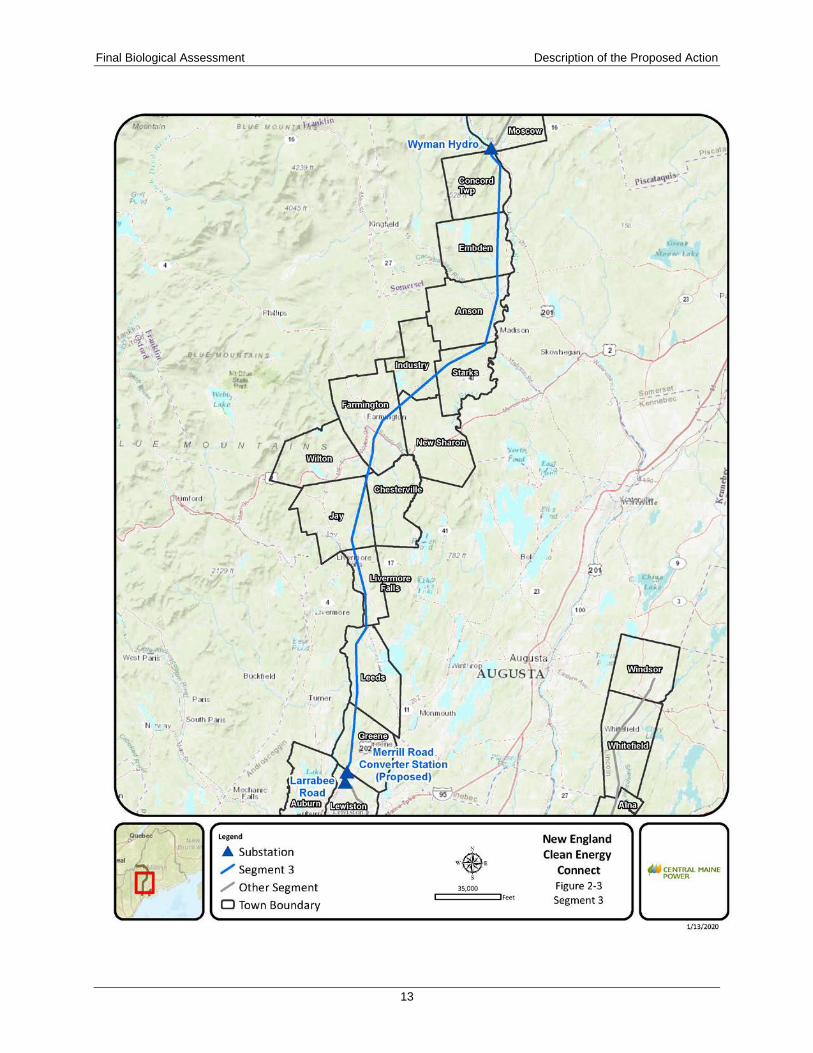


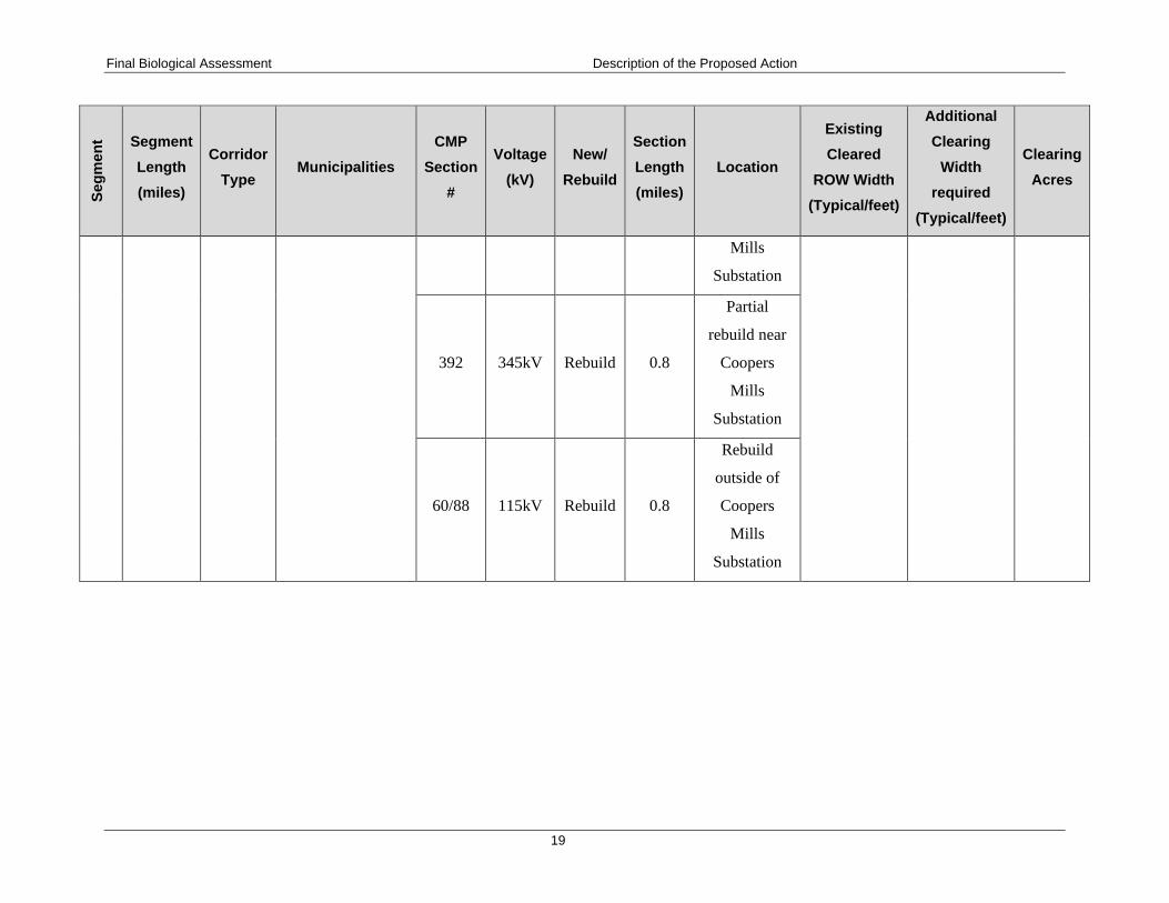
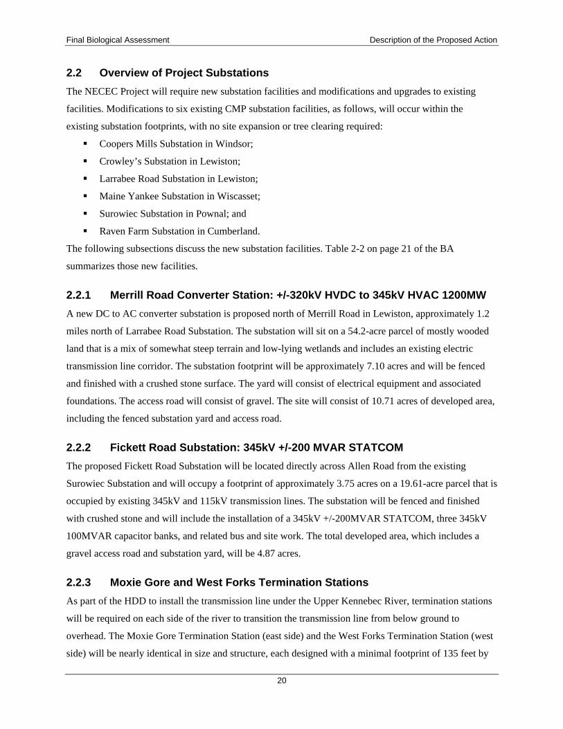
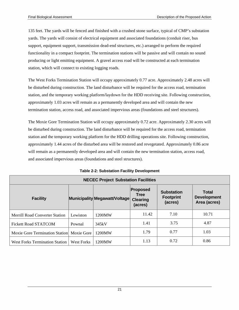


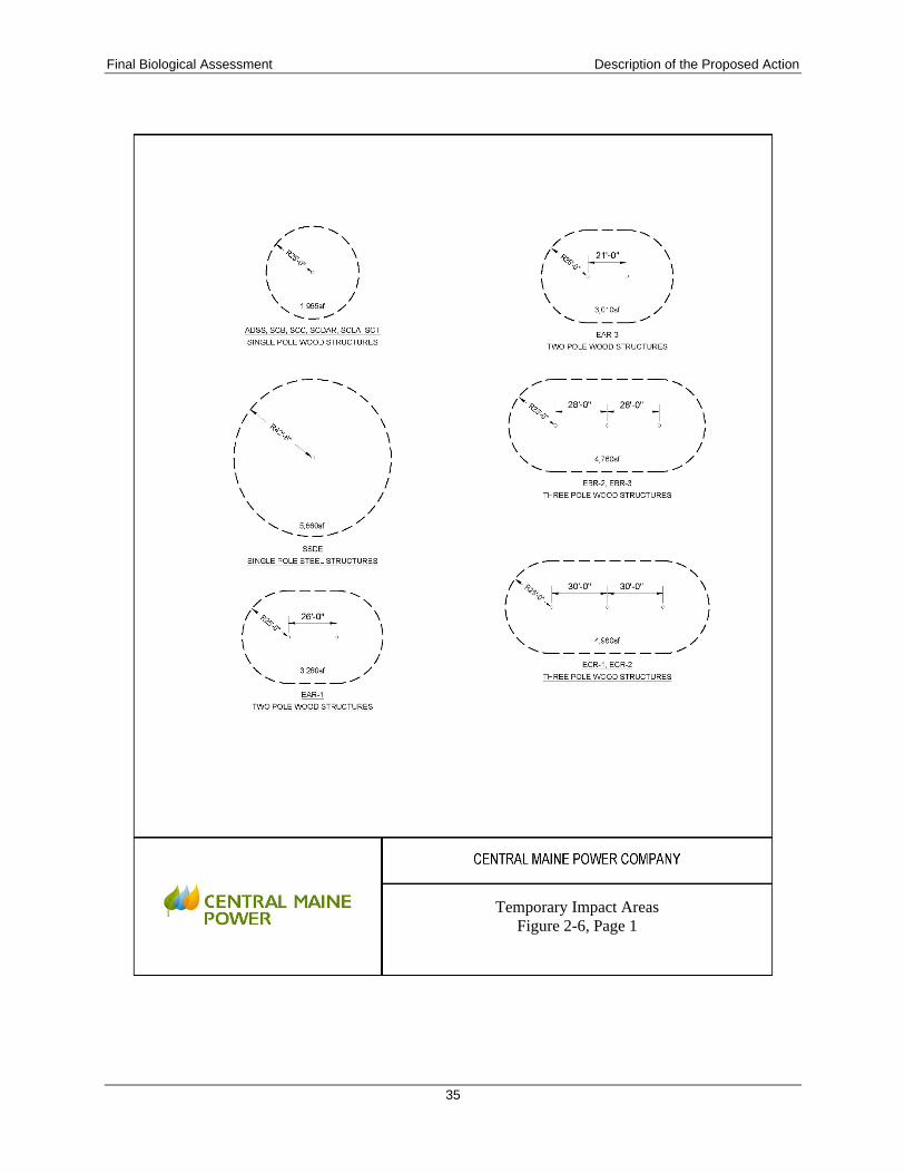
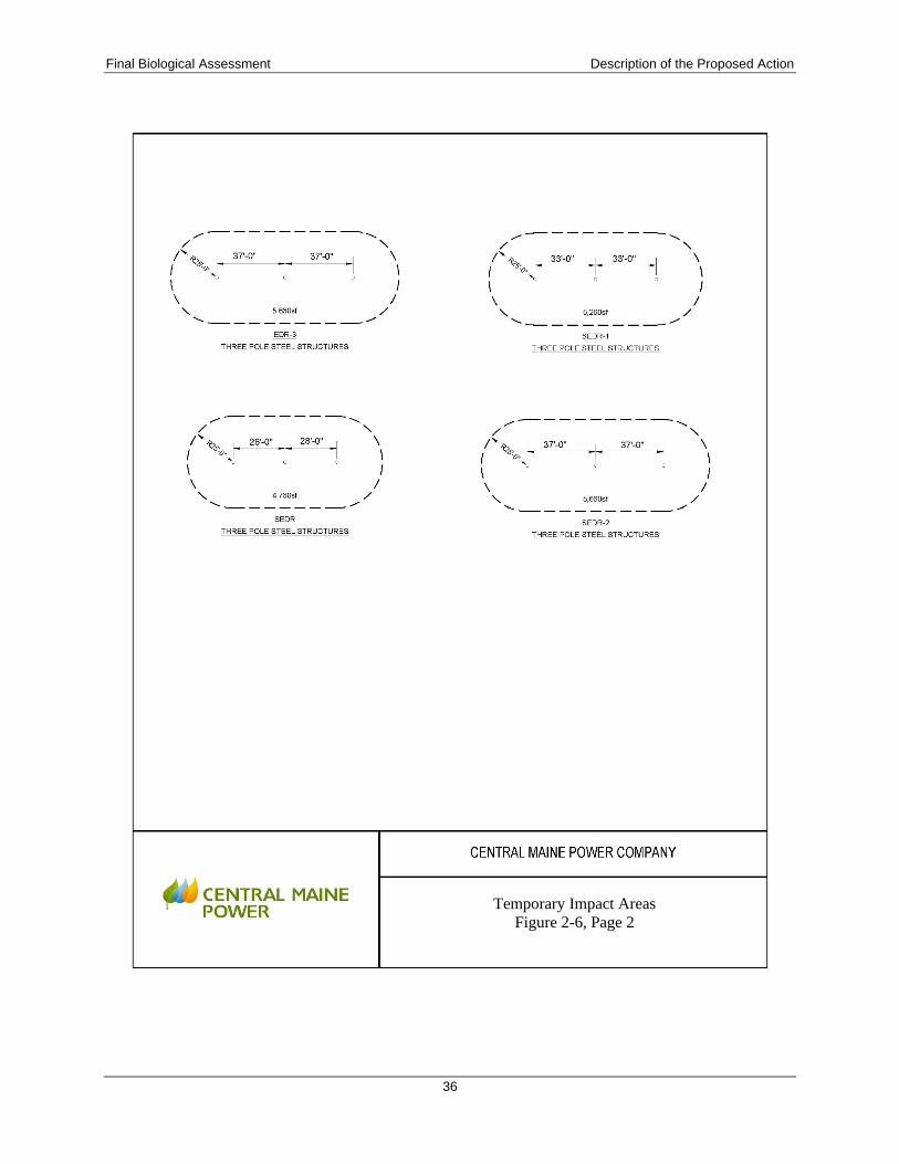


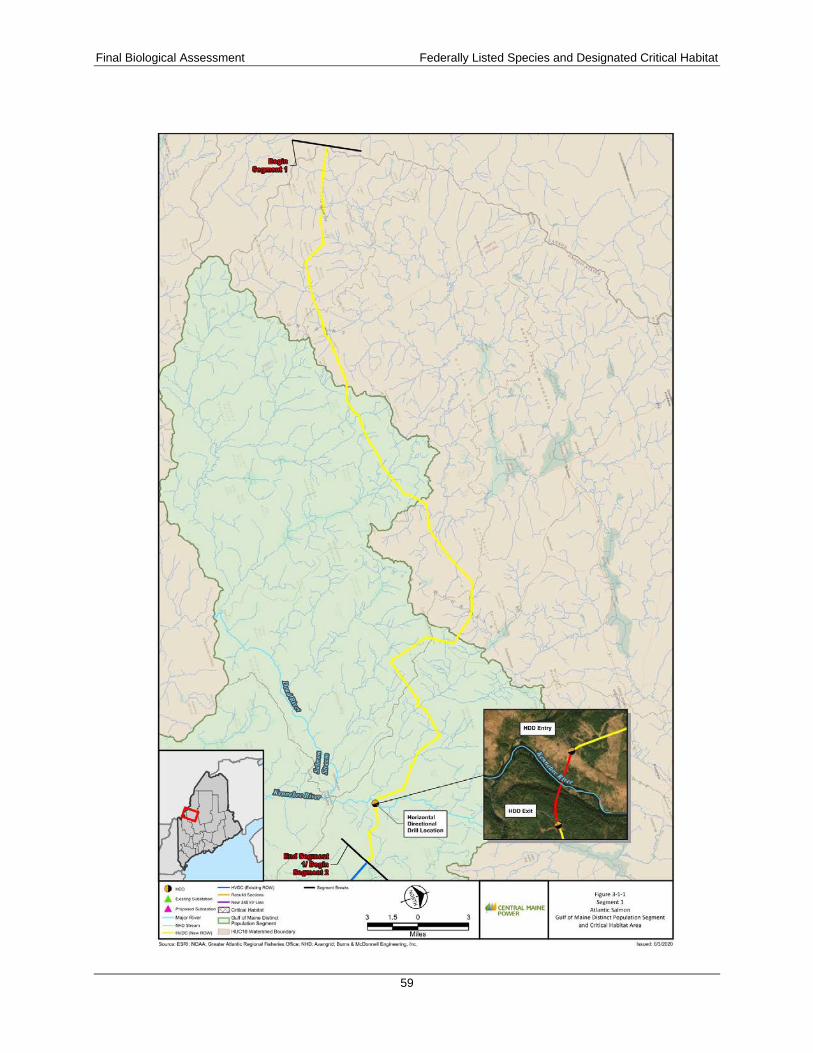
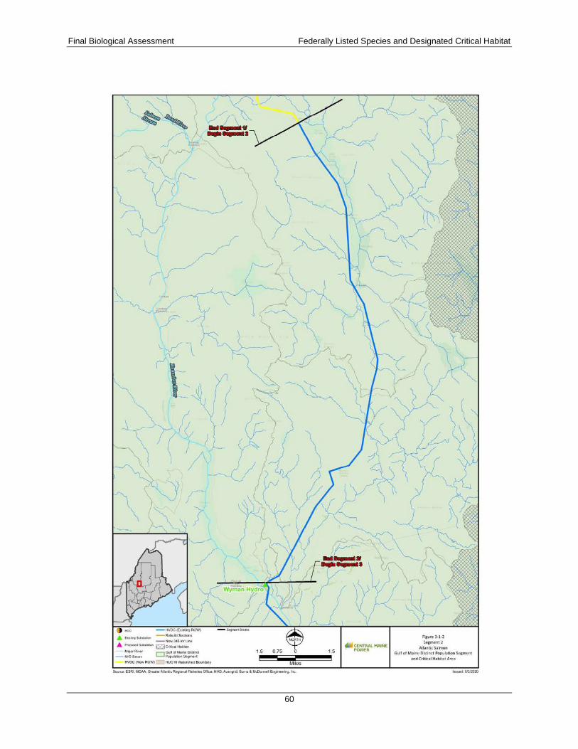

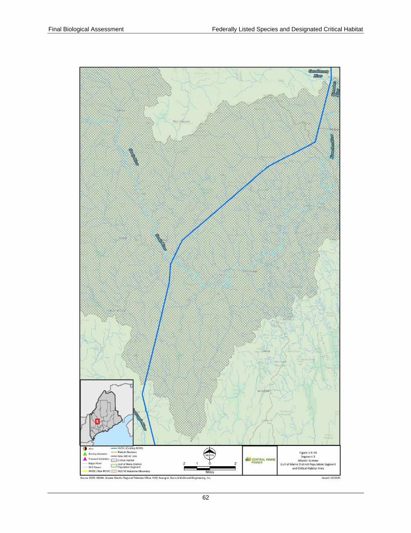

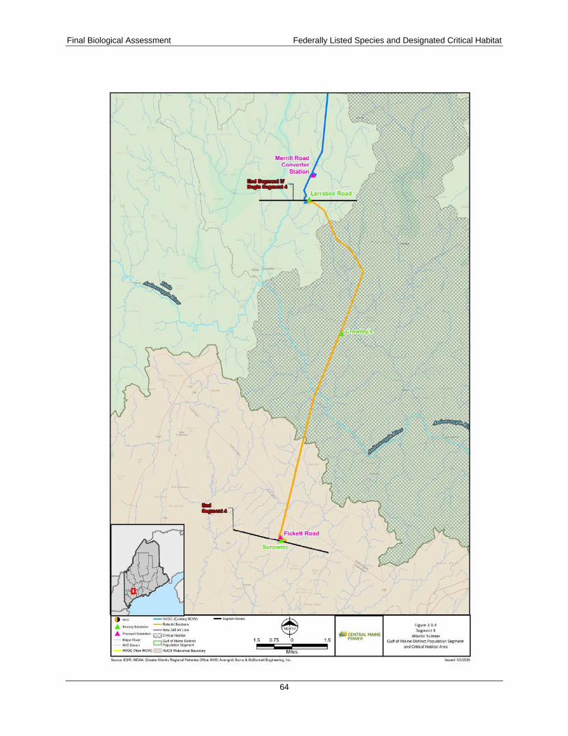


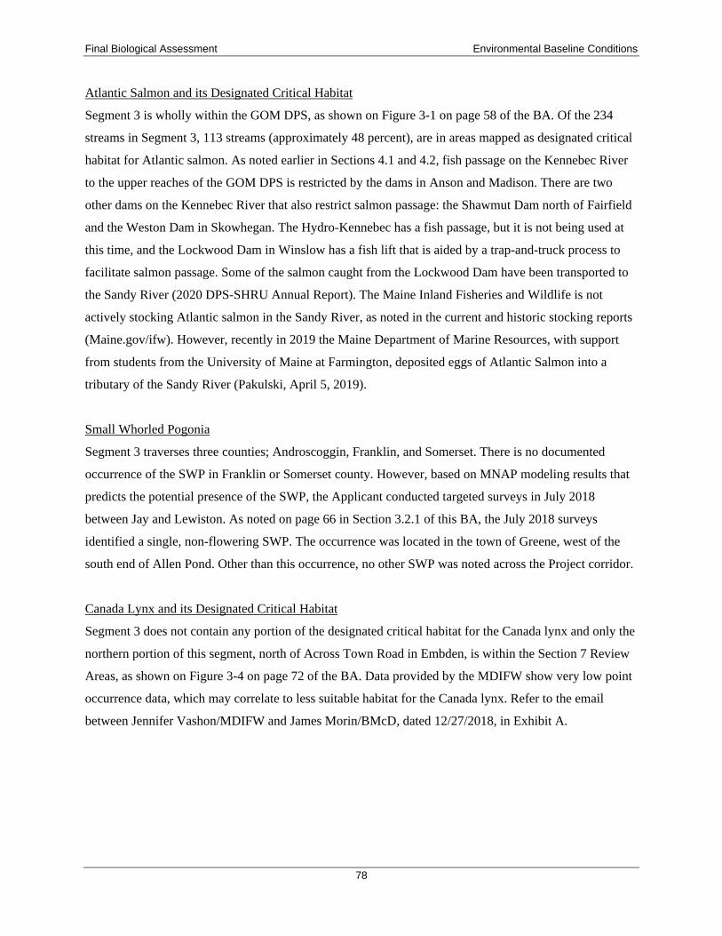


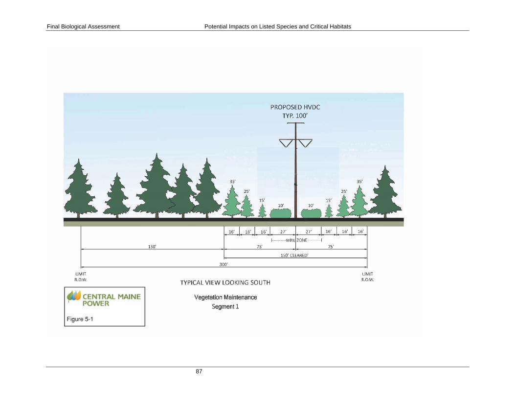


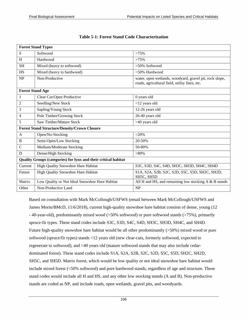


Related Documents