REGIONAL SNOWFALL PATTERNS IN THE HIGH, ARID ANDES MATHIAS VUILLE and CASPAR AMMANN Department of Geosciences, Morrill Science Center, University of Massachusetts, Amherst, MA 01003-5820, U.S.A. Abstract. Since 1990 the project ‘Climate Change in the Arid Andes’ has been focusing on past climate and environmental conditions in the high mountain range of the north Chilean Andes (18 S– 28 S). The extreme aridity of this region is shown by the absence of glaciers, even at the highest altitudes above 6700 m a.s.l. More knowledge of the present climatic situation is needed to interpret the proxy data of different paleoarchives in this transition belt between tropical and extratropical circulation. Precipitation events in this arid region are mainly registered during southern hemisphere summer, when the ITCZ reaches its southernmost position. Winter precipitation (snowfall) has so far not been considered an important factor in the hydrologic system of the area, because snow is seldom accurately registered by climatic stations. To fill this gap in our information, winter snowfall activity was analysed for a period of 6 years using digital NOAA/AVHRR satellite data. The results show that snowfall during winter (May–September) is a quite regular phenomenon, mainly linked to northward displacements or cut-offs of cold air-masses from the Pacific. The areal distribution of snowfall is determined by the synoptic situation that produces precipitation. During cold frontal events, snowfall is most frequent in the southernmost part of the research area and on the western Chilean side of the Andes. Cold air that has been cut off from the westerlies often interacts with warmer and more humid air over the continent and therefore gives rise to a different snowfall distribution, with the greatest snowfall frequency between 23 S–25 S, decreasing polewards as well as towards the equator. These two winter snowfall patterns show that reconstruction of paleoclimate has to take into account the different mechanisms that may cause precipitation in the research area. Intensification of winter precipitation (e.g., the west wind zone) can induce largely different precipitation patterns, depending on which mechanisms (cut-offs, cold-fronts or both) within the west wind zone are strengthened. Introduction This study is part of a broader interdisciplinary project on climate change in the arid Andes of Northern Chile, focusing on past climate and environmental conditions in the high mountain range of the Andes between 18 S–28 S during the last 20,000 years. The study area lies between the tropical circulation zone in the north and the west wind belt with its cyclonic activity in the south (Figure 1). This arid part of the Andes is an excellent place to study past climatic changes because any variation or shift in circulation zones in the past would have left tracks in different paleoarchives (paleosols, moraines, lacustrine sediments, etc.) that are found in the area (Grosjean, 1994; Messerli et al., 1993, forthcoming). Under present conditions the precipitation systems of both circulation zones penetrate into this area due to the seasonal shifts of these zones, but precipitation is nevertheless very scarce. The whole area is presently an extremely dry zone, mainly [181] Climatic Change 36: 413–423, 1997. c 1997 Kluwer Academic Publishers. Printed in the Netherlands.

Welcome message from author
This document is posted to help you gain knowledge. Please leave a comment to let me know what you think about it! Share it to your friends and learn new things together.
Transcript
REGIONAL SNOWFALL PATTERNS IN THE HIGH, ARID ANDES
MATHIAS VUILLE and CASPAR AMMANNDepartment of Geosciences, Morrill Science Center, University of Massachusetts, Amherst,
MA 01003-5820, U.S.A.
Abstract. Since 1990 the project ‘Climate Change in the Arid Andes’ has been focusing on pastclimate and environmental conditions in the high mountain range of the north Chilean Andes (18� S–28� S). The extreme aridity of this region is shown by the absence of glaciers, even at the highestaltitudes above 6700 m a.s.l. More knowledge of the present climatic situation is needed to interpretthe proxy data of different paleoarchives in this transition belt between tropical and extratropicalcirculation.
Precipitation events in this arid region are mainly registered during southern hemisphere summer,when the ITCZ reaches its southernmost position. Winter precipitation (snowfall) has so far notbeen considered an important factor in the hydrologic system of the area, because snow is seldomaccurately registered by climatic stations. To fill this gap in our information, winter snowfall activitywas analysed for a period of 6 years using digital NOAA/AVHRR satellite data. The results show thatsnowfall during winter (May–September) is a quite regular phenomenon, mainly linked to northwarddisplacements or cut-offs of cold air-masses from the Pacific. The areal distribution of snowfall isdetermined by the synoptic situation that produces precipitation. During cold frontal events, snowfallis most frequent in the southernmost part of the research area and on the western Chilean side of theAndes. Cold air that has been cut off from the westerlies often interacts with warmer and more humidair over the continent and therefore gives rise to a different snowfall distribution, with the greatestsnowfall frequency between 23� S–25� S, decreasing polewards as well as towards the equator. Thesetwo winter snowfall patterns show that reconstruction of paleoclimate has to take into account thedifferent mechanisms that may cause precipitation in the research area. Intensification of winterprecipitation (e.g., the west wind zone) can induce largely different precipitation patterns, dependingon which mechanisms (cut-offs, cold-fronts or both) within the west wind zone are strengthened.
Introduction
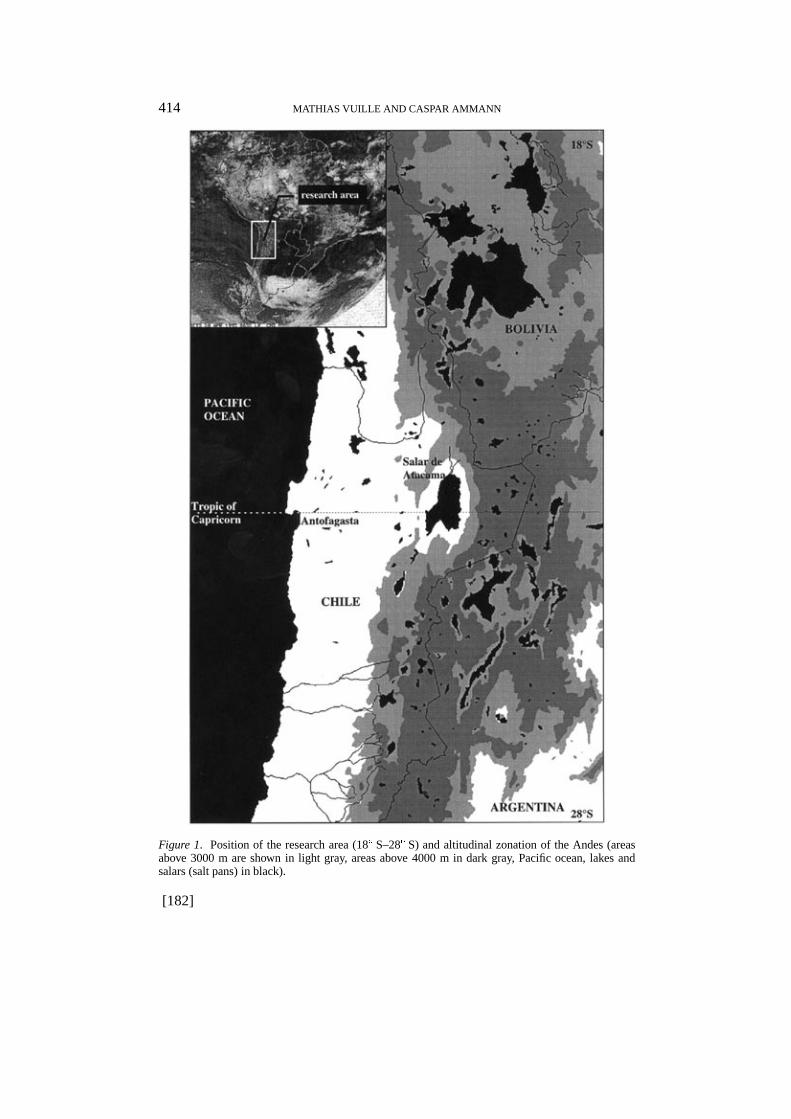
This study is part of a broader interdisciplinary project on climate change in the aridAndes of Northern Chile, focusing on past climate and environmental conditions inthe high mountain range of the Andes between 18� S–28� S during the last 20,000years.
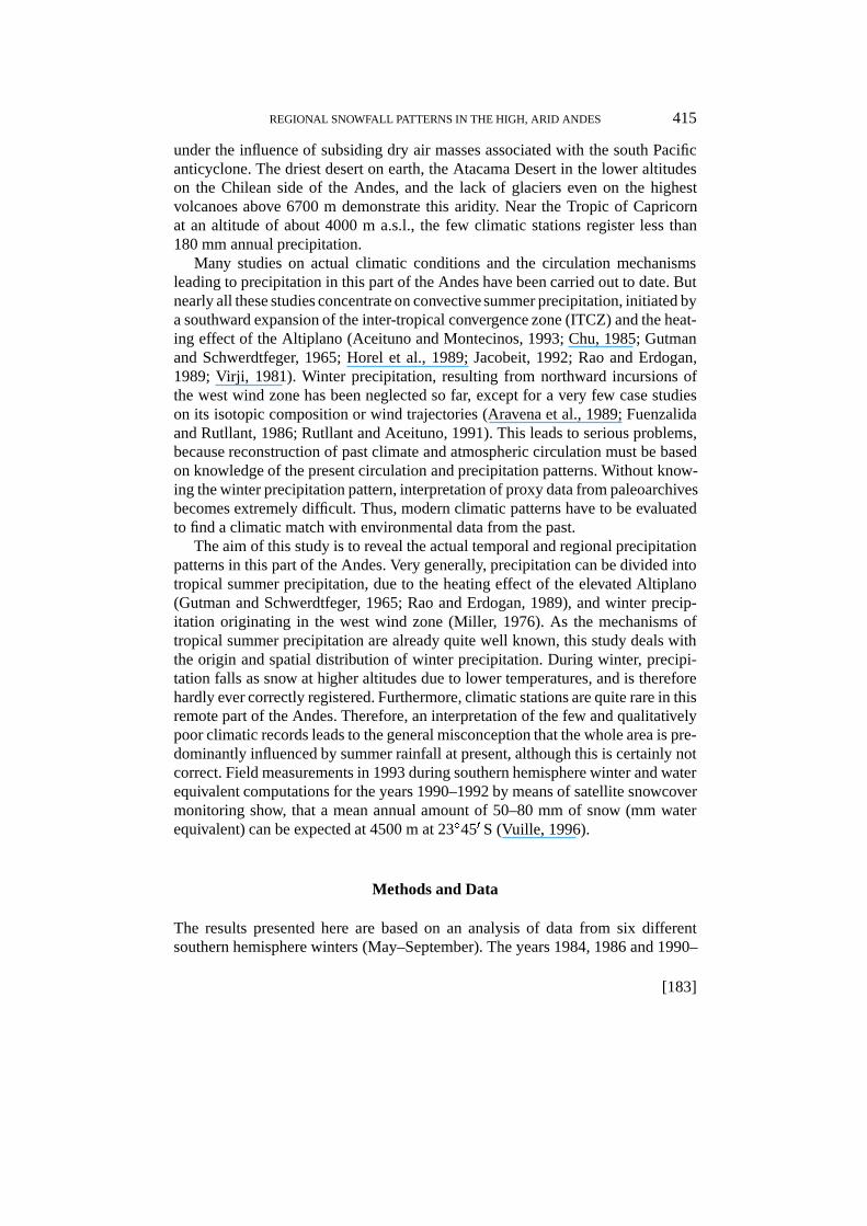
The study area lies between the tropical circulation zone in the north and thewest wind belt with its cyclonic activity in the south (Figure 1). This arid partof the Andes is an excellent place to study past climatic changes because anyvariation or shift in circulation zones in the past would have left tracks in differentpaleoarchives (paleosols, moraines, lacustrine sediments, etc.) that are found in thearea (Grosjean, 1994; Messerli et al., 1993, forthcoming).
Under present conditions the precipitation systems of both circulation zonespenetrate into this area due to the seasonal shifts of these zones, but precipitation isnevertheless very scarce. The whole area is presently an extremely dry zone, mainly
[181]Climatic Change 36: 413–423, 1997.c 1997 Kluwer Academic Publishers. Printed in the Netherlands.
414 MATHIAS VUILLE AND CASPAR AMMANN
Figure 1. Position of the research area (18� S–28� S) and altitudinal zonation of the Andes (areasabove 3000 m are shown in light gray, areas above 4000 m in dark gray, Pacific ocean, lakes andsalars (salt pans) in black).
[182]
REGIONAL SNOWFALL PATTERNS IN THE HIGH, ARID ANDES 415
under the influence of subsiding dry air masses associated with the south Pacificanticyclone. The driest desert on earth, the Atacama Desert in the lower altitudeson the Chilean side of the Andes, and the lack of glaciers even on the highestvolcanoes above 6700 m demonstrate this aridity. Near the Tropic of Capricornat an altitude of about 4000 m a.s.l., the few climatic stations register less than180 mm annual precipitation.
Many studies on actual climatic conditions and the circulation mechanismsleading to precipitation in this part of the Andes have been carried out to date. Butnearly all these studies concentrate on convective summer precipitation, initiated bya southward expansion of the inter-tropical convergence zone (ITCZ) and the heat-ing effect of the Altiplano (Aceituno and Montecinos, 1993; Chu, 1985; Gutmanand Schwerdtfeger, 1965; Horel et al., 1989; Jacobeit, 1992; Rao and Erdogan,1989; Virji, 1981). Winter precipitation, resulting from northward incursions ofthe west wind zone has been neglected so far, except for a very few case studieson its isotopic composition or wind trajectories (Aravena et al., 1989; Fuenzalidaand Rutllant, 1986; Rutllant and Aceituno, 1991). This leads to serious problems,because reconstruction of past climate and atmospheric circulation must be basedon knowledge of the present circulation and precipitation patterns. Without know-ing the winter precipitation pattern, interpretation of proxy data from paleoarchivesbecomes extremely difficult. Thus, modern climatic patterns have to be evaluatedto find a climatic match with environmental data from the past.
The aim of this study is to reveal the actual temporal and regional precipitationpatterns in this part of the Andes. Very generally, precipitation can be divided intotropical summer precipitation, due to the heating effect of the elevated Altiplano(Gutman and Schwerdtfeger, 1965; Rao and Erdogan, 1989), and winter precip-itation originating in the west wind zone (Miller, 1976). As the mechanisms oftropical summer precipitation are already quite well known, this study deals withthe origin and spatial distribution of winter precipitation. During winter, precipi-tation falls as snow at higher altitudes due to lower temperatures, and is thereforehardly ever correctly registered. Furthermore, climatic stations are quite rare in thisremote part of the Andes. Therefore, an interpretation of the few and qualitativelypoor climatic records leads to the general misconception that the whole area is pre-dominantly influenced by summer rainfall at present, although this is certainly notcorrect. Field measurements in 1993 during southern hemisphere winter and waterequivalent computations for the years 1990–1992 by means of satellite snowcovermonitoring show, that a mean annual amount of 50–80 mm of snow (mm waterequivalent) can be expected at 4500 m at 23�450 S (Vuille, 1996).
Methods and Data
The results presented here are based on an analysis of data from six differentsouthern hemisphere winters (May–September). The years 1984, 1986 and 1990–
[183]
416 MATHIAS VUILLE AND CASPAR AMMANN
1993 were chosen because they represent rather wet (1984, 1992) as well as ratherdry (1990) years. The climatic variability was analysed in earlier studies usingdigital Landsat satellite data (Vuille and Baumgartner, 1993) and climatic datafrom two automatic weather stations installed in the centre of the study region in1990 at 4400 m and 5000 m a.s.l. at 23�450 S (Vuille, 1996). Such a variabilityanalysis is crucial, in order to be sure of getting significant results in an area of veryhigh temporal and regional precipitation variability. Even though the analysis of alonger data set would have been desirable, this article presents a first case studytowards a better understanding of the climate in this region. During the six winters,37 different precipitation events were registered by climatic stations in the researcharea. Out of the 37 events, 24 were selected for this study and analysed using weathercharts (surface, 500 hpa and 200 hpa), radio soundings from Antofagasta (Figure 1),GOES satellite data and the records from the official Chilean climate stations. Theother 13 events were not analysed due to missing data sets. The main criteria forthis synoptic analysis were the pressure fields and the radiosonde soundings fromAntofagasta. Analysis of these data resulted in a preliminary classification of thedifferent events into typical synoptic situations which produce precipitation in theresearch area. A better and final separation resulted by integrating the verticaltemperature distribution and the horizontal temperature and wind fields. A detaileddescription of this synoptic analysis is given in Ammann (1996).
It is quite difficult to monitor the regional extent of precipitation as the officialclimatic stations are very rare and unevenly spread over the research area. Further-more, it seems that at least winter snowfall is not always correctly registered bythese stations. Therefore, satellite data were chosen as a basis for this study, as suchdata had already been applied successfully in earlier studies in this area (Vuille andBaumgartner, 1993). During winter, precipitation falls as snow at higher altitudes,so satellite data offer a unique opportunity to monitor the extent and frequency ofsnowfall. Digital NOAA/AVHRR data were used to separate snow-covered areasfrom bare soil. The NOAA/AVHRR satellite sensor was chosen because its spatialresolution of 1 km2 allows snow classification on a regional scale (Rango et al.,1983; Baumgartner and Seidel, 1988) and the whole study area can be covered inone image. Moreover, many authors have shown that if a multispectral classifica-tion algorithm is used, the different satellite sensors (channels) allow snow-coveredareas to be accurately separated from their surroundings (Allen et al., 1990; Kidderand Wu, 1987; Lucas and Harrison, 1990). In this study snow discrimination wasdone by using NOAA/AVHRR channel 1–4 and applying a Maximum LikelihoodClassification algorithm (Duda and Hart, 1973). During the winter of 1993 a fieldverification was carried out in order to detect classification errors and to excludelight snowfalls without any contribution to the hydrological cycle, that might stillshow up as snow cover in the satellite imagery. Typical snow depths at 4400 m,23�450 S for single snowfall events are 5 cm–20 cm, depending on slope and aspect(Vuille, 1996). Furthermore, all scenes were geometrically corrected and resampledusing a Nearest Neighbour Resampling method. Finally, all scenes were matched
[184]
REGIONAL SNOWFALL PATTERNS IN THE HIGH, ARID ANDES 417
to a Digital Terrain Model to be able to detect the temporary snowline and thesnow-covered area in different elevation zones.
1. Synoptic Situation During Winter Snowfall Episodes
The synoptic analysis of precipitation events in the research area during southernhemisphere winter led to a weather classification, in which events with differentsynoptic situations were separated. The results show that there are only two maincategories of weather conditions producing snowfall in the area during winter. Ofcourse there are many variations within these two categories, but they are of norelevance when looking at the spatial distribution of snowfall in the research area.This conclusion results from the analysis of the final snowfall patterns which arevery homogeneous within each category.
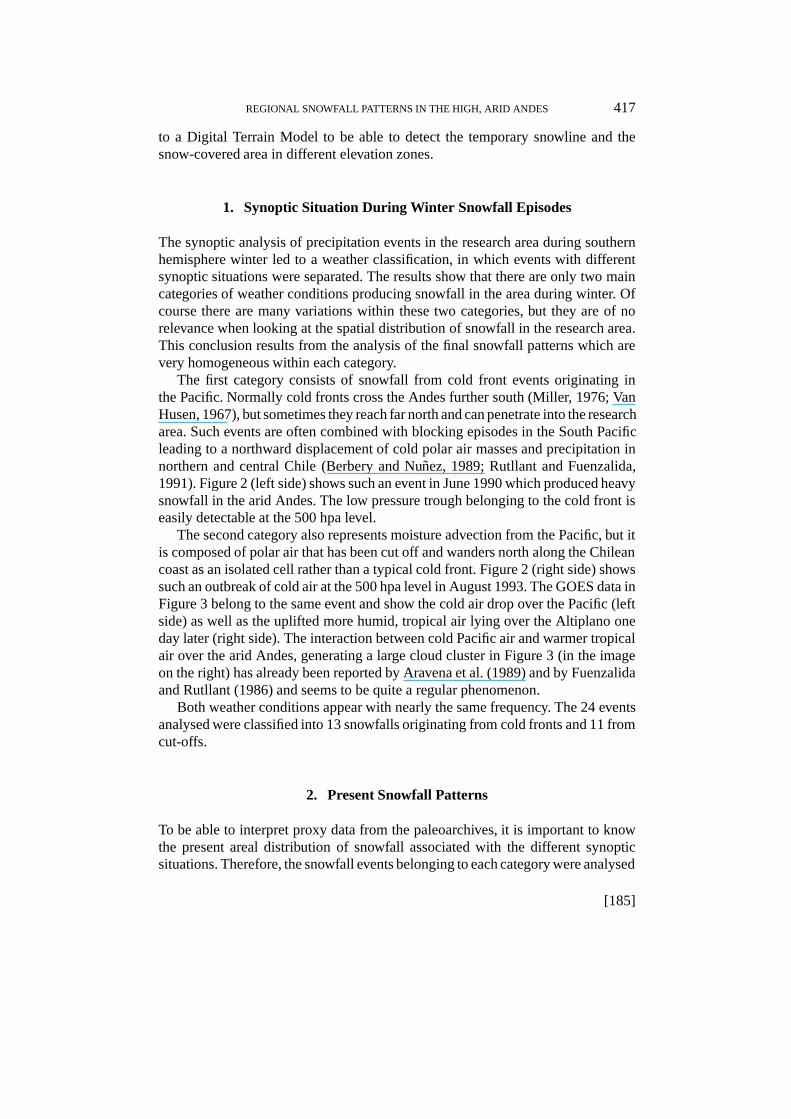
The first category consists of snowfall from cold front events originating inthe Pacific. Normally cold fronts cross the Andes further south (Miller, 1976; VanHusen, 1967), but sometimes they reach far north and can penetrate into the researcharea. Such events are often combined with blocking episodes in the South Pacificleading to a northward displacement of cold polar air masses and precipitation innorthern and central Chile (Berbery and Nunez, 1989; Rutllant and Fuenzalida,1991). Figure 2 (left side) shows such an event in June 1990 which produced heavysnowfall in the arid Andes. The low pressure trough belonging to the cold front iseasily detectable at the 500 hpa level.
The second category also represents moisture advection from the Pacific, but itis composed of polar air that has been cut off and wanders north along the Chileancoast as an isolated cell rather than a typical cold front. Figure 2 (right side) showssuch an outbreak of cold air at the 500 hpa level in August 1993. The GOES data inFigure 3 belong to the same event and show the cold air drop over the Pacific (leftside) as well as the uplifted more humid, tropical air lying over the Altiplano oneday later (right side). The interaction between cold Pacific air and warmer tropicalair over the arid Andes, generating a large cloud cluster in Figure 3 (in the imageon the right) has already been reported by Aravena et al. (1989) and by Fuenzalidaand Rutllant (1986) and seems to be quite a regular phenomenon.
Both weather conditions appear with nearly the same frequency. The 24 eventsanalysed were classified into 13 snowfalls originating from cold fronts and 11 fromcut-offs.
2. Present Snowfall Patterns
To be able to interpret proxy data from the paleoarchives, it is important to knowthe present areal distribution of snowfall associated with the different synopticsituations. Therefore, the snowfall events belonging to each category were analysed
[185]
418 MATHIAS VUILLE AND CASPAR AMMANN
Figure 2. Synoptic weather charts (500 hpa) showing typical circulation patterns leading to snowfallin the research area. Left side: cold front event in June 1990, right side: cut-off event in August 1993(Source: European Weather Forecast Center, Reading, UK, by permission of D. Luethi, ETH-Zuerich).
Figure 3. GOES satellite data from August 9th and 10th 1993, showing development of a typicalcut-off event over the arid Andes (Source: Dept. of Geography, Univ. of Berne).
separately and then combined into a ‘cold front-snowfall pattern’ and a ‘cut off-snowfall pattern’. The results show that there are significant and relevant differencesin the spatial pattern of the two categories due to the different synoptic situation(Figures 4 and 5).
[186]
REGIONAL SNOWFALL PATTERNS IN THE HIGH, ARID ANDES 419
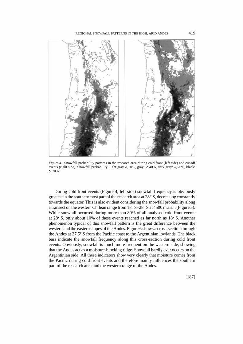
Figure 4. Snowfall probability patterns in the research area during cold front (left side) and cut-offevents (right side). Snowfall probability: light gray < 20%, gray: < 40%, dark gray: < 70%, black:> 70%.
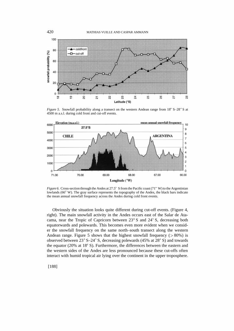
During cold front events (Figure 4, left side) snowfall frequency is obviouslygreatest in the southernmost part of the research area at 28� S, decreasing constantlytowards the equator. This is also evident considering the snowfall probability alonga transect on the western Chilean range from 18� S–28� S at 4500 m a.s.l. (Figure 5).While snowfall occurred during more than 80% of all analysed cold front eventsat 28� S, only about 10% of these events reached as far north as 18� S. Anotherphenomenon typical of this snowfall pattern is the great difference between thewestern and the eastern slopes of the Andes. Figure 6 shows a cross-section throughthe Andes at 27.5� S from the Pacific coast to the Argentinian lowlands. The blackbars indicate the snowfall frequency along this cross-section during cold frontevents. Obviously, snowfall is much more frequent on the western side, showingthat the Andes act as a moisture-blocking ridge. Snowfall hardly ever occurs on theArgentinian side. All these indicators show very clearly that moisture comes fromthe Pacific during cold front events and therefore mainly influences the southernpart of the research area and the western range of the Andes.
[187]
420 MATHIAS VUILLE AND CASPAR AMMANN
Figure 5. Snowfall probability along a transect on the western Andean range from 18� S–28� S at4500 m a.s.l. during cold front and cut-off events.
Figure 6. Cross-section through the Andes at 27.5� S from the Pacific coast (71� W) to the Argentinianlowlands (66� W). The gray surface represents the topography of the Andes, the black bars indicatethe mean annual snowfall frequency across the Andes during cold front events.
Obviously the situation looks quite different during cut-off events. (Figure 4,right). The main snowfall activity in the Andes occurs east of the Salar de Ata-cama, near the Tropic of Capricorn between 23� S and 24� S, decreasing bothequatorwards and polewards. This becomes even more evident when we consid-er the snowfall frequency on the same north–south transect along the westernAndean range. Figure 5 shows that the highest snowfall frequency (> 80%) isobserved between 23� S–24� S, decreasing polewards (45% at 28� S) and towardsthe equator (20% at 18� S). Furthermore, the differences between the eastern andthe western sides of the Andes are less pronounced because these cut-offs ofteninteract with humid tropical air lying over the continent in the upper troposphere.
[188]
REGIONAL SNOWFALL PATTERNS IN THE HIGH, ARID ANDES 421
The question of why the main snowfall activity occurs only in the area east of theSalar de Atacama is still under discussion. Probably this zone is often frequentedby the cut-off tracks, but the number of analysed events is still too small for definiteconclusions. Furthermore, the role of Andean topography during phases of coldair advection is not yet clear. Therefore, the orographic effect of the high masselevation east of the large Salar de Atacama must be analysed more precisely.
3. Paleoclimatic Implications and Conclusions
Proxy data from the paleoarchives (moraines, lacustrine sediments, paleosols, etc.)indicate that more humid conditions during the late glacial and the early holocenein the research area are probably due to an intensification and southward extensionof tropical summer precipitation (Grosjean, 1994; Grosjean et al., 1995; Hastenrathand Kutzbach, 1985; Messerli et al., 1993, forthcoming). These findings are con-sistent with the reported expansion of Bolivian Altiplano lakes during this Taucaphase (Wirrmann and Mourguiart, 1995) and tropical moisture advection produc-ing a lower late pleistocene equilibrium line on the eastern slope of the Andes (Foxand Strecker, 1991).
Nevertheless, the two typical present-day precipitation patterns during southernhemisphere winter in the arid Andes have clear implications for climatic interpre-tation of paleoarchives in the research area. They show that an intensification ofthe westerlies can have different effects, depending on whether cold fronts, cut-offlows or both are intensified within the west wind zone. In any case, it would bea dangerous simplification to compare an intensification of the westerlies with asimple and continuous northward shift of more humid conditions. If an intensifiedwest wind zone was accompanied by a higher cut-off frequency, reconstructionof a former precipitation pattern becomes difficult. It is not yet clear whether thesnowfall maximum near the Tropic of Capricorn is significant even for longer timeperiods, or if it is a random effect due to the small number of analysed events.If this distribution is produced by topographic effects, it can be concluded that asimilar pattern should have been active in the past, as topography has remained thesame over the last 20,000 years. Even though all proxy data from paleoarchivessuggest a tropical moisture source to be the origin of the more humid conditions,the precipitation pattern derived from cut-off events shows that it is theoreticallypossible to explain such conditions in the central and also in the northern part ofthe study area even without intensified tropical circulation. This has to be kept inmind when interpreting moisture signals from paleoarchives.
We must emphasize, that it is not satisfactory to analyse past climate by shiftingor intensifying entire circulation belts. The processes within a circulation zoneleading to different precipitation patterns have to be analysed and understood. Bychanging intensity and the frequency of the synoptic situation, many more possiblepaleoclimatic interpretations become available.
[189]

422 MATHIAS VUILLE AND CASPAR AMMANN
Finally, this study has led to a better understanding of the present atmosphericcirculation in winter over the research area during precipitation episodes, andcontributed to the discovery of previously unknown precipitation patterns in thearid Andes. It is obvious that the snowfall frequency has been highly underestimatedso far, due to the lack of climatic records in the area (no data or data of very poorquality). Satellite data have proven to be an excellent tool for such purposes.
Acknowledgements
This article is part of the Swiss National Science Foundation Project ‘ClimateChange in the Arid Andes’ (NF 20-36382.92). Special thanks are owed to B.Messerli and M. F. Baumgartner (Dept. of Geography, Univ. of Berne) and allother members of our team, each of whom contributed to this study.
References
Aceituno, P. and Montecinos, A.: 1993, ‘Circulation Anomalies Associated with Wet and Dry Peri-ods in the South American Altiplano’, Preprint Fourth International Conference on SouthernHemisphere Meteorology and Oceanography, Hobart Australia, pp. 330–331.
Allen, C., Durkee, P., and Wash, C.: 1990, ‘Snow/Cloud Discrimination with Multispectral SatelliteMeasurements’, J. Appl. Met. 29, 994–1004.
Ammann, C.: 1996, ‘Climate Change in den trockenen Andes Attwelle Wiederschlagmuster’, Geo-graphica Bernensia, G 46, p. 127.
Aravena, R., Pena, H., Grilli, A., Suzuki, O., Mordeckai, M.: 1989, ‘Evolucion isotopica de las lluviasy origen de las masas de aire en el Altiplano chileno’, in IAEA-TECDOC-502: Isotope HydrologyInvestigations in Latin America, pp. 129–142.
Baumgartner, M. F. and Seidel, K.: 1988, ‘Multisensor Snow Cover Mapping and Snowmelt RunoffSimulations’, in Eastern Snow Conference, Proceedings of the Annual Meeting, pp. 186–191.
Berbery, E. H. and Nunez, M. N.: 1989, ‘An Observational and Numerical Study of Blocking Episodesnear South America’, J. Clim. 2, 1352–1361.
Chu, P.-S.: 1985, ‘A Contribution to the Upper-Air Climatology of Tropical South America’, J.Climatol. 5, 403–416.
Duda, R. O. and Hart, P. E.: 1973, Pattern Classification and Scene Analysis, John Wiley and Sons,New York, p. 482.
Fox, A. N. and Strecker, M. N.: 1991, ‘Pleistocene and Modern Snowlines in the Central Andes(24� S–28� S), Bamberger Geographische Schriften 11, 169–182.
Fuenzalida, H. and Rutllant, J.: 1986, ‘Estudio sobre el origen del vapor de agua que precipita en elinvierno altiplanico’, Informe Final, Universidad de Chile (unpubl.).
Grosjean, M.: 1994, ‘Paleohydrology of the Laguna Lejia (North Chilean Altiplano) and ClimaticImplications for Late-Glacial Times’, Paleogeography, Paleoclimatology, Paleoecology 109. 89–100.
Grosjean, M., Geyh, M. A., Messerli, B., and Schotterer, U.: 1995, ‘Late-Glacial and Early HoloceneLake Sediments, Groundwater Formation and Climate in the Atacama Altiplano 22–24� S’, J.Paleolimnol. 14, 241–252.
Gutman, G. and Schwerdtfeger, W.: 1965, ‘The Role of Latent and Sensible Heat for the Develop-ment of a High Pressure System over the Subtropical Andes in the Summer’, MeteorologischeRundschau 18 (3), 69–75.
Hastenrath, S. L. and Kutzbach, J.: 1985, ‘Late Pleistocene Climate and Water Budget of the SouthAmerican Altiplano’, Quartern. Res. 24, 249–256.
[190]
REGIONAL SNOWFALL PATTERNS IN THE HIGH, ARID ANDES 423
Horel, J. D., Hahmann, A. N., and Geisler, J. E.: 1989, ‘An Investigation of the Annual Cycle ofConvective Activity over the Tropical Americas’, J. Clim. 2, 1388–1403.
Jacobeit, J.: 1992: ‘Die grossraumige Hohenstromung in der Hauptregenzeit feuchter und trockenerJahre uber dem sudamerikanischen Altiplano’, Met. Zeitschrift, N.F. 1 (6), 276–284.
Kidder, S. Q. and Wu, H.: 1987, ‘A Multispectral Study of the St. Louis Area under Snow-CoveredConditions Using NOAA-7 AVHRR data’, Rem. Sens. Env. 22, 159–172.
Lucas, R. M. and Harrison, A. R.: 1990, ‘Snow Observation by Satellite: A Review’, Rem. Sens. Rev.4 (2): 285–348.
Messerli, B., Grosjean, B., Bonani, G., Burgi, A., Geyh, M. A., Graf, K., Ramseyer, K., Romero,H., Schotterer, U., Schreier, H., and Vuille, M.: 1993: ‘Climate Change and Natural ResourceDynamics of the Atacama Altiplano during the Last 18,000 Years: A Preliminary Synthesis’,Mount. Res. Dev. 13 (2), 117–127.
Messerli, B., Ammann, C., Grosjean, M., Jenni, B., Kammer, K., and Vuille, M.: forthcoming, ‘CurrentPrecipitation, Late Pleistocene Snow Line and Lake Level Changes in the Atacama Altiplano 18�–28� S: Evidence for Shifts of the “Andean Dry Diagonal” ’, Bamberger Geographische Schriften.
Miller, A.: 1976, ‘The Climate of Chile’, in Schwerdtfeger, W. (ed.), The Climates of Central andSouth America, World Survey of Climatology 12, 113–145.
Rango, A., Martinec, J., Foster, J., Marks, D.: 1983, ‘Resolution in Operational Remote Sensing ofthe Snow Cover. Hydrological Applications of Remote Sensing and Remote Data Transmission’,Proc. of Hamburg Symposium, IAHS Publ. 145, 371–382.
Rao, G. V. and Erdogan, S.: 1989, ‘The Atmospheric Heat Source over the Altiplano’, Boundary-LayerMeteorol. 46, 13–33.
Rutllant, J. and Aceituno, P.: 1991, ‘Southern Hemisphere Circulation Signals in Connection withWinter Rainfall Forecasting in Central Chile’, IAEA, UNESCO and International Centre forTheoretical Physics, Internal Report, IC/91/64.
Rutllant, J. and Fuenzalida, H.: 1991, ‘Synoptic Aspects of the Central Chile Rainfall VariabilityAssociated with the Southern Oscillation’, Int. J. Climatol. 11, 63–76.
Van Husen, C.: 1967. ‘Klimagliederung in Chile auf der Basis von Haufigkeitsverteilungen derNiederschlagssummen’, Freiburger Geographische Hefte 4.
Virji, H.: 1981, ‘A Preliminary Study of Summertime Tropospheric Circulation over South AmericaEstimated from Cloud Winds’, Mon. Wea. Rev. 109, 599–610.
Vuille, M. and Baumgartner, M. F.: 1993, ‘Hydrologic Investigations in the North Chilean AltiplanoUsing Landsat-MSS and -TM Data’, Geocarto Intern. 8 (3), 35–45.
Vuille, M.: 1996, ‘Zur raumzeitlichen Dynamik von Schneefall und Ausaperung im Bereich dessudlichen Altiplano, Sudamerika’, Geographica Bernensia G 45, p. 118.
Vuille, M. and Messerli, B.: 1997, ‘The Role of Winter Snowfall in the Hydrologic Cycle of the AridAndes, Northern Chile’, Wat. Resour. Res. (in review).
Wirrmann, D. and Mourguiart, P.: 1995, ‘Late Quarternary Spatio-Temporal Limnological Variationsin the Altiplano of Bolivia and Peru’, Quartern. Res. 43, 344–354.
(Received 22 February 1996; in revised form 30 October 1996)
[191]
Related Documents