REGIONAL PLANNING NEWS – VOLUME 5 · ISSUE 1 · MARCH 2018 | 1 SWITCH TO E-NEWS Help save paper, printing, and mailing costs. Sign up to receive this newsletter by email at www.sewrpc.org/news. LOOK ONLINE Find new and updated information at www.sewrpc.org and www.vision2050sewis.org. REPORTS AND RESOURCES Waukesha County Aquatic Invasive Species Strategic Plan A Lake Management Plan for Lake Denoon, Racine and Waukesha Counties, Wisconsin Kenosha County Hazard Mitigation Plan Update: 2017-2022 REGIONAL PLANNING NEWS A publication of the Southeastern Wisconsin Regional Planning Commission Volume 5 · Issue 1 · March 2018 2 Regional Chloride Impact Study 4 Jackson and Mason Creek Plans 6 Waukesha County AIS Strategic Plan Southeastern Wisconsin Coastal Resilience Study SEWRPC is partnering with staff from the Wisconsin Coastal Management Program (WCMP), the University of Wisconsin Sea Grant Institute, and the University of Wisconsin-Madison Department of Civil and Environmental Engineering in developing the Southeastern Wisconsin Coastal Resilience Study. The funding source for the study is a National Oceanic and Atmospheric Administration Coastal Resilience Grants Program award to the WCMP. The three-year study will focus on the Lake Michigan coast in Ozaukee, Milwaukee, Racine, and Kenosha Counties. Deliverables for the study will include projecting future shoreline recession, developing guidance materials for implementing risk reduction practices and communicating risk along the coastal shoreline, organizing a network for communities to collaborate, and identifying coastal resilience projects to fund. SEWRPC staff are participating in the effort by providing technical support for guidance materials related to bluff vegetation and assisting in organizing and interacting with the project Community of Practice, which will be a network of local officials, scientists, and outreach specialists in the study region. The Community of Practice will meet periodically throughout the project to discuss local projects, share information related to coastal resilience, learn about coastal risks, and plan regionally resilient strategies for the shared Lake Michigan coast.

Welcome message from author
This document is posted to help you gain knowledge. Please leave a comment to let me know what you think about it! Share it to your friends and learn new things together.
Transcript

REGIONAL PLANNING NEWS – VOLUME 5 · ISSUE 1 · MARCH 2018 | 1
SWITCH TO E-NEWSHelp save paper, printing, and mailing costs. Sign up to receive this newsletter
by email at www.sewrpc.org/news.
LOOK ONLINEFind new and updated information at www.sewrpc.org and www.vision2050sewis.org.
REPORTS AND RESOURCESWaukesha County Aquatic Invasive Species Strategic Plan
A Lake Management Plan for Lake Denoon, Racine and Waukesha Counties, Wisconsin
Kenosha County Hazard Mitigation Plan Update: 2017-2022
REGIONAL PLANNING NEWSA publication of the Southeastern Wisconsin Regional Planning Commission
Volume 5 · Issue 1 · March 2018
2 Regional Chloride Impact Study 4 Jackson and Mason
Creek Plans 6 Waukesha County AIS Strategic Plan
Southeastern Wisconsin Coastal Resilience StudySEWRPC is partnering with staff from the Wisconsin Coastal Management Program (WCMP), the University of Wisconsin Sea Grant Institute, and the University of Wisconsin-Madison Department of Civil and Environmental Engineering in developing the Southeastern Wisconsin Coastal Resilience Study. The funding source for the study is a National Oceanic and Atmospheric Administration Coastal Resilience Grants Program award to the WCMP. The three-year study will focus on the Lake Michigan coast in Ozaukee, Milwaukee, Racine, and Kenosha Counties. Deliverables for the study will include projecting future shoreline recession, developing guidance materials for implementing risk reduction practices and communicating risk along the coastal shoreline, organizing a network for communities to collaborate, and identifying coastal resilience projects to fund. SEWRPC staff are participating in the effort by providing technical support for guidance materials related to bluff vegetation and assisting in organizing and interacting with the project Community of Practice, which will be a network of local officials, scientists, and outreach specialists in the study region. The Community of Practice will meet periodically throughout the project to discuss local projects, share information related to coastal resilience, learn about coastal risks, and plan regionally resilient strategies for the shared Lake Michigan coast.

2 | REGIONAL PLANNING NEWS – VOLUME 5 · ISSUE 1 · MARCH 2018
ENVIRONMENTALENVIRONMENTAL
Regional Chloride Impact StudySEWRPC staff has begun work on a regional chloride impact study that will evaluate the introduction of chloride in the environment and the environmental impacts of such introduction within the Region. The study will provide a comprehensive inventory of the historical and present sources of chloride loads to surface and groundwater resources; an assessment of the impacts of these loads on the environment, and in particular on the surface water and groundwater resources of the Region; development of a state-of-the-art component addressing current research and emerging technologies and policies related to mitigating the environmental effects of chloride from multiple sources; identification of alternative means of achieving desired levels of management of sources of chloride; and the formulation of general recommendations for abatement of the undesirable environmental impacts of the use of chloride.
Past Commission studies have verified that there are few data available on instream, or in-lake, chloride concentrations or specific conductance levels during the winter. Therefore, under the study, existing sources of water quality data will be supplemented with data collected by data loggers that will be deployed by SEWRPC at about 40 stream and lake locations to continually record conductivity and water temperature over the course of up to two years, including the winter. Monthly and event grab samples will also be collected and sent to the Wisconsin State Laboratory of Hygiene for analysis of chloride concentration and conductivity constituents. The lab data will be used to develop a relationship between conductance and chloride concentration at each station. The data collected will establish an existing baseline condition regarding the chloride content of representative streams and lakes. The collection of new specific conductance data will be targeted to those lakes and streams which might be expected to be most directly affected by chloride from road salt application or other potential sources, but it will also include some waterbodies that are judged to be less susceptible to chloride pollution, enabling the establishment of a baseline condition that is representative of a range of chloride impacts on the surface water resources of the Region.
Figure 2PEWAUKEE RIVER PILOT MONITORING SITE –
SENSOR CONFIGURATION
Credit: SEWRPC
Figure 1PEWAUKEE RIVER PILOT MONITORING SITE
Credit: SEWRPC
REGIONAL PLANNING NEWS – VOLUME 5 · ISSUE 1 · MARCH 2018 | 3
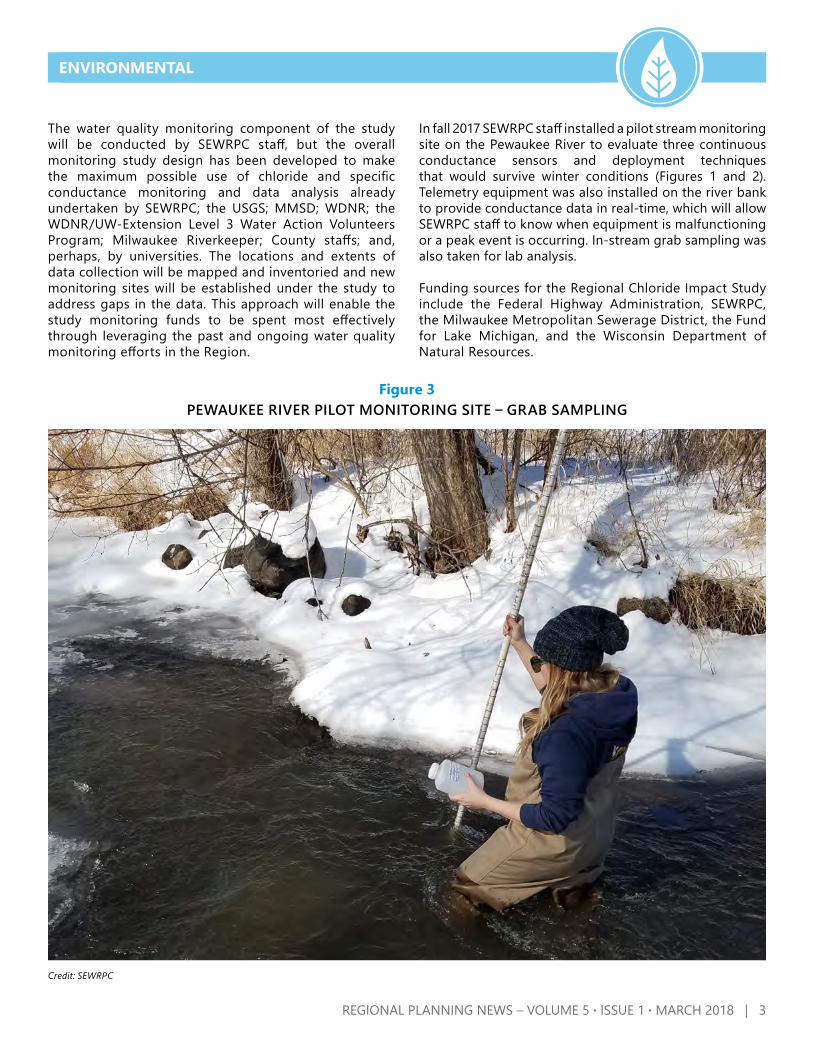
The water quality monitoring component of the study will be conducted by SEWRPC staff, but the overall monitoring study design has been developed to make the maximum possible use of chloride and specific conductance monitoring and data analysis already undertaken by SEWRPC; the USGS; MMSD; WDNR; the WDNR/UW-Extension Level 3 Water Action Volunteers Program; Milwaukee Riverkeeper; County staffs; and, perhaps, by universities. The locations and extents of data collection will be mapped and inventoried and new monitoring sites will be established under the study to address gaps in the data. This approach will enable the study monitoring funds to be spent most effectively through leveraging the past and ongoing water quality monitoring efforts in the Region.
In fall 2017 SEWRPC staff installed a pilot stream monitoring site on the Pewaukee River to evaluate three continuous conductance sensors and deployment techniques that would survive winter conditions (Figures 1 and 2). Telemetry equipment was also installed on the river bank to provide conductance data in real-time, which will allow SEWRPC staff to know when equipment is malfunctioning or a peak event is occurring. In-stream grab sampling was also taken for lab analysis.
Funding sources for the Regional Chloride Impact Study include the Federal Highway Administration, SEWRPC, the Milwaukee Metropolitan Sewerage District, the Fund for Lake Michigan, and the Wisconsin Department of Natural Resources.
ENVIRONMENTAL
Figure 3PEWAUKEE RIVER PILOT MONITORING SITE – GRAB SAMPLING
Credit: SEWRPC

4 | REGIONAL PLANNING NEWS – VOLUME 5 · ISSUE 1 · MARCH 2018
ENVIRONMENTAL
Jackson and Mason Creek Plans are Consistent with the Watershed-Based USEPA 9-Elements
Commission staff have been working with local, County, and State stakeholders over the past few years on developing watershed protection plans for Jackson Creek and Mason Creek. Each of these projects was financed in part through a grant from the Wisconsin Department of Natural Resources (WDNR) River Planning Grant Program. Each of the plans has been approved by WDNR and the U.S. Environmental Protection Agency (USEPA). The Jackson Creek plan is published and can be found on our website at www.sewrpc.org/SEWRPCFiles/Publications/CAPR/capr-320-jackson-creek-watershed-protection-plan.pdf. The Mason Creek Preliminary Draft plan will be published by June 2018. Each of these plans are comprehensive management plans that meet the 9 elements of a watershed-based plan which include:
1. Identification of the causes and sources of water pollution
2. Estimation of pollutant loading from the watershed and the expected load reductions
3. Description of management measures that will achieve load reductions and identification of targeted critical areas
4. Estimation of the amounts of technical and financial assistance and the relevant authorities needed to implement the plan
5. Development of an information/education component6. Development of a project schedule7. Development of interim, measurable milestones8. Identification of indicators to measure progress and
make adjustments9. Development of a monitoring component
See WDNR link for more details at dnr.wi.gov/topic/nonpoint/9keyelementplans.html
WDNR and USEPA determinations that these plans are consistent with the 9 elements is a significant benefit, because this makes projects recommended under these plans eligible for Federal funding.
Under these plans, protection of the watershed is focused on human needs and the hydrologic and ecological integrity of the water system, which ultimately contribute to a healthy economy. These plans provide recommendations that would:
• Minimize further degradation of the surface waters • Reduce nonpoint agricultural runoff and urban runoff • Encourage the preservation of natural resource
connections for wildlife • Promote stewardship of the watershed
ENVIRONMENTAL
COMPANY
RAILROAD
COMPANY
RAILROAD
COMPANY
AND
RAILROAD
AND
AND
SOUTHERN
SOUTHERN
WISCONSIN
WISCONSIN
SOUTHERN
BIG FOOTAIRFIELD
LAKE LAWNLODGE AIRPORT
LINE
LINTON
PALMER
TOWNRD.
ST.
CH
UR
CH
ST.
LIN
CO
LN
S
T.W
ISC
ON
SIN
ST.
BRIG
GS
RD
.
GR
AN
DV
ILLE
RD
.
CO
BB
IER
D.
CENTRALIA
SHARON - DARIEN
RD.WALWORTH
NORTH
RD.
TOWN
2ND
HALL
ST.
")F
")M
")X
")K
")P
")
")M
")F
")C
")C
")B")B
")B
")B
")C")O
")K
")H
")H
")H
")NN
")F
**
³±
##
67
**
³±
##
50
**
³±
##
67
0
**
³±
##89
*
**
³±
##67
**
³±
##11
**
³±
##
11
**
³±
##
11
**
³±
##
11
**
³±
##67
0114
0114
0114
0112
,-43
,-43
20
7
8
7
6
5
8
6
5
9
8
65
43
2
1
987
6 54
32
1
98
54
32
1
9
7
6
5 43
21
20
19
2019
1817
32
31
3029
19
1817
3231
3029
28
2423
22
2120
817
1615
1413
12
1110
24
23
22
2120
19
1817
1615
14
13
12
1110
3635
3433
32
29
2726
25
24
23
2221
20
17 1615
14
13
12
1110
36
3534
3331
3029
2827
26
25
2423
22
2120
19
18
17
1615
14
13
1211
10
3635
3433
32
2928 27
2625
242322
2120
17 16
15
14
3635
3433
32
31
30
29
28
2726
25
2423
2221
2019
CREEK
TURTLE
LAKE
TURTLE
LAKE
COMUS
GENEVA
AN
JACKSONCRE
CREEK
LADD
SWAN
TUR
TLE
SUGAR
CREEK
CREEK
EAST
OVELENS
DELAVAN
RICHMOND
B A Y
D A R I E N
W I L L I A M S
W A L W O R T H
F O N T A N A O NG E N E V A L A K E
LI
NN
GE
NE
VA
S H A R O ND A R I E N
D A R I E N
SH
AR
ON
DA
RI
EN
D E L A V A N
DE
LA
VA
N
D E L A V A N
DE
LA
VA
N
R I C H M O N D
RI
CH
MO
N
WA
LW
OR
TH
W A L W O R T H
WA
LW
OR
TH
S U G A R C R E E K
SU
GA
R
CR
E
D E L A V A N
E L K H O R N
))))))))))))))))))))))))""""""""""""""""""""""""""""""""""""""""""
2222299999
22222222000000000
1111177777
LLLLLLL AAAAAAAAAA VVVVVVVVVV AAAAAAAAA NNNNNNNNNN
S O U T H E A S T E R N W I S C O N S I N R E G I O N A L P L A N N I N G C O M M I S S I O N
COMMUNITY ASSISTANCEPLANNING REPORT NO. 320
JACKSON CREEKWATERSHEDPROTECTION PLAN

REGIONAL PLANNING NEWS – VOLUME 5 · ISSUE 1 · MARCH 2018 | 5
Implementation ProgramThese plans are based upon a recommended 10-year implementation timeline that addresses establishing best management practices and restoration practices, information and education activities, estimated costs, potential funding sources, responsible agencies, and methods to gauge success. Most importantly, an adaptive management implementation and evaluation approach was integrated into this planning framework/process. So, if progress toward implementation is not being made, the plan will be reevaluated. For example, adjustments might be made to the location and/or extent of best management practices installed to reduce pollutant loads, which is determined by continued water quality sampling results.
Meeting the goals for each of the Jackson Creek and Mason Creek watershed plans will be challenging. Plan implementation is primarily a voluntary effort. The effort will need to be supported with targeted technical and financial assistance. It will require an ongoing commitment of the stakeholder workgroups established in each of their watersheds and surrounding local, county, State, and Federal partners to improve the water quality and the condition of the watersheds. The plans must be adaptable and continued communication also is key to address the challenges, changes, and lessons learned by all.
ENVIRONMENTAL
Credit: SEWRPC
Credit: SEWRPC

6 | REGIONAL PLANNING NEWS – VOLUME 5 · ISSUE 1 · MARCH 2018
ENVIRONMENTALENVIRONMENTAL
Community Assistance Planning Report No. 333 – Waukesha County Aquatic Invasive Species Strategic Plan
In the spring of 2014, starry stonewort, a new aquatic invasive species (AIS), was discovered in Little Muskego Lake in Waukesha County. Spurred by the new finding, Waukesha County, in collaboration with SEWRPC, created an Aquatic Invasive Species Strategic Plan. The plan was funded through a three-year Aquatic Invasive Species Education, Prevention, and Control grant from the Wisconsin Department of Natural Resources. Additional funding was also provided by Washington and Waukesha Counties and the following local groups:
• Beaver Lake Friends Group• City of Muskego• Fox River Commission• Hunter’s Lake Association • Lac La Belle Lake Management District
• Lake Pewaukee Sanitary District• Silver Lake Management District• Tall Pines Conservancy• Upper Nemahbin Lake District
The scope of the plan was generated over the course of several meetings with an Advisory Committee composed of members from local lake groups and government entities. The Strategic Plan first discusses the negative impacts that AIS can have on the environment, recreational opportunities, and the economy. AIS found in and threatening Waukesha County waterbodies are described and resources are provided to aid identification and reporting of AIS. Current efforts, such as the Clean Boats Clean Waters program, and potential projects for the prevention of the spread of AIS are also discussed. In conjunction with the written plan, an online mapping application was created by Waukesha County that identifies the location and presence of specific AIS throughout the County.
Finally, the plan lays out a set of goals and action items developed by the Advisory Committee that provide the public with recommendations for AIS education, prevention, and control, and that guide the implementation and maintenance of a Countywide AIS program. The goals include the following:
< Goal 1:Educate water users, both residents and visitors, and the general public about the existence of AIS
< Goal 2: Prevent the spread of AIS to and from local waters
< Goal 3:Collect, map, analyze, and periodically update AIS population, distribution, and density data within Waukesha County to monitor program effectiveness and identify new AIS threats
< Goal 4:Reduce, Manage, and Control new and existing AIS populations within Waukesha County
< Goal 5:Network and Collaborate with other entities on AIS efforts
< Goal 6:Sustain the implementation of the AIS Strategic Plan and utilize it as a living document.
Credit: Brad Steckart
Credit: SEWRPC Staff

REGIONAL PLANNING NEWS – VOLUME 5 · ISSUE 1 · MARCH 2018 | 7
Wisconsin Regional Planning Commissions and the Wisconsin DNR Announce Funding to Help Communities, Counties, and Tribes Mitigate the Impacts of Emerald Ash Borer (EAB) and Reduce RunoffThe Southeastern Wisconsin Regional Planning Commission is partnering with the Wisconsin Department of Natural Resources (WDNR) and the Bay-Lake, East Central Wisconsin, and Northwest Wisconsin Regional Planning Commissions (RPCs) in a program administered by the Bay Lake RPC to help communities, counties, and tribes plant trees to mitigate Emerald Ash Borer impacts and reduce runoff.
The Bay Lake RPC has recently announced the availability of new funding under the 2018 Wisconsin RPCs and WDNR Tree Planting Grant Program. The funding is available to all Wisconsin jurisdictions within the Great Lakes Basin. In Southeastern Wisconsin, all, or part, of Kenosha, Milwaukee, Ozaukee, Racine, Washington, and Waukesha Counties are located within the Great Lakes Basin. Just over $120,000 will be available each year in 2018 and 2019 to fund projects ranging in cost from $1,000 to $20,000. All communities within the Wisconsin Great Lakes Basin are eligible, but this program will particularly be targeting projects in communities in the Basin that meet one or more of the following criteria:
• Within an EAB-quarantined county (all six of the Southeastern Wisconsin counties in the Basin are EAB-quarantined, see tinyurl.com/EAB-Quarantine),
• Within a watershed with surface water quality concerns (in Southeastern Wisconsin, certain communities in Milwaukee, Ozaukee, Washington, and Waukesha Counties are in targeted watersheds),
• On tribal lands, • Within communities that are members of a regional
planning commission, • Within areas of concern (AOCs) for beneficial use
impairments, and • Within a Tree City USA community (see tinyurl.com/
TreeCityUSA).
The funding is made available through two FY2018 U.S. Forest Service Great Lakes Restoration Initiative (GRLI) grants received by the Bay-Lake Regional Planning Commission.
Applications are due on April 9, 2018.See http://baylakerpc.org/natural-resources/2018-rpcs--dnr-great-lakes-basin-tree-planting-grant-program for information on applying for the grant.
ENVIRONMENTAL
Credit: Flickr User David Cappaert
Credit: SEWRPC Staff
Credit: Wikimedia Commons User Howard Russell

ENVIRONMENTAL
Comprehensive Planning UpdateThe State comprehensive planning law effectively requires County and local governments that administer land use regulations such as zoning to adopt a comprehensive plan. Comprehensive plans are required to address nine elements, including issues and opportunities; housing; transportation; utilities and community facilities; agricultural, natural, and cultural resources; economic development; intergovernmental cooperation; land use; and implementation. Between 2004 and 2011, SEWRPC assisted County and local governments in the Region prepare comprehensive plans in accordance with the State comprehensive planning law. SEWRPC assisted with preparing multi-jurisdictional comprehensive plans for Kenosha, Ozaukee, Racine, Walworth, and Washington Counties, with a total of 78 cities, villages, and towns participating in those multi-jurisdictional efforts. Milwaukee County did not prepare a comprehensive plan because it does not administer land use regulations and Waukesha County chose to lead its own planning effort with representation from SEWRPC on their advisory committee.
The State comprehensive planning law also requires comprehensive plans to be updated at least once every 10 years. SEWRPC has offered to assist with plan updates for any County or local government that previously participated in a multi-jurisdictional planning effort. Work began in 2016 and 2017 on 10-year comprehensive plan updates for Washington and Walworth Counties. Both County plan updates are expected to be completed during 2018. SEWRPC is also assisting local governments in both Counties with updates to their land use plan maps for inclusion in their respective County plans, and in some cases updating local comprehensive plans at the request of the community.
FIRST-CLASS MAIL U.S. POSTAGE
PAID PERMIT NO. 645
SEWRPC Serving the counties ofKenosha, Milwaukee,Ozaukee, Racine, Walworth,Washington, and Waukesha
SOUTHEASTERN WISCONSIN REGIONAL PLANNING COMMISSIONW239 N1812 ROCKWOOD DRIVE PO BOX 1607 WAUKESHA, WISCONSIN 53187-1607
8 | REGIONAL PLANNING NEWS – VOLUME 5 · ISSUE 1 · MARCH 2018
COMMUNITY ASSISTANCE
Published Comprehensive Plan UpdatesCommunity Assistance Planning Report No. 295, (2nd Edition)A Comprehensive Plan Update for the Town of Polk: 2050
Community Assistance Planning Report No. 296, (2nd Edition)A Comprehensive Plan Update for the Town of Trenton: 2050
The Southeastern Wisconsin Regional Planning Commission is the official advisory areawide planning agency for land use and infrastructure for the seven counties in the Region. More information can be found at www.sewrpc.org.Please contact us at [email protected].
Related Documents