Regional Mine Reclamation Bond Calculator Guidance Document HEALTH SAFETY AND PERMITTING BRANCH MINING AND MINERALS DIVISION MINISTRY OF ENERGY, MINES AND PETROLEUM RESOURCES APRIL 2018

Welcome message from author
This document is posted to help you gain knowledge. Please leave a comment to let me know what you think about it! Share it to your friends and learn new things together.
Transcript
Regional Mine Reclamation Bond Calculator Guidance Document
HEALTH SAFETY AND PERMITTING BRANCH
MINING AND MINERALS DIVISION
MINISTRY OF ENERGY, MINES AND PETROLEUM RESOURCES
APRIL 2018

Regional Mine Reclamation Bond Calculator Guidance Document
EFFECTIVE DATE: 2018-01-04 BRANCH: Health and Safety & Permitting (HS) VERSION:
Credits:
This report is based on work undertaken by EDI Environmental Dynamics Inc.
Staff who contributed to this report include:
Tim Antill, M.Sc., R.P.Bio., P.Ag………………………………………Primary Author
Patrick Audet, Ph.D., R.P.Bio…………………………………………Senior Advice & Review
3 | P a g e
Table of contents
INTRODUCTION ------------------------------------------------------------------------------------------ 5
PROJECT BACKGROUND AND APPROACH --------------------------------------------------------- 6
Rate Values for Services, Goods & Activities ------------------------------------------------------------------------------------------- 6
Reclamation Requirements ----------------------------------------------------------------------------------------------------------------- 7
End Land Use ------------------------------------------------------------------------------------------------------------------------------------ 8
RECLAMATION OF ACCESS STRUCTURES ON REGIONAL MINES ----------------------------- 9
PROCEDURES FOR DETERMINING REGIONAL MINE RECLAMATION BOND
REQUIREMENTS ---------------------------------------------------------------------------------------- 11
Compiling Project Information & Clarification of Project Details --------------------------------------------------------------- 11
Progressive Reclamation Approaches to Reduce Bond Requirements -------------------------------------------------------- 11
Limitations ------------------------------------------------------------------------------------------------------------------------------------- 12
User Modifications -------------------------------------------------------------------------------------------------------------------------- 12
Reclamation Bond Return ----------------------------------------------------------------------------------------------------------------- 13
STRUCTURE AND CONTENT OF THE BOND CALCULATION SHEET ------------------------ 13
Section 1: Equipment Mobilization/Demobilization --------------------------------------------------------------------------------- 14
Section 2: Ground Based Asset/Debris Removal -------------------------------------------------------------------------------------- 15
Section 3: Fuel/hydrocarbon Removal --------------------------------------------------------------------------------------------------- 20
Section 4: Ground Based Exploration Activities --------------------------------------------------------------------------------------- 21
Section 5: Helicopter Based Exploration Activities------------------------------------------------------------------------------------ 23
Sections 6, 7 & 8: Placer, Sand & Gravel and Quarry Activities ------------------------------------------------------------------- 25
Section 9: Site Preparation ------------------------------------------------------------------------------------------------------------------- 30
Section 10: Supplemental Topsoil---------------------------------------------------------------------------------------------------------- 31
Section 11: Access Trail/Road --------------------------------------------------------------------------------------------------------------- 32
Section 12: Stream Crossing/Restoration ------------------------------------------------------------------------------------------------ 35
Section 13: Revegetation – Seeding ------------------------------------------------------------------------------------------------------- 36
Section 14: Revegetation – Planting ------------------------------------------------------------------------------------------------------- 37

Regional Mine Reclamation Bond Calculator Guidance Document
4 | P a g e
Section 15: Additional Revegetation Activities ---------------------------------------------------------------------------------------- 38
Section 16: Reclamation Monitoring ------------------------------------------------------------------------------------------------------ 39
Section 17: Planning and assessment ----------------------------------------------------------------------------------------------------- 41
Section 18: Miscellaneous -------------------------------------------------------------------------------------------------------------------- 42
Section 19: Project management----------------------------------------------------------------------------------------------------------- 43
Section 20: Uncertainty Factor -------------------------------------------------------------------------------------------------------------- 43
Section 21: Inflation ---------------------------------------------------------------------------------------------------------------------------- 43

Regional Mine Reclamation Bond Calculator Guidance Document
5 | P a g e
Introduction
The B.C. Ministry of Energy and Mines and Petroleum Resources (MEMPR) requires proponents of
regional mine activities (e.g. exploration, placer, aggregate, quarries) to post a reclamation security
bond intended to cover the default cost of site reclamation, maintenance and closure. The value of
the security bond is set during the Notice of Work (NoW) application process and can be modified
during the life of the project depending on the nature of mining activities, specific features and/or
other project circumstances.
The bond is held by the Province until reclamation requirements have been met to the satisfaction
of the Mine Inspector, at which point the bond is released and returned to the proponent. In cases
where the proponent abandons the site and fails to meet these requirements, the reclamation
security bond is used by the Province to cover the cost and obligations of site reclamation and
closure.
The Regional Reclamation Bond Calculator was developed to assist Inspectors of Mines in the
determination of the appropriate bond amount. It is not to fetter the decision of the Inspectors and
the bond calculation can be modified by the inspector to account for the site specific circumstances.
The purposes of the Regional Reclamation Bond Calculator are:
To provide Regional Mines Inspectors with a defensible and consistent means of assessing reclamation liability for regional mines
To avoid financial risk and liability to the public/government by ensuring the assessed security represents the cost of mine reclamation to the Province
To encourage dialogue between proponent and Inspector, with the aim of limiting unnecessary disturbance and prompting progressive reclamation
To promote transparency in bonding levels and methodology to First Nations and the public.
Experience in use of the calculator tool shows that is facilitates dialogue between the mine inspector
and the proponent on specific project design and activities. Such a dialogue may, in turn, result in
amendments to the project design that could limit environmental liability and foster reclamation
success. Discussions pertaining to the cost and effort of reclamation at the earliest stages of planning
and permitting can improve environmental compliance, then resulting in the timely release and
return of the security bond for responsible operators.
This document provides a background on the development and content of the bond calculator
followed by guidance (for users) on the recommended approach for determining reclamation bond
values with the calculator.
Regional Mine Reclamation Bond Calculator Guidance Document
6 | P a g e
Project Background and Approach
It was recognized that in the past, methods used for determining the value of reclamation security
bonds has differed among MEMPR regions. Therefore, the bond calculator was developed to
reduce potential inter-regional differences by applying standard rates for a suite of common
reclamation activities that are typically associated with certain mining activities. The bond calculator
is formulated as a Microsoft Excel® spreadsheet to enable a simple, rapid and transparent method to
document reclamation calculations and values. The bond calculator is designed for ease of use,
versatility, and accuracy to provide a reasonable estimate of anticipated reclamation costs.
Environmental Dynamics Inc. (EDI) was retained by the BC Ministry of Energy and Mines and
Petroleum Resources (MEMPR) to assist in the development of a reclamation bond calculator for
regional mine exploration, placer, aggregate, and quarry activities. Initial development of the bond
calculator stemmed from discussion with regional MEMPR personnel regarding the existing
bonding process, as well as a review of alternative bond spreadsheets used by regional MEMPR
branches. Research and development involved review of relevant legislation, regulations and
guidance documents related to exploration, placer, aggregate, and quarry activities. Bonding
methods, algorithms and spreadsheets used in different jurisdictions were also reviewed, such as
those from the states of Arizona, Nevada and Montana in the USA.
The bond calculator was then drafted, refined and calibrated over the course of the project based on
recurring feedback with MEMPR staff. The bond calculator was later presented as a public
consultation to relevant industry groups (e.g. Association of Mineral Exploration, regional placer
mining associations and BC Sand and Gravel Association) and several First Nation groups (e.g. the
Tahltan and Taku River Tlingit First Nations in Northwest, BC).
Rate Values for Services, Goods & Activities
In the development of the calculator, the various individuals were contacted to discuss process,
activities and estimated costs for services, goods and activities. Sources of information consulted in
determining appropriate productivity factors and costs included:
MEMPR Regional Mines Inspectors and Reclamation Specialists
Ministry of Forest Lands and Natural Resource Operations (FLNRO) Road Engineering
staff
Reclamation goods and services providers
Bridge and road construction contractors
2016-17 Blue Book Equipment Rental Rate Guide (Heavy Road Builders 2016)
Regional Mine Reclamation Bond Calculator Guidance Document
7 | P a g e
Reference to latest Blue Book values in the bond calculator enables the defensible application of
standardized rate values across the province; this also facilitates updating future iterations of the
bond calculator, for example, to account for changes in equipment rates and/or financial inflation.
The rates of common classes of equipment typically used in reclamation of regional mine activities
are provided in the Calculation Notes and Rate Sheet tabs where equipment size and rates are
identified for specific reclamation tasks.
FLNRO staff provided estimated cost/km for road works on the coast as well as in the interior
based on their experience with forestry road deactivation and reclamation. In this case, deactivation
and full reclamation costs are assumed to be similar for both forestry and regional mine/exploration
access roads.
Goods and service providers were contacted regarding material and application costs for seeding
and planting activities. Prices vary depending on seed species mix (e.g. native vs agronomic) and size
and source of planting stock. For simplicity, the bond calculator applies an average price for native
seed and tree seedlings; however, actual prices will necessarily vary depending on desired species
mix/stock and availability at the time of reclamation. The bond calculator is designed to provide a
reasonable estimate of revegetation costs for typical reclamation projects; a feature for users is the
ability to adjust/modify application and stocking rates as well as material costs if more accurate or
project specific information is available.
Reclamation Requirements
Regulatory requirements for reclamation were considered in the
development of the bond calculator.
As per the Mines Act and under the Health, Safety, and
Reclamation Code for Mines in BC (Code) (MEM 2017) the
following is a summary of reclamation requirements:
1) Reclamation of disturbed sites shall occur following of
cessation of activities (within 1-year for exploration),
unless authorized in writing by an inspector.
2) Structures and Equipment:
a. Camps not required to support future activities
are to be dismantled, removed and reclaimed.
b. All scrap material must be removed/disposed in
a manner acceptable to the inspector.
c. All machinery, equipment and building structures
are to be removed.
3) Pits and trenches are to be backfilled and reclaimed.
a. Unless the sides of the pits or trenches are sloped to a stable and safe angle.
For a complete description of
the regulatory requirements
please reference:
Mines Act Section 10 (1)
Health Safety and Reclamation
Code for Mines in British
Columbia (HSRC):
Parts: 9.7.1 (1) ; 9.10.1(6-
7); and 9.13.1
Parts 10.7.1 and 10.7.4-
10.7.21

Regional Mine Reclamation Bond Calculator Guidance Document
8 | P a g e
4) End land use – area must be reclaimed to an end land use that considers previous and
potential uses.
a. End land use must be approved by inspector.
5) Land capability is to be similar to pre-disturbance conditions.
6) Land is to be reclaimed in a manner that is consistent with adjacent land forms.
a. Slopes must be at stable and safe angles.
7) Land cover:
a. Shall be revegetated to a self-sustaining state with species appropriate for the site.
b. Appropriate measures shall be taken:
i. To minimize the establishment of noxious weeds.
ii. To minimize the erosion of exposed or disturbed soil.
8) Watercourses must be restored to pre-disturbance conditions (i.e. stability and productive
capacity).
9) The owner, agent, or manager will undertake monitoring programs to demonstrate that
reclamation and environmental protection objectives including land use, productivity, water
quality, and stability of features are being achieved.
End Land Use
To achieve successful reclamation of a site, it is necessary to identify the current (pre-development)
land use, as well as desired end land use (post-development). Determining the end land use up-front
will guide reclamation planning and efforts and will assist in appropriately monitoring and evaluating
reclamation success. Land uses in BC commonly fit within the following categories.
Agricultural – cultivated cropland, hayland, pasture/rangeland
Forestry – natural (non-managed) woodland, forestry/silviculture
Wildlife – conservation, ecosystem maintenance
Social – traditional use, recreational, sustenance, aesthetic
Residential – urban, rural development
Industrial – resource development, extraction
The procedure for classifying land use involves an understanding of social, economic, and resources
management objectives to then determine the range of acceptable resource usages and activities at a
given location. The targeted end land use may refer to activities occurring in situ prior to
development or those consistent with the surrounding areas (e.g., reclaiming a forested site back to a
forested site to meet with a forestry land use).
Regional Mine Reclamation Bond Calculator Guidance Document
9 | P a g e
Reclamation of Access Structures on Regional Mines
For roads and other access structures authorized under a Mines Act Permit, it must be determined if
it is appropriate to plan for deactivation rather than full reclamation. Deactivation of roads that
leaves a road prism intact for future use has inherent risks that must be assessed and justified based
on the potential costs and benefits. The planned level of road closure should be included in First
Nations consultation and agency referrals to help assess the benefits and risks and identify
appropriate mitigation measures. The authorized level of reclamation must be clearly described in
the Mines Act Permit either in the approved Reclamation Program or as a permit condition
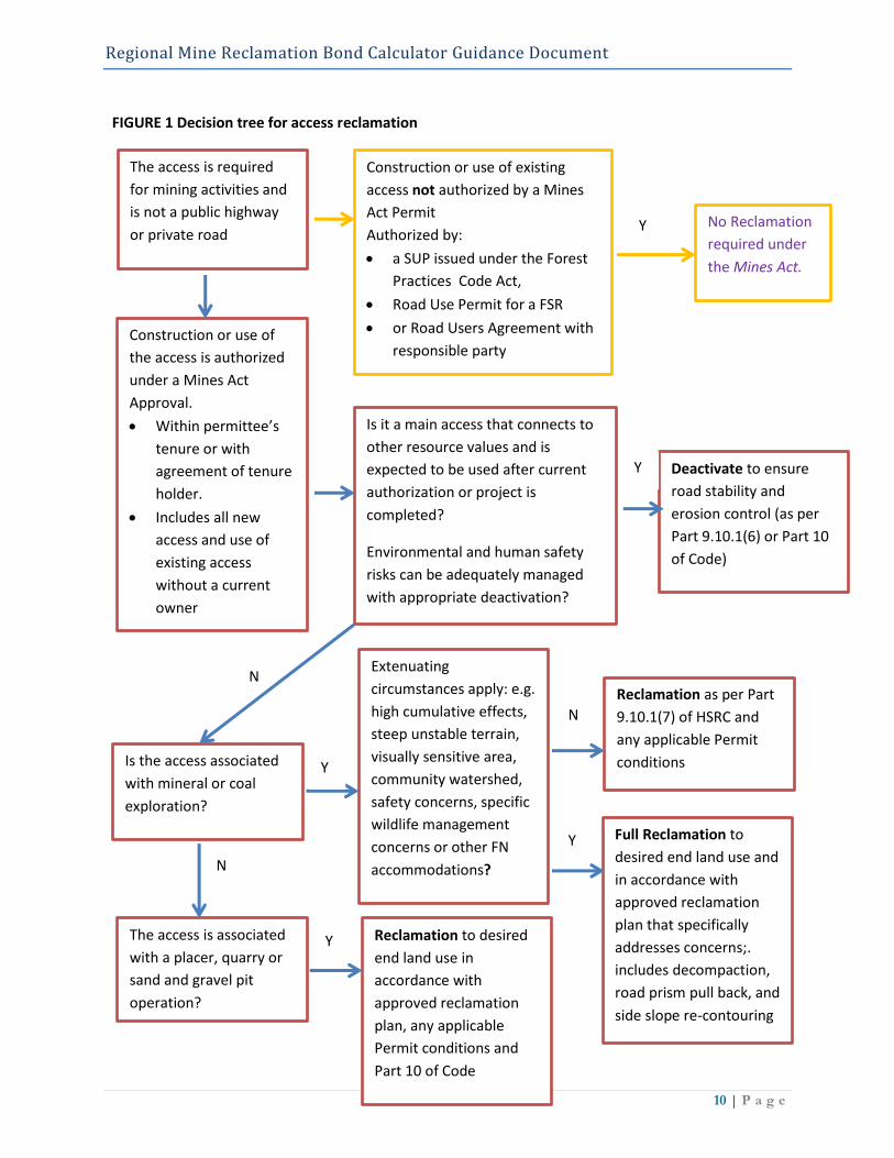
A determination of the appropriate level of reclamation for roads and other access structures
authorized for construction and use under a Mines Act Permit should be guided by the decision
process outlined in Figure 1.
Figure 1 indicates that deactivation as defined in Part 9.10.1(6) of the HSRC may be an acceptable
level of road closure and release from reclamation obligations only in situations where it involves a
main access route that connects to other resource values and is expected to be used after current
authorization or project is completed and other extenuating circumstances or risks do not apply.
Full deconstruction of the road, including pull back of the road prism may be required in situations
where extenuating circumstances increase the risk to surrounding resource values. For exploration
access without extenuating circumstances, reclamation will still generally require decompaction of
the running surfaces to allow for establishment of self-sustaining vegetation.
It is also recommended that the services of a specialist professional be required to carry out a terrain
stability assessment and prepare the applicable portion of the road deactivation or reclamation
prescription if any of the following apply:
• Terrain stability mapping indicates that the road is located on terrain that is unstable or
potentially unstable;
• Terrain stability mapping has not been done, and the road is located on terrain with slopes
greater than 60%;
• The road is located on terrain where there are indicators of slope instability;
• The areas downslope or upslope of the road (or adjacent to or connected to it) contain
elements at risk of damage or loss from a landslide, and the road crosses areas having a
moderate or high likelihood of landslide occurrence;
Section 11 of the Guidance Document provides a full description of which costs apply to
reclamation of access structures depending on the circumstances.
Regional Mine Reclamation Bond Calculator Guidance Document
10 | P a g e
FIGURE 1 Decision tree for access reclamation
The access is required
for mining activities and
is not a public highway
or private road
Construction or use of existing
access not authorized by a Mines
Act Permit
Authorized by:
a SUP issued under the Forest
Practices Code Act,
Road Use Permit for a FSR
or Road Users Agreement with
responsible party
No Reclamation
required under
the Mines Act.
Construction or use of
the access is authorized
under a Mines Act
Approval.
Within permittee’s
tenure or with
agreement of tenure
holder.
Includes all new
access and use of
existing access
without a current
owner
Is it a main access that connects to
other resource values and is
expected to be used after current
authorization or project is
completed?
Environmental and human safety
risks can be adequately managed
with appropriate deactivation?
Deactivate to ensure
road stability and
erosion control (as per
Part 9.10.1(6) or Part 10
of Code)
Is the access associated
with mineral or coal
exploration?
Extenuating
circumstances apply: e.g.
high cumulative effects,
steep unstable terrain,
visually sensitive area,
community watershed,
safety concerns, specific
wildlife management
concerns or other FN
accommodations?
The access is associated
with a placer, quarry or
sand and gravel pit
operation?
Full Reclamation to
desired end land use and
in accordance with
approved reclamation
plan that specifically
addresses concerns;.
includes decompaction,
road prism pull back, and
side slope re-contouring
Reclamation to desired
end land use and in
accordance with
approved reclamation
plan that specifically
addresses concerns.
Reclamation as per Part
9.10.1(7) of HSRC and
any applicable Permit
conditions
Reclamation to desired
end land use in
accordance with
approved reclamation
plan, any applicable
Permit conditions and
Part 10 of Code
Y
Y
Y
N
Y
N
N
Y
Y

11 | P a g e
Procedures for Determining Regional Mine Reclamation Bond
Requirements
Compiling Project Information & Clarification of Project Details
At the time of the NoW permit application; information from the application should be used to
populate the applicable fields within the bond calculator. Where project details are limited, project
assumptions should be documented by the Mine Inspector. If necessary, the proponent may be
contacted for further context and clarification.
At this time, the proponent should be informed that providing specific details for project activities
and emphasizing efforts that limit disturbance and environmental liability can reduce the overall
bond amount. For example, it is beneficial to identify portions of the project footprint that will be
subject to stripping and stockpiling of topsoil (if at all). Likewise, it is also beneficial to describe the
extent of specific reclamation activities such as landscape recontouring and soil decompaction. All
these activities will impact reclamation cost and effort. Therefore, in the absence specificity, the user
of the bond calculator may (unwittingly) apply additional reclamation activities in their interpretation
of the proposed project resulting in the over-estimation of the project’s reclamation requirements.
Dialogue with the proponent will help to refine understanding of reclamation requirements,
procedures and milestones.
Once the bond calculator has been populated, empty fields (i.e., unused rows) should be hidden so
that only those that apply are visible. A copy of the bond calculation should be provided to the
proponent with the application acknowledgement letter. This will provide the proponent with a
point of reference for the cost of each reclamation activity and may prompt further discussion
regarding their reclamation plan. It is possible that the proponent may seek to revise specific features
of project design (e.g. size and number sediment ponds) to minimize their disturbance footprint and
associated reclamation requirements in a manner that could reduce the overall bond amount.
Progressive Reclamation Approaches to Reduce Bond Requirements
To lessen the burden of exceedingly high bond values, it is suggested that permit conditions be
written in a manner that promotes progressive reclamation and reduces ongoing environmental
liability. At the discretion of the Mines Inspector, this option could include identification of a
suitable timeline for progressively reclaiming certain features, such as those stemming from early
stages of project development. For example, the proponent may be required to backfill and reclaim
exploration trenches no later than the end of the operating season. Otherwise, additional bonding
could be applied to the project later if the reclamation milestone is not completed. This could
facilitate a conditional opportunity for the proponent to lower their bond value (perhaps only
marginally relative to the anticipated full security) if they commit to progressive reclamation of
specific project features and thereby reduce the cumulative environmental liability of the project.
Similarly, it is suggested that proponents successfully engaging in progressive reclamation practices
Regional Mine Reclamation Bond Calculator Guidance Document
12 | P a g e
may seek partial release of the security bond based on achievement of interim reclamation
milestones (e.g. slope recontouring, topsoil placement, surface preparation). Interim bond release
should be assessed commensurate to risk/liability and measured against a suitable timeline. As is
standardly required, full release of the remaining security bond would be achieved upon meeting
final closure criteria.
It is recognized that Mine Inspectors hold discretionary powers to modify security bond
requirements based on project features and other circumstances. These proposed scenarios offer
potential mechanisms that could encourage proponents to achieve and maintain sound
environmental planning and practices at the earliest stages of the reclamation process. In both cases
described above, progressive reclamation approaches can be incentivized in a manner that maintains
operational cash flow for the proponent, while reducing environmental liability to the Province.
Limitations
During development and trialing of the cost calculator, a common limitation encountered was the
availability of adequately detailed information in the NoW. Solicitation of more detailed information
may be required to better capture and/or refine reclamation requirements and cost.
Estimation of reclamation costs may also vary (sometimes by large margins) when attempting to
address potentially complicated site features, activities and/or circumstances. In this regard,
specialists consulted during development of the calculator – such as those involved in adit closure,
sealing of drill holes, and geotechnical monitoring – cautioned that prices may be considerably
higher for complex or challenging projects. If it is suspected that a given project may involve
complex features and/or circumstances (e.g. terrain stability, acid generating rock, etc.) additional
information should be requested of the proponent at the time of the NoW Application or as
concerns arise. Third party estimates from qualified sources may be required and used in the bond
calculation.
The bond calculator has been designed to capture reclamation activities associated with most
regional mines. It is not intended for large bulk sample programs and it is also unsuitable for
projects with underground workings. These projects require the submission of professionally
developed reclamation and closure plans that will be the basis for cost estimations.
User Modifications
Although the current version of the bond calculator is editable, it is not expected that users of the
bond calculator will need to routinely modify values or calculations. Nevertheless, this feature allows
for project specific modifications to be applied by the Mine Inspector should they be required. For
example, standard planting stocking density and seed application rates have been used within the
calculator; yet, alternative values (i.e., sourced via third party quotes) can be changed to reflect more
specific reclamation requirements. Likewise, standard equipment sizes and rates have been applied
within the calculator; yet, rates for different sized machines and associated production rates are
available (in the “Rate Sheet” tab) and can be applied if warranted.

Regional Mine Reclamation Bond Calculator Guidance Document
13 | P a g e
Values derived using the bond calculator are based on available information used to extrapolate
reclamation cost across different operating regions. In some cases, the proponent may disagree with
the bond calculator value. At the discretion of the Mine Inspector, the proponent may provide an
independent cost estimate for the proposed activity using different rates – along with sound
justification of their conceptualization of reclamation requirements – to refine the security bond
value.
Reclamation Bond Return
When reclamation has been completed to the required standard, the owner, agent or manager may
apply to the inspector in writing for release and return of the security bond. The request for return
of a reclamation bond should include an up-to-date annual summary describing all reclamation
activities undertaken and geographically referenced supporting photographs documenting site
conditions before and after reclamation treatments. The request will be reviewed for compliance
against both the reclamation standards and permit requirements. A field inspection may be necessary
prior to release of the bond. When all Act, Code, and permit conditions have been met to the
satisfaction of the Mine Inspector – and there are no ongoing inspection, monitoring, mitigation, or
maintenance requirements at the site – the proponent will be released from all further obligations
and the security bond will be returned.
Structure and Content of the Bond Calculation Sheet
The bond calculator spreadsheet consists of a tab called “Calculation Sheet” along with two
supporting tabs called “Calculation Notes” and “Rate Sheet”. Project data are populated and
computed in the Calculation Sheet. Supporting background information – referring to the
information source and/or algorithm used to derive rates for discrete line items in the Calculation
Sheet – is presented in the Calculation Notes. Supplemental information pertaining to equipment
rates etc. is presented in the Rate Sheet.
The calculator has 21 sections, each consisting of multiple line items; the user is required to enter
values for each reclamation line items that apply to a given project. The calculator will then compute
an estimated cost for reclamation of the project. The descriptions below provide additional detail
and guidance on what must be considered when it is appropriate to use each line item or section.

Regional Mine Reclamation Bond Calculator Guidance Document
14 | P a g e
User Guidance on Use of Bond Calculator Spreadsheet
Section 1: Equipment Mobilization/Demobilization
The first activity in the bond calculator refers to the mobilization and demobilization of equipment
to and from a site. Things to consider when completing this section include:
Lowbed
Transport cost is based on an hourly trucking rate quoted by service providers. It was found that
Blue Book values were not always consistent with industry standards for transportation costs and,
consequently, undervalued the actual cost of trucking. Where applicable:
Travel time should be based on distance from anticipated service community.
This line-item should account for each piece of equipment expected to be transported
to and from site. For example: if one excavator, one dozer, and one rock truck is
anticipated, this will require three lowbed trips to site.
Depending on the duration of the project, machinery may be onsite for many days or
weeks. In this case, the lowbed operator may choose to drive to site to drop off the
equipment, return empty to town and wait until the project is completed before
returning to site to recover the equipment. This would result in two round trips for
each piece of machinery.
When considering length of time for a lowbed to travel to/from site, a lower rate of
speed for off highway travel should be considered. Assume 90 km/hr for highway
travel, 60 km/hr for Forest Service Roads and 40 km/hr for access roads. Length of
time can be adjusted based on known road conditions. Total time should also include
effort to load/unload equipment (suggest adding 2hrs).
Pilot Car
Pilot cars are required for oversize loads on public roads – referring to any load greater than 3.2 m in
width and over 27.5 m in length. This line-item may not be required for most equipment
transportation needs, unless the project will require specific pieces of large equipment (e.g. the scale
of the disturbance warrants the productivity and earth moving capabilities of a larger machine).
Where applicable:
Travel time should be based on distance from anticipated service community to off-
highway access point.
Transport cost is based on quotes by service providers (Blue Book values were not
consistent with industry standards for pilot car costs).
Note: A permit is required to move oversize loads on provincial highway, and this may involve the
development of Transportation Management Plan for very large or very heavy loads. Additional

Regional Mine Reclamation Bond Calculator Guidance Document
15 | P a g e
information regarding the use of pilot cars is provided in the BC Ministry of Transportation and
Infrastructure Pilot Car Load Movement Guidelines (MOTI 2016).
Walking Equipment
Include equipment walking distance if access to the site is difficult, or if certain reclamation activities
are spread out over a longer distance. Where applicable:
The rate in the calculator is based on an average walking speed of 10 km/hr.
Round trip distance (in kilometres) should be factored into the estimate.
Specialized Equipment/Transport
In some cases, access to sites will be difficult or remote and therefore require special transport
considerations (e.g. barging of equipment or use of aircraft to access remote locations). If specialized
equipment and/or methods of transport are required, a project specific cost estimate will be needed
based on a quote or known local pricing. Enter the cost into the bond calculator.
Section 2: Ground Based Asset/Debris Removal
There may be remnant assets or debris left on site if a proponent decides no longer to operate or
take responsibility for a property. Legacy debris can be common where the property has changed
owners (possibly even numerous times). Albeit potentially unrelated with the current owner’s
activities, this debris becomes the responsibility of the current owner and its cleanup represents a
liability to the Crown if the site is abandoned. This section relates to the cost of cleanup and removal
of material on site.
Equipment/Wash Plant Removal
This section applies to the cost of a lowbed to remove equipment such as excavators, crawler
tractors, drill rigs, wash plants, conveyors, and crushers to be transported from the site to the nearest
storage area (preferably at a secure location/compound) or delivered to scrap yards or auction
centers depending on circumstances and condition of the equipment. Where applicable:
Assume one lowbed per piece of equipment to be removed.
Return travel time should be based on distance from anticipated service community.
Refer to Section 1 – Equipment Mob/Demob for considerations for lowbed
requirements.
Note: User discretion is advised when populating this section. Instead of bonding for all equipment
onsite, the user may assume that newer machines and equipment of higher value will be mobilized
offsite by the proponent. In case of site abandonment, it may only be necessary to account for older
equipment potentially being left onsite. However, where transport costs are excessively high, even

Regional Mine Reclamation Bond Calculator Guidance Document
16 | P a g e
newer equipment may be left behind. These assumptions should be documented in the Notes
column.
Shipping Containers (Sea Cans)
Shipping containers can be self-loaded and transported using specialized trailer beds or lifted and
positioned on a flatbed trailer. Where applicable:
Transport cost is based on an hourly trucking rate quoted by service providers (Blue
Book values were not consistent with industry standards for transportation costs).
Travel should account for one round trip for each shipping container. For example,
the total travel time to mobilize two containers over an 8-hour time/distance will be 32
hours.
As described in Section 1 when estimating lowbed rates, a lower rate of travel should
be accounted for based on known road conditions. Loading/unloading time should
also be included in the total time/effort (suggest adding 2 hours).
Scrap/Garbage
It may be difficult to anticipate whether garbage,
metal scrap, etc. will be left on site. This line item
would not typically be applied during NoW; but it
could be considered following inspection and
permit amendment.
Note: If approved by the Inspector, inert material
(e.g. scrap metal) may be buried within a mineral
lease site. However, all debris that may pose a
contamination risk should be removed (e.g. old
engines, transmissions, hydraulic systems). Where
applicable:
This line item is based on the use of a
Regional Mine Reclamation Bond Calculator Guidance Document
17 | P a g e
dump truck (8 m3); the user is required to estimate the number of loads (i.e., return
travel time, including loading time) necessary to dispose of waste.
Tipping fees for disposal of waste are provided in the “Disposal” section.
Camp (Tent/Camper Trailer)
This line item pertains to wall tent/camper trailer-style camps associated with small operations.
Camp removal cost will be site-specific and dependant on type and size. Where applicable:
Removal is based on use of a 1-ton truck to remove material and trailers (Blue Book:
$62/hr).
If multiple camper trailers, the user should consider the time required to mobilize each
trailer (e.g. length of time for each trip).
Transport destinations may include (1) storage areas (preferably at a secure location or
compound) or (2) landfill, scrap facilities, or auction centers (depending on
circumstances and condition of the trailers).
Note: It is assumed that camper trailers in this section are in adequate condition for transport on
public roads. If not, it may be more appropriate to account for them under the scrap line item.
Time/effort to dismantle and dispose of camps should be accounted for under the Removal Crew
line item.
Removal Crew
A crew will be needed to assist with clean-up onsite. It may be difficult to estimate the number of
hours needed to clean up a site. Where applicable:
The removal rate is based on a two-person crew ($50/hr/person) to handle & remove
debris.
Consider time/effort as full workdays (e.g. 10 hours) and include travel time to/from
the site.
As a reference, assume 5 hours (1/2 day) for the crew to dismantle a tent
structure/building. If burning materials, assume one day to monitor burning of 4 pads
or two buildings.
Explosives Disposal
Handling and disposal of explosives should only be done by trained qualified professionals. This line
item is unlikely to be included at the NoW application stage, but it may be included following an
inspection. Due to site-specific factors (e.g. quantity and type of explosive), additional information is
required to determine disposal costs. This line item requires a project specific cost estimate.

Regional Mine Reclamation Bond Calculator Guidance Document
18 | P a g e
Camp (Atco Trailer/Bunk House)
This section pertains to the removal of an Atco trailer-style modular camp, and includes line items
for dismantling, trucking, and pilot cars. Where applicable:
Preparation for transport is given on a per trailer basis. This rate provides for a two
person dismantle crew (based on 8 hr day at $50/hr/person) to disconnect amenities
and prep the trailer for transport (e.g. blocking if required). Prep time will be affected
by trailer disposition. If trailers are on skids, they can be winched onto the trailer; if the
trailer is not on skids, then it must be jacked onto blocks so that the trailer can be
positioned beneath it.
Transport cost is based on an hourly trucking rate quoted by service providers (Blue
Book values were not consistent with industry standards for transportation costs).
Round trip time/effort should be considered for each trailer. For example, the total
travel time to mobilize two trailers over an 8-hour time/distance will be 32 hours.
Disposal options will depend on the condition of the trailer. Trailers left onsite
unattended/unmaintained for multiple seasons are prone to water damage, mold, and
rodent infestations, greatly reducing the value or future use of the structure.
Trailers in good condition may be sold, auctioned, or donated to local groups.
Trailers in poor condition can be disposed at landfills that accept
construction/commercial waste. For reference, trailers weigh 12- 24 tonne
depending on configuration and size. Tipping fees for trailer disposal are
provided in the “Disposal” section.
As described previously:
A lower rate of travel should be accounted for based on known road conditions.
Loading/unloading time should also be included in the total time/effort (suggest
adding 2 hours).
A pilot car will be required for the transport of trailers on public highways of any load
greater than 3.2 m in width:
Travel time for pilot car should be based on distance from anticipated service
community to off-highway access point.
Transport cost is based on quotes by service providers (Blue Book values were
not consistent with industry standards for pilot car costs).
A permit is required to move over sized loads on provincial highway, and this
may involve the development of Transportation Management Plan.

Regional Mine Reclamation Bond Calculator Guidance Document
19 | P a g e
Equipment Cleanup Activities
This section refers to equipment needed to address debris and clean-up the site – which is distinct
from the requirement to address equipment left onsite by the proponent. Excavator and dozer line
items have been provided if they are needed for debris removal (e.g. loading of wash plant or other
large/heavy debris). Equipment may also be used to burry inert debris, to limit transport and
disposal fees. Where applicable:
Excavator and dozer rates are provided on a per hour basis. The user will need to
estimate the amount of time required for cleanup activities, whereby it may be useful
to capture time/effort in terms of half-day (5 hr) or full-day (10 hr) units.
Disposal
The weight of debris for disposal may not be easily estimated during the NoW application stage.
Where applicable:
Landfill/disposal facilities charge a tipping fee based on the weight of the disposal
material. Tipping fees will vary by landfill and location. Rates vary from $82/tonne
(Prince George) to $360/tonne (Nanaimo). The bond calculator uses a mid-range
value of $160/tonne (Kamloops).
As a reference, a full size pick-up truck weighs approximately 2.3 tonne.
A disposal fee for camper trailers has been provided on a per trailer basis. This
assumes disposal of an average trailer weight of 2.3 tonne with tipping fee of
$160/tonne.
A disposal fee for modular trailers has been provided on a per trailer basis. This
assumes disposal of a 24-tonne trailer with tipping fee of $160/tonne.
Regional Mine Reclamation Bond Calculator Guidance Document
20 | P a g e
Section 3: Fuel/hydrocarbon Removal
This section pertains to the removal of fuel and other common hydrocarbon products, such as
hydraulic oil, kerosene, lubricants, and propane.
Fuel Drum/Tidy Tank/Lubricant Storage
This line item is for the removal of fuel drums and other easily portable material. Where applicable:
The estimate is based on the use of a 5-ton truck. The user will need to estimate the
time for the truck to drive to site, load the drums, and take the material to an
appropriate facility.
It is assumed that one truck can carry 10 drums. Depending on circumstances the user
may need to adjust the number of trips or transport method.
For reference, the volume of a 45-gallon drum is approximately 205 litres. Fuel volume
is included in the NoW. The proponent may need to provide additional detail
regarding storage (drum vs large tanks).
Tent based camps may use kerosene heaters, typically one drum/tent. The volume of
heating fuel should be considered in the calculation.
Large Fuel Tank Storage
This line item is for the removal of large-size steel tanks over 900 L. Where applicable:
Assume one transport truck and trailer per large tank to be removed.
Considerations for required trucking time/effort will be similar to those presented in
Section 1 – Equipment Mob/Demob; time/effort should be based on return travel
distance from anticipated service community to/from site.
Soil Remediation
This line item would not typically be populated during NoW application but could be considered
following routine site inspection, permit amendment or assessment of potential legacy issues. Soil
remediation primarily relates to hydrocarbon spills or salt contamination. The line item value is
intended to reflect a broad estimate to test, excavate, and transport soil to an authorized facility; this
cost strictly relates to the removal of contaminated soil and does not include ground water testing
for contaminates. Costs can vary greatly depending on the quantity and nature of contaminated
material and soil. For large sites and/or sites having complex geochemistry (i.e., requiring specialized
remediation techniques), the cost is expected to be substantially higher and third-party quote should
be obtained. The cost does not capture the cost of disposal for hazardous chemicals used for
processing (e.g. mercury). If hazardous chemicals are expected onsite, more information from the
proponent is required.

Regional Mine Reclamation Bond Calculator Guidance Document
21 | P a g e
Section 4: Ground Based Exploration Activities
Drill Site Reclamation
Drill site reclamation associated with ground-based activities is provided as a per site cost, and
includes burying sumps, removal of debris, recontouring, replacing topsoil, and revegetation
(materials and application). Where applicable:
The rate of $500 site is based, in part, on source information from MEM (2003).
The reclamation cost is based on an average drill pad approximately 10 m x 10 m,
If larger sites are consistently required, consider using the alternative of the cost per
hectare provided.
Large Gravel Pads
This line-item pertains to the removal of large gravel pads located in areas with soft ground (e.g.
wetlands, floodplains), but does not include the cost of revegetation. Where applicable:
The value is based on one medium sized excavator ($143/hr) with a production
capacity of 150 m3/hr to load a dump truck.
The value assumes two loads/hr for an off-road dump truck (capacity 17 m3) at a of
rate $163/hr. A minimum 1-hour charge of $449 should apply.
Trench
Trench reclamation is based on volume (m3). Dimensions (i.e. length, width and depth) of the trench
can be entered in to the spreadsheet to calculate the trench volume. Trench width and depth is not
currently included on the NoW application; this information will need to be requested from the
proponent.
For multiple trenches, the volumes for each trench can both be summed and entered directly in the
spreadsheet as a total, or additional rows for the trench calculation can be copied and pasted into the
spreadsheet for each trench. Where applicable:
Trench reclamation is based on an average excavator productivity of 150 m3/h, and the
cost includes surface finishing and revegetation. Actual cost may vary depending on
machine productivity and swell factor of material. The formula is: excavator rate ($)
divided by productivity (m3/h), plus compaction finishing ($0.20/m3)
Regional Mine Reclamation Bond Calculator Guidance Document
22 | P a g e
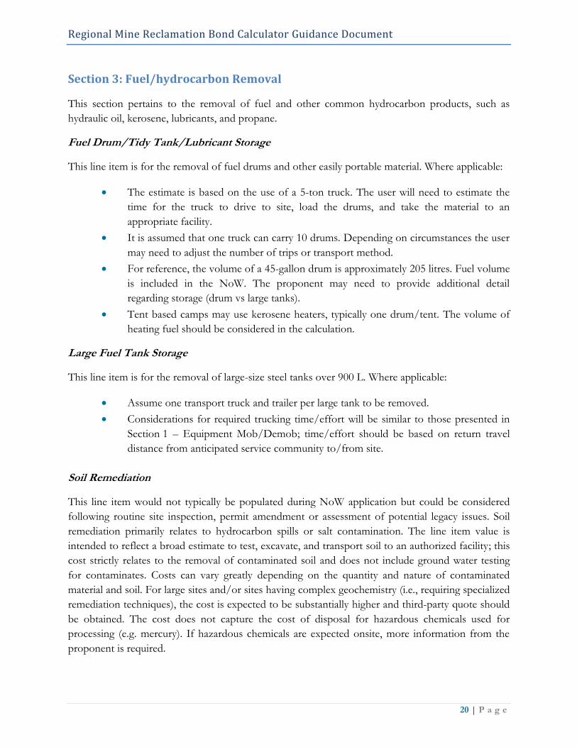
Sealing Exploration Drill Holes
Two categories have been provided for the sealing of exploration drill holes:
1. number of holes, or
2. cost per meter (cost/m).
The selected category will depend on the information
available. Cost of sealing drill holes can be highly
variable and depends on multiple factors (e.g. depth,
diameter, etc.). During the NoW stage it may be
unnecessary to bond for every drill hole and some
discretion is required. Factors to consider include
geology of the area, operator experience, local
knowledge, and expected likelihood of issues.
In the absence of these additional information and at
the discretion of the inspector, a cost for sealing 10%
of all drill holes identified in the NoW may be appropriate. If a problem hole is encountered and the
depth is known, then the cost/m option may be used. The cost per meter to decommission includes
cement and grout materials, all required equipment, crew, vehicle, drill, etc. This number is an
estimation of average costs and the actual value may vary considerably.
Note: Under the BC Water Sustainability Act Groundwater Protection Regulation, drill holes made
for mineral exploration are not considered wells; however, monitoring and geotechnical wells fall
under the definition of a well under the Act. The provincial regulatory requirements for controlling
flowing artesian wells are outlined in Section 71 of the Groundwater Protection Regulations
(Province of British Columbia 2016).
Sealing Openings/Adits
Cost for sealing openings/adits will be site specific, unique to size and geography, and will depend
largely on what works are required for sealing. For this reason, the cost to close adits or shafts can
be highly variable. Due to site specific conditions and technical consideration, this line item requires
additional details and third-party costing by a qualified professional.
Waste Dumps
Cost will depend on volume of material and the desired level of reclamation. If Potentially Acid
Generating rock is expected, then more information is required for bond costing. Due to site
specific conditions and technical consideration, this line item requires additional details and third-
party costing by a qualified professional.

Regional Mine Reclamation Bond Calculator Guidance Document
23 | P a g e
Section 5: Helicopter Based Exploration Activities
Helicopter Staging
For helicopter-based programs, a staging area is required for materials and crew. Helicopter costs for
exploration activities are separated into two line-items: (1) distance to staging area and (2) distance
from staging area to site. Where applicable:
The rate provided in the calculator is for an Astar helicopter, $2,100/hr including fuel.
Distance to staging area is based on the number of kilometers from the closest
helicopter base.
Enter one-way trip distance to staging area, total kilometres will be doubled for
the round trip in the calculation.
Assume a minimum of 1-hour of helicopter time for travel to/from staging area.
To convert from km to hours the calculation is based on the average A-Star
helicopter cruising speed is 212 km/hr.
Every kilometre over 212 km (1-hour minimum) will be an extra $10/km.
Distance from staging area to site is used for other calculations in the spreadsheet
(*This field must be populated for dependent fields to be computed).
Calculations will double value for round trip. Distance converted to time based
on estimated long-lining speed of 120 km/hr.
Crew Staging
Pricing has been provided to support transportation and accommodation for reclamation crews.
Where applicable:
Mileage (km) to staging area should be used if there will be vehicle support, or if crew
and helicopter are mobilized from separate areas. Total kilometres will be doubled for
the round trip in the calculation.
For meals and accommodation (hotel/industrial camp), enter the number of nights per
person.
For remote sites, a tent camp may be required. Enter the number of nights per person
for small tent-based camp.
Heli-pad Removal
Assumes each pad takes a 2-person crew 1/2 a day to disassemble. Crew day rate is
$1000/day, equivalent to each crew member working 10 hr day at $50/hr.
o Caching of heli-pad timbers: Assumes two loads per pad caches at 1-2 central
locations.
o Burning of small debris: Estimated that each debris pile takes a 2-person crew
per hour

Regional Mine Reclamation Bond Calculator Guidance Document
24 | P a g e
Drill pads
Removal of drill pads includes disassembly, caching of timbers, burning of debris and removal of
non-wooden debris. It is necessary to confirm with the proponent how many drill pads will be in use
at a given time. For example, a drill program may have a set number of proposed drill holes (e.g. 20),
yet there may be far fewer active sites (e.g. 2-3 drill pads) over the life of the program. Where
applicable:
Enter the number of drill pad sites within each category in this section. The user will
need to differentiate small versus large pads. This will depend on the size of the
proposed drill and steepness of the slope. Drill pads on slopes > 30% are typically
considered large due to the amount of timbers required. Drills capable of collecting
“PQ” large diameter core (114 mm) used for bulk sample collection or resource
definition typically require pads with more shoring that fit within the “large drill pad”
category.
Small structures will take a 2-person crew half a day/pad to disassemble.
Large structures will take a 2-person crew one day/pad to disassemble.
All timbers should be removed from drill sites.
Burn timbers if conditions allow.
Cache in case of re-use or when circumstances do not allow for burning.
Caching of timbers to one or two centralized locations
Small structure, estimate 2 loads per pad.
Large structure, estimate 5 loads per pad.
A 2-person crew will require 2 hours per pad to burning small debris.
Burning in situ may not always be suitable, for example in alpine areas with
shallow topsoil and slow growing conditions.
Remove timbers from alpine.
Removal of non-wooden debris (e.g., drill steel, metals, plastics, etc.). Assume that
approximately 1/3 of sites will have debris for removal.
Fuel Barrels
Removal of full fuel barrels off-site, assume 2 full barrels per load.
Removal of empty barrels offsite, assume 10 empty barrels per load.
Regional Mine Reclamation Bond Calculator Guidance Document
25 | P a g e
Heli Camp Removal
Exploration camps left onsite will need to be removed; this includes disassembly, removal of non-
wood parts, and burning of wooden debris.
Burning tent pads: assume one day to burn four pads, including monitoring fires.
Burning derelict buildings: assume one day to burn two buildings, including
monitoring fires.
Disassembly of buildings: assume half a day to remove non-wooden parts.
Removal of metal (e.g. tin roofs): assumes one load per building.
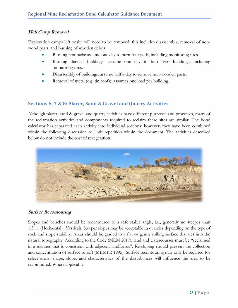
Sections 6, 7 & 8: Placer, Sand & Gravel and Quarry Activities
Although placer, sand & gravel and quarry activities have different purposes and processes, many of
the reclamation activities and components required to reclaim these sites are similar. The bond
calculator has separated each activity into individual sections; however, they have been combined
within the following discussion to limit repetition within the document. The activities described
below do not include the cost of revegetation.
Surface Recontouring
Slopes and benches should be recontoured to a safe stable angle, i.e., generally no steeper than
1.5 : 1 (Horizontal : Vertical). Steeper slopes may be acceptable in quarries depending on the type of
rock and slope stability. Areas should be graded to a flat or gently rolling surface that ties into the
natural topography. According to the Code (MEM 2017), land and watercourses must be “reclaimed
in a manner that is consistent with adjacent landforms”. Re-sloping should prevent the collection
and concentration of surface runoff (MEMPR 1995). Surface recontouring may only be required for
select areas; shape, slope, and characteristics of the disturbances will influence the area to be
recontoured. Where applicable:

Regional Mine Reclamation Bond Calculator Guidance Document
26 | P a g e
This line item applies to the
recontouring and sloping of
disturbed areas. Bond value is
based on the estimated time and
productivity rate of a medium
sized dozer to complete 1 ha.
The rate is based on the use of a
medium sized dozer (rate of
$262/hr) with a productivity of
300 m3/hr. It has is estimated that
it will 17 hours moving an average
depth of material 0.5 m, to
complete 1 ha.
Overburden Placement
Overburden placement involves distribution of stockpiled overburden across the site. Depending on
the location of the stockpile, the material may have to be transported prior to placement. This
results in extra equipment, time, and cost. In some cases overburden and topsoil will be stripped,
mixed and stockpiled together. In this case, do not include the topsoil placement line item.
For small sites, or where the stockpiled overburden is located adjacent to the area to be reclaimed,
use lower cost option “without travel”:
The rate is based on the use of a medium sized dozer (rate of $262/hr) with a
productivity of 300 m3/hr. It has is estimated that it will 17 hours moving an average
depth of material 0.5 m, to complete 1 ha.
For larger sites, or where the stockpiled topsoil requires transport prior to placement use the higher
cost option “with travel”:
If overburden requires trucks to move material, the rate assumes the use of an off-road
truck (17 m3 capacity) and a turnaround time of 0.5 hrs between loads to move
material from stockpile areas. Excavator needed to load dump truck ($150/hr *
147 hrs). This is in addition to the rate for spreading topsoil. The rate for overburden
spreading is based on the use of a medium sized dozer (rate of $262/hr) with a
productivity of 300 m3/hr. It has is estimated that it will take 17 hours to move an
average depth of material 0.5 m, to complete 1 ha..
Calculations are based on an average replacement overburden depth of 0.50 m.
Regional Mine Reclamation Bond Calculator Guidance Document
27 | P a g e
Topsoil Placement
Topsoil placement involves distribution of stockpiled topsoil across the site. Depending on the
location of the stockpile, the material may have to be transported prior to placement. This results in
extra equipment, time, and cost.
For small sites, or where the stockpiled topsoil is located adjacent to the area to be reclaimed, use
lower cost option “without travel”:
The rate is based on the use of a medium sized dozer (rate of $262/hr) with a
productivity of 300 m3/hr. It has is estimated that it will 3.3 hours moving an average
depth of material 0.1 m, to complete 1 ha.
For larger sites, or where the stockpiled topsoil requires transport prior to placement use the higher
cost option “with travel”:
If topsoil requires trucks to move material, the rate assumes the use of an off-road
truck (17 m3 capacity) and a turnaround time of 0.5 hrs between loads to move topsoil
from stock pile areas. Excavator needed to load dump truck ($150/hr * 42 hrs). This
is in addition to the rate for spreading topsoil. The rate for topsoil spreading is based
on the use of a medium sized dozer (rate of $262/hr) with a productivity of
300 m3/hr. It has is estimated that it will 3.3 hours moving an average depth of
material 0.1 m, to complete 1 ha. Total cost for this line item is $10,730/ha.
Calculations are based on an average topsoil depth of 0.10 m.
Test Pit
This line item is for the backfilling of exploratory test pits excavated with an excavator or back hoe.
Cost for test pit backfilling is based on volume (m3). Where applicable:
The dimension of the test pit(s) are populated into the spreadsheet. For multiple test
pits, the volumes for each pit can both be summed and entered directly in the
spreadsheet as a total, or additional rows for the pit calculation can be copy-pasted into
the spreadsheet for each pit.
The cost associated with backfilling test pits is based on productivity of medium size
excavator (150 m3/hr) at a rate of $143/hr. There is a 1-hour minimum charge ($143)
to account for small sites. This helps to capture travel time between test pits.
Bond value includes back filling pit and capping with topsoil.
Regional Mine Reclamation Bond Calculator Guidance Document
28 | P a g e
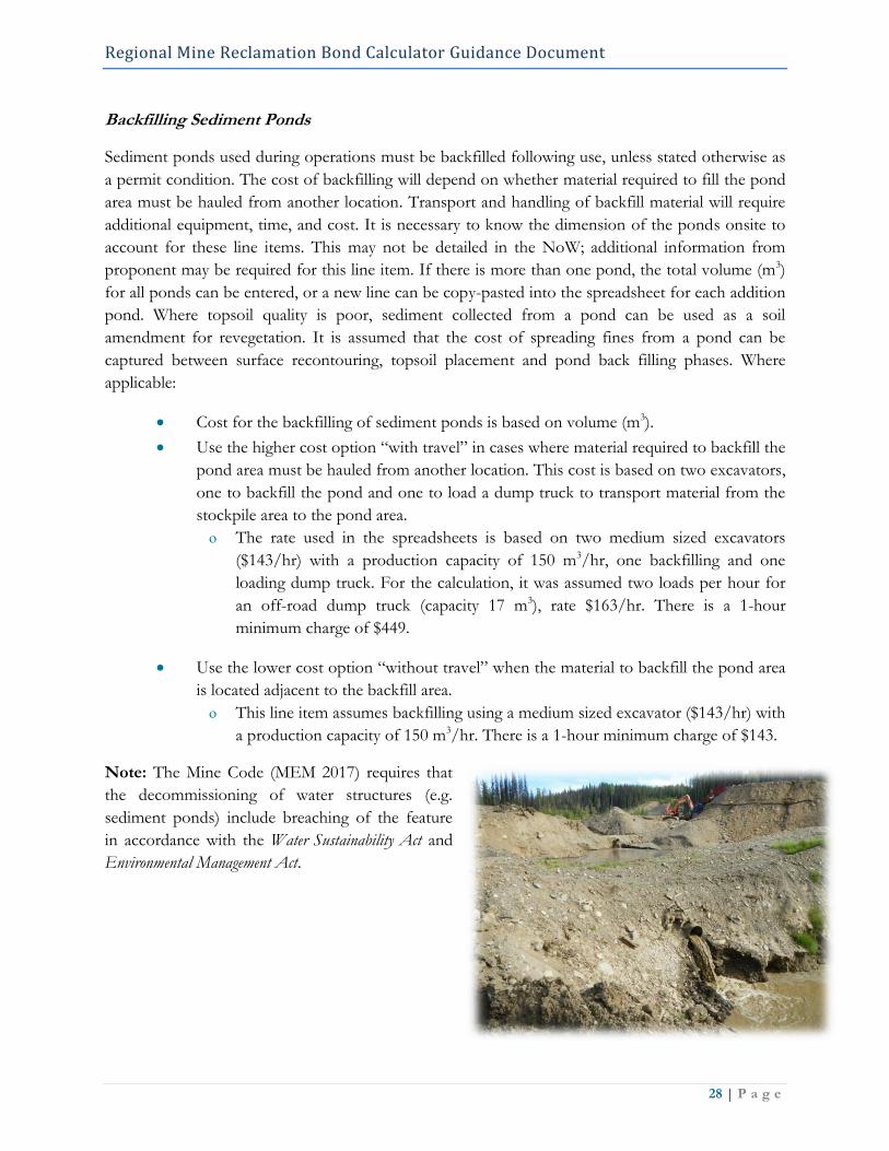
Backfilling Sediment Ponds
Sediment ponds used during operations must be backfilled following use, unless stated otherwise as
a permit condition. The cost of backfilling will depend on whether material required to fill the pond
area must be hauled from another location. Transport and handling of backfill material will require
additional equipment, time, and cost. It is necessary to know the dimension of the ponds onsite to
account for these line items. This may not be detailed in the NoW; additional information from
proponent may be required for this line item. If there is more than one pond, the total volume (m3)
for all ponds can be entered, or a new line can be copy-pasted into the spreadsheet for each addition
pond. Where topsoil quality is poor, sediment collected from a pond can be used as a soil
amendment for revegetation. It is assumed that the cost of spreading fines from a pond can be
captured between surface recontouring, topsoil placement and pond back filling phases. Where
applicable:
Cost for the backfilling of sediment ponds is based on volume (m3).
Use the higher cost option “with travel” in cases where material required to backfill the
pond area must be hauled from another location. This cost is based on two excavators,
one to backfill the pond and one to load a dump truck to transport material from the
stockpile area to the pond area.
The rate used in the spreadsheets is based on two medium sized excavators
($143/hr) with a production capacity of 150 m3/hr, one backfilling and one
loading dump truck. For the calculation, it was assumed two loads per hour for
an off-road dump truck (capacity 17 m3), rate $163/hr. There is a 1-hour
minimum charge of $449.
Use the lower cost option “without travel” when the material to backfill the pond area
is located adjacent to the backfill area.
This line item assumes backfilling using a medium sized excavator ($143/hr) with
a production capacity of 150 m3/hr. There is a 1-hour minimum charge of $143.
Note: The Mine Code (MEM 2017) requires that
the decommissioning of water structures (e.g.
sediment ponds) include breaching of the feature
in accordance with the Water Sustainability Act and
Environmental Management Act.

Regional Mine Reclamation Bond Calculator Guidance Document
29 | P a g e
Backfilling of Pits
Reclamation may require that excavated pits be backfilled. The cost of backfilling will depend on
whether material required to fill the pit area must be hauled from another location. Transport and
handling of backfill material will require additional equipment, time, and cost. It is necessary to
know the dimension of the ponds onsite to account for these line items. This may not be detailed in
the NoW; additional information from proponent may be required for these line items.
Cost for the backfilling of pits is based on volume (m3).
Use the higher cost option “with travel” in cases where material required to backfill the
pit area must be hauled from another location. This cost is based on two excavators,
one to backfill the pit and one to load a dump truck to transport material from the
stockpile area to the pit area.
The rate used in the spreadsheets is based on two medium sized excavators
($143/hr) with a production capacity of 150 m3/hr, one backfilling and one
loading dump truck. For the calculation, it was assumed two loads per hour for
an off-road dump truck (capacity 17 m3), rate $163/hr. There is a 1-hour
minimum charge of $449.
Use the lower cost option “without travel” when the material to backfill the pond area
is located adjacent to the backfill area.
This line item assumes backfilling using a medium sized excavator ($143/hr) with
a production capacity of 150 m3/hr. There is a 1-hour minimum charge of $143.
Water Management Installation/Deactivation
Water management refers to ditching used to direct water through or around the site. In some cases,
it will be necessary to remove ditching (deactivation), in other cases it will be necessary to direct
runoff or seepage flows (installation). These line items are site specific and ditching activities are not
expected to be commonly used. Where applicable:
Water management deactivation includes backfilling of ditches (e.g., contact water
collection ditches).
Post closure water management includes installing interception ditching to direct and
manage water movement through site.
The cost of water management activities is based on the use of a medium sized
excavator ($143/hr) with a production capacity of 150 m3/hr. There is a 1-hour
minimum charge of $143.
Regional Mine Reclamation Bond Calculator Guidance Document
30 | P a g e
Section 9: Site Preparation
Decompaction (Ripping – Subsoiler)
Soil compaction can severely limit plant re-establishment thereby delaying development of a desired
end land use and re-instatement of pre-development land capability. Soil compaction damages soil
structure by reducing or destroying soil pores that conduct soil water, nutrients and oxygen
necessary for plant root activity (DeJong-Hughes et al 2017). Compaction then restricts root
penetration, limit water infiltration, and result in the development of surficial crusts that further
inhibit re-establishment of vegetation.
Soil decompaction is achieved using a dozer equipped with standard ripper shanks or a winged
subsoiler. Productivity will vary depending on ground compaction, number of ripper teeth, and
depth of penetration. Where applicable:
Unit cost is based on a ripping production rate of 1.5 ac/hr (0.607 ha/hr)
(Northwestern University 1992).
Depending on activities and conditions, the entire site may not require decompaction.
Enter the size of area expected to experience compaction within the site (e.g. roads,
lay-down areas).
Harrowing
Harrowing is used to roughen soil surface in preparation for seeding and is typically applied along
relatively flat terrain with smooth surfaces. This approach is not likely to be used on most regional
mine reclamation projects; however, it may be suitable should the activity coincide with agricultural
land, or in areas where grass is desired to be the dominant cover type. The rate for harrowing has
been modified from MEM 2003.

Regional Mine Reclamation Bond Calculator Guidance Document
31 | P a g e
Rough and Loose Surface Preparation
Rough and loose surface treatments provide an effective
way to control erosion and create conditions that promote
the revegetation of a site. The rough and loose surface
method provides increased diversity of habitats, improving
ecological resilience (Polster 2013). Results in a highly
heterogeneous soil surface. Work is completed with an
excavator. Where applicable:
Rate is based on and average productivity of
0.25 ha/hr (MOF Silviculture Manual 1999),
using a medium size excavator at $143/hr.
Section 10: Supplemental Topsoil
If topsoil is stripped and stockpiled appropriately (i.e., taking into consideration soil handling and
conservation best management practices), there should not be a need for the addition of
supplemental topsoil. However in the case of poor topsoil management or legacy soil handling
practices, supplemental topsoil may be required to improve reclamation success. Sources of topsoil
may vary, and depending on circumstances the distance to a provider or donor site may be
considerable. When translocating topsoil it is important to avoid the introduction of noxious weed
species. Caution must be used when sourcing topsoil to avoid the spread of invasive species. The
bond calculator provides value for the following:
Commercial rate for one m3 of topsoil (*This rate does not include transportation
costs).
Topsoil (ha): based on the volume of topsoil to cover one hectare to a depth of 30 cm.
Dump Truck (8 m3): based on the distance from the anticipated source to and from
the site.
Regional Mine Reclamation Bond Calculator Guidance Document
32 | P a g e
Section 11: Access Trail/Road
Permanent deactivation and reclamation of access roads and trails is required in order to limit
potential liability, minimize environmental impacts, and to meet the regulatory requirements
conducive to the release and return the reclamation security bond. Review of regulatory guidebooks
related to exploration (MEMPR 2009), placer (FLNRO & MEM 2014), and sand, gravel and quarry
operations (Province of British Columbia. 1995), as well as the Code (MEM 2017) all indicate that
access roads and trails should be reclaimed following use. However, the level of deactivation and
reclamation may vary depending on circumstances (e.g. site characteristics, future land use, and
access management considerations) as well as Permit conditions.
Permanent Deactivation
The intent of permanent deactivation is to place the road in a self-maintaining state that will
indefinitely protect adjacent resources at risk. Permanent deactivation commonly involves a range of
measures, but is often more aggressively applied where roads traverse areas of steep terrain or
erodible soils – especially geographical areas that receive high levels of precipitation. Permanent
deactivation is done with the expectation that the road will no longer be used by the proponent and
that it will receive no further inspections or maintenance. Permanent deactivation will normally
result in the elimination of motor vehicle access along road segments where unstable road fill is
pulled back and where stream culverts and bridges are removed. However, for roads that cross flat
or gentle terrain with no stream crossings, little or no work may be necessary to permanently
deactivate the roads. In this case, motor vehicle access may be both possible and acceptable, unless
there is a requirement in a higher-level plan to eliminate such access (MOF 2002). Typical
permanent deactivation objectives are to:
1. Maintain or re-establish natural hill slope drainage patterns.
2. Minimize the potential for road-related landslides and erosion.
3. Construct or alter slope angles to be stable.
4. Limit maintenance and liability for inactive roads.
5. Maintain access management objectives where applicable.
Permanent deactivation includes installing water bars and cross ditches, removal of cross drain
culverts, and limited pull back of unstable areas. Permanent deactivation also includes seeding areas
of higher erosion potential at an additional cost.
Road are divided into “Interior Roads” and “Coastal Roads” and within each category
cost for roads with side slope >30% and roads with side slope <30%.
The Interior Road category is generally applicable for Northeast Central, South
Central, and South East Regions.
The Coastal Road category is more applicable for Northwest and Southwest
Regions. However, this category may be used in mountainous interior wet belt
areas if applicable. Typically, this category would be used in areas of heavy
Regional Mine Reclamation Bond Calculator Guidance Document
33 | P a g e
precipitation, and steep mountainous terrain where there is increased erosion and
slope instability potential.
Road deactivation values are derived from estimates from FLNRO Road Engineers
based on an average cost per kilometer basis.
Roads on steeper slopes are more expensive due to the larger road prisms, erosion
control concerns, and natural drainage features. Cost per km was converted to a per ha
rate for the bond calculator. Roads widths on slopes <30% were assumes to have an
average prism width of 8 m. Roads widths on slopes >30% were assumes to have an
average prism width of 10 m.
To reflect information provided in the NoW, costs are based on a cost ($)/ha basis.
The user must enter the length and width of the road to determine the area (ha).

Regional Mine Reclamation Bond Calculator Guidance Document
34 | P a g e
Full Reclamation
Objectives of full road reclamation include (1) restoration of original habitat components, (2)
improvement of visual aesthetics and (3) establishment of end land use objectives. Full reclamation
then requires decompaction, pull back, recontouring, restoring natural drainage patterns, and
revegetating road and right-of-way. Motor vehicle access will be eliminated, and even All-Terrain
Vehicle access may be restricted.
Trails for exploration are broken into three categories based on definitions in the
Mineral and Coal Exploration Handbook (MEMPR 2009):
Exploration Trail: refers to a 1.5 m wide trail, <30 cm into mineral soil.
For the purpose of the bond calculator, exploration trails are non-bladed
trails, but can be greater than 1.5 m wide. In reality, trails are rarely as
narrow as 1.5 m.
Rate is based on the estimate that an excavator can reclaim 1 km of trail
(3.5 m wide) in 5 hrs. Area is converted to hectares and calculation is
based on an excavator rate of $143/hr.
Due to the narrow width and limited surface disturbance, revegetation is
typically left to natural ingress.
Excavated Trail up to 3.5 m wide (side slope <30%), >30 cm into mineral soil.
Excavated Trail up to 3.5 m wide (side slope >30%), >30 cm into mineral soil.
Rates for excavated trails were modified from values in previous Northeast
Central Bond Calculator., within input from FLNRO Road Engineers. Pricing
was converted from per kilometer rate to hectare rate based on trial width of 3.5
m.
Roads are divided into “Interior Roads” and “Coastal Roads” and within each category
cost for roads with side slope >30% and roads with side slope <30%.
The Interior Road category is applicable for Northeast Central, South Central,
and South East Regions.
The Coastal Road category is more applicable for Northwest and Southwest
Regions. However, this category may be used in mountainous interior wet belt
areas if applicable. Typically, this category would be used in areas of heavy
precipitation, and steep mountainous terrain where there is increased erosion and
slope instability potential.
Access Road (side slope <30%): values are based on estimates from FLNRO Road
Engineers. Costs would be lower in non-coastal areas.
Access Road (side slope >30%): values are based on estimates from FLNRO Road
Engineers. Costs would increase with slope, as there is more material to handle and
more issues associated with terrain. Revegetation costs are included.

Regional Mine Reclamation Bond Calculator Guidance Document
35 | P a g e
Any access system that is located on >50% slopes should be referred to engineering
for reclamation projects and costs.
Costs are based on a cost per hectare basis. The user must enter the length and width
of the road/trail to determine the area (ha).
Section 12: Stream Crossing/Restoration
Bridges (Removal & Transport)
Costs are sourced from the Northern Interior Forest Region Detailed Engineered Cost Estimate
Procedures (2006) by bridge size. The 2016 Interior Appraisal Manual still refers to bridge removals
costs in the 2006 document (FLNRO 2016). Costs include both the removal of the structure and
transportation to a reasonably close storage area. If the bridge is to be transported >20 km,
mob/demob costs should be added on top of the identified bridge cost.
Stream Culvert Removal
For fish bearing streams: culvert removal will require environmental permitting, an environmental
management plan, fish salvage, and associated professional fees. Site isolation, excavation of the
road surface, and reconstruction of the streambed will also be required, which will involve clean
gravel/cobble material and erosion control measures. For non-fish bearing streams: site isolation,
excavation of the road surface, and reconstruction of the streambed will be required, which will
involve clean gravel/cobble material and erosion control measures.
Regional Mine Reclamation Bond Calculator Guidance Document
36 | P a g e
Stream Restoration
Stream restoration may be required depending on the disturbance. An all-inclusive cost for stream
channel restoration has been provided. The rate includes permitting, fish salvage, equipment, site
isolation, environmental monitoring, riparian planting, and erosion and sediment control. Where
applicable:
The price was based on an average of known costs for past restoration projects.
Cost is based on linear meter of stream channel and is intended for small to mid-sized
streams (channel width <6m). A third-party quote is suggested for larger systems.
Section 13: Revegetation – Seeding
Disturbance sites and trails/roads should be seeded with native species, unless the areas are expected
to recover through natural regeneration or expected to be replanted with tube-stock. Vegetation
species selection should be consistent with the desired end land use. Native seed mixes should
include the use of a short-lived or annual cover crop species to provided early erosion and sediment
control. For reference, the BC government provides a number resources including revegetation
techniques found within the Soil Rehabilitation Guidebook (MOF 1997). Where applicable:
For erosion control, apply seed mix at a rate of 15-30 kg/ha (NEIPC 2010).
For seeding to allow for tree growth, apply at a rate of 4-6 kg/ha (NEIPC 2010).
The bond calculator uses a default seeding rate of 25 kg/ha and a fertilizer application
rate of 300 kg/ha. (*Application rate can be modified if a more specific rate is
required).
Seed price in the calculator is based on average native seed cost, and price can vary
widely depending on the provider and seed mix.
Broadcast seeding is a commonly used and is beneficial for steep and/or uneven
surfaces.
A handheld cyclone seeder is an effective way of broadcast seeding and
depending on the model allows for seeding rate adjustment.
The rate is based on the assumption that one person can seed 1 ha/day.
The application cost is based on $40/hr for 10 hr.
Granular fertilizer can also be broadcasted by hand.
Seeders mounted or pulled by ATVs are suitable for larger areas or linear disturbances.
The price in the calculator is based on a productivity rate of 5 ha/day.
The application cost is based on $40/hr for 10 hr, plus $200 for an ATV.
Granular fertilizer can also be broadcasted using an ATV.
Aerial Broadcast seeding is good for large areas or numerous difficult to reach areas.
It is possible to seed 100 ha/hr (mid-range value from NEICP 2010).
Regional Mine Reclamation Bond Calculator Guidance Document
37 | P a g e
Section 14: Revegetation – Planting
Planting refers to the use of rooted tube-stock to re/establish vegetation. This activity typically
involves planting of trees, but can also involve planting shrubs and forbs. The decision to plant will
depend (in part) on the desired plant community and end land use. For example, if end land use is
forestry, or wildlife habitat associated with forested ecosystems, then appropriate tree species should
be planted. Where an existing forest plantation is disturbed by activities (including small
disturbances under 1 ha.) similar tree species should be planted. Moreover, opportunities may exist
to incorporate traditionally important and/or ethnobotanical species into the planting program; this
should involve consultation relevant members of local First Nations.
Special Considerations
When project disturbance openings are greater than1 ha, it is recommended that the area be planted
with trees, if consistent with reclamation goals (e.g. end land use). If the adjacent area is forested and
the disturbance area in large enough not to easily facilitate natural colonization, then the area should
be planted. In some cases, planting may not be required if natural ingress is expected, this may occur
in small openings (e.g. areas less than 1 ha) or along narrow linear corridors where adjacent seed
sources are close by. Use native pioneering species where appropriate and consider seed providence
(geographic location, latitude, and elevation) when selecting seedling stock. It is recommended that
all trails and roads that are recontoured in areas with slopes 30-50% be considered for tree planting
to ensure the stabilization of surface material.
Planting cost is based on averages from forest industry, and accounts for small openings and
therefore smaller economies of scale. Stocking density may vary with BEC Zone and site series.
Where applicable:
The cost in the calculator is based on a planting density of 1500 stems/ha, but density
can be modified according to desired conditions.
The calculator uses $0.5/seedling and $1.00 to plant for each tree. Note: tree prices
vary greatly depending on plug size and grower.
For sites with poor soil nutrients, fertilizer in the form of nutrient packets (e.g. tea bag
fertilizer products) may be considered. The calculator uses $0.07/tea bag and $0.20 to
plant for each packet.

Regional Mine Reclamation Bond Calculator Guidance Document
38 | P a g e
Section 15: Additional Revegetation Activities
Hydroseeding
Hydroseeding is a planting process that uses a slurry of seed, mulch and tackifier that is sprayed
from a tank. The mulch within the slurry provides moisture retention for faster germination,
insulation from temperature extremes to prevent seed dormancy, and protection from erosion.
Hydroseeding is typically used as an erosion control technique, particularly on steep slopes with
exposed soils. Hydroseeding involves a greater seed application rate compared to broadcast seeding
methods (NEIPC 2010). Cost varies widely depending on location in province, remoteness of site,
size of area, and type and application of seed and materials. Where applicable
The price can range from about $0.45/m2 for standard commercial road side seed
mixes (e.g., highway projects) to $4.00/m2 for specialty products.
The calculator uses a rate of $2.00/m2 ($20,000/ha) as the expected average cost for
most hydroseeding projects using a native seed mix.
The rate used in the calculator can be modified if available information warrants.
Bioengineering (live cuttings)
Bioengineering is the use of live plant cuttings to establish vegetation, typically with the intent of
stabilizing stream banks and restoring riparian function. Many methods, material, and construction
characteristics can be used depending on goals. Bioengineering has site specific uses, such as live
staking drainage or riparian areas. Live staking with deciduous species (willow, cottonwood) is
effective at stabilizing surfaces and slopes, and is most effective in areas with high soil moisture
content. Costs are variable depending on the site location and the availability of material and labour.
Where applicable:
Price in the calculator is based on
the US Army Corps of Engineers
(Hollis and Leech 1999) person hour
production rates, which assumes 66
cuttings/person hour and planting
100 stems/hr. Labour rate are
$40/hr. Live stake spacing was
assumed to be 1 m, which equates to
10,000 stems/ha.

Regional Mine Reclamation Bond Calculator Guidance Document
39 | P a g e
Section 16: Reclamation Monitoring
Monitoring is a component of the reclamation process as it provides a summary of performance and
ongoing actions pertaining to:
(1) Documentation of site conditions and reclamation requirements (e.g., soil, topography,
erosion and sediment controls and vegetation), and
(2) Identification of potential deficiencies (should they occur) and associated remedial action(s)
applied to meet the necessary reclamation standards
Reclamation monitoring provides opportunities for adaptive management as a mechanism for
revising or improving upon restorative action in the light of new information (e.g., accounting for
site-specific circumstances or incorporating additional restorative actions).
Vegetation Monitoring
Monitoring costs can vary depending on factors such as speed of recovery and number of site visits.
Although a minimum of one site visit is required, three site visits are recommended (Year 1, Year 3,
Year 5). The user can enter the number of expected monitoring visits. Price is based on the use of a
third party qualified professional assessing the vegetation.
Regional Mine Reclamation Bond Calculator Guidance Document
40 | P a g e
Geotechnical Monitoring
Geotechnical monitoring would be included in the bond only if site specific conditions or concerns
warranted. This line item would not likely be included in the initial NoW security bond. Cost for
geotechnical monitoring can be highly variable depending on the location and complexity of the site.
Where applicable:
Price based on $180/hr for a 10 hr site visit, plus 10 hrs of data management and
reporting time as well as disbursements (e.g., vehicle and survey equipment). Price does
not include instrumentation installation, if required.
Water Quality/ARD Monitoring
Water Quality/ARD monitoring would be included in the bond only if site specific conditions or
concerns warranted. This line item would not likely be included in the initial NoW security bond.
Where applicable:
Water quality monitoring and ARD monitoring assume $500 for lab costs, plus an
approximate cost for travel time to and from the site for sample collection, and
shipping. Actual price will vary depending on the program, project location, and
efficiencies with additional samples. Depending on the program and site concerns,
sampling parameters may differ.
For ARD monitoring considerations, parameters could include: buffering capacity
(acidity, alkalinity), physical properties (total dissolved solids, total suspended
sediments), major ions, nutrients, and/or metals.
The bond calculator requires that the user enter the number of sample (e.g. sample
sites) required, as well as the frequency that the samples are collected. Collecting
samples from both control sites and impact sites should be considered.
Foliar Metals Uptake Monitoring
Foliar metals uptake monitoring would only be required if there were known or suspected metal
toxicity concerns. Where applicable
Foliar metals uptake monitoring assumes $200/site for lab costs (e.g., full metals suite),
plus a day rate for the technician to collect the samples, and travel to and from the site.
Actual price will vary depending on the program, project location, and efficiencies with
additional samples.
The user is required to enter the number of samples (e.g. sample sites) in the bond
calculator.

Regional Mine Reclamation Bond Calculator Guidance Document
41 | P a g e
Section 17: Planning and assessment
This section includes the estimated cost for a number of technical plans, investigations or
assessments. These assessments are not to be included in the bonding at the NoW stage, but may be
considered depending on site specific concerns following an inspection, or during a permit
amendment. It is recommended that given site specific conditions and project locations, where
possible, quotes should be obtained from third party professionals. However, the bond calculator
provides these line items as a costing guide in the event that site specific pricing is not available.
Reclamation Plan
Includes the cost for a qualified professional to conduct a site visit, assess existing site conditions,
and prepare a reclamation plan. For complex or remote sites, the cost for a reclamation plan will be
higher (e.g., $10,000).
Geotechnical Assessment
Includes the cost for a qualified professional to conduct a site visit, assess existing site conditions,
and prepare a geotechnical report with proposed mitigation measures. For complex or remote sites,
the cost for a geotechnical assessment will be higher.
Soil Remediation Investigation
Includes the cost for a qualified professional to conduct a site visit, facilitate lab analyses, and
prepare an assessment report. The price includes an excavator for 10 hr/day.
Ground Water Investigation
The cost of a groundwater investigation for a contaminated site, including a minimum of three drill
holes ($10,000/hole).
Hazardous Materials Assessment
Includes the cost for a qualified professional to conduct a site visit, assess materials left on site,
identify potential areas of contamination, and prepare a report (Phase 1 report). For complex or
remote sites, the cost for a hazardous materials assessment will be higher (e.g., $8,000).

Regional Mine Reclamation Bond Calculator Guidance Document
42 | P a g e
Section 18: Miscellaneous
This section contains a few miscellaneous line items that may be required during a reclamation
project. Items may not be necessary for every project, and it is at the discretion of the user to include
the ones that apply based on circumstances and anticipated activities.
Accommodation and Meals
Rate for accommodation and meals is set at $200/day/person. It is expected that this price will be
adequate for most hotel and camp situations throughout the province. It can be adjusted if costs are
expected to be different based on project and location. If accommodation is required for the project,
account for all personnel expected to be onsite (e.g. equipment operators, debris removal crew, etc.)
Vehicle Mileage
This line item is intended to cover fuel and vehicle expenses to and from site for those providing
reclamation services. Where applicable, the cost is given on a per kilometer basis ($1.05/km).
Helicopter Access/Support
For remote or difficult to access sites, a helicopter may be required. The rate provided in the
calculator is for an Astar helicopter ($2,100/hr) – the hourly rate provided includes fuel. This aircraft
is becoming the industry standard. Rates for other helicopters are included in the "Rate Sheet" tab of
the bond calculator, if required.
Airplane
For remote sites with air strips or water access. Floatplane access may be more common in northern
or coastal regions. Where applicable, the rate is based on service provider quote, $550/km or
$1,093/hr.
Regional Mine Reclamation Bond Calculator Guidance Document
43 | P a g e
Section 19: Project management
Effort will be required to successfully coordinate and manage the reclamation project. This includes
administering contracts, supervising contractors, and ensuring the tasks are completed as intended
and on schedule. The bond calculator has the option to include a 10% project management fee to
the security estimate. It is at the discretion of the user to apply the project management fee based on
the complexity of the anticipated works. Complex projects with many components may require third
party project management. Percentage based project management fees for construction, consulting
or engineering can vary. A fee of 10% was considered reasonable mid-range value based on industry
practice. Where applicable:
Enter '1' in the cell if applicable to include the project management fee in the
calculator.
Section 20: Uncertainty Factor
The bond calculator has the option to include a 15% uncertainty factor to the security estimate. It is
at the discretion of the user to apply the uncertainty factor based on circumstances, level of
perceived unknowns, and confidence in the security estimate. For example, remote access
challenges, northern allowance, or unforeseen costs and differences in rates. Where applicable:
Enter '1' in the cell to include the uncertainty factor in the calculator.
Section 21: Inflation
The bond calculator allows for an inflation rate to be applied to projects with longer term end dates
(e.g. five or more years). It is at the discretion of the user to decide whether inflation should be
factored into the bond calculation based on circumstances and estimated timelines. The calculator
uses an annual inflation rate of 2.0% on goods and services. This is based on the current inflation
rate for BC (Statistics Canada 2017). For reference, the calculated annual inflation based on change
in Blue Book equipment rates was 2.25%.
Related Documents