FINAL ENVIRONMENTAL ASSESSMENT LONG-TERM WATER SUPPLY AGREEMENTS U.S. BUREAU OF RECLAMATION AND U.S. FISH AND WILDLIFE SERVICE REFUGE WATER SUPPLY TULARE LAKE BASIN JANUARY 2001

Welcome message from author
This document is posted to help you gain knowledge. Please leave a comment to let me know what you think about it! Share it to your friends and learn new things together.
Transcript
FINAL ENVIRONMENTAL ASSESSMENT
LONG-TERM WATER SUPPLY AGREEMENTS
U.S. BUREAU OF RECLAMATION ANDU.S. FISH AND WILDLIFE SERVICE
REFUGE WATER SUPPLY
TULARE LAKE BASIN
JANUARY 2001
SAC\155333\JAN 2001/010190001 (TULARE CONTENTS.DOC) III
Contents
Section Page
1.0 Purpose and Need ...............................................................................................................1-11.1 Introduction .............................................................................................................1-11.2 History of Refuge Water Supply Planning..........................................................1-11.3 Purpose and Need for the Proposed Action........................................................1-41.4 Public Scoping .........................................................................................................1-5
2. Background ............................................................................................................................2-12.1 Kern National Wildlife Refuge..............................................................................2-22.2 Pixley National Wildlife Refuge............................................................................2-4
3. Summary of Previous Environmental Documentation..................................................3-13.1 Introduction .............................................................................................................3-13.2 Programmatic Environmental Impact Statement ...............................................3-13.3 Conveyance of Refuge Water Supply for South San Joaquin Study Area ....3-243.4 Management of Wildlife Areas ...........................................................................3-27
4. Description of Alternatives .................................................................................................4-14.1 Introduction .............................................................................................................4-14.2 Water Service Agreement ......................................................................................4-14.3 On-Refuge Management ........................................................................................4-44.4 Alternative Considered But Not Analyzed in Detail .......................................4-11
5. Affected Environment and Environmental Consequences...........................................5-15.1 Introduction .............................................................................................................5-15.2 Biological Resources ...............................................................................................5-25.3 Water Quality ........................................................................................................5-135.4 Agricultural Land Use..........................................................................................5-155.5 Recreation...............................................................................................................5-185.6 Regional Economics ..............................................................................................5-195.7 Social Conditions...................................................................................................5-225.8 Cultural Resources ................................................................................................5-245.9 Visual Resources ...................................................................................................5-275.10 Power ....................................................................................................................5-28
6. Consultation and Coordination..........................................................................................6-16.1 Fish and Wildlife Coordination Act .....................................................................6-16.2 Endangered Species Act.........................................................................................6-16.3 Cultural Resources Coordination .........................................................................6-2
CONTENTS
IV SAC\155333\JAN 2001/010190001 (TULARE CONTENTS.DOC)
6.4 Indian Trust Assets................................................................................................. 6-26.5 Environmental Justice ............................................................................................ 6-26.6 Farmlands Policy .................................................................................................... 6-3
AttachmentsEnvironmental CommitmentsReferencesList of Preparers
AppendixTerms and Conditions of Biological Opinion
Tables1-1 Annual Level 2 and Level 4 Refuge Water Supplies for Tulare Lake Basin
Refuges ...................................................................................................................................... 1-5
3-1 Refuge Water Supply and Delivery Assumptions in the PEIS No ActionAlternative ................................................................................................................................ 3-5
3-2 Refuge Water Supply and Delivery Assumptions in the PEIS for Level 2and Level 4 Water Supplies in Alternatives 2, 3, and 4...................................................... 3-9
3-3 Refuge Water Supply and Delivery Assumptions in the PEIS for Level 2Water Supplies in Alternative 1........................................................................................... 3-10
3-4 Summary of CVPIA PEIS Analysis ..................................................................................... 3-11
4-1 Quantities of Water to Be Provided to the Kern and Pixley NWRs under theNo Action Alternative............................................................................................................. 4-1
4-2 Summary of the Proposed Water Service Memorandum of Agreement withthe U.S. Fish and Wildlife Service ......................................................................................... 4-3
4-3 Acres of Habitat Expected on Kern and Pixley NWRs under the No ActionAlternative and Proposed Action.......................................................................................... 4-7
4-4 Special-Status Species for which the Service will Implement Conservationand Take Avoidance Measures under the Proposed Action ........................................... 4-11
5-1 Special-Status Species Known to Occur or Potentially Occurring onKern and Pixley NWRs........................................................................................................... 5-5
Figure2-1 Tulare Lake Basin Refuges ......................................................................................................2-1

Section 1: Purpose and Need
SAC/155333/JAN 2001/010190002 TULARE~1.DOC 1-1
SECTION 1
Purpose and Need
1.1 IntroductionThe U.S. Department of the Interior, Bureau of Reclamation (Reclamation) proposes to enterinto long-term water supply agreements with the U.S. Fish and Wildlife Service (Service)pursuant to Sections 3406(d)(1) and 3406(d)(2) of Title 34 of Public Law 102-575, the CentralValley Project Improvement Act (CVPIA). These sections of the CVPIA require the provisionof firm water supplies to specified National Wildlife Refuges (NWRs), State Wildlife Areas(WAs), and private wetlands in the Grassland Resource Conservation District (RCD)(collectively referred to as “refuges”). Providing firm water supplies under this projectwould allow for optimum habitat management on the existing refuge lands. Reclamation isthe federal Lead Agency for the preparation of this Environmental Assessment (EA) underthe National Environmental Policy Act (NEPA).1 The proposed federal action is for theexecution of the following water service agreement:
• A Memorandum of Understanding between Reclamation and the Service for delivery ofwater to the Kern and Pixley NWRs.
Reclamation is also undertaking concurrent actions to enter into long-term water supplyagreements per the CVPIA for refuges in the Sacramento River and San Joaquin River basinsof the Central Valley. Separate environmental documents are being prepared for these twostudy areas.
1.2 History of Refuge Water Supply Planning
1.2.1 The Pacific Flyway and Central Valley WetlandsThe Central Valley lies at the southerly end of the Pacific Flyway migratory route. In pre-settlement times, it provided ideal wintering habitat and attracted large numbers ofwaterfowl. The Pacific Flyway is the westernmost of North America’s four flyways, ormigration routes, which are defined as definite geographic regions with breeding groundsin the north, wintering grounds in the south, and a system of migration routes in between.The Pacific Flyway encompasses territory in three countries: northern and western Canada,Alaska and all states west of the Rocky Mountains in the U.S., and western Mexico.
The Service ranks Central Valley wetland habitat as one of the top five habitats in the U.S.Historically, the Central Valley contained approximately 4 million acres of wetlands.Approximately 1.5 million acres located in the Sacramento/San Joaquin River Delta and theTulare Basin were permanent marshes, while the remaining 2.5 million acres were seasonalwetlands created by winter rains and spring snow melt from the Sierra Nevada. Today,approximately 300,000 acres remain; 100,000 acres are publicly owned (federal and state 1 This EA determines that the project would not cause a substantial change in the human environment and thus does notrequire preparation of an Environmental Impact Statement.
SECTION 1: PURPOSE AND NEED
1-2 SAC/155333/JAN 2001/010190002 TULARE~1.DOC
refuges) and 200,000 acres are privately owned (including private duck clubs). Theremaining 300,000 acres provide wintering habitat for 60 percent of the Pacific Flyway’scurrent waterfowl population and migration habitat for an additional 20 percent of thepopulation. Altogether, nearly 10 to 12 million ducks and geese, along with millions of otherwater birds, winter in or pass through the Central Valley. However, the number ofwaterfowl using the Central Valley has declined 40 to 50 percent over the last 30 years.Maintaining the Pacific Flyway for waterfowl depends largely on maintaining criticalwetland habitat in the Central Valley.
The Migratory Bird Conventions of 1916 and 1936 provided some of the first protection forwaterfowl and other migratory birds. These Conventions are treaties between the U.S. andCanada and the U.S. and Mexico, respectively. The Conventions established protection forall species of migratory birds in North America except in regulated hunting seasons forgame birds. The Conventions also provided the basic foundation for cooperative waterfowlmanagement programs. In accordance with these treaties, and in recognizing theimportance of waterfowl and wetlands and the need for international cooperation to help inthe recovery of a shared resource, the Canadian and U.S. governments developed a strategyto restore waterfowl populations through habitat protection, restoration, and enhancement.The strategy was described in the North American Waterfowl Management Plan. The NorthAmerican Waterfowl Management Plan was signed in 1986 by the Canadian Minister of theEnvironment and the U.S. Secretary of the Interior and was updated in 1994 to include theRepublic of Mexico.
The goals of the North American Waterfowl Management Plan are accomplished throughjoint ventures composed of individuals, corporations, conservation organizations, and local,state, and federal agencies. There are currently 11 habitat joint ventures in the U.S. and threein Canada, including the Central Valley Habitat Joint Venture. The Central Valley HabitatJoint Venture established the following six broad goals:
• Enhance the natural resource values on the remaining existing wetland areas(approximately 300,000 acres)
• Enhance 443,000 acres of private agricultural lands for feeding and nesting waterfowl
• Protect 80,000 acres of existing wetlands through perpetual easement or fee titlepurchase
• Restore and protect 120,000 acres of former wetlands
• Secure 402,450 acre-feet of water for NWRs and WAs in the Central Valley and theGrassland RCD
• Secure Central Valley Project power for the NWRs, State WAs, the Grassland RCD, andother private and public lands dedicated to wetland management
1.2.2 Wetland Water Supply PlanningSecuring a reliable water supply of sufficient quality has long been recognized as animportant component for sustaining wetland habitats in the Central Valley and thewaterfowl of the Pacific Flyway and other wildlife species that depend on wetland habitat.As early as 1950, state and federal resource agencies started investigating ways to maintain
SECTION 1: PURPOSE AND NEED
SAC/155333/JAN 2001/010190002 TULARE~1.DOC 1-3
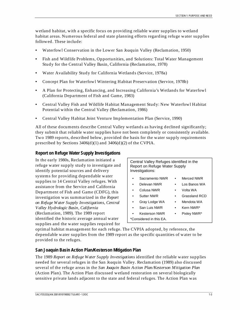
Central Valley Refuges identified in theReport on Refuge Water SupplyInvestigations:
• Sacramento NWR
• Delevan NWR
• Colusa NWR
• Sutter NWR
• Gray Lodge WA
• San Luis NWR
• Kesterson NWR
• Merced NWR
• Los Banos WA
• Volta WA
• Grassland RCD
• Mendota WA
• Kern NWR*
• Pixley NWR*
*Considered in this EA.
wetland habitat, with a specific focus on providing reliable water supplies to wetlandhabitat areas. Numerous federal and state planning efforts regarding refuge water suppliesfollowed. These include:
• Waterfowl Conservation in the Lower San Joaquin Valley (Reclamation, 1950)
• Fish and Wildlife Problems, Opportunities, and Solutions: Total Water ManagementStudy for the Central Valley Basin, California (Reclamation, 1978)
• Water Availability Study for California Wetlands (Service, 1978a)
• Concept Plan for Waterfowl Wintering Habitat Preservation (Service, 1978b)
• A Plan for Protecting, Enhancing, and Increasing California’s Wetlands for Waterfowl(California Department of Fish and Game, 1983)
• Central Valley Fish and Wildlife Habitat Management Study: New Waterfowl HabitatPotential within the Central Valley (Reclamation, 1986)
• Central Valley Habitat Joint Venture Implementation Plan (Service, 1990)
All of these documents describe Central Valley wetlands as having declined significantly;they submit that reliable water supplies have not been completely or consistently available.Two 1989 reports, described below, provided the basis for the water supply requirementsprescribed by Sections 3406(d)(1) and 3406(d)(2) of the CVPIA.
Report on Refuge Water Supply InvestigationsIn the early 1980s, Reclamation initiated arefuge water supply study to investigate andidentify potential sources and deliverysystems for providing dependable watersupplies to 14 Central Valley refuges. Withassistance from the Service and CaliforniaDepartment of Fish and Game (CDFG), thisinvestigation was summarized in the Reporton Refuge Water Supply Investigations, CentralValley Hydrologic Basin, California(Reclamation, 1989). The 1989 reportidentified the historic average annual watersupplies and the water supplies required foroptimal habitat management for each refuge. The CVPIA adopted, by reference, thedependable water supplies from the 1989 report as the specific quantities of water to beprovided to the refuges.
San Joaquin Basin Action Plan/Kesterson Mitigation PlanThe 1989 Report on Refuge Water Supply Investigations identified the reliable water suppliesneeded for several refuges in the San Joaquin Valley. Reclamation (1989) also discussedseveral of the refuge areas in the San Joaquin Basin Action Plan/Kesterson Mitigation Plan(Action Plan). The Action Plan discussed wetland restoration on several biologicallysensitive private lands adjacent to the state and federal refuges. The Action Plan was
SECTION 1: PURPOSE AND NEED
1-4 SAC/155333/JAN 2001/010190002 TULARE~1.DOC
prepared to implement the objectives of the Central Valley Habitat Joint Venture in the SanJoaquin Valley (including providing reliable water supplies) and to meet the long-termmitigation requirements for the selenium-contaminated Kesterson Reservoir. Pursuant tothe Action Plan, most of the private lands studied in the report have been acquired andintegrated into the existing federal and state refuge system. The water supplies necessary forfull habitat development and management on these acquired parcels were identified in theAction Plan and were adopted by reference into the CVPIA. The San Joaquin Basin ActionPlan/Kesterson Mitigation Plan is discussed in more detail in the EA prepared for long-termrefuge water service agreements in the San Joaquin River Basin.
1.3 Purpose and Need for the Proposed ActionThe purpose of the Proposed Action is to execute long-term refuge water supplyagreements, pursuant to the CVPIA, for the Kern and Pixley NWRs. These agreements willdefine the terms and conditions for annual water deliveries to the refuges. The need for theProposed Action is to provide firm, reliable water supplies of suitable quality to the refugesto contribute to habitat maintenance and improvement efforts along the Pacific Flyway.
The purposes of the CVPIA are identified in Section 3402 of the CVPIA; they include theprotection, restoration, and enhancement of fish, wildlife, and associated habitats in theCentral Valley and the achievement of a reasonable balance among competing demands foruse of Central Valley Project (CVP) water. CVPIA directives regarding wildlife refuges arefound in Section 3406(d) of the Act, which begins as follows:
In support of the objectives of the Central Valley Habitat Joint Venture and in furtherance ofthe purposes of this title, the Secretary shall provide, either directly or through contractualagreements with other appropriate parties, firm water supplies of suitable quality to maintainand improve wetland habitat areas on units of the National Wildlife Refuge System in theCentral Valley of California; on the Gray Lodge, Los Banos, Volta, North Grasslands, andMendota state wildlife management areas; and on the Grassland Resource ConservationDistrict in the Central Valley of California.
The proposed long-term agreements will be implemented in accordance with Sections3406(d)(1) and 3406(d)(2) of the CVPIA. Section 3406(d)(1) requires the Secretary of theInterior to immediately (that is, upon enactment of the CVPIA) provide specific quantities ofwater to the refuges. The CVPIA indicates that long-term contractual agreements should bedeveloped for water provided under Section 3406(d)(1). For the refuges considered in thisEA, the water supplies required pursuant to Section 3406(d)(1) are for “Level 2” supplies.These supplies were defined in the 1989 Report of Refuge Water Supply Investigations as theaverage annual water supplies delivered to the refuge boundaries from 1977 through 1984(Table 1-1). The CVPIA requires delivery of this water in all year types except critically drywater year conditions, as determined by Reclamation. In the case of a critically dry wateryear, the Secretary of the Interior may reduce the Level 2 refuge water supplies by up to 25percent.
Section 3406(d)(2) of the CVPIA refers to “Level 4” refuge water supplies, which is theamount of water required for optimal habitat management of the existing refuge landsidentified in the 1989 Report on Refuge Water Supply Investigations (Table 1-1). The incrementof water above Level 2 to meet Level 4 supplies must be acquired from voluntary sources
SECTION 1: PURPOSE AND NEED
SAC/155333/JAN 2001/010190002 TULARE~1.DOC 1-5
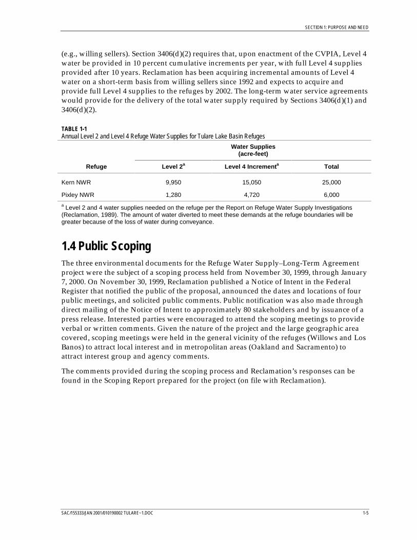
(e.g., willing sellers). Section 3406(d)(2) requires that, upon enactment of the CVPIA, Level 4water be provided in 10 percent cumulative increments per year, with full Level 4 suppliesprovided after 10 years. Reclamation has been acquiring incremental amounts of Level 4water on a short-term basis from willing sellers since 1992 and expects to acquire andprovide full Level 4 supplies to the refuges by 2002. The long-term water service agreementswould provide for the delivery of the total water supply required by Sections 3406(d)(1) and3406(d)(2).
TABLE 1-1Annual Level 2 and Level 4 Refuge Water Supplies for Tulare Lake Basin Refuges
Water Supplies(acre-feet)
Refuge Level 2a Level 4 Incrementa Total
Kern NWR 9,950 15,050 25,000
Pixley NWR 1,280 4,720 6,000
a Level 2 and 4 water supplies needed on the refuge per the Report on Refuge Water Supply Investigations(Reclamation, 1989). The amount of water diverted to meet these demands at the refuge boundaries will begreater because of the loss of water during conveyance.
1.4 Public ScopingThe three environmental documents for the Refuge Water Supply–Long-Term Agreementproject were the subject of a scoping process held from November 30, 1999, through January7, 2000. On November 30, 1999, Reclamation published a Notice of Intent in the FederalRegister that notified the public of the proposal, announced the dates and locations of fourpublic meetings, and solicited public comments. Public notification was also made throughdirect mailing of the Notice of Intent to approximately 80 stakeholders and by issuance of apress release. Interested parties were encouraged to attend the scoping meetings to provideverbal or written comments. Given the nature of the project and the large geographic areacovered, scoping meetings were held in the general vicinity of the refuges (Willows and LosBanos) to attract local interest and in metropolitan areas (Oakland and Sacramento) toattract interest group and agency comments.
The comments provided during the scoping process and Reclamation’s responses can befound in the Scoping Report prepared for the project (on file with Reclamation).

Section 2: Background
SAC/155333/JAN 2001/010190003 TULARE~2.DOC 2-1
SECTION 2
Background
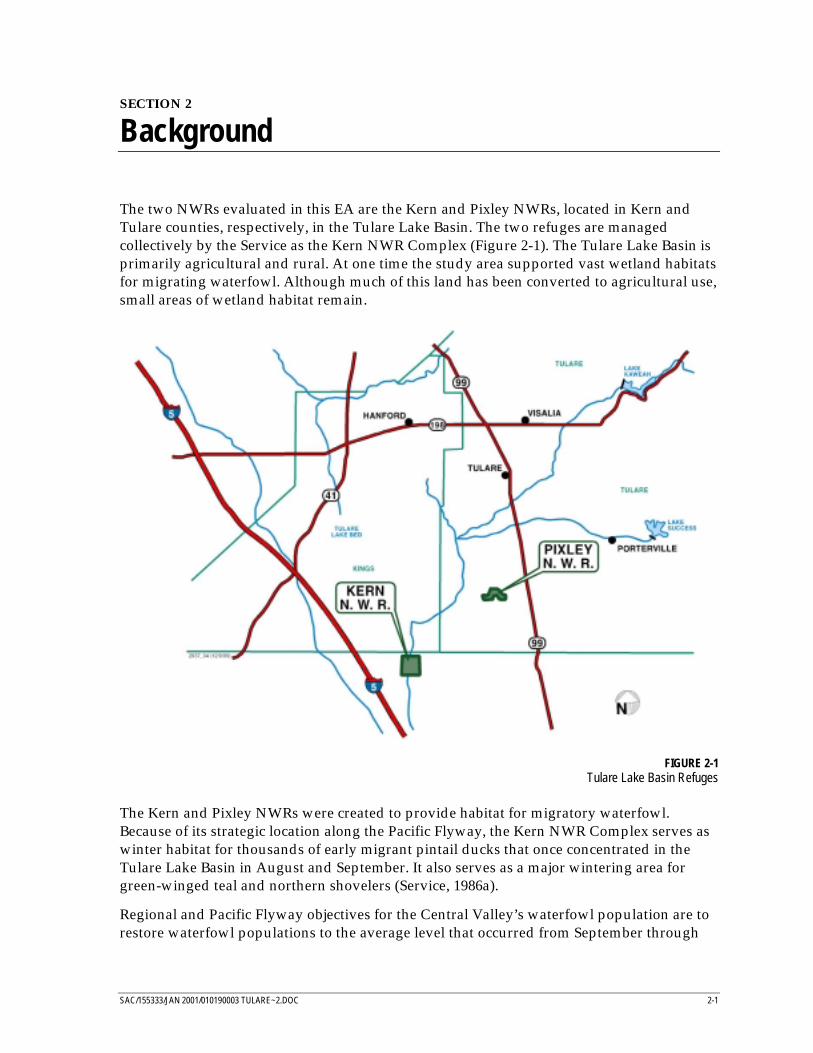
The two NWRs evaluated in this EA are the Kern and Pixley NWRs, located in Kern andTulare counties, respectively, in the Tulare Lake Basin. The two refuges are managedcollectively by the Service as the Kern NWR Complex (Figure 2-1). The Tulare Lake Basin isprimarily agricultural and rural. At one time the study area supported vast wetland habitatsfor migrating waterfowl. Although much of this land has been converted to agricultural use,small areas of wetland habitat remain.
FIGURE 2-1Tulare Lake Basin Refuges
The Kern and Pixley NWRs were created to provide habitat for migratory waterfowl.Because of its strategic location along the Pacific Flyway, the Kern NWR Complex serves aswinter habitat for thousands of early migrant pintail ducks that once concentrated in theTulare Lake Basin in August and September. It also serves as a major wintering area forgreen-winged teal and northern shovelers (Service, 1986a).
Regional and Pacific Flyway objectives for the Central Valley’s waterfowl population are torestore waterfowl populations to the average level that occurred from September through
SECTION 2: BACKGROUND
2-2 SAC/155333/JAN 2001/010190003 TULARE~2.DOC
January in the years 1972 to 1977. Specific objectives for the southern San Joaquin Valley,including the Kern and Pixley NWRs, reflect these broader goals. Kern NWR has supportedapproximately 30 percent of the southern San Joaquin Valley wintering waterfowlpopulation. However, with the loss of other wetland habitat in southern San Joaquin Valley,the Service estimates that Kern NWR must support closer to 40 percent of the futurepopulation to recover the waterfowl population to the 1972 through 1977 levels. For PixleyNWR, the Service has set the objective that the refuge should support approximately 5percent of the southern San Joaquin Valley wintering waterfowl population (Service, 1986b).
2.1 Kern National Wildlife RefugeThe Kern NWR was created by the Migratory Bird Conservation Commission in 1961. Theapproximately 10,600-acre refuge is located 6 to 7 miles east of Interstate 5, 35 milesnorthwest of Bakersfield, and 19 miles west of Delano, in northern Kern County.
The Kern NWR was established to restore a part of the wetland habitat lost because of thedrainage of Buena Vista, Kern, Goose, and Tulare lakes for agricultural use. Nearby landuses include wetlands, croplands, and uplands. Management of Kern NWR has fourobjectives (Service, 1986a):
• Provide wintering and migration habitat for waterfowl and water birds
• Preserve and improve habitats that support the endangered blunt-nosed leopard lizard,San Joaquin kit fox, and other endangered and sensitive species
• Maintain populations and habitats for native plants and animals
• Provide for public use that is compatible with the refuge’s and Service’s objectives andencourages visitors’ environmental understanding
2.1.1 Pre-CVPIA Water SuppliesNo appropriative or riparian water rights exist for Kern NWR. Before passage of the CVPIA,Kern NWR obtained water from Poso Creek and through annual contracts for State WaterProject water from Kern County Water Agency. Groundwater was used to supplement thesewater supplies. Because of inconsistent availability, none of the water supplies available toKern NWR was considered reliable.
In normal water years, water from surrounding streams and water delivery systemsprovided valley farmers with irrigation water. Excess water sometimes reached the refuge,although usually the refuge had to purchase water or pump groundwater from deep wells.In dry years, surface water had to be purchased or groundwater was pumped. During wetyears, the refuge was naturally flooded by runoff from surrounding areas (Service, 1986a).Poso Creek, which terminates at the refuge, carries flood waters to the refuge (Reclamation,1989). The Service has an agreement with the Pond-Poso Conservation District to receive allflood waters that reach the refuge via Poso Creek (Reclamation, 1989). These occasionalflood flows were used on the refuge to create wetland habitat.
In the past, the refuge has purchased water from Reclamation and the Kern County WaterAgency. Water purchased from the Kern County Water Agency was State Water Project
SECTION 2: BACKGROUND
SAC/155333/JAN 2001/010190003 TULARE~2.DOC 2-3
water delivered through the California Aqueduct to Buena Vista Water Storage Districtunder annual contracts (Reclamation, 1992). Water purchased from the Kern County WaterAgency constituted most of Kern NWR’s water supply (Reclamation, 1989) and amountedto approximately 9,950 acre-feet per year.
Nine groundwater wells supplied water to the refuge until the early 1970s, when a recedingwater table, coupled with escalating energy costs, led to the discontinued use of three of thewells. The remaining six wells have been operated on an as-needed basis in conjunctionwith the purchase of State Water Project water (Service, 1986a).
Habitat management has been hindered by the unreliable and highly variable watersupplies. As a result, the amount, duration of availability, and quality of wetland habitat onKern NWR has varied dramatically from year to year, depending on water availability.Given the limited amount of water, water conservation methods, such as land-leveling andthe use of contour dikes, have helped use limited water resources to create the greatestpossible wetland habitat. The moist soil units on Kern NWR were leveled to increase theproduction of high-carbohydrate crops, such as swamp timothy and watergrass. Use of theleveled moist soil units has provided more habitat for less water than in unleveled seasonalmarsh units. Summer water consisting of wetland flooded from fall through early summerprovides nesting habitat for sensitive species. However, in most years, no summer water hasbeen available on Kern NWR because of limited water availability. The quantity of availablesummer water has varied considerably from year to year, depending on the ability to rundeep wells, the availability of agricultural drainage water, and drought conditions.
2.1.2 Existing Water SuppliesExisting water supplies consist of the pre-CVPIA supplies and water supplies provided forin the CVPIA. With passage of the CVPIA, Kern NWR has been receiving Level 2 watersupplies. An increasing proportion of the Level 4 increment has also been delivered to KernNWR. However, Kern NWR does not currently have the infrastructure to receive anddistribute full Level 4 deliveries. As a result, Kern NWR has accepted 50 to 60 percent of fullLevel 4 deliveries for the last several years, because this is the maximum the refuge can useeffectively with the existing infrastructure. Facilities modifications and upgrades needed toeffectively and efficiently use full Level 4 water supplies were identified as part of therefuge’s Master Plan and are currently being implemented.
2.1.3 Recent Water AcquisitionsDuring the 1999/2000 water-service period (March 1, 1999, to February 28, 2000), KernNWR was entitled to receive 70 percent of Level 4 water supplies. Reclamation temporarilyacquired 10,228 acre-feet of water from Semitropic Water Storage District. A portion of thiswater was used to meet Level 4 requirements at Kern NWR, while up to 3,478 acre-feet wereallocated to meet Level 2 needs. By using some of the acquired water to meet Level 2requirements at Kern NWR, an in-kind amount of CVP water was “backed up” as federalstorage in the San Luis Reservoir to meet Level 4 requirements of other San Joaquin Valleywetland areas (Reclamation, 1999).
SECTION 2: BACKGROUND
2-4 SAC/155333/JAN 2001/010190003 TULARE~2.DOC
2.2 Pixley National Wildlife RefugeThe Pixley NWR was established in 1959 and consists of approximately 6,000 acres of grass-lands and wetlands. The refuge is located in southwestern Tulare County, approximately12 miles northeast of the Kern NWR and 5 miles southwest of the community of Pixley.Portions of the Pixley NWR lie within the historic Tulare Lake Bed.
Pixley NWR was established to restore and protect wetland habitat. In addition to providingwetland habitat, Pixley NWR currently serves an important role in supporting threatenedand endangered species. Approximately 4,392 acres are set aside as habitat for three endan-gered species, the blunt-nosed leopard lizard, the San Joaquin kit fox, and the Tiptonkangaroo rat. Wetlands, riparian habitat, and croplands make up the other primary landuses on Pixley NWR. Management of Pixley NWR has three primary objectives (Service,1986b):
• Preserve and improve habitats that support the endangered blunt-nosed leopard lizard,San Joaquin kit fox, and other endangered and sensitive species
• Maintain adequate populations of native plants and animals
• Provide habitat for migratory waterfowl and water birds, when water is available
2.2.1 Pre-CVPIA Water SuppliesThe refuge has no firm surface water supplies. Water supplies used by Pixley NWR beforepassage of the CVPIA consisted of surface water from Deer Creek and excess water fromPixley Irrigation District. Because of inconsistent availability, none of the water suppliesavailable to Pixley NWR were considered reliable.
Deer Creek is an intermittent stream that passes through the southeast corner of the refuge(Service, 1986b). During extremely wet years, when flood flows occur in Deer Creek, therefuge could divert surface water from the creek at check structures along the southernboundary of the refuge. However, these conditions rarely have occurred and flood flowsfrom Deer Creek were not considered a reliable water supply. In addition, for the purposeof groundwater recharge, Pixley Irrigation District has provided excess water to a limitedarea of the refuge.
Groundwater has been the only reliable water available to the refuge. The groundwater is ofpoor quality for agricultural irrigation, but is adequate for refuge uses. The Pixley NWRpreviously relied almost exclusively on a single groundwater well for regular water supply.The refuge is located in an area of groundwater overdraft with groundwater levels between100 and 200 feet below the ground surface. Still, the well has yielded approximately 1,280acre-feet of water per year of adequate quality (Reclamation and CDFG, 1997). Well capacityis minimally sufficient to meet Level 2 needs (Reclamation and CDFG, 1997).
Wetland habitat management on Pixley NWR has been similarly constrained by unreliableand limited water availability as it was for Kern NWR. Often, Pixley NWR did not havewater to flood its wetland units. Only in wet winters when the refuge received floodwaters,was good wetland habitat supported (Service, 1986b).
SECTION 2: BACKGROUND
SAC/155333/JAN 2001/010190003 TULARE~2.DOC 2-5
2.2.2 Existing Water SuppliesSince passage of the CVPIA, Pixley NWR has relied on its existing well to provide Level 2water supplies to the refuge. None of the Level 4 increment has been delivered to PixleyNWR because of inadequate facilities to convey the water to the refuge. Alternatives forconveying Level 4 water supplies to Pixley NWR are currently being evaluated(Reclamation, 1999).
2.2.3 Recent Water AcquisitionsNone of Pixley NWR’s Level 4 increment has been acquired because of inadequate facilitiesto deliver this water to the refuge.

Section 3: Summary of PreviousEnvironmental Documentation

SAC/155333/JAN 2001/010190004 (TULARE 003.D0C) 3-1
SECTION 3
Summary of Previous EnvironmentalDocumentation
3.1 IntroductionThe purpose of this chapter is to summarize the results of the NEPA and CEQA documentsthat recently have been completed for providing reliable water supplies for refuges and forproviding appropriate conveyance facilities for the water supplies. These documentspresented the results of evaluation of the alternatives, identified benefits and impacts,identified mitigation measures, and determined that the impacts that could not bereasonably mitigated would be acceptable due to the benefits received by the project.
The two documents completed for the Tulare Lake region refuges include the ProgrammaticEnvironmental Impact Statement (PEIS) for the CVPIA and the Conveyance of Refuge WaterSupply Environmental Assessment for the South San Joaquin Valley.
It should be recognized that under each of the descriptions presented in this chapter, referencesto "No Action Alternative" and other alternatives are specific to the reference documents not tothe alternatives described in the remaining chapters of this Environmental Assessment.
3.2 Programmatic Environmental Impact Statement
3.2.1 Overview and Use of the Programmatic Environmental Impact StatementOn October 30, 1992, the President signed into law the Reclamation Projects Authorizationand Adjustment Act of 1992 (Public Law 102-575) that included Title XXXIV, the CentralValley Project Improvement Act. The CVPIA amended the previous authorizations of theCVP to include fish and wildlife protection, restoration, and mitigation as project purposeshaving equal priority with irrigation and domestic uses and fish and wildlife enhancementas a project purpose equal to power generation. Through the CVPIA, Interior is developingpolicies and programs to improve environmental conditions that were affected byoperations, management, and physical facilities of the CVP. The CVPIA also includes toolsto facilitate larger efforts in California to improve environmental conditions in the CentralValley and the San Francisco Bay-Delta system. The PEIS addressed potential impacts andbenefits of implementing provisions of the CVPIA. The PEIS was prepared under NEPA byReclamation and the Service.
The analysis in the PEIS was intended to disclose the probable region-wide effects ofimplementing the CVPIA and provide a basis for selecting a decision among the alternatives.The PEIS was developed to allow subsequent environmental documents to incorporate PEISanalysis by reference and limit the need to re-evaluate the region-wide and cumulativeimpacts of the CVPIA. In some cases, worst-case assumptions were used to maximize theutility of the analysis for tiering within the scope of the impacts analyzed in the PEIS.
SECTION 3: SUMMARY OF PREVIOUS ENVIRONMENTAL DOCUMENTATION
3-2 SAC/155333/JAN 2001/010190004 (TULARE 003.D0C)
As the project-specific actions are considered, the lead agencies must determine if thespecific impacts were adequately analyzed in the PEIS. If the actions under considerationwere previously evaluated and the impacts of such actions would not be greater than thoseanalyzed in the PEIS or would not require additional mitigation measures, the actions couldbe considered part of the overall program previously approved in a Record of Decision. Insuch a case, an administrative decision could be made that no further environmentaldocumentation would be necessary. If a tiered document is appropriate, the tiereddocument may be an EIS or an EA. The tiered documents can use the PEIS by reference toavoid duplication and focus more narrowly on the new alternatives or more detailed site-specific effects. Therefore, only changes from the alternatives considered in the PEIS wouldbe addressed in detail in the tiered documents.
3.2.2 Use of the Programmatic Environmental Impact Statement for EnvironmentalDocumentation for Refuge Water Supply AgreementsAs described in the PEIS, the nature of the mandate of Section 3406(d)(1) of the CVPIA doesnot require compliance with NEPA before implementation, as confirmed by the Ninth CircuitCourt of Appeals. Westlands Water District v. Natural Resources Defense Council, 43 F.3d 457(9 Cir. 1994). However, the PEIS did consider three methods for hydrologic shortages of CVPwater. The alternative actions for refuge water supplies are incorporated into the PEISalternatives as part of overall CVPIA implementation, as summarized below. The PEIS did notevaluate the impacts of individual provisions of CVPIA. The PEIS evaluated the impacts ofimplementing the overall CVPIA program under several methodologies.
3.2.3 Programmatic Environmental Impact Statement AlternativesThe CVPIA identified six general purposes for the CVPIA and over 60 actions that takentogether would achieve these purposes. Individually, specific actions would not achieve theoverall objectives of the CVPIA. Therefore, the PEIS alternatives were developed to evaluate arange of actions, or programs, to meet the purposes and implement provisions of the CVPIA.
The PEIS considered a No Action Alternative, 5 Main Alternatives, including a PreferredAlternative, and 15 Supplemental Analyses.
No Action AlternativeThe PEIS No Action Alternative was used as a basis for comparison of alternatives. The NoAction Alternative included projects and policies that would be impacted by the CVPIA.The No Action Alternative reflected conditions in the Year 2025 if the CVPIA had not beenadopted. The No Action Alternative focused on the following issue areas that wereidentified through the scoping process as potentially being affected by implementation ofthe PEIS alternatives.
Water and Power Facilities and OperationsThe PEIS No Action Alternative included existing facilities and operations and projectedchanges in operational policies which were being evaluated concurrently. The PEIS NoAction Alternative included provisions in the Long-Term CVP Operations Criteria and Plan(CVP-OCAP), Reclamation’s Mid-Pacific Region guidelines, the National Marine FisheriesService (NMFS) biological opinion for winter-run chinook salmon, the Service’s biologicalopinion for Delta smelt, the Bay-Delta Plan Accord, minimum instream Trinity River flows
SECTION 3: SUMMARY OF PREVIOUS ENVIRONMENTAL DOCUMENTATION
SAC/155333/JAN 2001/010190004 (TULARE 003.D0C) 3-3
of 340,000 acre-feet/year, and opening of Red Bluff Diversion Dam gates from mid-September through mid-May. No new facilities were included in the PEIS No ActionAlternative unless the facilities design, approvals, and construction funding approvals werein existence.
The PEIS No Action Alternative assumed that unless groundwater was not physicallyavailable due to hydrogeologic conditions, groundwater would be used with full diversionof surface water to fully meet water demands.
The PEIS No Action Alternative assumed that CVP facilities would be operated primarily tomeet water rights, environmental requirements, and water supply requirements. Hydroelectricpower generation at CVP reservoirs was assumed to be incidental in the PEIS analysis.
Biological ResourcesThe PEIS No Action Alternative assumed implementation of programs that provide benefitsand impacts to the fisheries, including the Bay-Delta Plan Accord, biological opinions forwinter-run chinook salmon and delta smelt, and construction of the Shasta TemperatureControl Device. These programs were existing or being prepared prior to implementation ofCVPIA.
The PEIS No Action Alternative assumed implementation of current environmentalrequirements as defined in adopted county general plans.
The PEIS No Action Alternative also included the CVP Conservation Program. Thisprogram was developed in 1991 during the Section 7 consultation between Reclamation andthe Service for the renewal of the Friant Division water contracts. As part of thisconsultation and a subsequent consultation on interim renewal contracts, Reclamationagreed to address endangered species issues throughout the area affected by the CVP. Theprimary goal of the Conservation Program is to meet the needs, including habitat needs, ofthreatened, endangered and species of concern in the areas affected by the CVP. TheConservation Program, along with other initiatives such as Habitat Conservation Plans,would help ensure that the existing operation of the CVP would not jeopardize listed orproposed species or adversely affect designated or proposed critical habitat.
Agricultural and Urban Land Use ProjectionsThe PEIS No Action Alternative included projections concerning future growth and landuse changes based upon projections from California Department of Water ResourcesBulletin 160-93, including 45,000 acres of land projected to be retired in accordance withinthe San Joaquin Valley Drainage Plan study area.
CVP Water Use and PricingThe PEIS No Action Alternative assumed that all current long-term CVP contracts would berenewed by 2025. The total contract amount was assumed to be equal to existing contractamounts if that full contract amount had been diverted by the water user within the period of1980 through 1993 or if environmental documentation was completed to evaluate use of fullwater contract amounts. If the full contract amount had not been diverted in that period orenvironmental documentation was not completed, the contract amount was assumed to beequal to the maximum amount diverted of CVP water during the period 1980 through 1993.
SECTION 3: SUMMARY OF PREVIOUS ENVIRONMENTAL DOCUMENTATION
3-4 SAC/155333/JAN 2001/010190004 (TULARE 003.D0C)
The price of CVP water was assumed to be equal to the 1992 rates in 1992 dollars. Thepricing of CVP water for water service contracts would be at Contract Rate under therequirements of the Reclamation Reform Act.
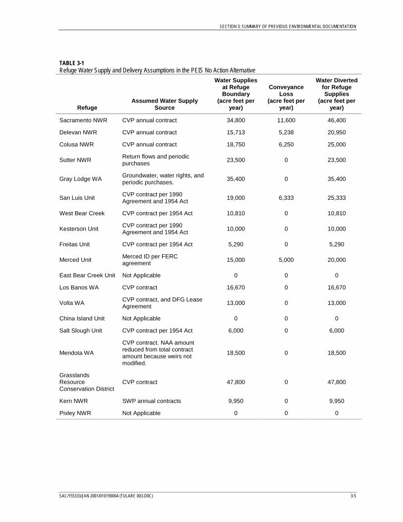
Refuge Water SuppliesThe PEIS No Action Alternative assumed that refuge water supplies are supplied fromhistorical water suppliers, including the CVP, SWP, tailwater return flows from upstreamwater users, and water rights holders. The delivery amounts assumed in the PEIS No ActionAlternative for the refuges and wetlands considered in the PEIS are shown in Table 3-1. Therefuges and wetlands considered in the PEIS are limited to those identified in the CVPIA asthe refuges addressed in the 1989 Report on Refuge Water Supply Investigation and the SanJoaquin Basin Action Plan.
PEIS AlternativesThe PEIS alternatives were developed with Core Programs and Multiple Options. The CorePrograms included the actions addressed by separate concurrent programs and CVPIAprograms that would probably be implemented in a single manner at a programmatic levelbut may require specific siting analyses. The Multiple Options included actions with severalimplementation methods that could be considered at a programmatic level.
Core Programs Included in All AlternativesThe following Core Programs are included in all of the PEIS alternatives.
• Renew all CVP service, water rights, and exchange contracts - up to existing amounts(same as No Action Alternative)
• Implement water measurement and water conservation measures - as described inReclamation Reform Act with Best Management Practices with measurement at point ofdiversion and point of use (same conservation measures but without measurement inNo Action Alternative)
• Implement non-flow improvements - as described in the preliminary Anadromous FishRestoration Program (no improvements in No Action Alternative)
• Implement (b)(1) “other” program - as the next phase of the Conservation Program(base program in No Action Alternative)
• Upgrade Tracy and Contra Costa pumping plants fish protection facilities - (noimprovements in No Action Alternative)
• Construct Shasta Temperature Control Device - same as No Action Alternative
• Complete improvements to Coleman National Fish Hatchery - no improvements in NoAction Alternative
• Complete habitat improvements in Clear Creek - as described in the preliminaryAnadromous Fish Restoration Program (no improvements in No Action Alternative)
• Implement non-flow stream restoration actions to replace gravels in Central Valleystreams - as described in the preliminary Anadromous Fish Restoration Program (noimprovements in No Action Alternative)
SECTION 3: SUMMARY OF PREVIOUS ENVIRONMENTAL DOCUMENTATION
SAC/155333/JAN 2001/010190004 (TULARE 003.D0C) 3-5
TABLE 3-1Refuge Water Supply and Delivery Assumptions in the PEIS No Action Alternative
RefugeAssumed Water Supply
Source
Water Suppliesat RefugeBoundary
(acre feet peryear)
ConveyanceLoss
(acre feet peryear)
Water Divertedfor RefugeSupplies
(acre feet peryear)
Sacramento NWR CVP annual contract 34,800 11,600 46,400
Delevan NWR CVP annual contract 15,713 5,238 20,950
Colusa NWR CVP annual contract 18,750 6,250 25,000
Sutter NWRReturn flows and periodicpurchases 23,500 0 23,500
Gray Lodge WAGroundwater, water rights, andperiodic purchases. 35,400 0 35,400
San Luis Unit CVP contract per 1990Agreement and 1954 Act 19,000 6,333 25,333
West Bear Creek CVP contract per 1954 Act 10,810 0 10,810
Kesterson Unit CVP contract per 1990Agreement and 1954 Act 10,000 0 10,000
Freitas Unit CVP contract per 1954 Act 5,290 0 5,290
Merced Unit Merced ID per FERCagreement 15,000 5,000 20,000
East Bear Creek Unit Not Applicable 0 0 0
Los Banos WA CVP contract 16,670 0 16,670
Volta WA CVP contract, and DFG LeaseAgreement 13,000 0 13,000
China Island Unit Not Applicable 0 0 0
Salt Slough Unit CVP contract per 1954 Act 6,000 0 6,000
Mendota WA
CVP contract. NAA amountreduced from total contractamount because weirs notmodified.
18,500 0 18,500
GrasslandsResourceConservation District
CVP contract 47,800 0 47,800
Kern NWR SWP annual contracts 9,950 0 9,950
Pixley NWR Not Applicable 0 0 0
SECTION 3: SUMMARY OF PREVIOUS ENVIRONMENTAL DOCUMENTATION
3-6 SAC/155333/JAN 2001/010190004 (TULARE 003.D0C)
• Complete modifications to Anderson-Cottonwood Irrigation District and Glenn-Colusa Irrigation District diversion facilities for fish protection - no improvements inNo Action Alternative
• Improve fish passage - no improvements in No Action Alternative
• Implement seasonal field flooding of up to 80,000 acres to enhance waterfowlhabitat - no improvements in No Action Alternative
• Purchase up to 30,000 acres of retired land within San Joaquin Valley Drainage Planstudy area – this area selected for purposes of PEIS analysis only (in addition to45,000 acres purchased under the No Action Alternative)
Multiple Options Included in Different AlternativesThe following multiple options were combined into four Alternatives, 15 SupplementalAnalyses, and the Preferred Alternative.
• Implement Fish and Wildlife Actions per Sections 3406(b)(2) and (3) of CVPIA
− Preferred Alternative assumed reoperation of the CVP supplies under Section3406(b)(2) and acquisition of water from willing sellers under Section 3406(b)(3) forimprovement of flows on tributaries to the Delta, to meet portions of the Bay-DeltaPlan Accord, and Delta outflow. Approximately 50 percent of the acquired watercould not be exported by CVP and SWP. Acquisition of water from willing sellers isconstrained by existing funding limits.
− Alternative 1 and Supplemental Analyses 1b through 1i assumed reoperation ofthe CVP supplies under Section 3406(b)(2) for improvement of flows on tributaries tothe Delta and to meet portions of the Bay-Delta Plan Accord.
− Supplemental Analysis 1a assumed reoperation of the CVP supplies under Section3406(b)(2) for improvement of flows on tributaries to the Delta, to meet portions ofthe Bay-Delta Plan Accord, and Delta outflow.
− Alternative 2 and Supplemental Analyses 2a through 2d assumed re-operation ofthe CVP supplies under Section 3406(b)(2) and acquisition of water from willingsellers under Section 3406(b)(3) to improve instream flows, to meet portions of theBay-Delta Plan Accord, and Delta outflow. Acquired water could not be exported bythe CVP and SWP. Acquisition of water from willing sellers is constrained byexisting funding limits.
− Alternative 3 and Supplemental Analysis 3a assumed reoperation of the CVPsupplies under Section 3406(b)(2) and acquisition of water from willing sellers underSection 3406(b)(3) for improvement of flows on tributaries to the Delta and to meetportions of the Bay-Delta Plan Accord. Acquired water could be exported by theCVP and SWP. Acquisition of water from willing sellers is not constrained byexisting funding limits.
− Alternative 4 and Supplemental Analysis 4a assumed reoperation of the CVPsupplies under Section 3406(b)(2) and acquisition of water from willing sellers underSection 3406(b)(3) for improvement of flows on tributaries to the Delta, to meet
SECTION 3: SUMMARY OF PREVIOUS ENVIRONMENTAL DOCUMENTATION
SAC/155333/JAN 2001/010190004 (TULARE 003.D0C) 3-7
portions of the Bay-Delta Plan Accord, and Delta outflow. Acquired water could notbe exported by the CVP and SWP. Acquisition of water from willing sellers is notconstrained by existing funding limits.
− No Action Alternative assumed use of CVP water to meet portions of the Bay-DeltaPlan Accord.
• Implement Water Pricing Actions
− Preferred Alternative; Alternatives 1, 2, 3, and 4; and Supplemental Analyses 1a,1b, 1d through 1f, 1h, 1i, 2a through 2c, 3a, and 4a assumed 80 percent of contractamount at Contract Rate, top 10 percent of contract amount at Full Cost Rate, andmiddle 10 percent of contract amount at blended rate assuming continuation ofAbility-to-Pay policy.
− Supplemental Analyses 1c and 2d assumed 80 percent of contract amount at FullCost Rate, next 10 percent of contract amount at 110 percent of Full Cost Rate, andtop 10 percent of contract amount at 120 percent of Full Cost Rate assumingcontinuation of Ability-to-Pay policy.
− Supplemental Analysis 1g assumed 80 percent of contract amount at Contract Rate,top 10 percent of contract amount at Full Cost Rate, and middle 10 percent ofcontract amount at blended rate without Ability-to-Pay policy.
− No Action Alternative assumed 100 percent of contract amount at Contract Rateassuming continuation of Ability-to-Pay policy.
• Modify Red Bluff Diversion Dam
− Preferred Alternative indicated that this action would be determined followingadditional studies.
− Alternatives 1, 2, 3, and 4; Supplemental Analyses 1a through 1h, 2a through 2d,3a, and 4a; and No Action Alternative assumed gates open mid-September throughmid-May.
− Supplemental Analysis 1i assumed gates open all year with a new facility to deliverwater.
• Construct Delta Fish Barriers
− Preferred Alternative indicated that this action would be determined followingadditional studies.
− Alternatives 1, 2, 3, and 4; Supplemental Analyses 1a, 1c through 1e, 1g through 1i,2b through 2d, 3a, and 4a; and No Action Alternative assumed non-structuralbarriers at Old River and Georgiana Slough.
− Supplemental Analyses 1b and 2a assumed structural barriers at Old River andGeorgiana Slough.
SECTION 3: SUMMARY OF PREVIOUS ENVIRONMENTAL DOCUMENTATION
3-8 SAC/155333/JAN 2001/010190004 (TULARE 003.D0C)
• Provide for Water Transfers
− Preferred Alternative and Supplemental Analyses 1e, 2b, 3a, and 4a assumed CVPIAwater transfers with basic CVPIA transfer fees.
− Alternatives 1, 2, 3, and 4; Supplemental Analyses 1a through 1c, 1f through 1i, 2a,and 2d; and No Action Alternative assumed only non-CVPIA water transfers.
− Supplemental Analyses 1f and 2c assumed CVPIA water transfers with basicCVPIA transfer fees plus $50/acre-foot fee.
• Revegetate up to 30,000 acres Retired Lands
− Preferred Alternative and Supplemental Analysis 1h assumed revegetation andrestoration of retired lands without need for water supplies.
− Alternatives 1, 2, 3, and 4; Supplemental Analyses 1a through 1g, 1i, 2a through 2d,3a, and 4a; and No Action Alternative assumed no revegetation or restoration ofretired lands.
• Refuge Water Supplies
− Preferred Alternative assumed Level 2 and 4 water supplies as shown in Table 3-2subject to hydrologic shortages described by the 40-30-30 Index with a maximumshortage of 25 percent of the total amount.
− Alternative 1 and Supplemental Analyses 1a through 1c and 1e through 1iassumed Level 2 water supplies, as shown in Table 3-3 subject to hydrologicshortages described by the Shasta criteria with a maximum shortage of 25 percent ofthe total amount.
− Supplemental Analysis 1d assumed Level 2 water supplies, as shown in Table 3-2subject to no hydrologic shortages.
− Alternatives 2, 3, and 4 and Supplemental Analyses 2a through 2d, 3a, and 4aassumed Level 2 and 4 water supplies as shown in Table 3-2 subject to hydrologicshortages described by the Shasta criteria with a maximum shortage of 25 percent ofthe total amount.
− No Action Alternative assumed existing water supplies at the time of adoption ofCVPIA as shown in Table 3-1 subject to hydrologic shortages described by the40-30-30 Index with a maximum shortage of 25 percent of the total amount.
Summary of Overall Analyses of PEIS AlternativesThe alternatives considered in the PEIS were analyzed to determine the potential foradverse and beneficial impacts associated with implementation of all actions as compared tocontinuation of the No Action Alternative conditions. The results of this analysis aresummarized in Table 3-4. The most significant changes under the alternatives as comparedto the No Action Alternative were related to surface water and groundwater facilitiesoperations and deliveries, power generation, fishery resources, agricultural land use andeconomics, and waterfowl habitat.
SECTION 3: SUMMARY OF PREVIOUS ENVIRONMENTAL DOCUMENTATION
SAC/155333/JAN 2001/010190004 (TULARE 003.D0C) 3-9
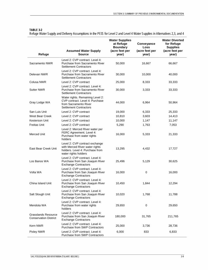
TABLE 3-2Refuge Water Supply and Delivery Assumptions in the PEIS for Level 2 and Level 4 Water Supplies in Alternatives 2,3, and 4
RefugeAssumed Water Supply
Source
Water Suppliesat RefugeBoundary
(acre feet peryear)
ConveyanceLoss
(acre feet peryear)
Water Divertedfor RefugeSupplies
(acre feet peryear)
Sacramento NWRLevel 2: CVP contract. Level 4:Purchase from Sacramento RiverSettlement Contractors
50,000 16,667 66,667
Delevan NWRLevel 2: CVP contract. Level 4:Purchase from Sacramento RiverSettlement Contractors
30,000 10,000 40,000
Colusa NWR Level 2: CVP contract 25,000 8,333 33,333
Sutter NWRLevel 2: CVP contract. Level 4:Purchase from Sacramento RiverSettlement Contractors
30,000 3,333 33,333
Gray Lodge WA
Water rights. Remaining Level 2:CVP contract. Level 4: Purchasefrom Sacramento RiverSettlement Contractors
44,000 6,964 50,964
San Luis Unit Level 2: CVP contract 19,000 6,333 25,333
West Bear Creek Level 2: CVP contract 10,810 3,603 14,413
Kesterson Unit Level 2: CVP contract 10,000 1,147 11,147
Freitas Unit Level 2: CVP contract 5,290 1,763 7,053
Merced Unit
Level 2: Merced River water perFERC Agreement. Level 4:Purchase from water rightsholders
16,000 5,333 21,333
East Bear Creek Unit
Level 2: CVP contract exchangewith Merced River water rightsholders. Level 4: Purchase fromwater rights holders
13,295 4,432 17,727
Los Banos WALevel 2: CVP contract. Level 4:Purchase from San Joaquin RiverExchange Contractors
25,496 5,129 30,625
Volta WALevel 2: CVP contract. Level 4:Purchase from San Joaquin RiverExchange Contractors
16,000 0 16,000
China Island UnitLevel 2: CVP contract. Level 4:Purchase from San Joaquin RiverExchange Contractors
10,450 1,844 12,294
Salt Slough UnitLevel 2: CVP contract. Level 4:Purchase from San Joaquin RiverExchange Contractors
10,020 1,768 11,788
Mendota WALevel 2: CVP contract. Level 4:Purchase from water rightsholders
29,650 0 29,650
Grasslands ResourceConservation District
Level 2: CVP contract. Level 4:Purchase from San Joaquin RiverExchange Contractors
180,000 31,765 211,765
Kern NWR Level 2: CVP contract. Level 4:Purchase from SWP Contractors 25,000 3,736 28,736
Pixley NWR Level 2: CVP contract. Level 4:Purchase from SWP Contractors
6,000 833 6,833
SECTION 3: SUMMARY OF PREVIOUS ENVIRONMENTAL DOCUMENTATION
3-10 SAC/155333/JAN 2001/010190004 (TULARE 003.D0C)
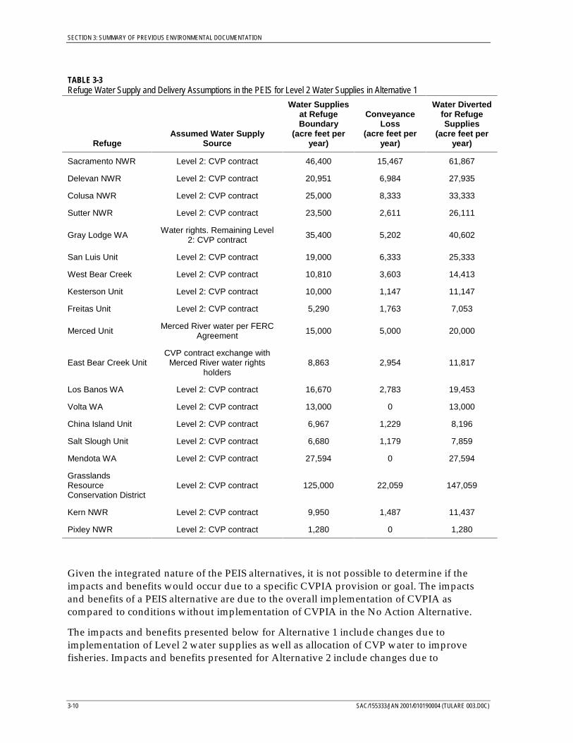
TABLE 3-3Refuge Water Supply and Delivery Assumptions in the PEIS for Level 2 Water Supplies in Alternative 1
RefugeAssumed Water Supply
Source
Water Suppliesat RefugeBoundary
(acre feet peryear)
ConveyanceLoss
(acre feet peryear)
Water Divertedfor RefugeSupplies
(acre feet peryear)
Sacramento NWR Level 2: CVP contract 46,400 15,467 61,867
Delevan NWR Level 2: CVP contract 20,951 6,984 27,935
Colusa NWR Level 2: CVP contract 25,000 8,333 33,333
Sutter NWR Level 2: CVP contract 23,500 2,611 26,111
Gray Lodge WA Water rights. Remaining Level2: CVP contract 35,400 5,202 40,602
San Luis Unit Level 2: CVP contract 19,000 6,333 25,333
West Bear Creek Level 2: CVP contract 10,810 3,603 14,413
Kesterson Unit Level 2: CVP contract 10,000 1,147 11,147
Freitas Unit Level 2: CVP contract 5,290 1,763 7,053
Merced Unit Merced River water per FERCAgreement 15,000 5,000 20,000
East Bear Creek UnitCVP contract exchange with
Merced River water rightsholders
8,863 2,954 11,817
Los Banos WA Level 2: CVP contract 16,670 2,783 19,453
Volta WA Level 2: CVP contract 13,000 0 13,000
China Island Unit Level 2: CVP contract 6,967 1,229 8,196
Salt Slough Unit Level 2: CVP contract 6,680 1,179 7,859
Mendota WA Level 2: CVP contract 27,594 0 27,594
GrasslandsResourceConservation District
Level 2: CVP contract 125,000 22,059 147,059
Kern NWR Level 2: CVP contract 9,950 1,487 11,437
Pixley NWR Level 2: CVP contract 1,280 0 1,280
Given the integrated nature of the PEIS alternatives, it is not possible to determine if theimpacts and benefits would occur due to a specific CVPIA provision or goal. The impactsand benefits of a PEIS alternative are due to the overall implementation of CVPIA ascompared to conditions without implementation of CVPIA in the No Action Alternative.
The impacts and benefits presented below for Alternative 1 include changes due toimplementation of Level 2 water supplies as well as allocation of CVP water to improvefisheries. Impacts and benefits presented for Alternative 2 include changes due to
SECTION 3: SUMMARY OF PREVIOUS ENVIRONMENTAL DOCUMENTATION
SAC/155333/JAN 2001/010190004 (TULARE 003.D0C) 3-11
implementation of Level 4 water supplies and acquisition of water from non-CVP waterservice contractors to improve fisheries. Impacts and benefits for Alternatives 3 and 4primarily include changes due to acquisition and use of water from non-CVP water servicecontractors to improve fisheries at higher levels than under Alternative 2.
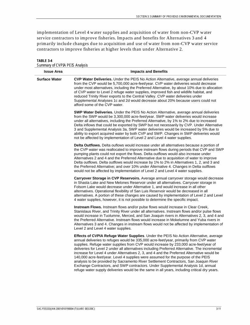
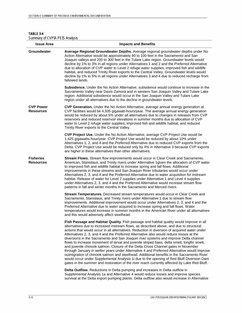
TABLE 3-4Summary of CVPIA PEIS Analysis
Issue Area Impacts and Benefits
Surface Water CVP Water Deliveries. Under the PEIS No Action Alternative, average annual deliveriesfrom the CVP would be 5,700,000 acre-feet/year. CVP water deliveries would decreaseunder most alternatives, including the Preferred Alternative, by about 10% due to allocationof CVP water to Level 2 refuge water supplies, improved fish and wildlife habitat, andreduced Trinity River exports to the Central Valley. CVP water deliveries underSupplemental Analyses 1c and 2d would decrease about 20% because users could notafford some of the CVP water.
SWP Water Deliveries. Under the PEIS No Action Alternative, average annual deliveriesfrom the SWP would be 3,300,000 acre-feet/year. SWP water deliveries would increaseunder all alternatives, including the Preferred Alternative, by 1% to 2% due to increasedDelta inflows that could be exported by SWP but not necessarily by CVP. Under Alternative3 and Supplemental Analysis 3a, SWP water deliveries would be increased by 5% due toability to export acquired water by both CVP and SWP. Changes in SWP deliveries wouldnot be affected by implementation of Level 2 and Level 4 water supplies.
Delta Outflows. Delta ouflows would increase under all alternatives because a portion ofthe CVP water was reallocated to improve instream flows during periods that CVP and SWPpumping plants could not export the flows. Delta outflows would also increase underAlternatives 2 and 4 and the Preferred Alternative due to acquisition of water to improveDelta outflows. Delta outflows would increase by 1% to 2% in Alternatives 1, 2, and 3 andthe Preferred Alternative; and over 10% under Alternative 4. Changes in Delta outflowswould not be affected by implementation of Level 2 and Level 4 water supplies.
Carryover Storage in CVP Reservoirs. Average annual carryover storage would decreasein Shasta Lake and New Melones Reservoir under all alternatives. Carryover storage inFolsom Lake would decrease under Alternative 1, and would increase in all otheralternatives. Operational flexibility of San Luis Reservoir would be decreased in allalternatives. A portion of these changes are caused by implementation of Level 2 and Level4 water supplies, however, it is not possible to determine the specific impact.
Instream Flows. Instream flows and/or pulse flows would increase in Clear Creek,Stanislaus River, and Trinity River under all alternatives. Instream flows and/or pulse flowswould increase in Tuolumne, Merced, and San Joaquin rivers in Alternatives 2, 3, and 4 andthe Preferred Alternative. Instream flows would increase in Mokelumne and Yuba rivers inAlternatives 3 and 4. Changes in instream flows would not be affected by implementation ofLevel 2 and Level 4 water supplies.
Effects of CVPIA Refuge Water Supplies. Under the PEIS No Action Alternative, averageannual deliveries to refuges would be 335,000 acre-feet/year, primarily from CVP watersupplies. Refuge water supplies from CVP would increase by 233,000 acre-feet/year ofdeliveries for Level 2 under all alternatives including Preferred Alternative. The incrementalincrease for Level 4 under Alternatives 2, 3, and 4 and the Preferred Alternative would be140,000 acre-feet/year. Level 4 supplies were assumed for the purpose of the PEISanalysis to be provided by Sacramento River Settlement Contractors, San Joaquin RiverExchange Contractors, and SWP contractors. Under Supplemental Analysis 1d, annualrefuge water supply deliveries would be the same in all years, including critical dry years.
SECTION 3: SUMMARY OF PREVIOUS ENVIRONMENTAL DOCUMENTATION
3-12 SAC/155333/JAN 2001/010190004 (TULARE 003.D0C)
TABLE 3-4Summary of CVPIA PEIS Analysis
Issue Area Impacts and Benefits
Groundwater Average Regional Groundwater Depths. Average regional groundwater depths under NoAction Alternative would be approximately 90 to 100 feet in the Sacramento and SanJoaquin valleys and 200 to 300 feet in the Tulare Lake region. Groundwater levels woulddecline by 1% to 3% in all regions under Alternatives 1 and 2 and the Preferred Alternativedue to allocation of CVP water to Level 2 refuge water supplies, improved fish and wildlifehabitat, and reduced Trinity River exports to the Central Valley. Groundwater levels woulddecline by 1% to 5% in all regions under Alternatives 3 and 4 due to reduced recharge fromfallowed lands.
Subsidence. Under the No Action Alternative, subsidence would continue to increase in theSacramento Valley near Davis-Zamora and in western San Joaquin Valley and Tulare Lakeregion. Additional subsidence would occur in the San Joaquin Valley and Tulare Lakeregion under all alternatives due to the decline in groundwater levels.
CVP PowerResources
CVP Generation. Under the No Action Alternative, average annual energy generation atCVP facilities would be 4,935 gigawatt-hours/year. The average annual energy generationwould be reduced by about 5% under all alternatives due to changes in releases from CVPreservoirs and reduced reservoir elevations in summer months due to allocation of CVPwater to Level 2 refuge water supplies, improved fish and wildlife habitat, and reducedTrinity River exports to the Central Valley.
CVP Project Use. Under the No Action Alternative, average CVP Project Use would be1,425 gigawatts-hour/year. CVP Project Use would be reduced by about 10% underAlternatives 1, 2, and 4 and the Preferred Alternative due to reduced CVP exports from theDelta. CVP Project Use would be reduced only by 4% in Alternative 3 because CVP exportsare higher in these alternatives than other alternatives.
FisheriesResources
Stream Flows. Stream flow improvements would occur in Clear Creek and Sacramento,American, Stanislaus, and Trinity rivers under Alternative 1given the allocation of CVP waterto improved fish and wildlife habitat to increase spring and fall flows. Additionalimprovements in these streams and San Joaquin River tributaries would occur underAlternatives 2, 3, and 4 and the Preferred Alternative due to water acquisition for instreamhabitat. Release of water for Level 2 supplies under Alternative 1 and Level 4 suppliesunder Alternatives 2, 3, and 4 and the Preferred Alternative would increase stream flowpatterns in fall and winter months in the Sacramento and Merced rivers.
Stream Temperatures. Decreased stream temperatures would occur in Clear Creek andSacramento, Stanislaus, and Trinity rivers under Alternative 1 due to stream flowimprovements. Additional improvement would occur under Alternatives 2, 3, and 4 and thePreferred Alternative due to water acquired to increase spring and fall flows. Watertemperatures would increase in summer months in the American River under all alternativesand this would adversely affect steelhead.
Fish Passage and Habitat Quality. Fish passage and habitat quality would improve in allalternatives due to increased instream flows, as described above, and due to structuralactions that would occur in all alternatives. Reduction in diversion of acquired water underAlternatives 2, 3, and 4 and the Preferred Alternative also would reduce losses at thediversions in the Sacramento and San Joaquin river systems and improve Delta channelflows to increase movement of larval and juvenile striped bass, delta smelt, longfin smelt,and juvenile chinook salmon. Closure of the Delta Cross Channel gates in Novemberthrough January in wetter years under Alternative 4 and Preferred Alternative would improveoutmigration of chinook salmon and steelhead. Additional benefits in the Sacramento Riverwould occur under Supplemental Analysis 1i due to the opening of Red Bluff Diversion Damgates in the summer and restoration of the river reach currently affected by Lake Red Bluff.
Delta Outflow. Reductions in Delta pumping and increases in Delta outflow inSupplemental Analysis 1a and Alternative 4 would reduce losses and improve speciessurvival at the Delta export pumping plants. Delta outflow also would increase in Alternative
SECTION 3: SUMMARY OF PREVIOUS ENVIRONMENTAL DOCUMENTATION
SAC/155333/JAN 2001/010190004 (TULARE 003.D0C) 3-13
TABLE 3-4Summary of CVPIA PEIS Analysis
Issue Area Impacts and Benefits
2 and the Preferred Alternative due to the use of acquired water for increased Delta outflow.
Vegetation andWildlifeResources
Retired and Fallowed Agricultural Lands. The No Action Alternative assumes retirementof 45,000 acres of land identified in the San Joaquin Valley Drainage Plan as havingdrainage problems. An additional 30,000 acres would be retired under all alternativesincluding the Preferred Alternative. Additional habitat would occur due to fallowing of 0.3 to3% of irrigated areas in the Central Valley under the alternatives including PreferredAlternative due to allocation of CVP water to Level 2 refuge water supplies, improved fishand wildlife habitat, reduced Trinity River exports to the Central Valley and wateracquisitions for instream flows and Level 4 water supplies.
Riparian Restoration. Riparian restoration would occur along the Sacramento and SanJoaquin river systems due to habitat improvements under all alternatives. Additionalrestoration would occur under Alternatives 2, 3, and 4 and Preferred Alternative due toacquired water under increased instream flows.
Flooded Fields. Up to 80,000 acres of agricultural fields would be flooded to provideadditional habitat for waterfowl under Alternatives 1, 2, 3, and 4 through the implementationof Incentive Payments. The CVPIA stated that this program should be funded through theRestoration Fund only through 2002. The PEIS Alternatives 1, 2, 3, and 4 assumedcontinued funding through 2025. The Preferred Alternative assumed no funding through theRestoration Fund in 2025, but suggested that field flooding continue.
Refuge Water Supplies. Habitat and waterfowl population would increase under Alternative1 due to Level 2 water supplies. Additional increases would occur under Alternatives 2, 3,and 4 and Preferred Alternative due to Level 4 water supplies.
Recreation andRecreationalEconomics
Opportunities at Reservoirs. As a result of lower surface elevations at Shasta Lake andNew Melones Reservoir due to allocation of CVP water to Level 2 refuge water supplies,improved fish and wildlife habitat, and reduced Trinity River exports to the Central Valley,boating opportunities would be reduced and boat ramps would need to be extended underall alternatives. Boating opportunities would be improved due to higher reservoir levels inFolsom Lake and Lake Oroville under all alternatives including the Preferred Alternative.
Opportunities at Rivers. As a result of increased flows in the upper Sacramento River andStanislaus River in peak season due to allocation of CVP water to Level 2 refuge watersupplies, improved fish and wildlife habitat, and reduced Trinity River exports to the CentralValley, swimming opportunities would increase under all alternatives. Lower flows in peakseason on the American River would decrease swimming opportunities under allalternatives including the Preferred Alternative.
Flat-water recreational opportunities near Red Bluff would decline under SupplementalAnalysis 1i. Boat access may be restricted near the physical barriers in Georgiana Sloughand Old River under Supplemental Analyses 1b and 2a.
Increased stream flows on the San Joaquin River tributaries and San Joaquin River underAlternatives 2, 3, and 4 and the Preferred Alternative and on the Sacramento Rivertributaries under Alternatives 3 and 4 and the Preferred Alternative could increaserecreational opportunities.
Opportunities on Refuges. Recreational opportunities on the refuges would increaseunder Alternative 1 due to Level 2 water supplies. Additional increases would occur underAlternatives 2, 3, and 4 and Preferred Alternative due to Level 4 water supplies.
Economic Impacts and Benefits. Recreation-related expenditures would increase about3% at reservoirs and rivers under all alternatives. Recreation-related expenditures atrefuges would increase about 25% under Alternative 1 due to Level 2 water supplies, and70% under Alternatives 2, 3, and 4 and the Preferred Alternative due to Level 4 watersupplies.
SECTION 3: SUMMARY OF PREVIOUS ENVIRONMENTAL DOCUMENTATION
3-14 SAC/155333/JAN 2001/010190004 (TULARE 003.D0C)
TABLE 3-4Summary of CVPIA PEIS Analysis
Issue Area Impacts and Benefits
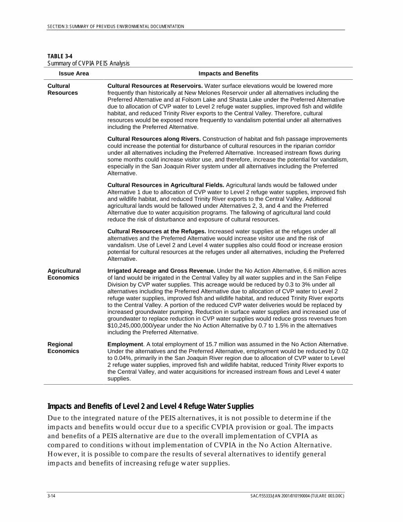
CulturalResources
Cultural Resources at Reservoirs. Water surface elevations would be lowered morefrequently than historically at New Melones Reservoir under all alternatives including thePreferred Alternative and at Folsom Lake and Shasta Lake under the Preferred Alternativedue to allocation of CVP water to Level 2 refuge water supplies, improved fish and wildlifehabitat, and reduced Trinity River exports to the Central Valley. Therefore, culturalresources would be exposed more frequently to vandalism potential under all alternativesincluding the Preferred Alternative.
Cultural Resources along Rivers. Construction of habitat and fish passage improvementscould increase the potential for disturbance of cultural resources in the riparian corridorunder all alternatives including the Preferred Alternative. Increased instream flows duringsome months could increase visitor use, and therefore, increase the potential for vandalism,especially in the San Joaquin River system under all alternatives including the PreferredAlternative.
Cultural Resources in Agricultural Fields. Agricultural lands would be fallowed underAlternative 1 due to allocation of CVP water to Level 2 refuge water supplies, improved fishand wildlife habitat, and reduced Trinity River exports to the Central Valley. Additionalagricultural lands would be fallowed under Alternatives 2, 3, and 4 and the PreferredAlternative due to water acquisition programs. The fallowing of agricultural land couldreduce the risk of disturbance and exposure of cultural resources.
Cultural Resources at the Refuges. Increased water supplies at the refuges under allalternatives and the Preferred Alternative would increase visitor use and the risk ofvandalism. Use of Level 2 and Level 4 water supplies also could flood or increase erosionpotential for cultural resources at the refuges under all alternatives, including the PreferredAlternative.
AgriculturalEconomics
Irrigated Acreage and Gross Revenue. Under the No Action Alternative, 6.6 million acresof land would be irrigated in the Central Valley by all water supplies and in the San FelipeDivision by CVP water supplies. This acreage would be reduced by 0.3 to 3% under allalternatives including the Preferred Alternative due to allocation of CVP water to Level 2refuge water supplies, improved fish and wildlife habitat, and reduced Trinity River exportsto the Central Valley. A portion of the reduced CVP water deliveries would be replaced byincreased groundwater pumping. Reduction in surface water supplies and increased use ofgroundwater to replace reduction in CVP water supplies would reduce gross revenues from$10,245,000,000/year under the No Action Alternative by 0.7 to 1.5% in the alternativesincluding the Preferred Alternative.
RegionalEconomics
Employment. A total employment of 15.7 million was assumed in the No Action Alternative.Under the alternatives and the Preferred Alternative, employment would be reduced by 0.02to 0.04%, primarily in the San Joaquin River region due to allocation of CVP water to Level2 refuge water supplies, improved fish and wildlife habitat, reduced Trinity River exports tothe Central Valley, and water acquisitions for increased instream flows and Level 4 watersupplies.
Impacts and Benefits of Level 2 and Level 4 Refuge Water SuppliesDue to the integrated nature of the PEIS alternatives, it is not possible to determine if theimpacts and benefits would occur due to a specific CVPIA provision or goal. The impactsand benefits of a PEIS alternative are due to the overall implementation of CVPIA ascompared to conditions without implementation of CVPIA in the No Action Alternative.However, it is possible to compare the results of several alternatives to identify generalimpacts and benefits of increasing refuge water supplies.
SECTION 3: SUMMARY OF PREVIOUS ENVIRONMENTAL DOCUMENTATION
SAC/155333/JAN 2001/010190004 (TULARE 003.D0C) 3-15
Impacts on Surface Water SuppliesUnder the PEIS No Action Alternative, average annual deliveries to refuges would be335,000 acre-feet/year, primarily from CVP water supplies. Refuge water supplies fromCVP would increase by 233,000 acre-feet/year to 568,000 acre-feet/year for Level 2 under allalternatives including Preferred Alternative. This would result in a decrease in CVP waterdeliveries, however the specific amount is difficult to determine due to the integratedimplementation of CVPIA provisions. The PEIS alternatives assume that the water would bediverted under the monthly patterns described in the 1989 Report on Refuge Water SupplyInvestigation, and all of the return flows would be discharged from the refuges in March. ThePEIS also assumed allocation of the entire amount of Level 2 water supplies from CVPwater. This may overestimate the impacts to CVP users if existing non-CVP water suppliescontinue to be used in the future.
Allocation of CVP water for Level 2 water supplies would reduce CVP water deliveries,especially south of the Delta because the refuges have a higher water supply reliability thanthe agricultural or municipal and industrial CVP water service contractors. Therefore,delivery of refuge water supplies may reduce the remaining capacity in the Tracy pumpingplant or San Luis Reservoir in some months, especially in Below Normal or Dry water years.Allocation of CVP water for Level 2 water supplies also would reduce the amount of CVPwater available for use by water service contractors. However, it is not possible to specifythe impact only due to Level 2 refuge water supplies.
The overall impact of allocating CVP water towards meeting Section 3406(b)(2) of CVPIArequirements in Alternative 1 was to allocate up to 800,000 acre-feet/year as measured by areduction in CVP water service contract deliveries. Following the determination of the"(b)(2) Water Management" component, the analysis of Alternative 1 continued withallocation of CVP water to Level 2 water supplies and reduction of CVP water supplies dueto increased instream flows in the Trinity River. The overall impact of Alternative 1 (RevisedAlternative 1 as presented in the Final PEIS) was to reduce water deliveries to CVP waterusers by 5 percent on an average annual basis and up to 8 percent in dry periods. The refugewater supplies were reduced by up to 25 percent in dry periods in accordance with the 40-30-30 Index in the No Action Alternative and Revised Alternative 1. The 40-30-30 Index issimilar in frequency to the Shasta Index which is used to determine hydrologic deficienciesfor deliveries to the Sacramento Settlement Contractors and Delta Mendota ExchangeContractors except that during the study period of 1922 – 1990, the 40-30-30 Index wouldidentify dry year hydrologic conditions in one more year than the Shasta Index.
Under Supplemental Analysis 1d, refuge water supply deliveries would not be reduced indry periods. This increased water supply reliability for the refuges would reduce CVPdeliveries by an additional 0.5 percent in drier periods.
Impacts on CVP water service contractors under the Preferred Alternative would be higherthan Revised Alternative 1 due to a different method to allocate water under "(b)(2) watermanagement." Water deliveries to CVP water users would be reduced by 10 percent on anaverage annual basis and up to 13 percent in dry periods. The refuge water supplies werereduced by up to 25 percent in critically dry periods in accordance with the 40-30-30 Indexin the No Action Alternative and the Preferred Alternative.
SECTION 3: SUMMARY OF PREVIOUS ENVIRONMENTAL DOCUMENTATION
3-16 SAC/155333/JAN 2001/010190004 (TULARE 003.D0C)
The incremental increase for Level 4 under Alternatives 2, 3, and 4 and the PreferredAlternative would be 140,000 acre-feet/year. Level 4 supplies were assumed for the purposeof the PEIS analysis to be provided by Sacramento River Settlement Contractors, SanJoaquin River Exchange Contractors, and SWP contractors. It was assumed that acquisitionof the Level 4 water supplies did not change the pattern of Delta diversions or annualstorage amounts in CVP reservoirs. The acquisition amount was actually larger than theamount diverted by the refuges. The additional increment was used to restore instreamflows that would have occurred due to return flows from the sellers during the irrigationseason. The seller was required to release the increment of acquired water in excess of theLevel 4 increment during the irrigation season to avoid third-party impacts. Therefore, therewere no third-party impacts to surface water supplies due to Level 4 water supplies.Deficiencies during dry periods would be determined by the acquired water supplies.Therefore, deficiencies for refuges in the Sacramento River and San Joaquin River regionswould be determined based on the Shasta Index. Deficiencies for refuges in the Tulare Lakeregion would be determined by the SWP deficiencies.
Impacts to Surface Water QualityThe primary concern about surface water quality related to refuge water supplies is basedupon discharge of return flows from the San Joaquin River region refuges into the SanJoaquin River. Salts in the return flows could increase salinity concentrations in the SanJoaquin River to a level that could exceed current salinity standards in the river as measuredat Vernalis. The PEIS analysis assumed a worst-case scenario of discharging all of the returnflows during the month of March.
Changes in monthly water quality on the San Joaquin River at Vernalis during the irrigation(April - August) and non-irrigation (September -March) seasons were evaluated for the NoAction Alternative and Alternative 1. During dry periods, water quality standards wouldnot be met under the No Action Alternative. Adverse impacts of the PEIS alternatives wereidentified as an increase in frequency of violations of the standards, not the ability to meetthe standard at all times. The analysis indicated that for both the irrigation and non-irrigation seasons, water quality standards would be exceeded more frequently inAlternative 1 than in the No Action Alternative. Under the Preferred Alternative, thecombined contribution of acquired water released on the Merced, Tuolumne, and Stanislausrivers (under the Vernalis Adaptive Management Program) would result in increased flowand improved water quality in the San Joaquin River at Vernalis during April and May, anddecreased flow and reduced water quality in other months.
During the non-irrigation season, including March when refuges discharge return flows andagricultural users discharge return flows during pre-irrigation in the PEIS alternatives, thewater quality standard would be exceeded in approximately 5 percent of the years underthe Preferred Alternative as compared to 2 percent of the years under the No ActionAlternative. This increased frequency of violations is primarily due to reduced San JoaquinRiver flows in March of up to 3 to 10 percent, depending upon water year type.
It is important to note that the PEIS analysis assumes that the total salt loading duringMarch includes contributions from both the refuge water supply return flows and irrigationreturn flows from pre-irrigation activities.
SECTION 3: SUMMARY OF PREVIOUS ENVIRONMENTAL DOCUMENTATION
SAC/155333/JAN 2001/010190004 (TULARE 003.D0C) 3-17
Impacts on GroundwaterLevel 2 water supplies under all alternatives including Preferred Alternative would result ina decrease in CVP water deliveries which would increase reliance on groundwater in someareas of the Central Valley. In these areas, groundwater levels would decline. Groundwaterlevel declines in the San Joaquin and Tulare Lake regions also would lead to increasedsubsidence. However the specific amount of groundwater decline and subsidenceassociated with Level 2 water supplies is difficult to determine due to the integratedimplementation of CVPIA provisions.
The incremental increase for Level 4 under Alternatives 2, 3, and 4 and the PreferredAlternative would cause groundwater levels to decline based upon the assumptions in thePEIS for these water supplies. Level 4 supplies were assumed for the purpose of the PEISanalysis to be provided by Sacramento River Settlement Contractors, San Joaquin RiverExchange Contractors, and SWP contractors through fallowing of land. Fallowing of landreduces groundwater recharge which leads to groundwater level declines.
Impacts on CVP Power ResourcesLevel 2 water supplies under all alternatives including Preferred Alternative would result inchanges in release patterns from CVP reservoirs and reduced reservoir elevations in summermonths and a reduced capability of using CVP hydropower facilities to meet peak summerdemand for Western Area Power Administration preference power customers. However thespecific impact on power supplies due to Level 2 water supplies is difficult to determine due tothe integrated implementation of CVPIA provisions. Use of Level 2 water supplies is notanticipated to affect annual CVP Project Use, however, the pattern of CVP Project Use would bemodified to provide increased fall and spring diversions to the refuges.
Level 4 supplies were assumed for the purpose of the PEIS analysis to be provided bySacramento River Settlement Contractors, San Joaquin River Exchange Contractors, andSWP contractors. It was assumed that acquisition of the Level 4 water supplies would notchange the pattern of Delta diversions or annual storage amounts in CVP reservoirs.However, release patterns could be modified, primarily at Shasta Lake and San LuisReservoir, which could shift the pattern of CVP power generation and Project Use.
Impacts on and Benefits to Fisheries ResourcesLevel 2 and Level 4 water supplies under all alternatives including Preferred Alternativewould result in increased instream flow patterns in the Sacramento and Merced rivers in thespring and fall months. These changes would be beneficial to fishery resources, includingfall-run and spring-run chinook salmon, by increasing instream flows. Use of Level 2 andLevel 4 water supplies would not impact temperature in critical summer months, fishpassage and habitat, or Delta outflow. The increased frequency of violations of watertemperature standards in the Sacramento River under all of the PEIS alternatives is probablymore associated with "(b)(2) water management" and increased instream flows on theTrinity River.
The PEIS did not evaluate fishery resources that occurred within the refuges.
Benefits to Vegetation and Wildlife Resources at Refuges in the Sacramento River RegionUnder the No Action Alternative, water deliveries reflect the general conditions on therefuges prior to the implementation of the CVPIA in 1992. In 1992, approximately
SECTION 3: SUMMARY OF PREVIOUS ENVIRONMENTAL DOCUMENTATION
3-18 SAC/155333/JAN 2001/010190004 (TULARE 003.D0C)
2,450 acres of permanent ponds, 14,650 acres of seasonal marshes, and 1,900 acres ofwatergrass (millet) habitats were managed for migratory and breeding waterfowl and otherwetland-dependent wildlife at refuges in the Sacramento River Region. Water suppliesavailable to refuges under the No Action Alternative would limit the flexibility of refugemanagers to use adaptive management techniques in adjusting the timing and locations ofwetland habitats to maximize their benefits to wildlife. Large numbers of ducks, geese, andother water birds would continue to use the refuges in the Sacramento River Region underthe No Action Alternative, but limited wetland acreages and short flooding cycles couldreduce their use of refuge wetlands. Water supplies for refuges in the Sacramento RiverRegion under the No Action Alternative could limit late-season wetland acreages andnesting opportunities for ducks, shorebirds, and wading birds that nest in the CentralValley. Lack of suitable late-season water supplies also could increase stagnation of watersin permanent ponds and seasonal marshes, and could increase the potential for outbreaks ofwaterfowl diseases such as botulism and avian cholera. Similarly, the limited summer andearly fall water available to refuges under the No Action Alternative would not permitrefuge managers to adapt their water use to prevent or eliminate waterfowl diseaseoutbreaks in wetland habitats.
Level 2 water supplies to refuges in the Sacramento River Region would allow moreeffective management of existing wetlands to benefit migratory and breeding waterfowl andother water birds and wildlife. Under Level 2 water supplies, approximately 2,900 acres ofpermanent ponds, 17,300 acres of seasonal marshes, and 2,300 acres of watergrass habitatswould be managed on refuges in the Sacramento River Region, an increase of 3,500 acresover the No Action Alternative acreage. Although these acreages would represent asubstantial benefit to migratory waterfowl and other water birds, water supplies would beinadequate for optimal wetland management. Level 4 water supplies would permit optimalmanagement of existing and new wetlands to benefit migratory and breeding waterfowland other water birds and wildlife. Under Level 4 water supplies, approximately 3,000 acresof permanent ponds, 18,570 acres of seasonal marshes, and 2,700 acres of watergrasshabitats would be managed on refuges in the Sacramento River Region. This is an increaseof 5,300 acres over the No Action Alternative acreage. Reclamation and CDFG cite thefollowing benefits of Level 4 water deliveries to refuges in the Sacramento River Region andthe migratory waterfowl and other water birds that depend on them:
• Earlier fall flood-up schedule for seasonal marshes to allow increased wildlife use, whileeasing water conveyance capacity constraints due to timing
• Maintenance of additional acres of both summer water and permanent pond habitattypes for both wildlife use and vegetation improvement
• Increased acreage of watergrass habitat and increased frequency of irrigation, ifnecessary, to provide a high-quality carbohydrate food source for waterfowl and otherwater birds, while easing potential waterfowl crop depredation problems on nearbyagricultural lands
• Increased “flow-through” management in all wetland habitat units on the refuges todecrease the potential for disease outbreaks, especially botulism, among waterfowl andother water birds using these habitats
SECTION 3: SUMMARY OF PREVIOUS ENVIRONMENTAL DOCUMENTATION
SAC/155333/JAN 2001/010190004 (TULARE 003.D0C) 3-19
• Maintenance of water depths, using year-round water delivery, that provide optimumforaging conditions for the majority of avian species
• Control of undesirable vegetation species, such as cocklebur, using deep irrigation andmaintenance for periods of two to four weeks during summer
• Development of an additional 400 to 500 wetland acres throughout the SacramentoNWR complex during the next several years
Each of these benefits is described in more detail in the specific master plans for individualrefuges.
Existing wetland and upland habitats would not be affected by the conveyance orapplication of Level 4 water supplies on the refuges because most of the water would beapplied to existing wetlands and recreated wetlands would be in historical wetland areas,such as swales, basins, or farmed wetlands. The overall objectives of refuge watermanagement strategies anticipated under Level 4 water supplies would enable refugemanagers to implement their master plans to optimize the foraging, resting, and breedinghabitats for wetland-dependent wildlife.
The relative numbers of waterfowl and other water birds on the refuges, expressed in use-day indices (one use-day equals one bird present at a refuge for one day), reflect thepotential use of Sacramento River Region refuge wetlands under the No Action Alternative.Use-day indices for the No Action Alternative were extrapolated from Level 2 estimatesprovided by Reclamation in 1992 for use in the PEIS. These values are included to providean approximate basis for comparison with the other alternatives. Use days under the NoAction Alternative for the Sacramento River region were 157,986,440 for ducks and geeseand 6,186,440 for other water birds. It is anticipated that the use days for ducks and geesewill increase 18 percent under Level 2 water supplies and 35 percent under Level 4 watersupplies. Use days for other water birds would increase 18 percent under Level 2 watersupplies and 35 percent for other water birds under Level 4 water supplies. Actual numbersof ducks and geese visiting the Sacramento River Region each year would vary withpopulation trends in the Pacific Flyway and with the regional availability of suitablewetland habitats.
Benefits to Vegetation and Wildlife Resources at Refuges in the San Joaquin River RegionUnder the No Action Alternative, refuges in the San Joaquin River Region and privatewetlands would receive approximately 143,570 acre-feet of CVP water in normal and wetyears. Under the No Action Alternative, wetlands available for breeding and migratorywaterfowl on refuges in the San Joaquin River Region (excluding the San Joaquin BasinAction Plan lands) could include an estimated 2,000 acres of permanent ponds, 36,000 acresof seasonal marshes, and 2,000 acres dedicated to growing waterfowl food plants such aswatergrass and smartweed. The water supplies under the No Action Alternative wouldlimit the flexibility of refuge managers to use adaptive management techniques to adjust thetiming and locations of wetland habitats to maximize their benefits to wildlife. Largenumbers of ducks, geese, and other water birds would continue to use refuges in the SanJoaquin River Region under the No Action Alternative, but limited wetland acreages andshort flooding cycles could limit the potential waterfowl use of refuge wetlands.
SECTION 3: SUMMARY OF PREVIOUS ENVIRONMENTAL DOCUMENTATION
3-20 SAC/155333/JAN 2001/010190004 (TULARE 003.D0C)
With Level 2 water supplies to these lands, refuges in the San Joaquin River Region(excluding the San Joaquin Basin Plan Action lands) could support approximately3,400 acres of permanent ponds; 59,100 acres of seasonal wetlands; and 3,550 acres ofwaterfowl food plant habitat, such as watergrass and smartweed. Level 2 water supplies inthe San Joaquin River Region would enable refuge managers to more effectively manageexisting wetlands to benefit migratory and breeding waterfowl and other water birds andwildlife. However, although these acreages would substantially benefit migratorywaterfowl and other water birds compared with acreages under the No Action Alternative,water supplies would be inadequate for optimal wetland management.
With Level 4 water supplies, approximately 6,240 acres of permanent ponds, 57,680 acres ofseasonal marshes, and 7,700 acres of watergrass and smartweed habitats would be managedon refuges in the San Joaquin River Region, excluding the San Joaquin Basin Action Planlands. This is an increase of 31,600 acres over the No Action Alternative acreage. Benefits ofLevel 4 water deliveries discussed above for the Sacramento River Region would also applyto refuges in the San Joaquin River Region. Increased water deliveries to San Joaquin RiverRegion refuges would enable refuge managers to more effectively manage existing wetlandsto benefit migratory and breeding waterfowl and other water birds and wildlife. Refugesand private wetlands in the San Joaquin River Region have benefited from firm watersupplies during the past few years. The Grasslands RCD has increased waterfowl and otherwaterbird production habitat by approximately 400 percent since 1992, and increasedwintering waterfowl food production by irrigating 14,600 acres in addition to those irrigatedin 1994, resulting in an estimated 300 percent increase in food supplies. Five years ofdetailed research conducted by the Service, in cooperation with state and federallandowners, identified the importance of continuing to use high-quality, Level 4 CVP watersupplies to reduce selenium concentrations at refuges. Based on studies conducted in 1986,1987, 1988, 1989, and 1994, selenium concentrations in waterfowl and other water birdswintering in that vicinity declined significantly.
Use-day indices indicate that refuges in the San Joaquin River Region would support abouthalf as many waterfowl but more than seven times as many shorebirds, wading birds, andother water birds as refuges in the Sacramento River Region under the No Action Alternative.Use days under the No Action Alternative for the San Joaquin River region were 76,002,420 forducks and geese and 46,220,600 for other water birds. It is anticipated that the use days forducks and geese will increase 65 percent under Level 2 water supplies and 113 percent underLevel 4 water supplies. Use days for other water birds would increase 65 percent under Level 2water supplies and 158 percent for other water birds under Level 4 water supplies. The actualnumber of water-dependent species using all these refuges and private wetlands each yearwould vary with population trends in the Pacific Flyway and with regional availability ofsuitable wetland habitats in the San Joaquin River Region.
Benefits to Vegetation and Wildlife Resources at Refuges in the Tulare Lake RegionUnder the No Action Alternative, water supplies available to refuges in the Tulare LakeRegion (including Mendota WA) would limit the flexibility of refuge managers to useadaptive management techniques to adjust the timing and locations of wetland habitats tomaximize their benefits to wildlife. With supplies available under the No ActionAlternative, approximately 3,600 acres of seasonal wetlands could be managed at Mendota
SECTION 3: SUMMARY OF PREVIOUS ENVIRONMENTAL DOCUMENTATION
SAC/155333/JAN 2001/010190004 (TULARE 003.D0C) 3-21
WA and at Kern NWR; and no permanent ponds or seasonal wetlands would be managedat Pixley NWR under this alternative.
Level 2 water supplies to refuges in the Tulare Lake Region would enable more effectivemanagement of existing wetlands to benefit migratory and breeding waterfowl and otherwater birds and wildlife. Under Alternative 1, approximately 4,800 acres of seasonalmarshes would be managed on refuges in the Tulare Lake Region, an increase of 1,200 acresover the No Action Alternative acreage. Although these acreages would represent asubstantial benefit to migratory waterfowl and other water birds, water supplies under thisalternative would be inadequate for optimal wetland management.
Under Level 4 water supplies, approximately 12,000 acres of seasonal marshes and4,000 acres of watergrass and smartweed habitats would be managed on refuges in theTulare Lake Region. This is an increase of 12,400 acres over the No Action Alternativeacreage. Benefits of Level 4 water deliveries discussed above for the Sacramento RiverRegion also would apply to refuges in the Tulare Lake Region. The increased waterdeliveries to Tulare Lake Region refuges would enable refuge managers to more effectivelymanage existing wetlands, to benefit migratory and breeding waterfowl and other waterbirds and wildlife. Refuges and private wetlands in the Tulare Lake Region have benefitedfrom firm water supplies during the past few years. For example, seasonal wetland habitatsat the Kern NWR complex in 1994 peaked at 4,000 acres, compared with 1,900 in 1992,representing a 52 percent increase. An increase of 20 percent in waterfowl and 30 percent inother waterbird use was documented at the Kern NWR complex during this same period.
The number of ducks, geese, and other water birds using seasonal marshes at refuges in theTulare Lake Region probably would represent less than 10 percent of the birds using refugesin the San Joaquin River Region or Sacramento River Region under the No ActionAlternative. Use days under the No Action Alternative for the Tulare Lake region were6,583,820 for ducks and geese and 986,030 for other water birds. It is anticipated that the usedays for ducks and geese will increase 36 percent under Level 2 water supplies and314 percent under Level 4 water supplies. Use days for other water birds would increase36 percent under Level 2 water supplies and 326 percent for other water birds under Level 4water supplies. Limited wetland acreages and short flooding cycles could limit waterbirduse of refuge wetlands. The actual number of water-dependent species using refuges in theTulare Lake Region each year would vary with population trends in the Pacific Flyway andthe regional availability of suitable wetland habitats.
Benefits to Recreation and Recreational Economics at the RefugesRecreational opportunities on the refuges increased under Alternative 1 due to Level 2water supplies. Additional increases occurred under Alternatives 2, 3, and 4 and PreferredAlternative due to Level 4 water supplies.
Under the No Action Alternative, hunting, fishing, and non-consumptive visitor use was101,200 at the Sacramento River region refuges, 72,900 at the San Joaquin River regionrefuges, and 4,400 at the Tulare Lake River region refuges (as described above). UnderLevel 2 water supplies, visitor use would increase to 125,700 at the Sacramento River regionrefuges and 93,200 at the San Joaquin River region refuges. No change would occur atTulare Lake River region refuges. The majority of the increased use would be due tohunting. Under Level 4 water supplies, visitor use would increase to 164,500 at the
SECTION 3: SUMMARY OF PREVIOUS ENVIRONMENTAL DOCUMENTATION
3-22 SAC/155333/JAN 2001/010190004 (TULARE 003.D0C)
Sacramento River region refuges, 121,000 at the San Joaquin River region refuges, and 11,000at the Tulare Lake River region refuges.
In the Sacramento River region refuges, the increased visitor use would increase recreationtrip-related expenditures from $144,474,000/year under No Action Alternative to$145,322,000/year with Level 2 water supplies and $146,680,000/year with Level 4 watersupplies. In the San Joaquin River region refuges, the increased visitor use would increaserecreation trip-related expenditures from $84,494,000/year under No Action Alternative to$85,156,000/year with Level 2 water supplies and $86,041,000/year with Level 4 watersupplies. In the Tulare Lake region refuges, the increased visitor use would increaserecreation trip-related expenditures from $77,000/year under No Action Alternative to$193,000 with Level 4 water supplies. No change would occur under Level 2 water supplies.
Impacts on Cultural ResourcesIncreased water supplies at the refuges under all alternatives and the Preferred Alternativewould increase visitor use and the risk of vandalism. Use of Level 2 and Level 4 watersupplies also could flood or increase erosion potential for cultural resources at the refugesunder all alternatives, including the Preferred Alternative.
Impacts on Agricultural EconomicsAs described above under Impacts to Surface Water Resources, implementation of CVPIAincluding providing CVP water for Level 2 water supplies, would result in a decrease inCVP water deliveries to water service contractors. However the specific amount is difficultto determine due to the integrated implementation of CVPIA provisions. These actionswould reduce water supply reliability, reduce irrigated acreage, and increase groundwateruse. All of these actions would reduce gross revenues by 0.7 to 1.5 percent. The PEISassumed allocation of the entire amount of Level 2 water supplies from CVP water. Thismay overestimate the impacts to CVP users if existing non-CVP water supplies arecontinued to be used in the future.
Level 4 supplies were assumed for the purpose of the PEIS analysis to be provided bySacramento River Settlement Contractors, San Joaquin River Exchange Contractors, and SWPcontractors. Gross revenues for the agricultural sector would increase due to sales of water.
Impacts on Regional EconomicsEmployment and income would increase for recreational sectors with Level 2 and Level 4water supplies as compared to the No Action Alternative. However, loss of employmentand net revenues would decrease for the agricultural sector at a greater amount. Therefore,the total change in regional economics would be negative under implementation of CVPIA.
Summary of Impacts and Benefits Described in the PEISThe Final PEIS recognizes that there are adverse impacts that would occur due toimplementation of the Preferred Alternative. Some of these impacts can be mitigated. Thefollowing impacts under the Preferred Alternative were identified with the associatedmitigation measures.
• Reduction in CVP water service contract deliveries and reduction in groundwater levelscould be mitigated by implementation of methods to increase CVP yield includingrecommendations under Section 3408(j).
SECTION 3: SUMMARY OF PREVIOUS ENVIRONMENTAL DOCUMENTATION
SAC/155333/JAN 2001/010190004 (TULARE 003.D0C) 3-23
• Adverse impacts due to increased summer water temperatures in the American Rivercould be mitigated by temperature control devices on Folsom Dam.
• Increase potential for mosquito abundance due to increased wetlands, including refugewetlands, could be mitigated by increased abatement activities.
• Reductions in swimming opportunities in the American River due to high flows couldbe mitigated by development of other swimming opportunities.
• Increased potential for disturbance to cultural resources could be mitigated by increasedactivities in accordance with Section 106 consultation.
• Periodic reductions in boating and shoreline use opportunities at CVP reservoirs couldbe mitigated by construction or extension of boat ramps and facilities for beach use.
• Adverse impacts to employment could be mitigated by job training opportunities.
• Adverse impacts to orchards along the Stanislaus River banks due to high groundwaterduring high flow conditions could be mitigated by flood easements.
For other impacts, there are no reasonable mitigations for many of these impacts. Thefollowing impacts do not have reasonable mitigation measures.
• Adverse impacts due to Restoration Fund charges• Adverse impacts to fish due to increased water temperatures in some streams• Adverse impacts to fish due to reduced instream flows in some streams.• Adverse impacts to reduction in CVP power generation and shift of generation
However, the impacts are necessary to realize the benefits to fish and wildlife resources.
3.2.4 Implementation of CVPIA Refuge Water SuppliesThe PEIS was intended to provide the basis for a decision on whether to implement most ofthe CVPIA provisions. However, the decision-maker may determine that additional analysisis needed to reach a decision on how to implement any the provisions. A Record of Decisionbased on the PEIS would not include a decision about whether to provide CVP watersupplies to refuges as described in 3406(d)(1), because the nature of the 3406(d)(1) mandatedoes not require compliance with NEPA before implementation, as confirmed by the NinthCircuit Court of Appeals. Westlands Water District v. Natural Resources Defense Council,43 F.3d 457 (9 Cir. 1994). However, a Record of Decision based on the PEIS would likelyinclude a decision about how to describe hydrologic shortages to which refuge watersupplies would be subject. A Record of Decision based on the PEIS would likely include adecision about whether to proceed at the programmatic level with water acquisition toprovide increased refuge water supplies, as described in 3406(d)(2).
The PEIS assumed that subsequent NEPA documentation for refuge water supplies wouldinclude evaluation of improvements to conveyance and methods used to acquire theincrement for Level 4 water supply. In addition, the PEIS assumed that future NEPAdocumentation would evaluate use of Level 2 and Level 4 water supplies at the refugesunder new water management plans that were different than those identified in 1989. The
SECTION 3: SUMMARY OF PREVIOUS ENVIRONMENTAL DOCUMENTATION
3-24 SAC/155333/JAN 2001/010190004 (TULARE 003.D0C)
PEIS also assumed that future NEPA documentation would include an updated list andanalysis of special status species on the refuges.
3.3 Conveyance of Refuge Water Supply for South San JoaquinStudy Area
3.3.1 Overview of the NEPA/CEQA Documentation for Conveyance of RefugeWater Supplies for South San Joaquin Study AreaThe Conveyance of Refuge Water Supply Project was implemented pursuant to Section 3406(d)(5) of CVPIA. Reclamation was the lead federal agency for NEPA in cooperation with theService and the CDFG. CDFG is acting as the lead state agency for CEQA. The purpose ofthis document was to evaluate the environmental impacts of implementing alternativemeans of conveying water supplies to the Pixley and Kern NWRs within the South SanJoaquin Valley area of the Central Valley.
The environmental compliance portion of the action began with the 1995 publication of theReport of Recommended Alternatives, Refuge Water Supply and San Joaquin Basin Action Plan Lands(Decision Document). This document described the alternatives identified during technicalinvestigations and public involvement meetings in 1994. The Decision Document also discussesthe initial screening of the alternatives, based on environmental, technical, and economicfactors, as a result of project scoping/screening efforts. The potential feasibility of alternativesidentified in the Decision Document was verified in June 1995 through public involvementworkshops, stakeholder meetings, and field investigations. The Refuge Water SupplyConveyance Alternatives Refinement Memorandum published in May 1995 summarized theresults of alternative refinement activities presented in the Decision Document for theSacramento, Delevan, Colusa, Sutter, Gray Lodge, Kern, and Pixley refuges.
The Conveyance of Refuge Water Supply EA/IS focused on the environmental compliancephase of the project and addresses anticipated effects of constructing and/or improvingexisting conveyance facilities to the Pixley NWR and Kern NWR. Reclamation, incooperation with the Service and the CDFG, is proposing to provide and/or improveexisting conveyance facilities to deliver those quantities of water required for full habitatdevelopment on Pixley and Kern NWRs located in the South San Joaquin Valley.
The purposes of this conveyance project are to:
• Provide or upgrade facilities to support peak flow and year-round delivery of watersupply requirements
• Minimize any adverse impacts on the environment resulting from the implementation ofthe selected conveyance alternative
The need for the Conveyance of Refuge Water Supply Project was a result of capacityconstraints and/or maintenance requirements in existing delivery systems. Currently, watersupplies are conveyed on an as-available basis, which is not consistent with refuge needs.Existing facilities were not designed to convey peak daily refuge requirements in addition toexisting customer demands or are dewatered for maintenance purposes, and therefore, are
SECTION 3: SUMMARY OF PREVIOUS ENVIRONMENTAL DOCUMENTATION
SAC/155333/JAN 2001/010190004 (TULARE 003.D0C) 3-25
precluded from year-round delivery capability. Facility capacities must be able to supportscheduled maximum peak flows under Level 4 water supplies.
3.3.2 Current Conveyance FacilitiesThe Kern NWR currently receives Level 2 water supplies via the California Aqueduct toBuena Vista Water Storage District (BVWSD) facilities. Water is diverted at BVWSDTurnout 1B and conveyed through a pipeline to either the West Side Canal or the Main DrainCanal, which in turn convey the water to the Goose Lake Canal. Although available capacityin the West Side and/or Main Drain Canals varies, one or the other is sufficiently belowcapacity at any given time to accommodate the diverted refuge flows. The Goose Lake Canalconveys the water to the southern boundary of the Kern NWR, where it is diverted into therefuge’s internal distribution system. Both the West Side Canal and the Main Drain Canalhave capacity limitations during peak demand periods. The Goose Lake Canal is normallyshut down for 2 to 3 weeks in late September or early October and again in March for seasonalmaintenance. In wet years, Kern NWR takes flood waters from Poso Creek.
The Pixley NWR currently relies almost exclusively on a single groundwater well forregular water supply. The well was installed in 1993 near the southern boundary of therefuge. The well draws from the deep aquifer beneath the Corcoran clay layer and producesapproximately 1,500 gallons per minute (gpm), or 3.3 cubic feet per second (cfs), of goodquality water. The well is 1,200 feet deep and has a 150-horsepower (hp) pump motor. Wellcapacity is minimally sufficient to meet Level 2 needs. During extremely wet years whenflood flows occur in Deer Creek, surface-water diversions from the creek can be made atcheck structures along the southern boundary of the refuge. This occurred only twice sincethe early 1980s and is not considered a reliable water supply.
3.3.3 Conveyance for Refuge Water Supply AlternativesThe No Action Alternative would involve continued use of existing conveyance systemsthat would limit refuge water supplies to Level 2 amounts or less during some months.
Two alternatives were considered for the Kern NWR:
• Use existing Buena Vista Water Storage District facilities, enlarge Main Drain, and useexisting West Side Canal when Main Drain capacity is exceeded.
• Use existing Lost Hills Irrigation District facilities and clean Burhan Canal to reducewater losses.
The alternative that uses existing Buena Vista Water Storage District facilities, enlarges theMain Drain, and uses existing West Side Canal when Main Drain capacity is exceeded wasselected as the recommended alternative because of the greater potential for interaction withagricultural return flows.
Four alternatives were considered for the Pixley NWR:
• New pipeline from Friant-Kern Canal to refuge
• Shared Delano-Earlimart Irrigation District facilities plus new pipeline to refuge
SECTION 3: SUMMARY OF PREVIOUS ENVIRONMENTAL DOCUMENTATION
3-26 SAC/155333/JAN 2001/010190004 (TULARE 003.D0C)
• Conjunctive use program with on-refuge ground water wells, in lieu recharge withPixley Irrigation District
• New pipeline from Friant-Kern Canal to refuge and portions of Pixley Irrigation District
The new pipeline from Friant-Kern Canal to the refuge was selected as the recommendedalternative primarily because of its high water supply reliability and water quality rankingas a result of the direct pipeline from the Friant-Kern Canal.
3.3.4 Summary of Analyses of AlternativesImpacts identified by the EA/IS were primarily related to construction impacts. Mitigationmeasures were also identified to reduce the impacts to a level of less than significant. Theresults of the impact analysis are summarized below.
• Land Use. Construction could temporarily impact agricultural production. However,these impacts would be mitigated by scheduling construction during non-crop seasons,minimizing construction easements, and compensating landowners for loss of crops.
Residential structures, other structures, and powerlines could be permanently impacteddue to proposed routes. These impacts would be mitigated by selecting routes that avoidexisting structures and powerlines. If necessary, landowners would be compensated forloss of use of property.
• Biological Resources. Impacts to special-status species would be avoided based uponthe findings of pre-construction surveys and mitigation measures to avoid impacts orprovide acceptable compensation.
Permanently eliminated riparian habitat would be replaced at a 2:1 ratio. Erosion andsediment controls would be included in the project to reduce impacts during andfollowing construction.
Wetlands delineations would be conducted and measures to avoid jurisdictionalwetlands would be developed. Post-construction surveys would be conducted todetermine actual impacts. Eliminated wetlands would be replaced at a 2:1 ratio.
Revegetation plans would be developed to restore construction sites.
A monitoring plan would be instituted to confirm the implementation of the mitigationmeasures. The monitoring program would continue for at least three years followingconstruction.
• Cultural Resources. Construction activities would be restricted to alignments thatwould not impact prehistoric sites near Kern NWR and historic residences near Pixleyand Kern NWRs.
• Surface Water Resources. Construction would be scheduled during the dry season tominimize erosion and damage to streambeds and streambanks. An erosion control planwould be implemented to minimize impacts during and following construction.
SECTION 3: SUMMARY OF PREVIOUS ENVIRONMENTAL DOCUMENTATION
SAC/155333/JAN 2001/010190004 (TULARE 003.D0C) 3-27
No long-term impacts were identified in the EA/IS. The benefits of implementing theconveyance facilities were similar to those described in the PEIS for providing Level 4 watersupplies to the refuges.
3.3.5 Implementation of Conveyance Facilities for Refuge Water SuppliesThe EA/IS for Conveyance of Refuge Water Supplies and the associated Finding of NoSignificant Impact will be adopted by Reclamation following completion of CVPIA PEIS.The current status of the conveyance facilities for the Kern and Pixley NWRs is discussed inother sections of this document. Delivery of Level 2 and Level 4 water supplies could beinitiated under CVPIA on a temporary basis when the conveyance facilities are completed.Long-term deliveries could be initiated following adoption of the long-term water supplyagreements that are the subject of this document.
3.4 Management of Wildlife AreasA Master Plan and associated NEPA documentation were approved in 1986 for the KernNWR by the Service. The Master Plan was adopted to guide the maintenance andenhancement of wildlife habitat on the refuge, including both the needs of migratorywaterfowl and special-status species. The environmental evaluation concluded that minornegative impacts would occur on air quality, soils, and economics, as well as potentialimpacts on adjacent landowners due to reduced capacity to accommodate flood waters onthe refuge. Beneficial effects of the Master Plan would occur for vegetation, wildlife, culturalresources, land use, and aesthetics.
A Master Plan and associated NEPA documentation were approved in 1886 for the PixleyNWR by the Service. The Master Plan was adopted to guide the maintenance andenhancement of wildlife habitat, and focused on the acquisition of private lands within theApproved Refuge Boundary. For the Pixley NWR, a key consideration was the productionof special-status species and enhancement of native plant and animal communities. Theenvironmental evaluation concluded that minor negative impacts on soils, air quality, andhydrology would occur, but that substantial beneficial effects would occur for vegetation,wildlife, cultural resources, and aesthetics.

Section 4: Description of Alternatives
SAC/155333\JAN 2001/010190005 (TULARE 004.DOC) 4-1
SECTION 4
Description of Alternatives
4.1 IntroductionTwo alternatives were identified for this project: the No Action Alternative and theProposed Action. The alternatives consist of two parts: the water supply agreement and on-refuge management. On-refuge management addresses how Level 2 water supplies and theLevel 4 increment would be used on the refuges to achieve the purposes of the CVPIA. Inaddition, alternatives considered but not carried forward for detailed analysis are described.
4.2 Water Service Agreement
4.2.1 No Action Alternative
IntroductionThe Preferred Alternative of the CVPIA PEIS assumed that Reclamation would enter into a25-year water supply agreement with the Service to provide Level 2 water supplies to Kernand Pixley NWRs from CVP yield. In addition, the Preferred Alternative assumed thatReclamation would provide the Level 4 increment as acquired through the WaterAcquisition Program. Therefore, the No Action Alternative assumes that Reclamationwould enter into a 25-year water supply agreement with the Service to provide Level 2water supplies from CVP yield to Kern and Pixley NWRs, and that the long-term watersupply agreement would provide for delivery of up to the Level 4 increment, as acquired.The quantities of CVP water that would be provided under the long-term water supplyagreement of the No Action Alternative are shown in Table 4-1. Level 2 and Level 4 watersupplies would be delivered on the estimated monthly patterns identified in the Report onRefuge Water Supply Investigations (Reclamation, 1989).
TABLE 4-1Quantities of Water to Be Provided to the Kern and Pixley NWRs under the No Action Alternative
RefugeLevel 2
(acre-feet)Level 2 + Level 4 Increment
(acre-feet)
Kern NWR 9,950 25,000
Pixley NWR 1,280 6,000
Note: Level 2 water supplies would be provided from CVP yield. The Level 4 increment would be provided asacquired through voluntary measures.
Water Management PlanningSection 210 of the Reclamation Reform Act of 1982 requires water districts with certain typesof contracts with Reclamation to prepare and submit Water Conservation Plans with
SECTION 4: DESCRIPTION OF ALTERNATIVES
4-2 SAC/155333\JAN 2001/010190005 (TULARE 004.DOC)
appropriate goals, measures, timetables, and plans to ensure that water is being efficientlyapplied to beneficial uses. The plans are to be updated every 5 years. After passage of theCVPIA, a number of parties recognized the need for the development of Best ManagementPractices/Efficient Use Plans for the refuges to ensure that the refuge water supplies werebeing efficiently used in keeping with the Reclamation Reform Act. In 1996, Interiorresponded by directing that an Interagency Coordinated Program (ICP) be instituted toprovide a common methodology for water use planning for all wetlands areas receivingwater authorized by the CVPIA. In 1997, the U.S. Department of the Interior, represented byReclamation, the Service, CDFG, and the Grassland WD assembled a Task Force for thispurpose.
The Task Force provided guidance and advice in the development of the report AnInteragency Coordinated Program for Wetland Water Use Planning, Central Valley, California (ICPReport) (Reclamation, et al., 1998) that examined water use on wetland areas and provided aprocess for identification of effective water regimes for wetlands. The goals of the ICP, asoverseen by the Task Force, were to: (1) provide background information on optimummanagement scenarios for refuge water supplies; (2) identify methods of effective use ofwetland water supplies; (3) assure that a process is in place for public input that can beapplied consistently to assist in refuge management decisions; and (4) provide a commonmethodology for analysis of effective water use.
In the ICP Report, the Task Force proposed a common methodology for water use planningon the refuges. There was general agreement within the Task Force that a number of watermanagement practices could be used to improve water use in some situations on therefuges. The common methodology recommended by the Task Force was to systematizethese practices and to create a procedure by which all state, federal, and Grassland WDmanagers are periodically asked whether they have considered efficient use practices ontheir wetland operations. The ICP Report presented a partial list of practices that couldcontribute to increasing water use efficiency on the refuges. Furthermore, the ICP Reportidentified a number of measures that wetland managers should consider when planningoperations. The intent of the proposed measures was to encourage refuge managers toconsider the suggested practices during each planning cycle and to adopt those that aretechnically feasible, financially affordable, and consistent with achieving the refuge’s goals.The common methodology promoted the most effective water regimes for refuges whilepreserving local flexibility for wetland managers.
Finally, the Task Force proposed that implementation of the common methodologydescribed in the ICP Report should require all refuges to prepare an Effective Water Use Plan.In many cases, existing documents provide a strong foundation for preparing these plans.These documents include:
• A Guide to Wetland Habitat Management in the Central Valley (a Cooperative effort ofCDFG and the California Waterfowl Association, last revised in 1995)
• Water Management Strategy for the National Wildlife Refuges for the Central Valley ofCalifornia ( K.M. Forrest and S. Baird, in draft)
• Water Management Plan for Grassland Water District (Stoddard & Associates, 1998)
SECTION 4: DESCRIPTION OF ALTERNATIVES
SAC/155333\JAN 2001/010190005 (TULARE 004.DOC) 4-3
These documents describe water management practices and water requirements for wetlandhabitats and croplands managed for waterfowl. They also discuss the justification for thewater management practices and the benefits to waterfowl habitat. These documents maybe functional equivalents of Effective Water Use Plans, but to make the format andaccountability consistent with plans prepared by CVP water users, and to incorporate theWater Use Effectiveness Practices developed by the Task Force, the Task Forcerecommended that each refuge prepare a separate document.
The CVPIA PEIS Preferred Alternative assumed that the long-term water supply agreementbetween Reclamation and the Service would be implemented. Therefore, the No ActionAlternative also assumes preparation and implementation of a Water Use Plan for each refuge.
4.2.2 Proposed Action
IntroductionUnder this alternative, Reclamation would enter into a 25-year water supply agreementwith the Service to ensure provision of Level 2 water supplies to Kern and Pixley NWRs.The long-term water supply agreement would also include provisions for delivery of theLevel 4 increment when this additional water is acquired by Reclamation. The majorprovisions of the water supply agreement are summarized in Table 4-2.
TABLE 4-2Summary of the proposed water service Memorandum of Understanding with the U.S. Fish and Wildlife Service.a
Article Discussion
Quantities of Water: Refuge water supplies will be provided both from the CVP and from other sources, asdescribed below. The USFWS will continue to use non-CVP sources of Level 2 waterprovided that these other supplies remain available and of suitable quality. If this non-CVPwater becomes unavailable or unsuitable in quality, then Reclamation will providesubstitute water such that adequate Level 2 water is delivered to the refuges pursuant tothe CVPIA.
Kern NWR Reclamation will provide the full Level 2 supply of 9,950 afa, and will seek to acquire theLevel 4 increment of 15,050 acre-feet per year through voluntary measures for a totalpotential water delivery of 25,000 acre-feet per year.
Pixley NWR Reclamation will reimburse the Service for the power costs of pumping the full Level 2supply of 1,280 acre-feet per year from groundwater, and will seek to acquire the Level 4increment of 4,720 acre-feet per year through voluntary measures for a total potentialwater delivery of 6,000 acre-feet per year.
Term of Agreements 25 years
Water Delivery Schedule On or before March 1 of each year, the refuges will submit a schedule of water deliveriesto Reclamation.
Measurement The refuges shall provide measurement readings to Reclamation from the authorizedPoint of Delivery. Prior to March 1 of each year, the refuges will submit a requestedmonthly schedule of water deliveries to Reclamation.
Water Quality Reclamation will provide water of sufficient quality to maintain or improve wetland habitatareas and comparable to that provided other CVP contractors in the same geographicregion. If the Level 2 or Level 4 water supplies are not of sufficient quality, Reclamationand the affected refuges will meet within 48 hours to determine appropriate actionsnecessary to identify and address the source of the water quality problems. Reclamationis under no obligation to construct or furnish water treatment facilities to maintain orimprove the quality of water furnished under these agreements.
Endangered Species Use of water provided by this agreement will be in compliance with any applicableBiological Opinions.
SECTION 4: DESCRIPTION OF ALTERNATIVES
4-4 SAC/155333\JAN 2001/010190005 (TULARE 004.DOC)
TABLE 4-2Summary of the proposed water service Memorandum of Understanding with the U.S. Fish and Wildlife Service.a
Article Discussion
Deficiencies Reductions in deliveries will be based on the critically dry water year classificationswhenever reductions due to hydrologic circumstances are imposed upon agriculturaldeliveries of CVP water, subject to the 25 percent cap on refuge water supply reductionsfor Level 2 water supplies. Reductions in Level 2 supplies not provided by Reclamation inexcess of 25 percent will be compensated by Reclamation so that the maximum deficiencydoes not exceed 25 percent. For Level 4 supplies, reductions will be imposed inaccordance with the priority or priorities that applied to such water prior to its acquisitionfor Level 4 supplies.
Rescheduling With the approval of Reclamation, a portion of Level 2 water supplies and/or a portion ofthe Level 4 water supplies may be rescheduled for use within the refuge’s boundary duringthe subsequent year, in accordance with applicable rescheduling guidelines and policies.
Pooling Whenever deficiencies are imposed on Level 2 water supplies and the Level 4 increment,the remaining water supplies may be pooled for use on other refuges at the direction of theInteragency Refuge Water Management Team and subject to Reclamation’s determinationregarding impacts on project operations and contractors..
Exchanges With the approval of Reclamation, CVP water made available under this agreement maybe exchanged for water made available to other refuges, provided that the exchange isauthorized by applicable Federal and California State laws and applicable guidelines orregulations.
Water Use Efficiency Within one year following the establishment of criteria by the Interagency Refuge WaterManagement Team, each refuge shall prepare a Water Management Plan to address theeffective and efficient use of water on the refuge, following the general guidelines of theInteragency Coordinated Program Task Force report. Implementation of the plans wouldbe monitored in annual reports submitted to Reclamation, and the plans would be updatedon a five-year schedule for the term of each agreement. Any identified water savings maybe reallocated to other wetland, wildlife, or fishery needs under the direction of anInteragency Refuge Water Management Team and subject to Reclamation’s determinationregarding impacts on project operations and contractors..
a These provisions are part of a joint MOU with the Service including the refuges of the San Luis NWR Complex in the SanJoaquin River basin.
Water Management PlanningThe MOU proposed between Reclamation and the Service includes the requirement thatWater Use Plans be prepared for Kern and Pixley NWRs. The ICP Report that has beendescribed for the No Action Alternative fills a short-term need to ensure and improve, ifnecessary, water use efficiency on the refuges. Kern and Pixley NWRs have recently initiatedpreparation of Comprehensive Conservation Plans, as required by the National WildlifeRefuge System Improvement Act of 1997. Development of a Water Use Plan is anticipated aspart of this process to fulfill the requirements of the MOU.
4.3 On-Refuge ManagementHabitat management on the Kern NWR Complex focuses on providing wetland and nativeupland habitats. Crops and pasture are also grown on Pixley NWR to provide winterforaging and loafing habitat for sandhill cranes and geese.
All habitats on the Kern NWR Complex except native uplands, require active watermanagement to produce and maintain high-quality habitat. Water management practices arediscussed below for each of the habitat types, including management priorities in criticallydry years. These practices would be the same for the No Action Alternative and the Proposed
SECTION 4: DESCRIPTION OF ALTERNATIVES
SAC/155333\JAN 2001/010190005 (TULARE 004.DOC) 4-5
Action. It is important to note that the water requirements described below are averages.More or less water may be required in any given year, depending on precipitation patterns.
4.3.1 Seasonal WetlandWetland habitats on Kern and Pixley NWRs are grouped into three major categories:seasonally flooded marsh, moist soil impoundments, and summer water. These categoriesare addressed collectively as seasonal wetlands for this assessment.
Seasonally flooded marshes are inundated fields or ponds that are managed primarily togrow seed and to produce invertebrates for migratory waterfowl, shorebirds, and otherwetland-dependent wildlife. (Reclamation and CDFG, 1995). Primary food production plantspecies found within this habitat type on Kern and Pixley NWRs are watergrass (or wildmillet) and swamp timothy. Water levels are managed to provide appropriate water depthsfor wintering waterfowl and shorebirds. At Kern and Pixley NWRs, seasonal marsh isflooded from October through February, although some units may be flooded as early asAugust or September if water is available to provide habitat for early arriving migratorywaterfowl such as northern pintails. Optimal management of seasonally flooded marsh onthe Kern NWR Complex requires approximately 2.5 to 3.4 acre-feet of water per acre(D. Hardt, 2000).
Moist soil impoundments are similar to seasonal wetlands, except that they are irrigated insummer to improve production of watergrass and swamp timothy, the primary foodproducing species. Moist soil impoundments are typically irrigated during the summer toproduce large quantities of these food plants. Water requirements differ among the plantspecies. Swamp timothy requires the least irrigation and, consequently, the least amount ofwater to produce. Watergrass can require several irrigations during the summer and has thehighest water requirements of the moist soil plants (Reclamation and CDFG, 1995).Watergrass is considered to be one of the most productive and important waterfowl foods inCalifornia (Reclamation, et al., 1998)
Production of food plants and management of seasonal wetlands typically has the followingwater management pattern (Reclamation and CDFG, 1995). Drawdown (draining of winterfloodwater and drying of the soils) would occur in the spring. For swamp timothy,drawdown is usually accomplished in the last 2 weeks of March through the first 2 weeks ofApril. For units managed for watergrass, the drawdown is later, occurring from early Aprilthrough early May. The soils dry and warm to allow germination of seeds and initialvegetation growth. Depending on weather patterns and soil composition, a first irrigation isapplied during the last 2 weeks of April through the first 2 weeks in May for swamptimothy, or from late May to early June for watergrass. A second irrigation to ensure heavyseed production and vegetative structure is applied during the last 2 weeks of May throughthe first 2 weeks of June for swamp timothy, or from late June to July for watergrass.Depending on soil composition and weather conditions, swamp timothy may not require asecond irrigation (Reclamation, et al., 1998). Swamp timothy is then left dry to let the plantsmature and the seed cure before fall. Watergrass may receive a third irrigation before fall(Reclamation, et al., 1998). Fall flooding is initiated in September or October, although someunits may be flooded in August to provide habitat for early arriving waterfowl.
SECTION 4: DESCRIPTION OF ALTERNATIVES
4-6 SAC/155333\JAN 2001/010190005 (TULARE 004.DOC)
Water requirements for moist soil impoundments vary from year to year, and amonglocations, depending on weather conditions, soil composition, topography of wetland units,and target food plants, as described above. On the Kern NWR Complex, the waterrequirements for moist soil impoundments range from 4 acre-feet per acre to 7.4 acre-feet,depending on the target food plant and local site conditions (D. Hardt, 2000). In dry years,more water may be necessary, while in wet years less water would be adequate.
Summer water consists of wetlands that are flooded from fall through early summer andmaintained flooded through June or July for sensitive species nesting habitat. Provision ofsummer water at Kern NWR requires about 3.1 to 3.5 ac-ft of water per acre during May,June and July (D. Hardt, 2000).
4.3.2 Irrigated Pasture and CroplandIrrigated pasture is primarily managed to create nesting cover, but may also be managedlater in the year to produce short green grazing and loafing habitat during the winter forsandhill cranes and geese. Small grain production croplands are used to produce food andcover. The primary small grain crops grown on Pixley NWR are barley, wheat, safflower,and vetch. No crops are grown on Kern NWR. These crops produce high-energy food usinglittle water, and also provide nesting and escape cover in the spring and summer. Theadvantage of the small grains is that they provide fall green feed and diversity, and can beproduced with a minimum of water during a typical mild winter. Water is required in thefall as a pre-irrigation to germinate the seed and to start growth. The plants then grow usingnaturally occurring winter moisture until spring irrigation is applied to ensure heavy seedproduction. Optimum management of small grain production fields and irrigated pastureon Pixley NWR requires approximately 3.4 to 3.8 acre-feet of water (D. Hardt, 2000).
4.3.3 Riparian HabitatManaged riparian habitat consists of natural slough channels that receive water drainedfrom managed wetland units. Managed riparian habitat also includes areas where trees andshrubs have been planted, and delivered water is used to irrigate and help establish newplantings. On Pixley NWR, it is estimated that management of riparian habitat areasrequires 2.6 to 3 acre-feet of water per acre during November and December to helpestablish new plantings.
4.3.4 Dry Year ManagementThe previous discussion of on-refuge management described optimum management ofwetland habitats. Optimum management can only be practiced with adequate watersupplies. In critically dry years, water availability is reduced. Under the CVPIA, Level 2water supplies may be reduced up to 25 percent in critically dry years. Level 4 watersupplies are also expected to be reduced. The degree to which Level 4 water supplies wouldbe reduced depends on the dry-year provisions associated with acquired water, and cannotcurrently be determined. Nonetheless, the water available for refuge management activitiesin dry years would be reduced.
In critically dry years when water availability would be reduced, the diversity, acreage andduration of availability of wetland habitats would be reduced. Refuge managementobjectives would shift to emphasize habitats with the lowest water requirements. Seasonal
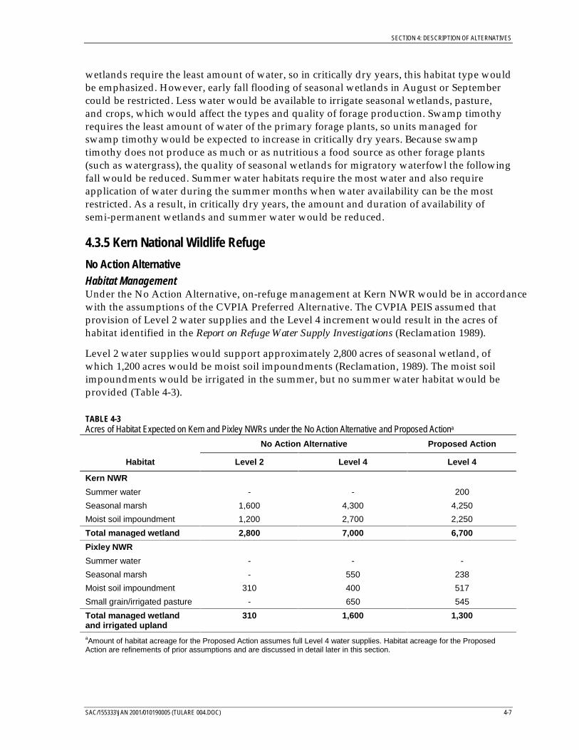
SECTION 4: DESCRIPTION OF ALTERNATIVES
SAC/155333\JAN 2001/010190005 (TULARE 004.DOC) 4-7
wetlands require the least amount of water, so in critically dry years, this habitat type wouldbe emphasized. However, early fall flooding of seasonal wetlands in August or Septembercould be restricted. Less water would be available to irrigate seasonal wetlands, pasture,and crops, which would affect the types and quality of forage production. Swamp timothyrequires the least amount of water of the primary forage plants, so units managed forswamp timothy would be expected to increase in critically dry years. Because swamptimothy does not produce as much or as nutritious a food source as other forage plants(such as watergrass), the quality of seasonal wetlands for migratory waterfowl the followingfall would be reduced. Summer water habitats require the most water and also requireapplication of water during the summer months when water availability can be the mostrestricted. As a result, in critically dry years, the amount and duration of availability ofsemi-permanent wetlands and summer water would be reduced.
4.3.5 Kern National Wildlife Refuge
No Action AlternativeHabitat ManagementUnder the No Action Alternative, on-refuge management at Kern NWR would be in accordancewith the assumptions of the CVPIA Preferred Alternative. The CVPIA PEIS assumed thatprovision of Level 2 water supplies and the Level 4 increment would result in the acres ofhabitat identified in the Report on Refuge Water Supply Investigations (Reclamation 1989).
Level 2 water supplies would support approximately 2,800 acres of seasonal wetland, ofwhich 1,200 acres would be moist soil impoundments (Reclamation, 1989). The moist soilimpoundments would be irrigated in the summer, but no summer water habitat would beprovided (Table 4-3).
TABLE 4-3Acres of Habitat Expected on Kern and Pixley NWRs under the No Action Alternative and Proposed Actiona
No Action Alternative Proposed Action
Habitat Level 2 Level 4 Level 4
Kern NWR
Summer water - - 200
Seasonal marsh 1,600 4,300 4,250
Moist soil impoundment 1,200 2,700 2,250
Total managed wetland 2,800 7,000 6,700
Pixley NWR
Summer water - - -
Seasonal marsh - 550 238
Moist soil impoundment 310 400 517
Small grain/irrigated pasture - 650 545
Total managed wetlandand irrigated upland
310 1,600 1,300
aAmount of habitat acreage for the Proposed Action assumes full Level 4 water supplies. Habitat acreage for the ProposedAction are refinements of prior assumptions and are discussed in detail later in this section.

SECTION 4: DESCRIPTION OF ALTERNATIVES
4-8 SAC/155333\JAN 2001/010190005 (TULARE 004.DOC)
With the increased water associated with Level 4 water supplies, Kern NWR would provide7,000 acres of seasonal wetland habitat, of which approximately 2,700 acres would be moistsoil impoundments. The increase to the Level 4 water supply would expand the availabilityof wetland habitat and provide water for spring/summer irrigation. Level 4 water wouldalso allow for early flooding of seasonal wetlands and would increase the extent of seasonalwetlands in the fall and winter.
Mosquito AbatementUnder the No Action Alternative, mosquito monitoring and control programs would followexisting practices. The Kern County’s Mosquito and Vector Control District is responsiblefor monitoring and control programs on public and private lands, including the Kern NWR.Control activities on Kern NWR undertaken by the Kern County Mosquito and VectorControl District are conducted in accordance with approved Pesticide Use Proposals andspecial use permits from the Service. Control actions depend on the mosquito populations,the detected presence of viral disease in mosquito populations or birds, and environmentalconditions (such as ambient temperature, or wind speed/direction). Mosquito controltypically relies on chemical methods, primarily growth inhibitors. The Mosquito and VectorControl District obtains approval from the refuge before flying and spraying for mosquitocontrol.
Listed Species ManagementUnder the No Action Alternative, management and conservation actions for federally listedspecies would be in accordance with the 1997 Biological Opinion on Wetland/RiparianEnhancement and Endangered Species Management Actions, Within Refuge Master Plans, on Kernand Pixley National Wildlife Refuges, Kern and Tulare Counties, California (Service, 1997). TheKern NWR Complex consulted with the Service’s Ecological Services Division pursuant tothe federal ESA on the effects of wetland and riparian habitat restoration and enhancement,and endangered species management actions on the Kern and Pixley NWRs, as described inthe Master Plans for the two refuges (Service 1986a and 1986b). While the Master Plansinclude use of full Level 4 water supplies, the consultation focused on the specific effects ofthe proposed habitat restoration and enhancement actions.
The consultation and ensuing Biological Opinion addressed the following listed species:
• San Joaquin kit fox (Vulpes macrotis mutica)• Blunt-nosed leopard lizard (Gambelia sila)• Tipton kangaroo rat (Dipodomys nitratoides nitratoides)• Vernal pool fairy shrimp (Branchinecta lynchi)
The conservation and avoidance measures required under the Biological Opinion generallyconsisted of conducting surveys for San Joaquin kit fox, blunt-nosed leopard lizard, andTipton kangaroo rat before construction activities, educating construction workers on theoccurrence and identification of listed species, and flagging and/or fencing areas potentiallyinhabited by listed species to prevent intrusion by construction equipment or personnel, or bythe visiting public. With implementation of all of the measures for listed species, the Servicedetermined that the level of anticipated take resulting from habitat restoration andenhancement activities on Kern and Pixley NWRs was not likely to result in jeopardy to anylisted species nor would it result in the destruction or adverse modification of critical habitat.
SECTION 4: DESCRIPTION OF ALTERNATIVES
SAC/155333\JAN 2001/010190005 (TULARE 004.DOC) 4-9
Proposed ActionHabitat ManagementManagement objectives on Kern NWR with full Level 4 water supplies have been refinedsince preparation of the Report on Refuge Water Supply Investigations (Reclamation, 1989) onwhich the management assumptions for the No Action Alternative were based. Under theserevised management objectives, Kern NWR would support 6,700 acres of seasonal wetland, ofwhich approximately 200 acres would be managed for summer water, and 2,000 acres wouldbe managed as moist soil impoundments. The remaining 4,500 acres of wetland would beseasonally flooded only during the fall and winter to provide habitat for wintering waterfowl(Table 4-3). These revised management objectives are assumed for the Proposed Action.
The apparent reduction in the acres of managed wetland under the Proposed Action resultsfrom a refinement in habitat classification on the Refuge. In the Report on Refuge WaterSupply Investigations, riparian habitat was not specifically identified. The original seasonalmarsh acreage (7,000 acres) included 300 acres of riparian habitat. This habitat was notindividually identified. An additional 150 acres of riparian habitat has also been added as aresult of reclassification of habitats. Only the 6,700 acres of seasonal marsh would beactively managed with Level 4 water supplies. Riparian habitat would benefit from Level 2and Level 4 water supplies, and available water supplies would be used, as necessary, tohelp establish new plantings of riparian trees and shrubs as a part of restoration andenhancement actions.
Mosquito AbatementMosquito abatement practices would be the same as those described for the No ActionAlternative.
Listed Species ManagementUnder the Proposed Action, the Service would implement conservation and take avoidancemeasures to protect federally listed and state-listed species, as well as other special-statusspecies, from impacts that could occur on Kern NWR as a result of on-refuge managementactivities. Species-specific measures would be implemented for the species listed inTable 4-4. The conservation and take avoidance measures vary among the species. Ingeneral, the measures consist of:
• Avoiding disturbance to nesting or denning individuals
• Surveying for species before earth-moving activities
• Confining surface disturbance to areas without indicators of habitation by special-statusspecies and at least 200 feet from potential habitat
• Conducting construction activities during daylight hours
• Restricting vehicle speeds to 25 mile per hour or less
In addition to these measures, the Service’s Endangered Species Division is to be contacted inthe event that take of one of the special-status species cannot be avoided in order to developcircumstance-specific mitigation measures. Management measures for San Joaquin kit fox,blunt-nosed leopard lizard, Tipton kangaroo rat, and vernal pool fairy shrimp would be in
SECTION 4: DESCRIPTION OF ALTERNATIVES
4-10 SAC/155333\JAN 2001/010190005 (TULARE 004.DOC)
addition to those specified in the 1997 Biological Opinion. Conservation and take avoidancemeasures that would be implemented for each species are provided in Appendix A.
4.3.6 Pixley National Wildlife Refuge
No Action AlternativeHabitat ManagementUnder the No Action Alternative, on-refuge management at Pixley NWR is assumed to be inaccordance with the assumptions of the preferred alternative resulting from the CVPIAPEIS. The acres of each habitat that would be managed using firm Level 2 water suppliesand the Level 4 increment are shown in Table 4-3.
Management using Level 2 water would consist of winter flooding of seasonal wetlands forwintering and migrating waterfowl. Existing wetland impoundments allow for a total of950 wetland acres. However, Level 2 water could only support approximately 310 acres ofseasonal wetland. No crops or irrigated pasture would be supported.
The increase to Level 4 water supplies would increase wetland habitat availability in the falland winter. In addition, more water would be available to irrigate moist soil impoundmentsand cropland. Irrigated uplands would consist of small grains and pasture, and wouldprovide food resource for geese, sandhill cranes, and waterfowl.
Mosquito AbatementMosquito-control activities have not been necessary on Pixley NWR in the past. If controlactions were necessary in the future they would be the same as those described for KernNWR.
Listed-Species ManagementListed species management would be the same as that described for the No ActionAlternative for Kern NWR.
Proposed ActionHabitat ManagementManagement objectives with full use of Level 4 water under the Proposed Action wouldemphasize moist soil impoundments to a greater degree than the No Action Alternative andwould reduce the acreage maintained as unirrigated seasonal marsh. Current habitatobjectives using full Level 4 deliveries are shown in Table 4-3. The change in the habitatacreages from those predicted in the Report on Refuge Water Supply Investigations results fromrecalculations of acreages within the units on the Refuge (D. Hardt, 2000)
Mosquito AbatementMosquito-abatement practices would be the same as those described for the No ActionAlternative.
Listed-Species ManagementListed species management would be the same as that described for Kern NWR under theProposed Action.
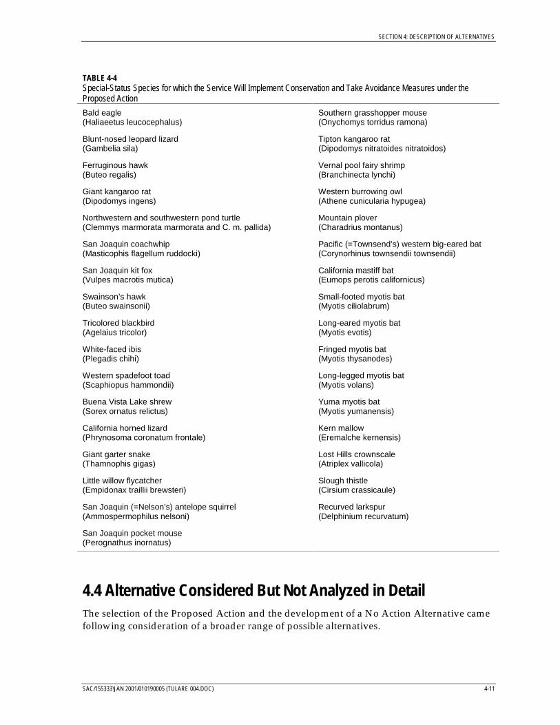
SECTION 4: DESCRIPTION OF ALTERNATIVES
SAC/155333\JAN 2001/010190005 (TULARE 004.DOC) 4-11
TABLE 4-4Special-Status Species for which the Service Will Implement Conservation and Take Avoidance Measures under theProposed Action
Bald eagle(Haliaeetus leucocephalus)
Southern grasshopper mouse(Onychomys torridus ramona)
Blunt-nosed leopard lizard(Gambelia sila)
Tipton kangaroo rat(Dipodomys nitratoides nitratoidos)
Ferruginous hawk(Buteo regalis)
Vernal pool fairy shrimp(Branchinecta lynchi)
Giant kangaroo rat(Dipodomys ingens)
Western burrowing owl(Athene cunicularia hypugea)
Northwestern and southwestern pond turtle(Clemmys marmorata marmorata and C. m. pallida)
Mountain plover(Charadrius montanus)
San Joaquin coachwhip(Masticophis flagellum ruddocki)
Pacific (=Townsend’s) western big-eared bat(Corynorhinus townsendii townsendii)
San Joaquin kit fox(Vulpes macrotis mutica)
California mastiff bat(Eumops perotis californicus)
Swainson’s hawk(Buteo swainsonii)
Small-footed myotis bat(Myotis ciliolabrum)
Tricolored blackbird(Agelaius tricolor)
Long-eared myotis bat(Myotis evotis)
White-faced ibis(Plegadis chihi)
Fringed myotis bat(Myotis thysanodes)
Western spadefoot toad(Scaphiopus hammondii)
Long-legged myotis bat(Myotis volans)
Buena Vista Lake shrew(Sorex ornatus relictus)
Yuma myotis bat(Myotis yumanensis)
California horned lizard(Phrynosoma coronatum frontale)
Kern mallow(Eremalche kernensis)
Giant garter snake(Thamnophis gigas)
Lost Hills crownscale(Atriplex vallicola)
Little willow flycatcher(Empidonax traillii brewsteri)
Slough thistle(Cirsium crassicaule)
San Joaquin (=Nelson’s) antelope squirrel(Ammospermophilus nelsoni)
Recurved larkspur(Delphinium recurvatum)
San Joaquin pocket mouse(Perognathus inornatus)
4.4 Alternative Considered But Not Analyzed in DetailThe selection of the Proposed Action and the development of a No Action Alternative camefollowing consideration of a broader range of possible alternatives.
SECTION 4: DESCRIPTION OF ALTERNATIVES
4-12 SAC/155333\JAN 2001/010190005 (TULARE 004.DOC)
This section describes other alternatives that were considered, but were not carried forwardfor detailed analysis. All of the alternatives considered included full Level 2 and Level 4water deliveries per CVPIA directives.
4.4.1 Annual AgreementsUnder an alternative based on annual water service agreements, Reclamation wouldnegotiate annual agreements with the Service for Level 2 supplies and the available Level 4increment. Such an alternative would provide maximum flexibility in Reclamation’s watersupply planning, but this alternative was not selected for detailed analysis because ofseveral disadvantages. Primary among these disadvantages was that annual contracts didnot appear to meet the intent of the CVPIA. Bolstering Central Valley wetland habitats byproviding reliable refuge water supplies is a long-term proposition, and year-to-yearcontracts would not provide enough certainty to promote effective management of on-refuge habitats. However, flexibility has been built into the proposed long-term agreementsin a manner consistent with CVPIA directives. In addition to the inherent flexibilityprovided by Reclamation’s Water Acquisition Program, Level 2 supplies can be reduced indry years, and pooling of water supplies between refuges can occur in dry years under thedirection of a refuge water management team. Because annual contracts do not appear tomeet CVPIA directives, and because some flexibility is obtained through long-termagreements, an alternative involving annual agreements was not carried forward fordetailed consideration.
4.4.2 Long-Term Level 2 AgreementsAnother potential alternative is to enter into long-term agreements for Level 2 supplies only.The Level 4 increment would be provided under annual interim agreements, subject toavailability of water from the Water Acquisition Program. This alternative was not selectedfor detailed analysis because it did not offer any clear advantages over the Proposed Actionand may not be consistent with the CVPIA. Reclamation’s commitment to provide Level 2supplies would remain the same under this alternative as under the Proposed Action.Reclamation’s obligation to provide the Level 4 increment would also not differ between thetwo alternatives. In both cases, the Level 4 increment would be provided through voluntarymeasures (e.g., water conservation, conjunctive use, purchase, lease, donation, or othersimilar activities)2. If the Level 4 increment were not available, then it would not beprovided to the refuges. Because an alternative to only enter into long-term agreements forLevel 2 supplies would not fulfil the objectives of the CVPIA, it was not carried forward fordetailed consideration.
2 These measures do not require involuntary reallocations of CVP yield.

Section 5: Affected Environment andEnvironmental Consequences
SAC/155333/JAN 2001/010190006 (TULARE 005.DOC) 5-1
SECTION 5
Affected Environment and EnvironmentalConsequences
5.1 IntroductionThis section describes the environmental setting of the Kern and Pixley NWRs, anddescribes potential environmental consequences regarding the following resourcecategories:
• Biological Resources• Water Quality• Agricultural Land Use• Recreation• Regional Economics• Social Conditions• Cultural Resources• Visual Resources• Power
Other resources were either fully covered in the CVPIA PEIS (for example, CVP-wide issuessuch as surface water and groundwater), or were not likely to be affected under theProposed Action (such as mineral resources and noise). The PEIS provides an appropriatecumulative impacts analysis for this document, and additional cumulative impacts are notconsidered.
As a NEPA document, the effects of the alternatives are considered at an equal level ofdetail, and the primary focus is on how the Proposed Action would impact the environmentrelative to the No Action Alternative. In other words, environmental consequences wouldoccur if the Proposed Action was not implemented, and the focus of the environmentalanalysis is identifying how the environment would be affected with the project versus howit would be affected without the project. As described in Section 4, the No ActionAlternative has two primary components:
• Reclamation would continue to provide Level 2 water supplies and the Level 4increment under long-term agreements of unspecified duration.
• On-refuge use of the water would be in accordance with the assumptions of the CVPIAPEIS.
The analysis of the impacts of the Proposed Action considers how on-refuge habitatconditions would differ between the current management objectives assumed under theProposed Action and the habitat conditions assumed in the PEIS. For both alternatives, theimpact analysis considers conditions that would occur with full Level 4 water supplies.
SECTION 5: AFFECTED ENVIRONMENT AND ENVIRONMENTAL CONSEQUENCES
5-2 SAC/155333/JAN 2001/010190006 (TULARE 005.DOC)
5.2 Biological ResourcesThis section describes the biological resources present on the refuges within the Tulare LakeBasin, and how these resources may be affected as a result of the Proposed Action.
5.2.1 Affected EnvironmentThe Kern NWR Complex is located in the Tulare Lake Basin at the southern portion of theCentral Valley and comprises two individual refuges (Kern and Pixley NWRs) owned andmanaged by the Service. Historically, seasonal flooding of Tulare Lake and four othersmaller lakes created an interconnected patchwork of aquatic, wetland, riparian forest, andvalley oak savannah habitats. The vast wetland habitats were an important overwinteringand migratory stopover for waterfowl. Although much of the historic Tulare Lake Basin hasbeen converted to agricultural use, small areas of wetland habitat remain.
The 10,600-acre Kern NWR was established to restore a portion of the wetland habitat lostthrough drainage of Buena Vista, Kern, Goose, and Tulare lakes for agricultural use.Management of Kern NWR has four objectives (Service, 1986a):
• Provide wintering and migration habitat for waterfowl and water birds
• Preserve and improve habitats that support the endangered blunt-nosed leopard lizard,San Joaquin kit fox, and other endangered and sensitive species
• Maintain populations and habitats for native plants and animals
• Provide for public use that is compatible with the refuge’s and Service objectives, andencourage environmental understanding for visitors
Pixley NWR was also established to restore and protect wetland habitat. However, inaddition to providing wetland habitat, Pixley NWR currently fills an important role insupporting threatened and endangered species. Approximately 4,392 acres of the refuge areset aside as habitat for three endangered species—the blunt-nosed leopard lizard, the SanJoaquin kit fox, and the Tipton kangaroo rat. Management of Pixley NWR has three primaryobjectives (Service, 1986b):
• Preserve and improve habitats that support the endangered blunt-nosed leopard lizard,San Joaquin kit fox, and Tipton kangaroo rat, as well as other endangered and sensitivespecies
• Maintain adequate populations of native plants and animals
• Provide habitat for migratory waterfowl and water birds, when water is available
Vegetation and WildlifeManagement of the Kern NWR Complex focuses on providing wetland and native uplandhabitats. Small grain crops and pasture are also maintained on Pixley NWR as winterloafing habitat for sandhill cranes and geese. The vegetation and associated wildlifecommunities of Kern and Pixley NWRs can be divided into four general types:
• Upland habitats• Wetland habitats
SECTION 5: AFFECTED ENVIRONMENT AND ENVIRONMENTAL CONSEQUENCES
SAC/155333/JAN 2001/010190006 (TULARE 005.DOC) 5-3
• Riparian habitats• Irrigated pasture and crops
Upland HabitatsNative upland habitats consist of annual and perennial grasslands, alkali scrub/alkali playa,and vernal pool complexes. Approximately 2,330 acres of Kern NWR and 5,045 acres ofPixley NWR are native upland habitats managed for endangered species. Water is not usedto manage the upland habitats, and would not be affected by the Proposed Action. For theremaining habitat types (wetland, riparian, and irrigated pasture), active water managementis necessary to produce and maintain good-quality wildlife habitat. Therefore, these habitatscould potentially be affected by the proposed water service agreement. The affectedenvironment discussion and environmental consequences focus on these habitat types.
Wetland HabitatsWetland habitats consist of seasonally flooded marshes (including moist soilimpoundments, and summer water/permanent ponds). Seasonally flooded wetlands areprimarily managed to provide habitat for migratory waterfowl, while the summerwater/permanent pond types are managed to provide habitat for resident wildlife andsummer migrants. Through the fall and winter, large concentrations of waterfowl andsmaller numbers of egrets, herons, ibis, and grebes (as well as many other types of waterbirds and shorebirds) use the seasonally flooded marshes. In addition, a full complement ofraptors preys on the numerous water birds. Approximately 6,700 acres of Kern NWR aredesignated for management as wetlands; on Pixley NWR, approximately 1,300 acres aredesignated for management as wetlands.
Seasonally flooded marshes are inundated fields or ponds managed primarily to grow seedand produce invertebrates as food for migratory waterfowl, shorebirds, and other wetland-dependent wildlife. (Reclamation and CDFG, 1995). Plant species include watergrass(Echniochloa crusgalli), smartweed (Polygonum sp.), swamp timothy (Crypsis schoenoides),sprangletop (Leptochloa sp.), loosestrife (Ammannia sp.), burhead (Echinodorus sp.),beggarticks (Bidens sp.), annual saltbush (Atriplex sp.), goosefoot (Chenopodium sp.), and brassbuttons (Cotula coronopifolia). Water levels are managed to provide the appropriate foragingwater depths for various wintering waterfowl and shorebirds. Generally, seasonal marshesare flooded from October through February, although some units are flooded as early asAugust or September to provide habitat for early-arriving migratory waterfowl such asnorthern pintails. The seasonal wetland units are drained in the spring. As water isremoved, shorebirds use the shallow depth and exposed mudflats.
Moist soil impoundments are similar to seasonally flooded wetlands, except that they areirrigated in summer to improve production of watergrass and swamp timothy, the primaryfood species for waterfowl. Moist soil impoundments are typically irrigated during thesummer to increase plant biomass and to enhance seed production. Water requirementsdiffer among plant species. Swamp timothy requires the fewest irrigations and,consequently, requires less water to produce. Watergrass can require several irrigationsduring the summer and has the highest water requirements of the moist-soil plants(Reclamation and CDFG, 1995). Watergrass is considered one of the most productive andimportant waterfowl food plants in California (Reclamation, et al., 1998). With adaptivemanagement techniques, the acreage for each target food source changes based on water

SECTION 5: AFFECTED ENVIRONMENT AND ENVIRONMENTAL CONSEQUENCES
5-4 SAC/155333/JAN 2001/010190006 (TULARE 005.DOC)
availability; less watergrass can be managed in dry years, while less swamp timothy isproduced in wet years.
Summer water habitat consists of wetlands that are flooded in the fall and remain floodedthrough June or July. This habitat provides nesting and brooding habitats for waterfowl, aswell as breeding habitat for sensitive species such as tri-colored blackbirds and white-facedibis. Summer water is only provided on Kern NWR.
Riparian HabitatManaged riparian habitat consists of natural slough channels that receive water drainedfrom managed wetland units. Managed riparian habitat also includes areas where trees andshrubs were planted. Water is delivered to these areas in November and December to helpestablish new plantings. Riparian habitats provide important nesting and foraging habitat aswell as migratory/dispersal corridors for a variety of migratory and resident wildlifespecies. Willows and cottonwoods provide nesting, roosting, and feeding habitat formigratory songbirds and raptors, and shelter and screening for waterfowl. Deer, smallmammals, and duck broods use riparian areas during the summer when many marsh unitsare dry.
Irrigated Pasture and CropsIrrigated pasture and cultivated crops are only provided on Pixley NWR. Irrigated pasturecreates nesting cover for upland game birds and other species, and may also be managedlater in the year to produce short green grazing and loafing habitat during the winter forsandhill cranes and geese. Small grain crops include barley, wheat, safflower, and vetch.These crops produce high-energy food, requiring little water, and also provide nesting andescape cover in the spring and summer.
Special-Status SpeciesTable 5-1 lists the special-status species known to occur, or potentially occurring, on theKern and Pixley NWRs and their habitat associations. These species were identified in aMarch 20, 2000, letter from the Service to Reclamation. In addition to the list from theService, the following documents were reviewed to identify any additional special-statusspecies potentially occurring at the refuges:
• Master Plans for Kern and Pixley NWRs (Service, 1986a and 1986b)
• Biological Opinion on Wetland /Riparian Enhancement and Endangered Species ManagementActions Within Refuge Master Plans on Kern and Pixley National Wildlife Refuges, Kern andTulare Counties, California (Service, 1997)
• CVPIA PEIS and associated Draft Biological Opinion
• Programmatic Biological Opinion on National Wildlife Refuge and Wildlife Area WaterConveyance Projects within Tulare, Kern, Fresno, Madera, and Merced Counties, California(Service, 1999)
• Draft EA/IS for Conveyance of Refuge Water Supply Project South San Joaquin ValleyStudy Area (Reclamation and CDFG, 1997)
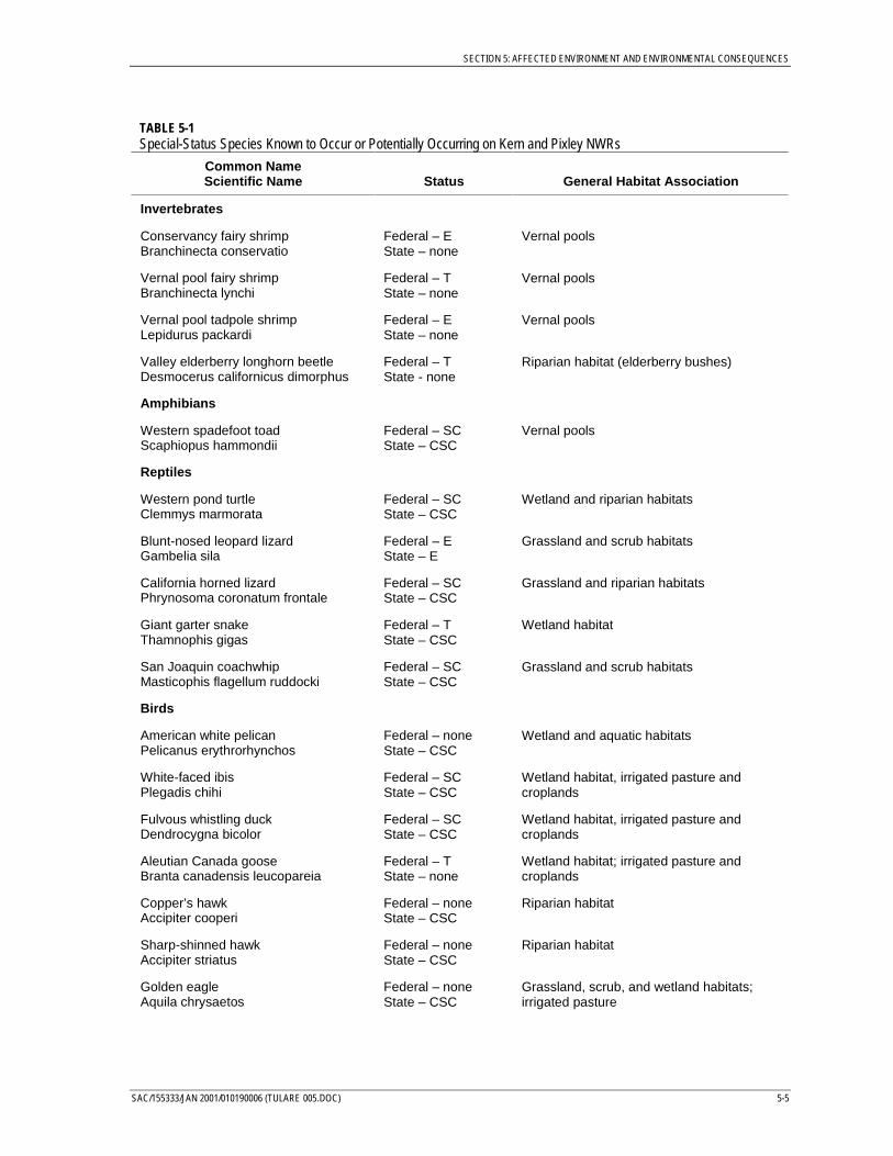
SECTION 5: AFFECTED ENVIRONMENT AND ENVIRONMENTAL CONSEQUENCES
SAC/155333/JAN 2001/010190006 (TULARE 005.DOC) 5-5
TABLE 5-1Special-Status Species Known to Occur or Potentially Occurring on Kern and Pixley NWRs
Common NameScientific Name Status General Habitat Association
Invertebrates
Conservancy fairy shrimpBranchinecta conservatio
Federal – EState – none
Vernal pools
Vernal pool fairy shrimpBranchinecta lynchi
Federal – TState – none
Vernal pools
Vernal pool tadpole shrimpLepidurus packardi
Federal – EState – none
Vernal pools
Valley elderberry longhorn beetleDesmocerus californicus dimorphus
Federal – TState - none
Riparian habitat (elderberry bushes)
Amphibians
Western spadefoot toadScaphiopus hammondii
Federal – SCState – CSC
Vernal pools
Reptiles
Western pond turtleClemmys marmorata
Federal – SCState – CSC
Wetland and riparian habitats
Blunt-nosed leopard lizardGambelia sila
Federal – EState – E
Grassland and scrub habitats
California horned lizardPhrynosoma coronatum frontale
Federal – SCState – CSC
Grassland and riparian habitats
Giant garter snakeThamnophis gigas
Federal – TState – CSC
Wetland habitat
San Joaquin coachwhipMasticophis flagellum ruddocki
Federal – SCState – CSC
Grassland and scrub habitats
Birds
American white pelicanPelicanus erythrorhynchos
Federal – noneState – CSC
Wetland and aquatic habitats
White-faced ibisPlegadis chihi
Federal – SCState – CSC
Wetland habitat, irrigated pasture andcroplands
Fulvous whistling duckDendrocygna bicolor
Federal – SCState – CSC
Wetland habitat, irrigated pasture andcroplands
Aleutian Canada gooseBranta canadensis leucopareia
Federal – TState – none
Wetland habitat; irrigated pasture andcroplands
Copper’s hawkAccipiter cooperi
Federal – noneState – CSC
Riparian habitat
Sharp-shinned hawkAccipiter striatus
Federal – noneState – CSC
Riparian habitat
Golden eagleAquila chrysaetos
Federal – noneState – CSC
Grassland, scrub, and wetland habitats;irrigated pasture
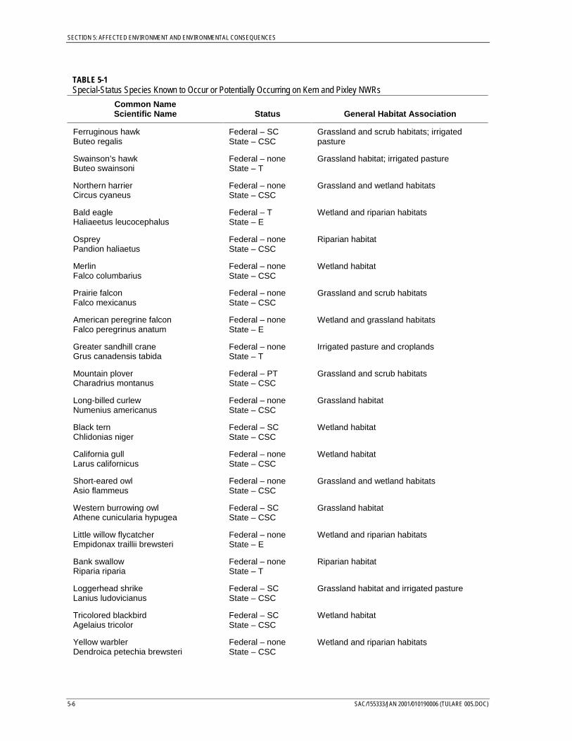
SECTION 5: AFFECTED ENVIRONMENT AND ENVIRONMENTAL CONSEQUENCES
5-6 SAC/155333/JAN 2001/010190006 (TULARE 005.DOC)
TABLE 5-1Special-Status Species Known to Occur or Potentially Occurring on Kern and Pixley NWRs
Common NameScientific Name Status General Habitat Association
Ferruginous hawkButeo regalis
Federal – SCState – CSC
Grassland and scrub habitats; irrigatedpasture
Swainson’s hawkButeo swainsoni
Federal – noneState – T
Grassland habitat; irrigated pasture
Northern harrierCircus cyaneus
Federal – noneState – CSC
Grassland and wetland habitats
Bald eagleHaliaeetus leucocephalus
Federal – TState – E
Wetland and riparian habitats
OspreyPandion haliaetus
Federal – noneState – CSC
Riparian habitat
MerlinFalco columbarius
Federal – noneState – CSC
Wetland habitat
Prairie falconFalco mexicanus
Federal – noneState – CSC
Grassland and scrub habitats
American peregrine falconFalco peregrinus anatum
Federal – noneState – E
Wetland and grassland habitats
Greater sandhill craneGrus canadensis tabida
Federal – noneState – T
Irrigated pasture and croplands
Mountain ploverCharadrius montanus
Federal – PTState – CSC
Grassland and scrub habitats
Long-billed curlewNumenius americanus
Federal – noneState – CSC
Grassland habitat
Black ternChlidonias niger
Federal – SCState – CSC
Wetland habitat
California gullLarus californicus
Federal – noneState – CSC
Wetland habitat
Short-eared owlAsio flammeus
Federal – noneState – CSC
Grassland and wetland habitats
Western burrowing owlAthene cunicularia hypugea
Federal – SCState – CSC
Grassland habitat
Little willow flycatcherEmpidonax traillii brewsteri
Federal – noneState – E
Wetland and riparian habitats
Bank swallowRiparia riparia
Federal – noneState – T
Riparian habitat
Loggerhead shrikeLanius ludovicianus
Federal – SCState – CSC
Grassland habitat and irrigated pasture
Tricolored blackbirdAgelaius tricolor
Federal – SCState – CSC
Wetland habitat
Yellow warblerDendroica petechia brewsteri
Federal – noneState – CSC
Wetland and riparian habitats
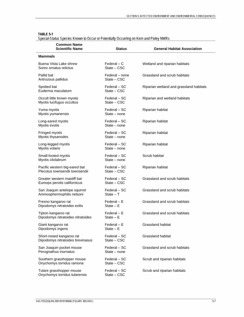
SECTION 5: AFFECTED ENVIRONMENT AND ENVIRONMENTAL CONSEQUENCES
SAC/155333/JAN 2001/010190006 (TULARE 005.DOC) 5-7
TABLE 5-1Special-Status Species Known to Occur or Potentially Occurring on Kern and Pixley NWRs
Common NameScientific Name Status General Habitat Association
Mammals
Buena Vista Lake shrewSorex ornatus relictus
Federal – CState – CSC
Wetland and riparian habitats
Pallid batAntrozous pallidus
Federal – noneState – CSC
Grassland and scrub habitats
Spotted batEuderma maculatum
Federal – SCState – CSC
Riparian wetland and grassland habitats
Occult little brown myotisMyotis lucifugus occultus
Federal – SCState – CSC
Riparian and wetland habitats
Yuma myotisMyotis yumanensis
Federal – SCState – none
Riparian habitat
Long-eared myotisMyotis evotis
Federal – SCState – none
Riparian habitat
Fringed myotisMyotis thysanodes
Federal – SCState – none
Riparian habitat
Long-legged myotisMyotis volans
Federal – SCState – none
Riparian habitat
Small-footed myotisMyotis cilolabrum
Federal – SCState – none
Scrub habitat
Pacific western big-eared batPlecotus townsendii townsendii
Federal – SCState – CSC
Riparian habitat
Greater western mastiff batEumops perotis californicus
Federal – SCState – CSC
Grassland and scrub habitats
San Joaquin antelope squirrelAmmosphermophilis nelsoni
Federal – SCState – T
Grassland and scrub habitats
Fresno kangaroo ratDipodomys nitratoides exilis
Federal – EState – E
Grassland and scrub habitats
Tipton kangaroo ratDipodomys nitratoides nitratoides
Federal – EState – E
Grassland and scrub habitats
Giant kangaroo ratDipodomys ingens
Federal – EState – E
Grassland habitat
Short-nosed kangaroo ratDipodomys nitratoides brevinasus
Federal – SCState – CSC
Grassland habitat
San Joaquin pocket mousePerognathus inornatus
Federal – SCState – none
Grassland and scrub habitats
Southern grasshopper mouseOnychomys torridus ramona
Federal – SCState – CSC
Scrub and riparian habitats
Tulare grasshopper mouseOnychomys torridus tularensis
Federal – SCState – CSC
Scrub and riparian habitats
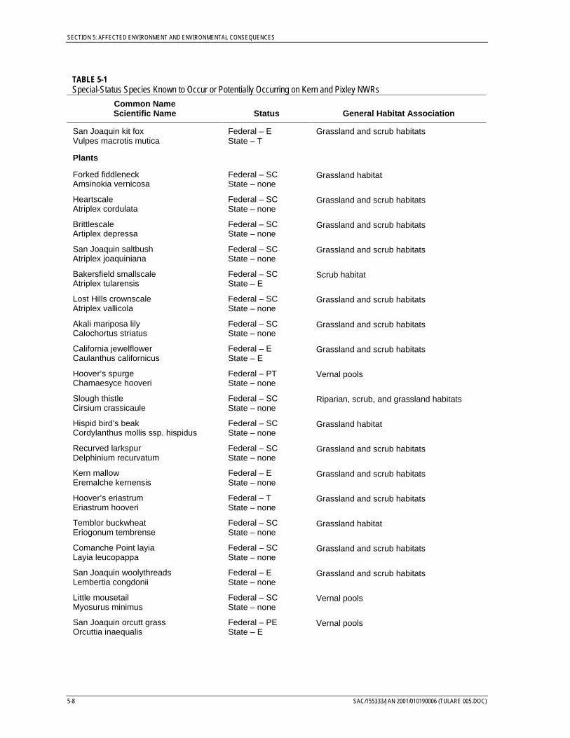
SECTION 5: AFFECTED ENVIRONMENT AND ENVIRONMENTAL CONSEQUENCES
5-8 SAC/155333/JAN 2001/010190006 (TULARE 005.DOC)
TABLE 5-1Special-Status Species Known to Occur or Potentially Occurring on Kern and Pixley NWRs
Common NameScientific Name Status General Habitat Association
San Joaquin kit foxVulpes macrotis mutica
Federal – EState – T
Grassland and scrub habitats
Plants
Forked fiddleneckAmsinokia vernicosa
Federal – SCState – none
Grassland habitat
HeartscaleAtriplex cordulata
Federal – SCState – none
Grassland and scrub habitats
BrittlescaleArtiplex depressa
Federal – SCState – none
Grassland and scrub habitats
San Joaquin saltbushAtriplex joaquiniana
Federal – SCState – none
Grassland and scrub habitats
Bakersfield smallscaleAtriplex tularensis
Federal – SCState – E
Scrub habitat
Lost Hills crownscaleAtriplex vallicola
Federal – SCState – none
Grassland and scrub habitats
Akali mariposa lilyCalochortus striatus
Federal – SCState – none
Grassland and scrub habitats
California jewelflowerCaulanthus californicus
Federal – EState – E
Grassland and scrub habitats
Hoover’s spurgeChamaesyce hooveri
Federal – PTState – none
Vernal pools
Slough thistleCirsium crassicaule
Federal – SCState – none
Riparian, scrub, and grassland habitats
Hispid bird’s beakCordylanthus mollis ssp. hispidus
Federal – SCState – none
Grassland habitat
Recurved larkspurDelphinium recurvatum
Federal – SCState – none
Grassland and scrub habitats
Kern mallowEremalche kernensis
Federal – EState – none
Grassland and scrub habitats
Hoover’s eriastrumEriastrum hooveri
Federal – TState – none
Grassland and scrub habitats
Temblor buckwheatEriogonum tembrense
Federal – SCState – none
Grassland habitat
Comanche Point layiaLayia leucopappa
Federal – SCState – none
Grassland and scrub habitats
San Joaquin woolythreadsLembertia congdonii
Federal – EState – none
Grassland and scrub habitats
Little mousetailMyosurus minimus
Federal – SCState – none
Vernal pools
San Joaquin orcutt grassOrcuttia inaequalis
Federal – PEState – E
Vernal pools
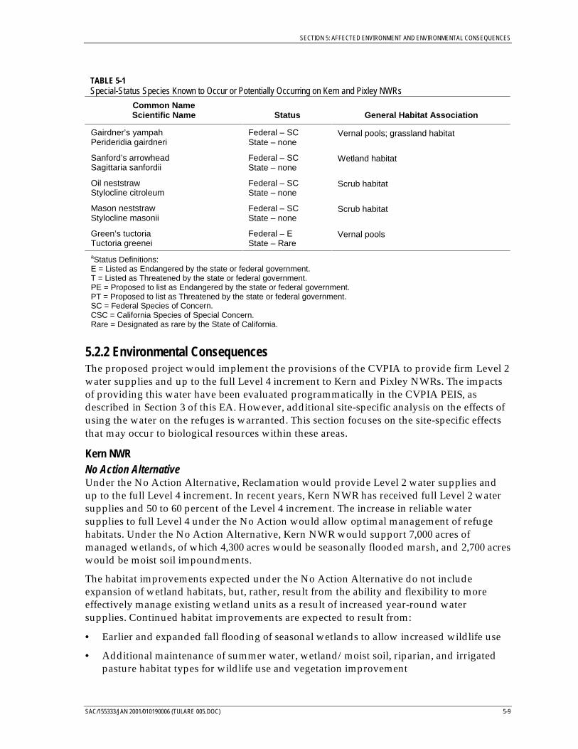
SECTION 5: AFFECTED ENVIRONMENT AND ENVIRONMENTAL CONSEQUENCES
SAC/155333/JAN 2001/010190006 (TULARE 005.DOC) 5-9
TABLE 5-1Special-Status Species Known to Occur or Potentially Occurring on Kern and Pixley NWRs
Common NameScientific Name Status General Habitat Association
Gairdner’s yampahPerideridia gairdneri
Federal – SCState – none
Vernal pools; grassland habitat
Sanford’s arrowheadSagittaria sanfordii
Federal – SCState – none
Wetland habitat
Oil neststrawStylocline citroleum
Federal – SCState – none
Scrub habitat
Mason neststrawStylocline masonii
Federal – SCState – none
Scrub habitat
Green’s tuctoriaTuctoria greenei
Federal – EState – Rare
Vernal pools
aStatus Definitions:E = Listed as Endangered by the state or federal government.T = Listed as Threatened by the state or federal government.PE = Proposed to list as Endangered by the state or federal government.PT = Proposed to list as Threatened by the state or federal government.SC = Federal Species of Concern.CSC = California Species of Special Concern.Rare = Designated as rare by the State of California.
5.2.2 Environmental ConsequencesThe proposed project would implement the provisions of the CVPIA to provide firm Level 2water supplies and up to the full Level 4 increment to Kern and Pixley NWRs. The impactsof providing this water have been evaluated programmatically in the CVPIA PEIS, asdescribed in Section 3 of this EA. However, additional site-specific analysis on the effects ofusing the water on the refuges is warranted. This section focuses on the site-specific effectsthat may occur to biological resources within these areas.
Kern NWRNo Action AlternativeUnder the No Action Alternative, Reclamation would provide Level 2 water supplies andup to the full Level 4 increment. In recent years, Kern NWR has received full Level 2 watersupplies and 50 to 60 percent of the Level 4 increment. The increase in reliable watersupplies to full Level 4 under the No Action would allow optimal management of refugehabitats. Under the No Action Alternative, Kern NWR would support 7,000 acres ofmanaged wetlands, of which 4,300 acres would be seasonally flooded marsh, and 2,700 acreswould be moist soil impoundments.
The habitat improvements expected under the No Action Alternative do not includeexpansion of wetland habitats, but, rather, result from the ability and flexibility to moreeffectively manage existing wetland units as a result of increased year-round watersupplies. Continued habitat improvements are expected to result from:
• Earlier and expanded fall flooding of seasonal wetlands to allow increased wildlife use
• Additional maintenance of summer water, wetland/moist soil, riparian, and irrigatedpasture habitat types for wildlife use and vegetation improvement
SECTION 5: AFFECTED ENVIRONMENT AND ENVIRONMENTAL CONSEQUENCES
5-10 SAC/155333/JAN 2001/010190006 (TULARE 005.DOC)
• Increased management of moist soil impoundments and through more frequentirrigation to provide a high-quality carbohydrate food source for waterfowl and otherwater birds, while easing potential waterfowl crop depredation problems on nearbyagricultural lands
• Maintenance of water depths, using year-round water delivery, that provide optimumforaging conditions for the majority of avian species
• Control of undesirable vegetation species using deep irrigation and maintenance forperiods from 2 to 4 weeks during the summer
With these improved management capabilities resulting from increased and more-reliablewater supplies, optimal habitat conditions could be maintained under drought conditionsand during flood/storm conditions to provide suitable and stable habitat conditions forresident and migratory wildlife. In particular, full Level 4 water supplies would increase theavailability of wetland habitat and would provide water for spring/summer irrigation.Level 4 water would also allow early flooding of seasonal wetlands and would increase theextent of seasonal wetlands in the fall and winter. Overall, higher-quality wetland habitatwould be available for a longer period of time each year.
An additional benefit of the No Action Alternative would include reduction of the potentialfor waterfowl to transmit avian diseases to domestic fowl. Potential benefits are two-fold:(1) increased on-refuge retention of waterfowl as a result of improved habitat availabilityand quality would reduce potential exposure of domestic fowl to migratory waterfowl, and(2) increased ability for refuge managers to employ flow-through management techniqueswould minimize outbreaks of avian cholera, botulism, and other bird diseases on therefuges.
Continuing improvements in habitat quality and availability of seasonal wetlands wouldbenefit migratory waterfowl. The Report on Refuge Water Supply Investigations (Reclamation,1989) projected more than 16 million bird-use-days for waterfowl, geese, and othermigratory shorebirds on the Kern NWR each year under management with full Level 4water supplies. Improvements in wetland habitat quality and availability would havebeneficial effects for other wetland-associated wildlife, including a variety of invertebrates,reptiles, amphibians, mammals, and shorebirds, by providing foraging and resting areas. Anumber of special-status species would also benefit from the increased habitat diversityprovided under optimal habitat management of wetland units. These species include thetricolored blackbird, white-faced ibis, Buena Vista Lake shrew, slough thistle, and recurvedlarkspur. Golden and bald eagles, and the American peregrine falcon could indirectlybenefit from an increase in their seasonal food supply of wintering waterfowl.
The increased water supplies would increase return flows from the refuge. This increasecould seasonally increase the availability of water in conveyance channels on the refuge andbeneficially affect riparian vegetation and associated wildlife. However, Kern NWR may notbe able to release return flows to adjacent agricultural lands. If water is not released frommanaged wetland units, it could overflow into upland habitats and could temporarilyinundate habitat for special-status species associated with native upland habitats, such asSan Joaquin kit fox, Tipton kangaroo rat, giant kangaroo rat, and blunt-nosed leopard lizard.
SECTION 5: AFFECTED ENVIRONMENT AND ENVIRONMENTAL CONSEQUENCES
SAC/155333/JAN 2001/010190006 (TULARE 005.DOC) 5-11
The refuge is currently working with the Solicitor’s Office of the Department of the Interiorto develop a legal mechanism for protecting listed species under these conditions.
Proposed ActionThe Proposed Action would provide the same benefits to wetland habitats as thosedescribed for the No Action Alternative. The Proposed Action primarily differs from the NoAction Alternative in providing greater flexibility of the delivery schedule of Level 2 watersupplies and the Level 4 increment and in a greater emphasis on summer water. Under theNo Action Alternative, Level 2 water supplies and the Level 4 increment would be deliveredon the monthly pattern identified in the Report on Refuge Water Supplies Investigations(Reclamation, 1989). In contrast, the water service agreement for the Proposed Action wouldprovide greater flexibility and would allow year-to-year adjustments in the delivery pattern.This difference would further enhance the refuge managers’ ability to optimally managewetland habitats, as managers could better adjust the water delivery schedule in response tohabitat management needs and wildlife use.
Management of on-refuge habitats under the Proposed Action would focus on seasonalwetland habitats, just as under the No Action Alternative. The Proposed Action is expectedto support 6,700 acres of managed wetlands of which 4,250 acres would be seasonal marsh,2,250 acres would be moist soil impoundments, and 200 acres would be summer water. Inaddition, approximately 450 acres of riparian habitat would be supported on Kern NWR.The difference in acreage of managed wetlands between the Proposed Action and the NoAction Alternative reflects a reclassification of habitats on the refuge rather than an expectedphysical difference.
The Proposed Action includes provision of 200 acres of summer water that was notprojected to occur under the No Action Alternative. By maintaining wetland habitats intothe summer months, the benefits of increased water supplies would extend to residentspecies and summer migrants. Summer water provides habitat for nesting birds such astricolored blackbirds and waterfowl, and resident species.
Development and maintenance of riparian habitat would benefit raptors, songbirds,raccoons, opossums, and some reptiles and amphibians. Increases in aquatic invertebratesshould also be proportional to increases in aquatic acreage. An existing riparian area on therefuge is managed for a heron rookery; water is kept on the area at depths sufficient toprotect nesting birds from predators. With implementation of the Proposed Action, riparianhabitat would be managed for optimal rookery habitat. Special-status species, such as thewestern pond turtle and the little willow flycatcher, may benefit from the additional acresand better-quality riparian habitat supported under the Proposed Action.
The Proposed Action includes conservation measures for protecting special-status speciesthat avoid and minimize potential impacts to special-status species from a wide range ofhabitat management activities and operational regimes that may be influenced by theapproval of the Proposed Action. These conservation measures would improve protectionof special-status species relative to the No Action Alternative. Implementation of theconservation measures would ensure protection of special-status species and their habitats,and could contribute to the recovery of listed species. Thus, relative to the No ActionAlternative, the Proposed Action would provide greater benefit to special-status species.
SECTION 5: AFFECTED ENVIRONMENT AND ENVIRONMENTAL CONSEQUENCES
5-12 SAC/155333/JAN 2001/010190006 (TULARE 005.DOC)
Pixley NWRNo Action AlternativeUnder the No Action Alternative, Reclamation would provide Level 2 water supplies andup to the full Level 4 increment to Pixley NWR. Since passage of the CVPIA in 1992, PixleyNWR has only had access to Level 2 water supplies from the one groundwater well on therefuge. The continuing availability of Level 2 water supplies, and eventual expansion of theconveyance infrastructure to reliably provide up to the full Level 4 increment, would resultin substantial improvements in the ability to manage waterfowl habitat on the refuge. Theincrease in reliable water supplies to full Level 4 under the No Action Alternative wouldallow optimal management of on-refuge habitats. Under the No Action Alternative, PixleyNWR would support 950 acres of managed wetlands, of which approximately 550 acreswould be seasonally flooded marsh, while 400 acres would be moist soil impoundments. Inaddition, 650 acres would be managed as irrigated pasture and cultivated crops.
As with Kern NWR, expansion of wetland habitats to non-wetland areas would not occur.Rather, increased and reliable water supplies would enable more effective management ofexisting habitats. Continued improvements in management capabilities and the subsequentbenefits to wetland habitat quality and availability and wetland-associated species would bethe same as those described for Kern NWR. The Report on Refuge Water Supply Investigations(Reclamation, 1989) projected nearly 3 million bird-use-days for waterfowl, geese, and othermigratory each year under optimal habitat management.
Full Level 4 water supplies would also support an increase in irrigated pasture andcroplands. This increase would benefit sandhill cranes, geese, raptors, and other birds andmammals that forage on small grains and/or insects and small mammals found in thesehabitats. Pasture could also provide habitat for grassland birds, such as sparrows,pheasants, and northern harriers.
An additional benefit of the No Action Alternative would include reduction of the potentialfor waterfowl to transmit avian diseases to domestic fowl. Beneficial effects with regard tocontrolling avian diseases would be the same as those described for the Kern NWR.
Proposed ActionThe effects of the Proposed Action on habitat quality and availability on Pixley NWR wouldbe largely the same as for the No Action Alternative. Under the Proposed Action, PixleyNWR would support approximately 755 acres of managed wetlands, with 238 acresmanaged as seasonally flooded marsh and 545 acres managed as moist soil impoundments.Approximately 545 acres would be irrigated pasture and cultivated crops. The acreagedifferences from the No Action Alternative reflect a reclassification of habitats on the refugerather than an expected physical difference. The Proposed Action could result in somewhatbetter habitat quality than the No Action Alternative because of increased flexibility in thedelivery schedule of Level 2 water supplies and the Level 4 increment. Under the NoAction, Level 2 water supplies and the Level 4 increment would be delivered on themonthly pattern identified in the Report on Refuge Water Supplies Investigations (Reclamation,1989). In contrast, the water service agreement for the Proposed Action would providegreater flexibility and year-to-year adjustments in the delivery pattern. This differencewould further enhance the refuge managers’ ability to optimally manage habitats on therefuge, thereby benefiting a diversity of wildlife species (including special-status species).
SECTION 5: AFFECTED ENVIRONMENT AND ENVIRONMENTAL CONSEQUENCES
SAC/155333/JAN 2001/010190006 (TULARE 005.DOC) 5-13
As on Kern NWR, conservation measures to protect special-status species would beimplemented under the Proposed Action. These measures, in combination with improvedhabitat management capabilities, would further benefit special-status species relative to theNo Action.
5.3 Water QualityThis section describes the water quality conditions that exist on the Kern NWR Complex(Kern NWR and Pixley NWR) and how these conditions may change as a result of theProposed Action.
5.3.1 Affected Environment
Kern National Wildlife RefugeWater supplies for Kern NWR consist of surface water from the CVP and SWP, andgroundwater. The Kern NWR is primarily served by the Buena Vista Water Storage District,which obtains surplus SWP water from the Kern County Water Agency through theCalifornia Aqueduct. In addition, Kern NWR occasionally receives water from Reclamationthrough the Friant-Kern Canal and, subsequently, through Poso Creek. The quality ofsurface water from the CVP and SWP is adequate for refuge uses and is widely used forirrigation and drinking water (Reclamation, 1994). Runoff from surrounding farms andflood flows supply additional surface water. The quality of this water has also beenadequate for refuge uses. Studies conducted by the U.S. Geological Survey on the refugedetected few pesticides, and those detected were far below levels at which adverse effectswould occur. Trace element concentrations were also found to be low and to pose littlethreat to wildlife.
Nine groundwater wells were used to supply water to the refuge until the early 1970s whena receding water table, coupled with escalating energy costs, led to the discontinued use ofthree of the wells. The remaining six wells have been operated on an as-needed basis, inconjunction with the purchase of SWP water (Service, 1986a). No water quality concernsregarding the use of groundwater on the refuge have been identified.
There are no return flows from the Kern NWR except in extremely wet years. The refugearea sits within the Tulare Lake Bed. The historic hydrology has been greatly altered, withthe majority of flow that at one time reached the lake bed now controlled through dams,reservoirs, and irrigation features. The primary drainage features within the study area areDeer Creek, Poso Creek, the Goose Creek Canal, and the Kern River channel. The KernNWR accepts floodwater from Poso Creek on an as-needed basis.
Pixley National Wildlife RefugePixley NWR’s primary source of water has been groundwater; limited surface watersupplies have been available in the past. Deer Creek, which passes through the southeastcorner of the refuge, is an intermittent stream (Service, 1986b). During extremely wet yearswhen flood flows occur in Deer Creek, surface water could be diverted from the creek atcheck structures along the southern boundary of the refuge. This water is of suitable qualityfor wetland habitat management. Studies conducted by the USGS on the refuge detected few
SECTION 5: AFFECTED ENVIRONMENT AND ENVIRONMENTAL CONSEQUENCES
5-14 SAC/155333/JAN 2001/010190006 (TULARE 005.DOC)
pesticides, and those detected were far below levels at which adverse effects would occur.Trace element concentrations were also found to be low and to pose little threat to wildlife.
Pixley NWR has also received surface water from the Pixley Irrigation District when surplusflows have been available. The Pixley Irrigation District obtains water from the Friant-KernCanal at Millerton Lake. Surface water quality in Millerton Lake, the San Joaquin River atand upstream of the PID diversion, and in subsequent canals and systems is adequate forrefuge and agricultural uses (Reclamation, 1994). This water is widely used for irrigationand drinking water after disinfection.
Groundwater has been the only reliable water available to the refuge. The groundwater is ofpoor quality for agricultural irrigation, but has been adequate for refuge uses. The PixleyNWR has relied almost exclusively on a single groundwater well for regular water supply.
There are no return flows from Pixley NWR except in extremely wet years. The refuge areasits within the Tulare Lake Bed. While the vast majority of this lakebed is under cultivation,the area still has been inundated as recently as 1983. The historic hydrology has been greatlyaltered, with the majority of flow that at one time reached the lake bed now controlledthrough dams, reservoirs, and irrigation features. The primary drainage features within thestudy area are Deer Creek, Poso Creek, the Goose Creek Canal, and the Kern River channel.
5.3.2 Environmental ConsequencesThe proposed project would implement the CVPIA provisions to deliver up to Level 4 watersupplies to the refuges of the Kern NWR complex. The impacts of providing this water havebeen evaluated in the CVPIA PEIS, as described in Section 3 of this EA. However, additionalsite-specific analysis is warranted. This section focuses on the site-specific water-qualityimpacts that may occur with increased water supply.
Kern NWR ComplexNo Action AlternativeUnder the No Action Alternative, on-refuge management at the Kern NWR Complex wouldbe in accordance with the assumptions of the CVPIA Preferred Alternative. Under the NoAction Alternative, Reclamation would provide Level 2 water to the Kern NWR Complexfrom CVP yield and the Level 4 increment as acquired through the Water AcquisitionProgram.
Water provided to Kern NWR and Pixley NWR would continue to improve water qualityconditions on the refuges. First, the availability of reliable, year-round water supplies wouldallow managers to optimally manage wetland habitat, which includes maintaining goodwater quality in the wetland units to avoid outbreaks of avian diseases. Second, the quality ofthe water provided to the refuges would be of similar or better quality. The quality thegroundwater used on Pixley NWR is poor. With provision of Level 2 and up to Level 4 watersupplies, the quality of the water used for wetland habitat management would continue toimprove.
There are no return flows from either the Kern or Pixley NWRs except in extremely wetyears, so providing Level 2 and up to Level 4 water supplies would not affect the quality orquantity of return flows.
SECTION 5: AFFECTED ENVIRONMENT AND ENVIRONMENTAL CONSEQUENCES
SAC/155333/JAN 2001/010190006 (TULARE 005.DOC) 5-15
Proposed ActionAs under the No Action Alternative, Reclamation would deliver Level 2 water supplies fromCVP yield and the Level 4 increment as acquired through the Water Acquisition Program toKern NWR. This water would be used to manage wetland habitats on Kern NWR in amanner similar to the No Action Alternative. The quality and quantity of the water deliveredto and used on the refuges would be the same as under the No Action Alternative. As aresult, no adverse impacts to water quality would occur from use of the water on Kern NWR.
On Pixley NWR under the Proposed Action, groundwater would continue to be used to meetLevel 2 water supplies. The one well on Pixley NWR has provided water of sufficient qualityfor wetland habitat management, although it is generally of poorer quality than CVP water.Reclamation would provide the Level 4 increment to Pixley NWR as acquired through theWater Acquisition Project. Because Level 2 water and the Level 4 increment would be ofsufficient quality for wetland habitat management and there are no return flows from PixleyNWR, no adverse effects to water quality would occur. In the event that groundwaterbecomes unsuitable for wetland habitat management, Reclamation would provide Level 2water from other sources of sufficient quality.
5.4 Agricultural Land UseThis section describes the interaction between the refuges and adjacent agricultural lands,and how these conditions may change as a result of the Proposed Action.
5.4.1 Affected Environment
Kern National Wildlife RefugeThe Kern NWR is on the lower margins of the historic Tulare Lake, and the surroundingarea contains large remnants of native habitats, as well as lands converted to agriculturaluse. Native uplands are located primarily to the south and east of the refuge, and are alsofound to a lesser extent north of the refuge. Portions of the lands south of the refuge containwetland and riparian habitats. Several duck clubs are located south and east of the refuge.Developed farmlands are located primarily to the west and northeast of the refuge.
Because of its federal ownership, the refuge is considered “Non-Jurisdictional” lands in theKern County General Plan. Surrounding land uses are designated as a combination of“Intensive Agricultural,” “Resource Reserve,” and “Extensive Agriculture,” with all threeland uses applying to surrounding parcels. The Kern NWR Master Plan states thatjustifications for creating the refuge included preserving lower San Joaquin Valleywaterfowl habitat, providing local hunting opportunities, and protecting nearby crops fromdepredation. The Master Plan does not address compatibility with adjacent farmlands, andrefuge/farmland compatibility is not addressed in the Kern County General Plan.
Pixley National Wildlife RefugeThe Pixley NWR is on the eastern margins of historic Tulare Lake and contains largeremnants of native grassland habitats and marshes. Most of the surrounding lands havebeen converted to agricultural use, with a few pockets of native habitats occurring outsideof the refuge boundaries. The Pixley NWR is unique among Central Valley refuges in that it
SECTION 5: AFFECTED ENVIRONMENT AND ENVIRONMENTAL CONSEQUENCES
5-16 SAC/155333/JAN 2001/010190006 (TULARE 005.DOC)
is composed of several isolated parcels rather than one contiguous tract. As a result of recentland acquisitions, the Service currently owns the entire refuge boundary.
The Pixley NWR and surrounding areas are designated as “Agriculture” by the TulareCounty General Plan. Justification for creating the refuge included protecting nearby cropsfrom depredation, but the Pixley NWR Master Plan does not address compatibility withadjacent farmlands, and refuge/farmland compatibility is not addressed in the TulareCounty General Plan.
5.4.2 Environmental ConsequencesThe proposed project would implement the CVPIA provisions to deliver up to Level 4 watersupplies to the Kern and Pixley NWRs. The impacts of providing this water have beenevaluated in the CVPIA PEIS, as described in Section 3 of this EA, but additional site-specific analysis is warranted. This section focuses on the site-specific land use conflicts thatmay occur with surrounding agricultural land uses. Key issues of concern to farm ownerssurrounding the Kern and Pixley NWRs include economic impacts (primarily as a result ofcrop depredation by waterfowl and spread of avian diseases) and refuge expansion. Otherland use and nuisance issues are considered minor (such as weed control, and beaver andmuskrat damage) and would not change under the proposed project. The quality of refugerunoff water was addressed in Section 5.3, and mosquito control was addressed in Section 4.
In order to understand how changing water supplies on the refuges may impact adjacentagricultural lands, the individual refuge management plans were reviewed. The purpose ofthis reconnaissance was to understand current refuge management practices and how thesepractices affect surrounding land uses. A similar process was undertaken to evaluate howthe Proposed Action may affect these current practices.
Kern National Wildlife RefugeNo Action AlternativeThe objectives of the Kern NWR include alleviating depredation of agricultural crops bywintering waterfowl, which continues to be a part of the refuges’ primary mission. Thisobjective would continue to be supported under the No Action Alternative. As described inSection 5.2 (Biological Resources), on-refuge habitats would continue to improve under theNo Action Alternative. Continuing to provide Level 2 water, and eventually expanding tofull Level 4 supplies, would improve the Service’s ability to manage waterfowl habitat onthe refuge. The improvements expected under the water service agreements do not includeexpansion of wetland habitats to non-wetland areas, but rather provide the ability to moreeffectively manage existing habitats.
One of the benefits of effectively managing wetland habitats with a reliable water supply isthe ability to improve production of waterfowl forage on the refuge (such as moist soilimpoundments for improved watergrass production) rather than focusing only onproviding flooded areas. The ability to more effectively grow food items on the refuge isexpected to help maintain waterfowl on the refuge, thereby reducing the potential fordepredation on surrounding farmlands. Additionally, effectively managing existing habitatis expected to result in a reduced potential for waterfowl diseases to occur, as described inSection 5.2. Reduction in disease potential, coupled with a decrease in off-refugedepredation impacts, is expected to result in a decreased incidence of spreading avian
SECTION 5: AFFECTED ENVIRONMENT AND ENVIRONMENTAL CONSEQUENCES
SAC/155333/JAN 2001/010190006 (TULARE 005.DOC) 5-17
diseases to domestic fowl (and also should reduce spread of avian diseases from domesticfowl to waterfowl), resulting in an overall beneficial effect to surrounding land uses.
No additional refuge lands would be acquired. The amount of water provided to the refugeby Reclamation would allow for optimum management of current refuge lands per theReport on Refuge Water Supply Investigations. The Service currently owns the entire refuge,and no expansion of the refuge is planned.
Proposed ActionHabitat conditions under the Proposed Action would be similar to the No ActionAlternative, the primary difference being an increase in summer water (approximately anadditional 200 acres relative to the No Action Alternative). This increase in summer waterand other minor changes in habitat under the Proposed Action would not substantiallychange potential impacts to adjacent farmlands relative to the No Action Alternative.Therefore, the level of impact would be about the same as described above. As is the caseunder the No Action Alternative, no additional refuge lands would be acquired as part ofthe Proposed Action.
Pixley National Wildlife RefugeNo Action AlternativeThe objectives of the Pixley NWR include alleviating depredation of agricultural crops bywintering waterfowl, which continues to be a part of the refuges’ primary mission. Thisobjective would continue to be supported under the No Action Alternative. Similar to theprevious discussion of impacts on the Kern NWR, continued improvements to Pixley NWRhabitat conditions are expected to occur under the No Action Alternative. Continuing toprovide Level 2 water, and eventually up to Level 4 supplies, would result in substantialimprovements to the ability of the Service to manage waterfowl habitat on the refuge. Theimprovements expected under the water service agreements do not include expansion ofwetland habitats to non-wetland areas but, rather, provide the ability to more effectivelymanage existing habitats. As on the Kern NWR, providing additional water supplies wouldhelp improve on-refuge production of waterfowl forage crops, which is expected to helpmaintain waterfowl on the refuge and to reduce the potential for depredation onsurrounding farmlands. Additionally, effectively managing existing habitat is expected toresult in a reduced potential for waterfowl diseases to occur, as described above for the KernNWR. A reduction in disease potential, coupled with a decrease in off-refuge depredationimpacts, is expected to result in decreased spreading of avian diseases to domestic fowl (andalso would reduce spreading avian diseases from domestic fowl to waterfowl).
No additional refuge lands would be acquired under the No Action Alternative. Theamount of water provided to the Pixley NWR would allow for optimum management ofcurrent refuge lands per the Report on Refuge Water Supply Investigations. At this time, noadditional expansion of the refuge is planned.
Proposed ActionHabitat conditions under the Proposed Action would be similar to the No ActionAlternative. Accordingly, potential impacts to adjacent farmlands would be similar to thosedescribed above. As is the case under the No Action Alternative, no additional refuge landswould be acquired as part of the Proposed Action.
SECTION 5: AFFECTED ENVIRONMENT AND ENVIRONMENTAL CONSEQUENCES
5-18 SAC/155333/JAN 2001/010190006 (TULARE 005.DOC)
5.5 RecreationThe quality of on-refuge habitats, both for waterfowl and other species, affects recreationopportunities and experiences. This section describes the potential for habitat changesassociated with the project to affect consumptive and non-consumptive recreation uses onthe refuges.
5.5.1 Affected Environment
Kern National Wildlife RefugeBoth consumptive and non-consumptive recreation uses occur at the Kern NWR. Publichunting is consistent with federal objectives for the refuge, and occurs in cooperation withCDFG. The primary emphasis is on waterfowl hunting but, to a lesser extent, pheasanthunting also occurs. The current master plan for the Kern NWR calls for an increase inwaterfowl hunters from levels in the mid-1980s of an estimated 2,600 hunters per year toapproximately 3,300 hunters per year. Pheasant hunter levels are expected to remain atapproximately 20 hunters per year. Other consumptive recreation opportunities (such asfishing or dove hunting) are not currently permitted on the Kern NWR.
Non-consumptive recreation use (such as bird watching) has historically been low, but isplanned to increase. In the mid-1980s, it was estimated that approximately 500 visitors peryear took part in nonconsumptive recreation activities on the Kern NWR. These numbersare expected to increase to more than 2,000 visitors, in part a result of new developmentcommitments on the refuge to expand nonconsumptive recreation opportunities. Suchcommitments include developing auto tour routes and footpaths, and providinginterpretive exhibits describing refuge wildlife and habitats. The Kern NWR Master Planstates that some recreational development is contingent on securing a long-term, reliablewater supply.
Pixley National Wildlife RefugePublic recreation use is not emphasized on the Pixley NWR. No hunting or fishing iscurrently allowed or planned. Nonconsumptive recreation use is currently allowed subjectto permit, and minor recreation development is planned, including interpretive and wildlifeobservation facilities and two small foot trails. The recreation objective for the Pixley NWRis approximately 1,000 nonconsumptive recreation visitors per year. The Pixley NWRMaster Plan states that the recreation development is contingent on securing a long-term,reliable water supply.
5.5.2 Environmental ConsequencesEntering into the proposed long-term refuge water supply agreements may affect recreationuses in several ways. This section focuses on the on-refuge habitat changes that maycontribute to changes in recreation use. Other potential recreation effects have beenevaluated in the CVPIA PEIS, as summarized in Section 3.
Policies affecting on-refuge recreation uses are not expected to change, so any changes tohabitats on the refuges are expected to directly correspond to changes in recreation use. Theconclusions of Section 5.2 (Biological Resources) have been carried forward to this section
SECTION 5: AFFECTED ENVIRONMENT AND ENVIRONMENTAL CONSEQUENCES
SAC/155333/JAN 2001/010190006 (TULARE 005.DOC) 5-19
(for example, benefits to waterfowl habitat will improve recreation opportunities for huntersand bird watchers).
Kern NWRNo Action AlternativeUnder the No Action Alternative, habitat conditions are expected to continue to improve ina manner that supports the recreation goals described in the Kern NWR Management Plan.As described above, recreation use on the Kern NWR is expected to increase from3,100 visitor-use days per year (mid-1980s levels) to more than 5,300 visitor-use days peryear as the Management Plan is implemented. This expected recreation benefit isattributable to the habitat improvements under firm Level 2 supplies and the Level 4increment.
Proposed ActionRecreation benefits under the Proposed Action are expected to be similar to those of the NoAction Alternative. Although minor habitat changes are expected (such as increasedpermanent wetlands), these changes are not expected to result in substantially differentrecreation benefits than those described above under the No Action Alternative.Accordingly, there would be no impact to recreation use under the Proposed Action relativeto the No Action Alternative.
Pixley NWRNo Action AlternativeUnder the No Action Alternative, habitat conditions are expected to continue to improveover current conditions in a manner that supports the recreation goals described in thePixley NWR Management Plan. As described above, recreation use on the Pixley NWR isexpected to increase to approximately 1,000 visitor-use days per year as the ManagementPlan is implemented. This expected recreation benefit is attributable to opening the refuge tonon-consumptive recreation uses, which would be made possible, in part, because of habitatimprovements under firm Level 2 water supplies and the Level 4 increment.
Proposed ActionRecreation benefits under the Proposed Action are expected to be identical to the No ActionAlternative. Accordingly, there would be no impact to recreation use under the ProposedAction relative to the No Action Alternative.
5.6 Regional EconomicsThis section describes how the refuges contribute to regional economic conditions and thepotential changes in these conditions from implementing the long-term refuge water supplyagreements. The section focuses on economic benefits associated with public use of therefuges. Effects associated with employment are discussed in Section 5.7 (Social Conditions).Effects on adjacent agricultural operations associated with providing full Level 2 and Level4 water supplies to the refuges are discussed in Section 5.4 (Agricultural Land Use).
SECTION 5: AFFECTED ENVIRONMENT AND ENVIRONMENTAL CONSEQUENCES
5-20 SAC/155333/JAN 2001/010190006 (TULARE 005.DOC)
5.6.1 Affected EnvironmentSignificant economic benefits have resulted from waterfowl-based recreation activities, bothpublic and private. Nationwide, it is estimated that approximately $3.3 billion is spentannually on nonconsumptive uses of migratory waterfowl, and another $0.5 billion is spentannually on migratory waterfowl hunting (Southwick Associates, 1995). California isconsidered the largest state consumer of migratory waterfowl-related recreation spending(Southwick Associates, 1995), but no studies have been specifically performed regarding theeconomic benefits of wildlife refuges in the Tulare Lake basin.
Economic benefits associated with waterfowl-based recreation activities are dispersed (thereis a “non-point” economic benefit), so changes to economic outputs would occur acrossmarket sectors and communities. According to Southwick Associates (1995), travel-relatedcosts are the most significant economic outputs, because a majority of consumers travel longdistances (such as from urban areas) to the refuges. Travel-related costs include gas, food,and lodging; these expenses can be entirely attributed to the refuges because waterfowl-based recreation is the primary purpose of the trip. In contrast, the economic benefits ofwaterfowl-based recreation by local residents is difficult to estimate because items such asfuel and refreshments may not be directly related to on-refuge recreation activities. Othereconomic benefits associated with waterfowl-based recreation uses include employmentand wages (discussed in more detail in Section 5.7), revenues to state and federalgovernments from permits and licenses, and the purchase of sporting equipment such asguns and ammunition.
The affected environment for regional economic impacts is primarily the local communitiesin the vicinity of the refuges. These communities may capture a portion of the trip-relatedexpenses associated with refuge-based recreation. Expenditures tend to be highest duringthe fall and winter in conjunction with the primary hunting and birdwatching seasons.
5.6.2 Environmental ConsequencesThe proposed project would implement the CVPIA provisions to deliver up to Level 4 watersupplies to the Kern and Pixley NWRs. At a broad scale, the economic impacts ofimplementing the CVPIA have been evaluated in the CVPIA PEIS, as summarized inSection 3. However, additional site-specific analysis is warranted. This section focuses onpotential economic impacts resulting from changes in water deliveries to the Kern andPixley NWRs, and is focused primarily on trip-related expenses captured by localcommunities.
As described by Southwick Associates (1995), annual hunting depends, at least partially, onthe population of waterfowl available for hunters to target. Similarly, birdwatching tripsdepend on waterfowl (and other bird) populations to some degree. For the purposes of thisanalysis, it is assumed that demand for hunting and birdwatching is positively correlatedwith waterfowl populations. In other words, recreation use will increase or decrease inrelation to waterfowl populations. Therefore, in order to assess potential economic impacts,Sections 5.2 (Biological Resources) and 5.5 (Recreation) were reviewed to determine howchanges in refuge habitats may affect waterfowl populations and recreation use.
SECTION 5: AFFECTED ENVIRONMENT AND ENVIRONMENTAL CONSEQUENCES
SAC/155333/JAN 2001/010190006 (TULARE 005.DOC) 5-21
Kern National Wildlife RefugeNo Action AlternativeUnder the No Action Alternative, Level 2 water supplies would continue to be provided tothe Kern NWR, and increasing amounts of Level 4 water would be provided. As describedin Section 5.2 (Biological Resources), increased water supplies, together with other post-CVPIA actions (such as improvements to conveyance facilities), would continue to result inimprovements to on-refuge habitats and to waterfowl (and other bird) populations. Aswildlife populations continue to increase, hunter and birdwatcher use is expected torespond in a similar manner. In addition, as is expected for wildlife populations, drasticchanges in recreation are not expected to occur; rather, modest increases over time are morelikely. Positive economic benefits would be experienced by local communities (throughincreased travel-related expenditures) and to other economic sectors. Benefits to localcommunities would likely be a dispersed benefit to the service sector (such as gas stations orrestaurants) as the reliability of a positive recreation experience is bolstered by the waterservice agreements. Because of limited data regarding the economic effects of waterfowl-based recreation, it is not possible to quantify the specific benefits to the economy of theTulare Lake basin in a site-specific manner. However, changes relative to existing conditionsare expected to be beneficial and long term.
Proposed ActionSimilar economic benefits are expected to occur under the Proposed Action as under the NoAction Alternative. Refuge management under the assumptions for the Proposed Actionwould be about the same as those under the No Action Alternative, with the addition ofapproximately 200 acres of summer water habitat. As described in Section 5.5 (Recreation),habitat changes under the Proposed Action are not expected to result in significant, if any,changes to onsite recreation use relative to the No Action Alternative. Accordingly, nochanges to regional economic benefits are expected under the Proposed Action relative tothe No Action Alternative.
Pixley National Wildlife RefugeNo Action AlternativeUnder the No Action Alternative, Level 2 water supplies would continue to be provided tothe Pixley NWR. Level 4 water supplies would be provided in the future, pendingcompletion of conveyance infrastructure and acquisition of the water by Reclamation. Asdescribed in Section 5.2 (Biological Resources), providing up to full Level 4 supplies wouldallow the expansion of on-refuge waterfowl habitat and result in improvements towaterfowl (and other bird) populations. This improvement in waterfowl habitat is expectedto help support the refuge’s objective of expanding nonconsumptive recreation use.3 Aswildlife populations continue to increase, a modest increase in birdwatcher use over time isexpected (a maximum of 1,000 visitors per year according to the Management Plan).Because of limited data regarding the economic effects of waterfowl-based recreation, it isnot possible to quantify the specific benefits to the economy of the Tulare Lake basin in asite-specific manner. However, changes relative to existing conditions are expected to bebeneficial and long term.
3 As described in Section 5.5, consumptive recreation use (such as hunting) is not currently allowed and is not proposed to beallowed on the Pixley NWR.
SECTION 5: AFFECTED ENVIRONMENT AND ENVIRONMENTAL CONSEQUENCES
5-22 SAC/155333/JAN 2001/010190006 (TULARE 005.DOC)
Proposed ActionRefuge management under the habitat assumptions for the Proposed Action would be thesame as those under the No Action Alternative. Because of the limited economic benefitsdescribed above, habitat changes under the Proposed Action are not expected to result inchanges to regional economic benefits relative to the No Action Alternative.
5.7 Social ConditionsThis section describes how the refuges contribute to local and regional social conditions andthe potential changes in these conditions as a result of implementation of the long-termrefuge water supply agreements. The focus of this section is on the indicators of social wellbeing (such as employment) that affect key social groups.
5.7.1 Affected EnvironmentProviding Level 2 and Level 4 refuge water supplies would affect some individuals to agreater degree than others. In order to simplify the analysis, the effects of the refuge watersupply project are considered in the context of three broad social groups: (1) individualswho participate in refuge-dependent recreation activities (such as hunting andbirdwatching), (2) local communities that benefit from the refuges being located nearby, and(3) neighboring farmers.
As described in the CVPIA PEIS, waterfowl hunters are primarily concerned with thepreservation of habitat and refuge lands. The organizations representing waterfowl hunters(such as the California Waterfowl Association and Ducks Unlimited) support efforts torestore or improve waterfowl habitats. Birdwatchers share the same goals as waterfowlhunters, but place a higher value on other aspects of the natural environment. For example,birdwatchers generally support restoration of riparian areas and permanent ponds to asimilar degree as seasonal wetlands. Members of both groups generally believe thatenvironmental considerations should play a larger role in water resources decisionmaking.
The key indicators of social well-being for local communities are business income andemployment potential. Local services businesses are primarily concerned with how changesin on-refuge management affect their customer base. In general, local businesses areassumed to support changes in refuge management that improve recreation use, becauseincreased recreation use would translate into an increased customer base and higherbusiness income. Employment potential could also be affected as business staffing needschange. Other potential employment opportunities for local residents could result fromchanges in refuge management (such as on-refuge staffing, construction of facilities, etc.).
In general, changes in refuge management are not of concern to neighboring farmers unlessthe changes result in decreased crop revenues (from depredation by migratory waterfowl)or a decrease in water supply reliability. Because one of the primary goals of wildliferefuges is to reduce depredation by waterfowl, farmers are generally supportive of therefuges. However, individual nuisance problems may occur where the two different landuses abut.
SECTION 5: AFFECTED ENVIRONMENT AND ENVIRONMENTAL CONSEQUENCES
SAC/155333/JAN 2001/010190006 (TULARE 005.DOC) 5-23
5.7.2 Environmental ConsequencesThe proposed project would implement the CVPIA provisions to deliver up to Level 4 watersupplies to the Kern and Pixley NWRs. At a broad scale, changes in social conditionsresulting from implementation of the CVPIA have been evaluated in the CVPIA PEIS, assummarized in Section 3. This section focuses on potential impacts to the indicators of socialwell-being for refuge-dependent recreation users and local business owners resulting fromchanges in water deliveries to the Tulare Lake basin refuges.
Potential benefits to recreation users and local communities are closely related to waterfowlpopulations and recreation use. Therefore, in order to assess impacts to social conditions,Sections 5.2 (Biological Resources) and 5.5 (Recreation) were reviewed to determine howchanges in refuge habitats might affect waterfowl populations and recreation use. Potentialimpacts to surrounding farmlands were evaluated in Section 5.4 (Agricultural Land Use).
Kern NWRNo Action AlternativeUnder the No Action Alternative, Level 2 water supplies would continue to be provided tothe Kern NWR, and increasing amounts of Level 4 water would be provided over time. Asdescribed in Section 5.4 (Recreation), hunter and birdwatcher use is expected to continue toincrease in response to improved waterfowl conditions and increased numbers of birds.This is a beneficial social effect as well. The recreation user group is expected to have a moresatisfying recreation experience as a result of improved conditions on the refuges.
As described in Section 5.6 (Regional Economics), local communities would continue torealize positive economic benefits through increased travel-related expenditures byrecreation users. Benefits to local businesses would likely be a dispersed benefit to theservice sector (such as gas stations and restaurants). Local businesses would also realize abeneficial social effect, because revenues would increase. Employment opportunities areexpected to increase, because economic benefits to local service businesses (increasedrevenues) may result in job growth in the affected businesses. In addition, the refuge expectsto expand staffing levels in response to increased recreation demand. Economic andemployment factors all contribute to a positive social benefit resulting from refuge watersupplies provided under the No Action Alternative.
Proposed ActionSimilar social benefits are expected to occur under the Proposed Action as occur under theNo Action Alternative. Refuge management under the assumptions for the Proposed Actionwould be slightly different from those under the No Action Alternative, but thesedifferences are not expected to result in changes to social conditions relative to the NoAction Alternative.
Pixley NWRNo Action AlternativeUnder the No Action Alternative, Level 2 water supplies and the Level 4 increment wouldbe provided to the Pixley NWR. As described in Section 5.4 (Recreation), birdwatcher use isexpected to increase in response to continuing improvements to waterfowl conditions andincreased numbers of birds. As with the Kern NWR, this would provide a beneficial social
SECTION 5: AFFECTED ENVIRONMENT AND ENVIRONMENTAL CONSEQUENCES
5-24 SAC/155333/JAN 2001/010190006 (TULARE 005.DOC)
effect as well. Economic and employment factors would benefit as described previously forthe Kern NWR.
Proposed ActionSimilar social benefits are expected to occur under the Proposed Action as under the NoAction Alternative. Refuge management under the assumptions for the Proposed Actionwould be the same as under the No Action Alternative, so no changes to social conditionsare expected to occur relative to the No Action Alternative.
5.8 Cultural ResourcesThis section describes the historic and prehistoric conditions in the refuge area, anddescribes known cultural resources on each refuge. The focus of the evaluation is how theproject may impact known and unknown cultural resources.
5.8.1 Affected Environment
General Overview of Prehistoric ResourcesStudies of the southern San Joaquin Valley region define an elaborate culture complex forthe late prehistoric period. This complex can be ascribed probably to the Yokuts and theirdirect ancestors. The material culture of this late temporal period complex included steatitevessels and beads, finely made projectile points, pottery, shaped stone mortars, Tivela discbeads, use of asphaltum, and the presence of metates and manos. Flexed burials were thepredominant interment mode. Earlier mortuary practices included extended, rather thanflexed burial position, a situation analogous to that of the northern valley (Gifford andSchenck, 1926; Lillard, et al., 1939; Moratto, 1972).
The Southern Valley Yokuts were members of the Penutian language family that occupiedall of the Central Valley, San Francisco Bay Area, and the Pacific Coast from Marin Countyto near Point Sur. The Yokuts differed from other California Indians in that they had truetribal divisions with group names. Each tribe spoke an individual dialect of seemingly oneparent language (Kroeber, 1925). The tribe controlling the Pixley study area at the time ofEuro-American contact was the Wowol, who controlled the southern shores of Tulare Lake.Their principal village, Sukwutnu, was some distance south of the lake, 15 miles west ofDelano (Latta, 1949). The lower Kern River, incorporating the Kern project area, was thehomeland of the Chuxoxi (Wallace, 1978). Settlements were oriented along the waterways,with their village sites normally placed adjacent to these features for their nearby water andfood resources. House structures varied in size and shape (Latta, 1949; Kroeber, 1925).Housepit depressions ranged from 3 to 18 meters in diameter.
Trade was well developed, with a mutually beneficial interchange of needed or desiredgoods. Obsidian, rare in the San Joaquin Valley, was obtained by trade with Paiute andShoshoni groups on the eastern side of the Sierra Nevada, where numerous sources of thismaterial are located, and to some extent from the Napa Valley to the north. Shell beads(obtained by the Yokuts from coastal people) and acorns (rare in the Great Basin) wereamong many items exported to the east by Yokuts traders (Davis, 1961).
SECTION 5: AFFECTED ENVIRONMENT AND ENVIRONMENTAL CONSEQUENCES
SAC/155333/JAN 2001/010190006 (TULARE 005.DOC) 5-25
The rivers, streams, and sloughs that formed a maze within the valley provided abundantfood resources such as fish, shellfish, and turtles. Game, wild fowl, and small mammalswere trapped and hunted to provide protein augmentation of the diet. In general, theeastern portion of the San Joaquin Valley provided a lush environment of varied foodresources, with the estimated large population centers reflecting this abundance (Cook,1955; Baumhoff, 1963).
Kern National Wildlife RefugeThe Kern NWR lies in the swampy remnant of sloughs associated with Tulare Lake. Beforereclamation efforts, the land had little value for agriculture. Consequently, there were fewearly settlers in the study area. There were some attempts to homestead the land in thedecades between 1880 and 1920, but many of the homesteads were relinquished once ortwice before they were finally taken up between 1920 and 1940. One of the main land uses inthe 1920s appears to have been the establishment of gun clubs for waterfowl hunting.
According to the South San Joaquin Valley Information Center, nine cultural resourcessurveys have been prepared for specific projects within the Kern NWR. Although nocomprehensive surveys or studies have been performed for the Kern NWR, the areaencompassed by the nine surveys covers a substantial portion of the refuge area. There havebeen 32 sites recorded within the Kern NWR. Most of these sites are prehistoric in nature,and are mostly lithic scatters consisting of artifacts such as milling equipment and chert,basalt, and obsidian flakes. Remants of Native American burial sites were observed (such asmineralized human bone fragments). Three historic habitation sites and two historic trashdumps are also known to be located on the Kern NWR.
Pixley National Wildlife RefugeMost of the Pixley NWR study area lies in an area of checkerboard land grants to therailroad. Portions of the study area were swamps and overflow lands that could not beworked for agriculture until reclamation had taken place. Early settlers in the sections opento settlement tried to homestead the land in the 1870s and 1880s, but were not successfuland a number of claims were cancelled in the 1880s. Topographic maps from the 1920s showa number of small rectangular ponds, as well as a system of ditches, apparently part of theirrigation system for the region.
As described by the South San Joaquin Valley Information Center, there have been fourprevious cultural resources surveys within Pixley NWR, one of which was a comprehensivestudy of the refuge area (Varner and Cursi, 1981). Three prehistoric and three historic siteswere recorded during these surveys. The three prehistoric sites are lithic scatters, but allappear to have been displaced by farm leveling and drainage work. The site or sitesproducing these artifacts may have been located along streams that flowed into Tulare Lake.In addition to these lithic scatters, a burial ground was previously reported near one of thesites surveyed. The historic sites described in the surveys are three homesite remnantsrelated to early settlement in the late 1800s.
5.8.2 Environmental ConsequencesThe proposed project would implement the CVPIA provisions to deliver up to Level 4 watersupplies to the Kern and Pixley NWRs. The impacts of providing this water have been
SECTION 5: AFFECTED ENVIRONMENT AND ENVIRONMENTAL CONSEQUENCES
5-26 SAC/155333/JAN 2001/010190006 (TULARE 005.DOC)
evaluated in the Programmatic EIS for the CVPIA, as described in Section 3 of this report;however, additional site-specific analysis is warranted. This section focuses on the site-specific cultural resources impacts that may occur as a result of implementing the ProposedAction.
Kern NWRNo Action AlternativeUnder the No Action Alternative, Reclamation would continue to ensure that Level 2 wateris provided to the Kern NWR, and would provide up to Level 4 water supplies, wheninfrastructure is available to support such deliveries and as this water is acquired. Since thepassage of the CVPIA, the increased availability of reliable water supplies has affected, andwill continue to affect, habitat management practices on the refuge. Specifically, this waterhas supported the efficient use of seasonal wetland habitat on the Kern NWR, and wouldsupport further improvements, pending delivery of Level 4 water supplies. These changesin management practices do not have the potential to disturb cultural resources.
In order to address potential affects of on-refuge management activities on culturalresources, the Service has entered into a Programmatic Agreement with the State HistoricPreservation Officer (SHPO) under Section 106 of the National Historic Preservation Act.4The agreement covers all Service lands in California, including the Kern and Pixley NWRs.The purpose of the Programmatic Agreement is to establish procedures for culturalresources review for routine undertakings on the refuges, without each individualundertaking requiring SHPO consultation. The result is full compliance with Section 106requirements in a streamlined manner. Activities on the Kern NWR under the No ActionAlternative are consistent with the terms of the Programmatic Agreement. Accordingly, fullcompliance with Section 106 is expected without separate SHPO consultation.
Proposed ActionManagement activities on the Kern NWR under the Proposed Action would be similar tomanagement activities under the No Action Alternative; differences would consist only ofminor differences in habitat acreage. Accordingly, the potential to impact cultural resourcesis the same as under the No Action Alternative. Any potential for adverse effects would beminimized by full compliance with the requirements of the Programmatic Agreement,which will remain in effect under the Proposed Action.
Pixley NWRNo Action AlternativeUnder the No Action Alternative, Reclamation would provide Level 2 water supplies andthe Level 4 increment to the Pixley NWR. Under the No Action Alternative, refugemanagers would have the ability to appropriately manage the increased water supply.These changes in management practices do not have the potential to disturb culturalresources.
As described for the Kern NWR, the Service also follows the Programmatic Agreement withSHPO for the Pixley NWR. The activities occurring on the Pixley NWR under the No Action 4 Section 106 of the National Historic Preservation Act requires consideration of the effects of federal actions on resourceslisted, or eligible for listing, on the National Register of Historic Places. The determination of effect is made by the SHPO in thestate Office of Historic Preservation.
SECTION 5: AFFECTED ENVIRONMENT AND ENVIRONMENTAL CONSEQUENCES
SAC/155333/JAN 2001/010190006 (TULARE 005.DOC) 5-27
Alternative would occur with compliance with the Programmatic Agreement. Compliancewith the Programmatic Agreement would minimize the potential for adverse culturalresource impacts under the No Action Alternative.
Proposed ActionThe Proposed Action would not result in management activities substantially different fromthose expected under the No Action Alternative; differences would consist only in minorchanges to habitat types. Accordingly, the potential for Service actions on the Pixley NWRto impact cultural resources is the same as that under the No Action Alternative. Asdescribed above, the potential for adverse effects would be minimized by full compliancewith the requirements of the Programmatic Agreement, which will remain in effect underthe Proposed Action.
5.9 Visual ResourcesThis section describes the visual quality of the refuges and potential changes in visualquality resulting from implementing the long-term refuge water supply agreements.
5.9.1 Affected EnvironmentAll wildlife refuges considered in this EA are located within agricultural viewsheds in theCentral Valley. The refuges provide visual contrast with surrounding agricultural lands,primarily because of their natural vegetation and water. Scenic quality is also enhanced bythe large numbers and variety of waterfowl, which increases visual sensitivity.
5.9.2 Environmental ConsequencesThe proposed project would implement the CVPIA provisions to deliver up to Level 4 watersupplies to the Kern and Pixley NWRs. At a broad scale, the visual resource impacts ofimplementing the CVPIA have been evaluated in the Programmatic EIS, as summarized inSection 3; however, additional site-specific analysis is warranted. This section focuses onpotential site-specific visual resource impacts.
Kern NWR ComplexAs mentioned above, scenic quality of the refuges is related to the visual contrast betweenthe refuge lands and surrounding farmlands, and waterfowl populations. In order to assessvisual resource impacts, Sections 5.2 (Biological Resources) was reviewed to determine howchanges in refuge habitats may affect scenic quality.
No Action AlternativeUnder the No Action Alternative, continued improvements to habitats on the Kern andPixley NWRs are expected. The total amount of water, including the Level 4 increment ,is asubstantial increase above historical water supplies, so the delivery of the full refuge watersupplies is expected to improve on-refuge habitat. Although new wetlands would not bedeveloped, existing wetlands would be managed more effectively, and would provide morefrequent reliable habitat benefits. Accordingly, continuing to provide Level 2 water suppliesand delivery of the Level 4 increment under the No Action Alternative would continue toimprove visual resources.
SECTION 5: AFFECTED ENVIRONMENT AND ENVIRONMENTAL CONSEQUENCES
5-28 SAC/155333/JAN 2001/010190006 (TULARE 005.DOC)
Proposed ActionOn-refuge habitat conditions under the Proposed Action would be similar to conditionsunder the No Action Alternative. Therefore, no substantial difference would occur inpotential visual resource benefits relative to the No Action Alternative.
5.10 PowerThis section describes power use by the Kern and Pixley NWRs, and how power use forrefuge management may change as a result of implementing the project.
5.10.1 Affected Environment
Kern NWRPower is supplied to the Kern NWR by Pacific Gas and Electric (PG&E). Groundwaterpumping has historically been used to supplement other water sources for the Kern NWR,but has not provided a significant percentage of its total water supply. Although the wellsystem provides valuable security for the maintenance of on-refuge habitats, groundwaterpumping costs are high.
Pixley NWRPower is supplied to the Pixley NWR by PG&E. Since the recent construction of a well,groundwater pumping has provided the only reliable water supply to the Pixley NWR.Groundwater pumping costs are high, but the Service has received CVP Project Use Powerfor use on the Pixley NWR since 1993.
5.10.2 Environmental ConsequencesThe proposed project would implement the CVPIA provisions to deliver up to Level 4 watersupplies to the Kern and Pixley NWRs. The power impacts of providing this water havebeen evaluated in the CVPIA PEIS, as summarized in Section 3. However, site-specificimpacts on the refuges (such as power use and cost) were not described in the PEIS.Accordingly, this analysis focuses on the changes in on-refuge power use and costsassociated with the proposed water service agreement. Because groundwater pumping istypically the most significant power use on the refuges, the amount of water expected to beprovided from groundwater under the Proposed Action was compared to the amount ofgroundwater pumping under the No Action Alternative.
Kern NWRNo Action AlternativeLevel 2 water supplies would continue to be provided under the No Action Alternative, anddelivery of the Level 4 increment would increase as conveyance facilities are expanded.Accordingly, groundwater use would continue to decrease in favor of surface waterdeliveries. Because groundwater pumping and its associated power use would continue todecrease, the No Action Alternative would have a beneficial effect on power resources.
SECTION 5: AFFECTED ENVIRONMENT AND ENVIRONMENTAL CONSEQUENCES
SAC/155333/JAN 2001/010190006 (TULARE 005.DOC) 5-29
Proposed ActionImplementing the Proposed Action would provide firm Level 2 water supplies and theLevel 4 increment, which would reduce the need for groundwater pumping on the KernNWR, except in dry years when Level 2 deliveries are reduced. The average annual need forgroundwater pumping would be identical to the No Action Alternative. Therefore, theProposed Action would not impact power resources relative to the No Action Alternative.
Pixley NWRNo Action AlternativeLevel 2 water supplies would be provided under the No Action Alternative. This wouldobviate the need to pump groundwater to provide Level 2 supplies, and, therefore, poweruse would decrease. Conveyance of the Level 4 increment is currently being planned; powercosts associated with conveying Level 4 supplies are expected to be low.
Proposed ActionUnder the Proposed Action, Level 2 water supplies would be provided from groundwaterpumping on the Pixley NWR, rather than from conveyance of CVP water through newconveyance facilities. The power use associated with this use of groundwater is, however,not expected to exceed the amount of power required to convey surface water through CVPfacilities. However, this does not represent a real impact because groundwater pumping,and its associated cost, is currently being used on the Pixley NWR. Accordingly, power useon the Pixley NWR would remain the same as under existing conditions. Changes to poweruse associated with providing the Level 4 increment would not change relative to the NoAction Alternative.

Section 6: Consultation and Coordination
SAC/155333/JAN 2001/010190007 (TULARE 006.DOC) 6-1
SECTION 6
Consultation and Coordination
This EA has been prepared to comply with the environmental review and consultationrequirements of NEPA. Compliance efforts with specific environmental review andconsultation requirements to implement the Proposed Action are identified below.
6.1 Fish and Wildlife Coordination ActThe Fish and Wildlife Coordination Act requires Reclamation to consult with the Servicebefore undertaking projects that control or modify surface water. This consultation isintended both to promote the conservation of wildlife resources by preventing loss of ordamage to wildlife resources, and to provide for the development and improvement ofwildlife resources in connection with water projects. Federal agencies undertaking waterprojects are required to include the Service’s recommendations in their project report, givefull consideration to these recommendations, and include justifiable means and measuresfor wildlife purposes in their project plans.
Reclamation contacted the Service about the need for a formal Coordination Act Report forthe project, and the Service determined that a formal report is not required for the project.The Service, as a project participant, reviewer, and commentor, ensures that the intent of theCoordinations Act is fully addressed as part of the project formulation and ongoingcooperative efforts. Technical memoranda to the official project files have served thepurpose of information tracking. Reclamation and the Service are closely coordinatingseveral ongoing activities associated with the CVPIA.
6.2 Endangered Species ActReclamation has consulted with the Service to ensure compliance with the federalEndangered Species Act (ESA). The existing Biological Opinion on Wetland/RiparianEnhancement and Endangered Species Management Actions Within Refuge Master Plans on Kernand Pixley National Wildlife Refuges, Kern and Tulare Counties, California (Service, 1997)addressed the effects of refuge management actions on San Joaquin kit fox, blunt-nosedleopard lizard, Tipton kangaroo rat, and vernal pool fairy shrimp. Conservation and takeavoidance measures were required by the Service. Management of the refuges under theProposed Action would continue in accordance with this Biological Opinion.
The consultation with the Service for the Proposed Action included management changesspecifically attributable to the Proposed Action and addressed additional species that werenot covered in the existing Biological Opinion. Also, several new avoidance andconservation measures have been proposed in the draft Biological Opinion for the CVPIAthat were not included in the 1997 Biological Opinion. These additional measures would beimplemented under the Proposed Action. Based on a review of the effects of the Proposed
SECTION 6: CONSULTATION AND COORDINATION
6-2 SAC/155333/JAN 2001/010190007 (TULARE 006.DOC)
Action, the Service concluded that the Proposed Action was not likely to adversely affectlisted species.
Reclamation also conducted informal consultation with the National Marine FisheriesService (NMFS) to address potential effects of the Proposed Action on anadromoussalmonids in the San Joaquin Valley. NMFS concurred that the Proposed Action is not likelyto adversely affect anadromous salmonids.
6.3 Cultural Resources CoordinationThis project has been reviewed in accordance with the requirements of the National HistoricPreservation Act. Notification of and information about the project has been provided byReclamation to tribes for which the project area may have historical or cultural significance;no concerns have been raised. The assessment of project effects on cultural resources(Section 5.8) concludes that the potential for impacts is low due to the nature of the project(i.e., change in water management on the refuges), and, therefore, Reclamation hasconcluded that additional compliance activity under the National Historic Preservation Actis not necessary.
6.4 Indian Trust AssetsIndian Trust Assets (ITAs) are legal interests in property or rights held in trust by the U.S.for Indian Tribes or individuals. Trust status originates from rights imparted by treaties,statutes, or Executive Orders. These rights are reserved for or granted to tribes. A definingcharacteristic of an ITA is that such assets cannot be sold, leased, or otherwise alienatedwithout federal approval. Indian reservations, rancherias, and allotments are common ITAs.Allotments can occur both within and outside of reservation boundaries and are parcels ofland where title is held in trust for specific individuals. Additionally, ITAs include the rightto access certain traditional use areas and to perform certain traditional activities.
Reclamation’s ITA database was searched for this project, and it was determined that noITAs are located within the refuge areas (Welch, 2000). Therefore, implementation of theProposed Action will not affect ITAs.
6.5 Environmental JusticeExecutive Order 12898 requires each federal agency to achieve environmental justice as partof its mission, by identifying and addressing disproportionately high and adverse humanhealth or environmental effects (including social and economic effects) of its programs,policies, and activities on minority populations and low-income populations of the U.S.Reclamation has determined that entering into long-term water supply agreements with therefuges would not disproportionately impact minority or low-income populations. Thesocial and economic impacts identified in Section 5 are generally anticipated to be beneficial,in addition to being shared across income levels.
SECTION 6: CONSULTATION AND COORDINATION
SAC/155333/JAN 2001/010190007 (TULARE 006.DOC) 6-3
6.6 Farmlands PolicyCouncil on Environmental Quality (CEQ) memorandums to heads of agencies, datedAugust 30, 1976, and August 11, 1980, and the Farmlands Protection Policy Act of 1981require agencies to prepare farmlands assessments designed to minimize adverse impactson prime and unique farmlands. As described in Section 5.4 (“Agricultural Land Use”), theProposed Action would have no adverse impacts on adjacent farmlands.

Attachments
SAC\155333\010190010\JAN 2001/TULARE ENVIRON.DOC 1
Environmental Commitments
Significant impacts have not been identified for the Proposed Action. However, the Servicehas committed to implement additional conservation measures for various special-statusplant and animal species, as follows.
• Conservation measures from the Service’s 1997 Biological Opinion for San Joaquin kitfox, blunt-nosed leopard lizard, Tipton kangaroo rat, and vernal pool fairy shrimp havebeen updated to be consistent with the Biological Opinion for the CVPIA.
• New conservation measures have been added for the following species:
− bald eagle− Buena Vista Lake Shrew− California horned lizard− ferruginous hawk− giant garter snake− giant kangaroo rat− little willow flycatcher− northwestern and southwestern pond turtle− San Joaquin antelope squirrel− San Joaquin coachwhip− San Joaquin pocket mouse− southern grasshopper mouse− Swainson’s hawk− tricolored blackbird− white-faced ibis
SAC\155333\JAN 2001/010190008 (TULARE REF.DOC) 1
References
Baumhoff, M. A. 1963. Ecological Determinants of Aboriginal California Populations. Universityof California Publications in American Archaeology and Ethnology 49(2):155-236. Berkeley.
California Department of Fish and Game (CDFG). 1983. “A Plan for Protecting, Enhancing,and Increasing California’s Wetlands for Waterfowl.” Sacramento, California.
Cook, S.F. 1995. The Aboriginial Populations of the San Joaquin Valley, California. University ofCalifornia Press Anthropological Records 16(2). Berkeley.
Gifford, E.W. and W.E. Schenck. 1926. Archaeology of the Southern San Joaquin Valley,California. University of California Publications in American Archaeology and Ethnology,Vol. 23, No. 1. Berkeley.
Hardt, D. 2000. Telephone conversation between Dave Hardt, USFWS Kern NWR, RefugeManager, and Sandy Taylor, CH2M HILL Project Manager. January 24, 2000.
Kroeber, A. L. 1925. Handbook of the Indians of California. Bureau of American EthnologyBulletin 78. Washington, D.C.
Latta, F. F. 1949. Handbook of the Yokurs Indians. Bear State Books, Oildale, California.
Lillard, J. B., R. F. Heizer, and F. Fenenga. 1939. An Introduction to the Archaeology of CentralCalifornia. Sacramento Junior College, Department of Anthropology Bulletin 2. Sacramento.
Moratto, Michael J. 1984. California Archaeology. Academic Press, Inc., New York.
Stoddard & Associates. 1998. Water Management Plan for Grassland Water District. Stoddard &Associates Civil Engineers, Los Banos, California.
U.S. Bureau of Reclamation (Reclamation). 1950. “Waterfowl Conservation in the Lower SanJoaquin Valley.” Sacramento, California.
U.S. Bureau of Reclamation (Reclamation). 1978a. “Water Availability Study for CaliforniaWetlands.” Prepared by CH2M HILL Hill.
U.S. Bureau of Reclamation (Reclamation). 1978b. “Fish and Wildlife Problems,Opportunities, and Solutions.” Working document No. 12, USBR, Sacramento, California.
U.S. Bureau of Reclamation (Reclamation). 1986. “Central Valley Fish and WildlifeManagement Study: New Waterfowl Habitat Potential Within the Central Valley,California.” Special Report, September 1986.
U.S. Bureau of Reclamation (Reclamation). 1989. “Report on Refuge Water SupplyInvestigations: Central Valley Hydrologic Basin, California.” Mid Pacific Region.
U.S. Bureau of Reclamation (Reclamation). 1992. “Refuge Water Supply Study, PlanCoordination Team Interim Report.” Mid-Pacific Region, Sacramento, California.
REFERENCES
2 SAC\155333\JAN 2001/010190008 (TULARE REF.DOC)
U.S. Bureau of Reclamation (Reclamation). 1999. “Final Environmental Assessment andFinding of No Significant Impact. The Temporary Acquisition of Water from SemitropicWater Storage District for San Joaquin Valley Wetland Habitat Areas.” Mid-Pacific Region,Sacramento, California.
U.S. Bureau of Reclamation (Reclamation) and California Department of Fish and Game(CDFG). 1995. “San Joaquin Basin Action Plan: Wetlands Development and ManagementPlan in the North Grasslands Area.” Merced County, California.
U.S. Bureau of Reclamation (Reclamation) and California Department of Fish and Game(CDFG). 1997. “Draft Environmental Assessment / Initial Study, Proposed FONSI /Negative Declaration.” Conveyance of refuge water supply project, South San JoaquinValley Study Area.
U.S. Bureau of Reclamation (Reclamation), U.S. Fish and Wildlife Service, CaliforniaDepartment of Fish and Game, Grassland Resource Conservation District. 1998. “Final TaskForce Report: An Interagency Coordinated Program for Wetland Water Use Planning,Central Valley, California.” Prepared by Tetra Tech, Environmental Science Associates, andCONCUR.
U.S. Fish and Wildlife Service (Service). 1978. “Concept Plan for Waterfowl WinteringHabitat Preservation.” Region 1, Portland, Oregon.
U.S. Fish and Wildlife Service (Service). 1986a. “Kern National Wildlife Refuge MasterPlan.” Region One.
U.S. Fish and Wildlife Service (Service). 1986b. “Pixley National Wildlife Refuge MasterPlan.” Region One.
U.S. Fish and Wildlife Service (Service). 1990. “Central Valley Habitat Joint VentureImplementation Plan.” Portland, Oregon.
U.S. Fish and Wildlife Service (Service). 1997. “Intra-Service Biological Opinion onWetland/Riparian Enhancement and Endangered Species Management Actions WithinRefuge Master Plans on Kern and Pixley National Wildlife Refuges, Kern and TulareCounties, California.” Sacramento Field Office, Sacramento, California.
U.S. Fish and Wildlife Service (Service). 1999. “Programmatic Biological Opinion onNational Wildlife Refuge and Wildlife Area Water Conveyance Projects Within Tulare,Kern, Fresno, Madera, and Merced Counties, California.” Sacramento Fish and WildlifeOffice, Sacramento, California.
Wallace, W. J. 1978. Southern Valley Yokuts: California, pp. 448-461, edited by R. F. Heizer.Handbook of North American Indians, Vol. 8, William G. Sturtevant, general editor.Smithsonian Institution, Washington, D.C.
SAC\155333\JAN 2001/010190009 LISTOF~1.DOC 1
List of Preparers
U.S. Bureau of ReclamationMona Jefferies-Soniea Project Manager
Stan Yarbrough CVPIA Negotiations Specialist
Jim West Archaeologist
U.S. Fish and Wildlife ServiceJoel Miller Refuge Wildlife Program Specialist
Jill Wright Fish and Wildlife Biologist
Mirriam Morrill Fish and Wildlife Biologist
CH2M HILLSandy Taylor Project Manager
Matt Franck NEPA Compliance
Beth Doolittle NEPA Compliance
Laurel Karren NEPA Compliance
Gwen Buchholz CVPIA Consistency

Appendix A:Terms and Conditions of Biological Opinion
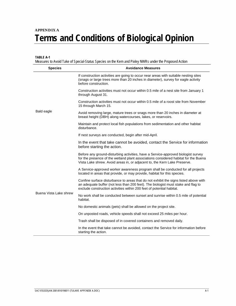
SAC\155333\JAN 2001/010190011 (TULARE APPENDIX A.DOC) A-1
APPENDIX A
Terms and Conditions of Biological Opinion
TABLE A-1Measures to Avoid Take of Special-Status Species on the Kern and Pixley NWRs under the Proposed Action
Species Avoidance Measures
Bald eagle
If construction activities are going to occur near areas with suitable nesting sites(snags or large trees more than 20 inches in diameter), survey for eagle activitybefore construction.
Construction activities must not occur within 0.5 mile of a nest site from January 1through August 31.
Construction activities must not occur within 0.5 mile of a roost site from November15 through March 15.
Avoid removing large, mature trees or snags more than 20 inches in diameter atbreast height (DBH) along watercourses, lakes, or reservoirs.
Maintain and protect local fish populations from sedimentation and other habitatdisturbance.
If nest surveys are conducted, begin after mid-April.
In the event that take cannot be avoided, contact the Service for informationbefore starting the action.
Buena Vista Lake shrew
Before any ground-disturbing activities, have a Service-approved biologist surveyfor the presence of the wetland plant associations considered habitat for the BuenaVista Lake shrew. Avoid areas in, or adjacent to, the Kern Lake Preserve.
A Service-approved worker awareness program shall be conducted for all projectslocated in areas that provide, or may provide, habitat for this species.
Confine surface disturbance to areas that do not exhibit the signs listed above withan adequate buffer (not less than 200 feet). The biologist must stake and flag toexclude construction activities within 200 feet of potential habitat.
No work shall be conducted between sunset and sunrise within 0.5 mile of potentialhabitat.
No domestic animals (pets) shall be allowed on the project site.
On unposted roads, vehicle speeds shall not exceed 25 miles per hour.
Trash shall be disposed of in covered containers and removed daily.
In the event that take cannot be avoided, contact the Service for information beforestarting the action.
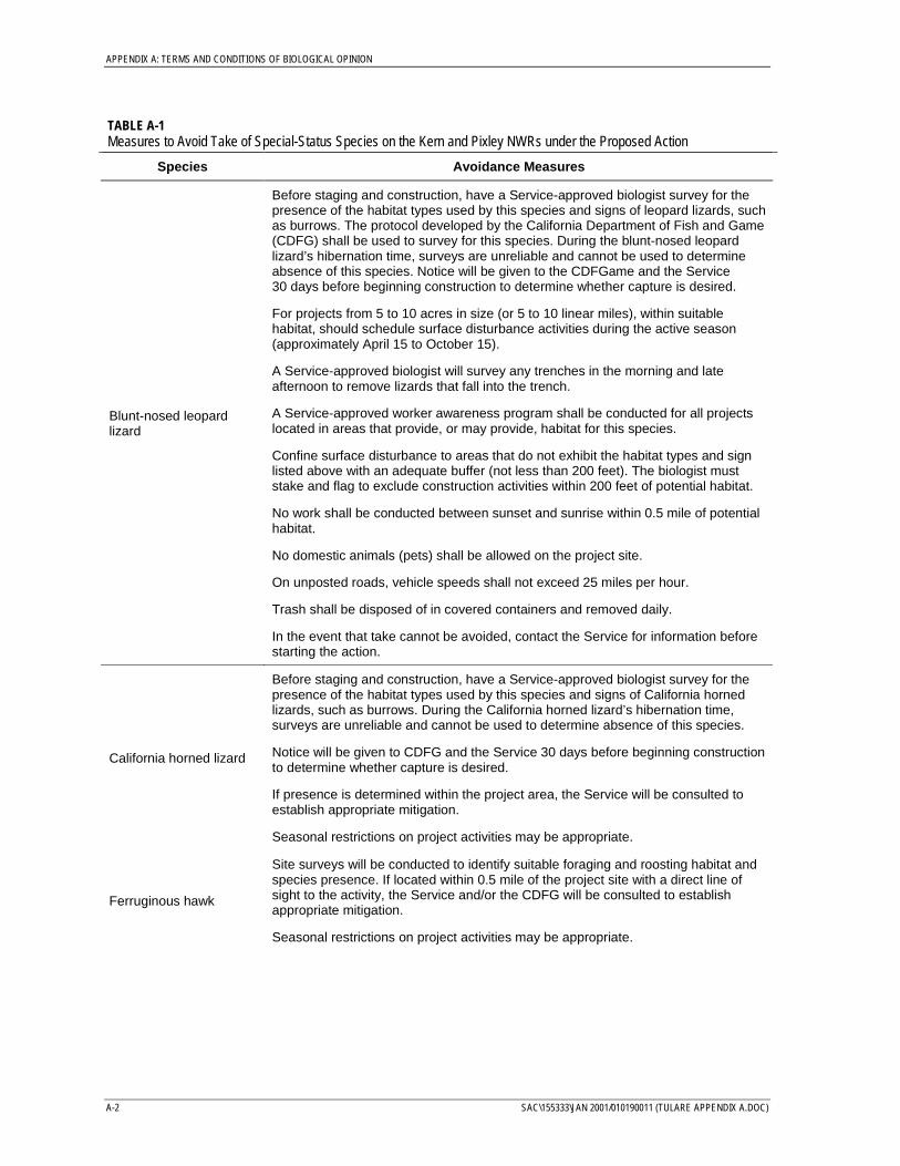
APPENDIX A: TERMS AND CONDITIONS OF BIOLOGICAL OPINION
A-2 SAC\155333\JAN 2001/010190011 (TULARE APPENDIX A.DOC)
TABLE A-1Measures to Avoid Take of Special-Status Species on the Kern and Pixley NWRs under the Proposed Action
Species Avoidance Measures
Blunt-nosed leopardlizard
Before staging and construction, have a Service-approved biologist survey for thepresence of the habitat types used by this species and signs of leopard lizards, suchas burrows. The protocol developed by the California Department of Fish and Game(CDFG) shall be used to survey for this species. During the blunt-nosed leopardlizard’s hibernation time, surveys are unreliable and cannot be used to determineabsence of this species. Notice will be given to the CDFGame and the Service30 days before beginning construction to determine whether capture is desired.
For projects from 5 to 10 acres in size (or 5 to 10 linear miles), within suitablehabitat, should schedule surface disturbance activities during the active season(approximately April 15 to October 15).
A Service-approved biologist will survey any trenches in the morning and lateafternoon to remove lizards that fall into the trench.
A Service-approved worker awareness program shall be conducted for all projectslocated in areas that provide, or may provide, habitat for this species.
Confine surface disturbance to areas that do not exhibit the habitat types and signlisted above with an adequate buffer (not less than 200 feet). The biologist muststake and flag to exclude construction activities within 200 feet of potential habitat.
No work shall be conducted between sunset and sunrise within 0.5 mile of potentialhabitat.
No domestic animals (pets) shall be allowed on the project site.
On unposted roads, vehicle speeds shall not exceed 25 miles per hour.
Trash shall be disposed of in covered containers and removed daily.
In the event that take cannot be avoided, contact the Service for information beforestarting the action.
California horned lizard
Before staging and construction, have a Service-approved biologist survey for thepresence of the habitat types used by this species and signs of California hornedlizards, such as burrows. During the California horned lizard’s hibernation time,surveys are unreliable and cannot be used to determine absence of this species.
Notice will be given to CDFG and the Service 30 days before beginning constructionto determine whether capture is desired.
If presence is determined within the project area, the Service will be consulted toestablish appropriate mitigation.
Seasonal restrictions on project activities may be appropriate.
Ferruginous hawk
Site surveys will be conducted to identify suitable foraging and roosting habitat andspecies presence. If located within 0.5 mile of the project site with a direct line ofsight to the activity, the Service and/or the CDFG will be consulted to establishappropriate mitigation.
Seasonal restrictions on project activities may be appropriate.
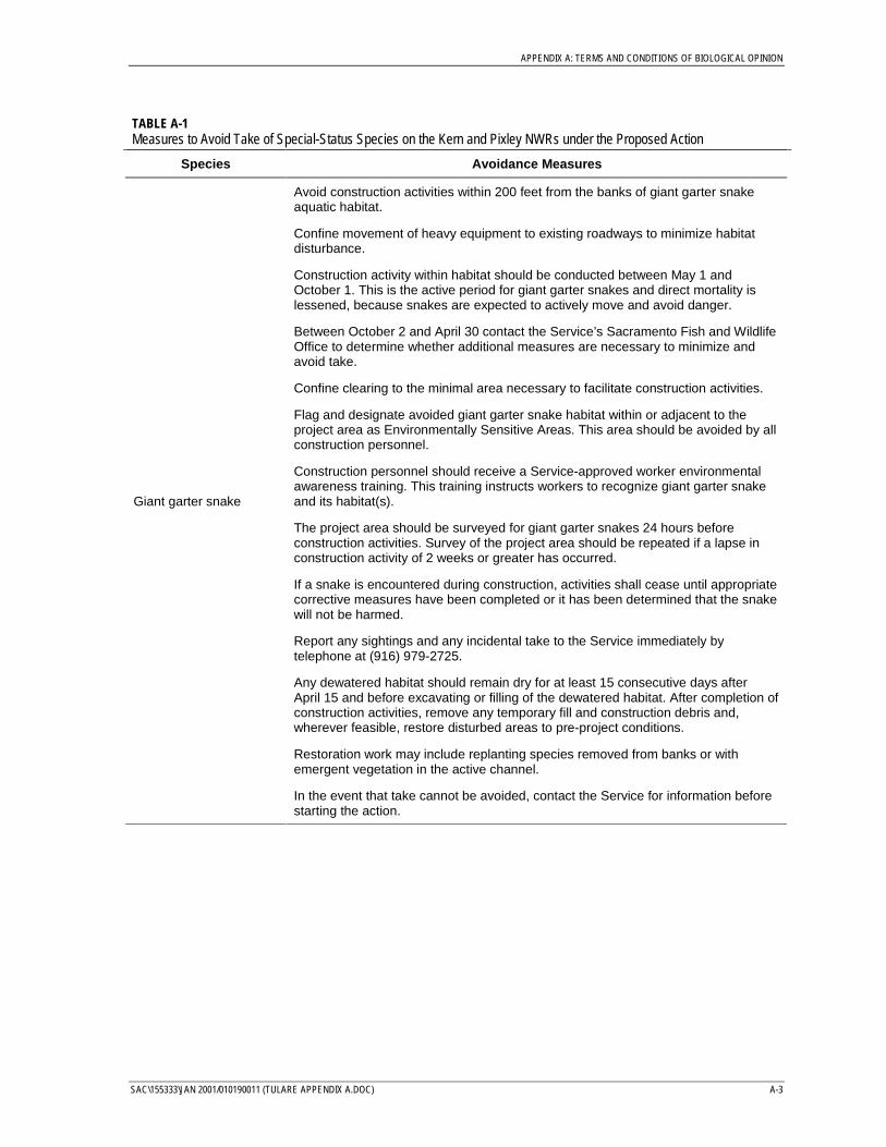
APPENDIX A: TERMS AND CONDITIONS OF BIOLOGICAL OPINION
SAC\155333\JAN 2001/010190011 (TULARE APPENDIX A.DOC) A-3
TABLE A-1Measures to Avoid Take of Special-Status Species on the Kern and Pixley NWRs under the Proposed Action
Species Avoidance Measures
Giant garter snake
Avoid construction activities within 200 feet from the banks of giant garter snakeaquatic habitat.
Confine movement of heavy equipment to existing roadways to minimize habitatdisturbance.
Construction activity within habitat should be conducted between May 1 andOctober 1. This is the active period for giant garter snakes and direct mortality islessened, because snakes are expected to actively move and avoid danger.
Between October 2 and April 30 contact the Service’s Sacramento Fish and WildlifeOffice to determine whether additional measures are necessary to minimize andavoid take.
Confine clearing to the minimal area necessary to facilitate construction activities.
Flag and designate avoided giant garter snake habitat within or adjacent to theproject area as Environmentally Sensitive Areas. This area should be avoided by allconstruction personnel.
Construction personnel should receive a Service-approved worker environmentalawareness training. This training instructs workers to recognize giant garter snakeand its habitat(s).
The project area should be surveyed for giant garter snakes 24 hours beforeconstruction activities. Survey of the project area should be repeated if a lapse inconstruction activity of 2 weeks or greater has occurred.
If a snake is encountered during construction, activities shall cease until appropriatecorrective measures have been completed or it has been determined that the snakewill not be harmed.
Report any sightings and any incidental take to the Service immediately bytelephone at (916) 979-2725.
Any dewatered habitat should remain dry for at least 15 consecutive days afterApril 15 and before excavating or filling of the dewatered habitat. After completion ofconstruction activities, remove any temporary fill and construction debris and,wherever feasible, restore disturbed areas to pre-project conditions.
Restoration work may include replanting species removed from banks or withemergent vegetation in the active channel.
In the event that take cannot be avoided, contact the Service for information beforestarting the action.
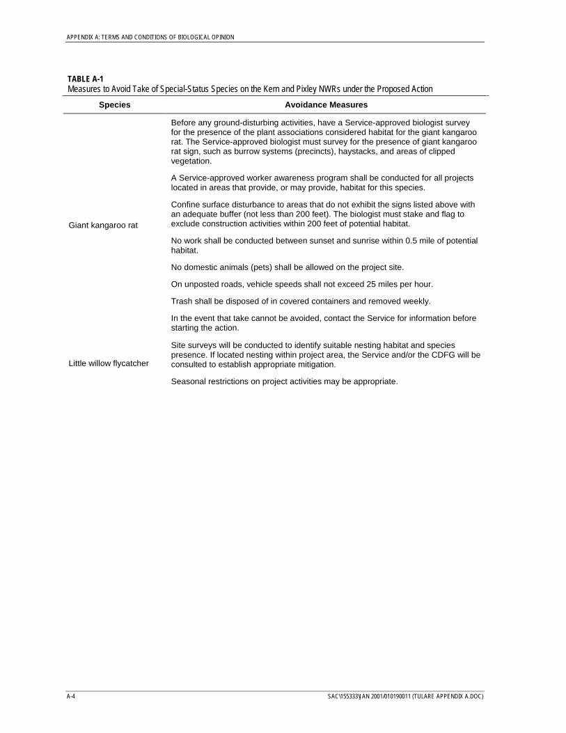
APPENDIX A: TERMS AND CONDITIONS OF BIOLOGICAL OPINION
A-4 SAC\155333\JAN 2001/010190011 (TULARE APPENDIX A.DOC)
TABLE A-1Measures to Avoid Take of Special-Status Species on the Kern and Pixley NWRs under the Proposed Action
Species Avoidance Measures
Giant kangaroo rat
Before any ground-disturbing activities, have a Service-approved biologist surveyfor the presence of the plant associations considered habitat for the giant kangaroorat. The Service-approved biologist must survey for the presence of giant kangaroorat sign, such as burrow systems (precincts), haystacks, and areas of clippedvegetation.
A Service-approved worker awareness program shall be conducted for all projectslocated in areas that provide, or may provide, habitat for this species.
Confine surface disturbance to areas that do not exhibit the signs listed above withan adequate buffer (not less than 200 feet). The biologist must stake and flag toexclude construction activities within 200 feet of potential habitat.
No work shall be conducted between sunset and sunrise within 0.5 mile of potentialhabitat.
No domestic animals (pets) shall be allowed on the project site.
On unposted roads, vehicle speeds shall not exceed 25 miles per hour.
Trash shall be disposed of in covered containers and removed weekly.
In the event that take cannot be avoided, contact the Service for information beforestarting the action.
Little willow flycatcher
Site surveys will be conducted to identify suitable nesting habitat and speciespresence. If located nesting within project area, the Service and/or the CDFG will beconsulted to establish appropriate mitigation.
Seasonal restrictions on project activities may be appropriate.
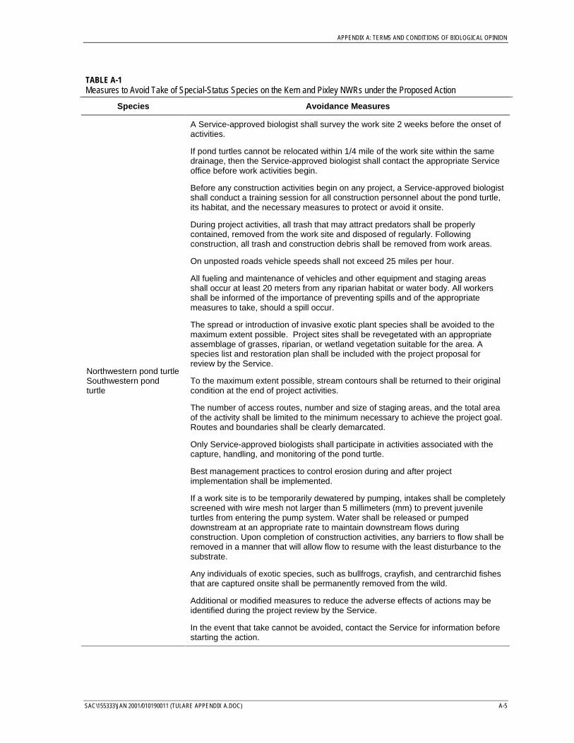
APPENDIX A: TERMS AND CONDITIONS OF BIOLOGICAL OPINION
SAC\155333\JAN 2001/010190011 (TULARE APPENDIX A.DOC) A-5
TABLE A-1Measures to Avoid Take of Special-Status Species on the Kern and Pixley NWRs under the Proposed Action
Species Avoidance Measures
Northwestern pond turtleSouthwestern pondturtle
A Service-approved biologist shall survey the work site 2 weeks before the onset ofactivities.
If pond turtles cannot be relocated within 1/4 mile of the work site within the samedrainage, then the Service-approved biologist shall contact the appropriate Serviceoffice before work activities begin.
Before any construction activities begin on any project, a Service-approved biologistshall conduct a training session for all construction personnel about the pond turtle,its habitat, and the necessary measures to protect or avoid it onsite.
During project activities, all trash that may attract predators shall be properlycontained, removed from the work site and disposed of regularly. Followingconstruction, all trash and construction debris shall be removed from work areas.
On unposted roads vehicle speeds shall not exceed 25 miles per hour.
All fueling and maintenance of vehicles and other equipment and staging areasshall occur at least 20 meters from any riparian habitat or water body. All workersshall be informed of the importance of preventing spills and of the appropriatemeasures to take, should a spill occur.
The spread or introduction of invasive exotic plant species shall be avoided to themaximum extent possible. Project sites shall be revegetated with an appropriateassemblage of grasses, riparian, or wetland vegetation suitable for the area. Aspecies list and restoration plan shall be included with the project proposal forreview by the Service.
To the maximum extent possible, stream contours shall be returned to their originalcondition at the end of project activities.
The number of access routes, number and size of staging areas, and the total areaof the activity shall be limited to the minimum necessary to achieve the project goal.Routes and boundaries shall be clearly demarcated.
Only Service-approved biologists shall participate in activities associated with thecapture, handling, and monitoring of the pond turtle.
Best management practices to control erosion during and after projectimplementation shall be implemented.
If a work site is to be temporarily dewatered by pumping, intakes shall be completelyscreened with wire mesh not larger than 5 millimeters (mm) to prevent juvenileturtles from entering the pump system. Water shall be released or pumpeddownstream at an appropriate rate to maintain downstream flows duringconstruction. Upon completion of construction activities, any barriers to flow shall beremoved in a manner that will allow flow to resume with the least disturbance to thesubstrate.
Any individuals of exotic species, such as bullfrogs, crayfish, and centrarchid fishesthat are captured onsite shall be permanently removed from the wild.
Additional or modified measures to reduce the adverse effects of actions may beidentified during the project review by the Service.
In the event that take cannot be avoided, contact the Service for information beforestarting the action.
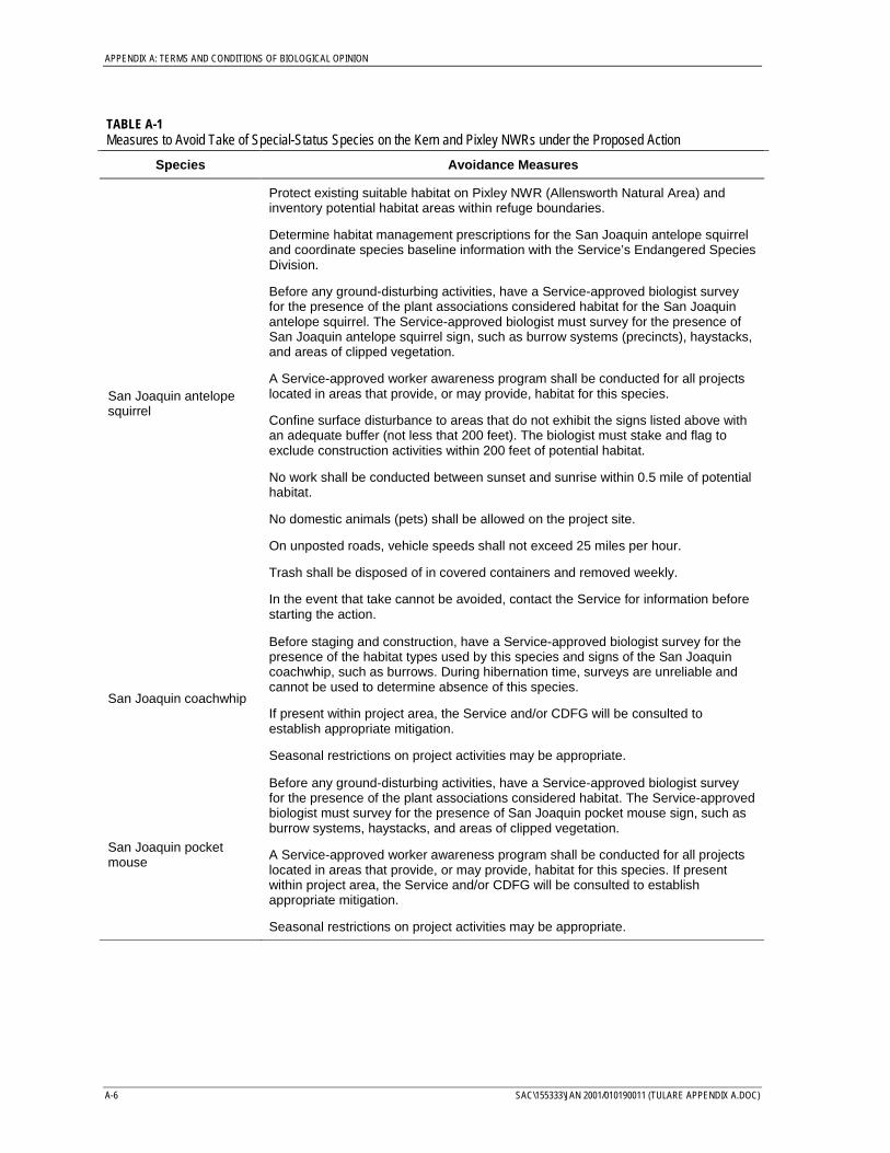
APPENDIX A: TERMS AND CONDITIONS OF BIOLOGICAL OPINION
A-6 SAC\155333\JAN 2001/010190011 (TULARE APPENDIX A.DOC)
TABLE A-1Measures to Avoid Take of Special-Status Species on the Kern and Pixley NWRs under the Proposed Action
Species Avoidance Measures
San Joaquin antelopesquirrel
Protect existing suitable habitat on Pixley NWR (Allensworth Natural Area) andinventory potential habitat areas within refuge boundaries.
Determine habitat management prescriptions for the San Joaquin antelope squirreland coordinate species baseline information with the Service’s Endangered SpeciesDivision.
Before any ground-disturbing activities, have a Service-approved biologist surveyfor the presence of the plant associations considered habitat for the San Joaquinantelope squirrel. The Service-approved biologist must survey for the presence ofSan Joaquin antelope squirrel sign, such as burrow systems (precincts), haystacks,and areas of clipped vegetation.
A Service-approved worker awareness program shall be conducted for all projectslocated in areas that provide, or may provide, habitat for this species.
Confine surface disturbance to areas that do not exhibit the signs listed above withan adequate buffer (not less that 200 feet). The biologist must stake and flag toexclude construction activities within 200 feet of potential habitat.
No work shall be conducted between sunset and sunrise within 0.5 mile of potentialhabitat.
No domestic animals (pets) shall be allowed on the project site.
On unposted roads, vehicle speeds shall not exceed 25 miles per hour.
Trash shall be disposed of in covered containers and removed weekly.
In the event that take cannot be avoided, contact the Service for information beforestarting the action.
San Joaquin coachwhip
Before staging and construction, have a Service-approved biologist survey for thepresence of the habitat types used by this species and signs of the San Joaquincoachwhip, such as burrows. During hibernation time, surveys are unreliable andcannot be used to determine absence of this species.
If present within project area, the Service and/or CDFG will be consulted toestablish appropriate mitigation.
Seasonal restrictions on project activities may be appropriate.
San Joaquin pocketmouse
Before any ground-disturbing activities, have a Service-approved biologist surveyfor the presence of the plant associations considered habitat. The Service-approvedbiologist must survey for the presence of San Joaquin pocket mouse sign, such asburrow systems, haystacks, and areas of clipped vegetation.
A Service-approved worker awareness program shall be conducted for all projectslocated in areas that provide, or may provide, habitat for this species. If presentwithin project area, the Service and/or CDFG will be consulted to establishappropriate mitigation.
Seasonal restrictions on project activities may be appropriate.
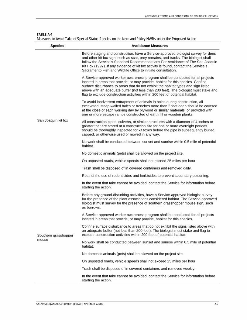
APPENDIX A: TERMS AND CONDITIONS OF BIOLOGICAL OPINION
SAC\155333\JAN 2001/010190011 (TULARE APPENDIX A.DOC) A-7
TABLE A-1Measures to Avoid Take of Special-Status Species on the Kern and Pixley NWRs under the Proposed Action
Species Avoidance Measures
San Joaquin kit fox
Before staging and construction, have a Service-approved biologist survey for densand other kit fox sign, such as scat, prey remains, and tracks. The biologist shallfollow the Service’s Standard Recommendations For Avoidance of The San JoaquinKit Fox (1997). If any evidence of kit fox activity is found, contact the Service’sSacramento Fish and Wildlife Office to initiate consultation.
A Service-approved worker awareness program shall be conducted for all projectslocated in areas that provide, or may provide, habitat for this species. Confinesurface disturbance to areas that do not exhibit the habitat types and sign listedabove with an adequate buffer (not less than 200 feet). The biologist must stake andflag to exclude construction activities within 200 feet of potential habitat.
To avoid inadvertent entrapment of animals in holes during construction, allexcavated, steep-walled holes or trenches more than 2 feet deep should be coveredat the close of each working day by plywood or similar materials, or provided withone or more escape ramps constructed of earth fill or wooden planks.
All construction pipes, culverts, or similar structures with a diameter of 4 inches orgreater that are stored at a construction site for one or more overnight periodsshould be thoroughly inspected for kit foxes before the pipe is subsequently buried,capped, or otherwise used or moved in any way.
No work shall be conducted between sunset and sunrise within 0.5 mile of potentialhabitat.
No domestic animals (pets) shall be allowed on the project site.
On unposted roads, vehicle speeds shall not exceed 25 miles per hour.
Trash shall be disposed of in covered containers and removed daily.
Restrict the use of rodenticides and herbicides to prevent secondary poisoning.
In the event that take cannot be avoided, contact the Service for information beforestarting the action.
Southern grasshoppermouse
Before any ground-disturbing activities, have a Service-approved biologist surveyfor the presence of the plant associations considered habitat. The Service-approvedbiologist must survey for the presence of southern grasshopper mouse sign, suchas burrows.
A Service-approved worker awareness program shall be conducted for all projectslocated in areas that provide, or may provide, habitat for this species.
Confine surface disturbance to areas that do not exhibit the signs listed above withan adequate buffer (not less than 200 feet). The biologist must stake and flag toexclude construction activities within 200 feet of potential habitat.
No work shall be conducted between sunset and sunrise within 0.5 mile of potentialhabitat.
No domestic animals (pets) shall be allowed on the project site.
On unposted roads, vehicle speeds shall not exceed 25 miles per hour.
Trash shall be disposed of in covered containers and removed weekly.
In the event that take cannot be avoided, contact the Service for information beforestarting the action.
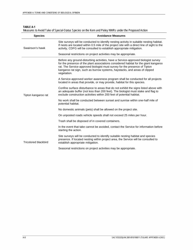
APPENDIX A: TERMS AND CONDITIONS OF BIOLOGICAL OPINION
A-8 SAC\155333\JAN 2001/010190011 (TULARE APPENDIX A.DOC)
TABLE A-1Measures to Avoid Take of Special-Status Species on the Kern and Pixley NWRs under the Proposed Action
Species Avoidance Measures
Swainson’s hawk
Site surveys will be conducted to identify nesting activity in suitable nesting habitat.If nests are located within 0.5 mile of the project site with a direct line of sight to theactivity, CDFG will be consulted to establish appropriate mitigation.
Seasonal restrictions on project activities may be appropriate.
Tipton kangaroo rat
Before any ground-disturbing activities, have a Service-approved biologist surveyfor the presence of the plant associations considered habitat for the giant kangaroorat. The Service-approved biologist must survey for the presence of Tiptonkangaroo rat sign, such as burrow systems, haystacks, and areas of clippedvegetation.
A Service-approved worker awareness program shall be conducted for all projectslocated in areas that provide, or may provide, habitat for this species.
Confine surface disturbance to areas that do not exhibit the signs listed above withan adequate buffer (not less than 200 feet). The biologist must stake and flag toexclude construction activities within 200 feet of potential habitat.
No work shall be conducted between sunset and sunrise within one-half mile ofpotential habitat.
No domestic animals (pets) shall be allowed on the project site.
On unposted roads vehicle speeds shall not exceed 25 miles per hour.
Trash shall be disposed of in covered containers.
In the event that take cannot be avoided, contact the Service for information beforestarting the action.
Tricolored blackbird
Site surveys will be conducted to identify suitable nesting habitat and speciespresence. If located nesting within project area, the Service will be consulted toestablish appropriate mitigation.
Seasonal restrictions on project activities may be appropriate.
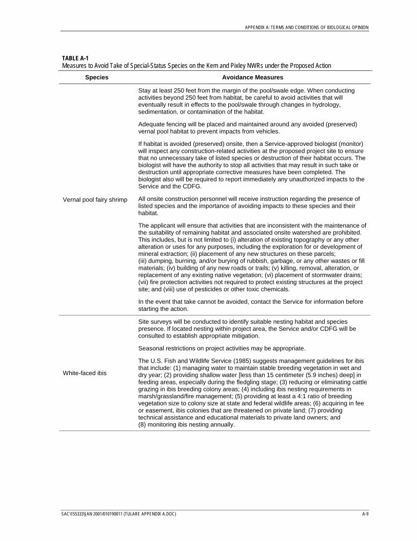
APPENDIX A: TERMS AND CONDITIONS OF BIOLOGICAL OPINION
SAC\155333\JAN 2001/010190011 (TULARE APPENDIX A.DOC) A-9
TABLE A-1Measures to Avoid Take of Special-Status Species on the Kern and Pixley NWRs under the Proposed Action
Species Avoidance Measures
Vernal pool fairy shrimp
Stay at least 250 feet from the margin of the pool/swale edge. When conductingactivities beyond 250 feet from habitat, be careful to avoid activities that willeventually result in effects to the pool/swale through changes in hydrology,sedimentation, or contamination of the habitat.
Adequate fencing will be placed and maintained around any avoided (preserved)vernal pool habitat to prevent impacts from vehicles.
If habitat is avoided (preserved) onsite, then a Service-approved biologist (monitor)will inspect any construction-related activities at the proposed project site to ensurethat no unnecessary take of listed species or destruction of their habitat occurs. Thebiologist will have the authority to stop all activities that may result in such take ordestruction until appropriate corrective measures have been completed. Thebiologist also will be required to report immediately any unauthorized impacts to theService and the CDFG.
All onsite construction personnel will receive instruction regarding the presence oflisted species and the importance of avoiding impacts to these species and theirhabitat.
The applicant will ensure that activities that are inconsistent with the maintenance ofthe suitability of remaining habitat and associated onsite watershed are prohibited.This includes, but is not limited to (i) alteration of existing topography or any otheralteration or uses for any purposes, including the exploration for or development ofmineral extraction; (ii) placement of any new structures on these parcels;(iii) dumping, burning, and/or burying of rubbish, garbage, or any other wastes or fillmaterials; (iv) building of any new roads or trails; (v) killing, removal, alteration, orreplacement of any existing native vegetation; (vi) placement of stormwater drains;(vii) fire protection activities not required to protect existing structures at the projectsite; and (viii) use of pesticides or other toxic chemicals.
In the event that take cannot be avoided, contact the Service for information beforestarting the action.
White-faced ibis
Site surveys will be conducted to identify suitable nesting habitat and speciespresence. If located nesting within project area, the Service and/or CDFG will beconsulted to establish appropriate mitigation.
Seasonal restrictions on project activities may be appropriate.
The U.S. Fish and Wildlife Service (1985) suggests management guidelines for ibisthat include: (1) managing water to maintain stable breeding vegetation in wet anddry year; (2) providing shallow water [less than 15 centimeter (5.9 inches) deep] infeeding areas, especially during the fledgling stage; (3) reducing or eliminating cattlegrazing in ibis breeding colony areas; (4) including ibis nesting requirements inmarsh/grassland/fire management; (5) providing at least a 4:1 ratio of breedingvegetation size to colony size at state and federal wildlife areas; (6) acquiring in feeor easement, ibis colonies that are threatened on private land; (7) providingtechnical assistance and educational materials to private land owners; and(8) monitoring ibis nesting annually.
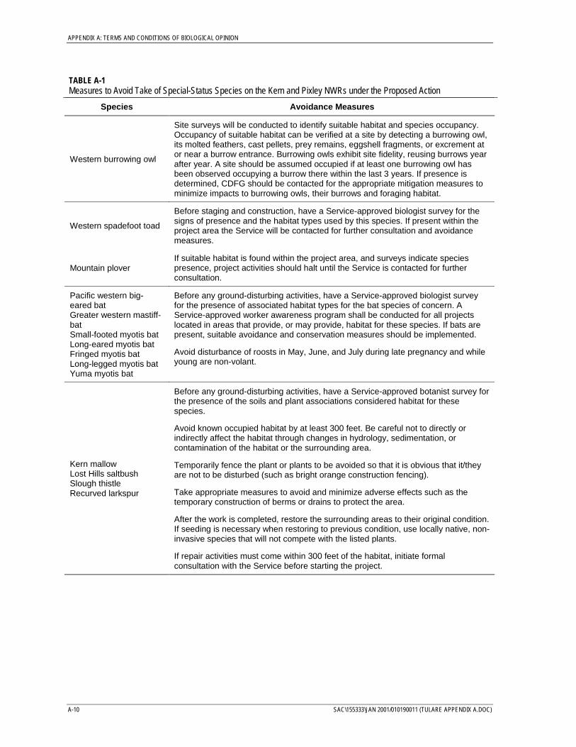
APPENDIX A: TERMS AND CONDITIONS OF BIOLOGICAL OPINION
A-10 SAC\155333\JAN 2001/010190011 (TULARE APPENDIX A.DOC)
TABLE A-1Measures to Avoid Take of Special-Status Species on the Kern and Pixley NWRs under the Proposed Action
Species Avoidance Measures
Western burrowing owl
Site surveys will be conducted to identify suitable habitat and species occupancy.Occupancy of suitable habitat can be verified at a site by detecting a burrowing owl,its molted feathers, cast pellets, prey remains, eggshell fragments, or excrement ator near a burrow entrance. Burrowing owls exhibit site fidelity, reusing burrows yearafter year. A site should be assumed occupied if at least one burrowing owl hasbeen observed occupying a burrow there within the last 3 years. If presence isdetermined, CDFG should be contacted for the appropriate mitigation measures tominimize impacts to burrowing owls, their burrows and foraging habitat.
Western spadefoot toad
Before staging and construction, have a Service-approved biologist survey for thesigns of presence and the habitat types used by this species. If present within theproject area the Service will be contacted for further consultation and avoidancemeasures.
Mountain ploverIf suitable habitat is found within the project area, and surveys indicate speciespresence, project activities should halt until the Service is contacted for furtherconsultation.
Pacific western big-eared batGreater western mastiff-batSmall-footed myotis batLong-eared myotis batFringed myotis batLong-legged myotis batYuma myotis bat
Before any ground-disturbing activities, have a Service-approved biologist surveyfor the presence of associated habitat types for the bat species of concern. AService-approved worker awareness program shall be conducted for all projectslocated in areas that provide, or may provide, habitat for these species. If bats arepresent, suitable avoidance and conservation measures should be implemented.
Avoid disturbance of roosts in May, June, and July during late pregnancy and whileyoung are non-volant.
Kern mallowLost Hills saltbushSlough thistleRecurved larkspur
Before any ground-disturbing activities, have a Service-approved botanist survey forthe presence of the soils and plant associations considered habitat for thesespecies.
Avoid known occupied habitat by at least 300 feet. Be careful not to directly orindirectly affect the habitat through changes in hydrology, sedimentation, orcontamination of the habitat or the surrounding area.
Temporarily fence the plant or plants to be avoided so that it is obvious that it/theyare not to be disturbed (such as bright orange construction fencing).
Take appropriate measures to avoid and minimize adverse effects such as thetemporary construction of berms or drains to protect the area.
After the work is completed, restore the surrounding areas to their original condition.If seeding is necessary when restoring to previous condition, use locally native, non-invasive species that will not compete with the listed plants.
If repair activities must come within 300 feet of the habitat, initiate formalconsultation with the Service before starting the project.
Related Documents