Refining National Boundaries of the United States National Boundaries Group ESRI UC San Diego 2016 Laura Waggoner US Census Bureau Robert Pierce US Geological Survey

Welcome message from author
This document is posted to help you gain knowledge. Please leave a comment to let me know what you think about it! Share it to your friends and learn new things together.
Transcript
Refining National Boundaries of the United States
National Boundaries GroupESRI UC San Diego 2016
Laura Waggoner US Census Bureau
Robert PierceUS Geological Survey

National Boundaries Group The National Boundaries Group (NBG) within Federal
Geographic Data Committee (FGDC) has been improving the national boundaries of the U.S including: State, County, International, Marine, Federal, Tribal
Formed to establish collaboration of federal boundary efforts for A-16 data sets
For all responsible federal agencies to achieve the following with boundaries: Currency, Accuracy, Consistancy, Accessibility, Integration
First meeting held March 14, 2011 Quarterly meetings started in 2012
Co-chaired by the USGS and Census Bureau
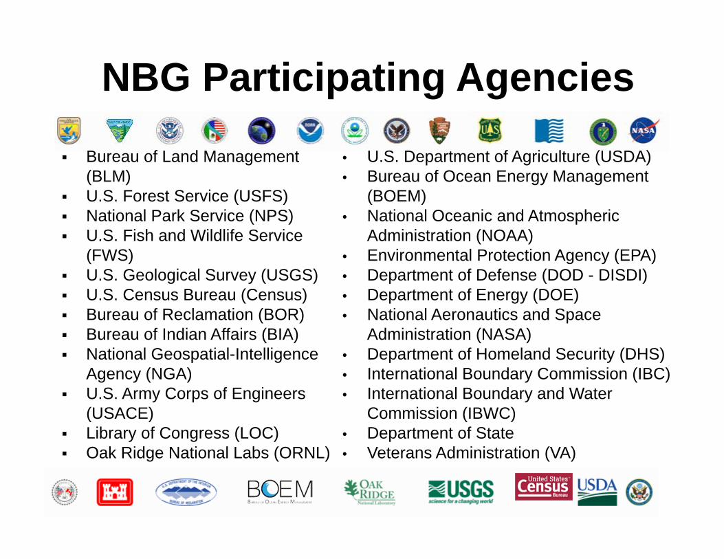
NBG Participating Agencies
Bureau of Land Management (BLM)
U.S. Forest Service (USFS) National Park Service (NPS) U.S. Fish and Wildlife Service
(FWS) U.S. Geological Survey (USGS) U.S. Census Bureau (Census) Bureau of Reclamation (BOR) Bureau of Indian Affairs (BIA) National Geospatial-Intelligence
Agency (NGA) U.S. Army Corps of Engineers
(USACE) Library of Congress (LOC) Oak Ridge National Labs (ORNL)
• U.S. Department of Agriculture (USDA)• Bureau of Ocean Energy Management
(BOEM)• National Oceanic and Atmospheric
Administration (NOAA)• Environmental Protection Agency (EPA)• Department of Defense (DOD - DISDI)• Department of Energy (DOE)• National Aeronautics and Space
Administration (NASA)• Department of Homeland Security (DHS)• International Boundary Commission (IBC)• International Boundary and Water
Commission (IBWC)• Department of State• Veterans Administration (VA)

Sources Of Boundary DataAuthoritative Source Boundary
Bureau of Census:Boundary Annexation Survey (BAS)
Govt Units: state, county, incorporated places, minor civil divisions, congressional districts, tribal lands
State Department(IBWC, IBC)
International Boundary: Mexican‐U.S Border, Canadian‐U.S. Border
Federal AgenciesFWS, USFS, NPS, BLM, BOR, DOE, NASA, DOD, DHS, USACE, et al
Federal Lands: civilian, military
NOAA Maritime boundariesBureau of Land Management Public Land Survey System
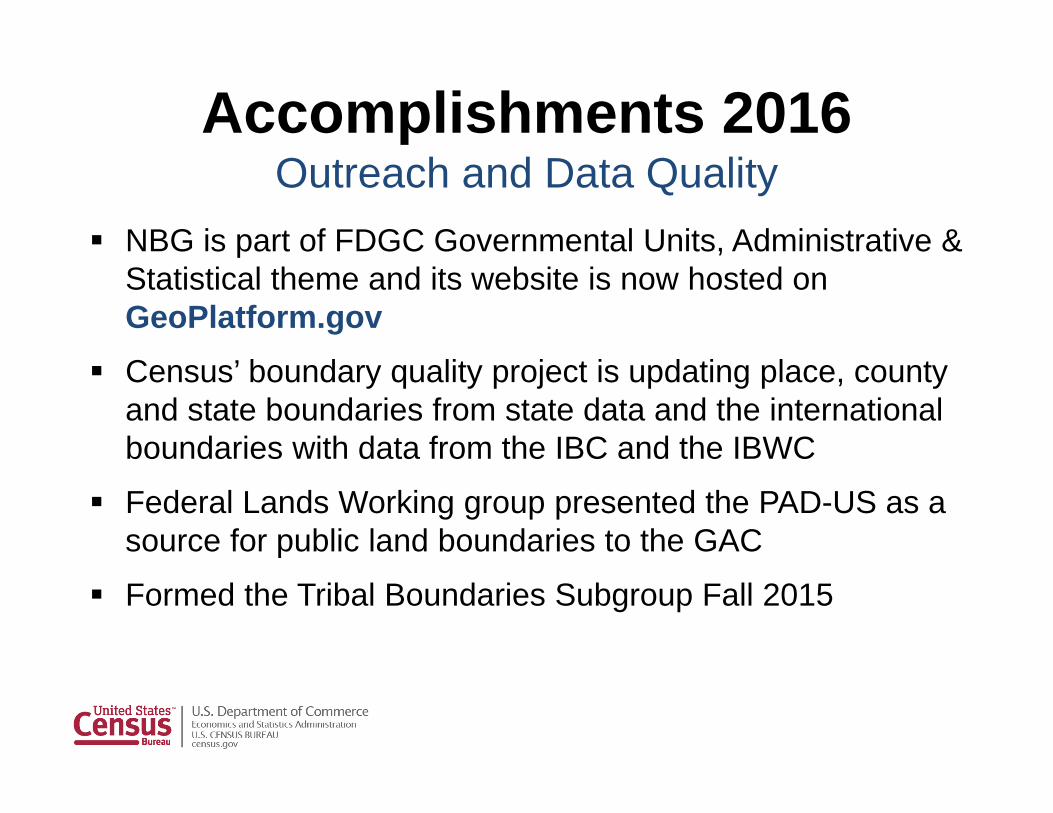
Accomplishments 2016Outreach and Data Quality
NBG is part of FDGC Governmental Units, Administrative & Statistical theme and its website is now hosted on GeoPlatform.gov
Census’ boundary quality project is updating place, county and state boundaries from state data and the international boundaries with data from the IBC and the IBWC
Federal Lands Working group presented the PAD-US as a source for public land boundaries to the GAC
Formed the Tribal Boundaries Subgroup Fall 2015

GeoPlatform.gov Establishment of Community
page on FGDC’s GeoPlatform Space to share information,
meeting minutes, presentations, blogs, and links
Pertaining to the National Boundaries Group and its subgroups Federal Lands Working Group Tribal Subgroup
https://www.geoplatform.gov/a16govunits/NBG
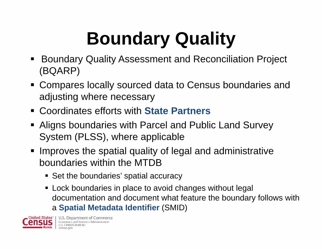
Boundary Quality Boundary Quality Assessment and Reconciliation Project
(BQARP) Compares locally sourced data to Census boundaries and
adjusting where necessary Coordinates efforts with State Partners Aligns boundaries with Parcel and Public Land Survey
System (PLSS), where applicable Improves the spatial quality of legal and administrative
boundaries within the MTDB Set the boundaries’ spatial accuracy Lock boundaries in place to avoid changes without legal
documentation and document what feature the boundary follows with a Spatial Metadata Identifier (SMID)

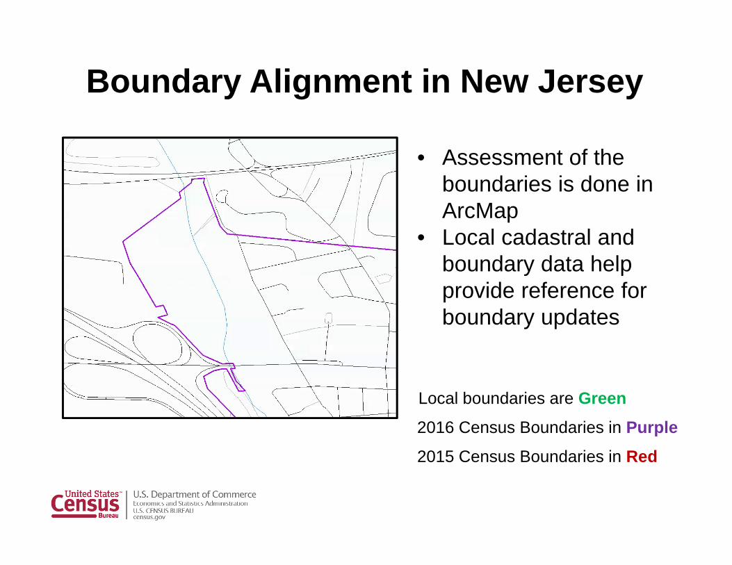
Boundary Alignment in New Jersey
2015 Census Boundaries in Red 2016 Census Boundaries in PurpleNew Jersey local boundaries are Green
Before and after Census’ Boundary Quality Assessment and Reconciliation Project
Boundary Alignment in New Jersey
2015 Census Boundaries in Red
2016 Census Boundaries in Purple
Local boundaries are Green
• Assessment of the boundaries is done in ArcMap
• Local cadastral and boundary data help provide reference for boundary updates
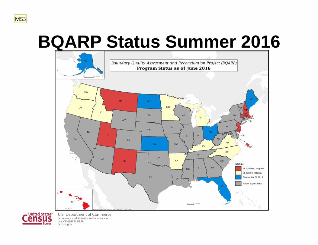
BQARP Status Summer 2016MS3

Slide 10
MS3 We'll have a newer status map next weekMadeline Sovich, 5/20/2016
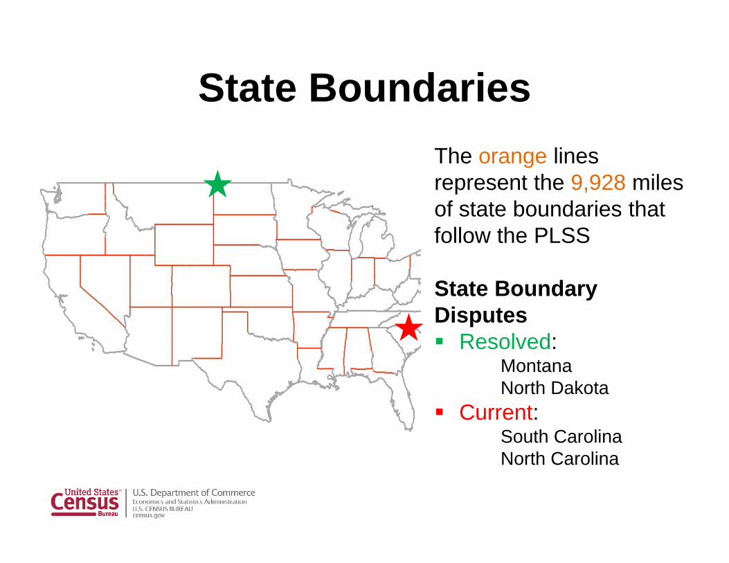
State BoundariesThe orange lines represent the 9,928 miles of state boundaries that follow the PLSS
State Boundary Disputes Resolved:
MontanaNorth Dakota
Current:South CarolinaNorth Carolina
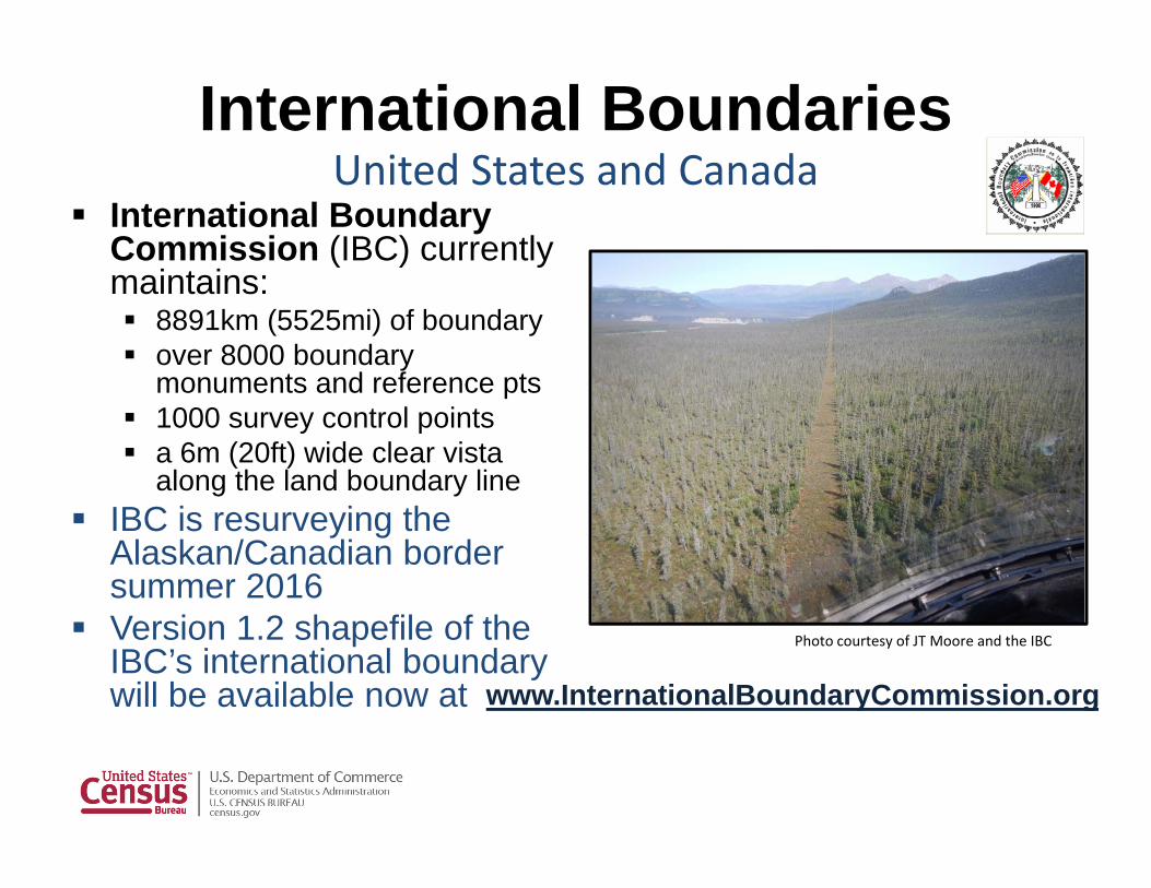
International Boundary Commission (IBC) currently maintains: 8891km (5525mi) of boundary over 8000 boundary
monuments and reference pts 1000 survey control points a 6m (20ft) wide clear vista
along the land boundary line IBC is resurveying the
Alaskan/Canadian border summer 2016
Version 1.2 shapefile of the IBC’s international boundary will be available now at
International BoundariesUnited States and Canada
Photo courtesy of JT Moore and the IBC
www.InternationalBoundaryCommission.org
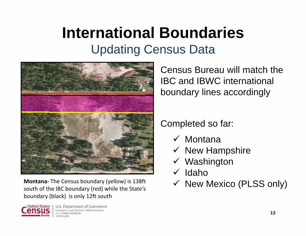
International BoundariesUpdating Census Data
Census Bureau will match the IBC and IBWC international boundary lines accordingly
Completed so far:
Montana New Hampshire Washington Idaho New Mexico (PLSS only)
13
Montana‐ The Census boundary (yellow) is 138ft south of the IBC boundary (red) while the State’s boundary (black) is only 12ft south

International BoundariesUnited States and Mexico
The International Boundary and Water Commission(IBWC) is the bi-national commission on boundary disputes
Currently resurveying boundary markers in a multi- year project
Boundary affected by major flow events including hurricane Alex (2008)

Federal BoundariesFederal Lands Working Group
FY 2016-17 Objectives: Assess and improve inventory completeness Assess and improve the compatibility or completeness of
core attributes between agency datasets Improve the efficiency of annual fed lands data
aggregation for the Protected Areas Database of the United States (PAD-US)
Identify and correct major topology overlaps errors (i.e. boundaries) between agency datasets.

Federal Lands Working GroupProtected Area Database
Presented to the DOI Geospatial Advisory Committee (GAC) to get support for the PAD-US Acknowledge PAD-US as the nation's inventory of
protected (public) areas by identifying PAD-US as the nation's inventory of protected area by recognizing PAD-US is an A-16 layer in the Cadastral Theme.
Support federal agencies providing PAD-US with updates by requesting DOI Bureaus provide staff time to work on PAD-US by submitting data and working to resolve gaps and overlaps between agencies.
Recognize the resources required to produce an aggregated geodatabase for common agency needs

Tribal Boundaries Tribal Boundaries Subgroup
New Subgroup of the National Boundaries Group (NBG)
Growing interest in NBG meetings Started holding independent meetings in late
2015 Meetings are 1st Wednesday of every month
Anyone is welcome to join!

Tribal Boundaries Subgroup: Why?
Many agencies use tribal boundaries, often separately and differently
Boundaries are needed for data dissemination
Agencies writing legislation and people using the data need to understand the geography behind the data
Some agencies use tribal boundaries but can’t maintain their own layer so they need to coordinate with other agencies

Tribal Boundaries Subgroup Current Work
Goal I: Discuss and document tribal boundary needs from agencies that use tribal boundaries
First order of business for the group To accomplish this goal, each agency will take a turn
presenting to the group 1-2 presentations during each group meeting Use a presentation template to hit key points Document presentations
Related Documents