Redwine River Ranch Breathtaking Estate on the Santa Fe River! 5278 SW County Rd. 138, Ft. White, FL Presented by: Charlie Sparks BROKER 386-755-0808 [email protected] Sale Price: $1,650,000 Zoning: AG-3 / ESA- 2 Land Size: 139.91 Acres Total Bldg Size: 6,005 SF* River Frontage: Over 2400’ on Santa Fe *See Page 3 for more details FOR MORE INFORMATION CONTACT: Charlie Sparks, BROKER 386-755-0808 | 877-871-0808 [email protected] 426 SW Commerce Dr. #130 Lake City, FL 32025

Welcome message from author
This document is posted to help you gain knowledge. Please leave a comment to let me know what you think about it! Share it to your friends and learn new things together.
Transcript

Redwine River RanchBreathtaking Estate on the Santa Fe River!
5278 SW County Rd. 138, Ft. White, FL
Presented by:
Charlie [email protected]
Sale Price: $1,650,000
Zoning: AG-3 / ESA- 2
Land Size: 139.91 Acres
Total Bldg Size: 6,005 SF*
River Frontage: Over 2400’ on Santa Fe
*See Page 3 for more details
FOR MORE INFORMATION CONTACT:Charlie Sparks, BROKER386-755-0808 | [email protected]
426 SW Commerce Dr. #130Lake City, FL 32025

Property Layout
Charlie Sparks, BROKER | 386-755-0808 | [email protected]
Redwine River Ranch
WWorkshop
Stilt House
Guest House
Main House
Private Spring / Private Spring /Private Spring /Swimming Hole
Private Island
ooouseoouseNew Pole Barn

Charlie Sparks, BROKER | 386-755-0808 | [email protected]
PROPERTY OVERVIEW
Property Red Wine River Ranch – Ft. White, FL
Address5278 SW County Rd. 138
Fort White, FL 32038
Best UsePersonal residence, Corporate retreat, or Bed &
Breakfast, etc.
Year Built 1978 - 1994
Land Size Approx. 139.91 Acres
Building Sizes (based on appraisal)
Main Home: Guest Home #1:
Stilt House:
3,717 SF / 4BR,4BA1,136 SF / 1BR, 1BA1,152 SF / 3BR, 2BA
Roof Type Shingle, Metal (guest house)
Site Amenities
Paved Driveway – Nearly 2,000 feet in lengthPrivate spring detached from river.
Private island, approx. 5 acres.24x60 Pole Barn & 64x64 Workshop.
2,400+ feet of frontage on Santa Fe River.Wooded lot with Oaks, Cypress and other trees.
Nature trails and private roads on property.
Zoning & Land UseAG-3 & ESA-2
See attached regulations
Utilities
Private Well & SepticElectricity
Telephone ServiceSatellite Service
Property Access Paved, Government maintained
Redwine River Ranch

Main Home Exterior Photo Summary
Charlie Sparks, BROKER | 386-755-0808 | [email protected]
Redwine River Ranch

Main Home Exterior Photo Summary
Charlie Sparks, BROKER | 386-755-0808 | [email protected]
Redwine River Ranch

Main Home Interior Photo Summary
Charlie Sparks, BROKER | 386-755-0808 | [email protected]
Redwine River Ranch

Guest Quarters Photo Summary
Charlie Sparks, BROKER | 386-755-0808 | [email protected]
Redwine River Ranch

Exterior Photo Summary
Charlie Sparks, BROKER | 386-755-0808 | [email protected]
Redwine River Ranch

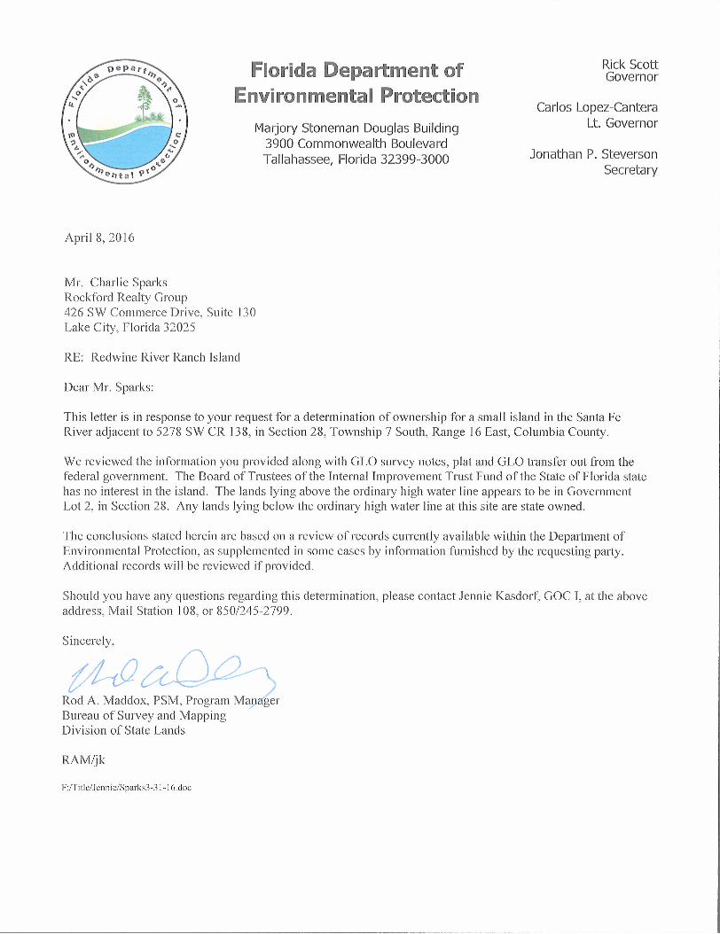
SummaryThis truly unique property features 139+/- acres with pasture areas, towering Oaks and Cypress trees, several nature trails and private roads, a private natural spring / swimming hole, and a 5 acre private island! There are 3 separate homes on the property. Located on a paved road!
The Main House: The two-story main home has over 3,700sf of living space and was constructed with reclaimed logs from the Santa Fe River! Beautiful stone fireplaces on both floors and rustic touches throughout! Large windows and skylights provide plenty of natural light and gorgeous views. Ample decking and patio areas to relax and take in the peaceful setting. Large detached 2-car garage with its own half bath.
The Guest House: The 1BR/1BA guest home features approximately 1,136 sqft of space. Gorgeous open beam ceilings in the living room and kitchen area.
The Stilt House: Cypress-sided 3BR/2BA stilt house with approximately 1,152 sqft of living space. Lovely wrap-around porch. Parking space under home.
The current ownership is offering this property for sale at an attractive price of $1,650,000!
Aerial View
Charlie Sparks, BROKER | 386-755-0808 | [email protected]
Redwine River Ranch

Repairs & Improvements Since October 2016
Charlie Sparks, BROKER | 386-755-0808 | [email protected]
Redwine River Ranch
New Metal Standing Seam Roofs – All homes $60,800
Post Brackets & repairs, Garage Angle Brackets $2,800
Paint Main House and Garage $5,850
Windows & Doors $53,000
Work Shed $43,000
Decks, Front & Rear $37,500
Deck Repairs – Skirting $1,800
Deck Repairs – Small Deck $1,300
Deck Repairs – Rear Lower Deck $8,300
Pavers $23,500
Deck Railing $11,400
Roof – Guest House $6,400
Remove & Replace Fence $27,140
Replace Rocks in Front $11,470
Trees $3,240
Sod $4,400
Tree Removal & Stump Grinding $52,100
Concrete $14,300
Gate $6,000
Millings $6,800
Misc. Labor & Materials $92,000
TTOTAL : $473,100

Area InformationFort White is located in southern Columbia County at the intersection of
U.S. Hwy 27 and State Road 47. State Road 47 leads north 20 miles to Lake City.
The town was incorporated in 1884 and grew steadily following the arrival of the railroad in 1888. Phosphate mining, turpentine and agriculture (cotton and oranges) were the foundation of the economy, and the population grew to nearly 2,000.
Columbia County is noted for its natural tourist attractions like the Ichetucknee River, Suwannee River, Santa Fe River and a large U.S. Forest. The community has enjoyed good growth over the past two decades and is set for continued growth for years to come. And of course, you cannot say enough good things about the enviable climate in North Central Florida!
Location
Nearby Metropolitan City Distance in Miles
Gainesville 32
Jacksonville 80
Tallahassee 123
Charlie Sparks, BROKER | 386-755-0808 | [email protected]
Redwine River Ranch

Columbia County Demographics
Charlie Sparks, BROKER | 386-755-0808 | [email protected]
Population
Households
Income
Housing
Columbia County Florida
1990 Census Population2000 Census Population2010 Census Population2015 Projected Population
Growth 2000-2010Growth 2010-2015
2013 Estimated Median Age2013 Persons per square mile
42,61356,51367,53169,865
19.5%3.5%
39.984.6
12,938,07115,982,82418,801,33219,750,577
17.6%5%
40.7359.2
2000 Census Households2010 Estimated Households
Growth 2000-2010
2010 Average Household Size
2000 Number of Housing Units2010 Number of Housing UnitsGrowth 2000-2010
20,92524,941
19.1%
2.52
23,57928,63621.4%
6,338,0757,420,802
17%
2.48
7,302,9478,989,580
23%
1990 Per Capita Personal Income2000 Per Capita Personal Income2010 Per Capita Personal Income2012 Per Capita Personal Income
2013 Median Household Income2013 Median Family Income
$13,370$19,273$27,983$29,966
$37,534$44,707
$19,437$29,079$38,493$41,012
$47,309$57,128
2000 Occupied Units2000 Vacant Units2000 Owner Occupied Units2000 Renter Occupied Units
2010 Occupied Units2010 Vacant Units2010 Owner Occupied Units2010 Renter Occupied Units
1990 New Home Permits2000 New Home Permits2010 New Home Permits2012 New Home Permits
20,9252,654
16,1464,779
24,9413,695
18,2136,728
2782898447
6,337,929965,018
4,441,7991,896,130
7,420,8021,568,7784,998,9792,421,823
126,384155,26938,67964,810
Redwine River Ranch
REAssist
Rectangle

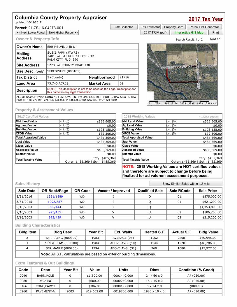
Columbia County Property Appraiser updated: 10/12/2017
2017 Tax YearParcel: 21-7S-16-04273-001
<< Next Lower Parcel Next Higher Parcel >>
Tax Collector Tax Estimator Property Card Parcel List Generator 2017 TRIM (pdf) Interactive GIS Map Print
Owner & Property Info Search Result: 1 of 2 Next >>
Owner's Name ERB MELVIN J JR &
MailingAddress
SUSIE PARK (JTWRS) 3401 SW ST LUCIE SHORES DR
PALM CITY, FL 34990
Site Address 5278 SW COUNTY ROAD 138
Use Desc. (code) SFRES/SFRE (000101)
Tax District 3 (County) Neighborhood 21716
Land Area 75.740 ACRES Market Area 02
Description NOTE: This description is not to be used as the Legal Description forthis parcel in any legal transaction.
ALL OF S1/2 OF SW1/4 LYING NE FLA POWER N R/W LINE EX E 60 FT FOR RD R/W & EX RD R/WFOR SR-138. 373-031, 376-406,408, 995-444,455,459, WD 1292-887, WD 1321-1889,
Property & Assessment Values2017 Certified Values
Mkt Land Value cnt: (0) $329,905.00Ag Land Value cnt: (3) $0.00Building Value cnt: (3) $123,158.00XFOB Value cnt: (5) $32,306.00Total Appraised Value $485,369.00Just Value $485,369.00Class Value $0.00Assessed Value $485,369.00Exempt Value $0.00
Total Taxable Value Cnty: $485,369 Other: $485,369 | Schl: $485,369
2018 Working Values ( ...Hide Values) Mkt Land Value cnt: (0) $329,905.00Ag Land Value cnt: (3) $0.00Building Value cnt: (3) $123,158.00XFOB Value cnt: (5) $32,306.00Total Appraised Value $485,369.00Just Value $485,369.00Class Value $0.00Assessed Value $485,369.00Exempt Value $0.00
Total Taxable Value Cnty: $485,369 Other: $485,369 | Schl: $485,369
NOTE: 2018 Working Values are NOT certified valuesand therefore are subject to change before beingfinalized for ad valorem assessment purposes.
Sales History Show Similar Sales within 1/2 mile
Sale Date OR Book/Page OR Code Vacant / Improved Qualified Sale Sale RCode Sale Price8/31/2016 1321/1889 WD I Q 01 $875,000.00
3/31/2015 1292/887 WD I Q 01 $621,200.00
9/16/2003 995/444 WD I Q $1,353,800.00
9/16/2003 995/455 WD V U 02 $106,200.00
9/16/2003 995/459 WD V U 02 $215,200.00
Building CharacteristicsBldg Item Bldg Desc Year Blt Ext. Walls Heated S.F. Actual S.F. Bldg Value
2 SFR PILING (000300) 1983 AVERAGE (05) 1152 2808 $60,945.00
3 SINGLE FAM (000100) 1984 ABOVE AVG. (10) 1144 1228 $46,286.00
4 SFR MANUF (000200) 1994 ABOVE AVG. (31) 960 1080 $15,927.00
Note: All S.F. calculations are based on exterior building dimensions.
Extra Features & Out BuildingsCode Desc Year Blt Value Units Dims Condition (% Good)0040 BARN,POLE 0 $1,800.00 0001440.000 24 x 60 x 0 AP (050.00)
0080 DECKING 0 $600.00 0000240.000 16 x 15 x 0 AP (050.00)
0166 CONC,PAVMT 0 $384.00 0000192.000 8 x 24 x 0 (000.00)
0260 PAVEMENT-A 2003 $19,602.00 0019800.000 1980 x 10 x 0 AP (010.00)
REAssist
Rectangle

0040 BARN,POLE 2003 $9,920.00 0003968.000 62 x 64 x 0 (000.00)
Land BreakdownLnd Code Desc Units Adjustments Eff Rate Lnd Value
000100 SFR (MKT) 50 AC 1.00/1.00/1.00/1.00 $5,271.11 $263,555.00
009900 AC NON-AG (MKT) 25.74 AC 1.00/1.00/1.00/1.00 $2,500.00 $64,350.00
009945 WELL/SEPT (MKT) 1 UT - (0000000.000AC) 1.00/1.00/1.00/1.00 $2,000.00 $2,000.00
Columbia County Property Appraiser updated: 10/12/2017
1 of 2 Next >>
DISCLAIMERThis information was derived from data which was compiled by the Columbia County Property Appraiser Office solely for the governmental purpose of propertyassessment. This information should not be relied upon by anyone as a determination of the ownership of property or market value. No warranties, expressedor implied, are provided for the accuracy of the data herein, it's use, or it's interpretation. Although it is periodically updated, this information may not reflect thedata currently on file in the Property Appraiser's office. The assessed values are NOT certified values and therefore are subject to change before beingfinalized for ad valorem assessment purposes.
© Columbia County Property Appraiser | Jeff Hampton - Lake City, Florida 32055 | 386-758-1083 by: GrizzlyLogic.com

Columbia County Property AppraiserJeff Hampton - Lake City, Florida 32055 | 386-758-1083
PARCEL: 21-7S-16-04273-001 - SFRES/SFRE (000101)ALL OF S1/2 OF SW1/4 LYING NE FLA POWER N R/W LINE EX E 60 FT FOR RD R/W & EX RD R/W FOR SR-138. 373-031,
376-406,408, 995-444,455,459, WD 1292-887,Name: ERB MELVIN J JR &Site: 5278 SW COUNTY ROAD 138
Mail:SUSIE PARK (JTWRS)
3401 SW ST LUCIE SHORES DR PALM CITY, FL 34990
Sales Info
8/31/2016 $875,000.00 I / Q3/31/2015 $621,200.00 I / Q
2017 Certified ValuesLand $329,905.00Bldg $123,158.00Assd $485,369.00Exmpt $0.00Taxbl Cnty: $485,369
Other: $485,369 | Schl: $485,369
NOTES:
This information,updated: 10/12/2017, was derived from data which was compiled by the Columbia County Property Appraiser Office solely for the governmental purpose of property assessment. Thisinformation should not be relied upon by anyone as a determination of the ownership of property or market value. No warranties, expressed or implied, are provided for the accuracy of the data herein,it's use, or it's interpretation. Although it is periodically updated, this information may not reflect the data currently on file in the Property Appraiser's office. The assessed values are NOT certified valuesand therefore are subject to change before being finalized for ad valorem assessment purposes.
REAssist
Rectangle
REAssist
Rectangle

Total Millage 16.1383 Total Taxes $7,823.39
Total Assessments $806.38
If Paid By Amount Due $0.00
Columbia County Tax Collectorgenerated on 10/26/2017 11:21:28 AM EDT
Tax Record
Last Update: 10/26/2017 11:21:27 AM EDT
Ad Valorem Taxes and Non-Ad Valorem Assessments The information contained herein does not constitute a title search and should not be relied on as such.
Account Number Tax Type Tax Year R04273-001 REAL ESTATE 2016
Mailing Address LAKE CITY ASSOCIATES, LLC 575 LEXINGTON 515 E 86TH ST APT 6WE NEW YORK NY 10028
Property Address 5278 COUNTY ROAD 138 SW FORT WHITE
GEO Number 217S16-04273-001
Exempt Amount Taxable Value See Below See Below
Exemption Detail Millage Code Escrow Code NO EXEMPTIONS 003 Legal Description (click for full description) 21-7S-16 0101/0101 75.74 Acres ALL OF S1/2 OF SW1/4 LYING NE FLA POWER NR/W LINE EX E 60 FT FOR RD R/W & EX RD R/W FOR SR-138, ORB 373-031, 376-406- 408, ORB 995-444, ORB 955-455, ORB 995-459, WD 1292-887,
Ad Valorem Taxes
Taxing Authority Rate AssessedValue
ExemptionAmount
TaxableValue
TaxesLevied
BOARD OF COUNTY COMMISSIONERS 8.0150 484,771 0 $484,771 $3,885.44 COLUMBIA COUNTY SCHOOL BOARD DISCRETIONARY 0.7480 484,771 0 $484,771 $362.61 LOCAL 4.5040 484,771 0 $484,771 $2,183.41 CAPITAL OUTLAY 1.5000 484,771 0 $484,771 $727.16 SUWANNEE RIVER WATER MGT DIST 0.4093 484,771 0 $484,771 $198.42 LAKE SHORE HOSPITAL AUTHORITY 0.9620 484,771 0 $484,771 $466.35
Non-Ad Valorem Assessments Code Levying Authority Amount FFIR FIRE ASSESSMENTS $420.38 GGAR SOLID WASTE - ANNUAL $386.00
Taxes & Assessments $8,629.77
Date Paid Transaction Receipt Item Amount Paid 12/16/2016 PAYMENT 2101296.0002 2016 $8,284.58
REAssist
Rectangle
Columbia County Property Appraiser updated: 10/12/2017
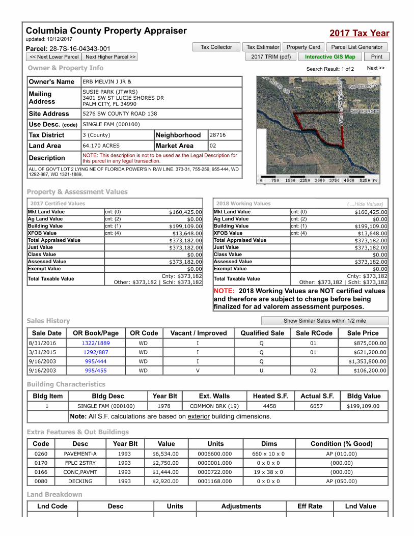
2017 Tax YearParcel: 28-7S-16-04343-001
<< Next Lower Parcel Next Higher Parcel >>
Tax Collector Tax Estimator Property Card Parcel List Generator 2017 TRIM (pdf) Interactive GIS Map Print
Owner & Property Info Search Result: 1 of 2 Next >>
Owner's Name ERB MELVIN J JR &
MailingAddress
SUSIE PARK (JTWRS) 3401 SW ST LUCIE SHORES DR
PALM CITY, FL 34990
Site Address 5276 SW COUNTY ROAD 138
Use Desc. (code) SINGLE FAM (000100)
Tax District 3 (County) Neighborhood 28716
Land Area 64.170 ACRES Market Area 02
Description NOTE: This description is not to be used as the Legal Description forthis parcel in any legal transaction.
ALL OF GOV'T LOT 2 LYING NE OF FLORIDA POWER'S N R/W LINE. 373-31, 755-259, 955-444, WD1292-887, WD 1321-1889,
Property & Assessment Values2017 Certified Values
Mkt Land Value cnt: (0) $160,425.00Ag Land Value cnt: (2) $0.00Building Value cnt: (1) $199,109.00XFOB Value cnt: (4) $13,648.00Total Appraised Value $373,182.00Just Value $373,182.00Class Value $0.00Assessed Value $373,182.00Exempt Value $0.00
Total Taxable Value Cnty: $373,182 Other: $373,182 | Schl: $373,182
2018 Working Values ( ...Hide Values) Mkt Land Value cnt: (0) $160,425.00Ag Land Value cnt: (2) $0.00Building Value cnt: (1) $199,109.00XFOB Value cnt: (4) $13,648.00Total Appraised Value $373,182.00Just Value $373,182.00Class Value $0.00Assessed Value $373,182.00Exempt Value $0.00
Total Taxable Value Cnty: $373,182 Other: $373,182 | Schl: $373,182
NOTE: 2018 Working Values are NOT certified valuesand therefore are subject to change before beingfinalized for ad valorem assessment purposes.
Sales History Show Similar Sales within 1/2 mile
Sale Date OR Book/Page OR Code Vacant / Improved Qualified Sale Sale RCode Sale Price8/31/2016 1322/1889 WD I Q 01 $875,000.00
3/31/2015 1292/887 WD I Q 01 $621,200.00
9/16/2003 995/444 WD I Q $1,353,800.00
9/16/2003 995/455 WD V U 02 $106,200.00
Building CharacteristicsBldg Item Bldg Desc Year Blt Ext. Walls Heated S.F. Actual S.F. Bldg Value
1 SINGLE FAM (000100) 1978 COMMON BRK (19) 4458 6657 $199,109.00
Note: All S.F. calculations are based on exterior building dimensions.
Extra Features & Out BuildingsCode Desc Year Blt Value Units Dims Condition (% Good)0260 PAVEMENT-A 1993 $6,534.00 0006600.000 660 x 10 x 0 AP (010.00)
0170 FPLC 2STRY 1993 $2,750.00 0000001.000 0 x 0 x 0 (000.00)
0166 CONC,PAVMT 1993 $1,444.00 0000722.000 19 x 38 x 0 (000.00)
0080 DECKING 1993 $2,920.00 0001168.000 0 x 0 x 0 AP (050.00)
Land BreakdownLnd Code Desc Units Adjustments Eff Rate Lnd Value
REAssist
Rectangle
REAssist
Rectangle
REAssist
Rectangle

009900 AC NON-AG (MKT) 63.17 AC 1.00/1.00/1.00/1.00 $2,500.00 $157,925.00
000100 SFR (MKT) 1 AC 1.00/1.00/1.00/1.00 $2,500.00 $2,500.00
Columbia County Property Appraiser updated: 10/12/2017
1 of 2 Next >>
DISCLAIMERThis information was derived from data which was compiled by the Columbia County Property Appraiser Office solely for the governmental purpose of propertyassessment. This information should not be relied upon by anyone as a determination of the ownership of property or market value. No warranties, expressedor implied, are provided for the accuracy of the data herein, it's use, or it's interpretation. Although it is periodically updated, this information may not reflect thedata currently on file in the Property Appraiser's office. The assessed values are NOT certified values and therefore are subject to change before beingfinalized for ad valorem assessment purposes.
© Columbia County Property Appraiser | Jeff Hampton - Lake City, Florida 32055 | 386-758-1083 by: GrizzlyLogic.com
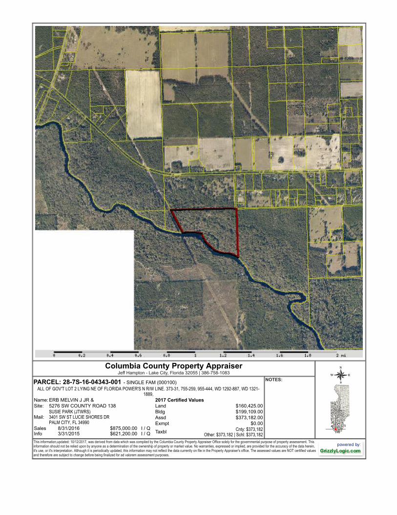
Columbia County Property AppraiserJeff Hampton - Lake City, Florida 32055 | 386-758-1083
PARCEL: 28-7S-16-04343-001 - SINGLE FAM (000100)ALL OF GOV'T LOT 2 LYING NE OF FLORIDA POWER'S N R/W LINE. 373-31, 755-259, 955-444, WD 1292-887, WD 1321-
1889,Name: ERB MELVIN J JR &Site: 5276 SW COUNTY ROAD 138
Mail:SUSIE PARK (JTWRS)
3401 SW ST LUCIE SHORES DR PALM CITY, FL 34990
Sales Info
8/31/2016 $875,000.00 I / Q3/31/2015 $621,200.00 I / Q
2017 Certified ValuesLand $160,425.00Bldg $199,109.00Assd $373,182.00Exmpt $0.00Taxbl Cnty: $373,182
Other: $373,182 | Schl: $373,182
NOTES:
This information,updated: 10/12/2017, was derived from data which was compiled by the Columbia County Property Appraiser Office solely for the governmental purpose of property assessment. Thisinformation should not be relied upon by anyone as a determination of the ownership of property or market value. No warranties, expressed or implied, are provided for the accuracy of the data herein,it's use, or it's interpretation. Although it is periodically updated, this information may not reflect the data currently on file in the Property Appraiser's office. The assessed values are NOT certified valuesand therefore are subject to change before being finalized for ad valorem assessment purposes.
REAssist
Rectangle
REAssist
Rectangle

Total Millage 16.1383 Total Taxes $6,042.61
Total Assessments $430.06
If Paid By Amount Due $0.00
Columbia County Tax Collectorgenerated on 10/26/2017 11:22:19 AM EDT
Tax Record
Last Update: 10/26/2017 11:22:19 AM EDT
Ad Valorem Taxes and Non-Ad Valorem Assessments The information contained herein does not constitute a title search and should not be relied on as such.
Account Number Tax Type Tax Year R04343-001 REAL ESTATE 2016
Mailing Address LAKE CITY ASSOCIATES, LLC 315 E 86TH ST APT 6WE NEW YORK NY 10022-4790
Property Address COUNTY ROAD 138 5276 S
GEO Number 287S16-04343-001
Exempt Amount Taxable Value See Below See Below
Exemption Detail Millage Code Escrow Code NO EXEMPTIONS 003 Legal Description (click for full description) 28-7S-16 0100/0100 64.17 Acres ALL OF GOV'T LOT 2 LYING NE OF FLORIDAPOWER'S N R/W LINE. ORB 373-31, ORB 755-259, 955- 444, WD 1292-887,
Ad Valorem Taxes
Taxing Authority Rate AssessedValue
ExemptionAmount
TaxableValue
TaxesLevied
BOARD OF COUNTY COMMISSIONERS 8.0150 374,427 0 $374,427 $3,001.03 COLUMBIA COUNTY SCHOOL BOARD DISCRETIONARY 0.7480 374,427 0 $374,427 $280.07 LOCAL 4.5040 374,427 0 $374,427 $1,686.42 CAPITAL OUTLAY 1.5000 374,427 0 $374,427 $561.64 SUWANNEE RIVER WATER MGT DIST 0.4093 374,427 0 $374,427 $153.25 LAKE SHORE HOSPITAL AUTHORITY 0.9620 374,427 0 $374,427 $360.20
Non-Ad Valorem Assessments Code Levying Authority Amount FFIR FIRE ASSESSMENTS $237.06 GGAR SOLID WASTE - ANNUAL $193.00
Taxes & Assessments $6,472.67
Date Paid Transaction Receipt Item Amount Paid 12/16/2016 PAYMENT 2101296.0001 2016 $6,213.76
REAssist
Rectangle

Suwannee River Water Management DistrictEffective Flood Information Report
The Federal Emergency Management Agency (FEMA) maintains information about map features, such as street locations and names, in or near designated flood hazard areas. Theinformation herein represents the best available data as of the effective date shown. The applicable Flood Insurance Study and a Digital Flood Insurance Rate Map is availableonline (http://www.srwmdfloodreport.com). To obtain more detailed information in areas where Base Flood Elevations (BFEs) and/or floodways have been determined, users areencouraged to also consult the FEMA Map Service Center at 1-800-358-9616 (http://www.msc.fema.gov) for information on available products associated with this FIRM panel. Available products from the Map Service Center may include previously issued Letters of Map Change. Requests to revise flood information in or near designated flood hazard areas may be provided to FEMA during the community review period on preliminary maps, or through theLetter of Map Change process for effective maps.
LOCATION10-26-2017
21-7S-16-04273-001
County: COLUMBIA
STR: S028 T07 R16
Columbia Flood Hazard Areas Status
FLOOD INFORMATION
FIRM Panel(s): 12023C0526C,12023C0527C
Special Flood Hazard Area?(SFHA): Yes
Flood Zone(s): X 0.2 PCT, AE
Floodway: No
1% Annual ChanceFlood Elev (BFE): 36 (feet)
10% Annual ChanceFlood Elev: 30.5 (feet)
50% Annual ChanceFlood Elev: 27.3 (feet)Note: E levations are based on NAVD88
Date:
Parcel:
E ffective: 02/04/2009

Suwannee River Water Management DistrictEffective Flood Information Report
The Federal Emergency Management Agency (FEMA) maintains information about map features, such as street locations and names, in or near designated flood hazard areas. Theinformation herein represents the best available data as of the effective date shown. The applicable Flood Insurance Study and a Digital Flood Insurance Rate Map is availableonline (http://www.srwmdfloodreport.com). To obtain more detailed information in areas where Base Flood Elevations (BFEs) and/or floodways have been determined, users areencouraged to also consult the FEMA Map Service Center at 1-800-358-9616 (http://www.msc.fema.gov) for information on available products associated with this FIRM panel. Available products from the Map Service Center may include previously issued Letters of Map Change. Requests to revise flood information in or near designated flood hazard areas may be provided to FEMA during the community review period on preliminary maps, or through theLetter of Map Change process for effective maps.
LOCATION10-26-2017
28-7S-16-04343-001
County: COLUMBIA
STR: S028 T07 R16
Columbia Flood Hazard Areas Status
FLOOD INFORMATION
FIRM Panel(s): 12023C0526C,12023C0527C
Special Flood Hazard Area?(SFHA): Yes
Flood Zone(s): AE FW, X 0.2 PCT
Floodway: Yes
1% Annual ChanceFlood Elev (BFE): 36.2 (feet)
10% Annual ChanceFlood Elev: 30.6 (feet)
50% Annual ChanceFlood Elev: 27.4 (feet)Note: E levations are based on NAVD88
Date:
Parcel:
E ffective: 02/04/2009

SRWMD:
http://www.srwmd.state.fl.us
http://www.fema.gov
FEMA:
CONTACT
LINKS
All areas outside the 1-percent annual chance floodplain are Zone X. This includes areas of 1% annual chance sheet flow flooding where average depths are less than 1 foot, areas of 1% annual chance stream flooding where the contributing drainage area is less than 1 square mile, or areas protected from the 1% annual chance flood by levees. No Base Flood Elevations or depths are shown within this zone. Insurance purchase is not required in these zones.
Same as Zone X; however, detailed studies have been performed, and the area has been determined to be within the 0.2 percent annual chance floodplain (also known as the 500-year flood zone). Insurance purchase is not required in this zone but is available at a reduced rate and is recommended.
X 0.2 PCT (X Shaded, 0.2 PCT ANNUAL CHANCE FLOOD HAZARD)
X
Areas with a 1% annual chance of flooding over the life of a 30-year mortgage with additional hazards due to storm-induced velocity wave action. Base Flood Elevations (BFEs) derived from detailed analyses.
VE
Base Flood Elevation (BFE)
The elevation shown on the Flood Insurance Rate Map for Zones AE, AH, A1-A30, AR, AO, V1-V30, and VE that indicates the water surface elevation resulting from a flood that has a one percent chance of equaling or exceeding that level in any given year.
A
AE, A1-A30
Areas with a 1% annual chance of flooding and a 26% chance of flooding over the life of a 30-year mortgage. Because detailed analyses are not performed for such areas; no depths or base flood elevations are shown within these zones.
Areas with a 1% annual chance of flooding and a 26% chance of flooding over the life of a 30-year mortgage. In most instances, base flood elevations derived from detailed analyses are shown at selected intervals within these zones.
Areas with a 1% annual chance of flooding and a 26% chance of flooding over the life of a 30-year mortgage. Usually areas of ponding with flood depths of 1 to 3 feet. Base Flood Elevations are determined.
AH
AO
Supplemental Information:
Areas with a 1% annual chance of flooding and a 26% chance of flooding over the life of a 30-year mortgage. Usually areas of sheet flow on sloping terrain with flood depths of 1 to 3 feet. Base Flood Elevations are determined.
10%-chance flood elevations (10-year flood-risk elevations) and 50%-chance flood elevations (2-year flood-risk elevations), are calculated during detailed flooding studies but are not shown on FEMA Digital Flood Insurance Rate Maps (FIRMs). They have been provided as supplemental information in the Flood Information section of this report.
The channel of a river or other watercourse and the adjacent land areas that must be reserved in order to discharge the base flood (1% annual chance flood event). The floodway must be kept open so that flood water can proceed downstream and not be obstructed or diverted onto other properties.
Please note, if you develop within the regulatory floodway, you will need to contact your Local Government and the Suwannee River Water Management District prior to commencing with the activity. Please contact the District at 800.226.1066.
AE FW (FLOODWAYS)
SRWMD9225 County Road 49Live Oak, FL 32060
(386) 362-1001
Toll Free:(800) 226-1066

SITE ANALYSIS
Location
The subject property is located on the southwest corner of Southwest County Road 138 andSouthwest Horseshoe Loop and along the northern bank of the Santa Fe River. The subjectproperty is further situated approximately five miles south of the Town of Fort White in extremesouthern Columbia County, Florida.
Site Description
Present Use: Heavily wooded rural residential/recreational land.
Size: 139.91 acres
Shape: Irregular in shape. See included map showing boundary lines.
Water Frontage: The subject property contains 2,400 feet of frontage along the northern bank ofthe Santa Fe River.
Topography: According to a review of GIS Mapping available from the National WetlandsInventory, the subject property contains approximately 41 acres (29% of the total property area)of probable jurisdictional wetlands. Wetland areas are concentrated in the southern portion ofthe tract and coincide with the parcel’s frontage along the Santa Fe River. Topographical mapsindicate that the subject property is generally level but slopes slightly downward from northeastto southwest toward the aforementioned wetland areas and the Santa Fe River.
Vegetation: The bulk of the subject property mainly consists of areas of mixed forest with avariety of natural vegetation indigenous to this region of Florida. The northern portion of thetract is partially cleared with scattered mature trees and is currently utilized as grazing land.
Soil Conditions: The site is presumed to have an adequate load-bearing capacity for developmentpurposes as evidenced by surrounding improvements. Also, no surface or subsurface hazardousmaterials or other contaminants are presumed on or in the site. However, engineering testborings were not performed by the appraiser and no warranties are given by the appraiserconcerning engineering of the site. As mentioned previously, the subject property containsapproximately 41 acres of probable jurisdictional wetlands. Due to engineering problemsinherent with construction in areas of this type, it is assumed by the appraiser that either noconstruction will take place in these areas or that adequate measures, including further testing,will be undertaken prior to development.
Flood Map Classification: According to flood hazard mapping available through the SuwanneeRiver Water Management District, approximately 30% of the subject property is situated withinFlood Hazard Zone X (unshaded).
Unshaded areas of Flood Hazard Zone X are defined as areas of minimal risk outside theone-percent and 0.2-percent-annual-chance floodplains. No base flood elevations or base flooddepths are shown within these zones.
31

SITE ANALYSIS (Continued)
Areas of the subject property primarily associated with its frontage along the Santa Fe River aresituated in the shaded areas of Flood Hazard Zone X (70% of the total property area), FloodHazard Zone AE (62% of the total property area), and the Floodway of the Santa Fe River (18%of the total property area).
Shaded areas of Flood Hazard Zone X are defined as areas of moderate risk within the0.2-percent-annual-chance floodplain, areas of one-percent-annual-chance flooding whereaverage depths are less than one foot, areas of one-percent-annual-chance flooding where thecontributing drainage area is less than one square mile, and areas protected from theone-percent-annual-chance flood by a levee. No base flood elevations or base flood depths areshown within these zones.
Flood Hazard Zone AE is defined as areas subject to inundation by the one-percent-annual-chanceflood event determined by detailed methods. Base flood elevations are shown within these zones.A Base Flood Elevation is the computed elevation to which floodwater is anticipated to riseduring the base flood. For the subject property, a Base Flood Elevation of approximately 36 feetis indicated.
Finally, a "Regulatory Floodway" means the channel of a river or other watercourse and theadjacent land areas that must be reserved in order to discharge the base flood withoutcumulatively increasing the water surface elevation more than a designated height. Communitiesmust regulate development in these floodways to ensure that there are no increases in upstreamflood elevations.
A copy of the Flood Insurance Rate Map showing the flood zones discussed above in relation tothe subject property is provided on the following page.
Access: Primary access and exposure is provided to the subject property via approximately 896feet of frontage along south side of County Road 138. County Road 138 represents a secondaryeast-west thoroughfare for this portion of Columbia County and contains two asphalt pavedtraffic lanes. Additional access is provided via approximately 1,563 feet of frontage along thewest side of Southwest Horseshoe Loop, a two lane unimproved graded roadway.
Utilities and Public Services: The improvements on the subject utilize private wells and septicsystems for water and sanitary sewer. Columbia County provides police protection and rescueand fire services, and trash removal is provided by private contractors. Electricity and telephoneservice are also available to the site. The available utilities and public services are consideredadequate for the subject under its highest and best use.
Existing Crops, Pasture, etc.: The subject property consists of a 139.91± acre parcel ofrecreational and rural residential land containing areas of partially cleared native grazing land anddense natural vegetation with a variety of species indigenous to this and similar ecosystems ofthis region of Florida. No crops or improved pastures are located on the subject property.
32
SITE ANALYSIS (Continued)
Outstanding Rights and/or Possessory Interests
Easements and Other Restrictions: According to limited research provided to the appraiser and areview of available satellite imagery, the subject property is assumed to be encumbered by atransmission line easement granted to the Florida Power Corporation. Because of the limitedencumbered area and its situation along the western boundary of the subject property, thisencumbrance is not considered to have any adverse impact on the functional utility and/or marketvalue of the subject property. No other easements, having an adverse affect on market value, arenoted on the subject property.
Existing Leases, Rentals, or Use Agreements: The subject property is not known to beencumbered by any existing leases, rentals, or use agreements having an adverse affect on marketvalue, and is not rented nor is there a rental history.
Life Estate: The subject property is not known to be encumbered by a life estate.
Outstanding Oil, Gas, and Mineral Rights: No outstanding oil, gas, and/or mineral rights notedon the subject property.
Zoning and Other Land Use Regulations
Zoning Designation: According to the Columbia County Planning and Zoning Department, themajority of the subject parcel, associated primarily with the aforementioned flood prone areas, iszoned ESA-2, Environmentally Sensitive Areas, with a minority portion located in the A-3,Agricultural, district.
Lands in the ESA-2 district are considered in need of special planning and treatment regardingland development regulation. This is not a preservation district, but land uses permitted withinthis district are to provide mitigating measures to protect the natural functions of areas which arelimited to the planning and treatment of land development within the 100-year floodplain of theIchetucknee Springs State Park, O'Leno State Park, Osceola National Forest, Pinhook Swamp,Suwannee River Corridor, Santa Fe River Corridor, and Ichetucknee Trace, as designated withinthe Federal Emergency Management Agency flood insurance rate map for the county. Theseregulations prohibit intensive residential, intensive recreational, and intensive agricultural usesand prohibit industrial and commercial development within the 100-year floodplain of the areasdesignated as environmentally sensitive areas.
Primary permitted uses and structures within the ESA-2 district include: Non-intensiveagricultural and forestry operations, single-family dwellings, mobile homes, homes of six orfewer residents which otherwise meet the definition of a "community residential facility", publicresource based recreation facilities, churches and other houses of worship. Intensive agriculturaldevelopment means those agricultural land uses requiring an industrial waste permit from theFlorida Department of Environmental Protection. Development in this district is permitted to aminimum lot area of ten acres.
34
SITE ANALYSIS (Continued)
Lands in the A-3 district are intended to provide for areas primarily consisting of agricultural andresidential uses consistent with the areas as designated agricultural within the county’scomprehensive plan.
Primary permitted uses and structures within the A-3 district include: all agricultural activities(but not including livestock or poultry slaughterhouses), single family dwellings, mobile homes,plant nurseries and greenhouses, homes of six or fewer residents which otherwise meet thedefinition of “community residential facility”, public elementary and middle schools, churchesand other houses of worship, cemeteries, travel trailers, and landscape services. Development inthis district is permitted to a minimum lot area of five acres.
The requirements and restrictions under the zoning ordinance are reasonable and typical ofsimilar zoning ordinances in other local communities.
For the government body, land use plans serve as generalized guidelines for both current andfuture development. Items generally included in guidelines are use classifications, use intensity,and preservation areas. The land use plan is generally used in conjunction with existing zoningwhen a proposed development is being reviewed by the government authority.
The subject parcel was reported to have land use designations which are in agreement with thecurrent zoning designations.
Environmental Regulations: Its inclusion of approximately 41 acres, or approximately 29% ofthe total property acreage, of probable jurisdictional wetlands, restricts the development of thesubject property through environmental regulations currently in place in the subject area. TheSuwannee River Water Management District, the Florida Department of EnvironmentalProtection, and the US Army Corps of Engineers, the governing bodies on wetland regulation inthe subject area, tend to highly discourage any development in designated wetland areas, thusmaking it infeasible for any intensive use in these areas. Also, zoning regulations placed onflood zone areas, in which a portion of the subject property is located, further restrict the type andconstruction of improvements in designated flood zones. No other environmental regulationshaving an impact on market value are known or presumed in this analysis.
35

Sec. 4.4. - "ESA" environmentally sensitive areas.
4.4.1
Districts and intent.
The "ESA" environmentally sensitive area category includes three zone districts: ESA-1, 2, 3. Lands in these districts are
considered in need of special planning and treatment regarding land development regulation. These are not preservation
districts, but land uses permitted within these districts are to provide mitigating measures to protect the natural functions
of areas which are limited to the planning and treatment of land development within the 100-year floodplain of the
Ichetucknee Springs State Park, O'Leno State Park, Osceola National Forest, Pinhook Swamp, Suwannee River Corridor,
Santa Fe River Corridor and Ichetucknee Trace, as designated within the Federal Emergency Management [Agency]
flood insurance rate map for the county, as amended. These regulations prohibit intensive residential, intensive
recreational and intensive agricultural uses and prohibit industrial and commercial development within the 100-year
floodplain of the areas designated as environmentally sensitive areas.
4.4.2
Permitted principal uses and structures.
1. Non-intensive agricultural (see definition of intensive agriculture in section 2.1) and forestry operations conducted in
accordance with Silviculture Best Management Practices Manual, published by the Florida Department of
Agriculture and Consumer Services, Division of Forestry, Revision May 1990.
2. Single-family dwellings.
3. Mobile homes.
4. Homes of six or fewer residents which otherwise meet the definition of a "community residential facility."
(See section 4.2.)
5. Public resource based recreation facilities.
6. Churches and other houses of worship. (Ord. No. 2005-14, § 4, 8-4-05)
4.4.3
Permitted accessory uses and structures.
1. Uses and structures which:
a. Are customarily accessory and clearly incidental and subordinate to permitted or permissible uses and
structures;
b. Are located on the same lot as the permitted or permissible principal use or structure, or on a contiguous
lot in the same ownership; and
c. Do not involve operations or structures not in keeping with the intent of these land development districts.
2. Examples of permitted accessory uses and structures include:
a. Private garages.
b. Docks, ramps, piers and walkways for residential and water-dependent commercial uses (See article 14).

c. Residential facilities for caretakers whose work requires residence on the premises or for employees who
will be quartered on the premises.
4.4.4
Prohibited uses and structures.
Industrial and commercial uses, intensive agricultural uses (See section 2.1 for definition of intensive agriculture), private
recreational uses and any use or structure not specifically, provisionally, or by reasonable implication permitted herein or
permissible as a special exception.
4.4.5
Special exceptions.
(See also articles 12 and 13).
1. Home occupations.
2. Campgrounds of less than 100 campsites, provided that such campgrounds are no located within five miles from
another campground, which is also located within an environmentally sensitive area and not more than 20 percent
of the natural vegetation on each campsite within such campgrounds shall be removed.
3. Bottled-water plant.
4. Other similar uses, which are consistent with the uses within this district.
4.4.6
Minimum lot requirements (area, width).
1. Single-family dwellings and mobile homes:
ESA-1
Minimum lot area: 40 acres.
Minimum lot width: 400 feet.
ESA-2
Minimum lot area: ten acres.
Minimum lot width: 400 feet (five acres if developed as a planned rural residential development and an overall density of one dwelling unit per ten acres is maintained on site).
ESA-3
Minimum lot area: five acres.
Minimum lot width: 275 feet.
Note: Minimum lot areas for any portions of the area designated as environmentally sensitive which is outside of the 100-year floodplain as designated by the Federal Emergency Management Agency flood insurance rate map shall conform
with the following minimum lot requirements of the abutting zoning district. If there is more than one abutting zoning district, excepting conservation, the minimum lot requirements shall conform with the more restrictive
district.
2. All other permitted or permissible uses and structures (unless otherwise specified).

Minimum lot area. Ten acres.
Minimum lot width. 400 feet.
4.4.7
Minimum yard requirements (depth of front and rear yard, width of side yard)
(See section 4.2 for right-of-way setback requirements.)
1. All permitted or permissible uses and structures (unless otherwise specified):
Front: 30 feet.
Side: 25 feet.
Rear: 25 feet.
Special provisions. The location of any structure (except permitted docks, walkways, and piers) shall be set back a
minimum of 35 feet from wetlands.
The location of any structure (except permitted docks, walkways, and piers) shall be set back a minimum of 75 feet
from the Suwannee, Santa Fe and Ichetucknee Rivers.
The location of any structure (except permitted docks, walkways, and piers) shall be set back a minimum of 50 feet
from all other perennial rivers, streams and creeks.
4.4.8
Maximum height of structures: No portion shall exceed:
35 feet. (See section 4.2 for exclusions from height limitation.)
4.4.9
Maximum lot coverage by all buildings.
20 percent.
Note: In addition to meeting the required lot yard, building height, lot coverage, landscaped buffering, and off-street parking
requirements of this section, no structure shall exceed a 1.0 floor area ratio.
4.4.10
Minimum landscaped buffering requirements.
1. All permitted or permissible uses and structures (unless otherwise specified). None, except as necessary to meet
other requirements as set out herein.
4.4.11
Minimum off-street parking requirements.
1. Each residential dwelling unit. Two spaces for each dwelling unit.
2. For all other uses and special exceptions as specified herein. To be determined by findings in the particular case.

Sec. 4.5. - "A" Agricultural.
4.5.1
Districts and intent. The "A" Agricultural category includes three zone districts: A-1, A-2
and A-3. Lands in these districts are intended to provide for areas primarily consisting of
agricultural and residential uses consistent with the areas as designated agricultural
within the county's comprehensive plan.
4.5.2
Permitted principal uses and structures within Agriculture-1 and Agriculture-2 districts.
1. All agricultural activities (but not including livestock or poultry slaughterhouses),
including the raising of livestock and poultry, the production of dairy and poultry
products, the cultivation of field crops and fruits and berries, forestry, apiculture, and
similar uses; provided, that no structure used for housing of animals or any
commercial feed lot operation shall be located within 300 feet of any lot line, and no
structure used for housing domestic animals shall be located within 100 feet of any
lot line.
2. The processing, storage, and sale of agricultural products and commodities which
are raised on the premises (but not including livestock or poultry slaughterhouses);
provided that no building used for these activities shall be located within 300 feet of
any side or rear lot line.
3. Single-family dwellings.
4. Mobile homes.
5. Plant nurseries and greenhouses.
6. Homes of six or fewer residents which otherwise meet the definition of a
"community residential facility." (See section 4.2.)
7. Public elementary and middle schools. (See sections 4.2 and 14.13.)
8. Churches and other houses of worship.
9. Cemeteries not requiring licensure of the State of Florida
10. Landscape services including yard maintenance firms.

(Ord. No. 2005-14, § 5, 8-4-05)
4.5.3
Permitted accessory uses and structures within Agriculture-1 and Agriculture-2 districts.
1. Uses and structures which:
a. Are customarily accessory and clearly incidental and subordinate to permitted
uses and structures.
b. Are located on the same lot as the permitted principal use or structure or on a
contiguous lot in the same ownership.
2. Examples of permitted accessory uses and structures include:
a. Barns and stables.
b. Private garages.
c. Private swimming pools.
d. On-site signs. (See section 42.)
e. Residential facilities for caretakers whose work requires residence on the
premises or for employees who will be quartered on the premises.
4.5.4
Prohibited uses and structures within Agriculture-1, -2 and Agriculture-3 districts. Junk
yard or automobile wrecking yard, any use or structure requiring an industrial waste
permit issued by the Florida Department of Environmental Protection located within areas
designated as high groundwater aquifer recharge on illustration A-XI entitled Natural
Groundwater Aquifer Recharge Areas found within the county's Comprehensive Plan, any
mining use or structure not located within areas designated as mining areas on illustration
A-X, entitled Mining Areas found within the county'[s] comprehensive plan and any use or
structure not specifically, provisionally or by reasonable implication permitted herein as a
special exception.
4.5.5
Permitted principal uses and structures within Agriculture-3 districts.
1. All agricultural activities (except intensive agricultural uses as defined in section
2.1 herein within high groundwater aquifer recharge areas as defined within the
county's comprehensive plan), including the raising of livestock and poultry, the
production of dairy and poultry products (but not including livestock or poultry slaughter-
houses), the cultivation of field crops and fruits and berries, forestry, in accordance with
the comprehensive plan, apiculture, and similar uses; provided, that no structure used
for housing of animals or any commercial feed lot operation shall be located within 300
feet of any lot line, and no structure used for housing domestic animals shall be located
within 100 feet of any lot line.

2. The processing, storage, and sale of agricultural products and commodities which are
raised on the premises (but not including livestock or poultry slaughterhouses);
provided that no building used for these activities shall be located within 300 feet of any
side or rear lot line.
3. Single-family dwellings.
4. Mobile homes.
5. Plant nurseries and greenhouses.
6. Homes of six or fewer residents which otherwise meet the definition of a "community
residential facility." (See section 4.2).
7. Public elementary and middle schools. (See sections 4.2 and 14.13.)
8. Churches and other houses of worship.
9. Cemeteries not requiring licensure of the State of Florida.
10. Landscape services including yard maintenance firms.
(Ord. No. 2005-14, § 6, 8-4-05)
4.5.6
Permitted accessory uses and structures within Agriculture-3 districts.
1. Uses and structures in all Agricultural-1 [Agriculture-1] and Agricultural-2 [Agriculture-
2] zoning districts which:
a. Are customarily accessory and clearly incidental and subordinate to permitted
uses and structures.
b. Are located on the same lot as the permitted principal use or structure or on a
contiguous lot in the same ownership.
c. Do not involve operations not in keeping with the character of a rural area.
2. Examples of permitted accessory uses and structures include:
a. Barns and stables.
b. Private garages.
c. Private swimming pools.
d. On-site signs (See Section 4.2).
e. Residential facilities for caretakers whose work requires residence on the
premises or for employees who will be quartered on the premises.

4.5.7
Special exceptions within Agriculture-1, Agriculture-2 and Agriculture-3 districts.
(See also articles 12 and 13.)
1. The processing, storage, and sale of agricultural products and commodities which are
not raised on the premises; provided, that no building used for these activities shall be
located within 150 feet of any side or rear lot line.
2. Livestock auction arenas and general merchandise auction houses.
3. Livestock or poultry slaughterhouses; provided, that no building used for these
activities shall be located within 150 feet of any lot line.
4. Heavy equipment and related machinery sales.
5. Agricultural feed and grain packaging, blending, storage, and sales.
6. Agricultural fertilizer storage and sales.
7. Agricultural fairs and fairground activities.
8. Recreational activities such as racetracks and speedways; golf courses; country clubs;
tennis and racquet clubs; golf and archery ranges; rifle, shotgun, and pistol ranges;
travel trailer parks or campgrounds, including day camps; hunting or fishing camps; and
similar uses.
9. Riding or boarding stables; provided that no building used for housing of animals shall
be located within 150 feet of any lot line.
10. Drive-in theaters (see section 4.2 for special design standards).
11. Hospitals, sanitariums, nursing homes, and residential homes for the aged and
residential facilities for the aged.
12. Commercial kennels, veterinary clinics, and animal shelters; provided, that no
open runs or buildings used for housing of animals shall be located within 150 feet of
any lot line.
13. Group living facilities.

14. Crematories.
15. Airplane landing fields.
16. Child care centers, provided:
a. No outdoor play activities shall be conducted before 8:00 a.m. or after 8:00 p.m;
and
b. Provision is made for areas for offstreet pick-up and drop-off of children.
17. Home occupations (see section 4.2).
18. Public buildings and facilities, unless otherwise specified (see section 4.2).
19. Private clubs and lodges.
20. Off-site signs (see also section 4.2).
21. Solid waste facilities.
22. Group home care facilities.
23. Explosives, manufacturing or storage.
24. Flea markets.
25. Paper and pulp manufacturing
26. Cemeteries and mausoleums which require state licensure.
27. Small engine repair (not to exceed 2,000 square feet).
28. Automotive repair and repair of agricultural equipment (not to exceed 2,500
square feet).
29. Welding shop (not to exceed 2,500 square feet).
30. Bed and breakfast inns.
31. Building contractor and yard.
32. General store.
33. Mini-warehouses (completely enclosed).
34. Intensive agriculture (except where prohibited).
35. Other uses which are compatible with the uses of this district.
(Ord. No. 2013-10, § 2, 10-3-13)
4.5.8
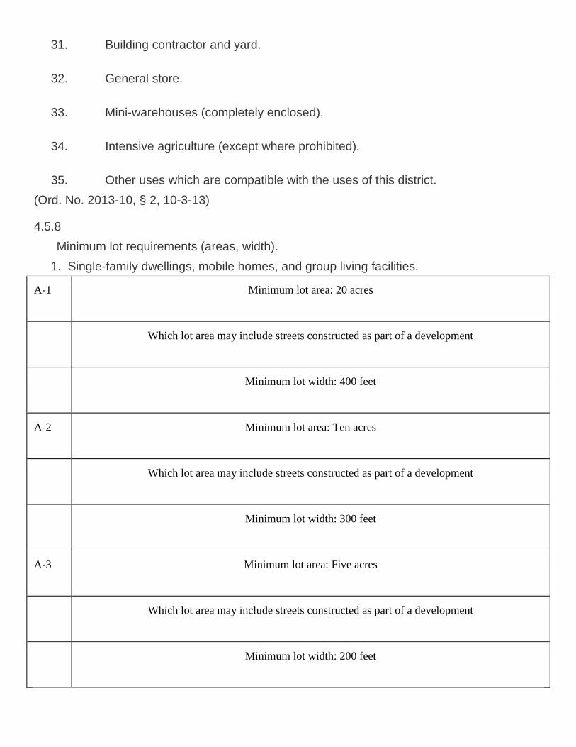
Minimum lot requirements (areas, width).
1. Single-family dwellings, mobile homes, and group living facilities.
A-1 Minimum lot area: 20 acres
Which lot area may include streets constructed as part of a development
Minimum lot width: 400 feet
A-2 Minimum lot area: Ten acres
Which lot area may include streets constructed as part of a development
Minimum lot width: 300 feet
A-3 Minimum lot area: Five acres
Which lot area may include streets constructed as part of a development
Minimum lot width: 200 feet

2. All other permitted uses and structures (unless otherwise specified). None, except as
necessary to meet other requirements as set out herein.
(Ord. No. 2006-1, § 1, 1-5-06)
4.5.9
Minimum yard requirements (depth of front and rear yard, width of side
yard). (See section 4.2 for right-of-way setback requirements.)
1. All permitted uses and structures (unless otherwise specified):
Front: 30 feet.
Side: 25 feet.
Rear: 25 feet.
Special provisions: The location of any structure (except permitted docks, walkways,
and piers) shall be set back a minimum of 35 feet from wetlands.
The location of any structure (except permitted docks, walkways, and piers) shall be
set back a minimum of 75 feet from the Suwannee, Santa Fe and Ichetucknee
Rivers.
The location of any structure (except permitted docks, walkways, and piers) shall be
set back a minimum of 50 feet from all other perennial rivers, streams and creeks.
4.5.10
Maximum height of structures. No portion shall exceed:
(See also section 4.2 for exceptions)
35 feet. (See section 4.2 for exclusions from height limitations.)
4.5.11
Maximum lot coverage by all buildings.
20 percent.
Note: In addition to meeting the required lot yard, building height, lot coverage, landscaped
buffering, and off-street parking requirements of this section, no structure shall exceed a 1.0
floor area ratio.
4.5.12
Minimum landscaped buffering requirements. (See also section 4.2.)
1. All permitted uses and structures (unless otherwise specified). None, except as
necessary to meet other requirements as set out herein.
4.5.13
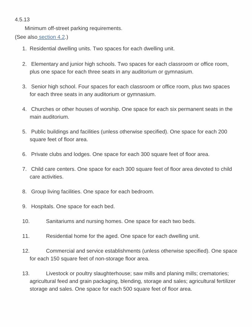
Minimum off-street parking requirements.
(See also section 4.2.)
1. Residential dwelling units. Two spaces for each dwelling unit.
2. Elementary and junior high schools. Two spaces for each classroom or office room,
plus one space for each three seats in any auditorium or gymnasium.
3. Senior high school. Four spaces for each classroom or office room, plus two spaces
for each three seats in any auditorium or gymnasium.
4. Churches or other houses of worship. One space for each six permanent seats in the
main auditorium.
5. Public buildings and facilities (unless otherwise specified). One space for each 200
square feet of floor area.
6. Private clubs and lodges. One space for each 300 square feet of floor area.
7. Child care centers. One space for each 300 square feet of floor area devoted to child
care activities.
8. Group living facilities. One space for each bedroom.
9. Hospitals. One space for each bed.
10. Sanitariums and nursing homes. One space for each two beds.
11. Residential home for the aged. One space for each dwelling unit.
12. Commercial and service establishments (unless otherwise specified). One space
for each 150 square feet of non-storage floor area.
13. Livestock or poultry slaughterhouse; saw mills and planing mills; crematories;
agricultural feed and grain packaging, blending, storage and sales; agricultural fertilizer
storage and sales. One space for each 500 square feet of floor area.
14. Livestock auction arenas; agricultural equipment and related machinery sales;
agricultural fairs and fairground activities; drive-in theaters; racetracks and speedways;
golf and archery ranges; rifle, shotgun, and pistol ranges; commercial kennels;
veterinary clinics; and animal shelters. One space for each 350 square feet of floor
area, plus, where applicable, one space for each 1,000 square feet of lot or ground
area outside buildings used for any type of sales, display, or activity.
15. For other special exceptions as specified herein. To be determined by findings in
the particular case.
Related Documents