University of Tennessee, Knoxville University of Tennessee, Knoxville TRACE: Tennessee Research and Creative TRACE: Tennessee Research and Creative Exchange Exchange Masters Theses Graduate School 8-2004 Weaving: Redesigning the Post Colonial Town Through African Weaving: Redesigning the Post Colonial Town Through African Cultural Traditions Cultural Traditions Henry Walela Musangi University of Tennessee, Knoxville Follow this and additional works at: https://trace.tennessee.edu/utk_gradthes Part of the Other Architecture Commons Recommended Citation Recommended Citation Musangi, Henry Walela, "Weaving: Redesigning the Post Colonial Town Through African Cultural Traditions. " Master's Thesis, University of Tennessee, 2004. https://trace.tennessee.edu/utk_gradthes/4688 This Thesis is brought to you for free and open access by the Graduate School at TRACE: Tennessee Research and Creative Exchange. It has been accepted for inclusion in Masters Theses by an authorized administrator of TRACE: Tennessee Research and Creative Exchange. For more information, please contact [email protected].

Welcome message from author
This document is posted to help you gain knowledge. Please leave a comment to let me know what you think about it! Share it to your friends and learn new things together.
Transcript
University of Tennessee, Knoxville University of Tennessee, Knoxville
TRACE: Tennessee Research and Creative TRACE: Tennessee Research and Creative
Exchange Exchange
Masters Theses Graduate School
8-2004
Weaving: Redesigning the Post Colonial Town Through African Weaving: Redesigning the Post Colonial Town Through African
Cultural Traditions Cultural Traditions
Henry Walela Musangi University of Tennessee, Knoxville
Follow this and additional works at: https://trace.tennessee.edu/utk_gradthes
Part of the Other Architecture Commons
Recommended Citation Recommended Citation Musangi, Henry Walela, "Weaving: Redesigning the Post Colonial Town Through African Cultural Traditions. " Master's Thesis, University of Tennessee, 2004. https://trace.tennessee.edu/utk_gradthes/4688
This Thesis is brought to you for free and open access by the Graduate School at TRACE: Tennessee Research and Creative Exchange. It has been accepted for inclusion in Masters Theses by an authorized administrator of TRACE: Tennessee Research and Creative Exchange. For more information, please contact [email protected].
To the Graduate Council:
I am submitting herewith a thesis written by Henry Walela Musangi entitled "Weaving:
Redesigning the Post Colonial Town Through African Cultural Traditions." I have examined the
final electronic copy of this thesis for form and content and recommend that it be accepted in
partial fulfillment of the requirements for the degree of Master of Architecture, with a major in
Architecture.
Scott Wall, Major Professor
We have read this thesis and recommend its acceptance:
Edgar Stach, Barbara Klinkhammer
Accepted for the Council:
Carolyn R. Hodges
Vice Provost and Dean of the Graduate School
(Original signatures are on file with official student records.)
To the Graduate Council:
I am submitting herewith a thesis written by Henry Walela Musangi_ entitled "Weaving: Redesigning the
Post Colonial Town Through African Cultural Traditions." I have examined the final paper copy of this
thesis for form and content and recommend that it be accepted in partial fulfillment of the requirements
for the degree of Master of Architecture, with a major in Architecture.
Scott Wall, Major Professor
We have read this thesis
and recommend its acceptance:
Edgar Stach
Barbara Klinkhammer
Acceptance for the Council:
Dean of Graduate Studies
WEAVIIN·G
REDESIGNING THE POST-COLONIAL TOWN THROUGH AFRICAN CULTURAL TRADITIONS
A Thesis Presented for the
Master of Architecture Degree
The University of Tennessee, Knoxville
Henry Walela Musangi August 2004

ii
. ,
Copyright © 2004 by Henry Musangi All rights reserved

Dedication
To my parents Richard and Regina Musangi, who made it possible for me to come this far by modeling
hard work, public service and the importance of a good education. I am very grateful.
iii
Acknowled:gements
I am grateful to many people.
Professor Jon Coddington, my Graduate Program Director at the College of Architecture and Design,
for insisting that I undertake a project in my home country and therefore this outcome. Marion Poggas
and all my former colleagues at Image Architects Inc. for making graduate school possible for me; Mr.
Joseph Ochieng and the many hard working vendors at the Nakuru Municipal Market; Ms. Onsano at
the Nakuru Municipal Council for providing me with important background material; and my committee:
Professors Scott Wall, Barbara Klinkhammer, and Edgar Stach for valuable advice and guidance. Most
of all, to my family for encouraging me, and even advising me during the research and execution of this
project.
iv
Abstract
"They [Africans] look upon their native arts and crafts primarily as the 'locus' of their national consciousness. In spite of a violent urge for the
new, for progress and for high living standards, more and more of their valuable, innate culture and customs now are being reflected upon in
new light, finding their voice in the form of a new, healthy and surprisingly expressive art"
·The 'new' is cleansed from any cliche imitating a style.
The 'new' does not evolve from cheap modernism.
The 'new' functions according to the climate and the situation.
The 'new' proves to have an understandable symbolism adapted to the people.
The 'new' is vitalized by an elementary simplicity."
-Swiss architect Justus Dahinden
This thesis aims at defining and justifying the principles that fuse African pre-colonial
(traditional) architectural themes with the literal and metaphorical lessons observed in the craft of
weaving.
African traditional architecture refers to the building traditions that have been held on the
continent since pre-colonial times. Being a vast continent, its cultures, climate and geography are
inherently diverse. All these factors have led to a variety of architectural principles and characteristics.
Bernard Rud of sky in Architecture Without Architects, points out that vernacular architecture bears
significance due to the fact that it is not based on any prevailing fashion or trend. Instead, it has
through the years been perfected and sustained (Rudofsky. Architecture Without Architects, 1965.p.
1 ). Prevailing ideas about African architecture often bring up thoughts of hurriedly erected cylindrical
structures with grass thatch as roofing. It is also questioned if such structures constitute architecture;
that is, buildings thought through and put up with the aid of a trained professional in that field.
In my research, I examined this architecture while extracting and outlining key themes that are
characteristic of vernacular architecture in different parts of the world and more specifically in Kenya.
These lessons include design and construction principles such as materiality and decoration, climatic
influences, the measure and representation of space, plus form and parti. I specifically applied my
research to the urban situation in Nakuru, Kenya. All the lessons learned were combined and used to
redesign a very active quarter of the town, thus racially and economically better weaving it into the
overall fabric of the town.
The result should be a strong, yet simple, modern and distinctly African architecture that is free
from cliche, bearing a symbolism that is adapted to and understood by the people.
V
Table of Contents
Chapter I: The Place of Dust: Making a Colonial Town .................................... 1
Chapter II: The Persistence of Disorder: Reweaving an Urban Fabric ......................... 6
Chapter Ill: Architecture for the Developing World: An Authentic Modern Vernacular ............. 11
Chapter IV: Lessons from Precedent: Geoffrey Bawa and the Sri Lankan Aesthetic .............. 15
Chapter V: Anthropology of the Built Environment: Designing for a Culture? ................... 19
Chapter VI: African Traditional Architecture: The Appraisal and Meaning of Space . . . . . . . . . . . . . . 28
Chapter VII: Materiality and Decoration . . . . . . . . . . . . . . . . . . . . . . . . . . . . . . . . . . . . . . . . . . . . . . 31
Chapter VIII: Climatic Factors Influencing Tropical Architecture ............................. 34
Chapter IX: Woven Spaces: A Socially and Economically Viable Marketplace . . . . . . . . . . . . . . . . . . 39
Bibliography . . . . . . . . . . . . . . . . . . . . . . . . . . . . . . . . . . . . . . . . . . . . . . . . . . . . . . . . . . . . . . . . . . 44
Appendix ..................................................................... 4 7
Vita ......................................................................... 68
vi
List of Figures
Figure Page
I -1 Map of Kenya 1
I -2 New Nakuru Railway Station 4
I -3 Nakuru Market Entrance 4
1-4 Nakuru Geographical Structure 5
II -1 Nakuru Figure-Ground 7
II -2 Nakuru Lions Park and Axialities 9
II -3 Nakuru Potential Road Linkages 10
Ill -1 Canopy at Kahere Eila Poultry Farming School 14
Ill -2 Plan of Kahere Poultry Farming School 14
IV-1 House by Geoffrey Bawa, Sri Lanka 15
IV- 2 Illustration of Sri Lanka Parliamentary Complex 17
IV-3 Cross Section and Elevation of Sri Lankan Parliamentary Complex 17
V-1 Single Activity Setting vs. System of Activities & Settings 19
V-2 Market Activity at Lions Park Facing Main Market Building 21
V-3 Aerial Perspective Sketch of Redeveloped Nakuru Market at Lions Park 2 2
V-4 JMT Center 23
V-5 JMT Center Plan 23
V-6 Hypothetical System of Settings in Different Cultures 24
V-7 Design Generators; Graphic Exercise 1 -3 24
V-8 Design Generation from Graphic Exercise 2 25
V-9 Design Generation from Graphic Exercise 3 25
V-10 Site Redevelopment with Connections, Continuities and Axialities 26
V -11 Site Redevelopment 27
VI -1 Gabra Tent Plan 28
VI-2 Mityana Shrine Floor Plan 29
VI -3 Mityana Shrine Model 29
Vl-4 Mityana Shrine Exterior 29
VI-5 Nakuru Site Model 30
VII -1 Adobe Wall Detail 31
Vll-2 Caledonian Construction Detail 32
VII - 3 Nakuru Market Wall Screen Language 33
vii
VII -4 Nakuru Market Partial North Elevation 33
VIII -1 JMT Center Passive Cooling 35
VIII-2 JMT Center Cases 35
VIII -3 Ngoundere University Site Plan 35
VIII -4 Ngoundere University Language and Passive Cooling 36
VIII -5 Nakuru Market Passive Cooling 38
IX-1 Lions Park Existing S ite Panoramic 39
IX-2 Lions Park Canopies 40
IX-3 Lions Park Bench Plan 40
IX-4 Market Building at Shopping Street 41
IX-5 Market Improvised Stands 41
IX-6 Profile of New Market Stands 41
IX-7 Market Ground Level Plan and Stand Configuration 42
IX-8 Market Upper Level Plan 42
A-1 Kenyatta Avenue, Nakuru 48
A-2 Northern Exterior of Existing Market Building 49
A-3 Wholesale Market Vendors 50
A-4 Panorama of Existing Railway Station 51
A-5 Weaving Language of New Market Building 52
A-6 Model with View From North East 53
A-7 Lions Park Close Aerial Perspective 54
A-8 Vending Canopies South of New Market Building 55
A-9 Transportation Center Drop-Off Facing South 56
A-10 Market and Context South Elevation 57
A-11 Market and Context North-South Section 58
A-12 Market and Context East Elevation Along East Road 59
A-13 Market and Context North Elevation 60
A-14 Aerial Perspective of New Market Building 61
A-15 Close Perspective at South-East of New Market Building 62
A-16 Market Interior at North-West Entrance 63
A-17 Market Interior Facing Stairs 64
A-18 Market Interior Facing Rain Water Collecting Units 65
A-19 Market Interior Facing North 66
A-20 Nakuru Figure-Ground with Redevelopment 67
viii
.. �
Wai!'"
.Meru
.. = �Gal'lua
.NAIAOBI 0
Machalcos ll
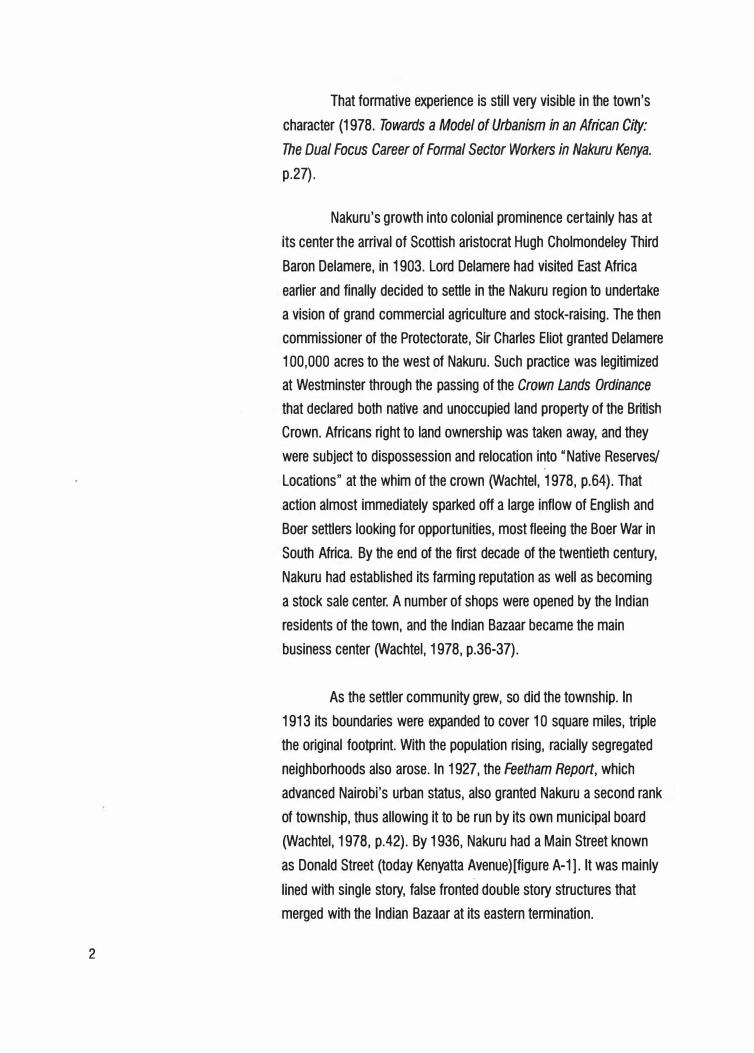
Chapter I The Place of Dust
Making a Colonial Town
The Mombasa to Uganda railway reached Nakuru in 1900.
The area remained a mere railway outpost until January 1904 when
the commissioner of the Protectorate, Sir Charles Eliot proclaimed
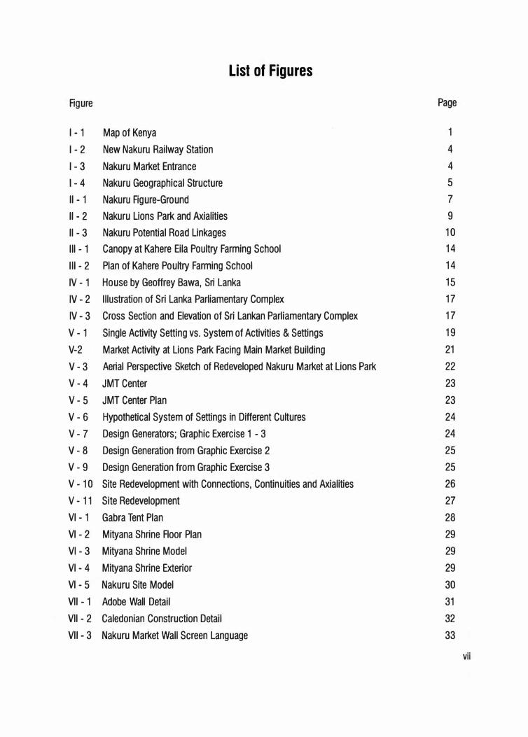
it a township. Nakuru's location 160km nor thwest of the country's
capital Nairobi [figure I - 1] and sandwiched position between two
natural features, namely the extinct volcanic feature Menengai Crater
to the north, and the highly ecologically sensitive Lake Nakuru Malindl. fnd1' ,i · ac., National Park [south], famous for its flamingoes, bird species
FIGURE I - 1: Map of Kenya
and game, would force the city to expand in a lineal manner along
the railway and highway corridor. Neither northern nor southern
expansion would be feasible.
The name "Nakuru" is derived from the Maasai word
meaning "the place of dust". The loose volcanic soil and lake soda
that is characteristic of this geologically sensitive region, results in
dust storms during the dry season.
Historical Roots to the Existing Spatial Structure and Current Conditions
At its inception, Nakuru Township's footprint was a circle
with a radius of one mile from the entrance to the railway station.
Before long, Nakuru became the headquarters of the Northern
Railway District marking the star t of its functional importance as a
transportation center. Andy Wachtel, noting this founding, points out
that unlike many western urban centers, Nakuru was not founded as
an industrial type city purely or transitionally. It grew to be somewhat
industrial, but is better characterized as a "colonial town" founded to
serve a "settler vanguard".
2
That formative experience is still very visible in the town's
character (1978. Towards a Model of Urbanism in an African City:
The Dual Focus Career of Formal Sector Workers in Nakuru Kenya.
p.27).
Nakuru's growth into colonial prominence cer tainly has at
its center the arrival of Scottish aristocrat Hugh Cholmondeley Third
Baron Delamere, in 1903. Lord Delamere had visited East Africa
earlier and finally decided to settle in the Nakuru region to undertake
a vision of grand commercial agriculture and stock-raising. The then
commissioner of the Protectorate, Sir Charles Eliot granted Delamere
100,000 acres to the west of Nakuru. Such practice was legitimized
at Westminster through the passing of the Crown Lands Ordinance
that declared both native and unoccupied land property of the British
Crown. Africans right to land ownership was taken away, and they
were subject to dispossession and relocation into II Native Reserves/
Locations" at the whim of the crown (Wachtel, 1978, p.64). That
action almost immediately sparked off a large inflow of English and
Boer settlers looking for opportunities, most fleeing the Boer War in
South Africa. By the end of the first decade of the twentieth century,
Nakuru had established its farming reputation as well as becoming
a stock sale center. A number of shops were opened by the Indian
residents of the town, and the Indian Bazaar became the main
business center (Wachtel, 1978, p.36-37).
As the settler community grew, so did the township. In
1913 its boundaries were expanded to cover 1 0 square miles, triple
the original footprint. With the population rising, racially segregated
neighborhoods also arose. In 1927, the Feetham Report, which
advanced Nairobi's urban status, also granted Nakuru a second rank
of township, thus allowing it to be run by its own municipal board
(Wachtel, 1978, p.42). By 1936, Nakuru had a Main Street known
as Donald Street (today Kenyatta Avenue) [figure A-1]. It was mainly
lined with single story, false fronted double story structures that
merged with the Indian Bazaar at its eastern termination.
European settlement on the slopes of the extinct volcano
Menengai also took place at this time resulting in a racially layered
character to the town whereby natives lived closest to the lake on
the southern edge, Asians between and below the railway line,
and Europeans to the north of the slopes. The start of World War
II brought business and life in the town center to a stagnation.
However, an aerodrome was constructed to support the war in an
area on the eastern outskirts adding 200 Europeans to the town's
population (Wachtel, 1978, p.48}.
The combination of the segregating Crown Lands Ordinance
and Native Lands Trust, would greatly affect the shape of Nakuru.
Both laws led to the establishment of native locations where, as
Wachtel points out, "segregation was practiced in the supposed
interests of better administration or public health" (1978, p.54}.
Urban segregation was thus justified to be a necessity due to the
incivility and resulting unsanitary culture of both lower class Indians
and natives. In truth, it served to effect control. In 1914, Nakuru
township was divided into six quarters being: the government
officers quarters, the Indian Bazaar, European business quarter,
European residential quarter, Indian 'coolies' lines, and African lines
(Wachtel, 1978, p.57}.
Africans were typically low-income laborers working for
Europeans. Many lived in servant's quarters within their European
master's compounds or in the contained labor lines within the
African quarter. The houses, or "landhies", consisted of tiny 100-
120 square foot rooms shared by many, and thus no place for family
life. Anthony O'Connor, in his book The African City, pictures the
situation stating that,
Each [ city] consisted of two largely separate
communities, with social interaction between them near
the minimum. For most of the Europeans they were
spacious cities designed for people like themselves
into which an uncomfortably number of Africans had
3
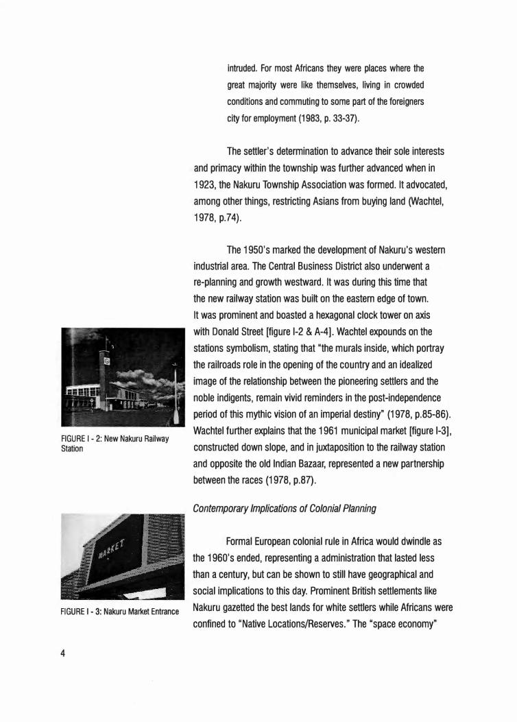
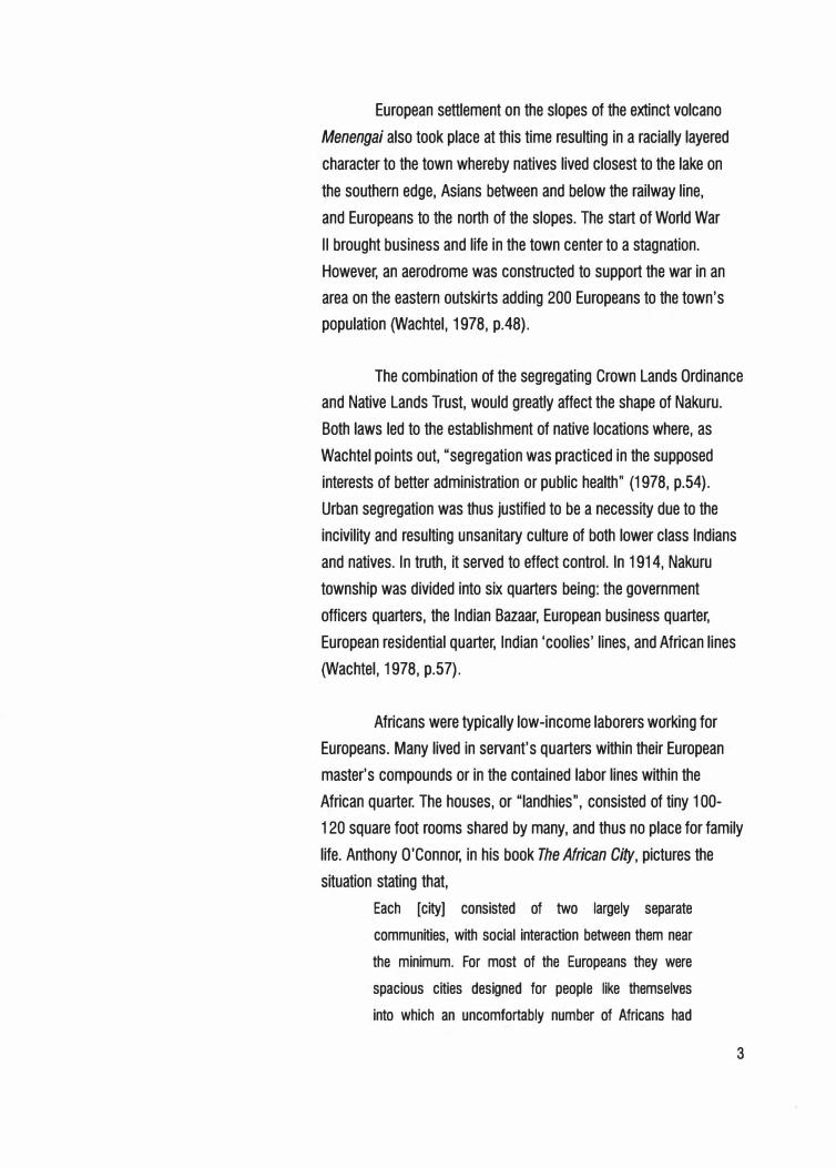
FIGURE I - 2: New Nakuru Railway Station
intruded. For most Africans they were places where the
great majority were like themselves, living in crowded
conditions and commuting to some part of the foreigners
city for employment (1983, p. 33-37).
The settler's determination to advance their sole interests
and primacy within the township was further advanced when in
1923, the Nakuru Township Association was formed. It advocated,
among other things, restricting Asians from buying land (Wachtel,
1978, p.74).
The 1950's marked the development of Nakuru's western
industrial area. The Central Business District also underwent a
re-planning and growth westward. It was during this time that
the new railway station was built on the eastern edge of town.
It was prominent and boasted a hexagonal clock tower on axis
with Donald Street [figure 1-2 & A-4]. Wachtel expounds on the
stations symbolism, stating that "the murals inside, which portray
the railroads role in the opening of the country and an idealized
image of the relationship between the pioneering settlers and the
noble indigents, remain vivid reminders in the post-independence
period of this mythic vision of an imperial destiny" (1978, p.85-86).
Wachtel further explains that the 1961 municipal market [figure 1-3],
constructed down slope, and in juxtaposition to the railway station
and opposite the old Indian Bazaar, represented a new partnership
between the races (1978, p.87).
Contemporary Implications of Colonial Planning
Formal European colonial rule in Africa would dwindle as
the 1960's ended, representing a administration that lasted less
than a century, but can be shown to still have geographical and
social implications to this day. Prominent British settlements like
FIGURE 1 _ 3: Nakuru Market Entrance Nakuru gazetted the best lands for white settlers while Africans were
confined to "Native Locations/Reserves." The "space economy"
4
FIGURE I - 4: Nakuru Geographical Structure
was therefore dictated by the colonial authorities (Myers, 2003, p.4).
Native locations were planned to be compartmentalized and thus
controllable regions. They had, on a macro scale, an inside and an
outside with limited entrance and exit provisions on the urban grid,
making them less tied into the overall urban fabric (Myers, 2003,
p.46).
As earlier pointed out, colonial urban order, in terms of
spatiality, architecture, landscape and design features, served
deliberate political purposes, particularly, as British planner Eric
Dutton put it, for the "cultivation of public opinion on the spot." The
colonialists intent was two fold, namely, the acceptance of British
rule, and second, as some kind of goodwill (Myers, 2003, p.7-8).
The segmentation of the township into racially defined
quarters served to contain. Traditional African spatial orders were
far less rigidly enframed than those the British instituted. Nakuru,
sandwiched between two bounding natural features [figure 1-4) is a
contained town on the macro-urban scale, while its native locations
were a micro-urban containment due to the fact that a large number
of Africans were squeezed into single room housing with clear
internal-external demarcation. This was very opposite to African
domestic order, whereby the exterior blended with the interior and
settlement was never crowded, but always juxtaposed to a vast
exterior environment. Edward Soja in a piece titled "The Geography
of Modernization: A Radical Reappraisal", points out that pre-colonial
cultures in Kenya had a noted affection for rural life, and that urban
nucleated settlement was largely shunned. Colonial urbanization
superimposed a very new system of settlement over East Africa, and
its broad outlines are solid and evident in today's urban structures
(Obudho, 1979, p.37-38).
5
6
Chapter II The Pe,rsist,ence of Disord,er Reweaving an Urban Fabric
As previously discussed, the segmented city was designed
to control; so that an individual could, as stated by Garth Myers,
"observe and survey the city as a means of abstracting and
objectifying the built environment." Myers further expounds that
"the often well-surveilled central spaces of observation served to
distance traditionally rural Africans from the communal, "fused"
conceptions of space with which they approached the city,
seemingly making the rational, western planning approach to urban
space normalized in their eyes (Myers, 1978, p.9). These strategies
thus served to separate the "container" (colonial/colonizing power)
and the "contained" (African community).
Currently approximately 360,000 people live within the
Nakuru Municipal boundaries. Unfortunately, due to the physical
and geological constraints of the region, the town has not expanded
enough to cater for its current population. Economic constraints
(typical of municipal bodies in Kenya) and lack of proper planning
have resulted in characteristically chaotic physio-spatial conditions
in some sections of downtown Nakuru, most evidently at the
town's main bus park and retail market quarter [figure A-2 & A-3].
The current retail market was constructed and opened in 1961. It
currently has between 100-200 stalls where vendors sell a variety
of agricultural produce. Due to dire economic conditions many
people from the surrounding farming communities are dependent
on the market to sell their produce for income. A lack of adequate
stall space has driven several vendors to patch themselves and their
produce on city sidewalks.
Nakuru, being located along the East African railway
line, and the Trans-African Highway (A-104), is also a major
transportation hub. The current Public Service Vehicle [PSV] park, is
poorly planned and is thus a jumble of several vehicles trying to inch
themselves past each other.
The urban condition that is evident in Nakuru today is one
of disorder, marked by a particular lack of architectural coherence or
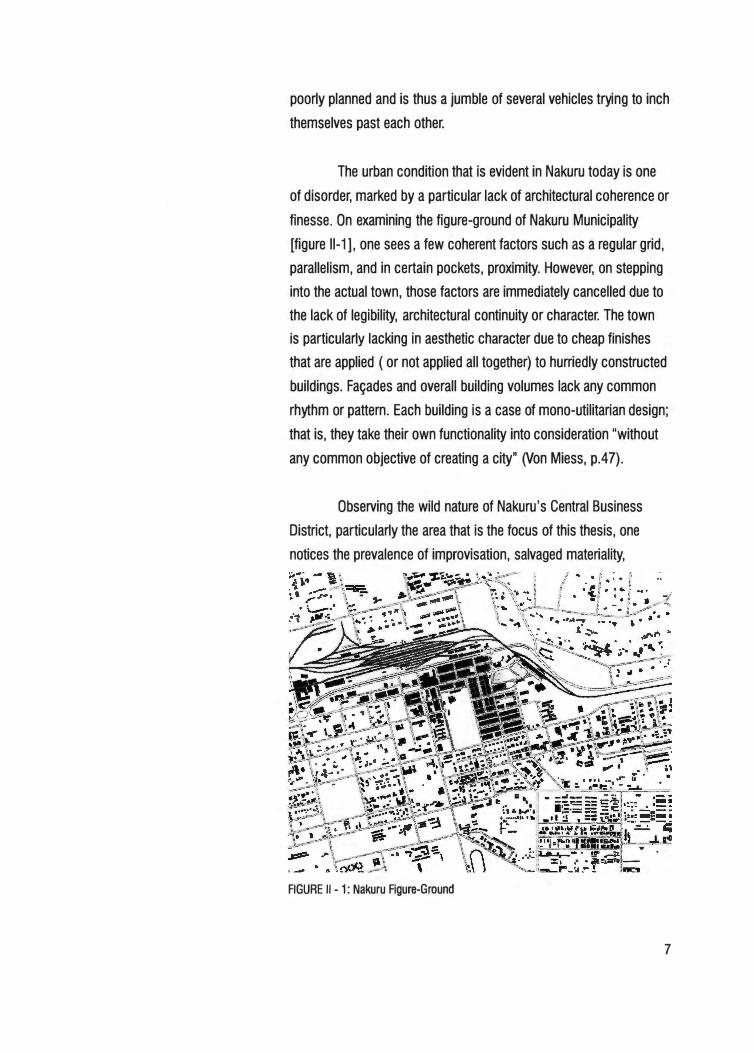
finesse. On examining the figure-ground of Nakuru Municipality
[figure 11-1 ], one sees a few coherent factors such as a regular grid,
parallelism, and in certain pockets, proximity. However, on stepping
into the actual town, those factors are immediately cancelled due to
the lack of legibility, architectural continuity or character. The town
is particularly lacking in aesthetic character due to cheap finishes
that are applied ( or not applied all together) to hurriedly constructed
buildings. Fa�ades and overall building volumes lack any common
rhythm or pattern. Each building is a case of mono-utilitarian design;
that is, they take their own functionality into consideration "without
any common objective of creating a city" (Von Miess, p.47).
Observing the wild nature of Nakuru's Central Business
District, particularly the area that is the focus of this thesis, one
notices the prevalence of improvisation, salvaged materiality,
FIGURE II - 1: Nakuru Figure-Ground
7
8
na'ive/illegal settlements, and poor recreations of western urbanity.
Mohammed Arkoun in his introduction to Brian Taylor's Reading the
Contemporary African City, points out that architects and planners
need to reinterpret their policies and plans, basing them anew on
ancient (thus proven) conditions of existence, reworking forms of
solidarity, and intensifying adaptive activities:
Reading an urban space means reflecting in a new
and radical way about the relationships - undeniable
but not yet clarified - between the configuration of the
physical environment in which a community lives and
the aesthetic, ethical symbolic universe in which the
imaginative life of this community organizes and asserts
itself (Arkoun, 1983, p.xvii).
This thesis proposes a solution to Nakuru's urban and
architectural disorder by seeking to establish an architectural identity
at the point where the town's commercial center was birthed. African
architectural values are subtly hidden in the current disorder, but are
better gleaned from traditional settlement patterns and other African
aesthetics.
The historical containment of the Market - Public
Service Vehicle site requires that the urban fabric be re-weaved.
The improvisations that are evident in local constructions and
modifications are telling. The African urban majority remains reliant
on local customs in the production and organization of space
(Myers, p.17 & 161 ). This thesis investigates and provides an
architectural outlet for the resourcefulness of the people, while at the
same time ensuring that it does not get out of control leading to a
persistence of disorder.
Planning Initiative
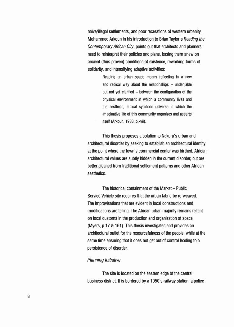
The site is located on the eastern edge of the central
business district. It is bordered by a 1950's railway station, a police
station, several commercial buildings and a poorly maintained open
space (Lions Park) [figure 11-2].
Broad Program Proposals: Character and Relationships
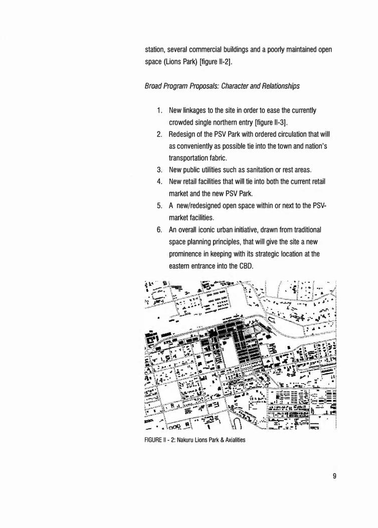
1. New linkages to the site in order to ease the currently
crowded single northern entry [figure 11-3].
2. Redesign of the PSV Park with ordered circulation that will
as conveniently as possible tie into the town and nation's
transportation fabric.
3. New public utilities such as sanitation or rest areas.
4. New retail facilities that will tie into both the current retail
market and the new PSV Park.
5. A new/redesigned open space within or next to the PSV
market facilities.
6. An overall iconic urban initiative, drawn from traditional
space planning principles, that will give the site a new
prominence in keeping with its strategic location at the
eastern entrance into the CBD.
FIGURE II - 2: Nakuru Lions Park & Axialities
9
FIGURE II - 3: Nakuru Potential Road Linkages
10
Chapter Ill Architecture for the Develo
1
ping World An Authentic Modern Vernacu!lar
There has been the common desire in architectural circles in
developing nations, to equate progress with western building types.
The rise of interest in regionalist and contextual issues is evidence of
the growing realization that the developing world has to learn to draw
equally on its own architectural traditions and adapt them to modern
needs of shelter, and as is often the case, basic survival.
Turkish architect, historian and architectural critic Suha
Ozkan, in a paper titled "A Pluralist Alternative", decries the fact that
the architectural elite has ignored the role of individuals and societies
in determining their own environment. He points out that traditional
processes and patterns often resulted in suitable, albeit imperfect,
culturally rich and harmonious built environments. Unfortunately,
today's architectural profession has relegated this cultural sensitivity
to the anthropologist alone. As Secretary General of the Aga Khan
Trust for Culture and an expert in vernacular form and emergency
housing, Ozkan argues against the seemingly endless debates about
modernism's value and rightfully encourages architects to abandon
non-substantive semantics and rhetoric, and turn to the needs of
the homeless and less endowed (Steel, Architecture for a Changing
World. p. 36).
In his book Modern Architecture Since 1900, historian and
critic William Curtis, adds to the discussion by decrying the fact
that peasant vernaculars are often associated with primitiveness
and backwardness. He points out the earlier stated fact that the
insensitive planting of modern architecture in the developing world,
without respect to traditions, values and climates, made many
realize the importance of the preservation of national and rural
traditions (Curtis, Modern Architecture Since 1900. p. 568). "As
11
12
always, architectural value would reside in the convincing synthesis
of the practical, the aesthetic and the symbolic, and in the creation
of a unity in harmony with the setting. Vernacular structures could
provide some clues for achieving these ends by revealing age-
old patterns of adaptation" (Curtis, p. 571 ). A major challenge in
developing architecture for the developing world is the establishment
of an architectural language suitable and sensitive to both modern
and traditional tasks.
The Danger of Kitsch
Hassan Uddin Khan, an architectural critic, in an article
published in the book Criticism in Architecture titled "Meaning in
Tradition: Today, an Approach to Architectural Criticism", caution
that a particular architecture can be easily mistaken to simply be it's
imagery and craft. That is, the literal application of design elements
and technologies. He therefore warns that buildings are more than
how they appear or are produced (Khan, qtd. in Powell, Criticism
in Architecture. p. 57). Historian William Curtis further states the
danger thus,
A building that fitted some passing prescription,
that illustrated values noisily, proclaimed as 'Islamic',
'Indian', 'nationalist', 'communist', (or whatever), was
not necessarily architecture of lasting quality. Indeed, too
facile an acceptance of conventional iconography could
lead quickly to kitsch .... What was needed was a blend of
the local and the universal, which avoided the limitations
of each and led to forms of lasting symbolic resonance.
Skin-deep modernism and glib traditionalism were evils to
be avoided in every part of the world (p. 587).
Lessons from the Vernacular
Good design stems from an understanding and sensitivity to
the ecology of the particular site or region, and a cultural relevance
to people and their daily rituals. Architecture that has existed in such
a context for years most certainly has been adapted in the best way
possible to accommodate these factors and therefore carries the
lessons a modern designer would need in order to similarly adapt
any new building to a people.
Today's developing world is faced with the need to develop
or be left behind in an increasingly global society. Every aspect
of society that would foster national existence such as education,
health and industry are tied into the larger global economy, which
is largely western and technologically advanced. Third World
nations have and continue to experience the inroads of imported
technology, which doesn't imply the extinction of traditional values.
Instead, these advancements offer architecture the challenge of
fusing technology and tradition. It would be inaccurate to assume
that technology allows only for a western expression, while denying
regional and cultural forms of architectural expression, argues Khan.
The Aga Khan Award for architecture rewards architects and
lay builders in the developing world who have succeeded in fusing
the two. The nominated buildings, being in developing countries
where resources are few, income low and population high, are
often very simple and of affordable construction. They are rarely
constructed with much government aid or management, but manage
to capture and utilize the simple vitality, skill and ingenuity found in
the building traditions of poor communities.
The character of the nominated buildings for the award,
offers several lessons. First, the projects display a strong expression
of the importance of the larger natural and urban environment.
Secondly, they are rarely isolated, but engage and dialog with their
natural and social contexts. The projects also typically use an
appropriate technology and strive to avoid inappropriate, imported
or even industry-driven imposed technologies. This kind of
resourcefulness with local materials has benefits being an increased
13
FIGURE Ill - 1: Canopy at Kahere Eila Poultry Farming School Heikkinen + Komonen Architects
-· -·'-· -- :•'',
·,:,:,:x.a,, · · •:c:1.1o:•�
=' =- ==
. ,. ., .............. �
·d,·
FIGURE Ill - 2: Plan of Kahere Poultry Farming School Heikkinen + Komonen Architects
14
harmony with the natural context and the social and economic
realities of the beneficiaries. The projects are always sustainable,
replicable and display an effortless blending of systems and
function. Last, the projects display an ingenious translation of forms
and techniques drawn from indigenous prototypes without resulting
in kitsch {Steele, p. 12, 22, 32). This is the kind of 'new' architecture
Swiss architect Justus Dahinden spoke of, that is vitalized by its
elementary simplicity and free from any cliche imitating a style.
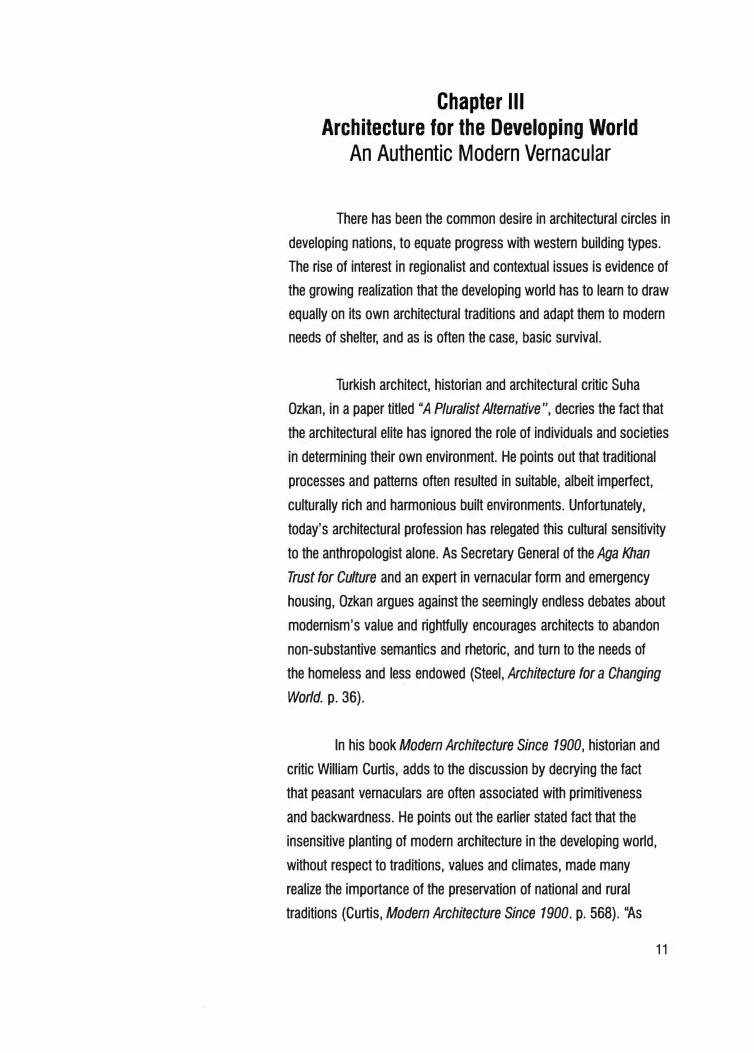
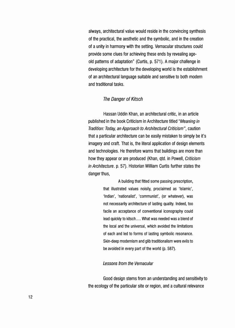
Among the recipients of the award in 2001 was the
Kahere Ela Poultry Farming School [figure 111-1] in Guinea by the
Finish architects Heikkinen + Komonen. The traditional cylindrical
structures in the neighborhood of the site were typically grouped
around an open space that was used for a variety of social and
domestic activities. The new complex for the farming school required
three main areas: a classroom, student quarters, and teacher's
quarters. Tradition was respected by grouping them around a central
courtyard and large tree that would serve as an outdoor gathering
area [figure 111-2]. The plan was based on a 1.2 meter grid that
lent simplicity but formal grace to the architecture. All the primary
construction materials came from local sources, and included
stabilized heat-collecting earth blocks, wood-frame technology, and
simple metal roof trusses. The complex displays a simple and clear
form that combines traditional planning relationships of Guinean
culture with Nordic timber construction sophistication.
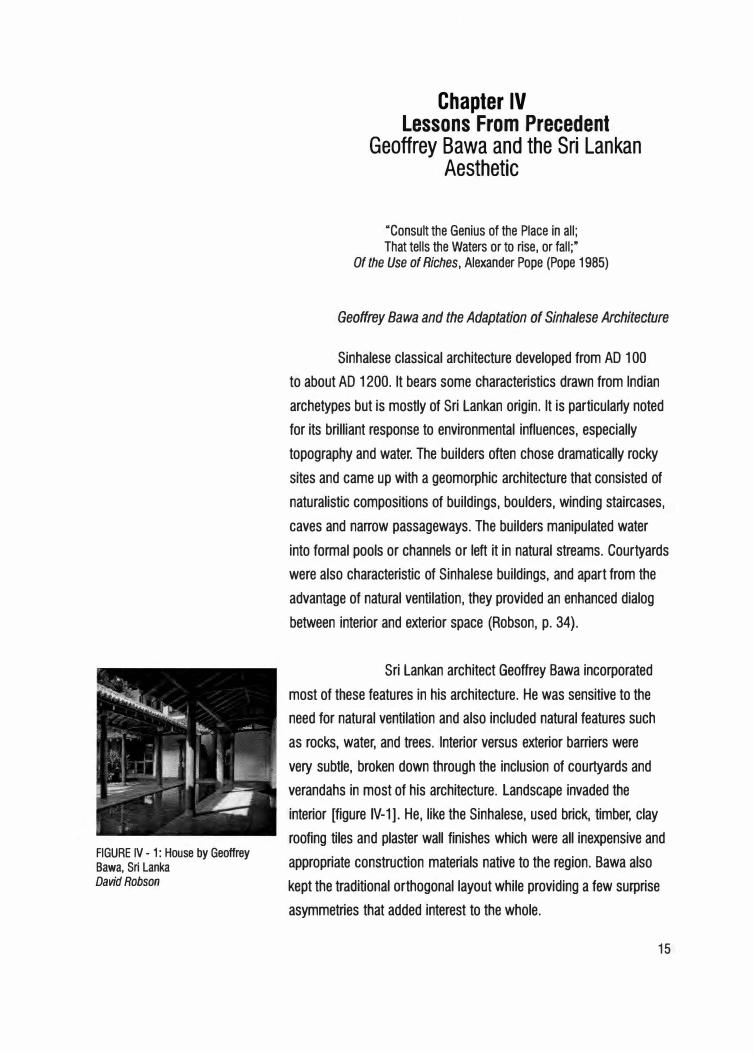
FIGURE IV - 1: House by Geoffrey Bawa, Sri Lanka David Robson
Chapter IV Lessons From Precedent
Geoffrey Bawa and the Sri Lankan Aesthetic
"Consult the Genius of the Place in all; That tells the Waters or to rise, or fall;"
Of the Use of Riches, Alexander Pope (Pope 1985)
Geoffrey Bawa and the Adaptation of Sinhalese Architecture
Sinhalese classical architecture developed from AD 100
to about AD 1200. It bears some characteristics drawn from Indian
archetypes but is mostly of Sri Lankan origin. It is particular1y noted
for its brilliant response to environmental influences, especially
topography and water. The builders often chose dramatically rocky
sites and came up with a geomorphic architecture that consisted of
naturalistic compositions of buildings, boulders, winding staircases,
caves and narrow passageways. The builders manipulated water
into formal pools or channels or left it in natural streams. Courtyards
were also characteristic of Sinhalese buildings, and apart from the
advantage of natural ventilation, they provided an enhanced dialog
between interior and exterior space (Robson, p. 34).
Sri Lankan architect Geoffrey Bawa incorporated
most of these features in his architecture. He was sensitive to the
need for natural ventilation and also included natural features such
as rocks, water, and trees. Interior versus exterior barriers were
very subtle, broken down through the inclusion of courtyards and
verandahs in most of his architecture. Landscape invaded the
interior [figure IV-1]. He, like the Sinhalese, used brick, timber, clay
roofing tiles and plaster wall finishes which were all inexpensive and
appropriate construction materials native to the region. Bawa also
kept the traditional orthogonal layout while providing a few surprise
asymmetries that added interest to the whole.
15
16
Bawa was not very theoretical. A rare idea of his philosophy
comes from an article in the Times of Ceylon Annual {1968) titled "A
Way of Building":
"I have always found It difficult to write about architecture,
particularly my own. There has been so much dogma
and theory put forward over the centuries ... that one is
hesitant in stating a new set of rules ... But there are rules,
some old and strong ones. The first is that a building must,
at the very least, satisfy the needs that give It birth ... The
second is that it must be in accord with the ambience of
is place ... And there is one more, a technical rule: there
must be a knowledgeable and true use of materials."
On the importance of and his adaptation of the distinct Sri Lankan
roof aesthetic, he continued:
"One unchanging element is the roof - protective,
emphatic and all-important - governing the aesthetic
whatever the period, whatever the place. Often a building
is only a roof, columns and floors - the roof dominant,
shielding, giving the contentment of shelter. Ubiquitous,
pervasively present, the scale or pattern shaped by
the building beneath. The roof, its shape, texture and
proportion is the strongest visual factor" (Robson, p. 60-
61 ).
Bawa also sought to frame views, particularly to the
landscape, which he celebrated. He did this by bringing the
landscape right up to the building and then into the building within
courtyards [figure IV-1].
The Sri Lankan Parliament at Kotte, 1979-1982
Austin Woodeson, who was the chief architect of the Ceylon
Public Works Department, built Sri Lankas original parliament in
1929 in the Anglo-Paladian style. The building faced the Indian
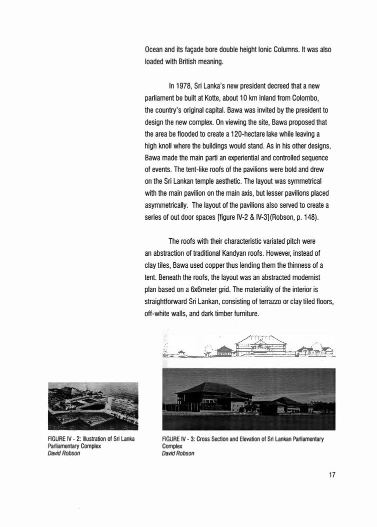
FIGURE IV - 2: Illustration of Sri Lanka Parliamentary Complex David Robson
Ocean and its fa�ade bore double height Ionic Columns. It was also
loaded with British meaning.
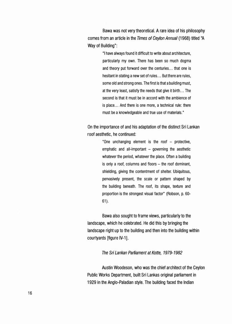
In 1978, Sri Lanka's new president decreed that a new
parliament be built at Kotte, about 1 O km inland from Colombo,
the country's original capital. Bawa was invited by the president to
design the new complex. On viewing the site, Bawa proposed that
the area be flooded to create a 120-hectare lake while leaving a
high knoll where the buildings would stand. As in his other designs,
Bawa made the main parti an experiential and controlled sequence
of events. The tent-like roofs of the pavilions were bold and drew
on the Sri Lankan temple aesthetic. The layout was symmetrical
with the main pavilion on the main axis, but lesser pavilions placed
asymmetrically. The layout of the pavilions also served to create a
series of out door spaces [figure IV-2 & IV-3] (Robson, p. 148).
The roofs with their characteristic variated pitch were
an abstraction of traditional Kandyan roofs. However, instead of
clay tiles, Bawa used copper thus lending them the thinness of a
tent. Beneath the roofs, the layout was an abstracted modernist
plan based on a 6x6meter grid. The materiality of the interior is
straightforward Sri Lankan, consisting of terrazzo or clay tiled floors,
off-white walls, and dark timber furniture.
FIGURE IV - 3: Cross Section and Elevation of Sri Lankan Parliamentary Complex David Robson
17
18
roofs.
::�'.,.
)i' ':·;�,··.�� . �.'¥·
T imber was used extensively in the construction of the
David Robson describes Bawa as being very intuitive and
mistrustful of theory. He states that Bawa avoided trying to justify
his designs, insisting that architecture had to be experienced directly
to be understood. " He doubted that buildings could be ascribed
specific meanings; their true significance would be established in
the minds of their users and would develop thorough time." Robson
speculating on why this may have been so states that, " It may be
that his [Bawa's] lawyers training had left him suspicious of the
humbug that permeates so much of what poses for architectural
discourse" (Robson, p. 261 ).
Bawa was also instinctively sensitive to bio-climatic factors
in order to maintain optimum human comfor t. Cross and stack
ventilation as well as solar protection were important features of his
buildings. To achieve these, Bawa designed cour tyards, verandahs,
pergolas, water pools, and wide overhangs. Thermal massing
provided protection from solar gain. The heavy clay tiles and roofing
construction was cool, waterproof and structurally sound. The
materials used in construction were mostly local, usually consisting
of brick, timber, clay products and plaster.
Bawa managed to avoid meaningless decoration. Earlier
in his career, his buildings wer,e whitewashed cubic forms typical
of tropical modernism. Eventually, Bawa incorporated the local
aesthetic through the incorporation of colors and textures of the local
environment (Robson, p. 262).
tt .. -......... .,,.-
/""'
\ ____ _,.. ...... _.. ............
... _.. __ .. _____ .,,.... of-
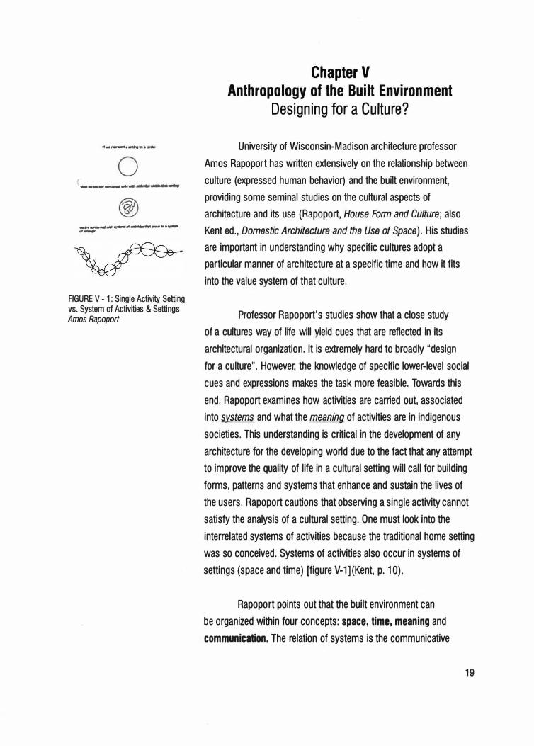
FIGURE V - 1: Single Activity Setting vs. System of Activities & Settings Amos Rapoport
Chapter V Anthropology of the Built Environment
Designing for a Culture?
University of Wisconsin-Madison architecture professor
Amos Rapoport has written extensively on the relationship between
culture (expressed human behavior) and the built environment,
providing some seminal studies on the cultural aspects of
architecture and its use (Rapoport, House Form and Culture; also
Kent ed., Domestic Architecture and the Use of Space). His studies
are important in understanding why specific cultures adopt a
particular manner of architecture at a specific time and how it fits
into the value system of that culture.
Professor Rapoport's studies show that a close study
of a cultures way of life will yield cues that are reflected in its
architectural organization. It is extremely hard to broadly "design
for a culture". However, the knowledge of specific lower-level social
cues and expressions makes the task more feasible. Towards this
end, Rapoport examines how activities are carried out, associated
into systems and what the meaning of activities are in indigenous
societies. This understanding is critical in the development of any
architecture for the developing world due to the fact that any attempt
to improve the quality of life in a cultural setting will call for building
forms, patterns and systems that enhance and sustain the lives of
the users. Rapoport cautions that observing a single activity cannot
satisfy the analysis of a cultural setting. One must look into the
interrelated systems of activities because the traditional home setting
was so conceived. Systems of activities also occur in systems of
settings (space and time) [figure V-1] (Kent, p. 10).
Rapoport points out that the built environment can
be organized within four concepts: space, time, meaning and
communication. The relation of systems is the communicative
19
20
aspect. Time refers to the temporal components of the systems;
tempos (number of activities per unit time), rhythms (periodicity of
activities) and cycles (lifetime, annual, seasonal, festivals, workdays
or weekends, day or night etc.) (Kent, p.15).
In the case of the market at Nakuru, the design of the
adjacent Lions Park is such that it could allow for periodic market
activity when civic gatherings do not require the space of the park.
Defining Activity
Rapoport defines activities as "direct expressions of
lifestyle and ultimately culture" (Kent, p. 11 ). Activities have four
aspects, being (1) the nature of the activities (instrumental aspects;
the activity itself) (2) how the activities are carried out (3) how
they associate into systems and (4) their latent meaning. Activity
systems are always organized into space and time and the ref ore
we must note that architecture works as a system. That is, people
do riot act in a single building, but in a system of buildings, outdoor
spaces, settlements and regions. An understanding of indigenous
architectural life is an understanding of a larger cultural landscape.
Defining Setting
"A setting is a milieu which defines a situation, reminds
occupants of the appropriate rules and hence of the ongoing
behaviors appropriate to the situation defined by the setting, thereby
making co-action [playing the same role in a setting] possible"
(Kent, p. 12). Settings and their boundaries are culturally defined
(often cognitively), and so are the rules regarding behavior within a
setting. Their temporal qualities also vary from culture to culture. A
setting, Rapoport explains, carries several hints (mnemonics) which
together define a situation, reminding those who enter of a number of
appropriate rules and behavior. The setting will have the appropriate
props for specific behavior and activity. There must be identifiable
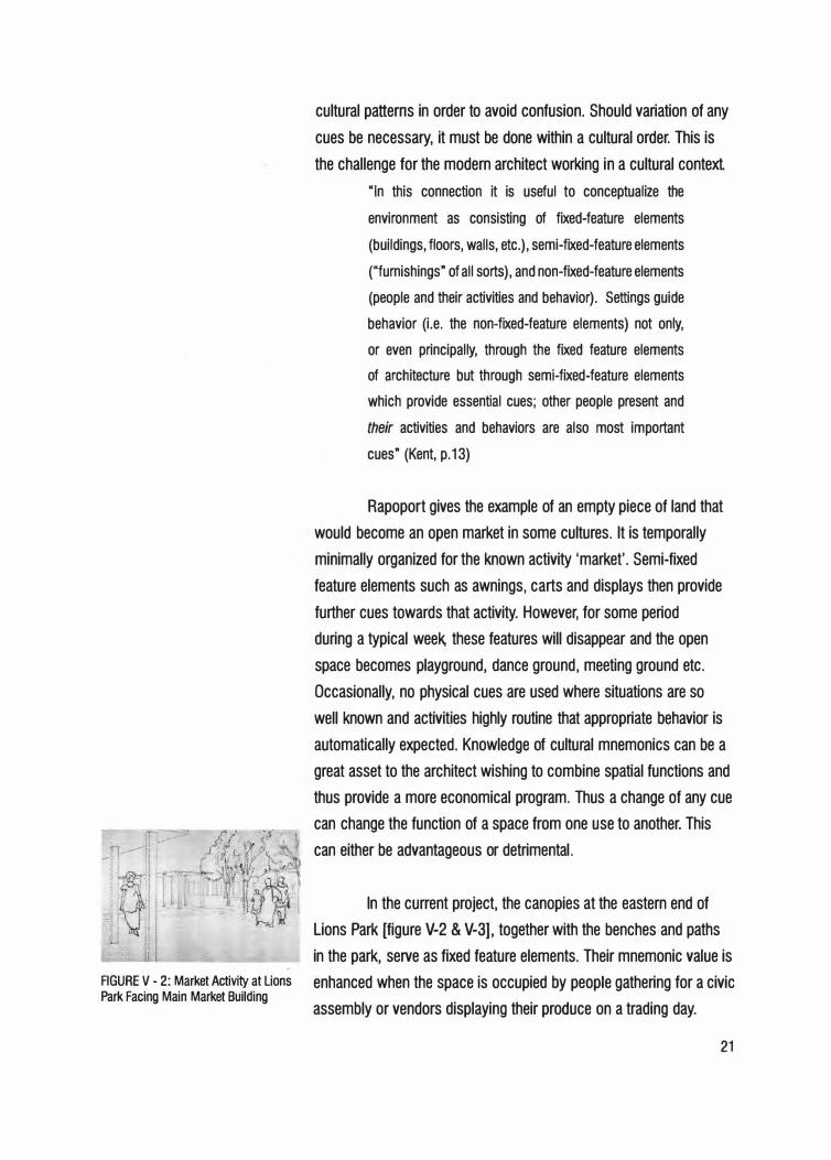
FIGURE V - 2: Market Activity at Lions Park Facing Main Market Building
cultural patterns in order to avoid confusion. Should variation of any
cues be necessary, it must be done within a cultural order. This is
the challenge for the modern architect working in a cultural context.
"In this connection it is useful to conceptualize the
environment as consisting of fixed-feature elements
(buildings, floors, walls, etc.), semi-fixed-feature elements
("furnishings" of all sorts), and non-fixed-feature elements
(people and their activities and behavior). Settings guide
behavior (i.e. the non-fixed-feature elements) not only,
or even principally, through the fixed feature elements
of architecture but through semi-fixed-feature elements
which provide essential cues; other people present and
their activities and behaviors are also most important
cues" (Kent, p.13)
Rapoport gives the example of an empty piece of land that
would become an open market in some cultures. It is temporally
minimally organized for the known activity 'market'. Semi-fixed
feature elements such as awnings, carts and displays then provide
further cues towards that activity. However, for some period
during a typical week, these features will disappear and the open
space becomes playground, dance ground, meeting ground etc.
Occasionally, no physical cues are used where situations are so
well known and activit_ies highly routine that appropriate behavior is
automatically expected. Knowledge of cultural mnemonics can be a
great asset to the architect wishing to combine spatial functions and
thus provide a more economical program. Thus a change of any cue
can change the function of a space from one use to another. This
can either be advantageous or detrimental .
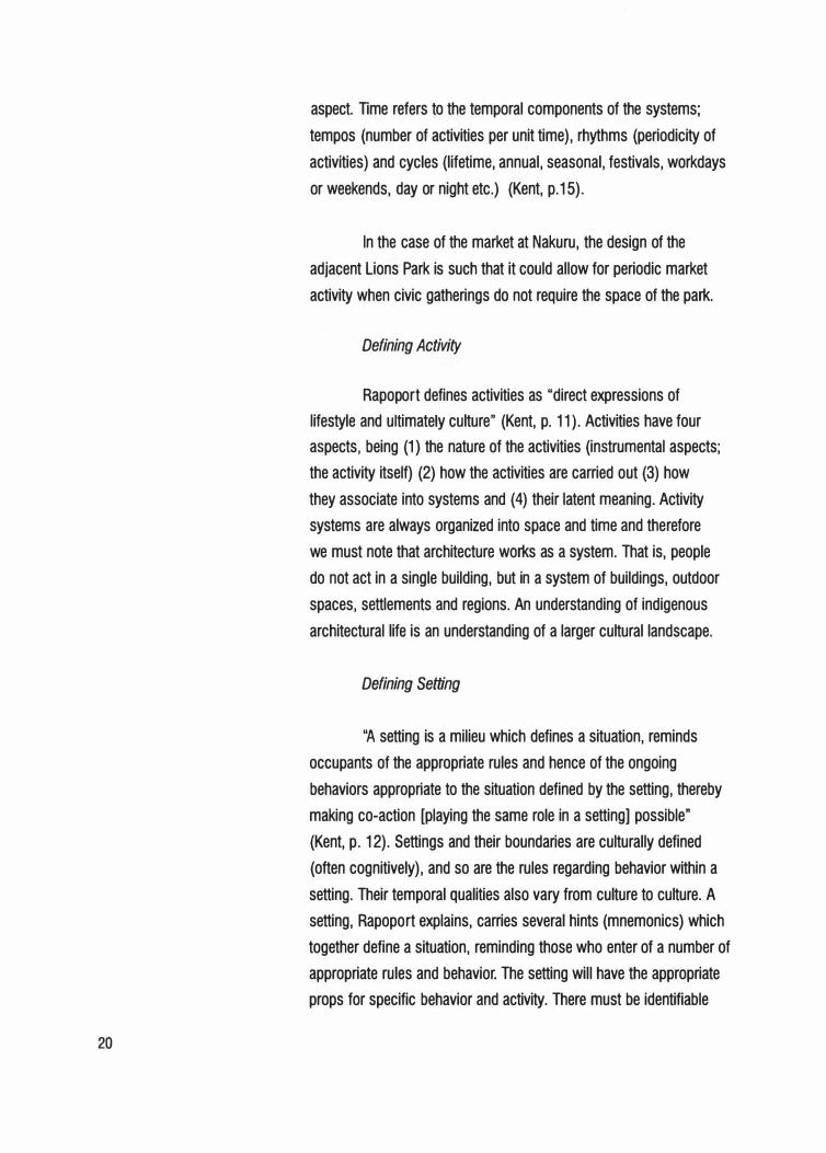
In the current project, the canopies at the eastern end of
Lions Park [figure V-2 & V-3], together with the benches and paths
in the park, serve as fixed feature elements. Their mnemonic value is
enhanced when the space is occupied by people gathering for a civic
assembly or vendors displaying their produce on a trading day.
21
22
FIGURE V - 3: Aerial Perspective Sketch of Redeveloped Nakuru Market and Lions Park
Culture and Built Form
Built form is one aspect of culture. Rapopor t points out that
it is hard to relate culture to built form, but much more feasible to
relate built form to specific aspects of a culture such as religion or
status hierarchies. Culture exists and needs to have a multi-sensory
outlet which is often its effects and products, architecture not being
the least. "Culture exists by definition: it is a conceptual summary
shorthand {and proposed explanation) for par ticular conjunctions of
a great variety of human phenomena" {Kent, p. 10). Rapoport argues
that we do not see culture - only its effects and products. A study of
lifestyle is very useful in investigating the cultural aspects that affect
built form, and thus the enviro-cultural work of Amos Rapoport is a
great r�source.
The relationship between activities and architecture is
mediated by culture. Architecture encloses behavior and as a
consequence, behavior or activities shape architecture. A knowledge
and understanding of this fact will help the architect realize that his
actions either foster or distort activities {Kent, p. 11 ).
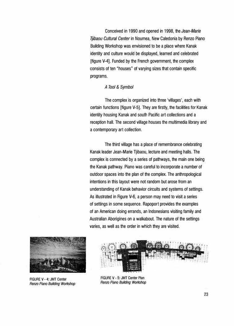
FIGURE V - 4: JMT Center
Renzo Piano Building Workshop
Conceived in 1990 and opened in 1998, the Jean-Marie
Tjibaou Cultural Center in Noumea, New Caledonia by Renzo Piano
Building Workshop was envisioned to be a place where Kanak
identity and culture would be displayed, learned and celebrated
[figure V-4). Funded by the French government, the complex
consists of ten "houses" of varying sizes that contain specific
programs.
A Tool & Symbol
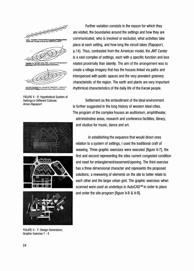
The complex is organized into three 'villages', each with
certain functions [figure V-5]. They are firstly, the facilities for Kanak
identity housing Kanak and south Pacific art collections and a
reception hall. The second village houses the multimedia library and
a contemporary art collection.
The third village has a place of remembrance celebrating
Kanak leader Jean-Marie Tjibaou, lecture and meeting halls. The
complex is connected by a series of pathways, the main one being
the Kanak pathway. Piano was careful to incorporate a number of
outdoor spaces into the plan of the complex. The anthropological
intentions in this layout were not random but arose from an
understanding of Kanak behavior circuits and systems of settings.
As illustrated in Figure V-6, a person may need to visit a series
of settings in some sequence. Rapoport provides the examples
of an American doing errands, an Indonesians visiting family and
Australian Aborigines on a walkabout. The nature of the settings
varies, as well as the order in which they are visited.
FIGURE V - 5: JMT Center Plan
Renzo Piano Building Workshop
23
Further variation consists in the reason for which they
are visited, the boundaries around the settings and how they are
�, __,..°' _ _,._.,f!!!Xl"'l!Yl""lcilncy'-. communicated, who is involved or excluded, what activities take 1-.i,,.,.. ......... -.--- .. ...-i
place at each setting, and how long the circuit takes (Rapopor t,
p.14). Thus, contrasted from the American model, the JMT Center
is a vast complex of settings, each with a specific function and less
��":1::i-:.=�.:i .. -°" related proximally than latently. The aim of the arrangement was to
A-.,Allarlglna !Lg. ,.,..ocqdle"-ln-."): -of "'bl9 ......... 1!5!!!1 ... otloc,ohlpo(--�-.. ,
FIGURE V - 6: Hypothetical System of Settings in Different Cultures Amos Rapoport
FIGURE V - 7: Design Generators: Graphic Exercise 1 - 3
24
create a village imagery that has the houses linked via paths and
interspersed with public spaces and the very prevalent greenery
characteristic of the region. The earth and plants are very important
rhythmical characteristics of the daily life of the Kanak people.
Settlement as the embodiment of the ideal environment
is further suggested in the long history of western ideal cities.
The program of the complex houses an auditorium, amphitheater,
administrative areas, research and conference facilities, library,
and studios for music, dance and art.
In establishing the sequence that would direct ones
relation to a system of settings, I used the traditional craft of
weaving. Three graphic exercises were executed [figure V-7], the
first and second representing the sites current congested condition
and need for entanglemenVeasemenVopening. The third exercise
has a three dimensional character and represents the proposed
solutions, a reweaving of elements on the site to better relate to
each other and the larger urban grid. The graphic exercises when
scanned were used as underlays in AutoCAD™ in order to place
and order the site program [figure V-8 & V-9].
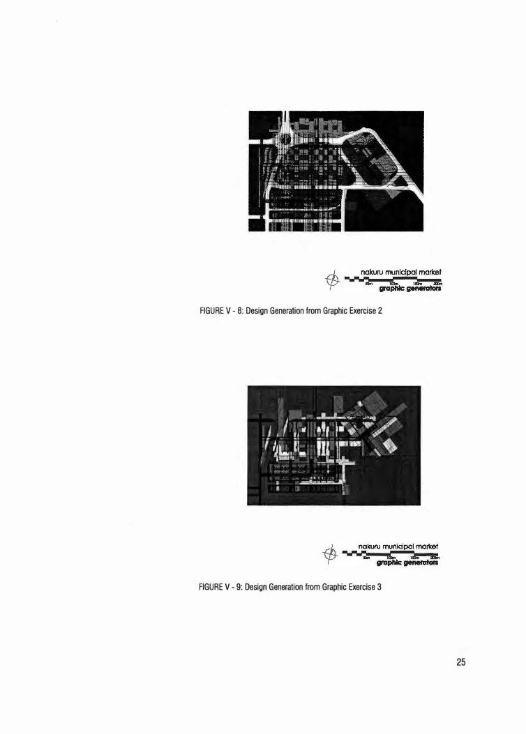
FIGURE V - 8: Design Generation from Graphic Exercise 2
FIGURE V - 9: Design Generation from Graphic Exercise 3
25
26
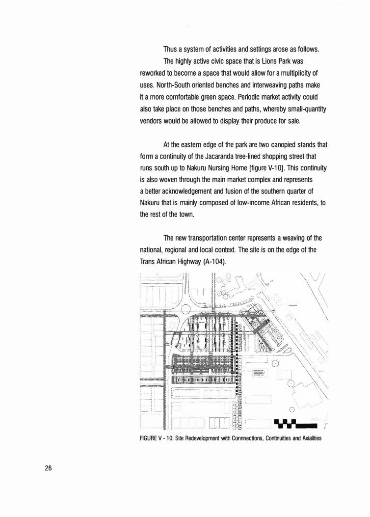
Thus a system of activities and settings arose as follows.
The highly active civic space that is Lions Park was
reworked to become a space that would allow for a multiplicity of
uses. North-South oriented benches and interweaving paths make
it a more comfortable green space. Periodic market activity could
also take place on those benches and paths, whereby small-quantity
vendors would be allowed to display their produce for sale.
At the eastern edge of the park are two canopied stands that
form a continuity of the Jacaranda tree-lined shopping street that
runs south up to Nakuru Nursing Home [figure V-1 OJ. This continuity
is also woven through the main market complex and represents
a better acknowledgement and fusion of the southern quarter of
Nakuru that is mainly composed of low-income African residents, to
the rest of the town.
The new transportation center represents a weaving of the
national, regional and local context. The site is on the edge of the
Trans African Highway (A-104).
:--
��-��-j
0
,,
j,..·-'"';'""""""""·"""·• • • • 7 • ..., • .--....
FIGURE V - 1 O: Site Redevelopment with Connnections, Continuities and Axialities
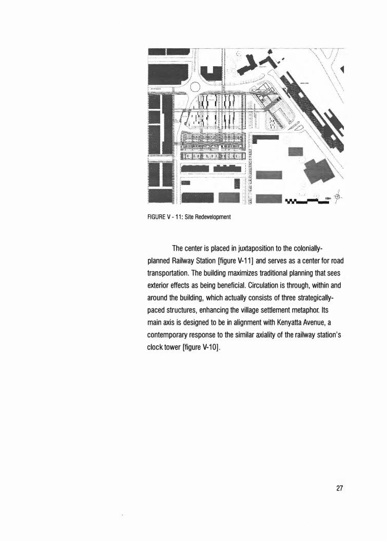
FIGURE V-11: Site Redevelopment
The center is placed in juxtaposition to the colonially
planned Railway Station [figure V-11] and serves as a center for road
transportation. The building maximizes traditional planning that sees
exterior effects as being beneficial. Circulation is through, within and
around the building, which actually consists of three strategically
paced structures, enhancing the village settlement metaphor. Its
main axis is designed to be in alignment with Kenyatta Avenue, a
contemporary response to the similar axiality of the railway station's
clock tower (figure V-1 O].
27
-=-t=•-1
FIGURE VI - 1: Gabra Tent Plan
Labelle Prussin
28
Chapter VI Afr,ican Trad.itional Ar.chitectu 1re
The Appraisal and Meaning of Space
The drama that is the exterior environment in Africa, has
affected indigenous architecture in that a contrast was created
between the concentrated and super-efficient enclosure of the typical
African dwelling, against the vast scale of the landscape.
Author Labelle Prussin states that,
In the deser t environment where encampments sit
precariously in profile against the sky on the uninterrupted
boundless infinity of the horizontal line, the continuous,
often curved, building surface strengthens the sense
of isolation. Beauty lies in the opposition, the polarity
between the intensity and concentration of interior space
and the boundless infinity of exterior space (Prussin,
Labelle. African Nomadic Architecture: Space, Place and
Gender, 1995. p. 191-192).
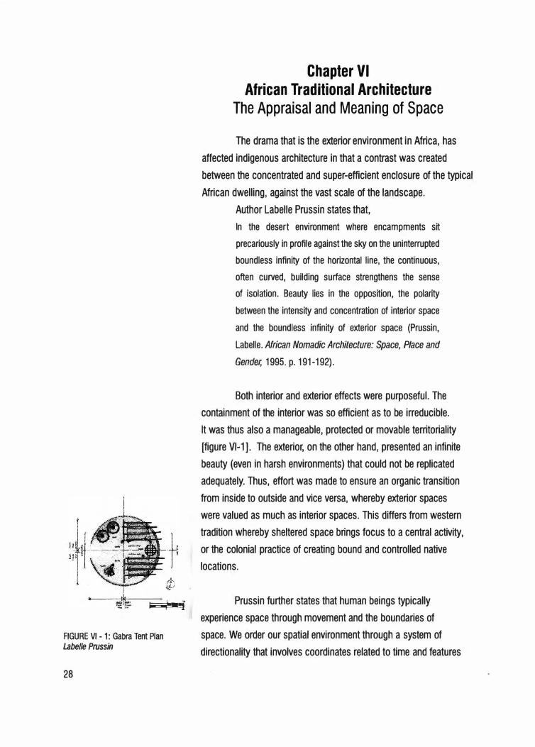
Both interior and exterior effects were purposeful. The
containment of the interior was so efficient as to be irreducible.
It was thus also a manageable, protected or movable territoriality
[figure Vl-1]. The exterior, on the other hand, presented an infinite
beauty (even in harsh environments) that could not be replicated
adequately. Thus, effort was made to ensure an organic transition
from inside to outside and vice versa, whereby exterior spaces
were valued as much as interior spaces. This differs from western
tradition whereby sheltered space brings focus to a central activity,
or the colonial practice of creating bound and controlled native
locations.
Prussin further states that human beings typically
experience space through movement and the boundaries of
space. We order our spatial environment through a system of
directionality that involves coordinates related to time and features
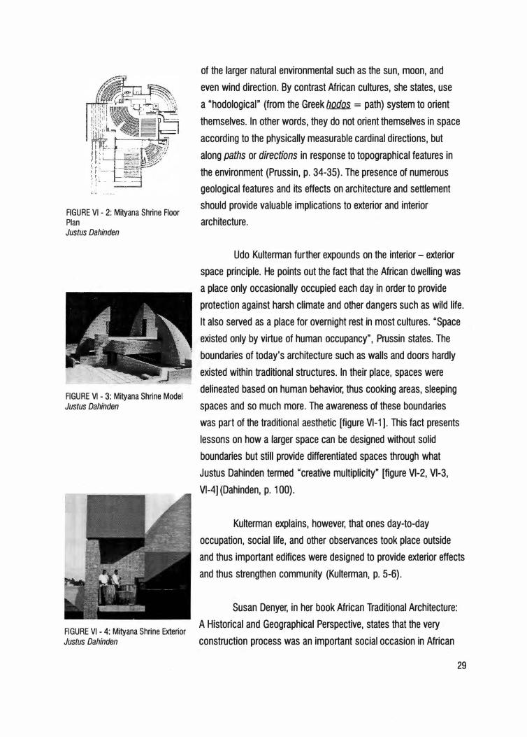
FIGURE VI - 2: Mityana Shrine Floor Plan Justus Dahinden
FIGURE VI - 3: Mityana Shrine Model Justus Dahinden
FIGURE VI - 4: Mityana Shrine Exterior Justus Dahinden
of the larger natural environmental such as the sun, moon, and
even wind direction. By contrast African cultures, she states, use
a "hodological" (from the Greek hodos = path) system to orient
themselves. In other words, they do not orient themselves in space
according to the physically measurable cardinal directions, but
along paths or directions in response to topographical features in
the environment (Prussin, p. 34-35). The presence of numerous
geological features and its effects on architecture and settlement
should provide valuable implications to exterior and interior
architecture.
Udo Kulterman fur ther expounds on the interior - exterior
space principle. He points out the fact that the African dwelling was
a place only occasionally occupied each day in order to provide
protection against harsh climate and other dangers such as wild life.
It also served as a place for overnight rest in most cultures. "Space
existed only by virtue of human occupancy", Prussin states. The
boundaries of today's architecture such as walls and doors hardly
existed within traditional structures. In their place, spaces were
delineated based on human behavior, thus cooking areas, sleeping
spaces and so much more. The awareness of these boundaries
was par t of the traditional aesthetic [figure Vl-1 ]. This fact presents
lessons on how a larger space can be designed without solid
boundaries but still provide differentiated spaces through what
Justus Dahinden termed "creative multiplicity" [figure Vl-2, Vl-3,
Vl-4] (Dahinden, p. 100).
Kulterman explains, however, that ones day-to-day
occupation, social life, and other observances took place outside
and thus important edifices were designed to provide exterior effects
and thus strengthen community (Kulterman, p. 5-6).
Susan Denyer, in her book African Traditional Architecture:
A Historical and Geographical Perspective, states that the very
construction process was an important social occasion in African
29
30
society. Building was always a highly cooperative venture, often
shortening construction to a day, while the materials had been
gathered for weeks preceding. Few materials ere used and that fact
further required that the construction be elaborate (Denyer. African
Traditional Architecture: A Historical and Geographical Perspective,
1978. p.92).
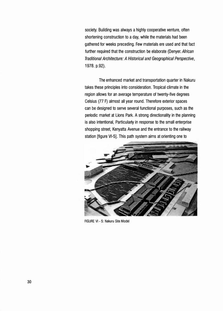
The enhanced market and transportation quarter in Nakuru
takes these principles into consideration. Tropical climate in the
region allows for an average temperature of twenty-five degrees
Celsius (77 F) almost all year round. Therefore exterior spaces
can be designed to serve several functional purposes, such as the
periodic market at Lions Park. A strong directionality in the planning
is also intentional, Particular1y in response to the small enterprise
shopping street, Kenyatta Avenue and the entrance to the railway
station [figure Vl-5]. This path system aims at orienting one to
FIGURE VI - 5: Nakuru Site Model
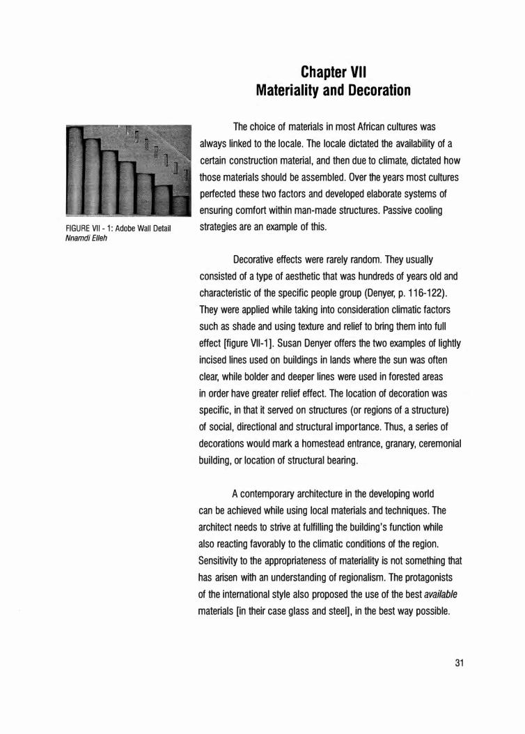
FIGURE VII - 1: Adobe Wall Detail
Nnamdi El/eh
Chapter VII Materiality and Decoration
The choice of materials in most African cultures was
always linked to the locale. The locale dictated the availability of a
certain construction material, and then due to climate, dictated how
those materials should be assembled. Over the years most cultures
perfected these two factors and developed elaborate systems of
ensuring comfort within man-made structures. Passive cooling
strategies are an example of this.
Decorative effects were rarely random. They usually
consisted of a type of aesthetic that was hundreds of years old and
characteristic of the specific people group (Denyer, p. 116-122).
They were applied while taking into consideration climatic factors
such as shade and using texture and relief to bring them into full
effect [figure Vll-1 ]. Susan Denyer offers the two examples of lightly
incised lines used on buildings in lands where the sun was often
clear, while bolder and deeper lines were used in forested areas
in order have greater relief effect. The location of decoration was
specific, in that it served on structures (or regions of a structure)
of social, directional and structural importance. Thus, a series of
decorations would mark a homestead entrance, granary, ceremonial
building, or location of structural bearing.
A contemporary architecture in the developing world
can be achieved while using local materials and techniques. The
architect needs to strive at fulfilling the building's function while
also reacting favorably to the climatic conditions of the region.
Sensitivity to the appropriateness of materiality is not something that
has arisen with an understanding of regionalism. The protagonists
of the international style also proposed the use of the best available
materials [in their case glass and steel], in the best way possible.
31
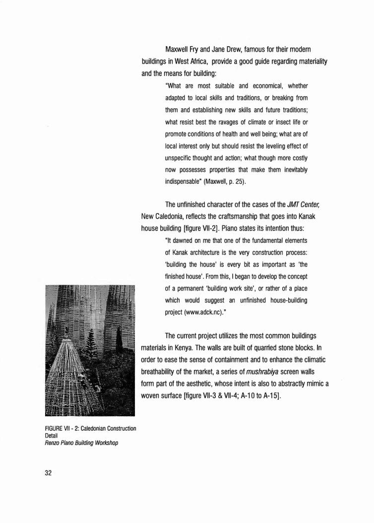
FIGURE VII - 2: Caledonian Construction
Detail
Renzo Piano Building Workshop
32
Maxwell Fry and Jane Drew, famous for their modern
buildings in West Africa, provide a good guide regarding materiality
and the means for building:
"What are most suitable and economical, whether
adapted to local skills and traditions, or breaking from
them and establishing new skills and future traditions;
what resist best the ravages of climate or insect life or
promote conditions of health and well being; what are of
local interest only but should resist the leveling effect of
unspecific thought and action; what though more costly
now possesses properties that make them inevitably
indispensable" (Maxwell, p. 25).
The unfinished character of the cases of the JMT Center,
New Caledonia, reflects the craftsmanship that goes into Kanak
house building [figure Vll-2]. Piano states its intention thus:
"It dawned on me that one of the fundamental elements
of Kanak architecture is the very construction process:
'building the house' is every bit as important as 'the
finished house'. From this, I began to develop the concept
of a permanent 'building work site', or rather of a place
which would suggest an unfinished house-building
project (www.adck.nc)."
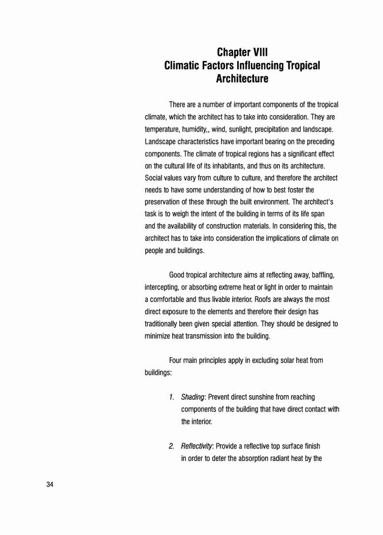
The current project utilizes the most common buildings
materials in Kenya. The walls are built of quarried stone blocks. In
order to ease the sense of containment and to enhance the climatic
breathability of the market, a series of mushrabiya screen walls
form part of the aesthetic, whose intent is also to abstractly mimic a
woven surface [figure Vll-3 & Vll-4; A-1 O to A-15].
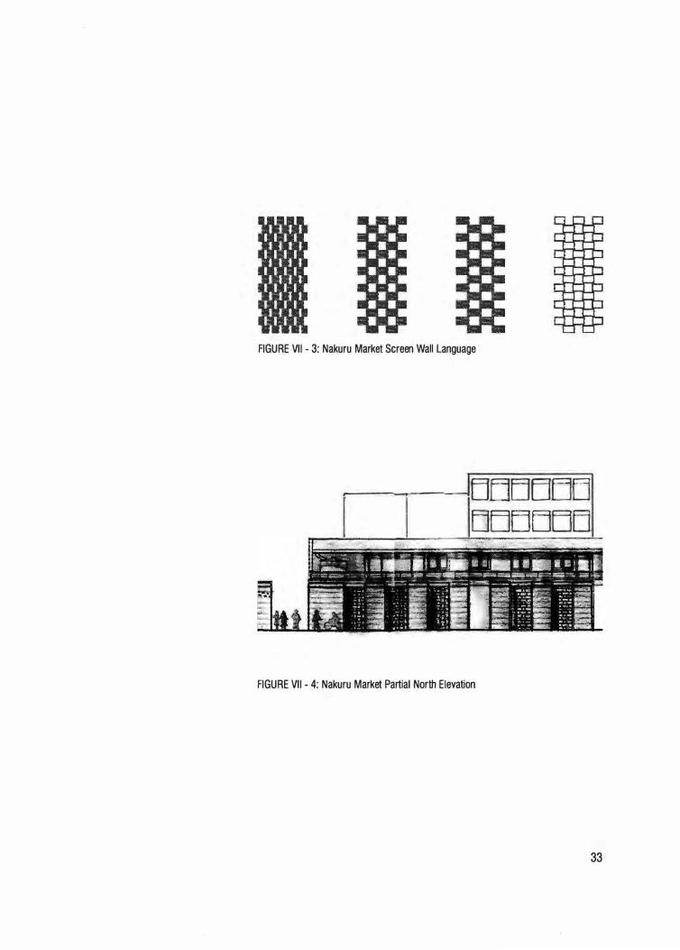
FIGURE VII - 3: Nakuru Market Screen Wall Language
-------fE1EIEJEJEJ1
Ll
,LJLJEJE11
E]EJ
FIGURE VII - 4: Nakuru Market Partial North Elevation
33
34
Chapter VIII Climatic Factors Influencing Tropical
Architecture
There are a number of important components of the tropical
climate, which the architect has to take into consideration. They are
temperature, humidity,, wind, sunlight, precipitation and landscape.
Landscape characteristics have important bearing on the preceding
components. The climate of tropical regions has a significant effect
on the cultural life of its inhabitants, and thus on its architecture.
Social values vary from culture to culture, and therefore the architect
needs to have some understanding of how to best foster the
preservation of these through the built environment. The architect's
task is to weigh the intent of the building in terms of its life span
and the availability of construction materials. In considering this, the
architect has to take into consideration the implications of climate on
people and buildings.
Good tropical architecture aims at reflecting away, baffling,
intercepting, or absorbing extreme heat or light in order to maintain
a comfortable and thus livable interior. Roofs are always the most
direct exposure to the elements and therefore their design has
traditionally been given special attention. They should be designed to
minimize heat transmission into the building.
Four main principles apply in excluding solar heat from
buildings:
1. Shading: Prevent direct sunshine from reaching
components of the building that have direct contact with
the interior.
2. Reflectivity: Provide a reflective top surf ace finish
in order to deter the absorption radiant heat by the
I _..,./_.
FIGURE VIII - 1: JMT Center Passive Cooling Renzo Piano Building Workshop
FIGURE VIII - 2: JMT Center Cases Renzo Piano Building Workshop
FIGURE VIII - 3: Ngaoundere University Site Plan Aga Khan Development Network
building.
3. Ventilation: Make provision for the movement of air
across the interior of the building, and within materials
in order to prevent the collection of hot air.
4. Thermal Capacity: Use materials that do not store heat
from the sun.
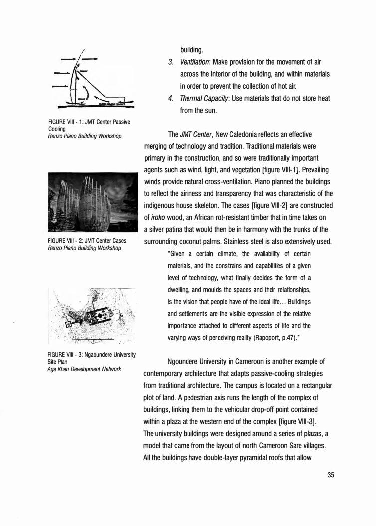
The JMT Center, New Caledonia reflects an effective
merging of technology and tradition. Traditional materials were
primary in the construction, and so were traditionally important
agents such as wind, light, and vegetation [figure Vlll-1]. Prevailing
winds provide natural cross-ventilation. Piano planned the buildings
to reflect the airiness and transparency that was characteristic of the
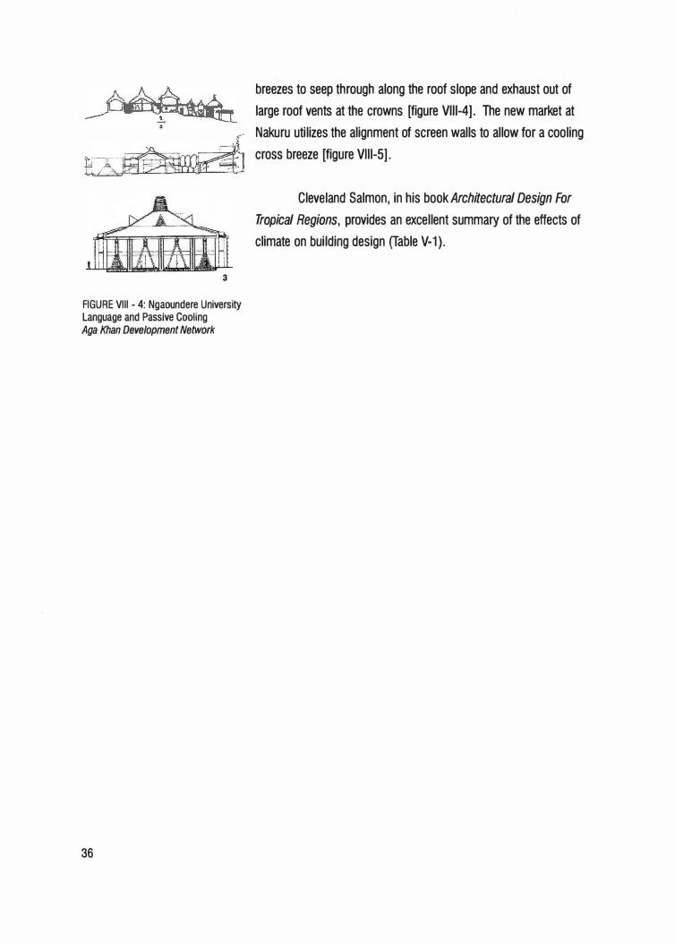
indigenous house skeleton. The cases [figure Vlll-2] are constructed
of iroko wood, an African rot-resistant timber that in time takes on
a silver patina that would then be in harmony with the trunks of the
surrounding coconut palms. Stainless steel is also extensively used.
"Given a certain climate, the availability of certain
materia ls, and the constrains and capabilities of a given
level of technology, what finally decides the form of a
dwe lling, and moulds the spaces and their relationships,
is the vision that people have of the ideal life ... Buildings
and settlements are the visible expression of the relative
importance attached to different aspects of life and the
varying ways of perceiving reality (Rapoport, p.47)."
Ngoundere University in Cameroon is another example of
contemporary architecture that adapts passive-cooling strategies
from traditional architecture. The campus is located on a rectangular
plot of land. A pedestrian axis runs the length of the complex of
buildings, linking them to the vehicular drop-off point contained
within a plaza at the western end of the complex [figure Vlll-3].
The university buildings were designed around a series of plazas, a
model that came from the layout of north Cameroon Sare villages.
All the buildings have double-layer pyramidal roofs that allow
35
3
breezes to seep through along the roof slope and exhaust out of
large roof vents at the crowns [figure Vlll-4]. The new market at
s" Nakuru utilizes the alignment of screen walls to allow for a cooling
cross breeze [figure Vlll-5].
Cleveland Salmon, in his bookArchitectural Design For
Tropical Regions, provides an excellent summary of the effects of
climate on building design (Table V-1).
FIGURE VIII - 4: Ngaoundere University Language and Passive Cooling Aga Khan Development Network
36
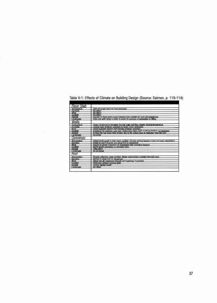
Table V-1: Effects of Climate on Building Design (Source: Salmon, p. 110-114)
/nnr .�t::1h �n-On-nr:::mp nnnn fOr nP:::IT PYf'n::mnP
llllnr In llnnn 1runn1.1 ,<UOC ,-11.1\l"..IIIUll 11.:1'...lrl 11.:l"Warnufnr t.:·1pn I •n c1:::1n wrrn C::lnl'Yl in nrnPr TO :::.vrnn thP nvna.,en nl
�l�S
" �===Ei'ui�"�'�j"'ii"�"'"i""ui��"�''"i'm�,1 <<
�an�!1r;m1<i
<r
�P•>n�
111�nrP
�m ,�
1 rP
�mn
�Pr.m
�ir
�P
=====:1 ... 1rn1nr 11:::lrnc::: nrPP7PC:: ;tn(1 nm,unn e,,omn"n nnnn,,nne
oenmas
Hoot
rlllrllrlllFI.I ..:Jll'..11 fl".IHI 1111.1111 lfllll1 0.:1111.1'-". IUJl fnr - ,_
• 111 I [() 1111111 11111.11 t.:IHIIIIH11 ..,fll\lllllJ u ... , 111·:.u 11111u1.1r-..: n u:.1-.: ::Inn WPC.T nfU:lnT:::ITlnn<:. rf""n nn:11:J7LIC' �nrl ,,on� CPP •u 111.o11111m:::1v1m11m ,111 nrpv:;:1111nn nrPP7PC::
,mu, ,, .. m,rn """' o,u .. .,.u
><inn tn ,11nw lrP.P. air mm .. ,m,m 11)111 IHM.>lllfll1'•: IT 111"..llf'lll':.II
37
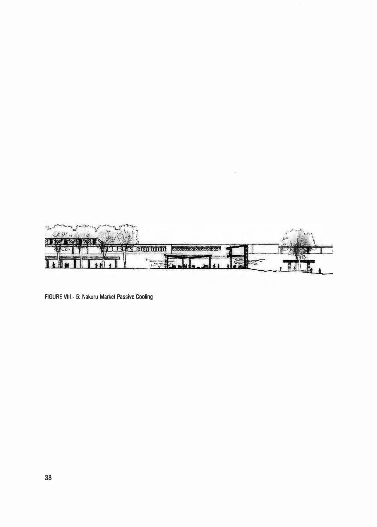
FIGURE VIII - 5: Nakuru Market Passive Cooling
38
Chapter IX Woven Spaces
A Socially and Economically Viable Marketplace
Nakuru's economy is largely driven by the informal sector.
Being located at the heart of Kenya's farming community; many
farmers choose to sell their produce in the town in order to earn a
living. As earlier mentioned, the towns infrastructure cannot support
the volume of traders who wish to sell their produce.
As part of this thesis project, my goal has been to design
the necessary infrastructure that would be economically feasible to
construct.
At the onset, the proposed redevelopment seeks to
decongest the transportation-market quarter. Key towards this is
the reorganization of the public transportation patterns by providing
them a new location away from the busy Mburu Gichua Road at the
western side of the site [figure IX-1].
The placement of the transportation center downhill from
the colonial railway station compliments the older structure by
acknowledging the importance of public transportation in developing
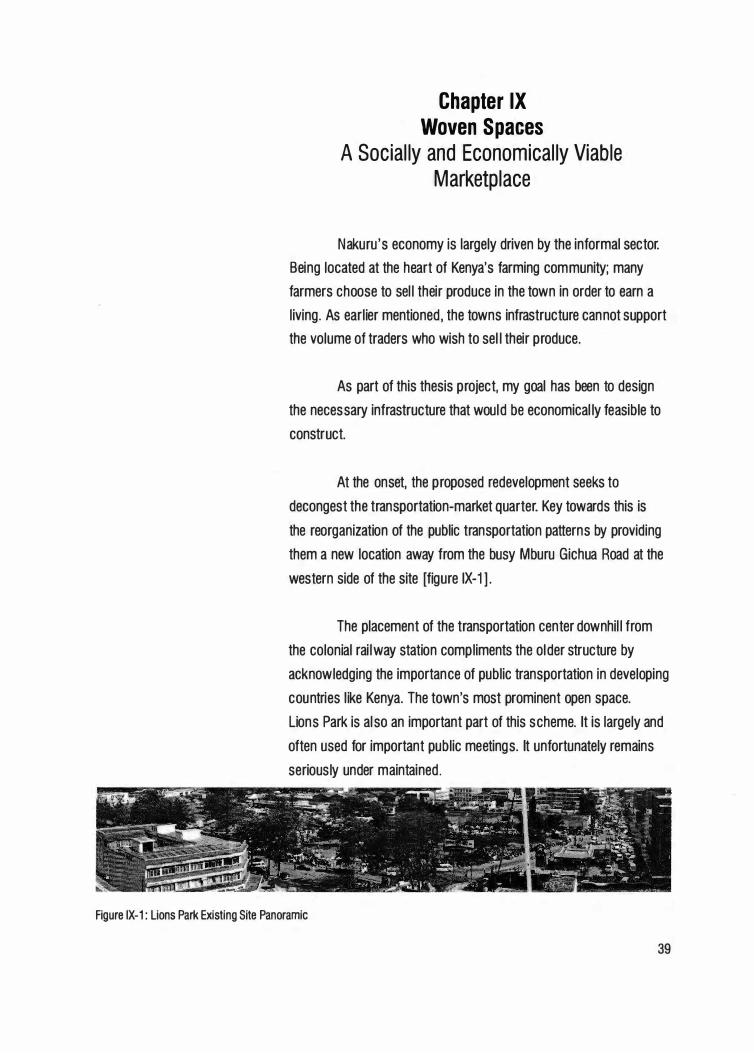
countries like Kenya. The town's most prominent open space.
Lions Park is also an important part of this scheme. It is largely and
often used for important public meetings. It unfortunately remains
seriously under maintained.
Figure IX-1: Lions Park Existing Site Panoramic
39
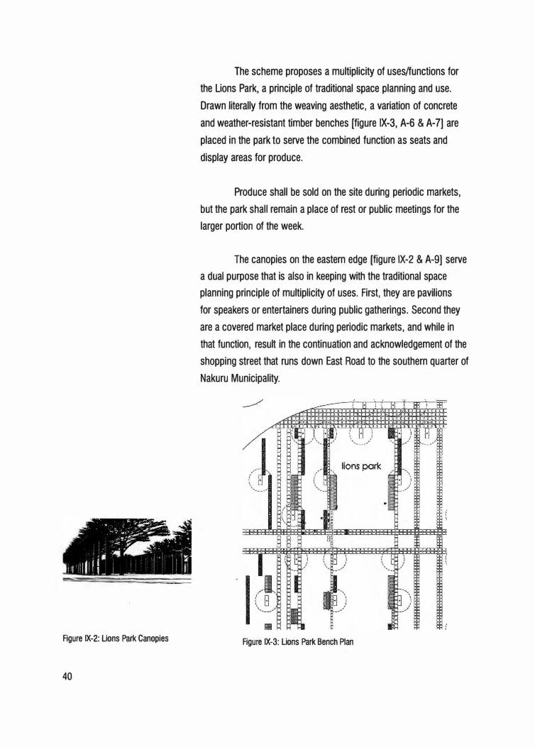
Figure IX-2: Lions Park Canopies
40
The scheme proposes a multiplicity of uses/functions for
the Lions Park, a principle of traditional space planning and use.
Drawn literally from the weaving aesthetic, a variation of concrete
and weather-resistant timber benches [figure IX-3, A-6 & A-7] are
placed in the park to serve the combined function as seats and
display areas for produce.
Produce shall be sold on the site during periodic markets,
but the park shall remain a place of rest or public meetings for the
larger portion of the week.
The canopies on the eastern edge [figure IX-2 & A-9] serve
a dual purpose that is also in keeping with the traditional space
planning principle of multiplicity of uses. First, they are pavilions
for speakers or entertainers during public gatherings. Second they
are a covered market place during periodic markets, and while in
that function, result in the continuation and acknowledgement of the
shopping street that runs down East Road to the southern quarter of
Nakuru Municipality.
Figure IX-3: Lions Park Bench Plan
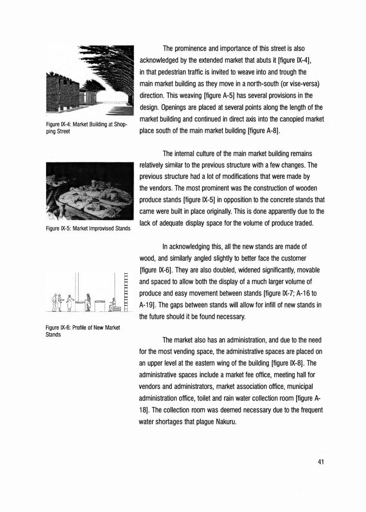
Figure IX-4: Market Building at Shopping Street
Figure IX-5: Market Improvised Stands
Figure IX-6: Profile of New Market Stands
The prominence and importance of this street is also
acknowledged by the extended market that abuts it [figure IX-4],
in that pedestrian traffic is invited to weave into and trough the
main market building as they move in a north-south (or vise-versa)
direction. This weaving [figure A-5] has several provisions in the
design. Openings are placed at several points along the length of the
market building and continued in direct axis into _the canopied market
place south of the main market building [figure A-8].
The internal culture of the main market building remains
relatively similar to the previous structure with a few changes. The
previous structure had a lot of modifications that were made by
the vendors. The most prominent was the construction of wooden
produce stands [figure IX-5] in opposition to the concrete stands that
came were built in place originally. This is done apparently due to the
lack of adequate display space for the volume of produce traded.
In acknowledging this, all the new stands are made of
wood, and similarly angled slightly to better face the customer
[figure IX-6]. They are also doubled, widened significantly, movable
and spaced to allow both the display of a much larger volume of
produce and easy movement between stands [figure IX-7; ·A-16 to
A-19]. The gaps between stands will allow for infill of new stands in
the future should it be found necessary.
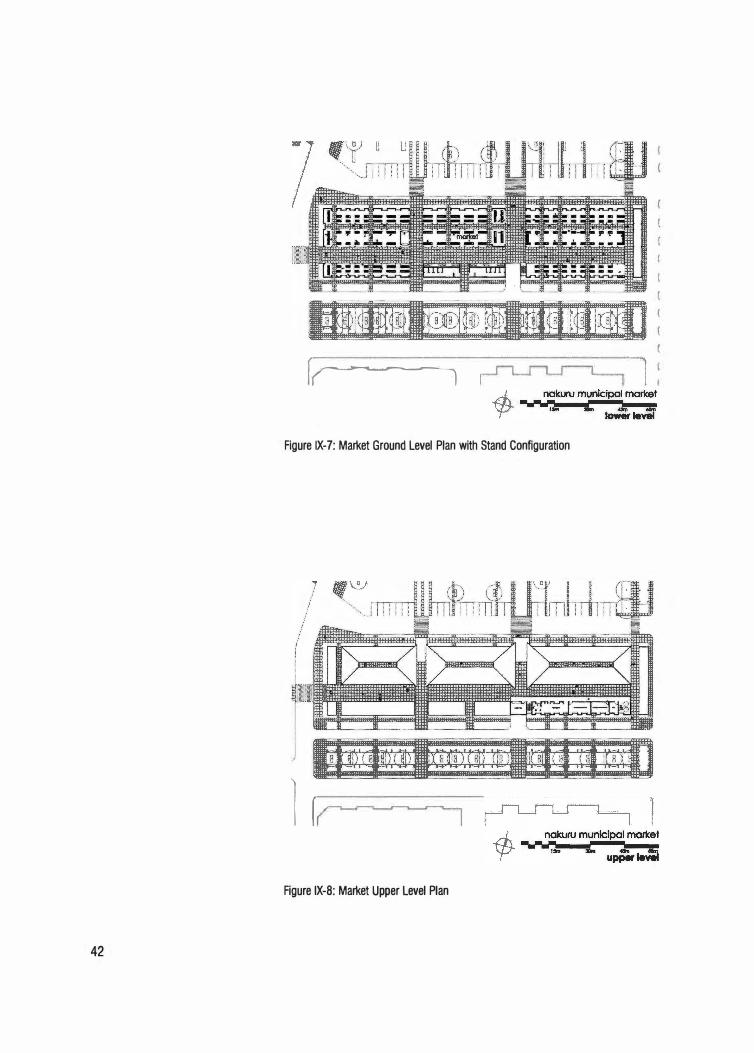
The market also has an administration, and due to the need
for the most vending space, the administrative spaces are placed on
an upper level at the eastern wing of the building [figure IX-8]. The
administrative spaces include a market fee office, meeting hall for
vendors and administrators, market association office, municipal
administration office, toilet and rain water collection room [figure A-
18]. The collection room was deemed necessary due to the frequent
water shortages that plague Nakuru.
41
42
f� ··:1
Figure IX-7: Market Ground Level Plan with Stand Configuration
l [
Figure IX-8: Market Upper Level Plan
It was also a wish of the vendors to have water for
processing produce as told to me by Mr. John Ochieng (one of
the market's original occupants) during an interview from which
I learned a lot about the history of the town and market (Ochieng,
2003).
The building is constructed of local materials from the
ground up. The main material is quarried stone that also serves as a
good heat absorber and therefore helps to regulate the temperature
within. The regular screen walls depressed and in shadow allows
for cool cross-breezes, taking advantage of Nakuru's south-north
winds. The roof utilizes clay tile that is also a better thermal mass
than iron sheets. Concrete slabs serve as paving.
Overall, I hope the scheme serves as a model towards the
potential redevelopment and significance that Nakuru holds [figure
A-20].
Nakuru has an active population. Its placement as a park
edge town makes its future highly sensitive towards the ecosystem
that surrounds it. Kenya's economic reality as a developing country
in which the larger majority of the population lives on less than one
dollar a day also means that planning and redevelopment has to be
done in the most economically viable manner. The least energy use,
plus the incorporation of locally produced materials and skill will
have to be primary. Attention and acknowledgment of the town's
culture, par ticularly that of the African majority, plus Asian and
European residents, will also serve towards reestablishing the towns
prominence as one of the finest urban centers in East Africa.
43

Bibliography
44
Agency for the Development of Kanak Culture. www.adck.nc [accessed 1 0/11/2003] .
Anon. Mimar, Architecture in Development Digital Library. www.archnet.org/library/sites [accessed 7/15/2003].
Arkoun, Mohammed. "Introduction." In Taylor, Brian Brace, ed. Reading the Contemporary African City. Singapore: Concept Media/The Aga khan Award for Architecture, 1983.
Crouch, Dora P. and June G. Johnson. Traditions in Architecture: Africa, America, Asia and Oceania. New York: Oxford University Press, 2001.
Curtis, William. Modern Architecture Since 1900. London: Phaidon, 1900.
Dahinden, Justus. New Trends in Church Architecture. New York, Universe Books, 1967.
Denyer, Susan. African Traditional Architecture: A Historical and Geographic Perspective. New York: Africana Publishing, 1978.
Frampton, Kenneth, and Udo Kulterman, eds. World Architecture 1900-2000: A Critical Mosaic Central and Southern Africa. Guang Dong: China Architecture & Building Press, 2000.
Fry. Maxwell and Jane Drew. Tropical Architecture in the Dry and Humid Zones. New York: Reinhold Publishing, 1964.
Kent, Susan. Domestic Architecture and the Use of Space: AnInterdisciplinary Cross-Cultural Study. Cambridge: Cambridge university press, 1990.
Kulterman, Udo. New Architecture in Africa. New York: Universe Books, 1963.
Kulterman, Udo. New Directions in African Architecture. New York: George Braziller, 1969.
Municipal Council of Nakuru. Nakuru: Strategic Structure Plan. Nakuru: Government of Kenya and United Nations Center for Human Settlement, 1999.
Myers, Garth A. Verandahs of Power: Colonialism and Space in Urban Africa. New York: Syracuse University Press, 2003.
Ochieng, Joseph. Personal Interview. Nakuru, Kenya, 8 January 2004.
O'Connor, Anthony. The African City. London: Hutchinson University Library for Africa, 1983.
Powell, Robert ed. Criticism in Architecture. Singapore: Concert Media, 1989.
45
46
Prussin, Labelle. African Nomadic Architecture: Space. Place, and Gender. Washington DC: Smithsonian Institution Press, 1995.
Prussin, Labelle. "Concluding Remarks." In Taylor, Brian Brace, ed. Reading the Contemporary African City. Singapore: Concept Media/The Aga khan Award for Architecture, 1983.
Rapoport, Amos. House Form and Culture. Englewood Cliffs, N.J.: Prentice Hall, 1969.
Robson, David. Geoffrey Bawa: The Complete Works. London: Thames & Hudson, 2002.
Rudofsky, Bernard. Architecture Without Architects: A Short Introduction to Non-Pedigree Architecture. New York: Museum of Art, 1965.
Salmon, Cleveland. Architectural Design for Tropical Regions. New York: John Wiley & Sons, 1999.
Soja, Edward W. " The Geography of Modernization: A Radical Reappraisal." In Obudho, R. A. and D. R.E Taylor. Eds. The Spatial Structure of Development: A study of Kenya. Boulder: Westview Press, 1979.
Steele, James. Architecture for a Changing World. London: Academy Editions, 1992.
Von Meiss, Pierre. Elements of Architecture: From Form to Place. Lausanne: Chapman and Hall, 1998.
Wachtel, Andy A. D. Towards a Model of Urbanism in an African City: The Dual Focus Career of Formal Sector Workers in Nakuru, Kenya. Ph.D. Dissertation, Chicago: Northwestern University, 1978.

Appendix
47
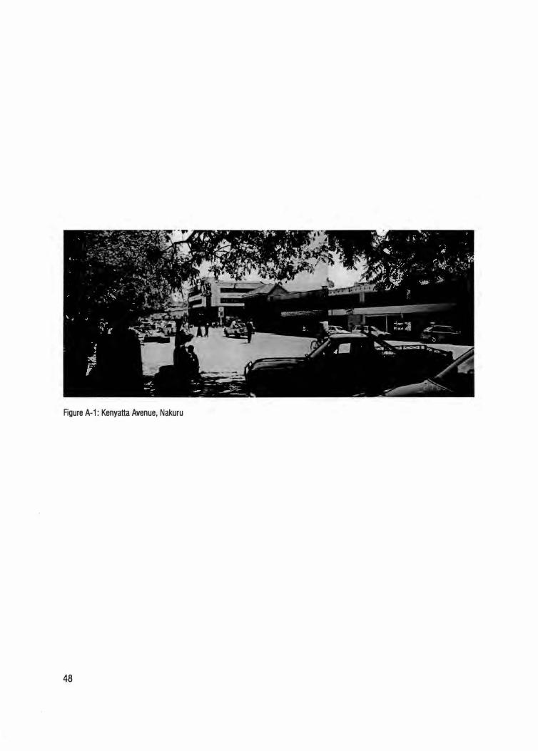
Figure A-1: Kenyatta Avenue, Nakuru
48
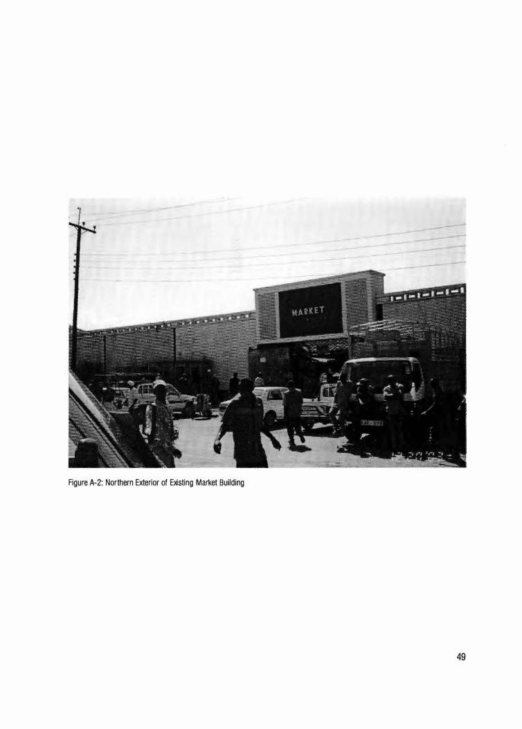
Figure A-2: Northern Exterior of Existing Market Building
49
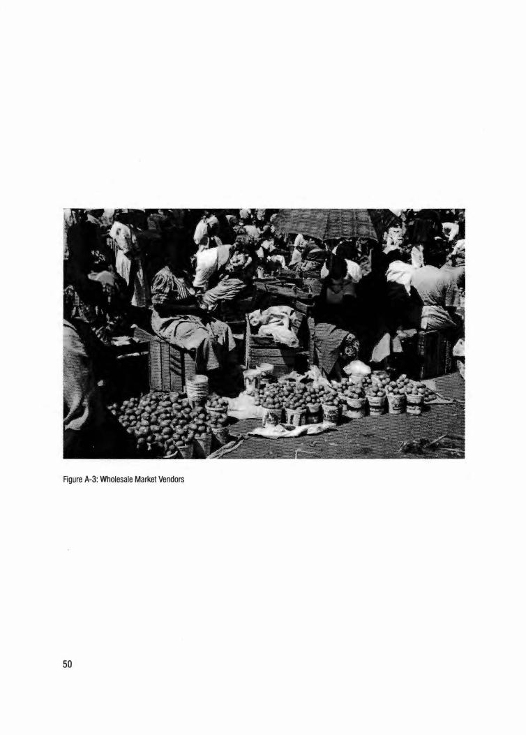
Figure A-3: Wholesale Market Vendors
50
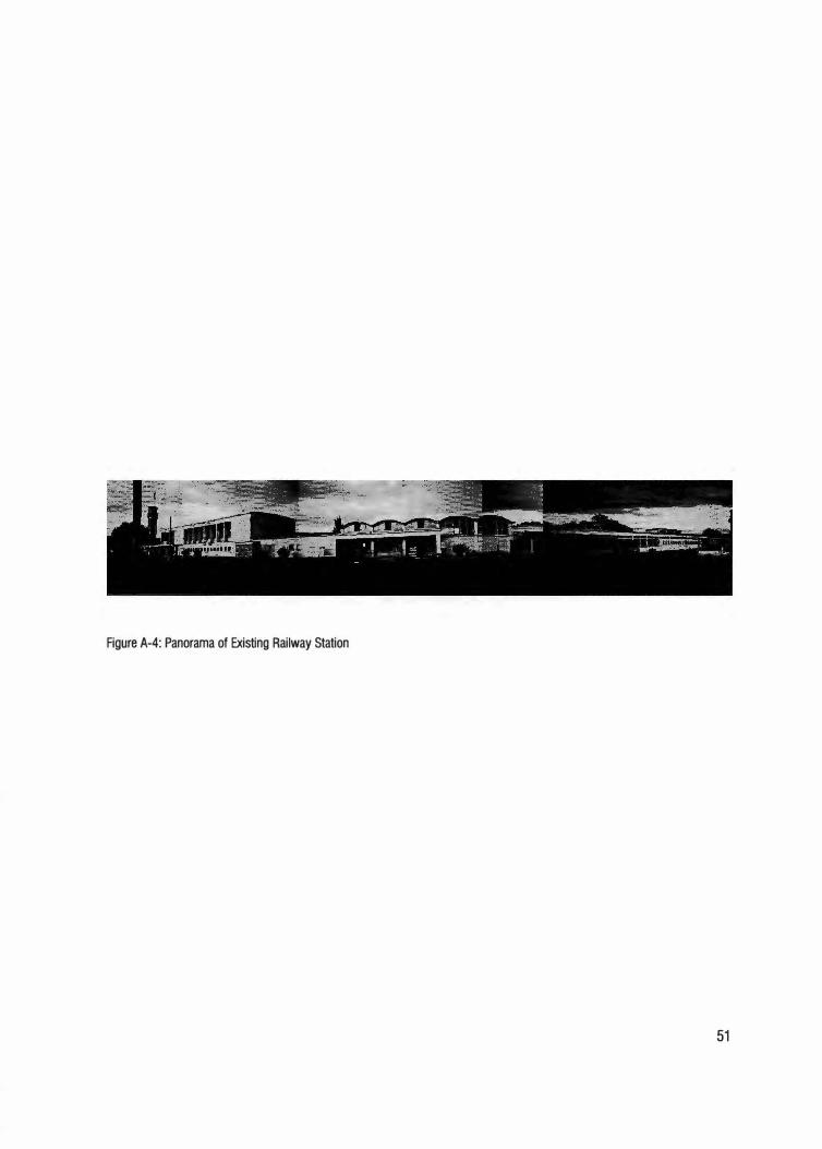
Figure A-4: Panorama of Existing Railway Station
51
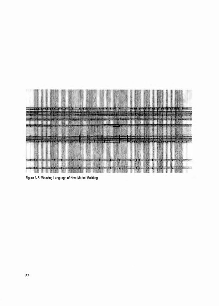
Figure A-5: Weaving Language of New Market Building
52
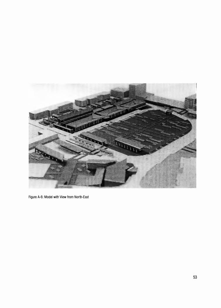
Figure A-6: Model with View from North-East
53
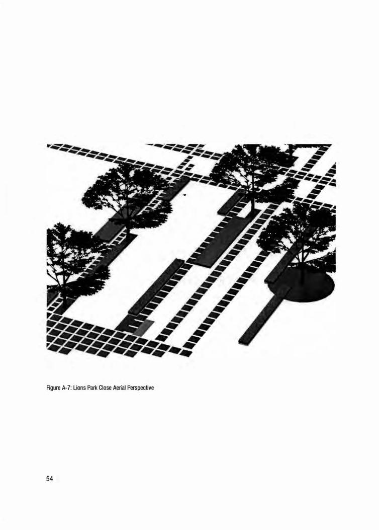
Figure A-7: Lions Park Close Aerial Perspective
54
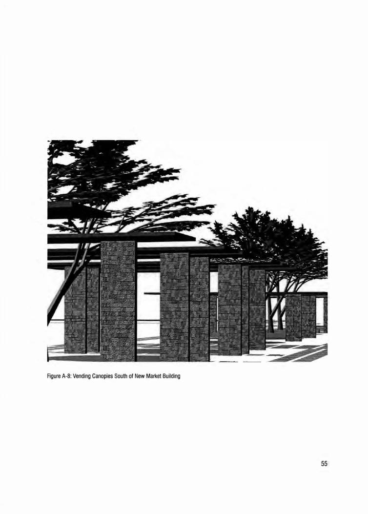
Figure A-8: Vending Canopies South of New Market Building
55
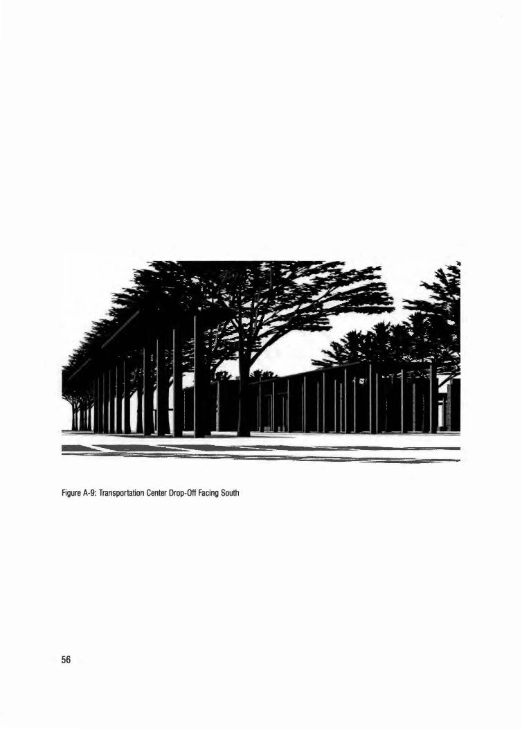
Figure A-9: Transportation Center Drop-Off Facing South
56
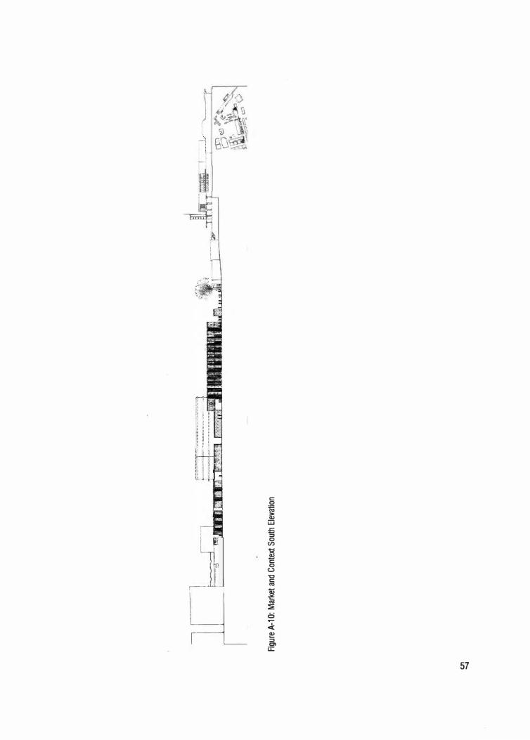
c.n
.......
1 _n r __ :;;
I,_
Ii
Figu
re A
-1 O
: M
arke
t an
d Con
text
Sou
th E
leva
tion
J- -- - - H &
i. W:
.. ---
-···r,
···-�r:!'
:q:!
iE
iimrt
'
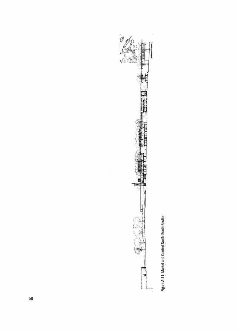
CJ'1
CX)
Figu
re A
-11 : M
arket
and
Con
text
Nor
th-S
outh
Sec
tion
-�
,�----
,-�--�
'",:>-·,
":':',\
'?'�
\-:/
. \t\
\ . . .
'. � ·,;.
\'.·
,,\�.,.._-
.. ·._ .. ·
.
i'.•,f��
�{o
.. 11_·a
.. �1ti&
·.-;i
r�,
, i
11 ·r 'b
:.
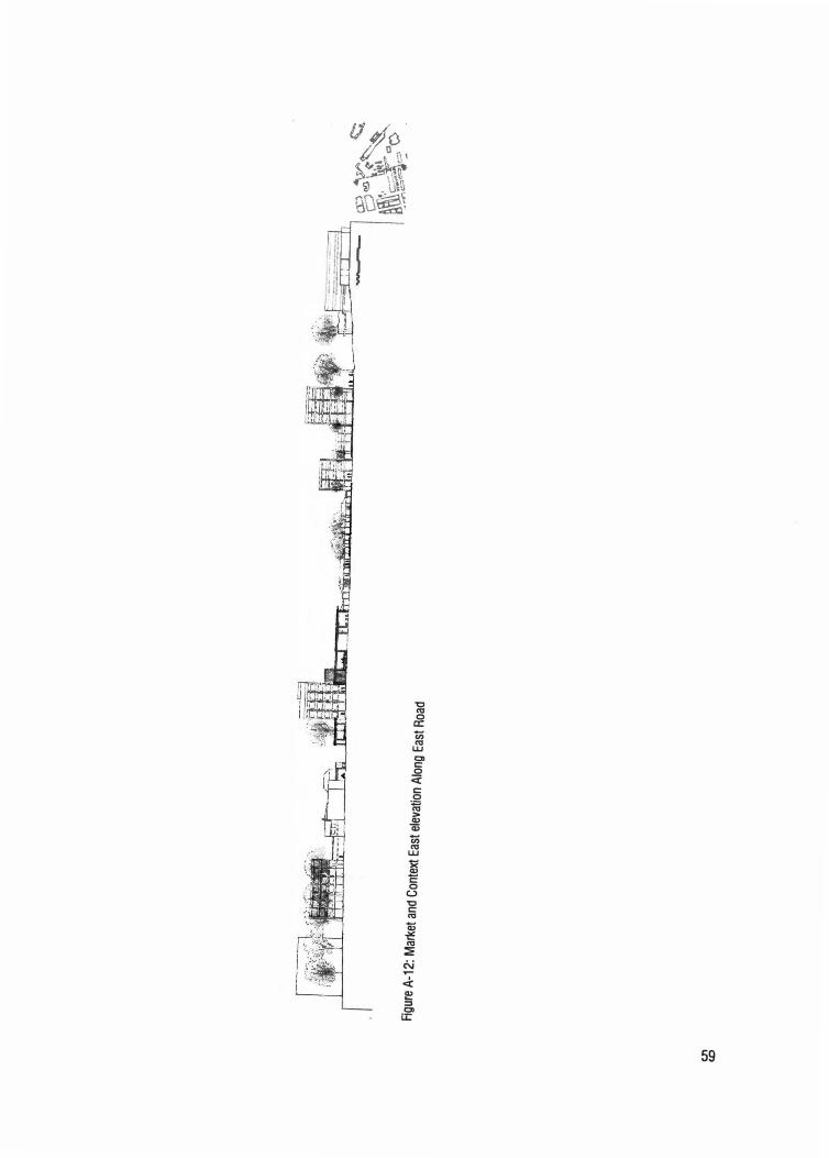
C11
(0
Rgure
A-1
2: M
arket
and
Con
text
Eas
t el
evat
ion
Alo
ng E
ast Roa
d
==[7�
:'.;�= ..
. · . ....
.• ·-� .. O:
) ..
��
'-t..
E:J ·=
\ �
�
"'•'it\
�
''
-��
17-'' 0
_'::-"
�
I;�
�'\ c
.::-.1 0
.�
... ,r
\e; .• -
.. ·
-.
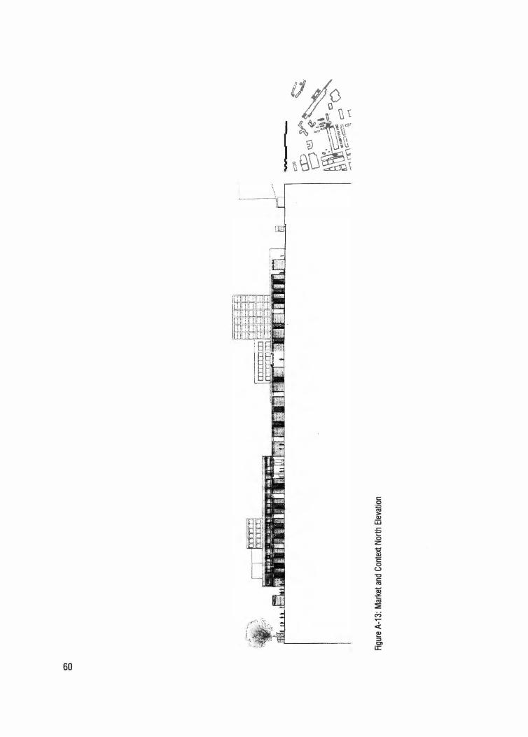
C')
0
.�·-
..,·-,
.
Figur
e A
-13
: M
arket
and
Con
text
Nor
th E
leva
tion
ao
c°-. r:
{
�
?-'"'\
�
A>�
· . ·
. �·
\.---"
':I �
..
: �
ij1\\a,
�
i\ . . · ... ·
... ·. ·.�
-�-;:::=;--
. 0
c-
.,.-.
.
'
ij \
��
� c.::>
0---"
n,.
-i;\
M
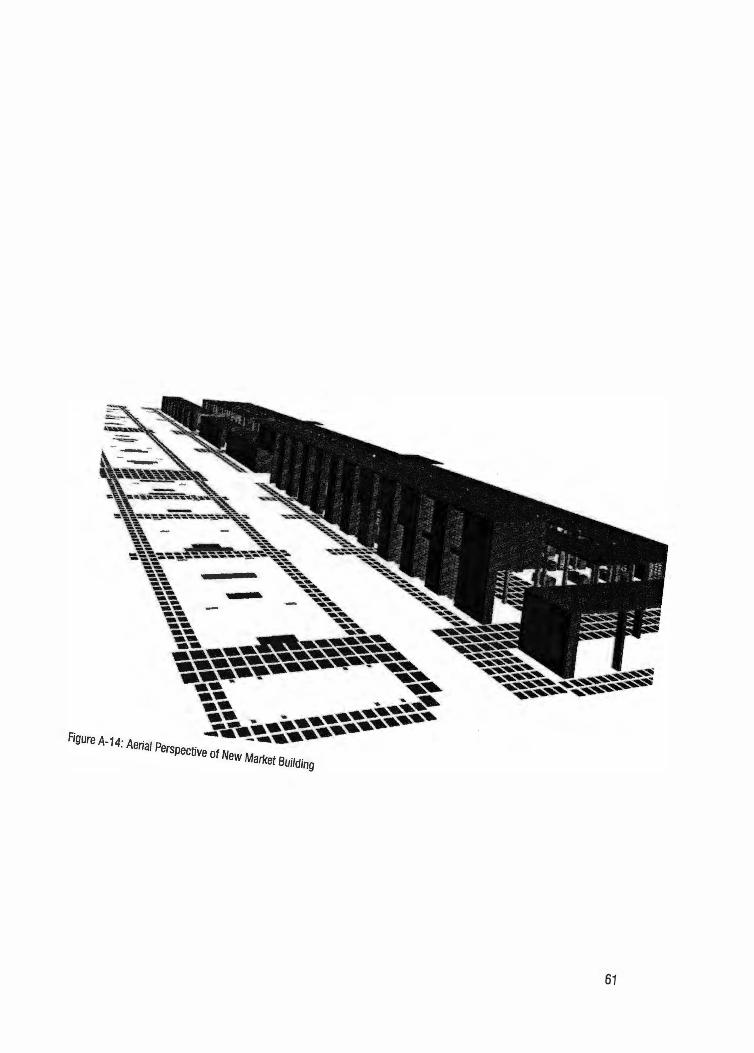
61
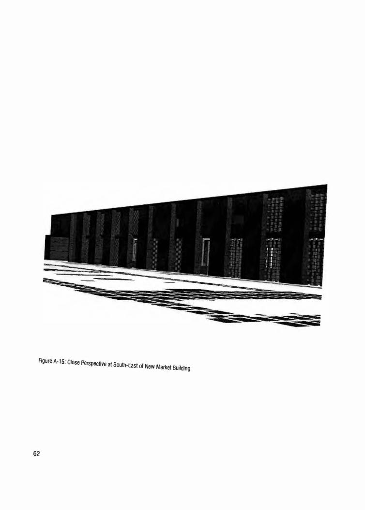
Figure A-15: Close Perspective at South-East of New Market Building
62
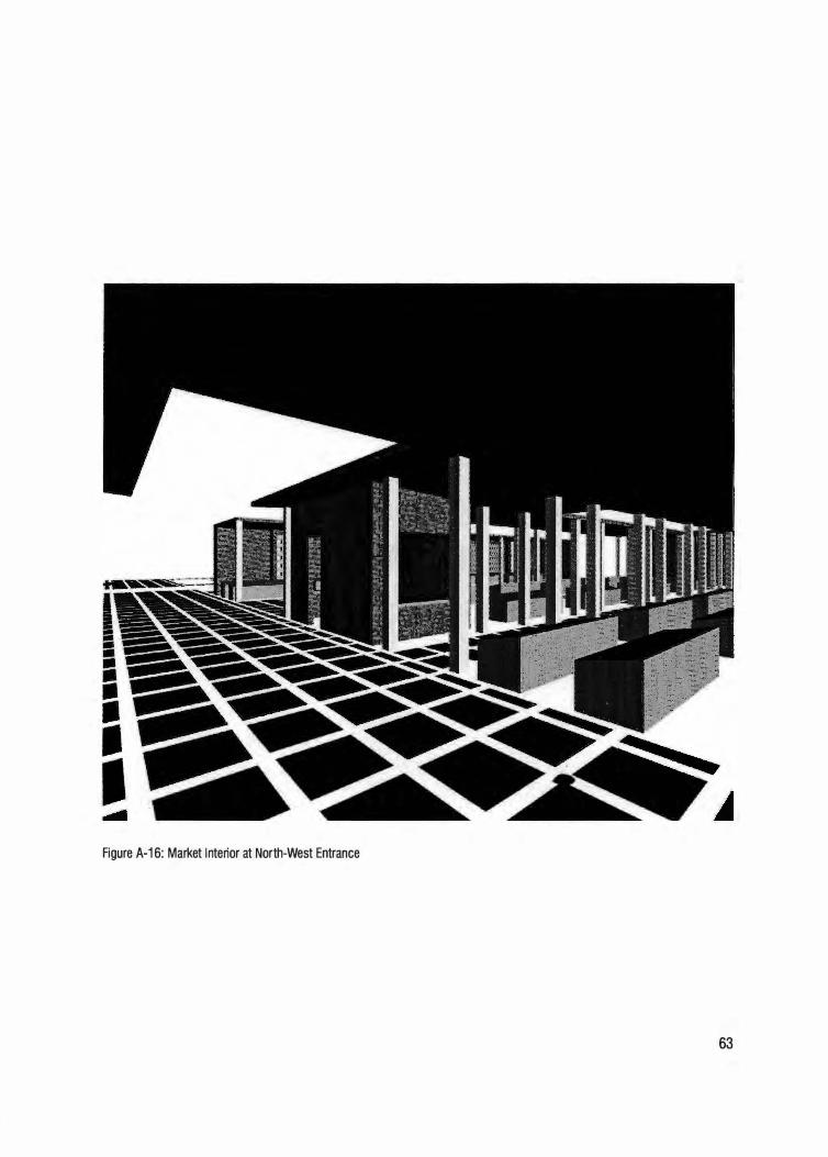
Figure A-16: Ma rket Interior at North-West Entrance
63
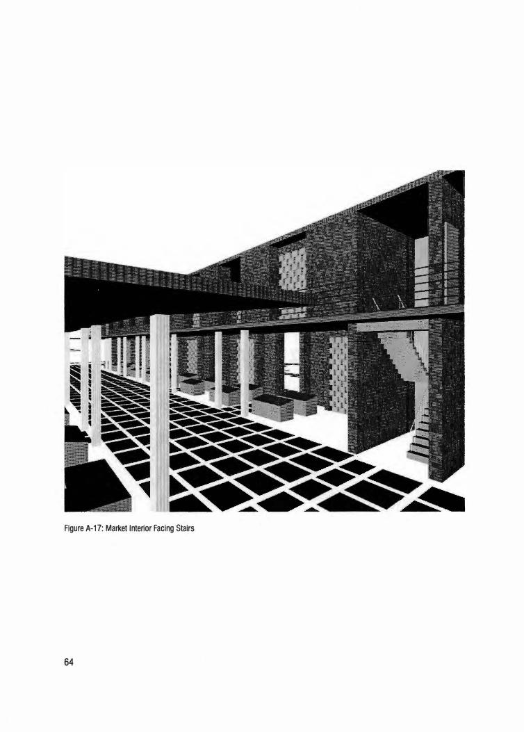
. A 17· Market Interior Facing StairsFigure - ·
64
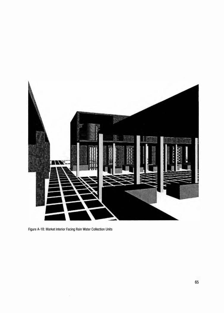
Figure A-18: Market Interior Facing Rain Water Collection Units
65
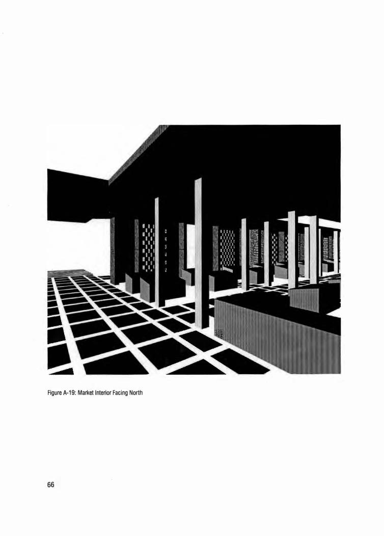
Figure A-19: Market Interior Facing North
66
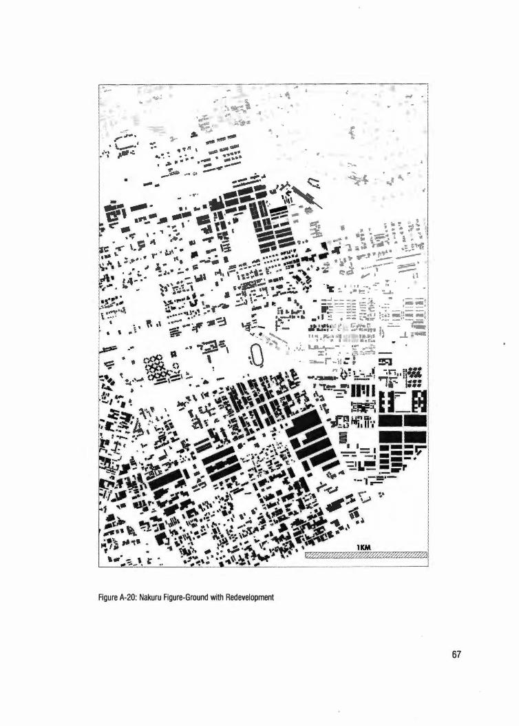
ru Figure-Ground with Red evelopment Figure A-20: Naku
67
68
Vita
Henry Walela Musangi was born in Nairobi, Kenya on March 19th, 1976. He
attended the Kenya school system from which he received his Kenya
Certificate of Primary Education (KCPE) from Kilimo Primary School in
1990 and Kenya Certificate of Secondary Education (KCSE) from Alliance
High School in 1994. He graduated from Southern Illinois University at
Carbondale with a Bachelor of Science in Archltectural Studies in 1999,
after which he worked for two years at Image Architects Inc. in Carbondale
Illinois as an Architectural Intern. Following that, Henry was admitted to
the graduate program at the College of Architecture and Design, University
of Tennessee Knoxville, from which he received a Master of Architecture
degree in August 2004.
Related Documents