i DIEN BIEN PROVINCIAL PEOPLE’S COMMITTEE ACTION PLAN ON “REDUCING EMISSIONS FROM DEFORESTATION AND FOREST DEGRADATION, SUSTAINABLE FOREST MANAGEMENT, CONSERVATION AND ENHANCEMENT OF FOREST CARBON STOCK” IN DIEN BIEN PROVINCE IN PERIOD 2011 – 2020 (REDD+ ACTION PLAN OF DIEN BIEN PROVINCE FOR PERIOD 2013 – 2020) _____/______/2014 APPROVING AGENCY _____May, 2014 PLANNING AGENCY Dien Bien, 2014

Welcome message from author
This document is posted to help you gain knowledge. Please leave a comment to let me know what you think about it! Share it to your friends and learn new things together.
Transcript

i
DIEN BIEN PROVINCIAL PEOPLE’S COMMITTEE
ACTION PLAN
ON “REDUCING EMISSIONS FROM DEFORESTATION AND FOREST
DEGRADATION, SUSTAINABLE FOREST MANAGEMENT,
CONSERVATION AND ENHANCEMENT OF FOREST CARBON STOCK”
IN DIEN BIEN PROVINCE IN PERIOD 2011 – 2020
(REDD+ ACTION PLAN OF DIEN BIEN PROVINCE
FOR PERIOD 2013 – 2020)
_____/______/2014
APPROVING AGENCY
_____May, 2014
PLANNING AGENCY
Dien Bien, 2014

ii
Table of Contents
PREAMBLE .................................................................................................................................................. 1
PART 1 Legal Basis and Documents ............................................................................................................ 2
PART 2: Assessment of Results of the Implementation of Forest Protection and Development for
Period 2006 – 2012......................................................................................................................................... 3
1. Background conditions on forests and forestland ................................................................................... 3
2. Achievements of the implementation of forest protection and development .......................................... 4
3. Remaining issues on forest protection and development ........................................................................ 5
4. Conditions causing the issues on forest protection and development ..................................................... 6
PART 3: DIEN BIEN PROVINCIAL REDD+ ACTION PLAN FOR PERIOD 2013-2020 ................... 8
I. Structure of Provincial REDD+ Action Plan ........................................................................................... 8
II. Overall Goal ............................................................................................................................................ 10
III. Specific Objectives ................................................................................................................................ 10
1. Period 2013 – 2015 ........................................................................................................................... 10
2. Period 2016 – 2020 ........................................................................................................................... 11
IV. Key Tasks ............................................................................................................................................... 11
1. Period 2013 – 2015 ............................................................................................................................... 11
2. Period 2016 – 2020 ............................................................................................................................... 13
V. Solutions ................................................................................................................................................... 13
1. Solutions on policies and structural arrangement for the implementation, and safeguards .................. 13
1.1 Verification and test-operation of the policy framework for REDD+ implementation ................... 13
1.2 Structural arrangement for REDD+ implementation at different administrative levels ................. 14
1.3 Assessment of the activities implemented under the PRAP on the safeguards according to 7 criteria
in Cancun agreement ............................................................................................................................. 18
2. Facilitation of scaling up the implementation of forest protection, regeneration and afforestation to the
province level ............................................................................................................................................ 19
2.1 Selection of the prioritized communes ............................................................................................. 19
2.2 Promoting Implementation of Forest Protection, Regeneration and Afforestation ......................... 20
2.3 Land and forestland allocation ....................................................................................................... 21
2.4. Strengthened management of forest protection and development .................................................. 21
3. Provision of Support for Livelihood Development ............................................................................... 22
4. Strengthened Management of Special Use Forest ................................................................................. 23
5. Promotion of investment from enterprises ........................................................................................ 25
6. Implementation of Provincial Forest Monitoring System ................................................................. 26
6.1 Modificationof PFSM with its adjustment in accordance with the national forest monitoring system
............................................................................................................................................................... 26
6.2 Evaluation of the forest change ....................................................................................................... 33
7. Clarification of the funding sources for the REDD+ implementation ............................................... 34
8. Organization of trainings ................................................................................................................... 35
VI. Monitoring and Evaluation of the Activities under the PRAP .......................................................... 39
PART 4. FUNDING FOR PRAP IMPLEMENTATION .......................................................................... 41
PART 5. STRUCTURAL ARRANGEMENT FOR PRAP IMPLEMENTATION ................................ 43
Annex 1. Interim Forest Reference Levels (FRLs) and Forest Reference Emission Levels (FRELs) for Dien

iii
Bien Province ................................................................................................................................................ 45
Annex 2. Calculation of the Expected Amount of Net Carbon Sequestration ............................................... 49
Annex 3. Prioritized Communes for the REDD+ Implementation ............................................................... 53
Annex4. Three Outputs of PFMS .................................................................................................................. 62
Annex 5: Overview of Organization Chart of Provincial Forest Monitoring System ................................... 63
Annex 6: Flow of the Present Program, Activities relatedwith PFMS and the Output ................................. 64
Annex 7: Harmonization of National Forest Information System and Provincial Forest Monitoring System
....................................................................................................................................................................... 65
Annex 8: Time Frame of Developing Database System at National and Provincial Levels ......................... 66
Annex 9. Idea of Benefit Distribution ........................................................................................................... 67
Annex 10: Plan for capacity development in the province to implement REDD+ ....................................... 68
Annex 11. Unit Cost for Various Activities ................................................................................................... 70
Annex 12. Acronyms ..................................................................................................................................... 73
Annex 13: List of terminology ...................................................................................................................... 75
Annex 14: Revision to the section of PRAP implementation budget to adapt to the actual situation ........... 79

1
PREAMBLE
Dien Bien province lies in northwestern Vietnam, bordering the People’s Republic of China and
Lao People’s Democratic Republic. Total territorial area is 950,290 ha of which 384,691ha is
under the forest, accounting for 40.2%. Within the area under the forest, the natural forest area
accounts for 98% (377,120 ha) and man-made forest area accounts for 2.0%. In natural forest,
there is 301,229 ha (79.9%) of regrowth forest, 19,055 ha (5.1%) of medium forest, 22,922 ha
(6.1%) of bamboo-timber mixed forest and 4.8% of poor forest. Remaining 4.1% is either rich
forest, purely bamboo forest or rocky mountain forest.
The Resolution of 12th Congress of Dien Bien Provincial Party Committee of Tenure 2010 – 2015
points out the specific tasks for Dien Bien forestry as follows: To focus efforts on developing
forest in a sustainable, effective manner; to review and place markers to clearly demarcate the
boundary of forest of 3 types in the field; to allocate land and forest in combination with
providing support to forest regeneration, forest protection and afforestation; to protect protection
forests and special use forests; and to encourage diversified investment of different types in
afforesting production forest area in combination with processing and marketing in order to step
by step make forestry a great contributor to socio-economic development, poverty reduction and
environmental and ecological protection.
In order to carry out the tasks set in the National REDD+ Action Progam for the period of 2011 –
2020 and additinally, to continue with the effective implementation of FPDP of the period of 2009
– 2020, the Dien Bien PPC developed this Provincial REDD+ Action Plan for the province.
The Dien Bien Province REDD+ Action Plan for Period 2013 -2020 aims to implement the
National REDD+ Action Plan and specify the Dien Bien Province Forest Protection and
Development Master Plan to 2020 in contribution to mitigating deforestation and forest
degradation, sustainable forest management, conservation and enhancement of forest carbon as
well as improving the living conditions of people living off forestry in the area of province.
The plan consists of 5 parts:
Part 1. Legal basis and documents used to make the Plan
Part 2: Assessment of results of the implementation of forest protection and development in
period 2006 - 2012
Part 3. REDD+ Action Plan for Period 2013-2020
Part 4. Funding for implementation
Part 5. Arrangements for implementation

2
PART 1: Legal Basis and Documents
- Decision 230/QD-TTg of 13th October 2006 by the Prime Minister on the approval of
Socio-Economic Development Master Plan of Dien Bien Province for Period 2006-2020;
- Decision 18/2007/QD-TTg of 5th February 2007 by the Prime Minister on the approval of
Vietnam Forestry Development Strategy in Period 2006 – 2020;
- Decision 799/QD-TTg by the Prime Minister to approve the National Action Program on
“Reducing Emissions from Deforestation and Forest Degradation, Sustainable Forest
Management, Conservation and Enhancement of Forest Carbon” in Period 2011 – 2020;
- Decision 57/2012/QD-TTg by the Prime Minister to approve the Forest Protection and
Development Plan in Period 2011 – 2020;
- Decree 99/2010/ND-CP of 24th September 2010 by the Government on the Policy on Payment
for Forest Environmental Services;
- Circular 05/2008/TT-BNN of 14th January 2008 by the Ministry of Agriculture and Rural
Development on guidance on how to make master plans and plans on forest protection and
development;
- Decision 1764/QD-BNN-HTQT by the Ministry of Agriculture and Rural Development to
approve the Technical Cooperation Project to Pilot REDD+ in Dien Bien.
- Record of Discussion between the Japanese International Cooperation Agency (JICA) and
representatives of relevant Vietnamese agencies signed on 1st February 2012 regarding the
Japanese Government-sponsored REDD+ Pilot Technical Cooperation Project;
- Resolution of 12th Congress of Dien Bien Provincial Party Committee of Tenure 2010-2015;
- The Master Plan for Forest Protection and Development for Period 2009 - 2020 approved in
Decision 2117/QD-UBND of 2nd December 2009 by the Dien Bien Provincial People’s
Committee.
- The Plan for Forest Protection and Development of Dien Bien Province for Period 2010-2020;
- Plan 388/KH-UBND by the Dien Bien Provincial People’s Committee on review and
improvement of land and forest allocation and grant of forestland use certificates for Period 2013
– 2015 in the area of Dien Bien province.

3
PART 2: Assessment of Results of the Implementation of Forest Protection and
Development for Period 2006 – 2012
1. Background conditions on forests and forestland
1.1. Area of forest of all types
Based on the report on review of status of forest of 3 types in accordance with Directive
38/CT-TTg, approved by the Provincial People’s Committee (in Decision 76/QD-UBND of 14th
January 2008).During the implementation period, the PPC has made several adjustments in order
to be consistent with circumstances. On 8th March, 2010, the PPC has issued a Decision No.
262/QD-UBND on approval of conversion of area between three forest types (production forest,
protection forest and special use forest) of Dien Bien province. After conversion, the area of three
forest type is: 760,449 ha, of which area of special use forest is 48,584 ha; protection forest is
413,832 ha; and production forest is 298,032 ha.
1.2. Forest volume
Volume of forest of all types is estimated at 18,521,616 m3 of timber, including 18,346,028 m3 of
natural forest timber and 175,588 m3 of man-made forest timber, and 161,362,000 bamboo trees.
Forest volume mainly comes from natural forest while man-made forest volume is low.
Harvestable natural forests are mostly in production and special-use forests, critical areas, and
areas of high elevation and severe slope, without road access. Forest with harvestable volume in
production forest area is small.
1.3. Resources of forest fauna and flora
Initial statistical survey results show that in terms of higher/vascular plants, there are 740 species
of 500 genera of 156 families in 5 phyla, of which 29 are listed by Vietnam Red Book. The
number with their names listed by both Vietnam and world red books is 4, and the number with
their name listed in World RED Book but not listed in Vietnam Red Book is 6.
In terms of fauna, there are 59 mammals, 185 birds, 36 reptiles and 11 amphibians. The precious,
rare species include sun bears (Helarctos malayanus), Asian black bears (Ursus thibetanus),
white-cheeked gibbons (Nomascus leucogenys), Phayre’s leaf monkeys (Trachypithecus phayrei),
tigers, leopards, monkeys, otters, peacocks, rufous-necked hornbills (Aceros nepalensis),
recticulated panthons (Python reticulatus), etc.
However, these resources are decreasing with several species on the brink and threat of distinction.
Therefore, there need effective measures to zone off, protect and develop these precious natural
resources.
1.4. Non-timber forest resources
Dien Bien’s climate is suitable for the growth of several types of non-timber forest products:
bamboo shoots, rattan and medicinal plants such as Cardamom (Amomum vilosum and A.
tsao-ko), Homalomena (Homalomena occulta), Acanthopanacis bark, Dang shen (Codonopsis
pilosula), Chinese knotweed (Fallopia multiflora), Chinese yam (Dioscorea persimilis), Indian

4
mulberry (Morinda officinalis), Scirpus articulatus, Notoginseng, etc. There are forest vegetables,
forest spices and forest leaves for spa, therapeutic massage and therapeutic bath traditionally used
by ethnic minority people in Vietnam.
Harvesting and processing non-timber forest products (NTFPs) is a significant contributor to
improving people’s living conditions in the direction of using the short-term to support the
long-term in forestry production.
2. Achievements of the implementation of forest protection and development
In Period 2006-2012, great achievements were made in the implementation of FPDP with
awareness being raised; the legal framework on forest protection and development being
improved; and policies on forestry, especially those on the diversification of economic sectors
involved in forestry, forest and land allocation, forest contracting and forest benefiting being
issued and put into practice. The role and sense of responsibility of State administrative agencies
at all levels and social organizations is increasingly enhanced. The State has increased investment
in forest protection and development through different programs and projects, leading to big
change for the better in this regard, specifically in the following areas:
2.1. Forest management
In implementing Directive 38/CT-TTg by the Prime Minister, Dien Bien province has completed
its review and replanning of forest of 3 types for the formulation of forest protection and
development plan on yearly and periodical bases. Also, some key tasks as below will continue to
be implemented:
- Annual forest monitoring in both area and status terms. Forests and forestlands have been
divided into compartments and sub-compartments for management.
- Land and forest allocation for organizations and households, individuals, communities in
accordance with Decree 163/NĐ-CP which should cover 85% of forestland area. Forest owners
who receive forests and forestlands will obtain benefits from forest management and protection.
- The option on sustainable forest management has initially been initiated and piloted in
some areas (villages or communes) as the basis for the multiplication of sustainable forest
management on national scale.
2.2. Forest protection
Due to population burden and increasing demand for fire woods and cultivation area,
violation cases against law on forest protection and development such as deforestation, illegal
harvests of timber and fire woods or unapproved changes to forest and forestland use purposes
have been on the rise. Dien Bien province has taken a variety of measures to prevent illegal
cutting and forestland use purpose change outside planning and emerged stricter in handling
violations in forest protection and development law. The violations of law on forest protection and
development and deforestation have been reduced and damage therefore has been mitigated.
Several effective models of forest protection and development have cropped up in different areas,
contributing to forest area recovery, socio-economic development and environmental-ecological
protection.

5
The forest ranger service has been renovated in the line that forest rangers shall stay close to
forest, villagers and local authorities and work harder to mobilize villagers and members of
society to protect forest.
2.3. Forest development
Thanks to effective implementation of measures on afforestation, forest regeneration and
protection on provincial scale, the forest area increased from 266,000 ha in 1998 to 384,691 ha in
2012 (increasing 8,500 ha/year on average). The zoning and protection of natural forest for
recovery has helped increase the forest’s capacity in protecting and conserving biodiversity.
- In the 14 years from 1998 to 2012, forest cover increased from 28.7% to 40.2%, averaging
0.9%/year; this outcome shows the great effort in forest management, protection and development
of the provincial government and local people.
- The forestry sector has been active in generating employment and income for villagers,
contributing to poverty reduction for local people, especially people of ethnic minority groups.
2.4. Key measures
- Clarification of forest of 3 types, setting up of protection/special-use forest management
boards and mechanism of management as a public service provider.
- Land and forest allocation to organizations, households, individuals, communities and
improvement of household economic conditions based on forest businesses and agro-forestry
production.
- Decree 99/2010/ND-CP by the Government on the policy on Payment for Forest
Environmental Services to facilitate the implementation of forest production and development by
society.
- Provision of support or other favorable conditions for enterprises in planting production
forests and establishment of wood processing companies.
- Undertaking scattered forest planting to increase forest cover.
- Mobilization of resources from private sector and foreign donors, apart from state budget,
for forest protection and development.
3. Remaining issues on forest protection and development
- Natural forests planned as production forest are now mainly poor and regrowth forest. Of
the total natural production forest area of 130,800 ha, 282 ha is rich forest, 1,219 ha is medium
and 1,815 ha is poor forest, 109,709 ha is regrowth forest and the remainder of 17,785 ha is other
forests (mixed and bamboo forests). Although area of production forest is increasing in recent
years, the quality of forest keeps decreasing with the continuous reduction in percentage of valued
timber trees. Forests are scattered, making it difficult to form concentrated production zones.
- Forest area and status has not been checked and listed statistically at plot level for
production planning;
- Forestland use planning is not close to reality, even belated to be revised and often broken.
The demarcation of production and special use forests is not clear in several areas, making it
difficult and slow down the process of forestland allocation.
- The area of non-forested land planned for forestry is currently fragmented and scattered,

6
making it difficult to develop concentrated man-made forests at large scale; several areas of forest
are usurped or used for other purposes, making it impossible to do the afforestation.
- The allocation of land and forest has been deficient with only land being allocated, not
forest; or the papers on land allocation are different from those on forest allocation with their
loose, non-unified management; or the allocated forestland has been used for other purposes but
no proper handling measure has ever been taken. Meanwhile, most households living in the
countryside are poor and do not have proper conditions for forest-related production and business
on their allocated forest and forestland. State investment in this regard is limited.
- Deforestation and illegal use of forestland goes unabated in several areas, especially in the
districts with larger natural forest area.
- The legal handling of violations of forest and land law is difficult and most often than not,
delayed due to the fact that violators are mostly poor people living in remote areas; penalties
against forest destroyers are not heavy enough.
- The effects of forest protection contracting with households and individuals are
insignificant in some areas. The contracted people would take money but do not actually protect
forest. Forest is being destroyed but who is held responsible is not clearly pointed out. Forest
protection has not been implemented consistently. Local authorities have not taken drastic
measures to protect forest.
- The forestry sector’s growth is small and not sustainable with low income, poor competitive
edge and the potentiality of forest resources not being put to full and reasonable use, especially for
NTFPs and environmental services. The productivity and quality of forest is low, failing to meet
the requirements of socio-economic development, especially the demand for timber for
consumption inside and outside the province.
- Credit for investment in man-made forests in production forest area is not performing as
enterprises cannot have access to or simply cannot borrow.
- A series of protection forest management boards, which were rearranged from State-owned
forest plantations, are not capable enough to protect the forest allocated. Their production plans
are still formed on the conventional thinking of central command that is “keeping forest is for the
sake of State”, which results in the poor performance of production and business. There is no
specific system that can bring stable income to them as forest owners in a market economy and
their responsibility is not financially associated with their outcome of forest production. The
living conditions of officials and workers with these boards are harsh with unstable income and
hence difficulty in motivating and sometimes, even leading them to the state of “ignorance” to
deforestation acts.
- Scientific research in the field of forestry is a far cry from meeting the needs of production
with many research theses after successful defending ending up on paper and never put into
practice.
4. Conditions causing the issues on forest protection and development
4.1 Objective causes
- Forest is scattered on a large area while pressure on forestland and forest products is on the
rise, especially in areas short of farmland; forestry activities are carried out mainly in remote areas
with poor infrastructure, which hinders the implementation, checking and monitoring activities.

7
- A cycle of production for forest crops is long with expectedly low profits and comes in
abundant risks. The project areas are distributed chiefly in mountainous areas with poor
socio-economic conditions. Forest crops are also less competitive than other agricultural crops.
- The need for timber and forest products grows too fast while man-made forest timber is
short of demand, putting ever larger pressure on natural forest and attracting the illicit acts of
deforestation, cutting and transport of forest products.
-The market economy has driven the prices of some farm produce up, so has it as to the
search for farmland for such produce, driving the urge of villagers to clear forest for farming
highly valued crops or illegal practice of trading or transfer of farmland among themselves.
- Unexpected weather conditions with prolonged drought and frequent floods have taken its
toll on forest resources. The area of regenerated and man-made forest has increased but the chance
of forest fire and forest pest attacks has also risen.
- Policies on PFES payment for forest protection have positively encouraged communities to
participate in forest protection and development. However, due to low PFES payment, current
policies are overshadowed by benefits obtained from the production of food crops and industrial
crops on forestlands.
4.2. Subjective causes
- Awareness of role and functions of forest among local authorities and villages is still below
expectation. Villagers, especially those in remote areas are not fully aware of the urgent need to
protect and develop forests and consequently, they are still deforesting or giving a helping hand or
even working as hire men for forest destroyers.
- Policies and mechanisms are inconsistent and do not meet the general social development
requirements. Some policies have not implemented properly, such as those on land and forest
allocation, forest extension service, technological transfer, etc.; the work on promotion,
dissemination and education of law and policies on forestry has not yielded good results.
- Investment in forestry is low, spread thin and ineffective. Investment is not well structured
while investment in forestry infrastructure facility building has not paid due attention.
- Policies on how to use forest for households, individuals and communities are still missing
while the use of fuelwood is indispensable, so when their need is not met, they tend to harvest
forest illegally for fuelwood.
- The protection forest and special use forest management boards in the capacity of forest
owner have not received investment for the forest area they are allocated for management and
protection.Technically, the forest area without any forest owner goes into the hands of the
Commune People’s Committee (CPC) but there is no mechanism for CPC to manage and protect
such forest effectively.
- The forest ranger force is small in number with unclear legal status, and missing and
outdated equipment. Education level of some of forest rangers is low. Benefits for forest rangers
do not match the tasks given. Consequently, it is impossible to deal with problems properly in the
hot spots of deforestation where there is the sole service of forest rangers.

8
PART 3: DIEN BIEN PROVINCIAL REDD+ ACTION PLAN FOR PERIOD 2013-2020
I. Structure of Provincial REDD+ Action Plan
Structure to implement REDD+ under the overall goal to contribute to achieving the goal of FPDP
is illustrated in Figure 3.1. As shown in the figure, the on-going and planned policies, programs
and projects on various sectors including forest, agriculture, livelihood development, etc. are the
foundation of REDD+. These items are implemented regardless of the REDD+. In order to
integrate those into REDD+, requirement of the UNFCCC such as monitoring of forest, setting up
the reference levels has to be met. On the other hand, institutional framework to implement the
relevant policies, programs and projects and other required activities has to be arranged.
Furthermore, funding solutions need to be worked out and the external fund sources have to be
identified to make the implementation system work. The REDD+ implementation includes all of
the necessary works for acquiring the carbon credit with approval of the UNFCCC. All these
activities will contribute to the forest sector master plan and emission reduction.
Capacity
building
FPDP
Institutional arrangement
Deforestation DriversForest analysis
Policy Project Program
Agriculture LivelihoodForest
Monitoring
BDS
FRELs/FRLs
Safeguards
PFES
Allocation
30A
REDD+ Implementation
Contribution
etc.
e.g.
Existing items
Support
Emission Reduction
Contribution
Identification
Support
External fund source
Support
Support
UNFCCC requirement
Implementation
Figure 3.1 Overview of REDD+ implementation
Figure 3.2 shows the relationship between overall goals, specific objectives, key tasks and
solutions.

9
To contribute to
achieving
the goals of FPDP
and reduction of
GHG emission
To build and operate the system
to implement REDD+ based on
the relevant policies
To build a model of enhancing
implementation of forest
protection, regeneration and
afforestation and apply the
model to scaling up the REDD+
implementation to the
province level
To improve the system to collect
and manage the forest
information and apply the
system to scaling up the REDD+
implementation to the province
level
To build a system to financially
support REDD+ and operate the
system in the province level
Arrange and confirm the policy framework to
implement REDD+
Arrange and confirm the institutional
framework to operate the policy framework
with implication of the safeguards
Build a model to enhance forest protection
through the pilot implementation and apply
the model to scaling up the implementation
to the province level
Build a model to enhance regeneration
through the pilot implementation and apply
the model to scaling up the implementation
to the province level
Build a model to enhance afforestation
through the pilot implementation and apply
the model to scaling up the implementation
to the province level
Modify the PFMS based on the existing
monitoring system: monitoring change of the
forest status; monitoring performance of the
PaMs; verification by random sampling grid;
data management by operation of the proto-
type database
Measure and evaluate forest change in
the pilot areas and scaling up to the province
level
Formulate the financial management
mechanism including BDS consistent with
further guidance of UNFCCC and national
policy and applicable for implementation of
REDD+
Test-operate the policy framework in the pilot areas, analyzing the result
and rearranging it; further operate the rearranged policy framework in
other areas, analyzing the result and rearranging it
Test-operate the institutional framework in the pilot areas, analyzing the
result and rearranging it; further operate the rearranged institutional
framework in other areas, analyzing the result and rearranging it
Operate the modified PFMS in the pilot areas, analyzing the result and
adjusting it taking into account local context, national system and
international requirement; scale up operation of the modified PFMS to
the province level, analyzing the result
Adjust the PFMS so that it becomes compatible with the national forest
monitoring system
Evaluate the forest change based on area
Evaluate forest carbon stock based on the forest change
Identify the financial gaps and the financial sources to make up the gaps
and apply the financial sources to the activities
Promote forest protection, regeneration and afforestation
Test-operate the BDS in the pilot areas (if the fund becomes available),
analyzing the result and modifying it; scale up operation of the modified
BDS to the province level, analyzing the result and modifying it
Prioritizing communes with higher potential
Review and complete forest and land allocation
Enhancing forest management by villages
Strengthen SUF management
Providing livelihood support
Promote private investment
To build capacity to implement
the key tasks for the specific
objectives 1 – 4
Provide trainings for trainers (intended for those involved in the test
operation); provide trainings by those who take trainings for the test
operation
Improve technical capacity of the institutions
and their personnel and raise awareness of
stakeholders for REDD+ implementation
Overall Goal Specific Objectives Key Tasks Solutions
Specific objective 1:
Implementation framework
Specific objective 4: Finance
Specific objective 3: Information
Specific objective 2: Tool
Specific objective 5: human resources
Compare the activities implementation under the PRAP with the
safeguards given in the Cancun agreement
Figure 3.2 Logical structure of the PRAP

10
Figure 3.3: Roadmap of REDD+ implementation
II. Overall Goal
To contribute to the reduction of greenhouse gas emission, the achievement of forest protection and
development objectives, increase in forest cover, biodiversity conservation and improvement of living
conditions of the local people for sustainable forest management.
III. Specific Objectives
1. Period 2013 – 2015
- Annual net carbon stock increase of 40,641 ton of CO2.
- Increase of forest cover to 45% in 2015.
- Establishment of 6,555 ha of forests in two communes of Muong Phang and Muong Muon
eligible for REDD+ implementation.
- Conservation of existing flora and fauna species; prevention of biodiversity degradation in two
REDD+ pilot communes.
- Organization of 13 trainings and study tours.
Phase I: 2013 - 2015 Phase II: 2016 - 2020
Piloting Replication
Dien Bien District
Muong Phang
Commune
Muong Cha District
Muong Muon
Commune
Replication
______District
____ Commune
____ Commune ____ Commune
____ Commune
______District
____ Commune
____ Commune ____ Commune
____ Commune
Formulation of implementation
models in pilot sites
Replication of the models
in other areas

11
2. Period 2016 – 2020
- Annual net carbon stock increase of 376,650 ton of CO2.
- Increase of forest cover to 50% in 2020.
- Establishment of 264,000 ha of forests eligible for REDD+ implementation.
- Conservation of existing species of flora and fauna; prevention of biodiversity degradation in
the province.
- Organization of 420 trainings and study tours.
IV. Key Tasks
1. Period 2013 – 2015
Undertake REDD+ implementation in 2 pilot communes: Muong Phang in Dien Bien District and
Muong Muon in Muong Cha District and following tasks under PRAP:
1.1 Arrangement of the policy and institutional frameworks and the safeguards
1.1.1. Arrange and confirm the policy framework to implement REDD+ (Key task 1)
Policy and institutional framework for REDD+ implementation will be verified and arranged on the
basis of ongoing and planned policies, programs and projects on various sectors such as forest
protection and development, agriculture, livelihood development, poverty reduction, finance, etc. In
order to enhance their implementation, the following points have to be cleared:
Identification of appropriate policies, programs and projects that address deforestation drivers
Arrangement of a comprehensive framework to implement the identified policies, programs and
projects as a package so that gaps of one item are complemented by another
The arranged policy framework will be operated in the pilot areas. Result of the operation will be
reviewed and the policy framework will be rearranged with feedback of the result of the pilot
operation.
1.1.2. Arrange and confirm the institutional framework to operate the policy framework (Key task 2)
Structural arrangement should be made to implement the arranged institutional framework as
described under Key task 1. The following items will be clarified:
System to coordinate different sectors in each administrative level (province, district and
commune)
Leading agency in each administrative level
Role of the coordinating body in each administrative level

12
System to coordinate different administrative levels
The arranged institutional framework will be monitored in the pilot implementation. The institutional
framework will be rearranged according to the result of monitoring.
1.1.3. Clarify the activities implemented under the PRAP which address the safeguards (Key task 3)
Safeguard is one of the requirements to implement REDD+ according to the decision made by
UNFCCC. In order to implement REDD+, there is a need to meet 7 safeguard items on the Cancun
agreement (Decision 1/CP.16). Establishment of systems for providing information on how safeguards
are addressed and respected is required in agreement of UNFCCC.
On the other hand, although building this safeguard information system is currently considered at the
national level in Vietnam, the system is not yet built. Therefore, after the system at the National level is
established, it is necessary to deal with this system if actions needed arise at provincial level.
1.2 Building a model of enhancing implementation of forest protection, regeneration and
afforestation (Key task 4)
To address remaining challenges in forest protection, forest regeneration and afforestation, a piloting
model aimed to strengthen forest protection, forest regeneration and afforestation will be formulated in
which villagers will be supported and given incentives to participate in forest protection, forest
regeneration and afforestation.
1.3 Strengthening of the provincial forest monitoring system (PFMS) (Key task 5)
Modification and upgrading of PFMS, including:
Monitoring change of the forest status
Monitoring performance of policy and measures taken under PRAP
Verification of forest information, strengthened management of forest and forestland information,
formulation of database and piloting
Calculation and assessment on forest change in pilot sites: Once information on forest status is
collected through PFMS in the pilot areas, measurement and evaluation of the forest change shall
be conducted for contribution to feedback process.
1.4 Formulation of the financial management mechanism applicable for implementation of the
REDD+ (Key task 6)
Funding resources for REDD+ implementation include:
- Budget for Forest Protection and Development Plan
- Budget for PFES payment
- Budget for other programs, projects: Program 30A, Poverty Reduction Program, Project 79,
etc.

13
Besides the state and program funds with the specific purposes, the Provincial REDD+ Fund will be
established under the Provincial Forest Protection and Development Fund (FPDF). The Provincial
REDD+ Fund will regulate the expenditure of the fund used for the implementation of PRAP and
disbursement of the carbon benefit to be received by the financial contributors and other parties
entitled to the benefit.
Budgets for FPDP, PFES and other policies, programs and projects as well as the provincial REDD+
fund (after it is established) will be used effectively for REDD+ implementation. Therefore, the
financial management mechanism based on these budget sources will be established through the
REDD+ pilot implementation.
1.5 Training for capacity building (Key task 7)
Main targets for the capacity building during this period are government officers at different levels and
the villagers who are involved in the REDD+ implementation.
Enhancement of governance
Strengthening facilitation skill
Promotion of forests management and forest change monitoring activities
Promotion of livelihood development activities
Awareness raising on forest conservation
During the period of 2013 to 2015, there will be the training of trainers (TOT), which is an important
activity designed to strengthen the capacity for activity implementation in two pilot communes.
2. Period 2016 – 2020
Continue to undertake tasks for the period 2013-2015 (in view of results in REDD+ implementation
obtained during 2013-2015), and replicate the REDD+ implementation to the whole province.
V. Solutions
1. Solutions on policies and structural arrangement for the implementation, and safeguards
1.1 Verification and test-operation of the policy framework for REDD+ implementation
The designed interim policy framework does not clarify how each policy item share responsibility,
complement gaps or coordinate on the support to be given or budget expenditure. More detailed
structure that clarifies the role of each policy item will be developed during the period 2016 – 2020,
taking into account the result of the pilot implementation. The designed policy framework is described
below.
Forest management model should consist of “forest protection and Development” component and

14
“livelihood support” component as illustrated in Figure 3.4. Forest protection, regeneration and
afforestation will be implemented according to the FPDP for the period from 2012 to 2020 prepared
for each district. On the other hand, livelihood support is necessary to enhance the activities on forest
protection and development because major deforestation driver in the province is conversion of the
forest into the cultivation land. This trend is exacerbated by the population growth. Lack of the
cultivation lands increase demand for more land for shifting cultivation. However, implementation of
forest protection, regeneration and afforestation prevent the local people from increasing the land for
cultivation. In order to cope with the lack of the cultivation land, these activities have to be
accompanied by livelihood support. In order to support this model, the policies, programs and projects
relevant with forest protection and development and livelihood development will be integrated,
reciprocally filling the gaps of the other.
The policies, programs and project involved in the interim framework are as follows:
- Forest Protection and Development Plan
- Policies on Payment for Forest Environmental Services
- Resolution No. 30A/2008/NQ-CP
- ODA Project (SUSFORM-NOW, World Bank’s Project for Poverty Reduction in Northernn
Mountaineous Provinces (Phase 2), etc.).
- Production Forest Development Policy (Decision No. 147/2007/QD-TTg).
To support the implementation of these policies/projects, there is a need for capacity building for
government officers, in forest monitoring for example.
30A
Program
SUSFORM-
NOW
NMRRP2
Project
Production
Forest
Development
PFES
FPDP
budget
Allocation Commune
planning
Forest Management Model
Forest Protection and Development
Forest Protection
Regeneration
Afforestation
Livelihood Support
Agriculture
Livestock
NTFP
etc.
Support
Support
Requirement
Incentive Arrangement(Technical, Material, Financial)
Support
Figure 3.4 Design of the policy framework
1.2 Structural arrangement for REDD+ implementation at different administrative levels
This solution is a measure to execute the key task 2. REDD+ will be implemented according to the

15
following institutional framework.
(a) Provincial Commanding Unit
In the province level, the Provincial People’s Committee (PPC) is the leading agency for management
and implementation of REDD+. In order to operate the policy framework that involves various sectors,
coordination among the different administrative agencies should be secured. The Provincial
Commanding Unit for Forest Protection and Development Plan in the period 2011-2020 (hereafter
referred to as Provincial Commanding Unit) will facilitate coordination among the agencies of
different sectors.
The roles and responsibility to be added to PCU should include:
Regular meeting to acknowledge the progress of the implementation and work out
countermeasures to cope with the issues arising in the implementation;
Management of the PRAP implementation;
Documentation and assessment of annual REDD+ implementation; Reporting to the National
REDD+ Commanding Unit on the progress of implementation of the PRAP;
Developing the system of benefit distribution;
Revising the PRAP in accordance with the feedback of the pilot implementation, and so on.
(b) District Commanding Unit
In the district level, the District People’s committee (DPC) will be the leading agency of implementing
the REDD+. The District Commanding Unit for Forest Protection and Development Plan in the period
2011-2020 (hereafter referred to as District Commanding Unit) which is established in each district
shall take a role of coordinating different sectors in the district level in order to enhance management
of the REDD+ implementation.
The roles and responsibility of the DCU should include:
Regular meeting to acknowledge the progress of the implementation and work out
countermeasures to cope with the issues arising in the implementation;
Supervising the REDD+ implementation in each commune within the district;
Providing support for each commune to handle the issues arising in the implementation in the
commune/village level;
Preparation of the REDD+ action plan in the commune level;
Reporting to the Provincial Commanding Unit on the progress of implementation of the REDD+
action plan in the commune level;
(c) Communal Commanding Unit
In the commune level, CPC will be a leading agency to implement REDD+ implementation in the
commune level. The Communal Commanding Unit for Forest Protection and Development Plan in the
period 2011-2020 (hereafter referred to as Communal Commanding Unit) will coordinate the different
sectors in the commune level in order to enhance management of the REDD+ implementation. CCU is

16
led by a leader of CPC in charge of agro-forestry and rural development. Vice leader is the
commune-based forest ranger. Other members are CPC staff (Planning and statistics, land
administration, agricultural extension), PFMB/SUFMB, village leaders and other mass organizations
(including police, army, women's union, farmers' union, youth union, senior citizens' society or former
soldiers' society).
In implementation of the PRAP, a commune REDD+ action plan (C-RAP) will be prepared in each
commune. Besides the C-RAP, forest management plan and livelihood development plan will be
prepared in each village to implement REDD+.
The roles and responsibility of CCU should include:
Regular meeting to acknowledge the progress of the implementation and work out
countermeasures to cope with the issues arising in the implementation;
Management of the REDD+ implementation in each village within the commune;
Handling the issues arising in the village level;
Preparation of the REDD+ action plan in the commune level;
Reporting to the District Commanding Unit on the progress of implementation of the REDD+
action plan in the commune level;
(d) Village Team
In the village level, a village management board for forest management and livelihood development
(VMB) is formed, including the village leader, representatives of mass organizations such as women’s
union, farmer association, veterans association, elderly association and youth union and other
representatives of the village.
The roles and responsibility of the VMB should include:
To coordinate forest management and livelihood development activities
To ensure all village forest management regulations and plans are strictly followed by the villagers
To coordinate interest groups formulated for key livelihood activities such as animal raising
To ensure revolving and credit systems are working properly
To operate and manage of the Village Fund
To handle violations of forest management or livelihood development related rules and regulations
in coordination with the CPC
Diagram of the institutional framework is illustrated in Figure 3.5.
The institutional framework will be monitored in the implementation in the pilot areas during the
period 2013 – 2015. Member organizations involved in the coordination system and roles of each
coordination body will be analyzed and adjustment will be made in accordance with their performance.
The institutional framework will be rearranged taking into account monitoring results of the pilot
implementation. The rearranged institutional framework will be applied to the implementation to scale
up to the province level during the period 2016 – 2020. The rearranged institutional framework will
continue to be monitored during the period 2016 – 2020 and adjustment will be made whenever the

17
necessity arises.
Figure 3.5 Diagram of the institutional framework for the REDD+ implementation
Provincial Commanding Unit for FPDP
District Commanding Unit for FPDP
Commune Commanding Unit for FPDP
DARD DONRE DPI DF ….
PPC
District
DARD District
DONRE
District FPD …. Agriculture
Extension
DPC
VMBFMLD
Households
Legend:
Directing, Leading:
Report, feedback:
CPC
Other
departments

18
1.3 Assessment of the activities implemented under the PRAP on the safeguards according to 7
criteria in Cancun agreement
Solutions based on Safeguard Information system will be elaborated in accordance with further
guidance of the UNFCCC. Provincial safeguard information system will be developed at the time
of safeguard information system at the National level being developed.
In this section, it is given a description of viewpoints for how safeguards can be addressed at the
REDD+ preparation stage in the province of Dien Bien in accordance with 7 safeguard items in
the Cancun agreements.
Safeguard (a) Actions to be supplementary or consistent with the objectives of national forest
programmes and relevant international conventions and agreements.
PRAP is prepared in consistent with NRAP and FPDP which is the National policy. NRAP is also
prepared in consistent with the framework of UNFCCC. According to this process, it is
considered that PRAP is possible to abide by the Safeguard (a).
Safeguard (b): Transparent and effective national forest governance structures, taking into
account national legislation and sovereignty
PRAP plans to comprehend forest status through the verification processes of PFMS. It is
considered that this PFMS is possible to contribute to a highly transparent system for forests
governance.
Safeguard (c):Respect for the knowledge and rights of indigenous peoples and members of
local communities, by taking into account relevant international obligations, national
circumstances and laws, and noting that the United Nations General Assembly has adopted the
United Nations Declaration on the Rights of Indigenous Peoples
Safeguard(d): The full and effective participation of relevant stakeholders, in particular
indigenous peoples and local communities.
Various opinions from the villagers are gathered in the Peoples’ Council and relevant offices at the
Provincial level. The Provincial Commanding Unit documents these opinions to formulate the
safeguards (c) and (d).
In addition, Free, Prior, and Informed Consent, so-called “FPIC” is needed in order to secure the
safeguard (c) and (d) as a tool. The content of REDD+, the roles, responsibility, potential merits,
demerits, and risks for REDD+ will be known to the villagers in the process of FPIC.
Safeguard (e): That actions are consistent with the conservation of natural forests and
biological diversity, ensuring that the actions referred to in Article 70 of this decision are not used
for the conversion of natural forests, but are instead used to incentivize the protection and

19
conservation of natural forests and their ecosystem services, and to enhance other social and
environmental benefits
Forest protection and natural regeneration in the implementation of FPDP are basically
biodiversity-friendly activities. Also, afforestation in the FPDP is intended for bare land such as
“Ia” and “Ib” of forest and land use category stipulated in Vietnam. It doesn’t mean logging of
natural forests and then afforestation in these forests. Consequently, it is considered that the
activities are impossible to violate the biodiversity.
Safeguard(f): Actions to address the risks of reversals
Safeguard(g): Actions to reduce displacement of emissions
Livelihood development activities to support forest protection in implementing REDD+ are
planned in the PRAP. It is considered that the activities be possible to contribute to reduce risks of
reversal and displacement of emissions. In addition, forest changes in the whole province are
comprehended through PFMS. It is considered that monitoring of these risks through PFMS is
also possible to contribute to the activities to reduce displacement of emissions.
2. Facilitation of scaling up the implementation of forest protection, regeneration and
afforestation to the province level
Solutions 4 through 10 described below are measures to execute the key task 4 through 6.
2.1 Selection of the prioritized communes
Communes where potential for REDD+ is higher should be prioritized for the pilot
implementation before any replication can be started. The communes to implement the pilot
during the period 2013 – 2015 will be selected among the prioritized communes. Likewise,
scaling up the REDD+ implementation to the province level during the period 2016 – 2020 will
start from the prioritized communes.
The prioritized communes will be selected on the basis of the following 6 criteria in terms of
potential of REDD+ implementation. Every commune selected on one criterion is regarded as the
prioritized commune.
Large forested area remaining (10,000 ha or larger) in 2010;
Large forested area remaining (5,000 ha or larger) in 2010 and net decrease of the forested
area between 2000 and 2010;
Large forested area remaining (5,000 ha or larger) in 2010 in the area where PFES is
implemented;
Large area planned (1,000 ha or larger) for regeneration under the FPDP (2012 – 2020);
Large area planned (500 ha or larger) for afforestation under the FPDP (2012 – 2020)
Potential for external funding source for REDD+ implementation

20
With the above-listed criteria taken into account, following communes have been selected as the
prioritized communes for REDD+ implementation:
- Dien Bien District: Communes of Muong Loi, Muong Nha, Muong Phang and Muong
Pon
- Dien Bien Dong District: Communes of Chieng So, Keo Lom, Luan Gioi, Muong Luan,
Phi Nhu and Pu Nhi
- Muong Ang District: Communes of Bung Lao and Muong Dang
- Muong Cha District: Communes of Hua Ngai, Muong Muon and Muong Tung
- Muong Nhe District: Communes of Chung Chai, Leng Su Sin, Muong Nhe, Muong Toong,
Nam Ke, Pa My, Sen Thuong and Sin Thau.
- Nam Po District: Cha Cang, Nam Khan and Pa Tan.
- Tua Chua District: Xa Nhe Commune
- Tuan Giao District: Communes of Muong Muon and Toa Tinh
(Analysis results on the selection of prioritized communes based on these criteria are summarized
in Annex 3).
2.2 Promoting Implementation of Forest Protection, Regeneration and Afforestation
2.2.1 Promotion of the forest protection
Regarding forest area under PFES scheme, guide forest owners to formulate forest protection
regulations, use PFES monies properly, undertake frequent patrolling for forest fire prevention
and control.
With production forest and special-use forest areas in which PFES scheme is not applicable or
PFES amount is smaller than VND 200,000/ha/year, formulate a design for forest protection and
sign forest protection contracts with households, individuals, communities with the protection fee
of VND 200,000/ha/year.
To encourage villagers to participate in forest protection, forest use purposes should not be
changed, livelihood development and awareness raising activities should be promoted.
2.2.2 Promotion of the regeneration
- Targets: Bare lands under categories of Ib, Ic planned as special-use forest or protection
forest areas.
- Funding resource for forest regeneration: State budget.
The livelihood support should also accompany the activity in order to cover the loss of their
cultivation lands. Awareness raising will be incorporated into this activity so that the forestland
owners can understand the benefit of the forests. Additionally, legal education should be promoted
to raise the public awareness on forest regeneration.

21
2.2.3. Promotion of the afforestation
- Targets: Bare lands under categories of Ia, Ib, Ic planned for afforestation.
- Funding resource for afforestation: State budget.
Livelihood support: The provision of livelihood support aims to reduce the risk of changing
forest area into farmlands. Awareness raising will be incorporated into this activity so that the
forestland owners can understand the benefit of the forests.
For the afforestation to be successful, training and technical instructions should be provided to
villagers and forest owners for their better understanding and smoother implementation of
afforestation activity.
2.3 Land and forestland allocation
Forestland allocation is the process that is required for implementation of PFES. It will also
help secure clear ownership of forest plots, which is critical for REDD+ implementation.
Additionally, issuance of forest land use right certificates to villagers will encourage them to
participate in forest protection and development as they will obtain actual benefits from forests for
their protection and development.
Regarding review and allocation of forest lands to organizations, households, individuals and
communities according to Plan 388/KH-UBND, land and forest allocation will be undertaken as
follows:
• By the end of 2013: all land and forest allocation work to be finished in districts in Da
River catchment area
• By the end of 2014: all forest allocation work to be finished in Dien Bien province
• By the end of 2015: all forest land allocation work to be finished in in Dien Bien province.
For the land and forest allocation to meet the schedule specified in Plan No. 388/KH-UBND
by PPC, steering and coordination between offices and consultants should be ensured and capacity
building for government offices at distrist and commune level should be strengthened.
2.4. Strengthened management of forest protection and development
2.4.1. Establishment of village management board for forest management and livelihood
development
A village management board for forest management and livelihood development (VMB) will be
established at each village to implement the REDD+. The tasks and members of VMB will be
defined by villagers. In case a village already has an organization in charge of forest management,
its functions/ members can be modified for actual implementation.
Under the VMB, forest patrolling teams will also be established to undertake patrolling for forest
change and bearing some parts of implementation of forest change monitoring. In addition,
sub-groups will also be formulated based on each activity of livelihood development.

22
2.4.2. Formulation of Village Forest Management Regulations (VFMR)
After setting up the VMB, its tasks and members, the VFMR shall be developed under guidance
of technical staff and agreement by villagers. REDD+ activities to be implemented such as forest
protection, regeneration and afforestation will be included in the Village-level Forest Management
Plan. Activities in Forest Protection and Development Plan (2012-2020) will be modified to fit
actual situation.
3. Provision of Support for Livelihood Development
Livelihood support for the local people is necessary to mitigate deforestation. Under FPDP,
rice support is available for households who change farmlands into forestlands by afforestation. In
order to secure sustainable livelihood development, however, stable livelihood conditions will
have to be attained. This requires technical support as well as material support.
The first priority is to evaluate and select the best livelihood development activities which are
suitable to social, economic and natural conditions. The selection should take into account
villagers’ interests, market demand and cost-benefit analysis.
Existing livelihood support programs and projects will also be utilized. The following
programs/projects will be combined with REDD+ to secure the livelihood support:
- Resolution 30A/2008/NQ-CP by the Government on financial and technical support for
production activities (agricultural production, husbandry activities, fisheries and forestry
activities).
- Project for Sustainable Forest Management in the Northwest Watershed Area
(SUSFORM-NOW): material and technical supports on agricultural, animal husbandry and
forestry activities are provided.
- Northern Mountains Poverty Reduction Project, Phase 2 (NMRRP2): Material and
technical supports on crop and livestock production are provided.
Villagers should be also encouraged to utilize resources available in their localities.
Village livelihood development plan (VLDP) will be formulated for supplementary activities to
villages which need the support in order to be effectively engaged in forest management. Basic
principle for the support on livelihood development based on the VLDP should be decided. The
principal is suggested as follows;
Only the villagers committed to forest protection and/or development of new forest as
stipulated in the VFMP should be provided with support for livelihoods development.
The villagers should play a central role in planning to implementation, monitoring and
evaluation.
Livelihood development should focus not only on investment support but also capacity
building and awareness raising of the villagers and other relevant stakeholders
Livelihoods development activities should not adversely affect the surrounding environment
and natural resources.
Livelihood development activities based on natural & socio-economic conditions in the

23
commune should be selected.
Support to livelihood development should promote good utilization of local available
resources as much as possible.
In case of cash crops, production plan should be prepared considering marketability.
Not only income increase and increase in food production but also activities with reduction of
resources utilizations and expense should be considered.
Cost & benefit, investments needed and risks should be fully considered beforehand.
Support should be provided in an open and transparent manner with taking social equality
fully into account.
The following livelihood activities are considered to have potential to be applied.
Agricultural activities
Increasing productivity of crop land: soil improvement; compost
Agroforestry, fruit production
Plantation: rubber; coffee, etc.
Energy efficient activities:
Biogas and wood-saving stoves that can reduce fuel wood consumption
Livestock production
Production of chicken, pigs, etc. and aquaculture
Forestry activities
Developing tree plantation including one for non-timber forest products (NTFPs)
For higher efficiency, training and technical instructions should be provided to villagers for
potential livelihood development, assessment on livelihood development should also be
performed for further implementation.
4. Strengthened Management of Special Use Forest
SUF area in Dien Bien Province is presented in the following table:
District Forested area
(ha)
Nonforested area
(ha)
Total
(ha)
Dien Bien 6,697.11 5,163.04 11,860.15
Dien Bien Phu City 138.90 6.90 145.80
Tuan Giao 16,777.84 7,616.47 24,394.31
Muong Ang 1,976.00 4,145.90 6,121.90
Muong Nhe 32,843.21 14,107.99 46,951.20
Muong Cha 9,139.21 5,193.93 14,333.14
Nam Po 9,315.54 5,392.57 14,708.11
Total (ha) 76,887.81 41,626.80 118,514.61
Source: Decision No. 714/QĐ-UBND dated 16 September 2013 by Dien Bien PPC
SUFs are protected areas based on the regulations and the laws and people including peripheral

24
residents are not allowed to enter this area without approval. However, human-induced
deforestation has taken place in the MNNR between 2000 and 20101. This means that humans
enter the inside of the restricted areas and have conducted the livelihood activities. Also, villagers
are presently living on cultivating in the the Muong Phang Historic-Scenic-Environmental Forest.
For the mitigation of deforestation in the SUF, strengthening management of SUF is needed. The
following actions will be taken for the strengthening.
4.1. Clarification of the boundary of SUF and its buffer zone
Clarification of the boundary will be needed to recognize the demarcation between SUF areas and
its buffer zone for better SUF management. If boundary of SUF forest plots can be shown clearly
on the map and in the field, area of SUF forests can be identified.
4.2. Controlling migration and stabilization of the population
Measures should be taken to check the migration of people and illegal practice of shifting
cultivation in the SUF area. However, in terms of ethnic groups with varied customs and practices,
enough explanation and consultation before implementing policies enforcement and project
activities will be needed to avoid senseless conflicts.
4.3. Improving organizational structure
SUFMB should develop a code of practice involving forest management activities such as
patrolling for the SUF as a public service providing agency
Take initiatives to get involved in the provision of forestry services to assist local residents in
developing agriculture and forestry;
Train villagers involving ethnic minority in protecting SUF and develop an adequately able
workforce to work at commune and village levels.
Work with other related local authorities to protect forests in a cross-sectoral manner.
Be given professional training to improve management and technical skills.
4.4. Awareness raising on forest protection
SUFMB should consider how to cope with illegal activities in SUF areas, particularly with
the doers of these activities as it is against forest conservation. Therefore, education on awareness
raising is needed on a regular basis for villagers residing nearby SUF.
Based on the Government legal documents issued, SUFMB will issue regulations, manuals
and brochures to promote to all locals to improve their awareness of their rights and obligations to
get involved in forest protection and legal penalties to them if they violate law or regulations on
forest protection and use.
1The Study on Potential Forests and Land Related to “Climate Change and Forests” implemented by JICA between
September 2009 and March 2012

25
4.5. Improving the SUF Buffer zone management
Buffer zone is planned to use resource, land in compliance with the objectives of preventing
and reducing the encroachment upon special use forest through management and conservation
measures, and improving local community livelihood sustainably.
Buffer zone should be delineated at the same time of establishing special use forest. Also,
reinforcing the buffer zones must be linked to lead to strengthened implementation of SUF
management. From the aspect of the livelihood, local people in the communes in buffer zone and
the adjacent areas should integrate the promotion of forest protection with the promotion of the
knowledge of agriculture and forestry. Local people’s life and income should be associated with
forest protection and development. Furthermore, SUFMB is body to receive the payment of PFES
scheme. Therefore, this fund is expected to strengthen the assistance of the village development in
the buffer zone.
4.6. Promotion on the participatory forest management in SUF based on the Benefit
Distribution System
According to No: 126/QĐ-TTg named the decision on pilot policy on Benefit Distribution
Mechanism (BDM) in management, protection and development of special-use forests, BDM is a
community-based forest management principle to manage, protect and sustainably develop SUFs
contributing to income generation and improvement of livelihoods for people living inside SUFs
and in the buffer zone of the SUFs. This may provide an appropriate opportunity to gain sharable
benefits which include agricultural, forestry and aquatic products without causing negative
impacts in SUFs even though this is still limited due to pilot policy. In order to promote BDM, the
strengthening of the Benefit Distribution Agreement will be needed. Participants involved in
BDM from communes and villages are highly significant from the perspective of both the
sustainable conservation of SUFs and livelihood improvement.
5. Promotion of investment from enterprises
5.1. Facilitate land acquisition process by private companies in afforestation schemes
Under Decision 147/2007/QD-TTg by Prime Minister, there have been 12 companies given the
license for afforestation. However, most of the afforestation does not make progress due to the
difficulty in making land lease agreement with local people. Thus, land and forest allocation
should be speeded up; land policies should be reviewed in a way that can support private
enterprises in obtaining forest lands for afforestation. Low-interest loans might be an encouraging
factor for their investment into afforestation, including their construction of companies for forest
product processing.
For assigning lands for afforestation, the long-term economic benefits of local people need to be
guaranteed. In order to expand the afforestation areas, 1) economic benefits for local people from

26
the afforestation during the tree growth and at the harvest, 2) the compensations for lands to local
people, and 3) the treatment of lands after tree harvest need to be well negotiated and agreed with
local people. PRAP promotes village forest management through promoting land allocation to
villages, organizing VFMPs with VMBs. Private companies which have a license in the commune
can participate in commune/village consultation process and finance a part of VFMP with
agreement of VMBs.
5.2. Promote afforestation by private sectors for carbon offset
Foreign private companies are interested in investing forest development for carbon credit. The
interest of private companies for afforestation stems from the Corporate Social Responsibility
(CSR) to offset carbon emission by their business. It is important to develop a simple REDD+
afforestation model to clearly show the relation between amount of investment, work to be done
(protection, afforestation, or regeneration) and carbon stock increased (carbon credit issued).
6. Implementation of Provincial Forest Monitoring System
To achieve specific objectives to collect reliable forest information, a key task was to modify
existing Provincial Forest Monitoring System (PFMS). As a solution, two procedures regarding
PFMS operation for achieving the key task are described here. Firstly, based on PFMS directed by
this Provincial REDD+ Action Plan (PRAP), an attempt shall be made to produce three outputs
and revise them if necessary, and at the same time, a revision shall be conducted to adjust PFMS
in order to contribute to the national forest monitoring system. Secondly, forest changes shall be
assessed through PFMS.
6.1 Modificationof PFSM with its adjustment in accordance with the national forest monitoring
system
6.1.1. Modification of the PFSM in the pilot sites; replication of the modified PFMS in the other
areas, analysis of the result.
a) Objectives and expected outputs of PFMS
The objectives of PFMS are to enhance the system to collect reliable forest information. As
mentioned in Key tasks, three outputs gained through PFMS operation are shown below (See
Annex4).
- Monitoring the change of current forest status
- Monitoring of Policy and Measures (PaMs)
- Verification by field check
To achieve these outputs, institutional arrangement and mutual cooperation between different
levels are indispensable (See Annex 5).
Output 1: Annual statistical data
At the moment, information on the current forest status is firstly reported by villagers, checked by

27
forest rangers, and sent to the central government via database software of forest statistics survey
(DBR2012). To enhance this information collection, the accumulation of field evidence data, the
measurement of the changed forest area with GPS, and the utilization of village management
board for forest management and livelihood development (VMB) in collecting the information at
the village level shall be conducted.
The outline of output 1 is shown in the following table.
Output 1
“Annual statistical data (via DBR2012)”
Purpose
To monitor the forest changed area (increase and decrease) based on the
report from the village in order to reflect the output of the result into the
DBR software which is used for the reporting of annual statistical survey of
the province to the central government
Items to be monitored
Forest changed area (increase and decrease)
� Area (ha) of forest change
� Forest classification, 3 types of forest, forest owner, driver of change
Necessary
information
Digital data: Maps of 3 types of forest; forest owner; forest classification;
FPDP plan, FPDP land use land cover; cadastral.
At field survey: forest change information from village, 3 types of forest ,
forest owner information (name of forest owner, type of forest management),
forest classification, driver of forest change, area of forest change, year of
planting and harvesting, picture
Output
5 types of tables of DBR software ① Sheet 1a –Description of non-upland field plot ② Table 1A/TKR – Statistical areas of forest and forestland by 3 types of
forest ③ Table 2A/TKR – Statiscal forest area by forest owner ④ Table 3/TKR – Statistical change of area of forest and forestland by
driver ⑤ Table 4/TKR – Aggregation of forest covers by administrative unit
Flow of the
information
Villager →(VMB)→ communed-based forest ranger → district FPD
→ Sub-FPD
Major activities for output 1 is measuring and reporting of forest change as follows.
- Check and make the report of the area of forest change (increase and decrease) at village
level as representatives of forest owners (individual, households, village community) by
commune-based forest rangers;
- Measure the forest changed area (increase and decrease) with GPS camera, GPS, and
satellite imagery and store them as evidence of the survey by commune-based forest
rangers in addition to the record of present forest management sheets (regulated by
Circular 25/2009/TT-BNN by MARD);
- Report the survey result to the technical unit of the district FPD from commune-based

28
forest rangers
- Polygonize the forest changed area by DBR software, transfer the polygonized data into
the prototype database by technical unit of the district FPD
- Store the evidences in the prototype database system by the technical unit of the district
FPD
- Report and get approval of the data of forest changed area (increase and decrease) with
evidences synthesized with forest management dossiers from CPC, DPC, district FPD,
district DARD, sub-FPD and DARD.
Output 2: Monitoring of PaMs
This PRAP has organized Policy and Measures (PaMs) against deforestation and degradation as
the implementation of REDD+. PaMs has three concrete contents: the promotion of forest
protection through the implementation of PFES, afforestation through the implementation of
Forest Protection and Development Plan (FPDP), and regeneration through the implementation of
FPDP. The aim of Output 2 is to monitor this policy implementation status and recognize
implementation issues. The outline of output 2 is shown as follows.
Output 2
“Management of PaMs”
Purpose
� To manage the location and the area of three types of area respectively as
follows; ① Potential PFES area (considered as nearly equivalent to the area planned
for forest protection under FPDP) ② Area planned for afforestation under FPDP ③ Area planned for regeneration under FPDP
� To calculate the success rate of implementation of each area by
clarifying the actual implementation in the planned area respectively.
Items to be monitored
Potential PFES area Afforestation and regeneration under
FPDP
• Location and the area (ha) of
the potential PFES
• Area of actual land and forest
allocation in the potential
PFES area
• Area of decrease of forest in
the allocated PFES area
• Location and the area (ha) of the
FPDP planned area
• Increase of the forest area in the
FPDP planned area.

29
Necessary
information
For the clarification of the allocated
land and forest under PFES:
• Geographic area, forest area,
implementation area (unit is
commune), FPDP presell ID,
status plot ID, forest
classification, 3 forest types,
forest owner
For clarification of decrease of
forest(to be obtained in the field):
• Geographic area, forest area,
year of harvest, cause of forest
change, picture
For FPDP planned area (obtain at the
office):
• Geographic area, planned
area(afforestation and
regeneration), FPDP presell ID,
status plot ID, forest
classification, 3 forest types,
forest owner
For increase of the forest area (to be
obtained in the field survey):
• Geographic area, forest area, year
of planting, cause of forest
change, picture
Output
Calculate following area and the
rate in each district, commune and
status plot:
• Mapping of potential PFES
area = A
• Rate of land and forest
allocated area under PFES =
B/A
• Success rate of PFES
implementation =
{(B1-B2)-C}/A
Assuming:
A : potential PFES area;
B: area of land and forest allocated
area;
C: forest changed area monitored
by the field survey under PFES.
Calculate following area and the rate
in each district, commune and status
plot:
• Success rate of afforestation under
FPDP = D/E
• Success rate of regeneration under
FPDP = F/G
Assuming:
D : aggregated forest changed area of
afforestation by DBR software as a
result of output 1;
E : planned area of afforestation under
FPDP of the district;
F: aggregated forest changed area of
regeneration by the DBR software as a
result of output 1.
G : planned are of regeneration under
FPDP of the district
Flow of the
information
Village(VMB) → communed-based forest ranger → district FPD → Sub-FPD
Output 3: Verification
Although the current system used to recognize the changed forest area starts with reports from
villagers under the regulation, the reports themselves are inadequate, and there is room for
improvement regarding villagers' compliance. Therefore, the governments shall conduct the
verification on the field and assess the accuracy of the reports from villagers, aiming to improve

30
forest governance. For example, a survey at the locations on the field which are randomly
sampled from the forest area and a comparison with the villagers' report shall be conducted. In
addition, the field survey result could be used to clarify the uncertainty of the current forest status,
and also the forest statistics information could be used as evidence.
Output 3
“Verification”
Purpose
• Improvement of forest governance
• To assess the accuracy of the forest information by processing internal
verification in the province in order to clarify uncertainty of forest
information
Items to be monitored
The point of the random sampling grid prepared by the province
Under the location of random sampling grids, following shall be monitored:
• Clarification of FPDP planed code on the map
• Field survey result of current forest status.
• Consistency of the increase and decrease of forest respectively by
comparing the plan and the survey result.
Necessary
information
3 forest type, FPDP plan map, setting of random sampling grids of each
district
Output
• Consistency rate of the increase of forest
• Consistency rate of the decrease of forest
• Verification report of forest information
Flow of the
information Sub-FPD ⇄ district FPD ⇄ communed-based forest ranger
Major activities of output 3 could describe as follows.
- Set the random sampling grids on the prototype data base system by Sub-DOF and
distribute it to the pilot communes for them to conduct the field survey
- To set Evaluate the field survey result of the random sampling grids and the reporting
result of the forest type from the villagers and the activities (forest protection, regeneration
and afforestation).
b) Institutional Arrangement of PFMS and their responsibility
It is important to cooperate with the relevant organizations for the implementation of PFMS. For
the promotion of cooperation, clarification of each role is necessary. Moreover, many levels are
involved in the implementation of PFMS, which can be classified as central province, district,
commune, village, house hold. The cooperation diagram of the levels is shown in Annex 6. On the
basis of this diagram, each role of the organizations is described below.

31
DEPARTMENT/
SECTION/
GROUP
IMPLEMENTATION
OUTPUT of
PFMS in 2
PROCEDURE
Village Implement and monitor activities and forest change under village FMP
and then report it to CPC and forest ranger at the meeting (monthly
report)
Villagers
Check the forest increase/decrease in
the area responsible for management
according to the village FMP under
VFPDB
1
Forest
Owners
(Individual
and
community)
Check the forest increase/decrease of
his/her/their owned forest area other
than implementation area of village
FMP(monthly report, occasionally)
1
VMB
Compile the data of forest
increase/decrease reported from
villagers and forest owners by
recording it on the identical reporting
sheet (monthly report)
1
Communed-based
Forest Ranger
Measure and identify forest change as well as the
point of random sampling grids at the field given
from the province.
Report it to CPC and District-FPD with evidences
(monthly).
Awareness raising of villagers in coordination with
PFMB and SUFMB.
1,3
District FPD Store and approve the result of PFMS under district and report it to
DPC, District DARD, and sub-FPD (quarterly)
Technical
Section
Measure the change of the large area
of forest with forest ranger if
necessary.
Input the survey results of forest
rangers into the prototype forest
information database system.
Synthesize the report with the present
forest management dossiers. Report
those reporting results to (vice)
director.
1,2,3

32
(vice)director
Approve the reporting results from
forest rangers, report it to DPC,
district DARD and sub-FPD(monthly,
biannually)
1,2,3
Sub-FPD
Monitor and report the forest status to Provincial DARD (biannually)
and central FPD (annually)
Technical
Section
Compile and store the reporting
results into the database system from
District FPDs and report it to the
(vice) director
1
(vice)
director
Approve the reporting results
(monthly, biannually, annually)
compiled by the technical section.
Report it to Provincial DARD and
central FPD as statistical survey
1
Sub-DOF Support technical and planning of activities under PRAP to DPCs and
CPCs collaborating with SUFMBs and PFMBs (biannually)
Technical
Section
Set and evaluating random sampling
grids of PFMS.
Report to Provincial DARD.
1,2
c) Operation of Proto-type Forest Information database(ProFID)
A provincial forest information database system for PFMS established as a pilot IT system by
integrating the technical guidance of Decision 78/2002/QD/BNN-KL and Circular
25/2009/TT-BNN. ProFID is developed and introduced to operate PFMS. One of the functions of
database system for PFMS is demonstrated in order to get the framework of PFMS understood by
the relevant organizations.
6.1.2. Revision and adjustment to PFMS according to the national forest monitoring system
a) Revision and improvement of PFMS
While the current PFMS puts forest rangers at the center of the system, the range of the ranger's
service area is large, and the issue of how much sufficient information can be collected remains.
Therefore, the verification shall be conducted in the pilot areas using the high-resolution satellite
at the end of Phase I. The verification analyzes the shortage and excess of information collected
through PFMS, as well as clarifies the improvement from a cost-benefit standpoint.
In addition, monitoring subjects of PFMS are forest increase and decrease at this stage. This
means degradation of forest and regeneration of forest does not include as monitoring subjects in
PFMS design. Institutional aspect, current decision about forest monitoring did not instruct
monitoring of forest degradation and regeneration. In technically, measurement and evaluation of
forest status by villager or ranger require high expertise, because evaluation of forest quality
needs plot level survey. On the other hand, judging from provincial circumstances and existing

33
data of forest status, degradation and regeneration of forest are widely spread in entire province
recently. Therefore, examination of feasibility about forest quality evaluation utilizing high
satellite image that mentioned above needs to conduct at the end of PhaseI and examine revision
of monitoring subjects.
With this verification and examination, PFMS shall be revised and a scale-up will be conducted
for the whole province in Phase II.
b) Revision of PFMS in terms of harmonization to national forest monitoring system
PFMS needs to closely cooperate with the national forest monitoring system, which ensures the
consistency of information. The national forest monitoring system is composed of two pillars:
satellite analysis and permanent sampling plotting once every five years. PFMS can effectively
survey by being provided with these satellite data, analysis results and ground inventory results.
On the other hand, the province will be able to contribute to the nation by providing ground
survey data that forest rangers have accumulated. This is because the information can have an
important role as auxiliary data for central information analysis. While such forest information
system with national-provincial cooperation (Annex7) is envisioned, PFMS shall be modified if
necessary with an eye on the future direction of the nation.
c) Revision of ProFID
The ProFID shall be operated and revised by phases and time frame of revising database system at
national and provincial level is shown in Annex 8.
- Phase I (2013- 2015):
The ProFID is tested and its contents are enriched to improve its accuracy and utility. The ProFID
is utilized to store the data collected by monitoring in pilot areas. The problems and needs on the
system are identified while it is utilized in the pilot areas and before full-scale implementation of
the database system. Database storing server shall be set up and the data shall be demonstrated at
Sub-FPD without Web-GIS. Contents of the pilot areas shall be updated to the latest version (e.g.
FPDP, satellite imagery, result of PFES information, etc.).
- Phase II (2016- 2020)
Enhanced system is established with Web-GIS for whole province. New database system shall be
developed in high possibility as a result of synthesizing the ProFID in Dien Bien province and the
regulation of the national database system. The new database system is based on internet and
enables pixels and attribute of forest status (area and type of forest) and REDD+ activities to be
edited at district Sub-FPD based on the report of forest rangers.
6.2 Evaluation of the forest change
The forest change shall be evaluated through PFMS, and the basic information which is necessary
to revise master plans, such as FPDP, shall be organized. The evaluation of the amount of change
shall be twofold: an evaluation based on area and based on carbon.

34
6.2.1. Evaluation of forest change based on area
In the whole province as a target area, the current forest status (2013) and the forest change (2015
and 2020) accumulated through PFMS shall be compared at the end of Phase I and Phase II.
Moreover, they shall be compared according to the forest type. Then, this result shall be compared
with the past forest dynamics and compiled in a report that describes what types of forest area
have changed and how much forest change (increase and decrease) have occurred.
6.2.2. Evaluate forest carbon stock based on the forest change
Although in the conventional forest management the change in forest area (increase and decrease)
is evaluated, in REDD+ the change must be converted to carbon. To be more specific, it shall be
compared with FRELs/FRLs based on the results of change (increase and decrease) in forest
carbon and the emission-reduction effect shall be measured through the implementation of PRAP.
The work shall be carried out at the end of Phase I and Phase II. The evaluation method is shown
below (See the PFMS manual for the detailed procedure).
- Produce a forest distribution map at each point of time and organize the information on the
forest change (increase and decrease) from 2013 to 2015 and 2020.
- Compare the forest distribution map of 2010 with the maps at each point of time using GIS
and compile the change in area of each forest type as a change matrix.
- Organize the amount of change of the average carbon amount per unit of area in response
to the area change on the matrix. Calculate the amount of carbon stock change by
multiplying both.
7. Clarification of the funding sources for the REDD+ implementation
7.1. Financial sources for implementing the REDD+
Flow of the funds for implementing REDD+ is illustrated in Figure 3.6. Major funding sources for
REDD+ implementation are the state budget for the on-going policies, Provincial Forest
Protection and Development Fund (Provincial FPD Fund) and donor projects. For the financial
sources for implementing forest protection, regeneration and afforestation, the state budgets for
FPDP, 30A and production forest development policy are identified. There are projects
implemented by foreign donors. Among these, NMRRP2 and SUSFORM-NOW are identified.
These projects support forest protection and development as well as the livelihood support.
According to the NRAP, the Provincial REDD+ Fund will be established under the Provincial
FPD Fund. The Provincial REDD+ Fund contributes to protection and development of forests,
improving livelihoods of the villagers. Potential financial contributors for this fund are the
National REDD+ Fund, private companies, foreign donors, and so on. The Provincial REDD+
Fund has not been established yet. After the Provincial REDD+ Fund is established, financial
contributors for the fund will be identified so that the provincial REDD+ fund can support
REDD+ implementation. Alongside the establishment of REDD+ fund is the formulation of a
transparent REDD+ Benefit Distribution System.

35
Figure 3.6 Flow of funds for implementing REDD+
Furthermore, to make up for any potential shortage of funds as planned, mechanisms and policies
should be in place to attract investments from enterprises inside and outside the province in
planting forests for timber materials, attract grants/support from other governments, international
organizations, foreign non-governmental organizations, foreign companies/individuals,
organizations/individuals inside and outside the province.
7.2. Benefit distribution system
The Benefit Distribution System (BDS) for REDD+ will be developed by DARD after national
BDS policy is formulated in accordance with the guidance of the UNFCCC and Provincial
REDD+ Fund is established. Tentative BDS for Dien Bien Province is described in Annex 9.
8. Organization of trainings
The capacity building in the province needs a phased approach in accordance with NRAP such as:
undertaking of surveys and assessment to verify the current capacity and evaluate the need of
training; formulating the training schedule and organizing trainings. It is also needed to take
sufficient time to succeed in establishing the capacity to implement REDD+ by 2020. For the sake,

36
“TOT” will be conducted during 2013-2015 to raise the trainers who can implement the trainings
needed. The officers involved in the management of agriculture, forestry, land, and other rural
development issues at all administrative levels who participated in the TOTs will take the lead in
the development of REDD+ implementation capacity in the province in the period from 2016 to
2020.
Targets for the capacity building are considered as follows;
- In the province level: Sub-Department of Forest Protection (Sub-FPD), Sub-Department of
Forestry; (Sub-DoF), Center for Agriculture and Forestry Planning and Designing (CAFPD),
Protection Forest Management Board (PFMB), Special Use Forest Management Board
(SUFMB), etc. are the main targets.
- In the district and commune levels: DPC, District DARD, District FPD, CPC, etc. are the
main targets.
- In the village level: key people such as village leaders or villagers participating in forest
management and livelihood development activities are the main targets. Workshops and
trainings will be provided on the forest monitoring system and facilitation of the local
stakeholders to prepare the commune REDD+ action plan, etc.
Items and contents for capacity building are as follows:
5.1. Enhancement of governance
- Holding workshops for administrative officers and village leaders involved in REDD+ to
understand the monitoring and reporting systems in the REDD+ implementations
- Conducting practical on-the-job trainings to gain the ability to play in the monitoring and
reporting system by the clarification of the role and responsibility in the REDD+
implementations.
- Conducting trainings for CPC staff and member of the village management board for forest
protection and livelihood development on management skills for the management boards
and village funds.
- Holding workshops for administrative officers involved in REDD+ to understand the
financial procedure for REDD+ implementations after the approval of the decision of the
National policy for the related BDS.
5.2. Strengthening facilitation skills
- Holding workshops on facilitation skills to strengthen facilitation skills to prepare and
implement both VFMP and VLDP
- Conducting on-the-job trainings through the practice of facilitating village meetings at the
villages

37
5.3. Promotion of forests management activities
- Conducting trainings for improving the technology for afforestation and tending and the
methodology for operation for forest patrolling are needed to manage forests sustainably.
5.4. Developing capacity for forest monitoring
Before planning capacity building, it is essential to compare current situation and expected goal
for gap assessment.
Current capacity Expected goal
–2015
Expected goal
-2020
Equipme
nt
(1) Personal computer; 7
PC in Dien Bien
district FPD and 2
PC in Muong Cha
district FPD. GIS
software (Mapinfo
already installed).
Difficult to process
high-resolution
satellite data due to
PC configurations.
(2) GPS:2 GPS for each
MMc and MPc. One
for each district FPD
(3) Satellite image;
Covering
high-resolution data
(Observed Feb,2013)
(4) 6 GPS camera
(1) Accumulate forest
information
through PFMS and
store ProFID in
pilot area
(2) Maintain
(3) Prepare latest
satellite data for
revision of PFMS
(4) Maintain
(1) High-specification PC for
satellite analysis for each
district
(2) Prepare GPS for all
ranger in province
(3) Attention to provide
satellite data from NFI.
Examine the way to
covering entire province
(4) Prepare GPS camera for
all ranger in province
PC
operation
and data
managem
ent
3 specialists in Dien
Bien district and not any
specialist assigned in
Muong Cha district
At least one PC
operator in each district
and improve data
management skill
One computer expert in each
district

38
Current capacity Expected goal
–2015
Expected goal
-2020
Field
survey
(for
monitorin
g forest
change)
Preliminary technical
training about collecting
forest information on the
ground combine with
remote sensing, GPS and
GIS are conducted. (One
person each from pilot
communes)
Continue on-the-job
training in pilot
commune and recycle
of evaluation
Ideally, dispatch 2
persons for each
commune.
Capacity development for all
ranger of entire province is
necessary
Field
survey
(Verificati
on)
Training about general
understanding of
methodology about
verification was
conducted.
On-the-job training
through implementation
of verification survey.
Implement verification survey
all commune level. For that,
capacity building for all
rangers
Forest
monitorin
g by
villagers
Not adequate
information are
submitted from villagers
Reasons are shortage of
budget for monitoring.
Establish VMB in pilot
communes and updating
forest change by
villager consistently.
Collecting forest information
and their report adequately in
entire province.
Considering above mentioned, the following capacity building activities will be conducted:
- Conducting practical on-the-job trainings on field survey skills (GPS and GIS operation,
remote sensing analysis, and identification of forest type) and database operating
(compiling field data, GIS operation, remote sensing analysis and random sampling grids
treatment) to strengthen field survey skills and to enhance the operational skills of forest
information system.
- Conducting practical on-the-job trainings to strengthen the skills of villagers for recording
and reporting forest change on the field with the support of VMB
- Holding workshops on safeguard monitoring to introduce safeguard and its monitoring
system to understand the importance of safeguard in the implementation of REDD+.
- Holding a meeting to set Safeguard Information System at the Provincial level after
setting Safeguard Information System at the National level officially.
5.5. Promotion of livelihood development activities
Appropriate forest management in the village should be conducted with villagers` involvement. In
fact, it is the most important for villagers to maintain daily livelihood. Hence, livelihood
development and alternative measures for livelihood will be needed to promote forest protection
for forest-dependent people. Therefore, technologies for livelihood development and alternative
measures for livelihood are needed to provide the villagers to protect forests. However, livelihood

39
development measures which give negative impact on forests are not consistent with the objective
of forest protection. Therefore, this kind of measure should not be applied. Considering mentioned
above, the following capacity buildings will be conducted.
- Holding workshops to enhance knowledge and technique of agricultural activities, to
introduce energy efficient lifestyle, to support livestock production increase and forestry
activities for sustainable use for NTFPs.
- Holding a meeting to identify available resources and potential products in the market
5.6. Awareness raising on forest conservation
There is a need to promote the understanding of REDD+ and the significance of forest
conservation continuously. Forests help secure a stable environment and water supply, which is
critical to local people dependent on agricultural production. Significance of forests includes
PFES monies and other indirect benefits. Considering mentioned above, the following capacity
buildings will be conducted.
- Holding awareness-raising workshops for stakeholders involved in REDD+
implementation to promote an understanding of the importance on conserving forests and
basic REDD+ concepts
- Training theme, training subjects, training methods, training for relevance with PRAP,
trainers, training targets (trainees), and training period in terms of solutions for capacity
development in the province are described in the attached Annex 10.
VI. Monitoring and Evaluation of the Activities under the PRAP
The Department of Agriculture and Rural Development, which is the permanent agency to support
Provincial Commanding Unit in REDD+ implementation, will take the lead and coordinate with
line departments and agencies at the province, district and commune levels to monitor and
evaluate the process of implementation and the performance of the PRAP.
Contents of monitoring and evaluation are as follows.
- Process of preparing the REDD+ action plan at the commune level to ensure participation of
all stakeholders including the villagers and ethnic minorities
- Process of implementing the policies, programs and projects to ensure these are implemented
in accordance with their plans, decisions and regulations
- Outcomes of implementing the policies, programs and projects
- The implementation of land-use planning; reviewing, adjusting and completing the process of
allocating land and forests, etc.
- Disbursement of funding and financial transactions relating to the implementation of PRAP
The scope of monitoring and evaluation: entire province

40
Mechanisms applicable for monitoring and evaluation: monitoring and evaluation shall be
transparent, open and participatory, with the involvement of all concerned parties, including the
administrative agencies in the provincial, district and commune levels, civil organizations, local
people, etc.

41
PART 4: FUNDING FOR PRAP IMPLEMENTATION
Funds for implementation of the PRAP will be derived from the state budget available for the
implementation of the FPDP, PFES, 30A Program and from other relevant programs and projects
as well as the potential supports from bi-lateral and multi-lateral donors, non-governmental
organizations and local organizations. The funding proposed for specific projects will be
identified on the basis of specific agreements with donors and potential contribution of the state
budget subject to the approval of competent authorities.
Total costs of the REDD+ implementation for the period from 2013 to 2020 are estimated as
below.
1. Forest protection, regeneration and afforestation under the FPDP
Costs for implementing forest protection, regeneration and afforestation under the FPDP are
estimated as shown below.
Unit: million VND
Items
Forest protection
Regenerat
ion
Afforestation Manage
ment
cost (8%)
Under
PFES
Not
under
PFES
Protect
ion
Production SUF Tendin
g
Costs 604,952 142,000 50,937 108,782 120,866 2,075 107,065 42,538
Sub-total 746,952 50,937 338,788 42,538
Total 1,179,215
Source: Forest Protection and Development Plan for Period 2012 – 2020
2. Forestland Allocation
Total cost of the forestland allocation is estimated as below.
Unit cost (million VND/ha) Total area (ha) Total cost (million VND)
0.2 716,202 143,240
The unit cost2 is based on the cost norm provided in Plan 388/KH-UBND.
The total area of forestlands for allocation is calculated on the basis of Decision
714/QD-UBND by Dien Bien PPC (Forstlands under management of Muong Nhe Natural
Reserve Management Board is excluded as the allocation work had been completed before the
promulgation of Plan 388/KH-UBND).
2Unit costs for various activities are provided in Annex 11.

42
3. Livelihood Support
Total cost of the livelihood support is estimated as below.
Unit cost (million VND/commune) # communes Total cost (million VND)
3,000 130 390,000
4. Operation of the Forest Monitoring System
Cost of monitoring equipment is estimated at VND 1,551 million.
Cost of field work for monitoring is estimated as below:
Unit cost (million VND/commune/year) # communes # year Total cost (million VND)
6.781 130 8 7,052
5. Total estimated costs
Total costs for above-listed activities are summarized as below:
Cost items Cost
(million VND)
(1) Forest protection, regeneration and afforestation 1,179,215
(2) forestland allocation 143,240
(3) Livelihood support 390,000
(4) Forest monitoring 8,603
Total 1,721,058

43
PART 5: STRUCTURAL ARRANGEMENT FOR PRAP IMPLEMENTATION
1. Provincial Department of Agriculture and Rural Development
- Provincial DARD is the standing body with the responsibility of leading and coordinating
with other provincial departments and relevant offices in publicizing and implementing
REDD+ Action Plan in the province.
- Advise Dien Bien PPC on the addition of REDD+ related functions and responsibilities to
Commanding Unit on Provincial Forest Protection and Development Plan for 2011-2020
(Provincial Commanding Unit on REDD+) for the implementation of PRAP during
2013-2020; advise on the establishment of a task force with representatives from
Provincial DARD, DONRE, Department of Planning and Investment, Department of
Finance, Department of Science and Technology; advise Dien Bien PPC on the
establishment of a provincial REDD+ fund, promulgate a charter for the organization and
operation of the REDD+ fund in accordance with Vietnamese laws and regulations.
- Direct the arrangement of policies and administrative mechanisms , formulate guidelines
for the implementation of the Plan; submit these guidelines to Dien Bien PPC for
approval and promulgation, or promulgate policies or guidelines under DARD’s authority;
- Formulate annual implementation plans and organize the implementation of Provincial
REDD+ Action Plan; improve and operate the forest monitoring system for REDD+
implementation;
- Lead and coordinate with Provincial DONRE to check and adjust FREL/FRL (if
necessary).
- Annually, coordinate with other provincial departments and relevant offices to check and
document budget needs to be integrated in the implementation of PRAP;
- Undertake periodical assessment of the PRAP implementation and report the
implementation progress to PPC and MARD as regulated; propose suggestions for any
issues arising during the implementation.
2. Provincial Department of Planning and Investment
Lead and coordinate with Department of Finance, DARD to balance and allocate state budget
and other funding resources to programs/projects/plans of forest protection and development,
socio-economic development related to REDD+, targeting the successful implementation of
PRAP; integrate the PRAP implementation with other relevant programs, projects in the
province; formulate mechanisms, policies for PRAP management and implementation.
3. Provincial Department of Finance
- Be eligible for monitoring spending for PRAP implementation.

44
- Coordinate with DARD to formulate financial management mechanisms and policies for
PRAP implementation; formulate guidelines for management and use of REDD+ funds at
all levels and monitor stakeholders to ensure their compliance to guidelines for
management of REDD+ funds.
4. Provincial Department of Natural Resources and Environment
- Lead and coordinate with Provincial DARD to advise Dien Bien PPC on directing
People’s Committee at district, town and city levels to check and finalize procedures for
land and forest allocation and issuance of forest land rights use certificates in accordance
with Plan 388/KH-UBND dated 20 February 2013 by Dien Bien PPC; integrate REDD+
implementation in land use planning at different levels.
- Coordinate with Provincial DARD to check and adjust forest reference emission levels
(FRELs) and forest reference levels (FRLs); assess the reduction in emission level
following the PRAP implementation.
5. Provincial departments, offices and mass organizations
Depending on functions, responsibilities of each organization, and tasks under PRAP,
undertake propaganda and other relevant REDD+ activities in the province.
6. People’s Committee at district, town and city levels
- Undertake propaganda and other relevant REDD+ activities under PRAP; direct, guide
and check the development and implementation of commune-level REDD+ Action Plan
under the general guidance of Provincial DARD.
- Proactively mobilize other resources to be integrated with other programs, projects in the
province to ensure that goals under PRAP will be achieved.
- Ensure the compliance to monitoring and assessment principles as stipulated in PRAP.
- Undertake periodical assessment of the PRAP implementation and report the
implementation progress to Provincial DARD.

45
Annex 1. Interim Forest Reference Levels (FRLs) and Forest Reference Emission Levels
(FRELs) for Dien Bien Province
1. Objectives of FRELs/FRLs development
Objectives of FRELs/FRLs development is to set a goal of GHG emission and reduction of
the province for PRAP as well as to evaluate results of REDD+ activities by constructing base line
of GHG emission and reduction :
2. Definition of FRELs and FRLs under NRAP
FRELs: gross emissions at a reference time period that can be set as a benchmark, based on
which emission reduction by only the REDD activities will be measured.
RLs: net emissions (or net increase of sequestration) at a reference time period that can be set
as a benchmark, based on which net emission reduction (or net increase of sequestration) by the
REDD and plus activities (carbon sequestration or enhancement) will be measured.
3. Method of setting interim forest reference levels (FRLs)
FRLs are set on the basis of the forest
distribution maps of 5 points in time
(1990, 1995, 2000, 2005 and 2010) and
the data of the national forest inventory
(NFI) for 4 cycles (cycle 1: 1990 – 1995,
cycle 2: 1995 – 2000, cycle 3: 2000 –
2005, cycle 4: 2005 – 2010). The forest
distribution maps are used to calculate the
activity data (area of each land cover
type) and the data of the NFI are used to
calculate the emission factors (carbon
stock per hectare for each forest type).
The effect of Program 661 is subtracted
from the actual land cover conditions as
the early actions.
Figure 6.1: Process flow of FRELs/FRLs development
4. FRELs in DienBien
FRELs deal with gross emission. For example, in Dien Bien province, the gross emission
increased from 1990 to 2005, but drastically decreased in 5 following years from 2005 to 2009.
The average data from 1990 to 2009 was used to project the amount of emission of the province in
the future. The result of the calculation was 1.35 million CO2t/year.

46
Figure 6.2: FRELs based on historical trends and extrapolate by average model
5. FRLs in DienBien
FRLs illustrate net emission (or net increase by sequestration). There was large net emission in
Dien Bien Province between 1995 and 1999, but it has turned into net sequestration since 2000.
Figure 6.3: Historical trends of emission and sequestration
(12,000)
(7,000)
(2,000)
3,000
8,000
13,000
90~94’ 95~99’ 00~04’ 05~09’
Fr F
A/R F
De F
Average

47
Figure 6.4: Historical trends of net emissions (or net increase of sequestration)
6. Consideration of National Circumstance
Under UNFCCC discussion, each Party could take into consideration of its national
circumstances3 in the process of FRELs/FRLs development.
In case of DienBien province, reforestation and afforestation program from 1990 could apply
as an early action of national circumstances. Program 661 made large contribution for carbon
stock trends in 2005 to 2009
3Decision 1/CP16. Article 71.
106 (680)
1,708
2,631
(1,000)
(500)
0
500
1,000
1,500
2,000
2,500
3,000
90~94’ 95~99’ 00~04’ 05~09’
(1,000)
(500)
0
500
1,000
1,500
2,000
2,500
3,000
90~94’ 95~99’ 00~04’ 05~09’
Histrical trends
Due to 661
Results of Program 661
Figure 6.5: Contribution of Program 661 in carbon stock trends (Source: Program 661)

48
7. Application of extrapolation model
Three potential FRLs have been set:
Extrapolating the historical data by linear regression model;
Extrapolating the historical data by logarithmic regression model;
Extrapolating the historical data on the averaged value. The analysis shows very low
correlation for both linear and logarithmic models. Therefore, the averaging the historical
data is considered most reasonable
Judging from correlation coefficient, average model for extrapolation is appropriate model to
apply in terms of conservative assumption. In summary, this historical data is averaged and
extrapolated to estimate the amount of net emission/sequestration in the future. The result is net
sequestration of 63,000 CO2t/year.

49
Annex 2. Calculation of the Expected Amount of Net Carbon Sequestration
Area of forest protection, regeneration and afforestation planned for each district under FPDP is provided in the table below.
In addition to the provincial FPDP for the period 2009 -2020, more detailed district FPDP for the period 2012 - 2020 has been approved by the Dien
Bien Provincial People’s Committee. The FPDP for each district clarifies the plan of each activity by communes and by years. On the basis of the
district FPDP, with consideration of the time of implementation, the goal in terms of the carbon stock is net increase of 364,818 CO2t per year.
2012 2013 2014 2015 2016 2017 2018 2019 2020 Total
Protection Dien Bien 0 5,483 5,100 5,200 5,100 1,000 2,200 3,700 2,700 30,483
Dien Bien Dong 0 6,000 6,000 6,500 5,791 600 2,000 2,600 2,600 32,091
Dien Bien Phu 0 595 600 618 369 60 170 70 70 2,552
Muong Ang 347 11,247 77 27 0 258 227 220 117 12,520
Muong Cha 42,573 68 49 0 87 220 1,340 1,290 1,080 46,707
Muong Lay 4,441 0 0 0 0 100 100 100 200 4,941
Muong Nhe 82,288 0 0 0 0 80 350 190 210 83,118
Tua Chua 27,076 0 0 21 0 60 60 60 120 27,397
Tuan Giao 28,488 3,942 4,078 141 71 210 1,245 210 250 38,635
Total 185,213 27,335 15,904 12,507 11,418 2,588 7,692 8,440 7,347 278,444
Regeneration Dien Bien 0 1,000 1,500 1,500 1,000 1,000 1,000 600 400 8,000
Dien Bien Dong 0 1,200 1,800 1,800 1,800 1,200 1,000 900 600 10,300
Dien Bien Phu 0 100 0 0 0 0 0 0 0 100
Muong Ang 0 5,078 0 0 0 0 0 0 0 5,078
Muong Cha 0 1,400 1,400 1,000 4,131 1,442 0 0 0 9,373
Muong Lay 0 690 0 0 0 0 0 0 0 690
Muong Nhe 0 7,097 0 0 0 0 0 0 0 7,097
Tua Chua 0 750 728 600 633 567 509 462 263 4,512
Tuan Giao 0 1,025 1,069 2,026 4,200 0 0 0 0 8,320
Total 0 18,340 6,497 6,926 11,764 4,209 2,509 1,962 1,263 53,470
50
Afforestation Dien Bien 70 1,000 1,000 1,000 1,000 800 600 300 300 6,070
Dien Bien Dong 0 600 800 800 800 700 700 500 300 5,200
Dien Bien Phu 0 60 70 70 70 60 50 40 30 450
Muong Ang 0 650 627 657 497 380 250 50 50 3,161
Muong Cha 87 420 260 290 420 360 330 400 390 2,957
Muong Lay 0 100 100 150 150 100 0 0 0 600
Muong Nhe 0 410 790 725 540 305 120 80 30 3,000
Tua Chua 0 120 180 180 240 240 290 300 300 1,850
Tuan Giao 71 517 685 975 550 690 435 380 530 4,833
Total 228 3,877 4,512 4,847 4,267 3,635 2,775 2,050 1,930 28,121
Source: Forest Protection and Development Plan for Period 2012 – 2020
Successful implementation of the forest protection under FPDP makes no change of land cover types (from forests to forests).
Successful implementation of the regeneration under FPDP changes bare lands to the regrowth forest after 5 years.
Successful implementation of the afforestation under FPDP changes bare lands to the plantation forest after 4 years.
Assuming that all of the planned activities will be implemented successfully, the amount of carbon stock to be gained is described in the table below.
Emission factors of the regrowth forest and the plantation forest for the 4th cycle of the NFI are 93 CO2t/ha and 102 CO2t/ha respectively.
Emission factor of the forests are calculated by the weighted average of the emission factor of each forest class and its area in 2010; it is estimated to be
116 CO2t/ha.
Emission factor of the bare land is 0 CO2t/ha.

51
EF* 2012 2013 2014 2015 2016 2017 2018 2019 2020 Total
Protection Dien Bien 116
0
Dien Bien Dong 116 0
Dien Bien Phu 116 0
Muong Ang 116 0
Muong Cha 116 0
Muong Lay 116 0
Muong Nhe 116 0
Tua Chua 116 0
Tuan Giao 116 0
Total 0
Regeneration Dien Bien 93 0 93,000 139,500 139,500 372.000
Dien Bien Dong 93 0 111,600 167,400 167,400 446.400
Dien Bien Phu 93 0 9,300 0 0 9.300
Muong Ang 93 0 472,254 0 0 472.254
Muong Cha 93 0 130,200 130,200 93,000 353.400
Muong Lay 93 0 64,170 0 0 64.170
Muong Nhe 93 0 660,021 0 0 660.021
Tua Chua 93 0 69,750 67,704 55,800 193.254
Tuan Giao 93 0 95,325 99,417 188,418 383.160
Total 0 1,705,620 604,221 644,118 2.953.959
Afforestation Dien Bien 102 7,140 102,000 102,000 102,000 102,000 415.140
Dien Bien Dong 102 0 61,200 81,600 81,600 81,600 306.000
Dien Bien Phu 102 0 6,120 7,140 7,140 7,140 27.540
Muong Ang 102 0 66,300 63,954 67,014 50,694 247.962
Muong Cha 102 8,874 42,840 26,520 29,580 42,840 150.654
Muong Lay 102 0 10,200 10,200 15,300 15,300 51.000
Muong Nhe 102 0 41,820 80,580 73,950 55,080 251.430

52
EF* 2012 2013 2014 2015 2016 2017 2018 2019 2020 Total
Tua Chua 102 0 12,240 18,360 18,360 24,480 73.440
Tuan Giao 102 7,242 52,734 69,870 99,450 56,100 285.396
Total 23,256 395,454 460,224 494,394 435,234 1.808.562
Grand Total 4,762,521
*EF: emission factors
The forested area of Dien Bien Province in 2010 is 339.825 ha according to the analysis made by the Dien Bien REDD+ Pilot Project by JICA. On the
other hand, area of the forests protected under the FPDP is 278,444 ha. Area of the forests that are not protected under the FPDP is 61,381 ha. It is
estimated that the forests not protected under the FPDP will be deforested with the rate of deforestation for the period between 2000 and 2010, which is
36 %. As a result, assuming 22,097 ha of the forests will be deforested, the amount of emission would be 2,563,271 CO2t. Subtracting the gross
sequestration by the emission, net sequestration would be:
4,762,521 – 2,563,271 = 2,199,250 CO2t.
FRLs is 316,000 CO2t during the period between 2016 and 2020, the amount of carbon increase against the FRLs for the five years would be:
2,199,250 – 316,000 = 1,833,250 CO2t
This in turn is 376,650 CO2t/year.

53
Annex 3. Prioritized Communes for the REDD+ Implementation
Analysis results of the selection for prioritized communes are summarized as below:
(1) Large forested area (10,000 ha or larger) remaining in 2010
A commune with remarkably large area of the forests is considered potential for REDD+
regardless of whether the forest has been increasing or decreasing. For this criterion, the forested
area of 10,000 ha or larger is set as the indicator to identify the large forested area. As shown in
the table below, six communes meet this criterion and hence selected as the prioritized communes.
Commune District Forested
area (ha)
Muong Loi Dien Bien 15,247
Muong Nha Dien Bien 13,274
Sen Thuong Muong Nhe 11,895
Chung Chai Muong Nhe 11,530
MuongMun Tuan Giao 11,029
Leng Su Sin Muong Nhe 10,986
Source: JICA Dien Bien REDD+ Pilot Project
(2) Large forested area remaining (5,000 ha or larger) in 2010 and net decrease of the
forested area between 2000 and 2010
Forested area was net-increasing in most communes between 2000 and 2010 largely due to
Program 661 and other efforts to protect and develop forests. Under this circumstance, attention
should be paid to the communes where the forested area has been net-decreasing. It can be
suspected that the efforts of forest protection and development did not go well in these communes.
In order to address the deforestation and forest degradation, these communes should be carefully
looked at and hence prioritized for REDD+.
On the other hand, communes with little forest to protect are not suitable for being prioritized
on forest protection. Consequently, the communes should have somewhat large amount of the
remaining forests. Therefore, among the communes with forested area of 5,000 or larger, those
where the forests are net decreasing are considered to be prioritized under this criterion. Eight
communes listed in the table below are selected as the prioritized commune on this criterion.

54
Commune District
Forested area (ha) Change of the
forested area
(ha) 2010 2000
Chung Chai Muong Nhe 11,530 14,790 -3,261
Muong Tung Muong Cha 6,988 9,363 -2,375
MuongToong Muong Nhe 6,825 8,977 -2,152
Nam Ke Muong Nhe 7,792 9,813 -2,021
MuongNhe Muong Nhe 8,802 10,482 -1,680
Leng Su Sin Muong Nhe 10,986 11,604 -618
Cha Cang Muong Nhe 6,870 7,478 -608
Muong Muon Muong Cha 5,890 6,392 -503
Source: JICA Dien Bien REDD+ Pilot Project
(3) Large forested area remaining (5,000 ha or larger) in 2010 in the area where PFES is
implemented
PFES is a useful tool for protecting forests as described in the next section (Solution 5) and
therefore, the communes where PFES is implemented should be prioritized for REDD+. Moreover,
the PFES will be applied to areas with the forest cover. Therefore, the communes to be prioritized
on PFES should have large amount of the remaining forests. For this criterion, among the
communes lying in the watershed areas covered by PFES, those with the forested area of 5,000 ha
or larger are considered as the prioritized communes. 15 communes listed in the following table
are selected as the communes to be prioritized.
Commune District Forested
area (ha)
Commune District Forested
area (ha)
Sen Thuong Muong Nhe 11,895 Nam Ke Muong Nhe 7,792
Chung Chai Muong Nhe 11,530 Muong Tung Muong Cha 6,988
Muong Mun Tuan Giao 11,029 Cha Cang Nam Po 6,870
Leng Su Sin Muong Nhe 10,986 MuongToong Muong Nhe 6,825
Hua Ngai Muong Cha 9,698 Muong Muon Muong Cha 5,890
Sin Thau Muong Nhe 9,464 Muong Pon Dien Bien 5,715
Pa Tan Nam Po 8,989 Nam Khan Nam Po 5,199
Muong Nhe Muong Nhe 8,802
Source: JICA Dien Bien REDD+ Pilot Project
(4) Large area (1,000 ha or larger) planned for regeneration under FPDP (2012 – 2020)
Regeneration to be implemented under the FPDP supports enhancement of the forest carbon
stock. In this association, communes where large area of the regeneration is planned under the
FPDP have more potential to sequestrate large amount of the carbon. For this criterion, the
planned area of 1,000 ha or larger is set as the indicator to select the prioritized communes. The
regeneration activity takes 5 years to complete for any given area. As a result, 7 communes meet

55
the criterion and hence selected as the prioritized communes.
Commune District Area planned for regeneration (ha)
2012 - 2015 2016 - 2020 Total
Muong Tung Muong Cha 400 3,088 3,488
Muong Loi Dien Bien 500 1,660 2,160
Muong Nha Dien Bien 400 1,540 1,940
Hua Ngai Muong Cha 1,400 448 1,848
Sen Thuong Muong Nhe 1,796 0 1,796
Muong Toong Muong Nhe 1,334 0 1,334
Muong Dang MuongAng 1,000 0 1,000
Source: Forest Protection and Development Plan for Dien Bien Province 2012 – 2020
(5) Large area planned for afforestation under the FPDP (2012 – 2020)
Afforestation to be implemented under the FPDP supports enhancement of the forest carbon
stock. In this association, communes where large area of afforestation is planned under the FPDP
have more potential to sequestrate large amount of the carbon. For this criterion, the planned area
of 500 ha or larger is set as the indicator to select the prioritized communes. The afforestation
activity takes 4 years to complete for any given area: planting in the 1st year; tending in the 2nd
through 4th years. For calculating the total planned area, areas planned for the 1st year are counted.
As a result, 14 communes meet the criterion and hence selected as the prioritized communes.
Commune District Area planned for afforestation (ha)
2012 - 2015 2016 - 2020 Total
Muong Loi Dien Bien 1,000 1,040 2,040
Muong Nha Dien Bien 965 945 1,910
Toa Tinh Tuan Giao 482 320 802
Nam Ke Muong Nhe 730 20 750
Keo Lom Dien Bien Dong 280 420 700
Bung Lao Muong Ang 370 250 620
Pa My Muong Nhe 220 330 550
Xa Nhe Tua Chua 126 402 528
Muong Dang MuongAng 320 187 507
Luan Gioi Dien Bien Dong 220 280 500
Muong Luan Dien Bien Dong 220 280 500
Chieng So Dien Bien Dong 220 280 500
Phi Nhu Dien Bien Dong 220 280 500
Pu Nhi Dien Bien Dong 210 290 500
Source: Forest Protection and Development Plan for Dien Bien Province 2012 – 2020
(6) Potential for external funding source for REDD+ implementation
Since there is no specific fund for REDD+ confirmed yet as of October 2013, the existing
policies, programs and projects with their budget are tools to be applied to forest protection and

56
development activities. However, the budget may not be enough to implement the policies,
programs and projects as they are planned and external funds may be needed. There is a plan of
private investment on forest protection and development in Muong Phang Commune and
therefore, Muong Phang Commune is selected as the prioritized commune.
Furthermore, the special use forest has been newly established in Muong Phang Commune.
According to the Report 533/BC-SNN, the special use forests are planned to be established in five
sites. Setting up the special use forest newly in the area where the local people practice
agricultural activities may require the local people to give up their cultivation land and lead them
to convert the forests in other areas into their cultivation land. In order to protect and develop the
forests in association with establishment of the special use forest, a model to protect and develop
the forests involving the local people should be developed. The model established for the special
use forest in MuongPhang Commune can be applied to the other sites where the special use forest
will be established.
1. Result of the analysis of the whole communes on the six criteria to select the prioritized
communes
Unit: ha
Commune District
Crit. 1 Crit. 2 Crit. 3 Crit. 4 Crit. 5 Crit. 6
Forest
in
2010
difference
2000/201
0
PFES
Regeneratio
n under
FPDP
Afforestatio
n under
FPDP
Private
investmen
t
MuongLoi Dien Bien 15,247 10,751 2,160 2,040
MuongNha Dien Bien 13,274 7,643 1,940 1,910
Na U Dien Bien 5,772 2,593 560 230
NuaNgam Dien Bien 4,710 1,891 620 210
Sam Mun Dien Bien 2,421 1,628 520 100
Nong Het Dien Bien 45 16 80 50
NoongLuong Dien Bien 742 490 80 50
Thanh An Dien Bien 195 148 130 100
Thanh Yen Dien Bien 522 342 70 50
Pa Thom Dien Bien 3,864 2,234 110 50
Thanh Xuong Dien Bien 255 191 130 50
Thanh Chan Dien Bien 964 666 0 30
Thanh Hung Dien Bien 802 561 100 30
Thanh Luong Dien Bien 920 315 360 150
MuongPhang Dien Bien 3,060 1,667 3,060 590 150 Yes
Thanh Nua Dien Bien 3,663 2,834 3,663 410 200

57
Na Nhan Dien Bien 2,374 1,348 2,374 920 250
Na Tau Dien Bien 3,671 65 3,671 100 100
MuongPon Dien Bien 5,715 3,253 5,715 620 320
Pu Hong Dien Bien Dong 3,876 1,872 537 300
Tia Dinh Dien Bien Dong 4,071 2,714 530 200
PhinhGiang Dien Bien Dong 2,616 1,162 587 400
Hang Lia Dien Bien Dong 2,242 733 567 200
Luan Gioi Dien Bien Dong 1,743 1,060 537 500
KeoLom Dien Bien Dong 3,037 2,242 617 700
Muong Luan Dien Bien Dong 1,481 258 567 500
Dien Bien
Dong Dien Bien Dong 528 181 525 100
Chieng So Dien Bien Dong 952 515 537 500
Phi Nhu Dien Bien Dong 2,486 504 587 500
Noong U Dien Bien Dong 1,902 788 537 200
Xa Dung Dien Bien Dong 2,066 1,360 525 200
Na Son Dien Bien Dong 944 851 617 400
PuNhi Dien Bien Dong 3,112 1,537 3,112 530 500
Nam Thanh Dien Bien Phu 64 61 0 20
Muong Thanh Dien Bien Phu 30 20 0 0
NoongBua Dien Bien Phu 78 29 20 55
Tan Thanh Dien Bien Phu 56 21 0 10
Ta Leng Dien Bien Phu 582 436 30 120
Thanh Binh Dien Bien Phu 0 0 0 0
Him Lam 2 Dien Bien Phu 12 -23 0 0
Him Lam Dien Bien Phu 126 -3 0 30
Thanh
Truong Dien Bien Phu 16 10 0 5
Thanh Minh Dien Bien Phu 1,038 706 50 180
MuongLan Muong Ang 970 447 281 260
Xuan Lao Muong Ang 1,315 941 700 440
Nam Lich Muong Ang 650 404 400 270
AngCang Muong Ang 1,299 960 602 477

58
MuongAng Muong Ang 84 84 0 30
AngNua Muong Ang 277 277 234 67
Bung Lao Muong Ang 1,008 481 400 620
Ang To Muong Ang 934 659 622 380
Ngoi Cay Muong Ang 1,179 993 839 110
Muong Dang Muong Ang 2,389 615 1,000 507
MuongMuon Muong Cha 5,890 -503 5,890 330 370
Muong Cha Muong Cha 874 541 874 302 40
Na Sang Muong Cha 3,625 49 3,625 230 340
Si Pa Phin Nam Po 364 -235 364 0 0
Sa Long Muong Cha 3,346 257 3,346 836 180
Ma Thi Ho Muong Cha 2,873 1,372 2,873 821 462
Phin Ho Nam Po 1,210 -68 1,210 0 0
Pa Ham Muong Cha 2,174 -66 2,174 329 380
HuoiLeng Muong Cha 2,545 1,027 2,545 517 313
HuaNgai Muong Cha 9,698 2,586 9,698 1,848 400
Cha Nua Nam Po 3,976 -672 3,976 0 0
Cha To Nam Po 3,203 1,228 3,203 0 0
Muong Tung Muong Cha 6,988 -2,375 6,988 3,488 402
Xa Tong Muong Cha 3,248 1,513 3,248 672 420
Nam Khan Nam Po 5,199 3,129 5,199 0 0
Na Lay Muong Lay 1,325 284 1,325 75 100
Lay Nua Muong Lay 2,601 518 2,601 540 300
Song Da Muong Lay 1,485 1,162 1,485 75 200
Na Bung Nam Po 3,850 74 3,850 0 0
Na Hy Nam Po 4,113 -44 4,113 0 0
Na Khoa Nam Po 3,145 559 3,145 0 0
Cha Cang Nam Po 6,870 -608 6,870 0 0
Na Co Sa Nam Po 4,148 1,993 4,148 0 0
Quang Lam Muong Nhe 4,279 1,275 4,279 473 180
Pa Tan Nam Po 8,989 814 8,989 0 0
Pa My Muong Nhe 2,378 470 2,378 182 550

59
Nam Ke Muong Nhe 7,792 -2,021 7,792 466 750
MuongToong Muong Nhe 6,825 -2,152 6,825 1,334 270
MuongNhe Muong Nhe 8,802 -1,680 8,802 567 220
Nam Vi Muong Nhe 1,753 -1,906 1,753 33 110
Chung Chai Muong Nhe 11,530 -3,261 11,530 797 210
Leng Su Sin Muong Nhe 10,986 -618 10,986 847 120
Sin Thau Muong Nhe 9,464 483 9,464 602 340
SenThuong Muong Nhe 11,895 2,187 11,895 1,796 220
Tua Chua Tua Chua 29 -23 29 0 0
Muong Bang Tua Chua 1,216 615 1,216 326 407
XaNhe Tua Chua 1,133 683 1,133 351 528
Muong Dun Tua Chua 1,599 781 1,599 282 273
Sinh Phinh Tua Chua 2,056 716 2,056 251 0
Trung Thu Tua Chua 1,861 332 1,861 251 0
Tua Thang Tua Chua 3,537 856 3,537 408 463
Ta Phinh Tua Chua 1,434 254 1,434 299 0
Lao XaPhinh Tua Chua 1,786 40 1,786 278 0
Ta Sin Thang Tua Chua 1,167 191 1,167 142 0
Sin Chai Tua Chua 3,983 -242 3,983 433 0
Huoi So Tua Chua 1,224 140 1,224 270 179
TenhPhong Tuan Giao 2,155 575 2,155 0 230
Chieng Sinh Tuan Giao 1,278 -37 1,278 90 311
Quai To Tuan Giao 1,468 897 1,468 190 489
Tuan Giao Tuan Giao 582 88 582 30 106
Quai Cang Tuan Giao 714 77 714 80 283
Toa Tinh Tuan Giao 2,304 1,559 2,304 106 802
Na Say Tuan Giao 4,565 1,156 4,565 40 250
Muong Thin Tuan Giao 1,247 818 1,247 98 138
QoaiNua Tuan Giao 714 147 714 90 364
PuNhung Tuan Giao 2,083 558 2,083 70 260
Ta Ma Tuan Giao 4,839 1,450 4,839 99 190
MuongMun Tuan Giao 11,029 60 11,029 49 449

60
Mun Chung Tuan Giao 2,131 521 2,131 70 493
Phinh Sang Tuan Giao 4,331 610 4,331 50 380
Result of the analysis on the prioritized communes is illustrated in the map attached to the next
page. Prioritized communes are categorized in the 4 following groups:
• Potential commune 1: selected on at least one of the criteria 1 – 3 (suitable for reducing
deforestation and forest degradation) and for at least one of the criteria 4 – 5 (suitable for
increasing forests)
• Potential commune 2: selected on at least one of the criteria 1 – 3 (suitable for reducing
deforestation and forest degradation)
• Potential commune 3: selected on at least one of the criteria 4 – 5 (suitable for increasing
forests)
• Potential commune 4: selected on criteria 6 (socio-economic conditions)

61
2. Prioritized communes for the REDD+ implementation

62
Annex4. Three Outputs of PFMS
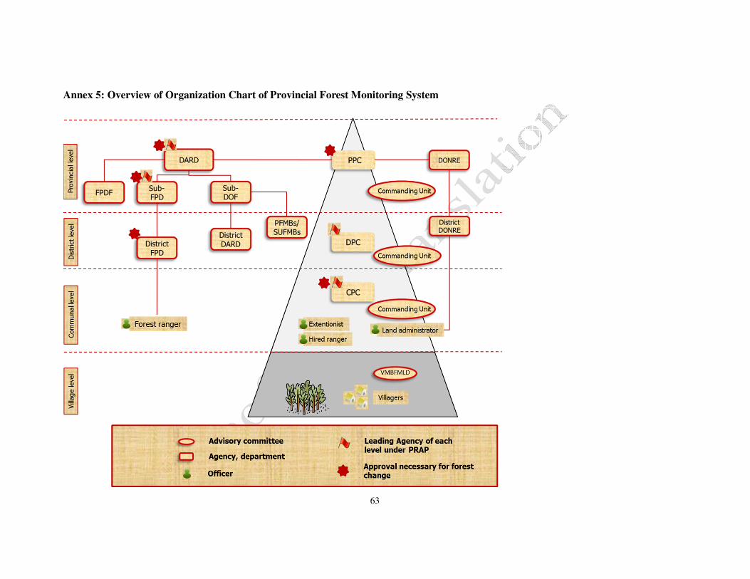
63
Annex 5: Overview of Organization Chart of Provincial Forest Monitoring System

64
Annex 6: Flow of the Present Program, Activities relatedwith PFMS and the Output

65
Annex 7: Harmonization of National Forest Information System and Provincial Forest Monitoring System

66
Annex 8: Time Frame of Developing Database System at National and Provincial Levels

67
Annex 9. Idea of Benefit Distribution
Flow of distribution of REDD+ carbon benefit

68
Annex 10: Plan for capacity development in the province to implement REDD+
Theme Subject Methods Trainers’ resources Training Targets Time
Enhancement
of governance
Management skills for the
management boards and village
funds
-Holding workshops to understand management skills
for the management boards and village funds.
-On-the-job training through the management of the
management boards and the village funds
Provincial DARD, DPC,
PFMB, SUFMB, Sub-DoF,
District DARD, and CPC
Villagers in the pilot
area
2013 ~
2015
Provincial DARD, PPC,
PFMB, SUFMB, Sub-DoF,
District DARD, and CPC,
Villagers in pilot areas
Villagers outside the
pilot areas
2016 ~
2020
Reporting of progress and
result of implementing the
monitoring system
-Holding workshops on the monitoring system to
understand the mechanism of the monitoring and
reporting flow in the different administrative level
-Conducting on-the-job trainings to monitor and
report in the REDD+ implementations
Sub-FPD and Provincial
DARD in the pilot areas
District-FPD, CPC
in the pilot areas
2013 ~
2015
District-FPD and CPC
in the pilot areas
District-FPD and CPC
outside the pilot areas
2016 ~
2020
Financial procedure associated
with BDS
-Holding workshops to understand financial
mechanism associated with BDS
-On-the-job training on financial procedure to deal
with BDS
National REDD+
Coordination Office
Provincial DARD,
PPC, PFMB, SUFMB,
Sub-DoF,
District DARD, and
CPC
2013 ~
2015
Strengthening
facilitations
skills
Strengthening facilitations
skills to draft the Forest
management plan and
Livelihood development plan
-Holding workshops to strengthen facilitation skills to
prepare the plans
-Conducting on-the-job training through practice of
facilitating at the village meetings
Provincial DARD DPC, PFMB,SUFMB,
District-FPD, and CPC
2013 ~
2015
DPC, PFMB, SUFMB,
District-FPD and CPC
in the pilot areas
DPC, PFMB,SUFMB,
District-FPD and CPC
outside the pilot areas
2016 ~
2020
Promotion of
forest
management
activities
Promotion of Forest allocation
and forest management
technology
-Holding workshops to understand and to promote
forest allocations.
-Conducting on-the job trainings to improve the
technology for forest management including
afforestation, tending, and patrolling.
Provincial DARD, DPC,
PFMB, SUFMB,CPC
Villagers
2013 ~
2015 DARD, DPC, PFMB,
SUFMB,CPC in the pilot
areas
Villagers outside pilot
areas 2016 ~
2020

69
Developing
capacity for
forest monitoring
Monitoring Forest Status
-Strengthening field survey
skills (GPS and GIS operation,
remote sensing analysis and
identification of forest type)
-Strengthening operation of the
forest information database
system (compiling the field
data, GIS operation and remote
sensing analysis, random
sampling grids)
-Strengthening the skills of
villagers on recording and
reporting forest change
obtained in the field
-Providing lectures about forest monitoring
technologies
-On-the-Job Training on the field survey, operation of
the database
Sub-FPD, Sub-DoF
in the pilot areas
Sub-FPD,CAFDP,
District-FPD,
and VMBFMLD
in the pilot areas
2013 ~
2015
Sub-FPD,CAFDP,
District-FPD,
and VMBFMLD in the pilot
areas
Sub-FPD,CAFDP,
District-FPD,
and VMBFMLD
outside the pilot areas
2016 ~
2020
Promotion on the
livelihood
development
activities
Improving livelihood
development skills(Agricultural
activities, Energy efficient
lifestyle, Livestock production,
Forestry activities)
-Holding workshops to enhance knowledge and
technique of agricultural activities involving raising
livestock.
-On-the-job training on each livelihood development
activity.
-Holding a meeting to identify available resources
and potential products in the market.
Provincial DARD, DPC,
PFMB, SUFMB
CPC and the villagers
in the pilot area
2013 ~
2015
CPC and the villagers in the
pilot areas
CPC and the villagers
outside pilot areas 2016 ~
2020
Awareness
raising
Enhancing awareness on forest
protection
Holding workshop and meeting to foster the
understanding on the importance of forest protection.
Provincial DARD, DPC,
PFMB, SUFMB, and
District-FPD
CPC and the villagers
in the pilot areas 2013 ~
2015
CPC and the villagers in the
pilot areas
CPC and the villagers
outside pilot areas 2016 ~
2020
Note: Modifications and additions to this capacity development plan are to be made as appropriate in the course of C-RAP implementation.

70
Annex 11. Unit Cost for Various Activities
Unit cost of each item is summarized in the table below.
Cost items Unit cost
1 Forest protection VND 200,000 /ha/yr.
2 Regeneration VND 200,000 /ha/yr.
3 Afforestation (Total) VND 15,000,000/ha
3.1 Planting (1st yr.) VND 8,300,000 /ha
3.2 Tending (2nd yr.) VND 3,000,000/ha
3.3 Tending (3rd yr.) VND 2,200,000/ha
3.4 Tending (4th yr.) VND 1,500,000/ha
4 Management cost of forest protection,
regeneration and afforestation 8%
5 Forestland allocation VND 200,000/ha
6 Livelihood support* VND 3,000,000,000/commune
7 Monitoring equipment* VND 1,550,910,400 8 Field work for monitoring* VND 15,000,000/commune/yr
* Details of the calculation of livelihood support, monitoring equipment and field work for
monitoring are provided below.

71
<Calculation of the unit cost of the livelihood support>
Estimation made by REDD+ Pilot Project

72
<Calculation of the unit cost of the monitoring equipment>
Equipment Unit price
(VND) Unit Quantity unit
#
procurement Total (VND)
Satellite
data
(0.5m
resolution)
599,200 km2
(=100ha) 237 km2 1 142,010,400
GPS 10,000,000 set 112 set 1 1,120,000,000
PC (for
GIS) 32,100,000 set 9 set 1 288,900,000
Total 1,550,910,400
Estimation made by Dien Bien REDD+ Pilot Project
<Calculation of the unit cost of the field work for monitoring>
Responsibility Item Unit price
(VND) Quantity Unit
Total amount
(VND) Remarks
Forest ranger
Daily allowance 150,000 50 days 7,500,000
Fuel 2,500 2,000 km 5,000,000 20km average x 2
x 50 times
Accommodation 100,000 25 nights 2,500,000
Total 15,000,000
Estimation made by Dien Bien REDD+ Pilot Project

73
Annex 12. Acronyms
AD Activity Data
CFM Community Forest Management
CPC Commune People’s Committee
CRAP Commune REDD+ Action Plan
CRPMU Commune REDD+ Program Management Unit
CSR Corporate Social Responsibility
DANIDA Danish International Development Agency
DARD Department of Agriculture and Rural Development
DONRE Department of Natural Resources and Environment
DPC District People’s Committee
DRPMU District REDD+ Program Management Unit
EF Emission Factor
FMS Forest Monitoring System
FORMIS Forest Monitoring Information System
FOs Forest Owners
FPD Department of Forest Protection
FPDP Forest Protection and Development Plan
FRELs/FRLs Forest reference emission levels/Forest reference levels
GHG Greenhouse Gas
GIS Geographic Information System
GPG-LULUCF Good Practice Guidance for Land Use, Land-Use Change and Forestry
GPS Global Positioning System
IPCC Intergovernmental Panel on Climate Change
JICA Japan International Cooperation Agency
MARD Ministry of Agriculture and Rural Development
MNNR MuongNhe Nature Reserve
NFI&S National Forest Inventory and Statistics
NFMS National Forest Monitoring System
NRAP National REDD+ Action Program
NTFP Non-Timber Forest Product
ODA Official Development Assistance
PDCA Plan-Do-Check-Action
PFES Payment for Forest Environmental Services
PFMB Protection Forest Management Board
PFMS Provincial Forest Monitoring System
PFPDF Provincial Forest Protection and Development Fund
PPC Provincial People’s Committee
PRAP Provincial REDD+ Action Program
PaMs Policy and Measures
REDD+ Reducing emissions from deforestation and forest degradation and the role

74
of conservation, sustainable management of forests and enhancement of
forest carbon stocks in developing countries
RELs/RLs Reference Emission Levels and Reference Levels
RPMU REDD+ Program Management Unit
SBSTA Subsidiary Body for Scientific and Technological Advice
SUF Special Use Forest
SUFMB Special Use Forest Management Board
SUSFORM-NOW Project for Sustainable Forest Management in the Northwest Watershed
Area
Sub-DOF Sub-Department of Forestry of Dien Bien Province
Sub-FPD Sub-Department of Forest Protection of Dien Bien Province
TFF Trust Fund for Forest
UNFCCC United Nations Framework Convention on Climate Change

75
Annex 13: List of terminology
Terminology Definitions
Activity Data (AD)
Activity Data (AD) is obtained from the analysis of forested land and non-forested
land status with satellite imagery and field observations. AD is used to estimate the
emissions according to the calculation proposed by IPCC:
Emissions = AD (Activity Data) x EF (Emission Factor)
Forest inventory
Forest inventory includes documentation and analysis of forest area and volume
based on the forest management profiles; it shall be done on all forested areas,
regardless of the inclusion of these areas in the planning of 3 forest types, with all
dispersed trees being covered. Forest inventory should be annually undertaken
nationwide and the inventory results should be made public yearly on 31 December
(in accordance with Circular 25/2009/TT-BNN by Ministry of Agricultural and
Rural Development)
Benefit
Distribution
System
Benefit Distribution System is a core component of National REDD+ Action
Program. The main objective of REDD+ Benefit Distribution System is to ensure
the benefits and compensations for people who are directly involved in
deforestation and forest degradation activities (A Benefit Distribution System
applicable to REDD program in Vietnam should be designed, UN-REDD, 2010).
CRAP
Commune REDD+ Action Plan is referred to as CRAP. CRAP aims to support
REDD+ implementation at commune level. CRAP is designed in congruence with
Provincial REDD+ Action Plan (PRAP) to contribute to the success of PRAP
implementation. The design of this Plan is based on forestry and socio-economic
conditions of each commune, with a focus on field-level activities.
DBR A software for storage and handling of forest inventory results obtained annually at
provincial level, developed by (VNFOREST’s) Forest Protection Department.
Emission Factor
(EF)
EF is defined as the changes in carbon stocks under each forest type which are
obtained in National Forrest Inventory (NFI). Under NFI, emissions are calculated
according to the proposed formula by IPCC:
Emissions = AD x EF.
Forestland
allocation
Forestland allocation is undertaken to allocate forestlands owned by the State to
organizations, households or individuals for management so as to create incentives
in forestland management and ensure long-term and sustainable forestland use. In
Vietnam, the State has promulgated the Decree 163/1999/ND-CP which specifies
conditions for the implementation.
Forest Protection
and Development
Plan (Decision
57/QD-TTg)
Forest Protection and Development Plan (FPDP) is a master plan on increasing
forest cover in the period 2011-2020, further expanding the success of Program
661. Its objectives include efficient and effective management of current forest
area, an increase of forest cover to 42-43 % by 2015 and 44-45 % by 2020 and

76
improved livelihoods of local people. Tasks under FPDP are protection of current
forest area of 13,388,000 ha, afforestation in an area of 2,600,000 ha and
regeneration for an area of 750.000 ha, etc.
Forest Reference
Emission Levels
(FRELs)
FRELs are the amount of gross emissions in a reference time period and can be
used as the baseline, formulated on the basis of emission levels due to deforestation
and forest degradation (according to NRAP)
Forest Reference
Levels (FRLs)
FRLs are the amount of net/gross emissions in a reference time period from
deforestation and forest degradation and the forest sequestration of greenhouse
gases as the results of carbon stock conservation, sustainable forest management
and carbon stock enhancement (according to NRAP)
Measurement-
Report-
Verification (MRV)
MRV is a concept of mechanism and/or requirements aimed to assess the
implementation of REDD+ related policies on emissions and removal of
greenhouse gases in the crediting mechanism. However, international discussions
on objectives and targets of MRV, and agencies to be in charge of the MRV
implementation are still ongoing. As of 2013, MRV systems for forest monitoring
in REDD+ remain under review by Subsidiary Body for Scientific and
Technological Advice (SBSTA) (According to REDD+ Manual by REDD+
Research and Development Center, Japan, 2013).
National Forest
Inventory (NFI)
Forest inventory includes inventory, assessment, identification of forest status,
forest volume for planned forestlands and non-forestlands and adjustment of the
changes on forest area and forest volume based on forest inventory results and
forest management profiles. Forest inventory is undertaken every five years on the
same management area (according to Circular No. 25/2009/TT-BNN by Ministry of
Agriculture and Rural Development).
Introduction on NFI: there are two NFI-related programmes in Vietnam, namely
NFIMAP (National Forest Inventory and Monitoring Programme) and NFI&S
(National Forest Inventory and Statistics). NFIMAP Programme has completed four
cycles of forest inventory (in 1990, 1995, 2000 and 2010) for forest area, volume
and status through usage of satellite imagery combined with field surveys and
set-up of sample plots by Forest Inventory and Planning Institute (under Ministry of
Agriculture and Rural Development). NFI&S Programme is ongoing (from 2013 to
2016) as the fifth cycle of NFI after the pilot implementation in Bac Kan and Ha
Tinh; this programme also aims to identify the boundary of forest plots between
forest owners.

77
National Forest
Monitoring
System (NFMS)
NFMS in Vietnam includes forest monitoring and REDD+ activities; monitoring
results presented by inventories of greenhouse gases, and safeguards-related
data. Safeguards-related data is collected separately to confirm targeted criteria
and indicators.
NRAP
National Action Programme on “Reducing Emissions from Deforestation and
Forest Degradation, Sustainable Management of Forests, Conservation of
Forests and Enhancement of Forest Carbon Stocks” is referred to as “NRAP” in
English. The Programme, which is approved by Prime Minister under Decision
799/QĐ-TTg dated June 2012, is implemented from 2011 to 2020.
Payment for Forst
Environmental
Services (PFES)
Payment for Forest Environmental Services (PFES) aims to provide incentives
to forest owners in provision of forest environmental services through
protection of forest plots under their management. Government of Vietnam has
promulgated Decree No. 99/2010/NĐ-CP on the policy on payment for forest
environmental services.
Policies and
Measures (PaMs)
PaMs at provincial level should be integrated with those at national level and
are undertaken to evaluate the implementation of greenhouse gases reduction
activities under REDD+. Monitoring the implementation of PaMs is included in
Pronvincial Forest Monitoring System, enabling the central government to
monitor the success of PaMs and, subsequently, make appropriate adjustments
to policies and measures, if needed.
Programme on
Hunger
Eradication and
Poverty Reduction
(Resolution
30A/2008/NQ-CP)
Resolution 30A/2008/NQ-CP by the Government on fast and sustainable
poverty reduction for 61 poor districts. Main activities under the Programme
include contracting rich and medium forests for protection (VND
200,000/ha/year); seedling support (VND 2,000,000 – 5,000,000/ha), rice
support (15 kg/household/month, up to 7 years) and support for land clearing
for agricultural cultivation (VND 5,000,000/ha/household).
PRAP
Provincial REDD+ Action Plan, referred to as PRAP in English, is designed to
identify strategies for the province for planning, preparation and implementation
of REDD.
Provincial Forest
Monitoring
System (PFMS)
Improved provincial forest monitoring system is an improved version of
existing provincial forest monitoring system, proposed by Dien Bien Province
on the basis of the annual implementation of existing provincial forest
monitoring system. Characteristics of the Improved provincial forest monitoring
system have been explained in Step 10.
Safeguards
Safeguards are necessary measures to reduce detrimental effects of activities on
environment and societies. Safeguards in REDD+ include potential negative
effects of planned activities and solutions for these negative effects.
Safeguard Safeguard Information System provides information on safeguards that have

78
Information
System
been identified and targeted. The system, which serves for information sharing,
will help promote transparency, prevent potential harmful effects on
environment and society and share information on effects of REDD+ related
activities. Safeguards are often paired with Safeguard Information System for
the efficient implementation.
Programme 661
Five Million Hectare Afforestation Programme (Decision 661 by the
Government), referred to as Programme 661, was implemented from 1998 to
2010, targeting the increase of forest cover to 40 % by 2010 through nationwide
development of 5 million hectares of afforestation.

79
Annex 14: Revision to the section of PRAP implementation budget to adapt to the
actual situation
1. Objectives of this annex
Under REDD+ mechanism, there are constant changes in the required tasks following decisions
made at annual international discussions. Despite such unsteadiness, contents of this REDD+ Action
Plan were prepared on the basis of domestic and international conditions, and implementation progress
of project activities by November 2013.
Additionally, a number of agreements such as “Warsaw Framework for REDD+” adopted at COP
19 held in Warsaw in the late November 2013 have been recognized. A financial mechanism has also
been formulated, which can be seen as a cornerstone in REDD+ development.
This Annex supplements some information on how discussion results at COP 19 can be applied
into the revision of PRAP. In fact, a system should be in place, in which NRAP should be revised first,
based on decisions made at COP 19, and PRAP can be revised accordingly. This system is not taken
into account in the formulation of this Annex; thus, it should be noted that the Annex expresses
opinions of the province.
2. Components agreed at COP 19
In principle, two agreements on financial matters have been reached at COP 19. Below are
initiatives for the revision of PRAP based on these two agreements.
a) “Working Programme on funding sources based on implementation results for full
implementation of activities listed under Paragraph 70, Decision 1/CP.16”.
It is clarified under this section that budget for REDD+ implementation will come from
different funding sources, including bilateral and multi-lateral cooperation, public fund and
private investment. Also, Green Climate Fund (GCF) is an important funding channel for the
payment to be made on the basis of the REDD+ implementation results.
Additionally, Permanent Committee on Financial matters is also requested, under this
section, to consider the payment based on the implementation results and to plan for future
funding sources.
b) “Coordination of funding sources for the implementation of greenhouse gas reduction
activities in forestry sector in developing countries, including institutional arrangement”
The description under this section varies between countries; countries or lead agencies can
nominate the main actors to receive payment based on the implementation results of greenhouse
gas reduction activities in forestry sector.
c) Conclusion
It can be said that most of the discussions on REDD+ implementation method were finished
at COP 19; financial processes were also formulated after being much discussed in previous
conferences. In short, period-by-period approach in the preparation is taking form and the focus
has shifted to full implementation from pilot implementation.

80
In this scenario, it is necessary to predict the timing of payment amount to be released on
the basis of implementation results so as to formulate a framework and outputs as basis for
payment release.
3. Basic approach to REDD+
Necessity of financial roadmap formulation can be seen in decisions made at COP 19.
However, taking into account current policies of Vietnam, the basic approach can be summarized
as below:
• Before the birth of REDD+ initiatives, Government of Vietnam had adopted a large number
of policies, programs and projects on forest protection and development and gained
significant results.
• REDD+ is considered one of solutions to realize national strategies/plans for forest protection
and development and promote socio-economic development at local level.
• However, as one of developing countries with limited resources, Vietnam expects to receive
financial and technical support for to prepare REDD+ implementation and results on reduced
emissions of greenhouse gases due to REDD+ implementation for payment, in accordance
with United Nations Framework Convention on Climate Change (UNFCCC).
• Vietnam is not under an obligation to reduce emissions of greenhouse gases, and the REDD+
implementation in Vietnam will hardly obtain much achievement in case of no international
support to be provided to the country.
Thus, it can be concluded that REDD+ is part of the voluntary approach and international
support for REDD+ implementation is needed; international support for REDD+ Action Plan
should be in place and the roadmap for REDD+ implementation, including funding matters,
should be included in Provincial REDD+ Action Plan.
4. Revision and supplementation to the contents of PRAP
When it comes to changes in current situation as mentioned above, revision to the contents
of REDD+ Action Plan can be recommended as follows:

81
1) Clarity of basic principles on REDD+ and international funding sources
Relevant section: Section 3. Provincial REDD+ Action Plan/ 1.4 Formulation of financial
management mechanisms applicable in REDD+ implementation (Task # 9) – Period 1
Existing To be revised
Different funding sources include budget for
Forest protection and development, PFES.
Additional sources of funding are Program
30A, donor funding, etc.
Different funding sources include budget for
Forest protection and development, PFES.
There are additional sources of funding such as
Program 30A.
Before the birth of REDD+ initiatives,
Government of Vietnam had adopted a large
number of policies, programs and projects on
forest protection and development and gained
significant results; and Vietnam is not under an
obligation to reduce emissions of greenhouse
gases
Also, REDD+ implementation in Vietnam is
completely in line with policies and strategies
set by the Communist Party and Government of
Vietnam, demonstrating the willingness of
Vietnam in its integration with international
communities in earth climate protection.
However, as one of developing countries with
limited resources, Vietnam expects to receive
financial and technical support for to prepare
REDD+ implementation and results on reduced
emissions of greenhouse gases due to REDD+
implementation for payment, in accordance
with United Nations Framework Convention on
Climate Change (UNFCCC).
Thus, searching for international sources of
funding through cooperation opportunities is a
critical task.

82
2) Clarity of roles of State budget and other donor funding
Relevant section: Section IV: Funding for the implementation of REDD+ Action Plan / 2. Cost
analysis and funding sources
(Add following passage to the end of relevant section)
Above-mentioned funding sources are given on the assumption that State budget will be allocated
fully as promised. However, considering the nationwide situation in different sectors, it is unclear
if these programs will be fully implemented. Thus, the following table maps out scenarios for
required additional funding based on the hypothetical percentage of allocated State budget.
Items State budget (% compared with 2013)
100 70 50 30
Costs for implementation
(VND billion) 1,721 1,721 1,721 1,721
Funding which can be
mobilized (VND billion) 1,293 1,140 1,054 969
Required additonal
funding (VND billion) 428 581 667 752
As demonstrated in the table, the implementation of this Plan might face difficulty depending on
the actual amount of funding allocated. Thus, it is important to look for external funding sources.
3) Potential external funding sources and financial roadmap for the implementation of REDD+
Action Plan
Relevant section: Section IV: Funding sources for the implementation of REDD+ Action Plan / 2.
Cost analysis and funding sources
(Add following passage to the end of relevant section, after the above-described passage)
As discussed above, funding for PRAP implementation can experience a serious shortage,
depending on the allocation of State budget for existing programs. In principle, Vietnam should
engage voluntarily in REDD+ implementation and funding sources for this process should not
depend solely on State budget as international donor funding can be utilized.
Potential funding sources are GCF and JCM, etc. However, it remains unclear at this moment how
financial mechanisms under these frameworks have been established. Thus, financial roadmap for
the implementation of this Plan should be formulated on following preconditions. It should be
noted that these preconditions are initiatives of Dien Bien province as said at the beginning of this
Annex.
[Preconditions]
• Green Climate Fund (GCF) is to pay for REDD+ implementation results, thus the Fund shall
not be used for readiness preparation or pilot implementation.
• GCF is transferred to nations. In short, this Fund will not support project-level and
sub-national level approach;

83
• GCF will be released since 2020, which means other funding sources should be available for
the implementation;
• It was agreed by two countries that REDD+ would be covered under the Joint Crediting
Mechanism (JCM);
• JCM Fund will be used to release payment before or at the same time with GCF.
Based on above preconditions, the roadmap for funding for and implementation of PRAP can be
shown in the following diagram:
In the first Period until 2015, pilot implementation as described in the REDD+ Action Plan is the
principal activity and will be undertaken with the funding support from JICA. For the next Period,
from 2016 to 2020, a large amount of funding will be required to replicate the implementation to
other areas in the province. Hopefully, the Joint Crediting Mechanism (JCM) which is under
discussion will be applicable. For this, the arrangement should be made in a way that REDD+ will
be covered under JCM. Green Climate Fund (GCF) will release the payment on results-based
implementation of Dien Bien PRAP. An agency at national level is expected to receive the
payment from GCF and allocate the payment for provinces. As such, Dien Bien province should
be prioritized to receive the payment from GCF, setting an example of REDD+ implementation
for other provinces.
Related Documents