RECORD OF DECISION KLONDYKE TAILINGS PROJECT WQARF REGISTRY SITE KLONDYKE, ARIZONA April 2018 Prepared By: Arizona Department of Environmental Quality Remedial Projects Unit 1110 West Washington Phoenix, Arizona 85007

Welcome message from author
This document is posted to help you gain knowledge. Please leave a comment to let me know what you think about it! Share it to your friends and learn new things together.
Transcript
RECORD OF DECISION KLONDYKE TAILINGS PROJECT
WQARF REGISTRY SITE KLONDYKE, ARIZONA
April 2018
Prepared By:
Arizona Department of Environmental Quality Remedial Projects Unit 1110 West Washington Phoenix, Arizona 85007
Arizona Department of Environmental Quality ii Klondyke Tailings WQARF Registry Site Record of Decision
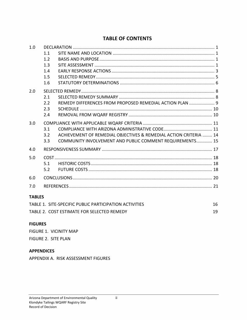
TABLE OF CONTENTS
1.0 DECLARATION ..................................................................................................................... 1 1.1 SITE NAME AND LOCATION .................................................................................... 1 1.2 BASIS AND PURPOSE ............................................................................................... 1 1.3 SITE ASSESSMENT ................................................................................................... 1 1.4 EARLY RESPONSE ACTIONS ..................................................................................... 3 1.5 SELECTED REMEDY .................................................................................................. 5 1.6 STATUTORY DETERMINATIONS .............................................................................. 6
2.0 SELECTED REMEDY .............................................................................................................. 8 2.1 SELECTED REMEDY SUMMARY ............................................................................... 8 2.2 REMEDY DIFFERENCES FROM PROPOSED REMEDIAL ACTION PLAN ..................... 9 2.3 SCHEDULE ............................................................................................................. 10 2.4 REMOVAL FROM WQARF REGISTRY ..................................................................... 10
3.0 COMPLIANCE WITH APPLICABLE WQARF CRITERIA ......................................................... 11 3.1 COMPLIANCE WITH ARIZONA ADMINISTRATIVE CODE ........................................ 11 3.2 ACHIEVEMENT OF REMEDIAL OBJECTIVES & REMEDIAL ACTION CRITERIA ........ 14 3.3 COMMUNITY INVOLVEMENT AND PUBLIC COMMENT REQUIREMENTS ............. 15
4.0 RESPONSIVENESS SUMMARY ........................................................................................... 17
5.0 COST .................................................................................................................................. 18 5.1 HISTORIC COSTS .................................................................................................... 18 5.2 FUTURE COSTS ...................................................................................................... 18
6.0 CONCLUSIONS ................................................................................................................... 20
7.0 REFERENCES ...................................................................................................................... 21
TABLES TABLE 1. SITE-SPECIFIC PUBLIC PARTICIPATION ACTIVITIES 16 TABLE 2. COST ESTIMATE FOR SELECTED REMEDY 19
FIGURES FIGURE 1. VICINITY MAP FIGURE 2. SITE PLAN
APPENDICES APPENDIX A. RISK ASSESSMENT FIGURES

Arizona Department of Environmental Quality iii Klondyke Tailings WQARF Registry Site Record of Decision
LIST OF ACRONYMS A.A.C. Arizona Administrative Code ADEQ Arizona Department of Environmental Quality ADWR Arizona Department of Water Resources A.R.S. Arizona Revised Statute AWQS Aquifer Water Quality Standards CAB Community Advisory Board CIP Community Involvement Plan COC Contaminant of Concern cy Cubic yards DEUR Declaration of Environmental Use Restriction EPA United States Environmental Protection Agency ERA Early Response Action FS Feasibility Study LTP Lower Tailings Pile mg/kg Milligrams per kilogram mg/L Milligram per liter PI Preliminary Investigation PRAP Proposed Remedial Action Plan RI Remedial Investigation RO Remedial Objectives ROD Record of Decision RSRL Residential Soil Remediation Level SRL Soil Remediation Level UTP Upper Tailings Pile WQARF Water Quality Assurance Revolving Fund

Arizona Department of Environmental Quality 1 Klondyke Tailings WQARF Registry Site Record of Decision
1.0 DECLARATION
1.1 SITE NAME AND LOCATION
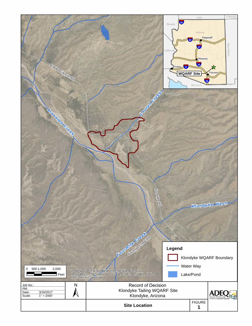
This Record of Decision (ROD) is for the Klondyke Tailings Project Water Quality Assurance Revolving Fund (WQARF) Registry Site (Site), located in Graham County, Arizona. The Site is located approximately 1.5 miles northeast of the unincorporated community of Klondyke in Section 6, Township 7 South, Range 20 East (Figure 1). The Site is located 4.5 miles upstream of the Aravaipa Canyon Wilderness Area managed by the U.S. Bureau of Land Management. The Nature Conservancy’s Aravaipa Canyon Preserve is located immediately upstream of the wilderness area.
1.2 BASIS AND PURPOSE
This ROD presents the selected remedial action for contaminants of concern (COCs) in soils at the Site in accordance with Arizona Revised Statute (A.R.S.) §49-287.04. The decision in this ROD is based upon previous activities and investigations conducted at this Site and documented in the Arizona Department of Environmental Quality (ADEQ) Administrative Records file. The State of Arizona, acting by and through ADEQ, has selected the remedy described in this ROD for implementation at the Site.
1.3 SITE ASSESSMENT
The Site was added to the WQARF Registry on September 28, 1998 with an eligibility and evaluation score of 69 out of a possible 120. The original WQARF Site boundaries were placed around the two source area parcels, 110-47-003g and 110-47-003h. Since completing the site characterization activities, the Site boundaries have been expanded to encompass residential parcels and reaches of Laurel Creek that have elevated concentrations of lead (Parcels 110-47-001b; 110-47-001g; 110-47-001h; 110-47-001i; 110-47-001k; 110-47-001m; 110-47-003b; 110-47-003d; 110-47-003f; 110-47-003g; 110-47-003h and 110-47-006) (Figure 2).
The Site is the former location of a flotation mill that processed ore material mined from several lead, zinc, copper, silver and gold mines that operated in the Santa Teresa Mountains north and northeast of the Site from the late 1870s through the 1960s. Metal ore was processed by a series of flotation mills at the Site, resulting in three tailings piles. The Upper Tailings Pile (UTP) is located approximately 30 feet from the bank of Aravaipa Creek. The Lower Tailings Pile (LTP) is approximately 200 feet downstream of the Upper Tailings Pile. A small mill and mine tailings pile (small tailings pile) is approximately 2,100 feet east-northeast of the convergence of Laurel Canyon Wash and Aravaipa Creek (Figure 2).

Arizona Department of Environmental Quality 2 Klondyke Tailings WQARF Registry Site Record of Decision
Since being added to the WQARF Registry, the Site has undergone various phases of contaminant investigation and assessment including soil and groundwater evaluations, remedial investigation (URS 2014), and a human health risk assessment (HHRA) (Arcadis 2016, Arcadis 2016a). Findings applicable to the current state of the Site are:
• Contaminated media is 37.8 acres of surface soils to about 1 foot below ground surface caused by on-Site tailings piles left over from mining;
• Site COCs are arsenic, cadmium, copper, lead, manganese, vanadium, and zinc with exceedances of the lead Residential Soil Remediation Level (RSRL) of 400 milligrams per kilogram (mg/kg) acting as an indicator for the exceedance of other COCs’ respective RSRLs;
• The Site is comprised of portions of 12 Graham County Parcels (110-47-001b, 110-47-001g, 110-47-001h, 110-47-001i, 110-47-001k, 110-47-001m, 110-47-003b, 110-47-003d, 110-47-003f, 110-47-003g, 110-47-003h, and 110-47-006) with concentrations of lead in soils exceeding the RSRL for lead (Figure 2);
• Six Parcels (110-47-001g, 110-47-001m, 110-47-003b, 110-47-003d, 110-47-003f, and 110-47-006) within the site contain residential buildings;
• Six Parcels (110-47-001b, 110-47-001h, 110-47-001i, 110-47-001k, 110-47-003g, and 110-47-003h) within the site are unoccupied;
• Contaminant sources are the UTP and the LTP on Parcel 110-47-003g, and the small tailings pile on Parcel 110-47-006 (Figure 2);
• The UTP contaminant source on Parcel 110-47-003g was capped in 2008, cutting off exposure pathways to COCs within;
• A groundwater investigation was conducted from 2005 to 2013. The investigation included the installation of four groundwater monitoring wells, and groundwater monitoring using both ADEQ monitoring and privately owned wells. During the eight years of groundwater monitoring, there was a single exceedance of applicable Aquifer Water Quality Standards (AWQSs). The 0.05 milligram per liter (mg/L) AWQS for lead was exceeded in a single groundwater sample that indicated a 0.145 mg/L concentration of lead. The sample was collected on August 29, 2007 from a private well on Parcel 110-47-001. All analytical results from groundwater samples collected from the well prior to and after this sampling event indicated concentrations of lead below the laboratory reporting limit, and consequently the AWQS. No other exceedances were noted during the investigation, nor could the single exceedance be confirmed. The groundwater investigation indicated that Site COCs have not impacted groundwater;
• Current use of undeveloped land warrants recreational and trespasser receptor exposure scenarios;

Arizona Department of Environmental Quality 3 Klondyke Tailings WQARF Registry Site Record of Decision
• Per a Site-specific HHRA (Arcadis 2017), only Parcels 110-47-003g (containing the UTP and LTP sources) and 110-47-006 (containing the small tailings pile source) currently exceed acceptable risk criteria considering recreational and trespasser receptor scenarios in undeveloped portions of the Site; and
• Lead contaminated soils in residential areas on Parcels 110-47-001g, 110-47-001m, 110-47-003b, 110-47-003d, 110-47-003f, and 110-47-006 have been remediated to concentrations below the 400 mg/kg RSRL for lead through the implementation of Early Response Actions (ERAs), as described in Section 1.4.
1.4 EARLY RESPONSE ACTIONS
Investigative findings identified areas of potential concern that have since been remediated by ERAs. The completed ERAs achieved Site Remedial Objectives (ROs) (ADEQ 2014) and remediated lead and other COCs in surface soils to levels that are protective of current property use. The ERAs are summarized as follows:
UTP Cap (URS 2008): In 2008, construction activities were performed on Parcel 110-47-003g to contain and stabilize the UTP and prevent migration of COCs from the UTP. Construction activities included:
• Excavation of approximately 2,000 cubic yards (cy) of tailings from the LTP and COC contaminated surface soils near the LTP for placement and compaction on the UTP;
• Grading, shaping and compaction of the UTP; • Placement of a clean soil cap over the UTP, graded to promote runoff instead of
infiltration; • Reseeding of the cap to promote evapotranspiration and mitigate erosion; and • Installation of gabion mattresses to protect cap slopes from erosion, scour, and
undercutting during storm events.
Completion of construction activities yielded a 2-foot thick, clean soil cap over the UTP that has segregated the COCs within the UTP from receptors and the environment. The cap has been, and continues to be, maintained by ADEQ since its completion in 2008.
Parcel 110-47-003g Surface Soils Removal (AMEC 2015): In 2015, excavation of lead contaminated surface soils between the UTP and LTP on Parcel 110-47-003g was performed to remove a potential source of contamination to surface water and to adjoining properties. Removal activities included:
• Excavation of approximately 4,900 cy of COC contaminated soils; • Placement and compaction of excavated, COC contaminated soils on top of the LTP;

Arizona Department of Environmental Quality 4 Klondyke Tailings WQARF Registry Site Record of Decision
• Placement and compaction of approximately 7,100 cy of clean backfill material into areas excavated during the 2015 soils removal and 2008 UTP cap installation; and
• Placement of a temporary cap, vegetation, and berms on the LTP to mitigate infiltration and access by recreational vehicles.
Completion of the soils removal activities left the LTP in a condition suitable to future capping and mitigated the potential for contaminant migration from the LTP and areas immediately surrounding the LTP.
Klondyke Road Remediation (AMEC 2016): In 2016, removal of lead contaminated surface soils from Klondyke Road, followed by the construction of a replacement road, was performed to mitigate lead contaminated dust being dispersed by vehicular traffic. The remediation of Klondyke Road was conducted in response to an HHRA (Arcadis 2016) which concluded that fugitive dust from vehicular traffic caused an increase in risk to human health at parcels 110-47-003f, 110-47-003f, 110-47-003g, and 110-47-003b. Remediation activities included:
• Excavation of approximately 2,200 cy of COC contaminated soils along 2,100 linear feet of Klondyke Road;
• Placement and compaction of excavated, COC contaminated soils on top of the LTP; and • Placement and compaction to Graham County roadway design specification of
approximately 2,700 cy of clean backfill material into the portion of Klondyke Road excavated during remediation.
Completion of Klondyke Road remediation activities resulted in abatement of lead contaminated dust causing exceedance of acceptable risk criteria from being dispersed by vehicular traffic. Construction of the replacement road achieved lead concentrations in the road surface that are protective of human health and the environment.
Residential Area Remediation: Remediation of contaminated soils around residential buildings within the site was performed during three separate remedial actions conducted from 2010 to 2016. Residential buildings on Parcels 110-47-001g, 110-47-001m, 110-47-003b, 110-47-003d, 110-47-003f, and 110-47-006 were included in one or more of the remedial actions. All three remedial actions entailed the excavation of soils exceeding an action level of 400 or 800 mg/kg of lead from 200 square foot areas around residential buildings. The soils were excavated to a depth of one foot, except in areas used for sustenance gardening, which were excavated to a depth of two feet. Excavated areas were backfilled with local, clean fill material. Excavated soils contaminated with Site COCs were compacted onto the UTP. Specific descriptions of the three residential area remedial actions are below:
Arizona Department of Environmental Quality 5 Klondyke Tailings WQARF Registry Site Record of Decision
• From May through June 2012 and October through November 2013, United States Environmental Protection Agency (EPA) excavated soils around residential buildings on Parcels 110-47-001m, 110-47-003d, and 110-47-006. The EPA used lead action levels of 800 mg/kg at properties that did not report that children visited and 400 mg/kg at properties where the homeowners reported that children visit. Soils on Parcels 110-47-003d and 110-47-006 were excavated where lead concentrations exceeded 800 mg/kg. Soils on Parcel 110-47-001m were excavated where lead concentrations exceeded 400 mg/kg. Approximately 1,500 cy of soils were excavated from around residences and consolidated on the LTP during remediation (E&E 2014).
• In March and April 2016, ADEQ remediated soils around residential buildings on Parcels 110-47-001g, 110-47-003b, and 110-47-003f. ADEQ used a lead action level 400 mg/kg on the three parcels. Approximately 4,466 cy of soils were excavated from around residences and consolidated on the LTP during remediation (AMEC 2016).
• In November 2016, ADEQ remediated soils around residential buildings on Parcels 110-47-003d and 110-47-006. As previously described, these Parcels were remediated by EPA using an action level of 800 mg/kg, which left soils exceeding the 400 mg/kg RSRL for lead around residential buildings. ADEQ used a lead action level 400 mg/kg on the three parcels. Approximately 219 cy of soils were excavated from around residences and consolidated on the LTP during remediation (AMEC 2016a).
Ultimately, lead contaminated soils around all residential buildings within the Site were remediated to below the 400 mg/kg RSRL for lead through the use of a lead removal action level of 400 mg/kg. Removal of lead contaminated soils around the existing residences resulted in lead concentrations in surface soils around developed areas that are protective of the current use of the remediated properties.
1.5 SELECTED REMEDY
The selected remedy, as specified in the Site Proposed Remedial Action Plan (PRAP) (AMEC 2017a), is consolidation/capping of mine tailings sources at the LTP on Parcel 110-47-003g and small tailings pile on Parcel 110-47-006. Declarations of Environmental Use Restriction (DEURs) on the two Parcels, after the sources have been capped, will be pursued upon completion of the selected remedy. This remedy is selected to mitigate exceedance of acceptable risk criteria determined by the results of the HHRA described in Section 1.3.
Consolidation/capping is a remedial measure that employs physical containment of contaminated media, mitigating the risk of contaminant migration and exposure to receptors. Consolidation of the mine tailings sources will be achieved by shaping, grading, and compacting the tailings piles into forms suitable to be capped. Capping will be achieved by excavating clean

Arizona Department of Environmental Quality 6 Klondyke Tailings WQARF Registry Site Record of Decision
soil and rock from a borrow area local to the Site, then transporting the clean materials to the LTP on Parcel 110-47-003g and small tailings pile on Parcel 110-47-006. At Parcel 110-47-003g, clean soil will be compacted and graded into a 2 foot thick layer over the LTP, physically segregating the tailings from the environment. At Parcel 110-47-006, clean rock will be sorted to a 1.5 inch minus grade and placed over the impacted area in a 2 foot thick layer, physically segregating the tailings from the environment.
A DEUR is a restrictive covenant designed to document engineering and institutional controls, allow closure of a site with contamination above RSRLs, and ensure appropriate future use of a contaminated site. A DEUR must be agreed to by the owner of a parcel, and is attached to the deed of the parcel it affects. DEURs will be pursued by ADEQ independent of the selected remedy completion.
A summary description of the selected remedy is provided in Section 2.0 of this ROD. A detailed description of the selected remedy is provided in the FS Report. Upon completion of the remedy, all state owned monitoring wells associated with the Site will be abandoned in accordance with the PRAP and applicable Arizona Department of Water Resources (ADWR) requirements as promulgated in Arizona Administrative Code (A.A.C.) R12-15-816. After completion of the remedy selected by this ROD, ADEQ may find that the Site requires no further remedial action pursuant to A.R.S. §49-287.01(G) and/or remove the Site from the WQARF registry pursuant to A.R.S. §49-287.01(K).
1.6 STATUTORY DETERMINATIONS
The Site Remedial Investigation (RI) Report (URS 2014) was completed In June 2014, pursuant to A.R.S. §49-287.03. The RI Report:
• Established the nature and extent of the contamination and the sources thereof;
• Identified current and potential impacts to public health, welfare and the environment;
• Identified current and reasonable foreseeable uses of land and waters of the state; and
• Obtained and evaluated information necessary for identification and comparison of alternative remedial actions.
The FS Report was completed in April 2017, pursuant to A.R.S. §49-287.03. Based on information provided in the RI Report, a remedy addressing only contaminated soils at the Site was appropriate and therefore, in accordance with A.R.S. §49-282.06(B)(4)(a) and A.A.C. R-18-16-407(C), an analysis of alternative remedies was not required. Based on the previous

Arizona Department of Environmental Quality 7 Klondyke Tailings WQARF Registry Site Record of Decision
work completed as ERAs, the FS Report proposed and evaluated a single remedy capable of compliance with A.R.S. §49-282.06 and demonstrated that the proposed remedy:
• Addressed the contaminated soil in a manner that achieves compliance with A.R.S. §49-152 and A.A.C. Title 18, Chapter 7, Article 2 and will achieve the ROs for the Site;
• Was selected based upon best engineering, geological, and hydrogeological judgment following engineering, geological, and hydrogeological standards of practice considering:
o The Site RI;
o Best available scientific information concerning available remedial methods and technologies; and
o A written analysis explaining how the remedy is consistent with A.R.S. §49-282.06.
The PRAP was completed in June 2017, pursuant to A.R.S. §49-287.04. The PRAP discussed the remedy evaluated by the FS Report and provided costs to implement the proposed remedy. Public comments on the proposed remedy were solicited, and none were received. The PRAP:
• Identified the boundaries of the Site and portions of the Site subject to remedial action;
• Identified results of the RI and FS;
• Described the proposed remedy and its estimated costs; and
• Described how the remedial goals and selection factors were evaluated.
Pursuant to A.R.S. §49-287.04(H), this ROD is the final administrative decision as defined under A.R.S. §41-1092. Consolidation/capping of mine tailings sources at the LTP on Parcel 110-47-003g and small tailings pile on Parcel 110-47-006 is selected as the remedy for the Site to meet the following criteria set forth in A.R.S. §49-282.06:
• Adequately assures the protection of public health and welfare of the environment;
• To the extent practicable, provides for the control, management, and cleanup of Site COCs to maximize beneficial use of the waters of the state; and
• Is reasonable, necessary, cost-effective and technically feasible.
Arizona Department of Environmental Quality 8 Klondyke Tailings WQARF Registry Site Record of Decision
2.0 SELECTED REMEDY
The remedy evaluated and proposed in the FS Report was carried forward to the PRAP and has been selected by this ROD as the remedy for the Site.
2.1 SELECTED REMEDY SUMMARY
The selected remedy for the Site, described in detail within the FS Report, is consolidation/capping of mine tailings sources at the LTP on Parcel 110-47-003g and small tailings pile on Parcel 110-47-006. DEURs will be pursued after the sources have been capped.
Remedial actions at the LTP source area on Parcel 110-47-003g include consolidation of tailings and the installation of an engineered cap. Consolidation of the LTP mine tailings source will be achieved by shaping, grading, and compacting the tailings pile into a form suitable to be capped. Capping will be achieved by excavating clean soil from a borrow area local to the Site, then transporting the clean soil to the LTP on Parcel 110-47-003g. The clean soil will then be compacted and graded into a 2 foot thick layer, physically segregating the tailings from the environment. Geotextile fabric and gabion mattresses will be installed as the LTP is capped to protect the cap from erosion. Capping of the LTP combined with the previously completed ERAs described in Section 1.4 will result in the parcel being remediated to the current, undeveloped use considering the trespasser/recreational exposure scenario. A conceptual LTP consolidation and cap design is included in Appendix F of the FS Report.
Remedial actions at the small tailings pile source area on Parcel 110-47-006 include consolidation of tailings and the installation of a cap. Consolidation of the small tailings pile mine tailings source will be achieved by shaping, grading, and compacting the tailings pile into a form suitable to be capped. Capping will be achieved by excavating clean rock from a borrow area local to the Site, sorting the rock into 1.5 inch minus and 2-4 inch grades, then transporting the clean rock to the small tailings pile on Parcel 110-47-006. The clean 1.5 inch minus material will then be placed over the impacted area in a 2 foot thick layer, physically segregating the tailings from the environment. Hydro-seeding, to promote vegetation, and a layer of 2-4 inch gravel will be used to protect the cap from erosion. Capping of the small tailings pile combined with the previously completed ERAs described in Section 1.4 will result in the Parcel being remediated to the current use considering the existing residential use area and trespasser/recreational exposure scenario in undeveloped portions of the parcel.

Arizona Department of Environmental Quality 9 Klondyke Tailings WQARF Registry Site Record of Decision
Six Parcels (110-47-001g, 110-47-001m, 110-47-003b, 110-47-003d, 110-47-003f, and 110-47-006) within the site contain residential buildings. As described in Section 1.4, lead contaminated soils in areas surrounding the residences were remediated to concentrations below the RSRL for lead through the completion of ERAs between 2010 and 2016. Excluding capping the small tailings pile on Parcel 110-47-006 as prescribed by this ROD, no further remedial action is needed on these Parcels.
Six Parcels (110-47-001b, 110-47-001h, 110-47-001i, 110-47-001k, 110-47-003g, and 110-47-003h) within the site are unoccupied. Excluding capping the LTP on Parcel 110-47-003g as prescribed by this ROD, no remedial action is needed on these Parcels.
After completion of the selected remedy, long term cap maintenance will be required at the UTP, LTP, and small tailings pile areas. For purposes of cost estimation, long term cap maintenance is to include 30 years of annual inspection and reporting, and replacement of 3 cy of gabion mattress every 5 years.
2.2 REMEDY DIFFERENCES FROM PROPOSED REMEDIAL ACTION PLAN
In accordance with A.A.C. R18-16-410(B)(1), this section describes differences between the remedy described in the PRAP and that which is described in this ROD.
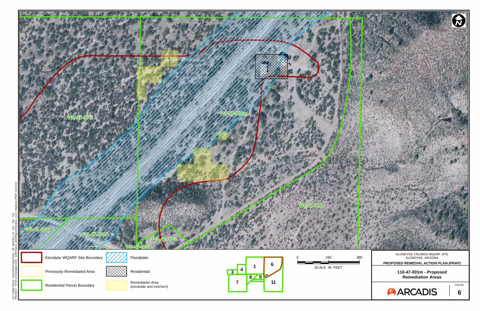
The PRAP included a contingency to conduct in-situ consolidation/capping (described in detail in the FS Report) on currently undeveloped land to prevent exposure to concentrations of lead exceeding applicable SRLs, should the land be developed in the future. This ROD considers current land use (Section 3.2), and does not include the future land use contingency included in the PRAP.
Appendix A of this ROD includes figures indicating locations where the contingency described in the PRAP would have potentially been implemented. Should future development occur within the boundaries of the Site, these figures may be referenced to help differentiate between areas that do and do not need remediation prior to occupation. The figures were generated using a Site-specific HHRA (Arcadis 2017) to guide the contingency remediation proposed in the PRAP, and are not intended to guide future development, nor replace land developer due diligence.

Arizona Department of Environmental Quality 10 Klondyke Tailings WQARF Registry Site Record of Decision
2.3 SCHEDULE
Based on the scope of work provided in the FS Report, the remedy (consolidation/capping of mine tailings sources at the LTP on Parcel 110-47-003g and small tailings pile on Parcel 110-47-006, will be completed within one year of the start of work.
2.4 REMOVAL FROM WQARF REGISTRY
Upon implementation of the remedy, all state owned wells associated with the Site will be abandoned in accordance with applicable ADWR requirements as promulgated in A.A.C. R12-15-816. After completion of the remedy, ADEQ will remove the Site from the WQARF Registry as stated in A.R.S. §49-287.01(K). Long term cap maintenance will be required after removal of the Site from the WQARF Registry, therefore these costs have been included in Section 5.2.
Although the Site will be removed from the WQARF registry, it can be reopened per A.R.S. 49-287.01 (M) and remedial action may be taken or required for any of the following reasons:
1. On discovery of new information that, based on the rules adopted by the department pursuant to A.R.S. 49-282.06, would result in the potential denial of a no further action request.
2. Information submitted to the director pursuant to A.R.S 49-287.01 (F) is inaccurate, misleading, or incomplete.
3. The reopening of an investigation or the taking of a remedial action is necessary to respond to a release or the threat of a release of a hazardous substance that may present an imminent and substantial danger to the public health or welfare or the environment.
Arizona Department of Environmental Quality 11 Klondyke Tailings WQARF Registry Site Record of Decision
3.0 COMPLIANCE WITH APPLICABLE WQARF CRITERIA
3.1 COMPLIANCE WITH ARIZONA ADMINISTRATIVE CODE
A.A.C. Title 18, Chapter 16, Article 2. Preliminary Investigation
A Site Preliminary Investigation (PI) was conducted in accordance with A.A.C. R18-16-201. The PI resulted in the Site being listed in 1998 on the WQARF Registry. The Site was scored in accordance with A.A.C. R18-16-202, receiving a score of 69 out of a possible 120.
A.A.C. Title 18, Chapter 16, Article 3. Public Information
Public notifications and comment periods required by A.R.S. Title 49, Chapter 2, Article 5 or by the Site Community Involvement Plan (CIP), created under A.R.S. § 49-287.03 and A.R.S. Title 49, Chapter 2, Article 5, were provided in accordance with A.A.C. R18-16-301. Public notifications were disseminated through local newspaper and/or direct mail, as appropriate. When not otherwise specified by A.R.S. or A.A.C., timeframes for public comment were at least 30 days. A summary of the community involvement activities required by A.A.C. and/or A.R.S. conducted at the Site is presented in Section 3.3, Table 1 of this ROD.
In accordance with A.A.C. R18-16-302, a public information repository for the Site has been maintained in ADEQ’s Phoenix office at 1110 W. Washington Street, Phoenix, Arizona 85007.
A.A.C. Title 18, Chapter 16, Article 4. Remedy Selection
A.A.C. R18-16-402 states criteria for applicability or exemption of WQARF Registry Sites with regard to A.A.C. Title 18, Chapter 16, Article 4. The Site, remedial actions within the Site, and remedial actions selected by the ROD meet the stated criteria and fall under the purview of A.A.C. Title 18, Chapter 16, Article 4.
A.A.C. R18-16-403 sets forth requirements for a WQARF Registry Site RI and FS Scope of Work, Site Fact Sheet, Site CIP Outline, and public notice and comment periods. In August 1998, ADEQ provided a combined public notice of availability and 30 day public comment period for the Site RI Scope of Work, Fact Sheet, and CIP Outline, which were created in accordance with A.A.C. R18-16-403.
A.A.C. R18-16-404 sets forth requirements for WQARF Registry Site community involvement. Per A.A.C. R18-16-404(C), ADEQ developed a Site-specific CIP following the 30 day comment period

Arizona Department of Environmental Quality 12 Klondyke Tailings WQARF Registry Site Record of Decision
for the CIP Outline. The original CIP was issued in March 1999 and underwent annual review, with updated versions of the document being issued in December 2000, October 2007, and March 2016.
A.A.C. R18-16-405 sets forth requirements for a WQARF Registry Site ERA. ERAs were conducted at the Site from 2008 to 2016 and are described in Section 1.4 of this ROD. Pursuant to A.A.C. R18-16-405(D), work plans were prepared for each ERA. In accordance with A.A.C. R18-16-405(A), ERAs performed at the Site were deemed necessary to:
• Address current risk to public health, welfare, and the environment;
• Address sources of contamination; and
• Contain contamination to reduce the scope and cost of the remedy selected for the Site.
In accordance with A.A.C. R18-16-405(B), the ERAs were based upon best engineering and geological judgement following engineering and geological standards of practice, considering the following information:
• Best information available characterizing the Site; • Best available scientific information concerning available remedial methods and
technologies; and • Best available information regarding whether the methods and technologies could
increase cost or scope of possible remedies for the Site or result in increased risk to public health or welfare or the environment.
A.A.C. R18-16-406 sets forth requirements for a WQARF Registry Site RI. Pursuant to A.A.C. R18-16-406(B), an RI work plan (URS 2006) was produced for the Site in 2006. In accordance with A.A.C. R18-16-406(C), RI field investigations were conducted between 2006 and 2014 to asses:
• Physical Site characteristics; • Contaminant characteristics, exposure routes, and sources; and
• Impacts to aquatic and terrestrial biota
An RI Report was completed in 2014 to describe findings from the RI. In accordance with A.A.C. R18-16-406(A)(D)(G)(H) the RI Report included:
• The results of Site characterization including contaminant nature and extent;

Arizona Department of Environmental Quality 13 Klondyke Tailings WQARF Registry Site Record of Decision
• Information regarding current and potential impacts to public health, welfare, and the environment;
• ROs based on current and reasonably foreseeable uses of property as determined by land use questionnaires completed by land owners; and
• A responsiveness summary encompassing comments, questions, and concerns regarding the draft version of the RI Report.
A.A.C. R18-16-407 sets forth requirements for a WQARF Registry Site FS. Pursuant to A.A.C. R18-16-407(B), an FS work plan (ADEQ 2014a) was prepared for the Site in 2014. Investigative activities conducted at the Site during the RI indicated that contaminant sources had not and would not impact groundwater. Due to the lack of groundwater impact, the FS was conducted without an analysis of alternative remedies pursuant to R18-16-407(C)(D), as appropriate for remedies addressing only soils. The FS Report, completed in 2017, proposed and evaluated a single remedy:
• That addressed the contaminated soils in a manner that achieved compliance with A.R.S. §49-152 and A.A.C. Title 18, Chapter 7, Article 2 using:
o A Site-specific HHRA that identified Parcels 110-47-003g and 110-47-006 as exceeding acceptable risk criteria;
o Completed ERAs that achieved the pre-determined lead RSRL of 400 mg/kg for residential areas;
o Engineering source controls in the form of consolidation/capping of mine tailings sources at the LTP on Parcel 110-47-003g and small tailings pile on Parcel 110-47-006; and
o Institutional source controls in the form of DEURs at Parcels 110-47-003g and 110-47-006.
• Designed to prevent human exposure to hazardous substances; • Selected based upon best engineering and geological judgement following engineering
and geological standards of practice; and
• Capable of achieving Site ROs.
A.A.C. R18-16-408 sets forth requirements for a WQARF Registry Site PRAP. The PRAP, completed in 2017, was prepared in accordance with A.A.C. R18-16-407(B). The PRAP included:
• A description of the proposed remedy;
Arizona Department of Environmental Quality 14 Klondyke Tailings WQARF Registry Site Record of Decision
• A description of how the proposed remedy will achieve ROs;
• Site boundaries and areas subject to the proposed remedy;
• The results of the RI and FS;
• Estimated costs associated with the proposed remedy; and
• A description of how the proposed remedy will comply with remedial action criteria specified in A.R.S. § 49-282.06.
3.2 ACHIEVEMENT OF REMEDIAL OBJECTIVES & REMEDIAL ACTION CRITERIA
In accordance with A.A.C. R18-16-406(I), ADEQ prepared an RO Report (ADEQ, 2014) for the Site that established ROs for the current and reasonably foreseeable uses of land and waters of the State of Arizona that have been or are threatened to be affected by a release of a hazardous substance. Per A.A.C. R18-16-407, the ROs were evaluated in the FS Report and, per A.A.C. R18-16-408 and A.R.S. §49-287.04(A)(B)(C), considered in development of the remedy presented in the PRAP.
In accordance with A.A.C. R18-16-410, ADEQ has reviewed the proposed remedy outlined in the PRAP pursuant to A.R.S. § 49-287.04 and finds, as part of this ROD, that for remedies addressing only soils, the proposed remedy must address contamination in accordance with the requirements set forth in A.R.S. § 49-152 and A.A.C. Title 18, Chapter 7, Article 2. Further, ADEQ must determine the selected remedy “will achieve the remedial objectives for the use of the property” per A.A.C. R18-16-407(C)(1).
Pursuant to A.A.C. R18-16-406(G), for remedial objectives used for a soil remediation remedy, the landowner has a right to identify the type of land use in accordance with A.R.S. § 49-152 and A.A.C. Title 18, Chapter 7, Article 2. ADEQ has reviewed the information on current use of the property and determined that the remedy will address those uses. Pursuant to A.A.C. R18-16-406(G), a landowner may establish both the current and reasonably foreseeable use of its land in circumstances where the remedy will address landfill or other non-soil materials other than waters of the state at the site, or portion of a site. ADEQ finds that the Site is not associated with landfill and is not a site involving other non-soil materials.
The PRAP identifies the remedy and states that the Site remedy will address soil remediation, and will achieve the remedial objectives for the use of the affected areas. This ROD therefore addresses the current uses of the property in accordance with A.R.S. § 49-152, A.A.C.

Arizona Department of Environmental Quality 15 Klondyke Tailings WQARF Registry Site Record of Decision
R18-16-406(G) and A.A.C. Title 18, Chapter 7, Article 2, and consistent with A.A.C. R18-16-407(C)(1).
An RO was not established for groundwater due to the lack of COC detections in groundwater, however ROs to protect surface water and land uses were established. Surface water uses in the area of the Site were characterized as full body contact, fish consumption, agricultural livestock watering, and aquatic and wildlife (warm water). Land uses in the area of the Site were characterized as a mix of residential and agricultural. The ROs for the Site are:
• To protect surface water for the designated uses from contamination at the Site. This action is needed for the present time and for as long as the level of contamination in the tailings and soils at the source property threatens the use of surface water for its intended uses.
• To restore soil conditions to the remediation standards for residential use specified in A.A.C. R18-7-203 (specifically, background remediation standards prescribed in A.A.C. R18-7-204, predetermined remediation standards prescribed in A.A.C. R18-7-205, or site-specific remediation standards prescribed in A.A.C. R18-7-206) that are applicable to the hazardous substances identified. This action is needed for the present time and for as long as the level of contamination in the soil on the property threatens the use as a residential property.
The Selected Remedy achieves the ROs established for the Site and is designed to achieve the remedial action criteria pursuant to A.R.S. § 49-282.06(A) including the following:
• Assures the protection of public health, welfare, and the environment.
• Provides for the maximum beneficial use of the groundwater resource.
• Is reasonable, necessary, cost-effective, and technically feasible.
3.3 COMMUNITY INVOLVEMENT AND PUBLIC COMMENT REQUIREMENTS
A Community Advisory Board (CAB) was formed that has previously met on a regular basis to discuss issues and status of investigation and cleanup activities conducted at the Site. These meetings are open to the public and the last meeting was held on June 23, 2017. Details of the CAB meeting agendas and minutes can be viewed on the ADEQ Web site at:
http://www.azdeq.gov/klondyke-tailings-cab-meeting-repository

Arizona Department of Environmental Quality 16 Klondyke Tailings WQARF Registry Site Record of Decision
A CIP was developed for the Site in March 1999, with the most recent revision completed in March 2016. The following table lists specific public participation activities that have been completed for the Site.
Table 1 - Site-Specific Public Participation Activities
Community Involvement Activities Regulatory Citation/Rule Date Notice of Site listing on the Registry
A.R.S. § 49-287.01 A.R.S. § 49-289.03(A)
August 5 and 12, 1998
Hazardous substance contamination notice and fact sheet
A.R.S. § 49-289.02(B) A.R.S. § 49-287.03(B)
A.A.C. R18-16-404(C)(1)(i) August 5 and 12,
1998 Questionnaires mailed for draft Land and Water Use Study A.A.C. R18-16-404
August 5 and 12, 1998
Notice of RI scope of work, fact sheet, and outline of CIP
A.R.S. § 49-287.03(B) A.R.S. § 49-287.03(C) A.A.C. R18-16-403(F) A.A.C. R18-16-403(G)
August 5 and 12, 1998
Establish information repository A.R.S. § 49-289.03(B) 1998
Original and updated CIPs
A.R.S. § 49-287.03(D) A.R.S. § 49-289.03(C) A.A.C. R18-16-403(E) A.A.C. R18-16-404(C)
March 1999, December 2000, October 2007,
March 2016 Establish Community Involvement Area A.R.S. § 49-289.02(A) April 2000
Establish CAB selection committee A.R.S. § 49-289.03(D) June 2000
Establish CAB A.R.S. § 49-289.03(C)
A.R.S. § 49-289.03(F)(1) June 2000 Notice of opportunity to comment on draft RI Report (90 days)
A.A.C. R18-16-404(C)(1)(b) A.A.C. R18-16-406(F) December 7, 2013
Public meeting to establish ROs A.A.C. R18-16-404(C)(1)(b)
A.A.C. R18-16-406(I)(1) January 22, 2014 Notice of opportunity to comment on proposed RO Report (30 days)
A.A.C. R18-16-404(C)(1)(c) A.A.C. R18-16-406(I)(5) May 31, 2014
Public meeting(s) to discuss proposed/revised RO Report if needed A.A.C. R18-16-406(I)(5) Not Required
Notice of availability of final RI and RO Reports A.A.C. R18-16-406(J) October 1, 2014
Notice of availability of the FS Work Plan A.A.C. R18-16-404(C)(1)(d) February 14, 2015 Issue notice of availability and opportunity to comment on the PRAP (90 day)
A.R.S. § 49-287.04(B) A.A.C. R18-16-404(C)(1)(e) June 14, 2017
Notice of ROD & Responsiveness Summary Availability
A.R.S. § 49-287.04 (G) A.A.C. R18-16-404(C)(1)(f)
Notice to be published

Arizona Department of Environmental Quality 17 Klondyke Tailings WQARF Registry Site Record of Decision
4.0 RESPONSIVENESS SUMMARY
Per A.A.C. R18-16-410(B)(2) and A.R.S. §49-287.04(F), a comprehensive responsiveness summary shall be prepared by the director regarding all comments received on the PRAP after the conclusion of all public comment periods. A comment period for the PRAP was held from June 14, 2017 through September 12, 2017. No written comments regarding the PRAP were received during the comment period. A public meeting was held on June 23, 2017 to discuss the PRAP. No oral comments regarding the PRAP were received during the public meeting.

Arizona Department of Environmental Quality 18 Klondyke Tailings WQARF Registry Site Record of Decision
5.0 COST
As required in A.A.C. R18-16-410(C), the following is a breakdown of costs incurred by the state, excluding non-recoverable costs incurred by ADEQ, and projected future remedial action costs.
5.1 HISTORIC COSTS
ADEQ began investigation of the Site in 1997. ADEQ has incurred costs during Site investigation and implementation of remedial actions. These activities to date have cost ADEQ $5,771,261.
5.2 FUTURE COSTS
The anticipated cost to implement the remedy selected in this ROD is $873,934 and is summarized in Table 2. A detailed cost backup is presented in the PRAP.

Arizona Department of Environmental Quality 19 Klondyke Tailings WQARF Registry Site Record of Decision
Table 2 - Cost Estimate for Selected Remedy
Remedial Item Fiscal Year Cost Fiscal Year Total
Notes
LTP Consolidation/Capping
2018
$578,852
$663,598 Capitol Cost
Small Tailings Pile (Parcel 110-47-006) Capping $32,692 DEUR Cost for Small Tailings Pile (Parcel 110-47-006) $23,930 DEUR Cost for UTP & LTP (Parcel 110-47-003g) $23,930
O&M costs for UTP, LTP, & small tailings pile caps (fiscal year 2019 includes additional $15,000 for well abandonment)
$4,194
Annual O&M includes 30
yrs of annual inspection/
reporting and replacement
of 3 cy gabion mattress per
5 yrs
2019 $19,320 $19,320 2020 $4,449 $4,449 2021 $4,583 $4,583 2022 $4,720 $4,720 2023 $4,862 $4,862 2024 $5,008 $5,008 2025 $5,158 $5,158 2026 $5,313 $5,313 2027 $5,472 $5,472 2028 $5,636 $5,636 2029 $5,805 $5,805 2030 $5,980 $5,980 2031 $6,159 $6,159 2032 $6,344 $6,344 2033 $6,534 $6,534 2034 $6,730 $6,730 2035 $6,932 $6,932 2036 $7,140 $7,140 2037 $7,354 $7,354 2038 $7,575 $7,575 2039 $7,802 $7,802 2040 $8,036 $8,036 2041 $8,277 $8,277 2042 $8,526 $8,526 2043 $8,781 $8,781 2044 $9,045 $9,045 2045 $9,316 $9,316 2046 $9,596 $9,596 2047 $9,883 $9,883
Total Cost: $873,934 Average Annual Costs: $29,131
Arizona Department of Environmental Quality 20 Klondyke Tailings WQARF Registry Site Record of Decision
6.0 CONCLUSIONS
The remedy for the Site is consolidation/capping of mine tailings sources at the LTP on Parcel 110-47-003g and small tailings pile on Parcel 110-47-006. DEURs will be pursued on both parcels after the sources have been capped and the remedy completed.
The PRAP included a contingency to conduct in-situ consolidation/capping on currently undeveloped land to prevent exposure to concentrations of lead exceeding applicable SRLs, should the property be developed in the future. This ROD considers current land use, as described in Section 2.2 and 3.2, and does not include the future land use contingency included in the PRAP.
Based on the FS, the Site remedy (consolidation/capping of mine tailings sources at the LTP on Parcel 110-47-003g and small tailings pile on Parcel 110-47-006) will be completed within one year of the start of work.
After completion of the selected remedy, long term cap maintenance will be required at the UTP, LTP, and small tailings pile areas. For purposes of cost estimation, long term cap maintenance is to include 30 years of annual inspection and reporting, and replacement of 3 cy of gabion mattress every 5 years.
Costs incurred by ADEQ during Site investigation and remedial action implementation total $5,771,261, as of the issuance of this ROD. The anticipated cost to implement the remedy selected in this ROD is $873,934.
Upon implementation of the remedy, all state owned wells associated with the Site will be abandoned in accordance with applicable ADWR requirements as promulgated in A.A.C. R12-15-816. After completion of the remedy, ADEQ will remove the Site from the WQARF Registry as stated in A.R.S. §49-287.01(K). Although the Site will be removed from the WQARF registry, it can be reopened per A.R.S. 49-287.01 (M).

Arizona Department of Environmental Quality 21 Klondyke Tailings WQARF Registry Site Record of Decision
7.0 REFERENCES
AMEC Foster Wheeler (AMEC), 2015. Tailings Removal Action Report Parcel 110-47-003G, Klondyke Tailings WQARF Site, Klondyke, Graham County, Arizona. May 20, 2015.
AMEC, 2016. Fiscal Year 2016 Tailings Removal Action Report, Klondyke Tailings WQARF Site, Klondyke, Graham County, Arizona. June 8, 2016.
AMEC, 2016a. Fiscal Year 2017 Removal Action Report, Klondyke Tailings WQARF Registry Site, Klondyke, Graham County, Arizona. December 16, 2016.
AMEC, 2017. Feasibility Study Report, Klondyke Tailings WQARF Site, Klondyke, Graham County, Arizona. April 13, 2017.
AMEC, 2017a. Proposed Remedial Action Plan, Klondyke Tailings WQARF Registry Site. June 7, 2017.
Arcadis, 2016. Human Health Risk Assessment, Klondyke Mine Tailings Site, Klondyke, Arizona. June 2016.
Arcadis, 2016a. Human Health Risk Assessment Addendum, Klondyke Mine Tailings Site, Klondyke, Arizona. November 2016.
Arcadis, 2017. Human Health Risk Assessment in Support of the Feasibility Study, Klondyke Mine Tailings Site, Klondyke, Arizona. June 2017.
Arizona Department of Environmental Quality (ADEQ), 2014. Final Remedial Objectives Report, Klondyke Tailings WQARF Registry Site, Klondyke, Arizona. December, 2014.
ADEQ, 2014a. Feasibility Study Work Plan, Klondyke Tailings Project WQARF Registry Site, Klondyke, Arizona. December, 2014.
E&E, 2014. Klondyke Tailings Removal Report, Klondyke, Graham County, Arizona. February 2014.
URS, 2014. Final Remedial Investigation Report, Klondyke Tailings WQARF Site, Klondyke, Arizona. June 2014.
URS, 2008. Upper Tailings Pile Completion Report, Klondyke Tailings WQARF Site, Early Response Action FY18, Upper Tailings Pile Consolidation. November 2008.
Arizona Department of Environmental Quality 22 Klondyke Tailings WQARF Registry Site Record of Decision
URS, 2006. Final Work Plan, Remedial Investigation, Klondyke Tailings WQARF Site.

FIGURES
A r a v a i p a C r e e k
F o u r m i l e C r e e k
L au r el C
r ee k
K l o n d y k e W a s h
Klondyke Rd
Aravipa Canyon Rd
Fourmile
Creek Rd
Site Location
Record of Decision Klondyke Tailing WQARF Site
Klondyke, Arizona
0 1,000 2,000500
Feet
±Job No.:PM:Date:Scale:
3/16/20171" = 2000'
FIGURE1
_̂WQARF Site Tucson
§̈¦10
§̈¦40
§̈¦17
§̈¦19
§̈¦15
§̈¦8Yuma
Phoenix
FlagstaffArizona
Utah
New
Mexico
Colorado
Nevada
California
M e x i c o
LegendKlondyke WQARF Boundary
Water Way
Lake/PondImagery Source: Esri, DigitalGlobe, GeoEye, EarthstarGeographics, CNES/Airbus DS, USDA, USGS, AeroGRID, IGN, andthe GIS User Community

AA
AA
AA
AA
L a u r e l Ca n y o n W
a s h
A r a v a i p a C r e e k
UTP
LTP
110-47-003bWell
110-47-003dWell
110-47-001mWell
110-47-001iWell
110-47-006
110-47-004
110-47-001k110-47-001b
110-47-001m110-47-001i
110-47-003f
110-47-003h
110-47-003g
110-47-003d
110-47-001h
110-47-001g
110-47-001f
110-47-001e
110-39-003
110-39-011
110-47-003b
Legend
AA Domestic Well Location
Parcel 110-47-006 Tailings Deposit
Parcel Boundary
Klondyke WQARF Site Boundary
Path
: X:\P
roje
cts\
20-L
ongt
erm
Pro
ject
s\K
lond
yke
WQ
ARF\
MX
D\P
ropo
sed
Rem
edia
l Act
ion
Pla
n\Fi
gure
2_P
arce
lMap
.mxd
Parcel Map
Record of Decision Klondyke Tailing WQARF Site
Klondyke, Arizona
0 600 1,200300
Feet ±
FIGURE2
Job No.:PM:Date:Scale:
5/16/20171" = 400'
Notes:110-47-003d Well Identification
110-47-003d Parcel Identification
UTP Upper Tailings Pile
LTP Lower Tailings Pile
Imagery Source: Esri, DigitalGlobe, GeoEye, EarthstarGeographics, CNES/Airbus DS, USDA, USGS, AEX, Getmapping,Aerogrid, IGN, IGP, swisstopo, and the GIS User Community
Small Tailings Pile

APPENDIX A
Risk Assessment Figures

110-47-001h
110-47-001i
110-47-003f110-47-003d110-47-003b 110-47-006
110-47-001m
0 170 340
SCALE IN FEET
ÄI
KLONDYKE TAILINGS WQARF SITEKLONDYKE, ARIZONA
110-47-001i - ProposedRemediation Areas
FIGURE
1
CIT
Y:(D
EN-T
ECH
) D
IV/G
RO
UP
:(EN
V/G
IS)
DB
: MA
THE
S L
D:
PIC
: P
M:
TM
:
PRO
JEC
T:
PATH
: D:\K
lond
yke
AZ\
M -
GIS
\Pro
ject
s_M
XD
\Rep
ort\K
lond
yke_
11x1
7_M
apbo
ok_P
RAP
_rev
2.m
xd
431
987
211
6Klondyke WQARF Site Boundary
Previously Remediated Area
Residential Parcel Boundary
Floodplain
Residential
Remediation Area(excavate and overturn)
PROPOSED REMEDIAL ACTION PLAN (PRAP)

110-47-003f
110-47-001k
110-47-001b
110-47-006
110-47-001m
0 30 60
SCALE IN FEET
ÄI
KLONDYKE TAILINGS WQARF SITEKLONDYKE, ARIZONA
110-47-001b - ProposedRemediation Areas
FIGURE
2
CIT
Y:(D
EN-T
ECH
) D
IV/G
RO
UP
:(EN
V/G
IS)
DB
: MA
THE
S L
D:
PIC
: P
M:
TM
:
PRO
JEC
T:
PATH
: D:\K
lond
yke
AZ\
M -
GIS
\Pro
ject
s_M
XD
\Rep
ort\K
lond
yke_
11x1
7_M
apbo
ok_P
RAP
_rev
2.m
xd
431
987
211
6Klondyke WQARF Site Boundary
Previously Remediated Area
Residential Parcel Boundary
Residential
Remediation Area(excavate and overturn)
PROPOSED REMEDIAL ACTION PLAN (PRAP)

110-47-001h
110-47-001g
110-47-003b
0 50 100
SCALE IN FEET
ÄI
KLONDYKE TAILINGS WQARF SITEKLONDYKE, ARIZONA
110-47-001g - ProposedRemediation Areas
FIGURE
3
CIT
Y:(D
EN-T
ECH
) D
IV/G
RO
UP
:(EN
V/G
IS)
DB
: MA
THE
S L
D:
PIC
: P
M:
TM
:
PRO
JEC
T:
PATH
: D:\K
lond
yke
AZ\
M -
GIS
\Pro
ject
s_M
XD
\Rep
ort\K
lond
yke_
11x1
7_M
apbo
ok_P
RAP
_rev
2.m
xd
431
987
211
6Klondyke WQARF Site Boundary
Previously Remediated Area
Residential Parcel Boundary
Residential
Remediation Area(excavate and overturn)
PROPOSED REMEDIAL ACTION PLAN (PRAP)

110-47-001h
110-47-001g
110-47-001i
110-47-003d110-47-003b
0 90 180
SCALE IN FEET
ÄI
KLONDYKE TAILINGS WQARF SITEKLONDYKE, ARIZONA
110-47-001h - ProposedRemediation Areas
FIGURE
4
CIT
Y:(D
EN-T
ECH
) D
IV/G
RO
UP
:(EN
V/G
IS)
DB
: MA
THE
S L
D:
PIC
: P
M:
TM
:
PRO
JEC
T:
PATH
: D:\K
lond
yke
AZ\
M -
GIS
\Pro
ject
s_M
XD
\Rep
ort\K
lond
yke_
11x1
7_M
apbo
ok_P
RAP
_rev
2.m
xd
431
987
211
6Klondyke WQARF Site Boundary
Previously Remediated Area
Residential Parcel Boundary
Residential
Remediation Area(excavate and overturn)
PROPOSED REMEDIAL ACTION PLAN (PRAP)

110-47-003f
110-47-001k
110-47-001b
110-47-006
110-47-001m
0 20 40
SCALE IN FEET
ÄI
KLONDYKE TAILINGS WQARF SITEKLONDYKE, ARIZONA
110-47-001k - ProposedRemediation Areas
FIGURE
5
CIT
Y:(D
EN-T
ECH
) D
IV/G
RO
UP
:(EN
V/G
IS)
DB
: MA
THE
S L
D:
PIC
: P
M:
TM
:
PRO
JEC
T:
PATH
: D:\K
lond
yke
AZ\
M -
GIS
\Pro
ject
s_M
XD
\Rep
ort\K
lond
yke_
11x1
7_M
apbo
ok_P
RAP
_rev
2.m
xd
431
987
211
6Klondyke WQARF Site Boundary
Previously Remediated Area
Residential Parcel Boundary
Residential
Remediation Area(excavate and overturn)
PROPOSED REMEDIAL ACTION PLAN (PRAP)
110-47-001i
110-47-003f110-47-003d
110-47-001k110-47-001b
110-47-006
110-47-001m
0 190 380
SCALE IN FEET
ÄI
KLONDYKE TAILINGS WQARF SITEKLONDYKE, ARIZONA
110-47-001m - ProposedRemediation Areas
FIGURE
6
CIT
Y:(D
EN-T
ECH
) D
IV/G
RO
UP
:(EN
V/G
IS)
DB
: MA
THE
S L
D:
PIC
: P
M:
TM
:
PRO
JEC
T:
PATH
: D:\K
lond
yke
AZ\
M -
GIS
\Pro
ject
s_M
XD
\Rep
ort\K
lond
yke_
11x1
7_M
apbo
ok_P
RAP
_rev
2.m
xd
431
987
211
6Klondyke WQARF Site Boundary
Previously Remediated Area
Residential Parcel Boundary
Floodplain
Residential
Remediation Area(excavate and overturn)
PROPOSED REMEDIAL ACTION PLAN (PRAP)

110-47-001h110-47-001g 110-47-001i
110-47-003f
110-47-003d
110-47-003h
110-47-003b
0 175 350
SCALE IN FEET
ÄI
KLONDYKE TAILINGS WQARF SITEKLONDYKE, ARIZONA
110-47-003b - ProposedRemediation Areas
FIGURE
7
CIT
Y:(D
EN-T
ECH
) D
IV/G
RO
UP
:(EN
V/G
IS)
DB
: MA
THE
S L
D:
PIC
: P
M:
TM
:
PRO
JEC
T:
PATH
: D:\K
lond
yke
AZ\
M -
GIS
\Pro
ject
s_M
XD
\Rep
ort\K
lond
yke_
11x1
7_M
apbo
ok_P
RAP
_rev
2.m
xd
431
987
211
6Klondyke WQARF Site Boundary
Previously Remediated Area
Residential Parcel Boundary
Floodplain
Residential
Remediation Area(excavate and overturn)
PROPOSED REMEDIAL ACTION PLAN (PRAP)

110-47-001h 110-47-001i
110-47-003f
110-47-003d
110-47-003h
110-47-003b
0 100 200
SCALE IN FEET
ÄI
KLONDYKE TAILINGS WQARF SITEKLONDYKE, ARIZONA
110-47-003d - ProposedRemediation Areas
FIGURE
8
CIT
Y:(D
EN-T
ECH
) D
IV/G
RO
UP
:(EN
V/G
IS)
DB
: MA
THE
S L
D:
PIC
: P
M:
TM
:
PRO
JEC
T:
PATH
: D:\K
lond
yke
AZ\
M -
GIS
\Pro
ject
s_M
XD
\Rep
ort\K
lond
yke_
11x1
7_M
apbo
ok_P
RAP
_rev
2.m
xd
431
987
211
6Klondyke WQARF Site Boundary
Previously Remediated Area
Residential Parcel Boundary
Floodplain
Residential
Remediation Area(excavate and overturn)
PROPOSED REMEDIAL ACTION PLAN (PRAP)

110-47-001i
110-47-003f
110-47-003d
110-47-003h
110-47-001k
110-47-001b
110-47-006
110-47-001m
0 60 120
SCALE IN FEET
ÄI
KLONDYKE TAILINGS WQARF SITEKLONDYKE, ARIZONA
110-47-003f - ProposedRemediation Areas
FIGURE
9
CIT
Y:(D
EN-T
ECH
) D
IV/G
RO
UP
:(EN
V/G
IS)
DB
: MA
THE
S L
D:
PIC
: P
M:
TM
:
PRO
JEC
T:
PATH
: D:\K
lond
yke
AZ\
M -
GIS
\Pro
ject
s_M
XD
\Rep
ort\K
lond
yke_
11x1
7_M
apbo
ok_P
RAP
_rev
2.m
xd
431
987
211
6Klondyke WQARF Site Boundary
Previously Remediated Area
Residential Parcel Boundary
Floodplain
Residential
Remediation Area(excavate and overturn)
PROPOSED REMEDIAL ACTION PLAN (PRAP)

110-47-003f
110-47-003d
110-47-003h
110-47-001k
110-47-006
0 70 140
SCALE IN FEET
ÄI
KLONDYKE TAILINGS WQARF SITEKLONDYKE, ARIZONA
110-47-003h - ProposedRemediation Areas
FIGURE
10
CIT
Y:(D
EN-T
ECH
) D
IV/G
RO
UP
:(EN
V/G
IS)
DB
: MA
THE
S L
D:
PIC
: P
M:
TM
:
PRO
JEC
T:
PATH
: D:\K
lond
yke
AZ\
M -
GIS
\Pro
ject
s_M
XD
\Rep
ort\K
lond
yke_
11x1
7_M
apbo
ok_P
RAP
_rev
2.m
xd
431
987
211
6Klondyke WQARF Site Boundary
Previously Remediated Area
Residential Parcel Boundary
Floodplain
Residential
Remediation Area(excavate and overturn)
PROPOSED REMEDIAL ACTION PLAN (PRAP)

110-47-003f110-47-003d
110-47-003h
110-47-001k110-47-001b
110-47-006
0 140 280
SCALE IN FEET
ÄI
FIGURE
11
CIT
Y:(D
EN-T
ECH
) D
IV/G
RO
UP
:(EN
V/G
IS)
DB
: MA
THE
S L
D:
PIC
: P
M:
TM
:
PRO
JEC
T:
PATH
: D:\K
lond
yke
AZ\
M -
GIS
\Pro
ject
s_M
XD
\Rep
ort\K
lond
yke_
11x1
7_M
apbo
ok_P
RAP
_rev
2_11
.mxd
431
987
211
6Klondyke WQARF Site Boundary
Previously Remediated Area
Residential Parcel Boundary
Floodplain
Residential
Remediation Area(excavate and overturn)
110-47-006 - ProposedRemediation Areas
KLONDYKE TAILINGS WQARF SITEKLONDYKE, ARIZONA
PROPOSED REMEDIAL ACTION PLAN (PRAP)
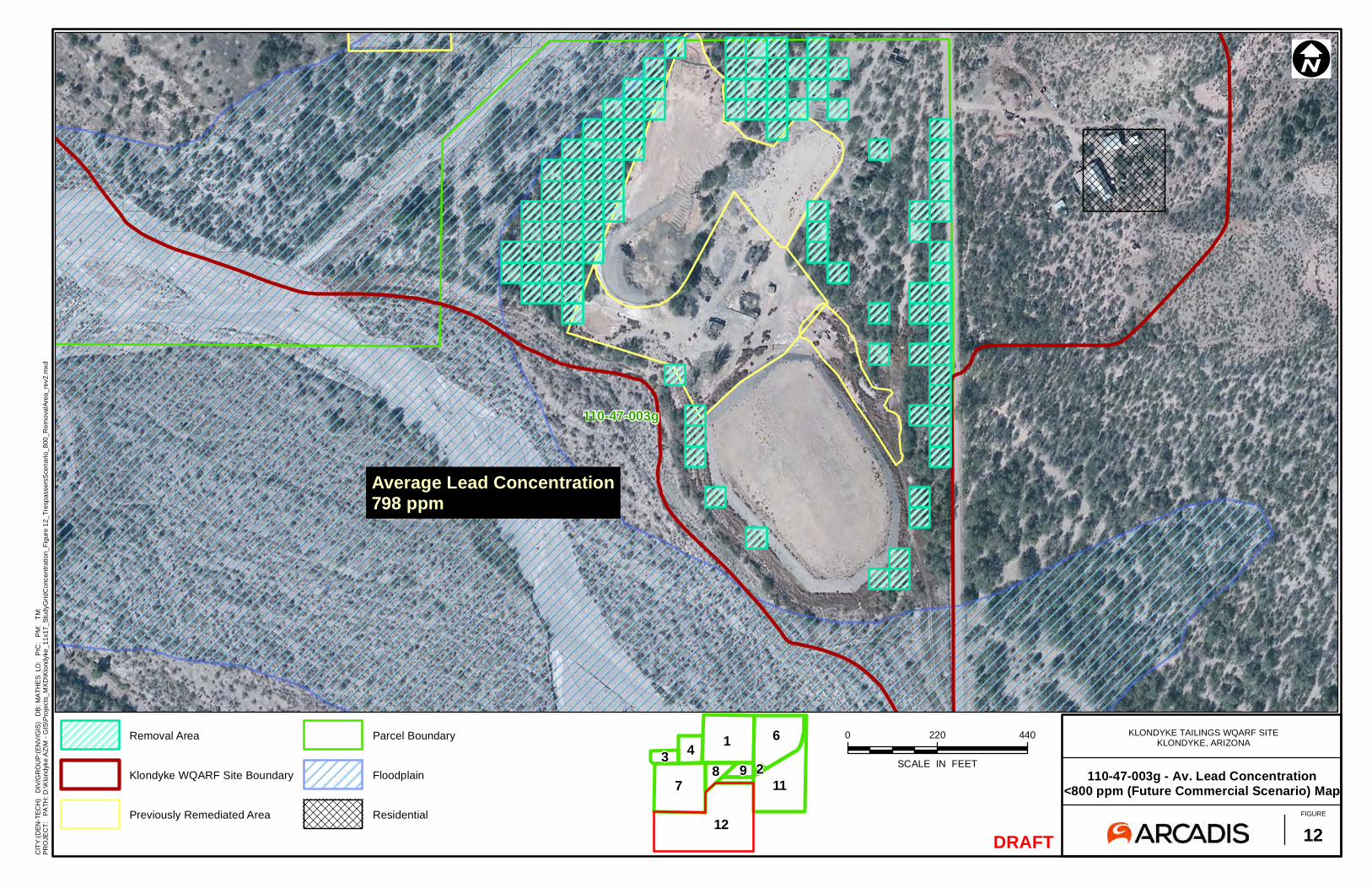
110-47-003g
DRAFT
0 220 440
SCALE IN FEET
ÄI
KLONDYKE TAILINGS WQARF SITEKLONDYKE, ARIZONA
110-47-003g - Av. Lead Concentration<800 ppm (Future Commercial Scenario) Map
FIGURE
12
CIT
Y:(D
EN-T
ECH
) D
IV/G
RO
UP
:(EN
V/G
IS)
DB
: MA
THE
S L
D:
PIC
: P
M:
TM
:
PRO
JEC
T:
PATH
: D:\K
lond
yke
AZ\
M -
GIS
\Pro
ject
s_M
XD
\Klo
ndyk
e_11
x17_
Stud
yGrid
Con
cent
ratio
n_Fi
gure
12_
Tres
pass
ersS
cena
rio_8
00_R
emov
alAr
ea_r
ev2.
mxd
12
431
987
211
6Removal Area
Klondyke WQARF Site Boundary
Previously Remediated Area
Parcel Boundary
Floodplain
Residential
Average Lead Concentration798 ppm
jim.clarke
Rectangle
Related Documents