Recent sediment accumulation in the Norwegian Channel, North Sea HENK DEHAAS, ELLEN OKKELS & TJE ERD C.E. VAN WEERING de Haas, H., Okkels, E. & van Weering, T.C.E. 1996: Recent sediment accumulation in the Norwegi an Channel, North Sea. Nor. geol. un ders. Bull. 430,57-65 . In the Norwegian Channel 35 box cores were taken for sedimento logical analysis, and 'lOPO (J.- and '37CSy-spect ros- copy to determine sedimentation rates. Grain sizes were determined and X-ray photog raphs of the cores were made. In addition, penetrating echo sounding lines covering a length of more than 5500 km were studied. Sediments enter the Norwegian Channel from th e south and th e west as suspended load. The dry bulk densities of these generally fine-grained sediments (silty clays - silts) range from 0.35 to 1.79 qxcrn' , Most of the cores show a surface mixed layer of less than 2 cm. The sedimentation rates measured in the Norweg ian Channel range from 30 to 280 mmx100 yr' , Highest sedimentati on rate s are foun d in th e north ern part of the research area.The total recent dry bulk sediment accumulation in the Norweg ian Channel is calculated to be 28x1O· tons'yr' . Penetrating echoso- under data reveal that sedimentation occurs in the deeper parts and in small protected basins along the flanks of the Norwegian Channel. The contrast between the present-day relatively high sedimentation rates and the thin Holocene sedimentary unit is explained by a change in th e depo sit ional system somet ime during th e Holocene. de Haas, H., Okkels, E. & van Weering, T.CE., Netherlands Institute for 5ea Research, P.O.Bax 59, 7790 AB Den Burg, The Netherlands. Introduction The Norwegian Channel is one of the largest and deepest recent sedimentary basins of the North Sea and forms a major sink for fine-g rained material in the North Sea (Eisma 1981, van Weering 1981, Eisma & Kalf 1987, van Weering et al. 1987, 1993). Sediment s enter the North Sea (Fig. 1) from the Atlantic Ocean in the north, through the English Channel, from the Baltic Sea and from river input. F urthermore, sea floor erosion, coastal erosion, prima ry production and atmospheric input contribute to the sedi- Fig. 1. The North Sea and the study area (outlined). 60 50 o o 10 10 20 20 60 50 ment load of the North Sea . The sediments in the North Sea are transported by an anticlockwise residual circulati- on (Otto et al. 1990). Recent sediment accumulation occurs mainly along the eastern margin of the North Sea (t he Wadden Sea, the German Bight, the Skagerrak, the Kattegat and the Norwegian Channel) (McCave 1973, Eisma 1981, Eisma &Kalf 1987). In recent years,application of 2 10Pb geoch ronology has been used to calculate sedimentation and /or accumulati- on rates of recent sediments in the depositional sinks of the North Sea (van Weering et al. 1987, 1993, Zuo et al. 1989, Jorgensen et al. 1990, Denneqard et al. 1992a). Other met hods have also been used, such as pollen studi - es (Zagwijn & Veenstra 1966, van Weering 1982, Henningmoen & Heeq 1985, Long et al. 1988), mass bud- get calculations of suspended sediments (E isma 1981), 14C (Long et al. 1988, Moodley & van Weering 1993), dinofla- gellates (Long et al. 1986), stable isotopes (Erlenkeuser 1985) and foraminifera (van Weering 1982, van Weering & Ovale 1983, Ovale & van Weering 1985). In this paper we report on sedimentation and sedi- ment accumu lation rates in the Norwegian Channel based on data collected dur ing a cruise with the R.V. 'Aurelia' in 1988 and two cruises with the R.V.' Pelagia' in 1991 and 1993 (ENAM93) to the Norwegian Channel, and on data from th e literature.This study hasaimed at deter- mining the total amount of sediment being deposited in the Norwegian Channel, and to explain the major sedi- mentary processes. Methods A total of 35 box cores were collected in the Norwegian Channel with the RV. 'Aurelia' (1988) and with the R.V. '

Welcome message from author
This document is posted to help you gain knowledge. Please leave a comment to let me know what you think about it! Share it to your friends and learn new things together.
Transcript
Recent sediment accumulation in the Norwegian Channel,North Sea
HENK DEHAAS, ELLEN OKKELS& TJEERD C.E. VAN WEERING
de Haas, H., Okkels, E. & van Weering, T.C.E. 1996: Recent sediment accumulat ion in the Norwegian Channel, NorthSea. Nor. geol. un ders. Bull. 430,57-65 .
In the Norwegian Channel 35 box cores were taken for sedimento logical analysis, and 'lOPO (J.- and '37CSy-spect roscopy to determine sedimentat ion rates. Grain sizes were determined and X-ray photog raphs of th e cores weremade. In addit ion, penetrat ing echo sounding lines covering a length of more th an 5500 km were studied.Sediments enter the Norwegian Channel from th e south and th e west as suspended load. The dry bulk densit ies ofthese generally fine-grained sediments (silty clays - silts) range from 0.35 to 1.79 qxcrn', Most of the cores show asurface mixed layer of less than 2 cm. The sedimentat ion rates measured in the Norweg ian Channel range from 30to 280 mmx100 yr' , Highest sedimentation ratesare foun d in the north ern part of the research area.The total recentdry bulk sediment accumulat ion in the Norweg ian Channel is calculated to be 28x1O· tons'yr' . Penetrating echosounder data reveal th at sedimentat ion occurs in the deeper parts and in small protected basins along the flanks ofth e Norwegian Channel. The contrast between th e present-day relat ively high sedimentat ion rates and the thinHolocene sedimentary unit is explained by a change in th e depo sit ional system somet ime during th e Holocene.
de Haas, H., Okkels, E.& van Weering, T.CE., Netherlands Insti tu te for 5ea Research, P.O.Bax 59, 7790 AB Den Burg, TheNetherlands.
Introduction
The Norwegian Channel is one of the largest and deepestrecent sedimentary basins of the North Sea and forms amajor sink for fine-g rained material in th e North Sea(Eisma 1981, van Weering 1981, Eisma & Kalf 1987, vanWeering et al. 1987, 1993). Sediments enter the North Sea(Fig. 1) from the Atlantic Ocean in the north, through theEnglish Channel, from the Baltic Sea and from river input.Furthermore, sea floor erosion, coastal erosion, prima ryproduct ion and atmospheric input contribute to the sedi-
Fig. 1. The North Sea and the study area (outlined).
6 0
5 0
o
o
10
10 20
20
6 0
5 0
ment load of the North Sea. The sediments in the NorthSea are transported by an anticlockwise residual circulation (Otto et al. 1990). Recent sediment accumulationoccurs mainly along the eastern margin of the North Sea(the Wadden Sea, the German Bight, the Skagerrak, theKattegat and the Norwegian Channel) (McCave 1973,Eisma 1981, Eisma &Kalf 1987).
In recent years, application of 210Pb geoch ronology hasbeen used to calculate sedimentat ion and/or accumulation rates of recent sediments in the depos itional sinks ofthe North Sea (van Weering et al. 1987, 1993, Zuo et al.1989, Jorgensen et al. 1990, Denneqard et al. 1992a).Other methods have also been used, such as pollen studi es (Zagwij n & Veenstra 1966, van Weering 1982,Henningm oen &Heeq 1985, Long et al. 1988), mass budget calculat ionsof suspended sediments (Eisma 1981), 14C(Long et al. 1988, Moodley &van Weering 1993), dinoflagellates (Long et al. 1986), stable isotopes (Erlenkeuser1985) and foraminifera (van Weering 1982, van Weering &Ovale 1983, Ovale & van Weering 1985).
In th is paper we report on sedimentation and sediment accumu lation rates in the Norwegian Channelbased on data collected dur ing a cruise with the R.V.'Aurelia' in 1988 and two cruises with the R.V. ' Pelagia' in1991 and 1993 (ENAM93) to the Norwegian Channel , andon data from th e literatu re.This study has aimed at determining the to tal amount of sediment being deposited inth e Norwegian Channel , and to explain the major sedimentary processes.
Methods
A total of 35 box cores were collected in the NorwegianChannel with the RV. 'Aurelia' (1988) and with the R.V. '

58 Henk de Haa s, El/en Okkels &Tjeerd c.E. van Weerin g GU-BULL 430. 1996
Fig. 2. Locations and sedime ntation rates for the station s where sedimentation rates have been determ ined.
Pelagia' (1991 and 1993). Immediately after retrieval ofthe cores the overlying bottom water was siphoned offand subsamples were made by insert ing wet PVC liners(0 : 9 cm) into the box cores. The liners were closed withplastic caps and sealed with tape . After sampling, theliners were stored upright at 4° C. Sedimentation rateswere determined using a- and y-spectromet ry. 21°Pb wasmeasured via its a-part icles emitting granddaughter21OPO, which is assumed to be in equilibrium with 21°Pb.The sedimentat ion rates were calculated according to the(IC (Constant Init ial Concentration) method. The methodused is described in more deta il by van Weering et al.(1987). 137CS activity was measured using Aptec andCanberra germanium y-ray detectors on 1 cm-thick sediment slices with 35-65 g dry weight, depending on theporosity of the sediment. 21°Pb and 137CS analyses wereperfo rmed on the selected cores at 1 cm depth intervals.The counting time for the a- and y- measurements was 24hours and 1 to 2 weeks, respectively.
X-radiographs of the split cores were made using aHewlett-Packard 43805N X-ray system Faxitron. The radi-
ographs were used to check the cores for bioturbationand other possible disturba nces. Sedimentation rateswere determined only fro m cores not disturbed by bioturbation or by sampling and/o r storage . Twenty-fivecores were considered suitable for sedimentation ratedetermination (Fig. 2). Grain-size analyses were performed at the University of Utrecht using a Malvern Part icleSizer model 26000 capab le of measuring grain sizes w ithin a range of 0.5-188 mm. Ory bu lk densities were determined by tak ing subsamples of 5 cm' of wet sedim entwhich were dr ied at 60-700( for 72 hour s and aft erwardsweighed on a Mettl er P1200N balance. Sedimentat ionrates and dry bulk densities were corrected fo r compa ct ion during subsampling and storage of the samples. Thiswas done by measuring the compaction of the sedimentsin the liners and assuming a linear compaction over th ewhole sediment column. Accumulation rates were calculated using sedimentation rates and dry bu lk densit ies.3.5 kHz penetrating echosounder lines recorded in 1973,1974, 1975, 1976 and 1993, and data from the literaturewere used to determine where in the Norweg ian Channelrecent sedimentation and erosion/ non-depositionoccurs.
Geolog ical setting, hydrography andsediment transport
The present morphology of the Norweg ian Channel is theproduct of glacial erosion followed by sedimentat ionduring the Pleistocene and Holocene (van Weering 1975,Otto et al. 1990, Pedersen et al. 1991, Holteda hl 1993,Pederstad et al. 1993). At - 59°30'N the NorwegianChannel shallows to 280 m at a saddle po int. Furthersouth, the Norwegian Channel deepens to more than 700m in the Skagerrak (Otto et al. 1990).
An overv iew of the dominant circulation pattern in thenorthern North Sea is given by Otto et al. (1990). At lant icwater enters the North Sea mainly along th e western slope of the Norwegian Channel and through the OrkneyShetland inflow . This water mass enters the Skagerrakalong the southern slope as the Atlantic Shelf EdgeCurrent. Water com ing from the south ern North Seaenters the Skagerrak along the southern slope and part lyflows into the Kattegat. The remain der mixes w ith watercoming from the Baltic Sea, and the Atla nt ic Shelf EdgeCurrent. This water mass leaves the Skagerrak as the lesssaline Norwegian Coastal Current, which flows to theno rth throu gh the Norwegian Channe l and finally intothe Norwegian Sea. Seasona l variations in this patte rn arethe result of differences in water temperatu re and windst ress (Otto et al. 1990). The fract ion of th e sedimentswhich does not settle in the Skagerrak is transported outof the Skagerrak into the Norwegian Channel by th eNorwegian Coastal Current as suspended load. Some ofth is material sett les in the Norwegian Channel and theremainder is t ransported into the Norwegian Sea (Eisma1981, van Weering 1982).
6
3•1P6 14 13o DD11 10 7
r:?'station number5o
938~edimentat io n rate (cm·100 yr 1)
North Sea
o 2 4
t:. NG88• Sk91
o ENAM
58+----- ------.
60
62
NGU-BULL 430. 1996 Aivo Lepland & Rodney L.Stevens 59
ENAM 18Percentage25 50 751 0
ENAM 10Perce ntage25 50 751
ENAM 8Perce ntag e25 50 75 100
s:Q..,o
ENAM 9Percen tage25 50 75 1 0
ENAM 14Percentage25 50 75 100
4 · 6411m
ENAM 15Percentage25 SO 75 100
125 - 188 11m
f77721..' ..••.. •rLL&1
0.5 - 411m
..64 - 125 11m
4ENAM 16
Percentage25 SO 75 100
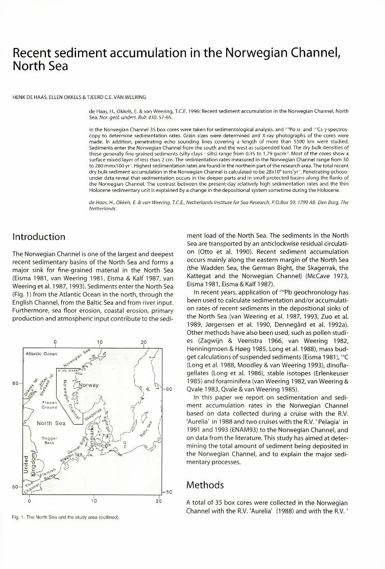
Fig. 3. Results of the gra in -size ana lyses ofthe ENAM cores. Posit ion of the graph s rela tive to the geograph ical location of thecores.
Results
Sediments
cores showed worm tubes at the sediment surface. Thebrownish colours of most of the top sediments of thecores indicate a well oxygenated environment.
Description Grain -size analysis and dry bulk density
The sediments in the Norwegian Channel consist mainlyof brownish, greenish and greyish silty clays. Some coresshow a few cm th ick sandy intervals (e.g. Sk91-4), whil eothers are sandy th roughout the core (e.g. Sk91-6). CoreSk91-2, taken high upon the western slope of theNorweg ian Channe l, consists of med ium to coarse sand.Sometimes gravel is found (core NG88-6). Shells, shellfragments and echinoid spines are common.Macroscop ically the cores are homogeneous and lackalmost completely pr imary sedimentary structures. Xradiographs of th e coresalso show very few primary sedimentary st ructures. Coarse-grained intervals, quartz andclay pebbles, and dark and light intervals caused by differences in mineralogy can be recognised on th e x-radiographs. Macroscopic burrows can be recogni sed in mo stof the cores and on the X-ray images. The burrows havediameters rang ing from 0.5 mm to more th an 10 mm. Inmany cases on ly a few narrow (0 =0.5 mm ) or wi der (0± 10 mm ) burrows are present, leaving the few primarysedimentary structures and the light and dark intervalsintact, i.e., the sediments are more or less und isturbed. Inother cores the primary structures and colour bandingare clearly disturbed, indicat ing strong bioturbation(cores ENAM93-8, Sk91-13 and Sk91-14). Several box
The grain sizes have only been determined on theENAM93 samples (Fig. 3). Most of these cores consist ofclayey silts, the percentage of clay being usually less than25%. In most of the cores the amount of very fine to finesand is 5% or less. Cores ENAM93-10, 13 and 16 are relat ively coarse, and the amount of sandy material sometimesexceeds 40% (top of ENAM93-10). The finest-grainedsediments are found in the central part of the NorwegianChannel. The grain-size distribution of the surface sediments is in agreement with the data provided by Qvale &van Weering (1985).
Dry bulk densiti es vary from 0.35 to 1.79 qxcrrr depen ding on the depth in the core and the grain-size distribu t ion.
210Pb and 137Cs measurements andsedimentation rates
The locations of the individual stations and the sedimen tation rates measured are given in Table 1. CoresENAM93-8, ENAM93-15, NG88-6, NG88-7, NG88-10,NG88-15, Sk91 -13 and Sk91 -14 were not used for interpretations, because they are strongly bioturbated. Core
60 Aivo Lepland &Rodney L.Stevens GU-BULL <:30, 1996
ENAM 9 ENAM 132,oPb excess activity (Bq 'kg" ) 210Pb excess activity (Bq 'kg01
) ENAM 9 ENAM 1310" 10° 10' 10
210
310
0110° ld 10
2 ld Ac tiv ity (Bq/k g) Ac t iv it y (Bq /k g)SML SML
00 10 0 10
j -""'"' 0
y""SML
_ 196 3
2 2 - , 963
E EE EE.. E.. 4 4
~ 2~ ~
.c s:'" li li0 6 6 IQ) ID
0 0I3 •
8 8I
4 • 10 10
ENAM 142 10Pb exce ss act ivity (Bq 'kg O
' )
10"' 10° 10' 102
103
SML
ENAM 1621 0pb excess activity (Bq 'kg O
' )
1001
100
10' 102
103
SML
EE..
"% 2 •Q)
0
3
4
ENAM 14 ENAM 16Activity (Bq /k g) Act iv ity (Bq/kg)
0 10 0 100 SML 0X..ee
>-'~'SML
2 2- 1963
E 4 E 4~ - ~x: s:li 6 I li 6 IQ) Q) - , 96 30 I 0
I8 I 8
I IJ
10 10
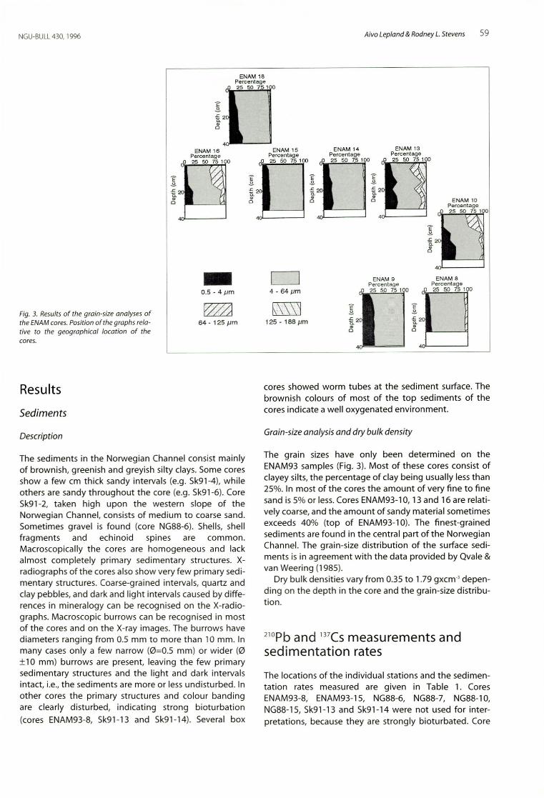
~Fig. 4. Selected results of the lIOPb measureme nts. Grey in terval indicatesthickness of the surface mixed layer (SML). See text for more details.
Sk91-2 was on ly 5 cm long and therefore to o short to beof any use. Core Sk91-4 showed a compa ct ion of 53%during sampling and storage, and is therefo re possiblytoo disturbed to allow a reliable deter mination of thesedimentation rate. Fig. 4 shows some of the results ofthe 2lOPb measurements. In general , th e logarit hmicexcess 210Pb activity plotted versus core depth shows astraight line below the surface mixed layer (SML). Usuallythe SML is very th in. In most cores th e thickness does notexceed 2 cm (Fig. 4). In some cores, howeve r, (ENAM93-8and 15) the SML reaches a th ickness of 15 cm or more.Some of the 2,oPb plots show anomalously high or low2,oPb values deepe r in the core (ENAM93-13, Fig. 4). Theseare thought to be the result of local burrow ing below theSML, whi ch resulted in the transport and subseque ntmixing of older or younger sediment. This explanation issupported by the X-radiogra phs whi ch show some majorburrows at the depths conce rned, and by grain-size analyses showing a variance in grain size at these specificdepths.
Fig. 5 shows 137Cs-act ivity profi les of some of th eENAM93 cores. The 1963 nuclear bomb testing and th e1986 Chemobyl P'Cs-act ivity peaks in core ENAM93-9 fall
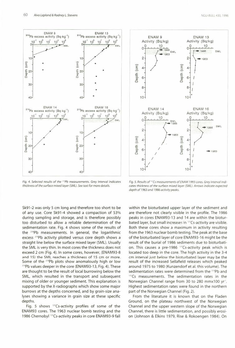
Fig. 5. Resul tsof "'Cs m easurements of ENAM 1993 cores. Grey interval indicat es th ickn ess of th e surface mixed layer (SML). Arrows indica te expecteddepth of 1963 and 1986 activity peaks.
wi thin the bioturbated upper layer of the sediment andare therefore not clearly visible in the pro fi le. The 1986peaks in cores ENAM93-13 and 14 are wi thin the bioturbated layer, but small increases in 137Cs-act ivity are visible.Both th ese cores show a maximum in activity result ingfrom the 1963 nuclear bomb testing.The peak at the baseof the bioturbated layer of core ENAM93-16 might be theresult of the buria l of 1986 sediments du e to bioturbat ion. This causes a pre-1986 137Cs-act ivity peak whi ch islocated too deep in the core. The high act ivity in the 3-4cm interval just below the bioturbated layer may be theresult of the increased Sellafield releases which peakedaround 1975 to 1980 (Kunzendorf et al. t his volume). Thesedimentat ion rates were determined from the 2'OPb and137Cs measurement s. The sedimentation rates in theNorweg ian Channe l range from 30 to 280 mm xlOO yr' .Highe st sedimentation rates were found in the northernpart of t he Norwe gian Channel (Fig. 2).
From the literature it is know n that on the FladenGround, on th e plateau northwest of the Norweg ianChannel and th e upper western slope of the Norweg ianChannel, there is litt le sedimentation, and possib ly erosion (Johnson & Elkins 1979, Rise & Rokoengen 1984). On
NGU-BULL 430, 1996 Aivo Lepland &Rodney L.Stevens 61
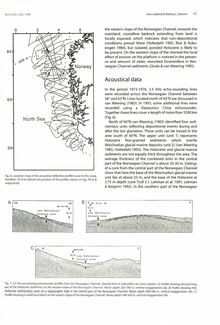
Fig, 6. Location map of the acoustica l reflection profiles used in thi s study.Numbers 7A to 8 indicote the position of the profiles show n in Figs 7A to 8,respectively.
o
62
60
58
2 4 6 the eastern slope of the Norwegian Channel , towards themainland, crystalline bedrock extending from land islocally exposed, which indicates that non-depositionalcondit ions preva il there (Holtedahl 1993, Rise & Rokoengen 1984), but isolated, ponded Holocene is likely tobe present. On the western slope of the channel t he localeffect of erosion on the platform is not iced in the presence and amount of older, reworked foraminifera in Norwegian Channel sediments (Qvale & van Weering 1985).
Acoustical data
In the period 1973-1976, 3.5 kHz echo-sounding lineswere recorded across the Norwegian Channel between58° and 63°N. Lines located north of 600N are discussed invan Weering (1983). In 1993, some add itiona l lines wererecorded using a Datasonics Chirp echosoun der.Together these lines cover a length of more than 5500 km(Fig. 6).
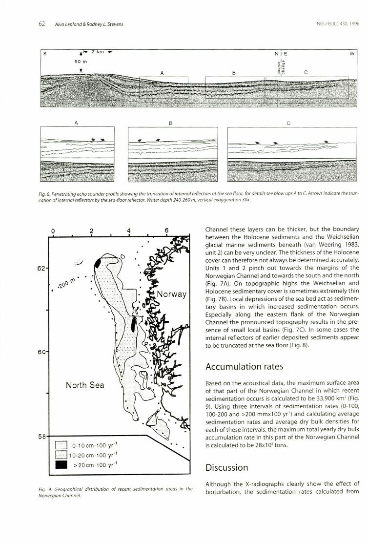
North of 600N van Weering (1983) identified four sedimentary units reflecting depositional events during andafter the last glaciation. These units can be traced in thearea south of 600N. The upper unit (unit 1) representsHolocene fine-grained sediments wh ich overlieWeichselian glacial mar ine depos its (unit 2) (van Weering1983, Holtedahl 1993). The Holocene and glacial marinesediments are not equally thick throughout the area. Theaverage thi ckness of the combined uni ts in the centra lpart of t he Norwegian Channel is abo ut 10-20 m. Datingsof a core from the central part of the Norwegian Channelshow that here the base of the Weichselian glacial marineunit lies at about 23 m, and the base of the Holocene at3.75 m depth (core Troll 3.1 , Lehman et al. 1991, Lehman& Keigwin 1992). In the southern part of the Norwegian
A sw NE B s"I" 5 km 004 N
,.' k m 004"I 50m
.!50 m L ate Weich sel ianl
.! Holoc e ne co ver
c
Fig. 7. 3.5 kHz penetrating echosounder profi les from the Norwegian Channel. Dashed lines in subsurface are tim e markers. A) Profile showing th e pinchingout of the Holocene sediments on the western slope of the Norwegian Channel. Water depth 320-390 m, vertical exaggeration 20x. B) Profile showing thin
Holocene sedimentary cover ona topographic high in the centra l part of the Norwegian Channel. Water depth 400-440 m, vertical exaggeration SOx. C)Profile showing a smallloeal basin on the eastern slope of the Norwegian Chann el. Water depth 340-420 m, vert ical exaggeration 20x.
62 Aivo Lepland &Rodney L.Stevens NGU-BULL430, 1996
s .." 2 m .. N I E W
50 m .,1<>
~I[B 0-<= C" I"
A B c
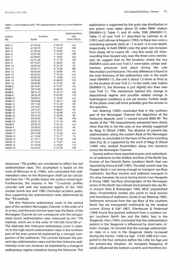
Fig. 8. Penetrating echo sounder profi le showing the truncat ion of int ernal reflectors a t the sea floor , for details see blow ups A to C. Arro ws indicate the trun cat ion of internal reflectors by the sea-floor reflector. Water depth 240-260 m, vertical exaggeration 30x.
Accumulat ion rates
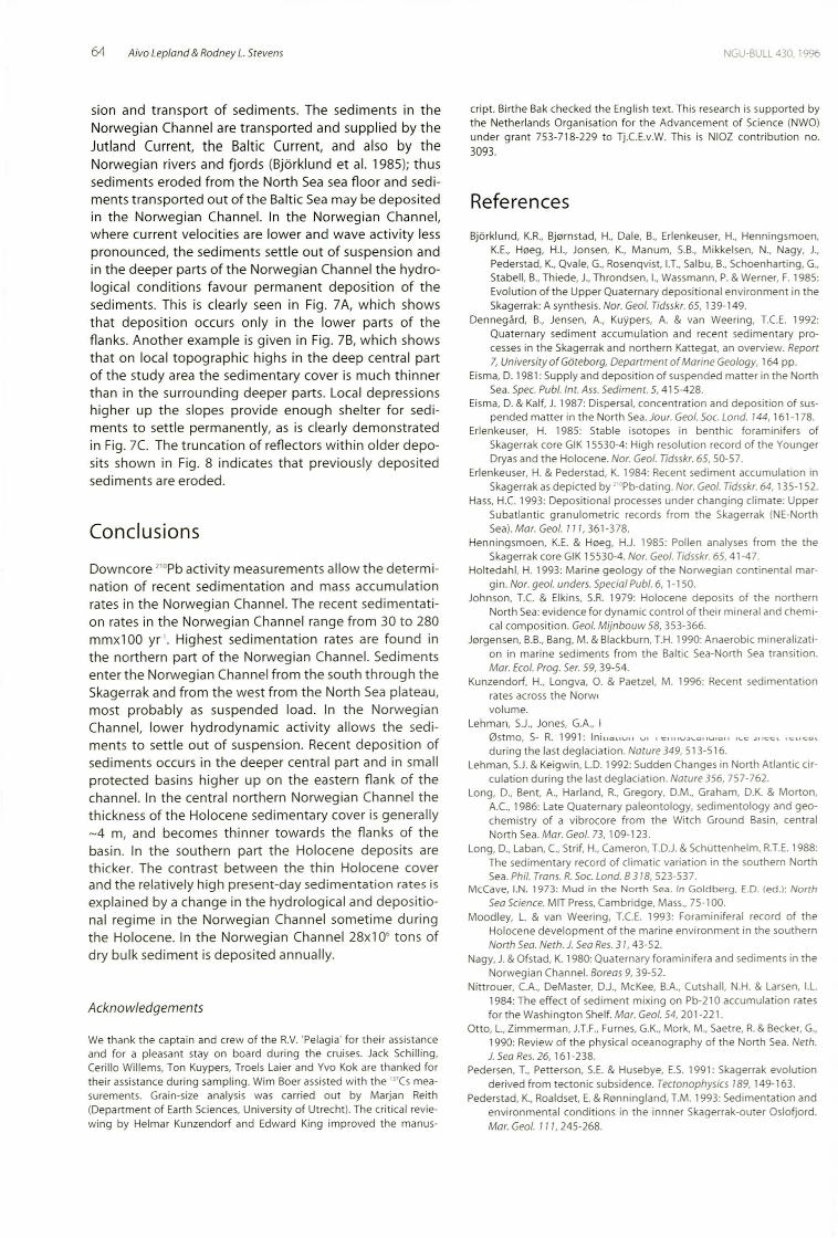
Based on the acoustica l data, the maximum surface areaof th at part of the Norwegian Channel in wh ich recentsedimentation occurs is calculated to be 33,900 km' (Fig.9). Using three intervals of sedimentati on rates (0-100,100-200 and >200 mm x100 yr') and calculat ing averagesedimentation rates and average dry bu lk densitie s fo reach of these intervals, t he maximum tota l yearly dry bu lkaccumulat ion rate in this part of the Norweg ian Channe lis calculated to be 28x106 tons .
Discussion
Channel these layers can be thicker, but th e boundarybetween the Holocene sediments and th e Weichselianglacial marine sediments beneath (van Weering 1983,un it 2) can be very unclear. The thickness of the Holocenecover can therefore not always be determined accurately.Units 1 and 2 pinch out towards the margins of theNorweg ian Channel and to wards the south and the nort h(Fig. 7A). On topographic highs the Weichselian andHolocene sedimentary cover is sometimes extre mely th in(Fig. 7B). Local depressions of the sea bed act as sedim entary basins in which increased sedimentation occurs.Especially along the eastern flank of the NorwegianChannel the pro nou nced topography results in th e presence of small local basins (Fig. 7C). In som e cases theinternal reflectors of earlier deposited sediments appearto be truncated at the sea floor (Fig. 8).
642
',.:.-1
North Sea
o 0-10cm '100 y(l
D 10-20 cm .100 y(l
• >20cm .100 y ( l
o
584---- - - - - - - -
62
60
Fig. 9. Geographical distribution of recent sedimentation areas in theNorwegian Channel.
Alt hough the X-radiographs clearly show th e effect ofbioturbation, th e sedimentation rates calculated from
NGU-BULL430, 1996
Tab le 1. List of stations an d "'Pb sed imentat ion rates (n.d.=not determi-ned).
Sedime ntatio nSta t ion Posit ion rateNo. North East (mm/1 00 yr)
Sk91-2 61"20.45' 2°00.70' n.d.Sk91-3 61"30.79' 2° 33.42' 190Sk91-4 61"39.20' 3°24.90' n.d.Sk91-6 62007.00' 1° 19.78' 190Sk91-7 62"09.83' 2° 18.83' 220Sk91-8 62 ' 12.28' 3° 17.75' 120Sk91-9 62 '12 .81' 3°38.05' 60Sk91-10 60°43.50' 4° 29.70' 30Sk91-11 60°42.7 1' 4° 10.28' 280Sk91-12 60°43.49' 3° 20.89' 60Sk91-13 60°42.62' 3° 10.24' n.d .Sk91-14 60°43.30' 3° 13.08' n.d .Sk91-15 59°30.60' 4°46.50 ' 120Sk91-16 59"29.99' 4° 27.30' 90NG88-6 58°10.47' 4° 37.61' n.d.NG88-7 58°12.43' 4°40.25' n.d.NG88-8 58°15.73' 4° 52.12' 100NG88-9 58"24.18' 5°07.83' 110NG88-10 58"28.61' 5° 18.92' n.d.NG88-11 58"36.68' 5° 24.71' 120NG88-12 59'11.92' 4° 51.39 ' 40NG88-13 59°13.81' 4°26.94' 60NG88-14 59°15.47' 4°08.85' 40NG88-15 59°12.70' 3°42.88' n.d .NG88-16 59°13.07' 3° 30.46' 90NG88-17 59°59.45' 3° 17.80' 140NG88-19 60001.72' 3°55.14' 160ENAM 8 59"30.10' 3° 41.25 ' n.d.ENAM 9 59"30.03' 4° 05.29' 40ENAM 10 60"20.60' 4° 39.32 ' 60ENAM 11 60°19.98' 3°22.06' n.d.ENAM 13 61°19.94' 3° 52.17' 70ENAM 14 6 1°19.77' 3° 35.58 ' 100ENAM 15 61°19.25' 3° 15.87' n.d.ENAM 16 61°19.96' 2°3 4.64' 110ENAM 18 62003.69' 2° 55.58' 190
downcore 21°Pb profiles are considered to reflect the realsedimentation rates. This assumption is based on thework of Nittrouer et al. (1984), who concluded that sedimentation rates on the Washington shelf can be calculated from the 21°Pb profile below the surface mixed layer.Furthermore, the maxima in the 137Cs-act ivity profilescoincide well with the expected depths of the 1963nuclear bomb test and 1986 Chernobyl accident peaks,thus supporting the sedimentation rates determined bythe 21°Pb method.
The thin Holocene sedimentary cover in the centralpart of the northern Norwegian Channel, in the order of 4m or less,and the even thinner layer near the flank sof theNorweg ian Channel do not correspond with the ext rapolated recent sedimentati on rates measured by the 21°Pbmethod, which are in the order of 100-200 mmxl00 yr '.The relativ ely th in Holocene sedimentary cover in relation to the high recent sedimentat ion rates in the northernpart of the area cannot be explained by a stronger compaction of the sediments. The contrast between the present-day sedimentation rates and the thin Holocene sedimentary cover can, however, be explained by a change insedimentary regime sometime during the Holocene. This
Aivo Lepland & Rodney L.Stevens 63
explanation is supported by the grain-size distr ibution intwo piston cores taken about 30 miles NNW (stationENAM93-15, Table 1) and 45 miles SSW (ENAM93-11,Table 1) of core Troll 3.1 described by Lehman et al.(1991) and Lehman & Keigwin (1992). In these two cores acoarsening upwards starts at -1 m and -2 m core depth,respectively. In both ENAM cores the grain size increasesfrom clayey silt to coarse silt - very fine sandy silt , Echosound ing lines located very near the three cores mentioned, do suggest that on the locati ons where the twoENAM93 cores and core Troll 3.1 were taken , similar sedimentary processes took place during the LateWeichselian and Holocene.The only difference is found inthe total thickness of the sedimentary unit. In the south(near ENAM93-11), the unit is about 1.5 times as thick ason the location of core Troll 3.1. In the north, near stationENAM93-15, the thickness is just slightly less than nearcore Troll 3.1. The mechanism behind th is change indepositional regime and possible related change inhydrological conditions is not yet known. Further studyof the piston cores will most probably give the answer toth is question.
Van Weering (1983) concluded that in the northernpart of the Norwegian Channel the deposition of theHolocene deposits (unit 1) ceased around 8000 BP. Theresults of the 210Pb measurements presented here clearlyshow that this is not the case, as was already suggestedby Nagy & Ofstad (1980). The absence of present-daysedimentation along the eastern flank of the NorwegianChannel, as concluded on the basis of the echo-soundingdata (Fig. 8), is supported by the work of Nagy & Ofstad(1 980) who stud ied foram inifera along two transectsacross the Norwegian Channel.
Several authors have reported erosion and redistribution of sediments on the shallow sea floor of the North Sea.Erosion of the Flemish Banks (southern North Sea) wasreported by Eisma&Kalf (1987).The tidal current near theDogger Bank is not strong enough to transport sea-floorsediments. Sea-floor erosion and sediment transport inthis area, however, do occur during storms (von Haugwitz& Wong 1988), Sea-floor photographs of the Norwegiansector of the North Sea indicate local present-day sea-flo or erosion (Rise & Rokoengen 1984, NIOZ unpublisheddata). Foramin iferal studies also point to local erosionand reworking of sediments (Qvale & van Weering 1985).Sediments removed from the sea floor of the southernNorth Sea are transported northwards by the residualcurrent (Eisma & Kalf 1987). Erlenkeuser & Pederstad(1984) found fine -grained sediment from a southern origin (southern North Sea and the Baltic Sea) in theSkagerrak. Hass(1993) concluded that the sedimentationpattern in th e Skagerrak is influenced by short-term climatic change s. He showed that the average sedimentation rates in a core in the Skagerrak clearly increasedduring the stormy ' Little Ice Age' (1550-1890 AD.) compared to the four centuries before the Little Ice Age andthe present-day situation. An increased frequency ofwinds influenced the bottom currents and therefore ero-
64 Aivo Lepland & Rodney L. Stevens GU-BULL430. 1996
sion and t ransport of sediments. The sediment s in theNorwegian Channel are tran sported and supplied by th eJutland Current, the Baltic Current , and also by theNorwegian rivers and fjord s (Bj6rklund et al. 1985); th ussediments eroded from the North Sea sea floor and sediments t ransported out of the Balti c Sea may be depositedin the Norwegian Channel. In the Norwegian Channel,w here current veloc iti es are lower and wave acti vity lesspronounced, the sediments settle out of suspension andin the deeper parts of the Norwegian Channel the hydrological condit ions favour permanent deposit ion of thesedimen ts. This is clearly seen in Fig. 7A, whi ch showsthat depo sit ion occur s on ly in the lower parts of theflanks. Another examp le is given in Fig. 7B, which showsthat on local topographic highs in the deep central partof the study area the sedimen tary cover is much th innerthan in th e surround ing deeper parts. Local dep ressionshigher up the slopes provide enough shelte r for sediment s to settle permanent ly, as is clearly demonstratedin Fig. 7C The trunca t ion of reflectors within older deposits shown in Fig. 8 indicates th at previously depositedsediment s are eroded.
Conclusions
Downcore 210Pb activity measurements allow the determination of recent sedimentati on and mass accumulat ionrates in th e Norw egian Channel. The recent sedimentat ion rates in the Norwegian Channel range from 30 to 280mm x100 yr' . Highest sedimentat ion rates are found inthe northern part of th e Norw egian Channel. Sedimentsente r th e Norwegian Channel fro m the south through theSkagerrak and from the west from the North Sea plateau,most probably as suspended load. In th e NorwegianChannel, lower hydrodynam ic act ivity allows the sediment s to settle out of suspension. Recent deposit ion ofsediments occurs in the deeper central part and in smallprotected basins higher up on th e eastern flank of thechannel. In the centra l northern Norweg ian Channel thethickness of the Holoce ne sedim entary cover is generally- 4 m, and become s th inner to wards th e flan ks of thebasin. In the southern part th e Holocene deposits arethicker. The contrast between th e thin Holocene coverand the relatively high present -day sedimentation rates isexplained by a change in the hydr olog ical and depositi onal regim e in th e Norwegian Channel somet ime duringthe Holocene. In the Norwegian Channel 28x10· tons ofdry bulk sediment is deposited annually.
Acknowledgements
We thank the captai n and crew of the RV. 'Pelag ia' for th eir assistanceand for a pleasant stay on board du ring the cruises. Jack Schill ing ,Cerillo Willems, Ton Kuypers, Troels Laier and Yvo Kok are thanked forth eir assistance duri ng sampling. Wim Boer assisted wi th the '''Cs measurements. Grain-size analysis was carried ou t by Marjan Reith(Department of Earth Scien ces, University of Ut recht ). The crit ical reviewi ng by Helm ar Kunzendorf and Edward King improved the manu s-
cript. Birthe Bak checked th e English text . This research is supported bythe Netherlands Organ isation for the Adva ncement of Science (NWO)under gran t 753-718-229 to Tj .e.E.v.w. This is NIOZ contribu t ion no.3093.
References
Bj iirklund, K.R., Bjcrn stad, H., Dale, B., Erlenkeuser, H., Henning smoen,K.E., Hoeg, H.I., Jonsen, K., Manum, S.B., Mi kkelsen, N., Nagy, J.,Pede rstad, K., Ovale , G., Rosenqvist, I.T., Salbu , B., Schoenha rting, G.,Stabell, B., Thiede, J., Thro nd sen, I., Wassmann, P. & Werner, F. 1985:Evolu t ion of the Upper Quaterna ry depositional envi ronment in theSkagerrak: A synthe sis. Nor. Geol. Tidsskr. 65, 139·149.
Denneqard, B., Jensen, A., Kuypers, A. & van Weering, T.e.E. 1992:Quaternary sediment accumulat ion and recent sedimentary processes in the Skagerrak and northern Kattega t, an overview. Report7, University ofGoteborq. Depar tment of Marine Geology, 164 pp .
Eisma, D. 1981: Supp ly and dep osit ion of suspend ed matter in the NorthSea. Spec. Publ. Int. Ass. Sediment. S, 415-428.
Eisma, D. & Kalf, J. 1987: Dispersal, conc entration and deposi tion of suspended matter in the North Sea.Jour. Geol. Soc. Lond. 144, 161-178.
Erlenkeu ser, H. 1985: Stable isot op es in benthic fo ramini fers ofSkagerrak core GIK 15530-4: High resolut ion record of the YoungerDryas and the Holocene. Nor. Geol. Tidsskr. 65, 50-57.
Erlen keuser, H. & Pederstad, K. 1984: Recent sedi ment accumulation inSkagerrak as dep icted by "'Pb-dat ing. Nor. Geol. Tidsskr. 64, 135-152.
Hass, H.e. 1993: Deposit ional processes under changing climate: UpperSubatlant ic granulom etr ic records from the Skagerrak (NE·NorthSea). Mar. Geol. 111,361-378.
Henningsmoen, K.E. & Hoeg, H.J. 1985: Pollen analyses from the theSkagerrak core GIK 15530-4. Nor.Geol. Tidsskr. 65, 41-47.
Holte dahl, H. 1993: Marine geology of the Norweg ian conti nental margin. Nor. geol. unders. Speciol Publ. 6, 1-150.
John son, T.e. & Elkins, S.R. 1979: Holocene deposits of the northernNorth Sea: evidence for dynam ic control of their mineral and chemical composit ion . Geol. Mijnbouw 58,353-366.
Jorgensen, B.B., Bang, M. & Blackburn , T.H. 1990: Anaerobic mineral ization in marine sediments from the Baltic Sea-North Sea tra nsit ion .Mar. Ecol. Prog.Ser. 59, 39-54.
Kunzendorf, H., Longva , O. & Paetzel, M. 1996: Recent sedimentati onrates across the Norw.vol um e.
Lehman , S.J., Jone s, G.A., I0stmo, S· R. 1991: InillOllVI I VI I C IIIIU .>\..UIIUIQ. I , ....c -,I I C Cl l~ l lCO l
du ring the last deglaciatio n. Nature 349, 513-516.Lehman, SJ. & Keigwin, L.D. 1992: Sudden Changes in North At lantic cir
culation du ring the last deglac iat ion. Nature 356, 7S7·762.Long, D., Bent , A., Harland, R., Gregory, D.M., Graham , DK & Morton,
A.e., 1986: Late Quaternary paleontology, sed imentol ogy and geochemistry of a vibrocore from the Witch Ground Basin, centralNorth Sea. Mar. Geol. 73, 109-123.
Long , D., Laban, C, Strif, H., Cameron , TD .J.& Schuttenhelrn, R.T.E. 1988:The sedimentary record of climatic variatio n in the southern NorthSea. Phil. Trans.R. Soc. Lond. 8318, 523-537.
McCave, I.N. 1973: Mud in the North Sea. In Goldberg. E.D. (ed.): North
SeaScience. MIT Press, Cambr idge , Mass., 75-100.Moodley, L. & van Weering , T.e.E. 1993: Foram in ifera l record of the
Holocene development of th e marine envi ronment in the southernNorth Sea. Neth.J. SeaRes. 3 I, 43-52.
Nagy, J. & Ofstad , K. 1980: Quaterna ry forami nifera and sedi ments in theNorw egian Channel. Boreas 9, 39-52.
Nit trouer, e.A., DeMaster, DJ ., McKee, BA, Cutshall, N.H. & Larsen, I.L.1984: The effect of sediment mixing on Pb·21O accumulation ratesfor the Washing to n Shelf. Mar. Geol. 54, 201-221 .
Otto , L., Zimmerman, J.T.F., Furnes, G.K., Mo rk, M., Saetre, R. & Becker, G.,1990: Review of the physical oceanog raphy of the North Sea. Neth.J. SeaRes. 26, 161-238.
Pedersen, T., Pett erson, S.E. & Husebye, E.S. 1991: Skagerrak evolu tionderived from tect onic subside nce. Tecronophysics 189, 149-163.
Peder stad, K., Roaldset, E. & Ronningland, T.M. 1993: Sedimentation andenvironm ental condi tions in the innner Skagerrak-ou ter Oslofjord.Mar.Geol. 111,245-268.

NGU-BULL 430, 1996 Aivo Lepland & Rodney L. Stevens 65
Qvale , G. & van Weering, T.CE. 1985: Relationship of surface sedimentsand benthic formaniniferal distribution patterns in the NorwegianChannel (northern North Sea).Mar. Micropal. 9, 469-488.
Rise, L. & Rokoengen, K. 1984: Surficial sediments in the Norwegian sector of the North Sea between 60°30' and 62° N. Mar. Geol. 58, 287317.
Van Weering, T.CE. 1975: Late Quaternary history of the Skagerrak; aninterpretation of acoustical profiles. Geol. Mijnbouw 54, 130-145.
Van Weering, T.CE. 1981: Recent sediments and sediment transport inthe northern North Sea; surface sediments of the Skagerrak. Spec.Publ.lnt. Ass. Sediment. 5, 335- 359.
Van Weering, T.CE. 1982: Recent sed iment s and sediment transport inthe North Sea; pistoncores from the Skagerrak. Proceedings Kon.Ned. Ac. Wetensch. 885, 155-201.
Van Weering , T.CE. 1983: Acoustical reflection profiles, sediments andlate Quaternary history of the Norwegian Channel north of Bergen.Geol. Mijnbouw62, 219-328 .
Van Weering, T.CE., Berger, G.W. & Kalf, J. 1987: Recent sediment accu-
mulation in the Skagerrak, northeastern North Sea. Neth . J. Sea Res.
27,177-189.Van Weering, T.CE., Berger, GW. & Okkels , E. 1993: Sediment transport,
resuspension and accumulation rates in the northeasternSkagerrak. Mar. Geol. 111,269-285.
Van Weering, T.CE. & Qvale , G. 1983: Recent sed iments and foraminiferal di stribution in the Skagerrak, northeastern North Sea. Mar. Geol.52,75-99.
Veenstra, H.J. 1965: Geology of the Doggersbank Area, North Sea. Mar.Geol. 3, 245- 262.
Von Haugwitz, W. & Wong, H.K. 1988: The Dogger Bank: Seismic stratigraphy and Holocene sed imentat ion. Mitt. Geoi.Palaont. Inst. Univ .Hamburg 65,381-407.
Zagwijn, W.H. & Veenstra, H.J. 1966: A pollen-analytical study of coresfrom Outer Silver Pit, North Sea.Mar. Geol. 4, 539-551.
Zuo, Z., Eisma, D. & Berger, GW. 1989: Recent sediment deposition rate sin the Oyster Ground, North Sea.Neth. J. Sea Res. 23, 263-269.
Manuscript received Apri/1 995; revised version accepted November /995.
Related Documents