RECENT ADVANCES IN SEISMIC AND INFRASONIC ANALYSES OF VOLCANIC ERUPTIONS AND POTENTIAL FOR USING EARTHSCOPE DATA 1 DAVID FEE WILSON ALASKA TECHNICAL CENTER, ALASKA VOLCANO OBSERVATORY GEOPHYSICAL INSTITUTE, UNIVERSITY OF ALASKA FAIRBANKS ROBIN MATOZA DEPARTMENT OF EARTH SCIENCE AND EARTH RESEARCH INSTITUTE UC SANTA BARBARA MATT HANEY U.S. GEOLOGICAL SURVEY, ALASKA VOLCANO OBSERVATORY

Welcome message from author
This document is posted to help you gain knowledge. Please leave a comment to let me know what you think about it! Share it to your friends and learn new things together.
Transcript

R E C E N T A D VA N C E S I N S E I S M I C A N D I N F R A S O N I C A N A LY S E S O F V O L C A N I C E R U P T I O N S A N D P O T E N T I A L F O R U S I N G E A RT H S C O P E D ATA
1
D AV I D F E E W I L S O N A L A S K A T E C H N I C A L C E N T E R , A L A S K A V O L C A N O O B S E RVAT O RY G E O P H Y S I C A L I N S T I T U T E , U N I V E R S I T Y O F A L A S K A FA I R B A N K S
R O B I N M AT O Z A D E PA RT M E N T O F E A RT H S C I E N C E A N D E A RT H R E S E A R C H I N S T I T U T E U C S A N TA B A R B A R A
M AT T H A N E Y U . S . G E O L O G I C A L S U RV E Y, A L A S K A V O L C A N O O B S E RVAT O RY
M O T I VAT I O N A N D A I M• Arrival of Earthscope in Alaska provides opportunity to study and improve
monitoring of volcanic eruptions
• This talk:
1. Highlight recent advances in seismic and infrasonic analyses of volcanic eruptions
2. Discuss potential of using Earthscope data for monitoring and studying volcanic eruptions
2Okmok Volcano, 2008 (AVO)
P O T E N T I A L V O L C A N I C H A Z A R D R E L AT E D U S E S O F E A RT H S C O P E S E I S M I C A N D I N F R A S O U N D D ATA
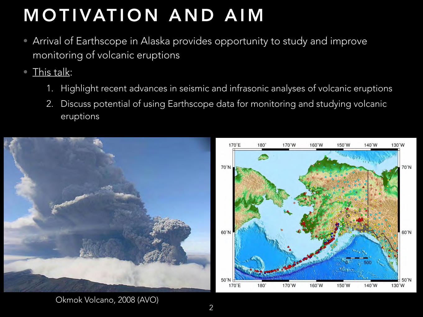
Volcanoes in AK • >90 volcanoes active in
Holocene, >50 have erupted in past 200 years
• >2 eruptions per year
• Most volcanoes are remote, so primary hazard is aviation
• Monitored by Alaska Volcano Observatory (AVO) using combination of seismic, infrasonic, geodetic networks, as well remote sensing, geological and geochemical studies
3

P O T E N T I A L V O L C A N I C H A Z A R D R E L AT E D U S E S O F E A RT H S C O P E S E I S M I C A N D I N F R A S O U N D D ATA
4
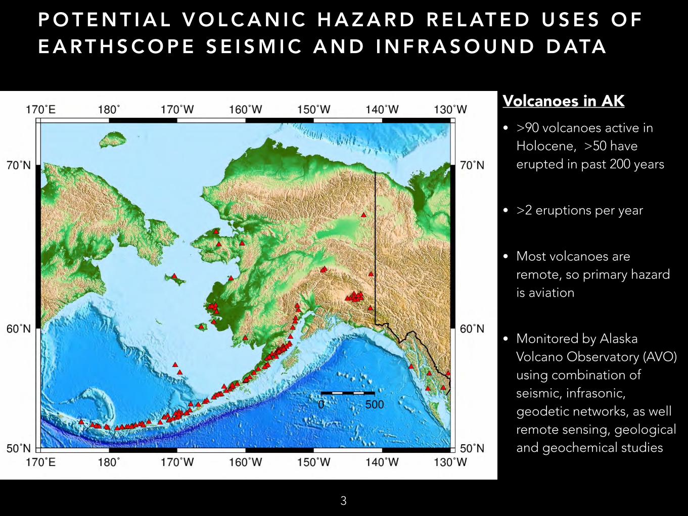
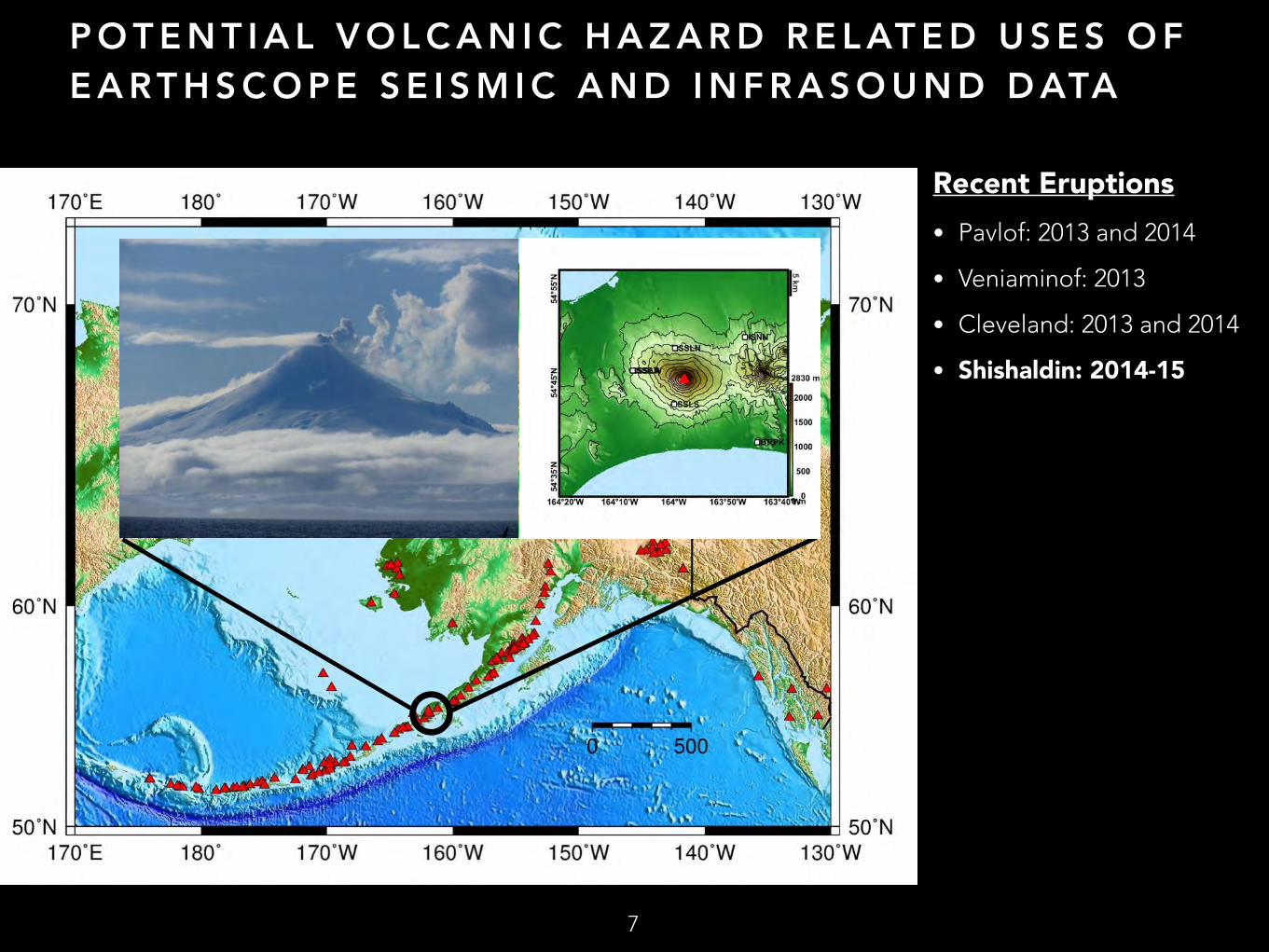
Recent Eruptions • Pavlof: 2013 and 2014
• Veniaminof: 2013
• Cleveland: 2013 and 2014
• Shishaldin: 2014-15

P O T E N T I A L V O L C A N I C H A Z A R D R E L AT E D U S E S O F E A RT H S C O P E S E I S M I C A N D I N F R A S O U N D D ATA
5
Recent Eruptions • Pavlof: 2013 and 2014
• Veniaminof: 2013
• Cleveland: 2013 and 2014
• Shishaldin: 2014-15
P O T E N T I A L V O L C A N I C H A Z A R D R E L AT E D U S E S O F E A RT H S C O P E S E I S M I C A N D I N F R A S O U N D D ATA
Recent Eruptions • Pavlof: 2013 and 2014
• Veniaminof: 2013
• Cleveland: 2013 and 2014
• Shishaldin: 2014-15
6
P O T E N T I A L V O L C A N I C H A Z A R D R E L AT E D U S E S O F E A RT H S C O P E S E I S M I C A N D I N F R A S O U N D D ATA
Recent Eruptions • Pavlof: 2013 and 2014
• Veniaminof: 2013
• Cleveland: 2013 and 2014
• Shishaldin: 2014-15
7
A L A S K A : AV O A N D A E C N E T W O R K S
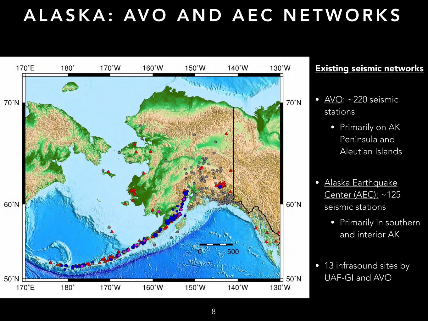
Existing seismic networks
• AVO: ~220 seismic stations
• Primarily on AK Peninsula and Aleutian Islands
• Alaska Earthquake Center (AEC): ~125 seismic stations
• Primarily in southern and interior AK
• 13 infrasound sites by UAF-GI and AVO
8

A L A S K A : 2 0 1 4
9
Transportable Array
• 25 stations added or upgrade
• Majority in interior AK, Kenai Peninsula

A L A S K A : 2 0 1 5
10
Transportable Array
• 82 stations to be added or upgraded
• New stations to be added near active, hazardous Cook Inlet volcanoes

A L A S K A : 2 0 1 6
11
Transportable Array
• 98 stations to be added or upgraded
• Many in northern AK and Canada
• New or upgraded stations in AK Peninsula and Aleutians

A L A S K A : 2 0 1 7
12
Transportable Array
• 91 stations to be added or upgraded
• New or upgraded stations in western AK and northern Yukon
R E C E N T A D VA N C E S : L A R G E - N S E I S M I C
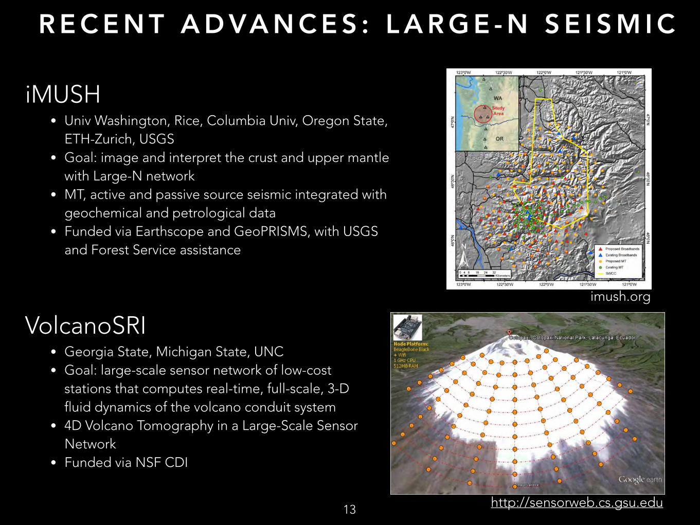
iMUSH • Univ Washington, Rice, Columbia Univ, Oregon State,
ETH-Zurich, USGS • Goal: image and interpret the crust and upper mantle
with Large-N network • MT, active and passive source seismic integrated with
geochemical and petrological data • Funded via Earthscope and GeoPRISMS, with USGS
and Forest Service assistance
13
imush.org
VolcanoSRI • Georgia State, Michigan State, UNC • Goal: large-scale sensor network of low-cost
stations that computes real-time, full-scale, 3-D fluid dynamics of the volcano conduit system
• 4D Volcano Tomography in a Large-Scale Sensor Network
• Funded via NSF CDI
http://sensorweb.cs.gsu.edu
C U R R E N T V O L C A N O S E I S M I C P R O J E C T S I N A L A S K A
14
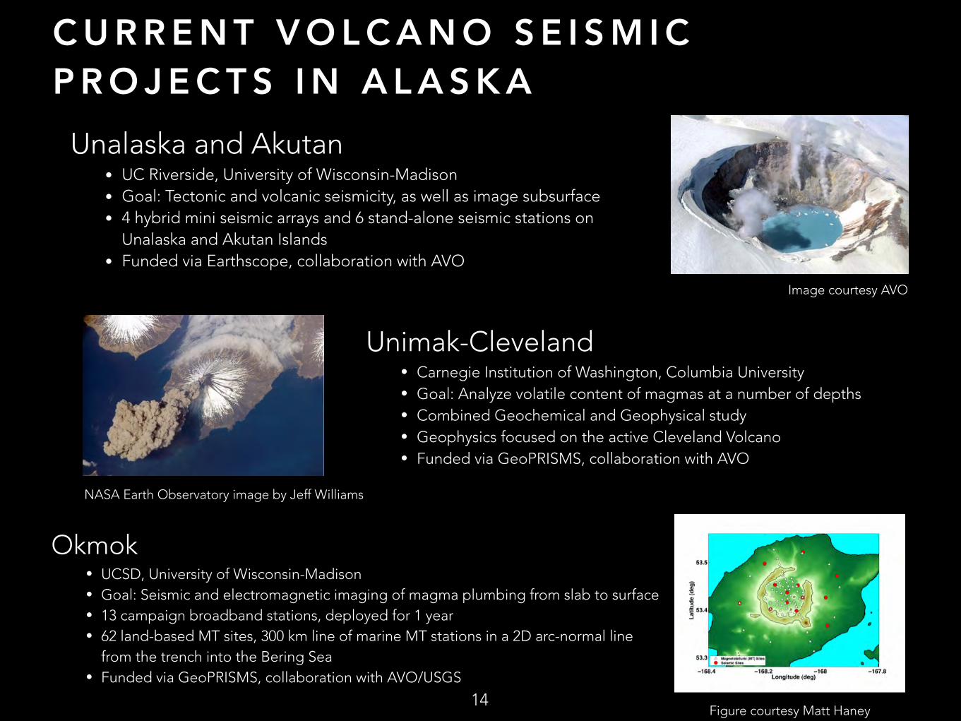
Unalaska and Akutan • UC Riverside, University of Wisconsin-Madison • Goal: Tectonic and volcanic seismicity, as well as image subsurface • 4 hybrid mini seismic arrays and 6 stand-alone seismic stations on
Unalaska and Akutan Islands • Funded via Earthscope, collaboration with AVO
Image courtesy AVO
Unimak-Cleveland • Carnegie Institution of Washington, Columbia University • Goal: Analyze volatile content of magmas at a number of depths • Combined Geochemical and Geophysical study • Geophysics focused on the active Cleveland Volcano • Funded via GeoPRISMS, collaboration with AVO
Okmok • UCSD, University of Wisconsin-Madison • Goal: Seismic and electromagnetic imaging of magma plumbing from slab to surface • 13 campaign broadband stations, deployed for 1 year • 62 land-based MT sites, 300 km line of marine MT stations in a 2D arc-normal line
from the trench into the Bering Sea • Funded via GeoPRISMS, collaboration with AVO/USGS
Figure courtesy Matt Haney
NASA Earth Observatory image by Jeff Williams
S E I S M I C T O M O G R A P H Y
15
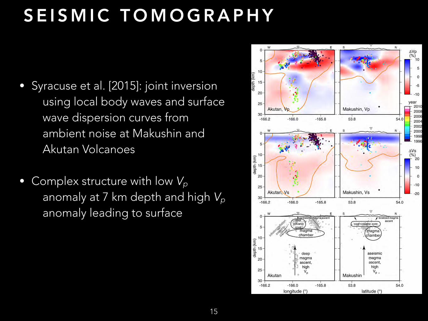
• Syracuse et al. [2015]: joint inversion using local body waves and surface wave dispersion curves from ambient noise at Makushin and Akutan Volcanoes
• Complex structure with low Vp anomaly at 7 km depth and high Vp anomaly leading to surface
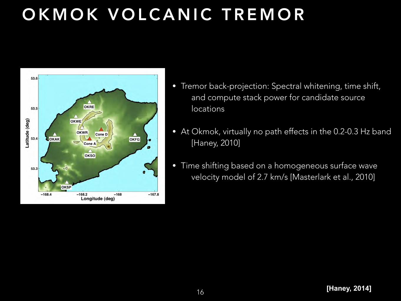
O K M O K V O L C A N I C T R E M O R
• Tremor back-projection: Spectral whitening, time shift, and compute stack power for candidate source locations
• At Okmok, virtually no path effects in the 0.2-0.3 Hz band [Haney, 2010]
• Time shifting based on a homogeneous surface wave velocity model of 2.7 km/s [Masterlark et al., 2010]
16 [Haney, 2014]
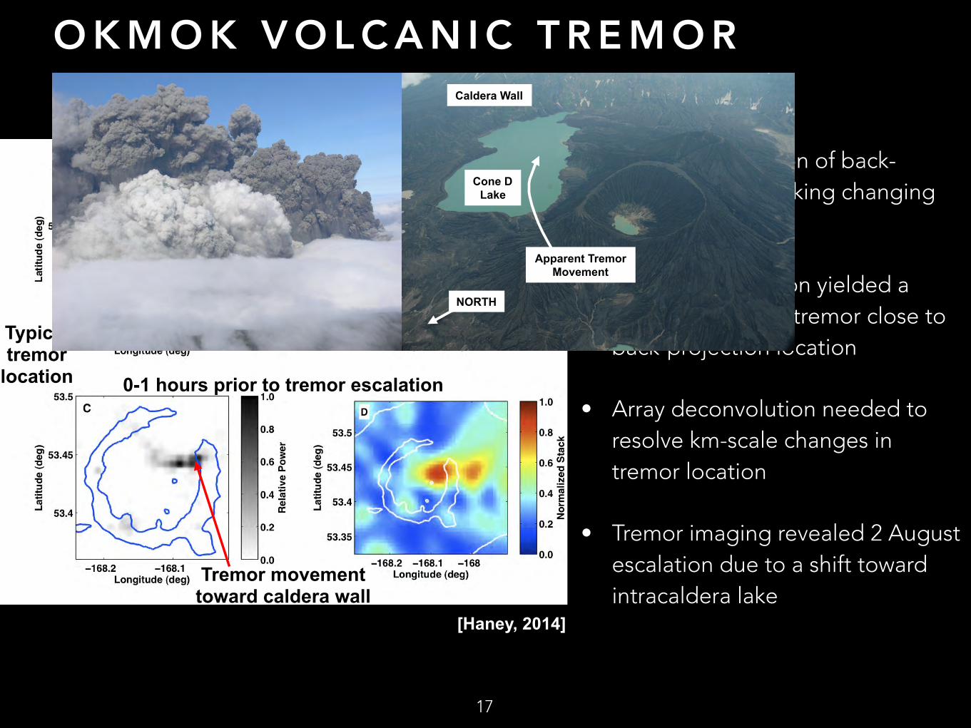
O K M O K V O L C A N I C T R E M O R
• First demonstration of back-projection for tracking changing volcanic tremor
• Waveform inversion yielded a shallow depth for tremor close to back-projection location
• Array deconvolution needed to resolve km-scale changes in tremor location
• Tremor imaging revealed 2 August escalation due to a shift toward intracaldera lake
17
1-2 hours prior to tremor escalation
0-1 hours prior to tremor escalation
Typical tremor
location
Tremor movement toward caldera wall
[Haney, 2014]
Apparent Tremor Movement
Cone D Lake
Caldera Wall
NORTH

R E C E N T A D VA N C E S : A C O U S T I C
• Workshop held by IAVCEI Volcano Acoustics Commission at Sakurajima Volcano, Japan
• Infrasound data uploaded to IRIS-DMC as benchmark dataset for the acoustic community to use in education, training, and research.
• Focus Section in Seismological Research Letters
18Infrasound data sped up 40x
Sakurajima Volcano, Japan

S A K U R A J I M A V O L C A N O : D E P L O Y M E N T A N D T O P O G R A P H Y
• Sensors deployed at various angles and distances to vent
• Topographic obstructions between vent and multiple sensors
• Significant waveform variability —> Propagation must be considered before the source can be evaluated-even locally! [e.g. Matoza et al., 2009; Lacanna and Ripepe, 2012];
19
a) b)
0 1000 2000 3000 4000 5000 60000
500
1000
Elev
atio
n [m
]
ARI
0 1000 2000 3000 4000 5000 60000
500
1000
Elev
atio
n [m
]
HAR
0 1000 2000 3000 4000 5000 60000
500
1000
Elev
atio
n [m
]
KOM
0 1000 2000 3000 4000 5000 60000
500
1000
Elev
atio
n [m
]
KUR
0 1000 2000 3000 4000 5000 60000
500
1000
Elev
atio
n [m
]
SVO
Distance [m]
−1000−500
0500
1000 ARI2311 m, 186o
Pres
sure
[Pa]
−1000−500
0500
1000 HAR3390 m, 299o
−1000−500
0500
1000 KOM4481 m, 26o
−1000−500
0500
1000 KUR3420 m, 81o
11:02:00 11:02:05 11:02:10 11:02:15 11:02:20
−1000−500
0500
1000 SVO6221 m, 281o
21 Jul UTC Time
[Fee et al., 2014]

S A K U R A J I M A M O D E L I N G• Finite-Difference Time-Domain Modeling
• 3-D GPU-accelerated, high-resolution DEM
• Anisotropic radiation due to topography
• Simple source for synthetics suggests waveform complexity from topography
20[Kim et al., in press][Kim and Lees, 2014]
S A K U R A J I M A WAV E F O R M I N V E R S I O N
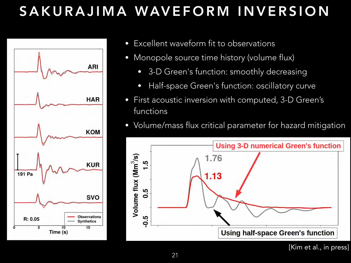
• Excellent waveform fit to observations
• Monopole source time history (volume flux)
• 3-D Green's function: smoothly decreasing
• Half-space Green's function: oscillatory curve
• First acoustic inversion with computed, 3-D Green’s functions
• Volume/mass flux critical parameter for hazard mitigation
21[Kim et al., in press]
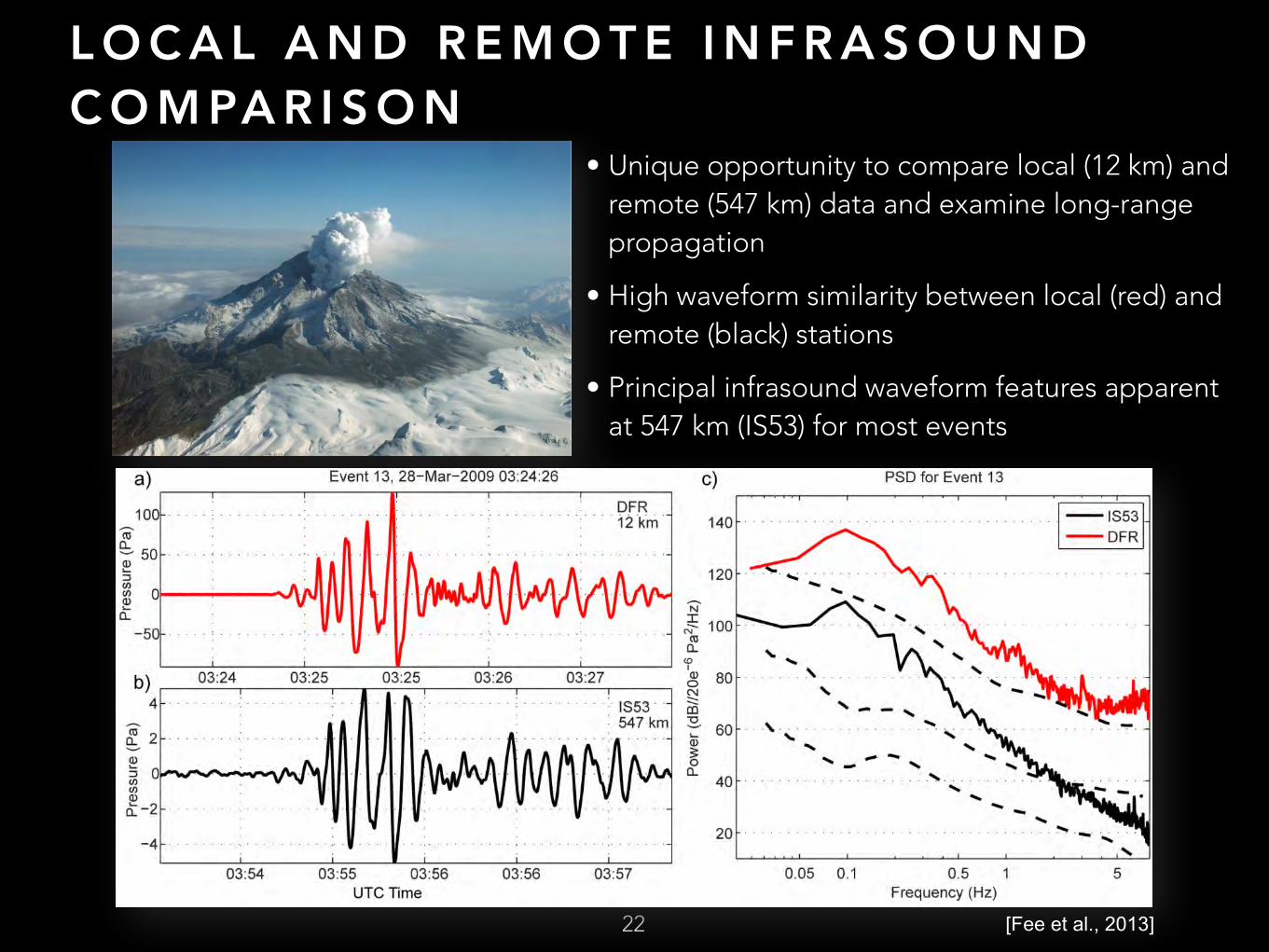
L O C A L A N D R E M O T E I N F R A S O U N D C O M PA R I S O N
22
• Unique opportunity to compare local (12 km) and remote (547 km) data and examine long-range propagation
• High waveform similarity between local (red) and remote (black) stations
• Principal infrasound waveform features apparent at 547 km (IS53) for most events
[Fee et al., 2013]

P R O PA G AT I O N M O D E L I N G A N D C R O S S - C O R R E L AT I O N
• Propagation:
• Deep atmospheric waveguide between ~40-60 km likely responsible for high waveform similarity
• Ray tracing predicts a single ground reflection between source and receiver
[Fee et al., 2013]
23
[Fee et al., 2013]
Winds Sound Speed Sound Propagation
• Compute cross-correlation between local and remote data
• Hilbert transform predicted from ray theory (90° phase shift) improves cross-correlation to 0.89
• Remote infrasound can provide good representation of local infrasound

G L O B A L C ATA L O G I N G O F E X P L O S I V E V O L C A N I S M• Project led by Robin Matoza (UCSB)
• Global association and location: brute force grid-search cross-bearings approach
24
e.g., +/-
longitud
latitud
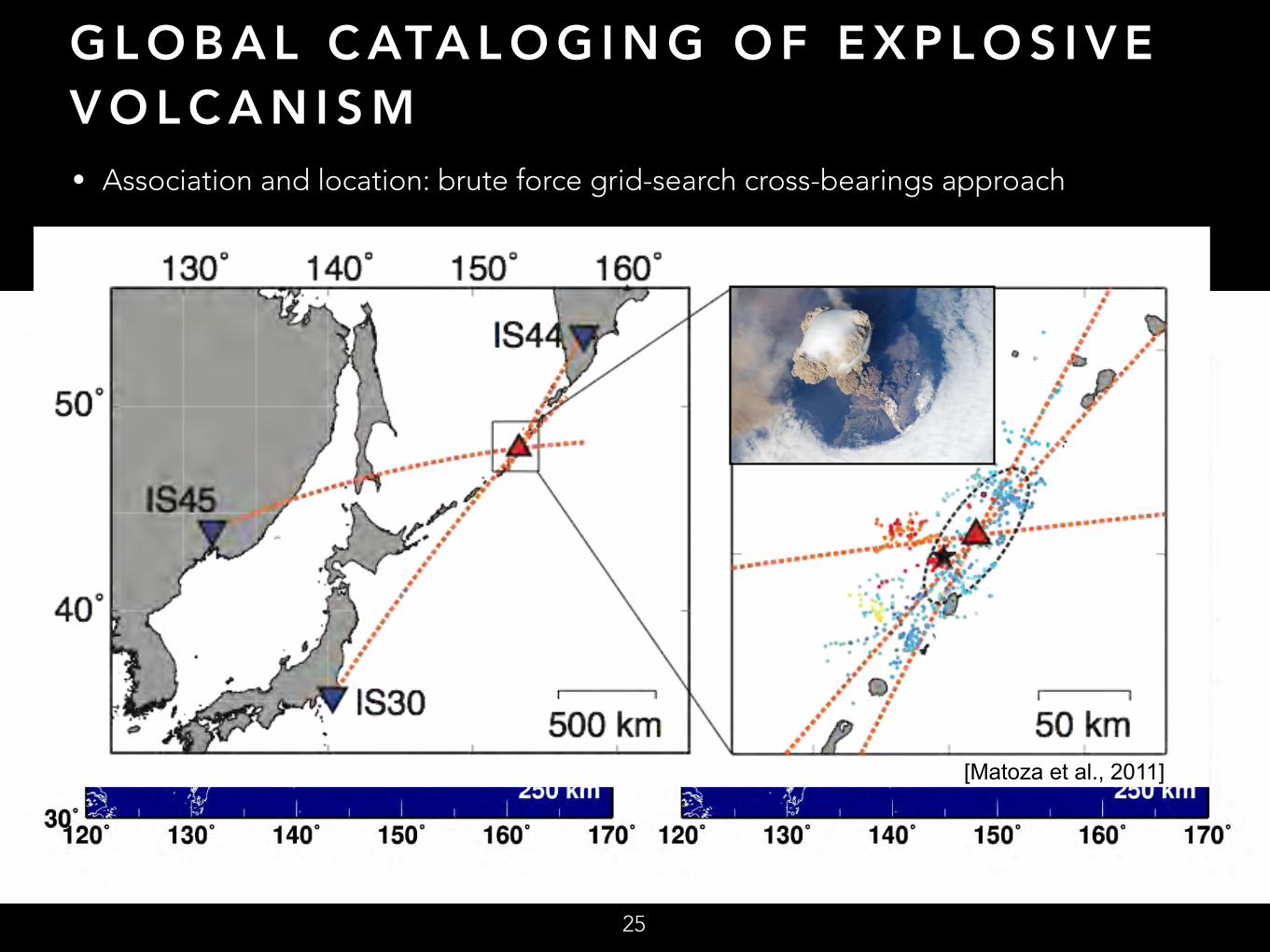
G L O B A L C ATA L O G I N G O F E X P L O S I V E V O L C A N I S M• Association and location: brute force grid-search cross-bearings approach
• Example: Sarychev Peak, 2009
25
[Matoza et al., 2011]
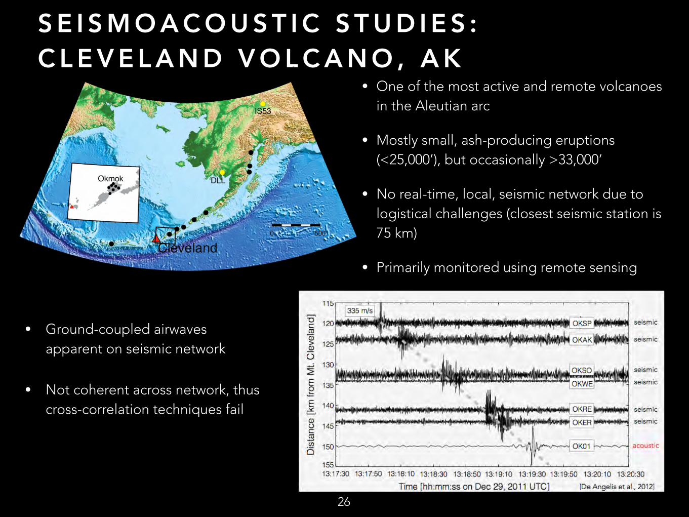
S E I S M O A C O U S T I C S T U D I E S : C L E V E L A N D V O L C A N O , A K
• One of the most active and remote volcanoes in the Aleutian arc
• Mostly small, ash-producing eruptions (<25,000’), but occasionally >33,000’
• No real-time, local, seismic network due to logistical challenges (closest seismic station is 75 km)
• Primarily monitored using remote sensing
OKAKS
26
• Ground-coupled airwaves apparent on seismic network
• Not coherent across network, thus cross-correlation techniques fail

C L E V E L A N D V O L C A N O - D E T E C T A N D N O T I F Y
From: David Fee [email protected]: Cleveland Volcano Dillingham Infrasound Detection Alert: 13-Apr-2012 1600 - 13-Apr-2012 1700 UTCDate: April 13, 2012 10:08:14 AM PDTTo: David Fee <[email protected]>, [email protected], Silvio De Angelis <[email protected]>, [email protected], [email protected], [email protected], Colin Rowell <[email protected]> Cleveland Infrasound Detection AlertDillingham Infrasound Array, 992 km from source
Dillingham Detection Time: 13-Apr-2012 16:54:27 UTCApprox. Origin Time: 13-Apr-2012 16:02:47 UTCMax Pressure Amplitude: 0.143 PaMax Fisher Ratio: 237•
27
Dillingham - 992 km
Infrasound
Wave Velocity
Back-Azimuth
Automated detections send alerts to AVO personnel
Dec 2011 – Aug 2012 Detections: ~7/20 in satellite imagery 19/20 events with infrasound
[De Angelis et al., 2012]

C O - L O C AT E D S E I S M I C A N D A C O U S T I C S E N S O R S
Filtered Waveforms
Acoustic spectrogram
Seismic spectrogram
5-10 Hz cross-correlation
Coherence spectrogram
Phase spectrogram
Infrasound array processing
28
~5 m
acoustic
seismic
[Matoza and Fee, 2014]
• Seismic-acoustic cross-correlation [Ichihara et al., 2012] and coherence [Matoza and Fee, 2014]
Utilize co-located seismic and acoustic sensors to detect:
1) acoustic signals without an array
2) ground-coupled energy on seismometers
8 March 2005, Mount St. Helens
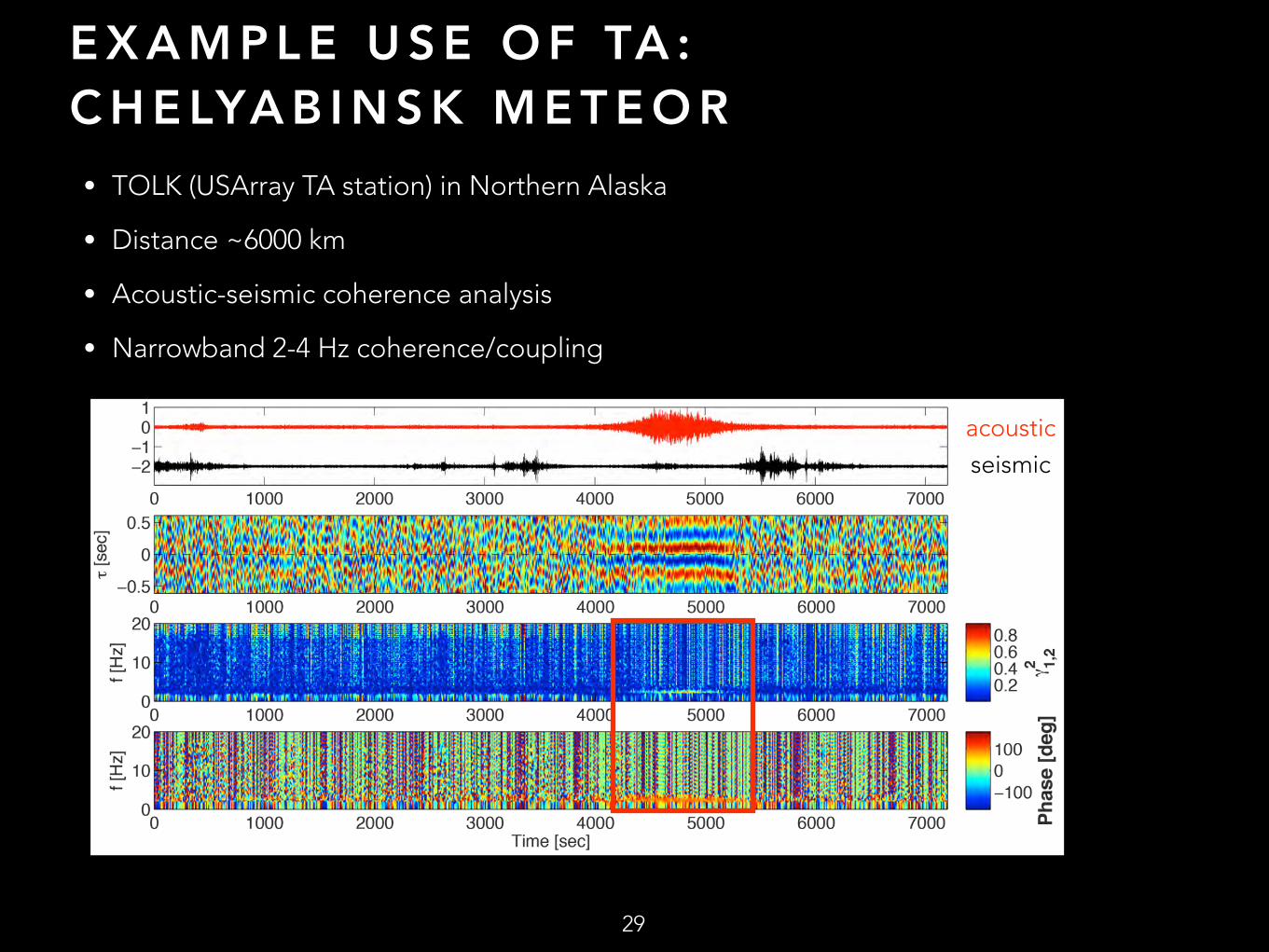
E X A M P L E U S E O F TA : C H E LYA B I N S K M E T E O R
• TOLK (USArray TA station) in Northern Alaska
• Distance ~6000 km
• Acoustic-seismic coherence analysis
• Narrowband 2-4 Hz coherence/coupling
29
acousticseismic
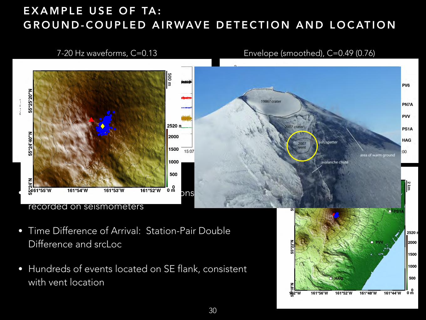
E X A M P L E U S E O F TA : G R O U N D - C O U P L E D A I R WAV E D E T E C T I O N A N D L O C AT I O N
• Pavlof: acoustic waves from explosions commonly recorded on seismometers
• Time Difference of Arrival: Station-Pair Double Difference and srcLoc
• Hundreds of events located on SE flank, consistent with vent location
30
7-20 Hz waveforms, C=0.13 Envelope (smoothed), C=0.49 (0.76)

E X A M P L E U S E O F TA : R E V E R S E T I M E M I G R AT I O N
31
• Acoustic waves recorded on seismic and infrasound sensors of sparse network
• Waveforms not coherent between stations-use amplitude envelope
• Reverse time migration (back-projection) of sparse network data – both seismic and acoustic
• Provides relatively high resolution location
• Applicable to volcanic eruptions
[Walker et al., 2010]
[Walker et al., 2010]
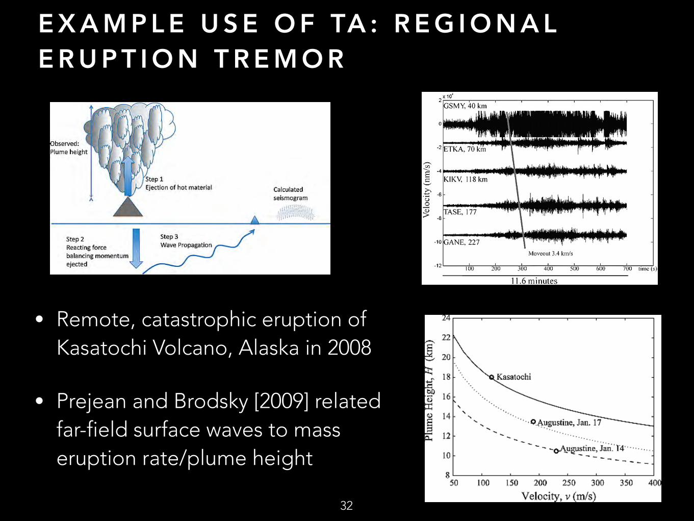
E X A M P L E U S E O F TA : R E G I O N A L E R U P T I O N T R E M O R
32
• Remote, catastrophic eruption of Kasatochi Volcano, Alaska in 2008
• Prejean and Brodsky [2009] related far-field surface waves to mass eruption rate/plume height
C O N C L U S I O N S A N D F U T U R E W O R K
33
• Opportunity to use existing networks and Earthscope data to monitor and study volcanic eruptions in Alaska - Detect, locate, image, characterize, and quantify volcanic source - Discriminate between different events *Relatively sparse network not always near volcanoes *Focused deployments for imaging, tracking tremor, etc
• Utilize co-located seismic and acoustic sensors to detect: - Acoustic signals without an array - Ground-coupled energy on seismometers
• Stations near volcanoes will improve eq detection and location • Integrate with PBO and geologic data
Related Documents