County of Fairfax, Virginia To protect and enrich the quality of life for the people, neighborhoods and diverse communities of Fairfax County November 20, 2013 Elizabeth D. Baker Walsh, Colucci, Lubeley, Emrich & Walsh, P.C. 2200 Clarendon Boulevard, 13 th Floor Arlington, VA 22201 RE: Rezoning Application RZ 2011-PR-005 (Concurrent with Special Exception Amendment Application SEA 2008-MD-036) Dear Ms. Baker: Enclosed you will find a copy of an Ordinance adopted by the Board of Supervisors at a regular meeting held on November 19, 2013, granting Rezoning Application RZ 2011-PR-005 in the name of NVCommercial Incorporated and Clyde's Real Estate Group, Inc. The Board's action rezones certain property in the Providence District from the C-8, HC and SC Districts to the PTC, HC and SC Districts to permit mixed use development with an overall Floor Area Ratio (FAR) of 8.05 and waiver #1682-WSWD-001-1 to permit the location of underground storm water management facilities in a residential area. The subject property is located in the N.E. quadrant of the intersection of Leesburg Pike and Chain Bridge Road on approximately 5.79 acres of land, [Tax Map 29-3 ((1)) 65, 71, 71A pt., 72, 73, 75, 76 and 78A], subject to the proffers dated November 12, 2013. Please note that on November 6, 2013, the Planning Commission approved Final Development Plan Application FDP 2011-PR-005 subject to the development conditions dated November 6, 2013. The Board also: • Approved a modification of Par. 2 of Sect. 17-201 and PFM Section 8-0201.3 of the Zoning Ordinance to permit the construction of the sidewalks and on-road bike lane system shown on the CDP in lieu of the Comprehensive Plan trails onsite. • Waived Sect. 2-505 to permit structures and vegetation on a corner lot as shown on the CDP and FDP. • Approved a waiver of Par. 1 of Sect. 6-506 to permit of a minimum district size of less than ten (10) acres for a PTC zoned parcel. Office of the Clerk to the Board of Supervisors 12000 Government Center Parkway, Suite 533 Fairfax, Virginia 22035 Phone: 703-324-3151 ♦ Fax: 703-324-3926 ♦ TTY: 703-324-3903 Email: [email protected] http://www.fairfaxcounty.gov/bosclerk

Welcome message from author
This document is posted to help you gain knowledge. Please leave a comment to let me know what you think about it! Share it to your friends and learn new things together.
Transcript

County of Fairfax, Virginia To protect and enrich the quality of life for the people, neighborhoods and diverse communities of Fairfax County
November 20, 2013
Elizabeth D. Baker Walsh, Colucci, Lubeley, Emrich & Walsh, P.C. 2200 Clarendon Boulevard, 13 th Floor Arlington, VA 22201
RE: Rezoning Application RZ 2011-PR-005 (Concurrent with Special Exception Amendment Application SEA 2008-MD-036)
Dear Ms. Baker:
Enclosed you will find a copy of an Ordinance adopted by the Board of Supervisors at a regular meeting held on November 19, 2013, granting Rezoning Application RZ 2011-PR-005 in the name of NVCommercial Incorporated and Clyde's Real Estate Group, Inc. The Board's action rezones certain property in the Providence District from the C-8, HC and SC Districts to the PTC, HC and SC Districts to permit mixed use development with an overall Floor Area Ratio (FAR) of 8.05 and waiver #1682-WSWD-001-1 to permit the location of underground storm water management facilities in a residential area. The subject property is located in the N.E. quadrant of the intersection of Leesburg Pike and Chain Bridge Road on approximately 5.79 acres of land, [Tax Map 29-3 ((1)) 65, 71, 71A pt., 72, 73, 75, 76 and 78A], subject to the proffers dated November 12, 2013.
Please note that on November 6, 2013, the Planning Commission approved Final Development Plan Application FDP 2011-PR-005 subject to the development conditions dated November 6, 2013.
The Board also:
• Approved a modification of Par. 2 of Sect. 17-201 and PFM Section 8-0201.3 of the Zoning Ordinance to permit the construction of the sidewalks and on-road bike lane system shown on the CDP in lieu of the Comprehensive Plan trails onsite.
• Waived Sect. 2-505 to permit structures and vegetation on a corner lot as shown on the CDP and FDP.
• Approved a waiver of Par. 1 of Sect. 6-506 to permit of a minimum district size of less than ten (10) acres for a PTC zoned parcel.
Office of the Clerk to the Board of Supervisors 12000 Government Center Parkway, Suite 533
Fairfax, Virginia 22035 Phone: 703-324-3151 ♦ Fax: 703-324-3926 ♦ TTY: 703-324-3903
Email: [email protected] http://www.fairfaxcounty.gov/bosclerk
RZ 2011-PR-005 -2- November 20, 2013
• Approved a waiver to allow the use of underground stormwater management and best management practices in a residential development (1682-WSWD-001-1), subject to the conditions dated August 13, 2013, contained in Attachment A of Appendix 11 of the staff report.
• Approved a waiver or modification of Par. 2 of Sect. 2-506 to allow for a parapet wall, cornice or similar projection to exceed the height limit established by more than three (3) feet as may be indicated on the FDP to screen mechanical equipment.
• Approved a waiver of Pars, of 3(E) and (G) of Sect. 10-104 to increase the maximum fence height from seven (7) to 14 feet around accessory uses/structures located within the rear yard for areas associated with sports courts and urban plazas as identified on the FDP.
• Approved a modification of Par. 4 of Sect. 11-202 requiring a minimum distance of forty (40) feet between the loading spaces and drive aisle to permit the loading spaces as shown on the CDP.
• Approved a waiver of Sect. 11-302 of the Zoning Ordinance to allow a private street to exceed 600 feet in length as shown on the CDP.
• Approved a modification of Sect. 7-800 of the Public Facilities Manual (PFM) to allow the use of tandem parking spaces and valet services to be counted as required parking (as permitted by the PTC District regulations).
• Approved a waiver of Sect. 16-403 to permit a site plan for public improvements plans associated with public roadway, infrastructure or final or interim park spaces as shown on the CDP to be filed without an approved FDP.
• Approved a waiver of Par. 3(B) of Sect. 17201 to provide any additional interparcel connections to adjacent parcels beyond that shown on the Plans and as proffered.
• Approved a waiver of Par. 3(A) of Sect. 17201 which requires a service drive along Leesburg Pike and Chain Bridge Road.
• Approved a waiver of Par. 7 of Sect. 17-201 to allow establishment of parking control, signs and parking meters along private streets within the development.
• Approved a waiver of Par. 4 of Sect. 17-201 to allow only for the dedication and construction of roads as indicated in the plans and proffers.
RZ 2011-PR-005 -3- November 20, 2013
• Approved a modification of Sect. 12-515.6(B) to reduce the minimum planter opening area for trees used to satisfy the tree cover requirement in favor of that shown on the CDP and FDP.
• Approved a modification of Sect. 12-515.6B to allow trees located above any proposed percolation trench or bioretention areas to count towards county tree cover requirements as depicted on the CDP and FDP.
• Approved a modification of the 10 year tree canopy requirements in favor of that shown on the Plans and as proffered.
• Approved a modification of the Zoning Ordinance and PFM for required tree preservation target and ten percent canopy to be calculated as shown on the overall CDP area.
• Approved a modification of Par. 8 of Section 13-202 and Par. 5 of Sect. 13-203 of the Zoning Ordinance for interior and peripheral parking lot landscaping for new interim surface parking lots to what is shown on an approved FDP or a landscape plan for existing surface lots.
Sincerely,
CZOALIALSA. Catherine A. Chianese Clerk to the Board of Supervisors
Cc: Chairman Sharon Bulova Supervisor Linda Smyth, Providence District Tim Shirocky, Acting Director, Real Estate Division, Dept. of Tax Administration Barbara Berlin, Director, Zoning Evaluation Division, DPZ Diane Johnson-Quinn, Deputy Zoning Administrator, Dept. of Planning and Zoning Thomas Conry, Dept. Manager, GIS, Mapping/Overlay Angela K. Rodeheaver, Section Chief, Transportation Planning Division Donald Stephens, Transportation Planning Division Department of Highways-VDOT Sandy Stallman, Park Planning Branch Manager, FCPA Charlene Fuhrman-Schulz, Development Officer, DHCD/Design Development Division Jill Cooper, Executive Director, Planning Commission Lee Ann Pender, Office of Capital Facilities/Fairfax County Public Schools Karyn Moreland, Chief Capital Projects Sections, Dept. of Transportation


PROFFERS NVCommercial Incorporated and Clyde's Real Estate Group, Inc.
RZ 2011-PR-005 November 12, 2013
Table of Contents
GENERAL 1
1. Conceptual Development Plan 1
2. Proffered CDP Elements. 1
3. Minor Modifications. 1
4. Declarations/Owners Associations 2
PROPOSED DEVELOPMENT 2
5. Existing Development and Interim Uses 2
6, Proposed Development. 3
7. Final Development Plans. 4
8. Development Phasing 6
9. Fire Marshal Evaluation. 6
ARCHITECTURAL AND URBAN DESIGN 7
10. Activated Streetscapes and Ground Floor Elements. 7
11. Architecture. 10
12. Parking Structure Facades 10
13. Building A Loading/Trash/Service Area 11
14. Building Height, 12
15. Telecommunications Equipment 12
BUILDING PRACTICES 13
16. Residential Building Certifications. 13
17. Non-Residential Building Certifications. 15
18. Energy Sustainability. 17
19. Noise Attenuation 17
20. Notification of Exterior Noise Levels. 19
21. Bird-Friendly Design Elements 19
SITE DESIGN AND AMENITIES 20
22. Conceptual Landscape Plan. 20
23. Streetscaping. 20
24. Interim Conditions and Standards. 24

TRANSPORTATION IMPROVEMENTS 26
25. Grid of Streets. 26
26. Leesburg Pike Frontage 28
27. Station Place 29
28. Center Street, 30
29. Viale Centrale 32
30. Tysons Central Street 33
31. Limited Access Break. 34
32. Traffic Signals. 34
33. Route 123 Slip Ramp. 35
34. Tysons Grid of Streets Transportation Fund. 36
35. Tysons-wide Transportation Funds, 36
36. Bus Facilities. 36
PEDESTRIAN AND BICYCLE FACILITIES 37
37. Bicycle Parking. 37
38. Pedestrian Path to Metro. 37
PARKING 38
39. Zoning Ordinance Requirements. 38
40. Phasing of Parking. 38
41. Commercial Off-Street Parking. 38
42. Parking Spaces along Streets 39
43. Parking Stipulations. 39
44. Future Parking Revisions. 39
TRANSPORTATION DEMAND MANAGEMENT 40
45. Tysons Transportation Management Association. 40
46. Transportation Demand Management Plan 40
47. Transportation Demand Management for Retail/Hotel Uses. 50
48. Intelligent Transportation Systems 51
AFFORDABLE/WORKFORCE HOUSING 51
49. Affordable Dwelling Units 51
50. Workforce Dwelling Units. 51
51. Non-Residential Contribution for Workforce Housing 52
PARKS AND RECREATIONAL FACILITIES 53
52. Publicly Accessible Parks. 53
53. Amenities and Facilities for Residents. 55
54. Athletic Field Contribution. 56
PUBLIC FACILITIES 57
55. Public Facility. 57
56. Public School Contribution. 62
STORMWATER MANAGEMENT 62
57. Stormwater Management, 62
58. Tree Replacement. 64
MISCELLANEOUS 65
59. Tree Preservation and Planting Fund Contribution 65
60. Metrorail Tax District Buyout for Certain Residential Uses 65
61. Condemnation Procedures 65
62. Zoning Administrator Consideration. 66
63. Adjustment in Contribution Amounts. 66
64, Advanced Density Credit. 66
65. Severability 66
66. Successors and Assigns. 66
67. Counterparts. 67

PROFFERS
NVCommercial Incorporated and Clyde's Real Estate Group, Inc, RZ 2011-PR-005
November 12, 2013
Pursuant to Section 15.2-2303(A) of the Code of Virginia (1950, as amended) and Section 18-204 of the Zoning Ordinance of Fairfax County (1978, as amended), the property owners and Applicants, for themselves and their successors and/or assigns (referred to hereafter, both collectively and, where appropriate, individually as the "Applicants"), .hereby proffer that the development of the parcels under consideration and shown on the Fairfax County 2013 tax maps as Tax Map 29-3 ((1)) 65, 71, 71A pt., 72, 73, 75, 76 and 78A (collectively, the "Property") shall be in accordance with the following conditions if, and only if, Rezoning application 2011-PR-005 (this "Rezoning") is granted.
GENERAL
1. Conceptual Development Plan. The Property shall be developed in substantial conformance with the proffered elements of the Tysons Central Conceptual Development Plan ("CDP") dated February 22, 2011 and revised through November 11, 2013, prepared by VIKA, Incorporated, Davis, Carter, Scott Ltd and LSG Landscape Architecture Inc.
The CDP includes two options; Option 1 represents the maximum commercial proposal. Option 2 represents the maximum residential proposal. Option 1 is depicted as the primary design on Sheets C-6 and C-6A of the CDP. The design variations included in Option 2 are shown in the inset boxes on Sheets C-6 and C-6A. The Applicants reserve the right to develop in accordance with either option or a combination of the two options, provided the maximum gross square footages identified in Proffer 6 are not exceeded.
2. Proffered CDP Elements. It shall be understood that the proffered elements of the CDP are liMited to the grid of streets, general location of the points of access, general location of the buildings and build-to-lines, general mix of uses, minimum and maximum gross floor area ("GFA"), minimum and maximum building heights, amount and general location and character of urban park land, and general quality and character of the streetscape (the "Proffered Elements"). A future amendment to the Proffered Elements shall require a subsequent Conceptual Development Plan Amendment ("CDPA") or Proffered Condition Amendment ("PCA"). Other elements of the CDP may be adjusted or modified with approval of future Final Development Plans ("FDPs") in accordance with the provisions set forth in Section 16-402 of the Fairfax County Zoning Ordinance (the "Ordinance").
3, Minor Modifications. Minor modifications to the Proffered Elements of the CDP may be permitted without the need for a CDPA or PCA when necessitated by sound engineering or that may become necessary as part of FDP approval or final site design or engineering,
Page 2
pursuant to Section 16-403(4) of the Ordinance provided the development is in substantial conformance with the CDP and these Proffers.
4. Declarations/Owners Associations. The Applicants shall cause the recordation of one or more declarations creating an umbrella owners' association ("UOA") and as necessary, condominium owners' associations ("COA") or declarations of covenants and agreements dealing with the governance of maintenance and operation of the Property or other governance documents which will legally bind the Property, (collectively referred to as the "Governance Documents"). Such Governance Documents shall be prepared, be legally effective and recorded prior to the issuance of the first Non-Residential use Permit ("Non-RUP") or Residential Use Permit ("RUP") for any new construction as shown on the CDP. The respective Governance Documents shall specify the various proffer and maintenance obligations set forth in these Proffers, including the maintenance of certain streets, associated sidewalks, streetscapes and furnishings, and site amenities such as, but
. not limited to, the publicly accessible park areas and implementation/management of a transportation demand management program. Such maintenance obligations shall not apply to the owners of any portions of the Property which have not yet been redeveloped in accordance with the CDP. The Governance Documents shall be included in any offering, sale materials or contracts for any condominiums. Purchasers of land or buildings shall be advised of these obligations in the contract of sale.
PROPOSED DEVELOPMENT
5. Existing Development and Interim Uses.
A. The Property is currently developed with seven existing buildings which contain approximately 82,403 square feet and associated surface parking lots (collectively, the "Existing Development"). The Existing Development on the Property, as shown on the CDP, may remain in use as an initial phase until such time as the portion of the Property on which the existing structure(s) is located is .redeveloped in accordance with this application, or as otherwise stated in these Proffers. The structures may not be enlarged, except minor building additions may be approved by the Zoning Administrator pursuant to the provisions of Par. 4 of Sect. 16-403 of the Ordinance. Modifications to the interior and exterior of structures and associated parking areas shall be permitted. Changes may be made to the site conditions as shown in the phasing Sheets A-176 through A-178 of the CDP (the "Phasing Sheets") and changes may be made to accommodate interim uses.
B. Any use that is permitted by-right in the Planned Tysons Corner Urban ("PTC") District, with the exception of residential and hotel uses, may also be permitted within existing structures as an interim use subject to the Use Limitations in Sect. 6-505 and the provisions of Paragraph A above, until such time as the relevant portions of the Property are redeveloped. However, after June 1, 2015, adult book stores, adult mini motion picture theatres, and commercial nudity establishments uses shall not be permitted.
Page 3
C. Any use of existing structures requiring a minor site plan or site plan shall incorporate peripheral and interior parking lot landscaping to the degree practicable, provided existing parking spaces are not reduced.
D. Existing structures may be partially demolished to accommodate the construction in the early phases of development of the Property. In that event, the portion of the existing structures to remain shall be included in the associated FDP for the new development.
E. The Applicants may restore any portion of the Existing Development including any modifications or improvements consistent with this Proffer that later is destroyed or damaged by casualty, subject to Article 15 of the Ordinance.
F, Commercial off-street parking may be provided on an interim basis as set forth in Proffer 41.
G. In order to provide activity on the Property and avoid portions of the Property being vacant for an extended period of time, new interim structures and interim uses shall be permitted. Such interim buildings/uses shall require approval of an FDP, special exception or special permit as may be applicable but shall be deemed in conformance with the CDP subject to the following conditions:
(i) Interim pop-up uses and/or buildings shall be permitted on the Property adjacent to the Greensboro Metro Station as generally shown on Sheet L-8.1 of the CDP and as described in Proffer 52A without the requirement for a FDP.
(ii) Other interim pop-up uses and/or buildings shall be permitted with approval of a FDP in the areas designated for such potential uses on the Phasing Sheets.
(iii) Any use permitted in the PTC District, with the exception of residential uses, hotel uses, adult book stores, adult mini motion picture theatres, and commercial nudity establishments may also be permitted as an interim use within interim buildings, subject to the use limitations of Section 6-505 as may be waived or modified by the Board of Supervisors.
(iv) New interim structures and uses shall provide improvements to pedestrian connectivity and interim streetseaping in accordance with Proffer 24.
(v) It is demonstrated how the new interim structures and uses meet the requirements of Paragraph 8 of Section 6-505 of the Ordinance.
H. All existing structures, new interim structures, and associated parking lots and site features shall be maintained in good condition.
6. Proposed Development. The maximum gross square footage permitted on the Property is 2,029,000 (the "Proposed Development") with no more than 631,000 gross square feet
Page 4
allocated to office use. The Proposed Development will over time replace the Existing Development. The Proposed Development may include all permitted uses in the PTC District, subject to the use limitations of Section 6-505 of the Ordinance, the development tabulations on Sheet C-3 of the CDP (the "Development Tabulations") and these Proffers. Notwithstanding that shown in the Development Tabulations, the office use permitted for Building E shall be no greater than 212,000 gross square feet with the balance of 419,000 gross square feet of office use to be allocated between Buildings A and F. However, the Applicants reserve the right to transfer office square footage between these buildings with FDP approval as set forth in Proffer 7 provided the maximum gross square footage . allocated for office use on the Property does not exceed 631,000.
Retail uses as identified in the Development Tabulations may include any non-residential use permitted in the PTC District, exclusive of office or hotel uses, or uses accessory to the primary use, subject to the use limitation contained in Paragraph 14 of Section 6-505 of the Ordinance (hereinafter referred to as "Retail Uses"). Retail Uses may include grocery stores provided any particular grocery store does not exceed 27,000 gross square feet. The size and general location of Retail Uses shall be shown on the FDP submitted for each building and shall include uses that create activated first floor store fronts, although Retail Uses may also be located above and/or below the first floor, including opportunities for eating establishments and similar uses on the upper floors of buildings.
Uses allowed by special exception or special permit in the PTC District may be authorized through a separate special exception or special permit process without the need for a PCA or CDPA, provided the use is in substantial conformance with the approved CDP.
7. Final Development Plans. FDPs for the Property shall be in substantial conformance with the CDP and these Proffers. FDPs approved for individual buildings on the Property shall establish the maximum GFA or maximum number of residential units for each building within the limits established by these Proffers and the CDP. The specific GFA and number of dwelling units for each building shall be established at final site plan. If the maximum GFA or maximum number of dwelling units approved with the FDP is less than the maximum for that building as shown on the CDP, the excess GFA or dwelling units may be utilized in another building or building(s) within the Property, provided: (1) the excess GFA or dwelling units can be accommodated within the maximum building height for the building utilizing the excess GFA or dwelling units shown on the CDP; (2) the minimum building height for the building providing theexcess GFA or dwelling units as shown on the CDP is maintained; and (3) FDP(s) or FDPA(s) for both of the applicable building(s) transferring and utilizing the excess GFA are approved.
In addition, the following information shall be provided with each FDP not filed concurrently with a CDP.
A. A tabulation indicating the development status of all land subject to this Rezoning shall be provided with each FDP and site plan submitted for the Property. The tabulation shall include a listing of all proposed and or completed buildings, along with the GFA, uses, final building heights, and parking approved on the CDP, or
Page 5
any FDP or site plan as may be applicable. The tabulation shall identify the allocation of any excess GFA (as compared with what was originally shown on the applicable CDP) and shall be updated with each subsequent FDP and site plan approved for the Property.
B. Tree Canopy Calculations. A tabulation indicating the tree canopy calculations of all property subject to this rezoning to be updated with each subsequent FDP, FDPA and site plan approved for the Property.
C. TDM Supplement. A copy of the previous TDM Annual Report, if available, to determine progress toward attaining TDM goals and any planned modifications to the TDM program.
D. Functional Drawings/Sight Distance. Functional drawings to include proposed right-of-way lines associated with public streets; vehicular sight distance lines at all intersections within, and adjacent to, the FDP area overlaid on the Landscape Plan; and details with respect to utilities and/or vegetation conflicts with building entrances and/or intersections as presented on the CDP.
E. Utilities. Approkimate location of existing and proposed utilities to serve the area of the FDP including the location of the any utility vaults and stormwater management facilities overlaid on the Landscape Plan.
F. Proposed Uses. A list of proposed uses and demonstration of how such uses meet the applicable "Use Limitations" of Section 6-505 of the Ordinance.
G. Architectural Elements. Specific information on architectural elements, build-to lines, and building heights as provided in Proffers 11 and 14.
H. Streetscape. A graphic depiction of, and any adjustments to, the activated streetscape elements as provided in Proffer 10 and refinement of, and adjustments to, streetscape elements as provided in Proffers 23 and 24.
I. Garage/Loading and Service Area Treatments. Proposed parking garage facade designs and refined loading and service area designs and treatments as provided in Proffers 12 and 13.
J. LandsCaping. Detailed landscape plans as provided in Proffer 22.
K. Streetscape Furnishings. Submission of a "Streetscape Furnishing and Materials Plan" as provided in Proffer 23.
L. Phasing. Identification of specific proposed phased improvements in accordance with Proffer 8 and those generally set forth on the phasing-related exhibits provided on the Phasing Sheets.
M, Parks and Recreation. For on-site parks and active recreation facilities, depiction of special amenity features committed by building as provided in Proffer 52 as
Page 6
well as the height of any fencing (limited to a maximum of 14 feet) proposed around recreational facilities.
N; Provisions for Bicycles. Bicycle parking and storage as provided in Proffer 37.
0, Parking Spaces. Refinement of the number of parking spaces as provided in Proffer 39.
P. Stormwater Management. Identification of the treatment of stormwater as provided in Proffer 57.
Q. Bus Shelter. Details of the proposed bus shelter location and design as described in Proffer 36.
R. Workforce Dwelling Units. For residential development, the expected location (on-site or off-site) of workforce dwelling units.
8. Development Phasing. The Proposed Development includes six (6) buildings, which are identified on the CDP as Buildings A through F. Development of each building may proceed in any order provided that each such building provides the phasing conditions depicted for such building on the CDP and that all proffers that apply to such building are addressed with the development of that building. Where a proffer establishes an obligation that applies to a building, including associated phasing obligations and potential condemnation actions, reference to "Applicants" in such proffer shall mean the party undertaking the development such building.
The Applicants shall construct the grid of streets and provide pedestrian improvements, public parks, private amenities and public facilities on the Property in conjunction with the development of each individual building in accordance with the Phasing Sheets and as further described in these Proffers. In addition, interim improvements as outlined in Proffer 24D and as may be determined at time of FDP approval shall be provided commensurate with the construction of each building. Adjustments to the phasing may be approved with FDP approvals without the requirement for a PCA or CDPA, provided the adjustments do not materially adversely affect the other phases and are in substantial conformance with the CDP. For purposes of these Proffers "construct" shall mean that: 1) a committed road improvement is substantially complete and is available for use by the public for travel whether or not the improvement has been accepted for maintenance by the state, and 2) a committed publicly accessible park space improvement is substantially complete and open to use by the public for use whether or not the improvement has been accepted by the County or FCPA.
9. Fire Marshal Evaluation. The Applicants have coordinated the layouts depicted on the CDP with the Fire Marshal. Further changes to the CDP and future FDPs shall be permitted without the requirement for a CDPA in response to the review of site plans by the Fire Marshal, including adjustments to the streetscape and perimeter building areas as necessary to allow for required emergency vehicle access, provided such modifications are made in consultation with the Fairfax County Department of Planning and Zoning
Page 7
("DPZ"), the Fairfax County Department of Transportation ("FCDOT") and the Office of Community Revitalization ("OCR") and in substantial conformance with the CDP, future FDPs and these Proffers.
ARCHITECTURAL AND URBAN DESIGN
10, Activated Stre.,etscapes and Ground Floor Elements. The ground floors of all new buildings (excluding new interim buildings) on the Property, but not the parking structures associated with such buildings, shall be designed and constructed with ground floors having a minimum floor to floor height of 16 feet along Leesburg Pike (State Route 7), Station Place, Center Street, Viale Centrale and Tysons Central Street where Retail Uses are proposed to activate the streetscape. In addition, the Applicants shall provide for a hierarchy of activated streetscapes throughout the Property as delineated on Sheet L-1 of the CDP and described below. The specific activation elements to be utilized for each building shall be graphically depicted on the FDP.
A. Gateway Pedestrian Corridor. This area located along a high volume boulevard (Leesburg Pike) may have significant pedestrian volumes, but will be generally used for pedestrian movement as opposed to pedestrian interaction. The Gateway Pedestrian Corridor shall generally incorporate the following elements, which may be adjusted with approval of an FDP:
(i) Where the ground floors of buildings (not including the associated parking garages which are addressed below) incorporate non-residential uses, functioning entry doors into such uses shall be provided with a maximum separation of 100 feet, or greater if shown on an approved FDP or as may be permitted by the Zoning Administrator. A minimum of fifty percent (50%) of the area of the street front ground floor facades (not including the associated parking garages) shall be constructed with glazed windows and doors or other transparent, translucent materials.
(ii) Entrances to parking structures shall not be permitted. Where parking structures occur along the ground floor façade of buildings, the general façade detailing of the building above shall be continued to the ground plane or other such architectural features provided.
(iii) The loading/trash/service area for Building A shall be screened from public view through the use of doors, recessed entryways, architectural features or other such similar treatments as shown on Sheets A-172 and L-5.2 of the CDP and as described in Proffer 13A. Loading/trash/service doors shall remain closed except when service vehicles are accessing the area,
B. Primary Pedestrian Corridors. These areas are designed to accommodate major pedestrian activity, providing access to the Metro Station (the "Metro Station") for pedestrians and accommodating access to, and encouraging interaction with, a variety of uses on the Property. Primary Pedestrian Corridors shall generally
Page 8
incorporate the following elements, which may be adjusted with approval of an FDP:
(i) Where the ground floors of buildings (not including the associated parking garages which are addressed below) incorporate non-residential uses, functioning entry doors into such uses shall be provided with a maximum separation of 75 feet, or greater if shown on ati approved FDP or as may be permitted by the Zoning Administrator. A minimum of fifty percent (50%) of the area of the street front ground floor façades of such buildings shall be constructed with glazed windows and doors or other transparent, translucent materials.
(ii) The ground floor facades of Buildings A and B that front on to the Metro Plaza shall be designed with active uses and architectural treatments to enliven and energize the Metro Plaza. Such ground floor facades shall incorporate Retail Uses, functioning entry doors with a maximum separation of 75 feet and a minimum of fifty percent (50%) glazed windows and doors or other transparent, translucent materials. Back of house operations and storage associated with the Retail Uses shall not fronton to the Metro Plaza.
(iii) Parking structures along the ground floor facades of buildings shall be minimized to the extent possible. Where parking structures occur along the ground floor façade of buildings, the general façade detailing of the building above shall be continued to the ground plane or other such architectural features provided.
(iv) Loading/trash/service areas along other Primary Circulation Corridors shall be minimized to the extent possible. Where these areas occur, they, shall be screened from public view through the use of doors, recessed entryways, architectural features or other such similar treatments. Loading/trash/service area doors shall remain closed except when service vehicles arc accessing the area.
C. Secondary Pedestrian Corridors. These areas are designed to accommodate moderate pedestrian activity, providing access to the Metro Station for pedestrians and accommodating access to a. variety of uses on the Property. Secondary Pedestrian Corridors shall generally incorporate the following elements, which may be adjusted with approval of an FDP:
(i)
Where the ground floors of buildings (not including the associated parking garages which are addressed below) incorporate non-residential uses, functioning entry doors into such applicable uses shall be provided with a maximum separation of 75 feet, or greater if shown on an approved FDP or as may be permitted by the Zoning Administrator. A minimum of thirty-five percent (35%) of the area of the street front ground floor

Page 9
façades of such buildings shall be constructed with glazed windows and doors or other transparent, translucent materials.
(ii) In residential buildings that do not incorporate non-residential uses on part or all of the ground floors, the building design of the primary facades shall incorporate, to the degree feasible, recreational and amenity spaces on the ground floor with a minimum of 35% of the ground floor facade below the ceiling, constructed with windows and/or doors or other transparent materials or semi-transparent materials, and/or incorporate entries in to individual dwelling units from the street level. Residential units that have direct access to the .streetscape from an individual unit shall utilize design features to provide interior privacy (such as having a ground floor elevation that is above the sidewalk grade).
(iii) Parking structures along the ground floor facades shall have screening composed of architectural systems designed to restrict views into the parking structure from street level, or the general facade detailing of the building above may be continued to the ground plane.
(iv) Loading/trash/service areas shall be screened from public view through the use of doors, architectural treatments or other such similar treatment. Loading/trash/service area doors shall remain closed except when service vehicles are accessing the area.
D. Tertiary Pedestrian Corridors. These areas are designed to accommodate modest pedestrian activity making connections to less intense areas or through alleys. Tertiary Pedestrian Corridors, not located along private alleys, shall incorporate the following elements:
(i) Where the ground floors of buildings (not including the associated parking garages which are addressed below) incorporate non-residential uses, a minimum of twenty percent (25%) of the area of the ground floor facades of such buildings shall be constructed with glazed windows and doors or other transparent, translucent materials or semi-transparent materials.
(ii) In residential buildings that do not incorporate Non-Residential Uses on part or all of the ground floors, efforts shall be made to incorporate, recreational and amenity spaces on the ground floor with appropriate transparency and/or incorporate entries into individual dwelling units from the street level. Residential units that have direct access to the streetscape from an individual unit shall utilize design features to provide interior privacy (such as having a ground floor elevation that is above the sidewalk grade).
(iii) Parking structures along the ground floor facades shall have screening composed of architectural systems and/or landscaping treatments designed to restrict views into the parking structures from street level, or the general

Page 10
facade detailing of the building above may be continued to the ground plane.
(iv) Access to parking garages and loading/trash/service areas are encouraged to be located along Tertiary Pedestrian Corridors, Loading/trash/service areas shall be screened from public view to the extent possible, through the use of doors, recessed entryways and/or similar treatment.
11. Architecture.
A. The architectural treatment of all buildings within the Proposed Development shall create a sense of identity and place, with a human scale at the ground plane, through the use of unifying elements such as materials, textures, color, window treatments, decorative details, lighting, and landscaping, Buildings shall be designed with high quality architecture and building materials that, at the time an individual FDP is approved, are typically used on the exterior of Class A . office buildings and residential, retail and hotel buildings of a similar quality.
B. Each FDP shall specify the building materials, architecture, and specific features designed to activate streetscapes, as further described below. Architectural plans, elevations, illustrations, materials and heights may be revised subsequent to CDP and FDP approval as a result of final architectural and engineering design, provided the quality of design remains in substantial conformance with that shown on the CDP and subsequent FDPs and as set forth in these Proffers, as determined by the Department of Public Works and Environmental Services ("DPWES") in consultation with DPZ in consultation with OCR without the -need for a formal administrative determination.
• C. Build-to-lines ("BTL") have been established as depicted on the CDP, to create an urban, pedestrian-oriented environment where buildings are located close to the street and pedestrian/streetscape areas are located between the buildings and the streets. In general, building facades are intended to be configured in such a way as to provide a continuous street wall along this line, but modifications to either side of the BTL shall be permitted provided such are in general conformance with the CDP and are shown on an approved FDP. Awnings and other architectural canopies attached to the building frontage shall not extend beyond the building zone, except as may be shown on an approved FDP, At the time of FDP and/or site plan approval, the Applicants shall identify possible locations along the street level for expanded areas for outdoor dining adjacent to cafes and restaurants and shall provide appropriate building zones for such uses, so that outdoor dining areas do not encroach into the sidewalk area.
12. Parking Structure Facades. To further the goals of the Comprehensive Plan, above grade parking structures shall incorporate uses or screening at the ground level in keeping with Proffer 10, so as to provide a pleasant and attractive design/experience along the streetscape. In addition, one or more of the following techniques shall be employed to screen garage areas above the street level:
Page 11
A. Inclusion of an active layer of occupied space;
B. Continuation of the general facade detailing of the tower above;
C. Extension of retail signage and architectural expressions above the retail level to provide a variety of storefront experiences, as may be permitted by the Ordinance or by an approved Comprehensive Sign Plan; or
D. For up to the first six levels of above grade parking, application of architectural screening materials that may include, but not be limited to, metal framing systems with inserted panels of wire mesh, metal, glass or other materials, and precast concrete or masonry spandrels designed to minimize views into the garage spaces from street level. Any additional levels of above-grade parking (greater than the first six levels) shall'be integrated into the architecture of the tower above.
Parking structure design features and materials shall be depicted on the FDP for review and approval.
13. Building A Loading/Trash/Service Area. Particular care shall be taken to mitigate the view of the loading/trash/service area serving Building A along Leesburg Pike and ensure that the _loading area can accommodate safe and convenient pedestrian passage. The architectural treatment and integration of the loading door shall be in general conformance with the character shown on Sheet A-172, or as may be refined at the time of FDP approval.
A. At the time of FDP submission for Building A, the Applicants shall provide detailed designs for the loading door treatment and demonstrate the door's integration with the first floor and general façade architectural detailing of the building in keeping with the design character shown on Sheet A-172. The width of the door for the loading trash /service area shall not exceed 36 feet. Based on the proposed uses of Building A known at the time of FDP submission, the Applicants shall make efforts to minimize the width of the loading door and/or reduce the number of loading spaces to the extent feasible, without the need for a PCA or CDPA. The FDP landscape plan shall seek to provide landscape screening of the loading area from Leesburg Pike through a combination of a low decorative wall, trees and plantings and/or similar treatments in keeping with the design character shown on Sheet L-5.2, subject to Virginia Department of Transportation ("VDOT") approval, The FDP shall also include details of the streetscape treatment (paving patterns, bollards, signage) designed to provide visual cues to the pedestrian of the potential loading activity.
B. Prior to the issuance of the first Non-RUP for Building A, the Applicants shall appoint, and continuously employ, a dockmaster to oversee the management of loading operations for Buildings A, B and C. It shall be the dockmaster's responsibility to: 1) minimize loading conflicts with pedestrian movements; 2) ensure scheduled deliveries avoid peak traffic times defined as 7:30 a.m. to 9:30 a.m. and 4:00 p.m. to 7:00 p.m. weekdays; 3) ensure that the loading door remains
Page 12
closed except for the movement of trucks in and out of the loading/trash/service areas; and 4) keep the loading/trash/service areas clean and well maintained at all times. Delivery restrictions, including limitations on the hours of delivery, may be modified at the time of FDP approval without the need for a PCA or CDPA.
C. The Applicants shall construct, as may be approved by VDOT, a raised island on Viale Centrale to prohibit vehicles turning left into the new service alley from Viale Centrale. The Applicants shall install a sign on Viale Centrale indicating the new service alley is restricted to "delivery vehicles only" and install a sign prohibiting right turn movements by trucks from the new service alley on to Viale Centrale.
14. Building Height. The minimum and maximum building height for each building on the Property shall be measured in accordance with the provisions of the Ordinance and as identified in the Development Tabulations. The final height of buildings shall be determined at the time of site plan approval for each building and shall be equal to or less than the maximum height but equal to or.greater than the minimum height shown on the CDP.
Building heights shown in the Development Tabulations are exclusive of penthouses and other rooftop structures that are typically excluded from the maximum height regulations as set forth in Section 2-506 of the Ordinance. Structures that are excluded from the maximum height regulations as set forth in Sect. 2-506 may be constructed to a height not to exceed twenty-five (25) feet from the roof level of the top floor of the building. All building penthouses and rooftop structures shall be integrated into or compatible with the architecture of the building. The height and extent of any roof top penthouse shall be provided in the FDP, as well as any rooftop parapet, wall, or fencing in excess of that permitted by the Zoning Ordinance. Additional height may be permitted to accommodate features associated with sustainable design and green building practices, such as wind turbines or solar panels, etc., with FDP approval.
15. Telecommunications Equipment. Telecommunications equipment may be placed on the proposed residential and non-residential buildings' rooftops. Any such facilities must comply with the applicable requirements of the Ordinance and be screened and/or setback sufficiently from the perimeter of the roof and penthouse such that they are not visible from the streets, forming the boundary of the Property, at street level. Other screening measures may be used such as including the facilities as part of the architecture of the buildings, utilizing compatible colors, or employing telecommunication screening material and flush mounted antennas. Telecommunications equipment may also be architecturally integrated onto the facades of the buildings where necessary to ensure on-street and/or open space coverage.

Page 13
BUILDING PRACTICES
16. Residential Building Certifications.
A. The Applicants shall include, as part of the building plan submission for any residential building to be constructed on the Property, a list of specific credits within the most current version of the U.S. Green Building Council's Leadership in Energy and Environmental Design New Construction (LEEDS-NC) rating system at the time of the project's registration, or other LEED rating system determined to be applicable by the U.S. Green Building Council (USGBC), or its equivalent (as determined jointly by the Applicants and Fairfax County), that the Applicants anticipate attaining.
Except as otherwise provided below in Paragraph E as an alternative, a LEED or equivalent-accredited professional (the "LEED-AP") who is also a professional engineer or architect or is a third party LEED consultant shall provide certification statements at the time of building plan review confirming that the items on the list will meet at least the minimum number of credits necessary to attain LEED-NC certification of the building.
B. The Applicants shall designate the Chief of the Environment and Development Review Branch ("EDRB") of the Department of Planning and Zoning ("DPZ") as a team member in the USGBC's LEED Online system. This team member will have privileges to review the project status and monitor the progress of all documents submitted by the project team, but will not be assigned responsibility for any LEED credits and will not be provided with the authority to modify any documentation or paperwork.
C. Prior to the issuance of a building permit for the building to be constructed, the Applicants shall post a "green building escrow" in the form of cash or a letter(s) of credit from a financial institution acceptable to DPWES as defined in the Public Facilities Manual ("PFM"), in the amount of $2.00/square foot of GFA, as shown on the site plan. This green building escrow shall be in addition to and separate from other bond requirements and will be released upon demonstration of attainment of LEED-NC certification, by the USGBC, under the project's registered version of the LEED-NC rating system or other LEED rating system determined, by the USGBC, to be applicable to each building. The submission to EDRB of documentation from the USGBC that each building has attained LEED-NC certification will be sufficient to satisfy this commitment.
D. At the time LEED-NC certification is demonstrated to EDRB, the escrowed funds and/or letter(s) of credit shall be released to the Applicants.
If the Applicants provide to EDRB, within three (3) years of issuance of the final RUP for the building, documentation demonstrating that LEED-NC certification for the building has not been attained but that the building has been determined by the USGBC to fall within three (3) points or less of attainment of LEED-NC

Page 14
certification, 50% of the green building escrow will be released to the Applicants; the other 50% will be released to Fairfax County and will be posted to a fund within the County budget supporting implementation of county environmental initiatives.
If the Applicants fail to provide, within three (3) years of issuance of the final RUP for the building, documentation to EDRB demonstrating attainment of LEED-NC certification or demonstrating that the building has fallen short of LEED-NC certification by greater than three (3) points, the entirety of the escrow for that building will be released to Fairfax County and will be posted to a fund within the County budget supporting implementation of County environmental initiatives.
If the Applicants provide documentation from the USGBC demonstrating, to the satisfaction of EDRB, that USGBC completion of the review of the LEED-NC certification application has been delayed through no fault of the Applicants, the Applicants' contractors or subcontractors, the proffered time frame may be extended as determined appropriate by the Zoning Administrator, and no release of escrowed funds shall be made to the Applicants or to the County during the extension.
E. As an alternative to the actions outlined in the Paragraphs A, C and D above, the Applicants may choose at its sole discretion to pursue a certification higher than LEED-NC, in which case the LEED-AP will provide certification statements at the time of building plan review confirming that the items on the list of specific credits will meet at least the minimum number of credits necessary to attain LEED-NC Silver certification.
Prior to the issuance of a building permit for the building to be constructed, the Applicants shall submit documentation, to EDRB, regarding the USGBC's preliminary review of design-oriented credits in the LEED program. This documentation will demonstrate that the building is anticipated to attain a sufficient number of design-related credits that, along with the anticipated construction-related credits, will be sufficient to attain LEED-NC Silver certification. Under this alternative, the Applicants are not required to provide a "green building escrow" unless the Applicants fail to provide the above referenced documentation that the building is anticipated to attain LEED-NC Silver certification.
Prior to final bond release of each building, the Applicants shall submit documentation to EDRB confirming the status of LEED certification.
F. As an alternative to the actions outlined in the Paragraphs A, C, D and E above the Applicants may select, subject to EDRB approval, an alternate residential rating system such as Earth Craft or the 2012 National Green Building Standard ("NGBS") using the ENERGY STAR Qualified Homes path for energy performance that may be implemented without an escrow. If one of the alternate
Page 15
residential rating systems listed herein is selected, the Applicants shall note the selected system and provide a completed checklist of the anticipated options to be pursued for the specified rating system at the time of building plan review. The Applicants shall demonstrate attainment of the selected certification from a rater recognized through the selected program prior to the issuance of the final RUP for the building. In the event certification is dependent on the post occupancy operation of the building, the Applicants shall demonstrate attainment of the selected certification prior to final bond release.
17. Non-Residential Building Certifications.
A. The Applicants shall include, as part of the building plan submission for any office or hotel building to be constructed on the Property, a list of specific credits within the most current version of the U.S. Green Building Council's Leadership in Energy and Environmental Design Core and Shell (LEED ®-CS) rating system at the time of the project's registration, or other LEED rating system determined to be applicable by the U.S. Green Building Council (USGBC), or its equivalent (as determined jointly by the Applicants and Fairfax County), that the Applicants anticipate attaining.
Except as otherwise provided below in Paragraph E as an alternative, the LEED-AP) shall provide - certification statements at the time of building plan review confirming that the items on the list will meet at least the minimum number of credits necessary to attain LEED-CS Silver certification of the building.
B. The Applicants shall designate the Chief of EDRB as a team member in the USGBC's LEED Online system. This team member will have privileges to review the project status and monitor the progress of all documents submitted by the project team, but will not be assigned responsibility for any LEED credits and will not be provided with the authority to modify any documentation or paperwork.
C. Prior to the issuance of a building permit for the building to be constructed, the Applicants shall post a "green building escrow" in the form of cash or a letter(s) of credit from a financial institution acceptable to DPWES as defined in the PFM, in the amount of $2.00/square foot of GFA, as shown on the site plan. This green building escrow shall be in addition to and separate from other bond requirements and will be released upon demonstration of attainment of LEED-CS Silver certification, by the USGBC, under the project's registered version of the LEED-CS rating system or other LEED rating system determined, by the USGBC, to be applicable to each building. The submission to EDRB of documentation from the USGBC that each building has attained LEED-CS Silver certification will be sufficient to satisfy this commitment.
D. At the time LEED-CS Silver certification is demonstrated to EDRB, the escrowed funds and/or letter(s) of credit shall be released to the Applicants.
Page 16
If the Applicants provide to EDRB, within three (3) years of issuance of the final Non-RUP for the building, documentation demonstrating. that LEED-NC certification for the building has not been attained but that the building has been determined by the USGBC to fall within three (3) points or less of attainment of LEED-CS Silver certification, 50% of the green building escrow will be released to the Applicants; the other 50% will be released to Fairfax County and will be posted to a fund within the County budget supporting implementation of county environmental initiatives.
If the Applicants fail to provide, within three (3) years of issuance of the final Non-RUP for the building, documentation EDRB demonstrating attainment of LEED-Silver certification or demonstrating that the building has fallen short of LEED-CS Silver certification by greater than three (3) points, the entirety of the escrow for that building will be released to Fairfax County and will be posted to a fund within the County budget supporting implementation of County environmental initiatives.
If the Applicants provide documentation from the USGBC demonstrating, to the satisfaction of EDRB, that USGBC completion of the review of the LEED-Silver certification application has been delayed through no fault of the Applicants, the Applicants' contractors or subcontractors, the proffered time frame may be extended as determined appropriate by the Zoning Administrator, and no release of escrowed funds shall be made to the Applicants or to the County during the extension.
E. As an alternative to the actions outlined in the Paragraphs A, C and D above, the Applicants may choose at its sole discretion to pursue a certification higher than LEED-CS Silver, in which case the LEED-AP will provide certification statements at the time of building plan review confirming that the items on the list of specific credits will meet at least the minimum number of credits necessary to attain LEED-CS Gold certification.
Prior to the issuance of a building permit for the building to be constructed, the Applicants shall .submit documentation, to EDRB, regarding the USGBC's preliminary review of design-oriented credits in the LEED program. This documentation will demonstrate that the building is anticipated to attain a sufficient number of design-related credits that, along with the anticipated construction-related credits, will be sufficient to attain LEED-CS Gold certification. Under this alternative, the Applicants are not required to provide a "green building escrow" unless the Applicants fail to provide the above referenced documentation that the building is anticipated to attain LEED-CS Gold certification.
Prior to final bond release of each building, the Applicants shall submit documentation to EDRB, confirming the status of LEED certification.
Page 17
18. Energy Sustainability. To promote efficient, renewable and sustainable energy practices, the Applicants shall provide the following:
A. Electric Vehicle Charging Infrastructure. A minimum of one (1) electric vehicle recharging station that serves two (2) parking spaces and conduit to facilitate two (2) additional future recharging stations in the parking garage for each building.
B. Shared Energy. For any site plan that includes more than one building, provide an assessment of the potential, within the area subject to the site plan, of shared energy systems, including but not limited to combined heat and power (CHP) (co-generation), micro-CHP, distributed energy resources, and district heating and/or cooling, and, if a shared energy strategy will not be pursued, provide a narrative discussion regarding the reason(s) for this outcome. At a minimum, the Applicants shall ensure that a utility sleeve through the foundations of the proposed buildings, are sized to accommodate a pipe/facility, a maximum of 12 inches in diameter, allowing potential future energy sharing or alternate energy sources.
C. Energy and Water Data. To the extent there are master electric, gas and water meters for entire buildings, upon request by the County the Applicants shall provide to the County aggregated non-proprietary energy and water consumption data, as practicable, for each building and the entire Property.
19. Noise Attenuation. The Applicants have submitted to Fairfax County a Traffic Noise Impact Analysis for Building F prepared by Polysonics Acoustics and Technology Consulting, dated September 20, 2013. The analysis indicates that projected traffic noise will be greater than a day-night averaged noise level ("Ldn") of 65 decibels ("dBA") for some dwelling units but that no dwelling units in Building F will be impacted by Ldn as high as 70 dBA. In addition the analysis shows that none of the buildings on the Property will be impacted by Ldri as high as 70 dBA.
A. At building plan submission for Building F, the Applicants shall submit a refined acoustical study prepared by a qualified acoustical consultant (the "Refined Acoustical Analysis") addressing indoor noise levels and proposing noise attenuation measures to reduce interior Ldn to no more 45 dBA for the residential component of Building F. The Applicants shall submit the Refined Acoustical Analysis to the Chief of EDRB for approval and shall additionally notify the Chief of EDRB by letter that such submission has been made. Failure by the Chief of EDRB to review and respond to the Applicants within 60 days of receipt of a Refined Acoustical Analysis shall be deemed approval of such analysis.
B. Prior to FDP approval for Buildings A, B, C, D and E, the Applicants shall provide an indoor noise impact analysis to determine if those specific buildings will be affected by transportation generated noise. If the specific noise impact analysis concludes that a building will be affected by noise levels that require mitigation, then at building plan submission for the applicable building, the Applicants shall submit a Refined Acoustical Analysis addressing indoor noise
Pagel 8
levels and proposing noise attenuation measures to reduce interior Ldn to no more than 45. dBA for the residential or hotel component of any buildings and no more than 50 dBA for any office components. The Refined Acoustical Analysis shall be prepared in accordance with County specified acoustical study guidelines. The Applicants shall submit the Refined Acoustical Analysis to the Chief of EDRB for approval and shall additionally notify the Chief of EDRB by letter that such submission has been made. Failure by the Chief of EDRB to review and respond to the Applicants within 60 days of receipt of a Refined Acoustical Analysis shall be deemed approval of such study.
C. Based on the findings of the Refined Acoustical Analyses, the Applicants shall provide the following noise attenuation measures, unless otherwise modified by the findings of the Refined Acoustical Analyses.
(i )
In order to reduce interior noise to a level of approximately 45 dBA Ldn, dwelling units anticipated by the Refined Acoustical Analyses to be impacted by traffic noise having levels projected to be between 65 and 70 dBA Ldn shall be constructed with the following acoustical measures:
a. Exterior walls shall have a laboratory sound transmission class (STC) rating of at least 39.
b. Doors and glazing shall have a laboratory STC rating of at least 28 unless glazing constitutes more than 20% of any residential facade exposed to noise levels of 65 to 70 dBA Ldn. If glazing constitutes more than 20% of an exposed residential facade, then the glazing shall have a STC rating of up to 39 as dictated. by the percent of glass.
c. All surfaces shall be sealed and caulked in accordance with methods approved by the American Society for Testing and Materials ("ASTM") to minimize sound transmission.
(ii) In order to reduce interior noise to a level of approximately 45 dBA Ldn, dwelling units anticipated by the study to be impacted by traffic noise through windows and walls having levels projected to be between 70 and 75 dBA Ldn shall employ the following acoustical measures:
a. Exterior walls shall have a laboratory sound transmission class (STC) rating of at least 45.
b. Doors and glazing shall have a laboratory STC rating of at least 37 unless glazing constitutes more than 20% of any residential facade exposed to noise levels of up to 75 dBA Ldn.. If glazing constitutes more than 20% of an exposed residential facade, then the glazing shall have a STC rating of up to 45 as dictated by the percent of glass.

Page l9
c. All surfaces shall be sealed and caulked in accordance with methods approved by ASTM to minimize sound transmission.
(iii) In order to reduce interior noise to a level of approximately of 50 dBA Ldn, office units anticipated by the Refined Acoustical Analyses to be impacted by traffic noise levels projected to be between 70 and 75 dBA Ldn shall be constructed with the following acoustical measures:
a. Exterior walls shall have a laboratory sound transmission class (STC) rating of at least 39.
b. Doors and glazing shall have a laboratory STC rating of at least 28 unless glazing constitutes more than 20% of any facade exposed to noise levels of 70 to 75 dBA Ldn. If glazing constitutes more than 20% of an exposed facade, then the glazing shall have a STC rating of up to 39 as dictated by the percent of glass.
c. All surfaces shall be sealed and caulked in accordance with methods approved by the ASTM to minimize sound transmission.
(iv) In order to reduce exterior noise to a level that is approximately 65 dBA Ldn for the outdoor recreational plaza on the southwest corner of Building F (not the tower rooftop level), such plaza shall be shielded from noise impacts from Route 7 by the construction of a parapet wall extending upward a minimum of three (3) feet and a maximum of five (5) feet from the plaza level.
20. Notification of Exterior Noise Levels. The Applicants shall notify potential tenants or purchasers of individual residential units with balconies and/or other outdoor amenities, either in the lease or sales contract, that exterior noise levels may exceed 65 dBA, which is the policy established by Fairfax County for outdoor recreation in residential areas impacted by high noise levels,
21. Bird-Friendly Design Elements. In an effort to reduce bird injury and death due to in-flight collisions with buildings, the Applicants shall include one or more bird friendly design elements, as determined by the Applicant, in the architectural plans of each building on the Subject Property. The bird friendly design elements may include, but not be limited to, the use of color, texture, opacity, fritting, frosting, patterns, louvers, screens, interior window treatments, or ultraviolet materials that are visible to birds, the angling of outside lights, curbing of excessive or unnecessary night-time illumination in commercial buildings, reduction of bird attracting vegetation, the use of decoys, and breaking of glass swaths. Nothing herein shall require the Applicants to obtain a bird-friendly LEED credit. Upon the issuance of a building permit for each building, the provisions of this Proffer shall be deemed satisfied as to such building.
Page 20
SITE DESIGN AND AMENITIES
22. Conceptual Landscape Plan. The CDP includes a conceptual landscape plan for the Property consisting of an overall plan and details regarding streetscapes, plazas, publicly accessible park areas, courtyards and private amenity areas. As part of subsequent FDP approvals, more detailed landscape plans for each building phase shall be provided in general conformance with the concepts included on Sheets L-2.1, L-2.2, and L-5.1 through L-8.2 with adjustments permitted so long as the quality of the landscaping remains consistent with that shown on the CDP.
As part of the site plan submission for each building phase, the Applicants shall submit to the Urban Forest Management Division of the DPWES ("UFMD") for review and approval a detailed landscape plan that is in substantial conformance with the quantity and quality of plantings and materials landscaping shown on the approved FDP, and shall include, among other things, irrigation information, design details for tree wells and other similar planting areas on structures and along streets. These details shall include the composition of planting materials, methods for providing suspended pavement over tree root zones to prevent soil compaction, and methods for ensuring the viability of plantings on structures. Adjustments to the type and location Of plantings shall be permitted to avoid conflicts with utilities and other site engineering considerations.
23. Streetscaping. Streetscaping shall be installed throughout the Property as conceptually illustrated on Sheets L-5.1, L-5.2, L-7.1 and L-8.2. Streetscape elements shall include: a landscape amenity panel located immediately behind the back of curb; a clear pedestrian sidewalk adjacent to the landscape amenity panel; and a building zone between the pedestrian sidewalk and the face of the building that is designed to allow access to the building and/or additional landscaping adjacent to residential uses and also storefront browsing, outdoor display, outdoor dining, and similar uses adjacent to Retail Uses. Outdoor display and dining areas shall be permitted within the building zone, but not within the clear pedestrian sidewalk. Streetscaping elements may be adjusted at the time of FDP approval provided the quality and character of the streetscape is consistent with that shown on the CDP.
A. Street Trees. Tree planting sites are set forth on the CDP, subject to revision as may be approved on the FDP or at site plan review by the UFMD and the Fire Marshal. The Applicants shall retain the services of a certified arborist or Registered Consulting Arborist to monitor the design and inspect the planting of the street trees and shall notify UFMD in writing or by electronic mail no later than three business days prior to tree pit construction to allow for County inspection. Where minimum planting widths of 8 feet are not provided, structural cell technology, or other measures acceptable to UFMD, shall be used to satisfy the following specifications for all planting sites:
(i)
A minimum of 4 feet open surface width and 16 square feet open surface area for Category III and Category IV trees, with the tree located in the center of the open area;.

Page 21
(ii) A minimum rooting area of 8 feet wide (may be achieved with techniques to provide un-compacted soil below hardscape elements), with no barrier to root growth within four feet of the base of the tree;
(iii) A minimum soil depth of four (4) feet as measured to the shallow most point of the tree pit as shown in the tree planting details found on Sheet L-7.1 and L-7.2 of the CDP;
(iv) Soil volume for Category III and Category IV trees (as defined in Table 12.19 of the PFM) shall be 700 cubic feet per tree for single trees, but may be reduced to a minimum of 400 cubic feet where necessary, such as where paving above rooting zones is necessary to accommodate pedestrian traffic or where utility locations preclude greater soil volume. For two trees planted in a contiguous planting area, a total soil volume of at least 600 cubic feet per tree shall be provided. For three or more trees planted in a contiguous area, the soil volume shall equal at least 500 cubic feet per tree. A contiguous area shall be any area that provides root access and soil conditions favorable for root growth throughout the entire area;
(v) Soil specifications in planting sites shall be provided in the planting notes to be included in all site plan submissions;
(vi) All shade trees shall be a minimum of 3 to 3.5 inches in caliper at the time of planting; all flowering trees shall be a minimum of 2 inch caliper at the time of planting; and all new evergreen trees shall be a minimum of eight (8) feet in height at the time of planting;
(vii) It is expected that some street trees may have to be planted within existing utility easements and that the Applicants shall replace any street trees that are removed to facilitate repairs of utilities in these easements; and
(viii) It is expected that some street tree planting sites will be designed to accommodate bio-retention functions.
B. Non-Invasive Plant Materials. Invasive species, as defined by the PFM, shall not be used within the streetscape and landscaped open space areas.
C. Utility Locations. Utilities, including, but not limited to water, sanitary sewer and storm sewer utility lines, shall be installed within the street network to the maximum extent feasible as determined by DPWES or shall be placed in locations that do not conflict with the landscaped open space areas and streetscape elements shown on the CDP and/or subsequent FDP as determined by DPWES. If there is no other option, utilities may be placed within open space or streetscape areas provided that the long-term health of trees and other plantings is ensured by the provision of sufficient soil volume as shown on the CDP, as determined by the UFMD. A conceptual utility plan shall be overlaid on the landscape plan submitted in the FDP. Adjustments to the type and location of plantings shall be permitted to avoid conflicts with utilities and other site engineering
Page 22
considerations. If at the time of site plan approval, street trees shown on the FDP are in conflict with existing or proposed utilities and alternative locations for the street trees satisfactory to UFMD cannot be accommodated, the Applicants shall modify the location of utilities to ensure that the trees shown on the FDP can be provided.
Maintenance access points to SWM Facilities and electric vaults beneath the streetscape shall be located outside clear pedestrian walkway zone of the streetscape to the extent feasible. These maintenance access points shall be shown on each site plan. If the access points must be located in the walkway zone, they shall be designed as a lift out panel with the same paving materials as the walkway (subject to ADA requirements), be flush with the walkway, and meet ADA accessibility requirements.
D, Sight Distance Considerations. Sight distance requirements shall be provided with the landscape plan submitted with each FDP, so as to identify and avoid conflicts with street tree locations. If at the time of site plan approval that street tree locations approved on the FDP are determined to conflict with sight distance requirements, the Applicants shall make efforts to gain approval of said trees by UFMD by making minor adjustments to their locations or by removing their lower branches. In the event VDOT does not approve the tree locations even after the changes anticipated above, the Applicants shall be permitted to relocate the affected street tree and any associated .stormwater management facilities without the need for confirmation from DPZ, subject to approval by UFMD. If the deleted street tree(s) result in a tree canopy below 10% on the Property, the street tree(s) must be accommodated in another location on the Property, as approved by DPZ in consultation with UFMD.
E. Streetscape Furnishings and Materials and Lighting. Unified and high quality streetscape materials shall be provided and may include, but not be limited to, unit pavers, seat walls, tree space edging, lighting, traffic signal poles, benches, trash receptacles and other hardscape elements. A Streetscape Furnishing and Materials Plan shall be provided as part of all FDPs. These plans shall include general product information and approximate locations of furnishings and materials to be located in the streetscape between the building face and the curb, and in other public realm open spaces. Materials, furnishings, and lighting shall be compatible with those already identified in the Tysons Corner Urban Design Guidelines for the Tysons West area, endorsed by the Board of Supervisors on January 24, 2012,.as may be amended and or modified and shall be coordinated with any streetscape design efforts put .forth by the Tysons Partnership, but shall not be subject to approval by Tysons Partnership.
All streetscape lighting shall be energy efficient. All on-site, outdoor and parking garage lighting shall not exceed that permitted under the Outdoor Lighting Standards of Section 14-900 of the Ordinance. All parking lot and building mounted security lighting shall utilize full cut-off fixtures. Recessed lighting shall be directionally shielded to mitigate the impact on the adjacent residences.

Page 23
F_ Signage and Wayfinding. Signage for the Property shall be provided in accordance with the requirements of Article 12 of the Ordinance. Alternatively, the Applicants may seek approval of a ComprehensiVe Sign Plan ("CSP"). The placement of traffic control signage on public streets shall be coordinated with VDOT. All signage on public streets is subject to VDOT approval. Wayfinding signage and elements may be provided as part of a larger CSP for the Tysons area. Such wayfinding signage shall be coordinated with the Tysons Partnership so to facilitate a consistent wayfinding and signage system throughout the district, but shall not be subject to approval by Tysons Partnership. Wayfinding shall provide direction to locations of prominent attractions, parks, cultural arts destinations, and other public amenities. •
G. Maintenance. The Applicants shall maintain and replace in-kind all pedestrian realm elements within the Proposed Development (including street trees currently maintained by the County). The pedestrian realm includes all areas between the back of curb and the building zone whether located within the public right-of-way or on private land with public access easements. The Applicants shall be responsible for obtaining all required VDOT permits and shall enter into the appropriate agreement, in a form approved by the Office of the County Attorney, with the County (or other public entity, as needed) to permit the Applicants to perform such maintenance within publically owned portions of the pedestrian realm. The Applicants shall not be required to repair or restore any elements of the pedestrian realm within publicly-owned areas that are damaged by contractors or permittees that are not acting under the direct authority of the Applicants or the building owner. An alternative maintenance agreement, such as a Business Improvement District, may be entered into upon written agreement of both the County and the Applicants without the requirement for a CDPA/FDPA/PCA. Maintenance commitments shall commence coincidental with the Applicants' streetscape installation and shall include, but not be limited to:
(I) All plantings including trees, shrubs, perennials, and annuals;
(ii) All associated irrigation elements;
(iii) All hard surfaces;
(iv) All streetscape furnishings including benches, trash and recycling containers, bike racks and non-standard structures;
(v) All lighting poles, brackets and fixtures;
(vi) All non-VDOT standard sign posts, traffic signal poles, pedestrian signal poles, mast arms, signal heads and control boxes;
(vii) Snow removal;
(viii) Leaf removal;
Page 24
(ix) Trash, recycling and litter removal;
(x) Decorative retaining walls;
(xi) Special drainage features, such a Low Impact Design facilities; and
(xii) All urban park amenities including horticultural care, maintenance of all water features, irrigation, lighting, furnishings, paving, and art.
As determined at the time of FDP approval, where the final streetscape design cannot be fully implemented during certain phases of development the Applicants shall provide interim streetscape improvements as described herein.
H. Phasing. Streetscape improvements shall be provided commensurate with development of the individual buildings as shown on the Phasing Sheets. As determined at the time of FDP approval, where the final streetscape design cannot be fully implemented during certain phases of development, the Applicants shall provide interim streetscape improvements as described in Proffer 24D.
24. Interim Conditions and. Standards. Due to the size of the Proposed Development and the time anticipated for its build-out, phased redevelopment may result in various interim conditions on the Property. At the time of FDP approval, the Applicants shall identify the specific proposed interim conditions within the FDP area and outside the FDP area and shall ensure such conditions provide reasonable pedestrian connections, adequate vehicular circulation and access to existing businesses to remain, temporary streetscaping and landscaping, public park treatments, and screening/treatment of exposed/partially complete above grade parking structures.
A. If an interim condition/phase includes partial demolition of an existing structure, the FDP for that phase shall include- all or a portion of the existing structure as necessary to ensure revisions to parking and on-site circulation for the existing structure are adequate.
B. If interim improvements not located on the Property are contemplated with any FDP, such FDP shall specify how and when such improvements are to be constructed. If the Applicants, after good faith efforts, are unable to acquire the necessary rights to construct the off-site interim improvements and condemnation of easements or rights-of-way becomes necessary, the Applicants shall request in writing that Fairfax County acquire the easements or rights-of-way by means of its condemnation powers as described in Proffer 61. At the time of FDP approval, it shall also be determined what course of action shall be required of the Applicants should the County elect not to use, or is unsuccessful in its attempt to use, its condemnation powers.
C. If an interim condition/phase results in street frontage or access insufficient to support planned ground floor Retail Uses, such ground floor areas may be utilized for other non-residential uses or temporary residential leasing offices/amenity spaces until such times as the street frontage or access necessary to support Retail
Page 25
Uses is complete. Temporarily vacant first floor store fronts shall be animated with window dressings, displays, exhibits or similar visually interesting uses to minimize the appearance of vacancy, provided said window displays and/or exhibits shall not interfere with leasing efforts and are in compliance with Article 12 of the Ordinance or an approved Comprehensive Sign Plan.
D. Interim conditions shall comply with the following general standards provided that the improvements are acceptable to Fairfax County, VDOT, and all other utility companies as may be appropriate:
(i) Construction of interim sidewalks a minimum of a five (5) feet in width and installation of interim street lights along the interim sidewalks; as needed to ensure a safe, convenient pedestrian paths.
(ii) Installation of street trees, with a minimum size of 2 inch caliper, approximately every 50 feet, to the extent feasible as determined by UFMD based on existing conditions and utility easements. Interim street tree planting shall not be required to meet the minimum planting width/area standard for permanent street trees.
(iii) Provision of interim designs for publicly accessible open spaces will include interim landscaping, pedestrian pathways, seating, signage, lighting and recreational facilities as determined at FDP.
(iv) Provision of peripheral and interior parking lot landscaping in accordance with Article 13-203 of the Ordinance for new surface parking lots used for interim commercial off-street parking. For interim commercial off-street parking . in existing surface lots, peripheral and interior parking lot landscaping in accordance with Article 13-203 of the Ordinance shall be provided to the degree practicable provided existing parking spaces are not reduced.
(v) Application of a screening system (which may be removable) where above grade garage structures that will be interior when later phases are complete are exposed at phase lines. This screening system shall be applied to all levels above grade and shall be composed of an architecturally designed system that may reflect basic architectural lines of the permanent facades, and that shall partially obscure the garage view from outside the garage until the next phase is constructed. The use of temporary art works as a -part of the screening system shall also be considered as part of the interim screening system. The specific screening system /to be utilized for each building shall be determined at the time of FDP approval and graphically depicted on the FDP. Alternate temporary garage screening may be approved with FDP approval.
(vi) Grading and seeding of areas on the Property where existing improvements are removed to accommodate a portion of the Proposed

Page 26
Development, and are not scheduled to commence construction within 18 months.
(vii) Where appropriate, provision of attractive temporary construction fencing, which may include public art, signage or wayfinding elements. Signage shall be in keeping with Article 12 of the Ordinance or alternatively in accordance with an approved Comprehensive Sign Plan.
TRANSPORTATION IMPROVEMENTS
25. Grid of Streets. The Applicants shall construct and place into operation a new grid of streets throiighout the Property including portions of streets identified on the CDP as Center Street, Station Place, Viale Centrale and Tysons Central Street and shall make improvements to existing public streets identified as Leesburg Pike and Tysons Central Street. For the purposes of these Proffers, Leesburg Pike and Center Street shall be considered to run east to west, and Stations Place and Viale Centrale shall be considered to run north to south. The functional classification of the streets is provided below:
Street Classification —I Leesburg Pike (State Route 7) Boulevard Center Street Collector Station Place Collector Viale Centrale Local (private) Tysons Central Street Local (a portion of which is private) Private Access Streets Service Alley (private) .
A. Public Streets. Those streets constructed adjacent to and within the limits of the Property and identified on the CDP as Leesburg Pike, Center Street, Station Place and portions of Tysons Central Street shall be designed and constructed as public streets. Public street improvements proposed herein shall be subject to VDOT approval and be in general conformance with the Transportation Design Standards for Tysons Corner Urban Center (the "Design Standards") of the Memorandum of Agreement approved by the Board of Supervisors on September 13, 2011, as may be amended (the "MOA"), subject to modifications/waivers as may be granted. The Applicants shall design and construct these streets to meet the Design Standards. The Applicants shall work diligently with VDOT and the County during the FDP and site plan approval processes to ensure that the improvements proposed to existing and new public streets will be. accepted into the VDOT system for maintenance.
The Applicants shall diligently pursue VDOT acceptance of improvements to existing streets and new public streets, for secondary `street maintenance in accordance with the process outlined in VDOT's Secondary Street Acceptance Requirements (the "SSAR"), as amended, including VDOT's written certification that such streets and/or improvements have been constructed in a manner consistent with the VDOT approved plans and compliant with all applicable regulations ("VDOT's Written Certification"). In the event the Board of
Page 27
Supervisors has not requested that VDOT accept the dedicated new public streets or improvements into the secondary street network for maintenance within five (5) years of VDOT's Written Certification, such street(s) may be retained by the Applicants upon notification to, and the concurrence of FCDOT, as a private street subject to a public access and maintenance agreement in a form acceptable to the County Attorney. In such event, a PCA, CDPA and/or FDPA will not be required .
B. Right-of-Way. The Applicants shall dedicate and convey in fee simple to the Board of Supervisors rights-of-way for each of the public streets listed in Paragraph A above. Dedication shall include the area of the landscape amenity panel and sidewalk and shall occur at the time of site plan approval, with the following exceptions:
(i) If at the time of site plan approval it is determined that electric vaults or other similar facilities proposed to be located beneath the landscape amenity panel/sidewalk prevent VDOT and/or Fairfax County from accepting the landscape amenity panel/sidewalk within the right-of-way, the Applicants shall provide dedication from 18 inches back of curb to 18 inches back of curb for the street section and shall grant a public sidewalk and utility easement in a form acceptable to the Office of the County Attorney, over the area of the amenity panel/sidewalk.,This easement shall allow for the installation of signage necessary for safety and operation of the street as well as parking regulation equipment by VDOT and/or the County. In addition, the Applicants shall provide easements within the amenity paneUsidewalk area for bus shelters as determined at the time of FDP or site plan.
(ii) If at the time of site plan approval it is unclear whether storrnwater management facilities, electric vaults or other similar facilities proposed to be located beneath the landscape amenity panel/sidewalk will be acceptable to VDOT and/or Fairfax County, the Applicants shall provide dedication from 18 inches back of curb to 18 inches back of curb for the street section at the time of site plan approval and shall reserve for potential future dedication the landscape amenity panel and sidewalk areas. A temporary public access easement in a form acceptable to the County Attorney shall be recorded over the reserved landscape amenity panel/sidewalk areas until such time as such areas are dedicated in fee simple. Conveyance of the amenity panel/sidewalk areas to the Board of Supervisors shall occur following construction of the street and streetscape improvements and final street acceptance inspection by Fairfax County and/or VDOT subject to the stipulations in these Proffers.
(iii) Should it be determined at final street acceptance inspection that the landscape amenity panel and sidewalk areas are not acceptable to VDOT and/or the County to be included in the right-of-way, the reservation of potential future dedication of the landscape amenity panel and sidewalk
Page 28
areas shall be released and a public sidewalk and utility easement, in a form acceptable to the County Attorney, shall be granted in its place. This easement shall allow for the installation of signage necessary for safety and operation of the street as well as parking regulation equipment by VDOT and/or the County. In addition, the Applicants shall provide easements within any privately-owned amenity panel for bus shelters identified on the CDP or any subsequent FDP, as determined at the time of site plan.
C. Private Streets and Alleys. The Applicants shall construct and maintain Viale Centrale, Tysons Central Street, and access streets as private streets (the "Private Streets") as shown on the CDP to the standards contained in the PFM. Public access easements in a form acceptable to the Office of the County Attorney shall be granted for the Private Streets and appurtenant facilities to facilitate public access, inspection and emergency access; such public access easements to become effective upon completion of each private street.
D. Definition of Construct. For purposes of this Proffer "construct" shall mean that the committed road improvement is open to use by the public for travel whether or not the improvement has been accepted for maintenance by the state or has obtained the release of bond.
Naming. The Applicants reserve the right to provide different names for the streets than those shown on the CDP.
F. Street Closures. The Applicants may temporarily close part or all of any streets to accommodate construction activity on the Property provided safe and adequate vehicle and pedestrian access is maintained, and the closure is for as short a time as reasonably possible.
0. Parking Lanes. The Applicants shall provide on-street parking throughout the limits of the Property as generally located on the CDP and as may be adjusted with approval of the FDP and/or site plan. The County and VDOT may restrict parking during peak commuting periods (typically 6:00 to 9:00 AM and 4:00 to 7:00 PM), in order to provide for turning movements to/from the public and/or private street network or to provide additional travel lanes. If requested by the County and/or VDOT, the Applicants shall install signs restricting parking subject to VDOT approval.
26. Leesburg Pike Frontage, The Applicants, subject to approval from VDOT and FCDOT, shall construct improvements along the Property's Leesburg Pike frontage measuring approximately 13 feet back from the existing face of curb to accommodate an additional combination through/right turn lane as shown on Sheets C-6 and C-6A of the CDP. Such improvement shall include a concrete bus stop pad located in the new combination through/right turn lane and a bus shelter as described in Proffer 36, subjeCt to VDOT approval. Said improvements shall be constructed concurrent with the construction of the Viale Centrale/Leesburg Pike intersection as set forth in Proffer 29, In the event that the
Page 29
Limited Access Break described in Proffer 31 is not approved, the construction of said Leesburg Pike improvements shall occur with the construction of Station Place.
27. Station Place
A. If not previously constructed by others, then in conjunction with the submission of the site plan for Buildings A, B or C, whichever occurs first, the Applicants shall submit a Public Improvement Plan (the "Road Plan") for the ultimate improvement of Station Place generally from Leesburg Pike to Center Street. Station Place shall be designed with an ultimate section measuring approximately 41 feet from face of curb to face of curb to accommodate three lanes oftraffic and a bicycle lane on one side of the street as depicted on. Sheets C-6, C-6A and C-8 of the CDP with lane assignments and striping determined at site plan. This cross section will be reviewed with FCDOT at the time of FDP submission for the first of Buildings A, B or C and may be further refined at site plan without the need for a PCA and/or CDPA.
B. As a part of the Road Plan, the Applicants shall design and construct an interim section of Station Place from Leesburg Pike to Center Street as depicted on Sheet C-9 and identified as Station Place/Center Street "T" Intersection and Phase II Pedestrian Plan — Interim Option #1 ("Interim Option P)on Sheet C-10, which sets the eastern curb of Station Place in its ultimate location and maintains the western curb of Station Place in its existing location resulting in an interim section measuring 51 feet from face of curb to face with lane assignments and striping determined at site plan. This cross section will be reviewed with FCDOT at the time of FDP submission for the first of Buildings A, B, or C and may be further refined at site plan without the need for a PCA and/or CDPA. It is anticipated that the western curb will be reconstructed in its ultimate location with the redevelopment of 2013 Fairfax County tax maps as Tax Map 29-3 ((15)) 4E and 4F (" Parcels 4E and 4F").
Construction of Interim Option #1 Station Place improvements will require off-site right-of-way or easements from Parcels 4E and 4F and an adjacent parcel identified on the 2013 Fairfax County tax maps as Tax Map 29-3 ((15)) 3C ("Parcel 3C"). It is understood that the necessary off-site right-of-way or easements from Parcels 4E and 4F will be made available to the Applicants. In the event the Applicants are unable to acquire the rights-of-way and/or easements necessary to construct Interim Option #1 Station Place improvements through a cooperative agreement with the owners of Parcel 3C, then the Applicants shall submit a written request for condemnation to Fairfax County in accordance with Proffer 61.
C. In the event the County elects not to use its powers of condemnation to acquire those off-site rights-of-way and/or easements from Parcel 3C to facilitate the construction of Interim Option #1 Station Place improvements, then the Applicants shall be relieved of its obligation to construct Interim Option #1 improvements and instead be permitted to construct a reduced interim section of

.Page.30
Station Place identified as Modified "T" Intersection Station Place/Center Street and Phase II Pedestrian Plan — Interim Option #2 ("Interim Option #2")on Sheet C-10 which sets the eastern curb of Station Place in an interim location and maintains the western curb of Station Place in its existing location resulting in an interim section measuring 24 to 30 feet from face of curb to face. In this event, the Applicants shall reserve the right-of-way for the ultimate design of Station Place and shall escrow with DPWES the cost of the future relocation of the eastern curb to its ultimate location and any reconstruction of the streetscape along the east side of Station Place.
D. The final design of either Interim Option #1 or Interim Option #2 improvements to Station Place as generally described above shall be further refined and determined in conjunction with the submission of the FDP(s) and site plan(s) for Buildings A, B or C.
E. Construction of Station Place shall be provided consistent with the Phasing Sheets, except where modified by FDP, prior to the issuance of the first RUP or Non-RUP for Buildings A, B or C, whichever occurs first.
F. If Station Place is to be constructed by others prior to the Applicants' obligation to construct as stated above, then upon written demand by Fairfax County, the Applicants shall dedicate and convey at no cost the right-of-way and ancillary easements necessary to facilitate such construction by others provided: (i) sufficient interim access to/from the existing on-site uses is maintained at all times; and (ii) such improvements to the Property are minimized and coordinated with the Applicants prior to site plan approval for the improvement of this section of Station Place. In addition the Applicants shall escrow, or demonstrate that it has otherwise provided, its share of the cost of the ultimate improvements along the Property's frontage prior to the issuance of the building permit associated with Buildings A, B, or C, whichever occurs first. The specific streetscape improvements as reflected on the Phasing Sheets along the Building A and B frontages shall be constructed by the Applicants with the development of Buildings A and B and associated Metro Plaza improvements.
28. Center Street. The Applicants shall construct Center Street through the Property connecting Station Place and Pinnacle Drive. Center Street shall be designed with an ultimate section measuring 54 feet from face of curb to face of curb as depicted Sheet C-8 on the CDP. It is anticipated that the ultimate alignment of Center Street will be determined with the redevelopment of properties identified on the Fairfax County 2013 tax maps as Tax Map as 29-3 ((15)) 2, 3A, 3B and 3C.
A. Center Street Between Station Place and the Property's Eastern Boundary: Between Station Place and the Property's eastern boundary, the Applicants shall construct Center Street as a 24 foot interim section from face of curb to face of curb to accommodate two lanes of traffic (one in each direction) as shown on Sheets C-6, C-6A and C-9 of the CDP. It is anticipated that the future redevelopment of adjacent properties will provide widening or realignment to
Page 31
accommodate additional lanes and on-street bicycle facilities. The section of Center Street connecting Station Place and Viale Centrale shall be constructed prior to the issuance of the first RUP or Non-RUP for Buildings B or C, whichever shall ,be completed first, unless otherwise determined jointly by the Applicants and Fairfax County at the time of FDP approval for .Buildings B or C. The section of Center Street between Viale Centrale and the Property's eastern boundary shall be constructed prior to the issuance of the first RUP or Non-RUP for Buildings D or E whichever shall occur first.
Construction of Center Street between Station Place and the Property's eastern boundary as shown on Sheets C-6, .C-6A and C-9 of the CDP will require 15 feet of off-site right-of-way previously reserved to the Board of Supervisors on property shown on the Fairfax County 2013 tax maps as Tax Map 29-3 ((1 5)) 2 and off-site rights-of-way and/or easements from the adjacent parcel identified on the 2013 Fairfax County tax maps as Tax Map 29-3 ((15)) 3C ("Parcel 3C"). The Applicants shall make diligent efforts to obtain the necessary off-site rights-of-way and/or easements to construct Center Street through a cooperative agreement with the owner of Parcel 3C.
(i) In the event the Applicants are unable to acquire the right-of-way and/or easements necessary to construct the above improvement through a cooperative agreement with the owner, which may include a reservation of advanced density credit for dedicated rights-of-way consistent with the Ordinance, then the Applicants shall submit a written request to Fairfax County in accordance with Proffer 61.
(ii) In the event the County elects not to use its powers of condemnation to acquire the off-site rights-of-way and/or easements to facilitate the construction of the above improvement, then the Applicants shall be relieved of their obligation to construct the section of Center Street shown on Sheet C-6 and be permitted to construct the Interim Option #2 alignment of Center Street with an interim section dimension as shown on Sheet C-10. In the event the Applicants construct the Interim Option #2 alignment, then the Applicants shall fully fund and install traffic signals at the time of the construction of the intersections of Station Place and Center Street, Center Street and Pinnacle Drive; and Leesburg Pike and Station Place, or as may be warranted by VDOT. Should any of the signals not be warranted, the Applicants shall escrow their pro rata cost of the unwarranted signal(s), as set forth in Proffer 32, with Fairfax County for future installation by others.
B. Center Street Between the Property's Eastern Boundary and Pinnacle Drive Between the Property's eastern boundary and Pinnacle Drive, the Applicants shall construct an interim section of Center Street measuring approximately 37.5 feet from face of curb to face of curb to accommodate . three lanes of traffic as shown on Sheets C-6, C-6A and C-9 of the CDP. This section of Center Street shall be
Page 32
constructed prior to the issuance of the first RUP or Non-RUP for Building D or E, whichever shall occur first.
Construction of this interim section will require 15 feet of off-site right-of-way previously reserved to the Board of Supervisors on property shown on the Fairfax County 2013 tax maps as Tax Map 29-3 ((15)) 2 as well as permission and a roadway license from property shown on the Fairfax County 2013 tax maps as Tax Map 29-3 ((1)) 69. In the event the Applicants are unable to acquire the permission and roadway license necessary to construct the above improvement through a cooperative agreement with the owners, then the Applicants shall escrow the cost of constructing the interim section from its eastern boundary to Pinnacle Drive and thereby be relieved of their obligation to construct that section of Center Street. Such escrow shall be posted prior to the approval of a site plan for Building D or E, whichever occurs first.
C. Northern Alignment by Others. In the event, Center Street is reconstructed by others on a more northern, alignment, the Applicants shall construct, an enhanced streetscape/public open space area specifically located on the Property as shown on Sheet L-4.2. In addition, the Applicants shall reconstruct the loading and parking entrances between Buildings B and C as may be required with the realignment of Center Street.
D. Tysons Grid of Streets Transportation Fund Credit. In the event the Applicants, at their sole discretion, construct the off-site portion of Center Street extending from the Property's eastern boundary to Pinnacle Drive as more fully described in Paragraph B above in advance of their obligation to do so as specified in Paragraph B above, then the Applicants may request and may be granted in-kind credit as outlined in the Board of Supervisor's Guidelines for the Tysons Grid. Fund.
29. Viale. Centrale. The Applicants shall construct Viale Centrale within the Property from Center Street to Leesburg Pike with a section measuring approximately 38 feet from face of curb to face of curb to accommodate two lanes of traffic (one lane in each direction) with parallel parking on both sides of the street in specified locations as generally depicted on Sheet C-6 of the CDP. Construction of the connection to Leesburg Pike will require approval of a break in the existing Limited Access Line along Leesburg Pike (the "Limited Access Break") as described in Proffer 31.
Viale Centrale shall be privately owned and maintained with parking garages and other uses permitted under the street. The Applicants reserve the right to close a portion of Viale Centrale on a temporary basis to accommodate special events such as, but not limited to, art fairs, farmers markets, outdoor concerts, festivals and other such events provided safe and adequate vehicle and pedestrian access is maintained. Viale Centrale from Leesburg Pike to Tysons Central Street shall be constructed prior to the issuance of the first RUP or Non-RUP. for Building A or F, whichever is completed first.
Page 33
A. With the construction of either Building A, B or C, whichever occurs first, the Applicants shall, subject to VDOT approval: 1) close the existing connection of the service drive paralleling Leesburg Pike to Leesburg Pike; and 2) remove the portion of the service drive between Station Place and Viale Centrale. With the construction of Building A the Applicants shall: 1) construct a service alley to serve Building A as shown on the CDP; and 2) construct the new connection of Viale Centrale to Leesburg Pike with channelization to prevent left-turn access from Viale Centrale to the new service alley serving Building A.
With the construction of Building F, the Applicants shall, subject to VDOT approval: 1) remove the existing service drive paralleling Leesburg Pike from Viale Centrale to the east and construct a park as shown on the CDP and further described in Proffer 52D; 2) reconstruct the service drive east of Building F as a service alley serving the loading and parking for Building F; and 3) construct the new connection of Viale Centrale to Leesburg Pike.
Until such time as either Building A, B or C is constructed, the service drive and its existing connection to Leesburg Pike shall remain open.
B. Viale Centrale from Tysons Central Street to Center Street shall be constructed prior to the issuance of the first RUP or Non-RUP for Building B or C, whichever is completed first.
C. Due to the potential construction phasing, the Applicants reserve the right to delay the installation of the final specialty paving materials in the Central Piazza until the last of Buildings A, B, C, E and F are constructed. If delayed, alternate interim paving shall be included in the FDP application for the respective buildings.
30. Tysons Central Street
A. Tysons Central Street, from Viale Centrale to the existing portion of Tysons Central Street, shall be constructed with a section measuring approximately 30 feet from face of curb to face of curb to accommodate two lanes of traffic (one lane in each direction) and parking on one side of the . street. It shall be privately owned and maintained with parking garages and other uses permitted under the street. This section of Tysons Central Street shall be constructed prior to the issuance of the first RUP or Non-RUP for Building F.
B. The existing section of Tysons Central Street located along the Property's eastern boundary shall be reconstructed in part in order to improve the grade and relationship to the Property. It is anticipated that this improvement will extend northward along property identified on the Fairfax County 2013 tax maps as Tax Map 29-3 ((1)) 78B and may require reconstruction of its site access by the Applicants. This section of Tysons Central Street shall be constructed prior to the issuance of the first RUP or Non-RUP for either of Buildings D, E or F, whichever is completed first.

Page 34
3 I Limited Access Break. Having filed a request for the Limited Access Break with VDOT, the Applicants shall diligently pursue its approval. if the Limited Access Break is not approved and a direct connection between Viale Centrale and Leesburg Pike cannot be constructed, then the Applicants shall:
A. Construct an alternate grid of streets to serve the Proposed Development as shown on Sheet C-6A with , construction phased to development. The existing service drive paralleling Leesburg Pike shall remain open for two way traffic and connected to Leesburg Pike until such time as the first of Buildings A, B or C is constructed. The pavement of the service drive shall be narrowed and the narrowing of the service drive connection to Leesburg Pike further considered at the time of site plan approval for Building F, as determined by FCDOT and VDOT;
B. Construct a public park/plaza. along Building A's Leesburg Pike frontage as shown on Sheet L-4.3 prior to the issuance of the first Non-RUP for Building A;
C. Escrow the cost of constructing the connection of Viale Centrale to Leesburg Pike, so as to facilitate construction should the Limited Access Break be approved in the future;
D. Limit development on the Property to the construction and occupancy of four buildings (with a maximum of 1,300,000 GFA) until such time as Center Street is constructed from Station Place to Pinnacle Drive;
E. Resubmit and process a request for approval of the Limited Access Break prior to the site plan approval for the third building to be constructed on the Property; and should the Limited Access Break be approved, construct the connection to Leesburg Pike (utilizing the escrowed funds) and reconstruct the area in front of Building F to a park/plaza like setting; and
F, Provide supplemental operational traffic analyses as may be required by FCDOT or VDOT at the time of FDP and/or site plan submission for each new building (excluding new interim buildings) to demonstrate that the proposed segments of the grid of streets shown on the FDP are adequate to support the proposed building(s). Commitments to the timing of construction of the necessary grid of streets to support the Proposed Development outlined elsewhere in these Proffers may be adjusted at the time of FDP approval based on the supplemental analyses, without the requirement for a PCA or CDPA.
32. Traffic Signals.
A. • If requested by VDOT, the Applicants shall complete and submit to VDOT warrant studies for potential signals at the following intersections within 12 months of the issuance of the first RUP or Non-RUP for the second building to be constructed on the Property and each consecutive building:
(i) Station Place and Center Street;
Page 35
(ii) Center Street and Pinnacle Drive; and
(iii) Leesburg Pike and Station Place.
Such studies shall include a review of both vehicular and pedestrian volume warrants.
B. If a signal(s) is warranted by VDOT, the Applicants shall equip and install the signal along with installation of pedestrian crosswalks and audible pedestrian countdown signals as may be permitted and approved by VDOT, utilizing any escrowed contributions for the signal(s) received by the County and any future escrowed contributions received by the County within ten (10) years of installation of the applicable signal by the Applicants.
C. If a signal at Station Place/Center or Center Street/Pinnacle Drive is not warranted within twenty-four (24) months after the issuance of the initial RUP or Non-RUP for the last new building to be constructed on the Property, then the Applicants' obligation to construct such signal(s) is deemed null and void and the Applicants shall instead escrow with the County their pro rata share of the signal(s) based on 2020 PM peak trip estimates toward the cost of future signalization of the intersection(s) by others.
D. For any signal warranted by VDOT, the Applicants shall provide VDOT with the requisite traffic signal plans for review and approval. All right-of-way associated with signal equipment (poles, equipment boxes, etc.) on the Property not already dedicated shall be reserved for dedication in fee simple to the Board of Supervisors in accordance with Proffers 25B and 61.
E. If the County, upon request of the Applicants or on its own initiative, determines that such signal installations as proffered will be detrimental to traffic operations, the Zoning Administrator may (1) agree to a later date for completion of the traffic signal installation(s) or (2) permit the Applicants to proceed without the signal installations.
33. Route 123 Slip Ramp. Subject to VDOT and Federal Highway Administration ("FHWA") approval, the Applicants reserve the right to design and construct a vehicular connection ("Slip Ramp") within the existing right-of-way on southbound Route 123 between International Drive and Leesburg Pike, providing direct access to Tysons Central Street and Pinnacle Drive. Should the Applicants , elect to file a public improvement plan/site plan, as may be applicable, for the Slip Ramp and construct the Slip Ramp, the Applicants may request in kind credit for all costs associated with the design, permitting and construction, including the relocation of all utilities, traffic signals, etc., for the Slip Ramp against their proffered contributions to the Tysons Grid of Streets Transportation Fund as described in Proffer 34. Should VDOT not approve a limited access break for the Slip Ramp, the public improvement plan/site plan or fail to issue the necessary permits for construction of the Slip Ramp, the Applicants shall have no further obligation under this Proffer. Nothing herein shall limit the Applicants ability to file for and receive
Page 36
site plan approvals, building permit approvals, RUPs and Non-RUPS for the entirety of the Proposed Development.
34. Tysons Grid of Streets Transportation Fund. The Applicants shall provide a contribution of $1,000.00 for each residential unit and $6.44 for each square foot of new non-residential space constructed on the Property to Fairfax County for the Tysons Grid of Streets Transportation Fund. The contribution associated with each building shall be paid on or before the issuance of the initial RUP or Non-RUP for the subject building based on the actual GFA of non-residential space and/or the actual number of residential units in the building. This contribution shall not apply to any public-use facilities constructed on the Property. The Applicants shall receive and deduct credits against the contributions that would otherwise be due to the County for the Grid of Streets Transportation Fund in keeping with the Guidelines for the Tysons-wide Transportation Fund endorsed by the Board of Supervisors on January 8, 2013.
Pursuant to the Guidelines, the Applicants shall receive credits for the following costs:
A. Costs incurred by the Applicants at the request of the County in the preparation of plats, exhibits, agreements and administrative fees to advance the granting of a license/easement agreement allowing for the construction of Center Street between the Property's eastern boundary and Pinnacle Drive; and
B. Costs incurred by the Applicants in the acquisition of off-site right-of-way and associated easements for the construction of off-site public streets and intersection improvements (including the intersection of Station Place and Center Street).
Furthermore, the Applicants may request in-kind credit for the advancement of the construction of Center Street between the Property's eastern boundary and Pinnacle Drive as referenced in Proffer 28D, the construction of the Route 123 Slip Ramp as referenced in Proffer 33, and the costs borne by the Applicants associated with any Fairfax County condemnation actions requested by the Applicants for the construction of off-site public streets and intersection improvements.
35, Tysons-wide Transportation Funds. The Applicants shall contribute the sum of $5.63 per square foot of new non-residential space and $1,000.00 for each residential unit constructed on the Property to Fairfax County for the Tysons-wide Transportation Fund. This contribution shall not apply to any public-use facilities constructed on the Property, including the public use described in Proffer 55. The contribution associated with each building shall be paid on or before the issuance' of each initial RUP or Non-RUP for the subject building based on the actual GFA of non-residential space and/or the actual number of residential units in the building. The Applicants shall receive and deduct credits against the contributions that would otherwise be due to the County for the Tysons-wide Transportation Fund in keeping with the Guidelines for the Tysons-wide Transportation Fund endorsed by the Board of Supervisors on January 8, 2013.
36, Bus Facilities. In conjunction with the Applicants' improvement to Leesburg Pike as discussed in Proffer 26, the Applicants shall install a reinforced concrete bus stop pad
Page 37
within the new combination through/right turn lane and a bus shelter along the Property's Leesburg Pike frontage integrated into the Metro Plaza design, In the event FCDOT and/or WMATA determine that the reinforced concrete bus stop pad and/or bus shelter will not be needed, then the Applicants' obligation to provide a concrete pad and bus 'shelter shall be deemed null and void.
If not previously constructed by others, then prior to the issuance of the first RUP or Non-RUP for the first new building (excluding new interim buildings) on the Property the Applicants shall design and construct a layover bus bay in the Leesburg Pike right-of-way west of proposed Station Place. The Applicants shall be entitled to utilize any escrowed contributions for the layover bus bay received by the County or any future escrowed contributions received by the County within ten (10) years of installation of the layover bus bay by the Applicants. Should the layover bus bay be constructed by others prior to the obligation of the Applicants to do so, the Applicants shall, prior to the issuance of the first RUP or Non-RUP for the first new building (excluding new interim buildings) on the Property, escrow 50% of the cost of designing and constructing the layover bus bay with the County for disbursement to the constructing party. In the event FCDOT and/or WMATA determine that a layover bus bay will not be needed, then the Applicants' obligation to provide or partially fund the layover bus bay shall be deemed null and void and any escrowed contributions shall be returned to the Applicants.
PEDESTRIAN AND BICYCLE FACILITIES
37. Bicycle Parking. The Applicants shall provide bicycle racks, and bike storage areas throughout the Property both at the street level and within the parking garages, the specific locations of which shall be determined at the time of FDP approval. The bike racks shall be inverted U-style racks or other design approved by Fairfax County Department of Transportation in consultation with OCR. The total number of bike parking/storage spaces shall be consistent with LEED certification requirements or as may be determined at the time of FDP approval.
38. Pedestrian Path to Metro.
A. The Applicants shall coordinate with the owners of adjacent properties identified as 2013 Tax Map 29-3 ((15)) 3C and 4E (the "Adjacent Properties") to design and construct a five (5) foot wide concrete sidewalk to the Greensboro Metro Station as shown on Sheet C-10 of the CDP. This sidewalk is primarily located off-site of the Property. Provided all necessary easements and cost sharing agreements are in place within six (6) months of the approval of this Rezoning, the Applicants shall construct the sidewalk and open it for public use within 18 months of the approval of this Rezoning.
B. If all necessary easements and cost sharing agreements are not in place.within' six (6) months of the approval of this Rezoning, upon request of the Applicants, the Zoning Administrator may agree to a later date for completion of the sidewalk installation. However, delay in the sidewalk installation shall not limit the
Page 38
Applicants ability to file for and receive site plan approvals, building permit approvals, RUPs and Non-RUPS for the entirety of the Proposed Development.
C. If all necessary easements and cost sharing agreements are not in place within five (5) years o.f_the approval of this Rezoning, then the Applicants obligation to install such sidewalk shall be null and void and instead the Applicants shall escrow the
• cost of installing that portion of the sidewalk located on the Property with DPWES.
D. Should another party (including Fairfax County) seek to construct the sidewalk in advance of the Applicants' obligation to do so, upon demand by Fairfax County, the Applicants shall make the necessary right-of-way and/or ancillary easements on the Property available at no cost for the construction of the sidewalk by others.
PARKING
39. Zoning Ordinance Requirements. Parking on the Property shall be provided in accordance with the parking requirements for the PTC District set forth in Section 6-509 and Article 11 of the Fairfax County Ordinance, and as shown on the CDP. Tandem and valet parking shall be permitted and shall count toward parking requirements. Tandem parking spaces may be used for residential units with two cars and in office and hotel buildings where spaces are assigned by building management. The exact number of spaces to be provided shall be refined with approval of FDPs and determined at the time of site plan approval based on the specific uses, number of residential units and bedroom mix. If changes in the mix of uses or bedroom mix result in parking greater than that anticipated on the CDP, the additional parking spaces shall be accommodated within the proposed parking structures, without increasing the height or mass of the above-grade parking structures.
40. Phasing of Parking. Parking shall be provided in phases commensurate with development of the Property. Parking spaces in excess of the maximum parking ratios set forth in the Ordinance may be provided in the early phases of development of the Property, provided that at completion of the full build-out of the Property, the maximum parking rates are not exceeded. Required parking spaces for an individual building need not be provided on the parcel on which the building is located, but shall be provided within the Property.
41. Commercial Off-Street Parking.
A. The Applicants may provide commercial off-street parking on an interim basis in existing surface lots on the Property without approval of an FDP.
B. Commercial off-street parking may be provided on an interim basis in new surface lots on the Property with approval of an FDP.
C. With approval of an FDP, commercial off-street parking may be provided on an interim basis in new parking structures built to support the Proposed Development which due to phasing have excess parking capacity.
Page 39
D. Prior to site plan approval or issuance of a Non- .RUP for commercial off-street parking in existing surface lots, whichever shall occur first, or at the time of FDP approval for commercial off-street parking in new surface lots or garages, the Applicants shall provide an operational traffic analysis ("Operational Analysis") of the points of access to the parking lot(s) to FCDOT and VDOT for review and approval. Such Operational Analyses shall be limited to an assessment of those driveways and/or turn lanes serving the particular parking .lot(s) and any proposed access controls.
E. Any establishment of interim commercial off-street parking facilities shall provide interim improvements as set forth in Proffer 24. New surface parking lots shall provide interior and peripheral parking lot landscaping, in accordance with the PFM. Existing parking lots shall not be required to meet PFM requirements for peripheral and interior parking_lot landscaping, but shall provide enhanced peripheral and interior parking lot landscaping to the satisfaction of DPZ, The Applicants shall submit the enhanced landscaping plan to DPZ for review and approval at the time the Operational Analysis described in Paragraph D is submitted to FCDOT and VDOT. This parking shall be in addition to the permitted parking for the proposed uses on the Property.
42. Parking Spaces along Streets. The Applicants shall provide on-street parking spaces as generally as shown on the FDP for each building subject to VDOT approval as may be applicable for public streets. The spaces may be part of or in addition to the total number of required parking spaces to be provided. The Applicants reserves the right to restrict the use of spaces along any private streets, through appropriate signage or such other means as the Applicants determines, that otherwise are not required to satisfy the parking requirements for use as temporary or short term parking, car-share parking and/or similar uses.
43. Parking Stipulations.
A. The Applicants shall provide controlled access to the parking garages and shall ensure that the control equipment is capable of counting vehicles entering and exiting the garages. Such controls shall be located so as to avoid vehicle stacking on the public streets.
B. The sale or lease rates of parking spaces shall be "unbundled" from the purchase price or lease rate of the individual dwelling units; meaning a unit's purchase price or lease rate shall be exclusive of parking costs.
C. The Applicants shall be permitted to install and maintain parking controls and fencing on its existing surface parking lots, without the requirement for a FDP, in order to control Metro-related parking by the general public.
44. Future Parking Revisions.
A. Ordinance Revisions. The Applicants reserve the right to provide parking at revised rates as may be permitted by a future amendment to the Fairfax County
Page 40
Ordinance. Optional use of revised rates shall not require a CDPA or PCA, provided there is no increase in the size or height of above-grade parking structures.
B. Increases. The Applicants reserve the right to seek a special exception for an increase in parking for the Property; such special exception application shall not require a CDPA or PCA, provided there is no increase in the size, height, or massing of above-grade parking structures.
TRANSPORTATION DEMAND MANAGEMENT
45. Tysons Transportation Management Association. The Applicants shall contribute towards the establishment of a future 'transportation management association (the "TMA"), which may be established for the Tysons Corner Urban Center and which all other Tysons property owners will contribute to also.
A. The Applicants shall make a one-time contribution to Fairfax County for the establishment of this future TMA based on a participation rate of $0.10 per gross square foot of new office uses and $0.05 per gross square foot of new residential uses to be constructed on the Property.
B. Twenty-five percent (25%) of the total contribution to the TMA shall be paid upon site plan approval of the first new building to be constructed on the Property. The remaining seventy-five (75) percent of the total contribution shall be paid in three (3) equal installments prior to the issuance of the first initial RUP or Non-RUP for the subsequent three (3) new buildings but in any event no later than ten (10) years from the date of this rezoning approval.
C. If subsequent to the approval of this Rezoning, a Tysons Corner Urban Center- wide TMA is approved by FCDOT and established for the purpose of administering TDM programs in the Urban Center, then the Applicants may, at his sole discretion, join or otherwise become associated with such entity and transfer some or all functions of this TDM Program to the new entity, whereupon this Proffer in whole or in part shall be void and of no further force or effect. Further, if determined by FCDOT that a proactive, private TDM program is no ,longer necessary, the TDM structure in this Proffer may be rendered null and void in whole or in part without the need for a PCA.
D. If the TMA has not been established within three (3) years after the approval of this Rezoning, this Proffer shall be null and void with no further effect on the Property. Further, any funds contributed to the TMA would then be returned to the Applicant.
Transportation Demand Management Plan. The proffered elements of the TDM Program as set forth below are more fully described in the Tysons Central Transportation Demand Management Plan prepared by Wells + Associates, Inc. dated May 2013 (the "TDM Plan"). It is the intent of this Proffer that the TDM Plan will adapt over time to respond to the changing transportation related circumstances of the Property, the

Page 41
surrounding community and the region, as well as to technological and/or other improvements, all with the objective of meeting the trip reduction goals as set forth in these Proffers. Accordingly, modifications, revisions, and supplements to the TDM Plan as coordinated with FCDOT can be made without the need for a PCA provided that the TDM Plan continues to reflect the proffered elements of the TDM Program as set forth below.
A. Definitions. For purposes of this Proffer, "Stabilization" shall be deemed to occur one-year following issuance of the last initial RUP or Non-RUP for the final new building to be constructed on the Property. "Pre-stabilization" shall be deemed to occur any time prior to Stabilization.
B. Trip Reduction Objective. The objective of this TDM Program shall be to reduce the vehicle trips generated by residents and office tenants of the Property (i.e., not including trips from hotel and retail uses), during weekday peak hours associated with the adjacent streets as more fully deScribed in the TDM Plan, by meeting the percentage vehicle trip reductions established by the Comprehensive Plan as set forth below. These trip reduction percentages shall be multiplied by the total number of residential and office vehicle trips that would be expected to be generated by the uses developed on the Property as determined by the application of the Institute of Traffic Engineers, 8th Edition, Trip Generation rates and/or equations (the "ITE Trip Generation"), and the number of trips determined by the product of such equation shall be referred to herein as the "Maximum Trips After Reduction." For purposes of this calculation, the maximum number of dwelling units or the total gross square footage of office uses proposed to be constructed in each new building on the Property, as determined at the time of site plan approval for each new building, shall be applied to the calculation described in the preceding sentence. The target reductions shall be as follows:
Development Levels Percentage Vehicle Trip Reduction
Up to 65 million GSF 30% 65 million GSF 35% 84 million GSF 40% 90 million GSF 43% 96 million GSF 45% 105 million GSF 48% 113 million GSF 50%
The trip reduction goals outlined above are predicated on the achievement of specific development levels within the Tysons Corner Urban Center as anticipated in the Comprehensive Plan. Prior to undertaking trip measurements, the TPM shall provide the County with a summary of the then existing development levels in Tysons Corner (based on RUPs and Non-RUPS issued) in order to determine the appropriate vehicle trip reduction goal.
Page 42
If through an amendment to the Comprehensive Plan, the Board of Supervisors should subsequently adopt a goal for trip reductions that is lower than that committed to in this Proffer, then the provisions of this Proffer shall be adjusted accordingly without requiring a PCA.
C. TDM Program Components — Site-Wide. The TDM Program shall include, but not necessarily be limited to, the following site-wide components, each of which are more fully described in the TDM Plan:
(i) Site-wide TDM Program Management.
(ii) TDM Program Branding.
(iii) Transportation Program Web Site.
(iv) Promotion of Real Time Transit Information.
(v) Site Specific Transportation Access Guide.
(vi) Live/work/play marketing to new tenants.
(vii) Pedestrian/bicycle facilities.
(viii) Monitoring/reporting.
(ix) Sustainable annual funding.
(x) Parking Management.
D. TDM Program Components — Residential. The TDM Program shall include, but not necessarily be limited to the following residential components, each of which is more fully described in the TDM Plan.
(i) Residential Transportation Coordinators.
(ii) Try Transit Campaign for new residents
E. TDM Program Components — Office. The TDM Program shall include, but not necessarily be limited to the following office components, each of which is more fully described in the TDM Plan.
(i) Office Transportation Coordinators.
(ii) Coordinated Outreach and Marketing Activities with TDM Providers.
(iii) Try Transit Campaign for new employees
Process of Implementation. The TDM Program shall be implemented as follows, . provided that modifications, revisions, and supplements to the implementation
Page 43 -
process as set forth herein as coordinated with FCDOT can be made without requiring a PCA.
(i) TDM Program Manager. If not previously appointed, the Applicants shall appoint and continuously employ, or cause to be employed, a TDM Program Manager (TPM). If not previously appointed, the TPM shall be appointed by the Applicants no later than sixty (60) days after the issuance of the first building permit for the first new building to be constructed on the Property. The TPM duties may be part of other duties associated with the appointee. The Applicants shall notify FCDOT and the District Supervisor in writing within 10 days of the appointment of the TPM. Thereafter the Applicants shall do the same within ten (10) days of any change in such appointment.
(ii) Annual Report and Budget. The TPM shall prepare and submit to FCDOT an initial TDM Work Plan ("TDMWP'') and Budget no later than 180 days after issuance of the first building permit for the first new building (excluding new interim buildings) on the Property. Every calendar year thereafter but no later than February 15th, the TPM shall submit an Annual Report, which may revise the Budget in order to incorporate any new construction on the Property. The Annual Report shall include, at a minimum:
a. Details as to the start-up components of the TDM Plan that will be put into action effective with the first new building (excluding new interim buildings) on the Property;
b. The budget needed to implement the TDM Plan (the "Budget") for the coming calendar year;
c. A summary of the then existing development levels in the Tysons Corner Urban Center
d. A determination of the applicable Maximum Trips After Reduction for the Property;
e. Provision of the specific details associated with the monitoring and reporting requirements of the TDM program in accordance with the TDM plan; and
f. Submission of the results of any Person Surveys and/or Vehicular Traffic Counts conducted in conjunction with each Annual Report.
The Annual Report and Budget shall be reviewed by FCDOT. If FCDOT has not responded with any comments within sixty (60) days after submission, then the Annual Report and Budget shall be deemed approved and the program elements shall be implemented. If FCDOT responds with comments on the Annual Report and Budget, then the TPM will meet with
Page 44
FCDOT staff within fifteen (15) days of receipt of the County's comments, Thereafter but in any event, no later than thirty (30) days after the meeting, the TPM shall submit such revisions to the program and/or budget as discussed and agreed to with FCDOT and begin implementation of the approved program and fund the approved Budget. Thereafter the TPM, in conjunction with each annual report summarizing the results of the TDM Program to be submitted no later than February 15th (the "Annual Report"), shall update the Annual Report and Budget for each succeeding calendar year, modify or enhance program elements and establish a budget to cover the costs of implementation of the TDM Plan for such year. The expected annual amounts of the Budget are further described in the TDM Plan.
(iii) TDM Account. If not previously established, the Applicant, through the TPM, shall establish a separate. interest bearing account with a bank or other financial institution qualified to do business in Virginia (the "TDM Account") within 30 days after approval of the initial TDMWP and Budget. All interest earned on the principal shall remain in the TDM Account and shall be used by the TPM for TDM purposes., The TDM Account shall be funded by the Applicant, through the TPM. The TDM Account shall not be eliminated as a line item in any governing budget associated with the Property and that funds in the TDM Account shall not be utilized for purposes other than to fund TDM strategies/programs and/or specific infrastructure needs as may be approved in consultation with FCDOT.
Funding of the TDM Account shall be in accordance with the budget for' the TDM Program elements to be implemented in the following year. In no event shall the Budget exceed $99,750.00 (this amount shall be adjusted annually from the date of rezoning approval for the Property (the "Base Year")) and shall be adjusted on each anniversary thereafter of the Base Year as permitted by VA. Code Ann. Section 15.2-2303.3. The TPM shall provide written documentation to FCDOT demonstrating the establishment of the TDM Account within ten (10) days of its establishment. The TDM Account shall be replenished annually thereafter following the establishment of each year's Budget. The TDM Account shall be managed by the TPM.
(iv) TDM Remedy Fund. At the same time the TPM creates and funds the TDM Account, the TPM shall establish a separate interest bearing account (referred to as the "TDM Remedy Fund") with a bank or other financial institution qualified to do business in Virginia. Funding of the TDM Remedy Fund shall be made one time, on a building by building basis, at the rate of $0.40 per gross square foot of new office uses and $0.30 per gross square foot of new residential uses on the Property. Funding shall be provided by the building owners prior to the issuance of the first initial

Page 45
RUP or Non-RUP for each applicable new building (excluding new interim buildings). This amount shall be adjusted annually from the date of rezoning approval of the Property (the "Base Year") and shall be adjusted on each anniversary thereafter of the Base Year as permitted by VA. Code Ann. Section 15.2-2303.3. Funds from the TDM Remedy Fund shall be drawn upon only for purposes of immediate need for TDM funding and may be drawn on prior to any Budget adjustments as may be required.
(v) TDM Incentive Fund. The "TDM Incentive Fund" is an account into which the building owners, through the TPM, shall deposit contributions to fund a transit incentive program for initial purchasers/lessees within the Proposed Development. Such contributions shall be made one time on a building by building basis at the rate of $0.02 per gross square foot of new office or residential uses to be constructed on the Property and provided prior to the issuance of the first initial RUP or Non-RUP for each individual new building (excluding new interim buildings).
(vi) TDM Penalty Fund. The "TDM Penalty Fund" is an account into which the Applicants shall, through the TPM, deposit penalty payments as may be required to be paid pursuant to this Proffer for non-attainment of trip reduction goals. The County may withdraw funds from the TDM Penalty Fund for the implementation of additional TDM Program elements/incentives and/or congestion management associated with the Property. To secure the Applicant's obligations to make payments into the TDM Penalty Fund, the Applicants shall provide the County with a letter of credit or a cash escrow as further described below.
Prior to the issuance of the first RUP or Non-RUP for each new building (excluding new interim buildings) on the Property, the Applicants shall:
a. Establish the TDM Penalty Fund, if not previously established by the TPM, and/or
b. Deliver to the County a clean, irrevocable letter of credit issued by a banking institution approved by the County or cash in an interest-bearing account acceptable to DPWES to secure the AG's obligations to make payments into the TDM Penalty Fund (the "Letter(s) of Credit or Cash Escrow(s)"). The Letter(s) of Credit or Cash Escrow(s) shall be issued in an amount equal to $0.10 for each square foot of new office GFA or $0.05 for each square foot of new residential GFA shown on the approved site plan for each new building on the Property. Until the Letter(s) of Credit or Cash Escrow(s) has been posted, the figures in the preceding sentence shall be adjusted annually from the first day of the calendar month following the date on which the first RUP or Non-RUP, as the case may be, for the first new building on the Property has been issued
Page 46
as permitted by VA. Code Ann. Section 15.2-2303,3. using the date of rezoning approval as the base year. Once the Letter(s) of Credit or Cash Escrow(s) has been posted, there shall be no further adjustments or increases in the amount thereof. The Letter(s) of
_Credit or Cash Escrow(s) shall name the County as the beneficiary and shall permit partial draws or a full draw. The foregoing stated amount(s) of the Letter(s) of Credit or Cash Escrow(s) shall be reduced by the sum of any and all previous draws under the Letter(s) of Credit or Cash Escrow(s) and payments by the Applicants (or the TPM) into the TDM Penalty Fund as provided below.
(vii) Monitoring. The TPM shall verify that the proffered trip reduction goals are being met through the completion of Person Surveys, Vehicular Traffic Counts of residential and/or office uses and/or other such methods as may be reviewed and approved by FCDOT. The results of such Person Surveys and Vehicular Traffic Counts shall be provided to FCDOT as part of the Annual Reporting process. Person Surveys and Vehicular Traffic Counts shall be conducted for the Property beginning one year following issuance of the final initial RUP or Non-RUP for the first new building to be constructed on the Property. Thereafter, Person Surveys shall be conducted every three years and Vehicular Traffic Counts shall be collected annually until the results of three (3) consecutive annual traffic counts conducted upon Stabilization show that the applicable trip reduction goals for the Property have been met. At such time and notwithstanding Paragraph H below, Person Surveys and Vehicular Traffic Counts shall thereafter be provided every five (5) years. Notwithstanding the above, FCDOT may suspend such Person Surveys and/or Vehicular Traffic Counts if conditions warrant.
G. Remedies and Penalties.
(i)
Pre-Stabilization. If the Maximum Trips After Reduction for the Property is exceeded as evidenced by the Vehicular Traffic Counts outlined above, then the TPM shall meet and coordinate with FCDOT to address, develop and implement such remedial measures as may be identified in the TDM Plan and annual TDMWP,
a. Such remedial measures shall be funded by the Remedy Fund, as may be necessary, and based on the expenditure program that follows:
Maximum Trips Exceeded Expenditure Up to 1% No Remedy needed 1.1% to 3% 1% of Remedy fund 3.1% to 6% 2% of Remedy Fund 6.1% to 10% 4% of Remedy Fund Over 10% 8% of Remedy Fund

Page 47
b. If the results of the traffic counts conducted during Pre- Stabilization show that the trip reduction goals have been met site-wide for three (3) consecutive years in accordance with the goals outlined on the table below, then a portion of the Remedy Fund as outlined in the same table below shall be released back to the building owners through the TPM. The amount released will be relative to the amount contributed by those buildings constructed and occupied at the time Vehicular Traffic Counts. Any funds remaining in the Remedy Fund after such release will be carried over to the next consecutive three (3) year period.
Tip to 65,000,000 Square Feet of GFA in Tysons
65-84,000,000 Square Feet of GFA in Tysons
84-90,000,000 Square Feet of GFA in Tysons
Meet or Exceed Trip Goal for 3 years by:
Cumulative % Remedy Fund
Returned
Meet or Exceed Trip
years by: Goal for 3 •
Cumulative % Remedy Fund • Returned
Meet or Exceed Trip Goal for 3 years by:
Cumulative % Remed y
17 d Remedy Fund
- Returned
0.0% - 4.9% 65% 0,0% - 4.9% 50% 0% - 4.9% 30%
5% - 8% 80% 5% - 10% 65% 5% - 10% 50%
8.1% - 10%' 90% 10.1% - 13% 80% 10.1% - 15% 65%
>10% 100% 15,1%7 18% 80% 13.1%- 15% 90%
>15% 100% 18.1 - 20% 90%
>20% 100%
113,000,000+ Square Feet of GFA in Tysons
90-96,000,000 Square Feet of GFA in Tysons
96-113,000,000 Square Feet of GFA in Tysons
Meet or Exceed Trip Goal for 3 years by:
Cumulative % Remedy Fund
Returned
Meet or Exceed Trip Goal for 3 years by:
Cumulative % Remedy Fund
Returned
Meet or Exceed Trip • Goal for 3 years by:
Cumulative % Remedy Fund
Returned
> 0.0% 100% 0,0% -.4.9% . 90% 0.0% - 4.9% 80%
5% 100% 5% - 8% 90%
>8% 100%
Page 48
c. There is no requirement to replenish the . TDM Remedy Fund at any time. Any cash left in the Remedy Fund will be released to the TPM for final distribution to the Applicant/Owner once three consecutive annual Traffic Counts conducted upon Stabilization show that the trip reduction goals have been met,
(ii) Upon Stabilization.
a. If the TDM Program monitoring, as evidenced by the Vehicular Traffic Counts outlined above, reveals that the Maximum Trips After Reduction for the Property is exceeded, then the TPM shall meet and coordinate with FCDOT to address, develop and implement such remedial measures as may be identified in the TDM Plan and annual TDMWP and funded by the Remedy Fund (if available) as may be necessary, commensurate with the extent of deviation from the Maximum Trips After Reduction goal as set forth in accordance with the expenditure schedule outlined above.
b. If the results of the traffic counts conducted upon-Stabilization show that the trip reduction goals have been met site-wide for three (3) consecutive years in accordance with the goals outlined on the table above, then any remaining Remedy Funds shall be released back to the building owners through the TPM.
c. If despite the implementation of remedial efforts, the applicable Maximum Trips After Reduction (based on the existing development levels in the Tysons Corner Urban Center as described in Paragraph B above) are still exceeded after three consecutive years, then, in addition to addressing further remedial measures as set forth in this Proffer, the TPM shall be assessed a penalty according to the following:
Exceeded Trip Goals Penalty . Less than 1% No Penalty Due 1% to 3% 5% of Penalty Fund 3.1% to 6% 10% of Penalty Fund 6.1% to 10% 15% of Penalty Fund Over 10% 20% of Penalty Fund
d. The Applicants through the TPM shall make the payments required by this Proffer into the TDM Penalty Fund upon written demand by the County, and the County shall be authorized to withdraw the amounts on deposit in the TDM Penalty Fund. If the Applicants fail to make the required penalty payment to the TDM Penalty Fund within thirty (30) days after written demand, the County shall
Page 49
have the ability to withdraw the penalty amount directly from the Letter(s) of Credit or Cash Escrow(s).
e. The maximum amount of penalties associated with the Property, and the maximum amount the Applicants shall ever be required to pay pursuant to the penalty provisions of this Proffer, including prior to and after Stabilization, shall not in the aggregate exceed the amount of the Letter(s) of Credit or Cash Escrow(s) determined and computed pursuant to the provisions of the above proffer. There is no requirement to replenish the TDM Penalty Fund at any time. The Letter(s) of Credit and/or any cash left in the Cash Escrow(s) (either Penalty and/or Remedy Funds) shall be released to the TPM once three consecutive counts conducted upon Stabilization show that the Maximum Trips After Reduction have not been exceeded.
H. Additional Trip Counts. If an Annual Report indicates that a change has occurred that is significant enough to reasonably call into question whether the applicable vehicle trip reduction goals are continuing to be met, then FCDOT may require the TPM to conduct additional Trip Counts (pursuant to the methodology set forth in the TDM Plan) within 90 days to determine whether in fact such objectives are being met. If any such Vehicular Traffic Counts demonstrate that the applicable vehicle trip reduction goals are not being met, then the TPM shall meet with FCDOT to review the TDM strategies in place and to develop modifications to the TDM Plan to address the surplus of trips.
I. Review of Trip Reduction Goals. At any time and concurrent with remedial actions and/or the payment of penalties as outlined in this Proffer, the TPM may request that FCDOT review the vehicle trip reduction goals established for the Property and set a revised lower goal for the Property consistent with the results of such Person Surveys and Vehicular Traffic Counts provided for by this Proffer. In the event a revised lower goal is established for the Property, the Maximum Trips After Reduction shall be revised accordingly for the subsequent review 'period without the need for a PCA.
J, Continuing Implementation. The Applicants through the TPM shall bear sole responsibility for continuing implementation of the TDM Program and compliance with this Proffer. The TPM shall continue to administer the TDM Program in the ordinary course in accordance with this Proffer including submission of Annual Reports.
K. Notice to Owners. All owners of the Property shall be advised of the TDM Program set forth in this Proffer. The then current owner shall advise all successor owners and/or developers of their funding obligations pursuant to the requirements of this Proffer prior to purchase and the requirements of the TDM Program, including the annual contribution to the TDM Program (as provided herein), shall be included in all initial and subsequent purchase documents.

Page 50
L. Enforcement. If the TPM fails to timely submit a report to FCDOT as required by this Proffer, the TPM will have sixty (60) days within which to cure such violation. If after such sixty (60) day period the TPM has not submitted the delinquent report, then the Applicants shall be subject to a penalty of $100.00 per day not to exceed $36,500.00 for any one incident. Such penalty shall be payable to Fairfax County to be used for transit, transportation, or congestion management improyements within the vicinity of the Property.
47. Transportation Demand Management for Retail/Hotel Uses. As provided in the above Proffer, certain components of the TDM Plan are applicable to and will benefit any proposed retail/hotel uses on the Property. Therefore, the Applicants will provide an additional TDM program tailored to specifically serve the Retail/Hotel Uses (the "Retail/Hotel TDM Program"). In no event will penalties be assessed against any Retail/Hotel Uses, which may be established on the Property.
A. Goals of the Retail/Hotel TDM Program. Because tenants of the Retail stores and Hotels and their employees work hours that are atypical of the standard work day, these tenants and their employees do not necessarily travel to and from the Property during Peak Hours. Given this, the Retail/Hotel TDM Program shall encourage Retail tenants, Hotel Guests and the Retail/Hotel employees to utilize transit, carpools, walking, biking and other non-Single Occupancy Vehicle ("non-SOV") modes of transportation to travel to and from the Property rather than focusing on the specific trip reductions during the AM or PM Peak Hours.
B. Components of the Retail/Hotel TDM Program. The Retail/Hotel TDM Program shall include, at a minimum, those components applicable to the Property that are described in Proffer 46 and the additional components provided below. These additional components may be subsequently amended by mutual agreement between the Applicants and FCDOT. All amendments to the components of the Retail/Hotel TDM Program contained in this Proffer shall be approved by FCDOT and will not require a PCA. The Retail/Hotel TDM Program components are further described in the TDM Plan.
(i) Employee/Tenant Meetings. The TPM shall hold, at a minimum, an annual TDM meeting with the Retail store tenants and Hotel Managers, and their respective employees, to review the available transit options, changes in transit service and other relevant transit-related topics. Based on these meetings, the TPM shall work with Fairfax County to consider changes to the relevant services, such as changes to bus schedules, if such changes would provide better service to the Property tenants and their employees.
(ii) Regional TDM Programs. The TPM shall make information available to Retail store tenants, Hotel Guests and the Retail/Hotel employees about regional TDM programs that promote alternative commuting options. This shall include information on vanpools, carpools, guaranteed ride
Page 51
home and other programs offered by organizations in the Washington, D.C. Metropolitan Area.
(iii) Retail/Hotel TDM Program Participation Outreach. The TPM shall endeavor in good faith to encourage participation by Retail store tenants and Hotel Management in the Retail/Hotel TDM Program, including the encouragement of a financial participation by such tenants through their direct offering of transit benefit programs and transit incentives to their employees. Actions taken by the TPM and Property management in furtherance of this objective may include dissemination of information to, and solicitation of participation from, the tenant's in-store management and executives or officers at their headquarters offices, at appropriate intervals. The TPM shall include a report to the County with respect to the activities described in the TDM Proffer as part of the Annual Report to be filed with the County. This report shall include detailed accounts of the outreach efforts and the feedback and response from the tenants.
48. Intelligent Transportation Systems. To optimize safe and efficient travel in Tysons, the Applicants shall incorporate and maintain a system that provides pertinent traffic and transit information that allows users to make informed travel decisions. This information shall be provided at initial occupancy of each building. The delivery of this information shall be made convenient for building occupants and visitors, such as via computer, cell phone, monitors, or similar technology. Such devices shall provide, but not be limited to, information on the following:
A. Traffic conditions, road hazards, construction work zones, and road detours.
B. Arrival times and delays on Metrorail, Tysons Circulator, and area bus routes.
C. Real time parking conditions and guidance to current on-site parking vacancies, if available.
D. Bus stops pre-wired for real-time arrival/departures information, if available.
The Applicants shall work with FCDOT and/or the Tysons Partnership to identify sources and facilitate electronic transmittal of data. Furthermore, the Applicants shall participate in efforts to implement any future dynamic traffic management program for the Tysons area.
AFFORDABLE/WORKFORCE HOUSING
49. Affordable Dwelling Units. If required by the provisions of Part 8 of Article 2 of the Ordinance, Affordable Dwelling Units ("ADUs") shall be provided pursuant to said regulations unless modified by the ADU Advisory Board.
50. Workforce Dwelling Units. In addition to any ADUs that may be required pursuant to this Proffer, the Applicants shall also provide for-sale and/or rental housing units on the Property in accordance with the Board of Supervisors' Tysons Corner Urban Center Workforce Dwelling Unit Administrative Policy Guidelines dated June 22, 2010.
Page 52
Workforce Dwelling Units ("WDUs") shall be provided such that the total number of ADUs, if any, plus the total number of WDUs results in not less than twenty percent (20%) of the total residential units constructed as part of the Proposed Development. If ADUs are provided in the development, both the ADUs and the ADU bonus units shall be deducted from the total - number of dwelling units on which the- WDU calculation is based.
The WDUs generated by each residential building on the Property shall be provided within said building, however the Applicants reserve the right to consolidate the WDUs into one or more buildings with the build-out of the Property and thereby increase the number of WDU units in one or more buildings beyond twenty percent (20%) with a corresponding decrease in the number of WDU units in the other buildings. A minimum of ten percent (10%) of the dwelling units designated as ADUs and WDUs shall be designed and constructed with Universal Design features, as determined by the Applicants. The WDUs shall have a bedroom mix similar to that provided in the market rate units. Additionally, in the event that parking spaces are guaranteed to be made available for lease to individual market rate dwelling units, at least one (1) parking space shall be made available for lease by each ADU and/or WDU in the development.
Notwithstanding the foregoing, the Applicants reserve the right to enter into a separate binding written agreement with Fairfax County as to the terms and conditions of the administration of the WDUs following approval of this Application. Such an agreement shall be on terms mutually acceptable to both the Applicants and Fairfax County and may occur after the approval of this Application. Neither the Board of Supervisors nor Fairfax County shall be obligated to execute such an agreement. If such an agreement is executed by all applicable parties, then the WDUs shall be administered solely in accordance with such an agreement and the provisions of this Proffer as it applies to WDUs shall become null and void. Such an agreement and any modifications thereto shall be. recorded in the land records of Fairfax County.
51 Non-Residential Contribution' for Workforce Housing. For all non-residential development, excluding ground level commercial retail/services and public uses, the Applicants shall select, within their sole discretion, one of the following two options for contributing toward the provision of affordable and/or workforce housing within Tysons Corner. These contributions shall be made to the Board of Supervisors, be deposited in a specific fund to be used solely for this purpose within Tysons Corner and shall be payable at the time of issuance of the initial Non-RUPs for office buildings or the hotel on the Property, excluding any ground level retail/service uses and public uses. The options shall consist of either (i) a one-time contribution of $3.00 for.each square foot of GFA of office or hotel use, or (ii) an annual contribution of $0.25 for each square foot of GFA of new office or hotel use continuing fora total of sixteen (16) years. Should the Board of Supervisors adopt new policies for non-residential affordable housing contributions in Tysons Corner, the Applicants may, within its discretion, elect to comply with these policies in lieu of the contributions described herein without the necessity of a CDPA or PCA.

Page 53
PARKS AND RECREATIONAL FACILITIES
52. Publicly Accessible Parks. The Applicants shall provide a variety of park space on and adjacent to the Property that will be open and accessible to the public as depicted on the CDP. The Applicants shall retain the area(s) in fee simple and shall record public access easement(s) ensuring that the park space is open to the public for periods of time consistent with urban parks; and provide for perpetual private maintenance. The Applicants shall also work with the Fairfax County Park Authority ("FCPA") to plan and coordinate activities and events within the publicly accessible park areas. A wayfinding and signage system shall be developed in coordination with FCPA at the time of FDP and site plan approval and installed by the Applicants. The construction of the publicly accessible parks shall occur in phases commensurate with the development of the Property as shown on the Phasing Sheets. The following publicly assessed parks shall be provided as generally shown on the CDP:
A. Metro Plaza — A street level park of approximately 0.73 (for Option 1 on Sheet L- 4.1) to 0,84 acres (for Option 2 on Sheet L-4.2) located adjacent to the Metro Station escalator pavilion at the corner of Leesburg Pike and Station Place.
(i)
The Applicants shall provide interim improvements to the Metro Plaza as shown on Sheet L-8.1 of the CDP. These interim improvements shall include an extension of the paving installed by MWAA and/or enhanced paving, benches, bike racks and landscaping and may include the provision of interim "placemaking" uses, such as pop-up retail uses (temporary Retail Use establishments), on the Property immediately adjacent to the Metro Plaza. Said "pop-up" retail may be housed in temporary buildings such as storage/shipping containers or may be food trucks, or a combination thereof as generally represented in the images on shown on Sheet L-8.1. Any temporary Retail Use establishments shall be tastefully appointed and well maintained and shall meet all applicable building code and health department regulations. The plaza improvements shall be provided within six (6) months of the Applicants' receipt of title for 2013 Tax Map 29-3 ((1)) part 71 A, agreement from the property owner of the remainder of 2013 Tax Map 29-3 ((1)) 71A to provide such improvements on the remainder of Parcel 71A, and receipt of all requisite approvals and permits.
Should the Applicants elect to include pop-up retail uses with the interim improvements to the Metro Plaza, the Applicants shall meet with representatives of DPZ and the Providence District Supervisor's office prior to establishing such uses to review the installation, the uses and the level of quality appointments. The Applicants shall meet again with representatives of DPZ and the Providence District Supervisor's office every five (5) years thereafter to ensure that the installation remains high quality, well maintained and an appropriate place-making use. Should it be determined that modifications, replacements or updating of the installation is necessary, the Applicants shall make such improvements. Nothing

Page 54
herein shall preclude the Applicants from electing to discontinue the pop-up retail uses and remove the installation.
(ii) The Applicants shall also provide permanent improvements to the Metro Plaza Park. Those improvements shall include -hardscaping; landscaping, bike racks and, seating, with a water feature and WMATA public art piece as focal elements as conceptually shown on Sheet L-6.1 A, contingent on agreements with WMATA, the property owner of the remainder of 2013 Tax Map 29-3 ((1)) 71A and VDOT. Space and requisite utility connections in accordance with FCDOT specifications (electric and telecommunications) shall also be provided for a multi-modal commuter information kiosk; said kiosk to be provided by others. Should Center Street be built in accordance with the Interim Option #2 alignment, the Metro Plaza improvements shall be provided as conceptually shown on Sheet L-6.1B. More specific details shall be determined at time of FDP approval for Building A or B, whichever shall be approved first. The Metro Plaza shall be constructed prior to the issuance of the initial RUP or Non-RUP for Building A or B, whichever shall occur.first.
Applicants may install a video art display, approximately 100 feet by 40 feet in size or another size as may be determined with the FDP approval, on the facade of Building B facing and animating Metro Plaza. The purpose of the video art display shall be to provide artistic displays and not be used for commercial advertisements. Details of the video art display (including size, content, lighting and sound) shall be provided and approved with the FDP for Building B.
B, Sky Park — An elevated public skypark of approximately 0.26 acres that provides gathering spaces with movable seating, plantings, water feature and a recreation area for bocce ball, shuffleboard and/or horseshoes or comparable amenities as conceptually shown on Sheet L-6.5. Well-marked and visible vertical transportation to the Skypark shall include staircases and glass elevators from both the Metro Plaza level and the Central Piazza level. Wayfinding signage to the Skypark shall be provided from Metro Plaza and Central Piazza. Any private area at the skypark level serving the adjacent uses shall be in addition to the approximate 12,171 square feet of public park space and shall be clearly defined. More specific details, including identification of wayfinding signage locations, shall be determined at time of FDP approval for Building A with construction of the skypark provided prior to the issuance of the first RUP or Non-RUP for Building A.
C. Central Piazza — A street level park of approximately 0.12 acres to be located at the intersection of Viale Centrale and Tysons Central Street. . Designed as, an urban plaza where employees, residents, hotel and retail patrons meet, greet and interact, the park will include hardscaping, specialty landscaping, seating; and a water feature with sculptural elements or similar focal element as conceptually shown on Sheet L-6.6. More specific design details for the Central Piazza shall be
Page 55
determined at time of FDP approval for Building A, B, or C, whichever shall be approved first. Construction of the Central Piazza shall occur prior to the issuance of the first RUP or Non-RUP for Buildings A, B and C, whichever shall occur first, although the first two of such buildings to be built may incorporate some interim conditions in the piazza as determined at the time of FDP to avoid major reconstruction with the construction - of the last of Buildings -A, B and C to -be built. Such interim conditions shall be shown on the FDPs for the 'applicable buildings.
D. Corner Park - A street level urban park of approximately 0.31 acres to be located in the southeast corner of the Property between Building F and Leesburg Pike. Contingent on agreement with the Commonwealth of Virginia and VDOT, the urban park shall include lawn panels, hardscape and landscape areas, a decorative stone wall and benches as conceptually shown on Sheet L-6.4. More specific details shall be determined at time of FDP approval for Building F. The Corner Park shall be constructed prior to the issuance of the first RUP or Non-RUP for Building F, unless the alternate grid of streets shown on Sheet C-6A is implemented, in which case the Applicants' obligation to provide the Corner Park shall be null and void.
E. Clyde's Park— A park of approximately 0.40 acres to be located between Buildings D and E. The park shall include walkways and landscape areas, an interactive water fountain, a multi-purpose lawn, playground, climbable sculpture, exercise station and a dog park as conceptually shown on Sheet L-6.3. Any private areas serving the adjacent uses shall be clearly defined. 'The park or portions of the park may be closed for up to 24 days per year for private events associated with Buildings D or E.
An interim design of the Clyde's Park is provided on Sheet L-6.2; this design would be implemented if Building D or E is constructed prior to the access being provided from Center Street or Tysons Central Street. More specific details shall be determined at time of FDP approval for the first of Buildings D or E to be approved. Construction of the permanent Clyde's Park shall occur prior to the issuance of the first RUP or Non-RUP for Buildings D or E, whichever occurs last.
F. The Pocket Park— A vest pocket park of approximately 0.05 acres designed with lawn, landscaping and seatwalls with engraved game boards as conceptually shown on Sheet L-6.4. More specific details shall be determined at time of FDP approval for Building D and construction of the Pocket Park shall occur prior to the issuance of the first RUP or Non-RUP for Building D.
53, Amenities and Facilities for Residents. The Applicants shall provide on-site recreational facilities for the future residents of the Property. Pursuant to Paragraph 2 of Section 6-508 and Paragraph 2 of Section 16-404 of the Ordinance regarding developed recreational facilities, the Applicants shall expend a minimum of $1700.00 per market-rate and workforce residential unit on such recreation facilities. Prior to final bond
Page 56
release for the Property, the balance of any funds not expended on-site, as determined by DPWES shall be contributed to the Fairfax County Board of Supervisors for the provision of recreation facilities serving Tysons Corner.
The specific facilities and amenities to be provided for each individual residential _building_or_shared_between two_or_rnore_b_uildingsshall b_e_detennined at the time of FDP approval. Amenities to be provided may include, but not be limited to:
A. Private exterior recreational areas/courtyards to be provided on the ground level, the upper level of the parking podiums and/or the roof level, with seating areas, walking paths, specialty landscaping, lawn areas, hardscape areas, passive recreation areas, and swimming pools;
B. Clubroom for community gatherings;
C. Media/entertainment center; and
D. Fitness center with exercise equipment such as stationary bikes, treadmills, weight machines, free weights, etc. and/or sports courts.
54. Athletic Field Contribution. To address the Comprehensive Plan's recommendations regarding the provision of athletic fields in Tysons Corner, the Applicants shall provide a contribution to the Fairfax County Board of Supervisors for the development of athletic fields in Westgate Park or acquisition and development of athletic fields elsewhere serving the Tysons area. The Applicants may elect to make contributions in accordance with the following options:
A. Contribute a fixed sum for one or more buildings on or before December 31, 2015. The fixed contribution for each building as set forth below shall not be subject to adjustment pursuant to Proffer 63:
(i) Building A - $531,000.00
(ii) Building B $497,000.00
(iii) Building C - $393,000.00
(iv) Building D - $504,000.00
(v) Building E - $340,000.00
(vi) Building F - $571,000.00
The above contribution amounts are based on the mid-point of the GFA range for each building as shown in the Development Tabulations. If at the time of issuance .of the first RUP or Non-RUP for any building for which a discounted payment was made in 2015, it is determined that the actual GFA of such building exceeds the mid-point GFA for the building, then the Applicants shall make an

Page 57
additional contribution to the Board of Supervisors equal to $2.38 per square foot of excess GFA. Such additional per square foot contribution shall be subject to adjustment pursuant to Proffer 63 but shall not apply to any public facilities including the public use described in Proffer 55.
B. For buildings that do not make a contribution prior to December 31, 2015, the Applicants shall, prior to the issuance of the first RUP or Non-RUP for the applicable building, contribute $2.38 per each square foot based on the actual GFA in the building. This contribution shall not apply to any public facilities constructed in a building including the public use described in Proffer 55 -, but shall be subject to adjustment as described in Proffer 63.
PUBLIC FACILITIES
55. Public Facility.
A. To address the Comprehensive Plan's recommendations regarding the provision of public facilities in Tysons Corner, the Applicants shall design, permit, construct and make available for use by Fairfax County or its designee space consisting of approximately 5,400 rentable square feet on the first floor at the northwest corner of Building C, at no cost to the County, This space is intended to house an institution of higher education such as George Mason University or another such institution as determined by the Board of Supervisors, or another public/community use which may include educational facilities, museums, art galleries/studios, theatres, cultural centers, indoor recreational activities, County or State offices or other uses mutually agreed upon by the Applicants and the County (the "Public Use Space"). The Public Use Space shall be constructed by the Applicants as a shell with interior improvements as follows:
(i) Core and Shell Obligations — Public Use Space
a. General
1) Demising walls necessary to form the space 2) Storefront or ribbon windows along the exterior perimeter
of the space 3) Egress stair and egress stair finishes 4) Elevator shaft for the future private elevator to the second
floor 5) Exterior entry door — storefront type with glass in
accordance with building's standard design retail storefront 6) Door for secondary means of egress
b, Structural
1) Reinforced concrete structure 2) Slab to slab height of +/- 16'-0".
Page 58
3) Loading capacity of 80 psf live + 20 psf partition = 100 psf total load
c, Core
1) Men's—and—women' s—restrooms---to- -meet- -IBC— codes including all plumbing fixtures, finishes, toilet partitions, toilet accessories, etc. ; to provide a complete and functioning set of restrooms on each floor
2) Water fountains in accordance with IBC codes 3) Gypsum board installed on all the Public Use Space tenant
side of all restroom and stairwell core walls, taped and finished ready for paint
4) Gypsum board installed on the exterior walls below and above the exterior windows
5) Adjustable 1" horizontal metal mini-blinds installed at the vision glass of the exterior windows
6) Fire alarm devices and exit signage at the emergency exit stairs and the main entrance
7) Code mandated signage
d. Base Building Plumbing
1) Domestic hot and cold water piping and sanitary piping for the restrooms
2) All fixtures for the typical floor restrooms
e. Heating, Ventilation and Air Conditioning ("HVAC") system -The base building HVAC system has not yet been designed and but is expected to include the following:
1) Roof mounted cooling tower providing condenser water to an air handler(s) in the space
2) Supply duct loop 3) VAV Boxes complete with all thermostats/sensors, control
wiring and DDC control boards are stocked on the floor 4) Provision for outside air to meet ASHRAE standards 5) An Energy Management System to monitor and control
mechanical equipment functions for the entire building from a remote location. System will be managed and controlled by the Building Engineer
6) Metering equipment to meter the condenser water usage
f. Fire and Life Safety
1) Sprinkler mains designed at a ratio of 1 head per 100 square feet. Laterals and sprinkler heads (heads are
Page 59
installed upright in the shell space) will be installed at code minimums but not less than a ratio of 1 head per 225 SF
2)
Fire Alarm System -A complete system as required for the building to obtain a core and shell occupancy permit
Electrical-System
1) 3-phase 4-wire 277/480 volt main service 2) Electrical closet to include:
a) High voltage panels to power the lights b) Low voltage panels to provide for receptacle loads c) Emergency power circuits, risers and connections
for lights, security and fire alarm system 3) Generator: A base building emergency generator to provide
power to life-safety systems and other legally required stand by systems only. The Public Use Space will not be permitted to place circuits for its equipment or loads on the emergency generator. Metering equipment to separately meter the electrical usage for the Public Use Space
(ii) Interior Improvements Fit-Out Allowance - Public Use Space
All space fit-out with the exception of the Core and Shell Obligations is anticipated to . include the following, subject to the public/community use design:
a. Access Control System, if any
b. Gypsum board on all columns
c. Doors and hardware
d. Interior gypsum board partitions
e. Acoustic ceiling grid and tile
f. Floor coverings, e.g. carpet & base, VCT
g. Wall finishes and paint
h. Interior signage beyond code required signage
HVAC
g.
1) Installation of Applicants provided VAV boxes including but not limited to the following:

Page 60
a) Main tap, balancing damper and ductwork to the VAV box
b) Connection of the automatic temperature controls to the base building system
c) Air Balance - - - d) ---Any duct -downstream of the VAV—box, flex—duct
and diffusers
Fire and Life Safety
1) Turning sprinkler heads down, head relocation and additional heads necessary to meet the public/community use's space layout
2) Fire Alarm devices within the Public Use Space
k. Electrical
1) Lighting fixtures 2) Receptacles and other power connections 3) Communications and data conduits and infrastructure 4) Communications and data wiring and equipment
The design, construction and permit costs of the interior improvements shall not exceed $100.00 per rentable square foot. Should the Public Use Space tenant design the interior improvements such that the cost of design, permits and construction is greater than $100.00 per rentable square foot, the Public Use Space tenant shall either 1) cause the space to be redesigned to a cost that does not exceed the $100.00 per rentable square foot or 2) reimburse the Applicants the difference between the actual cost and the $100.00 per rentable square foot. Should the public/community use design the interior improvements such that the cost of design, permits and construction is less than the $100.00 per rentable square foot allowance, the remaining balance of the allowance may be used by the public/community use to purchase furniture, fixtures and equipment ("FF&E") for the Public Use Space. The Public Use Space shall be made available for a period of fifty (50) years rent-free. Operating costs exclusive of real estate taxes, if any, associated with the Public Use Space shall be abated for a period of ten (10) years, Following the ten (10) year abatement period, operating costs for the Public Use Space shall be the responsibility of the occupant of the Public Use Space. The Applicants agree to separately meter or sub-meter water and electricity for the Public Use Space. Up to six (6) parking spaces within the garage of Buildings B and C will be made available for the Public Use Space at market rates. Said Public Use Space shall be made available to the County prior to the issuance of a RUP or Non-RUP for more than 100,000 square feet of other uses in Building C, as may be applicable, or as may otherwise be determined at FDP.

Page 61
B, In addition to the 5,400 rentable square feet on the first floor, the Applicants shall provide approximately 9,100 rentable square feet on the second floor of Building C for future expansion of the public/community use (the "Supplemental Public Use Space"). The Supplemental Public Use Space shall be designed, permitted and constructed as a cold dark shell, at no cost to the County, as follows:
Core and Shell Obligations — Supplemental Public Use Space
a. General
1) Demising walls necessary to form the space 2) Storefront or ribbon windows along, the exterior perimeter
of the space 3) Egress stair and egress stair finishes 4) Elevator shaft for the future private elevator to the second
floor 5) Entry door from the garage — fire-rated hollow metal type 6) Door(s) for secondary means of egress
• b. Structural
1) Reinforced Concrete structure 2) Slab to Slab height of 10'-4" which will allow for an eight
foot (8'-0") clear finished ceiling height . 3) Loading capacity of 80 psf live + 20 psf partition = 100 psf
total load
c. Base Building Plumbing
1) Domestic hot and cold water piping at the demising partition for connection by the Public Use Space tenant for the future restrooms and other plumbing fixtures
2) Sanitary piping below the slab for the future restrooms
d. Fire and Life Safety
1) Sprinkler mains designed at a ratio 1 head per 100 square feet; laterals and sprinkler heads (heads are installed upright in the shell space) installed at code minimums for storage
2) Fire Alarm System - a complete system as required for the building to obtain a core and shell occupancy permit
e. HVAC system
1) Condenser water supply and return piping sized to meet the needs of the Supplemental Public Use Space; the piping

Page 62
will be stubbed through the demising wall at a location to be determined
2) Provision for the connection to an outside air supply system 3) Provision for the connection of the . future HVAC
equipment to the building energy management system _ • _
f. Electrical System
1) Meter base and main disconnect in the main electrical room to serve the space
2) Conduit from the main electrical room to the space
The Supplemental Public Use Space shall be made available to Fairfax County or its designee upon one (1) year written notice to the Applicants and verification that the public/community use can, and Will, complete the interior fit out of, and occupy, the Supplemental Public Use Space. The Supplemental Public Use Space shall be made available rent-free for a period that is co-terminus with the Public Use Space. Operating costs and real estate taxes, if any, for the Supplemental Public Use Space shall be the responsibility of the occupant of the Supplemental Public Use Space. The Applicants agree to separately meter or sub-meter water and electricity for the Supplemental Public Use Space. Until such time as the. Applicants receive notice of the intent to fit out and occupy the Supplemental Public Use Space, the space shall be used by the Applicants or other users for storage.
56. Public School Contribution. Per the Residential Development Criteria Implementation Motion adopted by the Board of Supervisors on September 9, 2002, and revised July, 2006, the Applicants shall contribute $9,378.00 per expected student (based on a ratio of 0.087 students per residential unit) to the Fairfax County School Board to be utilized for capital improvements to schools that any students generated by the Property will attend. Such contribution shall be made prior to the issuance of the first RUP for each residential building and shall be based on the actual number of dwelling units built in each building.
If, prior to site plan approval for the respective residential buildings, Fairfax County should modify, on a county-wide basis, the expected ratio of students per subject multi-family unit or the amount of the contribution per student, the amount of the contribution shall be modified for that building to reflect the then current ratio and/or contribution. This contribution is not subject to the provisions of Proffer 63. If the County should decrease the ratio or contribution amount, the amount of the contribution shall be decreased to reflect the current ratio and/or contribution.
STORMWATER MANAGEMENT
57. Stormwater Management. Stormwater Management ("SWM") measures for the Property shall be designed to protect receiving waters downstream of Tysons Corner by reducing runoff from impervious surfaces using a progressive approach. This progressive approach shall, to the maximum extent practicable, subject to the determination of
Page 63
DPWES and DPZ, retain on-site and/or reuse the first inch of rainfall. Proposed SWM and Best Management Practice ("BMP") facilities shall follow a tiered approach as identified by the County which may include infiltration facilities (where applicable), rainwater harvesting/detention vaults, runoff reducing and other innovative BMPs.
Plans submitted subsequent to this Rezoning shall identify the use of certain-Low Impact Development ("LID") techniques that will aid in runoff volume reduction and promote reuse throughout the site. As a part of the LID techniques proposed, the Applicants may provide green roofs both intensive and/or extensive, bio-retention (traditional and urban) areas, soil amendments, dry swales, pervious hardscapes/streetscapes, and infiltration.
Additionally, the SWM facilities shall be designed to accommodate not just the pre-developed (existing) peak release rates, but also strive to preserve and/or improve the pre-developed (existing) runoff volumes and reduce pollutant runoff as contemplated within the stormwater management-related credits of the project's registered version, or the most current version, of the U.S. Green Building Council's applicable Leadership in Environmental Education and Design (LEE0 D) rating system (e.g., for LEED-NC 2009, the Stormwater Design-Quantity Control and Stormwater Design-Quality Control credits [Sustainable Sites 6.1 and 6.2]). The above noted SWM Facilities shall be designed, to the maximum extent practicable, to meet the requirements of the stormwater management-related credits of the project's registered version or the most current version of the U. S. Green Building Council's applicable LEED rating system for each building/phase of the development based upon the LEED Boundary identified with each building/phase.
A. At the time of each FDP, the Applicants shall provide calculations for that phase showing the proposed • volume reductions and shall work cooperatively with DPWES and DPZ to ensure that the stormwater management measures that would be sufficient to meet the requirements of the aforementioned LEED credits will be provided and that the first inch of rainfall will be retained or reused to the maximum extent practicable. Supporting information shall be included, as part of each FDP submission, that is of sufficient detail, subject to DPWES's determination in coordination with the Environment and Development Review Branch of DPZ, to demonstrate the viability of the proposed stormwater management strategy for the area subject to the FDP. This information shall include the following:
(i) For any BMP involving infiltration of water into the ground, soil testing information documenting that the soil will be able to support the proposed infiltration measure(s).
(ii) For any measure involving storage and reuse of stormwater runoff, documentation supporting assumed levels of water usage.
B. The requirements of Paragraph B may be met on an individual building basis (to include consideration of any associated parking, roadway and/or courtyard areas) or be based upon the total area of the Property. Extended detention facilities and
Page 64
extended release techniques may be used to augment the proposed volume reductions. It is further understood that interim or temporary SWM and BMP measures may be required during any interim phase of the Proposed Development.
- - Each FDP-shall include the location and preliminary design-of the SWM facilities— including the access points to underground vaults. Access points, detailed at the time of FDP, shall be located outside of the landscape amenity panel and sidewalk zone of the streetscape.
C. With each subsequent site plan, the Applicants shall provide refined calculations illustrating conformance with the proposed volume reductions shown on the FDP. The specific SWM facilities shall be determined at the time of site plan, and as may be approved by the DPWES. While it is anticipated that compliance with the goal of retaining and/or reusing the first inch of rainfall and meeting the requirements of the aforementioned LEED credits will be confirmed at site plan by utilizing the proposed retention credits identified by the County as part of its stormwater spreadsheet, the Applicants reserve the right to utilize any combination of LID measures (existing and future) to meet this goal, subject to the review and approval of DPWES. Similarly, if all other County suggested stormwater alternatives have been attempted, the Applicants reserve the right to over detain the runoff from a one-inch rainfall to a release rate that mimics that of a "good" forested condition.
Where it may be the Applicant's intent to use a rainwater harvesting system ("RWHS") for stormwater credit, variations in reuse water demand may create fluctuations in draw down of the RWHS tank(s). If storage time will exceed 10 days, due to seasonal variation in demand, the Applicants shall have the right to discharge excess volumes off site during non-rainfall periods in a manner and at release rates as allowed by the PFM or as approved by the Director of DPWES. To the extent practicable, such discharges shall mimic release rates from a good forested condition for a significant majority of rainfall events, and/or excess volume shall be directed to other facilities using a "treatment train" approach, if possible, as approved by the Director of DPWES. If for any reason the designed dedicated end use(s) becomes unavailable because of some change, the Applicants shall provide an approved alternative end use or install a properly designed BMP treatment system to achieve runoff reduction and treatment of the runoff.
58. Tree Replacement. As shown on the CDP, the Applicants are requesting a modifiCation of PFM Section 12-0505.6B to allow for trees located above any proposed percolation trench or bio-retention area to count toward the 10-year tree canopy requirement. In the event that any of the said trees may need to be removed for maintenance or repair of those facilities, the Applicants shall replace removed trees as determined by the UFMD to sustain the 10-year canopy UFMD to sustain the 10-year canopy.
Page 65
MISCELLANEOUS
59. . Tree Preservation and Plpntina Fund Contribution. At the time of site plan approval for the first building on the Property, the Applicants shall make a one time contribution of $4,200.00 to the Fairfax County Tree Preservation and Planting Fund.
60. Metrorail Tax District Buyout for. Certain Residential Uses. At least sixty days prior to recording any residential condominium documents that would change the use of all or any portion of the Property that either i) is zoned to permit multi-family residential use but is not yet used for that purpose or ii) from use as a multi-family residential real property that is primarily leased or rented to residential tenants or other occupants by an owner who is engaged in such a business, in either case therefore taxable for purposes of the now existing Phase I Dulles Rail Transportation Improvement District (the "Phase I District") to a use that is not subject to the Phase I District tax, the Applicants shall provide a written notice to the Director of the Real Estate Division of the Fairfax County Department of Tax Administration advising that the Applicants intend to record such condominium documents for that portion of the Property. Prior to recording the condominium documents, the Applicants shall pay to Fairfax County a sum equal to the then-present value of Phase I District taxes estimated by the County to be lost as a result of that change in use.
61. Condemnation Procedures. The development of the Property in accordance with these Proffers may require the acquisition of property, rights-of-way and/or easements from parcels that are not part of the Property, in particular 2013 Tax Map 29-3 ((1)) 2, 3B and 3C, (collectively referred to as "Off-Site Parcels"). The Applicants shall use its good faith efforts and offer a reasonable fair market value for said property, right-of-way and/or easements. In the event the Applicants are not able to acquire the property, rights-of way and/or easements from Off-Site Parcels necessary to fulfill the obligations described herein, the Applicants shall demonstrate its efforts in writing and submit a written request to Fairfax County to acquire the property, rights-of way and easements by means of its condemnation powers. This Proffer shall not apply to the roadway license associated with 2013 Tax Map 29-3 ((1)) 69 as described in Proffer 2813.
In conjunction with any such request, the Applicants shall forward to the appropriate County agency: (a) plat, plans and profiles showing the necessary property, rights-of way and/or easements to be acquired; (b) an appraisal, prepared by a MAI (Member of the Appraisal Institute) independent appraiser approved by the County, of the value of the properly, rights-of way and/or easements to be acquired and of all damages, if any, to the residue of the Off-Site Parcels; (c) a sixty (60) year title search certificate of Off-Site Parcels from which the property, rights-of way and/or easement is to be acquired; and (d) cash in an amount equal to appraised value of the property, rights-of-way and easements and of all damages to the residue of the Off-Site Parcels; and (e) a copy of written offers and counteroffers and evidence of owners refusal of such offers and counteroffers. In the event the Owner of the Off-Site Parcels are awarded more than the appraised value of the Off-Site Parcels and of the damages to the residue in a condemnation suit, the Applicants shall pay the amount of the award in excess of cash amount to the County within fifteen
Page 66
(15) calendar days of said award. It is understood that the Applicants upon demand shall pay all other costs incurred by the County in acquiring the easements to the County.
Prior to and during any potential condemnation proceedings, the Applicants, its successors and assigns,-shall be-permitted,-at-its own risk, to submit, , process and receive approval- of the-Site Pian-and-related=subdivision-plat(s)—easement-plats ; -development permits, building plan approvals and building permits for other portions of the Property.
62. Zoning Administrator Consideration. Notwithstanding the foregoing, upon demonstration that despite diligent efforts or due to factors beyond the Applicants' control, proffered improvements such as, but not limited to, transportation, publicly-accessible park areas, athletic fields, trail connections, and offsite easements, have been delayed (due to, but not limited to, an inability to secure necessary permission for utility relocations, VDOT approval for traffic signals, necessary easements and/or site plan approval, etc.) beyond the timeframes specified, the Zoning Administrator may agree to a later date for completion of these proffered improvement(s).
63. Adjustment in Contribution Amounts. Except for contributions to the Tysons Grid of Streets Transportation Fund, the Tysons-wide Transportation Fund, and public schools, all monetary contributions specified in these proffers shall adjust on a yearly basis from the base year of 2014 and change effective each January 1 thereafter, based on changes in the Consumer Price Index for all urban consumers (not seasonally adjusted) ("CPI-U"), both as permitted by Virginia State Code Section 15.2-2303.3.
64. Advanced Density Credit. Advanced density credit is reserved consistent with the provisions of the Fairfax County Ordinance for all eligible dedications described herein or as may be required by Fairfax County or VDOT.
65. Severability. Pursuant to Section 18-204 of the Ordinance, any portion of the Property may be the subject of a proffered condition amendment ("PCA"), Special Exception ("SE"), Special Permit ("SP"), or Final Development Plan Amendment ("FDPA") without joinder and/or consent of the owners of the other portions of the Property, provided that such PCA, SE, SP or FDPA does not materially adversely affect the other phases. Previously approved zoning applications applicable to the balance of the Property that is not the subject of such a PCA, SE, SP or FDPA shall otherwise remain in full force and effect.
66. Successors and Assigns. These Proffers will bind and inure to the benefit of the Applicants and their successors and assigns. Each reference to "Applicants" in this proffer statement shall include within its meaning and shall be binding upon Applicants' successor(s) in interest and/or the owners from time to time of any portion of the Property during the period of their ownership. Once portions of the Property are sold or otherwise transferred, the associated proffers become the obligation of the purchaser or other transferee and shall no longer be binding on the seller or other transferee. With respect to any portion of the Property subject to a COA, the COA shall have liability for performance of any applicable proffers, but not the individual condominium owners.
Page 67
67. Counterparts. These Proffers may be executed in one or more counterparts, each of which when so executed and delivered shall be deemed an original, and all of which taken together shall constitute but one and the same instrument.
[SIGNATURES BEGIN ON NEXT PAGE]
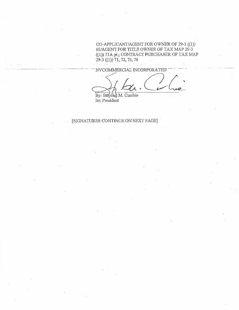
CO-APPLICANT/AGENT FOR OWNER OF 29-3 ((1)) 65/AGENT FOR TITLE OWNER OF TAX MAP 29-3 ((1)) 71A pt.; CONTRACT PURCHASER OF TAX MAP 29-3 ((1)) 71, 72, 73, 76
NVCOMMERCIAE INCORPORATED— -
By: S ph M. Cumbie Its: President
[SIGNATURES CONTINUE ON NEXT PAGE]
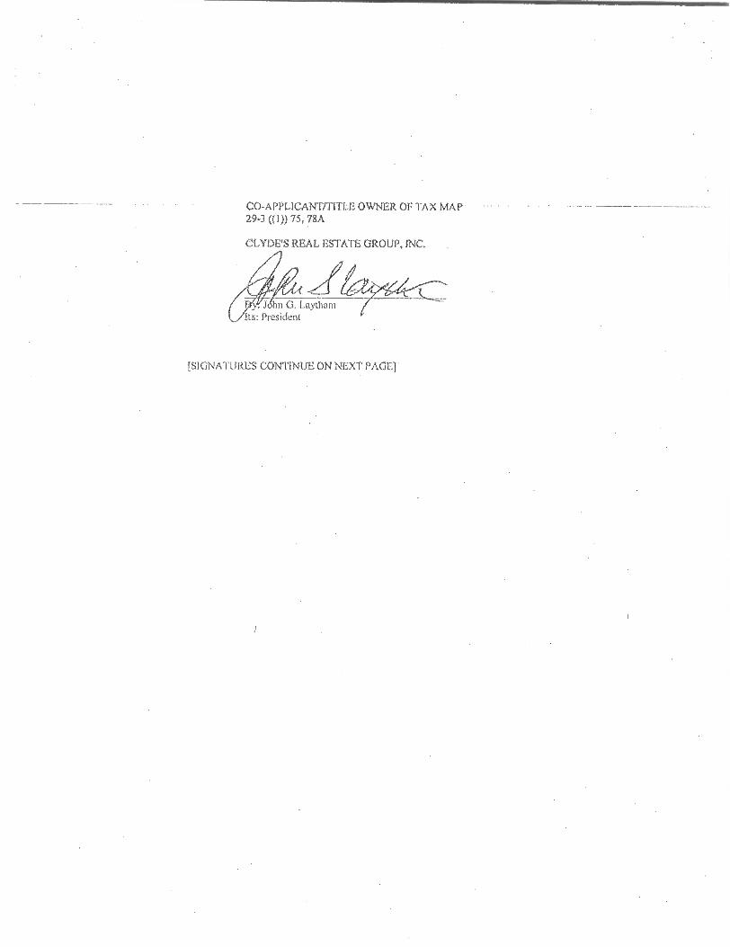
.J6hn 0. Laytham ts: President
CO-APPLICANT/TITLE OWNER OF TAX MAP •
29-3 ((I)) 75, 78A,
CLYDE'S REAL ESTATE GROUP, INC.
[SIGNA.TURI.::S CONTINUE ON NEXT PAGE1
By: Step Cumbie Its: President
TITLE OWNER OF TAX MAP 29-3 ((1)) 65
TYSONS ONE, LLC
By: NV Commercial Incorporated, its Manager
[SIGNATURES CONTINUE ON NEXT PAGE]

TITLE OWNER OF TAX MAP 29-3 ((1)) 71
TYSONS PROPERTIES, L.L.C.
_By: Lassen Family Limited Partnership, its sole manager/member
By: Sellica Corporation, its sole general partner
By: Lenora R. Lassen Its: President
[SIGNATURES CONTINUE ON NEXT PAGE]
TITLE OWNER OF TAX MAP 29-3 ((1)) 72
LEESBURG PIKE INVESTORS, L.L.C.
By: lenn H. Rosenthal Its: Managing Member
[SIGNATURES CONTINUE ON NEXT PAGE]
By: Sharon IL McBay Its: Manager
TITLE OWNER OF TAX MAP 29-3 ((I)) 73
MCBAY TYSONS, L.L.C.
[SIGNATURES CONTINUE ON NEXT PAGE]
TITLE OWNER OF TAX MAP 29-3 ((1)) 76
8334 LEESBURG PIKE, LLC
By: All Akbar Parvizian Its: Managing Member
[SIGNATURES CONTINUE ON NEXT PAGE]
y: S n M. Cumbie Its: Administrative Member
TITLE OWNER OF TAX MAP 29-3 ((1)) 71A PT.
TYSONS CENTRAL LLC
[SIGNATURES END]

" "
4111i
111 l
igli
18"
e
i IR
1811
1 111
! "
lb g
SI1EE INDM CIVIL C-L COON SHEET C-1 NOTE C-1 NOTE AND TABULATIONS CA =GINO CONDITIONS PLAN C-1 LIMITED AMISS TINE EXHIBIT
CONOSPTUAL DEVELOPMENT NAN C6A. OTNCEETUAL DININGPMENT NAN maw=
uhateD ACCIPS TUNE BREAK OQ CMIC73ITUAL DEVEUEMENT NAN W/ULTIMATE
CENTER STREET ALIGNMENT FUNCTENAL DRAWING AND many HAN ULTIMATE TYPICAL SIREET SECTIONS OXICEPTUAL DEVELOP/0NT HAN WITH INTERIM ROAD SECTIONS
c-rt
MGM SIDEWALK. AND STAMM nice / CENIER STREET INTEIMECIION. OPTIONS
11 0-11. EXISTINO VIMETAMON MAP AND CALCULATIONS CO. TRAPPE CEROJIATION. IENTED ACCESS AND SIGHT DISTANCE c-o. OVERALL SPORMWATER MANAGEMENT PLAN
IT C44. WM OVERALLCOPSPUTAT1ONS AND SUPPORTING OVA n. STORMWAIER MANAGEMENT NARRATIVE
MEW 21 OR IIIRIJ STORMWATER MANAGEMENT COMPUTATIONS U C-19.
TW IT VAULT AND PIO DOOMS
Il o-n CDP ADEQUATE OUNALL DISCRETION
ARCHITECTURAL A-M. GROUND PI= NAN - OPTION 1
A- MA. GROUND PIZOR PLAN - ONION 2 A-132. RCOP PAN - AERIAL VIEW - ornoN
A-MA ROW PLAN - AERIAL VIEW - OPTION 2 A-151 BROW GRADE PARKING PLAN - OPTION 1 k 2
A-EA METRO / PEDESTRIAN AC= HAN - OPTION I tt
titp
749
1,1?
M
MX
PIS
PR
OO
AS
OX
OP
OS
OP
9P
ftp
0ft
P
RIO
MA
KM
XP
PO
OPI
PA
AR
XP
AP
A01
$64
WP
PO
4rM
PK
UNP
PM
NP
FI.X
P P
pldt
. o .
.,......1
1
/1/1/
1//1/
1 P.
lo
n 1
1 El
1
11 1 i l!li 1
. . !
. 1
eTh
„.,:„
.....„..
.,„:....
,"17
! .:, , , ,_
, _ _
, .
-::::„
„..r
.„._
.. , ..
„...,-.„ „
,,,,,
n
. . . ill
".75=
4j:.?.‘Y
--cP!5'!:M,Y
-1V-A-ii
i .,,
rstiz
z:A
i1.64
-1
Cd )
V
, : t
=-I,0
-1714
.3,Z
1,,ki
,__,
O
a
.4- ,
m"pl
ity , , , .
i
4.,
' ..4
k--.
,v ',I
0,,I
.4.4i
,,, li
gle)
;:
::.s\-:,,i
vii ,
,
,,.,..
..,...,.
..,-_„..„
,.._ ,--
-,- ,
,7"1
tti
!-.4
Nd O
tte i
„% ':Ele
ggliV
ictilgP
14,110
4M ,!4
l . --W
-1 0
'i Il
ii V
iifii th
itarrr
Ari H
p; ,`
-, , ;.`
;`a
'..:,,14
it
1,0
1u4
4i1
.ga.
...,
....
— .
.1
c,,,
4.;0
142::: i11:
1117Z
IL
:A=
ZJI
!1
)1:J 'Ili
tt m
air, I
I
.1. rj
ugog
tqgx
--744.5
.w.T.M
.M.,..,
”. i'
r ' 1
p_...-,,
e•t■r--,
■40..
..,_....
110, ...
., _
''.1
R '4
!1 1
11
1111
1E11
1111
1M4
50:1
4 1 +
4 1
.:'";
-..-
115.2
n.m
gg,
„J..
.. ,.
...,,„
,.....
..„
,„,, „. „
, „ :
, ..
:101
671:0V.41
-
kli' ' 4
1 ,st
' , ,
. ..!:,;•.:(
.; . 4
: -,
, ,'(i '!
4 -
.,,ii,4,;
,,,,l,r ''
", .,.
1.?-31
kCsj,5
4 ':..
. '', ' '
it '
:
C',11:1
1.',$3
.- ,1
,,.
!. ..,!
:; :il t I
I ,r.
.'-'
..i)::'-
'0.;-:
1 ' '1
'.f71,i'V
l 1.1.Y
r,' r
v I i jo
1 i '' '
'' ':•°
,i•,,•
-•:.
• H
Lt' , ..
'''A .'' '.'.4..
4.',.
.-eq
6 A - :,
Ailiiit ,
vti 4
-, i q
m„ ..!
..,, .V
..:;,,r,O
K...4:4
,- 1
1 ,
....- -
$....
. ( .. ,, --
5-mow
eva
7-- .
: .---,
..N,,1„
cs.:,ik
.-..
1 g 2
1 1
,/..
pp
6: 6
CI 8
:: =
,,...w-.5
" i- ts, ;.,f, .
... '
' . - —
_„4,---
1. :,,
,e,
0 I g
! 0 M
g /9
461, A
, V
O-i =e
; t4
.0 4,
;_,-,-,-.:,
...t...,„,.
,,,,. ..'
h .
- ,'-'f (
!., -s,
.1
•
; Y ''''''
10.. 4.
.\'‘) 0
- -, 7,41
0.1....:„: -.m
. 3
5. ...
. „---... =
., 5
' 1
M
MX
ZZSPAIigg
iiES
HM
Mk
;;;;;WW;;;444
k;;;;W
W;M;;;
P3
=132 222 ;
;2222
2210
1
11111111 1110111//
r111 11911
91111111111111111
11111111101111
111111111"1111111111111
Illhp 1
62q—
Is l. ,n15, i
llig M1
1„, UM
MU
M., ,,,,,,, 1
,..N
g Mill i
gi i il
- g
gl ' iiillp
iggilliN
aINNI
ii ,,,
qiiiilliliii11111111111104
14111ill
aiiii
A-INA SITE =MN A411 SIZE SECTION
A-IPA. SITE SECTION A-156 MIE SECTION A-El. S TE SECGON A-LIL SITE !scow *411. SITE SECTION A-SS1 SITE SECTION Ali m SEcnoN
A-MA. SITS SECTION A-I62 EXIEMOR ELEVATION
A-VEA. EXIMUOIL ELEVATION ma MUM MILVAIION
A-SSA EXTERIOR ELEVAT/ON A-194. MERLE ELEVATION
A-EN. MOIERIOR PLEvATIoN A-ES 1MTERKIR ELEVAT/CN
A-16N. EGERIOR. ELEVATION A-161 EXTERIOR ELEVATION
A-INA ILINIBLIOR ELEVATION A-91 EMMA ELEVATION
A-167A. EXMOOR ELEVATION A-1G.
AIX A-111. A-H2. A-PA
A-MA
A-US.
111
Si i
2N1R53
A.gliSP
g%
1
P q
L-13 CONCEPT LANDSCAPE PUNTING PLAN (ALIT WIEN Mil TREE CANOPY COMPUTATIONS
IEEE PLANTER DETAILS PARK A 01M4 SNCE PLAN (ONION D PARK k MIN SPACE PLAN (OPTION
L-U TILUSTRAIIVE SITE PLAN (WON 0 11J-USIRATIVE SEM PLAN (OMEN ILLUSTRAIIVE SITE PLAN (ALT GRID)
IrL TYPICAL STREET NICER:RE ROUTE T STREMSCAPS ENLARGEMENI, METRO PLAZA ENLARGEMENT. METRO PLAZA MODEM T ENLARGEMENT, 111151 PARR INIMUM OWILEING I2 A TO ENLAMMONT CLI:DHS PARK (BUELDINO 17 k E)
k-Al ENLARGEMENT. CORNER PAR AND THE EX= PARK 1.63 EMAROBBONWP KB PARK AND MATS AMENITY SPACE 1.-66 Ld7 ELUSTRATIVE PARK VOWS 1,11 LLUSTRATNE PAIL VIEWS LL mica. anon' TRIM DETAILS 1,72 TYPICAL RAN GARDEN CETAILS LAU NE= METRO PL17A HAN 1.112 ORE-SITE DAPROVERENT INTERIM PARS •
1 MIBTEMENVIL S-L TIMMS onarra. 7 SIM,SECTEN PO= STREET GRID PLAN 3-1 PEE ACCESS PLAN S-1 ROAD DEMON STANDARDS SUMMARY
WANES / INCEPTIONS OP TYROS CORNEA TRANSPORMTION MANIC STAllDARC6
s-s. DEMON VEHICLE MOVEMENTS s-A MEDIUMS (W11-40) OONIROL VEHICLE MOVEMENTS
AITTUTURNS EVE-97) CONNEL VEHICLE /TOMAH=
11 11
1
Mil
l'
'..
"
1...-
muanwrns VIEW - ORLON 1 A 2 ILLUSTRATIVE VIEW ILLUSTRAIIVE MEW ILLUSTRATIVE MEW ILLUSTRATNE VIEW SHADOW MUDS - OPTION 1 SHADOW SRIDY - OPTION 1 MAW* MAN ENS= PLAN PHASING PLAN
il
P._.4
8
H
gc) 71
°7:1
1
RZ 2011-PR-005 RE: SEA 2008-MD-036
CONCEPTUAL DEVELOPMENT PLAN
, _
. 7 -_
‘:.■,..
-t
1 ,,, ,:,
i ,r I-1
....;;. .1'4,ca, s,
r,
::FeaiLirTK;,3
”
,
1
111311111111111111111 1111
. • ;';.
11'.rt
IV.'44°"9
0
;
,', a11111 r.:11
A :filif.i• id ii WSW
...if'"':,;'::.W,V::'
,./(4.:?.
Vg
C) '..;, IM:is:I l'iiii iiii E E E E E t
n' ".-4
14/..$'
Z,7.'W
eki
EEE1-
ivtitrP
''',.
I ii;iql E1,:
1 I gliii st E .1111 Eg +;
,,ei.,1"-:.510
szi- r A1-4
- .
:4 1 '. .i :4:1 'XI MCI XI M
EV=
- ,144.t.,.4,, ,:,:
ek.e. %,...,w3
0 1 II '1 li :1 : : lil.,11111EEE F4 a 1
,4.411t!!F
eW
4/ A
-
11• W
I 1
1 I il It 1 il
ri=°M
.O-rd
-1:: 11 jrIV'
41/4;44
.. ikl
›.
, .
..
,
,..,,,,,,,.
.
....
,......
„,,
,,,..
...:„, ,
c,,
-,01 (
...41%suRrit
,twwwwwwwws
- ...,
:Ts, .-.1.- .
3.-54F.4.*I. •,•---i -
101 .-,:,.. Il I 0 :67 hi .........,,Baucgtsm.', Ng inlinjiHniffill
.1.1.,1b.
Wu Ing ii :".111111111 II -*- I
1
RION .allIlligninfliiiiii
BM 11
..."''7 •
47111.t III ' ''' '
M HUJII Iliiiiii EN,,,,,,...w;io.i....b......., unmilmilii...
m•APinisavmsmiantextereserreAll111111,111111131firta
. „a ,,,,, .„ . , , , ,_ Wleri.F.51..7iiiii?ExtErerFairinfl ,11111111111111111111beims •• 1112111 I 1 t, , , , MWIZA111.15117,Szt7.11.,11B,LIZATInT . ' Ill11.11111111111
r
F
TYSONS CENTRAL
1 CONCEPTUAL DEVELOPMENT PERSPECTIVE
g
,, :r.i
i .,•;..; 7: Zi 7,7
-
' . ,,••• r
hi-).•(
- r145 .i.v.!
is i
4 .1 A
rm= - cm= -I IL; i:r1
.,- t?i,- , 31
-'; fft4
0
g b- Di.
t.7)
tN.) C4
-;- nua Ira
amonE
ESES,0%-
----- ._____
_:-A.z4%
oc)
v ,
,
: ;
mf11311N1Fe
■
=====
-- , ) '
..,1:,--gg'i54:#.yl eC“-
■ 1- I.<
pan ;lett ,Tyk I
,,
,
,-1.
41111it
, ilifiVe
rms .
-wr-
-.
'o).:1,441741
-1 '38 ,-- tpr
zil " '-''',..c m
8 _Lc-)
. ... 00 (:::,
■
-111'3L1,11611vd11: II:: CI SI i CI MIX CM
= -'45";
Ote..0,
5,,s =
•■'',.
6.
■i
, , .
-
' t:"
ikki4 fogWV
er "
t•-,
(I'D 8.
c't•-)
-
1,_ ' 1 Mid
, Iffiapiet
.
cIA, :
88,)
8 2'8
8 0
r i rill
4 = gg
FEBRUARY 22, 2011 JANUARY 25, 2012 MARCH 30, 2012
JUNE 20, 2012 NOVEMBER 19, 2012
MARCH 11, 2013 APRIL 18, 2013 MAY 13, 2013 JULY 10, 2013
AUGUST 15, 2013 OCTOBER 28, 2013
NOVEMBER 11, 2013 WifIEWP5
ill
N
ITir
-
2 \-' = se'
LANDSCAPE ARCHITECT LSG LANDSCAPE ARCHITECTURE
1919 GALLOWS ROAD, SUITE 110 VIENNA, VIRGINIA 22182
ROBERT K. ESSE.BURN ASIA AND STEVE CHOI, ASIA (03) 821-2045
TRANSPORTATION WAT IS ASSOCIATES F. TM 5
1420 SPRING HILL ROAD, SUITE 610 Its ,4;," TYSONS, VIRGINIA. 22102
ROBIN ANTONUCCI MICHAEL PINKOSKE
(KE) 36S-9262
1
1 w g i gi
iR
E
4.p-pc9
20
2
4
Pi
q 'I
g!
,Igil
z5g4M
W°;;' , 3
Po
i g!N
srp, 3
4 12
,-- 2
,,g § 5
„
„-V
- , m
.........
4....4.
P
iO'''',0 e.g,8° i.2/4
P
k;]:
';1;i''''';
',
11b0
g8
-6,„ 1 41
011
81
"1 gp
,alg
'._„,p-c.,,.._:, ...-....-.r, , ,
,,,,key:•,„::,,,
s 25
' V2
J!P
g
g @
s g h
.4. 4I
„,
..< ,.
. , :
% ,
_•
• / .
s.,i,
0
1
' P'''''”
, '-'''''
: "..,1
4!:,
ii 11,
- ; - ,,,
>.
73
P
,,,14-.-4
-2‘
--Jr_ ,,• -A:
APPLICANTS' REPRESENTATIVE WALSH, COLUCCI, LUBELEY, EMRICH & WALSH, PC
2200 CLARENDON BOULEVARD, 13TH FLOOR ARLINGTON, VIRGINIA 22201
MARTIN D. WALSH ESQUIRE & ELIZABETH BAKER (703) 528-4700
ENGINEER VI/CA INC. & VIKA VIRGINIA LLC
8180 GREENSBORO DRIVE, SUITE 200 TYSONS CORNER VIRGINIA 22102
ROBERT COCHRAN LS. JOHN R AMA1U 1 11 PI.
(703) 442-7800
CLYDES REAL ESTATE GROUP, INC 3236 M STREET NW
WASHINGTON, D.C. 20007 JET-1. OWENS (202) 3E-9180
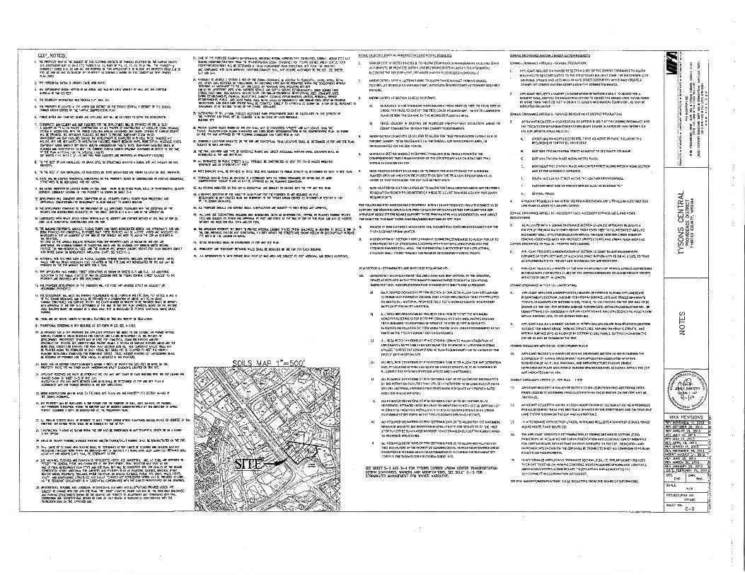
SOI S MAP 1"=500'
(r)
0 z
_CCP NOWS: I. Ort PROMO. ME ES ME DUCT Cf TH5 NEON. GOD. OF MOS DOOR CR TH FARM DAM
TM AGSM. MP AS 0-3 (0)) PARCELS 65, 71. PART IF MA 72 A 7176 • 70. AC PROMO 5 010121119 MO OIL 9C NO NC. OE NOOSE OF MS .1CA3611 LS 70 RE.. PROEM DOI CA TO PIC SC NO NC . A IOW RE PROMPT AS COONE ROW 01 MS CONDPIIIN DEL1OA07 RAN DOD
2 It NONONTO MN 5 11900 ST. WO .11.
DIC 1.00110.1 MO MEN IS As MIAS 0010. NO FED VENCE BY VOA NC OE ENTER NUM 61X3 (7) FEET.
1. 11( 551041 MORO. US PRIMPS OT WO 10
1 MT PRIPOTTY 5 WOO N ME MEW SLR MIDI Cf DC TO. MORN 7 COOT Cr MC MC. ORO UNAA 0110 Cr DE WEE COOREMIC R.W.
6 PUBLIC MDR . SANITARY SOO AID ATWELL AND NIL BE Or1000 70 SERVE DIE DEROMET.
7. 67.11010t ILMACELED OE FAME 711
10 COREIREET 0 PROEM CR DE 0 DO
5A MN. AS 10 .09 PNAS0 03651.006 At µl 550 Cr C0.7.1.1 00 MEOIATE STORY CRI.ISE 1SAN 11 ACCOIDANCE NM THE OBE FAMES WHIN SOON. 500 *0304 MEM OF 0001 COME
01. ID PROVED ME AMOK FIGI3OES Of ROG 10 PROVE UMW STERN ENO MOOR° . FOE EOM SHOULD M 00171.65ENT BE COMEE0 x POSID MEC FA UT. LIAT POLE( NI 06 NOT MO 10 11.1160101 FAOUPED ROOT ROOK BOG BOREDEM (CEDED OM TOPCOAT OM ORO 051 PCNOS AF/15 0OR000 VOLTS ND 11.01. ROUTES MAL RE 0E900 . 0941RUCTO 10 NE/. 0.0170.19/1141 WADY SWAMP EAMON. N ME AT ME TME OF DE P1MI AAFROVAl FOR M SPEMED F.ITT 974 911272 0-17 11.1 0-7C MO DRY .11 POLE EOM ME PROPOSE AS PERM.. MODEL
B. NM LIM OP KNOCIDD NO CR. ME OR DIELORIIIS MONO A BURR SIE ARE P.M ON MS
9. 70 THE .7 0 ON MOMME. NO WORMS DI TOM SUBSTANCE APE KNOW TO OST IN MS FAMERTY.
ID MERE ARM CRS. REDO. STAIONNIS Of IC PROEM. OARS ED 016101101 Cf ECM CORIETIAL STRUCRIRES TO BE 0111720 Aft NOT WOW
11. 11( ONO PRCPERTY 610X50 WM AN NW 2. MK 5 NO ACCO RML IVA 07 0.6010101. MOM CERROM EUROCRAT EOM CA IRIS OMR. AS 91001 ON 9.7 C-4.
11 DEELOPIENT INl CONDO UPON COIREICII Cf ALL RENO FPS. COUTPIP RAN MESS.. MPROVALS. 000.1010 CORD I00 0010000010004561I005 1105 MEE 70 WOE ECU.
DIE COUCPONT ONO. 10 7( PROMOS Cf Nl APPOr/81 SINONDI UM THE CREPT. Of DIE AMOS AD 1170/0704 RECUESITO CIA MS 9417, STEEL S-3 5-4 NO N M APPUCITION
14. 1.7.011 EPOI SP. ARIAS SHCMI DEM NAT EC MEM NO MOO WO. At M T. Er MP SO LONC MN SOSTANIM. 07950RAMICE WIN Pt EDP.
16 71( 0.11-0. MEWS GARAGES, DAM PARKS MO ROADS REPRES9110 MON ARE OPPRONATE AND . PENG PROW. FOR ORCIETUAL
TIN: 17271 DAMES MT BE OTERO NOE MO NOOSE OR
OLDEASED N 971 IR OUAIMI , 01 DE MC OF FM NOON . REED TO .NO ME COP DE PROM. SO DO PS 106 ANIKM MOO SEBUM 019M DE PROPERTY OES LS SOW ON 1NE 1001000,. OE NONNI MOM OF FROMIAL ORS NO OD 71.3.. MM. GROSS ONO FIXITACC TM 101-RESODITAL USE AO DIE NW. ProMN. O.. NOCHE EN EACH BUMS OMIT NM VOX .171N 01 OIVELOMENT TOULON MART. SET 9417 C-1
16. 0071100µ SR RONNE DO AS NAM GEMS MONO 0O0 3, DELO. INTRANCE 9045 10112. MDR NO . AEESSCRYIPAS MOTU M PIC Ort NO7 RERACANTED ON DE MP MT OE PRIMO 0 MOP 111.. DIE .0 FOR A 07.
17. MS OP ucsnal WS WADS EVE 001.05 AS SON ON 91222 45 NO C-6 NO MO.& 06.101 TO RC PUBLIC ROES) Cf WE CR DEMO POEM TEENS COG. STREET 0.0217 10 OR PROPERTY ARE PRIMO NM MS 0.1301.T.
16 THE PR.. 05)107101 0 TO PROVO NIL NOT POSE ANT MVO ME Of RACINE OR NE0430.0 POMMIES
19. THE DEM. MLL WET DE 0010.0 RUE.. AS SE FERRI N DIE PIG 200 RA ..Font 6 NO 11 Er MI 20000 omoscE 000 DAIL BE PRONE N A COB.. Cr MOH ONO ROE GR. PANINC SIRJOINES. SAT. 9.341 DE EXACT 14100 OF VMS 0 BE PROW. 9019 NOVO NM NORMA Cr DE FOP RIO DEIERN. Al MI T. IF MERE RAN 009501 M.9D II INC DERE LOS BUIUDIC HO. OR 14110011 OT STONES WU N01 ID HMO. IC MOW ADOMML.At OWE 00004
TEE ARE 0 DOE ASSES OR MAMIE DODO ON MS SE WORMY 0214X10101
71. 171.970. OM. 5 NOT Rain AS SE maim Z0 SEC 5-5100
72 AS PROMO FOR ME PROM T. AMEND DEM NE ROIL 10 ME MING 0 PROWX IMO Mr. EON IX AREAS DECRACO FOR ONT.EM 07.60100 05 ME PHASIC OF
ONELONOTT PRCGRESSO SPACES MT BE U710 TEN COM.. COWED PRONG MOM 0.7.1100 STRAD SCE NEVEM. NA. RAMS IF AWN OR RAMIE PO. AREAS ARE NOT WAG LOA MEAT TOR PARK., TIM MORE nos D0150 00713 DO 101701. OW TREE NAY E1E RAM N.C. THE MVP Cr MO ISM RD SHALL NOT BE RICO. 70 AEU DE MAN RANT. WHO. SNOODS 710 PE 44047 5IRE7 TEII NEM MOIR LOT LANDSC.0 SHALL O ROHM OR PROVO MN DEE ARM PS DEMO VI ME OWED
21 19170 NE NO MENG MIT ODOM NAWC ANON OF .00 Mt (75) RI OR KR NM PROM. ROE NE NO ODER 001 MOTICROPO YIU11 EADMITS LCCA1131 ON MS DC
M. MT.. REMO RE NOG TO 0121204 M3000 DOT Of UM RAMC 1011 RE TOP (NOM 1% INWES SNOW ON SHEET C-3) Of DO 07. ALDO. PE Ia. 0105 BODOLAM BAYS 9. 1171:11146D Ai /DP 12 ACCORMICE VON OE 17.0 DEMO Of DIE CM 00.KA1I6
21 MDR 1■60110117. NAY RE NAM TO DC FM. 9E RANS FM ME PROVITT PER RION 16-030 CRIONICE
76 THE PROMO MAYO 9.000 N . TRUK FORM PURPOSE fr SALE .04T WOLK ON FROC. 007 PRIMO DOCINSION SHO. ON MOW NAY BE OWED ADAMSTRATIVELY IT THE ORE M Of 6006 ADM, NOM. AIWA OR MEOW Er RE PPE.. ANL
E. All PROATI SNEED WEI O 0000 10 WET MONS UPBAN SEMI STANOARDS INLESS HALO OR MOTO DT DOCTOR MI 0004 SPED 216111. BC 001316.0 AT 111E
16 06401.C. NOVO AS SON VONN MC 07 MAT DE UNCOINDEN ANY MODEM CRIER 111 AS A STAIO Pp. OPOON
29 *HAS EIT 9000 MOM MANAGE PAAKNG ./01 TANDY/MLET MOO RI. BE OCIONSTREO 0 M RIP.
055 00 cc ORATOR 040 0A0NG SOU BE DRONED AT FM. 0113 OF 01.110 5*0 SWOPE WE NOT OSS., PELL. ACM AMIN MI 1091.-0910, i SPAMIE Pf PLANS NNE BCO 9.00X0 RCM. WI
DOOMS MD WC. ORS SHALL FE 01131.70 AT OP.
71. STE ANENTO. FEATURES .TINNSMIS 5003115E HERON ARE COM .. AS 9101, ARE NAM 10 RUDE OE COD. MOE 00 MADAM 0 RE 07.1.01.7. FWD DIE. MY WRY 07 11E
If r1101. 80110101(FDPI NCI 911 AAA. BUT IR FE 07.511311 Ilf CINDY IT Of 00101 PUNT REPREENIED .0N. ACOMONAL. ALONE NO DOOMS SUM . 5.11070 0.321103 FOCH. OEN SUDS ARE-LS Mao. TEL. MO lomIND OR 9E11DAV. MEM 9AT. SONG LP.S. ORGY VA1161416( SAUCAMS SAWA FORDS 11010.9:100 MOM MY BE PROW. AS LOC AS DE MULE. 0.100..16 N .STANTAL CONFORRACE 14111 M ONLITY WREN. CAI DE MEMO
31 .0111ECTURAL MARC . INOUE ANENTECTURAL DOM NO 1.111671.02 PROVO WREN . ROW 10 OMNI 5111 FOP 000 915 O.W. MI Cf. LOW. 9015 AN SR Of MI PRIPOSO .00,0(0 NO PAN. 01001117190 MON 01 11( 0600 PR MAE 10 ALLOSTENT NO 07104311. FINAL ENDONAL AD NORECORAL IOW SO AMC M MY nONx N SuBSTMIM. COMNINCE NM MI REPIESOITATENS 0 TIE AMMO GOP.
RUMAT MEMO. 00.10100 w5lv5R1 /14001FICATIONS 55010075
1. WAIVER OF PON SECTION 60303.3. TO ALLOW STORKAWATO MANAGEMENT FACILITIES ISWER
AND BHP) TO BE PROVIDE/MOON UNDERGROUND...MS WITHIN THE RESIDENTIAL
BLEDSOE ME DEVELOPMENT. ISEPARATE WANES FILED 001687.WEV0-001-11
I.
•
CATION OF PEA SECTION 7.2070 ALLOVITANOCWVALET PARIONG SPACES,
CONTROLLED BY BUNTING MANAGEMENT, W. SUCH SPACES 001.11.70WARO REQUIRED
PANONG.
3. MODIFICATION OF SECTION 12-0S1070 PERMIT(
RJ REDUCTION MME MINIMUM PLANTING AREA MORE.. 01 FEET, TO STK (61 FEET
ORDER FOR TREES TO SATISFY 77.15 TREE COVER REQUIRED. REFER TO LANDSCAPE
PLANS HEREIN FOR GRAPHIC OF 7(55 PROPOSE/ FIRMING AREA
10 TREES LOCATED IN EXISTING OR PROPOSED RIGHT.CE.W. DEDICATION AREAS TO
COUNT TOWARD.. TIMOR TREE CANOPY REQUIREMENTS.
4. MOOREATION OF SECTION LOSE FOR TO ALLOW FOR TEE PRESERVATION TARGET AND 10
PERCENT CANOPY TO BE CALCULATED ON THE OVERALL COP DEVELOPMENT WARS
DEMONSTRATED ORME OF HERON.
RAMA Of SECTION 5-0102.3NEOUI5INGTRMLSANDIME MAILS SHOWN ON THE
COMPREHENSIVETRARS PLAN IN FAVOR Of ME STREETSCATI AND 05-11053 BIM TRAIL
SEEM SHOWN ONT.°.
6. MOOMOTION OF SECTION 1206012BM PERADETHE REDUCTION OF THE MINIMUM
PUNTER OPENING ARO FORTNER MOTO SAM. THE TREE COVER REQUIREMENT, IN
FAVOR OF THAT SHOWN. Mt COP AND AS PRORFERED.
7. MOODICATION OE SECTION 12-05160,0 .OW TORT.. LOCATED ABOVE ANT PROPOSED
PERCOLATION TRENCH OR 0104E5EMEEN AREAS TO COUNT TOWARDS COME TREE COVER
REQUIREMENTS.
FOLLOWMG PFIA WAIVERS MODIFICATIONS E TORY 10 ARE MORD PROM THE DIRECTOR 70
SUPPORT THE DESIGN ELEMENTS AND PROFFERED COADATTMENTSOVONS APPLICANT AND COP.
M.G. REQUIRE THE WARD WPC. THEE PEA MAMAS AND 140011CATION AND MET
THE OR1CTOR TO GRA1.71062 WILIVERSOICOGICATOMS AT SET PLAN.
0001ST OF PEA SECTION 7 IN FAVOR OF THE TRANSPORTATION DESIGN STMONIOS FOR TM
MONS CORNER OMAN COOED
9. MODIFICATION OMEN. 7.072 PAM. MOOT. STANDARDS TO ALLOW FOR UP TO
PROACT.4 Of STRUCTURAL G.L..WITHEN PARKING STRUCTURES .07.
REQUIRED PARKING STALL AREA THE PARKING STALLS AFFECTED. SUCH STRUCTURAL
COL.. SH.1. COUNT TOWARD THE NU.. OF REQUIRED PARKING SPACES.
PEA DERN 6 - STORM... AND PAP CODE REOLANDAENTS
10. INVOTKI. / MOOFICATION OF MOUND SW. AND OAP MITER.. THE DIRECTOR,
DPWES AS OTLINEDN THE MTORMWATER MINAGEMENI 05907 MN DEVIATOR
NARRATOR OUTLINED ON STORMWAER MANAGEMENT SHOTS.. AS FOLLOWS,
A) ALL REQUIRED MERCK OF PAM SECTION 61304.0 TO ALLOW FOR INSTAUATION
OF PERMEABLE PAVEMENT SYSTEMS THAT VERO INFILTRATOR TO 10 CONSTRUCTED
ONINSETU FILL MATERIA, PROM. FIELD TUTS.. AIXQUATE INFILTRATION
RATIO UM FOR INSITU MATERIAL
B) ALL REQUIRED DEVIATIONS Of IN14 SECTION 6-1304.1170 SEM MINIMUM
HORDONTAL SETBACKS FOR BOTH 5011177.ATIN0 AND NON-INFILTRATING SETE.
FROM BVILDNW FOUNDATIONS 67 REDUCED TO 7150 07 FERIA ORDER TO
MOLTIATE INSTALIATION OF PERMEATE PAVERS IRAN URBAN ENVIRONMENT. SET
FORTH IN 701E MONS CORNER OMEN MADE RO
CI ALL REQUIRED OFINATIONS OF EN SECTION 5.7304.41 TO ALLOW MUTATION OF
ROLM.. RATES LESS THAN 0.51 INtHR FOR DESIGN OF INFILTRATION SYSTEMS
LITILIED TO MEET. COMPREHEMDI PLAN REQUIREMENT FOR RETENTION OF THE
FIRST r 0 WNW OWSRI.
0) ALL REQUIRED...2.0F MA SERIN 6-1306.1F TO .0. FOR ANY DETENTION
FMK. LOCATED WITION A BIALDWG OR GA.. STRUCTURE TO BE GOVERNED.
BUILDING CODE NECIMREMENTS FOR ACCESS AND fANNTENANCE.
EI NI REQUIRED DEVIATIONS Of Pi. SECTION 6.1107.7C TO ALLOW FOR MISTALLATION
Of IONVENTION FACIA., THAT UTIVE INFILTRATION TO BE 02E6TRUCTED ON 10
SITU TILL AIRS., PROVEN FEED TESTS SHOW ADEQUATE MFILTRATEIN RATES
EXIST FOR IN-SITU AMTERLAL
FI ALL 1.01050 DEVIATE. OF MIA SECTION 6.1307.2E TO SET THE MINIMUM
HORTZONTAL SF...FROM BUNGING FOUNDATIONS BE REDUCE/700RO (0) FUT
M ORDER.° F.EnPArz INST.LATION OF INO-RETENTION STEINS MAN MAN
ENVIRONMENT SIT FORTH IN THE NSONS CORNER DESIGN GUNDONES.
11) ALL REQUIRED OIVIATIONS 0 MM SECTION 61307.26 TO ALLOW FOR 71.1.0110.61
DRAWAGE ARE. TO MORETENTION FILTERS ROOD FOR RETENTION OF ME FIRST
1 9 0 RUNOFF BE ELDNNATED IN MOOT° ACCOMMODATE ROOFTOP RUNOFF PIPED
YO PROPODO STRUCTURED
• ALL MOONED DEVIATIONS OF PEA SECTION OEM. TO ALLOW INSTALLATION OF
TREE BOX FREI. LATHE WW1, OF FADING DOR. VENCE MAINTENANCE MIAS
OR OLTICOOR STORAGE AREAS HT ACCOMMODATE THE URBAN ENVIRONMENT SET
FORTH IN THE MOMS CORNEA DESIGN °ODIUM.
SEE MEET 5-3 AND 3-4 FOR MONS CORNER UNMAN CENTER TRANSPORTATION DES/CN STANDARDS. %wan AND 11001FICA110N5. SEE SHEET C-15 FOR STORMIER MANAGEMENT KW HAILER NARROW-
ENO. ORDINANCT WINO AMOIFITATION RECO=
TONING °ROMANCE ARAM 2 -GENERAL REGUNDONS
1. APPLICANT REQUESTS • WAIVER OF SECTION 0.5030E ME TONING ORIMONCE TO ALLOW
BRION. TO BE 170100.0.0 TO 11. SYREITSCAPE SO.. ZONE LINE ON DOA. LOIS
ON MARC STREETS AND LOTS...UV. STREIT EASEMENTS WH. MAT CREATE A
CORNER LOT CONFIGIAMTION.DEFINED M ME ROOK ORDINANCE.
APPLICANT BEQUESTS A WANE MODIFICATION CO SECTION 29067 TO ALLOW FOR A
PAR.. WALL, CORNICE OR SHAM PROJECTION TO EXCEEDED HEIGHT IRAQ ESTARESHEO
111 MOO TRW 71410 131 HEIN OMER TO SCREEN MECHANICAL EQUIPMENT. AS M. BE ININCATED OM AN MP.
TONING ORDINANCE ARTICLE 6 . PLANNED DEVELOPMENT DISTRICT REGUIATTONS
3. /AMCAM MORESTS A MODIFICATION OF ARTICLE 6-501-7 OF THE COMING ORDINANCE AND
1115 TYSON'S CORNER UR.. CENTER STREW.. DESIGN IN FAVOR 130 THAT 910.1 011
THE CP73E0. AREAS DELUDE f
A. STREET °NEON NORTH SD( OF R71.7 AND ADJACENT TO PARK. INCLUDING THE REQUIREMENT FOR THE BUILDING ZONE
•
EAST ODE TYSONS CENTRAL STREET ADJACENT TO THE RODE 123 RAMP.
EAST SIDE STATION NICE ALONG METRO RASA.
D. NORTHEAST SOF STATION MACE AND ENTER EVE ALONG INTERIM NOM SCORN
AND ATT. SURD. IENTRANCE.
E. SOUTH SEE ONTO STREET ALONG THE vSA PROENTY MORA.
F. EAST AM WEST SIDE Of MINATO SERV. ALLEY AT BURPING AO,
OHM. KARA
APPLICANT REQUESTS ARANO WELTON 6906 PARAGRAPN 1 TO .OW A DISTRICT LIE
LESS THAN 10 .SORES FOR AN APPUOTION.
20070 ORDINANCE ARTICLE 10.1.030. USES, RECESS. SERVICES USED.. HOW
OCCUPATIONS
5. AS ALLOWED WITHIN TONING ORDINANCE SECTION 10103.6 APPLIONT REQUESTS A
WOVEN OF ME MAXIMUM FENCE HEIGHT FROM EOM FEET° MUNE. FEET AMMO
ACCESSORY USES /STRUCTURES LOOTED... THE MOUND FOR THOSE AREAS.
M.. ASSOCIATED WEN AM PROPOSED SPORTS COURTS ANO URBAN POO MASAI
MAT. ORDINANCE ARTICLE 11. PARKING F.LOADING
6. APPUCANT REQUESTS A MODNICATION OF SECTION 11902(4) REQUIRING MINIMUM
DISTANCE OE FORTY FEE 007 °EA LOADING SPACE IN PROXIMATE TO ORM AISLES, TOTIAT
AS DEMONSTRATED ON THE OP AND SHOWN ME. APPROVED FOP.
APRIONIE NEMESIS A WAIVER OF TN MAXIMMA LT.. OF PINNATE EMITS AS PRONTO.
PARAGRAP11 ZOF SECTION 11902 OE ME 6.1.11ROMANCE TO ALLOW MOTE STREETS
M EXCESS OF 600 FT_ IN LENGTH.
MM. ORDINANCE ARTICLE 13- AANCISGAPING
0. PROM NERDS'S ANDO...TON / WAIVER OF INTERIOR ORONO LOT EA74.4PE
REQUIREMEDS (SECTION 112020) FOR ME RU DEFACE LOTS ANO SPACE ON ', RNA.
sTRTETS AS .0.0 PER SECTION 13.202 PARA.. TO THAT SHOWN CM THE COP NO 70 BE
SHOWN ON THE FOP. FOR INTERIM SURFACE PARKING EOM INTEMOR LANDSCAPING NALL BE
DEMONSTRATE° ON SUOSEQUENT FOP APPTICATIONS AND VALLUITUIE MISTING VEGETATION
WITHIN PARKING LOTS. TO THE OMR POSSIOLE.
9. APPLICANT REQUESTS A MODIFICATEN Of PERIPHERAL LANDDARE REERANIMENTS (SECTION
13903.0 FOR ABOVE GRAIN ORO. STRUCTURES, PARSING ON IRMA'. STRUTS, AND
MERIN SURFACE LOTS AS ALLOWED ST SECTION 19203, PARA 3, TO THAT SHOWN ON THE
CO OR AS MAY BE SHOWN ON . FOP.
TONING ORDINANCE ARTICLE 16. DEVELOPMENT PLANS.
10. APPLICANT REQUESTS A WARTS OF TONING ORDINANCE SECTION 10403 RECRIMNGUIE
SUBMISSION MAE. OfVFLOPMENT P.H.PAICATON.S00.10 WRITHE
SUBMISSION OF ALL PLISLIC ROAOWAY, ANO INFRASTRUCTURE PHASMG EXHIBIT
IMPROVEMENT rtANS ANO INTERIM PARKING SPACES REQUIRED ...OWN WITHIN ME 0110
AND INDICATED ON T. TOP.
TONING °ROMANCE ARTICLE 17 ME PLAN - 2-606
11. ARMOR MODES AWARE Of SECTION 17-0140.1.005. 0 000.1.29
PARCEL ACCESS TO AMON.. PARCELS (OMER THAN THOSE MOWN ON THE COP) AND AS
PROFFERED,
00LICANT AfautSIs A WARN ANODE PA00100A000 OF SECTION 17.701 AS APPRO...
FOR.L REEL MO TOO AND NEE MAULS IN FAVOR OF ME MEMO. ANO ON-RO.
LANE SYSTEM SHOWN ONTHE CLIP AND As PROEM°.
11 IN ACCORDANCE WITH SECTION 0-001. APPLICANT REQUESTS A WARTS OF SERVICE ROADS
ALONG ROUE 'AND ROUE 123.
16 Off AMMO. M.S. A DETERMINATION OF DRAG DEONANCE SECTION 17-01
PARAGRAIN OLINEOUIRING ANY EUATHEN ROOM. AND CONSTRUCTION OF .11.0NG
FOR DIEING ROADS OFYONO THAT .11013 MOOTED ON THE CM. DEDICATIONANO
NAPROVEMENTS MONA ON THE CDP SHAT DOMED 70 MET. COMPREHENSNE PLAN
TRUER PLAN RECIARREMEN.
16. DA0CEW1HCOMNG ORDINANCE DC7.17.201(7), THE APPLICANT REQUESTS
ME RIC. TO ISTABU. POKING CONTROLS, SIGNS MELO. DOING AND LOOTIONL
AND POKER MITERS HONG 'RNA. STREETS WORM AND ADMENT TOT.
DEVELOPMENT. COORONATION WITH FOOT .
SEE PEN WNVERSOADDIFICATIO. 1.7M REQUESTED TROD THE ILOARO Or 30E0055005.
viK A REvISIONS (72SCILLEATIE ,
RE, OCTOBEF 05. 2012 REV AUGUST 11 2012 REV ALT ID 2013 REV .1 12. 203
*PRE ITS 2203 REV'"
REV NO 19, 2012 INSERT AUGUST 21 2012
REV ARE 20. 2012 REV MARp1 ]0, 2020,17 REV JMUARY 25, DAD. FEBRUARY 2011
OE( [MO
WALL N/A
PROJECT/FILE NO.
V71465
SHEET NCR
C-2
IL YME Cf M MOROSE ROME MPRODIONG NCUOING HO. 0IRq01P0 ls IDEURCES. CURL. LON 01) MY RM. 007010/001A1OM FROM I% 111..1011011 52.0. FCR OWNS 001001 011300 EEO SUCH E00'300/001.01. MIL BE 1LIE5UO3 AT END COSC.017 RAN (M)M( 915 RAD DE CANER ANO ORONO( 11111 907 MOOR (DEPT./0MM 94011 D7 REDO WOOER 70 70 CM. SCE SEES S-3 ANO H.
N. POIMINIT 10 MME 2 MCI. 6-501 OF IC 071503 OPMPALL x FORD 10 03100041, MCC 10E. OCTAL 610 OD. USES COOED DI 1.201106 INF ELL.. ME WAY BE ARCM TATIM DE 1£111073.7 .../7 RECU.NO AN 0445 02 TO EDP NO 161110 05.110, FON 9011. OUT NOT MITE 10 ACCESSORY USE, AIDA BONED SMAIE NO 5IP51755Y00 ES11709540011 COO MANX TOM STORES. EAST ECED RESTALIONTS, IGEN CLUBS ARE AAA CCU.. REC0EA10. USE COMORO USED IA= ESTAINMENTS. FOONI,CM. N5T101.5, 0.047 PUNNED ESTADO.. PEES, KOOK SON. 5761279411703. AMC . 000 ROLE USG 070 SINES 13708291012 . LAN USE PIPAPOIL
. 05 CARE 030ER 9. BE PERIM DUE 10 APPROIIL AS SOVN Of A ED, OR SE ARM. 10 PARMRAPH 70 Cr SEEM 10-102 Cr WE ONG ORDANEE
33. SA16ACI101 6 TO EA. PUBUQY ACCESSBLE PARK RECUPDENTS 91. BE CALCULATED CH OE MIRY OF OE PROD.( . NOT O REOURE TO BE LINO ON GM PO MO BAD. SIC
36 NM.ADM 190026 DOM CR. MP MOLL. COMO. VOSS 040 NAT CO. OM DE 1750555 DiAssIPEL000 000 EMONOS NO MEM. 1070.30000 A 11( 0.11130f. PLAN M 9100 CA OF COP My NOR BY DE KAMM 00.590 NO DWI NM AN MP.
37. CMG.. LCOTONS HOCATED COI IN COP ARE CONCOMAL F1NA. LOCATOR 91111 BE 01136.0 AT RP NO OE KAI DUE 70 VOW 10, 00V11..
71( FINAL DOOM NO OE OF RE.. RN. NO STREET .1379E1t P.M S. LOCO. 9.0 DEE.. At RP MI SITE RAIL
N. 01 MOMS EN ROE REM M. 1.01.1.11£ 07.18000 AS DO SE CC-13 ORES POICA10 011107113E NO AS COSMO 10
tl 190711 BARRENS 001 BE PRODO x MEC .E PITS RACER 10 MVO TREES AS DEWED BY 001 At 9150.M
0 PROPOSED 900.311 91.0.1 EL POKE 111 ATECRONO NM DE M. COMM( OR TOM DE OR NCO isselesomi 90.34 R. AS NAT EC 0000 BY ME PMORMG M.SC.
Q. AU. ORM. POEM Of DIS COP 5 MOWS 000 MET 0 OM. NDI If EP NO 00 FIAD
0 A WAD DACRON Ef THE ANCLE 0 BLUI PL... PROMO IS NOT 1102090 AS MS DEVELONENT 5 NE DEMO MO RC PNN(A10 THE TOMS URBAN 01701 AS OESCRODM .110 11-102 Of ID ECMG OONANCE
IL . PROPOSE 901. /JO MS. ROM MMICADONS AR OMAR TO ME ROOM WO 0071004.
4. Nl Wf 1.14 090471011 501M BE OMNI. 9101 AS 3N000 OD MOM OR PMMEO PARK. DACE EL) . DUCT TO 0101 MO 'Mem et 11107 . FOOT Al ME DE OF FOP 01 915 0.AR MO MAY BE ROM NINOUt M KO TOR Pr.A. COM 4110/0
0 IF PPD. RD:ER.3 DE ROO TO PROM URN( RAMC DACE (51145 011*0). IN MOON 10 DOE 910. 11E 010. PROMO MED NOT SUBSTANTLAUT ROC. 500411 TIE DIEM. RON MEM OR SMEAR., ROUSE ME NOM 0 M LORD DOWD
Q. REA 00.0 SW. OE EMUS. Al RP NO 9D .V1.
O. POWER RQ TOODURT RITMO NNE 211011 BE HEED Of SE FOP DR DO MAD.
It Ail WOO.. PI ROT ONCE ROM ROIL OF VAT .A Al SURER TO 0501 APPRO.. IMMT 0307000
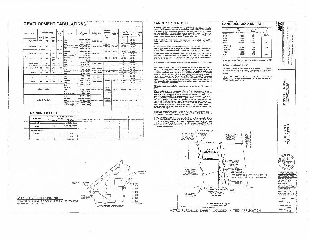
TABULATION NOTES DI Building heights are measured from average grade: the average grade is estimated at 483.50 feet for Buildnus A thrOugh F On a common garage. Minimum and maximum building heights do not include penthouSes and architectural embellishments. Minimum and maximum building heights do include above grade parking levels. See moiler& for details on architecture/ treatment of above grade parking levels. The bun.ng heights
identity the venous building heights castrated in the COP
12) The numbers of stories shown are conceptual and may be adjusted provided the adjusted height remains within the minimum and maximum bonding heights shown
FA Retail use as Indicated tri Ibis tabulation may include a radey of other commercial uses such as, 010 not limited M. eating establishment and fast food restaurants (See proffers). Office use as ind0ated in this tabulation may include other accessory uses.
14] The square looter for individual buildings shown 0 cOnceptuat The APP9Oanrs reserve the right to transfer Square footage between and within buildings provided the maximum overall site FAR is not exceeded and the enirimum and maximum building heights shown for individual buildilgs are mainlined (see Preff.).
(51 The number of hotel rooms is conceptual and may be adjusted at FDP and/or site
Plan.
95) The minimum required and maximum permitted parking spaces were Catculated for the primary uses proposed In aocordance will Section 6-502 of the Ordinance, which is restated hereon. For the purposes of this tabulation, the residential parking was calculated by assuming en average mix of 00% 0.1 bedroom units and 40% 2 bedroom units. At the time of site plan, the M0 Of Uses, Wither of hotel morns, dwelling units, mu of bedroom types and speCific parking prodded win be determined. The Applicants reserve the right 10 provide more or less parking for each bulling at the lime of FOP approval andlor site plan approval than required by Section 6.509 provided the minimum parking rates are mei a. the maximum parking rates are not exceeded or the buiklovt of the overall development.
(7lAckilicoal loading spaces inside the holdings may be provided with FOPS and/or site plans.
18) Option 1 Includes two alternative uses of Elyildtng El One holm!ea officetretail uses
and the other includes hotel/retail useS. The Option 1 "GFA by Use' column provide the GFA range or both the el./ratan and hotel/retail allernatives, thus the Option 1 •GFA by Use for individual buildings do not mathematically add up to the Optical) -GFA by Use Totals and the individual Optico 1 -guiding CFAs' do not mathematically add up the Option 1 "Buildng GFA' Totals. In a0ON2, GFA for office uses has been set al the maximum 250 FAR permitted (031.0700 SF) which Is less than the sum rd the office uses shown n Buildings 0.E and F or Optico 1. (See Proffers for amitalions on overall GFA and office GFA)The Total Bolding GFA and minimum and maximum parking numbers reported for Option 1 in the tabulation reflect the Building E office/retaa option. not the hoteVrelail option.
921 Option 2 Total GFA s less than the sum of the Option 2 office. residential, hold and retail GFAs, as Mere is flexibility in the mix of uses. However. Total Option 2 GFA is 2,028,000 (See Proffers for limItabons on overall GFA)
1101 Up to 14.500 gross SF of proposed Pubk loOty Space will be provided in Building • C in corm:dance with the proffers. In aOCArdence with the Comprehensive Plan, the floor
area of a public facility does not count toward a development's 2100011 GFA and FAR and thus up to 14.500 gross SF is not included In the building or overall GFA or FAR Parking associated with Me public faddy use to be determined at site plan and in accordance with the proffers.
...2t.:142 7411W E.2 Uri IV MI
90130i73,Tt asc ml 5510.1
1 . we-a-is-own
nrtgst.Mte". sir rtg-..i.s..ostu, ' _,.., .0.1. PR . IT,.
, ,,,,,, ,,,,,t
00 Ml, Y.: 1. •,
use nassur. up. 1 / IMF orr (- x 5 =Mrs)
1 / r itzss
I -----t „,... sarsron \
i
^t . 1 .1.1':1. " p'' rueurr armusdani ; 1 1 1 I
I r i 42144616 I , .0.4701 PC 1
I 1\
KrrsKunr an.
,2..3
izc
P08
IERNICE ROAD
sine RC PIKE - RCUlE p ssel wort OF MT)
25212 SF OR 715221 AC )
SEE SHEET C-1. FOR THE AREA TO BE REMOVED FROM Sf 2008-MD-036
LAND USE MIX AND FAR Use GFA
111
Percentage of
Total
FAR RI
oenON 1121 TES It1
415
63100 1.50121 -Residential -Had
846030 255.000
-.01 721104 r....,. 220700 0.11
0.11052 lel -Ohnce -Residential
720,000 1,522.000
1)7
-Hotel 155000 -Rasa 2.71.292 TOTAL 2,029,000 6.05
111 The Develop... Tabutations provide for a minimum and ros,murn GFA. The maximum GFAs were unfired n this art
(2) Based on a land area of 252,201 SF.
131 Option 1 indudes two alternate uses of Staking E; one Includes officehalea uses and the other includes heel/retail use.. For the purposes of the comparleons in this dun the Blirldrig E - office/ retail use was utilized
(I) Opfion 2 Total GFA rs leas than the turn of the office, residenbal, hotel and retail GFAs, as there is 11.40510 In the mix of men. However Total GFA is 2,0290100 (S. Proffers)
MOS 00CC 5410,02
WORK FORCE HOUSING NOTE: 20% OF THE TOTAL OF ALL THE DWEWNG UNITS SHALL BE WORK FORCE DKLUNG UNITS. SEE PRETERS.
AVERAGE GRADE EXHIBIT
DEVELOPMENT TABULATIONS
Illetkere Mauna elelete III Range of
Stones 0.. 071 GrAby Malang OSA
150
0.15o0 Unks5.1.1
Res.
Must. el
Pecking Permitted c In Me to Meuo statien
entre. [01
Loading Saw.
MA I Yes. Yin
A Options 162 210 3E0 • 210 15-26 00ce 200000 -2200X
40000- 11200 2402011- MX=
- S12
Rae.
0000.112 220 DT 200 22.20
Reel
100200-155020
100000- 120.00C
20200 • 33001
220.00-356A0
150-200
100,275 1_20-35
150-200
142 -249
0.166
C Oulms 112 290 2S-39 OW -UGC
6400-IA500
232.1100-242,002
252-350 556-oar
2 nee . . Putlk F105111101
250;250
0-1.
760111:i
0 0_i a2 227:i
02 26 Rolle tai
Rea
245.002 WO%
o -20000 21510-30300
260•260 260 -360 370-512 2 ISO
297 ,
Opeca 1 Of.
Option Rad
00.2
227 114 / in"
70 a 102
• 140 -21; i s .175'
10-12
S-61
14-10
Mee
RAM
Odd
Reel
102000 -2 20X
10.000 arm
96000.1921:00
10000 - 03.000
105,000 -1s6Oce
10.000 .33.0X
200,000- 245.0)0
106.090. 225000
175.000 • 220202
1 0 3 0 0
vo-210
0
20.100
750 - ROO
d0 150 24,
"--110
2 •_ • .1
2 • • -
2
Oster 2
151 260 167
MO 4D1 t 340
15-19
7744
Once
neekleetiel
Reel
140000.2411003
X10.000-290.000
10.000 • VI=
150.1:00• 257200 -----------
210000-415100 .277‘;"
21.1•3114
0: 1 • 72
so-n
2
2
Option 1 Totals 181 Reeldentlat
dad nerre
Peptic Focaltyrli
530.000-621100
575030-6411.000
10010-155.00 13U000-1007030 110.200 122-177 610-as 2225-3651 6100-Uwe
SACO-m.500
Option 2 Totals 191
Oaks
RtlY
RAY Fee00001
200200.220=
101000-1461.00C
00,000. 155000
same:17=0
SACO- 14.5CC
1.422.100•22011000 1 1 .:222 2011-302 1,04• 1200 2.310-0314 12
1 PARKING RATES
army Use Parkme Permitted 4 us Ulle to Me. Due.
Enuenoe
Minimum Mesim.
office o 1.0.000FA
Rene 0 ert0(000.Aucluer0 arie 5000 ORA
0019.05esteenesi
0.1 BR - -
1 1.6160
2 On 1 --- MUIR • - -•
PtRtl 0 tRaltl mew
.ANATErn r. 0.11AR7
oIells .;
VIKA REVISIONS REV NOK DER ti, 2013 RV/ OCTOBER 20. 2013 REV AUGUST 15, 2013 REV JULY 10 2013 REI., MAY 13, 2013 REV APRIL 10. 2013 REV MAR. 11 2013
REV NOW1ABER 19, 2012 INSERTUOST 21 2012 REV AIRE 20, 2012 REV MARCO 30, 2012 REV JANUARY 25. 2012 OAIL. FEBRUARY 22, 2011
DK R1AG
PRO.ECT/FILE Rb
V71400
1_ 4-
!
MIXT HO C-3 METRO PURCHASE EXHIBIT INCLUDED IN THIS APPLICATION
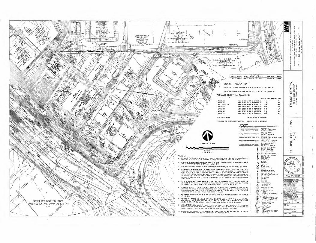
.5, 6e2 0.1.
\
el P4ErCr" Ea WATCP VALVf.
S. POST WOOD POST
10265 01074000230 00
BITEID NT.116112
116,29-a4(V) 3-C
114540 05110 PARR
NAMArRgkERIPIP,40C • DB. 19275 PC 2010
WE: C-4 USE OREL
CE/WIEW(lteSTATION 'E k 41.45,41\. \ ROTErSTATES ;ZERO
\ \XL- 011150e0,4161162660545. NEC
-44tik \ ,
00502 141(4
2171-Cr1= 5
ZONING TABULATION: • TOTAL AREA Dom. zarm 111 tr 5F 252.291 SO. It 011 3.79180 AC.
TOTAL AREA PROPOSED 205IE PTC 252291 SO. 71. OR 5.79120 AC.
AREA/DENSITY TABULATION: •
• 70000 .65 • PARCEL 71
• PART PARCEL 71A
• PARCEL 72
• PANCEL 73 • PARCEL 73 • PAROD. 76 • PARCO. 76A
611111011 702F pEznan AREA) 21.363 SO. FT, OR 249093 AC,
AREA: 22887 91 FT. CR 0.39426 AC.
AREA: 12.956 SO. FT, OR 0.29743 AC.
ARM 15.622 SO. FT. OR 0.21936 A.
AREA 00.410501 FL CR 0.97256 AC.
OREN. 01.719 52 FL 01 734000 AC.
AREA 31.324 21 FT. OR 0.5910 AC
AREA 26.011 48( 77. CR (16671302.
C-a
C-a
C-8
C-11
C-6
C-8 C-6
PTC
PTC
PTC RTC
PTC
PTC
PTC PIE
TOTAL PARCEL AREA& 252291 91 FT. 05 6.70106 AC.
TOTAL AREA FOR DENSITY/BITERSIVE CREDITT 252291 SO. FT. 05 6.15150 AC.
LEGEND c660.66 ot6 C.,TE TETEN9OX L;CM0T
alu'Rrt.6 coNoun OW14.0 MRCS
vaN.c/couvumunas c ARDPERE. LINCS
ununts CANNENts
GRAPHIC SCALE
• 508106? 4201:1'"" IRAPIC COW.. KM
• P.M° S.41. POLL O MU • 6.au vacs, 00. v... VIrre ummotS • WhILI, INTER
METRO IMPROVEMENTS UNDER CONSTRUCTION ARE SHOWN AS EXISTING
( MT ) I Tam It
NOTES: I. 6# 0.0101? PROPERTIES 001761 NMERI ARE IDENTIFIED ON EARWAX CORM TAX MAP NO. 029-3 ROOT AS
PARC. 52 5 . 72, 72 72. 76. 752 ANO PANT Of PARCEL 710 ONO ARE ALL ZONED C-S. HC SC
2 THE 1110405141. 8(782 511062 101001€ REFERENCE° 70 „ROHM 00ORD6lA1E SYSTEM or 1963 (WS 63) MIT IS BASED ON COPS 9)0152 PERFORNED BY VIN6 .1 8<401. 0, 2010.
3. DE 92 MANOR 910931 HEREON IS A CONPILAION 02 444010 INFORNATON OS DATA AM A 11.11 RUN SURVEY.
4. DE PROPERIES 91091 MOH P7200140 20 1100515 ONE LLC 0101026061 13651 Al PACE 1472 (PARC. 653 TYSONS PROPERTIES LID BY OECD BOCK 11761 AT PACE 0556 (PARCEL CONNOVINACEN 2601121 014002 BOOK 20104 21 PACE 040 (PART OF PARCEL 1125 LEESBURG PRE 111141005, TLC BY KED BCCN 10743 AT PAM 066 (PARCEL 125 00201114015 1.1.4 61 4804 BOON 16106 AT PAGE 1789 (PARCEL 735 6331 44001,00 97(1 ASSOCIATES BY DEEIT B001 0412 AT PAM 1329 (PARCEL Da 040 WOES REAL MATE 020(7. 2)1 21 5402 4001 60110 AT PACE 252 (7202233 75 .4 78A) ALL AMOND 11E WO 7410102 02 UREA% MAIM SIREINIA.
•
2 TIE NM 111070504E70 910911 192041, ASSOCIATED DIN TNE OVERHEAD 60)10 P 0EDEST501 CRRIEEDON AND 5600 CENRAL 7 STATOR APE BASED ON PLOTS PREPARED BY, YAM, EN112150: COINSION TO 6016E AVE 712015 MORAL 7 551106 WASTER 910 PUN DATER 7/31/07 0310 70 01-0-011
• 7070074310C IN105NA1101 711071 1100001 IS RASO CPI AN AER/AL MOTET PRON. 10 VIKA, INC, BY 2410-50116 MO BASCO ON 07111R07 PI0100161115 001E0 MARCH 2006 AT 114O. lIlt VOTE, DATUM 6 REFERENCED TO MORIN NEIMAN VERTICAL DARIN Cr 7969 (4345 66). CONTOUR 4117541 IS Cl. TOPOCRAROC (INTRNATION 21004040400 MAS WO BEEN MELO 6760217 BY 726
7. UNDERCROUND 01111145 BAY NOT BE 90670 AT ACTUAL SOLE. BIN ARE DEPICTED HERECN FOR GRAPHICAL PURPOSES ONLY,
• NIE NCRIERNAL 0.007RE AND ADMIRAL, OA 11E SURVEY CONTROL USED 70 PERFORY SINTEY 1:37.75 74001 EXCEEDS INE WNW PRECISION OF 1.20,000 AS REQUIRED BY CONNENTEALDI OF „RONK /180410-10-370.0 54111 TFE ATTENDANT ANCLXAR CLOSURE 93101 SUSTATTS ITE 561011 Cf 0.09.111E
ITIPROJETIENTS FOR ADANA. PROPERTY 00112721 ON FAIRFAX COUNTY TAX NAP ND 029-3 ((85)) AS PARCELS I 91010 07001 0004 TAXER 70042 1.51601 010006354 0 ASSOC, NE SITE CRADING RAN 04)10180 51(E El RANDOLPH BUILDING r. DATED 6-11-00. 1)0 211424830? 91005 HAS NOT OZER FIFID TEFINED.
12 110700110116 FOR 0161000 PROPERTY moon 051 1410129 COUNTY TAX NAP NO. 029-1 ((R)) 20 PARCELS 410761 FEIEON WPC 14410 11004 OS DATA 040 NAS 001 2020 FIELD 1016000
e" wroL,T'n "
• 1141140012111)l4*)? m DRAIN
O Tacw.1 11118)1 • nRc OLPAPT..1 CONNETTON
2.
r M.0 HAAVoCAP
• - APPR7,66TIE
• ren." •• .TsL"tc....,'
f4". C74CPCg ar CORMAO,A0 UL14 PVC • . ars .mcro. te•
REV RONDO. 11 2013 /EV 00701 40 503123020? 12 2013
051 XIV I 2063 207 4441 85 2013 REV APF6L 12 2013 050 223011;. 2013
003 3 2012 REV 20, 2012
2004040223? 25. 2012 DAM FEBRUARY 11 OWl
•10
SCALE:
PROJECT NO.
MARC
SHEET
SIORia DRAIN COMOVIT
C-4
0.23 1 0REE'14,tiEr RIORI'- ■G'E' EDFE, ' R
INV 0.:(9-3-13-19,33:
le14 Fa-,3 1. - 4 1501 nmsrf arna
0St WO/N1 R10 0040
329,-1-150013 1,40.,ERTY.
LIM
ITE
D AC
CES
S EX
HIBI
T
EN NE71 PC 1131 1 7CRE C-4
Se•p
,EX
HIS
ITS
•71
111-
LIM
ITE
D A
CC
ES
S E
XH
IBIT
.%
SEE SHEET C-6, C-6A, AND C-12 FOR THE LIMITED ACCESS LINE WITH. BREAKS AND SHIFTS
\IKA REVISIONS
18' REV NONUSER 11. 2013
APPROS LOGAIICN 400E0 ACCESS LAE (5001 0007-029-103 i 0113029-103)
REV OCTOBER 26. 2013 'REV AUGUST 10. 2013 REV JILT I0. 2013 REV MAT 13. 2013 REV Ana. It 2013 FEY MAR. 11, 2013 Tale
Taw rate
linaPAG PIKE TE ROU
(0.15111 WIN Cf 1.1
_ — --
sem cA. (4407-429-103) 400E 7 WEL
1
1
EX SERVICE Rom
7260:0
E140 MATEO ACONS (`001 0007-024-103)
ING GRAPHIC SCALE
REV NOVEMBER 19, 2012 REV .1019 20. 2012 REV MARIN 30. 2012 REV .ANDAIRY 15. 2012 DATE EEORUART 22. 1011
SCALE
PRO.JECIAILE NO. V71411C
SHEET NO. 3 2 C-5
LEGEND: ; ENTRANCE
(TZIR
DENOTB ACNE GRADE LONER MGR ' B E SFEET C-3 FOR Naafi' TAEUAT):631 AND
RANTES
ENTRANCE
Decre3 AeovE GRADE TOWER, NOT KLIE442. PENINGRE SEE SNEET C-3 FM lEIGHT
TABULATORS NO RAKES
CENOTES LNDEFGRGRO PAP/363 MOVE FOR ABOVE BELCNI GRADE PARSE SEE A-1S1
LOADNG ENTRANCE
PAIRKNO ENTRANCE
TREE PBS
DENOTES BUILDING ENTRANCE
ALTERNATE MAXIMUM RESIDENTIAL OR HOTEL BUILDINGS "E" AND "F
SEE SECT C-3 FOR 867110 Cr WOOS A. FL C, ic
MP CHM HOTS. 1. SEE SPIT C-3 FOR AIL STE ,TAMILAITORS ARO PARISE TAOULAITCHS 2 STE SHEET C—,1 NR 8CONOART WORM. AIM MIME TOPORRAMIT AS Er
RELATES 70 ME COP LA10110 2 SEE MEET C-6A Fit ALTERNATE NNE MORALE AND MONS COMAE STREET.
SEE SIEEi C-80 FOR ULIMATE CENTER STREET MAR. S. SEE SEE SHEET C-10 FRI ALTERNATE CEP. STREET AIM MA11014 PUCE
INTERSECIIIM SAMS G. SEE MEET C-8 FOR 1/11.011ATE 111 11CAL SMELT SECTORS 2 SEE SHEET C-9 FOR NIERS ROAD CROSS—SECTICRIS Cp. & .1 2 SEE SHEET C-13 ANTI C-20 FOR SIM RARE 9. YE MEET L-21 ASOL-3.2ECR OPEN SPACE MAR.
ID. SEE MT L-I FOR MERMAN ORO/LAWN PLAN. 11. SEE SNIT L-21 FOR MEAL STREET RECURS.
NA STATE CRS (PAIR
(VSC BS)
16
GRAPHIC SCALE •
( FELT I mm. 11.
VIKA REVISIONS
REV 1,101.018101 II. 2013 REV OCTOBER 24 2013
S
REV 004E PO It 702
DATE FEBRIR7 2 22. 2011 1.8
8(5 AIRE PO 204
ATMORE 22 2012
0E2 0012.
?.■
REV ALMOST M. 2013 MTV ASTIR 201 REV MAT 12 2013 RLI, APRIL M. 2013 REV *MOVE 2013
rA PAC
SCALE( 1•.301
PROJECT/ME NO.
011101
ERECT NO.
C-6
LEGEND:
ENTRANCE MP)
CENCRES AEC* GRACE LOWER OCCf. SEE SFEET C-3 FCR liartIT TABULAMCNS RANGSS
ENTRANCE (TEE)
COMES MOVE GRACE TONER At3T NCU.ONG P6411SCUSE SEE SHIT C-3 FOR FEW TASLUTENS ECERANTE3
DENOTES MDERCROAD PEDORE STRICIUW FOR MOE MD BIM GRADE POMO SEE A-83
LOACTG ENTRANCE
PARKING ENTRANCE
TREE PETS
DENOTES BUILDING EIKIRANCE
ALTERNATE MAXIMUM RESIDENTIAL OR HOTEL BUILDINGS "E" AND "F"
ME SHEET C-3 FOR 1.130HS OF BUILDS. A. D. 0.00
PIP SHEET NM. I. SEE RICER C-7 FOR ALL ATE TABULA.. OE PARR. T.ILATIENS T. NC 91E0 C-4 MR BOUNDARY R.IFOR14.101 MAO =TM TOPOGRANY COlT
RELATES TO IHE CM LAYOUT. 3. ME MEET C-GA FOR .1101HATE RALE 171.7T0M ESE. 00111AL MEM
ICHOUT 9L61OD ACCESS MAX. 4. SEE MEET C-GS . LILIMARE EERIER SINEET PLAN ' 1 ME SEE SHEET C-10 FOR .TRICER CENTER STREET AND SWIM PLACE
DITOOORC1IUI OHMS. 6. SEE WV C-8 FOR UILMATE ....AL MEET MOTORS 7. SEE WET C-9 FOR NON ROAD CROSS-SECICHS CO, A 1 5.. WM C-17 0.012 C-20 FOR SRN KAM
..ET L-73 AND L-12 FOR OPEN SPACE PLAN. TO SEE SHEET L-I FM PECESIINAN 011.01011 PLAN. 11.. 5.7 L S.I FOR MICAL STREET QM..
RESTATE . DRIO NORTH
(TPTE 87)
GRAPHIC SCALE
I „yr was, so IL
-. 444/ PROP TEMCRARY (21.70 4": , ua'ARurr RELOCI.1.
-1:1.%1:2*". -1k14 • Om FLOOR 01911. 6,,v)
CP UNDERCD01.2 CARACETERLFROP LINE, 14;', I \
PL•1;.9114C.111. 11.-19_/ '1401311; JP. CP 10/1 NWINI
OANACE 420-PROP, ERIT ONE • ,
FAR'
PROF 11:19.0g: MAF. AND INRITY 0.110.
Mi. 2 FINAL MSTS
. • MERINO AT N
3.'"'AM"( 'RC4, '• ' ' /. ' ' ".,. ••• . „d'r.:, ----- 0/ -- ,.... , IT 11000 N /
1 '' (......0" ,.I..
t"-tb,cc oixmcmcaitmcnow ._2.,1.6.29.1.1:9615.9.5,11.9.00) 01
•••••••••••
••• •
\:\
Ti
0
4.0 . '
LET. or 1.0.917% FCV1.4 RELODATTRACCE95 STIR
Ntt-or .80KE AL SE ,
• 41ISONS CrAPIINigairSTAT104,t
UNIREPESITTTSV °11491116 .T
0041.1.110.1
1.4
•
*79.1\•..'
/./
,”
C,I1PROJCMU4.--)=E6
,_,.,.: 7.4F.;-7,7-nzF-5,-.:.#-4E-t,,-- - ..,,,..0.4-1:1, — -• -„--...,_,,,..--,,.."...,4,_-__—_-,_;_L...2.-4,i..-3.4.12......,--7--77.,--i•,.. . .
STATION . ' ". 1- .: - -: - --; ... - )- -..----- "7 • -:::. to.to06001iiAqta.----- -:7
...
, .. .
.......... ,.,,,r,...- ja.--r---- ...------s--:-.--,•-•-,...-v.,,, ----i
• '.
.
< CC t5 F-
1.,-) 5 LLI E- 0 .)
(/) 8 Z o cqt Of) ff. AC >-
< < w LLI
—J CC
M
0_ LO LU =1 0 a_ ZOOM 0 __I X V)
(-) w 0 <
ViKA REVISIONS
REV /10.010 II. 2013 1.1
REV OCTOBER 2 5, 2017 REV AUGUST 5. 2017 . MLR 10, 2017 REV INT LI, 2017 REV APRA II 2017 atv wita 0 2017 REV NOMA. N. 2012 REV -UNE 20, 2012 REV SAP. 30. 2012
JANUARY ZS, 2012 5 DATE. FEBRUARY 21. 2011 •
DES .
SCALE r-RA
PREJECT/FILE AC.
SHEET NO.
5*Al"At4igT A. 4".- ..,
C-6A
_7 Die3EOR,G MO Ta,m,i,„(vaajo:4tEzLca - -
...
..--•":"'" —

ABM GRACE LOWER ROOF. FEE MEET C-3 FOR tErta TM:MAIMS ND RANGES
LEGEND. ENTRANCE (T
CE
OMER AB:NE GRACE TOWER, /ER KUM FEHINMEE FEE ElEgr e-s FCH igwor T/SIATI0N3 410 RINZES
ceina LIZERCII:UO PARIEG SISUCTVE FOR MOVE AN) BELOW OWE PAR:IS:IEEE A-63
.„
11
;5,7 60", . ,Irscas afrIVA14"syAncat
Slat tatolannio.! VI \ I
COAlbEAtliTtP Nf „
BAO,T . WALL oRtERTAr52.1, •
PO upORARY W200 9b mot ./ /
Atp RaocAnat COM EAMON,'
naafi 0.1.0 MI •
TREE PITS
LOADE40 ENTRANCE
. PARKPQ ENTRANCE
(7)
DENOTES BULDNO ENTRANCE -J
13
Z 111 LJ 0 La
(f) g
0 0 g- EE
ALTERNATE MAXIMUM RESIDENTIAL OR HOTEL BUILDINGS “E" AND "F"
C
VIKA REVISIONS
REV 1.090401 11. 2013 REV 0010001 24 2015
>a C-5 1210011$ OF BUIL.= A. B. ca 0
CIESHEE111111ESL stal 4.3 FOR All 97E TASULATICM AND PAN. TABIAATICen
Kr 9117 C-• f2 1701AOMY 111FC010120. Atal COSONG 09.051APRT AS 0 MATES 70 Of COP woo.
1 92 11107 C-BA FOR ALIMAIT MALE COORALE ITSC15 CDOIAL I. SEE 90E1 C-60 FOR MONATE COVER
01001 PLAN.
S. SEE SEE *EU C-10 TOR A1.11301A7E CEN7121 MUT MO S71701 PLACE OUSER. WOWS
1. sx sal C-B M U11.1111A7E,77PICAL SWEET SEC1156 1. SEE sal c FORMIE9.1 ROAD CROSS-SECOC11S CA
SEE 94E7 C-12 0.1.0 C-92 FOR 010. RAM B. SEE WM 1-11 ARC 1-3.2 FOR OPEN SPACE RAIL
It SEC 911Xt1-1 KR PEDESIRIAM CIRCIAADEPI PLAN. II. SEE NEU L-11 FOR 1111CAL par SECTIONS
40257 IA. 2011 REV ALI' 14 2013 REV MAY 14 2010 PIN APRIL 14 1013 REV MARC. 11. 2012 REV PmElseER 19. 9112 REV Ant 24 5012 RE0 MARCII 24 2012 REV JAWARY 24 2012 DAM FEBRUARY 22, 2011
DES IA
DV/. GRID NORTH GRID NORTH MC 02
• GRAPHIC SCALE la
MOO
MA ma =ma. P00001 ME to. PONE
I SM( mi n.
00 n. MEET MO.
C-68
. MOSOKA 11 KU REV OCTOBER TA 2013 .g REV 90035T 5, 2013 2•2 REV 221.1' 10 2013 REV MAY 139 2010 Re,, APRIL M. 2013 ea REV 80921 11 2013 REY110.111ER 19, 2012
REV AMC 20 2012 22 REV MAKIi 30. 2012 Kv JANUARY 25, 2012
DATE. 117058201 223011
JTA
SCALE) 50'
pitoJEcT/n, nuac
'"E" "CL C-7
)Y7-957. -44
0.2
KR WED 37.
(123E9Oa R
\ 9," \\./
LEGEND
WATER - BLUE STORM SEWER - SANITARY SEWER - BROWN ELECTRIC ! - ORANGE GAS - RED SIGHT DISTANCE - PINK
STREET TREES -
SEE SHEET C-6 FOR BUILDING r MID r ALTERNATIVE LAYOUTS
wr.° ,,A1', ,..- ....,,,,
,Ir , .1,11Vitti,--
.— ___ ,
,• ..-
.
, ..49-.."..7---.4--..---7. -77-7, -7 7.- -....2°" --)' 77.29:..).7_2992)))/---•• • )79722.-2,2A-0 arinTOSG,,,,„,“0 V21(1.31T) •-:•r. •ZA .
'A • •
GREENSBOROSTATION— . .' - . . . .
•'::: .. ••, . .
' - 9 - • .
NOTE: POWER VAULTS ARE SHOWN IN PROPOSED LOCATIONS. DUCT RAMC AUGNMENT HAS NOT BEEN DETERMINED AT THIS POINT. ALL OTHER DRY UTUDES WILL RUN PARALLEL TO POWER DUCT BANK IN SAME TRENCH.
- DENOTES TYPICAL UNDERGROUND DOMINION VIRGINIA POWER VAULT
I VA STAYS
)110•R'111 (KC 83)
GRAPHIC SCALE
Ma
1 *
:To
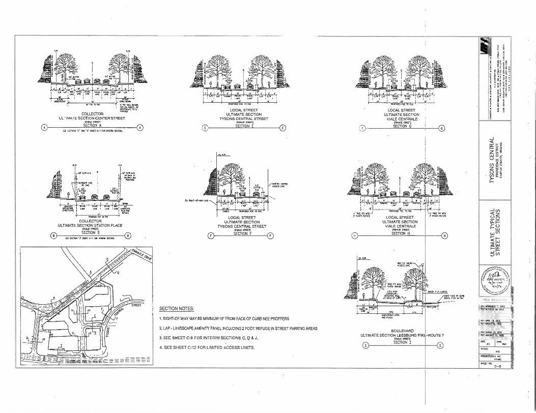
0
SECTION NOTES:
1.RIGHT-OF-WAY MAY BE MINIMUM 18 2 FROM FACE OF CURB SEE PROFFERS
2. LAP - LANDSCAPE AMENITY PANEL INCLUDING 2 FOOT REFUGE IN STREET PARKING AREAS.
3. SEE SHEET C-9 FOR INTERIM SECTIONS C, D & J.
4. SEE SHEET C-12 FOR LIMITED ACCESS LIMITS.
LOCAL STREET ULTIMATE SECTION
TYSONS CENTRAL STREET (MAX 511110
SECTION E
Sillr WOES ACCESS DIE
LOCAL STREET ULTIMATE SECTION
TYSONS CENTRAL STREET (MK Mal) SECTION F
0
VIKA REVISIONS
PRACCT/FIE
V71,11:1C
SW Ha
C-8
0 0
BOULEVARD ULTIMATE SECTION LEESBURG PIKE-ROUTE 7
MARX
SECTION ON I 0
REV 1,1049BEA 11, 2011 REV OCTOBER 20. 2010 REV Wahl 14 2013 REV 241 10 2013 REV MAT 13. 2013 OEv /P1111. 14 2013 REV 93201 11, 2010
REV 11031143017 19. 2012 mV .RAC 20, 2012 REV YARN 34 2012 REV 162.1011, 2S, 2012 DATE: FEB14331 22. 2011
INC
2
8
j
PRCOOSCOIC m roc
LOCAL STREET ULTIMATE SECTION
VIALE CENTRALE 0411147F Man
SECTION G
P9OPOSO7 FCC 70 FOC
LOCAL STREET ULTIMATE SECTION
VIALS CENTRALE ' (MAX STEM
SECTION H
MORCM( PR MN
..`firTar ----- 41 C-- ^3 porwiri
29.2 14,14411:11114C AREA *
A/11 20124
3.9e1111 AMISS
1110E 111111 Y PAVER FEFIAC
2.0. OFR.
fr7t. 71:1 I I I
Se Se FCC 10 FRC ' 11.1C MfA MARC
DC WA P.M 20 3119273COC 10 ER POMO
COLLECTOR ULTIMATE SECTION CENTER STREET
EPOILIC Oman SECTION A
SEE SEC4066 .C. /10 2 90010.7 FOR WIWI SMOCK
200110x OCT C-7 FOR PRIM SEMI. 0 0 (FVOUC Sian
SECTION B
_ e wen , mum. I eeeect. 1, ma 1 SU
STRIMISCA4 1 1 PIM FC11 I OEMs
PO.= IOC 10 FCC .1(
COLLECTOR ULTIMATE SECTION STATION PLACE
0 0
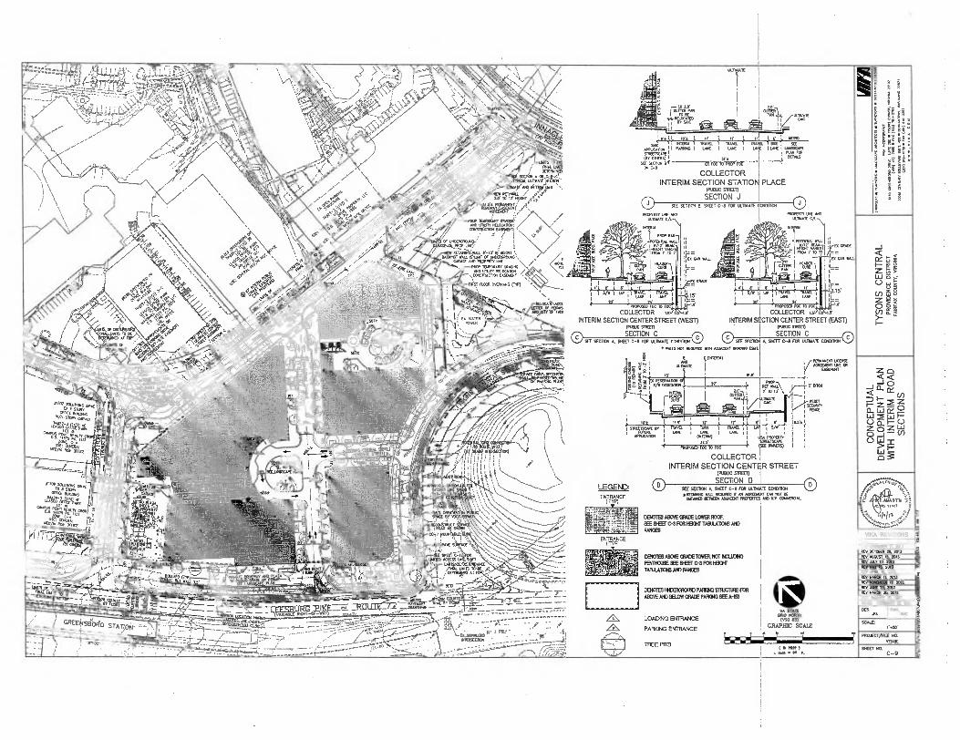
1,21-• t",) o i
,?"
• -‘?
<...==zq .
• ) • \\ I (<2' r
MAL Lla OETEFARTE
44,WW,Mie- ARCIATE RAO
CCOCO_M.•
PROP 7ormgr. Ourrt NO UV. REBOVITICNi
N
1111001 ... \>•/
TANA DROP 1.PORART GRADING
F-47. 'SORE MORK (TIN
F AZ:ET EP •
T' s R
Z.% a
• NOCCATIVCCL
LETTER OF P006 ANDXSPX111441
ER
,, BY INC
or 1 oo ; WER10
MVO. T MOS ( DPI I AS LAIC I LOC i UNDSCAPE
RAN FOR OERAS
PRCPERTf Utrt AND UBRAIL
CAR WALL Rag
11J.; ;!',1,:;',•a1 i 9 : .;',.. ...q. , , • ,,,. ". 1 if ),
X " ' -.9' •
, ! UNE I LAK 15. I
! LANE I LAW ,
PROPOSEll'&
1
10 FOC 'FIVIPOSED FCC TO FCC '7—..
a WAVE I i
-I iff IRAV S
21/ !
1 up 1 ntrALL I EL ,
L =
COLLECTOR Is o. s COLLECTOR is I s
CHMUC COWAN
INTERIM SrTION CENTER STREET (EAST) INTERIM SECTION CENTER STREET (WEST) (INSUC sTRIX1)
SECTION C SECTION C SEE SECDCR A SHEET C-8 FOR COWIE CONDIHOH 0 0 SEE 5E001 A. SHEET C-8 FOR A110ATE MOON C)
• WALLS NOT KOVNO .1111 ADJACON IMMO (3O
I.O GUM
, /AMIE
NINty 1 ITIAVEL 1 Ripon WE
TRZETSCAPE (BY ODE./
SEE BECTON BR IN C-8
EDI
ID, FOC TO PROT roc
COLLECTOR INTERIM SECTION STATION PLACE
FOX= STREET)
SECTION J 0 SEE SESAME E SHEET C-8 MR ULTYKIE COMMON 0
WRETT VIA Am INDWATE CA)
RANI
i E tOnnmI)
1 . 14 I ut.111( 1 r ouger se
1!)- .?"'".4 I rr .., , , 11/W CONCATON ,. 1 ..PRCP
51.5 r
— . ' le 2 10 A r-t. r "- c INJEER1 ryir ,t1 W041,:f WRAC
; ICI 1 11X 12. ; IX LI r ,L r , kro 1 sommuot A ' RA. i Tv. I R... 1 I II VII
APPLOMIC•1 I 1 I °MX
I PRORATE I ,
COLLECTOR
1- fa ISIS) I I ( MOOED roc TO Foc
INTERIM SECTION CENTER STREET (PUBLIC 511051)
SECTION D SIX SWIM A, SHEET C-8 FOR LA.10481E memo 0 • RETPXOF WO MOO V AR ACNEORENT CM NOT BE
WANED 5052 2040000 MO N.V. MACRO.
CHEM AlrhE GRACE LONER FOOF SEE BEET FCR H3CHT TABIABONS MO RANOES
ENTRANCE (TYP)
LEGEND ENTRANCE
MP) •
z _1 o a.
— Zo
CL ,— M 0.1 0_ 0
ZLoJ o Z 0
VIKA REVISIONS
S
S
R. RYON. II, 2013
REV CCM). 20 20.
eavio IIET (rn,
(fOLS71 ,14.120?.,
.4443ro.favt;-, • —6—arra:
CMOTES ABOVE GRAZE TONER NOT mum PMINOME ME BEET C-9 WICK TAMLAIICNS AND IMMO
CERZIES IRCEIAMOUtO PARTE' IIIRJCTUFE FOE ABOVE AND LELIA GRAZE PAHCIKI LEE A-1S3
LOADING ENTRANCE
PARKING ENTRANCE
(71 TREE PVT'S
4 WA STAR
COO NORTH (050 03)
GRAPHIC SCALE
I V 7
REV ROM IN 2013 REV REV Z7 ,7. AVIV
REV APRIL It 2013 REV MAR. II. 2013 REV R.OIBET 19 2012 REV LW TC, 2012 REV WACII 05 2010 REV ROAR 23. 2012
S
DATE FEND.. 22. 2011
XA
5.301
PROJECT/FILE NO.
SNEET NO. 9
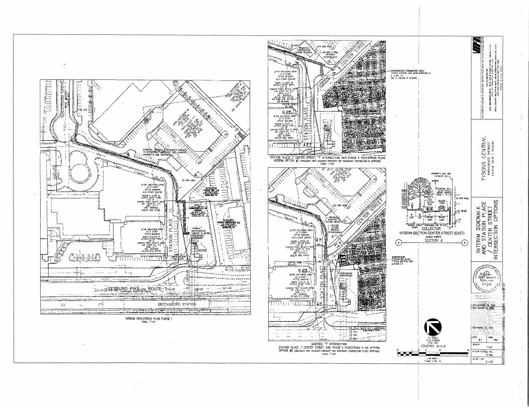
REV MAY 13, 21113 REV PM 14 201-3--
c
V SCAM
DAM BRUME 24 Nit
STATOR PLACE / CENTER STREET "r INTERSECTION AND PHASE II PEDESTRIAN PLAN !MERIN OPTION DOMOODIT WTI AMCOR Romer rat TOPCOAT DIODECT1011 K APPROVED
SO. 1•.01
PROPERTY1.111 MO DOMAN CM.
"L WL
1W1110 TROD 11 TO 1
■trj r r
sft, , EROS , COWL 1 DME
2( 4
lr 114113M1 MET. PRIMO= MOO RC'
COLLECTORV
INTERIM SECTION CENTER STREET (EAST) MOM SMEO
SECTION A
0NDEREMO010 STODUATER VOLT MOO
N CENTRO MU
..000
iS
0 0
99V9g. ejeg4
_ . -
MODIFIED *T" NTERSECITON STATION PLACE / CENTER Swat( AND PHASE R PEDESTRIAN PUN INTER*/ OPTION #2 wawa mt Ao3AnNT MORO rce ISIPCOAD 1111ERSECIO1 01 1107 APPROVED
a
VIVA REVISIONS
REV NOVEMBER 11 2013
OBTXECT/FILE MO. VTIOC
REV AMOIST ID. 2013 REV 4/1.1 10, 2013
REV IUM01 11, 2013 REV MOW 19, 2012 REV VIBE 24 2012 REV 10101 34 2012 REV JAMODIT 24 .2
REV OCTOBER 24 2013
CM wail I tmed. - DO n.
1110/11002110 070009111:11 01 LT TWO CENTRAL MC MN WNW& ■
ISGM GE (UP TO 40.000 01 V/SYC)
VA STATE ORM NORTH
(KC In) GRAPHIC SCALE
IMO MI 1■111
SHEET NO. C-10
GREENS90F$0 STATIO
INTERIM PEDESTRIAN PUN PHASE ONO r.51/
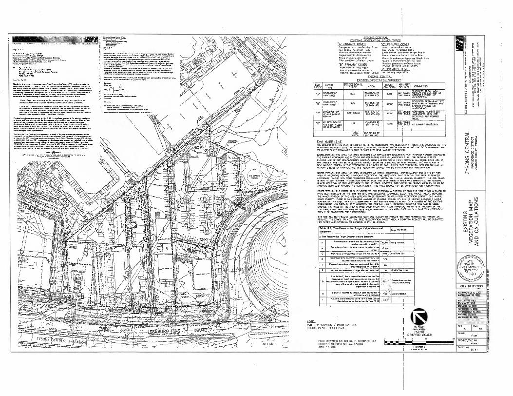
,"'"`=1:4=c
--- :7_7
. VARIABLE /MT-OF-WAY)
/ • • r-r ..
inatiarztam. EXISTING VEGETATION cnvcR TYPES
-A" PRIMARY COWS PRIMARY COVE)/ Euorunsus olunlus-BurnIng Bush Ace/ Hstmon-ReD Maple Iles opuco-Nnericon Holly Rea osTaco-Americcel Holly Nondino domeslico-Non.c Liriode.ron tulisiTru-YelION Poplar lAgerStroemia-Cropen.11e Pines s s -Eastern Whits Pi. Pines mago-Hugo Pine P./3 tbunclbergii-Japonese Block Pine Tiro cordolu-Li1.1.1 L.naen Gok
"R0 PRIMARY COVER R017.10 pseudonma-B1c. locust Prunus seogino,Bleck Chen,
Acer .Y -Pad Mople -0" PRIMARY COVER Nor. u' -VAnle Mulberry
Robin, pseueleacIa-Black Locus; 00 011n1N7 5 "7921111 I'nn
ZS4114LENIBAL FOISTING VEGETATION SUMMERY
EVIA INDEX
COVER TYPE
SUCCESSIONAL STAGE AREA
COVER CONDITION
PRIMARY SPECIES
„,,,,,,...,, 1"."0".." 1 .
..,. "
DEVELOPED/ mAINTAINED
v,,, 1.307.4.3 T 25 sr.... 7 OVELlis .54 C PLA°CPa PRI/ELI /1."Nt" NO
.1,72142.'" L'r
08 DEVELOPED/ N/A 114.7133.04 SF
„,,,,,, , --m.",
DEVELOPED RESTAURANT OlE
MANTA/NED 0.946A AC) 0M° TWO 1-1- ..-- '
RATH SURFACE
AND LORD INTERIOR PARKING LOT
LANDSCAPING.
Hc• DEVELOPED W/ .....,......„, 1.111473 ST ... SEE COVER PERIPHERAL PARKING LOT JKAND FOREST REMNANT
(0.2.3 AC) TTPE TABLE •
LANDSCAPED AREA NIT DECIDUOUS AND CONFER TREES
.D. ER DEVELOPMENT 31.32400 SF SEE COVER iAS BEEN RAZED. 10 VEGETATION.
N/A (0.7197 AC) GOOD T1PE TABLE
1
NO CANOPY VEGETKRON.
TOTAL 252297.00 SF AREA (5.7910 AC)
FV14 NARRATIVE TOE SUBJECT STE HAS BEEN DEVELOPED AS RETAIL COMMERCIAL AND RESTAURANT. THERE ARE CULTVARS ON THIS DEVELOPED PROPERTY THAT ARE PLANTED LANDSCAPE REMNANT VEGETATON FROM THE TIME OF DEVELCPRENT ANo VOLUNTEER PLANT GERMINATORS THAT TIRIVD) INTO 0EMI-.71.1RE VEGETATION.
,1171 TIPE-A. THIS AREA HAS MN DEVELOPED AS RESTAURANT COMMERCIAL NTH SURFACE PARKINS COMP./N(3 DIE FANNING COMPOUND HAS INTERIOR AND PERIPHERAL PARKING kANoscAoHc. ALL THE DECIDUOUS TREES
PUNTED ARE OF ONE GENUS/SPECIES (LINDEN). FROM A BIOTIC STAND POINT. BECAUSE ALL THESE TREES ARE Of ONE SPECIES, THIS CAN BE PROBLEMATIC SHOULD .ERE BE A DIRFARF OR PEST PROBLEM. THE AGE PASS IS SEW-MATURE. GENERALLY THIS VEGETATION IS OF 0000 TO FAIR HEALTH. IHIS VEGETATON APPEARS TO HAVE AN MODERATE LEVEL OF MAINTENANCE THIS VEGETATION SHOULD NOT BE CONSIDERED FOR PRESERVATION.
70171 TTPF-11. TVS AREA HAS BEEN DEVELOPED AS RETAIL COMB:ROO- A0PROSIMA1ELT 950 (0/-) OF 025 AREA IS IMPERVIOUS A. NO GNIFIGNT VEGETATION. THE VEGETATION . MINN THIS IS MIN THIS AREA IS PUNTED
LANDSUPE (MAPLE) VATH
SI
SOME voLUN00:R GERMINATED VEGETATION (MAPLE. 1001ST. MULBERRY). THE AGE CUSS ISSUB TO SEMI-MATURE. IT DOES NOT APPEAR THAT THIS VEGETATION IS REGULARLY MAINTNNED. 711E GENERAL HEAL. CONDITION OF ITS WIRETAP. IS FAIR TO GOOD. HOWEVER. TINS I.EGETATION SHOWS AVERAGE. 70 BELOW AVERAGE VIGOR AND VITALITY. .E VEGETATE,/ IN THIS AREA SHOULD NOT BE CONSIDERED FOR PRESERVATON.
MISR TYPE-C• THIS ENTPSE AREA IS VEGETATED AND PERVIOUS. A PORTON OF TIM THIS YEGETATON APPEARS TO
HAVE BEEN INSTALLED AT THE TIME THE SITE WAS DEVELOPED (JAPANESE BLACK FINE MAPLE. HOLLY). NOTEVER.
THE MAJOR PORTON DE 005 AREA APPEARS TO BE RETINA. OR VOLUNTEER TEGETAION (LHIM, OAK. MAPLE, BLACK CHERRY). TIME IS AN EXTENSIVE AMOUNT OF INVASIVE ENG./. THAT IS ROOTED THROUGH A LARGE Pan. OF MIS AREA. MIS IVY IS EMBEDDED AT THE EASTRIG GROUND PLANE 04 A NUMBER Of THE EAST. TRUNK STEMS AND THROUGH TREE CANOPIES 7111 GENERAL HEALTH CONDEMN OBSERVED WAS FOR TO GOOD.
01E101.1. THE TREES IN THIS AREA SHOVED GOOD COLOR AND POOR. HOWEVER, THE ON-SIDE SAMPUNG OF 711E
CONDITION. STRUCTURE AND TYPE Of VEGETATION OBSERVED IN DAIS AREA DOES INDICATE THAT THIS VEGETATION SHOULD BE CONSIDERED FOR PRESERVATION_
TONS TIE WILL NOT PROVIDE VEGETATION THAT RILL MAU, OR PROMDE THE TREE PRESERVATION TARGET AS KOUIREO. THEREFORE. TO MEET THE TREE PRESERVATION TARGET AREA A DEVIATION REOUEST WU BE SUBMIT= FOR REVIEW AND APPROVAL AS OUTLINED 171 PFM 12-05021.4
Table 1231 Tree Preservation Target CalculationS And May13,2013
Statement
A. IN. Proonntlon TarpelCAlculaSens and Nsument
A Pe V-11v10,11.1 ow VI eMm.(1 , ...c•AM 17....,..46;,....
exisning w0,1711. 1n710/1.9 . .. .,...-
‘2,,,,,,,i
B Resent. Swum. ems saw. Ty ONTO.
INTOT • 77,1%
C P... of 10,a/um ....... Ms. e 11073...: ...Table 17A
0 Pertentm al. I.ear tree canopy TN... Nat
axe. ea mei Pumusx Nee Ness... 17% I
1
E Proposed Nes.. oleancpy nmsberm. wast NT Be
Net 0002/1 TN P...., 0
....
F FIR2 BM TIN Prtsenali.Temet NON. been /net, MI Pna 1.1 cc No
Nebr. F. Nen a repsest loc.. tan Ina Tree Prmer.. Tamel Rum be passeden . PAn R.
moss em or more el. jusIlleallens INI In 2 ISOM" .m9TM a ...NS prusees s sitessoesits
essInet. etwhy Ns TN
Yz.
• • "' ' ' I .0•11 ,
" '
No. NINA /TN.. ......2,....,,,
I
H Ilslep A7 rt.. •nsnnon. ■ sna en pepmem . 4...i.7c..,,2.,...4
1 ..„,......,,,...,,,,.. mule 1Prn. Dn. DP`PW
censmions is pm...M.1s In TsMa 1E10 . 1,23' : - I
1
PLAN PREPARED 07: NELSON P. KIRCHNER. RLA CER1B1ED ARBORIST NO. MA-4720AM APRIL 17, 2013 111 Min 4
I Nab - NT et
FOR PFM WAIVERS / MODIFICARONS REQUESTS SEE SHEET C-2. I 0.0
V STATE A
Mc 23) GRAPHIC SCALE
Z
<02-- P <
Z Z rz 0 D cn P -J
< 0
LI 0 > Z
VIKA REVISIONS
REV NO.BER 11. 2013 REV OCTOBER 24 2013 REV MOUS, IS. 2013 REV AAT 10. 2013 REV UAT 2013
REV ATM 10. 2013 REV UM. II. 2113 REV NOVINDER I% 2012 REV
SINE 24 2012
REV MARDI 34 2012
REV JANUARY 25 2012 DATE, ffBRUAGY 24 2011
1211N. .MC
SCALE,
PRO,ECT/771/ NO.
V717,7C
SHEET NO. C-11 3
•••
---------
,
LEGEND
BOLANNO3
COLLECTOR INN
LOCAL STRZE1 —
PRA/ATE ALLEY
METRO RAIL wm s CIRCULATOR BUS I I ;
ADOrnONAL TURN IAN
S VIKA REVISIONS
Rev ROPPMER A 2013 Rv 00000012e, 2013 NET AoCusT IA, 2013 RV 9, IA TA 3 RV 0.W IA 2013 Dv MU. M. 2213 REV MR. Ii. 2013
RV NOWA. 19, 2013 REV AOC 20. 2012
‘),V
- • -
S
5 RCv WAN 30. 2012 RV .0.14119R2 TS 2012 DATA ITBRuRRT TT. 2001
SCAlL r-so
FROJEcTintE in V71.
SEE SNOT C.-7 FOR 5111 DISTANCE OEMONSTRATION ON FUNCTIONAL PLAN
CPO RORIT1 123)
GRAPHIC SCALE
9/EET in C-12
ft A,c
IS gar 1 Yob to IL
•
, . „, \ ...,...-7- , :::S9.:41.gr614.,
." .• ..., LAMA MI* .vt.. ..
.." \ \ .L .../7 ,... Kr RR
/ A
Tr ■•,. 1ff TO I' MOW
/ . .0- ,
PRIA1, E,EASFYINT ■ • \
7
./. ,
MEM i / /e. / ■ '•
, i /
TR 112.7.9r.a0K, • / ' \
--112 , / • ..... '•••
CONSTROCIAN rep
.„, Cf iNVEREROup0 i • . 4 , • •
i RETa649921. 8 .-12 Rf 1400111
/
f • ; ;
OM. PM M. 1.00. ,
/ el TWA f/ -
.. .1 OCR Cr ma .re of up2CRORORRO
•-• PROP 101POR. CAROM / <-•rt"•A''''' > 1 • 1 • itrAlulia.9= ,...." ... / . • •,.
' s) •\,,,/ t.17 //II
'••••••••..„.. \
-..... /
//; C
Amor.:icAsxstuny . y ........-----
• Tr 1991-A ,•
1\ • \
----------
UXATICI-TriejfelaiiS• 0o72-099-103 4501)
"r2r0-23,12l.V..._ CND MOM ACCESS ut PHASING PUNS 91 SECT S-1 leaf?
Men FLCol IPARRANG (AP)
ells SHIM RS
E '''ro‘” tog ITC X., (AT out( NIERSEcim)
7'741541
77 • /
•
.7;7.. • ;77 iv Pi r:f t
---------
- ---------
---- _.
- UTE 7 1 1.
--- - -------- il
/
A) RAINWATER 8) ADDERONAL DETEN
INADEQUATE OUITALL
C) 8MP STORAGE AND/OR TR Ru
1,707 Sown OM Ex951 r
OFFICE BU DING 17/3-SToRY cARAGE
LE'6'0-14W46
CAM7V/Akil?ERA
1 -1-74 11709 sown°. 0,4,
EX 8 STORv I 1 cola eutaNG1
LIT4240/.1 CAMPUS
D ZONE C-A
uco/Hi RzgA
JJ:Lf:1 1-1-7- •
.6,4kw
. „ -SSE AREA
TON TREE - NOT INCLUDES IN
COMPS (81)
TER RVESIING AND REUSE DON/VERNON FOR AN E OUTFALL
P S ACE AND/OR TREATMENT
NOSE; GREEN ROOF AREAS REPRESENTED HERE REFLECT THE OPTION WITH THE LEAST AMOUNT OF GREEN ROOF AREA TO BE CONSERVATIVE.
21 Sr OFF-STE AREA 0 1111iftEIENTION TREE
PITS INCLUDED IN r P
I EGEND
SITE OVERALL DRAINAGE DIME
AREA CAPTURED BY GREEN ROOF
TO - . -
POTENTIAL OFF‘SITE DRAINAGE AREA TO BIORETENTION - NOT IN COWS BIO-RETENTION DRAINAGE AREA (OFF-SITE AREA INCLUDED IN COMPS) APPROXIMATE LOCATION OF RIO-RETENTION TREE PIT
AREA OF EXTENSIVE GREEN ROOF (SOIL DEPOi=4 INCHES)
FtER (SOILD
OrEpINTHTE-1N2SIVEINcHGEREjN ROOF
ROOF TOP DISCONNECT TO STORMWATER PLANTERS vIHA REVISIONS
- LIEITE EE L:111,
DES Am. Le Al E f.xl,. ; 1851 D. NE. REV ROKINER 11 2013
REV GCTO3111 RS. 2013 REV AUGUST 13. 2013 REVART 10. 2013
REV MAY 11 2013
STORM WATER PLANTERS
INTENSIVE GREEN ROOF NON-VEGETATED DRAINAGE AREA
REV ARM I& 2013
REV MARDI O. 2013 N REV owa. n. 2012 8
RCV DINE 20. 1012 30. 2012
REV 3AMIARY 25. 2012 G5.
DATE: FEBRUARY ?I 2011 1 DES.
-- - G20.AGo _
(`VARIABLE RIL•HT-OF-WAY) •
GREENS80110 STATIC* 'T
,x4,0 • .
-
t _____
PITS - NOT INCUJO _ _17:74: 4'7 5111MILED RE:-
PITS - INCLUDED IN 1' E• COMPS ' -STIE_AREA
,; 1r
-911-LarARQ1,032,-.(6,..wmR !KW:re:677:5:
;1- ; (: ----- -R)-AoonToallicir_NnON FOR AN
------ ....................
RIO
.41 7 Lg..- - •
. .....
SCALE
VA moon crno (KG 63)
GRAPHIC SCALE
1 7 'I
1. /.40•
PROJEGT/NLE NO.
V71411C
SHEET HO. C-13
INADCONATF Oro
. sol Mr 1 YR AO N.
VIKA REVISIONS
REV NOVEMBER 11 7013 REV OCTOBER 20. 7013 REV AUGUST 15 2013 REV A/1T 10 2013 REV MAT 13, 2013 REV Anite. T0. 2013
REV MARCH 30, 2012 REV JANUARY 20. 2012 DAIL FEBRUARY 21 2011
SCALD N/A
PRO.EST/312 NO.
V7145C
SW ran C-14
AEA., MA R,r_j„.2.0j2._ REV 901EMB0R 19. 2012 REV NNE 2 2012
APPLICATION OVERALL SWM COMPUTATIONS - ADDITIONAL RETENTION (OFF-SITE AND I ARDFR STORMS)
TOTAL RUNOFF REDUCTION REQUIRED 11.054 EFT SEE OVERALL
TOTAL RUNOFF moucnod PROVIDED 21,031 CFT COMPUTATIONS SHOE,
PAINFAU.DEPTI ReFANED ONSET LOOM 1000.1,11000,
ins Ana SAO
OFFSITEALTERNATIVES TO MMGATESHORTAGE
RUNOFF NeDUCTION PRACTICE CONT1411307100 DA DA RV 1• VOL REWIRED (CFI
VOL PROVIDED
gel ACTUAL RUNOFF
RETAINED (INCHES) VOLUME
EQUIVALENT DEPTH
RETAINS, BIORETENTION (TREES). Tyrone Combat SORE (A) 0.06 0.65 NO 832 1.00 267 0.01 BIORETENDON (IREasi - Tyson Caning Slam IC) 0.07 0.95 245 752 1.03 245 0.01 510REONTION (FREES). Route, (A) 0.22 095 772 3037 1.03 772 0.04
TOTAL VOLUME - 1304 0.04
STORAGE PROVIDED IN PROPOSED RUNOFF REDUCTION PRAcncEs DURING TEED EVENT
RUNOFF REDUCTION PRACTICE EXTENSA. GREEN ROOF
CONTIVNITING DA
1.09
DARV
0.05
1. 1/01. REQUIRED (CP)
3757
VOL PROVIDED
• (CM
5530
LEER RUNOFT RETNNED diedifasi
1.47
ISECESS VOLUME
1772
EQUIVALENT DEPTH
RETAINED
0.130 INTENSIVE GREEN ROOF PERMEABLE PAVEMENT NT
0.29 0.00
0.451 963
0.951 0 2096
0 218
0.00
1136 0.05
0.0C
SWM ,.,...... 2.46
1.05 0.061 8477 0051 3634
13040 0232 260
5353 5599
• 0.25 0.57
RAINWATER HARVESTING 0E0 0%) 0 0 000 0 0.0C
• Nenameneonee Nam roams Am/ es me mow. a ..e.
OVERAUAPPLICATION BREAKDOWN IN PRACTICE
TOTAL VOSS VOL 33117C, FIN
PRACTICE INCHES CONTRIBUTED TO OVERALL EXTENSIVE GREEN ROOF NIENSNE GREEN ROOF 0,NFIMIN awl
0.18 003
IN TIER I CONTROLS
0.73• PERMEABLE PAVEMENT
BORETENTIO9 (TREES) 0.00 0.41
PSOCNnECIION 70 DIM PUNIER MN. FN..) RAINWATER HARVESIING
004 003
IN
01 RAINFALL NOT CONVERTED TO RUNOFF 0.06 N
OrSCCoineCtiCel TO gym RANTER (Non Veo. Areas) 0.26 Tar Al Controls 0.25• INTENSIVE GREEN ROOF plonNegnatio areas) ODE M
TOTAL 1A0 IN
OVERALL APPLICATION SMARM. BT BLOCK
WOO(
INCHES
RETAINED
El 1 .03 100
C 1 03
APPLICATION OVERALL SWM COMPUTATIONS - TYSONS CORNER CONFORMANCE SPREKSHFET Tysons Corner Comprehensive Plan Stormwater Conformance Spreadsheet- Beta Version 448-2012
511a Name: INVC - COP
Description 40ued Use
Post-Development Lanai Cover ROM esM nryinlienue lam Rv Coefficients
Drainage Area A N50 8909 MSC C HSO D
Land Cover Type • soils Soils Salle Soils
Land Cu.., Type 1.130 A mile ILSOe SON HSO C SMIe H900 Seas TeDM Forest / meson. been Space - UndisturteS. moaned
OM 0.03 004 nos best and open space or Mr* lend
Forest / Proem. Open Sone -
UnAnureed. protected even and open 0.00 Slammed Tod 015 0,20 0.32 025
Moue,. (0..) MOO Imperious Caw 0.95 0.95 095 095
Moen.. Coer (acne) 0.77 0.77 • Sea ON Inetructrons tee fora defin Won ON.7 land cover type.
Telal 8.77
Land Cover Summary Drainage Area B Forest 7 Preserved Open Space (ac) 0.00
Land Cover Type FOG Anna HOG • Saes 1130 C END MG 51 Sells Telale Wooled Rv (brut) 0.00 Forest I laymen. Open Space • Urastureed. protected boat end open
0.03 % Rent
Managed Tatham) 0.04 0.01 Manned Turf (KM) 0.06
Mpenious raw (acres) 2.114 2.54 Weighted Rv Mari 0.25
Total 1811 % /Mnaged Turf 1%
Drainage Area C Inperelou0 Corer (=fee) 534
Lana Cone. Type HSO A aetie NOG • SRAM HSO O Sells MPS LI Sella Totals Re (ImpenAmee) 0,95 Fermi Prem.. Open Space - UreSsealeed. prolected brut AM open
0.03 % Iniptervious 99%
Managed 11•1(s9.) 0.02 0.02 Total Site Area (acres, 580
mpernot• Cow Wm) 113 2.13 SlIe Ree 0.94
Tees, tit Rainfall/Runoff Slallmary
Target RNMall lo Retain Onsde (inch.) 1.0
Drainage Area 0 1-MAO R2M28 Volume RR Rake ale (CI) 21.064 Lana Cover Type IMO A seas ■010 13 Sells 1956 C Sons 455 0 Seas Teals Volume Not Convened to Rune (41) 1.206 Foram / Presened Open Soma ,
Unasturead, oo* loom and open 000 1-Inch Runoff Volume for endue IMa (cf) 19,849
Managed 751 Liam) 003 Runoff R.duction Summery
mom... Cover Novel 0.03 Targel Runoff Reduction Volume (CO 15,849
Tetel 0.03 Runoff Reduction Voiuma Acillevael (co 19.796
Total Runoff Volurne Retained (Q) 21,031
Drainage Area E Total Area Of Sao Captured Ina SNP (MOORS) , 5.78
Lan0 Cover Tsp. HIS A sells 050 El Sells NSG C Salle MSG D Sells Toads Forest / Reamed Open Space • UMIsuateed. penmen ben a. open DEO Conformance MID COmprehenSive Plan GOal
Manned To1N0ed)
mpenaos Cesar Mom)
0.E0 Total Slte Area Captured 13y • B MP NI 100%
SOO
Tole Rainfall Depth Retained OnsIte (1005) 111 OFT-SITE CREDITS
a a
COMPREHENSIVE PLAN IMPLEMENTATION
THE TYSONE cORNER COMPRFNENSNE STORAIWATER MANAGEmENT FUN SHALL BE IMPLEMENTED VIA TIE USE OF URBAN BIOBETENTION (MEE PITS AND STORMWATER PLANTERS/
. VEGETATIVE ROOFS. THE ROAOWAY ROW AND STRUTSCAPE SHALL BE CONTROLLED. WHERE POSSIBLE BY TREF PITS THAT ARE STRATEGICALLY PLACED TO MAXIMIM RUNOFF INTERCEPTOR. THE BUILDING ROOF ....ALL BE CONTROLLED BY A VEGETATIVE ROOF MAT HAS BEEN DESIGNED TO TREAT BOTH VEGETATIVE AINI NONVECIETATIVE AREAS. ROOF AREAS IMPRACTICABLE FOR GREEN ROOF NAVE fIEEN DISCONNECTED WHERE SBIBLE TO STORIEWATER PLANTERS. BELOW IS A BREAKDOWN OF THE IMPLEMENTATION RENS ON
POTHE STORMWATER
CONFORMANCE CHECK LIST
• THE COMPUTATIONS PROVIDED ON SHEET CEA CALCULATE Ire REQUIRED TREATMENT VOLUME OF I . OF .NFALL OVERT. ENTRE SITE COP AREA REGAROLESS OF ROW DEDICATOR. CAN BE SEEN OR SHEETS 0. INCHES OF THE FIRST IP INCH RAINFALL OEPTH SHALL
BE CONTROLLED BY MESE TER 3 TECHNIQUES. IN THE EVENT A TIER 111 MPROACH IS NOT > THE STORSGVATER MANAGEMENT DESIGN FOR THIS sat SHALL INCLUDE PRACTICES FEAS1ELE AT SITE PLAN. THE APPLICANT SHALL wom w1111 DEW. TO MINN THE FIRST
THAT ARE DOCUMENTED IN THE OCR RUNOFF REDUCTION MANUAL MIS SUBJECT INCH Of IMINFALL TO THE PRKTCABLE. APPLICATION PROPOSES MODIFICATIONS OF THE OCR ST)M/WATER PUNIER FOR MEMENTATION WITH HON RISE CONsTRucioN.
RIMER RS MEIGToDOTHATTHE moVATNE MENENTATCWOCMATON OF THEMA SPECIE FORE...GREEN ROOF TON.LOW ADMEN111AIOSCM AREAS TOME-TEL..° RN PER.. AREAS...IL BECC.DEREO A TERD E.P.TE OF-SADROF TIFTREATAIENTPROVIDED BY THESE FAOLIIIESFOLLOWSIMEDESIONGUOMNES PROVOS) IN WA SPEC...S.0RLO... PROVINDONC-NFORTIESHEETR.CTIOF It/PERVIOUS V.T.1,1,1EFACLIFTFOIVIREATMET.N .417..11SHOULDBENOTEDITIGTEENANSCAE OF D.C.:MEE mactscARE Ems To INTE.NE MEN R7OF AME ON THE SANE PENEELEVEL FOR TREATMENT AND RETEMEIWAS ACEETTEMOmENEMO.A Slam. FRAcTCEN [ERMA COSTA couNiy.CAMORTEEN WEL
ITTMetemEmato
• EFFETE OR SHARED FACIE RRS
VIKA REVISIONS
REV NOVEMBER 11 2013
REV OCTOBER Re. 201) RN AUGUST 15. 2015
REV EAT ILL 2013 REV MAT 11 2013
REV APRIL 11 2013
REV MARCH It 2013 REV NOVEL:ER 19. 2012 REV AMC 20. 2012 rrt, AMR. AO, 2012
REV JANUARY 23, 2012 DATE: FEBRUARY 22, 2011
TYSONS CORNER COMPREHENSIVE PLAN STORMWATER CONFORMANCE CHECKLIST NARRATIVE
TM PURPOSE OF THIS NARRATIVE IS TO DETAIL THE PROCESS ET WHICH THE suBJECT SITE MEETS, EXCEEDS. OR
NO TO THE MAXIMUM EXTENT PRACTICABLE THE RUNOFF REDUCTION
REQU.VIERTS OF THE TISONS CORNER CONNREHENSIVE PLAN.
COMPREHENSIVE PI AN STORMWATER MANAGEMENT GOALS:
• MIS STORmwATER NIANAGEIMT x■RunvE EXPO-ANS HOW THIS PUN PROPOSES TO MEET THE STORIAWATER .OUIREI.NTS Of THE TYSONS CORNER COMPR.E.P. PUN. .IS NARRATIVE OESCRIBES THE VARIOUS STRATEGIES BY MEER THE VARJOUS GOALS ARE TO BE MET E.GI. VEGETA. ROOF SAD URBAN 0104IETENTION GREE PITS/AS WELL AS THOSE ST.TEEES WE EVALUATED eur wen uuant.e TO MP... we to ERE CONSTRAINTS.
COMPREHENSIVE PLAN STORMWA TER MANAGEMENT GOALS RESPONSE STORAIWATER MANAGEMENT AND WATER OUAUT IC0.7.0. FOR .........outo E. DES4RED TO RETURN 1E0ER WO INE GROUND wHENE SO. ARE SOM.. OR REUSE In NIVRE ALLOWED TO THE MERE PRAC77GAELE REDUCTION OF MORI/WATER RUNOFT VOLUME IS INE SINGLE YOST IMPORTANT STORNWA TER OEYGN OBISCRVE FOR MONS
...ATM S.LL .T OE US. ON TE PROJECT DUE TO ITS MIFIACTCALITY. AP.. ON SITE AVAIALDLE FOR INFILTRAGON A. VERY m.G..... m •LA.E ..........mo .LINO. m. m. VAULTS AND. FUTURE PUB... MAINTN., ROW IN WINCH INPILMATION PRACTICES ARE NOT ALLOWED. THE APPLICATOR .. TOTALS... ACRES BEFORE AU.. ROW DEDICATIONS TOT/U2NG ATROXIMAT.T 0•3 ACRES THIS L.VES SST ACRES OF silt AA. COS ACRES of maim, COVERED BYTE .TENTS Of 111E UNDERGROUND GA.G. THE 02B ...REMAINING OR SITE POTENTIALLY AVAIUBLE FOR...TRAITOR IS A ITS FOOT UNEAR SAND ALONO CENTER STREET REIWE. INS ROW °MCAT. ARO THE UNINAGROU. OA.. AND THE SMALL STREETSCAPE AR. AT 71. WESTERN ENO OF CENTER S.F....P.. AREAS A. FUR.. CONS...ED . SUILDWO SETBACKS .0
=110M+0' --. 10 :XWt'PP'10=1- THE APPLICATION AR... THE Emma.. of THE APPUCATION AREA
ssS OF
INFILTRATOR LS IMPRACTICABLE DUE. TO THE VARIOUS SITE CO.TPANTS DES. M.
AT A ANNIASUAL DIE FIRS?' MN Di RAINFALL SnOtRO BE RETAINED 01,S, T E 7NROtION INFETRATION, EVAPOIRANSINRATION AND/OR REUSE IF, ON • EWEN WE WE .7.17. GM.. OF R1E FAST
ORMONSTRAE0 ROT TO BE FULLY ACINEVAIRE ALL ....2 MEASURE S SNOOLO RC oN0/...o.yro yo y/./o pogo,. ROSSI/RE iN ORDER TO SUPPORT FN 1 S 00AL AND ACIOEVE IARTIA.L ........,........ RAINFAU_ .
THE TARO. o0u_ OF ME RUNOFF anwcrox METHOD IS TO CAPTURE ARO CONTROL T. FIRST.. OF RAINFALL TO THIS TENT TABEE NUN SMRSWATER MANAGEMENT STRATEGIES HAVE ETS, ELD., VEGETATIVE OOFS.URBAN BIBRETOMON GREE AND STORM... PUNTERS.
• T. VSOFTATVE ROO'S HAVE SE. DESK.. PER DCA SPEC PS ANO To TREE:Term VEGETAITVE ENO NOBVEGETATIVE ROOF
AREAS. • mE vmm so.RETTfrox TREE InTs WO STORIAWATER PL.TERS .........0 P.C. sPec a mPENox SA. II. MEE INTS ARE UTL2E0 TO ULTIMATELY TREAT T. ROADWAY RUNOFF AS .LL As NIEN....... sm.......
. THE STORMWATER PLANTE. ARE USED TO TREAT IMPERVIOUS sous. no. mews W.RE O.. ROOF Pt WITLACTICAFILE
MORO CONPUTATIO.NAVE SSW PRONO.T.,,ERIFY THE REQUIRED sToR.4 mu .. METEOR EACH ALIERNATIVE (SEC RANO., Dew. vALNE smo NARK/Amon T. SHEET EACH OF T.SS PRACTIC. IS A...., ......... poop......E AREAs m ....
Domma THE sCHMARQ OESIOR THE.. EVALUATED T. POT...1 FOR RAR4wATER cAPRAte prom THE Rotondo. WIT NMI. BONO TWAGETED FOR COOLI. TOWER MAMBO. DUNN° ME EVALUADOIL SEVERAL STATE OF TIE ART NVAC SVSTENS WERE EVALUATED RACLITIND VARIABLE REERTERANT MANA.M.T. ALL Of WHICH SIONIFICANYLY DECREA.ANOIOR ELMIRA. THE NEED FOR MAKEUP WATER.
THESE PRACTICES COMBINED TELE AN ENTRE ONSTE RETAINED ANNFAU. DEP. 0E1.00 IN.. IYA. °FEN. cREm. ALL mms OF TH. o.,,ELDAND s......, N./qr...Nom R>, Nocor
TM. BEEITO/112.DBENCLIGGFROMSTSTOR.
TREATMENT 0 PROPOSE° ROADWAY T. sraErrscums wwE STAETEIMON IN. ,Ts mom/EDF. TREAT....0 RETEN.N. AT T. Low... oF CENTER STREW, AND VA. CENTRALE. ON VIE AREAS WE TREAT. BY OFFS.. /ROUTES PROPOSED.. THE APPUCATION WC TO ORKANO A................, • oAI. [0/mg.,. AREA of 0.2 ACRES OR IS.. THE SITE ENCLUDINCI OFFSITE AREAS,. BEEN c som...D.T.NorysTRAT. To THE N.m..... p..B.LE-WE HAVE MET THE MONS CORNER COMPREHENSIVE PLAN GOAL TO ...R.. THE FIRST INCH OF PAINFALL
INNOVATIVE STOPLWA TVA NA/UDINE. MEASURES IN A MANNER GM TM. PAST ANO FOREAIOST. ORD. 7, E REDUCDON oF srpRo.,ATER Rwto,,,,R/E AND EON/ROL OFF. A FLOWS //..,NE RENAonNo sToRIIWATER TWAT CARROT SE COMPLETELY DAMMED ONSITE • 'AT A ANNAlLWSTOTIWATER
"";•=1TAZAONCTNCA'T=IIVrr. 'TCCVEFCPg'T 0.000.1.1.11104.1.110N TREE PITS. AND STORMWAT. PUNTERS .VE INEN DESIGNED W ACCORD.. WITH ...RESPECTIVE SPECIFICATION.
111ANAGERWT MUSURES THAT
ATN1 " 01.1Argrr COTROL A. STORYWATER DESAWOMUTY CONTRoL CREWS OP TNE MST CURRENT VERSION OF TNE LEGO.
OR ...S.D. SYSTEM (OR THE Eci.eALE, OF TNE5E CREDTSJ SNOW. OE PROVIDEO IF. ON A GIVER SnE THE•TION..7 Of TIE SrORMWATER DESIGN LEBO CREDITS/OR EGUNALOON TS
CM.DEROMS..171. /ED NOT TO E.OLLY
ALL AA.. MEASURES SNOW, RE SIPLEINVIT. TO DIE WENT POSSIRLE O4 SW,. ORT OF nos GOAL,
LIED sioNAw•TER tneorrs ci END T.2 mu. BE OBTAIN. THROUGH THE USE OF TIE VEGETATIVE ROOF ANO THE URBAN SIONETENT.I.EE
Ou"' ' .-TAR '''''''''' coa.'4"...'CLI:V7OPTrNIZ'.7.USE MuLTS me MN SHOWN ON THEAPLANSC. rr is Dun INTENT. ACMEVE LEED CERTF.MON. A WAIVER ...EL BE SUBMITTED FOR PEN swim E OM. TO ALLOW ANUNDERGROUND VAULT TO BE Loc•TED w • .SIDENTAL DEVELOPMENI AS 71.1 ...MON ERAS .310.111. OPTIONS.
&M.A., AS TIE HEAL LE. BOUNDARIES HAVE ...BEEN IDENTIFIED: THE COMPLTATIONS PROVIDED ON SHEETS C.11711RU C.111 ARE ...ON I. TOTAL SITE AR.S. TN 1.413130UNDAR. PAU. Bg IDENTIRED AT TIE FBI LEVEL .111RENSED CONPUTATONS FOR EACH SE... OOL.DARY TO. 0. COMPU.CE.
INg=r17R11,0041=". STORAIWATERNANALIEvENT ON
AWL TIP, DEVELOPMENT SIT.
AOOMONAL STO.NA T. NANAGENIO/r EFFORTS SHOULD BE ENEOURAGEO.•
T. 14'/OPOSaSITIN5E4APE OF THEAPPLBATON A TO ALL ...PITS ARE PROWDED OFFS. AROUND THE PERIMETER OF TIE APPUCATON AREA THESE 0104.11ENTION TREE NTS CAPRJAE ANO TREAT
AND .111ING OFFS. STREETS MORON GEE Of FSITE FAMTRES SECTOR IN TIE NARAMIVEI. THERE AREND S.RED STORIAWATER BANA.ENENTALTERNATNEs.. ops Ary,.....,..
Y.10 TECWOOYES OF 5191311W.A.
REDESIGNED STREETS KNERE AU0.0 MO P.C17CABLE .
LOW IMPACT .VELOPIA.T BIOTICHNIQUES ARE PR... FOR IN THE ==,..1=,,,70=17: -.=',.:::: 0.....
,E310.110,1 AN • •R armavuunor i or ocarupeo STREWS ON osvELDFNENT sq.
PURSUED WIVE. EASIBLE; RESTOR A DON .0
STABIULAITON TECN:=3 T,NZT.
RESTREIZZY B;NEFW.LAt VEGETATED APPRO•LNE S ARE IREARRRISMOFASIT E EFFORTS TO RESTORE ARDOR STAINME STREAMS NI MONS CORNER WOULD ALSO BE E.OURAGEO TRE ABOVE OUJOELINES ARE, MENDED TO F/PROVE STORNWRTE R NANAOSIENT eotanou sumucnnv no ALLOW FOR AMPROVEY &MS IO DIE NA.. ANO RECRF_ATIONAL VALVES OF SIREN/SIN TrSONS CORNER 17! ROL.. N.URAL RESTORARV E PROCESSES WOOF ',MOWN RESIORARON
R.TOPATION .17 MS NO OpEN CHANNELS OR ant.. VA BOUNDARY. IT IS SEI.J.ED THAT ANY SMEAR RESTORATION SHOULD SE COMPREHENSME IN MANNER A. NOTPRONDED IN PIE. MEAL FORM TO BETTER PRONOE AESTIETC AND RECREATO.L VALUE TO 1.0. CORNER
• ACCESS TO ME STORMWATE_R BIM FACILITIES SHALL BE PREMED FOR BY ROOFTOP ACCESS FoR THE VEGETATVE ROOES AND STR.T KCESS FOR THE. TREE ...ACCESS TO THE STORMWATER PLANTERS SHALL BE ...TOED VIA ROOFTOP (P001... ACCESS.
r..THE WEE PITS, VEGETATIVE ROOFS. AND STORMATER PLANTERS SHELL BE
• TIE DEMON SHALL CREATE A sAM ENVIRONMENT FOR TIE PUBLIC. THE EXTENSIVE VEGETATIVE ROOF AREAS NOT HAVE PUBLIC ACCESS WHEREAS THE TREE PITS SHALL DE PROVIDED WITI A ORATE OR F.CE TO PREVENT PEDESTRIAN CONFUCTS. INTENSIVE. GREEN ROOFS AND STORIMATER PLANTERS WILL BE DESTNED P.. OF ROOFTOP mo AT GRADE HENRIES NU WILL NOT CREATE A SAFETY CORCERN.
THIS PROJECT SHALL BE CONSTRUCTED IN PHASES. EACH PHASE SHALL HAVE INDEPENDENT Swim CONTROLS THAT MEET TO THE MAAIMUM EXTENT PRACTICABLE THE GOALS OF THE...5 CORNER COMPREHENSIVE PUN. THE PHASED CONSTRUCTION AND SOH CONTROLS W. BE 10.1.1. GATOR! DEUX AT FOP AND sITE PLAN LEVEL NUT PALL REAM IN G.E.L CONFORMANCE WITH THE COP TREATMENT PR0VIOE0.
• CERTAIN MIA .QUIREMENIS SHALL NEED TO BE WAIVED IN ORDER TO %VET THE
WA C OVERALL CON
.CEPT OF THE PTC COMPREHENSIVE PLAN. A DETAILED UST OF WAIVERS .
FOLLOWS..ET .2 INCLUDES ADOITTNAL WAIVERS THAT WTBE USED FOR FUTURE FLAMEOUT,
1. IN KEEPING WITN THE URBAN CONCEPT OF THIS DEVELOPMENT, A MODIFICATION OF PFM STANDARD 11.07. 111 GI .QUESTED TO PERMIT THE REDUCTOR OF THE MINIMUM PLANTING AREA f OR TREES PLANTED TO SATS. THOFF TREE COVER REMIREMENT REDUCE TIE METH FROM EIGHT FT. TO A MNINIIM INE M, fi. AS MOWN ON THE COPIED. AND AS PROVIDED IN THE PROFFERS. STRUCTUFLW. SOILS WILL BE IMPLEIMNTE TO ENKANCE SURVIVABILITY OF THE TREES SUBJECT TO HIS HCONFICATON REQUEST. REFER TO TIE TYPICAL STREET SECRONS FOR THE GRAPHIC1. 4.NTING PLAN.
7. A WAIV E PRACTICES TO ALLOW STORmwATER NANAGEMENT (sWmt TEMS FOR AND BEST MANMR
EIERT PRACTICE E SATISFIED BY uNDRGRouND SYS THE PROPOSED
SHALL
`BO TO BE SAENT, OS REFERENCED IN SECTION .01012 OF THE Pfm. A
WAIVER SHALL BE SUBMITTED UNDER A MEMATE cOvEL
ALL REQUESTED DEVIATORS OF PGA SECTION In>OSAF TO ALLOW FOR ANY DETENTION FACILITY LOCATE° WITHIN A BUILDING OR GARAGE STRUCTIRE TO BE DINED ST SUEDE. CODE REOUIREI.NTS FOR ACCESS ANO MAINTENANCE.
4. ALL REQUESTED DEVIATIoNs oF PFM SECTOR .2110.2 TO SET THE MENUM NO.:LON/AL SETBACKS FROM BRUN. FOUNDATIONS BE REDUCED TO ZERO Al FEET IN ORDER TO F.IUTATE EsTALLATON OF TOORETENTION SYSTEM INN URBAN ENNRONMENT SET FORTH w THE TTSONE CORNER DESIGN GUIDELINES.
REQUEsTED OMATIoNs OF PGA SECTION...2G TO ALLOW FOR THE 14.0.1mUM DRAIN.E AREAS TO .34.TENTION FILTERS UTILIZED FoR .TENTION OF THE FBAs, r OF RUNOFF Be CONNATE° oRDER TO ACCommODATE ROOFTOP RUNOFF MED TO PROPOSED STRUCIIIREs.
3 MA VAULTS, If REQUIRED FOR LEE) REUSE, SHALL DE PLACED INSIDE OF THE PARKING GARAGE AND THE ACCESS POINTS SHALL EXTEND BEYOND THE ERELONG FACE WHERE IT SHALL NOT ADVERSELY INP.7 UNOSCAPINC OR THE SIDEWALK ioNE
7 A CM. ACCESS DOOR SHELL BE PROVIDED FOR EACH CHAMBER Of THE LEER FUSE VAULT FOR MAINTENANCE.
DESIGN OF BEST MANAGEMENT PRACTICES
• INFILTRATION Empts
THERE ARE No INFILT.TION IIMPS PRovosEo PEPLICATON. TMIS IS DUE TO THE FACT THAT INFILTRATOR IS NOT FEASIBLE ON TR of THE DEVELOPED SITE DUE To UNDERGROUND GARAGES AND ROW DED.TION. INFILTRATION IS IMPRACTEMLE BECAUSE OF LIMITED CONDOMS AREAS ON
IRE REMAINING SN OF ME SITE AREA FOR PRACTICES DUE TO PROPOSED unUTI., VAULTS. AND STREETSCAPES. ALL RUNOFF REDUCTION SHALL BE CONTROLLED BY LIEN
RS AND
vEGETATNE ROOF SYSTEMS.
• RAINWATER HARVESTED CURRENTLY MERE IS NO R... ATER MARN.THO PROPOSED MTH THIS APPLICATION.. EVALUATOR WAS PERFORMED TO .SESS T. REUSE DEMAND cow.. FOR HVAC SYSTEMS, WHICH ARE it) BE EMPLOY. winnwmis APPocAnowtr wAs
TIE THESE COOLING TOWS. IS ITT
PRACTICASLE.THEY DO NOT REQUIRE MAKEUP WAER. TIE DEVELOPER RESERVE. TIE RIGHT TO UTIL. RAINWATER HARVESTING if ',EARLE AT SITE PLAN SUBMISSION.
• plam. RETRO,. PRAGRCEs •
THE PROPOSED RUNOFF REOLICTON CTCES SHALL INCL.. VEOETATVE ROOFS THE
URBAN BT.RETEIMON (TREE NTS AND STORIAWATER PLANTERS). BELOW IS A BREAKDOWN OF THE RUNOFF REDUCTOR PRAcTIcES ITEW ON THE STORMWATER CONFORMANCE CHECKLIST,
7RUNOFF REA/CRON BEIP'S IN THE FoRm OF URBAN ON ...I's AND STORENIATER PLANTERS) SHE, BE MENDED R. UNDER-Dim. AND A SUNSURF.E STONE LATER AS OFT.E0 EN OCR SPEC.
THE WO-RETENTION TREE W. AND sloRMwAIER FLANTERs SHALL CONFORM TO D. SPEC/N.7HE VEGETATIVE ROOF SYSTEM SMALL CONFORM TO DCR SPEC M.
. NENTIONED FARLNR DUE TO Sr. CONSTRAINTS THE ENTRE RAINFALL COULD NOT BE CAPTURES/CONTROLLED...2 FOR THE SITE AS A WHOLE. THE PROPOSED PLANS CAN .COUNT FOR 1.00f DUD-ft OFiSITE CREDIT SEE SHEETC.I.
• ITER1 INNOVATIVE SAP'S !ACCEPTED IN OTHER JURISOICTIONS)
THERE ME NO TIE. NEWER MONET. BM. BONE PROPOSED wall MG SuBJECT APPLICATION. ES WERE.° PREvousLy stiE co...TRAIN'S LIMIT ME AJTLIC.ILITY OF VARTUS BHP PRACTCES.
CuRRENTLY THE SELECT APPUGATION DOES PROPOSE THE USE Of OFFSITE OR ELARED SWM FMLITTES. TIN TREE PITS ALONE TINCES CENT. sTREET AND ROUTE sERME °RINE cm
OH .DITIONAL STREET RUNOFF FROM THE VDOT ROW IAPPROXIMATLY 0 IT AC). AS CAN BE
SEEN ON anerr C.14 THIS WILL YIELD AN ADDITIONAL COS INCH TowARDS in MR RAINFALL DEPTH CONTROLLED.
• CONFORMER SWIM COMP' SERE PLAN STOR R GOALS
IT IS THE BELIEF OF THE UNDERSIGNED ENGINEER THAT MIS SITE PLAN ADEQUATELY HANDLES. TO MAMMA EXTENT POSSIBLE,. RUNOFF REDUCTIoN REQUIRE/ens OF THE YTSONS CORNER
TPREHENSIVE PL.. BELOW IS SUMMARY OF THE RUNOFF REDUCTION PRACTICES UTLIZED IN ME RIAWATER MANAGEMENT PLA.N AND THEIR CONFORMANCE TO THE OVERALL GOAL OF THE IPREMENSNE STORMWATER MANAGEMENT PLAN FOR THIS SUBJECT APPLICATION.
I. AS MENTIONED PREVIOUSLY ME PROPOSED DESIGN SHALL NOT CONTROUCAPTURE THE Ms, ENTIRE 1.0• OF RAINFALL ON SITE. THIS SUBJECT APPLICATOR PROPOSES TO CONTROL TO THE MAXIMUM EXTENT PRACTICABLE, THE FIRST LODI (WITH OFFS. CREDIT).
7 THIS PROPOSED DESIGN SHALL PTUE2E, TO THE MAXIMUM EXTEND FEASIBLE, RUNOFF REDUCTION VIA THE EMPLOYMENT OF VEGETATIVE ROOFS AND URBAN BIO.REIENTION (TREE
ITS AND STORMWATER PLANTERS). 100. Of THE TOTAL SITE AREA IS CAPTURED ALONG WITH IASI OF RAINFALL INCLUDING OFFS. ARE. (THE ACTUAL AMOUNT CONTROLLED IS IASI WHEN CONSIDERING A LEE) RAINFALL EVENT • 3.7INCHES).
MENToNED PREVIouSLY SITE CONSTRAINTS HAVE LIMITED THE USE OF MANY BM. PRACTICES (REUSE. INFILTRATION. ETC./
ME PROPOSED DESIGN DOES HELP CONTROL PEAK FLOW BY REDUCING THE RUNOFF VOLUME AND AS SUCH THE PEAR DISCHARGED G REDUCED. .13ITIONALLY. POTENTIAL /FED REUSE VAULTS HAVE BEEN SHOWN SUCH THAT F AT ME TIME OF FOP/FINAL ENGINEERING IT IS FOUND TO BE NECESSARY TO FURTHER REDUCE THE RUNOFF VOLUME OF THE 7YR AND 17,7, 74 HOUR DESIGN STORMS. THE LEND STORMS WILL RESULT IN A GREATER VOLUME REDUCTION THAN THAT CALCULATED IN THE 1 . COMPLIANCE COMPUTATIONS - WITH TES GREATER VOLUME APPLIED TO LEED COMPLIANCE ONLY.
7 STREET RUNOFF HAS BEEN ADDRESSED NA THE USE OF URBAN MO-RETENTION (TREE PITS) THAT ARE DESIGNED IN ACCORDANCE WITH OCR SPEC E.
7 STREAM STABILIZATION AND RESTORATION M. NOT BEEN PROPOSED WITH THIS SUBJECT APPLICATION DUE TO THE NEED OF A COMPREHENSIVE STREAM RESTORATION PROGRAM
7 THIS SUBJECT APPLICATION SHALL CONFORM TO THE PENES SEM REQUIREMENTS FOR ADEQUATE OUTEALL, DETENTION, WATER DIJALITY. AND OVERLAND RELEF. SEE SHEETS C-13 TRU CSI FOR DETAILS.
• SUPPLE mENTAL INFORMATIONOUSTIFICATION REOUE ST
WHILE IT TS NOT PRACTICABLE TO RETAIN ALL DENTE SUBJECT SRS. INCLUDES AREAS OF THE
SITE PERIPHERY, DUE TO VAROUS CONSTRAINTS INCLUDING SITE GREENE. OTHER
COMPREHENSIVE PLAN REQUIREMENTS. AND VDOT REQUIREMENTS. COMPLIANCE WITH THE
COMPREHENSNE PLAN COAL FOR CAPTURING/RETAININO THE FULL 1-INCH RAIN EVENT CAN BE MET
ONCE ALL PHASES ARE COMPLETE BY CAPTURING OFFSITE AREAS. IF THE RUNOFF REDUCTOR
MEASURES NOOK COMPUTATIONS SHOWN HEREIN ARE NOT APPROVED BY °PEES. TIE
APPLICANT WILL WORN WITH THE COUNTY TO RETAIN THE FIRST MOH OF RAINFALL TO THE
EXTENT PRACTICABLE IN ACCORDANCE WITH THE COMPREHENSIVE PL. GOAL
IN FURTHERANCE OF THE APPLICANTS COMMITMENTS HEREIN AND MILE TT INTENDS TO MEET ME
14NCH RETENTON GOAL USING THE TECHNIQUES SHOWN. TO RESERVES WE RIGHT TO UTLIZE ANY
COMBINATION OF LEI (EXISTING AND FUTURE) MEASURES TO WET MS GOAL SUBJECT TO WE
REVIEW ANO APPROVAL OF DPWES AT TIME OF SITE PLAN.
REcOONIZING THAT RUNOFF EDUCTION TECHNOLOGIES ARE RELATIVELY NEW AND STILL
EVOLVINE, THE APPLICANTS FINAL DESIGN DEVELOPMENT ANO/OR EPEES COMAE., ON THE SITE
PLAN MAY RESULT IN CHANGES TO 71. LID MEASURES SHOWN ON THE COP AND/OR FOR
INCLUDING, BUT NOT UNITED TO, ELIMINATION OR ADDITION OF MEASURES SO LONG AS THESE
CRINGES DO NOT AFFECT THE GRID Of STREETS. THE GENERAL LOCATION OF TIE POINTS OF
ACCESS TO EACH BLOCK THE GENERAL LOCATION OF THE BUILDINGS. THE BUILD.TO LINES. ME
MEM. AMOUNT END GENERAL LOCATION Of PUBLICLYACCESS URBAN PARR LAND AS MAY BE
APPLICABLE FOR EACH BLOCK AND THE GENERAL QUALITY AND CHARACTER OF TIE CAPE
ALONG THE PUBLIC AND PRIVATE STREETS WITHIN AND ABUTTING THE SUBJECT PROPERTY AND AS
OTHERWISE SPECIFIED IN TN PROFFERS.
• MR 3 INNOVERVE BMPE INONAPPROVILDI
LmwesicoO A ON
MATTHE NNEVAINE WINM A RO
ENTATIONE.G0FrATION OF TeTER3
SIN-c.foR usE WITHA STORIANATER MAN. LOCATED OF M OLL BE OGNSCERED BNP.THE [ES. OF. TREATENTPRoNIMBYTHESEEMAISSEELLOWTHE DENGNouollE. FlOvoE0 IN GER SPEC...WM SPECsEL DETALSERDWED ON CT FOR REDISMINECION Of MIRSERCOF WATER TO ITE LOWERPCORAIROOF PREES.N.1711.1.10UU3 BE NOTED THIS TECINA3.0. Of DiscomECTEGATOAERROOFTOELOMIPCOMANTOA.mplANTERvosAco... IMUD.E.O.ESTANOARDORACTSENOMTRACOSTACCUNTY.CAUFORNLA N30N,
-J < Et
ZDIs LIJ
g V) La o z o oo
LES. BC
BC
SCALE N/A
PROECT/FILE M.
WI MC
SHEET NO.
C-TO 3
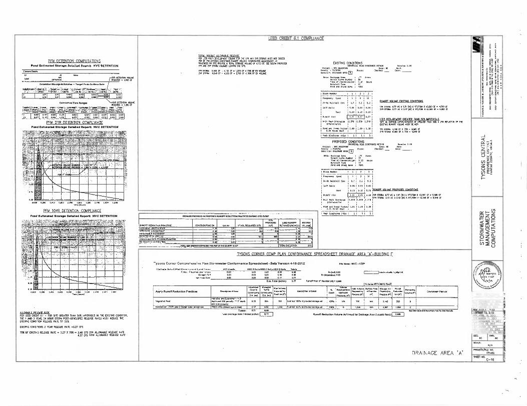
pn.4 DETENTION COMPUTATIONS
I EED CREDIT 6.1 COMPLIANCE
tOil-:
■7100C:::
0071:074 (
MO
.ca
m O
re•V
e• ,4•01
4.•••3
• ON
UM
OV
V•11
..... K
IM
(OW
• ""-' ("
')1:4 '''''
in•r
01.5X
33•, •1 1V19.1.1•• V
AN
313•73 no
rmans
• s•am
ens • 1.011•3
•• .0
•0•6,1 • S.E
••■"1
• 41..3
mu vo lair u I MAR r qn F.SF PER 62011057-DEvaselo61 vcauwE rcAt 172 In ARO 212 SIMS Run NOT COMO 752 OF112 DISTIRC 0262111045 RUNOR v12.072 5270R7A112 Waav201161 uD PRACTRES CR WE PREP. A 707A2 270RACE v0.1712 OF 033KIM MVOS. oOsnNG CONDIMONS 7111 AND 710 51001 MIMES LEA. TIE 91E GAMMA MD D1.6. M. Vera. 1.00
1. : 1170 P... .err Iv mg 111121Cat 5.006 Cr - 4.123 Cr A 1,373 Cf 01S Cr EX nag Camy : KIR. 39.ag C.a. • Dem
• SR MK RAM CP - 4.123 a . 3.713 CF 4 7SE CIE El TRUE swencia, D16710.6 AMIE I
Mg D... Are. t .77 Mo. camISMer : 10 1. of CoKearraclon: al° 11.6 lantall Me ■ Ir MD a. ea. At. I AM
Pond Estimated Storage Detailed Report NVC DETENTION
M. 0a.
' 72 s.
.11 26 0E7217101 KURA
tereance KO.. • 7065 CE
Datactl........- Tag. A. 0.76.11.
..927.55:141461it ll.a.:;! -.4kf .l. 'l l SUM,: PrSaavo'c'',4312.. i' • ii Nair ii -40sPONT, ilTilegNI TilLaig i i 'i Ligi iti -aaiN041) , !ir i 40041 , is 'W.W.I::
1KaraI
IMOK
• ... Ma „.., 5.1014 uo,
Ian Aare
Osed
1 1 2 1 3
1 I 2 I 11
2.11 3. 2 : 0.
I I O.. 10.01 1 0.1
O.14 1 0.12 1 CIA
81.111ZUS 0.Iff-0101201011211
10 fd 4171 11=1 *11:011 =II ',..71 :::i ColeuMm Ton Ran. i-1010 ORM. KUM
((CURED A 1250 6 ..1333.:11111.-. cs.....41.9•211.1:79.197 37.0M:f..1., 4 -... 1.,,alj
rtSrleangi="Itiger.11.4.-4:14119:10.-.:gfraratatEe'rerla15.01171'
110 Vaall: 1172 AC 2 1.21 ON) 0 77/12117 .3.560 9' 9. 11.740 LE 21R KOM 027 AC II 017 71) 5 177/1201 5 43260 SE - CM 7
110 I r041 .070721 =I '"olgi rgi :1:1 :=.11 :11 :.11 t.:01 S.. 1110 4,47
TY
SO
NS
CEN
TRA
L PR
OV
IDEN
CE
DIS
TRIC
T F
AIR
FA
X C
OU
NT
Y,
VIR
GIN
IA
..t ...,.... 1 1 .51. 1. S. 1.51 1 IA70.A7A/A70 1
roe! and Ewa. net. 1.00 1.00 1130 .•....... ■ ,
Mk DM.. le. 1 2 3 1 5
I EFEI RFOUNFINNT WARR DIAN Sin IMPTIVAGUS WU AN 0151114 7,012,1071214222 Cr CREAMY MAN 502 A 252 REDUCROS CP 22 Cams 0..07 MIRE 111131 BE MCI:
go gcroo 4.. c, v 75v v .3.... ,d.
2. Malt 6,065 Cr 2 75,4 • 4,310 Cr
?FM 2YR DETENTION COMPLIANCE Pot. (017113.041 Storage Oetalle Report NVC DETENTION
temay:-?..-ccim-Tp.-:K91-7EviNpagt4,617,-!: zy, ''' '- ...1414.3.12 / 4VAS'599.710957'.'43 1-, .. IX
WilliZAP' R Nta PROPOSED OONDMONS .0.1.11, MA 01.40. NM. Mg. 2..
=Frog1e:
f
r'07
OC PSKOMD Wer.: K Met
Na ..0 "'“` Cbeeked: _ Dm:
WU: ... Ana 3 .77 AL. Am. ... I.. 3 03
1:1;=C,onc,entratlen ! i n No.
Pond and Seup Are• . K.
IBEFEIBUNI4 MiNA 1511.1M "AilikitiffiNSMIN
V_MintgliAMIll Iii: la I NIB .. -ten 3
---------- -- neon. 1.1 1 I
21. MAI•11 .1 2.1 3.2
1. Dale 0.04 0.05
0.0 0 00 e se
14
5.2
GM
0 14 RITEEEE11321EIMELECIUDIMDMS. To
1311■111M :
ILI:" ;WI
451,11111 .021 um 1.3, 71111 512.12 0.72 AC x 1.16 IC R ”1/.. x 6.5. 0 Si • 3.37, Or
12. scam 57T AG ■ 244 PO /INV. 7 03666 N e 04, CiF
.576 I
1.00 i
5 1
alll'...
STO
RM
WA
TER
M
AN
AG
EM
EN
T C
OM
PU
TATI
ON
S
11. I. 111.1. 17.3711 11.571 .../.1 I I
, Pend and 53.0 Pact. 1.00 1 Ise . 0.21 om. us. 1 I
cm o2oo 0.400 O. Co cm „4.400 ,, I.200 1.400 Imo IAN
pFm 10YR DETENTION COMPLIANCE 5713.005111.1.0 0191101105E6 RUNOFF MUCK. SWUM DURING 1119.717
•
. Ng DI•erom 1 1 1 2 I 3 -.--...-..................- Pond Estimated Storage Detailed Report NVC DETENTION
;V''!4,1W7711-Wler'1..7"-7.1''!_eix%-,7.%11. RUNOFF IMAKTION MACE. CONIMUTINO OA OA RV "'VOL WORM fen
VO L 1120.0130
63") LIMORMSOFF
164211.111110 .01E5) 17CE. VOLUME
ekl1=511..MVX1044131110 INIfirs ' 21112 _. ...
1321010Elkii=iigt MEE
I.
EKE.. GREEN ROOF ...NE GREEN ROOF
0 co 0 06 6.65
20 Viso
.06 769
016 2401
DRAINAGE AREA .A.-R1.111 DING F
PERMEABLE 0
PAVEMERV 13.3ENBCP3 M (ME OISCONNECION 70 MIA KAMER
0. 05 167 1 eV 292 321 '
RAINWATER ig.4511710 0.00 0 0 0
0.00 0.00
...ID 100.1701.64 UM. of m.o. 61.7. TOTAL ECM VOL 1771
k ..a,
PA ,
IMES kiaa NNW ling TYSONS CORNER COMP PI AN CONFORMANCE SPREADSHEET ERIS lialEINENE
Tysons Corner Comprehensive Plan Stormwater Conformance Spreadsheet-Beta VeralOn 448-2012 sip Wm: NVC•COP
Drainage Are • A Pog-Deve lopmen1 La. Cover USG A or. MO 0 VaM MO C...0 0 Soll• Tol.
Ili I i IN I I MI it" sr '--1)
AATATril a i I- k i VM7 , I. 110% 4,94'
'2,
. \i;Z:riN ni.V.,,'
MIN, ail. '.-.- . lqi MIME
7 vem f NMI,. Opa Dare .5.1) am I i .. ■11.M1S nopi.u. Mae. Ila
0E0 000 0213 0.03 0.04 16.6.1.) D.
ry 0.00
0. CO3 400 COO
COO C00 0.n a77
od.0
Ni WAIF
b P.
omen. Milaii-amewi
V 4 IA. me ...7
D.71. Total (.1.1 0/7 Rune131.3 In .1.0 NBA 2.000
Apply RurtOff Reduction Practkes CIIT.W.T.....
u.0.u0. Camcin
poesetioe DA. DR)
M.E. Twin
memo-see 2A. RAI
...". 'asi."' Dree. ( 0)
Deemenee 70•0111 M.
M.
Vgurin no, ,
lam. ,,,,,,. co
Tao Downs 3.446 by
PIRA. 10
EMI.
9....• a/ P.M.
MR
Oar. Voi No.. Make 10')
Itir.
.1.." KIP.
,...„,
o,.....re, ' '
Coma. P.M An__
WM. RME
VIKA REVISIONS
REV NPROMER 11. Nes Vepemted Roof Mien.. EA.., 1•+.S...O. tenet', -ir 011119 .430 Deo.)
CM NA KO Me. 1001.1.001•10.. .3. on WO NA 7.. 700 0 REY WOOER 26 2013 REV MOAT 15. 2013 Bromsoon . DCA I. 2 Mign Sea arclereau TREE PITSDeleaso. A .0 437 060 1.010 8.0 7. of pa. moo. ve 100% 0 7935 ADS 1.050 0 Royal 10. 2013 REV MAY II 2013
Tags an ese soap lieoevai•emoTaeler Ile noes
113.1.413. Ann Tim .1.. 07 Runoff Redvetion Volum, Achieved for MAME,. Are • A Putt teeth F-7 PER TEED CREPT 6.1 - KR SPE GREATER DIAN 50E 11PERNOLTS IN THE EXISTING CE THE THE 1 AND 2 WAR 24 HOUR STORM POST RELEASE RATES MUST REDUCE THE USING CONDITION RELEASE 11411 BY 25X
ID03111. CONDITIONS 2 YEAR RELEASE RA1E .127 GS
75% OF OWING RELEASE RATE . 3.27 0 75% . 2.45 11 310 ALLOWABLE RELEASE RATE 4.37 CTS 10177 ALLOWABLE RELEASE RATE
REV APRIL la 20,3 REV NAPEN 11. 2011
DRAINAGE AREA 'A'
REV NOVEMBER .. 2012 REV
.0748 20. 2012
REV mARCII 32 2012 REV AAARAA1117 25. 2012 MIS FEBRUARY 22, 2011
DES. I TneL BC BC
SCAM N/A
PROJEC7/7111 ...M.. sKET NO.
C-16
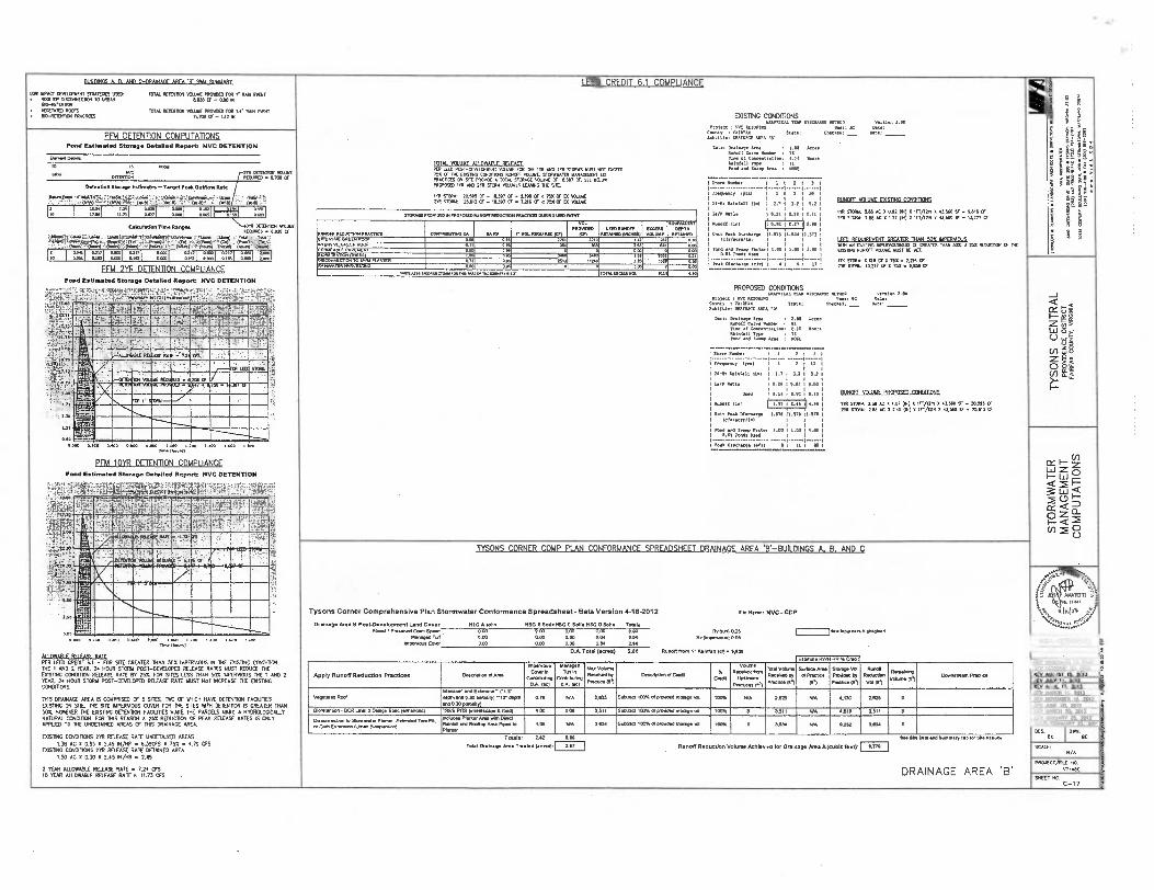
112.08r5 A Ft AND C-DR70NAGF *00.0 IF 0816 D WARY I FFD CREDIT 6.1 COMPLIANCE
PO
3 V
VI
n•••••
en
t-•1
11 00c(nv • to
tt-se
. 00
0
te•3
[ Ora
lab
en
1.2
11•4•03 •
11■15 Otiv
.n01 11.1
1003 M
at
01 1.0
.2. V
ux
.1530 Ila
r n0
11
05
• 540....1
6 • 1
021
.11r k
r.O
NV
I • IM
Move
, • S
el.71.43
LOW •PACT OLIELCPMENT SMATECES USED • 800101 015CONNECIION 10 LAWN 21,1130 6 - 0.110 IN
• VEGETA. ROOFS MTN. E10-11E11311501
101AL REM. 14»4 PROW. FOR 1 . RAN MIT
MTN. RE1131901 NEW( RCM. 864 I, ItIll EMIT • DO-REID111011 MACROS 11.7116 CY- 1.12 01 DIMING CONDIDONS
GRA.IM MR DISCIAPLE.003 Version 2.00 Uses DC Rase: Eii:::';F700,... auto: Cheek r: Orr
Mal halear Area : 433 Ares M., Core X.1:67 : 71
Corestratien: 410 awn TOTAL VD INIF All OWARI F 6E1 F AFL Arra, Type : 77
PFM DETENTION COMPUTATIONS Pond Estimated Storage Detailed Report NVC DETENTION
E......
10 .00.
•..• ANC SIR COMICS MAE MOT. REOLWED e 700 CF
..0 P051-0EYELONENT NCUIME. DE 1312 ARO 270 SID. 1.51 NOT o® row a. Sea Area : RUM 753 OF DE 035.3 C.0111013 RUNCE VOLUME STORM.. .14(.011 LC PRACICESCR STE PRO. A 70191. STOP. VOLUME a 1E397 6. SEE 9ELOP PREP°. 1111 AND 2112 STOOD YOBBO LEAVINC TIE Sit
SA STORIS: 70595 a - 14397 CF - L. CF < '753 Cr IS VP. DR 5.15 25613 CF - 14397 CE o 7.211 CF < 753 OF El VELURE
SConn1:67.11 -------
law -------- ----
f PM
21-1 RaIrall .1
1 1 2 I 3 .--
2 I I 1 If
I M I 3.2 1 5.2
" ' ''. 11111
IIMICfr OUSE DOSING CIINDSION
Detention Storage Estimates - Target Peak Outflow..
' 30 ,9E,L.D1SP/si .1-'71544,61,-. , (4.1L ..... "Am. '.:' AN417' ... f0.R1 .tr, facie 4
2"1T= '275 ICC '8( °I. '2; (V) '2 '1"F/2'3 'n '2 V3.550 ; : 1%17'0' ILI 002 1 1:.„, i :711 ml L:11 .:-.1 (0011 3700.471.60111170 ix PROMPLOR110101310677.110.16.01311740110.110110 PANT Ian natio
66.(I. 1101 ILEUM
.16 Pp. 10.3611.00
OekuIetionTlete Ranges 0.0011111011 VOLUME KOPKO e 4920 CT
y13.47......,13rel.ndeee,i;;CeeelerrIt000m.Fv.,,OPe.....:Mar, Ti- ,,
7.7,1
ftkrX1r1=1A11.4=fi-4',TIV.40:4 -.74;,,, r,::::,=, RON088 RPOU1711111.07101 .tar M DA RV Cameo...um as,
VOL PROVICED
,cin 1.1170.110811
Rumen °acmes, E.. VOLUME
176.111/111.1111r 001:711
REM..
". 11.515 .530 1.573
6,766776 GARD:Roo, 1.7.6. 4.01 ROOF
554 0.11
0 06 .31 sm
0213 961
1. 2.
0,0 1.0../.1
....a am9 ram. , 11.177 7. 00.
Is.
PROPOSED r:e1acm . MC num.
ZZ■h•', IT L,..., Orr Drina, Area
Aueor Corr ralser 76167 Of Cooe.7.1.1.7 1171.11 RP. P..
--••••.••-••-•••-• . t. re ,...,
FN.... lyre
20 -88 nalatall Mu
la/. Ratio
p.,,,,
O
10 6111.Por 1.1
31scharga Isfa
S
irre
er
/101
P
.
.. Farr . A. 0.1
Hal arra. 419
0.
0.63
0. .........
1
1.. 1 .. 1.. 1
1 66660 --6.- ---
t Frn RFOUROVFNT 127FAITT TIAN 50S IMPERVIOUS SRI AN EMSONG
ASP OF
CI NAN 503. A 253 RED.. a 712
10351114 R.. MAW MUST BE 1.:
110 STORM: 17610 Cr X MC . 7211 Cr
PPR600.87167,16.17: .,_,,,„,,,„,„, o r Ire 5143 OM 1.11
5.oe IL nli v.gi 001 :gi 001 r,g1 =1 .-,g1 :-..1 t::1 DiscoN.CcoN TO 3. P.N. ''' 0.71 „„ „2.,. 310 7
TYSO
NS
CEN
TRA
L P
RO
VID
EN
CE
DIS
TRIC
T
FA
IRF
AX
CO
UN
TY
, M
RG
INIA
PFM 211R DFTENTION COMPLIANCE, w.0100ArA 70.81vOSm,c
.17:1■1017100.67.6....
OA
0.11.7 0670117 0 r TODD FACF3SVoL
0
91.19
1 1 ..... 77 ... 2mstow 13277 CF X 758 • 0.150 cr
COND111ONS opR00.7.... pp.. 0.... R6-6.0 Version 2.00
ors: 6C Date:
,. '""' CnesSei: _ ore: .
: 2.115 Leres
I 92 0.10 Kos.
1 IT
Area Area • 100
Pond Estimated Storage Detailed Report NVC DETENTION
tr:Z.315,24r,ity4Tp: 7.'5
6 1•:
774,v4-.. .:y.; !:',.. rpf,.'j.ltit- ,..se,
0717.01.6111 161,..• .16.:::,36-1,P. P qr -
11111 060
W. *1,ii E Eti . .Oaf A - BEHMOIN
, '
1 ;,
-LIVIIINISSiESSI 9- 1211IMUI.
1 2 I IR
1.7 . 3.2 1 5.2 •
A.. i 11.115 i 11.52
1 ., : ., : ,,,,, RUNOFF VOI ONE PROPn•rD GNOMONS.
1
1, 0..,
,
..
4.01E
M.PFAISEM ' . -''' OR.
:. . ..,_
STD.
1
JR
FE: 11PM • WOW RED o*
701 er
1 riallilIMIIIII AC Milatal 11. 111 STORY: 7.65 X 1.07 (IX) X ir/12N x .50 SF -x0.015 Cr
30
oo
TM VCR .: 205 AC X 205 (m) X 110/1710 X 0050 SF • 25013 a
IAN 1.570 11.570
•
1.00 I.. I 1.00
I II 1 20
STO
RM
WAT
ER
MA
NA
GEM
ENT
CO
MP
UTA
TIO
NS
..„.„:
d
..;;;;.,
Mtn 0.000 0.310 1..0 0..a« cam lioe 1.201 I. so .. oo 1. 00
71.160.11
PFM 10111 DETENTION COMPLIANCE Rend Estimated Storage Detailed Report NVC DETENTION
kisr ';'..i011.1-,sfe7ii'dligg414,1:41:1 )41.2t.V..14Piti •
pa ,,, - ,---..-NO Sri1 ill • ..•_ -11iatill „„, .,„ El am .
TYSONS CORNER COMP PI AN CONFORMANCE SPREADSHEFT DRAINAGE AREA •'B .-BUILDINGS A. B. AND C
lEiiI0
IrAF45$ T . 1
,....,. lin
Tysons Corner Comprehensive Plan Stormwater Conformance Spreadsheet - Beta Version 4 -18 -2012 SIN Name: NVC - CAP
Drainage Area 01 Poet.Dovelopment Land Cover 1150 A ail. 1185 El SolIe NOG C Sons NOG 08011. Teti.
" l -.-- r!. IBILF41.1m ,11.
im ili „.., i ,,,,„ , . 5 ‘ MARTO l.1
X
■ rim.
S ,._ 4 yj
‘4.4::..
11.1111.
.1;.5,;
al uo Ie
11111111111111 13
. I I
Forst / Preeer. Open Sp. . Roo 003 000 000 0,5.025
51..03■01 003 1100 0.00 0.01 RvOrnperox. 0 91
mama. Omr 0.00 0.00 0.03 270 28a
I Lem• 1.0
0.000 0 0.000 0.600
1,110PAR F RR EASE RAIT"
0.0 1.000 t.:00 00 .600 1.100 en. ,,, VIKA REVISIONS
D.A. Tam (scros) 2.88 Runoff fnan .1 - .1.11 (en. 11,660
Apply Runoff Reduction Practices Omoimon ol Ana
mama. Covet
CalletriA DA WI
Managed 141In
C.D.s 0.A. NC)
....... ........„
'........°)
NINO. of 0111
Voium 8000,000081........
F.,...c.,/, DA,
Toole..
R....
7710010010
Emma* RMI
S.. Pre olPrefise
(..)
RR % 1061
500030.00 Paeled by
Pad. (el
8vEs. R...
.1e)
.........
'Iv N .*
Doman= Poo.
REV NOVEMBER 11 2080 REV MT.. 28 2013
PER LEM CREDIT 0.1 - FOR 510 GREATER DIAN SOS 11.IPERMOUS N THE E)3S7D1C CONDITION, ME 1 AND 2 YEAR. 24 HOUR STOMA POST-DEVELCPED RELEASE 80105 MUST REDUCE DE DOSIBIG CENDITON RELEASE RAZE RV 250. FOR SITES LESS DIAN 50% IMPERVIOUS DE 1 AND 2 YEAR 24 HOUR STORM POST-13EKLEPED RELEASE RATE tam NOT INCREASE THE CA101180 CONDITIONS.
MISDRAINAGE AREA S COMPRISED OF 5 SITES, NO OF WHICH HAVE DETENVON FACILITES DISTING ON SI1E. TIE SITE NPERNOUS COVER FOR DIE SITES WITI 0E1ENION IS CREATOR 1X57050S. 140115CON )ER Of (FOR TI
TIM DETENTION MUTES MAKE ONE PARCELS MARC A
REASON A 250 REDUCTOR OF PEAR RELEASE RAZES 1090
IS O0NLY 1.00CALLY
NATURAL DITION. APPLED TO THE UNDETANED AREAS OF THIS 0670558 AREA.
DOSING EEND1110115 2YR RELEASE RAZE UNDETAINED AREAS L38 AC 1C 005 X 5.45 114/HR tA 6.3965 X 75S s 4.79 CFS
COSTING MOTORS 2YR RELEASE RATE DETAINED AREA 150 AC X 0.30 A 5./51X/10 • 2.45
2 YEAR ALLOWABLE RELEASE RAZE e 7.24 CFS10 YEAR ALLOWABLE RELEASE RATE. 11.73 CIS
REV AUGUST 15. 2013 OPT An, to 2013
APRN. 16. 2013 REV met. 11. 2013
vemmet RCP and Ellen., Cu,-
own me 030 prosily -1.21 tete ansgal porter)
0.76 NM 2.835 Samoa arm of D.. gawp se. 1004 NM 7.025 PM 4178 2.2125 0 REV NOVEMBER 19. 2012 REV JUNE 20. 2012
131.10011011 - OCR Lori 2 Design S.s Iennrc.) TREE FRS (10. 1... 8 1.0 I 00 Ore 3311 uaraa 1.33. al poiced Mane al 803% 0 3.581 4.611I ' 3,511 0 REV MARCH 30, 2012 REV JANUARY 25, 2012
Dossonnecoon to Strew 1:16711er. Etlen01/11... ,,,,.....,.,.,....„ ojr.n ......„.....,
Melo. Mater Ma .410 Dyer Rates and Re0100061 0000 10 Piarder
LOS 100 3.030 531.010. al pave.0 amigo as woe o 8,601 005 4222 Ia. 0 DATE: FEBR1A37 22. 2011
DES 0991. BC Totals: 3.82 egt reset Rea as/Summary Tat for 5. RIM..
1..1 On.. PM Tre tad lacr.p. SW Runoff Reduction Volume Achieved for Drainage Ana A (cubic Teel): 0,770 SCALE: N/A
DRAINAGE AREA 'B' PROJECT/F1LE NO.
,,711109 SHEET NO.
C-17

IFFD CRFDIT 6.1 COMPLIANCE .
•1
0i'
VN
IA•m
“
Z•ZZ
-11111 (10
() •■7
• C01
.-.•
(W
O
.10
C 0
0•1•
•••• ...man
OVV
• U
V.
A31•0
0 •
III WY7
3 ,S
ot
tain
V•1
0■1
14"-'
rd
l;
031•1.0.0. y
rs
.63
0 p
erm
visns • S
WA
IM. • 3
1711
,01fe N
r•W.IN
VI •
....W
U • S
t13
.7/0
PFM DETENTION COMPUTATIONS
TOTAL 631156 An nwAriir 010. EXISTING CONDrI1CNS
Pond Estimated Storage Detailed Report NVC DETENTION
E.3.10.11a
10 0 0.00
um no 2YR MEM. ICUME
00017011 RE.. • A1106
609110100 0.90 benne. - 0107111. 033670. Rate
:,V!,::.',.?;:f,,,i-,„•r;1:7,1:-..=,-:!•'1;714;-.,,i. 7= -,. -.T:i:0'afit....j..-;;ZI. . PER 00 POST-001161.1 VOLVWFOR 116 111 NO 21R S.11S RUST .11.E10 GPARSICKL PT. DISC.. NITRO Was. 200 70X CF ME D. 01.0. RUNOFF 70.1E. STORWIMER 11.A.61.17 110
10*
3 0VC 1010010 Wen 1% Wte I PRAC.5 CR STE PRO. A TOTAL STTR. SWAIE 6 15.720 CR 500l =L.; VO.01,,...in ''''' Cheated; _ One:
000050 1717 Me 210 SON VOLIA.10.10 111E STE. NS 0E5 MOT ACCOUNT FCR 1.16 Amami. MANE DEMD THE I . STOW NAT MOW glow BE CAPTVRED 01 Dan: Oratna. Am : 2.13 Acres ME 1201 0012 Awn 1 Car. NW. 3 II
1. 31663 1575 Cr - 15.720 6. 0 Cr a 70 OF 0 MIK I et Oancentratles3 0.10 Wurs
03311 Typs 3 77 220 510110 112121CF - 15270 CF . 3,001 6 d 7SX 6 Et vol. Para and Ss. Am 3 WC
° RO I 1 7.:1 '....2,:i '..4.° 1 ....1 .'',.'4 1 HO 0.404
CakulatIonTIne Ranges \ACM DEIDITCN MSC WOWED . 3.223 CF
.1.3019.t '11.61•TE0RLE ...=•.359*-1. 1...-014707VRS'2 305° 331.96q '3 ..°6'111..t.
1%.1.'•Wr.'14-5=0=11'97°411=1":•11T.12741311=317=0.-17=11;1•9•Tati3
110 1 r771 :1111 :1031 :1111 :17071 :11fl =11 :1111 =111:1 II 21
rm ,00.0 1 1 2 1 20 1 1
24-110 WI *F11 101 2.7 1 32 1 3.2
100 001e • •to t 0, t ..00
01)5100 VOIHIAF FlOSTINC COMMONS. PFM 211 DETENTION COMPLIANCE
601.0110.3161111101•0300..130130110.111601CO 000141110301.6 Pond Estimated Storage Detailed Report NVC DETENTION
6-1:111 1;00.V.1N'.IT 1T7al 14064 criatatrt37 Vidi 113, . Xy Run. awns. Paw. 0037.0.1. 0A . i- VOL now. 00
VOL PRON.
067 1299201.07103
.01.00... 10000 .11.30
1YR 5160 215 AC X 153 60 X Iranza x 0.500 5F - moo CF 07 5160 215 AC 3t 20 (00 X 1r01710 X•13.5030 SF • 15.000 6
TY
SO
NS
CEN
TRA
L P
RO
VID
EN
CE
DIS
TR
ICT
FA
IRFA
X C
OU
NTY
, VIR
GIN
IA
5.7336E GREN., .20.0.. swam ROOF
asS 63.7
1. 1203 O. 11.111I 0.1C 1 11.1B
3 .0. ilf,21.
•
4244r..-k-ir ,<_44-, ..13:.,-. 1 r..4 r'.".: ... -
: •t
vjjr...•
, 1 30.0.1.9 P.O." .•
11"0 ":3 Amen Ii.) 1119:10121:1111 ,..4 0.119.071rtmes, i OM 17.07.0. TO Ss. Rumen 0.73
3016 1.0
00. 00 .3 Wm.. 12570 11.571
Instscrenn1 I I 1 1
wn 736 0. 0010 1 1 3 55 1 20
0.0 Tar. Osed 1 1
Peal pls.. 1 ______........ 1.511
1 .0
'MAN I11 RF11111RFIeNT WASH 500 6/PERN011e 011111 13331210 ISPERSOUSNESS OF GREA1E0 .0 50; A 255 6101111011 6 116 075761 ;war VW. 11951 0 IC:
1. sram 12007 6 X 755 . 0013 Cr 7. • %>55 . 7
.....10.0 0.00 12.3.003.01. :: 6i
-MO" REINER •
PIM la „.,...., PROPOSED CONDITIONS
,,c7,7ix
''''''''' °05.01 IC 01101 1" L"
Un. Mtn. PALA El ton. Checked: _ Case3
Dat a: Prnewe Area 3 215 Ways
. 1 Wm Mbar 97
.f et Carrentrentaa3 0.10 inn italnall : 11 P. an lv
70.3a. Fee3 110.
ji -- IfPilikIllfilignifil . .
Re. 1 671111111411 41 ,C, II • 01. 7. 31... 1 1 2 1 3
team.? 13.) 1 1 3 1 10
24-ke W01011 1101 2.11 3.2 1 5.7
T•PP Ann 0.00 1 ILO 10.W
nod 0.10 11.0/ 10.e RUICELN311NLERDEDSEDInDIMB
0.0oa a inn 1.000 t. oe 70 Own/
pFm 10YR DFTEN11ON COMPLIANCE
STO
RM
WAT
ER
MA
NAG
EMEN
T C
OM
PUTA
TIO
NS
Pend Estimated Storage Detailed Report NYC DETENTION
Ii'll te.kir1410:ZiTAia;“- -74.7;i'rtitii..?::4:, :'''4 '
00040 Ural MillE1111 4.. 00,4 51001 215 AC x 1 .07 00 X 171/131x 0510 SF e 10.375 CF 2111 3100* 215 AC X 05 01) X 1101. X 10.-. 6 • 0.70 6
Wit Peal 01snane 11.571 . 711 12. 1./actene1 1
, .
tees red Nag retool 1.00 1.00 I 3.011 co% ...o. u...a ,________,____ _____,_ 1 Peal Olschans Icts1 1 7 0 i 0
.... 7- • - mlviL4Ec.t.7. tvLI;St.
re1741 rialAti - - -- . . 10-Hzvtiaalib. : EN
agigaMitigi ' - .
A -' ...,,,
riartainAllagEnittiffrif Alprit . '-.Ezamitersnal
iiiiiidtt
DRAINAGE AREA 'C'
MillilliBitellilliffiMitillia11111111110 , ligitIliallikiliiiiiiitillialli111111111111111 dal
4,4t. ii. IN
, qw■Immoninsuilism 1A110111.1111111111111111111111111111111111 tammarlemmemissimmum
1111■1111111111111111 MN
I
, AN, mom
IR,
SI:- .1.1r` 5:7/ ‘,..1::::,,,,,,,,,....,-.7.
- 111=11111111111:12-•-•11111111111111111 ...
i a.M.1=.11.11.11.11SNINs■-
TYSONS CORNER COMP PI AN CONFORMANCE SPREADSHEET DRAINAGE AREA V-BUILDINGS D AND F ..0.0 *Ica 0. sato 0.0.5 tme t.793 3. 00 a 00 1.0
ne nesn
n I l
6110AFF RFIFSOF RATE •
Tysons Corner Comprehensive Plan Stormwater Conformance Spreadsheet-Beta Version 448-2012 3Ite Name: NVC -CDP
Drainage Area C Poet-Development Land Cover MSG A mu n50 II 5011•1150 C Solis 113D o Soils Tenn
HIKE REVISIONS FIR I1 ED CREDIT 6.1 - FOR SlE CREAM MN 502 DAPERNOUS IN THE EXISTING CONOMON. IHE I AND 2 YEAR. 24 HOUR STOR4 ROST-DEWLOPEO RE1DSE RATES MUST REDUCE THE VOTING CONDOM RELEASE RATE BY 25X FOR SITES LESS THAN 5011 IMPERNOUS THE 1 ANO 2 YEAR, 24 MEER STERN POST-CENELOPED RUA% RATE MUST NOT NcREASE IHE EXISING comoinous.
THIS MENAGE AREA IS COMPRISED OF - 3 SITES, ONE CC 0011tH HAS A CCENHON TAOUTY E31.511510 ON SITE. 1101 SITE 400(0015 COVER FCR THE SITE WIN DETENTION IS GREATER MN503, HOIEVER THE EASTING DE1ENTION FACLITT WAXES THE PARCEL 410110 A HYDROLOOCALIT NATIMAL CONDITION. FOR THIS REASON A 250 REDUCTION OF PEAK RELEASE RATES IS M T APPLIED TO THE UNDETAINED AREAS IT 1105 DUNNE AREA
EXISTING CONDITIONS 2111 RELEASE RATE UNDETANCO AREAS 1.95 AC X 0.80 X 5.45 1N/HR • 6.50crs x 75S a 6.38 CFS
EaSING CCNOIROVS 2YR RELEASE RATE DE1AI1E0 AREA 0.20 AC X 0.30 X 5.45 IN/HR a 0.33
2 YEAR MAMIE RELEASE RATE. 671 CFS 10 1EAR ALLOWABLE MOSE RATE e 11.72 CFS
For./ Pm.. 00.3 90. • 00 0.00 0.00 0.0 0.00 0 0.1 0.25 I 1.1a Input cells 111.00111ed REV REIVF.ER 01.013 REV OCTOBER 20 2013 REV PURIST II. 2013
manned Tut MOO 0.0 0.0 0.02 002 17.1.70.337.) 0.95
manias Cow 0.00 0.00 0.00 2.13 2.13 REV A11.1 10. 2013 REV MAY 13, 2013
DA Total (acres) 2.18 Runoff eon 1- Reiff 1 110 • T20
Apply Runoff Reduction Practices Oescrionen RIM
W on* Cow In
0.11.1.0 0.0. 00
Ma mma r ode
Come.. S.A..)
. ,,..... ""'" Rem*
,,
or p.otte CO
OmorletionorOeSt %
Oen
yawn .... ......
Um.. Won. 00)
Tote vaunt. awaked by Frees pa)
E.. RW11
Sanaa Arm a Pram.
NI
RR %Caen
Storage Vat 173.1. ey Procrice01)
Runoff Remo .
._,. Va .
Remalelre
volume 00/ 130.01.0 lann.
REV .n0.10. 2013 REv NARGH II. 2013 RP, NoWNEIER Is 2012 REV JUK 20. 2012 REV *0100 20 2012 REV JANUARY 25. 20t2
vegetated Root nansise. a. 01.170.
(.4.5,13. and 0.30 pens. 12• Morn and 020 comely)
0.52 WA 1.117 Semen HOS al somas meta .- NM NV, VDT WA 2.137 VIP 0 DATE: FEBRUARY 22, 2o1
DES oe70. BC BC Mrs.,. • OCR Leal 2 Oman 5. 0.00.. TREE PITS (smetecam 6 nee an CM 2058 Saxon 10014 04 PMMO Mete v. W014 0 3.058 WA 5.166 0.0511 0
Encemectiat to Stomoster Planter. Erten. Tree Pk or Cure Emmen (Men Bloramlou
nag. Rimer Area wits Draft Room am ...too Arm peed to Rimer
673 NM 2513 Sonora 10014 °Imam mem . mon 0 2513 WA 11,240 2.50 0 SCALE
N/A
PRO•ECT/PLE NO. V7146C
Totals: 234 ere ne.C.10 and Wirnmenl.fas Ina ha..
Total On Ina se Ana The be Hos wi: 2.14 Runoff Reduction Volume AchNved for Drainage Pon A (cubic tmrt). 2.388 MEET N0.
0-18

FAIRFAX COUNTY PUBLIC FACILITIES MANUAL
VEGA,. ROOS
SUMP PET FOR PUMP MICK N. DET PER IdEP/STROC111
AILS11AL WWII FLOOR (LOICSJ
11,11.)
SECTION A—A
TYPICAL RETENTION/DETENTION VAULT DETAIL NOT TO ICON
VA OCR STORIAWATER DEVON SPECIOCKRON
CROSS SECTION NEW (NTS)
EXTENSIVE MIEN ROOF
• ONE 0071.09 PPE PR MM. MAIM TO BE DECIONIES MA CROCE.. WEAL WY BEPINPED
^ MAL BE
M A110 LOCUM Of NIP. PIPESOS FOR
MEP
NOTES; I) MN. 1.13£0 SHAPE Da. LLCM, NV DON. PF
STCRWATER UAN(CEMOR VAIAIS AM SULECT 112 BIKE AT DIE 1NE Cf Mk OCINELIONC.
2) SAMMY AND REINED.. FOR VAULTS PR SIRUClUAL EICRCERND PLANS
(Brio %Tr ZWAL1:01
0O ER SYS
SUMP PIT FOR PUN
198%.Aggi'aL
SECTION R-B
PI AN NEW
RAW. FLOOR ABOVE.- \
ACCESS NAT. TO FLOOR ADM OWED SMUT AND SEALED) INFLOW PIPE••
SAME WALL
ELEV 1E000 MPS CORRESPENIN TO DC BOTTIN OF 11C VAULT
ilVE 61[7. Kr 4 1 AT MAL NONTERINO -
SINLIE VAULT AMONG SA
DlaelcrEe
BC DES. RC
—J <
z L.., oZ 0 z
(/) Z r,
OV (/)
411104 1'1 -5
PLAN VIEW
°mac end N.nn, 0-00 leadlnx
AMILII PPEC.1 0.0r1r CAP. tuAbl ORMR rOartA .700 .12014 LCCAMN PER R017 WWI IN, SEE STRIX,PAL 1704 . WALL EMI. /.04CRCOM11 O.TC110HS
RAO ON. NOM NSTAILATCN PER OPP.P.O. PANS LedANdx Po, PL. 0.170.1. PER ARM PONS
P.M 11440,17A AROVISCZt PRO713.,
Sa gt. RIMS, CONCREM PA.5 SK41. SL7 UAL
u0•4M" mNsaman(DAI
ram wow MN
',OPTION 1--(
STORMWATFR PLANTER DETAIL NOT TO SCAM
PRIORI TON MIA PUNIER
OUvEl DIOR PIK
VIKA PENSIONS
RATOPROMRC 10011C[P. N, mot wws
0C1onout A' ale. ph. 30 or Node
Imelmrarala
WWI 07 Now with • mu, r emw and bele. Use pi,. Fre
8,4719.0 mad
ConeretsSeC
V-t-Otr" 9-13°R-d°
CROSS SECTION A-A'
▪ =depth
E-S. soul. abr. /a herdlnaod mulch
Open bottom
N"tr-r.V.2 a:MZ 018 4. 'rnC-33
REV NOVEMBER 11 2013 REV OCTOBER 211. 2013
REV .Ally 10 2013
*MSS. Rua:An ro,..PtENL rA W*011 KIX3143 0, SM..
ROW. OS to AS APP.., AST, NA 1.1 t PUS
0,1.1.1103191.,,
NoLse. tOCREN 31.A. op, , nn. 3111LCNNLPROL nod DIAIL
REV MAY 13. 2013 REV APRIL 111, 2013
REV MAR. II 2013 REV NOVEMBER 19. 2012 REV A/RE 20. 2012 REV LIARCli 30 2012
REV JANUARY 20, 2012
(taw LINN/ NOOlt BATE: FEBRUARY 22 2011
Ref. Sao. !I 309 PLATE NO.
TREE BOX FILTER 90- 6
NOTE) CONTRACTOR TO COORDINATE 'MTH
PAVER SUPPLER TO PROVIDE A 'ROLLED' PAVER OR TIC LOCATIONS OVER THE SLAB DRAINS 70 FACILITATE GRAN LOCATION Pe
MAINTENANCE.
'TREF BOX FIIITR DETAIL
WALE N/A
MOP. (TP.) ROW *Nvonca NA. a. WV
91113.CET/FI.E NO.
meet
INTENSIVE ( > r DEPTH) GREEN ROOF AT PLAZA LEVEL
OW NO C-19
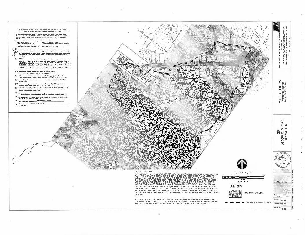
MINIMUM STORAMATER INFORMATION FOR REZONING. SPECIAL EXCEPTION. SPECIAL PERMIT AND DEVELOPMENT PUN APPLICATIONS
P m me. *v. a • man.. eff •.e... ma... . •I men oenva. asve se P • MM.* 17. AAP..
Tnis aben la wow .142t1
monetleb., Zedrp banafte mow. M M. 1.0)12 2.11.
omm sum. MRS 14 AIM Comma, R.N.. 0...11.27.11211 Caempmem Plans ARC 0.1.0.022 ml PRC Pl.n1aN1Ea 101 PRP P 0.a ons. ARCM.= MA 10) ....N.321. 1.
0 I. PnA N • m•am •ale of 1.7
2 mama num ma or.12 ammo. sumo Nan
N.. M Pm. A.M.... a.... ne•m Imalumn nom.. on
0' PAAN OnMe Fem. Same
Tat 103F 17°11 ""?'"1 ;17;1- ;,:41,. Irb-cr .ASS AC 2.20 AC L2,114,- 15142 6 OLL
FORM— sl AC 0 Ct 1mm 3.33 AC - 0.39 0.6 .2 AC .30..1116
0 4 _Fc4)_ M. en N. jkly
I
O me. Wely
0 7 A
▪
P... Amemen Indla 0.......11••••11. pt..... • 11,,LA LAO
O a...
*ma snmA
• EM
•
MOMM wIomMas eneas.1.12) I. and• no% as le MeIrr on so sun, of ie ■Inn
UKOKOICUO OEIDITOI
OW Mon.... man* • 5/4
g—j Z 5 W 5
§§ Z sS
ü zl
a DUTFAH DESCRIPTIONS
THIS WATERSHED MAP INCLUDES THE COP SITE AREA PLUS CONTRIBUTING SUB-SHEDS AS SHORN ON THIS PLAN. THE ADEQUACY OF OUTFALL FOR IRIS CDP IS BASED UPON THE PREMISE THAT AN ADEQUATE OUTFALL 5 E4 PLACE CR WILL BE IN PLACE AT THE TIME OF FINAL SITE PLAN. THE OUTFALL (PONT 'A') IS A CLOSED CONDUIT AND FLOWS SOUTH-WEST. THE OUTFALL JOINS ANOTHER OUTFALL ON THE NORTH SIDE OF LEESBURG PIKE (ROUTE 7) AND IS THEN DIRECTED UNDER ROUTE AND THROUGH AN EXISTING SHOPPING CENTER (PIKE 7 PLAZA). THE CONDUIT THEN CROSSES UNDER GOSNEU. ROAD (RT. 939) AND THEN DAYLIGHTS ON THE WEST SIDE OF GOSNELL ROAD. THE OUTFALL THEN ENTERS AN OPEN CHANNEL (OLD COURTHOUSE SPRING BRANCH - POINT 13 .) AND IS CONVEYED TO THE TO THE WEST UNDER DULLES
TOLL ROAD (RT. 267). THE STUDY AREA INDICATED ON THIS SHEET IS APPROXIMATELY 654 AC.. WHICH IS GREATER THAN ONE SQUARE 30.E (640 AC.) - THEREFORE MEETING THE EXTENT REQUIRED IN THE ZONING ORDINANCE.
GRAPHIC SCALE m•
WO 1MI
m FLYT )
LEGEND.
,37,7V6fj, SERM=111,1,_
DENOTES SITE AREA
VIKA REVISIONS
REV NOVEMBER II, 2013 REV OCTOBER At 2013 REV AuGusT 15. 2013 REV JAY 10, 2013 REV APRIL It 2013 REV MARCH II, 2013 REV NOVEMBER 12 2012
REV JUNE 20, 2012 REV MAACK 30, 2012 REV JANUARY 25, 2012 DATE: FEBRUARY 22, 2011
DES. j'A I Owl...
ADDITIONAL ANALYSIS, TO A CREATED DEGREE OF DETAIL, IS TO BE PROVIDED 05TH SUBSEQUENT FINAL DEVELOPMENT PLANS CONNECTED TO TARS CONCEPTUAL DEVELOPMENT PLAN. FIRMER COMPUTATIONS AND ANALYSIS ON THE FOP PLANS WILL SUPPLEMENT THIS OUTFALL DESCRIPTION FROM THE CDP. —SUB AREA DRAINAGE LINE INN PROJECT/FILE NO
wpm
SCAM 1•500.
BATT NO,
C-20
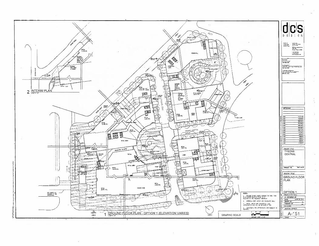
REVISIONS
COW 11/11/13
COP 10126/13
COP 00/16/13
CDP 07/10/13
051113
COP 0.80, 3
COP 03M1/13
COD 110502
COP
COP MOM,
CD/ 105/12
COP 247/11
COP
PAM= TITLE
TYSONS CENTRAL
ELEVATIOESTAAR
AA'
➢ROJICT NO. 30677800
iy
1
wow. worm; row AA MOUND FLOM S OSS
AN_SMOWS BOLDINGDAME KAN AS IT me
This
RELATES TO 11. ADJACED1 SIDEWALK.
2 MIER., CORI AREAS SCIAEMAIC 08,1
r.! W'a'LTS'A;111'. 111,1SIDWO
SCOT,
JUKE 2012 DATE
dcs DESIGN
103441-4301
0.11 EwAnwr VI. MC AAA nu VIRORILL LLC 70..41-1/00
Lad., ArtOleetwe IJO SOLOLDAS
aterme TITLE
GROUND FLOOR PLAN
OPTION 1
CA ACCIETED er
DRAWN 81
CNECATO
DRAWING WIRER
A-151 SHEET or

Pfte■ Ow IIMOS. nom
CA MIMED Dr
3 DATE JUNE M. 2012
DRAWN BY IA CHECKED BY AN
dcs DESIGN
DAVIS
1/kA KAZOO
60115:
ORM. ROOK vA81E5 ACROSS THE SIR. DRS
LELATESS"C7061rIETJ'ACE' iraWALK.
2. *TERN.. CORE AREAS ARE SCHDAATie ONLY
1 RETAJL AREAS ARE CONCERN. AND APPROMAIE AnD Nu BE RUINED Al MP.
A. ELEvAnas ARE ARPROxruArE AND soDJEC1 10 REMSON.
0 Is
GRAPHIC SCALE SCALE: 1/32. •1 ,0.
GROUND FLOOR - OPTION 2 PLAN (ELEVATION VARIES)
0.reloper.
Pro.inatr v., INC. Ami1SA viROINIA.I.Uf 703-40-7•03
REVISION,
COP 11/11/13
CDT 0/28/13
coo asnem COP 07110113
COP 03n3n3 041.13
Cor 03/11/13
CD■ 1/1./12
CDR III20/12
COP MOM,
COP 1/25/17
COP 2/22111
COP /03/10
PROJECT TITLE
TYSONS CENTRAL
PROMS! NO. 30612600
DRAWING TITLE
GROUND FLOOR PLAN
OPTION 2
DRAWINC NUMBER
A-151A SPLIT OF
NOTE: 1. ARCHITECTURAL PLKNS, ELEVATIONS, ILLUSTRATIONS, MATERIALS, BUILDING HEIGHTS. ETC ARE CONCEPTUAL AND ARE SUBJECT TO REVISION WITH FINAL DEVELOPMENT PLAN AND FINAL SITE PLAN APPLICATIONS 2. FOP NUMBER OF STORIES AND BUILDING HEIGHTS OF BUILDINGS, SEE DEVELOPMENT TABULATION ON 3. BUILDING DESCRIPTIONS TAKE FROM AVERAGE SITE
----ELEVATION 483.50- . BUN:DWG HEIGHTS. USES AND SCE TO BE FINALMED DURING FOP AND SITE PL<SUBMISSIONS.
REVISIOW
COP 11/11/13
COP 10/28/13
COP 08/16/13
COP 07/10/13
COP 06/3/13
COP 04/18/13
COP .11/13
COP 11/18/12
COP 8/20/12
COP 3/30,12
COP 1/25/12
2/22/11
COP 1103110
PROJECT TIM
TYSONS CENTRAL
PROJECT NO. 00&21800
I...Mc MOM Ir..
• I
• ,
ROOF PLAN - AERIAL VIEW- OPTION 1
2
S G N
C S I D E
Owrlop.r.
VIKA VI8081, Lk
LOU Aren.w.a.. 702.1.100
mArme rrns
ROOF PLAN AERIAL VIEW
OPTION 1
GI REVIEWED dr
BLOC JUNE 20. 2012
DRAWN Br
oar= Er
OKAYING MEM.
A-152 ERZET Or
wook37:iMM
NOTE: 1. ARCHITECTURAL MANS, ELEVATIONS, ILLUSTRATIONS, MATERIALS. BUILDING HEIGHTS. ETC ARE CONCEPTUAL AND ARE SUBJECT TO REVISION PATH FINAL DEVELOPMENT PLAN MD FINAL SITE PLAN APPLICATIONS 2. FOR NUMBER OF STORIES AND BUILDING HEIGHTS OF BUILDINGS. SEE DEVELOPMENT TABULATION ON CD.
...•■.1 3. BUILDING DESCRIPTIONS TAKE FROM AVERAGE SITE
BIZI.TIRTHEIGA USES AGO SIZE TO BE FINALIZED DURING FOP AND Sire PLMSUBMISSIONS.
makzetrat WEL MOM RESSENILm
GA REVIEWED Jr
DATE AA* 20. 2012
DRAWN IT IA CHECKED or
ACTERNATEs.ROOF PLAN - AERIAL VIEW— OPTION 2 GRAPHIC SCALE
SCALE 1132- .1,0.
PEN= TITLE
TYSONS CENTRAL
PROJECT ma 3126170,I0
S G N
C S I D E
DP*
POP...-0011
NC NW VII, VIRGIN!, LIG NO3,47.7.00
1.8.0.1ArtMerervor 1.141RaiNeNNAGIo•Nwt 102431.300
RAYMOND
COP
PPP
COP
COP
OPP
PPP
COP
COP
COP
CEP
COP
GDP
DRAWING OTIS
ROOF PLAN AERIAL VIEW
OPTION 2
A-152A SKEET Or
DAVIS CARTER
WCO
MWm YISLC
TYSONS CENTRAL
PROJECT I* 308-770 CO
RESIDENTIAL 2 66,6 ABOVE PAW • LEVEL anOw CrtAFX
ALTERNATE/ OPTION RESIDENTIAL
2 LEWL AB. ORME • LEVEL BELOW OR.
6.6 761.40 ORO
707.271.7460
RESIDENTIAL
IS LEVELS bOVE 6.1C • LEWIS BELOW CORK
ALTERNATE/ OPTION RESIDENTIAL
6 LEVELS MYR .0 / • LCVMS ROW WOE
VETS ABOVE OWE WA. BELOW GUDE
ALTERNATE/ OPTION RESIDENTIAL (HOTEL)
2 RM. MOW LW. • LEAD. 060W WOOL
HOTEL / RESIDENTIAL
LORIS AB0612 CAW LEVELS BELOW OWE
OFFICE
gro: ALTERNATE/ OPTION RESIDENTIAL
LEV21.5 MOW ORA. • LEVELS BELOW WOE
ALTERNA E/ OPTION OFFICE
• UNCLS BELOW OWE
7 UNCLS 2162•C OR • LE.. BELOW OR
0.0
p
a
It BELOW GRADE PARKING PLAN — OPTION 1 & 2 GRAPHIC SCALE
11
6 if 22 6W
62.6 2.2Mi
scALE.1/37. V-Cf
D E S I G N
ACIISIONS
CDR 11/1.3
COP 10/21W12
COP owien3 CDR 07/10/12
COP 02/1112
COP 0.013
COP 02/11/12
COP 11/1612
COP NOW
COP 3/30112
C122 11.25/12
COP 202/11
COW 1140/10
DRAWING mu
BELOW GRADE PARKING PLAN
OPTION 1 & 2
CA 'WINED SY
JUNE 20. 2012
MC= BY
DATI
BMW BY
MIMIC NUMBCR
A-153 SOW OF
dcs DESIGN
:2:11• 17% SCOT710
7:S:Fi or
PROJECT TITLE
TYSONS CENTRAL
PFELIECT NO. 30&1]000
REVISIONS
COP
CIO
CD.
COP
CD/
co.
cor
Cor
cor
DRAPING WU
METRO / PEDESTRIAN ACCESS PLAN
OPTION "I & 2 ■••■•*.t.1.113.11.32••
nkrArmorG
1 METRO / PEDESTRIAN ACCESS PLAN - OPTION 1 & 2 1/12,41-01
OCOESTRIAN /AM OF Ts Alt
GRAPHIC SCALE ilmel"6■11 SCALE: Mr 1 •.0.
CA REVIEWED BY
DATE JUNE 20.2012
DRAWN Dr IA Man NY AM
DRAWING Amis.!
A-1 53A DWELT OP
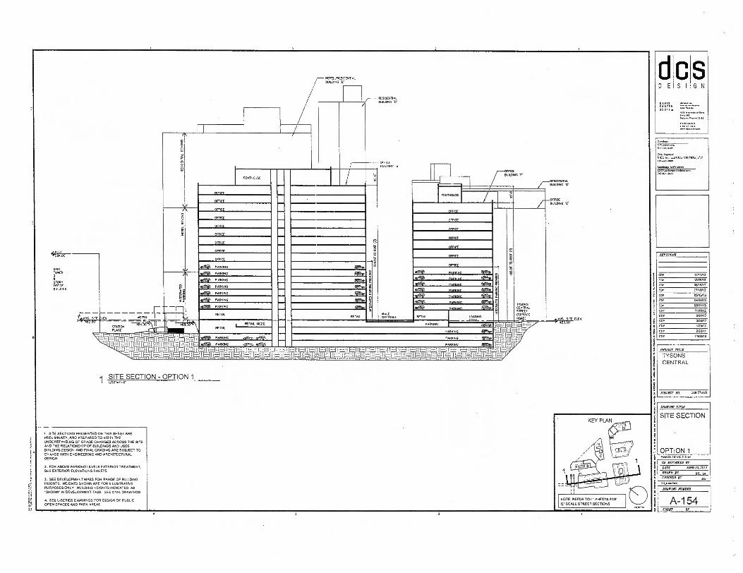
S I E
PROJECT TITLE
TYSONS CENTRAL
PROJECT RN. 200.77B CO
REVIS1015
GDP
COP
COP
COP
ONAKIAC rill
SITE SECTION
OPTION 1 mmeo..triu111131
CA REVIEFED
DOE AA* 20.2012
DRAIN BY PC IA CHECKED Br AM
Mr= ARMS
A-154 SHEET Of
ee
SCOT,
S G N
aTE.SECTION - OPTION 1
NOTE: REFER TO L . SHEETS FOR
)1. SCALE STREET SECTIONS
1. SITE SECTIONS PRESENTED ON THIS SHEET ARE PRELIMINARY. AND PREPARED TO AID IN THE UNDERSTANDING OF GRADE CHANGES ACROSS THE SITE AND THE RELATIONSHIP OF BUILDINGS AND USES BUILDING DESIGN AND FINAL GRADING ARE SUBJECT TO CHANGE WTH ENGINEERING AND ARCHITECTURAL DESIGN.
2. FOR ABOVE PARKING LEVELS EXTERIOR TREATMENT. SEE EXTERIOR ELEVATIONS SHEETS
3. SEE DEVELOPMENT MASS FOR RANGE OF BUILDING HEIGHTS. HEIGHTS SHOWN ARE FOR ILLUSTRATIVE PURPOSES ONLY. BUILDING HEIGHTS INDICATED AS 'SHOW IN DEVELOPMENT TABS SEE CIVIL DRAVANGS
4. SEE L-SERIES DRAWNGS FOR DESIGN OF PUBLIC OPEN SPACES AND PARK AREAS
TOM ER 2
STORY orneE 0111117iNG
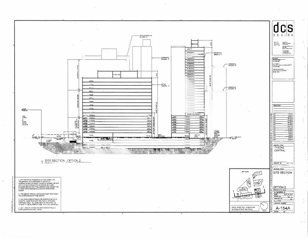
C D E SI GN
SCOT,
=Tx-
RESIOENTAA
RESOOPIAL
RESTMIIAL
RESRNNTN FIuLUMC •r
AUDATY
REAM/01AL
RESIDE TAL
PEGDCSVAL
RESIDENTAL
RESIDCNTN
RESOEN AL
RESIDEN TK
RESDENTIAL
RESCENTAL
RESIDENTIAL
ROOM
RESOENHAL
RESIDENTAL
REVD 11
RESIDE NAL
RESDENTAL
DENTAL
RE90fNTH
RE 0
BIAWDNC b'
RESD.TIAL DURING
RDLLDLM0 'B'
RESIDENTAL SUILLING
OFFICE
OFFICE
OFFICE
OPTIC
OFFICE
171-1,CE
opE,GE
ocPa
CE
PROlIST rnis
TYSONS CENTRAL
PROJECT Aa 1M--77 800
RIVISIOIIS
cor
co•
Ger
COP
COP
COP
COP
COP
COP
COP
COP
11/0,13
10/2013
0/13
01110R3
05,13/13
OWNS
GYMS
"ARM,
NOM
3/012
las52 202/11
"Wig
PARKN G
P wKNG
PARNNG
P RNNG
PAR NG
P ARNNG
SAG TONER 2
STORY OFFICE BUILDING
gdfil PARNING
VALE GOURALE
1==.1MENMIS■9—
RETAIL
TYSONS CEMITAL STREET (SOME ROAD) AVG. SI
4113.30 VG. SI E LEY
TAIL MEZZA STATOR
PARKING 94fftB. PARKING
PARKING
KING
5
VIL *a.
4211. 122.
*ts. fies• likew
AMONG
PARKING
•e5g PARR
RETAA.
RETAIL LOADING 00.
PAA
PAR G PARNNG
1117W- 11- I . 171 N I [Tru- 191 JETI11,-;11-.11-
PARK1
RESOENRAL/ANEMTY
1 SITE SECTION - OPTION 2
BRAVING MIS
SITE SECTION
OPTION 2 M•104 w
CA RFFIARID sr sArr AIM 20. SW
DRAWN sr Er IA an.. sr AM
okA.R44997
OIMIIAC NUROZR
A-1 54A SUR OP
1. SITE SECTIONS PRESENTED ON THIS SHEET ARE PRELIMINARY. AND PREPARED TO AID IN THE UNDERSTANDING OF GRADE CHANGES ACROSS THE SITE MO THE RELATIONSHIP OF BUILDINGS AND USES. BUILDING DESIGN MD FINAL GRADING ARE SUBJECT TO CHANGE MATH ENGINEERING AND ARCHITECTURAL DESIGN
2 FOR ABOVE PARKING LEVELS EXTERIOR TREATMENT. SEE EXTERIOR ELEVATIONS SHEETS
3. SEE DEVELOPMENT MASS FOR RANGE OF BUILDING HEIGHTS. HEIGHTS SHOWN ARE FOR ILLUSTRATIVE PURPOSES ONLY BUILDING HEIGHTS INDICATED AS -SHOWN- IN DEVELOPMENT TABS. SEE CIVIL DRAWINGS.
4. SEE L.SERIES DRAWINGS FOR DESIGN OF PUBLIC OPEN SPACES AND PARK AREAS.
NOTE. REFER TO I: SHEETS FOR It' SCALE STREET SECTIONS

04":7•00
SSC
MOAT rrrI2
TYSONS CENTRAL
'N.M. la 300701E0
RUT IDIOMS
COP 11411/13
COP tODE413
COP 151013
COP 010003
COP 050303
COP
1519113
COP 030103
cos 1119112
COP 52002
cos 130/12
COP 12211.2
COP 20201
COP 11/03/10
tl D E
C S I G N
Or/01.- RV
0,* -84,1362
0A1Zymor OD, Ilk awl 14 ROMA
Lwow. wwww. La La.., Artimpa. I1O.131.204,
wurtrc TIl LC
SITE SECTION
OPTION 1
3
otivil "Om
NNW.
DATI MI. 20. 2012
CSLC.A HP
MANN BY RC IA AM
MAIMS NUNN.
A-155 SSW Of
MAIM. BUILDING r
WILE CENTRALS
OFFICE
CFFICE
OFVICE
OFFICE
CSTICS
PARK]
KING
PARKING
PARKING
PARKING
PAR
RETAIL
PARKING
ARKIN°
• ASKING
I =i I 2-'1 ft-211
001.13.
f—RESDE1111
CSTICE
7—BIALINNO
is
c rig
RN"
ESML
C RAW UP ifto•
RrAt in
1 SITE SECTION - OPTION 1
ILllf
1 SITE SECTIONS PRESENTED ON THIS SHEET ARE PRELIMINARY. AND PREPARED TO AID IN THE UNDERSTANDING OF GRADE CHANGES ACROSS THE SITE AND THE RELATIONSHIP OF BUILDINGS AND USES. BUILDING DESIGN AND MM. GRADING ARE SUBJECT TO CHANGE WTI ENGINEERING AND ARCHITECTURAL DESIGN.
2. FOR ABOVE PARKING LEVELS EXTERIOR TREATMENT. SEE EXTERIOR ELEVATIONS SHEETS
3. SEE DEVELOPMENT MASS FOR RANGE OF BUILDING HEIGHTS. HEIGHTS SHOWN ARE FOR ILLUSTRATIVE PURPOSES ONLY. BUILDING HEIGHTS INDICATED AS 'SHOWN' IN DEVELOPMENT TABS. SEE COAL DRAWINGS
4. SEE L•SERIES DRAVANGS FOR DESIGN OF PUBLIC OPEN SPACES AND PARK AREAS.
NOTE REFER TO I: SHEETS FOR SCALE STREET SECTIONS

PARKING AMIN.
PARKING PARKING
SNC TOPER
S TORY
OOLONG
4.7
PoOLIG ACCESS ELEVATOR
SKY PARK —SEE SERIES UNCS
REIM.
PDFRIC ACCE SS ELINATOR
WAWA
P
Meg FRANTIC
P NG
000 ET
PARKPC
PAR
RCS NN
WENN L
RE OE TIAL
READENTAL
RFSIDENTAL
RESIDENT AL
NSENIIAL
RESIDENTIAL MENI TY
PM INC
pARIONG
PARK NG
STAIN'S PLACE
W EL
MINS
STREET cOGRAL
(SFR,. RoLo)
PARKING
PM
D E S I G N
DAVIS
SCOTTO
tir RE 711144-001
rt.lIrC I 1.A VI eAtl V WON.. LIA
Lonimos ANYNNINnt.
AAVIAIONS
COP
COP
COP
COP
COP
COP
COP
COP
CO/
CO.
100167 TM:
TYSONS CENTRAL
PALM? AS 306,8.03
MAIM THU
SITE SECTION
OPTION 2 14.10r loIrO. NO/.
CS intern DT
BATA JUNE 20. 2012
0A4VII Br
MACAO AT AY TN,INKDRP
IMAM MAMA
A-155A SPOT or
1 NOTE: REFER TO L . SHEETS FOR
I SCALE STREET SECTIONS
BULDwG 'B'
L'70 ,1,77r" RESIDENTIAL
RESIDENT
RESIDENTµ
ENDERS,
SEEAOEN TAL
RESIDENTIAL
RESIDENT L
RESOEH TML
RESIOOTTAL
RE DENTAL
RESIDENTµ
REVDENnµ
BUIUxHG 'F
SITE SECTION — OPTION 2
1
1. SITE SECTIONS PRESENTED ON THIS SHEET ARE PRELIMINARY. AND PREPARED TO ND IN THE UNDERSTANDING OF GRADE CHANGES ACROSS THE SITE MID THE RELATIONSHIP OF BUILDINGS AND USES. BUILDING DESIGN MD FINAL GRADING ARE SUBJECT TO
A
CHANGE %MTH ENGINEERING MID ARCHITECTURAL DESIGN.
2. FOR ABOVE PARKING LEVELS EXTERIOR TREATMENT, SEE EXTERIOR ELEVATIONS SHEETS
3. SEE DEVELOPMENT MASS FOR RANGE OF BUILDING HEIGHTS. HEIGHTS SHOWN ARE FOR ILLUSTRATIVE PURPOSES ONLY BUILDING HEIGHTS INDICATED AS SHOW IN DEVELOPMENT TABS. SEE CIVIL DRAW NOS.
4. SEE L-SERIES DRAWINGS FOR DESIGN OF PUBLIC OPEN SPACES AND PARK AREAS

PH
ROOF ~Mr!
RESIDENTIAL
RFSIOENTAL
NPRIDENTAL
RrS/OFN
,OFN
ar,nrnmu
PFSI0rN➢ 0
RFSIDFNTIAI
RESIOFNTAI
OW
r—rjNG . E .
dcs DESIGN
RVVISIONS
GDP 11/11/13
COP 1008/13
COP 05/15/13
COP 01/1013
COP 05/1303
COP 015003
COP 03 1013
cop 1105/12
COP army COP 300/12
COP 1/25/12
COP 2/22/11
COP i0.03/10
PROlICT TITLE
TYSONS CENTRAL
RESiOCNTfAI
RESIDENMAL/NOIEL
Vas
0 L
0111.
HOTEL
HOWL
HOTEL
HOTEL
HOWL
HOWL
PARKING
PARKING
SAIL ,99,90 2
STORY oFTKE Bu909.4
'')'2--.. "—'506.6 7
E
SITE SECTION - OPTION 1
NOTE: REFER TO LT SHEETS FOR
TET SCALE STREET SECTIONS
PROMS" At 30047500
PowolOg IVIVO ItO sot
CA WISNER DT
DATE JUNE 20.2012
DRAWN BP R0 IA CHWELD BF AY OP,INON4
f
D
DRAPING rrnx
SITE SECTION
OPTION 1
DRAWING NIIIIDER
A-156 MIT OP
1 SITE SECTIONS PRESENTED ON THIS SHEET ARE PRELIMINARY. MD PREPARED TO AID IN THE UNDERSTANDING OF GRADE CHANGES ACROSS THE SITE AND THE RELATIONSHIP OF BUILDINGS AND USES. BUILDING DESIGN AND FINAL GRADING ME SUBJECT TO CHANGE WITH ENGINEERING AND ARCHITECTURAL DESIGN.
2. FOR ABOVE PARKING LEVELS EXTERIOR TREATMENT. SEE EXTERIOR ELEVATIONS SHEETS
3. SEE DEVELOPMENT MASS FOR RANGE OF BUILDING HEIGHTS. HEIGHTS SHOWN ARE FOR ILLUSTRATIVE PURPOSES ONLY. BUILDING HEIGHTS INDICATED AS -SHOWN- IN DEVELOPMENT TABS. SEE CIVIL DRAWINGS
A SEE L.SERIES DRAWINGS FOR DESIGN OF PUBLIC OPEN SPACES AND PARK AREAS. ij
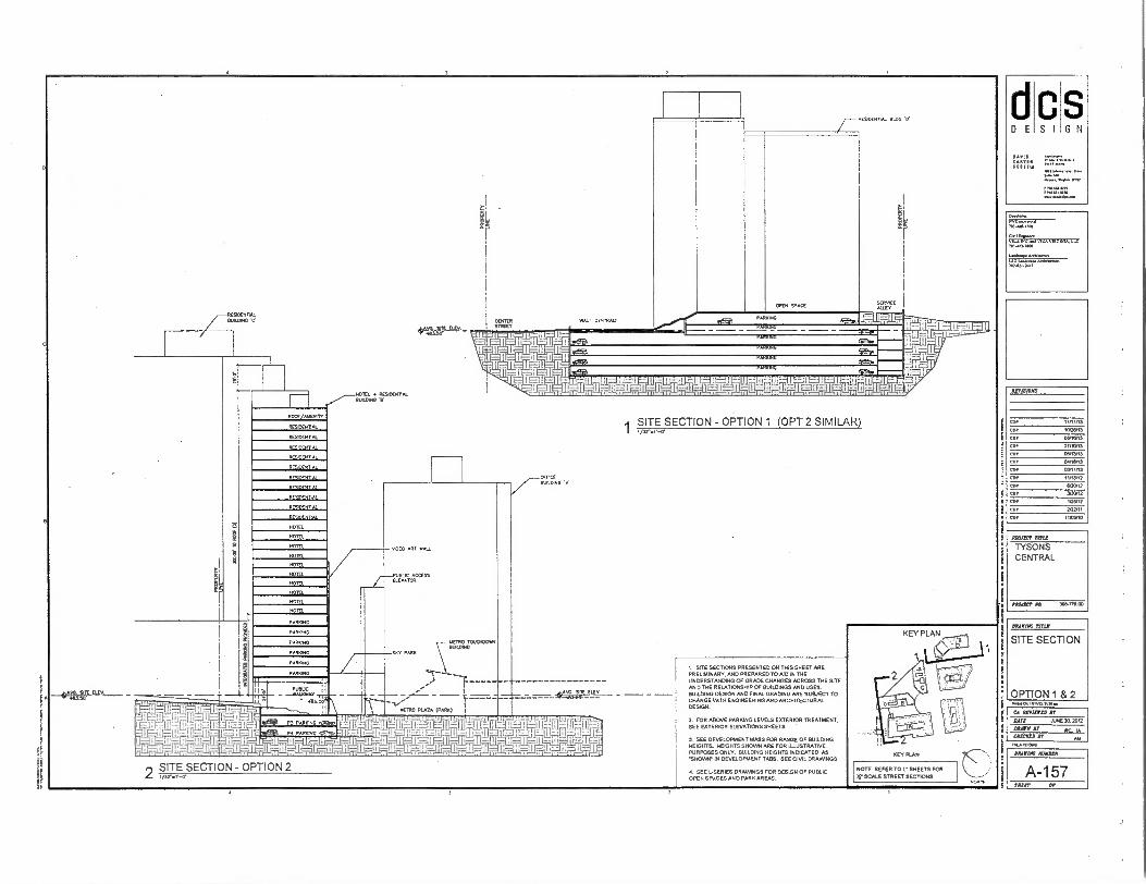
E
I
Pi0.001011/41.1101•K
CA AMMO IT
PAT ARE 20. 2012
MOM II NC IA WC= Al AN 00 01.00.0
~AT TRU
TYSONS CENTRAL
PRAIA? AM. 30.770110
S G N
PARIS
se 0 TT 1.
wn inn
S I
310F0ma TI1.010
end
70,0,7•08
LIAO, ...NOW*
107-811.20.1
AITISIONS
COP
CPA
COP
COP
COP
COP
COP
COP
COP
COP
COP
co.
oro/13
10/2W13
OWHY13
07/10/13
03/13/13
ONIZIA3
03/11/13
11/19/12
INAL12
130/12
10912
2/22/11
IMMO
OWING mu
SITE SECTION
OPTION 1 & 2
VAIVINE ROM=
A-157 SNAIL OF
I. SITE SECTIONS PRESENTED ON THIS SHEET ARE PRELIMINARY. AND PREPARED TO AID IN THE UNDERSTANDING OF GRADE CHANGES ACROSS THE SITE AND THE RELATIONSHIP OF BUILDINGS AND USES. BUILDING DESIGN AND FINAL GRADING ARE SUBJECT TO CHANGE VAIN ENGINEERING AND ARCHITECTURAL DESIGN.
2. FOR ABOVE PARKING LEVELS EXTERIOR TREATMENT. SEE EXTERIOR ELEVATIONS SHEETS
3. SEE DEVELOPMENT MASS FOR RANGE OF BUILDING HEIGHTS, HEIGHTS SHOWN ARE FOR ILLUSTRATIVE PURPOSES ONLY. BUILDING HEIGHTS INDICATED AS 'SHOWN- IN DEVELOPMENT TABS. SEE CIVIL DRAWINGS .
I. SEE LSERIES DRAWINGS FOR DESIGN OF PUBLIC OPEN SPACES AND PARK AREAS.
NOTE. REFER TO L• SHEETS FOR
SCALE STREET SECTIONS
HOTEL
HOTEL
HOTEL
1 IIIMIMBmm0.-- I RETRO PLAZA (PARK) I
1.00 r7MBEMPLI9
= = Mrifill ;41-17 rriji,LIIVMr ; - Eliiiiii EIL W-1-6ij i ITI 04— 1 1 ,,=,1=1: -,'._5='i„--1 :17-TrT14e:A-i.' F.. 274 - --1=3' 1 L7T-6-4-71111:1---41-1 - 1117 7 11-tt g --il -111-T: '1i-1-V-it= -
t,[11=111:- IEnteifri.:11P1 1 '
SITE SECTION - OPTION 2 1/31,•-0•
IC IR 0 MOWN.
RESDENTAL 5LMING 'C'
40 r REV.
Knek. ♦ RFRODOIAL 12.
SITE SECTION - OPTION 1 (OPT 2 SIMILAR)
°Tao
E0 APT WALL
PUBLIC ACCESS ELETAMR
/AHEM"
STENO
RESDENTA.
nA
OAL
DEN PI
Hil
RESDEHEAL
SO L
Pr D rnPI
MEL
HOTEL
HOTEL
HOLE.
HOTEL
HOTEL
HOTF1
O

PROPICT mu TYSONS CENTRAL
MYOPIC: ro. 308.718.00
COP
AMR
CO.
COP
CD!
COP
COP
CD,
COP
cot C1N
ArvIstows
BRAVOS SITAR
SITE SECTION
OPTION 2 Roma. In
11,1.0014
dcs DESIGN
Ad.
CA BP0122D BY
Nit JUNE 20. 3012
OWN BY RE IA Man BY
MAWS BMW
F
Y
EC
S
A-158 30221' OP
ILuILOCNYAI
PN 1 BUILDERS E'
R ARCM,
RESIDES'S&
REILDENTAL
DER AL
REYOrN7 N
DI NTCNTAL
RESIDENTAL
RESDENVAL
REYDERMAL
RESIOFNTAL
RFSIOFNTAI
e
0 EL
B
0
CAT. BM.. 'A'
a7rSECTION - OPTION 2
1. SITE SECTIONS PRESENTED ON THIS SHEET ARE PRELIMINARY. AND PREPARED TO AID IN THE UNDERSTANDING OF GRADE CHANGES ACROSS THE SITE AND THE RELATIONSHIP OF BUILDINGS AND USES. BUILDING DESIGN AND FINAL GRADING ARE SUBJECT TO CHANGE WTH ENGINEERING AND ARCHITECTURAL DESIGN
2. FOR ABOVE PARKING LEVELS EXTERIOR TREATMENT. SEE EXTERIOR ELEVATIONS SHEETS
3. SEE DEVELOPMENT MASS FOR RANGE OF BUILDING HEIGHTS HEIGHTS SHOWN ARE FOR ILLUSTRATIVE PURPOSES ONLY. BUILDING HEIGHTS INDICATED AS SHOW Al DEVELOPMENT TABS. SEECIVIL DRAIMNGS.
SEE ,SERIES DRAWINGS FOR DESIGN OF PUBLIC OPEN SPACES AND PARK AREAS
NOTE: REFER TO V SHEETS FOR
11- SCALE STREET SECTORS
Ft
iD
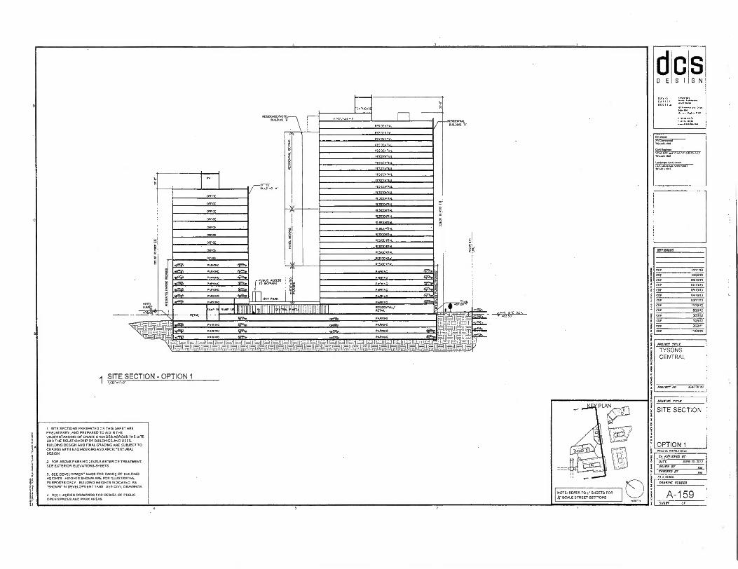
so
RESCENIIN. SLALOMS V STE
rown1L
AL
PES.ENTAI
SIOCNI1AL
lo L
PET AL
F OlEERVAL
RTIAL
F,InE
FESNENRN
RESmrN11AL
RrSOCxn.
PCSDEnnN
RESTESTIAL
SSP
EsenEN AL
MENTAL
ES
anal=
- \ RESOOKE/NOILL OUILDING V
tl
Owelemp OOEZ:=1---
7MAPHIM
owl VITA mc A.a ASUCA LIL
NO4114041
PA
PA
PAR ffreaa
M,PP
AusuC ACCESS TO SKTPARR
COP 111113
OF 1021.13
COP 01IS/13
COP 07.00.
COI 0.1.3
COP 04/18/13
COP 0111/13
OPP mon2
<sr anON2
cor 3/30,13
COP 125/12
cor 2122/11
COP iloCONO
PROJECT TITLE
TYSONS CENTRAL
PROJECT MO 31.1]000
Pon.
CA urinal, NY'
DOE JUNE 20.200 ORROM Jr
CRICKED OT
1
F
e
NOTE: REFER TO SHEETS FOR
3r SCALE STREET SECTIONS
DRAIIIAC mix
SITE SECTION
OPTION 1
ORAFIRC NURSER
A-159 SHUT Of
RK1N0
rA.MRC gen SKY PARK
F-
1
ia=fof
tai sI,"E [LEP
1210r
111111i,1114H+1111111111111 1111 PPS
I=LL I -It 17,-411-.71,-.711
.1171
RESERMAL/ RETAIL ANP
SITE SECTION - OPTION 1
I. SITE SECTORS PRESENTED ON THIS SHEET ME PRELIMINARY, AND PREPARED TO MD IN THE UNDERSTANDING OF GRADE CHANGES ACROSS THE SITE AND THE RELATIONSHIP OF BUILDINGS AND USES. BUILDING DESIGN MD FINAL GRADING ARE SUBJECT TO CHANGE WITH ENGINEERING AND ARCHITECTURAL DESIGN.
2. FOR ABOVE PARKING LEVELS EXTERIOR TREATMENT. SEE EXTERIOR ELEVATIONS SHEETS
3. SEE DEVELOPMENT MASS FOR RANGE OF BUILDING HEIGHTS. HEIGHTS SHOWN ARE FOR ILLUSTRATIVE PURPOSES ONLY. BUILDING HEIGHTS INDICATED AS 'SHOWN. IN DEVELOPMENT TABS SEE CARL DRAWINGS.
a SEE L.SERIES DRAWINGS FOR DESIGN OF PUBLIC OPEN SPACES AND PARK AREAS

r -
RES00111AL
I I BUILD.
fy
I
SI
— — —1 RESIDENTIAL (01.1113N) EIURDING
MICE MALMO
E
STUBS TO 4TOCS PARK
Extsm. ADJACENT STRuCNRE
MONS CENTIAL STREET (PRIVATE) ALE CENTR
NA WiDIALLIP91v611L__
• 1E3. I - L_.---=.1H.11 LhiL 11=-IL=ig:.1_1-7,t14
0"1.Vx EL" „0,„t ,
DRANIAC rrrid
SFErSECTION - OPTION 1 & 2 SITE SECTION
I SITE SECTIONS PRESENTED ON THIS SHEET ARE PRELIMINARY. AND PREPARED TO MD IN THE UNDERSTANDING OF GRADE CHANGES ACROSS THE SITE AND THE RELATIONSHIP OF BUILDINGS AND USES. BUILDING DESIGN MID FINAL GRADING ARE SUBJECT TO CHANGE WITH ENGINEERING AND ARCHITECTURAL DESIGN.
CI REVIEWED DT
DATE /LINE 24 30i2 2 FOR ABOVE PARKING LEVELS EXTERIOR TREATMENT. SEE EXTERIOR ELEVATIONS SHEETS
3. SEE DEVELOPMENT MASS FOR RANGE OF BUILDING HEIGHTS. HEIGHTS SHOWN ARE FOR ILLUSTRATIVE PURPOSES ONLY. BUILDING HEIGHTS INDICATED AS 'SHOWN- IN DEVELOPMENT TABS. SEE CIVIL DRAWINGS.
• SEE L-SERIES DRAWINGS FOR DESIGN OF PUBLIC OPEN SPACES AND PARK AREAS.
MUER ST
OPTION 1 & 2 INIMet Ca INTIM. OM NM
•
11,16.3.0
DR.MAC SUNDER
AY WRECKED BE
NOTE: REFER TO L. SHEETS FOR
X. SCALE STREET SECTIONS A-160 SKEET OF
S
S G N
d D E
REVISIONS
C01/ 110103
100103
COP 011/1013
COP 07/1013
COP 05/1113
COP 041603
COP 030103
an• 11/1/103
COP 020112
COP 39002
1/3113
COP 212011
COP 110300
PROJECT TITLE
TYSONS CENTRAL
PROJECT 10 30.1711 00
RESNIEWIAL BUILDWO r (OPTION)
RESIDENLIAL r BUILDING
===
NOTE: REFER TO V SHEETS FOR
SCALE STREET SECTIONS
Frh PARK C
RESIDENT&
RESIDENT&
RESIDENTIAL
11 TAIL
BCULUSO T'
MONS CENTRAL STREET (PRIVATE)
P
i~M RARING
P RK G
P R G
PENT OUSE
OFFICE
CPTICE
MICE
ancc
amcc
OFFICE
COME
MOSS BUILDING *T*
PM PATUSA
PARING
'ICI 1=111.7-,_Th I 1=1 : LE: I liar& .1 ...7411 119 1.- 1 iMnitilifaV4 -1 0
BULDINC 'D'
OPEN s,>
RESIDENT&
RESIDENT&
RESIDENII.
RESIDENT&
RESIDENT&
RESIDENTIAL
REsDENTAL
RESIDES TAL
PENTHOUSE
SITE SECTION - OPTION 1
1. SITE SECTORS PRESENTED ON THIS SHEET ARE PRELNAINARY. AND PREPARED TO AID IN THE UNDERSTANDING Of GRADE CHANGES ACROSS THE SITE AND THE RELATIONSHIP OF BUILDINGS MID USES. BUILDING DESIGN AND FINAL GRADING ARE SUBJECT TO CHANGE WITH ENGINEERING AND ARCHITECTURAL DESIGN. •
2. FOR ABOVE PARIUNG LEVELS EXTERIOR TREATMENT. SEE EXTERIOR ELEVATORS SHEETS
3. SEE DEVELOPMENT MASS FOR RANGE OF BUILDING HEIGHTS. HEIGHTS SHOWN ARE FOR ILLUSTRATIVE PURPOSES ONLY BUILDING HEIGHTS INDICATED AS 'SHONA.. IN DEVELOPMENT TABS. SEE CIVIL DRAWINGS.
A. SEE L-SERIES DRAWINGS FOR DESIGN OF PUBLIC OPEN SPACES AND PARK AREAS .
D E S I
Matt 1700
TYSONS CENTRAL
nearer xv. 308.1,13 op
ACTISTONS
C911,
occrIAC TITLE
SITE SECTION
OPTION 1
CI WIMP NT
MAT[ JUNE 2a, 2012
MOW Jr AM MOM IT AN
INANIONO
MIAOW MINA
A-161 SHEET OP
S G N
Dr.*,
70.88.43011
/110-141.7.00
7:2%fr7o7r
.==
P.NP OR Homo ti
CA IIIIIIII1D IT
DAVE JuNE 20. 200
DRAPE BP AN
CHICECII Dr AM I PI •NIAORO
KEY PLAN
REVISIONS
COP
COP
CUP
COP
COr
COP
COP
COP
COP
COP
COP
PIPIISCV MEP
TYSONS CENTRAL
MAW ND 306771.1:0
NOTE. REFER TO L. SHEETS FOR V SCALE STREET SECTIONS
ORAIKUN RHINE
SITE SECTION
OPTION 2
MAIM WIPER
A-161A SMUT or
S G N S I D E
3 SEE DEVELOPMENT MASS FOR RANGE OF BUILDING HEIGHTS HEIGHTS SHOWN ARE FOR ILLUSTRATNE PURPOSES ONLY BUILDING HEIGHTS INDICATED AS .SHOWtf IN DEVELOPMENT TABS SEE CIVIL DRAWINGS.
4. SEE L.SERIES DRAWINGS FOR DESIGN OF PUBLIC OPEN SPACES AND PARK AREAS .
1 SITE SECTIONS PRESENTED ON THIS SHEET ARE PRELIMINARY. AND PREPARED TO AID IN THE UNDERSTANDING OF GRADE CHANGES ACROSS THE SITE AND THE RELATIONSHIP OF BUILDINGS AND USES. BUILDING DESIGN AND FINAL GRADING ARE SUBJECT TO CHANGE WITH ENGINEERING AND ARCHITECTURAL DESIGN.
A. FOR ABOVE PARKING LEVELS EXTERIOR TREATMENT. SEE EXTERIOR ELEVATIONS SHEETS
1.....„—PENTHOUSE BEHIND
AvENITY RESIDENTAL DUNDING
RESIDENT, MANI,
RES/DENTAL
RESIDENT.
BESDEKT AL
BEADESPAL
RESIDENTIAL
RESIDENTAL
RESIDENT
RESIDENTAL
RESIDENTIAL
RESIDENTAL
RESIDENTIAL
RESDENTAL
. ,1411AL
RESIDE.,
RESIDENTIAL
RESIDENTIAL
RESIDENTAL
RESIDENTAL
RESIDENT,
DENT AL
RESIDENTAL HO
RESDENTAL Pr HO
RESD NT or Hp
RESOENTAL or HO
RETAll/ R ESIDENTAL/NOTEL
RESIDENTIAL &AMC
HOTEL (OPTON) BUILDING r
TRAL TREE
PARKING
PAWN°
42e PARKING
p PARKING
P.
RESIDENTAL
ES/DENTAL
RESIDENTAL
RESDENTA
RES/DENTAL
RESIDENTAL
RESIDENTAL
RESIDENTAL
RESIDENTAL
RUN)
RESO xTAL
RESIDENTIAL
RESIDENTAL
RESIDENTIAL
RESIDENTAL
RESDENTA
RESIDENTAL
RE SIDENTAL
RESIDENT.
RESIDENTAL
RESIDENTAL
RESIDE AL
RESIDENTIAL
RESIDENTAL E% TY
B OPTS SPACE
YOES
55. S ELY.
AR
I 401 1P. 1ffi1174--7117'==rT ET-114-71011tWj-Mill i I I I I I I
HI , • 1-- I HI 11--11:—I • —i
SITE SECTION - OPTION 2
WENT, A
AOEVTAI
RESIDENTAL
RESIDENTAL
RCAOENTA
OCNT
ES 0 11AL
RESIDENT'
ESTI N11
TENT
RFSIOEN,L
AL RESIDE
PENTIOUSE STAINS
/_ RESIDENTAL RESIDENTAL BUU2N0 'D' BUtDINC 'E'
HOTEL (OPTWI—.

S I G N
MIST not
TYSONS CENTRAL
PINJET Aa 300-7 ,B IU
1. ARCHITECTURAL PLANS. ELEVATIONS, ILLUSTRATIONS. MATERIALS. BUILDING HEIGHTS. ETC ME CONCEPTUAL AND ARE SUBJECT TO REVISION OATH FINAL DEVELOPMENT PLAN AND FINAL SITE PLANAPPLICATIONS 2. FOR NUMBER OF STORIES MID BUILDING HEIGHTS OF BUILDINGS. SEE DEVELOPMENT TAB IN CIVIL DRAWINGS.
SZ.... PIC a VII, VIRGINIA. LI( 7.1-1.13.00
L.*Ardingere
703-1O1-10.0
NOTE: REFER TO L . SHEETS FOR
IC SCALE STREET SECTIONS
11111111 811 muliiiii
IlmimumnummummillImmum
eigulusani isliniiiiMiliMillii tagasumussonnumannsulMHIMIMbus.
r9onnommemommniuman11111111111111111m; 1111111111111111iiiii
ZIPIIIIIIIMIIIMMIlinum411111111111111111111iffil
NIIMINE11111PP! 1111111 I I I
illiimunI2 111111111 I mum Ip m
II III 1111111/In .
iii
1111 I :11 : P7 OIMPP4110 11 1 11 III III Iiiiiiii450111110
11111 11111! IIIIUIIIJ
Bun slp si sI:; ! rz I ii II
1.77:77 ilits llllll I
ill MET57:ruiraiiii "e ifflin ln .c
----.-----
Paw. IVIVO.178..
CI WM= RE AINE20.100
DAM, Can-A IT
sr TI
AM nsAuvan
AWING MINER
ROUTE 7 ELEVATION - OPTION 1 A-162 SHEET Of
d D E
PAIRS
ON.
Z"..791.■••111.
C'S
NDTS14710
COP
COP 112111/17
COP osnen3 COP 07/10/13
OOP 05■1340
COP OanN0
COP 010413
COP 11/10112
COP 52512
3G0117
COP IOS, 12
JAWING TIM
EXTERIOR ELEVATION
OPTION 1
RnISJOAB
COP
COI
CD!
CIO
COP
COP
COr
ni,11.1:00
AROIAC MENDER
A-162A V=
NOTE: I. ARCHITECTURAL PLANS. ELEVATIONS. ILLUSTRATIONS. MATERIALS, BUILDING HEIGHTS. ETC ARE CONCEPTUAL AND ARE SUBJECT TO REVISION PATH FINAL DEVELOPMENT PLAN AND FINAL SITE PUN APPLICATIONS 2. FOR NUMBER OF STORIES AND BUILDING HEIGHTS OF BUILDINGS. SEE DEVELOPMENT TAB IN CML DRAWINGS.
dcs DESIGN
OAVII
;t;71:1
• I :drirr li 4gt.41 , 1........2..”......i.r3P. te•!.
- I T W ih fil I SILIMI
...-747.' „L,- ■ . A rizz =2 . eill . . "la . t. a a! mtil
...., .....27■=1" _mel'''''"ilie= a) M2==ZZ. ..= 00:51E1 a
..---.. ,.. 1 of ERR -,7003e —T. 0
774,717-= - Add 0 9" inillialighillibilkil _IMIIMIWIIIIIIMU
lialliiiiirliliniiiiiiiiiiiiiiinIMIMM Mini IlliniiiiiiiiiiiiiiiiiiiiiiiiiiMIIIIMMIllkiii
11111111iiiMUMOM BBBBBB MI mmmm 111111111111111111ilii iiiiiiiiiIiiiiiiiiiiiiiiiiiiii1111111111111,110111 tiMINIMPOOMPOPPMPOPMPRWAIIIIIIIIIIIIIIMMO 04minoseiiiiiiiimailuM1111111111111111 ----- mommummomm ONOWIIIIIIIIIIIIIIIIBMIN iiiiiiiiiiiithiiiniiiiiiiiiHMERMUlliiiii 4rnommomumminAl 11111111111111111411 -,k,4.........-..- ------------
.,A,........ ,.--.--,... —
,,,..,....... mmmmmmm iaittrai..,. -----meamiu emusammungsgagges
-Ezttistiitrotivitostti
!UM
1:112
EVPV:
10111H-111111i1.11 111011111111111iil I tut-alJrfirt now n 11111 it
Ini" no111 I! m 1 n 1 iiiliiili fif i ii I
mu o. Ilisiii 11 n Iii
h1111111.111 EillI III1 Mill II it 91t111'J' 1111111! EIHI mu II
Ilion 111 -11 i 11 1.C11111811 NI II 1 140111 111111 i I t
1Inone ni 1 on 1.110 in 111111 III
4111111Mil Iii s IlIa NIKO 1 11111" 11 lit Ii i1 iii 1, Hill
6»111111111 Eli 11 o I I 11 111 illit1111l11 n1 111 1 I 111 111 II
NEM ail •• loam 11 1111111 1111 •D Glii •• 11111 1111 II
i 111 n1:91 nITEI o tultii1011 111 •11111 1 111111 11 ' 1,111111 ,A11161111 1 -II
1111I MUNI -1111uneni n
wsin nnn 1i I I T -7; MINIM LII II
kr*=0'7-, 1 1114 111111111111 1111 1 'iii 11uv
• lit I " Hun fill lir
PROJECT Me
TYSONS CENTRAL
DAASIAC eteLC
EXTERIOR ELEVATION
OPTION 2 .14ft WM1 1M.
CA ervirrea IT
DAPS JUNE eo. 2012
fount De RC let UMW sr AM
NOTE: REFER TO SHEETS FOR X. SCALE STREET SECTIONS
O
NOTE: I. ARCHITECTURAL PLANS, ELEVATIONS. ILLUSTRATIONS. !MATERIALS. (WILDING HEIGHTS. ETC ARE CONCEPTUAL AND ARE SUBJECT TO REVISION WITH FINAL. DEVELOPMENT PLAN AND FINAL SITE PLAN APPLICATIONS 2. FOR NUMBER OF STORIES ANS BUILDING HEIGHTS OF BUILDINGS, SEE DEVELOPMENT TAB IN CIVIL DRAWINGS.
. ÷t^
•- ' •
—, • .r.” •••
t 1A
• 14"." . '
' •
,..• 1. • 1-/
icq.; 7'2E7L7.,
741 "3T ,z72
;7,Es: 11:1": —
=rim
ban• •mutiononou• Hilillil minimum.
=1 lij1111MIMIUMMIMI::----- I II '.. 111111111.11111111==-.. — _ I IilItt IIIM 1-11
;
NOTE: REFER TO V SHEETS FOR
X. SCALE STREET SECTIONS
1 STATION PLACE ELEVATION - OPTION 1
S G N
C D E S
REVISIONS
tinv13
COP loom eoP 021513
CDI 07/10/13
COP os.,3 COP OAREINS
CLIP convo COP 1111512
CDP WO/12
COP /20/12
1/2N12
202111
114110
COP
COP
COP
!MAIM TITLE
EXTERIOR ELEVATION
OPTION 1
INOIKT tine TYSONS CENTRAL
PROJSCr At 510-71500
POo4 Pa imm.1.1mr.,
El 0ITINI10 Sr ANT AO. Xi 2012
30410 5? Rr TN CIISCRSO St
111,10.4
- ...1.11111110U11111111
. .0,„ „..i . ---9-1.11...111:::::;.:::::.°".A_LlagAtmg=f4lt 0 1141,11■ i_l_. _s._ IE — -
.A .,--.2..7— — ..—,.....—..... ....
T..
:-.......--..‘ -
A-163 SEER Of
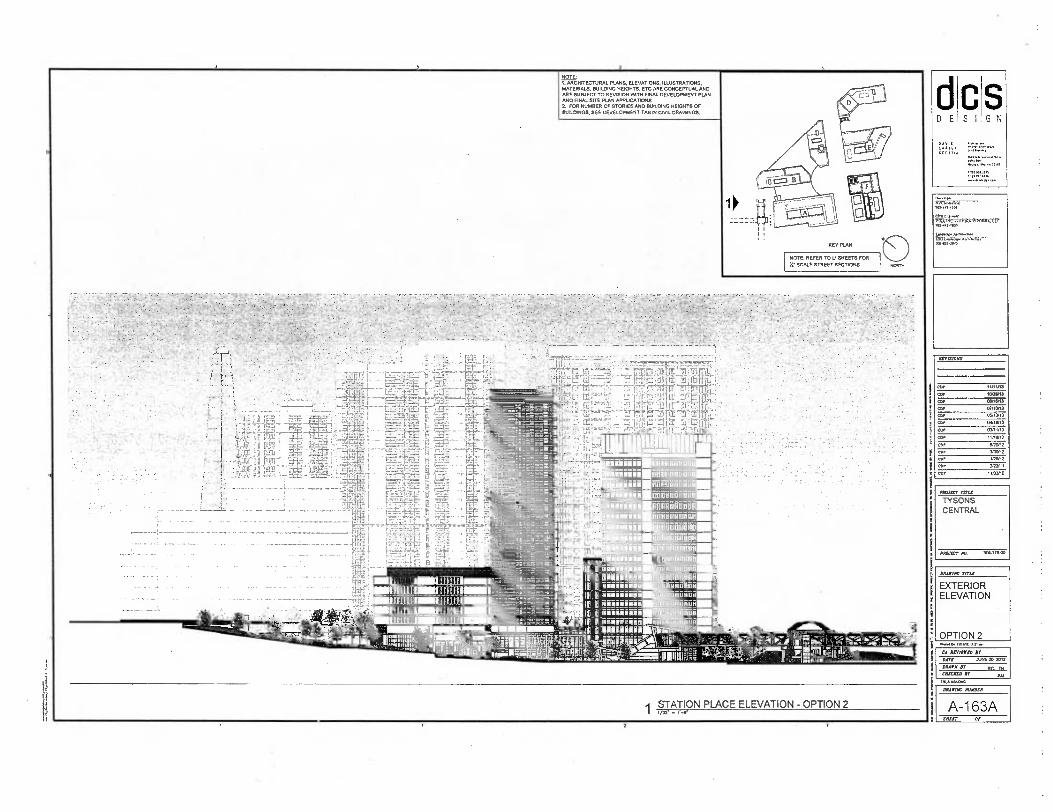
,
~ER MU
TYSONS CENTRAL
'MUD, Mx 205478os
G N ci D E
C S I
AZPAZIRRE
COP
COP
COP
COP
cop COP
COP
COP
COP
COP
/01-4444.
pryine.r OVA O■C V1lA VIR/IIUI& LU. 710..1.1100
amp Arewm 1T :17
DRAPING
EXTERIOR ELEVATION
OPTION 2 Onvia,”
CA WWII BC
MOT JUNE 21:1. MIS
DAMN DY BY TN DMIMAD
M ■ OlaBs4
.11111111111111111 IMMIIIRM11111 I.' I1 I I ml g g mmmmmm
STATION PLACE ELEVATION - OPTION 2
I IIIMEN
NOTE: 1. ARCHITECTURAL PLANS, ELEVATIONS, ILLUSTRATIONS, MATERIALS, BUILDING HEIGHTS. ETC ARE CONCEPTUAL AND ARE SUBJECT TO REVISION WITH FINAL DEVELOPMENT PLAN MID FINAL SITE PLAN APPLICATIONS 2. FOR NUMBER OF STORIES AND BUILDING HEIGHTS OF BUILDINGS, SEE DEVELOPMENT TAB N CAVIL DRAWINGS.
NOTE: REFER TO L. SHEETS FOR X' SCALE STREET SECTIONS
IMAIDIC NUMBER
A-1 63A SMXIT

NOTE: 1. ARCHITECTURAL PLANS, ELEVATIONS. ILLUSTRATIONS, MATERIALS. BUILDING HEIGHTS. ETC ME CONCEPTUAL AND ARE SUBJECT TO REVISION WITH FINAL DEVELOPMENT PLAN AND FINAL SITE PLAN APPLICATIONS 2. FOR NUMBER OF STORIES AND BUILDING HEIGHTS OF BUILDINGS, SEE DEVELOPMENT TAB IN CIVIL DRAVANGS.
7.:
KEY PLAN
NOTE: REFER TO L . SHEETS FOR II' SCALE STREET SECTIONS
1■14.1 tiglin3.111/4.
CA Ur/DIED Dr
DATE JUNE 20,2012
OM. SP RIT TN WICKED DT AM mama
DAMAO NOW=
CENTER STREET ELEVATION - OPTION 1 A-164 SHEET OP
S G N
C S I D E
On..loper
70, 01.0011
TRAI1w,
va, MI-U14/00
Laniroaprn 2113-01.200
REVISIONS
cor 1/11/13
cor 10,2103
010101
car
coo
ON1013
010311
0101101
cot MINIM
coy ni11102
cOr 111or12
TWIT
CDT 1/26112
CDT 2/22/11
CDI 11AXVIO
PROJECT TOSS
TYSONS CENTRAL
PAONCT 116 313611503
DAAPINC TITLE
EXTERIOR ELEVATION
OPTION 1
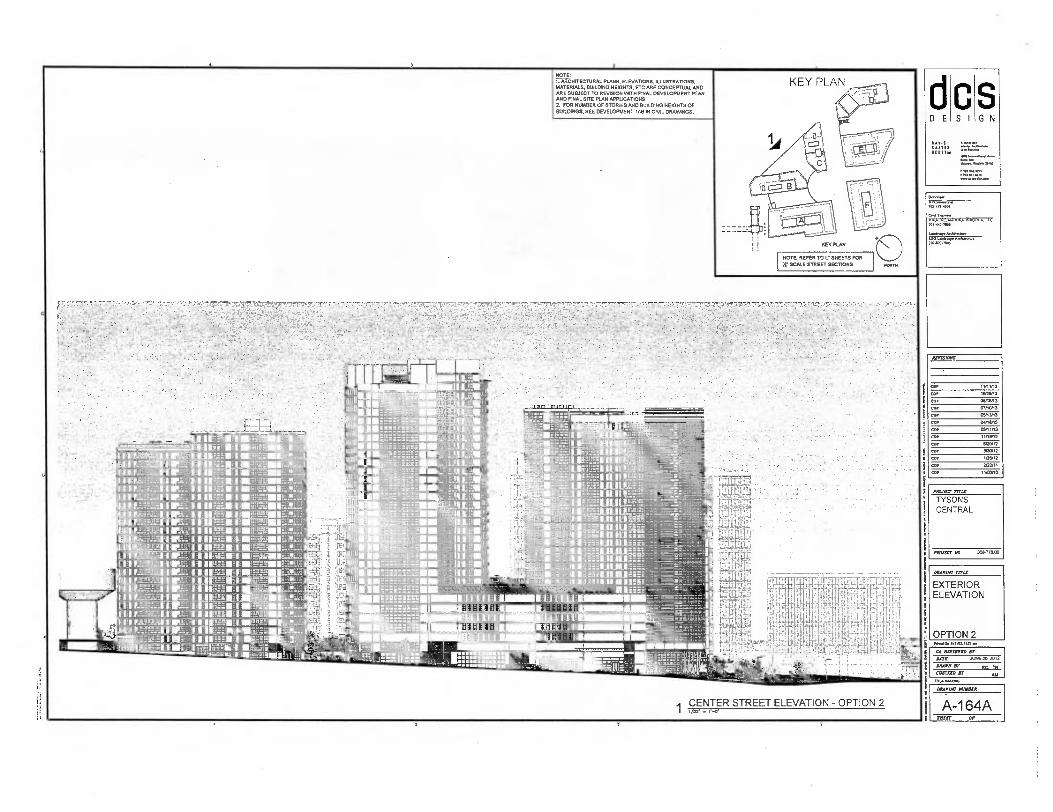
NOTE 1. ARCHITECTURAL PLANS, ELEVATIONS. ILLUSTRATIONS. MATERIALS, BUILDING HEIGHTS. ETC ME CONCEPTUAL AND ME SUBJECT TO REVISION WITH FINAL DEVELOPMENT PLAN MD FINAL SITE PLAN APPLICATIONS 2. FOR NUMBER OF STORIES AND BUILDING HEIGHTS OF BUILDINGS. SEE DEVELOPMENT TAB IN CIVIL DRAVANGS.
KEY PLAN dcs DESIGN
.O0 — 70)-448-0441
ChO Lmr
MI-M-7PD
labspe AM* LEO La*, Arch...w.
NOTE REFER TO L. SHEETS FOR
22' SCALE STREET SECTIONS
77.
101423 ,200
AL9131011$
COP 11n1,13
COP 10128,13
COP 0:1116/13
COP 01/10/13
canan
COP 04/18113
COI 03/1103
rinaBB
COP 1,40112
COP 300,12
COP 10/12
COP 2/22/11 co, 1100110
MAXIM' TM/
TYSONS CENTRAL
PAW.' IA. 306770 1:0
aunts: rrns
EXTERIOR ELEVATION
OPTION Poirot InVII.17.•
CA urrorrs DATE AIME 20. 2012
MACE sr Br TN CHEOCED Jr AM
CENTER STREET ELEVATION - OPTION 2 A-1 64A SIAM Of
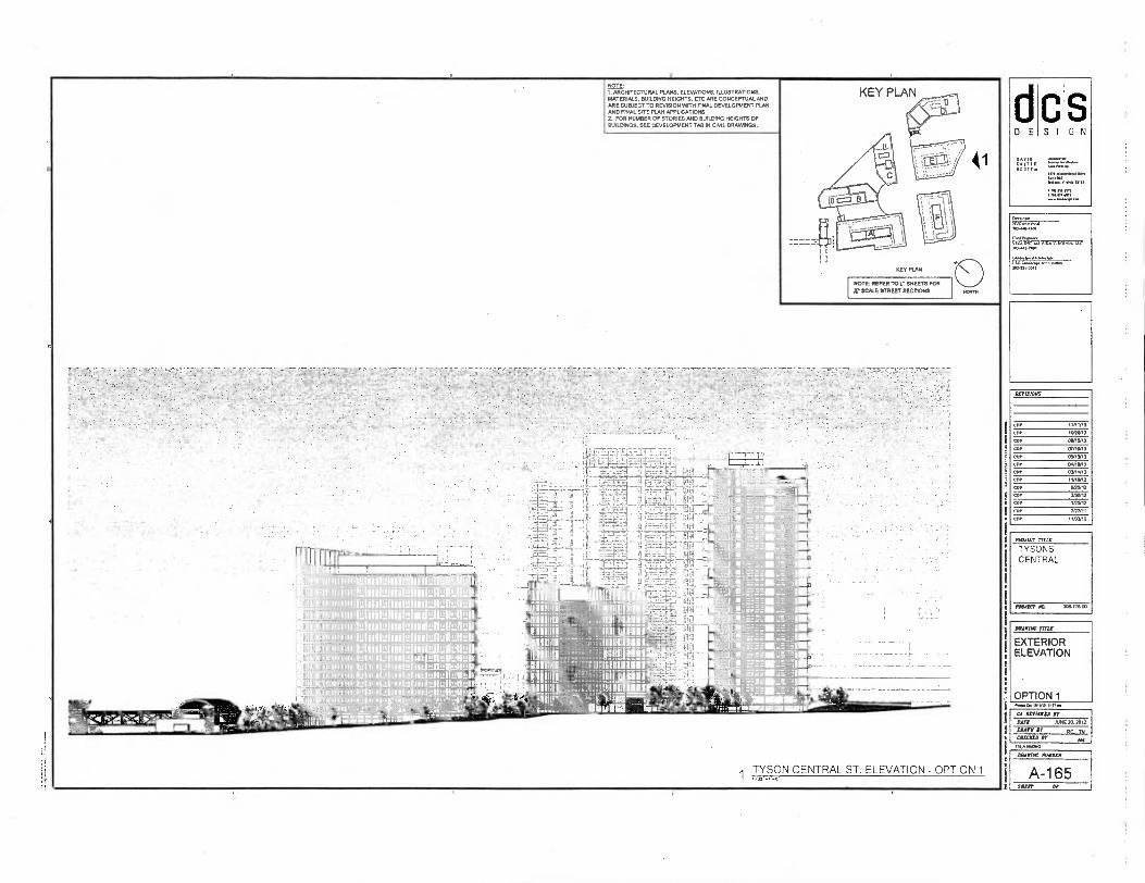
NOTE: 1. ARCHITECTURAL PLANS, ELEVATIONS. ILLUSTRATIONS, MATERIALS, BUILDING HEIGHTS. ETC ARE CONCEPTUAL AND ARE SUBJECT TO REVISION WITH FINAL DEVELOPMENT PUN AND FINAL SITE PLAN APPLICATIONS 2. FOR NUMBER OF STORIES AND BUILDING HEIGHTS OF BUILDINGS, SEE DEVELOPMENT TAB IN CIVIL DRAWINGS.
NOTE REFER TO L. SHEETS FOR Jr SCALE STREET SECTIONS
1111 nth limn IIfl Pu;
I qi I 111 1 1
N liii jUL11 ii N
'WON ii I Ii II IA II lllll I. min NIMINNIWINitaullellblit • m I Hum lo I UII ti II I WI II I "ill IIiJBIul"I1IIli!!JI"Uii'
t• Pp se lin • rn. • tel. 2ra r4INA4 •••••■•■•
1 TYSON CENTRAL ST. ELEVATION - OPTION 1
7014434.
7.34 0.1.
ArrISIONS
COP
11/11/13
1001313
MVO
01/1013
OPINO
WINO
CORP* PROP2
etKPI2
MPG
15912
2/2.,
1131110
COP
COP
COP
COP
CIO
COP
ARAVIIC SlIngS
A-165 MR OP
d c s DESIGN
0•311
01,
PROM, MIX
TYSONS CENTRAL
PROJECT An
IMMIX mu
EXTERIOR ELEVATION
OPTION 1 Poem Oa 1111■3. It11.0
CA RAVII74; Dr
DATA AWE* 20I2
MAIM Dr Re =CUD Or AN
110,111000
9

dcs DESIGN
NOTE: I. ARCHITECTURAL PLANS : ELEVATIONS, ILLUSTRATIONS, MATERIALS. BUILDING HEIGHTS. ETC ME CONCEPTUAL MID ARE SUBJECT TO REVISION WIN FINAL DEVELOPMENT PLAN MO FINAL SITE PLAN APPLICATIONS 2. FOR NUMBER OF STORIES 1140 BUILDING HE/GATE OF BUILDINGS. SEE DEVELOPMENT TAB IN CML DRAVANGS
MT MAR
NOTE: REFER TO L.• SHEETS FOR SCALE STREET SECTIONS
. laTIEYED BY
JUNE N. 2oi2 BAYS
TYSON CENTRAL ST. ELEVATION - OPTION 2
iinuumiii nanIFInistiton iiiühjftjjlftin mamas issusl -alistlFaIIIII-alifilinfalLtIliiii iluifililifilillitalfilltalladaluulallatna lily sm um mmfts1111MassIMOMILWIlls Ims
111111:13PIneentUimilmlnalaluidullLIIiillim filLIFIEEM
nomm liiii IMMURE liii Mil iitiilhEil0.luEtLluiWOJlIJ. I Iii in in iiulvlElEIiitiidLIiiiIllltiiiluiii
ill nurn ism 11i.1 emillAsiasciUlitsWILina hull
Iii 11111 III lllll minima-1e 191
I In uIiiiirniiili!ldEl' iidi imAltUlE lvii mms isemPhn nals imulglOu Iii Is I;
11 ummilillnlildmi Midas I " II Mil lii Malan a lUlL_liifiZIlLlIiiIf ii
I II milmenti“inev ssIsmatalsoilaIILIIMII ii immsemessalishisLIssilleliss pli MN"
• mm lllllll • II U uulul II 111101114"011111102illiggilL WIIyfl I I Hu uiuuluiuuUiLIiiiiiIIiiuiiiIIidfillLUllyIi Ii imossemessilliMaIIIIIalliinalkalla bill Ii ms llllllllll
MAIM TITLE
EXTERIOR ELEVATION
OPTION 2
, • „ . , • .„ .
„
. • ,
. , •
. • '
• .
•
• 4 _=.:.•.„.• ■ •= -
10M1
"„•••
BBAIIII BY Rr
1 CHM= BY AM
Poodepd.r
110,47.7•07
717■117tr
BETINJOBS
COP
COP
co.
cor
COP COP COP COP COP COP COP COP COP
PICLISCY TRU
TYSONS CENTRAL
PAWS, 308.773.03

voodoo ...intim.
CA PS1117.0 AT
JUNE 20. 2012 MOM Al RC TN MC= IT
171,111.110
RCVISIOPS
coy 11/11n3
coy 10120/13
cop 0510123
cop 07110,13
CD/ 03/13r13
COP 04/10/13
GDP =11/13
cp. 11/19112
11/20/12
300/12
CD, 1/25/12
COP 2/22/11
COP 11.1/10
MULCT TITLE
TYSONS CENTRAL
PEMECT NS 303-770.00
ci E C S I
S G N
0111111CM 70.4.0011
Leprwor •n■
, 05.441.7•PP
Lapdog, Metileetax
BAArnic WPM
EXTERIOR ELEVATION
OPTION 1
Rom 1. ARCHITECTURAL PLANS. ELEVATIONS. ILLUSTRATIONS. MATERIALS. BUILDING HEIGHTS. ETC ARE CONCEPTUAL AND ARE SUBJECT TO REVISION HUH FINAL DEVELOPMENT PLAN AND FINAL SITE PLAN APPLICATIONS 2. FOR NUMBER OF STORIES AND BUILDING HUGHTS OF BUILDINGS. SEE DEVELOPMENT TAB IN CML DRAVMNGS.
NOTE REFER TO 12 SHEETS FOR Jr SCALE STREET SECTIONS
VIALE CENTRALE EAST ELEVATION - OPTION 1 I
DABDIC WIRER
A-166 MIT OP
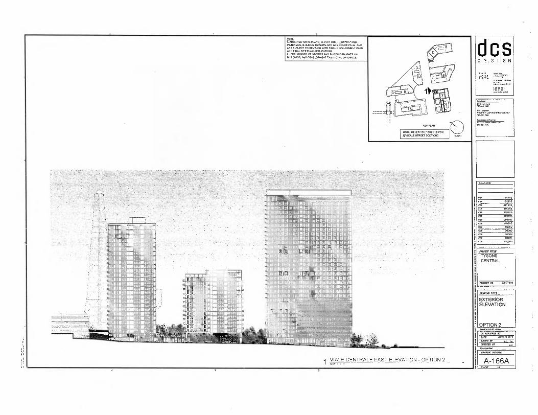
NOTE' 1. ARCHITECTURAL PLANS. ELEVATIONS. ILLUSTRATIONS. MATERIALS. BUILDING HEIGHTS. ETC ME CONCEPTUAL AND ARE SUBJECT TO REVISION OATH FINAL DEVELOPMENT PLAN AND FINAL SITE RAN APPLICATIONS 2. FOR NUMBER OF STORIES AND BUILDING SCOUTS OF BUILDINGS. SEE DEVELOPMENT TAB IN CIVIL DRAWNGS.
VIALE CENTRALE EAST ELEVATION - OPTION 2 1 1/32 -
NOTE: REFER TO 1: SHEETS FOR ET SCALE STREET SECTIONS
rworMiluirraittla 131•1i11•• iii ME i n Oil ukaibmi 11111!
IrrilLlereemINErileredirtuIMIllullelleren1
itime Wk. uiem!IUII!t 1MVII 1112111111.4fiellrdlellrrhesill IuIuI!IIIiiII III1R 111 MAWR
—iiFiiiIlIuiiii ll iiinuihmaiganhasualsemsi e iiii Ib 110: Ine:11:11 lullr.11E121101141
11111! 1111 U ILl I rimpraiLi
m1121 inn II r11 inris Ellallere LtLIIMIalglletel i
eii -IJUIALKIWis I ifffirlung III I!UIIsI !I
memelluILI 1111MINIthilrm ki talldiEllirki lit
efilliK11r.410112111111
hillerlleiivallatel iiIliJIilIislbsIisjl 111H111 1111V1•""=-"-'1:r"=*""'"
ir EMIL I 1114M-BEE'IPZSIE"gM° IMUM1110 LE 111 fill PAL 1111 PM.. _WERbEFINEg Mau KIWI me sersonammeronself orrairigi !Mundial 11111
l IIIIIMEVEMEOMETBMTWE
aduerrAILIILIHORIMMIIIMINEEfivItmaige EnilltilM a E 7. 74171.1:47rEalirt..17€17.71,11.
I AIINGUZIlinall. - Val
PI WW1•-11Pq I
dcs DESIGN
REV ISIONS
COP
COP
COP
COP
COP
COP
COP
COP
COP
MIRY fraz
TYSONS CENTRAL
INAUCT NO. 3ce-77e op
(MAIM FATAL
EXTERIOR ELEVATION
OPTION 2
1 CA WOWED ET
OATS JUNE XI ASIA
I MAIM AY RC IS EDUCATE MT AN
1 n....Nmom
LWAINIC MINDED
1 1
A-1 66A MEET 0 I'
G N ci
E C S I
COP
CO/
CO.
O IP
CD/
OD,
COP
CD1
CO,
Of,
Imm3 IMM7
MVO
07/10IO
05I0/13
04/111/0
5111513
BANS
MOM
WOO
2G2/11
maGO
PROMO TITLE
TYSONS CENTRAL
PAWLS,' MI 308.7 7. 0 00
C
▪
A mum, sr DATE JUNE 20. 2012
MAIN AY Ftf 114 CHIC= BY MI 7,447A13
ROTC I. ARCHITECTURAL PLANS, ELEVATIONS. ILLUSTRATIONS. MATERIALS, BUILDING HEIGHTS, ETC ARE CONCEPTUAL. AND ARE SUBJECT TO REVISION VAIN FINAL DEVELOPMENT PLAN AND FINAL SITE FLAN AFFIXATIONS 2. FOR NUMBER OF STORIES AND BUILDING HEIGHTS OF BUILONGS. SEE DEVELOPMENT TAB IN CIML DRANANGS.
NOTE: REFER TO 1.• SHEETS FOR
) SCALE STREET SECTIONS
■
■
IMOMMIMMOHL minium mom
MINMOONINFOOMIll MAIL ------- 111110iii 111111
11Hild
11410 111113 3 111111
4111111111111'11:-- ,- sf.24.7101001,
1 VIALE CENTRALE WEST ELEVATION - OPTION 1
F
CA . 741.40-7300
▪ Art■extrrer• An.hownme
70,2114.15
DROIAC TITLE
EXTERIOR ELEVATION
OPTION 1
RLY MOO
MOW= HOMO(
A-167 MR OP

S d DE
OR HIS
S G N
1 ;•
Mos. 11111■13.11rA
CA MIMI Iff
DATA JUNE 25 2013
DRAIN OF BC 114 CRAM er All
GI, WRONG
NOTE: 1. ARCHITECTURAL PLANS. ELEVATIONS, ILLUSTRATIONS. MATERIALS. BUILDING HEIGHTS. ETC ARE CONCEPTUAL AND ARE SUBJECT TO REVISION WTH FINAL DEVELOPMENT PLAN MD FINAL SITE PLAN APPLICATIONS 2. FOR NUMBER OF STORIES AND BUILDING HEIGHTS OF BUILDINGS. SEE DEVELOPMENT TAB IN CIVIL DRAWINGS.
KEY PLAN
NOTE: REFER TO L . SHEETS FOR
20 SCALE STREET SECTIONS
VIALE CENTRALE WEST ELEVATION - OPTION 2
H
GA INC ERA V VIRGINIA 1.1A. 701444100
AGIGANGA LSO la,. Artlueaux, IR2411400
ACVIEFIONS
COP IMMO
COP 10,20,13
cop 00/16,13
COP 01P10/13
COP 12,1513
COP 04/10,13
COP 03/11113
OOP "ARM
COP WO/12
100P12
COP 505112
COP 2/22/1,
COP 11,02A0
P031CCT TRU
TYSONS CENTRAL
',enc. NO. XS-77S SO
DRAWING TITLE
EXTERIOR ELEVATION
OPTION 2
DRAFIAC MINER
A-1 67A SHIRT OF

PPM= Trnit
TYSONS CENTRAL
PROJIIT HO 3013-77300
dcs DESIGN
Pm. Off 101.3. INC
100 4+4C/201031
2 ILLUSTRATIVE VIEW - - OPTION 1 NITS
2 ILLUSTRATIVE VIEW ALTERNATE - OPTION 2
1 ILLUSTRATIVE VIEW 7 OPTION 1 nn
1 ILLUSTRATIVE VIEW ALTERNATE - OPTION 2 xrs
NOTE: REFER TO L . SHEETS FOR
r SCALE STREET SECTIONS
1. ARCHITECTURAL PLANS, ELEVATIONS, ILLUSTRATIONS, MATERIALS. BUILDING HEIGHTS. ETC ME CONCEPTUAL AND ARE SUBJECT TO REVISION IATTH FINAL DEVELOPMENT PLAN AND FINAL SITE PLAN APPLICATIONS
2. FOR NUMBER OF STORIES MD BUILDING HEIGHTS OF BUILDINGS, SEE DEVELOPMENT TAB IN CML DRAWINGS.
3. THIS SUBMISSION SHOWS THE GENERAL CHARACTER 6 DUALITY OF THE PROPOSED DEVELOPMENT.
DILITHIC TITLE
ILLUSTRATIVE VIEW
OPTION 1 & 2
RVISIOMS
car 11112
• 1020/13
OINIVI3
COP OTA013
cep 00n3n3
co, WINO
co, 03n1/13
101512
entn2 31012
ISSUE
Cyr =NH
• "MAR
COP
COP
10144,1.
P.0ippen• •
70344141.
am* LVO Ancluinnn. 0221..3
CA ALVII7CO Ir EATS PASTS er CIOXICIO BF
AARE 20, 2012
RC IN
Au
MOM MAWR
A-168 SUM OF

inuts.liasyn
CI RIMINI IT
JUTE M1E20.2012
DRAIN IT Rr DI Mr= ET AM
tl
d D E S I
S G N
=PA 5.111.•
NOTE, REFER TO L. SHEETS FOR
X. SCALE STREET SECTIONS
NOTE: I. ARCHITECTURAL PLANS. ELEVATIONS. ILLUSTRATORS. MATERIALS, BUILDING HEIGHTS. ETC ME CONCEPTUAL MO ARE SUBJECT TO REVISION WITH FINAL DEVELOPMENT PLAN AND FINAL SITE PLAN APPLICATIONS
2. FOR NUMBER OF STORIES AND BUILDING HEIGHTS OF BUILDINGS. SEE DEVELOPMENT TAB IN CIVIL DRAWINGS.
3. THIS SUBMISSION SHOWS THE GENERAL CHARACTER a QUALITY OF THE PROPOSED DEVELOPMENT.
01 ILLUSTRATIVE VIEW- OPTION 1 NA (OPTION 1 SIM)
02 ILLUSTRATIVE VIEW- OPTION 1 & 2
' INN I.,I AlIst zi::
,. '' mum m m ' 1
,,... ,,,,,, ,•1 n‘wi g 1
...,„ ell, - II Si
num * In a, li SEM m
klMiiii . .
1.1-War- )111111111MINIIIIIRS IIla --'011.firmilThiforik -e'er SIM
-- 1111 7. ....17,.. - o.
1 1 1111 L._ ,
'
- . ' 5,1 T ... ' al&musirr- _
I. 1 En=
,
st,Z.. - ---T
. ,s.,... ,...
--
v
12% 1 .- 7 ---nye.:',F,:',7 :- ' I ' ' -? " ''-' ...
-- -
..
03 ILLUSTRATIVE VIEW - OPTION 1 & 2 04 ILLUSTRATIVE VIEW- OPTION 1 & 2 NIO
l q
i s
IYMnIC AMMO
A-169 SHUT OP
Rivislows
COP 11/11/13
COP 1025113
013n6,13
COP 07110113
COP 05/1113
co, Duiedis
COP 01,11/13
COP 1111.2
COP 61112
COP 3/30,12
V25,12
COP 2/22/11
11/0110
MAW? TITLI
TYSONS CENTRAL
MOM, NO. 30.778 DO
IItorrAc vitt
ILLUSTRATIVE VIEW

31
S I D E
PROJECT TITLE
TYSONS CENTRAL
PBOaCT //0. 3067113.00
SCOTTsid
Op 1101 VP 1111a.
CA ASPIRED OP OATS NE 20. MIA
MAIN AY RI TN CHAIM BY
AM nLALIAIILLAN
03 ILLUSTRATIVE L UST RAT IVE VIEW— OPTION 1 & 2 04 ILLUSTRATIVE VIEW — OPTION 2 (OPTION 1 SIM)
01 ILLUSTRATIVE VIEW— OPTION 1 & 2
NOTE: 1.ARCHITECTURAL PLANS. ELEVATIONS, ILLUSTRATIONS. MATERIALS. BUILDING HEIGHTS. ETC ARE CONCEPTUAL ANC ARE SUBJECT TO REVISION PATH FINAL DEVELOPMENT PLAN MD FINAL SITE PLAN APPLICATIONS
2. FOR NUMBER OF STORIES MO BUILDING HEIGHTS OF BUILDINGS. SEE DEVELOPMENT TAB IN CIVIL DRAWINGS.
3. THIS SUBMISSION SHOWS THE GENERAL CHARACTER A DUALITY OF THE PROPOSED DEVELOPMENT.
02 ILLUSTRATIVE VIEW— OPTION 1 & 2
NOTE: REFER TO L . SHEETS FOR SCALE STREET SECTIONS
S G N
O•01.1.111.2
11, 103.{..Olt
DRA006 71172
ILLUSTRATIVE VIEW
COP 1/11/13
COP 10213/13 COP 06116/13
COP 01/10113
CLIP 03113113
COP 01/18113
COP 03/11/13
cor 'IMMO
COP
52012
caT 30512
105/13
202/11
11=10
COP
COP
COP
',war AVYBFB
A-170 SHEET OF
e
i A

NOTE: REFER TO L. SHEETS FOR
Xs SCALE STREET SECTIONS
NOTE: 1. ARCHITECTURAL PLANS. ELEVATIONS. ILLUSTRATIONS. MATERIALS. BUILDING HEIGHTS. ETC ME CONCEPTUAL. MID ME SUBJECT TO REVISION PATH FINAL DEVELOPMENT PLAN AND FINAL SITE PLAN APPLICATORS
2. FOR NUMBER OF STORIES MID BUILDING HEIGHTS OF BUILDINGS. SEE DEVELOPMENT TAB IN CML DRAWINGS.
3 THIS SUBMISSION SNOMD THE GENERAL CHARACTER QUALITY OF THE PROPOSED DEVELOPMENT.
n5 ILLUSTRATIVE VIEW- OPTION 2 001 (OPTION 1 SIM)
02 ILLUSTRATIVE VIEW - OPTION 2 (OPTION 1 SIM)
03 ILLUSTRATIVE VIEW - OPTION 1 & 2 04 ILLUSTRATIVE VIEW - OPTION 1 & 2 on
IP, 4
,• • _„_.
• •
xrvislorrs
COP imin3
COP NOM,
COP LIMP°
COP 07/1000
cop 03/13/13
cot
0.11/13
OPM/33
11112E12
EBB 600/12
cor POD
0. 112332
0.
MAI
11033/10
MAIM mu.
ILLUSTRATIVE VIEW
MIRY mu
TYSONS CENTRAL
170JBLY 09 3067799
S I G N ci D E
ISO Ia.,. Poelownwe 1171.01.7043
7.0).4.4301
0.1 Ey*
70).411.7100
••••107.111■11 OM.
pa 11170520 BY
IATZ
APR 20. 2012
DRAIN MI Re 1M CAD7120
1/0,11017/1010
BMW= MIIMBX
A-171 Mit or
KEY PLAN ci D E G N S I
'C:117111 3C01,
3 ILLUSTRATIVE VIEW
NOTE: REFER TO L . SHEETS FOR X. SCALE STREET SECTIONS
NOTE: I. ARCHITECTURAL PLANS. ELEVATIONS. ILLUSTRATIONS. MATERIALS. BUILDING HEIGHTS. ETC ARE CONCEPTUAL AND ME SUBJECT TO REVISION WITH FINAL DEVELOPMENT PLAN AND FINAL SITE PLAN APPLICATIONS
2. FOR NUMBER OF STORIES AND BUILDING HEIGHTS OF BUILDINGS. SEE DEVELOPMENT TAB IN CIVIL DRAWINGS.
3. THIS SUBMISSION SHONG THE GENERAL CHARACTER QUALITY OF THE PROPOSED DEVELOPMENT.
- - -
4 pup ING .N LOADING DOCK PLAN 2 ILLUSTRATIVE VIEW
PIMP. iVrial.1112=1
CA 1171170 BY SATE A*4E243012
MOW IT RC 7t4 GUCCI
IT UN
114..0.1M171.10
,BUI,L BDING A LOADING DOCK DOOR
VU
Ls c 20242,1%0
RVISIOIR
COP
CDP
CD/
COP
CDP
toe
COP
CDP
COP
COP
PROJECT TITLE
TYSONS CENTRAL
Plena AG 300-778.00
MAIDS, TM"
ILLUSTRATIVE VIEW
DILIFIAC AMMER
A-172 MUT or
S G N S
.u.4. .-., a
., ' .I. tk. 4
4k,t,— ,-IF
. . •:
' , 4'0,,
••• : ..... r .
- bi. • . ■tr 14;24^' ''. A ' ' ''' 7 •...o. NA .
A., - --.„ -.`''t.,
. ..1 .1..;,‘":4,:t N. '. ' '''' '!.1:, -{.
,
‘ .
-,
. :i.',
r ira , 41!: ._
r,,r7 . f• --
r
-,--..
, . .
..f., ,
,v.,,,,, ,043.F2;tY , - .. -;::?,/,40 . ; 0. • .
■;. . k: ;, _ "-., e,,,,- ..... , . i_,,,... 41: ,.,,,,:,...:, ,.. . ,
\.-,\ .--•"'IF . , „ • -
.4.- ..,-,..... , ...„..,: ,..,- .. . ....,,,,
fi„,,,,, ,_.".4;%- ,, 4-4'%... 2` +.';-‘, - -
4P., - ' '
, .
1.: •, " ' .'...'.. . .:.
• , . .. • -,._ -44, :\ .-a•
0-
7
,..,‘
WINTER SOLSTICE - 9:00 AM WINTER SOLSTICE - 12 00 PM WINTER SOLSTICE - 3:00 PM
,,.-.1..
,
;.; ''. ' ..-...1 -
- -,'
,.
. ,
, .- •
4-.. 1 ,•'. '' ' ' ' •A' ; I ‘,
"), • ' ,, ,r,, . '
4. .•,;:. '4
,
. 44i: / •., '-'" ,,, a ;* - -F,„ -
•" . .•
\
, ..g! '"
, - -,r....I.'.... '\ , ..' ' .,1 '.1.-''
1-:-. • ',.' •,,,-: ' '' - ---
, ._.
I I ''S . ,;.V. .r. ' ,I ,it - • t
-- •
. ,
.1.,:, , .
Az .
i'. --• '' ' • 14i!' -*--
- 4k,,,4 %,
„ • _ „-
. .9
SUMMER SOLSTICE - 9:00 AM SUMMER SOLSTICE - 12:00 PM SUMMER SOLSTICE - 3:00 PM
- • -, '`,....' ,, • 44 ,,. `.:.' '
\ „Y',',11$'
.. '
... . . .. .
.14"' ' 4 .‘ , .,, ,
„•.--,,S*, ...
't . . • ,..,
....
. ...,-.-,,..
U.. - , -
,
..
I I
16,
,
' '1,
,..;
. ... ,,- -, i' ,;.- , , ... 7.. ,,...,, .. it,1 ,
ii \ ' . \ , _
-,..k ik t. +I ., IN , .„ • ,,,, .,., • . - , i ,•, * .. L - ot - ,-- -^ "*,'.i , ., . „ • •• ,..g...-A •N 0,9s•C'1:".•-, IS' ".
,',:::"77:'-- • ,. ." '
, . . • ' ,
,
.
. , • .... ,::•..
' '' • ' i
. .. 1: N /17
... , • .:. • * '
.,
SPRING SOLSTICE - 9 . 00 AM SPRING SOLSTICE - 12.00 PM SPRING SOLSTICE - 3:00 PM
1101/11.1131.
ci DE
1004131014
CVINC V11101/11h1,/
BY VISIONS
COP 11/11/13
COP 132613
COP CO/113113
CDP 07110113
CD, 03113/13
COP 04/10/13
COP 03/11/13
COP 11/19112
COP 600/12
COP 3/30■12
COP 10113
COP 2/22/11
cop 11103110
PB0160T mur TYSONS CENTRAL
PROJOT 308.170 00
012.4 1/121 TITLE
SHADOW STUDY
OPTION 1
CA 0111211D Jr
BATS AC4E20.2012
DRAWN IT
MCI= IT
rn.r.04vas
ORACIAC 0UMBLY
A-174 SHEET Or

COP
COP
300112
105/13
3001
PROJECT TRW
TYSONS CENTRAL
PROJILT YR 304-773C0
RVISIOSI
COP 11/11,13
a. POMO]
angina
COP 07/013
COP OVI3O3
COP OP/IWO
coP 03/11/13
▪ 1 1/102
co• WOO,
(IN
OPTION 2
DRIVING 17710
SHADOW STUDY
• IVISIP.I.N•
S G N D E
C S I
703-141.11110
up,opooPoo,P.• awiseyeAsrn.
• REVIES111 SF
an AIMS 20.2013
MSS Rr Rr MGM ST
DRAWINC MACCR
A-1 74A SHEET o r
.
..•1
., , r 44 ,.,.
4$
. 7 A, it.
,.
efr . "..,,,I ..,...,...
,....,-,.....-zi .
. . - •
4, ry
V \ - '..-'' 71"44.f.v. 'V '
. ..: vdmi,%., .,,,,,,,
' - ..... ... :
4,-0--- 7, I A
.,.. , .,. .
,--
. . • 1.
\
, .....
.,: ...,‘ ....- N Nyafg.
,...,
.
, -,
,.
WINTER SOLSTICE - 9:00 AM WINTER SOLSTICE - 12:00 PM WINTER SOLSTICE - 3:00 PM
-
` 4
1.
`:4111b 4. Y
. .M...1., . ....,•-.
, L... 'tir 4, ,5
.
i
...
..,„:„
4 i. L.
4- ,
- 4 ..• _
, .,. .i■ -.
4 •
O's e(P L-::::':\
:3--
-. -a. 4!
11<ar.....ber-6. ' ... .r' ^ ty •t '7,? \S\ .,'‘ .. ,..., ,,\
I
..,, r I,
,1 _ . .v......
...-P .. ri.\,... .1V....- ,
,..e
. : s,1/ N:* 4.1'2....
SUMMER SOLSTICE - 9:00 AM SUMMER SOLSTICE - 12:00 PM SUMMER SOLSTICE - 3:00 PM
''',.
.. ' ...,
e ,
-.!..*- ."r . ..., ,-;.
-...
..
, ,,,_ ,
,
.'";! • ; "<$^ • ..." .t",-
'..4,0, . ,
. ..7,4" , ..,..-- ;:, • ,..... '.'
..Ali, ..r. - --
,,,,p .;..„ i,,I, .„ .
...- -.... ...._ '
.
' 0.5?, • ,,,
.A. r•,\Np .k.
„-- .11001*--3" '---.,. . (1,/,'"i.-" - .:-.,..;.-.
.... ..---7----1?-‘4'",rq, y.• 'W Z- ,,,,..ef.
-IV
SPRING SOLSTICE - 9:00 AM SPRING SOLSTICE - 12:00 PM SPRING SOLSTICE - 3:00 PM

PHASE A
PHASE B 1. Demolish existing Structures on site within Phase area. Adjacent sites with misting retail
will remain in service
2. Construct Building A, with below grade parking, at grade retail. above grade parking and
office
3. Build retail base north to the edge of future Phase B
4. Construct the Skypark, with access from the Metro Pima and Central Piazza. S. Upgrade Metro Plaza to the limits of construction for future Phase R as shown above.
6. Construct Station Place 7. Construct the pedestrian path on the Property to connect to pedestrian path from Center
Street to Soknlons Drive. to be constructed by others.
8. Cons tact karate Centrale from itt 7 to Central Piazze, pending approval from VDOT for At 7
connection. VON such time that access is granted, Service Road will remain open to Station
Place
9. Construct permanent condition of Service Road south of Building A from Viale Centraleto
Station Place with donna of vehicular connection at Station Place all Subject to item a 8
above.
10. Widen Route 7 wen new fourth travel lane along the frontage d the Property from Route
123 off-tamp to Station Place. Stripe the newfourth lane to restrict access until Service
Road connection is removed.
11. Service Road east of Vole Centrele wit remain aeon until Phase F is complete. 12. Construct Central Mane In an interim condition to the border of adjacent future phases
13. Areas directly north of Building A will he regraded and have Interim uses, such as penes
retail, parking and/Or open space. Interim uses to be determined at FOP. 14. Construct interns site muss ocnslrection between Vale Centrale and existing Tysons Central Street.
reusing existing curb out .
LEGEND
EXISTING SIDEWALK
FUTURE TYSONS GREENSBORO METRO
INITIAL PEDESTRIAN CONNECTION
FOURTH LANE - ROUTE 7
INTERIM CONDITIONS INTERIM IMPROVEMENTS AND
A PEDESTRIAN PATHS TO METRO
FINAL CONDITIONS
PROPOSED IMPROVEMENTS
1. Demolish existing structures on site within Phase area. Adjacent sites with existing retail
will remain in service
2. Constmot Building 0, with below grade parking, at grade reek above grade parking, hotel
and/or residential toes
3. Upgrade Metro Plaza to the brings of construction for future Phase El as shown above.
4. Construct Station Place
S. Construct the pedestrian path on the Property to connect to pedestrian path from Center
Street to Solutions Drive, to be constricted by others.
6. Construct Center Street from Station Place to Via* Centrale 7. Construct Mate Centraterfrorn Center Street to Central Piazza Street wit be finished with
Interim finishes to allow for future adjacent construction. Final finishes to be Installedwith future phases.
8. Maintain existing. Service Road forsite access, with closure of vehicular connection at
Station Place, or provide interim connection between Central Piazza and existing' Tyeons Central Street.
9. Widen Route 7 along the frontage of the Property from Route 123 off-ramp to Station Place.
Stripe the new fourth lane to restrict oaeo until Service Road connection is removed.
10. Service Road east of Vale Centrale wdt remain open until Phase F is complete.
11. Construct Central Piano Man nterlm condition to the border of adjacent future phases
12. Areas directly to the south of Wilding 0 will be regraded and have Interim uses, such as
pop-up rebg, policing and/or open space. Interim uses to be determined at FOP.
d D E S I GN
S rt:.1.42 1.11,
• , Extant of below grade perking io be covered with interim finishes And ]beat to be a More olmee '1XISSO.nm teae daft partial
rronotrortrenee b sorb. ' Warp...FOP
Connect to exishng
pedeaman wait .
Mit by others
Potential victim Connection Potential Interim Connection . , -
Existing setell to renter
CeentiOn
Temporary pool The stern use of Me parcel ' ' may he corroctstl sidtate
Street be- closed Mepcsadly tat the confarilOnan of faun phases
New elle eocesa Mom existing service toad
Maintain Service Baal
tonnection end filture Phew'
Me0.1r1Service Road E.Onnadon Mil future phase,
widen RI 7 to four Imes Stipe new fourth Oro to markt area until Service
Coed conneinieb as removed •
?I
CENTRAL PLA.ZZA
Mona TITLE
TYSONS
CENTRAL
PROIECT Ma Sa.771103
COP
COP
COP
05,1113
curare Ctiing.
COP
COP
11/1912
• edgio COP 'two
REVISIONS
COP 11A1/13
cc. IWO/13
CD, earrans COP anima
10052
MD"
CUOMO COP
seamy TITLE
PHASING PLAN
...Ow 1111M. OrN
CA WILTED IT DATE ocean onto DRIVE or CHECKED sr yet 171,081NO
DRASTIC MIMES
A-176 VINES Or
Conner:aka tuning
boat bp Where.
New ure moms tront mdsling service Mad
Street rneYbe kinkafiRinh , - clormitter Me construlton of more phase. as determined -a1 the erne of EDP and may be runner 1111firRer adii pen.
Qom. vases bbernee Road
INTERBCPIONAPANODROP.OFE TURNAROUNO TtrAGOVA RITERtai BUILDING ENTRY (REQUIRED FOP. .1/4.,Cess UNTLADJAGEW sTREET "
- NETWORKIBliSTALLEION °TREF! PISSES AND LOBBY RELOCATED)
. „ .
'The Ireertmust at MN PW
,
CC , may be converted to !tonere parkingarriterim park '
IITERIM METRO PLAA IMP RCiVEMEN1S
RIVISIOAS
CD?
I I/1 NJ
looms omens wow 05,13/13
omens 09,11/13
It/16V
603112
MOM
1,12.12
=At
11a1/10
031
<DI
COP
COP
CD,
CUP
GDP
title
PHASING PLAN
On 1
111.7.•
Ca REV1M0 sr DAY AWE 20, 2012
PROM BY
CHSCAID sr 71,1110.
MAIM NUM,
A-177 sonar or
PflOMCr TRU
TYSONS CENTRAL
(MINT An 33677400
0 E
C S N
I IV 1511 02,5
Pereb, evonvvim /0,10-1X9
Loa, LSG Lux., Ardnecese 2.02.1.200
PHASE D 1. De mash existing structures on site within Phase area, Atgacent sites with existing retail
will remain In service
2. Construct Buildirg C, with below grade parking, at grade retail, above grade parking and
residential uses
3. Upgrade Motto lathe bode of future Phase A sod B
4. Construct Station Place
S. Construct the pedestrian path on the Property to connect to pedestrian path from Center
Streelto Solutions Drive, constructed by other, 6. Construct Center Street from Station Place to Male Centrale
7. Construct Male Centrale from Rt 7 to Center Street, pending approval from VDOT for Rt 7
connection. Until such time that access is granted, Service Road will remain opento Station
Place. Street south of Central Maori wit be interim to allow for future Phase (A or Fj
construction of below grade parking and final streetscape.
8. Maintain existing Service Road for site access, with closure of vehicular connection at
Station Place.
9. Widen Route 7 along the frontage of the Property from Route 123 off•ramp to Station Place.
Stripe the new fourth tenets restrict access until Service Road connection is removed.
10. Service Road east of Vie le Centrale Mil remain open until Phase F is complete.
11. Construct Central Pinta in an interim condition to the border of adjacent future phases.
12. Areas directly to the south and west of Building C will be regraded and have interim twos,
such as pop-up retail, parking and/or open space. Interim uses to be determined at FOP.
LEGEND
EXISTING SIDEWALK
FUTURE TYSONS GREENSBORO METRO
Et= INITIAL PEDESTRIAN CONNECTION
1.
2. 3.
4.
S.
6.
7.
8.
NMI FOURTH LANE - ROUTE 7
INTERIM CONDITIONS
INTERIM IMPROVEMENTS AND PEDESTRIAN PATHS TO METRO
FINAL CONDITIONS
PROPOSED IMPROVEMENTS
Demafish existing structures on she within Phase area. Adjacent sites with existing retail
will remain in service
Construct Building D, with below grade parking, and residential uses
Construct Center Street at north edge of site for connectionsto Pinnacle Drive during future Phases.
Rebuild Existing Tyscns Central Street to new, lower elevations forconnections tofteure
phases. Maintain existing Service Road for site access, with existing vehicular connection to Route 7 the Metro Station
Provide pedestrian connection to existing sidewalk along Service Road for connection to
Metro Station
Construct the pedestrian path on the Property to connect to pedestrian path born Center
Street to Solutions Drive, to be constructed by others. Area to line south to be regraded and have interim park./ open space uses.
An interim turnaround for vehicular access will be irrstaRed. This will remain in use until
future phases construct Center Street connection to Station Place, Bale Centrale and
Tyson Central Street. Once this street grid li installed, vehicular access will be redirected
to these streets, and the interim turnaround vnll be replaced with Clyde's Park

LEGEND
7,7P-Ps ;P:
1. DemoNsh existing structures on site within Phase area. Adjacent sites with existing retail wilt remain in service
2. Construct Building E, with below grade parking, at grade retail, and office or residential or
hotel uses 3. Rebuild existing Tysons Central Street to new, lower elevations for connection to future
phases. Maintain existing Service Road for site access, with existing vehicular connection to
Route 7 the Metro Station.
4. Provide pedestrian connection to exIsUng sidewalk along Service Road for connection to Metro Station
S. Construct the pedestrian path on the Property to connect to pedestrian path from Center Street to Solutions Drive, to be constructed by others.
6. Area to the north will be regraded and have interim park / open space uses.
7. An interim turnaround 1 or vehicular access will be installed. Thi5 will remain in use until
future phases construct Center Street connection to Station Place, 'dale Centrale and
Tysons Central Street. Once this street grid is Installed, vehicular access will be redirected
to these streets, and toe interim turnaround will be retraced with Cycles Park
8. Sea Proffer ter connection cf Center Street and Pinnacle Drive.
EXISTING SIDEWALK
FUTURE TYSONS GREENSBORO METRO
INITIAL PEDESTRIAN CONNECTION
MN= FOURTH LANE - ROUTE 7
1. Dernoish existing structures on site wthirt Phase area. Adjacent sites with existing retail
will remain in Service
2. Construct Building F, with below grade parking, at grade retail, and office or residential uses
3. Rebuild existing Tysons Central Street to new, lower elevations for connections do figure
phases. Maintain existing Service Road for site access, with existing vehicular connection to
Route 7 the Metro Station.
4. Construct Wale Centrals 7 to Tysons Central Street, pe.nding approval from VOOT
fort? connection, Until such brae that access is granted, Service Road will remain open to
Station Place.
S. Construct Tyson: Central Street from Vale Centrale to Service Road.
6. Provide pedestrian correction to erristing sidewalk along Service Road for connection to
Metro Station
7. Construct the pedestrian paihon the Property to connect to pedestrian path from Center Street to Solutions Drive, constructed by others.
8. Widen Route 7 well new fourth travel lane from Route 123 of f.ramp to Wale Centrale. The
lane will be extended with a future phase that included the construction of Station Plant.
9. Service Road east of Vale Centrale to be converted to fire lane access Integrated with
pedestrian plata and park.
10, Areas north of Building F wit be regraded and have interim park and open spare. Design to
be determined at FOP. N. Construct new vehicular entrance to existkm Clyde's Restaurant to connect to new,
regraded Service Read. Construct pedestrian connection horn Clyde's Rcstaurant to Tysons
Central Street.
INTERIM CONDITIONS f'k"7— INTERIM IMPROVEMENTS AND
PEDESTRIAN PATHS TO METRO
FINAL CONDITIONS
PROPOSED IMPROVEMENTS
iFielPIITAIH USE oFTtos pAgro_ • '1;:g1,14Cririft7EQ, Tp,II:rRFA4E .
INTEPIMPICK:LIFI AND DROP-OPF TURNAROUND TO ACCESS INTER04 BUILDING LOBBY, (REQUIRED FOR ACCESS UNTILACUAcENT,STREET NETWORK jS Ifistlist_EO iN OTHER PHASES ANO NJILDNG LIIERity IS RELOCATE)) • c ; " . .
0.4 ••• • • 1.1
'ap7R INTERIM
IMPROVEMENTS d
EXISTING RETAIL ' TO MEMAilv
PHASE E PHASE F
RLY
CV. 1/1 1/13
COP roams COP 000113
COP 01110
COP MAW,
outsna
COP 0111E0
COP 110602
COP 00012
300/12
CO• 10112
COE 1001
C01, 110110
MINT Ma
TYSONS CENTRAL
Pita 1ST 10847.9 D3
tics DESIGN
U.:1'11E1:71;
1,044.00II
vile,. INC *VIVA VIRGINLALIC M.A11.7130
lAn.,
W.R1. 1.20.1r
DRAY. TITLE
PHASING PLAN
*Md. IvrintillAlln
Co RIVIITIO at
DAM JUNE 20.1012
MAIM Or la MIMI BY
11,111e.
DIUYIPC twIrl
A-178 51161-r Or 1 !

dcs DESIGN
SOOT,
=
1.10M
A 51 LOADING DOCKS
PRIMARY PEDESTRIAN CORRIDORS
Winery FadatirIan Corridor. an 'nanded to have tie highest levels of pedestrian activity and interaction. They tyticaly occur near Ensh Nations and are the location of stniliont fetal. rnaior building entries, and sotisl gathering spaces. Primary Pedestrian Corridors supped pee...n circulation. but also incl.:. *woes for outdoor gathering, sitewslt cafes and browsing area, As a result. ..se areas typically have Me widest Wm.,pe and most snisled bolding facades. Thew corridors may be Identified as a neighborhood destination In and of temselves.
BB Ng MI SECONDARY PEDESTRIAN CORRIDORS
Secondary Pedeatrian Corridors typically have signifIcaml pedestrian voidness, and generally an Waited for pedestrian rrowfront as opposed to pedestrian interaction. Some retaa activity trial is genetilly more neighborhood or dIstricbserving occurs itithin Maw corridors. Residential and civic uses heve glair entrances facing Secondary OWestrian Corridors. These corridors typically have wider streetscapes to fantasia pedestrian movement and a significant level on Wading facade animalism to create an interesting and coniortable walking environment.
I ■ 44311 TERTIARY PEDESTRIAN CORRIDORS
'forgery Pedestrian Corridors support pedestrian connectheny through and ...van neighborhoods. Thew corridors typically Include residential entrances, access to parking. and lirmleg access to loading and service lactate, Any retail von. occurs.. tytioNN Pe found at Inane..m nth ogler mare satillicant Wee.. Bulk .° facades provide sena variation end level el detail le create an interesting and comfortable walang environment.
.1111.11111. GATEWAY PEDESTRIAN CORRIDOR
A unique environment atiscent to a high volume boulevard. that may high level of pedestrian activity as sled WIT access lc a transit Naar., but nay have reduced retail and platimmaking opportunities.
ENHANCED PLACEMAKING OPPORTUNITIES
_TYSONSCENTRAL STREET
In addnion Io pedestrian carrlders, locations for enhanced pacemaking are indicated on Ine pedestrian hierarcAy plan. rase al* Iniended no highfight cede. areas as 7401. of Importance. or owartunities to emphasize line CIIIWW, or identity of a trabiti, corridor,. neighborhood. These can be lecallons or Mail. dvic fealties. urban open spaces, public an, spatial archilecture and / or Ow elements which Bette en identifiable 01.Illation.
M
A GARAGE ENTRANCE
METRO STATION
ELEVATOR TOWER
BUILDING ENTRANCE
BUILDING ENTRANCE UNDER THE BUILDING CANOPY
Mt ---- •
trail -04111111E1 !era 1.-Wint2 tall*** !mita traL. I I is
obs-.1-ThRA SUI .:111:11
rmeLtrffl
xert 11. SS WO macaw WWW WV se moo.. CROWE.. AND OWW. mance° nurnrE CFNEFW DESiGN OVAUTV CHWACTWIWCII WE IN 91.WWATIV .I. COWORMANCe veivITLAT woCvw
O 15 30 SO 90
DROWN TITLE
PEDESTRIAN CIRCULATION PLAN
Now OR III1Y11
CA REVIVED DT 3 DITE
NUNN
JUNE 20. 2012
EMCEED AT
'"" DRAITIC NUMBER
0101500000
COP
COP
CUP
CD,
COP
COE
GM
COE
COE
CIM
PROJECT TITLE
TYSONS CENTRAL
PNRINT AV. 3067764
M'Comlacrol 70)44-1,011
al, IN, VIRUINIA.1-12 /03-.7.7101
Lsar,e,Asel...■
Ltd Lettitiainmiaimen 7■13.1.464,
L-1
ii
t
TWIT OE

D E C S I
S G N
MI= TITLE
TYSONS CENTRAL
MILVICT NO. 3011776 00
CDT
COP
COP
COP
SCKY12
$0512
1/21111
110000
MINSIONS
▪ 11/11/13
eNe
case 0419/13
070013
COP DYI7N9
▪ 0.18/13
COP 03/11/13
• 1109/12
GM 2210 •12
D&WIIC TITLE
CONCEPT LANDSCAPE PLANTING PLAN
OPTION 1
103.14•301
0
▪
O.A INC VI RA . 3.2.1100
▪ 111.13.18..
CA MIMEO BY
01172. JUNE 10.1011
ORATE/ EY
PUCE. Jr
1,1 10.1
CDP TREE SCHEDULE (option 1, limits of COP site) CDP TREE SCHEDULE (option Included off-site Improvement) STREET TREES (CATEGORY I) STREETTREES (CATEGORY I) Well THE
KEY ON. SOMME& NAME COMMON NAME Mt 7.2 <OVEILAYOEY FEY OIL NOTANICAL NAME COMMON NAME ME ITPE COMA MNOPT Awe.. Calemere. ue. WMMN Md MaMe T.I. Sae 75 22.....SeMYE xDwCAhllle rt. sae 7S O SM. IMMOS.N. kney 111 75
FOlipale Inel. ON 7. cal MB 75 Quemmelao,MgIN• Enell. OM rd MB 71 19 1. subeelal 19 1425
• '
.0
STREET TREES (CATEGORY IVI
A....11mober Were OFeberGlory Me EMIel I . LAP WM. /lane r CA. IMO Seuthe. Me OH . ete
Hne.a. Vale, M.' ....OH fe.01111
STREET TREES (CATEGORY IV)
Foo Mourn .000.41* OOLION OW Red Al.Me r of. sw) )50 • PlalanoWeslIO. LW. WM O. r PM. SU 150
220 • OWN. law MM.. MIRA rot me no rem. AO Am u.leul 71 • MSG
ORNAMENTAL TREES (CATEGORY
115
II) AmeiemelerarbaN• Pawnee Sen... 1. . 1M 175 Ame....... Demeremealeper T . Me 725
0
mt. /amen..
Comm Mum Intern emPpee mesa m.
7. .. Me 125 IN
,z...) Ceres:::neivls Em
Oop
men...I
Kowa .o0 TN, MI 125
mein. AM. Star lea
me
reM rut. 51B U5 Phenol. mellem 3. Mmeea )- ol sae 119 raww 5 . ommul le 70:0
ORNAMENTALTREES IN ELEVATED DECX (CATEGORY II) ORNAMENTAL TREES IN ELEVATED DECK (CATEGORY II) emimelee rmen Mvon.SeneNtw. r o1 PAP . Arn•lan..... DowneMer.e.. r PM MB M
0
Oe. .els • 401.12,52. 187“...11.1 low Clow. Y.. P. AS
US Wel wade.. 1......
1•Oem ....11
Mem Omm. real NM M5 To. NA 115
MacmIN nell. Mar142.5112 1. . 1165 115 M... stellma 5.58.010 1,31: MS 121 ......, . 5925 wee. at 530
oo
ona
.055 RN ANN
MINOR MMUS. CANOPY MGVIREM (FOG
MOISKECOVERMOVIOPO N HAN70.1521
15/1911 TOTAL.. (0.112110VMDMT HARTING Nei
MINN
1..350
A:magma ..
t planrameduN MEMut .lull tn. M wiN e /Me Pm/ MM. s■erFes mor ..Ire*,.. limE■mi.n
GENERAL NOTE
I RO FINENERAL ati N1.1011 PAINING LOT LAPOSCANNG51.1111M0YMMIMP.0.2. FINAL LANDSCAPE CALLIANOON WALK OPLIPDWPO FOR INF SRI AMP PM OF F.O.P.
LEGEND
00 PROPOSED ON SITE TREES
SEE NOTE #1 FOR STREET TREE CONDITIONS (TYP.)
•"-.Y;:r•
• on.
gS
rS
se OFF SITE TREES
LEGEND EXTENSIVE GREEN ROOF
SO-RETENTION TREE PIT
1310-RETENTION PLANTER
STORM WATER UNE
DETENTION VAULT
UTILITY VAULT
WATER LINE
SANITARY UNE
UNIT OF CLEARING AND GRADING (SEE CIVIL DRAWINGS)
PROPERTY LINE
NOTE
HERE LIPPIALJIA FLAWING WIDTHS OF F ARE NOT PROWDED ALTERNATIVE PLANTING SMALL SE USED TO SATISFY SITE PLANTING CONDITIONS (SEE SHEET 1.2 a AND L11)
2 THE UNDSCAPE AMENITY LANDSCAPE PANELS SHALL PROVIDE sot VOLUMES IN ACCORDANCE WITH THE PROFFERS
1101p TOE PL. WO 011.10..0.• NAV
PO PP NOCKIE0 WIN FINAL
PNOINELIWO MOW. PROVIO THAT GENERAL OPSION OLIALITV IVO CNIARACPPOISPCS ARE NI PASTA.. CONFORNANCE 1,1•7 P.N.01
A s a so on = an on on = on on = = no ft., PA O 0 15 30
eft
ORNAINENTALIREES (CATEGORY II)
Tn„ireft,.X2114 TYSONS CENTRAL STREET Mk Mk 4•■
r%1XVOi I
ORATION MINDER
L-2.1
SHEET 0f
CDP TREE SCHEDULE (option 2, but of COP site) CDP TREE SCHEDULE (option 2.: Included off-site improvement)
WATER LINE
SANITARY LINE j II
;I • LIMIT OF CLEARING AND GRADING (SEE CIVIL DRAWINGS)
PROPERTY LINE ■No • owns
NOTE -7/ • •
1 WHERE MINIMUM PLANTING WIDTHS OF er ARE NOT PROVIDED. ALTERNATIVE PLANTING SHALL BE USED TO SATISFY SITE MAN1ING CONDITIONS (SEE SWEET L.2. AND L.7 II I
INTENSIVE
GREEN ROOF
DETENTION VAULT
%Mr UTILITY VAULT
MUM TITLE
TYSONS CENTRAL
MC/6T PA son,n,co
STREETTREES (CATEGORY II ion ISO STIEETTREES (CATEGORY I) tarRovu ROY CRY. POTAIOGI NAME COMMON NAME SUE TYPE LITTIONOPY fry Orr. $011.1E, , A.A.., COMMON NAME NM DIN NWERCANON
Neer nANN,Numare. CM... Mole PM. Mn 75 Aear*Deiumnare• C... Red Nage r . SU 75 Gm. Molsalmwe Stow 0.00 TM. NM 75 O 60.1.0a Sen. Sen. Gotge r a. Bal 75 OmeNN NEN To.. Fawljne INE.ON r.. eat 75 Ehoms N.. T.... FamlaN Ing. ON Tat en 75
19 141.5 WM. 0 1.
STREET TREES (CATEGORY W) SIREETTREES (CATEGORY m
Neer Newn,CGoNr ENV Do33e(6wy Ree Maple rw. 3.33 iso Aor vSom•3nom.43.1 00e1No GINN Red MAIN r BS. 750 se.olla LeneleNIENe r eat NB 750 `I. MINN NeOlNa lona. Plane free KO ISO
Otter an laid. • Seelhem Red ON rM. 750 Clue. NEM Nolhem NOON r cal. MA 750 aerge NM Rio Own alma 3.333e.ge• vnerkm100 rkl ILLS 750
NE7 NAN. 72
dcs DESIGN
ORNAMENTAL TREES (CATEGORY II) NNW.. aNaNa Wvow Seacterwr r a. Me 115
can.. Comes Ness
...Ellem
Inlen... r [al. NO SG itewa ON.. r eat 0611 DS
Mr MmooM r oa. en 1.75 ...... , GE
ORNAMENTAL TREES (CATEGORY nowne■ SeaWebw3 an 17.5
C. 's) Ce. No.. laMern WNW r NO. Ma NS
K.., Cams Saru m" t.... Ow...,
TALI. tat 725
MagnellaNelleta Star .E.le Pa. sag >n tsca miNerall
ORNAMENTAL TREES IN 31EVA1413 DEER (CATEGORY 11) Atnelant...a OwrowIeme•Pew rni. Wvs NnelaNnierartnrea DownEv SaNceNNY EMI 175
0 ..M. Comm keNa
In. Nand
Mem Mow. . INC OS
rw. tie 33S Ter. cmmemn CANN INN
Iavern Reabuel
INN Demed
WA IS
liall 175 MaEnolla Neu. Seer Mernella r eal. INIM 1G .EneN nell. Sur M.N. en NS
NONNal N 55CG NENN . 5507
GROSSMANN 7547910 MYRIAM COVPR MOSIOSIM N.M. MI 27,913
ORNAMENTAL TREES IN ELEVATED DEM (CATEGORY II)
sow. In ICsogent .0. en inerny be *tad Jo roUrne W.. *IL
Seer. maroon hentlinv oso fin 40 NV, one ovaPe6POP
GENERAL NOTE:
1 AO M.N. ANG EARNmELCO. NNOSCAPING N.111 NOVINGFOR CEA NON LANDSC.1 CALCUN7..1.1.1( DOONANEONO.1uE sn, N7o1 17.0F ENE.
LEGEND ® 0 PROPOSED ON SITE TREES
. 017991E TREES
LEGEND FJTIENSIVE GREEN ROOF
EMDRETENTION TREE PIT
MO-RETENTION PLANTER
STORM WATER UNE
THE LANDSCAPE AMENITY LANOSCAPE PANELS WALL MONDE SOL VOLUMS ea no.ononncs MTN THE PROFFERS
SEE NOTE #1 FOR STREET TREE CONDITIONS (TYP.)
t■ cst.„
I
Fame. NIMOO.NO ale
............. attnerometramoat ......... etwaemant.mtnntowleneurane .....
NoTE THE PLANA. ENGEN/ SNOWN MAT SE MOONED NET,. PEN ENCONEER. DES....ONGED TEAT NE GENE. 17.30N OINUTE ONRACTERISTIGI ARE Ne SVISSTANT. CONFORM.. WITN
0 15 33 00 HO
3
AMAIN 1GNAR THE CANON MC MINN D. E. reel
TOTAL,. CGVIANIMGEOST PANT. NE) 14.300
CA 11711111 IT
OATS JUNE 20. 2012
PRAWN Sr MOTO 87
1515951 •WpoloMallolomowersommEnmlomMommEallmwm
111011C TALL/
CONCEPT LANDSCAPE PLANTING PLAN (ALT.)
OPTION 2
RIPISIONS
COP 11/11/13
COY 105553
COP name* 07/10/13
COE C653N3
0.11/13
COE owns COE 11/111112
COP VMS
3030/12
COP 1/2312
COP mot COP 11/0350
COO
aura MOM
L-2.2
SWEET Of
O CORNER PARK TREE PANEL SCALE 101, T.O. C) TREE PIT DETAIL
SCALE VE, C.O.
NOM 1. SOIL VOLUME FOR CATEGORY III AND ry TREES SHALL BE 700 CUBIC FEET PER SINGLE TREES AND FOR /CO CUBIC FEET IN SECONDARY PEDESTRIAN ZONES WHERE PAVING ABOVE TREE ROOTING ZONES IS NECESSARY. 2. FOR TWO TREES PLANTED IN A CONTIGUOUS PLANTING AREA, 500 CUBIC FEET SOIL PER TREE SHALL BE PROVIDED. 3 FOR THREE OR MORE TREES PUNTED IN A CONTIGUOUS PLANTING AREA. 400 CUBIC FEET SOIL PER TREE.
••1110
COP
CDP
DIDDI12
1/2112
202111 CDP
PROJECT TITLE
TYSONS
CENTRAL
PROJECT AR 30677E00
1117101014
COP 11/11103
COP 100013
COP 0811913
▪ 07/10/13
coo
091111
• owe,* • COMM
COP IIMPIE
COP 0/22012
CD•
DRAWEE rail
TREE CANOPY COMPUTATIONS
CA REVIKEED HT
OATS JUNE 20, 20,2
DHOW DE
CHECKED DE
L-2.3
SHUT OE
y
I
C S I
S G N D E
703.440-1101
?IVA71 VILA VS/ 4111/.
LSO Lembeepe Aechweleee ,014,1•71,41
IV
0 CANOPY CAL. OPTION 1 0 CANOPY CAL. OPTION 2
Table IzIOpIIHooL0 my 10R.. Tr.. COIIopp COkulatron °Om SuoJ Tem
an (OP T )
I mo Pm... Tepee. 1.....
, .'
oloa eo Tme annarm......•••••• .• u•.••w. .1. 7...., . .7.•••••• ....I
c me 5 HUGO M. a 1 wpowe .m.S anc ....
Ili ... Mc.. I....WI* 00.31 S.SHel area 0 alec N.M. mac
0 12.0517.1A I
*1 artaa! amomen.SPI • 0 . :: .c.::
1.1 . 0.40... sita.araa001-1101131SPi• 0.2.201 tleael, S•e Het Zen I it . IM4 a ■ Inf
S
P••w.. el NMS. um canon nom. i NN 1,..r.......
Asa/ 0,917ne C000r Roomooe• • esuF,•: ALS /A.m. V Ms*. ...an Sea...... ...p.
luemnal• 001. yes. Den N.0....•.•M•N mm A•M'A MM•0 CM
a . r
CI on Frew.. .....AnaMF • A awe
' ''':' ' • : -,-,z,'. 0
c 'I Tom um., om to .... 0 ,
Ca, • 0 E1.51020Dt
C7
..1 Hume" .r.o.... 'K..- K er Mot, me. ,
CP• 1.54•011 S.
7
Han
fIn.O 26PI
C 0
C •
• Pratamen Arms anal100,........ IS19.1
C A 0 )
eo-w w
1 .0310 ,I
C10
ifteMisrsetIAMICLIRCEPFAIZSZUMMARIEW
Tam MC 3. C£ C , .5 0•'
0
-2222_
.......C1O•as I 7 ..... or
rm.. man b.
••00 On 0•SAM -IP
2222«2222.. 0. Ile HeeHar
Sr. sn. 7..../ /7/./..., la o o/t ovoo. w/ /wow 0 octo•I SS ■
-.0 o .
e''''' as ''''' '." ''"?-7:7114:, : --,trirwar ....... ...... nm mann. . 0 ow 134E1. 0
ou. WI 1 0..91 -0..---T. .• M .^.41 non •
0 1 .....--......P.!!..!?.1 .9 1.- !.... .. o
An
ex veRNI ...In • k 11,1°...1!.?"......._ sm..
co...soil , MAMMAS. Ow A........ Sy auftenas ai 0
510 • 1.0 414. 0 Seu. . , csism.•0,
....••••■1,.../....................1 e 1..... tet
9. iF2.!- .1.1!' -. 0 .
77-..-az.-..T.7.3.7.7.-.....-.7..i......(i-,,T -1, -
Dna 1.4 0
R.?.?2tL__ il2STS ■p ■pop, S....
1...... la gm.. by 0 101 0
Am dclossy ...... no nen. andm •i AM
----. Inal Nemo.. um omarm omun 0.. p......., ...
D M ts et a... au.. relief
now MO
0..e.
W. ca.
Noel NO
Campy ..s..... melees Rees... 0 Nes N. 5 GSM Smart .1
'''''"" " "''""... r''''" 1"..„" 1 ° .71,,
Tat 10n• In. canon Pra...1
...... 0 Pet ara. 0
1 1. re One*. OanDig I. I 28,509 HP.
Taal of am p. eled 0/: 0 e a 0 Ike eem
E. ino010.mar On C.........1 ESP.; 20.25 I
lea toff IHH.ED e. skate ••••1 a• ./.........”
1/..1 m•Soo/Conorae ON Pool000Pm0000loAcs/oonov•ooms_oo,omoo•
Ta01.1210 PreIlmIIIaIY 1 0.Year 71111 Canopy CalculalOn o
J___ LT. thoot(OPT.21
, Pk. Pm Om Mos.. 1.....mns an ma , M.. ,
nnelneal tem pee., me 10.... enaoy CA a..... ...
IL int Can. p.re
WMA pram ma meg Mil • =NM .......
' ...... r..!!.Ett.....!1.-_ ..IP... 4 M.0310.16
OS 0..1 ams Nes SP,. ciF.EMV071 01. , 0.0410.41
Ds
IS AFFe. mem sat am MS, y7
Nosyij_o she, zonOo ncv se 75
PIO WnM
Pox... al lOmmr I. n. msna • 10.. ; ••
--- Nee,-.1WeNinWM-GRI-Wie-e;;ZeTTMTedSL , --Z7ZIS- iiiie . .......10..... Cm. Re.......• ...,, .. Ne
• s. en 0 Gon GM Imn ma.
C. in Pm .4n... .0rjr -r,...-r- si... .0
1"."-' --"'""""trrl:r:: e ;T'./7'1,..; Se. teas a• -••m am groMM ly *on ce*M7 esere
e o ■ ImsO • e e lescseLeRsi Saw. Pan
-e'w.,............Q. -40".-1:1T.- --1-- 14-17:-.T.-- __________________..-cAY.1.114fl .......!-- latej41,..
esememenes 701.102.5 CC 7.••.
Y.
0 mea. meg Se me, 1170/,HOHHO •H
i' • as
D a al 40............127COM• 3 23 0
S Se
lin Res Am el aft-Ne/ p.a• I> M.. eon. • Di D • lair
/7///, /mo oo o ■ tooms.m.
but 0 • a ■ $ (SPi • 3 i MASMASG.
Ana a . au y ..1% • am 0.
D • OF,
Armee sow . tarnet• • 0 4 mann
Sq. RC OS . 1 S MP , •
A. Ono. P.. by .0 Ona. 0 0
4 MS. AA. On..
II Na LS (0Pj • 0 4 1.2.0......, Anao/...•.by 3.......«E ONE.
0 Qs 1.2S,Sf” 0
Sean leel
4 G/SK/MS "..!.....!”...1..° T.,...........r. • I .....
P..•0/00 M ...WM CI IS • 0 ::..........'
o /Is n.• apy a. 0 me Nwa1 .
]1 2 1'.0 Eaa
010 • .11. 01. reams .
DA m• . or re. • n .w 4 ISMS
021 Cam. arm ma•2ew le Mph P,.y 40••
•
. . .....,
0 . Pcs c • Fee Snse n.
1.
e
Inn all. .ir me C ., 0 OP
I rw N.., ••• Pm.. • iC •
Sm.
ES Tm.o. .AN7wwPw M.N 0, MI. D.n cp.
DON ••
ow.oo
Too/ e torn... Prows wo 20 re /././:// ''
es- ems as. es....mmuss temm.......Fce Lovelry-Zbe me.mcee:Her.
PLANTING COMPACT SOIL TO ALLOW FOR MAX. TSETTLEMENT
1.1/21 TO 21 AIR GAP AFTER SETTLEMENT
SET BASAL FLARE OF TREE FLUSH 07/TH OR SLIGHTLY ABOVE FINISH GRADE
2' DEEP MULCH GEOGRID CURB 6 GUTTER,
SEE CIVIL PLAN PUBLIC ■ FOR DETAILS
SIDEWALK
COMPACTED SOIL MIX
PEDESTAL
PERFORATED SUBORAIN PIPE, CONNECTED TO STORM DRAIN
GEOGRID
STRUCTURAL CELLS TWO HIGH
••: DRAINAGE AGGREGATE
ROOT BARRIER
O STREET TREE ON ROUTE 7 SCALE I/2, 1MT
PLANTING IX COMPACT SC. TO ALLOW FOR MAX. r SETTLEMENT
1-10' TO Z. AIR GAP
AFTER SETTLEMENT
SET BASAL FLARE OF TREE FLUSH WITH OR
SLIGHTLY ABOVE FINISH GRADE
0' DEEP MULCH
GEOGRID
PUBLIC SIDEWALK
SEATWALL
ROOT BARRIER
DRAINAGE AGGREGATE
GEOGR ID
STRUCTURAL CELLS
TWO HIGH
COMPACTED PERFORATED
SOIL MIX SUBORAIN PIPE.
PEDESTAL CONNECTED TO STORM DRAIN
CORNER PARK PLAZA
PAP E
30,01
STRUCTURAL CELLS
?PAIR TITLE
TYSONS CENTRAL
Plena NO. 201,77300
AITISIOMS
COP 1191113
co, MONO
EDP 00115/12
co, RERUNS
0311113
COP 31/1332
COP 020912
COP 1919,12
PEP 621312
cop MOM,
cop 195NS
25001
110390
dcs DE SIGN
Opvis
"OTT.
=22
X9443003
3H1 Num' OTIUW771 IMVIONTKIM 103-LO-OCO
="
• tote -
TREE PLANTER DETAILS
RololOo INIVO. *la no
CA RAIIIVID sr DATE ARE 20. SOU
MIN IT
CNICZYD BY
PaRORIM
OPPOIO0.1
TREF PI MITER TYPE ON STRUCTURE SUB
PEE TREE PIT DETAIL ON CORNER PARK
NOTE:
1 DETAILS SHOWN REPRESENT AREAS WHERE TIE RAISED PUNTERS ARE MIN RET MACE OPEN SOIL ON TERRACE BETWEEN WEST. NORTHEAST, AND SOUTH Cf BUILDING 12 AND SOLITROF RAIDING D
2 TIE SIZE CF TREE PUNTER LOCATED TO PIE SOUTH CF BUILDING F PROVIDED LOON OPEN SOB EEL PLAZA AREA
3 INNImGM POO Cu FT TREE SOIL VOLUME PI TREE PUNTER SHOES, AND MINIMUM TOO CU FT TREE SOS VOLUME PI ALL OTHER P1STANCES
0 IS 30 00 90
.......i,. Itargaintafteiwairav • •
....... animmummEHEw 44:21mmismiumemss■iim■mmaak7
...
DAAWAC MAWR
L-2.4
spur Pr
iJ
oftra onvo. wow
PUBUC PARK PROVIDED TYPE AMMO MAU CENTRAL POMO OR D. PARK TNE POCKET RAM CORNER PARK SKY PARK
MASK OPEN SPACE • Al GRADE 0.73 0.05 11 PORK OPEN SPACE • RIME 0 26 TOTAL OPEN SPACE PROPOSED
MINT, °MAKI InVonnerir...0
THE POCKET PARK: 0 05 ACRES
RECREATIONAL FACILITIES RECOMMENDED USE RATIO
NUM rosnlants
MCC Rai..
5.4.5464 new..
RECOMMEND.
OAS
PROMS.
0.5
SEE PRINTERS
CLYDE'S PARK: 0.35 ACRES
PRIVATE AMENITY SPACE:
0.26 ACRES
• to —
I.
METRO PLAZA: 0.73 ACRES
NOTE: THE PLAN AND IMAGERY SHOWN MAY BE MODIFIED WITH FINAL ENGINEERING AND DESIGN. PROVIDED THAT THE GENERAL DESIGN DUALITY AND CHARACTEFUSTICS ARE IN SUBSTANTIAL CONFORMANCE WTI THAT SHOWN.
O
0.
-:a
—.0 0eeoacam
CORNER PARK: 0.31 ACRES
MULTTUDI COURTS
PLAYGROUP.
CENLITIC MU%
0 15 30 60 90
702426.22CO
VIN6 LLT 7.60.7703
imatram MOSectom
REVISI016
11111/13 CDR 10/26213
CDR 0811.3
COP 01010113
°SIM]
COP 010163
COP 022111/13
CDR
COP WONT
COP 3230212
COP 1.12
CLIP 2/22r.
CDP 11.0210
PROJECT TITLE
TYSONS CENTRAL
PROJECT NO.
MAIM TITLE
PARK & OPEN SPACE PLAN
OPTION 1
CA REVIEWED IT
DATE AmE ED 2012
DRAWN IT
00:011I sr
DRAWING MDIIIIR
L-3.1
SMUT OF
G N C S I D E
• AVIS
KIST/ ION 1.....1110.
IN*
10144-4X■
CIA Wm= VIM WC *V. VIRGINIA LLC 10,44-7,00
LSO AftWerem 703.621.2045
REVISION,
COP nmm cOP 0211/13
011115/13
COP 57/10/13
OD13/13
COP ovivia
COP 0:911/13
COP 1/15/12
COP 62002
COP 200/12
cor 00,12
COP 922/11
COP 11/03/10
PROJECT MLR
TYSONS CENTRAL
PR011a AO. 302-TT1100
PICARIAS Tint
PARK & OPEN SPACE PLAN
OPTION 2
P6.06 NM.
O 0 IS 30 50 90
PUBUC PARK PROVIDED TYPE METRO FLAW D.TRAI POS. WOOS PARK THE POO... CORNER PARK SKR PARK PANIC ONO SPACE •AT CAME NARK OPEN SPACE- maw TOTAL OPER PIKE PROPOSED
0.1 ORS OAS 1111
I
AM LA
MAO?! ono SPACE fhformostoPAYI 0 26 • bawds. w *ow center ToyerailsormAr
RECREATIONAL FACRITIES RECOMMENDED U51 MOO RECONNMENDED PROVIDED
COURTS PLAYGROUNDS
ATHLETIC AEON
1/2103 seskiwo IMO, DN..
D61.SIN
26
SOT PROEMS
THE POCKET PARK: 0.05 ACRES
CLYDE'S PARK:
0.35 ACRES
PRIVATE
AMENITY SPACE:
0.26 ACRES
5a.104 1,
METRO PLAZA:
0.86 ACRES
NOTE THE RAN AND IMAGERY SHOWN MAY BE MODIFIED WITH FINAL ENGINEERING AND DESIGN. PROVIDED THAT THE GENERAL DESIGN OUALITY APO CHARACTERISTICS ARE PA SUBSTANTIAL CONFORMANCE WITH THAT SHOVM
CORNER PARK: 0.31 ACRES
III
CA MMUS ST
BATE JUMBO 2012
AMEN SY
CHECKED BY
DRAIIIX IMAM
L-3.2
SHEET Or

REVISIONS
11111113
10120/13
Oar 06115/1.3.
0111013
CD/ wow> cp. 04/10I13.
CDT 0.1/11l13
CD, 11/10/12
tor 610112
3130112
1/25, 12
CT■ 222/11
COP 11.0/10
Milt, MU
TYSONS CENTRAL
PROJECT A. 308-7113.00
d DE
S G N S I
Oeftleren
00G-fa-01r6Y—CT... 10.41.1yea
Lwirnine Arrnr UI- 10,101400
WARM 71712
ILLUSTRATIVE SITE PLAN:
OPTION 1
hamlet 1111110.1117161.
CA REWIRED BY
JUNE 20. 2012
BROM or CHEERED AY
NOTE:
THE PLAN AND IMAGERY SHOWN MAY BE MODI-FIED WITH FINAL ENGINEERING AND DESIGN, PROVIDED THAT THE GENERAL DESIGN QUALITY AND CHARACTERISTICS ARE IN SUBSTANTIAL CONFORMANCE WITH THAT SHOWN.
. rip ------- • •
-7‘ . -
LEE scultkp PIN E (RT. .7.
ANEW IMMO
L-4.1
00121 Of
fit if

BASED ON THE ULTIMATE CENTER STREET & STATION PLACE ROAD .. • ALIGNMENT ..
M's-
ONS GEAL S.iTE E
COP
<Or 10/21.3
CVO 011/1.3
CD, 07/10, 13
03/11.
COP
[OP 03/11/13
for 1/19/12
la/12
cor 13.2
ern
Car
CP• IMMO
PROJECT MU
TYSONS CENTRAL
PROJECT ND 301-171.00
•
THE PLAN AND IMAGERY SHOWN MAY BE MODI-FIED WITH FINAL ENGINEERING AND DESIGN. PROVIDED THAT THE GENERAL DESIGN QUALITY AND CHARACTERISTICS ARE IN SUBSTANTIAL CONFORMANCE WITH THAT SHOWN.
Rie00[1■11/111.117.•
•
^ NM
l'ara LE E SB1.1.1t0 PIKEIRT 7
CA REWIEWED DR
DAM JUNE DO. 2012
DRAWN BY
CRECKED BY
S G N
dc DESI
V I
7.17,
10.1-1•11-.4
'PTIA-MOnaTiiMAr= 74)+12,11[10
lanpe Wstkitemee
MINIX TITLE
ILLUSTRATIVE SITE PLAN:
OPTION 2
DRAWING MINDER
L-4.2
SOW Of
PROJICT Mil
TYSONS CENTRAL
'MIXT IN4 30677.00
DAVIS
SCOTTO,
Nam ocilnIn3.1•21
RENMONS
COP
COP
PTO
COP
CDC
COP
COP
PTO
COP
CV,
POP
COP
to IlEVICISD BY
COPE 20. COTO
CNICUO BY
BAYS
BRAIN BY
L-4.3
SMELT Or
LEESBU1RiG PIKE(RT
40/
FlEMPRIIMMEW ..-0,14 •
ONS CENTRAL E ET
NOTE:
THE PLAN AND IMAGERY SHOWN MAY BE MODI-FIED WITH FINAL ENGINEERING AND DESIGN, PROVIDED THAT THE GENERAL DESIGN QUALITY AND CHARACTERISTICS ARE IN SUBSTANTIAL CONFORMANCE WITH THAT SHOWN.
6")
SIT
dcs DESIGN
i. ti.71—=Oki OU—OWW—CUJIA.
TO,P0O00
lawarape eltoe. vow 1.9111...coc
DIMMING
ILLUSTRATIVE SITE PLAN:
ALT - GRID
i=
G N S I E
PCOlius
roV:•";"'"."'. Wolas Owl
I , su
MIC.marci.1 /11.41-1101
V17.:11,771■1 we. V ■ 11611.41A, uc 701+12..0
103411.0
COV 11/11/13
co? 10020/13
COP 01/15/13
COP 0>non3
COP 115113/13
COP OV111/13
COP 11/19/12
CO. 14/20/10
COP NOM
COP 105/12
222/11
COP 11/0.0
PROW TIM
TYSONS CENTRAL
PROM,' YID 3004711.00
MAROC TITLE
TYPICAL STREET SECTIONS
raw oorswrx was.
CA REVIEWED BY
DATE .11.1PIE 20.2nix DRIER BY
CHECKED BY
way
Li 1
1 STREET SECTION -1
ZOW;El- r.o. I ra-
WALN Art. — TYSO.S CENTR4 STREET —
SCME
O STREET SECTION - 3 Irtr• 0 STREET SECTION - 4 2 STREET SECTION - 2
KEY MAP
STREET SECTION - 5 O
OTE:
0 SECTION - 6 0 SECTION - 7 .
THE PLAN AND IMAGERY SHOWN MAY BE MODIFIED WITH FINAL ENGINEERING AND DESIGN, PROVIDED THAT THE GENERAL DESIGN DUALITY AND CHARACTERISTICS ARE IN SUBSTANTIAL CONFORMANCE WITH THAT SHOWN.
PANEL DRAIIIIX AMBER
L-5.1
BREIT Of

I. METRO SCULPTURE
2. PICNICKING AND GATHERING SPACE
3. MAX. 36 HT. DECORATIVE STONE WALL ALONG ROUTE 7
4. BOLLARDS
5. METRO BIKE STORAGE
A. METRO PLAZA SPECIAL PAVING
7. LOADING DOCK
t FAIRFAX CO. TRAIL
• NOTE:
THE PLAN AND IMAGERY SHOWN MAY BE MODI-- FLED WITH FINAL ENGINEERING AND DESIGN.
PROVIDED THAT THE GENERAL DESIGN QUALITY AND CHARACTERISTICS ARE IN SUBSTANTIAL CONFORMANCE WITH THAT SHOWN.
0 ROUTE 7 ENLARGEMENT PLAN
0 ROUTE 7 SECTION Ivino10•11/1141.14:21!
CI REVIEWED BY
DATE JUNE20. yota DRAWN BY
MCC. er
YAMS, TITLE
TYSONS CENTRAL
PROJECT NO 3067711.00
S G N
y,•,..,..., ,,,^
ci DE
TRTER SC071,
S I
Doe.o,
703.6. ,71.
1,111.1.11, 7190
Yodseore Art* LSO
REVISIONS
cot COW
COP
cOP
fro
COP
cr. cOr
cur
COP
DRAWIAC TITLE
ROUTE 7 STREETSCAPE
DILIWINC WOOED
L-5,2

--„BUILDING 'A' REFERENCE IMAGES
9977,-71 dcs DESIGN
=7—
S TA T 0 N PLACE
O METRO PLAZA ENLARGEMENT PLAN
METRO PLAZA POTENTIAL ACTIVITIES:
SERVES AS A MAJOR TRANSIT CORRIDOR AND UNIQUE PLACE MAKING PLAZA FOR CIVIC GATHERING AND COMMERCIAL SUPPORT AC-TivmEs SUCH AS SEASONAL DECORATIONS & PROGRAMS.
1. METRO SCULPTURE
2. PICNICKING AND GATHERING SPACE
3. MAX. 36- HT. DECORATIVE STONE WALL ALONG ROUTE r 4. CASCADE WATER FEATURE
5. OUTDOOR RETAIL AREA
6. METRO BIKE STORAGE
7. BRIDGE COLUMN
8. INTERACTIVE WATER FOUNTAIN WITH FEATURES IN THE MIDDE
9. METRO PLAZA SPECIAL PAVING
MAIM TREE
ENLARGEMENT: METRO PLAZA
TA. Om 1%1.3.921
THE PLAN AND IMAGERY SHOWN MAY BE MODIFIED WITH FINAL ENGINEERING AND DESIGN, PROVIDED THAT THE GENERAL DESIGN DUALITY AND CHARAC-TERISTICS ARE IN SUBSTANTIAL CONFORMANCE WITH THAT SHOWN.
PIV,nmeot 70,14.3,11.
/01-141,10P
It1T412
WISIORT
co, 11/11/13
,090n3
CUP 00/13,13
COP oniona
C12, 03r13/13
CUP 001103
COP .11/13
11 /111/12
cnt 6120112
cur 390/12
cop 1/25112
COP 20.11
COP 11/03110
PROJECT TITLE
TYSONS CENTRAL
PROJECT 210. 306770.03
CA RIWZIAIT BY RATE JUNE a.2012 BRA. BY
CHECKED AT
REARM RUBBER
L-6.1A
BRUT OF
paneeMEN ..1 1G 0 METRO PLAZA SECTION 77.77 ® METRO PLAZA SECTION
3 3
MOJA= rant
TYSONS CENTRAL
MALT NO. 3011473.00
dcs DESIGN
SCOTT..
wd...m.i.4
Foriloe VikA nrc..ia vlkA vilmom, Llf 701+0.7•00
1.33 Laa.r:Awldicen.
11.1.10e lInVI3.1•31
0 METRO PLAZA INTERSECTION ENLARGEMENT PLAN
METRO PLAZA POTENTIAL ACTIVITIES: 1.3
SERVES AS A MAJOR TRANSIT CORRIDOR AND UNIQUE PLACEMAKING PLAZA FOR CIVIC GATH-ERING AND COMMERCIAL SUPPORT ACTIVITIES SUCH AS SEASONAL DECORATIONS B. PROGRAMS.
1. METRO SCULPTURE
2. PICNICKING AND GATHERING SPACE
3. MAX. 36' HT. DECORATIVE STONE WALL ALONG ROUTE 7
4. CASCADE WATER FEATURE
5. OUTDOOR RETAIL AREA
6. METRO BIKE STORAGE
7. BRIDGE COLUMN
B. INTERACTIVE WATER FOUNTAIN WITH FEATURES IN THE MIDDLE
9. METRO PLAZA SPECIAL PAVING
10. FAIRFAX CO. TRAIL
11. RETAINING WALL
NOTE:
THE PLAN AND IMAGERY SHOWN MAY BE MODIFIED WITH FINAL ENGINEERING AND DESIGN, PROVIDED THAT THE GENERAL DESIGN QUALITY AND CHARAC-TERISTICS ARE IN SUBSTANTIAL CONFORMANCE WITH THAT SHOWN.
BUILDING 'B' BUILDING 'A'
LL
0 IS
iY
STATION PLACE
L=7
0 STREET SECTION
PLO//At MLA.
ENLARGEMENT: METRO PLAZA
MODIFIED T INTERSECTION
BEVIS/OW
11/11/13
10■711/13
CUP 01313I13
COP 07/1633
COr 03/13/13
0018113
CO• 03111113
1111913
CIO 620, 12
RIP 301112
COP /23/2
CV, 2R3/11
11103/10
CA ACYMICD BY
BATS JUNE 30. 30a
MAIM BY
OltrACO MY
NUBIA CRUSH
L-6.1 B
SHEET OF
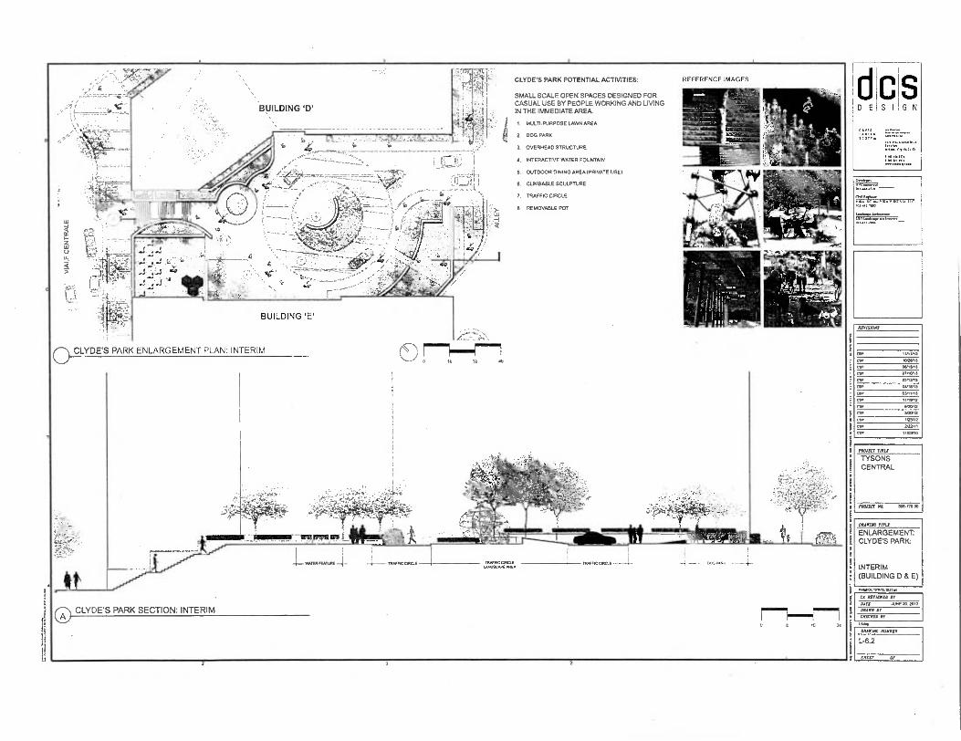
CLYDE'S PARK POTENTIAL ACTIVITIES: REFERENCE IMAGES
SMALL SCALE OPEN SPACES DESIGNED FOR CASUAL USE BY PEOPLE WORKING AND LIVING IN THE IMMEDIATE AREA
0
1. MULTI-PURPOSE LAWN AREA
2. DOG PARK
3. OVERHEAD STRUCTURE
4. INTERACTIVE WATER FOUNTAIN
5. OUTDOOR DINING AREA (PRIVATE USE)
8. CLIMBABLE SCULPTURE
7. TRAFFIC CIRCLE
8. REMOVABLE POT
C
0 CLYDE'S PARK ENLARGEMENT PLAN: INTERIM we
0 CLYDE'S PARK SECTION: INTERIM
0 t 10 21
D E S I
PPonliCII
S G N
1.: ■ 111 IC071,
.loos UM/
I MI. 071 „SI ”11
Ow* r•Vra —npertvl 10144..
I•i rz Zuno VIROSIIA ui
Lradoe,.....ormor
11,1711.180
(117/$1047
EDP 11/11/13
COP MRS.
COP 01/1S/13
07110.
CDV 05/13/13
lM 0.11/13
CUP Mtn]
COP 11/111,12
COI .20P12
VZSP12
COP 14512
COP br/11
077 11■0110
22022-1 TITIJ
TYSONS CENTRAL
PROMC7 E 306770.00
MIME WW2
ENLARGEMENT: CLYDE'S PARK
INTERIM (BUILDING D & E)
Ca IMMO II
WTI Sill M. All
112422 Al
CMSCATO Jr
01212122 465011
L-6.2
35117 or
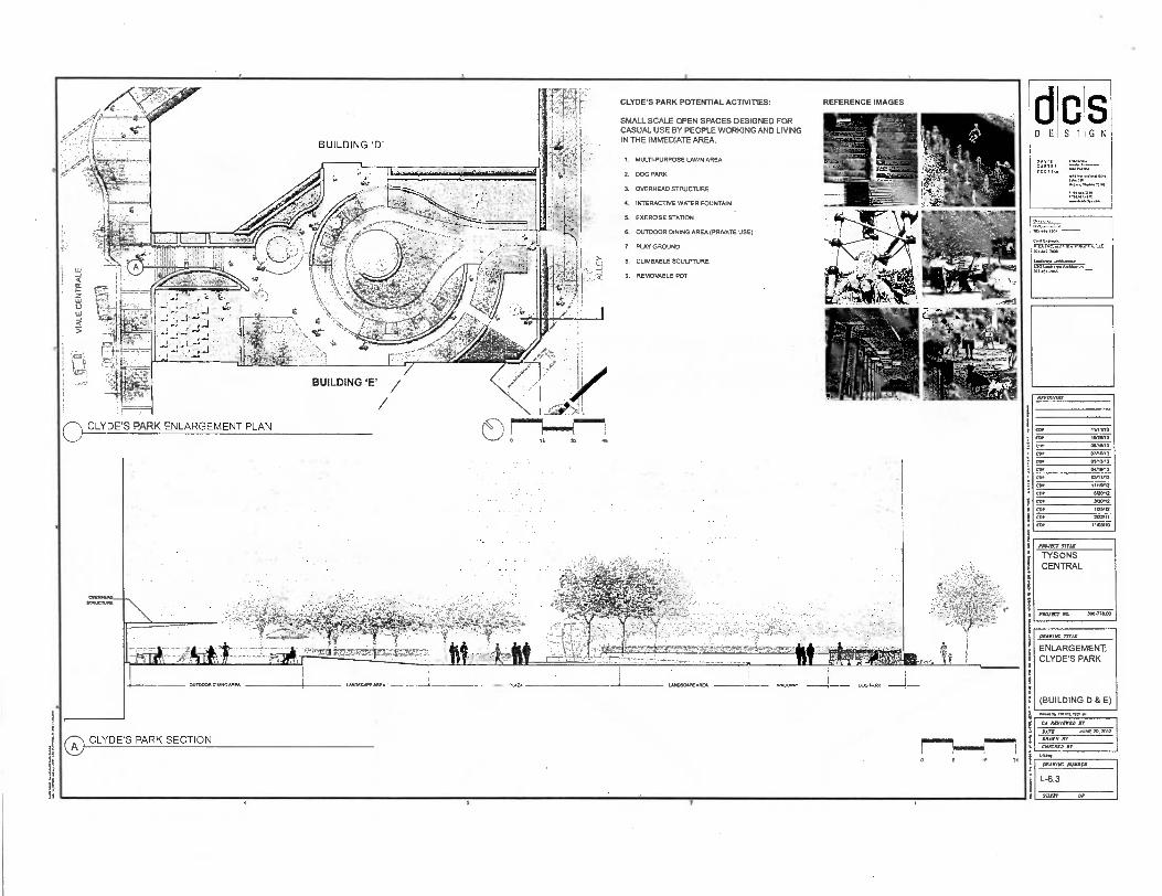
MINT 1711.1.
TYSONS CENTRAL
PROAECT /13 300475.00
D E S I
1,11.101111111100,1021
COP
COP
Cot
Co5
COt
COP
CO7 COP
COP
COP
CD•
cop
9
9 1
(BUILDING D & E)
00IVII7C 77112
ENLARGEMENT: CLYDE'S PARK
S G N
Ammons
CA ItC71171TO B7
BAIT JUNE M. 2012
BILAWN OY
ClOrlaD B7
BAAVIIIC MIBBS1
L-6.3
SILLY Or
It 32
CLYDE'S PARK POTENTIAL ACTIVITIES:
SMALL SCALE OPEN SPACES DESIGNED FOR CASUAL USE BY PEOPLE WORKING AND LMNG IN THE IMMEDIATE AREA.
1. MULTI-PURPOSE LAWN AREA
2. DOG PARK
J. OVERHEAD STRUCTURE
4. INTERACTIVE WATER FOUNTAIN
5. EXERCISE STATION
OUTDOOR DINING AREA (PRIVATE USE)
7. PLAY GROUND
8, CUMBABLE SCULPTURE
9. REMOVABLE POT
REFERENCE IMAGES
O CLYDE S PARK ENLARGEMENT PLAN
A CLYDE S PARK SECTION
a
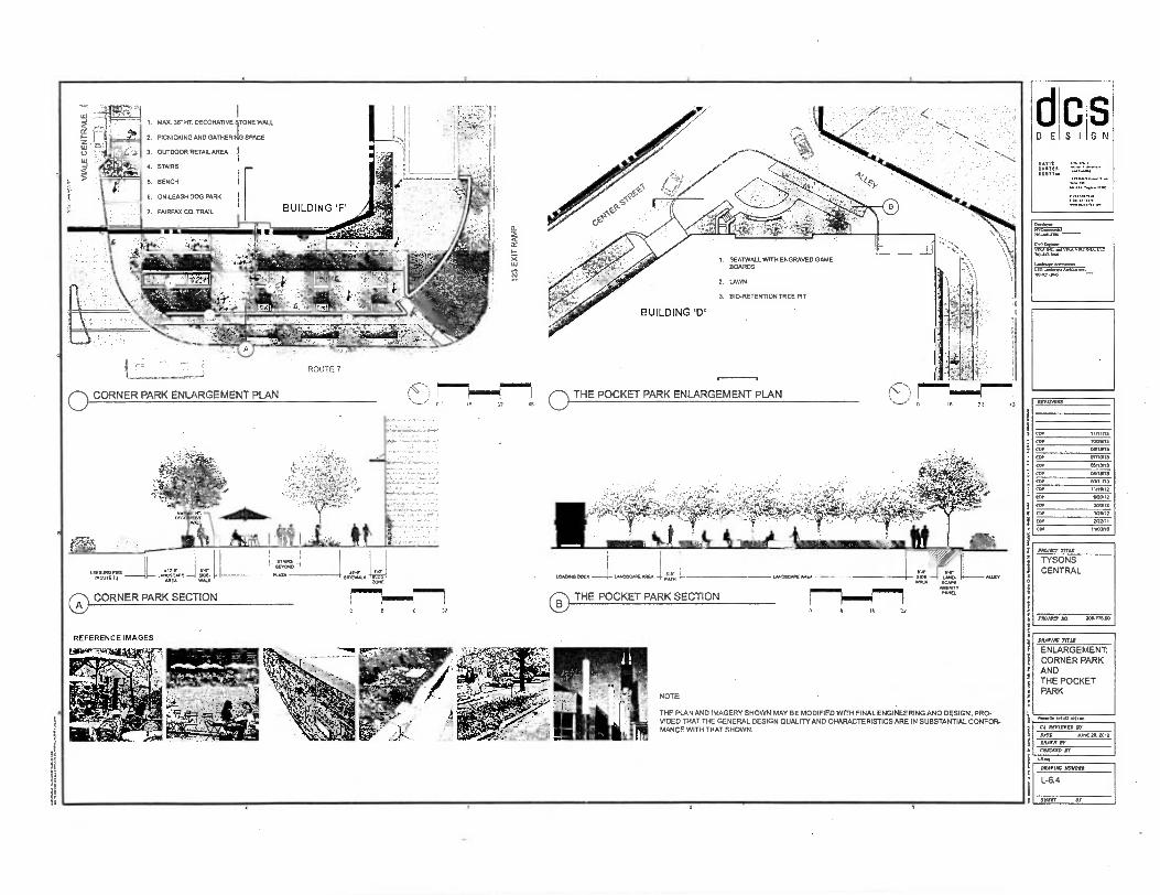
11•101t
1. MAX. 36 HT DECORATIVE 9TONE WALL
g ,
- 2. PICNICKING AND GATHERI SPACE
3. OUTDOOR RETAILAREA
4. STAIRS LLI• •
5. BENCH
O. ON-LEASH DOG PARK
7. FAIRFAX CO. TRAIL
THE POCKET PARK ENLARGEMENT PLAN Is 52 43
COP 11111113
COP 10211113
CYO 0413113
COP 07,10113
COP 03113113
CUP ognin,
COP 03111113
COP Ilnen2
COP li/20112
COP 340112
cop lastix
OPP 3/22111
COP 11103110
PROM, rfra
TYSONS CENTRAL
PROM, PIO. 30677300
DRADIAC. TITLD
ENLARGEMENT: CORNER PARK AND THE POCKET PARK
1.•10.111111,0 so•
Cl RIVIEDZD Dl
OATS JUNE 30. 2012
DRAWN AT
CNRCRID ST
1.4.4
NOTE:
THE PLAN AND IMAGERY SHOWN MAY BE MODIFIED WITH FINAL ENGINEERING AND DESIGN. PRO-VIDED THAT THE GENERAL DESIGN QUALITY AND CHARACTERISTICS ARE IN SUBSTANTIAL CONFOR-MANCE WITH THAT SHOWN.
RlDISIONS
DRAWING MJW8CR
L-6.4
311551 Or
S G N S I
NU 442.7,00
Afflumer... /10.111.100

Po. 1.41,13. Pliatoo 1 NOTE:
THE PLAN AND IMAGERY SHOWN MAY BE MODIFIED WITH FINAL ENGINEERING AND DESIGN, PRO-VIDED THAT THE GENERAL DESIGN QUALITY AND CHARACTERISTICS ARE IN SUBSTANTIAL CONFOR-MANCE WITH THAT SHOWN.
O BUILDING 'B'
4-
MVP ;.$A .
AVIV
BUILDING 'A'
BUILDING 'B'
0 SKY PARK (PUBLIC SPACE) ENLARGEMENT PLAN •,—./ 2 16 32 OP
PRIVATE AMENITY SPACE ENLARGEMENT PLAN
1. UPPER TERRACE
2. CASCADE WATER FEATURE
3. SCUPLTURE
4. LOWER TERRACE
5. OUTDOOR CONCESSION AREA
B. RECREATION AREA/ SPORTS COURTS
D,C..CC CALI. •
7j2i
7775 32. 48
I. OUTDOOR FIRE PIT
2. POOL
3. WATER FEATURE
4. OVERHEAD STRUCTURE
S. HOTEL LOUNGE
B. LAWN
7. REMOVABLE POT
CD SKY PARK SECTION 7"." 6"'"7
8
REFERENCE IMAGES
PRIVATE AMENITY SPACE SECTION 0
0 SKY PARK SECTION
lb 31
dcs DESIGN
AVIS
I COTT or .1.17*PO.
Ostm.OolOPPOIO
RUMPS
1.1.t.
Looft, .41mm:
REVISIONS
11,11/13
COP 10P21/13
COP 011/12/13
COP 0,110/13
COP 05,13/13
cur OUIPP13
Ctn. 03/1.3
COP 11116,12
COP 6/20/12
COI 31=12
COP irem ' COP 2,22,11
COP 11103/10
PROTECT ma TYSONS CENTRAL
NAM? 110. 304478.00
BARIUM mu
ENLARGEMENT: SKY PARK AND PRIVATE AMENITY SPACE
L-6.5
VISIT or
CR AMMO BY
LOT ..616 20.2012
MIN BY
CHEERED SY

N E C S I
S DAVIS C•117111 Serrno
701-60430,
Orlt75:1VIKA
La, *we LOC I* O014114045
MAME TITLE
ENLARGEMENT: CENTRAL PIAZZA
sei
INVISIOlB
COP
PAW= rind
TYSONS CENTRAL
PROJICT ALL 309.771.50
NOTE:
0 CENTRAL PIAZZA SECTION = THE PLAN AND IMAGERY SHOWN MAY BE MODIFIED WITH FINAL ENGINEER-ING AND DESIGN, PROVIDED THAT THE GENERAL DESIGN DUALITY AND
lb y, CHARACTERISTICS ARE IN SUBSTANTIAL CONFORMANCE WITH THAT SHOWN.
REFERENCE IMAGES
BUILDING
-
BUILDING 'B'
BUILDING 'F'
1. WATER FEATURE
2. SEAT WALL
3. DROP-OFF AREA
4. SEATING AND GATHERING SPACE
5. BOLLARDS
E. OUTDOOR RETAIL AREA
7. REMOVABLE POT
BUILDING 'A'
0 CENTRAL PIA77A ENLARGEMENT PLAN
BUILDING 'D'
22
11111111111111111111111111,,A ■
L-6.6
SMUT Or
CA ALVIIIIED Br
PATS JUNE 20.2012
oR 5'R 2?
CJISCNSO Br

O SKY PARK O METRO PLAZA
NOTE:
THE PLAN AND IMAGERY SHOWN MAY BE MODIFIED WITH FINAL ENGINEERING AND DESIGN, PROVIDED THAT THE GENERAL DESIGN QUALITY AND CHARAC-TERISTICS ARE IN SUBSTANTIAL CONFORMANCE WITH THAT SHOWN.
dcs DESIGN
•
MAIM TITLE
ILLUSTRATIVE PARK VIEWS
Proms lintni.TI
CA itrernro FY
DAM JUNE 20. 2012
MA. Or
CMICICED Br
MAME MUMMA
p
T
REVISIONS
11/111.13
CoP 0/20/13
CO, 08/13,13
07/10113
cop 0113/13
COP
CO, 03111/13
11/19/12
cop 420l12
cor 313002
COP 23/12
COP 2122,11
COP 1 UON10
MN= 7171C
TYSONS CENTRAL
PROJECT ALL 306771.00
L-6.7
711111 OF

S I D E
OAP'S CAMP SCOT,
S G N
MOM TITLE
ILLUSTRATIVE PARK VIEWS
LAO%
is
11171310I6
COP
COP
COP
fOr COP
COP
lM
COP
COP
c9P
cOP
COP
COP
PROMO TITLE
TYSONS CENTRAL
BAWER YO. 200-77000
0 LEESBURG PIKE (ROUTE 7) CLYDE'S PARK
NOTE,
THE PLAN AND IMAGERY SHOWN MAY BE MODIFIED WITH FINAL ENGINEERING AND DESIGN, PROVIDED THAT THE GENERAL DESIGN DUALITY AND CHARAC-TERISTICS ARE IN SUBSTANTIAL CONFORMANCE WITH THAT SHOWN.
CA REVIEWED BY RATE NNE 20.2012
MAN JP
Man, BY
IRAVAX MIAMI
L-6.13
SHEET Of
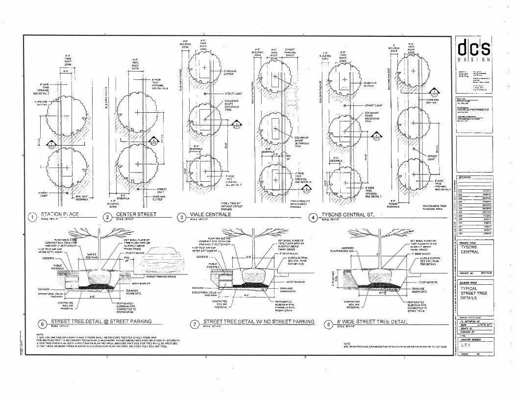
F.D• SIDEWALK
SHAPECOLUMNAR
STREET LIGHT
DECIDUOUS TREE
Alit
rat II!
S I D E S
N
707 44.430.
‘.4,5T-..t,ViVA VIRGINIA. LE. 101.1.12,20,0
lanic.e..senive LSO 710.1.10.0
REVISIONS
11/11/13
C91. RIGNI3 COP 05/t5in COP mon3 car 05.13
ER? 03/11/13 WA 11115212
ADP SRCVI7 REP 730/12 CDP 105,12
2/01,11
cop 1 .0113.
PAWN,' Mil
TYSONS CENTRAL
MA=At 30677.00
IRA BlUE TITLE
TYPICAL STREET TREE DETAILS
Wouo. Irstu13.1k20••
El REHIRED Jr DATE 4.EVKOU 2012
MANE IP
CRACKED Jr
LTG. TREE
ROOT ZONE
A-O BUILDING
ZONE
MADE TREE OPENING. SEE DETNL 7
W DE TREE OPENING. SEE DETAIL 7
11111111111111
I I CUR! GUTTER
4111 I'.
SIDEIARAX CONTIGUOUS TREE PLUM/1G AREA
VARIES SEE PLAN
PERFORATED SUBDRAIN PIPE, CONNECTED TO STORM DRAIN
NOTE: SEE ARCHITECTURE DRAWINGS FOR STRUCTURE SIRS AND SUB-GRADE CONDITIONS
NOTE I SOIL VOLUME FOR CATEGORY III AND N TREES SHALL BE 700 CUBIC FEET PER SINGLE TREES AND FOR 100 CUBIC FEET IN SECONDARY PEDESTRIAN ZONES WHERE PAVING ABOVE TREE ROOTING ZONES IS NECESSARY. 2. FOR TWO TREES PLANTED IN A coNTIGuous PLANTING AREA, 503 CUBIC FEET SOIL PER TREE SHALL BE PROVIDED 3 FOR THREE OR MORE TREES PLANTED IN A CONTIGUOUS PLANTING AREA 400 CUBIC FEET SOIL PER TREE.
CURB AND GUTTER
2
O TYSONS CENTRAL ST. • SCALE 2,7•2-o•
f•'
frd PUBLIC
MERCED PLANTING SOIL MIR
low it 401700T BARRIER
•
'42'1'717NRRAMI
N DRAINAGE AGGREGATE
SET BASAL FLARE OF TREE FLUSH 74TH OR RU.170'4E/WE FINISH GRADE
3. DEEP MULCH
CURBS GUTTER. SEE CIVIL PLAN FOR DETAILS
COMPACTED PERFORATED COMPACTED
SOIL MIX SUBDRAIN PIPE. SOIL MID
PEDESTAL CONNECTED TO PEDESTAL. STORM DRAIN
0 STREET TREE DETAIL W/ NO STREET PARKING, ® 8' WIDE STREET TREE DETAIL scAl unr•o• SCALE irr.r.cr
Er WOE TREE
OPENING, EE D SEE 7
CURB AND GUTMR
1
?./>2
lorw STATION PLACE SCALE 1/5, V.Ir 0
E.O. TREE
ROOT ZONE
E.0 SIDEWALK
1•7 BUILDING
ZONE
0 CENTER STREET SCALE IATAT.7
STREET LIGHT
E.A TREE ROOT ZONE
V MADE TREE OPENING. SEE DETAIL S
STREET LIGHT
CURB AND GUTTER
•
117-0. SIDEWALK
• -0• BUILDING TREE
ZONE ROOT 1"- ZONE
COLUMNAR SHAPE DECIDUOUS TREE
24-
ERROR TREE OPENING, SEE DETAIL
TYPE 2 TREE PET PATH STREET PARKING
STREET PARING
SPACE
TREE ROOT ZONE
BUILDING ZONE
CURB AND GUTTER
BU
ILD
ING
FA
CA
DE
STREET LIGHT
.C.OLA,EUMNAR
DECIDUOUS TREE
Alit IIW £1
,011Pir
TYPE I TREE PIT WITHOUT STREET PARKING
C WIDE TREE OPENING. SEE DETAIL 7
PAP TREE ROOT ZONE
BUILDING ZONE
PLANTING MA COMPACT SOIL TO ALLOW FOR MAX. 7 SETTLEMENT
1.112. TO 7 PAN GAP AFTER SETTLEMENT
GEOGRID
SET BASAL FLARE OF TREE FLUSH 00TH OR SUGHTLY MXIVE FINISH GRADE
7 DEEP MULCH,..;:i 77\32,`, FOC
' • !
PUBLIC SIDEWALK
DRAINAGE AGGREGATE
GEOGRID
STRUCTURAL CELLS TRIO HIGH
COMPACTED SOIL MIX
PEDESTAL
PERFORATED SUBDRAIN PIPE. CONNECTED TO STORM DRAM
PLANTING MS COMPACT SOIL TO ALLOW FOR MAX. 2- SETTLEMENT
I-1/7 TO? AIR GAP AFTER SETTLEMENT
GEOGRID
PUBLIC SIDEWALK
SET BASAL FLARE OF TREE FLUSH WITH OR SLIGHTLY ABOVE FINISH GRADE
7 DEEP MULCH
CURB & GUTTER. SEE CIVIL PLAN FOR DETAILS
DRAINAGE AGGREGATE
GEOGRID
STRUCTURAL CELLS TOO HIGH
ROOT BARRIER
O VIALE CENTRALE SCALE
STREET PARKING SPACE
ROOT BARRIER
0 STREET TREE DETAIL @ STREET PARKING SCALE 10,41.
IRANIAN NONNI*
L-7.1
DRIER? OP

d D E
C S I
S G N
1711111 On 71 on
mm /01-4.71/111
CFO Evertot VIRA AC••1 7111.1 MOO, Lle /1.4.177101
1.1,71oge.olliono
/07171117200
1.02710[1111111.1121w
MIIE1014
PIVIECT MIS
TYSONS CENTRAL
PRICEY EEL 30.1-7PAW
O STREET TREE / BIO-RETENTION (TYPE II) SCALE
LANDSCAPE AMENITY PUBLIC
PANEL SIDEWALK
O 8' WIDE RAIN GARDEN PLAN SCALE usNILT
]'PVC PIPE DRAINAGE AGGREGATE
SUBDRAIN PIPE (SEE CM MACS.)
SU BGRADE
FLOW THROUGH CURB
ROOT BARRIER
RIP-RAP
ATRIUM SURFACE DRAIN
RIO-RETENTION PUNTING SOIL MUDPER FAIRFAX COUNT...STANDARD REFER TO COUNTY PFM
LIMITS OF PLANTING EXCAVATION
FILTER FABRIC
CD 8' WIDE PLANTING STRIP / BIO-RETENTION SCALE 1/2, 1,17
to
ROOT BARRIER FILTER FABRIC
SIC-RETENTION PUNTING • SOIL MUDPER FAIRFAX COUNTY STANDARD REFER TO COUNTY PFM
LIMITS OF PLANTING EXCAVATION
SUBDRAIN PIPE (SEE CML MSS.)
DRAINAGE AGGREGATE SUBGRADE
0 8' WIDE STREET TREE / BIO-RETENTION SCALE 1.2-A1'tr
ATRIUM SURFACE DRAIN LESS THAN WA.
SEE PLAN WO-RETENTION PLANTING SOIL MIX;PER FAIRFAX COUNTY STANDARD REFER TO COUNTY PFM
ROOT BARRIER
PVC PIPE
SUBDRAIN PIPE (SEE CML CMS.)
BOA/WE
O PLANTING STRIP / BIO-RETENTION SCALE IS, 1,
•
ROA LANDSCAPE
AMENITY PANEL
LESS
SEE PUy1/..,;.:-.:
B10-RETENTION PUNTING SOIL MIX,PER FAIRFAX COUNTY STANDARD REFER TO COUNTY PFAA
GEOGRID
STRUCTURAL CELLE TWO RIGS
FILTER FABRIC
ROOT BARRIER
SUBDRAIN PIPE (SEE CML VASS.)
DRAINAGE AGGREGATE
0 STREET TREE / BIO-RETENTION (TYPE I) SCALE W.V.'
SUBGRADE
RIP-RAP 7 PLANTING
THROUGH TEE SIDEWALK THR N. SOIL UNDER
PLANTING EXCAVATION; SCARIFY
FILTER FABRIC
DRAINAGE AGGREGATE
RIP RAP
SURFACE
DRAIN
PUBLC BlF SIDEIMALK
O LESS THAN 8' WIDE RAIN GARDEN PLAN BLUE NPAINV
STREET PARKING SPACE
GEOGRID
STRUCTURAL CELLS TINO HIGH
LESSMANS. , SEE EXAM
BOO-RETENTION PLANTING SOIL MULPER FAIRFAX COUNTY STANDARD REFER TO COUNTY PFM
ROOT BARRIER .
SUBORAIN PIPE (SEE CML CMGS.)
DRAINAGE AGGREGATE
FILTER FABRC
SUBGRADE
SWIM find
TYPICAL RAIN GARDEN DETAILS
CA RETIMD ST Dart ARE 10.201]
ORM, Br
CHECKED El
DRAIITAC NOWIltH
L-7.2
SHEET OP
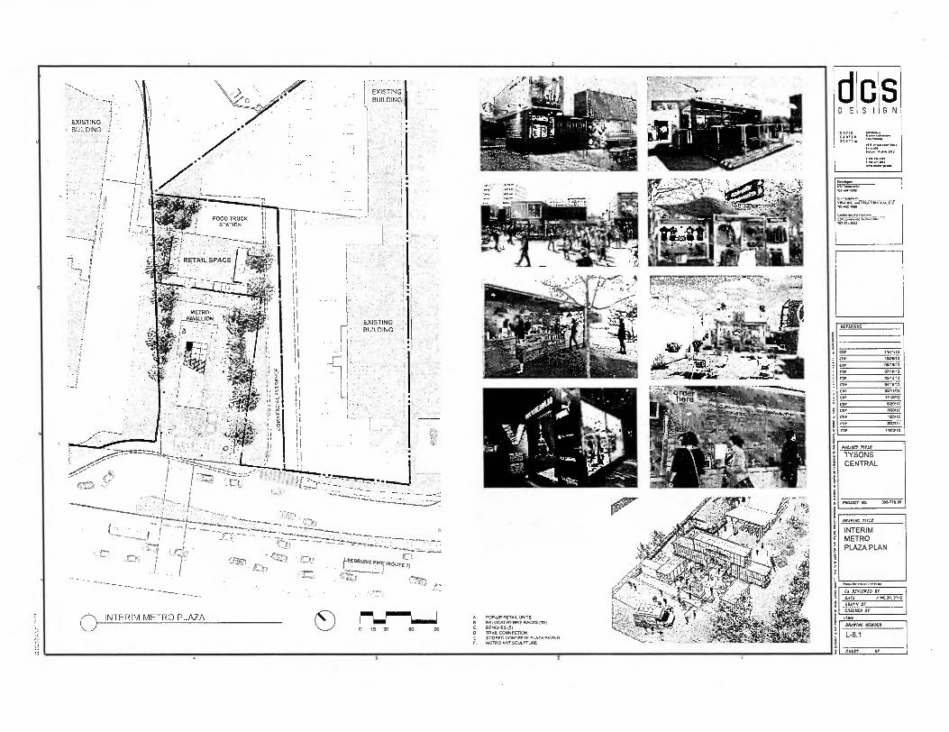
'
1
•
(13g, ins, 4!S5
-411 CA AIVIEVED BY
/UNE 20. 2012 DATE
BRAWN BY
MCAT° BY
as, POP.UP RETAIL UNITS RELOCATED BIKE RACKS 001 BENCHES (3) TRAIL CONNECTION
1.1SCEOTRROEDARCIONSrULEPTUTE PR'ZAE PADING
ci D E S
PROJECT TITLE
TYSONS CENTRAL
300-778.00 PNUECT
S G N
REVISIONS
as, 11111113
'wan, fp! 08/15,13
(151, 07/1.3
AMY OVILIJ
,De
CD, Min]
11/10/12
6/20M
COP 1,30, 12
cOr 1./12
EDP 2.42/11
11/01,10
MARINE MIS
INTERIM METRO PLAZA PLAN
DISTORT NUMBER
L-8.1
SHUT OE
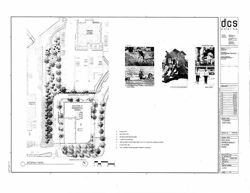
SPAS
SW,
FRANCT
TYSONS
CENTRAL
MALT MA 3011.Ttt400
EX/STING
r# CLYOCS f BIJILDING
1 L171.
ti AST
I
— — —
1 .
I . :".:'7',..,•::-.EL
...
I ••; I rle LTif.it ,, .1 cc
P71,
' , itrt81
PARK TRAIL
115055 CENTRAL STREET 7-7!'
OPEN LAWN
PARK BENCH (S)
ON LEASH DOG WALKING AREA
.1.1100 SF. PLAYGROUND
IRA; CONNECTION BETWEEN PARK TRAIL AND CLYDE SITE (POSSIBLE STAIRS/
S . WOE PARK TRAIL
TRAIL CONNECTION TO ADJACENT PROPERTY SIDEWALK n::11V-:. •
' 7- '7.3r.: -:2q.5":=11;(67. ;•Aao• INuolfix ION). ttf2,o
LEESBURG PIKE (ROUTE 1,
S I G N
.0/C /0.140-a.
?VI= VIA V SO IA A Llt 701..7,1100
Lambe, Melibee.c LEA)
AtVISIONS
DAAPIAC TITLE
OFF-SITE
IMPROVEMENT
INTERIM
PARK
CO MAIMED AY
DATE JUNE 20. 2012
DRAIN AY
[IMMO Jr
DRAPING RENDER
L-8.2
SAAR IF


4.
\
,
- - • Loam
ttrRIBS -
1y} ERNATE MAXIMUM RESIDENTIAL
BUILDINGS "E" AND 'F"
111.1 r ---
ALM nitiC DATA (RESIDENTIAL ORTON E AND F)
FOLD. A TYPE a COISTRUCI.
IMMER GT 570113 25 MENG 14000 30000
USt 000A BUILDING ECM PRINT .915 SF
FULLY SM... PER 17FPA 13 ITS NO .1.1. RATING 2 HOUR
RCOF TYPE CLASS 3A
BUILD. B TYPE Cf CONSTRUCTOR 18
WANT Q STONES 34 NW. MOO 400.00
USE GROUP B WED. FOOT PRI. ion SF
FULLY SPRIMIRED PER RNA 13 YES HO FOE WALL RANG 2 HOUR
ROOF ME CUSS 3A
BUIDING C OR OF CONSTRUCTER
NIMBER OF STOOPS 32 BUIL.° HEW 3100
. GROUP BUILD. f021 PRINT 1;311 SF
FOLLYSPROBILERED PER MN 13 ITS too ENE W. RATING 1 HOUR
ROY TYPE CLASS 3A
MALDING TR OF CONSTRUCTOR
NUMBER Of SICRCS 26 MD. HECHT MOO
USE GROUP B ENID. F007 PRINT 14.8. SF
FLU, YRINK.RED PER NEPA 13 aZ ITS DM WALL RANG 2 HER
.f Me CLASS 30
BUILDING TIM Cf CONSTRUCTION IR
HINBER Cf STOICS 16 MALMO HEIGHT 200
USE GROUP B BUIDNG NOT PRINT 21,782 7
MLV 97.023. POI RNA 13 WS NO ORE WALL RAT. 2 HOUR
• ROOF TIPE 0,55 3A
WM. r TYPE Of OMSTRUCTIOR IS
NUMBER OF STORIES 14 DMZ. HMO 400
1.17 GROUP 8
MEMO 001 111611T 1.874
FULLY SP...1.0 PER BRA 13 1ES NO ME WALL RATING 2 1.111
ROY T. MASS 3A
/661174T 1 F3750
00101r5 KMULAJI FIRE A.SS FOR FIRE LANES (450 PSF LAT LOAD RAW) "0104
- > W HEIGHT
- DENOTES ACCESSIBLE ROUTE
- oomEs wow 727114R FIVE ADZE. WARMS (450 R MS LOAD RATED)
11./ 9 STORY
TRY G.,
4/141.
WAIT
(4149j,,
=
----------------------
..................
,27: (BC:
- -• - 7
DBi 007. 7WR RRYNNNIS,
N ALL ROADS PROPOSED BY THE PROJECT, AS WELL AS AO.NING ROADS; THE CLASNICATIONS OF THE ROADS (11. ARTERIAL. COLLECTOR. ETC.) MONO BE NOTED. (TO BE PRIMO.)
2) LOCATOR 000 051040x5 Of ALL FIRE ACCESS LANES AND TURNAROUNDS; VEHICLE ACCESS TO NT REAR Or BUILDINGS, INCLUDING INTERIOR COURTYARDS FOR SICK-BUILD DONUT-SHAPED 01J.INGS, NEEDS TO BE 5610115. (PROVIDED)
3) ARR. NACRAMS (10CATING INERE EMERGE/10T VEHICLES CAN ACCIYS BUKTINGS. (PROVIDED)
4) 011ONSONS Or THE MTN. BETWEEN THE PORTIONS OF THE ROADWAY 11101 ARE ACCESSIBLE TO ORE TRUCKS ANO THE FACADES OF NE INKOINGS. ME TARGET DISTAXCE SEMEN 15 AND 30 NET SEPARATOR. (PRON.)
5) IMPROVEMENTS PLANNED FOR THE AREA BEIWEEN THE PORTIONS OF NE ROADWAY THAT ARE ACCESSIBLE TO ME NUNS AND TIC FACADES OF DIE BUILDPIGS, ROLUING PARKING LANES. GARAGE PODIUMS. LANDSCAPED AREAS. STEEP 70/ 113, SIDEWALK; PLAZAS, TAROT OUTDOOR SEATING AREAS. STEPS. PLANTER;
7ULPTURE3. ETC. (P00700) 8) CLEAR IDENTIFICATION or BUILDING FOOTPRINTS, CANTILEVEREO EXTENSIONS,
PERNOUSES, BALCONES, PAT.. ETC. (TO BE PROVIDED) 7) HEIGHTS OF NE PROPOSED BURIN. FOR BUILDINGS 111114 MULTIPLE HEIGHTS 017
TO sm., BANS, TIC HEIGHT AND NUMBER OF STORIES OF EACH BUILDING scalon NORD BE CLEARLY NOTED. (PROVO.) LocAnox Of OVERHEAD UTILITY LINES. (711 BE PROVO.)
(1) IDENTIFICATION OF CONSTRUCTOR TIPS FOR EACH BUILDING; TOR MULTIPLE MUM. LOCATE0 ON A 57GLE GARAGE PODIUM, THE CONSTRUCTION TYPE FOR EA. BUILD. ALSO BE IDEHIIIIED - NC GARAGE PODIUM CAN BE IDENTIFIED AS A BLOCK. B.1 CAM BUDDING IDENT1FIED SEPARAIELY EACH PORTION Of STRUCTURE WIN A DIFFERENT corisrRocnox TYPE 15 CONSIOEREO A SEPARATE BUM.. STRUCTURES THAT ARE SEPARATED
00 A FIRE WALL ARE ALSO CONSIDERED SEPARATE BUILDINGS.
(TO BE PRONGED) 10)TTPE OF 1.110PIG SIM NAM. (71117/STINI/NON-GMBUSTIBLE). TYPE OF
SPRINKLERS (TYPE 13; IF III
PLEASE EXPLAIN). AND ROOF ME (CLASS A PREFERRED). (TO BE PRON.)
INLOCATION OF PROPOSED BUILDING ENTRANCES, 0001 PEDESTRIAN AND VEHICULAR; ACCESS DOORS ARO ELEVATORS, 10CLUING REDEVAC ELEVATORS SHOULD BE NON ON THE FON ALSO. NY iNTEROR ROUTES AVAILA. FOR NEROMOT VOLE EASE, SUCH AS SUITABLY SITED DRIVEWAYS THROUGH PARKING GARAGES A. COURTYARDS. SHOULD BE DELINEATED. (10 BE1/10110EIN
12)LOADINO AREAS AND INENER PREYARE ACCESSIBLE TO EMERGENCY PERICLES, (PROVIDED)
13)ACCESS TO ACTIVE COURTYARDS (ESPECIALLY MR POOLS, TENNIS COURTS ETC NEEDS TO BE SHORN - HOT NA THE MEDICAL 5747 GL-7 TIIERE. 111111 THEIR EOLIPPENT. MICKEY, (10 BE PROVIDED)
1A)ALL ME LANES OVER STRUCTURAL PARKING OR UNDERGROUND VAULT SHALL BE OESIONEO FOR 450 PSF LOAING. (70 BE PRIMED)
VA STATE CRIO HRT( (Y. B.3)
GRAPHIC SCALE
• •
( rzrr Lmb • SO
tEENseorfo STATIC41
-
FIR
E A
CCE
SS
PLA
N
VIKA REVISIONS
REY KOOKIER 11, 2013 REV 4C1 XL 2013 REV AUGUST 15, 2013 REV JAY 10, 2013 REV MAY IS 2013 RN APRIL I4 2013 Nv MARCH 11, .13 REV NOVEMBER 1; 2012
REV NE N. 2012 REV MARIN 30, 2012 REV YHUARY 25, 2012 DA1; FEBRUARY it 2011
NS iA OWN.
SCAM 1-.50
PROJECT/PILL NO.
1411403
WET 140.
S-2
r /
3

ma3,1
■11 . a
aa
e•S
-04 Cux) ••
■ • ••
•- e•
Caa'aleva
latfa
rtaa
avo
w K
a=
Vai
'Mt)
/ *IT:4 -to
m.., .
10
10
1:0 3.0
.1103
ar V.
NO
SX
ravoru
sni • som
a .. • to
st• •••• 3er.so
nn
• sno
w., •
I L.Z.,-----5,
i/ o 0 IVI 4K1 /
' , ,
r'' , /'t 0, .w.../ .. , , ",,,J, , _044/ 1 Nut was . • -.... ,.. . col R11.0 ..- .... ...",...:„.....„„
..: . ..,
...........+:: \
w,,,,, TWOC/i1 111.1WATE ,
L'44'01,* .,Z. '141* .-.4'• 0:.
r---N, 4011
4-
.
,.. 10: .. _
. / *4- ,
, . .4, 6 40, ,,,,, Fat4riatrier4 .,
4 . .,.
, / / - '.`..... -4,. / , 4. , _„„• 0 -..: ' ./ \':-------
..... PREP 1111PCIORT sli
MD UOOTT RELOCA :v. N•ty 4.• 'C. 1-',.ols =ram - a 7ors,t • ) \ ,...,- • f . Ad, ' AM-2 2.t. ,, fit • ,,,, . IHE PM o er , ■
A \ '
ff="64(7 STATUS
CURB PARKING
WAIVER REFERENCE & SPACING
l''''' '-' -'1 DRIVE / INTERSECTION
STREETSCAPE
SIGHT DISTANCE ,' ApproVeR Or V . ce ......"14 1 '
i F..5Tr-,,_" . • , . 4" s' / /,,,...s D'IER COW.C.271,G, .1. /-. "..,4 ", • " 3/26/2013 .... , ... \ \...
1 V.:4‘ ' ' ' C f -,■ : WALL IS IT Or CURD • . . . /
..------ 1.jr,„ • GAR ARO / /.„zr,.....) / / / r
POW,' GRACING / R.,. / 405.,, "TriZt --; ,.. , ,
AI ‘......„, .7 /
3/26(2013 " 11.ree33,3 -' .4r40. N. 111 f .0. FUXR 0,1300410 (MO '' \ -__________. /
TY
SONS
CE
NTR
AL
PR
OVI
DEN
CE
DIS
TRIC
T F
AIR
FA
X CO
UNTY
, V
IRG
INIA
• ..... .Z' .. A---.- ._ yr./ ---.. '',!-;,-,--, ..--,., -,..... ,
® 4 --- - •FC P2.:-...'''',-....- --. 1 0„ .i, ,. .•,..--k,, ./,':: ,- .--..._,
/ //. ' - - - - '4. a. .. / .R,.,',4"1. .• --.; 10/.45/2011- 'W, ...' '' . . ''' ''.H. ''i.• A3C/21,0n27231,514RT . .
.- ' 1 WATER ...a.
‘• . 4 ' "li' 1 t 507 ,_, A .e
.' / • ' TOWER w - : - ** •
' °,' ' "--, ., RE7A7 •*„/' .).. ,44, ...- ..., .a,<• AIR, - 4 i Ira N. - ' > \'''\)0" 'Y.■ FC P2 t 6 a _
. ' 1"41
4, ■
. ' ' \ „ , , ..i•,a.4. r4" 214'
'. ' -\ '''1-4.4'06'' ' rii2r It, ,<A4- 1., • . Approved . \ ' • / 7/
Tr ' S RE .... ........................- 11
...1.4, 31 -Ai wIl 6('‘ / 'P'' e•
•.-C7 SOLD. . ' ) D, s 1:3-STOR. • ,..]
0.1:Slt.ilifr At, r .R.
D B. • v W. ..i FC_P3 1`. 1•1
a 0./RB , OD
ell r .
' 1 at •,•, .1 . 'Iliii#.4€:. ' .' • ,*$•:--• \ ‘ \ , , \
- • '511/15/2013 . , '5" \t, \ \ \\N\ \\\
RO
AD
DES
IGN
ST
AN
DA
RD
S S
UM
MA
RY
.. NA . ( „,„„ ,z1z1=-„,tufstmao
' ' t li \ \ ■, •, ,,Aa MPROV. .7. , • Dt.! .7r.f v
14 itk-- ,..., ,..,,, '
www... ESDA1E
j . 1.1111 . U-'....—'CW2a--110W8gorXgr,-121.4VAirl A
iiii`STIOF1-
W.V... " ' )
'Pe \ , X.,.
. /121/GRAMEGM014+ ' i .. ■ \ \ \ ■ 1
liftl ‘, ' I
‘,.... ! i //,.•
\
jj .
1 fo ls'47,": - .1 :E.
.RTD ."&-giw'r -,! i j : 1.7 i'f ' ill 1
AM 2 4 .:.74 ' - Approved _ .. - .
f i ; 1 , ' .-., ',..,7' -r--. /
. 4 1 — 126,2033M k -- , , is
. -A31175. .0, AUW111773CIIM,,,,,,,614-• ...., u'''''''''''" .1aVialmitithrAmortila.
.R. alarA a it lit5515ff*F. ' • . '4110)
'.',13' _ o3 ..„ .,
I
AIVI-2 -6', t Ad ' . A
--.F... .,0P„P572voet, '2 7-: 'KU AM -- -- ' ,Flain'
i. ''-' ' - ''
'n"'
lApprcr,04 ''.. -4 - 10i1'54.0..
'-
.A.■.. a 7..,. ; 10,15,2913 -
PI
W-'34r■ rr"..3.'
a. ... \ \.:''' ...." i i .' AV/ is ! ...A.... v. i ' ; ', f f 1, ..... ,,j` , ,„ ....
. ' ..4% /A / -S. . i .' ' ‘v,\_ \ ',...._. .",......................." A#/e../ / • I \ \ )//,411E W110k21 • , 11 / . /I /
..'".....' / /
.1 ' - a N '' \\is.. .. ■.:N ss---3.- -----)..4, - .. ,„,\:\
'1,,,1 7 \\1,.,.; "----:_„:".-/-,` • / hy
-"",.../, / I ,L,C:le , 0! "‘C I . i di, 41e,
'..-.."'' ,. :"..:. ....::: .---- t Y , i '/` 1),Y .
f.,
i •
of ho .. riN17 C.I....pse
rk.....-
H. • -.--- H,1". -1.1 .. .,, , ' ''' , ' . VW .. - r ., --- --',,,, --k.,„, ,
... --v. . .....-•},R3 .9.,; (,17 ....a&G-WAAISE 8!
o 3.1.. IL • 3 , gig
31.2612011 :: ,'''' i , _
1 ‘ '
, ,,,,,,Alsgz- cll., , ..r.":"■11‘lt- . -: .---. 1■1': /.'
/cm. . --.,- ...-• ..--... , A. - %WA REVISIONS ..._._ .....-. • -1221S-7-F o-j -pli
=Z. .1"4141amkaaaa.,,s„,...„
'- .. - e7---- ' APFINVed "',/ ' ' cue, .2,....................w..-„
lillib '''.‘ j a.... —.,-
---- 7. - - - e .. - ---,.-- 4 •• _ _ __ _ '-'"' - ■•• ...w ' .....0 4" . -"--11-rwa--- : 4, .7---„afa # , ,---
77"- 7. a.lag_.:::r4Li--,- - - . ' --- ' ....
4,.-izir ..“, Isc-&-L--- — REV OCTOBER 2B 2013 m''''94-nip-
- , Allnilk ..1,...,..w.,Aa:MG.1111E4 -...--:„....„.......„..w / -•••••-.-
' . GREE S
Er040 STATieft-- \ - -eft _IR-IaLm-A.r, ),....... _17..._....5;.........„...4.-.....7::"',.,,...j.........-4-.....-----. .- • P 1
.1 1 -.. ) / ---.."
, 7...... . . .
_ .....__..„.. ■ aft:h.oemans
4 .i.:„....... t /
- ..,
c._ ,
.
,
REV MAR. 11. 2013 _...... -...-. cws-.-- Dot 4214U300 A. 2013
es. few. ERG 1 Ruc
. SEE SHEET C-2 FOR ADDITIONAL STREETSCAPE MODIFICATIONS TO ADDRESS VARIATIONS OF THE ELEMENTS WITHIN THE PROVIDED STREETSCAPE MTh.
SCALE 0"
PROJECT/HLE MO. 001080
SHEET M O. 5-3

Summary of Design Standards for Tysons Corner as Applicable toTysons Central •
-
. •
APPROVED 32121112 103 . (2251 (A14.2 _0- VDOT APPROVED 3.212113
20. CM) (AM-1_7) S. (2231 4011.2_1)- VDOT APPROVED 3.242013
CLASSIFICATION
CRITERIA
• " ,-
, LOW SPEED .
. BOULEVARD , ...
', ,, .
. . - i
. . - • .
- •
. . • . . - .
„ . , _.
, COLLECTOR LOCAL SERVICE
' STREET
Raised/Landscaped Median (Table 6, DS-15)
'• u :. R6qi'ed
. . •
. '
, . . . . . . , N/A N/A
• N/A
.... ;
...
Circulator Route (Table 13, DS-6)
N/A N/A "Yes @certain .
bastions • N/A
.
„..•
• • • N/A N/A N/A N/A N/A
.
On-Street Parldng (Table 5, DS-lar
Resuirted
"
-,
- •
.
Required (E) " . — . . ' , • • '•• • ..'
Need Waiver
Approved ":" .10/15/2013 .
Need VVelver
• IFC-P3) . Approved • ,
. 10/15/2013 ." ."
Required (71-11')
Need Waiver (FC_P1)
. Approved 10(15/2013
N/A
'
.
''' N/A
Target LOS gable 2, 05-5)
13-/E . . . -
"....-.• •
E ; " N/A
# of Through Lanes 4-8 Lanes -
• "'" lanes 2
. 2 lanes .
Design Speed (Table 3. DS-10)
. , 40 mph " •• ' " -,,, ' . 25-30 mph . 1'
. . 25 mph or less
Operating Speed gable 3, DS-10)
35 mph •
'1:-/
. .
..V. ' • • •1 . '..: •
' 25 mph 25 mph or leis • V
Operational AnaWs (Table 4, DS-II)
. Requirod •
- . " ' -,,,- DIscretionary -../. - • -' . • 1. - -
• . ' N/A
. N/A N/A N/A
.
. ..
Signal Spacing Operational - N/A N/A • N/A
• -
-..N/A
Unsl5nal/zed,
Full Access Spacing Opertldnal .
Aiovymo Roo, d , N/A , ;• , 200-660
' •
If VI • • • . "
Access Spacing (Table 4, IDS-11)
„, . 325"-660' *See Below 155-660' .. . , .
N/A N/A
•
N/A .
. . • .. . '. N/A .. : ..
Drivewa Spaci Y0 ng . .
...' -, PaUkricted . . N/A • N/A • 1.55' (Table 4, DS-I I)
•
*See Below , -47 . 50' *See Below 50' . .
See Below
Lane Widths (Table 5,05-13) . '.• •-" I i '
. • - ia -li" - . -V- - , . ice
. .;/- - 10'
Streetscape Zone Width (Table 14, DS-27)
- - - ' 15'kungzone lidi
- - 13' lamkaping pane
Need Waiver ' -. - -
, ' PPra -
• •
4'-12' Building
8' sidewalk • • • -* •
,' 16-24m
E sidewalk 6' landscalsing
panel
4'-12' Building
V"- "i7
.
sidevralk
-
,
V-- ..:•,..,, o•I...^7.-..
- 411 I .rt .a.o*vir 1•
n ,....c V:,,. „V
:l."'
Sight Distance (Table 12. DS-23)
385 (305 000) I SS' '7 155'
Bike Lane (Table 15, 05-29)
- N/A N/A N/A N/A . N/A VIKA REVISIONS
stem. med. Icon/db. 24S.34' on Annus Ind Collecort Srarlon Nice
1* en Roes4rwwr It. Psrlelespnas St nusinad In Eh. vklus, 41 ersubrer muss, . Altos le SAIC 54,2,6 00 (I SS) (A14.2_4)-VDOT
1. Dim, AdinSW:mo ,n11 ...< opt Gwe,01 pen., ep...reuenal amts., . steAvrs Mks se SAIC Edning (nor.)
2. Spann{ nt uct 1.4 dtinonocrse< circus!, sn epesoclonslarasn: SSD se 1,230 nun rosornmonsled. •Ireenedion 'racing suplrhs cusselons • 41rOnsos Mown toquIresIS
3. Evaluated on a cats.by.cale Ws, LUESIOBSI 4. II lot Owe, reWertns1 In clunteer I I' for wetn more serener.' In mum .0th C1"11.411 T. Satre ( ,, ...Own, .ff nmp1.20" Pis) bui.t_n - VDOT APPROVED 3.262413 Ylile_Csorall S. Nov +1,11hael reams...ern on sol/marVavonutt wt.. 4.0 het el lew 'seed beJ4vanIt ntsd oprstlens1 • r .nea. Suva 1Selwlono se tmIt,Pl.0. .14..1,...s Ploi se Myatt Sy.. AN,
sway., • Yak Omni.. Bulk1nsDDrIvevrq 140 (ISO (A/1.2_1)-VIDOT ArrROVED 224.24113 - Leeebtrs P1ce so SLAIN A Ails 14
4. Width wy bponslIng on losalon mks. co sob ond arbSdo porkIr4. 4144141nt V 0r545403 1.0r4 0 Rag 70 (131)(AM-2 24 -VDOT APPROVED 321201)
n B(R II. 2010 REV OCTOBER 211, 2013 REV AUGUST IA 2013 REV AA, to. 2013 REV RAY 2013 13.
v AMR lb 200 REv wARG11 11. SOO
PAM 44411.141V■ 4 30,3
SEE SHEET C-2 FOR ADDITIONAL STREETSCAPE MODIFICATIONS TO ADDRESS VARIATIONS OF THE ELEMENTS WITHIN THE PROVIDED STREETSCAPE WIDTH.
DES 0101. ENO RIC
SG,42, 0/0 InoacT/11SE W.
V714110
1 5-4
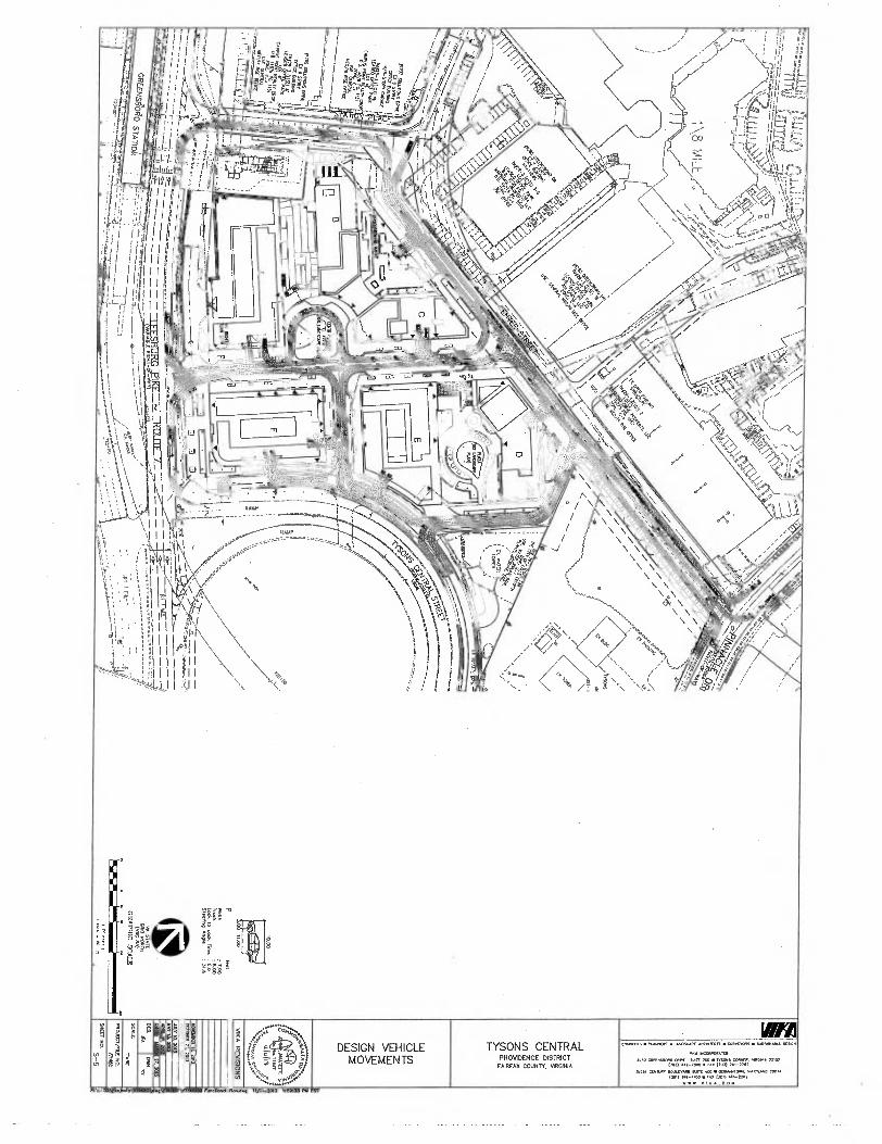
:•\2,202 ■2 V1146C V71.16114 Fun Nand PI .d 2 wit 2013 05T.
TYSONS CENTRAL PROVIDENCE DISTRICT
FAIRfAX COUNTY. VIRGINIA 11111111 DESIGN VEHICLE MOVEMENTS
C•0•CERS • .1.14W4(115 • LANDSCAPE 4110411LC11 • 9-47vINIPS • SUVADIASU 9I9ON
vit4A 114COV•01.700
9100 GAM4511(1.0 CAM SUM 2C41 • TM. CORM. .4,1. 2210) P.) 442-7900 • /AI , 703) 791-2707
20211 (10191.1 .1:01...0 mart 00 • 0:104A141. 0.4. MARYLAND 70.174 Imp, 914-4100 • ro 1301) 916,282
'VFW VI 11A.0011
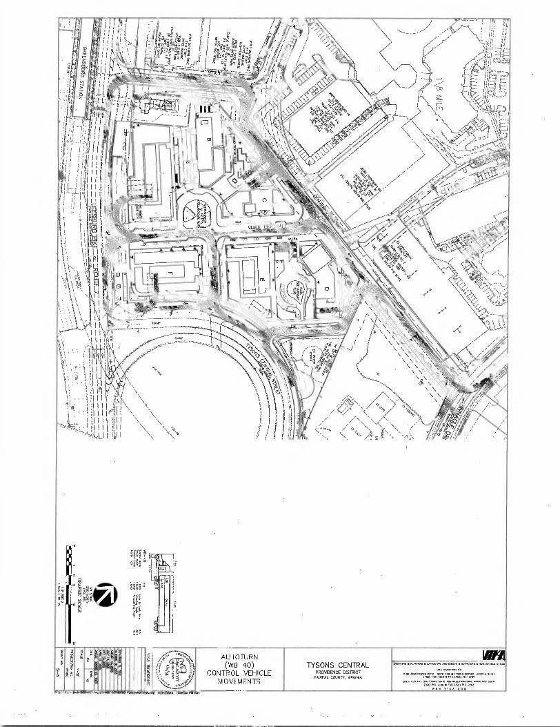
AUTO TURN (Wf3 40)
CONTROL VEHICLE MOVEMENTS
TYSONS CENTRAL PROVIDENCE DISTRICT
FAIRFAX COUNTY, %AROMA
WC441•5 • RANKAS • LANOSCAR .470.71CIS • 9ANt11,15 • %Mu..
••• 1•0010.COMITO . a. Op,rN.0q. pep.,
,70, 447-.0 11 r.a VW) /61-2707
2025I [WWII 00.R0 WIZ 400 • GERIUNTOON. 110111...0 20874 (MO 010-.00 • roa 301, t..-xasx
w VINA.0 0 14
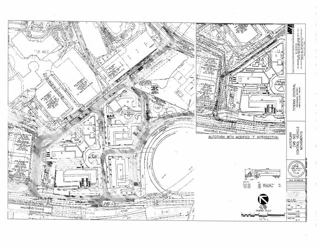
AUTOTURN WITH MODIFIED; INTERSECTION
WS-50
;:r1:71,17r . ST:14 Zr..77Z1' 8 00 Ma:WM.9 Anqle
Min
vE
-le Ergo.

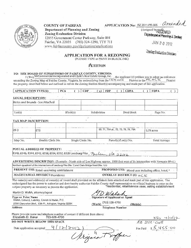
PCA (
CDP FDPA APPLICATION TYPE(S): FDP ( ) CDPA
Lot(s) Block(s) Page No. Deed Book Subdivision
LEGAL DESCRIPTION:
Metes and Bounds - See Attached
ADVERTISING DISCRIPTION: (Example - North side of Lee Highway approx. 1000 feet west of its intersection with Newgate Blvd.) Northern quadrant of the intersections of Leesburg Pike (Rte. 7) and Chain Bridge Road (Rte. 123)
PRESENT USE: Retail uses/eating establishment PROPOSED USE: Mixed uses including office, hotel, * MAGISTERIAL DISTRICT:providence OVERLAY DISTRICT (S): H-C, SC
zorz - pag
Fee Paid $ 51 °Q
DO NOT WRITE BELOW THIS SPACE
Date application accepted: a--1
RZ2011-PR-005 a/"1"--et
(Assigned byntitivED
Di ghtOn of flming Zoriag
JAN ,? 0 2012
ZnigitE igan Mision
COUNTY OF FAIRFAX
APPLICATION No: Department of Planning and Zoning Zoning Evaluation Division 12055 Government Center Parkway, Suite 801 Fairfax, VA 22035 (703) 324-1290, TTY 711 wwwfairfaxcountv.g,ov/dpz/zoning/applications
APPLICATION FOR A REZONING (PLEASE TYPE or PRINT IN BLACK INK)
PETITION
TO: THE BOARD OF SUPERVISORS OF FAIRFAX COUNTY, VIRGINIA I (wo, NVCommercial Incorporated and Clyde's Real Estate Group, Inc.
c-s, HC and Sc the applicant (s) petition you to adopt an ordinance
amending the Zoning Map of Fairfax County, Virginia; by reclassifying from the District to the PTC, H-C, SC District the property described below and outlined in red on the Zoning Section Sheet(s) accompanying and made part of this application.
TAX MAP DESCRIPTION:
29-3 ((1)) 65, 71, 71A pt., 72, 73, 75, 76, 78A 5.79 acres
Map No. Double Circle No. Single Circle No. Parcel(s)/Lot(s) No. Total Acreage 1,,
POSTAL ADDRESS OF PROPERTY: 8348, 8346, 8344, 8342, 8338, 8334, 8332, 8328 Leesburg Pike I
Z-1/9
The name(s) and address(s) of owner(s) of record shall provided on the affidavit form attached and made part of this application. The undersigned has the power to authorize and does hereby authorize Fairfax County staff representative on official business to enter on the subject property as necessary to process the application. "residential, retail/service uses, eating establishment
Martin D. Walsh, attorney/agent
Type or Print Name Walsh, Colucci, Lubeley, Emrich & Walsh, P.C.
2200 Clarendon Blvd., 13th Fl., Arlington, Virginia 22201
Address
Signature of Applicant or Agent
(Work) (703) 528-4700 (Mobile) Telephone Number
Please provide name and telephone number of contact if different from above: Elizabeth D. Baker 703-528-4700


RZ 2011-PR-005
Zoning Application Closeout Summary Report
Printed: 12/6/2013
General Information
APPLICANT: N V COMMERCIAL INCORPORATED AND CLYDE'S REAL ESTATE GROUP, INC.
DECISION DATE: 11/19/2013
CRD: NO
HEARING BODY: BOS
ACTION: APPROVE
STAFF COORDINATOR: SUZANNE LIN
SUPERVISOR DISTRICT: PROVIDENCE
DECISION SUMMARY:
ON NOVEMBER 19, 2013, THE BOARD UNANIMOUSLY APPROVED RZ 2011-PR-005 ON A MOTION BY SUPERVISOR SMYTH
SUBJECT TO PROFFERS DATED NOVEMBER 12, 2013.
APPLICATION DESCRIPTION:
MIXED USE
Zoning Information
Existing Zoning
Proposed Zoning Approved Zoning
DISTRICT AREA DISTRICT AREA DISTRICT AREA
C- 8 5.79 ACRES PTC 5.79 ACRES PTC 5.79 ACRES
Tax Map Numbers
0293 ((01))( )0071 A
0293 ((01))( )0071
0293 ((01))( )0075
0293 ((01))( )0065 0293 ((01))( )0078 A
0293 ((01))( )0076
0293 ((01))( )0072
0293 ((01))( )0073
Approved Land Uses
Zoning District PTC
LAND USE
M FD
HOTEL/MOTL
OFFC/GENRL
RETAIL/EST
REELANDAREA ADO'S WDU'S SOFA EAR NRES LAND AREA
1509 5.79 ACRES 302
TOTALS 1,509
302
Approved Waivers/Modifications
SEE FILE FOR ALL WAIVERS AND MODIFICATIONS
12/6/2013
Zoning Application Closeout Summary Report.rpt, created 02/14/2011 for Robert Harrison, seri num 4159233
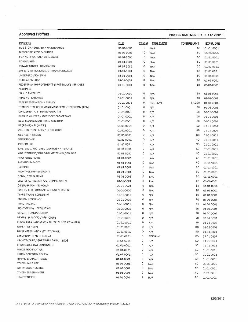
Approved Proffers PROFFER STATEMENT DATE: 11-12-2013
PROFFER DUE TRIG # TRIG EVENT CONTRIB AMT EXPIR. DTE BUS STOP / SHELTER / MAINTENANCE 01-01-0001 0 N/A $0 01-01-0001
BICYCLE RELATED FACILITIES 01-01-0001 0 N/A $0 01-01-0001
HOA NOTIFICATION / DISCLOSURE 01-01-0001 0 N/A $0 01-01-0001
ROAD FUNDS 01-01-0001 0 N/A $0 01-01-0001
PRIVATE STREET- STANDARDS 01-01-0001 0 N/A $0 01-01-0001
OFF-SITE IMPROVEMENTS-TRANSPORTATION 01-01-0001 0 N/A $0 01-01-0001
UNDERGROUND-SWM 01-01-0001 0 N/A $0 01-01-0001
DEDICATION - BOS 01-01-0001 0 N/A $0 01-01-0001
PEDESTRIAN IMPROVEMENTS (CROSSWALKS /BRIDGES 01-01-0001 0 N/A $0 01-01-0001
/SIGNALS)
PUBLIC AMENITIES 01-01-0001 0 N/A $0 01-01-0001
PHASING - LAND USE 01-01-0001 0 N/A $0 01-01-0001
TREE PRESERVATION / SURVEY 01-01-0001 0 SITE PLAN $4,200 01-01-0001
TRANSPORTATION DEMAND MANAGEMENT PROGRAM (TDM) 01-01-0001 0 N/A $0 01-01-0001
CONDEMNATION - TRANSPORTATION 01-01-0001 0 N/A $0 01-01-0001
PURSUE WAIVERS / MODIFICATIONS OF SWM 01-01-0001 0 N/A $0 01-01-0001
BEST MANAGEMENT PRACTICES (BMP) 01-01-0001 0 N/A $0 01-01-0001
RECREATION FACILITIES 01-01-0001 0 N/A $0 01-01-0001
CONTRIBUTION - FCPA/ RECREATION 01-01-0001 0 N/A $0 01-01-0001
USE RESTRICTIONS 01-01-0001 0 N/A $0 01-01-0001
STREETSCAPE 01-01-0001 0 N/A $0 01-01-0001
INTERIM USE 01-01-0001 0 N/A $0 01-01-0001
EXISTING STRUCTURES (DEMOLISH / REPLACE) 01-01-0001 0 N/A $0 01-01-0001
ARCHITECTURE/ BUILDING MATERIALS/ COLORS 01-01-0001 0 N/A $0 01-01-0001
PROFFERED PLANS 01-01-0001 0 N/A $0 01-01-0001
PARKING GARAGES 01-01-0001 0 N/A $0 01-01-0001
PARKING 01-01-0001 0 N/A $0 01-01-0001
FRONTAGE IMPROVEMENTS 01-01-0001 0 N/A $0 01-01-0001
COMMUTER PARKING 01-01-0001 0 N/A $0 01-01-0001
LOW IMPACT DESIGN (LID)/ RAINGARDEN 01-01-0001 0 N/A $0 01-01-0001
CONTRIBUTION - SCHOOLS 01-01-0001 0 N/A $0 01-01-0001
SCREEN TELECOMMUNICATIONS EQUIPMENT 01-01-0001 0 N/A $0 01-01-0001
TRANSITIONAL SCREENING 01-01-0001 0 N/A $0 01-01-0001
ENERGY EFFICIENCY 01-01-0001 0 N/A $0 01-01-0001
ROAD PHASING 01-01-0001 0 N/A $0 01-01-0001
RIGHT OF WAY - DEDICATION 01-01-0001 0 N/A $0 01-01-0001
OTHER - TRANSPORTATION 01-01-0001 0 N/A $0 01-01-0001
HEIGHT - BUILDING / STRUCTURE 01-01-0001 0 N/A $0 01-01-0001
FLOOR AREA RATIO (FAR)/ GROSS FLOOR AREA (GFA) 01-01-0001 0 N/A $0 01-01-0001
OTHER-GENERAL 01-01-0001 0 N/A $0 01-01-0001
NOISE ATTENUATION (STUDY/ WALL) 01-01-0001 0 N/A $0 01-01-0001
LANDSCAPE PLAN REQUIRED 01-01-0001 0 SITE PLAN $0 01-01-0001
ARCHITECTURE/ GREEN BUILDING/ LEEDS 01-01-0001 0 N/A $0 01-01-0001
AFFORDABLE DWELLING UNITS 01-01-0001 0 N/A $0 01-01-0001
MINOR MODIFICATION 01-01-0001 0 N/A $0 01-01-0001
URBAN FORESTRY REVIEW 01-01-0001 0 N/A $0 01-01-0001
TRAFFIC SIGNAL/ TIMING 01-01-0001 0 N/A $0 01-01-0001
OTHER - LAND USE 01-01-0001 0 N/A $0 01-01-0001
WORKFORCE HOUSING 01-01-0001 0 N/A $0 01-01-0001
OTHER - ENVIRONMENT 01-01-0001 0 N/A $0 01-01-0001
HOA ESTABLISH 01-01-0001 1 RUP $0 01-01-0001
12/6/2013
Zoning Application Closeout Summery Report.rpt, created 02/14/2011 for Robert Harrison, seq num 4159233
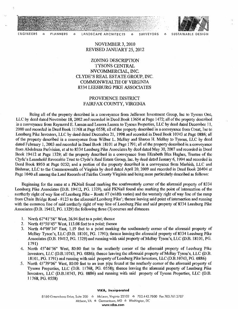
ENGINEERS 0 PLANNERS 0 LANDSCAPE ARCHITECTS
o SURVEYORS 0 SUSTAINABLE DESIGN
NOVEMBER 3, 2010 REVISED JANUARY 25, 2012
ZONING DESCRIPTION TYSONS CENTRAL
NVCOMMERCIAL, INC. CLYDE'S REAL ESTATE GROUP, INC.
COMMONWEALTH OF VIRGINIA 8334 LEESBURG PIKE ASSOCIATES
PROVIDENCE DISTRICT FAIRFAX COUNTY, VIRGINIA
Being all of the property described in a conveyance from Jefferson Investment Group, Inc to Tysons One, LLC by deed dated November 18, 2002 and recorded in Deed Book 13654 at Page 1472; all of the property described in a conveyance from Raymond E. Lassen and Lenora Lassen to Tysons Properties, LLC by deed dated December 11, 2000 and recorded in Deed Book 11768 at Page 0558; all of the property described in a conveyance from Cosat, Inc to Leesburg Pike Investors, LLC by deed dated December 21, 1998 and recorded in Deed Book 10743 at Page 0886; all of the property described in a conveyance from Wilbur L. McBay and Sharon H. McBay to Tysons, LLC by deed dated February 1, 2003 and recorded in Deed Book 18101 at Page 1791; all of the property described in a conveyance from Abdolreza Parivisian, et al to 8334 Leesburg Pike Associates by deed dated May 30, 2007 and recorded in Deed Book 19412 at Page 1329; all the property described in a conveyance from Elizabeth Bles Hughes, Trustee of the Clyde's Leasehold Revocable Trust to Clyde's Real Estate Group, Inc. by deed dated January 6, 1994 and recorded in Deed Book 8950 at Page 0252; and a portion of the property described in a conveyance from Marbish, LLC and Bishmar, LLC to the Commonwealth of Virginia by deed dated April 20, 2009 and recorded in Deed Book 20404 at Page 1040 all among the Land Records of Fairfax County Virginia and being more particularly described as follows:
Beginning for the same at a PKNail found marking the southwesterly corner of the aforesaid property of 8334 Leesburg Pike Associates (D.B. 19412, PG. 1329), said PKNail found also marking the point of intersection of the northerly right of way line of Leesburg Pike — Route #7 (width varies) and the westerly right of way line of the ramp from Chain Bridge Road - #123 to the aforesaid Leesburg Pike'; thence leaving said point of intersection and running with the common line of said northerly right of way line of Leesburg Pike and said property of 8334 Leesburg Pike Associates (D.B. 19412, PG. 1329) the following three (3) courses and distances
1. North 67°41'56" West, 26.94 feet to a point; thence 2. North 45°50'45" West, 113.08 feet to a point; thence 3. North 44°00'34" East, 1.19 feet to a point marking the southeasterly corner of the aforesaid property of
McBay Tyson's, LLC (D.B. 18101, PG. 1791); thence leaving the aforesaid property of 8334 Leesburg Pike Associates (D.B. 19412, PG. 1329) and running with said property of McBay Tyson's, LLC (D.B. 18101, PG. 1791)
4. North 45°46'56" West, 80.00 feet to the southerly corner of the aforesaid property of Leesburg Pike Investors, LLC (D.B.10743, PG. 0886); thence leaving the aforesaid property of McBay Tyson's, LLC (D.B. 18101, PG. 1791) and running with said property of Leesburg Pike Investors, LLC (D.B.10743, PG. 0886)
5. North 45°39'06" West, 80.00 feet to an iron pipe found at the southerly corner of the aforesaid property of Tysons Properties, LLC (D.B. 11768, PG. 0558); thence leaving the aforesaid property of Leesburg Pike Investors, LLC (D.B.10743, PG. 0886) and running with said property of Tysons Properties, LLC (D.B. 11768, PG. 0558)
VIKA, Incorporated
8180 Greensboro Drive, Suite 200 0 McLean, Virginia 22102 0 703.442.7800 Fax 703.761.2787
McLean, VA 0 Germantown, MD 0 Washington, DC www.vika.com
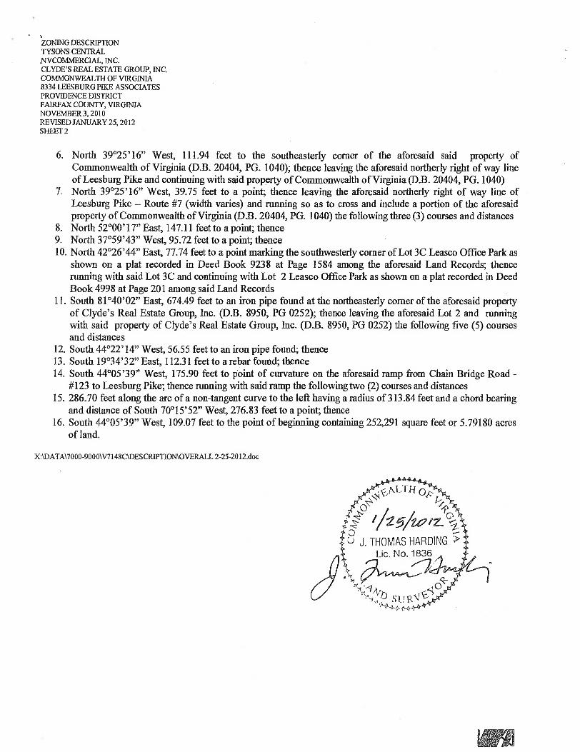
ZONING DESCRIPTION TYSONS CENTRAL NVCOMMERCIAL, INC. CLYDE'S REAL ESTATE GROUP, INC. COMMONWEALTH OF VIRGINIA 8334 LEESBURG PIKE ASSOCIATES PROVIDENCE DISTRICT FAIRFAX COUNTY, VIRGINIA NOVEMBER 3, 2010 REVISED JANUARY 25, 2012 SHEET 2
6. North 39°25'16" West, 111.94 feet to the southeasterly corner of the aforesaid said property of Commonwealth of Virginia (D.B. 20404, PG. 1040); thence leaving the aforesaid northerly right of way line of Leesburg Pike and continuing with said property of Commonwealth of Virginia (D.B. 20404, PG. 1040)
7. North 39°25'16" West, 39.75 feet to a point; thence leaving the aforesaid northerly right of way line of Leesburg Pike — Route #7 (width varies) and running so as to cross and include a portion of the aforesaid property of Commonwealth of Virginia (D.B. 20404, PG. 1040) the following three (3) courses and distances
8. North 52°00'17" East, 147.11 feet to a point; thence 9. North 37°59'43" West, 95.72 feet to a point; thence 10.North 42°26'44" East, 77.74 feet to a point marking the southwesterly corner of Lot 3C Leasco Office Park as
shown on a plat recorded in Deed Book 9238 at Page 1584 among the aforesaid Land Records; thence running with said Lot 3C and continuing with Lot 2 Leasco Office Park as shown on a plat recorded in Deed Book 4998 at Page 201 among said Land Records
11.South 81°40'02" East, 674.49 feet to an iron pipe found at the northeasterly corner of the aforesaid property of Clyde's Real Estate Group, Inc. (D.B. 8950, PG 0252); thence leaving the aforesaid Lot 2 and running with said property of Clyde's Real Estate Group, Inc. (D.B. 8950, PG 0252) the following five (5) courses and distances
12.South 44°22'14" West, 56.55 feet to an iron pipe found; thence 13.South 19°34'32" East, 112.31 feet to a rebar found; thence 14.South 44°05'39" West, 175.90 feet to point of curvature on the aforesaid ramp from Chain Bridge Road -
#123 to Leesburg Pike; thence running with said ramp the following two (2) courses and distances 15.286.70 feet along the arc of a non-tangent curve to the left having a radius of 313.84 feet and a chord bearing
and distance of South 70°15'52" West, 276.83 feet to a point; thence 16.South 44°05'39" West, 109.07 feet to the point of beginning containing 252,291 square feet or 5.79180 acres
of land.
XADATA\7000-9000W7148C1DESCRIPTIONNOVERALL 2-25-2012.doc
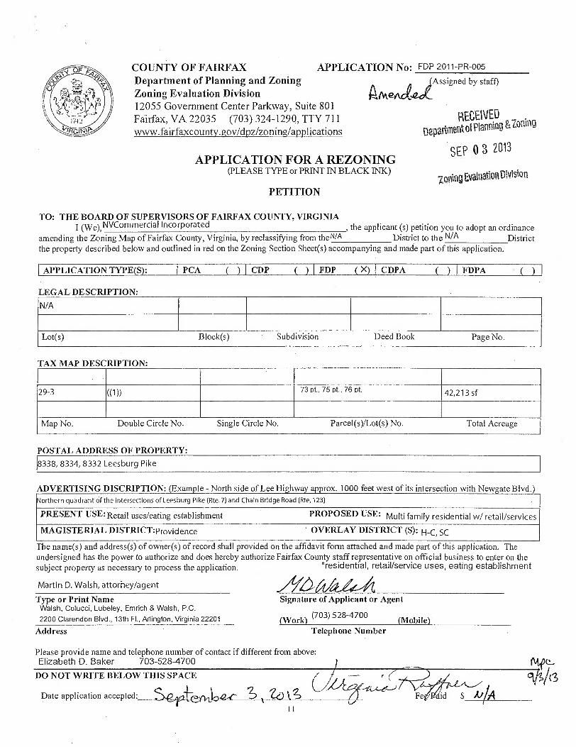
ADVERTISING DISCRIPTION: (Example - North side of Lee Highway approx. 1000 feet west of its intersection with Newgate Blvd.) Northern quadrant of the intersections of Leesburg Pike (Rte. 7) and Chain Bridge Road (Rte. 123)
PRESENT USE: Retail uses/eating establishment PROPOSED USE: Multi family residential w/ retail/services
MAGISTERIAL DISTRICT:providence ' OVERLAY DISTRICT (S): H-C, SC
COUNTY OF FAIRFAX APPLICATION No: FDP 2011-PR-005
Department of Planning and Zoning (Assigned by staff) Zoning Evaluation Division Aftkerja 12055 Government Center Parkway, Suite 801 Fairfax, VA 22035 (703) 324-1290, TTY 711 RECEIVED www.fairfaxcounty.gov/dpz/zoning/applications Department et Planning &
3 APPLICATION FOR A REZONING
SEP 0 2013
(PLEASE TYPE or PRINT IN BLACK INK) Uning Evaluation Divislon
PETITION
TO: THE BOARD OF SUPERVISORS OF FAIRFAX COUNTY, VIRGINIA I (wo, NVCommercial Incorporated , the applicant (s) petition you to adopt an ordinance
amending the Zoning Map of Fairfax County, Virginia, by reclassifying from the WA District to the N/A District the property described below and outlined in red on the Zoning Section Sheet(s) accompanying and made part of this application.
APPLICATION TYPE(S): PCA ) CDP
( ) FDP ( X) CDPA
FDPA
LEGAL DESCRIPTION: N/A
Lot(s)
Block(s)
Subdivision
Deed Book
Page No.
TAX MAP DESCRIPTION:
29-3 ((1 )) 73 pt., 75 pt., 76 pt. 42,213 sf
Map No. Double Circle No. Single Circle No. Parcel(s)/Lot(s) No. Total Acreage
POSTAL ADDRESS OF PROPERTY: 8338, 8334, 8332 Leesburg Pike
The name(s) and address(s) of owner(s) of record shall provided on the affidavit form attached and made part of this application. The undersigned has the power to authorize and does hereby authorize Fairfax County staff representative on official business to enter on the subject property as necessary to process the application. *residential, retail/service uses, eating establishment
Martin D. Walsh, attorney/agent ../x()a/aezeh
2200 Clarendon Blvd., 13th Fl., Arlington, Virginia 22201 (Work) (703) 528-4700
(Mobile) Address Telephone Number
Type or Print Name Signature of Applicant or Agent Walsh, Colucci, Lubeley, Emrich & Walsh, P.C.
Please provide name and telephone number of contact if different from above: Elizabeth D. Baker 703-528-4700
1
DO NOT WRITE BELOW THIS SPACE f r
Date application accepted: felevjcp0,r '; k S 11


FINAL DEVELOPMENT PLAN CONDITIONS
FDP 2011-PR-005
November 6, 2013
If it is the intent of the Planning Commission to approve Final Development Plan FDP 2011-PR-005 on property located at Tax Map 29-3 ((1)) 73 (pt.), 75 (pt.) and 76 (pt.) , staff recommends that the Planning Commission condition the approval by requiring conformance with the following development conditions.
1. Any plan submitted pursuant to this final development plan shall be in substantial conformance with the approved FDP entitled "Tysons Central Building F ," prepared by VIKA, Inc.; Davis, Carter and Scott Ltd.; and, LSG Landscape Architecture; and dated January 4, 2013 as revised through October 28, 2013, and these conditions. Minor modifications may be permitted pursuant to Sect. 16-402 of the Zoning Ordinance.
2. Notwithstanding what is shown on the FDP, Tysons Central Street shall be extended to connect to the drive aisle on Tax Map 29-3 ((1)) 72 (Parcel 72) to provide interim access to Parcel 72 with pedestrian improvements as shown below on the Tysons Central Parcel 72 Interim Entrance Exhibit prepared by VIKA and dated November 6, 2013 unless the owner of Parcel 72 agrees that the connection need not be made. Such interim access shall be removed with the future construction of Buildings A, B, or C.
X:IDPZITYSONS-COREICASESINV COMMERCIAL RZ 2011-PR-0051STAFF REPORTWOVEMBER 6 FDP CONDITIONS FDP 2011-PR-005.DOCX


FDP 2011-PR-005
Zoning Application Closeout Summary Report
Printed: 12/4/2013
General Information
APPLICANT: NVCOMMERCIAL INCORPORATED
DECISION DATE: 11/06/2013
CRD: NO
HEARING BODY: PC
ACTION: APPROVE
STAFF COORDINATOR: SUZANNE LIN
SUPERVISOR DISTRICT: PROVIDENCE
DECISION SUMMARY:
ON NOVEMBER 6, 2013, THE PLANNING COMMISSION UNANIMOUSLY APPROVED EDP 2011-PR-005 ON A MOTION BY
COMMISSIONERLAWRENCE SUBJECT TO DEVELOPMENT CONDITIONS DATED NOVEMBER 6, 2013 AND TO THE BOARDS
APPROVAL OF THE REZONINGRZ 2011-PR-005.
APPLICATION DESCRIPTION:
MIXED USE
Zoning Information
Existing Zoning
Proposed Zoning Approved Zoning
DISTRICT AREA DISTRICT AREA
DISTRICT
AREA PTC
42,213.00 SQ FEET
Tax Map Numbers
0293 ((01))( )0075
0293 ((01))( )0076 0293 ((01))( )0073
Approved Land Uses
Zoning District PTC
LAND USE
DU'S RES LAND AREA ADU'S WDU'S SaFA EAR NRESIANDAREA
MFD
414 83
RETAIL/EST 411,000 9.74 42,213.00 SQ FEET
TOTALS 414
83
12/4/2013
Zoning Application C:oseout Summary Repertrpt, created! 02/1.4/2011 for Robert. Harrison, sect num 41,71713
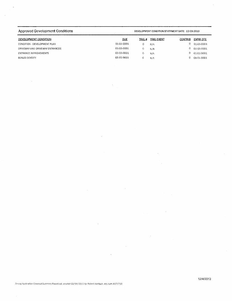
Approved Development Conditions
DEVELOPMENT CONDITION STATEMENT DATE: 12-03-2013
DEVELOPMENT CONDITION J1LJE TRIG # TRIG EVENT CONTRIB EXPIR DTE
CONDITION - DEVELOPMENT PLAN 01-01-0001 0 N/A 0 01-01-0001
DRIVEWAY AND DRIVEWAY ENTRANCES 01-01-0001 0 N/A 0 01-01-0001
ENTRANCE IMPROVEMENTS 01-01-0001 0 N/A 0 01-01-0001
BONUS DENSITY 01-01-0001 0 N/A 0 01-01-0001
12/4/2013
Zoning Application Closeout Summary Roport.rpt, created 02/14/2011 for Robert Harrison, see num 4171713

\\c ••••-'5.; ■•••
JANUARY 4, 2013 MARCH 11, 2013 APRIL 18, 2013 MAY 13, 2013 JULY 10, 2013
AUGUST 15, 2013 OCTOBER 28, 2013
;.,•31 ' •
Aga.
k:-I III 1111
SHEET INDEX:
TYSONS CENTRAL BUILDING F
FINAL DEVELOPMENT PLAN fillP-2011-PR-005
RE: RZ 2011-PR-005 (CDP) PROVIDENCE DISTRICT
FAIRFAX COUNTY, VIRGINIA
r.
CONCEPTUAL DEVELOPMENT PERSPECTIVE TAX MAP NOS.
29-3 ((I)) PART OF 73, PART OF 75 AND PART OF 76
CIVIL C-L COVER SHEET C-2 BOUNDARY AND KEY MAP
3. C-3. NOTES AND WAIVERS 4. C-4. TABULATIONS 5. C-5. AREA METRO comma PLAN 6. C-5A. EXISTING CONDITIONS 7. C-6. OVERALL CDP CONTEXT PLAN • C-7. FINAL DEVELOPMENT PLAN WITH RTE 7 IMPROVEMENTS
AND LIMITED ACCESS BREAK 9. C-7A. INTERIM FINAL DEVELOPMENT PLAN WITH RTE 7 IMPROVEMENTS
PRIOR TO LIMITED ACCESS BREAK 10. C-7B. FINAL DEVELOPMENT WITHOUT LIMITED ACCESS LINE BREAK ll C-& DETAILED FINAL DEVELOPMENT PLAN 12. C-9. EXISTING VEGETATION MAP AND CALCULATIONS • C-10. FDP TRAFFIC CIRCULATION PLAN 14. C-10A. FDP TRAFFIC CIRCULATION PLAN W/O LIMITED ACCESS LINE BREAK 15. C-11 TYPICAL STREET SECTIONS 16. C-12 FIRE LANE ACCESS PLAN 17. C-13. AUTO TURN ANALYSIS DESIGN VEHICLE
C-I4. AUTO TURN ANALYSIS CONTROL VEHICLE 19. c-a OVERALL STORMWATER MANAGEMENT PLAN 20. C-16. STORMWATER MANAGEMENT NARRATIVE 21. C-17. STORMWATER COMPUTATIONS 22 C-I& SWM VAULT AND BMP DETAILS • C-19. FDP ADEQUATE OUTFALL DESCRIPTIONS 24. C-20. FUNCTIONAL PLAN
PDF ARCHITECTURAL A-151 FLOOR PLANS A-152 FLOOR PLANS A-I53 BUILDING SECTIONS A-I54 BUILDING ELEVATIONS A-155 BUILDING ELEVATIONS A-156 PROPOSED ELEVATIONS WITH PROPOSED DEVELOPMENT A-157 PROPOSED ELEVATIONS WITH PROPOSED DEVELOPMENT A-I58 ILLUSTRATIVE VIEW WITH PROPOSED DEVELOPMENT A-159 ILLUSTRATIVE VIEW WITH EXISTING ADJACENT DEVELOPMENT A-160 ILLUSTRATIVE VIEW WITH EXISTING ADJACENT DEVELOPMENT A-16I ILLUSTRATIVE VIEW WITH EXISTING ADJACENT DEVELOPMENT A-I62 SHADOW STUDY
PDF LANDSCAPE ARCHITECTURE: 37. L-L CONCEPT LANDSCAPE PLANTING PLAN - OPTION 1 38. L-la. LANDSCAPE PLAN 39. L-Ib. LIMITS OF CLEARING & INTERIM METRO PLAZA 40. L-Ic. TREE CANOPY COMPUTATIONS 41 L-2 BUILDING ILLUSTRATIVE SITE PLAN & SECTIONS 42. L-3. ROOF TOP & PODIUM LANDSCAPE PLAN 43. L-4. CORNER PARK SITE PLAN & SECTIONS 44. L-5. TYPICAL TREE DETAILS 41 L-5.I TYPICAL RAIN GARDEN DETAILS
L-6. PEDESTRIAN CIRCULATION PLAN 47. L-7.1 SITE FURNITURE & MATERIAL IMAGES 4& L-T2 INTERIM PARK SITE FURNITURE & MATERIAL IMAGES
PDF SUPPLEMENTAL 49. S-I TYSONS CENTRAL 7 SUB-SECTION CONTEXT STREET GRID PLAN 50. S-2 WAIVERS / EXCEPTIONS OF TYSONS CORNER TRANSPORTATION
TRAFFIC STANDARDS 51. S-1 ROAD DESIGN STANDARDS SUMMARY
TAX MAP/VICINITY MAP SCALE,. SOP
APPLICANT NVCOMMERCJAL INCORPORATED
8230 J FRSBURG PIKE SUITE 620
VIENNA, VIRGINIA 32182 STEPHEN CUMBIE
(703) 448-4300
APPLICANTS REPRESENTATIVE: WALSH, COLUCCL LUBELEY, EMRICH & WALSH, PC
2200 CLARENDON BOULEVARD, 15TH FLOOR ARLINGTON, VIRGINIA 22201
MARTIN D. WALSH ESQUIRE & ELIZABETH BAKER (703) 528-4700
ARCHITECTS DAVIS, CARTER, SCOTT LTD.
1676 INTERNATIONAL DRIVE, SUITE 500 MCLEAN, VA 22102
DOUGLAS CARTER, AIA & ANDREW MAKIN, AIA (703) 556-9275
ENGINEER. VIKA INC & VIKA VIRGINIA LIE
8180 GREENSBORO DRIVE, SUITE 200 TYSONS CORNER, VIRGINIA 22102
ROBERT COCHRAN LS. JOHN F. AMATETTI PE
(703) 442-7800
LANDSCAPE ARCHITECT LSG LANDSCAPE ARCHITECTURE
1919 GALLOWS ROAD, SUITE 110 VIENNA, VIRGINIA 22182
ROBERT K. ESSELBURN ASIA STEVE CHOI ASIA
(703) 821-2045
TRANSPORTATION WELLS • ASSOCIATES, INC.
1420 SPRING HILL ROAD, SUITE 610 TYSONS CORNER. VIRGINIA 22102
ROBIN ANTONUCCI MICHAEL PINKOSKIE
(703) 365-9262 VIXA NUMBER VV714110
SHEET C-I
2.
#st
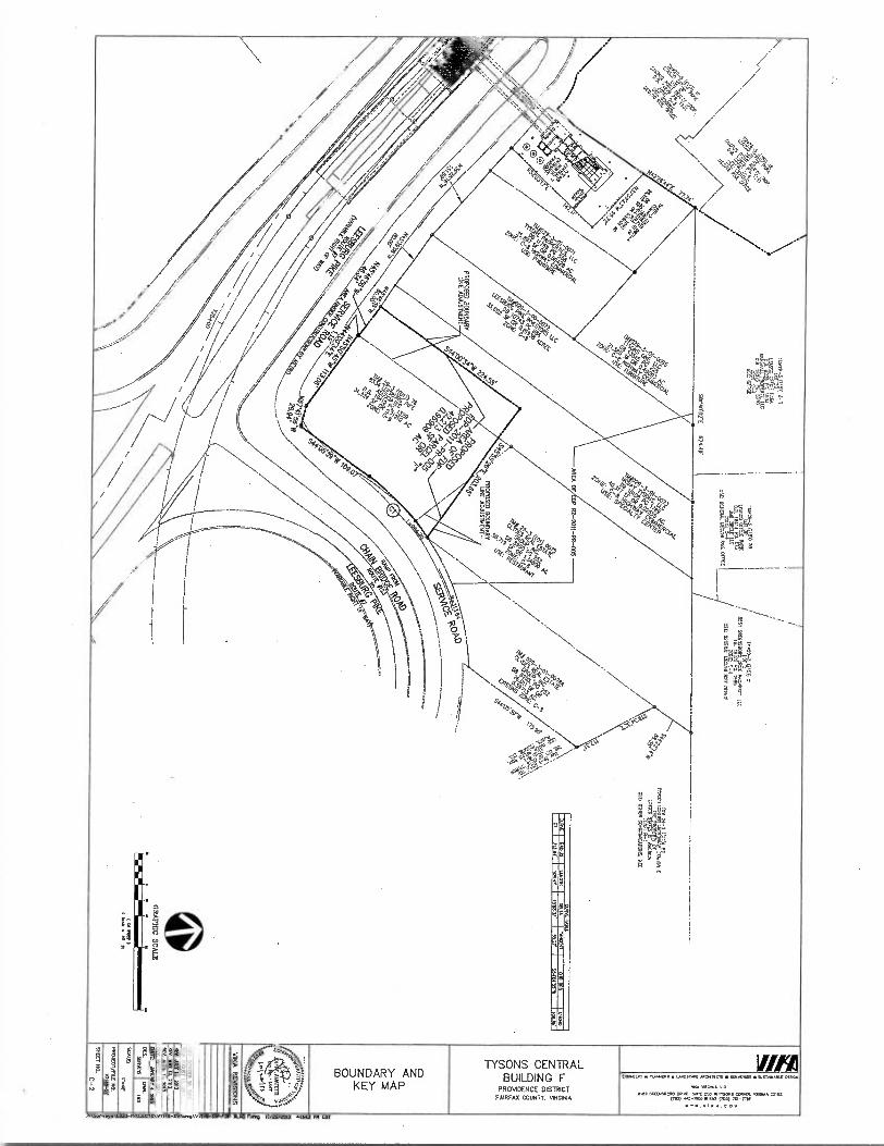
g
flat
' o A
wnv
e w
oo
010 WIE
E 3. TYSONS CENTRAL
BUILDING F PROVIDENCE DISTRICT
FAIRFAX COUNTY. VIRGINIA
BOUNDARY AND KEY MAP
fin ExfaxtiPt • .1.0•4LAS • 4405C/dor ANO•IIECIS • "..H.PV1 • 9■17././kr DES.
vr•A V•01114 LtC
ERCEMS•CRO POW UM =0 • MOMS CORNA. •••• ■• =102 (70.1) .2-1000 • liA■ VW) 761-13/
V7.•.VIKA.COV
P,Survey•V.#113-1•RILIECTSW71.10-0VUkg V7101-5V-N RUG ran 10/26/2¢43 MAU PH ar

SOILS MAP 1 00 =500 0
6A.6B BARKERS CROSSROADS-RHODHISS-ROCK OUTCROP COMPLEX CLASS IW, TYPE D
101 URBAN LANDAHEATCN COMPLEX.-- CLASS IBS TYPE D
FDP GENERAL NOTES 1. 1141 FROMM Par 19 M 910401 Cf RP CORSISTS Cf PARC135 DORM 01 INC FOCH HUM
TAX ASSES01:10 MAP AS 21-3 DID IAMB PART FIE 71 PART Cf 75 /NO PART Cf 76. DE PEPEPTY OJNO1711 MED C-6 SC NO 14C. ME PLIPOSE U DES APPLCAPOI IS 0 PROVOE A HE FOR PE MCPHEE HMCO 10 MG SC. MC MM 91-2011.1.5 . 10 BE MELON AS MOM OM ME APP.
ME IICITIONTAL DATA 5 NM. STAIT COD NORM
1 IC %POMMY 9glM HEREON 0 AM MEAL MO PAS MP WRIED BY NEE NL TIE COO. 00ERVAL . (0 HET.
TIE BOUNDARY INITINIAPCN VAS FREPARTO BY VIM NC
1E 9111£11 .103. IS LOOMED DI OE MMTII CB-LISTECT Al 11C THINS CENTRAL DOTICL 114 MC MINS MIER URBAN CENTIOl Cf 0111 FAIRFAX C015031111911 ELM.
PLED WATER ARO VIVANT SOU ARC MUHL AND 11111 BE COMO 10 SERNE RE DEVELCOVENT.
T. MEV 11A10 11141A4VENT AND NUE 504114 KR PC .04105IEN1 Y61. BE M10M OR DIT AHD NQ BE CCHSTRUCT131 LS A MOW MOHO SYS. MISS COISMUCIED N AOSEINDICT NM 10360 OLIAPPIANSH STERVITATTA 10)1502017 0611°A. NECUATC STOW ORAPIACE SYS1131 IN 107001ANCE Pt NOLIC F.UTES N.° STROHM NO 0E9a1 CRITERIA OFARMNG If ER051:0. THE APPLICANT RE.Va MTDINT 10 HOAX IMPORARY SUM DAMN 146/50ENT A. OW FAWNS MO. PIE OLM10.011 BE OMITTED PI PHASES TEE FAWNS MAY NCI., DTI ARE NOT IMTD 10. BIORCHNITON ARCH 0101.7104 FACTO. CR ON/07-9E INOCROKUND VAULTS ICE 100.01 Main. IES5110 Nu CONSIRUCIED TO 1.7 ME =NOV FEEDS COWES MAW
N MEC, AT MC 7NC a CONSTRUD. FOR PC SPLOOTO 051174. NO DRY WA PO SW SS MO Mt EMPOSH
MC FACANISS
TOTE BEST IX OUR KNONTECE. HO MAK SRS 1 SIAUCTIRIS WHO A BUTON. 010 ARE A PP.. CH PC 6/6ECT PROPERTY.
1 10 PC BEST CT OR PIO.. HO HAZAIOCUS OR MCC SUISUN= APT MORI TO MST IN TIC SLOECT PRCOMIT.
IL MDSE ARC NO IDS. RED.. STRUCIVRES 04 THE PROTR0 DALES OF .011 ■101101 OF 10511NO COMM& STRUCIIRES ID BE MUM . N01 MOH
11. E ENTIRE SUBCCI PROPERIT IS LOWED VW AM 11. /OE 04 10115. WIRE 5 NO RECO RIM 1LPA. al A 01.0.111AL 01.5 COMMA 010001 COSMO DEA 110 EMMY.
IL MELON. 611 0710041 UPON Cf°3101014 .1110.0 FUREAS COUNTY RIR PROCESSING HD WN. IMIUMC134011 Of DOCUIPICNI IS .0 SUBECT TO li.TT MAID.
11 PE ODADONIENT C.C.S 1011 PROVSHIS OE ALL APPUCABIT STANOINDS 10114 DE CHM. OF PC MTH . 115010ATIONS MOON N111 PAL COP AND HATER RMS. al RT-A01140 al 1151 9027.
16IA1101010° OPEN VACS NEAR1461001 SUM BF DOOMED 1111H14 SUISUN.. 000311.1.00400 AT MI THE CP DEAL SIR MAN.
15. 11C MOM 100115110, CARA46 PLA0I6 PAM . HMOS 0TE901X110 WITCH ARE APPRO.'S AND APE BONG PROMO FM 1.0101161. PURPOSES MY. TESL RANDS LEH BE AMID, 11110 ASE NCI.. IR °CHASED N SUE OR COMMIT AT TIE TIE O MAL 97E P. SINN DAV/TN./6 Ca.40.. N ALLMAN. 111MCUT It MED To AD1310 IDE 11104. 0006PLENT P. (HP) AS 0.110
CRASS SO LONO ALE WNW SITELTDCAPE MGM AS MOM 011 TR MP NE UNION.. NO PE 1111°01 11.514 BuEONC IMOD • 0.1111 HAD. Of 169001016 LENS MO SOESSI
DADI. Mu. HAWSCaPLY 1101 MESE 910M CN ME FOP.
16.•00000L SITE RANKS 901 AS BUT MI WHO 711 PLANTS TAM. 1010214 COM. 11111160. HIRANCT S. LAMES. MILS AO ALL OINUI ACCESS. HANKS P010115 El AR PIC 205 OR USES NOT HPRESDIED Ell 711 100 MAY1 PRIMED 10L 111AL SR AM.
IT. MO OHMS TO 01 PAID 001I(5) Cr OT C° HARE 7 1110N 0 AMACLIIT 10 NE SUBECT PRETERIT NC P.M NM PM DEHLOPM046
16 Ilf PRIM= OTHICPDENT OM DC ..ECT INOPOITY SILL NM POSE ANY AMR. OAST 01 .ACM1 01 NEWSOM PROPCR146
It NE PECHCE III UM 111E PAWNS RECUINGOITS AS SCE FERAL It PIC 1011 PER °MISB ARO ILA PE 021510 MOANS ND MAIL IC PROMO IN A covoNAIDEN Ce AT M. HO 17006 WEE PARK. SMOCKS . SURFACE SPACES. OE MARE 01 PM. SPAM PRIAM KRIM MAY BE 0,1510 AT MI 911 ELM DASH 01 CC AG A MINT ET CIA MO MAW OF UMR M101/10151 MS
70 PIM ART HO DIM ASSETS CC 1440001L FUNKS ON 103 911 WORM CT (01111EATIOL
DL MICR 1102010.446 DAY BE U. 70 ME 0151NUOP0 PUNS fai PC HMI ERCPERTY P011 .11111 14-401 OF 116 DOUG CMONANCE
22 PE WILCO ERDPOITY DAY BE SUBONCE. N PIE INURE 101 TIE PURPOSE Or SAIL .0 1114100. DR PHASING NIT ERCPITSH 921001001 51101114 II EDP NAY EC 11006113) ANINISTRATOLTY BY DIE MC. CF MM MD °MOUT RECUR. NCDOCATKIN Cf ME FOP,
21 ALL PRIVATT SIREETS SNAIL BE 090101 TO HIT POI 0.1015 1.0FSS NAND 01 HOF. NT TR HUT. PT CUM WM 91. Of OCHR. AT NE Er DIE PUN.
ANTS Of RUM PAWNS. MUNCH P.. CR T.0.1 MEMO VAIL 61 OINCHSTRANO ON ME DTE MAN.
912 LUMS. F60/TES MO ORID9EIG5 AND COACH OF FUNDDINES ATOMS RP MITI 115. APT COHOMAL ..AS MIN ARE AID. C0 0 REFLECT ME CENERAL MOH NO CH.CTER OF ME ERCOMED 17011011041 1114. HITCRON MAY VARY Al ME ILE If SITE PHI. BUT DILL HI. NM PE MAT OF PC GAOLRIMESENTED 1001 NATIONAL 9R AND HANKS SUM AS PLANERS CAHN% DENLIES. 0001 HAW AREAS. moan HOMES 441111 ITIONTANS OR SHOAL TURKS. PUDIC ANL 9016 SALTSU11.111 AND VANTULOCE STRUCMITES ANC DUOS FLUMES MOT N.M. MTN DAT Of PE. AS laM AS NG C.0.011.1. 04 WON COF..). NM INC CORM ROW.. IN 1110 GRAPHICS,
26 FERN BU ONO AND LAMOSCAPE AROMA. MAIMS AND 1115.111. PROMOHEROD ARE SUIECI 0 01101 111111 FINAL NSW 111111M SUBSTMIPPL 0.05141. AllONANCES 116 EXACT LOCATE% SHAPE . OE RE PROPOSED CH.10(S) MAME SMICIURE(S) 91001 al DIE CHATII5 SUBECT TO 6045116311 ADO 6111113401T 14114 FIRAL INCIEERINS ARCHTECTURAL DEW°
II 1.011 Al 1110
RN. .STACIAL CONFOILIMLE YAM 11C RIPHSCNIA11115 11.06 4110 MANIKIN STRECTSCAPE ARO MOON° ONOHONS.
01.1100110 ROMEO NPRONEKNIS (0400045, WRONG .AN PE) DAY REQUIRE 17510015/00161014S HO! 1000 0055 DANA.. CONN SINOANK ND RO0 01901 101601 ANO/nN PIE INANSPORTA. BEHR ray nuns COACT UIDAN CHM (AS DAY BE CEITRUMID AT IND. DTE PLAID COAL ANA RID WON 01110110011A1105 SHALL Ma HOLM 01701110 70 Pr 101.
26 PURTIONT TO °Oaf 1 SECT. 6-50 OF ME 20111 ORLITIANCF. N .KTIOH TO REDECHIAL, . OPER I193 120111110 01 10161A1101S. MI HILO. ADD RPM UM DAY BE 11610100 IMAM MD. f MM. RECUR. AM IHNOMINT TO PC CP C FM, °QUOINS BUT MOT Um. 10 ACCESSEGY USES. A1116 10151.5 sp. AND SUPPLY SEANCE 61,02951/411 W U SWEAR HOD STCRES. IWO PESTAUWES 1665 CMS Ale CREAM C0155. RICROTIMA4.1.6 00.1415 USES, SAM EST.5100416 1111000 S00N0MS 0654041 CITRENG 61617.111110 COCES. 000111 WM. ES00.1110111 PUBUC RIO MAD PUNIC 115611/01 SHLS 01.95I05 APO SMINt USE
ERVA7E ACAS 900S 910161 ON VT TOP 91.- NOT BE C0.01160 `21moo ANO. AS MOO. MAY WAIT IRON V( THAINS .1400611011 .01 STAMM.. S.M. (520.0.125 IN MI 0011111H1AME PLVL
30 CROSS°. 1E071015 051C4100 CR TIC TOP NL ONCEPIPT. FRE LOCA06 SOL. BE 001314N1 BY HOT AY DIE
31. DE OPAL MAT. 1110 ORE Cf ACCESTOLE RIPS ND SIGH .HDBLE 0010010 SP. LOCAMNS MEAL BE 0013061410 AT DE ELM.
32 All MIRANCES 1100 NO PRIVATE STREETS 91111 OPENLY EC CEDISMJCIED IS HOT MD CC-13 DIMS ROUTH OTHERNSE NO AS DITUDIETH BY TOOL
31 11001 WITH SHALL BE PRIMED N TIE TRH NS .ACENE TO MCC STREETS AS 01101.611 BY .T AT 971 PLAN
34. PROPOSED SICRACE DIALL BE MAU N ',COMMIX WAI PC DEMO ORDNANCE AMP I/ CR VIM INC CR BALE 0P5.11911 DINACE PLANS AS NAT BE AMMO BY 1111 RHO. CONMSDIN.
AUL Man NacATED CN INS Dr N Carom. ONO RIBICT 70 00NX RN 714 ;NAL NZ PULL
36. P. ORAPHC CCP.. OF CIL .0 Of NIX ILIA FOR PREPOSED 00110151741 911 5 NOT 00.1. AS DES 001104,010 IS MOT LOCATED 1616 PE FERMAT SF 1111 111.5 URBAN CORER AS DOMED N SEMICN 16-101 If ME TANG 645N.6
37. ALL PREPOSH 9MNS NO 0011100PA1KNS AFC DUCT TO 1007 ROOT AND A.M.
316 ALL LANE UST MT, 11111:01, OR PLATTED) ARE MOT 10 REM Y . OHMIC BY NOT AT THE IDE O . PLAN . ILO BE KCVO 1111011 DE KO 111 PCA HOAR COPA/HPA.
NA AM.° NM. ON . 03605 MOMS MSC NOT °PAC. 0 BULONO f FO TO ROAN MONO APPROVAL Cf A SIC PLO.
40. MS PLAN 0 COMOVICAL 4140 TS NON. 10 BE MO N 5,14010100 NOVAE MID USE APPROVAL ERHESS ONLY. IT IS NOT AN 010.11.NC CINSTRUCTCH PRANK AND .06 CENA106 AO /0651111 WAY BE REMIND, ANO 207112111/ PURSUANT 70 TOMS CHINANCT 00101 16-70440 AS PART ff 11.1. OLSON .
1291 MM
DIS PROCESS,
UN. 10.1131. TIT H102. COISHICOM COMM DMQ BE N
03671541. CONFORsm
II. FINAL HEIS If CHARM MO MAN. ID DT 0100.11 Al DE PWI . ME sumo m THE 011121.7101 Or SHIT 0111S/TRAN9DON5 me CHOY LAYOUT.
42 All R19OV01015 04 DE WM 9114 ROAD 5011-06-.AT AEA ME DELECI TO 1001 APSIIIIA1 ND ROMS - 001101CH
THIS EDP IS SUBJECT TO ALL ZONING ORDINANCE WAIVERS AND 1.4001F1CAIIONS REQUESTED ON APPLICATION jRZ-2011-PR-005. (GDP) THE FOLLOWING ZONING ORDINANCE MODIFICATIONS AND WAIVERS US TED HAVE BEEN REITERATED AS DIET SPECIFICALLY APPLY TO THE BUILDING F SITE PUBLIC FM/Ian MANUAL WAIVERS/MODIFICATIONS REQUESTS
1. WEAVER Of POP SECTION 6.03.6 TO ALLOW STORMWATER MANAGE...0.ES (OW
AND IMP) TO IF PROVIDED WOTAN UNDERGROUND SYSTEMS WITHIN THE RESIDENTIAL
BLOM OF THE DEVELOPMENT. (WARM WAIVER FILED 0016111.WSW.01-11
1. MODIFIGTION OF PEAA SECTION YOKO. ALLOW TANDONVALEY MIMING SPACES,
CONTROLLED BY 9010106 MANAGEMENT, WIEN SUCH SPACE COUNTING TOW.° REQUIRED
PARKING.
3. MODIFICATION OF SECTION 11.0110 TO PERMIT:
A) REDUCTION IN 111E MINIMUM PLANTING AREA FROM DORM FETE, 60 SIM TOFFEE IN
ORDER FOR TREES TO SATISFY 111E TREE COVER REQUIREMENT. REFER TO LANDSCAPE
PUNS HEREIN FOR GRAPHIC OF THE PROPOSED PLAITING ABM
TREES LOCATED IN COSTING 011 00000510 RIGHT•06WAT DEDICATION ARMS TO
COMET TOWARD THE 10-TEAR TREF CANOPY REQUIREMENTS
MODIFHATION OF SECTION 1.2•111 FOR TO ALLOW FOR TREE PRESERVATION TARGET AND 10
HNC., CANOPY TO BE CALCULATED. THEO....DP DEVELOPMENT ARK AS
DEMONSTRATID ON THE COP HEREIN.
VANES 131 SECI1021.201.3 REQUIRINGTRAILS MID BIKE TRADS SHOWN MITRE
COMPREHENSIVE 710115 MAN IN FAVOR OF THE STREETSCAPE AND ON.ROAD 010E001
SYSTEM SHOWN ON TIE COP.
MODIFIGTION OF SECTION 100601.113 TO PERNUTINE REDUCTION OF OH 6411014014
PUNTER OPENING AREA fOR TREES USED TO SATISFY THE TREE COVER ASQUIREMENT, IN FAVOR OF 71W SHOWN ON THE COP AND AS PROFFERED.
MODIFICATION OF SECTION 12401660 TO ALLOW TOR TREES LOCATED MDD. AM PROPOSED
PERCOLATION TREN0100 010.REHNTION AREAS 10 COUNT TOWARDS COMET NM COVER
REQUIREMENTS.
THE MIAOWING PHA WAIVERS MODIFICATIONS f1 7119U 10 ALE REQUIRED ERMA THE DIRECTORY°
SUPPORT THE DESIGN ELEMENTS AND PROFFERED COMMITMENTS Of THIS APPLIGNE AND CD/,
APPLIGNE H00E50119 BOARD SUPPORT THESE PFM WAIVERS AND MODIFICATTON AND DIRECT
THE DlleCTOR TO GRANT THESE WANVISTMODINCATIoNS AT sin PUN.
R. WAIVER Of /FM SECTION 7 IN FAVOR OF THE TRANSPORTATION DESIGN STANDARDS FOR THF
MOMS cONNER URBAN DENIER.
MOMFIGIDON OF SECTION 7.01102.2 PARKING GEOTAMTDC STANDARDsTo ALLOW FON VETO
4° PA.CTION OF STIDUCITHAL COLUMNS WITHIN PARING STRUCTURES ROOTH
'AMONG STALL AR. THE PARKING STALLS AFFEcTED RV sual STRUM/RM.
COLUMNS SHALL COUNT TOWARD THE NUMEER OF REQUIRED PARKING SPACES.
1561 SECTION 6 • STORMWATER AND BURP CODE REQUIREMENTS
LIFIDATIONS /MODIFICATION OF REQUIRED SWAT AND MAP CIIITERIA BEENE DIRECTOR,
DPINS S MOLINE° M THE STORTAWATER MANAGEMENT DESIGN TIM DEVIATIONS
NARRATIVE - OUTLMEO ON STORAIWATER MANAGEMENT SHEETS AND AS FOLLOWS:
0 ALL REQUIRED DEVIHTIONS OF PPM SECTION 61304.1CI0 ALLOW FOR MST/616110N
00 PERMEARLE PAVEMENESYSTEMS MAT MORE INFILTRATION TO BE CONSTRUCTED
ONCE-SITU FRI. MATERIAL, PROVIDED FIELD TESTS SHOW ADEQUATE INENTIATION
RATES EXIST FOR INCITU MATERIAL
DI ALL REQUIRED DEVIATIONS OF PF14 SECTION 6-130436- TO SET THE MINIMUM
HORITONTAL SETBACKS FOR 80111 INFILTRATING AND NON.INFILITIATING ITEMS
FROM W.I. FOLNDADONS BE REDUCED TO 1010 (0) ITET IN ORDERED
FACILITATE INSTALLATION OF HAM FABLE PAVERS IN AN MAN SEVOIONMW AS SET
FORTH IN THE TYSOMS CORNER DESIGN GUIDELINES.
CI ALL 900011190 DEVIATIONS OF EFTA SECT101 6-1004.4110 ALLoW UTIMATION OF
INFILTRATION RATEs TESs T.N D.S7 MAMMA DESIGN oF INF vapx SysTOAS
001.1200 TO MELT. COMPREHENSIVE PUN REQUIREMENT FOR NETENTPON OE THE
HUT 1 7 OF RONOEF ON-SITE.
Dl
ALL HOMED DEVIATIONS OE EFTA SECTION 6-12063F TO ALLOW FOR ANT DETENTION
FACILIN LOCATE° WIMIN A BUILDING OR GARAGE STRUCTURE TO BE GOVERNED DT
BUILDING CODE REQUIREMENTS FOR ACCESS AND MIANHENANCF.
0 All REQUIRED DEVIADONS OF PFM SECTIONS-1107.2CM ALLOW FOR INSTALMTION
OF MCI-RETENTION EACTUTITS THAT LOIRE INFILTRATION TO BE CONSTRUCTED ON IN-
SIR". MATER., PROVIDED FIELD TESTS SHOW ADEQUATE 1141E71.15N RATES
FEAST FOR INGITU MATERIAL
0 ALL REQUIRED IlIVIATONS OF PIM SECTION 6.1307.10 TO SET THE MINIMUM
11011110611AL SETBACKS MOM BUILDING FOUNDATIONS DE REDUCED TO FERO (0) FEET
IN ORDER TO FACILITATE INSTALM1TON OF IN0RETENTION SYSHMS N I. MESH
0 001005 MT SET IOREI IN 109 70.1 CORNER DESIGN SIDOE.TS.
11) AIL REQUIRED DEVIATIONS OF P114 SECTION 6 1107.2GTO ALLOW FOR THE MIAMIUM
DRAINAGE ARIAS TO BIO-RETENTION FILTERS UTMLED FOR DETENTION OF THE FIRST
17 OF RUNCIET Bf ELIMINATED IN ORDER TO ACCOMMODATE ROOFTOP MANCH PIPED
T0100E05E0 STMUCTURES.
ALI REQUIRED DEVIATIONS OF PEM SECTION 61109.10 TO ALLOW INSTALLATION OF
TREE BON FILTERS IN THE VIONITY OF LOADING DOCKS, VEHICLE AOUNTENANCE AREAS
On 040MAR STORAGE AREAS TO ACcommoDAIE 110 MUSS iNvIRONMENT SET
O n IN THE TYSON'S CORNER DESIGN GUIDELINES.
SEE SHEET S-2 ANO S-3 FOR TYSCNS COMER URBAN CENTER TRANSPORTATION DESIGN STANDARDS, WADERS AND MCOINCADONS. SEE SHEET 1-10 FOR STORMWMER MANAGEMENT KM WAIVER NARRATIVE
TONING ORDINANCE WAIVER ./ MOPMCATION MOLESTS
ZONING ORDINANCE ARTICLE T. GENERAL HOUND.,
1. APPLICANT REQUEST 5 A WAIVER OF SECTION 2•506 OF THE TOM. ORDINANCE TO ALLOW
BuILDINGS TO Bt TONSTRUCEED TO THE STREETSC.E DIALING TONE ONE ON CORNER LOTS
00 ELT. SmEE IS ANO LOTS W. PRNATE STREET EASEMENTS W1401 MAT CREATE A
CORNER LOT CONFIGURA7.1 AS DEEMED 'HMCO/TANG ORDINANCE.
2. APPLICANT REQUESTS A WAIVER/MO OINGTICH OF SECTION 1.6.1 ED ALL./ FOR A
PARAPET WALL, CORNICE OT SIMILAR pRalECIN31 TO EXCEED THE HEIGHT LIMIT 131.1.10110
BY MORE THANTHREE 01 FEET IN ORDER TO SCHEN MECHANKAL EQUIPMENT, AS MAT BE
INDICATED DN AN 101.
TONING ORDINANCE ARTICLE 6 • MANNED 00/0.0PMENE DISTINCT REGULATORS
1. APPLICANT REQUESTS A MODIFICATRat OF ARTICLES-501-1 OEM( TONI. ORDINMCE AND
THE EMITS CORNER URBAN CENTER STREETSCAPE 001.IN FAVOR OF THAT .OWN ON
THE COP. SPECIFIC AREAS
A STREET LINE ON 011111.1 OF N7 AND ADJACENT. EA. IN . CLUDING THE REQUIREMENT,. THE BUDDING HINE
EAST SIN MONS CENTRAL STREET ADIACEHITO THE ROUTE 111 RAMP, B.
EAST SIDE STATION MACE ALONG METRO ELVA
OR
SIDE SEATON PM. ANo TENTER STREIT ALONO INTERNMATAn SECO.
ANO AT THE DUD°. I ENTRANCE.
E SOUTH SIDE CENTER STREET ALONG INF LS, PROPERTY FR010,01.
EAST AND WEST SIDE OF PANAY. SERVICE ALEIT AT SLUING 711.7
G. CENTRAL PIPSZA
APPUCANT REQUESTS A WAVIER OF SECTION 6506 PARAGRAPH I TO ALLOW A DISTRICT SITE
LESS THAN 10 ACRES FOR AN APPLICATION.
TONING ORDINANCE ARTICLE 10-ACCESSORY USES, ACCESSORY SWAM USES, AND HOME
OCCUPATIONS
S. AS ALOWEDWFHIN TOMNG ORDMIANCS SECTION 76..1.t APPLICANT REQUESTS A
WAIVER THE 2640111.164 FENCE HEIGHT FROM SEEN FEET TO FOURTEEN FEET MOUTH
ACCESSORY USES / STRUCTURES LOCATED wITHIN THE REAR TANG FOR THOSE MIAs of
FENTANG Essc.ATED W. ANT PROPOSED 5E0110 couRTS AND ORITAN PAHA AREAS AS
TONING ORDINANCE ARTICLE II • /ARCING AND LOADING
5. APPLIGNI REQUESTS A MOUNILAI ION OF SECTION 11-207(4) RFOUNING 161.2164
DISTANCE OF TOM HET (40) Of A LOADING SPACE IN ■ POSSAITY TO 101. AGLES, TO THAT
AS DEMONSTRATED ON THE CRP AND SHOWN ON THE APPROVED FOP.
APPLICANT REQUESTS A HEWER OF THE Won.. LENGTH OF PRIVATE STREETS AS PROVIDED
IN PARAGRAPH 2 °ESTEE.. 21502 Of THE TONING ORDINANCE To ALLOWFANDEATE STREETS
IN EXCESS OF 600 FT. IN LENGTH.
20.13 ORDINANCE ARTICLE 13- TANDSCAPING
APPLICANT' REQUESTS A MODIFICATION/ WAIVER OF !MINOR PARKING SOT MNDSCAPE
REMBROHNES (SECTION 13-102.0) FOR INTERIM SURFACE LOIS AND SPACES. PRIVATE
STREETS AS ALLOWED PER SECT00 11.202. PARA 6 TO THAT SHOWN ON 114E COP ANTI TO BE
SM. ON THE POP. FOR INTERIM SURFACE ENO. MT° INTERIOR LANDSCAPING WILL ITE
DEMONSTRATED 05 SURSZELUENTFDP APPLICATIONS AND WILL LIMTE FIISTWG DIGETATION
W/THIN PARKING LOTS, TO THE MOH POSSIBLE.
APPLICANT REQUESTS A MODIFICATION OF PERIPHERAL LANOSGEE REQUIREMENTS (SECTION
16206.0 FOR AIDE GRADE /AWING STRUCTURES, PARKING ON PRIVATE STREETS, AND
INTERIM SURFACE LOTS Ai AMMO, RY SECO. 16203.P ARA I. TO THAT SHOWN INANE
COE OR AS DAM' BE SHOWN ON THE MP,
TONING ORDINANCE ARTICLE 16 • DEVELOPMENT PUNS
10. APPLICANT WILMS A WAIVER OF TONING OWN ANCE SECTION 16.3 REQUIRWS THE
SMASH. OF A FINAL DEVELOPMENT PUN APPLICATION ASSOMEED WITH THE
31.064SSION OF ALL PUBLIC Ro.WAT. ANO INFRASTRUCTURE PHASING MIME
IMPRovEMENT MANS AND INTERIM PARKING SPACES REOLDRED IS SHOWN WITHIN TIE COP
AMINO...0o ON THE MP.
ZONING ORDINANCE ARTICLE 17 PUN • 25n6
11. A/PLIGHT REQUESTS A WAIVER Of SECTION 17•001.111191 vo3o1v1NG AMODONAL
PMCFL ACCEST V AMOINING PARCELS (OTHER THAN THOSE SHOWN °NENE 030) AND AS
PROFFER°,
11. APPLICANT REQUESTS A WANED AND/0R MODISIGTION OF SECTION 17.201 AS APPROPRIATE
FOR ALL RECILFIRTIT TRANS A. BITE TRAILS IN FAVOR OF THE STREETSCAPE AND 014-ROAD BITE
LANE SYSTEM SHOWN ON THE COP AND AS PROFFERED.
IN WOMAN. WITH SECTION 17-001, MEL.. REQUESTS A WAIVER OF SERVICE ROADS
ALONG ROM TANG ROUTE 123.
THE AEMICANT REQUESTS A DETERMINATION OF TONING ORDINANCE SECTION 17401
PARAGNAP11 OD REQUIRING ANY HARMER DEINGOON AND CONSTRUCTION OF WIDENING
EON EDISON° ROADS BEYOND THAT W11101 IS INDICATED ON THE COP. DEDICATION ANTI
IMPROVEMENTS SHOWN ON THE OD WALL BE DEOPEDTO MEEML COMPREHENSIVE PLAN
POLICE POUT REQUIREMENTS.
IS. IN ACCORDANCE wax TONING ORDINANCE SECTION 17401 (71, THE APPUGNT REQUESTS
THMOHT TO ESTABL. PARKING CONTROLS. SIGNS IINCLUDING SPACING AND LOCATION1
AND PANNING METERS ALONG PRIVATE STREETS WRION AND ADJACENT TO IDIE
OWED/MC. IN COORDWATON W1H SCOOT.
SEE PM WAIVERS414001EICATIONS 1.1 AS REQUESTED FROM OE BOARD OF SUPERVISORS.
NO
TE
S A
ND
WA
IVE
RS
VIKA REVISIONS
REV. 0010109 20, 2013 REV. AUGUST IS, 2013 REV. JULY 10, 2013 REV. WAY 13, 2013 REV. APRIL 10 2013 REV. MARCH 11, 2013
DATE: J.E. 6 2013
0121. ,A OTT. 1EV
SCALE: N/A
mo.occi/Faz NO.
4,7140C
BEET NO. C-3
RUNNING BUILDINGS
TABULATION A, B, C, D,
- E & F .....
130I0Ing Opt)... U.. COP GRA 0301 001* 5114 Flan GFA
9!... 200,000 - 324503 ..___ .. A 096. 4 1 03 2 RaM5 20300- 002*
Tool 340,000 .252,0110
1531 300.1103.1530333
B 0010303 1 2
P.m !.30lo____._!3.00-100"'
20,000. 20.000 . .... .. _ _ . .. . _ Teed 220,000 452,000 •
3a11423110 00.000-3350300
C 01,3313 112 13.t.. - .. . _. ,,,3.,70,791 _.
. .t. • LOW . .. -. - .. - .- .. . _ ;400 -14.557
233.005 . 343050 - - - .- -
PPM 30013310 ._ _ _ •.. 231,00O .503,00W'
-..... 0 OpOont 1 A 2 7123i 0.30000 -
..--
Told 343.0013-2413,003
OPee 300.00-2I200 • 005an 1,411. 1 Rald 10030 -13.000
1.31!
15ii-----"-- . . . ... Raba
130,000.013.300
-- Oi.E6671EPEO . ._ 00.002 - 35.000
----
E ogees 1. PA 2
..
....... . Twat
RoldanTY '-..-- -10040371300305
IMAM .. RAPP
030133 0310 lom • 33.000
175,005 • 22311..000 1.02
or.• _ ......._. WV"" °C. -
F
OplIon 1 RPM 10,000 • 17000
iiiipi- 300.000 .393.003
....._ .. ...... - -----------
__
- .- Apdarld .- --
350.000 - 354.000
012052 Rata toma . 37,00, 1200- Oppa
Taw 215,005 -41P000 314000 • 411,500
cHke
AF116961 315,300.020 ,300
300.00.0312*
...- . Option 1 Totals ARP 100050 - 155.003
[11 P00010200302 3140 0 -14.500 - . ..- 311.1 33,013-170.000
--
TOTAL 1,2101,000 .1,107,1100
Olko 00,200.330,000
5.0.000.31 _. 10400151- 1441000 _ _553.E00•354.000 Option 2 Totals ma 100000 - 1570170
121 Poop Fa032,131 5.400 - 14.550
'To. 61000 - 53600 30.030. I7.600'
TOTAL 1,423,000 .2,025050 300,000 .411,505
Ill 60410 clnalutios 140 oimmalv. mot a Balding E; ane Include.. cake/retail us. .1040% net Incluasi halonstall uses 111a Op1on 1 TOR OFR' tamn provide Po GFA ramp Ix both Pe oReeholailard holaFrots11 allertslins. 11‘.. Pe 071107 1 GFA • for IrevklusIbulkangs do rot rreffievneacally add uo P 013 Op!. 1 101404125n GFA kr 01fica Pa surn of Pe Mk* uses
um Pm bean se .1 Pe rnmIrourn 2.50 FAR oermaled 5331.000 SF) WIN la less Pan storm In 053111rpaA. E an1 F For Oalon 1.
L.- [21051107 2 Total GfA la %Whorl Pa aura MIN. Opllon 2 °Mee, realdeMial, hotel ard retail OFAs. aa arra It MARV In to nix ol um. Total Opion 2 GFA Is 2.029,000 /Sae Frollem for knitviami onavolal OFR).
331 Up lo 14,506 proP; .GF oFfoyould olPie iaaiilysi;aco pH ea-,;;;;a;,4 in 90432.0Bin-eeni0i720 Wt.; - I
TA
BU
LA
TIO
NS
041E1 JAN. 4. 2013 0E1 I ovoc Ky
SCAM:
REV 001021E11 211. 2013 REV. AL/GuST jA_V.17 REP .0)0)0 IA 2013
REV. MAT 13
REV. APR!. 15, 2013
REV. MARCH II 2013
VIKA REVISIONS 0
I.
V.
0/V
0RO3307/F3.E 140. 0075430
PIM NO. C-4
DEVELOPMENT fAbuLATION Bundlnil
13010.31101913 1
8230. of
Slade. RI
000 7) OFA by use Suadral OFR Clamlang V401.24141 • 1/11
Farl5P2 Re1m4003Pro44a2
b 14•Vo
ene. Mit. Mln. Map
321 400 27.34 p.01110411 litI2l11e7.400
350,000 - 394.003
10,000 -11.000 3110,000-411000
375.111 . 375.411 505.557 1 111 004,3 hebklb measured torn enropo erode ond ImMelm Ma Imam and ony sod& memblisenlo Nes lie Nor Imel. .130104011ld3m nal betel mcnevelerd belorms or reselmelvdpenbous tm melon 2.303 Oro vembq ember.. Such leabreartev bo • imbue el 251eN.
PI nom/m.3'01.M SnOwn h cancenbel old mein squeal proAled p.m= 3oRlIn5 he121011 no( erapied.
Rbal/Sento naves imlicered In Mb lebilalivn may be.. marbly al Wm commxclel uses Nat as. MA oral Orello0 lo.oebq 02081013700b04I.M113
PII FYI IV) Tee* (rib pm. elt3 0roliNg men ebbs Waldo. 10 unla 0041 (W131.11). Pm/Wad numb. of WM; beielTsro;0;;;IMe rs11Ppint;x4PIev; . Pe War ranter olonden map prow.
FDP - SITE TABULATION FDP AREA = 42.213 SF OR 0.96909 ACRES
PROPOSED MAXIMUM GFA W/ BLDG F 411.000 GSF
FAR = 9.74
d3011,0004314t100bla GFA And FAR 020 1.8 b 14.500 onus SF 13 eel Ircluted tra WHY. or appal GFA or PAR
auaC
1/C POR5011 MEIRO FARM. 1110.15E0 AP11.11501
002005 1100030 AVERAGE GRADE EXHIBIT
WORK FORCE HOUSING NOTE: ALL REQUIRED WORK FORCE HOUSING WILL CONFORM WIN MONS COMPREHENSIVE PLAN POLICIES FOR WORK FORCE HOUSES. SEE PROFFERS:
Loading Spaces
PI
2
MeV 000 I Ma 2 Ma 3 4711.0
3 MAI I 112.0 7 503.6 ' • 4000
MA II VOA II ,177.0 15 020
5..2112•4134
71,104 temenvtlinraolded
NV Nib to 0.1.0 Max
a/10001MA. 20000813 032
03015.00001A
MOIPfllIp R.343030S
NI 11,2 m4n40u0re-4013-e33i0r230*M1MTenro0iee'7014e3 mem fez even use woe crecololod 0. accordance Mb 3001 0.100 vibe Zintig Oranneco, 001112 metal. beim IN El primary um 333531303 03)13 FDP.! 1343303003 Met some ecinmemlel use• hem Moab perNm Moo Rap 0.0 132112233!100010307*h301 Wet. Reabeaer parthl•as Osseo on an pampa d a5TA rel ebbe= irelb ond 1314 tberircem .11. N Vme el Me peikbp MI be preNdel bred on Om speciao uses, GFA palm or unIts mlx of Wawa fpne and Pa 0111115x and madam Wet .41 Pan In 8.0.111-61:0 Mem 5014 ordPancp
MAReakomiltrap Ape. evorovalal indae Po landirp 0020,7000230125031102110
7,312,7 0..
RotaM3mvice
1,-.9T11105F11.. !
2313,10050
•
s41` •
..-- •
, .., ./ r t i / /
/41 /. - e / 4 / 1
,,
/ - .1 . / , .--
\ 4,'' •/ 1.: '.-. ---- \ - \ y' 1 '--r--- •...1 • It,..
--EX-SERwer7 33
BEGIN RECONSTRUe NS-GENTITAT-STR
-END LIMITED ACCESS LINE SHIFT • SEE SHEET S-1 FOR LIMITED
PROPOSED LIMITED 'ACCESS LINE CONTINUATI5A ACCESS LINE SHIFT ±3'
<
Z w a oz,A
0c±' (1) Z 55 c9 m O.
4/ ' `1" %.0.00NREC,rfir
I
Sit I -
NAt q icE FDP LIMITS FOR OVERALL ULTIMATE FINAL DEVELOPMENT PLAN (SEE SHEET C-6)
RI E W V IN TE
FOR INTERIM AND DETAILED „Ad SI , I' BLIC \ CE FINAL DEVELOPMENT PLAN
BY 7R \ (SEE SHEETS C-7 AND D-.6)
POSED LSTED FOR BOUNDAR CESVIAN WITH (SEE SHEET EN< FOR Vra I
Y INFORMA"60
V-- 45,ITRA_,E, s\,,is.
...1'......"
\ ••
ED ,
uJ
< 8
tom
Iree Rea eactrin1-1..-Rff.r
-V
(vuqr oo07.o2
TPERDOAXcrc
•%. _tiorrEify -Abv,Ess LINE _ T -taLIAM'As iaege4 c7rXrheEt rst3 L6FTEd LC
VIKA REVISIONS
REV. OCTOBER 20. 2013 REV. Al/COST 15 20. REV. JULY 10 2013 125•00--- REV. MAY 13. 2013 REV. APRIL IB 2013 REV. MARCH 11. 20I3
DATE: JAN. 4. 2013
• ---------- 2;;AfT /1 , ..
VA STATE ORM NOR71.1
(VS0 03)
GRAPHIC SCALE
OWN. BY
SCALE:
, ND C-501)
/ rpoim_p_Trn.0007-029_103 Pi ROX-LOCATION OF
ED ACCESS LINE
INTERSECTION / pr_ __ —
------' 4:•■ -: — -----f-:1=1:15— — — - - — -1/ — - - -cd \
7 PROJECTAILL NO.
VV71400
3
4
1 SHEET NO. el rest ) 1 Ison 40 It C-5

• 'fir! Li
• MOM SICHAL POLE • 11100 ow moo lut_osoo ELOSSOL ELN. 101010160 1.111112y woo.
EfEl“ ▪ wArtR VALLS
3" •
ESE 0111rA 21,04412'' ROM L
IACIErrS"'ATS 0E4'41,11C'
155. con , A
CURVE TULE 081*0 8*3400 104040 40,1* 14*40*1 040 0)0 810140
Cl 535.44' 10441' 110,5? 51.41 364S*'53'W 40810
FDP AREA = 42,213 SF OR 0.96909 AC.
LEGEND OUILITOC 4116
MCC or PA.NENT
=Ton. amour 0211010.0 mos
GRAPHIC SCALE
1E1M70041[(004.1.11.11MS
INJOLIC 11171166S CASOACNTS SWEARS SEWN COMMIT MINN MAN CCOCOIT
04711. 2-F;CONTOLIN
2. G tr.= =4014- 111604 CLIN10.4 OPT
n■ MST 1 Inch TO IL
UNE
• nvitoraions ASSOCIATED 88114 THE OVERHEAD ROME f7 REDFSTRAN CCHNECDCN Mel
ARE BASED EN PLANS MENDED BY: %WA MUD: GROISION 70 ISERE AVE RSONS CENTRAL 7‘ N
GliFENSOCRO MACH, AK 441W CCIESTRUCTION, 0140 SrIONN AS STO10 0451010*800*. SAID LIPRO TD VEBRI:
MICR BASTER STE FLAN CATEDC 7/31/07 SIEET NO. H03-k-011 A\\\ %. ,1\
.6 N. .55 /
NOTES: I. THE SUOLECT %AVERT' , A DEBITED ON PARCAE COIRItt TAY NAP AS PORTIONS OF 4029-3-07-0073. PORTION
Cr O08-3-01-0078. A440 PoRTIONS 00 ion 3 01 0076 AND AND Alf ZONED C-S. 1IC 6, SC. 2. TICS EDAM HAS BEEN PREPARED VOGUE RR LENART OF A TIRE REPORT.
1.
3. Too HORIZONTAL DAMN 41001 HERECN IS rrorromoo ro LOOMS carnomeo SKEEN OF 19133 (WS B3) NW IS BASED ON A CPS SURVEY PERFORMED CY DNA ON APRIL S. 2010. DIE H0408401. CLOSIRE AHO 6000RACY CP DIE SURVEY CONTROL USED TO PERFORA 11111 SURVEY 01 1:37.731. WIDE EFLEEDS 111E MMUS PRECISICN or F20.000 AS REOAREO BY CRAAHATALIN CF 11100AA.
B. 111r117tRIF0A714'Setl=1"„744,'"Mt9r04 Me ,-"c,■%%?:AP''" ,;,;,,;,,arku. B. THE METRO DIRROVEDENIS 91031 HEREON, ASSOOATED AIN THE OVEWE00 ROIAF 411 PREMIEN CONNECTION
ANO MONS CENTRAL 7 STATEN ME BASED CD PLANS PREPAREO 30 115010 WIDER EVOISON 10 *14(0 AVE MONS MORAL 7 STAMM MASTER SUE PLAN 001E0: 7/31/01 SKR NO. 1103-0-011 TOPOORAPIEG INFORNATION 81085 HEREON II BASED ON ARIAL SURVEY ROWED TO NNEL NC. ST AERO-BEIRIC MO 065E0 01 CONDON PHOTOCRAFAS DATED Dad 2006 AT 1,80% DIE VERTICAL DADIN REF0971ICF0 TO RORIE ALEMCAR ValICAL Ofiant OF 1980 (NA. 94 CONTOUR INTERVAL IS LW. TCPOORAPHIG INFORMARDV siaEN HEREON H. NOT 0E01 nun VIANIE0 BY WI, 1NC. 1910010301100 UTIODES NAY HOT BE SHOW AT ACRIAL SCALE, OAT ARE OEM. ROACH CDR GRAPHICAL 7080334 04111,
. INPROVELIENTS FOR ANCININO PrECDERTY WITTED ON FAIRFAX COUNTY TA% DAP NO. 029-3 ((IS)) 00 80808.5 2 SHOWN AFREON relE TANEN ROB URBAN ENGVIEFAINO 44 ASSOC., PIC STE CRAMS RAH NITRO -THE E4 RANDOLPH
BUN (IMO B-8-00. OE 411-0111/ABON SNOW HAS NOT BEEN FIELD VOWED.
10 IMPROVED/DVS TOR ADM. INICODITY CENTRED OH FARE. MONTT 1,1 MAP HO. 029-1 ((00) AS 803091,0 80 SHORN HEREON FERE 1*3111 MOM OS DATA N41 HAS HOT BEEN *00 NAMED.
.4- SIM MST 6° DM POST
e
▪
MIL rqq •z0aT11111 O NOON Om/ Hpm,L2
21211 (LLEINIC4L .1104111106 o 0I10111104 N411100 II (PC DOMATANT CO0.0101 -6 NTONANt O EA. 444.0
O LICHT POLE 160 PHONE PEDESTAL O 1.1104 1160101.6 ▪ onurT
5114 moo yr 4/11.111 DOW
0001[111 NLP CLOIDINSO EFEAAEIE
COP4/06101 0610. NFL ORL 001010 RES1MC11011
H.C. ---11ANDICAP
VW' /01020'LL.PDPROMMATI
=)112Cool„ rootow soc HOPSC 0110M0110.1'
SHEET C-5A
1.7

BOUNDARY
SEE SHEET C-2 FOR BOUNDARY INFORMATION
LIMITS OF UNDERGROUND GARAGE ON PROP LINE
HIGHE ELE
PROP RET WALL V-13' IN HEI BACK OF WALL IS LIMIT OF
UNDERGROUND GARAGE AND PROPERTY LINE
\ . RELOCATE ACCESS\ fi
LETIER-,9F—. INITERPRETATION , TO CKIS-WG St
LN
1 1
RROLIACD:;:::"3 E C-
-(Ada SHEET
PENTHOUSE L .L.
PERPETUAL ROADWAY EASEMENT TO VDOT
INTERIM RETAINING WALL SEE SHEET C-7 HT--2'-13.1
LEGEND r, 6 ABOVE GRADE TOWER
ABOVE GRADE LOW ROOF/PODIUM
DDOOR
LOADING PARKING
UNDERGROUND GARAGE WALL 1MM RTINCALLY AT FROPERR LAPAAWN CF FDP1
PROPERTY / MIMS OF EDP BUD TO LINE
1.....I_J_I_L__I "SEE SHEET L-1B i____w____
FOR INTERIM i . LL-Z-4----_-_,-77,11. METRO 1 I
1 '-u.nALRO_VEMENTS,...i:RIT TERRACE ii T3 ...
...-=--. _&__,... /„.. __I 't - _a Li r ir 1 - 5.- — _. —_,...,e.
FUTURE BUILDING A RIVA
ATE SPA
ART INSTALLAIICIR INTERIM SIDEWALK SEE SHEET C-7
BLD T
UI O LINE
MKA REVISIONS
11 I/A9--„T:\_ oaS11N6 -ftf E.7" c.._.. q .1 (SICTED B y mcmoNOIY h __ __ : _,:u...... ,,, R 3,. r,. = V_W_ 11
- 11.;;;, .... . ' , -.,.. RET WALL AB. .. 1 II
PRIVATE DRIVEWAY IN
-41:253Z---A ,--_ tttlRaWagm,„emisiwimminwiwt.
---,,-----,,.=- ---- ______ PUBLIC SPACE BY PERMIT
REV. OCTOBER 25. 2013
AREA OF FDP \ \ FOR DETAILS
\ \ \ \ \• • SEE SHEET C-7 & C-8)
N-,
OR LIMITS OF DISTURBANCE N(SEE SHEET L-1B)
\\\: ,‘FOR TYPICAL STREET SECTIONS \\:,,N(SEE SHEET C-11)
E
REV. AUGUST IS. 2013 REV. JULY 10. 2013 REV. MAY 13, 2013 REV. APRIL 10, 2013 REV. MARCH 11, 2013
GATE: JAN. 1 2013
1. 1/17215:Ez4Zilir"1- 114 ,..11171..111 -.111.1.1171-14 *id
ADDITIONAL LANE ON RTF 7— 1 —
SCALE:
VA STARE .GRIO NORTH
(AGO HI GRAPHIC SCALE
R 3 CONS CT S ROAD A SHO
LIMITS OF UNI
ERGROUN GARA sulAr
AK-PROX LockyoN LIMITED ACCE LINE
VD(T 0007-029-10 C-501
SH FTEDJJMLTE-D-ACC S LN
PROP 5' SAN (MK TO ROME 7 PAL)
eRfroSEDMRSA% comm. SOMA 111PflowNon
PRP-UT/FRE NO. 1/1/71460
( FIT) F 1 h.s rt SHEET NO.
. C-6 5 •

EXISTING CLYDES
TO REMAIN
CI) < CL
.gC z
o OO W C.)
bJO
M C.)
CG .• a_ < -
0.1.1110;to
Inn
,AKA REVISIONS
r
A
REV. OCTOBER 20,2013_ REV. AUGUST 15,2212. REV. All:, 10 2013 REV. MAY 13. 2013 REV. APRIL TB, 2013 REV. MARCO 11, 2013
DATE:JAN. 4 2013
SCALE:
PROJECT/FILE NO. 2077000
SHEET NO. C-7
VA SYRIE ORM NORTH
(VDO 133) GRAPHIC SCALE
( 031020 1a,A, 40 IL
- -174 -
------ k%
X , -GREE SA
‘9,1 40;fr
wpa..
..,...,__....__.....4,,........L" " \ ,,,,,,..
/. ACCESS u mum/
--."-"W`-,-'"".-------- /) - k. ,..---- ''''' ■ ....\ // .,... ../..---
K ABOVE GRADE TOWER
19M
ABOVE MADE LOW ROOF/PODIJM
A.. DOOR
zfla PARKING AND LOADING LOAC/10 PARKING
MO A
mem Fad Amp, 0007...)-103 0-301
471.
e111"
• 14 VIATIR
20800
\ -4— tr------ —\ •->. / Iv i LERictirorAwf - 1. •
---.-14—=.1---i-----_____--t-- ,
_ •. .......____ ._.,_____„.....-...„
---FeArf. HAst;:oustiTEEE: ...! OWNER I PRIOR TO L1MITED,001A . -BREAK 725.0..
-i---,..p..,17___-_-_„.--,7.—.... ____,....„,.. .1LoPflze_-- --------- •-•:"-....,_„.' -..." \
I _ -,•,--...-..:.....17-......,..„7: -,..\\
ELSIGNAk D IN:SECTION
...-.,--
‘1 SHEET-C- Q)-- 'l
FINAL LIMITS *OF-DISTURBANCE TO \ •
FOR APPROX LIMITS OF CLEARING BE ESTABLIstENSHG_ED AT. 5121E PLAN.
SIGHT DISTANCE. CCCIPLITM_R-- r-,--
, ,__.... ,.,
,, ,. ,
4 _,...f...-..4_...... . _ -7 ...'47AliffiR.F4S.-------.-.....,.."...::___,_.;;='''=,..-.2,,,..._ .., •, \ I N Mil \ n ...1
, --- ...........
/1) /( 10 LEGEND
13 2 TIRO AND RAIN
UNDERGROUND GARAGE WALL LIMITS CTIPICAU-Y AT PROPERTY LleA-ILfrE1 OF FOP) PROPERTY LIVE / LAAITS OF FOP
BUILD TO LOVE
sla snow DRAN
SANITARY SEWER
f" WATERLINE 121V
{ 0,) TEMPORARY 6r180t1 TREE
LEES R PIKE=-R0t1
0 7ISONS E It" srimal
•
/ • ,
/1/ p
040 °- -------------------------------
— 1,10:4 4
—
- -
' •
7 -
IWO ACCESS UNE WIT RELOCAMTV
intrftr
-J
- Z os w
Z 15 0 8 _J
z 5 s o co co a.
LEGEND:
orgrp,11, ABOVE GRADE TOWER
ABOVE GRADE LOW ROOF/PODIUM
DOOR PARKING AND LOAM] LOADING PARKNG
A ei.- ... -,.°' .'4. B Fe.,:,." 1 to _.,
11 likiin4mg-Ci IF --.–. .!___ 7 __„,,,, r
_Ai.. X561 {aim .— 1:11,:v./0v1P1M _-.
t ____ _. akr,,Witft-t lalli061;/[i.1/I:Li44 ,
-4.1.728M, fik ,T.,/
21421ggg - .cir.h."
UNDERGROUND GARAGE WALL LARS (TYFICAL, AT PROFIERTY LNEIUMTs OF FOP) PROPERTY LINE / LIARH OF FOP
\\a'■,-- ;6 RE-OTAk"
VIED LIMITED ACCESS U S8T°RMN DIIAN AITARY SEWER
STOMA
WATERLINE
<I∎ ( W TEMPORARYETFIEET 'TREE <-9
MKA REVISIONS
•Cl■
-1 BEE LA PUNS FOR LOCATION
OF SUFFACE BIKE RACKS
TISTORBANCE
.L••• - ISEE_BILEET.C.-20r
• ewer .D-A-11 BEkt.-
ESTABwa
USHED AT SITE PLAN. N. NTERSECTION
VI gm -os on TO
FOR APPROX LIMITS OF CLEARING
SIGHT DISTANCE ODIAPLITIP_R___ •
1 II ••
REV. OCTOBER AB, 2013
REV. AUGUST IS. 2013 REV. JULY 10. 2013 REV. MAY 11 2013 REV. APR. Is, 2013
REV ARCH 11, 2013
DATE:JAN. A 2D1.3
DES. Jr.% I KY
VA STATE GRID NORTH
(VSC GRAPHIC SCALE SCALE
1,10.
7 7 PROJECT/ME NO. VV71400
SHEET NO. ( rm. ) 1 10eR IR 0. C-7A
KEW '
ABOVE GRADE TOWER
ABOVE GRADE LOW ROOF/PCOIUM
/ 4" • ' 7•4.
`. /
',..
./.)
, / I ./. 1./
, /4 , ----7____„,......./1 ..- \ e / . .. ---. .. ) --_,----- 1.4.. , -___, •
_....---
:I; win met
VS stn., lEtanttola
4
_ . 4ErAip—v RIEW10
via
Crar=-111111M. ••••.kfoiloot,44,_rga-
- _
LEGEND,
• Ab. DOOR
PARKING AND LOADING
UMEROFOUND GARAGE WALL UM/T8 (TYPICALLY AT RCSsTTY LNE/LIA113 OP FDP)
PROPERTY LINE I .1_11ATS OF FOP
------ BUILD TO LIE
STORM DRAIN
-
SANTARY SEWER
qa. --r ----- WA-TERME
.4...
LV LOADING
0--GILRYCi / •
•
PARKING
TEMPORARY STREET TREE 161
VIKA REVISIONS
4014mkkrnivsia._
,TOR-FHASING ROUTE 7 II ROVEMENTS- L8 FINCUTITS- OF DISTURBANCE TO'
BE ESTABUSHED AT srtE PLAN. PRIOR TO UNITED AC -BREAK •
( Rim EEr- TERSECTiON FOR APPROX WITS OF CLEARING
--7 /211111.1M1/1111 11 /
, PROJECT/FILE NO. 2071440
sift, NO. C-78
DATE,JAN. 4 2013
DES. OWL SA RI
SCOPE.
REV. OCTOBER 28, 2013 REV. AUGUST 15. 2013 REV. JULY 2o13 REV. MAY 13, 2013 REV. APRIL It 2013 REV. MATCH 11. 2012
SIGNT DISTANCE. CCOPUTATICk SEE SHEET. C-20)- S _
L. old
VA STATE ORE MGM MC 53)
GRAPHIC SCALE
(N. TORT) Isoe 40 lt

GI 111111 . i•-• 11 1...„-EX OVERREAD-11
11--- : BNPE RELINOCAE ID 1
IT- :
' INTERIM RETAININ-C-W-ALL- 41 ' ' '---' .... `''''' "' ` `•-•-• - .--. •
lir‘p, irr / j•
41° ' ♦ ,./ /
a(•/ /
DETAII FT) EDP NOTES. ......
i.„_--.4119 =II
tl 2
II
I 0 {Ij
MAME-FROM 2 IU 1.3.1 1 1 ; IN HEIGHT
IMRE
YAKKING ARET1-BV-1 bUillING-°-1101°' LETTER OF PERMISSION E AN
1. SEE SHEET A-153 FOR BUILDING HEIGHT DETAILS.
PROPOSED SEWER AND WATER TO SERVE STE SHALL LL BE PROVIDED BY CONNECTION TO PROPOSED SEVIER AND WATER MAINS MEIN MONS CENTRAL STREET AND LEESBURG PIKE ON AS DE1ERMINED AT ATE PLAN SUBMISSION.
3. THE APPLICANT RESERVES THE RICHT TO EXTEND AND CONSTRUCT OTIUTES, ROADWAYS AND OTHER INFRASTRUCTURE NEEDS FOR THE SITE WHICH MAY BE (MATE THE UNITS OF THE FOP AS SHONA HEREON, THROUGH PRIVATE PARTY AGREEMENTS VITH THE MICRO) OF THE ADJACENT PROPERTIES.
4. SEE SHEETS C-3 AND C-4 NOTES AND TABULATORS FOR GENERAL NOTES, AND MODIFICATIONS AND WHICH APPLY TO THE SUBJECT PROPERTY.
5 DELI"( AND 1.10 LOCATIONS SHOM HEREON ARE APPROXIMATE FINAL LOCATION TO BE DETERMINED AT ANAL SITE PLAN.
8. STREET TREES IN SIGHT DISTANCE TINES SUBJECT TO VDOT APPROVAL AT SAE PLAN. (SEE PROFFERS)
7. LITATS OF CLEARING A GRADING TO INCLUDE ALL ON-SIZE PROPERTY MD OFF-ATE AREAS NOTED SUBJECT TO PERMIT OR UCENSE AGREEMENT WTI COMMONWEALTH OF VIRGINIA SUBJECT AND TO NODE APPROVAL SEE SHEET L-113 FOR LIMITS CF CLEARING AND GRADING.
B. APPLICANT RESERVES 111E RIGHT TO MODIFY THE UNITS OF CLEARING MO GRADING INCLUDING ALL REQUIRED OFTISTE IMPROVEMENTS AS DICTATED AT SITE PLAN. SEE SHEET L-IB.
B. THE FINAL NUMBER AND LOCATION OF PATTING SPACES TO MEET THE MINIMUA1 AND MAXIMUM PERMITTED BY THE ZONING ORDINANCE TO BE DETERMINED AT SDI PLAN.
10. RECREATIONAL AMENITIES FRONDED MTH THE MALMO 'F . PARCEL ARE TO INCLUDE: PRIVATE ROOF TERRACE, PRIVATE RESIDENTIAL ROOF TERRACE AND POD, GROUND LEVEL PARK ALONG LEESBURG PIKE AND INTERIM PARK °EFATE.
...,iti4 (pp 4
. ..
5; ,*". 7 ' . 0
ci . 90 1 4 r,`
01'.
CONNECT X =51_ I
1 1 CLYD S LA or or
•/ ,,,
/' 41 "4. -, ef-/ /
' TT- , / ...„ / • d •
/,,f` ,,i., /
♦ A• /
i
- _ _ _.... PROP
uiiurr POLE j
-- . ........„„ L,
AO St
I
ZSIPA
11111M
i -- . 1-. INTERIM
i$ LIMI
. •5-0
''
RETAINING 1011 If FOR CLYDES '
9t. BOW, • GARAGE UN
- ii... ansmirat,,,11„,...1....„,r,... , , b.._P 35-1411VMMUMMIrialr
r iu
/ 4 .
I 791181.WWGINIWWWW.WILWPWW.P9MW
ECONFIGURAT1ON PARKING
ITS
, PROP
LIM! V00
OF ' ,
AREA ' „--; ,M GRATE STORM
Cr PE PENAL R DW Y ESMT
11°.
, , i
Iwzonfia■tr... /7 ,c7 .....---
/A 'fi> N ‘ /7 // ----
.°,,f. , NO . w,.....;,-49Tr -----`''-` '71 , as:„... -,,,,,r
.w. ,-nr- Nos. . 44
40 ,51---,-1, SONS
"811111199r I
TREET .44_ 1
_ ..'''' --,..
lk,
---- i/L---/ / IN . *
/1/1 <Z--r•I'= Fi■ TENTIAL EM / / _,.. RID ONNEC
=-,.> • II) -I L / 01
ok, 8, , , , ,
//1/1 1 ' `51,7- PROP F.H.
, ,/, i I
_.4. • ,..
. 1121 01 ' Iitjo"
N`PT ,„„A '4 ..., , 0 ,,. , W. .,,
I4 %--
O 6
i
9 1
.4 ile , .4 I . . kw 1 ji 1 i f 1 ` ' " 7:41 :0 - Z P
, ,4, i
I ..
•
13- 1,1- ,TAT-''' i..•7 1L.'4 rb..6
I41•1 ,104
. ' ' "' : . ' 1 ".P:P•IloPlilkA'''',V , '" ,;P - ''''''
A-,
vt 1" 6- .,-
END Of, T . .7
II'.
..,,.
'' '".' .....
u1 III
1
FOP
C-2)
-BOUNDARY
'-t-' 1 .:,'44,.*L I
0 . .-.1., '• -
Ar
'5 '. ii 1
MAINTE CE i i 1 1 i t I
i■ II
II PROPOSED 24. WATERIMN a MONS CENTRAL STREET AND LEESBURG PIKE FOR FAIRFAX WATER.
12. AU. STREET TREES ARE SUBJECT TO VOOT AND FIRE MARSHAL RENEW AND APPROVAL FOR ARE ACCESS.
II ALL GRADING SHOWN ON THE FOP IS GONCtPTUAL AND SUELECT TO CHANGE AT FINAL SITE PLAN.
14. SEE SHEET C-13 AND C-I4 FOR AUTO TURN ANALYSIS.
15. SEE SHEET C-20 FOR SIGHT DISTANCE LPIES.
' II. NODCrIZAI LANTIAZ Muivtg."',ZIT ', 1:LIVERITsI,VDTETT,;DAMENSIVER PM'''. ERCIAL AND
17. THIS PLAN REWIRES A UNITED ACCESS UNE BREAK AND SHIFT ALONG ROUTE 7 AND TYSONS CENTRAL STREET - SEE GDP.
\
' (SE
F PO
A
.....*.3
MIT OF
INFORMATION
SHEET
;
, „ '
... P ‘.-
XW'
0..7X . 4'
YI
'....
,.1
.. W , o w
S g o
/ 1
- -
34.--
. • •
WIN
,
I 1
I i
, 1 1 , i D I ..
. . - I I I
11
II ll / I
I /
I I
i
/11-414, ! i
4,
I 1. 11 1,
\ \\
I I I. 1 I 114 III .... v ,,, Ty- 1 ,
i t 3
. \\
\ \ \ \\ --.
R TEMPORARY ENTIACTCLYDE
E5,5__PURING
y 1 k V .
-,a.
, 'I
-
--■
is
1171' r is , •
n :::
PQ: z
:117,11 1' , '
1 J 1,I
, '' r ' .
' ' • 11 •
W " _J
<
11- I. PRIVATE DRIVEWAY I UNDER VOUT
/ \ \ %. \ \ \
\ PERMIT \ \ \ LEGEND.
.4:E o F Id 0 CI
L...1 C:I
STRUCTION
S E -G-10)
4
A
5,1
P ' - I l
'1•
\ \\.\ \ ; ; , ; OUNTAII/LE CURB ' •t.
I 1
" '''( H ABOVE GIADE TOWER
I BE
.
OCATION AO MED I
N. EU _ Welk!.
A S NA.
fr.t"I'L'l ABOVE GRADE LOW ROOF/PO
• Ali■ DOOR
z6, PARKING AND LOADING L. LOADING © PAJIGNEI
UNOEROROUII3 GARAGE WALL LASTS
STurALLy AT pucesmY LsEhisrs SF FSPI PROPERTY LINE / LIMRS OF FDP
.”Clnsito,m'' STOFSI cam
0 LO
-1.4 IN EX EN CE TO
0 72- - palp
ill' I PROP
'N .po V li ..-".4 - WO" .".
FDC ,,,..„; rf 1
, \\ '
\ il 11; /I
' 417 A SPA \ hil)FStFACE'E
it A h 0 -A HIFTD-65TTED ACCESS UNE TYP)
th, '11 4,
Eli ' Ai ___. .. ___ _,-; ,
_ • • Er . '. 110' 1 ,aliejl ..-'' g o 4ip Cr% ARENA 10T 4-029-103 C-501) ,,--, "...IF-14,m A - -
....41 ell .., N ilt -- irup.9,04 ' ,I...v.,. /0. ...,,
F.MJATETT
N.
0 4'-
Mn1
:i...3 A)
:0,, 4
IPI '-'5)''Z' 1:.,,a. If:, ,.....,,,,,
.......d Me Era - 4 ' ♦
- II
.0, , 0 /I'
__OE- (5
PRO TO R
FOR LINDSCAPE DET645.-.---- -11 - GORNERTPAR1/4
SHEET L-4)
5' S/W (LINK UTE 7 TRAIL) ,
0J FAX COUN PROPOSED F R IMPROVEMENT '
tr 11111 SANITARY SEWER
--t1-"' -' WA ''''''""• u P j
8
L LOCATION OF IM CESSIBLE RAMPS-10n -=----' 74-c-DrTEallyD-- , N °Ti°0,7 '----- lig Ai-.Gt-TPPAT4' 1: 11°
I ---71,41. -"IF Mt 1\ ...2.■ 311117- „.,,, . TERUINE
,,) k x TEMPORARY STREET TREE C__..V
vA sTATE GRID Nom
(vs° 83) .0._._,...FIAPHIC SCALE
-
- I N IOW E ' fiIi ;4113511E mg
.&A A ... - - *..it.,11" .. .....wmaxidositm-ofitazo , wArmaiire-vi - "-- 1. VIKA REVISIONS --------7*- - l aio glib- 'N.`,..4,,,...1 7,4' ifzeginifigaallrBNPA....,, ''' , SIDEWALK
.-.. 4 -"-- __ __ , gi
mil'E 1 adh J-Z. I.- ,,. 4,.. b, , w:CrATAIL ro .------- - .w-
"AL IA
■ tied' . . I a - N -7T--.. NEWS P:.-A*46ffaUgS6304111.745 " •-••• • _ 1. ... 1 .44 - • Vid- REV. 00043E3 20, 2013 TEMP STREET TREES C 76.74- P • • 24 WATER
LIMITED ACCESS LINE "BREAK" REQUIRED ULTIMATE ROUTE 7 NTRANCE FOR MALE CENTRALS
..- ..- ..,,,, 177.0,...i.Z,.
LOCATION OF FINAL LANOTC-APte
- --,„ SUBJECT TO T/DOT PERMIT AND -,.....-- - ITTILITT-7CPPROVAL- EX SIGNALIZE.
REV AUGUST 13, 2013 Y 10.2011
REV. MAY 13. 2013
-2:1--V1VV.- --„, - - AND-ROUTE-7 LAN EE_SI-IFFT.-C- 1. 13-1.3_ _ INTERSECTIOL1 - -444-■4444- DALE: AN. 4 2o .3 on. DM. ... JFA 1------ FOR ROUTE 7 ENTRANCE PHASING ______ _
- T (SEE SHEETS e-7-AND-e--7A) .. r.-1 I
- _ i AL SC A 1 0 1 ...._ IL) i L____
LEESBURTPTKEL _
ROUTE - 'F-'' IC)1 ,.
1111111 1 ___- ...- - --(VARIAIIIX RIGHT-OF-WAY)
) ./11.- ),I
ruascr/BLE NO: VV71,100
SHEET NO. C-8
(otnorr) 1 inch ... 30 IL
a a
V
1
( met I loma • SO
PLAN PREPARED BY: NELSON P. ICIRCFINER, RU. ISA CERTIFIED ARBORIST No. MA-4720AM • •
MALMO& EXISTING VEGFTATTON COVER TYPFR
"A' PRIMARY COVER 11 . PRIMARY COVER Sex apnea-Anse/Son Holly
opaco-Arnorlcon Holly 111e cordata-LIM101401 linden 7110 cordato-UNIeled Linden
LE0t01D_
/70
EXISTING TREE CANOPY
Table 12.3: Wee Preservation Target Galculadons and Statement May 13,2013
A. Tree PONny1Oan Town ColoulaRans and IIMMEnon1
A Psolnelopront wma of eynling hoe oonopy Nom
RISEN Rgolallon roopysP). '. ....„,..
II Peconlalsolgros MN ma Gmend by eololloo nee
1nnPT °
2..
C Percents, of 10.yono yea coney, regIrt0 In .. 1M4 soo 11110 ISA
. Pos./me of Ow tOyoor Nee canopy req.Nnen, t. Ohotklbo met llvougn Iron sos•ENIIono
E 111oFoso4 porta/Togo ol canopy retmlrement ITN WIE TE
oWl 11ro/4111es preoonallono
0.,,,
P Hu I.Trao Pros•naIlon Noun shlman bowl men No PnAlta Yes Or NO
0
. INT lor Ono F. Iwo • isquest lo OWEN Warn TN Tres Presenallon Taw MOIR F.LINIan Ns Non Ilml
Hems me w more al .M Nollkallors Mod In I MODES
aNnowIlh a oars. ISM posIdos o slIntooclIt explanation or v.* ths Ty
4i4
4..kFt'41' .,:li$
00:4
•141,,,
Pia. sheet roArber. see 1 12-0508.3A(1)
H II SIVA 71e.. 4 mamma. a MO In Ispored In so/m.1n wan i ISOM., „,,..1,,.... .
_ , ,,....4
I Phu MN InkontaBon or le Me 10yeRr Tive ORRIS
Dammam m per Ifishudlam EATON 12111
Ks3ATNE001700000111.71450/101sTwo Conan/FOP 2013.05.1031sPh2ell a)
NO7E• FOR PFM WAIVERS / MODIFICATIONS REQUESTS, SEE SHEET C-3.
VA STATE GRID OM
(SSCN
El3)
GRAPHIC SCALE
- —a— —t-1.-""—i-LL I LT-A-.1-4Otir1.1 " '<IVA • '...1".AW F SkAIN3RRY7S.VC
■110.11Www. WW1
arnlm
lama 1.4•Wwit 1.01; Won.
• 17055 vb,1•13025-1.5.3
• Pwwwnwowe
ww adawwww . .
. „.. . . .
."17,Z:r=""===..".. mow w, Irmo carom wwnolorIEL w rts Diaulo.no /awn.* w
7=1: 217.n. • ohm Gam,. Dew...Wan, 31, ra.11,11.1.• 414
=It.. la •wwww■ Y•Wheand wow... en ova Jwio/oo walawdi Mt 020. Caw, NW, nes. 110.044 w.)1 ow now
• •
Jaca Illerapiurviar In liraltls. ...,,J.woo•On()) • • ••
rtvu exexeme emeee. mesa mem.
w w gwal
•
-- ir...-4 .,....,•• ::„,.....-4 —,..............., ;,t.tzat.rT=4..trol•Avw..t ..,..C3r """ ttrINEENA '
Aan.III...1A AI...V.10U th. A •I.J;;;=::=1.747k1z,...,; • • • • • ' „ 1..z...•.....7,11...............,... onjonecl riew Ow; . ,..,,.......m h, rya. 1.11.11...1 Ilan '..,...11 :7=1,'...PetrariararaV' 1.■
rfAra=4:17,1V:r."■= 1dr.' ''''''''•" t ....we W., wig .......M..a:: "11,7 *.""*"''''' "."4"' 1owon1 G, noonn•yrwwwo nww win ) ). v • '""'"A.. — . .
p. ww ow EotnIsm. .
• r
. °,71..."`"::::;/...:4 non../o 11 1 Po von wy Aownw w ono nAlMwt
P.m P. 110.ww11/./ • w.m/Eorsmony(MIIIICIRIM)1/.7.
• • • •
• 4.17i.,..Zr=7".,12V-7..i. • neno••••••/"....maMoM•*••••••••1Yn`••• •
www•wwww/ww.,,,,wwww). .
.....Lownw vow/wow. w ••won f 7 "7 70-17 7 .,147...,.t. ,e•
1-' F..===
BeUrf -
\,/e-.4"
e9147414i4:
SCSONL.C.EN2R61. EXISTING VEGETATION SUMMERY
EVM INDEX
COVER TypE
SUCCESSIONAL STAGE AREA
COVER • CONDITION
PRIMARY SPECIES COMMENTS
•.. °
DEVELOPED/ LIAINTAJNED
N/A SLOBS SF (0.04322 AC)
FAR SEE CRIER Tvy,E TABU
rtACE Magi ZINO IN SOR PARKIN LOT tANDSCAPPLO.
,„°. DEVELOPED/
MANTAS.) N/A 127 SF
(0.02557 AC) 1.127
0000 COVER
TYPE TABLE DEDEVELOPEDRESTAURANT SITE
G :114711SOURRFPAAM P LOT NAND LANDSCAPING.
TOTAL AREA
42.213 SP (0.5000 AC)
EVM NARRATIVE
THE SUBJECT Slit HAS BEEN DEVELOPED AS RETAIL COMMERCIAL AND RESTAURANT. THERE ARE CULTIVARS ON 1105 DEVELOPED PROPERTY THAT ARE PUNTED LANDSCAPE, PENNANT VEGETATION FROM THE TOE OF DEVELOPMENT ANO TICLIASTEER. PLANT GERIANATIONS TINT THRTJECI INTO SEMI-MANGE VEGETATION.
CDSIELIME=A AREA-A HAS BEEN DEVELOPED AS RETAIL COINIERCUL VAIN SURFACE PARTING CO/POUND. 111E PARKING 071.11/0111O HAS NO INTERIOR ON PERIPHERAL PARRIN2 LANDSCAPING. THE EAST. VEGETATION •ENUS/SPEOES IS OUTLINED ABOVE. FROM A BIOTIC / OUAUTT ASSESSMENT, NE SUBJECT VEGETATION WOULD NOT
BE CONSIDERED OF HIGH VAL. PLANT MATERIAL TN A. cuss IS SEMI-NATURE GENERALLY THE V./ETAT/OH IS OF FAIR TO GOOD MALTS THIS VEGETATION APPEARS TO HAVE AN MCOEIRATE LEVEL OF MAINTENANCE. THIS VEGETATION SHOULD NOT BE CONSIDERED FOR PRESERVATION.
COVER TIFF-B. AREA- I HAS BEEN DEVELOPS) AS RESTAURANT EDIFLIERCALIIIS AREA OF FOP APPUEATION IS A
P0111011 INC RESTAURANT PARKING COMPOUND PERIPHERY. APPROINIJATELT 36% (IF) OF THIS AREA IS IMPERVIOUS THE REMARDER •701011 BE COS /ERE PERIPHERAL LANDSGAPINO THAT HAo BEEN INSTALLED TM IHE RESTAURANT DEVELOPMENT. THE ERVING VEGETATION GENUS/SPECIES IS OUTUNED ABOVE. FROM A BIOTIC / QUALITY ASSESTINNT, 11. SUBJECT VEGETATON WOAD NOT BE CONDOLED Cf NW VALUE PLANT MATERIAL THE AGE CLASS IS SUB 70 110-NAME. IT APPEARS THAT MS VEGETATION HAS A LOW FREQUENCY MARITERANCE SCHEDULE THE GENERAL WALT( EMOTION OF MS VEGETATION IS FAIR TO OCEO. HOWEVER, INS VEGETATION SHOWS AVERAGE) TO BELOW AVERAGE MOOR AND STALE°, THE SUBJECT VEGETATION SHOULD NOT BE CONSIDERED FOR PRESERVATION.
THIS 011 00. NOT PROMDE watoom THAT WELL QUALIFY OR PROVIDE 111E TREE PRESERVATION TARGET AS REWIRED. THEREFORE, TO WET THE TREE PRESERVATION TARDET AREA A DEVIATION REQUEST IS SUBMITTED NTH THIS APPLECATON FOR REVIEW AND APPROVAL AS OUTLINE) IN PM 12-030E4.
VIKA REVISIONS
REV. OCTOBER 28. 2013 REV. AUGUST IS. 2013
REV. AlLT 10. 2013 REV. MAT I3. 2013 REV. APR, Ia. 2013 REV. MARCH 11. 2013
DATE JANUARY 1 1013
ORS. NPR
SCALE) v•-sa•
PackecT/M3 wmac
SHEET NO.
• C-9
I;
I III ii II 11 1111 11111r II III 11 11111111111111
L
LEGEND
e
f.
_Lk +
E (Imm •••=„ •
--- w- - :zGABILSw.g4
BOULEVARD
COLLECTOR
LOCAL STREET (PUBUC AND PRIVATE)
PRIVATE ALLEY
METRO RM.
ORCULATER BUS
ADDITIONAL TURN LANE PROPERTY UNEAJMITS OF FDP RETAJMNG WALL
ABOVE GRADE TOWER
ABOVE GRADE LOW ROOF/PODIUM
DOOR
PARKING AND LOADING
LOADING
PARKING
TREE PIT (SEE LANDSCAPE PLAN) TREE (SEE LANDSCAPE PLATO
•
a.
e
REIM. TEMPORA 72 ACCESS TO EX CLYDE ROPERTY
GCONSTRUCTI N F BUILDING SS ROAD TO REMOVED
THE COUPLE 1 OF 'MONS _STREET ( U DC LOC4 UNITS TO B IrG F SI
.. '
-------- ---------------
IT: ,
= --"- -- _-_-..-__ .'" ' % \ ■■•":.i'74 i_.__j •• ill hi . - ,"-----
--:--,
LIZZ-ViliDAriogrtai4717- ___ L-Ir›--
• -AlLZ4F- --"'- .7 ----. .-. -:.■.:.*:.=.7.7-,....----.---....4.9:42;-.::------ - -- - ..-.‘.•=1--- j2-.2111".-2--,--
-- .--- --. —11:111:17*77—mmunin171- limilmil -46-wa
1 u.......wma,xn■ PREEN ___ "31111 nimumunmonara am
mat ------7,3,,,_-----71-}.... -
• I
SCALD PRO.EDT/FRE NO.
0371100
SHEET NO. C-10
:----- ---z._—:—.1. ••--..-R- -"---_-..--:11-__-,-...I........P______ _
LEES B OTALTEM111.44/3/
RG_1 PIK ,- (VARIABLE RIGHT-OF-WAY) —moo OTT~O~n00~N~11~F~DC~11~11~
11ni TAN
1
---
VA STATE wattrawnsArz G11/0 NORTH
— • • (VSC 83) ----- - GRAPHIC SCALE
- 1-40TO THIS PLAN REQUIRES A UMITD) ACCESS UNE BREAK AND SHIFT ALONG ROUTE 7 AND TYSONS CENTRAL STREET -
W rcur I SEE COP.
DA1F•JAN. 1 2013
DES. DNS. FA
KY
REV. OCTOBER 20. 2013
R". REV. JULY 10 2013 REV. MAY 13, 2013 REV. APRIL It 2013 REV. MUCH 11, 2013
VIKA REVISIONS 2

LEGEND F■Rwww■B•
S DEN — ow =B.
imammeomwo”.. 10111
0
EXISTING • CLYDES
TO REMAIN
DOOR PARKING AND LOADING LOADING PARKING
TREE PIT (SEE LANDSCAPE PLAN) TREE (SEE LANDSCAPE PUN)
BOULEVARD
COLLECTOR
LOCAL STREET (PUBLIC A140 PRIVATE)
PRIVATE ALLEY
METRO RAIL C1RCULATCR BUS
ADDITIONAL TURN LANE PROPERTY UNE/LIMITS OF FOP RETRAINS WALL
ABOVE GRADE TOWER
ABOVE GRADE LOW ROOF/PODIUM
I I c II
I I I
I I I II I
TIDAPORA RO TO EX CLYDE
DAR( G CONSTRUCT( F. I3EESS ROAD TO CA14TTHE COUPLET
RAI STREET TgEkT ESC% TOE
4'w2"r4. "P. 2471ML11— —7W
— —
uTT 711117:111";TIMUril M
tammanissvENI41 GREEN
.
[3: n LEESB RG!. OUT-E—T
_
SCALE:
SHEET NM C-1 OA •
A_LJ,1111Q.?!..7 I II 1111 I I • ---- --- -- ---------------- ---
- ----------
•••••:40.
- nkf7/' m mmumn mr1411 ■ 177111. 1rtillEft, outItinit 111
TERSECTION
— -- IMF: THIS PLAN REQUIRES A LARDED=MN
------- •
—
ROUTE 7 ANOBROX
MONS CENTRAL STREET — ACCESS UNE AND SHIFT um°
SEE COP.
IIU II 1 . 11111111111111 1 <3—
4, ,,,
... . ✓ i
,...\ - s .7 \>,
..FLAID., .
'',... - -'s `•••7T. ''''''' ,47-Afsiti, c1.3-
,>-- yi(V ..--`' 0 \-\ ..c.q- o ,% • x.0
•••
".- ... - -------- 7 r ■Tio« ai.moT..:00%r
<I■
VA STATE CAM 51051H
(VSC 53)
GRAPHIC SCALE
I DI Orr I I Ind,
DES. DATE JAN. 2013
PRO.ECT/FILE ISO. W/14130
REV. OCTOBER 25, 2013 REV. AUGUST IS. 2013 REV. JULY ON 2013 REV. MAY 13. 2013 REV. APRIL. 15. 2013 REV. MARCH 11. 2013
VIKA • REVISIONS
C.NY
ORA L

H
EN PARTON° TAT
4,4 r I r n to y 8
I I " LAP I TRAM TRAVEL 1 PNIKINIII
LANE IANE LANE 1 I
PROPOSEDIOC TO 100 -L
LOCAL STREET ULTIMATE SECTION
TYSONS CENTRAL STREET (PRIVATE STREET)
A SECTION A 'LAP..LANDSCAPE AMENITY PANEL 0
Mgr'
Vo; •
-
j 4
1 I--
t II II 3' S/VI,LAP rim
I LANE LANE
PROPOSEIgLIC CO FCC 4-
LOCAL STREET ULTIMATE SECTION
TYSONS CENTRAL STREET (MOW STREET)
SECTION 13 0 •LAP..LANDSCAPE AMENITY PANEL ®
1
Hrre i 0.114ER PAN
EX P
—SECTI( SEE THIS
1 lEC1 THI
NOM ABLE CURD
Or)) IIFTED LIMITED ACCESS L
4.4
TEN L F E RIO OONNEC ON
. _ RO L4( AND ACCESSABLE RAMP
LOCH, ION/TO B ;DETERMINED AT SITE PLAN ND P VDOT APPROVAL.
I it
IFINA
CENT
EE LA
1116 • Nary= lail rl wassurial
a le- Dl h `404.1mammirliosidsmalmattrio 411) fl". dlit 'IL........ 5. - MLSEIVEINESIP4.- /
-----, -- ../ 0010 •
FOR ARK DETAILS -(SEE SHEET L-1A AND L-4)
PROP S/A (UN( TO ROUTE 7 TRAIL) r.r. 0out„
VOCNI■Ut'81PRVETIENT P
110
UNITED ACCESS SINE 'CREAK" REQUIRED _4 — —urfaMrlahrl151n1Aerro7 VIAL ENIRALE —AbID-ROLITE-2.
SECTION KEY MAP SCALE
VA STATE CNN) OR,
(VSC 83)
• If GRAPHIC SCALE
•
(m FEET ) 1 Loch SD .rL
TYP
ICA
L S
TRE
ET
SEC
TIO
NS
c-fR
, UP LANE LANE I i is N PROPOSERICC TO FCC (112111)
LOCAL STREET ULTIMATE SECTION
VIALE CENTRALE (PRIVATE STREET)
SECTION C "LAP=LANDSCAPE AMENITY PANEL
•k, -
z-1,„7--,‘11.1" 2 0'
er- •10- "
i4 PAN Ill
1 LANE LANE
I 400a
ELM
111.
IF111.11
PROPOSE.A. 10 FOG
LOCAL STREET ULTIMATE SECTION
VIALE CENTRALE (PRIVATE nom) SECTION D
•LAPoLANDSCAPE AMENITY PANEL
0 0
SI (SEE SHEET L-IA) INTERN PARR
0
REV. OCTOBER 25. 2013 REV. AUGUST 15. 2013 REV. JULY 10. 2013
VIKA REVISIONS p
i
g
REV. MAT 13. 2013 REV. APRIL IS. 2013 REV. MARCH II. 7013
DATE: JAN. 4. 2013
SCALE: 1.-10.
PRO.ECTAILE110.
W71450
SHEET NO. C-11
................. ...
...
----Z-Z.
It* actmftt;.21.- _ mrt-Tr,
a-tral 40A 71,010
, ;.,,villatUf141 1g..011')P1.11111■12/SwY
LOADED ACCES LINE 'BREAK' REQUIRED ENIR-kerrY CartEMAIT
Jah
4): -""■ t
D INTERSECTION
V
725.00_ —a-
... \ I
(KR F° (
KO' BUILDING HEIGHT
- 5 BD BUILDING MOLT
- DENOTES ACCESSIBLE ROUTE
.17 Pl . ';
VA Mr GRID NORM
(Vsc 11.3)
GRAPHIC SCALE T 1
( MT 1 lab •• Ile ft
SI
a
KY DES.
-A
< <
IY z w c-"g • 0 z
— g §
z 5
}}co 0
VIKA REVISIONS
REV. OCTOBER 25, IDll REV. AUGUST 15. 2010 REV. JAY 10, 2013 REV. OAT 13, 2013 REV. APRIL 10. 2013 REV. MAR. 11, -7073
DATE; JAN. 1, 2013
SCALE)
PRO-CCTO1LE VV7N1130
SHEET NO. C-12
LIIIE_ADIaltELLItECUSEEDIS
I) ALL ROADS PROPOSED BY DIE PROJECT, AS WELL Al ADJOININC ROADS; THE CLASSIFICATONS Of THE ROADS (LE. ARTERIAL, COLLECTOR, ETC.) MOULD BE NOM. (TO BE PRONGED)
2) LOCATION AND DRJENSIONS OF ALL FILE ACCESS LANES AND 005NARWN0S; VEHICLE ACCESS TO THE REAR Of BUILDINGS, 010110I0I3 INTERIOR COURTYARDS FOR STICK-BUILD, DONUT-SHAPED antowcs. NEEDS TO RE SHOWN. (PRONDED)
3) ARR. DIAGRAMS INDICATINO WHERE EMERGENCY VEHICLES CAN ACCESS BUILDRICS (PROVIDED)
1) DRIMSIoNS Of THE DISTANCE ITEPREEN THE PORTIONS OF THE ROADWAY 7.7 ARE ACCESSIBLE TO FIRE TRUCKS AND THE FACADES OF DOE BUILDINGS. DIE TARGET DISTANCE IS BETWEEN 15 AND 30 FEET SEPARATION. (PROVIDED)
5) IMPROVEMENTS PLANNED FOR THE AREA BETWEEN PIE PORTIONS OF THE ROADWAY THAT ARE ACCESSIBLE TO FIRE TRUCKS AND ME FACADES OF THE RUBBINGS, INCLUDINO PARKING LANES. MRAGE POOP.% LANDSCAPED AREAS, STEEP SLOPES, SIDEWALKS. PLAZAS. YARDS, OUTDOOR 5E011110 AREAS, STEPS, PLANTERS. SCULPTURES, ETC. (PROVIDD)
I) CLEAR IDENTIFICATION or BUILDING FOOTPINTS, CANTILEVERED ENTENSIONS, pENTHOUSES, BALCONIES, PATIOS, ETC. (TO SE PROVIDED) F) UTZ, tcTI. PZPIIAEAreuATIALVreggAINAT ■etIlr111,111rir SHOULD BE CLEARLY NOTED. (PROVIDED)
I1) LOCATION OF OVERHEAD UOUTY LINES. (TO BE PRODDED) 9) IDENTRICATION
CF CONSTRUCTOR TYPE FOR EACH BUILDING; PM MULTIPLE BURDINGS
LOCATED ON A SINGLE GARAGE PODIUM. ME CONSTRUCTOR TWA FOR EACH BUILDRIG MUST BE lortinmo - THE GARAGE PODRIM CAN BE IDENTRED AS A ROCA, RIM EA. BUILDING 10ENITTED SEPARATELY. EACH PORTION Of STRUCTURE WRIT A DIFFERENT CONSTRUCTION TYPE 5 CONSIDERED A SEPARATE BUILDING. STRUCTURES DIAT ARE SEPARATED
00 0 FIRE WALL ARE ALSO CONSIDERED SEPARATE BUILOINGS.
(TO BD PROVIDED) IG)TYPE Of WRONG SKIN NATURAL (COIABUSTIBLE/11011-COMEIMBLEI, TYPE OF
SPRINKLERS (TYPE 13; F 13R PLEASE EXPLAIN), AND ROOF TIRE (CLASS A PREFERRED). (TO BE PROVIDED)
11)100011011 OF PROPOSED BUILDING ENTRANCES. 5010 PEDESTRIAN AND vEINCULAR. ACCESS DOORS AND ELEVATORS. INCLUDING METTEVAC ELEVATORS, SHOULD BE SHOWN 00 THE FOP. ALSO, ANY INTERIOR ROUTES AVAILABLE FOR EMERGENCY VEHICLE USE. SUCH AS SUITABLY SITED DRIVEWAYS THROUGH PARKING GARAGES AND COURTYARDS, SHOULD BE OELINEATTO. (TO RE PROVIDED)
12)L0ADIN0 AREAS AND WHETHER THEY ARE ACCESSIBLE TO EMERGENCY VEHICLES. (PROVIDED)
13)ACCESS TO ACTIVE COURTYARDS (ESPECIALLY WON POOLS, TENNIS COURTS. ETC.) NEEDS TO BE SHOWN - HOW WILL THE MEDICAL STAFF GET THERE, WIN THEIR EQUIPMENT, QUICKLY? (TT BE PROVIDED)
10)011 FIRE LANES OVER STRUCTURAL PARKING DR UNITERMOUND VAULTS SHALL RE DESIGNED FOR ORO PST' 1.00011/0 (TO BE PROVIDED)
ENS DING DATA
TYPE OF CONIVell"g1 r1E1 RIMER Cr STORIES 31
eutom 01011 Hod USE GROW B
BUILDING FOOT PRINT 21.11710
FILLY SPRINNIIRED PER NEPA 13 ES _010
FRE WAU. RATING NOM ROCF TIPE CLASS 30,
JECEND
odd•1 0010105 NIP5ILAR TOE ACCESS FM ENE LANES (ASO REF LISE LOAD RAID)
P feet VIKA REVISIONS
AUTO TURN ANALYSIS GOING INTO THE GARAGE MOVEMENTS AUTO TURN ANALYSIS LEAVING THE GARAGE MOVEMENTS
19.00
3.00 11.00
4 VA VAX
MVO 1.100111 (VSC 53)
GRAPHIC SCALE
REV. 00.0ER 25. 2013 REV. AUGUST IS. 2013
71E71. :117 22:11P— REV. OWL Ie. 2013 REV. 11AREN 11. .13
DAIL JAN. 0 2013
DE5. I OM.
Width : 7.00 Track : 6.00 Lock to Lock Time : 6.0 Steering Angle : 31.6
DESIGN VEHICLE NOT TO SCALE
PROJECT/FILE NO. 2071480
5NEET C-13
Ji
--I — itt4,
411 4,1
.11
-11 II-- --1:
-v,- , k —T.
' N.LI!4 / /41itk ° .1 ...... _ - -, - steram■■•mrierwiria it 47 A A
RIO
'ANDS, 465:1LrAliaL
qi ""4:4W
A.441%-kA , \ttilIMEN:18117 ■ 111.1gul.W.V1INAhlillrnyor
■L.111:11i
421' /Ofik
LIMITED ACCNS LINE 'BREAK" REOUIRED -LTIlarrIRM1r, TENCE- r5R- cartET/If
_
--HU"— -u
/ .41.
J
rs
wan atraiiiinYal:L.."1:. 4.!
4,04, tiOh
LIMITED ACCESS_LINE 'BREAK" REQUIRED ULTIM/W- FINTE-7 -ERTITANa-Fa TIkrCEMTIAGE
AND-RMITEJ 410 LAN EE.- IC
- E.ELSBU

VIKA REVISIONS
REV. OCTOBER 20. 2013 REV. AUGUST IS. 2013
REV. 21.6.1 10, 2013 REV. MAY 13. 2013 REV. APRIL 111, 2013 REV. MARCH IL 2013
DATE. JAN. 4, 2013
SCALE: 1.∎30.
PROJECT/41LE Na 2V7145C
n'TTI ----- I
Tractor Width Troller Width Tractor Trock Trager Track
: 8.00 Lock to Lock Time 6.0
8.50 Steering Angle : 17.7
: 8.00 Articulating Angle : 70.0 : 8.50
Jo1.11,117 OrPERMLIAL _ yam WO A BUT
NECTOW
,i
40
irmfialtij 1115 glICESIIIIIM
liviWcar. -. '45 -vIr U.S.
,S., MI -elk - #A-, umnmolswmomaTaa .4
4M iu TESE4R54§.. ,.
',' v.ivityfik .
LIMITED ACCESS UNE 'BREAK' REQUIRED -1.11.71/Ar TRITACE-Fo-ff
—AWD_R 1E-7 Ate LAN
—3,
/ •
—
AUTO TURN ANALYSIS WB-50 MOVEMENTS
3.00 12.50
WB-50 feet
CONTROL V HICL -50
33.00 1'
25.50
feet
8.00 Lock to Lock Time : 6.0
: 8.00 Steering Angle : 20.3
: 8.00 Articulating Angle : 70.0 8.00
CONTROL ypmg (w5-40)
7.50
3.00 12.50
VVB — 40 Tractor Width Trailer Width Tractor Track Trailer Track
VA STATE CRT NORM
(KC 83)
GRAPHIC SCALE
7.50 rfi
42.50
—r
Imita I 0/1151421oNe2---
iM511111101 OC3=11,101 gmts,
.fizmunniiivawkwawar....
- r
47,A,11..34:—
LIMITED A UNE "BREAK" REQUIRED LICTIMATE R06(TC7 NTRANCE FOR ifKLE CENTRAIE
_ANIBOUTE7 4Th LAN ES.SMEET—C
E E SETO AUTO TURN ANALYSIS WB-40 LOADING MOVEMENTS
35.50
0 0
SHEET Na C-14
rarr In,' 30

VI v
AL ONN
ISSEAL).
SI1E OVERALL DRAINAGE DIVIDE
— DRAINAGE DIVIDES
APPROXIMATE LOCATION OF BIO-RETENTION TREE PIT •
- I
EcE 'ffefi -g
. 0,
- -,-,-- —_,--=_,- ut_,.....4,.._
mietRaNciack.C.Rails' • PREP 24' WATER
,ROFC-WED ,ABrA'r Atr.ctrir.VE L ,..‘
r.".• —
ASSUMED LEED BOUNDARY LINE
AREA TO TREE PITS
POTENTIAL OFF-SITE TREATMENT AREAS
•
AREA OF EXTENSIVE GREEN ROOF (SOIL DEPTH-4 INCHES)
AREA OF INTENSIVE GREEN ROOF (SOIL DEPTH.12 INCHES)
NON-VEGETATED AREA TO INTENSIVE GREEN ROOF
REV. OCTOBER 20, 2012 ,„ REV. AWI/ST 13. 2012 REV. JULY 10 2012 .1 REV. MAY 12 2012 REV. APRIL 10.
0:g1 DA J 20
T LO VA STATE
CRO NOM (VSC 02)
GRAPHIC SCALE WEQAJAAii
;Ei ES:IDA T15:1°:IN GF R
R TRE
Ell-L-::
C) BMP S R A ( ) 1 Web AO R.
DES FA
SCALE
PROJECTAILE HO. VV71.1110
=•--- --r---====--,-------- '''.1.--__3.7-.1.:-+ : . .
■RT+41 . ,TM::.
SHEET ND. C-15

IT IS TIE 0E0E0 OF THE UNDERSIONED FINSINFER THAT THIS me PLAN ADEOUATELY HANDLES, TO THE MAXIMUM EXTENT POSSIBLE THE RUNOFF REDUCTION REQUIREMENTS OP Tint .APRONS CORNER COMPREHENSIVE PLAN. BELOW IS SUMMARY OF THE RUNOFF REDUCTION PRACTICES UTILEXED IN THE STORMWATER MANAGEMENT PLAN AND DIEM CONFORMANCE TO INE OVERALL GOAL OF THE
COMPREHENSIVE P1 AN !MEI EMENTATION COMPREHENSIVE STOROWATeR MANAGEMENT PLAN FOR THIS EURJECT APPLICATOR
TYSONS CORNER COMPREHENSIVE PLAN STORMWATER CONFORMANC CHECKLIST NARRATIVE
ITIE PURPOSE OF THIS NARRATIVE IS TO DETAIL THE PROCESS 01 WHICH THE SUBJECT SITE ABETS, EXCEEDS, OR PROVIDES TO THE MAXIMUM EXTENT PRACTICABLE THE RUNOFF REDUCTION REQUIREMENTS OF THE TYSONS CORNER COMPREHENSIVE PLAN.
COMPREHENSIVE ELAN STORMWATER MANAGEMENT GOALS .
• THIS STORMWATER MANAGEMENT NARRATIVE EXPLAINS HOW THIS PLAN PROPOSES TO MEET TttE STORMWATER RECIUMEMENTS OF THE ',BONS CORNER cOMPREHENsivE PLAN. THIS NARRATIVE DESCRIBER TIE VARIOUS STRATEGIES BY WHICH THE VARIOUS GOALS ARE TO BE MET M.G. VEGETATIVE ROOF AND URBAN 50.11ETER11011 (TREE PITS/ AS WELL AS THOSE STRATEGIES WE EVALUATED BUT WERE UNABLE TO IMPLEMENT DUE TO SITE CONSTRAINTS.
THE MOMS CORNER COMPREHENSIVE STORMWATER MANAGEMENT RUN SHIM BE IMPLESENTED VIA THE USE OF URBAN 1310.11ETEN06N (TREE PIT= AND VEGETATIVE ROOFS. THE ROADWAY ROW AND STREE1E00 E *TALL BE CONTROLLED. WHERE POSSIBLE. 01 TIER PITS THAT ARE STRATEGICALLY PLACED ...111MM RUNOFF INTERCEPTION. THE BUILDING ROOF AREA SHALL BE CONTROLLED BY A VEGETATIVE ROOF THAT HAS BEEN DESIGNED TO TREAT BOTH VEGETATIVE AND NON-VEORTATIVE A... ROOF AREAS IMPRACTICABLE FOR GREEN ROOF HAVE BEEN SHEETED TO A GREEN ROOF AREA WHERE ROI/10LE. BELOW rs • BREAKO0WM OF THE IMPLEMENTATION ITEMS ON THE STORMINATER CONFORMANCE CHECK LIM
) THE COmPUTATIONS PRovIDFD ON SLEET 0-17 CALCULATE THE REQUIRED TREATMENT VOLUME Of I• OF RAINFALL OVER ENTIRE SITE CDR AREA REGARDLESS OF ROW LIEDICATIoN.
RESPONSE
COMPREHENSIVE PLAN
STORMWA TER MANAGEMENT GOALS
L
STORNWATER ALANADEDMIT AND AMR DUALITY CONTROLS FOR
EVELOITAIENI SHOUT DBE OESIONETI TO NETIAIN WAY. IWO IRE GROUND ME/1E3MS ARE SVITAELE OR REDSE IT WHERE AIRA
LLOWED. TO 7 RD EXTENT CTICABLZ. AMEXTEDI OF
17DRNITA 7ER MINOR MENEM HE SAVOIE MOST IMPORTANT STORCOVA TER DESIONOEJECTIVE FOR MONS.
Tiorri-CARIOR. NRSEIRCH Of RAMIALL SNOULD RE RETADMD
• THE TREE WTI AND VEDETATIVE ROOF. SHALL BE PFUVATELY KUNTAINED. > STREET RUNOFF HAS BEEN ADDRESSED VIA THE USE OF URBAN BIORETENTION (TREE
PTA THAT ARE DESIGNED IN ACCORDANCE WITH OCR SPEC 01
INFETRATION SHALL NOT BE usED ot4 THE PROJECT DLE 10 ITS IMPRACTIcALoy. AREAS OM SITE AVALALBLE FOR INFILTRATIoN ARE VERY UNITED C. TO A LARGE PROPOSED UNDERGROUND GARAGE, 0TA1TY
;f5VgfcV:= TUORT' A'LLIZg-rilltgrt 11rTOVALITLION
ows. Re umocKnor4 AREA Is A.OsT ENTIRELY OM ToP DIAN
UNCENOUND GARAOL, ANO THE A.A IS FURTHER CONSTRAIN.. RUMS. SETBACKS AND PROP0510111% INFRASTRUCTURE 1011.111811, VAULTS. TREES, FICA. INFILTRATION 100)4(05 ARE NOT FEASIBLE ON TIM ENTIRE APPLICATION AREA
) ATILEAm STAMIZATIOM AND RESTORATION HAS NOT BEEN PROPOSED WITH THIS INSJECT APPLICATOR DUE TO THE NEED OF A COMPREHENSIVE STREAM RESTORATION PROGRAM
. DFDET
• -
.„„.' 07:-",v.1.7..1.01:01tvrpururTAceE's7VTAIlITAITHEI'LTITSTIILL BE PROVIDED WITH A GRATE OR FENCE To PREVENT pEoesTIRAN CONFLICTS INTENSIVE
GREEN ROOFS
TIM TARO= 00AL OF THE RI= REDUCE...=01S TO TWO WHO coNTWIL TRIM= mom or TOWMALL TOTES EXT.! TWO MAIN
THIS SUBJECT APPLICATION SHALL CONFORM TO THE PEWS SW1.1 REQUIREMENTS FOR ADEQUATE GUTFALL • DETENTION, WATER QUALITY, AND OVERLAND RELIEF.
• SUPPLEMENTAL INFORMATIoNtJUSTIFICATION REQUEST
WHILE IT IS NOT PRACTICABLE TO RETAIN ALL OF THE SUBJECT SIZE. 000100I00 AREAS OF THE SITE PERIPHERY, DUE TO VARIOUS CONSTRAINTS INCLUDING Any °REDING. OTHER COMPREHENSIVE PLAN REOUIREMENTS, AND VOOT REQUIREMENTS. COMPLIANCE WITH THE COMPREHENSIVE FLAN GOAL FOR CAPIIIRINGTETAWING THE FULL 14NCH RAIN EVENT CAN BE MET F017 THIS PHASE EY CAP TORINO OFFATTE AREAS. IF THE RUNOFF REDUCTION MEASURES AND/OR
COMPUTATIONS SHOWN HEREIN ARE NOT APPROVED BY OPINES. THE APPLICANT WILL WORK WITH
THE COUNTY TO RETAIN THE FIRST 11NC74 OF RAINFALL TO THE EXTENT PRACTICABLE IN
ACCORDANCE WITH T. COMPREHENSIVE PLAN GOAL
=FURTHERANCE OF THE APPLICANTS COMMITMENTS HEREIN AND WHILE =INTEND. TO MEET THE 1J81011RETENTION 00AL USING TIE TECHNIQUES SHOWN. IT RESERVES THE 17101IT TO 0111.120 ANY
cOMBINATIoN oF U0 (EXIS1100 AND FIMINE)MEAsuNEs To MEET TIM 00AL SUBJECT 703 TEE REVIEW 0110 APPROVAL OF DPWEI AT TIME OF SITE PUN.
AREA aF 0.= WOREONA]A 0"4114 "120" OF THE WEN. BEEN
MET T HE TY SONS C TOVOC=X11:VrIZA7.1 0741C. 4 "". WE HAVE
13000041000 MAT RUNOFF REDUCTION TECHNOLOGIES ARE RELATIVELY NEW ARO STILL EVOLVING, THE APPLICANMS FINAL DESIGN DEVELOPMENT ARO/op IMWES COMMENTS ON THE SITE
PLAN KAY RESULT R4 CHANGES TO THE LID MEASURES SHOWN ON TM COP ANLVOR FLIP,
INCLUDING. BUT NOT LIMITED TO, ELIMINATOR OR ADDITION OF MEASUREH SO LONG AS THESE
CHANGES DO NOT AFFECT THE CIRO OF STREETS, THE GENERAL LOCATION OF THE POINTS OF
ACCESS TO EACH BLOCK, THE GENERAL LOCATION OF THE BUILDINGS, THE BURRY° LINES, THE
MINIMUM AMOUNT AND GENERAL LOCATION OF PUBLICLY-ACCESS URBAN PARKLAND AS MAYBE
APPLICABLE FOR EACH BLOCK AND THE GENERAL QUALITY AND CHARACTER OF THE STREETSDAPE ALONG THE PUBLIC AND PRIVATE STREETS WITHIN AND ABUTTING THE SUBJECT PROPERTY AND AS OTHERWISE SPECIFIED IN THE PROFFERS.
S OF .1 A
WILL BE DESIGNED As PART Or ROOFTOP AND AT GRADE RIAENmEs AND mml.. NOT UDATE A SAFETY CONCERN.
• THIS PROJECT SHALL BE CONI1RUCTED IN PHASES. EACH PHASE SHALL HAVE INDEPENDENT SWM CONTRoLS THAT 'fury° THE MAXIMUM EXTENT PRACHCABLE T1E OCIALS OF THE =EONS CORNER COMPREHENSIVE PLAN.THE PHASED CONSTRUCTWI AND SINN CONTROLS WILL
S BE IDENTIFIED MORE DETAIL 01 0)01 PLAN LEVEL BUT WEL REMAIN
ISENERAL AANCE NTH THEO.. AND FOP TREATMENT PROVIDED.
P CERTAIN PTA REQUIRESIENT”HALL NEED TO BE WANED IN ORDER TO MEET THE IS AS OVERALL CONCEPT OF THE RTC COMPREHENSIVE PLAN. A DETAILED LIST OF WAIVERS
FOLLOWS:
1. RI AN
WITH THE URBAN CONCEPT OF THIS DEVELOPMENT. 5100IFICATION OF PM STANDARD 102700 111 (4) IS 0E0HIEST0 TO PERMIT THE REDUCTION OF THE MINIMUM PLANT. AREA FOR TREES PUNTED TO SATISFY THE .EE COVER REQUIREMENT TO REDUCE THE WIDTH FROM EIGHT (1) FT. TO MINIMUM OF FIVE (2) VT SHOWN ON THE CENT= AND AS PROVIDED IN THE PROFFERS. STRUCTURAL .LS WILL Be PRTEMENTED TO ENHANCE SURVIVABERT Of TIM TREES SUBJECT TO HIS MODIFICATON REQUEST. REFER TO THE TYPICAL STREET BECTON* FOR THE GRAPHIC INANTHO PLAN.
T. • WAIVER TO ALLOW ETORMANTIER11.614.110.MNT ISVISE AND BEST TAANAGELIENT PRACTICES 1111•105) TO BE SATISFIED ET UNDERGRoUND sysMsts FoR IRE PROPOSED PESTILENTIAL DEVELOPMENT. As REFERENCED R4 sEcTILIN AMU OF THE PIM A WAIVER SHAM. BE MINATTED UNDER A SEPARATE covER.
S ACIL DEVIATIONS
A BU OF PEN SCTOR 8.110117, TO ALLOW FOR ANY DETENTION
ITY LOCATED WITIIN BUBO NOES GARAGE STRUCTURE TO. GOVERNED BY BUILDING CODE REQUIREMENTS FOR ACCESS AND INUNIZIONCE.
4. ALL REQUESTED DEVIATIONS OF EN SECTION 1.13071E SET TIE M HOMEONTAL 811.0. FROM BUILDING FOUNDATIONS BE REDUCED TO SRO pi FEE
ISR.T
IN ORDER TO FACILITATE INSTALIATON OF BIONETENTON SYSTEMS IN AN URBAN EMARONNENT SET FORTH THE TYSON'S CORNER DEMON GUIDELINES.
. ALL RERDE6TE0 omoknoNs or FFm SECTION 5.1307. TO ALLOW FOR THE OREIMINA DRAINAGE AREAS TO RIO-FIRIENTMO FILTERS UTILISED FOR RETENTON OF THE FIRST 1 2 Of RUNOFF Be ELIMINAT. IN ORDER TO ROGOW/GOETZ ROOFTOP RUNOFF PIPE° TO PROPOSED STRUCTURE.
> SWM VAULTS, IF REGUIRED FOR LED REUSE SHALL BE PLACED INSIDE OF THE PARKING GARAGE AND THE ACCESS POINTS SHALL EXTEND BEYOND ME BUILDING
ZONFACE WHERE TT SMALL NOT ADVERSELY INFLICT LANDSCAPING OR THE SIDEWAISIDEWALK
E.
• AUX.. ACCESS 0000 011011 BE PROVIDED FOR EACH CHAMBER OF THE LEE, REUSE VAULT FOR IMUNTENANcE.
DESIGN OF BEST MANA0E1AFNT PRACTICES
• SOP TRATION BOPS
TIE. ARE NO INFILTRATION MOPE PROPOSED WITH THIS APPLICATION. THIS IS ELIE TO THE FACT THAT INFILTRATION IS NOT FEASIBLE ON THE SITE BASED ON THE GARAGE ANO SITE CONSTRAINTS. WFILTRATION IS IMPRACTCABLE BECAUSE OF LIMITED CONTOIOUS AREAS AROUND THE SITE FOR PRACTICES DUE TO PROPOBFD VAULTS. AND ST1EETSCAPES. ALL RUNOFF REDUCTOR SHALL BE CONTROLLED BY URBAN MONETENTON AND VEGETATIVE ROOF SYSTEMS.
• RAINWATER HARVESTH4t CURRENTLY THERE IS NO RAINWATER HARVESTNO PROPOSED WRIT THIS APPLICATION. AN EVALUATION W. PERFORMED TO SSES". TWUSE .4.110 POTENTIAL FOR.E ARE NV. ETSEI=V=CH ARS To BE EMPLOY. WENN THE APPLMATION.R WAS POLINO THAT REUSE IN THESE COOLING TOWERE IS NOT PRACTICER. AS THEY. NOT REWIRE STAMP WATER. THE ELOPER REBERVES .E R.= TO MILDE RAINWATER HARVESTRO VIABLE AT SITE PLAN SUBSESSION.
• 111102ELEARMS1140 41
THE PROPOTIED RUNOFF REDUCTOR PRACTICES SMALL INCLUDE VEGETATIVE ROOF. AND URBANWORETENTION (TREE Rum. BELoW IS A SNEAK:Dow,/ OF THE RUNOFF RE0007100 PRACTWEI ISMS ON TIESTORMINATER CONFORMANCE CHECN ENT
• RUNOFF REDUCTION SIPS DI THE FORM OF URBAN 1310-RE0EN1ON (TREE PITS, SHALL BE PROVIDED WITH UNIIERSHIAINS AND A SUBSURFACE STONE LAY. AS DEE ARLO IN DOR SPECTOR
I. THE BIONETENTON THE PITS SHALL CONFORM TO OCR SPECS. THE VEGETATIVE ROOF SYSTEM SHALL CONFORM M DCR SPEC X6.
• Ni=g7C=I7 000 1,,":"IATtfg '41,7,74 14;7;r1"F"`" • TIT PINOVATIVT ROPE IACCITTED IN non. JURisoronorml
LEER STORIAVATER CREDITS LI AND SHALL BE OSTARIED THROUGH 1. U. of THE VEGETATNE ROOF A. TE URRAN 1114.1ETENTION (TR= FITS A. STORTSWATER PLANTER= EACH REACTOR PROVIDES BOTH
ANT= ANO QUALITY CONTROL AOINTMNLLT.POTENTIAL LEE=R .SE VAULTS HAVE SE. SHOWN ON T. PLANS AS R IS OUR INTENT TO ECHO= LEED CERTNICILIMN. WAIVER SHALL SE SUBMITTED FOR PPM SECTION 0303E TO ALLOW AN U.E.ROLMO VAULT TO Be LOCATED IN A RESNENTAL OVELOPMENT AS THIS APPLICATION HAS RENDENTIAL OPTIONS.
IIIMILARILY, AS THE FINAL LEED BOUNORNES HAVE TET BEEN 11.111010, THE COOPUTATIO. MIONVED ON =BET C-IT •ASED CM REASSUMED LEM ECIUNDART AREA THE LETS BOUNDARIES WILL DE
11Hum A TIN sos FLAN Leywunim FINAL compuTATIoNs FOR EACH FATIATNITOUTMART TO SHOW COMPLIANCE.
• ? I o/J.TIFOH
Lu
044! TETTI
LA.11.1411,,
INNT)
4oAm.
TM CREDITS (OR ROIEVALeRDIS ODEON. RATED MOT 70 BE FULLY REMOVABLE, ALL ATRIUM MEASURER MIOULD BE IMPlENVITED ro INE.7ENT POSSRLE IN SUPPORT OE 711M COAL •
,E0MVALENT APPROACHE MAY MCDRPORATEDOORDWATCD 37ORPIWA TER MANACCLIENTOR IRRIPLE DEVELOP...NT RITES AND., 01.11-SATE DORMERS ADDMORAL SIDRA...ER SIARAGEMOIT EFFORTS MOULD • oe orrcourtrao, MKA. REVISIONS
TECH NIQUES OF STORNWATER .1,CPRREPIME MIODLOALSO MCORPORATEO IMO NEW AND REORSIONED
D MEETS WHERE
ALLOWED AN PRACTICARLE• •RESTORADOM AND/OR STAIRLITATION OP DEGRADED STITGANS DT OEVETRET, ENT We. SHOULD., PURSUED WIER!
RESTORATION ARO STAMUSADON TECIOROUES THAT INCORPORATE ECOLOGICALLY MR) RESITIEDRALLY RENENCIAL, VEORTATED REPROACHES ARE MISTERRED. Of RED! LECONTE TO RES7DRE ATIDIOR MAW, STREANS OR =SEWS CORNER SHOULD ALSO BE MICTIVRADED. DM ABOVE DUIDELINSE ARC woman. To RARRovE SIORYWATER RANAOENENT CONTROLS SURERAENTLY To ALLOW TOR IMPROVEMENTSTO THE IIABITAT AND RECREATIONAL VALUES OP STEER. IR MORI ODIVIER 71MODOM NATURAL
',RESTORATIVE AVOWS...U.0R
rowan PROLE,/
THis SUBJECT APPLMATION DOES NOT PROPOSE ANY SOW. RESTORTGION AS TT HAS NO P. CHANNELS OR =REAMS WITHIN ITS
NAM RELIEVED THAT ANY STR.M RE STORATI
MEAL HITS el FORM TO SITTRR Imomp 'Allow= AND RECREATONAL VELVET° =EONS CDROM
Xl9KErL21.109 __Fiv„...!_41493T.g, 299_4
REV. GLIM] C REV. MAT TG, 20)3 REV. MERE ITS 2013 RE*. MANN IL 2013
DAIS: JAN, 4 2013
DES I 0004. 2 JA NY Y
PER CDP - FOR INFORMATION ONLY THEREARE NO TIER NEW OR 1.0VATVE BMWS BEING PROPOSED WITH THIS APPLICATION OF AS MENTIONED PREVIOUSLY SIM CONSTRAWYS LIME THE APPLIC.ILITY OF VAR/OUS IIMP PRACTICES .
• TER 3 ENNOVATIVF 4141,1NORAPPRovFm
PORTIONS OF THE INTENSIVE ORE' ROOF SYSTEM PROVIDED VAT. THESE PLANS SHALL BE A TER DESIGN SPICE THEY ARE DENTIN. TO TWAT 00711 VEGETATIVE AND TIONNEOETAIWE REAS. AB
SUCH THEY HAVE BEEN OVER DESIONED T3 ACCOUNT FOR TIT ADDITIONAL AREA RUNOFF. BE SEEN NS ET C.1, 0.0
IT NCHES OF TIE TRST ...INCH RAINFALL DEPTH SHALL BE CONTROLLED BY
STALE: .ES 1 ECHNIQUE. E ITER
• OFFSITF OR SHARED FRCS MEI
7TIERTMENT OF OFFSITE !METING T
O IN THE TREE pHs •LONG om, CENTRAL STREET AND ROUTE 7 SERWEE imam ARE NECBSEART To TREAT APPROXIMATELY.= ACRES. .15 IS NECESSARY TO ACHIEVE THE I • GOAL FOR TES FOP AREA-
• CONFORMANcE WITT OFADMIENFlysivF pi AN ITORMWATER 00010
PN0.10T/FEE NO, W/1400 •
con., s(ernmmm,
ORM. 44...443.61•Hymsla.Cemt Doom.. °A.M.
Wm. Ow
Vm.MA
mmA mm.
EIN •CEP
• LEN
am a m ate kl• PSI OM en 9.17
OA ERIREn4 An P.M10.0 11 11.61114
AWN ARNATR.412.4 Prem. OARAm•Nm
TAIT
Normal
110=4"1
LleevMe
'222222.'
0*•410•111 Om we.) Imm,m•st
IMINAns Really
WM
SMesAm• RP..
A
SwF. WAMMIN wArm
W. FWASIE 58271
Rom.. ONWARA
v.... gm,
Man= • 0141Leo IlMst NE. INIme.
....14.,4•4
.pmPle *LE m■ Mem.
Nape 1■10 SP LM
.80.103.4.......•wL
Noma HTMMIIeMIR.L
IRE
MA 2 I .OB PIA 4220 011, 0 =tom AR OM
72044•Imm 7••4001•• ern 1.4.1•41445.0N.. pew •mm °Wm. AnIsAMAN hoGrirl 0-18
> AS MENTIONED PREVRSUSLY 711E PROPOSED DESIGN SHALL MEET THE If TARGET OINLY THROUGH TIM USE OF OFFSITE CREDITE FOR TREATMENT OF EXISTING ROW IN TREE PITS_
• THISPROPOSED DEMON SHALL OPTIMIZE, TO THE AMMAILIIA EXTEND FEASIBLE, RUNOFF REDUcTION VIA THE EMPLOYMENT OF VEGETATIvE RooFs AND uRBAN LUDARTENTION (TREF Pin) 100B OF THE TOTAL SITE AREA (WHEN INCLUDING OFF-S1TE AREAS) IS OXFORDALONG WITH 1 . OF RAINFALL
) AS MENTIONED PREVIOUSLY SITE CONSTRAINT. HAVE MINTED THE USE OF MANY BM, PRACTICES tREUSE,11101717111044.ETc.1
> THE PROPOSED DESIGN DOES HELP CONTROL PEAK FLOW BY REDUCING THE RUNOFF VOLUME AND AS SUCH THE PEAMISCHARGED IS REDUCED. RODITIONALLY. POTENTIAL LEED REUSE VAULTS HAVE BEEN SHOWN SUCH THAT IF AT THERM! OF FOINFINAL ENGINEERING IT IS FOUND TO RE NECESSARY TO FURTHER REDUCE THE RUNOFF VOLUME OF TIE STRAND 10TH, II HOUR DESIGN STORMS. THE LEM STORMS WILL RESULT IN A GREATER VOLUME REOUCTION THAN THAT CALCULATED IN THE 1• COMPLIANCE COMPUTATIONS- WITH THIS GREATER VOLUME APPLIED TO LIED COMPLIANCE ONLY.
• THE STORMWATER MANAGEMENT DESIGN FORTES MTV SHALL WCLUDE PRACTICESTHAT ARE Doman/17ED R4 THE OCR RUNOFF REDUCTOR MANUAL THIS SUBJECT ”PLICAT.N PROpoSal MoDIF MATIONS OF THE OCR STDRMWATER PUNTER FOR IMPLEMENTATION WITH HIGH RISE CONETRUCTON.
P ACCE. TO 1110 STORMWATER 5071 FACILITIES SHALL BE PROVIDED FOR BY ROOF TOP ACCESS FOR.E VEGETATIVE ROOFS AND STREET ACcEss FOR.THE TREE PITS.
TORMWATER MANADENENT STRATEGIES HAVE BEEN UTIUSEM =MAT= ROOFS ARO URBAN WO.RETENTION PITSL
• THE VEINTATNI ROOFS HAVE SUN DESIGNED PER CCR SPEC IS AND ARE USED TO TREAT SO. • VEGETATI. AND NONVEGETATIVE ROOF ARE.
• THE =BAN 11=RETIHnoN TR= InTs AND SRAIWATER PLANTERS HAVE BEEN DESIGNED PER OCR SPEC of Am
TOmon TIE TREE PRI
ARE UTILISE° TO ULTIMATELY T.. THE ROADWAY RIM= AS WELL AS TNE MAIROUNOIND STISITSCRIE.
ro",agrzntx.",:.4R:.7.%=v,rov,4.v.v.gr"
TAN. FOR CULT THE APPROPRIATE VOLUME PROVIDED.ISEE RAINFALL DESIGN VALUE =TEO NARAIWEL CH OF THE. P.CTICES IS ADEOURIELY 81.2E0 FOR .SPROOSED DR... AREAS TO TH. OR CREDIT IS ONLY THEN FOR THE VOLU
EA
ME PROVIDED IN .014 =LACI.
RUM. TIE SCHEMATIC DEMON THE TEALL EVALUATED.= ARNE. FOR RAINWATER CAPTURE vATHIN THE ADDIN. RATH ms./0m TARGETED FoR cooUND TowERIARK.F. DLRING Tuts summon, sEyERAL sTATE of THE ART HvAc res... won EvAummo RacLuoNO VARIABLEFIDG REERANT MANAGEMENT. ALL OF WHICH SIONIFICANTL DECREASE AMOR ELIMINATE THE NEED FM MAKEUP WATER
WERE P RACTICES COMBINED 1010 AN Forms 0ACCOLWT111170 001.01OF.0
RAINFALL DEPTH Of 1 MON -WHEN TAKING INTO SITS =MORS ASSOCNTS0 WITH BUREN= CONSTRUCT... ALL ARE. OF THE DEVELOPED SITE THAT HAVE TM POTETRIAL FOR A ORE. ROOF HAW BE.
TREATMENT
SuCH PLMPoSEE.FoR .ATIENT OF TIM PROPOSED ROADWAY THE STRILETSCAPES HAVE 11041STENTON TREE TEE PROVIDED FOR TREATMENT AND RETENTION. AT THE WHERE.= THE TM OFF=TE AREAS ARE TREATED ET .THOFF-MTE AMON-SITS MERIT= PROPOS. MN THE APPLICATOR. A TOTAL CONTROLLED
THE RUNOM REOUCTION PRACTICES SHALL EE USED IN CONE ORO..
"TREI:4110°C=1"'."41"041' 13;=" I411"Tgri="rel=gr• ACCO.AIKE TITIN 'T/1664 ..... SPECIFICATION.
MI 'Un'e6:::':ETTSTAWer""AVIZIVTINXII4g.`"*.glIts,
71.;g"siralr.":17q"7Z7 17711710007 710,22..., rmST INCH°, .114.0.7.1r/..13 Of up THE pRommem*ant5.711
AND AWN= Of FM= STREETS AND TI. NOR LEEE OFFSITE FACE.= SECTION IN THE NARRATIVE,. THERE ARE NO SHARED MORMWATER MANAOFELOT ALTER.TIVES WITH THIS APT.ICATION. LOW =PACT DEVELOPRENT (LID, TECHNIQUES ARE PROVIDED FOR IN THE STREET OVEION TINS ORD. MORETENTION RITER PIT THESETRES PITS PROVIDE 110. <SANTRY AND QUALITY coNTRDL AS OVILINVO OCR SPEC= .
00,0n4 ,111101/41i 1001.7.171.0 IVAPOTRARSIIRADON ARDAR REUSE MON A OVEN SITE DIE RETENTION ON-SITE OF INEFIRST MONO/ RAMVALL MIONSTRAT RaTTO BE FULLY ACHIEVABLE... AVARAELE
POSSIBLE IN ORDER TO SDRIORT
RAINFALL•
REDEVELOPNENTIROJECTS TRIONS SNOLITOMDOREORATE NWOVADVE STORMY/ATER MMEADERIENT ROAM/ES MA MANNER TREr EIRE,. AND fORENOST. OPT.= REDUCTION OP STORMWATER ROWER VOLUME ARO CONTROL OF PEAR FLIRTS TOR E RENAIMMG MRAIWATER our cr000r COMILETel, CAPTURED OPTSTE• TAT STORDWATER YARACELTEN I MEASURES 71MT ARO SOT IcIERT 70 ARRAY WTI THE STORRWATER DEMON-OLIANTI, CONTROL AND STORIEWATER DESCIN-OLIALITY CONMOL CREDITS CT THE YOST OLIRREMT VERSION Or ME LEE. HO OR LIMOS ATING MIEN (02 THE DOVIVALE
RNT Or THESE
REDITS, SHOULD DE PROVIDED.M.
g:t.:74k"1■7411711:00'
FDP OVERALL ALTERNATIVE ADDITIONAL SWAT OPTIONS AND CREDITS
TOTAL RUNOFF REDUCTION REQUIRED AS81 CET SEE OVERALL CONPUTATIONS MEV I
TOTAL RUNOFF REDUCTION MOND. UNE=
RAINFALL DEPTH RETAINED ONSITY LEO PI (SHOWN HERE)
SANE AARE SAT
0=MNALIMITATVISTOMI1RIAlt SHORTAGE
RUNOFF REDUCTION PRACTICE CONTNEUTINO DA DA r vol. REDIARM /CFI p.m..
ELT ABTDAL m.o.
RETAINED p/041511) VolUme DEPTH
RETAINED INORETENTION (TREES). Ty.. Cot. SAM IA) BORETENTION DREES) • Reula I' (A)
. ELM
010 011 LI S
287 802
MS 023
1 IA
0.04
... VIAL vOLUMS IRE 0.21
WERNER PROVIDED W PROPOSED RUNOFF REDUCTION PRACTICO DUNNE LTD EVENT
RUNOFF INDIJOTION PRACTICE DONTRIEUTEND DA DA RY T VOL 1.00.12 icr)
VOL FRONDED
ICI) SUM 1.101=
RIITAMID ARCM= ILICESE VOLUME
EPUIVALE117 DEPTH
RETAIN. =TENS. BREEN.= itattonrE (MEER Poor
AM 0.05
457 111
225 604
1.42 1.20
im 0.25 0 as
pEnlEABLE PAvEmENT soRETENIM DREES,
A00 AM
0.05 011
6 an SOO
0.00
DPP isi
0.00 4.20
MscoNNECnoN To W. PLANTAR RANNATERHARvEsTew
0.00 015 too 1tm 0 • Res
..,,,,,,,....., ”...15.01.5.7 TOTALIECESS VOL 0101( 320
OVERALL APPUCATION BREARDOWN ST PRACTICE
=NOTICE ELIENSNE
INCHES CONTRIEUTED INC 0.13
TO OVERALL TIER I
0.442 INTENSNE GREEN 0000 (vm•Inv• MINI PERMEABLE PAVENEW 12101MTENTION DR.= oncoNNECTON TO AWN FLAMER nos Anwl
E.74 ,AN
RARAVATER HARVESTING / T. ALL • T • LATER
OLSCONNECIION 0 SWIA PUNIER D. 12 V. Mem, WIENSAM GREEN 11001(Non -02,00.1. am.)
6.00 0.44
IN INNIS =NMI. 00.T
TOTAL IAD IN

MPLIA CE COMPU Ili 1 ;4 1 LEED CREDIT 6.1 COMPLIANCE Version 2.06
tg:; •
r';' 77, c:07e. LVMT11 ST1 "14 o er s
rare a
Subtitle, oosnee COMA. DA:711":2
awl alp Area ;
Tyson* Corner Comprehensive Plan Storrnwater Conformance Spreadsheet-Beta Version 4411-2012 ;SVC • COP SA Herm
Docription Sono Use
PosiDesMornent Lend Cover
I INS In. WAWA. I n 4114. RV DOTIMNer111. 113o A Moe B HSO 0 Re0 0
Land com Tmo • me sm. sem style Foot / Pre mea Opo Unelekesea, Tomes/
02 o.oe tee Om
MAW Turf 015 0.20 0.23 025
Opole. Coo 0 17 Ad 0.23 Lee
•
!eel A Ammon. A tot • san n,nen.r vol. lane row Om
prm DFIFICOMPUTATIONS oreiroge apes A
Lend Cool., NM I Pooped Opo, Sr... . UndsmAl. SOMA. Moon
mooed Allem,
MO A soils 71141 NM NO C Self. NS00 SoNs TAD
E)RS11NG CONDITIONS aNS 3000s Nether
... 1 2
................. tanoeney (Yen 1 2
24400 0240011 (10 2.7 3.2
AN AMC 0.011 0.03
Used 0.10 0.113
euraff (0)
Pond Estimated Storage Detailed Building F Detention ax
Sae. Oaf. Sopenlos can Poe.) os7
00 M Am
Wsano 1
PI AMA DRAM "
Delonlina SSA.. SOlmOas -ADM VOA CADA RaoREQUIRED n 1,747 Cr
• IlemAril mo Melnoos ••• Nos • • • - Istr, • ,, AO . ::, :ciuriili,-.: " .1; .:::Z" Tn. '...' SE-M..T.Lt. • r '1.1.)"1.7r1:(9q.):1 ,-1..et:. :-.-.0.411,, ,o.)4- --1.). ) :A...J.,.
../-
IL . 1 :Z1 ',-;;II rzl t°,',:f-z-;:z1 :1,11 COcuMenTIme AngA N40111 AMMON ALIA
REOLMQ .A309 a
-.$1417.1kii10F.;11OF:10,0147::; ClQ• 2.1 :irosa.. i72=77^...,t,:.:j..t E FR'iT YVS.D•Mq:
r, .." ,..),(01Mo....110'......Er
M
el...i. p../ 1'P'6.•.r ...1,.......LOD
..,..o..i....--iglil..=1.70•M''' .1-: le UN L131 CO 1.151 SIM AA :.? LOD"' '''"Irda
lab. 11.11
AA Co...Summery
Fetes/ Preserved Open SPA. OCT Weighted Rv (forest)
Forest
Drelro. Ana 13 lona CoverlDo rose / Proem Com epos LooloureeL proem mei Al IMO
moo. LOAM
000 0.00 1.97 LIS OM A elle AO S NM NA C Sell.1030 0 Nile IAN
Solt reel 01.111110. 1.310 0.010
""1.Zntr'...15"" .' '." Moneyed DM TANI 0.00
fro
0•16
opersion can Tom MONA Re fiuM
%Managed Turf
Pe•11 Ohlrge MOM 3
ITINDELigaLEDELIFS327MEDI •
IYR SAD 0.70 AC X 1.17 MO X ITT/I201 X 43.560 Sr 5135 CF DR STORM 0.70 AC X 2.45 (N) X 112/1111 X 43,360 Sr ei 6.109 Cr
LITI) RFC/019E11MT PRFAIFR MAN 003 171117 4111 OA MI ADM IMPEADIONESS OF MAIER THAN DS A MX RIEDS0110i Or NE DMA RAM DUNE MAT BE NED
Desloge{ MA 0
Ceorlype Snot I roomed Open Soo . Moos., Alma too ene1 on
Mem. Tud Scree/
Operstous roof (10 5(
fly (impeobo)
%Mosso.
097
095
100,
1130 •soN Neel 11 ANSA OM. Al. Soils TAR
110
Total Sile Area Multi SD
SA Re 0.96 PFM 2YR DFTENTION COMPLIANCE AMA As lonel
ReirdetIr Runoff Summery 7••9•1111511111 to Rao. Onslie MAN
MAO Mr. Alms Of MA ale Solono Nol Converted to DANA)
1.Inch litmoR Opium for 0111re sile leg
: 40110 ccEr Fend DeildlealOd Slangs Detailed Repeals Budding F MAMMA Disinsgs Area 0
coer Type
osesoMel, premed MI end open
Woo 11O 1 010
meows Om Reoel
3,521
170
3,343 Cmonce1 rut
""-
iia 02[20 OS a
2i10
lig=res Norm AAA. 2.06
"2._ rte
one Amber
Le-No
(200)
Ledo ItoinfM1 ((n)
1
1
1.7
-1-
3.1
PROPOSED CONDITIONS
la/P Aatla 0.03 0.01
used 0.50 gam
Runoff OA 0.20 0.70
""1 1c%:;!c0r=1" 1.570
mod and Aso•Pecter 1.00 1.00 0.0X mode Os.
Ask Memo.. SS/
11SO A Ms HA a seas HSO C Soils IMO 0 Sells Ales Ill l0renre01
SA
LOO Runoff Reduction Summery
Forget RAD Reduction Atone (d
Runoff Roluslen AAA MOM Ng TOO Runoff Scioto 1200m 1(d) TAI Area of Efte LAPAA 13 a BAP TAM
3,345
.331 3,S08
097 KurhsE1tA7 crs, ESA MED STORY
F-- NOT INCLINA
•ARRAS VOLMIE-SECUREO 1.242 ••, MONACO AD Mosso 2,170 4. 1,310 3.453 OF
Drainage Ned E Loa ....rime rem 'Premd Oxen Mee • Wm.., mem Alt so son
Amor,. Oen.
Na A Ms NSO1 MO moc Ale NO 0 OM TAY
Conformance witlICorroprellens. Plan Goal
Teel 015 Ares Captured lays DMP 114) I 100%
IMOOdil•Coo Oo••I
Tem ROM DAM Retained OneNellAhl
L00
Tyson's Corner Tree Pit Shins dud IFDPI ON511E MONT MAMA ARANO art
DAL Tree St 1 os2
MOM AA N SOMA NA POIMAG SOIL SAO S AMTDOO) AMINIST) PROVO Dfli 013•711(14CM AMR (FR OMAN) o oo
6 P
3 < cc 0
M (f) 0
1.11 14C
138
070
n.2m 10 seoc osoc , Laao low LAime
PFM 10YR DETENTION COMPLIANCE
Pond Estimated Storage Detailed Report, Building P Detention
AAA A ON InOrefotiel
LAI TA PIA
0.95
191 LOS 0.05
1.
See toe Pits
01 IOC 47
SS
WSW WY NNE PREPInEll coNomnn‘ to 115)5: 470 AC X 2.26 (N) X IFT/111N X 43.040 S - 0.231 CF 2211 STA. 0.70 AC X 2.75 010 X NET/ION X 41500 Sr 7.017 Cr
Tree St 6 Do Pit 7 Tree PIA
Teo Pit9 Os. 011 10
Tree Mt 11
TOTALS•
95 1 0.3 01 i 0.3 0.4 131
41 21 13. 1 01 AY 151 ne yOTAI VS UNE Al SAMS , en EASP
POI TENS r051-014211MOIT DOOM TOR 1114 NN 2111 SANS MIST NOT DASD 75X OF DE ANDO COMMONS RONNE VOLUME. STAMM IONACEMENT 1.10 PRACTCES 014 SD PRIMA A DAL SION. ALINE Of 3.102 Cr. SEE 110.011 PROPOSED 11R ND LYN STORM SPINES LASSO DM STE
• 11R DORM 0.235 0 - 3,405 IF 2730 Cr 073X OF EX SEWS Pat STORIC 7.367 Cr - 3,4413 CF 4.102 Cr < 73X OF EX 435071E
LEED REQUIREMENTS ARE 4E7 DIROUDI DIE ID / STD PRIDDITES - 10000471 RESERVES DC RAO TO DADELIEN7 AN INDERER13000 DEEMS VAULT Al 171E 11111 OF MAL Dectrustrc es othcao st PE MP.
3113 GM,
t Mine 1h art 70201• OFFS
' IIILERREFRERIENIERIEREEERLII MEM. ■ROMI■MMIIIM72■3. ■:11=1111 ■,^ ■REMRINEZIET.I ■MIMMEMNEIMIIIE WEIME132 MIIIIMEM■CEEINEKEMMME =WWIE■M IMIIIMI■=1111111117111•11111MIIINICEM:I X
trant ARM 1
Tree 41 14
roe 11 ALLOMILMEASE PAD.. 445 CF. r LEED STORM
. MAD
1 , • . I-NOT SWAM . 1.1 • OFF-STE.
MUSE REQUIRED ;309 Cr REIDOICO SCONE PROSEED 2.120*.L315.. 3.405.4F-
,n11 16 1074 41 0 1 0.3 O.
AMA
000Corne G
AM Roof Mem
14672 Ufa
Rol:15171n /se omfel VIACOM
ele Green 1.11 • Goon mire
Nem RAI Goan Roe. Geeen 0AI
Gre NO 6
VIKA REVISIONS Imaunimmu n 1■IRM■1111111111111IIMEEMIM o Poe e zoo 1AINI sax a ISSO LAO Two toe tear
Tam km) Told 0.6,7 715 7NO
TYSONS CORNER COMP PLAN CONFORMANCE SPRFAIMFFT DRAINAGE AREA 'A'-BUILDING F Tyson. Corner Comprehensive Plan Stormoate Conformence Spreadsheet -Beta Version 44134012 sr Nom NOR • COP
Di DWALD r 001 FAXF RADE PER TEED CREDO 6.1 - FOR STE GREATER MAW 5011 111PERMOUS IN 11£ PASDNG COMMON. THE I AND 2 YEAR, 24 MIR STORM POST-DEVEUIPED RELEASE RATES MUST REDUCE INE EXISTING CONDITION RELEASE RATE BY 25£
-OEV. 0010000 t4 2043 REV. AUGUST 15, 2013 DAM... MO A PeO.DsoOsprost LsorCeow
Noel I Soma Oon spoe • Moo. AM Np•Asn Der
Nes Aeos 110o Mots $00 c $ lie o tone Teal. 0.00 o.0o o.o0
. Soo o.00 coo No REV. 111.1 10, 2013 leve Immo moo , too
as mama) OM
m e.0.m r sonfon Me • 2.340
REV. MAY 13. 2011 EXISTING DMEATONS 2 YEAR RELEASE RAZE e4.54 LcS
753 OF COSTING RELEASE RAZE - 4.54 X 750 3.41 CFS 211( ALIDWABLE RELEASE RAIE 4.55 CFS 10111 ALLOWABLE RELEASE RAZE
REV. Y. 10, 2013 REV. MARCH IL SOO ON TOW Tama) OST
DAM DA 4 2013
DES. 1 Mae jr, Ky •
APO, Rl11101f R.1110000 Practices MOOS. dem
AA Aeon
A
CAMS. 0.A. OS
Moo ed AA
MA.. Mee 100
......
MOAN hosed)
MM. ODA
1
...=:..., ,.......
,Z..• .,,,
TOorreem Re* I I to ease. 0)
Alom Pm sf PAM
ph
Nam. PRAMS/ heekettat
roof ReboDel won
......... ..,.,....., ----
AmOess Prolice
Nom: ot Menke. MP ama M eM A.M .A. Opel MAN may)
AI NM To some 1A1e/pesiMMAge A. tae mm /IS LA 710 o
Seroa0A .CCALAI 2 Mir Soo loSTAA DA PA OMAR. • mi RA LA TN. SAM MA dead eMpoel. OA 0 LSD 2eI AM 2.61$ 0
SCALE: N/A
PRO.ECT/FILE NV214110
Tests. MEET NA MEN Teal AA. As A A MAW 15. Runoff Red dion Alms NOMA for M.A. Am A (OM Keg:
rce iluar
C-17

VIKA REVISIONS
REV. JAY 10. 2013 REV. HAY 13 2013
REV. HARCH II 2013 DAM JAN.• 2013
DES I OWN. .y .17*
SCALE:
PROJECT/VILE NO W71180
REV. APRIL 18 2013
VA OCJI.TORIIWATRA DEMON SPECIFICATION R0.1 VEGETATED ROOF
(AgRESD HATINFO Ir ABUSE
TO MIRK
r111311BAJT17111111FWALL
REFLECTED
WATER SYSTEM
M.11
rg.r"
p[70ADEL SECTION a - R
DEMON AND DETAILS PER MEP PLAN •
TO SAID. WATER SYSTEM
•
8-- RIFLOW FROM PRE-IREATIENT FADUTY
NAPO ,,Vel-Erwi'm LB • •
PLAN VIEW
GARAGE FLOOR MOW-- \
.8COESS HATCH 10 FLOOR ABOVE (BOLTED SHUT ANO EALED)
INFLOW
•--elAFALE WALL
t— '1161\-E'LRMRL N' OIA OUTF OW PIPE• SEE BE DEIDUOIED AT • FIN
IMEAL MOR
VAUM
ROUTING ON le' FOR SECTION A-A MLT
TYPICAI REIFITRON/DFTENTION VAUI T DETAIL • NOT TO SCALE
COUPS .I.DTO.00 IN
807011 Cf TRE'VKL' A I
DR. ROOK (LOEST Me)
• OE 011TIO11 PPE PER VAULT. LOOM 10 BE WEANED WM DIAL ENOREERNO. OUVALL MAY BE PNIPER
•• TRIAL NUMBER ARO L000101 O BELOW PEES PER VP
DELIESI. 1) FRO/ MIRA 91APE. SOZ 1001104 05 OISIDI OF
STEMMER MANAGEMENT VAULTS ARE SUBJECT TO CHANCE AT THE RE OF FNAL 01115ERNO.
2) SUPPORT NO RERIFORCNO FOR VAULTS PER 51181ClUAL ENCREERNG PLANS.
EXTENSIVE GREEN ROOF
EC 2
Z Z0 6
0 8 co 13 z s UT
• LT71
ly
FOR DETAIL REFER TO LANDSCAPE SERIES (L SERIES) SHEETS
TRFf BOX FILTER DETAIL
reeilfeLS 61.1.47M /Linn.
4... Ceml vARNIfi OLTI90013 al MOW MLA
Wag. conveLOL.37 on Mr tuo NICER PANIC aIntrial PE.
n0414 Nal...lorlIcHni., oinseric.11.1811,11.24,1
riCTICTONLMX /117.0 Morsiwerul (rn..)
St117%,S.BTRallI TT,
POO DEMITII VAPO0.15. ✓193.011.1. .11.711142
Sal.. MUST Caciale C.M.1,411.10•CR rorelt MICR Dub?. Lcc.m74 pep. LAVen 817•1c-na. Car• yyll. 0,1•2. MIWCF031. CaseCilos Ye Kra
1.8 OR. MON. NSIAL.Nnal 11.1.4.141.CcAtial MIR 1•LAN [NOWA. rrx /.401,1,11
NM. ANT. 01011711=.1.16
tt, I 14.1.701 ern % COlorle.....r...S MO/ Mt MX 11.104
PEA 61,4NEL Aenva ealay
MANI. I•essMIAL• NO MM.
ea.TIWIL. I-AR arraZr Mr... OR WWI WNW., RSV et. C•Ma. ATMovel,..tal
MR Mit ORANI6 rya Inni 11Walal
WU. • 10. BOrral .1•117 new Z7. TO IVA CPR BOO Sr MANIC MON.
a0.41E. Vieii•ider.44-fr•-• ,
INTENSIVE , 6" DEPTH) GREEN ROOF AT PLAZA LEVEL
NOTE, CCNTRACTOR TO COORDINATE WIN PAVER SUPPLIER TO PROVIDE A 'DRILLED' PAVER IN THE LOCATIONS
OVER 1140 SLAB DRAINS TO FACILITATE DRAIN LOCATION E MAINTENANCE.
0'0 -
=
REV. OCTOBER 20, 1013 REV. AUGUST 15 3013
SHEET NO. C-18
I1 . 1:1,P:-42tt' .4a
;1 _ IfITDIIIIIIIIILITIDalli iTta11 Iinmunlnn mu.InniTUUnu Clier4j- - -,, p,"410Xiqr -- "4 - 74,
Il ./
CROSS SECTION VIEW (NTS) •
Noun ILL Ty,* al Swim - Wens. Vq..1.119.0 gle ex ea .11■1•••■ VA Asp.. Comnistlen)

INIMUM STORMWATER INFORMATION FOR REZONING. SPECIAL Excel:mom, SPECIAL PERMIT AND DEVELOPMENT PLAN APPLICATIONS
MMMmOUkn9 reeldrof In anoom er Reveled In el torieR appliaiont,cenraivetrequad Isalon reputem
s.17,7..nceibn Vielvero egeil won 677.....R.
• la eadqualmy addr.. nqutreel 7,1177..11777, rasurl h • 0.2 rem,. .740.7
Indmoton lwAy.ANINNN Neloll44149 YAWN OMAN. 41144114110 7,4.17.7,717070117 Spetiol 7-.797.7,0.0111.1271.7 CM., 2..4.7041616 RINI Cornmelde, Rerludlaw0en 0171.1t tO-0277/. /IR 14 - '0,12.7,6ra Rene PRt 0160171(16-1072 21.1 PRC Plan (16.3031E 610i 707. 7 Olalds (6,7•21YRCI116-2021P4 712? ArRendenonls (111.207 1076101)
[g] 1. 717.6 n1.177.6.7tlow1'4511 4.271621.0.7.67 co one avei 44•1444.446314
2. A 01701.2, dOgtarN Mex470.01 manapineRIN7722001).7.711R00e,1 cleeing and 71.6p wwwwwnta
ree1.77 w=7.741:::=7:::::74:7:8174iTent= ■=1T''
-.1-.L.1.5
111. rad712;0767/ 027277rea 011.311e am. f /7.1 B10,700 11 por.R dam
❑ 8.1.444.0NAN vea pwwwW8 Wow. waInow the siellninter nwagemOnt I671617 snmn 41/
El 7.Worm... managemeN nomilvtANEA waNINIon NW. WINFIon and best mm,YR.VoNWNWYmen14 F IB
...m em. site ft...rm.. ammum tom the la poiod *RR 16 Rua 1111 times Me. ■10110,1100 nes A 0120.6. am al WNW ow uwere mm NN sensp.AmA.4.4 4.44•Lk12.
Vi'' f■.:71:::=11=======.7.1t=171‘10
DO, fong. lopogrophy AMA rtnAmm wnws NI. 18 1.41 an. nem as to *WAN an. wry or kb nn proWN4
MU011.001*11 , rt.101.10, 900,03, • 1:117 tioR7waief rnmawn,nl 11 nor midred tece.m. IVA •
111.4•14,1.4 Ro
GRDI 1.11..1 ot-' .;;;tp,"' ^122L,
80-f21001 g1 0.12 .__„417 S AC 0,12,,_.0 11. j, 1JLA,_
Watt 0.88 AC UR AC 'COO AC 4,957 CF
7.7.7=.1 's "`"' •
4.44;:ON 0+:+4 ADDITORAL AREA TO CONDMILIONO DRAINAGE AREA CONNECRON TO EX 30' STMIA (203 AC)
DRAINAGE AREA GREATER THAN SOX OF SIZE OF CCNIRIMINNG DRAINAGE AREA (18.25 AC) •
61.1FAIFAVAIFAI
V. OCTOBER 20, 2012 REV. AUGUST IS 200 REV. JULY 10, 2013
REV MAY 13, 2013
REV. APRIL 18, 2013 V. 31 (.11 11. 2013
DATE. JAN. 4, 2013
.--,-.4 --------4
(0 4, D r A AREA=.2Eltd.
' EXISTING DETENTION PROVIDE tr )N. h.,______AZ".„.
, ..CON OENCI-PG1NT1OH DA ...,. SO% IN SIZE OF CONTRIBUTING
-1.."----DRAINAGE AREA
(413.01% s NSTALLED BY VVMATA ,
.Qcar174 CFS
BMP NARRATIVE • ALTHOUGH THERE WILL BE WATER QUALITY BENEFITS RECOGNIZED IN THE USE OF THE STORMWATER PRACTICES REFERENCED IN THIS FDP, NO ON-SITE BMP CONTROLS ARE REQUIRED TO MEET PFM REQUIREMENTS. THE SUBJECT SITE FALLS COMPLETELY WITHIN THE DESIGN AREA OF REGIONAL FACILITY D-100 (THE CARRINGTON ESTATES POND). AS SUCH. THE GNP REQUIREMENTS FOR THIS PROPERTY ARE MET IN THIS EXISTING REGIONAL FACILITY..
•-•``,...•••••,
-.2.
I FUND
DRAINAGE AREA OF PROPOSED FOP OUFAU. (7.32 AC)
U
Ittantk.;' OUTFALL ANALYSIS
0,2° THE ANALYSIS PROVIDED ON HEREON IS INTENDED TO BE AT A GREATER LEVEL OF DETAIL THAN THAT PROVIDED YOH THE COP, BUT NOT COMPLETE TO THE LEVEL OF THE FINAL CONSTRUCTION DOCUMENTS. THE PURPOSE OF THE FDP LEVEL ANALYSIS IS TO PROVIDE A GREATER DEGREE OF CERTAINTY REGARDING THE ADEQUACY OF THE OUTFALL
• • THIS WATERSHED MAP INCLUDES THE FOP SITE AREA, THE COP SITE AREA. AND CONTRIBUTING SUEISHEDS AS SHOWN ON THIS PLAN. THE ADEQUACY OF OVTFALL FOR THIS FOP IS PROVIDED BY THE PROPOSED OUTFALL WITH THE FDP AND THE EXISTING OUTFALL WHICH IT DES TO. COMPUTATIONS ARE PROVIDED FOR THE EXISTING AND PROPOSED PIPES SHOWING ADEQUACY TO A POINT 150 FEET DOWNSTREAM OF CONFLUENCE WITH A DRAINAGE AREA 909 OF THE SIZE OF THE CONTRIBUTING DRAINAGE AREA. THE COMPUTATIONS AND EXTENT OF ANALYSIS SATISFY THE INTENT OF THE PFM. THE INFORMATION PROVIDED FOR THE EXISTING PIPES IN THE ANALYSIS. SHOWN HEREIN ARE FROM FAIRFAX COUNTY GIS INFORMATION ANO DESIGN PLANS FOR THE WMATA RAIL IMPROVEMENTS ALONG ROUTE 7. •
GRAPHIC SCALE
(Inner) 1 RNA WO 44
•
OUTFALL DESCRIPTION •• THE OUTFALL PROPOSED WITH THIS FOP WILL BE A CLOSED CONDUIT SYSTEM COLLECTING THE FDP SITE AREA AND THE INTERIM PARK, PLUS PARCELS 75, 78A, 78B, AND 69 OF TAX MAP 29-3 ((1)). THE OUIFALL ROLL FLOW SOUTH DOWN TYSONS CENTRAL STREET THEN WEST ALONG ROUTE 7 ROTH THE TIE
'OUT POINT BEING A DOGHOUSE MANHOLE CONNECTION TO THE EXISTING 30" RCP UNDER PINNACLE DRIVE. APPROXIMATELY 50' DOWNSTREAM FROM THE PROPOSED DOGHOUSE MANHOLE THE EX 30" RCP TIES INTO AN EXISTING MANHOLE WITH A TOTAL DRAINAGE AREA OF 28.4 ACRES. THIS IS THE POINT OF CONFLUENCE ROTH A DRAINAGE AREA AT LEAST SOX OF THE SIZE OF THE CONTRIBUTING DRAINAGE AREA. THE OUTFALL OF THIS MANHOLE INCREASES TO A 42" PIPE WHERE THE WATER IS THEN CONVEYED ACROSS ROUTE 7 IN A NEW STORM DRAIN •WMATA BUILT ROTH THE RAIL IMPROVEMENTS. BEYOND ROUTE 7 THE CLOSED CONDUIT SYSTEM CONTINUES SOUT-WEST IN A 42" PIPE UNTIL IS IT JOINED BY A 30" PIPE ON PARCEL 29 -3((1))-32. FROM HERE THE • OUTFALL TURNS NORTH WEST AND IS NOW A'96" PIPE AT APPROXIMATELY IR TRAVELING TOWARDS THE HEAD OF THE OLD COURTHOUSE SPRING BRANCH. AFTER CROSSING GOSNELL ROAD THE COTEAU. DAYLIGHTS INTO AN OPEN CHANNEL (OLD COURTHOUSE SPRING BRANCH) AND IS CONVEYED TO THE WEST • UNDER DULLES TOLL ROAD (RT. 287). THIS NATURAL CHANNEL NEED NOT BE ANALYZED DURING THE SITE PLAN ANALYSIS AS IT IS BEYOND THE EXTENT OF REVIEW DESCRIBED ABOVE. THIS CHANNEL HAS WELL ESTABLISHED BED AND BANKS BASED ON FIELD OBSERVATIONS., STUDY AREA INDICATED ON THIS SHEET IS APPROXIMATELY 854 AC. - GREATER THAN A SQUARE MILE (640 Ac) WHICH IS REQUIRED FOR THE OUTFLL DESCRIPTION IN AN ENTITLEMENT PLAN.
•
aP
AT FINAL SITE PLAN ADDITIONAL COMPUTATIONS WILL BE PROVIDED SHOWING ADEQUACY OF EACH RUN OF DESIGNED PIPE AND AS-BUILT INFORMATION FOR EXISTING PIPES WITHIN THE ANALYSIS TO ENSURE AN ADEQUATE OUTFALL AS DEFINED IN SECTION 6-0203 OF THE PF1A. FURTHER. POTENTIAL VIM VAULTS HAVE BEEN PROVIDED ON THE COP AND FDP FOR ADDITIONAL SW MEASURES. IF REQUIRED AT FINAL SITE PLAN.
DRAINAGE AREA WITHIN PROPOSED FDP OHIFAI A. 7.32- AC
C. 0.70
Tc=10 MIN
I= 5.92 IN/HR
0= 31 CFO (CAPACITY PROVIDED 32 CFO)
'1 1 1: 0 1k 1 :.114: .1 9 0 ' 1. I CONNFOTION TO FXI.
A= 10.15 AC
C.. 0.70
Tc=10 MIN
I= 5.92 IN/HR
Om 42 CFS (CAPACITY PROVIDED 43 CFS)
DRAINAGE ARFA AT CONFIIIFIVE POINT: 28.4. AC
C. 0.70
78.412
I= 5.59 IN/HR
Om 11i CFO (CAPACITY PROVIDED 174 S)
JA
00.51. NY
SCALD AS SH
PROJECT/TINE NO. 71485
SHEET NO. C-19

( Ai Esei I Ruh - ER IL
SCSI I10. C-20
LEGEND
WATER - BLUE 5TORM SEWER -
0_17
--------------------- ------ -------- SANITARY SEWER - BROWN
ELECTRIC - ORANGE
GAS - RED
SIGHT DISTANCE - PINK
STREET TREES - 0 •
• :I
• •)•7',
-L. FUNC
TION
AL
PLA
N
'RESIDENTIAL: . TOWER
27-341STORIE ""(INCLUDES'7
W./EL:ABOVE ADE GARAGE
'', HT=400.00.■', ±4• LEVEL BELOW.'
;1
t GRADE GARAGE
145' SIGHT DISTANCE
• I
ylli r •
. Tlrf I .
R«a TED
a
r
165' SIGHT DISTANCE r
-J EryQ
" Z V N 5 LL.I . 5, U Z
5 11 in _1 - Z 5 5 '4 OLOg
. LT
TM'
- 27- - '- •
• -- •
................................
-- r!- -- - UNITED ACCES- UNE "BREW REOUIRE0,
--------------------(---- alreENTRALE — r'L — —AND-RCU.TE-2 AIR LANE-E,SEEDNEEL-C-.2) •
•
.... 7 ---------
- ------ A.
PROP S 5/.1 (LNK TO ROUTE 7 IRMO
oRceosTo f RAM WIWI 110SEEVIAIL OLCIAIII
_6GHT_D48 - ID_EsiGhLsp
rl
d, ).1),
EX SIGNALIZED' INTERSECTION
VIKA REVISIONS -40-MP
9
yi
SATE JAPE a. 21313
LEA-- ESSURG PIKE
•— toc.40; — — •
e.A.AA •
REV OCTOOEF 2E T013 _ Atioys, ID. TOTS
fitv_Jui.! 10. REV. LIAT 11,2013 REV. APRR. IS. TOTS
REV. LIARCH 0. MU
10 Sf1 (RP n1:7: cTroiri
DES sA SEIE,
1 • 30.
VA STATE ORO NORM MC E0
GRAPHIC-SCALE
PROJECT/0LE NO. VV710,0
<1''POTENTIAL CONNE
FUTURE GRID CTION
Ij
_ • 11,
_ -----
tyro.--¢ . -
Typical Below Grade Plan 2 P1 Level Plan 3 ,Ist Floor 1
aA 66
11 /OEE.0,.HIAIN
!DUEL
t. FLOOR PLANS ARE PROW. TO ILLUSTRATE INE OvERALL WRONG CONFIGURATM. ExTENT Cf BELOW GRADE EXCAVARCN. RELATIONSHIP OF THE OUNDING MTH GRADE LEVEL STE AND
ATO"rjE CHErMil'OnTlir4 vo Vfgrest=?,1tUtf t,7 STSEINUNT5E1TE. STE PLAN AND BUILDING PERMITSUBMTSSICNS.
2 REFER TO LANDSCAPE DRAvANDS FOR ExTENT OF STREETSCAPE.
J. RUB TO SAIL DRAWINGS FOR STORM WATER MANAGEMENT DESIGN. STREET DESIGN AND SECTIONS.
A, UNDERGROUND VAULT AND UTILITIES DESIGN ARE SUBJECT TO ADJUSTMENT AT THE TIME OF SITE PLAN APPROvAL.
PER ",„c,,,raoza,tz tre.rEtzsclar ARE CONCEPTUAL AND 10 -A""
16 IP so.
II SCALE: 1' = 30'
D E S I
JAN.04.2013 DATE
HE
AM
DRAWN BY
CHECKED II
DAiriS CARTER ISO" 64
S G N
REVISIONS
FDY
R,A
061 10113
05/13/13
11620/13
00110/11
ON11613
07111/13
PROJECT 71030
TYSONS CENTRAL BUILDING F
PROJECT OW. 300476.10
DRAWING TITLE
FLOOR PLANS
CA REVIEWED DT
DRAWING RUDDER
A-151 SWEET OP
dcs DE SIGN
SCOTTLE
11
A
1 Roof / Penthouse Level Plan
eRGIERn Latin
2 Typical Residential floor Plan
SCALE: I:. NE
NOEL
BELOW PLANS ARE PROM. TO ILLUSTRATE THE OVERALL BUILDING CONDOVRADCS, EXTENT OF
BELOW GRADE RELATIONSHIP Di ICE DUELING MTH GRADE LEGEL SDI AND STREETSCANE DESIGN BUILDING DITRE LOCATOR. SALOOM PASSING MO MOVE INTO ENVELOPE.
GENEFAL RELANON.
SHIN OF WALDO. USES. MESE DESION DETAILS ARE SUM., TO CHANCE AT AND SHE PLAN AND BUILDING PERMIT SUBLESSORS.
2. RISER TO LANDSCAPE DRAWINGS FOR EXTENT Of STREFTSCAPE.
J. REFER TO OWL DRAWINGS FOR STOW WATER LIMACETENT DESPITE STREET OESIGH ASO SECTIONS.
4 UNDERGROUND VAULT AND UTILITIES OES. ARE SUBECT TO AMUSEMENT AT TIE TIME OF 910 ELM APPROVAL- e le RV sir
S. DIE COMICENTATOUR
ll Cf
INTER. SPNEERING
ACES AS 940504 ME CONCEPTUAL AND SUBJECT TO CHANGE PEN FINAL ARCHITECTAL AND ENGI DESIGN.
rte PINI11113
FM' 04/181,3
DIVISHHIS
!Of 1111111113
06,16, 13
03113/13
PROJECT TITLE
TYSONS CENTRAL BUILDING F
PROJECT HD 306710 00
ORATING TITLE
FLOOR PLANS
3
rLAN,LEENG
OBAKIND NUMBED
CA REVIEVED BY
DA. 3013
DAM. BY NE_ CHECKED BY
A-152 SHEET OF
St wEVIRA VIRGIL/MLLE 1113411
Lambe, Amlelecurn
103.7121,14,
0 Nr 10.
611■MM■11M1
SCALE: P = OD
D E S I
DATE AWN, 1015
DRAWN sr MORS NE
HP
AY
PO, 00/10111
REVISIONS
FOP 10/111113
MIMI]
030113
SMISIM
111P
PROJECT TITLE
TYSONS CENTRAL BUILDING F
PIALVEZT AQ %WAIL=
MEDIC TITLE
BUILDING SECTIONS
CA IZETIETED 111
Nest...MEMO
NMA SIOTTur
S G N
DAArox INNISER
A-153 SHEET Cr
E r
U kn
1,1131EL
I. FLOOR PLANS ARE MOMDED TO ILLUSTRATE INC OVERALL BUILDING CCIPIGURATION, EXTENT OP BELOW GRADE EXCAVATION, RELATIONSMP OP THE BUILDING NTH GRADE LEVEL SITE AND S1REETSCAPE DESIGN. BUILDING ENTRY LOCATIONS. BUILDING MASSING AND ABOVE GRADE ENVELOPE. AND GENERAL REURONSNIP OF BUILDING USES. RIESE DESIGN DETAILS ME SUBJECT TO CHANGE AT SITE PLAN .0 BUILOING PERMIT SUBLIISSIONS.
2. REFER TO LANDSCAPE DRMANOS FOR EXTENT Cr STREETSCAPE.
3. REFER TO CAL 0555005 FOR STORM WATER MANAGEMENT DESIGN. STREET DESIGN AND SECTIONS.
1. AN
UNDERGROUND VAULT AND AMITIES DESIGN ARE SUBJECT TO ADJUSTMENT AT THE TIME OF SITE PL APPROVAL
S. INF COMMUN.. OF INTERIOR SPACES AS SHOWN ME CONCEPTUAL AND SUBJECT TO CHANGE PER FINAL AROMECNRAL AND ERONEERINO DESIGN.
PM1.0■14
,
,..„,_Asootemalmml
RSZ■111 Nib%
ANN
0
raw. st••■■•■■
WNW”. NMI
• 11.110111n. flea
Mita. ROM., R.
nre. IMIWONS 14.071
I41101114 ROM
• RIIICOM 0We
Mel
MCC INX■OTY /UP
Te. T11017114.11.
NAP w. no.
f Tim
m"..1171;
rt LT2R,
3 s. ._ „,_., , F .
L k, EE ........, ,_.. 4:', ` i J
'~ .h—mo
t ,s~
~3
_ 1111 ,43101iiii - - .... -.. 2 BUILDING SECTION - EAST-WEST
--------
VOW... PA -7-,
, N0411-Taiir -NO
•••■titilt. al
14,13. 4.1

POV 06/10/13
115113/13
d S E
DRAWN Br CIIITATO BY AEI
ZILArdovid VIKA
1•2411.1.1,
10.01.11.613.1.13,..
BNO.A.LEEE
REVISIONS
For 0/2,d13
011/16113
04/111113
03/11/13
S G N
.. -
mom, ..1.4 [1111
......
M;111 SCOTTu.
MAIM TITLE
BUILDING ELEVATIONS
SMELT TRES
TYSONS CENTRAL BUILDING F
PROJECE NO. 3011.77EJA0
CA ALVIESED BY
RAVE RAN. 04. 2013
CRITIC NUMBER
A-154
•
. NOTE ELEVATIONS ARE CONCEPTUAL IN NATURE PRO WILL BE REFRIED AT FINAL ARCH DESIGN
Ils,S. 184 .6 PRECAST' CONCRETE
7Ce-0' PRECAST COMMIE ___. _ _ ____ — —_ -.
...... H . .
/ — - •
- - -LIII — P
, - r LI : • :.T.- ./. 17:11'; '" enET' iiii 1 iii : _ . ROCA TO MONO
WIDOW WALL Yd. Ez.: 3:1E''
1!
.i 41...71 -r.'1...-'9' ''''1411"."1 i - 1- Prir Bi 11111 1.
niaMEEMili 1-71711-r11
I .411,11- ;11 ,..3,1
- sl Viniiiiiiiiiiii
I
gg g I; 5 _ RIBI&N211 Nit Ai --. - R6--
ti <':
Li!!
ell 1 I Pk ii O''
EfERNMI "It _I 19E34APa n it 1•1 Midi - MINIM
anliaii , ;A iocal5 la "jiiP®
, '. 2
-Ircilli -194 . 13, 112., _
-7ifoi- - - I-I I I luiniiiiiiiiiiti REErailil, Air! .
Przt- 3 11315 unmoor' ilioannouriiiii 1 i IMPIEIR61 ill b liUiiiiiiiii'17iiii hatimulifillit ililliiiiiiiiiii-
_14 II
. - Limg15.1 t_.,,m2 ii
lsk 1115 nog 20 &11 ',.. .G.30B1
FEMEIMIT ., A i 97g I Ain I'l l : in J --
; 11P140 l 0 Iffiiiiiii1111111ii nil ii". ' I Illini•Minim' .
-III .
Ena „11..,,ffieria i ! i a B . " I III IFT!, liarip -.4,4 grAftlisam it A in! 1 II 1
, ,,,,IL..kalom... ;; lit IL.,,110 a 1,1
,, ,Y.Ff211 1 1
- go as 1 1 Illiiiiiiiiiiiiiiiii 111101E I OM aili iiii 1111"111-1
IF -. 1 191 II, Idiom ul It ' iii u '
-11 aiii V" is 'Eilliat 77;17-- .
gi' BEI I RR ,iiiiiiiienntlini ilffiral - " 2 1111111 II ii it
EliEttlifigliii 1illi9il I iiiii-i 4. mg i r-
c ,i . , , , T .. 4. - murnmrir-
v,mtliplamtil -
:1Z1V.WIT 111 I I ir i r.viEntivagMaiti
V-LtNrITE • -'rrtg11141144.Flni TTI'. -.Ii.1:141;50,14M1711 7141-1Z151tIM13
:.,-.T. zr.-1E- ALUMINUM RAI. - a- - Ili -,112g - t3 CO az,"tArms,' .ZZE .0■Na- -
limoilliiiiii.Ta 1-- i PI m 1 ifii2511M11111 "j . ilniiiiiiiiiiiiPiiiiniaid -ftliiigilli' r-I5 - H r .'". ''''"',
— --- 103 1 BURIN iiiniinumeonninerd1111111.211fri , 2 ii rio al M al 11:-.1::ZT.:412V.'-...A111
' 11z/'-'1113141 '-IlliP" w - mai la • . 4,1010064221212thininnUMWN,Iro. ffti tit M I., 4 4ic ..,.
,- -, ....... ' ' • 1177' .,
•
Immelisitip • •
- --..-v-
' NO ik' itti" _ .
NIM41111.....11001aant-itillig•-. , ,iiii i , 11- i 44.. -IA PF4 , 1 .4 i-.4.,!,5- Irl ._ ;
• **-1' i 11 hifjelailnierj ''''' 1-,k1.-. --
2 BUILDING F SOUTH ELEVATION BUILDING F EAST ELEVATION r- 0/00. - I'-D' SEE I/ 50" "'""'"'"
1 11 1111111
mania lomigium Mr -11N
ytreiv.4ER*PRtkiate, m m :Ed mUW m
M M ELI • al 1111 1111 arr. 1 E
1
0]
77.1 .7 L_
1111111111111141111•
HUM 11111111
11111111.
0111
I 001
111101 1111111
IQ I I
pnn 1101111
ED 0 Ed m LUZ Ed I LIM
-al Ed trEM ED Man_ T142:0 I 11
Ed 'ULM m rnL 11111
inioa
ih ii
1101111
IJ I --I Jr- I I 1 1
L
I I
111111 111111111
4111,1
C1401190
31111.01 304
SNOISIAM
JO 39911S
991. -V 02011/13 MIAOW
omossveroill YW AB 09933113 Nl . AB 1001I0
SIOS .00 'NW LIM
Aff 03111431103
SNOLIVA313 °maws
YULE OtaffrOff
00111100 OH 1.111.054
A °ma-line 1V1IIN30 SNOSAl 0.313 .131051
-"TEE o1110
"4:Zia
NOIS30
sop
134/31917 1031411 SOI =22 AEA
NOIIVA313 1S3M d °mama NO.NOSSO
'mom 11131.1 335 .0-• ..03/1
NOLLVA313 H11:10N emcnine 7
a
El=
TOMS. ,47M, 4,1, I .:.. MMilitailirra-6
KM MM
18....0
'I I' F4 ri V-44.'- oJAI Ed 11 11I• Eir EEININIMMLIMMEiliklm ii ]Ed dj_ Nit.
-1 .-t, r4 ,.-. :=.1.4-11.-I: •.,-.r.,== . _ 4_14__ um IQ Q Eri 1,1t -:, 11. 7H -7 1 -7[Yrr, r nlivalizmi LIzu ELI Eg
_la, -Li :.,•-11:-' '-.1a=1,1 i- 1-.14r-.• - EI Eg. ug II JO__ noon
SOY. onommv 61.1 13Nva
31..03 1530384
S tl0 131314
NO1930 NOW 10813 IV 03141330 38 11103 ONV aniArN NI 1(0I113333103 300 9N011/831313109
sm. ,1511e, mi 0,41
El] 1111 EMINIED 111
P11 M : i ll Alin M,M,M [La Wad 1111m 1111 Ed 'Ed im . . _.'4d11 ' • Ma '!' 1 [1]...[D 1 .[1] . 111111JI-M-EIIMEEIIt
m1111 EdUlam di Elf] _EWE@ Ed. KEITh m :id" Ed .Ed ,1_ m111 I I Ed • m om
1111 1 M M: al LEI Iii MlEE1
IEMEMEITZMEd Mq1].
ED ail LEI 11 1111Mli
0111 Ed1111 : m ALE_Ed111 m:o
LIZEI I [1111
201MLIM111:11 -•M
1191 01//41®I ®
m LEFMEEr m 11111 MIJ!.1 4L:XEd
BID
RP
1.34 131.
.111111
1111111
III 11
1111111 1111111 1111111
MIN FA 1E , njrEg,11 , 1i11 . EdEllidjlEd111 Ed:M 1 12
11121 Ed ' La ". 11 ;
. .111:
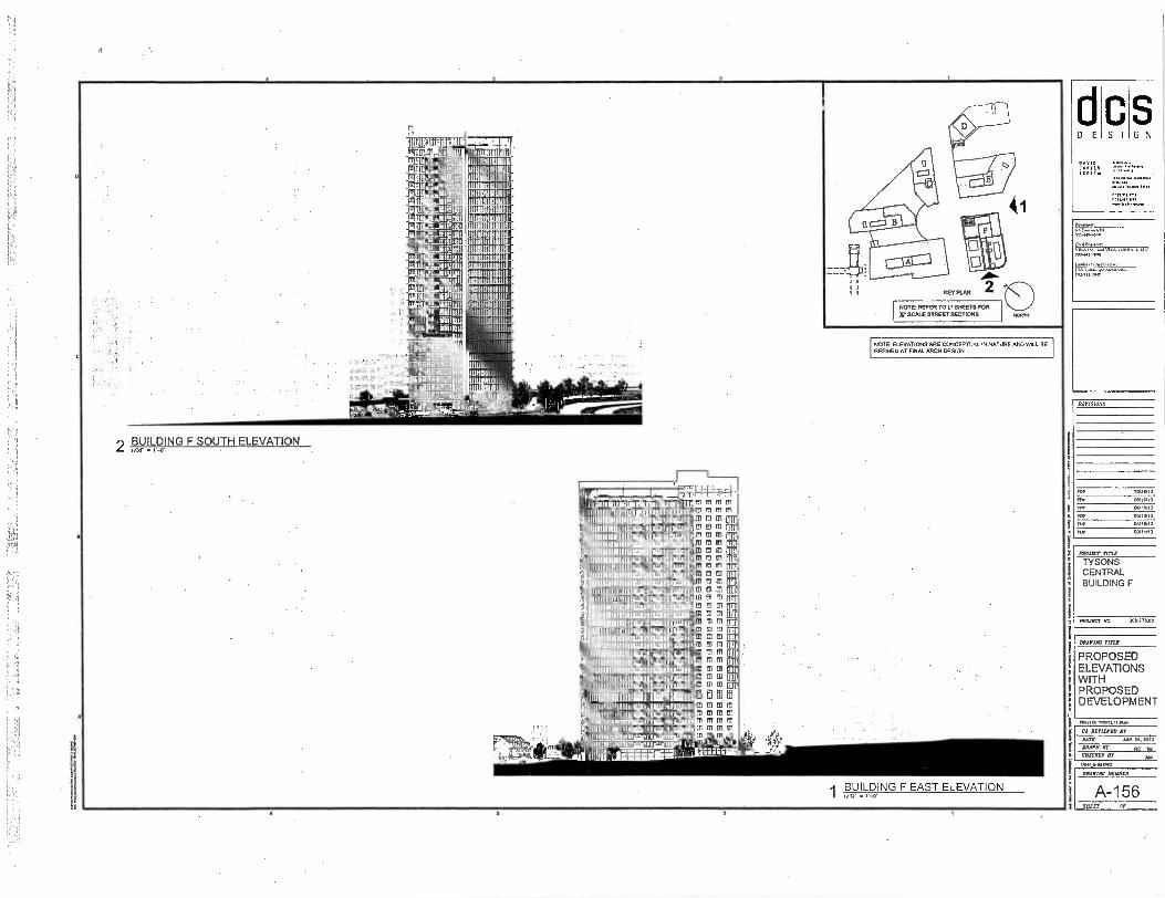
2 BUILDING F SOUTH ELEVATION
!mu] n -
r
1111131111111 111111111111E
III
1111/11 [rET
ti III 06@16fI Ill
181E11 11111111111/11
11111153 grav otwomip ,
1.1.2igsaii.i.SH31111111 •
1111
YlU 11'
III 11711111M1111111
• 1
I Am 311111151111111 rrtmmTnix
10141111111M
17:112M
NOTE: REFER TO L'• SHEETS FOR
W SCALE STREET SECTIONS
NOTE: ELEVATIONS ARE CONCEPTUAL IN NATURE AND WILL BE REFINED AT FINAL ARCH DESIGN
I
,17,-7.-T-4 1 . 171 rmn , 177.-T=TI7T1?rs 0 M
M 01 01 50
1 1 11 5 11111Millifil 11glulforalijaffi 9111 - -
e — li Ii jmnummiumanamm
iJ woe en 4 1111 p I ,
11111JEW iolliturargemeir
▪
co , 1115054_ mu • 01-
•11 "
tIOIWOMMILWIlt " I 3111111W1111 ' " 111 linkup] • • 1 1101111111111115111111113511LWain
1111111111131111110111 " ;P91111511UW ii 11
E 5111111BRIKInglcutidfi 1 " I1111111111MMINICI'
p 1111111111111E111Ww1g11inBuil
11 11111111111116111M1MiljaMI iiiniunitH •
*Ann • '1 11111111Ni REIHMAM:211 "
1111111151101 113111111011 11
. 11E 1• 151 ul 1-1.1.11i
1
III IJ
1/1 II al irn El to rn M
ro m.m 3 D mm 05 El mntl M M m ti5 ru men Eri • BR tli l, M en II
51 11 51 nmm
tv 01 m In it I73 M CD ET in 05 rei air imm m ~n mmm
m lm
F
m CO 1p m trip
61dffIED to al ra m m mmm MITIMM 01 01 ED
113.1. 711-11111
VIRA 1/11.1.0
dcs DESIGN
SCOTI,
DRAWING Trim
PROPOSED ELEVATIONS WITH PROPOSED DEVELOPMENT
REVISIONS
IMP 1:11, 13
tor
on
Fn
•
06/10.13
▪ 091913
For ouson Po, 0911113
PROJECT MIS
TYSONS CENTRAL BUILDING F
PROJECT NO 306.775.00
1.4.0.1.33.7.1111,
CA REVIEWED IT
DATE • ARP.04, 2013
NUNN or Rr CHECKED Br MI
1141,...11101.
MAIM MINER
A-156 SPELT Of
4
,BUILDING F EAST ELEVATION

•
Bill"It"INFIE10101 I 221111131Iikidlifilis:M sli I; 111!51
ti IggglEgglitEging1,1111d u1.4 fart a. • Jab w o
IIIMILEHIEMILII dIriw cs gsgemingegsmeg i I
don d
,r1:11 EE 4005. holetk.m.t•t*..Air al at ❑
wwwww ULU us I cc o IlTl wwwwwDiliw lia.11 w IMmeigin
t
.J1:0141-0 WED oimplb w "lath w
M o
GiU MIIIpu 191#101 In Ul UZIP4IIFU msfi:10115 quilial r
EU w pm .04-01 al '1:111101bc
Via w 1.1A424p :vs 'LAM k; so7433 1.111 %LEI
111.11fflaa* us 111111111s c 1111 -1Ap3u Lrogla tri loom lull .1,u•stom L'Issrmsu
11 L
.1.00g Mgab IL Q1 i4931cu w
MTh tuds.sp 111u QC w ' se anynwilas Ds w -141111Z HI Li L1.11, -mot#p w `,tlEllw c rallsggwu ,rlsgt41111 w rlitti411 re c ilIPPIOPaa . 131cTIED, w "Ja 11111 6;
161 b W r4ellki w
I In 113
:mune 11 .11. '' .. '7.0Ft,Al'',- 11
11-LNII
11 ■
1 ALL g I' Fa+, F.71:2 A
I. I - I me , Sal I i - G dui
CAI ..6-4 la' '
1 1 - 7 'ILI
4 1 1 ' 1 1 - I . il. L. • ]itin
1 1 ' L. .. :Ii EE13 11 - A.
■ - I 1-1
-111Ifi
RT. • 31, 11 i-.14 Fs-r. ' 411
1.1.31 S EFE ,, ai- NI
si]
a
",.=1 Fr
— 1 s
ESE
11 1/14,1
min 11111111 nil
Ginn
11111111i IN Inn
sum
WNI
Earge-1,44i
imintimminriaimimmarri ramiumanteammumilm
ilniMEninE1112;M i=0 1 . 1 .- ndinEWEININIMIMJIMME-111111111611111111M1M1W-MIMII IsignmegilligigEatarillisz7XLM
suarusammilIEREPEita l War§1111MPE-°.11MiusgtiM
-•=55,----m..111E-Miiirniimis. litgagginglglel EarNMW•••'°•" IligMligagMlogigemairr-gisimmtr Masi 11111111115 .011•Ms.....WagrWil
IRSSIMSraggillINE-7-E1111WP-AdMggralM gsigsgiggigg MifillnillirEggilligiggg5g3=11°°°°°9 21 EIMIEREEIUME-11----31111F-MEEMIF--Kril
° M AtsEEAipGGGiiGI 91111311MBIUMILW -MM:•"52FL.351
IggES,AsiENnigaginggginEr9
COLIEWEIEILIngirrir EME LIERNIESEINEMILINELSHIgillISESEI laliEllngl rP-911F.SERSOedira 1513W-.P. d.-.JiM•-°"-iVJAMigr
4 ,
■11Q
I 0 11 I A I
. I. A
,1 :rap lit iii
[trr r,TrTrIT _MT= ~ lTrlltl
Tr
E111 119111111111_,.
Ii1ll1 ,e.
r ILIA 1 11Ll OA • Cl 5.
I , 11 1 41 IDLE us gig w 111 w w .16111.0 10.4 c to.= , .11111SIJ WW1! sa..c al us
11111 so so (1111 d011igig
k-11,1su w la as la,: !la SU .1111.1i11 w m 1211J.W ' scr Ira
uliw , w DlTIII ar bag sollia.culti'll mtili.1.1_ w m..sa w wis
ra tari Lgwoui.muu sa pf.E. w 1.111 w w a GDi w 11.1cs c San
wEIBItD us all g] gig us, w ' w al w
11. as as w
Nlii sass
IR
55011035133515 31035
900 513355 0 01 93039 3105
8510 1.30
NNfoN
O
u03$
I N 9 3 0
WINO
C1.111/110
11/11116
MA 11144411l
1111160 so, Cl/CNIN
0111.10e OM 134311
A otssia -ung WIALN30 SNOSAI "71111.731.01Y
JO 473{11
L91. -V names mama
vacriswr•m
Al QM= a u 11071.7
C101 VO
03/471AJC
11■13INd013A3 CI CI3S0d02Id
HIM% SNOLLVA313
CI3S0c102Jcl JUL( MIAOW
rAIA1.1. VII 1
NOIIVAT13 132AA d omaiine
- .zctl NOIIVA313 H_DAON d omcnine
501S30 HOW 1VNI0 IV 03511311
39 1-115 050 3111105 NI 10111/35NO3 380 5N0111M313 ascm
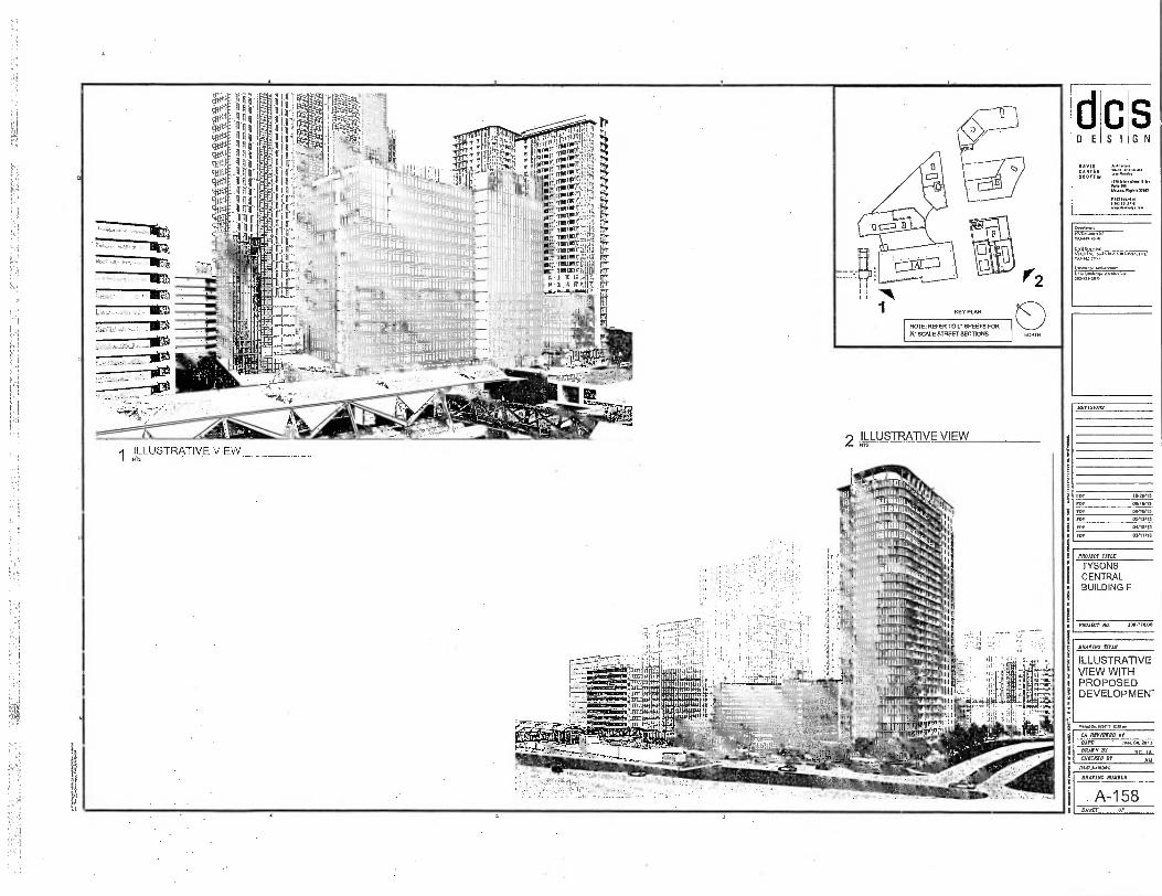
mr iiiiiihi ,
.,11 ja1:1111.114-111111:617:1110P1119"1111111tilii
1:
rirlifIlilliil
1----1::::; 11-:11:1111:171-11":: li irrig-----1-1 m-__L_—... ilia p plituniliniiiiiiiiiiiii mow ipp MA iiiii iii iiniiiiiiiv Nil a 50 UtlIngligigni15551M55551 EN
NOTE: REFER TO L' SHEETS FOR
X. SCALE STREET SECTIONS
1 ILLUSTRATIVE VIEW 2 ILLUSTRATIVE VIEW
44, ±AJI ,--.1-07.0,,rtz.
D E S I
CA N TO!
SCOTTY/
S G N
7■1344243011
lanAtag., AretwecAne-L30 I.svIKA,. AuM1IAAA ■ pe ..1131.1.15
PM.
060.13
DY13,13
%VISIONS
IWO/ 13
Oa/1W]
011111/ 13
01/1 1/13
PROJECT rrrnr
TYSONS CENTRAL BUILDING F
PROJECT An 308.77000
DRADMO TITLE
ILLUSTRATIVE VIEW WITH PROPOSED DEVELOPMEN"
CA IIETIEVED
DATE • JAN. 04. 2013
%Arm BY NT IA CHECKED BY AAI
DEARING MUDDED
A-158 SHEET OF

Moors NOTE: REFER TO V SHEETS FOR
SCALE STREET SECTIONS
o, e'141-' :
S G N 0 E
sz
• 1(
0■1•12.11.p.
CA OVUM DI
DATE JAN.0..2013
DRAWN BY Fle IA COLCNO0 Dr AY
17.0/JAMAIG
ERMINE MEM
A-159 SWEET Or
REVISIONS
WINOS FRI 011/15,13
011110/13
FOP
05,13/13
OA/ ----
PLP
MALT MU
TYSONS CENTRAL BUILDING F
PROJECT No. 308 Ito OF
L.
iLUSTRATIVE VIEW
..4,1..rn-Irt.7. , ...., -‘,, t°_ ,,,..„,,,,eiti.,p.
p„,,,... r,,;,.:,...,144;ii...,,,,,t, Irp.'.: . -....:,,,,„.,—.."1""irl ...,4 "TM riet, . , hifOior:4,%16tiiti tP
-olcfi 1117160! orrIPPr.:,...mr.Istro-...i?
-Iforc 11,gji i,,P,"'Cl• 1 11 '1'7' ;;Ifiril'Ir l 14. -Iv TTrR 747/01 ', • 0. rovirrv7F-4011 rarlrf
1 "rmoi:: ,r. p lor: ,Atwrrlh'ig'4. zr
-iffrg ripvrT g il'ig, ; P,Niii',g,g111197111,1 fir. :, rr liofe nirroFTIfilLii ;TT
111M ..;:1417;' ' orr:Ikliblr'!7q111'1111:77r0111 IT , 41. I ILIpi; T lap011er ENVIE rig I sa
7117'11T113 :1 S Ill' 0:447171j' .. I'l Ili 111Lifi:' '.1-:' . *1' Uti4 1111:11 1'18111i1 ilfrr i r I , il iCag if: * MI I, * .ITT. * 1 I V I 2 ni I IHH .NNA,.... N.H.-. ' . l'i la
4 '0; IC ; rg ._,I, 1: ,,,,IiIii ;, ) ..--idnii42:1:1W1 FA-
mu It. iiNftrilallinfilinnifii vm oeunifinlionli 'T 10 : 'Ff''6'41411.uriiIt.e,i.7;114'r. .il..
-I II — I In
analimaLauzimminimmilimillai • .15T Tr4
f..21 *PI
KEY PLAN
11 12311"--
2 ILLUSTRATIVE VIEW
VIKA ...A VIKA V 7115.2.17.
'FAT117=
ORANINO TO.
ILLUSTRATIVE VIEW WITH EXISTING ADJACENT DEVELOPMENT

n E S I G N
!N71,1 SLOT7w.
Oy•-•*
1141. vY VIKA VII141,1
Laub., Nei.* I...Iscapt
REVISIONS
roe Avalon RM innERT Fn. *100013
115113/13
0•11111/13
03/11/13
NOTE: ELEVATIONS ARE CONCEPTUAL IN NATURE AND WEL BE REFINED AT FINAL ARCH DESIGN
Ulf :HARTnn vrnru Int,7111,1 TWIST,
NOTE: REFER TO I. SHEETS FOR X. SCALE STREET SECTIONS
EM S4 ICiiui n' ■■
j BFI
II -.!!!i ItIo
WI WWI
4 ggt"t'A.,Agt
1 ILLUSTRATIVE VIEW
tlttr ~ mit„,,, i - t,, :. iton m Impv, ,
!'"riq '4:1' ,111, . kw ,ir
1,1 i
: k NI: Att: EN;Att Eit,
i II It 7 ril, OW 111; .4. 0 81.!
1 1 5e, A - Irl ool ITT,. 1 Tr usl
.11 i _ 313 m q .w,,,,:, 101:: , .: 3 ‘,50 ext. ,.,„„,,fri 1 II fu.T ni min
III NI r. ,t3 : Tr MA.1. 1111175 €1III V I— HIES PI0.1 Worm,
inirr111 En . a:IL.of!.ta,ove: VI I Ill gi, M , Alet,ani 11!
111 mpg gu iy4m nili m, I II I1.03571 evig101 , a
MiTtilli lli 11v9161313 Unt
g i'f'71',.
111 I 1 ItrailoOal ren9t 11 I I in.",' ,0 ..a1P.
.T.G.I0. mg: rld,-io'pert
i:Ifilit' "tirreM1 1rfk 1 140;0101;11
Ii4a:
PROJECT TRW
TYSONS CENTRAL BUILDING F
PROJECT An IosTALoo
DRIVINC YITLE
ILLUSTRATIVE VIEW WITH EXISTING ADJACENT DEVELOPMENT
1141.1.16/2.13.17.11,
CA RETIEIED BY
BAIT
JAN.04.2013
DRAIN Br _RC_JA_ CHECKED BY
AM /11.1191 .0.1.0
DRAWING MIIIBER
A-160 SHEET OP

2 ILLUSTRATIVE VIEW 4 ILLUSTRATIVE VIEW 2 ILLUSTRATIVE VIEW
AZIA0.112.r.
CA REVIEWED Br DAM JAN. AI. MA
PRAWN BY RI' IA CIILTRYO Br AY
MII,AACIAVG ILLUSTRATIVE VIEW 3 ILLUSTRATIVE VIEW
;VER scOrl,
PO. 10,211113
AAP 05, 13113
03/11/12
NOTE: ELEVATIONS ARE CONCEPTUAL IN NATURE ANO WILL BE REFINED AT FINAL ARCH DESIGN S
G N C S I D E
OtecALur
=VAT.
VIAA LAU ALIA..., 442 , 71.41
L,ndsr. AnbiALALL,
101:L17;g3r A""""".
REVISIONS
PROJECT TITLE
TYSONS CENTRAL BUILDING F
PROJECT NO. 3011.778 GO
DRAWIIV rare
ILLUSTRATIVE VIEW WITH EXISTING ADJACENT DEVELOPMENT
DRIIlAS NUMBIIR
A-161 SLIMLY OF
dcs DESIGN
DAVIS CAMTIN SCOTrw
I1/1,111 "11
Ortetmo:
701-41.43011
7k] 11fl NIKA VIKA VIRGIN, 1.1.1. 703.11./A15
tand.c., Arcliirmore
35111145.15
BATISMA5
PDF 10,211/13
f1,1. 00/15113
FOP
101.
06110113
03/13/13
Fur 05110, 13
03/11/13
PAM, mu TYSONS CENTRAL BUILDING F
MI= ma 300471 00
Road. Perit3.1.p.
CA AMMO Dr DATE .0.1.04,T013
DRAIN Br
• pr IAA 77101111700
MAGIC NUM
A-162 SRELT Of
DRATINC TITLE
SHADOW STUDY
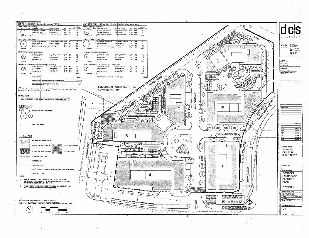
FOP
FOP
FOP
FDP
FOP
FOP
2013.10.20
2013.10
2013.0730
201105,13
2012 09 1S
2013.11
1 1
d c s DESIGN
SCOTTue
■ES.F.sts
MIMIC WM
CONCEPT LANDSCAPE PLANTING PLAN
OPTION 1
MINIM WPM,' Iss
CA AMMO Br
DAIT JUNE 20. 2012
DAM or camorn NT
11425
CDP TREE SCHEDULE lop Ion 1, limits of CDP site) CDP TREE SCHEDULE (option 1: includ d off-site Improvement)
sulMoull
STREET TREES (CATEGORY II 1PU 91DE
ItEr OTT IOTANICAl GATE CO N NA E. WIN COMMODE, mar Col are Co/u are Ae0 Maple MS 75
DInkso131.9“enNY Sem SIM, 7S Duero. robot...Fleas' raal Enellth Oak Sal. 661 71
19 le25
STREET TREES (CATEGORY I)
REV CITY. AOTANKADN ME
Mee Meson 'C
GIFSee Webs s mtet
Bum. roller estlesaM
IS
7.171 TNT
COMMON NAME SUE ME COMMON'
Cowman Red NNW 3. eal. 1113 75 Angry Giniqo Val. SE. 75 Amileate AI.Oall Veal. DSO 73
1125
STREETTREES (CATEGORY IV)
Mgr Muse,
Neuron emel
rIsmrtsts
Seems mere.
STREETTREE5 (CATEGORY IV)
seesaws' October Glory Neel1Peplet Tai. IAA 250 O DAN rubrure0Dober Glory ODD Ar Glory Red Maple r A Antlen Plane Tree 3. AL KS 250 Flamm aterlIollo .3131Plane Dee 3. Al. BS. 750
Southern fled 04 cat BLS 250 Menus falcate Soothers Red Oak r ral. 06B 250 Volley N Amerlean Dm Val. SLR 750 Ulenrs arnerleone VW, ier9e . ABA on Elm 71 sal e611
oe-os,e n non
ORNAMENTALTREES (CATEGO R emelsnehler fortis emmen
• Comes Souse
Mama. Hell,
3,131olal 5
ORNAMENTAL TREES (CATEGORY II) Davne9 5cAltoberry V S. Amelonehler rho..
la m e Yw. 0.11 11
▪
5Certl1 eanodenail
ae Ooswo. r MK 115 0117M112etesa
Dar Mann,. eal. 661 125 Ala.nolla
615 tub , lolal 16
meerneekeerry 71 al. BRE 125
S70; Aaqrs71.
V.. DU 125 ANN IlaDM eal. B66 25.
cm. en 125
SOW
sores
Is
ORNAMENTAL TREES IN ELEVA enselancele,
O
fetch canaslen Carew Loom
'Memel. Kell
see.. m
00035 5112
ARUM S0.11111/ICANCIFI SEQUIRI131561,1. 111
TOTAL TREE COLE PSOVICHD BY RANTING WI
ORNAMENTAL1INES IN ELEVATED DECK (CATEGORY II) chler Breen. nolceber Cal 1114 1,5
Cc:rels adlaud r ass 1N Tao au no
March. Deflate 1411 Delo TaL PU in see
TOTAL TRH COVER PROVIDED ER PIPITING (591
E D DECK (CATEGORY ID ores Downey ServIcebeny
18 tutors BARAN AAA Dogwood
Dr Mesa
v. AN.
AVM 11111111111U!!
71 '7
Medoihe ANO R REMMort
NOonly a/ Never. I.W. seletteME. OR INN ENRON v.,.
Spwirmnav °REIN. I and ...NM,
GENERAL NOTE
NO MISINKKAL ANOINSTRIOS M ING ISITUNDSCAPING SHAD SP PA0310(010AC.0.3
Mal LANDSCAPE CALCUURON I. BE DRUMM yORTNE SREATINE NW Of F.D.P.
LEGEND
0 0 PROPOSED ON siTE TREES
Do
OFF SITE TREES
SEE NOTE #1 FOR STREET TREE CONDITIONS (TYP.)
II , is is •
u 11 1 II A
BIO-RETENTION PLANTER UTILITY VAULT f 11 g STORM WATER LINE
I/
WATER LINE • II •
SANITARY LINE
LIMIT OF CLEARING AND GRADING (SEE CIVL DRAWINGS)
11
PROPERTY UNE
NOTE:
I. WHERE MINIMUM PLANTING WIDTHS OF V ARE NOT PROVIDED, g ALTERNATIVE PLANTING SHALL RE USED TO SATISFY SITE PLANTING
CONDITIONS. (SEE SHEET 1.-.7-4 ANOL.7.1)
2, THE LANDSCAPE AMENIre LANDSCAPE PANELS SHALL PROVIDE SOIL
VOLUMES IN ACCORDANCE WITH THE PROFFERS:
LEGEND . EXTENSIVE GREEN ROOF
WO-RETENTION -TREE PIT DETENTION %%LILT wRIZL^Wol_%,.1" tivfor,A—MIV
■igning-... • - - - --- — •
- 7 - -- . - _ - 7_ — _ ------- --- --- --- 7 -- ----------
NOTE 111E PLAN AND {AMERY SHOWN wor woolmr.o AnD rus. ENGINEERING AND DESIGN, PROVIDED THAT THE GENERAL DESIGN OVALITY CHARACTERIST. ARE IN SUBSTANTIAL CONFORMANCE WITNINAT SHOWN.
O 0 15 30 99 90
---
re) • •
MINT TITLE
TYSONS CENTRAL BUILDING 'F'
PAIIIICT NO.
Develop. NVCavernertial 701-40-003
701-311.7100
1.50 Le=Pe' AreAltenve. 701.311.100
DRAINAC MIRROR
L-1
SHUT 01

FOP
FoP
FOP
FOP
FOP
FOP
7017.10.4
20110.4
2017.07.10
70110.17
201114.111
201.01,1
./ FOP TREE SCHEDULE (limit of FDP site)
•se— -.—
TRAIL CONNECTION WITH EXISTING SIDEWALK FINAL ALIGNMENT TO BE DETERMINED LATER
STREET TREES (CATEGORY I) JEER ONE
WY MY. BOTANICAL NAME COMMON NAME SIZE TON EOM ILAN° TY O Apr ess4sm T0144P. 7014140 NM WM
CS
11101 N 61.114411041440
14400 robsetntlema.
San4Onlem
0 site S Fas11.4.914 OM rat BA 9 7S
444 77S
S1REETIREES (CATEGORY IV)
EXISTING CLYDES
TO REMAIN 0 ACCIIIIMO "Om., CNN' 004erGle, 94 74000 0. 0 , 04 14 Almn49.41110119 Wenn Plane Tree 7,, OAS 24
OtormoNakma southern WI ON T rAL 1S6
711014.0444 .4114farsn' AlnerICAM 005 9. 0611 ISO
4441 9 7110
•
ORNAMENTAL TREES (CATEGORY II) woHanom.00na Onvenny ServIcehery 3,1 40 125 Ce4=4144 Stamm 0009F0 7,, esti 05 90.494. 90.00 0.90.04 3" cal 71s0 125 0las4110411.1. S,1. 090 171
BENCH (9)
PLAYGROUND (0. BOO so.!.)
GROSS PRAM: NMI Sr
440F MYSAAIMICANOFT144117741440441 SOS SF
TOMS TRH COVES 11105/1710 AT RAMING LESS Si
NTERIM PARK
Nollr sprtles. the pent... are W.. the trees MOM ■All baselertetUerthe/Inedplanang Seeps no. yverytlepenellne en final design one I evellobIllo.
C GENERAL NOTE 1 TAFF CAIMPY MITMATION 00 XOISINSFSIATIXIFSISA PAM PIANTNG 7 All771177114 ruisuc 91611S OF WAWA! 51447 70417744094
AU.STISFUTISFES SU947 FIRMARSIMSSAANYWAS
INTERIM RETAINING WALL SEE CIVIL DRAWINGS
' FOP TREE SCHEDULE (Included off-s)te Improvement)
6' WIDE SIDEWALK STREETIREES (CATEGORY JEER TAN
KEY QTY. BOTANICAL NAME COMMON NAME SIZE TREE COM LOMAT O Mei rubema rehmPatY Celonmsea M.1* PW INS TS 4514101010,49Y 404034970 77 cal 40 75 00.90m01414171Pas /aStleate Ing11*. Col en 75
371
lY3ON8 CENTRAL STREET
-
STREETTREEE (CATEGORY NS
Am, 4000 1440 Gore 1.4nbet GI, Mel Maple T MB ISO
O
9140449000110
OssernAlslpsa 14■4004104 LA. SAO ISO 1.705us 4404 4114F 04• : 2:0
7494 L MOO
.1111■ /A AIIlk, r0./MimilLriN
ORNAMENTAL TREES (CATEGORY I) Amels4190444 Oa wnev Serwhederry 7,1 MS 17S
O
CeMmans40sIs Osolut bum 10.401140014
Salsem M..
Itngur Oen... .0.43,011.
I' eat SA. 17S
Trot DM Sri
r. MA us
IMO
4 4.411
010
INTERIM
4 410 to. POWER, CABLE, AND
PROPOSED
COMMUNICATION 14
EASEMENT
4
911075 It AMAs HOMO SF .
AMA OF WRNS 174 CANOPY 97001997. (ISA ans.) TOM SF
TOTA717177 C04111914949.714/11114 475 St
OTIOte Noes rom*, os oort of overall londscooe pion sficoo., R.NIc•PoPRO PM If
OmunuesITren fraler.00 WO
TREE LEGEND
PORPOSED TREES
AIIP1111
ON-LEASH DOG WAUONG AREA
O 440 IMO MM. TEMPORARY OFFSITE PLANTING IMPROVEMENT
CA REWIRED IT
ACE JUNE 20. 1012
MEN ET
GK CKEE Zr 0:24TipETZE,i) 0 15 30 60
614.19,90904
LEESBURG PINE ROUTE 7
r LANDSCAPE WALL
OFF-SITE PLANTING IMPROVEMENT REMAINS IN THE SITE
.II
D E S I G N
Avm
.....
41-99994
0.11.01000: 71111410.141
1444 4704.59
REVISIONS
PROJECT TITLE
TYSONS CENTRAL BUILDING 'F'
PROJECT PO
ORAVIAC TIME
LANDSCAPE PLAN
ORATING main
L-1 a
SHEET ,OP
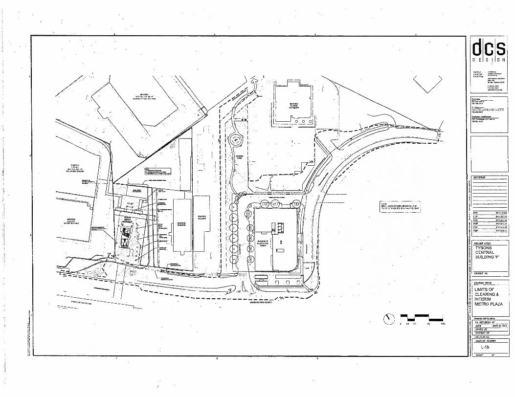
d S E
FOP
FOP
FOP
POP
FOP
FOP
2013.10.00
2013.08.15
2013.07.10
mac,. 1013 01.111
1013.03.11
dew orn. IS.r.
CA R1711PACC Sr 000020, 1012 JUN DATE
DRAWN ST
cfracATO AT
•
80 120
FTZLI-MiTS DISTURBANCTL.0.02. TO OE ESTABLISHED AT Pl., P
--- 7 --- . . .. .. .... ......
.
... LEE . PNEJ .......
■LE NEL ....
OREEN3150,10 SiAPON
S G N
•
I1,11UL
BRACING Tn.
LIMITS OF CLEARING & INTERIM METRO PLAZA
mraroms
pRoax, TITLE
TYSONS CENTRAL BUILDING F
mann Mt
DAACINC NWIDAR
L-1 b
SHEET Or
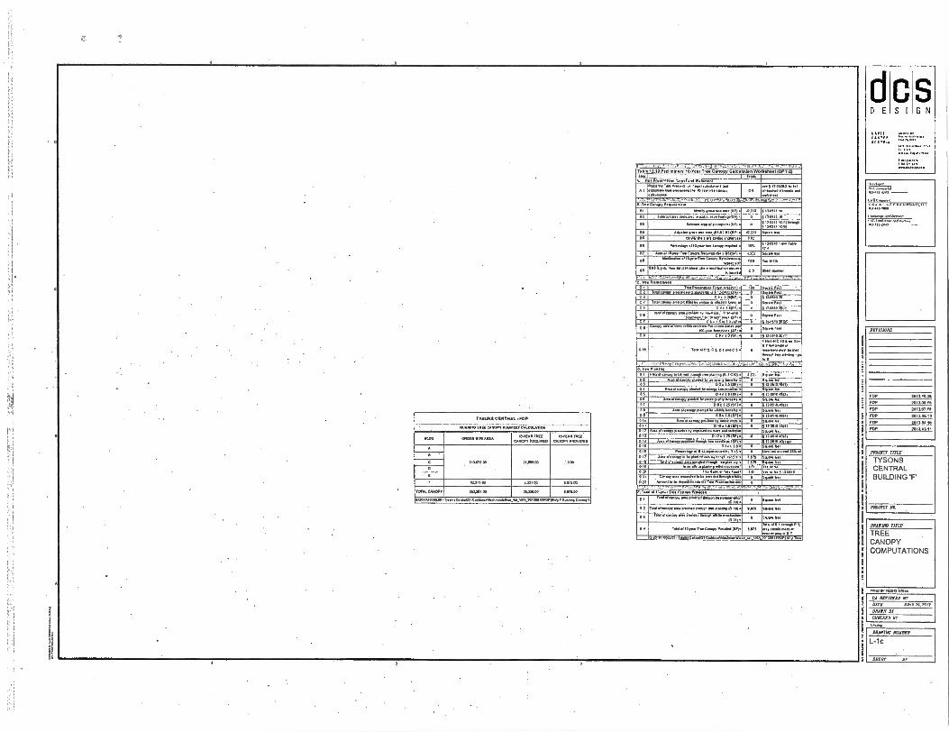
4
FOP
FDP
FDP
FDP
FOP
FOP
2013.1013
2013 00.,0
201107.10
201103.13
2013.01.10
2013.0111
.K3 VINI.13.3.1.5
MARINO TITLE
TREE CANOPY COMPUTATIONS
P.M Ow 1.31.0 .Soo
IMRE CENTRAL • POP
RUM/. MX CANOPY 11.3.1319, CALCULATION
MOO 1310333 S.M. 101111111133
CA.1.1. RECUR. WEAR 111E3
CAW. PROVIDEO
210.b13.m 21001100
0
0
42.31300 4.21100 1105100
TOTAL...
01.011014100.,eng.naggel
202.1.00
Catelo•v•......•
11311.00
• Ly.a.3013001 7,001.0.1..1110•..TT
1.03.00
1• Table 12A0 Preliminary 10- ear Tree Canopy .101.10011.0.3.014131FT.31
1 To land .1•11143
rem A! '"iiligar.g.n 77 777
. TA. Pea. ranol e•agelabgeg • A 1 rd,................ I. ...or.. gangs
age 5 /10102-1 .611
II..
anew eeeWnmet
C. agnew.0•1.1•••••••• .M104.1
Cl
:1•705".....:7.7,.."*.:',.. ''" :112' 11 11.: . 3.14.1..1.
in n•l een.leser...... • 5 111411 10111... 5 110511 101,
M.o. •••■ • me aro .133.11.9Fi • wars en 6 0110311. 00. canna anciaerwe FM
I. H... ell... Ino maeop..100 • 1• 12A
1. A.. 103or Mos Canopy FlwAreee. • .501.• .... 01••24 0. .. ...en .10..a.Tin C., Awfairevelo• „„..., 11.
.• LIM 1. ves, Olen Sal pin *Member. rnedkar7e.: zu.7.1, 0.2
C.* Frown.. C Tr. CO
Pante.. To.131581.1•1• T......s Op.. of 9 1.1.00.21.
Sep. F.1
I. Searog 11.1
C 3 C 2 • 1 NSF, 0 17.0510311 C/ 1.,a•asy saes .1.13y on. a *Me Iarel1 or
C 5 CAI 15F3 2 1. 537.102"311, 111
C 4 '''c""'""'3f,a1.ur•'."'oTTZ ■ee'71:.
Spa. Feel
C1 . C4.11.610r3F.
Cow. rta .1orn milelo ns.•••• Peewee...Am. Am 100.1•0 FogarIelas f SF,•
• 112.10133
F.r
0 0 0 . 10 1301 • 0 5 11. 101C11 / 11. 7olC 11111•• Pan
.PolC3,C3CT.CS• 0 rt0onenigans.mi
Of gr. ♦ » A.
Po. 1.11. 1. • IP 1e D
0. Pla .0
0 1 Op ale lobe mid . lne pan 1.0 . le • .. ap 3.1 02 05 **"."4"''''' "III: .7;;.'r,: : :=1111 OA 05
Av. of • Ow.. um. tenger.* • 0 A • 1 5151.1• 0
Sepage eal 0 11121
DI ...A. 01 esteem • low 0•• 0 I 1. 0
.... ke g12a5,03 21
0 0 Ana AN.. gx1N *at . • sme . II 11 014 13.11.•
ponistees mine Fe• • 0 0
f110510q,l 511••■• 11.1
D I I 0 12
D 10 • 1.51. Ana of s ..r.01.301.epew e ana 11.
0 13.05.0 0
Van ear 0 13 0 13 a I 1 I.•
. Paso. I. se*. ISFi • 0 110510 0011
512N10.Ot .1 0. 1. 5. 0 1.1. 1.0 • 0 cyan NI
Peanolopte101•••.• ■ ••0e. le• 13 . • 0 31.10.1•• •••13. d 0 if Area el WM la IN ploilnl•AN • ■■ benel • 0.3 se WI
0 F • •Os Ina 0g
••• • owl tr a sp.
•••
011 oD ank er 7nr• Fun. NO
0 IN 1 11.13
*I D13 ....r-
. Fa 1101 or 10.0.1 Tote ...is Irrorklei
Ir.
.., Teed armeery v. pre........••.... IC 101.
• e0.
32 CM 03..
I
T...nery ma ee. 0.. elog..0:::..
cm . mi. pap 11 Pao.. • Vao 1.1
lali-grri -egg -1-03 II • Total of 10• ,01.. C•eepr Pm. 01.• 0.0, 0 ....... o
10.10.10055 04 Ty........1C,Jegg.V.Pgeora.••• 01 11140 07171.174:11'413..
DAVIS
.013,
D E S I G N
NITISIOBB
PROJECT TITLE
TYSONS CENTRAL BUILDING 'F'
PROJECT a
CA 50111100 BT
DATE 2012 20. DM
DRAIN BY
CRICKED By
ONAVIN➢ NUMBER
L-lc
SHEET or

7.j
1 .1 :1
II
FOP
FOP
FoP
MN OSA,
2012.04,11
20110.1
REVISIONS
FOP 2012.10.20
FOP 2012.021.15 FOP 2012.0200
PROJECT TITLE
TYSONS CENTRAL BUILDING 'F'
PROJECT NO.
ammo TIME
BUILDING 7' ILLUSTRATIVE SITE PLAN & SECTIONS
NITTI OTTSOISS 1ST cos
1.2,112.
C S I
S G N D E
IHTTITATT
ZI=771147T-
‘IS.A THI vutt•HHA.13
Erne, MSS*:
ri L:1
i Cl SCrt
71!
t
I • • EXISTING 6LYDES TO REMAIN
•
r'
EXISTING BUILDING.:
EXISTING BUILDING I
BUILDING 'F' BUILDING 'F' 7.11.1.11.1M1 15 n 60 TO
NOTE' THE PLAN AND IMAGERY SHOWN WV BE MODIFIED MTH FINAL ENGINEERING AND DESIGN. PROvIDED TAT, THE °ENO./ DESIGN DIMITY AND CHARACTERISTICS ARE IN SUBSTANTIAL CONFORMANCE WITH THAT SHOWN
EXTENDED CANOPY
I 12 WrA `.
'Irk • STREET
TARRING AMENRY PANEL
INTERIM LAN SCARE ARHA MAU 12.1111ALE POWER EASEMENT
BUILDING 'F' UV,
• 1 _
TYSONS CENTRAL STREET
I I 4:ID
.
i I
-,
r"--.6-• , 4 - \ f liffi'-'-';': 7.-ZL7'• 770.9A 1, --....,,, ...:, .., ...Y .2... !.. : ..: 1,:kplic:., # , r'''.: • ----;
.;„ •
- ----.....' ' .--7:.=': ..-7,./:7),,c2E! linitc;•;, ----. .7..7...'.17'11111 1./ \ e' ''Y'" . '
3.'...`.7!.";".' -'11.Prjrracs,57.'77:-: " • .77- 1 \
ime....
II
® BUILDING 'F'
MAW VRAANCE •;.;F:;?':
— • ,7,Pr! "• •
L__ • t 1 LEESBURG PIKE (ROUTE 7) NI
AL' r SCAF7E MOE
ANEW'S VINYL
Asci, Cs'
PRIVATE/4110Y
ZON0
CA REVIEWEDY JUNE 20. 2012
DRAWN RV CHECEED Br
054 1711. NUMBER
L-2
CITA t Cr
........ C., ,
SHEET Of
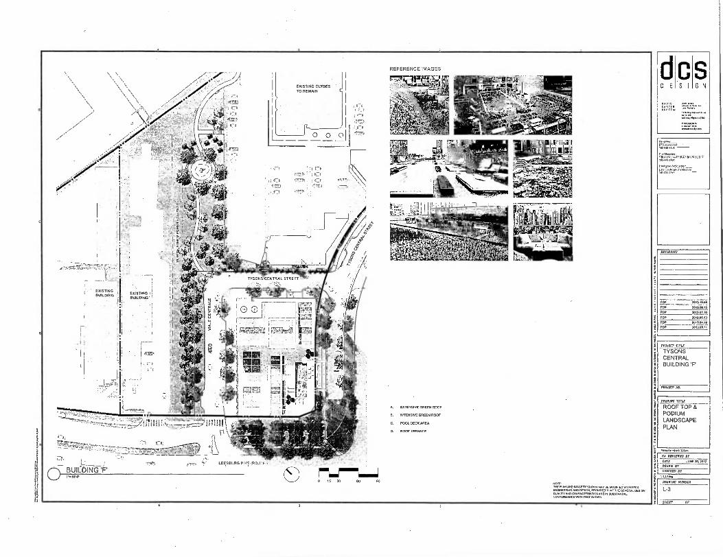
FOP
FOP
POP
FOP
FOP
FOP
2013.10.2.
2013.0615
2013.01.10
201300.1 , 10.1./11
2013.03.1i
PirwtornonLWNI•
pe MANIAC MAWR
DRADIAE TITLE
ROOF TOP & PODIUM LANDSCAPE PLAN
S G N
WIEN. Mulish ION
S E
.** Art iNnwre
REVISIONS
PROJECT TITLE
TYSONS CENTRAL BUILDING 'F
PROJECT IN
CA RENEWED DI
DATE Ake 10. 1012 DRAWN IT
CHECKED DI
L-3
„r-- „ji NI ill
CT BUICE;ING
SWEET Or
ATP 4:" LE SBURG PIKE (ROUTE Ti
• er.:. •
Tre,
EXISTING CLYOES TO REMAIN
••rEVI) 4'
T00 0i
7 -
O
fl
EXISTING BUILDING
0 15 30 60 SO
EXTENSIVE GREEN ROOF
B. INTENSIVE GREEN ROOF
C. POOL DECK AREA
D. ROOF TERRACE
TIE PLAN MO IMAGERY SHOWN WM' BE MOWED WITH FINAL ENONEENING OESICIE BlIOVIDED MIT THE GENERAL DESIGN OUALITE A. CHARACTERISE ICS AM IN SUBSTANTIAL CONFORMANCE VAIN THAT SHOWN.
TYSONS CENTRAL STRE ET
674 r:t
I
(yrs
4r&B
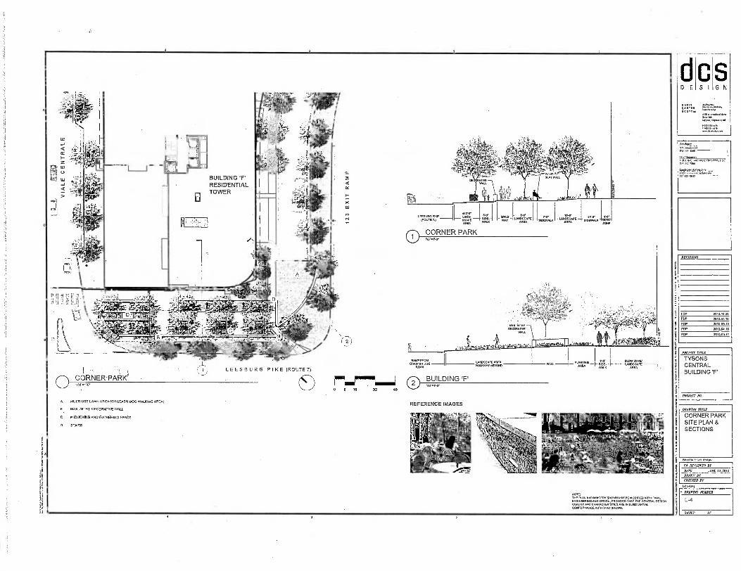
FOP 201.10.26
FOP
FOP
FOP
FDP
20110/.10
2013.0113
20110E11
2013.0111
dcs DESIGN
CARTER SCOTT Ito
DRAWING 111.1B
CORNER PARK SITE PLAN & SECTIONS
1.4_1411•S
0 CORNER PARK 1/8`.1,0"
1.1.1
EY
U
BUILDING 'F' RESIDENTIAL TOWER
12
3 E
XIT
RA
MP
;201 Cry
LEESBURG PIKE (ROUTE7)
RNER-PARK 77-11-7-1 CD 0 8 16 48
BUILDING 'F'
MULTI-USE LAWN AREA (ON-LEASH DOG WALKING AREA)
B. MAX. Hs- HT. DECORATIVE WALL
C. PICNICKING AND GATHERING SPACE
D. STAIRS
NOTE: THE PUN AND IMAGERY SHOWN /AAV DEMME. W. MAI. ENGINEERING AND OESIDN, PROVIDED TNAT GENEFIAL. DESIGN 00.11V AND CHARACTERISTICS ARE PI SUBSTANTIAL CONFORMANCE WITH THAT SHOWN.
REFERENCE IMAGES
4111
.T.dx
REVISIONS
PROJECT TITLE
TYSONS CENTRAL BUILDING 'F'
PROJECT NO.
CA REVIEWED Br
DATE JuNE to. Pm
DRAWN DT
CHEESED Br
• DRAWING NUMBER
L-4
SHEET or fs
D E
S G N
C S I
DAVIS CARLO SCOT,
414.426 22213.1 pm
CA AMMO hr Aar !WO 70.2012 OWN Dr CHIOTO HT
LADS
GC. TREE ROOT ZONE
I-If BUILDING
ZONE
0 TREE PIT @ CORNER PARK SCALE 17.1.42'
NOTE:
SEE ARCHITECTURE DRAWINGS FOR STRUCTURE SLAB AND SUB-GRADE CONDITIONS.
CD STREET TREE DETAIL W/ NO STREET PARKING SCALE: 12.41 ,c 0 STREET TREE DETAIL p STREET PARKING
scALE 1/2441
NOTE: 1. SOIL VOLUME FOR CATEGORY III AND TA TREES SHALL BE 700 CUBIC FEET PER SINGLE TREES AND FOR 400 CUBIC FEET IN SECONDARY PEDESTRIAN ZONES WHERE PAVING ABOVE TREE ROOTING ZONES IS NECESSARY. 2. FOR TWO TREES PLANTED IN A CONTIGUOUS PLANTING AREA 500 CUBIC FEET SOIL PER TREE SHALL BE PROVIDED. 3. FOR THREE OR MORE TREES PLANTED IN A CONTIGUOUS PLANTING AREA 400 CUBIC FEET SOIL PER TREE.
PLANTING SO MIX COMPACT SOIL TO ALLOW FOR MAX. r SETTLEMENT
I-17 TO 7 AIR GAP AFTER SETTLEMENT
GEOGRID
PUBLIC SIOEWALK
GEOGRID
11,01 TREE
ROOT ZO
PUBLIC SIDEWALK .
CONTIGUOUS TREE PLANTING AREA
IT WIDE TREE OPENING, SEE DETAIL 4
BUILDING ZONE
TREE ROOT ZONE
SET BASAL FLARE OF TREE FLUSH WITH OR SUGHTLY ABOVE FINISH GRADE .
3. DEEP MULCH •
STREET PARKING SPACE
ROOT BARRIER
VARIES VARIES SEE PLAN
MEW
4d10111er
DRAINAGE STRUCTURAL CELLS AGGREGATE
TWO HIGH IMF
COMPACTED SOIL MIX
PEDESTAL
PERFORATED SUBDRAIN PIPE, CONNECTED TO STORM DRAIN
OUrER
. i I SHAPE
COLUMNAR
STREET LIGHT
DECIDUOUS TREE
SW
WIDE TREE OPENING, SEE DETAIL 4
TYPE 1 TREE PIT WITHOUT STREET PARKING
0 VIALE CENTFtALE SCALE. 1/11.•1'S
BU
ILD
ING
FA
CA
DE
COLUMNAR SHAPE DECIDUOUS TREE
TYPE 2 TREE PR WITH STREET PARKING
AMENDED PLANTING SOIL MIX
GEOGRID
PUBLIC SIDEWALK
GEOGRID
STRUCTURAL CELLS TWO HIGH
SET BASAL FLARE OF TREE FLUSH WITH OR SLIGHTLY ABOVE FINISH GRADE
r DEEP MULCH
CURB & GUTTER, SEE CIVIL FAIN FOR DETAILS
ROOT BARRIER
ORMNAGE AGGREGATE
SET BASAL FLARE OF TREE FLUSH WITH OR SLIGHTLY ABOVE FINISH GRADE
3' DEEP MULCH
SEATWALL BEYOND
ROOT BARRIER
DRAINAGE AGGREGATE
PLANTINGS. MIX COMPACT SOIL TO ALLOW FOR MAX. 7 SETTLEMENT
1-17 TO 2. AIR GAP AFTER SETTLEMENT
mil// WW1
PERFORATED SUBDRAIN PIPE, CONNECTED TO STORM DRAIN
COMPACTED PERFORATED COMPACTED
SOIL MIX SUBORAIN PIPE, BOIL MIX
PEDESTAL CONNECTED TO PEDESTAL STORM DRAIN
O TYSONS CENTRAL ST. SCALE: 12 .5,0 .
8 ..0. STREET BUILDING TREE PARKING
ZONE ROOT SPACE BUILDING
1- ZONE ZONE
Ilr OltTfFII
II COLUMNAR SHAPE
4LDECIDUOUS TREE
-111
r III Ilr
IV WIDE TREE OPENING. SEE DETAIL 4
STREET LIGHT
CORNER PARE TREE PIT
® 8' X 8' TREE PIT ScALE crEn -o•
IIVOwnwrcial MAU-43M
yuu IND.. no, vusliwk.i.Le 70340-7100
Laeye*
"ormoo
MOUND POLE
TYPICAL TREE DETAILS
ArVISIONS
FDP EDP FOP FOP FOP FOP
MOM =IS
TYSONS CENTRAL BUILDING 'F'
PROW' NO
DAAIIAC MOIREA
L-5
SOOT Or
dcs DESIGN
IMMO TITLE
TYPICAL RAIN GARDEN DETAILS
RIVISIONS
FOP
FOP
FOP
FOP
Fop
FOP
PAW= 0551
TYSONS CENTRAL BUILDING 'F
'Naar, All
1.10a WM MIN
CA WM= AT
BATS NNE 10, 1012
DRAWN IF
=CUD IT
1,10,1
a
s
CORNER PARK PLAZA
STRUCTURAL CELLS
LESS THAN 11 .-0• SEE PLAN
RIO-RETENTION PLANTING SOIL MIX(PER FAIRFAX COUNTY STANDARD REFER TO COUNTY PFM
LIMITS OF PLANTING EXCAVATION SCARIFY
FILTER FABRIC
ROOT BARRIER
SUBDRAIN PIPE (SEE CIVIL DWGS )
DRAINAGE AGGREGATE SUBORADE
0 PLANTING STRIP SCALE 1/6•1 O.
ATRIUM SURFACE DRAIN
RIP-RAP
FLOW THROUGH
CURB
LESS THAN ra• SEE PLAN WO-RETENTION
PLANTING SOIL IAIXPER FAIRFAX COUNTY STANDARD REFER TO COUNTY
PPM
LIMITS OF PLANTING
I EXCAVATION; • SCARIFY
I ii
ROOT BARRIER
a• PVC PIPE 11,11.
SUBDRAIN PIPE SUOGRADE (SEE CIVI DWGD.)
FILTER FABRIC
DRAINAGE AGGREGATE
0 STREET TREE (TYPE I)/ BIO-RETENTION SCALE: 1/0•1,.
FLTER FARR= ROOT BARRIER
FLOW THROUGH CURB
ROOT BARRIER
r4r LANDSCAPE
AMENITY PUBLIC PANEL SIDEWALK
1 1
3• PVC PIPE
r SUBDTLAIN PIPE (SEE CML OW0S.)
RIP-RAP
ATRIUM SURFACE DRAIN
O WO-RETENTION PLANTING SOIL MIXPER FAIRFAX COUNTY STANDARD REFER TO COUNTY PPM
2V1.1.
LIMITS OF PLANTING EXCAVATION
FILTER FABRIC
DRAINAGE AGGREGATE
SUSGRADE
O 8' WIDE / BIO-RETENTION SCALY wow.
!NO-RETENTION PLANTING SOIL MIXPER FAIRFAX COUNTY STANDARD
SURFACE REFER TO COUNTY PFM ORAN
LIMITS OF PLANTING EXCAVATION
SUBDRAIN PIPE (SEE CIVIL DWGS.)
DRAINAGE AGGREGATE SUIRMADE
0 8' WIDE RAIN GARDEN ® 8, WIDE TREE / BIO-RETENTION
'Ff=FFAEFFF- - — - -
mmO■11 mum mM =I MIMI MI=
0 CORNER PARK TREE PANEL &OLE 1/4,14f
LANDSCAPE AMENITY
PANEL
2' PLANTING SOIL UNDER
THE SIDEWALK
RIP RAP
SURFACE DRAIN
1 LESS THAN 8' WIDE SCALE:
WC* 70.1.10.
CIAISserer mc....■ you v ukeaon. Al
70.42.7.00
AWING RUSSIA
L-5.1
SILAS? Of

1111 I I PRIMARY PEDESTRIAN CORRIDORS
Tertiary Pedestrian Corridor support pedestrian connectivity through and behmen neighborhood.. These corridors typically Include residential entrances, acmes to parldng. and limited access to loading and service McNees. Any retail which occum Mil typically be found at Intersections with Myer more stonier:ant streets. ResIdentiel yard. and stoops typically can be found along this corridor type. Building facade. provide some variation and level et demil to create an Interesting and obmforieble walking environmenL
I• IN ■ ■ y TERTIARY PEDESTRIAN CORRIDORS
Primary Pedestrian Corridors are Intended lo have the highest levels of pedestrian activity and Intonation. They typically occur near transit station. and are the location of alunificant retail, major building entries, and social gathering apace.. Primary Pedestrian Corridors support pedestrian circulation, but should also Include sperms for outdoor gathering, 'Airmail( carps and browsing areas, As a result, these areas typically have the widest streetscape end most animated building facades. These coMdors may be Identified as a neighborhood destination In and of themselves.
Secondary PedesMen Corridors typically have significant pedestrian volumes, and generally are utilized for pedestrian mammont as opposed to pedestrian Interaction. Some retell activity that la generally more neighborhood or districbseming occurs within these corridors. Residential and civic uses should have their entrances facing Secondary Pedestrian Corridors. These corridors typically have older streetscapes to facilitate pedestrian movement, end • elgnifteant level of building Meade animation to creels an inioreseng and comfortable walking enetronmenL
SECONDARY PEDESTRIAN CORRIDORS
z ..7. In i} ' _.._F-------
,,,,,' • 7 i ....
100111ING e.g. I I
..", I ,•, I '''',..„......,
1 I ';!. il I it, :
7 • *:‘ .0(
_r.- _9 A ". .. .. lkii
b \ y ,..7, ) ia . "1:11 ■•0; .. ...- .
..;;;C". „../'''
-
, ,....,, ...,..
ea ...-..' ....'-'"
,te
1 • • • • 1 GATEWAY PEDESTRIAN CORRIDOR • ........
A unique environment ad7aunt to a high volume boulevard, that may high level of pedestrian ectivity assoclead WI access to a transit station, but may have reduced retell end place-making opportunities.
ro:,d.rounc
•-
ENHANCED PLACEMAKING OPPORTUNITIES
In eddition to pedestrian corridors, locations for enhenad ptecemekina should be Indicated on the pedestrian Merarchy Men. These are Mended to highilght certain areas as places of Importance, or oPpertunlaes to emphasize the character or Identity of e district, corridor, or neighborhood. These ben be location. of retail, chic facilities, urban open spaces, public err, special architecture and I or other elements which create an identlgable dastinagon.
M metro
METRO STATION
0 BUILDING ENTRANCE
A GARAGE ENTRACNE
a LOADING DOCKS
.... .Try, 47 ..... r'
.... .. . . ..... . as ire Kaa
• IRMayr*a •
MO,
LEMUR° PIKE (ROUTE 1)
!t , NOTE THE RAN AND IMAGERY SHOWN MAY BE NOMS110 WITH FIN, ENGNEENNO ANO DEVON, PROVIDED TOM '11. GENERAL DESIGN OU.111, Nvo CHARACTESISTICA APE IN SUBSTANTIAL CONFORMANCE mill THAT SHOWN.
O 0 20 40 BO 120
701.1.0ell
NFw VILA VOURNIA.I.Le 703-1.71.03
Liatot Alciiimper WEL*, AR* TO1-11.11-211.
REVISIONS
FOP
2111310.20
FOP
20110413
FOP
20te.or.10
FOP
201101.13
FOP
2013.04.1.
FOP
.01103.11
PROJECT WWI
TYSONS CENTRAL BUILDING 'F.
PROM, Ng.
MEM MLR
PEDESTRIAN CIRCULATION PLAN
somas rants.,
CA MIMED NE
DATE JUNE X, 1011
MAIN It
CHECKED Ir 1.1.1_1C.11■411.
011ErIlIC fixate
L-6
SHEET OP
BIKE RACKS 12A0E, CREATIVE PIPE oona HORSESHOE RACK
TRASH RECEPTACLES MAKE CREATIVE PIPE MODEL DEGALDO
NOTE: I. LIGHTING AND SITE FURNISHINGS ARE REPRESENTATIVE OF QUALITY AND MATERIALS. FINAL SELECTION SHALL BE MADE BY THE APPLIcANT FROM ITEMS SHOWN OR SIMILAR PRODUCTS IN THE TYSONS URBAN DESIGN GUIDELINES.
S S G N
ci DE
=IN SCOT,
FOP
FOP
FOP
FOP
Fop
FOP
201110.21
201101.15
2013.07.10
2013.05.13
2013.05.111
2013.03.11
tuvistoAS
CNLI V., vel ,KL*UIESIIIIALIL 201-441.1100
LANINaN
70T.117773‘
MM.? TITLE
TYSONS CENTRAL BUILDING 'F'
PROJIST NO
MCC. MU
SITE FURNITURE & MATERIAL IMAGES
NNWORNI1211.20
L-7.1
0 STREET LIGHT FIXTURE 0 LITTER RECEPTACLES ()
BIKE RACKS
STICK LIFIGTS MAKE REEK mom. P.Y.4
BOLLARDS MAKE GEGA MODEL 112 IS
• PLANTERS MAKE LANHSC AVE FORMS MODEL SORELLA
UMBRELLA L.+I.IOZCAPEFOIOAS
EODINOK
® DECORATIVE SITE LIGHT FIXTURE ci) PLANTER 0 UMBRELLA S. SELECTION OF LIGHT FIXTURES FOR LIGHTING IN ROW SUBJECT TO CONFORMANCE WITI POWER COMPANY REQUIREMENTS.
BENCHES imvh I FORLIS
RCS, / tE7P0
TABLE & CHAIRS MAKE LANOWAPE FOP? It ylor TELll
PAVER MATERIAL ;.vut •WUMFLI FeWEI1S
PL srn.e
A
0 SITE BENCH CD TABLE AND CHAIRS 0 PAVER
STREET LIGHTS MAKE SEIUX MOOLL: ARC MINI
CA ArIL17.19 BY
JUNE PO. MO
DRAWN BY
CIIICABD BY •
1i
FOP
FOP
POP
20110113
2010.04.111
2013.03.11
"0 11,1
D E S I G N
tiVC.mtasiw 703-44.301
MU V.I.,, ViKA INC,nd 111140-710,
RIVISIONS
FOP 2013.10.211
FOP 2013.00.16
FDP 301101.10
PROJECT YOU
TYSONS CENTRAL BUILDING 'F'
PROJECT
DRAB= TITLE
INTERIM PARK: SITE FURNITURE & MATERIAL IMAGES
CA R17/17K0 BY
DAYS JUNE 10. 2013 DRAIN BY MCKIM BY
L-7.2
smsar OP
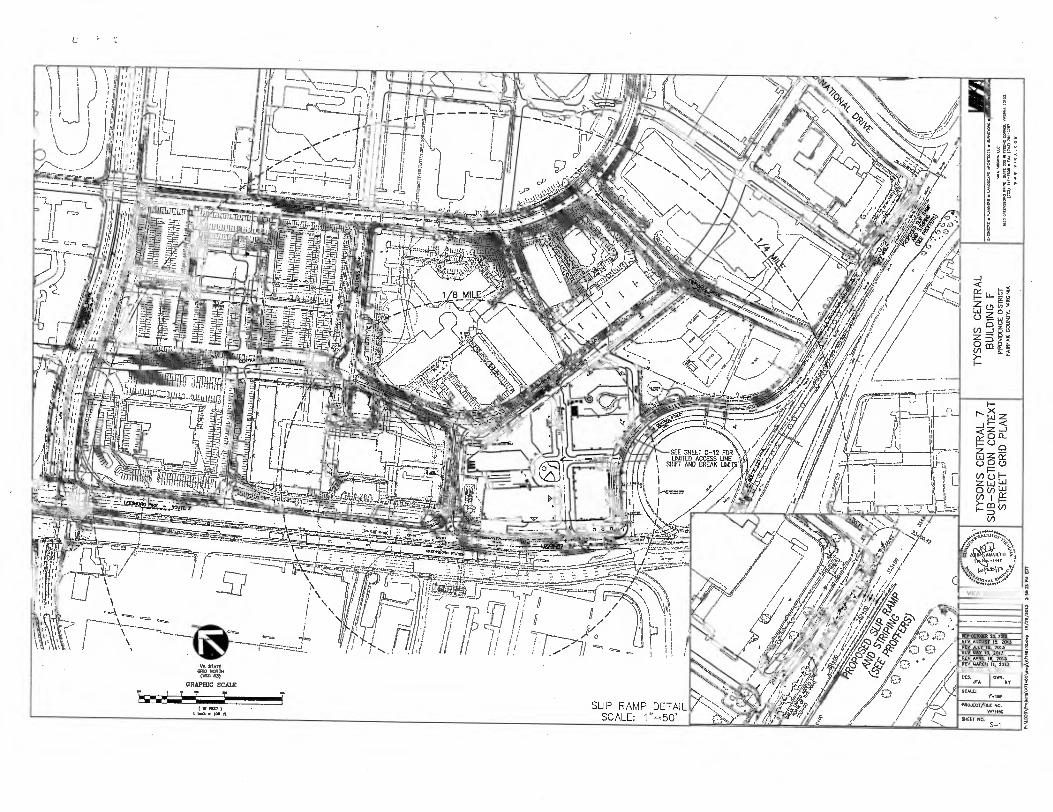
SEE SHEET C-12 FOR LIMITED ACCESS LINE
SHIFT AND BREAK imp
I ,//// „/ 4,/
\ I t
A-3 _
j 17EV,T.E:rvis"ig.
) 22c0.133
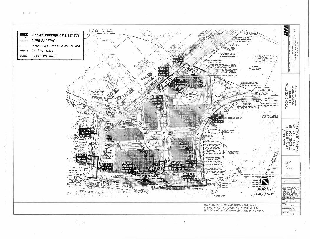
•
• • • -
. . ,. 0 IVI I LL . .."'- ' //
. .
min
no) v
+
or,
O M) A
te M
a -e
n b
..
La=
•Nr.01. 1
0,1■05. P
ir.3.. •
:Of 7./
.. 3,0
4 M
en
t..1.60
Ore.v
rerm
ar•
• tlf..
..•4
• W
T.. 1
0•7
... •
510
3.1
9
I / , - : • -‘ . • vi ., .'1_ ...9. . . . MOTS OP NSTABANCE. ___ - -- ......‘..., A .
. TANS R.K. • ••- .... PPM 5e :172"-*\ • ••-..:, utm9,9,A.OLor11:7111E0 . FDPN..„„:„ .. ...... ,
'' , .- - -- - A, „AI*
\ - .... . • "7\ --- •• ••••••••• ..\-•::•:.•:•• • ..•••• ,. • .4),IN 404•11. .• FINGAL ULTNATE SECTOR '
, --. _____, , / ,, .
•. 044
OLTMATC MD IMIERN CYO • • '',..,..-:,-,.. • ' .• ,
\ '''
• . •••••••. . \ N., ,-"' 4; ....•
, • . KW REY WAIL . "--- . • ,.\,/ . , • ,, . , , • "..i•-..: : dt," 04 ... TO IT moot
, ... S. e. ...4, ,..e::(?:•••V" ...:( . Ce,/4.-7. Fi• 11 , 545 .5 PERIAvemt
\ ' ••• • ' ;,,,:k.V.IP" ..,to,....>4„:4,
• • • ' EP V PROP TEMPORARY CRAOPIG „ . T "-• ,VT7-\' Er • k •• f•I' • 0 '' AND UNITY MAGI=
CONSTRUCTION EASEMENT r....s ''' .n-1•,=;.T.1.1.4.- I • 4\ ' '.. • . AM-2-2 • ;0- -, .,/ :SE - :7
XTP -• -:,•`\,
°Igc WAIVER REFERENCE & STATUS
.. •-...- CURB PARKING
DRIVE/INTERSECTION SPACING
°••••777.•, STREETSCAPE
OC-r,,F=I SIGHT DISTANCE , 4: 5.
. " . . . . . ' ' s., \ ,.... _ .,4,0 4K
- ........ •• • -'''''Z'' EP • • ../ , '4
1•••• ..-- • .:(• ,i ••. . \ AM-2_1
, i .... - • ....f, • : ./ • . •I• •-. . •., , +, •Appeoyed
,• ,.. „:...m. • 46t0Z„.* 3/2612013 .(4;.? . • , • • ,N.s. ...
• / 4 • 4
51;•':.•4• '. .• :••• ‘• eg5/*‘',V6 RP'
. , .
:.,..i" ..... • , ,...?-- • .;, '' :4, . ..c. ...
N. • , ct _ .7" • ,, . " ••'' : . -I.'" rekArt ST•
• • • • ' 4.f.i.• e(4 ... -.• ..1,:
'' 0 ' • '5••'' . - • Y . N C>*!,- . ' '''4' •••• \ • • -N 4. •I
••• • \ IAN - i' ..:•• • • , • , ,FINAigm13 T6 BE •,,, 1,7.:
•vst vir-..‹, '.0.40 ,A1:•-• ' .A■
'.- ' - \ : .".•=3 °F •-'44-4,' 501-V • - , , ••': FC_P2 ',.7... • • NI' .‘,,ke„e.- --- .. - - • .- ••.. ved lki._ Ati;••.,-. -
,Y,,.. ., , .. . _ ....-0.. , • • 7 , ;.„ Appro . - .'''' ----,--- • *V- .‘,./".,.. # , 10/1512013 . ... POIENDA , ' ,
• -iP! Fr - ..•.Ltr :_,- A - :-'7,Cir rldFIL'
,_ . ..C4.• P.r, •-•:- , lit ‘` TKIN(Tr,..krnar • h_ ..".",. ke, --elC-KI rt. .41k "
. 444•S: .0 - • , ■t`. ' T 4! ,....',7"1 .074„. . 4. .: • - 7 A1I. ' 1 t" a ;e ' : ■114 „
. 0 Me • •• P S 1 Efelp)5,-
- il 4IF .
s: • ApprOVed • ' 3/202013
• 1, -,1"):. :74.1
.4011PIRN,...,._ e1/04.- 1' , 4.--,, .......___,, .,.
:V• iille" • 1 Ort •:(:seine 0 T 0 • •"...• ."'4'4•'•."'W 'FC .P2 I. 1. -.. '''-' - 04.4r•IT
. -1'..i.... Approved ,eg R i -4 (L'• 1'
, ■••••••••,,-...* • ,,,L, ,,. ar+.7= E -•
s,'''`,11 . 5074
V
k'i . a
s •, A ... s t.. :4K20. 5:•• • • /
'
.r eves Or UnECROKIND :Sir .• . I -GAME ON PROP UK
RETAINNGSSALL er-is TY HERNE / "NN. BA. OF Wel IS INET Or MTDERGROUND , , R..„ GARAGE AND PROPERTY UNE . . TPOI.
HONEST PLATYCRIE / PROP INIPORARY ONATIC EXP. 0201 ,
,--' \ 'NY -• •,._ NA UMW RELOCATOR
CNKITRIGTIOR EASEL/ENT ..719nr. Iii
.11; -, rev NGOR OWRNARG (.1 •
. Vg • /
'Ali .. •
/ REICCATE ACCESS' Nle A , .",.. . ESTER OF PERIAISSION fam ,• r.t.V. ARO ON OF CALS,CIRRICA /
1 • ' -.... LYN CF ITSNITUARCX
sic WIT C-7 1 i„ .1 -..., EN. WITS IT BC _. 'RR OCROBANED AT FOP
. ' l' / - - .,.
• •.-- ..t . -. cro ••', ....- - . 'C' ' . comsmucnal
.,•.; ..'" -.•••••:: .../ T., St.P SWAM _ . _ , ..47°•• ••-• - •••.'in ''' ;1• SIO' • ---• ovor_00.,,,,,-, ■”,
TY
SO
NS
CE
NT
RA
L B
UIL
DIN
G F
PRO
VID
EN
CE
DIS
TR
ICT
F
AIR
FA
X C
OU
NT
Y, V
IRG
INIA
HIE (
5- ' '
1
"- 51•Wr.:1-• ,t..„,„..........
-7i
ii' ri'' .:142 Tn_•112te
tY9 • . '''''.
- ''''
„
' .'7 ircirnE = / n,,,,,--
riMEDIMP
: a e -
55.1- r = - .
1'''i740 '
'.. • ,C,,i, '' s' .x:, .. TERMEE ME RrocHsynucny.
•10..P, •• • 5BELL-EIC MASCO AS INETGAIEET
4( . - -.. °•• P•••••9•4 P".4 - .
-- 1,..„- ‘ fi • •c,‹160,R4,50,..e.....: - - . ....
, 9 - ' DID MKS. CUSS 1.0•0 SDI
..IFC_P1 . . paps ENE Nal a . sadlEjailoMegla
'
•
Approved .,
10/1512013 1,, , • • • •
WAI
VE
RS
/
EXC
EPTI
ON
S O
F TY
SO
NS
COR
NER
TR
AN
SPO
RTA
TIO
N
TR
AFF
IC S
TAN
DA
RD
S • :.r.t.12-..14,11...F.:.. . 0.. 1
FC P3
".. °1 Approved 7 [., 4 , r. , 9 '
- -,:-.:1:,','AgEmivr BIT ■ F. i in,h. ii $ '' 1
. ' Dr.. 1
z u...,,s .1A, ., : • ' ; • , ye-
.
, --- --FilIPIMIE
‘.
. .
•
• ' .., • . . .
•• . h r .:....: 7 . ZlItiE' --I i ,. 4 -la .1. . • - (: A r 7 amasunoa)
. •
•• •
*ow' cesTING,304 •
ilita,14.1. =
' i
...•- • ofil_ ...,-- 3
.. 4),,,,..,,, j:_ rii.ii j 1
1•__. e Nle 14
3
/ Am.2
31170 a „,,,
I W. , FAS re,IF: 4c:T.F.p_r_„,t.
sew., ..,rro4,,.., ,.'-._,! ,,I. e. 1,.../, ig41
-" --'' : ' fiO;IF
• it -51:44iq . J . 6 -944 ' `IT ?r.',"?. n4 7.' -
• ANI -2__4
rillii71;1111:,,,' ;
._4,m,L,etY. .
t . eS.IA 4 a li
111.ils iiirr 1 ..
r
.
' liutiwinimemii imm"
w :" - "
il......e.wia•ii......1.1.111\
r r i •.- ' ,.
,k,,, .2,
. r. i ,I,,, _ I I I Ill / IIII I I,'
' 0,3 ■ I ..,L -I r152 1 NI .7
or
L'. 7•- WTI
004:44A_ 0
'
'
gP4446ilila' i ' 52 S'1*,. Ill
-
• : ' rwietrugazo '.' , jaic-71-13 (n • ; I.SEE saw CsID-FOR 4rr ■ • . . t
NEE' 61nOVIIFOTUC le
., Approved - L'P° 'f4
- 3/26/2013 • -11 '
-- .r-' 1"-.-- - • i
d t Ai
- •"1- '''t/' .--2- 111;31■IMIR ' FC SS1 it
it tiliii I: , r - 9 E 0:;1:•.
.61(4i ' •,
- DRIVEINT
SEE LANDSCCIPMNI_
" it. 1 ili 8 -
I Fc,ssi tipp!'oved . , , _
. . . . ,..... ' (.... •RECORSTRUN SOW( I... . . . . 4Erf. I .0.. 5.,-
• . :... (*ones)
• -- -- .---_,_ a.,.. ..;... aat, a,,,„,, •
---,, ..: ___ _.... .,,-:-.-._.. •
. : AM-2_6 .. - . Approved
1 ' - - 3121/2013
•'•• ' B•'• Batik,
- - ''''
. I - . rP14r7. , ■ ApproVed 01,,,t01_,.. rj, L10/15/2013 v 't..,LL'''' ............." - .11111111
' PIM RrrW4L15. - 11411_ _
Apprchied 345/2012
'..1• 1 10115/2013 ''',64111
ms AM-I 1 V I • .' D 1 '' a Ell......,..„,,,APproved
. . ..i , sf•-• "
•
' ..-P.Aerst $1., mx,... ,,,. 03
THAL CANS T BE • • • :: •• F. . .. r ...11? CI
OFIERNIE0 AT FDP„.. ...... ' - ' " -.."1" •I ...... VIKA REVISiONS
- ' 'APt,-9,_ . . . 1...illiii.....46 .1 I ' I ref 11•.............", -440051 3/2 812013 \lt ' _ - .3,2__1_ _ 2._ --,-- vox, -.......... - .:., . .
lOSTING yorp ROT - - -LT-RANh •LCO-A, r
a /..04-
"...'' '''7.r." 'f'-'-'7 - • ''''' 4 ••:••• , __, _ _-.„-,....---_
M.., •ANDIEN. -7. = - YARTaFqaTilEDLE___LPICH -41=TAL•Vi_eTi1--ACoiCrr-g-V2-:•(!)=-/-"Yer----7_-7.----: •• OI
--
NOP . • ,_ • . GREENSBORO STATION • i ' ". z..--- m"an'uc'"ij
, .1
-. . . ,. _ , .SCALE :-*-= 40' _ .. .. . . .. ..,- .. • -
10t,.5101.....1115.0 • -. , - ' -
REM ocroeirie.-inT _e _lee To. sENS _
--R
M
ik 01050 "fic TIM Pry 11;;ACIF -11.iaas -
MK JAN • 2011- PCS 1 OM
.• 11 KY
. SEE SHEET C-2 FOR ADDITIONAL STREETSCAPE
. MODIFICATIONS TO ADDRESS VARIATIONS OF THE ELEMENTS WITHIN THE PROVIDED STREETSCAPE WIDTH.
NA PROXCT/FILE M.
WENIN
SHEET NO S-2
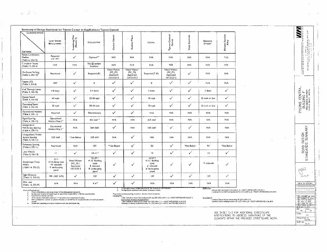
Summary of Design Standards for Tysons Corner as Applicable to Ty ons Central
,f a•
"t
e, • V
I: S••
MLA
• CIL
3r, 3
,C O
c3
.:12
. C91
1
rr.,1,
enr.1.1
5 • 7
7,1
0, • 5
.01.e
ife
• 5.7112
,,
CLASSIFICATION
CRITERIA
LOW SPEED
BOULEVARD
Lee
sburg
Pik
e
(Ro
ute
7)
COLLECTOR
Ce
nte
r S
tre
et R
nld
u°!a
elS
LOCAL
Ty
so
ns C
en
tra
l S
tree
t
ale
!A
SERVICE
STREET
Pri
vate
Serv
ice
Alley
Raised/Landscaped Median (Table 6. DS-I5)
Re red red (16%2 V Optional" N/A N/A N/A N/A N/A N/A N/A
Circulator Route(Table 13, DS-6)
-N/A
N/A @ certain
locations N/A N/A N/A N/A N/A ' N/A N/A
On-Street Parldng (Table 5. DS-13)
Re s tricte d V Required (8')
Need Waiver (FC_P2)
Approved 10/15/2013
Need Waiver (FC_P3)
Approved 10/15/2013
Required (7*-8)
Need Waiver • (FC_PI) Approved 10/15/2013
V. N/A N/A
TYS
ON
S C
ENT
RA
L B
UIL
DIN
G F
P
RO
VID
EN
CE
DIS
TRIC
T
FARR
FAX
CO
UN
TY. V
IRG
INIA
Target LOS (Table 2, DS-5)
DIE'' E V V E V V. N/A N/A
1/ of Through Lanes (Table 3, DS-10)
4-8 lanes 2-4 lanes ✓ 1/ 2 lanes V V 2 lanes '7
Design Speed (Table 3. D5-10)
40 mph 25-30 mph V V/ 25 mph V V 25 mph or less V('
Operating Speed (Table 3, DS-10)
35 mph ,•
✓ 25-30 mph Vi. V 25 mph V. V 25 mph or less V
Operational Analysis (Table 4, DS-I I)
Required ✓ Discretionary V/ "Vr N/A N/A N/A N/A N/A
Signal Spacing (Table 4. DS-I I)
Operational Analysis Req'd '
N/A 425-660' ' N/A N/A 325-660' N/A N/A N/A N/A
Unsignalized. Full Access Spacin
g(Table 4, DS-I I)
Operational Analysis Req'd '
N/A , 200'-660' ✓ N/A 100'-660' V V/ N/A N/A
RO
AD
DE
SIG
N
STA
ND
AR
DS
SUM
MA
RY
Unsignalized, Partial Access Spacing (Table 4, DS-I I)
325-660' "See Below 155%660' N/A 1.7 N/A N/A N/A N/A N/A
(Table 4, DS-I I) Restricted - N/A' 155'
Driveway Spacing " See Below V/ 50' V. "See Below 50' "See Below
Lane Widths(Table 5, DS-13)
11' ✓ 10%1 l'' V" '7 10' V 10' V.
Streetscape Zone Width (Table l4. DS-27)
33'. 15 Building zone ,
10' sidewalk . 8' landscaping
panel
Need Waiver (FC_SSII Approved 10/15/2013
20-28, (-IT Building
zone 9' sidewallt
8' landscaping panel
V/
16-24, 4'-12' Building
zone 6' sidewalk
6' landscaping panel
•V/ V 5' sidewalk
V
..k. 1. "i) .
n.1:..11., Sight Distance (Table 12. DS-23)
385' (305' SSD) vi 155' ✓ y 155' V V 155' V
Pike Lane (Table 15, DS-29)
N/A N/A 4.-6" '1. S N/A N/A N/A N/A N/A vii< A REVISION.;
-
Nee an Requieenence L Dtmict AdnInlirrrts may anew Mee LOS perm opendonel Anne. 5 Speen eon Ise demereeed strew an memeonel melee: .10 ea 1110 nee Teemeended. 3. Evelvased on e esomby.sete Mt a. In le men reside del . (banner III for seem more commercial In mere S. New derolleed In ttttt Ions on eolletorsevenues nein NO be of lore sped bouleere need melon,.
TM.. 6. Width vary dependfig on louden relate to Deb and [DPI& parent.
2 On S. ',rem
'Intersection eel, Mt beetbun
irculater raw. nwIlIng OloUd be 26 -36 on Avenue And Colleen. may be resented In the vldrirr sl talus. roues.
re sefrins eneeselons - ellerenree lemon (norelredr
Centelt so Reuse Ill weeleund off rote 210 (12E)(421.1_1)- VDOT APPROVED 3.26.2013 Sven 13vItniorm re Sat. Mace Cenbsle to IMAM 0 Mem, 1.10 . (1551 (A14.5_1) -TOOT APPROVED 3.2..2.1)
Dream le nunclInt 0 ...ley 7e (I SS') Ian-]]I-TOOT AY PROVED 321.20 13
• Vele r ttttt - Vole
211.00185D
Aid. tim.
: te'eTTo;
VIII, remelt
PICO tb:SdAllt. s(015r811(no'IMi:.(2V2)5(TA01-"5_"61O-VVEDDC?1-1141T OVED 3.51.1613
to P.Rne SR vice Alley 20. (1)51 TAN .2 . 15 MN co &Arent A Dew ITV (TM) (AM.1_111- 'MOT APPROVED 3.26.20 1)
- - . --- ---
PTV. PTV. OCTOBER 28. 201)_ PET. ACCUP 15. RITS
13 1[14 .1 10,0/
.. N14s'2. 4,..011-__-
715 wet in. 2.0 ,
• Leesbtme. POse • Leesburg
ACV .A1101 II 7011
SEE SHEET C-2 FOR ADDITIONAL STREETSCAPE MODIFICATIONS TO ADDRESS VARIATIONS OF THE ELEMENTS WITHIN THE PROVIDED STREETSCAPE WIDTH.
DATE JAR. S. 2012
DM ITNI Jen RT
50e. 3/3
PRO.AcT/TILE NO. v-171010
211M HO. 5-3
Related Documents