1 1 RAPID PLANNING SUSTAINABLE INFRASTRUCTURE, ENVIRONMENTAL AND RESOURCE MANAGEMENT FOR HIGHLY DYNAMIC METROPOLISES

Welcome message from author
This document is posted to help you gain knowledge. Please leave a comment to let me know what you think about it! Share it to your friends and learn new things together.
Transcript

1 1
Rapid planningSuStainable infraStructure, environmental and reSource management for HigHly dynamic metropoliSeS

2
rapid planning SuStainable infraStructure, environmental and reSource management for HigHly dynamic metropoliSeS
Copyright © Rapid planning Consortium 2015
DISCLAIMER
The designations employed and the presentation of material in this publication do not imply the expression of any opinion whatsoever on the part of the secretariat of the United Nations concerning the legal status of any country, territory, city or area or its authorities, or concer-ning the delimitation of its frontiers or boundaries regarding its economic system or degree of development. Excerpts may be reproduced without authorization, on condition that the source is indicated. Views expressed in this publication do not necessarily reflect those of the United Nations Human Settlements Programme, the United Nations and its member states.
CoPyRIgHT PHoToS & gRAPHICS:
© Marcus Mangeot (Cover, 4, 7, 8/1., 9/1., 10, 12, 14, 15, 22)
© Dieter Steinbach (6, 17)
© Thomas Sterr (8/2., 16)
© Harry Storch (9/2., 11)
© Mohamed El Gazar (18, 19)
© Michael Peterek (21)
EDIToRS
AT-Association
Dieter Steinbach
Andrea Schultheis
UN-Habitat
Sebastian Lange
Frankfurt University of Applied Sciences
Michael Peterek
Ulrike Reichhardt
Yaman Hebbo
Olga Korovina
LAyoUT
Marcus Mangeot
SPoNSoR
The research project “Rapid Planning“ is sponsored
by the german Federal Ministry of Education and Research (BMBF)
2

3
contentS
DISCLAIMER 2
gREETINg 4FoREWoRD 5
INTRoDUCTIoN 6Scenario 7Challenges 8
PRojECT 10Objectives 10Products 11Framework 12Activities 13Expected Results
PARTICIPATINg CITIES 14Case City - Da Nang, Vietnam 14Urbanization 15Expectations on the side of the city 15
Case City - Kigali, Rwanda 16Urbanization 17Expectations on the side of the city 17
Case City - Assiut, Egypt 18Urbanization 19Expectations on the side of the city 19
Reference City - Frankfurt am Main, Germany 20Urban Development Goals 21
oBSERVER CITIES 22
THE RAPID PLANNINg CoNSoRTIUM 23
IMPRINT 30
3

4
GREETING
A city is a complex system. This observation is neither new nor original. However, this complexity is not reflected in organizational charts of city administrations all over the world. There, we do find clearly cut sectors or pillars each encompassing an urban need.
Yet, the interactions between these putatively singular sectors are increasing. The post 2015 Sustainability Goals will become benchmarks for many cities. How can cities successfully harmonize human well-being, socio-economic subsystems, the physical environment and limited natural and financial resources in their planning? In many emerging economies and developing countries urban and region decision making is further challenged by a lack of data.
This is where “Rapid Planning” steps in. Rapid Planning develops a method and tool box to support decision making under uncertainty. Nonetheless, Rapid Planning is anchored in reality. This means that theory and sound academic ground work converge with practice. Rapid Planning research is designed to have implications for both science and cities. Rapid Planning is action research. It also incorporates the involvement of stakeholders and capacity development measures. Four cities, Assiut in Egypt, Kigali in Rwanda, Da Nang in Vietnam and Frankfurt am Main in Germany pioneer as part-ners who want to reshape common approaches to urban infrastructural development. UN-Habitat as an operative partner in the project helps to multiply the innovative Rapid Planning approaches through its worldwide network. However, the success and the facilitation of transition processes to true sustainable urban and regional develop-ment strongly depend on the user-friendly application of Rapid Planning. PT-DLR will safeguard that Rapid Planning will live up to this expectation without compromising its scientific excellence.
Dr. Andrea Koch-Kraft
Project Management Agency (PT-DLR)Member of the German Aerospace CenterEnvironment, Culture, Sustainability
4

5
foreWord
cities embody some of society’s most pressing challenges, including the provision of basic services, such as water, sanitation and energy, and increasing resource depletion and environmental degradation that extend beyond the city boundaries. but cities are also the engines of national urban development - they present real opportunities for unleashing enormous economic and social potential, increasing energy and resource efficiency, reducing inequities, and creating sustainable livelihoods for all.
History has shown that urbanization leads to development, and that urbanization is a source rather than simply a by-product of development. africa and asia are among the least urbanized continents and have the fastest rates of urbanization in the world, whi-le in the arab states, challenges due to scarcity of resources like water and arable land are paramount. in these regions, growing cities and towns face additional challenges, which include: high percentages of people living in slums; expansion and dominance of the informal sector; unplanned peri-urban expansion; social and political conflict over land resources; and high levels of vulnerability to natural disasters.
for cities to play their role as drivers of economic and social development, these chal-lenges have to be addressed through effective planning and governance. moreover, new methods of planning that are capable of meeting the challenge presented by rapid urbanization in the 21st century need to be explored.
un-Habitat
5

6
Rapid Planning is an action-oriented research project that has been developed and is funded under the umbrella of the Future Megacities Research Program1 of the German Federal Ministry for Education and Research (BMBF).
It seeks to develop a rapid trans-sectoral urban planning methodology, specifically targeting supply and disposal infrastructure. The service sectors covered by the project include energy, water, waste water/sanitation, solid waste and urban agriculture/food.
Rapid Planning is a global project. That means that it features the regions of Sub-Saharan Africa, the Arab States, South East Asia and Europe, represented by Frankfurt as a refe-
1 For further information, please see: http://future-megacities.org
rence city. The tangible product of this project will be a practical guideline and toolkit for trans-sectoral supply and disposal infrastruc-ture planning. It will allow planning rapidly, but also cost effectively. It will help cities to improve resource efficiency and to improve access to urban basic services. Moreover, Rapid Planning will support the effort of planned city extension and planned city infill development by informing the pro-cess from the point of infrastructure planning and development.
SCEnaRiO
introduction
6

7
SCEnaRiO
The world in the 21st century will experience unprecedented urban growth.
It was only in 1960 that the first 1 billion people had urbanized. We have since then seen a accelerated urban growth. In the 15 years between 2003 and 2018, 1 billion people will have been added to our cities. Most of this growth is occurring in developing regions. In fact, it is predicted that seven out of ten urban dwellers will be African or Asian in 2030. Beyond being a demographic phenomenon, urbanization is a transformative force that is continually shaping societies, their economies, political systems and environments.
Local governments in these regions are facing immense challenges in planning and developing urban infrastructure, and subsequently in providing adequate access to basic services for new and existing urban residents.
Moreover, urbanization challenges in the 21st century are unfolding before a multitude of interconnected global challenges, which include:
• Scarcity, depletion and increasing price of energy and other resources
• Increasing destruction of the natural environment
• Climate change
Cities are where most human productive activities are taking place. These activities consume energy and resources and they contribute to climate change and environmental degradation. It is, therefore, self-evident that cities must play a major role in achieving sustainable development in the course of the 21st century.
Clearly, our current infrastructure choices will affect city-level sustainability in the medium and long term.
The key question linked to the planning and implementation of sustainable urban infrastructure is how cities can provide services, improve quality of life and competitiveness, while making optimal use of energy and resources, minimizing consumption and preserving the environment.
7

8
CHallEngES
In this context, rapid urbanization presents an opportunity as well as a challenge. If the world continues to urbanize at the projected speed, most of the cities that will exist by the end of this century, are yet to be built. The oppor-tunity is at hand to take a sustainable urban development path for developing these new cities right from the start, which means now. This includes sustainable supply and disposal infrastructure and the access to basic services for all new and existing urban residents.
Infrastructure choices and options are intima-tely linked to the amount of public space and the density and distribution of activities. These determine to a large extent the possibility and viability of technological solutions and of ser-vice provision.
It is not only the quality of infrastructure and services that is important but also the speed at which it is delivered. When urbanization is rapid, planning and implementation must be carried out at a similar pace. It also requires planning in advance and sufficient understan-ding of the dynamics of urban development to
8

9
avoid infrastructure choices that lock cities in inflexible patterns.Cities grow dynamically and depend on their local context so each one is different. Cities are not isolated from the sur-rounding regions that provide vital resources. Urban development which is sustainable and energy and resource efficient requires integra-tion across hierarchies, sectors and projects.
Data presents a significant problem. The chal-lenge is the lack of accurate data and the technical capacities for gathering and analy-zing it. Moreover, infrastructure planning is mostly sector related and potential synergies
between them remain unconsidered due, in part, to a lack of data, information and sub-sequent urban management. Adequate urban infrastructure planning and management requires adequate data for only that which is measured adequately can be managed.
The Rapid Planning Project seeks to respond to the need and demand for rapid urban trans-sectoral infrastructure planning, linked to fit-to-purpose physical planning.
9

10
OBJECTiVES
The objective of the Rapid Planning project is to develop and test a rapid trans-sectoral urban infrastructure planning methodology, with the focus on supply and disposal infra-structure.
The purpose is thereby to aid the realization of synergies between supply and disposal infra-structure sectors and to achieve mutually rein-forcing solutions that are both cost effective and energy and resource efficient.
This has to be developed for specific contexts and urban patterns and fully cognisant of the interdependences between such contexts and the viability of infrastructure options. The ideas and concepts that are developed
and tested should thereby be relevant and appropriate for specific contexts and trans-ferable between cities with similar or compa-rable patterns. The project seeks therefore to develop as far as possible universally-applica-ble solutions which are relevant for specific urban planning contexts. This may include city extension planning, urban redevelopment and densification, city-wide planning and also planning in the city-region context. Roadmaps and guidelines will provide detailed advice on the application of the methodology in the context of planning phases from concept to implementation to monitoring of success.
Aspects of urban planning, economy and finance and legislation relevant to the project’s objective have been analyzed and assessed and included in the subsequent methodology.
proJect
10

11
pROdUCTS
Rapid Planning is in line with UN-Habitat’s effort towards the creation of a New Urban Agenda promoting a fresh model of urban development able to identify strategic respon-ses which ignite processes of local develop-ment which build on linking adequately all facets of sustainable development to promote equity, welfare and shared prosperity.
Tangible products developed by the Rapid Planning Project include an urban data warehouse2 on urban infrastructure planning data, knowledge blocks on a variety of related topics, computer-aided tools for trans-sectoral modelling and a guideline and roadmap for the rapid planning implementation.
The Rapid Planning approach can be applied city-wide. It will allow scenario development and assessment and will help to achieve a fast implementation. Topics covered inclu-de appropriate technology, spatial planning, material flows, governance and policy, climate change, socio-economic development and the environment.
The work will benefit from the experiences and findings gained by the Future Megaci-ties projects, workshops and practices from different cities around the world. This pool of knowledge, which has been generated by the partners that form the Rapid Planning Consor-tium, is a unique and valuable input to this research.
2 This is a web-based service that helps to collect, store and availe urban data and information.
The Rapid Planning Project works in case cities selected to represent Sub-Saharan Africa, South East Asia and the Arab States. The case cities (Kigali, Da Nang and Assiut) will benefit from entry projects at which the trans-secto-ral approach is tested on a small scale. The entry projects are developed and implemented based on demand expressed by the case cities, represented by their local governments.
The relevance of the research for concrete issues faced by cities in providing infrastruc-ture is dependent upon the careful identifica-tion of issues in the framework of urban plan implementation, urban renewal and densifica-tion initiatives or in relation to environmental management and protection. The concrete and practical problems faced by cities and ser-vice delivery agencies will form the basis of the development of the research agenda in each city.
As mentioned above, the sectors of interest to this project include energy supply, water sup-ply, wastewater treatment, solid waste treat-ment and urban agriculture. All products will focus on these sectors
The project includes a comprehensive training and capacity-building component and is also actively facilitating the dialogue and exchan-ge of information between participating case cities and designated transfer cities.
11
12
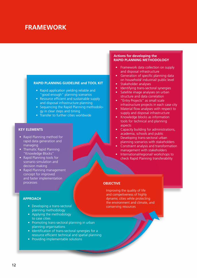
approacH
• Developing a trans-sectoral planning methodology
• Applying the methodology to case cities
• Promoting trans-sectoral planning in urban planning organisations
• Identification of trans-sectoral synergies for a resource efficient technical and spatial planning
• Providing implementable solutions
actions for developing the rapid planning metHodology
• Framework data collection on supply and disposal infrastructure
• generation of specific planning data on household/ industrial/ public level
• Stakeholder analyses• Identifying trans-sectoral synergies• Satellite image analyses on urban
structure and data correlation• “Entry Projects” as small scale
infrastructure projects in each case city• Material flow analyses with respect to
supply and disposal infrastructure• Knowledge blocks as information
tools for technical and planning aspects
• Capacity building for administrations, academia, schools and public
• Developing trans-sectoral urban planning scenarios with stakeholders
• Constraint analysis and transformation management with stakeholders
• International/regional/ workshops to check Rapid Planning transferability
Key elementS
• Rapid Planning method for rapid data generation and managing
• Thematic Rapid Planning “Knowledge Blocks”
• Rapid Planning tools for scenario simulation and decision making
• Rapid Planning management concept for improved and faster implementation processes
rapid planning guideline and tool Kit
• Rapid application yielding reliable and “good enough” planning scenarios
• Resource efficient and sustainable supply and disposal infrastructure planning
• Sequencing the Rapid Planning methodolo-gy in clear steps and timing
• Transfer to further cities worldwide
obJective
Improving the quality of life and competiveness of highly dynamic cities while protecting the environment and climate, and conserving resources
frameWorK
12
13
aCTiViTiES
The activities undertaken by the Rapid Plan-ning Project are organized in a set of work packages, covering the following fields:
• Collection of framework data and infor-mation
• Development of practical entry projects
• Identification and analysis of urban struc-tures, typologies and the urban fabric in general
• Collection and analysis of sector specific data, including water, sanitation, solid waste, energy and so on
• Set-up of a data warehouse
• Design and development of the rapid trans-sectoral planning methodology
• Simulation of trans-sectoral planning scenarios to build on the Material Flow Analysis and the spatial analysis
• Incorporation of the rapid trans-sectoral planning methodology into the urban planning context, especially the physical planning dimension
• Analysis and incorporation of adminis-trative, legal, economic and financial aspects
• Stakeholder participation and engage-ment and transformation management
• Checking transferability of results to other cities, and checking the applicabi-lity of the draft Rapid Planning methodo-logy
• Compiling the Rapid Planning guideline, tool kit, and implementation assistant
EXpECTEd RESUlTS
Rapid Planning is expected to contribute to improving the quality of life for urban resi-dents and the competitiveness of rapidly-gro-wing cities. It will also contribute to protecting the environment and conserving energy and resources.
Data and information collected and generated through the project will be made available to the case cities for their benefit.
The project may also result in a shift in the way the local authorities are structured, managed and administered, as well as in the way thin-king and decision-making takes place. This is implied by the trans-sectorial planning as such and may refer not only to the planning proce-dures but also to the way decision makers are informed by planning data.
The project may also contribute to the reduc-tion of urban energy and resource consump-tion, the valorization of waste materials and the reduction of the pressure on the natural environment.
13

14
participating citieSCaSE CiTY
da nang, ViETnaM
FaCTS :
Total area: 1,285.4 km²
population: 1,046,876 (2015)
Economic growth rate of over 11 per cent per year in the period 1997-2013
Significant investments in city infrastructure
Da Nang is the largest city in central Viet-nam and one of the country‘s most import-ant ports. It is also the most dynamic city in the country from the viewpoint of economic development and change.
The city’s population is predicted to reach about 1.6 million by 2020, and to rise further to 2.5 million by 2030. Da Nang’s electricity demand is continuously growing at 7-8% per year. Da Nang collects around 700 tons of solid waste each day, however, the vast majo-rity is disposed in the city’s central landfill, due to the lack of recycling capacities and facilities. Currently just 15-20% of the total population is connected to city‘s wastewater treatment plants. The remaining wastewater is dischar-ged with the storm water system, causing river and coastal water pollution. Agricultural land uses, although only a small part of the
14

15
city’s GDP, play an important role in overall economic development and food producti-on.3 In Da Nang, tropical cyclones have caused severe damage to vulnerable coastal areas in the past, leading to the resettlement of many poor households. Flooding is a recurring pro-blem, both in poorly-drained central areas as well as in peri-urban districts undergoing rapid land conversion. Rapid tourism develop-ment on exposed beaches which are subject to typhoons, storm surge and coastal erosion makes these areas vulnerable. During the dry months, Da Nang can experience prolonged droughts that significantly impacts upon agri-culture production and city water supply, and is often accompanied by serious salt water int-rusion.4
Urbanization:
Changes in land use, environmental degra-dation and the depletion of natural resour-ces have accompanied Da Nang City’s rapid, urban development. Concerns about the environmental repercussions of economic growth resulted in the city government taking the lead to develop the plan Developing Da Nang – an Environmental City. This focuses
3 (Source: APEC (Asian-Pacific Economic Cooperation) (2014) Policy Review for Low-Carbon Town Development Project in Da Nang, Viet Nam. Final Report May, 2014. Report for the APEC Energy Working Group.)4 (Source: Bui Duc Tinh and Nguyen Manh Hung (2014) Modelling demand for catastrophic flood index-based insurance in Da Nang City, Vietnam. International Institute for Environment and Development. Asian Cities Climate Resilience Working Paper Series 10: 2014, London)
on developing a sustainable city by relocating polluting industries, controlling the develop-ment of industrial sectors and creating pro-tected areas such as the Ba Na forest zone. In addition, the plan aims to improve environ-mental management in the areas of solid was-te, water supply and wastewater. Processes of urban redevelopment and densification are expected to be triggered and incentivized by the controls over land conversion and the pro-tection of vulnerable ecosystems.5
Expectations on the side of the city:
The Da Nang City People’s Committee has commissioned the “Plan for Developing Da Nang - The Environmental City”. It lays the foundation for city planning in the context of sustainability, green growth and encourages resource efficiency.
• Integrated water resource management and climate change response
• Urban-rural linkage and promotion of value chains
• Energy efficiency and innovative technologies
• Eco system restoration and eco-tourism
• Solid waste management and resource recovery
• Coordination for multi-sector investment planning
5 (Source: Da Nang green growth City Development Strategy)
15

16
CaSE CiTY
Kigali, RWanda
FaCTS :
Total area: 730 km² (only 50 per cent developable land and about 15 per cent so far built up)
population: 1,135,428 (2012)
Population growth rate: 4.5 per cent p.a. (Rwanda 2.6 per cent p.a.)
New Kigali City Master Plan (2013) for future development
Kigali is the capital city of Rwanda. It is the country‘s biggest city and it is also its com-mercial capital. With more than one million people today (representing 10.8 per cent of the country’s total population), Kigali has been expanding by leaps and bounds over the hilly terrain surrounding its core and is one of Afri-ca’s fastest-growing cities.
Located in the heart of Rwanda, Kigali is built on hills, ridges and valleys. With some slopes of up to 50 per cent gradient and two rainy seasons, the land is vulnerable to erosion and flooding. There are 25 watersheds within the city limits and the valleys are fertile. Agriculture occupies the largest proportion of the land (60.5 per cent), with built-up areas about 15 per cent. Kigali generates about 50 per cent
16

17
of Rwanda’s Gross Domestic Product (GDP), which is comprised of revenue from three main sectors: industry (32.6 per cent), ser-vices (61.9 per cent) and agriculture (5.5 per cent). Kigali’s low-density expansion pattern is facing serious challenges which include liquid and solid waste management, air quality, floo-ding and landslide disaster risks, access and sustainable consumption of water and ener-gy as well as the provision of green housing.
(Source: Kigali, State of Environment and Outlook Report 2013, Rwanda Environment Management Authority)
Urbanization:
Rwanda gives high priority to urbanization to support economic transformation and growth. The country’s urbanization target is 35 per cent by 2020. The current rate is just under half that at 17 per cent. As Kigali is expected to house more than 50 per cent of the coun-try’s urban dwellers, the remainder should be accommodated in other cities, especial-ly secondary ones. As a rapidly growing city, Kigali is experiencing severe problems of air and water pollution, liquid and solid waste management, inadequate water and energy infrastructures and unsustainable production and consumption lifestyles.
(Source: Kigali, State of Environment and Outlook Report 2013, Rwanda Environment Management Authority)
Expectations on the side of the city:
Kigali over the past decade has been very suc-cessful in achieving progress in socio-econo-mic development. The question of urbanisati-on is a key challenge in the countries Economic Development and Poverty Reduction Strategy (EDPRS). Moreover, the implementation of the Kigali Master plan is an additional challenge that the City of Kigali is currently facing. Here, the question of infrastructure development and finance is important.
Rapid Planning can help to:
• Realise the urban development phasing and how to best approach it,
• Inform the city’s 30-year outlook in planning urban infrastructure,
• Realise necessary urban density and to provide adequate access to urban basic services at the same time,
• To support the city’s urban upgrading and renewal efforts, especially with regards to residential and commercial areas.
17

18
CaSE CiTY
Assiut is the largest town in Upper Egypt and lies about 375 km south of Cairo. It was sett-led during Pharaonic times on a broad ferti-le plain bordering the west bank of the Nile. Surrounded by rich agricultural land and situ-ated at the end of one of Africa’s great cara-van routes, from sub-Sahara Africa and Sudan to Assiut via Al-Kharga Oasis, it has always been important commercially, if not politically. Assiut City is the capital of the Governorate of Assiut, and is bordered to the east by the river Nile and to the west by Mount Assiut West. Assiut features a continental arid climate, which is cold and dry in winter and hot and dry in summer. It is an important commercial centre and hosts the third largest university in Egypt.
FaCTS :
Total area: 256 km²
population: 979,892 (2013)
Agricultural centre on a broad fertile plain and commercial hub
aSSiUT, EgYpT
18
19
Varying shares of the city labour force enga-ge in different economic activities, the main activities comprising 25.6% in educational services, followed by 17.42% in management and administration, defence and social secu-rity, 12.7% in wholesale and retail activities, 8.3% in health services and 7.7% in building and construction. The main employment-pro-viding sectors are agriculture, industry and trade, which represent the largest shares of domestic income in the city.
(Source: GOPP (2010), National Urban Observatory Survey Report for Assiut - Draft Report, 2010)
Urbanization:
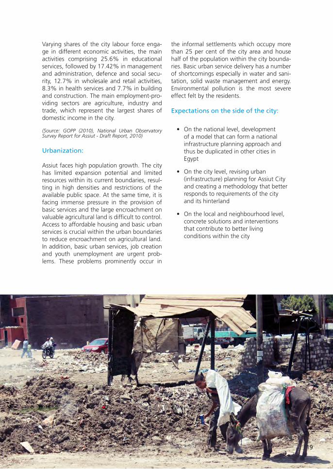
Assiut faces high population growth. The city has limited expansion potential and limited resources within its current boundaries, resul-ting in high densities and restrictions of the available public space. At the same time, it is facing immense pressure in the provision of basic services and the large encroachment on valuable agricultural land is difficult to control. Access to affordable housing and basic urban services is crucial within the urban boundaries to reduce encroachment on agricultural land. In addition, basic urban services, job creation and youth unemployment are urgent prob-lems. These problems prominently occur in
the informal settlements which occupy more than 25 per cent of the city area and house half of the population within the city bounda-ries. Basic urban service delivery has a number of shortcomings especially in water and sani-tation, solid waste management and energy. Environmental pollution is the most severe effect felt by the residents.
Expectations on the side of the city:
• On the national level, development of a model that can form a national infrastructure planning approach and thus be duplicated in other cities in Egypt
• On the city level, revising urban (infrastructure) planning for Assiut City and creating a methodology that better responds to requirements of the city and its hinterland
• On the local and neighbourhood level, concrete solutions and interventions that contribute to better living conditions within the city
19

20
REFEREnCE CiTY
An additional German partner of the pro-ject-related exchange of experiences and know-how between the case cities and with the observer cities will be the city of Frankfurt am Main.
It is the largest city in the German Federal Sta-te of Hesse and the fifth largest in the country, with a population of about 700,000 in 2014. Almost 27 per cent of its population has a non-German passport and another 22 per cent have migration origins from outside Ger-many, making the city one of the most inter-national urban centres in Europe.6
Frankfurt’s regional catchment area has an estimated population of 2.2 million, and the
6 (Source: City Statistics; http://www.frankfurt.de/sixcms/detail.php?id=2811&_ffmpar[_id_inhalt]=7524; 05.03.2014)
FaCTS :
Total area: 248 km²
population: 700,800 (June 2014)
Rated as the world’s most sustainable city by ARCADIS Sustainable Cities Index 2015.
© Flickr/cfaobam.
FRanKFURT aM Main, gERManY
20

21
city itself forms the hub of the larger Frank-furt/Rhine-MainMetropolitan Region, home of about 5.5 million people.7
Frankfurt am Main is not only the most important financial centre on the European continent, with more than 300 national and international banks, including the headquar-ters of the European Central Bank, but also a trade and logistics centre, with one of the busiest airports in Europe and a regular set of trade fairs of worldwide importance, a cultural centre with a wide range of renowned muse-ums and a centre of science and education for about 70,000 university students.
In recent years, the economic potential of Frankfurt and its surrounding region has led to a growing attractiveness and an increase in the city’s population. At the same time, the city has been promoting sustainable urban development programmes, integrating the objectives of climate and environmental pro-tection as well as energy efficiency. Environ-ment, climate and urban development are seen as inseparable topics, as urban sustaina-bility and attractiveness can only be achieved if the natural resources are preserved in the long term, the environmental and housing quality is improved, and the natural resources are used as efficiently as possible.8
7 (Source: http://www.region-frankfurt.de/Verband/Region-in-Zah-len; 05.03.2015)8 (Source: http://www.stadtplanungsamt-frankfurt.de; 05.03.2014)
Urban development goals:
• A high quality and mixed-use inner-city development including the provision and protection of open space and green areas
• City housing and social mix for an increasing population
• Strengthening of the diverse urban districts and their different characteristics
• Development of sustainable forms of urban mobility
• Cooperation for a sustainable common future within the polycentric region
• Development of participative planning and new forms of cooperation between the different urban stakeholders
• Promotion of a building culture and an awareness of the physical, social and environmental qualities of the urban environment
21

22
OBSERVER CiTiES
A group of observer cities will be formed on the regional base (three groups: South-East Asia, Arab States, and Sub-Saharan Africa). Observer cities will play a role in the questi-on of checking the transferability of the Rapid Planning methodology and to also dissemina-te the related knowledge. A dialogue will be initiated that is going to continue throughout the project. Participating technical experts and city leaders will exchange ideas with case city representatives and the project consortium in a web-based platform, but also more directly in workshops. The dialogue will be developed in cooperati-on with other existing projects and initiatives
implemented by UN-Habitat. The validation and dissemination of results will therefore benefit from existing networks and ongoing collaborations.
In this way, it will be possible to validate the developed planning methodology for its regi-onal relevance. It will also support possible spin-offs and the subsequent application of the methodology in the observer cities.
The picture above shows cities to which initial communication has taken place already. The final list of observer cities is to be determined through a selection process and based on the expressed interest.
dEniZli, TURKEY
KRYVYi RiH, UKRainE
YEKaTERinBURg, RUSSia
lagOS, nigERia
CapE TOWn, SOUTH-aFRiCa
MapUTO, MOZaMBiQUE
aCCRa, gHana
naZRET, ETHiOpia
naiROBi, KEnYa
daR ES SalaaM, TanZania
KaTHMandU, nEpal
MandalaY, MYanMaR
ViEnTianE, laOS
ilO ilO, pHilippinES
CEBU CiTY, pHilippinES
KHUlna, Bangla dESH
gWangJU, KOREa
YOgYaKaRTa, indOnESia
dEniZli, TURKEY
KRYVYi RiH, UKRainE
YEKaTERinBURg, RUSSia
lagOS, nigERia
CapE TOWn, SOUTH-aFRiCa
MapUTO, MOZaMBiQUE
aCCRa, gHana
naZRET, ETHiOpia
naiROBi, KEnYa
daR ES SalaaM, TanZania
KaTHMandU, nEpal
MandalaY, MYanMaR
ViEnTianE, laOS
ilO ilO, pHilippinES
CEBU CiTY, pHilippinES
KHUlna, Bangla dESH
YOgYaKaRTa, indOnESia
gWangJU, KOREa
22

23
tHe rapid planning conSortium
aT-VERBand / aT-aSSOCiaTiOn
AT-Verband (AT-Association) stands for advanced socially- and environmentally-sound technolo-gy practice. AT-Verband has been registered in germany as a non-profit organisation since 1988. The 30 members are independent consultants, researchers, trainers, institutes and consultancy companies. AT stands for a qualified technology practice that enhances conscious choice by the users and enables them to develop or apply technical solutions that are in their own genuine interest. AT-Verband is committed to this objective. It aims to qualify its members and society at large for rational and sustainable technology practice, and to cooperate with public and com-mercial institutions for that end. AT-Verband members are frequently contracted as consultants by a broad range of german and international organizations. Their tasks range from short-term planning and evaluation missions through research, capacity building and periodic backstopping to full-fledged implementation of development and other cooperation programmes. Recently, AT-Verband was involved in Research & Development projects, such as MoDULAARE and IgNIS, and in projects of Siemens Foundation on social entrepreneurship in waste management in Nairobi (Kenya), the Siemens Foundation’s “Empowering People Award”, and development of the corresponding web-based technology platform “Empowering People Network”.
TEaM
Dieter Steinbach (joint Project Director)
Andrea Schultheis (joint Project Manager)
Dr. oliver Assmann
Dr. Norbert Hueber (Associated Scientist)
Prof. Dr. Erwin Thomanetz (Associated company gCTU)
Marcus Mangeot (Associated company Crossdocs)
Barry Claude Urban (Associated company Spondulics cc)
www.at-verband.de
23

24
BRandEnBURg UniVERSiTY OF TECHnOlOgY COTTBUS-SEnFTEnBERg
With its 10,000 students, the BTU Cottbus-Senftenberg is the second-largest university and the only technical university in the state of Brandenburg. Its degree programmes are highly regarded within ger-many and internationally. Key to this success are the many collaborations in both teaching and research that BTU actively pursues not only with other universities and research institutions but also with local small and medium-sized companies as well as large international organizations and enterprises. The Depart-ment of Environmental Planning – headed by Prof. Dr. Dr. h.c. (NMU Dnepropetrovsk) Michael Schmidt - is part of Faculty 4, Environmental Sciences and Process Engineering. It was established in September 1994 and is closely connected with the teaching and research within the Institute of Environmental Manage-ment and offers proven expertise for Environmental Planning, Landscape Planning and also Environmental Information Systems. The department coordinated the Megacity-Project Integrative Urban and Environ-mental Planning for Adapting Ho Chi Minh City to Climate Change which was financed from 2008 to 2013 as part of the research programme Sustainable Development of the Megacities of Tomorrow by the german Federal Ministry of Education and Research (BMBF). Additionally, the department coordinated the MSc. Programme Urban Development Planning at the Vietnamese-german University in Ho Chi Minh City, Vietnam, from 2009 to 2012.
TEaM
Dr. Harry Storch
Nigel Downes www.tu-cottbus.de
FRanKFURT UniVERSiTY OF appliEd SCiEnCES (FRa-UaS)
With 12,000 students, Frankfurt University of Applied Sciences, founded as Fachhochschule Frankfurt am Main in 1971, is a leading Institution of Higher Education that systematically combines scientific approaches with practical application. Within its four faculties – Architecture, Civil Engineering, geo-matics; Computer Science and Engineering; Business and Law and, finally, Health and Social Work – it offers a wide range of study courses at undergraduate and graduate level and is involved in a steadily growing number of important research projects. Within Faculty 1: Architecture, Civil Engineering and geomatics, research is bundled within the Frankfurt Research Institute for Architecture, Civil Enginee-ring, geomatics (FFin). The Institute has an interdisciplinary range of about 35 researchers in the fields of sustainable planning and building. Research experience, gained in cooperative projects with private enterprises, public institutions and municipal authorities, is focused on urban development and land management; urbanization in a global context; renewable energies in the context of land manage-ment; energy efficiency, with regards to materials, building constructions and usage; strategies for the adjustment to the demographic change in planning and building; (electro)mobility and also geo-in-formation as basis for planning and building. The Faculty 1 International Masters Programme Urban Agglomerations (M.Sc.), targeting urban development in a worldwide perspective, is closely related to the Rapid Planning research project.
TEaM
Prof. Dr. Michael Peterek
Dr. Ulrike Reichhardt
yaman Hebbo
olga Korovina www.ffin.eu
24

25
iFaK - inSTiTUT FüR aUTOMaTiOn Und KOMMUniKaTiOn E. V. MagdEBURg
The Institut für Automation und Kommunikation (ifak), a non-profit institute for applied research asso-ciated to otto-von-guericke University of Magdeburg, was founded in 1991. The institute carries out applied research on Information and Communication Technology and Automation, Water and Energy, Measurement Technology and Power Electronics and Transport and Assistance and has an interdisciplinary team of more than 50 staff members.
The Water and Energy Department of ifak is working on modelling, simulation and control of urban water and wastewater systems and a research line on smart energy networks has recently been added to its portfolio. The expertise of ifak is sought after nationally and internationally in collaborations with univer-sities, water authorities and companies and industry. Its systems for dynamic simulation of water systems are in worldwide use and its researchers are actively involved in a number of national and international committees, which include the german Water Association (DWA) and the International Water Association (IWA).
TEaM
Dr. Manfred Schütze
Dr. jens Alex
An Truong www.ifak.eu
iFEU - inSTiTUTE FOR EnERgY and EnViROnMEnTal RESEaRCH
The Institute for Energy and Environmental Research (IFEU) is a non-profit ecological research institute. It was founded in 1978 as an independent centre of excellence for environmental research by scientists from the University of Heidelberg. Currently, IFEU has a staff of more than 70, mostly scientists in the fields of biology, chemistry, physics, geography and engineering. IFEU scientists provide research and consulting services for international organizations, federal and state ministries, local governments, well-known companies, business associations, Ngos, schools, public utilities as well as transport and logistics service providers. IFEU experts carried out projects in Europe, USA, China, India, Africa, Indonesia, Latin America, Russia and the Marshall Islands. Key areas of IFEU’s activity are focused on the following areas:
•Environmentallysustainableenergysystemssuchasenergyefficiencyinbuildingsector•Food,agricultureandbio-basedsystemssuchassustainabilityofcurrentandfuturebiomassuses•Industryandproductssuchaslifecycleassessmentofproducts•Transportationsuchasenvironmentalimpactassessmentoftransport•Wastemanagementandresourceprotectionsuchaspracticalrecyclingsolutions
TEaM
Bernd Franke
Andreas Detzel
Mirjam Busch
Christin Zeitz
jonas Harth www.ifeu.eu
25

26
iUWa – inSTiTUTE FOR ECO-indUSTRial analYSES
IUWA Heidelberg e.V. was founded in 1992 as a fully independent, non-profit organization which concentrates on environmental management, material efficiency, circular economy, waste management, eco-innovation, regional sustainability issues, the development of sustainability networks for enterprises and other similar topics. It works as a completely self-financed instituti-on, which currently implements application-oriented research projects on behalf of the german Federal Ministry of Research and Education (BMBF), the Ministry of the Environment, Climate Protection and the Energy Sector of Baden-Württemberg (on behalf of the European Commissi-on) as well as industrial enterprises. In addition to this, IUWA e.V. publishes „uwf“ as one of the leading journals on environmental/ sustainability management for the german-speaking market (germany, Austria and Switzerland) which is designed as a bridge-builder between applicati-on-oriented science and practical application in business. Consultancy and software develop-ment with a special emphasis on waste management and logistics for industrial companies is exercised by IUWA gmbH as a private neighbouring company.
TEaM
Dr. Thomas Sterr
Dr. Werner Krause
Michael Seyboth www.iuwa.de
iFEU - inSTiTUTE FOR EnERgY and EnViROnMEnTal RESEaRCH
IZES is a non-profit research institute associated to the Saarland University of Applied Sciences (HTW Saar). The interdisciplinary team is composed of researchers who have backgrounds in engineering, economics, forestry, energy, social sciences, law, chemistry and computer scien-ces. IZES supports environmental and climate protection together with sustainable development through applied research in the fields of future technologies and future markets as well as through system and stakeholder management. The research activities are organized in two rese-arch departments, Material Flow Management and Energy Markets as well as in five research groups, Infrastructure and Urban Development, Rural Area and Resources, Social-Scientific Ener-gy Research, Technical Innovations and Applied Solar Technology. IZES addresses the local, the national and the international level and cooperates with decision-makers and administrations, universities and other research institutions plus the industrial and SME sectors.
TEaM
Prof. Frank Baur
Mike Speck
Ulrike Schinkel
Katja Weiler
Denise Zeyer www.izes.de
26

27
OSTFalia UniVERSiTY OF appliEd SCiEnCES, CaMpUS SUdERBURg
ostfalia University of Applied Sciences is a practice-orientated university with 12 faculties and 13,000 students in total at four different locations in Northern germany. The spectrum of facul-ties ranges from engineering branches to business, law, health and social work. The smallest location of ostfalia is Campus Suderburg, a rural site halfway between Hamburg and Hannover. This site was founded in 1854 due to a historical engineering invention, an innovative form of gravity irrigation, which increased crop yields significantly. Today, the Suderburg Faculty of Civil & Environmental Engineering is teaching and researching the whole scope of water resources management and engineering. Students from all over the world prepare themselves at Campus Suderburg for their professional life in the fields of engineering and ecology.
TEaM
Prof. Dr. Artur Mennerich
Ingeborg joost
Hady Ezzo www.ostfalia.de
TU BERlin - TECHniSCHE UniVERSiTäT BERlin
The research and teaching institute Planning Building Environment offers an extraordinary and rare profile of planning-, space- and construction-related sciences. The chair of “Landscape Architecture. open Space Planning” is engaged in the development of landscapes and open spaces. Teaching and research is concerned with the investigation of the connection between urban and open space development in its multiple spatial, social, cultural and historical dimensions and perspectives on very different scales. It focuses on strategies of contemporary and future development and production of space in a national and international context.
The chair is part of the Innovation Center – Habitat Design. As an interdisciplinary collaboration it deals with ecological, economic, social and technological aspects of highly complex urban systems. It kicks off new research topics and co-operations and increases the visibility of space-related research activities at TU Berlin on national and international levels.
TEaM
Prof. Undine giseke
Christoph Kasper
juliane Brandt
Katharina Lindschulte www.freiraum.tu-berlin.de
27

28
UniVERSiTY OF STUTTgaRT - inSTiTUTE OF EnERgY ECOnOMiCS and THE RaTiOnal USE OF EnERgY (iER)
The IER carries out research and teaching on the economics and environmental aspects of energy tech-nologies and systems. Within this field, special focus lies on the analysis of renewable energy techno-logies (biomass, solar radiation, wind energy, geothermal energy and so on) with respect to technolo-gical, economic, ecological and socio-political factors, the estimation of energy potentials and also the environmental impact assessment such as resource utilization, emission profiles and life-cycle assess-ment. The development and application of energy system and energy economic models on internati-onal, national and regional level is another important research field. These models are used to develop economic impact studies, greenhouse gas control strategies and to show the importance of different energy technologies and energy and environmental policy instruments. Software tools such as energy models, life cycle and environmental impact assessment are employed to support decision processes and develop practical and effective solutions. Current projects are being carried out nation- and world-wide, including in Africa, Asia and South America.
TEaM
Dr. Ludger Eltrop
Sheetal Dattatraya Marathe
Dimitrij Chudinzow www.ier.uni-stuttgart.de
EBERHaRd KaRlS UniVERSiTäT TüBingEn, FaCUlTY OF SCiEnCE, dEpaRTMEnT OF gEOSCiEnCES
The Eberhard Karls Universität Tübingen is one of Europe’s oldest universities and is one of germany’s 11 universities with special support under the “excellence initiative” of the german government. The University of Tübingen has an international reputation as a place of research across the academic and scientific spectrum. For decades, the university has been initiating and developing core research in the innovative new areas appearing at the interfaces of conventional research fields. The geoinformatics Unit develops and applies geospatial methods and techniques for different fields of research. The rese-arch foci are in the field of environmental monitoring and management of natural resources using qualitative and quantitative methods. Remote sensing is an important part of the Unit’s methodological toolset. The Unit possesses expertise with medium- to high-resolution optical as well as microwave data. Its tasks in the Rapid Planning project include:
• Urban remote sensing• geospatial analysis• Spatial database management• WebgIS development
The geoinformatics Unit hosts the geodata server and offers spatial analysis to the collaborating part-ners. The results are provided in an interactive online system (WebgIS).
TEaM
Prof. Dr. Volker Hochschild
Felix Bachofer
Alice Rühl www.geo.uni-tuebingen.de
28

29
THE UniTEd naTiOnS HUMan SETTlEMEnTS pROgRaMME – Un-HaBiTaT
UN-Habitat is the United Nations programme working towards a better urban future. Its mission is to promote socially- and environmentally-sustainable human settlements development and the achievement of adequate shelter for all.
For close to 40 years, UN-Habitat has been working in human settlements throughout the world, focusing on building a brighter future for villages, towns and cities of all sizes. Because of these four decades of extensive experience, from the highest levels of policy to a range of specific technical issues, UN-Habitat has gained a unique and a universally-acknowledged expertise in all things urban.
This has placed UN-Habitat in the best position to provide answers and achievable solutions to the current challenges faced by our cities. UN-Habitat is capitalizing on its experience and positi-on to work with partners in order to formulate the urban vision of tomorrow. It works to ensure that cities become inclusive and affordable drivers of economic growth and social development.
UN-Habitat envisions well-planned, well-governed and efficient cities and other human sett-lements, with adequate housing, infrastructure and universal access to employment and basic services such as water, energy and sanitation.
TEaM
The UN-Habitat team working on Rapid Planning includes colleagues from the Urban Planning and Design Branch, the Regional office for Africa, the Regional office for Arab States, the Regi-onal office for Asia and Pacific, the Urban Basic Services Branch as well as the Country offices in Rwanda, Egypt and Vietnam.
Sebastian Lange is serving as the task manager for this project.
www.unhabitat.org
29

30
iMpRinT
Published by © Rapid Planning Consortium 2015
CoNTACT
AT-Association
Waldburgstrasse 96
70563 Stuttgart, germany
Dieter Steinbach
Andrea Schultheis
UN-Habitat
Sebastian Lange
UN-HABITAT - Urban Planning and Design Branch
United Nations Avenue, gigiri
MEDIA
crossdocs.eu
Sophienstrasse 189
76185 Karlsruhe, germany
Marcus Mangeot
SUppORTEd BY
30

31
FOllOW US
How to scan Qr codes with your smartphone:
Step 1: Please, visit your App-Store and install a QR Code scanner of your choice.
For Android, we recommend „QR Code Reader“, for Apple IOS „QR Code Reader and Scanner“.
Step 2: Launch the app. From here it couldn‘t be easier, all you need to do now is point your smartphone‘s camera at the QR code you want to scan and the app will do the rest.
Scan WitH your mobile
www.rapid-planning.net
Scan WitH your mobile
facebook.com/rapidplanning
31

www.rapid-planning.net
Related Documents