Nat. Hazards Earth Syst. Sci., 11, 707–714, 2011 www.nat-hazards-earth-syst-sci.net/11/707/2011/ doi:10.5194/nhess-11-707-2011 © Author(s) 2011. CC Attribution 3.0 License. Natural Hazards and Earth System Sciences Rapid forecasting of tsunami runup heights from 2-D numerical simulations B. H. Choi 1 , V. Kaistrenko 2 , K. O. Kim 3 , B. I. Min 1 , and E. Pelinovsky 4 1 Department of Civil and Environmental Engineering, Sungkyunkwan University, Suwon, Korea 2 Tsunami Laboratory, Institute of Marine Geology and Geophysics, Yuzhno-Sakhalinsk, Russia 3 Korea Ocean Research & Development Institute, Ansan, Korea 4 Department of Nonlinear Geophysical Processes, Institute of Applied Physics, Russian Academy of Sciences, 46 Uljanov Street, 603950, Nizhny Novgorod, Russia Received: 23 August 2010 – Revised: 5 January 2011 – Accepted: 24 January 2011 – Published: 8 March 2011 Abstract. We propose a method to compute tsunami runup heights that is based on an integration of numerical, 2-D shallow-water modelling and an analytical, 1-D long-wave runup theory. This approach provides a faster forecast of tsunami runup heights than a complicated coastal inundation model. Through simulations of potential tsunami scenarios, this approach can also be applied to long-term tsunami pre- diction. We tested the model by simulating the historical event in the East (Japan) Sea and found that the estimates of runup heights agreed well with the available observations. 1 Introduction Numerical modeling of the propagation of tsunami waves is an important tool for forecasting tsunami heights and the risks posed to coastal populations. Previous analyses of tsunami characteristics have used the shallow-water model with a no-flux boundary condition at a depth of 5–10 m on the shore (Titov and Synolakis, 1998; Sato et al., 2003; Choi et al., 2003; Ioualalen et al., 2007; Schuiling et al., 2007; Za- itsev et al., 2009; Beisel et al., 2009). In this model, runup heights are determined using simplified formulae of the 1-D, analytic theory of long-wave runup for a fixed shape of an incident wave, whether a sine wave or a solitary wave (Choi et al., 2002a; Ward and Asphaug, 2003). The runup stage is included in the numerical model by taking into account the various assumptions concerning the hydraulic proper- ties (roughness) of the dry land, an important calculation for tsunami risk assessment (Glimsdal et al., 2006; Lovholt et Correspondence to: E. Pelinovsky ([email protected]) al., 2006; Dominey-Howes and Papathoma, 2007; Gonza- lez et al., 2009; Dall’Osso et al., 2010; Gayer et al., 2010). The direct calculation of the propagation of the tsunami wave from its source to the coastal zone using a single numerical model results in low accuracy. As a partial solution, various nested methods with different mesh resolutions in the open sea and the coastal zone have been developed (Titov and Syn- olakis, 1995, 1998; Choi et al., 2003; Wei et al., 2008; Roger and Hebert, 2008; Roger et al., 2010; Titov et al., 2011). Near the coast, accurate computing of tsunami wave dynam- ics requires small grid steps of 10–100 m. As a result, such numerical models are difficult to use in operational practice. For instance, in the East (Japan) Sea, tsunamis usually ar- rive at the eastern Korean coasts within 100 min. Thus, the runup height in coastal zones must be predicted well in ad- vance, and it is for this reason that the Korea Meteorological Administration (KMA) uses the vertical wall approximation in its model of wave propagation. The model permits rapid warning, but it also yields low accuracy in its estimates of tsunami runup height. In practice, the formula describing the runup of sine and solitary waves on a planar beach is used to approximate the tsunami runup heights; see, for instance, Choi et al. (2002a) and Ward and Asphaug (2003). It has been shown recently that the formulae for wave runup with various shapes can be parameterised and unified for incident waves of various shapes if the characteristic wavelength of the incident wave is determined on the level 2/3 from maximal wave height (Didenkulova and Pelinovsky, 2008; Didenkulova, 2009). Defining the incident wave near the coast, where the bot- tom profile can be approximated by a planar beach, is not straightforward if the computation is performed in a domain with a non-reflected boundary condition. Published by Copernicus Publications on behalf of the European Geosciences Union.

Welcome message from author
This document is posted to help you gain knowledge. Please leave a comment to let me know what you think about it! Share it to your friends and learn new things together.
Transcript
Nat. Hazards Earth Syst. Sci., 11, 707–714, 2011www.nat-hazards-earth-syst-sci.net/11/707/2011/doi:10.5194/nhess-11-707-2011© Author(s) 2011. CC Attribution 3.0 License.
Natural Hazardsand Earth
System Sciences
Rapid forecasting of tsunami runup heights from 2-Dnumerical simulations
B. H. Choi1, V. Kaistrenko2, K. O. Kim 3, B. I. Min 1, and E. Pelinovsky4
1Department of Civil and Environmental Engineering, Sungkyunkwan University, Suwon, Korea2Tsunami Laboratory, Institute of Marine Geology and Geophysics, Yuzhno-Sakhalinsk, Russia3Korea Ocean Research & Development Institute, Ansan, Korea4Department of Nonlinear Geophysical Processes, Institute of Applied Physics, Russian Academy of Sciences,46 Uljanov Street, 603950, Nizhny Novgorod, Russia
Received: 23 August 2010 – Revised: 5 January 2011 – Accepted: 24 January 2011 – Published: 8 March 2011
Abstract. We propose a method to compute tsunami runupheights that is based on an integration of numerical, 2-Dshallow-water modelling and an analytical, 1-D long-waverunup theory. This approach provides a faster forecast oftsunami runup heights than a complicated coastal inundationmodel. Through simulations of potential tsunami scenarios,this approach can also be applied to long-term tsunami pre-diction. We tested the model by simulating the historicalevent in the East (Japan) Sea and found that the estimatesof runup heights agreed well with the available observations.
1 Introduction
Numerical modeling of the propagation of tsunami waves isan important tool for forecasting tsunami heights and therisks posed to coastal populations. Previous analyses oftsunami characteristics have used the shallow-water modelwith a no-flux boundary condition at a depth of 5–10 m onthe shore (Titov and Synolakis, 1998; Sato et al., 2003; Choiet al., 2003; Ioualalen et al., 2007; Schuiling et al., 2007; Za-itsev et al., 2009; Beisel et al., 2009). In this model, runupheights are determined using simplified formulae of the 1-D,analytic theory of long-wave runup for a fixed shape of anincident wave, whether a sine wave or a solitary wave (Choiet al., 2002a; Ward and Asphaug, 2003). The runup stageis included in the numerical model by taking into accountthe various assumptions concerning the hydraulic proper-ties (roughness) of the dry land, an important calculation fortsunami risk assessment (Glimsdal et al., 2006; Lovholt et
Correspondence to:E. Pelinovsky([email protected])
al., 2006; Dominey-Howes and Papathoma, 2007; Gonza-lez et al., 2009; Dall’Osso et al., 2010; Gayer et al., 2010).The direct calculation of the propagation of the tsunami wavefrom its source to the coastal zone using a single numericalmodel results in low accuracy. As a partial solution, variousnested methods with different mesh resolutions in the opensea and the coastal zone have been developed (Titov and Syn-olakis, 1995, 1998; Choi et al., 2003; Wei et al., 2008; Rogerand Hebert, 2008; Roger et al., 2010; Titov et al., 2011).Near the coast, accurate computing of tsunami wave dynam-ics requires small grid steps of 10–100 m. As a result, suchnumerical models are difficult to use in operational practice.For instance, in the East (Japan) Sea, tsunamis usually ar-rive at the eastern Korean coasts within 100 min. Thus, therunup height in coastal zones must be predicted well in ad-vance, and it is for this reason that the Korea MeteorologicalAdministration (KMA) uses the vertical wall approximationin its model of wave propagation. The model permits rapidwarning, but it also yields low accuracy in its estimates oftsunami runup height.
In practice, the formula describing the runup of sine andsolitary waves on a planar beach is used to approximate thetsunami runup heights; see, for instance, Choi et al. (2002a)and Ward and Asphaug (2003). It has been shown recentlythat the formulae for wave runup with various shapes canbe parameterised and unified for incident waves of variousshapes if the characteristic wavelength of the incident waveis determined on the level 2/3 from maximal wave height(Didenkulova and Pelinovsky, 2008; Didenkulova, 2009).Defining the incident wave near the coast, where the bot-tom profile can be approximated by a planar beach, is notstraightforward if the computation is performed in a domainwith a non-reflected boundary condition.
Published by Copernicus Publications on behalf of the European Geosciences Union.
708 B. H. Choi et al.: Rapid forecasting of tsunami runup heights
The primary purpose of this study is to develop a modelthat combines numerical simulations for wave dynamics farfrom the coast with analytical solutions for the wave runup.The novelty of our approach, as contrasted to previous stud-ies (Choi et al., 2002a; Ward and Asphaug, 2003), lies in itsoriginal expression for the runup ratio. This new approachfacilitates the rapid prediction of a tsunami’s characteristicsupon its arrival at the coast to help prevent tsunami-relateddisasters. Section 2 describes an analytical approach to com-pute the runup height using the wave height at the wall;this approach is based on a rigorous solution of a set of 1-D shallow-water equations for waves above a planar beach.Section 3 presents a shallow-water numerical model for sim-ulating tsunami propagation in the East (Japan) Sea. Thecombined model is tested in Sect. 4, which describes a nu-merical simulation of the 1993 event and calculations of theexpected runup heights. Estimations of the runup heightsalong the Eastern Korean Coast are in close agreement withobservations.
2 Analytical approach to compute the runup heightthrough the height of a tsunami wave at the wall
In the analytical theory of long-wave runup, rigorous so-lutions of 1-D, nonlinear, shallow-water equations can beobtained for a planar beach using the Carrier – Greenspantransformation (Carrier and Greenspan, 1958) for the var-ious shapes of the incident wave (Pedersen and Gjevik,1983; Synolakis, 1987; Kaistrenko et al., 1991; Synolakis,1991; Pelinovsky and Mazova, 1992; Tadepalli and Syno-lakis, 1994; Carrier et al., 2003; Kanoglu, 2004; Tinti andTonini, 2005; Kanoglu and Synolakis, 2006; Didenkulova etal., 2006, 2008; Antuono and Brocchini, 2007, 2008, 2010;Didenkulova and Pelinovsky, 2008; Madsen and Fuhrman,2008, Didenkulova, 2009; Briganti and Dodd, 2009; Do-brokhotov and Tirozzi, 2010). The important result here isthat the linear and nonlinear theories predict the same max-imal values for the runup height if the incident wave is de-termined far from the shore, and for this reason, linear the-ory can be applied to analyse the runup process. Within theframework of linear theory, rigorous solutions can be foundfor various bottom profiles, not only the planar beach. A pop-ular approximation of the bottom profile is a planar beachcombined with a flat bottom (a configuration usually appliedin laboratory modeling). In this case, the incident and re-flected waves are easily separated on the flat bottom, and therunup height of the monochromatic wave is (Shuto, 1972)
R/A =2√
J 20 (2kL)+J 2
1 (2kL),
(1)
whereR is the maximal runup height,A is the amplitude ofthe incident wave,L is the shelf width,k is the wave num-ber of the incident wave, andJ0 andJ1 are Bessel’s func-tions. Using Fourier transformations, similar formulae (at
Fig. 1. Schematic presentation of the coastal zone
least in integral form) can be derived for an incident wave ofarbitrary shape (Synolakis, 1987; Pelinovsky and Mazova,1992). The amplification factor (1) has been used to estimatethe runup heights observed on the Korean Coast during the1993 tsunami (Choi et al., 2002a).
When applied to tsunamis, the bottom profile varies in thecoastal zone and cannot be represented as flat. A classic nu-merical model includes the wall at depthh and distanceLfrom the shore (Fig. 1). Numerical simulation can then cap-ture the resulting oscillation of water level,η(L,t). Selectingthe incident and reflected waves from the wave records nearthe wall is not simple; here, we apply another approach basedon rigorous solutions of the wave equation.
The shallow-water equations in the linear approximationcan be reduced to the wave equation for the water displace-ment,
∂2η
∂t2=
∂
∂x
[gh(x)
∂η
∂x
], (2)
whereg is the acceleration due to gravity, andh(x) describesthe bottom profile. The general solution of Eq. (2) can befound using the Fourier transformation
η(x,t) =1
2π
∞∫−∞
η(x,ω) ·e−iωtdω. (3)
The Fourier transformη(x,ω) is the solution of the ordinarydifferential equation following from Eq. (2),
d
dx
[gh(x)
dη
dx
]+ω2η = 0. (4)
We assume thath(x) =αx everywhere andα is constant.For this case, an elementary solution of (4) is presentedthrough the Hankel functions
η(x,ω) = B(ω) ·H(1)0 (ζ )+A(ω) ·H
(2)0 (ζ ),
ζ = 2ω√
x/gα. (5)
Using the asymptote of the zero-order terms of the Han-kel function, it can be shown easily that Eq. (5) corresponds
Nat. Hazards Earth Syst. Sci., 11, 707–714, 2011 www.nat-hazards-earth-syst-sci.net/11/707/2011/
B. H. Choi et al.: Rapid forecasting of tsunami runup heights 709
to the incident wave with amplitudeA (propagated onshore),and the first corresponds to the reflected wave with ampli-tudeB (propagated offshore). We assume that characteristicsof the incident wave are known, and therefore,A(ω) can befound from the Fourier presentation of the incident wave.
We first analyse the wave runup on the vertical wall(Fig. 1). The boundary condition on the wall is
dη
dx
∣∣∣∣x=L
= 0, (6)
which leads to
B(ω) ·H(1)1 (ωT )+A(ω) ·H
(2)1 (ωT ) = 0, (7)
whereT is the travel time of the wave from the wall on depthh to the shore,
T =2L
√gh
= 2
√L
gα. (8)
Equation (5) forx = L and (7) can serve as a system ofequations to find the amplitudes of the incident and reflectedwaves,
A(ω) = −η(L,ω)H
(1)1 (ωT )
H(1)0 (ωT )H
(2)1 (ωT )−H
(1)1 (ωT )H
(2)0 (ωT )
, (9)
B(ω) =η(L,ω)H
(2)1 (ωT )
H(1)0 (ωT )H
(2)1 (ωT )−H
(1)1 (ωT )H
(2)0 (ωT )
.
It is easy to simplify these equations, taking into account thatthe denominator is the Wronskian of the Hankel functions[see Eq. (9.1.17) in Abramowitz and Stegun (1964)]:
A(ω) =iπωT H
(1)1 (ωT )
4η(L,ω),
B(ω) = −iπωT H
(2)1 (ωT )
4η(L,ω). (10)
Thus, the equations (10) can be used to compute the spectralamplitudes of the incident and reflected waves through theFourier spectrum of the water oscillations on the wall.
We now consider the wave runup on the same planar beachwith no vertical wall, assuming that the incident monochro-matic wave has the same amplitudeA(ω) as before. In thiscase, the bounded (on the shore) solution to (5) is
η(x,ω)= 2·A(ω) ·J0(ζ ). (11)
Using (11) and (9) to eliminateA(ω), we can calculate thewave field on a planar beach compared to the wave oscilla-tion on the wall. In particular, the spectral amplitude of thewater oscillations on the shore is
η(0,ω) =iπωT H
(1)1 (ωT )
2η(L,ω). (12)
The expression (12) can be considered the runup ratio for asine wave, which is discussed in Harbitz and Pedersen (1992)
and Kaistrenko et al. (1999) on a planar beach. Usingthe Fourier transformation of (12), we can computeη(0,t)throughη(L,t). The inverse Fourier transformation in thisasymptotic case is expressed by the simple integral
η(x = 0,t)=
t−T∫0
t −τ√(t −τ)2−T 2
dη(x = L,τ)
dτdτ . (13)
Equation (13) can be integrated by parts and written as
η(x = 0,t)=
t−T∫0
√(t −τ)2−T 2·
d2η(x = L,τ)
dτ2dτ. (14)
In Eqs. (13) and (14), t =0 corresponds to the wave ap-proaching the vertical wall. In the initial moment, it is as-sumed thatη(x = L,t =0) = dη(x = L,t =0)/dt = 0. Theinput functionη(x = L,t) gives the water wall oscillationscomputed from the 2-D model. The maximum ofη(x =0,t)in linear theory gives the maximal runup height of tsunamiwaves on the coast in nonlinear theory.
Thus, considering the two geometries of a nearshore pla-nar beach (in the runup study) and a planar beach with a ver-tical wall at a fixed depth (the equivalent boundary condi-tion), we have shown that the runup height can be expressedthrough the characteristics of the water oscillations on thevertical wall. This procedure is rapid and easily realised oncomputers. As a result, the numerical simulation of tsunamiwaves can be used for estimations of the runup heights oftsunami waves.
Several limitations of the proposed approach should bementioned. First, the 1-D analytical runup theory is applied,whereas the numerical simulation of tsunami waves in realbasins assumes 2-D geometry. This distinction means that2-D effects (refraction, focusing, etc.) nearshore are not in-cluded in the model. The wave field on the wall generallycontains the approaching waves propagated onshore and thetrapped waves propagated alongshore. It is evident that thefirst waves in the time series near the wall are “onshore”waves (trapped waves approach later), and thus the intervalof integration in Eqs. (13) or (14) should be bounded by thefew first waves. The second limitation concerns the use ofthe approximation of the nearshore bottom profile and thevertical wall as a planar beach with the same slope. Realbathymetry near the wall can be approximated by the piece-wise linear function (Kanoglu and Synolakis, 1998) or by apower function (Didenkulova et al, 2009; Didenkulova andPelinovsky, 2010). It is evident that near-shore bathymetricfeatures influence the runup process and may affect the re-sults described above. Another limitation is the ignoring ofbreaking effects in tsunami waves. Finally, the Eqs. (13) or(14) contain linear approximation. However, as noted earlier,the maximal runup height computed by linear and nonlineartheories is the same, suggesting that this last limitation is lessimportant. The appropriateness of these assumptions can be
www.nat-hazards-earth-syst-sci.net/11/707/2011/ Nat. Hazards Earth Syst. Sci., 11, 707–714, 2011
710 B. H. Choi et al.: Rapid forecasting of tsunami runup heights
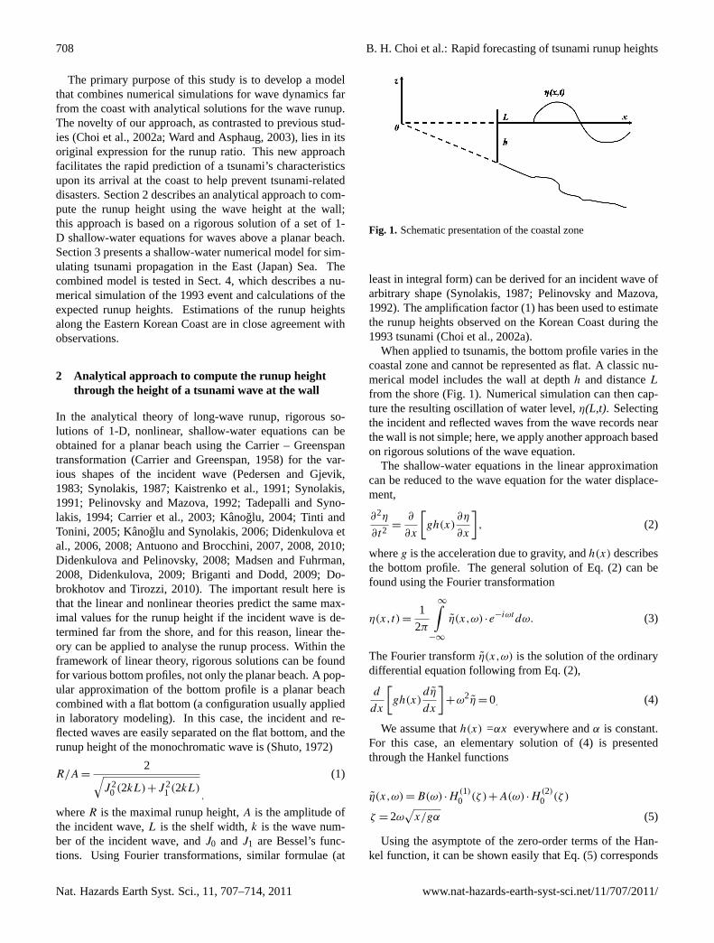
Fig. 2. Topography and bathymetry (contour unit: metre) of theEast (Japan) Sea. The 8 dots along the Korean coast indicatebeaches where comparisons between the observed and calculatedrunup heights were made (see Fig. 6).
tested through modeling historic events. In the next sectionthe developed analytical approach that will be used in estima-tions of the 1993 tsunami runup heights in the East (Japan)Sea. A general description of this event is given in (Choi etal., 1994, 2003).
3 Numerical model
A finite-difference model (Choi et al., 2003) was developedto simulate the generation and propagation of the tsunami.The numerical model uses the linear shallow-water equationwith a spherical coordinate system covering the East Sea areawith mesh dimensions 959× 1118, a mesh size of 1 angularmin, and a 2-s time step (Fig. 2). The basic equations are
∂η
∂t+
1
Rcosφ
[∂P
∂χ+
∂
∂φ(Qcosφ)
]= 0,
∂P
∂t+
gh
Rcosφ
∂η
∂χ−f Q = 0, (15)
∂Q
∂t+
gh
R
∂η
∂φ−f P = 0.
In the equations above,φ andχ are latitude and longitude,P andQ are discharge per unit width in the direction ofφ
andχ , respectively,R is the radius of the earth, andf is theCoriolis parameter.
We compiled all of the available topographic data with adigitisation of hydrographic charts, including Chinese and
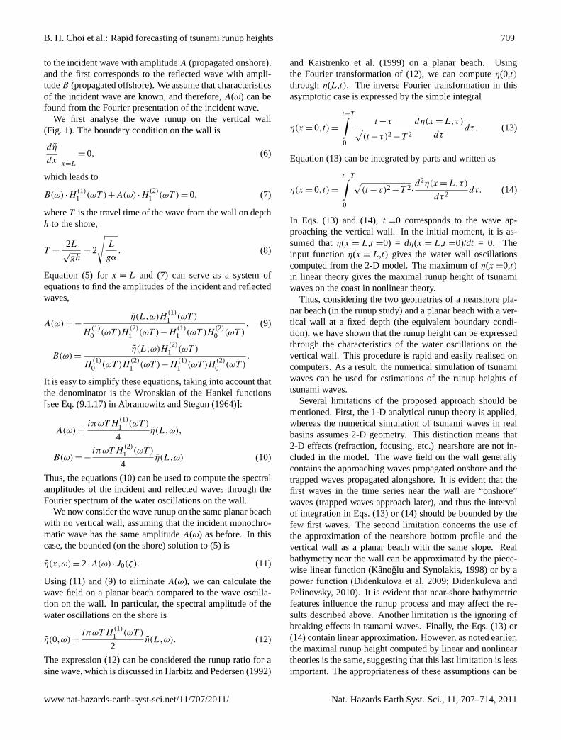
Fig. 3. The location and initial water elevations of the 1993 event.Solid and dashed lines indicate the positive and negative values,respectively. The contour interval is 0.5 m.
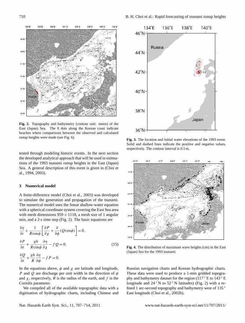
Fig. 4. The distribution of maximum wave heights (cm) in the East(Japan) Sea for the 1993 tsunami.
Russian navigation charts and Korean hydrographic charts.These data were used to produce a 1-min gridded topogra-phy and bathymetry dataset for the region (117◦ E to 143◦ Elongitude and 24◦ N to 52◦ N latitudes) (Fig. 2) with a re-fined 1 arc-second topography and bathymetry west of 135◦
East longitude (Choi et al., 2002b).
Nat. Hazards Earth Syst. Sci., 11, 707–714, 2011 www.nat-hazards-earth-syst-sci.net/11/707/2011/
B. H. Choi et al.: Rapid forecasting of tsunami runup heights 711
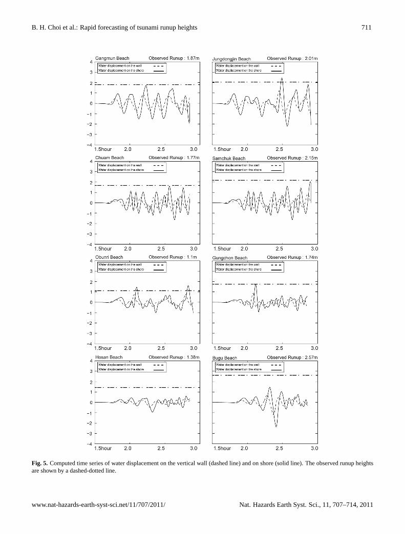
Fig. 5. Computed time series of water displacement on the vertical wall (dashed line) and on shore (solid line). The observed runup heightsare shown by a dashed-dotted line.
www.nat-hazards-earth-syst-sci.net/11/707/2011/ Nat. Hazards Earth Syst. Sci., 11, 707–714, 2011
712 B. H. Choi et al.: Rapid forecasting of tsunami runup heights
Table 1. Fault parameters of the 1993 Hokkaido earthquake.
N (◦ N) E (◦ E) hf (km) θ (◦) δ (◦) λ (◦) L (km) W (km) U (m)
42.10 139.30 5 163 60 105 24.5 25 12.0042.34 139.25 5 175 60 105 30 25 2.5043.13 139.40 10 188 35 80 90 25 5.71
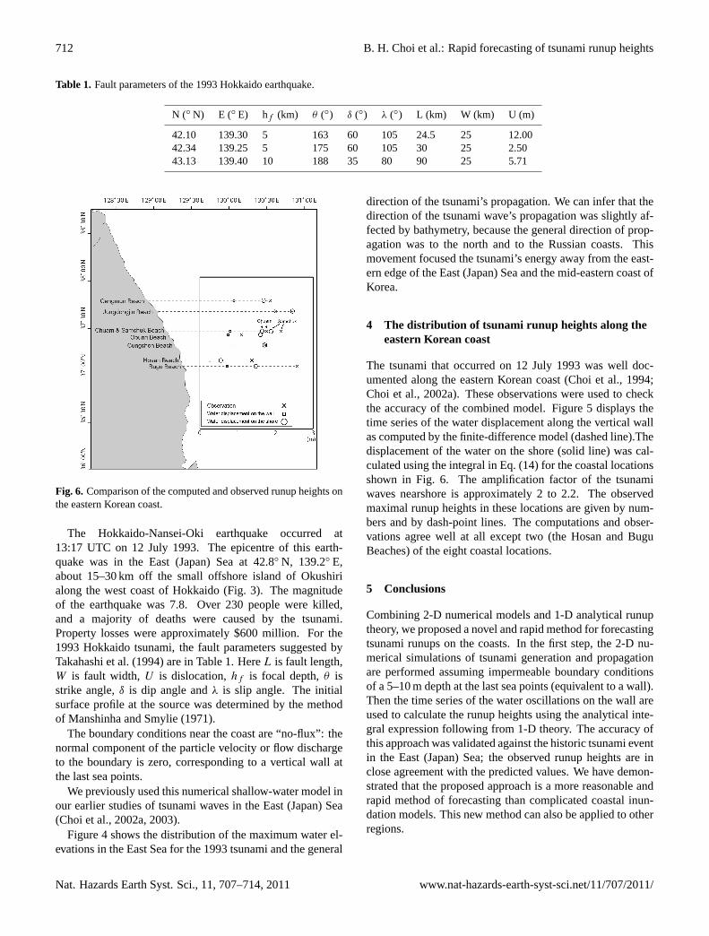
Fig. 6. Comparison of the computed and observed runup heights onthe eastern Korean coast.
The Hokkaido-Nansei-Oki earthquake occurred at13:17 UTC on 12 July 1993. The epicentre of this earth-quake was in the East (Japan) Sea at 42.8◦ N, 139.2◦ E,about 15–30 km off the small offshore island of Okushirialong the west coast of Hokkaido (Fig. 3). The magnitudeof the earthquake was 7.8. Over 230 people were killed,and a majority of deaths were caused by the tsunami.Property losses were approximately $600 million. For the1993 Hokkaido tsunami, the fault parameters suggested byTakahashi et al. (1994) are in Table 1. HereL is fault length,W is fault width, U is dislocation,hf is focal depth,θ isstrike angle,δ is dip angle andλ is slip angle. The initialsurface profile at the source was determined by the methodof Manshinha and Smylie (1971).
The boundary conditions near the coast are “no-flux”: thenormal component of the particle velocity or flow dischargeto the boundary is zero, corresponding to a vertical wall atthe last sea points.
We previously used this numerical shallow-water model inour earlier studies of tsunami waves in the East (Japan) Sea(Choi et al., 2002a, 2003).
Figure 4 shows the distribution of the maximum water el-evations in the East Sea for the 1993 tsunami and the general
direction of the tsunami’s propagation. We can infer that thedirection of the tsunami wave’s propagation was slightly af-fected by bathymetry, because the general direction of prop-agation was to the north and to the Russian coasts. Thismovement focused the tsunami’s energy away from the east-ern edge of the East (Japan) Sea and the mid-eastern coast ofKorea.
4 The distribution of tsunami runup heights along theeastern Korean coast
The tsunami that occurred on 12 July 1993 was well doc-umented along the eastern Korean coast (Choi et al., 1994;Choi et al., 2002a). These observations were used to checkthe accuracy of the combined model. Figure 5 displays thetime series of the water displacement along the vertical wallas computed by the finite-difference model (dashed line).Thedisplacement of the water on the shore (solid line) was cal-culated using the integral in Eq. (14) for the coastal locationsshown in Fig. 6. The amplification factor of the tsunamiwaves nearshore is approximately 2 to 2.2. The observedmaximal runup heights in these locations are given by num-bers and by dash-point lines. The computations and obser-vations agree well at all except two (the Hosan and BuguBeaches) of the eight coastal locations.
5 Conclusions
Combining 2-D numerical models and 1-D analytical runuptheory, we proposed a novel and rapid method for forecastingtsunami runups on the coasts. In the first step, the 2-D nu-merical simulations of tsunami generation and propagationare performed assuming impermeable boundary conditionsof a 5–10 m depth at the last sea points (equivalent to a wall).Then the time series of the water oscillations on the wall areused to calculate the runup heights using the analytical inte-gral expression following from 1-D theory. The accuracy ofthis approach was validated against the historic tsunami eventin the East (Japan) Sea; the observed runup heights are inclose agreement with the predicted values. We have demon-strated that the proposed approach is a more reasonable andrapid method of forecasting than complicated coastal inun-dation models. This new method can also be applied to otherregions.
Nat. Hazards Earth Syst. Sci., 11, 707–714, 2011 www.nat-hazards-earth-syst-sci.net/11/707/2011/
B. H. Choi et al.: Rapid forecasting of tsunami runup heights 713
Acknowledgements.We gratefully acknowledge support fromthe Korean National Emergency Management Agency. VK hadparticular support from RFBR (11-05-01054) and EP – from RFBR(11-05-00216) and Russian State Contract No. 02.740.11.0732.The third author was supported by the Korea Ocean Research &Development Institute (PE98533). The authors thank Carl Harbitz,Ira Didenkulova and two anonymous reviewers for very usefulcomments.
Edited by: I. DidenkulovaReviewed by: C. B. Harbitz, D. Greenslade,and another anonymous referee
References
Abramowitz, M. and Stegun, I. A.: Handbook of mathematicalfunctions with formulas, graphs and mathematical tables, Na-tional Bureau of Standards, NY, 1046 pp., 1964.
Antuono, M. and Brocchini, M.: The boundary value problem forthe nonlinear shallow water equation, Studied Applied Mathe-matics, 119, 71–91, 2007.
Antuono, M. and Brocchini, M.: Maximum run-up, breaking condi-tions and dynamical forces in the swash zone: a boundary valueapproach, Coastal Eng., 55, 732–740, 2008.
Antuono, M. and Brocchini, M.: Solving the nonlinear shallow-water equations in physical space, J. Fluid Mech., 643, 207–232,2010.
Beisel, S., Chubarov, L., Didenkulova, I., Kit, E., Levin, A., Peli-novsky, E., Shokin, Y., and Sladkevich M.: The 1956 Greektsunami recorded at Yafo (Israel) and its numerical modeling. J.Geophys. Res., 114, C09002,doi:10.1029/2008JC005262, 2009.
Briganti, R. and Dodd, N.: Shoreline motion in nonlinear shallowwater coastal models, Coastal Eng., 56, 495–505, 2009.
Carrier, G. F. and Greenspan, H. P.: Water waves of finite amplitudeon a sloping beach, J. Fluid Mech., 4, 97–109, 1958.
Carrier, G. F., Wu, T. T., and Yeh, H.: Tsunami run-up and draw-down on a plane beach, J. Fluid Mech., 475, 79–99, 2003.
Choi, B. H., Ko, J. S., Chung, H. F., Kim, E. B., Oh, I. S., Choi, J.I., Sim, J. S., and Pelinovsky, E.: Tsunami runup survey at EastCoast of Korea due to the 1993 Southwest of the Hokkaido Earth-quake, J. Korean Soc. Coastal and Ocean Engineers, 6, 117–125,1994 (in Korean).
Choi, B. H., Pelinovsky, E., Riabov, I., and Hong, S. J.: Distributionfunctions of tsunami wave heights, Natural Hazards, 25, 1–21,2002a.
Choi, B. H., Kim, K. O., and Eum, H. M.: Digital bathymetricand topographic data for neighboring seas of Korea. J. KoreanSoc. Coastal and Ocean Eng., 14, 41–50, 2002b (in Korean withEnglish abstract and figure captions).
Choi, B. H., Pelinovsky, E., Hong, S. J., and Woo, S. B.: Compu-tation of tsunami in the East (Japan) Sea using dynamically in-terfaced nested model, Pure Applied Geophys., 160, 1383–1414,2003.
Dall’Osso, F., Maramai, A., Graziani, L., Brizuela, B., Cavalletti,A., Gonella, M., and Tinti, S.: Applying and validating thePTVA-3 Model at the Aeolian Islands, Italy: assessment of thevulnerability of buildings to tsunamis, Nat. Hazards Earth Syst.Sci., 10, 1547–1562,doi:10.5194/nhess-10-1547-2010, 2010.
Didenkulova, I.: New trends in the analytical theory of long seawave runup, in: Applied Wave Mathematics: Selected Topics inSolids, Fluids, and Mathematical Methods, edited by: Quak, E.and Soomere, T. , Springer, 265–296, 2009.
Didenkulova, I. and Pelinovsky, E.: Run-up of long waves on abeach: the influence of the incident wave form, Oceanology, 48,1–6, 2008.
Didenkulova, I. and Pelinovsky, E.: Traveling water waves alongquartic bottom profile, Proc. Estonian Acad. Sciences, 59, 166–171, 2010.
Didenkulova, I., Zahibo, N., Kurkin, A., Levin, B., Pelinovsky, E.,and Soomere T.: Runup of nonlinear deformed waves on a beach,Doklady Earth Sciences, 411(8), 1241–1243, 2006.
Didenkulova, I., Pelinovsky, E., and Soomere, T.: Run-up charac-teristics of tsunami waves of “unknown” shapes, Pure Appl. Geo-phys., 165, 2249–2264, 2008.
Didenkulova, I., Pelinovsky, E., and Soomere, T.: Long sur-face wave dynamics along a convex bottom, J. Geophys. Res.–Oceans, 114, C07006,doi:10.1029/2008JC005027, 2009.
Dobrokhotov, S. Yu. and Tirozzi, B.: Localized solutions of one-dimensional non-linear shallow-water equations with velocity c= (x)1/2, Uspekhi Math Nauk, 65, 77–180, 2010.
Dominey-Howes, D. and Papathoma, M.: Validating a tsunami vul-nerability assessment model (the PTVA Model) using field datafrom the 2004 Indian Ocean tsunami, Natural Hazards, 40, 113–136, 2007.
Gayer, G., Leschka, S., Nohren, I., Larsen, O., and Gunther,H.: Tsunami inundation modelling based on detailed roughnessmaps of densely populated areas, Nat. Hazards Earth Syst. Sci.,10, 1679–1687,doi:10.5194/nhess-10-1679-2010, 2010.
Glimsdal, S., Pedersen, G. K., Atakan. K., Harbitz, C. B., Lang-tangen, H. P., and Løvholt, F.: Propagation of the Dec. 26 2004Indian Ocean Tsunami: effects of dispersion and source charac-teristics, Int. J. Fluid Mech. Res., 33, 15–43, 2006.
Gonzalez, F., Geist, E. L., Jaffe, B., Kanoglu, U., Mofjeld, H., Syn-olakis, C. E., Titov, V. V., Arcas, D., Bellomo, D., Carlton, D.,Horning, T., Johnson, J., Newman, J., Parsons, T., Peters, R.,Peterson, C., Priest, G., Venturato, A., Weber, J., Wong, F., andYalciner, A.: Probabilistic tsunami hazard assessment at Seaside,Oregon, for near- and far-field seismic sources, J. Geophys. Res.,114, C11023,doi:10.1029/2008JC005132, 2009.
Harbitz, C. and Pedersen, G.: Model theory and analytical solutionsfor large water waves due to landslides, Tech. Rep. 4, PreprintSeries Dept of Mathematics, University of Oslo, 17 pp., 1992.
Ioualalen, M., Pelinovsky, E., Asavanant, J., Lipikorn, R., and De-schamps, A.: On the weak impact of the 26 December IndianOcean tsunami on the Bangladesh coast, Nat. Hazards Earth Syst.Sci., 7, 141–147,doi:10.5194/nhess-7-141-2007, 2007.
Kaistrenko, V., Go, C. N., and Chung, J. Y.: A simple method fortsunami wave form recalculation through the shelf, IOC-IUGGJoint International Workshop on Tsunami Warning Beyond 2000Theory, Practice and Plans, Korea, Seoul, 15 p., 1999.
Kaistrenko, V. M., Mazova, R. Kh., Pelinovsky, E. N., and Simonov,K. V.: Analytical theory for tsunami run up on a smooth slope,Sci. Tsunami Hazards, 9, 115–127, 1991.
Kanoglu, U.: Nonlinear evolution and run-up-rundown of longwaves over a sloping beach, J. Fluid Mech., 513, 363–372, 2004.
Kanoglu, U. and Synolakis, C. E.: Long wave runup on piecewiselinear topographies, J. Fluid Mech., 374, 1–28, 1998.
www.nat-hazards-earth-syst-sci.net/11/707/2011/ Nat. Hazards Earth Syst. Sci., 11, 707–714, 2011
714 B. H. Choi et al.: Rapid forecasting of tsunami runup heights
Kanoglu, U. and Synolakis, C.: Initial value problem solution ofnonlinear shallow water-wave equations, Phys. Rev. Lett., 97,148501, 2006.
Løvholt, F., Bungum, H., Harbitz, C. B., Glimsdal, S., Lindholm, C.D., and Pedersen, G.: Earthquake related tsunami hazard alongthe western coast of Thailand, Nat. Hazards Earth Syst. Sci., 6,979–997,doi:10.5194/nhess-6-979-2006, 2006.
Madsen, P. A. and Fuhrman, D. R.: Run-up of tsunamis and longwaves in terms of surf-similarity, Coastal Eng., 55, 209–223,2008.
Manshinha, L. and Smylie, D. E.: The displacement fileds of in-clined faults. Bulletin of the Seismological Society of America,61, 1433–1440, 1971.
Pedersen, G. and Gjevik, B.: Run-up of solitary waves, J. FluidMech., 142, 283–299, 1983.
Pelinovsky, E. and Mazova, R.: Exact analytical solutions of non-linear problems of tsunami wave run-up on slopes with differentprofiles, Natural Hazards, 3, 227–249, 1992.
Roger, J. and Hebert, H.: The 1856 Djijelli (Algeria) earthquake andtsunami: source parameters and implications for tsunami hazardin the Balearic Islands, Nat. Hazards Earth Syst. Sci., 8, 721–731,doi:10.5194/nhess-8-721-2008, 2008.
Roger, J., Allgeyer, S., Hebert, H., Baptista, M.A., Loevenbruck,A., and Schindele, F.: The 1755 Lisbon tsunami in GuadeloupeArchipelago: source sensitivity and investigation of resonanceeffects, Open Oceanography Journal, 4, 58–70, 2010.
Sato, H., Murakami, H., Kozuki, Y., and Yamamoto. N.: Study on asimplified method of tsunami risk assessment, Natural Hazards,29, 325–340, 2003.
Schuiling, R. D., Cathcart, R. B., Badescu, V., Isvoranu, D., andPelinovsky, E.: Asteroid impact in the Black Sea. Death bydrowning or asphyxiation?, Natural Hazards, 40, 327–338, 2007.
Shuto, N.: Standing Waves in Front of a Sloping. Dike, CoastalEngineering in Japan, JSCE, 15, 13–23, 1972.
Synolakis, C. E.: The run-up of solitary waves. J. Fluid Mech., 185,523–545, 1987.
Synolakis, C. E.: Tsunami run-up on steep slopes: How good lineartheory really is?, Natural Hazards, 4, 221–234, 1991.
Tadepalli, S. and Synolakis, C. E.: The run-up of N-waves, P. R.Soc. London, A445, 99–112, 1994.
Takahashi, T., Shuto, N., Imamura, F., and Ortiz, M.: The best faultmodel for the 1993 Hokkaido Nansei-Oki earthquake tsunami,Proc. Coastal Eng., 41, 251–255 , 1994 (in Japanese).
Tinti, S. and Tonini, R.: Analytical evolution of tsunamis inducedby near-shore earthquakes on a constant-slope ocean, J. FluidMech., 535, 33–64, 2005.
Titov, V. V. and Synolakis, C. E.: Modeling of breaking and non-breaking long-wave evolution and runup using VTCS-2., J. Wa-terw. Port. C-Asce, 121, 308–316, 1995.
Titov, V. V. and Synolakis, C. E.: Numerical modeling of tidal waverunup, J. Waterw. Port. C-Asce, 124, 157–171, 1998.
Titov, V. V., Moore, C., Greenslade, D. J. M., Pattiaratchi, C., Badal,R., Synolakis, C. E., and Kanoglu, U.: A new tool for inundationmapping: Community Modeling Interface for Tsunamis (Com-MIT), Pure Appl. Geophys., Topical Volume, Accepted Dec.2010, 2011.
Ward, S. N. and Asphaug, E.: Asteroid impact tsunami of 2880March 16, Geophys. J. Int., 153, F6–F10, 2003.
Wei, Y., Bernard, E., Tang, L., Weiss, R., Titov, V., Moore,C., Spillane, M., Hopkins, M., and Kanoglu, U.: Real-time experimental forecast of the Peruvian tsunami of August2007 for U.S. Coastlines, Geophys. Res. Lett., 35, L04609,doi:10.1029/2007GL032250, 2008.
Zaitsev, A. I., Kovalev, D. P., Kurkin, A. A., Levin, B. V., Peli-novskii, E. N., Chernov, A. G., and Yalciner, A.: The tsunami onSakhalin on August 2, 2007: Mareograph evidence and numeri-cal simulation, Russian J. Pacific Geology, 3, 437–442, 2009.
Nat. Hazards Earth Syst. Sci., 11, 707–714, 2011 www.nat-hazards-earth-syst-sci.net/11/707/2011/
Related Documents
![Kinematic Earthquake Source Inversion and Tsunami Runup ... · models [Romano et al., 2012; Melgar and Bock, 2013]. We show that o -shore tsunami wave measurements when inverted jointly](https://static.cupdf.com/doc/110x72/5f56b7cce6ecce668d5a9599/kinematic-earthquake-source-inversion-and-tsunami-runup-models-romano-et-al.jpg)


