AIP AD2- VOHS1 INDIA 1 JUN 2009 _______________________________________________________________________ AD2. AERODROMES VOHS 2.1 AERODROME LOCATION INDICATOR AND NAME VOHS - RAJIV GANDHI INTERNATIONAL , SHAMSHABAD (HYDERABAD)/INTERNATIONAL VOHS AD 2.2 AERODROME GEOGRAPHICAL AND ADMINISTRATIVE DATA 1. ARP coordinates and site at AD 171426N 0782544E ,North of PTB. 2. Direction and distance from (city) Bearing 210°/20 KM from Husain Sagar Radial 192°/12 NM from HHY 3. Elevation/Reference temperature ARP elevation 601 M (1972 ft) and Aerodrome elevation 617 M (2024ft)/ 39°C 4. MAG VAR/Annual change 01°15" West (1995)/2' E 5. AD Administration, AD Address, telephone, Telefax, telex, AFS Operator: GMR. Hyderabad International Airport Ltd. Shamshabad, Ranga Reddy- Dist Andhra Pradesh. PIN-501218 Telephone: 040-66764205/66764194 FAX : 040-24008256 E_Mail : [email protected] ATC Services: GM-ATM Airports Authority of India Shamshabad, Ranga Reddy- Dist Andhra Pradesh. PIN-501218 Telephone: 040-24008303 FAX : 040-24008307 6. Types of traffic permitted (IFR/VFR) IFR/VFR 7. Remarks Aerodrome License NO. AL/Public/021 Category-Public use VOHS AD 2.3 OPERATIONAL HOURS 1. AD Administration Mon to Fri : 0900-1800IST Sat : 0900-1300IST Sun & Hol : Nil 2. Custom and immigration H24 3. Health and sanitation H24 4. AIS Briefing office H24 5. ATS Reporting Office(ARO) H24 6. MET Briefing office H24 7. ATS H24 8. Fuelling H24 9. Handling H24 Prior Arrangement 10. Security H24 11. De-icing Nil 12. Remarks RWY 09/27 will remain CLSD for ACFT OPS due to maintenance on all TUE BTN 0800 & 1000 UTC(1330-1530 IST) VOHS AD 2.4 HANDLING SERVICES AND FACILITIES 1. Cargo-handling facilities By Hyderabad Menzies Air Cargo Private Ltd. 2. Fuel/oil types JET A1 3. Fuelling facilities/Capacity Hyderant and bowzer (09 Dispensers + 02 Refuellers) ________________________________________________________________________ Airports Authority of India AIP AMDT.NO.1/2009

Rajivgandhiintl amendment
Jul 13, 2015
Welcome message from author
This document is posted to help you gain knowledge. Please leave a comment to let me know what you think about it! Share it to your friends and learn new things together.
Transcript

AIP AD2- VOHS1 INDIA 1 JUN 2009 _______________________________________________________________________ AD2. AERODROMES VOHS 2.1 AERODROME LOCATION INDICATOR AND NAME VOHS - RAJIV GANDHI INTERNATIONAL , SHAMSHABAD (HYDERABAD)/INTERNATIONAL VOHS AD 2.2 AERODROME GEOGRAPHICAL AND ADMINISTRATIVE DATA
1. ARP coordinates and site at AD 171426N 0782544E ,North of PTB. 2. Direction and distance from (city) Bearing 210°/20 KM from Husain Sagar Radial
192°/12 NM from HHY 3. Elevation/Reference temperature ARP elevation 601 M (1972 ft) and Aerodrome
elevation 617 M (2024ft)/ 39°C 4. MAG VAR/Annual change 01°15" West (1995)/2' E 5. AD Administration, AD Address, telephone,
Telefax, telex, AFS Operator: GMR. Hyderabad International Airport Ltd. Shamshabad, Ranga Reddy- Dist Andhra Pradesh. PIN-501218 Telephone: 040-66764205/66764194 FAX : 040-24008256 E_Mail : [email protected] ATC Services: GM-ATM Airports Authority of India Shamshabad, Ranga Reddy- Dist Andhra Pradesh. PIN-501218 Telephone: 040-24008303 FAX : 040-24008307
6. Types of traffic permitted (IFR/VFR) IFR/VFR 7. Remarks Aerodrome License NO. AL/Public/021
Category-Public use VOHS AD 2.3 OPERATIONAL HOURS
1. AD Administration Mon to Fri : 0900-1800IST Sat : 0900-1300IST Sun & Hol : Nil
2. Custom and immigration H24 3. Health and sanitation H24 4. AIS Briefing office H24 5. ATS Reporting Office(ARO) H24 6. MET Briefing office H24 7. ATS H24 8. Fuelling H24 9. Handling H24 Prior Arrangement 10. Security H24 11. De-icing Nil 12. Remarks RWY 09/27 will remain CLSD for ACFT OPS due to
maintenance on all TUE BTN 0800 & 1000 UTC(1330-1530 IST)
VOHS AD 2.4 HANDLING SERVICES AND FACILITIES
1. Cargo-handling facilities By Hyderabad Menzies Air Cargo Private Ltd. 2. Fuel/oil types JET A1 3. Fuelling facilities/Capacity Hyderant and bowzer (09 Dispensers + 02 Refuellers)
________________________________________________________________________Airports Author i ty of India AIP AMDT.NO.1/2009
AIP AD2- VOHS2 INDIA 1 JUN 2009 _______________________________________________________________________
4. De-icing facilities Nil 5. Hanger space for visiting aircraft Nil 6. Repair facilities for visiting aircraft By prior Arrangement 7. Remarks Nil
VOHS AD 2.5 PASSENGER FACILITIES
1. Hotels Novotel Business Brand Hotel with 305 rooms at a distance of 2. 75km from PTB and hotels in Hyderabad city.
2. Restaurants Level C : KFC, Pizza Hut, Coffee Bean, Indian, Chinese, Continental. Level D : Cafe Coffee Day Level F : Bollywood Bar, Sports Bar, Pizza Hut, KFC Level B : Canteen (for Employees of GMR & Airlines) Duty Free shops: Total 4 ( Level Dl, level El and level F2)
3. Transportation Taxi and Bus services. 4. Medical Facilities 24 hrs Medical and Dental Facilities provided by Apollo
Hospital Enterprises Limited (One full fledged medical centre housing minimum 17 beds), First Aid counters at Level D, E and F.
5. Bank and post office Canara Bank at Level- C Total 8 ATMs are provided (level C 1, level D 3 and level F 4) Foreign exchange counters –Total8( Level F 4, Level E 2 and Level D2)
6. Tourist office APTDC (Andhra Pradesh Tourism Development Corporation at Level D)
7. Remarks Nil VOHS AD 2.6 RESCUE AND FIRE FIGHTING SERVICES
1. AD category for fire fighting Cat 9, CAT 10 AVBL at PN of 24HRS 2. Rescue equipment AVBL as per AP service manual part1 for CAT 9 3. Capability for removal of disabled
aircraft With prior arrangement with Air India Mumbai.
4. Remarks NO. of trained personnel -77 VOHS AD 2.7 SEASONAL AVAILABILITY – CLEARING Nil VOHS AD 2.8 APRONS, TAXIWAYS AND CHECK LOCATIONS DATA
1. Apron surface and strength Surface Rigid Strength See AD 2.23
2. Taxiway width, surface and strength
Width See AD 2.23 Surface See AD 2.23 Strength See AD 2.23
3. ACL and elevation Location All aircraft stands on the passenger terminal apron. Elevation ---
________________________________________________________________________Airports Author i ty of India AIP AMDT.NO.1/2009

AIP AD2- VOHS3 INDIA 1 JUN 2009 _______________________________________________________________________
4. VOR/INS checkpoints VOR At runway holding positions on A1, A2, A3, A8 and A9. INS Nil
5. Remarks Nil
VOHS AD 2.9 SURFACE MOVEMENT GUIDANCE AND CONTROL SYSTEM AND MARKINGS
1. Use of aircraft stand ID signs, TWY guidelines and visual docking / parking guidance system of aircraft stands
Aircraft Stand ID signs: All stands are provided with stand identification sign and straight lead-in lines Taxiing guidance signage are provided at all intersections and straight sections as recommended by ICAO annex..14. Air Bridges: 12 -Stand No.1, 50 to 53, 54L, 54R, 55L, 55R, 56L, 56R & Bay no 94. Visual Docking Guidance Systems: 25 From Bay no. 45 to Bay No. 53, 54L, 54, 54R, 55L, 55, 55R, 56L, 56, 56R, 57 , 57R, 58, 58R, 94, 01 & 02.
. RWY and TWY markings and LGT RWY
Marked
Designation, THR, TDZ, Centerline, Aiming Point and Side stripe
Lighted Threshold, Edge, Centerline and Runway End lights
TWY
Marked Centerline, Taxiway edge marking, taxiway holding positions and intermediate holding position markings at intersections.
Lighted TWY 'A’, links from Al to A10, B3, B4 and B5 with centre line and edge lights (elevated). Link taxiways' Bl, B2, B6, K to K3 and M with only Edge lights.
3. Stop bars Not Provided . Guard Lights: At every runway holding position point both sides of taxiway with a pair of elevated alternate flashing yellow lights facing the taxiways.
4. Remarks Surface Movement Guidance and Control radar has been provided.
VOHS AD 2.10 AERODORME OBSTACLES
In approach /TKOF areas In circling area and at AD Remarks 1. 2. 3. Obstacle type RWY/ Elevation Area affected Marking/LGT Coordinates
Obstacle type Elevation Marking/LGT Coordinates
---
a b c a b
________________________________________________________________________Airports Author i ty of India AIP AMDT.NO.1/2009

AIP AD2- VOHS4 INDIA 1 JUN 2009 _______________________________________________________________________ ATC Tower 678M 171406.009N
0782518.006E --- --- ---
--- --- VOHS AD 2.11 METEOROLOGICAL INFORMATION PROVIDED
1. Associated MET office IMD , Hyderabad 2. Hours of service
Met office outside hours H24
3. Office responsible for TAF preparation Periods of validity
Hyderabad (VOHY) 09 & 24 Hours.
4. Types of landing forecast Interval of issuance
Trend H24. Half hourly
5. Briefing / consultation provided H24 6. Flight documentation
Language(s) use Tabular & Chart English
7. Charts and other information available For briefing or consultation
Upper winds FL 050, 100, 140, 180, 240, 300, 340, 390, 450 (U85, U70, U60, U50, U40, U30, U25, U20, U15, U10) SW (Upto FL630)
8. Supplementary equipment available for Providing information
Tele Fax , 040-24008233 040-24008269
9. ATS units provided with information Hyderabad ATC and ACS. 10. AD Additional information (limitation of service,
etc.) Integrated WX system RWY 09/27 AVBL for OPR purpose
VOHS AD 2.12 RUNWAY PHYSICAL CHARACTERSTICS
Designations RWY NR
TRUE & MAG BRG
Dimensions of RWY(M)
Strength (PCN) and surface of RWY and SWY
THR coordinates
THR elevation and highest elevation of TDZ of precision APP RWY
1 2 3 4 5 6 09 090° 4260X60 77/F/B/W/T &
88/R/C/W/T
171342.9N 0782446.17E
THR: 600M TDZ: 602M
27 270° 4260X60 77/F/B/W/T & 88/R/C/W/T
171344.89N 0782710.33E
THR: 617M TDZ: 617M
Slope of RWY-SWY
SWY dimensions ( M)
CWY dimensions (M)
Strip dimensions (M)
OFZ
Remarks
7 8 9 10 11 12 0.029% (Min) 0.95% (Max) from RWY 09
towards RWY27 transverse 1.50%
(throughout)
--- --- 4380X300 Existing
---
________________________________________________________________________Airports Author i ty of India AIP AMDT.NO.1/2009

AIP AD2- VOHS5 INDIA 1 JUN 2009 _______________________________________________________________________ VOHS AD 2.13 DECLARED DISTANCES
RWY Designation
TORA (M)
TODA (M)
ASDA (M)
LDA (M)
Remarks
1 2 3 4 5 6 09 4260 4260 4260 4260 RESA 285M X150M 27 4260 4260 4260 4260 RESA 285M X 150M
VOHS AD 2.14 APPROACH AND RUNWAY LIGHTING
Designations RWY
APCH LGT TYPE LEN INTST
THR LGT COLOUR WBAR
VASIS (MEHT) PAPI
TDZ,LGT LEN
RWY Centerline, LGT Length Spacing Color,INTST
RWY Edge, LGT,LEN Spacing Color,INTST
1 2 3 4 5 6 7 09 CAT-I
900M Green PAPI
Left / 3.3° 22.5M
---
4260M 30M
4260M ,60M
27 CAT-I 900M
Green PAPI Left / 3.3° 22.5M
---
4260M 30M
4260M ,60M
RWY END LGT COLOUR WBAR
SWY LGT LEN(M) Colour
Remarks
8 9 10 Red --- PAPI aligned with ILS GP
Red --- PAPI aligned with ILS GP VOHS AD 2.15 OTHER LIGHTING, SECONDARY POWER SUPPLY
1. ABN/IBN location, characteristics and Hours of operation
ABN On top of ATC Tower, 24FPM, white and green, 400,000cd. Switched on only during the operation of AD Ground LGTs.
IBN Nil
________________________________________________________________________Airports Author i ty of India AIP AMDT.NO.1/2009

AIP AD2- VOHS6 INDIA 1 JUN 2009 _______________________________________________________________________
LDI location and LGT Anemometer location and LGT
LDI Illuminated, white light between runway and taxiway, in front of PTB. 140M From the runway centre line [171348.57N 782548.14E] Horizontal and perpendicular segment are of 4 M Length with 11 lights each spaced equidistant. Each bulb is of 50W halogen with white lens. WDI: Three,(i) North of RWY 27 end (ii) South of RWY 27end (iii)North of RWY 09 ends. Colors: Orange & white bands & Illuminated
Anemometer --- 3. TWY edge and centre line lighting
Edge Elevated blue lights placed at 3 m
from taxiway edge. The lateral distance between lights are 60M on straight section and on curved portion varies on the radius of the curve.
Centerline Insert bidirectional green lights with gap of 15 m on links are unidirectional lights on RETs.
4. Secondary power supply/switch-over Time
DG power as standby. 15 Sec switchover time critical circuits with UPS for zero percent switchover time (Threshold/End/Rwy centre line /Edge lights
5. Remarks Nil VOHS AD 2.16 HELICOPTER LANDING AREA Not Established VOHS AD 2.17 ATS AIRSPACE
1. Designation and lateral limits CTR bounded by coordinates 175543.6N 0775535.4E then along anticlockwise arc of 50NM centered at “HIA” VOR 171340.1N 0782420.9E to 175003.6N 0774755.5E to 174303.7N 0775355.5E then along the anticlockwise arc of 25NM radius with centred at 175503.6N 0772955.6E to 172838.7N 0773410.6E then along anticlockwise arc of 50NM centered at “HIA” VOR 171340.1N 0782420.9E to 175543.6N 0775535.4E.
2. Vertical limits SFC to FL100 3. Airspace classification D 4. ATS unit call sign
Language(s) Hyderabad Tower English.
5. Transition altitude 7000FT MSL 6. Remarks Nil
VOHS AD 2.18 ATS COMMUNICATION FACILITIES
Service Designator
Call sign
Frequency
Hours of operation
Remarks
1 2 3 4 5 SMC Shamshabad
GND 121.850MHz H24
5NM coverage
________________________________________________________________________Airports Author i ty of India AIP AMDT.NO.1/2009

AIP AD2- VOHS7 INDIA 1 JUN 2009 _______________________________________________________________________
Clearance Delivery
--- 121.625MHz H24 5NM coverage
Tower Shamshabad TWR
118.450MHz H24 25NM Coverage
Approach/ Radar
Hyderabad APP/Radar
120.250MHz 125.550MHz
H24 75NM Coverage
ATIS --- 126.475MHz H24 75NM Coverage
Area Control Hyderabad Control/ Radar
128.350MHz 120.950MHz
H24 200NM Coverage
Emergency --- 121.5MHz H24 50NM Coverage
VOHS AD 2.19 RADIO NAVIGATION AND LANDING AIDS
Type of aid Site of Elevation of CAT of ILS/MLS transmitting DME trans- (For VOR/ILS/ Hours of antenna -mitting MLS,give VAR) ID Frequency operation coordinates antenna Remarks 1 2 3 4 5 6 7 DVOR HIA 113.8 MHz H24 171340.11N
0782420.88E 600M 150NM Coverage
DME HIA 1172/1109 MHz H24 171340.11N 0782420.88E
605M 150NM Coverage
ILS LLZ09 IHBD 108.5 MHz H24 171345.1N 0782725.2E
617M 25NM Coverage
ILS GP09 --- 329.9 MHz H24 171339.1N 0782455.6E
614M 10NM Coverage
ILS DME09
--- 983/1046 MHz H24 171339.1N 0782455.6E
614M 25NM Coverage
ILS LLZ27 ISAM 110.9 MHz H24 171342.7N 0782431.3E
604M 25NM Coverage
ILS GP27 --- 330.8 MHz H24 171340.8N 0782700.5E
630M 10NM Coverage
ILS DME27
--- 1007/1070MHz H24 171340.8N 0782700.5E
630M 25NM Coverage
PSR --- 2775/2825 MHz H24 171451.3N 0782628.1E
--- 60NM coverage
MSSR --- 1030/1090MHz H24 171451.3N 0782628.1E
638M 250NM Coverage
SMR --- 9375MHz H24 171331.19N 0782605.79E
615.669M 6KM Coverage
VOHS AD 2.20 LOCAL TRAFFIC REGULATIONS -------- VOHS AD 2.21 NOISE ABATEMENT PROCEDURES --------- VOHS AD 2.22 FLIGHT PROCEDURES ________________________________________________________________________Airports Author i ty of India AIP AMDT.NO.1/2009

AIP AD2- VOHS8 INDIA 1 JUN 2009 _______________________________________________________________________
-----------
VOHS AD 2.23 ADDITIONAL INFORMATION
1. PARKING STANDS STAND.No. Surface Strength (PCN) Co-Ordinates Remarks 1 Rigid 62/R/C/W/T 171408.48N0782552.27E 2 Rigid 62/R/C/W/T 171408.60N 0782553.83E 3 Rigid 62/R/C/W/T 171408.52N 0782555.22E 4 Rigid 62/R/C/W/T 171408.54N 0782556.68E 5 Rigid 62/R/C/W/T 171408.56N 0782558.16E 6 Rigid 62/R/C/W/T 171408.57N 0782559.63E 7 Rigid 62/R/C/W/T 171408.59N 0782601.10E 8 Rigid 62/R/C/W/T 171408.61N 0782602.57E
9 Rigid 62/R/C/W/T 171408.63N 0782604.04E 10 Rigid 62/R/C/W/T 171408.65N 0782605.51E 11 Rigid 62/R/C/W/T 171408.78N 0782607.08E 12 Rigid 62/R/C/W/T 171408.69N 0782608.46E 40 Rigid 88/R/C/W/T 171403.65N 0782608.53E 41 Rigid 88/R/C/W/T 171403.75N 0782607.16E 42 Rigid 88/R/C/W/T 171403.61N 0782605.58E 43 Rigid 88/R/C/W/T 171403.60N 0782604.11E 44 Rigid 88/R/C/W/T 171403.58N 0782602.64E 45 Rigid 88/R/C/W/T 171403.67N 0782601.27E 46 Rigid 88/R/C/W/T 171403.54N 0782559.70E 47 Rigid 88/R/C/W/T 171403.52N 0782558.23E 48 Rigid 88/R/C/W/T 171403.50N 0782556.75E 49 Rigid 88/R/C/W/T 171403.48N 0782555.28E 50 Rigid 88/R/C/W/T 171403.46N 0782553.81E 51 Rigid 88/R/C/W/T 171403.45N 0782552.34E 52 Rigid 88/R/C/W/T 171403.86N 0782550.71E 53L Rigid 88/R/C/W/T 171403.67N 0782549.03E
53 Rigid 88/R/C/W/T 171403.24N 0782549.09E 54 Rigid 88/R/C/W/T 171404.05N 0782546.91E 54L Rigid 88/R/C/W/T 171403.20N 0782546.34E 54R Rigid 88/R/C/W/T 171404.15N 0782547.69E 55 Rigid 88/R/C/W/T 171404.01N 0782544.20E 55L Rigid 88/R/C/W/T 171403.15N 0782543.38E 55R Rigid 88/R/C/W/T 171404.27N 0782544.73E 56 Rigid 88/R/C/W/T 171403.88N 0782541.15E 56L Rigid 88/R/C/W/T 171403.11N 0782540.41E
56R Rigid 88/R/C/W/T 171404.24N 0782541.77E 57 Rigid 88/R/C/W/T 171403.85N 0782538.27E 57L Rigid 88/R/C/W/T 171403.08N 0782537.57E 57R Rigid 88/R/C/W/T 171404.13N 0782539.00E 58 Rigid 88/R/C/W/T 171403.81N 0782535.43E
________________________________________________________________________Airports Author i ty of India AIP AMDT.NO.1/2009

AIP AD2- VOHS9 INDIA 1 JUN 2009 _______________________________________________________________________ 58L Rigid 88/R/C/W/T 171403.04N 0782534.73E 58R Rigid 88/R/C/W/T 171404.00N 0782536.09E 59 Rigid 88/R/C/W/T 171403.20N 0782533.26E 90 Rigid 62/R/C/W/T 171408.24N 0782533.19E 91 Rigid 62/R/C/W/T 171408.25N 0782534.66E 92 Rigid 62/R/C/W/T 171408.27N 0782536.13E 93 Rigid 62/R/C/W/T 171408.29N 0782537.60E 94 Rigid 62/R/C/W/T 171408.31N 0782539.07E 100 Rigid 60/R/C/W/T 171356.51N 0782701.43E 200 60/R/C/W/T 171403.23N 0782514.56E
201 60/R/C/W/T 171403.58N 0782513.91E 202 60/R/C/W/T 171403.37N 0782512.97E 203 60/R/C/W/T 171403.19N 0782511.49E 204 60/R/C/W/T 171403.17N 0782509.86E 300 30/R/C/W/T 171404.19N 0782658.05E 301 30/R/C/W/T 171405.07N 0782658.06E 302 30/R/C/W/T 171405.95N 0782657.81E 303 30/R/C/W/T 171406.83N 0782657.79E 304 30/R/C/W/T 171407.71N 0782657.78E 305 30/R/C/W/T 171408.58N 0782657.77E
Size of South Apron (Stand 40 to 59) 1083X84M Size of North West Apron (Stand 90 to 94) 241X58M Size of North East Apron (Stand 01 to 12) 545X58M Size of Cargo Apron 190X113M Size of Maintance Apron 195X 130M
2. PUSHBACK / PULL FORWARD PROCEDURE FOR STAND NR 01-12 AND 90-94: i) ACFT on Stand NR.01-12 shall pushback facing East. ACFT on Stand NR. 01,02,03 shall pull
forward till limit line marked abeam Stand 4 due safety reasons i.e; to avoid JET BLAST effect on perimeter wall.
ii) ACFT on Stand NR.90 - 94 shall pushback facing West. ACFT on Stand NR. 92,93,94 shall pull forward till limit line marked abeam Stand 91 due safety reasons.
iii) Stand NR 01&94 AVBL for Code C ACFT.PUSHBACK limit lines marked for Stand NR. 01 & 94. PUSHBACK LIMIT LINES are marked with WHITE LINE.
iv) ADDN marking AVBL for PWR IN/PWR OUT .On Stand 90 for ACFT upto code B, on Stand 91 & 92 for ACFT upto wing span of 20M.
3.TAXIWAY:
Designation Length/Width (M)
PCN Coordinates Remarks
A 4395/45 77/F/B/W/T 171351.12N 0782556.85E A1 427/25 77/F/B/W/T 171348.40N 0782711.41E A2 225/25 77/F/B/W/T 171348.22N 0782657.31E A3 225/25 77/F/B/W/T 171347.94N 0782634.91E
A4 499/25 77/F/B/W/T 171347.81N 0782624.67E RET
________________________________________________________________________Airports Author i ty of India AIP AMDT.NO.1/2009

AIP AD2- VOHS10 INDIA 1 JUN 2009 _______________________________________________________________________
________________________________________________________________________Airports Author i ty of India AIP AMDT.NO.1/2009
A5 499/25 77/F/B/W/T 171347.58N 0782606.83E RET A6 482/25 77/F/B/W/T 171347.30N 0782544.68E RET A7 482/25 77/F/B/W/T 171347.10N 0782529.43E RET A8 225/25 77/F/B/W/T 171346.99N 0782520.50E A9 225/25 77/F/B/W/T 171346.57N 0782448.05E A10 281/25 77/F/B/W/T 171346.53N 0782444.76E B1 82/25 69/F/B/W/T 171353.76N 0782701.30E Isolation Bay B2 327/18 69/F/B/W/T 171357.22N 0782657.19E MRO B3 297/25 77/F/B/W/T 171357.19N 0782613.05E PTB B4 272/25 77/F/B/W/T 171355.51N 0782553.79E PTB B5 272/25 77/F/B/W/T 171355.31N 0782538.22E PTB B6 175/25 69/F/B/W/T 171353.49N 0782520.41E Cargo E 1130/25 77/F/B/W/T 171400.95N 0782552.49E Cargo K 365/25 77/F/B/W/T 171405.79N 0782612.92E K1 365/18 73/F/B/W/T 171405.75N 0782610.13E K2 646/18 73/F/B/W/T 171410.90N 0782601.06E K3 586/18 73/F/B/W/T 171412.34N 0782601.04E M 596/18 73 /F/B/W/T 171410.34N 0782532.28E
4. TWY A, A1, A2, A3, A8, A9, A10,CL LGT AVBLonly at visibility conditions of RVR 1000 M or less. 5. Rapid exit TWY CL LGT corresponding to the RWY in use AVBL during the time of OPS of aeronautical ground LGT. 6. VFR training FLTs north of Nadirgul AD in a radius of 2NM. Lower limit: GND Upper limit: 2600FT AMSL 7. Storm Water Drain on either side of RWY 27/09 DIST from CL 105M, Shape trapezoid, Width at the top 10M, Width at the bottom 2M to3M, Depth 2M to 3M. VOHS AD 2.24 CHARTS RELATED TO AN AERODROME
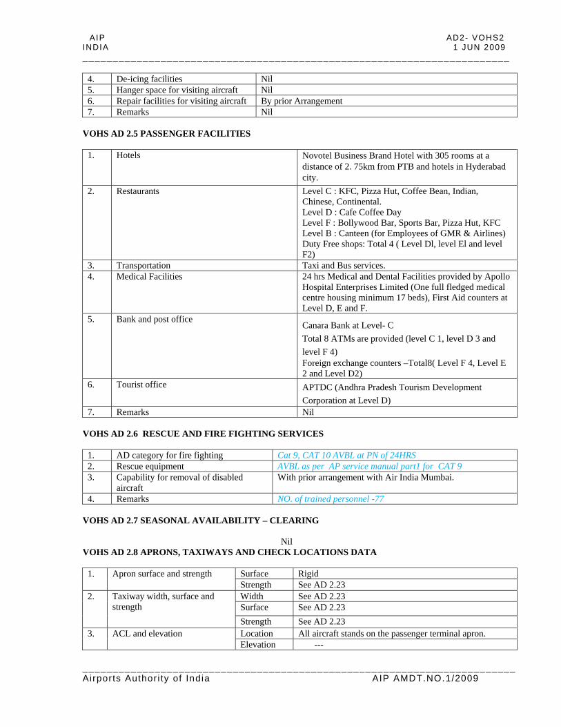
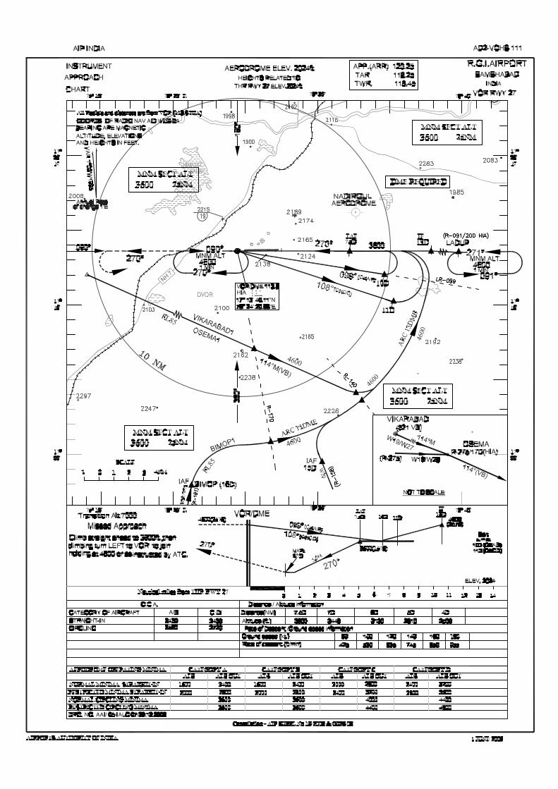
1. VOR RWY 09 2. VOR RWY 27 3. Aerodrome Chart 4. Aircraft Parking/Docking Chart-ICAO(Cargo&MRO Apron) 5. Aircraft Parking/Docking Chart-ICAO(Passenger Terminal Apron) 6. Aerodrome Obstacle Chart-Type A 7. Precision Approach Terrain Chart-RWY09 8. Precision Approach Terrain Chart-RWY27
(NOTE : FROM PAGE AD 2-VOHS 11-104 INTENTIONALLY LEFT BLANK)
ij
Text Box
105

ij
Text Box
106

Page 2 of 2
ij
Text Box
AD2-VOHS 107 I JUN 2009

Page 3 of 3
ij
Text Box
AD2-VOHS 108 I JUN 2009

Page 4 of 4
ij
Text Box
AD2-VOHS 109 I JUN 2009

Page 8 of 8
ij
Text Box
AD2-VOHS 110 I JUN 2009

Page 9 of 9
ij
Text Box
AD2-VOHS 111 I JUN 2009
Page 10 of 10 Page 10 of 10
ij
Text Box
AD2-VOHS 112 I JUN 2009
Related Documents