RAJARSHI SHAHU MAHAVIDYALAYA, LATUR (Autonomous) Syllabus for the B. A. S.Y. (Semester – III & IV) Programme :- B.A. (Competitive Examinations Programme – CEP) Course : Geography Credit Based Semester and Grading System (Syllabus with effect from June 2019)

Welcome message from author
This document is posted to help you gain knowledge. Please leave a comment to let me know what you think about it! Share it to your friends and learn new things together.
Transcript
RAJARSHI SHAHU MAHAVIDYALAYA, LATUR
(Autonomous)
Syllabus for the B. A. S.Y. (Semester – III & IV)
Programme :- B.A. (Competitive Examinations Programme – CEP)
Course : Geography
Credit Based Semester and Grading System
(Syllabus with effect from June 2019)
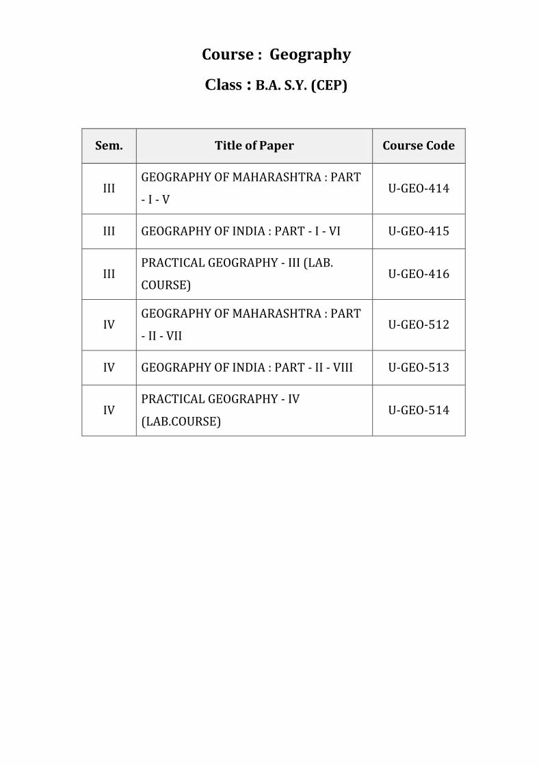
Course : Geography
Class : B.A. S.Y. (CEP)
Sem. Title of Paper Course Code
III GEOGRAPHY OF MAHARASHTRA : PART
- I - V U-GEO-414
III GEOGRAPHY OF INDIA : PART - I - VI U-GEO-415
III PRACTICAL GEOGRAPHY - III (LAB.
COURSE) U-GEO-416
IV GEOGRAPHY OF MAHARASHTRA : PART
- II - VII U-GEO-512
IV GEOGRAPHY OF INDIA : PART - II - VIII U-GEO-513
IV PRACTICAL GEOGRAPHY - IV
(LAB.COURSE) U-GEO-514
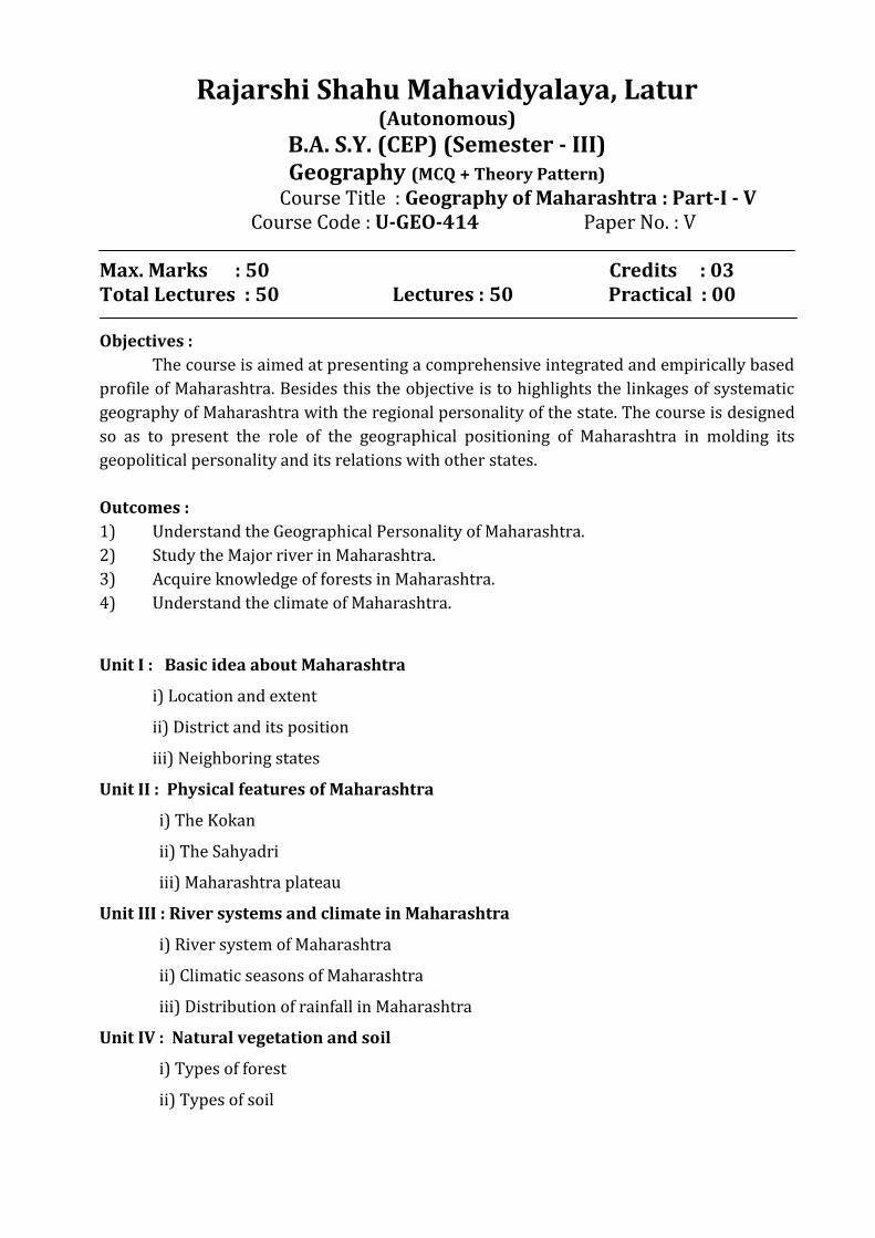
Rajarshi Shahu Mahavidyalaya, Latur (Autonomous)
B.A. S.Y. (CEP) (Semester - III) Geography (MCQ + Theory Pattern)
Course Title : Geography of Maharashtra : Part-I - V Course Code : U-GEO-414 Paper No. : V Max. Marks : 50 Credits : 03 Total Lectures : 50 Lectures : 50 Practical : 00 Objectives :
The course is aimed at presenting a comprehensive integrated and empirically based
profile of Maharashtra. Besides this the objective is to highlights the linkages of systematic
geography of Maharashtra with the regional personality of the state. The course is designed
so as to present the role of the geographical positioning of Maharashtra in molding its
geopolitical personality and its relations with other states.
Outcomes :
1) Understand the Geographical Personality of Maharashtra.
2) Study the Major river in Maharashtra.
3) Acquire knowledge of forests in Maharashtra.
4) Understand the climate of Maharashtra.
Unit I : Basic idea about Maharashtra
i) Location and extent
ii) District and its position
iii) Neighboring states
Unit II : Physical features of Maharashtra
i) The Kokan
ii) The Sahyadri
iii) Maharashtra plateau
Unit III : River systems and climate in Maharashtra
i) River system of Maharashtra
ii) Climatic seasons of Maharashtra
iii) Distribution of rainfall in Maharashtra
Unit IV : Natural vegetation and soil
i) Types of forest
ii) Types of soil
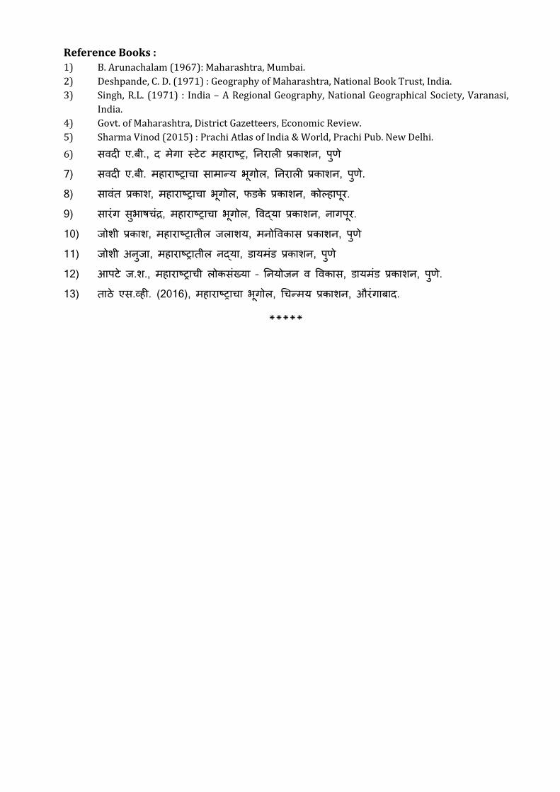
Reference Books :
1) B. Arunachalam (1967): Maharashtra, Mumbai.
2) Deshpande, C. D. (1971) : Geography of Maharashtra, National Book Trust, India.
3) Singh, R.L. (1971) : India – A Regional Geography, National Geographical Society, Varanasi,
India.
4) Govt. of Maharashtra, District Gazetteers, Economic Review.
5) Sharma Vinod (2015) : Prachi Atlas of India & World, Prachi Pub. New Delhi.
6) ए. ., , , 7) ए. . , , . 8) , , , . 9) , , , . 10) , , , 11) , , , 12) . ., – , , . 13) ए . . (2016), , , .
*****
Rajarshi Shahu Mahavidyalaya, Latur (Autonomous)
B.A. S.Y. (CEP) (Semester - III) Geography (MCQ + Theory Pattern)
Course Title : Geography of India : Part-I - VI Course Code : U-GEO-415 Paper No. : VI Max. Marks : 50 Credits : 03 Total Lectures : 50 Lectures : 50 Practical : 00 Objectives :
The course is aimed at presenting a comprehensive integrated and empirically based
profile of India. Besides this the objective is to highlights the linkages of systematic
geography of India with the regional personality of the country. The course is designed so as
to present the role of the geographical positioning of India in molding its geopolitical
personality and its relations with other countries.
Outcomes :
1) Understand the Geographical Personality of India.
2) Study the Major river in India.
3) Acquire knowledge of forests in India.
4) Understand the climate of India.
Unit I : Basic idea about India
i) Location and extent, time zone
ii) Neighboring countries
iii) States and its position and the states on International boundaries
Unit II : Physical features of India
i) The Himalayas
ii) The great north Indian plains
iii) Peninsular plateau
iv) Coastal plains and islands
Unit III : River systems and climate in India
i) River system of India
ii) Origin of monsoon and seasons of India
iii)La-nino and El-nino effects on Indian monsoon
Unit IV : Natural vegetation and soil
i) Types of forest
ii) Types of soil
Suggested Readings :
1. Chauhan, P.R. and Prasad, M. (2003): Bharat Ka Vrihad Bhugol, Vasundhara
Prakashan, Gorakhpur.
2. Farmer, B.H. (1983): An Introduction to South Asia. Methuen, London
3. Gautam, A. (2006): Advanced Geography ofIndia, Sharda Pustak Bhawan, Allahabad
4. Johnson, B.L.e. (1963): Development in South Asia. Penguin Books, Harrnondsworth
5. Krishnan, M.S. (J 982): Geology of India and Burma, CAS Publishers and Distributors,
Delhi.
6. Khullar, D.R. (2007): India: A Comprehensive Geography, Kalyani Publishers, New
Delhi
7. Nag, P. and Gupta, S. S. (1992): Geography of India, Concept Publishing Company,
New Delhi.
8. Rao, B.P. ( 2007): Bharat kee Bhaugolik Sameeksha, Vasundhara Prakashan, Gorakh
ur.
9. Sharma, T.e. and Coutinho, O. (2003): Economic and Commercial Geography of India,
Vikas Publishing House Private Ltd. New Delhi.
10. Singh, J. (2003): India: A Comprehensive Systematic Geography. Gyanodaya
Prakashan, Gorakhpur
11. Singh, J. (200 I): Bharat: Bhougolik Aadhar Avam Ayam, Gyanodaya Prakashan,
Gorakhpur.
12. Singh, R.L. (ed.) (1971): India: A Regional Geography. National Geographical Society
of India, Varanasi,.
13. Spate, O.H. K., Learrnonth A. T. A. and Fanner, B. H. (1996): India, Pakistan and Sri
Lanka. Methuen, London, 7th edition.
14. Sukhwal, B.L. (1987): India: Economic Resource Base and Contemporary Political
Patterns. Sterling Publication, New Delhi
15. Tiwari, R.e. (2007): Geography of India, Prayag Pustak Bhawan, Allahabad.
16. Wadia, D. N. (1959): Geology of India. Mac-Millan and Company, London and student
edition, Madras.
17. A.B. Sawadi, Bhartacha Samagra Bhugol Part I.
******
Rajarshi Shahu Mahavidyalaya, Latur (Autonomous)
B.A. S.Y. (CEP) (Semester - III) Geography (MCQ + Theory Pattern)
Course Title : Practical Geography - III Course Code : U-GEO-416 Paper No. : III Max. Marks : 50 Credits : 03 Total Lectures : 50 Lectures : 50 Practical : 00 Objectives:
1) To make students aware about different climatic graphs and diagrams.
2) To make student aware about climatic conditions through weather
instruments and daily weather maps.
Outcomes :
1) Understand the uses of Climograph, Hythergraph, Star Diagram
2) Understand the study of Indian daily weather reports.
3) Students introduce to weather instruments
Unit-I : Introduction
i) Climograph.
ii) Hythergraph.
iii) Star Diagram.
Unit-II : Introduction of Weather Instruments
i) Minimum & Max. Thermometer.
ii) Dry & Wet Bulb Thermometer.
iii) Rainguage
iv) Aneroid Barometer.
v) Wind Vane.
vi) Cup-Anemometer.
Unit-III : Study of Indian Daily Weather Reports
i) Weather Signs & Symbols.
ii) Interpretation of Indian Daily Weather Reports. One Each from Winter,
Summer & Rainy Season.
Unit-IV : Use of Line & Bar Graph for Representing Geographical Data
i) Line Graph- Simple & Multiple.
ii) Bar Graph- Simple & Multiple
Reference Books :
1) Mishra R.P. & Ramesh A. Fundamentels of cartography. Mc.Millan
Co.H.D.1986.
2) Singh R.L. Elements of Practical Geography, Kalyani Publication, H.D.
3) Sarkar, A.K. Practical Geography A Systematic Approach orient Longman,
Calcatta,1997.
Monk house ,F.J. & Wilkinson, H.R.: Maps & Diagrams London, 1994. ******
Rajarshi Shahu Mahavidyalaya, Latur (Autonomous)
B.A. S.Y. (CEP) (Semester - IV) Geography (MCQ + Theory Pattern)
Course Title : Geography of Maharashtra : Part-II - VII Course Code : U-GEO-512 Paper No. : VII Max. Marks : 50 Credits : 03 Total Lectures : 50 Lectures : 50 Practical : 00 Objectives:
The course is aimed at presenting a comprehensive integrated and empirically
based profile of Maharashtra. Besides this the objective is to highlights the linkages
of systematic geography of Maharashtra with the regional personality of the state.
The course is designed so as to present the role of the geographical positioning of
Maharashtra in molding its geopolitical personality and its relations with other
states.
Unit - I : Minerals and Energy Resources
i) Mineral Resources in Maharashtra
ii) Energy Resources - Coal and Mineral Oil
Unit - II : Industries
i) Agro Based Industries - Cotton Textile and Sugar Industry
ii) Industrial regions of Maharashtra
Unit - III : Settlement
i) Types of settlement
ii) Problems of slum area
Unit-IV : Tourism and transport
i) Tourism in Maharashtra
ii) National highway in Maharashtra
Reference Books :
1) B. Arunachalam (1967): Maharashtra, Mumbai.
2) Deshpande, C. D. (1971) : Geography of Maharashtra, National Book Trust, India.
3) Singh, R.L. (1971) : India – A Regional Geography, National Geographical Society, Varanasi,
India.
4) Govt. of Maharashtra, District Gazetteers, Economic Review.
5) Sharma Vinod (2015) : Prachi Atlas of India & World, Prachi Pub. New Delhi.
6) ए. ., , , 7) ए. . , , . 8) , , , . 9) , , , . 10) . ., – , , . 11) ए . . (2016), , , .
******
Rajarshi Shahu Mahavidyalaya, Latur (Autonomous)
B.A. S.Y. (CEP) (Semester - IV) Geography (MCQ + Theory Pattern)
Course Title : Geography of India : Part-II - VIII Course Code : U-GEO-513 Paper No. : VIII Max. Marks : 50 Credits : 03 Total Lectures : 50 Lectures : 50 Practical : 00 Objectives:
The course is aimed at presenting a comprehensive integrated and empirically based
profile of India. Besides this the objective is to highlights the linkages of systematic
geography of India with the regional personality of the country. The course is designed so as
to present the role of the geographical positioning of India in molding its geopolitical
personality and its relations with other countries.
Unit-I : Population
i) Factors Affecting on Distribution of Population
ii) Distribution of Population in India
Unit-II : Minerals and Energy Resources
i) Mineral Resources-Iron Ore and Manganese
ii) Energy Resources-Coal and Mineral Oil
Unit-III : Industries
i) Agro Based Industries- Cotton Textile Industry
ii) Mineral Based Industries-Iron and Steel Industry
Unit-IV : Transport
i) Importance of Transport
ii) Transport Routes-Roads, Railways, Airways and Waterways
Suggested Readings :
1. Chauhan, P.R. and Prasad, M. (2003): Bharat Ka Vrihad Bhugol, Vasundhara
Prakashan, Gorakhpur.
2. Farmer, B.H. (1983): An Introduction to South Asia. Methuen, London
3. Gautam, A. (2006): Advanced Geography ofIndia, Sharda Pustak Bhawan, Allahabad
4. Johnson, B.L.e. (1963): Development in South Asia. Penguin Books, Harrnondsworth
5. Krishnan, M.S. (J 982): Geology of India and Burma, CAS Publishers and Distributors,
Delhi.
6. Khullar, D.R. (2007): India: A Comprehensive Geography, Kalyani Publishers, New
Delhi
7. Nag, P. and Gupta, S. S. (1992): Geography of India, Concept Publishing Company,
New Delhi.
8. Rao, B.P. ( 2007): Bharat kee Bhaugolik Sameeksha, Vasundhara Prakashan, Gorakh
ur.
9. Sharma, T.e. and Coutinho, O. (2003): Economic and Commercial Geography of India,
Vikas Publishing House Private Ltd. New Delhi.
10. Singh, J. (2003): India: A Comprehensive Systematic Geography. Gyanodaya
Prakashan, Gorakhpur
11. Singh, J. (200 I): Bharat: Bhougolik Aadhar Avam Ayam, Gyanodaya Prakashan,
Gorakhpur.
12. Singh, R.L. (ed.) (1971): India: A Regional Geography. National Geographical Society
of India, Varanasi,.
13. Spate, O.H. K., Learrnonth A. T. A. and Fanner, B. H. (1996): India, Pakistan and Sri
Lanka. Methuen, London, 7th edition.
14. Sukhwal, B.L. (1987): India: Economic Resource Base and Contemporary Political
Patterns. Sterling Publication, New Delhi
15. Tiwari, R.e. (2007): Geography of India, Prayag Pustak Bhawan, Allahabad.
16. Wadia, D. N. (1959): Geology of India. Mac-Millan and Company, London and student
edition, Madras.
17. A.B. Sawadi, Bhartacha Samagra Bhugol Part I.
******
Rajarshi Shahu Mahavidyalaya, Latur (Autonomous)
B.A. S.Y. (CEP) (Semester - IV) Geography (MCQ + Theory Pattern)
Course Title : Practical Geography - IV Course Code : U-GEO-514 Paper No. : IV Max. Marks : 50 Credits : 03 Total Lectures : 50 Lectures : 50 Practical : 00 Objectives:
1) To understand the different cartographical methods.
2) To study the two and three dimensional diagrams for representation of
economic data.
Unit-I : Use of Line and Bar Graph for Representing Economic Data
i) Line Graph: Simple and Multiple.
ii) Bar Graph: Simple & Multiple
Unit-II : Two Dimensional Located Diagrams
i) Wheel Diagram
ii) Circle Diagram
iii) Square Diagram
Unit-III : Three Dimensional Located Diagrams
i) Cube Diagram.
ii) Sphere Diagram
iii) Block Piles
Unit-IV : Distributional Maps
i) Dot Map.
ii) Choropleth Map
iii) Flow Line Map
Reference Books :
1. Mishra R.P. & Ramesh A. Fundamentels of cartography. Mc.Millan Co.H.D.1986.
2. Singh R.L. Elements of Practical Geography, Kalyani Publication, H.D.
3. Sarkar, A.K. Practical Geography A Systematic Approach orient Longman,
Calcatta,1997.
4. Monk house ,F.J. & Wilkinson, H.R.: Maps & Diagrams London, 1994.
*******
Related Documents