Quest Carbon Capture and Storage Project Environmental Assessment Table of Contents Shell Canada Limited November 2010 Page iii 10.4.4 Changes to Species Diversity........................................................................ 10-19 10.4.4.1 Community and Species Diversity – Vegetation Loss ............... 10-19 10.4.4.2 Rare Plants ......................................................................... ......... 10-20 10.4.4.3 Non-native and Invasive Species ................................................ 10-20 10.4.4.4 Agricultural Pests ...................................................... .................. 10-20 10.5 Summary of Project Residual Environmental Effects on Vegetation and Wetlands ... 10-20 10.5.1 Significance Determination .......................................................................... 10-23 10.5.1.1 Changes to Landscape Diversity ................................................. 10-23 10.5.1.2 Changes to Community Diversity ............................................... 10-23 10.5.1.3 Changes to Species Diversity...................................................... 10-23 10.5.2 Follow-up and Monitoring ............................................................................ 10-24 10.6 Cumulative Environmental Effects on Vegetation and Wetlands ............................... 10-25 10.6.1 Changes to Landscape Diversity ................................................................... 10-25 10.6.1.1 Large Patches of Native Vegetation ......................... .................. 10-25 10.6.2 Changes to Community Diversity ................................................................. 10-25 10.6.3 Change to Species Diversity ....................................................... .................. 10-25 10.6.3.1 Loss of Rare Plants .......................................... ........................... 10-25 10.6.4 Cumulative Environmental Effects – Summary ........................................... 10- 25 10.7 References ........................................................................................................... ......... 10-28 10.7.1 Literature Cited ............................................... .............................................. 10-28 10.7.2 Personal Communication .............................................................................. 10-28 10.7.3 Internet Sites ............................................................................... .................. 10-29 11 Wildlife and Wildlife Habitat ............................................... ...................................... 11-1 11.1 Boundaries – Wildlife and Wildlife Habitat .................................................................. 11-1 11.1.1 Temporal Bound aries ...................................................................................... 11-1 11.1.2 Spatial Boundaries ......................................................................................... . 11-1 11.1.2.1 Project Development Area ............................................................ 11-1 11.1.2.2 Local Assessment Area ...................................................... ........... 11-3 11.1.2.3 Regional Assessment Area ....................................... .................... 11-3 11.1.3 Administrative and Technical Boundaries ..................................................... . 11-3 11.2 Scope of Assessment – Wildlife and Wildlife Habitat .................................................. 11-3 11.2.1 Regulatory Setting ............................................................. ............................. 11-4 11.2.1.1 Federal Regulations ...................................................................... 11-4 11.2.1.2 Provincial Regulations .................................................................. 11-5 11.2.2 Key Issues and Potential Interactions ............................................................. 11-6 11.2.2.1 Environmental Effects Assessed .................................................. . 11-9 11.2.2.2 Species Assessed ......................................................................... 11-10 11.2.3 Measurable Parameters ................................................................................. 11-17 11.2.4 Residual Environmental Effects Rating Criteria ........................................... 11-17 11.2.5 Standards or Thresholds for Determining Significance ................................ 11-19 11.2.6 Influence of Consultation on the Assessment ............................................... 11-19 11.3 Baseline Conditions – Wildlife and Wildlife Habitat .................................................. 11-19 11.3.1 Existing Data Review and Results ....................................................... ......... 11-20 11.3.2 Field Methods and Results ............................................................................ 11-20 11.3.2.1 Amphibian Surveys..................................................................... 11-21

Welcome message from author
This document is posted to help you gain knowledge. Please leave a comment to let me know what you think about it! Share it to your friends and learn new things together.
Transcript

8/21/2019 Quest CCS EIA - Wildlife and Wildlife Habitat (1)
http://slidepdf.com/reader/full/quest-ccs-eia-wildlife-and-wildlife-habitat-1 1/141
Quest Carbon Capture and Storage ProjectEnvironmental Assessment Table of Contents
Shell Canada Limited November 2010
Page iii
10.4.4 Changes to Species Diversity........................................................................ 10-19
10.4.4.1 Community and Species Diversity – Vegetation Loss ............... 10-19
10.4.4.2 Rare Plants .................................................................................. 10-20
10.4.4.3 Non-native and Invasive Species ................................................ 10-20
10.4.4.4 Agricultural Pests ........................................................................ 10-20
10.5
Summary of Project Residual Environmental Effects on Vegetation and Wetlands ... 10-20
10.5.1 Significance Determination .......................................................................... 10-23
10.5.1.1 Changes to Landscape Diversity ................................................. 10-23
10.5.1.2 Changes to Community Diversity ............................................... 10-23
10.5.1.3 Changes to Species Diversity...................................................... 10-23
10.5.2 Follow-up and Monitoring ............................................................................ 10-24
10.6 Cumulative Environmental Effects on Vegetation and Wetlands ............................... 10-25
10.6.1 Changes to Landscape Diversity ................................................................... 10-25
10.6.1.1 Large Patches of Native Vegetation ........................................... 10-25
10.6.2 Changes to Community Diversity ................................................................. 10-25
10.6.3 Change to Species Diversity ......................................................................... 10-25
10.6.3.1
Loss of Rare Plants ..................................................................... 10-25
10.6.4 Cumulative Environmental Effects – Summary ........................................... 10-25
10.7 References .................................................................................................................... 10-28
10.7.1 Literature Cited ............................................................................................. 10-28
10.7.2 Personal Communication .............................................................................. 10-28
10.7.3 Internet Sites ................................................................................................. 10-29
11 Wildlife and Wildlife Habitat ..................................................................................... 11-1
11.1 Boundaries – Wildlife and Wildlife Habitat .................................................................. 11-1
11.1.1 Temporal Boundaries ...................................................................................... 11-1
11.1.2 Spatial Boundaries .......................................................................................... 11-1
11.1.2.1
Project Development Area ............................................................ 11-1
11.1.2.2 Local Assessment Area ................................................................. 11-3
11.1.2.3 Regional Assessment Area ........................................................... 11-3
11.1.3 Administrative and Technical Boundaries ...................................................... 11-3
11.2 Scope of Assessment – Wildlife and Wildlife Habitat .................................................. 11-3
11.2.1 Regulatory Setting .......................................................................................... 11-4
11.2.1.1 Federal Regulations ...................................................................... 11-4
11.2.1.2 Provincial Regulations .................................................................. 11-5
11.2.2 Key Issues and Potential Interactions ............................................................. 11-6
11.2.2.1 Environmental Effects Assessed ................................................... 11-9
11.2.2.2 Species Assessed ......................................................................... 11-10
11.2.3
Measurable Parameters ................................................................................. 11-17
11.2.4 Residual Environmental Effects Rating Criteria ........................................... 11-17
11.2.5 Standards or Thresholds for Determining Significance ................................ 11-19
11.2.6 Influence of Consultation on the Assessment ............................................... 11-19
11.3 Baseline Conditions – Wildlife and Wildlife Habitat .................................................. 11-19
11.3.1 Existing Data Review and Results ................................................................ 11-20
11.3.2 Field Methods and Results ............................................................................ 11-20
11.3.2.1 Amphibian Surveys ..................................................................... 11-21

8/21/2019 Quest CCS EIA - Wildlife and Wildlife Habitat (1)
http://slidepdf.com/reader/full/quest-ccs-eia-wildlife-and-wildlife-habitat-1 2/141
Table of ContentsQuest Carbon Capture and Storage Project
Environmental Assessment
November 2010 Shell Canada Limited
Page iv
11.3.2.2 Yellow Rail Surveys ................................................................... 11-21
11.3.2.3 Breeding Bird Surveys ................................................................ 11-21
11.3.3 Overview of Baseline Habitat Conditions for Wildlife ................................ 11-22
11.4 Project Residual Environmental Effects Assessment – Wildlife and Wildlife
Habitat .......................................................................................................................... 11-23
11.4.1
Mitigation Measures ..................................................................................... 11-23
11.4.2 Change in Habitat Availability ..................................................................... 11-26
11.4.3 Change in Mortality Risk .............................................................................. 11-34
11.4.4 Change in Habitat Connectivity .................................................................... 11-35
11.5 Summary of Project Residual Environmental Effects on Wildlife and Wildlife
Habitat .......................................................................................................................... 11-36
11.5.1 Determination of Significance ...................................................................... 11-36
11.5.2 Follow-up and Monitoring ............................................................................ 11-39
11.6 Cumulative Environmental Effects on Wildlife and Wildlife Habitat......................... 11-39
11.7 References .................................................................................................................... 11-39
11.7.1 Literature Cited ............................................................................................. 11-39
11.7.2
Personal Communications ............................................................................ 11-43
11.7.3 Internet Sites ................................................................................................. 11-43
12
Historical Resources .................................................................................................... 12-1
12.1 Temporal Boundaries – Historical Resources ................................................................ 12-1
12.2 Spatial Boundaries – Historical Resources .................................................................... 12-2
12.2.1 Project Development Area .............................................................................. 12-2
12.2.2 Local Assessment Area ................................................................................... 12-2
12.3 Administrative and Technical Boundaries – Historical Resources................................ 12-3
12.4 Scope of Assessment – Historical Resources ................................................................ 12-3
12.4.1 Regulatory Setting .......................................................................................... 12-3
12.4.2
Key Issues and Interactions – Historical Resources ....................................... 12-3
12.4.3 Residual Environmental Effects Rating Criteria – Historical Resources ....... 12-6
12.4.4 Standards or Thresholds for Determining Significance – Historical
Resources ........................................................................................................ 12-6
12.4.5 Influence of Consultation on the Assessment ................................................. 12-6
12.5 Baseline Conditions – Historical Resources .................................................................. 12-7
12.5.1 Precontact and Historic Sites .......................................................................... 12-7
12.5.2 Palaeontology .................................................................................................. 12-7
12.6 Project Residual Environmental Effects Assessment – Historical Resources ............... 12-8
12.6.1 Mitigation Measures ....................................................................................... 12-8
12.6.2 Precontact Archaeological Sites ..................................................................... 12-8
12.6.3
Historic Period Sites ....................................................................................... 12-8
12.6.4 Palaeontological Sites ..................................................................................... 12-9
12.7 Summary of Project Residual Environmental Effects on Historical Resources ............ 12-9
12.7.1 Determination of Significance ........................................................................ 12-9
12.7.2 Follow-Up and Monitoring ............................................................................. 12-9
12.8 References .................................................................................................................... 12-10
12.8.1 Personal Communication .............................................................................. 12-10
12.8.2 Internet Sites ................................................................................................. 12-10
8/21/2019 Quest CCS EIA - Wildlife and Wildlife Habitat (1)
http://slidepdf.com/reader/full/quest-ccs-eia-wildlife-and-wildlife-habitat-1 3/141
Quest Carbon Capture and Storage ProjectEnvironmental Assessment Section 11: Wildlife and Wildlife Habitat
Shell Canada Limited November 2010
Page 11-i
Acronyms and Abbreviations
ACA ................................................................................ Alberta Conservation Association
ASRD .............................................................. Alberta Sustainable Resource Development
CCS ............................................................................................ carbon capture and storageCEA Agency................................................. Canadian Environmental Assessment Agency
CEAA ................................................................... Canadian Environmental Assessment ActCOSEWIC .............................. Committee on the Status of Endangered Wildlife in Canada
EA................................................................................................ environmental assessmentESA ................................................................................... environmentally significant areaESCC ............................................................Endangered Species Conservation Committee
FWMIS ........................................ Fisheries and Wildlife Management Information SystemLAA ..................................................................................................... local assessment area
MBCA ................................................................................ Migratory Birds Convention ActRAA .............................................................................................. regional assessment areaROW ..................................................................................................................right-of-way
SARA ....................................................................................................... Species at Risk Actthe Project .......................................................... Quest Carbon Capture and Storage ProjectTWS ................................................................................................... temporary workspaceVEC ................................................................................. valued environmental componentWMA ........................................................................................... wildlife management area
ZOI ............................................................................................................ zone of influence

8/21/2019 Quest CCS EIA - Wildlife and Wildlife Habitat (1)
http://slidepdf.com/reader/full/quest-ccs-eia-wildlife-and-wildlife-habitat-1 4/141
Section 11: Wildlife and Wildlife HabitatQuest Carbon Capture and Storage Project
Environmental Assessment
November 2010 Shell Canada Limited
Page 11-ii
8/21/2019 Quest CCS EIA - Wildlife and Wildlife Habitat (1)
http://slidepdf.com/reader/full/quest-ccs-eia-wildlife-and-wildlife-habitat-1 5/141
Quest Carbon Capture and Storage ProjectEnvironmental Assessment Section 11: Wildlife and Wildlife Habitat
Shell Canada Limited November 2010
Page 11-1
11 Wildlife and Wildlife Habitat
Wildlife and wildlife habitat is considered a valued environmental component (VEC)
because it is of aesthetic, economic and recreational importance to Canadians (Filion etal. 1993). Furthermore, wildlife is a critical component in the functioning of natural
ecosystems. Changes in wildlife abundance or diversity could alter ecosystem function.Changes in other VECs (e.g., soils, vegetation and aquatics) could also affect wildlife
abundance and habitat availability.
This section provides the assessment of the potential environmental effects of the QuestCarbon Capture and Storage (CCS) Project (the Project) on wildlife and wildlife habitat.
11.1 Boundaries – Wildlife and Wildlife Habitat
11.1.1 Temporal BoundariesThe following temporal boundaries are used to assess Project environmental effects,some of which have a specific time-line assigned to them:
• Construction is scheduled to commence in Q3 2012 and end in Q4 2014.
• Operation timeframe is for the life of the Scotford Upgrader (greater than 25 years).
• Decommissioning and abandonment recognizes the final reclamation of landsdisturbed by construction.
11.1.2 Spatial Boundaries
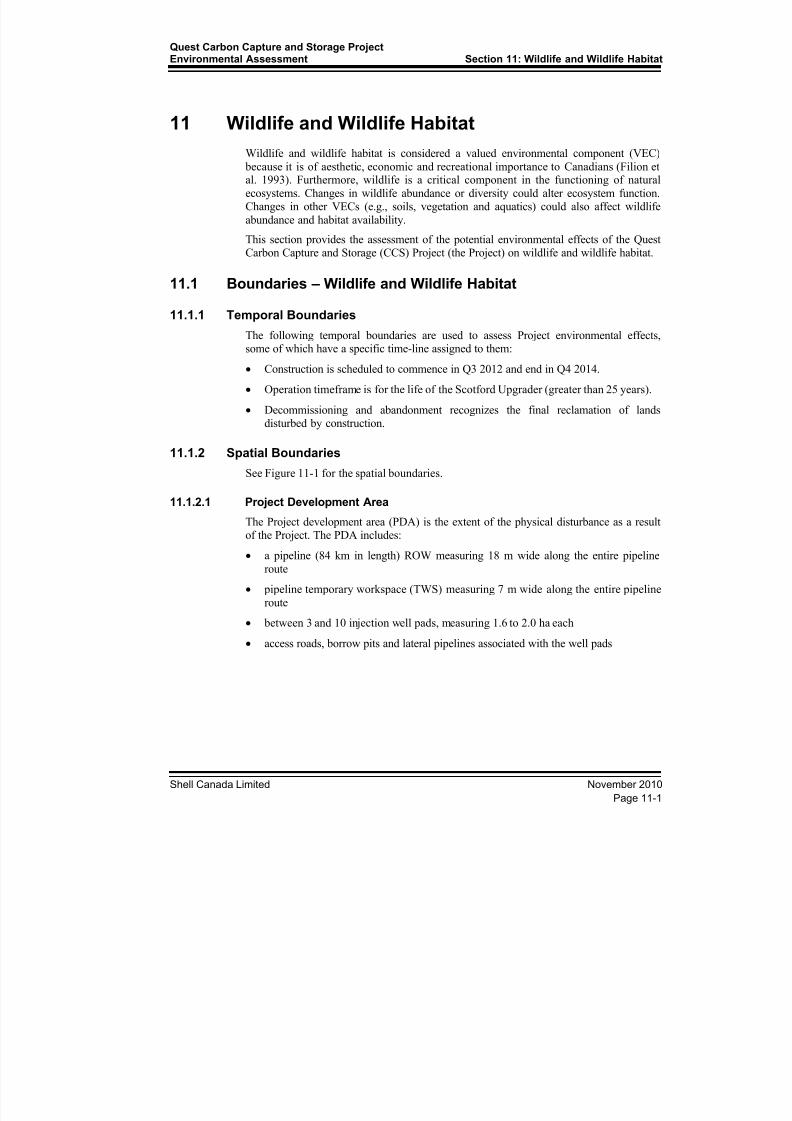
See Figure 11-1 for the spatial boundaries.
11.1.2.1 Project Development Area
The Project development area (PDA) is the extent of the physical disturbance as a resultof the Project. The PDA includes:
• a pipeline (84 km in length) ROW measuring 18 m wide along the entire pipeline
route
• pipeline temporary workspace (TWS) measuring 7 m wide along the entire pipeline
route
• between 3 and 10 injection well pads, measuring 1.6 to 2.0 ha each
• access roads, borrow pits and lateral pipelines associated with the well pads

8/21/2019 Quest CCS EIA - Wildlife and Wildlife Habitat (1)
http://slidepdf.com/reader/full/quest-ccs-eia-wildlife-and-wildlife-habitat-1 6/141
BC SK
AB
FIGURE NO.
11-1
Areaof
Interest
PREPARED FOR
QUEST CARBON CAPTURE AND STORAGE PROJECT
Acknowledgements: Original Drawing by Stantec Pipeline: Sunstone Engineering August 11, 2010, Wells: Shell August 26, 2010, Basedata: National Road Network, Canvec, Altalis
PREPARED BY
Assessment Areas for Wildlife and Wildlife Habitat
FortSaskatchewan
RGE 23RGE 22 RGE 21
RGE 20 RGE 19
TWP 61
TWP 60
TWP 59
TWP 58
TWP 57
TWP 56
Bon Accord
Gibbons
Redwater
Bruderheim
4
TWP 55
831
18
661
63
TWP 54
St MichaelWostok
Lamont
Warspite
Egremont Radway
Opal
Star
Thorhild
Abee
Newbrook
Tawatinaw
Rochester
R e d w
a t e r R i v e r
S t u r g
e o n R i v
e r
B e a v e r h
i l l C r e e k
N o r t h S a s k a t c h
e w a n R i v e r
45
29
28829
Josephburg
mao
825
28A
28
651
830
15
37
830
15
827
WP 10-6
WP 8-19
WP 7-11
WP 15-29
WP 12-14
345000
345000
365000
365000
385000
385000
405000
405000 5 9 4 5 0 0 0
5 9 4 5 0 0 0
5 9 6 5 0 0 0
5 9 6 5 0 0 0
5 9 8 5 0 0 0
5 9 8 5 0 0 0
6 0 0 5 0 0 0
6 0 0 5 0 0 0
6 0 2 5 0 0 0
6 0 2 5 0 0 0
123510425-149 REVB
4 0 4 8
Kilometres
Injection Well
Pipeline Route
Local Assessment AreaBoundary
Regional Assessment AreaBoundary
Major Road
Railway
Watercourse
Shell Scotford
Waterbody
Urban Area
8/21/2019 Quest CCS EIA - Wildlife and Wildlife Habitat (1)
http://slidepdf.com/reader/full/quest-ccs-eia-wildlife-and-wildlife-habitat-1 7/141
Quest Carbon Capture and Storage ProjectEnvironmental Assessment Section 11: Wildlife and Wildlife Habitat
Shell Canada Limited November 2010
Page 11-3
11.1.2.2 Local Assessment Area
The local assessment area (LAA) includes the PDA with the addition of a 500-m distance
extending from the boundary of the PDA
11.1.2.3 Regional Assessment AreaThe regional assessment area (RAA) is a 15 km distance extending from the boundary of
the LAA. It provides a regional context for interpreting the wildlife observations made
during the baseline surveys within the PDA and LAA. The area is sufficiently large to
include species with large home ranges. For the purpose of this assessment, all injection
wells are assumed to be located within 15 km of the pipeline.
11.1.3 Administrative and Technical Boundaries
Alberta Sustainable Resource Development (ASRD) manages wildlife resources within
the administrative boundaries of wildlife management areas (WMAs). The pipeline route
passes through three WMAs. The southern terminus is in the Edmonton WMA and the
northern terminus is in the St. Paul WMA. The middle section of the alignment passesthrough the Vermillion WMA. Wildlife occurrences were obtained from the Fisheries andWildlife Management Information System (FWMIS) to aid field survey planning and the
environmental assessment
11.2 Scope of Assessment – Wildlife and Wildlife Habitat
The scope of the Project includes the CO2 capture infrastructure (at the Scotford
Upgrader), CO2 pipeline, and between three and ten injection wells, including associated
access roads, borrow pits and lateral pipelines. Shell has identified the location of five
injection wells, and may require up to five additional wells based on the results of its
subsurface appraisal program.
The locations of the CO2 pipeline, five candidate injection wells, along with theirrespective access roads, lateral pipelines and borrow pits, are provided in this assessment.
Field surveys were conducted and site-specific data were collected for these components.
The PDA includes all of these components. This section provides a quantitative
assessment of the potential environmental effects on land use from this Project
infrastructure.
The additional five injection wells, along with the associated infrastructure (lateral
pipelines, access roads and borrow pits) are also considered in this assessment. However,
site-specific information is not yet available for these components, as their locations have
not been determined by Shell.
The primary mitigation measure to be used during site and route selection is avoidance of
sensitive environmental, cultural and landscape features. The site selection and routing plan includes constraints mapping, desktop analysis, field scouting, and pre-disturbance
assessments. Given Shell’s plan for selecting the location of well pads and associated
infrastructure (see Section 1.5.4), and that all well pads will be located in the RAA, the
environmental effects of the five additional well pads and associated infrastructure areanticipated to be comparable to the potential environmental effects of the five candidate
well pads.

8/21/2019 Quest CCS EIA - Wildlife and Wildlife Habitat (1)
http://slidepdf.com/reader/full/quest-ccs-eia-wildlife-and-wildlife-habitat-1 8/141
Section 11: Wildlife and Wildlife HabitatQuest Carbon Capture and Storage Project
Environmental Assessment
November 2010 Shell Canada Limited
Page 11-4
11.2.1 Regulatory Setting
11.2.1.1 Federal Regulations
Species at Risk are protected under SARA, which is one part of a three-part Government
of Canada strategy for the protection of wildlife species at risk, and applies to all wildlifespecies listed in Schedule 1 as being at risk, and their critical habitat, within all federal
lands in Canada. This three-part strategy also includes commitments under the Accord forthe Protection of Species at Risk, and activities under the Habitat Stewardship Programfor Species at Risk, which protects Species at Risk on federal land. The status of species
is assessed and designated by the independent and scientific COSEWIC, which thenrecommends this designation for protection by being officially listed under SARA.
Although no components of the Project are situated within or pass through federal lands,consideration of federally listed species is important to an environmental assessmentunder CEAA.
COSEWIC and SARA
The following information defines the various categories used in the federal at riskspecies legislation:
• Wildlife Species: A species, subspecies, variety, or geographically or genetically
distinct population of animal, plant or other organism, other than a bacterium orvirus, that is wild by nature and is either native to Canada or has extended its rangeinto Canada without human intervention and has been present in Canada for at least50 years.
• Extinct: A wildlife species that no longer exists
• Extirpated: A wildlife species no longer existing in the wild in Canada, but occurring
elsewhere
• Endangered: A wildlife species facing imminent extirpation or extinction
• Threatened: A wildlife species likely to become endangered if limiting factors are not
reversed
• Special Concern: A wildlife species that might become a threatened or an endangered
species because of a combination of biological characteristics and identified threats
• Not at Risk: A wildlife species that has been evaluated and found to be not at risk of
extinction given the current circumstances
• Data Deficient: A category that applies when the available information is insufficient
to:
• (a) resolve a species’ eligibility for assessment• (b) permit an assessment of the species’ risk of extinction
8/21/2019 Quest CCS EIA - Wildlife and Wildlife Habitat (1)
http://slidepdf.com/reader/full/quest-ccs-eia-wildlife-and-wildlife-habitat-1 9/141
Quest Carbon Capture and Storage ProjectEnvironmental Assessment Section 11: Wildlife and Wildlife Habitat
Shell Canada Limited November 2010
Page 11-5
SARA Public Registry
Conservation documents from the SARA Public Registry provided species conservationrequirements, discussions of critical habitat, and descriptions of recovery goals andobjectives. Documents included management plans, COSEWIC assessments and status
reports, and recovery strategies, though the types of documents available for each speciesvaried (Environment Canada 2010, Internet site). Information from these documents isused to assess how the Project may interact with conservation issues and or recoveryefforts.
11.2.1.2 Provincial Regulations
The assessment of wildlife and wildlife habitat is guided by the Alberta Wildlife Act, aswell as guidance documents related to species of management concern. Species at Risk inAlberta are protected under the Wildlife Act . The status of species is assessed and
designated by the Endangered Species Conservation Committee (ESCC) of Alberta,which then recommends this designation for protection by being officially listed on the
Wildlife Act .
Endangered Species Conservation Committee
The following terms define the various categories used in the provincial legislation andguidance documents:
• Species at Risk: A species at risk of extinction or extirpation (endangered or
threatened), or a species that needs special management attention to prevent it from
becoming at risk
• Extinct: A species that no longer exists
• Extirpated: A species no longer existing in the wild in Alberta but occurring
elsewhere in the wild
• Endangered: A species facing imminent extirpation or extinction
• Threatened: A species likely to become endangered if limiting factors are notreversed
• Species of Special Concern: A species with characteristics that make it particularlysensitive to human activities or natural events
• Data Deficient: A species for which there is insufficient scientific information tosupport status designation.
General Status of Alberta ’s Wild Species
Of consideration by the ESCC is the assessment and general status applied by ASRD.Since 1985, ASRD has reviewed the general status of wildlife and wildlife populationsevery five years. The updated status reports assist in planning and decision-making forconservation programs and setting management priorities. The general status updates
help determine the species that are At Risk or May Be At Risk of extinction, are Sensitiveto human activities or natural events, or are considered Secure in Alberta (ASRD 2005,Internet site). The results of the assessment help to determine whether there is reason torecommend a species be considered At Risk and given legislative protection asEndangered or Threatened under Alberta's Wildlife Act .
8/21/2019 Quest CCS EIA - Wildlife and Wildlife Habitat (1)
http://slidepdf.com/reader/full/quest-ccs-eia-wildlife-and-wildlife-habitat-1 10/141
Section 11: Wildlife and Wildlife HabitatQuest Carbon Capture and Storage Project
Environmental Assessment
November 2010 Shell Canada Limited
Page 11-6
Alberta Species at Risk Progr am
Conservation documents from ASRD Species at Risk Program provided speciesconservation requirements and described recovery goals and objectives for species ofconservation concern in Alberta. Documents included research reports, status reports, and
Recovery Plans for various species (ASRD 2009, Internet site). Information from thesedocuments is used to assess how the Project may interact with conservation issues andrecovery efforts.
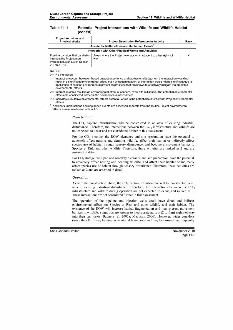
11.2.2 Key Issues and Potential Interactions
Project construction and operation have the potential to modify terrain, vegetation anddrainage, which could have potential environmental effects on wildlife and habitat(see Table 11-1).
Table 11-1 Potential Project Interactions with Wildlife and Wildlife Habitat
Project Activities andPhysical Works Project Description Reference for Activity Rank
Construction
CO2 capture infrastructure in an area of existing heavy industrial disturbance (ScotfordUpgrader) – no further effects expected
0
CO2 pipeline Clearing, top-soil stripping, grading, trenching, watercoursecrossings, stringing pipe, welding, lowering in, backfilling, hydrostatictesting, mainline valve installation, cleanup, and reclamation oftemporary workspaces.
2
CO2 storage (including injectionwells, access roads and borrowpit areas)
Clearing, topsoil stripping, grading, road construction, piling,infrastructure, commissioning, and clean up.
2
Operation
CO2 capture infrastructure in an area of existing heavy industrial disturbance (Scotford
Upgrader) – no further effects expected
0
CO2 pipeline Breaks in forest and shrub land cover created for pipeline ROW mayact as a barrier to seasonal movements of wildlife.
1
CO2 storage (including injectionwells, access roads and borrowpit areas)
Operation and maintenance activities associated with CO2 injectionwells could result in sensory disturbance.
1
Decommissioning and Abandonment
CO2 capture infrastructure Industrial site – no further effects. 1
CO2 pipeline Will involve reclamation to native vegetation (see Volume 1, Appendix E)
1
CO2 storage (including injectionwells, access roads and borrow
pit areas)
Grading of site to integrate into surrounding area. Will involvereclamation to native vegetation
1
8/21/2019 Quest CCS EIA - Wildlife and Wildlife Habitat (1)
http://slidepdf.com/reader/full/quest-ccs-eia-wildlife-and-wildlife-habitat-1 11/141
Quest Carbon Capture and Storage ProjectEnvironmental Assessment Section 11: Wildlife and Wildlife Habitat
Shell Canada Limited November 2010
Page 11-7
Table 11-1 Potential Project Interactions with Wildlife and Wildlife Habitat(cont’d)
Project Activities andPhysical Works Project Description Reference for Activity Rank
Accidents, Malfunctions and Unplanned Events
1
Interaction with Other Physical Works and Activities
Pipeline corridors that parallel orintersect the Project (seeProject Inclusion List in Section2, Table 2-1)
Areas where the Project overlaps or is adjacent to other rights-ofway.
NOTES:
0 = No interaction
1 = Interaction occurs; however, based on past experience and professional judgement the interaction would notresult in a significant environmental effect, even without mitigation; or interaction would not be significant due toapplication of codified environmental protection practices that are known to effectively mitigate the predictedenvironmental effects.
2 = Interaction could result in an environmental effect of concern, even with mitigation. The potential environmental
effects are considered further in the environmental assessment.
= Indicates cumulative environmental effects potential, which is the potential to interact with Project environmentaleffects.
1 Accidents, malfunctions and unplanned events are assessed separate from the routine Project environmentaleffects assessment (see Section 17).
Construc t ion
The CO2 capture infrastructure will be constructed in an area of existing industrialdisturbance. Therefore, the interactions between the CO2 infrastructure and wildlife arenot expected to occur and not considered further in this assessment.
For the CO2 pipeline, the ROW clearance and site preparation have the potential to
adversely affect nesting and denning wildlife, affect their habitat or indirectly affectspecies use of habitat through sensory disturbance, and become a movement barrier toSpecies at Risk and other wildlife. Therefore, these activities are ranked as 2 and areassessed in detail.
For CO2 storage, well pad and roadway clearance and site preparation have the potentialto adversely affect nesting and denning wildlife, and affect their habitat or indirectly
affect species use of habitat through sensory disturbance. Therefore, these activities areranked as 2 and are assessed in detail.
Operation
As with the construction phase, the CO2 capture infrastructure will be constructed in anarea of existing industrial disturbance. Therefore, the interactions between the CO2
infrastructure and wildlife during operation are not expected to occur, and ranked as 0.These interactions are not considered further in this assessment
The operation of the pipeline and injection wells could have direct and indirect
environmental effects on Species at Risk and other wildlife and their habitat. Theexistence of the ROW will increase habitat fragmentation and may present movement
barriers to wildlife. Songbirds are known to incorporate narrow (2 to 6 m) rights-of-wayinto their territories (Bayne et al. 2005a, Machtans 2006). However, wider corridors(more than 8 m) may be used as territorial boundaries and may be crossed less frequently

8/21/2019 Quest CCS EIA - Wildlife and Wildlife Habitat (1)
http://slidepdf.com/reader/full/quest-ccs-eia-wildlife-and-wildlife-habitat-1 12/141
Section 11: Wildlife and Wildlife HabitatQuest Carbon Capture and Storage Project
Environmental Assessment
November 2010 Shell Canada Limited
Page 11-8
by birds (Bayne et al. 2005b). Gap crossing by birds decreases with increasing gap width(Desrochers and Hannon 1997; Rail et al. 1997), possibly because of increased risk of
predation (Lima and Dill 1990).
The upland forest and shrub habitat of the LAA is already in a highly fragmented state,
primarily as a result of settlement and agriculture. The wildlife communities of the regionalso contain species more suited for patchy habitat. Thus, even though wildlife isexpected to interact with the ROW during the operation phase, fragmentation of thelandscape is not expected to be measurably different from what existed at baseline.Therefore, the potential of the ROW acting as a barrier to wildlife connectivity during
operation is ranked as 1 and is not considered for additional assessment on the basis thatthe effect of the Project’s contribution to additional fragmentation will be negligible.
Sensory disturbance associated with Project operation is predicted to be negligible asnoise at the well injection sites is expected to be minimal. It is also realistic to expect that
pre-existing disturbances in the area such as roads, other industrial sites, and farming
activities will likely have habituated wildlife to the presence of the limited amount ofnoise that may be associated with the occasional ROW maintenance activity. Therefore,
the potential for sensory disturbance from operation of the pipeline and well sites isranked as 1 and is not further assessed.
During operation, increased mortality is possible because of vehicle traffic associated
with these activities. However, the risk of mortality is substantially lower duringoperation than during construction because fewer vehicles are present during the
operation phase. ROW maintenance could affect habitat availability during sensitive periods directly through the reduction of vegetation encroachment or indirectly due tohuman activity. Maintenance activities are expected to be sporadic and will be scheduled
to avoid critical time periods of ecological activity. Therefore, the disturbance andmortality rates of wildlife are not expected to increase above baseline levels during the
maintenance of the operating pipeline and well sites. Thus, the effects of these activitieson habitat availability and mortality rates are considered negligible and not considered for
additional assessment.
Given the environmental context and in consideration of codified mitigation measures,the operation phase of the Project is not expected to result in significant adverse
environmental effects. None of the potential Project environmental effects due tooperation are assessed further.
Decomm iss ion ing and Abandonment
Decommissioning and abandonment will include reclamation of well pads, access roadsand any additional borrow pit areas. It is assumed the pipeline and lateral pipelines will
remain in place. Direct loss of native vegetation may be temporary, where reclamation tonative vegetation and wetland conditions is the target. For reclamation details see the
Conservation and Reclamation plans for the pipeline and well pads (Volume 1,Appendix E and Appendix F). Although it is unclear what specific land uses may betargeted in the future, the Conservation and Reclamation Plan assumes that land usessimilar to those at baseline would be targeted. As the well pads, access roads and borrow
pit areas are located on upland vegetation, and areas of wetland will be compensated for
under the Water Act , reclamation is expected to be successful. Therefore, based on professional judgment and past experience, potential environmental effects on wildlifeand wildlife habitat are considered not significant, are ranked as 1, and not furtherassessed.

8/21/2019 Quest CCS EIA - Wildlife and Wildlife Habitat (1)
http://slidepdf.com/reader/full/quest-ccs-eia-wildlife-and-wildlife-habitat-1 13/141
Quest Carbon Capture and Storage ProjectEnvironmental Assessment Section 11: Wildlife and Wildlife Habitat
Shell Canada Limited November 2010
Page 11-9
11.2.2.1 Environmental Effects Assessed
For a summary of the potential environmental effects on wildlife and wildlife habitat,see Table 11-2. Potential environmental effects of Project activities on wildlife areexpected to be related primarily to the construction phase. These include:
• changes in habitat availability, caused by:
• clearing vegetation as part of site preparation
• increasing sensory disturbance, as a result of human activities
• change in mortality risk, caused by:
• collisions with vehicles
• increasing predator access
• change in movement, caused by:
• developing linear infrastructure
• decreasing the overall connectivity of wildlife habitat
Table 11-2 Potential Environmental Effects on Wildlife and Wildlife Habitat
Project Activities and Physical Works
Environmental Effects
Change inHabitat
AvailabilityChange in
Mortality Risk
Change inHabitat
Connectivity
Construction
Pipeline construction
Construction of CO2 injection wells and access roads
Interaction with Other Physical Works and Activities
Pipeline corridors that parallel or intersect the Project (see
Project Inclusion List in Section 2, Table 2-1)
1 1
NOTES:
Project Environmental Effects
Only Project–environment interactions ranked as 2 in Table 11-1 are carried forward to this table. A checkmark ()indicates that an activity is likely to contribute to the environmental effect.
Cumulative Environmental Effects
Cumulative environmental effects are ranked as follows:
0 Project environmental effects do not act cumulatively with those of other physical works and other activities.
1 Project environmental effects act cumulatively with those of other physical works and other activities, but areunlikely to result in significant cumulative environmental effects OR Project environmental effects act cumulativelywith existing significant levels of cumulative environmental effects but will not measurably change the state of theVEC.
2 Project environmental effects act cumulatively with those of other physical works and other activities and might
result in significant cumulative environmental effects OR Project environmental effects act cumulatively withexisting significant levels of cumulative environmental effects and might measurably change the state of the VEC.
8/21/2019 Quest CCS EIA - Wildlife and Wildlife Habitat (1)
http://slidepdf.com/reader/full/quest-ccs-eia-wildlife-and-wildlife-habitat-1 14/141
Section 11: Wildlife and Wildlife HabitatQuest Carbon Capture and Storage Project
Environmental Assessment
November 2010 Shell Canada Limited
Page 11-10
Change in Habitat A vai labi l i ty
The construction of the Project will require the removal of wildlife habitat. Indirectenvironmental effects on habitat availability might arise from increased human activity(e.g., equipment use, increased traffic), which could displace Species at Risk and other
wildlife for the duration of the construction phase. The sensory disturbance associatedwith habitat clearance and construction activities has the potential to affect habitat use,and breeding and rearing success for some Species at Risk and other wildlife.
As part of habitat loss, the pipeline and ROW disturbance could affect local hydrology(e.g., changes in drainage patterns), and vegetation clearing could have environmental
effects on ephemeral, temporary and other wetlands. The potential change in wetland andassociated riparian habitat availability could affect Species at Risk that use wetland andriparian habitats (western toad, Rusty Blackbird, Yellow Rail, Horned Grebe, and Olive-sided Flycatcher).
Change in Mortal i ty Risk
Mortality of toads may be affected by Project digging activities and traffic. Grounddisturbances could cause mortality for toads that hibernate or breed in areas where
pipeline construction occurs. Backfilling could also bury toads trapped or passing throughthe pipeline trench. An increase in mortality rates due to vehicle traffic is also a concernfor western toad and Common Nighthawk that may roost and nest on gravel roads.
Change in Habitat Connectiv i ty
Construction could be disruptive to the daily and seasonal movement patterns of
terrestrial species such as western toad. The open trench, spoil and topsoil piles, andstrung pipe could be barriers to daily or seasonal movements of western toads.
11.2.2.2 Species Assessed
The Species at Risk Public Registry lists federal recovery strategies and officialdefinitions of critical habitat for species listed under SARA. The registry lists 59 wildlife
species with finalized Recovery Strategies, 24 of which are terrestrial. Only two speciesthat may occur in the Project region have had recovery strategies finalized: Sprague’sPipit and Piping Plover. The recovery strategy of the Piping Plover identifies thelocations of wetlands identified for recovery efforts and none are located in the Projectregion (Environment Canada 2007).
Only 12 wildlife Species at Risk have had critical habitat identified and they are area-specific (Grasslands National Park, Sable Island, Wood Buffalo National Park). Only fiveof these species are terrestrial and only one (Piping Plover) has a chance of being in theProject area. However, no suitable habitat exists for the Piping Plover in the LAA or
RAA, and its critical habitat is defined only for Last Mountain Lake Bird Sanctuary inSaskatchewan.
Although the availability of recovery strategies and definitions of critical habitat arelimited to only a select number of species, the objective for the selection of assessment
species was to include federally listed species that have conservation requirementsapplicable to other wildlife species that normally occur within the RAA at baseline,
specifically species of management concern. For the purpose of the assessment, speciesof management concern were provincially regulated species of concern (e.g., northern
8/21/2019 Quest CCS EIA - Wildlife and Wildlife Habitat (1)
http://slidepdf.com/reader/full/quest-ccs-eia-wildlife-and-wildlife-habitat-1 15/141
Quest Carbon Capture and Storage ProjectEnvironmental Assessment Section 11: Wildlife and Wildlife Habitat
Shell Canada Limited November 2010
Page 11-11
long-eared bat, Baltimore Oriole), those classified as game species in Alberta (e.g.,moose, Ruffed Grouse), and the non-listed bird species protected under the Migratory
Birds Convention Act ( MBCA).
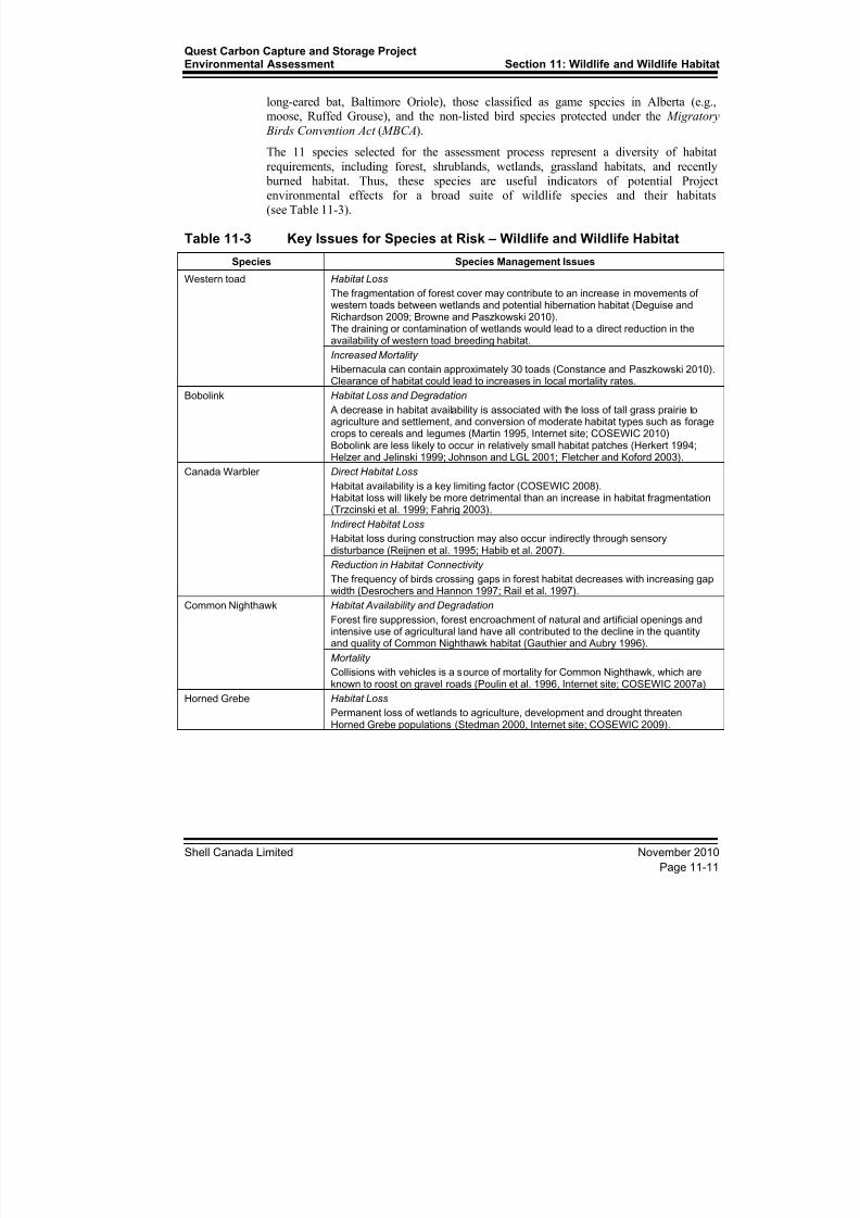
The 11 species selected for the assessment process represent a diversity of habitat
requirements, including forest, shrublands, wetlands, grassland habitats, and recently burned habitat. Thus, these species are useful indicators of potential Projectenvironmental effects for a broad suite of wildlife species and their habitats(see Table 11-3).
Table 11-3 Key Issues for Species at Risk – Wildlife and Wildlife Habitat
Species Species Management Issues
Western toad Habitat Loss
The fragmentation of forest cover may contribute to an increase in movements ofwestern toads between wetlands and potential hibernation habitat (Deguise andRichardson 2009; Browne and Paszkowski 2010).The draining or contamination of wetlands would lead to a direct reduction in theavailability of western toad breeding habitat.
Increased Mortality
Hibernacula can contain approximately 30 toads (Constance and Paszkowski 2010).Clearance of habitat could lead to increases in local mortality rates.
Bobolink Habitat Loss and Degradation
A decrease in habitat availability is associated with the loss of tall grass prairie toagriculture and settlement, and conversion of moderate habitat types such as foragecrops to cereals and legumes (Martin 1995, Internet site; COSEWIC 2010)Bobolink are less likely to occur in relatively small habitat patches (Herkert 1994; Helzer and Jelinski 1999; Johnson and LGL 2001; Fletcher and Koford 2003).
Canada Warbler Direct Habitat Loss
Habitat availability is a key limiting factor (COSEWIC 2008).Habitat loss will likely be more detrimental than an increase in habitat fragmentation(Trzcinski et al. 1999; Fahrig 2003).
Indirect Habitat LossHabitat loss during construction may also occur indirectly through sensorydisturbance (Reijnen et al. 1995; Habib et al. 2007).
Reduction in Habitat Connectivity
The frequency of birds crossing gaps in forest habitat decreases with increasing gapwidth (Desrochers and Hannon 1997; Rail et al. 1997).
Common Nighthawk Habitat Availability and Degradation
Forest fire suppression, forest encroachment of natural and artificial openings andintensive use of agricultural land have all contributed to the decline in the quantityand quality of Common Nighthawk habitat (Gauthier and Aubry 1996).
Mortality
Collisions with vehicles is a source of mortality for Common Nighthawk, which areknown to roost on gravel roads (Poulin et al. 1996, Internet site; COSEWIC 2007a)
Horned Grebe Habitat LossPermanent loss of wetlands to agriculture, development and drought threatenHorned Grebe populations (Stedman 2000, Internet site; COSEWIC 2009).

8/21/2019 Quest CCS EIA - Wildlife and Wildlife Habitat (1)
http://slidepdf.com/reader/full/quest-ccs-eia-wildlife-and-wildlife-habitat-1 16/141
Section 11: Wildlife and Wildlife HabitatQuest Carbon Capture and Storage Project
Environmental Assessment
November 2010 Shell Canada Limited
Page 11-12
Table 11-3 Key Issues for Species at Risk - Wildlife and Wildlife Habitat(cont’d)
Species Species Management Issues
Loggerhead Shrike Habitat Loss and Degradation
Habitat conversion and degradation has been correlated with population declines ofshrikes throughout North America (Yosef 1996, Internet site).
Mortality
Although the exact sources of mortality have not been identified, it is clear thatmortality of recently fledged young is high (COSEWIC 2004).
Olive-sided Flycatcher Habitat Degradation
Increases in forest fragmentation may be advantageous. However, gaps caused byhabitat clearance may not mimic naturally created natural gaps in forest (Robertsonand Hutto 2007; COSEWIC 2007b).
Rusty Blackbird Habitat Degradation
Species decline is attributed to habitat degradation associated with boreal wetlands(COSEWIC 2006, Avery 1995, Internet site).
Short-eared Owl Habitat Loss
Short-eared Owls appear particularly sensitive to habitat loss and fragmentation, asthey require relatively large tracts of grassland (Clayton 2000; Wiggins et al. 2006,Internet Site).Conversion of open habitats to agriculture, grazing, recreation, housing, and resortdevelopment is the key factor in the decline of Short-eared Owl (Clayton 2000,Wiggins et al. 2006, Internet site).
Sprague's Pipit Habitat Loss
In some regions, pipits are known to breed in tame pasture, but their occurrence andabundance are lower than those of pipits found in native grassland (Dale et al. 1997;Sutter and Brigham 1998; Davis et al. 1999).Sprague's Pipit at the northern edge of the species' breeding range may be relativelymore sensitive to changes in the already limited availability of high and moderatelysuitable habitat.
Yellow Rail Habitat Degradation
Loss of wetlands to agriculture and urban encroachment is probably the most seriousfactor affecting Yellow Rail populations (Eddleman et al. 1988; Bookhout 1995,Internet site; Alvo and Robert 1999).
Western Toad
Western toad are sensitive to habitat loss and increases in mortality rates. The status ofthe western toad is:
• SARA: Threatened under Schedule 1
• COSEWIC:Threatened
• Alberta's Endangered Species Conservation Committee: Not Listed
• General Status of Wildlife in Alberta: Sensitive
A federal recovery strategy has not been drafted for the western toad. However, a draft
management plan is in preparation (Environment Canada 2010, Internet site). Criticalhabitat for the toads has yet to be defined (Environment Canada 2010, Internet site).
Conclusions on the significance of the potential Project environmental effects, along withany mitigation strategies for western toad are considered to be applicable to other specieswith similar wetland and coniferous forest habitat requirements.
8/21/2019 Quest CCS EIA - Wildlife and Wildlife Habitat (1)
http://slidepdf.com/reader/full/quest-ccs-eia-wildlife-and-wildlife-habitat-1 17/141
Quest Carbon Capture and Storage ProjectEnvironmental Assessment Section 11: Wildlife and Wildlife Habitat
Shell Canada Limited November 2010
Page 11-13
Bobol ink
Bobolinks are sensitive to habitat loss and degradation. The status of the Bobolink is:
• SARA: No Schedule, No Status
• COSEWIC: Threatened
• Alberta's Endangered Species Conservation Committee: Not Listed• General Status of Wildlife in Alberta: May Be At Risk
There is neither a federal recovery strategy nor a management plan for Bobolinks, andcritical habitat has yet to be defined (Environment Canada 2010, Internet site). Generalhabitat requirements include tall grass prairie or ungrazed forage crops (Martin and Gavin1995, Internet site; COSEWIC 2010).
Conclusions on the significance of the potential Project environmental effects, along with
any mitigation strategies for Bobolinks are considered to be applicable to other specieswith similar grassland and pasture habitat requirements.
Canada Warbler
Canada Warblers are sensitive to forest habitat loss, sensory disturbance, increases inmortality rates and possibly a reduction in habitat connectivity. The status of the Canada
Warbler is:
• SARA: Threatened under Schedule 1
• COSEWIC: Threatened
• Alberta's Endangered Species Conservation Committee: Not Listed
• General Status of Wildlife in Alberta: Sensitive
There is neither a federal recovery strategy nor a management plan for the Canada
Warbler, and critical habitat for the warbler has yet to be defined (Environment Canada2010, Internet site). General habitat requirements include coniferous and mixedwood
forests with dense shrub undercover (COSEWIC 2008; Reitsma et. al 2010, Internet site).Conclusions on the significance of the potential Project environmental effects, along withany mitigation strategies for Canada Warbler are considered to be applicable to other
species with similar forest habitat requirements.
Common Nighthawk
Common Nighthawk are sensitive to changes in habitat availability and degradation, andincreases in mortality rates. The status of the Common Nighthawk is:
• SARA: –Threatened under Schedule 1
• COSEWIC: Threatened
• Alberta's Endangered Species Conservation Committee: Not Listed
• General Status of Wildlife in Alberta: Sensitive
There is neither a federal recovery strategy nor a management plan for the Common Nighthawk, and critical habitat for nighthawks has yet to be defined (EnvironmentCanada 2010, Internet site). General habitat requirements include open habitats forforaging and recently cleared, burned or disturbed areas or anthropogenic structures for
nesting (Poulin et al. 1996, Internet site; COSEWIC 2007a).

8/21/2019 Quest CCS EIA - Wildlife and Wildlife Habitat (1)
http://slidepdf.com/reader/full/quest-ccs-eia-wildlife-and-wildlife-habitat-1 18/141
Section 11: Wildlife and Wildlife HabitatQuest Carbon Capture and Storage Project
Environmental Assessment
November 2010 Shell Canada Limited
Page 11-14
Conclusions on the significance of the potential Project environmental effects, along withany mitigation strategies for Common Nighthawk, are considered to be applicable to
other species with similar habitat requirements, as well as species with crepuscular andnocturnal foraging strategies.
Horned Grebe
Horned Grebe are sensitive to permanent loss of wetlands to agriculture, developmentand drought. The status of the Horned Grebe is:
• SARA: No Schedule, No Status
• COSEWIC: Special Concern
• Alberta's Endangered Species Conservation Committee: Not Listed
• General Status of Wildlife in Alberta: Sensitive
There is neither a federal recovery strategy nor a management plan for the Horned Grebe,and critical habitat for the grebe has yet to be defined (Environment Canada 2010,
Internet site). General habitat requirements include wetlands with 0.3 to 2.0 ha of open
water (Stedman 2000, Internet site; COSEWIC 2008).Conclusions on the significance of the potential Project environmental effects, along with
any mitigation strategies for Horned Grebe are considered to be applicable to otherspecies with similar wetland habitat requirements.
Logg erhead Shrike
Loggerhead Shrikes are sensitive to changes in habitat availability and degradation, aswell as increases mortality rates. (Increases in mortality rates may upset the balancerequired to sustain populations of sensitive species. Common species can adapt to anincrease and still persist.) The status of the Loggerhead Shrike is:
• SARA: Threatened under Schedule 1
• COSEWIC: Threatened
• Alberta Endangered Species Conservation Committee: Special Concern
• General Status of Wildlife in Alberta: Sensitive
A federal recovery strategy has not been finalized for the Loggerhead Shrike, and criticalhabitat for the shrikes has yet to be defined (Environment Canada 2010, Internet site).Research and stewardship programs have been focused in southern Alberta,
Saskatchewan and Manitoba where the species is most common (Johns et al. 1994).General habitat requirements include upland shrubby habitat adjacent to open grasslandsand pasture (Yosef 1996, Internet site; COSEWIC 2004).
Conclusions on the significance of the potential Project environmental effects, along withany mitigation strategies for Loggerhead Shrike are considered applicable to other
species requiring similar open habitat types.
8/21/2019 Quest CCS EIA - Wildlife and Wildlife Habitat (1)
http://slidepdf.com/reader/full/quest-ccs-eia-wildlife-and-wildlife-habitat-1 19/141
Quest Carbon Capture and Storage ProjectEnvironmental Assessment Section 11: Wildlife and Wildlife Habitat
Shell Canada Limited November 2010
Page 11-15
Olive-Sided Flycatc her
Olive-sided Flycatcher are sensitive to changes in habitat availability and degradation.The status of the olive-sided flycatcher is:
• SARA: Threatened under Schedule 1
• COSEWIC: Threatened• Alberta's Endangered Species Conservation Committee: Not Listed
• General Status of Wildlife in Alberta: Secure
There is neither a federal recovery strategy nor a management plan for the Olive-sidedFlycatcher, and critical habitat has yet to be defined (Environment Canada 2010, Internetsite). General habitat requirements include wet coniferous and mixedwood forest typesthat include natural breaks in forest cover, including recent burns (Altman and Sallabanks
2000, Internet site; COSEWIC 2007b).
Conclusions on the significance of the potential Project environmental effects, along with
any mitigation strategies for Olive-sided Flycatcher are considered to be applicable tospecies requiring wet coniferous and mixedwood forest types that include natural breaks
in forest cover.
Rusty B lackb ird
Rusty Blackbird are sensitive to changes in riparian forest habitat availability anddegradation. The status of the rusty blackbird is:
• SARA: Special Concern under Schedule 1
• COSEWIC: Special Concern
• Alberta's Endangered Species Conservation Committee: Not Listed
• General Status of Wildlife in Alberta: Secure
There is neither a federal recovery strategy nor a management plan for the Rusty
Blackbird, and critical habitat has yet to be defined (Environment Canada 2010, Internetsite). General habitat requirements include recent burns, sedge meadows and riparianedges of conifer habitat (Avery 1995, Internet site; COSEWIC 2006).
Conclusions on the significance of the potential Project environmental effects, along withany mitigation strategies for Rusty Blackbird are considered to be applicable to otherriparian species.
Short-eared Ow l
Short-eared Owl are sensitive to changes in grassland habitat availability. The status of
the short-eared owl is:
• SARA: Special Concern under Schedule 3
• COSEWIC: Special Concern
• Alberta's Endangered Species Conservation Committee: Not Listed
• General Status of Wildlife in Alberta: May be at Risk
There is neither a federal recovery strategy nor a management plan for the RustyBlackbird, and critical habitat has yet to be defined (Environment Canada 2010, Internet
site). General habitat requirements include large open spaces that include grasslands,temporary ponds, ephemeral wetlands, and wetland edges (Clayton 2000; Wiggins et al.2006).

8/21/2019 Quest CCS EIA - Wildlife and Wildlife Habitat (1)
http://slidepdf.com/reader/full/quest-ccs-eia-wildlife-and-wildlife-habitat-1 20/141
Section 11: Wildlife and Wildlife HabitatQuest Carbon Capture and Storage Project
Environmental Assessment
November 2010 Shell Canada Limited
Page 11-16
Conclusions on the significance of the potential Project environmental effects, along withany mitigation strategies for Short-eared Owl are considered to be applicable to other
species requiring grassland and shallow wetland habitats.
Sprague’s Pipit
Sprague’s Pipit are sensitive to changes in grassland habitat availability and degradation.The status of the Sprague’s Pipit is:
• SARA: Threatened under Schedule 1
• COSEWIC: Threatened
• Alberta Endangered Species Conservation Committee: Special Concern
• General Status of Wildlife in Alberta: Sensitive
There is a federal recovery strategy for Sprague’s Pipit (Environment Canada 2010,Internet site). Recovery Goal #4 of the strategy is to “identify and conserve criticalhabitat in prairie Canada” (Environment Canada 2008). However, critical habitat has yet
to be defined for the pipit (Environment Canada 2010, Internet site). According to
Environment Canada (2008), Sprague’s Pipit are rarely found in cultivated lands and areuncommon in areas where native grasses have been replaced with introduced forage.Undisturbed native prairie was not identified within the LAA during the baseline surveys,nor is native prairie expected within the Dry Mixedwood Natural Subregion (ATPR
2006, Internet site). However, while native prairie has been identified as a necessity forthe survival and recovery of the species, territorial Sprague’s Pipits have been recorded insome non-native grasslands where the structure of the vegetation is similar to that ofnative vegetation (Environment Canada 2008).
Conclusions on the significance of the potential Project environmental effects, along with
any mitigation strategies for Sprague’s Pipit are considered to be applicable to othernative grassland species.
Yellow Rail
Yellow Rail are sensitive to changes in habitat availability and degradation. The status ofthe yellow rail is:
• SARA: Threatened under Schedule 1
• COSEWIC: Threatened
• Alberta's Endangered Species Conservation Committee: Not Listed
• General Status of Wildlife in Alberta: Undetermined
There is no federal recovery strategy for the Yellow Rail. However, a draft management plan is in preparation (Environment Canada 2010, Internet site). Critical habitat for therail has yet to be defined (Environment Canada 2010, Internet site). Specific habitat
requirements are limited to moist graminoid habitat (Bookhout 1995, Internet site;COSEWIC 2001).
Conclusions on the significance of the potential Project environmental effects, along withany mitigation strategies for Yellow Rail are considered to be applicable to other species
requiring moist graminoid habitat.
8/21/2019 Quest CCS EIA - Wildlife and Wildlife Habitat (1)
http://slidepdf.com/reader/full/quest-ccs-eia-wildlife-and-wildlife-habitat-1 21/141
Quest Carbon Capture and Storage ProjectEnvironmental Assessment Section 11: Wildlife and Wildlife Habitat
Shell Canada Limited November 2010
Page 11-17
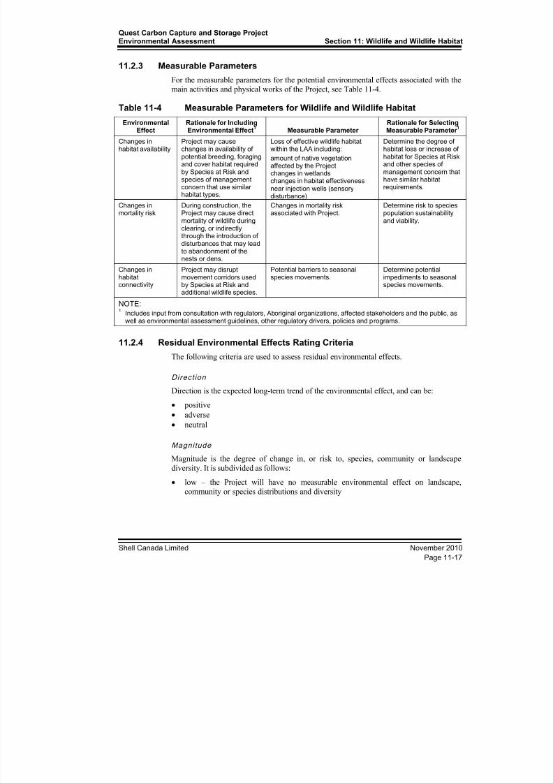
11.2.3 Measurable Parameters
For the measurable parameters for the potential environmental effects associated with themain activities and physical works of the Project, see Table 11-4.
Table 11-4 Measurable Parameters for Wildlife and Wildlife HabitatEnvironmental
EffectRationale for IncludingEnvironmental Effect
1 Measurable Parameter
Rationale for SelectingMeasurable Parameter
1
Changes inhabitat availability
Project may causechanges in availability ofpotential breeding, foragingand cover habitat requiredby Species at Risk andspecies of managementconcern that use similarhabitat types.
Loss of effective wildlife habitatwithin the LAA including:
amount of native vegetationaffected by the Projectchanges in wetlandschanges in habitat effectivenessnear injection wells (sensorydisturbance)
Determine the degree ofhabitat loss or increase ofhabitat for Species at Riskand other species ofmanagement concern thathave similar habitatrequirements.
Changes inmortality risk
During construction, theProject may cause direct
mortality of wildlife duringclearing, or indirectlythrough the introduction ofdisturbances that may leadto abandonment of thenests or dens.
Changes in mortality riskassociated with Project.
Determine risk to speciespopulation sustainability
and viability.
Changes inhabitatconnectivity
Project may disruptmovement corridors usedby Species at Risk andadditional wildlife species.
Potential barriers to seasonalspecies movements.
Determine potentialimpediments to seasonalspecies movements.
NOTE: 1 Includes input from consultation with regulators, Aboriginal organizations, affected stakeholders and the public, as
well as environmental assessment guidelines, other regulatory drivers, policies and programs.
11.2.4 Residual Environmental Effects Rating Criteria
The following criteria are used to assess residual environmental effects.
Direct ion
Direction is the expected long-term trend of the environmental effect, and can be:
• positive
• adverse
• neutral
MagnitudeMagnitude is the degree of change in, or risk to, species, community or landscape
diversity. It is subdivided as follows:
• low – the Project will have no measurable environmental effect on landscape,
community or species distributions and diversity
8/21/2019 Quest CCS EIA - Wildlife and Wildlife Habitat (1)
http://slidepdf.com/reader/full/quest-ccs-eia-wildlife-and-wildlife-habitat-1 22/141
Section 11: Wildlife and Wildlife HabitatQuest Carbon Capture and Storage Project
Environmental Assessment
November 2010 Shell Canada Limited
Page 11-18
• moderate – the Project will alter landscape, community and species distributions, but
will not reduce diversity
• high – the Project will alter landscape, community and species distributions and
reduce diversity
Geographic Extent
Geographic extent includes the geographic area in which an environmental effect of a
defined magnitude is expected to occur:
• site-specific (PDA)
• local (LAA)
• regional (RAA)
Duration
Duration is the length of time over which a project environmental effect is measurable. It
is subdivided as follows:
• short term – less than one year
• medium term – more than one year, but less than 10 years
• long term – more than 10 years, but not beyond the life of the Project
• permanent – beyond the life of the Project
Frequency
Frequency is the number of times during a project or a specific project phase that anenvironmental effect may occur:
• once – the environmental effect occurs once throughout the Project lifespan
• sporadic – the environmental effect occurs sporadically at irregular intervals
throughout the Project lifespan
• regular – the environmental effect occurs on a regular basis at regular intervals
throughout the Project lifespan
• continuous – the environmental effect occurs continuously throughout the Project
lifespan
Reversibi l i ty
Reversibility is the likelihood that a measurable parameter for the wildlife and wildlifehabitat VEC will recover from an environmental effect:
• reversible
• irreversible
Ecological Context
Ecological context is
the general characteristics of the area in which the Project is
located:
• undisturbed
• disturbed
8/21/2019 Quest CCS EIA - Wildlife and Wildlife Habitat (1)
http://slidepdf.com/reader/full/quest-ccs-eia-wildlife-and-wildlife-habitat-1 23/141
Quest Carbon Capture and Storage ProjectEnvironmental Assessment Section 11: Wildlife and Wildlife Habitat
Shell Canada Limited November 2010
Page 11-19
11.2.5 Standards or Thresholds for Determining Significance
Significance reflects the potential for the Project to contribute to alterations in diversity inthe RAA. Significance as assessed at the regional level (i.e., land use management and
planning decisions) are typically not identified for small, local areas. The assessment of
significance is defined as follows:• not significant – the Project will have no, or short- to medium-term, environmental
effects on landscape, community, or species distribution or diversity in the RAA andwill not result in a loss of landscape, community or species diversity in the RAA.
• significant – the Project will have long-term environmental effects on landscape,
community, or species distribution or diversity in the RAA, resulting in loss ofdiversity, including loss of communities or species of management concern
For Species at Risk, potential environmental effects of the Project on a particular species’habitat availability, habitat connectivity and or increased mortality rates would beconsidered significant if those effects can be conclusively linked to populations falling
below sustainable levels
11.2.6 Influence of Consultation on the Assessment
Consultation with regulators, stakeholders and community members related to the potential environmental effects of the Project on wildlife and wildlife habitat was
integrated into the Terms of Reference for the Quest CCS Project on which thisassessment is based.
During the planning stages of the field program, regulators were contacted to discussspecies of management concern that may occur in the LAA (Found 2010, pers. comm.).The regulatory consultation helped shape the identification of key issues, survey
methodologies, selection of assessment species, and evaluation of potential mitigationmeasures.
11.3 Baseline Conditions – Wildlife and Wildlife Habitat
The following is a summary of the baseline conditions in the LAA. For more detailedinformation, see Appendix 11A. Wildlife surveys were conducted within the LAA to helpselect the species to be included in the environmental assessment process. The surveysalso helped determine the baseline conditions for those species and to characterize otherwildlife populations in the LAA. These surveys included acoustic amphibian surveys,
Yellow Rail surveys and breeding bird surveys. Data on other wildlife, such as raptorsand mammals, was also collected during amphibian and breeding bird surveys. Existingdata on wildlife records located within the RAA were also used to supplement surveydata, by providing a regional context to the baseline condition of the LAA.
8/21/2019 Quest CCS EIA - Wildlife and Wildlife Habitat (1)
http://slidepdf.com/reader/full/quest-ccs-eia-wildlife-and-wildlife-habitat-1 24/141
Section 11: Wildlife and Wildlife HabitatQuest Carbon Capture and Storage Project
Environmental Assessment
November 2010 Shell Canada Limited
Page 11-20
11.3.1 Existing Data Review and Results
The FWMIS was queried for historical wildlife occurrences within the RAA (Found2010, pers. comm.). Pertinent wildlife components of other previously conducted
environmental assessments of developments in the region were also reviewed. These
reports included:• Shell Scotford Upgrader Environmental Impact Assessment (AGRA 1998)
• Shell Scotford Upgrader Expansion Environmental Impact Assessment (AXYS 2005)
• Inter Pipeline’s Corridor Pipeline Conservation and Reclamation Plan (TERA 20072008)
• Enbridge Athabasca Waupisoo Pipeline Conservation and Reclamation Plan
• Quest Carbon Capture and Sequestration Project Environmental Assessment of Well
(Site 4A and Endpoint Well) (TERA 2010).
Existing information, including data from the FWMIS and other baseline studies,
suggests that concentrations of wildlife observations are associated with ESAs adjacent tothe pipeline route. Most of the FWMIS data points of species of management concern are
associated with the North Saskatchewan River, its tributaries or adjacent forested areas(see Figure 11A-3, Appendix 11A). Areas such as the North Saskatchewan River, the
Northwest of Bruderheim Natural Area, and the North Bruderheim Natural Area areimportant for large-scale movements of numerous species, such as large mammals, aswell as resident and migratory birds.
Existing datasets and reports include 158 species of wildlife that could potentially breedor winter in or around the LAA (see Attachment 11A-1, in Appendix 11A). Bird specieswere the most numerous, with 132 species recorded in the area. In addition to the birds,
20 mammal species have been recorded in the area, along with five amphibian species.Of the 158 species, 55 are species of management concern because they are either listed
under federal or provincial conservation regulations, or are important to hunting and ortrapping activities in Alberta (see Attachment 11A-1, in Appendix 11A). FWMIS recordsof three species of management concern were within the RAA (see Figure 11A-3, in
Appendix 11A).
11.3.2 Field Methods and Results
Wildlife surveys were conducted in the spring of 2010 along an initially proposed pipeline ROW. Surveys conducted in 2010 included:
• spring amphibians
• Yellow Rail
• breeding birds
All the baseline survey fieldwork was done before segments of the pipeline were re-routed to the current North Saskatchewan River crossing, and south of the Natural Areasnear Bruderheim. The result is that portions of the current route were not included in the
2010 field surveys. The majority of the re-route segments fall outside of sensitive areas ofhabitat or in habitat rated low to nil for most of the assessment species. For example, theBruderheim re-route better avoids the forested habitat associated with the North of
Bruderheim and Northwest Bruderheim Natural Areas (see Figure 11A-3,
8/21/2019 Quest CCS EIA - Wildlife and Wildlife Habitat (1)
http://slidepdf.com/reader/full/quest-ccs-eia-wildlife-and-wildlife-habitat-1 25/141
Quest Carbon Capture and Storage ProjectEnvironmental Assessment Section 11: Wildlife and Wildlife Habitat
Shell Canada Limited November 2010
Page 11-21
Appendix 11A). The North Saskatchewan River re-route passes through mostlycultivated lands.
Segments of the Bruderheim route that remain to be surveyed, along with newlyidentified well sites, will be further surveyed in 2011. The results of these surveys, along
with any changes to the assessment of the Project effects, will be provided in the Projectupdate.
11.3.2.1 Amphibian Surveys
Acoustic amphibian surveys were used to determine the presence of amphibians. Becausesurveys pre-dated the current pipeline route, some stations are as far as 12 km from the
PDA. The results from these stations remain useful as regional occurrence data.Unsurveyed sections of the current ROW, and newly identified well sites, will be furthersurveyed in 2011.
Surveys were scheduled to coincide with the calling periods of the western toad. The breeding season for the western toad is typically April to June (Alberta Conservation
Association [ACA]/ASRD 2006), although breeding tends to last only one or two weeks(Olson et al. 1986). Other non-listed amphibian species, such as boreal chorus frog andwood frog, call from April to June. Therefore, the survey timing of May 18 to 20 wasconsidered optimal for collecting data on all species.
Fifty stations were surveyed and amphibians were detected at 42 (84%) stations. The
boreal chorus frog was the most common species detected and was distributed throughoutthe LAA. Western toad were detected at the northern end of the LAA. However, no
observations were closer than 8.3 km from the PDA. Canadian toad, which may be atRisk in Alberta (ASRD 2005, Internet site) were detected only south of the NorthSaskatchewan River, and the closest detection to the PDA was at over 800 m.
11.3.2.2 Yellow Rail Surveys
Yellow Rail surveys were conducted concurrently with amphibian surveys, and followedthe Canadian Wildlife Service survey protocol (Bazin and Baldwin 2007). The call-
playback method was used to elicit vocalizations from Yellow Rails. No Yellow Railswere detected, and no suitable habitat was noted during the surveys. Unsurveyed sections
of the current ROW, and newly identified well sites, will be further surveyed in 2011.
11.3.2.3 Breeding Bird Surveys
Breeding bird surveys followed standardized inventory methods in which birds arerecorded by sight and sound from a stationary observation point (Bibby et al. 2000). A50-m survey station radius was used to examine population parameters and conducthabitat-related analyses. Survey stations were placed at least 300 m apart, and included a
100 m distance from the edge of the habitat type being sampled.
To provide information on relative species abundance, the average density is calculatedfor each species detected within the 50-m point-count radius. The densities, speciesrichness and diversity of birds are summarized by habitat type.
Between June 8 and 11, 2010, 75 stations were used for breeding bird surveys, and82 bird species were recorded. The most common species were Yellow Warbler, Clay-colored Sparrow, House Wren and Song Sparrow. These species occurred within 60% ofsurveyed habitat types. Olive-sided Flycatcher were recorded in both the LAA and the

8/21/2019 Quest CCS EIA - Wildlife and Wildlife Habitat (1)
http://slidepdf.com/reader/full/quest-ccs-eia-wildlife-and-wildlife-habitat-1 26/141
Section 11: Wildlife and Wildlife HabitatQuest Carbon Capture and Storage Project
Environmental Assessment
November 2010 Shell Canada Limited
Page 11-22
RAA. Other species of conservation concern detected in the LAA included LeastFlycatcher, Northern Pintail and Brown Creeper. These species are considered Sensitive
in Alberta (ASRD 2005, Internet site). In the RAA, sensitive species observed included aGreat Blue Heron, an American White Pelican, and a Baltimore Oriole.
The highest density of breeding birds was found in mature deciduous forest, followed bysedge meadow. Species richness and diversity was highest in shrub habitat, which wasgenerally characterized by willow and alder. Habitat types with a low density of breeding
birds included young mixed coniferous and anthropogenic, such as roads, rights-of-way,and cultivated fields. Relatively few species were detected in these habitats and diversity
was predictably low.
11.3.3 Overview of Baseline Habitat Conditions for Wildlife
The pipeline route crosses the Dry Mixedwood Natural Subregion of the Boreal Forest Natural Region, which is vegetated by deciduous, mixedwood and coniferous forests,
with aspen and balsam poplar being the most common deciduous species, and whitespruce, black spruce and jack pine being the dominant conifer species (ATPR 2006,
Internet site). Wetlands are dominated by black spruce, shrub or sedge fens.
The pipeline route passes through Environmentally Significant Area (ESA) 690 at two
locations (Figure 11A-3, Appendix 11A). ESA 690 is essentially the North SaskatchewanRiver valley along with some forested tributaries and is considered to have national value(ATPR 2009, Internet site). The pipeline route crosses the North Saskatchewan River east
of Redwater and through the Beaverhill Creek–Astotin Creek watershed north ofBruderheim. ESA 690 is of national importance because the river valley is an
interprovincial watercourse, it contains diverse riparian and valley habitats, and plays anessential role as a regional wildlife corridor (ATPR 2009, Internet site). The river valleyis also a key wintering area for ungulates and other wildlife and has high recreation value
(Westworth and Knapik 1987; Infotech 1989).
The alignment also circumnavigates two additional ESAs and three natural areas(Figure 11A-3). The currently proposed route is 700 m from ESA 454 and 1,200 m fromESA 455, both considered to have provincial value (ATPR 2009, Internet site). The routewill pass 800 m south of the Northwest of Bruderheim Natural Area and 1,800 m east of
the North Bruderheim Natural Area (ATPR 2010, Internet site). On the north side of the North Saskatchewan River, the Redwater Natural Area is 5.6 km west of the PDA. Thesenatural areas are characterized by a mix of low-relief sand dunes and wetlands and bydiverse vegetation patterns. Along with the ESAs, the natural areas form part of theBeaverhill Creek wildlife movement corridor (Westworth and Knapik 1987; Infotech
1989).
While some segments of the pipeline route pass through or are adjacent to areas of potentially sensitive habitat, the vast majority of the Bruderheim route is in a highlyfragmented landscape dominated by cultivated fields. Therefore, though some remnantsof highly suitable habitat remain, the ecological state of the landscape for the Project is
relatively degraded at baseline. The southern portion of the PDA is within Alberta’sIndustrial Heartland (AIH) area (AIH 2010, Internet site). The pipeline route is throughthe counties of Strathcona, Lamont and Thorhild. Both the heavy industrial region of theAIH and areas adjacent to the AIH are characterized by a landscape dominated by
agriculture. As a result, any remaining wildlife habitats are highly fragmented. Thegeneral environmental context for the region is disturbed lands with low biodiversity
8/21/2019 Quest CCS EIA - Wildlife and Wildlife Habitat (1)
http://slidepdf.com/reader/full/quest-ccs-eia-wildlife-and-wildlife-habitat-1 27/141
Quest Carbon Capture and Storage ProjectEnvironmental Assessment Section 11: Wildlife and Wildlife Habitat
Shell Canada Limited November 2010
Page 11-23
relative to regions with large areas of pristine, undisturbed habitat that would have been present before settlement.
11.4 Project Residual Environmental Effects Assessment – Wildlife
and Wildlife HabitatOf the Project phases, only construction is predicted to have potential measurable effects
on Species at Risk and other wildlife and their habitats in the LAA.
Close to 230 ha of land cover is expected to be disturbed along the 84-km long pipelineroute, and approximately 78% (179 ha) of the PDA is on agricultural or previouslydisturbed lands. Cultivated fields make up 70% (160 ha) of the PDA. Therefore, most ofthe land cover in the PDA is considered to be of low quality or of no value to Species at
Risk or most other wildlife. Habitat that is more likely to be suitable to most wildlifespecies is limited to approximately 25% (55 ha) of the PDA and exists in a highlyfragmented state. Upland forest or shrub habitat is restricted to 10% of the PDA
(22.7 ha), and 5.5% of the land cover has been classified as wetlands, including marshes,
fens and bogs.The limited availability and fragmented state of wildlife habitat at baseline are likely thedriving factors for the limited presence of Species at Risk and low occurrence of speciesof management concern. Of the 11 Species at Risk chosen for the assessment, onlywestern toad and Olive-sided Flycatcher were detected during baseline surveys and onlythe flycatcher was detected within the LAA. In addition, the only other assessment
species that has been documented in other data sources in the RAA is the Common Nighthawk.
Of the potential 55 species of management concern known to occur in the region, less
than half were detected in the LAA during the 2010 baseline surveys and only three arenoted in the FWMIS within the RAA (see Attachments 11A-1, 11A-3, 11A-5;
Appendix 11A). Fifteen of the 20 species of management concern detected in the LAAwere game species (see Attachments 11A-3, 11A-5; Appendix 11A).
Given the ecological context of the region, the lack of habitat for Species at Risk also
means a lack of habitat for most other species of management concern and wildlife ingeneral. The consequence is the overall limited biodiversity of the LAA compared toareas that contain large tracts of contiguous forest and or shrub habitat, or an abundanceof large marshes and lakes.
11.4.1 Mitigation Measures
The possible environmental effects associated with the construction of pipelines will beaddressed effectively through predevelopment planning and implementing construction
mitigation measures. Table 11-5 lists restricted activity dates for protection of Species atRisk.
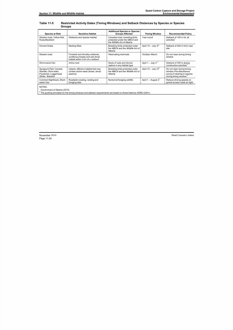
8/21/2019 Quest CCS EIA - Wildlife and Wildlife Habitat (1)
http://slidepdf.com/reader/full/quest-ccs-eia-wildlife-and-wildlife-habitat-1 28/141
Section 11: Wildlife and Wildlife HabitatQuest Carbon Capture and Storage Project
Environmental Assessment
November 2010 Shell Canada Limited
Page 11-24
Table 11-5 Restricted Activity Dates (Timing Windows) and Setback Distances by Species or SpeciesGroups
Species at Risk Sensitive HabitatAdditional Species or Species
Groups Affected Timing Window Recommended Policy
Western toad, Yellow Rail,Rusty Blackbird
Wetlands and riparian habitat Canadian toad, breeding birdsprotected under the MBCA andthe Wildlife Act of Alberta
Year round1 Setback of 100 m for all
activities1
Horned Grebe Nesting Sites Breeding birds protected underthe MBCA and the Wildlife Act of Alberta
April 15 – July 311 Setback of 500 m from nest
site1
Western toad Forested and shrubby wetlands,coniferous forests and wet shrubhabitat within 2 km of a wetland
Hibernating mammals October–March Do not clear during timingwindow
Short-eared Owl Active nest Nests of owls and diurnalraptors in any habitat type
April 1 – July 312 Setback of 200 m during
construction activities2
Sprague's Pipit, CanadaWarbler, Olive-sidedFlycatcher, LoggerheadShrike, Bobolink
Upland, effective habitat that maycontain active nests (forest, shrub,pasture)
Breeding birds protected underthe MBCA and the Wildlife Act of Alberta
April 15 – July 312 Do not clear during timing
window. Pre-disturbancesurvey if clearing is requiredduring timing window.
2
Common Nighthawk, Short-eared Owl
Roadside roosting, nesting andforaging sites
Nocturnal foraging wildlife April 1 – August 31 Reduce driving speeds on
gravel access roads at night.
NOTES:1 Government of Alberta (2010)
2 The guiding principles for the timing windows and setback requirements are based on those listed by ASRD (2001).
8/21/2019 Quest CCS EIA - Wildlife and Wildlife Habitat (1)
http://slidepdf.com/reader/full/quest-ccs-eia-wildlife-and-wildlife-habitat-1 29/141
Quest Carbon Capture and Storage ProjectEnvironmental Assessment Section 11: Wildlife and Wildlife Habitat
Shell Canada Limited November 2010
Page 11-25
Limiting Changes in Habitat Availability and Connectivity
The following mitigation strategies will limit the loss of habitat for Species at Risk and
other wildlife species:
using existing roads and rights-of-way to reduce disturbance where possible
constructing the route parallel to, or overlapping, the ROW of existing linear
corridors (roads, seismic lines, pipelines)
using existing access roads, where available, and coordinating the development of
new (temporary) roads with other industrial operators
avoiding disturbance of suitable habitat for Species at Risk and other wildlife species
areas by constructing the pipelines and other infrastructure in disturbed or less
sensitive areas, (e.g., avoidance of remnant riparian habitat within and along the
slopes of the North Saskatchewan River valley)
using setbacks if construction interferes with potential habitat for Species at Risk
following best management practices for construction including mitigation for areasof saturated lands (i.e., wetlands) and areas with high potential for erosion (i.e., sand
dune areas)
protecting wetlands, creeks and the North Saskatchewan River by:
use of trenchless techniques for pipeline installation
using existing rights-of-way for TWS
limiting removal and disturbance of soil adjacent to wetlands and watercourses
leading to wetlands
grading away from wetlands to avoid sedimentation
maintaining natural drainage patterns when storing excavated material reclaiming the area, after construction, to the preconstruction profile of wetlands,
allowing wetlands to regenerate naturally, monitoring the effectiveness of
wetland reclamation, and making adjustments as necessary
compensating for wetlands where infilling or removal of wetlands is required
following the Water Act
limiting the size of permanent and temporary workspace to the extent possible, and
reclaiming work areas immediately following construction
Limiting Changes in Mortality Risk
Pipeline construction planning will take into consideration timing windows and setbackdistances for Species at Risk and other species of wildlife protected under the MBCA and
the Wildlife Act of Alberta (see Table 11-5). Where feasible, construction will be
scheduled to avoid sensitive timing windows. Timing windows and setback requirements
have been developed for some species in the boreal ecoregion (Government of Alberta
2010), while others have been developed for prairie and parkland species (ASRD 2001).
The guiding principles of the latter are used to mitigate potential Project effects on some
species not addressed in the former (see Table 11-5).

8/21/2019 Quest CCS EIA - Wildlife and Wildlife Habitat (1)
http://slidepdf.com/reader/full/quest-ccs-eia-wildlife-and-wildlife-habitat-1 30/141
Section 11: Wildlife and Wildlife HabitatQuest Carbon Capture and Storage Project
Environmental Assessment
November 2010 Shell Canada Limited
Page 11-26
The possibility of western toads (and other wildlife species) being trapped in trenches atcontraction sites will be mitigated by following Alberta’s best practice guidelines
produced for the oil and gas industry (ASRD 2004), which are as follows:
• Limit the duration and amount of open trench along the ROW.
• If trench is left open overnight or during shutdown, provide 5-m wide pipe, spoil pileand trench breaks.
• Provide (2:1 sloped ramps) every 300 m to allow greater wildlife movement acrossthe ROW and escape.
• Check the trench at least twice daily for trapped wildlife and should any removal be
required, contact the local Fish and Wildlife office.
• Prohibit pets, firearms or recreational use of all-terrain vehicles on the ROW.
• Do not harass or feed wildlife.
• Record all wildlife observed within or near trenches for submission to ASRD.
Hazardous materials will be stored securely in an appropriate location to avoid interactionwith wildlife. Construction waste and debris, including all waste food products that could
potentially attract wildlife, will be routinely collected and disposed in a secure location.
11.4.2 Change in Habitat Availability
The Project’s environmental effects are assessed by comparing the baseline conditionswith those expected during the construction of the Project. The comparison is quantitativeand based on estimates of the amount of moderate and highly suitable habitat (key
habitat; the habitat that is likely required for the presence of a given species) availableduring each Project phase. Wildlife models were used to estimate the amount and quality
of the available habitat. The suitability of habitat is based on current published species
accounts and research, along with the professional judgment. A rating of 1 to 4 wasassigned to patches of habitat mapped within the LAA. Habitat considered highly suitable
for a given species was rated as 1, while habitat considered of moderate suitability wasrated as 2. Habitat patches of low suitability were rated as 3, and a rating of 4 was used
for habitat that is not suitable for a given species. Detailed mapping methodologies anddescriptions of ecosites and wetland classifications are provided in Appendix 10A.
Zones of influence (ZOIs) were used to enhance the accuracy of the baseline conditions
of habitat. Although habitat may be suitable for a given wildlife species, actual use may be limited or precluded because of other factors, such as human disturbance. Typically,habitats close to intensive human activities have lower habitat effectiveness thancomparable habitats in remote settings. To incorporate reduced habitat effectiveness as aresult of sensory disturbance, ZOIs were defined for each type of pre-existing human
disturbance identified in the LAA, as well as those associated with the construction of theProject. A disturbance coefficient (negative or positive) was applied to the habitat
suitability ratings within the ZOI. The ZOIs and disturbance coefficients vary by species.
See Table 11-6 for a summary of habitat change for species in the LAA. In general, key
habitat for the species assessed is limited within the LAA because of the amount ofdisturbance and fragmentation, primarily due to agricultural activity. As a result, formany of the assessed species (e.g., Canada Warbler, Olive-sided Flycatcher, Sprague’sPipit, Short-eared Owl, Bobolink, Yellow Rail) the amount of key habitat available is
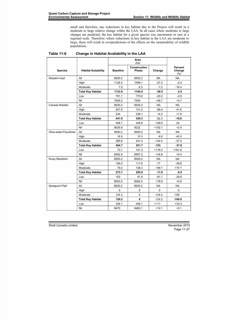
8/21/2019 Quest CCS EIA - Wildlife and Wildlife Habitat (1)
http://slidepdf.com/reader/full/quest-ccs-eia-wildlife-and-wildlife-habitat-1 31/141
Quest Carbon Capture and Storage ProjectEnvironmental Assessment Section 11: Wildlife and Wildlife Habitat
Shell Canada Limited November 2010
Page 11-27
small and therefore, any reductions in key habitat due to the Project will result in amoderate to large relative change within the LAA. In all cases where moderate to large
changes are predicted, the key habitat for a given species was uncommon or rare at aregional scale. Therefore, where reductions in key habitat in the LAA are moderate to
large, these will result in overpredictions of the effects on the sustainability of wildlife
populations.
Table 11-6 Change in Habitat Availability in the LAA
Species Habitat Suitability
Area(ha)
PercentChange
(%) Baseline
ConstructionPhase Change
Western toad All 8930.2 8930.2 NA NA
High 1126.4 1099.1 -27.3 -2.4
Moderate 7.5 6.3 -1.2 -16.4
Total Key Habitat 1133.9 1105.4 -28.5 -2.5Low 791.1 770.9 -20.2 -2.6
Nil 7005.2 7054 +48.7 +0.7
Canada Warbler All 8930.2 8930.2 NA NA
High 207.6 121.2 -86.4 -41.6
Moderate 234 238.1 +4.2 +1.8
Total Key Habitat 441.6 359.3 -82.3 -18.6
Low 458.7 348.8 -109.9 -24
Nil 8029.9 8222 +192.1 +2.4
Olive-sided Flycatcher All 8930.2 8930.2 NA NA
High 18.9 10.3 -8.6 -45.5
Moderate 385.8 241.4 -144.4 -37.4
Total Key Habitat 404.7 251.7 -153 -37.8
Low 73.1 191.3 +118.2 +161.8
Nil 8452.4 8487.2 +34.8 +0.4
Rusty Blackbird All 8930.2 8930.2 NA NA
High 194.5 117.6 -77 -39.6
Moderate 79.2 138.3 +59.1 +74.7
Total Key Habitat 273.7 255.9 -17.8 -6.5
Low 153 91.9 -61.1 -39.9
Nil 8503.5 8582.4 +78.9 +0.9
Sprague's Pipit All 8930.2 8930.2 NA NA
High 0 0 0 0
Moderate 124.2 0 -124.2 -100
Total Key Habitat 124.2 0 -124.2 -100.0
Low 336.1 448.1 +112 +33.3
Nil 8470 8482.1 +12.1 +0.1
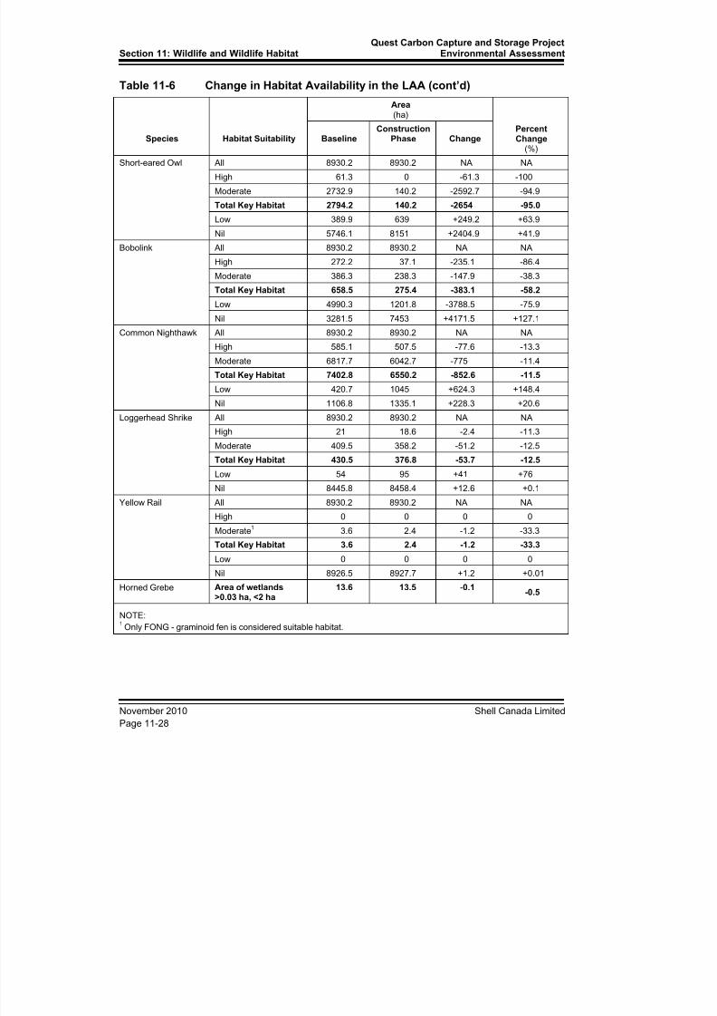
8/21/2019 Quest CCS EIA - Wildlife and Wildlife Habitat (1)
http://slidepdf.com/reader/full/quest-ccs-eia-wildlife-and-wildlife-habitat-1 32/141
Section 11: Wildlife and Wildlife HabitatQuest Carbon Capture and Storage Project
Environmental Assessment
November 2010 Shell Canada Limited
Page 11-28
Table 11-6 Change in Habitat Availability in the LAA (cont’d)
Species Habitat Suitability
Area(ha)
PercentChange
(%)
BaselineConstruction
Phase Change
Short-eared Owl All 8930.2 8930.2 NA NA
High 61.3 0 -61.3 -100
Moderate 2732.9 140.2 -2592.7 -94.9
Total Key Habitat 2794.2 140.2 -2654 -95.0
Low 389.9 639 +249.2 +63.9
Nil 5746.1 8151 +2404.9 +41.9
Bobolink All 8930.2 8930.2 NA NA
High 272.2 37.1 -235.1 -86.4
Moderate 386.3 238.3 -147.9 -38.3
Total Key Habitat 658.5 275.4 -383.1 -58.2Low 4990.3 1201.8 -3788.5 -75.9
Nil 3281.5 7453 +4171.5 +127.1
Common Nighthawk All 8930.2 8930.2 NA NA
High 585.1 507.5 -77.6 -13.3
Moderate 6817.7 6042.7 -775 -11.4
Total Key Habitat 7402.8 6550.2 -852.6 -11.5
Low 420.7 1045 +624.3 +148.4
Nil 1106.8 1335.1 +228.3 +20.6
Loggerhead Shrike All 8930.2 8930.2 NA NA
High 21 18.6 -2.4 -11.3
Moderate 409.5 358.2 -51.2 -12.5
Total Key Habitat 430.5 376.8 -53.7 -12.5
Low 54 95 +41 +76
Nil 8445.8 8458.4 +12.6 +0.1
Yellow Rail All 8930.2 8930.2 NA NA
High 0 0 0 0
Moderate1 3.6 2.4 -1.2 -33.3
Total Key Habitat 3.6 2.4 -1.2 -33.3
Low 0 0 0 0
Nil 8926.5 8927.7 +1.2 +0.01
Horned Grebe Area of wetlands>0.03 ha, <2 ha
13.6 13.5 -0.1-0.5
NOTE:1
Only FONG - graminoid fen is considered suitable habitat.

8/21/2019 Quest CCS EIA - Wildlife and Wildlife Habitat (1)
http://slidepdf.com/reader/full/quest-ccs-eia-wildlife-and-wildlife-habitat-1 33/141
Quest Carbon Capture and Storage ProjectEnvironmental Assessment Section 11: Wildlife and Wildlife Habitat
Shell Canada Limited November 2010
Page 11-29
Species at Risk
Vegetation removal, topsoil salvage and grading associated with the preparation of theROW and TWS, as well as the construction of access roads will result in a short-term lossof effective Species at Risk habitat in areas of native vegetation. For most Species at
Risk, the availability of suitable habitat is based on the availability of native vegetation(e.g., upland forests, shrublands and wetlands). During the construction of the Project,
both upland and wetland habitats will be changed with possible environmental effects ondifferent species.
Although clearing will occur primarily during the winter (January, February and March)
and fall (September, October and November) when the majority of wildlife species areabsent from the LAA, vegetation removal will result in loss of breeding and foragehabitat. This reduction in habitat may result in lost reproductive effort for some species,
particularly songbirds with small breeding territories, as displaced birds may crowd intoadjacent habitat following habitat clearing (Schmiegelow et al. 1997). This secondary
habitat may be of lower quality than previously occupied habitat (Holmes 2007).
Habitat loss during construction may also occur indirectly through sensory disturbance.
This is disturbance most important during the nesting season for the avian Species atRisk. Although clearing activities will occur outside the nesting period, other activities,such as grading, trenching and pipe installation, will occur when birds are nesting (i.e.,
June, July and August). Chronic noise, such as that associated with traffic and largemachinery, can affect abundance and reproductive success of songbirds in adjacent
habitats (Reijnen et al. 1995; Habib et al. 2007). The linear nature of the PDA means thatconstruction will not occur simultaneously along the entire ROW. Sensory disturbanceassociated with construction activities will be relatively localized and finite as the phases
of the construction move along the alignment.
Wetland-Depend ent Species
For breeding habitat, the Western Toad depends on the presence of vegetated wetlands(COSEWIC 2002; Browne and Paszkowski 2010). Rusty Blackbirds are obligate riparianspecies and depend on a combination of wetlands and adjacent forest or shrubby areas
(Avery 1995, Internet site; COSEWIC 2006). Horned Grebes depend on the presence ofsuitable, open water wetlands that are approximately 0.3 to 2.0 ha in size (COSEWIC2009). Within the LAA, only moist, sedge meadow habitats are considered effectiveYellow Rail habitat. Thus, Yellow Rails require the most specific wetland habitat of all ofthe species assessed. A general reduction of wetland habitat will mean a loss of potential
breeding habitat for all of these species. However, the potential loss of all wetland habitatin the LAA is expected to be 0.5%.
Less than 0.1% of the LAA contains the sedge meadow habitat in which Yellow Rails breed (see Table 11A-14, Figure 11A-13; Appendix 11A). In addition, potential Yellow
Rail habitat was assessed at a very course scale. None of the mapped graminoid fenhabitat is evaluated at a microhabitat level and, given that no suitable Yellow Rail habitatwas noted during the 2010 surveys, it may be that the small patches of graminoid fen
habitat within the LAA would support Yellow Rail. Of the total amount of graminoid fenhabitat in the LAA at baseline (3.6 ha), just over 1 ha is expected to be temporarily
unavailable during construction. The magnitude of the decrease in habit (33%,see Table 11-6) is related to the high levels of pre-existing disturbance and scarceness ofthe habitat at baseline. In addition, because graminoid fens can be re-established in the
8/21/2019 Quest CCS EIA - Wildlife and Wildlife Habitat (1)
http://slidepdf.com/reader/full/quest-ccs-eia-wildlife-and-wildlife-habitat-1 34/141
Section 11: Wildlife and Wildlife HabitatQuest Carbon Capture and Storage Project
Environmental Assessment
November 2010 Shell Canada Limited
Page 11-30
ROW, the habitat lost may become available again once the construction of Project iscomplete. The very low availability of Yellow Rail habitat, along with the absence of the
species in the LAA at baseline, imply the Project will have a low effect on thesustainability of regional populations of Yellow Rail or of other species that use similar
habitat.
While western toads were not detected in surveyed areas of the LAA, they are present inthe RAA and could be present in areas of the LAA to be surveyed through supplementalsurveys. Therefore, changes in local habitat availability and quality have the potential toaffect western toads within the LAA. Within the LAA, both wetland and upland habitat
are expected to be reduced by approximately 2.5 to 3.0%, both of which are used bywestern toads. Key habitat specific to western toads is predicted to be reduced fromapproximately 1134 ha to 1105 ha, a reduction of about 29 ha (2.5%)(see Table 11-6).
Given the scarcity of the species at a local scale, the small reduction in habitat availabilityassociated with the construction of the Project is expected to have lowo effect on the
probability of western toads being present within the LAA.
The LAA contains 16 open water wetlands between 0.3 and 2 ha in size that are suitable
for Horned Grebes. The combined surface area of these wetlands is estimated to be13.5 ha, or 2.4% of the entire wetland habitat in the LAA. Only 0.04 ha of wetlands iswithin the ROW, with an additional 0.03 ha within the adjacent TWS. The surface area of
the unavailable wetlands equates to 0.5% of the suitable wetland habitat within the LAA(see Table 11-6) and less than 0.01% of the entire area of the LAA. The relatively small
reduction in habitat availability, along with the fact that Horned Grebe observations arenot recorded within the LAA or RAA, lead to a confident prediction that the constructionof the Project will have a low effect on the sustainability of regional populations of
Horned Grebe. In addition, the mitigation strategy of wetland avoidance duringconstruction will reduce habitat loss of other species that use wetland habitat.
The majority of the key Rusty Blackbird habitat within the LAA consists of riparianconiferous forest, with the balance consisting of graminoid fens and the recently burned
areas. Less than 300 ha of the 8,900-ha LAA (approximately 3%) contains key RustyBlackbird habitat at baseline. Of the small amount of habitat available, the two thirds thatare rated highly suitable are expected to be reduced by 40%, while the moderately
suitable habitat is predicted to increase by 75% (see Table 11-6). The former will occurwith the potential loss of riparian forest cover and the latter with the creation of grasslandstructural stages in wooded or shrubby wetlands. Overall, the change in key habitat
availability is predicted to be a decrease of 6.5%. The relatively small reduction in habitatavailability, along with the fact that Rusty Blackbird records do not exist for the LAA or
RAA lead to a confident prediction that the construction of the Project will have a loweffect on the sustainability of regional populations of Rusty Blackbird.
Forest and Shrub-Dependent Species
The breeding habitat for Canada Warbler and Olive-sided Flycatcher includes forestedhabitat. Canada Warblers also require dense, shrubby understoreys (COSEWIC 2008;Reitsma et al. 2010, Internet site), while upland shrub adjacent to open pasture isimportant breeding habitat for Loggerhead Shrike (Yosef 1996, Internet site; COSEWIC
2004). Forested habitat is also important for western toad hibernation habitat. Westerntoad depend on the presence of conifer forest cover within 2 km of wetland habitat(Browne and Paszkowski 2010). All upland forest and shrub habitats are restricted to lessthan 25% of the LAA at baseline.
8/21/2019 Quest CCS EIA - Wildlife and Wildlife Habitat (1)
http://slidepdf.com/reader/full/quest-ccs-eia-wildlife-and-wildlife-habitat-1 35/141
Quest Carbon Capture and Storage ProjectEnvironmental Assessment Section 11: Wildlife and Wildlife Habitat
Shell Canada Limited November 2010
Page 11-31
The upland forest and shrub habitat of the LAA is already in a highly fragmented state.About 78% of the land cover within the pipeline corridor has been cultivated or is
disturbed. The remaining upland forest and shrub habitat in the LAA exists in small patches or a large remnant of boreal forest in and around the Northwest of Bruderheim
and North Bruderheim Natural Areas. These Natural Areas have been dissected by
pre-existing cutlines, well pads and their respective access roads. Due to the highlyfragmented state of the LAA at baseline, it is predicted that the additional habitat
fragmentation associated with the Project will not affect forest and shrub habitat speciesto the same degree as the overall loss of the habitat (Trzcinski et al. 1999; Fahrig 2003).
However, as mentioned previously, only 778 ha of potentially suitable habitat is availablein the LAA at baseline and only 2.9% of that will be lost to clearing. Therefore, thereduction in habitat will have a low effect on the sustainability of local or regional
populations of forest and shrub wildlife species.
Canada Warbler occurrence records are not known for the LAA or the RAA. Habitat that
could potentially be used by Canada Warblers will be reduced by 18.6%; from 442 hadown to 359 ha (see Table 11-6). While the percent reduction of potential habitat is large,the low availability of Canada Warbler habitat and the absence of the species in the LAAat baseline, lead to a confident prediction that the Project will have a low effect on thesustainability of regional populations of Canada Warblers.
There are approximately 405 ha of Olive-sided Flycatcher habitat within the LAA at baseline (4%; see Table 11-6). Olive-sided Flycatchers are attracted to forest edge
habitats for foraging and territorial singing (COSEWIC 2007b); thus, an increase in edgehabitat will likely have a positive effect on the availability of habitat for these flycatchers.The clearance of the habitat is to occur outside timing windows (see Table 11-5).
Therefore, a net reduction in habitat availability due to disturbance is not expected tooccur and Project effects on Olive-sided Flycatchers are expected to be low.
Loggerhead Shrikes require both open, grassland habitat along with upland, shrubbyhabitat (Yosef 1996, Internet site; COSEWIC 2004). At baseline, less than 5% of the
LAA is considered to be key loggerhead shrike habitat, which is calculated as a mix ofopen pasture and shrub habitat (see Table 11-6). In addition, the majority of the keyhabitat is considered to be of only moderate suitability to this species normally associated
with prairie natural regions. There are no documented Loggerhead Shrike records for theLAA or RAA. Therefore, the small proportion of land cover identified as potentialLoggerhead Shrike habitat is considered to have low potential as key habitat. The
availability of this habitat is expected to be reduced from approximately 430 ha to 377 ha,a reduction of 12.5%. While the percent reduction of potential habitat is moderate, the
low availability of Loggerhead Shrike key habitat and the absence of the species in theLAA at baseline, lead to a confident prediction that the Project will have a low effectLoggerhead Shrikes.
Given the lack of observations (due to the lack of their presence; survey effort wasadequate) of the forest-dependent assessment species and low amounts of potential key
habitat, the presence of these species in the LAA appears to be rare to unlikely. Only asmall amount of upland forest and shrub habitat are found in the LAA at baseline, andwhat does occur is highly fragmented. The Project infrastructure is mostly in cultivatedfields and passes through very little sensitive habitat. The game species detectedincidentally in the LAA are tolerant of a fragmented landscape. Deer, moose, coyotes,
weasels, and grouse present in the LAA at baseline are predicted to remain in the area
8/21/2019 Quest CCS EIA - Wildlife and Wildlife Habitat (1)
http://slidepdf.com/reader/full/quest-ccs-eia-wildlife-and-wildlife-habitat-1 36/141
Section 11: Wildlife and Wildlife HabitatQuest Carbon Capture and Storage Project
Environmental Assessment
November 2010 Shell Canada Limited
Page 11-32
after the construction of the Project because only a small proportion of the remnant cover(approximately 3%) is predicted to be removed.
Grassland-Dependent Species
Of the 6,981 ha of agriculture and disturbed lands in the LAA, only 489 ha (7%) has beenclassified as prairie–pasture–grassland alliance. The proportion of this general grasslandclassification that is actually suitable for species that require ungrazed to moderatelygrazed native or near natural grasslands is predicted to be small. Species with these
habitat requirements include Sprague's Pipit, Short-eared Owl and Bobolink (Kantrud andHiggins 1992; Clayton 2000; Environment Canada 2008; COSEWIC 2010).
Critical habitat for Sprague’s Pipit has not yet been identified because of a lack ofadequate information to determine what habitat is necessary for the survival and recoveryof this species (Environment Canada 2008). However, it is known that Sprague’s Pipits
require relatively large areas of open, undisturbed grasslands for breeding, rearing andfeeding (Robbins and Dale 1999; Environment Canada 2008). In general, Sprague’s
Pipits prefer native vegetation of intermediate height and density, with moderate amounts
of litter (Environment Canada 2008). These characteristics are more common in thesouthern prairies where Sprague Pipit numbers are relatively higher (Prescott 1997;USGS Patuxent Wildlife Research Center 2010).
The suitability of the prairie-pasture-grassland habitat for Sprague’s Pipits within the
LAA is marginal relative to other parts of the species’ range. The Project is located in theBoreal Natural Subregion within the northern limit of its range (Environment Canada2008) and where undisturbed native prairie is rare or absent (ATPR 2006, Internet site).The LAA contains 489 ha of pasture–prairie vegetation alliance. However, this land unitis discontinuous and interspersed with upland and shrubland vegetation. In addition,
agronomic and weed species are a large and often dominant component of this vegetationland unit. Invasive species and woody vegetation can alter the structure of vegetation sothat it is less attractive to Sprague’s Pipits (Environment Canada 2008). Cultivated land isvery abundant (6075 ha) and does hold some value as foraging habitat, but is not suitableas breeding habitat (Robbins and Dale 1999; Environment Canada 2008). Given the
criteria for habitat suitability for Sprague’s Pipits (Environment Canada 2008), 124 ha ofthe 8930 ha (1%) of the LAA is rated as moderate habitat for Sprague’s Pipit and none of
the LAA is rated as highly suitable. Since Sprague’s Pipits are area-sensitive (Robbinsand Dale 1999; Environment Canada 2008), the bisection of pastures in the LAA is
predicted to affect all the moderately suitable pipit habitat in the LAA. While the
majority of the prairie-pasture-grassland alliance will be remain after site preparation andclearance of habitat, the predicted change in habitat suitability will result in a reduction of
the 1% of the LAA that contains moderately suitable Sprague’s Pipit habitat. The suitablyof the habitat is predicted to change from moderate to low.
The low occurrence of suitable habitat likely drives the relatively low occurrence rates ofSprague’s Pipits in the region. Existing data suggests that the species abundance anddistribution is lower in the boreal-parkland transition zone than in the prairie portion ofthe species’ range (Environment Canada 2008; FAN 2007). Sprague’s Pipits were notdetected during baseline breeding bird surveys, nor were observations of the species
recorded in the FWMIS for the LAA or RAA.
8/21/2019 Quest CCS EIA - Wildlife and Wildlife Habitat (1)
http://slidepdf.com/reader/full/quest-ccs-eia-wildlife-and-wildlife-habitat-1 37/141
Quest Carbon Capture and Storage ProjectEnvironmental Assessment Section 11: Wildlife and Wildlife Habitat
Shell Canada Limited November 2010
Page 11-33
Construction activities, particularly site clearing, are planned to avoid the critical nesting period of Sprague’s Pipits. If construction needs to be started during the breeding season,
nest searches will be completed by qualified experts, to ensure construction activities donot disturb breeding birds in the area. If an active nest is found, an appropriate buffer will
be maintained around the nest until the nest is no longer used.
Therefore, given the low occurrence of habitat, the location of the Project relative to theknown range and distribution of the species, and the timing windows during construction,it is predicted that Sprague’s Pipits will not be affected by the Project.
The amount of key habitat available to Bobolinks (659 ha) at baseline is possibly
underestimated because cultivated lands are not included. Cultivated lands are the mostcommon cover type; other cover types such forest and shrub habitats are not suitable forBobolinks. The reduction in key habitat during the construction of the Project will be lessthan predicted in Table 11-6 (58.2% reduction). The environmental effect of the Projectis predicted to be an overestimation, because the availability of Bobolink habitat was
underestimated at baseline. Given that no occurrences of Bobolinks were noted in theLAA, the abundance of cultivated lands in the LAA, and that Shell will comply with
timing windows during construction, it is predicted that Bobolinks will not be affected bythe Project.
Cultivated lands are included in the key habitat for Short-eared Owl. The inclusion of
cultivated lands as moderately suitable habitat overestimated the amount of key habitatavailable to the owls (2794 ha). This is because only a portion of the cultivated land
cover would be grain stubble, the only crop cover used by Short-eared Owl (Clayton2000). In addition, Short-eared owls are associated with ungrazed pasture (Kantrud andHiggins 1992), thus the inclusion of all pasture in key habitat overestimated the amount
of key habitat available at baseline. Other crop types found in cultivated lands would not be suitable for Short-eared Owl. Similar to Sprague’s Pipits, habitat utilization by Short-
eared Owl is area dependent (Dechant et al. 2003, Internet site). Therefore, when theconstruction of the pipeline passes through the open habitat of the LAA, most of the
fields will be bisected, effectively reducing potentially key habitat to zero. However, themagnitude of the loss is overestimated due to the overestimation of habitat under baselineconditions. If cultivated lands are not included in key habitat, the reduction in habitat
would be equal to the loss within prairie-pasture-grassland habitat, approximately 13 ha(3%).
In general, the changes in key habitat are predicted not to affect the sustainability of localor regional populations of grassland-dependent Species at Risk and other wildlife. Thereduction in the availability of grassland habitat due to Project construction is predicted
to be low. Therefore, the Project’s environmental effect on grassland habitat availabilityis considered to be site-specific and of low magnitude.
None of the grassland species included in the assessment were detected during the 2010
surveys, and no records of these species were found within the RAA in the FWMIS.Regardless of their absence, timing windows will be observed for these Species at Risk.
Due to the lack of presence of the Species at Risk, the small amount of suitable habitatwithin the LAA at baseline, and the observance of timing windows (see Table 11-5), it is
predicted that Project effects on mortality will be low on all grassland species.
8/21/2019 Quest CCS EIA - Wildlife and Wildlife Habitat (1)
http://slidepdf.com/reader/full/quest-ccs-eia-wildlife-and-wildlife-habitat-1 38/141
Section 11: Wildlife and Wildlife HabitatQuest Carbon Capture and Storage Project
Environmental Assessment
November 2010 Shell Canada Limited
Page 11-34
Common Nighthawk
While Common Nighthawk use some habitat types that are shared with the speciesassessed above, they are also associated with unique ecological settings that requireadditional evaluation. As with Short-eared Owl and Loggerhead Shrike, Common
Nighthawk are associated with open habitat types. However, Common Nighthawk arealso able to take advantage of recently burned areas (Poulin et al. 1996, Internet site;COSEWIC 2007a). The 556 ha of burned area from the 2009 forest fire near Bruderheimwithin the LAA makes up 6.2% of the 8,900 ha LAA. During construction, 15.6 ha of the
burned area in the LAA will be cleared, resulting in a reduction in habitat of 2.8%.
Including open habitat types, most of the LAA (83%) is considered key habitat asCommon Nighthawk are known to forage over cultivated fields. Of the 7,400 ha of keyCommon Nighthawk habitat within the LAA, 853 ha will become unavailable during the
construction phase; a reduction of 11.5% (see Table 11-6). Most of the habitat within thePDA is cultivated land, the most common land cover type in the region. Therefore, the
magnitude of the reduction in habitat is considered to be low.
If timing windows are observed, the environmental effects of the clearance of habitat on
the mortality of Common Nighthawk are predicted to be low. During these times,nighthawks may roost or nest on gravel roads that pass through suitable habitat (Poulin etal. 1996, Internet site; COSEWIC 2007a).
Summary
In general, the changes in key habitat are predicted not to affect the sustainability of localor regional populations of wetland-dependent Species at Risk and other wildlife. Thereduction in the availability of wetland habitat due to Project construction is predicted to
be low. Or, as in the case of Yellow Rail, the availability of suitable habitat is very
limited at baseline. Therefore, the Project’s environmental effect on wetland habitatavailability is considered to be site-specific and of low magnitude.
11.4.3 Change in Mortality Risk
Direct sources of mortality may include:
• wildlife collisions with vehicles and other equipment
• destruction of dens, hibernacula and nests
Indirectly, development of pipeline projects can increase access to previously moreisolated areas through the development of rights-of-way and access roads. These linear
developments, combined with others on the landscape, can result in a shift in predator-prey relationships (e.g., increasing the access for nest predators).
Collisions with vehicles are possible during darkness. Given the low availability of
suitable habitat in the LAA, the probability of collisions is already considered negligible.Mitigation strategies to reduce or prohibit mortality of wildlife include no clearance ofhabitat within timing windows and a minimum setback distance of 50 m from wetlands(see Table 11-5). Given the implementation of these strategies, the residual Project
effects that may lead to a change in mortality rates are expected to be low.
8/21/2019 Quest CCS EIA - Wildlife and Wildlife Habitat (1)
http://slidepdf.com/reader/full/quest-ccs-eia-wildlife-and-wildlife-habitat-1 39/141
Quest Carbon Capture and Storage ProjectEnvironmental Assessment Section 11: Wildlife and Wildlife Habitat
Shell Canada Limited November 2010
Page 11-35
The absence of most Species at Risk, along with the application of mitigation strategiessuch as timing windows during the breeding period of birds or the hibernation period of
toads will reduce or remove environmental effects of the Project on mortality rates.Therefore, mortality rates of Species at Risk and other wildlife are not predicted to
increase above baseline levels.
11.4.4 Change in Habitat Connectivity
The Project may affect local and regional wildlife movements by decreasing the overallconnectivity of the landscape for Species at Risk and other wildlife species. Specifically,
the construction activities within the ROW may function as a physical or sensory barrierto the daily or seasonal movement patterns of terrestrial species such as western toads.
The relatively small reduction of riparian habitat will be important to regional movementsof wildlife such as game species (e.g. moose and deer). The movement corridor ofgreatest importance in the region is the North Saskatchewan River valley and its forested
tributaries, demarcated as ESA 690 (ATPR 2010, Internet site) (see Figure 11A-3;Appendix 11A). The pipeline will pass through ESA 690 at two locations: at the river
crossing site and at the crossing of the Beaverhill–Astotin Creek tributary system.Additional regionally important movement corridor habitat is avoided by the Bruderheim
route.
At the river crossing, the flood plain has been mostly cultivated and little riparian habitatremains. Horizontal directional drilling will allow for the retention or reclamation of
vegetation immediately adjacent to the river, preserving what remains of the remnantriparian habitat. In addition, the alignment of the pipeline through the floodplain of the
river valley avoids the remnant riparian forest and shrub habitats. Within the NamepiCreek and Beaverhill–Astotin tributary system, a strategy of minimizing the clearance ofhabitat will be used to mitigate the effects of construction within these areas of sensitivehabitat. The Project alignment will use existing rights-of-way for TWS at the streamcrossings, thus the Project is not expected to further impede wildlife movement. In
addition, a general mitigation strategy of a 50-m setback from the edge of waterbodieswill be used throughout the PDA. Therefore, the integrity of the riparian forest and shrubhabitat at baseline will be retained. The maintenance of riparian vegetation wouldconserve habitat for Species at Risk such as Rusty Blackbird, but also species ofmanagement concern such as beaver and other small, fur-bearing mammals associated
with riparian cover.
Based on available evidence, the 25-m wide corridor of the combined ROW and TWSmay temporarily deter movements of some forest birds. Sensory disturbance during
construction may cause birds to avoid construction areas, but these environmental effectsare considered local and short-term. Shell will implement breaks in the pipeline trench
and spoil piles to allow movement of ground based species. In addition, the pipeline will
be installed in segments, any one location will be exposed to intense constructiondisturbances for only a period of days to weeks. Considering mitigation measures, suchdisturbances, in combination with the width of the ROW, are not expected to affect localmovements or dispersal of wildlife along the length of the ROW. However, movements
of small, terrestrial animals such as western toad may be temporarily blocked bytrenches, pipe stockpiles and construction equipment.

8/21/2019 Quest CCS EIA - Wildlife and Wildlife Habitat (1)
http://slidepdf.com/reader/full/quest-ccs-eia-wildlife-and-wildlife-habitat-1 40/141
Section 11: Wildlife and Wildlife HabitatQuest Carbon Capture and Storage Project
Environmental Assessment
November 2010 Shell Canada Limited
Page 11-36
The construction phase is not expected to affect bird movements, as timing windows will prevent interactions between birds and construction activities. Mitigation strategies to
prevent blockages to western toad movements, along with the transitory nature of theconstruction sites, will reduce the potential Project environmental effects on wildlife
movements to a low magnitude.
11.5 Summary of Project Residual Environmental Effects onWildlife and Wildlife Habitat
For a summary of the Project-related environmental effects, see Table 11-7.
Given Shell’s plan for selecting the location of well pads and associated infrastructure(see Section 1.5.4), and that all well pads will be located within the RAA, the predicted
environmental effects of the additional injection wells are anticipated to be comparable tothe potential environmental effects of the five candidate injection wells and associatedinfrastructure.
11.5.1 Determination of SignificanceThe determination of significance that follows also includes the project activities listed as1 in Table 11-1.
Change in Habitat A vai labi l i ty
Availability of high suitability habitat for the assessed species is limited in the LAA. Aswell, some of the assessed species have no high quality habitat within the PDA
(e.g. Sprague's Pipit, Yellow Rail). The landscape in which the construction of the Projectis proposed is fragmented and disturbed. As a result, the magnitude of the environmental
effect of the construction activities on habitat availability for the assessed species is low.Project related environmental effects are expected to continue during the construction
phase, and in some cases, through to reclamation (short-term). The predictedenvironmental effect is not significant.
Change in Mortal i ty Risk
Construction-related change in mortality rates of wildlife species will likely beconstrained to areas where the PDA is within key habitat types. Given the limitedgeographic extent of key habitat in the LAA, few mortality events are predicted and will
not affect wildlife populations or diversity at a local scale. Therefore, the magnitude ofthe effects of construction activities on wildlife mortality is considered to be low and is
predicted to be not significant. The duration of the environmental effects will be short-term (limited to the construction period) and reversible once construction activities cease.
Change in Habitat Connectiv i ty
The environmental effects of Project construction on habitat connectivity are consideredlow in magnitude, short-term, and not significant.
Environmental effects of the construction phase of the Project on habitat availability,wildlife mortality and wildlife connectivity are predicted to be of low magnitude afterconsidering mitigation, given the short-term duration and local extent of the activities.

8/21/2019 Quest CCS EIA - Wildlife and Wildlife Habitat (1)
http://slidepdf.com/reader/full/quest-ccs-eia-wildlife-and-wildlife-habitat-1 41/141
Quest Carbon Capture and Storage ProjectEnvironmental Assessment Section 11: Wildlife and Wildlife Habitat
Shell Canada Limited November 2010
Page 11-37
Table 11-7 Summary of Project Residual Environmental Effects on Wildlife and Wildlife Habitat
Potential ResidualEnvironmental
EffectsMitigation and
Compensation Measures
Residual Environmental Effects Characteristics S i gni f i c an c e
P r e d i c t i on
C onf i d en c e
L i k el i h o o d
C um ul a t i v eE f f e c t s
RecommendedFollow-up and
monitoring
Di r e c t i on
M a gni t u d e
G e o gr a ph i c
E x t en t
D ur a t i on
F r e q u en c y
R ev er si b i l i t y
E c ol o gi c al
C on t ex t
Change in Habitat Availability
Habitat clearance Use existing ROW for TWS
Limit clearance in sensitiveareas
Observe timing windows
Use setbacks aroundwetlands and active nestsor dens
A/P L S ST O R D N H H N Pre-disturbancesurveys ifconstruction isrequired during timingwindowsPipe installat ion A L S ST O R D N H H N
Well site construction A L S ST O R D N H H N
Change in Mortality Risk
Habitat clearance Use existing ROW for TWS
Limit clearance in sensitiveareas
Observe timing windows
Use setbacks around
wetlands and active nestsor dens
Be wary of wildlife whentravelling to and onconstruction sites to limitcollisions
A L S ST O I D N H L N Pre-disturbancesurveys ifconstruction isrequired during timingwindows
A L S ST O I D N H L N
Pipe installation Limit open trench
Provide escape ramps
A L S ST O I D N H L N Ongoing monitoring oftrench for trappedwildlife
Change in Habitat Connectivity
Pipe installation Limit length of constructionsites along pipeline ROW
Provide escape ramps
A L S ST O R D N H L N
8/21/2019 Quest CCS EIA - Wildlife and Wildlife Habitat (1)
http://slidepdf.com/reader/full/quest-ccs-eia-wildlife-and-wildlife-habitat-1 42/141
Section 11: Wildlife and Wildlife HabitatQuest Carbon Capture and Storage Project
Environmental Assessment
November 2010 Shell Canada Limited
Page 11-38
Table 11-7 Summary of Project Residual Environmental Effects on Wildlife and Wildlife Habitat (cont’d)
KEY
N/A Not applicable
Direct ion:
P Positive
A Adverse
N Neutral
Magni tude :
L Low: Project will have nomeasurable environmental effecton habitat availability or localand/or regional populations andspecies diversity.
M Moderate: Project will have ameasurable environmental effecton habitat availability but not onlocal or regional populations andspecies diversity.
H High: Project will have ameasurable environmental effecton habitat availability and local orregional populations and speciesdiversity.
Geographic Extent :
S Site-specific: PDA
L Local: LAA
R Regional: RAA and beyond
Duration :
ST Short term: Less than one year.
MT Medium term: more than oneyear, but less than 10 years.
LT Long term: More than 10 yearsbut not beyond the life of the
ProjectP Permanent: beyond the life of
the Project.
Frequency :
O Occurs once.
S Occurs sporadically at irregularintervals.
R Occurs on a regular basis andat regular intervals.
C Continuous.
Reversibil i ty :
R Reversible
I Irreversible
Ecolog ical Context:
U Undisturbed: Area relatively or notadversely affected by human activity.
D Developed: Area has beensubstantially previously disturbed byhuman development or human
development is still present
Sign i f icance :
S Significant
N Not significant
Predict ion Confidence:
Based on scientific information andstatistical analysis, professional judgmentand effectiveness of mitigation
L Low level of confidence
M Moderate level of confidence
H High level of confidence
L ike l ihood :
Based on professional judgment
L Low probability of occurrence
M Medium probability ofoccurrence
H High probability of occurrence
Cumula t ive Effects
Y Potential for the effect tointeract with other past, presentor foreseeable projects oractivities in the RAA
N Effect will not, or is not likely to,interact with other past, presentor foreseeable projects oractivities in the RAA

8/21/2019 Quest CCS EIA - Wildlife and Wildlife Habitat (1)
http://slidepdf.com/reader/full/quest-ccs-eia-wildlife-and-wildlife-habitat-1 43/141
Quest Carbon Capture and Storage ProjectEnvironmental Assessment Section 11: Wildlife and Wildlife Habitat
Shell Canada Limited November 2010
Page 11-39
11.5.2 Follow-up and Monitoring
Shell will conduct further baseline surveys for any new areas of the PDA that have notyet been identified, such as pipeline laterals, new well pads, access roads and borrow pits.
A pre-disturbance survey for active nests or dens or potential hibernation habitat will be
required, if habitat clearance and site preparation is required within the recommendedconstruction timing windows.
Ongoing monitoring of the open trench will reduce or remove the possibility of wildlife becoming trapped and buried during trenching and backfilling.
11.6 Cumulative Environmental Effects on Wildlife and WildlifeHabitat
The local environmental effects of the Project discussed below are predicted to have a
low or immeasurable incremental contribution towards those same effects from otherregional human projects and activities. The environmental effects are predicted to have
low or no effects on local populations; thus, the same effects are predicted to have low tono effects on regional populations. Therefore, further assessment of potential cumulativeenvironmental effects is not required for these environmental effects.
11.7 References
11.7.1 Literature Cited
AGRA Earth and Environmental (AGRA). 1998. Shell Scotford Upgrader Environmental Assessment.Volume 2, Section 13: Wildlife. Prepared for Shell Canada Ltd. Calgary, AB.
Alberta Sustainable Resource Development (ASRD). 2004. Recommended Wildlife Procedures for Pipelines in Alberta. Alberta Fish and Wildlife, Edmonton, AB.
Alberta Sustainable Resource Development (ASRD). 2001. Recommended Land Use Guidelines for
Protection of Selected Wildlife Species and Habitat within Grassland and Parkland Natural Regions in Alberta. Fish and Wildlife Branch, Sustainable Resource Development, Government
of Alberta. Edmonton, AB.
Alberta Conservation Association and Alberta Sustainable Resource Development. (ACA/ASRD) 2006. Alberta Volunteer Amphibian Monitoring Program – Participants Manual . Alberta Conservation
Association. Edmonton, AB.
Alvo, R. and M. Robert. 1999. COSEWIC Status Report on the Yellow Rail Coturnicops noveboracensis
in Canada. Committee on the Status of Endangered Wildlife in Canada. Ottawa, ON.
AXYS Environmental Consulting (AXYS). 2005. Shell Scotford Upgrader Expansion Project
Environmental Impact Assessment. Prepared for Shell Canada Ltd., Calgary, AB.
AXYS Environmental Consulting Ltd. (AXYS). 2001. Thresholds for Addressing Cumulative Effects onTerrestrial and Avian Wildlife in the Yukon. Prepared for the Department of Indian and NorthernAffairs, the Environmental Directorate and Environment Canada, Whitehorse, Yukon by AXYSEnvironmental Consulting Ltd. Calgary, AB.
Bayne, E.M., S.L. Van Wilgenburg, S. Boutin and K.A. Hobson. 2005a. Modeling and field-testing of
Ovenbird (Seiurus aurocapillus) responses to boreal forest dissection by energy sectordevelopment at multiple spatial scales. Landscape Ecology 20: 203–216.

8/21/2019 Quest CCS EIA - Wildlife and Wildlife Habitat (1)
http://slidepdf.com/reader/full/quest-ccs-eia-wildlife-and-wildlife-habitat-1 44/141
Section 11: Wildlife and Wildlife HabitatQuest Carbon Capture and Storage Project
Environmental Assessment
November 2010 Shell Canada Limited
Page 11-40
Bayne, E.M., S. Boutin, B. Tracz and K. Charest. 2005b. Functional and numerical responses ofovenbirds (Seiurus aurocapillus) to changing seismic exploration practices in Alberta’s boreal
forest. Ecoscience 12: 216–222.
Bazin, R. and F.B. Baldwin. 2007. Canadian Wildlife Service Standardized Protocol for the Survey of
Yellow Rails (Coturnicops noveboracensis) in Prairie and Northern Regions. Canadian WildlifeService. Winnipeg, MB.
Bibby, C.J., N.D. Burgess, D.A. Hill and S.H. Mustoe. 2000. Bird Census Techniques, Second Edition.
Academic Press. London, UK.
Browne, C.L. and C.A. Paszkowski. 2010. Hibernation sites of western toads ( Anaxyrus boreas):Characterization and management implications. Herpetological Conservation and Biology 5: 49– 63.
Clayton, K.M. 2000. Status of the Short-eared Owl ( Asio flammeus) in Alberta. Alberta Environment,
Fisheries and Wildlife Management Division, and Alberta Conservation Association, WildlifeStatus Report No. 28. Edmonton, AB.
Committee on the Status of Endangered Wildlife in Canada (COSEWIC). 2010. COSEWIC assessment
and status report on the Bobolink Dolichonyx oryzivorus in Canada. Committee on the Status ofEndangered Wildlife in Canada. Ottawa, ON.
Committee on the Status of Endangered Wildlife in Canada (COSEWIC). 2009. COSEWIC assessmentand status report on the Horned Grebe Podiceps auritus, Western population and Magdalen
Islands population, in Canada. Committee on the Status of Endangered Wildlife in Canada.Ottawa, ON.
Committee on the Status of Endangered Wildlife in Canada (COSEWIC). 2008. COSEWIC assessmentand status report on the Canada Warbler Wilsonia canadensis in Canada. Committee on theStatus of Endangered Wildlife in Canada. Ottawa, ON.
Committee on the Status of Endangered Wildlife in Canada (COSEWIC). 2007a. COSEWIC assessment
and status report on the Common Nighthawk Chordeiles minor in Canada. Committee on theStatus of Endangered Wildlife in Canada. Ottawa, ON.
Committee on the Status of Endangered Wildlife in Canada (COSEWIC). 2007b. COSEWIC assessmentand status report on the Olive-sided Flycatcher Contopus cooperi in Canada. Committee on the
Status of Endangered Wildlife in Canada. Ottawa, ON.
Committee on the Status of Endangered Wildlife in Canada (COSEWIC). 2006. COSEWIC assessmentand status report on the Rusty Blackbird Euphagus carolinus in Canada. Committee on the Statusof Endangered Wildlife in Canada. Ottawa, ON.
Committee on the Status of Endangered Wildlife in Canada (COSEWIC). 2004. COSEWIC assessment
and update status report on the Loggerhead Shrike excubitorides subspecies Lanius ludovicianus in Canada. Committee on the Status of Endangered Wildlife in Canada. Ottawa, ON.
Committee on the Status of Endangered Wildlife in Canada (COSEWIC). 2002. COSEWIC assessmentand status report on the western toad Bufo boreas in Canada. Committee on the Status ofEndangered Wildlife in Canada. Ottawa, ON.
Committee on the Status of Endangered Wildlife in Canada (COSEWIC). 2001. COSEWIC assessmentand status report on the yellow rail Coturnicops noveboracensis in Canada. Committee on the
Status of Endangered Wildlife in Canada. Ottawa, ON.

8/21/2019 Quest CCS EIA - Wildlife and Wildlife Habitat (1)
http://slidepdf.com/reader/full/quest-ccs-eia-wildlife-and-wildlife-habitat-1 45/141
Quest Carbon Capture and Storage ProjectEnvironmental Assessment Section 11: Wildlife and Wildlife Habitat
Shell Canada Limited November 2010
Page 11-41
Dale, B.C., P.A. Martin and P.S. Taylor. 1997. Effects of hay management on grassland songbirds inSaskatchewan. Wildlife Society Bulletin 25: 616-626.
Davis, S.K., D.C. Duncan and M. Skeel. 1999. Distribution and habitat associations of three endemicgrassland songbirds in southern Saskatchewan. Wilson Bulletin 111: 389–396.
Deguise, I. and J.S. Richardson. 2009. Movement behaviour of adult western toads in a fragmented, forestlandscape. Canadian Journal of Zoology 87: 1,184–1,194.
Desrochers, A. and S. Hannon. 1997. Gap crossing decisions by forest songbirds during the post-fledging
period. Conservation Biology 11: 1,204–1,210.
Eddleman, W.R., F.L. Knopf, B. Meanley, F.A. Reid and R. Zembal. 1988. Conservation of North
American rallids. Wilson Bulletin 100: 458-475.
Environment Canada. 2007. Addendum to the Final Recovery Strategy for the Piping Plover ( Charadriusmelodus circumcinctus ) in Canada re: Identification of Critical Habitat. Species at Risk Act Recovery Strategy Series. Environment Canada, Ottawa, ON.
Environment Canada. 2008. Recovery Strategy for the Sprague’s Pipit ( Anthus spragueii ) in Canada.
Species at Risk Act Recovery Strategy Series. Environment Canada, Ottawa, ON.Fahrig, L. 2003. Effects of habitat fragmentation on biodiversity. Annual Review of Ecology, Evolution
and Systematics 34: 487–515.
Filion, F.L., E. DuWors, P. Boxall, P. Bouchard, R. Reid, P.A. Gray, A. Bath, A. Jacquemot andG. Legare. 1993. The importance of wildlife to Canadians: Highlights of the 1991 survey.
Canadian Wildlife Service, Environment Canada. Ottawa, ON.
Fletcher, R.J. and R. Koford. 2003. Spatial responses of Bobolinks ( Dolichonyx oryzivorus) near differenttypes of edges in Northern Iowa. Auk 120: 799–810.
Gauthier J. and Y. Aubry (eds.) 1996. The breeding birds of Québec: atlas of the breeding birds of southern Québec. Association Québécoise des Groupes d'Ornithologues, Province of Québec
Society for the Protection of Birds, Canadian Wildlife Service, Environnement Canada (Québecregion). Montréal, QC.
Government of Alberta (2010). Upstream Oil and Gas Best Management Guidelines for the Enhanced Approval Process. Government of Alberta, Edmonton, AB.
Habib, L., E.M. Bayne and S. Boutin. 2007. Chronic industrial noise affects pairing success and agestructure of ovenbirds Seiurus aurocapilla. Journal of Applied Ecology 44: 176–184.
Hegmann, G., R. Eccles, and K. Strom. 2000. A Practical Approach to Assessing Cumulative Effects for Pipelines. AXYS Environmental Consulting Ltd., Calgary, AB.
Helzer, C.J. and D.E. Jelinski 1999. The relative importance of patch area and perimeter-area ratio tograssland breeding birds. Ecological Applications 9: 1,448–1,458.
Herkert, J.R. 1994. The effects of habitat fragmentation on Midwestern grassland bird communities. Ecological Applications 4: 461–471.
Holmes, R.T. 2007. Understanding population change in migratory songbirds: long-term andexperimental studies of neotropical migrants in breeding and wintering areas. Ibis 149 (Suppl. 2):2–13.
Infotech. 1989. Environmentally sensitive areas study. Phase 2 report – Technical report . Prepared byInfotech Services and Associates for the Edmonton Metropolitan Regional Planning Commission.
Edmonton, AB.
8/21/2019 Quest CCS EIA - Wildlife and Wildlife Habitat (1)
http://slidepdf.com/reader/full/quest-ccs-eia-wildlife-and-wildlife-habitat-1 46/141
Section 11: Wildlife and Wildlife HabitatQuest Carbon Capture and Storage Project
Environmental Assessment
November 2010 Shell Canada Limited
Page 11-42
Johns, B., E. Telfer, M. Cadman, D. Bird, R. Bjorge, K. DeSmet, W. Harris, D. Hjertaas, P. Laporte andR. Pittaway. 1994. National Recovery Plan for the Loggerhead Shrike. Report No. 7. Ottawa:
Recovery of Nationally Endangered Wildlife Committee.
Johnson, D.H. and L.D. Igl. 2001. Area requirements of grassland birds: a regional perspective. Auk 118:
24–34.
Kantrud, H.A., and K.F. Higgins. 1992. Nest and nest site characteristics of some ground-nesting, non- passerine birds of northern grasslands. Prairie Naturalist 24:67−84.
Lima, S.L. and L.M. Dill. 1990. Behavioural decisions made under the risk of predation: a review and prospectus. Canadian Journal of Zoology 68: 619–640.
Machtans, C.S. 2006. Songbird response to seismic lines in the western boreal forest: A manipulativeexperiment. Canadian Journal of Zoology 84: 1,421–1,430.
Olson, D.H., A.R. Blaustein and R.K. O’Hara. 1986. Mating pattern variability among Western Toad( Bufo boreas) populations. Oecologia 70: 351–356.
Rail, J.-F., M. Darveau, A. Desrochers and J. Huot. 1997. Territorial responses of boreal forest birds to
habitat gaps. Condor 99: 976–980.Reijnen, R., R. Foppen, C. ter Braak, and J. Thissen. 1995. The effects of car traffic on breeding bird
populations in Woodland. Ill. Reduction of density in relation to the proximity of main roads. Journal of Applied Ecology 32: 187–202.
Robertson, B.A. and R.L. Hutto. 2007. Is selectively harvested forest an ecological trap for Olive-sided
Flycatchers? Condor 109:109–121.
Schmiegelow, F.K.A., C.S. Machtans and S.J. Hannon. 1997. Are boreal birds resilient to forestfragmentation? An experimental study of short-term community responses. Ecology 78: 1914– 1932.
Sutter, G.C. and R.M. Brigham. 1998. Avifaunal and habitat changes resulting from conversion of native
prairie to crested wheat grass: Patterns at songbird community and species levels. Canadian Journal of Zoology 76: 869–875.
TERA Environmental Consultants (TERA). 2010. Environmental Assessment for the Proposed ShellCanada Limited Site 4A 8-19-59-20 W4M Well Site and Access Road and Endpoint G 9-9-62-22W4M Well Site and Access Road . Quest Carbon Capture and Sequestration Project. Prepared for
Shell Canada Ltd. Calgary, AB.
TERA Environmental Consultants (TERA). 2008. Wildlife Survey for the Inter Pipeline (Corridor) Inc.
Corridor Pipeline Expansion Project – Dilbit Pipeline and Products Pipeline: Spring andSummer 2008. Prepared for Inter Pipeline. Calgary, AB.
TERA Environmental Consultants (TERA). 2007. Wildlife Report for the Corridor Pipeline Expansion
Project – Dilbit Pipeline: Summer 2006 and 2007. Prepared for Inter Pipeline. Calgary, AB.
Trzcinski, M.K., L. Fahrig and G. Merriam. 1999. Independent effects of forest cover and fragmentationon the distribution of forest breeding birds. Ecological Applications 9: 586–593.
Westworth, D.A. and L.J. Knapik. 1987. Significant natural features and landscapes of StrathconaCounty. Prepared by D.A. Westworth and Associates Ltd. for Strathcona County, Recreation and
Parks Division. Sherwood Park, AB.
8/21/2019 Quest CCS EIA - Wildlife and Wildlife Habitat (1)
http://slidepdf.com/reader/full/quest-ccs-eia-wildlife-and-wildlife-habitat-1 47/141
Quest Carbon Capture and Storage ProjectEnvironmental Assessment Section 11: Wildlife and Wildlife Habitat
Shell Canada Limited November 2010
Page 11-43
11.7.2 Personal Communications
Found, C. 2010. Regional Biologist, Alberta Sustainable Resources Development. Emailcommunications, July 2010.
11.7.3 Internet SitesAlberta’s Industrial Heartland (AIH). 2010. Alberta’s Industrial Heartland . Edmonton, AB Accessed
August 2010. Available at:
http://www.industrialheartland.com/index.php?option=com_frontpage&Itemid=1
Alberta Sustainable Resource Development (ASRD). 2009. Species at Risk. Accessed August 2010.Available at: http://www.srd.alberta.ca/BioDiversityStewardship/SpeciesAtRisk/Default.aspx
Alberta Sustainable Resource Development (ASRD). 2005. The General Status of Alberta Wild Species.2005. Accessed August 2010. Available at:http://www.srd.alberta.ca/BioDiversityStewardship/SpeciesAtRisk/GeneralStatus/StatusOfAlbertaWildSpecies2005/Search.aspx
Alberta Tourism, Parks and Recreation (ATPR). 2010. Natural Areas. Accessed August 2010. Availableat: http://www.tpr.alberta.ca/parks/landreferencemanual/naturalareas.aspx
Alberta Tourism, Parks and Recreation (ATPR). 2009. Environmentally Significant Areas. Accessed
August 2010. Available at:http://www.tpr.alberta.ca/parks/heritageinfocentre/environsigareas/default.aspx
Alberta Tourism, Parks, and Recreation (ATPR). 2006. Natural Regions: Alberta's Boreal Forest Natural
Region. Accessed August 2010. Available at:http://www.tpr.alberta.ca/parks/heritageinfocentre/naturalregions/borealforest.aspx
Altman, B. and R. Sallabanks. 2000. Olive-sided Flycatcher (Contopus cooperi), The Birds of NorthAmerica Online (A. Poole, Ed.). Ithaca: Cornell Lab of Ornithology. Accessed August 2010.
Available at: http://bna.birds.cornell.edu/bna/species/502
Avery, M.L. 1995. Rusty Blackbird (Euphagus carolinus), The Birds of North America Online (A. Poole,Ed.). Ithaca: Cornell Lab of Ornithology. Accessed August 2010. Available at:
http://bna.birds.cornell.edu/bna/species/200
Bookhout, T.A. 1995. Yellow Rail ( Coturnicops noveboracensis ), The Birds of North America Online (A.Poole, Ed.). Ithaca: Cornell Lab of Ornithology. Accessed August 2010. Available at:http://bna.birds.cornell.edu/bna/species/139
Dechant, J.A., M.L. Sondreal, D.H. Johnson, L.D. Igl, C.M. Goldade, M.P. Nenneman, and B.R. Euliss.
2003. Effects of management practices on grassland birds: Short-eared Owl . Northern PrairieWildlife Research Center, Jamestown, ND. Northern Prairie Wildlife Research Center Online.
Accessed August 2010. Available at:http://www.npwrc.usgs.gov/resource/literatr/grasbird/seow/seow.htm
Environment Canada. 2010. Species at Risk Act Public Registry. Accessed August 2010. Available at:http://www.sararegistry.gc.ca/default_e.cfm
Martin, S.G. and T.A. Gavin. 1995. Bobolink ( Dolichonyx oryzivorus), The Birds of North America
Online (A. Poole, Ed.). Ithaca: Cornell Lab of Ornithology. Accessed August 2010. Available at:http://bna.birds.cornell.edu/bna/species/176

8/21/2019 Quest CCS EIA - Wildlife and Wildlife Habitat (1)
http://slidepdf.com/reader/full/quest-ccs-eia-wildlife-and-wildlife-habitat-1 48/141
Section 11: Wildlife and Wildlife HabitatQuest Carbon Capture and Storage Project
Environmental Assessment
November 2010 Shell Canada Limited
Page 11-44
Poulin, R.G., S.D. Grindal and R.M. Brigham. 1996. Common Nighthawk (Chordeiles minor ), The Birdsof North America Online (A. Poole, Ed.). Ithaca: Cornell Lab of Ornithology. Accessed August
2010. Available at: http://bna.birds.cornell.edu/bna/species/213
Reitsma, L., M. Goodnow, M.T. Hallworth and C.J. Conway. 2010. Canada Warbler (Wilsonia
canadensis), The Birds of North America Online (A. Poole, Ed.). Ithaca: Cornell Lab ofOrnithology. Accessed August 2010. Available at: http://bna.birds.cornell.edu/bna/species/421
Stedman, S.J. 2000. Horned Grebe ( Podiceps auritus), The Birds of North America Online (A. Poole,
Ed.). Ithaca: Cornell Lab of Ornithology. Accessed August 2010. Available at:http://bna.birds.cornell.edu/bna/species/505
Wiggins, D.A., D.W. Holt and S.M. Leasure. 2006. Short-eared Owl ( Asio flammeus), The Birds of NorthAmerica Online (A. Poole, Ed.). Ithaca: Cornell Lab of Ornithology. Accessed August 2010.Available at: http://bna.birds.cornell.edu/bna/species/062
Yosef, R. 1996. Loggerhead Shrike (Lanius ludovicianus), The Birds of North America Online (A. Poole,Ed.). Ithaca: Cornell Lab of Ornithology. Accessed August 2010. Available at:
http://bna.birds.cornell.edu/bna/species/231

8/21/2019 Quest CCS EIA - Wildlife and Wildlife Habitat (1)
http://slidepdf.com/reader/full/quest-ccs-eia-wildlife-and-wildlife-habitat-1 49/141
Quest Carbon Capture and Storage ProjectEnvironmental Assessment
Appendix 11A: Wildlife and Wildlife HabitatBaseline
Shell Canada Limited November 2010
Appendix 11A Wildlife and Wildlife Habitat Baseline

8/21/2019 Quest CCS EIA - Wildlife and Wildlife Habitat (1)
http://slidepdf.com/reader/full/quest-ccs-eia-wildlife-and-wildlife-habitat-1 50/141
Appendix 11A: Wildlife and Wildlife HabitatBaseline
Quest Carbon Capture and Storage ProjectEnvironmental Assessment
November 2010 Shell Canada Limited
8/21/2019 Quest CCS EIA - Wildlife and Wildlife Habitat (1)
http://slidepdf.com/reader/full/quest-ccs-eia-wildlife-and-wildlife-habitat-1 51/141
Quest Carbon Capture and Storage ProjectEnvironmental Assessment
Appendix 11A: Wildlife and Wildlife HabitatBaseline
Shell Canada Limited November 2010
Page 11A-i
Table of Contents
Appendix 11A Wildlife and Wildlife Habitat Baseline
11A.1 Background ................................................................................................................. 11A-1
11A.1.1
Introduction ............................................................................................... 11A-1
11A.2 Methods....................................................................................................................... 11A-1
11A.2.1 Spatial Boundaries for Wildlife ................................................................ 11A-1
11A.2.2 Existing Data Review ............................................................................... 11A-2
11A.2.3 Baseline Field Surveys .............................................................................. 11A-2
11A.2.3.1 Amphibian Surveys ..................................................................... 11A-3
11A.2.3.2 Breeding Bird Surveys ................................................................ 11A-5
11A.2.3.3 Yellow Rail Surveys .................................................................... 11A-8
11A.2.3.4 Incidental Sightings ..................................................................... 11A-8
11A.3 Results ......................................................................................................................... 11A-9
11A.3.1 Environmental Setting .............................................................................. 11A-9
11A.3.2
Existing Data ........................................................................................... 11A-11
11A.3.3 Amphibian Surveys ................................................................................. 11A-11
11A.3.4 Yellow Rail Surveys ............................................................................... 11A-11
11A.3.5 Breeding Bird Surveys ............................................................................ 11A-12
11A.3.6 Incidental Sightings ................................................................................ 11A-12
11A.4 Species Selection ...................................................................................................... 11A-13
11A.5 Baseline Conditions for Assessment Species ........................................................... 11A-30
11A.5.1 Western Toad .......................................................................................... 11A-30
11A.5.2 Bobolink .................................................................................................. 11A-33
11A.5.3 Canada Warbler ...................................................................................... 11A-35
11A.5.4 Common Nighthawk ............................................................................... 11A-37
11A.5.5
Loggerhead Shrike .................................................................................. 11A-39
11A.5.6 Olive-Sided Flycatcher ........................................................................... 11A-41
11A.5.7 Rusty Blackbird ...................................................................................... 11A-43
11A.5.8 Short-Eared Owl ..................................................................................... 11A-44
11A.5.9 Sprague’s Pipit ........................................................................................ 11A-47
11A.5.10 Yellow Rail ....................................................................................... 11A-47
11A.5.11 Horned Grebe .................................................................................... 11A-47
11A.6 Supplemental Surveys ............................................................................................... 11A-51
11A.7 References ................................................................................................................. 11A-52
11A.7.1 Literature Cited ....................................................................................... 11A-52
11A.7.2 Personal Communications ...................................................................... 11A-55
11A.7.3
Internet Sites ........................................................................................... 11A-55
8/21/2019 Quest CCS EIA - Wildlife and Wildlife Habitat (1)
http://slidepdf.com/reader/full/quest-ccs-eia-wildlife-and-wildlife-habitat-1 52/141
Appendix 11A: Wildlife and Wildlife HabitatBaseline
Quest Carbon Capture and Storage ProjectEnvironmental Assessment
November 2010 Shell Canada Limited
Page 11A-ii
List of Tables
Table 11A-1 Amphibian Survey Codes .............................................................................. 11A-3
Table 11A-2 General Habitat Types Sampled During Breeding Bird Surveys .................. 11A-6
Table 11A-3
Rationale for Species Selection for the Environmental Assessment
........... 11A-14Table 11A-4 Rationale for Species Exclusion from the Environmental Assessment ...... 11A-19
Table 11A-5 Baseline Habitat Availability for Western Toad in the LAA ...................... 11A-31
Table 11A-6 Baseline Habitat Availability for Bobolink in the LAA .............................. 11A-33Table 11A-7 Baseline Habitat Availability for Canada Warbler ...................................... 11A-35
Table 11A-8 Baseline Habitat Availability for Common Nighthawk .............................. 11A-37
Table 11A-9 Baseline Habitat Availability for Loggerhead Shrike ................................. 11A-39
Table 11A-10 Baseline Habitat Availability for Olive-Sided Flycatcher .......................... 11A-43Table 11A-11 Baseline Habitat Availability for Rusty Blackbird ...................................... 11A-44
Table 11A-12 Baseline Habitat Availability for Short-Eared Owl .................................... 11A-44
Table 11A-13 Baseline Habitat Availability for Sprague’s Pipit ....................................... 11A-47
Table 11A-14
Baseline Habitat Availability for Yellow Rail
............................................ 11A-47Table 11A-1-1 List of Species from FWMIS Database and Previous Environmental
Assessments and Baseline Studies in the Region ....................................... 11A-1-1Table 11A-2-1 2010 Amphibian Survey Results ................................................................ 11A-2-1
Table 11A-3-1 2010 Breeding Bird Survey Results ........................................................... 11A-3-1
Table 11A-4-1 Summary of Bird Density, Species Richness and Diversity by HabitatClass ........................................................................................................... 11A-4-1
Table 11A-5-1 2010 Incidental Wildlife Observations in the Regional Assessment
Area ............................................................................................................ 11A-5-1
Table 11A-6-1 Common and Scientific Names of Species ................................................ 11A-6-1
List of Figures
Figure 11A-1 Amphibian Survey Stations ........................................................................... 11A-4Figure 11A-2 Breeding Bird Survey Stations ...................................................................... 11A-7
Figure 11A-3 Observation Locations for Species of Management Concern ..................... 11A-10
Figure 11A-4 Baseline Habitat Availability for Western Toad in the LAA ...................... 11A-32Figure 11A-5 Baseline Habitat Availability for Bobolink in the LAA .............................. 11A-34
Figure 11A-6 Baseline Habitat Availability for Canada Warbler ...................................... 11A-36
Figure 11A-7 Baseline Habitat Availability for Common Nighthawk .............................. 11A-38Figure 11A-8
Baseline Habitat Availability for Loggerhead Shrike
................................. 11A-40
Figure 11A-9 Baseline Habitat Availability for Olive-Sided Flycatcher .......................... 11A-42
Figure 11A-10
Baseline Habitat Availability for Rusty Blackbird
...................................... 11A-45Figure 11A-11 Baseline Habitat Availability for Short-Eared Owl .................................... 11A-46Figure 11A-12 Baseline Habitat Availability for Sprague’s Pipit ....................................... 11A-48
Figure 11A-13 Baseline Habitat Availability for Yellow Rail ............................................ 11A-49
Figure 11A-14 Baseline Habitat Availability for Horned Grebe ......................................... 11A-50

8/21/2019 Quest CCS EIA - Wildlife and Wildlife Habitat (1)
http://slidepdf.com/reader/full/quest-ccs-eia-wildlife-and-wildlife-habitat-1 53/141
Quest Carbon Capture and Storage ProjectEnvironmental Assessment
Appendix 11A: Wildlife and Wildlife HabitatBaseline
Shell Canada Limited November 2010
Page 11A-iii
List of Attachments
Attachment 11A-1 List of Species from FWMIS Database and Previous Environmental
Assessments and Baseline Studies in the Region
Attachment 11A-2 2010 Amphibian Survey Results
Attachment 11A-3
2010 Breeding Bird Survey Results
Attachment 11A-4 Summary of Bird Density, Species Richness and Diversity by HabitatClass
Attachment 11A-5 2010 Incidental Wildlife Observations in the Regional Assessment Area
Attachment 11A-6 Common and Scientific Names of Species

8/21/2019 Quest CCS EIA - Wildlife and Wildlife Habitat (1)
http://slidepdf.com/reader/full/quest-ccs-eia-wildlife-and-wildlife-habitat-1 54/141
Appendix 11A: Wildlife and Wildlife HabitatBaseline
Quest Carbon Capture and Storage ProjectEnvironmental Assessment
November 2010 Shell Canada Limited
Page 11A-iv
8/21/2019 Quest CCS EIA - Wildlife and Wildlife Habitat (1)
http://slidepdf.com/reader/full/quest-ccs-eia-wildlife-and-wildlife-habitat-1 55/141
Quest Carbon Capture and Storage ProjectEnvironmental Assessment
Appendix 11A: Wildlife and Wildlife HabitatBaseline
Shell Canada Limited November 2010
Page 11A-v
Acronyms and Abbreviations
AIH ........................................................................................ Alberta’s Industrial Heartland
ASRD .............................................................. Alberta Sustainable Resource Development
BSD ..................................................................................................... bird species diversityCCS ............................................................................................ carbon capture and storage
COSEWIC .............................. Committee on the Status of Endangered Wildlife in CanadaEA ................................................................................................ environmental assessment
ESA ................................................................................... environmentally significant areaESCC ............................................................Endangered Species Conservation Committee
FWMIS ............................................... Fish and Wildlife Management Information System
GIS ...................................................................................... geographic information systemLAA ..................................................................................................... local assessment area
LLD .................................................................................................... legal land descriptionPDA .............................................................................................. Project development areaRAA .............................................................................................. regional assessment area
ROW ..................................................................................................................right-of-waySARA ....................................................................................................... Species at Risk Act
UTM ....................................................................................... universal transverse mercator

8/21/2019 Quest CCS EIA - Wildlife and Wildlife Habitat (1)
http://slidepdf.com/reader/full/quest-ccs-eia-wildlife-and-wildlife-habitat-1 56/141
Appendix 11A: Wildlife and Wildlife HabitatBaseline
Quest Carbon Capture and Storage ProjectEnvironmental Assessment
November 2010 Shell Canada Limited
Page 11A-vi
8/21/2019 Quest CCS EIA - Wildlife and Wildlife Habitat (1)
http://slidepdf.com/reader/full/quest-ccs-eia-wildlife-and-wildlife-habitat-1 57/141
Quest Carbon Capture and Storage ProjectEnvironmental Assessment
Appendix 11A: Wildlife and Wildlife HabitatBaseline
Shell Canada Limited November 2010
Page 11A-1
11A.1 Background
11A.1.1 Introduction
This appendix describes the process used to select representative wildlife species for
assessing the potential environmental effects of the Quest Carbon Capture and Storage(CCS) Project on wildlife and wildlife habitat. It also provides the baseline conditions foreach of the species to be included in the EA.
Shell completed wildlife surveys in the LAA to characterize extant local wildlife populations and specifically document the occurrence, distribution and abundance ofspecies at risk. These surveys included acoustic amphibian surveys, yellow rail surveysand breeding bird surveys. Data on other wildlife, such as raptors and mammals, werecollected incidentally during amphibian and breeding bird surveys. Existing information
on wildlife in the area was also used to supplement survey data.
Wildlife surveys were conducted in the spring of 2010 along the proposed ROW.
Sections of the current route not surveyed due to temporal constraints, reroutes or the
addition of well pads are to be surveyed in 2011 (see Section 11A-6).
As stated in the Terms of Reference for the Quest CCS Project, an environmentalassessment is to consider the potential for the Project to result in adverse environmentaleffects on wildlife and wildlife habitat with a particular focus on species listed in
Schedules 1, 2 and 3 of the Species at Risk Act (SARA) and species actively listed by theCommittee on the Status of Endangered Wildlife in Canada (COSEWIC). A short-list ofspecies was chosen as surrogates for local wildlife and wildlife habitat, with an emphasison species of management concern. A review of existing wildlife and habitat information,along with field surveys within the Project area, were used to finalize the list of species
best suited to represent all wildlife and wildlife habitat in the assessment. A discussion onwhy certain species were chosen and others removed from the assessment list is provided(see Section 11A-4).
Once the list of assessment species was finalized, an analysis of habitat quality andavailability for each species was done. The resulting baseline conditions were used in to
evaluate the potential environmental effects of the Project on wildlife and wildlife habitat(see Section 11 of the EA).
11A.2 Methods
11A.2.1 Spatial Boundaries for Wildlife
The wildlife assessment uses three scales of assessment area, each progressively larger,and defined as follows:
The Project development area (PDA) includes:
• a pipeline (84 km in length) ROW measuring 18 m wide along the entire pipelineroute
• pipeline temporary workspace measuring 7 m wide along the entire pipeline route
• five well pads, measuring 1.6 to 2.0 ha each
8/21/2019 Quest CCS EIA - Wildlife and Wildlife Habitat (1)
http://slidepdf.com/reader/full/quest-ccs-eia-wildlife-and-wildlife-habitat-1 58/141
Appendix 11A: Wildlife and Wildlife HabitatBaseline
Quest Carbon Capture and Storage ProjectEnvironmental Assessment
November 2010 Shell Canada Limited
Page 11A-2
• one borrow pit, adjacent to well pad 8-19
• new well site access roads, associated with each of the five well pads, measuring a
total of about 2,000 m
The local assessment area (LAA) (see Figure 11A-1):
• includes a 500 m buffer extending from the boundary of the PDA
• contains an area within which environmental effects of the Project could be predictedwith a reasonable degree of accuracy and confidence
• is where potential Project environmental effects are likely to be most concentrated
The regional assessment area (RAA):
• includes a 15 km buffer from the boundary of the PDA
• includes an area with existing data for wildlife occurrences to provide regional
context for wildlife observations made during the baseline surveys within the PDAand LAA
• includes species with large home ranges
• is large enough to include the potential sites of future well pads
• is where environmental effects from the Project may interact with similarenvironmental effects from other projects or human activities
11A.2.2 Existing Data Review
The Fish and Wildlife Management Information System (FWMIS) was queried forhistorical wildlife occurrences within the RAA (Found 2010, pers. comm.). Pertinent
wildlife components of other environmental assessments of developments in the regionwere also reviewed. These reports included:
• Shell Scotford Upgrader Environmental Impact Assessment (AGRA 1998)
• Shell Scotford Upgrader Expansion Environmental Impact Assessment (AXYS 2005)
• Inter Pipeline’s Corridor Pipeline Conservation and Reclamation Plan (TERA 2007,
2008)
• The pipeline passes through the White Area in a similar location to the proposedProject pipeline. Several species were recorded during visual scans and groundinspections before construction in specific areas along the route.
• Quest Carbon Capture and Sequestration Project Environmental Assessment of Well(Site 4A and Endpoint Well) (TERA 2010).
• Observations made during site visits at several well pads and access roads sites.
11A.2.3 Baseline Field Surveys
During the planning stages of the field program, regulators were contacted to discussspecies of management concern that may occur in the assessment area (Found 2010, pers.
comm.). The regulatory consultation helped shape the identification of key issues, surveymethodologies, and the selection of key species.

8/21/2019 Quest CCS EIA - Wildlife and Wildlife Habitat (1)
http://slidepdf.com/reader/full/quest-ccs-eia-wildlife-and-wildlife-habitat-1 59/141
Quest Carbon Capture and Storage ProjectEnvironmental Assessment
Appendix 11A: Wildlife and Wildlife HabitatBaseline
Shell Canada Limited November 2010
Page 11A-3
11A.2.3.1 Amphibian Surveys
Survey standards provided by RIC (1998) and ASRD (2005, Internet site) were used toconduct acoustic amphibian surveys. Before field surveys, wetlands and waterbodieswere identified using aerial photographs. Survey stations were positioned to maximize
the number of waterbodies surveyed from a single station, and optimally were no lessthan 1 km apart (see Figure 11A-1). The pipeline routing matured after the surveys wereconducted; therefore, some stations are located as far as 12 km from the current route(see Figure 11A-1). The results from these locations are useful as regional occurrencedata.
Surveys were scheduled to coincide with the calling periods of western and Canadiantoads. Canadian toads typically initiate calling between mid-May and early June in the
boreal forest (Hamilton et al. 1998; ACA/ASRD 2006). As the LAA is in the Parkland
ecoregion, calling was assumed to begin earlier. Similarly, the breeding season for thewestern toad is typically April to June (ACA/ASRD 2006), although breeding tends to
last only one or two weeks (Olson et al. 1986). Other nonlisted amphibian species, suchas boreal chorus frogs and wood frogs, call from April to June. Therefore, survey timing
of May 18 to 20 was considered optimal for collecting data on all species.Amphibian surveys were conducted between 21:30 hours and 03:00 hours. Surveyorsdrove or walked to survey stations and waited quietly for five minutes for thedisturbance of their arrival to subside. Surveyors listened for five minutes, recording theapproximate distance and direction of any amphibians calling. Amphibian numbers were
categorized into one of four codes (see Table 11A-1). Habitat (when daylight remained),wind speed, precipitation, moon phase, traffic level and noise levels were also recorded.Surveys were suspended under conditions of heavy precipitation or strong winds
(>30 km/h).
A geographic information system (GIS) was used to plot the location of amphibians,
using the distance and direction data collected during field surveys. A single point was
plotted where the same amphibians were detected from multiple stations. Geographicinformation of the amphibian records, including Universal Transverse Mercator (UTM)and legal land description (LLD), were used in figures and tables.
Table 11A-1 Amphibian Survey Codes
Code Description
0 Nothing heard.
1 Individuals can be counted (no overlapping calls).
2 Calls of individuals are distinguishable, but some calls overlap.
3 Full chorus, or continuous calls, where individuals are not distinguishable.
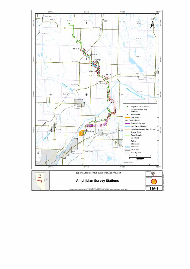
8/21/2019 Quest CCS EIA - Wildlife and Wildlife Habitat (1)
http://slidepdf.com/reader/full/quest-ccs-eia-wildlife-and-wildlife-habitat-1 60/141
8/21/2019 Quest CCS EIA - Wildlife and Wildlife Habitat (1)
http://slidepdf.com/reader/full/quest-ccs-eia-wildlife-and-wildlife-habitat-1 61/141
Quest Carbon Capture and Storage ProjectEnvironmental Assessment
Appendix 11A: Wildlife and Wildlife HabitatBaseline
Shell Canada Limited November 2010
Page 11A-5
11A.2.3.2 Breeding Bird Surveys
Field Surveys
Breeding bird surveys followed standardized inventory methods in which birds are
recorded by sight and sound from a stationary observation point (Bibby et al. 2000). Pointcounts with unlimited radius detection distances were used to compile overall breeding bird inventories for the assessment areas. A subset of bird data detected within a 50 mradius was used to examine population parameters and conduct habitat-related analyses.
Survey stations were placed at least 300 m apart, and included a 100-m buffer from theedge of the habitat type being sampled (see Table 11A-2). Where a 100 m buffer was not
possible, surveyors drew maps showing the arrangement of habitats within the 50 mradius. As with the amphibian surveys, breeding bird stations were based on a previous
pipeline route (see Figure 11A-2).
Point counts were conducted between 05:30 hours and 10:00 hours. Surveys wereinitiated following a one-minute settling period. At each survey point, both acoustic and
visual records of birds were recorded during a five-minute period. Although a longer
survey period may allow for one to three more species to be detected (Smith et al. 1998),the major proportion of the species composition is detected within the first few minutesof a point count (Lynch 1995, Shiu and Lee 2003). A shorter survey time is moreefficient, whereas a longer count period may introduce a density bias associated with
birds moving into and out of the survey area (Granholm 1983).
Singing male birds were assumed to be exhibiting territorial behaviour and wereconsidered representative of a breeding pair. Incidental bird observations were alsorecorded, and included:
• birds observed or heard outside the 50 m point-count radius
• birds flying through survey stations
• birds observed during travel to another survey station
Incidental observations were used to compile a complete inventory of bird species.However, as observer bias and bird detectability rates become more variable beyond50 m, only birds noted within the 50 m radius were used in habitat-related assessments, in
analyses of species richness and diversity and determination of bird densities. Pointcounts were not conducted during adverse weather conditions (e.g., heavy rain, highwinds), as these factors can affect both bird activity and the ability of the observer todetect birds (Bibby et al. 2000).
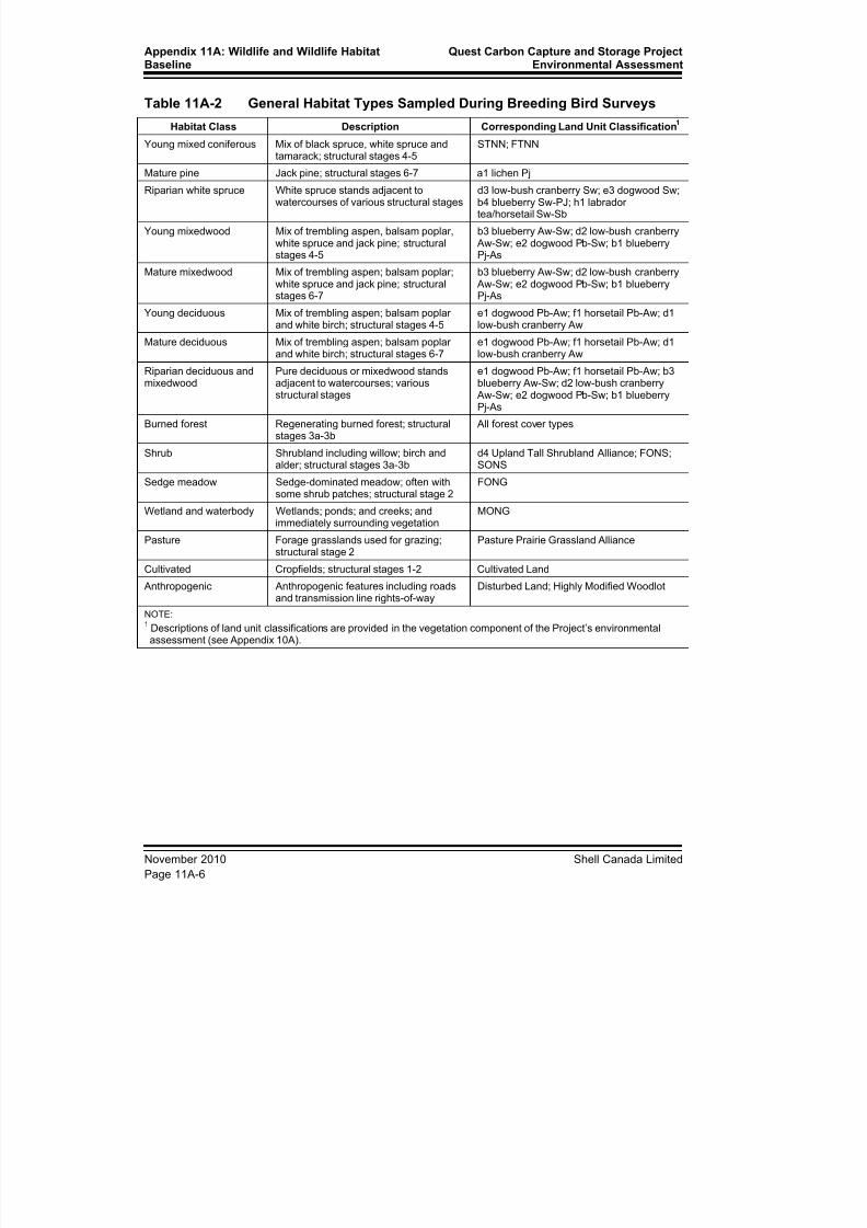
8/21/2019 Quest CCS EIA - Wildlife and Wildlife Habitat (1)
http://slidepdf.com/reader/full/quest-ccs-eia-wildlife-and-wildlife-habitat-1 62/141
Appendix 11A: Wildlife and Wildlife HabitatBaseline
Quest Carbon Capture and Storage ProjectEnvironmental Assessment
November 2010 Shell Canada Limited
Page 11A-6
Table 11A-2 General Habitat Types Sampled During Breeding Bird Surveys
Habitat Class Description Corresponding Land Unit Classification1
Young mixed coniferous Mix of black spruce, white spruce andtamarack; structural stages 4-5
STNN; FTNN
Mature pine Jack pine; structural stages 6-7 a1 lichen PjRiparian white spruce White spruce stands adjacent to
watercourses of various structural stagesd3 low-bush cranberry Sw; e3 dogwood Sw;b4 blueberry Sw-PJ; h1 labradortea/horsetail Sw-Sb
Young mixedwood Mix of trembling aspen, balsam poplar,white spruce and jack pine; structuralstages 4-5
b3 blueberry Aw-Sw; d2 low-bush cranberry Aw-Sw; e2 dogwood Pb-Sw; b1 blueberryPj-As
Mature mixedwood Mix of trembling aspen; balsam poplar;white spruce and jack pine; structuralstages 6-7
b3 blueberry Aw-Sw; d2 low-bush cranberry Aw-Sw; e2 dogwood Pb-Sw; b1 blueberryPj-As
Young deciduous Mix of trembling aspen; balsam poplarand white birch; structural stages 4-5
e1 dogwood Pb-Aw; f1 horsetail Pb-Aw; d1low-bush cranberry Aw
Mature deciduous Mix of trembling aspen; balsam poplar
and white birch; structural stages 6-7
e1 dogwood Pb-Aw; f1 horsetail Pb-Aw; d1
low-bush cranberry Aw
Riparian deciduous andmixedwood
Pure deciduous or mixedwood standsadjacent to watercourses; variousstructural stages
e1 dogwood Pb-Aw; f1 horsetail Pb-Aw; b3blueberry Aw-Sw; d2 low-bush cranberry
Aw-Sw; e2 dogwood Pb-Sw; b1 blueberryPj-As
Burned forest Regenerating burned forest; structuralstages 3a-3b
All forest cover types
Shrub Shrubland including willow; birch andalder; structural stages 3a-3b
d4 Upland Tall Shrubland Alliance; FONS;SONS
Sedge meadow Sedge-dominated meadow; often withsome shrub patches; structural stage 2
FONG
Wetland and waterbody Wetlands; ponds; and creeks; and
immediately surrounding vegetation
MONG
Pasture Forage grasslands used for grazing;structural stage 2
Pasture Prairie Grassland Alliance
Cultivated Cropfields; structural stages 1-2 Cultivated Land
Anthropogenic Anthropogenic features including roadsand transmission line rights-of-way
Disturbed Land; Highly Modified Woodlot
NOTE:1 Descriptions of land unit classifications are provided in the vegetation component of the Project’s environmentalassessment (see Appendix 10A).

8/21/2019 Quest CCS EIA - Wildlife and Wildlife Habitat (1)
http://slidepdf.com/reader/full/quest-ccs-eia-wildlife-and-wildlife-habitat-1 63/141

8/21/2019 Quest CCS EIA - Wildlife and Wildlife Habitat (1)
http://slidepdf.com/reader/full/quest-ccs-eia-wildlife-and-wildlife-habitat-1 64/141
Appendix 11A: Wildlife and Wildlife HabitatBaseline
Quest Carbon Capture and Storage ProjectEnvironmental Assessment
November 2010 Shell Canada Limited
Page 11A-8
Data Analyses
Breeding bird data were summarized in several ways. All birds detected within the 50 m point-count radius were included in the analyses. To provide information on relativespecies abundance, the average density of each species detected within the 50 m
point-count radius was calculated. Birds were assigned to the habitat in which theyoccurred, and the area (ha) of habitat in each plot calculated. The data were thensummarized by habitat type with the average density of breeding birds in each habitattype calculated as the number of territories/40 ha. Total species richness and diversitywere also calculated. In addition, bird species diversity (BSD) was calculated using the
Shannon-Wiener Index (Shannon and Weaver 1949) as follows:
SNBSD = - Σ piln(pi)
i = 1
where p is the relative abundance of the i th species relative to the population of birds ofall species (N). The Shannon-Wiener Index takes into account the number of species
within a habitat as well as the relative abundance of each species in that same habitat.Therefore, relatively rare species receive a lower weight than species that are regularly
observed. A high BSD value represents a habitat type with numerous individuals of manyspecies, whereas a low BSD value represents habitats with a low abundance of only few
species.
11A.2.3.3 Yellow Rail Surveys
The breeding bird survey methodology is not suitable for the detection of yellow rails
because they are active at night. The rails give a five-note, loud clicking call during the breeding season, which is typically initiated in late May (Bazin and Baldwin 2007).Yellow rails have been reported calling between late May and late July in Alberta (Pinelet al. 1991). Therefore, surveys in the LAA were conducted when yellow rails would bestarting to call.
As with amphibians, aerial photographs were reviewed before surveys to identify potential yellow rail breeding habitat. Survey stations were placed in sites with potential
habitat only (i.e., sedge meadows). Yellow rail surveys were conducted concurrently withamphibian surveys, and followed the Canadian Wildlife Service survey protocol (Bazinand Baldwin 2007). The call-playback method was used to elicit vocalizations from
yellow rails. After a five-minute listening period (during which amphibians wererecorded), a pre-recorded compact disc with five minutes of yellow rail calls and periodsof silence was played on a portable stereo. Surveys were conducted under conditions ofcomplete darkness (i.e., no sooner than one hour after sunset).
11A.2.3.4 Incidental Sightings
All wildlife sightings seen incidentally during field surveys were recorded andgeoreferenced. Sighting type included visual, auditory, tracks, scat, trails/beds, den, andsnags (standing dead trees). Except for visual and auditory observations, determining thenumber of individuals was not usually possible.

8/21/2019 Quest CCS EIA - Wildlife and Wildlife Habitat (1)
http://slidepdf.com/reader/full/quest-ccs-eia-wildlife-and-wildlife-habitat-1 65/141
Quest Carbon Capture and Storage ProjectEnvironmental Assessment
Appendix 11A: Wildlife and Wildlife HabitatBaseline
Shell Canada Limited November 2010
Page 11A-9
11A.3 Results
11A.3.1 Environmental Setting
The Project is to be situated in the Dry Mixedwood Natural Subregion of the Boreal
Forest Natural Region. The region is vegetated by deciduous, mixedwood and coniferousforests, with aspen and balsam poplar as the most common deciduous species, and whitespruce, black spruce and jack pine as the dominant conifer species (ATPR 2006, Internet
site). Wetlands are dominantly black spruce, shrub or sedge fens.
The southern portion of the PDA is located within the boundaries of Alberta’s IndustrialHeartland (AIH) area (AIH 2010, Internet site). The pipeline route is through the countiesof Strathcona, Lamont and Thorhild. Both the heavy industrial region of the AIH andareas adjacent to the AIH are characterized by a landscape dominated by agriculture. As a
result, any remaining wildlife habitats are highly fragmented.
The pipeline route passes through Environmentally Significant Area (ESA) 690 at two
locations (see Figure 11A-3). ESA 690 is essentially the North Saskatchewan River
valley along with some forested tributaries and is considered to have national value(ATPR 2009, Internet site). The pipeline route crosses the North Saskatchewan River east
of Redwater and through the Beaverhills Creek–Astotin Creek watershed north ofBruderheim. The river valley is an interprovincial watercourse characterized by diverse
riparian and valley habitats. The river valley is a key wintering area for ungulates andother wildlife and has high recreation value (Westworth and Knapik 1987; Infotech1989).
The alignment also circumnavigates two additional ESAs and three natural areas(see Figure 11A-3). The currently proposed route is 700 m from ESA 454 and 1,200 m
from ESA 455, both considered to have provincial value (ATPR 2009, Internet site). Theroute will pass 800 m south of the Northwest of Bruderheim Natural Area and 1,800 meast of the North Bruderheim Natural Area (ATPR 2010, Internet site). On the north side
of the North Saskatchewan River, the Redwater Natural Area is located 5.6 km west ofthe PDA. These natural areas are characterized by a mix of low-relief sand dunes and
wetlands and by diverse vegetation patterns. Along with the ESAs, the natural areas form part of the Beaverhill Creek wildlife movement corridor (Westworth and Knapik 1987;Infotech 1989).
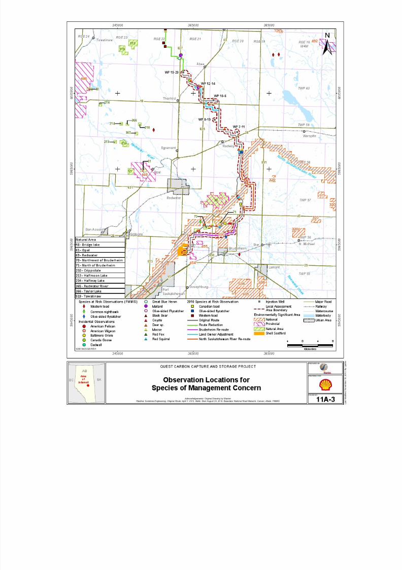
8/21/2019 Quest CCS EIA - Wildlife and Wildlife Habitat (1)
http://slidepdf.com/reader/full/quest-ccs-eia-wildlife-and-wildlife-habitat-1 66/141
8/21/2019 Quest CCS EIA - Wildlife and Wildlife Habitat (1)
http://slidepdf.com/reader/full/quest-ccs-eia-wildlife-and-wildlife-habitat-1 67/141
Quest Carbon Capture and Storage ProjectEnvironmental Assessment
Appendix 11A: Wildlife and Wildlife HabitatBaseline
Shell Canada Limited November 2010
Page 11A-11
11A.3.2 Existing Data
Existing information, including data from the FWMIS and other baseline studies,suggests that concentrations of wildlife observations are associated with ESAs adjacent to
the proposed pipeline route (ASRD 2010). Most of the FWMIS data points for species of
management concern are associated with the North Saskatchewan River, its tributaries oradjacent forested areas (see Figure 11A-3). Areas such as the North Saskatchewan River,the Northwest of Bruderheim Natural Area, and the North Bruderheim Natural Area areimportant for large-scale movements of numerous species, such as large mammals, as
well as resident and migratory birds.
Exiting datasets and reports include 158 species of wildlife that could potentially breed or
winter on or around the LAA (see Attachment 11A-1). Bird species were the mostnumerous, with 132 species recorded in the area. In addition to the birds, 20 mammalspecies have been recorded in the area, along with five amphibian species. Of the
158 species, 55 are species of management concern because either they are listed underfederal or provincial conservation regulations, or are important to hunting or trapping
activities in Alberta (see Attachment 11A-1). There are FWMIS records for three species
of management concern within the RAA (see Figure 11A-3).
11A.3.3 Amphibian Surveys
Amphibian surveys were conducted on the nights of May 18 to 20, 2010. Amphibians
were detected from 42 of the 50 survey stations (84%). Boreal chorus frog was the mostcommonly detected species and was widely distributed (see Attachment 11A-3). Borealchorus frogs were found in numerous wetland habitats ranging from ponds and dugouts,marshes, wet shrubland and wet woodlands. Wood frog was the second most commonly
detected species during amphibian surveys. This species was detected most frequentlywithin the centre portions of the pipeline route. Wood frogs were also found in manydifferent habitats, including dugouts, canals and creeks, wet shrubland and wet
woodlands. Two species of toad were recorded, Canadian toad and western toad.Canadian toads were detected only south of the North Saskatchewan River, with the
closest detection relative to the proposed pipeline route at over 800 m (see Figure 11A-3).Western toads were restricted to the northern end of the LAA during the 2010 surveywith no observations closer than 8.3 km from the proposed pipeline route(see Figure 11A-3). Canadian toads were primarily in a large wetland system, whereaswestern toads were in ponds and dugouts.
11A.3.4 Yellow Rail Surveys
No yellow rails were detected during field surveys. A preliminary review of aerial photographs of the region indicated that highly or moderately suitable sedge wetlandhabitat for yellow rails was particularly limited within the region. Similarly, suitable
habitat was not noted during field surveys.
8/21/2019 Quest CCS EIA - Wildlife and Wildlife Habitat (1)
http://slidepdf.com/reader/full/quest-ccs-eia-wildlife-and-wildlife-habitat-1 68/141
Appendix 11A: Wildlife and Wildlife HabitatBaseline
Quest Carbon Capture and Storage ProjectEnvironmental Assessment
November 2010 Shell Canada Limited
Page 11A-12
11A.3.5 Breeding Bird Surveys
Breeding birds were surveyed between June 8 and 11, 2010. In total, 82 bird species wererecorded during the breeding bird surveys (see Attachment 11A-3), and 65 species were
detected within 50 m of the survey stations. The most common species were Yellow
Warbler, Clay-colored Sparrow, House Wren and Song Sparrow. These species occurredwithin 60% of surveyed habitat types. Many of same species also occurred at the highestdensities. Some species, such as water birds (Northern Shoveler, Northern Pintail), whichare found in highly specific habitat types, or those in mature mixedwood forests (Brown
Creeper, Winter Wren), were recorded only at single survey stations(see Attachment 11A-3).
Of the 82 species detected, eight species are considered species of management concern:
• Olive-sided Flycatcher is a COSEWIC listed species (COSEWIC 2010).
• Brown Creeper and Least Flycatcher are considered to be sensitive in Alberta (ASRD
2005).
• Mallard, Northern Shoveler, American Coot and Ruffed Grouse are game birds.
• Northern Pintail is both a game bird and considered to be sensitive in Alberta (ASRD
2005).
The highest density of breeding birds was found in mature deciduous forest, followed bysedge meadow (see Attachment 11A-4). Species richness and diversity were both high in
the mature deciduous habitat, indicating that this habitat type supports a high number ofindividuals of many different species. In contrast, sedge meadow habitats had relativelylow species richness and diversity, suggesting that there were many individuals of a fewspecies. Riparian forests, wetlands and waterbodies also had a relatively high density of
birds, although species richness and diversity were moderate. Species richness and
diversity was highest in shrub habitat, which was generally characterized by willow andalder. Habitat types with a low density of breeding birds included anthropogenic, such asroads or rights-of-way, cultivated fields and young mixed coniferous. Relatively fewspecies were detected in these habitats and diversity was predictably low.
11A.3.6 Incidental Sightings
Thirty-three species or species groups were recorded during amphibian and breeding bird
surveys or other site visits (see Attachment 11A-5). Of these species, two wereamphibians, eight were mammals and 23 were birds. Most of the sightings wereclassified as auditory (38%) or visual (22%), and there was only one observation each ofdens or snags. Ungulate trails and beds were common in shrubby habitats and weremostly attributable to moose.
Of the 33 species or species groups incidentally recorded during the 2010 field visits, 14are considered to be species of management concern (see Attachment 11A-5). Six of theeight mammal species and four of the 23 bird species are game species. Speciesconsidered to be sensitive in Alberta (ASRD 2005) include American White Pelican,Baltimore Oriole and Great Blue Heron. One Olive-sided Flycatcher (a COSEWIC listed
species) was recorded incidentally.
8/21/2019 Quest CCS EIA - Wildlife and Wildlife Habitat (1)
http://slidepdf.com/reader/full/quest-ccs-eia-wildlife-and-wildlife-habitat-1 69/141
Quest Carbon Capture and Storage ProjectEnvironmental Assessment
Appendix 11A: Wildlife and Wildlife HabitatBaseline
Shell Canada Limited November 2010
Page 11A-13
11A.4 Species Selection
The concept of umbrella species allows for an efficient assessment that can focus on a
few species, but leads to conclusions that apply to many other species. Umbrella speciesserve as useful representatives for communities of wildlife. Wildlife management
activities to sustain umbrella species will help ensure viable populations for many others.For example, western toads require wetlands for breeding. When mitigation strategies areused to preserve wetlands, the concerns for other wetland species are addressed.
The objective for the selection of assessment species was to choose federally listedspecies that have conservation requirements applicable to other species of managementconcern and wildlife in general. Species of management concern are provincially
regulated species of concern (e.g., northern long-eared bat, Baltimore Oriole) or thoseclassified as game species in Alberta (e.g. moose, Ruffed Grouse). The species selected
for the assessment process were to represent a diversity of habitat types, including forest,shrublands, wetlands, grassland habitats, and recently burned habitat. Thus, these speciesare useful indicators of potential Project environmental effects for a broad suite of
wildlife species and their habitats (see Table 11A-3). Species not selected for the
assessment included those that could be assessed through umbrella species, or those thatwere unlikely to have a measurable effect on habitat availability, mortality or movementdue to a low probability of their presence in the Project region (see Table 11A-4). Forexample, Peregrine Falcon are known to have nested in the North Saskatchewan Rivervalley but have not done so for decades. Peregrine Falcon do nest on artificial structuresin the Fort Saskatchewan area. As the Project will not affect the nesting habitat of
Peregrine Falcon, the species was excluded from the assessment list.
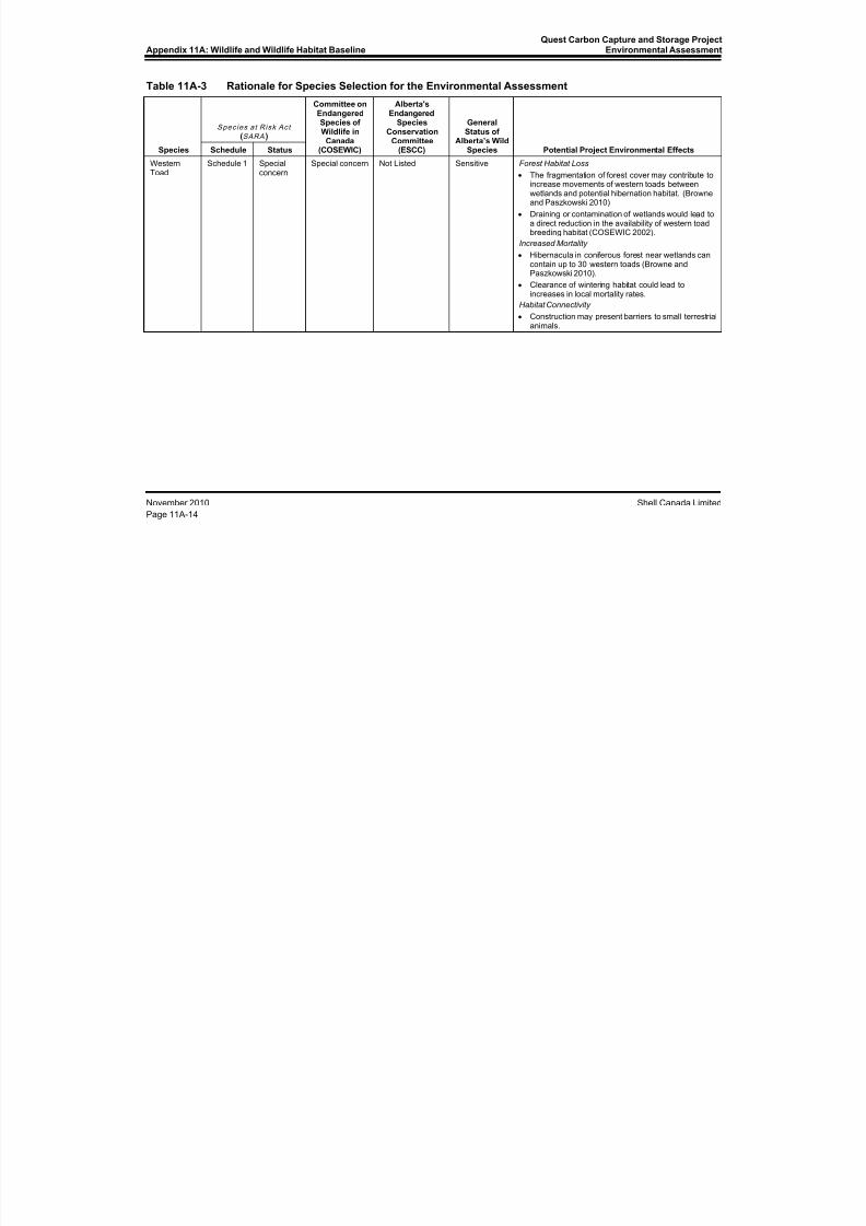
8/21/2019 Quest CCS EIA - Wildlife and Wildlife Habitat (1)
http://slidepdf.com/reader/full/quest-ccs-eia-wildlife-and-wildlife-habitat-1 70/141
Appendix 11A: Wildlife and Wildlife Habitat BaselineQuest Carbon Capture and Storage Project
Environmental Assessment
November 2010 Shell Canada Limited
Page 11A-14
Table 11A-3 Rationale for Species Selection for the Environmental Assessment
Species
Species at Risk Act (SARA )
Committee onEndangeredSpecies ofWildlife in
Canada(COSEWIC)
Alberta'sEndangered
SpeciesConservation
Committee(ESCC)
GeneralStatus of
Alberta’s WildSpecies Potential Project Environmental EffectsSchedule Status
Western
Toad
Schedule 1 Special
concern
Special concern Not Listed Sensitive Forest Habitat Loss
• The fragmentation of forest cover may contribute toincrease movements of western toads betweenwetlands and potential hibernation habitat. (Browneand Paszkowski 2010)
• Draining or contamination of wetlands would lead toa direct reduction in the availability of western toadbreeding habitat (COSEWIC 2002).
Increased Mortality
• Hibernacula in coniferous forest near wetlands cancontain up to 30 western toads (Browne andPaszkowski 2010).
• Clearance of wintering habitat could lead toincreases in local mortality rates.
Habitat Connectivity
• Construction may present barriers to small terrestrialanimals.

8/21/2019 Quest CCS EIA - Wildlife and Wildlife Habitat (1)
http://slidepdf.com/reader/full/quest-ccs-eia-wildlife-and-wildlife-habitat-1 71/141
Quest Carbon Capture and Storage ProjectEnvironmental Assessment Appendix 11A: Wildlife and Wildlife Habitat Baseline
Shell Canada Limited November 2010
Page 11A-15
Table 11A-3 Rationale for Species Selection for the Environmental Assessment (cont’d)
Species
Species at Risk Act (SARA )
Committee onEndangeredSpecies ofWildlife in
Canada(COSEWIC)
Alberta'sEndangered
SpeciesConservation
Committee(ESCC)
GeneralStatus of
Alberta’s WildSpecies Potential Project Environmental EffectsSchedule Status
Canada
Warbler
Schedule 1 Threatened Threatened Not Listed Sensitive Forest Habitat Loss
• Habitat availability is a key limiting factor (COSEWIC2008)
• The habitat loss in the region through which theProject passes will likely be more detrimental thanan increase in habitat fragmentation (Trzcinski et al.1999; Fahrig 2003).
Indirect Habitat Loss
• Habitat loss during construction may also occurindirectly through sensory disturbance (Reijnen et al.1995; Habib et al. 2007).
Reduction in Habitat Connectivity
• The frequency of birds crossing gaps in foresthabitat decreases with increasing gap width(Desrochers and Hannon 1997; Rail et al. 1997).
Mortality
• Disturbance or destruction of nests possible duringbreeding period.
CommonNighthawk
Schedule 1 Threatened Threatened Not Listed Sensitive Habitat Availability and Degradation• Forest fire suppression, forest encroachment of
natural and artificial openings and intensive use ofagricultural land have all contributed to the decline inthe quantity and quality of common nighthawkhabitat (Gauthier and Aubry 1996).
Mortality
• Collisions with vehicles are a source of mortality forcommon nighthawks, which are known to roost ongravel roads Poulin et al. 1996, Internet site;COSEWIC 2007a)
8/21/2019 Quest CCS EIA - Wildlife and Wildlife Habitat (1)
http://slidepdf.com/reader/full/quest-ccs-eia-wildlife-and-wildlife-habitat-1 72/141
Appendix 11A: Wildlife and Wildlife Habitat BaselineQuest Carbon Capture and Storage Project
Environmental Assessment
November 2010 Shell Canada Limited
Page 11A-16
Table 11A-3 Rationale for Species Selection for the Environmental Assessment (cont’d)
Species
Species at Risk Act (SARA )
Committee onEndangeredSpecies ofWildlife in
Canada(COSEWIC)
Alberta'sEndangered
SpeciesConservation
Committee(ESCC)
GeneralStatus of
Alberta’s WildSpecies Potential Project Environmental EffectsSchedule Status
Loggerhead
Shrike
Schedule 1 Threatened Threatened Special concern Sensitive Habitat Loss and Degradation
• Commonly associated with grasslands and pasture.Limiting factors in LAA is pasture and shrubbynesting sites. Habitat conversion and degradationhas been correlated with population declines ofloggerhead shrikes throughout North America (Yosef1996, Internet site).
Mortality
• Although the exact sources of mortality have notbeen identified, the mortality of recently fledgedyoung is high (COSEWIC 2004).
Olive-sidedFlycatcher
Schedule 1 Threatened Threatened Not Listed Secure Changes in Forest Habitat
• Increases in forest fragmentation may beadvantageous. However, gaps caused by habitatclearance may not mimic naturally created naturalgaps in the forest (Robertson and Hutto 2007;COSEWIC 2008).
• Post-fire habitat is important to nesting success(Altman and Sallabanks 2000, Internet site).
Sprague'sPipit
Schedule 1 Threatened Threatened Special concern Sensitive Grassland Habitat Loss
• In some regions, Sprague’s Pipits are known tobreed in tame grasslands, but their occurrence andabundance are lower than those of pipits found innative grassland (Dale et al. 1997; Sutter andBrigham 1998; Davis et al. 1999, EnvironmentCanada 2008).
• Sprague's Pipits at the northern edge of the species'breeding range may be more sensitive to changes inthe already limited availability of high andmoderately suitable habitat.
8/21/2019 Quest CCS EIA - Wildlife and Wildlife Habitat (1)
http://slidepdf.com/reader/full/quest-ccs-eia-wildlife-and-wildlife-habitat-1 73/141
Quest Carbon Capture and Storage ProjectEnvironmental Assessment Appendix 11A: Wildlife and Wildlife Habitat Baseline
Shell Canada Limited November 2010
Page 11A-17
Table 11A-3 Rationale for Species Selection for the Environmental Assessment (cont’d)
Species
Species at Risk Act (SARA )
Committee onEndangeredSpecies ofWildlife in
Canada(COSEWIC)
Alberta'sEndangered
SpeciesConservation
Committee(ESCC)
GeneralStatus of
Alberta’s WildSpecies Potential Project Environmental EffectsSchedule Status
Rusty
Blackbird
Schedule 1 Special
concern
Special concern Not Listed Sensitive Riparian Habitat Degradation
• Habitat degradation is attributed to the speciesdecline associated with boreal wetlands (COSEWIC2006, Avery 1995, Internet site).
• Sensitive to alteration of riparian habitat.
Yellow Rail Schedule 1 Specialconcern
Special concern Not Listed Undetermined Wetland Habitat Degradation
• Loss of wetlands as a result of agriculture and urbanencroachment has affected yellow rail populations(Bookhout 1995, Internet site; Alvo and Robert 1999,COSEWIC 2001).
• Mostly associated with moist but not wet sedgemeadows (Eddleman et al. 1988; Bookhout 1995,Internet site; Alvo and Robert 1999).
Short-earedOwl
Schedule 3 Specialconcern
Special concern Not Listed May be at risk Grassland Habitat Loss
• Short-eared owls appear particularly sensitive tohabitat loss and fragmentation, as they requirerelatively large tracts of grassland (Clayton 2000;Wiggins et al. 2006, Internet Site)
• Conversion of open habitats to agriculture, grazing,recreation, housing and resort development is a keyfactor in the decline of short-eared owls (Clayton2000, Wiggins et al. 2006, Internet site).

8/21/2019 Quest CCS EIA - Wildlife and Wildlife Habitat (1)
http://slidepdf.com/reader/full/quest-ccs-eia-wildlife-and-wildlife-habitat-1 74/141
Appendix 11A: Wildlife and Wildlife Habitat BaselineQuest Carbon Capture and Storage Project
Environmental Assessment
November 2010 Shell Canada Limited
Page 11A-18
Table 11A-3 Rationale for Species Selection for the Environmental Assessment (cont’d)
Species
Species at Risk Act (SARA )
Committee onEndangeredSpecies ofWildlife in
Canada(COSEWIC)
Alberta'sEndangered
SpeciesConservation
Committee(ESCC)
GeneralStatus of
Alberta’s WildSpecies Potential Project Environmental EffectsSchedule Status
Bobolink No
schedule
No status Threatened Not Listed Sensitive Wetland Loss and Degradation
• A decrease in habitat availability is associated withthe loss of tall grass prairie as a result of agricultureand settlement, and the conversion of moderatehabitat types, such as forage crops, to cereals andlegumes (COSEWIC 2010)
• Bobolinks are less likely to occur in relatively smallhabitat patches (Herkert 1994; Helzer and Jelinski1999; Johnson and Igl 2001; Fletcher and Koford2003).
HornedGrebe
Noschedule
No status Special concern Not Listed Sensitive Wetland Habitat Loss
• Permanent loss of wetlands to agriculture,development and drought threaten horned grebepopulations (COSEWIC 2009).
• Associated with wetlands 0.3–2 ha in area(COSEWIC 2009).
8/21/2019 Quest CCS EIA - Wildlife and Wildlife Habitat (1)
http://slidepdf.com/reader/full/quest-ccs-eia-wildlife-and-wildlife-habitat-1 75/141
Quest Carbon Capture and Storage ProjectEnvironmental Assessment Appendix 11A: Wildlife and Wildlife Habitat Baseline
Shell Canada Limited November 2010
Page 11A-19
Table 11A-4 Rationale for Species Exclusion from the Environmental Assessment
SpeciesConsidered
Species at Risk Act (SARA )
Committeeon
EndangeredSpecies ofWildlife inCanada
(COSEWIC)
Alberta'sEndangered
SpeciesConservation
Committee(ESCC)
General Statusof Alberta’s
Wild Species(ASRD)
Hunted orTrapped
Species inAlberta Rationale For ExclusionSchedule Status
AmphibiansCanadian Toad No
scheduleNo status Not Listed Not Listed May be at risk • Non-
GameSpecies
• Surrogate species: Western Toad
Northern LeopardFrog
Schedule 1 Specialconcern
Specialconcern
Threatened At risk • Non-GameSpecies
• No longer known to occur in LAA
Reptiles
Plains Garter Snake Noschedule
No status Not Listed Not Listed Sensitive • Non-GameSpecies
• Surrogate species: Western Toad,Yellow Rail, Olive-sidedFlycatcher, Rusty Blackbird,Bobolink
Red-sided GarterSnake
Noschedule
No status Not Listed Not Listed Sensitive • Non-GameSpecies
• Surrogate species: Western Toad,Yellow Rail, Olive-sidedFlycatcher, Rusty Blackbird
Birds
American Bittern Noschedule
No status Not Listed Not Listed Sensitive • Non-GameSpecies
• Suitable water bodies not found inLAA
• Unlikely to breed in LAA
American Coot Noschedule
No status Not Listed Not ListedSecure
• GameBird
• Surrogate species: Horned Grebe,Western Toad
American WhitePelican
Noschedule
No status Not at Risk Not Listed Sensitive • Non-GameSpecies
• Suitable waterbodies not found inLAA
• Unlikely to breed in LAA
8/21/2019 Quest CCS EIA - Wildlife and Wildlife Habitat (1)
http://slidepdf.com/reader/full/quest-ccs-eia-wildlife-and-wildlife-habitat-1 76/141
Appendix 11A: Wildlife and Wildlife Habitat BaselineQuest Carbon Capture and Storage Project
Environmental Assessment
November 2010 Shell Canada Limited
Page 11A-20
Table 11A-4 Rationale for Species Exclusion from the Environmental Assessment (cont’d)
SpeciesConsidered
Species at Risk Act (SARA )
Committeeon
EndangeredSpecies ofWildlife inCanada
(COSEWIC)
Alberta'sEndangered
SpeciesConservation
Committee(ESCC)
General Statusof Alberta’s
Wild Species(ASRD)
Hunted orTrapped
Species inAlberta Rationale For ExclusionSchedule Status
Birds (cont’d)Bald Eagle No
scheduleNo status Not at risk Not Listed Sensitive • Non-
GameSpecies
• Nests vulnerable to humandisturbance
• Suitable habitat not found in theLAA
• Unlikely to breed in LAA
Baltimore Oriole Noschedule
No status Not Listed Not Listed Sensitive • Non-GameSpecies
• Surrogate species: CanadaWarbler
Barred Owl Noschedule
No status Not Listed Not Listed Sensitive • Non-GameSpecies
• Large interior stands of maturedense woodland for breeding notfound in LAA
Barn Swallow Noschedule
No status Not Listed Not Listed Sensitive • Non-GameSpecies
• Mostly associated with farms andresidential areas
• Surrogate species: CommonNighthawk, Olive-sided Flycatcher
Bay-breastedWarbler
Noschedule
No status Not Listed SpecialConcern
Sensitive • Non-GameSpecies
• Suitable stands of mature forestfor breeding habitat not found inLAA
Black-crownedNight-Heron
Noschedule
No status Not Listed Not Listed Sensitive • Non-GameSpecies
• An uncommon, locally distributedspecies
• Suitable waterbodies not found inLAA
• Unlikely to breed in LAA
• Surrogate species: Horned Grebe,Western Toad
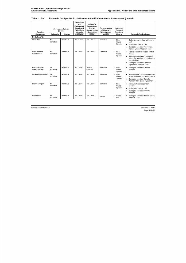
8/21/2019 Quest CCS EIA - Wildlife and Wildlife Habitat (1)
http://slidepdf.com/reader/full/quest-ccs-eia-wildlife-and-wildlife-habitat-1 77/141
Quest Carbon Capture and Storage ProjectEnvironmental Assessment Appendix 11A: Wildlife and Wildlife Habitat Baseline
Shell Canada Limited November 2010
Page 11A-21
Table 11A-4 Rationale for Species Exclusion from the Environmental Assessment (cont’d)
SpeciesConsidered
Species at Risk Act (SARA )
Committeeon
EndangeredSpecies ofWildlife inCanada
(COSEWIC)
Alberta'sEndangered
SpeciesConservation
Committee(ESCC)
General Statusof Alberta’s
Wild Species(ASRD)
Hunted orTrapped
Species inAlberta Rationale For ExclusionSchedule Status
Birds (cont’d)Black Tern No
scheduleNo status Not at Risk Not Listed Sensitive • Non-
GameSpecies
• Suitable waterbodies not found inLAA
• Unlikely to breed in LAA
• Surrogate species: Yellow Rail,Horned Grebe, Western Toad
Black-backedWoodpecker
Noschedule
No status Not Listed Not Listed Sensitive • Non-GameSpecies
• Mature coniferous forests limitedin LAA
• Standing dead trees in areas ofrecent fire required for nesting arefound in LAA
• Surrogate species: CommonNighthawk, Western Toad
Black-throatedGreen Warbler
Noschedule
No status Not Listed SpecialConcern
Sensitive • Non-GameSpecies
• Surrogate species: CanadaWarbler
Broad-winged Hawk Noschedule No status Not Listed Not Listed Sensitive•
Non-GameSpecies
•
Suitable large stands of mature toold-growth forest not found in LAA
• Surrogate species: CanadaWarbler, Olive-sided Flycatcher
Brown Creeper Noschedule
No status Not Listed Not Listed Sensitive • Non-GameSpecies
• A mature forest-dependentspecies
• Unlikely to breed in LAA
• Surrogate species: CanadaWarbler
Bufflehead Noschedule
No status Not Listed Not ListedSecure
• GameBird
• Surrogate species: Horned Grebe,Western Toad
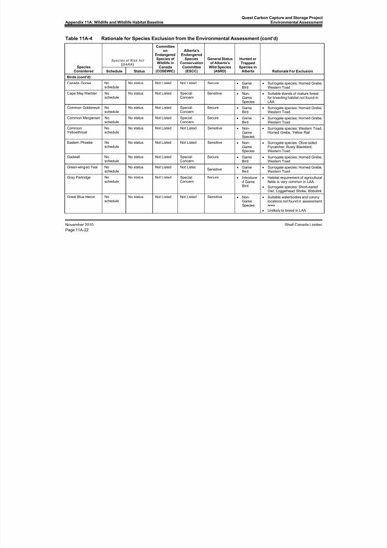
8/21/2019 Quest CCS EIA - Wildlife and Wildlife Habitat (1)
http://slidepdf.com/reader/full/quest-ccs-eia-wildlife-and-wildlife-habitat-1 78/141
Appendix 11A: Wildlife and Wildlife Habitat BaselineQuest Carbon Capture and Storage Project
Environmental Assessment
November 2010 Shell Canada Limited
Page 11A-22
Table 11A-4 Rationale for Species Exclusion from the Environmental Assessment (cont’d)
SpeciesConsidered
Species at Risk Act (SARA )
Committeeon
EndangeredSpecies ofWildlife inCanada
(COSEWIC)
Alberta'sEndangered
SpeciesConservation
Committee(ESCC)
General Statusof Alberta’s
Wild Species(ASRD)
Hunted orTrapped
Species inAlberta Rationale For ExclusionSchedule Status
Birds (cont’d)Canada Goose No
scheduleNo status Not Listed Not Listed Secure • Game
Bird• Surrogate species: Horned Grebe,
Western Toad
Cape May Warbler Noschedule
No status Not Listed SpecialConcern
Sensitive • Non-GameSpecies
• Suitable stands of mature forestfor breeding habitat not found inLAA
Common Goldeneye Noschedule
No status Not Listed SpecialConcern
Secure • GameBird
• Surrogate species: Horned Grebe,Western Toad
Common Merganser Noschedule
No status Not Listed SpecialConcern
Secure • GameBird
• Surrogate species: Horned Grebe,Western Toad
CommonYellowthroat
Noschedule
No status Not Listed Not Listed Sensitive • Non-GameSpecies
• Surrogate species: Western Toad,Horned Grebe, Yellow Rail
Eastern Phoebe Noschedule
No status Not Listed Not Listed Sensitive • Non-GameSpecies
• Surrogate species: Olive-sidedFlycatcher, Rusty Blackbird,Western Toad
Gadwall Noschedule
No status Not Listed SpecialConcern
Secure • GameBird
• Surrogate species: Horned Grebe,Western Toad
Green-winged Teal Noschedule
No status Not Listed Not ListedSensitive
• GameBird
• Surrogate species: Horned Grebe,Western Toad
Gray Partridge Noschedule
No status Not Listed SpecialConcern
Secure • Introduced GameBird
• Habitat requirement of agriculturalfields is very common in LAA.
• Surrogate species: Short-earedOwl, Loggerhead Shrike, Bobolink
Great Blue Heron Noschedule
No status Not Listed Not Listed Sensitive • Non-GameSpecies
• Suitable waterbodies and colonylocations not found in assessmentarea
• Unlikely to breed in LAA

8/21/2019 Quest CCS EIA - Wildlife and Wildlife Habitat (1)
http://slidepdf.com/reader/full/quest-ccs-eia-wildlife-and-wildlife-habitat-1 79/141
Quest Carbon Capture and Storage ProjectEnvironmental Assessment Appendix 11A: Wildlife and Wildlife Habitat Baseline
Shell Canada Limited November 2010
Page 11A-23
Table 11A-4 Rationale for Species Exclusion from the Environmental Assessment (cont’d)
SpeciesConsidered
Species at Risk Act (SARA )
Committeeon
EndangeredSpecies ofWildlife inCanada
(COSEWIC)
Alberta'sEndangered
SpeciesConservation
Committee(ESCC)
General Statusof Alberta’s
Wild Species(ASRD)
Hunted orTrapped
Species inAlberta Rationale For ExclusionSchedule Status
Birds (cont’d)Great Gray Owl No
scheduleNo status Not at Risk Not Listed Sensitive • Non-
GameSpecies
• Naturally scarce species
• Suitable stands of mature forestfor breeding not found in LAA
Least Flycatcher Noschedule
No status Not Listed Not Listed Sensitive • Non-GameSpecies
• Very common species in LAA
• Surrogate species: CanadaWarbler, Olive-sided Flycatcher
Lesser Scaup Noschedule
No status Not Listed Not Listed Sensitive • GameBird
• Surrogate species: Horned Grebe,Western Toad
Mallard Noschedule
No status Not Listed Not Listed Secure • GameBird
• Surrogate species: Horned Grebe,Western Toad
Northern Goshawk Noschedule
No status Not at Risk Not Listed Sensitive • Non-GameSpecies
• Suitable mature forest breedinghabitat not found in LAA
Northern Harrier Noschedule
No status Not at Risk Not Listed Sensitive • Non-Game
Species
• Surrogate species: Short-earedOwl, Horned Grebe
Northern Hawk-Owl Noschedule
No status Not at Risk Not Listed Sensitive • Non-GameSpecies
• Suitable stands of mature forestfor breeding habitat not found inLAA
• Surrogate species: CommonNighthawk, Western Toad
Northern Pintail Noschedule
No status Not Listed Not Listed Sensitive • GameBird
• Surrogate species: Horned Grebe,Western Toad
Northern Shoveler Noschedule
No status Not Listed Not Listed Secure • GameBird
• Surrogate species: Horned Grebe,Western Toad
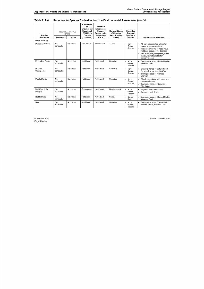
8/21/2019 Quest CCS EIA - Wildlife and Wildlife Habitat (1)
http://slidepdf.com/reader/full/quest-ccs-eia-wildlife-and-wildlife-habitat-1 80/141
Appendix 11A: Wildlife and Wildlife Habitat BaselineQuest Carbon Capture and Storage Project
Environmental Assessment
November 2010 Shell Canada Limited
Page 11A-24
Table 11A-4 Rationale for Species Exclusion from the Environmental Assessment (cont’d)
SpeciesConsidered
Species at Risk Act (SARA )
Committeeon
EndangeredSpecies ofWildlife inCanada
(COSEWIC)
Alberta'sEndangered
SpeciesConservation
Committee(ESCC)
General Statusof Alberta’s
Wild Species(ASRD)
Hunted orTrapped
Species inAlberta Rationale For ExclusionSchedule Status
Birds (cont’d)Peregrine Falcon No
scheduleNo status Non-active Threatened At risk • Non-
GameSpecies
• All peregrines in the Edmontonregion are urban nesters
• Historical river valley nests havenot been occupied for decades
• The river valley topography withinthe LAA is not suitable forperegrine nests
Pied-billed Grebe Noschedule
No status Not Listed Not Listed Sensitive • Non-GameSpecies
• Surrogate species: Horned Grebe,Western Toad
PileatedWoodpecker
Noschedule
No status Not Listed Not Listed Sensitive • Non-GameSpecies
• Suitable stands of mature forestfor breeding not found in LAA
• Surrogate species: CanadaWarbler
Purple Martin Noschedule
No status Not Listed Not Listed Sensitive • Non-GameSpecies
• Mostly associated with farms andresidential areas
• Surrogate species: CommonNighthawk
Red Knot (rufa subsp.)
Noschedule
No status Endangered Not Listed May be at risk • Non-GameSpecies
• Migrates east of Edmonton
• Breeds in high Arctic
Ruddy Duck Noschedule
No status Not Listed Not Listed Secure • GameBird
• Surrogate species: Horned Grebe,Western Toad
Sora Noschedule
No status Not Listed Not Listed Sensitive • Non-GameSpecies
• Surrogate species: Yellow Rail,Horned Grebe, Western Toad

8/21/2019 Quest CCS EIA - Wildlife and Wildlife Habitat (1)
http://slidepdf.com/reader/full/quest-ccs-eia-wildlife-and-wildlife-habitat-1 81/141
Quest Carbon Capture and Storage ProjectEnvironmental Assessment Appendix 11A: Wildlife and Wildlife Habitat Baseline
Shell Canada Limited November 2010
Page 11A-25
Table 11A-4 Rationale for Species Exclusion from the Environmental Assessment (cont’d)
SpeciesConsidered
Species at Risk Act (SARA )
Committeeon
EndangeredSpecies ofWildlife inCanada
(COSEWIC)
Alberta'sEndangered
SpeciesConservation
Committee(ESCC)
General Statusof Alberta’s
Wild Species(ASRD)
Hunted orTrapped
Species inAlberta Rationale For ExclusionSchedule Status
Birds (cont’d)Swainson's Hawk No
scheduleNo status Not Listed Not Listed Sensitive • Non-
GameSpecies
• Surrogate species: Short-earedOwl, Sprague’s Pipit, Bobolink,Loggerhead Shrike
Trumpeter Swan Noschedule
No status Not Listed Threatened At risk • Non-GameSpecies
• Migrant
• Introduced to Elk Island NationalPark
• Unlikely to breed in LAA
Western Grebe Noschedule
No status Not Listed Not Listed Sensitive • Non-GameSpecies
• Suitable waterbodies not found inassessment area
• Unlikely to breed in LAA
Western Tanager Noschedule
No status Not Listed Not Listed Sensitive • Non-GameSpecies
• Surrogate species: Canadawarbler
White-winged Scoter Noschedule
No status Not Listed Not Listed Sensitive • GameBird
• Suitable waterbodies not found inassessment area
• Unlikely to breed in LAA
Wilson’s Snipe Noschedule
No status Not Listed Not Listed Secure • GameBird
• Surrogate species: Horned Grebe,Western Toad, Rusty Blackbird
Whooping Crane Schedule 1 Endangered Endangered Endangered At risk • Non-GameSpecies
• Extremely rare migrant inEdmonton area
• Breeds in Wood Buffalo NationalPark and North West Territories
• Unlikely to interact with Project
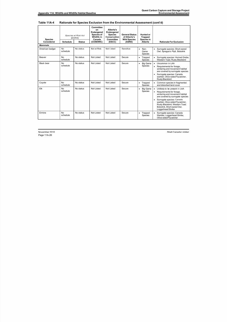
8/21/2019 Quest CCS EIA - Wildlife and Wildlife Habitat (1)
http://slidepdf.com/reader/full/quest-ccs-eia-wildlife-and-wildlife-habitat-1 82/141
Appendix 11A: Wildlife and Wildlife Habitat BaselineQuest Carbon Capture and Storage Project
Environmental Assessment
November 2010 Shell Canada Limited
Page 11A-26
Table 11A-4 Rationale for Species Exclusion from the Environmental Assessment (cont’d)
SpeciesConsidered
Species at Risk Act (SARA )
Committeeon
EndangeredSpecies ofWildlife inCanada
(COSEWIC)
Alberta'sEndangered
SpeciesConservation
Committee(ESCC)
General Statusof Alberta’s
Wild Species(ASRD)
Hunted orTrapped
Species inAlberta Rationale For ExclusionSchedule Status
Mammals American badger No
scheduleNo status Not at Risk Not Listed Sensitive • Non-
GameSpecies
• Surrogate species: Short-earedOwl, Sprague’s Pipit, Bobolink
Beaver Noschedule
No status Not Listed Not Listed Secure • TrappedSpecies
• Surrogate species: Horned Grebe,Western Toad, Rusty Blackbird
Black bear Noschedule
No status Not Listed Not Listed Secure • Big GameSpecies
• Uncommon in LAA
• Requirements for forage,wintering and movement habitatare covered by surrogate species
• Surrogate species: Canadawarbler, Olive-sided Flycatcher,Rusty Blackbird
Coyote Noschedule
No status Not Listed Not Listed Secure • TrappedSpecies
• Common species in fragmentedand disturbed land cover
Elk No
schedule
No status Not Listed Not Listed Secure • Big Game
Species
• Unlikely to be present in LAA
• Requirements for forage,wintering and movement habitatare covered by surrogate species
• Surrogate species: Canadawarbler, Olive-sided Flycatcher,Rusty Blackbird, Western Toad,Bobolink, Short-eared Owl,Loggerhead Shrike
Ermine Noschedule
No status Not Listed Not Listed Secure • TrappedSpecies
• Surrogate species: CanadaWarbler, Loggerhead Shrike,Olive-sided Flycatcher
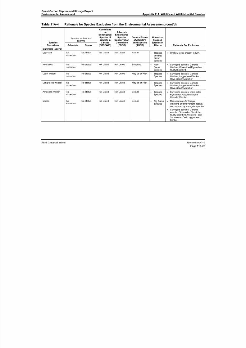
8/21/2019 Quest CCS EIA - Wildlife and Wildlife Habitat (1)
http://slidepdf.com/reader/full/quest-ccs-eia-wildlife-and-wildlife-habitat-1 83/141
Quest Carbon Capture and Storage ProjectEnvironmental Assessment Appendix 11A: Wildlife and Wildlife Habitat Baseline
Shell Canada Limited November 2010
Page 11A-27
Table 11A-4 Rationale for Species Exclusion from the Environmental Assessment (cont’d)
SpeciesConsidered
Species at Risk Act (SARA )
Committeeon
EndangeredSpecies ofWildlife inCanada
(COSEWIC)
Alberta'sEndangered
SpeciesConservation
Committee(ESCC)
General Statusof Alberta’s
Wild Species(ASRD)
Hunted orTrapped
Species inAlberta Rationale For ExclusionSchedule Status
Mammals (cont’d)Gray wolf No
scheduleNo status Not Listed Not Listed Secure • Trapped
and BigGameSpecies
• Unlikely to be present in LAA
Hoary bat Noschedule
No status Not Listed Not Listed Sensitive • Non-GameSpecies
• Surrogate species: CanadaWarbler, Olive-sided Flycatcher,Rusty Blackbird.
Least weasel Noschedule
No status Not Listed Not Listed May be at Risk • TrappedSpecies
• Surrogate species: CanadaWarbler, Loggerhead Shrike,Olive-sided Flycatcher
Long-tailed weasel Noschedule
No status Not Listed Not Listed May be at Risk • TrappedSpecies
• Surrogate species: CanadaWarbler, Loggerhead Shrike,Olive-sided Flycatcher
American marten Noschedule
No status Not Listed Not Listed Secure • TrappedSpecies
• Surrogate species: Olive-sidedFlycatcher, Rusty Blackbird,Canada Warbler
Moose Noschedule
No status Not Listed Not Listed Secure • Big GameSpecies
• Requirements for forage,wintering and movement habitatare covered by surrogate species
• Surrogate species: Canadawarbler, Olive-sided Flycatcher,Rusty Blackbird, Western Toad,Short-eared Owl, LoggerheadShrike
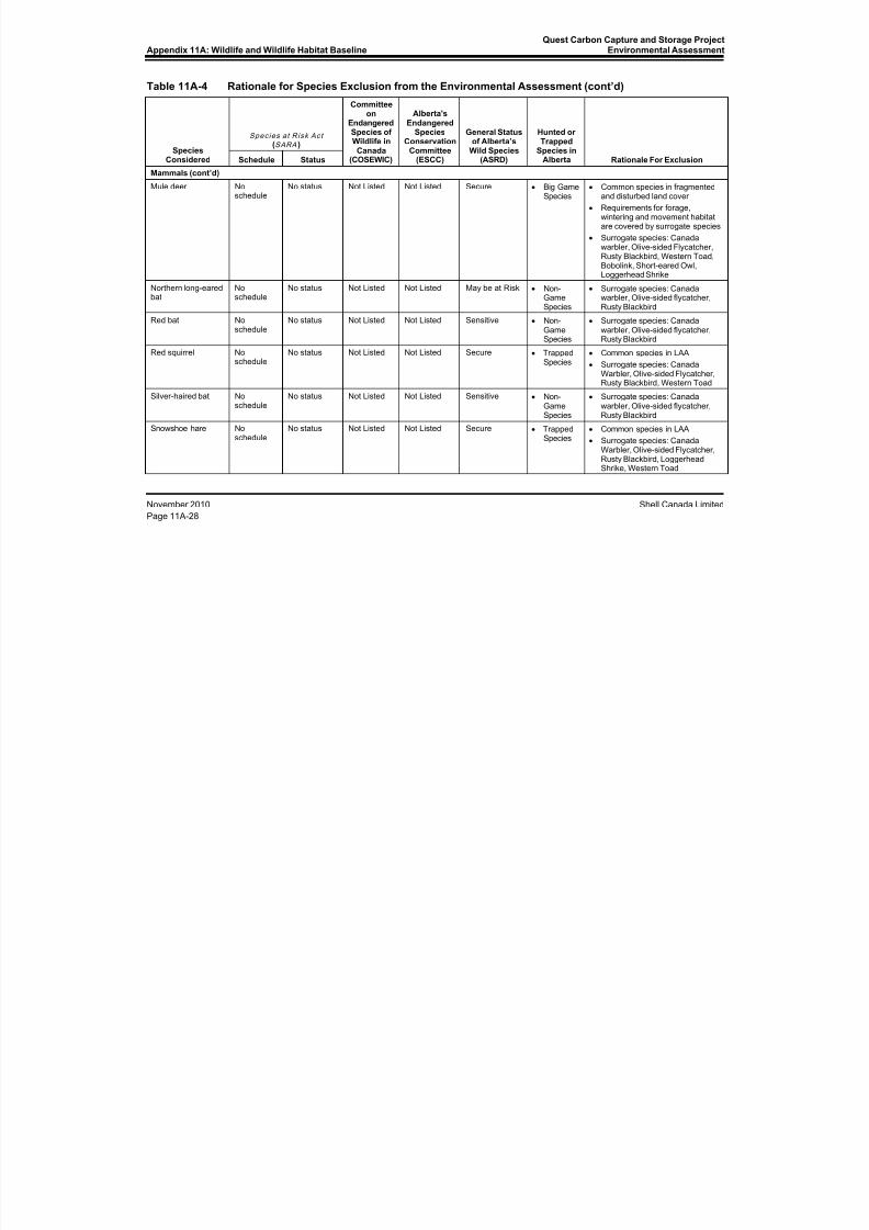
8/21/2019 Quest CCS EIA - Wildlife and Wildlife Habitat (1)
http://slidepdf.com/reader/full/quest-ccs-eia-wildlife-and-wildlife-habitat-1 84/141
Appendix 11A: Wildlife and Wildlife Habitat BaselineQuest Carbon Capture and Storage Project
Environmental Assessment
November 2010 Shell Canada Limited
Page 11A-28
Table 11A-4 Rationale for Species Exclusion from the Environmental Assessment (cont’d)
SpeciesConsidered
Species at Risk Act (SARA )
Committeeon
EndangeredSpecies ofWildlife inCanada
(COSEWIC)
Alberta'sEndangered
SpeciesConservation
Committee(ESCC)
General Statusof Alberta’s
Wild Species(ASRD)
Hunted orTrapped
Species inAlberta Rationale For ExclusionSchedule Status
Mammals (cont’d)Mule deer No
scheduleNo status Not Listed Not Listed Secure • Big Game
Species• Common species in fragmented
and disturbed land cover
• Requirements for forage,wintering and movement habitatare covered by surrogate species
• Surrogate species: Canadawarbler, Olive-sided Flycatcher,Rusty Blackbird, Western Toad,Bobolink, Short-eared Owl,Loggerhead Shrike
Northern long-earedbat
Noschedule
No status Not Listed Not Listed May be at Risk • Non-GameSpecies
• Surrogate species: Canadawarbler, Olive-sided flycatcher,Rusty Blackbird
Red bat Noschedule
No status Not Listed Not Listed Sensitive • Non-GameSpecies
• Surrogate species: Canadawarbler, Olive-sided flycatcher,Rusty Blackbird
Red squirrel Noschedule
No status Not Listed Not Listed Secure • TrappedSpecies
• Common species in LAA
• Surrogate species: CanadaWarbler, Olive-sided Flycatcher,Rusty Blackbird, Western Toad
Silver-haired bat Noschedule
No status Not Listed Not Listed Sensitive • Non-GameSpecies
• Surrogate species: Canadawarbler, Olive-sided flycatcher,Rusty Blackbird
Snowshoe hare Noschedule
No status Not Listed Not Listed Secure • TrappedSpecies
• Common species in LAA
• Surrogate species: CanadaWarbler, Olive-sided Flycatcher,Rusty Blackbird, LoggerheadShrike, Western Toad
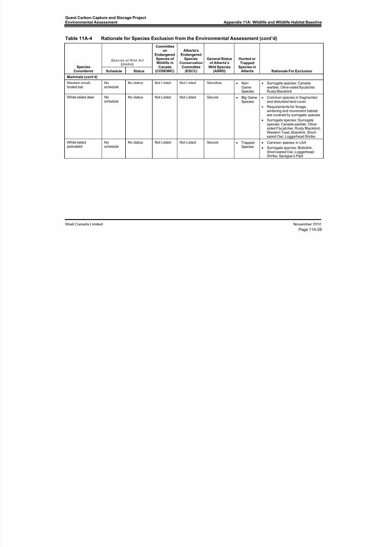
8/21/2019 Quest CCS EIA - Wildlife and Wildlife Habitat (1)
http://slidepdf.com/reader/full/quest-ccs-eia-wildlife-and-wildlife-habitat-1 85/141
Quest Carbon Capture and Storage ProjectEnvironmental Assessment Appendix 11A: Wildlife and Wildlife Habitat Baseline
Shell Canada Limited November 2010
Page 11A-29
Table 11A-4 Rationale for Species Exclusion from the Environmental Assessment (cont’d)
SpeciesConsidered
Species at Risk Act (SARA )
Committeeon
EndangeredSpecies ofWildlife inCanada
(COSEWIC)
Alberta'sEndangered
SpeciesConservation
Committee(ESCC)
General Statusof Alberta’s
Wild Species(ASRD)
Hunted orTrapped
Species inAlberta Rationale For ExclusionSchedule Status
Mammals (cont’d)Western small-footed bat
Noschedule
No status Not Listed Not Listed Sensitive • Non-GameSpecies
• Surrogate species: Canadawarbler, Olive-sided flycatcher,Rusty Blackbird
White-tailed deer Noschedule
No status Not Listed Not Listed Secure • Big GameSpecies
• Common species in fragmentedand disturbed land cover
• Requirements for forage,wintering and movement habitatare covered by surrogate species
• Surrogate species: Surrogatespecies: Canada warbler, Olive-sided Flycatcher, Rusty Blackbird,Western Toad, Bobolink, Short-eared Owl, Loggerhead Shrike
White-tailed jackrabbit
Noschedule
No status Not Listed Not Listed Secure • TrappedSpecies
• Common species in LAA
• Surrogate species: Bobolink,Short-eared Owl, Loggerhead
Shrike, Sprague’s Pipit

8/21/2019 Quest CCS EIA - Wildlife and Wildlife Habitat (1)
http://slidepdf.com/reader/full/quest-ccs-eia-wildlife-and-wildlife-habitat-1 86/141
Appendix 11A: Wildlife and Wildlife HabitatBaseline
Quest Carbon Capture and Storage ProjectEnvironmental Assessment
November 2010 Shell Canada Limited
Page 11A-30
11A.5 Baseline Conditions for Assessment Species
This part of the appendix provides the baseline conditions for each of the species chosen
for the EA on wildlife and wildlife habitat. For the assessment, baseline conditions referto the habitat quality and availability within the LAA. With respect to habitat quality, the
perceived suitability of habitat was based on current published species accounts andresearch, along with the professional judgment of experienced wildlife biologists. Arating of 1 to 4 was assigned to patches of habitat mapped within the LAA. Habitat
considered highly suitable for a given species was rated as “1” while habitat consideredof moderate suitability was rated as “2”. Habitat patches of low suitability were rated as“3”, and a rating of “4” signified habitat that is not suitable for a given species. Thecombination of habitat rated high and moderate was considered to be “key habitat”,which is likely required for the presence of a given species.
Maps were based on an ecosystem mapping process prepared for the entire LAA(see Figure 10A-4). The upland areas of the LAA were mapped by ecosite phase and eachwetland was classified using the Alberta Wetland Inventory classification. Each patch of
habitat also had a general structural stage modifier (e.g., woodland, shrub, grassland).
Detailed mapping methodologies and descriptions of ecosites and wetland classificationsare provided in the vegetation component of the EA (see Appendix 10A).
Zones of influence (ZOIs) were used to enhance the accuracy of the baseline conditionsof habitat. Although habitat may be suitable for a given wildlife species, actual use may
be limited or precluded because of other factors, such as human disturbance. Typically,habitats close to intensive human activities have lower habitat effectiveness thancomparable habitats in remote settings. To incorporate reduced habitat effectiveness as aresult of sensory disturbance, ZOI was defined for each type of human disturbance
identified in the LAA, and a disturbance coefficient (negative or positive) was applied tothe habitat suitability ratings within the ZOI. The ZOIs and disturbance coefficients vary
by species.
11A.5.1 Western Toad
Wetlands and moist shrub habitats constitute key breeding habitat for western toad. Keyhibernation habitat for western toad includes spruce dominated habitats within 2 km of a
wetland, particularly spruce-dominated coniferous forest with complex habitat structure(i.e., subterranean niches) (COSEWIC 2002; Guscio et al. 2007; Browne and Paszkowski2010). Ecosites and land cover units incorporated in key habitat included wetlands, along
with woodland and shrubby structural stages of:
• FONS - shrubby fen
• FTNN - wooded fen
• FONG - graminoid fen
• MONG - ephemeral to temporary marsh• MONG - seasonal to semi-permanent marsh
• SONS - shrubby swamp
• STNN - wooded swamp
• b4 blueberry Sw-PJ
• d3 low-bush cranberry Sw
• e3 dogwood Sw
• h1 labrador tea/horsetail Sw-Sb

8/21/2019 Quest CCS EIA - Wildlife and Wildlife Habitat (1)
http://slidepdf.com/reader/full/quest-ccs-eia-wildlife-and-wildlife-habitat-1 87/141
Quest Carbon Capture and Storage ProjectEnvironmental Assessment
Appendix 11A: Wildlife and Wildlife HabitatBaseline
Shell Canada Limited November 2010
Page 11A-31
• Recently Burned Land
• Water
Additional key habitat included grasslands structural stages of:
• FONS - shrubby fen
• FTNN - wooded fen• FONG - graminoid fen
• MONG - ephemeral to temporary marsh
• MONG - seasonal to semi-permanent marsh
• SONS - shrubby swamp
• STNN - wooded swamp
• Recently Burned
• Water
The presence of western toads in the region indicates that there is suitable habitat.
However, less than 5% of the LAA is considered to be key habitat for the toads(see Table 11A-5; Figure 11A-4). The lack of toad observations within the LAA may be
indicative of the lack of habitat along the alignment of the Project.
Table 11A-5 Baseline Habitat Availability for Western Toad in the LAA
Species SuitabilityRating
Baseline Case
Hectares Percent of Total LAA
All 8930.2 100.0
High 207.6 2.3
Moderate 234.0 2.6
Low 458.7 5.1
Nil 8029.9 89.9

8/21/2019 Quest CCS EIA - Wildlife and Wildlife Habitat (1)
http://slidepdf.com/reader/full/quest-ccs-eia-wildlife-and-wildlife-habitat-1 88/141
BC SK
AB
FIGURE NO.
11A-4
Areaof
Interest
PREPARED FOR
QUEST CARBON CAPTURE AND STORAGE PROJECT
Acknowledgements: Original Drawing by Stantec Pipeline: Sunstone Engineering August 11, 2010, Wells: Shell August 26, 2010, Basedata: National Road Network, Canvec, Altalis
PREPARED BY
Baseline Habitat Availability for theWestern Toad in the LAA
!(
!(
!(
!(
!(
!(
!(
!(
RGE 22 RGE 21 RGE 20 RGE 19RGE 18
W4M
TWP 60
TWP 59
TWP 58
TWP 57
TWP 56
Gibbons
Redwater
Bruderheim
TWP 55
831
18
Lamont
Warspite
Egremont
Radway
Opal
Star
Thorhild
Abee
R e d w a t e r R i v e r
B e a v e r h
N o r t h S a s k a t c h e w a n R i v e r
45
29
28
829
825
8A
651
15
830
827
365000
365000
385000
385000
5 9 6 5 0 0 0
5 9 6 5 0 0 0
5 9 8 5 0 0 0
5 9 8 5 0 0 0
6 0 0 5 0 0 0
6 0 0 5 0 0 0
123510425-134 REVB
2 0 2 4
Kilometres
Local Assessment AreaBoundary
Habitat Suitability
1 - High
2 - Moderate
3 - Low
4 - NIL
Shell Scotford
Major Road
Railway
Watercourse
Waterbody
Urban Area
±
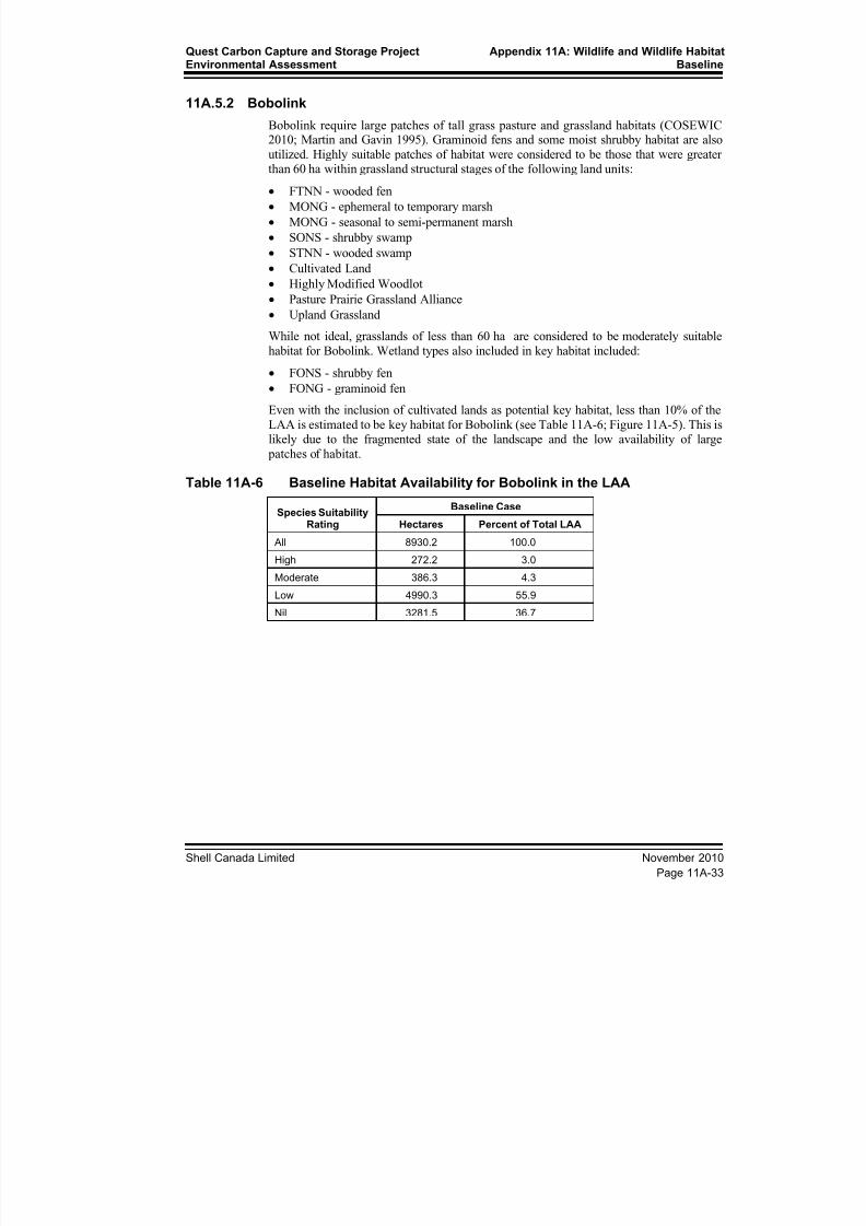
8/21/2019 Quest CCS EIA - Wildlife and Wildlife Habitat (1)
http://slidepdf.com/reader/full/quest-ccs-eia-wildlife-and-wildlife-habitat-1 89/141
Quest Carbon Capture and Storage ProjectEnvironmental Assessment
Appendix 11A: Wildlife and Wildlife HabitatBaseline
Shell Canada Limited November 2010
Page 11A-33
11A.5.2 Bobolink
Bobolink require large patches of tall grass pasture and grassland habitats (COSEWIC2010; Martin and Gavin 1995). Graminoid fens and some moist shrubby habitat are also
utilized. Highly suitable patches of habitat were considered to be those that were greater
than 60 ha within grassland structural stages of the following land units:• FTNN - wooded fen
• MONG - ephemeral to temporary marsh
• MONG - seasonal to semi-permanent marsh
• SONS - shrubby swamp
• STNN - wooded swamp
• Cultivated Land
• Highly Modified Woodlot
• Pasture Prairie Grassland Alliance
• Upland Grassland
While not ideal, grasslands of less than 60 ha are considered to be moderately suitable
habitat for Bobolink. Wetland types also included in key habitat included:
• FONS - shrubby fen
• FONG - graminoid fen
Even with the inclusion of cultivated lands as potential key habitat, less than 10% of the
LAA is estimated to be key habitat for Bobolink (see Table 11A-6; Figure 11A-5). This islikely due to the fragmented state of the landscape and the low availability of large
patches of habitat.
Table 11A-6 Baseline Habitat Availability for Bobolink in the LAA
Species Suitability
Rating
Baseline Case
Hectares Percent of Total LAA All 8930.2 100.0
High 272.2 3.0
Moderate 386.3 4.3
Low 4990.3 55.9
Nil 3281.5 36.7

8/21/2019 Quest CCS EIA - Wildlife and Wildlife Habitat (1)
http://slidepdf.com/reader/full/quest-ccs-eia-wildlife-and-wildlife-habitat-1 90/141
BC SK
AB
FIGURE NO.
11A-5
Areaof
Interest
PREPARED FOR
QUEST CARBON CAPTURE AND STORAGE PROJECT
Acknowledgements: Original Drawing by Stantec Pipeline: Sunstone Engineering August 11, 2010, Wells: Shell August 26, 2010, Basedata: National Road Network, Canvec, Altalis
PREPARED BY
Baseline Habitat Availability for theBobolink in the LAA
!(
!(
!(
!(
!(
!(
!(
!(
RGE 22 RGE 21 RGE 20 RGE 19RGE 18
W4M
TWP 60
TWP 59
TWP 58
TWP 57
TWP 56
Gibbons
Redwater
Bruderheim
TWP 55
831
18
Lamont
Warspite
Egremont
Radway
Opal
Star
Thorhild
Abee
R e d w a t e r R i v e r
B e a v e r h
N o r t h S a s k a t c h e w a n R i v e r
45
29
28
829
825
8A
651
15
830
827
365000
365000
385000
385000
5 9 6 5 0 0 0
5 9 6 5 0 0 0
5 9 8 5 0 0 0
5 9 8 5 0 0 0
6 0 0 5 0 0 0
6 0 0 5 0 0 0
123510425-137 REVB
2 0 2 4
Kilometres
Local Assessment AreaBoundary
Habitat Suitability
1 - High
2 - Moderate
3 - Low
4 - NIL
Shell Scotford
Major Road
Railway
Watercourse
Waterbody
Urban Area
±

8/21/2019 Quest CCS EIA - Wildlife and Wildlife Habitat (1)
http://slidepdf.com/reader/full/quest-ccs-eia-wildlife-and-wildlife-habitat-1 91/141
Quest Carbon Capture and Storage ProjectEnvironmental Assessment
Appendix 11A: Wildlife and Wildlife HabitatBaseline
Shell Canada Limited November 2010
Page 11A-35
11A.5.3 Canada Warbler
Key habitat for Canada Warbler includes coniferous and mixedwood forests with denseshrub undercover (COSEWIC 2008; Reitsma et al. 2010). Ecosites and land cover units
incorporated in key habitat included woodland and shrubby structural stages of:
• a1 (lichen Pj)• b1 (blueberry Pj-As)
• b3 (blueberry Aw-Sw)
• b4 (blueberry Sw-PJ)
• d2 (low-bush cranberry Aw-Sw)
• d3 (low-bush cranberry Sw)
• d4 (Upland Tall Shrubland Alliance)
• e2 dogwood Pb-Sw
• e3 dogwood Sw
• h1 labrador tea/horsetail Sw-Sb
• FONS - shrubby fen
•
FTNN - wooded fen• SONS - shrubby swamp
• STNN - wooded swamp
The majority of the land cover of the LAA is not forested. Therefore, most wildlifespecies associated with forest cover (such as Canada Warbler) have limited habitat
availability. Less than 5% of the LAA is estimated to be key habitat for Canada Warbler(see Table 11A-7; Figure 11A-6).
Table 11A-7 Baseline Habitat Availability for Canada Warbler
Species SuitabilityRating
Baseline Case
Hectares Percent of Total LAA
All 8930.2 100.0
High 207.6 2.3
Moderate 234.0 2.6
Low 458.7 5.1
Nil 8029.9 89.9

8/21/2019 Quest CCS EIA - Wildlife and Wildlife Habitat (1)
http://slidepdf.com/reader/full/quest-ccs-eia-wildlife-and-wildlife-habitat-1 92/141
BC SK
AB
FIGURE NO.
11A-6
Areaof
Interest
PREPARED FOR
QUEST CARBON CAPTURE AND STORAGE PROJECT
Acknowledgements: Original Drawing by Stantec Pipeline: Sunstone Engineering August 11, 2010, Wells: Shell August 26, 2010, Basedata: National Road Network, Canvec, Altalis
PREPARED BY
Baseline Habitat Availability for theCanada Warbler in the LAA
!(
!(
!(
!(
!(
!(
!(
!(
RGE 22 RGE 21 RGE 20 RGE 19RGE 18
W4M
TWP 60
TWP 59
TWP 58
TWP 57
TWP 56
Gibbons
Redwater
Bruderheim
TWP 55
831
18
Lamont
Warspite
Egremont
Radway
Opal
Star
Thorhild
Abee
R e d w a t e r R i v e r
B e a v e r h
N o r t h S a s k a t c h e w a n R i v e r
45
29
28
829
825
8A
651
15
830
827
365000
365000
385000
385000
5 9 6 5 0 0 0
5 9 6 5 0 0 0
5 9 8 5 0 0 0
5 9 8 5 0 0 0
6 0 0 5 0 0 0
6 0 0 5 0 0 0
123510425-133 REVB
2 0 2 4
Kilometres
Local Assessment AreaBoundary
Habitat Suitability
1 - High
2 - Moderate
3 - Low
4 - NIL
Shell Scotford
Major Road
Railway
Watercourse
Waterbody
Urban Area
±

8/21/2019 Quest CCS EIA - Wildlife and Wildlife Habitat (1)
http://slidepdf.com/reader/full/quest-ccs-eia-wildlife-and-wildlife-habitat-1 93/141
Quest Carbon Capture and Storage ProjectEnvironmental Assessment
Appendix 11A: Wildlife and Wildlife HabitatBaseline
Shell Canada Limited November 2010
Page 11A-37
11A.5.4 Common Nighthawk
Key habitat for Common Nighthawk includes open habitats such as recently burnedforests, cleared forests, and natural breaks in forest cover (Poulin et al. 1996). This
species is also present in mixed and coniferous forests, as well as in pine stands
(COSEWIC 2007a; Gauthier and Aubry 1996). Ecosites and land cover unitsincorporated in key habitat included woodland, grassland and shrubby structural stagesof:
• a1 lichen Pj
• b1 blueberry Pj-As
• b4 blueberry Sw-PJ
• e3 dogwood Sw
• h1 labrador tea/horsetail Sw-Sb
• Cultivated Land
• Highly Modified Woodlot
• Pasture Prairie Grassland Alliance
• Recently Burned Land
Key habitat within shrub and grassland structural stages of additional ecosites included:
• b3 blueberry Aw-Sw
• d2 low-bush cranberry Aw-Sw
• d3 low-bush cranberry Sw
• e2 dogwood Pb-Sw
• Disturbed Land
All the habitat rated as highly suitable equated to the forested area north of Bruderheimthat burned in 2009 (see Table 11A-8 Figure 11A-7). Most of the rest of the LAAcontains open habitats such as cultivated and pasture lands. These habitat types are
moderately suitable to Common Nighthawk as foraging habitat and potentially nesting
habitat (Poulin et al. 1996; COSEWIC 2007a).
Table 11A-8 Baseline Habitat Availability for Common Nighthawk
Species SuitabilityRating
Baseline Case
Hectares Percent of Total LAA
All 8930.2 100.0
High 585.1 6.6
Moderate 6817.7 76.3
Low 420.7 4.7
Nil 1106.8 12.4

8/21/2019 Quest CCS EIA - Wildlife and Wildlife Habitat (1)
http://slidepdf.com/reader/full/quest-ccs-eia-wildlife-and-wildlife-habitat-1 94/141
BC SK
AB
FIGURE NO.
11A-7
Areaof
Interest
PREPARED FOR
QUEST CARBON CAPTURE AND STORAGE PROJECT
Acknowledgements: Original Drawing by Stantec Pipeline: Sunstone Engineering August 11, 2010, Wells: Shell August 26, 2010, Basedata: National Road Network, Canvec, Altalis
PREPARED BY
Baseline Habitat Availability for theCommon Nighthawk in the LAA
!(
!(
!(
!(
!(
!(
!(
!(
RGE 22 RGE 21 RGE 20 RGE 19RGE 18
W4M
TWP 60
TWP 59
TWP 58
TWP 57
TWP 56
Gibbons
Redwater
Bruderheim
TWP 55
831
18
Lamont
Warspite
Egremont
Radway
Opal
Star
Thorhild
Abee
R e d w a t e r R i v e r
B e a v e r h
N o r t h S a s k a t c h e w a n R i v e r
45
29
28
829
825
8A
651
15
830
827
365000
365000
385000
385000
5 9 6 5 0 0 0
5 9 6 5 0 0 0
5 9 8 5 0 0 0
5 9 8 5 0 0 0
6 0 0 5 0 0 0
6 0 0 5 0 0 0
123510425-132 REVB
2 0 2 4
Kilometres
Local Assessment AreaBoundary
Habitat Suitability
1 - High
2 - Moderate
3 - Low
4 - NIL
Shell Scotford
Major Road
Railway
Watercourse
Waterbody
Urban Area
±
8/21/2019 Quest CCS EIA - Wildlife and Wildlife Habitat (1)
http://slidepdf.com/reader/full/quest-ccs-eia-wildlife-and-wildlife-habitat-1 95/141
Quest Carbon Capture and Storage ProjectEnvironmental Assessment
Appendix 11A: Wildlife and Wildlife HabitatBaseline
Shell Canada Limited November 2010
Page 11A-39
11A.5.5 Loggerhead Shrike
Key habitat for Loggerhead Shrike includes open pasture for foraging and shrubbyhabitat for nesting (COSEWIC 2004; Yosef 1996). Ecosites and land cover units
incorporated in key habitat include shrub and grassland within Pasture Prairie Grassland
Alliance and shrubby structural stages of:• d1 low-bush cranberry Aw
• d4 Upland Tall Shrubland Alliance
• e1 dogwood Pb-Aw
• f1 horsetail Pb-Aw
• Highly Modified Woodlot
Less than 5% of the LAA is considered to contain key Loggerhead Shrike habitat(see Table 11A-9; Figure 11A-8). The majority of the key habitat is considered to be ofonly moderate suitability to this species normally associated with prairie habitats.
Table 11A-9 Baseline Habitat Availability for Loggerhead Shrike
Species SuitabilityRating
Baseline Case
Hectares Percent of Total LAA
All 8930.2 100.0
High 21.0 0.2
Moderate 409.5 4.6
Low 54.0 0.6
Nil 8445.8 94.6
8/21/2019 Quest CCS EIA - Wildlife and Wildlife Habitat (1)
http://slidepdf.com/reader/full/quest-ccs-eia-wildlife-and-wildlife-habitat-1 96/141
BC SK
AB
FIGURE NO.
11A-8
Areaof
Interest
PREPARED FOR
QUEST CARBON CAPTURE AND STORAGE PROJECT
Acknowledgements: Original Drawing by Stantec Pipeline: Sunstone Engineering August 11, 2010, Wells: Shell August 26, 2010, Basedata: National Road Network, Canvec, Altalis
PREPARED BY
Baseline Habitat Availability for theLoggerhead Shrikes in the LAA
!(
!(
!(
!(
!(
!(
!(
!(
RGE 22 RGE 21 RGE 20 RGE 19RGE 18
W4M
TWP 60
TWP 59
TWP 58
TWP 57
TWP 56
Gibbons
Redwater
Bruderheim
TWP 55
831
18
Lamont
Warspite
Egremont
Radway
Opal
Star
Thorhild
Abee
R e d w a t e r R i v e r
B e a v e r h
N o r t h S a s k a t c h e w a n R i v e r
45
29
28
829
825
8A
651
15
830
827
365000
365000
385000
385000
5 9 6 5 0 0 0
5 9 6 5 0 0 0
5 9 8 5 0 0 0
5 9 8 5 0 0 0
6 0 0 5 0 0 0
6 0 0 5 0 0 0
123510425-143 REVB
2 0 2 4
Kilometres
Local Assessment AreaBoundary
Habitat Suitability
1 - High
2 - Moderate
3 - Low
4 - NIL
Shell Scotford
Major Road
Railway
Watercourse
Waterbody
Urban Area
±
8/21/2019 Quest CCS EIA - Wildlife and Wildlife Habitat (1)
http://slidepdf.com/reader/full/quest-ccs-eia-wildlife-and-wildlife-habitat-1 97/141
Quest Carbon Capture and Storage ProjectEnvironmental Assessment
Appendix 11A: Wildlife and Wildlife HabitatBaseline
Shell Canada Limited November 2010
Page 11A-41
11A.5.6 Olive-Sided Flycatcher
Key habitat for Olive-Sided Flycatcher includes wet coniferous and mixedwood foresttypes that include natural breaks in forest cover (COSEWIC 2007b; Altman and
Sallabanks 2000). Ecosites and land cover units incorporated in key habitat included:
• FONS - shrubby fen• FTNN - wooded fen
• FONG - graminoid fen
• SONS - shrubby swamp
• STNN - wooded swamp
• MONG - ephemeral to temporary marsh
• MONG - seasonal to semi-permanent marsh
• Highly Modified Woodlot
• Recently Burned Land
• Water
The first 50 m from habitat edges within the following ecosites:
• d4 Upland Tall Shrubland Alliance
• a1 lichen Pj
• b1 blueberry Pj-As
• b3 blueberry Aw-Sw
• b4 blueberry Sw-PJ
• d2 low-bush cranberry Aw-Sw
• d3 low-bush cranberry Sw
• e2 dogwood Pb-Sw
• e3 dogwood Sw
• h1 labrador tea/horsetail Sw-Sb
Key shrub structural stages within recently burned ecosites included:
• FONS - shrubby fen
• FTNN - wooded fen
• SONS - shrubby swamp
• STNN - wooded swamp
• a1 lichen Pj
• b1 blueberry Pj-As
• b3 blueberry Aw-Sw
• b4 blueberry Sw-PJ
• d2 low-bush cranberry Aw-Sw
• d3 low-bush cranberry Sw
•
e2 dogwood Pb-Sw• e3 dogwood Sw
• h1 labrador tea/horsetail Sw-Sb
Less than 5% of the LAA is considered to contain key Olive-Sided Flycatcher habitat(see Table 11A-10; Figure 11A-9). The single Olive-Sided Flycatcher (observed in theLAA during the 2010 breeding bird survey) was detected in habitat rated as moderately
suitable.

8/21/2019 Quest CCS EIA - Wildlife and Wildlife Habitat (1)
http://slidepdf.com/reader/full/quest-ccs-eia-wildlife-and-wildlife-habitat-1 98/141
BC SK
AB
FIGURE NO.
11A-9
Areaof
Interest
PREPARED FOR
QUEST CARBON CAPTURE AND STORAGE PROJECT
Acknowledgements: Original Drawing by Stantec Pipeline: Sunstone Engineering August 11, 2010, Wells: Shell August 26, 2010, Basedata: National Road Network, Canvec, Altalis
PREPARED BY
Baseline Habitat Availability for theOlive-sided Flycatcher in the LAA
!(
!(
!(
!(
!(
!(
!(
!(
RGE 22 RGE 21 RGE 20 RGE 19RGE 18
W4M
TWP 60
TWP 59
TWP 58
TWP 57
TWP 56
Gibbons
Redwater
Bruderheim
TWP 55
831
18
Lamont
Warspite
Egremont
Radway
Opal
Star
Thorhild
Abee
R e d w a t e r R i v e r
B e a v e r h
N o r t h S a s k a t c h e w a n R i v e r
45
29
28
829
825
8A
651
15
830
827
365000
365000
385000
385000
5 9 6 5 0 0 0
5 9 6 5 0 0 0
5 9 8 5 0 0 0
5 9 8 5 0 0 0
6 0 0 5 0 0 0
6 0 0 5 0 0 0
123510425-138 REVB
2 0 2 4
Kilometres
Local Assessment AreaBoundary
Habitat Suitability
1 - High
2 - Moderate
3 - Low
4 - NIL
Shell Scotford
Major Road
Railway
Watercourse
Waterbody
Urban Area
±

8/21/2019 Quest CCS EIA - Wildlife and Wildlife Habitat (1)
http://slidepdf.com/reader/full/quest-ccs-eia-wildlife-and-wildlife-habitat-1 99/141
Quest Carbon Capture and Storage ProjectEnvironmental Assessment
Appendix 11A: Wildlife and Wildlife HabitatBaseline
Shell Canada Limited November 2010
Page 11A-43
Table 11A-10 Baseline Habitat Availability for Olive-Sided Flycatcher
Species SuitabilityRating
Baseline Case
Hectares Percent of Total LAA
All 8930.2 100.0
High 18.9 0.2
Moderate 385.8 4.3
Low 73.1 0.8
Nil 8452.4 94.6
11A.5.7 Rusty Blackbird
Key habitat for Rusty Blackbird includes recent burns, sedge meadows and riparian edgesof conifer habitat (COSEWIC 2006; Avery 1995). Riparian habitat was represented bywoodland and shrub structural stages in the following ecosites and land cover units
within 50 m of water:
• a1 lichen Pj
• b1 blueberry Pj-As
• b3 blueberry Aw-Sw
• b4 blueberry Sw-PJ
• d2 low-bush cranberry Aw-Sw
• d3 low-bush cranberry Sw
• d4 Upland Tall Shrubland Alliance
• e2 dogwood Pb-Sw
• e3 dogwood Sw
• h1 labrador tea/horsetail Sw-Sb
• FONS - shrubby fen
• FTNN - wooded fen• FONG - graminoid fen
• SONS - shrubby swamp
• STNN - wooded swamp
• Highly Modified Woodlot
• Recently Burned Land
Woodland and shrubby structural stages of ecosites considered to be key habitat morethan 50 m from water include:
• FONS - shrubby fen
• FTNN - wooded fen
• FONG - graminoid fen
• SONS - shrubby swamp
• STNN - wooded swamp
Grassland structural stages of the following wetlands were considered to be key habitat:
• FONS - shrubby fen
• FTNN - wooded fen
• FONG - graminoid fen

8/21/2019 Quest CCS EIA - Wildlife and Wildlife Habitat (1)
http://slidepdf.com/reader/full/quest-ccs-eia-wildlife-and-wildlife-habitat-1 100/141
Appendix 11A: Wildlife and Wildlife HabitatBaseline
Quest Carbon Capture and Storage ProjectEnvironmental Assessment
November 2010 Shell Canada Limited
Page 11A-44
Highly suitable habitat was predicted to be present in the LAA relative to moderatelysuitable habitat. However, the total amount of key habitat for Rusty Blackbird was
estimated to be relatively rare in the LAA (see Table 11A-11; Figure 11A-10).
Table 11A-11 Baseline Habitat Availability for Rusty Blackbird
Species SuitabilityRating
Baseline Case
Hectares Percent of Total LAA
All 8930.2 100.0
High 194.5 2.2
Moderate 79.2 0.9
Low 153.0 1.7
Nil 8503.5 95.2
11A.5.8 Short-Eared Owl
Key habitat for Short-Eared Owl includes large open spaces that include grasslands,temporary ponds, ephemeral wetlands and wetland edges (Clayton 2000; Wiggins et al.
2006). Areas of more than 50 ha within the grassland structural stages of the followingecosites and land cover units were considered to be more suitable relative to patches lessthan 50 ha but more than 25 ha. Patches less than 25 ha were not considered to be keyhabitat. Cultivated lands were included as key habitat because of their potential use forforaging. However, the area included is over-estimated because Short-Eared Owl activity
is normally restricted to grain field stubble (Clayton 2000) and ungrazed pasture (Kantrudand Higgins 1992). The specific land use practices within cultivated and pasture landswas not quantified, thus the quantification of habitat availability is a conservativeestimate (see Table 11A-12; Figure 11A-11).
• FONG - graminoid fen
• Cultivated Land• Highly Modified Woodlot
• Pasture Prairie Grassland Alliance
Table 11A-12 Baseline Habitat Availability for Short-Eared Owl
Species SuitabilityRating
Baseline Case
Hectares Percent of Total LAA
All 8930.2 100.0
High 61.3 0.7
Moderate 2732.9 30.6
Low 389.9 4.4
Nil 5746.1 64.3

8/21/2019 Quest CCS EIA - Wildlife and Wildlife Habitat (1)
http://slidepdf.com/reader/full/quest-ccs-eia-wildlife-and-wildlife-habitat-1 101/141
BC SK
AB
FIGURE NO.
11A-10
Areaof
Interest
PREPARED FOR
QUEST CARBON CAPTURE AND STORAGE PROJECT
Acknowledgements: Original Drawing by Stantec Pipeline: Sunstone Engineering August 11, 2010, Wells: Shell August 26, 2010, Basedata: National Road Network, Canvec, Altalis
PREPARED BY
Baseline Habitat Availability for theRusty Blackbird in the LAA
!(
!(
!(
!(
!(
!(
!(
!(
RGE 22 RGE 21 RGE 20 RGE 19RGE 18
W4M
TWP 60
TWP 59
TWP 58
TWP 57
TWP 56
Gibbons
Redwater
Bruderheim
TWP 55
831
18
Lamont
Warspite
Egremont
Radway
Opal
Star
Thorhild
Abee
R e d w a t e r R i v e r
B e a v e r h
N o r t h S a s k a t c h e w a n R i v e r
45
29
28
829
825
8A
651
15
830
827
365000
365000
385000
385000
5 9 6 5 0 0 0
5 9 6 5 0 0 0
5 9 8 5 0 0 0
5 9 8 5 0 0 0
6 0 0 5 0 0 0
6 0 0 5 0 0 0
123510425-135 REVB
2 0 2 4
Kilometres
Local Assessment AreaBoundary
Habitat Suitability
1 - High
2 - Moderate
3 - Low
4 - NIL
Shell Scotford
Major Road
Railway
Watercourse
Waterbody
Urban Area
±

8/21/2019 Quest CCS EIA - Wildlife and Wildlife Habitat (1)
http://slidepdf.com/reader/full/quest-ccs-eia-wildlife-and-wildlife-habitat-1 102/141
BC SK
AB
FIGURE NO.
11A-11
Areaof
Interest
PREPARED FOR
QUEST CARBON CAPTURE AND STORAGE PROJECT
Acknowledgements: Original Drawing by Stantec Pipeline: Sunstone Engineering August 11, 2010, Wells: Shell August 26, 2010, Basedata: National Road Network, Canvec, Altalis
PREPARED BY
Baseline Habitat Availability for theShort-eared Owl in the LAA
!(
!(
!(
!(
!(
!(
!(
!(
RGE 22 RGE 21 RGE 20 RGE 19RGE 18
W4M
TWP 60
TWP 59
TWP 58
TWP 57
TWP 56
Gibbons
Redwater
Bruderheim
TWP 55
831
18
Lamont
Warspite
Egremont
Radway
Opal
Star
Thorhild
Abee
R e d w a t e r R i v e r
B e a v e r h
N o r t h S a s k a t c h e w a n R i v e r
45
29
28
829
825
8A
651
15
830
827
365000
365000
385000
385000
5 9 6 5 0 0 0
5 9 6 5 0 0 0
5 9 8 5 0 0 0
5 9 8 5 0 0 0
6 0 0 5 0 0 0
6 0 0 5 0 0 0
123510425-136 REVB
2 0 2 4
Kilometres
Local Assessment AreaBoundary
Habitat Suitability
1 - High
2 - Moderate
3 - Low
4 - NIL
Shell Scotford
Major Road
Railway
Watercourse
Waterbody
Urban Area
±
8/21/2019 Quest CCS EIA - Wildlife and Wildlife Habitat (1)
http://slidepdf.com/reader/full/quest-ccs-eia-wildlife-and-wildlife-habitat-1 103/141
Quest Carbon Capture and Storage ProjectEnvironmental Assessment
Appendix 11A: Wildlife and Wildlife HabitatBaseline
Shell Canada Limited November 2010
Page 11A-47
11A.5.9 Sprague’s Pipit
Key habitat for Sprague’s Pipit includes grasslands, preferably native mixed-grass prairiewith grasses of intermediate height and density (Robbins and Dale 1999; Environment
Canada 2008). Key grassland habitat was found within the Pasture Prairie Grassland
Alliance land cover unit. The highly specific habitat characteristics required by Sprague’sPipit likely constitute only a small proportion of Pasture Prairie Grassland Alliance landunit. Therefore, the summation of key habitat for the species is considered to beconservative and over-estimated (Table 11A-13; Figure 11A-12).
Table 11A-13 Baseline Habitat Availability for Sprague’s Pipit
Species SuitabilityRating
Baseline Case
Hectares Percent of Total LAA
All 8930.2 100.0
High 0.0 0.0
Moderate 124.2 1.4
Low 336.1 3.8
Nil 8470.0 94.8
11A.5.10 Yellow Rail
Key habitat for Yellow Rail is restricted to moist graminoid habitat (COSEWIC 2001;Bookhout 1995). This habitat is represented by the FONG - graminoid fen ecosite alone.Very little key habitat is located within the LAA at baseline (see Table 11A-14;
Figure 11A-13).
Table 11A-14 Baseline Habitat Availability for Yellow Rail
Species SuitabilityRating
Baseline CaseHectares Percent of Total LAA
All 8930.2 100.0
High 0.0 0.0
Moderate 3.6 0.04
Low 0.0 0.0
Nil 8926.5 99.96
11A.5.11 Horned Grebe
Horned Grebe are associated with wetlands, dugouts and ponds with 0.3 to 2.0 ha of open
water (COSEWIC 2009). Approximately 16 wetlands that fit this criteria are available inthe LAA. The area of wetlands available to Horned Grebe at baseline is estimated to be564.3 ha (see Figure 11A-14).
8/21/2019 Quest CCS EIA - Wildlife and Wildlife Habitat (1)
http://slidepdf.com/reader/full/quest-ccs-eia-wildlife-and-wildlife-habitat-1 104/141
BC SK
AB
FIGURE NO.
11A-12
Areaof
Interest
PREPARED FOR
QUEST CARBON CAPTURE AND STORAGE PROJECT
Acknowledgements: Original Drawing by Stantec Pipeline: Sunstone Engineering August 11, 2010, Wells: Shell August 26, 2010, Basedata: National Road Network, Canvec, Altalis
PREPARED BY
Baseline Habitat Availability for theSprague's Pipit in the LAA
!(
!(
!(
!(
!(
!(
!(
!(
RGE 22 RGE 21 RGE 20 RGE 19RGE 18
W4M
TWP 60
TWP 59
TWP 58
TWP 57
TWP 56
Gibbons
Redwater
Bruderheim
TWP 55
831
18
Lamont
Warspite
Egremont
Radway
Opal
Star
Thorhild
Abee
R e d w a t e r R i v e r
B e a v e r h
N o r t h S a s k a t c h e w a n R i v e r
45
29
28
829
825
8A
651
15
830
827
365000
365000
385000
385000
5 9 6 5 0 0 0
5 9 6 5 0 0 0
5 9 8 5 0 0 0
5 9 8 5 0 0 0
6 0 0 5 0 0 0
6 0 0 5 0 0 0
123510425-139 REVB
2 0 2 4
Kilometres
Local Assessment AreaBoundary
Habitat Suitability
1 - High
2 - Moderate
3 - Low
4 - NIL
Shell Scotford
Major Road
Railway
Watercourse
Waterbody
Urban Area
±
8/21/2019 Quest CCS EIA - Wildlife and Wildlife Habitat (1)
http://slidepdf.com/reader/full/quest-ccs-eia-wildlife-and-wildlife-habitat-1 105/141
BC SK
AB
FIGURE NO.
11A-13
Areaof
Interest
PREPARED FOR
QUEST CARBON CAPTURE AND STORAGE PROJECT
Acknowledgements: Original Drawing by Stantec Pipeline: Sunstone Engineering August 11, 2010, Wells: Shell August 26, 2010, Basedata: National Road Network, Canvec, Altalis
PREPARED BY
Baseline Habitat Availability for the Yellow Rail in the LAA
!(
!(
!(
!(
!(
!(
!(
!(
RGE 22 RGE 21 RGE 20 RGE 19RGE 18
W4M
TWP 60
TWP 59
TWP 58
TWP 57
TWP 56
Gibbons
Redwater
Bruderheim
TWP 55
831
18
Lamont
Warspite
Egremont
Radway
Opal
Star
Thorhild
Abee
R e d w a t e r R i v e r
B e a v e r h
N o r t h S a s k a t c h e w a n R i v e r
45
29
28
829
825
8A
651
15
830
827
365000
365000
385000
385000
5 9 6 5 0 0 0
5 9 6 5 0 0 0
5 9 8 5 0 0 0
5 9 8 5 0 0 0
6 0 0 5 0 0 0
6 0 0 5 0 0 0
123510425-142 REVB
2 0 2 4
Kilometres
Local Assessment AreaBoundary
Habitat Suitability
1 - High
2 - Moderate
3 - Low
4 - NIL
Shell Scotford
Major Road
Railway
Watercourse
Waterbody
Urban Area
±
8/21/2019 Quest CCS EIA - Wildlife and Wildlife Habitat (1)
http://slidepdf.com/reader/full/quest-ccs-eia-wildlife-and-wildlife-habitat-1 106/141
BC SK
AB
FIGURE NO.
11A-14
Areaof
Interest
PREPARED FOR
QUEST CARBON CAPTURE AND STORAGE PROJECT
Acknowledgements: Original Drawing by Stantec Pipeline: Sunstone Engineering August 11, 2010, Wells: Shell August 26, 2010, Basedata: National Road Network, Canvec, Altalis
PREPARED BY
Baseline Habitat Availability for theHorned Grebe in the LAA
!(
!(
!(
!(
!(
!(
!(
!(
RGE 22 RGE 21 RGE 20 RGE 19RGE 18
W4M
TWP 60
TWP 59
TWP 58
TWP 57
TWP 56
Gibbons
Redwater
Bruderheim
TWP 55
831
18
Lamont
Warspite
Egremont
Radway
Opal
Star
Thorhild
Abee
R e d w a t e r R i v e r
B e a v e r h
N o r t h S a s k a t c h e w a n R i v e r
45
29
28
829
825
8A
651
15
830
827
365000
365000
385000
385000
5 9 6 5 0 0 0
5 9 6 5 0 0 0
5 9 8 5 0 0 0
5 9 8 5 0 0 0
6 0 0 5 0 0 0
6 0 0 5 0 0 0
123510425-144 REVA
2 0 2 4
Kilometres
Local Assessment AreaBoundary
Habitat Suitability
Wetlands, Dugouts and Ponds with0.3 - 2 ha of open water
NIL
Shell Scotford
Major Road
Railway
Watercourse
Waterbody
Urban Area
±
8/21/2019 Quest CCS EIA - Wildlife and Wildlife Habitat (1)
http://slidepdf.com/reader/full/quest-ccs-eia-wildlife-and-wildlife-habitat-1 107/141
Quest Carbon Capture and Storage ProjectEnvironmental Assessment
Appendix 11A: Wildlife and Wildlife HabitatBaseline
Shell Canada Limited November 2010
Page 11A-51
11A.6 Supplemental Surveys
All the baseline survey field work was done before the pipeline was re-routed to the
current North Saskatchewan River crossing, and the re-route south of the Natural Areasnear Bruderheim. The result is that approximately 40% of the current route was not
included in the field surveys. While the re-routes equate to gaps in survey data, themajority of the re-route segments fall outside of sensitive areas of habitat or in habitatrated low to nil for most of the assessment species. For example, the Bruderheim re-route
better avoids the forested habitat associated with the North of Bruderheim and NorthwestBruderheim Natural Areas (see Figure 11A-3). The North Saskatchewan River re-route
passes through mostly cultivated lands.
Though the re-routes now bypass many areas of sensitive habitat, some sensitive areasremain along the Bruderheim re-route. Of the Western Toads recorded during the 2010
field surveys, none of records occurred within the LAA of the current pipeline route.However, some suitable habitat remains to be surveyed along the current alignment. OneOlive-sided Flycatcher was detected in the LAA in 2010, but the current route now
passes through habitat that may support more flycatchers. Also, more than 500 ha of
recently burned habitat is included in the LAA of the Bruderheim route, which isconsidered to be highly suited for Common Nighthawk. Nighthawks require a specializedsurvey methodology that was not conducted in 2010 as part of the baseline surveys.Finally, winter track surveys were not included in the initial scope of the surveys. Tracksurveys would be useful to identify key movement corridors and better determine thewildlife usage of the various habitat types located within the LAA during the winter of
2010/2011. Therefore, supplemental surveys will be conducted in 2011.
While the results from surveys conducted within the current LAA can be used to
extrapolate over the entire Bruderheim route, supplemental surveys will serve thefollowing multiple purposes:
• The North Saskatchewan River crossing and Bruderheim reroute sections will be
surveyed to produce a more complete list of wildlife species and wildlife habitat present in the LAA.
• The presence and abundance of Common Nighthawk within the LAA can be
determined.
• Common Nighthawk surveys conducted at dusk in June will have the potential to
detect the presence of Yellow Rail during a different time period than previouslysurveyed.
• Results from winter track surveys will help identify key areas of the LAA used by
species of management concern such as game animals.
• Data will be collected for validation of the baseline and assessment wildlife models
used in the EA.

8/21/2019 Quest CCS EIA - Wildlife and Wildlife Habitat (1)
http://slidepdf.com/reader/full/quest-ccs-eia-wildlife-and-wildlife-habitat-1 108/141
Appendix 11A: Wildlife and Wildlife HabitatBaseline
Quest Carbon Capture and Storage ProjectEnvironmental Assessment
November 2010 Shell Canada Limited
Page 11A-52
11A.7 References
11A.7.1 Literature Cited
AGRA Earth and Environmental (AGRA). 1998. Shell Scotford Upgrader Environmental Assessment.
Volume 2, Section 13: Wildlife. Prepared for Shell Canada Ltd. Calgary, AB.
Alberta Conservation Association and Alberta Sustainable Resource Development. (ACA/ASRD) 2006. Alberta Volunteer Amphibian Monitoring Program – Participants Manual . Alberta Conservation
Association. Edmonton, AB.
Alberta Sustainable Resource Development. 2005. Sensitive Species Inventory Guidelines. January 2005,
Draft. Alberta Sustainable Resource Development, Fish and Wildlife. Edmonton, AB.
Alvo, R. and M. Robert. 1999. COSEWIC Status Report on the Yellow Rail Coturnicops noveboracensis in Canada. Committee on the Status of Endangered Wildlife in Canada. Ottawa, ON.
AXYS Environmental Consulting (AXYS). 2005. Shell Scotford Upgrader Expansion Project Environmental Impact Assessment. Prepared for Shell Canada Ltd., Calgary, AB.
Bazin, R. and F.B. Baldwin. 2007. Canadian Wildlife Service Standardized Protocol for the Survey ofYellow Rails (Coturnicops noveboracensis) in Prairie and Northern Regions . Canadian WildlifeService. Winnipeg, MB.
Bibby, C.J., N.D. Burgess, D.A. Hill and S.H. Mustoe. 2000. Bird Census Techniques, Second Edition.Academic Press. London, UK.
Browne, C.L. and C.A. Paszkowski. 2010. Hibernation sites of western toads ( Anaxyrus boreas):Characterization and management implications. Herpetological Conservation and Biology 5: 49– 63.
Clayton, K. M. 2000. Status of the Short-eared Owl ( Asio flammeus) in Alberta. Alberta Environment,Fisheries and Wildlife Management Division, and Alberta Conservation Association. Wildlife
Status Report No. 28. Edmonton, AB.Committee on the Status of Endangered Wildlife in Canada (COSEWIC). 2010. COSEWIC assessment
and status report on the Bobolink Dolichonyx oryzivorus in Canada. Committee on the Status ofEndangered Wildlife in Canada. Ottawa, ON.
Committee on the Status of Endangered Wildlife in Canada (COSEWIC). 2009. COSEWIC assessmentand status report on the Horned Grebe Podiceps auritus, Western population and Magdalen
Islands population, in Canada. Committee on the Status of Endangered Wildlife in Canada.
Ottawa, ON.
Committee on the Status of Endangered Wildlife in Canada (COSEWIC). 2008. COSEWIC assessmentand status report on the Canada Warbler Wilsonia canadensis in Canada. Committee on the
Status of Endangered Wildlife in Canada. Ottawa, ON.
Committee on the Status of Endangered Wildlife in Canada (COSEWIC). 2007a. COSEWIC assessmentand status report on the Common Nighthawk Chordeiles minor in Canada. Committee on theStatus of Endangered Wildlife in Canada. Ottawa, ON.
Committee on the Status of Endangered Wildlife in Canada (COSEWIC). 2007b. COSEWIC assessment
and status report on the Olive-sided Flycatcher Contopus cooperi in Canada. Committee on theStatus of Endangered Wildlife in Canada. Ottawa, ON.

8/21/2019 Quest CCS EIA - Wildlife and Wildlife Habitat (1)
http://slidepdf.com/reader/full/quest-ccs-eia-wildlife-and-wildlife-habitat-1 109/141
Quest Carbon Capture and Storage ProjectEnvironmental Assessment
Appendix 11A: Wildlife and Wildlife HabitatBaseline
Shell Canada Limited November 2010
Page 11A-53
Committee on the Status of Endangered Wildlife in Canada (COSEWIC). 2006. COSEWIC assessmentand status report on the Rusty Blackbird Euphagus carolinus in Canada. Committee on the Status
of Endangered Wildlife in Canada. Ottawa, ON.
Committee on the Status of Endangered Wildlife in Canada (COSEWIC). 2004. COSEWIC assessment
and update status report on the Loggerhead Shrike excubitorides subspecies Lanius ludovicianus in Canada. Committee on the Status of Endangered Wildlife in Canada. Ottawa, ON.
Committee on the Status of Endangered Wildlife in Canada (COSEWIC). 2002. COSEWIC assessment
and status report on the western toad Bufo boreas in Canada. Committee on the Status ofEndangered Wildlife in Canada. Ottawa, ON.
Committee on the Status of Endangered Wildlife in Canada. 2001. COSEWIC assessment and statusreport on the yellow rail Coturnicops noveboracensis
Dale, B.C., P.A. Martin and P.S. Taylor. 1997. Effects of hay management on grassland songbirds inSaskatchewan. Wildlife Society Bulletin 25: 616-626.
in Canada. Committee on the Status ofEndangered Wildlife in Canada. Ottawa, ON.
Davis, S.K., D.C. Duncan and M. Skeel. 1999. Distribution and habitat associations of three endemic
grassland songbirds in southern Saskatchewan. Wilson Bulletin 111: 389–396.
Desrochers, A. and S. Hannon. 1997. Gap crossing decisions by forest songbirds during the post-fledging period. Conservation Biology 11: 1,204–1,210.
Eddleman, W.R., F.L. Knopf, B. Meanley, F.A. Reid and R. Zembal. 1988. Conservation of NorthAmerican rallids. Wilson Bulletin 100: 458–475.
Environment Canada. 2008. Recovery Strategy for the Sprague’s Pipit ( Anthus spragueii
Fahrig, L. 2003. Effects of habitat fragmentation on biodiversity. Annual Review of Ecology, Evolutionand Systematics 34: 487–515.
) in Canada.
Species at Risk Act Recovery Strategy Series. Environment Canada, Ottawa.
Fletcher, R.J. and R. Koford. 2003. Spatial responses of Bobolinks ( Dolichonyx oryzivorus) near differenttypes of edges in Northern Iowa. Auk 120: 799–810.
Granholm, S.L. 1983. Bias in Density Estimates due to Movement of Birds. Condor 85: 243–248.
Gauthier J. and Y. Aubry (eds.) 1996. The breeding birds of Québec: atlas of the breeding birds of southern Québec. Association Québécoise des Groupes d'Ornithologues, Province of Québec
Society for the Protection of Birds, Canadian Wildlife Service, Environment Canada (Québecregion), Montréal, QC.
Habib, L., E.M. Bayne and S. Boutin. 2007. Chronic industrial noise affects pairing success and agestructure of ovenbirds Seiurus aurocapilla. Journal of Applied Ecology 44: 176–184.
Hamilton, I.M., J.L. Skilnick, H.Troughton, A.P. Russell and G.L. Powell. 1998. Status of the Canadian
toad (Bufo hemiophrys) in Alberta. Alberta Environmental Protection, Wildlife ManagementDivision, and the Alberta Conservation Association. Wildlife Status Report No. 12. Edmonton,
AB.
Herkert, J.R. 1994. The effects of habitat fragmentation on Midwestern grassland bird communities. Ecological Applications 4: 461–471.
Helzer, C.J. and D.E. Jelinski 1999. The relative importance of patch area and perimeter-area ratio tograssland breeding birds. Ecological Applications 9: 1,448–1,458.
8/21/2019 Quest CCS EIA - Wildlife and Wildlife Habitat (1)
http://slidepdf.com/reader/full/quest-ccs-eia-wildlife-and-wildlife-habitat-1 110/141
Appendix 11A: Wildlife and Wildlife HabitatBaseline
Quest Carbon Capture and Storage ProjectEnvironmental Assessment
November 2010 Shell Canada Limited
Page 11A-54
Infotech. 1989. Environmentally sensitive areas study. Phase 2 report – Technical report . Prepared byInfotech Services and Associates for the Edmonton Metropolitan Regional Planning Commission.
Edmonton, AB.
Johnson, D.H. and L.D. Igl. 2001. Area requirements of grassland birds: a regional perspective. Auk 118:
24–34.
Kantrud, H. A., and K. F. Higgins. 1992. Nest and nest site characteristics of some ground-nesting, non- passerine birds of northern grasslands. Prairie Naturalist 24:67-84.
Lynch, J.F. 1995. Effects of Point Count Duration, Time of Day and Aural Stimuli on Detectability ofMigratory and Resident Bird Species in Quintana Roo, Mexico. In: Monitoring bird populationsby point counts. Albany, California (C.J. Ralph, J.R. Sauer, S. Droege, eds.). USDA ForestService Gen. Tech. Rep. PSW-GTR-149.
Olson, D.H., A.R. Blaustein and R.K. O’Hara. 1986. Mating pattern variability among Western Toad
( Bufo boreas) populations. Oecologia 70: 351–356.
Pinel, H.W., W.W. Smith, and C.R. Wershler. 1991. Alberta Birds, 1971-1980. Volume 1: Non-
passerines. Provincial Museum of Alberta Natural History, Occasional Paper Number 13.
Edmonton, AB.
Rail, J.-F., M. Darveau, A. Desrochers, and J. Huot. 1997. Territorial responses of boreal forest birds tohabitat gaps. Condor 99: 976–980.
Reijnen, R., R. Foppen, C. ter Braak, and J. Thissen. 1995. The effects of car traffic on breeding bird populations in Woodland. Ill. Reduction of density in relation to the proximity of main roads. Journal of Applied Ecology 32: 187–202.
Resources Inventory Committee (RIC). 1998. Inventory Methods for Pond-breeding Amphibians and Painted Turtle. Standards for Components of British Columbia’s Biodiversity No. 37 . Prepared byMinistry of Environment, Lands and Parks, Resources Inventory Branch for the Terrestrial
Ecosystems Task Force, Resources Inventory Committee. Victoria, BC.
Robertson, B.A. and R.L. Hutto. 2007. Is selectively harvested forest an ecological trap for Olive-sidedFlycatchers? Condor 109: 109–121.
Shannon, C.E. and W. Weaver. 1949. The Mathematical Theory of Communication. University of IllinoisPress, Urbana, IL.
Shiu, H.J. and P.F Lee. 2003. Assessing Avian Point-Count Duration and Sample Size Using SpeciesAccumulation Functions. Zoological Studies 42: 357–367.
Smith, W.P., D.J. Twedt, P.B. Hamel, R.P. Ford, D.A. Wiedenfeld and R.B. Cooper. 1998. IncreasingPoint-Count Duration Increases Standard Error. Journal of Field Ornithology 69: 450–456.
Sutter, G.C. and R.M. Brigham. 1998. Avifaunal and habitat changes resulting from conversion of native
prairie to crested wheat grass: Patterns at songbird community and species levels. Canadian
Journal of Zoology 76: 869–875.
TERA Environmental Consultants (TERA). 2007. Wildlife Report for the Corridor Pipeline Expansion Project – Dilbit Pipeline: Summer 2006 and 2007. Prepared for Inter Pipeline. Calgary, AB.
TERA Environmental Consultants (TERA). 2008. Wildlife Survey for the Inter Pipeline (Corridor) Inc.
Corridor Pipeline Expansion Project – Dilbit Pipeline and Products Pipeline: Spring andSummer 2008. Prepared for Inter Pipeline. Calgary, AB.

8/21/2019 Quest CCS EIA - Wildlife and Wildlife Habitat (1)
http://slidepdf.com/reader/full/quest-ccs-eia-wildlife-and-wildlife-habitat-1 111/141
Quest Carbon Capture and Storage ProjectEnvironmental Assessment
Appendix 11A: Wildlife and Wildlife HabitatBaseline
Shell Canada Limited November 2010
Page 11A-55
TERA Environmental Consultants (TERA). 2010. Environmental Assessment for the Proposed ShellCanada Limited Site 4A 8-19-59-20 W4M Well Site and Access Road and Endpoint G 9-9-62-22
W4M Well Site and Access Road . Quest Carbon Capture and Sequestration Project. Prepared forShell Canada Ltd. Calgary, AB.
Trzcinski, M.K., L. Fahrig and G. Merriam. 1999. Independent effects of forest cover and fragmentationon the distribution of forest breeding birds. Ecological Applications 9: 586–593.
Westworth, D.A. and L.J. Knapik. 1987. Significant Natural Features and Landscapes of Strathcona
County. Prepared by D.A. Westworth and Associates Ltd. for Strathcona County, Recreation andParks Division. Sherwood Park, AB.
11A.7.2 Personal Communications
Found, C. 2010. Area Wildlife Biologist, Alberta Sustainable Resource Development. Edmonton, AB.Email communication, July 2010.
11A.7.3 Internet Sites
Alberta’s Industrial Heartland (AIH). 2010. Alberta’s Industrial Heartland. Edmonton, Alberta, Canada.
Accessed August 2010. Available at:http://www.industrialheartland.com/index.php?option=com_frontpage&Itemid=1
Alberta Sustainable Resource Development (ASRD). 2010. The Fisheries and Wildlife Management Information System. Accessed July 2010. Available at:http://srd.alberta.ca/ManagingPrograms/FishWildlifeManagement/FisheriesWildlifeManagementI
nformationSystem/Default.aspx
Alberta Sustainable Resource Development (ASRD). 2005. The General Status of Alberta Wild Species.
2005. Accessed August 2010. Available at:http://www.srd.alberta.ca/BioDiversityStewardship/SpeciesAtRisk/GeneralStatus/Default.aspx
Alberta Tourism, Parks and Recreation (ATPR). 2010. Natural Areas. Accessed August 2010. Availableat: http://www.tpr.alberta.ca/parks/landreferencemanual/naturalareas.aspx
Alberta Tourism, Parks and Recreation (ATPR). 2009. Environmentally Significant Areas. Accessed
August 2010. Available at:http://www.tpr.alberta.ca/parks/heritageinfocentre/environsigareas/default.aspx
Alberta Tourism, Parks, and Recreation (ATPR). 2006. Natural Regions: Alberta's Boreal Forest Natural Region. Accessed August 2010. Available at:http://www.tpr.alberta.ca/parks/heritageinfocentre/naturalregions/borealforest.aspx
Altman, Bob and R. Sallabanks. 2000. Olive-sided Flycatcher (Contopus cooperi), The Birds of NorthAmerica Online (A. Poole, Ed.). Ithaca: Cornell Lab of Ornithology. Accessed August 2010.
Available at: http://bna.birds.cornell.edu/bna/species/502
Avery, M.L. 1995. Rusty Blackbird ( Euphagus carolinus), The Birds of North America Online (A. Poole,Ed.). Ithaca: Cornell Lab of Ornithology. Accessed August 2010. Available at:
http://bna.birds.cornell.edu/bna/species/200
Bookhout, T.A. 1995. Yellow Rail (Coturnicops noveboracensis), The Birds of North America Online(A. Poole, Ed.). Ithaca: Cornell Lab of Ornithology. Accessed August 2010. Available at:http://bna.birds.cornell.edu/bna/species/139

8/21/2019 Quest CCS EIA - Wildlife and Wildlife Habitat (1)
http://slidepdf.com/reader/full/quest-ccs-eia-wildlife-and-wildlife-habitat-1 112/141
Appendix 11A: Wildlife and Wildlife HabitatBaseline
Quest Carbon Capture and Storage ProjectEnvironmental Assessment
November 2010 Shell Canada Limited
Page 11A-56
Poulin, R.G., S.D. Grindal and R.M. Brigham. 1996. Common Nighthawk (Chordeiles minor ), The Birdsof North America Online (A. Poole, Ed.). Ithaca: Cornell Lab of Ornithology. Accessed August
2010. Available at: http://bna.birds.cornell.edu/bna/species/213
Wiggins, D.A., D.W. Holt and S.M. Leasure. 2006. Short-eared Owl ( Asio flammeus), The Birds of North
America Online (A. Poole, Ed.). Ithaca: Cornell Lab of Ornithology. Accessed August 2010.Available at: http://bna.birds.cornell.edu/bna/species/062
Yosef, Reuven. 1996. Loggerhead Shrike ( Lanius ludovicianus), The Birds of North America Online (A.
Poole, Ed.). Ithaca: Cornell Lab of Ornithology. Accessed August 2010. Available at:http://bna.birds.cornell.edu/bna/species/231

8/21/2019 Quest CCS EIA - Wildlife and Wildlife Habitat (1)
http://slidepdf.com/reader/full/quest-ccs-eia-wildlife-and-wildlife-habitat-1 113/141
Quest Carbon Capture and Storage ProjectEnvironmental Assessment
Attachment 11A-1: List of Species from FWMISDatabase and Previous Environmental
Assessments and Basel ine Studies in the Region
Shell Canada Limited November 2010
Attachment 11A-1 List of Species from FWMIS
Database and PreviousEnvironmental Assessments andBaseline Studies in the Region

8/21/2019 Quest CCS EIA - Wildlife and Wildlife Habitat (1)
http://slidepdf.com/reader/full/quest-ccs-eia-wildlife-and-wildlife-habitat-1 114/141
At tachment 11A-1: L ist of Species from FWMISDatabase and Previous Environmental
Assessments and Basel ine Studies in the RegionQuest Carbon Capture and Storage Project
Environmental Assessment
November 2010 Shell Canada Limited
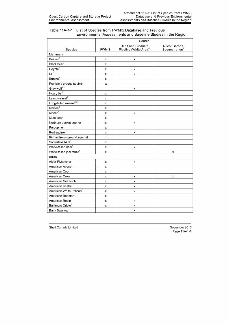
8/21/2019 Quest CCS EIA - Wildlife and Wildlife Habitat (1)
http://slidepdf.com/reader/full/quest-ccs-eia-wildlife-and-wildlife-habitat-1 115/141
Quest Carbon Capture and Storage ProjectEnvironmental Assessment
Attachment 11A-1: List of Species from FWMISDatabase and Previous Environmental
Assessments and Basel ine Studies in the Region
Shell Canada Limited November 2010
Page 11A-1-1
Table 11A-1-1 List of Species from FWMIS Database and PreviousEnvironmental Assessments and Baseline Studies in the Region
Species
Source
FWMIS1
Dilbit and ProductsPipeline (White Area)
2
Quest CarbonSequestration
3
Mammals
Beaver 2 x x
Black bear 1 x
Coyote2 x x
Elk1 x x
Ermine2 x
Franklin's ground squirrel x
Gray wolf 1,2
x
Hoary bat3 x
Least weasel2 x
Long-tailed weasel2,3 x
Marten2 x
Moose1 x x
Mule deer 1 x
Northern pocket gopher x x
Porcupine x
Red squirrel2 x x
Richardson's ground squirrel x
Snowshoe hare1 x
White-tailed deer 1 x x
White-tailed jackrabbit1 x x
Birds
Alder Flycatcher x x
American Avocet x
American Coot1 x
American Crow x x x
American Goldfinch x x
American Kestrel x x American White Pelican
3 x x
American Redstart x
American Robin x x
Baltimore Oriole3 x x
Bank Swallow x
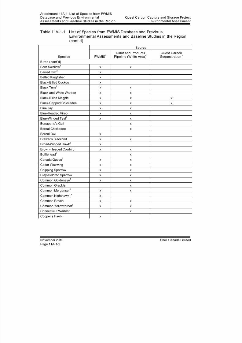
8/21/2019 Quest CCS EIA - Wildlife and Wildlife Habitat (1)
http://slidepdf.com/reader/full/quest-ccs-eia-wildlife-and-wildlife-habitat-1 116/141
At tachment 11A-1: L ist of Species from FWMISDatabase and Previous Environmental
Assessments and Basel ine Studies in the RegionQuest Carbon Capture and Storage Project
Environmental Assessment
November 2010 Shell Canada Limited
Page 11A-1-2
Table 11A-1-1 List of Species from FWMIS Database and PreviousEnvironmental Assessments and Baseline Studies in the Region(cont’d)
Species
Source
FWMIS1
Dilbit and ProductsPipeline (White Area)
2
Quest CarbonSequestration
3
Birds (cont’d)
Barn Swallow3 x x
Barred Owl3 x
Belted Kingfisher x
Black-Billed Cuckoo x
Black Tern3 x x
Black-and-White Warbler x x
Black-Billed Magpie x x xBlack-Capped Chickadee x x x
Blue Jay x x
Blue-Headed Vireo x x
Blue-Winged Teal1 x x
Bonaparte's Gull x
Boreal Chickadee x
Boreal Owl x
Brewer's Blackbird x x
Broad-Winged Hawk3 x
Brown-Headed Cowbird x x
Bufflehead1 x
Canada Goose1 x x
Cedar Waxwing x x
Chipping Sparrow x x
Clay-Colored Sparrow x x
Common Goldeneye1 x x
Common Grackle x
Common Merganser 1 x x
Common Nighthawk3,4
xCommon Raven x x
Common Yellowthroat3 x x
Connecticut Warbler x
Cooper's Hawk x

8/21/2019 Quest CCS EIA - Wildlife and Wildlife Habitat (1)
http://slidepdf.com/reader/full/quest-ccs-eia-wildlife-and-wildlife-habitat-1 117/141
Quest Carbon Capture and Storage ProjectEnvironmental Assessment
Attachment 11A-1: List of Species from FWMISDatabase and Previous Environmental
Assessments and Basel ine Studies in the Region
Shell Canada Limited November 2010
Page 11A-1-3
Table 11A-1-1 List of Species from FWMIS Database and PreviousEnvironmental Assessments and Baseline Studies in the Region(cont’d)
Species
Source
FWMIS1
Dilbit and ProductsPipeline (White Area)
2
Quest CarbonSequestration
3
Birds (cont’d)
Dark-Eyed Junco x x
Downy Woodpecker x x
Eastern Kingbird x
Eastern Phoebe3 x x
European Starling x x
Franklin's Gull x
Gray Catbird x xGray Jay x x
Gray Partridge1 x x
Great Blue Heron3 x x
Great Gray Owl3 x
Great Horned Owl x
Green-Winged Teal1,3
x x
Hairy Woodpecker x
Hermit Thrush x x
Horned Lark x
House Sparrow x
House Wren x x
Killdeer x x
Lark Sparrow x x
Least Flycatcher 3 x x
Le Conte's Sparrow x x
Lesser Scaup1,3
x
Lincoln's Sparrow x
Long-Eared Owl x
Mallard1
x xMarbled Godwit x
Mountain Bluebird x x
Mourning Dove x
Mourning Warbler x x
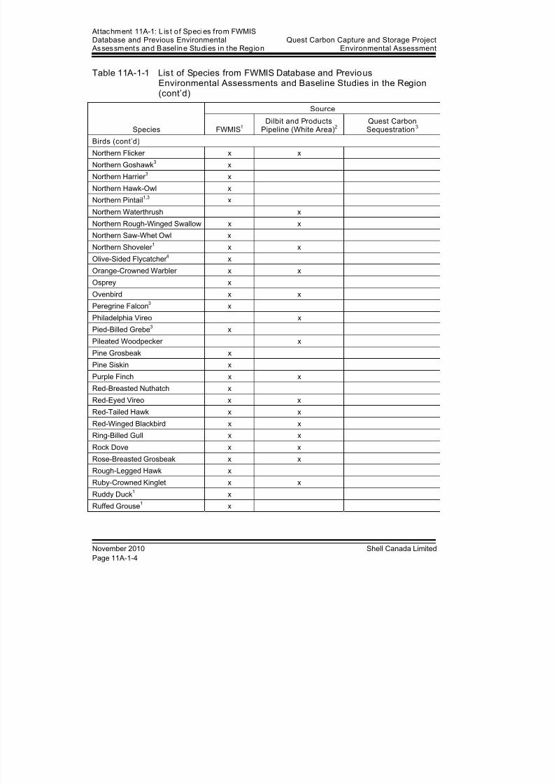
8/21/2019 Quest CCS EIA - Wildlife and Wildlife Habitat (1)
http://slidepdf.com/reader/full/quest-ccs-eia-wildlife-and-wildlife-habitat-1 118/141
At tachment 11A-1: L ist of Species from FWMISDatabase and Previous Environmental
Assessments and Basel ine Studies in the RegionQuest Carbon Capture and Storage Project
Environmental Assessment
November 2010 Shell Canada Limited
Page 11A-1-4
Table 11A-1-1 List of Species from FWMIS Database and PreviousEnvironmental Assessments and Baseline Studies in the Region(cont’d)
Species
Source
FWMIS1
Dilbit and ProductsPipeline (White Area)
2
Quest CarbonSequestration
3
Birds (cont’d)
Northern Flicker x x
Northern Goshawk3 x
Northern Harrier 3 x
Northern Hawk-Owl x
Northern Pintail1,3
x
Northern Waterthrush x
Northern Rough-Winged Swallow x xNorthern Saw-Whet Owl x
Northern Shoveler 1 x x
Olive-Sided Flycatcher 4 x
Orange-Crowned Warbler x x
Osprey x
Ovenbird x x
Peregrine Falcon3 x
Philadelphia Vireo x
Pied-Billed Grebe3 x
Pileated Woodpecker x
Pine Grosbeak x
Pine Siskin x
Purple Finch x x
Red-Breasted Nuthatch x
Red-Eyed Vireo x x
Red-Tailed Hawk x x
Red-Winged Blackbird x x
Ring-Billed Gull x x
Rock Dove x xRose-Breasted Grosbeak x x
Rough-Legged Hawk x
Ruby-Crowned Kinglet x x
Ruddy Duck1 x
Ruffed Grouse1 x
8/21/2019 Quest CCS EIA - Wildlife and Wildlife Habitat (1)
http://slidepdf.com/reader/full/quest-ccs-eia-wildlife-and-wildlife-habitat-1 119/141
Quest Carbon Capture and Storage ProjectEnvironmental Assessment
Attachment 11A-1: List of Species from FWMISDatabase and Previous Environmental
Assessments and Basel ine Studies in the Region
Shell Canada Limited November 2010
Page 11A-1-5
Table 11A-1-1 List of Species from FWMIS Database and PreviousEnvironmental Assessments and Baseline Studies in the Region(cont’d)
Species
Source
FWMIS1
Dilbit and ProductsPipeline (White Area)
2
Quest CarbonSequestration
3
Birds (cont’d)
Sandhill Crane3 x
Savannah Sparrow x x
Sharp-Shinned Hawk x
Sharp-Tailed Grouse1,3
x
Snow Bunting x
Snowy Owl x
Song Sparrow x xSora
3 x x
Spotted Sandpiper x x
Swainson's Hawk3 x
Swainson's Thrush x x
Swamp Sparrow x x
Tennessee Warbler x x
Tree Swallow x x
Turkey Vulture x x
Vesper Sparrow x x
Warbling Vireo x x
Western Kingbird x
Western Tanager 3 x x
Western Wood-Peewee x x
White-Breasted Nuthatch x
White-Throated Sparrow x x
White-Winged Crossbill x
Willet x
Wilson's Phalarope x x
Wilson's Snipe1
x xWinter Wren x
Yellow Warbler x x
Yellow-Bellied Sapsucker x x
Yellow-Headed Blackbird x
Yellow-Rumped Warbler x x
8/21/2019 Quest CCS EIA - Wildlife and Wildlife Habitat (1)
http://slidepdf.com/reader/full/quest-ccs-eia-wildlife-and-wildlife-habitat-1 120/141
At tachment 11A-1: L ist of Species from FWMISDatabase and Previous Environmental
Assessments and Basel ine Studies in the RegionQuest Carbon Capture and Storage Project
Environmental Assessment
November 2010 Shell Canada Limited
Page 11A-1-6
Table 11A-1-1 List of Species from FWMIS Database and PreviousEnvironmental Assessments and Baseline Studies in the Region(cont’d)
Species
Source
FWMIS1
Dilbit and ProductsPipeline (White Area)
2
Quest CarbonSequestration
3
Amphibians
Boreal chorus frog x x
Canadian toad3 x
Tiger salamander x
Western toad4 x x
Wood frog x x
NOTES:1
Hunted in Alberta2Trapped in Alberta
3 Listed by Alberta (ASRD 2005, Internet site)
4 Listed by COSEWIC (2002, 2007a, 2007b)
8/21/2019 Quest CCS EIA - Wildlife and Wildlife Habitat (1)
http://slidepdf.com/reader/full/quest-ccs-eia-wildlife-and-wildlife-habitat-1 121/141
Quest Carbon Capture and Storage ProjectEnvironmental Assessment Attachment 11A-2: 2010 Amphibian Survey Results
Shell Canada Limited November 2010
Attachment 11A-2 2010 Amphibian Survey Results

8/21/2019 Quest CCS EIA - Wildlife and Wildlife Habitat (1)
http://slidepdf.com/reader/full/quest-ccs-eia-wildlife-and-wildlife-habitat-1 122/141
At tachment 11A-2: 2010 Amphibian Survey ResultsQuest Carbon Capture and Storage Project
Environmental Assessment
November 2010 Shell Canada Limited

8/21/2019 Quest CCS EIA - Wildlife and Wildlife Habitat (1)
http://slidepdf.com/reader/full/quest-ccs-eia-wildlife-and-wildlife-habitat-1 123/141
Quest Carbon Capture and Storage ProjectEnvironmental Assessment Attachment 11A-2: 2010 Amphibian Survey Results
Shell Canada Limited November 2010
Page 11A-2-1
Table 11A-2-1 2010 Amphibian Survey Resul ts
Species
Distance of Amphibians f rom
Centreline(m)
Legal LandDescription
UTM Coord inates
Zone Easting Northing
Boreal chorus frog 57 NW-33-055-21W4 12 363411 5963606
147 SW-26-058-20W4 12 377513 5989524
182 SW-17-059-20W4 12 371453 5996224
184 NW-02-060-21W4 12 366799 6003313
203 NW-11-058-20W4 12 377021 5985924
209 NE-09-056-21W4 12 364447 5966726
216 SE-17-059-20W4 12 371971 5995691
222 NW-28-060-21W4 12 363215 6009952
248 NW-14-058-20W4 12 377699 5987182
260 SE-10-058-20W4 12 376960 5984749
271 NW-15-060-21W4 12 364681 6007031323 SE-15-058-20W4 12 376983 5986363
370 NE-33-055-21W4 12 364544 5963559
384 NE-15-060-21W4 12 365938 6006789
466 SW-17-059-20W4 12 371161 5995923
541 SE-11-057-20W4 12 377973 5975134
589 NE-02-060-21W4 12 367698 6003711
639 SE-29-059-20W4 12 372350 5998968
890 SE-03-058-20W4 12 376852 5983035
924 NE-11-057-20W4 12 377649 5975410
1,182 SW-35-057-20W4 12 376902 5981759
1,220 NE-11-057-20W4 12 377587 5975712
1,261 NE-28-056-20W4 12 374852 5971052
1,410 SW-05-060-20W4 12 371255 6002233
1,776 SW-14-057-20W4 12 377413 5976243
1,784 NW-23-056-21W4 12 367287 5969514
2,101 NE-06-060-20W4 12 370535 6003437
2,662 NW-28-056-20W4 12 373394 5970713
2,749 SE-25-056-21W4 12 370013 5970279
3,614 SW-08-061-21W4 12 361566 6014004
4,936 SE-12-061-22W4 12 359408 6014451
5,271 NE-12-061-22W4 12 359753 6015063
7,746 NW-13-061-22W4 12 358475 6017184
8,315 SE-23-061-22W4 12 357597 6017307
9,416 NW-23-061-22W4 12 357134 6018321
12,385 NW-35-061-22W4 12 357634 6021929
12,488 NW-35-061-22W4 12 357619 6022033
8/21/2019 Quest CCS EIA - Wildlife and Wildlife Habitat (1)
http://slidepdf.com/reader/full/quest-ccs-eia-wildlife-and-wildlife-habitat-1 124/141
At tachment 11A-2: 2010 Amphibian Survey ResultsQuest Carbon Capture and Storage Project
Environmental Assessment
November 2010 Shell Canada Limited
Page 11A-2-2
Table 11A-2-1 2010 Amphibian Survey Resul ts (cont’d)
Species
Distance of Amphibians from
Centreline(m)
Legal LandDescription
UTM Coord inates
Zone Easting Northing
Boreal chorus frog(cont’d)
13,923 NW-02-062-22W4 12 357746 6023615
14,217 SW-11-062-22W4 12 357528 6023850
15,626 NW-10-062-22W4 12 355685 6024610
Canadian toad1 897 SE-11-057-20W4 12 377643 5975376
1,237 NE-11-057-20W4 12 377558 5975716
2,666 NW-28-056-20W4 12 373390 5970681
Western toad2 8,315 SE-23-061-22W4 12 357579 6017295
9,396 NW-23-061-22W4 12 357151 6018308
12,380 NW-35-061-22W4 12 357645 6021928
14,211 SW-11-062-22W4 12 357506 6023836
15,639 NW-10-062-22W4 12 355655 6024610Wood frog 167 SW-26-058-20W4 12 377518 5989454
201 NW-28-060-21W4 12 363226 6009931
320 SE-15-058-20W4 12 376979 5986323
391 NE-15-060-21W4 12 365975 6006795
471 SW-17-059-20W4 12 371157 5995954
514 NE-22-058-20W4 12 377073 5988924
577 NW-11-060-21W4 12 366392 6005541
1,767 SW-14-057-20W4 12 377410 5976232
2,663 NW-28-056-20W4 12 373393 5970700
3,451 NE-06-061-21W4 12 361434 6013803
4,946 SE-12-061-22W4 12 359409 6014465
8,298 SE-23-061-22W4 12 357596 6017286
14,240 SW-11-062-22W4 12 357499 6023865
NOTES:1 Listed by Alberta (ASRD 2005, Internet site)
2 Listed by COSEWIC (2002)
8/21/2019 Quest CCS EIA - Wildlife and Wildlife Habitat (1)
http://slidepdf.com/reader/full/quest-ccs-eia-wildlife-and-wildlife-habitat-1 125/141
Quest Carbon Capture and Storage ProjectEnvironmental Assessment
Attachment 11A-3: 2010 Breeding BirdSurvey Results
Shell Canada Limited November 2010
Attachment 11A-3 2010 Breeding BirdSurvey Results

8/21/2019 Quest CCS EIA - Wildlife and Wildlife Habitat (1)
http://slidepdf.com/reader/full/quest-ccs-eia-wildlife-and-wildlife-habitat-1 126/141
At tachment 11A-3: 2010 Breeding BirdSurvey Results
Quest Carbon Capture and Storage ProjectEnvironmental Assessment
November 2010 Shell Canada Limited
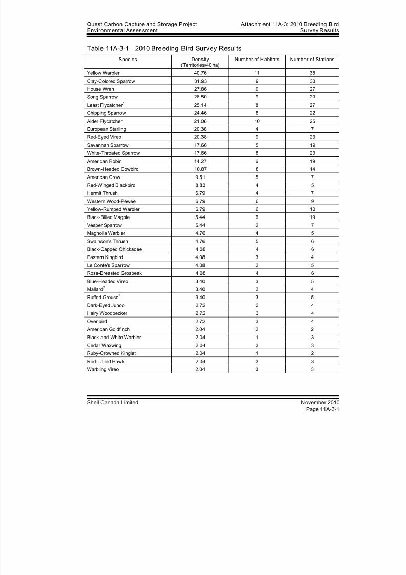
8/21/2019 Quest CCS EIA - Wildlife and Wildlife Habitat (1)
http://slidepdf.com/reader/full/quest-ccs-eia-wildlife-and-wildlife-habitat-1 127/141
Quest Carbon Capture and Storage ProjectEnvironmental Assessment
Attachment 11A-3: 2010 Breeding BirdSurvey Results
Shell Canada Limited November 2010
Page 11A-3-1
Table 11A-3-1 2010 Breeding Bird Survey Resul ts
Species Density(Territories/40 ha)
Number of Habitats Number of Stations
Yellow Warbler 40.76 11 38
Clay-Colored Sparrow 31.93 9 33House Wren 27.86 9 27
Song Sparrow 26.50 9 29
Least Flycatcher 1 25.14 8 27
Chipping Sparrow 24.46 8 22
Alder Flycatcher 21.06 10 25
European Starling 20.38 4 7
Red-Eyed Vireo 20.38 9 23
Savannah Sparrow 17.66 5 19
White-Throated Sparrow 17.66 8 23
American Robin 14.27 6 19
Brown-Headed Cowbird 10.87 8 14
American Crow 9.51 5 7
Red-Winged Blackbird 8.83 4 5
Hermit Thrush 6.79 4 7
Western Wood-Pewee 6.79 6 9
Yellow-Rumped Warbler 6.79 6 10
Black-Billed Magpie 5.44 6 19
Vesper Sparrow 5.44 2 7
Magnolia Warbler 4.76 4 5
Swainson's Thrush 4.76 5 6
Black-Capped Chickadee 4.08 4 6
Eastern Kingbird 4.08 3 4
Le Conte's Sparrow 4.08 2 5
Rose-Breasted Grosbeak 4.08 4 6
Blue-Headed Vireo 3.40 3 5
Mallard2 3.40 2 4
Ruffed Grouse2 3.40 3 5
Dark-Eyed Junco 2.72 3 4
Hairy Woodpecker 2.72 3 4
Ovenbird 2.72 3 4
American Goldfinch 2.04 2 2
Black-and-White Warbler 2.04 1 3
Cedar Waxwing 2.04 3 3
Ruby-Crowned Kinglet 2.04 1 2
Red-Tailed Hawk 2.04 3 3
Warbling Vireo 2.04 3 3

8/21/2019 Quest CCS EIA - Wildlife and Wildlife Habitat (1)
http://slidepdf.com/reader/full/quest-ccs-eia-wildlife-and-wildlife-habitat-1 128/141
At tachment 11A-3: 2010 Breeding BirdSurvey Results
Quest Carbon Capture and Storage ProjectEnvironmental Assessment
November 2010 Shell Canada Limited
Page 11A-3-2
Table 11A-3-1 2010 Breeding Bird Survey Results (cont’d)
Species Density(Territories/40 ha)
Number of Habitats Number of Stations
Boreal Chickadee 1.36 1 1
Common Raven 1.36 2 2Lincoln's Sparrow 1.36 2 2
Olive-Sided Flycatcher 3 1.36 1 2
Red-Breasted Nuthatch 1.36 2 2
American Coot2 0.68 1 1
Blue Jay 0.68 1 1
Brown Creeper 1 0.68 1 1
Cooper's Hawk 0.68 1 1
Franklin's Gull 0.68 1 1
Gray Catbird 0.68 1 1
Mourning Dove 0.68 1 1
Mourning Warbler 0.68 1 1
Northern Pintail1,2
0.68 1 1
Northern Shoveler 2 0.68 1 1
Orange-Crowned Warbler 0.68 1 1
Philadelphia Vireo 0.68 1 1
Purple Finch 0.68 1 1
Spotted Sandpiper 0.68 1 1
Swamp Sparrow 0.68 1 1
Tennessee Warbler 0.68 1 1
Tree Swallow 0.68 1 1
Veery 0.68 1 1
White-Breasted Nuthatch 0.68 1 1
Wilson's Warbler 0.68 1 1
Winter Wren 0.68 1 1
Yellow-Breasted Sapsucker 0.68 1 1
NOTES:1 Listed by Alberta (ASRD 2005, Internet site)
2 Hunted in Alberta
3 Listed by COSEWIC (2007b)
8/21/2019 Quest CCS EIA - Wildlife and Wildlife Habitat (1)
http://slidepdf.com/reader/full/quest-ccs-eia-wildlife-and-wildlife-habitat-1 129/141
Quest Carbon Capture and Storage ProjectEnvironmental Assessment
Attachment 11A-4: Summary of Bird Density,Species Richness and Diversity by Habitat Class
Shell Canada Limited November 2010
Attachment 11A-4 Summary of Bird Density, SpeciesRichness and Diversity by Habitat
Class

8/21/2019 Quest CCS EIA - Wildlife and Wildlife Habitat (1)
http://slidepdf.com/reader/full/quest-ccs-eia-wildlife-and-wildlife-habitat-1 130/141
At tachment 11A-4: Summary of Bird Densi ty,Species Richness and Diversity by Habitat Class
Quest Carbon Capture and Storage ProjectEnvironmental Assessment
November 2010 Shell Canada Limited
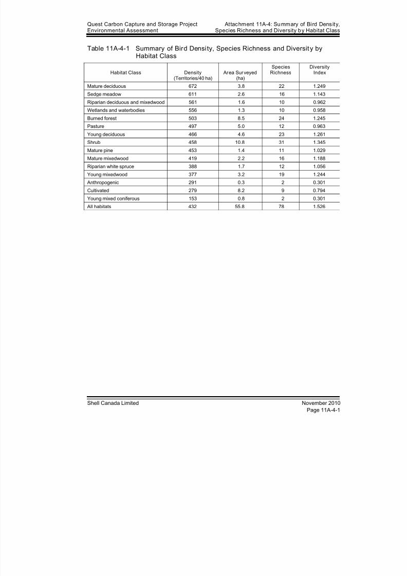
8/21/2019 Quest CCS EIA - Wildlife and Wildlife Habitat (1)
http://slidepdf.com/reader/full/quest-ccs-eia-wildlife-and-wildlife-habitat-1 131/141
Quest Carbon Capture and Storage ProjectEnvironmental Assessment
Attachment 11A-4: Summary of Bird Density,Species Richness and Diversity by Habitat Class
Shell Canada Limited November 2010
Page 11A-4-1
Table 11A-4-1 Summary of Bird Densi ty, Species Richness and Diversit y byHabitat Class
Habitat Class Density(Territories/40 ha)
Area Surveyed(ha)
SpeciesRichness
DiversityIndex
Mature deciduous 672 3.8 22 1.249
Sedge meadow 611 2.6 16 1.143
Riparian deciduous and mixedwood 561 1.6 10 0.962
Wetlands and waterbodies 556 1.3 10 0.958
Burned forest 503 8.5 24 1.245
Pasture 497 5.0 12 0.963
Young deciduous 466 4.6 23 1.261
Shrub 458 10.8 31 1.345
Mature pine 453 1.4 11 1.029
Mature mixedwood 419 2.2 16 1.188
Riparian white spruce 388 1.7 12 1.056
Young mixedwood 377 3.2 19 1.244
Anthropogenic 291 0.3 2 0.301
Cultivated 279 8.2 9 0.794
Young mixed coniferous 153 0.8 2 0.301
All habitats 432 55.8 78 1.526

8/21/2019 Quest CCS EIA - Wildlife and Wildlife Habitat (1)
http://slidepdf.com/reader/full/quest-ccs-eia-wildlife-and-wildlife-habitat-1 132/141
At tachment 11A-4: Summary of Bird Densi ty,Species Richness and Diversity by Habitat Class
Quest Carbon Capture and Storage ProjectEnvironmental Assessment
November 2010 Shell Canada Limited
Page 11A-4-2
8/21/2019 Quest CCS EIA - Wildlife and Wildlife Habitat (1)
http://slidepdf.com/reader/full/quest-ccs-eia-wildlife-and-wildlife-habitat-1 133/141
Quest Carbon Capture and Storage ProjectEnvironmental Assessment
Attachment 11A-5: 2010 Incidental Wildli feObservations in the Regional Assessment Area
Shell Canada Limited November 2010
Attachment 11A-5 2010 Incidental WildlifeObservations in the Regional
Assessment Area

8/21/2019 Quest CCS EIA - Wildlife and Wildlife Habitat (1)
http://slidepdf.com/reader/full/quest-ccs-eia-wildlife-and-wildlife-habitat-1 134/141
At tachment 11A-5: 2010 Incidental Wildli feObservations in the Regional Assessment Area
Quest Carbon Capture and Storage ProjectEnvironmental Assessment
November 2010 Shell Canada Limited
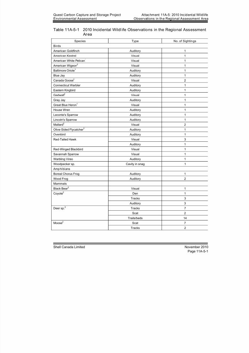
8/21/2019 Quest CCS EIA - Wildlife and Wildlife Habitat (1)
http://slidepdf.com/reader/full/quest-ccs-eia-wildlife-and-wildlife-habitat-1 135/141
Quest Carbon Capture and Storage ProjectEnvironmental Assessment
Attachment 11A-5: 2010 Incidental Wildli feObservations in the Regional Assessment Area
Shell Canada Limited November 2010
Page 11A-5-1
Table 11A-5-1 2010 Incidental Wildl ife Observations in the Regional Assessment Area
Species Type No. of Sightings
Birds
American Goldfinch Auditory 1
American Kestrel Visual 1
American White Pelican1 Visual 1
American Wigeon2 Visual 1
Baltimore Oriole1 Auditory 1
Blue Jay Auditory 1
Canada Goose2 Visual 2
Connecticut Warbler Auditory 1
Eastern Kingbird Auditory 1
Gadwall2 Visual 1
Gray Jay Auditory 1Great Blue Heron
1 Visual 1
House Wren Auditory 1
Leconte's Sparrow Auditory 1
Lincoln's Sparrow Auditory 1
Mallard2 Visual 2
Olive-Sided Flycatcher 3 Auditory 1
Ovenbird Auditory 1
Red-Tailed Hawk Visual 3
Auditory 1
Red-Winged Blackbird Visual 1
Savannah Sparrow Visual 1
Warbling Vireo Auditory 1
Woodpecker sp. Cavity in snag 1
Amphibians
Boreal Chorus Frog Auditory 1
Wood Frog Auditory 2
Mammals
Black Bear 2 Visual 1
Coyote2 Den 1
Tracks 3
Auditory 3
Deer sp.2 Tracks 7
Scat 2
Trails/beds 14
Moose2 Scat 7
Tracks 2

8/21/2019 Quest CCS EIA - Wildlife and Wildlife Habitat (1)
http://slidepdf.com/reader/full/quest-ccs-eia-wildlife-and-wildlife-habitat-1 136/141
At tachment 11A-5: 2010 Incidental Wildli feObservations in the Regional Assessment Area
Quest Carbon Capture and Storage ProjectEnvironmental Assessment
November 2010 Shell Canada Limited
Page 11A-5-2
Table 11A-5-1 2010 Incidental Wildl ife Observations in the Regional Assessment Area (cont’d)
Species Type No. of Sightings
Mammals (cont’d)
Porcupine Signs of foraging 2
Red Fox2 Visual 1
Red Squirrel2 Auditory 6
Vole sp. or Mouse sp. Auditory 1
NOTES:1 Listed by Alberta (ASRD 2005, Internet site)
2 Hunted or Trapped in Alberta
3 Listed by COSEWIC (2007b)

8/21/2019 Quest CCS EIA - Wildlife and Wildlife Habitat (1)
http://slidepdf.com/reader/full/quest-ccs-eia-wildlife-and-wildlife-habitat-1 137/141
Quest Carbon Capture and Storage ProjectEnvironmental Assessment
Attachment 11A-6: Common and Scienti fic Namesof Species
Shell Canada Limited November 2010
Attachment 11A-6 Common and Scientific Namesof Species

8/21/2019 Quest CCS EIA - Wildlife and Wildlife Habitat (1)
http://slidepdf.com/reader/full/quest-ccs-eia-wildlife-and-wildlife-habitat-1 138/141
At tachment 11A-6: Common and Scienti fic Namesof Species
Quest Carbon Capture and Storage ProjectEnvironmental Assessment
November 2010 Shell Canada Limited
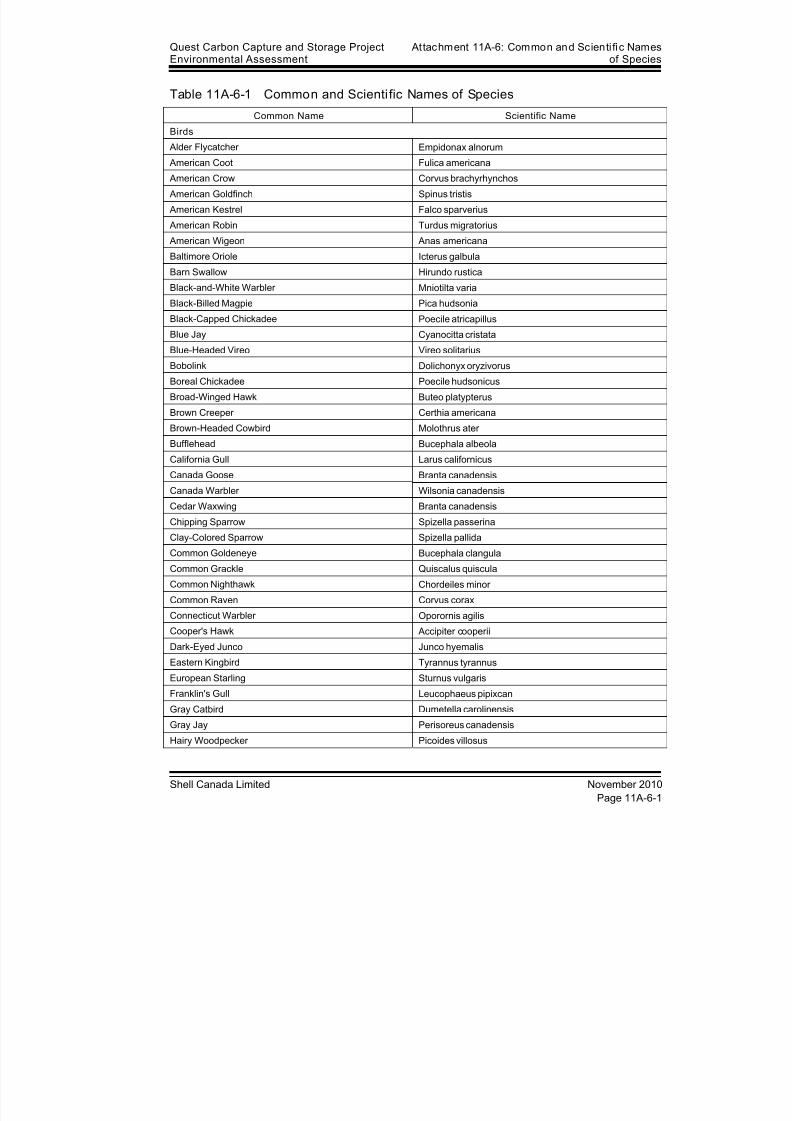
8/21/2019 Quest CCS EIA - Wildlife and Wildlife Habitat (1)
http://slidepdf.com/reader/full/quest-ccs-eia-wildlife-and-wildlife-habitat-1 139/141
Quest Carbon Capture and Storage ProjectEnvironmental Assessment
Attachment 11A-6: Common and Scienti fic Namesof Species
Shell Canada Limited November 2010
Page 11A-6-1
Table 11A-6-1 Common and Scienti fic Names of Species
Common Name Scientific Name
Birds
Alder Flycatcher Empidonax alnorum
American Coot Fulica americana
American Crow Corvus brachyrhynchos
American Goldfinch Spinus tristis
American Kestrel Falco sparverius
American Robin Turdus migratorius
American Wigeon Anas americana
Baltimore Oriole Icterus galbula
Barn Swallow Hirundo rustica
Black-and-White Warbler Mniotilta varia
Black-Billed Magpie Pica hudsonia
Black-Capped Chickadee Poecile atricapillusBlue Jay Cyanocitta cristata
Blue-Headed Vireo Vireo solitarius
Bobolink Dolichonyx oryzivorus
Boreal Chickadee Poecile hudsonicus
Broad-Winged Hawk Buteo platypterus
Brown Creeper Certhia americana
Brown-Headed Cowbird Molothrus ater
Bufflehead Bucephala albeola
California Gull Larus californicus
Canada Goose Branta canadensis
Canada Warbler Wilsonia canadensis
Cedar Waxwing Branta canadensis
Chipping Sparrow Spizella passerina
Clay-Colored Sparrow Spizella pallida
Common Goldeneye Bucephala clangula
Common Grackle Quiscalus quiscula
Common Nighthawk Chordeiles minor
Common Raven Corvus corax
Connecticut Warbler Oporornis agilis
Cooper's Hawk Accipiter cooperii
Dark-Eyed Junco Junco hyemalis
Eastern Kingbird Tyrannus tyrannus
European Starling Sturnus vulgaris
Franklin's Gull Leucophaeus pipixcan
Gray Catbird Dumetella carolinensis
Gray Jay Perisoreus canadensis
Hairy Woodpecker Picoides villosus
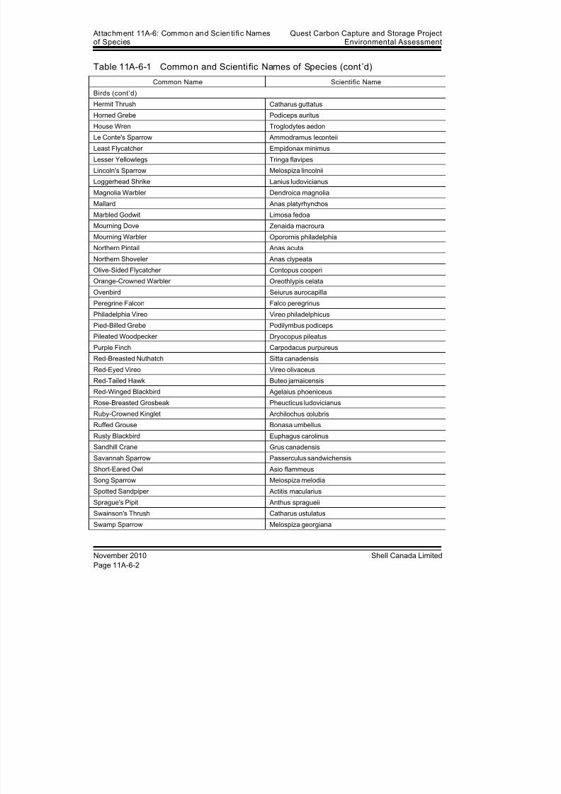
8/21/2019 Quest CCS EIA - Wildlife and Wildlife Habitat (1)
http://slidepdf.com/reader/full/quest-ccs-eia-wildlife-and-wildlife-habitat-1 140/141
At tachment 11A-6: Common and Scienti fic Namesof Species
Quest Carbon Capture and Storage ProjectEnvironmental Assessment
November 2010 Shell Canada Limited
Page 11A-6-2
Table 11A-6-1 Common and Scienti fic Names of Species (cont’d)
Common Name Scientific Name
Birds (cont’d)
Hermit Thrush Catharus guttatus
Horned Grebe Podiceps auritus
House Wren Troglodytes aedon
Le Conte's Sparrow Ammodramus leconteii
Least Flycatcher Empidonax minimus
Lesser Yellowlegs Tringa flavipes
Lincoln's Sparrow Melospiza lincolnii
Loggerhead Shrike Lanius ludovicianus
Magnolia Warbler Dendroica magnolia
Mallard Anas platyrhynchos
Marbled Godwit Limosa fedoa
Mourning Dove Zenaida macrouraMourning Warbler Oporornis philadelphia
Northern Pintail Anas acuta
Northern Shoveler Anas clypeata
Olive-Sided Flycatcher Contopus cooperi
Orange-Crowned Warbler Oreothlypis celata
Ovenbird Seiurus aurocapilla
Peregrine Falcon Falco peregrinus
Philadelphia Vireo Vireo philadelphicus
Pied-Billed Grebe Podilymbus podiceps
Pileated Woodpecker Dryocopus pileatus
Purple Finch Carpodacus purpureus
Red-Breasted Nuthatch Sitta canadensis
Red-Eyed Vireo Vireo olivaceus
Red-Tailed Hawk Buteo jamaicensis
Red-Winged Blackbird Agelaius phoeniceus
Rose-Breasted Grosbeak Pheucticus ludovicianus
Ruby-Crowned Kinglet Archilochus colubris
Ruffed Grouse Bonasa umbellus
Rusty Blackbird Euphagus carolinus
Sandhill Crane Grus canadensis
Savannah Sparrow Passerculus sandwichensis
Short-Eared Owl Asio flammeus
Song Sparrow Melospiza melodia
Spotted Sandpiper Actitis macularius
Sprague's Pipit Anthus spragueii
Swainson's Thrush Catharus ustulatus
Swamp Sparrow Melospiza georgiana
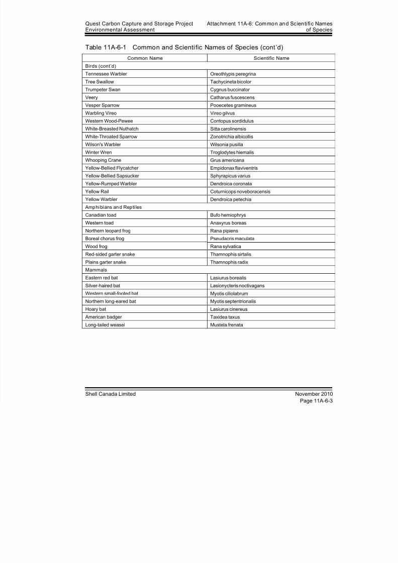
8/21/2019 Quest CCS EIA - Wildlife and Wildlife Habitat (1)
http://slidepdf.com/reader/full/quest-ccs-eia-wildlife-and-wildlife-habitat-1 141/141
Quest Carbon Capture and Storage ProjectEnvironmental Assessment
Attachment 11A-6: Common and Scienti fic Namesof Species
Table 11A-6-1 Common and Scienti fic Names of Species (cont’d)
Common Name Scientific Name
Birds (cont’d)
Tennessee Warbler Oreothlypis peregrina
Tree Swallow Tachycineta bicolor
Trumpeter Swan Cygnus buccinator
Veery Catharus fuscescens
Vesper Sparrow Pooecetes gramineus
Warbling Vireo Vireo gilvus
Western Wood-Pewee Contopus sordidulus
White-Breasted Nuthatch Sitta carolinensis
White-Throated Sparrow Zonotrichia albicollis
Wilson's Warbler Wilsonia pusilla
Winter Wren Troglodytes hiemalis
Whooping Crane Grus americanaYellow-Bellied Flycatcher Empidonax flaviventris
Yellow-Bellied Sapsucker Sphyrapicus varius
Yellow-Rumped Warbler Dendroica coronata
Yellow Rail Coturnicops noveboracensis
Yellow Warbler Dendroica petechia
Amphibians and Repti les
Canadian toad Bufo hemiophrys
Western toad Anaxyrus boreas
Northern leopard frog Rana pipiens
Related Documents