QUALITY ASSURANCE PROJECT PLAN for Hogansburg Dam Removal Pre-Construction Mussel Surveys And Mussel Relocation Site Investigations Prepared for: U.S. Environmental Protection Agency Region 2 and Great Lakes National Program Office Part of: Freshwater Mussel Restoration in the St. Regis River GL-00E01943 Prepared by: Jessica L. Jock St. Regis Mohawk Tribe Environment Division Akwesasne, 13655 June 12, 2016 Revised Final September 19, 2016

Welcome message from author
This document is posted to help you gain knowledge. Please leave a comment to let me know what you think about it! Share it to your friends and learn new things together.
Transcript
QUALITY ASSURANCE PROJECT PLAN for
Hogansburg Dam Removal Pre-Construction Mussel Surveys And Mussel Relocation Site Investigations
Prepared for: U.S. Environmental Protection Agency Region 2 and
Great Lakes National Program Office
Part of: Freshwater Mussel Restoration in the St. Regis River GL-00E01943
Prepared by: Jessica L. Jock
St. Regis Mohawk Tribe Environment Division
Akwesasne, 13655
June 12, 2016
Revised Final September 19, 2016
2016 St. Regis River Mussel Pre-construction Survey QAPP Page 3 of 41
TABLE OF CONTENTS Page
TITLE PAGE ........................................................................................................ 1
APPROVAL PAGE ................................................................................................... 2
TABLE OF CONTENTS .......................................................................................... 3
LIST OF FIGURES .................................................................................................. 4
LIST OF TABLES ..................................................................................................... 5
1.0 PROJECT MANAGEMENT PLAN ................................................................ 6 1.1 Distribution list ..................................................................................... 6 1.2 Project management ............................................................................. 9 1.3 Project schedule ......................................................................................... 12 1.4 Project background .................................................................................... 13 1.5 Description of project area ........................................................................ 16 1.6 Quality objectives and criteria ................................................................... 17 1.7 Special training and certification requirements ......................................... 21 1.8 Documentation and records ....................................................................... 22
2.1 DATA ACQUISITION .......................................................................................... 23 2.2 Experimental design and sampling tasks ................................................... 23 2.3 Sampling procedures and requirements ..................................................... 23 2.4 Sample handling, custody procedures, and documentation ....................... 25 2.5 Analytical procedures ................................................................................ 25 2.6 Quality control requirements ..................................................................... 25 2.7 Equipment calibration and maintenance requirements.............................. 26 2.8 Data management requirements ................................................................ 26
3.1 ASSESSMENTS .................................................................................................... 27 3.2 Technical systems assessments................................................................... 27 3.3 Performance audits .................................................................................... 27 3.4 Surveillance audits ..................................................................................... 27 3.5 Audits ......................................................................................................... 27 3.6 Corrective actions ...................................................................................... 28
4.1 DATA REVIEW, USABILITY, AND REPORTING ........................................... 28 4.2 Data verification and validation ................................................................ 28 4.3 Reconciliations with project requirements ................................................. 29 4.4 Data usability ............................................................................................. 30 4.5 Reports to management .............................................................................. 30
5.0 REFERENCES ...................................................................................................... 31

2016 St. Regis River Mussel Pre-construction Survey QAPP Page 4 of 41
APPENDICES
APPENDIX A Field Supply Check List ......................................................................... 33 APPENDIX B Field Data Sheets….………………………………………………… 35
APPENDIX C Safety Plan and Procedures: Wading, Snorkeling, and Diving………38
LIST OF FIGURES 1 Organizational chart of management for Freshwater Mussel Surveys ................... 11
2 Hogansburg Dam Project and boundaries………… .............................................. 16
3 Proposed 2016 300-m Survey Segments.……………………………………… 19

2016 St. Regis River Mussel Pre-construction Survey QAPP Page 5 of 41
LIST OF TABLES
1 Freshwater mussel species and conservation status ............................................... 14
2 Sites proposed for 2016 survey and GPS coordinates ............................................ 20
3 Sites proposed for 2016 feature specific mussel survey ......................................... 21
2016 St. Regis River Mussel Pre-construction Survey QAPP Page 6 of 41
1.1 PROJECT MANAGEMENT 1.2 Distribution list
1. Jessica Jock St. Lawrence River AOC, Program Manager Saint Regis Mohawk Tribe (SRMT), Environment Division 518-358-5937 x139 [email protected]
2. Tina Davis GLRI – Project Officer USEPA, Region 5 77 West Jackson Blvd., GL-17J Chicago, IL 60604 - 3507 312-353-8254 [email protected]
3. Lisa Holst Rare Fish Unit Leader and Freshwater Mussels Bureau of Fisheries 625 Broadway Albany, NY 12233 518-402-8887 [email protected]
4. Carol Lynes USEPA, Region 2 Quality Assurance Program Division of Environmental Science and Assessment 2890 Wood Bridge Ave. Edison, NY. 08837 732-321-6616 [email protected]
5. Kai Tang USEPA, Region 2 Quality Assurance Program, Tribal Liaison 2890 Wood Bridge Ave. Edison, NJ 08837 732-321-4364 [email protected]
2016 St. Regis River Mussel Pre-construction Survey QAPP Page 7 of 41
6. Angela Benedict Air Program Manager/Tribal Quality Assurance Officer (TQAO) Saint Regis Mohawk Tribe (SRMT), Environment Division 518-358-5937 x129 [email protected]
7. Ken Jock Division Director Saint Regis Mohawk Tribe (SRMT), Environment Division 518-358-5937 x 116 [email protected]
8. Tony David Water Resource Program Manager Saint Regis Mohawk Tribe (SRMT), Environment Division 518-358-5937 x 112 [email protected]
9. Mark Erickson Freshwater Mussel Expert Scientist Chapin Professor Emeritus, St. Lawrence University (SLU) 15 Church Street Canton, NY 13617 315-229-5193 [email protected]
10. Jay Wilkins Environmental Specialist Saint Regis Mohawk Tribe (SRMT), Environment Division 518-358-5937 x 123 [email protected]
11. Craig Arquette Environmental Specialist Saint Regis Mohawk Tribe (SRMT), Environment Division 518-358-5937 x 119 [email protected]
12. Angello Johnson Apprentice, Akwesasne Cultural Restoration Program Saint Regis Mohawk Tribe (SRMT), Environment Division 518-333-0221 x 5006 [email protected]
2016 St. Regis River Mussel Pre-construction Survey QAPP Page 8 of 41
13. Vaughn Adams Master, Akwesasne Cultural Restoration Program Saint Regis Mohawk Tribe (SRMT), Environment Division 518-333-0221 x 5006 [email protected]

2016 St. Regis River Mussel Pre-construction Survey QAPP Page 9 of 41
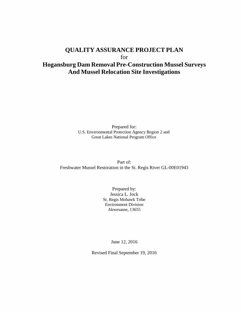
1.3 Project Management The project will be implemented by the Saint Regis Mohawk Tribe’s Environment Division with mussel species identification made by Dr. J. Mark Erickson, and voucher verification as needed by New York State Museum malacologists in consultation with NSYDEC. This section describes roles and responsibilities of individuals involved.
EPA GLRI- Project Officer Tina Davis will be responsible for providing funding and QAPP approval, and coordination with the proposed project and reporting needs.
SRMT Environment Director Ken Jock, SRMT Environment Division Director, is responsible for providing financial and staff resources necessary to meet project objectives and implement the requirements describes in this QAPP. The Director is the official project contact of all funding resources and has primary signing authority for all purchases and project plans.
Quality Assurance (QA) Officers Angela Benedict, Tribal Quality Assurance Officer (TQAO) is responsible for reviewing and approving all QAPPs according to the Tribe’s Quality Assurance Management Plan, 2015 (QAMP). She has signing authority for a project work plan for the SRMT Environment Division and coordinating QAPP approval with Region 2 QA Officer (Carol Lynes) and Tribal QA Liaison (Kai Tang). Should there be a need for any significant corrective actions, Carol and/or Kai will be contacted and consulted with prior to any continued work.
SRMT Project Manager Jessica L. Jock, St. Lawrence River Area of Concern (AOC) will be responsible for directing field crew, field data collection oversight and sampling QA/QC, data collection via SCUBA, and consulting with Lisa Holst, NYSDEC on relocation strategy and voucher samples, reporting quarterly to EPA, and final report compilation.
Species Identification, Aging, and Sexing Dr. J. Mark Erickson, Professor Emeritus, St. Lawrence University has over 30 years of Freshwater Mussel species research and identification in the greater St. Lawrence River watershed and has familiarity with St. Regis River species from past surveys. If questions about specific identifications persist, appropriate information will be collected (photograph and vouchers) and forwarded to outside experts for validation.
Field Team Field tasks include performing mussel surveys, habitat evaluations, and mussel relocation. The field crew will also be responsible for documentation and records to be maintained in the field. They will be responsible for all field data labeling, photo documentation, recording, management, and mapping GPS locations of sampling sites. They are expected to follow the methodologies outlined in this QAPP.
2016 St. Regis River Mussel Pre-construction Survey QAPP Page 10 of 41
Craig Arquette will serve as the Dive Safety Officer (DSO). Craig has 20 years of American Canadian Underwater Council (ACUC) International certification, and familiarity with SCUBA diving in the St. Regis River.
Vaughn Adams will lead a support team for mussel collection via snorkeling and wading, streamside safety assistance and boat support daily during surveys.

2016 St. Regis River Mussel Pre-construction Survey QAPP Page 11 of 41
Figure 1. Organizational chart of management for Freshwater Mussel Surveys
USEPA Region II Quality Assurance
Kai Tang, Tribal Liaison Carol Lynes, QA Officer
USEPA Project Officer Tina Davis, USEPA Region 5
GLRI Project Officer
Freshwater Mussel Restoration, Project Manager and Field Crew Leader
Jessica Jock, SRMT Environment Division
Mussel Expert Dr. J. Mark Erickson
Field Team & Support Vaughn Adams Angello Johnson Craig Arquette
Jay Wilkins Aaron Adams Teio Skidders
SRMT Environment Division Director Ken Jock
SRMT Quality Assurance Officer
Angela Benedict
2016 St. Regis River Mussel Pre-construction Survey QAPP Page 12 of 41
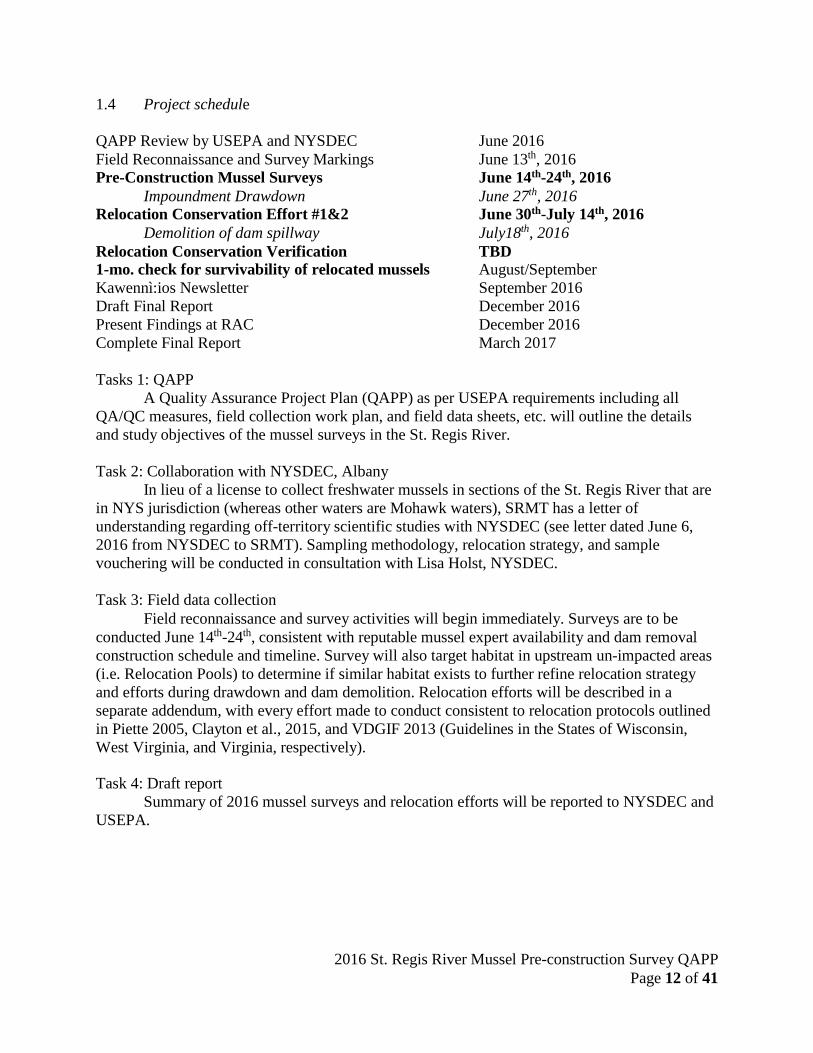
1.4 Project schedule QAPP Review by USEPA and NYSDEC June 2016 Field Reconnaissance and Survey Markings June 13th, 2016 Pre-Construction Mussel Surveys June 14th-24th, 2016
Impoundment Drawdown June 27th, 2016 Relocation Conservation Effort #1&2 June 30th-July 14th, 2016
Demolition of dam spillway July18th, 2016 Relocation Conservation Verification TBD 1- mo. check for survivability of relocated mussels August/September Kawennì:ios Newsletter September 2016 Draft Final Report December 2016 Present Findings at RAC December 2016 Complete Final Report March 2017
Tasks 1: QAPP
A Quality Assurance Project Plan (QAPP) as per USEPA requirements including all QA/QC measures, field collection work plan, and field data sheets, etc. will outline the details and study objectives of the mussel surveys in the St. Regis River.
Task 2: Collaboration with NYSDEC, Albany
In lieu of a license to collect freshwater mussels in sections of the St. Regis River that are in NYS jurisdiction (whereas other waters are Mohawk waters), SRMT has a letter of understanding regarding off-territory scientific studies with NYSDEC (see letter dated June 6, 2016 from NYSDEC to SRMT). Sampling methodology, relocation strategy, and sample vouchering will be conducted in consultation with Lisa Holst, NYSDEC.
Task 3: Field data collection
Field reconnaissance and survey activities will begin immediately. Surveys are to be conducted June 14th-24th, consistent with reputable mussel expert availability and dam removal construction schedule and timeline. Survey will also target habitat in upstream un-impacted areas (i.e. Relocation Pools) to determine if similar habitat exists to further refine relocation strategy and efforts during drawdown and dam demolition. Relocation efforts will be described in a separate addendum, with every effort made to conduct consistent to relocation protocols outlined in Piette 2005, Clayton et al., 2015, and VDGIF 2013 (Guidelines in the States of Wisconsin, West Virginia, and Virginia, respectively).
Task 4: Draft report
Summary of 2016 mussel surveys and relocation efforts will be reported to NYSDEC and USEPA.

2016 St. Regis River Mussel Pre-construction Survey QAPP Page 13 of 41
1.5 Project background
In March of 2015, the Saint Regis Mohawk Tribe (SRMT or Tribe) became co-licensee of the Hogansburg Hydroelectric Project—a small, historic dam on the St. Regis River and first impassible barrier to fish—for the purposes of decommissioning the obsolete facility and removing the dam to restore migratory fish access from the St. Lawrence River. Removal will begin in the summer of 2016, to restore this tributary river to free-flowing conditions for up to 267 river and stream miles of potential fisheries spawning habitat. It is currently home to several state listed species of fish that may benefit by increased connectivity with the St. Lawrence River (McKenna et al., 2015; Dittman et al., 2010; Carlson 1997).
Based on 2012 and 2013 surveys conducted by Riveredge Associates, LLC under
contract to SRMT, 10 species of freshwater mussels were identified in the St. Regis River. Five of those identified species are listed as New York State Species of Greatest Conservation Need (SGCN), but none of the found species to date are State, Provincial, or Federally listed threatened and endangered species. Potential species that may occur in or near the Hogansburg dam impoundment include: Alasmidonta marginata, Anodontoides ferussacianus, Elliptio complanata, Lampsilis cariosa, Lampsilis ovata, Lampsilis radiata, Leptodea fragilis, Ligumia recta, Potamilus alatus, and Strophitus undulatus (Harper et al., 2015). Other species that have been identified in or near the St. Lawrence River Area of Concern and their conservation status are outlined in Table 1.
Freshwater mussels are long-lived, slow growing, and slow moving organisms that have
difficulty adapting to any drastic and sudden habitat alteration; such as lowering of a reservoir during dam removal. Lessons learned on other dam removal sites indicate a high mortality of mussels may occur from stranding, desiccation, or exposure to predation (Doyle et al., 2005), especially in shallow nearshores and adjacent ponds upstream of the impoundment proposed for dewatering (Cooper 2011). Proactive measures to mitigate unintended harm to restore existing unionid populations in the area of potential effect (APE) can be achieved through a relocation effort. Relocation success has been reported as high as >97% at some sites (Cope et al., 2003), in comparison to 77%-95% mussel mortality (Cooper 2011; Doyle et al., 2005) by a ‘do nothing’ or ‘no action’ approach during dam removal. Relocation has been used as a conservation strategy by state and federal agencies for freshwater mussels as a way to protect mussel populations from unintended adverse effects during dewatering, sedimentation, construction projects, and chemical pollution impairments (Cope and Waller 1995; Clayton et al., 2015).
Proposed survey methods to be conducted on the St. Regis River will utilize similar
approved time-searched surveys already used in or near the St. Lawrence River AOC (Normandeau 2008; Riveredge 2013; Harper et al., 2015; Riveredge 2015). Field survey search and collection methods will use standard accepted practices such as wading, snorkeling, and SCUBA diving. Survey objectives will prioritize nearshore and shallow mussel habitat areas most likely to be affected by dewatering (including islands), habitats that support high densities of SGCN mussel species, and adjacent ponds or tributary confluences that may be affected by drawdown. Further details provided below in Sampling Methods.

2016 St. Regis River Mussel Pre-construction Survey QAPP Page 14 of 41
Table 1. Freshwater mussel species potentially occurring in and near the St. Lawrence River AOC and their conservation status. Species previously identified in the St. Regis River in bold below (Table modified from Harper et al., 2015).
Scientific Name
Common Name
New
York Status3
Species of Greatest
Conservation Need (SGCN) in
New York4
Species of New England
Conservation Concern
(Therres, 1999)
COSEWIC5
Ontario Status6
Quebec Status7
SARA Status
8
1 Actinonaias ligamentina 1 Mucket 2 Alasmidonta marginata Elktoe *9 3 Alasmidonta undulata Triangle Floater 4 Alasmidonta varicosa Brook Floater T (HP) SC SC
5 Anodontoides ferussacianus Cylindrical papershell
6 Elliptio complanata Eastern elliptio 7 Lampsilis cariosa Yellow lampmussel SC SC 8 Lampsilis ovata Pocketbook 9 Lampsilis radiata Eastern lampmussel
10 Lasmigona compressa Creek heelsplitter 11 Lasmigona costata Fluted shell 12 Leptodea fragilis Fragile papershell *9 13 Leptodea ochracea Tidewater mucket (HP) 14 Ligumia recta Black sandshell (HP) 15 Ligumia nasuta Eastern pondmussel E E E 16 Margaritifera margaritifera Eastern pearlshell 17 Obovaria olivaria 2 Hickorynut E E *9 18 Potamilus alatus Pink heelsplitter *9 19 Pyganodon cataracta Eastern floater 20 Pyganodon grandis Giant floater 21 Strophitus undulatus Creeper 22 Villosa iris Rainbow (HP) E T E
Totals 1 11 5 5 (3 E,2 SC) 3 (2 E, 1 T)
4 *likely
4 (2E, 2 SC)
E=Endangered, T = Threatened, SC = Special Concern, HP= high priority COSEWIC = Committee and the Status of Endangered Wildlife in Canada
2016 St. Regis River Mussel Pre-construction Survey QAPP Page 15 of 41
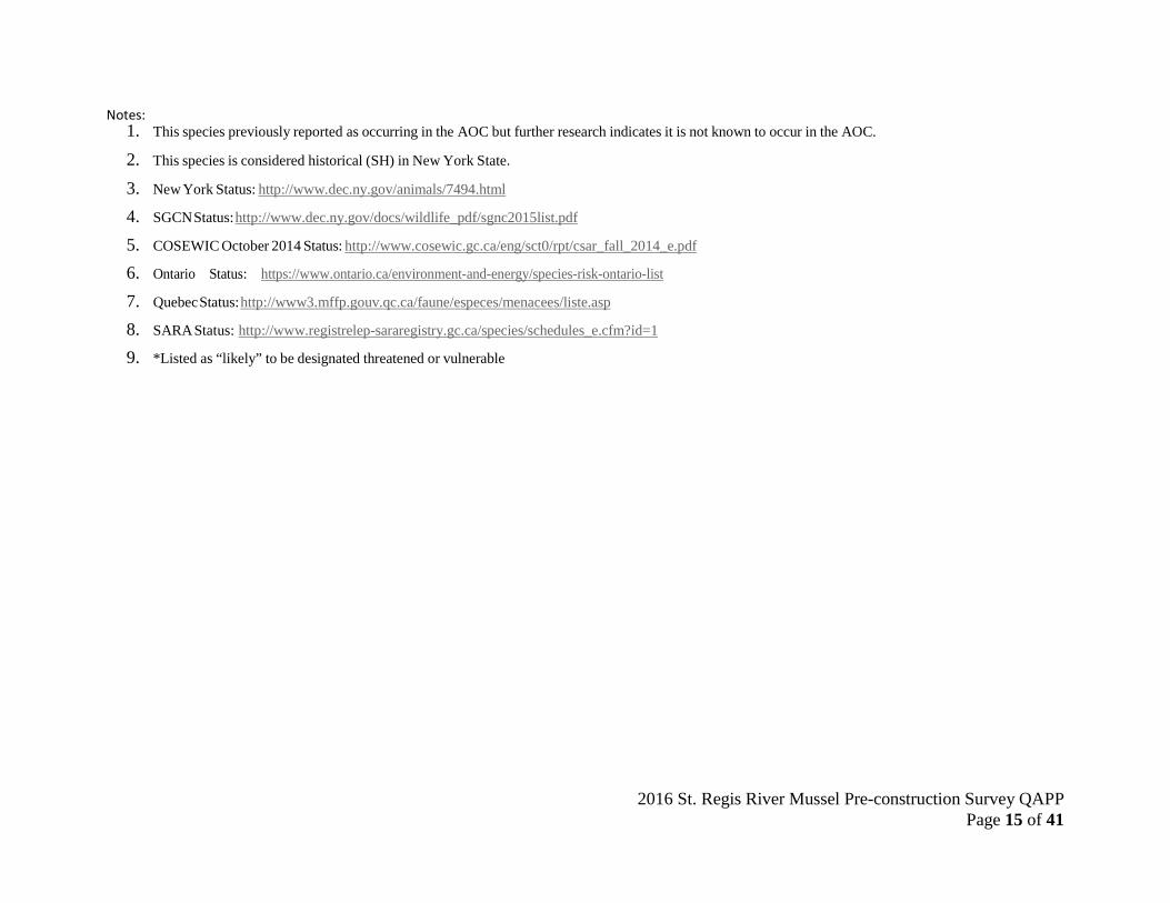
Notes:
1. This species previously reported as occurring in the AOC but further research indicates it is not known to occur in the AOC.
2. This species is considered historical (SH) in New York State.
3. New York Status: http://www.dec.ny.gov/animals/7494.html
4. SGCN Status: http://www.dec.ny.gov/docs/wildlife_pdf/sgnc2015list.pdf
5. COSEWIC October 2014 Status: http://www.cosewic.gc.ca/eng/sct0/rpt/csar_fall_2014_e.pdf
6. Ontario Status: https://www.ontario.ca/environment-and-energy/species-risk-ontario-list
7. Quebec Status: http://www3.mffp.gouv.qc.ca/faune/especes/menacees/liste.asp
8. SARA Status: http://www.registrelep-sararegistry.gc.ca/species/schedules_e.cfm?id=1
9. *Listed as “likely” to be designated threatened or vulnerable

2016 St. Regis River Mussel Pre-construction Survey QAPP Page 16 of 41
1.6 Description of project area The Mohawk Territory of Akwesasne is located near the townships of Massena, NY and
Cornwall, ON. The territory is at the intersection of northern New York State with the provinces of Ontario and Quebec and straddles the St. Lawrence River. The Hogansburg Dam is located on the St. Regis River, a north flowing 852 square mile watershed with headwaters in the Adirondack Mountains of Northern New York State. The dam is located 2.5 river miles from the confluence with the St. Lawrence River. The focus area of this pre-construction mussel survey is from the upstream limit of the work area under the 401/404 permit, upstream 4.85 miles to the next hydraulic break (a riffle section near the town of Helena, NY). This length of the river includes tributaries to the St. Regis River, uninhabited islands, and submerged sand bars. This section of the river includes the shared jurisdictions of the Saint Regis Mohawk Tribe and the New York State Department of Environmental Conservation (DEC) for the most part separated by the thread of the St. Regis River (Figure 2). The public record includes a Settlement Agreement reached between the Tribe and regulatory stakeholders (DOI, BIA, USFWS and DEC) in 2014 that supports the dam removal.
Figure 2. Green represents the focus of DEC and Army Corp permits for Hogansburg Dam. Red represents the project impoundment. Blue line represents co-management of river resources between SRMT and NYSDEC. Orange line represents the break of anticipated APE for freshwater mussels during drawdown.
2016 St. Regis River Mussel Pre-construction Survey QAPP Page 17 of 41
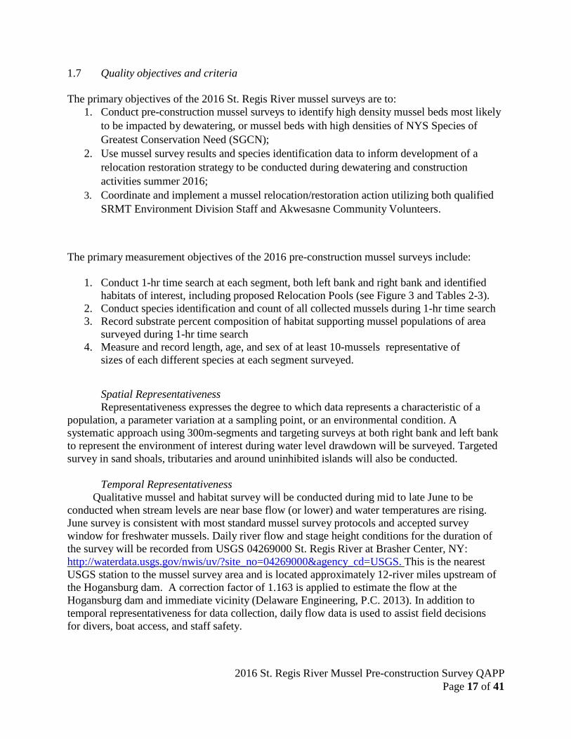
1.7 Quality objectives and criteria The primary objectives of the 2016 St. Regis River mussel surveys are to:
1. Conduct pre-construction mussel surveys to identify high density mussel beds most likely to be impacted by dewatering, or mussel beds with high densities of NYS Species of Greatest Conservation Need (SGCN);
2. Use mussel survey results and species identification data to inform development of a relocation restoration strategy to be conducted during dewatering and construction activities summer 2016;
3. Coordinate and implement a mussel relocation/restoration action utilizing both qualified SRMT Environment Division Staff and Akwesasne Community Volunteers.
The primary measurement objectives of the 2016 pre-construction mussel surveys include:
1. Conduct 1-hr time search at each segment, both left bank and right bank and identified habitats of interest, including proposed Relocation Pools (see Figure 3 and Tables 2-3).
2. Conduct species identification and count of all collected mussels during 1-hr time search 3. Record substrate percent composition of habitat supporting mussel populations of area
surveyed during 1-hr time search 4. Measure and record length, age, and sex of at least 10-mussels representative of
sizes of each different species at each segment surveyed.
Spatial Representativeness Representativeness expresses the degree to which data represents a characteristic of a
population, a parameter variation at a sampling point, or an environmental condition. A systematic approach using 300m-segments and targeting surveys at both right bank and left bank to represent the environment of interest during water level drawdown will be surveyed. Targeted survey in sand shoals, tributaries and around uninhibited islands will also be conducted.
Temporal Representativeness
Qualitative mussel and habitat survey will be conducted during mid to late June to be conducted when stream levels are near base flow (or lower) and water temperatures are rising. June survey is consistent with most standard mussel survey protocols and accepted survey window for freshwater mussels. Daily river flow and stage height conditions for the duration of the survey will be recorded from USGS 04269000 St. Regis River at Brasher Center, NY: http://waterdata.usgs.gov/nwis/uv/?site_no=04269000&agency_cd=USGS. This is the nearest USGS station to the mussel survey area and is located approximately 12-river miles upstream of the Hogansburg dam. A correction factor of 1.163 is applied to estimate the flow at the Hogansburg dam and immediate vicinity (Delaware Engineering, P.C. 2013). In addition to temporal representativeness for data collection, daily flow data is used to assist field decisions for divers, boat access, and staff safety.

2016 St. Regis River Mussel Pre-construction Survey QAPP Page 18 of 41
Completeness Every reasonable effort will be made to survey both right and left bank of Segments
SRU01-SRU16 (n= 32), with target surveys (i.e. either bank to bank or time-search around island banks) at SRU17-SRU24 (n=8) for a total of n=40 possible sampled areas. Completeness will be dependent on weather, field conditions (flows), and team availability. A minimum of 32 intended survey areas would be needed for 80% completeness to achieve study objectives. However, considering this study is specific to identify high mussel densities in advance of the draw-down, every reasonable effort will be made to survey all 40. Should time constraints inhibit ability to conduct a time-search survey at both right and left bank Segments SRU01-SRU16, only one bank will be selected, biased to lowest water depths (i.e. most likely to be impacted by drawdown).
Accuracy Accuracy of identifying freshwater mussels will be achieved through the use of species
verification and voucher specimens. Given the objectives of this survey, timely needs for relocation efforts, and expected known species to be found in the survey area (Table 1) it is not anticipated many specimens will be vouchered. Any mussel that can’t be affirmatively identified by Dr. J. Mark Erickson will be vouchered for later submittal to the New York State Museum. Voucher specimens will include a photograph of the posterior and beak with Location ID, date of collection, and questionable species ID. All voucher specimens will be retained at SRMT, frozen until facilitated transport to New York State Museum. All Segments surveyed (n=40) will also include a group photograph to document all mussels collected at each site. Included in the photograph will be:
1. 1-meter stick and a 6”-ruler or digital calipers for size reference; 2. All mussels collected aligned by size and species; 3. A dry erase board (or two) with Location ID, date of collection, species ID and species
count, and total # of live mussels.
2016 St. Regis River Mussel Pre-construction Survey QAPP Page 19 of 41
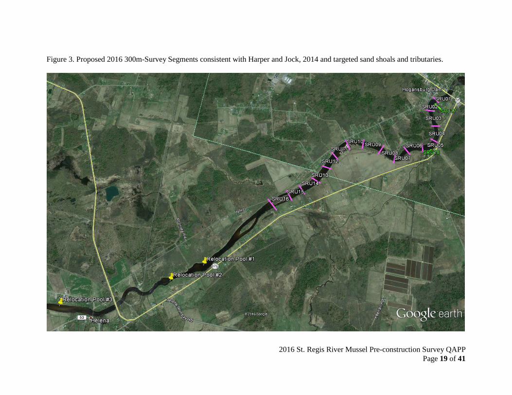
Figure 3. Proposed 2016 300m-Survey Segments consistent with Harper and Jock, 2014 and targeted sand shoals and tributaries.
2016 St. Regis River Mussel Pre-construction Survey QAPP Page 20 of 41
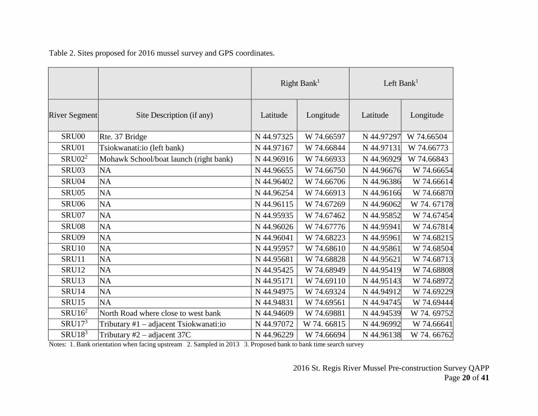
Table 2. Sites proposed for 2016 mussel survey and GPS coordinates.
Right Bank1
Left Bank1
River Segment
Site Description (if any)
Latitude
Longitude
Latitude
Longitude
SRU00 Rte. 37 Bridge N 44.97325 W 74.66597 N 44.97297 W 74.66504 SRU01 Tsiokwanati:io (left bank) N 44.97167 W 74.66844 N 44.97131 W 74.66773 SRU022 Mohawk School/boat launch (right bank) N 44.96916 W 74.66933 N 44.96929 W 74.66843 SRU03 NA N 44.96655 W 74.66750 N 44.96676 W 74.66654 SRU04 NA N 44.96402 W 74.66706 N 44.96386 W 74.66614 SRU05 NA N 44.96254 W 74.66913 N 44.96166 W 74.66870 SRU06 NA N 44.96115 W 74.67269 N 44.96062 W 74. 67178 SRU07 NA N 44.95935 W 74.67462 N 44.95852 W 74.67454 SRU08 NA N 44.96026 W 74.67776 N 44.95941 W 74.67814 SRU09 NA N 44.96041 W 74.68223 N 44.95961 W 74.68215 SRU10 NA N 44.95957 W 74.68610 N 44.95861 W 74.68504 SRU11 NA N 44.95681 W 74.68828 N 44.95621 W 74.68713 SRU12 NA N 44.95425 W 74.68949 N 44.95419 W 74.68808 SRU13 NA N 44.95171 W 74.69110 N 44.95143 W 74.68972 SRU14 NA N 44.94975 W 74.69324 N 44.94912 W 74.69229 SRU15 NA N 44.94831 W 74.69561 N 44.94745 W 74.69444 SRU162 North Road where close to west bank N 44.94609 W 74.69881 N 44.94539 W 74. 69752 SRU173 Tributary #1 – adjacent Tsiokwanati:io N 44.97072 W 74. 66815 N 44.96992 W 74.66641 SRU183 Tributary #2 – adjacent 37C N 44.96229 W 74.66694 N 44.96138 W 74. 66762
Notes: 1. Bank orientation when facing upstream 2. Sampled in 2013 3. Proposed bank to bank time search survey
2016 St. Regis River Mussel Pre-construction Survey QAPP Page 21 of 41
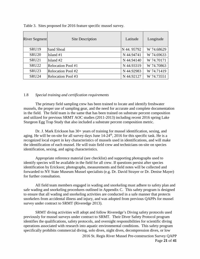
Table 3. Sites proposed for 2016 feature specific mussel survey.
River Segment
Site Description
Latitude
Longitude
SRU19 Sand Shoal N 44. 95792 W 74.68629 SRU20 Island #1 N 44.94741 W 74.69633 SRU21 Island #2 N 44.94140 W 74.70171 SRU22 Relocation Pool #1 N 44.93319 W 74.70863 SRU23 Relocation Pool #2 N 44.92983 W 74.71419 SRU24 Relocation Pool #3 N 44.92127 W 74.73551
1.8 Special training and certification requirements
The primary field sampling crew has been trained to locate and identify freshwater
mussels, the proper use of sampling gear, and the need for accurate and complete documentation in the field. The field team is the same that has been trained on substrate percent composition and utilized for previous SRMT AOC studies (2011-2013) including recent 2016 spring Lake Sturgeon Egg Trap Study that also included a substrate percent composition metric.
Dr. J. Mark Erickson has 30+ years of training for mussel identification, sexing, and
aging. He will be on-site for all survey days June 14-24th, 2016 for this specific task. He is a recognized local expert in key characteristics of mussels used in identifications, and will make the identification of each mussel. He will train field crew and technicians on-site on species identification, sexing, and aging characteristics.
Appropriate reference material (see checklist) and supporting photographs used to
identify species will be available in the field for all crew. If questions persist after species identification by Erickson; photographs, measurements and field notes will be collected and forwarded to NY State Museum Mussel specialists (e.g. Dr. David Strayer or Dr. Denise Mayer) for further consultation.
All field team members engaged in wading and snorkeling must adhere to safety plan and
safe wading and snorkeling procedures outlined in Appendix C. This safety program is designed to ensure that all wading and snorkeling activities are conducted in a safe manner that protects snorkelers from accidental illness and injury, and was adopted from previous QAPPs for mussel survey under contract to SRMT (Riveredge 2013).
SRMT diving activities will adopt and follow Riveredge’s Diving safety protocols used
previously for mussel surveys under contract to SRMT. Their Diver Safety Protocol program identifies the qualifications, safety protocols, and oversight responsibilities for scientific diving operations associated with research into aquatic environmental conditions. This safety program specifically prohibits commercial diving, solo dives, night dives, decompression dives, or low
2016 St. Regis River Mussel Pre-construction Survey QAPP Page 22 of 41
visibility dives. Riveredge's Diving Safety Plan is on file with SRMTED, and SRMT staff will defer to it as needed, but will follow the daily safety plan and briefing as outlined by the Diver Safety Officer (DSO).
The Dive Safety Officer (DSO) is Craig Arquette. No diving is permitted without Craig
Arquette on site. All divers shall possess a valid SCUBA diver certification from a recognized SCUBA organization, such as NAUI, PADI, SSI, and PDIC, and must obtain authorization from the DSO prior to conducting diving activities. For freshwater mussel surveys, DSO authorization permits the diver to conduct surveys to a depth not to exceed 30 feet. Prior to each dive all diving equipment shall be examined and functionally checked by the person using it. The examination and check shall be performed in the presence of the diving buddy, tender, or DSO. In addition, a safety hazard evaluation of the task(s) and site environmental conditions shall be completed and hazard controls identified. A briefing shall be held by the DSO prior to each diving operation that a minimum outlines the dive plan, safety procedures, and emergency procedures associated with the survey.
1.9 Documentations and records
A Field Supplies Check list (Appendix A) will be used to ensure all field data logging
supplies are present in the field. A Field Data Sheet (Appendix B) will be maintained and completed at each segment location by the field crew. Supplemental field notes will be maintained in a field journal in pen or sharpie marker and note such things as time of departure and time of completion each day of survey to calculate man hours, descriptions of mussels found, habitat type of segment, etc. Photographs will be taken of mussels and other evidence when identifications need to be confirmed during follow-up. Photographs will include the Location ID and Sampling Date. Photographs will be organized electronically using Location ID and Sampling Date.
Location ID will include a distinct code for each 300-m St. Regis River segment:
• SR – St. Regis River • U – Upstream the Hogansburg Dam • Independent number assigned each segment (i.e. 01, 02,...24) • R – Right Bank, L- Left Bank, BB – Bank to Bank • Location ID Example: SRU12R indicates Survey Segment #12, Right Bank
2016 St. Regis River Mussel Pre-construction Survey QAPP Page 23 of 41
2.1 DATA ACQUISITION 2.2 Experimental design and sampling tasks
Field reconnaissance efforts will include identifying and recording with GPS coordinates
any and all mussel middens located between SRU01-SRU16 to inform field crew of any special attention needed for surveys, or additional information useful for prioritizing relocation strategy segments. All mussel middens with high densities will be marked with a survey flag/tape and a photograph taken with a dry erase board identifying nearest Location ID, GPS coordinates, and date.
Sampling efforts for 2016 include assessing mussel species and densities present within the 300-m segments, and targeted shoals, tributaries, and uninhabited islands within the Area of Potential Effect (APE) from anticipated dam removal and dewatering of the upstream impoundment. This will entail a minimum of a 1.0 person-hour, timed search, to provide qualitative data on what species exist, or recently existed, with the segment, as well as the habitat quality supporting the mussels.
Surveys will take place in both the right bank and left bank (when looking upstream) of each Segment. The sampling protocols are time-searches adapted from methods previously used in the St. Regis River, and outlined in EPA approved QAPPs (Riveredge 2012 & 2013).
All mussels will be bagged and brought to shore by boat for processing. Mussels will be kept in water (river or holding containers with water) except for a brief period during identification, measuring, and/or photographing.
The length of ten mussels representative of the size range collected at each segment (i.e. smallest to largest; with representative sizes in between) will be measured with digital calipers for each species. If fewer than 10 mussels of a given species collected, all mussels collected of that species will be measured. Based on results reported in Harper et al., 2015 of previous mussel surveys in the St. Regis River and surrounding tributaries, ten (10) would capture field measurements of all the non-Elliptio complanata species, and is consistent with measuring objectives in 2015 and 2016 Grasse River Mussel Studies (Riveredge 2015). The same 10 mussels (representative of size range) of each species will be aged (estimated by counting growth rings on the exterior of the shell) and sexed.
If time allows, length measurement, aging, and sexing, of all mussels will be recorded (in addition to the 10 of each species present). This will be a field decision that considers mussels length of time out of water, mussel densities in a given sample, and staff recording efficiency and speed.
2.3 Sampling procedures and requirements
The following sampling methods are consistent and amended to previously used sampling protocols as outlined in previously approved Quality Assurance Project Plans (QAPPs) (Riveredge 2012 & 2013).
Prior to the first survey, permission will be obtained from landowners for river segments
that require access through private lands. Reference materials and guidebooks will be utilized in the field to reduce freshwater mussel identification errors.

2016 St. Regis River Mussel Pre-construction Survey QAPP Page 24 of 41
1. Set up at furthest downstream site and work your way upstream. Water depth (m) will be measured after timed-searches and recorded by waders, snorkelers, and divers to obtain a minimum and maximum water depth surveyed. The field crew will be a minimum of two people.
2. Using the handheld GPS, verify the coordinates at the starting point of the 300-m
segment or record new coordinates if for any difference they are different from the pre- determined GIS coordinates for the segment. Using aerial photographs, the GPS, and/or the laser rangefinder, the field crew leader will identify the bounds of the segment and communicate these bounds by reference to local landmarks (specific trees, rocks, logs, power lines, or other clearly and readily visible cues) to the field crew. The field crew leader will be responsible for ensuring that all information is recorded neatly and accurately on the field data form and that the searcher(s) remain within the bounds of the segment.
3. One person will keep track of time and alert other field crew when the 1.0 person-hour
search time is completed. Start and end times will be recorded on the field data sheet (Appendix B). Search time will only include time searching for mussels and not include mussel identification, travel between sites, assembling gear, set-up and breakdown, data entry, etc.
4. Each 300-m segment on both right and left banks will be searched for 1.0 person-hours,
using wading, snorkeling, or scuba diving methods. If water depth is less than one meter throughout the segment, field crew will use masks and snorkels. Depths greater than one meter will require certified open-water divers at a minimum. Field crew will work from a downstream to upstream direction. Searchers will search all available mussel habitats in the segment but must stay in the segment as earlier defined by the field crew leader.
5. Field crew will search the substrate visually looking for mussel siphons and tactilely by
running their hands through the substrate to a depth of two to ten centimeters to feel mussels below the substrate surface. The following minimum data will be recorded for every surveyed segment:
• Segment number • Field crew name(s) • Search time (person-hours) • Date • Number of mussels by species • Location within segment where mussel was found • Mussel condition by species (live, fresh dead, weathered dead, relic) • Lengths (mm) of ten individuals of each species
6. Mussels retained for measurement will be returned to the approximate collection location.
Whenever identification of a mussel is uncertain, consult all available reference material, the field team leader, and/or Co-Project Manager. Also take a photograph for later examination. See Section 1.6 Accuracy above for consistent photograph protocol. Photographs or specimen vouchers may be forwarded to outside experts for confirmation.
2016 St. Regis River Mussel Pre-construction Survey QAPP Page 25 of 41
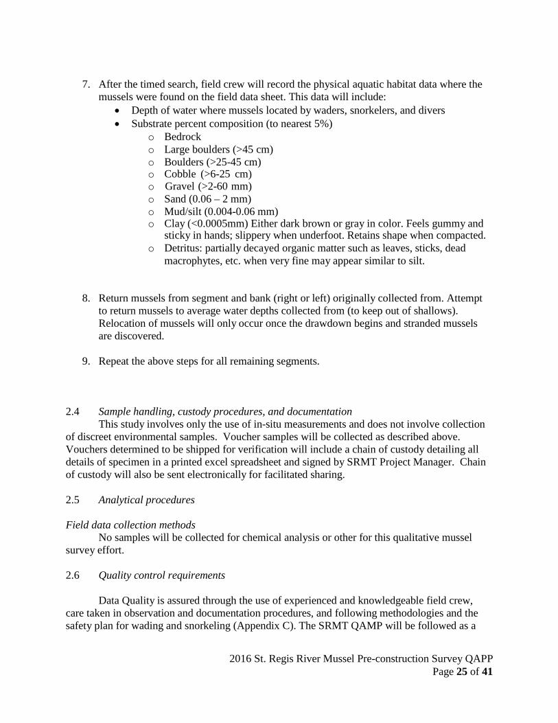
7. After the timed search, field crew will record the physical aquatic habitat data where the mussels were found on the field data sheet. This data will include:
• Depth of water where mussels located by waders, snorkelers, and divers • Substrate percent composition (to nearest 5%)
o Bedrock o Large boulders (>45 cm) o Boulders (>25-45 cm) o Cobble (>6-25 cm) o Gravel (>2-60 mm) o Sand (0.06 – 2 mm) o Mud/silt (0.004-0.06 mm) o Clay (<0.0005mm) Either dark brown or gray in color. Feels gummy and
sticky in hands; slippery when underfoot. Retains shape when compacted. o Detritus: partially decayed organic matter such as leaves, sticks, dead
macrophytes, etc. when very fine may appear similar to silt.
8. Return mussels from segment and bank (right or left) originally collected from. Attempt to return mussels to average water depths collected from (to keep out of shallows). Relocation of mussels will only occur once the drawdown begins and stranded mussels are discovered.
9. Repeat the above steps for all remaining segments.
2.4 Sample handling, custody procedures, and documentation
This study involves only the use of in-situ measurements and does not involve collection of discreet environmental samples. Voucher samples will be collected as described above. Vouchers determined to be shipped for verification will include a chain of custody detailing all details of specimen in a printed excel spreadsheet and signed by SRMT Project Manager. Chain of custody will also be sent electronically for facilitated sharing.
2.5 Analytical procedures
Field data collection methods No samples will be collected for chemical analysis or other for this qualitative mussel
survey effort. 2.6 Quality control requirements
Data Quality is assured through the use of experienced and knowledgeable field crew,
care taken in observation and documentation procedures, and following methodologies and the safety plan for wading and snorkeling (Appendix C). The SRMT QAMP will be followed as a

2016 St. Regis River Mussel Pre-construction Survey QAPP Page 26 of 41
management tool for planning, implementing, documenting, and assessing the effectiveness of activities supporting environmental data operations (submitted electronically to EPA previously).
Experienced field expertise via Dr. J. Mark Erickson assures the accuracy of
identification of freshwater mussels. The field crew is responsible for ensuring all sampling gear and equipment is in good working condition and signing off on the Field Supplies Checklist.
Field photographs are taken with a 6-inch ruler, and mussels measured to the nearest mm
with digital calipers. The Field Crew is responsible for all proper documentation in the Field Data Sheets and Field Log Book and signs off on them indicating their review and approval. Latitude and longitude coordinates are recorded for each sampling transect using Global- Positioning systems (GPS) at the beginning and end of each transect survey, and when target species are identified. The PM will review all field data sheets and documentation for any discrepancies and will be responsible to resolve those discrepancies.
2.7 Equipment calibration and maintenance requirements
Field Instrumentation
All field sampling gear will be inspected prior to each sampling day to ensure that all equipment is in working order and safe to use and spare parts or backup equipment are readily accessible.
Use of a handheld GPS unit, Radio/Cell Phone, and digital camera will be needed in the field. It is important to check to make sure all units are charged prior to leaving the office, and backup batteries are packed. Prior to departure, the field crew is responsible for making sure that equipment in the Field Supplies Checklist is inspected and in working condition.
Latitude and longitude coordinates are recorded for each sampling site using a handheld
Garmin GPS 76 to confirm sampling location, and mussel beds. The handheld GPS has an accuracy of +/- 3 meters and is only used as a verification tool to estimate start/stop locations. The use and maintenance of GPS units will be reviewed each week with each field crew member.
2.8 Data management requirements
It is the responsibility of the Field Crew to maintain field data sheets and field notebooks,
and confirm equipment checklist. Field observations will be tabulated in a field log notebook and Field Data Sheets will be brought back from the field to the office daily. Field Data Sheets will be stored in a 3-ring binder only for this project with the project name on the outside cover at the SRMT Environment Division, in the St. Lawrence River Area of Concern (AOC) office. Photographs of field observations will be uploaded daily and saved in dated Electronic Folders with date of photo, Location ID (i.e. SRU01-24) and identification of Right Bank, Left Bank, or other river feature, if relevant. Field notebooks will document a summary of daily field activities.
2016 St. Regis River Mussel Pre-construction Survey QAPP Page 27 of 41
For data collected under this project, the Project Manager will review all field data for accuracy. After Project Manager verifies Field Data Sheets, all Field Data Sheets will be scanned and saved electronically as backup. Hand recorded data from Field Data Sheets (Appendix B) will be tabulated and reported in the Final Report as Tables with Field Data Sheets attached as an Appendix. Field documents and records will be retained for up to 6 years after the final report is issued.
3.1 ASSESSMENTS
This section describes activities that will be conducted to ensure that data generated is
sufficient quality for its intended use, and that appropriate responses are in place to address non- conformances from the QAPP.
3.2 Technical systems assessments
Following both the field reconnaissance and field survey activity, our team will conduct a
post audit to identify problems encountered during the activity and will pay particular attention to documentation at the end of the event. Field crew discussion will be used to inform next day daily field activity, plan of action, and safety.
3.3 Performance audits of measurement and analytical systems
Performance audits have two components: proficiency evaluation and split sample analysis. These audits are generally applied to studies involving sampling protocols, chain of custody, and third party analytical services. This a Freshwater Mussel pre-construction survey in association with dewatering and restoration strategy development for potentially stranded mussels during dam removal. Therefore, the application performance audits are not applicable in this study.
3.4 Surveillance of operations
All records including field data sheets, field sampling gear preparation, field supplies check lists, and field log notebooks will be available for inspection and subject to routine surveillance and inspection by SRMT Project Manager and TQAO.
3.5 Audits
The SRMT Project Manager will perform audits so that any field and/or sampling deficiencies can be found and corrected. Audits are to be conducted during the project at least once at the beginning of field operations to ensure that Field Data Sheets, Field Notebooks are completed and managed properly, and staff safety is ensured in the field.
Should corrective actions need to be taken due to problems that are encountered; appropriate steps will be taken to correct this. For example, if a procedure is not being followed, training or retraining of a technician may be required. Should a problem be encountered that needs corrective action involving the program outlined in this QAPP, appropriate chain of command communication as indicated in Figure 1.0 will commence to effectively and efficiently rectify the problem or receive permission for any such changes. The Project Manager will be responsible for communicating to the EPA Project Officer and TQAO any problems encountered, and responsible for communicating or distributing any corrective actions needed to
2016 St. Regis River Mussel Pre-construction Survey QAPP Page 28 of 41
the field crew. All corrective actions will be documented and explained in the field notebook and reports as necessary.
3.6 Corrective Actions
Corrective actions will be implemented as needed. For this study the SRMT Project Manager and Field Crew Leader is the same. Jessica L. Jock is responsible for initiating corrective action and implementing it in the field. The Field Crew is responsible for communications to the SRMT project manager the status of any corrective actions. It is their combined responsibility of the SRMT team to ensure that measurement procedures are followed as specified and that the data generated meet the prescribed acceptance criteria. Specific corrective actions necessary will be clearly documented in the logbooks.
The need for technical corrective actions may be identified through technical assessment or as equipment malfunctions. Once identified, the problem may be addressed immediately or an audit report may serve as notification to project management staff that corrective action is necessary. Immediate corrective actions will be documents in the project logbook. Examples of corrective actions include:
• Battery replacements • Educating personnel about proper field procedures and documentation • Accepting data with an acknowledged level of uncertainty • Adapting location of sampling based on environmental conditions
After a corrective action has been implemented, its effectiveness will be verified through a post audit. If the action does not resolve the issue, then appropriate investigative and remedial actions will be taken.
4.1 DATA REVIEW, USABILITY, AND REPORTING
Data review and verification will be done by the Field Crew Leader prior to leaving the
sampling segment to evaluate the completeness, correctness, and compliance with requested information on the Field Data Sheets and entries into the field notebooks. Data validation will be done by Jessica L. Jock. These processes will occur both during and at the end of the project. Data meeting the quality objectives outlined in this QAPP will be considered acceptable and usable by the project.
4.2 Data verification and validation
The entire project team is responsible for ongoing assessment of the work performed by the team; identification of nonconformance with the project objectives; and initiation, implementation, and documentation of corrective action. Data generated during field activities will include general information such as: segment identification numbers; date; time; observations; but will also include specific information on mussel species and lengths; substrate composition; and specific water quality values. Reference books will be used for mussel identification. For verification, a subset of photographs for each species found will be sent to Dr. David Strayer, or other identified well-respected, mussel identification experts. The following reference books will be used in the field:
2016 St. Regis River Mussel Pre-construction Survey QAPP Page 29 of 41
• Erickson, J.M. and Garvey, K.L. 1997. Key to the unionacean clams (Mollusca) of the Grass River drainage, St. Lawrence County, New York. St. Lawrence Aquarium and Ecological Center Special Paper
• Nedeau, E. and Victoria, J. 2001. A Field Guide to the Freshwater Mussels of Connecticut. Department of Environmental Protection. Hartford, CT.
• Strayer, D. and K. Jirka. 1997. The Pearly Mussels of New York State. The New York State Education Department, Albany, NY.
Field data will be noted in pen or sharpie in a field notebook and field data sheets. Pencil
will not be used. No erasures will be made. Corrections will consist of a single strike-out with the date and initials of the individual making the correction or change. Data will be recorded by the Field Crew and validated by the SRMT Project Manager. Verification of data completeness of field data sheets and field notebooks will occur after each segment sampling by the Field Crew Leader prior to initiating next sampling activity.
Field employees will have thoroughly reviewed the QAPP and will be familiar with the
basic procedures before field collection efforts. All personnel involved with the study shall follow the QA/QC Sampling Plan to avoid errors that may occur in the field.
10% of all electronic field photos and data entry into excel sheets and/or tables will be
reviewed by an independent SRMT reviewer (i.e. TQAO or Water Resources Program Manager) to verify photo labeling and data transferral/input accuracy and usability. If errors found in 10% of reviewed data, data verification will be increased to 50% of all photos and data entry. If a substantial amount of errors found, independent SRMT review 100% of field photos and data entered electronically.
The final report will include all data that has been attained throughout the study in text,
tabular and graphical form in Microsoft Programming (i.e., Excel, Word, and/or Access) and mapping tools. The final report will be drafted when all surveys, relocation, and post-monitoring has been completed. The Relocation Plan will be submitted as an addendum to this QAPP upon completion of pre-construction surveys
4.3 Reconciliation with project requirements
Any deviations from quality objectives for the project will be documented and provided
to the data users for the project. The data that are determined to be incomplete or not usable for the project will be discussed with the project team and discuss resolution of the issue and implement necessary corrective actions (for example re-sampling or utilizing archive samples).
The usability of all data types for making recommendations for relocation and restoration efforts will be ensured through careful attention to the following factors:
• Scientifically sound, acceptable methods will be used for all data collection activities • Competent experienced biologists will be involved in the identification of mussel species
to ensure that correct identifications are made.
2016 St. Regis River Mussel Pre-construction Survey QAPP Page 30 of 41
• When sampling segments, SRMT project staff will diligently fill out field data sheets consistent with this QAPP are followed.
• Rigorous procedures and checks will be in place to ensure that all project data are accurately recorded and incorporated into the project database.
Any deviations from performance criteria or quality objectives will be documented in the summary report provided to the data users for the project. The SRMT Project Manager will work with the final data user in performing data quality assessments. An example of data quality assessment procedures include:
• Data that are determined to be incomplete or not usable for the project will be discussed with the project team. Data user will notify Project Manager regarding data that may impact the ability to meet project objectives.
4.4 Data usability
The usability of the data for freshwater mussel surveys will be ensured through attention to the following factors:
• Accepted field collection methods will be used for data collection activities. • Competent SRMT staff will be involved in all phases of field data collection,
documentation, data processing and analysis to ensure high quality data. • Field personnel will be diligent in completing all required documentation to ensure
consistency with procedures described in the QAPP. • Rigorous documentation control will be in-place to ensure data is properly recorded and
stored. 4.5 Reports to management
Upon completion of the field data collection activities, all field and QC data will be included in a comprehensive report that summarizes field activities and data evaluation. A discussion of data validation and adherence to QA/QC will be provided in the report. The need for corrective action will be dependent on the importance of the data issue to the overall project objective.
Final report on the St. Regis River Freshwater Mussel Restoration will be prepare by the Project Manager and submitted to USEPA and NYSDEC. This report won’t be completed until after all relocation strategy and relocation verification field efforts associated with community volunteer efforts dam removal are completed. Final Report will be in Word with Tables, Figures, Photos, and Field Data Sheets attached as an Appendix.
2016 St. Regis River Mussel Pre-construction Survey QAPP Page 31 of 41
5.0 REFERENCES Carlson D. 1997. Fishery Survey of the St. Regis River: Data Summary. SLC-32. New York
State Department of Environmental Conservation. July. 11pp. Clayton, J.L., B.Douglas, and P. Morrison. 2015. West Virginia mussel survey protocols. West
Virginia Division of Natural Resources. Elkins, WV. April 2015. 18pp. Cooper, J.E. 2011. Unionid mussel mortality from habitat loss in the Salmon River, New York,
following dam removal. Advances in Environmental Research 14:351-364. Cope, G. and D.L. Waller. 1995. Evaluation of freshwater mussel relocation as a conservation
and management strategy. Regulated rivers: research & management 11:147-155. Cope, W.G., M.C., Hove, D.L., Waller, D.J. Hornback, M.R. Bartsch, L.A. Cunningham, H.L.
Dunn, and A.R. Kapuscinski. 2003. Evaluation of relocation of unionid mussels to in situ refugia. Journal of Molluscan Studies 69:27-34.
Delaware Engineering, P.C. 2013. Hogansburg hydroelectric project: decommissioning work plan. FERC No. 7518. Prepared for Saint Regis Mohawk Tribe. October 2013.
Dittman D.; J. Johnson; M. Chalupnicki; J. Snyder. 2010. Assessment of Lake Sturgeon Rehabilitation: St. Regis River. Final Technical Report submitted to the U.S. Environmental Protection Agency –Great Lakes National Program Office. US Geological Survey, Tunison Laboratory of Aquatic Science. Cortland, NY.
Doyle M.; Stanley E.; Orr C.; Selle A.; Sethi S. and Harbor J. 2005. Stream ecosystem response to small dam removal: Lessons from the Heartland. Geomorphology 71: 227-244.
Erickson, J. M. 2003. Status of unionoid mussel distribution study in the St. Lawrence Lowlands of New York. Large Ecosystems Under Stress: Abstracts of the 10th Annual International Conference on the St. Lawrence River Ecosystem, p. 10.
Erickson, J. M. and A. R. Fetterman. 1997. Geological and sedimentological conditions influencing extirpation of unionid clams from mouths of small tributaries by filling of Lake St. Lawrence: A preliminary model. Explore the St. Lawrence River Watershed: 4th Annual International Symposium on the St. Lawrence River Ecosystem, Abstracts.
Garvin, M. 2005. Cultural importance of freshwater mussels to Native American tribes: a field study of caged mussels. Abstract of presentation at the Mussel Toxicity Testing Workshop (hosted by USEPA). Chicago, IL. August 23-24, 2005.
Harper L.H. and J.L. Jock. June 2014. Freshwater mussel interim status report: qualitative freshwater mussel surveys and mussel habitat characterizations in and near the Massena/Akwesasne St. Lawrence River Area of Concern (AOC). Report prepared by Riveredge Associates for Saint Regis Mohawk Tribe (SRMT) Environment Division. GL-9722130-10. 58 pp.
Harper L.H., J.M. Erickson, and J.L. Jock. November 2015. Freshwater mussel status report: habitat, populations, reproduction and contaminant assessment in and near the Massena/Akwesasne St. Lawrence River Area of Concern (AOC) for Beneficial Use Impairment (BUI) advancements. GL-97221310. 99 pp.
2016 St. Regis River Mussel Pre-construction Survey QAPP Page 32 of 41
Lake Ontario LaMP. April 2011. Implementing a Lake Ontario LaMP Biodiversity Conservation Strategy.
McKenna, J.E.; Hanak K. ; DeVilbiss K.;David A.; and Johnson J. 2015. Dam removal, connectivity, and aquatic resources in the St. Regis River watershed, New York: U.S. Geological Survey Scientific Investigations Report 2015–5116, 15 p.
Nature Bulletin. 1972. Uses of mussels. Retreived from website http://www.newton.dep.anl.gov/natbltn/400-499/nb452.htm on October 28, 2014.
Normandeau Associates. 2008. Baseline investigation on the freshwater mussels (Unionidae) of the Grasse River, St. Lawrence County, New York. Final Report, October 2008, prepared for Parsons Brinckerhoff and the Massena Electric Department, Massena, New York.
North American Indian Travelling College (NAITC). 1984. Traditional Teachings. 101 pp. Piette, Randal R. 2005. Guidelines for sampling freshwater mussels in wadeable streams.
Wisconsin Department of Natural Resuorces, Fisheries and Aquatic Sciences Research Program. Repot NO. 009-01-09
Richman, L.A., T. Kolic, K. MacPherson, L. Fayez, and E. Reiner. 2013. Polybrominated diphenyl ethers in sediment and caged mussels (Elliptio complanata) deployed in the Niagara River. Chemosphere. 92 (7): 778-786.
Riveredge Associates. August 2012 (Revised Final January 2013). Quality assurance project plan for qualitative freshwater mussel surveys and mussel habitat characterizations. Prepared for St. Regis Mohawk Tribe Environment Division and U.S. EPA Region 2. (GL- 97221310-0). 33 pp.
Riveredge Associates. August 2013. Quality assurance project plan for qualitative freshwater mussel surveys and mussel habitat characterizations - amendment. Prepared for St. Regis Mohawk Tribe Environment Division and U.S. EPA Region 2. (GL-97221310-0). 16 pp.
Riveredge Environmental, Inc. 2015. Mussel survey study design for the lower reach of the Grasse River, New York. Prepared for Alcoa Inc. August 2015. 27 pp.
[SRMT] Saint Regis Mohawk Tribe. 2015. Basis of Design: Decommission and Removal of the Hogansburg Dam. Prepared by CH2M. Akwesasne, NY.
USFWS 2014. America’s Mussels: Silent Sentinels. http://www.fws.gov/midwest/Endangered/clams/mussels.html, http://www.fws.gov/midwest/mussel/multimedia/posters/mussels_of_minnesota_back.pd f , and http://www.fws.gov/midwest/mussel/multimedia/life_cycle.html . Last accessed on 10/27/2014.
[VDGIF] Virginia Department of Game and Inland Fisheries. 2013. Draft freshwater mussel guidelines for Virginia.
2016 St. Regis River Mussel Pre-construction Survey QAPP Page 33 of 41
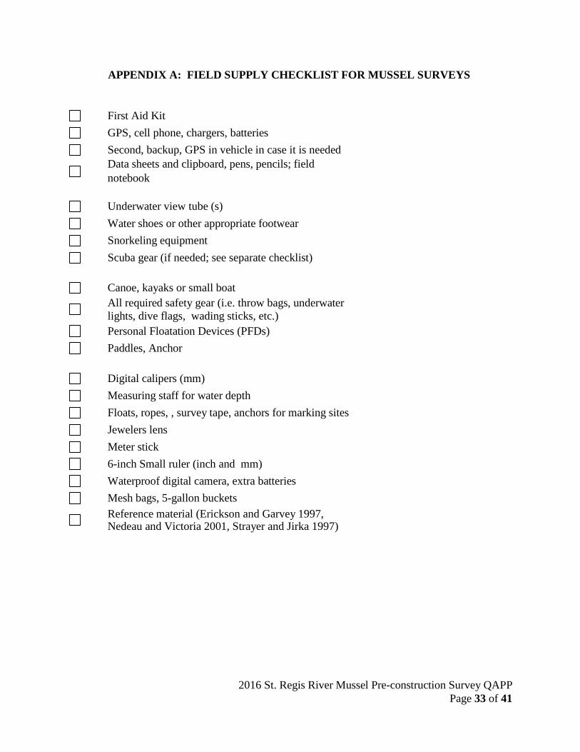
APPENDIX A: FIELD SUPPLY CHECKLIST FOR MUSSEL SURVEYS
First Aid Kit GPS, cell phone, chargers, batteries Second, backup, GPS in vehicle in case it is needed Data sheets and clipboard, pens, pencils; field notebook
Underwater view tube (s) Water shoes or other appropriate footwear Snorkeling equipment Scuba gear (if needed; see separate checklist)
Canoe, kayaks or small boat All required safety gear (i.e. throw bags, underwater lights, dive flags, wading sticks, etc.) Personal Floatation Devices (PFDs) Paddles, Anchor
Digital calipers (mm) Measuring staff for water depth Floats, ropes, , survey tape, anchors for marking sites Jewelers lens Meter stick 6-inch Small ruler (inch and mm) Waterproof digital camera, extra batteries Mesh bags, 5-gallon buckets Reference material (Erickson and Garvey 1997, Nedeau and Victoria 2001, Strayer and Jirka 1997)

2016 St. Regis River Mussel Pre-construction Survey QAPP Page 34 of 41
Checklist for Scuba Gear for Mussel Surveys – St. Regis River
Date: Completed By:
Tanks BC Wetsuit Regulator, octopus Gloves Booties Mask, fins, snorkel Weight belt Weight pockets Swimsuit Towel Dry clothes Knife weights Dive flag - tall for boat Dive flag – short with float Polypropylene tag line Mesh bag Watch Computer batteries U/W Flashlight Mask cleaner Dive computer/tables Hood(s) First aid kit 2-way radio Sunscreen Sunglasses Zip ties Cell phone Dive ladder(s) C-Cards Spare mouthpiece Spare O-rings
2016 St. Regis River Mussel Pre-construction Survey QAPP Page 35 of 41
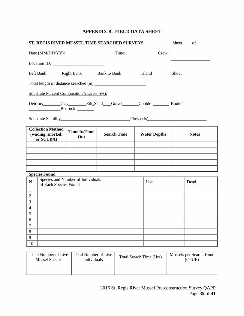
APPENDIX B. FIELD DATA SHEET
ST. REGIS RIVER MUSSEL TIME SEARCHED SURVEYS Sheet of
Date (MM/DD/YY): Time: Crew:
Location ID:
Left Bank Right Bank Bank to Bank Island Shoal
Total length of distance searched (m)
Substrate Percent Composition (nearest 5%):
Detritus Clay Silt Sand Gravel Cobble Boulder Bedrock
Substrate Stability Flow (cfs)
Collection Method (wading, snorkel,
or SCUBA)
Time In/Time Out
Search Time
Water Depths
Notes
Species Found
N Species and Number of Individuals of Each Species Found Live Dead
1 2 3 4 5 6 7 8 9 10
Total Number of Live
Mussel Species Total Number of Live
Individuals Total Search Time (Hrs) Mussels per Search Hour (CPUE)

2016 St. Regis River Mussel Pre-construction Survey QAPP Page 36 of 41
St. Regis Mohawk Tribe St. Regis River Mussel Measurements Data Sheet Page of
Form completed by: Form verified by: Site description:
Species Sex
(M, F, U) Length (mm)
Age (yrs) Notes
1 2 3 4 5 6 7 8 9 10 11 12 13 14 15 16 17 18 19 20 21 22 23 24 25 26 27 28 29 30 31 32 33 34 35

2016 St. Regis River Mussel Pre-construction Survey QAPP Page 37 of 41
St. Regis Mohawk Tribe St. Regis River Mussel Measurements Data Sheet
Form completed by: Form verified by: Page of
Site description: Species Sex
(M, F, U) Length (mm)
Age (yrs) Notes
36 37 38 39 40 41 42 43 44 45 46 47 48 49 50 51 52 53 54 55 56 57 58 59 60 61 62 63 64 65 66 67 68 69 70
2016 St. Regis River Mussel Pre-construction Survey QAPP Page 38 of 41
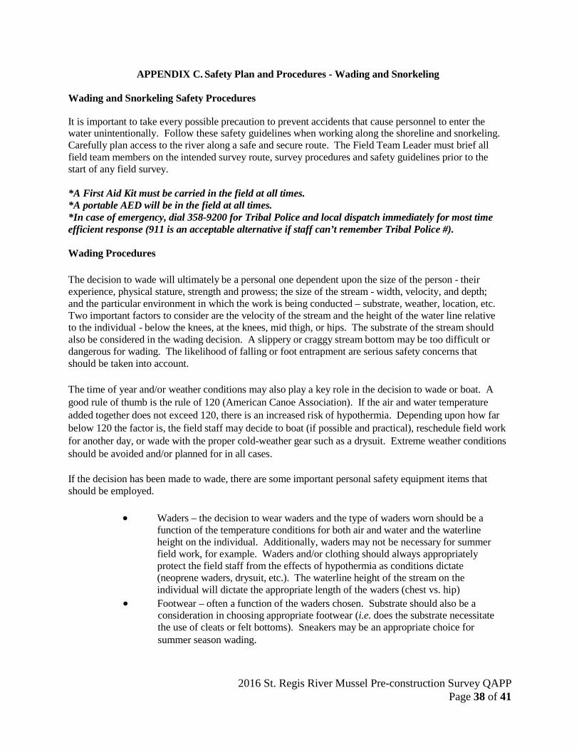
APPENDIX C. Safety Plan and Procedures - Wading and Snorkeling
Wading and Snorkeling Safety Procedures
It is important to take every possible precaution to prevent accidents that cause personnel to enter the water unintentionally. Follow these safety guidelines when working along the shoreline and snorkeling. Carefully plan access to the river along a safe and secure route. The Field Team Leader must brief all field team members on the intended survey route, survey procedures and safety guidelines prior to the start of any field survey.
*A First Aid Kit must be carried in the field at all times. *A portable AED will be in the field at all times. *In case of emergency, dial 358-9200 for Tribal Police and local dispatch immediately for most time efficient response (911 is an acceptable alternative if staff can’t remember Tribal Police #).
Wading Procedures
The decision to wade will ultimately be a personal one dependent upon the size of the person - their experience, physical stature, strength and prowess; the size of the stream - width, velocity, and depth; and the particular environment in which the work is being conducted – substrate, weather, location, etc. Two important factors to consider are the velocity of the stream and the height of the water line relative to the individual - below the knees, at the knees, mid thigh, or hips. The substrate of the stream should also be considered in the wading decision. A slippery or craggy stream bottom may be too difficult or dangerous for wading. The likelihood of falling or foot entrapment are serious safety concerns that should be taken into account.
The time of year and/or weather conditions may also play a key role in the decision to wade or boat. A good rule of thumb is the rule of 120 (American Canoe Association). If the air and water temperature added together does not exceed 120, there is an increased risk of hypothermia. Depending upon how far below 120 the factor is, the field staff may decide to boat (if possible and practical), reschedule field work for another day, or wade with the proper cold-weather gear such as a drysuit. Extreme weather conditions should be avoided and/or planned for in all cases.
If the decision has been made to wade, there are some important personal safety equipment items that should be employed.
• Waders – the decision to wear waders and the type of waders worn should be a
function of the temperature conditions for both air and water and the waterline height on the individual. Additionally, waders may not be necessary for summer field work, for example. Waders and/or clothing should always appropriately protect the field staff from the effects of hypothermia as conditions dictate (neoprene waders, drysuit, etc.). The waterline height of the stream on the individual will dictate the appropriate length of the waders (chest vs. hip)
• Footwear – often a function of the waders chosen. Substrate should also be a consideration in choosing appropriate footwear (i.e. does the substrate necessitate the use of cleats or felt bottoms). Sneakers may be an appropriate choice for summer season wading.
2016 St. Regis River Mussel Pre-construction Survey QAPP Page 39 of 41
• Life vests – The appropriate use of life vests is encouraged whenever working near the water. Life vests employed during wading situations should be rated a Coast Guard Class III or better.
• Cell phone or radio – it is extremely important to have communication devices on you at all times (when on/near the water, carrying these items in a waterproof container is advised) to ensure safety in emergency situations and to allow communication between field staff and plant operators where appropriate. In those instances where this is not possible, field crews should establish a communication protocol to notify a contact person prior to and at the end of each days field work.
• Polarized sunglasses – sunglasses with polarized lenses are always a wise choice for in-stream work. In addition to protection from UV rays, polarized lenses reduce reflective glare from the water enabling the wearer to better see the substrate, equipment, and in-stream conditions.
• Wading staff – a wading staff will offer extra stability in in-stream situations. A top-set wading rod may act as a wading staff.
The buddy system should be used for all in-stream field work. When wading is required, field work should be conducted by at least two people to provide an extra measure of safety. Depending on the conditions, more people may be required to insure safety. In swift water, group safety items should include:
• Throw bags – throw bags are very important safety items that can assist in
recovery of a swimmer or foot entrapment. In current situations, throw bags can also be dangerous, leading to entanglement. It is very important to not only have the throw bag, but to know how to properly use it. It is the responsibility of the field crew leader to ensure that field staff are properly trained in the use of all safety equipment, including throw bags.
• Catch line – a catch line may be used in situations where field staff are conducting in-stream work. As with throw bags, it is the responsibility of the field crew leader to ensure that catch lines are employed and used properly if conditions and situations dictate.
Snorkeling procedures
These snorkeling safety procedures guide employees when snorkeling.
With no exceptions at any time will anyone carry out any work alone, there must be at least two (2) employee’s present when snorkeling. Employees involved in snorkeling safety procedures must make prior arrangements to notify Field Team Leader or PI of a) the expected duration of the trip, 2) his/her departure time, and 3) the immediate end of the trip and approximate return time.
The Field Team Leader is the person in charge of the snorkeling activity. The Field Team Leader is responsible for the safety of the snorkeling operation.
The Field Team Leader is responsible for ensuring that:
2016 St. Regis River Mussel Pre-construction Survey QAPP Page 40 of 41
• All Snorkelers skill levels are evaluated and are up to a level suitable for the planned task. This may require a skill level evaluation in a shallow, calm water location.
• Risk Assessment is completed and control measures necessary to minimize the risks are implemented.
• All snorkelers are made aware of medical conditions that may be aggravated by snorkeling activities.
• Each team member is aware of their responsibilities, and rescue and first aid procedures are fully explained.
• A snorkel briefing is given to all snorkelers including advise about local hazards and conditions
• All snorkelers have a buddy assigned. Inexperienced snorkelers are to be paired with an experienced snorkeler.
• The required equipment is available at the snorkel site (i.e. communication equipment, first aid kit, sunglasses, hydration, and whistle)
• A recall system has been established, such as an air horn or whistle. • Head counts are to be conducted: prior to, during the activity (5
minute intervals) and a final head count is completed after the activity is finished.
General snorkeling procedures
• Snorkelers should not snorkel in the following conditions: 1) when wind speeds exceed 21 knots (freeze breeze). 2) when wave height at the site exceeds 0.5m, or 3) in strong currents where the snorkeler runs the risk of being carried away from the shore or boat. (note: the current at the snorkeling site should be such that all snorkelers are able to easily swim against the current with minimum exertion)
• All snorkelers’ skill levels are evaluated and are up to a level suitable for the planned task. This may require a skill level evaluation in a shallow, calm water location. (assistance from an experienced dive staff may be helpful)
• Risk assessment is completed and control measures necessary to minimize the risks are implemented.
• All snorkelers are made aware of medical conditions that may be aggravated by snorkeling activities and a medical declaration wavier has been signed.
• Snorkel teams should consist of at least 2 people in low risk conditions that are at least a buddy pair or one snorkeler and a lookout. Solo snorkeling shall be avoided.
• Where possible avoid areas of frequent boat traffic. When any vessel is approaching you should immediately leave the area until the vessel has departed. Larger vessels cannot easily maneuver in these confined areas to avoid swimmers.

2016 St. Regis River Mussel Pre-construction Survey QAPP Page 41 of 41
Boat based snorkeling In addition to the general snorkeling procedures outlined above, the following procedures should be followed for boat-based snorkeling procedures:
• drift snorkeling should be avoided unless a very experienced skipper is used
and the boat & dive staff have approved the snorkel plan. • a surface lookout must be posted at all times. Using a snorkel lookout
should be considered. • a dive flag should be displayed when snorkelers are in the water. • no snorkeling activities should take place further than 50 meters from the
boat. • a boat log should be filled out giving every ones full names. • a final head count shall be done before leaving the site. As well as a head
count every 5 minutes. • adhere to safe boating procedures.
Related Documents