Puget Sound Region TRANSPORTATION RECOVERY ANNEX July 2014 Regional Catastrophic Disaster Coordination Plan

Welcome message from author
This document is posted to help you gain knowledge. Please leave a comment to let me know what you think about it! Share it to your friends and learn new things together.
Transcript

Puget Sound
Region
TRANSPORTATION RECOVERY
ANNEX July 2014
Regional Catastrophic Disaster Coordination Plan

Part 1: User Guide
Part 2: Annex
The above links will take you directly to the User Guide or the Annex.

User Guide
Transportation Recovery Annex

Puget Sound Transportation Recovery Annex // User Guide// July 2014 UG-1
Clallam
Jefferson
Grays Harbor
Pacific
Whatcom
Skagit
Snohomish
King
Pierce
Lewis
Mason
Thurston
Island
Kitsap
San Juan
Northwest Washington
User Guide Purpose
This User Guide is designed to 1) provide an overview of the
Transportation Recovery Annex and to 2) be a practical mechanism for
coordinating regional transportation system recovery after a
catastrophic incident. The User Guide is not a replacement for the full
text of the Toolkit.
How to Use this Guide
This document provides an overview and practical guide to using the
Transportation Recovery Annex (”the Annex”). The full text of the Annex
is contained in Section C and separately bound Attachments.
Clicking on a blue link (p. #) will bring you to relevant information within this User Guide and full Toolkit document.
After clicking on a blue link, hold the Alt key down
and press the left arrow key to return to the page
you were viewing.
Clicking on blue links will bring you to relevant external resources.
Context
After an emergency or disaster, transportation
restoration is a continuous process of
assessment, prioritization, mitigation
and repair.
The Transportation Recovery Annex
guides regional transportation coordination
in a catastrophic event within the 8-county
Puget Sound Region. “Regional
coordination” means multiple counties or
Tribal Nations are involved. The Annex
supports the regional Coordination Plan.
The Annex provides a comprehensive framework and guidance for regional
transportation system recovery after a catastrophic incident. It provides
information and recommended guidelines for regional coordination,
collaboration, decision-making, and priority setting among Puget Sound area
emergency response and transportation agencies and other partners across the
disaster recovery spectrum. Although this Annex specifically addresses
transportation recovery after a major earthquake, the principles apply to all
types of transportation disruption, especially those that require multi-agency
and multi-modal coordination.
The Annex describes three separate concepts of coordination corresponding to
three stages of a catastrophic event:
Initial transportation system recovery actions to support response
Mid-term transportation system recovery actions
Long-term transportation system recovery actions
USER GUIDE OVERVIEW & CONTEXT

Puget Sound Transportation Recovery Annex // User Guide // July 2014 UG-2
USER GUIDE NAVIGATION
SHORT-TERM (UP TO 72 HOURS) MID-TERM (UP TO SEVERAL MONTHS) LONG-TERM (ONGOING)
Event
Short-Term Recovery
Decision & Coordination
Process (p. UG-3)
Disruption Scenarios
(p. UG-3)
Transportation
Collaboration in the
Short-Term (p. UG-4)
Roadway Checklists and
Inspection Documentation
(p. UG-5)
Mitigation Strategies (p. UG-6)
Mid-Term Recovery
Decision & Coordination
Process (p. UG-7)
Recovery Entities (p. UG-10)
Tools for Prioritization
Strategies
Processes (p. UG-13)
Long-Term Recovery Decision &
Coordination Process (p. UG-11)
Transportation Recovery
Indicators (p. UG-11)
A
Transportation
Collaboration in the
Mid-Term (p. UG-8)
Transportation
Collaboration in the
Long-Term (p. UG-12)
C
E
F
TIP:
Clicking on the
highlighted
page number
(p.#) will take
you to the
appropriate
section of the
User Guide.
After clicking
on an orange
link, hold the
Alt key down
and press the
left arrow key
to return to
the page you
were viewing.
H
MAPS
RESOURCES
CONTACTS
G Mid-Term Transportation
Recovery Coordination
Group (p. UG-9)
J
K
D
B
I

Puget Sound Transportation Recovery Annex // User Guide// July 2014 UG-3
Short-term recovery normally occurs in the first 72 hours after a catastrophic event. It is driven by immediate response needs and its aim is to manage the immediate
impacts of the disaster.
Short-Term Decision and Coordination Process
The short-term coordination process includes assessing the situation, followed by an iterative process of coordinating with partners and establishing detours. (p.II-2)
USER GUIDE A SHORT-TERM RECOVERY
Short-Term Recovery Checklists (p.II-16)
Short-term recovery checklists provide a list of key
recovery activities to be completed in the short-term
by mode and broken down by agency responsibility.
Short-Term Checklists include:
Roadways (p.II-16)
Waterways (p.II-17)
Airways (p.II-18)
Railways (p.II-19)
Potential Detour Scenarios and Routes
NOTE: THIS IS ALSO RELEVANT TO MID-TERM RECOVERY
Appendix A: This Appendix provides a summary of the development of the 50 disruption scenarios, the planning
process with local stakeholders and the calculations used to produce the Level of Service (LOS) map for each
scenario. (p.A-1)
Appendix B: This Appendix provides specific management and map information on each of the fifty (50)
disruption scenarios. (p.B-1)
Table B-1 is an index of the disruption scenarios. (p.B-2)
Return to Navigation

Puget Sound Transportation Recovery Annex // User Guide// July 2014 UG-4
Collaborative short-term transportation recovery measures are often temporary measures that can meet a transportation need while developing more
permanent measures and intermodal diversion of freight and passengers.
USER GUIDE B COLLABORATION IN THE SHORT-TERM
Transportation Collaboration in the Short-Term Phase
Actions Collaboration
Share situational awareness State EOC, WSDOT EOC and local EOCs share info from field assessments using all available technology, such as by e-mail, WebEOC and SharePoint sites.
Agencies that manage internet-based roadway condition maps update their websites as appropriate.
State EOC assembles Essential Elements of Information and shares information through the FEMA Regional Response Coordination Center (RRCC) and National Response Coordination Center (NRCC).
State agencies coordinate with federal regulatory agencies through Federal Lead Agency and/or liaisons to the State EOC.
Establish roadway and transit detours
State establishes detours for state highway system in collaboration with affected jurisdictions.
Local agencies establish detours in collaboration with affected adjacent jurisdictions.
Transit agencies make initial service adjustments.
Utilize mutual aid for emergency repairs
Local jurisdictions may request resources from mutual aid partners.
Share public information Public messages are shared through Joint Information Centers (JIC) and/or a Joint Information System (JIS). (See Section V - Information Collection and Dissemination.)
Return to Navigation

Puget Sound Transportation Recovery Annex // User Guide// July 2014 UG-5
A significant element of the recovery process for the roadway transportation system begins with the assessment of damages to bridges and roadway
structures, and the sharing of this information among local jurisdictions and the State.
WSDOT Bridges and Roadway Structures Checklist (p.E-1)
Provides a process for local jurisdictions for inspecting bridges and coordinating with neighboring cities and/or counties upon closure of bridges.
WSDOT Flow Chart for the Post-Earthquake Inspection of Bridges (p.E-3)
WSDOT First Response Bridge Inspection Documentation Form (p.E-5)
First Response Inspection Documentation Form is already in use for state owned bridges. This form has been recommended for use by local public works agencies and/or bridges inspection departments for Level I inspections.
The form is part of the new WSDOT “Handbook for the Post-Earthquake Safety Evaluation of Bridges.” (This handbook is not yet available).
The Highway Facilities Checklist p.E-7
Checklist lists highway facilities eligible for FHWA Emergency Relief
USER GUIDE C ROADWAY CHECKLISTS & INSPECTION DOCUMENTATION USER GUIDE C ROADWAY CHECKLISTS & INSPECTION DOCUMENTATION
Return to Navigation

Puget Sound Transportation Recovery Annex // User Guide// July 2014 UG-6
NOTE: THIS IS ALSO RELEVANT TO MID-TERM AND LONG-TERM RECOVERY
Transportation mitigation strategies are grouped into four (4) categories based on the desired results. The strategies are classified as Increasing Capacity
on Existing Lanes, Technology, Diverting or Redirecting Traffic and Demand Management.
Transportation Mitigation Strategies (p.E-14)
These mitigation strategies are generally related to Road and Railways
systems.
Provides an overview of a range of strategies, from how to increase capacity on existing lanes to demand management, organized by the phase of the recovery effort in which they usually occur.
Lists general transportation mitigation strategies and identifies which of the individual strategies can be applied during short-, mid- or long-term phases of recovery. (See Appendix 2 for applications to specific mitigation strategies associated with each disruption scenario.)
Subsequent sections describe each set of strategies, and provide information on how the strategy fits into the overall recovery plan, with considerations for ease of implementation.
Waterways Mitigation (p.F-1)
Summarizes waterways strategies and the recovery phases.
Additional information on each element is provided.
Airways Mitigation (p.G-1)
Summarizes airways strategies and the response phase in which they would come into play.
Additional information on each element is provided.
USER GUIDE D TRANSPORTATION MITIGATION STRATEGIES
Return to Navigation

Puget Sound Transportation Recovery Annex // User Guide// July 2014 UG-7
Mid-term transportation recovery measures are those actions implemented from the first hours to several weeks or months after the disaster.
Mid-Term Decision and Coordination Process (p.II-6)
The mid-term coordination process provides an overview of the process for mid-term transportation recovery actions.
USER GUIDE E MID-TERM RECOVERY
Mid-term Recovery Checklists (p.II-20)
Mid-term recovery checklists provide a list of key recovery activities to be completed in the short-term, broken down by
mode and agency responsibility. Checklists include:
Roadways (p.II-20)
Waterways (p.II-21)
Airways (p.II-22)
Railways (p.II-22)
Disruption Scenarios
NOTE: FOR MORE INFORMATION WITHIN
THIS USER GUIDE, SEE (UG-7).
USER GUIDE E MID TERM KEY MEASURES & RECOVERY CHECKLISTS
Return to Navigation

Puget Sound Transportation Recovery Annex // User Guide// July 2014 UG-8
Collaborative mid-term transportation recovery measures are often temporary measures that can meet a transportation need while developing more permanent
measures and intermodal diversion of freight and passengers. (p.II-7)
Transportation Collaboration in the Mid-term Recovery Phase
Actions Collaboration
Form coordination committee Counties, in consultation with their cities, tribes and the State convene a joint committee to coordinate mid-term transportation recovery decisions that cross county lines.
Works groups may be formed on a geographic and/or functional basis.
Existing entities such as Metropolitan Planning Organizations (MPOs) may be appropriate venues for the joint committee and/or its work groups.
Develop common operating picture The joint committee assigns responsibility to develop complete map(s) of the transportation network status.
Prioritize and design interim
repairs The joint committee and/or its work groups:
Anticipate long term recovery needs.
Consider financing opportunities and considerations.
Prioritize interim needs.
Design multi-modal solutions that integrate roadway, maritime, rail and aviation resources.
Identify funding sources.
Manage transportation demand The joint committee and/or its work groups will:
Identify the magnitude of demand.
Identify available capacity under alternative demand management scenarios.
Identify new capacity provided by emergency repairs and or expanded detour routes.
Implement demand management strategies.
Build public support Local and state agencies will:
Ensure community involvement in prioritization and design of interim repairs.
Provide common public messages through Joint Information Centers (JIC) and/or a Joint Information System (JIS) in support of demand management strategies. (See Section V - Information Collection and Dissemination.)
Begin long term recovery processes.
USER GUIDE F TRANSPORTATION COLLABORATION IN THE MID TERM
Return to Navigation

Puget Sound Transportation Recovery Annex // User Guide// July 2014 UG-9
Mid-Term Transportation Recovery Coordination Group (p. II-8)
As outlined in the Coordination Plan, a local, state or federal agency may recommend a Transportation Recovery Coordination Group be convened. There will likely be
two different groups, one for Long-Term planning for permanent restoration, and a Mid-Term Recovery Coordination Group for temporary measures that will be regional
in nature.
The Mid-Term Group will consist of a Steering Committee and several Working Groups. The Group would focus on coordinating and resolving cross-jurisdictional issues
during the temporary repairs and detours phase.
USER GUIDE G MID-TERM RECOVERY GROUP
Steering Committee
Steering Committee members should have the ability, authority, and jurisdictional knowledge such that
they can evaluate needs and commit resources where needed. Steering Committee members should
include one person from:
Each impacted county
Each impacted major city
Washington State DOT
Each impacted tribe
Transit Authorities
Ports
Impacted private industries
Objectives
1) Identify available major, inter-jurisdictional transportation modes and pathways available.
2) Coordinate temporary solutions and repair efforts between jurisdictions to maximize recovery efforts.
3) Develop work-arounds/detours to maximize the use of undamaged infrastructure
4) Identify other routes/modes where quick fixes are possible and categorize those by feasibility, effectiveness and cost.
5) Work with State Recovery groups in all sectors to ensure transportation issues receive sufficient consideration.
6) Set measureable goals and timelines. 7) Engage the public (e.g.; customers, vulnerable
populations, shippers) in the process.
Work Groups
Working Group membership will be Subject Matter Experts (SME) in the specific topic. SMEs should
have in-depth knowledge of their jurisdiction’s status, needs, and available resources. SME’s should also
have an understanding of regional impacts, regional economic needs, and regional planning efforts.
Possible Working Groups include:
Bridges/ Roadways
Freight Movement
Fueling
Traffic management/policy
Airports
Ferries
Mass Transit (Bus, Light Rail)
Seaports
Return to Navigation

Puget Sound Transportation Recovery Annex // User Guide// July 2014 UG-10
NOTE: THIS IS ALSO RELEVANT TO LONG-TERM RECOVERY
There is a range of ways that recovery entities along several modes can be organized. From utilizing grassroots methods through an existing agency or
working top down from a state agency, this range includes:
Local Transportation Entity Concept (p.C-4)
Local jurisdictions may form regional transportation recovery entities that are designed to facilitate regional recovery situational assessment
communication, priority setting or decision making. These entities could also play a role in any recovery organization established by the State. If local
regional coordination entities are formed, coordination with the State could occur so structures and organizations established locally could be
integrated into any state structure formed under the Governor’s authority.
Existing Organizations Recovery Entity Concept (p.C-6)
Local leadership has the authority to delegate some recovery decision making to existing organizations, including Metropolitan Planning Organizations
(MPOs) and Regional Transportation Planning Organizations (RTPOs), which are primary entities responsible for transportation planning in a region.
Washington Restoration Organization (WRO) (p.C-8)
The purpose of the WRO is to accelerate recovery by providing a single point of contact at the state level for Washington citizens, the private sector,
and local, state and federal governments to facilitate, coordinate and manage restoration operations.
USER GUIDE H RECOVERY ENTITIES
Return to Navigation

Puget Sound Transportation Recovery Annex // User Guide // July 2014 UG-11
Long-term transportation recovery measures for the purposes of this Annex are defined as permanent measures implemented to return the regional
transportation network to pre-disaster or better condition.
Long-Term Decision and Coordination Process (p.II-14)
The long-term coordination process provides an overview of the decision and coordination
process for long-term transportation recovery actions.
Long-Term Recovery Checklists (p.II-23)
Long-term recovery checklists provide a list of key
recovery activities to be completed in the long-term
by mode and broken down by agency responsibility.
Long-term Checklists include:
Roadways (p.II-23)
Waterways (p.II-23)
Airways (p.II-25)
Railways (p.II-25)
Transportation Recovery Indicators (p.V-5)
Different user groups and stakeholders will need to work together to identify indicators of recovery for their specific area that strive for some percentage of the pre-disaster level of service within a certain amount of time as a recovery goal.
Some potential metrics and indicators can be viewed at (p.V-5).
USER GUIDE I LONG-TERM RECOVERY
Return to Navigation

Puget Sound Transportation Recovery Annex // User Guide // July 2014 UG-12
The table on the left shows the transportation recovery activities, on which agencies need to collaborate in the long term after a catastrophic incident.
More information on transportation collaboration in the long-term can be found at (p.II-14).
The links below will connect to Recovery Concepts important to
long-term recovery previously discussed in this User Guide on
(UG-10).
Local Transportation Recovery Entity Concept (p.C-5)
Existing Organizations Transportation Recovery Entity Concept
(p.C-7)
Washington Restoration Organization Recovery Concept (p.C-9)
USER GUIDE J LONG-TERM COLLABORATION
Transportation Collaboration in the Long-term Recovery Phase
Actions Collaboration
Form working groups in
support of recovery
committee(s)
Recovery committee members:
Identify functional and/or geographic work groups.
Determine extent of work group authority.
Working group(s) update
common operating picture
Evaluate disaster impact on transportation services.
Estimate timelines for repair and reconstruction.
Develop cost estimates.
Working group(s) prioritize
and design permanent
repairs
Develop long term plans to restore and/or revise local and regional traffic movement.
Develop long term plans to restore and/or revise transit operations.
Develop long term plans to restore and/or revise inter-modal freight movement.
Recovery committee(s) and
Working group(s) build
public support
Involve community representatives on committees and working groups.
Conduct public meetings.
Seek public input.
Provide timely information.
Keep process transparent.
Demonstrate inter-agency collaboration.
Return to Navigation

Puget Sound Transportation Recovery Annex // User Guide// July 2014 UG-13
USER GUIDE K PRIORITIZATION TOOLS
Prioritization is an iterative process that requires information gathering, assessing the outcome, and adjusting the weights in the ranking spreadsheet
based upon the situation at the time of the catastrophe.
Prioritization Tool for Long-Term Transportation Recovery (p.D-1)
Prioritization is an iterative process that requires the following:
Information gathering
Ranking segment repair
Assessing the outcome
Adjusting the weights in the ranking spreadsheet based upon the situation at the time of a catastrophe
The links below will connect to mitigation strategies and processes
important to long-term recovery previously discussed in this User Guide.
Transportation Mitigation Strategies (p.E-14)
NOTE: FOR MORE INFORMATION WITHIN THIS USER GUIDE, (UG -6)
Medicaid Transportation Regions (p.E-27)
NOTE: FOR MORE INFORMATION WITHIN THIS USER GUIDE, (UG -14)
Waterways Mitigation Strategies (p.F-1)
NOTE: FOR MORE INFORMATION WITHIN THIS USER GUIDE, (UG -6)
Airways Mitigation Strategies (p.UG-1)
NOTE: FOR MORE INFORMATION WITHIN THIS USER GUIDE, (UG -6)
Aviation Implementation Process (p.UG-4)
NOTE: FOR MORE INFORMATION WITHIN THIS USER GUIDE, (UG -15)
Priority Regional Transportation Asset Factors and Values (p.D-3)
Jurisdictions establish priorities about which transportation assets should be repaired/restored first. The prioritization process entails scoring a set of criteria developed in relation to the transportation network. Circumstances at the time of the incident will determine the selection of criteria and weighting of the categories.
Priority Ranking for Repair/ Restoration of the Regional Transportation Assets (p.D-4)
Provides a spreadsheet for calculating the priority ranking for repair/restoration of regional transportation assets.
Return to Navigation

Puget Sound Transportation Recovery Annex // User Guide// July 2014 UG-14
USER GUIDE MAPS
Relevant maps to the short-term, mid-term and long-term recovery process include:
Transportation Broker Regions Map (p.E-29)
The transportation broker map shows the six Medicaid Transportation
Regions for special needs patients in northwest Washington State.
Transportation System Maps
The Transportation Systems Maps include general maps of the roadway, transit,
waterway, airway and railway transportation systems in the region.
Roadway (p. I-13)
Transit (p. I-14)
Railway (p. I-17)
Airway (p. I-16)
Airport Maps (p.G-6)
Waterway (p. I-15)
Clallam
Jefferson
Grays Harbor
Pacific
Whatcom
Skagit
Snohomish
King
Pierce
Lewis
Mason
Thurston
Island
San Juan
Kitsap
Northwest Washington
Anacortes
Key
Region 3A
Region 3B
Region 4
Region 5
Region 6A
Region 6B
Return to Navigation

Puget Sound Transportation Recovery Annex // User Guide// July 2014 UG-15
USER GUIDE RESOURCES
Important resources for short-, mid-, and long-term recovery include:
General Resources: Primary Federal Recovery Programs (p.VII-1)
The established primary recovery programs are the USDOT FHWA Emergency Relief (ER) program and the FEMA
Public Assistance Program.
Primary Federal Transportation Recovery Programs
Agency Information
FHWA Under Title 23, USC, Section 125, for the restoration of damaged roads and bridges on
functional classified systems (National Highway System).
Funds are available after the governor has issued a Proclamation of Emergency (Note: a
presidential declaration of major disaster is not necessary.)
FEMA Under Public Law 93-228, as amended by PL 100-707, the Robert T. Stafford Disaster
Relief and Emergency Assistance Act of 1988, for the restoration of damaged roads and
bridges off functional classified systems (I.e. off the federal aid system).
Funds are available after a presidential declaration of major disaster.
Glossary of Terms (p.H-1)
Common transportation terms used in this plan and in transportation recovery operations.
Transit Resources (p.E-26)
Table E-9 provides a summary of regional transit resources and routes.
This resource focuses on Bus and Streetcar Transit Systems throughout different counties, the capacity of the fleet, the service areas covered, and the additional/ connecting service areas.
Training and Exercise (p.I-1)
Provides information about multi-jurisdictional regional transportation system recovery in the Puget Sound
Region.
Airways Resources
Aviation Implementation Processes for Passengers and Freight Service (p.G-4)
Implement New Aviation Service
If, as a result of capacity reductions in
other transportation modes, a new
aviation service is needed to move
either people or freight. These steps
outline that implementation.
Implement/ Expand/ Relocate Passenger Service
Decisions to implement new services
or modify existing services through
expansion or relocation must consider
the availability of connections at both
ends of the route.
Airport Capabilities in the Puget Sound Region (p.G-7)
Table G-3 outlines the capabilities of airports in the Puget Sound.
Information provided includes name of airport, owner/ operator, FAA airport, airport reference code, whether or not the airport is included in NPIAS, and the NPIAS role.
Return to Navigation
Puget Sound Transportation Recovery Annex // User Guide // July 2014 UG-16
USER GUIDE RESOURCES (CONT.)
Information regarding waterways service strategies:
Waterways Service Resources
Long- Term Ferry Service Strategies
Because the region’s waterways are likely to provide one of the few operational transportation corridors after a major catastrophe, passenger ferry services will be in high demand.
Decisions to implement new services or modify existing services through expansion or relocation must consider the availability of intermodal connections at both ends of the route.
The issues associated with new, expanded, or relocated ferry services are summarized at (p.F-6).
Maritime Assets Inventory (F-10)
Table F-3 provides information on Puget Sound Maritime Assets.
The data is organized by:
Ports
Facilities and Vessels
Charters
Tugs, Barges and Salvage Companies
Marinas
Labor
Bridges over Navigable Waters
Boat Ramps
New Ferry Service Template (p.F-30)
Provides a spreadsheet listing the elements of a new ferry terminal to assist in determining the feasibility of a
proposed new service or alternate terminal. When evaluating landing sites, consideration should be given to
the urgency of the need for and anticipated duration of the service. A landing site that is inadequate for
permanent service may be quite serviceable for a week or two. Potential landing sites include:
Marinas
Accessible docks
Navy shore facilities
State and local waterfront parks
Vessel maintenance facilities
Recreational boat ramps
Return to Navigation

Puget Sound Transportation Recovery Annex // User Guide// July 2014 UG-17
USER GUIDE CONTACTS
Additional Road Conditions and Transit Websites (p.V-9)
Jurisdiction Website Address Provides real time:
WSDOT wsdot.wa.gov/traffic/ Traffic information to travelers
WSDOT www.wsdot.wa.gov/traffic/trafficalerts/ Traffic Alerts for travelers
King Co Road
Info gismaps.kingcounty.gov/roadalert/ Traffic Alerts and Road information in King County
City of Seattle www.cityofseattle.net/html/citizen/traffic.htm Traffic Alerts and Road information in the City of Seattle
City of Bellevue www.ci.bellevue.wa.us/traffic_advisories.htm Traffic Alerts and Road information in the City of Bellevue
Metro metro.kingcounty.gov/ Route information, safety information and rider alerts for any
schedule and Metro route changes
Sound Transit www.soundtransit.org/ Route information, safety information and rider alerts for any
schedule and Sound Transit route changes
Pierce County https://member.everbridge.net/index/453003085611267 Emergency and Traffic Notification Sign-Up for Traffic Alerts
and Road Information in Pierce County
City of Tacoma www.cityoftacoma.org/government/city_departments/public_works/street_operations/ Traffic Alerts and Road information in the City of Tacoma
Pierce Transit www.piercetransit.org/ Route information, safety information and rider alerts for any
schedule and Pierce Transit route changes
Intercity Transit www.intercitytransit.com/Pages/default.aspx Route information, safety information and rider alerts for any
schedule and Intercity transit route changes
Mason County www.co.mason.wa.us/public_works/road_closures.php Traffic Alerts and Road information in Mason County
Mason Co
Transit www.masontransit.org/ Route information, safety information and rider alerts for any
schedule and Mason County Transit route changes
Return to Navigation

Puget Sound Transportation Recovery Annex // User Guide// July 2014 UG-18
USER GUIDE CONTACTS (CONT.)
Kitsap County www.kitsapgov.com/pw/roadwork.htm Traffic Alerts and Road information in Kitsap County
Kitsap Co. Transit www.kitsaptransit.org/ Route information, safety information and rider alerts for any schedule
and Kitsap County Transit route changes
Island County www.islandcounty.net/publicworks/ Traffic and road condition information
Island Co. Transit www.islandtransit.org/ Route information, safety information and rider alerts for any schedule
and Kitsap County Transit route changes
Skagit County www.skagitcounty.net/reporting/roadclose/ Current Road Closures in Skagit County
Skagit Co. Transit www.skagittransit.org/ Route information, safety information and rider alerts for any schedule
and Kitsap County Transit route changes
Snohomish County www.co.snohomish.wa.us/PWApp/roads/emclosure/ Road Maintenance and Restrictions in Snohomish County
City of Everett www.ci.everett.wa.us/default.aspx?ID=65 Traffic Alerts and Road information in the City of Everett
Community Transit www.commtrans.org/ Route information, safety information and rider alerts for any schedule
and Snohomish County Transit route changes
Thurston County www.co.thurston.wa.us/publicworks/Alerts_Current.aspx Traffic Alerts and Road Closures in Thurston County
Other Important Contacts for Short, Mid, and Long-Term Recovery Include:
Local Jurisdiction Websites and Public Information Networks (p.V-8)
Utility Purveyors and Contact Information (p.E-24)
Bridge Inspection Contacts for the Puget Sound Region (p.E-9)
Airport Contact List (p.G-14)
Return to Navigation

This page intentionally left blank.
Puget Sound
Region
TRANSPORTATION RECOVERY
ANNEX July 2014
Regional Catastrophic Disaster Coordination Plan

This page intentionally left blank.

TRANSPORTATION RECOVERY ANNEX
Transportation Recovery Annex – February 2011 v
Table of Contents
I. Introduction and Overview ........................................................................................................ I-1
A. General Information ........................................................................................................................... I-1
B. Scope ................................................................................................................................................ I-2
C. Planning Assumptions ....................................................................................................................... I-2
D. The Transportation Restoration Process ........................................................................................... I-2
E. The Transportation System ............................................................................................................... I-3
F. Transportation System Hazards ...................................................................................................... I-10
G. Transportation System Maps .......................................................................................................... I-12
II. Concept of Coordination .......................................................................................................... II-1
A. General Information .......................................................................................................................... II-1
B. Short-term Transportation Recovery to Support Emergency Response .......................................... II-2
C. Mid-term Transportation Recovery ................................................................................................... II-4
D. Long-term Transportation Recovery ............................................................................................... II-13
III. Organization and Responsibilities ........................................................................................... III-1
A. General Information ......................................................................................................................... III-1
B. Organization for Transportation Recovery ....................................................................................... III-1
C. Responsibilities for Transportation Recovery .................................................................................. III-4
IV. Direction, Control and Coordination ....................................................................................... IV-1
A. General Information ......................................................................................................................... IV-1
B. Local Transportation Recovery Operations ..................................................................................... IV-1
C. State Transportation Recovery Operations ..................................................................................... IV-1
D. Intermodal Transportation Coordination .......................................................................................... IV-3
E. Federal Transportation Recovery Operations ................................................................................. IV-9
F. Regional Coordination ..................................................................................................................... IV-9
G. Criteria for Prioritization of Transportation Recovery for Roadways .............................................. IV-10
V. Information Collection and Dissemination ............................................................................... V-1
A. General Information .......................................................................................................................... V-1
B. Situational Awareness ...................................................................................................................... V-1
C. Public Information ............................................................................................................................. V-4
VI. Communications ......................................................................................................................... 1
A. General Information .............................................................................................................................. 1

TRANSPORTATION RECOVERY ANNEX
Transportation Recovery Annex – February 2011 vi
B. Short-Term Recovery Communications ............................................................................................... 1
C. Mid-term and Long-term Regional Communications Needs ................................................................. 4
VII. Administration, Finance and Logistics ................................................................................... VII-1
A. General Information ........................................................................................................................ VII-1
B. USDOT FHWA Emergency Relief (ER) Program ........................................................................... VII-1
C. FEMA Public Assistance (PA) Program ......................................................................................... VII-5
D. Mutual Aid Agreements .................................................................................................................. VII-6
VIII. Annex Development and Maintenance ................................................................................ VIII-1
A. General Information ....................................................................................................................... VIII-1
B. Plan Maintenance Responsibility................................................................................................... VIII-1
C. Plan Maintenance .......................................................................................................................... VIII-1
D. Training ......................................................................................................................................... VIII-1
E. Exercise and Evaluation ................................................................................................................ VIII-2
IX. Authorities and References .................................................................................................... IX-1
A. General Information ......................................................................................................................... IX-1
B. Federal Statutes .............................................................................................................................. IX-1
C. Federal Regulations ........................................................................................................................ IX-1
D. Federal Plans, Procedures and Reference Documents .................................................................. IX-1
E. State Statutes .................................................................................................................................. IX-3
F. State Regulations (Washington Administrative Code – WAC) ........................................................ IX-5
G. State Plans, Procedures and Reference Documents ...................................................................... IX-5
X. Recommendations and Best Practices ................................................................................... X-1
A. General Information .......................................................................................................................... X-1
B. Recommendations ........................................................................................................................... X-1
C. Best Practices ................................................................................................................................ X-13
D. Best Practices Resources .............................................................................................................. X-17
Appendix A. Alternative Routing and Level of Service (LOS) Map Development ........................... A-1
A. General Information .......................................................................................................................... A-1
B. Development of Alternative Routing Maps ....................................................................................... A-1
C. The Transportation Working Group and Planning Teams ................................................................ A-1
D. Transportation Infrastructure ............................................................................................................ A-2
E. Closure Scenarios ............................................................................................................................ A-2
F. Alternative Routing Plans ................................................................................................................. A-5

TRANSPORTATION RECOVERY ANNEX
Transportation Recovery Annex – February 2011 vii
G. Development of Level of Service (LOS) Maps ................................................................................. A-8
H. Traffic Flow ....................................................................................................................................... A-9
I. Levels of Service .............................................................................................................................. A-9
J. Roadway Capacity ......................................................................................................................... A-10
K. References ..................................................................................................................................... A-19
Appendix B. Disruption Scenarios Information and Maps ............................................................... B-1
A. General Information .......................................................................................................................... B-1
B. Fifty (50) Disruption Scenarios Information and Maps ..................................................................... B-1
Appendix C. Regional Coordination ................................................................................................ C-1
A. Regional Coordination ...................................................................................................................... C-1
B. Entities Formed by Local Government ............................................................................................. C-3
C. Regional Coordination Accomplished by Existing Organizations ..................................................... C-5
D. Regional Coordination - State Draft Plans ........................................................................................ C-8
Appendix D. Prioritization of Roadway Restoration and Reconstruction ......................................... D-1
A. General Information .......................................................................................................................... D-1
B. Prioritization Process ........................................................................................................................ D-1
C. Prioritization Tools ............................................................................................................................ D-2
Appendix E. Roadway Toolbox ....................................................................................................... E-1
A. General Information .......................................................................................................................... E-1
B. Roadway Assessments .................................................................................................................... E-1
C. Transportation Mitigation Strategies ............................................................................................... E-13
D. Transit Resources .......................................................................................................................... E-26
E. Resources for Special Needs Transportation ................................................................................. E-28
Appendix F. Waterways Toolbox ...................................................................................................... F-1
A. General Information .......................................................................................................................... F-1
B. Waterways Assessments ................................................................................................................. F-1
C. Waterways Mitigation Strategies ...................................................................................................... F-1
D. Maritime Implementation Processes for Ferries and Freight ............................................................ F-5
Appendix G. Airways Toolbox ......................................................................................................... G-1
A. General Information .......................................................................................................................... G-1
B. Airways Assessments ...................................................................................................................... G-1
C. Airways Mitigation Strategies ........................................................................................................... G-1
D. Aviation Implementation Processes for Passenger and Freight Services ........................................ G-5

TRANSPORTATION RECOVERY ANNEX
Transportation Recovery Annex – February 2011 viii
Appendix H. Glossary of Terms ...................................................................................................... H-1
Appendix I. Recommendations, Sustainment, Training and Exercises ............................................. I-1
A. General Information ........................................................................................................................... I-1
B. Recommendations ............................................................................................................................ I-2
C. Training and Exercises ...................................................................................................................... I-5
D. Recommended funding opportunities and next steps ..................................................................... I-10
E. Improvement Plan ........................................................................................................................... I-12
F. Train-the-Trainer Information .......................................................................................................... I-17

TRANSPORTATION RECOVERY ANNEX
v
List of Tables
Table I-1: Regional Ferry Services .................................................................................................................. I-7
Table I-2: Airports per County .......................................................................................................................... I-9
Table I-3: Classifications of Airports ................................................................................................................ I-9
Table I-4: Transportation System Hazards and Impacts ................................................................................ I-11
Table II-1: Transportation Collaboration in the Short-term .............................................................................. II-3
Table II-2: Transportation Collaboration in the Mid-Term ............................................................................... II-7
Table II-3: Possible Working Groups ............................................................................................................ II-10
Table II-4: Transportation Recovery Indicators ............................................................................................. II-12
Table II-5: Mid-Term Transportation Recovery Priorities .............................................................................. II-14
Table II-6: Mitigation Solutions Effectiveness Worksheet (Example) ............................................................ II-12
Table II-7: Mitigation Solutions Effectiveness Worksheet ............................................................................. II-13
Table II-8: Transportation Collaboration in the Long-Term ........................................................................... II-15
Table II-9: Short-Term Recovery Checklist ................................................................................................... II-16
Table II-10: Mid-Term Recovery Checklist................................................................................................... II-20
Table II-11: Long-Term Recovery Checklist ................................................................................................. II-23
Table III-1: Local Transportation Recovery Responsibilities .......................................................................... III-5
Table III-2: State Transportation Recovery Responsibilities .......................................................................... III-7
Table III-3: Federal Transportation Recovery Responsibilities ...................................................................... III-8
Table III-4: Private Sector Transportation Recovery Responsibilities .......................................................... III-14
Table IV-1: Roadways and Waterways Coordination .................................................................................... IV-4
Table V-1: Essential Elements of Information (EEI)........................................................................................ V-4
Table V-2: Transportation Recovery Indicators .............................................................................................. V-5
Table V-3: Local Jurisdiction Websites and Public Information Networks ...................................................... V-8
Table V-4: Additional Road Condition and Transit Websites .......................................................................... V-9
Table VI-1: Communications Tools ..................................................................................................................... 5
Table VII-1: Primary Federal Transportation Recovery Programs ................................................................ VII-1
Table VII-2: FHWA ER Reimbursement Process ......................................................................................... VII-3
Table VII-3: Summary of Waterways Mutual Aid Agreements ...................................................................... VII-7
Table VII-4: Summary of Airways Mutual Aid Agreements ........................................................................... VII-7
Table VIII-1: Preparedness Cycle ................................................................................................................ VIII-2
Table X-1: Recommendations ........................................................................................................................ X-1
Table X-2: Best Practices ............................................................................................................................. X-13
Table X-3: Best Practices Resources ........................................................................................................... X-17
Table A-1: Number of Disruption Scenarios per County ................................................................................. A-3
Table A-2: Weighting Factors ......................................................................................................................... A-5
Table A-3: Final List of 50 Scenarios for Detailed Planning ............................................................................ A-6
Table A- 4: Roadway Segment Volume Approximation ................................................................................ A-13
Table B- 1: Disruption Scenarios Index .......................................................................................................... B-2
Table C- 1: Regional Transportation Recovery Actions .................................................................................. C-2
Table C- 2: Puget Sound MPOs and RTPOs. ................................................................................................ C-7
Table D- 1: Prioritization Components ........................................................................................................... D-1
Table D- 2: Priority Regional Transportation Asset Factors and Values ......................................................... D-3

TRANSPORTATION RECOVERY ANNEX
Transportation Recovery Annex – February 2011 vi
Table D- 3: Priority Ranking of Regional Transportation Assets .................................................................... D-4
Table E- 1: Bridges and Roadway Structures Checklist ................................................................................. E-1
Table E- 2: Inspector Qualifications, Methods and Objectives. ..................................................................... E-4
Table E- 3: Highway Facilities Checklist ......................................................................................................... E-7
Table E- 4: Bridge Inspection Contacts for the Puget Sound Region (July 2010) .......................................... E-9
Table E- 5: Transportation Mitigation Strategies........................................................................................... E-14
Table E- 6: Repair and Replacement Elements............................................................................................ E-22
Table E- 7: Utility Purveyors and Contact Information (January 2011) ......................................................... E-24
Table E- 8: WSDOT Emergency Contracting (January 2011) ...................................................................... E-25
Table E- 9: Roadways (Bus and Streetcar) Transit Systems (January 2011) .............................................. E-26
Table F- 1: Waterways Mitigation Strategies .................................................................................................. F-1
Table F- 2: Long Term Ferry Service Strategies............................................................................................. F-6
Table F- 3: Maritime Assets Inventory (January 2011) ................................................................................. F-10
Table F- 4: New Ferry Service Template ...................................................................................................... F-32
Table G- 1: Airways Strategies ....................................................................................................................... G-2
Table G- 2: Passenger Service Strategies ..................................................................................................... G-6
Table G- 3: Airport Capabilities ....................................................................................................................... G-8
Table G- 4: Airport Contacts List (September 2010) ..................................................................................... G-14
Table I- 1- Transportation Recovery Annex Training & Exercise Results ........................................................ I-6
Table I- 2- Transportation Recovery related courses....................................................................................... I-7
Table I- 3- Other classes that could relate to this annex offered by different organizations ............................ I-8
Table I- 4:- Snohomish County tentative commitments from participating agencies ..................................... I-10
Table I- 5 – Potential funding opportunities from the CFDA .......................................................................... I-11

TRANSPORTATION RECOVERY ANNEX
Transportation Recovery Annex – February 2011 vii
List of Figures
Figure I-1: Puget Sound Regional Catastrophic Planning Program area ........................................................ I-1
Figure I-2: Transportation Restoration Process ............................................................................................... I-3
Figure I-3: Regional Roadways Map (January 2011) .................................................................................... I-13
Figure I-4: Regional Transit Map (July 2010)................................................................................................. I-14
Figure I-5: Regional Waterways Map (January 2011) ................................................................................... I-15
Figure I-6: Regional Airways Map (January 2011)......................................................................................... I-16
Figure I-7: Regional Railways Map (January 2011) ....................................................................................... I-17
Figure II-1: Short-term Decision and Coordination Process .......................................................................... II-3
Figure II-2: Mid-Term Decision and Coordination Process ............................................................................. II-6
Figure II-3: Long-term Decision and Coordination Process .......................................................................... II-14
Figure III-1: WSDOT Emergency Organization Chart – Level III Activation ................................................... III-2
Figure III-2: Potential Organization Chart for a Washington Restoration Organization (WRO) ..................... III-3
Figure III-3: Joint Field Office Organization Chart (from the NRF) ................................................................. III-4
Figure IV-1: State Transportation Recovery Direction and Control ................................................................ IV-2
Figure IV-2: Direction, Control and Coordination Relationships for Maritime Operations .............................. IV-6
Figure IV-3: Reporting relationships among airports and EOC/ECCs ........................................................... IV-8
Figure A- 1: Congested State Highways in the Central Puget Sound Region .............................................. A-12
Figure C- 1: Local Transportation Recovery Entity Concept ........................................................................... C-5
Figure C- 2: Existing Organizations Transportation Recovery Concept ......................................................... C-7
Figure C- 3: Washington Restoration Organization Recovery Concept ......................................................... C-9
Figure E- 1: Flow Chart for the Inspection Procedure for Bridges (January 2011) ......................................... E-3
Figure E- 2: Level 1 First Response Inspection Documentation Form ........................................................... E-6
Figure E- 3: Transportation Broker Regions for Special Needs Patients for the Region .............................. E-29
Figure F- 1: Ports, Ferry Routes and Landing Sites (January 2011) .............................................................. F-9
Figure G- 1: Map of Airports (December 2010) .............................................................................................. G-7
Transportation Recovery Annex – July 2014 I-1
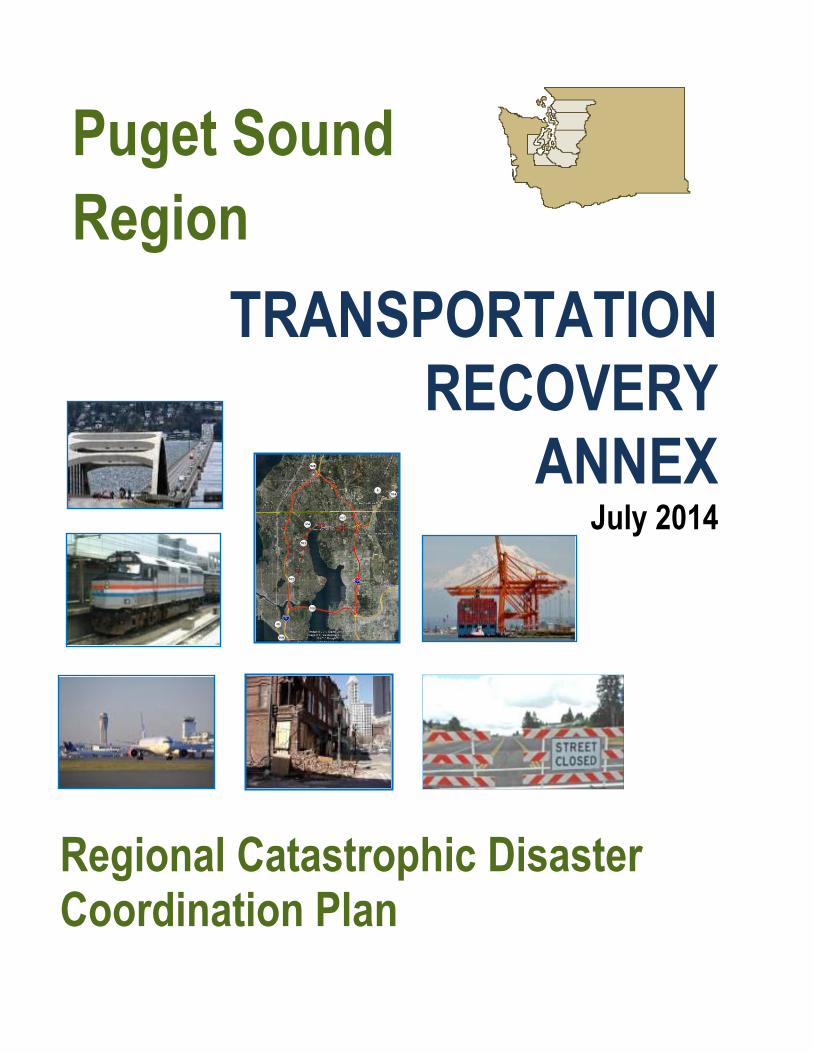
I. Introduction and Overview
A. General Information
The Puget Sound Transportation Recovery Annex (Annex) supplements the Puget Sound Regional
Catastrophic Coordination Plan (Coordination Plan). It provides recommended guidelines for coordinating
multi-jurisdictional regional transportation system recovery in the Puget Sound Region after a catastrophic
incident. This Annex addresses transportation issues in Island, King, Kitsap, Mason, Pierce, Skagit,
Snohomish and Thurston Counties. It provides information and recommended guidelines for regional
coordination, collaboration, decision-making, and priority setting among Puget Sound area emergency
response and transportation agencies and other partners across the disaster recovery spectrum. (See Figure
I-1 for a map of the Puget Sound Regional Catastrophic Planning Program area)
Figure I-1: Puget Sound Regional Catastrophic Planning Program area
Although this Annex specifically addresses transportation recovery after a major earthquake, the principles
apply to all types of transportation disruption, especially those that require multi-agency and multi-modal
coordination.
This Annex also provides information, strategies and guidance for local jurisdictions to develop their
respective local implementation plans to address local issues and procedures for connecting local
transportation recovery measures with the restoration of the regional transportation network, as well as
establishing coordination linkages with other local jurisdictions, state and federal transportation agencies,
traffic management systems, and applicable private sector stakeholders who own or operate applicable
infrastructure components.
Clallam
Jefferson
Grays Harbor
Pacific
Whatcom
Skagit
Snohomish
King
Pierce
Lewis
Mason
Thurston
Island
Kitsap
San Juan
Northwest Washington
INTRODUCTION SECTION I
Transportation Recovery Annex – July 2014 I-2
B. Scope
This Annex offers general guidelines on regional multi-jurisdictional coordination and priority setting for the
recovery of transportation networks. In addition, the Annex includes Appendices that can be used as
toolboxes for traffic mitigation strategies, waterway alternatives and bridge and roadway reconstruction.
These Appendices provide a multi-modal guide for implementing strategies consistent with regionally
available abilities and resources that will facilitate restoration of critical transportation links.
Finally, the Annex includes traffic mitigation strategies for 50 major road disruption scenarios identified by
stakeholders in each of the eight (8) counties. Appendix A describes the process of identifying the disruption
scenarios and developing the Level of Service (LOS) Maps. Appendix B (published separately) describes
each of the 50 scenarios and identifies the lead agency, the supporting agencies and jurisdictions, and who
needs to be notified and by whom of alternative detours.
C. Planning Assumptions
This Annex assumes the following:
The Annex will be available to assist local, state, and federal officials in preparing for, responding to and recovering from transportation disruptions.
The Annex applies to any emergency or disaster, including human caused incidents that may disrupt the transportation system.
The Annex builds upon existing local and state emergency management and transportation related plans.
The Annex is consistent with Washington State emergency management plans.
Although this is a recovery planning effort, implementing initial recovery actions will involve response elements.
Recovery of the transportation system will require multi-jurisdictional coordination.
The federal government can provide technical assistance and physical assets to establish multi-modal transportation alternatives and to support transportation recovery in accordance with Federal statutes, plans, and policies.
D. The Transportation Restoration Process
After an emergency or disaster, transportation restoration is a continuous process of assessment,
prioritization, mitigation, and repair. The process begins at the onset of an emergency, as soon as field crews
begin sending condition information. As more data is collected, managers assign priorities, and crews
commence maintenance and repairs based on available data. At the same time, mitigation measures are put
in place to help manage the functioning components of the transportation system.
As the process continues, more specific information becomes known about the extent of damage and duration
of repairs for individual elements. That information often results in a revision of priorities and mitigation
strategies. As repairs are completed, managers reassess field conditions and the cycle of prioritization,
mitigation, repair, and assessment continues.
In a catastrophic incident, maintaining the integrity of this process can be a challenge. The basic principles
remain the same; however, the scope of the incident may require dividing the affected area into manageable

INTRODUCTION SECTION I
Transportation Recovery Annex – July 2014 I-3
units from a span of control stand point necessitating regional coordination structures, communications
discipline and the management of a large amount of information. Pre-existing relationships and reporting
protocols can mitigate these challenges.
The transportation restoration process is summarized in Figure I-2 below.
Figure I-2: Transportation Restoration Process
E. The Transportation System
1. Roadways
Multiple jurisdictions own and share responsibility for the roadway system in Washington State. The
Washington State Department of Transportation reports that state highways, including federally funded
highways and interstates, carry almost 56% of the traffic statewide. County roads carry approximately 16%
and local roads carry 26%, with the remainder being carried by park, tribal and port roads. State and local
roads account for approximately 155 million vehicle miles traveled on a daily basis. (See Attachment 1 –
Roadway Map.)

INTRODUCTION SECTION I
Transportation Recovery Annex – July 2014 I-4
As sections of the road network become unusable during a
catastrophic incident, the remaining roadways must perform
the essential functions of providing emergency response
routes; local access to homes, schools and businesses;
vehicle parking and queuing near terminal points such as
transit stations, park-ride and ridesharing locations, and
marine and aviation facilities; and bypassing the incident
location.
Transportation mitigation strategies are grouped into four (4)
categories based on the desired results. The strategies are
classified as Increasing Capacity on Existing Lanes,
Technology, Diverting or Redirecting Traffic and Demand Management. These strategies can be utilized in
short-, mid- and long-term recovery phases to assist with recovery of the regional transportation network.
(See Appendix E – Roadways Toolbox)
a. Bus, Streetcar and Passenger Rail Transit
Bus and Streetcar Transit Systems
Transit’s people-moving capacity and flexibility in adjusting to network disruptions is critical during
recovery of the transportation system. Transit operations perform one of the basic requirements for
recovery, moving large numbers of people in the fewest number of vehicles. Transit agencies include
trained staff that can easily transition to emergency operations. Transit systems have the versatility to
change routes, communicate directly with the public and relay real time conditions from the drivers.
Transit also aids successful regional recovery by providing the needed links between locations of marine,
highway, air and rail facilities, and the actual destination of the individual passengers. Transit systems
have the history and ability to work together in coordination with other transportation authorities to adjust
routes, increase service and provide information to the public concerning alternatives. (See Appendix E
– Roadways Toolbox for information concerning transit resources)
Passenger Rail
o Sound Transit provides commuter rail service between Everett and Seattle and between Seattle and Tacoma. In 2010, Sound Transit ran 26 “Sounders” (round trips)—eight (8) Everett to Seattle and 18 Seattle to Tacoma. The agency plans to extend service to South Tacoma and Lakewood by 2012. Sound Transit’s Light Rail system consists of a 1.6-mile (2.6 km) line in Tacoma called Tacoma Link and a 14.6-mile (22.4 km) line in Seattle, Tukwila, and SeaTac called Central Link.
Tacoma Link connects the city's Downtown and Tacoma Dome area.
Central Link runs between downtown Seattle and the SeaTac International Airport.
Current and future routes for Light Rail are shown on the map in Attachment 2.
o Amtrak is a quasi-governmental organization that operates passenger rail service. It operates on tracks owned by BNSF Railway and coordinates transit through the BNSF Railway Dispatch Center in Fort Worth, Texas. Amtrak offers two long distance passenger train services through Washington State: the Empire Builder traveling east through Spokane to Minneapolis and the Coast Starlight, traveling south through Portland to Los Angeles.
Traffic Recovery Alternatives
Short-term alternatives to manage travel demand and increase efficiencies.
Alternatives for providing transit, maritime and aviation solutions.
A set of real-time transportation actions in response to changing conditions during recovery.

INTRODUCTION SECTION I
Transportation Recovery Annex – July 2014 I-5
In addition, Amtrak Cascades is the main short distance train that offers passenger service through
the Puget Sound region. It operates two roundtrip routes from Seattle south to Eugene, Oregon, four
roundtrips from Seattle south to Portland, Oregon, and two round trips north from Seattle to
Vancouver, B.C.
Amtrak Cascades operates in partnership with the States of Washington and Oregon and the
Province of British Columbia. Through a recent partnership with Sound Transit, Cascades will utilize
Sounder stations at King Street, Edmonds, and Everett to expand daily round-trip commuter rail
service between Seattle and Everett at peak hours. (See Attachment 2 – Regional Transit Map)
b. Transportation Providers for Persons with Special Needs
Several transportation providers serve persons with
special needs in the Region. They are a combination
of public transit authorities, non-profit and for profit
“special needs” transportation providers, volunteer
transportation organizations and 211 programs, local
coalitions and Medicaid Transportation Brokers. They
are supported by the Washington State Department of
Social and Health Services (DSHS) and the Washington State Department of Transportation. (See Appendix
E – Roadways Toolbox for further information)
2. Waterways
The Puget Sound Region includes approximately 2,500 miles of shoreline and multiple industrial and public
port facilities, with waterway access available in all eight counties of the region. Some of the most populated
cities in the region (Everett, Seattle, and Tacoma) have waterfront access. The waterways, facilities and
vessels that comprise the regional maritime network can help mitigate the effects of disruptions to the on-
shore transportation network (i.e., bridge closures) by providing alternatives for the movement of people and
goods. (See Appendix F – Waterways Toolbox for information concerning maritime resources)
Recovery from a catastrophic incident will involve alternative
transportation solutions that make use of maritime transportation
assets and the communication channels used by government
and industry to integrate the maritime industry into regional
response and recovery efforts. This Annex provides a general
framework for relationships among maritime stakeholders and
local, state and federal transportation and emergency response
agencies, including, but not limited to, the following:
Identification of critical waterways and maritime assets.
Identification of alternative navigational routes and/or infrastructure for passenger and freight due to damage at ports and/or terminals, which may require modified land-based transportation operations.
Identification of alternative maritime routes for passengers, vehicles, and freight due to road or rail system disruptions.
Medicaid Transportation Brokers
maintain databases of “special needs”
patients and have access to qualified non-
profit and for profit transportation
providers throughout the state.
Maritime stakeholders estimate that
the capacity of moving freight via
deck barges was at around 5% of
roadway capacity, but it could be as
much as 20% to 30%.
Maritime Recovery Alternatives
New ferry routes.
New freight loading and
unloading locations.
New multi-modal facilities.

INTRODUCTION SECTION I
Transportation Recovery Annex – July 2014 I-6
Portions of sounds, bays, rivers and channels in the region are under the jurisdiction of the United States
Coast Guard (USCG). Disruptions to maritime infrastructure (such as the loss of a vessel) that are
independent of land-based transportation operations are outside the scope of the maritime transportation
recovery portions of this plan.
a. Ferry Service
The Washington State Department of Transportation operates the largest ferry system in the nation with
reported annual ridership in 2009 of approximately 23 million passengers. Ferry routes are considered part of
the state highway system. Many different ferry services within the region offer various vessel types,
capacities and facilities. Table I-1 summarizes ferry services in the region. (See Attachment 3 - Regional
Ferry Service Map)
The WSF Pier 52 terminal provides links to numerous roadway and transit connections on the downtown
Seattle waterfront. Other ferry terminals with such connections include Fauntleroy, Vashon Island, Point
Defiance, Southworth, Bremerton, Bainbridge Island, Kingston, Anacortes, Port Townsend, Edmonds,
Mukilteo and Clinton.

INTRODUCTION SECTION I
Transportation Recovery Annex – July 2014 I-7
Table I-1: Regional Ferry Services
Ferry Service Description
The Washington State Ferries
Passenger/Vehicle Ferries
Downtown Seattle to Bremerton
Downtown Seattle to Bainbridge Island
Anacortes to San Juan Islands (Orcas, Shaw, Lopez, and
Friday Harbor)
Edmonds to Kingston
Mukilteo to Clinton
Port Townsend to Keystone
Fauntleroy to Vashon to Southworth
Fauntleroy to Southworth
Anacortes to Sidney BC
Point Defiance to Tahlequah
King County Ferry Service
Passenger-Only Ferries
Downtown Seattle to West Seattle
Downtown Seattle to Vashon Island
Kitsap Transit Foot Ferries Passenger-Only Ferries
Bremerton to Port Orchard or Annapolis
Pierce County Passenger/Vehicle Ferry
Steilacoom to Ketron Island or Anderson Island
Skagit County Passenger/Vehicle Ferry
Anacortes to Guemes Island
Hat Island Community
Association
Private Passenger-Only Ferry & Landing Craft
Port of Everett to Hat Island
Clipper Navigation
Private Passenger-Only Service
Seattle to Victoria BC
Friday Harbor to Victoria BC
Black Ball Ferry Line Passenger/Vehicle Ferry
Port Angeles to Victoria
Whatcom County Ferry System
Passenger/Vehicle Ferry
Mainland Gooseberry Point (near Bellingham) to Lummi
Island
INTRODUCTION SECTION I
Transportation Recovery Annex – July 2014 I-8
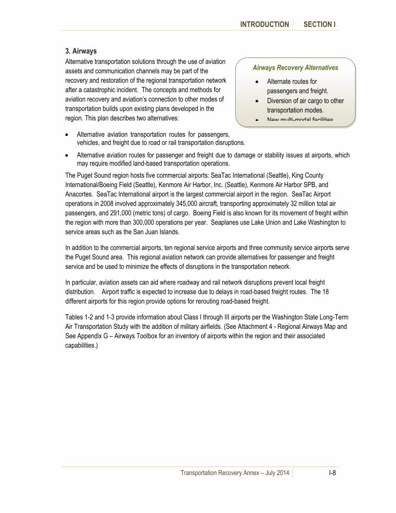
3. Airways
Alternative transportation solutions through the use of aviation
assets and communication channels may be part of the
recovery and restoration of the regional transportation network
after a catastrophic incident. The concepts and methods for
aviation recovery and aviation’s connection to other modes of
transportation builds upon existing plans developed in the
region. This plan describes two alternatives:
Alternative aviation transportation routes for passengers, vehicles, and freight due to road or rail transportation disruptions.
Alternative aviation routes for passenger and freight due to damage or stability issues at airports, which may require modified land-based transportation operations.
The Puget Sound region hosts five commercial airports: SeaTac International (Seattle), King County
International/Boeing Field (Seattle), Kenmore Air Harbor, Inc. (Seattle), Kenmore Air Harbor SPB, and
Anacortes. SeaTac International airport is the largest commercial airport in the region. SeaTac Airport
operations in 2008 involved approximately 345,000 aircraft, transporting approximately 32 million total air
passengers, and 291,000 (metric tons) of cargo. Boeing Field is also known for its movement of freight within
the region with more than 300,000 operations per year. Seaplanes use Lake Union and Lake Washington to
service areas such as the San Juan Islands.
In addition to the commercial airports, ten regional service airports and three community service airports serve
the Puget Sound area. This regional aviation network can provide alternatives for passenger and freight
service and be used to minimize the effects of disruptions in the transportation network.
In particular, aviation assets can aid where roadway and rail network disruptions prevent local freight
distribution. Airport traffic is expected to increase due to delays in road-based freight routes. The 18
different airports for this region provide options for rerouting road-based freight.
Tables 1-2 and 1-3 provide information about Class I through III airports per the Washington State Long-Term
Air Transportation Study with the addition of military airfields. (See Attachment 4 - Regional Airways Map and
See Appendix G – Airways Toolbox for an inventory of airports within the region and their associated
capabilities.)
Airways Recovery Alternatives
Alternate routes for
passengers and freight.
Diversion of air cargo to other
transportation modes.
New multi-modal facilities.
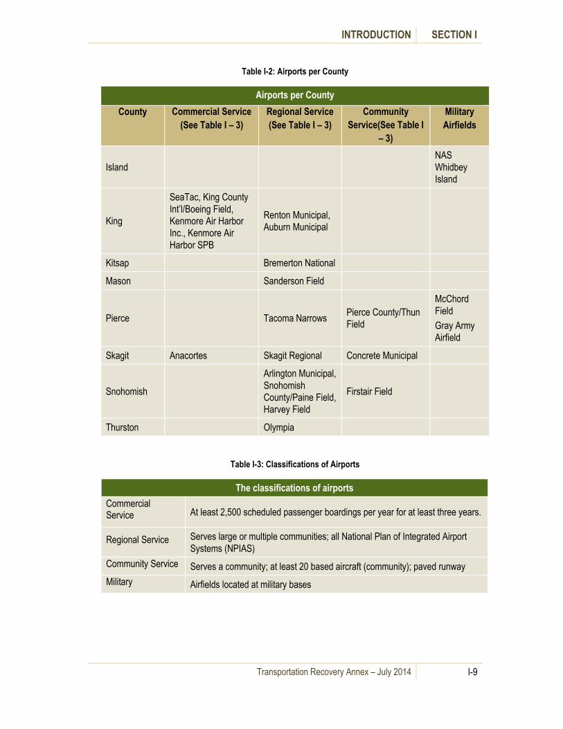
INTRODUCTION SECTION I
Transportation Recovery Annex – July 2014 I-9
Table I-2: Airports per County
Airports per County
County Commercial Service
(See Table I – 3)
Regional Service
(See Table I – 3)
Community
Service(See Table I
– 3)
Military
Airfields
Island
NAS
Whidbey
Island
King
SeaTac, King County
Int’l/Boeing Field,
Kenmore Air Harbor
Inc., Kenmore Air
Harbor SPB
Renton Municipal,
Auburn Municipal
Kitsap Bremerton National
Mason Sanderson Field
Pierce Tacoma Narrows Pierce County/Thun
Field
McChord
Field
Gray Army
Airfield
Skagit Anacortes Skagit Regional Concrete Municipal
Snohomish
Arlington Municipal,
Snohomish
County/Paine Field,
Harvey Field
Firstair Field
Thurston Olympia
Table I-3: Classifications of Airports
The classifications of airports
Commercial Service At least 2,500 scheduled passenger boardings per year for at least three years.
Regional Service Serves large or multiple communities; all National Plan of Integrated Airport
Systems (NPIAS)
Community Service Serves a community; at least 20 based aircraft (community); paved runway
Military Airfields located at military bases

INTRODUCTION SECTION I
Transportation Recovery Annex – July 2014 I-10
4. Railways (Rail Freight Service)
All major railroad systems in the region are privately owned and operated, including the routes Amtrak uses
for its passenger service. The BNSF Railway and the Union Pacific (UP) Railroad make up the state’s
mainline railroad system. Two of the state’s three major rail corridors (the I-5 rail corridor, and Everett to
Spokane) pass through the planning area covered by this Annex. This rail system primarily serves the inland
transportation part of the supply chain for large volumes of import and export cargo moving through the state’s
ports. Port access to rail is very important to the state economy and the ports need rail access and connection
to the regional transportation network to be competitive. (See Attachment 5 - Regional Railways Map)
BNSF Railway owns the mainline rail route in the I-5 corridor. BNSF Railway grants AMTRAK and Union
Pacific rights to operate passenger service on this route from Vancouver, Washington to Tacoma. Between
Tacoma and Seattle, both BNSF Railway and UP own and operate on their own tracks.
The state freight rail system is part of the larger freight transportation network, providing businesses, ports,
and farms with competitive access to North American and international markets. Currently in Washington
State, railroads move 18% of goods by weight. The trucking system is the railroad’s biggest customer. Modal
interchanges—ports, trans-loading facilities, and distribution
centers—are critical nodes in the system.
Disruption to the rail network, particularly to the local
distribution network, will tax the local and regional roadway
and transit systems. Long-term disruptions may also require
the implementation of maritime and aviation solutions. The
railroad system may also be a part of alternative solutions for
disruptions to the other components of the transportation
system although railroads have minimal capacity to absorb
freight movement from the highway system. Recovery of the
rail network in coordination with other modes of transportation is done through existing relationships the
railroads have with WSDOT, ports, the trucking industry and other customers, and through the Washington
State Critical Infrastructure Protection (CIP) Program.
F. Transportation System Hazards
The Puget Sound Region is subject to potential catastrophic incidents including, but not limited to, a major
earthquake, flooding, severe winter storms and terrorist attacks. As a planning scenario, the Regional
Catastrophic Preparedness Program scenario envisions a magnitude 6.5 earthquake along the Seattle Fault
causing not only significant disruption to the regional transportation network, but disruption to the lives of
individuals, families, government and the private sector for a long period of time. More detailed hazard
information is covered in the Puget Sound Catastrophic Disaster Coordination Plan (Coordination Plan).
Potential hazards to the transportation system are summarized in Table 1-4.
.
The U.S. Railroad Administration estimates railways in Washington could increase their capacity by only 5%. If roadway capacity is reduced due to a disaster, railroads have minimal capacity to absorb freight movement
from the highway system.

INTRODUCTION SECTION I
Transportation Recovery Annex – July 2014 I-11
Table I-4: Transportation System Hazards and Impacts
System Hazards and Impacts
Roadways Anything that disrupts the flow of roadway traffic and compromises traveler safety
Structural damage resulting in collapse, partial collapse or concern of imminent
collapse.
Debris on road surface resulting in partial or complete blockage of roadway(s).
Settlement or shifting of roadways or structures resulting in uneven or
disconnected road surface.
Loss of power disabling traffic signals that control traffic flow.
Rupture of underground pipelines or utilities resulting in structural damage or
imminent danger of explosion, fire or asphyxiation.
Damage to overhead electric wires resulting in danger of electrocution.
Damage to nearby structures including signs and light poles, or buildings
resulting in roadway closures. Civil unrest or panic resulting in roadway
closures.
HazMat release resulting in a danger of death, asphyxiation or explosion.
Traffic accidents closing all or part of a roadway.
Flooding, snow or ice resulting in partial or total roadway closures.
Soil destabilization resulting in mudslides or the danger of landslides.
Structural damage to roadway bridges over non-navigable waterways (i.e. other
roadways upstream waterways that are not considered navigable by the United
States Coast Guard, ravines, etc.).
Waterways Anything that disrupts the flow of traffic over navigable waterways, disrupts the transfer of cargo from ship to shore, or compromises passenger safety
Extreme environmental conditions.
Structural failures, debris or vessel damage that blocks navigable waterways.
This includes collapsed bridges and sunken vessels.
Loss of navigation aids (buoys) designating channels for safe passage of ships.
Structural damage of shore-side facilities that prevent the normal movement of
people, vehicles or goods to and from vessels.
Interruption of terrestrial or airborne transportation infrastructure that prevents
the movement of passengers, vehicles, or cargo to and from Ports and
terminals.
Utility failures at port facilities that prevent the arrival, departure or processing
of vessels.
Unavailability of trained personnel to operate systems or equipment that
prevents the movement of passengers or cargo to and from vessels.
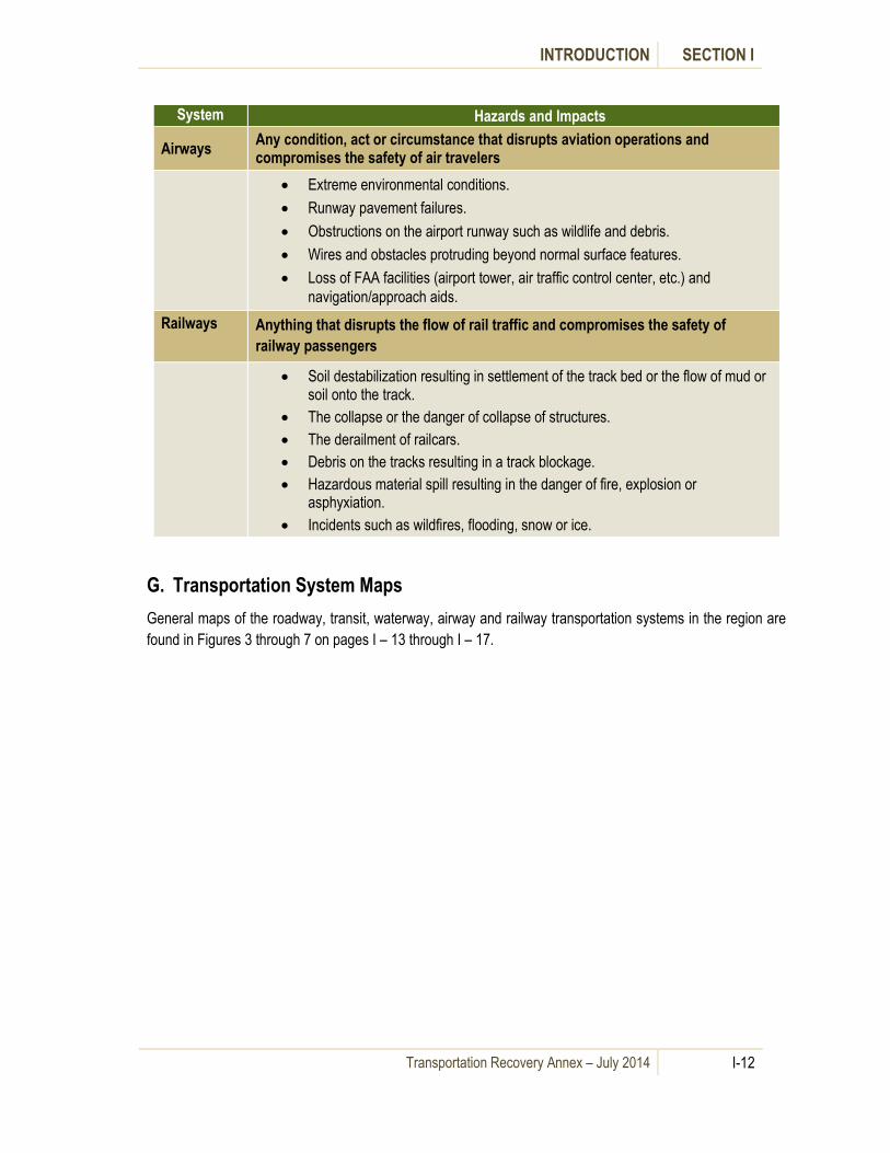
INTRODUCTION SECTION I
Transportation Recovery Annex – July 2014 I-12
System Hazards and Impacts
Airways Any condition, act or circumstance that disrupts aviation operations and compromises the safety of air travelers
Extreme environmental conditions.
Runway pavement failures.
Obstructions on the airport runway such as wildlife and debris.
Wires and obstacles protruding beyond normal surface features.
Loss of FAA facilities (airport tower, air traffic control center, etc.) and
navigation/approach aids.
Railways
Anything that disrupts the flow of rail traffic and compromises the safety of
railway passengers
Soil destabilization resulting in settlement of the track bed or the flow of mud or soil onto the track.
The collapse or the danger of collapse of structures.
The derailment of railcars.
Debris on the tracks resulting in a track blockage.
Hazardous material spill resulting in the danger of fire, explosion or asphyxiation.
Incidents such as wildfires, flooding, snow or ice.
G. Transportation System Maps
General maps of the roadway, transit, waterway, airway and railway transportation systems in the region are
found in Figures 3 through 7 on pages I – 13 through I – 17.

INTRODUCTION SECTION I
Transportation Recovery Annex – July 2014 I-13
Attachment 1 – Regional Roadways Map (State Routes)
Figure I-3: Regional Roadways Map (January 2011)
Source: KPFF Consulting Engineers

INTRODUCTION SECTION I
Transportation Recovery Annex – July 2014 I-14
Attachment 2 – Regional Transit Map
Figure I-4: Regional Transit Map (July 2010)
Source: Sound Transit

INTRODUCTION SECTION I
Transportation Recovery Annex – July 2014 I-15
Attachment 3 – Regional Waterways Map
Figure I-5: Regional Waterways Map (January 2011)
Source: KPFF Consulting Engineers
Anacortes

INTRODUCTION SECTION I
Transportation Recovery Annex – July 2014 I-16
Attachment 4 – Regional Airways Map
Figure I-6: Regional Airways Map (January 2011)
Source: KPFF Consulting Engineers

INTRODUCTION SECTION I
Transportation Recovery Annex – July 2014 I-17
Attachment 5 – Regional Railways Map
Figure I-7: Regional Railways Map (January 2011)
Source: KPFF Consulting Engineers

Transportation Recovery Annex – July 2014 II-1
II. Concept of Coordination
A. General Information
This section describes how local, state and federal agencies, together with the private sector, will collaboratively
manage recovery of the transportation network within the Puget Sound region after a catastrophic incident.
Transportation system recovery actions and collaboration thereof will evolve and reflect markedly different areas of
emphasis in the days and weeks after a catastrophic incident.
As with all emergency management, pre-planning for transportation
system recovery will save lives and money during a catastrophic
incident. Appendix C to this annex describes regional coordination and
planning activities that local, state and federal agencies can initiate to
help jump start any transportation recovery processes.
This section also describes three separate concepts of coordination,
corresponding to three stages of a catastrophic incident:
Initial transportation system recovery actions to support response.
Mid-term transportation system recovery actions.
Long-term transportation system recovery actions.
The Washington State Patrol
(WSP) district offices and
Washington State Department
of Transportation (WSDOT)
regional offices will make initial
recovery decisions about the state
highway system.
The United States Coast Guard
(USCG) and Individual Port
Authorities will collaborate to
make initial recovery decisions
about the Maritime Transportation
system.
The Federal Aviation
Administration (FAA) and
Individual Port Authorities will
collaborate to make initial
recovery decisions about the Air
Transportation System
WSDOT and Private Sector
Infrastructure Owners will
collaborate to make initial
recovery decisions about the
Railway system.

CONCEPT OF COORDINATION SECTION II
Transportation Recovery Annex – July 2014 II-2
B. Short-term Transportation Recovery to Support Emergency Response
Short-term transportation recovery measures for the purposes of this Annex normally occur in the first 72 hours and
include initial damage and situational assessments, debris removal, implementation of pre-planned or emergency
cargo handling procedures, detours, and temporary repairs to provide emergency access or help restore regional
movement of passengers and cargo. Short-term activities manage the immediate impacts of the disaster and are
driven by immediate response needs.
Local agencies may manage short term transportation recovery
activities from established dispatch centers, operations centers, and
traffic management centers until local and state emergency operations
centers can be activated. At the state level, the State EOC will be
gathering information from local and state sources. The WSDOT
Regions report to the WSDOT EOC in Olympia which then relays
information to the State EOC for dissemination to local government and
others. Information from WSP is relayed to the State EOC.
In the early days after a catastrophic incident, federal transportation
agencies monitor the situation and respond to state requests, including
those for a United States Department of Transportation Declaration. Federal agencies will initially work through
Regional Response Coordination Centers and the National Response Coordination Center.
Attachment 1 to this section details responsibilities and priorities for local, state and federal agencies and the private
sector by mode for short-term recovery of the transportation system in support of
emergency response.
In addition to individual agency activities, some limited multi-agency coordination
of short-term transportation recovery actions to support emergency response will
likely focus on shared situational awareness, implementation of pre-planned or
emergent cargo handling procedures, detours, and potential requests for mutual
aid to conduct emergency repairs. Agencies and facilities may have some limited
capacity to share public information messages and/or press releases.
Figure II-1 provides a generalized overview of the short term coordination
process.
Transportation
Collaboration in the
Short Term
Share situational awareness.
Establish alternate transportation modes and routes for freight and passengers.
Utilize mutual aid for emergency repairs.
Share public information messages
The Washington State Patrol
(WSP) district offices and
Washington State Department of
Transportation (WSDOT) regional
offices will make initial response-
oriented recovery decisions about
the state highway system.

CONCEPT OF COORDINATION SECTION II
Transportation Recovery Annex – July 2014 II-3
Figure II-1: Short-term Decision and Coordination Process
Table II-1 summarizes transportation recovery activities on which agencies may be able to collaborate in the short
term after a catastrophic incident.
Table II-1: Transportation Collaboration in the Short-term
Transportation Collaboration in the Short-Term Recovery Phase
Actions Collaboration
Share situational awareness
State EOC, WSDOT EOC and local EOCs share info from field
assessments using all available technology, such as by e-mail,
WebEOC and SharePoint sites.
Agencies that manage internet-based roadway, waterway, railway,
and port condition maps update their websites and provide data
feeds as appropriate.
State EOC assembles Essential Elements of Information and
shares information through the FEMA Regional Response
Coordination Center (RRCC) and National Response Coordination
Center (NRCC).
State agencies coordinate with federal regulatory agencies through
Federal Lead Agency and/or liaisons to the State EOC.
Establish alternate
transportation modes and
routes
State establishes detours for state highway system in collaboration
with affected jurisdictions.
USCG establishes alternate routing for navigable waterways in
collaboration with affected jurisdictions.
Ports announce terminal conditions and publish schedule changes.
Local agencies establish detours in collaboration with affected
adjacent jurisdictions.
Transit agencies make initial service adjustments

CONCEPT OF COORDINATION SECTION II
Transportation Recovery Annex – July 2014 II-4
Transportation Collaboration in the Short-Term Recovery Phase
Actions Collaboration
Utilize mutual aid for emergency
repairs
Local jurisdictions may request resources from mutual aid
partners.
Share public information
Public messages are shared through Joint Information Centers
(JIC) and/or a Joint Information System (JIS). (See Section V -
Information Collection and Dissemination.)
C. Mid-term Transportation Recovery
Mid-term transportation recovery measures for the purposes of this Annex are those actions implemented from the
first hours to several weeks or months after the disaster. They are often temporary measures that can meet a
transportation need while developing more permanent measures and intermodal diversion of freight and passengers.
These actions may include, but not be limited to, additional traffic mitigation strategies (parking prohibitions, freight-
only traffic days, etc), revised detours, completion of emergency work, or seeking recovery financing. (Appendices E,
F and G provide information about additional mitigation measures)
Mid-term transportation recovery measures are often coordinated from EOCs
and ECCs but may also be managed in some agencies at the public works or
transportation departmental level. Some decision making may transition to
other locations established for the disaster, such as a Joint Field Office (JFO)
if a Presidential Disaster has been declared. This will involve federal and
state agencies, as well as local planners, engineers and other personnel who
were not part of the initial response support.
For example, the US Department of Transportation will also be involved
through the Emergency Relief (ER) program and will work closely with local
and state transportation agencies and through the Federal Railroad
Administration (FRA). Other federal agencies such as the US Coast Guard
and FAA will work with their counterparts at local and state agencies to begin
the recovery process.
Attachment 2 to this section details responsibilities and priorities for local,
state and federal agencies and the private sector by mode for mid-term
recovery of the transportation system.
Multi-agency and public/private coordination of mid-term transportation
recovery actions during this phase will be essential. Multiple public agencies
and private entities will have a role in prioritizing and designing interim
repairs, which will heavily influence the region’s long-term recovery.
Decision-makers must have a common operating picture and an accurate
understanding of available resources.
Interagency work groups may be formed to determine optimal interim multi-modal replacements for extensively
damaged transportation systems (e.g. using maritime resources to supplement freight movement). Policy decisions
Transportation
Collaboration in the Mid
Term
Create a coordination committee.
Develop a common operating picture.
Prioritize and design interim repairs.
Manage transportation demand.
Implement multi-modal solutions.
Build public support.
Form long term recovery organizations.
Seek recovery financing.

CONCEPT OF COORDINATION SECTION II
Transportation Recovery Annex – July 2014 II-5
The formation of standing or ad hoc
regional working groups could be led
by the local emergency management
agency and involve appropriate public
and private sector stakeholders as the
situation warrants.
such as more rigorous traffic mitigation strategies (e.g. restrictions on private automobile use; freight only lanes) and
detouring regional traffic through local communities for longer time periods will require broad-based agency and
public support.
Local government may choose to form standing or ad hoc
regional working groups to deal with mid-term transportation
issues that go beyond single agency boundaries. Some regional
coordination would be best organized around a specifically
identified geographic area; other issues may be best organized
on a specific functional basis. (Subsection F Regional
Coordination within Section IV Direction, Control and
Coordination describes a range of options for establishing
regional transportation recovery entities.)
These actions will lay the foundation for regional cooperation for long term transportation recovery issues and provide
a catalyst to the formation of long term recovery organizations (described in Section D below).
Figure II-2 provides an overview of the decision and coordination process for mid-term transportation recovery
actions.

CONCEPT OF COORDINATION SECTION II
Transportation Recovery Annex – July 2014 II-6
Figure II-2: Mid-Term Decision and Coordination Process
Table II-2 summarizes transportation recovery activities on which agencies will need to collaborate in the mid-term
after a catastrophic incident.

CONCEPT OF COORDINATION SECTION II
Transportation Recovery Annex – July 2014 II-7
Table II-2: Transportation Collaboration in the Mid-Term
Transportation Collaboration in the Mid-term Recovery Phase
Actions Collaboration
Form coordination committee
Counties, in consultation with their cities, tribes and the
State convene a joint committee to coordinate mid-term
transportation recovery decisions that cross county lines.
Works groups may be formed on a geographic and/or
functional basis.
Existing entities such as Metropolitan Planning
Organizations (MPOs) may be appropriate venues for the
joint committee and/or its work groups.
Develop common operating picture The joint committee assigns responsibility to develop
complete map(s) of the transportation network status.
Prioritize and design interim repairs
The joint committee and/or its work groups:
Anticipate long term recovery needs.
Consider financing opportunities and
considerations.
Prioritize interim needs.
Design multi-modal solutions that integrate
roadway, maritime, rail and aviation resources.
Identify funding sources.
Manage transportation demand
The joint committee and/or its work groups will:
Identify the magnitude of demand.
Identify available capacity under alternative
demand management scenarios.
Identify new capacity provided by emergency
repairs and or expanded detour routes.
Implement demand management strategies.
Build public support
Local and state agencies will:
Ensure community involvement in prioritization
and design of interim repairs.
Provide common public messages through Joint
Information Centers (JIC) and/or a Joint
Information System (JIS) in support of demand
management strategies. (See Section V -
Information Collection and Dissemination.)
Begin long term recovery processes.

CONCEPT OF COORDINATION SECTION II
Transportation Recovery Annex – July 2014 II-8
1. Mid-Term Transportation Recovery Coordination Group
A. Introduction As outlined in the Coordination Plan, County officials may recommend a Transportation Recovery Coordination
Group be convened. There will likely be two different groups, one for Long-Term planning for permanent restoration,
and a Mid-Term Recovery Coordination Group for temporary measures that will be regional in nature. The Mid-Term
Group will consist of a Steering Committee and several Working Groups. It will focus on coordinating and resolving
cross-jurisdictional issues during the temporary repairs and detours phase.
Once County officials determine the need for a Mid-Term Transportation Recovery Group, the Steering Committee
lead will be contacted and requested to convene the group.
B. Mission Assist in restoring the Puget Sound transportation system capacity and function to a normal or “new normal” state by
collaboratively resolving transportation issues as quickly as possible.
C. Scope The scope of the Mid-Term Transportation Recovery Coordination Group is to set priorities for addressing temporary
strategies for cross-jurisdictional transportation disruptions from the disaster, focused on mobility needs in support of
economic recovery efforts. The Group will not issue mandates. It will offer objective evaluations of current conditions
and desired end-states as agreed upon by the majority of the agencies represented in Coordination Group, and will
make recommendations for achieving those goals.
D. Objectives
1) Identify major, inter-jurisdictional transportation modes and pathways available.
2) Coordinate temporary solutions and repair efforts between jurisdictions to maximize recovery efforts.
3) Develop work-arounds / detours to maximize the use of undamaged infrastructure.
4) Identify other routes/modes where quick fixes are possible and categorize those by feasibility, effectiveness
and cost.
5) Work with State Recovery groups in all sectors to ensure transportation issues receive sufficient
consideration.
6) Set measureable goals and timelines.
7) Engage the public (e.g.; customers, vulnerable populations, shippers) in the process.
E. Structure and Organization The Mid-Term Transportation Recovery Coordination Group will consist of a Steering Committee and multiple,
subject-specific Work Groups. Each impacted entity may appoint a Subject Matter Expert to the Work Groups, and
each impacted entity may have a seat on the Steering Committee.
The Steering Committee will receive status information and recommendations from the Work Groups. The Steering
Committee will evaluate the recommendations as a whole. It will forward the agreed upon recommendations to the
State’s Recovery Committee for longer term items, and will coordinate mitigation activities within the region.
Disagreements between Steering Committee members will be resolved by a majority vote of participating members.
Recommendations are non-binding and do not obligate any agency to fund the recommended projects or courses of
action.
CONCEPT OF COORDINATION SECTION II
Transportation Recovery Annex – July 2014 II-9
F. Steering Committee Steering Committee membership is voluntary. Representatives should have the ability, authority, and jurisdictional
knowledge such that they can evaluate needs and commit resources where needed.
The Steering Committee will suggest which Work Groups should be activated and will seek Subject Matter Experts
from around the region to serve on the Work Group.
Steering Committee members should include one person from:
Impacted counties
Impacted major cities
Washington State DOT
Impacted tribes
Transit Authorities
Ports
Private industry
G. Steering Committee Sustainment Plan Maintaining an active, ongoing Steering Committee requires a lead agency and a process to support and guide a
lead agency into the future. Ideally, the lead agency will convene an annual meeting of all interested parties to
review the Mission, Scope, membership, and status of emergency planning for transportation recovery.
During the preparedness sustainment period prior to a catastrophic event, there should be a core membership group
willing and available to meet annually. During the recovery phase following a catastrophic event, many agencies will
be needed on the Steering Committee.
H. Lead Agency Sustainment Lead Agency designation will be for a two-year term. The first lead agency serving from June 2014 to June 2016 will
be King County DOT.
At the end of that term, the current agency may agree to continue in the role for an unlimited number of additional
terms, or may relinquish the role as Lead Agency to another willing agency. If more than one agency wishes to serve
as the lead, they may serve as co-leads or a vote of Steering Committee members in attendance may select from the
list of candidate agencies.
I. Duties of Lead Agency The Lead Agency will convene a meeting of the Steering Committee members a minimum of one time per year. A
suggested agenda and suggested activities are included in this section. Notes from the meeting will be maintained
by the lead agency and shared with future lead agencies to maintain continuity within the Committee.
Lead Agency will request all member agencies verify representative names and contact numbers prior to the Annual
Meeting.
J. Support for Lead Agency The Puget Sound Regional Council (PSRC) will provide support for the Lead Agency by:
Providing pre-disaster data for the Transportation Recovery Indicators Chart in the tools by modifying the type of information currently monitored by PSRC

CONCEPT OF COORDINATION SECTION II
Transportation Recovery Annex – July 2014 II-10
Providing a meeting space for the annual Steering Committee meeting
Providing contact names and numbers for agencies when requested
K. Work Groups Working Group membership will be Subject Matter Experts (SME) in the specific topic. SMEs should have in-depth
knowledge of their jurisdiction’s status, needs, and available resources. SME’s should also have an understanding of
regional impacts, regional economic needs, and regional planning efforts.
Working Groups will be assigned tasks by the Steering Committee and will report back to the Steering Committee
with evaluations and recommendations for resolving issues in their assigned area.
Table II-3: Possible Working Groups
Possible Working Groups:
Bridges/Roadways Airports
Freight Movement Ferries
Fueling Mass Transit (Bus, Light Rail)
Traffic management/policy Seaports
L. First Meeting Agenda, Mid-Term Steering Committee
Roll call of agencies present.
Based on current information, which jurisdictions, agencies and other stakeholders should be part of the Mid-Term Transportation Recovery Coordination Group? (Owners of key infrastructure such as Tribes that control connecting roadways, suppliers and shippers of critical goods, mass transit organizations, etc.)
What damages outside of your jurisdiction are having negative impacts within your jurisdiction?
What damages within your jurisdiction are having impacts outside of your jurisdiction, if known?
Of those, which of them has a plan and actions in progress to resolve the problem?
What do you need from a neighboring jurisdiction or partner agency to successfully accomplish your agency’s plans, avoid conflicting recovery activities, and maintain key traffic patterns?
Which Work Groups are needed?
M. Sustainment Meeting Activities Once per year the designated Steering Committee lead will request updates of names, email, and phone numbers for
Steering Committee stakeholders and set a meeting date.
Committee Lead will convene the meeting of interested stakeholder to review the membership list and processes for
Committee activation, Work Group designation, and priority-setting following a disaster.
The annual sustainment meetings will renew connections between potential Committee members and ensure all
parties recognize the value and potential contribution of the Mid-Term Transportation Recovery Coordination Group.
N. Transportation Recovery Indicators Reporting progress toward restoring transportation to the public is a key mission for the Coordination Group. The
following table may prove useful in defining the areas for consideration. By comparing current status to pre-event

CONCEPT OF COORDINATION SECTION II
Transportation Recovery Annex – July 2014 II-11
status, the Group will have objective data for measuring progress. This measurable data can be used to keep the
public informed of progress.
Pre-Disaster status may be available through the Puget Sound Regional Council’s data collection mechanisms.
Updated data regarding pre-disaster status may be collected during the annual Steering Committee meeting. Post-
disaster status may be available from local and State Transportation Departments, transit agencies, port authorities,
public works departments, airports, and area EOCs.

Transportation Recovery Annex – July 2014 II-12
Table II-4: Transportation Recovery Indicators
Transportation Recovery Indicators
Impact Pre-disaster number/status
Current/status Trend + Improving - Not improving
Roadways
Percentage of Interstate functional
Percentage of arterials functional
Percentage of other roads functional
Critical bridges inspected and open
Waterways
Number of cranes operating
Number of deep draft berths available
Number of ferry routes operating
Number of ferry terminals operating
Volume of barge capacity
Airways
Number of gates functioning
Number of terminals functioning
Number of functional runways
Railways
Percentage of tracks functional
Number of stations functional
Regional Bus/Passenger Rail
Number of stations functional
O. Mid Term Transportation Priorities After a catastrophic event, there will be many instances of damaged infrastructure and many competing interests in
finding alternate solutions as quickly as possible. Setting priorities for resolving problems will be challenging. An
objective appraisal of the significance of the damaged infrastructure will help determine priorities for funding
temporary repairs, developing alternate routes, or instituting other mitigation activities.
The following worksheet is intended to give Steering Committee and Work Groups a tool for performing an objective
analysis of competing projects to determine priorities and effectiveness of mitigation options. This tool provides a
weighted numerical analysis of multiple projects for comparison.
Only executive Policy Groups will have the authority to set priorities, but the tool provided gives the Work Groups and
the Steering Committee a quantifiable basis for making recommendations to Policy Groups and to the State recovery
groups.
Instructions for Use:
List significant damaged infrastructure, one per line.
For columns A – E, assess the significance of each factor as it pertains to the damaged infrastructure.

CONCEPT OF COORDINATION SECTION II
Transportation Recovery Annex – July 2014 II-13
Example: For A, does the infrastructure provide a vital link for emergency reconstruction supplies to reach an
impacted jurisdiction? If no, then it warrants a 1 or a 0.
For B, are there other workable detours or alternates? If no, then it warrants a 3.
1 = low value for that factor, 2 = medium value, 3 = high value.
To arrive at the score, multiple the value (1, 2, or 3) by the Score Factor number to arrive at the score.
Total the scores. The scores will determine which pieces of damaged infrastructure need immediate attention.

CONCEPT OF COORDINATION SECTION II
Transportation Recovery Annex – July 2014 II-14
Table II-5: Mid-Term Transportation Recovery Priorities
Mid-Term Transportation Recovery Priorities Regional Value
3 – High, 2 – Medium, 1 – Low, 0 - None
Score Factor x15 x10 x15 x10 x10 SCORE Priority
Damaged Infrastructure
Emergency Response Function
Functional Alternate
Economic Impact
Intermodel Connections
Transit Route
I-405 Interchange at 8th Ave
3 ( x 15)
45
2 (x 10)
20
3 (x15)
45
2
20
3
30 140
Example
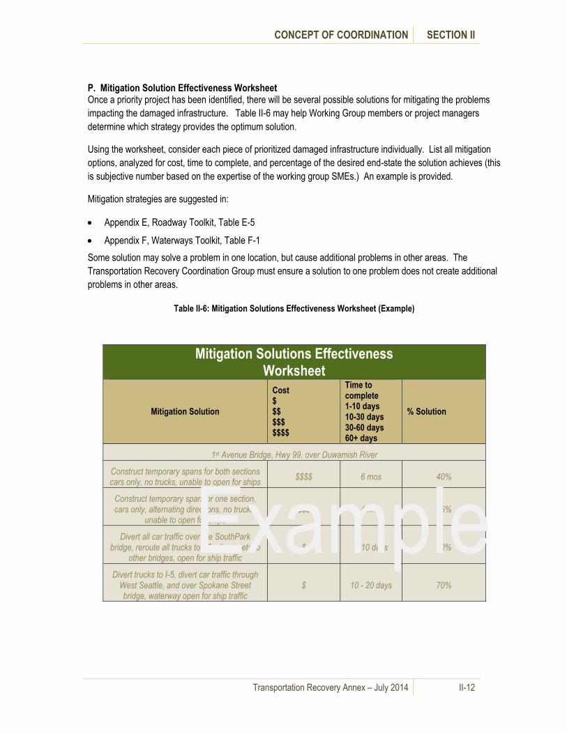
CONCEPT OF COORDINATION SECTION II
Transportation Recovery Annex – July 2014 II-12
P. Mitigation Solution Effectiveness Worksheet Once a priority project has been identified, there will be several possible solutions for mitigating the problems
impacting the damaged infrastructure. Table II-6 may help Working Group members or project managers
determine which strategy provides the optimum solution.
Using the worksheet, consider each piece of prioritized damaged infrastructure individually. List all mitigation
options, analyzed for cost, time to complete, and percentage of the desired end-state the solution achieves (this
is subjective number based on the expertise of the working group SMEs.) An example is provided.
Mitigation strategies are suggested in:
Appendix E, Roadway Toolkit, Table E-5
Appendix F, Waterways Toolkit, Table F-1
Some solution may solve a problem in one location, but cause additional problems in other areas. The
Transportation Recovery Coordination Group must ensure a solution to one problem does not create additional
problems in other areas.
Table II-6: Mitigation Solutions Effectiveness Worksheet (Example)
Mitigation Solutions Effectiveness Worksheet
Mitigation Solution
Cost $ $$ $$$ $$$$
Time to complete 1-10 days 10-30 days 30-60 days 60+ days
% Solution
1st Avenue Bridge, Hwy 99, over Duwamish River
Construct temporary spans for both sections cars only, no trucks, unable to open for ships
$$$$ 6 mos 40%
Construct temporary span for one section, cars only, alternating directions, no trucks,
unable to open for ships $$$ 4 mos 25%
Divert all car traffic over the SouthPark bridge, reroute all trucks to I-5, city streets to
other bridges, open for ship traffic $ 5-10 days 30%
Divert trucks to I-5, divert car traffic through West Seattle, and over Spokane Street bridge, waterway open for ship traffic
$ 10 - 20 days 70%
Example

CONCEPT OF COORDINATION SECTION II
Transportation Recovery Annex – July 2014 II-13
Table II-7: Mitigation Solutions Effectiveness Worksheet
D. Long-term Transportation Recovery
Long-term transportation recovery measures for the purposes of
this Annex are defined as permanent measures implemented to
return the regional transportation network to pre-disaster or
better condition. These activities may include reconstruction and
permanent repair, establishing metrics to monitor recovery
progress, and long term plans to protect transportation
infrastructure from future disasters.
Attachment 3 to this section details responsibilities and priorities
for local, state and federal agencies and the private sector by
mode for long-term recovery of the transportation system.
Multi-Agency coordination of long-term transportation recovery actions to support emergency response will
require inter-agency and inter-jurisdictional coordination within and between all levels of government. Private
sector and community involvement and support will also be critical. If not already formed to address mid-term
Mitigation Solutions Effectiveness
Worksheet
Mitigation Solution
Cost
$
$$
$$$
$$$$
Time to complete
1-10 days
10-30 days
30-60 days
60+ days
% of Solution
Project Name
Solution 1
Solution 2
Permanent repairs are often
covered under the FEMA Public
Assistance Program as
“permanent work” and as
“permanent restoration work”
under USDOT Emergency
Relief (ER) Program funding.
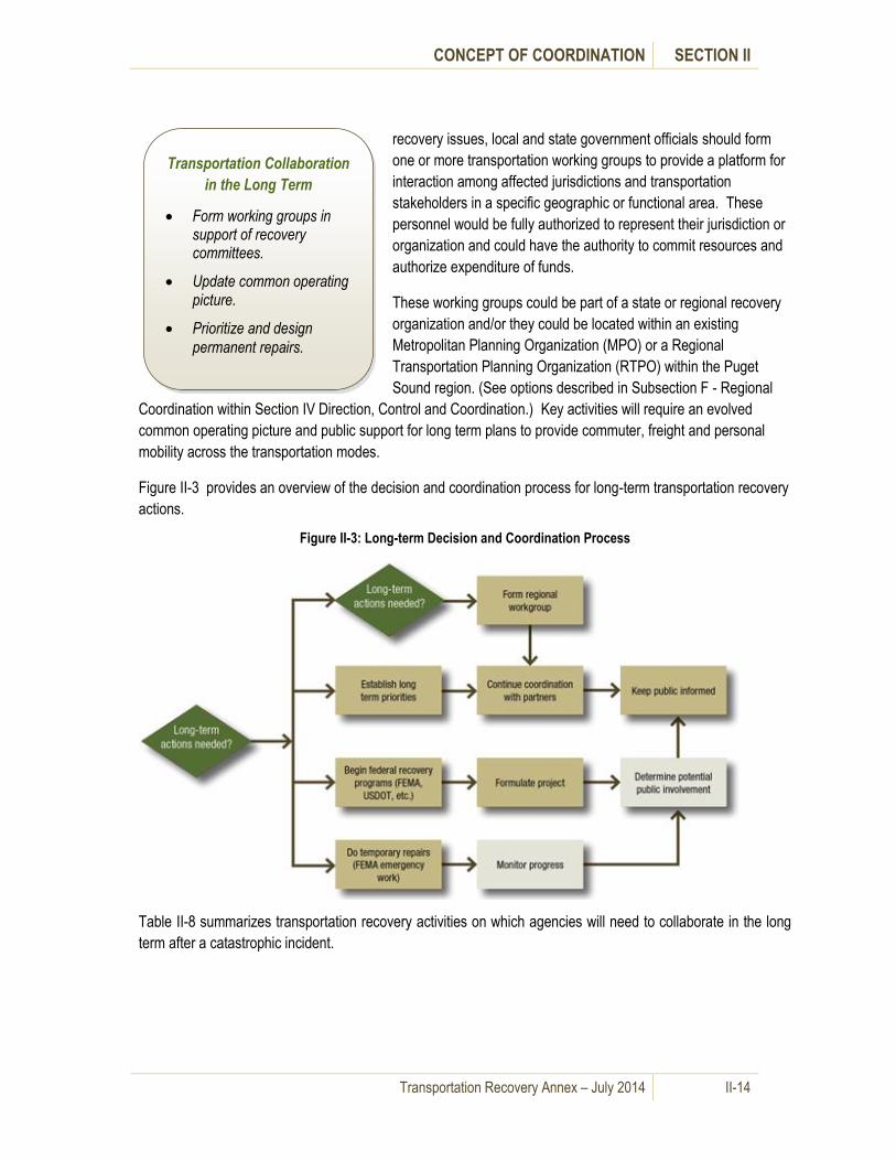
CONCEPT OF COORDINATION SECTION II
Transportation Recovery Annex – July 2014 II-14
recovery issues, local and state government officials should form
one or more transportation working groups to provide a platform for
interaction among affected jurisdictions and transportation
stakeholders in a specific geographic or functional area. These
personnel would be fully authorized to represent their jurisdiction or
organization and could have the authority to commit resources and
authorize expenditure of funds.
These working groups could be part of a state or regional recovery
organization and/or they could be located within an existing
Metropolitan Planning Organization (MPO) or a Regional
Transportation Planning Organization (RTPO) within the Puget
Sound region. (See options described in Subsection F - Regional
Coordination within Section IV Direction, Control and Coordination.) Key activities will require an evolved
common operating picture and public support for long term plans to provide commuter, freight and personal
mobility across the transportation modes.
Figure II-3 provides an overview of the decision and coordination process for long-term transportation recovery
actions.
Figure II-3: Long-term Decision and Coordination Process
Table II-8 summarizes transportation recovery activities on which agencies will need to collaborate in the long
term after a catastrophic incident.
Transportation Collaboration
in the Long Term
Form working groups in support of recovery committees.
Update common operating picture.
Prioritize and design
permanent repairs.

CONCEPT OF COORDINATION SECTION II
Transportation Recovery Annex – July 2014 II-15
Table II-8: Transportation Collaboration in the Long-Term
Transportation Collaboration in the Long-term Recovery Phase
Actions Collaboration
Form working groups in support of
recovery committee(s)
Recovery committee members:
Identify functional and/or geographic work groups.
Determine extent of work group authority.
Working group(s) update common
operating picture
Evaluate disaster impact on transportation services.
Estimate timelines for repair and reconstruction.
Develop cost estimates.
Working group(s) prioritize and design
permanent repairs
Develop long term plans to restore and/or revise local
and regional traffic movement.
Develop long term plans to restore and/or revise transit
operations.
Develop long term plans to restore and/or revise inter-
modal freight movement.
Recovery committee(s) and Working
group(s) build public support
Involve community representatives on committees and
working groups.
Conduct public meetings.
Seek public input.
Provide timely information.
Keep process transparent.
Demonstrate inter-agency collaboration.

CONCEPT OF COORDINATION SECTION II
Transportation Recovery Annex – July 2014 II-16
Attachment 1 – Short-term Recovery Checklists
Table II-9: Short-Term Recovery Checklist
Short-term Recovery Checklist – Roadways
√ WSDOT
Assess damage and impact to the state road network.
Develop initial recovery priorities.
Report information to the State EOC.
Establish initial detours and alternative routes.
Provide information to local jurisdictions.
Provide information to the public.
√ Local Transportation Agencies
Assess damage and impact to local road network.
Develop initial recovery priorities.
Establish initial detours and alternative routes.
Report information to the local EOC.
Provide information to other jurisdictions.
Provide information to the public.
√ Commercial Operators
Assess damage and impact.
Provide status to the local EOC or WSDOT.
Develop initial recovery priorities.

CONCEPT OF COORDINATION SECTION II
Transportation Recovery Annex – July 2014 II-17
Short-term Recovery Checklist - Waterways
√ USCG
Relocate and reestablish the Captain of the Port, as required.
Obtain Essential Elements of Information (EEI) from port facilities, terminals and vessels.
Determine closing/opening of waterways.
Coordinate with the USACE and EPA for debris removal and/or hazardous waste cleanup.
Form the Marine Transportation System Recovery Unit (MTSRU) under authority of COTP.
Communicate with local EOCs, State EOC, Seaports, and private sector stakeholders for
prioritization of navigable waterway restoration.
√ Seaports
Conduct initial assessments (stakeholders to provide information to port).
Obtain status from intermodal transportation partners, including airports, railways and
transportation departments (state and local).
Develop initial recovery priorities.
Provide EEI to USCG.
Initiate Port Recovery / Resumption of Trade plans
Coordinate with terminal operators to provide marine transportation support as requested by the
local or State EOC and WSDOT EOC.
√ WSDOT - Washington State Ferries Division
Conduct operational capabilities assessment identifying each terminal’s or each vessel’s ability to
support some level of service operations.
Develop initial recovery priorities.
Return residents to their home side of the Puget Sound.
Provide status to the WSDOT EOC and JHOC.
Provide marine transportation of disaster recovery units and resources as requested by the
WSDOT Representative at the State EOC, and/or WSDOT HQ EOC.
√ County Ferries
Conduct operational capabilities assessment identifying each terminal’s or each vessel’s ability to
support some level of service operations.
Return residents to their home side of the Puget Sound.

CONCEPT OF COORDINATION SECTION II
Transportation Recovery Annex – July 2014 II-18
Short-term Recovery Checklist - Waterways
Provide status to the County EOC or others as per local plans.
Provide marine transportation of resources as requested by the local or State EOC.
√ Commercial Operators
Conduct operational capabilities assessment identifying each terminal’s or each vessel’s ability to
support some level of service operations.
Provide status to the port authority and USCG.
Provide marine transportation of recovery resources as requested by the local or State EOC.
Short-term Recovery Checklist - Airways
√ FAA
Send out Notice to Airmen (NOTAM).
Obtain status from airports and determine if formal Emergency Security Control of Air Traffic
(ESCAT) implementation is required.
√ FAA (con’t)
Obtain the status of the Air Route Traffic Control Center (ARTCC) controlling instrument flight rule
(IFR) traffic over Washington State and parts of Idaho, Oregon, and California.
√ WSDOT Aviation Division
Obtain status from airports.
Develop initial recovery priorities.
Send representative to State EOC.
√ Airports
Conduct initial assessments (stakeholders provide information to port authority).
Provide EEI to local EOC, FAA and/or State EOC.
Provide support and coordinate with local and State EOCs.

CONCEPT OF COORDINATION SECTION II
Transportation Recovery Annex – July 2014 II-19
Short-term Recovery Checklist - Railways
√ Railways
Collect situational awareness and damage assessments on the condition of the railway system.
Provide situation reports to the State EOC and the WSDOT.
Develop initial recovery priorities.
Develop and implement alternatives to restore railway transportation.
√ WSDOT – Rail and Marine Division
Collect information on the status of the railway network.
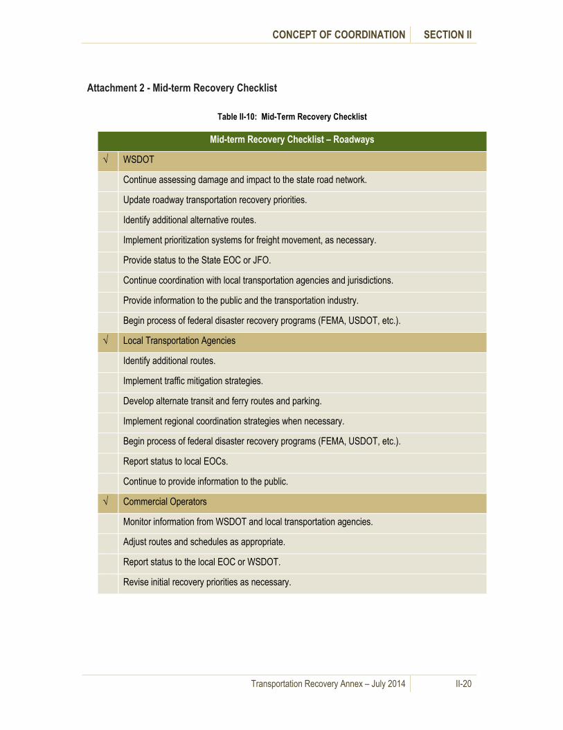
CONCEPT OF COORDINATION SECTION II
Transportation Recovery Annex – July 2014 II-20
Attachment 2 - Mid-term Recovery Checklist
Table II-10: Mid-Term Recovery Checklist
Mid-term Recovery Checklist – Roadways
√ WSDOT
Continue assessing damage and impact to the state road network.
Update roadway transportation recovery priorities.
Identify additional alternative routes.
Implement prioritization systems for freight movement, as necessary.
Provide status to the State EOC or JFO.
Continue coordination with local transportation agencies and jurisdictions.
Provide information to the public and the transportation industry.
Begin process of federal disaster recovery programs (FEMA, USDOT, etc.).
√ Local Transportation Agencies
Identify additional routes.
Implement traffic mitigation strategies.
Develop alternate transit and ferry routes and parking.
Implement regional coordination strategies when necessary.
Begin process of federal disaster recovery programs (FEMA, USDOT, etc.).
Report status to local EOCs.
Continue to provide information to the public.
√ Commercial Operators
Monitor information from WSDOT and local transportation agencies.
Adjust routes and schedules as appropriate.
Report status to the local EOC or WSDOT.
Revise initial recovery priorities as necessary.

CONCEPT OF COORDINATION SECTION II
Transportation Recovery Annex – July 2014 II-21
Mid-term Recovery Checklist - Waterways
√ USCG
Obtain Essential Elements of Information (EEI) from port facilities, terminals, and vessels.
Provide assessments to open waterways and prioritize opening of waterways based on EEIs.
Coordinate with the USACE and EPA for debris removal and/or hazardous waste cleanup.
Coordinate MTSRU recommendations concerning the opening of waterways and establishing
recovery priorities with local EOCs and State EOC.
√ Seaports
Conduct secondary assessments (stakeholders provide information to port).
Obtain updated status from intermodal transportation partners, including airports, railways and
transportation departments (state and local).
Provide EEI to USCG.
Develop mid-term recovery priorities and adjust Port Recovery / Resumption of Trade plans as
necessary
Coordinate with terminal operators to provide marine transportation support as requested by the
local or State EOC and WSDOT EOC.
√ WSDOT - Washington State Ferries Division
Update ferry system recovery priorities.
Conduct a complete engineering assessment of damage.
Restore service at some level of service.
Provide status to the WSDOT EOC and JHOC.
Provide marine transportation of disaster recovery units and resources as requested by the
WSDOT Representative at the State EOC and/or WSDOT HQ EOC.
√ County Ferries
Conduct a complete engineering assessment of damage.
Restore service at some level of service.
Provide status to the County EOC or others as per local plans.
Provide marine transportation of disaster recovery units and resources as requested by the local
or State EOC.
√ Commercial Operators
Conduct a complete engineering assessment of damage.
Provide status to the port authority.
Provide marine transportation of recovery resources as requested by the local or State EOC.

CONCEPT OF COORDINATION SECTION II
Transportation Recovery Annex – July 2014 II-22
Mid-term Recovery Checklist - Airways
√ FAA
Implement Emergency Security Control of Air Traffic (ESCAT), as required.
Coordinate with USDOT and DHS regarding changes to air traffic management, airspace and/or
security measures.
Determine airport capacity and restoration of the movement of airfreight and passengers.
Obtain EEI from airports.
√ WSDOT Aviation Division
Obtain status from airports and coordinate with the State and local EOCs.
Update airways priorities.
√ Airports
Conduct in-depth assessments. (Stakeholders provide information to port authority.)
Continue to provide EEI to local EOC, FAA and/or State EOC.
Continue to provide support and coordinate with local and State EOCs.
Mid-term Recovery Checklist - Railways
√ Railways
Update railway recovery priorities.
Restore railway infrastructure to functional levels.
Restore movement of freight and passengers.
Provide situation reports to the State.
√ WSDOT – Rail and Marine Division
Continue to collect information on the status of the railway network.

CONCEPT OF COORDINATION SECTION II
Transportation Recovery Annex – July 2014 II-23
Attachment 3 - Long-term Recovery Checklist
Table II-11: Long-Term Recovery Checklist
Long-term Recovery Checklist – Roadways
√ WSDOT
Develop long-term transportation recovery priorities.
Continue coordination with local transportation agencies and jurisdictions.
Provide information to the public and the transportation industry.
Continue the process of federal disaster recovery programs (FEMA, USDOT, etc.).
√ Local Transportation Agencies
Develop long-term transportation recovery priorities.
Continue traffic mitigation strategies.
Continue alternate transit and ferry routes and parking.
Implement regional coordination strategies when necessary.
Involve the public in long-term transportation recovery planning.
Continue process of federal disaster recovery programs (FEMA, USDOT, etc.).
√ Commercial Operators
Continue to monitor information from WSDOT and local transportation agencies.
Adjust routes and schedules as appropriate.
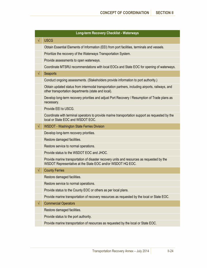
CONCEPT OF COORDINATION SECTION II
Transportation Recovery Annex – July 2014 II-24
Long-term Recovery Checklist - Waterways
√ USCG
Obtain Essential Elements of Information (EEI) from port facilities, terminals and vessels.
Prioritize the recovery of the Waterways Transportation System.
Provide assessments to open waterways.
Coordinate MTSRU recommendations with local EOCs and State EOC for opening of waterways.
√ Seaports
Conduct ongoing assessments. (Stakeholders provide information to port authority.)
Obtain updated status from intermodal transportation partners, including airports, railways, and
other transportation departments (state and local).
Develop long-term recovery priorities and adjust Port Recovery / Resumption of Trade plans as
necessary.
Provide EEI to USCG.
Coordinate with terminal operators to provide marine transportation support as requested by the
local or State EOC and WSDOT EOC.
√ WSDOT - Washington State Ferries Division
Develop long-term recovery priorities.
Restore damaged facilities.
Restore service to normal operations.
Provide status to the WSDOT EOC and JHOC.
Provide marine transportation of disaster recovery units and resources as requested by the
WSDOT Representative at the State EOC and/or WSDOT HQ EOC.
√ County Ferries
Restore damaged facilities.
Restore service to normal operations.
Provide status to the County EOC or others as per local plans.
Provide marine transportation of recovery resources as requested by the local or State EOC.
√ Commercial Operators
Restore damaged facilities.
Provide status to the port authority.
Provide marine transportation of resources as requested by the local or State EOC.

CONCEPT OF COORDINATION SECTION II
Transportation Recovery Annex – July 2014 II-25
Long-term Recovery Checklist - Airways
√ FAA
Implement Emergency Security Control of Air Traffic (ESCAT) as required.
Coordinate with USDOT and DHS regarding changes to air traffic management, air space and/or
security measures.
Determine airport capacity and restoration of the movement of airfreight and passengers.
Obtain EEI information from airports.
√ WSDOT Aviation Division
Provide representative at State EOC.
Obtain status from airports.
√ Airports
Conduct in-depth assessments. (Stakeholders provide information to port authority.)
Develop long-term recovery priorities.
Provide EEI to local EOC, FAA and/or State EOC.
Return service back to normal operating service levels.
Long-term Recovery Checklist - Railways
√ Railways
Continue assessments and develop long-term recovery priorities.
Restore railway infrastructure to pre disaster condition and function.
Restore movement of freight and passengers to pre-disaster levels.
Upgrade railway infrastructure to increase resiliency against future disasters.
√ WSDOT – Rail and Marine Division
Continue to collect information on the status of the railway network.

Transportation Recovery Annex – July 2014 III-1
III. Organization and Responsibilities
A. General Information
This section describes the organizational framework of local, state and federal recovery efforts. It also
defines local, state, federal, private sector and non-governmental organization (NGO) responsibilities
relative to transportation recovery.
B. Organization for Transportation Recovery
1. Local Transportation Recovery
Local command, control and coordination for disaster response
and short term roadway recovery measures are usually
accomplished through local Emergency Operations or
Coordination Centers (EOCs/ECCs), most of which have a
Transportation (ESF-1) component.
The structure of the organization chart for the local EOC/ECC varies from jurisdiction to jurisdiction.
Refer to specific jurisdiction Comprehensive Emergency Management Plans (CEMP) and local
EOC/ECC procedures for specific jurisdiction models.
After a catastrophic incident, agencies may choose to establish temporary local or regional organizations
to deal with mid-term and long-range transportation recovery issues that cover multiple jurisdictions.
Recovery measures and strategies may continue for months or even years. Mid-term and long-term
transportation recovery operations may transition to other facilities and locations as established to meet
the needs of the catastrophe.
2. State Transportation Recovery
Following a catastrophe, the State EOC supports state agency, local jurisdiction and tribal nation
operations in the response and intial recovery to emergency incidents. State agency representatives
respond to the EOC to coordinate their respective agency’s initial recovery operations. The ESF-1
Transportation Group in the State EOC coordinates and manages state transportation response and
recovery. ESF-1 includes representatives from the
Washington State Department of Transportation
(WSDOT) and the Washington State Patrol (WSP).
WSDOT and WSP are the two state agencies with
primary transportation responsibilities. WSDOT Traffic
Management Centers and WSP District Communications
Centers coordinate initial recovery efforts with local
transportation authorites. In some cases, WSP and
WSDOT provide liaison officers to local EOC/ECCs and
coordination facilities. WSDOT also maintains an EOC at
their headquarters in Olympia.
Figure III-1, provided by WSDOT, illustrates WSDOT’s Emergency Organization for Level 3 (larger
event) Response.
Each local jurisdiction is
authorized to define the
structure of its emergency
management organization.
WSDOT and WSP provide direction,
control and coordination of initial
recovery operations from their
respective regional Traffic
Management Centers and District
Offices. They transmit situational
awareness information about the
transportation system to their
headquarters and the State EOC.

ORGANIZATION AND RESPONSIBILITIES SECTION III
Transportation Recovery Annex – July 2014 III-2
Figure III-1: WSDOT Emergency Organization Chart – Level III Activation
Mid-term and long-term transportation recovery operations may transition to the Joint Field Office (JFO)
established by the state and FEMA after a Presidential Declaration of Emergency or Disaster or to other
facilities and locations as established to meet the needs of the catastrophe. (See sub-section 3 below)
For long-term recovery at the state level, one working concept
under consideration is a Washington Restoration Organization
(WRO) based on the State of Mississippi’s recovery efforts
following Hurricane Katrina. The WRO would work directly for
the Office of the Governor to coordinate and manage statewide
and regional recovery and restoration activities after a
catastrophic incident. It is likely that the WRO or any similar
governor-created organization would create a work group or
subcommittee to address transportation recovery issues. In the
As the state moves into
mid- and long-term
recovery planning and
operations, the governor
will likely appoint a task
force, commission or
individual to manage the
process.

ORGANIZATION AND RESPONSIBILITIES SECTION III
Transportation Recovery Annex – July 2014 III-3
event that local agencies have formed a regional recovery entity, the governor could choose to integrate
the work groups. (See Section IV - Direction, Control and Coordination) Figure III-2 illustrates one
potential Organization Chart for a WRO.
Figure III-2: Potential Organization Chart for a Washington Restoration Organization (WRO)
3. Federal Transportation Recovery
When a catastrophe occurs and the President issues (or may issue) Declaration of Emergency or
Disaster, the federal government activates the National Response Coordination Center (NRCC) and
respective Regional Response Coordination Centers (RRCC). The NRCC and appropriate RRCC
coordinate to quickly dispatch Emergency Response Teams (ERT) and an Incident Management
Assistance Team (IMAT) to the affected state. These teams follow the structures outlined in the
National Incident Management System (NIMS) and
set up coordinated operations with the state.
Federal Emergency Support Function (ESF-1)
transportation agencies, including the US
Department of Transportation, Federal Aviation
Administration and Federal Highway Administration,
respond and coordinate with state transportation
agencies.
JFO Operations typically manage and
coordinate ESF 1 –Transportation until
USDOT establishes management linkages
with state and local transportation
agencies, allowing USDOT to work directly
with them at their respective locations.

ORGANIZATION AND RESPONSIBILITIES SECTION III
Transportation Recovery Annex – July 2014 III-4
The federal government establishes a Joint Field Office to coordinate federal/state recovery operations.
The JFO remains open as long as it is needed to support recovery operations. Over time, the JFO may
transition to a processing center or long-term recovery office that continues work on specific public
assistance to state and local applicants. USDOT works directly with state and local jurisdictions under
its own authorities.
Figure III-3 outlines the general organization of the JFO and ESF-1.
Figure III-3: Joint Field Office Organization Chart (from the NRF)
C. Responsibilities for Transportation Recovery
1. Local Transportation Recovery Responsibilities
Local ESFs usually share the following common transportation-related responsibilities:
Provide a liaison to the EOC in accordance with local directives. Provide the EOC with situational awareness and assessments for route restoration and planning.
Disseminate information concerning transportation impacts and alternatives to affected personnel.
Coordinate public information and provide Public Information Officer(s) to the Joint Information Center (JIC).

ORGANIZATION AND RESPONSIBILITIES SECTION III
Transportation Recovery Annex – July 2014 III-5
Table III-1 provides a summary of additional local transportation related emergency management
responsibilities for local government executives and agencies.
Table III-1: Local Transportation Recovery Responsibilities
Local Responsibilities
Local Executive Heads
Provide direction, control and support during disaster recovery operations as detailed in
jurisdiction’s Comprehensive Emergency Management Plan (CEMP).
Ensure that local emergency plans take into account transportation recovery issues.
Support mitigation efforts to protect transportation infrastructure.
Establish strong working relationships with other jurisdictional leaders and with core private
sector and non-governmental organization (NGO) leaders.
Provide leadership to the community and private sector stakeholders throughout the
transportation sector recovery planning process.
Emergency Management
Support transportation recovery and mitigation planning activities.
Support assessment and protection of key transportation assets and critical infrastructure.
Support recovery activities.
Share information among public and private sector entities concerning recovery efforts for
transportation infrastructure, networks and capabilities.
Law Enforcement
Provide traffic and crowd control in setting up initial detours and diversions.
Fire Services
Review recovery and infrastructure rebuilding plans to ensure compliance with existing rules
and regulations.
Public Works and Transportation
Develop transportation recovery, rebuilding and restoration plans.
Provide temporary construction and repair of access routes, technical advice, engineering,
construction management, inspection and emergency contracting.
Implement emergency clearing of debris to re-open roads and other transportation corridors.
Implement emergency stabilization or demolition of damaged transportation infrastructure.
Maintain lists of and contracts with qualified private contractors.
Provide structural inspection of transportation infrastructure.
Public Works and Transportation
Compile and evaluate damage assessments from state and local agencies.
Provide physical assets for detours and other changes in traffic patterns such as barricades,
road signs, variable message signs, and pavement markings.
Coordinate with other jurisdictions’ transportation agencies.
Implement traffic mitigation measures such as parking restrictions, variable message signing,
traffic signal operations and traffic monitoring and surveillance
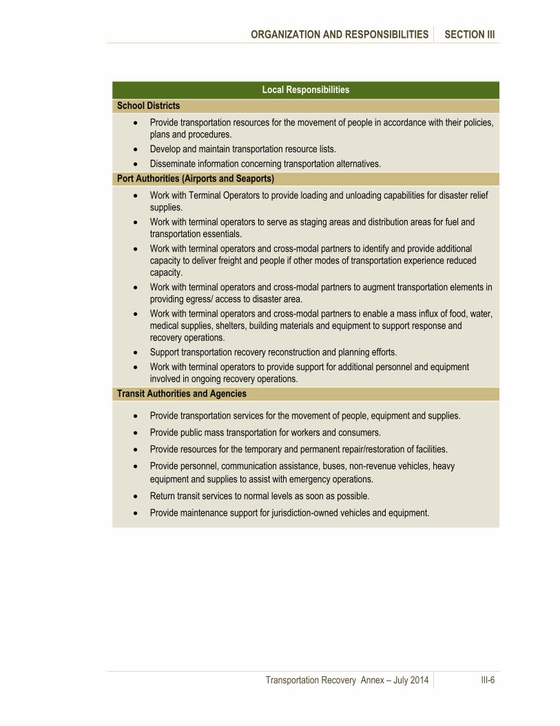
ORGANIZATION AND RESPONSIBILITIES SECTION III
Transportation Recovery Annex – July 2014 III-6
Local Responsibilities
School Districts
Provide transportation resources for the movement of people in accordance with their policies,
plans and procedures.
Develop and maintain transportation resource lists.
Disseminate information concerning transportation alternatives.
Port Authorities (Airports and Seaports)
Work with Terminal Operators to provide loading and unloading capabilities for disaster relief
supplies.
Work with terminal operators to serve as staging areas and distribution areas for fuel and
transportation essentials.
Work with terminal operators and cross-modal partners to identify and provide additional
capacity to deliver freight and people if other modes of transportation experience reduced
capacity.
Work with terminal operators and cross-modal partners to augment transportation elements in
providing egress/ access to disaster area.
Work with terminal operators and cross-modal partners to enable a mass influx of food, water,
medical supplies, shelters, building materials and equipment to support response and
recovery operations.
Support transportation recovery reconstruction and planning efforts.
Work with terminal operators to provide support for additional personnel and equipment
involved in ongoing recovery operations.
Transit Authorities and Agencies
Provide transportation services for the movement of people, equipment and supplies.
Provide public mass transportation for workers and consumers.
Provide resources for the temporary and permanent repair/restoration of facilities.
Provide personnel, communication assistance, buses, non-revenue vehicles, heavy
equipment and supplies to assist with emergency operations.
Return transit services to normal levels as soon as possible.
Provide maintenance support for jurisdiction-owned vehicles and equipment.

ORGANIZATION AND RESPONSIBILITIES SECTION III
Transportation Recovery Annex – July 2014 III-7
2. State Transportation Recovery Responsibilities
Table III-2 provides a summary of general state transportation recovery responsibilities.
Table III-2: State Transportation Recovery Responsibilities
State Responsibilities
Department of Transportation (WSDOT)
Coordinate transportation-related missions in support of recovery efforts.
Prioritize and/or allocate transportation resources and recovery efforts.
Conduct damage assessment to the state transportation facilities.
Determine the usable portions of the state transportation system and coordinate emergency
highway traffic regulations with other appropriate agencies.
Reconstruct, repair and maintain the state transportation system.
Coordinate with WSP for traffic control.
Coordinate maritime, aviation and rail recovery with respective lead federal agency (USCG,
FAA, and USDOT)
Inspect infrastructure and prioritize repairs on the state transportation network.
Provide highway rerouting information to redirect traffic or keep traffic moving.
Provide assets such as barricades, road signs, variable message signs, and pavement
markings for implementing detours and other changes in traffic patterns.
Institute traffic changes such as High Occupancy Vehicle (HOV), High Occupancy Toll (HOT),
congestion pricing or reversible lanes.
Restore state transportation system connectivity and re-establish ferry system operations.
Washington State Patrol
Provide traffic control and law enforcement on the state transportation system.
Conduct aerial reconnaissance and photographic missions. Coordinated by ESF-1 (WSDOT
Aviation) at the State EOC.
Utilities and Transportation Commission
Provide assistance in processing applications for permits from transportation companies to
engage in common or contract carrier operations.
Military Department
Provide limited air and land transportation of personnel and equipment and limited air traffic
control functions. Coordinated by ESF-1 (WSDOT Aviation) at the State EOC.
Assist in establishing roadblocks and directing traffic.
Provide assistance for emergency traffic regulation and movement control.
State EOC
Coordinate response and recovery activities including the collection of situational awareness
information on the transportation network and development of a Common Operating Picture.
Disseminate information about the status of the transportation network to local governments,
other state agencies, federal partners and the private sector.

ORGANIZATION AND RESPONSIBILITIES SECTION III
Transportation Recovery Annex – July 2014 III-8
3. Federal Transportation Recovery Responsibilities
Table III-3 provides a summary of general federal agency transportation recovery responsibilities as
outlined in the National Transportation Recovery Strategy (October 2009).
Table III-3: Federal Transportation Recovery Responsibilities
Federal Responsibilities
U.S. Department of Transportation
Coordinate recovery and mitigation activities in a declared disaster among transportation
stakeholders within the authorities of ESF-1 agencies.
Identify temporary alternative transportation solutions.
Support and enable damage assessments for multi-modal transportation network infrastructure.
Participate in the economic impact assessment of transportation network disruptions.
Provide technical and financial assistance for repair and restoration of transportation
infrastructure and network.
Help prioritize restoration efforts based on needs identified by local and state government.
Federal Aviation Administration (FAA)
Coordinate recovery of the Aviation Transportation System to acquire resources for system
continuity and infrastructure recovery.
Implement contingency measures to ensure public safety and continuity of commerce.
Provide funding to restore the air traffic control system, air navigation facilities, airspace
management capabilities, key equipment, airports and communications.
Enforce additional airspace restrictions as necessary.
Federal Highway Administration (FHWA)
Provide Emergency Relief Funding for Federal-Aid Highways and Federally Owned Roads.
Support states in project development, planning, and approval process for federally owned
assets.
Evaluate requests to deviate from environmental procedures during recovery.
Provide technical assistance.
Federal Motor Carrier Safety Administration (FMCSA)
Provide support to federal, state and local agencies in recovery operations pertaining to
emergency declarations on the shipment and transport of emergency services, e.g., waiver of
hours of service for drivers involved in time-sensitive recovery operations.
Federal Railroad Administration (FRA)
Provide direct loans and guarantees to rehabilitate intermodal rail equipment or facilities (both
freight and passenger rail).
Provide quantitative analysis, environmental research, project reviews, research and
development, and technical assistance for railroad infrastructure recovery.

ORGANIZATION AND RESPONSIBILITIES SECTION III
Transportation Recovery Annex – July 2014 III-9
Federal Responsibilities
Provide an expedited process to handle requests to waive compliance with rules, regulations or
standards during emergency incidents.
Federal Transit Administration (FTA)
Provide financial, planning and technical assistance for recovery of transit systems.
Evaluate requests to deviate from environmental procedures during recovery.
Maritime Administration (MARAD)
Advise the Secretary of DHS in a national defense emergency whether there is sufficient U.S.-
flag vessel capacity available to meet requirements; if not, the secretary of DHS may waive
compliance with coastwise law to allow for extra shipping capacity.
Make vessels from the Ready Reserve Force (RRF) [government-owned vessels intended
principally to deploy Department of Defense (DoD) forces] available to transport critical supplies
and equipment, provide messing and berthing, and provide command and control facilities.
Assist in damage assessment through its National Shipping Authority (NSA), provide technical
expertise and coordinate shore-side recovery of the Marine Transportation System (MTS).
Pipeline and Hazardous Materials Safety Administration (PHMSA)
Authorize a variance from hazardous materials safety regulations to facilitate emergency
transportation of materials or to transport hazardous wastes.
Authorize a special permit to meet emergency requirements for pipeline operations.
Research and Innovative Technology Administration (RITA)
Provide technical assistance in recovery and reconstitution of the transportation network and
promote transportation technology that will improve newly rebuilt infrastructure or policies
through the Volpe National Transportation Systems Center.
U.S. Department of Homeland Security (DHS)
Coordinate federal resources and private/public-sector partners with recovery operations.
Coordinate overall staffing of federal emergency management recovery activities at
multiagency coordination centers, including which ESFs are activated, the size and composition
of the organizational structure, the level of staffing at the above facilities, and the key personnel
required.
U.S. Coast Guard (USCG)
Coordinate with support agencies and other maritime stakeholders through ESF - 1, ESF -10,
and ESF - 13 to prioritize, evaluate, and support restoration of domestic ports, shipping,
waterways, and related systems and infrastructure.
Execute authorities under ESFs - 1 and -10 to monitor and ensure vessel salvage for vessels
containing oil and/or hazardous materials (includes coordinating and/or providing resources,
assessments, expertise and monitoring).
Open waterways and provide on-scene resources to help assess transportation infrastructure.

ORGANIZATION AND RESPONSIBILITIES SECTION III
Transportation Recovery Annex – July 2014 III-10
Federal Responsibilities
Prioritize operations of waterway facilities and ship movements.
Set Marine Security (MARSEC) Level as required, after hazards have been identified, for
reopening of waterways.
Engage the Marine Transportation System Recovery Unit (MTSRU), under the authority of the
Captain of the Port (COTP) that functions within the Planning Section of the Unified Command
structure to plan and support coordinated recovery activities and operations.
Oversee marking of wrecks, hazards, and debris that obstruct navigation and informing the
public of such markings, and cooperate with USACE for removal if necessary.
Coordinate with the Environmental Protection Agency (EPA) and related state agencies to
respond to pollution threats.
Execute authorities for enhancement of security measures as appropriate during and after the
recovery of the Marine Transportation System (MTS), including protection of Critical
Infrastructure and Key Resources (CIKR), security of the supply chain, and establishment and
enforcement of safety and security zones.
U.S. Customs and Border Protection (CBP)
Provide transportation-related CBP assets and resources for recovery operations, including
personnel, equipment, and air, surface and marine assets.
Authorize redirection of conveyances to other border entry-points where border entry point
infrastructure (if applicable) is being recovered post-incident.
Consider temporary easement of enforcement of border trade regulations to facilitate
commerce.
Approach foreign governments to make arrangements for diversion of U.S.-bound cargo and
passengers as needed in coordination with the U.S. Department of State.
Increase security measures as appropriate following a transportation incident.
Coordinate assets to complement temporarily degraded or disrupted USDOT/FAA air
navigation services capabilities.
Federal Emergency Management Agency (FEMA)
Coordinate long-term recovery resources and support to local, tribal and state governments for
transportation network recovery.
Manage long-term recovery federal assistance processes in coordination with ESF agencies
and the state(s).
Provide emergency funding disaster assistance and financial aid. Validates state requests for
assistance with funding related to transportation network recovery and accomplishing ESF-1
missions.
Coordinate recovery actions, program waivers and funding with other federal programs related
to transportation network recovery.
Advise on decision-making processes involving transportation network recovery.
Identify alternate transportation strategies while undergoing recovery operations.
Identify and prioritize projects for transportation recovery with local, tribal and state local entities
for quick implementation.

ORGANIZATION AND RESPONSIBILITIES SECTION III
Transportation Recovery Annex – July 2014 III-11
Federal Responsibilities
Disseminate information on transportation network recovery strategies and status to the public
in coordination with USDOT and other agencies.
Provide technical assistance for recovery planning and coordinates with stakeholders on
updating infrastructure mitigation and recovery plans.
Provide ESF-3 recovery resources and support, to include assistance under the FEMA PA
Program as authorized by the Stafford Act.
Office of Infrastructure Protection (IP)
Provide information, assistance and prioritized recommendations concerning the recovery and
restoration of transportation critical infrastructure, as well as all other critical infrastructure and
key resources impacted by transportation.
Provide Infrastructure Liaisons from the Protective Security Coordination Division to coordinate
infrastructure recovery among the Federal Coordinating Office (FCO), State Coordinating
Officer (SCO) and CIKR owners/operators by leveraging existing local relationships against the
impacted infrastructure and resources.
Transportation Security Administration (TSA)
Enhance security measures as appropriate during and after the recovery of a transportation
network.
Coordinate collaborative effort with sector stakeholders and prepare for resiliency and recovery
of transportation infrastructure from all hazards.
Recover and maintain intermodal capacity, and takes steps to ensure the continuity of cargo
and passenger flow in coordination with other appropriate stakeholders and government
agencies.
U.S. DEPARTMENT OF AGRICULTURE (USDA)
Provide engineering and contracting/procurement personnel and equipment to help remove
debris and/or repair roads and bridges.
U.S. SMALL BUSINESS ADMINISTRATION (SBA)
Provide disaster assistance loans to repair/replace disaster-related physical losses to
businesses and private nonprofit organizations of any size.
Provide economic injury disaster loans to small businesses and private nonprofits of any size to
assist in economic recovery of the disaster-impacted area.
Provide physical and economic injury loans to entities that provide transportation-related goods
and services and meet SBA’s eligibility criteria.

ORGANIZATION AND RESPONSIBILITIES SECTION III
Transportation Recovery Annex – July 2014 III-12
Federal Responsibilities
U.S. DEPARTMENT OF COMMERCE (DOC)
Economic Development Administration (EDA)
Offer economic recovery planning and implementation assistance to qualified non-profits, and
state, county, city or town governments.
Economics and Statistics Administration (ESA)
Provide, through its Bureau of the Census and Bureau of Economic Analysis, demographic and
economic data on areas affected by transportation emergencies.
Issue periodic economic impact reports of various disasters on an ad hoc basis.
National Institute of Standards and Technology (NIST)
Offer technical support and advice on procuring outside consulting services for evaluating and
assessing structural and fire safety aspects of transportation-related buildings and
infrastructure (e.g., train stations, ferry terminals, etc.).
National Oceanic and Atmospheric Administration (NOAA)
Provide weather forecasts to support emergency preparation as well as response and recovery
efforts prior to and in the aftermath of weather-related emergencies.
Provide hydrographic survey assets and expertise to help respond to and restore important
waterways, channels and ports.
Provide technical assistance on rebuilding coastal communities, including transportation
infrastructure, with resiliency and sustainability in mind.
U.S. Department of Defense (DOD)
Provide Defense Support of Civil Authorities (DSCA) in accordance with the NRF.
Support recovery activities with federal, state, local and tribal elements as requested and
approved by the Secretary of Defense.
Provide assets to complement temporarily degraded or disrupted USDOT/FAA air navigation
services capabilities as requested by USDOT/FAA and ESF-1.
Office of the Special Assistant for Transportation Engineering (SATE)
Execute the Highways for National Defense (HND) program to protect the Strategic Highway
Network (STRAHNET) and ensure the defense readiness capability of public highway
infrastructure in technical support of and coordination with military, state and federal agencies.
Execute the Railroads for National Defense (RND) program to support and protect the Strategic
Rail Corridor Network (STRACNET) and ensure the readiness and full capability of rail
infrastructure in technical support of and coordination with military, industry, local, state and
federal organizations during the recovery process.
Execute the Ports for National Defense (PND) program to provide technical support and ensure
the identification, adequacy and responsiveness of port infrastructure during maritime domain
recovery (www2.tea.army.mil/DODProg/default.htm).

ORGANIZATION AND RESPONSIBILITIES SECTION III
Transportation Recovery Annex – July 2014 III-13
Federal Responsibilities
U.S. Army Corps of Engineers (USACE)
Serve as the primary agency for providing ESF-3 technical assistance, engineering and
construction management resources and support during response and recovery activities of
any National Transportation System disruption.
Assist transportation recovery by providing equipment, supplies and technical assistance.
Provide rapid dredging capability through contracting or from the Federal Dredging Fleet.
Provide coordination and technical assistance (to include transportation network infrastructure
assessments, engineering, construction management, debris removal and environmental
assessment) to aid in the rapid recovery and reconstitution of critical transportation systems.
Provide coordination, technical assistance and emergency repair of damaged public critical
transportation infrastructure and facilities.
Support development of national strategies and plans for the restoration of transportation
infrastructure.
Oversee removal of wrecks, hazards and debris that obstruct navigation, and cooperate with
USCG for marking the obstructions and notifying the public.
Department of Energy (DOE)
Address the impact that damage to an energy system in one geographic region may have on
energy systems and components in other regions relying on the same system—consequently,
energy supply and transportation problems can be intrastate, interstate and international.
Assist federal departments and agencies by locating fuel for transportation, communications,
emergency operations and national defense.
Department of Interior (DOI) - Office of Wildland Fire Coordination
Provide (if available) engineering and contracting/procurement personnel and equipment to
help with debris removal, demolition, road and bridge repair, and temporary repair of critical
transportation-related facilities.
Department of State (DOS)
Coordinate offers of transportation recovery assistance from foreign governments should the
disaster warrant such offers.
Coordinate national efforts in international trade and commerce.
General Services Administration (GSA)
Identify sources for contracting transportation services needed to expedite recovery of
transportation systems.
Provide resources for inspecting and restoring transportation infrastructure.
U.S. Postal Service (USPS)
Collect and report on additional surface transportation infrastructure disruption and damages as
information becomes available.

ORGANIZATION AND RESPONSIBILITIES SECTION III
Transportation Recovery Annex – July 2014 III-14
4. Private Sector Transportation Recovery Responsibilities
The private sector may have direct involvement in transportation related recovery efforts providing
support to local, state and federal agencies. Private sector transportation resources include, but are not
limited to, private bus carriers, taxies, private ferries, trucking companies, airfreight companies and
shipping lines. These resources are often represented by associations. Agreements can be developed
between public and private sector entities to provide services or information in a catastrophic incident.
(See Section X – Recommendations and Best Practices, Recommendation 6)
Table III-4 provides a summary of general private sector transportation recovery responsibilities.
Table III-4: Private Sector Transportation Recovery Responsibilities
Private Sector
Railroads
Provide additional capacity to transport freight and people if other modes of transportation
experience reduced capacity.
Deliver aviation and automotive fuels and heating oil to augment pipelines.
Other Supporting Agencies
Supporting Agencies include various departments and agencies; the private sector, including but not
limited to corporate fleets, private transportation companies, etc.; volunteer organizations; and non-
governmental organizations (NGOs). Some key transportation organizations include the Washington
Trucking Association, the National Defense Transportation Association, the Marine Exchange of Puget
Sound and providers of transportation to the disabled.
Provide additional resources, information and situational awareness, communications, damage
assessments and other resources and information.
Support emergency response and the restoration of transportation infrastructure and facilities
with services including, but not limited to, planning, financial management, international
coordination, private-sector coordination, public affairs and tribal relations.

IV. Direction, Control and Coordination
A. General Information
This Section describes current practice and protocols by transportation modes for recovery of the
regional transportation system. Management of transportation recovery efforts during the initial response
to a catastrophic incident takes place primarily through incident command structures with support from
local Emergency Operations and Coordination
Centers (EOCs/ECCs).
Multi-agency collaboration required to support
transportation recovery is summarized in Section II –
Concept of Coordination, Tables II - 1, 2 and 3.
Appendix C describes coordination options through
which the region can organize to manage mid- and
long-term transportation recovery activities.
B. Local Transportation Recovery Operations
Local government on-scene law enforcement and transportation agencies affect direction and control of
initial transportation response and recovery activities, usually operating under the Incident Command
System (ICS). Short-term recovery operations involve initial situation assessments and implementation
of initial available detours and alternative routes.
Local EOC/ECC plans and protocols identify how local jurisdictions coordinate transportation issues and
recovery efforts. If local resources needed for short-term transportation recovery efforts are exceeded,
local government may request assistance through mutual aid with neighboring jurisdictions or through
the State EOC. The State encourages cities to work through their respective county EOC/ECC, but
recognizes cities as separate emergency management jurisdictions. Thus, if cities exhaust local, private
mutual aid and inter-local agreement resources, they may apply directly to the State.
Mid-term and long-term transportation recovery operations usually transition from the local EOC/ECC to
other locations as designated by the respective local jurisdictions. This also involves coordination
directly or through the state with federal transportation recovery programs such as the USDOT
Emergency Relief (ER) or FEMA Public Assistance (PA) programs. (See Section VII for a summary of
administrative requirements for these two programs.)
C. State Transportation Recovery Operations
The WSDOT Headquarters Emergency Operation Center (EOC) is
activated to coordinate WSDOT operations. Recovery
responsibility related to the Washington State Ferry (WSF) system
rests with the WSF Chief Executive Officer. For a catastrophic
incident, the WSF EOC activates to coordinate efforts and
resource utilization between WSF, the USCG and other local and
state agencies. The WSDOT Aviation Division coordinates
response and recovery efforts for the aviation network.
During transportation recovery activities,
affected jurisdictions may utilize regional
coordination entities to share
transportation information and to
coordinate transportation strategies.
The State EOC coordinates
response and recovery
operations of state agencies
in support of state and local
government, including
transportation response and
initial recovery operations.

DIRECTION, CONTROL AND COORDINATION SECTION IV
Transportation Recovery Annex – July 2014 IV-2
WSDOT and WSP on-scene incident commanders, utilizing the principles of the Incident Command
System (ICS), exercise operational direction and control of initial transportation response and recovery
activities within state agencies. Situational awareness and requests for assistance from state agencies
are made through the state agency on-scene command structure to the State EOC through WSDOT
regional EOCs and traffic management centers and WSP district communications centers. Figure IV-1
outlines these reporting and coordination relationships.
Figure IV-1: State Transportation Recovery Direction and Control
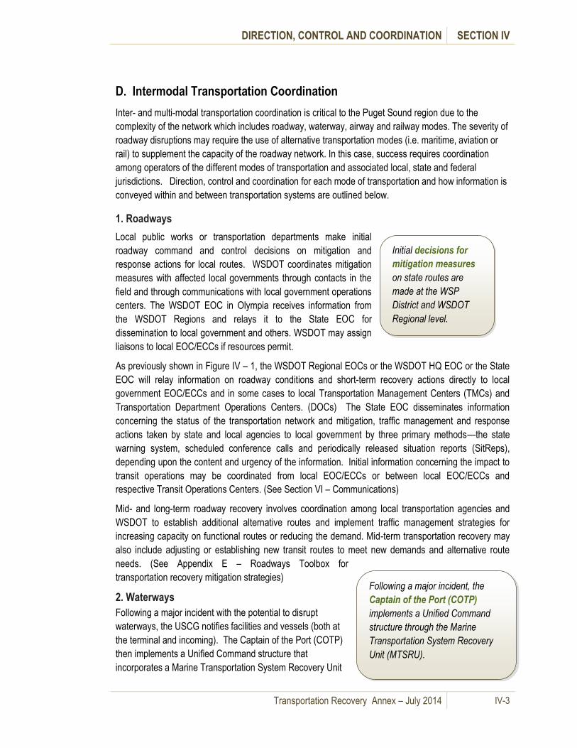
DIRECTION, CONTROL AND COORDINATION SECTION IV
Transportation Recovery Annex – July 2014 IV-3
D. Intermodal Transportation Coordination
Inter- and multi-modal transportation coordination is critical to the Puget Sound region due to the
complexity of the network which includes roadway, waterway, airway and railway modes. The severity of
roadway disruptions may require the use of alternative transportation modes (i.e. maritime, aviation or
rail) to supplement the capacity of the roadway network. In this case, success requires coordination
among operators of the different modes of transportation and associated local, state and federal
jurisdictions. Direction, control and coordination for each mode of transportation and how information is
conveyed within and between transportation systems are outlined below.
1. Roadways
Local public works or transportation departments make initial
roadway command and control decisions on mitigation and
response actions for local routes. WSDOT coordinates mitigation
measures with affected local governments through contacts in the
field and through communications with local government operations
centers. The WSDOT EOC in Olympia receives information from
the WSDOT Regions and relays it to the State EOC for
dissemination to local government and others. WSDOT may assign
liaisons to local EOC/ECCs if resources permit.
As previously shown in Figure IV – 1, the WSDOT Regional EOCs or the WSDOT HQ EOC or the State
EOC will relay information on roadway conditions and short-term recovery actions directly to local
government EOC/ECCs and in some cases to local Transportation Management Centers (TMCs) and
Transportation Department Operations Centers. (DOCs) The State EOC disseminates information
concerning the status of the transportation network and mitigation, traffic management and response
actions taken by state and local agencies to local government by three primary methods—the state
warning system, scheduled conference calls and periodically released situation reports (SitReps),
depending upon the content and urgency of the information. Initial information concerning the impact to
transit operations may be coordinated from local EOC/ECCs or between local EOC/ECCs and
respective Transit Operations Centers. (See Section VI – Communications)
Mid- and long-term roadway recovery involves coordination among local transportation agencies and
WSDOT to establish additional alternative routes and implement traffic management strategies for
increasing capacity on functional routes or reducing the demand. Mid-term transportation recovery may
also include adjusting or establishing new transit routes to meet new demands and alternative route
needs. (See Appendix E – Roadways Toolbox for
transportation recovery mitigation strategies)
2. Waterways
Following a major incident with the potential to disrupt
waterways, the USCG notifies facilities and vessels (both at
the terminal and incoming). The Captain of the Port (COTP)
then implements a Unified Command structure that
incorporates a Marine Transportation System Recovery Unit
Initial decisions for
mitigation measures
on state routes are
made at the WSP
District and WSDOT
Regional level.
Following a major incident, the
Captain of the Port (COTP)
implements a Unified Command
structure through the Marine
Transportation System Recovery
Unit (MTSRU).

DIRECTION, CONTROL AND COORDINATION SECTION IV
Transportation Recovery Annex – July 2014 IV-4
(MTSRU). The MTSRU is comprised of experts in maritime mobility, incident response and port
operations who work with stakeholders to restore the commercial capacity of a waterway following a
natural or manmade disruption.
The MTSRU functions within the Planning Section of the Unified Command to plan and support
coordinated recovery activities and operations, and has the job of informing decision makers and other
stakeholders at all levels regarding maritime transportation following disruption. MTSRU members also
identify communication mechanisms and informational requirements to facilitate the recovery of
waterway traffic flow.
Port tenants conduct the initial assessments of port facilities and convey them to port authorities and the
USCG Captain of the Port, generally through the USCG Joint Harbor Operations Center (JHOC). The
JHOC serves as the nexus for marine operations, monitoring, overseeing and coordinating daily
activities that ensure the maritime safety and security of the Puget Sound area. It also facilitates
planning, monitoring and response to natural disasters, accidents or deliberate attacks that affect ships,
craft or waterfront infrastructure within Puget Sound.
The primary command and coordination centers for maritime operations are the WSDOT Ferry System
EOC and the USCG Joint Harbor Operations Center. Maritime and roadway authorities coordinate their
short term transportation recovery efforts as outlined in Table IV-1.
Table IV-1: Roadways and Waterways Coordination
Short-term Roadway and Waterways Coordination
WSDOT - USCG
WSDOT provides a representative in the JHOC for an active Unified
Command, and Sector Puget Sound sends a liaison to the State EOC.
This provides a coordination interface among the state maritime and
roadway transportation networks.
Ports – Local EOCs Ports send a liaison to a local EOC to provide coordination between port operations and the local and state transportation network.
Ports relay damage assessment and port capabilities information to local EOCs and then to the State EOC. This information is used to set priorities for recovery of port operations or for use of ports as logistics centers for the arrival of emergency equipment, supplies and personnel by water routes.
Ports - USCG Ports relay damage assessment and port capabilities information to USCG (MTSRU)
WSF - WSDOT
WSF and other ferries operating in the Puget Sound region conduct assessments of terminals and/or piers prior to resuming service. WSDOT terminals convey their status to WSDOT Olympic Region EOC and the Northwest Region EOC.
WSF - USCG
WSF is likely to have a liaison officer at the USCG Joint Harbor Operations Center (JHOC). WSF short term priorities for operations include assessment of the terminals and vessels, and resumption of service to existing schedules. WSF relays damage assessment and WSF

DIRECTION, CONTROL AND COORDINATION SECTION IV
Transportation Recovery Annex – July 2014 IV-5
capabilities information to USCG (MTSRU)
Local EMA – Local EMA
Information sharing via the King County Office of Emergency Management SharePoint site facilitates coordination and operational decisions. (See Section VI – Communications.)
Mid- and long-term waterways recovery involves coordination among ports, WSDOT, the USCG and
other stakeholders to establish alternative routes if needed and adjusting or establishing new water
transit routes to meet new demands. (See Appendix F – Waterways Toolbox for maritime transportation
mitigation strategies).

DIRECTION, CONTROL AND COORDINATION SECTION IV
Transportation Recovery Annex – July 2014 IV-6
Figure IV-2 shows direction, control and coordination relationships for maritime operations.
Figure IV-2: Direction, Control and Coordination Relationships for Maritime Operations
Source: USCG Puget Sound Maritime Security Plan 2009
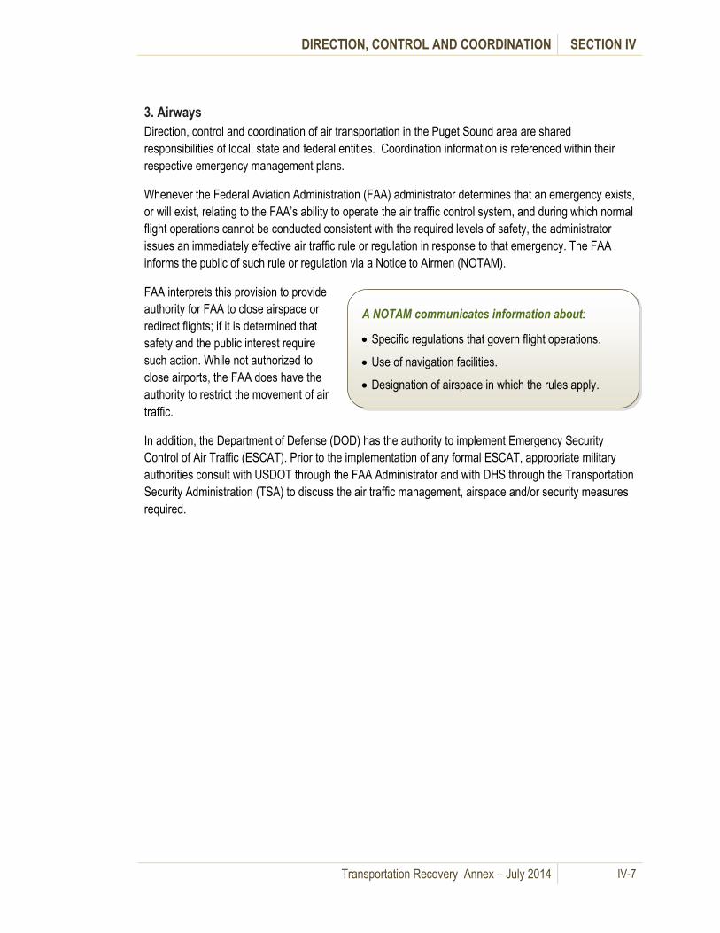
DIRECTION, CONTROL AND COORDINATION SECTION IV
Transportation Recovery Annex – July 2014 IV-7
3. Airways
Direction, control and coordination of air transportation in the Puget Sound area are shared
responsibilities of local, state and federal entities. Coordination information is referenced within their
respective emergency management plans.
Whenever the Federal Aviation Administration (FAA) administrator determines that an emergency exists,
or will exist, relating to the FAA’s ability to operate the air traffic control system, and during which normal
flight operations cannot be conducted consistent with the required levels of safety, the administrator
issues an immediately effective air traffic rule or regulation in response to that emergency. The FAA
informs the public of such rule or regulation via a Notice to Airmen (NOTAM).
FAA interprets this provision to provide
authority for FAA to close airspace or
redirect flights; if it is determined that
safety and the public interest require
such action. While not authorized to
close airports, the FAA does have the
authority to restrict the movement of air
traffic.
In addition, the Department of Defense (DOD) has the authority to implement Emergency Security
Control of Air Traffic (ESCAT). Prior to the implementation of any formal ESCAT, appropriate military
authorities consult with USDOT through the FAA Administrator and with DHS through the Transportation
Security Administration (TSA) to discuss the air traffic management, airspace and/or security measures
required.
A NOTAM communicates information about:
Specific regulations that govern flight operations.
Use of navigation facilities.
Designation of airspace in which the rules apply.

DIRECTION, CONTROL AND COORDINATION SECTION IV
Transportation Recovery Annex – July 2014 IV-8
Figure IV-3 outlines the reporting relationships among airports, local and state EOCs and federal
agencies.
Figure IV-3: Reporting relationships among airports and EOC/ECCs
.
For state level coordination, WSDOT Aviation Division will send a representative to the State EOC.
WSDOT Aviation Division also has a mobile command post that can be used to coordinate initial
recovery of the airways network.
Airports are considered critical infrastructure and are to remain open to the extent possible. Air traffic
will pause long enough to conduct initial assessments of airport facilities. The airport and/or
stakeholders conduct the assessments and report the status to the local EOC. Local EOCs inform the
State EOC of the status of airports and the State EOC disseminates the information to appropriate
agencies and stakeholders. WSDOT Aviation Division coordinates this information with the State EOC
which in turn informs local EOCs/ECCs.
If DOD implements ESCAT, the appropriate military
authority consults regularly with DOT (through the
FAA Administrator) and DHS (through the TSA
Administrator) as appropriate, regarding any
changes in required air traffic management,
airspace and/or security measures. For long term
recovery measures, airports may be part of the
temporary task forces or work groups established
by local governments or the State.
Mid- and long-term airways recovery involves coordination among airports, WSDOT, the FAA and other
aviation stakeholders to establish alternative routes if needed and adjusting or establishing new airways
The airports work through existing
established relationships with the state
under the state Critical Infrastructure
Protection Plan and with WSDOT
Aviation Division for setting priorities,
determining airport capacity and
restoring the movement of airfreight and
passengers.

DIRECTION, CONTROL AND COORDINATION SECTION IV
Transportation Recovery Annex – July 2014 IV-9
transit routes to meet new demands. (See Appendix G – Airways Toolbox for aviation transportation
mitigation strategies)
4. Railways
The private sector owns the interstate rail transportation network in the region. Railroad companies,
such as the BNSF Railway Company and the Union Pacific Railroad, have their own 24/7 dispatch
centers that are in touch with each train. Amtrak maintains the Consolidated National Operations Center
(CNOC) that provides overall coordination of Amtrak rail traffic. Mechanisms are in place for the
railroads to share information. The Association of American Railroads (AAR) manages an operations
center which is the hub of the Railway Alert Network (RAN) and links Federal national security, the
military and major customer associations with the freight railroads on a 24x7 basis. The system as a
whole is used to research, receive, analyze, and transmit security and threat information including
damages caused by a catastrophe. Due to Homeland Security requirements, railroad emergency plans
are not available to the public.
Following a major incident with the potential to disrupt
railway traffic, trains are normally stopped in place pending
an assessment. AMTRAK and Sound Transit Trains
operating primarily on BNSF Railway tracks in the Puget
Sound region would also stop in place pending an
assessment of the status of the route. Initial assessments
are coordinated with WSDOT.
Mid- and long-term recovery coordination with the railroads is done through pre-existing local contacts,
through the state (via WSDOT) and through existing coordination linkages with the state. The priority is
returning the railway system to pre-disaster and more resilient condition. For long-term recovery
measures, the railroads could be part of temporary task forces or work groups established under state
long-term recovery plans.
E. Federal Transportation Recovery Operations
A Federal-State Joint Field Office (JFO) is organized to administer Public Assistance (PA), and Hazard
Mitigation Grant Programs (HMGP), both of which relate to transportation recovery. If needed due to the
breadth and extent of damages across the state, FEMA may also establish Area Field Offices. (See
Section III – Organization and Responsibilities.)
F. Regional Coordination
Transportation recovery requires inter-agency and inter-jurisdictional coordination within and between all
levels of government. Appendix C identifies several options for local jurisdictions to be part of a
regional coordination process for making decisions and recommendations concerning regional
transportation recovery issues.
Coordination with the railroads
takes place through existing
relationships, through the WSDOT
Freight Divisions and through the
State EOC.

DIRECTION, CONTROL AND COORDINATION SECTION IV
Transportation Recovery Annex – July 2014 IV-10
G. Criteria for Prioritization of
Transportation Recovery for Roadways
After a catastrophic incident, resource shortages may require
prioritization of repair and restoration of the regional roadway
transportation network. Some priority decisions are
completely in the domain of an agency having jurisdiction,
but the regional nature of the transportation network and the potential regional aspects of a catastrophe
may necessitate local, state, federal and private sector transportation stakeholders working together to
set priorities.
A description of a recommended best practice prioritization process with a sample template is included
in Appendix D.
Pre-planning of criteria and
processes for setting priorities and
making decisions facilitates the
recovery process.

Transportation Recovery Annex – July 2014 V-1
V. Information Collection and Dissemination
A. General Information
This section describes how transportation organizations collect, manage, and disseminate information
concerning transportation disruptions to transportation organizations and the general public. These
processes are used after a catastrophic incident. It also provides information on various communication
networks available to regional stakeholders and citizens, including, but not limited to, Internet portals,
radio, television and social networking.
For the purposes of this Annex, situational awareness is the gathering and sharing of information among
transportation agencies concerning the status of the regional transportation network to develop response
and recovery strategies and tactics. Emergency public information is coordinating the information about
the transportation network to provide information and directions to the public.
Emergency information about the status of the regional transportation network and instructions to the
public are coordinated through Joint Information Centers (JICs) to ensure a consistent message is
provided to the public. The State EOC coordinates regional transportation information to help ensure
that information and messaging distinguishes between information directed at specific geographic areas.
(For example – distinguishing between information for the Seattle area as opposed to information for the
Olympia area)
In the hours and first days after a catastrophe, emergency transportation information is locally focused to
provide specific emergency response information on the status of local routes, damages, closures and
detours. As recovery moves to the mid- and long-term, information becomes more regionally focused
with information on alternative routes, transit alternatives and traffic management strategies that are
being implemented.
B. Situational Awareness
There are a number of communications
networks used by individual agencies,
jurisdictions or their respective EOCs/ECCs
and JICs to collect and disseminate
emergency transportation information both to
the public and to develop situational
awareness information for decision makers.
Washington State Department of Transportation WSDOT is the ESF-1 Transportation Lead at the state
level with representation at the State EOC. The State EOC shares transportation information with local
governments primarily via WebEOC, regularly scheduled conference calls and published situation
reports (SitReps). Regional sharing of transportation related information among local EOCs/ECCs may
use the King County Office of Emergency Management SharePoint site. This tool can assist in sharing
operational and recovery information among EOCs/ECCs, Transportation Management Centers (TMCs),
and local and state transportation agencies to develop situational awareness and develop longer term
strategies and plans. (See Section VI- Communications and the Regional Coordination Plan).
Situational awareness Information gathered
from the field helps develop a common
operating picture to guide operational decisions
in transportation recovery.

INFORMATION COLLECTION AND DISSEMINATION SECTION V
Transportation Recovery Annex – July 2014 V-2
1. Roadways
Roadway Conditions – Local governments collect roadway and bridge assessment information at local
EOCs/ECCs. This information is shared with local departments and the public as well as with other
jurisdictions through established communications protocols. WSDOT collects roadway and bridge
assessment information from WSDOT personnel, WSP field personnel and through communications
with local transportation and emergency management agencies. WSDOT and WSP field personnel
communicate with their respective regional traffic management center or district dispatch center.
Information is used to manage response and recovery operations and provide a basis for information on
traffic disruptions and lists alternate emergency routes for the traveling public. Traffic maps and camera
views on the WSDOT website provide real time information to travelers. (See Table V – 3)
Freight Networks - The Washington Transportation Association, in coordination with WSDOT, transmits
and receives information on traffic/shipping disruptions and alternate routing through email updates,
radio broadcasts, and roadway/waterway signage and the Internet. WSDOT sends information about
primary freight corridors to an existing list, with specific targeted information for truck freight, to
determine detours and to set freight transportation priorities.
Transit Networks - Transit agencies collect information from their personnel in the field and from other
local and state agencies. They then transmit information to EOC/ECCs where it is collected and
analyzed as part of situational assessment. It is then disseminated to other operational agencies
through road alerts, broadcast fax and emails, and direct notification.
2. Waterways
WSDOT - Washington State Ferries (WSF) Emergency Operations Center - Designated managers
report to or dispatch a representative to the WSF Emergency Operations Center upon notification of a
Level II or higher emergency. The WSF EOC coordinates with WSDOT as well as the JIC. Refer to
WSF Safety Maintenance System guidance for information collection and management for operations
related to marine transportation.
Sector Puget Sound United States Coast Guard (USCG) – Puget Sound Joint Harbor Operations
Center (JHOC) and Vessel Tracking Services (VTS) Puget Sound - The JHOC and vessel tracking
services (VTS) are located at Pier 36 in Seattle. The VTS monitor the Strait of Juan de Fuca, Rosario
Strait, Admiralty Inlet, and Puget Sound south as far as Olympia. Since 1979, the USCG has worked
cooperatively with the Canadian Coast Guard to manage vessel traffic in adjacent waters.
Through the Cooperative Vessel Traffic Service (CVTS), two Canadian Vessel Traffic Centers work hand in hand with Puget Sound Vessel Traffic Service. Tofino Vessel Traffic Service manages the area west of the Strait of Juan de Fuca. North of the Strait of Juan de Fuca, through Haro Strait, to Vancouver, B.C. falls to the Vancouver Vessel Traffic Service. The three Vessel Traffic Centers communicate via a computer link and dedicated telephone lines to advise each other of vessels passing between their respective zones.
The JHOC is operated by the USCG and coordinates with
The Joint Harbor Operations
Center (JHOC) facilitates planning,
monitoring and response to natural
disasters, accidents or deliberate
attacks that affect Puget Sound
ships, craft or waterfront
infrastructure.

INFORMATION COLLECTION AND DISSEMINATION SECTION V
Transportation Recovery Annex – July 2014 V-3
the State EOC through the exchange of liaisons.
Marine Exchange of Puget Sound - The Marine Exchange is a member-based, non-profit organization
that provides comprehensive communications and information services to its membership 24 hours a
day, seven days a week. The membership is a mix of Puget Sound based steamship agents and
operators, tug boat operators, ship chandlers, port authorities and state and federal agencies, along with
a wide range of maritime industry support businesses. Communication and information services include
a region-wide radio capability, telephone answering services, and various real-time and historical vessel
activity reports. The marine exchange is capable of assisting the Coast Guard as well as providing
back-up service for communications in the event that a disaster may disrupt VTS service.
The Marine Exchange shares information and coordinates with USCG for emergency response and
recovery. The information can be used to manage vessel traffic, develop alternative waterway routes
and to set priorities for maritime freight.
United States Navy (USN) - The United States Navy installations’ EOCs exchange disaster response
and recovery information with Navy Regional Operations Centers and local EOCs/ECCs before it goes
to the State EOC. The Navy Regional Operation Center also exchanges information with JHOC and US
Fleet forces, which make mission assignments. The Navy Regional Operations Centers share
information with US Fleet forces. The Regional Operations Center is central for the States of
Washington, Oregon and Alaska.
3. Airways
Airport Damage Assessments - The Aviation Program Manager (APM) coordinates the initial airport
damage assessment reports from airport officials or volunteer pilots in the disaster-affected areas. Upon
completion of their mission, pilots report results through their aviation director to the WSDOT EOC. The
WSDOT EOC then reports the information to the State EOC for analysis and dissemination to local
emergency management agencies and the public.
Aerial Reconnaissance - Requests from local governments and state agencies for aerial
reconnaissance, photographic and radiological monitoring missions go through the State EOC. The
APM coordinates the state’s air resources, including military, volunteer and Civil Air Patrol (CAP), to
support the mission. The APM briefs pilots on the mission. Upon completion of the mission, the pilots
report through the APM to the WSDOT EOC. The WSDOT EOC reports this information to the State
EOC for analysis and dissemination to the public.
4. Railways Mechanisms are in place for the railroads to share
information and they have their own public information
officers. The BNSF Railway Company and the Union Pacific
Railroad have their own 24/7 dispatch centers. Amtrak
maintains the Consolidated National Operations Center
(CNOC) that provides overall coordination of Amtrak rail
traffic. The Association of American Railroads (AAR)
manages the Railway Alert Network (RAN) and links Federal
Railroad companies, such as
BNSF Railway Company and
the Union Pacific Railroad, and
local dispatch centers coordinate
with local media to provide
emergency information to the
public about the status of railroad
operations after a catastrophe.
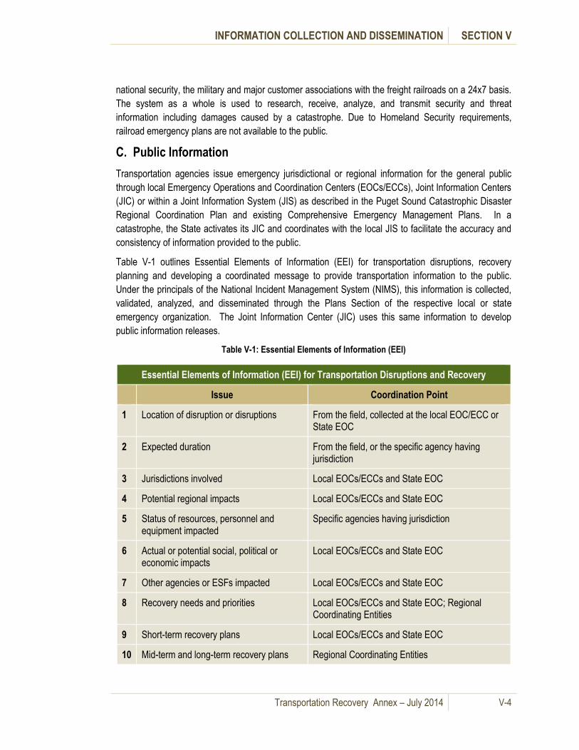
INFORMATION COLLECTION AND DISSEMINATION SECTION V
Transportation Recovery Annex – July 2014 V-4
national security, the military and major customer associations with the freight railroads on a 24x7 basis.
The system as a whole is used to research, receive, analyze, and transmit security and threat
information including damages caused by a catastrophe. Due to Homeland Security requirements,
railroad emergency plans are not available to the public.
C. Public Information
Transportation agencies issue emergency jurisdictional or regional information for the general public
through local Emergency Operations and Coordination Centers (EOCs/ECCs), Joint Information Centers
(JIC) or within a Joint Information System (JIS) as described in the Puget Sound Catastrophic Disaster
Regional Coordination Plan and existing Comprehensive Emergency Management Plans. In a
catastrophe, the State activates its JIC and coordinates with the local JIS to facilitate the accuracy and
consistency of information provided to the public.
Table V-1 outlines Essential Elements of Information (EEI) for transportation disruptions, recovery
planning and developing a coordinated message to provide transportation information to the public.
Under the principals of the National Incident Management System (NIMS), this information is collected,
validated, analyzed, and disseminated through the Plans Section of the respective local or state
emergency organization. The Joint Information Center (JIC) uses this same information to develop
public information releases.
Table V-1: Essential Elements of Information (EEI)
Essential Elements of Information (EEI) for Transportation Disruptions and Recovery
Issue Coordination Point
1 Location of disruption or disruptions From the field, collected at the local EOC/ECC or State EOC
2 Expected duration From the field, or the specific agency having jurisdiction
3 Jurisdictions involved Local EOCs/ECCs and State EOC
4 Potential regional impacts Local EOCs/ECCs and State EOC
5 Status of resources, personnel and equipment impacted
Specific agencies having jurisdiction
6 Actual or potential social, political or economic impacts
Local EOCs/ECCs and State EOC
7 Other agencies or ESFs impacted Local EOCs/ECCs and State EOC
8 Recovery needs and priorities Local EOCs/ECCs and State EOC; Regional Coordinating Entities
9 Short-term recovery plans Local EOCs/ECCs and State EOC
10 Mid-term and long-term recovery plans Regional Coordinating Entities
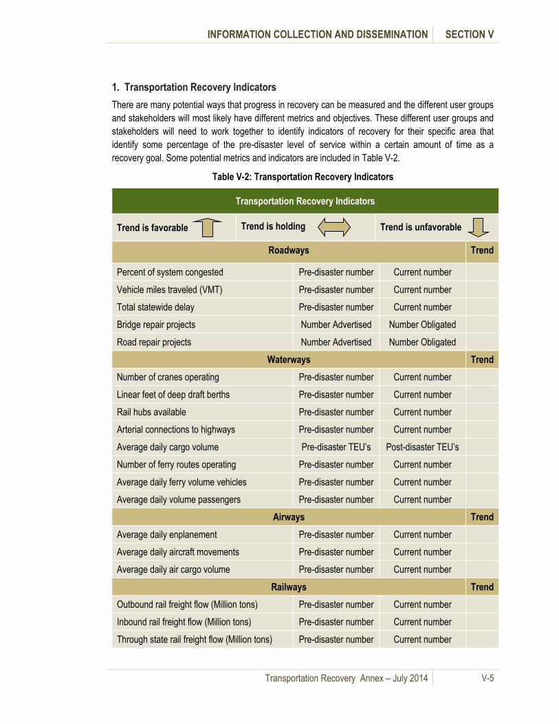
INFORMATION COLLECTION AND DISSEMINATION SECTION V
Transportation Recovery Annex – July 2014 V-5
1. Transportation Recovery Indicators
There are many potential ways that progress in recovery can be measured and the different user groups
and stakeholders will most likely have different metrics and objectives. These different user groups and
stakeholders will need to work together to identify indicators of recovery for their specific area that
identify some percentage of the pre-disaster level of service within a certain amount of time as a
recovery goal. Some potential metrics and indicators are included in Table V-2.
Table V-2: Transportation Recovery Indicators
Transportation Recovery Indicators
Trend is favorable Trend is holding Trend is unfavorable
Roadways Trend
Percent of system congested Pre-disaster number Current number
Vehicle miles traveled (VMT) Pre-disaster number Current number
Total statewide delay Pre-disaster number Current number
Bridge repair projects Number Advertised Number Obligated
Road repair projects Number Advertised Number Obligated
Waterways Trend
Number of cranes operating Pre-disaster number Current number
Linear feet of deep draft berths Pre-disaster number Current number
Rail hubs available Pre-disaster number Current number
Arterial connections to highways Pre-disaster number Current number
Average daily cargo volume Pre-disaster TEU’s Post-disaster TEU’s
Number of ferry routes operating Pre-disaster number Current number
Average daily ferry volume vehicles Pre-disaster number Current number
Average daily volume passengers Pre-disaster number Current number
Airways Trend
Average daily enplanement Pre-disaster number Current number
Average daily aircraft movements Pre-disaster number Current number
Average daily air cargo volume Pre-disaster number Current number
Railways Trend
Outbound rail freight flow (Million tons) Pre-disaster number Current number
Inbound rail freight flow (Million tons) Pre-disaster number Current number
Through state rail freight flow (Million tons) Pre-disaster number Current number

INFORMATION COLLECTION AND DISSEMINATION SECTION V
Transportation Recovery Annex – July 2014 V-6
Since one of the primary goals in restoring the transportation network is economic recovery, it will be
important for policymakers to understand specifically that this will mean different things to the different
user groups. As there are so many variables as to what major disruptions to the transportation system
would be after a catastrophe, it will be critical that transportation recovery efforts involve key
stakeholders and decision-makers at all levels of government and the private sector working together in
the many different planning efforts in the recovery process. The WSDOT document Development of a
Statewide Freight System Resiliency Plan (See Section IX, G.7) provides some guidance for decision
makers.
How recovery objectives are defined will assist in setting priorities for the state. As an example, metrics
could focus upon certain counties which have the largest freight operations or on all of the counties
impacted by the catastrophe. The difference between the two metrics is a decision whether to focus on
the state as a single entity (which concentrates efforts at high impact junctures for maximum
improvement) or apply efforts evenly across all of the regions. The challenge is a political discussion
which is an “effectiveness versus fairness” argument that is best handled by the elected officials.
Other metrics may be used as appropriate. Indicators of recovery progress may also be done for a
specific jurisdiction or area. These recommendations are derived from existing metrics used by the state
and jurisdictions and the various modes of transportation to measure current levels of service and
economic vitality. Utilizing existing measurement methods as recovery indicators can avoid confusion in
providing public information concerning the progress of recovery and facilitate the monitoring, assessing
and revising of transportation recovery plan.
Policies and procedures for providing emergency information to the public should be continued
consistently throughout the recovery process, although the nature of the information may be different.
Emergency public information is the response phase of a catastrophe is usually focused on providing the
public with information to guide their actions to protect themselves and their property. Information is
needed during recovery to provide citizens with guidance to help their recovery.
Once transportation recovery priorities and goals are established, it is also important to keep the public
informed of the progress of recovery strategies and actions. This may require the same level of regional
coordination that was needed among public sector agencies and jurisdictions, the private sector and
other transportation stakeholders to set regional transportation recovery priorities and goals in the first
place.
2. Transportation Communication Networks
Intelligent Transportation Systems (ITS) throughout the region are used to provide information among
transportation agencies and transportation stakeholders and for dissemination to the general public.
These systems include a broad range of wireless and wire line communications and information systems
used to communicate transportation response and recovery efforts. Key elements include, but are not
limited to, the following:
1.

INFORMATION COLLECTION AND DISSEMINATION SECTION V
Transportation Recovery Annex – July 2014 V-7
Variable Message Signs - A variable message
sign is an electronic traffic sign used on
roadways to provide motorists with important
information about traffic congestion, incidents,
roadwork zones, travel times, special events, or
speed limits on a specific highway segment.
Highway Advisory Radios (HAR) - Highway Advisory Radios are licensed low-power AM radio stations
installed along the roadway to provide alerts and general information regarding traffic and travel. The
presence of a HAR transmitter is marked by a roadway sign instructing motorist to "Tune to 1610 AM."
The 1610 frequency is one of several used by HAR radios and identified on the signs.
Traffic Data Collectors - Traffic Data Collectors are one of the key set of tools used to keep track of
what is happening on the roadways. The data is sent from the roadside to WSDOT Traffic Management
Centers to monitor operations and provide traffic conditions to the web and the WSDOT 511 traffic
information hotline. Each jurisdiction has a variety of ways to communicate emergency information to its
citizenry and the general public; however most transportation providers use the Internet as their primary
means of providing emergency information to the public.
Table V-3 lists Local Jurisdiction Roadway and/or Transit Conditions Websites and Public Information
Networks. Table V-4 lists additional transit and road condition website addresses.
Variable Message Signs also recommend
alternative routes, limit travel speed, warn of
duration and location of problem, or simply
provide alerts or warnings.
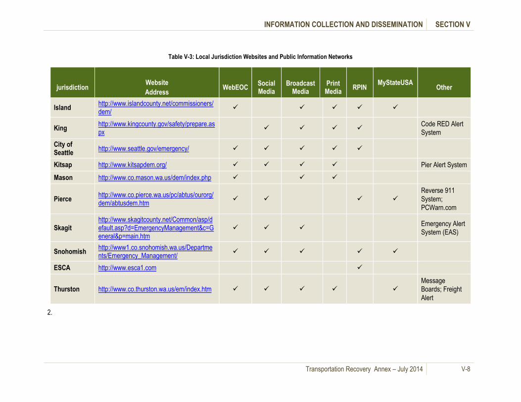
INFORMATION COLLECTION AND DISSEMINATION SECTION V
Transportation Recovery Annex – July 2014 V-8
Table V-3: Local Jurisdiction Websites and Public Information Networks
jurisdiction
Website
Address
WebEOC
Social Media
Broadcast Media
Print Media
RPIN
MyStateUSA
Other
Island http://www.islandcounty.net/commissioners/dem/
King http://www.kingcounty.gov/safety/prepare.aspx
Code RED Alert
System
City of Seattle
http://www.seattle.gov/emergency/
Kitsap http://www.kitsapdem.org/ Pier Alert System
Mason http://www.co.mason.wa.us/dem/index.php
Pierce http://www.co.pierce.wa.us/pc/abtus/ourorg/dem/abtusdem.htm
Reverse 911
System;
PCWarn.com
Skagit http://www.skagitcounty.net/Common/asp/default.asp?d=EmergencyManagement&c=General&p=main.htm
Emergency Alert
System (EAS)
Snohomish http://www1.co.snohomish.wa.us/Departments/Emergency_Management/
ESCA http://www.esca1.com
Thurston http://www.co.thurston.wa.us/em/index.htm Message
Boards; Freight
Alert
2.

INFORMATION COLLECTION AND DISSEMINATION SECTION V
Transportation Recovery Annex – July 2014 V-9
Table V-4: Additional Road Condition and Transit Websites
Jurisdiction Website Address Provides real time:
WSDOT http://wsdot.wa.gov/traffic/ Traffic information to travelers
WSDOT http://www.wsdot.wa.gov/traffic/trafficalerts/ Traffic Alerts for travelers
King Co Road Info http://gismaps.kingcounty.gov/roadalert/ Traffic Alerts and Road information in King County
City of Seattle http://www.cityofseattle.net/html/citizen/traffic.htm Traffic Alerts and Road information in the City of Seattle
City of Bellevue http://trafficmap.cityofbellevue.net/ Traffic Alerts and Road information in the City of Bellevue
Metro http://metro.kingcounty.gov/
Route information, safety information and rider alerts for any
schedule and Metro route changes
Sound Transit http://www.soundtransit.org/
Route information, safety information and rider alerts for any
schedule and Sound Transit route changes
Pierce County https://ww2.everbridge.net/citizen/EverbridgeGateway.action?body=home&gis_alias_id=310761
Emergency and Traffic Notification Sign-Up for Traffic Alerts and
Road Information in Pierce County
City of Tacoma http://www.cityoftacoma.org/Page.aspx?hid=13707 Traffic Alerts and Road information in the City of Tacoma
Pierce Transit http://www.piercetransit.org/
Route information, safety information and rider alerts for any
schedule and Pierce Transit route changes
Intercity Transit http://www.intercitytransit.com/Pages/default.aspx
Route information, safety information and rider alerts for any
schedule and Intercity transit route changes
Mason County http://www.co.mason.wa.us/public_works/road_closures.php Traffic Alerts and Road information in Mason County
Mason Co Transit http://www.masontransit.org/
Route information, safety information and rider alerts for any
schedule and Mason County Transit route changes

INFORMATION COLLECTION AND DISSEMINATION SECTION V
Transportation Recovery Annex – July 2014 V-10
Jurisdiction Website Address Provides real time:
Kitsap County http://www.kitsapgov.com/pw/roadwork.htm Traffic Alerts and Road information in Kitsap County
Kitsap Co Transit http://www.kitsaptransit.org/
Route information, safety information and rider alerts for any
schedule and Kitsap County Transit route changes
Island County http://www.islandcounty.net/publicworks/ Traffic and road condition information
Island Co. Transit http://www.islandtransit.org/
Route information, safety information and rider alerts for any
schedule and Kitsap County Transit route changes
Skagit County http://www.skagitcounty.net/apps/publicworks/roadclose/default.aspx?d=EmergencyInformation&c=General
Current Road Closures in Skagit County
Skagit Co Transit http://www.skagittransit.org/
Route information, safety information and rider alerts for any
schedule and Kitsap County Transit route changes
Snohomish County http://www1.co.snohomish.wa.us/Departments/Public_Works/Services/Roads/
Road Maintenance and Restrictions in Snohomish County
City of Everett http://www.ci.everett.wa.us/default.aspx?ID=65 Traffic Alerts and Road information in the City of Everett
Community Transit http://www.commtrans.org/
Route information, safety information and rider alerts for any
schedule and Snohomish County Transit route changes
Thurston County http://www.co.thurston.wa.us/roads/traffic/alerts.htm Traffic Alerts and Road Closures in Thurston County
Intercity Transit http://www.intercitytransit.com/Pages/default.aspx
Route information, safety information and rider alerts for any
schedule and Intercity Transit route changes
3.
http://www.skagitcounty.net/apps/publicworks/roadclose/default.aspx?d=EmergencyInformation&c=General

Transportation Recovery Annex – July 2014 VI - 1
VI. Communications
A. General Information
This section addresses communications issues among transportation agencies and stakeholders during
the short-term, mid-term and long-term recovery efforts after major disruption of the regional
transportation network, including communications tools for coordination with local, regional and state
transportation agencies and coordinating entities.
The section includes information on communications and alternate methods of communications among
emergency operations centers, traffic management centers, dispatch centers and other command,
control and coordination facilities. Information on communication with the public and disseminating
information to the public about transportation disruptions, detours, alternatives and recovery strategies is
covered in Section V – Information Collection and Dissemination.
B. Short-Term Recovery Communications
For the purposes of this Annex, short-term recovery of the transportation network involves gaining
situational awareness and implementing initial detours and alternate routes to restore whatever
transportation flow is possible after a major incident. Subsequent, short-term recovery efforts occur
during the initial response phase.
First responders and transportation agencies communicate with each other through existing
communications capabilities and frequency designations as outlined in local and state Emergency
Management Plans and Communications Plans. The agency having jurisdiction at any particular
transportation disruption develops the initial incident communication plan and sets the stage for
determining the short-term recovery actions of developing situational awareness and establishing any
initial detours or alternative routes. If a State agency assumes incident command, standard local
operational frequencies may not be utilized.
Many jurisdictions throughout the Puget Sound region have
established communications capabilities among emergency
operations centers, traffic management centers, dispatch
centers, other transportation command, control and
coordination facilities and responders in the field. Agencies
in these jurisdictions use these existing communications
plans, protocols and procedures as much as possible in the
initial hours of a major incident, acknowledging there may be
reduced capacity due to damage or a surge in use.
Local transportation agencies within the Puget Sound region are unlikely to have capacity to
communicate over all radio frequencies in use by public safety and transportation agency responders.
For example, local incident command may be unable to communicate with responding mutual aid
providers over its normal radio frequencies.
Within the Puget Sound Region, police, EMS, fire, public works and transportation agencies use a
variety of public safety radio systems that are not fully interoperable across the region. Specialized
mutual aid channels are also not consistently available or reliable. For short term recovery, and if an
Agencies also use Web based
tools such as state and local
transportation websites and the
King County SharePoint site to
share information and develop a
common operating picture.

COMMUNICATIONS SECTION VI
Transportation Recovery Annex – July 2014 VI - 2
incident is of a magnitude requiring mutual aid response, one of the state or national emergency non-
trunked channels/frequencies may be used for incident command, so multiple responding agencies will
be able to communicate on scene. These frequencies and capabilities are outlined in the Regional
Catastrophic Disaster Coordination Plan, the 2008 Washington Statewide Communications
Interoperability Plan and other State Plans.
1. Roadways
For short term recovery decisions, transportation
responders in the field report essential information to
their respective EOC/ECC through established
communications channels. This may be directly or
through a dispatch center or traffic management center
in accordance with local plans.
WSDOT and WSP field personnel communicate with their respective regional traffic management center
or district dispatch center. The State EOC provides information concerning the status of the
transportation network and system to local government through the State Warning System, periodic
conference calls or scheduled situation reports.
2. Waterways
The maritime industry in the Puget Sound region follows communication protocols in the Puget Sound
Harbor Safety Plan, which specifically outlines primary communication channels between vessels and
seaports. Primary communication is as follows:
VHF Channel 16 – International Distress and Calling
VHF Channel 20 – Marine Exchange channel
VHF Channels 5A, 11, 14, and 74 – Vessel Tracking Service (VTS). See Puget Sound – VTS User’s Manual for designated areas – http://www.uscg.mil/d13/psvts/
Washington State Ferries communicate via VHF Channels (Channel 79 is the WSF working channel) as
well as the following:
800 MHz Radio System – Used for internal communications as well as for correspondence with WSDOT Dayton and Olympic Area EOCs
Telephone system – Used for communications between terminals, support complexes, and management staff
WSDOT Intercom – Used as a large party telephone line that works as a simplex mode radio net
3. Airways
The aviation industry in the Puget Sound region follows communication protocols in the Washington
State Airport Reference Guide and other communications and emergency plans. Per the WSDOT
Disaster Plan, the principal means of communication among airports, aircraft and response agencies are
the following:
FAA communications system (Flight Plans Only)
Low band, VHF, HF, UHF or 800 MHz radios supplied by amateur operators and volunteers
Regional Traffic Management
Centers or District Dispatch
Centers report information to their
respective headquarters, which, in
turn, pass it to the State EOC.

COMMUNICATIONS SECTION VI
Transportation Recovery Annex – July 2014 VI - 3
Commercial Telephone, including cellular phones
Courier aircraft, UNICOM, etc.
4. Railways
The railroads in the Puget Sound region own and maintain their own internal communications systems.
In the event of a catastrophic incident, the railroads will use existing communications capabilities.
Mechanisms are in place for the railroads to communicate with each other and they have experience in
communications with local and state response agencies from past emergencies. The BNSF Railway
Company and the Union Pacific Railroad have their own 24/7 dispatch centers. Amtrak maintains the
Consolidated National Operations Center (CNOC) that provides overall coordination of Amtrak rail traffic.
The Association of American Railroads (AAR) manages the Railway Alert Network (RAN) and links
Federal national security, the military and major customer associations with the freight railroads on a
24x7 basis. Due to Homeland Security requirements, railroad emergency plans are not available to the
public.
5. Interagency Communications and Requests for Mutual Aid
Interagency communications and requests for mutual aid during short-term recovery operations follow
established protocols, policies and procedures to identify the frequency/channel (but not just the channel
name, since these may not be uniform across the region) to be used for on-scene incident command.
6. Regional Interoperability Frequencies
Communications at a major transportation incident with multiple responders is a recurring challenge. For
this reason, there are national, statewide and some regional channels for common use at an incident,
which allow any responder with a given system radio (800 Hz, 700 MHz, VHF or UHF) to talk to others—
even if that responder is not part of the agency in command of the incident.
Ad hoc communications networks and backup systems may be developed with assistance from the state
or federal government. “National interoperability channels” exist for each type of radio frequency –e.g.,
a set of frequencies for both calling and operating on 800 MHZ, 700 MHZ, VHF, and UHF. As “national”
Agencies requesting assistance of outside resources need to be prepared to:
Identify the incident command frequency being used (not simply the channel name).
Provide mobile communications radios for assisting agency command personnel in the event these personnel are not equipped with radios using the same frequency (e.g., if responders are regularly on VHF but the incident command agency uses 800 MHz).
Provide replacement batteries daily for issued mobile radios.
Transportation agencies maintain equipment caches with mobile radio equipment to be utilized for multiple agency response if mutual aid responders cannot communicate with incident command and a patch between frequencies is not/cannot be installed.

COMMUNICATIONS SECTION VI
Transportation Recovery Annex – July 2014 VI - 4
channels, these are the same across the county. A set of statewide channels (LERN, OSCCAR,
MEDNET, etc.) have similar capacities, and a few regional interoperability channels exist within the
Puget Sound region as well. Refer to the 2008 Washington Statewide Communications Interoperability
Plan for a list of these national, state and regional
channels.
These plans and systems replace failed/ disrupted day-to-
day communications. As preparation, dispatch operations
and public safety agencies need to program the respective
channels for their radio system into all their radios. These
channels are not trunked or digital, so anyone with a radio
operating on the general frequency (e.g., 800 MHz) can
access them, regardless of their location. Use of these
frequencies may require authorization.
These channels are frequency specific, that is, the 800 MHz channel cannot be heard or talked on by
those using VHF systems, and vice versa. Within individual jurisdictions and throughout the region,
multiple systems are in use. Where adjacent jurisdictions utilize different systems, without compatible
equipment they cannot communicate in an emergency. Cross-system patches are not typically in place,
but can be hardwired in during emergency incidents. Special equipment is available that allows for
communication across all radio frequencies but it is unclear who, if anyone, in the Puget Sound Region
has acquired this equipment.
Amateur (ham) radio operators can also communicate across frequencies and pass messages between
systems, but they are not used for incident communications between responders.
C. Mid-term and Long-term Regional Communications Needs
After the life-saving phase of a catastrophe or major incident ends, the need for emergency radio
communications diminishes as normal forms of communications recover. Transportation agencies and
stakeholders focus on restoration and recovery priorities. The emphasis, particularly for transportation
entities with intermodal connections that cross jurisdictional boundaries is on sharing information with all
agencies and stakeholders. Phone calls, e-mails, text messages and voice messages are the standard
methods of communications.
Table VI-1 lists communications tools to facilitate communications and coordination after a catastrophic
incident and their capabilities as they come back into service.
As a first order of business in
developing a communications
plan for the disruption, incident
command needs to identify and
secure necessary use
authorizations for using a specified
interoperable channel.

COMMUNICATIONS SECTION VI
Transportation Recovery Annex – July 2014 VI - 5
Table VI-1: Communications Tools
Communications Tools
System Capability
Hardwire “plain old telephone service” (POTS)
Service for the normal user – users compete with the regional population for dial tone
Voice/text messaging cellular service provided by wireless carriers
Service for wireless subscribers – users compete with other subscribers for dial tone
Two-way, combination cellular and digital two-way radio service
Private network cellular and point-to-point two-way radio service
Two-way pager service Pager service combined with wireless e-mail
Switch Redirect (SR)
Relocation of government telephone numbers and subscribed services to local government incident command centers and other emergency locations – SR telephone numbers are predestinated, and “unused” phones must be available to use at the incident command centers or emergency locations
GETS (Government Emergency Telecommunications Service)
Priority land line services by the NCS (National Communications System) using commercial circuits and lines – local and long distance calls compete on the national security emergency preparedness federal government long-distance network, and call completion depends on first obtaining local dial tone, which GETS does not provide.
FTS (Federal Telecommunications System)
High-priority, long-distance circuits to complete local calls – land line services are provided by commercial venders through the General Services Administration, which also provides long-distance calling and allows audio teleconferencing bridge services
Essential Service Protection (ESP) Service by commercial providers that allows for priority local dial tone – can be set up for business, government or residential phones of critical users
Regional/jurisdictional government dedicated lines.
Non-competing local service for a discrete set of super users throughout the government telephone network
Satellite voice and data communications
Point-to-point communications or connection to networks to and from remote locations – can be for voice communications or data connection for shared information over commercial service providers
High Frequency (HF) and/or Single-Side Band (SSB) radio
communications
Service through equipment maintained within the jurisdictions, or through volunteer organizations such as REACT, that coordinates communications for all member jurisdictions

COMMUNICATIONS SECTION VI
Transportation Recovery Annex – July 2014 VI - 6
Communications Tools
System Capability
NSEP priority cellular service Priority, non-encrypted service for emergency use over commercial cell networks
1-800 numbers Access to long-distance circuits through 1-800 numbers
King County SharePoint site
This site provides the capability to share information and collaborate among transportation agencies, Emergency Operations Centers (EOC), Emergency Coordination Centers (ECC), Traffic Management Centers (TMC) and other transportation coordination points. Access is granted through King County Office of Emergency Management, which upon approval, issues a username and password.

Transportation Recovery Annex – July 2014 VII-1
VII. Administration, Finance and Logistics
A. General Information
This section provides a general overview of FHWA and FEMA funding sources for repair and restoration
of damaged transportation infrastructure after a disaster, and information about regional mutual aid
agreements. Many federal agencies have the authority to assist local and state transportation agencies
and jurisdictions involving direct and immediate threat to life or major property damage (see Section III –
Organization and Responsibilities).
The primary established recovery programs are the USDOT FHWA Emergency Relief (ER) program and
the FEMA Public Assistance program. Table VII-1 summarizes these programs.
Table VII-1: Primary Federal Transportation Recovery Programs
Primary Federal Transportation Recovery Programs
Agency Information
FHWA
Under Title 23, USC, Section 125, for the restoration of damaged roads and bridges on
functional classified systems (National Highway System).
Funds are available after the governor has issued a Proclamation of Emergency (Note: a
presidential declaration of major disaster is not necessary.)
FEMA
Under Public Law 93-228, as amended by PL 100-707, the Robert T. Stafford Disaster
Relief and Emergency Assistance Act of 1988, for the restoration of damaged roads and
bridges off functional classified systems (I.e. off the federal aid system).
Funds are available after a presidential declaration of major disaster.
B. USDOT FHWA Emergency Relief (ER) Program
The Washington State Department of Transportation Emergency Relief Plan and the Federal Highway
Administration – Emergency Relief Manual state that roadways and bridges on a federal-aid highway
and that are damaged as a direct result of an approved natural disaster or catastrophic failure from an
external cause are eligible for Emergency Relief (ER) funds.
The ER program provides for repair and restoration of highway facilities to pre-disaster conditions.
Restoration in-kind is therefore the predominate type of repair expected to be accomplished with ER
funds. ER funds are not intended to replace other federal-aid,
state, or local funds for new construction to increase capacity,
correct non-disaster related deficiencies, or otherwise improve
highway facilities.
Added protective features, such as the relocation or rebuilding of
roadways at higher elevation or lengthening or raising bridges,
and added facilities not existing prior to the natural disaster or
All FHWA ER repair work falls
under two major categories:
1) Emergency work and
2) Permanent work.

ADMINISTRATION, FINANCE AND LOGISTICS SECTION VII
Transportation Recovery Annex – July 2014 VII-2
catastrophic failure, such as additional lanes, upgraded surfacing or structures are commonly referred to
as betterment. Betterment is not generally eligible for ER funding unless justified.
1. Emergency work
Emergency work includes those repairs during and immediately following a disaster to restore essential
traffic, to minimize the extent of damage, or to protect the remaining facilities. These repairs can begin
immediately following a disaster, and prior FHWA approval is not required. Properly documented costs
will later be reimbursed once the FHWA Division Administrator makes a finding that the disaster is
eligible for ER funding.
2. Permanent work
Permanent work includes those repairs and work that are undertaken (usually after emergency repairs
have been completed) to restore the highway to its pre-disaster condition. Permanent repairs must have
prior FHWA approval and authorization unless done as part of the emergency repairs. It should be
noted that the majority of federal funding of these repairs can only be used to restore transportation
networks to pre-disaster conditions. However, other funds from federal resources and/or public-private
partnerships can be utilized to supplement funding in order to improve impacted transportation systems
and networks while mitigating damages from future disasters.
3. Eligible Items
Generally, all elements of the highway within its cross section damaged as a direct result of a disaster
are eligible for repair under the ER program. This includes, but is not limited to, elements such as
pavement, shoulders, slopes and embankments, guardrails, signs and traffic control devices, bridges,
culverts, cribbing or other bank control features, bike and pedestrian paths, fencing and retaining walls.
When a pedestrian or bicycle trail within the right-of-way of a federal–aid highway suffers damage, that
damage is eligible for ER funding whether or not the roadway itself is damaged.
The intent of the ER program is to fund repairs to damaged roadways caused by a natural disaster or
catastrophic failure, not repairs to roadways damaged as a result of preexisting and non-disaster related,
i.e., inherent deficient conditions.
By law, FHWA can provide up to $100 million in ER funding to a state for each natural disaster or
catastrophic failure incident that is found eligible for funding under the ER program. This is commonly
referred to the $100 million per state disaster cap. For a large disaster that exceeds $100 million,
Congress can pass legislation lifting the cap for that disaster.
The types of incidents that qualify for ER funding are:
Widespread natural disasters, including floods, hurricanes, severe storms, earthquakes, volcanic eruptions, landslides and tidal waves.
Catastrophic failure, defined as the sudden and complete failure of a major element or segment of roadway system that causes a disastrous impact to transportation services. The cause must be external to the facility, such as a barge hitting a bridge and causing it to collapse.
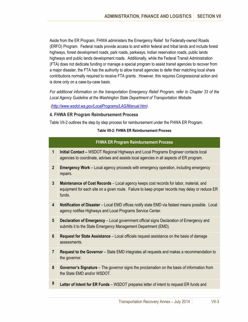
ADMINISTRATION, FINANCE AND LOGISTICS SECTION VII
Transportation Recovery Annex – July 2014 VII-3
Aside from the ER Program, FHWA administers the Emergency Relief for Federally-owned Roads
(ERFO) Program. Federal roads provide access to and within federal and tribal lands and include forest
highways, forest development roads, park roads, parkways, Indian reservation roads, public lands
highways and public lands development roads. Additionally, while the Federal Transit Administration
(FTA) does not dedicate funding or manage a special program to assist transit agencies to recover from
a major disaster, the FTA has the authority to allow transit agencies to defer their matching local share
contributions normally required to receive FTA grants. However, this requires Congressional action and
is done only on a case-by-case basis.
For additional information on the transportation Emergency Relief Program, refer to Chapter 33 of the
Local Agency Guideline at the Washington State Department of Transportation Website
(http://www.wsdot.wa.gov/LocalPrograms/LAG/Manual.htm).
4. FHWA ER Program Reimbursement Process
Table VII-2 outlines the step by step process for reimbursement under the FHWA ER Program.
Table VII-2: FHWA ER Reimbursement Process
FHWA ER Program Reimbursement Process
1 Initial Contact – WSDOT Regional Highways and Local Programs Engineer contacts local
agencies to coordinate, advises and assists local agencies in all aspects of ER program.
2 Emergency Work – Local agency proceeds with emergency operation, including emergency
repairs.
3 Maintenance of Cost Records – Local agency keeps cost records for labor, material, and
equipment for each site on a given route. Failure to keep proper records may delay or reduce ER
funds.
4 Notification of Disaster – Local EMD offices notify state EMD via fastest means possible. Local
agency notifies Highways and Local Programs Service Center.
5 Declaration of Emergency – Local government official signs Declaration of Emergency and
submits it to the State Emergency Management Department (EMD).
6 Request for State Assistance – Local officials request assistance on the basis of damage
assessments.
7 Request to the Governor – State EMD integrates all requests and makes a recommendation to
the governor.
8 Governor’s Signature – The governor signs the proclamation on the basis of information from
the State EMD and/or WSDOT.
9 Letter of Intent for ER Funds – WSDOT prepares letter of intent to request ER funds and

ADMINISTRATION, FINANCE AND LOGISTICS SECTION VII
Transportation Recovery Annex – July 2014 VII-4
FHWA ER Program Reimbursement Process
submits the request to the FHWA Division Office for action.
10
Preliminary Damage Assessments – Highways and Local Programs Service Center, in
cooperation with FHWA, prepares a preliminary damage assessment to determine the severity
and magnitude of disaster.
11 Request for ER Funds – WSDOT prepares a request for ER funds based on preliminary
assessment, including additional backup data.
12 Preparation of Field Report – The FHWA Division Office prepares a field report and sends it to
Washington, D.C. for action by the FHWA Administrator.
13 Concurrence from FHWA Administrator – The administrator concurs that damages are eligible.
14 Notification to Locals – The Highways and Local Programs Service Center notifies all
concerned local agencies of FHWA funding.
15
Preparation of Damage Assessment Forms – The Highways and Local Programs Service
Center with FHWA, and the local agencies prepare detailed damage assessments forms for each
site.
16 Program of Projects – The Highways and Local Programs Service Center prepares the
documents necessary to receive program and project approval.
17
Project Approval and Funding Setup – Local agencies will receive approval notice from the
Highways and Local Programs Service Center. The Regional Highways and Local Programs
Engineer will assist the local agencies in the preparation of the necessary documents to set up
funding and reimbursement mechanism. (Outlined in the Local Agency Guidelines)
18
Project Administration – Highways and Local Programs Service Center is administrating
agency for ER funds. All coordination is done through the Regional Highways and Local
Programs Engineer.
19 Closure of Projects – When work is completed, the local agency prepares the same notification
used on regular federal aid projects to start the closure procedure.
Note: All eligible emergency work accomplished in the first 180 days after the disaster will be 100
percent federally funded. Repairs performed beyond 180 days after the occurrence of the disaster will
be funded at the standard prorate program rate.

ADMINISTRATION, FINANCE AND LOGISTICS SECTION VII
Transportation Recovery Annex – July 2014 VII-5
C. FEMA Public Assistance (PA) Program
The impact of major or catastrophic incidents can exceed local financial resources. Financial aid and
assistance may be requested from FEMA through a request from the governor to the president for a
disaster or emergency declaration. This is coordinated after an incident by the Washington EMD. The
FEMA Disaster Assistance Manual provides specifics that address the assistance provided by the
Robert T. Stafford Disaster Relief and Emergency Act, Public Law 93-228, as amended (Public
Assistance).
1. Categories of Work
To facilitate the processing of the PA grants, FEMA distinguishes between emergency work and
permanent work, and it divides disaster-related work into seven categories.
Emergency work is performed immediately to save lives, to protect property, for public health and safety, and/or to avert or lessen the threat of a major disaster. It includes the first two categories listed below:
Category A – Debris Removal: Clearance, removal and/or disposal of items such as trees, woody debris, sand, mud, silt, gravel, building components, wreckage, vehicles and personal property.
Category B – Emergency Protective Measures: Actions taken by applicants before, during and after a disaster to save lives, protect public health and safety, and prevent damage to improved public and private property. Emergency communications, emergency access and emergency public transportation costs may also be eligible.
Permanent Work is performed to rebuild public infrastructure to pre-disaster form and function with the goal of building it back more resilient to future disasters. It includes the next five categories listed below:
Category C – Roads and Bridges: Repair of roads, bridges, shoulders, ditches, lighting and signs.
Category D – Water Control Facilities: Repair of irrigation systems, drainage channels and pumping facilities; repair of levees, dams and flood control channels is eligible but limited.
FEMA Process:
When damages are so extensive that the combined local and state resources are not
sufficient, the governor submits a request for an emergency or major disaster declaration to
the president through FEMA.
A joint FEMA, state and local team conducts a preliminary damage assessment to determine
if there is a need for federal assistance.
If federal assistance is justified, the president issues an emergency or major disaster
declaration and various emergency or disaster programs are made available to designated
counties.
Federal assistance is on a shared cost basis with 75% federal and 25% non-federal funds.

ADMINISTRATION, FINANCE AND LOGISTICS SECTION VII
Transportation Recovery Annex – July 2014 VII-6
Category E – Buildings and Equipment: Repair or replacement of public buildings, including contents and systems; heavy equipment; and vehicles.
Category F – Utilities: Repair of water treatment and delivery systems; power generation facilities and distribution lines; and sewage collection and treatment facilities.
Category G – Parks, Recreational Facilities, Other: Repair and restoration of parks, playgrounds, pools, cemeteries and beaches; as well as work otherwise not covered in categories A-F.
2. Reimbursement after a Major Disaster Declaration by the President
Before a disaster occurs, public agencies and private nonprofit agencies that provide a public service
should contact their respective local department of emergency management to determine their potential
eligibility and what documentation is required for making application for reimbursement under the FEMA
Public Assistance Program.
After a declaration of an emergency or major disaster by the president, eligible agencies that are in the
area declared a disaster should submit records of any damages to their facilities or any extraordinary
costs incurred in the response through the local Department of Emergency Management for potential
reimbursement under FEMA’s Public Assistance Program.
D. Mutual Aid Agreements
1. Public Works Emergency Response Mutual Aid Agreement
In 2004, WSDOT’s Highways and Local Programs distributed the Public Works Emergency Response
Mutual Aid Agreement to public works directors and engineers in all Washington cities and counties.
The purpose of the agreement is to allow signatory agencies to make the most efficient use of their
assets by enabling them to coordinate resources and to
maximize funding reimbursement during disasters and/or
emergencies.
Under the Public Works Emergency Response Mutual Aid
Agreement, agencies are charged with coordinating their
efforts with other agencies, compiling damage and recovery
information and reporting to the appropriate authority. Then
the State requests aid and assistance from the federal
government. The agreement provides a mechanism for immediate response, provided the responding
agency has the necessary resources and expertise.
All of the eight (8) counties within the Puget Sound Region are signatory to this agreement. The full
Public Works Emergency Response Mutual Aid Agreement Signatory Agencies can be found at the
following site:
(http://www.wsdot.wa.gov/NR/rdonlyres/DB3B3A92-5BB6-4C65-8570-
F7C61547724C/0/SignatoryAgencyList010710.pdf).
Refer to Chapter 33 of the Local Agency Guideline at the Washington State Department of
Transportation Website) for reimbursement forms:
(http://www.wsdot.wa.gov/LocalPrograms/LAG/Manual.htm)
The Public Works Emergency
Response Mutual Aid Agreement is
a best practice that enables agencies
to assist other agencies on an as-
needed basis when they are faced
with a disaster or emergency.

ADMINISTRATION, FINANCE AND LOGISTICS SECTION VII
Transportation Recovery Annex – July 2014 VII-7
2. Waterways Mutual Aid Agreements
Many maritime stakeholders have developed agreements to facilitate disaster response and recovery
operations. These agreements include, but are not limited to, operations for salvage, debris clearance,
environmental cleanup and radio frequency use. They include interagency agreements (IAA),
memoranda of agreement (MOA), memoranda of understanding (MOU), and their corresponding
agencies. (See Table VII-3)
Table VII-3: Summary of Waterways Mutual Aid Agreements
Summary of Waterways Mutual Aid Agreements
Agency Agreements
USCG
IAA between the US Navy and USCG for Cooperation in Oil Spill
Clean-Up Operations and Salvage Operations, 1980.
MOA between the Department of the Army and USCG for removal of
sunken vessels and obstructions to navigation.
MOU between American Salvage Association and USCG executing
Marine Salvage and Firefighting Partnership, June, 2007.
Naval Submarine
Base Bangor
(SUBASE Bangor)
MOU between Kitsap County Fire Protection Agencies and Naval
Submarine Base Bangor.
Agreement that the Kitsap County Fire Agencies are tasked by the
USCG as the primary rescue organizations for the navigable waters of
Puget Sound.
Agreement that SUBASE Bangor will support the Kitsap County Fire
Agencies with personnel and resources on a case-by-case basis.
Naval Base Kitsap
Radio Frequency Use Agreement between Naval Base Kitsap and
Kitsap County Central Communications CENCOM for a Government
radio station to use any frequency authorized to a non-Government
radio station
WSF MOU with Bainbridge Island Police Department Marine Vessel to
respond to security incidents related to WSF vessel operation.
WPPA The RCPT Supply Chain Working Group has developed a draft Port
Mutual Aid Agreement that is currently being reviewed by the ports.
The WPPA has agreed to serve as the regional MOU coordinator.
3. Aviation Mutual Aid Agreements
SeaTac Airport has entered into an agreement with other major airports in the western US to share
resources and assist each other in case of disaster. (See Table VII-4)
Table VII-4: Summary of Airways Mutual Aid Agreements
Summary of Airways Mutual Aid Agreements
Agency Agreements
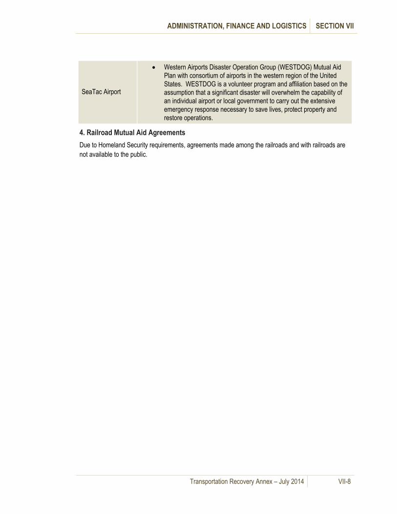
ADMINISTRATION, FINANCE AND LOGISTICS SECTION VII
Transportation Recovery Annex – July 2014 VII-8
SeaTac Airport
Western Airports Disaster Operation Group (WESTDOG) Mutual Aid
Plan with consortium of airports in the western region of the United
States. WESTDOG is a volunteer program and affiliation based on the
assumption that a significant disaster will overwhelm the capability of
an individual airport or local government to carry out the extensive
emergency response necessary to save lives, protect property and
restore operations.
4. Railroad Mutual Aid Agreements
Due to Homeland Security requirements, agreements made among the railroads and with railroads are
not available to the public.

Transportation Recovery Annex – July 2014 VIII-1
VIII. Annex Development and Maintenance
A. General Information
The Puget Sound Regional Catastrophic Planning Grant Program developed this Transportation
Recovery Annex (Annex) for the Puget Sound Region, which includes Island, King, Kitsap, Mason,
Pierce, Skagit, Snohomish and Thurston Counties. Local emergency management agencies,
transportation agencies, transit authorities and other public and private sector transportation
stakeholders took part in the process. Several State agencies were active participants, including the
Washington State Department of Transportation, the Washington State Patrol and the Emergency
Management Division of the Washington Military Department.
A continued effort should be made to solicit input from the same parties who contributed during the
planning process to ensure this annex remains current as it relates to transportation response and
recovery planning.
B. Plan Maintenance Responsibility
The Transportation Recovery Annex should be updated at the same time as and in accordance with the
procedures described within the Puget Sound Regional Catastrophic Disaster Coordination Plan
(Coordination Plan). Local emergency management agencies may incorporate elements of the
Transportation Recovery Annex that apply to their jurisdiction into their respective Comprehensive
Emergency Management Plans (CEMPs) and update the information on their regular CEMP
maintenance schedule.
C. Plan Maintenance
Maintenance of the Transportation Recovery Annex will require a periodic review and update of
transportation resource lists, maps, contact lists and website addresses included in the Annex as
outlined in the Coordination Plan. Ongoing review and testing of emergency operations should occur
throughout the year. Notice of the review should be sent to all RCPGP member counties, local
government transportation partners and public and private sector stakeholders as per procedures
outlined in the Coordination Plan. Any updates and input received should be incorporated into the
Annex and included in the next change to the overall Regional Coordination Plan.
D. Training
Each jurisdiction’s emergency management agency in the Puget Sound Region delivers a range of
training classes to enhance the emergency planning and response capabilities of their jurisdiction’s
elected officials, department directors, managers, and employees, special purpose districts, businesses,
schools, emergency workers, and the public. Information in the Annex may be integrated into the
ongoing training programs of the respective local emergency management agencies and local
jurisdictions.
From a regional standpoint, local emergency management agencies are encouraged to develop and
include training for transportation recovery coordination and other relevant topics on an annual basis.
Training schedules may include applicable courses of instruction and education that cover transportation
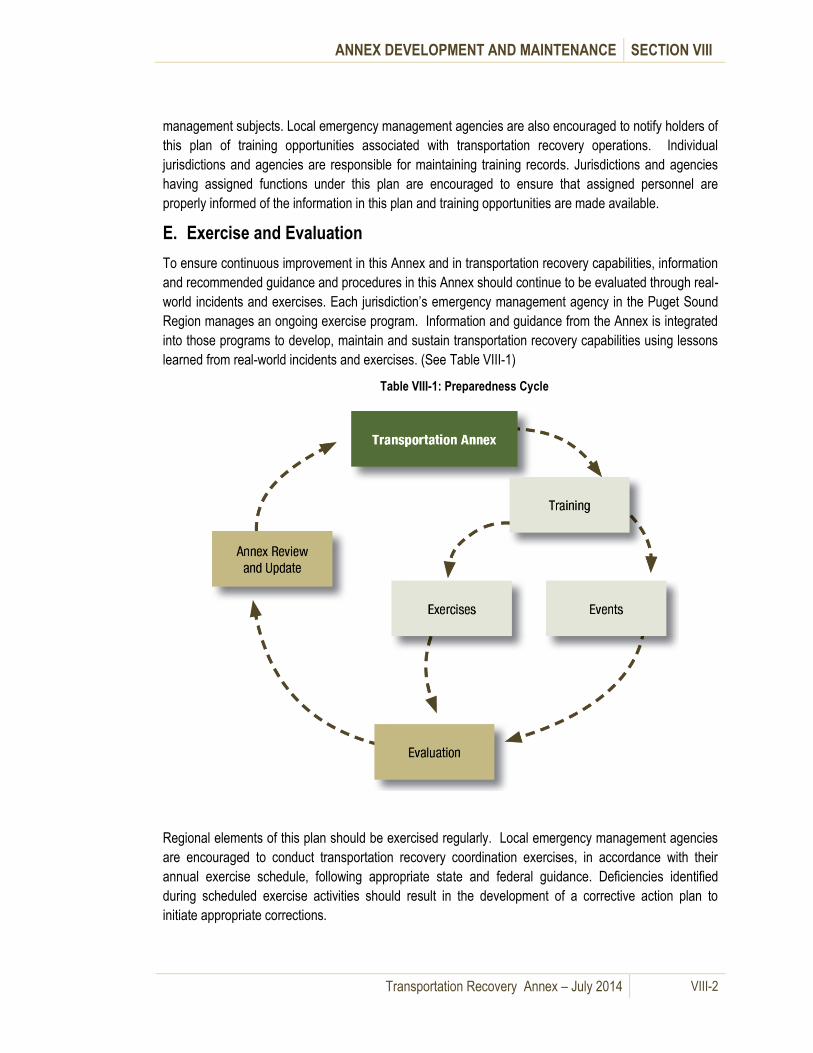
ANNEX DEVELOPMENT AND MAINTENANCE SECTION VIII
Transportation Recovery Annex – July 2014 VIII-2
management subjects. Local emergency management agencies are also encouraged to notify holders of
this plan of training opportunities associated with transportation recovery operations. Individual
jurisdictions and agencies are responsible for maintaining training records. Jurisdictions and agencies
having assigned functions under this plan are encouraged to ensure that assigned personnel are
properly informed of the information in this plan and training opportunities are made available.
E. Exercise and Evaluation
To ensure continuous improvement in this Annex and in transportation recovery capabilities, information
and recommended guidance and procedures in this Annex should continue to be evaluated through real-
world incidents and exercises. Each jurisdiction’s emergency management agency in the Puget Sound
Region manages an ongoing exercise program. Information and guidance from the Annex is integrated
into those programs to develop, maintain and sustain transportation recovery capabilities using lessons
learned from real-world incidents and exercises. (See Table VIII-1)
Table VIII-1: Preparedness Cycle
Regional elements of this plan should be exercised regularly. Local emergency management agencies
are encouraged to conduct transportation recovery coordination exercises, in accordance with their
annual exercise schedule, following appropriate state and federal guidance. Deficiencies identified
during scheduled exercise activities should result in the development of a corrective action plan to
initiate appropriate corrections.
ANNEX DEVELOPMENT AND MAINTENANCE SECTION VIII
Transportation Recovery Annex – July 2014 VIII-3
The planning for, development and execution of all exercises should involve close coordination between
participating jurisdictions, allied agencies, special districts, and supporting community and public service
organizations. Local emergency management agencies are encouraged to facilitate participation in
scheduled and ongoing region-wide exercises when the opportunity is available. The primary focus
should be to establish a framework for inter-jurisdictional exercise collaboration in coordination with
catastrophic transportation recovery training activities conducted within each jurisdiction.
Emergency exercise activity should be scheduled to follow state and federal guidance and program
requirements.
Exercise activity should follow the Homeland Security Exercise and
Evaluation Program (HSEEP) guidance, and may be designed as one or more
of the following exercise types:
Drills
Seminars (Workshops)
Table Top Exercises (TTE)
Functional Exercises (FE)
Full Scale Exercises (FSE)

Transportation Recovery Annex – July 2014 IX-1
IX. Authorities and References
A. General Information
There are numerous local, state and federal statutes, regulations and standards that provide the legal
basis for preparedness, response and recovery concerning the regional transportation network. The
following information is a general list of federal and state documents that may also be used for
developing additional transportation recovery policy, plans and procedures.
B. Federal Statutes
1. Public Law 93-288 The Disaster Relief Act of 1974, as amended by Public Law 100-707, the
Robert T. Stafford Disaster Relief and Emergency Assistance Act: Provides the authority for Federal
government to respond to disasters and emergencies to save lives and protect public health, safety, and
property. PL 93-288 authorizes the Federal government to assist States and other lawful applicants in
repairing certain roads, bridges, public sector structures and key infrastructure, provided the President
has first declared that an emergency or a major disaster exists, and names the authorized forms of
assistance for specific counties/ jurisdictions. PL 93-288 does not apply to roads and/ or bridges falling
under Federal Highway Administration jurisdiction.
(http://www.fema.gov/about/stafact.shtm)
2. Title 23 USC Section 125 Emergency Relief: Provides the authority for Federal Highway programs
including the Emergency Relief Program for repair and reconstruction of Federal highways after a
disaster. Congress authorized in Title 23, United States Code, Section 125, a special program from the
Highway Trust Fund for the repair or reconstruction of Federal-aid highways and roads on Federal lands
which have suffered serious damage as a result of (1) natural disasters or (2) catastrophic failures from
an external cause. This program, commonly referred to as the emergency relief or ER program,
supplements the commitment of resources by States, their political subdivisions, or other Federal
agencies to help pay for unusually heavy expenses resulting from extraordinary conditions.
(http://vlex.com/vid/sec-emergency-relief-19205117)
C. Federal Regulations
1. 44 CFR Part 205 [Title 44, Vol.1 of the Code of Federal Regulations] Revised as of Oct. 1, 2004]:
Outlines the roles and responsibilities of FEMA and the DHS. Part 206 prescribes policies and
procedures to be followed in implementing those sections of Public Law 93-288, as amended, delegated
to the Director, Federal Emergency Management Agency (FEMA). Part 206 apply to major disasters and
emergencies declared by the President on or after 11/23/1988 (date of enactment of the Stafford Act).
(http://www.access.gpo.gov/nara/cfr/waisidx_00/44cfrv1_00.html)
D. Federal Plans, Procedures and Reference Documents
1. National Transportation Recovery Strategy: Designed to help transportation industry stakeholders
and local, tribal, and State government officials prepare for and manage the transportation recovery
process following a disaster. The overall goal of this Strategy is to promote a recovery process for
AUTHORITIES AND REFERENCES SECTION IX
Transportation Recovery Annex – July 2014 IX-2
transportation networks – and subsequently for communities in general – that results in a greater level of
resilience.
(http://www.dot.gov/disaster_recovery/)
2. USDOT Emergency Relief (ER) Manual: Provides updated guidance and instructions on the
Federal Highway Administration's (FHWA) emergency relief (ER) program. This manual provides
information for FHWA, State, and local transportation agency personnel on policies and procedures for
requesting, obtaining and administering ER funds.
(http://www.fhwa.dot.gov/programadmin/erelief.cfm)
3. Effects of Catastrophic Events on Transportation System Management and Operations: This
report documents the actions taken by transportation agencies in response to catastrophic incidents as
an effort to examine the impacts of different types of incidents on transportation system facilities and
services. The findings and conclusions documented in this report are a result of the creation of a
detailed chronology of incidents, a literature search, and interviews of key personnel involved in
transportation operations decision making for the New York City, September 11, 2001 terrorist attack;
the Washington, D.C., September 11, 2001 terrorist attack; the Baltimore, Maryland, July 18, 2001 rail
tunnel fire and the Northridge, California, January 17, 1994 earthquake.
(http://ntl.bts.gov/lib/jpodocs/repts_te/14129.htm)
4. Simplified Guide to the Incident Command System for Transportation Professionals: Introduces
the ICS to transportation stakeholders who may be called upon to provide specific expertise, assistance,
or material during highway incidents but who may be largely unfamiliar with ICS organization and
operations. These stakeholders include transportation agencies and companies involved in towing and
recovery, as well as elected officials and government agency managers at all levels. This document may
also be beneficial to public safety professionals, who are familiar with ICS but may not fully understand
how ICS concepts are applicable to transportation agencies.
(http://ops.fhwa.dot.gov/publications/ics_guide/)
5. Area Maritime Security Plan: Outlines the coordination of the maritime recovery operations within
the Puget Sound Region, as developed and maintained by the Area Maritime Security Committee
(AMSC). Members of the AMSC include other federal and state agencies, maritime stakeholders and
partners. Elements of the plan include but are not limited to details of the security command-and-
response structure, measures to prevent the introduction of dangerous substance and devices into
restricted areas, evacuation of the port in case of security threats, procedures for reporting
transportation security incidents (TSI), and procedures to facilitate the recovery of the Marine
Transportation System after a TSI. This document contains sensitive security information and must be
requested from the USCG.
(http://edocket.access.gpo.gov/cfr_2003/julqtr/pdf/33cfr103.505.pdf)
6. Emergency Security Control of Air Traffic (ESCAT): Describes the joint action to be taken by
elements of the Department of Defense (DOD), the Department of Transportation (DOT) and the

AUTHORITIES AND REFERENCES SECTION IX
Transportation Recovery Annex – July 2014 IX-3
Department of Homeland Security (DHS) in the interests of national security to control air traffic under
emergency conditions.
(http://cfr.vlex.com/vid/245-4-application-security-traffic-escat-19744783)
6. FHWA - Information Sharing Guidebook for Transportation Management Centers, Emergency
Operations Centers, and Fusion Centers: This Guidebook provides an overview of the mission and
functions of Transportation Management Centers, Emergency Operations Centers, and Fusion Centers.
The Guidebook is focused on the types of information these centers produce and manage and how the
sharing of such information among the centers can be beneficial to both the day-to-day and emergency
operations of all the centers. There are some challenges to the ability to share information and these
challenges and some options for addressing them are addressed in the Guidebook. The Guidebook also
provides some lessons learned and best practices identified from a literature search and interviews/site
visits with center operators.
(http://www.ops.fhwa.dot.gov/publications/fhwahop09003/index.htm)
E. State Statutes
1. Chapter 18.43 RCW - Engineers & Land Surveyors: Applies to transportation projects only in
soliciting proposals for construction/ repair of roads, bridges, and other transportation infrastructure.
Chapter 18.43 requires anyone practicing or offering to practice engineering or land surveying services
to be properly registered and licensed. The statute sets out registration requirements.
(http://apps.leg.wa.gov/rcw/default.aspx?cite=18.43)
2. RCW 38.52.070 (2) - Emergency Contracting powers: This paragraph of 38.52.070 gives political
subdivisions (cities, counties, etc.) authority to enter into contracts and incur obligations necessary to
combat disasters "without regard to time-consuming procedures and formalities" normally prescribed by
law, such as competitive bidding, publication of notices, employment of temporary workers, etc.
(http://apps.leg.wa.gov/rcw/dispo.aspx?cite=38.52)
3. Chapter 46.44 RCW - Size, Weight, and Load Restrictions - State and Local Roadways:
Establishes detailed maximums and minimums for vehicle traffic (length, width, and weight) on State and
local roadways. The statute gives State and local authorities the ability to impose weight limits "or any
other restrictions as may be deemed necessary" on public highways under their jurisdiction. However,
the rule also demands that local authorities "shall by general rule … authorize the operation thereon of
school buses, emergency vehicles, and motor trucks transporting perishable commodities or
commodities necessary for the health and welfare of local residents...."
(http://apps.leg.wa.gov/rcw/dispo.aspx?cite=46.44)
4. RCW 46.44.091: Provides further exceptions (and conditions) for permitting any shipment duly
certified as necessary by military officials, or by officials of public or private power facilities, or when in
the opinion of the department of transportation the movement or action is a necessary movement or
action.
AUTHORITIES AND REFERENCES SECTION IX
Transportation Recovery Annex – July 2014 IX-4
(http://apps.leg.wa.gov/rcw/dispo.aspx?cite=46.44)
5. Chapter 46.48 RCW - Transportation of Hazardous Materials: Gives the Washington State Patrol
(WSP) the authority to adopt and enforce U.S.D.O.T. regulations regarding transportation of hazardous
materials, as these regulations apply to motor carriers "operating interstate and intrastate upon the
public highways of this state, except farmers." The statute also gives the WSP authority to inspect the
cargo (i.e. conduct safety inspections) of motor carriers hauling hazardous materials.
(http://apps.leg.wa.gov/rcw/dispo.aspx?cite=46.48)
6. Title 47 RCW - Public Highways & Transportation: Establishes the role and responsibility of the
Washington State Department of Transportation and recognizing the continuing need to expand and
maintain the state transportation network, establishes a "Priority Programming" and statewide
transportation planning process, including "Highways of Statewide Significance" and "Highways of
Regional Significance." The Chapter addresses freight mobility, special needs transportation, city
streets as part of state highways, construction and maintenance of highways, closing highways and
restricting traffic. Sub-parts of this chapter cover toll bridges, tunnels, and ferries; marine employees
and the Puget Sound ferry system, aeronautics, multi-modal transportation programs, and "high capacity
transportation development."
( http://apps.leg.wa.gov/rcw/default.aspx?Cite=47)
7. Chapter 47.29 RCW and Chapter 47.46 RCW: Discusses "Transportation innovative partnerships",
and "Public-private transportation initiatives," respectively, and addresses "Rail Freight Service" (47.76
RCW) and "Regional Transportation Planning Organizations" (47.80 RCW).
(http://apps.leg.wa.gov/rcw/dispo.aspx?cite=47.29) (http://apps.leg.wa.gov/rcw/dispo.aspx?cite=47.46)
8. Chapter 47.68 RCW: Establishes the responsibilities of the Washington State Department of
Transportation in providing for the protection and promotion of safety in aeronautics. The department is
expected to cooperate with and assist the federal government, the municipalities of the state, and other
persons in the development of aeronautics, and seeks to coordinate the aeronautical activities of these
bodies and persons. Under this chapter, municipalities are authorized (not required) to cooperate with
the department in the development of aeronautics and aeronautical facilities in this state. The
department may have a role in supporting air transport efforts in a catastrophic incident.
(http://apps.leg.wa.gov/rcw/dispo.aspx?cite=47.68)
9. Chapter 70.136 RCW - Hazardous Materials Incidents: This statute establishes limits on liability for
HAZMAT responders, and encourages advanced planning, cooperation, and mutual assistance between
applicable political subdivisions of the state and persons (companies) with the equipment, personnel,
and expertise in handling hazardous materials incidents.
(http://apps.leg.wa.gov/rcw/dispo.aspx?cite=70.136)
10. Chapter 80.01 RCW - Utilities & Transportation Commission: Creates the Utilities &
Transportation Commission and details its various authorities and responsibilities. It appears to have
limited application to our transportation project, except that the commission is empowered to "Regulate

AUTHORITIES AND REFERENCES SECTION IX
Transportation Recovery Annex – July 2014 IX-5
in the public interest... all persons engaging in the transportation of persons or property within this state
for compensation"... viz. trucking companies, bus companies, cab companies, etc.
(http://apps.leg.wa.gov/rcw/dispo.aspx?cite=80.36)
11. RCW 80.36.040: Applies to the use of road, street, and railroad right-of-way when consent of a city
is necessary. Gives telecommunications companies doing business in the state, the conditional right to
construct and maintain all necessary telecommunications lines along and upon any public road, street or
highway, along or across the right-of-way of any railroad, and may erect poles, posts, piers or abutments
for supporting the insulators, wires, etc.
(http://apps.leg.wa.gov/rcw/dispo.aspx?cite=80.36)
F. State Regulations (Washington Administrative Code – WAC)
1. Chapter 468-38 WAC - Movement of Over-Legal Vehicles/ Loads in Emergency Conditions:
This Chapter of the WAC covers the special permitting required to move over-legal loads on Washington
state roadways. The section covers "Superloads" (WAC 468-38-405), bridge restrictions (WAC 468-38-
420), and responses to emergencies (WAC 468-38-425). In brief, the permit process determines if the
proposed route infrastructure can support/ accommodate the load. Loads that exceed posted weight
limits or axel weight restrictions on bridges shall not be permitted to cross said bridge under any
circumstances. Other WAC and RCW chapters address the process of getting over-legal load permits
in responding to emergencies/ disasters. However, Chapter 468.38 WAC seems to imply that if the load
is in excess of infrastructure design limits... the load will be prohibited, regardless of disaster response or
emergency declaration.
(http://apps.leg.wa.gov/wac/default.aspx?cite=468)
2. Chapter 173-14 WAC - Permitting Developments on Shorelines: The Shoreline Management Act
contains numerous, strict requirements for repairing, constructing, or replacing any structure on most
saltwater and freshwater shores in Washington. Rare and narrowly construed exemptions (WAC173-
27-040) may be issued for certain developments/ projects. To the extent that catastrophic incident
planning involves emergency repairs to, or installation of, temporary bridges, temporary ferry landings,
modified boat landings, or any other structure on a shoreline, affected jurisdictions will utilize with this set
of codes and statutes.
(http://apps.leg.wa.gov/wac/default.aspx?cite=173)
G. State Plans, Procedures and Reference Documents
1. Alaskan Way Viaduct Closure Plan: Outlines actions for closure of the Alaska Way Viaduct.
(http://www.wsdot.wa.gov/Projects/Viaduct/ECP.htm).
2. Hood Canal Closure Plan: Outlines actions to be taken if the Hood Canal Bridge is closed.
(http://www.wsdot.wa.gov/Projects/SR104HoodCanalBridgeEast/Closures/options.htm)
3. State and Regional Disaster Airlift Plan (SARDA): The purpose of a State and Regional Disaster
Airlift Plan (SARDA) is to provide the Governor, the Washington Department of Transportation - Aviation

AUTHORITIES AND REFERENCES SECTION IX
Transportation Recovery Annex – July 2014 IX-6
Division, and the State Emergency Management Division with a means to access and utilize a broad
range of aviation resources within the State when needed to support civil emergency operations.
(http://www.evac.org/Files/ac00-7d.pdf)
4. Washington State Airport Reference Guide: The primary purpose of the guide is to promote the
use of the state’s aviation system by providing basic and user friendly information regarding airport
facilities.
(http://www.wsdot.wa.gov/aviation/PilotsGuide/default.htm)
5. WSDOT Northwest Region Emergency Response Plan: This plan describes the basic
mechanisms by which the Northwest Region will respond to and manage major natural and man-made
emergencies that impact the state transportation system. Although this plan does not establish absolute
standards, it does establish uniform operating procedures and performance guidelines. In some
instances, Northwest Region may be required to operate differently than stated in this plan in order to
respond properly to an emergency. The judgment of trained personnel should be used in conjunction
with this plan for emergency response operations.
(No web link)
6. SR 520 Information: Provides information on possible failure of SR 520 Bridge including the actions
to be taken, and references three alternative Lake Washington routes. See also the King County Ferry
District study for a discussion of landing site considerations (in Kenmore, Kirkland, Renton and Seattle)
linked to the alternate routes. It includes information on regional emergency management planning.
(http://www.wsdot.wa.gov/Projects/SR520Bridge/Library/technical.htm)
7. WSDOT Development of a Statewide Freight System Resiliency Plan: Designed to complement
existing emergency response plans by anticipating and planning how WSDOT should monitor, manage,
and control its transportation network assets and work with private sector partners to improve the
resiliency of the network. Resiliency for this project is focused on the restoration or recovery of the
state’s economy as it is affected, enabled, or disabled by the performance of the freight system.
(http://www.wsdot.wa.gov/NR/rdonlyres/023FC2C7-DD28-4EB6-8203-
98560DA76CB7/0/WSDOT_FSR_Report_v25.pdf)

This page intentionally left blank.

Transportation Recovery Annex – July 2014 X-1
X. Recommendations and Best Practices
A. General Information
Transportation stakeholders played a crucial role in developing the Regional Transportation Recovery
Annex. The process involved workshops, discussion seminars and interviews as well as reviews of
existing plans and recovery guidance literature.
The project team applied gap analyses to existing local transportation recovery planning documents to
provide a snapshot of the status of such planning. Gap analyses also provided a guide to expanding the
content for the reviewed document. The planning team reviewed the documents using the Department
of Homeland Security’s Target Capabilities List (TCL), a Companion to the National Preparedness
Guidelines, Recovery Mission-Area as a guide. The TCL was modified to address transportation-related
issues exclusively. The team also sought guidance from the State of Washington’s Disaster Assistance
Guide for Local Government (April 2008) and incorporated lessons learned from the Puget Sound
Regional Maritime Transportation Recovery Exercise
(2014).
A large amount of information was developed to help
guide recovery of the regional transportation network
after a catastrophic incident. This Section outlines the
above information and the recommendations developed
to improve regional preparedness. There is no
provision of funding or requirement for any jurisdiction to
implement these recommendations or best practices.
B. Recommendations
The following recommendations, outlined in Table X-1, are offered to continue the momentum toward
improved capability to manage recovery efforts for the regional transportation network.
Table X-1: Recommendations
Recommendations
1 Improve coordination among emergency management and transportation agencies.
2 Develop business recovery plans for each port, including mutual aid agreements among the ports.
3 Establish a regional transportation recovery policy.
4 Develop local jurisdiction transportation recovery plans.
5 Integrate transportation recovery into existing training and exercise schedules.
6 Improve private sector coordination.
7 Develop incentives to expedite transportation recovery.
8 Provide emergency replacement plans/procedures for marginal or inadequate structures.
With the infrequent nature of major
disruptions to the regional transportation
network, the Annex should be used at
every opportunity in disaster
planning, training, drills and
exercises, to ensure that emergency
management and transportation
agencies and other stakeholders are
familiar with its contents.

RECOMMENDATIONS AND BEST PRACTICES SECTION X
Transportation Recovery Annex – July 2014 X-2
9 Provide uniform bridge damage assessment reporting.
10 Provide uniform airport damage assessment reporting.
1. Improve Coordination among Emergency Management and Transportation Agencies
Gap – Transportation planners and engineers are often not involved in emergency management
planning, training and exercises.
The majority of current regional transportation planning is focused primarily on emergency response.
While emergency management agencies have developed relationships with transportation agencies,
they are primarily with transportation operations staff rather than with those responsible for the types of
capital design and construction projects required to recover from a catastrophic incident. When the
emergency period is over, and the focus of effort moves to recovery, transportation expertise is more
often provided by planners and engineers who, in larger departments, are not involved in day-to-day
transportation operations or in initial disaster operations.
Recommendation 1
Emergency management and transportation agencies should develop and implement strategies to
involve transportation planners and engineers in the emergency management planning cycle,
especially for recovery planning.
Year 1
Emergency managers and transportation contacts identify planners and capital projects
managers / staff that need to be more involved in recovery planning.
Add transportation recovery issues to training and exercise opportunities. Involve capital
project transportation staff in ongoing emergency management planning and training
cycle.
Year 2 Continue to involve capital project staff in planning training and exercises.
Year 3 + Continue to involve capital project staff in planning training and exercises.

RECOMMENDATIONS AND BEST PRACTICES SECTION X
Transportation Recovery Annex – July 2014 X-3
2. Develop Business Recovery Plans for each port, including mutual aid agreements among the ports.
Gap – Individual ports do not have comprehensive business recovery plans in place and there is no
region-wide mutual aid agreement among ports to provide for the sharing of resources after a disruptive
event or catastrophe.
Most Puget Sound ports do not have business recovery plans in place, or if they do, they may be
fragmented, untested or out of date. Moreover, ports often see recovery planning as primarily an
emergency management responsibility, and not a responsibility of finance and the business lines.
Business disruption caused by a disaster will have significant financial impacts on affected ports, which
will negatively impact the regional economy.
Recovery planning should clarify the roles and responsibilities of staff across the port, establish clear
decision making authority, and pre-identify recovery priorities, including the role the port will play in
supporting local and regional recovery efforts, as well as which business lines are most critical to restore
and which customers are most critical to serve. The plan should also pre-identify potential capital
projects that may be eligible to receive funding to support recovery of port operations, as well as
potential sources for funding, equipment, and personnel or specialized expertise. If appropriate, the
recovery plan should also consider lines of business and associated assets that may operate at a
different level from pre-disaster levels.
While individual ports may lack the necessary resources to independently recover from a significant
disaster, there are few, if any, mutual aid agreements in place to cover operational needs between ports,
agencies, and the private sector.
In 2004, WSDOT’s Highways and Local Programs distributed the Public Works Emergency Response
Mutual Aid Agreement to public works directors and engineers in all Washington cities and counties.
The purpose of the agreement is to allow signatory agencies to make the most efficient use of their
assets by enabling them to coordinate transportation resources and to maximize funding reimbursement
after disasters and/or emergencies. (See Section VII)
The Public Works Emergency Response Mutual Aid
Agreement provides an administrative mechanism for
immediate response contingent on other agencies having
the necessary resources and expertise. All eight counties
within the Puget Sound Region are signatory to this
agreement.
Some Puget Sound region ports have agreements for
sharing maintenance personnel during an emergency. A
catastrophic incident may cause damage at one or more
ports within the Puget Sound region, requiring aid from other Washington-area ports. Requests for aid
may include personnel (e.g., maintenance, operations, longshoremen, trades, emergency management,
etc.) or equipment.
The RCPT Supply Chain Resilience Working Group is working with the ports to develop a draft Mutual
Aid Agreement. The WPPA has agreed to serve as the MOU coordinator and will work with ports to sign
The Public Works Emergency
Response Mutual Aid
Agreement is a best practice that
enables agencies to assist peers in
other departments or jurisdictions
on an as-needed basis in a
disaster/emergency.

RECOMMENDATIONS AND BEST PRACTICES SECTION X
Transportation Recovery Annex – July 2014 X-4
on to the agreement. Once established, ports should train and exercise to these mutual aid agreements,
involving key partners including local governments, terminal operators, labor, and the state and federal
government. These exercises can be used to test and strengthen mechanisms for post-disaster
communication and coordination among these parties.
Recommendation 2
Ports in the Puget Sound Regions should develop and implement comprehensive business recovery
plans and a mutual aid agreement among Washington-area ports for sharing personnel and
equipment. A draft framework has been developed through the RCPT and is being reviewed and
considered by WPPA members.
Year 1
Educate all port departments and stakeholders on recovery planning; identify gaps and
begin development of comprehensive business recovery plans.
Sign on to the Port Mutual Agreement that is being coordinated by WPPA.
Year 2
Complete business recovery plans and begin training staff and stakeholders on
emergency plans and disaster policies.
Ports prepare procedures, forms, agreements and lists of available resources that may be
made available following a disaster. Develop and execute agreements.
Year 3 +
Exercise recovery plans and mutual aid agreements, involving port staff and key
stakeholders.
Regularly update info on resources, contacts and other information referenced in mutual
aid agreements.
RECOMMENDATIONS AND BEST PRACTICES SECTION X
Transportation Recovery Annex – July 2014 X-5
3. Establish Regional Transportation Recovery Operations Policy
Gap – There is no regional structure or process in place to accommodate regional coordination of
transportation recovery.
After a catastrophe, some transportation recovery issues, such as traffic management strategies and
situational awareness may, from a span-of-control standpoint, be better coordinated on a regional level.
In a catastrophe, the volume of information and coordination needs may be best managed by
establishing regional coordination structures (See Section IV).
Recommendation 3
State and local emergency management agencies should develop a forum among transportation
stakeholders, including Metropolitan Planning Organizations (MPOs), Regional Transportation Planning
Organizations (RTPOs), local and state transportation agencies, the ports, and the private sector for
the purpose of developing regional transportation recovery policies.
Year 1
Identify a champion to take the lead on this initiative. This could be through emergency
management agencies or the Metropolitan Transportation Organizations (MPO) and
Regional Transportation Planning Organizations. (RTPO) Develop a process for sharing
the planning expertise of transportation stakeholders and share strategies for convening
public and private sector stakeholders.
Year 2 Develop a schedule for short term, long term and emergency implementation.
Year 3 + Develop data and implement regional Traffic Demand Management (TDM) strategies.

RECOMMENDATIONS AND BEST PRACTICES SECTION X
Transportation Recovery Annex – July 2014 X-6
4. Develop Local Transportation Recovery Plans
Gap – Few local implementation plans exist for specific potential disruptions to the regional
transportation network.
The Regional Transportation Recovery Annex addresses transportation disruptions and short, mid and
long term solutions and options from a regional perspective. Stakeholders and the project team identified
fifty major disruption situations, and developed regional alternative routes and solutions (See Appendix
B). Most of the regional roadway transportation network is under the direction and control of state
government. Waterways, airways and railways are under the direction and control of a mix of local,
state, federal and private sector stakeholders.
Detailed recovery plans exist for major transportation system disruptions, such as those involving the
Alaskan Way Viaduct, the SR 520 Bridge and for potential closures of Interstate 5 in the
Olympia/Thurston County area. However, such planning is absent at local levels.
Recommendation 4
Local transportation agencies should develop local implementation and transportation recovery plans
for potential disruptions to key areas of the local and regional transportation network.
Year 1
Implementation plans should look at the step- by- step specifics of what needs to be done
and who is going to do it each affected jurisdiction, including resources and other
requirements, such as permits, emergency declarations, etc.
Identify impediments to implementing the recovery plans, and develop solutions to
overcome the impediments.
Identify key facilities for which specific local plans should be developed. Assign lead for
each of the individual plans. Identify stakeholders and develop planning teams.
Year 2
Develop detailed local transportation recovery implementation plans.
Integrate local transportation recovery implementation plans into the ongoing planning,
training, and exercising cycle of local jurisdictions.
Year 3 + Regularly update plans to reflect infrastructure and resource changes.
RECOMMENDATIONS AND BEST PRACTICES SECTION X
Transportation Recovery Annex – July 2014 X-7
5. Integrate Transportation Recovery into Existing Training and Exercise Schedules
Gap – Major disaster exercises traditionally focus on emergency response, as opposed to the longer-
term issues of recovery. In fact, recovery issues are generally not included in local and state training and
exercise programs.
Once the Transportation Recovery Annex revisions have been approved by the RCPT, it will be
important to integrate transportation recovery issues into existing training and exercise schedules at
local and state levels. Emergency management agencies should utilize experts from ESF-1 in their
respective jurisdictions to work with exercise development teams to include specific transportation
specific recovery information in exercises. Low cost examples would be adding questions about specific
transportation recovery issues to a scheduled table top exercise, including issues about long term
regional recovery coordination to a functional or full scale exercise and inviting transportation planners
and engineers to emergency management training sessions. This recommendation also supports
Recommendation 1.
Recommendation 5
Emergency management agencies should integrate transportation expertise (ESF-1) and transportation
recovery issues into existing local emergency management and transportation agencies' training and
exercise programs.
Year 1 Integrate transportation recovery issues and expertise into local and regional training and
exercise development and execution.
Year 2 Conduct training programs and begin exercise implementation including incorporating
transportation related scenarios into regional exercise programs.
Year 3 +
Continue training and exercise program updating by sharing new information received
from the Corrective Action Plans and After Action Reports among transportation
stakeholders.

RECOMMENDATIONS AND BEST PRACTICES SECTION X
Transportation Recovery Annex – July 2014 X-8
6. Improve Private Sector Coordination
Gap – Formal agreements between public transportation agencies and private sector stakeholders could
be improved to better integrate the private sector into ongoing emergency management planning,
training and exercise programs.
Private businesses play a significant role in protecting the community during disasters. Businesses also
play a vital role in working with government to facilitate and provide emergency recovery from all types
of disasters -- from small-scale to catastrophic. Each mode of transportation (roadway, waterways,
airways and railways) has many private sector transportation stakeholders.
Like the public sector, the private sector can support emergency recovery efforts consistent with the
National Incident Management System. Private sector facilities, primarily intended to provide a locally-
based function, could integrate with transportation recovery efforts at local government levels as
appropriate. Private sector facilities intended to provide a regional or multi-county function could
integrate with transportation recovery efforts at the state level. Formalizing public-private partnerships
would also enhance coordination amongst participants.
In addition, some private sector organizations may be able to bring in resources (volunteers, equipment,
supplies) from other locations.
Recommendation 6
Emergency management and transportation agencies should expand coordination with private sector
providers to involve them more in ongoing regional transportation planning and coordination.
Year 1
Expand communication and coordination channels with private sector transportation
providers across all modes of transportation. In 2013 the RCPT developed a Supply
Chain Resilience working group to coordinate public/private supply chain stakeholders
across the region.
Utilize the RCPT Supply Chain Resilience working group and explore developing model
Memoranda of Understanding (MOUs) addressing roles and responsibilities, coordination,
protections/indemnification and administration, especially with “marquee” local
organizations, such as major business and manufacturing organizations, including the
maritime transportation sector.
Year 2 Customize MOUs and obtain signatures among targeted private and public sector
participants.
Year 3 + Continually ensure that roles and responsibilities, coordination, protection and
administration clauses are still valid and update if necessary.

RECOMMENDATIONS AND BEST PRACTICES SECTION X
Transportation Recovery Annex – July 2014 X-9
7. Develop Incentives to Expedite Transportation Recovery
Gap – There are no pre-planned incentives to expedite recovery operations after a catastrophe.
Rebuilding a transportation network as a result of a catastrophic incident requires unprecedented
cooperation between local, regional, state and federal agencies as well as with the private sector.
Demolition and reconstruction allows all agencies involved to develop and implement innovative
solutions to existing “red tape” problems in order to restore the transportation network quickly. The
incentives developed and implemented in rebuilding Interstate 10 in Los Angeles County after the 1994
Northridge Earthquake is one example of expediting the reconstruction of a major transportation
network.
County officials instituted a remarkable series of incentives: an accelerated bid, design and award
process; 24-hour work days, seven days a week (12-hour shifts); 24-hour /day decision making and
inspection; an early bonus equaling $200,000 per day (along with a disincentive of $200,000 per day late
penalty). By finishing 74 days early, the contractor received a $14.8 million bonus.
Recommendation 7
Transportation agencies should use past lessons learned and case studies to develop information and
guidance related to methods that could be employed under Washington State regulations to expedite
transportation construction projects.
Year 1
Work with local, State and federal transportation agencies to plan on utilizing Federal
Highway Administration (FHWA) emergency relief (ER) funds and develop incentive-
disincentive mechanisms such as bonus and penalty targets. Note: ER projects are exempt
from regional planning and transportation improvement plans (TIP) and air-quality
conformity requirements, as long as the replacement projects are in-kind and in-place.
Year 2 Provide training and workshops to integrate information into local plans and procedures.
Year 3 + Sustain capability through ongoing workshops, training and exercises.

RECOMMENDATIONS AND BEST PRACTICES SECTION X
Transportation Recovery Annex – July 2014 X-10
8. Provide Emergency Replacement Plans/Procedures for Marginal or Inadequate Structures.
Gap – Local pre-planning for disaster recovery of marginal or inadequate structures by local planning
and public works departments has not yet been established.
Local comprehensive transportation plans identify roadway improvements based on population demands
and maintenance required for local area roads. Many jurisdictions have identified marginal or
inadequate structures (e.g., bridges that create traffic bottlenecks, bridges that will need to be replaced,
addition of bike lanes or high occupancy vehicle lanes on bridges, etc.) that may need future
improvements or additional capacity. In an effort to expedite recovery, local jurisdictions should prepare
design/build requests for proposals (RFPs) that can be issued quickly after a major disaster for
structures that may need replacement. FEMA will only provide funding for replacement of a structure in
its current location. Jurisdictions must find additional funding sources for improvements or expansion.
Recommendation 8
Transportation agencies should develop schematic design plans of bridges or transportation structures
that coincide with comprehensive transportation and land use planning documents. Prepare
design/build RFPs for replacement of structures to be issued quickly after a disaster.
Year 1 Identify marginal and inadequate structures in local areas.
Year 2
Discuss replacement options and develop schematic level plans for marginal and
inadequate structures.
Prepare RFPs that correspond with schematic level design plans for issuance after a
major disaster.
Year 3 + Regularly update information and coordinate with emergency planners for reference of
prepared RFPs in emergency plans.
RECOMMENDATIONS AND BEST PRACTICES SECTION X
Transportation Recovery Annex – July 2014 X-11
9. Provide Uniform Bridge Damage Assessment Reporting
Gap – There is no uniform damage assessment form for use by first response bridge inspectors.
State and local agencies within the Puget Sound region have bridges that they own, maintain, and/or
inspect. Local agencies either inspect their own bridges or have contracts with other agencies for
required bridge inspections. After a catastrophic incident, such as an earthquake, resources may be
overwhelmed, and inspection of bridges may need to be completed by trained first response teams (e.g.,
those comprising transportation maintenance personnel) as opposed to bridge engineers. A uniform
damage assessment form would help provide consistent information for managing transportation system
recovery. This assessment information would be transmitted to local Emergency Operations
Centers/Emergency Coordination Centers in accordance with existing local communications protocols
and used for operational planning and priority setting as well as for emergency public information
purposes.
Recommendation 9
Bridge inspection departments in transportation agencies should develop and implement use of a
uniform damage assessment form for first response bridge inspections. (See Appendix E for a
recommended template.)
Year 1 Provide or update bridge inspection forms to coincide with the Level 1 First Response
Inspection Documentation form provided in Appendix E.
Year 2
Provide training by bridge inspectors and program managers for road maintenance
personnel and emergency operation centers on use of the form. Bridge departments
should also identify individuals who reside nearest given structures for inspection.
Year 3 + Regularly update information on forms and contact information for maintenance
personnel.
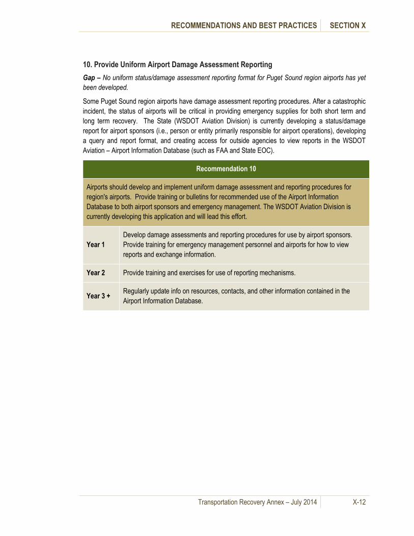
RECOMMENDATIONS AND BEST PRACTICES SECTION X
Transportation Recovery Annex – July 2014 X-12
10. Provide Uniform Airport Damage Assessment Reporting
Gap – No uniform status/damage assessment reporting format for Puget Sound region airports has yet
been developed.
Some Puget Sound region airports have damage assessment reporting procedures. After a catastrophic
incident, the status of airports will be critical in providing emergency supplies for both short term and
long term recovery. The State (WSDOT Aviation Division) is currently developing a status/damage
report for airport sponsors (i.e., person or entity primarily responsible for airport operations), developing
a query and report format, and creating access for outside agencies to view reports in the WSDOT
Aviation – Airport Information Database (such as FAA and State EOC).
Recommendation 10
Airports should develop and implement uniform damage assessment and reporting procedures for
region's airports. Provide training or bulletins for recommended use of the Airport Information
Database to both airport sponsors and emergency management. The WSDOT Aviation Division is
currently developing this application and will lead this effort.
Year 1
Develop damage assessments and reporting procedures for use by airport sponsors.
Provide training for emergency management personnel and airports for how to view
reports and exchange information.
Year 2 Provide training and exercises for use of reporting mechanisms.
Year 3 + Regularly update info on resources, contacts, and other information contained in the
Airport Information Database.

RECOMMENDATIONS AND BEST PRACTICES SECTION X
Transportation Recovery Annex – July 2014 X-13
C. Best Practices
The following Best Practices in Table X-2 are offered to provide ideas and information to improve
transportation resiliency and sustainability.
Table X-2: Best Practices
Best Practices
1 Include Three Elements in Local Transportation Recovery Planning: Leadership, Capabilities and
Accountability
2 Develop Regional Transportation Policies
3 Allow Flexibility in Applying Transportation Resources across Jurisdictions
4 Develop a Collaborative Environment for Recovery Efforts
5 Utilize Innovative Contracting Techniques to Expedite Recovery
6 Designate Special Teams for Deployment to Support Regional Recovery Efforts
7 Create Maritime Coordination Committees
8 Provide Travel Advisory Systems used in Day-to-Day Planning
1. Include Three Elements in Local Transportation Recovery Planning: Leadership, Capabilities and Accountability
The Government Accountability Office states in their report Catastrophic Disasters-Enhanced
Leadership, Capabilities, and Accountability Controls Will Improve the Effectiveness of the Nation’s
Preparedness, Response, and Recovery System, that preparing for, responding to and recovering from
any catastrophic incident involves three basic elements: leadership, capabilities and accountability. It is
a best practice for local governments to address the following three elements in local planning,
especially in transportation recovery plans:
Leadership. Clearly defined, effectively communicated and well-understood legal authorities, roles and responsibilities, potential overlap, and lines of authority at all levels of government facilitate rapid and effective decision making.
Capabilities. Capabilities needed for catastrophic incidents should be part of an overall national effort to integrate and define what needs to be done, where, by whom, and how well. At the local level this means:
o Planning to ensure that needed capabilities are ready.
o Realistically testing capabilities through training and exercises.
o Identifying and subsequently addressing problems.
o Working in partnership with federal, state, and nongovernmental stakeholders to integrate an all-hazards risk management framework into decision making. This is central to assessing

RECOMMENDATIONS AND BEST PRACTICES SECTION X
Transportation Recovery Annex – July 2014 X-14
catastrophic incident risks and guiding the development of national capabilities to prevent or mitigate, where possible, and respond to such risks.
Accountability. Controls and mechanisms should be in place to ensure that resources are used appropriately, and that contracts have sufficient provisions for fair and reasonable prices to help with expected reimbursements through disaster relief programs. Following a catastrophic incident, decision-makers face a tension between the demand for rapid response and recovery assistance—including assistance to victims—and implementing appropriate controls and accountability mechanisms.
2. Develop Regional Transportation Policies
The Puget Sound Regional Council (PSRC) continues to
spearhead an effort to coordinate traffic operations in the
Central Puget Sound Region. Summarized in the
document, Regional Concept of Transportation
Operations: Best Practices (July 2009), this effort is
based on similar work in California, Arizona, Oregon, and
elsewhere.
The report identified key issues to be resolved for day-to-
day operations as follows:
Define roles and responsibilities of participating agencies.
Establish a plan for developing, implementing and maintaining signal plans.
Identify a technical strategy for implementing cross-jurisdictional coordination.
Establish the physical infrastructure required to support the program.
Integrate with regional long-range planning efforts and continually “keep an eye on the ball” towards implementing regional operational concept over the long term.
Implementing coordinated transportation policy is essential for transportation recovery. The issues
involved with normal day-to-day operations are similar to those in an emergency, and the work done by
the PSRC provides an excellent starting point to extend this concept to the entire eight County Puget
Sound Region and to expand this concept to include emergency operations and emergency
transportation policy.
3. Allow Flexibility in Applying Transportation Resources across Jurisdictions
In the document Recovering from Disasters: The National Transportation Recovery Strategy (2009), the
USDOT cites the LA Swift project in Louisiana as a best practice in short-term solutions. Following
Hurricane Katrina, a multi-jurisdictional effort resulted in a free bus service for persons displaced to
Baton Rouge to their jobs in New Orleans. This was accomplished through:
Collaboration of operating and funding agencies
Recognition of the importance of transportation to economic recovery
Flexibility to provide a non-traditional service to address a specific need
The Puget Sound Regional Council’s
effort to develop a Regional Concept of
Operations is providing a mechanism to
overcome the jurisdictional and policy
issues of coordinated operations.
RECOMMENDATIONS AND BEST PRACTICES SECTION X
Transportation Recovery Annex – July 2014 X-15
This transportation incentive helped expedite economic recovery by not only getting people back to their
jobs, but also providing access to companies with job openings.
4. Develop a Collaborative Environment for Recovery Efforts
In the document Recovering from Disasters: The National Transportation Recovery Strategy (2009), the
USDOT cites the I-35W Bridge project as a best practice in recovery. A broad collaboration, deliberately
carried out to enlist maximum participation, was key to rebuilding the collapsed bridge ahead of
schedule and under budget. The I-35W Bridge project team extensively involved the community in the
design and construction of a replacement bridge.
The effort included community residents, local businesses, civic groups, government at all levels,
cultural and educational institutions and the media. This collaborative approach rallied a positive
response for the bridge rebuild.
5. Utilize Innovative Contracting Techniques to Expedite Recovery
Recovery from a 1994 earthquake in the Los Angeles area required a departure from the traditional
methods used and/or permitted for publicly funded projects. The effort is cited as a best practice in
USDOT’s Recovering from Disasters: The National Transportation Recovery Strategy (2009).
Several new methods expedited completion of multiple projects: A+B bidding (a combination of cost and
time), invitational bidding and design-build bidding. The use of monetary incentives, both positive and
negative, helped shorten schedules and minimize delays.
6. Designate Special Teams for Deployment to Support Regional Recovery Efforts
Best Practices in Emergency Transportation Operations Preparedness and Response: Results of the FHWA Workshop Series, (December 2006), cites a number of best practices for special resources. Among them is the designation of “Tiger Teams”. Teams of people with special capabilities such as bridge inspection, seaport expertise, airport expertise are assembled and can be deployed anywhere in the region on very short notice to support recovery operations. These teams can be especially effective in early recovery strategy development and planning.
7. Create Maritime Coordination Committees
Maritime stakeholders in the Puget Sound region, i.e., United States Coast Guard (USCG), Ports,
Washington State Ferries, Department of Ecology, labor, private companies (tugs, barges, salvage and
ferries), etc. meet regularly in committees to discuss maritime safety and security issues for both routine
operations and for disaster response and recovery. The frequent meetings and coordination among
stakeholders creates relationships that will be utilized for response and recovery after a catastrophic
incident.
The Marine Transportation
System Recovery Unit
(MTSRU) comprises a group of
maritime stakeholders selected
by the USCG who coordinate
both through pre-incident Marine
Transportation System recovery
preparedness (such as
exercises) as well as through
committee meetings.

RECOMMENDATIONS AND BEST PRACTICES SECTION X
Transportation Recovery Annex – July 2014 X-16
The USCG coordinates operations with other government agencies including, but not limited to:
Customs and Border Protection, the Transportation Security Administration, the Federal Bureau of
Investigation, the Department of Defense, the U. S. Navy, the Washington State Patrol, Washington
State Ferries, the Washington State Department of Ecology, and various city, county and port
police/sheriff and fire departments. The USCG Marine Transportation System Recovery Unit (MTSRU)
is responsible to unified command via the planning section for the planning and implementation of
recovery of the maritime system including the intermodal awareness.
The Coast Guard participates in the following committees or groups, which includes many of the
maritime stakeholders:
Area Maritime Security Committee (AMSC)
Washington State Ferry (WSF) Security Committee
Puget Sound Operations Planning Cell
Port Readiness Committee (PRC)
Operations Integration Working Group
Consolidated Targeting and Enforcement Team (USCG, CBP, ICE)
Joint Terrorism Task Force (JTTF)
Regional Intelligence Group
Harbor Safety Committee (HSC)
8. Provide Travel Advisory Systems used in Day-to-Day Planning
WSDOT provides daily “Freight Travel Advisory” notifications to help freight companies plan for
disruptions. It also allows freight stakeholders to incorporate transportation disruptions into their day-to-
day planning. By setting up communication tools that are used on a day-to-day basis, it allows for
stakeholders to be better prepared for a catastrophic incident – to know what to expect and where to
obtain pertinent information for transportation planning.
Maritime and aviation transportation modes also have day-to-day notification mechanisms to mariners
(Local Notice to Mariners (LNM) by USCG) and airmen (Notices to Airmen (NOTAM) by the FAA),
respectively.

RECOMMENDATIONS AND BEST PRACTICES SECTION X
Transportation Recovery Annex – July 2014 X-17
D. Best Practices Resources
There is a great deal of material documenting lessons learned and best practices in transportation
recovery. The following Best Practices Resources in Table X-3 are offered to provide sources of further
information to improve transportation resiliency and sustainability.
Table X-3: Best Practices Resources
Best Practices Resources
1 USDOT – National Transportation Recovery Strategy
2 FHWA Workshop Series 2006
3 FHWA – Information Sharing Guidebook
4 Transportation Research Board Information
5 Improving Post-disaster Humanitarian Logistics: Three Key Lessons from Catastrophic Events
6 A Compendium of Best Practices and Lessons Learned for Improving Local Community Recovery from Disastrous Hazardous Materials Transportation Incidents
7 Disaster Resilience: A National Imperative
8 Expedited Procurement Procedures for Emergency Construction Services
1. USDOT – National Transportation Recovery Strategy
The purpose of the National Transportation Recovery Strategy (NTRS) is to help local, state and tribal
transportation stakeholders prepare for or manage the transportation recovery process following a major
disaster. (http://www.dot.gov/disaster_recovery/resources/DOT_NTRS.pdf)
2. FHWA Workshop Series 2006
The FHWA produced a series of publications to aid local, state and federal authorities in designing
evacuation and other types of emergency transportation operations plans. One such publication is the
Best Practices in Emergency Transportation Operations Preparedness and Response: Results of the
FHWA Workshop Series 2006.
(http://ops.fhwa.dot.gov/publications/etopr/best_practices/etopr_best_practices.pdf)
3. FHWA – Information Sharing Guidebook
Information-Sharing Guidebook For Transportation Management Centers, Emergency Operations
Centers, And Fusion Centers – This guidebook provides an overview of the mission and functions of
transportation management centers, emergency operations centers and fusion centers. It focuses on the
types of information these centers produce and manage and how the sharing of such information among
the centers can benefit both day-to-day and emergency operations of all the centers. Challenges exist to
the ability to share information, and the guidebook addresses these challenges and options for handling
them. It also provides some lessons learned and best practices identified from a literature search and
interviews/site visits with center operators.
(http://www.ops.fhwa.dot.gov/publications/fhwahop09003/index.htm)

RECOMMENDATIONS AND BEST PRACTICES SECTION X
Transportation Recovery Annex – July 2014 X-18
4. Transportation Research Board Information
State Public Transportation Division Involvement in State Emergency Planning, Response, and
Recovery – This research documents existing and best policies and practices of state transit divisions
pertaining to weather-related emergencies. This research includes state involvement in emergency
planning, response and recovery. It identifies lessons learned from recent emergencies, key issues
associated with the involvement of state public transportation divisions, and best practices. The report
includes results of a national survey of state transit divisions, in-depth interviews with selected states
and copies of, or links to, various resources related to emergency management.
(http://onlinepubs.trb.org/onlinepubs/nchrp/nchrp_rrd_326.pdf)
5. Improving Post-disaster Humanitarian Logistics: Three Key Lessons from Catastrophic Events
A featured article in the May-June 2013 TR News presents three practical lessons gleaned from
fieldwork after the Port-au-Prince, Haiti earthquake and the Tohoku, Japan tsunami, the strategic
differences between disasters and catastrophes, the need to control the spontaneous flow of supplies,
and the benefits of integrating the civic society into the response and recovery.
(http://www.trb.org/SecurityEmergencies/Blurbs/169548.aspx)
6. A Compendium of Best Practices and Lessons Learned for Improving Local Community Recovery from Disastrous Hazardous Materials Transportation Incidents
TRB’s Hazardous Materials Cooperative Research Program (HMCRP) Report 9: A Compendium of Best
Practices and Lessons Learned for Improving Local Community Recovery from Disastrous Hazardous
Materials Transportation Incidents explores how local communities can develop or improve recovery
planning and operations in response to hazardous materials transportation incidents.
(http://www.trb.org/SecurityEmergencies/Blurbs/168372.aspx)
7. Disaster Resilience: A National Imperative
The Committee on Science, Engineering, and Public Policy, part of the National Academies’ Division on
Policy and Global Affairs (PGA), has released a report that defines "national resilience," describes the
state of knowledge about resilience to hazards and disasters, and frames the main issues related to
increasing resilience in the United States.
The report also provide goals, baseline conditions, or performance metrics for national resilience and
outlines additional information, data, gaps, and/or obstacles that need to be addressed to increase the
nation's resilience to disasters. Additionally, the report's authoring committee makes recommendations
about the necessary approaches to elevate national resilience to disasters in the United States.
(http://www.trb.org/SecurityEmergencies/Blurbs/168047.aspx)
8. Expedited Procurement Procedures for Emergency Construction Services
TRB’s National Cooperative Highway Research Program (NCHRP) Synthesis 438: Expedited
Procurement Procedures for Emergency Construction Services explores procurement procedures being
utilized by state departments of transportation in coordination with federal agencies to repair and reopen
roadways in emergency situations. (http://www.trb.org/SecurityEmergencies/Blurbs/168132.aspx)

Transportation Recovery Annex – July 2014 A-1
Alternative Routing and Level of Service Appendix A. (LOS) Map Development
A. General Information
This Appendix provides a summary of the development of the 50 Potential Detour Scenarios and
Routes, the planning process with local stakeholders and the calculations used to produce the Level of
Service (LOS) map for each scenario.
B. Development of Alternative Routing Maps
The process of developing alternative routing plans for the 50 Potential Detour Scenarios and Routes
was carried out in four parts. The first efforts were aimed at assembling a Transportation Planning team
of stakeholders to serve as the body to discuss and make decisions on the plan. The second stage of
the project involved taking inventory of the transportation infrastructure in the study area, and gathering
existing data from the stakeholders. The next effort was the collaborative selection and prioritization of
scenarios for inclusion in the plan. The final stage was the development and adoption of Alternative
Routing Plans for each of the scenarios. The work plan is described below.
C. The Transportation Working Group and Planning Teams
To provide input and oversight to the planning
process, a Transportation Working Group (TWG)
was formed with representatives from local
emergency management agencies, transportation
agencies, transit authorities and other public and
private sector transportation stakeholders. State
and federal agencies such as the Washington State Department of Transportation, the Emergency
Management Division of the Washington Military Department, the Washington State Patrol, FEMA, FAA,
the US Coast Guard and the military all participated.
Transportation planning teams consisting of stakeholder representatives were also organized in each of
the eight counties. The respective local emergency management agency helped develop the list of
invited stakeholders, to include all modes of transportation and all categories of responders. Each
stakeholder was asked to assign a key person to serve as the main contact and commit to agency
participation in the study activities. The stakeholders represented all modes of transportation – roads,
transit and marine –as well as law enforcement, military and private freight operators.
Planning teams met, approximately monthly, throughout the study area to bolster participation and
extract maximum local expertise and knowledge. In addition, the Transportation Working Group (TWG)
held several sub-regional meetings with groups of counties to ensure sharing of ideas and solutions.
Information from transportation planning team meetings was shared with the TWG.
Collaboration and participation from the
groups most affected by any disaster is
perhaps the most important element for
creating an effective planning document.

ALTERNATIVE ROUTING AND LOS MAP DEVELOPMENT APPENDIX A
Transportation Recovery Annex – July 2014 A-2
D. Transportation Infrastructure
This phase of the process required collecting base information for the transportation system. Roadway
information came from Washington State Department of Transportation (WSDOT) and from each of the
eight counties and several cities. Rail and freight network information came from WSDOT Rail and
Freight Division, and airport information from WSDOT Airport Inventory.
With the base information in hand, a preliminary regional transportation network was developed
including the State and Interstate numbered routes, major airports, rail lines and all ferry routes.
Transportation planning teams and the TWG helped to refine this network and reach consensus on the
transportation network to be used for this project. The transportation planning teams also added local
and county roadways of significant regional character.
The teams also identified key regional transportation facilities, defined as locations or physical buildings
that required connection to the regional transportation network during an emergency. Examples include
bus/rail terminals, hospitals, public works maintenance yards, ferry terminals, airports and bus garages.
Both the regional network and the key facilities were highlighted on county maps and used at the
meetings for the purpose of facilitating discussions. The purpose of this exercise was to spatially orient
the facilities with the road network to foster development of the scenarios and solutions.
E. Closure Scenarios
The transportation planning teams were first called on
to discuss existing conditions and apply critical thinking
to the task of identifying the scenarios (closure
locations) that would have the greatest impact on the
region as a whole and on the individual counties. They
then selected 50 scenarios, reaching consensus on
which scenarios to prioritize for inclusion in the Annex.
Teams were encouraged to select scenario locations offering the absolute worst locations for impact to
the transportation system and locations where no previous planning had taken place. Many of the
discussions centered on what exactly would be damaged in an earthquake, and the fact that multiple
sections might be closed due to the same earthquake incident.
The project scope was limited to 50 closure scenarios. Because the variations from combining just five
scenarios would result in 120 combinations, it was decided to avoid multiple combinations of the same
closure scenarios. The selected scenarios were single locations or segments likely to fail that would
cause the greatest traffic impact. The objective was to have the Transportation Planning Teams identify
from an unlimited list the most disruptive scenarios for their locale. Not coincidently, the solutions for
many of the scenarios are applicable for emergencies other than the catastrophic.
The next work effort was to develop a method for allocating the 50 scenarios among the eight counties
and the City of Seattle. Participants agreed to use population figures as the most reasonable method for
this allocation. Since some of the counties had comparatively small populations, the teams also agreed
to assign a minimum of two scenarios to each.
This method was adopted as presented and is summarized in Table A-1.
Each scenario described a location(s)
on the transportation network that a
severe earthquake would likely
close. Multi-modal scenarios were
encouraged.

ALTERNATIVE ROUTING AND LOS MAP DEVELOPMENT APPENDIX A
Transportation Recovery Annex – July 2014 A-3
Table A-1: Number of Potential Detour Scenarios and Routes per County
Scenarios
2009 Population (WA State OFM) (Pop % X 50)
# of Scenarios
Number from
Workshops
Suggested
Number County Population %
Island 80,300 2% 1 3 2
King 1,909,300 46% 23 39 21
Kitsap 247,600 6% 3 6 3
Mason 56,800 1% 1 4 2
Pierce 813,600 19% 10 11 9
Skagit 118,900 3% 1 3 2
Snohomish 704,300 17% 8 11 8
Thurston 249,800 6% 3 4 3
Total 4,180,600 50 81 50
Notes:
Minimum of 2 Scenarios per County
Duplicates Eliminated
King, ESCA, and Seattle Scenarios combined
Initially, many more than 50 Potential Detour Scenarios and Routes were offered by the planning teams.
With agreement on the number of scenarios for each county, it remained to develop a method for
prioritizing the scenarios to ensure the most critical were selected for inclusion in the plan. A formula
was developed that included important attributes and assigned weighting factors. The attributes and the
descriptions are as follows:
Functional Use –
How does the transportation segment fit into overall transportation system?
Is this a Highway of Statewide Significance? If the segment is on the list, it is rated higher than a roadway not on the list.
Rail Classification – Class 1 (large freight >$250 million/yr.[operating revenue]), Class 2 (medium freight>$20 million), Class 3 (local and short lines). Class 1 is a high value, Class 3 is low value.

ALTERNATIVE ROUTING AND LOS MAP DEVELOPMENT APPENDIX A
Transportation Recovery Annex – July 2014 A-4
Usage Level –
Does the segment have high traffic? Traffic is defined as Average Daily Trips. High traffic means a high value, low traffic a low value.
Emergency Need –
Does the segment connect to a critical facility and on the critical facility list developed at previous workshops? If the segment is a key connection the value is higher.
Will the segment be part of an evacuation route? If the segment will probably be used for an evacuation route, the value is higher.
Will emergency responders be greatly impacted by loss of the segment? If emergency responders will be significantly impacted, this value is higher.
Economic Impact –
Does the segment play a vital role in moving goods or providing services for the region? If the route moves substantial goods the rating should be higher than segments with lower amounts of goods or people.
If the segment moves a substantial number of commuters from home to work, the rating is higher.
Redundancy –
Are there identified alternative routes in close proximity to the segment that can be used to reroute traffic around a closure? If there are no alternatives the rating value is high.
Are there multiple alternative routes around the segment? If there are numerous alternatives the rating is lower.
For rail lines, are there additional rail lines to reroute rail traffic? If there are no alternatives, the rating is higher.
Probability of Closure –
Is the segment currently prone to closure? If the segment has been routinely closed due to emergencies in the past it is rated higher.
Has the segment been identified as having a deficiency? If the segment has been identified as having structural deficiencies, it is rated higher.
Has the segment been modified to lessen vulnerability? If the segment has not been modified to lessen its vulnerability, it is rated higher.
Ease of Repair –
In the event of a failure, how difficult will it be to make repairs? If it appears that a segment failure will be extremely difficult to repair or take a long time to repair, it is given a high rating.
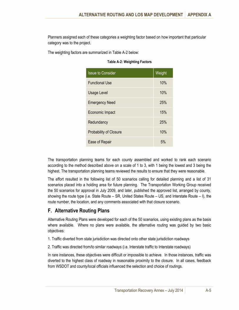
ALTERNATIVE ROUTING AND LOS MAP DEVELOPMENT APPENDIX A
Transportation Recovery Annex – July 2014 A-5
Planners assigned each of these categories a weighting factor based on how important that particular
category was to the project.
The weighting factors are summarized in Table A-2 below:
Table A-2: Weighting Factors
Issue to Consider Weight
Functional Use 10%
Usage Level 10%
Emergency Need 25%
Economic Impact 15%
Redundancy 25%
Probability of Closure 10%
Ease of Repair 5%
The transportation planning teams for each county assembled and worked to rank each scenario
according to the method described above on a scale of 1 to 3, with 1 being the lowest and 3 being the
highest. The transportation planning teams reviewed the results to ensure that they were reasonable.
The effort resulted in the following list of 50 scenarios calling for detailed planning and a list of 31
scenarios placed into a holding area for future planning. The Transportation Working Group received
the 50 scenarios for approval in July 2009, and later, published the approved list, arranged by county,
showing the route type (i.e. State Route – SR, United States Route – US, and Interstate Route – I), the
route number, the location, and any comments associated with that closure scenario.
F. Alternative Routing Plans
Alternative Routing Plans were developed for each of the 50 scenarios, using existing plans as the basis
where available. Where no plans were available, the alternative routing was guided by two basic
objectives:
1. Traffic diverted from state jurisdiction was directed onto other state jurisdiction roadways
2. Traffic was directed from/to similar roadways (i.e. Interstate traffic to Interstate roadways)
In rare instances, these objectives were difficult or impossible to achieve. In those instances, traffic was
diverted to the highest class of roadway in reasonable proximity to the closure. In all cases, feedback
from WSDOT and county/local officials influenced the selection and choice of routings.
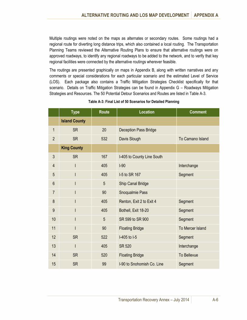
ALTERNATIVE ROUTING AND LOS MAP DEVELOPMENT APPENDIX A
Transportation Recovery Annex – July 2014 A-6
Multiple routings were noted on the maps as alternates or secondary routes. Some routings had a
regional route for diverting long distance trips, which also contained a local routing. The Transportation
Planning Teams reviewed the Alternative Routing Plans to ensure that alternative routings were on
approved roadways, to identify any regional roadways to be added to the network, and to verify that key
regional facilities were connected by the alternative routings wherever feasible.
The routings are presented graphically on maps in Appendix B, along with written narratives and any
comments or special considerations for each particular scenario and the estimated Level of Service
(LOS). Each package also contains a Traffic Mitigation Strategies Checklist specifically for that
scenario. Details on Traffic Mitigation Strategies can be found in Appendix G – Roadways Mitigation
Strategies and Resources. The 50 Potential Detour Scenarios and Routes are listed in Table A-3.
Table A-3: Final List of 50 Scenarios for Detailed Planning
Type Route Location Comment
Island County
1 SR 20 Deception Pass Bridge
2 SR 532 Davis Slough To Camano Island
King County
3 SR 167 I-405 to County Line South
4 I 405 I-90 Interchange
5 I 405 I-5 to SR 167 Segment
6 I 5 Ship Canal Bridge
7 I 90 Snoqualmie Pass
8 I 405 Renton, Exit 2 to Exit 4 Segment
9 I 405 Bothell, Exit 18-20 Segment
10 I 5 SR 599 to SR 900 Segment
11 I 90 Floating Bridge To Mercer Island
12 SR 522 I-405 to I-5 Segment
13 I 405 SR 520 Interchange
14 SR 520 Floating Bridge To Bellevue
15 SR 99 I-90 to Snohomish Co. Line Segment

ALTERNATIVE ROUTING AND LOS MAP DEVELOPMENT APPENDIX A
Transportation Recovery Annex – July 2014 A-7
Type Route Location Comment
King County (con’t)
16 SR 181 I-405 to SR 516 (W Valley Hwy) Segment
17 W. Seattle Hwy High Bridge
18 I 5 I-405/SR 518 Interchange
19 SR 99 Aurora Bridge Ship Canal
20 US 2 Skykomish To Stevens Pass
21 I 5 I-90 Interchange
22 SR 99/AWV Battery Street Tunnel To South End
23 I 5 SR 520 Interchange
Kitsap County
24 SR 305 Bridge to Bainbridge Island
25 SR 3 SR 16 Interchange
26 SR 104 West of Miller Bay Road To 307
Mason County
27 US 101 Hoodsport to Potlatch Segment
28 US 101 Kennedy Creek Bridge N of Thurston Co. Line
Pierce County
29 Various Bridges over the Puyallup River
30 SR 16 Tacoma Narrows Bridge
31 I 5 SR 16 Interchange
32 I 5 Puyallup River Bridge
33 I 5 SR 16 to King Co. Line Segment
34 I 5 SR 512 Interchange
35 I 5 SR 512 to Thurston Co. Line Segment
36 SR 410 SR 167/SR512 Interchange
37 I 5 SR 512 to SR 16 Segment

ALTERNATIVE ROUTING AND LOS MAP DEVELOPMENT APPENDIX A
Transportation Recovery Annex – July 2014 A-8
Type Route Location Comment
Skagit County
38 I 5 Skagit River Bridge
39 SR 20 Swinomish Channel Bridge
Snohomish County
40 I 5 Snohomish River Bridge
41 I 5 SR 529 Interchange
42 US 2 I-5 to SR 204 Segment
43 I 5 I-405 Interchange
44 SR 9 Snohomish River Bridge
45 I 405 SR 527 Interchange
46 SR 522 Snohomish River Bridge
47 US 2 SR 9 to King Co. Line Segment
Thurston County
48 Various I-5/SR507 Bridges over the Nisqually River Including Mounts Rd.
49 I 5 US 101 Interchange
50 US 101 SR 8 Interchange
4.
G. Development of Level of Service (LOS) Maps
Level of Service (LOS) for roads and highways is a
qualitative ranking of the traffic operational characteristics
experienced by users. The Level of Service ranking is a six-
tiered system, ranging from LOS A (free flow) to LOS F
(congested). According to the Highway Capacity Manual
2000, (LOS) is categorized by two parameters,
uninterrupted and interrupted flow.
Uninterrupted flow facilities (i.e. freeways) do not have fixed
elements such as traffic signals that cause interruptions to traffic flow, while Interrupted flow facilities do.
The Highway Capacity Manual,
published by the Transportation
Research Board, is the basis for
determining Levels of Service
(LOS) for the disruption scenarios
utilized in this Annex.
ALTERNATIVE ROUTING AND LOS MAP DEVELOPMENT APPENDIX A
Transportation Recovery Annex – July 2014 A-9
H. Traffic Flow
Levels of Service for freeways are described in terms of traffic flow. The 2000 Highway Capacity
Manual describes LOS for freeways as:
Level of Service A – Represents free flow. Individual vehicles are virtually unaffected by the presence of others in the traffic stream.
Level of Service B – Is in the range of stable flow, but the presence of other vehicles in the traffic stream begins to be noticeable. Freedom to select desired speed is relatively unaffected, but there is a slight decline in freedom to maneuver.
Level of Service C – Is in the range of stable flow, but marks the beginning of the range of flow which the operation of individual vehicles becomes significantly affected by interactions with other vehicles in the traffic stream.
Level of Service D – Is a crowded segment of roadway with large numbers of vehicles restricting mobility and a stable flow. Speed and freedom to maneuver are severely restricted, and the driver experiences a generally poor level of comfort and convenience.
Level of Service E – Represents operating conditions at or near capacity of the roadway. All speeds are reduced to low, but to a relatively uniform value. Small increases to flow will cause breakdowns in traffic movement.
Level of Service F – Is used to define forced or breakdown flow (stop-and-go gridlock). This condition exists when the amount of traffic exceeds the amount that can travel to a destination. Operations within queues are characterized by stop and go waves, and they are extremely unstable.
I. Levels of Service
Levels of Services for arterial roadways (i.e. roadways with signals) are defined in terms of delay. Level
of Service categories and the corresponding delay ranges are:
Level of Service A - Delay is 10 seconds or less.
Level of Service B – Delay is 10 to 20 seconds.
Level of Service C – Delay is 20 to 35 seconds.
Level of Service D – Delay is 35 to 55 seconds.
Level of Service E – Delay is 55 to 80 seconds.
Level of Service F – Delay greater than 80 seconds.
The purpose of this Appendix is to graphically show the expected level of service and the corresponding
level of congestion for each scenario. Since Level of Service and Level of Congestion are directed
related, Appendix A groups Level of Service into three congestion levels:
No Congestion, where LOS A and LOS B are grouped together ,
Moderately Congested, where LOS C and LOS D are grouped together, and
Congested, where LOS E and LOS F are grouped together.

ALTERNATIVE ROUTING AND LOS MAP DEVELOPMENT APPENDIX A
Transportation Recovery Annex – July 2014 A-10
The Level of Service was determined for each of the alternative routes in each scenario and graphically
illustrated on a LOS map, one map for each of the 50 scenarios. The methodology used existing data
to estimate the impact to Level of Service on alternative routes that bypassed the roadway closure.
Planners derived the current Levels of Congestion from the Washington State Department of
Transportation document entitled “Congested State Highways in the Central Puget Sound Region.”
This document shows the level of congestion based on 2006 data and contains the Level of Service data
on the state and interstate numbered routes. (See Figure A- 1)
In a few cases where routings were on county or local roadways, this WSDOT document did not have
information on local or county roadways. In those few instances, planners assessed county or city
planning documents for the baseline Level of Service information.
Once current LOS was established, planners reviewed each scenario to determine the impact of the
roadway closure(s). The roadway or roadways closed in a specific scenario were assumed to divert all
of its traffic onto the designated alternate routes. This effort assumes the diverted traffic volume to be
the capacity of the roadway and checked against the WSDOT document website entitled Traffic
Planning Trends.
(www.wsdot.wa.gov/mapsdata/tdo/traffictrends).
J. Roadway Capacity
Capacity for these roadway sections was estimated based on the number of lanes as derived from the
Washington State Department of Transportation’s “Highway Performance and Monitoring System Data”
and from aerial photography. Two lane roads boast a capacity of 2632 vehicles per hour and multilane
roadways merit a capacity of 2000 vehicles per hour per lane. This value approximates the maximum
number of vehicles per hour that a roadway carries when open. Shown in Table A- 4 as Hourly Volume,
capacity also represents the approximate amount of hourly traffic diverted to alternate routes if that
roadway were closed.
Changes to Level of Service were then based on the estimated increase in traffic on the alternative route
due to relocation of traffic volumes from the closed roadway. The LOS maps for each scenario illustrate
the resultant Levels of Service.
Each of these 50 scenarios results in a significant loss of
roadway capacity for the region. Most of the major
highways in this region are very congested on a normal
day. It was expected that capacity losses from each of
the 50 scenarios would typically result in currently
congested roadways becoming much worse and
moderately congested roadways becoming congested
due to the closures. Since nearly all of the 50 scenarios
represent roadway closures at major interchanges, high
volume areas or extended segments, this was indeed the result and is borne out in the Level of Service
mapping.
The degradation of Level of
Service due to any of these 50
scenarios illustrates the importance
of instituting multiple traffic mitigation
strategies when these closures
occur.

ALTERNATIVE ROUTING AND LOS MAP DEVELOPMENT APPENDIX A
Transportation Recovery Annex – July 2014 A-11
In rare cases, due to roadway closures, Level of Service actually improved due to the segments with
less traffic that were no longer through roadways. Jurisdictions are encouraged to invoke as many
strategies as possible and to cooperate with neighboring jurisdictions in the planning and implementation
of the traffic mitigation strategies.
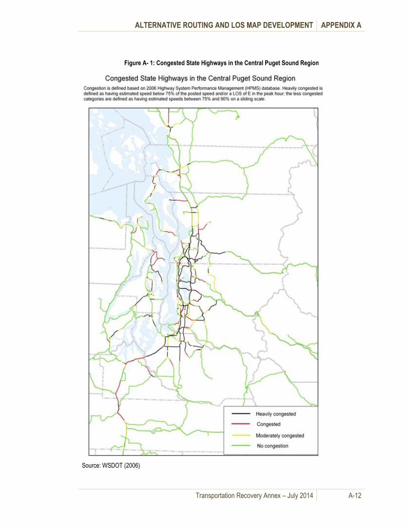
ALTERNATIVE ROUTING AND LOS MAP DEVELOPMENT APPENDIX A
Transportation Recovery Annex – July 2014 A-12
Figure A- 1: Congested State Highways in the Central Puget Sound Region
Source: WSDOT (2006)
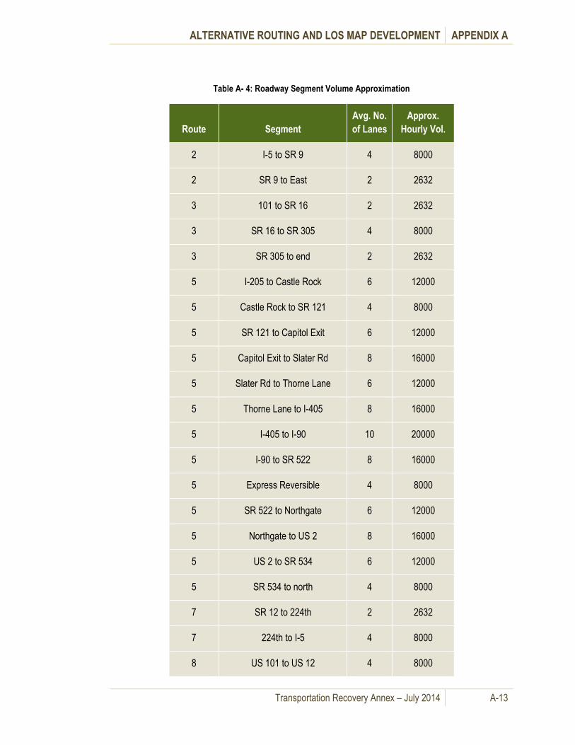
ALTERNATIVE ROUTING AND LOS MAP DEVELOPMENT APPENDIX A
Transportation Recovery Annex – July 2014 A-13
Table A- 4: Roadway Segment Volume Approximation
Route Segment
Avg. No.
of Lanes
Approx.
Hourly Vol.
2 I-5 to SR 9 4 8000
2 SR 9 to East 2 2632
3 101 to SR 16 2 2632
3 SR 16 to SR 305 4 8000
3 SR 305 to end 2 2632
5 I-205 to Castle Rock 6 12000
5 Castle Rock to SR 121 4 8000
5 SR 121 to Capitol Exit 6 12000
5 Capitol Exit to Slater Rd 8 16000
5 Slater Rd to Thorne Lane 6 12000
5 Thorne Lane to I-405 8 16000
5 I-405 to I-90 10 20000
5 I-90 to SR 522 8 16000
5 Express Reversible 4 8000
5 SR 522 to Northgate 6 12000
5 Northgate to US 2 8 16000
5 US 2 to SR 534 6 12000
5 SR 534 to north 4 8000
7 SR 12 to 224th 2 2632
7 224th to I-5 4 8000
8 US 101 to US 12 4 8000

ALTERNATIVE ROUTING AND LOS MAP DEVELOPMENT APPENDIX A
Transportation Recovery Annex – July 2014 A-14
Route Segment
Avg. No.
of Lanes
Approx.
Hourly Vol.
9 SR 522 to SR 524 4 8000
9 SR 524 to north 2 2632
12 west to SR 8 4 8000
12 SR 8 to I-5 2 2632
12 I-5 to east 2 2632
16 I-5 to toll plaza 6 12000
16 toll plaza to Gorst 4 8000
18 I-5 to Issaquah-Hobart Rd 4 8000
18 Issaquah-Hobart Rd to I-90 2 2632
20 south to Anacortes 2 2632
20 Anacortes to I-5 4 8000
82 All 4 8000
84 I-82 to Troutdale 4 8000
84 Troutdale to I-205 6 12000
90 I-5 to I-405 6 12000
90 Express Reversible 2 2632
90 I-405 to SR 900 8 16000
90 SR 900 to east 6 12000
96 I-5 to SR 9 4 8000
99 Tacoma to 272nd 4 8000
99 272nd to 276 6 12000

ALTERNATIVE ROUTING AND LOS MAP DEVELOPMENT APPENDIX A
Transportation Recovery Annex – July 2014 A-15
Route Segment
Avg. No.
of Lanes
Approx.
Hourly Vol.
99 276 to SR 509 4 8000
99 SR 509 to AWV 6 12000
99 AWV 6 12000
99 Tunnel 4 8000
99 Tunnel to SR 523 6 12000
99 SR 523 to SR526 end 4 8000
101 I-5 to Crosby 6 12000
101 Crosby to SR 3 4 8000
101 SR 3 to Hoodsport 2 2632
104 all except SR 99 to I-5 2 2632
104 SR 99 to I-5 4 8000
106 All 2 2632
108 All 2 2632
121 All 2 2632
160 All 2 2632
161 SR 7 to 224th SR 702 2 2632
161 224th to SR 167 4 8000
162 All 2 4000
163 All 4 8000
164 SR 18 to Dogwood 4 8000
164 Dogwood to SR 410 2 2632
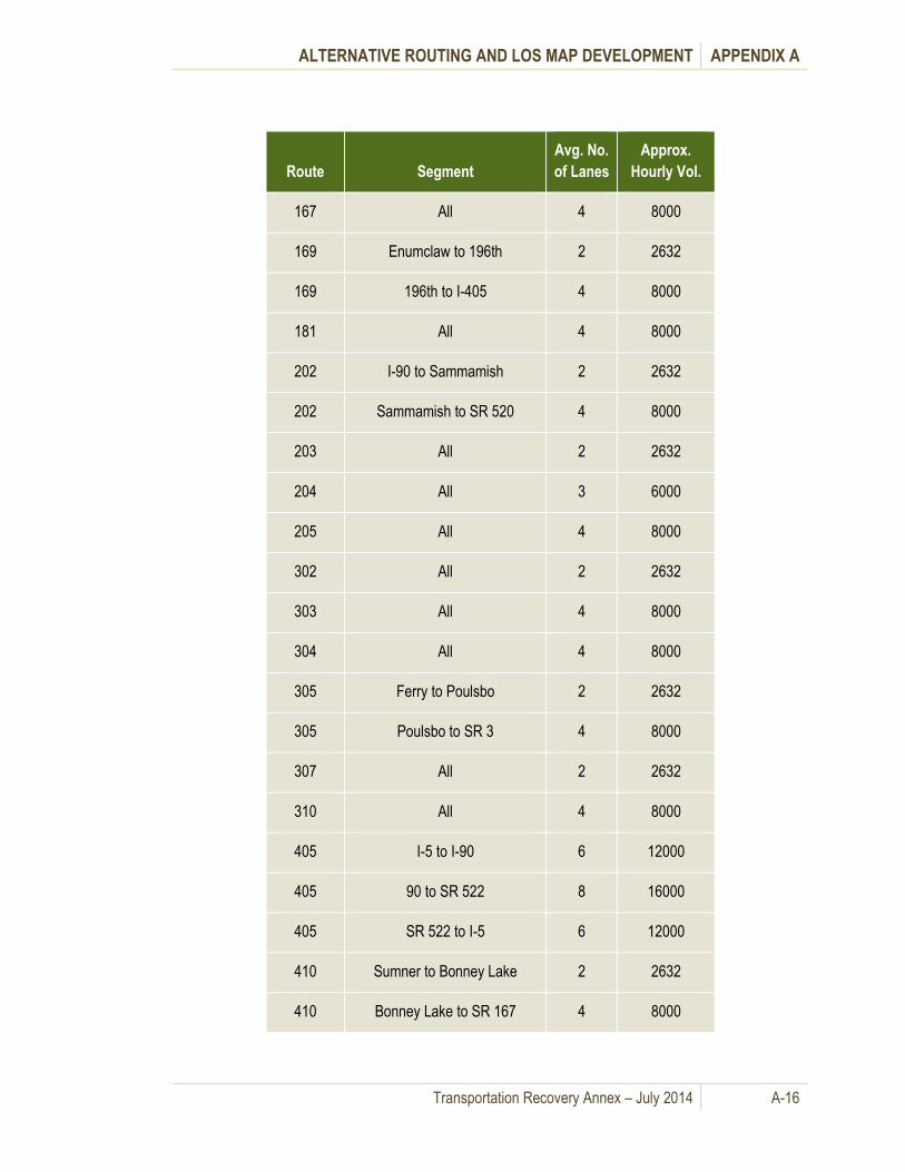
ALTERNATIVE ROUTING AND LOS MAP DEVELOPMENT APPENDIX A
Transportation Recovery Annex – July 2014 A-16
Route Segment
Avg. No.
of Lanes
Approx.
Hourly Vol.
167 All 4 8000
169 Enumclaw to 196th 2 2632
169 196th to I-405 4 8000
181 All 4 8000
202 I-90 to Sammamish 2 2632
202 Sammamish to SR 520 4 8000
203 All 2 2632
204 All 3 6000
205 All 4 8000
302 All 2 2632
303 All 4 8000
304 All 4 8000
305 Ferry to Poulsbo 2 2632
305 Poulsbo to SR 3 4 8000
307 All 2 2632
310 All 4 8000
405 I-5 to I-90 6 12000
405 90 to SR 522 8 16000
405 SR 522 to I-5 6 12000
410 Sumner to Bonney Lake 2 2632
410 Bonney Lake to SR 167 4 8000
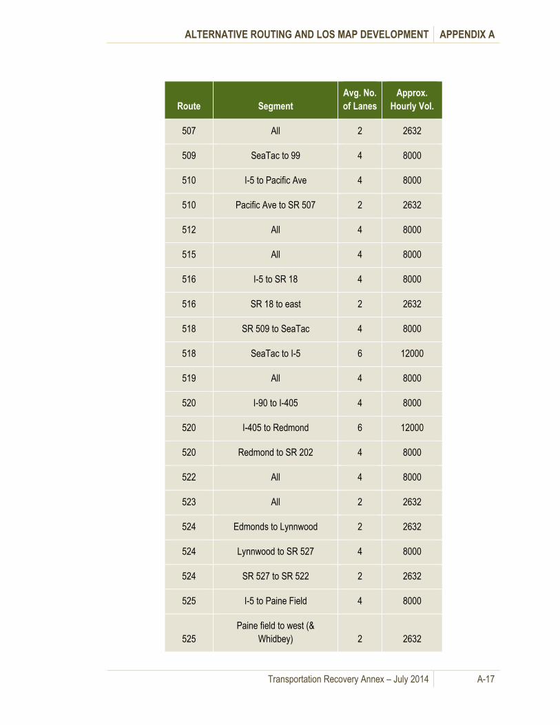
ALTERNATIVE ROUTING AND LOS MAP DEVELOPMENT APPENDIX A
Transportation Recovery Annex – July 2014 A-17
Route Segment
Avg. No.
of Lanes
Approx.
Hourly Vol.
507 All 2 2632
509 SeaTac to 99 4 8000
510 I-5 to Pacific Ave 4 8000
510 Pacific Ave to SR 507 2 2632
512 All 4 8000
515 All 4 8000
516 I-5 to SR 18 4 8000
516 SR 18 to east 2 2632
518 SR 509 to SeaTac 4 8000
518 SeaTac to I-5 6 12000
519 All 4 8000
520 I-90 to I-405 4 8000
520 I-405 to Redmond 6 12000
520 Redmond to SR 202 4 8000
522 All 4 8000
523 All 2 2632
524 Edmonds to Lynnwood 2 2632
524 Lynnwood to SR 527 4 8000
524 SR 527 to SR 522 2 2632
525 I-5 to Paine Field 4 8000
525
Paine field to west (&
Whidbey) 2 2632
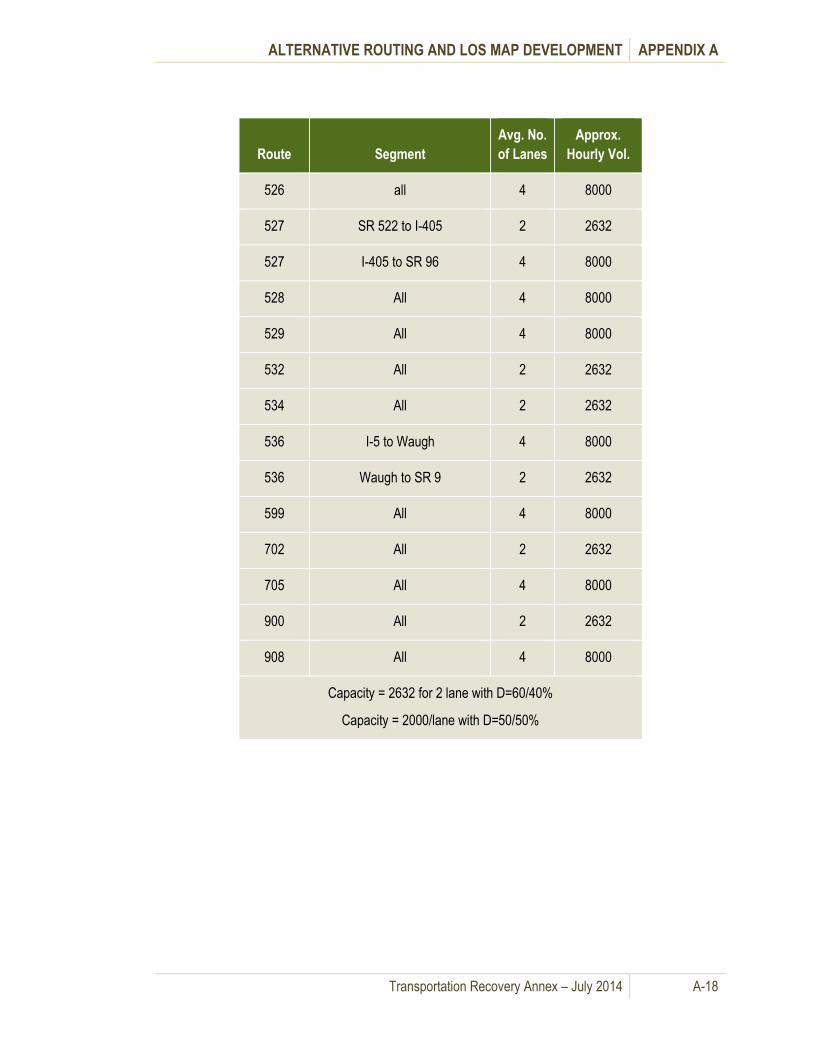
ALTERNATIVE ROUTING AND LOS MAP DEVELOPMENT APPENDIX A
Transportation Recovery Annex – July 2014 A-18
Route Segment
Avg. No.
of Lanes
Approx.
Hourly Vol.
526 all 4 8000
527 SR 522 to I-405 2 2632
527 I-405 to SR 96 4 8000
528 All 4 8000
529 All 4 8000
532 All 2 2632
534 All 2 2632
536 I-5 to Waugh 4 8000
536 Waugh to SR 9 2 2632
599 All 4 8000
702 All 2 2632
705 All 4 8000
900 All 2 2632
908 All 4 8000
Capacity = 2632 for 2 lane with D=60/40%
Capacity = 2000/lane with D=50/50%
ALTERNATIVE ROUTING AND LOS MAP DEVELOPMENT APPENDIX A
Transportation Recovery Annex – July 2014 A-19
K. References
5. Growth Management Indicators (GMI) Report- Skagit County
6. Mason County Comprehensive Plan – 2005
7. Pierce County TCMS 2009 Report
8. King County Transportation Needs Report 2008
9. Puget Sound Regional Council – LOS Map
10. Snohomish County – Transportation Element of the GMA Comprehensive Plan -2008
11. Thurston County Comprehensive Plan – 2004

This page intentionally left blank.

Transportation Recovery Annex – July 2014 B-1
Potential Detour Scenarios: Route Appendix B. Information and Maps
A. General Information
This Appendix provides specific management and map information on each of the fifty (50) disruption
scenarios. The summary of the development of the 50 potential detour scenarios and routes, the
planning process with local stakeholders and the calculations used to produce the Level of Service
(LOS) map for each scenario are covered in Appendix A.
Alternative routings are presented graphically on maps in Appendix B, along with written narratives and
any comments or special considerations for each particular scenario. Each individual scenario contains
information on who is in charge of implementing the particular alternative route and what agencies or
jurisdictions have coordination responsibilities for routes to be used as alternatives. Information is
provided on anticipated Level of Service (LOS) and mitigation strategies and alternatives work out with
the respective stakeholder working groups.
Notification protocols anticipate information sharing among specific transportation agencies, such as
between WSDOT and a local Transportation Management Center (TMC) and jurisdictional coordination
between the County EOC and respective cities within the county as per local notification and warning
plans. Coordination and communications concepts are covered in Section V – Information Collection
and Dissemination, Section VI - Communications and Appendix E – Roadways Toolbox.
B. Fifty (50) Potential Detour Scenarios: Route Information and Maps
Due to the size of the files containing this information, this Appendix, with its own Table of Contents and
Record of Revisions is published separately. An index of the disruption scenarios is found in Table B- 1.
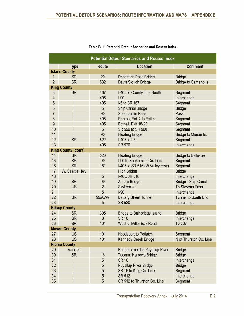
POTENTIAL DETOUR SCENARIOS: ROUTE INFORMATION AND MAPS APPENDIX B
Transportation Recovery Annex – July 2014 B-2
Table B- 1: Potential Detour Scenarios and Routes Index
Potential Detour Scenarios and Routes Index
Type Route Location Comment
Island County
1 SR 20 Deception Pass Bridge Bridge
2 SR 532 Davis Slough Bridge Bridge to Camano Is.
King County
3 SR 167 I-405 to County Line South Segment
4 I 405 I-90 Interchange
5 I 405 I-5 to SR 167 Segment
6 I 5 Ship Canal Bridge Bridge
7 I 90 Snoqualmie Pass Pass
8 I 405 Renton, Exit 2 to Exit 4 Segment
9 I 405 Bothell, Exit 18-20 Segment
10 I 5 SR 599 to SR 900 Segment
11 I 90 Floating Bridge Bridge to Mercer Is.
12 SR 522 I-405 to I-5 Segment
13 I 405 SR 520 Interchange
King County (con’t)
14 SR 520 Floating Bridge Bridge to Bellevue
15 SR 99 I-90 to Snohomish Co. Line Segment
16 SR 181 I-405 to SR 516 (W Valley Hwy) Segment
17 W. Seattle Hwy High Bridge Bridge
18 I 5 I-405/SR 518 Interchange
19 SR 99 Aurora Bridge Bridge - Ship Canal
20 US 2 Skykomish To Stevens Pass
21 I 5 I-90 Interchange
22 SR 99/AWV Battery Street Tunnel Tunnel to South End
23 I 5 SR 520 Interchange
Kitsap County
24 SR 305 Bridge to Bainbridge Island Bridge
25 SR 3 SR 16 Interchange
26 SR 104 West of Miller Bay Road To 307
Mason County
27 US 101 Hoodsport to Potlatch Segment
28 US 101 Kennedy Creek Bridge N of Thurston Co. Line
Pierce County
29 Various Bridges over the Puyallup River Bridge
30 SR 16 Tacoma Narrows Bridge Bridge
31 I 5 SR 16 Interchange
32 I 5 Puyallup River Bridge Bridge
33 I 5 SR 16 to King Co. Line Segment
34 I 5 SR 512 Interchange
35 I 5 SR 512 to Thurston Co. Line Segment
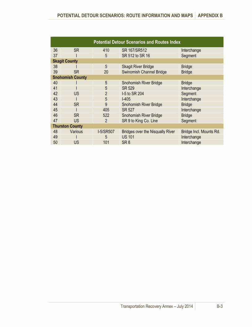
POTENTIAL DETOUR SCENARIOS: ROUTE INFORMATION AND MAPS APPENDIX B
Transportation Recovery Annex – July 2014 B-3
Potential Detour Scenarios and Routes Index
36 SR 410 SR 167/SR512 Interchange
37 I 5 SR 512 to SR 16 Segment
Skagit County
38 I 5 Skagit River Bridge Bridge
39 SR 20 Swinomish Channel Bridge Bridge
Snohomish County
40 I 5 Snohomish River Bridge Bridge
41 I 5 SR 529 Interchange
42 US 2 I-5 to SR 204 Segment
43 I 5 I-405 Interchange
44 SR 9 Snohomish River Bridge Bridge
45 I 405 SR 527 Interchange
46 SR 522 Snohomish River Bridge Bridge
47 US 2 SR 9 to King Co. Line Segment
Thurston County
48 Various I-5/SR507 Bridges over the Nisqually River Bridge Incl. Mounts Rd.
49 I 5 US 101 Interchange
50 US 101 SR 8 Interchange

This page intentionally left blank.

Transportation Recovery Annex – July 2014 C-1
Regional Coordination Appendix C.
A. Regional Coordination
Transportation recovery requires inter-agency and inter-jurisdictional coordination within and between all
levels of government. Affected regional jurisdictions must utilize and apply effective Incident Command
System (ICS) and National Incident Management System (NIMS) methodologies and techniques. This is
especially important in catastrophic incidents involving multiple jurisdictions and multiple disruptions to
the transportation network. There are several options for local jurisdictions to be part of a regional
coordination process for making decisions and recommendations concerning regional transportation
recovery issues.
Concepts for regional coordination are based on several factors. One important factor is that local
governments have the authority under state law to establish entities, such as “Working Groups,” that
bring together appropriate local elected and appointed officials and private sector personnel, decision
makers and selected subject-matter experts and stakeholders in specified geographic or functional
areas. There is also the authority to use existing entities, such as Metropolitan Planning Organizations,
that have pre-existing structures and processes for making transportation related decisions.
A key element in regional coordination is pre-planning. Membership by title or organization in ad hoc
organizations could be decided ahead of time, and be based upon recommendations from local elected
leaders, department heads and key stakeholders. Local elected officials could take part or delegate
decision-making authority. Or they could direct a Unified Command approach, depending upon the
circumstances and authorities involved.
Recovery entities focus on information and coordination from the regional perspective for long-term
transportation recovery issues in a specific geographic location or functional area. Further, these
Working Groups would only be set up when needed to address specific issues best resolved by
authorities and stakeholders in a specific geographic or functional area.
Regional transportation recovery entities would be made
up of personnel who have jurisdictional responsibility, are
key stakeholders in transportation recovery or are
significantly impacted by the transportation disruption
issues. These personnel would be fully authorized to
represent their jurisdiction or agency and could have the
authority to commit resources, and authorize expenditure
of funds.
There are three (3) key regional functions that these regional transportation recovery entities are
responsible for during mid- and long term recovery and reconstruction of the transportation network.
1. Regional Common Operating Picture: Information needs will shift from a focus on damage
assessment and situational awareness to evaluation of disaster impact on transportation services,
estimated timelines for repair and reconstructions and cost estimates. This information is shared among
stakeholders and regional partners.
2. Regional Coordination: Developing long term plans for the resumption of freight movement, road
and waterways alternatives for commuters, new and revised transit operations and the resumption of
Recovery entities do not supersede,
replace or duplicate the existing
recovery structures established in local
plans or that routinely occur among
Federal, state and local emergency
management organizations.
REGIONAL COORDINATION APPENDIX C
Transportation Recovery Annex – July 2014 C-2
both local and regional traffic movement will require communication and cooperation among
transportation stakeholders. Regional transportation recovery entities are a mechanism that can
facilitative this coordination and refine criteria to set regional priorities if necessary.
3. Regional Public Information: Developing mid- and long term recovery priorities and strategies will
increase pressure to provide information on alternative routes, new transit services and schedules and
traffic mitigation strategies to the general public. Regional Transportation Recovery entities will
coordinate with local and state Joint Information Centers to ensure accurate transportation related
information is available for release to the news media.
Regional Transportation Recovery entities typically
engage ESF 2 – Communications, ESF 5 – Emergency
Management and ESF 15 – External Affairs from either
the State or local levels to collect and share key
information with regional partners to facilitate making
decisions and recommendations. ESF 15 is the primary
public information support function at all levels. Other
ESFs may be activated to support the respective entities
as needed.
Once formed, regional transportation recovery entities would provide a platform for interaction among
regional jurisdictions, transportation stakeholders and potentially, other ESFs in a specific geographic or
functional area. They would also facilitate implementation of specified recommendations or directions
from the Governor’s Task Force during extended recovery periods. Key actions are listed in Table C-1.
Recovery entities focus on
information and coordination from the
regional perspective for long term
transportation recovery issues in a
specific geographic location or
functional area.

REGIONAL COORDINATION APPENDIX C
Transportation Recovery Annex – July 2014 C-3
Table C- 1: Regional Transportation Recovery Actions
Regional Transportation Recovery Entities Key Actions
1 Notify and share information with key regional decision makers, subject-matter experts, and ESF members during the recovery process.
2 Facilitate assessment of regional or functional issues by bringing together members of affected jurisdictions and transportation stakeholders and the other ESFs. The assessment information could be made available to regional stakeholders via conference calls, e-mail, or the secure websites, WebEOC or SharePoint sites.
3
Facilitate regional conference calls to receive and share situational awareness reports regarding transportation disruptions and the recovery efforts, to discuss current situation status of affected jurisdiction(s) and stakeholders, prioritize resources and response requirements, and to ensure consistent and uniform messaging.
4 Maintain an incident tracking and status reporting system available on a secure website, through WebEOC or a SharePoint site for authorized parties. Support staff could be assigned the task of continuously updating the informational website/database.
5 Facilitate the coordination of decisions and recommendations regarding recovery priorities, transportation routes and activating the alternate route scenarios.
6 Assist in the development of common messages that could be made available to the respective Joint Information Center to help ensure consistent information to the public.
7 Use websites available to the public, such as WSDOT’s http://wsdot.wa.gov/traffic/seattle to relay information on recovery priorities, transportation routes, route status and alternative routes to the public.
Three options for regional coordination in transportation recovery are outlined below:
1. “Bottom up” approach – This involves local jurisdictions taking the initiative to organize working
groups to address regional issues.
2. Utilization of existing organizations and institutions – Examples of this are the Metropolitan
Planning Organizations (MPOs) and Regional Transportation Planning Organizations (RTPOs).
3. “Top down” approach – This involves the State establishing task forces or working groups to
address regional issues as part of the governor’s long term recovery strategy.
These options are not mutually exclusive. All may play a role in long term recovery operations as other
strategies emerge at either the local or state level.
B. Entities Formed by Local Government
Local jurisdictions may form regional transportation recovery entities that are designed to facilitate
regional recovery situational assessment, communication, priority setting or decision making. This would
be led by ESF 1 – Transportation which has established relationships and lines of communication with
public and private transportation stakeholders. This effort would be coordinated with local emergency
management agencies and with the overall regional recovery effort. Establishing and operating these
entities would involve the following:

REGIONAL COORDINATION APPENDIX C
Transportation Recovery Annex – July 2014 C-4
Engage appropriate transportation stakeholders from the public and private sectors to resolve regional transportation issues and help manage local long term transportation recovery efforts.
Coordinate regional recovery issues that transcend single jurisdictional boundaries. This would provide a forum and a process to resolve problems, find solutions, set priorities and make recommendations. If situations arise where consensus cannot be reached, a method to come to a decision would be agreed to, such as a majority vote or turning to a higher level of government, such as the State.
Assemble representatives from the County, incorporated cities and towns and other stakeholders that have jurisdiction within their respective political boundaries or have information and resources to contribute. They would be assigned technical, legal and administrative support from their respective jurisdictions.
Develop a common set of objectives or strategies for the specific issue. Share information, maximize the use of available resources, and provide a unified local or regional voice in coordinating with the State and the Governor’s priorities.
Operate from a virtual or an identified physical location, or establish ad hoc Regional Recovery Centers as necessary.
Address issues that affect a specific geographical area (such as three counties) or a specific single function (such as coordinating traffic mitigation strategies).
Involve representatives from other modes of transportation including representatives from state and federal agencies, special districts, and the private sector, military and non-governmental organizations (NGOs), as appropriate. As directed by their respective elected or appointed officials, recommend recovery priorities, goals and objectives to the State recovery organization or to the respective local jurisdictions.
Construct the capability to sustain the effort throughout the recovery process to minimize turnover of representatives. Document the authority to commit their jurisdiction’s resources and commitment to speak with “one voice” to avoid confusion to the public in the recovery process. Members of these groups do not relinquish jurisdictional authority, responsibility, or accountability.
These entities could also play a role in any recovery organization established by the State. If local
regional coordination entities are formed, coordination with the State could occur so structures and
organizations established locally could be integrated into any state structure formed under the
Governor’s authority. A conceptual diagram is shown in Figure C-1.
.
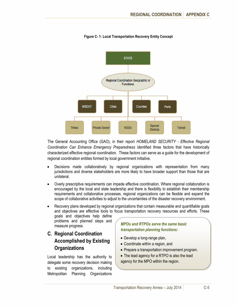
REGIONAL COORDINATION APPENDIX C
Transportation Recovery Annex – July 2014 C-5
Figure C- 1: Local Transportation Recovery Entity Concept
The General Accounting Office (GAO), in their report HOMELAND SECURITY - Effective Regional
Coordination Can Enhance Emergency Preparedness identified three factors that have historically
characterized effective regional coordination. These factors can serve as a guide for the development of
regional coordination entities formed by local government initiative.
Decisions made collaboratively by regional organizations with representation from many jurisdictions and diverse stakeholders are more likely to have broader support than those that are unilateral.
Overly prescriptive requirements can impede effective coordination. Where regional collaboration is encouraged by the local and state leadership and there is flexibility to establish their membership requirements and collaborative processes, regional organizations can be flexible and expand the scope of collaborative activities to adjust to the uncertainties of the disaster recovery environment.
Recovery plans developed by regional organizations that contain measurable and quantifiable goals and objectives are effective tools to focus transportation recovery resources and efforts. These goals and objectives help define problems and planned steps and measure progress.
C. Regional Coordination
Accomplished by Existing
Organizations
Local leadership has the authority to
delegate some recovery decision making
to existing organizations, including
Metropolitan Planning Organizations
MPOs and RTPOs serve the same basic
transportation planning functions:
Develop a long-range plan,
Coordinate within a region, and
Prepare a transportation improvement program.
The lead agency for a RTPO is also the lead
agency for the MPO within the region.

REGIONAL COORDINATION APPENDIX C
Transportation Recovery Annex – July 2014 C-6
(MPOs) and Regional Transportation Planning Organizations (RTPOs), which are the primary entities
responsible for transportation planning in a region.
Federal transportation law requires MPOs with multi-jurisdictional representation, such as the Puget
Sound Regional Council (PSRC), to agree on a regional plan, and allows the use of federal highway and
transit funding for such planning. State law has established RTPOs to support regional planning efforts.
The federal MPO and state RTPO requirements are complementary.
Local leadership could delegate some
recovery decision making to existing
organizations such as these MPOs and
RTPOs. RTPOs were authorized as part of
the 1990 Growth Management Act to
ensure local and regional coordination of
transportation plans.
An RTPO covers both urban and rural
areas and receives state funding in support
of its planning efforts. WSDOT provides
some administrative and technical
assistance, supports RTPO coordination
activities, and actively participates in the
regional transportation planning process.
An MPO covers an urbanized area and
receives federal funding to support its
planning efforts. WSDOT may provide
administrative and technical assistance,
supports RTPO coordination activities, and
actively participates in the regional
transportation planning process.
Considering these responsibilities, MPOs and RTPOs may be suited to assume the coordination role for
some regional transportation recovery issues, including but not limited to such factors as the scope of
the issue, the involved jurisdictions and authorities, and the source of recovery funding. A conceptual
diagram is shown in Figure C-2.
RTPO requirements and expectations
Planning must involve cities, counties,
WSDOT, transit agencies, ports, and
private employers;
Required to prepare a Regional
Transportation Plan;
Must certify that countywide planning
policies and the transportation element of
local comprehensive plans are consistent
with the Regional Transportation Plan;
Must develop and maintain a six-year
Regional Transportation Improvement
Program.
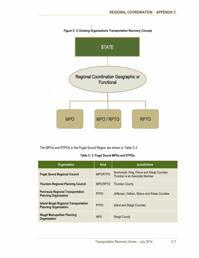
REGIONAL COORDINATION APPENDIX C
Transportation Recovery Annex – July 2014 C-7
Figure C- 2: Existing Organizations Transportation Recovery Concept
The MPOs and RTPOs in the Puget Sound Region are shown in Table C-2.
Table C- 2: Puget Sound MPOs and RTPOs.
Organization Kind Jurisdictions
Puget Sound Regional Council MPO/RTPO Snohomish, King, Pierce and Kitsap Counties. Thurston is an Associate Member
Thurston Regional Planning Council MPO/RPTO Thurston County
Peninsula Regional Transportation Planning Organization
RTPO Jefferson, Clallam, Mason and Kitsap Counties
Island-Skagit Regional Transportation Planning Organization
RTPO Island and Skagit Counties
Skagit Metropolitan Planning Organization
MPO Skagit County

REGIONAL COORDINATION APPENDIX C
Transportation Recovery Annex – July 2014 C-8
D. Regional Coordination - State Draft Plans
Local jurisdictions are involved in regional
coordination through coordination concepts in the
State of Washington Comprehensive Emergency
Management Plan. Part of this plan includes
Emergency Support Function ESF 14 – Long
Term Community Recovery, which is under
development. The current draft concept on how
the State intends to manage long term economic
recovery is the Washington Restoration
Organization (WRO). Under the current concept,
after catastrophic incidents, the governor will
establish the WRO by Executive Order and it
shall work directly for the Office of the Governor
in coordinating and managing statewide and
regional recovery and restoration activities.
The process is also designed to link local jurisdictions, the private sector, voluntary agencies and state
agency recovery efforts to federal relief and federal assistance programs. The current Draft WRO
structure envisions the formation of five individual task forces made up of public and private sector
representatives, appointed by the WRO Director with the approval of the WRO Board of Directors.
These task forces will work on issues relating to:
State Agency Recovery and Restoration
Infrastructure
Economic Recovery and Development
Communities
The Environment
Elements of the structure of the WRO call for liaison with communities and the private sector. A
conceptual diagram is shown in Figure C-4.
.
Purpose of the WRO
Accelerate recovery by providing a single
point of contact at the state level for
Washington citizens, the private sector, and
local, state and federal governments to
facilitate, coordinate and manage restoration
operations.
Encourage broad participation from all
levels and sectors of the community to
implement executive level policies and
coordinate long-term restoration activities and
programs.

REGIONAL COORDINATION APPENDIX C
Transportation Recovery Annex – July 2014 C-9
Figure C- 3: Washington Restoration Organization Recovery Concept
As much as possible, the regional and county, metropolitan and urban liaison positions are filled through
existing institutions such as the Washington State Association of Counties and the Association of
Washington Cities. State agencies such as WSDOT, WSP and others with transportation responsibilities
are part of this process. For long-term transportation recovery, a critical component is the Transportation
Working Group under the Infrastructure Task Force.
The Working Group develops long-term transportation restoration strategy through direct participation
and consensus of affected local, regional and state level stakeholders. The process prioritizes
transportation recovery strategies and initiatives that require the governor’s approval for implementation.
If local jurisdictions form working groups to address regional transportation recovery issues, these could
merge into the WRO process after a catastrophe.
REGIONAL COORDINATION APPENDIX C
Transportation Recovery Annex – July 2014 C-10
The basic Concept of Operations for the WRO is as follows:
Governor’s Office identifies potential candidates for key roles in the WRO and appoints a director and a board of directors.
The Department of General Administration provides support.
Activation of the WRO assumes that state and local government recovery capabilities are overwhelmed.
Local recovery plans must be compatible with and able to coordinate seamlessly with state recovery planning efforts.
The WRO will coordinate with local government recovery organizations to develop community driven local and regional recovery plans.
Counties, tribes, cities and private sector entities to provide a liaison to the WRO to ensure their needs come before the appropriate WRO element.

Transportation Recovery Annex – July 2014 D-1
Prioritization of Roadway Restoration and Appendix D. Reconstruction
A. General Information
This appendix provides a guideline for prioritizing the restoration of the roadway portion of the
transportation system after a major catastrophe that severely impacts the regional transportation
network. It could be applied on a jurisdictional or a regional basis. The process could be led by a
jurisdiction of by the state. This guideline may also be adapted for use with prioritizing projects for other
modes of transportation.
B. Prioritization Process
Multiple critical roadway infrastructures
may need replacing after a disaster, and
the prioritized timeline for which roadway
sections and structures are replaced has
significant economic impacts at local, state
and federal levels. This information is a
starting point for local jurisdictions to use
for discussions within the region and the
state.
The prioritization guideline comes from “A Guide to Highway Vulnerability Assessment” prepared for the
American Association of State Highway and Transportation Officials’ Task Force (AASHTO) by the
Science Applications International Corporation (SAIC). The guideline was then modified based on
recovery planning best practices and stakeholder input. Table D- 1 lists the needed information to
establish rankings for roadway segments. Local authorities should obtain those items listed in the
“information gathering” category.
Table D- 1: Prioritization Components
Prioritization Components
Description of High Priority Regional Transportation Asset Factors and Values
Spreadsheet for Calculation for Priority Ranking of Restoring Damaged Road Segments
Information Gathering
Emergency Response
Map of Hospitals
Map of Resource Points of Distribution
Map of Emergency Response Routes and/or Lifelines
Military Importance
Map of military bases and routes that serve bases
Prioritization is an iterative process that requires the following:
Information gathering;
Ranking segment repair;
Assessing the outcome; and
Adjusting the weights in the ranking spreadsheet based upon the situation at the time of a catastrophe.
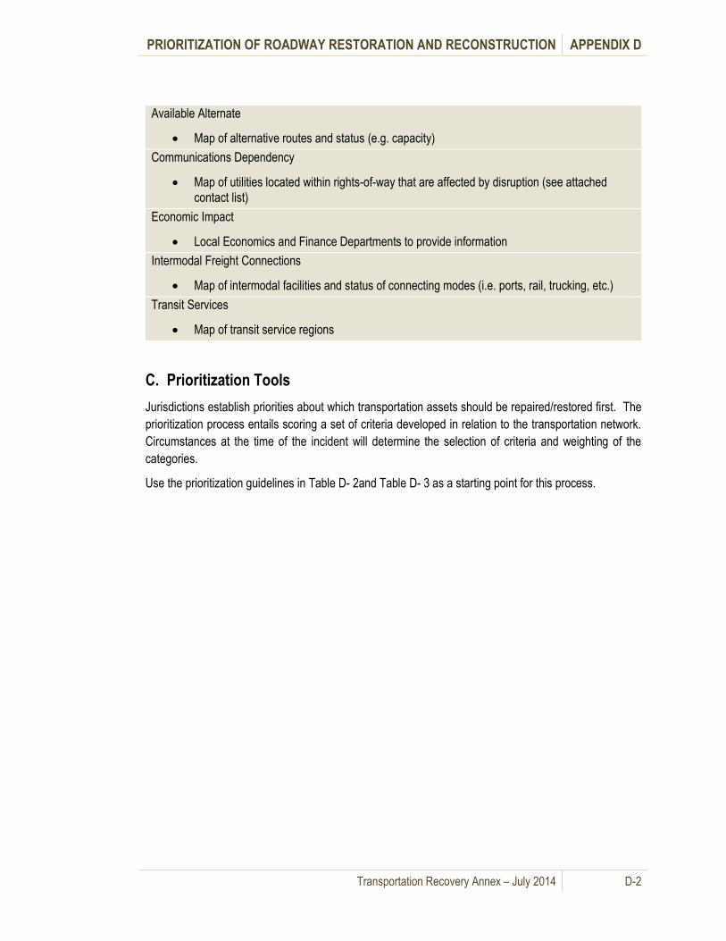
PRIORITIZATION OF ROADWAY RESTORATION AND RECONSTRUCTION APPENDIX D
Transportation Recovery Annex – July 2014 D-2
Available Alternate
Map of alternative routes and status (e.g. capacity)
Communications Dependency
Map of utilities located within rights-of-way that are affected by disruption (see attached
contact list)
Economic Impact
Local Economics and Finance Departments to provide information
Intermodal Freight Connections
Map of intermodal facilities and status of connecting modes (i.e. ports, rail, trucking, etc.)
Transit Services
Map of transit service regions
C. Prioritization Tools
Jurisdictions establish priorities about which transportation assets should be repaired/restored first. The
prioritization process entails scoring a set of criteria developed in relation to the transportation network.
Circumstances at the time of the incident will determine the selection of criteria and weighting of the
categories.
Use the prioritization guidelines in Table D- 2and Table D- 3 as a starting point for this process.

PRIORITIZATION OF ROADWAY RESTORATION AND RECONSTRUCTION APPENDIX D
Transportation Recovery Annex – July 2014 D-3
Table D- 2: Priority Regional Transportation Asset Factors and Values
High Priority Asset
Factor/Criteria
Max
Value
Weight Description Scoring Considerations
Benefit to Public Services
A. Emergency
Response Function 3 15%
Does the asset serve an emergency response function and will the
action or activity of emergency response be affected?
Does route directly serve hospitals, resource points of
distribution, etc.? Is route a previously identified emergency
response route?
B. Government
Continuity 3 15% Is the asset necessary to maintain government continuity?
Does route directly serve city/county/state agencies essential for
government continuity?
C. Military
Importance 3 15% Is the asset important to military functions?
Does the route directly serve military bases and/or facilitate
movement of military resources?
Benefit to the General Public
D. Available Alternate 3 10% Is this the only asset that can perform its primary function?
Are there no alternatives that will substitute adequately in lieu of
this asset? A max score of 3 translates to no alternatives routes
are available.
E. Communication
Dependency 3 5% Is communication dependent upon the asset?
Does this asset support critical communication infrastructure
facilities or operations?
F. Economic Impact
3 15%
Will restoration of the asset have a positive effect on the means of
living, or the resources and wealth of a region or state?
Does this asset serve major employment or trade centers? Does
this asset serve ports?
G. Intermodal Freight
Connections 3 15% Does this route connect to intermodal transportation hubs? Does this route connect to deep water ports?
H. Transit Services 3 10% Does the route provide relief to congestion and traffic mitigation? Is it or will it be a transit route or alternative transit route?
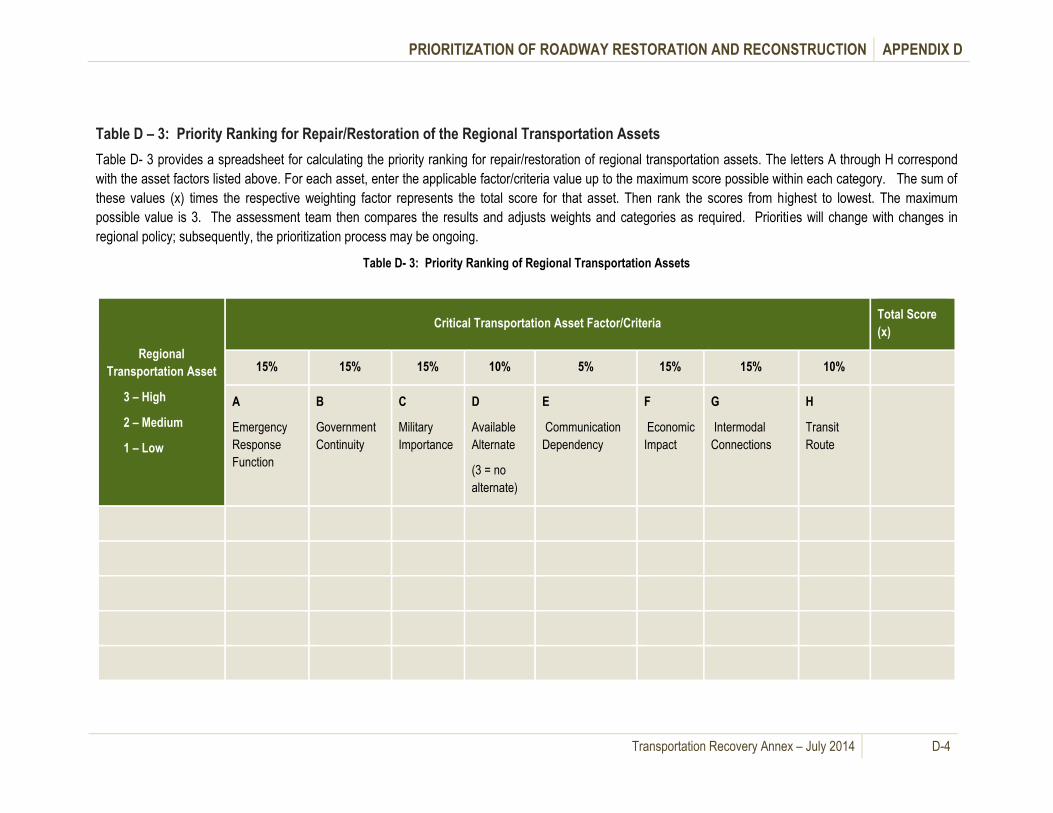
PRIORITIZATION OF ROADWAY RESTORATION AND RECONSTRUCTION APPENDIX D
Transportation Recovery Annex – July 2014 D-4
Table D – 3: Priority Ranking for Repair/Restoration of the Regional Transportation Assets
Table D- 3 provides a spreadsheet for calculating the priority ranking for repair/restoration of regional transportation assets. The letters A through H correspond
with the asset factors listed above. For each asset, enter the applicable factor/criteria value up to the maximum score possible within each category. The sum of
these values (x) times the respective weighting factor represents the total score for that asset. Then rank the scores from highest to lowest. The maximum
possible value is 3. The assessment team then compares the results and adjusts weights and categories as required. Priorities will change with changes in
regional policy; subsequently, the prioritization process may be ongoing.
Table D- 3: Priority Ranking of Regional Transportation Assets
Regional
Transportation Asset
3 – High
2 – Medium
1 – Low
Critical Transportation Asset Factor/Criteria Total Score
(x)
15% 15% 15% 10% 5% 15% 15% 10%
A
Emergency
Response
Function
B
Government
Continuity
C
Military
Importance
D
Available
Alternate
(3 = no
alternate)
E
Communication
Dependency
F
Economic
Impact
G
Intermodal
Connections
H
Transit
Route

Transportation Recovery Annex – July 2014 E-1
Roadway Toolbox Appendix E.
A. General Information
This section provides toolbox information for road and bridge assessments, mitigation strategies for use
in lessening the impact of roadway disruptions and resource information listings.
B. Roadway Assessments
A significant element of the recovery process for the roadway transportation system begins with the
assessment of damages to bridges and roadway structures and the sharing of this information among
local jurisdictions and the state. Information in this sub-section on inspection and damage assessments
of bridges are taken from the WSDOT “Handbook for the Post-Earthquake Safety Evaluation of Bridges”,
which is also referenced in the WSDOT EOP. The National Bridge Inspection Standards (NBIS) was
also used as a reference. This information can be utilized to gather initial assessment information for
transportation infrastructure, such as roads, bridges, retaining walls, seawalls, stairways, and tunnels,
and to aid in prioritizing restoration.
Table E- 1: The WSDOT Bridges and Roadway Structures Checklist provides a process for local
jurisdictions for inspecting bridges and coordinating with neighboring cities and/or counties upon closure
of bridges. It also contains information about coordinating with fire departments and considering
alternative transportation options for extended closures of bridges to island communities.
Table E- 1: Bridges and Roadway Structures Checklist
Bridges and Roadway Structures Checklist
√ Local Road Services Division – Level I Inspection of Bridges and Roadway Structures
Provide Level I inspection of local bridges and relay information to local EOC/ECC (See Figure E -2)
Walls (retaining, seawalls, sound barriers, etc.), stairways, and tunnels may be damaged or have collapsed. Level I inspection by local authorities (to the extent possible) should be conducted for other local roadway structures.
Coordinate traffic mitigation with neighboring cities or counties and local law enforcement.
Prioritize structures to be repaired/replaced within the city and/or county and send to State EOC, as needed for funding. (See Appendix D - Prioritization guideline procedures for damaged or collapsed road segments).
√ Identify Inspection Access Routes for Level II and III analysis
Provide routes based on observation (i.e. van-type, maritime (if over navigable waterway), helicopter) for personnel to inspect the roadway structures.
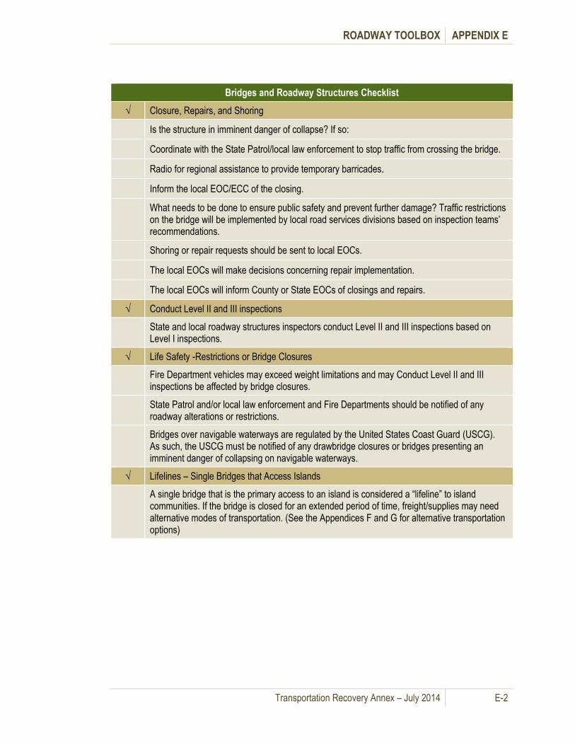
ROADWAY TOOLBOX APPENDIX E
Transportation Recovery Annex – July 2014 E-2
Bridges and Roadway Structures Checklist
√ Closure, Repairs, and Shoring
Is the structure in imminent danger of collapse? If so:
Coordinate with the State Patrol/local law enforcement to stop traffic from crossing the bridge.
Radio for regional assistance to provide temporary barricades.
Inform the local EOC/ECC of the closing.
What needs to be done to ensure public safety and prevent further damage? Traffic restrictions on the bridge will be implemented by local road services divisions based on inspection teams’ recommendations.
Shoring or repair requests should be sent to local EOCs.
The local EOCs will make decisions concerning repair implementation.
The local EOCs will inform County or State EOCs of closings and repairs.
√ Conduct Level II and III inspections
State and local roadway structures inspectors conduct Level II and III inspections based on Level I inspections.
√ Life Safety -Restrictions or Bridge Closures
Fire Department vehicles may exceed weight limitations and may Conduct Level II and III inspections be affected by bridge closures.
State Patrol and/or local law enforcement and Fire Departments should be notified of any roadway alterations or restrictions.
Bridges over navigable waterways are regulated by the United States Coast Guard (USCG). As such, the USCG must be notified of any drawbridge closures or bridges presenting an imminent danger of collapsing on navigable waterways.
√ Lifelines – Single Bridges that Access Islands
A single bridge that is the primary access to an island is considered a “lifeline” to island communities. If the bridge is closed for an extended period of time, freight/supplies may need alternative modes of transportation. (See the Appendices F and G for alternative transportation options)

ROADWAY TOOLBOX APPENDIX E
Transportation Recovery Annex – July 2014 E-3
Figure E- 1is the WSDOT flow chart for the post-earthquake inspection of bridges.
Figure E- 1: Flow Chart for the Inspection Procedure for Bridges (January 2011)
Source: WSDOT Handbook for the Post-Earthquake Safety Evaluation of Bridges
Table E- 2 provides a description of Inspector Qualifications, Methods and Objectives.
Legend:
Earthquake EQ
Inspection Procedure

ROADWAY TOOLBOX APPENDIX E
Transportation Recovery Annex – July 2014 E-4
Table E- 2: Inspector Qualifications, Methods and Objectives.
Inspector Qualifications, Methods and Objectives
Level I
First Response
Level II
Structural/Geotechnical
Inspection
Level III
In-Depth Inspection
Inspection
Area
All bridges within the area affected by the earthquake.
All bridges in the affected area except those that have complete span collapse.
All bridges recommended for further inspection by Level II teams.
Method of
Inspection
Rapid visual survey using:
Aerial view (helicopter), drive through, or traffic video-camera.
Hands on visual inspection using:
Ladders, ropes and safety harnesses, and any other available access equipment.
Hands on visual inspection supplemented with specialized equipment and/or personnel as required.
Personnel Region maintenance
Law enforcement
Incident response teams
News media
Bridge inspection team leaders
Civil/Structural PE’s
Civil/Structural PE’s
Geotechnical engineers
Bridge inspection team leaders
Objectives (1)Close obviously unsafe bridges.
(2) Identify routes that cannot be traversed.
(3) Identify vicinities with major damage.
(1)Close or restrict bridges.
(2) Open bridges deemed not critically damage but previously closed by Level 1 responders.
(3) Document inspection findings.
(4) Collect information for capacity and repair calculations.
(5) Establish baseline information (measurements, photos, etc.) for Level III inspections as necessary.
(6) Identify manpower and equipment needs for Level III inspection as necessary.
(1) Confirmation or adjustment of Level II restrictions.
(2) Follow up inspection to complete Level II assessment
(3) Establish repair recommendations.
(4) Develop and implement a structural monitoring plan as necessary.
Resources Any and all resources available.
Emergency Kits.
Standard bridge inspection equipment supplemented with water, food, and supplies for 72 hours per person.
“Handbook for the Post-Earthquake Safety Evaluation of Bridges”, see Chapter 4. Coordinate through the State EOC for further information.
Source: WSDOT Handbook for the Post-Earthquake Safety Evaluation of Bridges
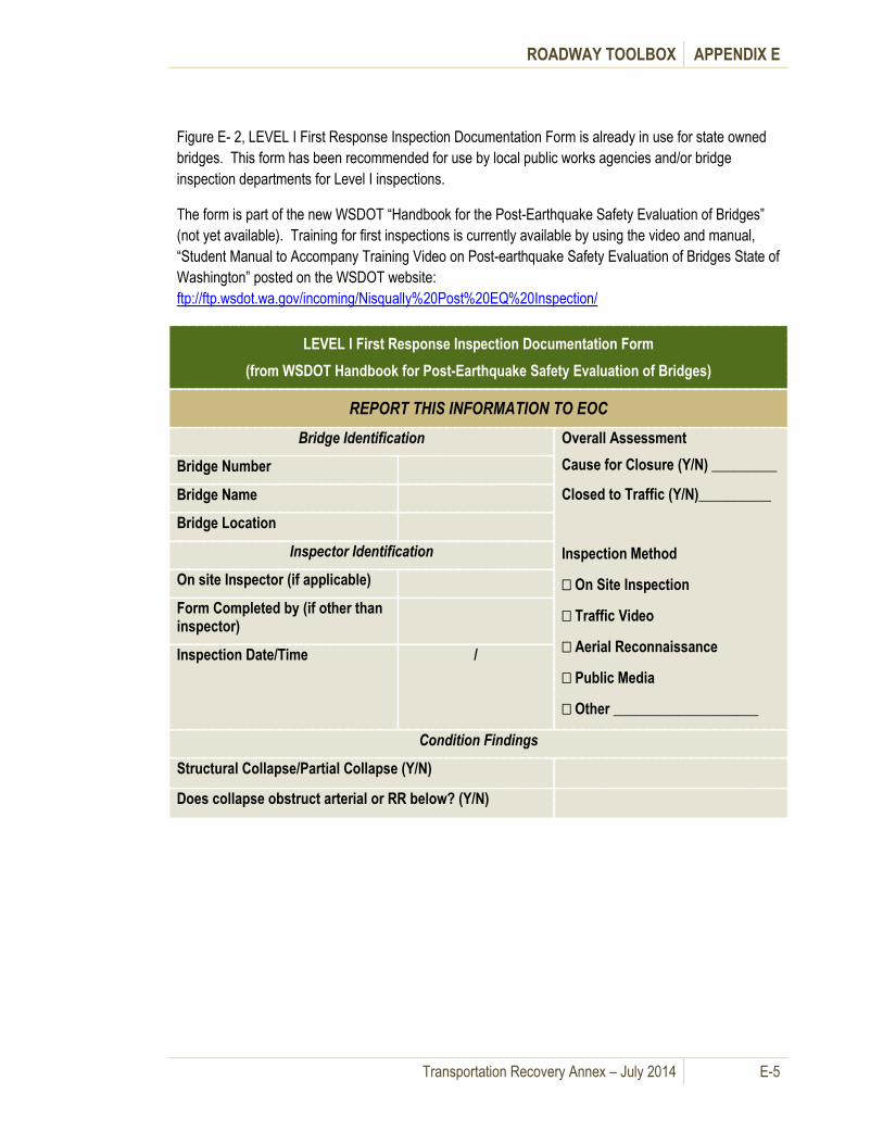
ROADWAY TOOLBOX APPENDIX E
Transportation Recovery Annex – July 2014 E-5
Figure E- 2, LEVEL I First Response Inspection Documentation Form is already in use for state owned
bridges. This form has been recommended for use by local public works agencies and/or bridge
inspection departments for Level I inspections.
The form is part of the new WSDOT “Handbook for the Post-Earthquake Safety Evaluation of Bridges”
(not yet available). Training for first inspections is currently available by using the video and manual,
“Student Manual to Accompany Training Video on Post-earthquake Safety Evaluation of Bridges State of
Washington” posted on the WSDOT website:
ftp://ftp.wsdot.wa.gov/incoming/Nisqually%20Post%20EQ%20Inspection/
LEVEL I First Response Inspection Documentation Form
(from WSDOT Handbook for Post-Earthquake Safety Evaluation of Bridges)
REPORT THIS INFORMATION TO EOC
Bridge Identification Overall Assessment
Cause for Closure (Y/N) _________
Closed to Traffic (Y/N)__________
Inspection Method
On Site Inspection
Traffic Video
Aerial Reconnaissance
Public Media
Other ____________________
Bridge Number
Bridge Name
Bridge Location
Inspector Identification
On site Inspector (if applicable)
Form Completed by (if other than inspector)
Inspection Date/Time /
Condition Findings
Structural Collapse/Partial Collapse (Y/N)
Does collapse obstruct arterial or RR below? (Y/N)

ROADWAY TOOLBOX APPENDIX E
Transportation Recovery Annex – July 2014 E-6
Figure E- 2: Level 1 First Response Inspection Documentation Form
LEVEL I First Response Inspection Documentation
Bridge Assessment
Yes
No
/No
t
Ap
plic
able
No
t In
spec
ted
Nee
ds
Lev
el II
Insp
ecti
on
Y/N
Structural Damage
A. Deck
1 Horizontal or vertical misalignment of deck or rails (take measurements of misalignment)
2 Fresh damage to rails, curbs, deck joints
3 Excessive deck joint openings (take measurements of opening)
4 Large settlements of bridge approaches (take measurements of settlement)
5 Other deck structural damage (describe below)
B. Superstructure
1 Settlement or shifting of girders (take measurements of settlement/shifting)
2 Spalling/cracking of girders (large and/or dense cracking visible from
30 feet or more justifies bridge closure)
3 Girder movement off of bearing supports (take measurements)
4 Bent or broken steel members
5 Other superstructure structural damage (described below)
C Substructure
1 Substructure movement – tilting, bending, settlement
2 Dense or large concrete cracks
3 Concrete spalling
4 Soil cracking and/or slumping under in immediate vicinity of bridge
5 Spalling of concrete above columns
6 Broken piles or columns

ROADWAY TOOLBOX APPENDIX E
Transportation Recovery Annex – July 2014 E-7
Note: Utility contact information is provided in sub-section G - Roadway repair and replacement
information.
Table E- 3 is the Highway Facilities Checklist listing highway facilities eligible for FHWA Emergency
Relief.
Table E- 3: Highway Facilities Checklist
Highway Facilities Checklist
Facilities (Examples of facilities eligible
for emergency relief within highway
right of way limits)
Operations and Maintenance
Pav
emen
t
Cra
ckin
g
Obs
erve
d
Dep
ress
ion
in P
avem
ent
Land
slid
e
Obs
erve
d
Dam
age
to
Str
uctu
re
Obs
truc
tions
Bui
ldin
g
Dam
age
Pon
ding
or
Blo
ckag
e Base Courses x x
Bike and pedestrian paths x x x x x
Bridges x x x x x x x
Corridor parking facilities x x x x x x
Cribbing or other bank control features x x x x x x
Culverts, pipes, and similar structures x x x x x x
7 Loss of soil under substructure
8 Other substructure damage (describe below)
Comments:
Utilities (Comment on utility damage – leaking pipes, live wires, etc.)
For any items listed as “not inspected” above, state reasons. Use alphanumeric reference for notes.

ROADWAY TOOLBOX APPENDIX E
Transportation Recovery Annex – July 2014 E-8
Highway Facilities Checklist
Facilities (Examples of facilities eligible
for emergency relief within highway
right of way limits)
Operations and Maintenance
Pav
emen
t
Cra
ckin
g
Obs
erve
d
Dep
ress
ion
in P
avem
ent
Land
slid
e
Obs
erve
d
Dam
age
to
Str
uctu
re
Obs
truc
tions
Bui
ldin
g
Dam
age
Pon
ding
or
Blo
ckag
e
Cut slopes x x
Drainage courses x x x x
Embankments x x x
Fences x
Guardrail x
Natural stream channels or manmade
channels, including riprap x x x x
Pavements or other surface courses x x x x x
Rest areas x x x x x
Retaining Walls x x x x
Shoulders x x x x x x
Signs and traffic control devices x x x x x

ROADWAY TOOLBOX APPENDIX E
Transportation Recovery Annex – July 2014 E-9
Table E- 4 provides bridge inspection contacts for the Puget Sound Region.
Table E- 4: Bridge Inspection Contacts for the Puget Sound Region (July 2010)
Bridge Inspection Contact List
Agency Contact Information
Pierce
Pierce County Public Works & Utilities
2702 South 42nd Street, Suite 201
Tacoma, WA 98409-7322
Phone: (253) 798-7250
King
Bridge Unit
Engineering Services Section
King County Road Services Division
201 S. Jackson St.
Seattle, WA 98104
Phone: (206) 296-6520
Phone: 1-800-527-6237 toll-free
Fax: 206-296-8754
TTY: 711 Relay Service
Island
Public Works Department
6th & Main, Coupeville, WA
Phone: (360) 679-7331
Fax: 360-678-4550
Snohomish
Bridge Design Group
5th floor, County Admin-East Building
3000 Rockefeller Ave., M/S 607
Everett, WA 98201
Phone: (425)-388-3196
Skagit
Public Works Department
1800 Continental Place
Mount Vernon, WA 98273
Phone: (360) 336-9400
Fax: (360) 336-9478

ROADWAY TOOLBOX APPENDIX E
Transportation Recovery Annex – July 2014 E-10
Bridge Inspection Contact List
Agency Contact Information
Kitsap
Department of Public Works
614 Division Street, Port Orchard, WA MS-26
Phone:(360) 337-5777
Fax:(360) 337-4867
Thurston
Thurston County Public Works (360) 709-3038
Mason
Mason County Public Works
100 W Public Works DR, Shelton WA 98584
Phone: (360) 427-9670 x450
WSDOT Highways and Local
Programs http://www.wsdot.wa.gov/localprograms/bridge/
WSDOT Bridge Preservation Office
Phone: (360) 480-4500 for single incident
Contact State EOC for multiple incidents
http://www.wsdot.wa.gov/eesc/bridge/index.cfm?fuseaction=office
_locations
FHWA – Washington Division http://www.fhwa.dot.gov/wadiv/opd.htm
Seattle http://www.cityofseattle.net/transportation/contact.htm
Tacoma
Tacoma Public Works Department
http://www.govme.org/govME/Admin/Inter/Contacts/AContacts.asp
x

ROADWAY TOOLBOX APPENDIX E
Transportation Recovery Annex – July 2014 E-11
Bridge Inspection Contact List
Agency Contact Information
Everett
Everett Public Works Department
3200 Cedar St.
Everett, WA 98201
Phone: 425-257-8800
Fax: 425-257-8882
Bellevue
Service First Desk
450 110th Ave. NE
P.O. Box 90012
Bellevue, WA 98009
Phone: (425) 452-6800
Renton
Renton Public Works Department
1055 S Grady Way
Renton, WA 98057-3232
Phone: (425) 430-7204
Tukwila
City Public Works Dept.
6300 Southcenter Blvd # 100
Tukwila, WA 98188-8548
Phone: (206) 433-0179
Mount Vernon
Public Works Department
1024 Cleveland Ave.
Mount Vernon, WA 98273
Phone: (360) 336-6204
Fax: (360) 336-6299
Mill Creek Public Works Dept.
http://www.cityofmillcreek.com/DEPARTMENT%20PAGES/PUBLI

ROADWAY TOOLBOX APPENDIX E
Transportation Recovery Annex – July 2014 E-12
Bridge Inspection Contact List
Agency Contact Information
C%20WORKS%20MAIN%20PAGE.html
Kent
Kent Public Works Department
5821 S 240th St
Kent, WA 98032
Phone: (253) 856-5600
Auburn
Auburn City Public Works
25 W Main St
Auburn, WA 98001-4916
Phone: (253) 931-3010
Bothell
Public Works Department
Dawson Building
9654 NE 182nd St.
Bothell, WA 98011
Phone: (425) 486 2768
Issaquah
Issaquah City Public Works
1775 12th Ave NW, Issaquah, WA 98027-8938
Phone: (425) 837-3400

ROADWAY TOOLBOX APPENDIX E
Transportation Recovery Annex – July 2014 E-13
C. Transportation Mitigation Strategies
Transportation mitigation strategies are grouped into four (4) categories based on the desired results.
The strategies are classified as Increasing Capacity on Existing Lanes, Technology, Diverting or
Redirecting Traffic and Demand Management.
Table E- 5 provides an overview of transportation mitigation strategies, from how to increase capacity on
existing lanes to demand management, organized by the phase of the recovery effort in which they
usually occur. It lists general transportation mitigation strategies and identifies which of the individual
strategies can be applied during short-, mid- or long-term phases of recovery. (See Appendix 2 for
applications to specific mitigation strategies associated with each disruption scenario.) Subsequent
sections describe each set of strategies, and provide information on how it fits into the overall recovery
plan, with considerations for ease of implementation.

ROADWAY TOOLBOX APPENDIX E
Transportation Recovery Annex – July 2014 E-14
Table E- 5: Transportation Mitigation Strategies
Transportation Mitigation Strategies
Strategies
Phases
Comments Short-
Term
Mid-
Term
Long-
Term
Increase Capacity on Existing Lanes
Operate Contraflow Lanes √ √ √
Utilize Reversible Lanes √ √ √
Restrict Lanes for HOV or BAT √ √ √
Provide HOV Bypass at
Bottlenecks √ √ √
Utilize the Shoulder of a
Roadway as an Additional Traffic
Lane
√ √ √
Eliminate/Restrict On-street
Parking √ √ √
Reduce Lane Widths to
Accommodate Additional Lanes √ √ √
Ramp Metering √ √ √
Increase Transit Service √ √ √
Increase Ferry Service √ √ √ See Appendix F – Waterways
Toolbox
Improve Transportation Incident
Management √ √ √
Implement Traffic Management
Technology √ √ √
Change Signal Timing to
Accommodate Changed Travel
Patterns
√ √ √
Reprioritize Current
Transportation Projects √ √ √ See Appendix D - Prioritization
Divert or Redirect Traffic
Revise Transit Routes √ √ √

ROADWAY TOOLBOX APPENDIX E
Transportation Recovery Annex – July 2014 E-15
Transportation Mitigation Strategies
Strategies
Phases
Comments Short-
Term
Mid-
Term
Long-
Term
Construct Bypass Roadway √ √ √
Close Selected Freeway On/Off
Ramps √ √ √
Relocate Ferry Service √ √ See Appendix F – Waterways
Toolbox
Manage Truck Usage √ √ √
Designate Emergency
Responder Routes √ √ √
Conversion of non-motorized
trails to restricted use √
Demand Management
Tele-Commuting √ √ √
Staggered Work Shifts √
Compressed Work Week √ √ √
Passenger-Only Ferry Service √ √ √ See Appendix F – Waterways
Toolbox
Congestion Pricing √
Vanpool/Carpool Incentives √
Additional Park and Ride Lots √ √ √
Increase Bicycle Usage √ √ √
HOV Designation √ √ √
1. Strategies for Increasing Capacity on Existing Lanes
a. Operate Contraflow Lanes
This involves increasing the capacity for travel in one direction by using a lane or lanes that normally
serve opposing traffic. Depending on traffic volumes and other available routes, contraflow lanes can be
used intermittently, temporarily during construction or permanently. Setting up contraflow lanes can take
several months, and involve a detail review of safety and operating procedures. Some construction may
be required at the physical start and end of the lanes, and this often requires extensive signing and

ROADWAY TOOLBOX APPENDIX E
Transportation Recovery Annex – July 2014 E-16
installation of safety devices. The planning and activation of contraflow lanes demands extensive
coordination between the operating agency and law enforcement.
b. Utilize reversible lanes
This involves changing the direction of traffic flow in a lane or lanes, typically depending on time of day.
This strategy is most commonly used to accommodate morning and evening peak traffic by switching
the direction of traffic at preset times. Reversible lanes usually occupy a dedicated and physically
separated roadway within the right of way. Setting up reversible lanes can take many months, and
involve a detail review of safety and operating procedures. Some construction may be required at the
physical start and end of the lanes, and this often requires extensive signing and installation of safety
devices. The planning and execution of reversible lanes demand extensive coordination between the
operating agency and law enforcement.
c. Restrict lanes for HOV or BAT
This involves reserving a traffic lane or lanes for a
specialized use such as high occupancy vehicles
(HOV), transit only or business access and transit
(BAT) lanes. HOV lanes provide a less
congested lane compared to the remaining
general purpose lanes, thus providing an
incentive for drivers to use transit and/or
carpooling/vanpooling. HOV lanes on freeways
are normally the leftmost lane(s), while HOV
lanes on arterial roadways are typically the
rightmost lane (BAT lane) or shoulder, where
buses can easily make pickups and drop-offs.
Cars and trucks are also allowed to use this lane for access to local business driveways. The public
often resists conversion of general use lanes to HOV use because single occupant drivers represent the
majority of road users. Converting shoulders to HOV use is often easier to implement, but decision-
makers must evaluate safety issues concerning vehicle breakdowns. Implementation requires minimal
construction, but may require extensive signing and pavement markings, and may require adjustment of
the HOV designation.
d. Provide HOV bypass at bottlenecks
This involves increasing passenger throughput by providing priority to high occupancy vehicles at
strategic locations where bottlenecks occur on a regular basis. The bypass can be limited to buses or
include all HOVs. Jurisdictions use the bypass concept in a wide range of circumstances, from simple
use of a shoulder for a short distance at a merge point, up to construction of a separate roadway section
that bypasses a congested section or exit ramp. HOV bypass lanes provide an incentive for transit and
carpooling/vanpooling by reducing travel time. HOV bypass lanes often have high value, since they
frequently require little or no construction to provide preferential treatment for HOV vehicles.
Conversion may take several forms.
Conversion of a regular traffic lane or
shoulder to HOV or BAT lanes.
Conversion of entire roadways to HOV
and/or transit only.
Operating an HOV lane in a contraflow
or reversible configuration.

ROADWAY TOOLBOX APPENDIX E
Transportation Recovery Annex – July 2014 E-17
e. Utilize the shoulder of a roadway as an additional traffic lane
Many roadways have shoulders of sufficient width to accommodate passenger vehicles. However, any
proposed use for a long period of time may require strengthening of the pavement prior to use,
prohibiting heavy vehicles from the lane, or reconstruction of the pavement at a later date.
Local streets may require restriction of truck traffic
from a converted shoulder lane. Planners must
evaluate traffic conditions up and downstream from
the section to determine if this strategy has benefit, but
often, implementing this strategy requires only signs
and pavement markings.
f. Eliminate/restrict on-street parking
This involves removing parked cars from the roadway to provide an additional traffic lane. Jurisdictions
can easily implement the restriction, and use it intermittently (peak hours), temporarily or permanently,
but it requires enforcement. Intersection geometry may reduce capacity due to insufficient turning radii
similar to utilizing the shoulder lane. The biggest hurdle for implementing this strategy is the impact to
residences and businesses along the route. Providing alternative parking areas or restricting the hours
can help reduce local impact.
g. Reduce lane widths to accommodate additional lanes
This involves restriping an existing pavement to provide additional lanes. For example, a three-lane
section with lanes of the standard freeway width of 12
feet can be restriped to four nine-foot wide lanes in
the same 36 feet of pavement. Additionally, restriping
can incorporate any pavement width gained by
utilizing the shoulder areas or removing parking.
Reduced lane widths producing an additional travel
lane can often provide critically needed capacity
through the most congested areas. Authorities may
need to impose slower speed limits in these sections
along with a review of large truck usage (the largest
tractor trailers are 8.5’ in width) and roadway
geometry.
h. Meter ramps
This involves controlling the rate at which vehicles enter a freeway section to minimize disruption to the
traffic flow on the mainline. Individual ramp metering can be responsive to demand and capacity in real
time, or be programmed to a constant flow rate based on historical data. Ramp metering can be added
with minimal construction.
i. Increase transit service
This involves adding and expanding transit service to increase passenger carrying capacity. This
strategy may take the form of increased frequency, expanded hours of operation, additional routes, etc.
On non-freeway sections, insufficient
turning radii at intersections may
reduce capacity to less than that of a full
travel lane.
Transit usage is a key component
of transportation recovery, since
transit operations can move larger
numbers of people, and managers can
adjust routes to accommodate breaks
in the transportation system and
possible relocation of ferry service.

ROADWAY TOOLBOX APPENDIX E
Transportation Recovery Annex – July 2014 E-18
and may require an increase in vehicle fleet and adjustment in vehicle size. Roadway geometry must be
considered along with routing for buses, since minimum turning radius is a concern with large buses.
j. Increase ferry service
This involves increasing frequency and expanding hours of operation to increase passenger carrying
capacity. This may require an increase in vessel fleet and adjustment in vessel size, which must be
matched with terminal/dock specifications. Passenger-only service (in smaller vessels) may be the only
ferry service feasible for some locations.
2. Strategies Utilizing Technology – Can be implemented alone but will have a greater impact when integrated with other strategies.
a. Improve transportation incident management
This involves instituting or strengthening “quick clearance” practices such as roving emergency service
patrols, stationing of tow trucks at critical locations, incident detection technology, coordinated dispatch
efforts and shared services. Jurisdictions can implement some individual measures quite easily.
However, others may require quick clearance legislation as well as coordinated policy adoption among
different agencies (e.g. DOT and law enforcement).
b. Implement traffic management technology
This involves monitoring the transportation system by implementing traffic management technologies to
improve basic operations and provide responsiveness in real time. Detection, verification, response and
information dissemination are the basic requirements for responding to those daily traffic incidents that
disrupt the system. The real time monitoring and response afforded by technology allows for flexibility in
applying (or suspending) certain strategies as conditions warrant. Technology also provides flexibility for
command center location and for coordinated response.
c. Install and use of electronic message signs
This involves quickly disseminating travel information to motorists, which is critical during emergency
operations.
d. Change signal timing to accommodate changed travel patterns
This involves revising signal timings to accommodate changes in volume, priority, or travel patterns.
Adding green time to an approach will increase capacity in that direction; however, signal changes will
complement numerous other strategies. Computerized and interconnected signal systems will
automatically adjust within certain limits, but most signals will require manual intervention. Timing
changes are relatively easy to implement, but some strategies will also require changes to traffic control
hardware (i.e., traffic signal heads or traffic signal controllers).
e. Reprioritize current transportation projects
This involves reassessing capital and operating resources at the time of the incident for immediate
response as well as longer-term strategies. A reassessment of project priorities could result in actions as
drastic as stopping ongoing projects to divert resources or because they are rendered ineffective by the
incident being addressed. The assessment should cross all modes and be done in coordination with
regional agencies.
ROADWAY TOOLBOX APPENDIX E
Transportation Recovery Annex – July 2014 E-19
3. Strategies to Divert or Redirect Travel
a. Revise transit routes (including add or remove routes)
This involves responding to the changes in travel patterns by serving those areas to which travel has
been diverted. Traditional routes may be disrupted either by the incident or the travel pattern changes
resulting from the response. Typically, new routes will serve traffic intercepted at new or existing park
and ride locations, areas whose auto commuter route has been disrupted or temporary relocation of
major employers.
b. Construct bypass roadway
This involves providing a temporary roadway
section to bypass a damaged or congested section
or a construction project. While constructing a new
roadway section is more complicated to
implement, removing all traffic from a roadway
section or bridge to be repaired can substantially
reduce construction time.
c. Close selected freeway on/off ramps
This involves reducing traffic demand on specific sections of roadway by diverting vehicles to roadways
with more capacity and/or away from areas of concern. Easy to implement, this strategy requires
coordinated diversion planning and advance communication of alternate routes to the traveling public.
d. Relocate ferry service
This involves responding to altered travel patterns by relocating ferry services, consistent with revising
transit routes. This may require intergovernmental or public-private agreements to repurpose marine
facilities and equipment. Planners will require an inventory of terminal/dockage facilities at candidate
locations to determine the type and size of vessels that can be accommodated. This strategy requires
coordination with the reconfigured roadway and transit networks.
e. Manage truck usage
This involves increasing throughput by managing
truck traffic in the affected or congested areas.
These solutions are specific to the nature of the
trucking activity that was present in the affected area
(e.g. port vs. downtown).
Strategies for giving preference to trucks as an
incentive to change travel patterns (route, hours, or
frequency) include dedicated roadways, off-peak toll
discounts, and relaxed delivery restrictions. Some conditions will necessarily require limiting truck traffic
at certain times of the day, on certain roadways or on bridges with weight limits.
f. Designate emergency responder routes
This involves utilizing certain routes or travel lanes as emergency responder routes and prohibiting use
by other vehicles during an incident. This requires coordinated response planning and a documented
The Bypass can provide a short connection
to a parallel roadway, a temporary bridge
structure; or a more permanent section that
can serve a portion of the traffic. In some
cases, construction of new freeway ramps
can create a more regional bypass route.
Other considerations in developing
specific truck usage plans:
The commodity being transported;
The ability to control delivery
schedules;
Alternatives available both locally and
regionally.
ROADWAY TOOLBOX APPENDIX E
Transportation Recovery Annex – July 2014 E-20
implementation plan that crosses jurisdictional boundaries. Restricting entire roadways, contraflow
lanes, and other priority vehicle techniques can be employed to accommodate emergency vehicles.
g. Convert non-motorized trails to restricted use
This involves temporarily converting existing trails to non-standard roadway configurations for emergency vehicles, construction vehicles or other professionally driven vehicles (e.g. tram) to reach areas inaccessible by existing roadways.
4. Strategies for demand management –
This is typically implemented as voluntary solutions to everyday congestion. Development of a plan for
these strategies need not wait for an emergency. Implementing strategies involving employees often
requires employers to voluntarily develop internal policies and procedures.
a. Tele-commute
This involves encouraging/allowing employees to work from home or other remote location to reduce the
traffic demand for access to/through affected areas. This could involve providing space in a privately
owned or leased facility, or a government sponsored internet Wi-Fi location. The employer would set
number of days per week or length of time for the program. While not difficult to implement, many jobs
cannot be done by telecommuting.
b. Stagger work shifts
This involves changing the start and finish times of employees to lessen the peak traffic demand on the
system. Major employers can adopt this strategy independently. , Groups of smaller employers could
introduce a coordinated program. Times shifted by as little as 15 minutes can be effective in “spreading
out” the peak hour traffic demand. While more severe circumstances require a greater change,
employee trip demand is relatively easy to analyze and implement. This may require adjusting transit
schedules to accommodate altered travel patterns.
c. Compress the work week
Reducing the number of workdays per week can reduce traffic
demand on certain roadway and transit sections significantly.
For example, allowing 40-hour employees to work 4 10-hour
days instead of 5 8-hour days reduces the weekly number of
commute trips from that location by 20%. While employees
are free to drive on the 5th day, it is unlikely that they will drive
into the employment centers in the peak traffic hours on that
day. Additionally, the longer days will likely have them
commuting outside the peak hours. This strategy will have a similar impact on transit demand, but may
require adjusting transit schedules.
d. Convert to passenger-only ferry service
This involves prohibiting vehicles on commuter ferries completely, or during certain times of the day or
week. This directly reduces the number of vehicles entering the roadway network. This alternative is
particularly applicable at those locations identified for new or relocated service where terminal/dockage
Origin and destination
surveys of ferry passengers
can provide information for
evaluating the services needed
to support the passenger-only
ferry service option.
ROADWAY TOOLBOX APPENDIX E
Transportation Recovery Annex – July 2014 E-21
facilities will only permit smaller vessels. It requires adequate parking and transit connections at either
end of the trip, as well as alternate means for those for whom the transit is not available.
e. Use cost incentives (congestion pricing)
This involves encouraging travel outside of the peak hour by charging higher tolls during congested
hours, and less at other times on existing toll roads and bridges. On other facilities certain lanes can be
reserved and tolled in this manner and work in conjunction with HOV lanes (called high occupancy toll
lanes (HOT lanes)). Tolls can be waived for certain vehicles or during emergencies. Tolls can also vary
by time of day, congestion level, and number of occupants in the vehicle.
f. Use vanpool/carpool incentives
This involves reducing the number of “single occupant vehicles” on the roadway network through
incentives for ridesharing provided by employers and government partners. Existing programs include
incentives such as employers providing vehicles and insurance, providing a cash subsidy for those that
use transit or regional vanpools, guaranteeing a ride home for an emergency during the workday and
providing flexible work hours to accommodate ridesharing schedules.
g. Provide additional park and ride lots
This involves providing parking facilities to intercept single occupant vehicles before they travel into the
affected or congested area. This is effective in reducing overall traffic demand if frequent and adequate
transit and ridesharing opportunities are available and the cost of parking plus transit is not a
disincentive. Ease of implementation varies with location and size. Local inventories of potential park
and ride locations are helpful during an emergency.
h. Increase bicycle usage
This involves encouraging the use of bicycle transportation by providing accommodations such as
bicycle racks on transit and at worksites, and relocating rather than eliminating bike routes when utilizing
travel lanes to increase vehicle capacity.
i. Increase HOV occupancy requirement
Changing the requirement for HOV use will affect usage of the HOV lane. Currently, most HOV
designations in the region require 2 occupants, a driver and one passenger (HOV-2). HOV lanes work
because there are fewer vehicles in the HOV lane compared to the general use lanes, thus providing a
quicker trip for the HOV users. When HOV lane usage approaches that of the general use lanes,
congestion becomes equal in all lanes, providing no incentive for the HOV users. At this point,
consideration should be given to changing the definition of HOV to a higher occupancy requirement.
d. Roadway repair and replacement information
This section provides information in the repair and replacement of damaged roadways and structures
following a disaster incident that will assist transportation recovery efforts. It includes operational
information for coordinating with utilities, hiring contractors and replacing structures. It is not intended to
replace local or state agency policies. Rather, it helps the reconstruction effort by informing emergency
planners and elected officials of roadway options. Table E- 6 is a summary of roadway repair and
replacement elements.

ROADWAY TOOLBOX APPENDIX E
Transportation Recovery Annex – July 2014 E-22
Table E- 6: Repair and Replacement Elements
Repair and Replacement Elements
Elements Phase Comments
Short-
Term
Mid-
Term
Long-
Term
Assess bridges and roadway
structures
√ √ √ See Roadway Toolbox - sub-
section B
Prioritize segment restoration √ √ √ See Prioritization in Appendix D
Repair bridges and roadway
structures
√ √ √
Replace bridges and roadway
structures
√ √
Coordinate with utility purveyors for utilities in roadway rights-of-way
√ √ √
Provide engineering contract
mechanisms
√
1. Repair bridges and roadway structures
Repairable structures that restore most of the lost regional networks are high priority, and demand
extensive coordination between the operating agency, public works, law enforcement, utility purveyors
and other stakeholders during their planning and repair. Repairing roadway structures may require
additional detours, and possibly some construction for signing and installation of safety devices at the
physical start and end of the damaged section.
2. Replace bridges and roadway structures
Replacement or partial replacement of roadway structures
requires substantial coordination during both planning and
replacement among local and state officials, including the
operating agency, public works, law enforcement, utility
purveyors, and other stakeholders affected by the structure
damage.
Because replacement for some structures involves long-term construction projects, it is necessary to set
up contracts ahead of time. See Appendix F for alternative maritime transportation options and the
Roadways Mitigation Strategies included in this Appendix. Replacing structures may require additional
detours for traffic to access the structure to perform the repairs.
Replaceable structures that
allow for increased capacity
of the regional network are
high priority.

ROADWAY TOOLBOX APPENDIX E
Transportation Recovery Annex – July 2014 E-23
Options for restoration of collapsed roadway structures include:
Replace roadway back to its pre-disaster state
Improve roadway section (i.e. add lanes, add pedestrian & bicycle lanes, revise channelization, add high capacity transit lane)
Re-locate roadway section
Re-locate utilities within ROW
Refer to Section VII for funding eligibility for replacing structures. Following are general options to
consider prior to replacing the structure:
3. Coordinate with utility purveyors for utilities in roadway rights-of-way
Utilities located within the rights-of-way should be coordinated with the roadway reconstruction efforts.
Upon roadway segment failure, identify all utilities within the rights-of-way and contact the respective
utility purveyor or district. Table E- 7 provides a list of utilities and contact information.

ROADWAY TOOLBOX APPENDIX E
Transportation Recovery Annex – July 2014 E-24
Table E- 7: Utility Purveyors and Contact Information (January 2011)
Utility Purveyors and Contact Information
Utility Contact Information
Electric & Natural Gas
Puget Sound Energy Customer Service (Emergencies)
1-800-552-7171 (Gas) 1-800-245-7875 (Power)
Cascade Natural Gas (Bremerton Area)
www.cngc.com
Olympic Pipeline Emergency - Renton Control Center/Operations: 425-224-8880
Main (425) 235-7736
Land and ROW - [email protected] (425) 981-2506
Telecom Contact the local EOC and/or Public Works Department for the county
or city
Fiber Optic Contact the local EOC and/or Public Works Department for the county
or city (Note: Request information about school districts which also
have fiber optic utilities)
Domestic Water & Raw Water
(Transmission Mains)
Contact the local EOC and/or local Public Works Department
Sanitary Sewer Contact the local EOC and/or local Public Works Department
Stormwater Contact the local EOC and/or local Public Works Department
Steam & Condensate Return
Pipes
Seattle Steam Company
Emergency
(206) 623-0442
Office address:
1325 Fourth Avenue, Suite 1440
Seattle, WA 98101
Telephone: 206.623.6366
Fax: 206.467.6394
Propane Gas Various vendors

ROADWAY TOOLBOX APPENDIX E
Transportation Recovery Annex – July 2014 E-25
4. Provide engineering contract mechanisms
Each jurisdiction has methods for hiring contractors. WSDOT has procedures in place for hiring
contractors which allow for expedited reconstruction. Table E- 8 provides an overview of methods for
hiring contractors.
Table E- 8: WSDOT Emergency Contracting (January 2011)
WSDOT Emergency Contracting
Method Agency Contracting Cost Limitations
State Forces (RCW 47.28.030) WSDOT Yes State forces can be used up to $100,000 of the cost of the project.
Force Account Contract 30 Days
or Less WSDOT Region Level Contract
Contract Without Bid WSDOT Region Level Contract
Contract With Bid Without
Advertisement WSDOT Region Level Contract
When an emergency occurs, the WSDOT needs to determine if the emergency requires a “Declaration
of Emergency”. A “Declaration of Emergency” is required whenever it is necessary to utilize emergency
contracting procedures for work related to transportation facilities and to increase the limit for State
Force repair work from $60,000 to $100,000.
If the event is large enough (defined as: Widespread Area of Catastrophic Failure with a minimum repair
cost of $700,000) that federal “Emergency Relief” funding will be pursued, the Region needs to complete
a Detailed Damage Inspection Report (DDIR) that will be forwarded to the Federal Highways
Administration (FHWA) in Olympia.
A Declaration of Emergency authority is delegated from the Secretary of Transportation to the Regional
Administrators and the Directors of Aviation and Ferries for all work directly or indirectly related to
transportation facilities. This also includes all work affecting property owned or used by their
headquarters organization. For further information regarding the Declaration of Emergency authority
see the WSDOT Emergency Relief Procedures Manual M 3014.01 (February 2007).
Communities should consider “Design-build" contracting to expedite reconstruction along with WSDOT’s
methods for hiring contractors. Design-build contracting allows for one entity (namely, the design-build
contractor) to be contracted to the Owner. Procedures for design-build contracts and reimbursements
from the State or local governments should be in place prior to a disaster.

ROADWAY TOOLBOX APPENDIX E
Transportation Recovery Annex – July 2014 E-26
D. Transit Resources
Table E- 9 provides a summary of regional transit resources and routes.
Table E- 9: Roadways (Bus and Streetcar) Transit Systems (January 2011)
Transit System Fleet Service Area Additional/Connecting
Service
Regional (King,
Pierce,
Snohomish
Counties):
Sound Transit
259 buses by late
2011; 38 light rail
cars, 58 commuter
rail cars and 11
locomotives
Express bus service to cities in
King, Pierce and Snohomish
Counties
Light rail service in King and
Pierce Counties. Sounder
commuter rail and
connections with bus service
operated by Skagit Transit,
Island Transit, Everett
Transit, Community Transit,
King County Metro, Pierce
Transit and Intercity Transit.
Island County:
Island Transit
65 total buses in the
fleet, including 10 on
Camano Island
92 vanpool vehicles
in the fleet
21 fixed routes, para-transit
and vanpool service throughout
Island County
Connects in Mt. Vernon with
Skagit Transit, Whatcom
Transit and Amtrak. In
Stanwood connects with
Community Transit, in
Everett connects with
Community Transit, Sound
Transit, Skagit Transit, Metro
and Amtrak. Also connects
with Port Townsend and
Mukilteo Ferries.
King County: King
County Metro
1,443 vehicles,
including standard
and articulated
buses, electric
trolleys, dual-
powered and hybrid
diesel-electric buses
and streetcars
1,073 Rideshare
vans
223 fixed routes over a 2,134
square mile area in King
County, with 13 transit centers;
1.3-mile electric bus and light
rail tunnel underneath
downtown Seattle; and peak-
hour freeway express
commuter service using the
region's network High
Occupancy Vehicle (HOV)
lanes
Future plans include:
RapidRide peak hour Rapid
Transit network that will
utilize five corridors in King
County, totaling 53 miles.
Seattle Streetcar Network,
which will radiate from
downtown Seattle to various
Seattle neighborhoods.
Kitsap County:
Kitsap Transit
120 buses
160 vanpool vehicles
47 fixed routes throughout
Kitsap County
Connects to transit systems
in Jefferson, Mason, Pierce
Counties, and Washington
State Ferries.
40 buses 8 fixed regional routes and Connects to transit systems

ROADWAY TOOLBOX APPENDIX E
Transportation Recovery Annex – July 2014 E-27
Transit System Fleet Service Area Additional/Connecting
Service
Mason County:
Mason Transit
28 total vanpool
vehicles, of which a
maximum 24 are
assigned
Dial-A-Ride service throughout
Mason County
in Kitsap, Jefferson, Clallam,
Grays Harbor, Pierce and
Thurston Counties. Shelton
school buses open to
general public to connect
with transit systems.
Pierce County:
Pierce Transit
270 buses and para-
transit vehicles
321 vanpool vehicles
50 fixed routes over 414-
square-mile area in Pierce
County, with 11 transit centers
and stations; SHUTTLE service
for disabled passengers.
Connects to surrounding
regional transit systems,
including ferries and trains.
Skagit County:
Skagit Transit
38 buses and para-
transit vehicles; 40
vanpool vans
11 fixed routes plus vanpools
and Dial-A-Ride service
throughout Skagit County
Express service to Island
and Whatcom Counties,
Everett, and Bellingham.
Pocket service for area ¾
mile outside fixed route
service.
Snohomish
County:
Community Transit
344 buses (plus 54
DART vans and 15
Swift Transit buses);
400 vanpool vans
28 local routes (including Swift)
and 25 commuter routes
throughout Snohomish County,
and to downtown Seattle,
University of Washington and
eastside suburbs of Seattle
Swift Transit: 17 miles on
Highway 99 from Everett to
Shoreline transit-station -
contracted to operate 5
additional Sound Transit
routes from Snohomish to
King County
Everett Transit
49 buses
24 bus routes in Everett and
Marysville, service to Mukilteo
Ferry Dock
Connections to Community
Transit, Sound Transit,
Skagit Transit, Island Transit
and AMTRAK
Thurston County:
Intercity Transit
68 Coaches, 33 para-
transit vehicles, 230
vanpool vans
20 local routes serving four
urban cities in Thurston County
including DAL service for
ADA/disabled riders. Two inter‐
county express routes between
Olympia/Lakewood/Tacoma.
Regional connections with
Mason, Grays Harbor, Rural,
CAP, Pierce and Sound
Transit Systems, as well as
Amtrak and Greyhound
services.
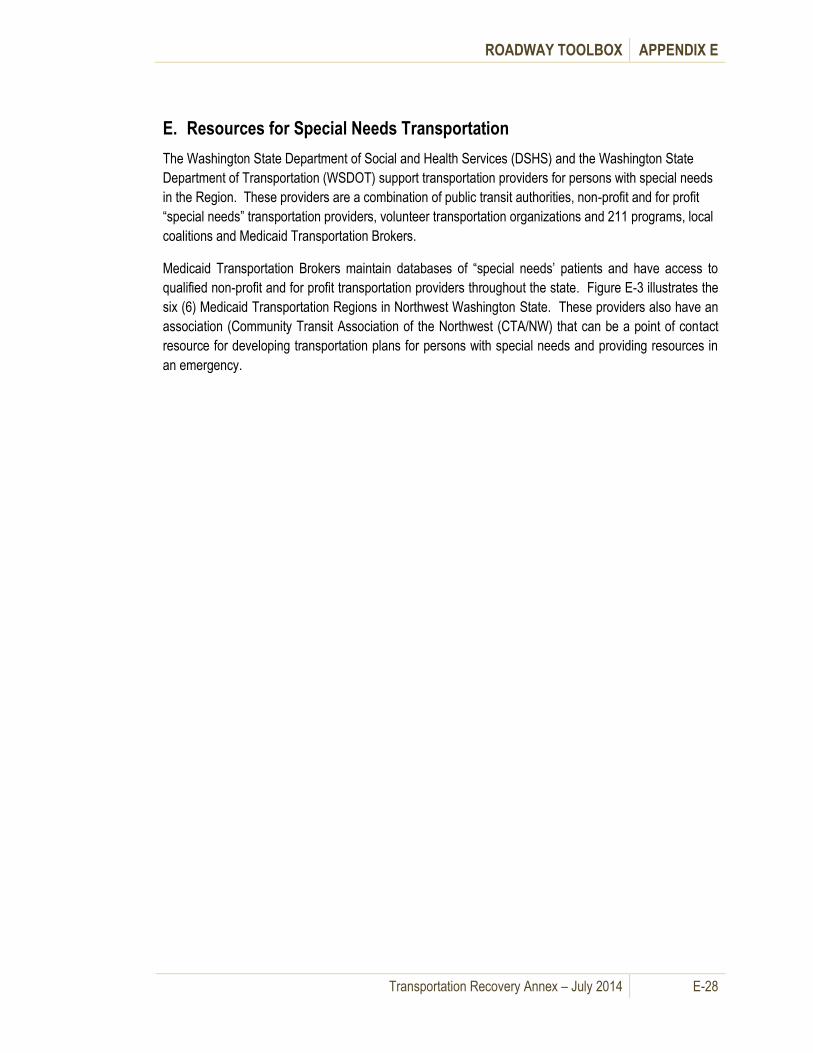
ROADWAY TOOLBOX APPENDIX E
Transportation Recovery Annex – July 2014 E-28
E. Resources for Special Needs Transportation
The Washington State Department of Social and Health Services (DSHS) and the Washington State
Department of Transportation (WSDOT) support transportation providers for persons with special needs
in the Region. These providers are a combination of public transit authorities, non-profit and for profit
“special needs” transportation providers, volunteer transportation organizations and 211 programs, local
coalitions and Medicaid Transportation Brokers.
Medicaid Transportation Brokers maintain databases of “special needs’ patients and have access to
qualified non-profit and for profit transportation providers throughout the state. Figure E-3 illustrates the
six (6) Medicaid Transportation Regions in Northwest Washington State. These providers also have an
association (Community Transit Association of the Northwest (CTA/NW) that can be a point of contact
resource for developing transportation plans for persons with special needs and providing resources in
an emergency.
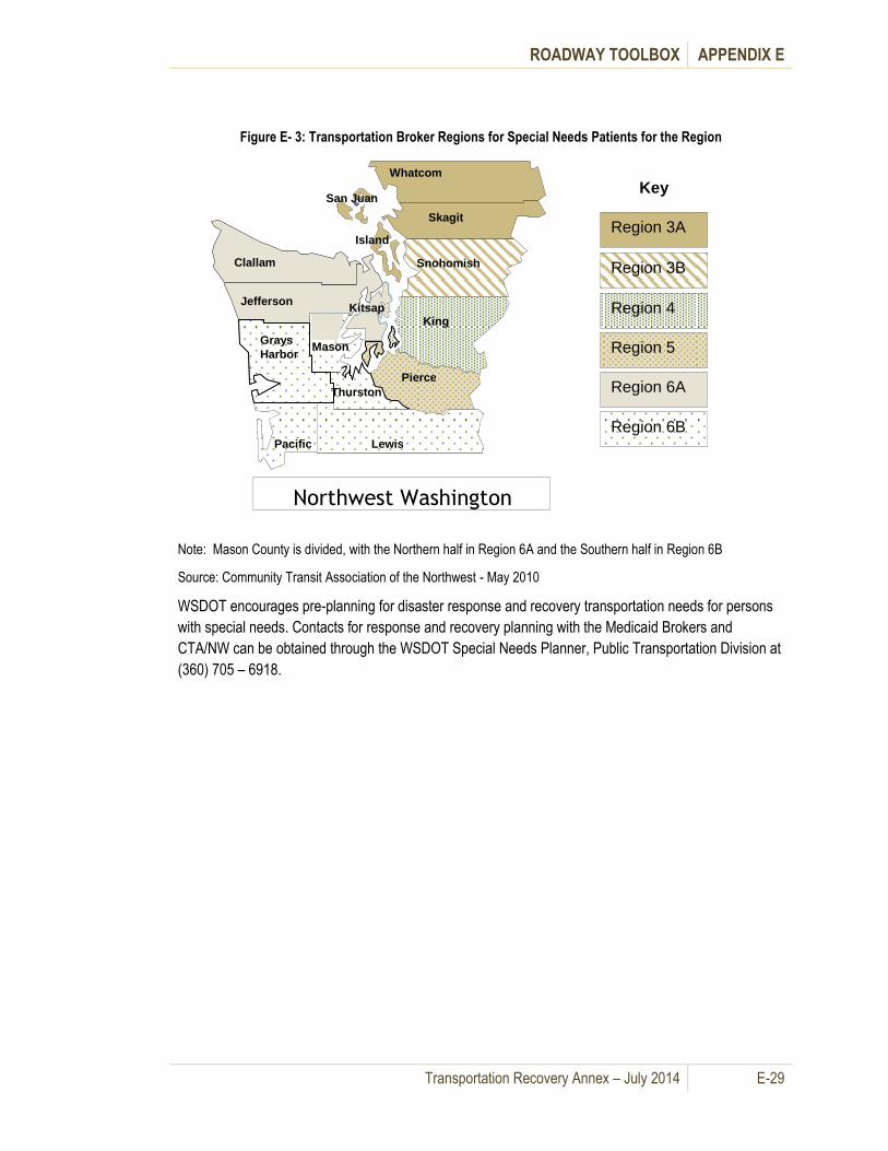
ROADWAY TOOLBOX APPENDIX E
Transportation Recovery Annex – July 2014 E-29
Figure E- 3: Transportation Broker Regions for Special Needs Patients for the Region
Note: Mason County is divided, with the Northern half in Region 6A and the Southern half in Region 6B
Source: Community Transit Association of the Northwest - May 2010
WSDOT encourages pre-planning for disaster response and recovery transportation needs for persons
with special needs. Contacts for response and recovery planning with the Medicaid Brokers and
CTA/NW can be obtained through the WSDOT Special Needs Planner, Public Transportation Division at
(360) 705 – 6918.
Clallam
Jefferson
Grays Harbor
Pacific
Whatcom
Skagit
Snohomish
King
Pierce
Lewis
Mason
Thurston
Island
San Juan
Kitsap
Northwest Washington
Key
Region 3A
Region 3B
Region 4
Region 5
Region 6A
Region 6B

This page intentionally left blank.

Transportation Recovery Annex – July 2014 F-1
Waterways Toolbox Appendix F.
A. General Information
This section provides information as to how maritime services may mitigate transportation disruptions.
The waterways strategies will expedite recovery by providing operational information (i.e., checklist,
inventory, map, and spreadsheet of components needed for temporary maritime transportation service
at a new location) to help move people and freight via the region’s waterways when a disaster
significantly reduces the capacity of other transportation modes. These strategies do not replace
policies set forth under existing maritime protocols such as the USCG Captain of the Port (COTP)
authority to reroute ships. Rather, the strategies should help emergency planners and elected officials
understand maritime strategies and protocols.
Because this strategy assumes a reduced capacity of the region’s transportation infrastructure, the focus
here is on the maritime transportation sector as an alternative used to circumvent disruptions to other
modal infrastructures.
B. Waterways Assessments
Damage assessments of port facilities or privately owned facilities on navigable waterways should be
conducted according to the USCG Sector Puget Sound Marine Transportation System Recovery Unit
(MTSRU) Event Data Sheet. Port tenants shall return forms to USCG Sector Puget Sound and to the
port authority through the contact information provided via Homeport Alert. Privately owned facilities
(not under port authority) shall return forms to USCG Sector Puget Sound through the contact
information provided by Homeport Alert. For WSF the damage assessment procedure and checklist
from the WSF Terminal Engineering Manual should be used, ensuring that USCG Sector Puget Sound
is notified.
C. Waterways Mitigation Strategies
Table F-1 summarizes waterways strategies and the recovery phases.

WATERWAYS TOOLBOX APPENDIX F
Transportation Recovery Annex – July 2014 F-2
Table F- 1: Waterways Mitigation Strategies
Waterways Strategies
Elements
Phase
Comments Short-
Term
Mid-
Term
Long-
Term
1. Utilize waterways and maritime
assets to deliver recovery
equipment, personnel, and
materials to otherwise
inaccessible areas
√
During the initial recovery
phase, this effort may be
directed by the USCG
2. Provide qualified personnel to
operate maritime assets
√ √ √
Coordinate represented labor
through local union halls.
Ensure law enforcement and
other security personnel
recognize proper maritime
credentials.
3. Utilize federal, state and local
maritime assets to support
recovery efforts
Coordinate resource requests
and utilization through the
incident management system
already in place (MTSRU or
local EOC)
4. Establish alternate passenger
and cargo transport services to
provide mobility options during
recovery efforts.
√ √ √
See attached spreadsheet for
determining the feasibility of
locations.
New passenger and cargo
transportation services may be
viable if commute times are
significantly less than alternate
modes.
WSF will coordinate with USCG
Sector Puget Sound.
5. Relocate, or increase existing
cargo and passenger transport
services
√ √
See WSDOT Disaster Plan for
WSF Coordination
6. Move intra-regional freight
using maritime assets
√
Utilizing ports, barges, and boat
ramps within the region to
provide supplies. The USCG
Marine Transportation System
Recovery Unit advises via a
planning section function the

WATERWAYS TOOLBOX APPENDIX F
Transportation Recovery Annex – July 2014 F-3
Waterways Strategies
Elements
Phase
Comments Short-
Term
Mid-
Term
Long-
Term
UC with proposed maritime EEI
informed priorities of effort.
7. Re-open ports for movement of
international trade
√
International trade is critical to
regional economic recovery.
Re-open sooner if possible.
The USCG Marine
Transportation System
Recovery Unit advises via a
planning section function the
UC with proposed maritime EEI
informed priorities of effort.as a
part of the Maritime focused
Unified Command transition
from short term to long term
regional recovery
responsibilities with
stakeholders/partners/agencies
8. Determine long-term
contracting procedures √
1. Utilize waterways and maritime assets to deliver recovery equipment, personnel and materials to otherwise inaccessible areas
Parallel with the evacuation efforts, the USCG, through the JHOC and/or the emerging unified command
structure(s) enabled w/MTS recovery units, directs all vessels and other maritime assets as needed to
help position recovery personnel, equipment and material to areas that have suffered major damage
and/or are not otherwise accessible. These efforts are directed in an escalating coordination
environment that addresses immediate CG IC recovery responsibilities as well as community needs
including public health, mass care, and other
specialized logistical requirements.
2. Provide qualified personnel to operate maritime assets
Vessels, port equipment and terminals all
require specialized skills and experience.
While there are enough qualified personnel in
the region to operate the maritime
transportation system under normal conditions,
ensuring these personnel can get to the necessary work sites is an important element of recovery
Jurisdictions may request temporary, short
duration emergency support from the U.S.
military through established channels during an
emergency if local and state resources have
been overwhelmed or a disaster has been
declared by the President.

WATERWAYS TOOLBOX APPENDIX F
Transportation Recovery Annex – July 2014 F-4
efforts. Trade unions represent a large portion of maritime labor, and they should be involved in locating
and dispatching qualified personnel. Trade unions may also be asked for flexibility in allowing members
to work across jurisdictions while the regional transportation system is restricted. Discussions regarding
the potential need for flexibility should take place as a part of the planning process, prior to any incident
or event which may disrupt day-to-day operations within the maritime transportation sector. The attached
maritime assets inventory lists contacts at each of the major maritime trade unions.
3. Utilize federal, state and local maritime assets to support recovery efforts
For federal, state and local maritime assets, request support from the COTP and/or the Unified Command established to address Recovery operations. Requests for support during intermediate and long term Recovery efforts should go through Area Maritime Security Committee partners, such as U.S. Navy, Border Patrol, State EOC, etc. The Command Navy Region Northwest (NRNW) and Naval Base Kitsap Instructions (NRNW Instructions) document the process and protocol for requesting Defense Support of Civil Authorities (DSCA)
regardless of phase of recovery environment.
The use of military maritime assets is based on whether or not the assets are available (i.e., military use
has priority over civilian use) and whether the military has jurisdiction (i.e. bringing military onto a port
facility may not be productive). The NRNW provide directions for immediate response, along with three
processes for requests of assistance (ROA), one of which allows for deployment in advance of the
incident which can only be employed in limited scenarios in the Pacific Northwest, since most of our
incidents do not have an advanced warning. DSCA operations are executed by the Fleet Commanders
through Regional Planning Agents (RPAs). The Commander, NRNW, is the RPA for DSCA in the
Pacific Northwest. Because of the large Navy presence in the Puget Sound region, military maritime
assets that may be available include tugboats, barges, landing craft, utility boats, tankers, and large
RO/RO and break-bulk cargo ships. Some of the equipment may not be available depending on supplies
replenishment, personnel, and damage.
4. Establish alternate passenger and cargo transport services to provide mobility options during recovery efforts.
Where roadways that run parallel to waterways are either impassable or have significantly reduced
capacity, new passenger and cargo transportation services may help mitigate the effects of the damage
and facilitate recovery operations. The toolbox below outlines processes for identifying new landing
sites and establishing new routes. Operation of new passenger and cargo transportation services may
be provided by any of the licensed public or private passenger vessel operators in the region. See their
contact information in the maritime assets inventory.
5. Relocate, or increase existing cargo and passenger transport services
Re-allocating vessels within the operators’ fleet or contracting with other vessel owners and/or operators
may be necessary if:
Jurisdictions may request temporary, short
duration emergency support from the U.S.
military through established channels during an
emergency if local and state resources have
been overwhelmed or a disaster has been
declared by the President.
WATERWAYS TOOLBOX APPENDIX F
Transportation Recovery Annex – July 2014 F-5
Damage to existing terminals makes them inoperable, or
Increased demand results from reduced capacity in other transportation modes.
The maritime assets inventory lists all existing ferry operators in the region along with their contact
information.
6. Move intra-regional freight using maritime assets
After public safety concerns have been addressed, regional maritime assets can assist in the movement
of freight. Waterways are particularly useful for the north-south movement of freight if capacity of the I-5
corridor is limited. The challenge may be the “last mile” of providing delivery options on the land side
once the cargo is brought from the waterside to the freight terminal. Available assets include tugs, deck
barges, derrick barges and landing craft. The maritime assets inventory contains contact information for
some of the larger operators. Additional contact information is available in the Pacific Northwest Ports
Handbook, published by the Marine Exchange, and other maritime directories. During the short term
recovery phase, the Marine Transportation System Recovery Unit will advise the COTP unified
command regarding this effort via coordination with entities such as ports, labor, and private industry.
7. Re-open ports for movement of international trade
Initially, depending on the facility conditions, port facilities may be used to support localized rebuilding
and short term recovery efforts, but to ensure long term regional economic recovery international trade
needs to be resumed as soon as possible. The maritime assets inventory provides contact information
for each of the commercial ports in the region.
8. Determine long-term contracting procedures
Until the regional transportation system is restored to an acceptable capacity, private assets are likely to
be necessary to mitigate the loss of capacity of public roadways. Contracting for the use of these assets
requires careful consideration of the costs and risks incurred by the private sector relative to the public
benefit, and many public agencies have developed general contracting plans for this purpose. Terms
and conditions for each contract need to be worked out prior to long-term implementation.
D. Maritime Implementation Processes for Ferries and Freight
1. Implement new maritime service
If, as a result of capacity reductions in other transportation modes a new maritime service is needed to
move either people or freight, the following steps should be taken:
Determine the type of transportation required (people and/or freight).
Identify potential origin and destination landing sites.
Request the status of the potential landing sites from the local EOC and/or the unified command(s) established to address the incident.
Assess the suitability of the potential landing sites based on EOC and/or the unified command(s) established to address the incident status report and other assessment tools as available.
Identify and contact potential service provider(s).

WATERWAYS TOOLBOX APPENDIX F
Transportation Recovery Annex – July 2014 F-6
Obtain USCG approval of new service through local EOC and USCG JHOC and/or the unified command(s) established to address the incident.
Negotiate contract terms and conditions with service provider.
Start new service.
2. Implement/expand/relocate passenger ferry service
Because the region’s waterways are likely to provide one of the few operational transportation corridors
after a major catastrophe, passenger ferry services will be in high demand. Decisions to implement
short term temporary and/or permanent long term new services or modify existing services through
expansion or relocation must consider the availability of intermodal connections at both ends of the
route. All response related and short term recovery strategies are coordinated via the COTP Unified
Command and local, state EOC(s). The issues associated with permanent long term new, expanded, or
relocated ferry services are summarized in Table F- 2.
Table F- 2: Long Term Ferry Service Strategies
Ferry Service Strategies
New Ferry Service
Permanent new ferry services can be set-up relatively quickly but will require approval from the local and state jurisdictions, transit authorities, and the USCG.
Any new ferry service will likely require a USCG-approved vessel for passengers. However, vessels under 100 gross tons carrying 6 passengers or less or vessels over 100 gross tons carrying 12 passengers or less do not require Coast Guard certification.
The facilities required to support a new passenger-only ferry service include the following: a dock or float that can accommodate the planned vessel; a ramp from shore to the dock or float to accommodate passenger loading/unloading, a transfer span to bridge the gap between the dock or float and the vessel; and transit connections and/or a parking area nearby.
The Maritime Map shows potential new passenger ferry.
Relocated Ferry Service
If an existing ferry terminal is damaged or becomes inaccessible, use an alternate landing site, provided the facilities listed above are available.
The Maritime Map shows potential alternate terminals.
Increased Existing Ferry Service
Increase ferry service with additional ferry vessels, extended operating hours, or re-allocating vessels within an existing fleet to better meet demand.
The attached inventory lists vessels that may be available.
Table F – 4 (New Ferry Service Template) includes a spreadsheet listing the elements of a new ferry
terminal to assist in determining the feasibility of a proposed new service or alternate terminal. When
evaluating landing sites, consideration should be given to the urgency of the need for and anticipated
duration of the service. A landing site that is inadequate for permanent service may be quite serviceable
for a week or two. Potential landing sites include:

WATERWAYS TOOLBOX APPENDIX F
Transportation Recovery Annex – July 2014 F-7
Marinas
Accessible docks
Navy shore facilities
State and local waterfront parks
Vessel maintenance facilities
Recreational boat ramps
There have been a number of studies related to new passenger-only ferry services in the region and
landing sites identified in these studies are shown on the Maritime Map (See Figure F- 1).
3. Implement freight service
Because of the capacity of the region’s
roadway and rail systems, intra-regional
movement of freight and materials via
waterways is limited primarily to small
vessels supplying islands without bridge
or ferry service, sand and gravel barges
supplying local cement plants, and tank
barges providing bunker service to
ocean-going ships visiting regional ports.
Local deck barges supplying goods to
Alaska and supporting local construction could provide additional or alternative freight service. Island
communities connected to the mainland via a single bridge, such as Whidbey Island and Camano
Island, are likely to require new maritime freight service if the bridge is out of service for an extended
period.
4. Break-Bulk and Container Cargo
Most freight to be moved will be either break-bulk or in containers, both of which require lifting
equipment for transfer to and from shore. Handling equipment includes derrick barges or wheeled or
tracked cranes operating from either shore or a deck barge. Water depth provides a safety margin for
fully loaded vessel/derrick/barges. Consider local tides and natural resources in evaluating this strategy.
5. Roll-On/Roll-Off (RO/RO) Cargo
In some instances, ships, barges and landing craft outfitted with bow ramps may be able to land vehicles
without the need for a derrick barge or crane.
Landing craft may operate in much shallower water than tug boats and more conventional vessels. Small, private landing craft can typically carry only one or two vehicles but they can land almost anywhere.
Barges equipped with ramps can carry several vehicles at a time but must be maneuvered by a tug boat, which will require deeper water.
RO/RO ships, such as deep-draft car carries, trailer carries, and military pre-positioning ships, require 25’ to 40’ of water depth and large mooring facilities to offload vehicles.
Who can request Emergency Service from WSF?
City or County Emergency Management Offices
Hospitals
Ambulance service companies
Fire Departments
Police Agencies
Utility Companies
911 Communications Centers

WATERWAYS TOOLBOX APPENDIX F
Transportation Recovery Annex – July 2014 F-8
WSF can also help in the movement of freight within the region. Movement of bulk materials must be in
a drive-on/drive-off or roll-on/roll-off condition prior to loading on the vessel. During short term recovery
situations all requests for WSF emergency marine transportation services should be submitted by the
local area Emergency Operations Center to the State of Washington Emergency Operations Center at
Camp Murray.
Movement of vehicles over 80,000 lbs. is tide level dependent and may require terminal engineer’s
assessment. Fares will be the current rate during normal hours. After hours fares will be billed to the
agency requesting the movement.
The Washington State Ferries (WSF) Operations Center Manual details further information about
requesting service to aid emergency operations. The WSF shall provide preferential loading in
accordance with the rules established in the Revised Code of Washington.
Figure F-1 and Table F- 3 provide information on Puget Sound Maritime Assets.
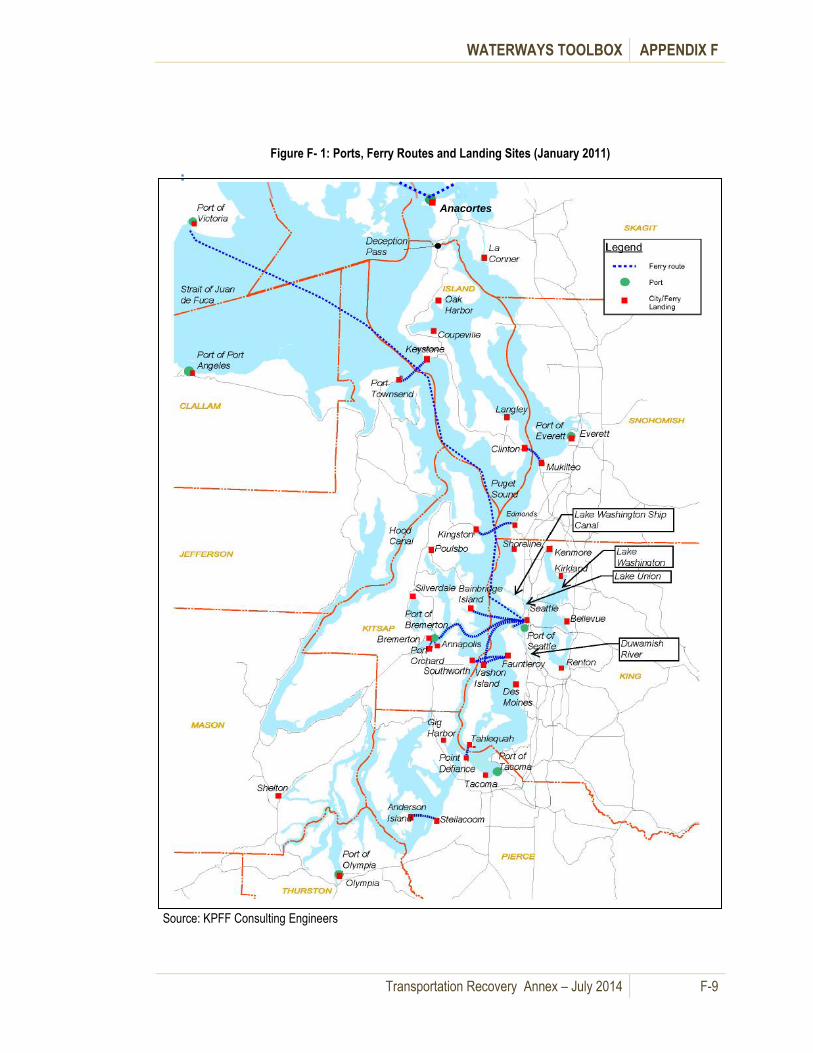
WATERWAYS TOOLBOX APPENDIX F
Transportation Recovery Annex – July 2014 F-9
Figure F- 1: Ports, Ferry Routes and Landing Sites (January 2011)
Source: KPFF Consulting Engineers
Anacortes

WATERWAYS TOOLBOX APPENDIX F
Transportation Recovery Annex – July 2014 F-10
Table F- 3: Maritime Assets Inventory (January 2011)
1. Ports
Facilities
Response and Recovery
Vessel Terminal Functional Usage Contact Information
Port of Anacortes 3 deep-draft
wharves
Phone: (360) 293-3134
Address: First and
Commercial Ave
Anacortes, WA 98221
www.portofanacortes.co
m
Port of Everett Containerized
(3 deep draft)
Phone: (425) 259-3164
Address: PO Box 528
Everett, WA 98206
www.portofeverett.com
Port of Olympia
Phone: (360) 528-8000
Address: 915
Washington St NE
Olympia, WA 98501
www.portolympia.com
Marine (Ocean) Terminal Berth 1 Containerized
Swantown Marina See Marinas Inventory
Port of Port Angeles
Phone: (360) 457-8527
Address: 338 W First
Street
Port Angeles, WA
98362
Port of Seattle www.portofseattle.org
South Harbor
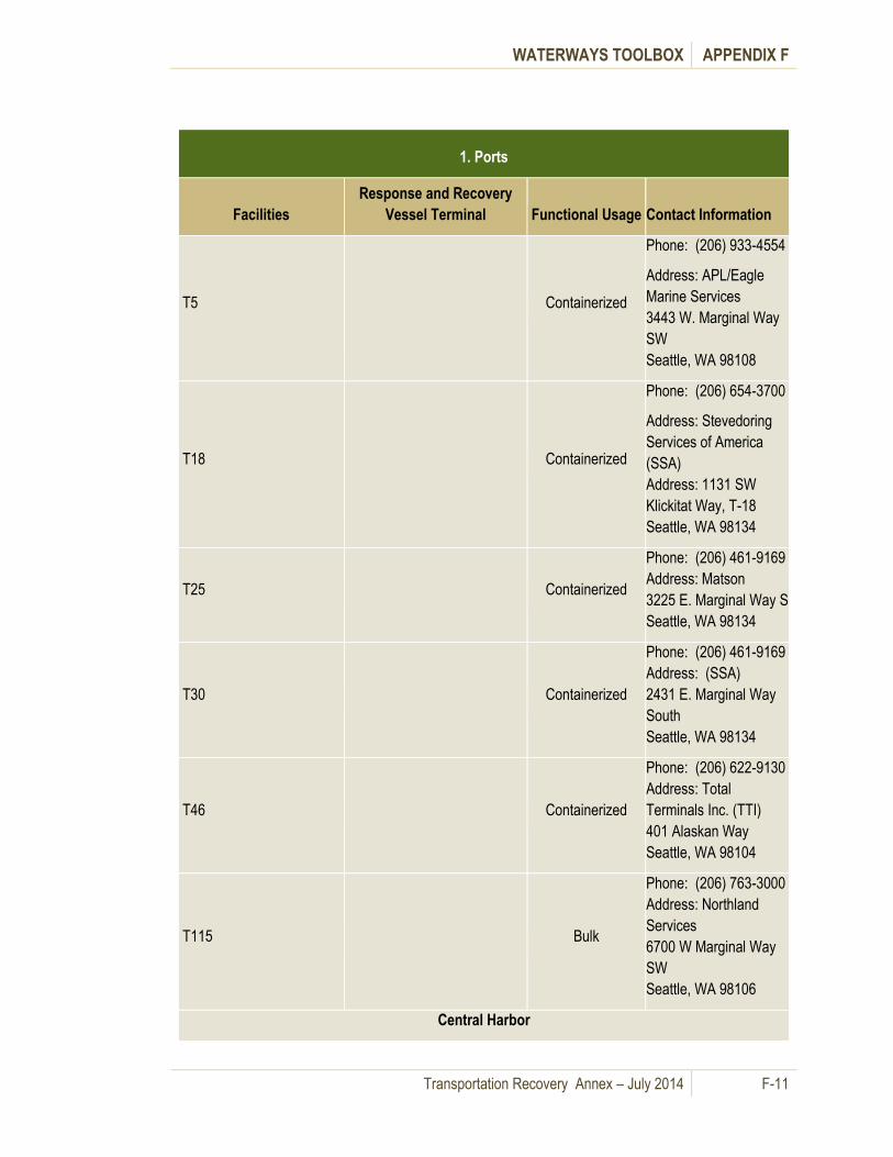
WATERWAYS TOOLBOX APPENDIX F
Transportation Recovery Annex – July 2014 F-11
1. Ports
Facilities
Response and Recovery
Vessel Terminal Functional Usage Contact Information
T5
Containerized
Phone: (206) 933-4554
Address: APL/Eagle
Marine Services
3443 W. Marginal Way
SW
Seattle, WA 98108
T18
Containerized
Phone: (206) 654-3700
Address: Stevedoring
Services of America
(SSA)
Address: 1131 SW
Klickitat Way, T-18
Seattle, WA 98134
T25 Containerized
Phone: (206) 461-9169
Address: Matson
3225 E. Marginal Way S
Seattle, WA 98134
T30 Containerized
Phone: (206) 461-9169
Address: (SSA)
2431 E. Marginal Way
South
Seattle, WA 98134
T46 Containerized
Phone: (206) 622-9130
Address: Total
Terminals Inc. (TTI)
401 Alaskan Way
Seattle, WA 98104
T115 Bulk
Phone: (206) 763-3000
Address: Northland
Services
6700 W Marginal Way
SW
Seattle, WA 98106
Central Harbor

WATERWAYS TOOLBOX APPENDIX F
Transportation Recovery Annex – July 2014 F-12
1. Ports
Facilities
Response and Recovery
Vessel Terminal Functional Usage Contact Information
P66 Cruise Terminal
See Passenger &
Vehicle Vessels
Inventory
P69
See Passenger &
Vehicle Vessels
Inventory
T86 Grain Facility
Phone: (206) 284-4851
Address: Louis Dreyfus
Corp
955 Alaskan Way W
Seattle, WA 98119-
3630
T91 Cruise Terminal
(RO/RO)
See Passenger &
Vehicle Vessels
Inventory
North Harbor
Shilshole Bay Marina See Marinas Inventory
Fishermen's Terminal See Marinas Inventory
Port of Tacoma First western pier on the
entrance to the Blair Waterway
Port Phone for EOC to
Contact:
www.portoftacoma.com
Phone: (253) 383-5841
Address: Administrative
Office
One Sitcum Plaza
Tacoma, WA 98421
Husky Terminal (Terminal
4) Containerized
Phone: (253) 627-6963
Address: Husky
Terminal
1101 Port of Tacoma
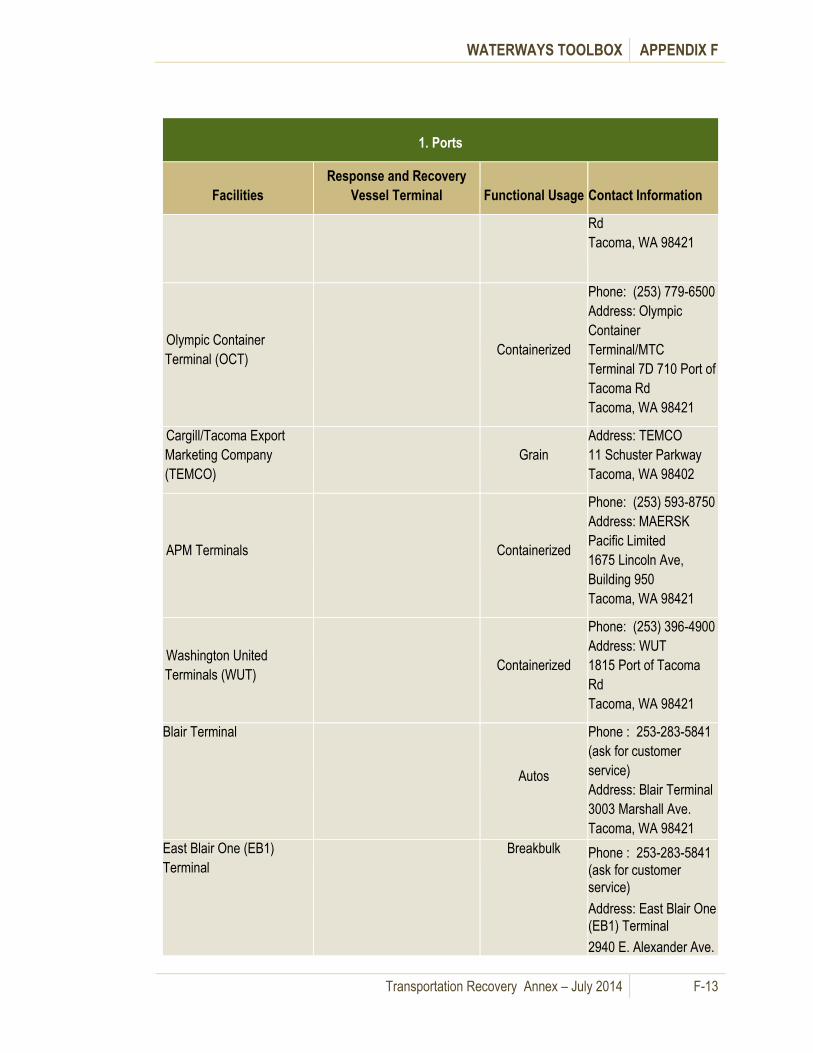
WATERWAYS TOOLBOX APPENDIX F
Transportation Recovery Annex – July 2014 F-13
1. Ports
Facilities
Response and Recovery
Vessel Terminal Functional Usage Contact Information
Rd
Tacoma, WA 98421
Olympic Container
Terminal (OCT) Containerized
Phone: (253) 779-6500
Address: Olympic
Container
Terminal/MTC
Terminal 7D 710 Port of
Tacoma Rd
Tacoma, WA 98421
Cargill/Tacoma Export
Marketing Company
(TEMCO)
Grain
Address: TEMCO
11 Schuster Parkway
Tacoma, WA 98402
APM Terminals Containerized
Phone: (253) 593-8750
Address: MAERSK
Pacific Limited
1675 Lincoln Ave,
Building 950
Tacoma, WA 98421
Washington United
Terminals (WUT) Containerized
Phone: (253) 396-4900
Address: WUT
1815 Port of Tacoma
Rd
Tacoma, WA 98421
Blair Terminal
Autos
Phone : 253-283-5841
(ask for customer
service)
Address: Blair Terminal
3003 Marshall Ave.
Tacoma, WA 98421
East Blair One (EB1)
Terminal
Breakbulk Phone : 253-283-5841
(ask for customer
service)
Address: East Blair One
(EB1) Terminal
2940 E. Alexander Ave.
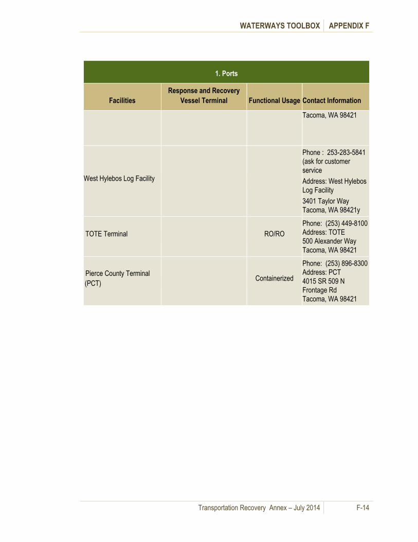
WATERWAYS TOOLBOX APPENDIX F
Transportation Recovery Annex – July 2014 F-14
1. Ports
Facilities
Response and Recovery
Vessel Terminal Functional Usage Contact Information
Tacoma, WA 98421
West Hylebos Log Facility
Phone : 253-283-5841
(ask for customer
service
Address: West Hylebos
Log Facility
3401 Taylor Way
Tacoma, WA 98421y
TOTE Terminal RO/RO
Phone: (253) 449-8100
Address: TOTE
500 Alexander Way
Tacoma, WA 98421
Pierce County Terminal
(PCT) Containerized
Phone: (253) 896-8300
Address: PCT
4015 SR 509 N
Frontage Rd
Tacoma, WA 98421

WATERWAYS TOOLBOX APPENDIX F
Transportation Recovery Annex – July 2014 F-15
2. Facilities and Vessels
Facilities Vessels Interoperability Contact Information
Washington State Ferries Terminals
Anacortes
Large – 8
(Cap. > 2,000)
Medium – 12
(Cap. 500 – 1,500)
WSF Large and
Medium Vessels can
interchangeably use
WSF Terminals.
State EOC or WSDOT
Operations Watch
Supervisor
Phone: (206) 515-3458
Phone: (206) 515-3456
2901 3rd Avenue Ste 500
Seattle, WA 98121-3014
Bainbridge Island
Eagle Harbor Repair Facilities -
Bainbridge Island
Bremerton
Edmonds
Fauntleroy
Keystone
Kingston
Mukilteo
Point Defiance
Port Townsend
Seattle Pier 52 (Colman Dock)
Southworth
Vashon Island
WSDOT Temporary Ferry Passenger Only Loading Sites (Freight may be considered and/or boat
landing ramp at sites for alternative route across the Hood Canal)
South Point (Jefferson County) Small Vessels WSDOT (see above)
Lofall (Kitsap County) Small Vessels WSDOT (see above)
Kitsap Transit Foot Ferry Landing Sites
KTFF (Port Orchard)
Small -3
(Cap. < 500) Small Vessels
Phone: (360) 373-2877
Address: Kitsap Transit
60 Washington Avenue Ste.
200
Bremerton, WA 98337
KTFF (Annapolis)
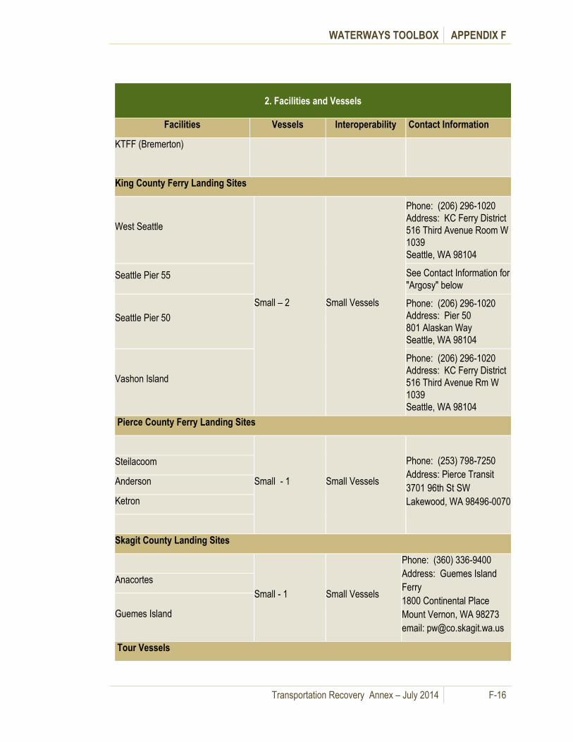
WATERWAYS TOOLBOX APPENDIX F
Transportation Recovery Annex – July 2014 F-16
2. Facilities and Vessels
Facilities Vessels Interoperability Contact Information
KTFF (Bremerton)
King County Ferry Landing Sites
West Seattle
Small – 2 Small Vessels
Phone: (206) 296-1020
Address: KC Ferry District
516 Third Avenue Room W
1039
Seattle, WA 98104
Seattle Pier 55 See Contact Information for
"Argosy" below
Seattle Pier 50
Phone: (206) 296-1020
Address: Pier 50
801 Alaskan Way
Seattle, WA 98104
Vashon Island
Phone: (206) 296-1020
Address: KC Ferry District
516 Third Avenue Rm W
1039
Seattle, WA 98104
Pierce County Ferry Landing Sites
Small - 1 Small Vessels
Phone: (253) 798-7250
Address: Pierce Transit
3701 96th St SW
Lakewood, WA 98496-0070
Steilacoom
Anderson
Ketron
Skagit County Landing Sites
Small - 1 Small Vessels
Phone: (360) 336-9400
Address: Guemes Island
Ferry
1800 Continental Place
Mount Vernon, WA 98273
email: [email protected]
Anacortes
Guemes Island
Tour Vessels

WATERWAYS TOOLBOX APPENDIX F
Transportation Recovery Annex – July 2014 F-17
2. Facilities and Vessels
Facilities Vessels Interoperability Contact Information
Argosy Medium - 1
Small - 8
Small Vessels Phone: (206) 622-8687
Address:
1101 Alaskan Way Pier 55
Seattle, WA 98101
Seattle Pier 54 - 57
Clipper Small - 3 Small Vessels Phone: (206) 448-5000
Address:
2701 Alaskan Way Pier 69
Seattle, WA 98121
Pier 69
Naval Shipyard Puget Sound (Landing Sites)
Potential Landing Site
Phone: Contact State EOC
Address:
1400 Farragut Avenue
Bremerton, WA 98314
Cruise Terminals
T-66
Cruise Lines
Large Passenger
Load/Unload Only
(No Vehicles)
Phone: Address:
2225 Alaskan Way
Seattle, WA 98121
T-91
Large Passenger
Load/Unload Only
(No Vehicles)
Phone: (206) 728-3628
(206) 728-3642
Address: Port of Seattle
2001 W. Garfield Street
Seattle, WA 98119
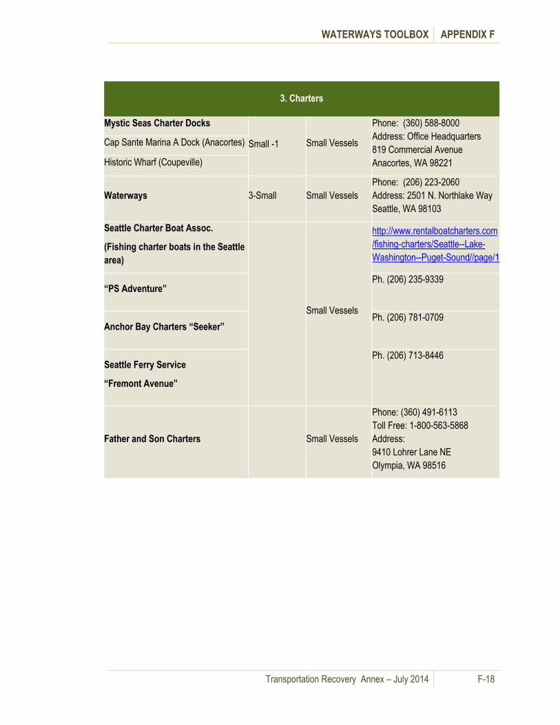
WATERWAYS TOOLBOX APPENDIX F
Transportation Recovery Annex – July 2014 F-18
3. Charters
Mystic Seas Charter Docks
Small -1 Small Vessels
Phone: (360) 588-8000
Address: Office Headquarters
819 Commercial Avenue
Anacortes, WA 98221
Cap Sante Marina A Dock (Anacortes)
Historic Wharf (Coupeville)
Waterways 3-Small Small Vessels
Phone: (206) 223-2060
Address: 2501 N. Northlake Way
Seattle, WA 98103
Seattle Charter Boat Assoc.
(Fishing charter boats in the Seattle
area)
Small Vessels
http://www.rentalboatcharters.com
/fishing-charters/Seattle--Lake-
Washington--Puget-Sound//page/1
“PS Adventure” Ph. (206) 235-9339
Anchor Bay Charters “Seeker” Ph. (206) 781-0709
Seattle Ferry Service
“Fremont Avenue”
Ph. (206) 713-8446
Father and Son Charters Small Vessels
Phone: (360) 491-6113
Toll Free: 1-800-563-5868
Address:
9410 Lohrer Lane NE
Olympia, WA 98516
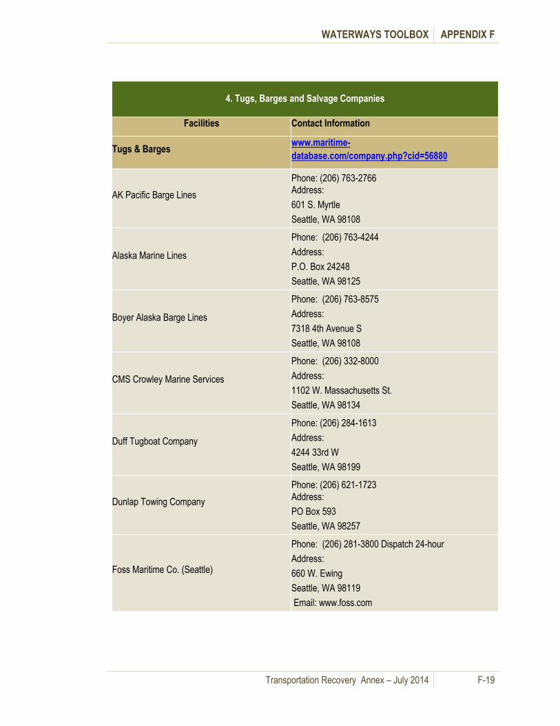
WATERWAYS TOOLBOX APPENDIX F
Transportation Recovery Annex – July 2014 F-19
4. Tugs, Barges and Salvage Companies
Facilities Contact Information
Tugs & Barges www.maritime-
database.com/company.php?cid=56880
AK Pacific Barge Lines
Phone: (206) 763-2766
Address:
601 S. Myrtle
Seattle, WA 98108
Alaska Marine Lines
Phone: (206) 763-4244
Address:
P.O. Box 24248
Seattle, WA 98125
Boyer Alaska Barge Lines
Phone: (206) 763-8575
Address:
7318 4th Avenue S
Seattle, WA 98108
CMS Crowley Marine Services
Phone: (206) 332-8000
Address:
1102 W. Massachusetts St.
Seattle, WA 98134
Duff Tugboat Company
Phone: (206) 284-1613
Address:
4244 33rd W
Seattle, WA 98199
Dunlap Towing Company
Phone: (206) 621-1723
Address:
PO Box 593
Seattle, WA 98257
Foss Maritime Co. (Seattle)
Phone: (206) 281-3800 Dispatch 24-hour
Address:
660 W. Ewing
Seattle, WA 98119
Email: www.foss.com

WATERWAYS TOOLBOX APPENDIX F
Transportation Recovery Annex – July 2014 F-20
4. Tugs, Barges and Salvage Companies
Facilities Contact Information
Glacier Marine Transport (Port Towage)
Phone: (206) 763-2766
Address:
765 S Myrtle
Seattle, WA 98108
Harley Marine/Olympic Tug and Barge www.harleymarine.com
Hurlen Marine Co (Port Towage)
Phone: (206) 762-3535
Address:
523 S Riverside Drive
Seattle, WA 98108
Lightweight Marine Transport
Phone: (360) 445-5432
Cell: (360) 661-7695
Address:
5320 Orcas Road
Eastsound, WA 98245
Pintail Inc.
Phone: (360) 317-8532
Cell: (360) 317-8532
Address:
P.O. Box 3284
Friday Harbor, WA 98250
Email: [email protected]
Samson Tug and Barge
Phone: (206) 767-7820
Address:
Terminal 115, 6702 W Marginal Way
Seattle, WA 98106
San Juan Ferry and Barge
Phone: (360) 317-8486 (Marty Starr)
Address:
PO Box 965
Friday Harbor, WA 98250
Email: [email protected]
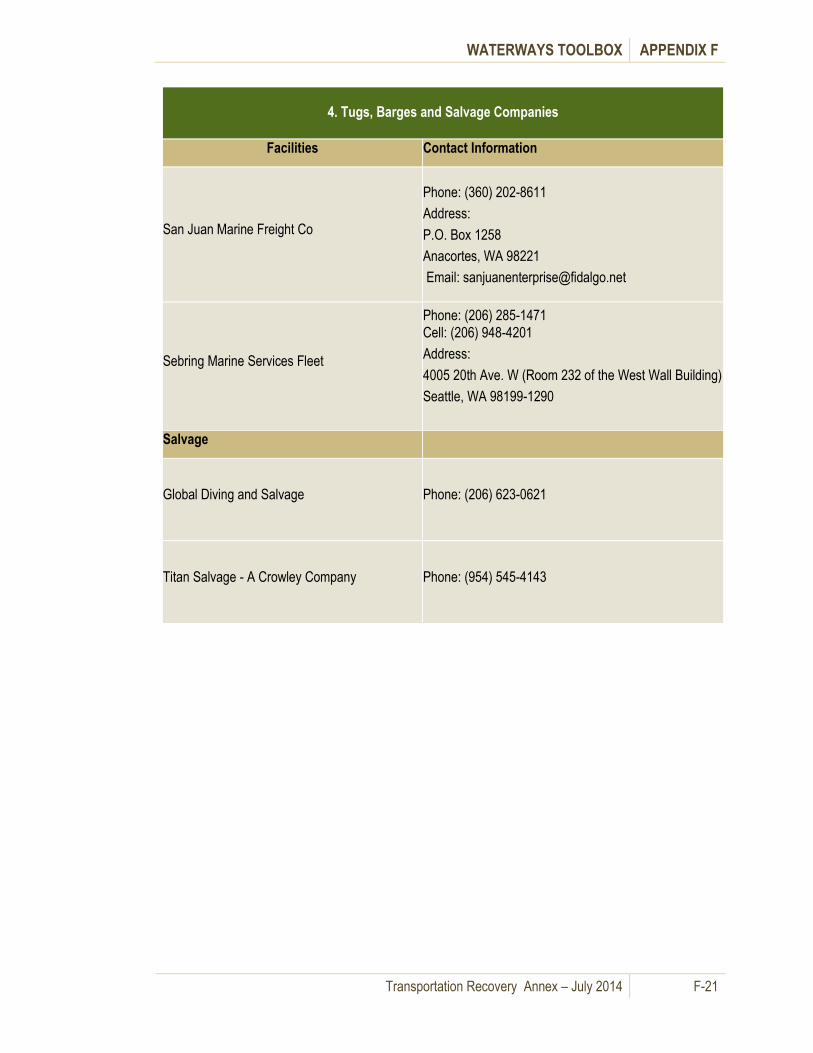
WATERWAYS TOOLBOX APPENDIX F
Transportation Recovery Annex – July 2014 F-21
4. Tugs, Barges and Salvage Companies
Facilities Contact Information
San Juan Marine Freight Co
Phone: (360) 202-8611
Address:
P.O. Box 1258
Anacortes, WA 98221
Email: [email protected]
Sebring Marine Services Fleet
Phone: (206) 285-1471
Cell: (206) 948-4201
Address:
4005 20th Ave. W (Room 232 of the West Wall Building)
Seattle, WA 98199-1290
Salvage
Global Diving and Salvage
Phone: (206) 623-0621
Titan Salvage - A Crowley Company
Phone: (954) 545-4143

WATERWAYS TOOLBOX APPENDIX F
Transportation Recovery Annex – July 2014 F-22
5. Marinas
Marinas Jurisdiction Contact Facility Contact Information
State of Washington Marinas
Directory
http://www.marinasdirectory.org/unitedstates/w
ashington/
Island County
Oak Harbor Marina City of Oak Harbor
Phone: (360) 679-2628
Address: 865 Barrington Drive
Oak Harbor, WA 98277
VHF 16 (switch to 68)
Deception Pass Marina City of Oak Harbor
Phone: (360) 675-5411
Address: 200 Cornet Bay Rd
Oak Harbor, WA 98277-9756
Langley Small Boat Harbor
(contact Langley Public Works)
City of Langley
Phone: (360) 221-4246 ext.13
Address: 200 Cornet Bay Rd
Oak Harbor, WA 98277-9756
Camano Island Yacht Club Camano Island
Phone: (360) 387-3737
Address: 129 North Sunset Dr
Camano Island, WA 98282
King County – Lake Washington
Bellevue (Meydenbauer Bay
Marina)
City of Bellevue
Phone: (425) 452-6123
Address: 2 99th Ave NE
Bellevue, WA 98004
Carillon Point Marina (Kirkland)
City of Kirkland
(Conditional Use
Permit required)
Phone: (425) 822-1700
Address: 3240 Carillon Point
Kirkland, WA 98033
Kenmore Tracy Owen Station Park
(formerly known as Log Boom Park)
City of Kenmore
Phone: None Known
Address: NE 175th Street
Kenmore, WA
Kirkland Marina Park
City of Kirkland
(Conditional Use
Permit required)
Phone: (425) 587-3340
Address: 25 Lakeshore Plaza
Kirkland, WA 98033
Leschi Park
City of Seattle
(Conditional Use
Permit required)
Phone: (206) 684-4075
Address: 201 Lakeside Ave S
Seattle, WA
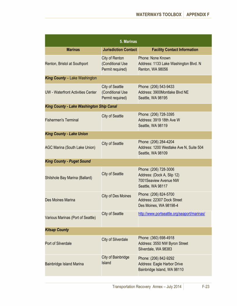
WATERWAYS TOOLBOX APPENDIX F
Transportation Recovery Annex – July 2014 F-23
5. Marinas
Marinas Jurisdiction Contact Facility Contact Information
Renton, Bristol at Southport
City of Renton
(Conditional Use
Permit required)
Phone: None Known
Address: 1133 Lake Washington Blvd. N
Renton, WA 98056
King County – Lake Washington
UW - Waterfront Activities Center
City of Seattle
(Conditional Use
Permit required)
Phone: (206) 543-9433
Address: 3900Montlake Blvd NE
Seattle, WA 98195
King County - Lake Washington Ship Canal
Fishermen's Terminal City of Seattle
Phone: (206) 728-3395
Address: 3919 18th Ave W
Seattle, WA 98119
King County - Lake Union
AGC Marina (South Lake Union) City of Seattle
Phone: (206) 284-4204
Address: 1200 Westlake Ave N, Suite 504
Seattle, WA 98109
King County - Puget Sound
Shilshole Bay Marina (Ballard) City of Seattle
Phone: (206) 728-3006
Address: (Dock A, Slip 12)
7001Seaview Avenue NW
Seattle, WA 98117
Des Moines Marina City of Des Moines
Phone: (206) 824-5700
Address: 22307 Dock Street
Des Moines, WA 98198-4
Various Marinas (Port of Seattle) City of Seattle
http://www.portseattle.org/seaport/marinas/
Kitsap County
Port of Silverdale City of Silverdale
Phone: (360) 698-4918
Address: 3550 NW Byron Street
Silverdale, WA 98383
Bainbridge Island Marina
City of Bainbridge
Island
Phone: (206) 842-9292
Address: Eagle Harbor Drive
Bainbridge Island, WA 98110

WATERWAYS TOOLBOX APPENDIX F
Transportation Recovery Annex – July 2014 F-24
5. Marinas
Marinas Jurisdiction Contact Facility Contact Information
Eagle Harbor Marina
City of Bainbridge
Island
Phone: (206) 842-4003
Address: 5834 Ward Avenue NE
Bainbridge Island, WA 98110
Winslow Wharf Marina
City of Bainbridge
Island
Phone: (206) 842-4202
Address: 141 Parfitt Way SW
Bainbridge Island, WA 98110
Mason County
Various Hood Canal Marinas Various explorehoodcanal.com
Pierce County
Various Gig Harbor Marinas City of Gig Harbor http://www.cityofgigharbor.net/businesses.php?
cat=29
Breakwater Marina (Pt. Defiance) City of Tacoma
Phone: (253) 752-6663
Address: 5603 N Waterfront Dr
Tacoma, WA 98407-6536
Fox Island Yacht Club Pierce County
Phone: (253) 549-2603
Address: 1061 12th Ave
Fox Island, WA 98333
Skagit County
Pioneer Point Marina (La Conner) City of La Conner
Phone: (360) 466-1314
Address: 1320 Connor Way
La Conner, WA
La Conner Marina City of La Conner
Phone: (425) 252-3088
Address: 613 N 2nd St
La Conner, WA 98257
Snohomish County
Everett Bayside Marina City of Everett
Phone: (360) 466-3118
Address: 1111 Craftsman Way
Everett, WA 98201
Port of Edmonds City of Edmonds
Phone: (425) 774-0549
Address: 336 Admiral Way
Edmonds, WA 98020-7214

WATERWAYS TOOLBOX APPENDIX F
Transportation Recovery Annex – July 2014 F-25
5. Marinas
Marinas Jurisdiction Contact Facility Contact Information
Thurston County
Swantown Marina & Boatworks Port of Olympia
Phone: (360) 528-8049
Address: 1022 Marine Dr NE
Olympia, WA 98020-7214
City of Olympia Municipal Pier City of Olympia
Phone: (360) 753-8380 (City Parks Dept.)
Address: 300 4th Avenue
Olympia, WA 98507
Port Plaza Port of Olympia
Phone: (360) 528-8049
Address: Port Plaza Docks, 701 NW Columbia
Street, Olympia, WA 98501
Thurston County (con’t)
Other Marinas (Near Olympia)
City of Olympia
www.westbay-marina.com
www.bostonharbormarina.com
www.zittelsmarina.com
http://pettitmarine.vpweb.com/
Fiddlehead Marine Inc.
(360) 352-0528
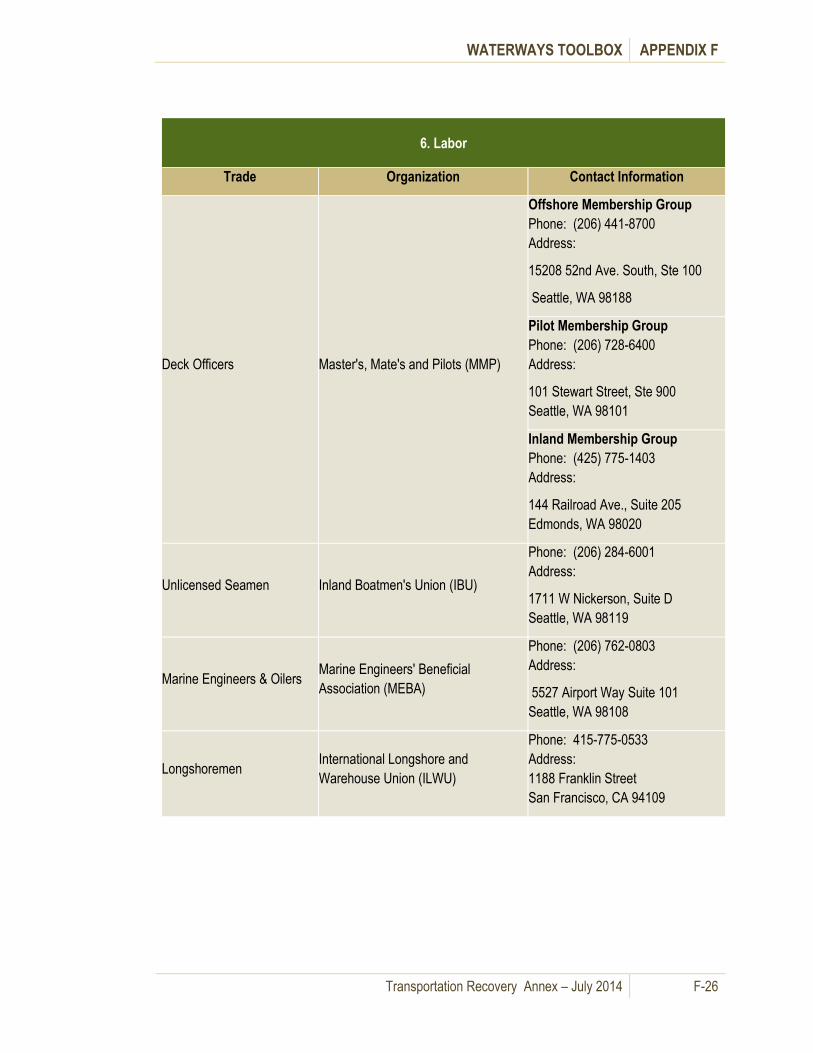
WATERWAYS TOOLBOX APPENDIX F
Transportation Recovery Annex – July 2014 F-26
6. Labor
Trade Organization Contact Information
Deck Officers Master's, Mate's and Pilots (MMP)
Offshore Membership Group
Phone: (206) 441-8700
Address:
15208 52nd Ave. South, Ste 100
Seattle, WA 98188
Pilot Membership Group
Phone: (206) 728-6400
Address:
101 Stewart Street, Ste 900
Seattle, WA 98101
Inland Membership Group
Phone: (425) 775-1403
Address:
144 Railroad Ave., Suite 205
Edmonds, WA 98020
Unlicensed Seamen Inland Boatmen's Union (IBU)
Phone: (206) 284-6001
Address:
1711 W Nickerson, Suite D
Seattle, WA 98119
Marine Engineers & Oilers Marine Engineers' Beneficial
Association (MEBA)
Phone: (206) 762-0803
Address:
5527 Airport Way Suite 101
Seattle, WA 98108
Longshoremen International Longshore and
Warehouse Union (ILWU)
Phone: 415-775-0533
Address:
1188 Franklin Street
San Francisco, CA 94109

WATERWAYS TOOLBOX APPENDIX F
Transportation Recovery Annex – July 2014 F-27
7. Bridges over Navigable Waterways
Waterway/Bridges
Mile
point Type Owner Telephone
Island County
Deception Pass Bridge 0.5 F WSDOT 425-739-3700 or 206-440-4490
King County
Lake Washington
SR 520 Evergreen Point Floating
Bridge/Governor Albert D. Rosselini
Memorial
N/A RS WSDOT 425-739-3700 or 206-440-4490
I-90 Floating Bridges/Lacey V.
Murrow and Homer M. Hadley
Memorial
N/A F WSDOT 425-739-3700 or 206-440-4490
Lake Washington Ship Canal
BNSF RR Ballard Bridge or Bridge
#6.4 0.1 B BNSF 206-784-2976
Ballard/15th Ave Bridge 1.1 B SDOT 206-232-9525
Fremont Bridge 2.6 B SDOT 206-386-4234
US99/Aurora or George
Washington Bridge 2.7 F WSDOT 425-739-3700 or 206-440-4490
I-5 4.2 F WSDOT 425-739-3700 or 206-440-4490
University Bridge 4.3 B SDOT 206-684-4765
Montlake Bridge 5.2 B WSDOT 206-720-3048 or 206-498-1469
Duwamish Waterway
Spokane Street Bridge 0.3 S SDOT 206-684-7443
West Seattle Bridge 0.3 F SDOT 206-684-7443
BNSF RR 0.4 B BNSF 206-935-1130
First Ave South dual 2.5 B WSDOT 206-764-4160 or 206-440-4490
South Park Bridge 3.8 B KING 206-762-2530
Kitsap County
Hood Canal Floating Bridge 5.0 RS WSDOT 253-548-2420

WATERWAYS TOOLBOX APPENDIX F
Transportation Recovery Annex – July 2014 F-28
7. Bridges over Navigable Waterways
Waterway/Bridges
Mile
point Type Owner Telephone
Agate Pass Bridge (n. Bainbridge
Island) 1.0 F WSDOT 253-548-2420
Port Washington Narrows (Manette
Bridge SR 303) 0.3 F WSDOT 253-548-2420
Port Washington Narrows (Warren
Avenue Bridge) 0.5 F WSDOT 253-548-2420
Mason County
None Listed on USCG - Sector
Puget Sound Bridge List
Pierce County
Hylebos Waterway (Hylebos Bridge
11th Street) 1.1 B Tacoma 253-591-5204
Thea Foss Waterway (11th Street
Bridge) 0.6 VL WSDOT 253-548-2420
Tacoma Narrow Bridge (SR 16
dual) N/A F WSDOT 253-548-2420
Skagit County
Swinomish Channel
SR 20 Rainbow Bridge 3.2 F Skagit 253-548-2420
SR 20 dual bridges 8.2 F WSDOT 253-548-2420
BNSF RR 8.4 S BNSF 719-242-7333
Snohomish County
Ebey Slough
I-5 Bridge 1.4 F WSDOT 425-739-3700 or 206-440-4490
BNSF RR 1.5 S BNSF 425-304-6613
SR 529 dual 1.6 S WSDOT 425-739-3700 or 206-440-4490
Steamboat Slough
BNSF RR 1.0 S BNSF 425-304-6613
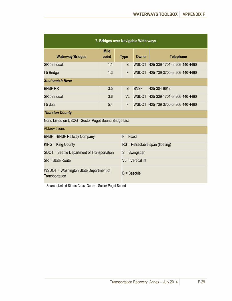
WATERWAYS TOOLBOX APPENDIX F
Transportation Recovery Annex – July 2014 F-29
7. Bridges over Navigable Waterways
Waterway/Bridges
Mile
point Type Owner Telephone
SR 529 dual 1.1 S WSDOT 425-339-1701 or 206-440-4490
I-5 Bridge 1.3 F WSDOT 425-739-3700 or 206-440-4490
Snohomish River
BNSF RR 3.5 S BNSF 425-304-6613
SR 529 dual 3.6 VL WSDOT 425-339-1701 or 206-440-4490
I-5 dual 5.4 F WSDOT 425-739-3700 or 206-440-4490
Thurston County
None Listed on USCG - Sector Puget Sound Bridge List
Abbreviations
BNSF = BNSF Railway Company F = Fixed
KING = King County RS = Retractable span (floating)
SDOT = Seattle Department of Transportation S = Swingspan
SR = State Route VL = Vertical lift
WSDOT = Washington State Department of
Transportation B = Bascule
Source: United States Coast Guard - Sector Puget Sound

WATERWAYS TOOLBOX APPENDIX F
Transportation Recovery Annex – July 2014 F-30
8. Boat Ramps
Landing Site Jurisdiction
Contact Contact Information
Island County
Naval Air Station Whidbey Island -
Seaplane Base
Military Dept
EMD
State EOC, 800-258-5990 or,
Various - See Department of Ecology -
Geographic Response Plans Dept. of Ecology
http://www.ecy.wa.gov/programs/spills/preparedn
ess/GRP/wa_marine_grps.htm
King County*
Various - See Department of Ecology -
Geographic Response Plans Dept. of Ecology
http://www.ecy.wa.gov/programs/spills/preparedn
ess/GRP/wa_marine_grps.htm
Various boat launches http://www.angelfire.com/wa/nwfishing/lakewaboa
tlaunchs.html
Kitsap County
Point White (fixed dock with small
floating platform) Large vessels with
ramps could offload items here.
City of
Bainbridge
Island
Phone: None Known. Address: Bainbridge Island, WA 98110
Fort Ward State Park (concrete
recreational boat launch)
City of
Bainbridge
Island
Phone: (206) 842-9292
Address: Eagle Harbor Drive
Bainbridge Island, WA 98110
Eagle Harbor (WSF Maintenance Yard) WSDOT/WSF
State EOC or WSDOT Operations Watch
Supervisor
Phone: (206) 515-3458
Phone: (206) 515-3456
2901 3rd Avenue Ste 500
Seattle, WA 98121-3014
Various - See Department of Ecology -
Geographic Response Plans Dept. of Ecology
http://www.ecy.wa.gov/programs/spills/preparedn
ess/GRP/wa_marine_grps.htm
Kitsap County (con’t)
Various Kitsap County http://www.kitsapgov.com/parks/regionalparks/Co
unty_park_inventory.htm
Mason County
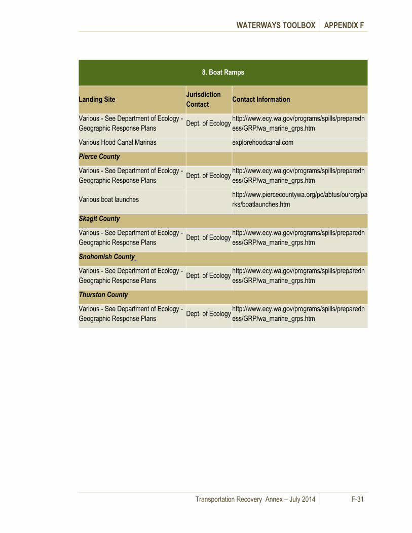
WATERWAYS TOOLBOX APPENDIX F
Transportation Recovery Annex – July 2014 F-31
8. Boat Ramps
Landing Site Jurisdiction
Contact Contact Information
Various - See Department of Ecology -
Geographic Response Plans Dept. of Ecology
http://www.ecy.wa.gov/programs/spills/preparedn
ess/GRP/wa_marine_grps.htm
Various Hood Canal Marinas explorehoodcanal.com
Pierce County
Various - See Department of Ecology -
Geographic Response Plans Dept. of Ecology
http://www.ecy.wa.gov/programs/spills/preparedn
ess/GRP/wa_marine_grps.htm
Various boat launches http://www.piercecountywa.org/pc/abtus/ourorg/pa
rks/boatlaunches.htm
Skagit County
Various - See Department of Ecology -
Geographic Response Plans Dept. of Ecology
http://www.ecy.wa.gov/programs/spills/preparedn
ess/GRP/wa_marine_grps.htm
Snohomish County
Various - See Department of Ecology -
Geographic Response Plans Dept. of Ecology
http://www.ecy.wa.gov/programs/spills/preparedn
ess/GRP/wa_marine_grps.htm
Thurston County
Various - See Department of Ecology -
Geographic Response Plans Dept. of Ecology
http://www.ecy.wa.gov/programs/spills/preparedn
ess/GRP/wa_marine_grps.htm

WATERWAYS TOOLBOX APPENDIX F
Transportation Recovery Annex – July 2014 F-32
Table F- 4: New Ferry Service Template
Site Name: _________________________ Location/Address:
New Ferry Service Template
Description Length Width Height
Ramp
Dock/Float
Freeboard
Water Depth Measurement taken on ___________ at ______ AM/PM. Tide height was approximately_______ feet.
Criteria Yes/ No Evaluation Rationale for Evaluation /
Considerations Proposed Improvements
Marine Facilities Good Fair Poor
Ramp
Railing
Exposure
ADA Accessibility
Surface Condition
Grade

WATERWAYS TOOLBOX APPENDIX F
Transportation Recovery Annex – July 2014 F-33
Criteria Yes/ No Evaluation Rationale for Evaluation /
Considerations Proposed Improvements
Dock/Float Yes/ No Good Fair Poor
Dimensions (Approx.)
Freeboard
Fendering
Ladder
Railing
Exposure
ADA Accessibility
Surface Condition
Mooring Capability
Vessel Security
In Water Work
Required?
Maintenance Issues
Upland Facilities
Accessibility Good Fair Poor
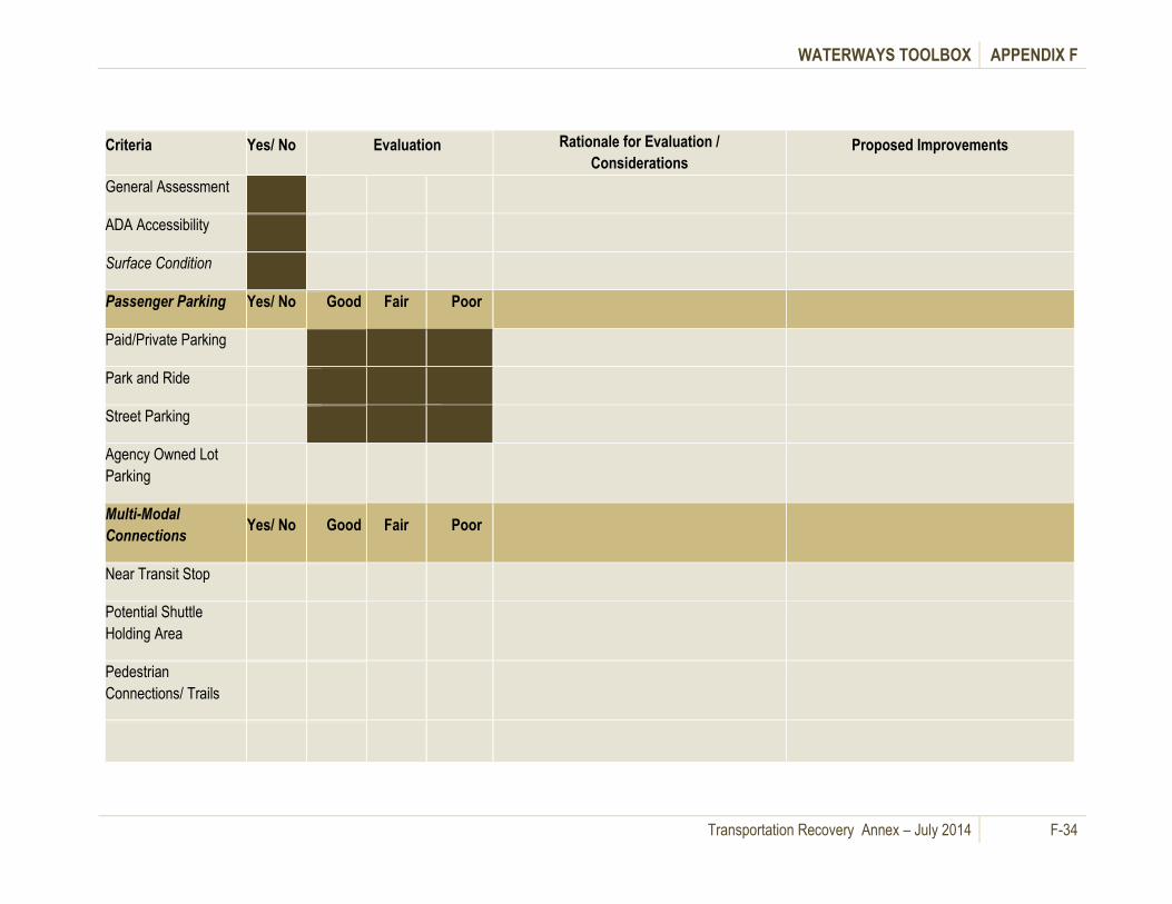
WATERWAYS TOOLBOX APPENDIX F
Transportation Recovery Annex – July 2014 F-34
Criteria Yes/ No Evaluation Rationale for Evaluation /
Considerations Proposed Improvements
General Assessment
ADA Accessibility
Surface Condition
Passenger Parking Yes/ No Good Fair Poor
Paid/Private Parking
Park and Ride
Street Parking
Agency Owned Lot
Parking
Multi-Modal
Connections Yes/ No Good Fair Poor
Near Transit Stop
Potential Shuttle
Holding Area
Pedestrian
Connections/ Trails

WATERWAYS TOOLBOX APPENDIX F
Transportation Recovery Annex – July 2014 F-35
New Ferry Service Template (con’t)
Criteria Yes/ No Evaluation Rationale for Evaluation /
Considerations Proposed Improvements
Other Yes/ No Good Fair Poor
Bicycle Facilities
Sheltered Area or
Potential Area
Area for Signage and
Customer Information
Area for Electronic
Ticket Vending
Restrooms
Maintenance Issues
Safety Yes/ No Good Fair Poor
Access and Egress
from Dock/Ramp
Lighting
Potential Conflicts with
other Uses
Permitting Yes/ No
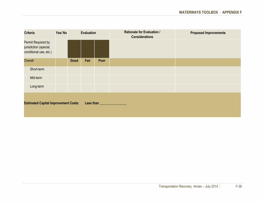
WATERWAYS TOOLBOX APPENDIX F
Transportation Recovery Annex – July 2014 F-36
Criteria Yes/ No Evaluation Rationale for Evaluation /
Considerations Proposed Improvements
Permit Required by
jurisdiction (special,
conditional use, etc.)
Overall Good Fair Poor
Short-term
Mid-term
Long-term
Estimated Capital Improvement Costs: Less than ________________

This page intentionally left blank.
Transportation Recovery Annex – July 2014 G-1
Airways Toolbox Appendix G.
A. General Information
This section provides information as to how jurisdictions can use aviation services to mitigate roadway
disruptions, and includes emergency evacuation airlift information as well as strategies for relocating or
increasing services. Aviation resources include airports and aircraft. Aviation classifications consist of
commercial, private and military owned and operated facilities and aircraft. Commercial airports and
aircraft are significant in transporting aid workers into the region as well as providing a mechanism for
residents to leave and seek other housing.
The Washington State Division of Aviation (part of WSDOT) may use non air carrier aircraft for a variety
of emergency purposes after a catastrophe. Non-air-carrier aircraft is all aircraft other than air-carrier,
including: (1) all twin-engine aircraft not owned by air-carriers, (2) all turbine powered fixed-wing aircraft
under 12,500 pounds gross weight, (3) all single-engine fixed wing aircraft not owned by air carriers, and
(4) all rotorcraft not owned by air-carriers.
The aviation strategies described herein will expedite recovery by providing operational information (i.e.
checklist, inventory and map) about available strategies to help move people and freight via the region’s
airways when a disaster significantly reduces the capacity of other transportation. These strategies do
not replace policies set forth by existing aviation protocols such as Federal Aviation Administration (FAA)
regulations or policies set by State or local jurisdictions. Rather, they are intended to help emergency
planners and elected officials understand aviation strategies and protocols.
B. Airways Assessments
Damage assessment report policy and procedures are included in the State and Regional Disaster Airlift
(SARDA) Plan which is part of the WSDOT Disaster Plan.
C. Airways Mitigation Strategies

AIRWAYS TOOLBOX APPENDIX G
Transportation Recovery Annex – July 2014 G-2
Table G- 1 summarizes airways strategies and the response phase in which they would come into play.
Additional information on each element follows.
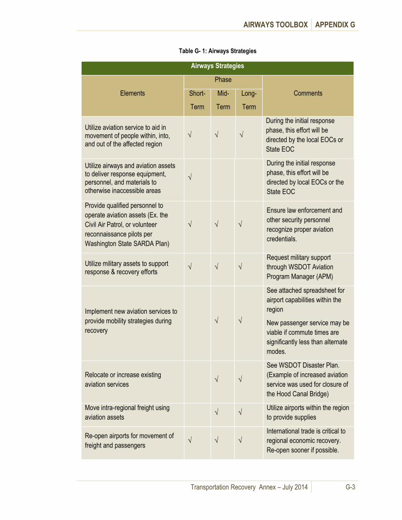
AIRWAYS TOOLBOX APPENDIX G
Transportation Recovery Annex – July 2014 G-3
Table G- 1: Airways Strategies
Airways Strategies
Elements
Phase
Comments Short-
Term
Mid-
Term
Long-
Term
Utilize aviation service to aid in movement of people within, into, and out of the affected region
√ √ √
During the initial response
phase, this effort will be
directed by the local EOCs or
State EOC
Utilize airways and aviation assets to deliver response equipment, personnel, and materials to otherwise inaccessible areas
√
During the initial response
phase, this effort will be
directed by local EOCs or the
State EOC
Provide qualified personnel to
operate aviation assets (Ex. the
Civil Air Patrol, or volunteer
reconnaissance pilots per
Washington State SARDA Plan)
√ √ √
Ensure law enforcement and
other security personnel
recognize proper aviation
credentials.
Utilize military assets to support response & recovery efforts
√ √ √
Request military support
through WSDOT Aviation
Program Manager (APM)
Implement new aviation services to
provide mobility strategies during
recovery
√ √
See attached spreadsheet for
airport capabilities within the
region
New passenger service may be
viable if commute times are
significantly less than alternate
modes.
Relocate or increase existing
aviation services √ √
See WSDOT Disaster Plan.
(Example of increased aviation
service was used for closure of
the Hood Canal Bridge)
Move intra-regional freight using
aviation assets √ √
Utilize airports within the region
to provide supplies
Re-open airports for movement of
freight and passengers √ √ √
International trade is critical to
regional economic recovery.
Re-open sooner if possible.

AIRWAYS TOOLBOX APPENDIX G
Transportation Recovery Annex – July 2014 G-4
Airways Strategies
Elements
Phase
Comments Short-
Term
Mid-
Term
Long-
Term
Determine long-term contracting
procedures √
Utilize aviation service to aid in movement of people within, into, and out of the affected region
√ √ √
During the initial response
phase, this effort will be
directed by the local EOCs or
State EOC
1. Utilize aircraft to aid in initial evacuation efforts
In the immediate aftermath of a catastrophic incident, non-air-carrier aircraft resources are utilized
through the State and Regional Disaster Airlift (SARDA). The Washington State Department of
Transportation, Aviation Division, directs this effort in its capacity as the element of the State emergency
organization to carry out SARDA responsibilities.
2. Utilize airports and aviation assets to deliver response equipment, personnel, and materials to otherwise inaccessible areas
Parallel with the evacuation efforts, Washington SARDA, through the State EOC, also directs aircraft
and other aviation assets as needed to deliver first responders, equipment and material to areas that
have suffered major damage and/or are not otherwise accessible.
3. Provide qualified personnel to operate aviation assets
Aircraft, airport equipment such as ramps, refueling trucks, bag carts, etc., and terminals all require
specialized skills and experience to operate. Taking steps to ensure specialized personnel can get to
the necessary work sites is an important element of response and recovery efforts. Trade unions
represent a large portion of aviation labor and they should be involved in locating and dispatching
qualified personnel.
4. Utilize military aviation assets to support response & recovery efforts
Per the WSDOT Disaster Plan, state air resources,
including military, can be requested through the WSDOT
Aviation Division’s Aviation Program Manager.
Jurisdictions may request temporary, short-duration
emergency support from the U.S. military through
established channels during an emergency. Civilian
access to military aviation assets is based on availability
and DOD priorities (i.e. military use has priority over
civilian use). As long as federal assets including military
aircraft are being used in the recovery effort, the State
EOC remains activated.
Jurisdictions may request
temporary, short duration
emergency support from the U.S.
military through established
channels during an emergency if
local and state resources have been
overwhelmed or a disaster has been
declared by the President.

AIRWAYS TOOLBOX APPENDIX G
Transportation Recovery Annex – July 2014 G-5
5. Implement new aviation services to provide mobility strategies during recovery
Where roadways are either impassable or have significantly reduced capacity, new aviation services
may be appropriate to help mitigate the effects of the damage. For example, when the Hood Canal
Bridge was closed, airlines provided more frequent trips between Seattle and Port Angeles.
6. Relocate or increase existing aviation services
Relocating aviation operations or contracting with other aircraft owners and/or operators to provide
additional flights/ sorties may be necessary in response to major damage at existing terminals or
runways, or increased demand resulting from reduced capacity in other transportation modes. The
Aviation Capabilities Inventory Table G- 3 lists all existing airports in the region and Table G- 4 lists
contact information for each airport.
7. Move intra-regional freight using aviation assets
After the initial response phase, aviation assets that exist within the region or are brought in to the
region may be necessary to assist in the movement of freight to landing sites near distribution centers or
near the intended final destination.
8. Re-open airports for movement of international trade
As soon as the recovery effort gets underway, re-opening the region's major commercial airports will be
important to regional economic recovery. Initially, port facilities can be used to support rebuilding and
recovery efforts but pre-disaster operations should be resumed as soon as possible. See Table G - 4 for
contact information for each of the region's commercial airports.
9. Determine long-term contracting procedures
Until the regional transportation system is restored to near its pre-event capacity, private aviation
resources will likely to be necessary to mitigate the loss of capacity of public roadways. Contracting for
the use of these resources requires careful consideration of the costs and risks incurred by the private
sector as well as the public benefit. Many public agencies have general contracting plans in place for
this purpose, but the specifics of each contract need to be worked out prior to long-term implementation.
D. Aviation Implementation Processes for Passenger and Freight Services
1. Implement new aviation service
If, as a result of capacity reductions in other transportation modes, a new aviation service is needed to
move either people or freight, the following steps should be taken:
Determine the type of transportation required (people and/or freight)
Identify potential origin and destination airports or runways
Request the status of the potential airport from the local EOC or State EOC
Assess the suitability of the potential airport based on EOC status report and other assessment tools as available
Identify and contact potential service provider(s)
Coordinate with WSDOT Aviation through ESF-1 at the State EOC to obtain FAA approval of new service.

AIRWAYS TOOLBOX APPENDIX G
Transportation Recovery Annex – July 2014 G-6
Negotiate contract terms and conditions with service provider
Start new service.
New aviation service is generally handled by airlines requesting information from airports about potential
service. Airports coordinate with local agencies and/or local and State EOCs as required. Some
jurisdictions in the Puget Sound Region own and operate seaplane bases which are a critical component
to local emergency plans for both emergency passenger and freight movement. These facilities may
also be critical to helping to restore regional transportation capabilities in conjunction with utilizing
maritime capabilities. (See Appendix F)
2. Implement/expand/relocate passenger service
Decisions to implement new services or modify existing services through expansion or relocation must
consider the availability of connections at both ends of the route. Table G- 2 summarizes the issues
associated with new, expanded, or relocated services.
Table G- 2: Passenger Service Strategies
Passenger Service Strategies
New Service using an Existing Airport
New services will require approval from the local jurisdiction, transit authorities, and/or the
FAA.
Any new service will require an FAA-approved aircraft for passengers.
The airport facility may require additional measures such as security and/or personnel
depending on the new service provided.
Relocated Service
If an existing terminal/airport is damaged or becomes inaccessible, an alternate landing site
can be used, provided the proposed site and facilities meet FAA standards.
Potential alternative airports in the Puget Sound region are listed in the Airport Capabilities
Table G - 3 and posted to the Aviation Map below.
Increased Existing Service
Increasing existing service may also help to mobilize people and freight in the region.

AIRWAYS TOOLBOX APPENDIX G
Transportation Recovery Annex – July 2014 G-7
Figure G- 1 shows the airports in the Puget Sound Region
Figure G- 1: Map of Airports (December 2010)
Source: KPFF Consulting Engineers

AIRWAYS TOOLBOX APPENDIX G
Transportation Recovery Annex – July 2014 G-8
Table G- 3: Airport Capabilities
Airport Owner/operator County FAA airport
identifier
Airport Reference Code**
(ARC) *
Included in NPIAS NPIAS role
Anacortes Port of Anacortes Skagit 74S A-I Yes GA Arlington Municipal City of Arlington Snohomish AWO C-II Yes GA Auburn Municipal City of Auburn King S50 A-I Yes Reliever Bremerton National Port of Bremerton Kitsap PWT A-I Yes GA Concrete Municipal Town of
Concrete
Skagit 3W5 A-I No - Firstair Field Private King W16 A-I No - Harvey Field Private Snohomish S43 A-II Yes Reliever McChord Field U.S. Air Force1 Pierce TCM - N/A - Gray Army Airfield (AAF) U.S. Army2 Pierce GRF Kenmore Air Harbor – Kenmore* Kenmore Air King S60 A-I Yes GA Kenmore Air Harbor – Lake Union* Kenmore Air King W55 A-I No - King County International/Boeing
Field
King County King BFI D-V Yes Primary (non-
hub) Reliever NAS Whidbey U.S. Navy Island NUW - N/A - Olympia Municipal City of Olympia Thurston OLM C-II Yes GA Pierce County/Thun Field Pierce County Pierce PLU B-II Yes GA Renton Municipal City of Renton King RNT B-II Yes Reliever Sanderson Field Port of Shelton Mason SHN A-II Yes GA Sea-Tac International Port of Seattle King SEA D-V Yes Primary –
hub Skagit Regional Port of Skagit Skagit BVS B-II Yes GA Snohomish County/Paine Field Snohomish
County
Snohomish PAE E-V Yes Reliever Tacoma Narrows City of Tacoma Pierce TIW C-II Yes GA Will Rogers/Wiley Post Seaplane
Base*
City of Renton King W36 A-I No -
Seaplane bases marked with * Sources: LATS (2009), NPIAS, WSDOT Airport Information System (www.wsdot.wa.gov/aviation/AllStateAirports/), AIRNAV airport
database (www.airnav.com/airports/us/WA)

AIRWAYS TOOLBOX APPENDIX G
Transportation Recovery Annex – July 2014 G-9
Military airfields in tan
1http://www.airnav.com/airport/KTCM
2http://www.airnav.com/airport/KGRF
* *The Airport Reference Code (ARC) provides an indication of the types of aircraft which can safely use an airport. ACR is a coding system
used to relate airport design criteria to the operational and physical characteristics of the airplanes intended to operate at the airport. The first
component, depicted by a letter, is the aircraft approach category and relates to aircraft approach speed. The second component, depicted
by a Roman numeral, is the airplane design group and relates to the airplane wingspan
Airport
WSDOT Airport Class. Runway
s
Runway length Runway width Runway surface Air Traffic Control Tower
Anacortes Commercial 1 3,015 ft 60 ft Asphalt No Arlington Municipal Regional 2 5,332 ft 100 ft Asphalt No 3,498 ft 75 ft Asphalt Auburn Municipal Regional 1 3,400 ft 75 ft Asphalt No Bremerton National Regional 1 6,000 ft 150 ft Asphalt No Concrete Municipal Community 1 2,609 ft 60 ft Asphalt No Firstair Field Community 1 2,087 ft 34 ft Asphalt No Harvey Field Regional 2 2,671 ft 36 ft Asphalt No 2,430 ft 100 ft Turf McChord Field Military 2 10,108 ft 150 ft Asphalt/Concrete/Grooved Yes 3,000 ft 60 ft Asphalt Gray Army Airfield Military 1 6,125 ft 150 ft Asphalt Yes
Kenmore Air Harbor – Kenmore* Commercial 1 10,000 ft 1000 ft Water No Kenmore Air Harbor - Lake Union* Commercial 1 5,000 ft 500 ft Water No King County International/Boeing
Field
Commercial 2 10,000 ft 200 ft Asphalt Yes 3,701 ft 100 ft Asphalt NAS Whidbey Military 2 8,001 ft 200 ft Concrete Yes 8,000 ft 200 ft Concrete Olympia Municipal Regional 1 5,501 ft 150 ft Asphalt Yes Pierce County/Thun Field Community 1 3,650 ft 60 ft Asphalt No Renton Municipal Regional 1 5,382 ft 200 ft Asphalt/concrete Yes Sanderson Field Regional 1 5,005 ft 100 ft Asphalt No Sea-Tac International Commercial 3 11,901 ft 150 ft Concrete Yes 9,426 ft 150 ft Concrete 8,500 ft 150 ft Concrete Skagit Regional Regional 1 5,477 ft 100 ft Asphalt No Snohomish County/Paine Field Regional 3 9,010 ft 150 ft Asphalt/concrete Yes 4,514 ft 75 ft Asphalt 3,000 ft 75 ft Asphalt

AIRWAYS TOOLBOX APPENDIX G
Transportation Recovery Annex – July 2014 G-10
Tacoma Narrows Regional 1 5,002 ft 150 ft Asphalt Yes
Will Rogers/Wiley Post Seaplane
Base*
Regional 1 5,000 ft 200 ft Water No
Seaplane bases marked with * Sources: LATS (2009), NPIAS, WSDOT Airport Information System (www.wsdot.wa.gov/aviation/AllStateAirports/), AIRNAV airport database
(www.airnav.com/airports/us/WA)

AIRWAYS TOOLBOX APPENDIX G
Transportation Recovery Annex – July 2014 G-11
Airport Approach type Approach lighting Aircraft Rescue & Fire Fighting (on or off airport) Fuel available
Anacortes Non-precision PAPI Off airport 100 / Jet-A Arlington Municipal Non-precision MALS/PAPI Off airport 100LL / Jet-A Visual PAPI Auburn Municipal Visual VASI Off airport 100LL Bremerton National Precision ILS/GPS MALSR/PAPI Off airport 100LL / Jet-A Concrete Municipal Visual No Off airport - Firstair Field Visual No Off airport - Harvey Field Visual VASI Off airport Avgas 100 /Jet-A Visual No McChord Field Precision ILS ALSF1/2 On airport 100LL / Jet-A / Jet-A1 Gray Army Airfield ILS (CAT 1)/DME ODALS On airport J-8 FUEL Visual No Kenmore Air Harbor – Kenmore* Visual No Off airport 100LL / Jet-A Kenmore Air Harbor - Lake Union* Visual No Off airport - King County International/Boeing
Field
Precision ILS-
DME/GPS
MALSR/PAPI On airport 100LL / Jet-A Visual PAPI On airport 100LL / Jet-A NAS Whidbey Precision ILS-
DME/GPS
ALSF1 On airport 100LL / Jet-A / Jet-A1 Precision GPS ALSF1 On airport Olympia Municipal Precision ILS-
DME/GPS
MALSR/PAPI Off airport 100LL / Jet-A Pierce County/Thun Field Visual PAPI Off airport 100LL Renton Municipal Non-precision PAPI/RNAV/GPS/NDB On airport 100LL / Jet-A / Jet-A1 Sanderson Field Visual / GPS PAPI Off airport 100LL / Jet-A Sea-Tac International Precision ILS-
DME/GPS
MALSR/PAPI On airport 100LL / Jet-A / Jet-A1 Precision ILS-
DME/GPS
MALSR/PAPI On airport Precision ILS-
DME/GPS
MALSR/PAPI On airport Skagit Regional Non-precision GPS PAPI Off airport 100LL / Jet-A Snohomish County/Paine Field Precision ILS-
DME/GPS
MALSR On airport 100LL / Jet-A / Jet-A1 Visual VASI On airport 100LL / Jet-A / Jet-A1 Visual PAPI On airport 100LL / Jet-A / Jet-A1 Tacoma Narrows Non-precision
ILS/GPS
PAPI/VASI Off airport 100LL / Jet-A Will Rogers/Wiley Post Seaplane
Base*
Visual No Off airport 100LL JET-A JET-A1+
Seaplane bases marked with * Sources: LATS (2009), NPIAS, WSDOT Airport Information System (www.wsdot.wa.gov/aviation/AllStateAirports/), AIRNAV airport database
(www.airnav.com/airports/us/WA)
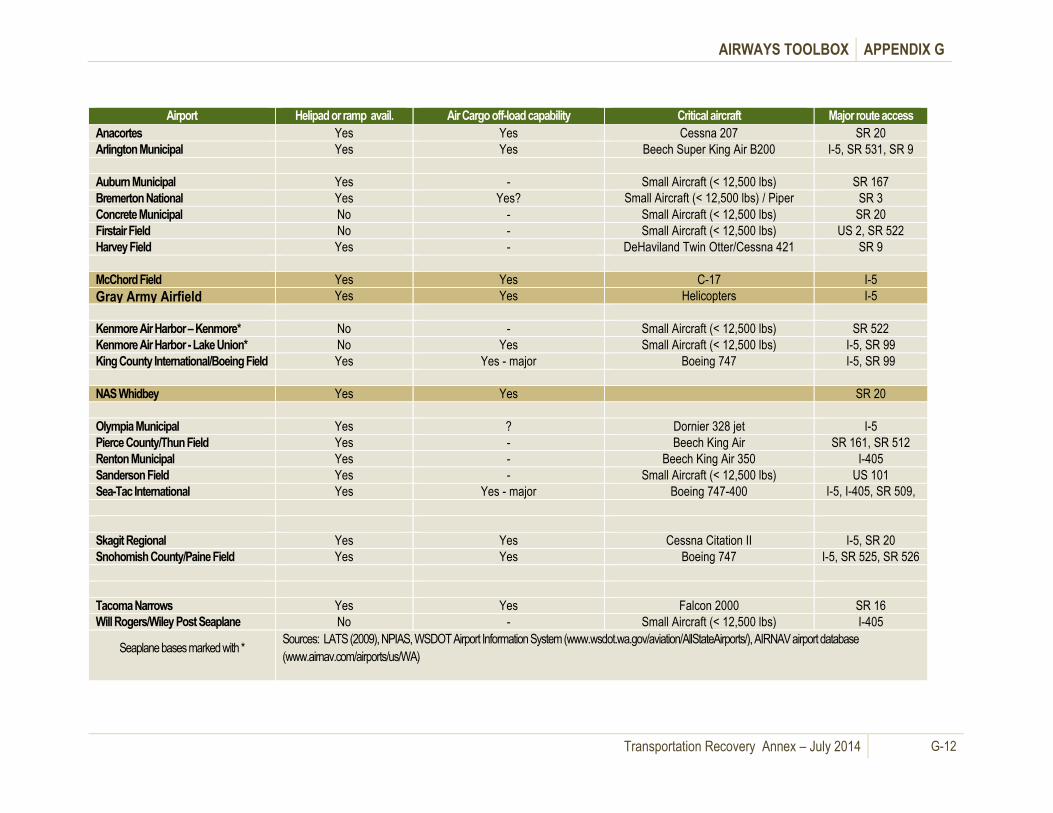
AIRWAYS TOOLBOX APPENDIX G
Transportation Recovery Annex – July 2014 G-12
Airport Helipad or ramp avail. Air Cargo off-load capability Critical aircraft Major route access
Anacortes Yes Yes Cessna 207 SR 20
Arlington Municipal Yes Yes Beech Super King Air B200 I-5, SR 531, SR 9
Auburn Municipal Yes - Small Aircraft (< 12,500 lbs) SR 167
Bremerton National Yes Yes? Small Aircraft (< 12,500 lbs) / Piper
Seneca
SR 3
Concrete Municipal No - Small Aircraft (< 12,500 lbs) SR 20
Firstair Field No - Small Aircraft (< 12,500 lbs) US 2, SR 522
Harvey Field Yes - DeHaviland Twin Otter/Cessna 421 SR 9
McChord Field Yes Yes C-17 I-5
Gray Army Airfield Yes Yes Helicopters I-5
Kenmore Air Harbor – Kenmore* No - Small Aircraft (< 12,500 lbs) SR 522
Kenmore Air Harbor - Lake Union* No Yes Small Aircraft (< 12,500 lbs) I-5, SR 99
King County International/Boeing Field Yes Yes - major Boeing 747 I-5, SR 99
NAS Whidbey Yes Yes SR 20
Olympia Municipal Yes ? Dornier 328 jet I-5
Pierce County/Thun Field Yes - Beech King Air SR 161, SR 512
Renton Municipal Yes - Beech King Air 350 I-405
Sanderson Field Yes - Small Aircraft (< 12,500 lbs) US 101
Sea-Tac International Yes Yes - major Boeing 747-400 I-5, I-405, SR 509,
SR 518
Skagit Regional Yes Yes Cessna Citation II I-5, SR 20
Snohomish County/Paine Field Yes Yes Boeing 747 I-5, SR 525, SR 526
Tacoma Narrows Yes Yes Falcon 2000 SR 16
Will Rogers/Wiley Post Seaplane
Base*
No - Small Aircraft (< 12,500 lbs) I-405
Seaplane bases marked with * Sources: LATS (2009), NPIAS, WSDOT Airport Information System (www.wsdot.wa.gov/aviation/AllStateAirports/), AIRNAV airport database
(www.airnav.com/airports/us/WA)
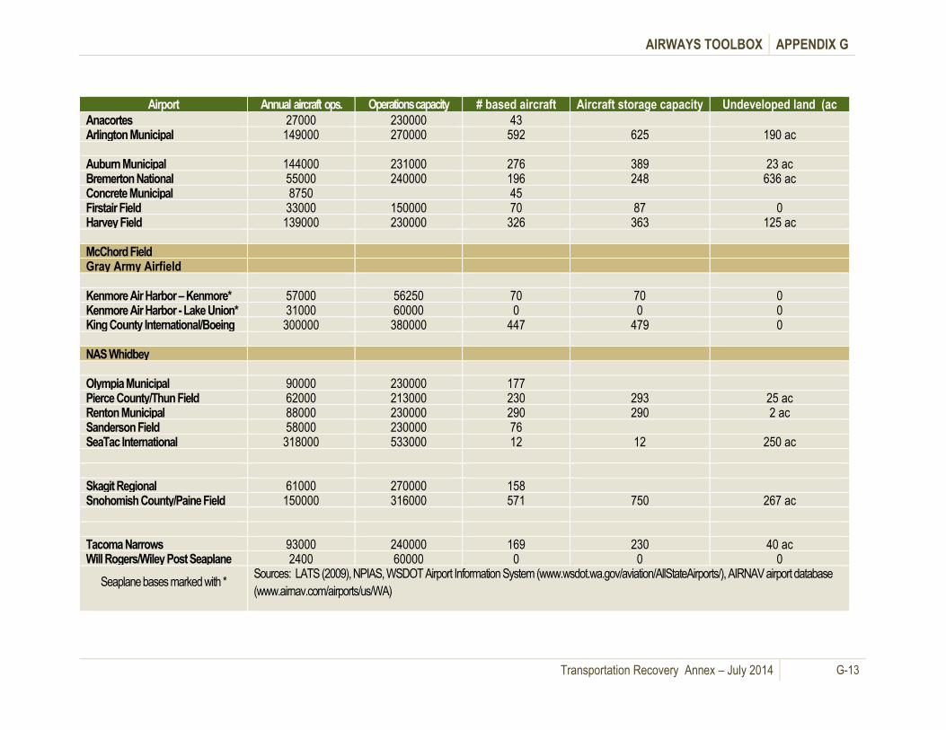
AIRWAYS TOOLBOX APPENDIX G
Transportation Recovery Annex – July 2014 G-13
Airport Annual aircraft ops. Operations capacity
(ASV)
# based aircraft Aircraft storage capacity Undeveloped land (ac
Anacortes 27000 230000 43 Arlington Municipal 149000 270000 592 625 190 ac Auburn Municipal 144000 231000 276 389 23 ac Bremerton National 55000 240000 196 248 636 ac Concrete Municipal 8750 45 Firstair Field 33000 150000 70 87 0 Harvey Field 139000 230000 326 363 125 ac McChord Field Gray Army Airfield Kenmore Air Harbor – Kenmore* 57000 56250 70 70 0 Kenmore Air Harbor - Lake Union* 31000 60000 0 0 0 King County International/Boeing
Field
300000 380000 447 479 0 NAS Whidbey Olympia Municipal 90000 230000 177 Pierce County/Thun Field 62000 213000 230 293 25 ac Renton Municipal 88000 230000 290 290 2 ac Sanderson Field 58000 230000 76 SeaTac International 318000 533000 12 12 250 ac Skagit Regional 61000 270000 158 Snohomish County/Paine Field 150000 316000 571 750 267 ac Tacoma Narrows 93000 240000 169 230 40 ac Will Rogers/Wiley Post Seaplane
Base*
2400 60000 0 0 0
Seaplane bases marked with * Sources: LATS (2009), NPIAS, WSDOT Airport Information System (www.wsdot.wa.gov/aviation/AllStateAirports/), AIRNAV airport database
(www.airnav.com/airports/us/WA)

AIRWAYS TOOLBOX APPENDIX G
Transportation Recovery Annex – July 2014 G-14
Table G- 4: Airport Contacts List (September 2010)
County Airport Phone Title
Island
NAS Whidbey 360-257-5391 Airfield Manager
King
SeaTac 206-248-7488 Aviation Planning
Boeing Field 206-296-7380 Operations & Compliance
Kenmore Air Harbor SPB 425-482-2242 Vice President, Flight Operations
Kenmore Air Harbor 425-482-2242 Vice President, Flight Operations
Renton Municipal 425-430-7471 Airport Manager
Auburn Municipal 253-333-6821 Manager
Kitsap
Bremerton National 360-674-2381 Director
Mason
Sanderson Field 360-533-9554 Business & Trade Development Asst.
Pierce
Pierce County Airport 253-871-3779 Airport Operations Manager
Tacoma Narrows Airport 253-798-2576 Transportation Operations Supervisor
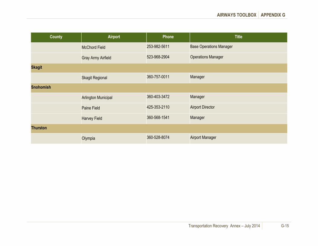
AIRWAYS TOOLBOX APPENDIX G
Transportation Recovery Annex – July 2014 G-15
County Airport Phone Title
McChord Field 253-982-5611 Base Operations Manager
Gray Army Airfield 523-968-2904 Operations Manager
Skagit
Skagit Regional 360-757-0011 Manager
Snohomish
Arlington Municipal 360-403-3472 Manager
Paine Field 425-353-2110 Airport Director
Harvey Field 360-568-1541 Manager
Thurston
Olympia 360-528-8074 Airport Manager

This page intentionally left blank.

Transportation Recovery Annex – July 2014 H-1
Glossary of Terms Appendix H.
The following are common transportation terms used in this plan and in transportation recovery
operations.
1. Air Carrier - The commercial system of air transportation comprising large certificated air carriers,
small certificated air carriers, commuter air carriers, on-demand air taxis, supplemental air carriers,
and air travel clubs.
2. Airport - A landing area regularly used by aircraft for receiving or discharging passengers or cargo.
3. American Association of State Highway & Transportation Officials (AASHTO) - A nonprofit,
nonpartisan association representing highway and transportation departments in the 50 states, the
District of Columbia and Puerto Rico. It represents all five transportation modes: air, highways,
public transportation, rail and water. Its primary goal is to foster the development, operation and
maintenance of an integrated national transportation system.
4. American Public Transportation Association (APTA) - Acting as a leading force in advancing
public transportation, APTA serves and leads its diverse membership through advocacy, innovation,
and information sharing to strengthen and expand public transportation.
5. Amtrak - Operated by the National Railroad Passenger Corporation, this rail system was created by
the Rail Passenger Service Act of 1970 (Public Law 91-518, 84 Stat. 1327) and given the
responsibility for the operation of intercity, as distinct from suburban, passenger trains between
points designated by the Secretary of Transportation.
6. Arterial - A class of roads serving major traffic movements (high-speed, high volume) for travel
between major points.
7. Arterial Highway - A major highway used primarily for through traffic.
8. Arterial Street - A class of street serving major traffic movements (high-speed, high volume) for
travel between major points.
9. Average Vehicle Occupancy - The number of persons divided by the number of vehicles traveling
past a selected point over a predetermined time period, usually expressed to two or three significant
figures (i.e., 1.2 or 1.26).
10. Bridge Management System (BMS) - A systematic process that provides, analyzes, and
summarizes bridge information for use in selecting and implementing cost-effective bridge
construction, rehabilitation, and maintenance programs
11. Bus Lane - 1) A street or highway lane intended primarily for buses, either all day or during
specified periods, but sometimes also used by carpools meeting requirements set out in traffic laws.
2) A lane reserved for bus use only. Sometimes also known as a "diamond lane."
12. Bus Priority System - A system of traffic controls in which buses are given a special advantage
over other mixed-flow traffic (e.g., preemption of traffic signals or preferential lanes).
13. Capacity, Design (or roadway capacity) - The maximum number of vehicles (vehicular capacity)
or persons (person capacity) that can pass over a given section of roadway in one or both directions
during a given period of time under prevailing environmental, roadway, and roadway user
conditions, usually expressed as vehicles per hour or persons per hour. (Operational capacity for an
HOV lane should be less than this.)
14. Carpool - An arrangement where two or more people share the use and cost of privately owned
automobiles in traveling to and from pre-arranged destinations together.

GLOSSARY OF TERMS APPENDIX H
Transportation Recovery Annex – July 2014 H-2
15. Change of Mode - The transfer from one type of transportation vehicle to another (i.e., auto to bus
or pedestrian to auto).
16. Class I Railroad - Railroad with an annual operating revenue of at least $266.7 million.
17. Collector (Highway) - In rural areas, routes that serve intra-county rather than statewide travel. In
urban areas, streets that provide direct access to neighborhoods and arterials.
18. Commercial Service Airport - Airport receiving scheduled passenger service and having 2,500 or
more enplaned passengers per year.
19. Commuter Lane - Another name for "High-Occupancy Vehicle Lane."
20. Commuter Rail - Long-haul passenger service operating between metropolitan and suburban
areas, whether within or across the geographical boundaries of a state, usually characterized by
reduced fares for multiple rides, and commutation tickets for regular, recurring riders.
21. Commuter Rail (Transit) - Urban passenger train service for short-distance travel between a
central city and adjacent suburb. Does not include rapid rail transit or light rail service.
22. Congestion Management System (CMS) - Systematic process for managing congestion. Provides
information on transportation system performance and finds alternative ways to alleviate congestion
and enhance the mobility of people and goods, to levels that meet state and local needs.
23. Containerized Cargo - Cargo that is transported in containers that can be transferred easily from
one transportation mode to another.
24. Corridor - A broad geographical band that follows a general directional flow connecting major
sources of trips that may contain a number of streets, highways and transit route alignments.
25. Expressway - A controlled access, divided arterial highway for through traffic and the intersections
of which are usually separated from other roadways by differing grades.
26. Federal-Aid Highways - Those highways eligible for assistance under Title 23 U.S.C. except those
functionally classified as local or rural minor collectors.
27. Ferry Boat - A boat providing fixed-route service across a body of water.
28. Ferryboat (Transit) - Vessels that carry passengers and/or vehicles over a body of water.
Generally steam or diesel-powered, ferryboats may also be hovercraft, hydrofoil, and other high-
speed vessels. The vessel is limited in its use to the carriage of deck passengers or vehicles or
both, operates on a short run on a frequent schedule between two points over the most direct water
routes other than in ocean or coastwise service, and is offered as a public service of a type normally
attributed to a bridge or tunnel.
29. Freeway - A divided arterial highway designed for the unimpeded flow of large traffic volumes.
Access to a freeway is rigorously controlled and intersection grade separations are required.
30. General Aviation - 1) All civil aviation operations other than scheduled air services and
nonscheduled air transport operations for taxis, commuter air carriers, and air travel clubs that do
not hold Certificates of Public Convenience and Necessity. 2) All civil aviation activity except that of
air carriers certificated in accordance with Federal Aviation Regulations, Parts 121, 123, 127, and
135. The types of aircraft used in general aviation range from corporate multiengine jet aircraft
piloted by professional crews to amateur-built single-engine piston-driven acrobatic planes to
balloons and dirigibles.
31. Heavy Rail (Transit) - An electric railway with the capacity to transport a heavy volume of
passenger traffic and characterized by exclusive rights-of-way, multicar trains, high speed, rapid
acceleration, sophisticated signaling, and high-platform loading. Also known as: Subway, Elevated
(railway), or Metropolitan railway (metro).

GLOSSARY OF TERMS APPENDIX H
Transportation Recovery Annex – July 2014 H-3
32. High Occupancy Vehicle (HOV) - Vehicles carrying two or more people. The number that
constitutes an HOV for the purposes of HOV highway lanes may be designated differently by
different transportation agencies.
33. High Occupancy Vehicle Lane - Exclusive road or traffic lane limited to buses, vanpools, carpools,
and emergency vehicles.
34. Highway - Is any road, street, parkway, or freeway/expressway that includes rights-of-way, bridges,
railroad-highway crossings, tunnels, drainage structures, signs, guardrail, and protective structures
in connection with highways. The highway further includes that portion of any interstate or
international bridge or tunnel and the approaches thereto (23 U.S.C. 101a). Infrastructure 1) In
transit systems, all the fixed components of the transit system, such as rights-of-way, tracks, signal
equipment, stations, park-and-ride lots, bus stops, maintenance facilities. 2) In transportation
planning, all the relevant elements of the environment in which a transportation system operates. 3)
A term connoting the physical underpinnings of society at large, including, but not limited to, roads,
bridges, transit, waste systems, public housing, sidewalks, utility installations, parks, public
buildings, and communications networks.
35. Intelligent Transportation Systems (ITS) - The application of advanced technologies to improve
the efficiency and safety of transportation systems.
36. Intermodal - The ability to connect, and the connections between, modes of transportation.
37. Intersection - 1) A point defined by any combination of courses, radials, or bearings of two or more
navigational aids. 2). Used to describe the point where two runways, a runway and a taxiway, or two
taxiways cross or meet.
38. Interstate - Limited access divided facility of at least four lanes designated by the Federal Highway
Administration as part of the Interstate System.
39. Interstate Highway - Limited access, divided highway of at least four lanes designated by the
Federal Highway Administration as part of the Interstate System.
40. Interstate Highway (Freeway or Expressway) - A divided arterial highway for through traffic with
full or partial control of access and grade separations at major intersections.
41. Lane - A portion of a street or highway, usually indicated by pavement markings, that is intended for
one line of vehicles.
42. Large Regionals (Air) Air carrier groups with annual operating revenues between $20
million and $99,999,999.
43. Level of Service (LOS) - A qualitative assessment of a road's operating conditions. For local
government comprehensive planning purposes, level of service means an indicator of the extent or
degree of service provided by, or proposed to be provided by, a facility based on and related to the
operational characteristics of the facility. Level of service indicates the capacity per unit of demand
for each public facility.
44. Light Rail - A streetcar-type vehicle operated on city streets, semi-exclusive rights-of-way, or
exclusive rights-of-way. Service may be provided by step-entry vehicles or by level boarding.
45. Local Street - A street intended solely for access to adjacent properties.
46. Maritime - Business pertaining to commerce or navigation transacted upon the sea or in seaports in
such matters as the court of admiralty has jurisdiction.
47. Memorandum of Understanding (MOU) - A document providing a general description of the
responsibilities that are to be assumed by two or more parties in their pursuit of some goal(s). More
specific information may be provided in an associated Statement of Work (SOW).

GLOSSARY OF TERMS APPENDIX H
Transportation Recovery Annex – July 2014 H-4
48. Metropolitan Planning Organization (MPO) - 1) Regional policy body, required in urbanized areas
with populations over 50,000, and designated by local officials and the governor of the state;
responsible in cooperation with the state and other transportation providers for carrying out the
metropolitan transportation planning requirements of federal highway and transit legislation. 2)
Formed in cooperation with the state, develops transportation plans and programs for the
metropolitan area. For each urbanized area, a Metropolitan Planning Organization (MPO) must be
designated by agreement between the Governor and local units of government representing 75% of
the affected population (in the metropolitan area), including the central cities or cities as defined by
the Bureau of the Census, or in accordance with procedures established by applicable State or local
law (23 U.S.C. 134(b)(1)/Federal Transit Act of 1991 Sec. 8(b)(1)).
49. Minor Arterials (Highway) - Roads linking cities and larger towns in rural areas. In urban areas,
roads that link but do not penetrate neighborhoods within a community.
50. Mode - A specific form of transportation, such as automobile, subway, bus, rail, or air.
51. Multimodal - The availability of transportation options using different modes within a system or
corridor.
52. National Highway System (NHS) - This system of highways designated and approved in
accordance with the provisions of 23 U.S.C. 103b).
53. Occupancy - The number of persons, including driver and passenger(s) in a vehicle. Nationwide
Personal Transportation Survey (NPTS) occupancy rates are generally calculated as person miles
divided by vehicle miles.
54. Paratransit - 1) Comparable transportation service required by the American Disabilities Act (ADA)
for individuals with disabilities who are unable to use fixed route transportation systems. 2) A variety
of smaller, often flexibly scheduled-and-routed transportation services using low-capacity vehicles,
such as vans, to operate within normal urban transit corridors or rural areas. These services usually
serve the needs of persons that standard mass-transit services would serve with difficulty, or not at
all. Often, the patrons include the elderly and persons with disabilities.
55. Peak Period - A portion of the day in which the heaviest demand occurs for a given transportation
corridor or region, usually defined as a morning or evening period of two or more hours.
56. Port - Harbor with piers or docks. See “Airport” for airways related definition.
57. Private Carrier - A carrier that provides transportation service to the firm that owns or leases the
vehicles and does not charge a fee.
58. Privately Owned Vehicle (POV) - 1) A privately-owned vehicle or privately-operated vehicle. 2)
Employee's own vehicle used on official business for which the employee is reimbursed by the
government on the basis of mileage.
59. Public Transit System - An organization that provides transportation services owned, operated, or
subsidized by any municipality, county, regional authority, state, or other governmental agency,
including those operated or managed by a private management firm under contract to the
government agency owner.
60. Rail - A rolled steel shape laid in two parallel lines to form a track for carrying vehicles with flanged
steel wheels.
61. Ramp Metering - A system used to reduce congestion on a freeway facility by managing vehicle
flow from local-access on-ramps. An on-ramp is equipped with a traffic signal that allows vehicles to
enter the freeway.
GLOSSARY OF TERMS APPENDIX H
Transportation Recovery Annex – July 2014 H-5
62. Regional Planning Organization (RPO) - An organization that performs planning for multi-
jurisdictional areas. MPOs, regional councils, economic development associations, rural
transportation associations are examples of RPOs.
63. Road - An open way for the passage of vehicles, persons, or animals on land.
64. Road Class - The category of roads based on design, weatherability, their governmental
designation, and the Department of Transportation functional classification system.
65. Stakeholders - Individuals and organizations involved in or affected by the transportation planning
process. Include federal/state/local officials, MPOs, transit operators, freight companies, shippers,
and the general public.
66. Urban Highway - Any road or street within the boundaries of an urban area. An urban area is an
area including and adjacent to a municipality or urban place with a population of 5,000 or more. The
boundaries of urban areas are fixed by state highway departments, subject to the approval of the
Federal Highway Administration, for purposes of the Federal-Aid Highway Program.
67. Vanpool (Transit) - Public-sponsored commuter service operating under prearranged schedules for
previously formed groups of riders in 8- to 18-seat vehicles. Drivers are also commuters who
receive little or no compensation besides the free ride.
Source Reference: Definitions incorporated in this glossary were developed based on the Parsons Brinckerhoff
HOV Glossary and taken from Seattle Transit Blog, King County Transportation Plan, and the Federal Highway
Administration Transportation Glossary.

This page intentionally left blan

Transportation Recovery Annex – July 2014 I-1
Recommendations, Sustainment, Training and Appendix I. Exercises
A. General Information
The Transportation Recovery Annex (the Annex) provides recommended guidelines for coordinating
multi-jurisdictional regional transportation system recovery in the Puget Sound Region after a
catastrophic incident. It provides information and recommended guidelines for regional coordination,
collaboration, decision-making, and priority setting among Puget Sound area emergency response and
transportation agencies and other partners across the disaster recovery spectrum.
The Annex also provides information, strategies and guidance
for local jurisdictions to develop their respective local
implementation plans to address local issues and procedures for
connecting local transportation recovery measures with the
restoration of the regional transportation network, as well as
establishing coordination linkages with other local jurisdictions,
state and federal transportation agencies and traffic
management systems.
1. Key Elements
Initial actions for situational awareness
Initial detours for 50 key roadway disruptions
Development and coordination of mid-term traffic management strategies
Development and coordination of regional recovery working groups
Development and coordination of a long term recovery process for transportation
Development and coordination of long term recovery priorities
Multi-modal resource lists
2. Core Capabilities Supported
Planning
Operational Coordination
Community Resilience
Threats and Hazard Identification
Situational Assessment
Infrastructure Systems for Response
Infrastructure Systems for Recovery
Public and Private Services and Resources

RECOMMENDATIONS, SUSTAINMENT, TRAINING, AND EXERCISES APPENDIX I
Transportation Recovery Annex – July 2014 I-2
3. Target Audiences for Training and Exercises
State/local EOCs and emergency management personnel
State/local transportation departments and ESF-1 personnel
Multi-Modal Transportation community (Air, Water, Road and Rail)
Puget Sound Regional Council (PSRC)
Pacific Northwest Economic Region (PNWER) and other private sector organizations
B. Recommendations
The Transportation Recovery Annex as written can be a useful tool for local and state transportation and
emergency management stakeholders in addressing regional catastrophic transportation needs. It
contains a number of checklists, resource lists, detour maps, guidelines, multi-modal alternatives and
regional coordination strategies that could be utilized to help regional coordination in short, mid- and
long term recovery efforts. It is, however, just a document, and emergency planning and preparedness
is a journey, not a destination. For example, as time passes, some information, such as resource lists
and phone numbers, will go out of date. The Annex needs to be periodically updated, used for training,
and exercised if it is to sustain its usefulness.
Although the development of the Transportation
Recovery Annex with 2008 Grant Funds and the
subsequent Training and Exercise project with 2010
Grant Funds did help to build new relationships and
develop “planning communities” as suggested in the
grant goals, there is still a long way to go in the Puget
Sound Region to fully develop and sustain the resiliency
in the multi-modal regional transportation system to
rebound from a catastrophic event.
In some cases progress was hampered by basic human nature (other priorities) and the realities of
government capabilities in the light of one of the worst recessions in our nation’s history. Many
stakeholders are already overloaded with their own mission and priorities, making it difficult to give
proper attention to Transportation Recovery Annex objectives.
In order for the Annex, and the regional efforts by many transportation stakeholders and emergency
managers in its development, to make a difference and improve regional capabilities, additional efforts
are needed. The following comments are based upon the recommendations outlined in Section X of the
Annex that were identified during Annex development.
1. Improve coordination among emergency management and transportation agencies, especially
with transportation planners and engineers who are often not involved in emergency management
planning, training and exercises, or if they are involved, it has historically been in response operations.
Although there is now an increased emphasis on overall recovery planning in the Region, more efforts
are needed to integrate the expertise of transportation planners and engineers who, in larger
departments, are often not involved in day-to-day transportation operations or in planning for initial
disaster response operations.
One baseline for Annex capability
evaluation and needed future effort
can be found in the
recommendations, gaps and best
practices outlined in Section X of
the Annex.
RECOMMENDATIONS, SUSTAINMENT, TRAINING, AND EXERCISES APPENDIX I
Transportation Recovery Annex – July 2014 I-3
Although genuine efforts were made by RCPT members and others to expand the audience for
participation in the Training and Exercise events, we often found attendance in many cases was limited
to the same stakeholders that took part in the development of the Annex in the first place. A notable
exception was in the maritime community where, due to some preexisting relationships and the US
Coast Guard’s emphasis on maritime recovery, there was a higher percentage of new stakeholders and
additional training and exercise events scheduled. Efforts must be made to expand future participation.
2. Develop an interlocal agreement among the ports so there is a region-wide interlocal agreement
among ports to provide for the sharing of resources after a catastrophe. An effort was initiated in 2010 to
develop a regional port mutual aid agreement for response to disaster. In an effort to develop this
agreement in a logical step by step process, the initial proposed draft primarily focused on assistance
with management personnel to support Port Emergency Operations Center staffing and some
equipment resources. Some progress has been made, but this still has not been completed. Currently,
the Pacific Northwest Economic Region (PNWER) is coordinating the effort. The primary issue is who
will be the coordinator of the effort and maintain the agreement. They are working with the Washington
Public Ports Association (WPPA) to encourage them to take ownership of the agreement. (From
conversations with Neil Clement of the Port of Bellingham and Eric Holdeman of PNWER)
3. Establish regional transportation recovery operations policy so there is a regional structure or
process in place to accommodate regional coordination of transportation recovery. With the change in
leadership that occurred at the Washington State EMD, there is new interest in the RCPGP products,
especially in the Regional Catastrophic Disaster
Coordination Plan.
Implementing coordinated regional transportation
policy is essential for transportation recovery. From a
basic span of control perspective, States without
regional mechanisms have established them after a
catastrophe to manage transportation recovery as
well as in all functional areas. Since experience has
shown that this is likely to occur, more discussion is
needed in the concepts of regional approaches to
solving problems after a catastrophe. This is best
lead from the State level and should be a statewide
discussion, not just among the RCPGP jurisdictions.
Additional work is being done to develop mid-term Transportation Coordination Groups in cooperation
with the Puget Sound Regional Council (PSRC) under the Transportation Recovery Annex Training and
Exercise Project, but more state and local leadership is needed in further discussion in this area,
including defining roles and responsibilities of transportation and emergency management agencies,
establishing plans for developing, implementing and maintaining cross-jurisdictional coordination, and
identifying lead agencies to sustain the effort.
Considering the Governor’s
authority to “appoint, with the
advice of local authorities,
metropolitan or regional area
coordinators, or both, when
practicable”, as outlined in RCW
38.52.050 (3) (d), the State EMD
should take the lead in further
discussions, planning and policy
development for regional
coordination.
Some local jurisdictions, notably Seattle and Snohomish County, are working on
comprehensive local recovery plans, but more discussion and planning is needed.

RECOMMENDATIONS, SUSTAINMENT, TRAINING, AND EXERCISES APPENDIX I
Transportation Recovery Annex – July 2014 I-4
4. Develop local transportation recovery plans and discussions to support restoration to the
regional transportation network. Most of the regional roadway transportation network is under the
direction and control of state government. Waterways, airways and railways are under the direction and
control of a mix of local, state, federal and private sector stakeholders. Some recovery planning has
been done, such as for the SR 520 Bridge and for potential closures of I-5 in the Olympia/Thurston
County area. Transportation recovery should be integrated into existing ongoing planning, plan
maintenance and updates.
5. Integrate transportation recovery into existing training and exercise plans and schedules.
Local jurisdictions annually update a three (3) year training plan. Short term, mid-term and long term
transportation recovery issues can be included in both local and state level, using information in the
Annex as a guide. The integration of transportation recovery issues and ESF-1 experts (See
Recommendation 1 above) into existing training and exercise schedules at local and state levels is a
very cost effective way of both Annex sustainability and usefulness in a catastrophe.
6. Improve private sector coordination through such strategies as developing formal agreements
between public transportation agencies and private sector stakeholders in each mode of transportation
(roadway, waterways, airways and railways) to better integrate the private sector into ongoing
emergency management preparedness programs. Formalizing public-private partnerships could
enhance coordination amongst private sector facilities that are locally based with local government
levels and with private sector facilities that provide a regional or multi-county function with state level
transportation recovery efforts.
7. Develop incentives to expedite transportation recovery to cut “red tape” and speed mid-term and
long term transportation recovery efforts. There are a number of models and best practices from past
disasters, such as the Northridge Earthquake, Hurricane Katrina and Super Storm Sandy. Rebuilding a
transportation network after a catastrophic event will require unprecedented cooperation between local,
regional, state and federal agencies as well as with the private sector.
8. Provide emergency replacement plans/procedures for marginal or inadequate structures by
integrating these discussions into local comprehensive transportation plans that identify roadway
improvements based on population demands and maintenance required for local area roads. Many
jurisdictions have identified marginal or inadequate structures (e.g., bridges that create traffic
bottlenecks, bridges that will need to be replaced, addition of bike lanes or high occupancy vehicle lanes
on bridges, etc.) that may need future improvements or additional capacity. In an effort to expedite
recovery, local jurisdictions should prepare design/build requests for proposals (RFPs) that can be
issued quickly after a major disaster for structures that may need replacement.
Developing incentive policies and procedures ahead of time, such as accelerated bid,
design and award processes; 24-hour work days, seven days a week (12-hour shifts); 24-
hour /day decision making and inspection; and, early bonuses and late penalties (as done
in the Northridge Earthquake) can also support Recommendation 6 above.
RECOMMENDATIONS, SUSTAINMENT, TRAINING, AND EXERCISES APPENDIX I
Transportation Recovery Annex – July 2014 I-5
9. Provide uniform bridge damage assessment reporting to expedite damage assessment by first
response bridge inspectors. Resources will be overwhelmed after a catastrophe. By developing uniform
damage assessment reporting, consistent information can be provided in accordance with existing local
communications protocols and used for operational planning and priority setting and emergency public
information purposes.
10. Provide uniform airport damage assessment reporting to support WSDOT Aviation Division
efforts to develop a status/damage report for airport sponsors (i.e., person or entity primarily responsible
for airport operations), developing a query and report format, and creating access for outside agencies
to view reports in the WSDOT Aviation – Airport Information Database (such as FAA and State EOC).
C. Training and Exercises
The following section includes information concerning future training and exercising to support
Transportation Recovery Annex and its respective Toolkits. The Annex provides information, strategies
and guidance for local jurisdictions to develop their respective local implementation plans to address
local transportation disruption issues and procedures for connecting local transportation recovery
measures with the restoration of the regional transportation network. It also guides the establishment of
coordination linkages with other local jurisdictions and transportation agencies, state and federal
transportation agencies and traffic management systems.
This Appendix identifies training, exercise and evaluation activities as they relate specifically to the
Annex. Training includes, as outlined in the Homeland Security Exercise and Evaluation Program
(HSEEP), discussion Seminars specific to the Annex to incorporating transportation elements into a
scheduled Full Scale Exercise.
1. Training Needs
Emergency management agencies in the Puget Sound Region deliver a range of training classes to
enhance the emergency planning and response capabilities of their respective community, including
transportation stakeholders. The Annex recommends integrating its respective elements into the
ongoing training programs of the local emergency management agencies, local jurisdictions and the
State EMD on an ongoing basis. Transportation stakeholders are also encouraged to notify holders of
the Annex of training opportunities associated with transportation recovery operations.
The specific training needs for the Annex include, but may not be limited to, the general knowledge of
the existence and contents of the Annex; use of Annex tools and procedures, such as the Prioritization
Tool, Bridge Assessment Information, Short Term, Mid-Term and Long Term Recovery Checklists,
strategies for developing agreements, use of specific disruption alternative routes and developing
additional diversion and detour routes.
2. Training Strategy
The RCPGP retained Witt | O’Brien’s to conduct training for local and state transportation stakeholders
and other personnel of participating public, private and non-profit agencies to train them on the contents
and tools of the Annex and to exercise the Annex elements to test capabilities and interdependencies
between jurisdictions; and to develop an After Action Report/Improvement Plan to improve the Annex
based on lessons learned through planning, exercising or actual events.

RECOMMENDATIONS, SUSTAINMENT, TRAINING, AND EXERCISES APPENDIX I
Transportation Recovery Annex – July 2014 I-6
A total of seventeen (17) training events were held and a total of 674 transportation stakeholders
participated in the training and exercise opportunities. (See Table I- 1) In accordance with Homeland
Security Exercise and Evaluation Program (HSEEP) policy, a Situation Manual (SitMan) was developed
for each event outlining the objectives and content of the program.
Table I- 1. Transportation Recovery Annex Training & Exercise Results
Transportation T&E Date Number of Participants
County
Island 11/14/2012 27
King 05/07/2013 63
Kitsap 04/24/2012 17
Pierce 04/09/2012 23
Snohomish/Skagit 01/24/2013 21
Thurston/Mason 12/12/2012 13
Cities
Seattle 12/20/2011 36
Other Key Stakeholders
Maritime (MTSRU) 04/19/2012 29
Maritime (HSC) 02/01/2012 32
PSRC 09/13/2012 45
WSDOT 06/13/2013 130
WSDOT Public Transit Conference 08/29/2012 15
Thurston TRB 03/14/2012 12
Thurston County Commissioners 06/07/2012 6
APWA MPAC 03/21/2012 30
Evergreen Quake 2012 10/01/2012 45
Evergreen Quake 2012 02/08/2012 130
Total 674
RECOMMENDATIONS, SUSTAINMENT, TRAINING, AND EXERCISES APPENDIX I
Transportation Recovery Annex – July 2014 I-7
The training focused on the three recovery related elements of the then-current DHS Target Capabilities
List: Structural Damage Assessment; Restoration of Lifelines and Economic and Community Recovery.
The training elements included:
Initial actions for situational awareness
Initial detours for road disruptions
Development and coordination of mid-term traffic management strategies
Development and coordination of regional recovery working groups
Development and coordination of a long term recovery process for transportation
Development and coordination of long term recovery priorities
The target audiences included, but were not limited to, State/local EOCs and ESF-1 personnel;
State/local transportation departments; the Maritime community; the Puget Sound Regional Council
(PSRC) and selected committees; the Pacific Northwest Economic Region (PNWER) and other private
sector organizations; and elected officials.
The Transportation Recovery Annex Training and Exercise Project also included the development of a
Train the Trainer Kit for each RCPT County and participating cities. This tool can be used in the future
for RCPT members and others to sustain training and exercises with respect to the Annex. (See Section
D of this Appendix)
3. Related Training Courses
There are currently no Independent Study Courses that relate specifically to the Transportation
Recovery Annex. There are several courses that relate to transportation or to recovery that may have
application. These courses are listed below and can be found on-line at http://training.fema.gov/IS.
General emergency management or National Incident Management System (NIMS) general required
training courses are not included in these tables.
Table I- 2- Transportation Recovery related courses
Course Number Course Name
IS-556 Damage Assessment for Public Works
IS-558 Public Works and Disaster Recovery (2/15/2012)
IS-801 Emergency Support Function (ESF) #1 – Transportation (8/7/2008)
IS-814 ESF #14 - Long Term Community Recovery
IS-2900 National Disaster Recovery Framework (NDRF) Overview (11/1/2013)

RECOMMENDATIONS, SUSTAINMENT, TRAINING, AND EXERCISES APPENDIX I
Transportation Recovery Annex – July 2014 I-8
Table I- 3. Other classes that could relate to this annex offered by different organizations
Course Name/Number Offered by
E210 – Recovery from Disaster, the Local Gov’t Role
Emergency Response Institute (EMI)
E286 – Short Term Recovery Operations Emergency Response Institute (EMI)
E313 – Basic Hazus Multi-Hazard Emergency Response Institute (EMI)
IS-0100.PWb Introduction to ICS for Public Works
Emergency Response Institute (EMI)
EO132 Discussion Based Exercise Design and Evaluation
Emergency Response Institute (EMI)
MGT 415 Disaster Recovery in Rural Communities
National Domestic Prep. Consortium (NDPC)
PER 300 Social Media for Disaster Response & Recovery
NDPTC – University of Hawaii
N/A Recovery for the Financial Section (Snohomish Co.)
Other training and exercise opportunities often are planned or scheduled through transportation related
associations, organizations, or conferences, such as RCPT member jurisdictions, the Washington State
Emergency Management Association (WSEMA), the American Public Works Association – Washington
Chapter (AWPA), the Washington State Department of Transportation (WSDOT), the Partners in
Emergency Preparedness Conference (PIEP). Also, the Washington State Emergency Management
Division publishes a Training and Exercise calendar posted on their web page. Please check with the
websites of the above for additional information.
4. Exercises
In order to test cross-jurisdictional concepts of this plan, there is a need to exercise with multiple
jurisdictions. Counties, cities, and other partners identified in this Annex should exercise together to test
cross-jurisdictional plans as well as local plans. Efforts should be made to coordinate training and
exercises of regional plans with other training and exercise efforts by using the Washington State EMD
website at www.emd.wa.gov. (As of June 2014, there were no Transportation Specific training or
exercise events on the Washington EMD web-site.)
There are a number of existing and future training and exercise
opportunities that could provide the State of Washington EMD,
participating RCPGP jurisdictions and other stakeholders the
opportunity to integrate a sustainable training and exercise
effort for regional transportation resiliency and sustainment of
the Transportation recovery Annex. Potential strategies could
be grouped into three basic categories: individual agency or
organization, local jurisdiction, and regional. Considering the
importance of transportation and the recovery of the multi-
With current budget realities,
the best strategy is to
integrate elements of
transportation recovery and
sustainment covered in the
Transportation Recovery
Annex into existing training
and exercises as well as
taking advantage of where
transportation stakeholders
gather already, such as
conferences.

RECOMMENDATIONS, SUSTAINMENT, TRAINING, AND EXERCISES APPENDIX I
Transportation Recovery Annex – July 2014 I-9
modal transportation system after a catastrophe, in a perfect world more would be done in transportation
recovery planning and training.
Each year, local jurisdictions develop and update their training and exercise plans as part of the process
the state requires for Emergency Management Preparedness Grant (EMPG) funding. (See
Recommendation 5 in Section B above) This is done on a three year cycle. An analysis of existing
training and exercise plans for counties in the RCPGP planning area show a number of opportunities for
inclusion of elements of transportation recovery and the tools, information and suggested guidance from
the Transportation Recovery Annex.
In November of 2013, a survey was done of the eight Counties in the RCPGP Region and the Cities of
Seattle and Tacoma to identify any scheduled exercises of any kind through 2016 that were either
targeted at Transportation Recovery issues or were of such scope that Transportation Issues could be
included. The stakeholders should use their Training and Exercise Plans they develop for the WA State
EMD to identify opportunities to continue training and exercising elements of the Transportation
Recovery Annex. The currently planned trainings and exercises present numerous opportunities to
integrate transportation recovery, policy and procedures using the information and tools in the
Transportation Recovery Annex. This could be as simple as adding a question or two about
transportation recovery into a TTX or Functional Exercise.
5. Evaluation
Evaluating exercises provides a forum where personnel can identify strengths, weaknesses and gaps to
plans and training as well as areas that need improvement. An After Action Report (AAR) should be
written any time the Annex is utilized in or integrated into an operations based exercise or an actual
event or incident. The AAR should be completed in a timely manner following the completion of an
exercise, generally within 90 days.
Any After Action Reports relative to transportation recovery or related topics should be shared with the
Snohomish County DEM and WSDOT which have offered to lead any sustainment efforts for the Annex.
The specific details of what they will be able or willing to do is being worked out.
6. Scheduling and Calendars
Lead agencies for the RCPGP plans, annexes and toolkits developed their respective training and
exercise plans using FFY 2010 RCPGP funds. The FFY 2011 RCPGP award supported additional
training and exercise activities. Sustainment of plans and annexes is being addressed in a separate
section of the Regional Catastrophic Disaster Coordination Plan. The lead agencies identified in the
sustainment section (Snohomish County DEM and WSDOT) may also provide leadership for training,
exercising, and evaluation of this annex.
Training and exercise schedules are developed on an annual basis by project leads or respective local
emergency management departments and organizations to be determined through the sustainment
process. Training and exercise activities should be coordinated among plan participants and
Washington State EMD Training and Exercise personnel as well as other RCPT members in case there
is opportunity to share exercise activity with neighboring jurisdictions or on a regional basis.
RECOMMENDATIONS, SUSTAINMENT, TRAINING, AND EXERCISES APPENDIX I
Transportation Recovery Annex – July 2014 I-10
D. Recommended funding opportunities and next steps
A key element to the next steps in the sustainment of transportation recovery planning has been the
commitment from both Snohomish County and WSDOT to take responsibility for some elements of
Transportation Recovery Annex maintenance and updating. This shows a commitment to make an
effort to continue discussions and planning on this important element of regional recovery.
Table I- 4:- Snohomish County tentative commitments from participating agencies
Minimum Sustainment Activity Commitments of Volunteer Lead Agencies
Minimum
Commitments
1 Keep and share latest electronic copy of Plan/Annexes upon request
2 Maintain and share contact list for the Plan/Annex upon request
3 Update and circulate contact list 1x year
4
Working in conjunction with State EMD, facilitate and promote integration
of exercise and training opportunities for the Plan/Annex into third-party
(state or other multi-county) hosted exercises/trainings.
5 Forward electronic updates of Plan/Annex and contact list to a central
website for posting (TBD: third party hosting the website)
6 Participate in RCPT (or successor) meetings to provide periodic updates
of Plan/Annex activities, opportunities re: training/exercise/sustainment
7 Participate in periodic “Project Leads” meetings
8
Provide electronic updates to RCPT members/other interested parties of
Plan/Annex activities, opportunities re: training/exercise/sustainment
ties, periodically as appropriate
9 Provide RCPT members prompt notice if unable to perform any of these
commitments
When Possible/
Subject to
Resource
Availability
10
Gather, compile and prioritize After Action Review (AAR) items relevant to
the Annex and make these recommendations available to interested
parties.
11 Propose updates to Plan/Annex as appropriate based on
Exercises/AARs/other information
12 Incorporate any plan changes as RCPT (or successor) approves

RECOMMENDATIONS, SUSTAINMENT, TRAINING, AND EXERCISES APPENDIX I
Transportation Recovery Annex – July 2014 I-11
They will work on advocating greater inclusiveness and for these recommendations in general under the
auspices of numbers 4, 10, & 11 from Table 4 above. (From E-mail from Jason Biermann – 11/27/2013)
WSDOT has added a new planner to their emergency management staff who will have the assignment
to support maintenance of the Annex. This will be in coordination with Snohomish County but the actual
scope of this work has yet to be developed (Phone conversation with John Himmel, January 17, 2014)
At this time there is no targeted funding for Transportation Recovery
Annex maintenance and sustainment efforts. It is being accomplished
through the respective agencies and other regional partners’
commitment to continuing transportation recovery planning efforts.
Through the life of the project, funding has come from specific federal
funding streams focused on catastrophic planning. FEMA Region X
staff have indicated that it was the expectation of the Federal
Government that these efforts were important to State and local
jurisdictions and they would continue to sustain those elements that
were state and local priorities.
The Catalog of Federal Domestic Assistance (CFDA) annually lists all of the federal grants and other
opportunities for federal financial assistance. A survey of existing opportunities for additional funding to
support further transportation recovery projects or planning in the Puget Sound Region reveals that there
are several programs that potentially could be used based on funding availability, current program
guidance, current national, state and local priorities and other factors.
Table I- 5 – Potential funding opportunities from the CFDA
Catalog Number
Program Agency Date
Modified
20.205 Highway Planning and Construction
Department of Transportation / Federal Highway Administration (FHWA)
12/28/2013
20.314 Railroad Development Department of Transportation / Federal Railroad Administration (FRA)
12/4/2013
20.527 Public Transportation Emergency Relief Program
Department of Transportation / Federal Transit Administration (FTA)
2/6/2013
20.931 Transportation Planning, Research and Education
Department of Transportation / Research and Innovative Technology Administration
7/18/2013
97.039 Hazard Mitigation Grant Department of Homeland Security 9/1/2013
97.047 Pre-Disaster Mitigation Department of Homeland Security 9/1/2013
97.056 Port Security Grant Program Department of Homeland Security 7/27/2013
97.075 Rail and Transit Security Grant Program
Department of Homeland Security 8/28/2013
20.205 Highway Planning and Construction
Department of Transportation / Federal Highway Administration (FHWA)
12/28/2013
As with most
targeted funding
opportunities, other
federal priorities are
driving funding
opportunities.

RECOMMENDATIONS, SUSTAINMENT, TRAINING, AND EXERCISES APPENDIX I
Transportation Recovery Annex – July 2014 I-12
Many of these grant programs are discretionary, meaning that priorities may be set by the recipients
under the scope set out by the enabling legislation or by the funding agency regulatory process. The
reality is, with all of the needs and priorities at the local and state level, there are currently other priorities
outside of the projects that continue and sustain the regional transportation recovery planning that has
been accomplished to date. Also, many of these programs set construction projects as a higher priority
than planning. In the federal funding system, programs get authorized by statute, but need to be funded
by separate appropriations action. Subsequently, although the program guidance may look promising,
often no funding is available.
On July 6, 2012, the President signed into Law P.L. 112-141, the Moving Ahead for Progress in the 21st
Century Act (MAP-21). USDOT was able to get authority under this Act for funds for Highway Resilience
allowing the States to set and fund their multi-modal transportation priorities, including planning,
retrofitting, airport and port improvements and the like. The regulations for these opportunities are under
development and may offer opportunities for further transportation recovery planning and construction, if
it becomes a State priority. Also, transportation funding by congress needs to be appropriated.
It is not likely that additional transportation recovery planning will trump existing priorities. WSDOT has
made the commitment to work with Snohomish County on maintaining and sustaining the Annex. As
stated previously, the details of this commitment have yet to be determined, but it does present an
opportunity for sustainment and further work.
There is not likely to be any dedicated funding from the Federal government for these purposes unless
there is an event that resets the national funding priorities, such as what Katrina did for catastrophic
planning. So, in the meantime, regional transportation stakeholders should look for every opportunity to
integrate sustainment measures for the Transportation Recovery Annex into existing activities, as
recommended in this report and the After Action Report and Improvement Plan for this project.
Finally, if a catastrophe or lesser disaster occurs in our region, there may be opportunity for funding for
repair and mitigation that could strengthen transportation resiliency. Recommendations 7 and 8 from
Section X of the Transportation Recovery Annex anticipate this opportunity and suggest measures that
could be taken ahead of time to increase the benefits from such an opportunity.
E. Improvement Plan
The Improvement Plan was developed to outline the observations, recommendations and needed
corrective actions to continue efforts in implementing, maintaining and sustaining the Transportation
Recovery Annex. Snohomish County DEM and WSDOT have both offered to assist in the maintenance
and sustainment of the Annex and are currently developing their policy as to what they can realistically
do to in this regard. RCPT jurisdictions and the general emergency management community in the
WSDOT is aware of MAP-21 funding opportunity, but already has numerous
establish priorities for retrofitting transportation infrastructure and other projects.

RECOMMENDATIONS, SUSTAINMENT, TRAINING, AND EXERCISES APPENDIX I
Transportation Recovery Annex – July 2014 I-13
RCPGP planning are can use this Improvement Plan to integrate Transportation Recovery issues,
recommended guidance, tools and procedures into their ongoing programs to assist in this effort.

RECOMMENDATIONS, SUSTAINMENT, TRAINING, AND EXERCISES APPENDIX I
Transportation Recovery Annex – July 2014 I-14
Improvement Plan – Objective 1
Objective 1 Observations Recommendations Capability Element
Responsible Party Completion Date
Increase overall awareness of the Transportation Recovery Annex and enhance coordination among transportation stakeholders in the Puget Sound Region by helping them understand how to use the Annex, how to use the tools in the Annex and how to integrate these tools into their local planning.
The Annex provides guidance for “connecting the dots” for disruption to the multi modal transportation system.
There was not a broad awareness of the existence of the Annex or recovery planning among many transportation Stakeholders
Few local transportation recovery plans exist for local implementation of recovery strategies.
The tools and guidance provided in the Annex are not used very often at the local and state levels making further planning and training challenging.
Continue to reach out to public and private transportation stakeholders to involve them in the local emergency planning process.
Continue to involve stakeholders in activities, such as scheduled training and exercise opportunities so public and private stakeholders could become familiar with the tools and guidance in the Annex.
Take advantage of and get involved in current planning sponsored by the RCPGP to update the detour maps and developing mid-term transportation recovery groups to help public and private transportation stakeholders develop local plans and procedures.
Stakeholders could utilize the Annex during
exercises within the region including filling out
ISNAP for transportation issues; holding
transportation related coordination conference
calls and discuss coordination groups;
prioritizing regional transportation solutions;
and, including mid-term and long term recovery
considerations in exercise injects.
Planning Snohomish Co DEM
WSDOT
RCPT members
Washington EMD
Ongoing

RECOMMENDATIONS, SUSTAINMENT, TRAINING, AND EXERCISES APPENDIX I
Transportation Recovery Annex – July 2014 I-15
Improvement Plan – Objective 2
Objective 2 Observations Recommendations Capability Element
Responsible Party
Completion Date
Enhance stakeholder’s understanding of the coordination and operational issues required for setting priorities and organizing limited resources for mid-term and long-term recovery.
Transportation stakeholders do not have experience in multi-agency/regional priority setting.
The forms and scoring processes in the Annex were confusing to participants.
There was uncertainty and discomfort with the topic of prioritizing scarce resources.
An established prioritization process could provide logical and objective explanations to share with the public regarding the prioritization of recovery projects.
Participants felt that the role of the State versus the role of the County needed to be better defined in order to make regional prioritization decisions.
Get involved in current planning sponsored by the RCPGP to update the detour maps and developing mid-term transportation recovery groups to help public and private transportation stakeholders develop local plans and procedures.
Provide additional training on the tools and processes in the Transportation Recovery Annex using the Train the Trainer tools provided to the RCPT members.
Jurisdictions need to plan for prioritization decisions that may not be favorable to them and prepare to inform their residents of those decisions.
Integrate Transportation Recovery issues and tools in regularly scheduled training and exercises.
Develop local transportation recovery plans supporting the regional transportation recovery planning.
Review the forms and instructions and clarify how the forms should be completed.
Review the scoring methodology and provide excel spread sheets with proper formula so all that a jurisdiction needs to do is enter the raw data and the score is determined.
Revisit the prioritization matrix and see if there is a more balanced way of scoring priorities, or develop an electronic method of prioritizing and hide the weighted values from the priority setters until projects are scored and ranked.
Planning Snohomish Co DEM
WSDOT
RCPT members
Washington EMD
Ongoing

RECOMMENDATIONS, SUSTAINMENT, TRAINING, AND EXERCISES APPENDIX I
Transportation Recovery Annex – July 2014 I-16
Improvement Plan – Objective 3
Objective 3 Observation Recommendation
Capabilit
y
Element
Responsible Party Completion
Date
Help stakeholders understand regional inter-dependencies in recovery from a catastrophic event to guide future planning.
Transportation stakeholders
often did not have an
appreciation for, nor
understanding of, the regional
interdependencies of the
regional multi-modal
transportation system.
Multi-modal transportation entities are loosely coupled and are not well acquainted.
There are insufficient planning and coordination efforts in place that present opportunities for government agencies and private sector to meet and understand the needs and recovery capabilities of the private sector.
Some participants did not have a thorough understanding of the interdependencies of bridges and utilities.
Continue to develop local transportation recovery plans
supporting the regional planning elements.
Continue to involve private sector transportation
partners in local and state transportation planning,
training and exercises.
Integrate the planning and development work done on
Transportation Recovery Annex with the State’s
Recovery Planning efforts.
Expand participation in existing transportation planning
efforts to private sector transportation partners and to
elements of local government, such as planners and
engineers who have not traditionally been involved in
emergency planning.
Planning and exercises should include discussions of the interdependencies in the regional transportation system.
Engage elected officials and high level executives in the planning discussions, training and exercises.
Continue to provide opportunities for public – private interaction and discussions about transportation recovery through existing public private partnerships like the Pacific Northwest Economic Region (PNWER).
Annex &
Local
Plans
Planning
Snohomish Co DEM
WSDOT
RCPT members
Washington EMD
Ongoing

RECOMMENDATIONS, SUSTAINMENT, TRAINING, AND EXERCISES APPENDIX I
Transportation Recovery Annex – July 2014 I-17
F. Train-the-Trainer Information
A Train-the-Trainer Toolkit was developed to assist jurisdictions and transportation stakeholders
continue training and exercising opportunities for the Transportation Recovery Annex. This Training
Toolkit consists of several components which can be found on the Washington State EMD Website at
the following web link: http://www.emd.wa.gov/plans/plans_index.shtml#R
The components include the following:
1. General Guidance
2. Situation Manual (SitMan) Template
3. PowerPoint Presentation (PPT)
4. Draft Announcement Flyer
5. Transportation Annex Overview
6. Priorities Handout (Optional)
7. Feedback Form
A summary of each and their intended use are as follows:
1. General Guidance
Begin the session with the PowerPoint presentation explaining the Regional Catastrophic Planning
Program, the Coordination Plan, and how the Transportation Recovery Annex fits into the plan. The
PPT shows examples of the tools, maps and charts contained in the Annex.
The last three slides of the PPT explain the exercise and show the questions groups are seeking to
answer in their break-out groups. These slides should remain on the screen for each of the three
exercise scenarios which are described in detail in the student handouts.
In addition, there is a copy of the Annex Overview and the Annex User Guide. The Annex Overview is a
60+ page document summarizing the Annex and showing examples of the tools and maps contained in
the larger plan. The Overview should be printed and given to each student at the beginning of the event.
The PPT slides reference specific pages in the Overview so students can turn to the actual document
shown on the screen. The Annex User Guide was developed to help explain key elements of the Annex
and facilitate the use of the Annex tools.
Upon completion of the PPT presentations, give students a 10 minute break. When they return, break
them into three or four groups, as appropriate to the size of the group. Groups are assigned Activity
one, Short-Term Recovery. This is intended as a “get acquainted” activity and should not take more
than 15 minutes of group time and 5 minutes of Report-Out time.
For the next activity, each group will be assigned a different piece of critical infrastructure significant to
their jurisdiction and asked to come to consensus on the assigned questions (on the PPT slide). The
Mid-Term recovery activity will take longer and groups should be allowed to work through their
questions. Reporting out will take at least 10 minutes.
Follow the same process for the Long-Term recovery activity. The priority–setting activity may be the
most challenging for the students. While it is set up such that each group evaluates the piece of
infrastructure assigned to them and arrives at a score. It may make more sense to the group if they work
as a large group to assign values to all infrastructure examples, thereby making the comparisons more

RECOMMENDATIONS, SUSTAINMENT, TRAINING, AND EXERCISES APPENDIX I
Transportation Recovery Annex – June 2014 I-18
consistent. The key to this tool is to show that an objective, systematic methodology is needed to justify
prioritization decisions.
2. Situation Manual (SitMan) Template
The SitMan includes the following:
a) Structure and info
b) Agenda
c) Exercise scenario options
INSTRUCTOR NOTES:
A Situation Manual is recommended in the Homeland Security Exercise and Evaluation Program
(HSEEP) to outline exercise activities. A generic Situation Manual is provided in the toolkit that should
be customized for each event specific to the participants. The SitMan is for exercise developers only and
should not be given to participants.
Appendix D to the SitMan is the Scenario and exercise requirements. It should be customized for the
participants and printed as a stand-alone document. Incorporating maps contained in the Annex specific
to the customized scenario.
To incorporate maps, find the document online, utilize a screen capture program to copy maps and
insert them into the student scenario pages.
The Scenarios are printed in the SitMan and should be customized for each jurisdiction and each event.
Once they are completed with maps and scenario descriptions, print just this Appendix of the SitMan
and distribute to participants.
It works best of each exercise information is on a separate sheet of paper and given out at the beginning
of each activity, as opposed to printing them and handing them out altogether.
3. PowerPoint Presentation (PPT)
The PPT includes the following:
a) Origins of the RCP and the TR Annex
b) Tools of the TR Annex
c) Maps of the TR Annex
d) Set up for exercise
INSTRUCTOR NOTES: Additional information for each slide is in the Notes section. The PPT is a
template and needs to have specific local information filled in for each respective local session.
4. Draft Announcement Flyer
INSTRUCTOR NOTES: This is a basic announcement to advertise training and exercise events and to
solicit participation. It can be completed for each respective event.
5. Transportation Annex Overview (Condensed TR Annex)
INSTRUCTOR NOTES: Print up this document and hand out to participants. It is a shortened Overview
of the larger Annex. The PPT refers to specific pages on this document and it should be available for
students.
RECOMMENDATIONS, SUSTAINMENT, TRAINING, AND EXERCISES APPENDIX I
Transportation Recovery Annex – June 2014 I-19
The priority-setting matrix Table D- 2 and Table D- 3 are included in this overview and will be used by
the students in the last exercise.
6. Priorities Handout (OPTIONAL)
INSTRUCTOR NOTES: This handout is useful if the event is heavily focused on priority-setting. It shows
the actual forms from the Annex. It can be used by the students for the final exercise if they do not wish
to write in the larger Overview document.
7. Feedback Form
INSTRUCTOR NOTES: This form can be used to collect After Action Report and Improvement Plan
(AAR/IP) information. Or, the instructors can do a two up/two down discussion having each participant
list two positive items from the activity and two areas of improvement or concern.
Related Documents