Technical Memorandum I‐290 Preliminary Engineering and Environmental (Phase I) Study West of Mannheim Road to East of Cicero Avenue Public Transit Existing Conditions April 2010

Welcome message from author
This document is posted to help you gain knowledge. Please leave a comment to let me know what you think about it! Share it to your friends and learn new things together.
Transcript

Technical Memorandum I‐290
Preliminary Engineering
and Environmental (Phase I) Study
West of Mannheim Road to East of Cicero Avenue
Public Transit Existing Conditions April 2010

Table of Contents
1.0 PUBLIC TRANSPORTATION ...................................................................................... 1
1.1 Chicago Transit Authority (CTA) ........................................................................ 6 1.1.1 CTA Bus Service .......................................................................................... 8 1.1.2 CTA Rapid Transit Service ...................................................................... 12
1.2 PACE Bus Service ................................................................................................. 16 1.2.1 Pace Planned Improvements ................................................................... 18
1.3 Metra Commuter Rail Service ............................................................................ 23 1.3.1 BNSF Service ............................................................................................. 25 1.3.2 UP‐W Service ............................................................................................. 28 1.3.3 Metra Planned Improvements ................................................................ 30
2.0 PUBLIC TRANSPORTATION DEFICIENCIES ...................................................... 32 2.1.1 Assessment of Facility Deficiencies ........................................................ 32 2.1.2 Assessment of Service Deficiencies ........................................................ 35 2.1.3 Conclusion ................................................................................................. 40
LIST OF REFERENCES ............................................................................................................. 41
List of Tables
Table 1‐1. Transit Services in the Broad Study Area ............................................................... 3 Table 1‐2. Transit Studies/Improvements in the Broad Study Area ..................................... 4 Table 1‐3. CTA Bus Route Service Characteristics ................................................................ 10 Table 1‐4. CTA Rail Station Characteristics ............................................................................ 12 Table 1‐5. Blue Line Bus to Rail Transfers, April 2009 .......................................................... 14 Table 1‐6. Pace Bus Route Service Characteristics ................................................................. 20 Table 1‐7. Metra Commuter Trains per Day and Stops by Station in Study Area ............ 27 Table 1‐8. Metra Boardings by Station .................................................................................... 29 Table 1‐9. CTA Bus Route Max Load Points in the Study Area .......................................... 36
List of Figures
Figure 1‐1. Transit Services in the Broad Study Area ............................................................. 1 Figure 1‐2. CTA Rapid Transit and Bus Service ...................................................................... 8 Figure 1‐3. Pace Fixed‐Route Bus Service ............................................................................... 16 Figure 1‐4. Metra Commuter Rail Lines ................................................................................. 24 Figure 2‐1. Typical Section for CTA Blue Line Median Station in Study Area ................. 33

I-290 Phase I Preliminary Engineering and Environmental Study 1 Public Transit Existing Conditions April 2010 Technical Memorandum
1.0 Public Transportation
Transit plays an important role in the I‐290 study area, which is served by a combination of rail and bus services. The I‐290 focused study area extends just east of Cicero Avenue and west of Mannheim Road (U.S. Routes 12/20/45). The focused study area includes transit services that are within close proximity to the I‐290 corridor. The broad study area is generally centered along I‐290 from approximately two miles west of Mannheim Road to approximately two miles east of Cicero Avenue. It also extends from North Avenue to the north and to Cermak Road on the south. The transit services in the broad study area are shown in Figure 1‐1.
Figure 1‐1. Transit Services in the Broad Study Area
The purpose of this technical memorandum is to summarize the performance and conditions of the existing transit facilities and services in the I‐290 broad study area. Available data and information is used to examine the physical, operational, and safety conditions and identify the deficiencies related to condition, design, operations, and safety. No recommendations are made in this technical memorandum.

I-290 Phase I Preliminary Engineering and Environmental Study 2 Public Transit Existing Conditions April 2010 Technical Memorandum
Fixed route transit services currently operating in the broad study area include Metra commuter rail, Chicago Transit Authority (CTA) rapid transit service and fixed route bus service, and Pace fixed route bus service. Metra operates the commuter rail system, which provides long‐haul commuter service from the suburbs and Chicago to the Chicago central business district. Metra operates two commuter rail lines through the study area. Metra’s Union Pacific‐West (UP‐W) Line travels between downtown Chicago and Elburn in central Kane County. The UP‐W Line runs parallel to CTA’s Green Line between North and South Boulevard on the same viaduct, approximately one mile north of I‐290. Metra’s Burlington Northern Santa Fe (BNSF) Line runs in an east‐west direction from downtown Chicago to Aurora in southeast Kane County. At Cicero Avenue, the Metra BNSF alignment is 1.9 miles south of I‐290, and at LaGrange Road, it is 3.8 miles south of the I‐290/Mannheim Road interchange.
CTA’s rapid transit system provides rail service for areas in the eastern portion of the study area on three rapid transit lines. The CTA Green Line terminates in Oak Park at Harlem Avenue; service is provided 21 hours per day (between 4 a.m. and 1 a.m.). The CTA Blue Line provides 24‐hour rapid transit train service between Chicago OʹHare International Airport and the Forest Park terminal station, via downtown Chicago. South of I‐290, The CTA Pink Line terminates 0.8 miles west of Cicero Avenue at 54th/Cermak Road and is approximately 1.4 miles south of the I‐290 corridor. Service on this line is provided between the hours of 4 a.m. and 1 a.m.
In a similar context, the CTA bus routes tend to serve the eastern portion of the study area, while the Pace bus routes are distributed throughout the study area. Amtrak’s intercity passenger rail service, the Chicago‐Galesburg‐Quincy trains (Carl Sandberg and Illinois Zephyr), share the BNSF tracks with BNSF and Metra trains, making a stop at LaGrange Road. The LaGrange Road station had an average of 38 daily Amtrak boardings in 20091. Amtrak also operates two pairs of daily long‐distance trains between Chicago and the west coast via the BNSF line, though these trains do not stop within the limits of the study area.
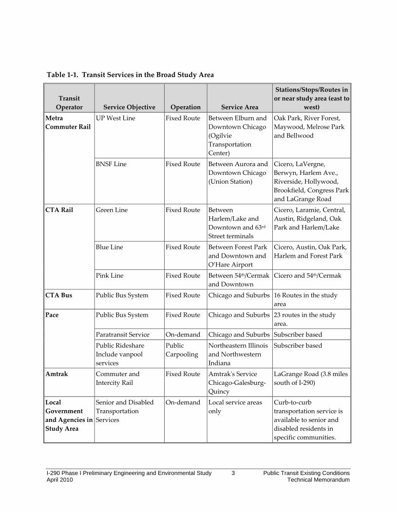
Table 1‐1 summarizes the transit services in the study area and the surrounding area discussed in this section. Table 1‐2 summarizes completed and on‐going transit studies and planned transit capital improvements in the study area.
1 Amtrak Illinois Fact Sheet, 2009
I-290 Phase I Preliminary Engineering and Environmental Study 3 Public Transit Existing Conditions April 2010 Technical Memorandum
Table 1‐1. Transit Services in the Broad Study Area
Transit Operator Service Objective Operation Service Area
Stations/Stops/Routes in or near study area (east to
west) Metra Commuter Rail
UP West Line Fixed Route Between Elburn and Downtown Chicago (Ogilvie Transportation Center)
Oak Park, River Forest, Maywood, Melrose Park and Bellwood
BNSF Line Fixed Route Between Aurora and Downtown Chicago (Union Station)
Cicero, LaVergne, Berwyn, Harlem Ave., Riverside, Hollywood, Brookfield, Congress Park and LaGrange Road
CTA Rail Green Line Fixed Route Between Harlem/Lake and Downtown and 63rd Street terminals
Cicero, Laramie, Central, Austin, Ridgeland, Oak Park and Harlem/Lake
Blue Line Fixed Route Between Forest Park and Downtown and O’Hare Airport
Cicero, Austin, Oak Park, Harlem and Forest Park
Pink Line Fixed Route Between 54th/Cermak and Downtown
Cicero and 54th/Cermak
CTA Bus Public Bus System Fixed Route Chicago and Suburbs 16 Routes in the study area
Pace Public Bus System Fixed Route Chicago and Suburbs 23 routes in the study area.
Paratransit Service On‐demand Chicago and Suburbs Subscriber based
Public Rideshare Include vanpool services
Public Carpooling
Northeastern Illinois and Northwestern Indiana
Subscriber based
Amtrak Commuter and Intercity Rail
Fixed Route Amtrakʹs Service Chicago‐Galesburg‐Quincy
LaGrange Road (3.8 miles south of I‐290)
Local Government and Agencies in Study Area
Senior and Disabled Transportation Services
On‐demand Local service areas only
Curb‐to‐curb transportation service is available to senior and disabled residents in specific communities.

I-290 Phase I Preliminary Engineering and Environmental Study 4 Public Transit Existing Conditions April 2010 Technical Memorandum
Table 1‐2. Transit Studies/Improvements in the Broad Study Area
Project Description Within Study Area?
Likely to Affect
Study Area Travel?
Expected orActual
Completion Date
Metra Union Pacific West Line Improvement Project
Track, signal, safety and station improvements Yes Yes 12/2010
The UP‐W Upgrade New Starts Project
Signal improvements, reconfiguration of the A‐2 Crossing – Northeastern Illinois’ busiest railroad crossing, additional parking, and new rolling stock to expand service on the line.
Yes Yes 2017
BNSF Railway Station Improvements Yes No On‐going
Bellwood St. Charles Road Redevelopment Plan
TOD study for Metra Bellwood UP‐W station. Yes No 4/2008
Berwyn Transit‐Oriented Master Plan
TOD study for the three Berwyn Metra station areas along the Metra BNSF line between Harlem Avenue and Ridgeland Avenue.
Yes No 11/2008
Brookfield Transit‐Oriented Development Corridor
TOD study for Congress Park, Brookfield, and Hollywood BNSF stations.
Yes No 5/2005
Maywood Station Area Planning Study Maywood station area study Yes No 1/2004
Melrose Park Lake Street Transit Improvement Plan
TOD study for Metra Melrose Park UP‐W station
Yes No 1/2007
Oak Park Intermodal Station Area Plan
CTA and Metra station area improvements
Yes No 3/2005
Riverside Central Business District Station Area Plan
Riverside BNSF station area improvements Yes No 8/2008
Cook‐DuPage Corridor Study
Study examined a broad range of transportation system improvements to address the mobility needs in the western suburbs of Chicago
Yes Yes 2009
CTA West Side Corridor Study
Service enhancements including 14 bus routes and two rail lines. Yes Yes 2006

I-290 Phase I Preliminary Engineering and Environmental Study 5 Public Transit Existing Conditions April 2010 Technical Memorandum
Project Description Within Study Area?
Likely to Affect
Study Area Travel?
Expected orActual
Completion Date
Harlem Avenue Underpass Project
Reconstruction of CTA, Metra and UP bridge at Harlem Ave. and South Blvd.
Yes Yes 2014
Pace Arterial Rapid Transit Study ART corridor planning Yes Yes 9/2009
Pace Regional Transit Signal Priority Initiative
Initiative to develop regional TSP program: corridor, technology, coordination, implementation
Yes Yes 9/2010
I‐294 Express Bus Service
Service plan for I‐294 corridor service
Yes Yes 9/2009
Pace Queue jump Initiative
Initiative to examine feasibility of queue jump lanes Yes Yes 2009
RTA I‐55 Bus on Shoulder Project development
Planning and project development study to examine the potential use of Interstate 55’s shoulders for a suitable transit demonstration program
Results benefit
project area Yes 2009
UIC Bus on Shoulder study
Feasibility for bus on shoulder operations
Results benefit
project area Yes 8/2008
RTA/Pace Cermak AA AA, preliminary design Yes Yes 2011

I-290 Phase I Preliminary Engineering and Environmental Study 6 Public Transit Existing Conditions April 2010 Technical Memorandum
1.1 Chicago Transit Authority (CTA)
The CTA Blue Line, formerly known as the Congress Line, opened in 1958, replacing the Garfield Park Line that was built in 1895. Whereas the Garfield Park Line was an elevated railway that followed the Van Buren Street/Harrison Street corridor through the West Side, the Blue Line was built mostly in the median of the Eisenhower Expressway (originally the Congress Expressway) in open cut. The Blue Line was planned at the same time as the Eisenhower Expressway in the 1950’s, and was the first of several combined transit/highway facilities pioneered in Chicago’s multimodal transportation system. The Congress Expressway/rapid transit project modernized transit facilities and decreased train travel time through the West Side, primarily by reducing the number of stops. The Garfield Park Line had over two dozen stations west of the Loop, but the Blue Line had 15, now reduced to 12. As the Chicago expressway system was taking shape in the 1950’s and early 1960’s, Chicago saw a favorable opportunity to create multimodal corridors by adding rail rapid transit to the new expressways. At the time, combining expressway and transit facilities was a new concept, with obvious advantages. Combining facilities saved design, land acquisition and construction time and costs, and was an efficient way to deliver major new transit facilities. Furthermore, the rapid transit line considerably increased the overall person capacity of the combined facility, acting as a high occupancy vehicle facility. The combined facility also provided both a highway and transit option in one place, and this combination was viewed as complementary rather than competing. Although these are still strong arguments for median rapid transit lines, there are definite drawbacks. For passenger station locations, the expressway is not a good environment. Access is necessarily divided from the adjacent neighborhood and pedestrians need to navigate across busy streets feeding on/off ramps. Bus connections can also be difficult due to the busy street conditions at expressway interchanges. At platform level, the noise and visual scene of the expressway can create a harsh environment. The present day rail transit network serving the West Side of Chicago and the near west suburbs is somewhat smaller than the one that existed at the end of World War II. The rail network began to shrink in the early 1950’s, with the cutback of “L” service on the Garfield Park Line (Blue Line) and the Douglas Park Line (Pink Line) to their present extents, as well as the elimination of Chicago, Aurora and Elgin interurban service.
• Garfield Park Line (Blue Line) cut back from Cermak/Mannheim in Westchester to Des Plaines Avenue in Forest Park; December, 1951.
• Douglas Park Line (Pink Line) cut back from Oak Park Avenue in Berwyn to 54th Avenue in Cicero; February, 1952.
• Chicago Aurora & Elgin interurban service ended July, 1957.

I-290 Phase I Preliminary Engineering and Environmental Study 7 Public Transit Existing Conditions April 2010 Technical Memorandum
• The “L” services were replaced by bus services including the CTA #17‐Westchester route and CTA #21‐Cermak route.
The 2006 CTA West Side Corridor Study identified service improvements to better connect communities in the west side of Chicago to major traffic generators throughout the region. The study demonstrated that although the area is well served by north‐south and east‐west transit routes, there were opportunities to further improve travel options, connect traffic generators, and improve connections between bus and rail.
Improvements were made to 14 bus routes, the service plan for the 54th/Cermak and Forest Park Branches of the Blue Line was refined, and the Pink Line service was implemented. In 2004, CTA completed the reconstruction of the Cermak Branch of the Blue Line that included the Paulina Connector, a three‐quarter mile long structure connecting the Blue Line to the rest of the CTA rail system (specifically, to the Green Line just west of the Ashland‐Lake station). Using the Paulina Connector provided the CTA with greater flexibility to reconfigure west side rail services to better meet future travel demand. In 2008, the 54th/Cermak branch was discontinued (as part of the Blue Line) and the new Pink Line service was created. In addition, the Green Line hours of service were expanded and schedules were refined in the morning and afternoon rush hours.
As of January 1, 2010, CTA’s regular cash fare is $2.25. Rates for the Chicago Card, Chicago Card Plus and Transit Card users are $2.00 for bus trips and $2.25 for rail trips. Transfers are $0.25 for the first transfer and free for the second transfer. The CTA offers 1‐day passes for $5.75, 3‐day passes for $14, and 7‐day passes for $23.00. The Pace/CTA 7‐day pass is $28.00 and the 30‐day pass is $86.00. The CTA also offers reduced fares for children, students, people with disabilities and military personnel. Seniors ride free.
The following sections summarize CTA bus and rail service shown in Figure 1‐1.

I-290 Phase I Preliminary Engineering and Environmental Study 8 Public Transit Existing Conditions April 2010 Technical Memorandum
Figure 1‐2. CTA Rapid Transit and Bus Service
1.1.1 CTA Bus Service The CTA operates 16 bus routes in the area surrounding the I‐290 corridor as shown on Figure 1‐1. The CTA bus routes that serve the broad study area represent approximately 136,000 weekday boardings and 13 percent of the bus system’s total ridership for October 2009.
CTA bus route service between Cicero Avenue and Mannheim Road generally includes the area east of Harlem Avenue (IL 43) spanning Oak Park, Berwyn, Cicero and the Austin neighborhood of Chicago. The one exception is Route #17 which travels west on Madison Street to the Cook County Court facility in Maywood and extends into Westchester. The service characteristics for CTA bus routes are described Table 1‐3. These routes operate on major arterials on approximately 1/2 mile spacing comprising a grid network of service. North‐south buses provide inter‐connections between the CTA rail stations on Green, Blue and Pink Lines. East–west routes primarily serve downtown Chicago and residential and employment areas in the West Loop and Oak Park. Frequency and hours of service varies by time of day and by route.

I-290 Phase I Preliminary Engineering and Environmental Study 9 Public Transit Existing Conditions April 2010 Technical Memorandum
As shown in Table 1‐3, all routes, except one, run at less than 12‐minute headway (frequency) on average. The exception is Route #17 Westchester, which has a headway ranging from 24 to 30 minutes and also operates only during the weekday peak periods. This route is also served by Pace Route #317. All weekday routes provide peak, midday and evening service. Most routes operate at least 12 hours per day and provide weekend service. All CTA buses are American with Disabilities Act (ADA) accessible and can carry up to two bicycles on racks mounted on the front of the bus.
In October 2009, the CTA #20/Madison had the highest weekday ridership of all the routes in the study area with 18,948 riders. This route travels east‐west between Austin Avenue and Michigan Avenue and is one of the heavier‐trafficked routes in the CTA bus system, running approximately 3,000 revenue miles each weekday. Only nine other CTA bus routes have greater ridership than the Madison bus route.
CTA bus service is available at the Blue Line Stations at Cicero, Austin and Forest Park. In addition, CTA buses also connect riders to the Oak Park Metra Station on the UP‐W Line and the Cicero Metra Station on the BNSF Line, which is located 1.4 miles south of Blue Line and Cicero Avenue. Routes #7 (not a direct connection), #54, #X54, and #57 serve the CTA Blue Line at Cicero. Routes #91 and #17 connect to the Austin and Forest Park stations, respectively. CTA buses also connect to stations along the Green and Pink Line.

I-290 Phase I Preliminary Engineering and Environmental Study 10 Public Transit Existing Conditions April 2010 Technical Memorandum
Table 1‐3. CTA Bus Route Service Characteristics
Route Number / Route Name
Primary Direction
Connecting CTA/Metra Train Routes
Weekday Service Hours (approx.)
Weekend Service Hours (approx.)
Weekday Peak Period Headway
Oct 2009 Weekday Ridership
Oct 2009 Weekend Ridership
Sat Sun
#7 /Harrison EW Polk Street/Pink Line. 6:00a‐10:00p NA 9 to 13 min 8,582 NA NA
#12 /Roosevelt EW NA 4:00a‐1:00a
4:00a‐1:00a 7 to 8 min 15,298 10,600 8,326
#17 /Westchester EW Forest Park/Blue Line 5:00a‐10:00p
5:00a‐10:00a Sat 7:00a‐10:00a Sun 24 to 30 min 505 NA NA
#20 /Madison EW Harlem‐Lake/ Green Line (Owl period only)
Between Austin & Michigan 24 hours weekdays
Between Austin & Michigan 24 hours weekdays
5 to 8 min 21,551 14,943 9,635
#X20 / Washington/Madison Express
EW NA
6:00a‐9:00a & 3:00p‐5:10p
NA 10 min 2,774 NA NA
#21 / Cermak EW Multiple Cermak Branch Stations
4:00a‐12:10a
4:00a‐11:00a 11 to 12 min 9,897 9,093 5,705
#54 / Cicero NS Cicero on the Green, Blue (Forest Park) and
Pink Lines
4:00a‐1:00a 4:00a‐1:00a 12 min 8,804 10,687 7,427
#X54 / Express NS Cicero on the Green, Blue (Forest Park) and
Pink Lines
6:00a‐7:00p
NA 12 min 6,451 NA NA

I-290 Phase I Preliminary Engineering and Environmental Study 11 Public Transit Existing Conditions April 2010 Technical Memorandum
Route Number / Route Name
Primary Direction
Connecting CTA/Metra Train Routes
Weekday Service Hours (approx.)
Weekend Service Hours (approx.)
Weekday Peak Period Headway
Oct 2009 Weekday Ridership
Oct 2009 Weekend Ridership
Sat Sun
#54B / South Cicero NS BNSF‐Cicero Ave. 5:15a‐11:10p
5:00a‐11:00p Saturday, 7:00a‐7:00p Sunday
12 to 13 min 3,605 4,043 2,901
#57 / Laramie NS Cicero/Blue (Forest Park) Line
6:00a‐8:40p
7:10a‐6:10p Saturday, 9:00a‐6:05p Sunday
10 to 12 min 3,492 1,679 847
#60 Blue Island/26th EW Cicero/24th 54th/ Cermak Downtown(Owl period
only) Cicero BNSF
24 hours weekdays 5:00a‐11:00p 7 to 10 min 14,418 8,957 6,864
#85 / Central NS Central Green Line 4:10a‐1:45a
4:30a‐1:45a 7 to 8 min 13,446 8,362 5,754
#86 / Narragansett / Ridgeland NS Ridgeland (Green Line)
5:22a‐9:30p NA 7 to 10 min 3,002 NA NA
#90 / Harlem NS Harlem‐Lake (Green Line) Harlem (Blue Line)
4:00a‐12:00a
5:00a‐10:00a 10 to 12 min 5,452 4,134 3,008
#91/ Austin NS Austin/Green and Blue (Forest Park) Line
4:25a‐9:50p
6:00a‐10:00a 7 to 8 min 9,335 5,226 3,424
#126/ Jackson EW NA 5:45a‐12:05a 6:00a‐11:00a 5 to 10 min 9,495 4,944 3,337
Study Area Total 136,107 82,668 57,228Note: CTA ridership is October 2009, per ridership reports on the RTAMS website. Service hours listed are prior to the February 7, 2010 service reduction. Source: CTA and Regional Transportation Asset Management System, RTAMS. NA = Data not available for route. .

I-290 Phase I Preliminary Engineering and Environmental Study 12 Public Transit Existing Conditions April 2010 Technical Memorandum
1.1.2 CTA Rapid Transit Service Three CTA rapid transit routes extend into the transit study area. These are the Green Line, the Forest Park branch of the Blue Line, and the Cermak branch of the Pink Line (also known as the Lake Congress and Douglas lines, respectively), as shown in Figure 1‐1. In total, there are 14 CTA rapid transit stations located within the study area – seven Green Line stations, five Forest Park Branch stations, and two Cermak Branch stations.
The Harlem/Lake, Forest Park and 54th/Cermak terminal stations also are major transfer points between the bus network and the CTA rapid transit system. The Forest Park terminal station in particular offers extensive transfer opportunities with connections to 12 Pace suburban bus routes; including express routes to Prairie Stone in Hoffman Estates, the Schaumburg/Woodfield area and the Oak Brook area. The Harlem/Lake station in Oak Park is a major intermodal transfer point, where it is possible to change between all modes in the region’s transit network, including CTA rapid transit, CTA bus, Metra commuter rail, and Pace bus.
Table 1‐4. CTA Rail Station Characteristics
CTA Station
CTA Rail Weekday
Boardings Oct 2009
CTA Rail Weekend Boardings Oct 2009
Number of Available Park and Ride Spaces and Utilization (2000)Sat Sun/Hol
CTA Blue Line Forest Park Branch Total
29,531 9,696 8,685
Cicero 1,265 758 577 0
Austin 1,950 789 630 0
Oak Park 1,687 524 438 0
Harlem 1,002 482 342 0
Forest Park 3,997 1,611 1,323 1051(85%)
CTA Green Line Lake Street Branch Total
27,284 14,861 11,237
Cicero 1,575 1,052 798 0
Laramie 1,433 897 659 0
Central 2,579 1,600 1,229 0
Austin 2,153 1,175 833 0
Ridgeland 1,395 554 382 0
Oak Park 1,638 926 788 0
Harlem/ Lake 3,741 2,304 1,660 0
CTA Pink Line (excluding Loop & Lake Street) Total
15,620 8,634 6,588
Cicero 1,128 909 671 0
54th and Cermak 1,942 1,056 767 304 (19%) Source: CTA and RTAMS. Parking utilization CTA Park‐and‐Ride Study, 2000

I-290 Phase I Preliminary Engineering and Environmental Study 13 Public Transit Existing Conditions April 2010 Technical Memorandum
As presented in Table 1‐4, of the three rapid transit branches within the study area, the Forest Park branch of the Blue Line and the Lake branch of the Green Line have the greatest number of customers, averaging nearly 30,000 per weekday. The Pink Line averages a little more than 14,000 customers per weekday.
1.1.2.1 Blue Line The CTA Blue Line terminates at Forest Park on its western end and at O’Hare International Airport on its northwestern end passing through downtown Chicago. Located in the Village of Forest Park, the CTA Blue Line terminal station is located about 1,000 feet north of I‐290 at the intersection of Des Plaines Avenue and I‐290. A rail car yard with shop building and car washer is located adjacent to the terminal station.
Heading east from the Forest Park station, the Blue Line parallels the CSX rail tracks on the south side of I‐290 through the Harlem, Oak Park and Austin CTA stations, until it reaches Central Avenue. At Central, the line swings northeast, underneath the eastbound lanes of I‐290 and into the center median of I‐290 to the Cicero Avenue station. The Forest Park branch is double‐tracked throughout, with eight intermediate crossover locations. From the Forest Park station to the Clark/Lake station in downtown Chicago, the trip takes approximately 29 minutes. From Cicero Avenue to Clark/Lake the trip takes approximately 20 minutes.
Service on the Forest Park branch is provided 24 hours per day, seven days per week. Weekday A.M. peak service consists of eight‐car trains running about every 7 to 10 minutes. Midday service on the Forest Park Branch is scheduled to run every 7.5 minutes using 4 or 8‐car trains. P.M. peak service on the branch schedules eight‐car trains running every 4‐8 minutes. The variances in headway are driven by the need to feed service to the heavier‐trafficked O’Hare Branch of the Blue Line. Owl (overnight) period service is operated every 30 minutes. Connections can be made to night owl bus service at certain Blue Line stops.
Weekday boardings at the five CTA Blue Line stations in study area averaged 1,911 per station in October 2009, with the Forest Park terminal station having 3,997 boardings or 41 percent of the total boardings in the study area. The Harlem Avenue station has 961 or 10 percent of the total boardings in the study area. Only the Forest Park station is currently ADA accessible.
CTA park‐and‐ride facilities are only available at the Forest Park terminal station, where 1,051 spaces are provided. Almost all of these spaces are utilized by commuters.
Bicycles are allowed on the Blue Line on weekdays outside of 7‐9 a.m. and 4‐6 p.m. peak periods. Bikes are allowed at all times on weekends and holidays. This is consistent with CTA’s rail system policy.
Table 1‐5 shows April 2009 bus transfer data for the Forest Park, Harlem, Oak Park, Austin and Cicero Blue Line stations within the I‐290 corridor. At Forest Park, 33 percent (1,291) of the average daily station entries (3,921) transferred from CTA and Pace buses. Pace Buses

I-290 Phase I Preliminary Engineering and Environmental Study 14 Public Transit Existing Conditions April 2010 Technical Memorandum
represented 87 percent (1,119) and CTA Bus #17 accounted for 13 percent (171) of the total transfers.
Table 1‐5. Blue Line Bus to Rail Transfers, April 2009
Blue Line Station & Bus
Routes
Average Daily Station Average Daily Station Percentage Bus Transfer
Entries from Bus Entries ‐ Total Week‐day Sat. Sun.
Week‐day Sat. Sun.
Week‐day Sat. Sun.
Forest Park 1290 440 215 3921 1705 1120 33% 26% 19% Pace 1119 440 215
CTA #17 171 Harlem 184 74 43 942 476 280 19% 16% 15%
Pace 160 74 43 CTA #21 24
Oak Park 178 37 1678 627 373 11% 6% 0% Pace 178 37
Austin 550 205 146 1894 880 569 29% 23% 26% Pace 59
CTA #20 39 CTA #91 419 205 146 CTA #126 33
Cicero 4 435 259 1150 757 548 75% 57% 47% CTA #7 72 CTA #12 39 CTA #20 46 21 CTA #53 21 CTA #54 319 300 233 CTA #57 110 64 26 CTA #72 26 CTA #73 25 21 CTA #126 46 29 CTA #X54 160
Notes: 1) All data from April 2009. 2) Pace routes may include some CTA passengers. 3) Transfer statistics were calculated from previous bus ride within 2 hours of entering rail station. 4) A minimum of 20 average daily transfers was used to determine routes serving stations. Source: CTA, April 2009. 5) Transfers data assumes that passengers walked from CTA routes that do not directly serve the stations listed above.
1.1.2.2 Green Line The Green Line provides rapid transit service between Harlem Avenue in River Forest/Oak Park and 63rd Street on Chicagoʹs South Side, via downtown. Two branches are served on the far south side, one to 63rd/Ashland, the other to 63rd/Cottage Grove. Alternating departures

I-290 Phase I Preliminary Engineering and Environmental Study 15 Public Transit Existing Conditions April 2010 Technical Memorandum
from Harlem/Lake serve these branches. Service on the Green Line was improved in March 2008, refining the operation during the morning and afternoon rush hours and with the service extending from 4:00 a.m. to 1:00 a.m. on weekdays.
The Harlem/Lake terminal station has average weekday boardings of 3,741 riders. Bus transfer connections at Harlem/Lake include CTA Buses #90 (and #N20 overnight). Pace Buses include #305, #307, #309, #313, #318 and #757. No CTA park‐and‐ride facilities are provided on the Green Line in the study area. The Village of Oak Park provides on‐street and off‐street permit parking in the downtown near Green Line stations for commuters. The Metra UP‐W Line stops immediately adjacent to CTA Oak Park Green Line station and has 226 park‐and‐ride spaces.
1.1.2.3 Pink Line The Pink Line was created in 2004 to operate rail service between 54th/Cermak and the Loop from approximately 4:00 a.m. to 1:00 a.m. weekdays. This new rail service configuration provides more frequent service on both the Cermak and Forest Park branches. The 54th/Cermak terminal station has average weekday boardings of 1,942 riders. Bus transfer connections at 54th/Cermak include CTA Buses #21 and #N60. Pace Buses include #304, #303, #305, #322 and #767. Park‐and‐ride facilities are provided at this station with 304 spaces which were 19 percent utilized in 20002.
Pace route #767 provides reverse rush hour express service between the CTA 54th/Cermak Pink Line Station, CTA Blue Line Forest Park Transit Center, the Pace Hillside park‐and‐ride, and Sears at the Prairie Stone Business Park in Hoffman Estates.
2 RTAMS reports 304 park‐and‐ride spaces of which 175 are designated CTA park‐and‐ride spaces.

I-290 Phase I Preliminary Engineering and Environmental Study 16 Public Transit Existing Conditions April 2010 Technical Memorandum
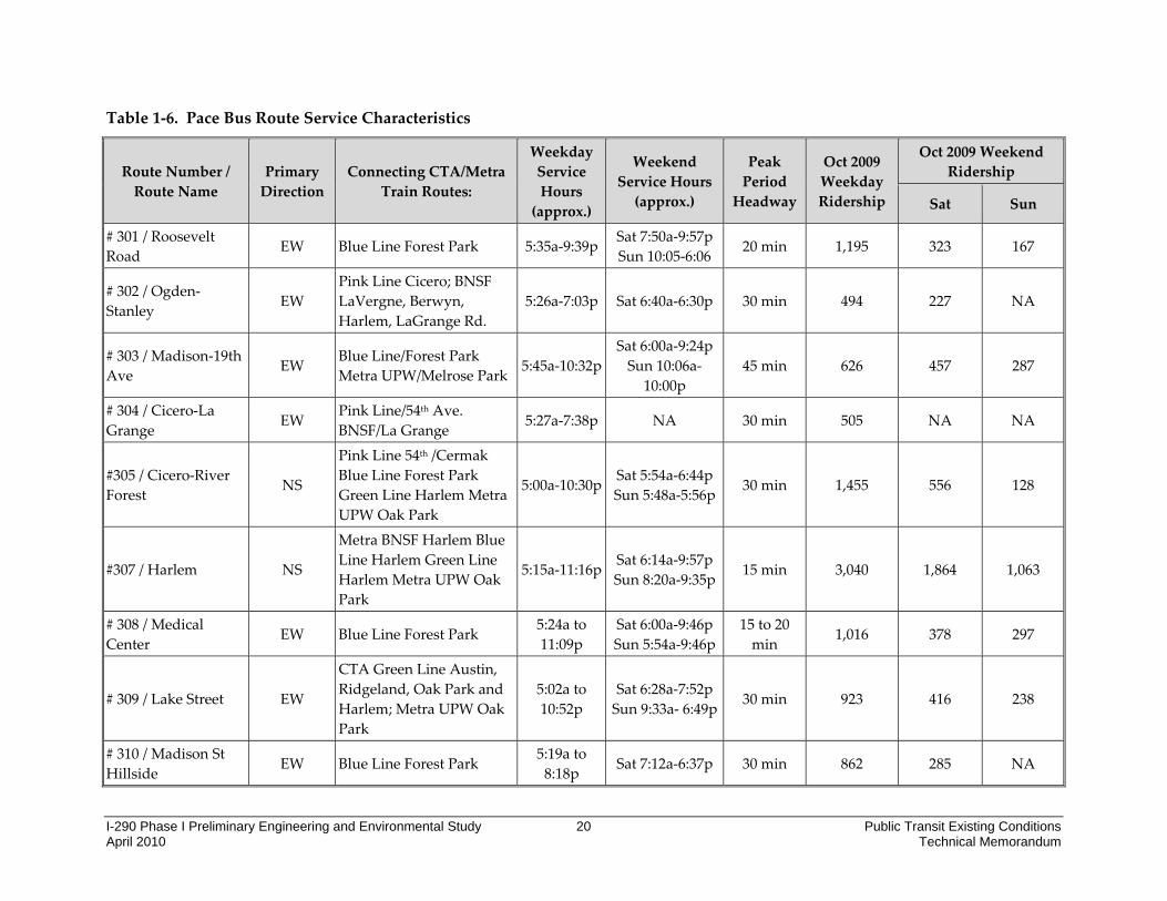
1.2 PACE Bus Service
Pace, the region’s suburban bus provider, operates 217 bus routes throughout Chicagoʹs six‐county suburbs and 23 bus routes in the broad study area, as shown in Figure 1‐1 and Table 1‐6. The majority of Pace service in the study area is provided along major arterial routes, providing connections to CTA bus and rail services. Feeder service to Metra train stations is provided primarily during peak periods. There are approximately 22,000 weekday boardings on the routes within or crossing the study area.
Figure 1‐3. Pace Fixed‐Route Bus Service
The CTA Blue Line is served by Pace bus at the Forest Park, Harlem, Oak Park, and Austin stations. Pace bus routes also serve the stations along Metra’s UPW and BNSF Lines as shown in Table 1‐6. Pace also serves the CTA Green Line and the CTA Pink Line.
Pace bus routes in the study area with the highest weekday ridership in October 2009 include Route #307 / Harlem (3,065), Route # 322 / Cermak‐22nd (2,315), and Route # 318 / West North Ave (1,939).

I-290 Phase I Preliminary Engineering and Environmental Study 17 Public Transit Existing Conditions April 2010 Technical Memorandum
Service is available primarily between 5:00 a.m. and 9:30 p.m. with various frequencies depending on the route. All Pace buses are ADA accessible. All Pace buses are fitted with bike racks.
For the needs of persons with disabilities, Pace’s ADA Paratransit Services program provides origin to destination transportation to ʺADA paratransit eligibleʺ persons who are unable to use accessible fixed route bus and rail service due to their disability. In addition, several community agencies, townships or local governments in the study area provide free curb to curb transportation services to senior and disabled residents. Service is on‐demand and usually restricted to a local service area.
Pace oversees the regional rideshare and vanpool incentive programs within the six county region. Pace RideShare is a free service that connects commuters who are interested in sharing their drive to work. The program provides employers and employees the ability to identify potential carpool partners by e‐mail to coordinate ridesharing. Pace Vanpool Incentive Program offers transportation alternatives to groups of employees and employers to driving alone. The Pace vanpool incentive program includes the following services:
• Traditional Vanpool ‐ designed to transport a group of 5‐13 people to work in a Pace Van. Employees that live and work near one another and share similar schedules can form a group that conveniently gets them between home and work. Each rider pays a low monthly fare based on distance and number of participants. This covers all costs of the vanpool including fuel, maintenance, insurance, tolls, roadside assistance, and van washes.
• Metra Feeder ‐ allows for the Pace Van to be parked at a Metra station near the worksite, so that 5‐13 participants can take the train and then use the van to complete the commute. To qualify for the program, at least half of the participants must purchase a Metra monthly pass or 10‐ride ticket. Each participant pays $58 per month which covers all costs associated with the van including fuel, maintenance, insurance, tolls, roadside assistance, and van washes. Metra fares and parking are not included in this rate. Participants are eligible for reimbursement of up to $125/ year for alternative transportation taken due to a personal emergency under a guaranteed ride home program.
• Employer Shuttle Program ‐ provides vans to employers in the Pace service area for their use in work‐related passenger trips at the rate of $1,029.00 per month per van. A Not‐For‐Profit company/agency is eligible at the rate of $768.00 per month per van.
• The Advantage Program ‐ is available to not‐for‐profit human service organizations/workshops/agencies located in the Pace six county region that hold a current State of Illinois Developmental Training Certification or equivalent, which provide work‐related transportation service to persons with disabilities at the rate of $401 per month per van.
I-290 Phase I Preliminary Engineering and Environmental Study 18 Public Transit Existing Conditions April 2010 Technical Memorandum
• Municipal Vanpool Program – is available to municipalities located in the Pace service area to provide work‐related vanpool services.
Pace regular bus fares are $1.75 with $0.25 transfers. Premium and express bus fares for longer distance trips may be higher. The Pace/CTA 7‐day pass is $28.00 and the 30‐day pass is $86.00. Pace also offers the Commuter Club Card (30 Day Pass) valid only on Pace for $60.00. Pace also offers reduced fares for children, students, and people with disabilities. Seniors ride free.
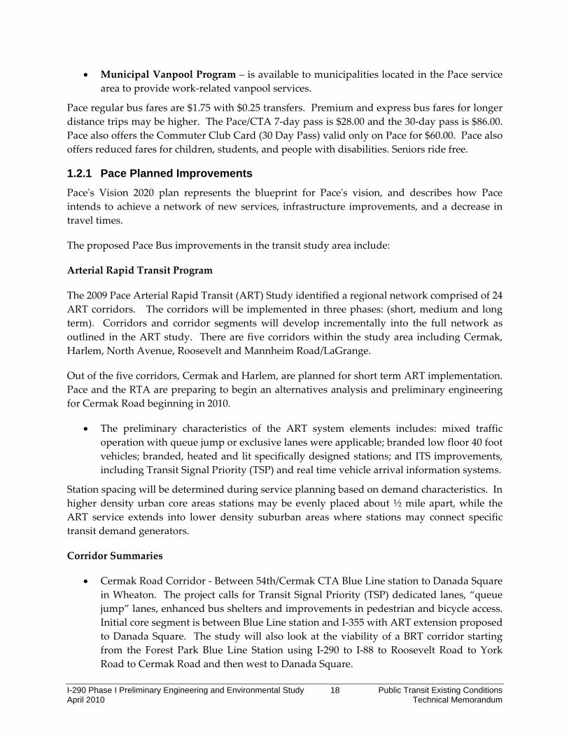
1.2.1 Pace Planned Improvements Paceʹs Vision 2020 plan represents the blueprint for Paceʹs vision, and describes how Pace intends to achieve a network of new services, infrastructure improvements, and a decrease in travel times.
The proposed Pace Bus improvements in the transit study area include:
Arterial Rapid Transit Program
The 2009 Pace Arterial Rapid Transit (ART) Study identified a regional network comprised of 24 ART corridors. The corridors will be implemented in three phases: (short, medium and long term). Corridors and corridor segments will develop incrementally into the full network as outlined in the ART study. There are five corridors within the study area including Cermak, Harlem, North Avenue, Roosevelt and Mannheim Road/LaGrange.
Out of the five corridors, Cermak and Harlem, are planned for short term ART implementation. Pace and the RTA are preparing to begin an alternatives analysis and preliminary engineering for Cermak Road beginning in 2010.
• The preliminary characteristics of the ART system elements includes: mixed traffic operation with queue jump or exclusive lanes were applicable; branded low floor 40 foot vehicles; branded, heated and lit specifically designed stations; and ITS improvements, including Transit Signal Priority (TSP) and real time vehicle arrival information systems.
Station spacing will be determined during service planning based on demand characteristics. In higher density urban core areas stations may be evenly placed about ½ mile apart, while the ART service extends into lower density suburban areas where stations may connect specific transit demand generators.
Corridor Summaries
• Cermak Road Corridor ‐ Between 54th/Cermak CTA Blue Line station to Danada Square in Wheaton. The project calls for Transit Signal Priority (TSP) dedicated lanes, “queue jump” lanes, enhanced bus shelters and improvements in pedestrian and bicycle access. Initial core segment is between Blue Line station and I‐355 with ART extension proposed to Danada Square. The study will also look at the viability of a BRT corridor starting from the Forest Park Blue Line Station using I‐290 to I‐88 to Roosevelt Road to York Road to Cermak Road and then west to Danada Square.

I-290 Phase I Preliminary Engineering and Environmental Study 19 Public Transit Existing Conditions April 2010 Technical Memorandum
• Harlem Avenue Corridor: Core segment operates between Milwaukee Avenue and 95th Street. Extension segment operates from Glenview to Tinley Park.
• North Avenue Corridor: Harlem Avenue to Kane County
• Roosevelt Road Corridor: Forest Park to Kane County
• Mannheim Road/LaGrange Road Corridor: Core segment from O’Hare kiss‐and‐fly to Cermak with extension to Orland Square.
• Transportation Center Design Studies ‐ Pace will work with local communities to implement new and improve existing hubs for community‐based and line‐haul transit service. The Forest Park Blue Line Station is designated a Pace regional transportation center. The 54th/Cermak CTA Blue Line station and Cicero Metra BNSF station are proposed as Community‐Based Service Hubs for future line‐haul arterial route(s).
• Pace will also do an assessment for the location of a DuPage Transit center in this corridor.
• West Cook Restructuring: In 2010, Pace plans to begin phase 1 restructuring within the study area. This phase will focus on efficiency improvements within select corridors to prepare for future corridor development and community based services.
I-290 Phase I Preliminary Engineering and Environmental Study 20 Public Transit Existing Conditions April 2010 Technical Memorandum
Table 1‐6. Pace Bus Route Service Characteristics
Route Number / Route Name
Primary Direction
Connecting CTA/Metra Train Routes:
Weekday Service Hours (approx.)
Weekend Service Hours (approx.)
Peak Period Headway
Oct 2009 Weekday Ridership
Oct 2009 Weekend Ridership
Sat Sun
# 301 / Roosevelt Road EW Blue Line Forest Park 5:35a‐9:39p Sat 7:50a‐9:57p
Sun 10:05‐6:06 20 min 1,195 323 167
# 302 / Ogden‐Stanley EW
Pink Line Cicero; BNSF LaVergne, Berwyn, Harlem, LaGrange Rd.
5:26a‐7:03p Sat 6:40a‐6:30p 30 min 494 227 NA
# 303 / Madison‐19th Ave EW Blue Line/Forest Park
Metra UPW/Melrose Park 5:45a‐10:32pSat 6:00a‐9:24p Sun 10:06a‐
10:00p 45 min 626 457 287
# 304 / Cicero‐La Grange EW
Pink Line/54th Ave. BNSF/La Grange 5:27a‐7:38p NA 30 min 505 NA NA
#305 / Cicero‐River Forest NS
Pink Line 54th /Cermak Blue Line Forest Park Green Line Harlem Metra UPW Oak Park
5:00a‐10:30p Sat 5:54a‐6:44p Sun 5:48a‐5:56p 30 min 1,455 556 128
#307 / Harlem NS
Metra BNSF Harlem Blue Line Harlem Green Line Harlem Metra UPW Oak Park
5:15a‐11:16p Sat 6:14a‐9:57p Sun 8:20a‐9:35p
15 min 3,040 1,864 1,063
# 308 / Medical Center
EW Blue Line Forest Park 5:24a to 11:09p
Sat 6:00a‐9:46p Sun 5:54a‐9:46p
15 to 20 min
1,016 378 297
# 309 / Lake Street EW
CTA Green Line Austin, Ridgeland, Oak Park and Harlem; Metra UPW Oak Park
5:02a to 10:52p
Sat 6:28a‐7:52p Sun 9:33a‐ 6:49p 30 min 923 416 238
# 310 / Madison St Hillside EW Blue Line Forest Park
5:19a to 8:18p Sat 7:12a‐6:37p 30 min 862 285 NA

I-290 Phase I Preliminary Engineering and Environmental Study 21 Public Transit Existing Conditions April 2010 Technical Memorandum
Route Number / Route Name
Primary Direction
Connecting CTA/Metra Train Routes:
Weekday Service Hours (approx.)
Weekend Service Hours (approx.)
Peak Period Headway
Oct 2009 Weekday Ridership
Oct 2009 Weekend Ridership
Sat Sun
# 311 / Oak Park Avenue NS
Green Line Oak Park Blue Line Oak Park Metra BNSF Berwyn Metra UPW Oak Park
5:08a to 7:56p
Sat 6:33a‐7:21p Sun 9:58a‐ 6:18p
10 to 20 min 1,483 386 178
#313 St. Charles Road EW
CTA Green Line Austin, Ridgeland, Oak Park and Harlem; Metra UPW Oak Park and Melrose Park
5:21a‐10:26pSat 7:01a‐8:26p Sun 10:00a‐7:26p 30 min 1,346 626 307
# 315 / Austin‐Ridgeland
NS Blue Line Austin Green Line Ridgeland Metra BNSF LaVergne Av.
5:25a to 7:47p
Sat 6:51a‐6:00p 30 min 779 224 NA
# 317 / Madison Westchester
EW Blue Line Forest Park 5:07a to 12:31a
Sat 5:30a‐12:31p Sun 7:11a‐ 12:31p
30 min 362 412 397
# 318 / West North Ave EW
Blue Line Forest Park Green Line Harlem Metra UPW Oak Park
4:52a to 12:10p
Sat 6:30a‐12:40p Sun 7:00a‐ 12:40p
15 to 30 min 1,845 764 462
# 320 / Madison EW Blue Line Forest Park Branch
6:02a to 6:59p NA 30 min 312 NA NA
# 322 / Cermak‐22nd EW 54th and Cermak Pink Line 4:12a to 12:15a
Sat 5:20a‐11:35pSun 6:57a‐
10:37p
10 to 15 min
2,226 947 632
#325 25th Avenue NS None in Study Area 5:08a to 7:15p
NA 30 min 475 NA NA
# 330 / Mannheim‐LaGrange Rd
NS Metra BNSF LaGrange 4:38a to 12:10a
Sat 5:20a‐8:08p 30 min 1,063 421 NA

I-290 Phase I Preliminary Engineering and Environmental Study 22 Public Transit Existing Conditions April 2010 Technical Memorandum
Route Number / Route Name
Primary Direction
Connecting CTA/Metra Train Routes:
Weekday Service Hours (approx.)
Weekend Service Hours (approx.)
Peak Period Headway
Oct 2009 Weekday Ridership
Oct 2009 Weekend Ridership
Sat Sun
# 331 / Cumberland‐5th Ave NS
Metra BNSF‐ Brookfield Metra UPW Maywood
5:12a to 10:29p Sat 7:32a‐6:33p 30 min 1,320 267 NA
Pace # 391 / Near West Suburbs‐UPS
EW/NS Blue Line Forest Park 2:36a to 10:29p
NA 4 trips per
peak period
115 NA NA
# 392 / Little Village ‐ United Parcel Service NS
Cicero Pink Line Metra BNSF‐ Cicero
2:45a to 10:26p NA
4 trips per peak period
77 NA NA
#747 / DuPage Connection EW Blue Line Forest Park
5:17a to 9:23p
Sat service to be replaced by an extension of Rte
301 to Oakbrook.
20‐30 min 1,017 NA NA
#757 / Northwest Connection NS
Green Line Harlem Metra UPW Oak Park
5:25 to 8:49a and 2:30p to
6:38p NA 30 min 165 NA NA
Study Area Total 22,701 8,553 4,156
Source: Pace and RTAMS. Service hours listed are prior to February 2010 service reduction. NA = Data not available for route.
I-290 Phase I Preliminary Engineering and Environmental Study 23 Public Transit Existing Conditions April 2010 Technical Memorandum
1.3 Metra Commuter Rail Service
The Metra system is comprised of 11 commuter rail lines radiating out from Chicago’s Loop, serving more than 100 communities at 240 rail stations. This includes 487.7 route miles. An additional line, the South Shore, is operated by the Northern Indiana Commuter Transportation District (NICTD). In addition to the six‐county northeastern Illinois area, Metra also has a station in Kenosha, WI.
Metra commuter rail service in the study area includes the Burlington Northern Santa‐Fe (BNSF) and Union Pacific West (UP‐W) Lines. Metra has a purchase of service agreement with the UP and BNSF railroads to operate Metra passenger service on their respective lines. As shown in Figure 1‐1, the UP‐W and BNSF lines are at the northern and southern boundaries of the study area, respectively. Like all other Metra commuter rail lines, the UP‐W, the BNSF are oriented toward downtown Chicago and function primarily to move suburban workers to and from job locations in downtown Chicago Monday through Friday. Train schedules are designed to optimize travel times between the suburbs and downtown Chicago in the morning, and in the reverse direction in the evening. Other types of corridor travel, such as trips between suburban communities (intermediate trips) and reverse commute trips from Chicago to the suburbs during the morning peak are also served, but within the context of Metra’s peak direction schedule (these are usually made by trains being positioned to make a second trip into downtown during the peak).

I-290 Phase I Preliminary Engineering and Environmental Study 24 Public Transit Existing Conditions April 2010 Technical Memorandum
Figure 1‐4. Metra Commuter Rail Lines
Metra commuter trains on the UP‐W and BNSF lines operate in mixed traffic with freight trains. The BNSF and UP‐W lines experience the highest volume of freight traffic in the Metra system, as both are key freight corridors between Chicago and the west coast. In addition to the freight train traffic, the BNSF also shares tracks with Amtrak’s medium and long‐distance intercity passenger services.
For each rail line, commuter service is a function of ridership demand, the physical plant including track and signals, freight train operations, equipment availability, and track time and space in the downtown Chicago terminals. Weekday train service and schedules for full service lines feature a combination of express and local trains during the a.m. and p.m. peak hours, with local trains running during off‐peak hours (midday and evening). Both the host railroads on the UP‐W and BNSF corridors reduce the amount of their freight traffic during the peak periods in order to maximize the capacity to operate commuter trains. Timetable paths for higher‐speed, high‐priority freight trains are included during the rush to run with the peak flow. Lower‐speed and lower‐priority trains are generally held outside the commuter service territory until the peak is over.

I-290 Phase I Preliminary Engineering and Environmental Study 25 Public Transit Existing Conditions April 2010 Technical Memorandum
Metra defines a.m. peak operations as trains that arrive to or depart from downtown between start of service to 9:15 a.m. Evening p.m. peak operations refer to trains that arrive to or depart from downtown from 3:15 p.m. to 6:45 p.m. Table 1‐7 summarizes the frequency and distribution of service on each line by stations in the study area.
Metra fares for UP‐W and BNSF stations in the study area are Zone B and C fares. As of February 2010, Metra has increased fares for one‐way rides and weekend passes. For one‐way tickets, Zone B fares are $2.50 and Zone C fares are $3.50. 10‐ride and monthly fares have not increased. Weekend pass fares are $7 regardless of fare zone and provide unlimited rides. Metra also offers reduced fares for children, students, and people with disabilities. Seniors ride free.
Metra has bicycle parking facilities at or adjacent to most of its stations, including 7 of the 9 stations along the BNSF Line (no facilities at Cicero or Hollywood) and at 4 of the 5 stations along the UP‐W Line (no facilities at Maywood) within the study area.
1.3.1 BNSF Service The BNSF has substantial freight and passenger traffic and is one of the busiest railroad mainlines entering Chicago. The BNSF operates commuter service between downtown Chicago and Aurora under a purchase of service agreement with Metra. The rail line includes over 200 trains each weekday, which is composed of 94 Metra revenue trains, 12 Metra non‐revenue trains (equipment moves that do not provide passenger service), more than 100 freight trains, four daily Amtrak medium‐distance intercity passenger trains which stop at both LaGrange and Naperville and four daily Amtrak long‐distance intercity trains which make Naperville their suburban Chicago stop location.
In spite of the high density of traffic, the BNSF is a very flexible railroad due to its three tracks, many crossover points, and a sophisticated signaling system. The middle track functions as an express track, allowing express trains to bypass local trains. Tracks are bi‐directionally signaled, which also enhances flexibility. In addition, a five‐aspect signal system further increases the overall capacity of the BNSF physical plant.
Commuter trains operate on a zone schedule in the a.m. and p.m. peak periods (the service discussions in the next two paragraphs are confined to scheduled trains). There are 31 peak a.m. inbound trains. These comprise 23 zone expresses and eight local trains that make stops in the study area. Midday, the inbound service is provided by four local trains making most every stop (exceptions include the Hinsdale‐Highlands, Congress Park and LaVergne stations). During the p.m. peak, the inbound service includes three zone expresses and three local trains. After the p.m. peak and until the end of the operating day, service is provided by five local trains.
Outbound trains operate in a similar manner. A.M. peak service is provided by six zone expresses and three local trains. Midday, the service is by two zone expresses and five locals. P.M. peak operations consist of 18 zone expresses and five locals, with departures from Union

I-290 Phase I Preliminary Engineering and Environmental Study 26 Public Transit Existing Conditions April 2010 Technical Memorandum
Station every three‐to‐four minutes between 4:44 and 5:49 p.m. Evening outbound trains include one zone express and seven locals. The scheduled outbound service totals 47 trains on weekdays.
With its current schedule and train service, the BNSF has the capacity to move approximately 44,798 seated passengers in the inbound direction and 45,567 seated passengers in the outbound direction each weekday. This carrying capacity is not evenly distributed along the line as all the trains do not stop at all stations and much of the seating capacity is not used outside the a.m. and p.m. peak periods. There are also several short‐turn trains during both the a.m. and p.m. peak periods.
With its frequent service and fast peak‐period express trains, the BNSF carries more commuters than any other Metra line. In September 2009, the line reported 1.3 million boardings, or 20 percent of Metra’s total weekday passengers for lines. Park & Ride facilities in along the BNSF, in Aurora and Naperville, are among Metra’s largest in capacity.
Only seven of the line’s 26 stations are located in the study area. The BNSF stations within the study area account for only 5 percent of total weekday boardings in 2006.
Travel times to downtown Chicago from the westernmost communities, including Aurora and Naperville, average 42 minutes on express trains versus 73 minutes on a local train. Reverse commute travel times from downtown Chicago to Naperville and Aurora average 57 minutes on local trains. Express trains to Naperville average 32 minutes. There is no express service to Aurora.
The innermost communities in the study area (Brookfield, Riverside, Berwyn, and Cicero) average 23 minutes to downtown with entirely local service. Reverse commute travel time from downtown to the inner most stations averages 18 minutes.
There are nine stations in the broader study area on the BNSF Line (Cicero, LaVergne, Berwyn, Harlem Ave, Riverside, Hollywood, Brookfield, Congress Park and LaGrange Road) that are served by 6 to 8 inbound trains during the morning peak period. Of these stations, LaGrange Road has the highest utilization with 1,352 average weekday boardings and is served by eleven inbound trains during the morning peak.
Table 1‐8 lists the bus routes, mostly operated by Pace that serve the Metra BNSF stations within the study area. All seven of the Metra BNSF stations have park‐and‐ride facilities that total over 1,300 spaces. These park‐and‐ride facilities are fully utilized.

I-290 Preliminary Engineering and Environmental Study 27 Public Transit Existing Conditions April 2010 Technical Memorandum
Table 1‐7. Metra Commuter Trains per Day and Stops by Station in Study Area
Metra Line Total and Stops at Study Area
Stations*
Weekday Service Weekend Service (Total both directions) In
Bound All Day
Out BoundAll Day
Suburb to ChicagoCBD Commute
Chicago to SuburbReverse Commute
InboundAM Peak (Start to 9:15
a.m.)
OutboundPM Peak (3:30 to 6:45 p.m.)
OutboundAM Peak (Start to 9:15
a.m.)
InboundPM Peak (3:30 to 6:45 p.m.)
Sat. All Day
Sun. All Day
UP‐W Line Total Trains 29 30 14 13 6 3 20 18
Oak Park 25 25 10 5 4 2 20 18
River Forest 23 22 9 4 4 2 20 18
Maywood 13 14 5 3 3 2 11 6
Melrose Park 15 15 6 3 3 1 10 9
Bellwood 18 20 6 3 3 2 20 18 BNSF Line Total Trains 47 47 31 23 9 7 28 18
Cicero 19 22 6 8 3 3 26 18
LaVergne 6 8 6 5 0 0 0 0
Berwyn 20 22 7 8 3 3 26 18
Harlem Ave 17 21 7 7 3 3 24 17
Riverside 20 22 7 8 3 3 26 18
Hollywood 14 11 6 4 0 3 17 12
Brookfield 20 22 7 8 3 3 26 18
Congress Park 6 7 6 4 0 0 0 0
La Grange Road 25 24 10 10 3 5 26 18 Source: Metra On‐Line Schedule, www.metrarail.com. Note: Number of trains with a station stop and terminal stop within a.m. or p.m. peak periods are only shown.

I-290 Phase I Preliminary Engineering and Environmental Study 28 Public Transit Existing Conditions April 2010 Technical Memorandum
1.3.2 UP-W Service The UP‐W line shares a number of common features with the BNSF. It has a substantial amount of freight and passenger traffic and is also among the busiest railroad mainlines entering Chicago. The Union Pacific Railroad operates commuter service between downtown Chicago and Elburn under a purchase of service agreement with Metra.
The rail line averages 140 trains each weekday, which is composed of 59 Metra revenue trains, 8 Metra non‐revenue trains (equipment moves that do not provide passenger service), and between 70 and 75 freight trains. The 14‐mile segment from Elmhurst to West Chicago encompassing seven stations and very nearly its entire length in DuPage County, is triple tracked, but has no crossovers, limiting operational flexibility. To the east, a bottleneck exists in the five‐mile section between Elmhurst and River Forest where the line has only two tracks. In addition, the signal system of the line does not allow optimal spacing of trains, further limiting the lines capacity. Through the combined efforts of the Chicago Region Environmental and Transportation Efficiency (CREATE) Program, the UP‐W Line Improvement Project and the UP‐W Upgrade New Starts Project, Metra and the UP plan to remedy all three of these operating challenges with a new signal system, additional crossovers, and new third track. The two entities are also working together on other changes to the existing operating practices which will increase the fluidity of the operation for both commuter and freight trains throughout the suburban territory.
Due to the physical limitations of the railroad (principally, the double‐track section, the line’s sub‐optimal signal system, and the lack of intermediate crossovers in the triple‐track section to the west, express and local UP‐W trains operate in mixed traffic on the same track, making a zonal express system like that of the BNSF infeasible. With its current schedule and train service, the UP‐W Line has the capacity to move approximately 20,000 seated passengers in and out of downtown Chicago each weekday. Like the BNSF, the UP‐W’s carrying capacity is not evenly distributed along the line, as all trains do not stop at all stations and much of this capacity is not used outside the a.m. and p.m. peak periods.
According to the current UP‐W Line schedule, the inbound service is provided by 14 peak a.m. inbound trains. Midday, five inbound locals are operated. P.M. peak period inbound service comprises three trains. Evening period inbound service is operated by seven trains, for a total of 29 scheduled inbound trains each weekday. By all indications, this line has the potential, but not the capacity to handle more service, and off‐load some of the peak period demand on the BNSF line. However, until the culmination of the UP‐W Line Improvement Project, CREATE, and the UP‐W Upgrade New Starts project, this potential cannot be fully realized.
Outbound weekday service on the UP‐W line includes two expresses and four locals during the a.m. peak and five local trains midday. During the p.m. peak period, the scheduled service includes eight expresses and five locals. Evening outbound service consists of six local trains for a total of 30 scheduled outbound trains each weekday.

I-290 Phase I Preliminary Engineering and Environmental Study 29 Public Transit Existing Conditions April 2010 Technical Memorandum
In 2009, the UP‐West Line reported 0.6 million boardings, or nine percent of Metra’s total weekday passengers for all lines. Five of the line’s 19 stations are located in the study area. However, unlike the BNSF, the UP‐W’s largest park‐and‐ride capacity is located in the middle of the line, at the Elmhurst station.
Travel times to downtown Chicago from the western half of the line range from just over one hour (Elburn), to 37 minutes (Glen Ellyn) and to 26 minutes (Elmhurst) on express trains. Reverse commute travel times from downtown Chicago averages 29 minutes to Elmhurst, 38 minutes to Glenn Ellyn and one hour and twenty three minutes to Elburn.
For the eastern half of the line, travel times are 32 minutes from Berkeley and 17 minutes from Oak Park on local trains. Reverse commute travel time from downtown to the innermost stations average 19 minutes.
Table 1‐8 lists the bus routes, mostly operated by Pace that serve Metra stations within the study area. The majority of these stations are outside the CTA bus service area. Most of the other bus connections to Metra involve the fixed route bus system that provides line haul long distance service on arterial streets near Metra stations. Of the five Metra UP‐W stations, the Oak Park (Marion Street) station is a major transfer station and is served by 11 inbound trains between start of service and 9:15 a.m. on a typical weekday. According to Metra’s parking capacity figures from 2008, Oak Park has a capacity of 226 cars with an effective use (available parking for customers without a permit) of 88 percent. River Forest is served by 10 inbound trains, Maywood is served by 6 inbound trains, and Melrose Park and Bellwood are served by 7 inbound trains each.
Table 1‐8. Metra Boardings by Station
Transit Operator/Station
Bus Route Connections
Weekday Boardings (2006)
Number of Available Park and Ride Spaces and Utilization Rates (2008)
CTA Pace
Metra UP‐W
Oak Park (B Zone) #90 #305, #307, #309, #313, #318, #757
1,025 226 (88%)
River Forest (B Zone) 0 #309, #313 367 204 (90%)
Maywood (C Zone) 0 #309, #313, #331 97 118 (32%)
Melrose Park (C Zone) 0 #303, #309, #313 100 39 (67%)
Bellwood (C Zone) 0 #309, #313, #330 215 209 (53%)
Metra BNSF
Cicero (B Zone) #54, #54B, #X54, #60
0 246 170 (66%)
LaVergne (B Zone) 0 #302, #315 159 176 (99%)
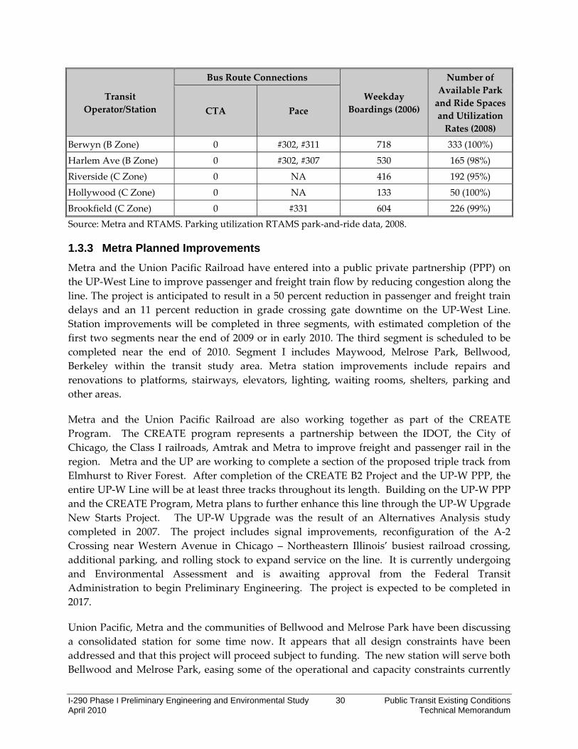
I-290 Phase I Preliminary Engineering and Environmental Study 30 Public Transit Existing Conditions April 2010 Technical Memorandum
Transit Operator/Station
Bus Route Connections
Weekday Boardings (2006)
Number of Available Park and Ride Spaces and Utilization Rates (2008)
CTA Pace
Berwyn (B Zone) 0 #302, #311 718 333 (100%)
Harlem Ave (B Zone) 0 #302, #307 530 165 (98%)
Riverside (C Zone) 0 NA 416 192 (95%)
Hollywood (C Zone) 0 NA 133 50 (100%)
Brookfield (C Zone) 0 #331 604 226 (99%) Source: Metra and RTAMS. Parking utilization RTAMS park‐and‐ride data, 2008.
1.3.3 Metra Planned Improvements Metra and the Union Pacific Railroad have entered into a public private partnership (PPP) on the UP‐West Line to improve passenger and freight train flow by reducing congestion along the line. The project is anticipated to result in a 50 percent reduction in passenger and freight train delays and an 11 percent reduction in grade crossing gate downtime on the UP‐West Line. Station improvements will be completed in three segments, with estimated completion of the first two segments near the end of 2009 or in early 2010. The third segment is scheduled to be completed near the end of 2010. Segment I includes Maywood, Melrose Park, Bellwood, Berkeley within the transit study area. Metra station improvements include repairs and renovations to platforms, stairways, elevators, lighting, waiting rooms, shelters, parking and other areas.
Metra and the Union Pacific Railroad are also working together as part of the CREATE Program. The CREATE program represents a partnership between the IDOT, the City of Chicago, the Class I railroads, Amtrak and Metra to improve freight and passenger rail in the region. Metra and the UP are working to complete a section of the proposed triple track from Elmhurst to River Forest. After completion of the CREATE B2 Project and the UP‐W PPP, the entire UP‐W Line will be at least three tracks throughout its length. Building on the UP‐W PPP and the CREATE Program, Metra plans to further enhance this line through the UP‐W Upgrade New Starts Project. The UP‐W Upgrade was the result of an Alternatives Analysis study completed in 2007. The project includes signal improvements, reconfiguration of the A‐2 Crossing near Western Avenue in Chicago – Northeastern Illinois’ busiest railroad crossing, additional parking, and rolling stock to expand service on the line. It is currently undergoing and Environmental Assessment and is awaiting approval from the Federal Transit Administration to begin Preliminary Engineering. The project is expected to be completed in 2017.
Union Pacific, Metra and the communities of Bellwood and Melrose Park have been discussing a consolidated station for some time now. It appears that all design constraints have been addressed and that this project will proceed subject to funding. The new station will serve both Bellwood and Melrose Park, easing some of the operational and capacity constraints currently
I-290 Phase I Preliminary Engineering and Environmental Study 31 Public Transit Existing Conditions April 2010 Technical Memorandum
experienced in the double‐track section of the UP‐W Line. However, the main motivation for this station appears to be economic development. The proposed station location is approximately 29th Avenue north of Grant Street along the UP‐W Line. The new station will replace the outdated Metra stations in Bellwood and Melrose Park, which are hampered by inadequate parking and problematic commuter access at the Bellwood Station. The station will feature a pedestrian crosswalk and a 680‐space, two‐story parking garage, and will be located in a tax increment finance (TIF) district. It will cost an estimated $10‐$15 million to build the station and parking garage, which will be funded by TIF bonds. In December 2008, a groundbreaking ceremony was held to begin infrastructure improvements. Construction of the new station is subject to funding and does not have a proposed start date at this time.
Additional improvements are being funded under the proposed Illinois state capital bonding program. Station projects that are included in the bond program are:
• Cicero (BNSF) station improvements include platform replacement, new warming house and shelter, improved ADA connections and parking lot relocation.
• River Forest (UP‐W) station improvements include retaining wall and stair reconstruction, new platforms, an expanded waiting shelter, and access improvements.
• Brookfield and Hollywood (BNSF) station improvements, including installation of additional lighting at the back of both platforms, started in 2009.
• Berwyn Harlem Avenue (BNSF) station improvements include construction of new inbound and outbound platforms has started. Work is expected to last through 2010. The Pedestrian crossing located in front of station will be permanently removed.
• Berwyn(BNSF) station improvements, including construction of a parking deck to add more commuter spaces, started in 2009.
I-290 Phase I Preliminary Engineering and Environmental Study 32 Public Transit Existing Conditions April 2010 Technical Memorandum
2.0 Public Transportation Deficiencies
2.1.1 Assessment of Facility Deficiencies This section inventories the facility deficiencies for the CTA Blue Line. Facility deficiencies for the CTA Green and Pink Lines were not evaluated as part of this analysis.
The 8.9‐mile Forest Park Branch of the CTA‐Blue Line extends from the subway portal located just east of Halsted Street in the median of the Eisenhower Expressway to the Forest Park Terminal, which lies to the west of Des Plaines Avenue in Forest Park. The terminal station is located on the north side of the expressway right‐of‐way. A 122‐car yard with shop building and car washer is located adjacent to the terminal station. The Des Plaines light maintenance shop was built over 50 years ago and capacity has historically been inadequate for the Blue Line. In particular, the yard site is constrained and cannot be expanded without extensive modification. The shop and yard facility is nearing the end of its useful life according to the CTA.
The Forest Park Branch has 10 intermediate stations plus the terminal station at Des Plaines Avenue/Forest Park. The intermediate stations are of the island platform configuration, with long ramps connecting them to station headhouses at street level. These stations were constructed before the American with Disabilities Act (ADA) of 1990 was enacted, so they do not meet ADA standards. This includes the pedestrian ramps from street to platform level and the island platforms. The station locations also result in long walks for transit riders and safety concerns. The CTA is shifting access philosophies towards providing elevators and stairways at headhouses to address ADA compliance. In addition, one head station is now more favorable than two on opposite sides of the same cross street – two head stations mean doubling the staff, operations and maintenance coverage.
The typical Forest Park branch intermediate station configuration is a main entrance on the major north‐south arterial served by CTA/Pace bus routes, with auxiliary exits provided at the opposite end of the station (usually 2 blocks from the main station). Austin, Oak Park and Harlem have farecard‐only entrances at the auxiliary station.
I-290 Phase I Preliminary Engineering and Environmental Study 33 Public Transit Existing Conditions April 2010 Technical Memorandum
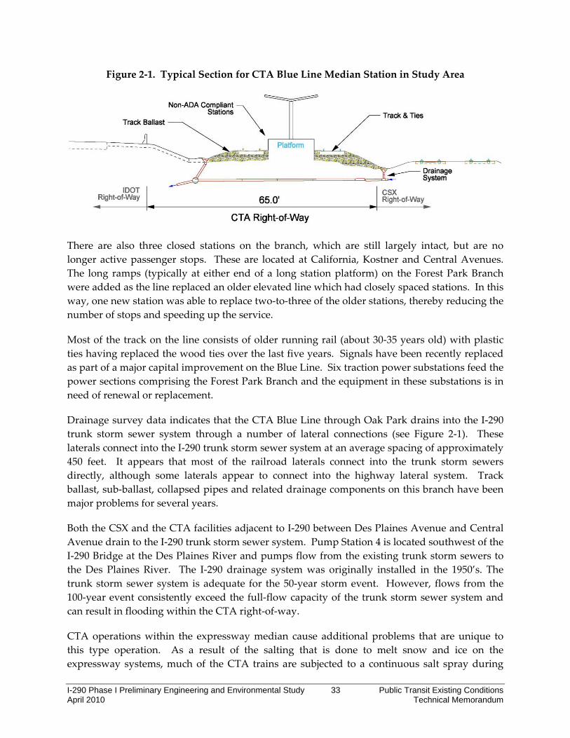
Figure 2‐1. Typical Section for CTA Blue Line Median Station in Study Area
There are also three closed stations on the branch, which are still largely intact, but are no longer active passenger stops. These are located at California, Kostner and Central Avenues. The long ramps (typically at either end of a long station platform) on the Forest Park Branch were added as the line replaced an older elevated line which had closely spaced stations. In this way, one new station was able to replace two‐to‐three of the older stations, thereby reducing the number of stops and speeding up the service.
Most of the track on the line consists of older running rail (about 30‐35 years old) with plastic ties having replaced the wood ties over the last five years. Signals have been recently replaced as part of a major capital improvement on the Blue Line. Six traction power substations feed the power sections comprising the Forest Park Branch and the equipment in these substations is in need of renewal or replacement.
Drainage survey data indicates that the CTA Blue Line through Oak Park drains into the I‐290 trunk storm sewer system through a number of lateral connections (see Figure 2‐1). These laterals connect into the I‐290 trunk storm sewer system at an average spacing of approximately 450 feet. It appears that most of the railroad laterals connect into the trunk storm sewers directly, although some laterals appear to connect into the highway lateral system. Track ballast, sub‐ballast, collapsed pipes and related drainage components on this branch have been major problems for several years.
Both the CSX and the CTA facilities adjacent to I‐290 between Des Plaines Avenue and Central Avenue drain to the I‐290 trunk storm sewer system. Pump Station 4 is located southwest of the I‐290 Bridge at the Des Plaines River and pumps flow from the existing trunk storm sewers to the Des Plaines River. The I‐290 drainage system was originally installed in the 1950’s. The trunk storm sewer system is adequate for the 50‐year storm event. However, flows from the 100‐year event consistently exceed the full‐flow capacity of the trunk storm sewer system and can result in flooding within the CTA right‐of‐way.
CTA operations within the expressway median cause additional problems that are unique to this type operation. As a result of the salting that is done to melt snow and ice on the expressway systems, much of the CTA trains are subjected to a continuous salt spray during
I-290 Phase I Preliminary Engineering and Environmental Study 34 Public Transit Existing Conditions April 2010 Technical Memorandum
winter which leads to excessive repairs, maintenance of rail cars, and can impact the quality and level of service. Current CTA practices call for a 6‐foot high barrier wall in order reduce the intrusion of snow from highway plowing.
Other CTA Rail Station Deficiencies include:
Passenger Access
• Median location requires lengthy walking distance between CTA stations and residential and commercial areas, or from buses running on parallel streets
• All stations are served by at least one CTA or Pace bus route, however, hours of bus service vary, while the Blue Line operates 24 hours a day
• Buses serving stations generally stop directly in front of the station in one direction only. Passengers travelling in the opposite direction must cross the street to access the rail station.
• Pedestrian access to stations at I‐290 interchanges is unpleasant and subjects pedestrians to conflicts with vehicles entering and exiting Expressway ramps.
• After entering the station, passengers descend a 300‐foot long ramp to the reach the platform level, which is not ADA compliant.
• Forest Park is the only Blue Line station in the study area which is ADA‐compliant.
• Auxiliary entrances provide farecard‐only access to stations, but passengers must walk more than a quarter mile to the main station house to purchase fare media.
Station Amenities
• As the rail system has evolved, equipment has been added to the stations for fare collection, such as ticket vending machines and turnstiles.
• Station houses have little space for additional passenger amenities, such as customer information boards, concessions and bicycle parking.
• The platforms are covered, but are otherwise open to the elements, and passengers experience highway noise.
Safety/Security
• Personal safety is a concern for some off‐peak users.
• CTA is in the process of installing video surveillance cameras at every rail station.
• Walls separating I‐290 from the CTA track and stations are unsightly and in bad repair.

I-290 Phase I Preliminary Engineering and Environmental Study 35 Public Transit Existing Conditions April 2010 Technical Memorandum
Metra Facility Deficiencies
With only two tracks in the 5‐mile section on the UP‐W Line between Elmhurst and River Forest, the express and local trains must share the same track on the UP‐W line. A three track right of way, similar to the BNSF, would allow faster and more efficient zonal express system. The CREATE (Chicago Region Environmental and Transportation Efficiency) program represents a partnership between the IDOT, the City of Chicago, the Class I railroads (including the UP, Amtrak and Metra to improve freight and passenger rail in the region. The CREATE B2 Project will construct new main on the UP: Elmhurst‐Provo Junction and upgrade IHB connection. Other track and signal improvements designed to reduce delay are also proposed for the UP‐W Line.
Metra targets numerous stations each year for repairs and renovations to platforms, stairways, elevators, lighting, waiting rooms, shelters and other areas. The UP‐W line station improvement projects include the Maywood, Melrose Park, Bellwood, and Berkeley stations.
Metra has completed a Federal Transit Administration New Starts Alternatives Analysis study for upgrading the UP‐W line. The preferred alternative includes signal improvements, reconfiguration of the A‐2 crossing, northeastern Illinois’ busiest railroad crossing, and additional parking and vehicles
For the BNSF Line, Metra has identified several station and/or parking projects within the study area.
• Brookfield Hollywood – Installation of additional lighting at the back of both platforms has started.
• Berwyn Harlem Avenue – Construction of new inbound and outbound platforms has started
• Berwyn – Construction of a parking deck to add more commuter spaces is underway.
• Cicero – Platform replacement, new warming house and shelter, improved ADA connections and parking lot relocation (capital bill)
2.1.2 Assessment of Service Deficiencies The existing CTA Blue Line rail transit facilities have some excess capacity to add trains with reduced headway between trains based on maximum load volumes. CTA January 2009 ridership data for the Forest Park Branch shows that the maximum load point during the a.m. peak occurred at the Racine/Congress station. Peak hour operation at the time of observation consisted of nine eight‐car trains (average headway of approximately 6.7 minutes). The average passenger load in that hour was 1,825 passengers, which equals an average per car of 25 passengers. This works out to a load factor of 0.56, indicating that there is considerable excess capacity under the present operating conditions. However, this is based on the current operating mode where all station stops are made and trains are spaced accordingly. With the existing double track configuration of the Blue Line (and also of the parallel Pink and Green

I-290 Phase I Preliminary Engineering and Environmental Study 36 Public Transit Existing Conditions April 2010 Technical Memorandum
lines), it would be difficult to operate an express‐type service in peak demand periods without encountering “local train” interference if a mixture of local and express peak service were desired. Blue Line express service would require a third track and an improved rail signal system to allow additional trains and greater frequency of service.
For Metra service, commuter service must operate in an environment where freight trains and switching movements share the track infrastructure, unlike the passenger‐only CTA. Capacity and scheduling problems are less an issue on the BNSF line than the UP‐West Line because of BNSF’s more efficient triple‐track arrangement. However, freight and commuter rail operations on BNSF Line include over 200 trains each weekday, and the line is considered to be at capacity. The main advantage of the BNSF is its flexibility combining three tracks, sophisticated signal system and many crossovers. The UP‐W is mostly a triple track railroad, but functions as a two track railroad for Metra because of a lack of crossovers and signals. Metra is proposing major improvements on the UP‐West Line, including signal system upgrades that would enhance safety, additional tracks and crossovers to improve travel times and restructuring the bottleneck that occurs at the A‐2 Crossing near Western Avenue.
CTA Bus Service Deficiencies
Connections between Pace and CTA are critically important in this study area, as Pace provides the main transit travel option to points west. Buses going to the Forest Park, Harlem/Lake and 54th Cermak terminals are going to points west. Overall, a full bus grid network west of the CTA Blue, Green and Pink terminal stations does not exist. Fall 2009 CTA bus route operations data for shows that 8 of 16 bus routes have their maximum load points within the study area. On average bus routes in the study area average 43 percent seated capacity during the a.m. peak period (6 p.m. to 8:30 a.m.) and 66 percent during the p.m. peak period (3 p.m. to 5:30 p.m.).
Table 1‐9. CTA Bus Route Max Load Points in the Study Area
Route Number / Route Name
Max Load Point
Max Load
Average Headway
Buses per Peak Period
Average Number of
Riders per Bus
Percent Seated Capacity
AM Peak #7 /Harrison EB Kedzie 192 11 14 14 36% #12 /Roosevelt EB Kedzie 388 7.5 20 19 49% #21 / Cermak WB 54th 182 11.5 13 14 35% #X54 / Express NB Lake 187 12 13 15 38%
#126/ Jackson EB Homan
431 7.5 20 22 55%
AM Peak Study Area Average Total
276.0 9.9 16 17 43%
PM Peak #21 / Cermak NS 54th 386 11.5 13 30 75% #21 / Cermak EB 357 11.5 13 27 69%

I-290 Phase I Preliminary Engineering and Environmental Study 37 Public Transit Existing Conditions April 2010 Technical Memorandum
Route Number / Route Name
Max Load Point
Max Load
Average Headway
Buses per Peak Period
Average Number of
Riders per Bus
Percent Seated Capacity
AM Peak Central
#54 / Cicero NB Lake 296 12 13 24 60% #X54 / Express NB Lake 324 12 13 26 66% #57 / Laramie NB Lake 289 11 14 21 54% #85 / Central NB Lake 565 7.5 20 28 72% Study Area Average Total PM Peak 369.5 10.9 14 26 66%
Source: CTA and RTAMS Note: Average capacity is assumed at 39.5 per bus Commuter, pedestrian and bicycle access to transit stations, as well as within the corridor communities, is currently a deficiency in the I‐290 study corridor. Three of the existing CTA Blue Line stations in the study area, Harlem, Austin and Cicero, are located in the intersections of heavily congested interchanges.
• The Harlem Station has access from the Harlem Avenue bridge, with auxiliary access from Circle Avenue.
• Austin Station has access from the Austin Boulevard bridge, with auxiliary access from Lombard Avenue.
• Cicero Station has access from the Cicero Avenue bridge. A pedestrian bridge at Lavergne Avenue connects to the station’s auxiliary exit.
• Oak Park Station has access from the Oak Park Avenue bridge, with auxiliary access from East Avenue.
• Harlem Avenue and Cicero Avenue are neighborhood activity centers both north and south of I‐290.
The high volume of pedestrian and vehicle movement through these heavily congested intersections creates a need for improved safety and accessibility for pedestrians, bicycle riders, CTA riders, and bus transfer pedestrians.
The pedestrian and bicycle bridge over the Des Plaines River, constructed in 2007, provides a connection to Maywood on the Illinois Prairie Path. However, the link to the Forest Park Station is incomplete and lacks signage and protection from automobile traffic. Pedestrians and cyclists are required to travel through the parking lot to access the station as no separate pathway is provided.
Pace Bus Deficiencies
Pace bus service provides 23 bus routes in the broader study area. May 2009 Pace bus system wide on‐time performance was 70.6 percent, study area on‐time performance averaged
I-290 Phase I Preliminary Engineering and Environmental Study 38 Public Transit Existing Conditions April 2010 Technical Memorandum
68.1percent. Fourteen Pace routes in the study area performed below 70 percent in on‐time service. On‐time performance varies due to traffic congestion and road construction. There is also delay associated with accessing the Forest Park terminal. On time performance data is gathered by Pace at over 1,500 time points during the entire service day.
The Forest Park Blue Line station is a major transit hub with connections to the 11 CTA Pace bus routes. According to Pace, their bus operations using I‐290 and the CTA transit park‐and‐ride facilities at the Forest Park terminal of the CTA Blue Line rail transit line are adversely affected by the traffic congestion on the Eisenhower Expressway and adjacent local arterials during the a.m. and p.m. peak periods.
The Forest Park station park‐and‐ride has a capacity of 1,051 spaces, 85 percent utilized in 2000. Multiple surface lots with separate entrances, some of which are isolated, and long walking distances to the station discourage use. Automobile access to the CTA and Village of Forest Park parking areas is constricted by the congested traffic patterns at the I‐290 Des Plaines Avenue interchange, with backups caused by traffic waiting to enter the westbound I‐290 ramp.
The closely‐spaced traffic signals on Des Plaines Avenue and unprotected left turns required for egress/ingress for both Pace and CTA bus operations at the north side of the Forest Park Transit Center also results in extensive delays to transit operations during a.m. and p.m. peak periods. Pace Route 747 buses also frequently divert to Roosevelt Road to avoid stop‐and‐go traffic conditions on I‐290 according to Pace.
Pace bus routes are extensive in the study area between Mannheim Road to Cicero Avenue, especially in Oak Park, Berwyn, and Cicero. However, over the past twenty years, population and employment have greatly increased outside of the study area into DuPage and Kane Counties. As a result, Pace operates several long haul service routes to Forest Park. Slow bus transit speeds, multiple transfers, inconsistency of service hours and bus frequencies and CTA/Pace schedule differences lead to unreasonably long travel time for Pace bus routes serving the Forest Park Blue Line station. Consequently, major employment centers are not easily accessible by Pace bus service for nearly all inter‐suburban and reverse commute trips in the western suburbs.
The growing suburban market has created demand for transit service connecting suburban and city of Chicago residents with widely distributed suburban employers and activity centers. Pace is implementing bus stop infrastructure improvements throughout service area. However, the project has an extensive multi‐year duration and needs significant funding to complete. Due to funding constraints, Pace has not been able to make any significant net additions to overall service levels.
Bus Transit Roadway Improvements
Improvements to traffic signal coordination, traffic operations and bus stop enhancements will reduce bus transit delays and improve operating speeds and reliability. Such improvements

I-290 Phase I Preliminary Engineering and Environmental Study 39 Public Transit Existing Conditions April 2010 Technical Memorandum
will benefit from assistance and coordination with other agency projects for signal, roadway or streetscape improvements.
Traffic signal coordination/optimization will maximize Transit Signal Priority investment. Other measures that would improve bus service include parking restrictions, relocations during peak hours, bus‐on‐shoulders operations, bus stop consolidations coordinated with pedestrian access, and pedestrian crossings with safety islands provide a safer and easier street crossing.
Accessible Bus Boarding Locations
Within the study area, the condition of bus stops varies from unmarked stops to ADA accessible stops with boarding pads and passenger shelters. Pace is in the process of improving pedestrian accessibility to all of its current and future bus stops and stations. The ADA standards will be the minimum requirements for Pace bus stops to provide accessibility to all of Pace’s patrons.
Infrastructure update of bus stops to improve pedestrian access throughout Pace’s service area is an extensive multi‐year project that will require significant infrastructure funding to complete.
Fare Integration Deficiencies
The CTA, Pace, and Metra have had limited success in implementing fare integration, which is an important factor in creating a seamless travel experience. Fare integration can encourage transit use by those who are unfamiliar or uncomfortable with other systems and, therefore, can lead to increased public transit ridership. Fare integration comes along with several challenges. To the extent that one system already provides multiride fare purchase incentives through special discounts, those discounts may need to be continued and coordinated among systems. The costs of such incentives are a tradeoff for increased ridership potential, as well as reduced fare collection costs. With multisystem fare integration, the benefits and costs, particularly relative to ridership gains and distribution of revenues, would need to be apportioned appropriately.
Other challenges include legacy computer software systems, as revenue processing may currently be performed using older systems that would not integrate with new, integrated systems, and the cost of replacing the legacy systems may be substantial. Those cost tradeoffs will need to be evaluated as part of a fare integration program among the RTA Service Boards.
Currently, integrated regional fare media are focused on serving commuters. Although CTA fare media is used extensively on Pace, Metra’s fare structure and fare collection system differ dramatically from that of CTA and Pace. Metra monthly pass holders have integrated fare options but nothing is currently available for occasional transit riders using Metra. Until recently, Metra riders could only buy tickets with cash or check either by mail, at manned stations or aboard trains (with a$3.00 surcharge). In January 2010, Metra announced acceptance credit cards at all of its downtown stations and began accepting them at all other manned
I-290 Phase I Preliminary Engineering and Environmental Study 40 Public Transit Existing Conditions April 2010 Technical Memorandum
stations and the 14 busiest Metra Electric stations in February 2010. At this time, the surcharge was also increased to $4.00 for individuals buying tickets on trains.
For inbound and outbound rail commuters, monthly Metra pass holders can purchase a Link‐Up Sticker for unlimited connecting travel on CTA and Pace buses. However, CTA usage is restricted to only the peak travel hours of 6 a.m.‐9:30 a.m. and 3:30 p.m.‐7 p.m. The BusPlus sticker is available for connections between Metra and Pace. Monthly Metra pass holders can purchase an unlimited ride sticker to be used in conjunction with their monthly ticket good for travel on all Pace suburban buses all day.
Pace buses with electronic fair collection can accept the CTA’s 30‐Day pass, the Pace/CTA 7‐Day Pass, and stored value cards (Chicago Card, Chicago Card Plus and magnetic strip transit cards) on its Fixed Route Service. Pace does not accept CTA’s 1‐Day (Visitor Fun Pass), 3‐Day, 7‐Day and U‐Pass fare media. In addition, No Pace or CTA Employee Passes or fixed route fare media (cards, tickets, passes, etc.) are accepted on Pace ADA Paratransit Service.
A CTA Transit Card or CTA Chicago Card is required to transfer from Pace to and from CTA. Certain electronic stored value fare media (CTA Transit Card, Chicago Card, Chicago Card Plus, etc.) cannot be used on Pace buses that do not have automatic fare collection equipment.
Pace transfers cannot be used on CTA buses or trains. Transfers can be used for two trips following the initial ride but the transfer is only valid on Pace routes. These trips must be taken within two (2) hours of the beginning of the initial ride. Reverse riding on the route of purchase using a Pace transfer is allowed within the two‐hour time limit. Reverse riding is not allowed using free local transfers. Local transfers are available in Aurora, Joliet, Elgin and Waukegan, and are valid for one hour. Surcharges apply on Premium Fare routes.
2.1.3 Conclusion A key objective of this memorandum was to undertake a detailed inventory and assessment of existing public transit conditions in the I‐290 study area. The findings of the memorandum will be used to develop the project Purpose and Need and suitable, potential transportation improvements in subsequent phases of the I‐290 Preliminary Engineering and Environmental Study.
A broad range of potential transportation improvement options will be evaluated for physical feasibility and financial feasibility in the next phase of the I‐290 Preliminary Engineering and Environmental Study. Potential options will be drawn from the RTP project proposals, as well as new proposals generated by this study. A shortlist of potential options will be further defined and undergo more detailed analysis. This study will culminate in the selection of a locally preferred alternative(s) that will clearly delineate anticipated future major transportation investments in the I‐290 Corridor.

I-290 Phase I Preliminary Engineering and Environmental Study 41 Public Transit Existing Conditions April 2010 Technical Memorandum
List of References
Regional Transportation Asset Management System (RTAMS), Regional Transportation Authority (http://www.rtams.org/ui/homepage.asp)
Options Feasibility Study, Planning Process and Technical Documentation Summary, Cook‐DuPage Corridor Study, Regional Transportation Authority, September 2008
2030 Regional Transportation Plan, Chicago Metropolitan Agency for Planning, October 9, 2009
FY 2007‐2012 Transportation Improvement Program, Chicago Metropolitan Agency for Planning, November 20, 2009
Amtrak Illinois Fact Sheet, December 2009
Maps and Schedules, Metra, December 2009 (http://metrarail.com/content/metra/en/home/maps_schedules/metra_system_map.html)
Route and System Guide, CTA, December 2009 (http://www.transitchicago.com/riding_cta/systemguide/default.aspx)
Bus transfer data, CTA, April 2009
Bus Schedules and Maps, Pace, December 2009 http://www.pacebus.com/sub/schedules/default.asp)
On‐time Performance Data, Pace, May 2009
Review by Pace, January 2010
Review by CTA, February 2010
Review by Metra, February 2010
Related Documents