PUB. 116 LIST OF LIGHTS RADIO AIDS AND FOG SIGNALS 2021 IMPORTANT MARINERS SHOULD REFER TO NGA’S MARITIME SAFETY INFORMTAION WEBSITE TO OBTAIN THE MOST RECENT VERSION OF THIS PUBLICATION https://msi.nga.mil/Publications/NGALOL BALTIC SEA WITH KATTEGAT, BELTS AND SOUND AND GULF OF BOTHNIA Prepared and published by the NATIONAL GEOSPATIAL-INTELLIGENCE AGENCY Springfield, VA © COPYRIGHT 2021 BY THE UNITED STATES GOVERNMENT. NO COPYRIGHT CLAIMED UNDER TITLE 17 U.S.C.

Welcome message from author
This document is posted to help you gain knowledge. Please leave a comment to let me know what you think about it! Share it to your friends and learn new things together.
Transcript

PUB. 116
LIST OF LIGHTSRADIO AIDS AND FOG SIGNALS
2021
IMPORTANTMARINERS SHOULD REFER TO NGA’S MARITIME SAFETY INFORMTAION WEBSITE TO OBTAIN THE MOST RECENT
VERSION OF THIS PUBLICATIONhttps://msi.nga.mil/Publications/NGALOL
BALTIC SEA WITH KATTEGAT, BELTS AND SOUND AND GULF OF BOTHNIA
Prepared and published by theNATIONAL GEOSPATIAL-INTELLIGENCE AGENCY
Springfield, VA
© COPYRIGHT 2021 BY THE UNITED STATES GOVERNMENT.
NO COPYRIGHT CLAIMED UNDER TITLE 17 U.S.C.

LIST OF LIGHTS LIMITSNATIONAL GEOSPATIAL-INTELLIGENCE AGENCY

WARNING ON USE OF FLOATING AIDS TO NAVIGATION TO FIX A NAVIGATIONAL POSITION
The aids to navigation depicted on charts comprise a system consisting of fixed and floating aids with varying degrees of reliability. Therefore, prudent mariners will not rely solely on any single aid to navigation, particularly a floating aid.
The buoy symbol is used to indicate the approximate position of the buoy body and the sinker which secures the buoy to the seabed. The approximate position is used because of practical limitations in positioning and maintaining buoys and their sinkers in precise geographical locations. These limitations include, but are not limited to, inherent imprecisions in position fixing methods, prevailing atmospheric and sea conditions, the slope of and the material making up the seabed, the fact that buoys are moored to sinkers by varying lengths of chain, and the fact that buoy and/or sinker positions are not under continuous surveillance but are normally checked only during periodic maintenance visits which often occur more than a year apart. The position of the buoy body can be expected to shift inside and outside the charting symbol due to the forces of nature. The mariner is also cautioned that buoys are liable to be carried away, shifted, capsized, sunk, etc. Lighted buoys may be extinguished or sound signals may not function as the result of ice or other natural causes, collisions, or other accidents.
For the foregoing reasons, a prudent mariner must not rely completely upon the position or operation of floating aids to navigation, but will also utilize bearings from fixed objects and aids to navigation on shore. Further, a vessel attempting to pass close aboard always risks collision with a yawing buoy or with the obstruction the buoy marks.

I
PREFACE
The 2021 edition of Pub. 116, List of Lights, Radio Aids and Fog Signals for Baltic Sea with Katte-gat, Belts and Sound and Gulf of Bothnia, cancels the previous edition of Pub. 116.
This edition contains information available to the National Geospatial-Intelligence Agency (NGA) up to 27 March 2021, including Notice to Mariners No. 13 of 2021.
EXPLANATORY REMARKS
The National Geospatial-Intelligence Agency publishes a List of Lights, Radio Aids and Fog Sig-nals in seven volumes divided geographically as shown on the index chartlet on the inside front cover of this book. Major fixed and outermost floating aids to navigation, such as sea buoys, safety fairway buoys, traffic separation buoys, etc., are listed. Other floating aids are not generally listed. Storm sig-nals, signal stations, radio direction finders, radiobeacons, RACONs and RAMARKs located at or near lights are found in this List. Individual Radiobeacons and DGPS Stations are listed in a separate section in the back of this publication.
Nothing in the manner of presentation of information in this publication or in the arrangement of material implies endorsement or acceptance by NGA in matters affecting the status and boundaries of States and Territories.
CORRECTIVE INFORMATION
Updates to the List of Lights are no longer published in NGA’s weekly Notice to Mariners. The List of Lights publications are updated monthly and made available as downloadable PDFs on the NGA’s Maritime Safety Information (MSI) website at https://msi.nga.mil. Mariners should refer to the MSI website to obtain the latest List of Lights information.
Users should refer corrections, additions, and comments to NGA’s Maritime Operations Desk, as follows: 1. Maritime Quality Feedback System: https://marhelp.nga.mil/
2. Toll free: 1-800-362-62893. Commercial: 571-557-54554. DSN: 547-54555. DNC website: https://dnc.nga.mil6. Maritime Domain website: https://msi.nga.mil7. E-mail: [email protected]. Mailing Address:
MARITIME SAFETY OFFICEN64-SFHNATIONAL GEOSPATIAL-INTELLIGENCE AGENCY7500 GEOINT DRIVESPRINGFIELD, VA 22150-7500
TABLE OF CONTENTS
III
Index Chartlet. . . . . . . . . . . . . . . . . . . . . . . . . . . . . . . . . . . . . . . . . . . . . . . . . . . . . . . . . . . . . . . . . . . . Back of front coverPreface and Introduction . . . . . . . . . . . . . . . . . . . . . . . . . . . . . . . . . . . . . . . . . . . . . . . . . . . . . . . . . . . . . . . . . . . . . . . . . . IDescription (Lights, Buoys, RACONs, RAMARKs) . . . . . . . . . . . . . . . . . . . . . . . . . . . . . . . . . . . . . . . . . . . . . . . . . . . VCharacteristics of Lights . . . . . . . . . . . . . . . . . . . . . . . . . . . . . . . . . . . . . . . . . . . . . . . . . . . . . . . . . . . . . . . . . . . . . . . . .VINomenclature of Lights . . . . . . . . . . . . . . . . . . . . . . . . . . . . . . . . . . . . . . . . . . . . . . . . . . . . . . . . . . . . . . . . . . . . . . . VIIILightships, Superbuoys, and Offshore Light Stations . . . . . . . . . . . . . . . . . . . . . . . . . . . . . . . . . . . . . . . . . . . . . . . . . . XIALA Buoyage System . . . . . . . . . . . . . . . . . . . . . . . . . . . . . . . . . . . . . . . . . . . . . . . . . . . . . . . . . . . . . . . . . . . . . . . . XIIIFog Signals . . . . . . . . . . . . . . . . . . . . . . . . . . . . . . . . . . . . . . . . . . . . . . . . . . . . . . . . . . . . . . . . . . . . . . . . . . . . . . . . . XIVVisibility Table . . . . . . . . . . . . . . . . . . . . . . . . . . . . . . . . . . . . . . . . . . . . . . . . . . . . . . . . . . . . . . . . . . . . . . . . . . . . . . . XVConversion Table — Feet to Whole Meters . . . . . . . . . . . . . . . . . . . . . . . . . . . . . . . . . . . . . . . . . . . . . . . . . . . . . . . . XVIRadiobeacons . . . . . . . . . . . . . . . . . . . . . . . . . . . . . . . . . . . . . . . . . . . . . . . . . . . . . . . . . . . . . . . . . . . . . . . . . . . . . . .XVIIDescription (Radiobeacons) . . . . . . . . . . . . . . . . . . . . . . . . . . . . . . . . . . . . . . . . . . . . . . . . . . . . . . . . . . . . . . . . . . . .XXIITable of Symbols . . . . . . . . . . . . . . . . . . . . . . . . . . . . . . . . . . . . . . . . . . . . . . . . . . . . . . . . . . . . . . . . . . . . . . . . . . . XXIIIDifferential Global Positioning System (DGPS) . . . . . . . . . . . . . . . . . . . . . . . . . . . . . . . . . . . . . . . . . . . . . . . . . . . XXVIDescription (Differential GPS Stations) . . . . . . . . . . . . . . . . . . . . . . . . . . . . . . . . . . . . . . . . . . . . . . . . . . . . . . . . . XXVII
List of Lights for:
Section 1West Coast of Sweden
Sweden-West Coast . . . . . . . . . . . . . . . . . . . . . . . . . . . . . . . . . . . . . . . . . . . . . . . . . . . . . . . . . . . . . . . . . . . . . . . . 1Sweden-Kattegat . . . . . . . . . . . . . . . . . . . . . . . . . . . . . . . . . . . . . . . . . . . . . . . . . . . . . . . . . . . . . . . . . . . . . . . . . 14
Section 2East Coast of Denmark and Flensburger FordeIncluding Lillebaelt
Denmark-Kattegat . . . . . . . . . . . . . . . . . . . . . . . . . . . . . . . . . . . . . . . . . . . . . . . . . . . . . . . . . . . . . . . . . . . . . . . . 21Denmark-Kattegat and Belts . . . . . . . . . . . . . . . . . . . . . . . . . . . . . . . . . . . . . . . . . . . . . . . . . . . . . . . . . . . . . . . . 25Denmark and Germany-Flensborg Fjord . . . . . . . . . . . . . . . . . . . . . . . . . . . . . . . . . . . . . . . . . . . . . . . . . . . . . . . 39
Section 3Northeast Coast of Germany, Store Baelt, Sjaelland, Lolland and FalsterIncluding Kieler Bucht and Mecklenburger Bucht
Germany-Kiel Bay . . . . . . . . . . . . . . . . . . . . . . . . . . . . . . . . . . . . . . . . . . . . . . . . . . . . . . . . . . . . . . . . . . . . . . . . 41Germany-Mecklenburger Bucht . . . . . . . . . . . . . . . . . . . . . . . . . . . . . . . . . . . . . . . . . . . . . . . . . . . . . . . . . . . . . 43Denmark-Store Baelt (Great Belt) . . . . . . . . . . . . . . . . . . . . . . . . . . . . . . . . . . . . . . . . . . . . . . . . . . . . . . . . . . . . 47Denmark-Smaalands Farvandet . . . . . . . . . . . . . . . . . . . . . . . . . . . . . . . . . . . . . . . . . . . . . . . . . . . . . . . . . . . . . . 56Denmark-Baltic Sea . . . . . . . . . . . . . . . . . . . . . . . . . . . . . . . . . . . . . . . . . . . . . . . . . . . . . . . . . . . . . . . . . . . . . . . 58
Section 4The Sound and Bornholm
Denmark-The Sound . . . . . . . . . . . . . . . . . . . . . . . . . . . . . . . . . . . . . . . . . . . . . . . . . . . . . . . . . . . . . . . . . . . . . . 61Sweden-The Sound . . . . . . . . . . . . . . . . . . . . . . . . . . . . . . . . . . . . . . . . . . . . . . . . . . . . . . . . . . . . . . . . . . . . . . . 66Denmark-Bornholm . . . . . . . . . . . . . . . . . . . . . . . . . . . . . . . . . . . . . . . . . . . . . . . . . . . . . . . . . . . . . . . . . . . . . . . 75
Section 5Germany, Poland, Russia and South Coast of Sweden
Germany-Baltic Sea . . . . . . . . . . . . . . . . . . . . . . . . . . . . . . . . . . . . . . . . . . . . . . . . . . . . . . . . . . . . . . . . . . . . . . . 78Poland-Baltic Sea . . . . . . . . . . . . . . . . . . . . . . . . . . . . . . . . . . . . . . . . . . . . . . . . . . . . . . . . . . . . . . . . . . . . . 81, 88Poland-Germany-Baltic Sea . . . . . . . . . . . . . . . . . . . . . . . . . . . . . . . . . . . . . . . . . . . . . . . . . . . . . . . . . . . . . . . . 88Russia-Baltic Sea . . . . . . . . . . . . . . . . . . . . . . . . . . . . . . . . . . . . . . . . . . . . . . . . . . . . . . . . . . . . . . . . . . . . . . . . . 95Sweden-Southeast Coast . . . . . . . . . . . . . . . . . . . . . . . . . . . . . . . . . . . . . . . . . . . . . . . . . . . . . . . . . . . . . . . . . . . 96

IV
Section 6Baltic Sea - East Coast of Sweden and GotlandIncluding Oland
Sweden-Baltic Sea . . . . . . . . . . . . . . . . . . . . . . . . . . . . . . . . . . . . . . . . . . . . . . . . . . . . . . . . . . . . . . . . . . . . . . 104Sweden-Gotland . . . . . . . . . . . . . . . . . . . . . . . . . . . . . . . . . . . . . . . . . . . . . . . . . . . . . . . . . . . . . . . . . . . . . . . . 133
Section 7Gulf of Bothnia - East Coast of SwedenIncluding Alands Sea
Sweden-Ahvenan Meri (Alands Sea) . . . . . . . . . . . . . . . . . . . . . . . . . . . . . . . . . . . . . . . . . . . . . . . . . . . . . . . . 137Sweden-Gulf of Bothnia . . . . . . . . . . . . . . . . . . . . . . . . . . . . . . . . . . . . . . . . . . . . . . . . . . . . . . . . . . . . . . . . . . 138
Section 8Lithuania, Latvia, Estonia, and RussiaIncluding Gulf of Riga
Lithuania-Baltic Sea . . . . . . . . . . . . . . . . . . . . . . . . . . . . . . . . . . . . . . . . . . . . . . . . . . . . . . . . . . . . . . . . . . . . . 163Latvia-Baltic Sea . . . . . . . . . . . . . . . . . . . . . . . . . . . . . . . . . . . . . . . . . . . . . . . . . . . . . . . . . . . . . . . . . . . . . . . 164Latvia-Gulf of Riga . . . . . . . . . . . . . . . . . . . . . . . . . . . . . . . . . . . . . . . . . . . . . . . . . . . . . . . . . . . . . . . . . . . . . . 166Estonia-Gulf of Riga . . . . . . . . . . . . . . . . . . . . . . . . . . . . . . . . . . . . . . . . . . . . . . . . . . . . . . . . . . . . . . . . . . . . . 171Estonia-Baltic Sea . . . . . . . . . . . . . . . . . . . . . . . . . . . . . . . . . . . . . . . . . . . . . . . . . . . . . . . . . . . . . . . . . . . . . . . 175Estonia-Gulf of Finland . . . . . . . . . . . . . . . . . . . . . . . . . . . . . . . . . . . . . . . . . . . . . . . . . . . . . . . . . . . . . . . . . . 176Russia-Gulf of Finland . . . . . . . . . . . . . . . . . . . . . . . . . . . . . . . . . . . . . . . . . . . . . . . . . . . . . . . . . . . . . . . . . . . 181
Section 9South Coast of Finland and Aland Islands
Finland-Gulf of Finland . . . . . . . . . . . . . . . . . . . . . . . . . . . . . . . . . . . . . . . . . . . . . . . . . . . . . . . . . . . . . . 190, 194Russia . . . . . . . . . . . . . . . . . . . . . . . . . . . . . . . . . . . . . . . . . . . . . . . . . . . . . . . . . . . . . . . . . . . . . . . . . . . . . . . . 193Finland-Ahvenanmaa (Aland Islands) . . . . . . . . . . . . . . . . . . . . . . . . . . . . . . . . . . . . . . . . . . . . . . . . . . . . . . . 206
Section 10Gulf of Bothnia - West Coast of Finland
Finland-Gulf of Bothnia . . . . . . . . . . . . . . . . . . . . . . . . . . . . . . . . . . . . . . . . . . . . . . . . . . . . . . . . . . . . . . . . . . 209
Section 11Radiobeacons
Germany . . . . . . . . . . . . . . . . . . . . . . . . . . . . . . . . . . . . . . . . . . . . . . . . . . . . . . . . . . . . . . . . . . . . . . . . . . . . . . 232Poland . . . . . . . . . . . . . . . . . . . . . . . . . . . . . . . . . . . . . . . . . . . . . . . . . . . . . . . . . . . . . . . . . . . . . . . . . . . . . . . . 232Russia . . . . . . . . . . . . . . . . . . . . . . . . . . . . . . . . . . . . . . . . . . . . . . . . . . . . . . . . . . . . . . . . . . . . . . . . . . . . 232, 233Latvia . . . . . . . . . . . . . . . . . . . . . . . . . . . . . . . . . . . . . . . . . . . . . . . . . . . . . . . . . . . . . . . . . . . . . . . . . . . . . . . . 232Finland . . . . . . . . . . . . . . . . . . . . . . . . . . . . . . . . . . . . . . . . . . . . . . . . . . . . . . . . . . . . . . . . . . . . . . . . . . . . . . . 233
Section 12Differential GPS Stations
Denmark . . . . . . . . . . . . . . . . . . . . . . . . . . . . . . . . . . . . . . . . . . . . . . . . . . . . . . . . . . . . . . . . . . . . . . . . . . . . . . 235Poland . . . . . . . . . . . . . . . . . . . . . . . . . . . . . . . . . . . . . . . . . . . . . . . . . . . . . . . . . . . . . . . . . . . . . . . . . . . . . . . . 235Finland . . . . . . . . . . . . . . . . . . . . . . . . . . . . . . . . . . . . . . . . . . . . . . . . . . . . . . . . . . . . . . . . . . . . . . . . . . . . . . . 235Sweden . . . . . . . . . . . . . . . . . . . . . . . . . . . . . . . . . . . . . . . . . . . . . . . . . . . . . . . . . . . . . . . . . . . . . . . . . . . . . . . 235
Index-Lights . . . . . . . . . . . . . . . . . . . . . . . . . . . . . . . . . . . . . . . . . . . . . . . . . . . . . . . . . . . . . . . . . . . . . . . . . . . . . . . . . 237Index-Radiobeacons . . . . . . . . . . . . . . . . . . . . . . . . . . . . . . . . . . . . . . . . . . . . . . . . . . . . . . . . . . . . . . . . . . . . . . . . . . . 249Index-Differential GPS Beacons . . . . . . . . . . . . . . . . . . . . . . . . . . . . . . . . . . . . . . . . . . . . . . . . . . . . . . . . . . . . . . . . . . 251Cross Reference-International vs. U.S. Light Number . . . . . . . . . . . . . . . . . . . . . . . . . . . . . . . . . . . . . . . . . . . . . . . . . 253
V
DESCRIPTION
(Lights, Buoys, RACONs, RAMARKs)
Information is tabulated in eight columns as follows:
Column 1: The number assigned to each light, RACONor RAMARK by this Agency. International numbers arelisted below this number in italic type and in a crossreference in the back of the book. RACONs andRAMARKs located at a light are listed with the light.Those not located at a light are assigned separate numbers.
Column 2: Name and descriptive location of the light orbuoy, RACON or RAMARK. A dash (-) or dashes (--) inthis column is used to reduce repetition of principalgeographic names. This column is intended to describe thelocation of the navigational aid and to distinguish it fromothers in proximity. Differences in type indicate thefollowing:
Bold-faced: Lights intended for landfall or having avisibility (range) of 15 miles or more.
Italics: Floating aids.ITALICS CAPITALS: Lightships and LANBYs.Roman: All other lights not mentioned above.Column 3: Approximate latitude and longitude of a
navigational aid to the nearest tenth of a minute, intendedto facilitate chart orientation (use column 2 and theappropriate chart for precise positioning).
Column 4: Light, buoy, RACON or RAMARKcharacteristic (see Characteristics of Lights chart forexplanation of lights).
Column 5: Height of light in feet measured from thefocal plane of the fixed light to charted height datum.Equivalent measurement given in meters listed below inbold-facced type.
Column 6: Range. The distance, expressed in nauticalmiles, that a light can be seen in clear weather or that aRACON or RAMARK can be received.
Column 7: Description of the structure and its height infeet measured from the top of the structure to the ground.
Note–Stripes are vertical. Bands are horizontal. The use of the term “diagonal stripes” is the exception.
Column 8: Remarks–sectors, fog signals, radarreflectors, minor lights close by, radiobeacons, stormsignals, signal stations, radio direction finders, and otherpertinent information.
Geographic names or their spellings do not necessarily reflect recognition of the political status of an area by the United States Government.
The names of lights may differ from geographic names on charts.
ABBREVIATIONS
Where the lights of different countries intermingle in the list they are distinguished by the following letters:
Other abbreviations:
(D.) Denmark (P.) Poland
(F.) Finland (R.) Russia
(G.) Germany (S.) Sweden
Al.—alternating lt.—lit
bl.—blast Mo.—Morse code
Bu.—blue min.—minute
Dir.—directional obsc.—obscured
ec.—eclipsed Oc.—occulting
ev.—every Or.—orange
F.—fixed Q.—quick flashing
Fl.—flashing R.—red
fl.—flash s.—seconds
G.—green si.—silent
horiz.—horizontal U.Q.—ultra quick flashingintens.—intensified
I.Q.— interrupted quick flashing
unintens.—unintensified
vert.—vertical
Iso.—isophase Vi.—violet
I.V.Q.—interrupted very quick flashing
vis.—visible
V.Q.— very quick flashingKm.— kilometer
(0.62137 mile) W.—white
L.Fl.—long flashing Y.—yellow

VI
CHARACTERISTICS OF LIGHTS
TYPE ABBR. GENERAL DESCRIPTION ILLUSTRATION
Fixed F. A continuous and steady light.
Occulting Oc. The total duration of light in a period islonger than the total duration of darknessand the intervals of darkness (eclipses) areusually of equal duration. Eclipseregularly repeated.
Group occulting Oc.(2) An occulting light for which a group ofeclipses, specified in number, is regularlyrepeated.
Composite group occulting
Oc.(2+1) A light similar to a group occulting lightexcept that successive groups in a periodhave different numbers of eclipses.
Isophase Iso. A light for which all durations of light anddarkness are clearly equal.
Flashing Fl. A light for which the total duration of lightin a period is shorter than the totalduration of darkness and the appearancesof light (flashes) are usually of equalduration (at a rate of less than 50 flashesper minute).
Long flashing L.Fl. A single flashing light for which anappearance of light of not less than 2 sec.duration (long flash) is regularly repeated.
Group flashing Fl.(3) A flashing light for which a group offlashes, specified in number, is regularlyrepeated.
Composite group flashing
Fl.(2+1) A light similar to a group flashing lightexcept that successive groups in a periodhave different numbers of flashes.
Quick flashing Q. A light for which a flash is regularlyrepeated at a rate of not less than 50flashes per minute but less than 80 flashesper minute.
Group quick flashing Q.(3) A light for which a specified group offlashes is regularly repeated; flashes arerepeated at a rate of not less than 50flashes per minute but less than 80 flashesper minute.
Q.(9)
Q.(6)+L.Fl.

VII
Interrupted quick flashing
I.Q. A light for which the sequence of quickflashes is interrupted by regularly repeatedeclipses of constant and long duration.
Very quick flashing
V.Q. A light for which a flash is regularlyrepeated at a rate of not less than 80flashes per minute but less than 160flashes per minute.
Group very quick flashing
V.Q.(3) A light for which a specified group of veryquick flashes is regularly repeated.
V.Q.(9)
V.Q.(6)+L.Fl.
Interrupted very quick flashing
I.V.Q. A light for which the sequence of veryquick flashes is interrupted by regularlyrepeated eclipses of constant and longduration.
Ultra quick flashing
U.Q. A light for which a flash is regularlyrepeated at a rate of not less than 160flashes per minute.
Interrupted ultra quick flashing
I.U.Q. A light for which the sequence of ultraquick flashes is interrupted by regularlyrepeated eclipses of constant and longduration.
Morse code Mo.(U) A light for which appearances of light oftwo clearly different durations are groupedto represent a character or characters inMorse Code.
Fixed and flashing F.Fl. A light for which a fixed light is combinedwith a flashing light of greater luminousintensity.
Alternating light Al. A light showing different colorsalternately.
NOTE - Alternating lights may be used in combined form with most of the previous types of lights.
TYPE ABBR. GENERAL DESCRIPTION ILLUSTRATION

NOMENCLATURE OF LIGHTS
Lights exhibit a distinctive appearance by which they are recognized, e.g. Fixed, Flashing, Group Flashing, etc. The properties of their appearance, by which they are dis-tinguished, are referred to as the characteristics of the light. The principal characteristics are generally the sequence of intervals of light and darkness, and, in some cases, the sequence of colors of light exhibited.
Fixed lights—those which exhibit a continuous steady light.
Rhythmic lights—those which exhibit a sequence of intervals of light and eclipse (repeated at regular intervals) in a manner described in Chart No. 1 and this volume.
Alternating lights—rhythmic lights which exhibit dif-ferent colors during each sequence.
Period of a light—the time occupied by an entire cycle of intervals of light(s) and eclipse(s).
Range: Meteorological visibility—the greatest distance at which a black object of suitable dimensions can be seen and recognized against the horizon sky or, in the case of night observations, could be seen and recognized if the general illumination were raised to the normal daylight level.
Luminous range of a light—the greatest distance at which a light can be seen merely as a function of its lumi-nous intensity, the meteorological visibility, and the sensi-tivity of the observer’s eyes.
Nominal range of the light—the luminous range of a light in a homogeneous atmosphere in which the meteoro-logical visibility is 10 nautical miles.
Geographical range of a light—the greatest distance at which a light can be seen as a function of the curvature of the earth, the height of the light source and the height of the observer.
The visibility of a light is usually the distance that it can be seen in clear weather and is expressed in nautical miles. Visibilities listed are values received from foreign sources.
Range lights—two or more lights at different eleva-tions, so situated to form a range (leading line) when brought into transit. The light nearest the observer is the front light and the one farthest from the observer is the rear light. The front light is normally at a lower elevation than the rear light.
Directional lights—lights illuminating a sector of very narrow angle and intended to mark a direction to be fol-lowed.
Vertical lights—Two or more lights disposed vertically or geometrically to form a triangle, square, or other figure. If the individual lights serve different purposes, those of lesser importance are called Auxiliary lights.
Occasional lights—lights exhibited only when specially needed:
(a) Tidal light—shown at the entrance of a harbor, to indicate tide and tidal current conditions within the harbor.
(b) Fishing light—for the use of fishermen and shown when required.
(c) Private light—maintained by a private authority for its own purposes. The mariner should exercise special caution when using a private light for general navigation.
Seasonal lights—usually shown only during the naviga-tion season or for a lesser time period within that season.
Articulated lights—offshore aids to navigation consist-ing of a length of pipe attached directly to a sinker by means of a pivot or such other device employing the prin-ciple of the universal joint. The positional integrity is intermediary between that of a buoy and a fixed aid.
Aeronautical lights—lights of high intensity which may be the first lights observed at night from vessels approach-ing the coast. Those lights situated near the coast are listed in the List of Lights in order that the navigator may be able to obtain more information concerning their description.
These lights are not designed or maintained for marine navigation and they are subject to change without prompt notification.
These lights are indicated in this List by the designation AVIATION LIGHT and are placed in geographical sequence in the body of the text along with lights for sur-face navigation.
Aeromarine lights—marine-type lights for which part of the beam is deflected to an angle of 10 to 15 degrees above the horizon to facilitate use by aircraft.
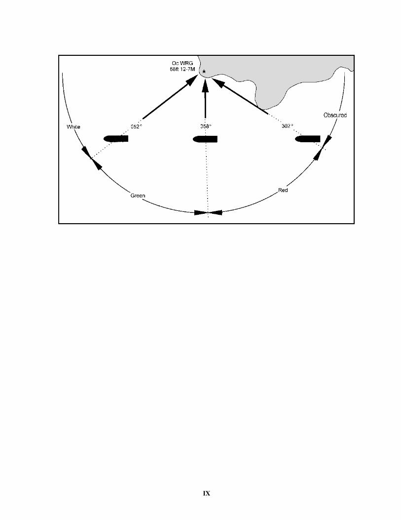
Sector limits and arcs of visibility—these are arranged clockwise and are given from seaward toward the light. Thus, in the diagram, the sectors of the light are defined as: obscured from shore to 302°, red to 358°, green to 052°, white to shore. These are bearings of the light as seen from a vessel crossing the sector lines.
Under some conditions of the atmosphere, white lights may have a reddish hue. The mariner should not judge solely by color where there are sectors but should verify this position by taking a bearing of the light. On either side of the line of demarcation between white and red there is always a small sector of uncertain color, as the edges of a sector of visibility cannot be clearly defined.
When a light is obscured by adjoining land and the arc of visibility is given, the bearing on which the light disap-pears may vary with the distance from which it is observed. When the light is cut off by a sloping point of land or hill, the light may be seen over a wider arc by a ship farther off than by one closer.
Bearings—all bearings are true, measured clockwise from 000°, and given in degrees or degrees and minutes.
IX

X
LIGHTSHIPS, SUPERBUOYS, AND OFFSHORE LIGHT STATIONS
Courses should be set to pass all floating aids to naviga-tion with sufficient clearance to avoid the possibility of collision from any cause. Experience shows that floating aids to navigation cannot be safely used as leading marks to be passed close aboard, but should always be left broad off the course, whenever searoom permits.
When approaching a lightship, superbuoy, or a station on a submarine site on radio bearings, the risk of collision will be avoided by insuring that the radio bearing does not remain constant.
Most lightships and large buoys are anchored with a very long scope of chain and, as a result, the radius of their swinging circle is considerable. The charted position is the location of the anchor. Furthermore, under certain condi-tions of wind and current, they are subject to sudden and unexpected sheers which are certain to hazard a vessel attempting to pass close aboard.
During extremely heavy weather and due to their exposed locations, lightships may be carried off station. The mariner should, therefore, not implicitly rely on a lightship maintaining its precisely charted position during and immediately following severe storms. A lightship known to be off station will secure her light, fog signal, and radiobeacon and fly the International Code signal “LO” signifying “I am not in my correct position.”
In the Baltic Sea, when lights with sectors of differing colors are encountered, the fairway is usually covered by a white sector to a vessel approaching the light, a green sec-tor to starboard and a red sector to port. The white naviga-tional sector may be very narrow and special care should be taken to keep on its center line.
In winter, most of the lighthouses and their surroundings are covered with snow and are difficult to distinguish. Due to frequent “snow bursts” one light may be showing at its full brilliancy while another in the same vicinity may be completely obscured even though the visibility may appear to be exceptional; for the same reason a light show-ing at full brilliancy may suddenly become obscured.
Russian lights are shown throughout the winter when icebreakers are working.
The latest Russian charts and publications give only suf-ficient details for navigation to the ports open to interna-tional trade. Thus, in this volume, only those lights along the routes to such ports can be assumed to be correct. Else-where, the latest available information, often not recent, is listed.
Radio navigational aids and certain lights on the Russian Arctic coast and adjacent islands north of the Arctic Cir-cle, from Novaya Zemlya east to the Bering Strait, have been omitted due to the lack of reliable information.
Russian lightships are on their station during periods of navigation. They leave their stations only when forced to do so because of ice and are then replaced as soon as pos-
sible. Lightships, by day, show a ball over a yellow flag with a blue St. George’s cross. If a vessel is seen standing into danger the signal “NF” of the International Code of Signals is hoisted, and if not immediately seen, rockets with two explosions and bright stars may be fired every minute; by night the rockets only are used.
When not on their proper stations, the lightships discon-tinue their characteristic lights and fog signals and if possi-ble lower their daymarks. They will show, instead, two black balls, one forward and one aft, or two red lights, one forward and one aft. In addition they will hoist the Interna-tional Code Signal “LO”, or will show a red and white flare-up light or flash simultaneously at least every 15 minutes.
Red flags may be displayed in place of the black balls and red and white lights shown simultaneously may be used in place of the flare-up light or flash.
A lightship under way shows the same lights and makes the same sound signals as other vessels underway, and if proceeding under its own power, hoists two black balls, one forward and one aft.
Relief lightships are painted red and equipped with two masts. By day they show a red ball at each mast, and by night exhibit a fixed red light from the same positions. Fog signals are sounded and warning signals described above are employed.
Fog bells at Russian lighthouses and lightships are sounded, unless otherwise stated, in the following uniform manner:
At lighthouses: In groups of double strokes, the interval between the groups being not more than 3 minutes.
On board lightships: In groups of triple strokes, the interval between the groups being not more than 2 min-utes.
When the fog signal of an approaching vessel is heard, the interval between the double or triple strokes in the groups is reduced and the bell is sounded continuously in double or triple strokes until the vessel is past the light or clear of danger.
Swedish lights are exhibited 15 minutes after sunset and extinguished at sunrise. Unless otherwise stated, they are shown throughout the year except when navigation in their vicinity is blocked by ice. Many of the smaller lights in Sweden are private lights, which are not constantly main-tained.
Swedish lightships only leave their stations when forced to because of ice and are then replaced as soon as circum-stances allow. Should a vessel be observed standing into danger, guns may be fired. Reserve lightships are painted red with “RESERV” in white on both sides.
Swedish lightships, when out of position, discontinue their characteristic lights and fog signals and, if possible, will lower their daymarks. The following signals are

XI
shown:By day—(a) Two black balls, one forward and one aft.
Red flags may be substituted for the balls.(b) The International Code Signal “LO”.By night—(a) Two red lights, one forward and one aft.(b) Two flare-ups (one white and one red) or flashes
shown simultaneously every 15 minutes. A red and whitelight may be used in place of the flare-ups.
A lightship underway shows the same lights and makes the same sound as other vessels underway.
All principal Finnish lights are exhibited from sunset to sunrise and are shown when navigation is open. Lights southward of 62° N. are extinguished from June 15th to July 1st; lights northward of 62° N. are extinguished from May 25th to July 20th.
Finnish lightships carry a riding light on the forestay. When not on their proper stations, the regular lights will be extinguished, no fog signals sounded, the daymarks removed if possible, and the following signals shown:
By day—(a) Two black balls, one forward and one aft.(b) The International Code Signal “LO”.By night—Two red lights, one forward and one aft; also
one red and white light will be shown simultaneously overthe gunwale at least every 15 minutes.
Lightships are kept on their stations as long as ice condi-tions permit and, if forced to leave, return as soon as cir-cumstances allow. If the mechanical fog signal is disabled, a bell will be rung.
When a pilot is stationed on board and is available, the International Code Flag “H” will be flown by day and a blue flare exhibited at night. If the pilot is absent or unable to leave the vessel, the International Code Flag “H” will be hoisted and lowered immediately. Explanation will be given by International Code Signal, or at night by Morse code. A lightship under way shows the same lights and makes the same sound signals as other vessels under way and, if proceeding under its own power, will hoist two black balls, one forward and one aft.
German lightships may be driven from their stations by ice, but are replaced as soon as circumstances allow. When out of position by day they hoist the International Code Signal “LO”, two red flags, one forward and one aft, and the distinguishing masthead mark is lowered. By night two red lights are shown, one forward and one aft. In addition, at intervals of less than 15 minutes, one white and one red light are displayed horizontally 9 feet apart from the deck for a period of one minute. In fog, only the bell fog signals prescribed in the navigation regulations are sounded. If a vessel is seen standing into danger a gun will be fired (groups of 2 reports at intervals of 3 minutes), the bell will be rung and signals made in accordance with the Interna-tional Code of Signals.
Danish lights are exhibited 15 minutes after sunset and extinguished 15 minutes before sunrise.
Danish lightships carry a riding light on the forestay.
Lightships, when out of position either because they have drifted or are on passage to their station or harbor, discon-tinue their characteristic lights and fog signals. If they have drifted out of position they will show:
By day—two black balls, one forward and one aft, and hoist the International Code Signal “LO”.
By night—two red lights will be shown, one forward and one aft; also one red and one white light will be shown simultaneously over the gunwale at least every 15 minutes.
A lightship under way shows the same lights, and makes the same sound signals as other vessels under way, and if proceeding under its own power, hoists two black balls, one forward and one aft. They are kept on their stations as long as ice permits and, when forced to leave, return as soon as circumstances allow.
Fog signals are sounded when visibility is 3 miles or less. Should the mechanical fog signal be disabled, a hand horn is used. Should a vessel be observed to be running into danger, the Morse letter “U” will be made by siren or flashing light, the International Code flag “U” hoisted. When pilots are available, a flag is displayed at the mast-head of the lightship, upper half white, lower half red. By night, pilot signals are answered by burning a flare.
WRECKING-MARKING VESSELS
A vessel marking a wreck in Danish or Swedish waters can be either a lightship or some other vessel fitted as such, but the hull is usually of some color other than red and will be distinguished as follows:
By day—Three green balls displayed from a yard; one ball on the yardarm nearest the wreck, and two balls verti-cally disposed on the other yardarm.
By night—A bell is sounded for about 10 seconds at intervals of not more than two minutes.
During fog—A bell is sounded for about 10 seconds at intervals of not more than 2 minutes.
When the vessel is anchored in a direction between north and east from the wreck, a bell sounds a series of double strokes.
When a vessel is anchored in a direction between south and west from the wreck, a bell sounds a series of single strokes.
Wreck-marking lighted buoys, which are painted green, exhibit a green group flashing light, giving two flashes when moored in a direction between N and E of the wreck, and a green flashing light when moored in a direction S and W of the wreck.
Wreck-marking spar buoys, which are painted green, have two green flags when moored in a direction between N and E of the wreck, and one green flag when moored in the direction S and W of the wreck; reflectors, when fitted, are green.
Wreck mark are always placed in the northeast or south-west quadrants from the wreck and between the latter and
XII
the main traffic route. In open water they are placed as nearly as possible northeastward or southwestward from the wreck; the narrow channels they are placed as nearly as possible on a line from the wreck at right angles to the direction of the channel, so that it may be necessary to place the marking on one side or the other of appropriate quadrant.
In Danish waters, a wreck, or other obstruction which shows above water, may be marked by a quick flashing light displayed on the wreck or obstruction itself. This light will be white when an inbound vessel is to keep the wreck to her starboard hand, and red when she is to keep it on her port hand.
When another vessel is considered to be approaching too closely, one or more warning shots will be fired if pos-sible from the wreck-marking vessel.
A vessel marking a wreck in German waters shall be painted green and may be marked “WRACK” or “W” in white. Temporary wreckmarking vessels may be painted some color other than green, but shall display a green board with the word “WRACK” in white letters on each side.
The following lights and shapes are displayed:To be passed on the mariner's starboard hand:By day—A green cone point up above two green balls,
arranged vertically.By night—Three fixed green lights arranged vertically.
Fog signal—Three strokes in succession on a bell, at intervals of not more than 30 seconds, or the rapid ringing of a bell for 5 seconds followed by 5 single strokes.
To be passed on the mariner's port hand:By day—A green cylinder above a green ball, disposed
vertically.By night—Two fixed green lights, disposed vertically.Fog signal—Two strokes in succession on a bell, at
intervals of not more than 30 seconds, or the rapid ringing of a bell for 5 seconds followed by 5 double strokes.
To be passed on either hand:By day—Two green balls, disposed vertically, at either
end of a crossyard.By night—Two fixed green lights, disposed vertically, at
either end of a crossyard.Fog signal—Four strokes in succession on a bell, at
intervals of not more than 30 seconds, or the rapid ringing of a bell for 5 seconds followed by 2 groups of 4 single strokes.
Note—The ordinary riding light for a vessel at anchor isnot exhibited.
If a vessel is seen to be running into danger, a gun will be fired (groups of 2 reports at intervals of 3 minutes), the bell will be rung and signals made in accordance with the International Code of Signals.

XIII
IALA BUOYAGE SYSTEM
XIV
FOG SIGNALS
The function of a fog signal in the system of aids to nav-igation is to warn of danger and to provide the mariner with an audible means of approximating his position rela-tive to the fog signal when the station, or any visual signal which it displays, is obscured from view by atmospheric conditions.
Fog signals depend upon the transmission of sound through air. As aids to navigation, they have certain inher-ent defects that should be considered. Sound travels through the air in a variable and frequently unpredictable manner.
It has been established that:fog signals are heard at greatly varying distances and
that the distance at which a fog signal can be heard may vary with the bearing of the signal and may be different on different occasions;
under certain conditions of atmosphere, when a fog sig-nal has a combination of high and low tones, it is not unusual for one of the tones to be inaudible. In the case of sirens, which produce a varying tone, portions of the blast may not be heard;
there are occasionally areas close to the signal in which it is wholly inaudible. This is particularly true when the fog signal is screened by intervening land or other obstruc-tions;
fog may exist a short distance from a station and not be observable from it, so that the signal may not be in opera-tion;
even though a fog signal may not be heard from the deck or bridge of a ship when the engines are in motion, it may be heard when the ship is stopped, or from a quiet position. Sometimes it may be heard from aloft though not on deck;
the intensity of the sound emitted by a fog signal may be greater at a distance than in immediate proximity.
All these considerations point to the necessity for the utmost caution when navigating near land in fog. Particu-lar attention should be given to placing lookouts in posi-tions in which the noises in the ship are least likely to interfere with hearing a fog signal. Fog signals are valu-able as warnings, but the mariner should not place implicit reliance upon them in navigating his vessel. They should be considered solely as warning devices.
Among the devices in common use as fog signals are:Radiobeacons which broadcast simple dot-and-dash
combinations by means of a transmitter emitting modu-lated continuous waves;
Diaphones which produce sound by means of a slotted reciprocating piston actuated by compressed air. Blasts
may consist of two tones of different pitch, in which case the first part of the blast is high and the last of a low pitch. These alternate pitch signals are called “two-tone;”
Diaphragm horns which produce sound by means of a diaphragm vibrated by compressed air, steam, or electric-ity. Duplex or triplex horn units of differing pitch produce a chime signal;
Nautophones, electrically operated instruments, each comprising a vibrating diaphragm, fitted with a horn, which emits a high note similar in power and tone to that of the reed;
Reed horns which produce sound by means of a steel reed vibrator by compressed air;
Sirens which produce sound by means of either a disk or a cup-shaped rotor actuated by compressed air or electric-ity;
Whistles which produce sound by compressed air emit-ted through a circumferential slot into a cylindrical bell chamber;
Bells which are sounded by means of a hammer actu-ated by hand, wave motion, by a descending weight, com-pressed gas, or electricity;
Guns and explosive signals which are produced by firing of explosive charges, the former being discharged from a gun, and the latter being exploded in midair;
Fog Detector Lights—certain light stations, in addition to the main light, are equipped with fog detector lights for automatic detection of fog. These lights sweep back and forth through an area over which the fog watch is neces-sary, showing a powerful bluish-white flash of about 1 sec-ond in duration. The interval between successive flashes will vary with the position of the vessel within the sector. At the limits of the sector the duration of the flash may be considerably longer than 1 second.
Fog detector lights operate continuously.Standby fog signals are sounded at some of the light and
fog signal stations when the main fog signal is inoperative. Some of these standby fog signals are of a different type and characteristic than the main fog signal.
Radiobeacons, RACONs, RAMARKs, and radio direc-tion-finders are mentioned in the List of Lights, but for detailed information, including the synchronization of radio signals and sound signals for distance finding, the navigator should consult Pub. 117, Radio Navigational Aids.
Note—use Chart No. 1 for the complete list of symbolsand abbreviations commonly used in presenting theessential characteristics of lights, fog signals, and radioaids found on charts.
XV
VISIBILITY TABLE
Explanation.—The line of sight connecting the observer and a distant object is at maximum length tangent with the spherical surface of the sea. It is from this point of tangency that the tabular distances are calculated. The table must accordingly be entered twice to obtain the actual geographic visibility of the object—first with the height of the object, and second with the height of the observer’s eye—and the two figures so obtained must be added. Thus, if it is desired to find the maximum distance
at which a powerful light may be seen from the bridge of a vessel where the height of eye of the observer is 55 feet above the sea, from the table:
Nautical Miles55 feet height of observer (visible) . . . . . . . . . . . . .8.7200 feet height of light (visible) . . . . . . . . . . . . . .16.5Distance visible . . . . . . . . . . . . . . . . . . . . . . . . . . .25.2
Table of distances at which objects can be seen at sea according to their respective elevations and the elevation of the eye of the observer.
Height in Feet
Distance in geographic or nautical
miles
Height in feet
Distance in geographic or nautical
miles
Height in feet
Distance in geographic or nautical
miles
Height in feet
Distance in geographic or nautical
miles
Height in feet
Distance in geographic or nautical
miles
Height in feet
Distance in geographic or nautical
miles
1 1.2 23 5.6 45 7.8 135 13.6 340 21.6 600 28.7
2 1.7 24 5.7 46 7.9 140 13.8 350 21.9 620 29.1
3 2.0 25 5.9 47 8.0 145 14.1 360 22.2 640 29.5
4 2.3 26 6.0 48 8.1 150 14.3 370 22.5 660 30.1
5 2.6 27 6.1 49 8.2 160 14.8 380 22.8 680 30.5
6 2.9 28 6.2 50 8.3 170 15.3 390 23.1 700 31.0
7 3.1 29 6.3 55 8.7 180 15.7 400 23.4 720 31.4
8 3.3 30 6.4 60 9.1 190 16.1 410 23.7 740 31.8
9 3.5 31 6.5 65 9.4 200 16.5 420 24.0 760 32.3
10 3.7 32 6.6 70 9.8 210 17.0 430 24.3 780 32.7
11 3.9 33 6.7 75 10.1 220 17.4 440 24.5 800 33.1
12 4.1 34 6.8 80 10.5 230 17.7 450 24.8 820 33.5
13 4.2 35 6.9 85 10.8 240 18.1 460 25.1 840 33.9
14 4.4 36 7.0 90 11.1 250 18.5 470 25.4 860 34.3
15 4.5 37 7.1 95 11.4 260 18.9 480 25.6 880 34.7
16 4.7 38 7.2 100 11.7 270 19.2 490 25.9 900 35.1
17 4.8 39 7.3 105 12.0 280 19.6 500 26.2 920 35.5
18 5.0 40 7.4 110 12.3 290 19.9 520 26.7 940 35.9
19 5.1 41 7.5 115 12.5 300 20.3 540 27.2 960 36.3
20 5.2 42 7.6 120 12.8 310 20.6 560 27.7 980 36.6
21 5.4 43 7.7 125 13.1 320 20.9 580 28.2 1000 37.0
22 5.5 44 7.8 130 13.3 330 21.3
XVI
CONVERSION TABLE — FEET TO WHOLE METERS
(FOR HEIGHTS OF LIGHTS)1 foot = 0.3048 meter
Feet Meters Feet Meters Feet Meters Feet Meters Feet Meters Feet Meters
40 12 80 24 120 37 160 49 200 611 0 41 12 81 25 121 37 161 49 300 912 1 42 13 82 25 122 37 162 49 400 1223 1 43 13 83 25 123 37 163 50 500 1524 1 44 13 84 26 124 38 164 50 600 183
5 2 45 14 85 26 125 38 165 50 700 2136 2 46 14 86 26 126 38 166 51 800 2447 2 47 14 87 27 127 39 167 51 900 2748 2 48 15 88 27 128 39 168 51 1000 3059 3 49 15 89 27 129 39 169 52
10 3 50 15 90 27 130 40 170 5211 3 51 16 91 28 131 40 171 5212 4 52 16 92 28 132 40 172 5213 4 53 16 93 28 133 41 173 5314 4 54 16 94 29 134 41 174 53
15 5 55 17 95 29 135 41 175 5316 5 56 17 96 29 136 41 176 5417 5 57 17 97 30 137 42 177 5418 5 58 18 98 30 138 42 178 5419 6 59 18 99 30 139 42 179 55
20 6 60 18 100 30 140 43 180 5521 6 61 19 101 31 141 43 181 5522 7 62 19 102 31 142 43 182 5523 7 63 19 103 31 143 44 183 5624 7 64 20 104 32 144 44 184 56
25 8 65 20 105 32 145 44 185 5626 8 66 20 106 32 146 45 186 5727 8 67 20 107 33 147 45 187 5728 9 68 21 108 33 148 45 188 5729 9 69 21 109 33 149 45 189 58
30 9 70 21 110 34 150 46 190 5831 9 71 22 111 34 151 46 191 5832 10 72 22 112 34 152 46 192 5933 10 73 22 113 34 153 47 193 5934 10 74 23 114 35 154 47 194 59
35 11 75 23 115 35 155 47 195 5936 11 76 23 116 35 156 48 196 6037 11 77 23 117 36 157 48 197 6038 12 78 24 118 36 158 48 198 6039 12 79 24 119 36 159 48 199 61

XVII
RADIOBEACONS
RADIO DIRECTION-FINDER SETS ON SHIPS
Radio direction-finder sets on board ship enable bear-ings to be taken of transmissions from other ships, aircraft, shore stations, marine radiobeacons, and the coastal sta-tions of the radio communication network. When located in the pilothouse or on the navigating bridge, the direc-tion-finder enables the navigating officer to obtain bear-ings himself without reference to others and without delay.
Due to the great value of radio bearings, particularly when visibility is poor and when celestial observations cannot be obtained, the radio direction-finder on board ship deserves the same consideration and care as are given to the sextant and compass. It has the following character-istics in common with the two latter navigational instru-ments: the readings are subject to certain errors; these errors may be reduced by skillful and intelligent operation; the dangers of using erroneous readings may be greatly reduced by the intelligence and good judgment of the mar-iner. In order to acquire experienced judgment in the oper-ation of the instrument, it is essential that the mariner use it as much as practicable.
Troubles from interference and weak signals are greatly reduced by the use of direction-finders of proper selectiv-ity. The bearings must be corrected for radio deviation as shown by the calibration curve of the set.
Types of Radiobeacons
1. Directional radiobeacons which transmit radio waves in beams along fixed bearings.
2. Rotating radiobeacons by which a beam of radio waves is resolved in azimuth in a manner similar to the beam of light sent out by rotating lights.
3. Circular radiobeacons which send out waves of approximately uniform strength in all directions so that ships may take radio bearings of them by means of the ship’s radio direction-finder sets. This is the most common type of radiobeacon.
To extend the usefulness of marine radiobeacons to ships and aircraft employing automatic radio direction finders, U.S. marine radiobeacons on the Atlantic and Pacific Coasts and Great Lakes have been modified to transmit a continuous carrier signal during the entire radiobeacon operating period with keyed modulation pro-viding the characteristic signal. Unless a beat frequency oscillator is installed, the continuous carrier signals are not audible to the operator of an aural null direction finder. A ten second dash has been included in the characteristic of these radiobeacons, to enable the navigator using a con-ventional aural null direction finder to refine his bearing. Vessels with direction finders will be able to use the
United States radiobeacons located on the Atlantic and Pacific Coasts, and Great Lakes at any time in their assigned sequence.
Aeronautical Radio Aids
Aeronautical radiobeacons and radio ranges are often used by navigators of marine craft in the same manner as marine radiobeacons are used for determining lines of positions. They are particularly useful along coasts where marine broadcast coverage is inadequate. Aeronautical aids situated inland become less trustworthy, so far as ships are concerned, when high land intervenes between them and the coast. They are established to be of primary usefulness to aircraft, and surface craft should use these aids with caution. Only those aeronautical radiobeacons considered to be of use to the mariner have been selected for inclusion in this publication.
AERONAUTICAL RADIOBEACONS. Like marineradiobeacons, these aids broadcast a characteristic signalon a fixed frequency.
NOTE: The assigned frequency of aeronauticalradiobeacons is normally from 200 to 415 kHz while thefrequency of marine radiobeacons is normally from 285 to325 kHz. Aeronautical radiobeacons not within the marineradiobeacon band will not normally be listed in thispublication.
The range signals are interrupted at intervals to permit broadcast of the identification signal. In aviation publica-tions the range leg bearings are most often given as mag-netic bearings toward the station; in this publication they are given as true bearings toward the station. Unless other-wise stated in the station details, aeronautical radio aids mentioned in this publication transmit continuously.
NOTE: Mariners are advised that changes to anddeficiencies in aeronautical radio facilities are not alwaysimmediately available to maritime interests and thepositions are approximate and listed to the nearest minuteonly.
Obligations of Administrations Operating Radiobeacons
The obligations of nations and other administrations operating radiobeacons are given in Article 43 of the Radio Regulations of the International Telecommunication Union, Geneva.
Accuracy of Bearings Taken Aboard Ship
No exact rules can be given as to the accuracy to be expected in radio bearings taken by a ship as the accuracy depends to a large extent upon the skill of the ship’s opera-

XVIII
tor, the condition of the ship’s equipment, and the accuracy of the ship’s calibration curve. Mariners are urged to obtain this information by taking frequent radio bearings when their ship’s position is accurately known and by recording the results. Normally, United States radiobea-cons are operated in a group of six, each station in a group using the same frequency and transmitting for one minute in its proper sequence, and operate during all periods, either sequenced or continuously, regardless of weather conditions.
SKILL OF OPERATOR: Skill in the operation of theradio direction-finder can be obtained only by practice andby observing the technical instructions for the set inquestion. For these reasons the operator should carefullystudy the instructions issued with the set and shouldpractice taking bearings frequently.
OPERATOR’S ERROR: As the operator obtainsbearings by revolving the direction-finder coil until thesignal disappears or becomes a minimum, the operator cantell by the size of the arc of silence or of minimum strengthapproximately how accurately the bearing has been taken.For instance, if the minimum is broad and the residualsignal covers about 10° with equal strength, it is doubtful ifthe bearing can be accurately estimated. On the other hand,if a sharp minimum can be obtained, the operator candetermine the bearing to within a half of a degree.
In this connection it should be noted that a properly operating and correctly adjusted direction-finder should in no case produce other than a point or arc of absolute silence. That is, there should be no “residual” signal at the point or arc of observation. The sharpness and complete-ness of the arc of silence are the best indications of a prop-erly operating direction-finder, and their absence is the best indication of the presence of “night effect.”
SUNRISE, SUNSET, OR NIGHT EFFECT: Bearingsobtained from about half an hour before sunset to abouthalf an hour after sunrise may be subject to errors dueto night effect. On some nights this effect is morepronounced than on others and effect is usually greatestduring the hours of twilight. Night effect may bedetected by a broadening of the arc of minimum signalsand by a fluctuation in the strength of the signals. Itmay also be indicated by difficulty in obtaining aminimum or by a rapidly shifting minimum. It issometimes accompanied by an actual shift in thedirection of the bearings. If it is essential to obtain abearing when the night effect is pronounced, severalbearings should be taken over a short period of time andan average taken of them.
RADIO DIRECTION FINDER WITHOUT GYRO REPEATERS: The ship’s compass must be read as the bearing is taken or an error may be introduced equal to the amount that the ship has yawed in the interval between taking the bearing and reading the compass. Any error in the ship’s compass must be applied to the bearing.
RECIPROCAL BEARINGS: In some direction-findersets, the operator cannot tell from which side of the shipthe signals are coming. With these sets the operator shallcorrect both bearings for their respective deviations andgive both corrected bearings to the person who is plottingthe bearings on the chart. If the mariner is in doubt as tothe side of the ship from which the bearings are coming,this difficulty can usually be solved by having anotherbearing taken after the ship has steamed a short distanceand noting in which direction the bearing is changing.
CALIBRATION: It is essential that the radiodirection-finder be accurately calibrated in order that thebearings may be corrected for deviation. While thebearings are being taken, other radio antennas on boardmust be in the same condition as they were when thecalibration was made; movable parts of the ship’ssuperstructure such as booms, davits, wire rigging, etc.,must be secured in the positions which they occupiedwhen the direction-finder was calibrated. Unusual cargoessuch as large quantities of metals and extraordinaryconditions of loading may cause errors.
The direction-finder should be recalibrated after any changes have been made in the set or its surroundings (this includes alterations to or changes in position of antennas, wire rigging, boat davits, booms, etc.) whenever there is reason to believe that the previous calibration has become inaccurate, and also at periodic intervals.
The calibration must be made on approximately the same frequency or frequencies as will be used to take bear-ings because the deviation for several frequencies is not likely to be the same. It is believed that one calibration curve is satisfactory for the normal radiobeacon frequency (285 to 325 kHz), but the instructions issued by the manu-facturer of the particular direction-finder in question should be studied in this connection.
To facilitate the calibration of ship’s direction-finders, special arrangements have been made by some services for operation of their radiobeacons at times other than their published schedules. Information as to the arrangements made by the United States stations in this respect is as fol-lows:
Sequenced radiobeacons cannot broadcast at any time other than on their assigned operating minute for the pur-pose of enabling vessels to calibrate their radio direction finders without causing interference. Special radio direc-tion finder calibration transmitters of short range are oper-ated at certain localities to provide continuous calibration service.
The position given for the antenna is the point from which the radiobeacon signal is emitted.
If it is not practicable to determine the time of calibra-tion sufficiently in advance to contact the district com-mander, request may be made directly to the stations by means of telephone, telegraph, or a whistle signal consist-ing of three long blasts; followed by three short blasts.

XIX
This whistle signal is to be repeated until it is acknowl-edged by the station through the starting of the transmitter. The same group of signals should be sounded at the termi-nation of calibration.
The work of the station personnel is not confined to standing watch and there may be times when the whistle request for calibration is not immediately heard, due to the noise from operating station machinery, etc. Usually, a repeated signal not too far from the station will attract attention.
“COMPENSATED” RADIO DIRECTION-FINDERS:Many radio direction-finders are “compensated” and nocalibration chart or curve is used. Attention is invited tothe fact that such compensation is just as vulnerable as thecalibration data due to changes made in the set or itssurroundings.
CHECK THE CALIBRATION: The calibration ofcompensation should be checked frequently by takingbearings when the ship’s position is accurately known andthe results should be recorded for future reference.
CALIBRATION RADIOBEACONS: In the UnitedStates and certain other areas special radiobeacons,primarily for calibrating shipboard direction-finders are inoperation. These radiobeacons transmit eithercontinuously during scheduled hours or upon request, asindicated in station details.
COASTAL REFRACTION (OR LAND EFFECT):Errors may occur in bearings taken by ships so located thatthe line of observation to the radiobeacon passes over landor along the shore line. However, many observations seemto indicate that such errors are negligible when theobserving vessel is well out from the shore. Bearingssecured entirely over water areas are to be preferred since“land effect” is thus eliminated. Bearings taken at sunsetand sunrise are likely to be erratic, and observations takenat these hours should therefore be repeated and checked asmay be feasible.
PROGRAM BROADCASTING STATIONS: Beforetaking bearings on a station broadcasting entertainmentprograms a mariner should consider that frequency maydiffer widely from the frequency for which the set iscalibrated, that the published location of the station maybe that of its studio and not that of its transmitting antenna,that if the station is synchronized with other stations itmay be impossible to tell on which station the bearing wastaken, and that as the majority of these stations are inland,the coastal refraction may be excessive.
Station Details
FREQUENCY: The frequency listed is that used by thestation in transmitting its “Characteristic Signal.” Callingfrequencies, if any, will be given under “remarks.”
RANGE: In this book the range of radiobeacons is onlyapproximate and is given merely to assist mariners in
planning their voyages and to inform them of severalradiobeacons they will probably hear first. Frequently,when conditions for radio reception are good,radiobeacons may be heard at greater distances thanindicated. The mariner who is at a greater distance than therange indicated should attempt to obtain bearings whennecessary, and not assume that the radiobeacon will beunheard beyond its indicated range.
GROUP SEQUENCE: Selected radiobeacons aregrouped together on the same operating frequency and areassigned a specific sequence of transmission within thisgroup. This reduces station interference and unnecessaryreturning.
ANTENNA LEAD-IN: Included in the details of manyradiobeacons located at or near light stations is a statementof the distance and bearing of the radiobeacon transmittingantenna from the light tower. Use should be made of thisinformation when calibrating the ship’s direction-findingequipment by means of simultaneous visual and radiobearings.
Plotting Radio Bearings
The procedure for converting radio (great circle) bear-ings as received by direction-finder equipment aboard ship is identical with that used in converting radio bearings sup-plied by direction-finder stations on shore and is described in section 100E “Plotting Radio Bearings” of Pub. 117, Radio Navigational Aids.
Synchronization for Distance Finding
At some radiobeacon stations, sound signals, either sub-marine or air or both, are synchronized with the radiobea-con signals for distance finding. Ordinarily, the sound signals do not operate during the transmission period of the radio signal in clear weather. The methods in use employ, as a rule, distinctive signals to indicate the point of synchronization, and make use, for determining dis-tance, of the lag of signals traveling through air or water as compared to the practically instantaneous travel of the radio signals.
In the case of some sound signals, a series of short radio dashes is transmitted at intervals following the synchroniz-ing point, so that by counting the number of such short dashes heard after the distinctive radio signal and before hearing the corresponding distinctive sound signal, the observer obtains the distance, in miles equal to the number of dashes counted, from the sound signal apparatus unless stated otherwise.
In the case of other signals, the observer notes the num-ber of seconds intervening between the reception of the distinctive radio signal and the corresponding sound signal and uses a factor to determine distances in miles as fol-lows:
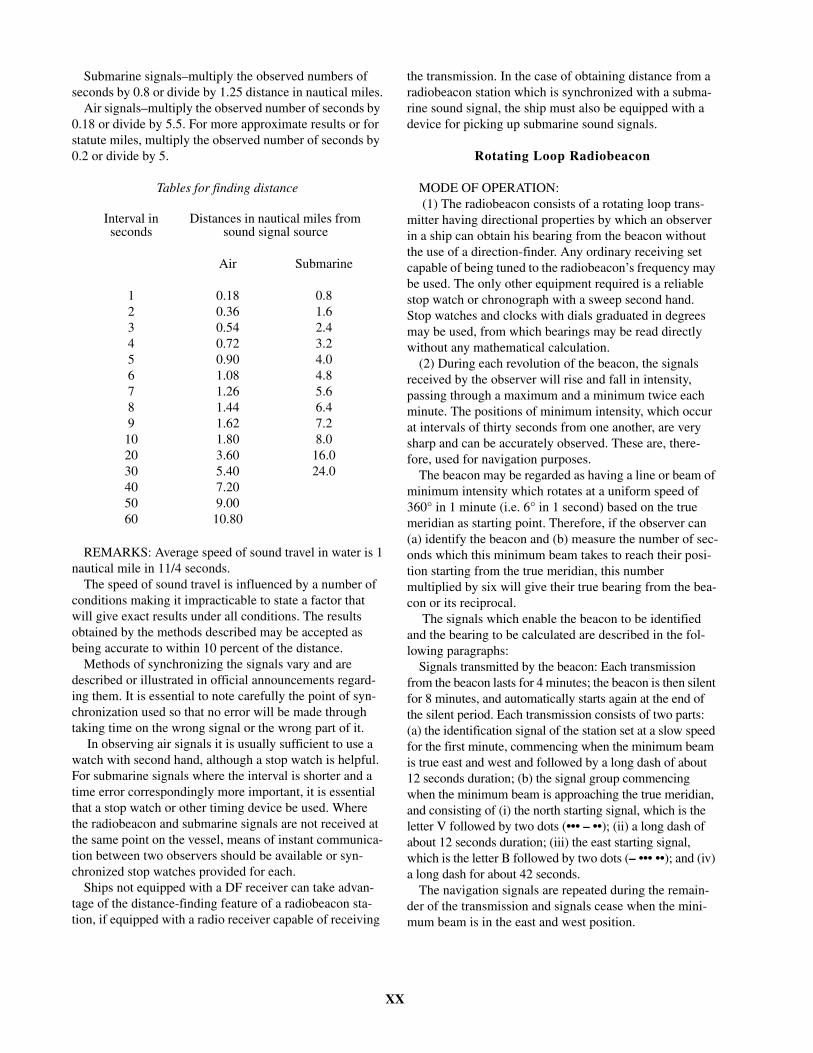
XX
Submarine signals–multiply the observed numbers of seconds by 0.8 or divide by 1.25 distance in nautical miles.
Air signals–multiply the observed number of seconds by 0.18 or divide by 5.5. For more approximate results or for statute miles, multiply the observed number of seconds by 0.2 or divide by 5.
REMARKS: Average speed of sound travel in water is 1nautical mile in 11/4 seconds.
The speed of sound travel is influenced by a number of conditions making it impracticable to state a factor that will give exact results under all conditions. The results obtained by the methods described may be accepted as being accurate to within 10 percent of the distance.
Methods of synchronizing the signals vary and are described or illustrated in official announcements regard-ing them. It is essential to note carefully the point of syn-chronization used so that no error will be made through taking time on the wrong signal or the wrong part of it.
In observing air signals it is usually sufficient to use a watch with second hand, although a stop watch is helpful. For submarine signals where the interval is shorter and a time error correspondingly more important, it is essential that a stop watch or other timing device be used. Where the radiobeacon and submarine signals are not received at the same point on the vessel, means of instant communica-tion between two observers should be available or syn-chronized stop watches provided for each.
Ships not equipped with a DF receiver can take advan-tage of the distance-finding feature of a radiobeacon sta-tion, if equipped with a radio receiver capable of receiving
the transmission. In the case of obtaining distance from a radiobeacon station which is synchronized with a subma-rine sound signal, the ship must also be equipped with a device for picking up submarine sound signals.
Rotating Loop Radiobeacon
MODE OF OPERATION: (1) The radiobeacon consists of a rotating loop trans-
mitter having directional properties by which an observer in a ship can obtain his bearing from the beacon without the use of a direction-finder. Any ordinary receiving set capable of being tuned to the radiobeacon’s frequency may be used. The only other equipment required is a reliable stop watch or chronograph with a sweep second hand. Stop watches and clocks with dials graduated in degrees may be used, from which bearings may be read directly without any mathematical calculation.
(2) During each revolution of the beacon, the signals received by the observer will rise and fall in intensity, passing through a maximum and a minimum twice each minute. The positions of minimum intensity, which occur at intervals of thirty seconds from one another, are very sharp and can be accurately observed. These are, there-fore, used for navigation purposes.
The beacon may be regarded as having a line or beam of minimum intensity which rotates at a uniform speed of 360° in 1 minute (i.e. 6° in 1 second) based on the true meridian as starting point. Therefore, if the observer can (a) identify the beacon and (b) measure the number of sec-onds which this minimum beam takes to reach their posi-tion starting from the true meridian, this number multiplied by six will give their true bearing from the bea-con or its reciprocal.
The signals which enable the beacon to be identified and the bearing to be calculated are described in the fol-lowing paragraphs:
Signals transmitted by the beacon: Each transmission from the beacon lasts for 4 minutes; the beacon is then silent for 8 minutes, and automatically starts again at the end of the silent period. Each transmission consists of two parts: (a) the identification signal of the station set at a slow speed for the first minute, commencing when the minimum beam is true east and west and followed by a long dash of about 12 seconds duration; (b) the signal group commencing when the minimum beam is approaching the true meridian, and consisting of (i) the north starting signal, which is the letter V followed by two dots (••• – ••); (ii) a long dash of about 12 seconds duration; (iii) the east starting signal, which is the letter B followed by two dots (– ••• ••); and (iv) a long dash for about 42 seconds.
The navigation signals are repeated during the remain-der of the transmission and signals cease when the mini-mum beam is in the east and west position.
Tables for finding distance
Interval in seconds
Distances in nautical miles from sound signal source
Air Submarine
1 0.18 0.82 0.36 1.63 0.54 2.44 0.72 3.25 0.90 4.06 1.08 4.87 1.26 5.68 1.44 6.49 1.62 7.210 1.80 8.020 3.60 16.030 5.40 24.040 7.2050 9.0060 10.80
XXI
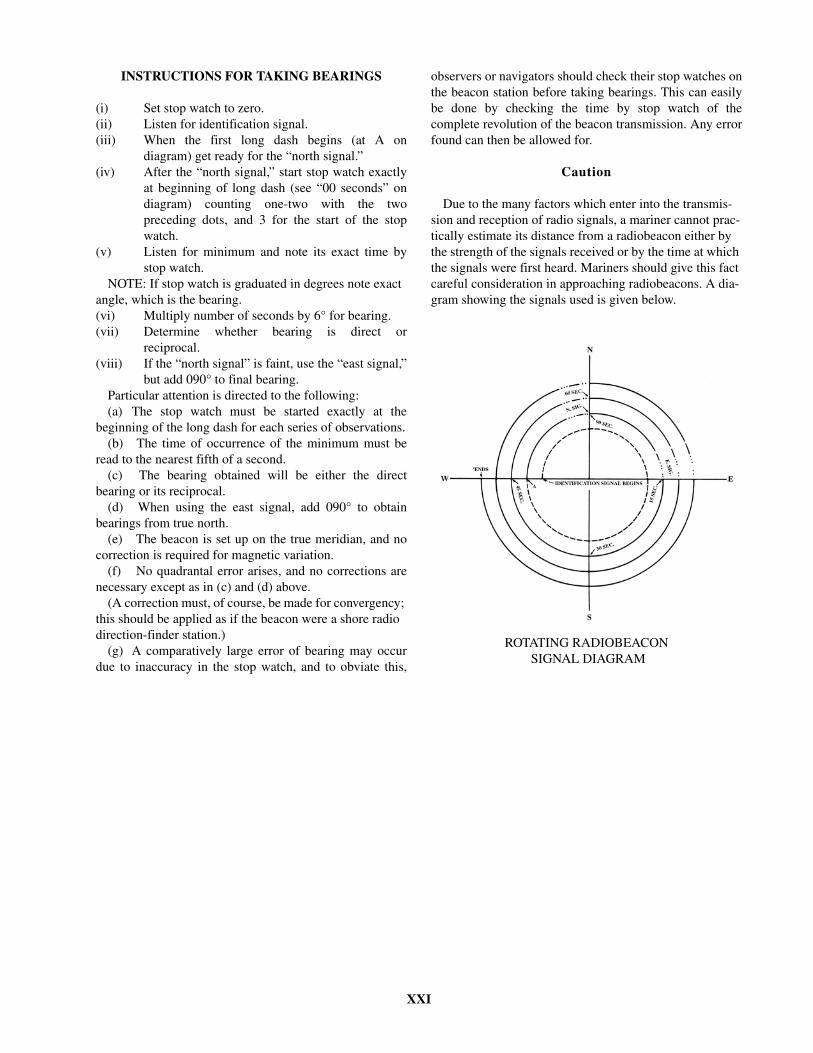
INSTRUCTIONS FOR TAKING BEARINGS
(i) Set stop watch to zero.(ii) Listen for identification signal.(iii) When the first long dash begins (at A on
diagram) get ready for the “north signal.”(iv) After the “north signal,” start stop watch exactly
at beginning of long dash (see “00 seconds” ondiagram) counting one-two with the twopreceding dots, and 3 for the start of the stopwatch.
(v) Listen for minimum and note its exact time bystop watch.
NOTE: If stop watch is graduated in degrees note exact angle, which is the bearing.(vi) Multiply number of seconds by 6° for bearing.(vii) Determine whether bearing is direct or
reciprocal.(viii) If the “north signal” is faint, use the “east signal,”
but add 090° to final bearing.Particular attention is directed to the following:(a) The stop watch must be started exactly at the
beginning of the long dash for each series of observations.(b) The time of occurrence of the minimum must be
read to the nearest fifth of a second.(c) The bearing obtained will be either the direct
bearing or its reciprocal.(d) When using the east signal, add 090° to obtain
bearings from true north.(e) The beacon is set up on the true meridian, and no
correction is required for magnetic variation.(f) No quadrantal error arises, and no corrections are
necessary except as in (c) and (d) above.(A correction must, of course, be made for convergency;
this should be applied as if the beacon were a shore radio direction-finder station.)
(g) A comparatively large error of bearing may occurdue to inaccuracy in the stop watch, and to obviate this,
observers or navigators should check their stop watches onthe beacon station before taking bearings. This can easilybe done by checking the time by stop watch of thecomplete revolution of the beacon transmission. Any errorfound can then be allowed for.
Caution
Due to the many factors which enter into the transmis-sion and reception of radio signals, a mariner cannot prac-tically estimate its distance from a radiobeacon either by the strength of the signals received or by the time at which the signals were first heard. Mariners should give this fact careful consideration in approaching radiobeacons. A dia-gram showing the signals used is given below.
ROTATING RADIOBEACON SIGNAL DIAGRAM

XXII
DESCRIPTION
(Radiobeacons)
Information is tabulated in eight columns as follows:
Column 1: The number assigned to each radiobeacon bythis Agency.
Column 2: Name and/or descriptive location of theradiobeacon.
Column 3: Approximate latitude and longitude of theradiobeacon to the nearest tenth of a minute.
Column 4: Radiobeacon characteristics. Included in thiscolumn are the Morse code, period in seconds, length oftransmission and silence time.
Column 5: Range (approximate) in nautical miles.
Column 6: Group sequence. Selected radiobeacons aregrouped together on the same operating frequency and areassigned a specific sequence of transmission within thisgroup. This reduces station interference and unnecessaryreturn.
Column 7: Frequency (given in kilohertz) and amplitudemodulation (see Table Symbols).
Column 8: Remarks. Transmission synchronization, typeof radiobeacon (marine, aero, etc.), calibration, antennalead-in, calling frequencies, distance-finding information,service charges, hours of transmission, directional signalsand other pertinent information.
ABBREVIATIONS
aero . . . . . . . . . . . . . . . . . . . . . . . . . . . . aeronauticaltr . . . . . . . . . . . . . . . . . . . . . . . . . . . . . . transmission si . . . . . . . . . . . . . . . . . . . . . . . . . . . . . . . . . . silence s. . . . . . . . . . . . . . . . . . . . . . . . . . . . . . . . . . .seconds(4) . . . . . . . . . . . . . . . . . . . . . . . . . . . . . . . . . 4 times Transmission is continuous unless otherwise stated.
XXIII
TABLE OF SYMBOLS
LEGEND
(1) Type of modulation of the main carrier.(2) Nature of signal(s) modulating the main carrier. (3) Type of “information” to be transmitted. “Information” does not include information of a constant, unvarying naturesuch as provided by standard frequency emissions, continuous wave and pulse radars, etc.
AMPLITUDE MODULATION:
N0N
(1) Emission of an unmodulated carrier.(2) No modulating signal. (3) No information transmitted.
A1A
(1) Double-sideband. (2) Single channel containing quantized or digital information without the use of a modulating subcarrier. (3) Telegraphy (for aural reception).
A2A
(1) Double-sideband. (2) Single channel containing quantized or digital information with the use of a modulating subcarrier. (3) Telegraphy (for aural reception).
A3E
(1) Double-sideband. (2) Single channel containing analog information. (3) Telephony (including sound broadcasting).
R3E
(1) Single-sideband (reduced or variable level carrier).(2) Single channel containing analog information. (3) Telephony (including sound broadcasting).
B8E
(1) Independent sidebands.(2) Two or more channels containing analog information.(3) Telephony (including sound broadcasting).
H2A
(1) Single-sideband (full carrier). (2) Single channel containing quantized or digital information with the use of a modulating subcarrier. (3) Telegraphy (for aural reception).

XXIV
H3E
(1) Single-sideband (full carrier). (2) Single channel containing analog information. (3) Telephony (including sound broadcasting).
J3E
(1) Single-sideband (suppressed carrier). (2) Single channel containing analog information.(3) Telephony (including sound broadcasting).
A3C
(1) Double-sideband. (2) Single channel containing analog information.(3) Facsimile.
A3F
(1) Double-sideband. (2) Single channel containing analog information.(3) Television (video).
B7D
(1) Independent sidebands. (2) Two or more channels containing quantized or digital information.(3) Data transmissions, telemetry, telecommand.
Note: With 6 kHz. EDW operation in the bands below 30 MHz allocated exclusively for Maritime Mobile Service (FC, MO).
FREQUENCY (OR PHASE) MODULATION:
F1B
(1) Frequency modulation. (2) Single channel containing quantized or digital information without the use of a modulating subcarrier. (3) Telegraphy (for automatic reception).
F2A
(1) Frequency modulation.(2) Single channel containing quantized or digital information with the use of a modulating subcarrier. (3) Telegraphy (for aural reception).
F3E
(1) Frequency modulation.(2) Single channel containing analog information. (3) Telephony (including sound broadcasting).
XXV
F3C
(1) Frequency modulation. (2) Single channel containing analog information.(3) Facsimile.
F3F
(1) Frequency modulation. (2) Single channel containing analog information.(3) Television (video).
P1B
(1) Sequence of unmodulated pulses. (2) Single channel containing quantized or digital information without the use of a modulating subcarrier. (3) Telegraphy (for automatic reception).
Pulse Modulation:GHz = gigahertzkHz = kilohertzMHz = megahertz

XXVI
DIFFERENTIAL GLOBAL POSITIONING SYSTEM (DGPS)
Differential Global Positioning System (DGPS) is aradio-based navigation system that eliminates errors in aGPS receiver that will allow the accuracy level to be sig-nificantly enhanced. DGPS accuracy can be 10 meters orbetter, compared with 100 meters or better with GPS. Thisis possible by placing a high-performance GPS receiver(reference station) at a known location. Because thereceiver knows its exact location, it can determine theerrors in the satellite signals. The satellite measures theranges to each satellite using the signals received and com-paring these measured ranges to the actual ranges calcu-lated from its known position. The total error is thedifference between the measured and calculated range.The error data for each tracked satellite is formatted into acorrection message and transmitted to GPS users. The cor-rection message format follows the standard establishedby the Radio Technical Commission for Maritime Ser-vices, Special Committee 104 (RTCM-SC104). These dif-ferential corrections are then applied to the GPScalculations, thus removing most of the satellite signalerror and improving accuracy.
Terms for understanding DGPS:
DGPS Correction Receiver
A DGPS correction receiver decodes the signalsreceived from a reference site. Data is formatted into aserial RTCM SC104 data stream and provided to theremote GPS receiver. There are many types of DGPS cor-rection receivers.
GPS Receivers
The GPS receiver measures ranges to each satellite, but
before the measurements are used to calculate position,corrections received from the DGPS receiver are appliedto the measurements. The position is then calculated usingthe corrected range measurements providing vastlyincreased accuracy.
Modulator
Depending on the transmission format, the modulatorencodes the data as necessary for transmission.
Reference Station
The reference station GPS receiver knows exactly theposition of its antenna, therefore it knows what each satel-lite range measurement should be. It measures the rangesto each satellite using the received signals just as if it wasgoing to calculate position. The measured ranges are sub-tracted from the known ranges and the result is range error.The range error values for each satellite are formatted intomessages in the RTCM SC104 format and transmittedcontinuously.
Transmitter
The transmitter is basically a power amplifier which isconnected to an antenna system. The modulated carrier isamplified and driven to the antenna. In the United StatesCoast Guard system, the transmitter is 250-1000 Watts andoperates in the 300Khz frequency range. The amplifiedsignal is radiated via the antenna to remote DGPS receiv-ers for real-time position correction.
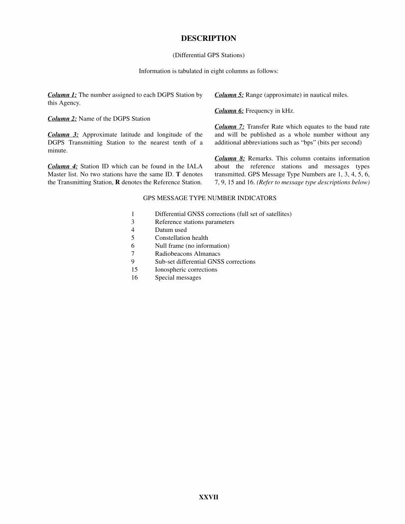
XXVII
DESCRIPTION
(Differential GPS Stations)
Information is tabulated in eight columns as follows:
Column 1: The number assigned to each DGPS Station bythis Agency.
Column 2: Name of the DGPS Station
Column 3: Approximate latitude and longitude of theDGPS Transmitting Station to the nearest tenth of aminute.
Column 4: Station ID which can be found in the IALAMaster list. No two stations have the same ID. T denotesthe Transmitting Station, R denotes the Reference Station.
Column 5: Range (approximate) in nautical miles.
Column 6: Frequency in kHz.
Column 7: Transfer Rate which equates to the baud rateand will be published as a whole number without anyadditional abbreviations such as “bps” (bits per second)
Column 8: Remarks. This column contains informationabout the reference stations and messages typestransmitted. GPS Message Type Numbers are 1, 3, 4, 5, 6,7, 9, 15 and 16. (Refer to message type descriptions below)
GPS MESSAGE TYPE NUMBER INDICATORS
1 Differential GNSS corrections (full set of satellites)3 Reference stations parameters4 Datum used5 Constellation health6 Null frame (no information)7 Radiobeacons Almanacs9 Sub-set differential GNSS corrections15 Ionospheric corrections16 Special messages
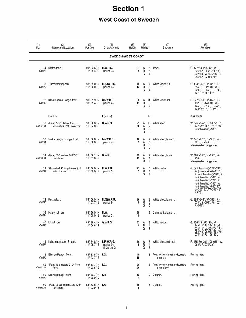
1
(1)No.
(2)Name and Location
(3)Position
(4)Characteristic
(5)Height
(6)Range
(7)Structure
(8)Remarks
Section 1West Coast of Sweden
SWEDEN-WEST COAST
4C 0277
Kattholmen. 59° 03.6´ N11° 09.4´ E
Fl.W.R.G.period 3s
319
W. 6R. 5G. 4
Tower. G. 177°54′-204°42′, W.-224°42′, R.-297°18′, G.-022°48′, W.-026°18′, R.-054°42′, G.-082°18′.
8C 0279
Tjurholmsknappen. 58° 59.0´ N11° 06.0´ E
Fl.(2)W.R.G.period 6s
4614
W. 7R. 5G. 4
White tower; 13. G. 194°-236°, W.-323°, R.-356°, G.-022°30′, W.-028°, R.-066°, G.-074°, W.-107°, R.-117°.
12C 0280
Klovningarna Range, front. 58° 55.9´ N10° 59.4´ E
Iso.W.R.G.period 4s
3611
W. 11R. 8G. 7
White tower; 20. G. 327°-051°, W.-059°, R.-132°, G.-140°30′, W.-145°, R.-216°, G.-242°, W.-255°30′, R.-327°.
RACON K(– • –) 12 (3 & 10cm).
16C 0280.01
-Rear, Nord Hallso, 6.4 kilometers 053° from front.
58° 58.0´ N11° 04.8´ E
Q.W.R.G. 12538
W. 10W. 9R. 6G. 5
White shed. W. 049°-057°, G. 090°-115°, W.-122°, R.-137°30′, W. (unintensified)-203°.
20C 0281
Sodra Langon Range, front. 58° 56.0´ N11° 08.0´ E
Iso.W.R.G.period 4s
165
W. 7W. 5R. 3G. 2
White shed, lantern. W. 145°-220°, G.-315°, W.-321°, R.-340°.
Intensified on range line.
24C 0281.01
-Rear, 500 meters 161°30′ from front.
58° 56.1´ N11° 07.9´ E
Q.W.R. 4915
W. 7W. 4R. 3
White shed, lantern. W. 162°-180°, R.-200°, W.-250°.
Intensified on range line.
28C 0282
Stromstad (Killingsholmen), E. side of island.
58° 56.0´ N11° 09.0´ E
Fl.W.R.G.period 3s
237
W. 6R. 4G. 3
White lantern. G. (unintensified)-222°-233°, W. (unintensified)-242°, R. (unintensified)-251°, G. (unintensified)-262°, W. (unintensified)-272°, R. (unintensified)-353°, W. (unintensified)-040°30′, G.-052°30′, W.-053°48′, R.078°.
32C 0283
Kristhallan. 58° 56.0´ N11° 07.7´ E
Fl.(3)W.R.G.period 9s
268
W. 8R. 6G. 5
White shed, lantern. G. 285°-303°, W.-333°, R.-033°, G.-096°, W.-100°, R.-107°.
36C 0284
Halsorholmen. 58° 56.0´ N11° 08.0´ E
Fl.W.period 3s
258
2 Cairn, white lantern.
40C 0285
Likholmen. 58° 55.4´ N11° 06.6´ E
Q.W.R.G. 278
W. 6R. 4G. 3
White lantern. G. 196°12′-243°30′, W.-249°18′, R.-324°54′, G.-033°18′, W.-036°24′, R.-056°42′, G.-068°36′, W.-075°12′, R.-196°12′.
44C 0287
Kabblingarna, on S. islet. 58° 54.8´ N11° 05.7´ E
L.Fl.W.R.G.period 9sfl. 2s, ec. 7s
165
W. 6R. 4G. 3
White shed, red roof. R. 185°30′-201°, G.-036°, W.-062°, R.-075°30′.
48C 0290
Ekenas Range, front. 58° 53.8´ N11° 02.7´ E
F.G. 4915
6 Post, white triangular daymark point up.
Fishing light.
52C 0290.01
-Rear, 165 meters 240° from front.
58° 53.7´ N11° 02.5´ E
F.G. 8526
6 Post, white triangular daymark point down.
Fishing light.
56C 0289
Ekenas Range, front. 58° 53.7´ N11° 02.9´ E
F.R. 124
3 Column. Fishing light.
60C 0289.01
-Rear, about 165 meters 176° from front.
58° 53.6´ N11° 02.9´ E
F.R. 155
3 Column. Fishing light.

2
(1)No.
(2)Name and Location
(3)Position
(4)Characteristic
(5)Height
(6)Range
(7)Structure
(8)Remarks
64C 0291
Sneholm, E. side of Stora Sneholm.
58° 53.5´ N11° 03.8´ E
Fl.W.R.G.period 3s
3912
W. 7R. 5G. 4
White concrete tower, black band; 36.
G. 122°54′-167°, W.-182°12′, R.-191°06′, G.-248°, W.-250°36′, R.-292°12′, G.-334°36′, W.-336°48′, R.-346°24′, G.-032°24′.
68C 0298
Kostersundet Sodra Range, front.
58° 53.2´ N10° 59.9´ E
F.R. 4112
6 Post. Fishing light.
72C 0298.01
-Rear, about 95 meters 015° from front.
58° 53.2´ N11° 00.0´ E
F.R. 6118
6 Post. Fishing light.
76C 0293
Vattenholmen. 58° 52.5´ N11° 06.4´ E
Fl.(2)W.R.G.period 6s
3310
W. 8R. 6G. 5
White lantern, red roof. G. 337°24′-007°, W.-013°, R.-018°30′, G. 038°12′-101°, W.-114°12′, R.-148°30′.
84C 0300
Lilla Brattskar. 58° 51.9´ N11° 04.1´ E
Fl.W.R.G.period 3s
319
W. 5R. 3G. 3
Post, lantern; 7. G. 000°-028°30′, W.-036°30′, R.-152°, G.-211°, W.-230°, R.-250°.
88C 0301
Rundegra. 58° 51.1´ N11° 02.9´ E
Fl.W.R.G.period 2sfl. 0.4s, ec. 1.6s
268
W. 5R. 3G. 2
White shed, lantern. G. 197°-225°, W.-240°, R.-288°, G.-015°, W.-020°, R.-037°.
Fishing light.
92C 0302
Skareskar. 58° 50.3´ N11° 02.6´ E
Fl.(4)W.R.G.period 12sfl. 0.7s, ec. 1sfl. 0.7s, ec. 1sfl. 0.7s, ec. 1sfl. 0.7s, ec. 6.2s
3912
W. 5R. 3G. 2
White column, black band. G. 264°-042°, W.-050°, R.-107°30′, G.-188°, R.-264°.
Fishing light.
96C 0304
Ursholmen, Kosteroarna, SW. side.
58° 49.9´ N10° 59.4´ E
L.Fl.(2)W.R.G.period 15sfl. 2s, ec. 2sfl. 2s, ec. 9s
10833
W. 10R. 8G. 6
White round tower, black band; 43.
R. 349°-036°, W.-169°, R.-174°, W.-337°, G.-341°, W.-349°.
112C 0306
Svangen. 58° 47.9´ N11° 07.1´ E
Fl.W.R.G.period 3s
7021
W. 16R. 13G. 12
White lantern. R. 302°-025°, G.-042°, W.-047°, R.-076°, G.-107°, W.-108°30′, R.-136°, G.-167°30′, W.-169°30′, R.-204°, W.-238°.
114C 0310
Bissen. 58° 48.1´ N11° 09.3´ E
Fl.(2)W.R.G.period 6s
288
W. 6R. 4G. 4
White shed, red roof; 23. G. 319°-327°42′, W.-329°42′, R.-346°18′, W. (unintensified)- 125°, G.-139°18′, W.-143°18′, R.-155°30′.
116C 0308
Ramskar. 58° 45.5´ N10° 59.6´ E
Fl.(3)W.R.G.period 9sfl. 0.7s, ec. 1sfl. 0.7s, ec. 1sfl. 0.7s, ec. 4.9s
6219
W. 8R. 6G. 5
White tower, black band; 62. G. 346°30′ -002°, W.-046°, R.-078°, G.-108°, W.-143°, R.-189°, G.-220°, W.-263°, G.-272°, R.-279°, W.-338°, R.-346°30′.
RACON M(– –) 13 (3 & 10cm).
120C 0312
Havstenssund Range, front. 58° 45.2´ N11° 10.6´ E
Iso.W.R.G.period 4s
3611
W. 10R. 7G. 6
White shed, red roof.Floodlit.
G. 355°-012°, R.-039°48′, W.-179°12′, G.-187°, W.-188°42′, R.-195°18′.
124C 0312.01
-Rear, 1.2 km., 013° from front. 58° 45.8´ N11° 10.9´ E
Q.R. 6921
11 White shed, red roof.
128C 0314
Vacker Rock. 58° 42.8´ N11° 09.7´ E
Fl.(4)W.R.G.period 12s
4313
W. 9R. 6G. 5
White tower, red roof, black band, gray conical base; 43.
G. 344°42′-015°54′, W.-019°18′, R.-034°36′, G.-071°36′, W.-085°36′, R.-099°30′, G.-285°36′, R.-344°42′.
132C 0320
Stangeskar. 58° 39.6´ N11° 11.6´ E
Fl.W.R.G.period 3s
268
W. 9R. 6G. 5
White tower, black base; 23. G. 154°30′-159°, W.-161°, R.-243°, G.-269°30′, W.-272°, R.-289°, G.-354°, W.-356°, R.-065°.
SWEDEN-WEST COAST

3
(1)No.
(2)Name and Location
(3)Position
(4)Characteristic
(5)Height
(6)Range
(7)Structure
(8)Remarks
136C 0324
Bramskar. 58° 39.2´ N11° 09.4´ E
Fl.W.R.G.period 6s
309
W. 7R. 6G. 5
White lantern, red concrete base.
G. 002°-010°, W.-015°, R.-020°, G.-067°30′, W.-097°, R.-118°, G. 248°-255°30′, W.-258°, R.-272°, G.-287°30′, W.-306°, R.-328°.
GREBBESTAD:
140C 0319
-Ottero, NW. side. 58° 39.6´ N11° 12.9´ E
Fl.(2)W.R.G.period 6s
309
W. 6R. 5G. 4
White lantern. G. 055°-087°, W.-093°, R.-129°, G. (unintensified)-221°.
144C 0317
-Svinnas Range, front. 58° 40.6´ N11° 14.5´ E
Q.R. 165
6 Shed, white square daymark, lantern.
Visible on range line only.
Q.W.R.G. W. 3R. 2G. 2
G. 234°54′-239°12′, W.-243°06′, R.-042°48′.
148C 0317.01
- -Rear, 250 meters 042° from front.
58° 40.7´ N11° 14.6´ E
Iso.R.period 2s
309
5 Shed, white square daymark, lantern.
152C 0316
-Range, front. 58° 41.3´ N11° 15.4´ E
F.R. 165
6 Pedestal, white triangular daymark point up, lantern.
156C 0316.01
- -Rear, about 105 meters 010°30′ from front.
58° 41.4´ N11° 15.4´ E
F.R. 299
6 Pedestal, white triangular daymark point down, lantern.
FJALLBACKA APPROACH:
160C 0322
-Djupskar. 58° 38.2´ N11° 11.8´ E
Fl.(3)W.R.G.period 9s
299
W. 7R. 5G. 4
White tower, black band; 20. G. 250°-339°, W.-341°30′, R.-070°, G.-123°, W.-126°, R.-145°, G.-178°30′, W.-181°, R.-250°.
164C 0331
-Sodra Syster. 58° 35.5´ N11° 09.2´ E
Fl.(2)W.R.G.period 6s
4714
W. 6R. 4G. 3
White tower, black base; 30. G. 320°-004°, W.-026°, R.-039°, G.-048°, W.-072°30′, R.-085°, G.-117°, W.-162°, R.-219°, G.-252°30′, W.-272°, R.-320°.
168C 0330
-Brande Holmen, S. extremity. 58° 35.5´ N11° 11.9´ E
Q.W.R.G. 5617
W. 5R. 3G. 2
White lantern. G. 251°30′-267°30′, W.-273°, R.-296°, W. (unintensified)-050°30′, G.-093°, W.-097°, R.-115°.
172C 0329
-Trybergsholm. 58° 35.6´ N11° 13.0´ E
Fl.W.R.G.period 3s
216
W. 5R. 3G. 2
White lantern. G. 047°30′-063°, W.-072°, R.-150°, G.-225°, W.-228°, R.-241°.
176C 0328
-Testholmen. 58° 35.8´ N11° 13.5´ E
Q.W.R.G. 165
W. 6R. 4G. 3
White lantern. G. 140°-155°30′, W.-157°, R.-213°, G.-316°30′, W.-319°, R.-327°.
180C 0337
-Kalvoskar. 58° 34.9´ N11° 15.1´ E
Iso.W.R.G.period 4s
134
W. 6R. 4G. 3
White lantern. G. 000°-016°, W.-019°, R.-068°, G.-133°, W.-138°, R.-149°.
184C 0327
-Lilla Kotto. 58° 36.3´ N11° 15.6´ E
Fl.W.R.G.period 3s
3310
W. 6R. 4G. 3
White lantern. G. 302°-318°30′, W.-328°, R.-340°, W. (unintensified)-071°, G.-086°30′, W.-092°, R.-114°, W. (unintensified)-150°, G.-170°, W.-173°, R.-178°.
192C 0335
Vaderobod. 58° 32.5´ N11° 01.8´ E
L.Fl.W.period 8s
10532
6 Red tower; 62.
196C 0334
Skalholmen. 58° 32.6´ N11° 05.7´ E
Fl.W.R.G.period 6s
4514
W. 8R. 6G. 5
White tower; 30. G. 167°-184°, W.-187°, R.-208°, G.-218°, W.-220°, R.-235°, G.-289°, W.-292°, R.-315°, G.-324°, W.-328°, R.-353°, G.-002°30′, W.-008°, R.-032°.
SWEDEN-WEST COAST

4
(1)No.
(2)Name and Location
(3)Position
(4)Characteristic
(5)Height
(6)Range
(7)Structure
(8)Remarks
200C 0338
Sandviksholmen, N. side. 58° 33.6´ N11° 14.6´ E
Fl.(2)W.R.G.period 6s
3410
W. 6R. 4G. 3
White tower, red roof; 23. G. 014°-045°30′, W.-048°, R.-122°, G.-190°30′, W.-193°, R.-242°.
204C 0339
Sotens Svartskar. 58° 32.9´ N11° 13.3´ E
Fl.(3)W.R.G.period 9s
247
W. 8R. 6G. 5
White tower; 20. R. 350°-355°, G.-004°, W.-018°30′, R.-036°30′, G.-048°, W.-051°30′, R.-063°, G. 172°30′-210°, W.-217°, R.-302°.
SOTE FJORD:
208C 0340
-Langholmen Range, front. 58° 31.9´ N11° 13.5´ E
Iso.W.R.G.period 4s
237
W. 11R. 1G. 1
White lantern. W. 356°-016°, G. (unintensified) 088°-141°12′, W. (unintensified)-150°, R. (unintensified)-164°30′.
Intensified on range line.
212C 0340.01
- -Rear, Magholmen 901 meters 006° from front.
58° 32.4´ N11° 13.6´ E
Q.W. 5617
10 White shed, white square daymark.
220C 0344
-Soo (Ramsvik), N. Point Range, front.
58° 26.8´ N11° 15.5´ E
Q.W. 196
7 White shed, lantern.
224C 0344.1
- -Rear, 1,019 meters 115°30′ from front.
58° 26.5´ N11° 16.4´ E
Iso.W.R.G.period 4s
4614
W. 6R. 5G. 4
White tower, red roof; 20. G. 326°48′-355°48′, W.-000°48′, R.-035°42′, G.-099°30′, W.-117°48′, R.-121°42′, G.-185°24′.
240C 0352
-Mjolskar (Miolskar). 58° 24.8´ N11° 11.7´ E
Fl.W.R.G.period 3s
4614
W. 7R. 5G. 4
Black tower, white top, gray conical base; 46.
G. 355°06′-021°54′, W.-025°30′, R.-168°48′, G.-193°48′, W.-195°54′, R.-355°06′.
242C 0353
Skarvasatt, N. head. 58° 21.8´ N11° 12.5´ E
Fl.(2)W.R.G.period 6s
4614
W. 8R. 5G. 4
Red lantern. G. (unintensified) 010°54′- 082°42′, R. (unintensified)- 147°18′, G.-162°, W.-167°30′, R.-175°18′, G.-182°48′.
244C 0354
-Tryggo (Evenskar) Range, front.
58° 23.2´ N11° 13.1´ E
Iso.R.period 4s
237
7 Column, white pedestal. Visible on range line only.
248C 0354.1
- -Rear, 1005 meters 016° from front.
58° 23.8´ N11° 13.4´ E
Q.R. 5517
8 Column, white pedestal. Visible on range line only.
260C 0361
Kolebadan. 58° 21.1´ N11° 15.3´ E
Iso.W.R.G.period 3s
196
W. 10R. 7G. 6
White pedestal, white and black base.
G. 004°30′-084°36′, W.-087°12′, R.-178°48′, W.-004°30′.
268C 0369
Pengeskarsbadan. 58° 20.8´ N11° 13.2´ E
Fl.(2)W.R.G.period 3s
237
W. 7R. 3G. 2
White pedestal, black base. G. 199°42′-233°30′, W.-238°, R.-199°42′.
272C 0368
Hatteflu, on Ostra Hatteflu. 58° 20.9´ N11° 13.6´ E
Fl.W.R.G.period 3s
216
W. 5R. 4G. 3
White pedestal, black base. G. 038°30′-106°48′, W.-111°54′, R.-120°42′, W.-250°06′.
276C 0375
Hallo. 58° 20.2´ N11° 13.2´ E
Fl.W.period 12s
13140
10 White round stone tower, red top; 66.
Floodlit.
Visible 182°30′-345°, (intensified)-174°48′.
Obscured by Salo 116°54′-119°24′ when within 2.5 miles of light.
282C 0371
Byttelocket. 58° 21.2´ N11° 14.3´ E
Fl.R.period 3s
134
1 White structure, black cairn.
284C 0370
Gravarna Backevik Range, front.
58° 21.4´ N11° 14.8´ E
Q.R. 4915
6 Structure; 23.Secondary structure: Pile.
Visible on range line only.
Q.W.R.G. 4915
W. 6R. 6G. 5
G. 045°36′-054°48′, W.-057°54′, R.-069°.
288C 0370.1
-Rear, 200 meters 023°36′ from front.
58° 21.5´ N11° 14.9´ E
Iso.R.period 2s
9228
6 Red lantern. Visible on range line only. Synchronized with front.
SWEDEN-WEST COAST
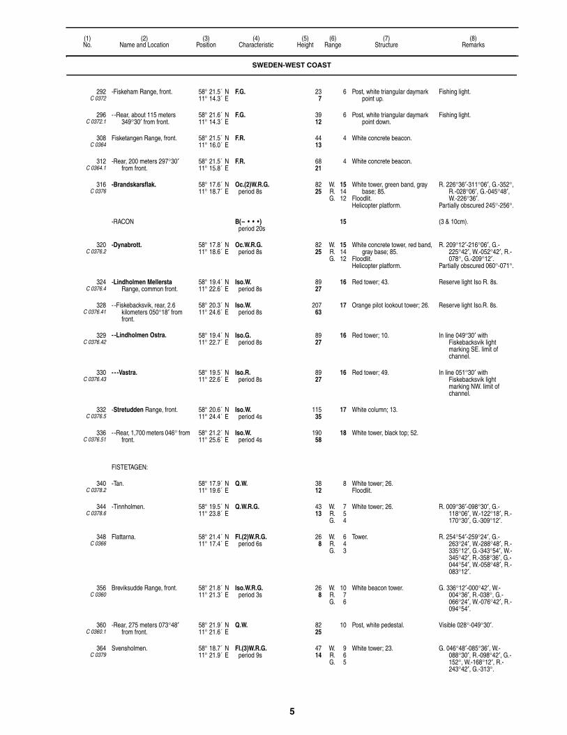
5
(1)No.
(2)Name and Location
(3)Position
(4)Characteristic
(5)Height
(6)Range
(7)Structure
(8)Remarks
292C 0372
-Fiskeham Range, front. 58° 21.5´ N11° 14.3´ E
F.G. 237
6 Post, white triangular daymark point up.
Fishing light.
296C 0372.1
- -Rear, about 115 meters 349°30′ from front.
58° 21.6´ N11° 14.3´ E
F.G. 3912
6 Post, white triangular daymark point down.
Fishing light.
308C 0364
Fisketangen Range, front. 58° 21.5´ N11° 16.0´ E
F.R. 4413
4 White concrete beacon.
312C 0364.1
-Rear, 200 meters 297°30′ from front.
58° 21.5´ N11° 15.8´ E
F.R. 6821
4 White concrete beacon.
316C 0376
-Brandskarsflak. 58° 17.6´ N11° 18.7´ E
Oc.(2)W.R.G.period 8s
8225
W. 15R. 14G. 12
White tower, green band, gray base; 85.
Floodlit. Helicopter platform.
R. 226°36′-311°06′, G.-352°, R.-028°06′, G.-045°48′, W.-226°36′.
Partially obscured 245°-256°.
-RACON B(– • • •)period 20s
15 (3 & 10cm).
320C 0376.2
-Dynabrott. 58° 17.8´ N11° 18.6´ E
Oc.W.R.G.period 8s
8225
W. 15R. 14G. 12
White concrete tower, red band, gray base; 85.
Floodlit. Helicopter platform.
R. 209°12′-216°06′, G.-225°42′, W.-052°42′, R.-078°, G.-209°12′.
Partially obscured 060°-071°.
324C 0376.4
-Lindholmen Mellersta Range, common front.
58° 19.4´ N11° 22.6´ E
Iso.W.period 8s
8927
16 Red tower; 43. Reserve light Iso R. 8s.
328C 0376.41
- -Fiskebacksvik, rear, 2.6 kilometers 050°18′ from front.
58° 20.3´ N11° 24.6´ E
Iso.W.period 8s
20763
17 Orange pilot lookout tower; 26. Reserve light Iso.R. 8s.
329C 0376.42
- -Lindholmen Ostra. 58° 19.4´ N11° 22.7´ E
Iso.G.period 8s
8927
16 Red tower; 10. In line 049°30′ with Fiskebacksvik light marking SE. limit of channel.
330C 0376.43
- - -Vastra. 58° 19.5´ N11° 22.6´ E
Iso.R.period 8s
8927
16 Red tower; 49. In line 051°30′ with Fiskebacksvik light marking NW. limit of channel.
332C 0376.5
-Stretudden Range, front. 58° 20.6´ N11° 24.4´ E
Iso.W.period 4s
11535
17 White column; 13.
336C 0376.51
- -Rear, 1,700 meters 046° from front.
58° 21.2´ N11° 25.6´ E
Iso.W.period 4s
19058
18 White tower, black top; 52.
FISTETAGEN:
340C 0378.2
-Tan. 58° 17.9´ N11° 19.6´ E
Q.W. 3812
8 White tower; 26.Floodlit.
344C 0378.6
-Tinnholmen. 58° 19.5´ N11° 23.8´ E
Q.W.R.G. 4313
W. 7R. 5G. 4
White tower; 26. R. 009°36′-098°30′, G.-118°06′, W.-122°18′, R.-170°30′, G.-309°12′.
348C 0366
Flattarna. 58° 21.4´ N11° 17.4´ E
Fl.(2)W.R.G.period 6s
268
W. 6R. 4G. 3
Tower. R. 254°54′-259°24′, G.-263°24′, W.-288°48′, R.-335°12′, G.-343°54′, W.-345°42′, R.-358°36′, G.-044°54′, W.-058°48′, R.-083°12′.
356C 0360
Breviksudde Range, front. 58° 21.8´ N11° 21.3´ E
Iso.W.R.G.period 3s
268
W. 10R. 7G. 6
White beacon tower. G. 336°12′-000°42′, W.-004°36′, R.-038°, G.-066°24′, W.-076°42′, R.-094°54′.
360C 0360.1
-Rear, 275 meters 073°48′ from front.
58° 21.9´ N11° 21.6´ E
Q.W. 8225
10 Post, white pedestal. Visible 028°-049°30′.
364C 0379
Svensholmen. 58° 18.7´ N11° 21.9´ E
Fl.(3)W.R.G.period 9s
4714
W. 9R. 6G. 5
White tower; 23. G. 046°48′-085°36′, W.-088°30′, R.-098°42′, G.-152°, W.-168°12′, R.-243°42′, G.-313°.
SWEDEN-WEST COAST

6
(1)No.
(2)Name and Location
(3)Position
(4)Characteristic
(5)Height
(6)Range
(7)Structure
(8)Remarks
372C 0378.4
Kafra. 58° 19.5´ N11° 21.7´ E
Fl.W.R.G.period 3s
3310
W. 9R. 6G. 5
White tower, black base; 36.Floodlit.
G. 179°48′-231°18′, W.-046°30′, R.-095°24′, G.-148°42′, R.-169°48′.
376C 0380
Blackhall. 58° 18.6´ N11° 22.8´ E
Fl.(2)W.R.G.period 6s
319
W. 8R. 6G. 5
Tower. G. 310°06′-322°30′, W.-327°30′, R.-019°36′, G.-112°18′, W.-120°48′, R.-150°.
378C 0381
Stora Korno. 58° 18.2´ N11° 22.5´ E
F.W.R.G. 103
2 White hut, concrete base.Floodlit.
G. 102°54′-170°06′, W.-175°12′, R.-190°12′, G.-213°24′, W.-222°24′, R.-260°, W.-102°54′.
380C 0381.5
Hangdyn. 58° 17.5´ N11° 24.2´ E
Q.W.R.G. 165
W. 5R. 3G. 2
Pedestal, red lantern, base. G. 264°-036°, W.-043°, R.-090°, G.-143°, W.-146°, R.-264°.
384 Sorgrundsberg Buoy. 58° 17.0´ N11° 11.0´ E
Q.(6)+L.Fl.W.period 15s
S. CARDINALYB, pillar, topmark.
Radar reflector.
388C 0388
Stangholmen, E. side. 58° 16.0´ N11° 24.9´ E
Iso.W.R.G.period 4s
196
W. 6R. 4G. 3
White lantern. G. 153°30′-163°18′, W.-164°42′, R.-246°06′, G.-293°24′, W.-328°06′, R.-012°12′.
392C 0384
Gaven. 58° 16.3´ N11° 21.0´ E
Fl.(3)W.R.G.period 9s
8927
W. 8R. 6G. 5
White tower, black band, red lantern; 30.
G. (unintensified) 234°30′-241°30′, W. (unintensified)-261°, R. (unintensified)-311°, G. (unintensified)-002°30′, G.-024°12′, W.-030°12′, R.-041°54′, G.-053°30′, W.-087°54′, R.-110°06′, G.-121°36′.
396C 0382
Gulskaren, on Sodra Gulskar. 58° 16.8´ N11° 23.4´ E
Fl.(2)W.R.G.period 6s
309
W. 7R. 5G. 4
White tower; 20. W. (unintensified) 237°-258°, R. (unintensified)-315°, R.-346°30′, G.-056°30′, W.-059°30′, R.-132°, G.-141°, G. (unintensified)-237°.
400C 0390
Flatholmen. 58° 15.7´ N11° 24.8´ E
Fl.W.R.G.period 4s
3310
W. 11R. 6G. 5
White lantern. G. 090°30′-094°48′, W.-095°36′, R.-112°30′, G.-129°, W.-138°30′, R.-200°, G.-257°, W.-265°, R.-304°, G.-335°.
402C 0390.5
Byxeskaren. 58° 15.7´ N11° 23.2´ E
V.Q.G. 309
3 White concrete tower; 16. Visible 070°-270°.Radar reflector.
404C 0392
Slaggabaden. 58° 15.9´ N11° 26.3´ E
L.Fl.W.R.G.period 8sfl. 2s, ec. 6s
206
W. 9R. 7G. 6
White tower, gray base; 26.Floodlit.
G. 194°54′-226°42′, R.-248°54′, G.-261°, W.-273°06′, R.-290°06′, G.-306°36′, W.-316°06′, R.-352°18′, G.-017°48′, W.-019°48′, R.-042°36′, G.-082°42′, W.-084°54′, R.-194°54′.
416C 0392.5
-Redd. 58° 16.1´ N11° 27.2´ E
Q.W. 196
4 White pedestal.
417C 0392.7
-Degausing Station W. Dolphin. 58° 16.2´ N11° 27.0´ E
2 F.R. (vert.) 2 Post, dolphin.
418C 0392.8
- -E. Dolphin. 58° 16.2´ N11° 27.2´ E
2 F.R. (vert.) 2 Post, dolphin.
428 Brofjorden Angoring Buoy. 58° 15.0´ N11° 13.5´ E
L.Fl.W.period 10s
SAFE WATERRW, pillar, topmark.
Radar reflector.
RACON G(– – • )period 30s
6 (3 & 10cm).
SWEDEN-WEST COAST

7
(1)No.
(2)Name and Location
(3)Position
(4)Characteristic
(5)Height
(6)Range
(7)Structure
(8)Remarks
SKAFTO:
432C 0394
-Groto, SE. point. 58° 13.0´ N11° 24.3´ E
Fl.W.R.G.period 3s
134
W. 6R. 4G. 3
White lantern. G. 173°-201°, W.-204°30′, R.-237°12′, G.-295°36′, W.-350°42′, R.-006°30′, G.-035°48′.
436C 0398
-Grundsund pier, head. 58° 13.0´ N11° 24.9´ E
Oc.(2)W.R.G.period 8slt. 1s, ec. 1slt. 5s, ec. 1s
165
W. 6R. 4G. 3
Gray framework tower. G. 111°-132°42′, W.-161°12′, R.-172°.
440C 0400
-Islandsberg. 58° 12.1´ N11° 24.3´ E
Fl.(4)W.R.G.period 12sfl. 0.3s, ec. 1.5sfl. 0.3s, ec. 1.5sfl. 0.3s, ec. 1.5sfl. 0.3s, ec. 6.3s
4313
W. 7R. 5G. 4
Red tower; 23. G. 310°-031°30′, W.-034°12′, R.-038°36′, R. 044°24′-047°48′, G.-085°30′, R.-125°36′, G.-181°12′, W.-184°54′, R.-235°.
444C 0402
Hattan. 58° 10.4´ N11° 22.4´ E
Fl.(2)W.R.G.period 6s
4815
W. 8R. 6G. 5
White tower, black band; 30. G. 019°30′-035°42′, W.-051°30′, R.-077°12′, G.-115°36′, W.-124°06′, R.-150°24′, G.-209°36′, W.-215°36′, R.-225°24′.
448C 0404
Fredagsholmen. 58° 11.2´ N11° 25.3´ E
Fl.W.R.G.period 3s
185
W. 5R. 4G. 3
Red lantern. G. 286°36′-294°, W.-300°42′, R.-054°48′, G.-114°42′, W.-122°06′, R.-136°12′.
452C 0409
Ornekullen Range, front. 58° 11.9´ N11° 29.8´ E
Q.R. 6520
9 White mast, white square daymark.
Visible on range line only.
456C 0409.1
-Rear, 255 meters 059° from front.
58° 12.0´ N11° 30.0´ E
Iso.R.period 4s
10532
9 White pedestal, black and white square daymark.
Visible on range line only. Synchronized with front.
460C 0409.5
Hallen Range, front. 58° 11.7´ N11° 29.3´ E
Q.G. 165
8 White pedestal.
464C 0409.6
-Rear, 210 meters 194° from front.
58° 11.6´ N11° 29.2´ E
Iso.G.period 4s
299
8 White pedestal. Visible on range line only. Synchronized with front.
468C 0410
Tarneskar Range, front. 58° 12.3´ N11° 29.6´ E
Q.R. 185
8 White pedestal. Visible on range line only.
472C 0410.1
-Rear, 80 meters 239°30′ from front.
58° 12.3´ N11° 29.5´ E
Iso.W.R.G.period 4s
247
8 Pedestal, white triangular daymark point down.
R.200°-288°, G.-008.3°, W.-011.9°, R.-090°Synchronized with front.
476C 0410.5
Flato. 58° 12.9´ N11° 30.7´ E
Fl.W.R.G.period 3s
3310
W. 4R. 2G. 2
White pedestal, lantern. G. 282°30′-299°36′, W.-309°54′, R.-010°48′.
480C 0411
Morlanda. 58° 12.3´ N11° 31.5´ E
Fl.(2)W.R.G.period 6s
196
W. 6R. 4G. 3
White pedestal. R. 133°30′-141°24′, G.-224°36′, W.-228°30′, R.-281°.
484C 0411.4
Ravsnasudde Range, front. 58° 15.6´ N11° 38.3´ E
Iso.W.period 4s
4614
10 White pedestal, white rectangular daymark.
488C 0411.5
-Rear, 920 meters 047° from front.
58° 16.0´ N11° 39.1´ E
Q.W. 9830
10 White pedestal, white rectangular daymark.
492C 0411.6
Rafsnas. 58° 15.5´ N11° 38.5´ E
Fl.W.period 3s
237
5 White post; 7. Visible 225°-113°48′.
496C 0411.9
Goden. 58° 15.5´ N11° 39.0´ E
Fl.(2)G.period 6s
3611
2 White post, green band; 7. Visible 053°12′-298°30′.
498C 0412
Kalvon. 58° 15.6´ N11° 39.8´ E
Fl.R.period 3s
309
3 White post, red band; 7. Visible 234°24′-125°.
500C 0412.5
Saten. 58° 15.6´ N11° 40.6´ E
Fl.(2)W.R.G.period 6s
227
W. 6R. 4G. 3
Beacon. G. 357°18′-039°30′, W.-048°30′, R.-091°24′, G.-175°30′, W.-178°48′, R.-189°42′.
504C 0412.7
Hogholmen, N. of channel. 58° 18.2´ N11° 41.3´ E
Fl.W.R.G.period 3s
196
W. 5R. 3G. 3
White tower. G. 180°-230°36′, W.-236°54′, R.-250°24′, G.-041°30′, W.-056°54′, R.-100°.
SWEDEN-WEST COAST

8
(1)No.
(2)Name and Location
(3)Position
(4)Characteristic
(5)Height
(6)Range
(7)Structure
(8)Remarks
508C 0413.3
Mattholm. 58° 18.3´ N11° 43.3´ E
Fl.W.R.G.period 3s
185
W. 4R. 2G. 2
White pedestal. G. 337°48′-089°42′, W.-091°54′, R.-183°18′.
512C 0413
Oso. 58° 18.2´ N11° 43.1´ E
Q.R.G. 185
2 White pedestal. G. 107°12′-281°, R.-346°54′.
516C 0413.5
-Sandvikskullen. 58° 18.1´ N11° 43.8´ E
Fl.(2)W.R.G.period 6s
185
W. 10R. 7G. 6
White lantern. G. 060°-116°12′, W.-119°30′, R.-205°18′, G.-246°24′, W.-249°06′, R.-320°.
528C 0422
Tvestjarten. 58° 10.5´ N11° 24.3´ E
Fl.(2)W.R.period 6s
165
W. 5R. 4
White tower. W. 325°12′-195°42′, R.-203°.
540C 0428
Rao Range, front. 58° 09.0´ N11° 23.9´ E
Q.W.G. 165
4 Black pedestal, white triangular daymark point up.
G. 283°-075°, W.-229°.
544C 0427
-Rear, 1000 meters 004° from front.
58° 09.6´ N11° 24.0´ E
Iso.W.G.period 5s
258
W. 3G. 8G. 3
Red lantern. G. 345°-010°, W.-198°30′.Intensified on range line.
544.1C 0426
- -Stromholmen, rear, 1100 meters 010°30′ from front.
58° 10.1´ N11° 24.2´ E
Fl.W.R.G.period 3sfl. 0.7s, ec. 2.3s
319
W. 6R. 4G. 4
White pedestal, lantern. G. 163°30′-186°30′, W.-014°42′, R.-029°48′.
548C 0430
Jarnskar. 58° 07.9´ N11° 24.1´ E
Fl.W.R.G.period 3s
155
W. 6R. 4G. 3
White lantern. G. 029°-050°, W.-064°, R.-095°, G.-139°, W.-148°, R.-226°, W.-278°.
552C 0434
Koljebergskil Range, front. 58° 08.0´ N11° 25.1´ E
Iso.R.period 3s
3711
6 Black hut, white gable, red band. Visible on range line only.
556C 0434.1
-Rear, 110 meters 093°30′ from front.
58° 08.0´ N11° 25.2´ E
Q.R. 6921
6 Black hut, white gable, red band. Visible on range line only.
560C 0438
Sorhallsudde Range, front. 58° 08.2´ N11° 24.9´ E
Iso.W.period 4s
227
9 Black hut, white gable, red band. Visible on range line only.
564C 0438.1
-Rear, 140 meters 345° from front.
58° 08.2´ N11° 24.9´ E
Q.W. 268
8 Black hut, white gable, red band. Visible on range line only.
568C 0444
Porsnasudde. 58° 07.4´ N11° 25.4´ E
Fl.(2)W.R.G.period 6s
196
W. 5R. 4G. 3
Red lantern. G. 315°54′-326°36′, W.-330°12′, R.-138°36′, W.-164°36′.
572C 0446
Karingo Kummel. 58° 06.6´ N11° 22.4´ E
Iso.W.R.G.period 3s
319
W. 7R. 5G. 4
White tower, black band; 23. W. 151°06′-172°42′, G.-209°, W.-211°54′, R.-236°30′, obsc.-298°18′, G.-310°, W.-315°48′, R.-322°06′.
576C 0447
Karingo telephone cable Range, front.
58° 06.7´ N11° 22.2´ E
F.R. 258
7 White rectangular daymark, red stripe.
Visible on range line only. Marks cable between Karingo
and Oxskar.
580C 0447.1
-Rear, 75 meters 193° from front.
58° 06.7´ N11° 22.3´ E
F.R. 4815
7 White rectangular daymark, red stripe.
Visible on range line only.
584C 0448
Oxskar. 58° 07.1´ N11° 22.6´ E
Fl.(3)W.R.G.period 9s
227
W. 6R. 4G. 4
White lantern. G. 326°18′-341°, W.-348°06′, R.-056°, W.-063°, obsc.-240°, G.-250°36′, R.-252°18′, G.-259°30′.
588C 0456
Maseskar. 58° 05.7´ N11° 19.8´ E
Fl.(3)W.R.G.period 30sfl. 1.5s, ec. 3.5sfl. 1.5s, ec. 3.5sfl. 1.5s, ec. 18.5s
8827
W. 16R. 13G. 12
White tower, red rectangular daymark; 43.
W. 012°30′-163°, R.-300°12′, G.-012°30′.
592C 0458
Brato. 58° 05.7´ N11° 26.7´ E
Fl.(4)W.R.G.period 12s
237
W. 5R. 4G. 3
Red lantern. G. 336°-351°, W.-355°, R.-088°, G.-131°, W.-136°, R.-158°.
596C 0460
Mollosund. 58° 04.4´ N11° 27.9´ E
Fl.(2)W.R.G.period 6s
237
W. 9R. 6G. 5
Red lantern. G. 295°-314°, W.-319°30′, R.-018°, G.-119°30′, W.-127°30′, R.-151°30′.
600C 0462
Lyr, W. side. 58° 04.2´ N11° 29.8´ E
Fl.(4)W.R.G.period 12s
165
W. 5R. 4G. 3
Red lantern. G. 000°-009°54′, W.-014°12′, R.-021°, G.-072°18′, W.-077°36′, R.-088°.
SWEDEN-WEST COAST
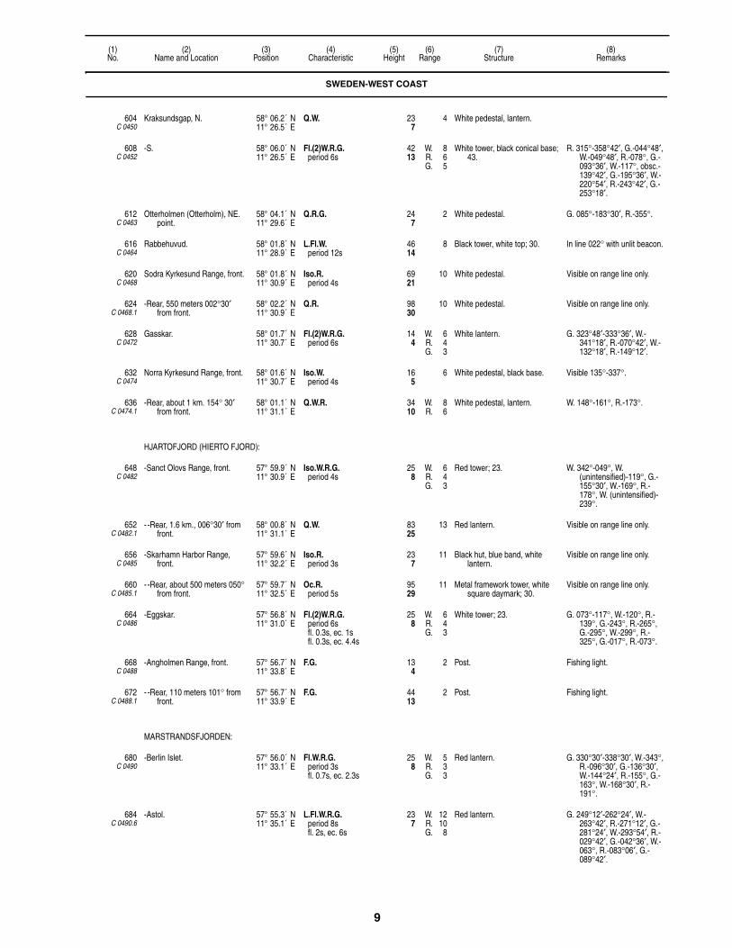
9
(1)No.
(2)Name and Location
(3)Position
(4)Characteristic
(5)Height
(6)Range
(7)Structure
(8)Remarks
604C 0450
Kraksundsgap, N. 58° 06.2´ N11° 26.5´ E
Q.W. 237
4 White pedestal, lantern.
608C 0452
-S. 58° 06.0´ N11° 26.5´ E
Fl.(2)W.R.G.period 6s
4213
W. 8R. 6G. 5
White tower, black conical base; 43.
R. 315°-358°42′, G.-044°48′, W.-049°48′, R.-078°, G.-093°36′, W.-117°, obsc.-139°42′, G.-195°36′, W.-220°54′, R.-243°42′, G.-253°18′.
612C 0463
Otterholmen (Otterholm), NE. point.
58° 04.1´ N11° 29.6´ E
Q.R.G. 247
2 White pedestal. G. 085°-183°30′, R.-355°.
616C 0464
Rabbehuvud. 58° 01.8´ N11° 28.9´ E
L.Fl.W.period 12s
4614
8 Black tower, white top; 30. In line 022° with unlit beacon.
620C 0468
Sodra Kyrkesund Range, front. 58° 01.8´ N11° 30.9´ E
Iso.R.period 4s
6921
10 White pedestal. Visible on range line only.
624C 0468.1
-Rear, 550 meters 002°30′ from front.
58° 02.2´ N11° 30.9´ E
Q.R. 9830
10 White pedestal. Visible on range line only.
628C 0472
Gasskar. 58° 01.7´ N11° 30.7´ E
Fl.(2)W.R.G.period 6s
144
W. 6R. 4G. 3
White lantern. G. 323°48′-333°36′, W.-341°18′, R.-070°42′, W.-132°18′, R.-149°12′.
632C 0474
Norra Kyrkesund Range, front. 58° 01.6´ N11° 30.7´ E
Iso.W.period 4s
165
6 White pedestal, black base. Visible 135°-337°.
636C 0474.1
-Rear, about 1 km. 154° 30′ from front.
58° 01.1´ N11° 31.1´ E
Q.W.R. 3410
W. 8R. 6
White pedestal, lantern. W. 148°-161°, R.-173°.
HJARTOFJORD (HIERTO FJORD):
648C 0482
-Sanct Olovs Range, front. 57° 59.9´ N11° 30.9´ E
Iso.W.R.G.period 4s
258
W. 6R. 4G. 3
Red tower; 23. W. 342°-049°, W. (unintensified)-119°, G.-155°30′, W.-169°, R.-178°, W. (unintensified)-239°.
652C 0482.1
- -Rear, 1.6 km., 006°30′ from front.
58° 00.8´ N11° 31.1´ E
Q.W. 8325
13 Red lantern. Visible on range line only.
656C 0485
-Skarhamn Harbor Range, front.
57° 59.6´ N11° 32.2´ E
Iso.R.period 3s
237
11 Black hut, blue band, white lantern.
Visible on range line only.
660C 0485.1
- -Rear, about 500 meters 050° from front.
57° 59.7´ N11° 32.5´ E
Oc.R.period 5s
9529
11 Metal framework tower, white square daymark; 30.
Visible on range line only.
664C 0486
-Eggskar. 57° 56.8´ N11° 31.0´ E
Fl.(2)W.R.G.period 6sfl. 0.3s, ec. 1sfl. 0.3s, ec. 4.4s
258
W. 6R. 4G. 3
White tower; 23. G. 073°-117°, W.-120°, R.-139°, G.-243°, R.-265°, G.-295°, W.-299°, R.-325°, G.-017°, R.-073°.
668C 0488
-Angholmen Range, front. 57° 56.7´ N11° 33.8´ E
F.G. 134
2 Post. Fishing light.
672C 0488.1
- -Rear, 110 meters 101° from front.
57° 56.7´ N11° 33.9´ E
F.G. 4413
2 Post. Fishing light.
MARSTRANDSFJORDEN:
680C 0490
-Berlin Islet. 57° 56.0´ N11° 33.1´ E
Fl.W.R.G.period 3sfl. 0.7s, ec. 2.3s
258
W. 5R. 3G. 3
Red lantern. G. 330°30′-338°30′, W.-343°, R.-096°30′, G.-136°30′, W.-144°24′, R.-155°, G.-163°, W.-168°30′, R.-191°.
684C 0490.6
-Astol. 57° 55.3´ N11° 35.1´ E
L.Fl.W.R.G.period 8sfl. 2s, ec. 6s
237
W. 12R. 10G. 8
Red lantern. G. 249°12′-262°24′, W.-263°42′, R.-271°12′, G.-281°24′, W.-293°54′, R.-029°42′, G.-042°36′, W.-063°, R.-083°06′, G.-089°42′.
SWEDEN-WEST COAST

10
(1)No.
(2)Name and Location
(3)Position
(4)Characteristic
(5)Height
(6)Range
(7)Structure
(8)Remarks
688C 0491
-Norra Astol Power Cable Range, front.
57° 55.5´ N11° 35.3´ E
F.R. 237
8 Lantern, white triangular daymark point up, black border.
690C 0491.1
- -Rear, 100 meters 141° from front.
57° 55.4´ N11° 35.3´ E
F.R. 3912
8 Lantern, white triangular daymark point down, black border.
692C 0491.4
-Astols Fishing Harbor Range, front.
57° 55.5´ N11° 35.2´ E
F.G. 185
2 White triangular daymark point up.
Fishing light.
696C 0491.5
- -Rear, 60 meters 257° from front.
57° 55.5´ N11° 35.1´ E
F.G. 247
2 White triangular daymark point down.
Fishing light.
701C 0489.4
-Pater Noster. 57° 53.7´ N11° 28.0´ E
L.Fl.W.period 15s
11836
11 Red framework tower; 105.
708C 0489
-Hatteberget. 57° 51.8´ N11° 27.5´ E
Fl.(2)W.R.G.period 12sfl. 1.5s, ec. 2sfl. 1.5s, ec. 7s
8526
W. 21W. 18R. 18R. 15G. 18G. 16
Black concrete tower, red bands, gray base; 85.
Helicopter platform.
W. 008°-110°, R.-152°, G. (unintensified)-225°, W. (unintensified)-260°, R. (unintensified)-346°, G.-008°.
-RACON G(– – • )period 30s
15 (3 & 10cm).
712C 0493
-Skallen, on islet. 57° 53.4´ N11° 33.5´ E
Iso.W.R.G.period 4s
4413
W. 14R. 11G. 10
White tower; 20. G. 033°54′-054°36′, W.-069°12′, R.-086°, G.-132°18′, W.-206°48′, R.-234°42′, G.-250°.
716C 0494.8
-Graberget. 57° 52.7´ N11° 35.0´ E
Fl.(2)W.R.G.period 3s
258
W. 6R. 4G. 3
White tower, black base; 20. G. 051°-052°30′, W.-054°, R.-067°, G.-099°, W.-103°, R.-138°30′, G.-209°, W.-223°, R.-234°30′.
720C 0494
-Marstrand Havn. 57° 53.5´ N11° 34.5´ E
Fl.(3)W.R.G.period 9s
237
W. 10R. 7G. 6
Tower. G. 053°-091°, R.-148°, G.-160°30′, W.-163°30′, R.-171°30′.
724C 0496
-Sodra Meholm. 57° 55.3´ N11° 37.4´ E
Fl.(2)W.R.G.period 6sfl. 0.7s, ec. 1sfl. 0.7s, ec. 3.6s
268
W. 5R. 3G. 3
White pedestal, lantern. W. 073°-256°, R.-290°, G.-073°.
728C 0498
-Norra Meholm. 57° 55.5´ N11° 37.8´ E
Fl.W.R.G.period 3s
3611
W. 5R. 3G. 2
White pedestal, lantern. W. 267°-075°54′, R.-261°42′, G.-267°.
730C 0499
-Nordholmarna. 57° 54.6´ N11° 37.8´ E
Fl.(3)W.R.G.period 9s
165
W. 7R. 5G. 4
White hut, green base; 10.Floodlit.
R. 055°12′-071°12′, G.-111°12′, W.-227°24′, R.-242°, G.-256°18′.
731C 0500
-Backebadan. 57° 54.9´ N11° 37.5´ E
Fl.W.R.G.period 3s
237
W. 7R. 5G. 4
Red hut, white roof.Floodlit.
R. 110°12′-236°54′, G.-242°54′, W.-110°12′.
UDDEVALLA APPROACH:
732C 0501
-Algo (Elgo), island, W. head. 57° 55.6´ N11° 40.1´ E
Q.W.R.G. 227
W. 6R. 4G. 3
White lantern. G. 060°06′-082°30′, W.-084°30′, R.-200°48′, G.-211°12′, W.-215°12′, R.-252°30′.
SWEDEN-WEST COAST
UDDEVALLA APPROACH:
736C 0502.2
-Wallhamn Roda Range, front. 58° 00.7´ N11° 42.1´ E
F.R. 8927
10 Framework tower. Range 3M by day.
SWEDEN-WEST COAST

11
(1)No.
(2)Name and Location
(3)Position
(4)Characteristic
(5)Height
(6)Range
(7)Structure
(8)Remarks
SWEDEN-WEST COAST
UDDEVALLA APPROACH:
740C 0502.21
- -Rear, 520 meters 352°48′ from front.
58° 01.0´ N11° 42.0´ E
F.R. 11836
10 Framework tower. Range 3M by day.
SWEDEN-WEST COAST
UDDEVALLA APPROACH:
744C 0502.4
-Grona Range, front. 58° 00.7´ N11° 42.2´ E
F.G. 8927
10 Framework tower. Range 3M by day.
SWEDEN-WEST COAST
UDDEVALLA APPROACH:
748C 0502.41
- -Rear, 521 meters 352°48′ from front.
58° 01.0´ N11° 42.1´ E
F.G. 11836
10 Framework tower. Range 3M by day.
752C 0502
-Mitholmarna. 57° 58.0´ N11° 43.7´ E
Fl.(4)W.R.G.period 12s
247
W. 7R. 5G. 4
White lantern. G. 027°06′-037°30′, W.-040°54′, R.-153°48′, G.-204°12′, W.-206°48′, R.-219°12′.
754C 0503
-Vinterholmen. 58° 01.9´ N11° 46.9´ E
Fl.W.R.G.period 3s
3611
W. 8R. 5G. 4
Metal framework tower. W. 018°-021°, R.-189°, G.-197°, W.-205°, R.-335°, G.-018°.
756C 0503.6
-Snoholmarna. 58° 02.7´ N11° 47.8´ E
Fl.(2)W.R.G.period 6s
134
W. 6R. 4G. 3
White lantern. G. 011°-018°, W.-028°, R.-077°, G.-138°, W.-144°, R.-173°, G.-200°, R.-240°.
760C 0503.4
-Brattogrundet, 1.5 kilometers 316° from Snoholmarna.
58° 03.2´ N11° 46.7´ E
Fl.W.R.G.period 3s
165
W. 6R. 4G. 3
White pedestal, lantern, gray base.
G. 040°-186°, W.-199°, R.-236°, G.-284°, W.-311°, R.-040°.
768C 0504.2
-Havden Roda Range, front. 58° 05.0´ N11° 48.3´ E
F.R. 268
7 Yellow triangular daymark point up, black border.
Shown on request.
772C 0504.21
- -Rear, 80 meters 059° from front.
58° 05.0´ N11° 48.4´ E
F.R. 4413
7 Yellow triangular daymark point down, black border.
Shown on request.
776C 0504.3
-Havden Grona Range, front. 58° 04.9´ N11° 48.3´ E
F.G. 196
6 Yellow triangular daymark point up, black border.
Shown on request.
780C 0504.31
- -Rear, 52 meters 059° from front.
58° 05.0´ N11° 48.4´ E
F.G. 299
6 Yellow triangular daymark point down, black border.
Shown on request.
784C 0504.36
-Stenung Range, front. 58° 05.1´ N11° 48.6´ E
F.G. 268
6 Post, white triangular daymark point up, black border.
Shown on request.
788C 0504.37
- -Rear, 112 meters 102°36′ from front.
58° 05.1´ N11° 48.7´ E
F.G. 3711
6 Post, white triangular daymark point down, black border.
Shown on request.
792C 0504.4
-Hog Grona Range, front. 58° 05.3´ N11° 49.2´ E
F.G. 5216
7 Yellow triangular daymark point up.
Visible on range line only. Shown on request.
796C 0504.41
- -Rear, 90 meters 101°18′ from front.
58° 05.3´ N11° 49.4´ E
F.G. 7523
7 Mast, yellow triangular daymark point down.
Visible on range line only. Shown on request.
800C 0504.6
-Hog Roda Range, front. 58° 05.3´ N11° 49.2´ E
F.R. 4313
7 Mast, yellow triangular daymark point up.
Visible on range line only. Shown on request.
804C 0504.61
- -Rear, 75 meters 102°06′ from front.
58° 05.4´ N11° 49.4´ E
F.R. 5918
7 Mast, yellow triangular daymark point down.
Visible on range line only. Shown on request.
12
(1)No.
(2)Name and Location
(3)Position
(4)Characteristic
(5)Height
(6)Range
(7)Structure
(8)Remarks
808C 0506
-Galteron. 58° 06.3´ N11° 48.2´ E
Fl.(2)W.R.G.period 6s
165
W. 9R. 7G. 6
White post.Floodlit.
G. 009°24′-013°30′, W.-015°24′, R.-028°54′, W. (unintensified)-177°48′, G.-216°18′, W.-223°, R.-234°24′.
810C 0507
-Halse Nabb. 58° 07.4´ N11° 49.6´ E
Q.W.R.G. 165
W. 10R. 7G. 6
White hut, red roof, red base; 10.Floodlit.
G. 167°-192°, W.-040°, R.-057°.
812C 0510
-Svanesund, at Orust. 58° 08.3´ N11° 50.0´ E
Fl.W.R.G.period 3s
165
W. 10R. 7G. 6
Red tower; 20. G. 192°06′-202°12′, W.-208°12′, R.-224°42′, W. (unintensified)-305°54′, G.-349°48′, W.-007°24′, R.-018°42′.
816C 0508
-Sundholmen. 58° 08.1´ N11° 50.2´ E
Fl.(2)W.R.G.period 6s
165
W. 5R. 3G. 2
White pedestal, lantern.Floodlit.
G. 345°-000°, W.-188°, R.-270°.
819C 0511.4
-Grota Holme. 58° 09.5´ N11° 51.3´ E
Fl.(2)W.R.G.period 6s
196
W. 7R. 5G. 4
White pedestal, lantern. G. 016°-036°, W.-047°, R.-089°, G.-170°, W.-175°, R.-179°, G.-208°.
820C 0511
-Djurnasudde. 58° 09.4´ N11° 50.9´ E
Q.W.R.G. 185
W. 5R. 3G. 2
White pedestal, lantern. W. 022°-331°, R.-002°, G.-022°.
824C 0512
-Strandanas. 58° 12.1´ N11° 50.8´ E
Fl.W.R.G.period 3s
134
W. 6W. 2R. 4G. 3
Red lantern. G. 175°06′-177°48′, W.-185°36′, R.-241°42′, W. (unintensified)-310°18′, G.-352°24′, W.-355°48′, R.-008°24′.
826C 0419
Aspholmen. 58° 15.0´ N11° 49.7´ E
Fl.(3)W.R.G.period 9sfl. 0.7s, ec. 1sfl. 0.7s, ec. 1sfl. 0.7s, ec. 4.9s
165
W. 6R. 4G. 3
White lantern, red concrete base.
G. 124°42′-148°42′, W.-154°36′, R.-170°, G.-187°06′, W.-316°18′, R.-331°36′, G.-351°18′.
828C 0418
Bjorningarna, S. island. 58° 15.6´ N11° 49.6´ E
Fl.W.R.G.period 3s
134
W. 6R. 4G. 3
Red lantern. G. 138°36′-157°18′, W.-160°54′, R.-178°, W.-292°24′, G.-331°42′, W.-336°12′, R.-352°42′.
832C 0417.5
Kollholm. 58° 16.3´ N11° 48.8´ E
Iso.W.R.G.period 4s
5216
W. 6R. 4G. 3
White tower; 23. G. 152°-160°, W.-165°30′, R.-169°30′, G.-173°30′, W.-176°, R.-198°, R. (unintensified)-254°, G. (unintensified)-308°30′, G.-328°, W.-332°30′, R.-345°, G.-152°.
836C 0417
-Stora Deje. 58° 18.1´ N11° 48.3´ E
Q.W. 206
4 White pedestal, lantern.
840C 0414
Stangen, on point. 58° 19.0´ N11° 48.9´ E
Q.W. 227
4 White fiberglass structure. Visible 013°48′-255°30′.
848.1C 0414.5
-N. fairway limit. 58° 19.5´ N11° 50.6´ E
F.R. Bridge. Pylons and wires marked by F.R. lights.
848.2C 0414.5
-S. fairway limit. 58° 19.5´ N11° 50.7´ E
F.G. Bridge. Top of each pylon marked by Fl.R. lights.
852C 0416
Uddevalla Range, front. 58° 20.9´ N11° 55.2´ E
Iso.R.period 4s
4915
10 White pole.
856C 0416.1
-Rear, 970 meters 060°18′ from front.
58° 21.2´ N11° 56.2´ E
Q.R. 11234
10 Pole.
860C 0514
Ramholmen Range, front. 57° 51.5´ N11° 33.3´ E
Iso.W.period 4s
3410
9 White pedestal, white square daymark.
Visible on range line only.
864C 0514.1
-Rear, 350 meters 312°30′ from front.
57° 51.6´ N11° 33.0´ E
Q.W. 6018
8 White pedestal, black square daymark.
Visible on range line only.
868C 0517
Stora Sillesund. 57° 51.5´ N11° 33.1´ E
Q.W.R.G. 268
W. 4R. 3G. 2
Black and white tower; 16. G. 255°-303°48′, W.-306°, R.-180°.
SWEDEN-WEST COAST

13
(1)No.
(2)Name and Location
(3)Position
(4)Characteristic
(5)Height
(6)Range
(7)Structure
(8)Remarks
872C 0521
Lonnbacken. 57° 51.3´ N11° 33.2´ E
Fl.W.R.G.period 3s
3812
W. 8R. 6G. 5
White tower, black band, gray conical base; 39.
R. 094°-118°54′, G.-146°36′, W.-150°12′, R.-213°12′, W.-259°30′, R.-308°24′.
876C 0520
Lekskar. 57° 50.5´ N11° 35.6´ E
Fl.(2)W.R.G.period 6sfl. 0.7s, ec. 1sfl. 0.7s, ec. 3.6s
247
W. 6R. 4G. 3
White lantern. G. 312°12′-322°36′, W.-331°42′, R.-349°, obsc.-009°06′, W.-165°42′.
884C 0525
Salo. 57° 48.9´ N11° 37.2´ E
Q.W.R.G. 268
W. 5R. 3G. 3
White pedestal. G. 294°30′-333°, W.-339°12′, R.-025°24′, G.-150°06′, W.-153°12′, R.-163°.
886C 0525.5
Stora Kalven. 57° 46.8´ N11° 43.5´ E
Fl.W.R.G.period 3s
237
W. 6R. 4G. 3
White post. G. 235°-257°, W.-260°, R.-275°, G.-299°30′, W.-303°, R.-350°, G.-012°, W.-014°30′, R.-044°, G.-103°, W.-107°, R.-145°.
Shown Apr. 15 to Oct. 30.
888C 0523
Stora Polsan. 57° 46.5´ N11° 31.4´ E
L.Fl.W.R.G.period 8sfl. 2s, ec. 6s
5918
W. 7R. 5G. 4
White tower, black band; 33. G. 344°-350°30′, W.-152°30′, R.-208°, G.-275°, R.-278°, G.-304°, W.-308°, R.-344°.
892C 0526
Kakholmen Range, front. 57° 46.1´ N11° 36.7´ E
F.R. 196
6 Post, white triangular daymark point up.
Fishing light.
896C 0526.1
-Rear, 60 meters 098° from front.
57° 46.1´ N11° 36.8´ E
F.R. 3711
6 Post, white triangular daymark point down.
Fishing light.
916C 0528
Stora Oset, E. side of islet. 57° 44.8´ N11° 36.6´ E
Fl.(3)W.R.G.period 9sfl. 0.7s, ec. 1sfl. 0.7s, ec. 1sfl. 0.7s, ec. 4.9s
4112
W. 8R. 5G. 4
White lantern. G. 345°-024°, W.-048°30′, R.-062°, G.-089°, W.-120°30′, R.-163°, W. (unintensified)-228°, G. (unintensified)-254°, W. (unintensified)-261°, R. (unintensified)-280°, W. (unintensified)-345°.
Sectors intensified 345°-163°.
920C 0530
Kallo Knipplan Range, front. 57° 45.0´ N11° 39.2´ E
F.G. 206
Column, white triangular daymark point up.
Fishing light.
924C 0530.1
-Rear, 120 meters 334° from front.
57° 45.1´ N11° 39.2´ E
F.G. 4112
Column, white triangular daymark point down.
Fishing light.
928C 0532
Bjorko Range, front. 57° 44.5´ N11° 40.0´ E
Iso.W.R.G.period 3s
268
W. 11W. 7R. 5G. 4
Red lantern. G. (unintensified) 031°-100°, G.-112°, W.-119°, R.-128°.
W. (intensified) on range line.
932C 0532.1
-Rear, 740 meters 162°30′ from front.
57° 44.1´ N11° 40.2´ E
Q.W. 10532
11 White lantern. Visible on range line only.
936C 0536
Hallso Range, front. 57° 43.9´ N11° 39.7´ E
Iso.W.R.G.period 4s
237
W. 10R. 7G. 6
White tower; 23. G. 168°-177°, W.-185°, R.-210°, G. (unintensified)-239°, W. (unintensified)-257°, R. (unintensified)-280°, W.-338°, G.-349°, W.-353°, R.-004°.
940C 0536.1
-Rear, 750 meters 331°30′ from front.
57° 44.3´ N11° 39.3´ E
Q.W. 5617
13 White lantern. Intensified on range line.
943C 0574
Valskar. 57° 40.6´ N11° 40.1´ E
Q.W.R. 134
W. 4R. 3
White pedestal, lantern. W. 228°-064°, R.-101°.
944C 0557
Dannekroken Range, front. 57° 41.1´ N11° 40.4´ E
Q.R. 268
8 Mast, white triangular daymark point up; 23.
948C 0557.1
-Rear, 300 meters 172° from front.
57° 41.0´ N11° 40.4´ E
Iso.R.period 4s
4413
8 Mast, white triangular daymark point down; 23.
958C 0556.5
Juthuvudets grund. 57° 42.2´ N11° 41.4´ E
Fl.G.period 3s
206
2 Black framework structure.
959C 0556.3
Bo. 57° 42.2´ N11° 41.1´ E
Q.W. 165
5
SWEDEN-WEST COAST

14
(1)No.
(2)Name and Location
(3)Position
(4)Characteristic
(5)Height
(6)Range
(7)Structure
(8)Remarks
960C 0552
Lilla Varholmen Range, front. 57° 42.2´ N11° 42.3´ E
Iso.W.period 3s
6620
11 White column, pedestal, white square daymark.
Visible on range line only.
964C 0552.1
-Rear, 180 meters 314° from front.
57° 42.3´ N11° 42.2´ E
Iso.W.R.G.period 3s
9529
W. 10R. 5G. 4
White lantern. W. visible on range line only.R. 061°24′-079°30′, G.-
105°24′, R.-114°36′.Synchronized with front.Shown Apr. 14 to Oct. 30.
968C 0556
Stora Varholmen. 57° 41.7´ N11° 42.0´ E
L.Fl.(2)W.R.G.period 12sfl. 2s, ec. 2sfl. 2s, ec. 6s
5015
W. 13R. 10G. 9
Red lantern. G. 320°30′-327°06′, W.-332°30′, R.-351°42′, G.-005°42′, W.-007°48′, R.-036°24′, W. (unintensified)-169°36′.
972C 0558
Tangudden. 57° 41.6´ N11° 40.1´ E
Iso.W.R.G.period 3s
155
W. 7R. 5G. 4
White lantern. G. 191°-306°, W.-309°30′, R.-326°.
973C 0558.7
Ockero, breakwater, head. 57° 42.3´ N11° 39.7´ E
Iso.W.period 7s
3
974C 0559
Ockero Range, front. 57° 42.4´ N11° 39.5´ E
F.R. 216
2 Post, white triangular daymark point up.
Fishing light.
975C 0559.1
-Rear, 285° 30' from front. 57° 42.4´ N11° 39.4´ E
F.R. 3611
2 Post, white triangular daymark point down.
Fishing light.
980 Mavholmsbadan, RACON. 57° 40.3´ N11° 42.4´ E
M(– –) 3 (3 & 10cm).
992C 0560
Hono Huvud. 57° 41.4´ N11° 36.4´ E
Fl.(2)W.R.G.period 6s
6219
W. 8R. 6G. 5
White lantern. G. 038°48′-062°, W.-149°, R.-206°, W.-277°48′, G.-312°, W.-318°, R.-336°.
996C 0561
Artholmen. 57° 41.5´ N11° 36.7´ E
Q.W.R.G. 3611
W. 6R. 4G. 3
White pedestal, lantern. G. 315°18′-104°36′, W.-117°36′, R.-315°18′.
1000C 0562.6
Tynneskar. 57° 40.7´ N11° 38.3´ E
Fl.W.R.G.period 3s
237
W. 6R. 4G. 3
White pedestal, lantern, black base.
R. 333°-036°, G.-121°30′, W.-124°, R.-153°, G.-333°.
1004C 0563
Klava. 57° 40.7´ N11° 38.5´ E
Iso.W.R.G.period 4s
144
W. 10R. 8G. 6
White lantern. G. 277°30′-281°30′, W.-285°, R.-017°, G.-040°, W.-043°30′, R.-056°30′, G.-090°, R.-105°.
1012C 0562
Benskar, SE. side of island. 57° 39.9´ N11° 36.8´ E
Fl.(3)W.R.G.period 9s
3310
W. 6R. 4G. 3
White pedestal, lantern. W. 050°-094°, R.-179°, G.-050°.
1016 Vinga Western Approach Buoy. 57° 38.9´ N11° 33.6´ E
L.Fl.W.period 10s
SAFE WATERRW, pillar, topmark.
Radar reflector.
SWEDEN-KATTEGAT
VINGA SAND:
1020C 0565
-Vinga. 57° 37.9´ N11° 36.1´ E
Fl.(2)W.period 30sfl. 1s, ec. 7.5sfl. 1s, ec. 20.5s
15146
25 Gray stone tower; 95. Unintensified on westerly bearings.
Traffic signals.
SWEDEN-WEST COAST
15
(1)No.
(2)Name and Location
(3)Position
(4)Characteristic
(5)Height
(6)Range
(7)Structure
(8)Remarks
GOTEBORG APPROACH:
1024C 0569
-Trubaduren. 57° 35.7´ N11° 38.0´ E
L.Fl.(3)W.R.G.period 30sfl. 3s, ec. 3.5sfl. 3s, ec. 3.5sfl. 3s, ec. 14s
7924
W. 14R. 10G. 7
Black tower, orange top, gray base; 82.
Helicopter platform.
W. 005°30′-131°36′, R.-163°30′, G.-214°24′, W.-237°12′, R.-247°48′, G.-005°30′.
Iso.R.period 4s
5918
9 Visible 064°-131°.
-RACON T(–) 14 (3 & 10cm).
1036C 0620
-Svarta Baden. 57° 37.1´ N11° 45.5´ E
Fl.W.R.G.period 6sfl. 0.7s, ec. 5.3s
216
W. 5R. 3G. 3
White pedestal. G. 190°-237°06′, W.-243°12′, R.-315°54′, G.-046°24′, W.-050°30′, R.-090°.
Fishing light.
1040C 0567
-Viten. 57° 38.1´ N11° 37.3´ E
Iso.W.R.G.period 6s
3611
W. 11R. 10R. 8G. 7G. 6
White lantern, white conical base; 30.
G. 250°-292°36′, W.-296°12′, R.-307°, R. (unintensified)-015°, G. (unintensified)-094°, G.-105°06′, W.-117°54′, R.-126°30′, R. (unintensified)-132°.
1042C 0564.5
-Kottstycket. 57° 38.4´ N11° 36.8´ E
Fl.(2)R.period 6sfl. 0.5s, ec. 1sfl. 0.5s, ec. 4s
309
4 White concrete tower, red band; 20.
Radar reflector.
1044C 0564
-Vinga Ungar, 732 meters NW. of Vinga.
57° 38.2´ N11° 35.5´ E
Fl.(3)W.R.G.period 8sfl. 0.7s, ec. 1sfl. 0.7s, ec. 1sfl. 0.7s, ec. 3.9s
4915
W. 7R. 5G. 4
Post. G. 198°30′-266°24′, W.-269°12', R.-000°, G.-099°, R.-198°30′.
1048C 0566
-E. Range, front. 57° 38.0´ N11° 36.7´ E
Q.R. 319
10 White tower; 33. R. 176°-276°.
1052C 0566.1
- -Rear, 390 meters 253°54' from front.
57° 37.9´ N11° 36.4´ E
Iso.R.period 2s
6219
10 Red house, black gable, white band on two sides.
Visible 186°-286°.Intensified on range line.Synchronized with front.
1056C 0619
-Stora Kanso. 57° 37.5´ N11° 44.7´ E
Iso.W.R.G.period 3s
3611
W. 5R. 4G. 3
Round hut, red roof, white lantern.
G. 275°-281°, R.-295°, W. (unintensified)-024°30′, G. (unintensified)-096°, G.-104°, W.-107°, R.-115°30′, R. (unintensified)-136°30′.
1058C 0618
-Svensholmen E. 57° 37.8´ N11° 46.2´ E
Fl.W.period 5s
103
2
1064C 0570
-Buskars Knote. 57° 38.3´ N11° 41.0´ E
Fl.(3)W.R.G.period 9s
3912
W. 7R. 5G. 4
Orange tower; 39.Floodlit.
W. 013°12′-026°42′, R.-088°, G.-182°, W.-192°54′, R.-350°36′, G.-013°12′.
-RACON K(– • –)period 30s
5 (3 & 10cm).
1066 -Trinda Brunskar, RACON. 57° 38.7´ N11° 43.4´ E
T(–) 5
1068C 0577
-Tanneskar, E. point. 57° 39.5´ N11° 39.5´ E
Iso.W.R.G.period 3s
299
W. 10R. 7G. 6
White lantern. G. 227°-233°06′, W.-239°06', R.-249°30′, G.-256°42′, W.-260°54′, R.-285°, G.-359°.
1075C 0571
-Botto. 57° 39.0´ N11° 43.2´ E
L.Fl.W.period 10s
White structure, green band.
1080C 0571.6
-Vasskarsgrund. 57° 39.2´ N11° 43.3´ E
V.Q.W.R.period 8s
3611
W. 13R. 10
Red tower, white top, gray structure, red roof; 39.
W. 237°-090°24′, R.-097°.
-RACON B(– • • •)period 20s
4 (3 & 10cm).
SWEDEN-KATTEGAT

16
(1)No.
(2)Name and Location
(3)Position
(4)Characteristic
(5)Height
(6)Range
(7)Structure
(8)Remarks
1088C 0573
-Gaveskar. 57° 39.7´ N11° 46.1´ E
Q.R. 3310
4 White tower, red band; 33.Floodlit.
Visible 202°12′-146°.
1092C 0575
-Skadden Rock. 57° 41.0´ N11° 44.9´ E
Q.W. 165
3 Pedestal.
1124.2C 0583
-Alvsborgshamnen Range, front.
57° 41.4´ N11° 49.7´ E
F.R. 3912
2 Mast, red triangular daymark point up.
Marks limit between 11 and 9 meter depths.
1124.21C 0583.1
- -Rear, 168 meters 275° from front.
57° 41.4´ N11° 49.6´ E
F.R. 4915
2 Mast, red triangular daymark point down.
1124.5C 0583.5
-Alvshorashamnen Ro Ro Range in line 029°42′, front.
57° 41.6´ N11° 50.8´ E
F.R.
1124.6C 0583.51
- -Rear, 160 meters from front. 57° 41.7´ N11° 50.8´ E
F.R.
1132C 0656
-Langedrag. 57° 40.0´ N11° 50.6´ E
Q.R. 165
6 Metal tower. Shown from May 1 to Oct. 31.Occasional.
1144C 0589
-Billingen. 57° 41.2´ N11° 52.9´ E
Fl.(2)W.period 6s
175
7 Dolphin. Shown from Jul. 6 to Jun. 6.
GOTEBORG (GOTHEBURG):
1148C 0594
-Skeppsbron. 57° 42.2´ N11° 57.1´ E
Fl.(2)W.period 6s
175
6 Dolphin. Shown from Jul. 6 to Jun. 6.
1152C 0624
-Donso, Svartskar, W. head. 57° 35.2´ N11° 43.3´ E
Fl.(2)W.R.G.period 6sfl. 0.3s, ec. 1sfl. 0.3s, ec. 4.4s
3611
W. 6R. 5G. 4
White pedestal. G. 345°-043°, W.-143°30′, R.-201°30′, G.-261°30′, W.-266°, R.-345°.
1156C 0623
-Karholmeskar. 57° 35.3´ N11° 46.1´ E
Fl.W.R.G.period 3s
268
W. 4R. 3G. 2
White pedestal. G. 253°24′-085°36′, W.-089°12′, R.-102°42′.
1160C 0625
Tistlarna. 57° 30.6´ N11° 43.6´ E
Fl.(4)W.R.period 12sfl. 0.3s, ec. 1.4sfl. 0.3s, ec. 1.4sfl. 0.3s, ec. 1.4sfl. 0.3s, ec. 6.6s
7523
W. 10R. 8
Yellow castellated building. R. 104°06′-350°42′, W.-104°06′.
1164C 0626
Matskar. 57° 30.5´ N11° 44.7´ E
Q.W.R.G. 3310
W. 5R. 3G. 3
White pedestal. G. 214°-227°, W.-237°, R.-310°, G.-003°, W.-016°, R.-045°.
Fishing light.
1166C 0659
Lerkils. 57° 27.5´ N11° 55.1´ E
Iso.W.R.G.period 8s
165
W. 5R. 3G. 2
White square pillar, lantern; 7. G. 085°-093°, W.-098°, R.-118°.
1168C 0658
Kungen. 57° 26.9´ N11° 49.9´ E
Fl.(3)W.R.G.period 9sfl. 0.8s, ec. 1.2sfl. 0.8s, ec. 1.2sfl. 0.8s, ec. 4.2s
4112
W. 9R. 7G. 6
White tower, black band; 26. G. 007°36′-064°06′, W.-113°24′, R.-200°, G.-339°, W.-342°, R.-007°36′.
1172C 0660
Hallands Svartskar. 57° 22.4´ N11° 51.3´ E
Fl.W.R.G.period 3sfl. 0.8s, ec. 2.2s
3310
W. 9R. 7G. 6
White tower; 23. G. 165°-174°, W.-179°, R.-197°, R. (unintensified)-260°, G. (unintensified)-264°, W. (unintensified)-266°, R. (unintensified)-287°, R.-295°30′, G.-324°, W.-328°, R.-340°, G.-353°, W.-000°, R.-017°.
SWEDEN-KATTEGAT

17
(1)No.
(2)Name and Location
(3)Position
(4)Characteristic
(5)Height
(6)Range
(7)Structure
(8)Remarks
GOTEBORG APPROACH:
1176C 0628
-Valo. 57° 33.0´ N11° 48.1´ E
L.Fl.W.R.G.period 8sfl. 2s, ec. 6s
4915
W. 9R. 7G. 6
White tower, green band; 33. R. (unintensified) 170°-174°, R.-178°30′, G.-270°, W.-271°30′, R.-291°30′, G.-344°, W.-345°30′, R.-354°30′, G.-001°30′, W.-006°, R.-033°, G.-039°.
1180C 0630
-Rattaren. 57° 34.8´ N11° 48.2´ E
Fl.W.R.G.period 3s
165
W. 6R. 4G. 3
White structure, green base. G. 205°-211°30′, W.-215°30′, R.-327°, G.-350°, W.- 357°30′, R.-034°.
1184C 0632
-Donsohuvud. 57° 35.7´ N11° 49.0´ E
Fl.W.R.G.period 3s
165
W. 9R. 7G. 6
White lantern. G. 185°30′-191°54′, W.-196°, R.-315°, G.-023°, W.-025°, R.-037°30′.
1188C 0636
-Knarrholmen. 57° 37.2´ N11° 49.4´ E
Fl.(2)W.R.G.period 6sfl. 0.5s, ec. 1sfl. 0.5s, ec. 4s
134
W. 10R. 7G. 6
Red lantern.Floodlit.
G. 000°-004°30′, W.-005°30′, R.-032°30′, W. (unintensified)-142°30′, G.-164°, W.-166°30′, R.-173°.
1196C 0634
-Lilla Sjoholmen. 57° 37.1´ N11° 51.0´ E
Fl.W.period 6s
196
4 White pedestal. Fishing light.
1200C 0644
-Langholmen (Ganle bukten). 57° 37.7´ N11° 52.4´ E
Fl.R.period 3s
62
1 Dolphin. Fishing light.Shown Oct. 1 to Mar. 31.
1208C 0652
-Rivo, E. extremity. 57° 39.6´ N11° 48.3´ E
Fl.W.R.G.period 3sfl. 0.7s, ec. 2.3s
72
W. 6R. 4G. 3
White wooden hut. G. 169°30′-172°12′, W.-177°36′, R.-199°06′, W.-326°24′, G.-340°, W.-345°24′, R.-351°54′.
1212C 0650
-Skifteskar. 57° 39.1´ N11° 49.1´ E
Fl.(3)W.R.G.period 9sfl. 0.7s, ec. 1.2sfl. 0.7s, ec. 1.2sfl. 0.7s, ec. 4.5s
268
W. 6R. 4G. 3
Orange tower, lantern. G. 312°54′-357°06′, W.-097°, R.-175°, G.-217°, W.-220°30′, R.-312°54′.
1216C 0654
-Smorbadan. 57° 39.4´ N11° 49.7´ E
Q.W.R.G. 165
W. 6R. 4G. 3
White pedestal. G. 000°48′-035°54′, W.-042°24′, R.-107°30′, G.-204°, W.-206°, R.-262°48′, G.-311°36′, W.-319°06′, R.-000°48′.
1228C 0670
Nidingen. 57° 18.1´ N11° 54.0´ E
Fl.(2+1)W.R.period 27s
8325
W. 22R. 18
White tower, black band; 75. R. 018°-039°, W.-018°.Light shown 24 hours from
Nov. 1 to Mar. 31.
1232C 0666
Lilleland Rev. 57° 18.4´ N11° 55.6´ E
Iso.W.R.G.period 3s
6219
W. 10R. 7G. 6
Black tower, white band, gray conical base, white lantern; 69.
Floodlit.
G. 235°-333°, W.-003°, R.-125°, G.-159°30′, W.-161°, R.-235°.
Light shown 24 hours from Nov. 1 to Mar. 31.
1236C 0673
Malo. 57° 20.2´ N11° 57.7´ E
Fl.(3)W.R.G.period 9sfl. 0.3s, ec. 1.2sfl. 0.3s, ec. 1.2sfl. 0.3s, ec. 5.7s
3210
W. 8R. 6G. 5
White concrete tower; 30. G. 316°-341°, W.-019°, R.- 030°, G.-059°30', W.-091°, R.-106°.
1240C 0664
-Hamn, E. side of Skallanas entrance.
57° 21.4´ N11° 59.0´ E
Fl.(2)W.R.G.period 6sfl. 0.3s, ec. 0.9sfl. 0.3s, ec. 4.5s
165
W. 7R. 5G. 4
White lantern. G. 342°-357°, W.-008°30′, R.-029°, G.-095°, W.-135°, R.-209°.
Occasional.
1244C 0674
Fjordskar, at entrance to Kungsbackafjorden.
57° 21.1´ N12° 01.1´ E
Fl.W.R.G.period 3sfl. 0.7s, ec. 2.3s
3310
W. 7R. 5G. 4
White lantern, gray stone base. G. 157°-194°30′, W.-201°, R.-318°, G.-002°30′, W.-029°, R.-038°30′.
1256C 0680
-Kungsbacka. 57° 27.2´ N12° 03.7´ E
Fl.W.R.G.period 3sfl. 0.5s, ec. 2.5s
206
W. 3R. 1G. 1
Dolphin. G. 270°-357°30′, W.-001°, R.-090°, W.-270°.
Shown May 1 to Nov. 30.
1260C 0683.4
Sallebecke Range, front. 57° 16.8´ N12° 08.4´ E
F.R. 206
3 Mast, white triangular daymark point up.
Fishing light.
1264C 0683.5
-Rear, 80 meters 145° from front.
57° 16.8´ N12° 08.4´ E
F.R. 309
3 Mast, white triangular daymark point down.
Fishing light.
SWEDEN-KATTEGAT

18
(1)No.
(2)Name and Location
(3)Position
(4)Characteristic
(5)Height
(6)Range
(7)Structure
(8)Remarks
1268C 0682
Krogstadsudde Batfjorden. 57° 14.5´ N12° 05.9´ E
Fl.(4)W.R.G.period 12sfl. 0.7s, ec. 1.4sfl. 0.7s, ec. 1.4sfl. 0.7s, ec. 1.4sfl. 0.7s, ec. 5s
4915
W. 5R. 3G. 3
White wooden tower; 23. G. 038°36′-079°, W.-090°30′, R.-180°, W. (unintensified)-290°.
Fishing light.
1272C 0682.6
Ringhals Range, front. 57° 15.1´ N12° 07.3´ E
Iso.G.period 3s
103
5 Pillar, red triangular daymark point up, white border.
1276C 0682.61
-Rear, 175 meters 056°18′ from front.
57° 15.2´ N12° 07.5´ E
Iso.G.period 3s
216
5 Pillar, red triangular daymark point down, white border.
Marks S. edge of channel.
1280C 0682.7
-Grona Range, front. 57° 15.1´ N12° 07.3´ E
Iso.R.period 3s
103
5 Red triangular daymark point up, white border.
1284C 0682.71
- -Rear, 175 meters 056°18′ from front.
57° 15.2´ N12° 07.4´ E
Iso.R.period 3s
216
5 Red triangular daymark point down, white border.
Marks N. edge of channel.
1285C 0682.5
-Ringhals Range, front. 57° 15.1´ N12° 07.3´ E
Iso.W.period 3s
165
10 Post, red diamond daymark, white border.
1285.1C 0682.51
- -Rear, 170 meters 056°24′ from front.
57° 15.2´ N12° 07.5´ E
Iso.W.period 3s
268
10 Post, red diamond daymark, white border.
Marks center of channel.
1288C 0683
Buahamn Range, front. 57° 14.4´ N12° 06.9´ E
F.R. 206
5 Mast, white triangular daymark point up, orange border.
Fishing light.
1292C 0683.1
-Rear, 100 meters 127° from front.
57° 14.4´ N12° 07.0´ E
F.R. 3310
5 Mast, white triangular daymark point down, orange border.
Fishing light.
1294C 0683.2
-Olai Rose Roda Range front. 57° 14.8´ N12° 06.0´ E
F.G. 3310
2 Mast, white triangular daymark point up, orange border.
1295C 0683.21
- -Rear, 82 meters 307° from front.
57° 14.8´ N12° 05.9´ E
F.G. 4313
2 Mast, white triangular daymark point down, orange border.
1296C 0671
Fladen. 57° 12.9´ N11° 49.7´ E
L.Fl.W.period 8sfl. 2s, ec. 6s
7824
9 Black tower, red top, gray base; 85.
Floodlit.
Fl.Y.period 3s
Security light.
RACON N(– • ) 15 (3 & 10cm).
1300C 0684
Klaback. 57° 09.1´ N12° 06.5´ E
Fl.(2)W.R.G.period 6sfl. 0.7s, ec. 1sfl. 0.7s, ec. 3.6s
4614
W. 7R. 5G. 4
White lantern. W. 333°12′-156°30′, R.-313°36′, G.-333°12′.
VARBERG:
1304C 0692
-E. Range, No 1, front. 57° 07.0´ N12° 14.3´ E
Iso.W.period 2s
3310
10 Concrete post, white triangular daymark point up.
Synchronized with 1312.
1308C 0692.1
- -Rear, No 3, 340 meters 019°24′ from front.
57° 07.2´ N12° 14.5´ E
Iso.W.period 2s
4614
10 Concrete post, white triangular daymark point down.
Marks E. edge of outer channel.
Synchronized with front.
1312C 0693
-W. Range, No 2, front. 57° 07.1´ N12° 14.3´ E
Iso.W.period 2s
3310
10 Concrete post, white triangular daymark point up.
Synchronized with 1304.
1316C 0693.1
- -Rear, No 4, 340 meters 019°18′ from front.
57° 07.2´ N12° 14.4´ E
Iso.W.period 2s
4614
10 Concrete post, white triangular daymark point down.
Marks W. edge of outer channel.
Synchronized with front.
1320C 0698.4
-Red Range, front. 57° 06.9´ N12° 14.9´ E
Oc.R.period 4slt. 3s, ec. 1s
4915
6 Mast, white triangular daymark point up.
Synchronized with 1328.
1324C 0698.5
- -Rear, 100 meters 070°18′ from front.
57° 06.9´ N12° 14.9´ E
Oc.R.period 4slt. 3s, ec. 1s
6620
6 Mast, white triangular daymark point down.
Marks N. edge of inner channel.
Synchronized with front.
1328C 0698
-Green Range, front. 57° 06.8´ N12° 14.9´ E
Oc.G.period 4slt. 3s, ec. 1s
4915
6 Mast, white triangular daymark point up.
Synchronized with 1320.
SWEDEN-KATTEGAT
19
(1)No.
(2)Name and Location
(3)Position
(4)Characteristic
(5)Height
(6)Range
(7)Structure
(8)Remarks
1332C 0698.1
- -Rear, 100 meters 065°42′ from front.
57° 06.9´ N12° 06.9´ E
Oc.G.period 4slt. 3s, ec. 1s
6620
6 Mast, white triangular daymark point down.
Marks S. edge of inner channel.
Synchronized with front.
1340C 0704
-Subberget. 57° 05.3´ N12° 14.2´ E
L.Fl.(2)W.R.G.period 30sfl. 5s, ec. 5sfl. 5s, ec. 15s
8526
W. 17R. 14G. 12
White cylindrical concrete tower; 46.
G. 342°-016°36′, W.-106°42′, R.-157°06′, W. (unintensified)-205°.
1344C 0706
Traslov. 57° 03.4´ N12° 16.1´ E
Fl.(3)W.R.G.period 9sfl. 0.7s, ec. 1.2sfl. 0.7s, ec. 1.2sfl. 0.7s, ec. 4.5s
299
W. 9R. 7G. 6
White pedestal, lantern.Floodlit.
G. 351°-058°, W.-091°30′, R.-119°.
1348C 0708
Galtaback Range, front. 57° 01.5´ N12° 18.6´ E
F.R. 165
7 White pedestal, lantern. Visible on range line only. Shown when required.
1352C 0708.1
-Rear, 250 meters 084°30′ from front.
57° 01.6´ N12° 18.8´ E
F.R. 4213
7 Post, white triangular daymark point down.
Visible on range line only. Shown when required.
1356C 0714
Glommen. 56° 55.7´ N12° 20.9´ E
Fl.W.R.G.period 3sfl. 0.6s, ec. 2.4s
319
W. 6R. 4G. 3
White pedestal, base, lantern. G. 296°-021°, W.-028°, R.-036°, G.-056°30′, W.-075°, R.-172°.
1360C 0716
Morups Tange. 56° 55.4´ N12° 21.6´ E
Oc.W.R.G.period 8slt. 6s, ec. 2s
9629
W. 18R. 15G. 13
White cylindrical stone tower, black band; 92.
G. 300°-326°, W.-148°42′, R.-180°.
Shown by day, Nov. 1 to Mar. 31.
RACON M(– –) 17 (3 & 10cm).
FALKENBERGS HAMN:
1368C 0722
-W. breakwater, head. 56° 52.9´ N12° 28.0´ E
Fl.(2)W.R.G.period 6sfl. 2s, ec. 4s
3611
W. 11R. 9G. 8
White tower, red bands.Floodlit.
W. (unintensified) 199°42′-256°54′, R.-352°06′, G.-016°48′, W.-033°54′, R.-105°12′.
1372C 0724
-Range, front, E. side. 56° 53.4´ N12° 28.5´ E
Iso.W.period 3s
3912
9 Mast, red triangular daymark point up.
Marks E. edge of channel.
1376C 0724.1
- -Rear, 360 meters 032°30′ from front.
56° 53.6´ N12° 28.8´ E
Iso.W.period 3s
7222
9 Mast, red triangular daymark point down.
Synchronized with front.
1380C 0726
-Range, front, W. side. 56° 53.4´ N12° 28.5´ E
Iso.W.period 3s
3912
9 Mast, red triangular daymark point up.
Marks W. edge of channel.
1384C 0726.1
- -Rear, 360 meters 032°30′ from front.
56° 53.6´ N12° 28.7´ E
Iso.W.period 3s
7222
9 Mast, red triangular daymark point down.
Synchronized with front.
1396C 0728.2
-Inner harbor Range, front, S. side.
56° 53.5´ N12° 29.4´ E
F.G. 3611
8 Mast, red triangular daymark point up.
Marks S. edge of channel.
1400C 0728.3
- -Rear, 120 meters 061° from front.
56° 53.6´ N12° 29.5´ E
F.G. 4915
8 Mast, red triangular daymark point down.
1401C 0734
Skallkroken Roda Range, front. 56° 44.0´ N12° 38.6´ E
F.R. 134
4 Post, white triangular daymark point up, red border.
1401.1C 0734.1
-Rear, 200 meters 044° from front.
56° 44.0´ N12° 38.7´ E
F.R. 268
4 Post, white triangular daymark point down, red border.
1403C 0734.2
Skallkrolken Grona Range, front.
56° 43.7´ N12° 38.7´ E
F.G. 103
2 Post, white triangular daymark point up, red border.
1403.1C 0734.21
-Rear, 40 meters 110° from front.
56° 43.7´ N12° 38.8´ E
F.G. 165
2 Post, white triangular daymark point down, red border.
1404C 0735
Tylogrund. 56° 38.2´ N12° 42.2´ E
L.Fl.(3)W.R.G.period 30sfl. 3s, ec. 3sfl. 3s, ec. 3sfl. 3s, ec. 15s
7322
W. 9R. 7G. 6
Red tower, white top; 75. R. 141°-274°, G.-294°, W.-141°.
Shown by day, Nov. 1 to Mar. 31.
Fl.W.period 3s
3310
2
SWEDEN-KATTEGAT

20
(1)No.
(2)Name and Location
(3)Position
(4)Characteristic
(5)Height
(6)Range
(7)Structure
(8)Remarks
1408C 0737
Grotvik. 56° 38.4´ N12° 46.8´ E
Q.W.R.G. 206
W. 8R. 6G. 5
Pedestal. G. 215°-312°, W.-019°, G.-043°, W.-077°, R.-135°.
HALMSTAD HAMN:
1412 -Entrance Buoy. 56° 37.0´ N12° 48.0´ E
L.Fl.W.period 10s
134
5 Red and white buoy. Radar reflector.
1416C 0738
-Halmstad, breakwater. 56° 38.9´ N12° 50.2´ E
Fl.(2)W.R.G.period 6s
4614
W. 13R. 10G. 9
White framework tower, red bands; 33.
Floodlit.
R. 269°12′-312°06′, G.-016°54′, W.-050°42′, R.-090°24′, W.-269°12′.
1420C 0746
-Oil Harbor Range, front. 56° 39.3´ N12° 51.6´ E
F.G. 268
6 Post, orange triangular daymark point up.
1424C 0746.1
- -Rear, about 400 meters 073° from from front.
56° 39.4´ N12° 52.0´ E
F.G. 3611
6 Post, orange triangular daymark point down.
1428C 0739
-Western Range, front. 56° 39.6´ N12° 50.9´ E
Iso.R.period 2s
268
13 Post, white triangular daymark point up.
Visible on range line only. Synchronized with 1436.
1432C 0739.1
- -Rear, 320 meters 037° from front.
56° 39.7´ N12° 51.0´ E
Iso.R.period 2s
4313
13 Post, white triangular daymark point down.
Visible on range line only. Marks W. edge of channel.Synchronized with front.
1436C 0740
-E. Range, front. 56° 39.5´ N12° 50.9´ E
Iso.G.period 2s
62
13 Post, white triangular daymark point up.
Visible on range line only. Synchronized with 1428.
1440C 0740.1
- -Rear, 350 meters 037° from front.
56° 39.6´ N12° 51.1´ E
Iso.G.period 2s
268
13 Post, white triangular daymark point down.
Visible on range line only. Marks E. edge of channel.Synchronized with front.
1441C 0739.4
-Inner Harbor Range, front. 56° 39.8´ N12° 51.5´ E
Iso.R.period 4s
165
7 Mast, red square daymark.
1442C 0739.5
- -Rear, 200 meters 030°24′ from front.
56° 39.9´ N12° 51.5´ E
Iso.R.period 4s
268
7 Mast, red square daymark.
1444C 0752
Bastad Range, front. 56° 26.1´ N12° 50.5´ E
F.R. 268
9 Post, white diamond daymark. Visible on range line only.
1448C 0752.1
-Rear, 60 meters 221°54′ from front.
56° 26.1´ N12° 50.5´ E
F.R. 3912
9 Post, white diamond daymark. Visible on range line only.
1452C 2242
Hallands Vadero. 56° 27.0´ N12° 32.5´ E
Mo.(A)W.period 10s
6821
12 White cylindrical metal tower; 43. Visible 335°-285°.
1456C 2246
Vingaskar. 56° 25.4´ N12° 35.5´ E
Fl.(3)W.R.G.period 9s
3410
W. 6R. 4G. 3
White lantern. G. 164°-195°, W.-218°24′, R.-285°30′, G.-348°18′, W.-046°30′, R.-060°54′.
TOREKOV:
1460C 2252
-Telephone cable range, front. 56° 25.5´ N12° 37.3´ E
F.G. 4915
4 Cable beacon. Visible on range line only.
1464C 2252.1
- -Rear, 700 meters 088° from front.
56° 25.5´ N12° 38.0´ E
F.G. 8225
4 Cable beacon. Visible on range line only.
1468C 2248
-On rock in harbor, front. 56° 25.7´ N12° 37.9´ E
F.R. 278
6 Mast, white triangular daymark point up.
Visible on range line only.
1472C 2248.1
- -Rear, 40 meters 124°30′ from front.
56° 25.7´ N12° 37.9´ E
F.R. 3310
6 Mast, white triangular daymark point down.
Visible on range line only.
1476C 2254
Ramsjo Hamn Roda Range front.
56° 23.1´ N12° 39.8´ E
F.R. 165
2 Post, white triangular daymark point up.
Fishing light.
1480C 2254.1
-Rear, 160 meters 355° from front.
56° 23.1´ N12° 39.8´ E
F.R. 3310
2 Post, white triangular daymark point down.
Fishing light.
1484C 2254.4
-Grona Range, front. 56° 23.1´ N12° 39.7´ E
F.G. 185
2 Post, white triangular daymark point up.
Fishing light.
SWEDEN-KATTEGAT
21
(1)No.
(2)Name and Location
(3)Position
(4)Characteristic
(5)Height
(6)Range
(7)Structure
(8)Remarks
1488C 2254.5
- -Rear, 110 meters 326° from front.
56° 23.1´ N12° 39.6´ E
F.G. 3611
2 Post, white triangular daymark point down.
Fishing light.
1492C 2258.4
Angelholm, N. jetty. 56° 16.4´ N12° 49.9´ E
Fl.R.period 3s
103
5 Post.Floodlit.
1496C 2258.6
-S. jetty. 56° 16.3´ N12° 49.9´ E
Fl.(2)G.period 6s
103
4 Post.Floodlit.
1500C 2258
Angelholm Range, front. 56° 16.3´ N12° 50.5´ E
F.G. 268
7 Post. Visible on range line only.
1504C 2258.1
-Rear, 110 meters 099° from front.
56° 16.3´ N12° 50.5´ E
F.G. 3611
7 Post. Visible on range line only.
1508C 2259
Svanshall, on W. mole. 56° 15.1´ N12° 39.8´ E
F.W.R.G. 206
W. 7R. 5G. 4
White framework tower. R. 129°-154°, G.-225°, W.-270°, R.-300°.
Fishing light.Shown Jul. 15 to May 15.
1512C 2259.5
Arildslage, pierhead, fishing harbor.
56° 16.5´ N12° 34.5´ E
Iso.W.R.G.period 4s
216
W. 9R. 6G. 5
White post. G. 120°-232°, W.-250°, R.-290°.
Fishing light.Occasional.
SWEDEN-KATTEGAT

22
(1)No.
(2)Name and Location
(3)Position
(4)Characteristic
(5)Height
(6)Range
(7)Structure
(8)Remarks
Section 2East Coast of Denmark and Flensburger Forde
Including Lillebaelt
DENMARK-KATTEGAT
1520C 0001
Skagen, W. 57° 44.9´ N10° 35.7´ E
Fl.(3)W.R.period 10sfl. 1s, ec. 1sfl. 1s, ec. 1sfl. 1s, ec. 5s
10231
W. 14R. 11
White cylindrical tower; 82. W. 053°-248°, R.-323°.DGPS Station.
1524C 0002
Skagen. 57° 44.1´ N10° 37.8´ E
Fl.W.period 4sfl. 0.5s, ec. 3.5s
14444
20 Gray cylindrical tower; 151.
RACON G(– – • ) (3 & 10cm).
SKAGEN HAVN:
1536 -W. breakwater, E. head. 57° 43.0´ N10° 36.0´ E
Fl.R.period 3sfl. 0.7s, ec. 2.3s
268
5 Red tower; 23.
1540C 0004.4
-E. breakwater, SW. head. 57° 42.9´ N10° 35.7´ E
Fl.G.period 5s
165
4 Green metal post; 7.Floodlit.
1544C 0004
- -NE. head. 57° 43.3´ N10° 36.4´ E
F.W. 206
6 Gray mast; 7.
1548C 0006
-Forhavn, SW. mole, head. 57° 43.0´ N10° 35.6´ E
F.R. 165
2 Gray post; 7.
1552C 0006.4
- -NE. mole, head. 57° 43.0´ N10° 35.6´ E
F.G. 165
2 Gray mast; 7.
1556C 0009
-Inner W. mole, head. 57° 43.1´ N10° 35.6´ E
F.R. 196
Post.
1560C 0010
-Inner E. mole, head. 57° 43.1´ N10° 35.6´ E
F.G. 196
Post.
1564 -Osthavn, SE. mole. 57° 43.0´ N10° 36.0´ E
F.G. 134
4 Gray pipe mast.
1568 - -NW. mole. 57° 43.0´ N10° 35.8´ E
F.R. 134
4 Gray pipe mast.
AALBAEK HAVN:
1572C 0017
-S. mole, head. 57° 35.5´ N10° 25.7´ E
F.R. 196
2 Mast; 13.
1576C 0016
-N. mole, head. 57° 35.5´ N10° 25.7´ E
F.G. 196
2 Mast; 13.
HIRSHOLM:
1584C 0020
Hirsholm. 57° 29.1´ N10° 37.5´ E
Fl.(3)W.period 30sfl. 1.2s, ec. 4.8sfl. 1.2s, ec. 4.8sfl. 1.2s, ec. 16.8s
9830
22 Cylindrical granite tower; 89.
F.W.R. W. 007°36′-013°30′, R.-016°24′.
1588C 0024
-Havn, S. mole, head. 57° 29.0´ N10° 37.2´ E
Iso.W.R.G.period 2s
165
W. 5R. 4G. 4
White octagonal hut, green band; 7.
W. 078°36′-090°30′, R.-180°, G.-078°36′.
Solar panels cover S. side of structure.
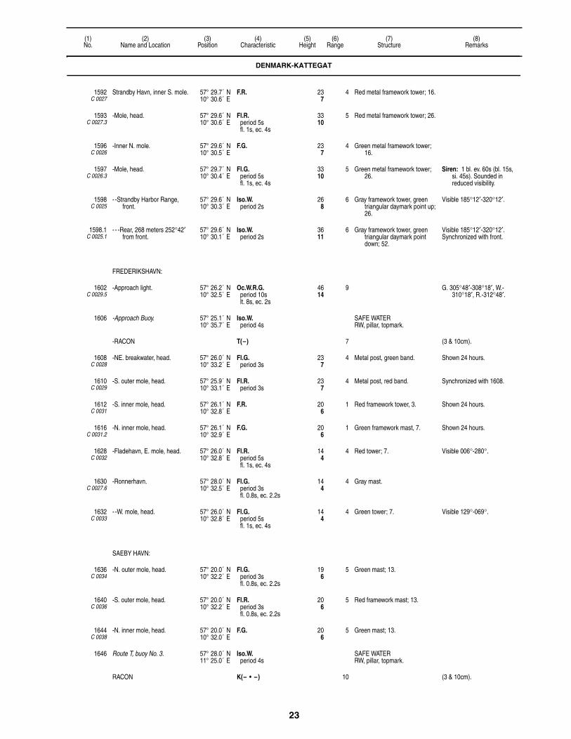
23
(1)No.
(2)Name and Location
(3)Position
(4)Characteristic
(5)Height
(6)Range
(7)Structure
(8)Remarks
1592C 0027
Strandby Havn, inner S. mole. 57° 29.7´ N10° 30.6´ E
F.R. 237
4 Red metal framework tower; 16.
1593C 0027.3
-Mole, head. 57° 29.6´ N10° 30.6´ E
Fl.R.period 5sfl. 1s, ec. 4s
3310
5 Red metal framework tower; 26.
1596C 0026
-Inner N. mole. 57° 29.6´ N10° 30.5´ E
F.G. 237
4 Green metal framework tower; 16.
1597C 0026.3
-Mole, head. 57° 29.7´ N10° 30.4´ E
Fl.G.period 5sfl. 1s, ec. 4s
3310
5 Green metal framework tower; 26.
Siren: 1 bl. ev. 60s (bl. 15s, si. 45s). Sounded in reduced visibility.
1598C 0025
- -Strandby Harbor Range, front.
57° 29.6´ N10° 30.3´ E
Iso.W.period 2s
268
6 Gray framework tower, green triangular daymark point up; 26.
Visible 185°12′-320°12′.
1598.1C 0025.1
- - -Rear, 268 meters 252°42′ from front.
57° 29.6´ N10° 30.1´ E
Iso.W.period 2s
3611
6 Gray framework tower, green triangular daymark point down; 52.
Visible 185°12′-320°12′.Synchronized with front.
FREDERIKSHAVN:
1602C 0029.5
-Approach light. 57° 26.2´ N10° 32.5´ E
Oc.W.R.G.period 10slt. 8s, ec. 2s
4614
9 G. 305°48′-308°18′, W.-310°18′, R.-312°48′.
1606 -Approach Buoy. 57° 25.1´ N10° 35.7´ E
Iso.W.period 4s
SAFE WATERRW, pillar, topmark.
-RACON T(–) 7 (3 & 10cm).
1608C 0028
-NE. breakwater, head. 57° 26.0´ N10° 33.2´ E
Fl.G.period 3s
237
4 Metal post, green band. Shown 24 hours.
1610C 0029
-S. outer mole, head. 57° 25.9´ N10° 33.1´ E
Fl.R.period 3s
237
4 Metal post, red band. Synchronized with 1608.
1612C 0031
-S. inner mole, head. 57° 26.1´ N10° 32.8´ E
F.R. 206
1 Red framework tower, 3. Shown 24 hours.
1616C 0031.2
-N. inner mole, head. 57° 26.1´ N10° 32.9´ E
F.G. 206
1 Green framework mast, 7. Shown 24 hours.
1628C 0032
-Fladehavn, E. mole, head. 57° 26.0´ N10° 32.8´ E
Fl.R.period 5sfl. 1s, ec. 4s
144
4 Red tower; 7. Visible 006°-280°.
1630C 0027.6
-Ronnerhavn. 57° 28.0´ N10° 32.5´ E
Fl.G.period 3sfl. 0.8s, ec. 2.2s
144
4 Gray mast.
1632C 0033
- -W. mole, head. 57° 26.0´ N10° 32.8´ E
Fl.G.period 5sfl. 1s, ec. 4s
144
4 Green tower; 7. Visible 129°-069°.
SAEBY HAVN:
1636C 0034
-N. outer mole, head. 57° 20.0´ N10° 32.2´ E
Fl.G.period 3sfl. 0.8s, ec. 2.2s
196
5 Green mast; 13.
1640C 0036
-S. outer mole, head. 57° 20.0´ N10° 32.2´ E
Fl.R.period 3sfl. 0.8s, ec. 2.2s
206
5 Red framework mast; 13.
1644C 0038
-N. inner mole, head. 57° 20.0´ N10° 32.0´ E
F.G. 206
5 Green mast; 13.
1646 Route T, buoy No. 3. 57° 28.0´ N11° 25.0´ E
Iso.W.period 4s
SAFE WATERRW, pillar, topmark.
RACON K(– • –) 10 (3 & 10cm).
DENMARK-KATTEGAT
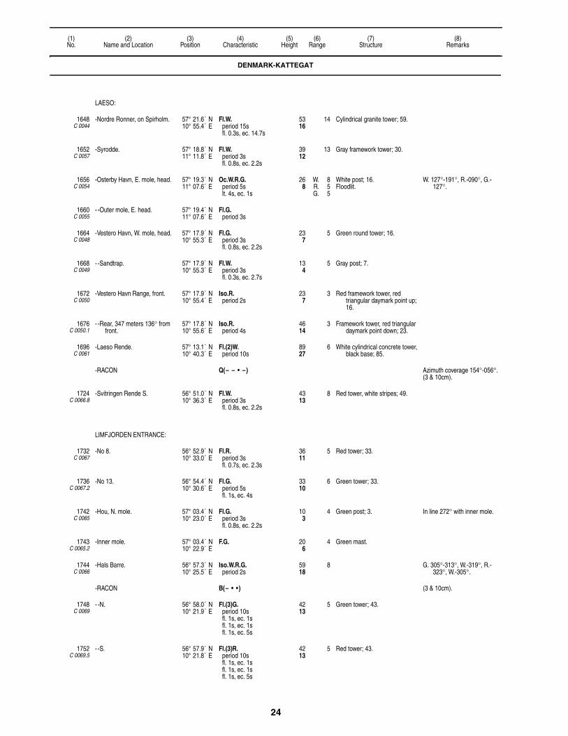
24
(1)No.
(2)Name and Location
(3)Position
(4)Characteristic
(5)Height
(6)Range
(7)Structure
(8)Remarks
LAESO:
1648C 0044
-Nordre Ronner, on Spirholm. 57° 21.6´ N10° 55.4´ E
Fl.W.period 15sfl. 0.3s, ec. 14.7s
5316
14 Cylindrical granite tower; 59.
1652C 0057
-Syrodde. 57° 18.8´ N11° 11.8´ E
Fl.W.period 3sfl. 0.8s, ec. 2.2s
3912
13 Gray framework tower; 30.
1656C 0054
-Osterby Havn, E. mole, head. 57° 19.3´ N11° 07.6´ E
Oc.W.R.G.period 5slt. 4s, ec. 1s
268
W. 8R. 5G. 5
White post; 16.Floodlit.
W. 127°-191°, R.-090°, G.-127°.
1660C 0055
- -Outer mole, E. head. 57° 19.4´ N11° 07.6´ E
Fl.G.period 3s
1664C 0048
-Vestero Havn, W. mole, head. 57° 17.9´ N10° 55.3´ E
Fl.G.period 3sfl. 0.8s, ec. 2.2s
237
5 Green round tower; 16.
1668C 0049
- -Sandtrap. 57° 17.9´ N10° 55.3´ E
Fl.W.period 3sfl. 0.3s, ec. 2.7s
134
5 Gray post; 7.
1672C 0050
-Vestero Havn Range, front. 57° 17.9´ N10° 55.4´ E
Iso.R.period 2s
237
3 Red framework tower, red triangular daymark point up; 16.
1676C 0050.1
- -Rear, 347 meters 136° from front.
57° 17.8´ N10° 55.6´ E
Iso.R.period 4s
4614
3 Framework tower, red triangular daymark point down; 23.
1696C 0061
-Laeso Rende. 57° 13.1´ N10° 40.3´ E
Fl.(2)W.period 10s
8927
6 White cylindrical concrete tower, black base; 85.
-RACON Q(– – • –) Azimuth coverage 154°-056°.(3 & 10cm).
1724C 0066.8
-Svitringen Rende S. 56° 51.0´ N10° 36.3´ E
Fl.W.period 3sfl. 0.8s, ec. 2.2s
4313
8 Red tower, white stripes; 49.
LIMFJORDEN ENTRANCE:
1732C 0067
-No 8. 56° 52.9´ N10° 33.0´ E
Fl.R.period 3sfl. 0.7s, ec. 2.3s
3611
5 Red tower; 33.
1736C 0067.2
-No 13. 56° 54.4´ N10° 30.6´ E
Fl.G.period 5sfl. 1s, ec. 4s
3310
6 Green tower; 33.
1742C 0065
-Hou, N. mole. 57° 03.4´ N10° 23.0´ E
Fl.G.period 3sfl. 0.8s, ec. 2.2s
103
4 Green post; 3. In line 272° with inner mole.
1743C 0065.2
-Inner mole. 57° 03.4´ N10° 22.9´ E
F.G. 206
4 Green mast.
1744C 0066
-Hals Barre. 56° 57.3´ N10° 25.5´ E
Iso.W.R.G.period 2s
5918
8 G. 305°-313°, W.-319°, R.-323°, W.-305°.
-RACON B(– • • ) (3 & 10cm).
1748C 0069
- -N. 56° 58.0´ N10° 21.9´ E
Fl.(3)G.period 10sfl. 1s, ec. 1sfl. 1s, ec. 1sfl. 1s, ec. 5s
4213
5 Green tower; 43.
1752C 0069.5
- -S. 56° 57.9´ N10° 21.8´ E
Fl.(3)R.period 10sfl. 1s, ec. 1sfl. 1s, ec. 1sfl. 1s, ec. 5s
4213
5 Red tower; 43.
DENMARK-KATTEGAT

25
(1)No.
(2)Name and Location
(3)Position
(4)Characteristic
(5)Height
(6)Range
(7)Structure
(8)Remarks
1760C 0072
-Korsholm, N. Range, front, about 2 km. 114°18′ from rear.
56° 58.4´ N10° 20.0´ E
Iso.G.period 2s
175
9 Red octagonal concrete tower; 20.
Visible 290°18′-298°18′.Sector limits may be indistinct.
Fl.R.period 3sfl. 0.8s, ec. 2.2s
165
3 Visible 139°30′-290°30′.
1764C 0072.1
- -S. front, 9 meters 203° from N. front light, 2 km. 114°06′ from rear.
56° 58.4´ N10° 20.0´ E
Iso.R.period 2s
175
9 Red octagonal concrete tower; 20.
Visible 290°18′-298°18′.
-Egensekloster:
1766C 0073
- -Egensekloster, common rear. 56° 58.8´ N10° 18.1´ E
Iso.W.period 2s
6620
15 Red framework tower, red triangular daymark point down; 66.
Visible 287°18′-301°18′.Synchronized with 1760 and
1764.
1768C 0076
- -E. Range, front. 56° 59.4´ N10° 18.4´ E
Oc.W.R.G.period 5slt. 4s, ec. 1s
134
W. 14R. 10G. 10
White hut, red band; 13. G. 311°30′-315°, W.-316°30′, R.-321°.
Shown 24 hours.
1772C 0076.1
- - -Rear, 177 meters 315°24′ from front.
56° 59.5´ N10° 18.3´ E
Iso.W.period 4s
309
13 Gray metal mast; 13. Shown 24 hours.
1776C 0078
- -E. pier. 56° 59.4´ N10° 18.5´ E
F.G. 134
5 White concrete post, green band.
1780C 0084
-Egensekloster Skov Range, front.
56° 58.7´ N10° 14.6´ E
Iso.R.period 2s
4213
6 Red framework tower, red triangular daymark point up, white stripe; 49.
Visible 076°18′-156°18′.Shown 24 hours.
1784C 0084.1
- -Rear, 540 meters 116°18′ from front.
56° 58.6´ N10° 15.1´ E
Iso.R.period 4s
6219
6 Red framework mast, red triangular daymark point down, white stripe; 52.
Visible 076°18′-156°18′.Shown 24 hours.
1788C 0089
-Frydenstrand, common front. 56° 59.0´ N10° 12.2´ E
Iso.W.period 2s
4313
8 Red framework tower, red triangular daymark point up, white stripe; 33.
Visible 131°-143°.Shown 24 hours.
Iso.G.period 2s
4313
6 Visible 231°-311°.Shown 24 hours.
1792C 0089.1
- -Rear, 916 meters 137° from common front.
56° 58.7´ N10° 12.8´ E
Iso.W.period 4s
7523
8 Red framework tower, red triangular daymark point down, white stripe.
Visible 133°-141°.
1796C 0088.9
- -Rear, 340 meters 271° from common front.
56° 59.0´ N10° 11.8´ E
Iso.G.period 4s
5918
5 Red framework tower, red triangular daymark point down, white stripe; 49.
Visible 231°-311°.
1800C 0079.9
-S. Range, front. 56° 59.5´ N10° 16.5´ E
Iso.R.period 2s
4213
8 Red framework tower, red triangular daymark point up, white stripe.
Visible 266°30′-306°30′.Shown 24 hours.
1804C 0080
- -Common rear, 240 meters 286° from range front, 270 meters 279°30′ from N. range, front.
56° 59.6´ N10° 16.3´ E
Iso.W.period 4s
5918
8 Framework tower, red triangular daymark point down, white stripe.
Visible 243°-323°.Shown 24 hours.
1808C 0080.1
-N. Range, front. 56° 59.5´ N10° 16.6´ E
Iso.G.period 2s
4213
9 Red framework tower, red triangular daymark point up, white stripe.
Visible 259°30′-299°30′.Shown 24 hours.
1812C 0082
-Hals, W. front. 56° 59.4´ N10° 18.3´ E
Iso.W.period 2s
4313
14 Red framework tower, red triangular daymark point up, white stripe.
Visible 066°30′-086°30′.Shown 24 hours.
1816C 0082.1
- -Rear, 360 meters 076° 30′ from front.
56° 59.5´ N10° 18.6´ E
Iso.W.period 4s
6219
14 Red framework tower, red triangular daymark point down, white stripe.
Visible 066°30′-086°30′.Shown 24 hours.
LIMFJORDEN:
1828C 0098
-Bredhage Range, front. 57° 03.8´ N10° 02.1´ E
Iso.W.period 2s
4213
8 Red framework tower, red triangular daymark point up, white stripe.
Visible 296°42′-308°42′.Shown 24 hours.
DENMARK-KATTEGAT
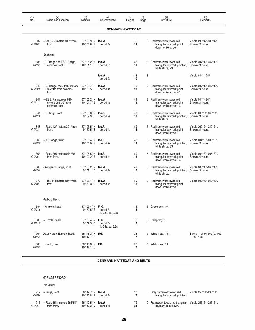
26
(1)No.
(2)Name and Location
(3)Position
(4)Characteristic
(5)Height
(6)Range
(7)Structure
(8)Remarks
1832C 0098.1
- -Rear, 536 meters 303° from front.
57° 03.9´ N10° 01.6´ E
Iso.W.period 4s
7523
8 Red framework tower, red triangular daymark point down, white stripe.
Visible 298°42′-306°42′.Shown 24 hours.
-Engholm:
1836C 0101
- -E. Range and ESE. Range, common front.
57° 05.2´ N10° 01.1´ E
Iso.W.period 2s
3611
12 Red framework tower, red triangular daymark point up, white stripe; 23.
Visible 307°12′-347°12′.Shown 24 hours.
Iso.W.period 2s
3310
8 Visible 044°-124°.
1840C 0100.9
- - -E. Range, rear, 1100 meters 327°12′ from common front.
57° 05.7´ N10° 00.5´ E
Iso.W.period 4s
7523
12 Red framework tower, red triangular daymark point down, white stripe; 66.
Visible 307°12′-347°12′.Shown 24 hours.
1841C 0101.1
- - -ESE. Range, rear, 620 meters 083°36′ from common front.
57° 05.2´ N10° 01.7´ E
Iso.W.period 4s
5918
8 Red framework tower, red triangular daymark point down, white stripe; 49.
Visible 044°-124°.Shown 24 hours.
1844C 0102
- -S. Range, front. 57° 05.3´ N9° 59.9´ E
Iso.R.period 2s
4313
6 Red framework tower, red triangular daymark point up, white stripe.
Visible 260°24′-340°24′.Shown 24 hours.
1848C 0102.1
- - -Rear, 427 meters 301° from front.
57° 05.5´ N9° 59.5´ E
Iso.R.period 4s
5918
6 Red framework tower, red triangular daymark point down, white stripe.
Visible 260°24′-340°24′.Shown 24 hours.
1860C 0106
- -SE. Range, front. 57° 05.4´ N10° 00.0´ E
Iso.R.period 2s
4313
5 Red framework tower, red triangular daymark point up, white stripe; 33.
Visible 004°30′-085°30′.Shown 24 hours.
1864C 0106.1
- - -Rear, 305 meters 044°30′ from front.
57° 05.5´ N10° 00.2´ E
Iso.R.period 4s
5918
5 Red framework tower, red triangular daymark point down, white stripe; 49.
Visible 004°30′-085°30′.Shown 24 hours.
1868C 0110
-Skongaard Range, front. 57° 05.2´ N9° 59.1´ E
Iso.W.period 2s
4213
8 Red framework tower, red triangular daymark point up, white stripe.
Visible 003°48′-043°48′.Shown 24 hours.
1872C 0110.1
- -Rear, 414 meters 024° from front.
57° 05.4´ N9° 59.3´ E
Iso.W.period 4s
5918
8 Red framework tower, red triangular daymark point down, white stripe.
Visible 003°48′-043°48′.
-Aalborg Havn:
1884C 0121.6
- -W. mole, head. 57° 03.4´ N9° 52.5´ E
Fl.G.period 3sfl. 0.8s, ec. 2.2s
165
3 Green post; 10.
1888C 0121.7
- -E. mole, head. 57° 03.4´ N9° 52.5´ E
Fl.R.period 3sfl. 0.8s, ec. 2.2s
165
3 Red post; 10.
1904C 0124
Oster-Hurup, E. mole, head. 56° 48.3´ N10° 17.1´ E
F.G. 237
5 White mast; 16. Siren: 1 bl. ev. 60s (bl. 10s, si. 50s).
1908C 0125
-S. mole, head. 56° 48.3´ N10° 17.1´ E
F.R. 237
5 White mast; 16.
DENMARK-KATTEGAT AND BELTS
MARIAGER FJORD:
-Als Odde:
1912C 0126
- -Range, front. 56° 42.7´ N10° 20.8´ E
Iso.W.period 2s
237
10 Gray framework tower, red triangular daymark point up.
Visible 256°54′-266°54′.
1916C 0126.1
- - -Rear, 1511 meters 261°54′ from front.
56° 42.5´ N10° 19.3´ E
Iso.W.period 4s
7924
10 Framework tower, red triangular daymark point down.
Visible 256°54′-266°54′.
DENMARK-KATTEGAT

27
(1)No.
(2)Name and Location
(3)Position
(4)Characteristic
(5)Height
(6)Range
(7)Structure
(8)Remarks
1920C 0127
- -Second Range, front. 56° 42.1´ N10° 19.6´ E
Iso.G.period 2s
165
4 Framework tower, red triangular daymark point up.
Visible 228°48′-243°48′.
Iso.W.period 2s
206
2
1924C 0127.1
- - -Rear, 232 meters 236°18′ from front.
56° 42.1´ N10° 19.4´ E
Iso.G.period 4s
309
4 Framework tower, red triangular daymark point down; 33.
Visible 228°48′-243°48′.
1928C 0128
- -Range, front. 56° 42.1´ N10° 19.3´ E
Iso.R.period 2s
196
4 Framework tower, red triangular daymark point up; 20.
Visible 228°48′-258°48′.
1932C 0128.1
- - -Rear, 181 meters 243°48′ from front.
56° 42.1´ N10° 19.1´ E
Iso.R.period 4s
3310
4 Framework tower, red triangular daymark point down; 33.
Visible 228°48′-258°48′.
RANDERS FJORD:
1936C 0176
-Udbyhoj. 56° 35.4´ N10° 19.2´ E
Oc.W.R.G.period 5slt. 4s, ec. 1s
10833
W. 15R. 12G. 12
White lighthouse, red band; 16. G. 194°-228°, W.-232°, R.-254°, G.-276°, W.-279°, R.-289°.
1940C 0178
-Barren, Entrance Range, front. 56° 36.1´ N10° 20.4´ E
Iso.W.period 2s
134
14 Red post, concrete base, red triangular daymark point up; 20.
Visible 250°36′-255°36′.
1944C 0178.1
- -Rear, 794 meters 253°06′ from front.
56° 36.0´ N10° 19.6´ E
Iso.W.period 4s
4614
14 Red mast, red triangular daymark point down; 39.
Visible 250°36′-255°36′.
1948C 0182
-Kirkegrund W. Range, front. 56° 36.4´ N10° 18.6´ E
Iso.R.period 2s
144
5 Red post, red triangular daymark point up; 13.
Visible 269°30′-292°30′.
1952C 0182.1
- -Rear, 875 meters 281° from front.
56° 36.5´ N10° 17.7´ E
Iso.R.period 4s
299
7 Red post, red triangular daymark point down; 26.
Visible 278°-284°.
1956C 0184
-Kirkegrund E. Range, front. 56° 36.1´ N10° 21.2´ E
Iso.R.period 2s
134
11 Framework mast, concrete base, red triangular daymark point up; 13.
Visible 098°30′-103°30′.
1960C 0184.1
- -Rear, 350 meters 101° from front.
56° 36.1´ N10° 21.6´ E
Iso.R.period 4s
268
11 Framework mast, concrete base, red triangular daymark point down; 23.
Visible 098°30′-103°30′.
1964C 0186
-Melbank. 56° 36.1´ N10° 20.9´ E
Fl.(2)R.period 5sfl. 0.8s, ec. 0.8sfl. 0.8s, ec. 2.6s
196
5 Red column, concrete base; 10.
1968C 0188
-Mellempolde. 56° 36.4´ N10° 19.2´ E
Fl.(2)G.period 5sfl. 0.8s, ec. 0.8sfl. 0.8s, ec. 2.6s
144
3 Green post, dolphin; 7.
1972C 0190
-Udbyhoi Fishing Harbor. 56° 36.6´ N10° 18.2´ E
Oc.(2)W.R.G.period 6slt. 3s, ec. 1slt. 1s, ec. 1s
144
W. 3R. 2G. 2
Green post, dolphin; 7. G. 281°-296°, W.-297°, R.-337°, G.-040°, W.-042°, R.-057°.
1976C 0164
Anholt, near E. point of island. 56° 44.2´ N11° 39.0´ E
Fl.W.period 15sfl. 0.3s, ec. 14.7s
13140
14 White cylindrical tower, red top; 138.
Visible 076°-053°.
1980C 0166
-Outer N. mole, head. 56° 42.9´ N11° 30.5´ E
Fl.R.period 3s
268
5 Post.
1984C 0168
-Outer S. mole, head. 56° 42.9´ N11° 30.6´ E
Fl.G.period 3s
268
5 Green post.
1988C 0172
-Inner S. mole, head. 56° 43.0´ N11° 30.6´ E
F.G. 206
White post. Visible 354°-302°.
1992C 0170
-Inner N. mole, head. 56° 43.0´ N11° 30.7´ E
F.R. 206
White post. Visible 254°-099°.
1996 Anholt Buoy 6. 56° 45.4´ N11° 53.0´ E
Iso.W.period 8s
SAFE WATERRW, pillar, topmark.
RACON T(–) (3 & 10cm).
DENMARK-KATTEGAT AND BELTS
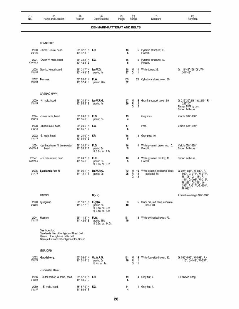
28
(1)No.
(2)Name and Location
(3)Position
(4)Characteristic
(5)Height
(6)Range
(7)Structure
(8)Remarks
BONNERUP:
2000C 0195
-Outer E. mole, head. 56° 32.2´ N10° 42.8´ E
F.R. 165
5 Pyramid structure; 13.Floodlit.
2004C 0195.2
-Outer W. mole, head. 56° 32.2´ N10° 42.8´ E
F.G. 165
5 Pyramid structure; 13.Floodlit.
2008C 0200
Gerrild, Knudshoved. 56° 31.7´ N10° 49.8´ E
Iso.W.G.period 4s
8827
W. 14G. 11
White tower; 36. G. 111°42′-128°06′, W.-301°48′.
2012C 0204
Fornaes. 56° 26.6´ N10° 57.4´ E
Fl.W.period 20s
10532
21 Cylindrical stone tower; 89.
GRENAO HAVN:
2020C 0209
-N. mole, head. 56° 24.5´ N10° 55.5´ E
Iso.W.R.G.period 4s
6720
W. 15R. 12G. 12
Gray framework tower; 59. G. 212°30′-216°, W.-219°, R.-222°30′.
Range 2/1M by day.Shown 24 hours.
2024C 0210
-Cross mole, head. 56° 24.8´ N10° 55.6´ E
Fl.G.period 5s
134
Gray mast. Visible 270°-180°.
2028C 0212
-Middle mole, head. 56° 24.6´ N10° 55.7´ E
F.G. 175
Post. Visible 129°-069°.
2032C 0214
-S. mole, head. 56° 24.6´ N10° 55.6´ E
F.R. 165
3 Gray post; 10.
2034C 0214.4
-Lystbadehavn, N. breakwater, head.
56° 24.2´ N10° 55.5´ E
Fl.G.period 3sfl. 0.8s, ec. 2.2s
165
4 White pyramid, green top; 10.Floodlit.
Visible 028°-298°.Shown 24 hours.
2034.1C 0214.6
- -S. breakwater, head. 56° 24.2´ N10° 55.6´ E
Fl.R.period 3sfl. 0.8s, ec. 2.2s
165
4 White pyramid, red top; 10.Floodlit.
Shown 24 hours.
2036C 1478
Sjaellands Rev, N. 56° 06.1´ N11° 12.1´ E
Iso.W.R.G.period 2s
8225
W. 16R. 13G. 13
White column, red band, black pedestal; 85.
G. 025°-036°, W.-039°, R.-062°, G.-074°, W.-077°, R.-105°, G.-118°, R.-141°, G.-205°, W.-212°, R.-235°, G.-256°, W.-283°, R.-317°, G.-350°, R.-025°.
RACON N(– • ) Azimuth coverage 020°-280°.
2040C 0220
Lysegrund. 56° 18.2´ N11° 47.7´ E
Fl.(2)W.period 5sfl. 0.5s, ec. 0.5sfl. 0.5s, ec. 3.5s
3310
5 Black hut, red band, concrete base; 30.
2044C 0222
Hesselo. 56° 11.8´ N11° 42.6´ E
Fl.W.period 15sfl. 0.3s, ec. 14.7s
13140
13 White cylindrical tower; 79.
See Index for: Sjaellands Rev, other lights of Great Belt Hjaelm, other lights of Little Belt, Gilleleje Flak and other lights of the Sound
ISEFJORD:
2052C 0226
-Spodsbjerg. 55° 58.6´ N11° 51.4´ E
Oc.W.R.G.period 5slt. 4s, ec. 1s
13140
W. 18R. 11G. 11
White four-sided tower; 30. G. 036°-095°, W.-098°, R.-116°, G.-148°, W.-237°.
-Hundested Havn:
2056C 0228
- -Outer harbor, W. mole, head. 55° 57.9´ N11° 50.5´ E
F.R. 196
4 Gray hut; 7. F.Y. shown in fog.
2060C 0230
- - -E. mole, head. 55° 57.9´ N11° 50.6´ E
F.G. 144
4 Gray hut; 7.
DENMARK-KATTEGAT AND BELTS

29
(1)No.
(2)Name and Location
(3)Position
(4)Characteristic
(5)Height
(6)Range
(7)Structure
(8)Remarks
2072C 0238
-Lynaes Havn, W. mole, head. 55° 56.5´ N11° 52.0´ E
F.R. 165
4 Red post; 10. Not shown 0100-0500.
2076C 0237
- -W. mole, head. 55° 56.4´ N11° 52.1´ E
Oc.(2)W.R.G.period 6slt. 1s, ec. 1slt. 3s, ec. 1s
165
W. 7R. 5G. 5
Red octagonal tower; 13. W. 000°-042°, R.-050°, G.-146°, R.-340°, G.-000°.
2080C 0233
- -Ferry Harbor, N. mole, head. 55° 57.6´ N11° 50.5´ E
Fl.R.period 3sfl. 0.3s, ec. 2.7s
165
3 Gray post; 7. Fog light.
2084C 0234
- - -S. mole, head. 55° 57.5´ N11° 50.6´ E
Fl.G.period 3sfl. 0.7s, ec. 2.3s
165
4 Pile structure, gray lantern; 13.
2088 -Rorvig, Yacht Harbor, N. mole, head.
55° 56.7´ N11° 46.2´ E
F.G. 155
3 Green mast; 8. F.R. light shown on S. mole head.
-Frederikssund:
2096C 0239.42
- -Range, front. 55° 51.1´ N12° 02.5´ E
F.R. 237
3 Framework tower, red and white striped triangular daymark point up.
2100C 0239.43
- - -Rear, 160°42′ from front. 55° 50.9´ N12° 02.7´ E
F.R. 3310
3 Framework tower, red and white striped triangular daymark point down.
2104C 0239.44
- -North side of bridge leaf Range, front.
55° 50.6´ N12° 02.4´ E
Iso.G.period 2s
134
3 Mast, red and white striped triangular daymark point up.
2108C 0239.45
- - -Rear, 172°30′ from front. 55° 50.0´ N12° 02.7´ E
Iso.G.period 4s
3912
3 Mast, red and white striped triangular daymark point down.
2116C 0239.7
-Roskilde Havn Range, front, W. mole, head.
55° 38.9´ N12° 04.7´ E
Iso.R.period 2s
268
6 Mast. Visible 150°48′-180°48′.
2120C 0239.71
- -Rear, 395 meters 165°48′ from front.
55° 39.1´ N12° 04.6´ E
Iso.R.period 2s
4313
6 Building. Visible 150°48′-180°48′.Synchronized with front.
2132C 0260.5
-Nykobing Havn, N. entrance to pleasure craft harbor.
55° 54.8´ N11° 40.6´ E
F.G. 103
4 Post.
2136C 0260.6
- -S. entrance to pleasure craft harbor.
55° 54.8´ N11° 40.5´ E
F.R. 103
4 Post.
2138C 0260.7
- -S. mole, head. 55° 54.8´ N11° 40.6´ E
Fl.R.period 3sfl. 0.8s, ec. 2.2s
134
4 White wooden structure, red top; 7.
Floodlit.
2140C 0242
-Kyndbyvaerket Havn Range, front.
55° 48.6´ N11° 52.5´ E
Iso.R.period 2s
165
7 Gray post; 10. Visible 161°30′-168°30′.
2144C 0242.1
- -Rear, 1.2 km., 165° from front.
55° 48.1´ N11° 52.9´ E
Iso.R.period 4s
5918
7 Metal framework tower; 20. Visible 161°30′-168°30′.
2152C 0255
- -Range, front. 55° 45.1´ N11° 48.7´ E
Iso.R.period 2s
4614
5 Framework tower, red triangular daymark point up, white bands; 30.
Visible 051°30′-071°30′.
2156C 0255.1
- - -Rear, 800 meters 061°30′ from front.
55° 45.4´ N11° 49.4´ E
Iso.R.period 4s
8526
5 Framework tower, red triangular daymark point down, white bands; 23.
Visible 051°30′-071°30′.
2164C 0257.5
-Loserup. 55° 46.8´ N11° 44.6´ E
Oc.W.R.G.period 5slt. 4s, ec. 1s
7523
W. 6R. 4G. 4
Red cylindrical tower, white band; 7.
G. 180°-207°, W.-216°, R.-234°.
2168C 0257
-Honsehalsen. 55° 46.1´ N11° 46.0´ E
Iso.W.R.G.period 2s
165
W. 7R. 5G. 5
Green cylindrical tower, white band; 13.
G. 252°-338°30′, W.-343°30′, R.-065°, G.-165°, W.-175°, R.-252°.
-Holbaek Havn:
2172C 0253
- -Holbaek Marina, W. mole. 55° 43.5´ N11° 45.7´ E
Iso.W.R.G.period 2s
165
5 Green post; 10.Floodlit.
W. 105°-135°, R.-145°, G.-105°.
Fl.R. 3s 3M marks E. mole.
DENMARK-KATTEGAT AND BELTS
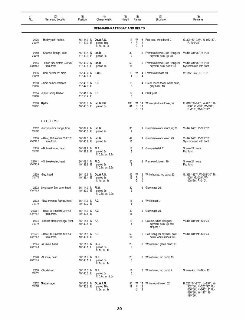
30
(1)No.
(2)Name and Location
(3)Position
(4)Characteristic
(5)Height
(6)Range
(7)Structure
(8)Remarks
2176C 0254
- -Horby yacht harbor. 55° 44.0´ N11° 42.0´ E
Oc.W.R.G.period 10slt. 8s, ec. 2s
134
W. 6R. 4G. 4
Red post, white band; 7. G. 309°30′-327°, W.-027°30′, R.-309°30′.
2180C 0248
- -Channel Range, front. 55° 43.4´ N11° 42.9´ E
Iso.R.period 2s
309
5 Framework tower, red triangular daymark point up; 30.
Visible 231°30′-251°30′.
2184C 0248.1
- - -Rear, 520 meters 241°30′ from front.
55° 43.2´ N11° 42.4´ E
Iso.R.period 4s
5216
5 Framework tower, red triangular daymark point down; 49.
Visible 231°30′-251°30′.Synchronized with front.
2196C 0244
- -Boat harbor, W. mole. 55° 43.2´ N11° 42.6´ E
F.W.G. 134
W. 4G. 4
Framework mast; 10. W. 315°-045°, G.-315°.
2200C 0246
- -Ship harbor entrance. 55° 43.3´ N11° 42.6´ E
F.G. 165
4 Green round tower, white band, gray base; 13.
2204C 0243
-Ejby Fishing Harbor. 55° 41.8´ N11° 50.2´ E
F.R. 196
4 Black post.
2208C 0262
Hjelm. 56° 08.0´ N10° 48.3´ E
Iso.W.R.G.period 8s
20061
W. 14R. 11G. 11
White cylindrical tower; 59. G. 016°30′-043°, W.-051°, R.-068°, G.-088°, W.-091°, R.-110°, W.-016°30′.
EBELTOFT VIG:
2212C 0782
-Ferry Harbor Range, front. 56° 09.2´ N10° 40.0´ E
Iso.W.period 2s
309
9 Gray framework structure; 20. Visible 043°12′-075°12′.
2216C 0782.1
- -Rear, 260 meters 059°12′ from front.
56° 09.3´ N10° 40.2´ E
Iso.W.period 2s
4915
9 Gray framework tower; 43. Visible 043°12′-075°12′.Synchronized with front.
2218C 0781
- -N. breakwater, head. 56° 09.2´ N10° 39.8´ E
Fl.R.period 3sfl. 0.8s, ec. 2.2s
165
5 Gray pedestal; 7. Shown 24 hours.Fog light.
2218.1C 0780.4
- -S. breakwater, head. 56° 09.1´ N10° 39.9´ E
Fl.G.period 3sfl. 0.8s, ec. 2.2s
206
6 Framework tower; 10. Shown 24 hours.Fog light.
2220C 0772
-Bay, head. 56° 13.9´ N10° 36.4´ E
Oc.W.R.G.period 5slt. 4s, ec. 1s
4313
W. 12R. 10G. 10
White house, red band; 20. G. 355°-357°, W.-358°30′, R.-005°, G.-008°, W.-008°30′, R.-010°.
2232C 0773.4
Lyngsbaek Bro, outer head. 56° 14.0´ N10° 37.0´ E
Fl.W.period 3sfl. 0.8s, ec. 2.2s
309
6 Gray mast; 26.
2233C 0776
-New entrance Range, front. 56° 11.9´ N10° 40.2´ E
F.G. 185
5 White mast; 7.
2233.1C 0776.1
- -Rear, 261 meters 091°42′ from front.
56° 11.9´ N10° 40.5´ E
F.G. 4915
5 Gray mast; 39.
2234C 0774
-Ebeltoft Harbor Range, front. 56° 11.6´ N10° 40.1´ E
F.R. 134
5 Column, white triangular daymark point up, red stripes; 7.
Visible 081°24′-126°24′.
2234.1C 0774.1
- -Rear, 401 meters 103°54′ from front.
56° 11.5´ N10° 40.4´ E
F.R. 5918
5 Red triangular daymark point down, white stripes; 33.
Visible 081°24′-126°24′.
2244C 0776.4
-W. mole, head. 56° 11.8´ N10° 40.1´ E
Fl.G.period 5sfl. 1s, ec. 4s
206
3 White tower, green band; 13.
2248C 0776.3
-N. mole, head. 56° 11.8´ N10° 40.1´ E
Fl.R.period 5sfl. 1s, ec. 4s
206
3 White tower, red band; 13.
2250C 0777
-Skudehavn. 56° 11.5´ N10° 40.0´ E
Fl.R.period 3sfl. 0.7s, ec. 2.3s
113
3 White tower, red band; 7. Shown Apr. 1 to Nov. 15.
2252C 0786
Sletterhage. 56° 05.7´ N10° 30.8´ E
Oc.W.R.G.period 10slt. 8s, ec. 2s
5617
W. 15R. 12G. 12
White round tower; 52. R. 250°54′-275°, G.-297°, W.-302°06′, R.-320°30′, G.-006°06′, R.-060°12′, G.-088°36′, W.-117°, R.-125°36′.
DENMARK-KATTEGAT AND BELTS

31
(1)No.
(2)Name and Location
(3)Position
(4)Characteristic
(5)Height
(6)Range
(7)Structure
(8)Remarks
2258C 0810
Skodshoved Harbor, S. mole, head.
56° 10.9´ N10° 22.4´ E
F.G. 165
4 Gray post; 10. Shown Apr. 1 to Nov. 15.
KALVO VIG:
2260C 0819
-Ronsten Grund SE. 56° 15.6´ N10° 28.6´ E
Fl.(3)R.period 10sfl. 0.5s, ec. 0.5sfl. 0.5s, ec. 0.5sfl. 0.5s, ec. 7.5s
72
2 Dolphin; 7. Shown Apr. 1 to Nov. 15.
2262C 0818
-Nappedam. 56° 16.6´ N10° 29.7´ E
F.R. 134
4 White concrete and metal post; 7.
2264C 0814
-Studstrupvaerkets Havn Range, front.
56° 15.0´ N10° 20.8´ E
F.R. 13842
6 Metal framework tower, orange triangular daymark point up; 125.
Visible 233°48′-013°48′.
2268C 0814.1
- -Rear, 135 meters 303°48' from front.
56° 15.1´ N10° 20.7´ E
F.R. 16149
6 House, orange triangular daymark point down; 148.
2269C 0813
- -S. mole, head. 56° 14.6´ N10° 20.6´ E
F.R. 165
4 White trapezoidal daymark, red top; 10.
2270C 0813.2
- -N. mole, head. 56° 14.6´ N10° 20.6´ E
F.G. 165
4 White rectangular daymark, green top; 10.
Visible 007°-257°.
2271C 0812
-Ega Marina, S. mole, head. 56° 12.6´ N10° 17.6´ E
Fl.R.period 3s
134
5 Red post; 7.
2271.1C 0812.5
- -N. mole, head. 56° 12.6´ N10° 17.5´ E
Fl.G.period 3s
134
5 Green post; 7.
AARHUS:
2275C 0802.05
-Pier 4 Range, front. 56° 09.8´ N10° 13.8´ E
Iso.W.period 2s
12137
7 Framework tower, 13. Visible 287°06′-303°06′.Shown 24 hours.Synchronized with 2275.1 and
2275.2.
2275.1C 0803
- -Middle, 199 meters 295°06′ from front.
56° 09.9´ N10° 13.6´ E
Iso.W.period 2s
15748
7 Framework tower, 10. Visible 287°06′-303°06′.Synchronized with 2275 and
2275.2.Occasional.
2275.2C 0804
- -Rear, 1130 meters 295°06′ from middle.
56° 10.1´ N10° 12.6´ E
Iso.W.period 2s
24073
7 Church tower. Synchronized with 2275 and 2275.1.
2280C 0792
-E. mole, head. 56° 09.7´ N10° 13.9´ E
Fl.R.period 5sfl. 1s, ec. 4s
5216
5 Gray tower, red band; 52.Floodlit.
Fog light.
2281C 0793.5
-N. mole, head. 56° 09.5´ N10° 14.7´ E
Fl.R.period 3sfl. 0.8s, ec. 2.2s
268
8 White metal tower, red band.Floodlit.
Fog light.Shown 24 hours.
2282C 0793
-W. mole, head. 56° 09.7´ N10° 13.7´ E
Fl.G.period 5sfl. 1s, ec. 4s
268
5 Gray cylindrical tower, green band.
Floodlit.
2283C 0793.9
-Miljohavn Basin. 56° 09.0´ N10° 15.3´ E
F.W. 165
5
2286C 0796
-E. harbor Range, front. 56° 08.5´ N10° 13.1´ E
Iso.W.period 2s
8225
6 Framework tower. Visible 210°-243°.Shown 24 hours.Range 2M by day, visible
217°30′-235°30′.
2286.1C 0796.1
- -Rear, 207 meters 220°12′ from front.
56° 08.4´ N10° 13.0´ E
Iso.W.period 2s
9529
6 Framework tower. Visible 210°-243°.Shown 24 hours.Range 2M by day, visible
217°30′-235°30′.Synchronized with front.
2287C 0794.5
-Basin 11. 56° 09.2´ N10° 13.9´ E
Fl.Y.period 3s
103
3 Metal post, yellow band.
DENMARK-KATTEGAT AND BELTS

32
(1)No.
(2)Name and Location
(3)Position
(4)Characteristic
(5)Height
(6)Range
(7)Structure
(8)Remarks
2287.5C 0797.8
-Basin 3 quay, NW. corner. 56° 08.9´ N10° 12.9´ E
Fl.Y.period 3s
103
3 Lantern.
2289C 0795
- -E. breakwater, head. 56° 08.9´ N10° 13.9´ E
Fl.R.period 5sfl. 1s, ec. 4s
268
5 White tower, red band; 26.Floodlit.
2292C 0808
-Yacht basin, E. mole, head. 56° 10.2´ N10° 13.5´ E
F.R. 237
5 Red tower; 13. Shown 24 hours.
2294C 0789.5
Marselisborg. 56° 08.2´ N10° 12.9´ E
Fl.G.period 3s
134
4 Green mast; 16.Floodlit.
2296C 0821
Norsminde Marina. 56° 01.5´ N10° 16.1´ E
F.G. 103
4 Metal post; 7.
TUNO:
2300C 0822
-E. side of island. 55° 57.0´ N10° 26.6´ E
Oc.W.R.G.period 5slt. 4s, ec. 1s
10231
W. 12R. 10G. 10
White church tower; 59. G. 133°-157°, W.-160°, R.-175°, G.-214°, W.-220°, R.-326°, G.-345°, W.-350°, R.-045°.
2304C 0824
-S. mole, head. 55° 56.9´ N10° 27.3´ E
F.R. 103
4 Gray post; 7. Shown Sep. 1 to Apr. 1 when vessels are expected.
SAMSO:
2328C 0837
-Saelvig Pier, head. 55° 51.9´ N10° 32.9´ E
F.G. 165
5 Mast; 13.
-Kolby Kaas Havn:
2332C 0838
- -N. mole, head. 55° 47.8´ N10° 31.7´ E
Fl.R.period 3sfl. 0.3s, ec. 2.7s
165
5 Red metal post; 7.
2336C 0839
- -S. mole, head. 55° 47.8´ N10° 31.6´ E
Fl.G.period 3sfl. 0.3s, ec. 2.7s
165
4 Green metal post; 7.
2340C 0842
-Vesborg. 55° 46.2´ N10° 33.1´ E
Oc.(2)W.period 12slt. 2s, ec. 2slt. 6s, ec. 2s
11836
17 White cylindrical tower; 62. Visible 275°-149°, W. partially obscured -169°.
2344C 0844
-Lushage, SE. point of Samso. 55° 45.9´ N10° 37.2´ E
Fl.W.period 3sfl. 0.8s, ec. 2.2s
309
6 White framework mast; 23. Visible 204°-095°.
2345C 0846
-Paludans Flak, E. side. 55° 44.0´ N10° 35.0´ E
Fl.(3)Y.period 10sfl. 1s, ec. 1sfl. 1s, ec. 1sfl. 1s, ec. 5s
237
5 Wind turbine Light on E. and W. sides.Other wind turbines, some
marked by lights, exist in area.
ENDELAVE HAVN:
2368C 0856
-Range, front. 55° 45.6´ N10° 15.8´ E
F.R. 237
4 Wooden mast. Visible 095°-235°.
2372C 0856.1
- -Rear, 110 meters 165° from front.
55° 45.5´ N10° 15.8´ E
F.R. 4213
4 Framework tower. Visible 095°-235°.
HORSENS FJORD:
2376C 0860
-Hjarno Range, front. 55° 49.4´ N10° 03.8´ E
Iso.G.period 2s
196
8 White wooden house; 13. Visible 334°42′-342°42′.
2380C 0860.1
- -Rear, 703 meters 338°42′ from front.
55° 49.8´ N10° 03.6´ E
Iso.G.period 4s
5918
8 Framework tower, orange band; 59.
Visible 334°42′-342°42′.
DENMARK-KATTEGAT AND BELTS

33
(1)No.
(2)Name and Location
(3)Position
(4)Characteristic
(5)Height
(6)Range
(7)Structure
(8)Remarks
2384C 0866
-Haldrup Range, front. 55° 52.8´ N9° 58.4´ E
Iso.R.period 2s
268
8 White house, red bands; 26. Visible 316°-324°.
2388C 0866.1
- -Rear, 600 meters 319°42′ from front.
55° 53.1´ N9° 58.1´ E
Iso.R.period 4s
6018
8 White house, red bands; 33. Visible 316°-324°.
2392C 0870
Sejet Range, front. 55° 50.0´ N9° 57.0´ E
Iso.G.period 2s
103
5 White house; 10. Visible 228°12′-248°12′.
2396C 0870.1
- -Rear, 410 meters 238°12′ from front.
55° 49.9´ N9° 56.8´ E
Iso.G.period 4s
3310
5 White house; 16. Visible 228°-248°.
-Horsens:
2400C 0876
- -S. side of harbor range, front. 55° 51.5´ N9° 50.9´ E
Iso.R.period 2s
4112
10 White building. Visible 191°-011°.
2404C 0876.1
- - -Rear, 690 meters 281° from front.
55° 51.5´ N9° 50.9´ E
Iso.R.period 4s
7122
10 Metal framework tower, orange triangular daymark point down; 85.
Visible 191°-011°.
2406C 0877
- -Yacht harbor. 55° 51.4´ N9° 52.7´ E
F.G. 103
3 Green post; 7. Shown Apr. 1 to Nov. 15.
HORSENS HAVN:
2408C 0880
-N. mole, head. 55° 51.0´ N9° 52.0´ E
Fl.G.period 3sfl. 0.8s, ec. 2.2s
134
4 Green post, white hut; 10.
2416C 0884
Juelsminde Havn. 55° 43.0´ N10° 01.0´ E
Fl.R.period 5sfl. 1s, ec. 4s
185
4 Steel pillar.
2420C 0885
Sandbjerg Vig. 55° 43.2´ N10° 00.5´ E
Fl.R.period 3sfl. 0.7s, ec. 2.3s
134
5 Red tripod; 10.
2432C 0893.5
Aebelo. 55° 38.7´ N10° 09.8´ E
Fl.W.period 15sfl. 0.3s, ec. 14.7s
6620
14 Cylindrical granite tower; 59. Visible 016°-263°.
2436C 0888
Korshavn. 55° 36.2´ N10° 36.5´ E
Oc.W.R.G.period 5slt. 4s, ec. 1s
134
W. 7R. 4G. 4
White tower, red band; 10. R. 259°-292°, G.-053°, W.-058°, R.-078°.
Shown Apr. 1 to Sep. 30.
2440C 0890
Enebaerodde, W. side of Odense Fjord, at Hals.
55° 31.0´ N10° 33.7´ E
Fl.W.R.G.period 5sfl. 1s, ec. 4s
4313
W. 11R. 8G. 8
White tower; 46. G. 142°-164°, W.-173°30′, R.-028°, G.-082°.
2442C 0890.2
Gabet Range, front. 55° 31.3´ N10° 33.2´ E
Iso.W.period 2s
3310
6 Red mast, red trangular daymark point up; 26.
Visible 210°48′-240°48′.Shown 24 hours.
2442.1C 0890.21
-Rear, 140 meters 225°48′ from front.
55° 31.2´ N10° 33.1´ E
Iso.W.period 4s
4915
6 Red mast, red triangular daymark point down; 43.
Visible 210°48′-240°48′.Synchronized with front.Shown 24 hours.
2444C 0890.4
Skoven. 55° 31.8´ N10° 34.9´ E
Oc.(2)W.R.G.period 6slt. 1s, ec. 1slt. 3s, ec. 1s
6219
W. 5R. 3G. 3
Framework tower; 23. G. 134°-144°, W.-154°, R.-164°.
Shown 24 hours.
BOGENSE HAVN:
2448C 0904
-E. mole, head. 55° 34.2´ N10° 04.6´ E
Oc.W.R.G.period 5slt. 4s, ec. 1s
196
W. 4R. 2G. 2
White tower; 16.Floodlit.
G. 160°30′-194°, W.-198°, R.-160°30′.
2452C 0908
-Entrance Range, front. 55° 34.1´ N10° 05.0´ E
F.R. 72
3 Post, white triangular daymark point up; 7.
2456C 0908.1
- -Rear, 130 meters 164°30′ from front.
55° 34.0´ N10° 05.1´ E
F.R. 3310
3 Warehouse, white triangular daymark point down.
DENMARK-KATTEGAT AND BELTS
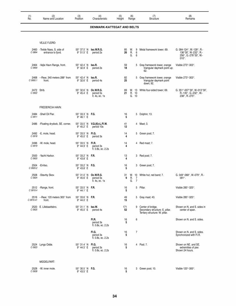
34
(1)No.
(2)Name and Location
(3)Position
(4)Characteristic
(5)Height
(6)Range
(7)Structure
(8)Remarks
VEJLE FJORD:
2460C 0894
-Trelde Naes, S. side of entrance to fjord.
55° 37.5´ N9° 51.5´ E
Iso.W.R.G.period 2s
8526
W. 9R. 6G. 6
Metal framework tower; 69. G. 084-124°, W.-128°, R.-136°30′, W.-232°, R.-256°, G.-276°30′, W.-010°.
2464C 0900
-Vejle Havn Range, front. 55° 42.4´ N9° 32.9´ E
Iso.R.period 2s
5918
5 Gray framework tower, orange triangular daymark point up; 62.
Visible 273°-303°.
2468C 0900.1
- -Rear, 340 meters 288° from front.
55° 42.4´ N9° 32.6´ E
Iso.R.period 4s
8225
5 Gray framework tower, orange triangular daymark point down; 92.
Visible 273°-303°.
2472C 0922
Strib. 55° 32.6´ N9° 45.4´ E
Oc.W.R.G.period 5slt. 4s, ec. 1s
6921
W. 13R. 10G. 10
White four-sided tower; 69. G. 351°-007°30′, W.-013°30′, R.-135°, G.-232°, W.-238°, R.-270°.
FREDERICIA HAVN:
2484C 0911
-Shell Oil Pier. 55° 33.3´ N9° 46.1´ E
F.G. 165
5 Dolphin; 13.
2486 -Floating drydock, SE. corner. 55° 33.5´ N9° 45.2´ E
V.Q.(6)+L.Fl.W.period 10s
4112
4 Mast; 3.
2492C 0918
-E. mole, head. 55° 33.5´ N9° 45.0´ E
Fl.G.period 3s
144
5 Green post; 7.
2496C 0919
-W. mole, head. 55° 33.5´ N9° 44.9´ E
Fl.R.period 3sfl. 0.8s, ec. 2.2s
144
4 Red mast; 7.
2500C 0920
-Yacht Harbor. 55° 33.2´ N9° 43.8´ E
F.R. 134
3 Red post; 7.
2504C 0920.2
-Erritso. 55° 33.2´ N9° 43.8´ E
F.G. 165
3 Green post; 7.
2508C 0924
-Stavrby Skov. 55° 31.0´ N9° 45.6´ E
Oc.W.R.G.period 5slt. 4s, ec. 1s
319
W. 10R. 7G. 7
White hut, red band; 7. G. 049°-068°, W.-079°, R.-091°.
2512C 0919.4
-Range, front. 55° 33.5´ N9° 44.1´ E
F.R. 165
5 Pillar. Visible 285°-325°.
2516C 0919.41
- -Rear, 120 meters 305° from front.
55° 33.6´ N9° 44.0´ E
F.R. 4915
5 Gray mast; 43. Visible 285°-325°.
2520C 0925
E. Lillebaeltsbro. 55° 31.1´ N9° 45.0´ E
Iso.W.period 4s
17152
9 Center of bridge.Secondary structure: E. pillar.Tertiary structure: W. pillar.
Shown on N. and S. sides in center of span.
Fl.R.period 3sfl. 0.8s, ec. 2.2s
165
6 Shown on N. and S. sides.
Fl.G.period 3sfl. 0.8s, ec. 2.2s
165
7 Shown on N. and S. sides.Synchronized with Fl.R.
2524C 0923
Lyngs Odde. 55° 31.4´ N9° 44.5´ E
Fl.G.period 3sfl. 0.8s, ec. 2.2s
165
4 Post; 7. Shown on NE. and SE. extremities of pier.
Shown 24 hours.
MIDDELFART:
2528C 0928
-W. inner mole. 55° 30.5´ N9° 43.5´ E
F.G. 165
3 Green post; 10. Visible 120°-300°.
DENMARK-KATTEGAT AND BELTS

35
(1)No.
(2)Name and Location
(3)Position
(4)Characteristic
(5)Height
(6)Range
(7)Structure
(8)Remarks
2536C 0932
W. Lillebaeltsbro. 55° 31.0´ N9° 42.5´ E
F.W., F.R., F.G. 165
On piers. F.W. shown from each side of bridge at middle of center span.
Fixed light at each corner of three passages, so arranged as to show R. to port and G. to starboard of approaching vessels.
N. passage lit for westbound traffic, S. passage for eastbound traffic and middle passage for traffic in either direction.
BORUP:
2540C 0936
-Snoghoj. 55° 31.5´ N9° 41.7´ E
Oc.W.R.G.period 5slt. 4s, ec. 1s
206
W. 10R. 8G. 8
White house, red band; 26. G. 056°-063°, W.-067°, R.-074°.
2544C 0934
-N. 55° 31.7´ N9° 40.7´ E
Iso.W.R.G.period 4s
237
W. 14R. 10G. 10
Gray post; 7. G. 012°-028°, W.-036°30′, R.-044°.
2548C 0938
-W. 55° 31.7´ N9° 40.5´ E
Iso.W.R.G.period 2s
165
W. 12R. 10G. 10
White house, red band; 23. G. 290°-293°30′, W.-295°, R.-302°.
Shows bearing 294°42′.
2552C 0944
Damgaard. 55° 31.6´ N9° 40.2´ E
Oc.W.R.G.period 5slt. 4s, ec. 1s
237
W. 12R. 10G. 10
White house, red band; 23. G. 290°-293°30′, W.-295°, R.-311°.
Shows bearing 294°12′.
2556C 0950
Skjaerbaek Fiskerihavn. 55° 30.8´ N9° 37.8´ E
F.G. 144
Post.
2560C 0948
Skjaerbaek. 55° 30.7´ N9° 37.0´ E
Oc.(2)W.R.G.period 12slt. 6s, ec. 2slt. 2s, ec. 2s
15447
W. 8R. 6G. 6
Factory. G. 035°30′-042°30′, W. -044°, R. -049°, G. 307°30′-311°30′, W.-314°30′, R.-320°.
2564C 0949
-Range, front. 55° 30.7´ N9° 37.1´ E
F.R. 309
5 Mast, orange triangular daymark point up.
Visible 239°18′-059°18′.Shown on request.
2568C 0949.1
- -Rear, 86 meters 329°18′ from front.
55° 30.7´ N9° 37.0´ E
F.R. 4313
5 Mast, orange triangular daymark point down.
Shown on request.
2572C 0956
Drejensodde, S. side of point. 55° 29.8´ N9° 35.0´ E
Oc.W.R.G.period 5s
144
W. 8R. 4G. 3
Green wooden hut; 13. G. 243°-252°30′, W.-255°, R.-260°30′, G.-276°.
KOLDING HAVN:
2576C 0958
-Range, front. 55° 29.6´ N9° 29.5´ E
F.R. 299
13 Gray framework tower; 30. Shown 24 hours.
2580C 0958.1
- -Rear, 514 meters 267° from front.
55° 29.6´ N9° 29.0´ E
F.R. 4915
13 Gray framework tower; 49. Shown 24 hours.
2584C 0960
-N. mole, head. 55° 29.6´ N9° 30.1´ E
Fl.G.period 3s
196
4 Round pipe, green stripes; 13.
2588C 0959
-S. mole, head. 55° 29.6´ N9° 30.1´ E
Fl.R.period 3s
206
4 Gray pile, red band; 13.
2592C 0964
Middlefart Yacht Harbor, jetty, head.
55° 29.5´ N9° 43.4´ E
F.G. 134
4 Metal post.
2596C 0962
Faeno. 55° 28.5´ N9° 42.1´ E
Fl.W.R.G.period 5sfl. 1s, ec. 4s
3611
W. 11R. 8G. 8
Gable of white house; 26. G. 338°-342°, W.-346°, R.-350°.
2608C 0968
-Tvingsbjerg. 55° 18.6´ N9° 53.6´ E
Iso.W.R.Gperiod 2s
3912
W. 12R. 8G. 8
White house; 26. G. 036°-041°, W.-043°, R.-048°.
Oc.W.R.G.period 5slt. 4s, ec. 1s
3912
W. 13R. 10G. 10
G. 117°-121°, W.-125°, R.-129°.
DENMARK-KATTEGAT AND BELTS

36
(1)No.
(2)Name and Location
(3)Position
(4)Characteristic
(5)Height
(6)Range
(7)Structure
(8)Remarks
ASSENS:
2616C 0977
-Breakwater. 55° 16.3´ N9° 53.0´ E
Oc.W.R.G.period 10slt. 8s, ec. 2s
165
W. 14R. 11G. 11
White structure, red band; 13. G. 158°-164°, W.-173°, R.-180°.
2617C 0982
-W. mole, head. 55° 16.3´ N9° 53.1´ E
Fl.G.period 3sfl. 0.7s, ec. 2.3s
165
4 Green hut; 10.
2618C 0983
-E. mole, head. 55° 16.3´ N9° 53.2´ E
Fl.R.period 3sfl. 0.7s, ec. 2.3s
165
3 Pole.
2620C 0970
Arosund, S. harbor mole. 55° 15.7´ N9° 42.7´ E
Oc.W.R.G.period 5slt. 4s, ec. 1s
309
W. 10R. 8G. 8
White cylindrical tower; 33. G. 126°-171°, R.-194°, G.-205°, W.-211°, R.-220°, G.-330°, W.-335°, R.-337°.
2624C 0970.4
-E. ferry mole, N. head. 55° 15.7´ N9° 42.8´ E
F.R. 134
4 Gray post; 7.
2628C 0969
Aaro Island. 55° 15.4´ N9° 43.6´ E
Iso.W.R.G.period 2s
3912
W. 11R. 8G. 8
White round tower, red band; 43. R. 306°-322°, G.-353°, W.-001°, R.-151°, G.-184°, W.-187°, R.-193°, partially obscured 178°-193°.
2632C 0970.6
Aaro Havn, S. mole, head. 55° 15.6´ N9° 43.7´ E
Fl.G.period 3s
134
3 Gray post; 10.
2636C 0988
Helnaes. 55° 08.0´ N9° 58.7´ E
Fl.W.R.G.period 5sfl. 1s, ec. 4s
9830
W. 13R. 10G. 10
White square tower; 92. R. 302°-321°, G.-330°, W.-343°, R.-030°, G.-075°, W.-125°, R.-141°, G.-179°.
2640C 0989.6
Bojden Ferry Harbor, N. mole, head.
55° 06.4´ N10° 04.8´ E
Fl.R.period 3s
268
5 Gray metal framework tower; 16. Shown 24 hours.
2644C 0989.4
-S. mole, head. 55° 06.4´ N10° 04.8´ E
Fl.G.period 3s
268
5 Gray framework mast; 16. Shown 24 hours.Siren: 1 bl. ev. 20s (bl. 5s, si.
15s). Sounded during poor visibility when ferry is expected.
2648C 0988.4
Faldsled Havn. 55° 09.1´ N10° 08.5´ E
F.G. 144
4 Green post; 13.
2652C 1030
Nordborg. 55° 04.7´ N9° 42.7´ E
Oc.W.R.G.period 5slt. 4s, ec. 1s
8827
W. 12R. 10G. 10
Yellow cylindrical tower; 66. G. 065°-070°, W.-073°, R.-171°, G.-184°30′, W.-236°, R.-254°.
ABENERA HAVN:
2660C 1050
-Sydhavn Range, front. 55° 02.0´ N9° 26.0´ E
Iso.G.period 2s
4915
5 Gray framework tower, red triangular daymark point up; 46.
2664C 1050.1
- -Rear, 160 meters 320°12′ from front.
55° 02.4´ N9° 25.7´ E
Iso.G.period 4s
6921
5 Gray framework tower, red triangular daymark point down; 66.
2668C 1052
-N. of Nyhavn Range, front. 55° 03.0´ N9° 26.0´ E
Iso.R.period 2s
3611
5 Gray framework mast; 26.
2672C 1052.1
- -Rear, 235 meters 350°18′ from front.
55° 03.0´ N9° 25.7´ E
Iso.R.period 4s
6219
5 Gray framework mast; 59.
2676C 1055
-Oil pier Range, front. 55° 03.0´ N9° 26.0´ E
F.W. 134
7 Wooden post, white cross topmark; 13.
Marks east limit of dredged area.
2680C 1055.1
- -Rear, 50 meters 027° from front.
55° 02.6´ N9° 26.0´ E
F.W. 237
7 Wooden post, white cross topmark; 20.
2684C 1065
- -E. side of pier. 55° 01.6´ N9° 26.9´ E
Fl.R.period 3sfl. 0.8s, ec. 2.2s
196
5 Mast, mooring dolphin; 10. Shown 24 hours.
DENMARK-KATTEGAT AND BELTS

37
(1)No.
(2)Name and Location
(3)Position
(4)Characteristic
(5)Height
(6)Range
(7)Structure
(8)Remarks
2688C 1067.4
Als Fjord, cable Range, front. 55° 00.4´ N9° 39.0´ E
F.R. 196
3 Framework mast, round daymark; 16.
Visible 230°-240°.
2692C 1067.5
- -Rear, 235° from front. 55° 00.4´ N9° 38.9´ E
F.R.W. (vert.) 3611
3 Framework mast, round daymark, diamond daymark; 30.
Visible 230°-240°.2 meters apart.
2696C 1067
Als Fjord Range, front. 55° 00.3´ N9° 39.2´ E
F.R. Framework tower, red round daymark, white border.
2700C 1067.1
-Rear, 27 meters 235° from front.
55° 00.3´ N9° 39.2´ E
F.R.W. (vert.) Framework tower, red and white round daymark, red and white diamond daymark.
Visible 230°-240°.
2704C 1066
Ballebro. 54° 59.8´ N9° 40.4´ E
Iso.W.R.G.period 2s
3611
W. 10R. 8G. 8
White cylindrical tower, red band; 20.
G. 128°-140°, W.-152°, R.-253°, G.-262°30′, W.-274°, R.-283°.
2708C 1122
Sottrupskov. 54° 58.3´ N9° 44.6´ E
Iso.W.R.G.period 4s
309
W. 6R. 5G. 5
White pedestal, red band; 7. G. 151°-192°30′, W.-201°, R.-238°.
2712C 1032
Tranerodde. 55° 02.7´ N9° 51.1´ E
Iso.W.R.G.period 2s
3912
W. 15R. 13G. 13
White cylindrical tower, red band; 33.
R. 131°-191°, G.-280°, W.-290°, R.-301°.
2716C 1034
Taksensand. 55° 00.4´ N9° 57.9´ E
Oc.(2)W.R.G.period 12slt. 6s, ec. 2slt. 2s, ec. 2s
4915
W. 15R. 12G. 12
White cylindrical tower; 62. G. 127°-135°, W.-139°, R.-174°, G.-186°, W.-323°.
2718C 1035.3
-Boat Harbor. 54° 59.6´ N9° 59.3´ E
Oc.R.period 5slt. 4s, ec. 1s
134
4 Red metal tower; 7.
2720C 1035.4
Fynshavn Ferry Harbor, S. mole, head.
54° 59.8´ N9° 59.3´ E
Fl.R.period 3sfl. 0.5s, ec. 2.5s
237
6 Gray framework tower; 16. Shown 24 hours.Siren: 2 bl. ev. 30s (bl. 5s, si.
5s, bl. 5s, si. 15s). Sounded when ferries are running.
2724C 1035.8
-N. mole, head. 55° 00.0´ N9° 59.0´ E
Fl.G.period 5s
237
6 Gray framework tower; 16. Fog light.Shown 24 hours.
2728C 1037
Fynshavn Cable Range, front. 54° 59.7´ N9° 58.6´ E
F.R. 268
5 Tripod, round daymark; 13. Visible 152°30′-272°30′.
2732C 1037.1
-Rear, 212°30′ from front. 54° 59.7´ N9° 58.5´ E
F.W.R. (vert.) 4714
5 Metal framework mast, round daymark, diamond daymark; 33.
Visible 152°30′-272°30′.
2736C 0989.8
Hornenaes Cable Range, front. 55° 04.6´ N10° 04.8´ E
F.R. 4915
5 Metal framework mast, round daymark; 20.
Visible 334°36′-094°36′.
2740C 0989.81
-Rear, 034° from front. 55° 04.6´ N10° 04.9´ E
F.W.R. (vert.) 7222
5 Metal framework mast, round daymark, diamond daymark; 30.
Visible 334°36′-094°36′.
2748C 0991
Bjorno. 55° 03.3´ N10° 15.7´ E
Iso.W.R.G.period 4s
206
W. 10R. 8G. 8
White hut, red band; 10. G. 040°-052°, W.-060°, R.-071°.
FAABORG FJORD:
2752C 0992
-Sisserodde. 55° 04.6´ N10° 13.7´ E
Iso.W.R.G.period 2s
268
W. 16R. 14G. 14
White hut, red band; 16. G. 350°42′-352°12′, W.-354°12′, R.-355°42′.
2760C 0994
-Dyreborg Havn. 55° 04.3´ N10° 13.1´ E
F.G. 103
2 Mast; 7.
2764C 0998
-Osterhede Range, front. 55° 05.2´ N10° 15.6´ E
F.G. 4213
4 Brown mast, red bands, red triangular daymark point up; 36.
Visible 043°30′-049°30′.Shown 24 hours.
2768C 0998.1
- -Rear, 212 meters 047° from front.
55° 05.2´ N10° 15.7´ E
F.G. 5918
4 Brown mast, red triangular daymark point down; 36.
Visible 043°30′-049°30′.Shown 24 hours.
DENMARK-KATTEGAT AND BELTS

38
(1)No.
(2)Name and Location
(3)Position
(4)Characteristic
(5)Height
(6)Range
(7)Structure
(8)Remarks
-Faaborg Havn:
2776C 1004
- -E. mole Range, front. 55° 05.6´ N10° 14.3´ E
F.R. 206
4 Gray post, red triangular daymark point up; 13.
Visible 260°-002°.Fl.G. 3s 4M shown from head
of pier 75 meters SSW.
2780C 1004.1
- - -Munkholm, rear, 189 meters 336°30′ from front.
55° 05.7´ N10° 14.3´ E
F.R. 3611
4 Framework tower, red triangular daymark point down; 43.
Visible 224°-089°.Shown 24 hours.
AVERNAKO:
2784C 1020
-Nakkeodde, E. head. 55° 01.0´ N10° 20.0´ E
Oc.W.R.G.period 5slt. 4s, ec. 1s
309
W. 11R. 8G. 8
White hut, red band; 10. G. 115°12′-123°, W.-130°, R.-143°.
2788C 1016
-Munke, E. side of Avernako. 55° 01.4´ N10° 16.3´ E
Iso.W.R.G.period 4s
3310
W. 15R. 11G. 11
White hut, red band; 13. G. 259°-264°, W.-268°, R.-273°.
AERO:
2792C 1070
-Skjoldnaes. 54° 58.2´ N10° 12.4´ E
L.Fl.W.period 30sfl. 4s, ec. 26s
10632
22 Round granite tower; 72.
2796C 1068
Vitso Range, front. 54° 55.4´ N10° 14.6´ E
F.R. 124
Mast, red round daymark, white border; 16.
Marks cable.
2800C 1068.1
-Rear, 220 meters 077° from front.
54° 55.4´ N10° 14.9´ E
F.W.R. (vert.) 258
Mast, red and white round daymark, red and white diamond daymark; 30.
2804C 1074
-Soby Havn. 54° 56.6´ N10° 15.5´ E
Iso.W.R.period 2s
206
W. 7R. 5
White hexagonal tower; 13. W. 151°-255°, R.-151°.F.G. 4M marks W. mole.Siren: 2 bl. ev. 60s (bl. 5s, si.
5s, bl. 5s, si. 45s).
2808C 1078
-Aeroskobing Havn, E. mole, head.
54° 53.6´ N10° 24.9´ E
Fl.R.period 5sfl. 1s, ec. 4s
134
4 Red post; 7. Shown 24 hours, Apr. 1 to Nov. 15.
Fl.G. 3s shown on S. part of mole.
2812C 1076
-Range, front, W. mole, head. 54° 53.5´ N10° 24.8´ E
F.G. 3611
5 Green metal mast, white top, red triangular daymark point up; 23.
Visible 136°18′-256°18′.
Fl.G. 134
4 Floodlit.
2816C 1076.1
- -Rear, about 145 meters 196° from front.
54° 53.4´ N10° 24.8´ E
F.G. 4915
5 White metal mast, red triangular daymark point down; 43.
Visible 136°18′-256°18′.
2818C 1077
-Dejro. 54° 54.0´ N10° 25.2´ E
Fl.(2)R.period 5s
82
3 Red dolphin.
-Marstal Havn:
2820C 1086
- -N. Range, about 1.4 km., 331° from church, front.
54° 52.0´ N10° 30.5´ E
F.R. 155
5 Mast, red triangular daymark point up; 16.
Visible 184°48′-324°48′.
2824C 1086.1
- - -Rear, 125 meters 254°48′ from front.
54° 52.0´ N10° 30.4´ E
F.R. 3611
5 Mast, red triangular daymark point down; 20.
Visible 184°48′-324°48′.
2825C 1087
- -S. channel Range, front. 54° 51.5´ N10° 31.6´ E
Iso.W.period 2s
216
7 Gray framework tower, white mast; 20.
Visible 303°24′-335°24′.
2825.1C 1087.1
- - -Rear, 279 meters 319°24′ from front.
54° 51.6´ N10° 31.4´ E
Iso.W.period 4s
3310
8 Gray framework tower, white mast; 33.
Visible 303°24′-335°24′.
2826C 1087.8
- - 54° 51.4´ N10° 31.3´ E
Oc.W.R.G.period 5slt. 4s, ec. 1s
206
W. 8R. 5G. 5
Gray mast; 13. G. 281°24′-286°24′, W.-290°24′, R.-294°24′, G.-301°24′.
DENMARK-KATTEGAT AND BELTS

39
(1)No.
(2)Name and Location
(3)Position
(4)Characteristic
(5)Height
(6)Range
(7)Structure
(8)Remarks
2828C 1088
- -S. Range, front. 54° 51.0´ N10° 31.0´ E
F.G. 268
3 Gray framework tower, red triangular daymark point up; 36.
2832C 1088.1
- - -Rear, 238 meters 178°42′ from front.
54° 51.3´ N10° 31.4´ E
F.G. 4213
3 Gray framework tower, red triangular daymark point down; 36.
2833C 1084
Aeros Hale cable Range, front. 54° 50.6´ N10° 31.0´ E
F.R. 165
5 Mast, red round daymark, white border.
Visible 219°48′-359°48′.Shown 24 hours.
2833.1C 1084.1
-Rear, 350 meters 288° from front.
54° 50.7´ N10° 30.7´ E
F.W.R. (vert.) 4313
W. 6R. 5
Metal framework tower, red and white round daymark, red and white diamond daymark; 33.
Visible 219°48′-359°48′.Shown 24 hours.4 meters apart.
2834C 1084.3
Ristinge, S. cable Range, front. 54° 49.8´ N10° 36.3´ E
F.R. 5918
5 Two masts, red round daymark, white border; 16.
Visible 032°12′-172°12′.Shown 24 hours.
2834.1C 1084.31
-Rear, 102°12′ from front. 54° 49.8´ N10° 36.4´ E
F.W.R. (vert.) 8927
W. 6R. 5
Two masts, red and white round daymark, red and white diamond daymark.
Visible 032°12′-172°12′.Shown 24 hours.4 meters apart.
2836C 1082
-Vejsnaes Nakke. 54° 49.0´ N10° 25.4´ E
Fl.W.period 5sfl. 1s, ec. 4s
7523
12 White three-sided structure, red band; 26.
Visible 220°-130°.
2840C 1704
Stryno Range, front. 54° 53.5´ N10° 36.9´ E
F.R. 196
8 Mast, round daymark; 23. Visible 274°-310°.
2844C 1704.1
-Rear, 270 meters 292° from front.
54° 53.6´ N10° 36.8´ E
F.W.R. (vert.) 3310
8 Metal framework tower, round daymark, diamond daymark; 23.
Visible 274°-310°.2 meters apart.
2848C 1703
-Pier, head. 54° 54.2´ N10° 37.8´ E
F.W.R.G. 165
W. 7R. 4G. 4
Roof of red warehouse. G. 016°-246°, W.-355°, R.-016°.
Shown 24 hours.
MOMMARK (MUMMARK):
2852C 1042
-E. mole, head. 54° 56.0´ N10° 02.7´ E
F.R. 113
5 Gray post; 7.Floodlit.
2856C 1046
-Outer mole, head. 54° 56.0´ N10° 02.8´ E
Fl.R.period 3sfl. 0.7s, ec. 2.3s
134
5 Gray post; 7.
2864C 1098
Hummelvig Range, front. 54° 53.8´ N10° 03.5´ E
F.R. 165
Framework tower, red round daymark, white border; 20.
Marks cable.
2868C 1098.1
-Rear, 50 meters 256° from front.
54° 53.8´ N10° 03.4´ E
F.W.R. (vert.) 309
Framework tower, red and white round, red diamond daymark, white border; 33.
2872C 1100
Gammel-Pol. 54° 52.9´ N10° 04.2´ E
Oc.(3)W.R.G.period 15slt. 5s, ec. 2slt. 2s, ec. 2slt. 2s, ec. 2s
6520
W. 11R. 8G. 8
White column, red band; 36. W. 166°30′-320°, R.-008°, G.-036°30′, W.-049°, R.-166°30°.
FLENSBORG FJORD:
2876C 1104
-Kegnaes (Kekenis). 54° 51.2´ N9° 59.3´ E
Oc.W.R.G.period 5slt. 4s, ec. 1s
10532
W. 12R. 10G. 10
Yellow round tower; 59. R. 217°-266°30′, G.-273°, W.-289°30′, R.-337°, G.-026°, W.-044°, R.-050°30′, G.-075°, W.-080°, R.-102°30′.
2880C 1115.5
Sonderborg. 54° 53.9´ N9° 47.5´ E
F.G. 134
4 Post; 7.
2888C 1116.4
-Near Castle. 54° 54.4´ N9° 46.9´ E
Fl.G.period 5sfl. 1s, ec. 4s
165
5 Framework mast, green post; 7. Visible 284°-258°.Radar reflector.
DENMARK-KATTEGAT AND BELTS
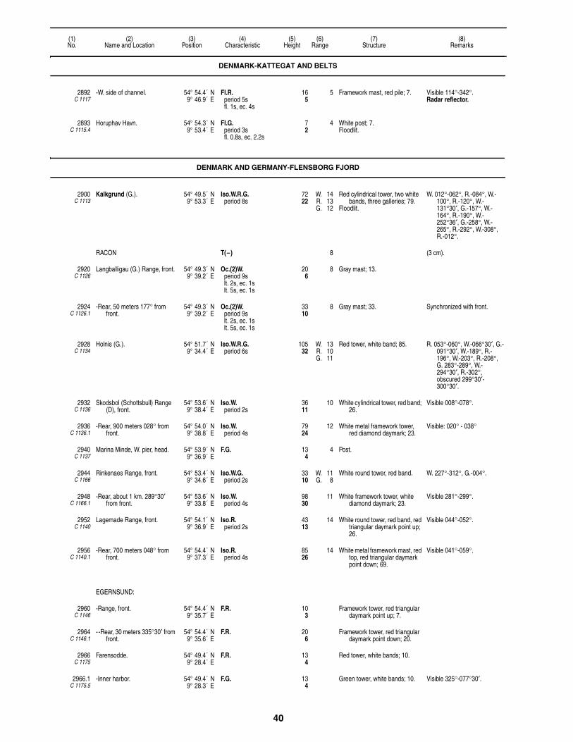
40
(1)No.
(2)Name and Location
(3)Position
(4)Characteristic
(5)Height
(6)Range
(7)Structure
(8)Remarks
2892C 1117
-W. side of channel. 54° 54.4´ N9° 46.9´ E
Fl.R.period 5sfl. 1s, ec. 4s
165
5 Framework mast, red pile; 7. Visible 114°-342°.Radar reflector.
2893C 1115.4
Horuphav Havn. 54° 54.3´ N9° 53.4´ E
Fl.G.period 3sfl. 0.8s, ec. 2.2s
72
4 White post; 7.Floodlit.
DENMARK AND GERMANY-FLENSBORG FJORD
2900C 1113
Kalkgrund (G.). 54° 49.5´ N9° 53.3´ E
Iso.W.R.G.period 8s
7222
W. 14R. 13G. 12
Red cylindrical tower, two white bands, three galleries; 79.
Floodlit.
W. 012°-062°, R.-084°, W.-100°, R.-120°, W.-131°30′, G.-157°, W.-164°, R.-190°, W.-252°36′, G.-258°, W.-265°, R.-292°, W.-308°, R.-012°.
RACON T(–) 8 (3 cm).
2920C 1126
Langballigau (G.) Range, front. 54° 49.3´ N9° 39.2´ E
Oc.(2)W.period 9slt. 2s, ec. 1slt. 5s, ec. 1s
206
8 Gray mast; 13.
2924C 1126.1
-Rear, 50 meters 177° from front.
54° 49.3´ N9° 39.2´ E
Oc.(2)W.period 9slt. 2s, ec. 1slt. 5s, ec. 1s
3310
8 Gray mast; 33. Synchronized with front.
2928C 1134
Holnis (G.). 54° 51.7´ N9° 34.4´ E
Iso.W.R.G.period 6s
10532
W. 13R. 10G. 11
Red tower, white band; 85. R. 053°-060°, W.-066°30′, G.-091°30′, W.-189°, R.-196°, W.-203°, R.-208°, G. 283°-289°, W.-294°30′, R.-302°, obscured 299°30′-300°30′.
2932C 1136
Skodsbol (Schottsbull) Range (D), front.
54° 53.6´ N9° 38.4´ E
Iso.W.period 2s
3611
10 White cylindrical tower, red band; 26.
Visible 008°-078°.
2936C 1136.1
-Rear, 900 meters 028° from front.
54° 54.0´ N9° 38.8´ E
Iso.W.period 4s
7924
12 White metal framework tower, red diamond daymark; 23.
Visible: 020° - 038°
2940C 1137
Marina Minde, W. pier, head. 54° 53.9´ N9° 36.9´ E
F.G. 134
4 Post.
2944C 1166
Rinkenaes Range, front. 54° 53.4´ N9° 34.6´ E
Iso.W.G.period 2s
3310
W. 11G. 8
White round tower, red band. W. 227°-312°, G.-004°.
2948C 1166.1
-Rear, about 1 km. 289°30′ from front.
54° 53.6´ N9° 33.8´ E
Iso.W.period 4s
9830
11 White framework tower, white diamond daymark; 23.
Visible 281°-299°.
2952C 1140
Lagemade Range, front. 54° 54.1´ N9° 36.9´ E
Iso.R.period 2s
4313
14 White round tower, red band, red triangular daymark point up; 26.
Visible 044°-052°.
2956C 1140.1
-Rear, 700 meters 048° from front.
54° 54.4´ N9° 37.3´ E
Iso.R.period 4s
8526
14 White metal framework mast, red top, red triangular daymark point down; 69.
Visible 041°-059°.
EGERNSUND:
2960C 1146
-Range, front. 54° 54.4´ N9° 35.7´ E
F.R. 103
Framework tower, red triangular daymark point up; 7.
2964C 1146.1
- -Rear, 30 meters 335°30′ from front.
54° 54.4´ N9° 35.6´ E
F.R. 206
Framework tower, red triangular daymark point down; 20.
2966C 1175
Farensodde. 54° 49.4´ N9° 28.4´ E
F.R. 134
Red tower, white bands; 10.
2966.1C 1175.5
-Inner harbor. 54° 49.4´ N9° 28.3´ E
F.G. 134
Green tower, white bands; 10. Visible 325°-077°30′.
DENMARK-KATTEGAT AND BELTS

41
(1)No.
(2)Name and Location
(3)Position
(4)Characteristic
(5)Height
(6)Range
(7)Structure
(8)Remarks
FLENSBURG:
2972C 1176
-Kielseng. 54° 48.3´ N9° 26.8´ E
Dir.Oc.W.R.G.period 4slt. 3s, ec. 1s
10532
W. 10R. 3G. 3
Metal, Round Mast; 16. G. 193°-195°, W.-199°, R.-201°.
2980C 1180
-Kraftwerk Range, front. 54° 48.2´ N9° 26.1´ E
Iso.G.period 4s
4915
12 White mast; 43. Shown 24 hours.
2984C 1180.1
- -Rear, 80 meters 229° from front.
54° 48.2´ N9° 26.0´ E
Iso.G.period 4s
6219
13 White mast; 59. Shown 24 hours.
DENMARK AND GERMANY-FLENSBORG FJORD

42
(1)No.
(2)Name and Location
(3)Position
(4)Characteristic
(5)Height
(6)Range
(7)Structure
(8)Remarks
Section 3Northeast Coast of Germany, Store Baelt, Sjaelland, Lolland and Falster
Including Kieler Bucht and Mecklenburger Bucht
GERMANY-KIEL BAY
SCHLEI:
-Schleimunde:
3000C 1186
- -Mole, head. 54° 40.3´ N10° 02.2´ E
L.Fl.(3)W.R.G.period 20sfl. 2s, ec. 3sfl. 2s, ec. 3sfl. 2s, ec. 8s
4614
W. 13R. 11G. 11W. 6
White tower, green bands; 46.Floodlit.
R. 144°-201°, G.-275°, W.-296°, R.-006°, W. (unintensified)-100°.
F.Y. shown in fog, visible 275°-296°.
Fog detector light.
3004C 1188
- -Near steamship′s pier Range, front.
54° 40.4´ N10° 02.0´ E
Oc.W.period 4slt. 3s, ec. 1s
206
9 White pile; 16. Visible 040°-175°.
3008C 1188.1
- - -Rear, 90 meters 107°30′ from front.
54° 40.3´ N10° 02.0´ E
Oc.W.period 4slt. 3s, ec. 1s
278
9 White mast; 20. Visible 040°-175°.Synchronized with front.
3036C 1189
-Lotseninsel Range, front. 54° 40.6´ N10° 01.3´ E
Iso.W.period 4s
3310
11 White mast, red triangular daymark point up; 33.
Intensified on range line.
3040C 1189.1
- -Rear, 800 meters 093°42′ from front.
54° 40.5´ N10° 02.1´ E
Iso.W.period 4s
7222
13 White mast, red triangular daymark point down; 62.
Synchronized with front.Intensified on range line.
3044C 1190
-Grimsnis Range, front. 54° 40.6´ N9° 56.5´ E
Iso.W.period 4s
237
11 White pile; 19. Intensified on range line.
3048C 1190.1
- -Rear, 595 meters 266° from front.
54° 40.5´ N9° 56.0´ E
Iso.W.period 4s
5216
13 White pile; 19. Intensified on range line.
3052C 1192
-Kappeln Range, front. 54° 40.0´ N9° 56.2´ E
Oc.W.period 4slt. 3s, ec. 1s
268
9 White pile; 19. Intensified on range line.
3056C 1192.1
- -Rear, 136 meters 213°18′ from front.
54° 39.9´ N9° 56.2´ E
Oc.W.period 4slt. 3s, ec. 1s
3611
9 White pile; 13. Synchronized with front.Intensified on range line.
3057C 1197
-Olpenitz, N. mole, head. 54° 39.6´ N10° 02.6´ E
F.G. 309
3 Metal mast; 19.
3058C 1198
- -S. mole, head. 54° 39.5´ N10° 02.5´ E
F.R. 309
3 Red mast; 19.
DAMP:
3060C 1202
-Jachtfen, N. mole. 54° 34.9´ N10° 01.7´ E
Fl.G.period 4sfl. 0.5s, ec. 3.5s
268
3 Green mast; 26.
3064C 1203
- -S. mole. 54° 34.8´ N10° 01.7´ E
Q.(2)R.period 5s
268
3 Red mast; 26.
ECKERNFORDE:
3068C 1206
Eckernforde. 54° 27.6´ N9° 50.6´ E
Dir.Oc.W.R.G.period 4slt. 3s, ec. 1s
11836
W. 21R. 17G. 18
Gray tower, two red platforms; 89.
G. 237°-242°, W.-244°30′, R.-251°.
Fl.(2)W.period 9sfl. 1s, ec. 2sfl. 1s, ec. 5s
21 Visible 251°-268°.
F.W.R. W. 12R. 8
W. 180°-193°, R.-208°, W.-237°.
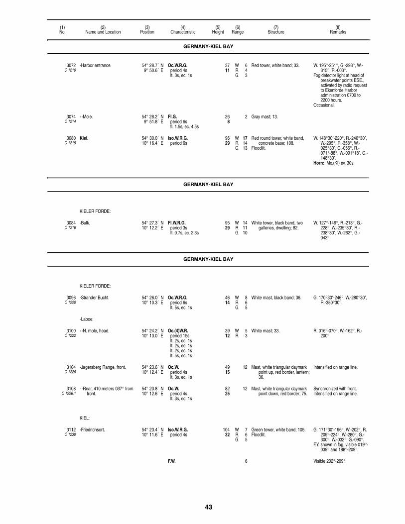
43
(1)No.
(2)Name and Location
(3)Position
(4)Characteristic
(5)Height
(6)Range
(7)Structure
(8)Remarks
3072C 1210
-Harbor entrance. 54° 28.7´ N9° 50.6´ E
Oc.W.R.G.period 4slt. 3s, ec. 1s
3711
W. 6R. 4G. 3
Red tower, white band; 33. W. 195°-251°, G.-293°, W.-315°, R.-003°.
Fog detector light at head of breakwater points ESE., activated by radio request to Ekenforde Harbor administration 0700 to 2200 hours.
Occasional.
3074C 1214
- -Mole. 54° 28.2´ N9° 51.8´ E
Fl.G.period 6sfl. 1.5s, ec. 4.5s
268
2 Gray mast; 13.
3080C 1215
Kiel. 54° 30.0´ N10° 16.4´ E
Iso.W.R.G.period 6s
9629
W. 17R. 14G. 13
Red round tower, white band, concrete base; 108.
Floodlit.
W. 148°30′-220°, R.-246°30′, W.-295°, R.-358°, W.-025°30′, G.-056°, R.-071°-88°, W.-091°18′, G.-148°30′.
Horn: Mo.(KI) ev. 30s.
GERMANY-KIEL BAY
KIELER FORDE:
3084C 1216
-Bulk. 54° 27.3´ N10° 12.2´ E
Fl.W.R.G.period 3sfl. 0.7s, ec. 2.3s
9529
W. 14R. 11G. 10
White tower, black band, two galleries, dwelling; 82.
W. 127°-146°, R.-213°, G.-228°, W.-235°30′, R.-238°30′, W.-262°, G.-043°.
GERMANY-KIEL BAY
KIELER FORDE:
3096C 1220
-Strander Bucht. 54° 26.0´ N10° 10.3´ E
Oc.W.R.G.period 6slt. 5s, ec. 1s
4614
W. 8R. 6G. 5
White mast, black band; 36. G. 170°30′-246°, W.-280°30′, R.-350°30′.
-Laboe:
3100C 1222
- -N. mole, head. 54° 24.2´ N10° 13.0´ E
Oc.(4)W.R.period 15slt. 2s, ec. 1slt. 2s, ec. 1slt. 2s, ec. 1slt. 5s, ec. 1s
3912
W. 5R. 3
White mast; 33. R. 016°-070°, W.-162°, R.-200°.
3104C 1226
-Jagersberg Range, front. 54° 23.6´ N10° 12.4´ E
Oc.W.period 4slt. 3s, ec. 1s
4915
12 Mast, white triangular daymark point up, red border, lantern; 36.
Intensified on range line.
3108C 1226.1
- -Rear, 410 meters 037° from front.
54° 23.8´ N10° 12.6´ E
Oc.W.period 4slt. 3s, ec. 1s
8225
12 Mast, white triangular daymark point down, red border; 75.
Synchronized with front.Intensified on range line.
KIEL:
3112C 1230
-Friedrichsort. 54° 23.4´ N10° 11.6´ E
Iso.W.R.G.period 4s
10432
W. 7R. 6G. 5
Green tower, white band; 105.Floodlit.
G. 171°30′-196°, W.-202°, R. 209°-224°, W.-280°, G.-300°, W.-032°, G.-090°.
F.Y. shown in fog, visible 019°-039° and 188°-209°.
F.W. 6 Visible 202°-209°.
GERMANY-KIEL BAY

44
(1)No.
(2)Name and Location
(3)Position
(4)Characteristic
(5)Height
(6)Range
(7)Structure
(8)Remarks
-Nord-Ostsee-Kanal:
3116C 1246
- -N. side of entrance. 54° 22.2´ N10° 09.2´ E
Oc.(3)W.G.period 12slt. 2s, ec. 1slt. 2s, ec. 1slt. 5s, ec. 1s
7222
W. 11G. 8
Red tower, annex; 66. G. 217°-224°, W.-270°, G.-354°, G. (unintensified)-012°, W. (unintensified)-039°.
F.R. on tower 865 meters SW. and on church 340 meters WNW.
Lights mark Nord-Ostsee-Kanal.
3120C 1248
- -S. side of entrance. 54° 21.8´ N10° 09.1´ E
Oc.(2)W.R.period 9slt. 2s, ec. 1slt. 5s, ec. 1s
8927
9 Red tower, white bands, red lantern, two galleries; 89.
R. (unintensified) 159°-192°, W.-214°, R.-288°, W.-302°, W. (unintensified)-003°.
3121C 1251
- -Hochbruche Bridge, center. 54° 22.1´ N10° 04.5´ E
2 F.W. Bridge. 2 F.W. marks center.
3124C 1238
-Tirpitzhafen. 54° 21.2´ N10° 08.9´ E
F.R. 3611
3 Red mast; 30.
3128C 1237
-Scheermole, head. 54° 21.3´ N10° 09.1´ E
F.G. 3812
3 Mast; 26.
3136C 1276
Neuland. 54° 22.0´ N10° 36.0´ E
Fl.Y.R.period 5sfl. 0.1s, ec. 4.9s
13140
Y. 6R. 5
Gray tower. Firing range signal.Signal station F.R. shown from
chimney 1.5 miles WNW.
HEILIGENHAFEN:
3140C 1336
-Dredged channel Range, front. 54° 22.0´ N11° 00.0´ E
Oc.W.period 4slt. 3s, ec. 1s
4213
17 White mast; 36. Intensified on range line.
3144C 1338
- -Rear, 312 meters 268°30′ from front.
54° 22.4´ N10° 59.5´ E
Oc.W.period 4slt. 3s, ec. 1s
6219
17 Pile, building; 49. Synchronized with front.Intensified on range line.
3148C 1329
-Warder Range, front. 54° 23.0´ N10° 59.0´ E
Iso.W.period 3s
4213
17 White mast; 46.
3152C 1329.1
- -Rear, 195 meters 279°12′ from front.
54° 22.6´ N10° 59.0´ E
Iso.W.period 3s
5918
17 White mast; 52.
3156C 1328
-Heilig Road, E. of town. 54° 22.0´ N11° 01.3´ E
Oc.(2)W.R.G.period 9slt. 2s, ec. 1slt. 5s, ec. 1s
5116
W. 13R. 10G. 9
Red and white tower, platform; 43.
G. 100°-206°, W.-212°12′, R.-250°.
3164C 1280
Westermarkelsdorf. 54° 31.7´ N11° 03.4´ E
L.Fl.W.R.period 10sfl. 2.5s, ec. 7.5s
5216
W. 18R. 14
Yellow tower, red lantern, gallery; 56.
R. 031°-054°, W.-200°, R.-231°, W.-254°, R.-260°.
GERMANY-MECKLENBURGER BUCHT
FEHMARN:
3168 -KIEL-OSTSEE ROUTE LANBY KO6/T63.
54° 35.9´ N11° 08.9´ E
Iso.W.period 8s
Red superbuoy, white stripe, red ball topmark.
-RACON T(–) 8 (3 & 10cm).
3170 -Kiel-Ostsee Route Buoy KO5/T62.
54° 35.5´ N11° 01.0´ E
Iso.W.period 4s
SAFE WATERRW, pillar, topmark.
-RACON M(– –) 8 (3cm).
3172C 1281
-Puttgarden entrance Range, front.
54° 30.2´ N11° 13.7´ E
Oc.W.R.G.period 4slt. 3s, ec. 1s
5918
W. 8R. 6G. 5
White mast, red bands; 59. G. 146°-183°, W.-227°, R.-264°.
GERMANY-KIEL BAY

45
(1)No.
(2)Name and Location
(3)Position
(4)Characteristic
(5)Height
(6)Range
(7)Structure
(8)Remarks
3176C 1281.1
- -Rear, 300 meters 205° from front.
54° 30.0´ N11° 13.6´ E
Oc.W.period 4slt. 3s, ec. 1s
9529
9 White mast, red bands. Synchronized with front.
3180C 1282
-Puttgarden. 54° 30.4´ N11° 13.8´ E
F.G. 237
4 Green mast; 13.Floodlit.
F.Y. shown in fog.
3184C 1282.2
- -E. mole, head. 54° 30.4´ N11° 14.0´ E
F.R. 237
4 Red mast; 10.Floodlit.
F.Y. shown in fog.
3188C 1284
-Marienleuchte. 54° 29.7´ N11° 14.3´ E
Fl.(4)W.R.period 15sfl. 0.2s, ec. 2.8sfl. 0.2s, ec. 2.8sfl. 0.2s, ec. 2.8sfl. 0.2s, ec. 5.8s
13140
W. 22R. 18
Red tower, white bands, gallery; 108.
R. 118°-146°, W.-173°, R.-223°18′, W.-333°.
-Burgstaaken Hafen:
3192C 1286
- -Staberhuk. 54° 24.2´ N11° 18.6´ E
Oc.(2)W.G.period 16slt. 3s, ec. 1slt. 11s, ec. 1s
8125
W. 18G. 14
Yellow tower, red lantern; 72. W. 175°-063°30′, G.-071°30′, W.-090°.
3194C 1287
-Mecklenburger Bucht. 54° 17.1´ N11° 24.6´ E
Oc.(3)Y.period 12s
6219
Yellow pile.Floodlit.
3196C 1326
- -E. mole, head. 54° 24.4´ N11° 11.9´ E
Oc.(3)W.R.period 12slt. 2s, ec. 1slt. 2s, ec. 1slt. 5s, ec. 1s
309
W. 8R. 5
White mast, black platform; 26. R. 252°-282°, W.-021°, R.-042°, W.-186°.
3200C 1316
- -Burger See. 54° 24.6´ N11° 11.3´ E
Iso.W.R.G.period 4s
4313
W. 14R. 11G. 10
White mast; 43. G. 312°-314°30′, W.-316°, R.-318°.
3208C 1322
- -On pier Range, front. 54° 25.4´ N11° 11.4´ E
Iso.W.period 8s
4915
9 Gray mast; 43.
3212C 1324
- - -Rear, 167 meters 356°30′ from front.
54° 25.3´ N11° 11.5´ E
Iso.W.period 8s
7523
9 Gray mast; 69.
3216C 1288
-Strukkamphuk E. Approach Range, front.
54° 24.6´ N11° 05.7´ E
Iso.W.R.period 3s
237
W. 8W. 3R. 6
White round tower; 16. W. 292°30′-317°30′, W. (intensified)-037°, W.-157°, R.-177°.
3220C 1288.1
- -Flugge, rear, about 6.1 km. 305° from front.
54° 26.5´ N11° 01.1´ E
F.W. 12237
25 Octagonal tower, red top; 125. Intensified on range line.
Oc.(4)W.period 20slt. 2.5s, ec. 1.5slt. 2.5s, ec. 1.5slt. 2.5s, ec. 1.5slt. 6.5s, ec. 1.5s
12538
17 Visible 245°-180°.
3228C 1300
-Fehmarnsund Bridge, Pier VI. 54° 24.2´ N11° 06.8´ E
Oc.W.R.G.period 4slt. 3s, ec. 1s
7523
W. 8R. 6G. 5
Bridge pillar. G. 074°30′-086°, W.-094°, R.-108°.
F.Y. shown in fog, visible 075°-110° and 250°-315°.
-RACON T(–) 2 (3 & 10cm).
3236C 1312
-Orth. 54° 26.5´ N11° 03.0´ E
Oc.W.R.G.period 4slt. 3s, ec. 1s
206
W. 6R. 5G. 4
Gray mast; 16. G. 346°-348°, W.-350°, R.-352°.
3244C 1342
Dahmeshoved. 54° 12.1´ N11° 05.4´ E
Fl.(3)W.period 12sfl. 0.8s, ec. 2.2sfl. 0.8s, ec. 2.2sfl. 0.8s, ec. 5.2s
10833
23 Octagonal tower, red lantern; 92. Visible 176°18′-068°18′.
3248C 1346
Pezlerhaken. 54° 05.1´ N10° 52.0´ E
L.Fl.(2)W.R.G.period 20sfl. 3s, ec. 4sfl. 3s, ec. 10s
6921
W. 14R. 11G. 9
Red tower, platform, white lantern; 62.
W. 221°-335°, R.-348°, W.-082°, G.-092°, W.-101°.
GERMANY-MECKLENBURGER BUCHT

46
(1)No.
(2)Name and Location
(3)Position
(4)Characteristic
(5)Height
(6)Range
(7)Structure
(8)Remarks
NEUSTADT:
3252C 1348
-W. side of harbor Range, front. 54° 05.8´ N10° 48.6´ E
Oc.W.period 4slt. 3s, ec. 1s
4614
12 White mast; 33. Intensified on range line.
3256C 1348.1
- -Rear, 110 meters 347°48′ from front.
54° 05.8´ N10° 48.6´ E
Oc.W.period 4slt. 3s, ec. 1s
6219
12 White mast; 49. Synchronized with front.Intensified on range line.
3260C 1348.4
-Neustadt-Wiek Range, front. 54° 05.9´ N10° 47.9´ E
Oc.(3)W.period 12slt. 2s, ec. 1slt. 2s, ec. 1slt. 5s, ec. 1s
3711
6 White mast; 23. Intensified on range line.
3264C 1348.41
- -Rear, 60 meters 304° from front.
54° 05.9´ N10° 47.9´ E
Oc.(3)W.period 12slt. 2s, ec. 1slt. 2s, ec. 1slt. 5s, ec. 1s
4915
6 White mast; 30. Synchronized with front.Intensified on range line.
3272C 1350
-Seeburg Range, front. 54° 05.9´ N10° 48.9´ E
Iso.W.period 3s
4313
9 White mast, dolphin; 33.
3276C 1350.1
- -Rear, 50 meters 020°30′ from front.
54° 06.0´ N10° 48.9´ E
Iso.W.period 3s
5216
9 White mast; 49. Synchronized with front.
TRAVEMUNDE:
3296C 1370
-Priwall Harbor Range, front. 53° 57.4´ N10° 53.1´ E
Oc.(2)W.period 9slt. 2s, ec. 1slt. 5s, ec. 1s
4213
17 White mast; 43.
3300C 1370.1
- -Rear, 380 meters 215°54′ from front.
53° 57.2´ N10° 52.9´ E
Oc.(2)W.period 9slt. 2s, ec. 1slt. 5s, ec. 1s
7924
17 White mast; 69. Synchronized with front.Intensified on range line.
3302C 1365.9
-Potenitz. 53° 56.5´ N10° 52.1´ E
Iso.W.R.G.period 4s
6219
W. 9R. 8G. 8
White mast; 59. G. 349°18′-352°, W.-353°24′, R.-356°06′.
3303C 1365.95
-Light 12. 53° 55.7´ N10° 52.3´ E
Oc.(2)R.period 9slt. 2s, ec. 1slt. 5s, ec. 1s
Red stone pile.
3304C 1360
-Travemunde. 53° 57.7´ N10° 52.9´ E
Fl.W.R.period 4sfl. 0.1s, ec. 3.9s
374114
W. 19R. 15
Building; 387. R. 165°-214°, W.-234°, R.-245°.
3308C 1362
-N. mole, head. 53° 57.7´ N10° 53.4´ E
Oc.R.G.period 4slt. 3s, ec. 1s
3912
6 Green tower, white bands, gallery, white mast; 39.
Floodlit.
R. 123°-201°, G.-066°.
F.Y. Visible 205°-265°.
3312 Buoy Wismar. 54° 07.0´ N11° 26.0´ E
Iso.W.period 4s
Red and white striped buoy, round topmark.
3315C 1386.4
Lieps. 53° 59.3´ N11° 18.3´ E
Dir.W.R.G.period 6s
3310
7 White mast; 33. Oc.G. 302°06′-303°42′, Oc.W.-303°48′, F.W.-304°, Fl.W.-304°06′, Fl.R.-305°42′.
3315.1C 1380.2
Boltenhagen, E. mole, head. 53° 58.3´ N11° 15.0´ E
F.G. 206
4 White pile.
3315.2C 1380.3
-W. mole, head. 53° 58.3´ N11° 15.1´ E
F.R. 206
4 White pile.
3316C 1382
Hohen Wieschendorf Range, front.
53° 57.5´ N11° 19.9´ E
Oc.W.period 4slt. 3s, ec. 1s
6219
15 White framework mast; 52.
GERMANY-MECKLENBURGER BUCHT

47
(1)No.
(2)Name and Location
(3)Position
(4)Characteristic
(5)Height
(6)Range
(7)Structure
(8)Remarks
3320C 1382.1
-Rear, about 1.4 km. 180°18′ from front.
53° 56.7´ N11° 19.9´ E
Oc.W.period 4slt. 3s, ec. 1s
12839
16 White framework mast; 69. Synchronized with front.
3328C 1386
Timmendorf. 53° 59.5´ N11° 22.6´ E
Iso.W.R.G.period 6s
6921
W. 16R. 12G. 11
Brown and white tower, gallery, red roof, white lantern; 69.
W. 049°-054°30′, G.-073°30′, W.-079°, R.-125°, G.-135°, W.-137°, R.-196°, G.-202°30′, W.-211°30′, R.-220°.
3330C 1398
Golwitz. 54° 01.4´ N11° 28.0´ E
Oc.W.R.G.period 5slt. 3.5s, ec. 1.5s
7523
W. 18R. 14G. 13
White mast; 69. G. 080°-085°, W.-086°30′, R.-116°.
3331C 1398.5
-N. side. 54° 01.4´ N11° 28.2´ E
Iso.W.R.G.period 4s
4213
W. 19R. 16G. 14
White tower, gallery, white dwelling, red and green lantern; 33.
G. 162°18′-164°30′, W.-166°, R.-168°18′.
3342C 1387.8
-Insel Walfisch Range, front. 53° 56.7´ N11° 25.1´ E
Oc.(2)W.period 9slt. 2s, ec. 1slt. 5s, ec. 1s
3310
7 White mast, black dolphin; 33. Intensified on range line.
3344C 1387.9
- -Rear, 2500 meters 123°54′ from front.
53° 55.9´ N11° 27.0´ E
Oc.(2)W.period 9slt. 2s, ec. 1slt. 5s, ec. 1s
9830
7 Red mast, white bands, black dolphin; 98
Intensified on range line.
3348C 1388
-Poel Range, front. 53° 57.2´ N11° 24.5´ E
Iso.W.period 4s
3310
7 White mast, red and white triangular daymark point up.
Intensified on range line.
3352C 1388.1
- -Rear, 1187 meters. 339°30′ from front.
53° 57.8´ N11° 24.1´ E
Iso.W.period 4s
7924
7 Red mast, white bands; 79. Intensified on range line.
3356C 1388.6
-Wendorf Seebad Range, front. 53° 55.1´ N11° 25.8´ E
Iso.R.period 4s
3310
6 White mast, black dolphin; 33. Intensified on range line.
3360C 1388.7
- -Rear, about 2029 meters 159°30′ from front.
53° 54.4´ N11° 26.2´ E
Iso.R.period 4s
7924
6 Red mast, white bands; 79. Intensified on range line.
3364C 1390
-Fliemstorf Range, front. 53° 55.8´ N11° 25.2´ E
Oc.W.period 4slt. 3s, ec. 1s
3310
7 White mast, black dolphin; 33. Intensified on range line.
3368C 1390.1
- -Rear, about 1250 meters, 329°54′ from front.
53° 56.4´ N11° 24.6´ E
Oc.W.period 4slt. 3s, ec. 1s
7924
7 Red mast, white bands, black dolphin; 79.
Synchronized with front.Intensified on range line.
WISMAR:
3372C 1392
-Range, front. 53° 54.0´ N11° 27.0´ E
Oc.R.period 4slt. 3s, ec. 1s
9228
12 Black mast; 85. Intensified on range line.
3376C 1392.1
- -Rear, about 685 meters 149°54′ from front.
53° 53.6´ N11° 27.3´ E
Oc.R.period 4slt. 3s, ec. 1s
15146
12 Black mast; 141. Synchronized with front.Intensified on range line.Channel marked by beacons.
3412C 1400
Buk. 54° 07.9´ N11° 41.6´ E
L.Fl.(4)W.R.period 45sfl. 2.1s, ec. 6.9sfl. 2.1s, ec. 6.9sfl. 2.1s, ec. 6.9sfl. 2.1s, ec. 15.9s
31395
W. 24R. 20
Brown round tower, red lantern; 69.
R. 040°-073°, W.-265°.
WARNEMUNDE-HAFEN:
3428C 1404
-Warnemunde. 54° 10.9´ N12° 05.1´ E
Fl.(3+1)W.period 24sfl. 0.3s, ec. 2.7sfl. 0.3s, ec. 2.7sfl. 0.3s, ec. 8.7sfl. 0.3s, ec. 8.7s
11234
20 White cylindrical tower, two galleries, copper dome; 102.
Visible 062°36′-242°36′.Calibration Radiobeacon at
Pilot Station 930 meters SE.
3432C 1415
-Petersdorf, approach Range, front.
54° 08.7´ N12° 06.8´ E
Oc.R.period 4slt. 3s, ec. 1s
7924
12 Red pile, white bands, red dome; 69.
GERMANY-MECKLENBURGER BUCHT
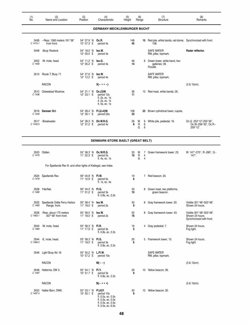
48
(1)No.
(2)Name and Location
(3)Position
(4)Characteristic
(5)Height
(6)Range
(7)Structure
(8)Remarks
3436C 1415.1
- -Rear, 1560 meters 161°36′ from front.
54° 07.9´ N12° 07.3´ E
Oc.R.period 4s
14845
15 Red pile, white bands, red dome; 108.
Synchronized with front.
3448 -Buoy Rostock. 54° 18.0´ N12° 00.0´ E
Iso.W.period 4s
SAFE WATERRW, pillar, topmark.
Radar reflector.
3452C 1405
-W. mole, head. 54° 11.2´ N12° 05.2´ E
Iso.G.period 4s
4614
6 Green tower, white band, two galleries; 39.
Floodlit.
3510 Route T, Buoy 71. 54° 27.6´ N12° 12.2´ E
Iso.W.period 4s
SAFE WATERRW, pillar, topmark.
RACON X(– • • –) (3 & 10cm).
3512C 1436
Ostseebad Wustrow. 54° 21.1´ N12° 23.1´ E
Oc.(3)W.period 12slt. 2s, ec. 1slt. 2s, ec. 1slt. 5s, ec. 1s
3611
13 Red mast, white bands; 26.
3516C 1440
Darsser Ort. 54° 28.4´ N12° 30.1´ E
Fl.(2+4)W.period 22s
10833
23 Brown cylindrical tower, cupola.
3517C 1440.5
-Breakwater. 54° 28.3´ N12° 31.2´ E
Dir.W.R.G.period 4s
268
W. 9R. 6G. 6
White pile, pedestal; 16. Oc.G. 253°12′-255°30′, Oc.W.-256°30′, Oc.R.-259°12′.
DENMARK-STORE BAELT (GREAT BELT)
3520C 1470
Odden. 55° 58.3´ N11° 22.3´ E
Oc.W.R.G.period 5slt. 4s, ec. 1s
3310
W. 7R. 4G. 4
Green framework tower; 23. W. 147°-270°, R.-280°, G.-147°.
For Sjaellands Rev N. and other lights of Kattegat, see Index.
3524C 1476
Sjaellands Rev. 56° 04.8´ N11° 12.9´ E
Fl.W.period 5sfl. 1s, ec. 4s
196
7 Red beacon; 20.
3528C 1480
Yderflak. 56° 04.0´ N11° 01.2´ E
Fl.G.period 3sfl. 0.8s, ec. 2.2s
3310
8 Green mast, two platforms, green beacon.
3532C 1483
Sjaellands Odde Ferry Harbor Range, front.
55° 58.4´ N11° 18.0´ E
Iso.W.period 2s
309
8 Gray framework tower; 20. Visible 351°48′-023°48′.Shown 24 hours.
3536C 1483.1
-Rear, about 175 meters 007°48′ from front.
55° 58.5´ N11° 18.0´ E
Iso.W.period 2s
5216
8 Gray framework tower; 43. Visible 351°48′-023°48′.Shown 24 hours.Synchronized with front.
3540C 1484
-W. mole, head. 55° 58.3´ N11° 17.9´ E
Fl.R.period 3sfl. 0.8s, ec. 2.2s
165
4 Gray pedestal; 7. Shown 24 hours. Fog light.
3544C 1484.2
-E. mole, head. 55° 58.3´ N11° 18.0´ E
Fl.G.period 3sfl. 0.8s, ec. 2.2s
206
5 Framework tower; 10. Shown 24 hours.Fog light.
3546 Light Buoy No 16. 55° 55.2´ N10° 57.2´ E
L.Fl.W.period 10s
SAFE WATERRW, pillar, topmark.
RACON M(– –) (3 & 10cm).
3548C 1497
Hatterrev, DW 3. 55° 54.1´ N10° 51.7´ E
Fl.Y.period 3sfl. 0.8s, ec. 2.2s
299
10 Yellow beacon; 36.
RACON B(– • • • ) (3 & 10cm).
3552C 1497.4
Hatter Barn, DW6. 55° 53.1´ N10° 50.1´ E
Fl.(4)Y.period 10sfl. 0.5s, ec. 0.5sfl. 0.5s, ec. 0.5sfl. 0.5s, ec. 0.5sfl. 0.5s, ec. 6.5s
309
10 Yellow beacon; 30.
GERMANY-MECKLENBURGER BUCHT

49
(1)No.
(2)Name and Location
(3)Position
(4)Characteristic
(5)Height
(6)Range
(7)Structure
(8)Remarks
3556C 1486
Sejero. 55° 55.1´ N11° 04.9´ E
L.Fl.(2)W.period 15sfl. 2.5s, ec. 2.5sfl. 2.5s, ec. 7.5s
10231
12 Yellow round tower; 62. Obscured by land when bearing 301°, 307°-311° and 316°-321°.
3560C 1487.2
-Main basin, W. mole, head. 55° 52.7´ N11° 08.2´ E
F.R. 165
4 Red post. F.Y. range 7M shown in fog.
3564C 1487.1
- -E. mole. 55° 52.8´ N11° 08.2´ E
F.G. 237
4 Green post; 10.
NEKSELO:
3572C 1489
-Range, front. 55° 47.7´ N11° 16.9´ E
Iso.W.period 2s
5918
7 White hut, red band; 7.
3576C 1489.1
- -Rear, 479 meters 175° from front.
55° 47.4´ N11° 17.0´ E
Iso.W.period 4s
10833
8 White hut, red band; 7. Visible 171°-179°.
3580C 1491
-Havsno, N. mole, E. 55° 45.3´ N11° 19.6´ E
F.G. 196
7 Green and white metal post; 13.
3589C 1495
-Fishing harbor. 55° 45.1´ N10° 56.7´ E
Fl.G.period 3s
165
2 White post; 10.
3592C 1498
-Rosnaes Puller. 55° 45.0´ N10° 50.6´ E
Fl.(2)W.period 5s
309
10 Red mast, granite base; 30. Visible 281°06′-278°42′.
3596C 1500
Asnaes. 55° 40.3´ N10° 56.1´ E
Fl.W.period 3sfl. 0.8s, ec. 2.2s
3912
4 White pedestal, red band; 13.
3600C 1504
Gisselore, on point. 55° 40.2´ N11° 04.6´ E
Fl.W.period 3s
134
7 Metal tower, concrete base; 13. Shown 24 hours.
KALUNDBORG HAVN:
3616C 1507.3
-Asnaesvaerket. 55° 39.9´ N11° 04.7´ E
Dir.W.R.G.period 10sfl. 7.5s, ec. 2.5s
4213
W. 12R. 8G. 8
Gray framework mast; 33. Oc.G. 113°31′-115°31′, Oc.W.-116°31′, Oc.R.-118°31′.
2 Dir. Lts. 20 meters apart mark channel on bearing 116°31′ (sectors on second light offset by 1°).
Shown 24 hours.
3618C 1508
- -N. Pier. 55° 39.9´ N11° 05.0´ E
Fl.G.period 3sfl. 0.8s, ec. 2.2s
113
3 Bracket on pier. Shown 24 hours.
3620C 1509
-Indre Range, front. 55° 40.0´ N11° 06.2´ E
Iso.W.period 2s
9027
7 Gray framework tower, red triangular daymark point up; 95.
Shown 24 hours.
3624C 1509.1
- -Rear, 142 meters 090°42′ from front.
55° 40.0´ N11° 06.3´ E
Iso.W.period 4s
10532
7 Gray framework tower, red triangular daymark point down; 105.
Shown 24 hours.
3626C 1509.4
-Oil pier, head. 55° 40.0´ N11° 05.4´ E
Fl.G.period 5s
165
3 Gray mast, platform; 26. Shown 24 hours.
3628C 1510
-Dredged channel entrance Range, front.
55° 40.6´ N11° 05.5´ E
Iso.G.period 2s
3310
5 Gray metal framework tower, red triangular daymark point up; 33.
3632C 1510.1
- -Rear, 125 meters 020°12′ from front.
55° 40.7´ N11° 05.6´ E
Iso.G.period 4s
5617
5 Gray metal framework tower, red triangular daymark point down; 49.
3633C 1510.4
-Dredged channel departure Range, front.
55° 39.9´ N11° 05.1´ E
Iso.G.period 2s
4915
5 Mast on wall, red triangular daymark point up; 39.
Visible 130°12′-270°12′.Shown 24 hours.Dir.Y. visible 180°12′-220°12′.
Illuminates black stripes indicating range line.
3633.1C 1510.41
- -Rear, 121 meters 200°12′ from front.
55° 39.9´ N11° 05.0´ E
Iso.G.period 4s
6219
5 Tank, red triangular daymark point down.
Visible 130°12′-270°12′.Shown 24 hours.
DENMARK-STORE BAELT (GREAT BELT)
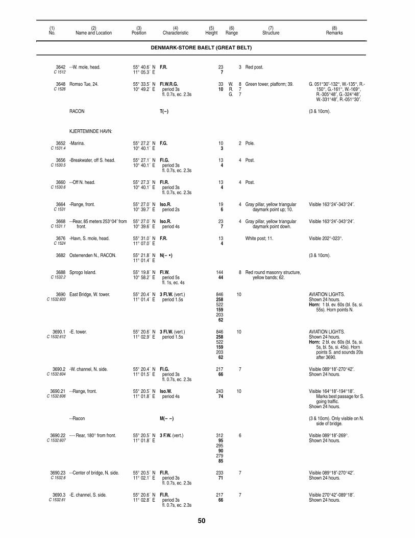
50
(1)No.
(2)Name and Location
(3)Position
(4)Characteristic
(5)Height
(6)Range
(7)Structure
(8)Remarks
3642C 1512
- -W. mole, head. 55° 40.6´ N11° 05.3´ E
F.R. 237
3 Red post.
3648C 1526
Romso Tue, 24. 55° 33.5´ N10° 49.2´ E
Fl.W.R.G.period 3sfl. 0.7s, ec. 2.3s
3310
W. 8R. 7G. 7
Green tower, platform; 39. G. 051°30′-132°, W.-135°, R.-150°, G.-161°, W.-169°, R.-305°48′, G.-324°48′, W.-331°48′, R.-051°30′.
RACON T(–) (3 & 10cm).
KJERTEMINDE HAVN:
3652C 1531.4
-Marina. 55° 27.2´ N10° 40.1´ E
F.G. 103
2 Pole.
3656C 1530.5
-Breakwater, off S. head. 55° 27.1´ N10° 40.1´ E
Fl.G.period 3sfl. 0.7s, ec. 2.3s
134
4 Post.
3660C 1530.6
- -Off N. head. 55° 27.3´ N10° 40.1´ E
Fl.R.period 3sfl. 0.7s, ec. 2.3s
134
4 Post.
3664C 1531
-Range, front. 55° 27.0´ N10° 39.7´ E
Iso.R.period 2s
196
4 Gray pillar, yellow triangular daymark point up; 10.
Visible 163°24′-343°24′.
3668C 1531.1
- -Rear, 85 meters 253°04′ from front.
55° 27.0´ N10° 39.6´ E
Iso.R.period 4s
237
4 Gray pillar, yellow triangular daymark point down.
Visible 163°24′-343°24′.
3676C 1524
-Havn, S. mole, head. 55° 31.0´ N11° 07.0´ E
F.R. 134
White post; 11. Visible 202°-023°.
3682 Osterrenden N., RACON. 55° 21.8´ N11° 01.4´ E
N(– • ) (3 & 10cm).
3688C 1532.2
Sprogo Island. 55° 19.8´ N10° 58.2´ E
Fl.W.period 5sfl. 1s, ec. 4s
14444
8 Red round masonry structure, yellow bands; 62.
3690C 1532.603
East Bridge, W. tower. 55° 20.4´ N11° 01.4´ E
3 Fl.W. (vert.)period 1.5s
846258522159203
62
10 AVIATION LIGHTS. Shown 24 hours.Horn: 1 bl. ev. 60s (bl. 5s, si.
55s). Horn points N.
3690.1C 1532.612
-E. tower. 55° 20.6´ N11° 02.9´ E
3 Fl.W. (vert.)period 1.5s
846258522159203
62
10 AVIATION LIGHTS. Shown 24 hours.Horn: 2 bl. ev. 60s (bl. 5s, si.
5s, bl. 5s, si. 45s). Horn points S. and sounds 20s after 3690.
3690.2C 1532.604
-W. channel, N. side. 55° 20.4´ N11° 01.5´ E
Fl.G.period 3sfl. 0.7s, ec. 2.3s
21766
7 Visible 089°18′-270°42′.Shown 24 hours.
3690.21C 1532.606
- -Range, front. 55° 20.5´ N11° 01.8´ E
Iso.W.period 4s
24374
10 Visible 164°18′-194°18′. Marks best passage for S. going traffic.
Shown 24 hours.
- -Racon M(– –) (3 & 10cm). Only visible on N. side of bridge.
3690.22C 1532.607
- - - Rear, 180° from front. 55° 20.5´ N11° 01.8´ E
3 F.W. (vert.) 31295
29590
27985
6 Visible 089°18′-269°.Shown 24 hours.
3690.23C 1532.6
- -Center of bridge, N. side. 55° 20.5´ N11° 02.1´ E
Fl.R.period 3sfl. 0.7s, ec. 2.3s
23371
7 Visible 089°18′-270°42′.Shown 24 hours.
3690.3C 1532.61
-E. channel, S. side. 55° 20.6´ N11° 02.8´ E
Fl.R.period 3sfl. 0.7s, ec. 2.3s
21766
7 Visible 270°42′-089°18′.Shown 24 hours.
DENMARK-STORE BAELT (GREAT BELT)

51
(1)No.
(2)Name and Location
(3)Position
(4)Characteristic
(5)Height
(6)Range
(7)Structure
(8)Remarks
3690.31C 1532.608
- -Range, front. 55° 20.5´ N11° 02.5´ E
Iso.W.period 4s
24374
10 Visible 344°18′-014°18′. Marks best passage for N. going traffic.
Shown 24 hours.
- -RACON M(– –) (3 & 10cm). Only visible on S. side of bridge.
3690.32C 1532.609
- - - Rear, 000° from front. 55° 20.6´ N11° 02.5´ E
3 F.W. (vert.) 31295
29590
27985
6 Visible 269°18′-089°18′.Shown 24 hours.
3690.33C 1532.601
- -Center of bridge, S. side. 55° 20.5´ N11° 02.1´ E
Fl.G.period 3sfl. 0.7s, ec. 2.3s
23371
7 Visible 270°42′-089°18′.Shown 24 hours.
3692C 1534
Osterrenden S., E28. 55° 19.5´ N11° 02.8´ E
Fl.(3)R.period 10sfl. 1s, ec. 1sfl. 1s, ec. 1sfl. 1s, ec. 5s
3310
9 Red mast, platform.
RACON O(– – –) (3 & 10cm).
HALSSKOV:
3716 -Ferry Pier, W. head. 55° 21.0´ N11° 07.0´ E
Fl.G.period 5sfl. 0.5s, ec. 4.5s
196
Gray metal mast; 3.
KORSOR HAVN:
3724C 1544
-Entrance Range, front. 55° 20.1´ N11° 08.2´ E
F.R. 309
10 Gray column, orange triangular daymark point up; 36.
Visible 068°-080°.Shown 24 hours.
3728C 1544.1
- -Rear, E. ferry berth mole, 198 meters 073°30′ from front.
55° 20.2´ N11° 08.4´ E
F.R. 5918
11 Gray column, orange triangular daymark point down; 56.
Visible 068°-080°.Shown 24 hours.
3732C 1545.4
-Detached breakwater, N. head.
55° 20.0´ N11° 07.0´ E
Fl.G.period 3s
165
4 Framework structure; 7. Fog light on breakwater.
3736C 1545.5
- -S. head. 55° 19.9´ N11° 07.4´ E
F.R. 165
4 Framework structure, gray base; 7.
3740C 1545
-Lygtepulle, breakwater, N. head.
55° 20.1´ N11° 07.4´ E
Fl.R.period 3s
165
4 Framework structure; 7. Fog light on mole.
3744C 1552
-Korsor Yachthaven. 55° 19.7´ N11° 07.7´ E
Fl.R.period 3s
165
4 Red post.
3748C 1553
- -S. mole, N. head. 55° 19.7´ N11° 07.8´ E
Fl.G.period 3sfl. 0.7s, ec. 2.3s
134
2 Green mast; 10.
3750 Vestbro Bridge, RACON. 55° 18.6´ N10° 53.8´ E
T(–) (3 & 10cm).Racons on each side of bridge
mark center of channel.
3752C 1556
Knudshoved. 55° 17.4´ N10° 51.1´ E
Oc.W.R.G.period 10slt. 6s, ec. 4s
5216
W. 12R. 10G. 10
White square tower; 39. G. 220°-269°, W.-276°, R.-305°30′, G.-359°, W.-003°30′, R.-095°.
Partially obscured 072°-080°.
NYBORG FJORD:
3772C 1562
-Slipshavn, on point. 55° 17.1´ N10° 49.5´ E
Fl.G.period 3sfl. 0.7s, ec. 2.3s
3310
7 White framework tower, red band; 20.
Visible 259°-180°.
3776C 1564
-Range, front. 55° 18.0´ N10° 46.9´ E
Iso.W.period 2s
134
9 Beacon, white round daymark; 30.
Visible 216°-036°.
DENMARK-STORE BAELT (GREAT BELT)

52
(1)No.
(2)Name and Location
(3)Position
(4)Characteristic
(5)Height
(6)Range
(7)Structure
(8)Remarks
3780C 1564.1
- -Jomfruhoj, rear, 55 meters 306° from front.
55° 18.0´ N10° 46.8´ E
Iso.W.period 2s
4313
9 White beacon, white round daymark; 16.
Visible 216°-036°.
-Avernakke Pynt.
3796C 1572
- -Dynen. 55° 18.0´ N10° 47.6´ E
Fl.R.period 3sfl. 0.7s, ec. 2.3s
134
7 Dolphin; 7. Visible 152°30′-005°30′.
3804C 1566
- -Mole, head. 55° 18.0´ N10° 48.0´ E
Oc.W.R.G.period 5slt. 4s, ec. 1s
206
W. 9R. 6G. 6
Gray framework structure, orange neon triangular daymark point up; 10.
W. 327°54′-334°42′, R.- 338°12′, G.-327°54′.
Daymark shown 24 hours.
-Nyborg Havn:
3812C 1566.3
- -S. mole, head. 55° 18.3´ N10° 47.4´ E
F.R. 165
4 Gray post; 7.
3820C 1578
- -W. side of entrance of Vester Havn, outer mole, E. head.
55° 18.4´ N10° 47.5´ E
F.R. 175
4 Post; 13.
3830C 1532
-Sprogo Harbor, S. mole. 55° 19.8´ N10° 58.2´ E
Fl.R.period 3sfl. 0.7s, ec. 2.3s
165
4 Gray mast; 26.Floodlit.
3832C 1588
Lundeborg Havn. 55° 08.3´ N10° 47.3´ E
F.G. 175
White post.
SVENDBORG SUND:
3836C 1590
-Elsehoved. 55° 06.1´ N10° 46.5´ E
Oc.W.R.G.period 5slt. 4s, ec. 1s
3310
W. 12R. 9G. 9
Red round metal tower, white bands; 26.
G. 188°-215°, W.-014°, R.-029°.
3840C 1634
-Taasinge Range, front. 55° 01.7´ N10° 39.4´ E
Iso.R.period 2s
3611
14 Red framework mast, white stripes, red triangular daymark point up.
Visible 279°-287°.Shown 24 hours, Sep. 1 to
Apr. 1.
3844C 1634.1
- -Rear, 223 meters 283° from front.
55° 01.7´ N10° 39.2´ E
Iso.R.period 4s
4915
14 Red post, white stripes, red triangular daymark point down.
Visible 279°-287°.Shown 24 hours, Sep. 1 to
Apr. 1.
3848C 1612
-Marodde. 55° 02.0´ N10° 39.0´ E
F.W.R.G. 134
W. 12R. 9G. 9
White post, red band; 10. G. 000°-059°, R.-140°, G.-151°, W.-154°, R.-164°.
Partially obscured 006°-008°36′.
Shown 24 hours, Sep. 1 to Apr. 1.
3852C 1614
-Troense. 55° 02.0´ N10° 38.9´ E
Iso.W.R.G.period 2s
134
W. 8R. 6G. 6
White post, red band; 10. G. 118°-174°, W.-177°, R.-188°30′, G.-221°, R.-255°.
Shown 24 hours, Sep. 1 to Apr. 1.
3864C 1624
-Grasten Range, front. 55° 31.0´ N11° 07.3´ E
F.R. 3611
9 White post; 13. Shown 24 hours, Sep. 1 to Apr. 1.
3868C 1624.1
- -Rear, 178 meters 105° from front.
55° 02.1´ N10° 40.3´ E
F.R. 6219
8 White post; 20. Shown 24 hours, Sep. 1 to Apr. 1.
-Kristiansminde:
3876C 1606
- -N. and E., front. 55° 04.0´ N10° 38.0´ E
F.W.R.G. 134
W. 12R. 8G. 8
Red post, white stripes. G. 263-084°30′, W.-090°30′, R.-175°30′.
Shown 24 hours, Sep. 1 to Apr. 1.
3878C 1606.1
- - -N. Range, rear, 108 meters 346° from front.
55° 03.6´ N10° 38.3´ E
F.G. 237
9 Red post, white stripes. Shown 24 hours, Sep. 1 to Apr. 1.
-Svendborg Havn:
3884C 1600
- -Frederikso, E. point. 55° 04.0´ N10° 37.0´ E
Fl.R.period 3sfl. 0.3s, ec. 2.7s
227
3 Post. Shown 24 hours, Sep. 1 to Apr. 1.
DENMARK-STORE BAELT (GREAT BELT)

53
(1)No.
(2)Name and Location
(3)Position
(4)Characteristic
(5)Height
(6)Range
(7)Structure
(8)Remarks
3888C 1591
-St. Jorgens. 55° 02.9´ N10° 35.8´ E
Oc.(2)W.R.G.period 6slt. 1s, ec. 1slt. 3s, ec. 1s
278
W. 12R. 9G. 9
White hut, red band, on wooden piles.
G. 053°30′-058°30′, W.-060°30′, R.-066°.
Shown 24 hours, Sep. 1 to Apr. 1.
3892C 1594.6
-Vindebyore Range, N. front, close N. of Vindeby.
55° 03.2´ N10° 37.4´ E
Iso.W.period 2s
134
12 White post, red band; 10. Shown 24 hours, Sep. 1 to Apr. 1.
3896C 1594.7
- -Rear, 203 meters 061° from front.
55° 03.2´ N10° 37.5´ E
Iso.W.period 4s
3310
12 White post, red band; 30. Shown 24 hours, Sep. 1 to Apr. 1.
3900C 1595
-East Bratten Range, front. 55° 03.0´ N10° 37.0´ E
F.G. 319
9 White post, red band, white triangular daymark point up; 16.
Shown 24 hours, Sep. 1 to Apr. 1.
3904C 1595.1
- -Rear, 130 meters 205° from front.
55° 02.8´ N10° 36.6´ E
F.G. 4915
9 White beacon, red band, white triangular daymark point down; 13.
Shown 24 hours, Sep. 1 to Apr. 1.
3908C 1594.2
-West Bratten Range, front. 55° 03.0´ N10° 36.0´ E
Iso.G.period 2s
134
9 White post, red band, white triangular daymark point up; 13.
Shown 24 hours, Sep. 1 to Apr. 1.
3912C 1594.3
- -Rear, 152 meters 068°30′ from front.
55° 02.8´ N10° 36.5´ E
Iso.G.period 4s
278
8 White beacon, red band, white triangular daymark point down; 16.
Shown 24 hours, Sep. 1 to Apr. 1.
3916C 1594
-Tankefuld Range, front. 55° 02.0´ N10° 34.0´ E
F.R. 103
7 White post, red band; 10. Shown 24 hours, Sep. 1 to Apr. 1.
3920C 1594.1
- -Rear, 56 meters 269° from front.
55° 02.4´ N10° 33.9´ E
F.R. 185
7 White post, red band; 16. Shown 24 hours, Sep. 1 to Apr. 1.
3924C 1022
-Baekkehave, NW. side of Tassinge.
55° 01.0´ N10° 32.7´ E
Oc.W.R.G.period 5slt. 4s, ec. 1s
206
W. 12R. 9G. 9
White hut, red band; 20. G. 095°-100°, W.-105°, R.-107°.
Shown 24 hours, Sep. 1 to Apr. 1.
3924.5C 1594.13
-Vesterron, E. mole. 55° 02.0´ N10° 32.0´ E
F.G. 103
3 Gray mast; 10.Floodlit.
3924.7C 1594.17
-Ratzausminde. 55° 02.0´ N10° 32.5´ E
Fl.G.period 3sfl. 0.7s, ec. 2.3s
134
3 Green mast; 13. Shown 24 hours, Sep. 1 to Apr. 1.
3925C 1594.15
-Rantzavsminde. 55° 02.1´ N10° 32.7´ E
F.R. 165
4 Red post; 7. Shown 24 hours, Sep. 1 to Apr. 1.
FYN:
3926C 1020.5
-Ballen. 55° 02.0´ N10° 28.0´ E
F.R. 165
2 Red mast; 13.Floodlit.
3927C 1021.4
-Skaro cable Range, front. 55° 00.6´ N10° 28.2´ E
F.R. 237
4 Beacon; 20. Visible 124°-304°.Shown 24 hours.
3927.1C 1021.41
- -Rear, 75 meters 214° from front.
55° 00.6´ N10° 28.1´ E
F.R.W. (vert.) 3611
4 Beacon; 33. Visible 124°-304°.Shown 24 hours.2 meters apart.
LANGELAND:
3928 -Langelandsbaelt, RACON. 54° 48.2´ N10° 50.3´ E
O(– – –) (3 & 10cm).
3932C 1673.3
-Hojbjerg E. 54° 52.7´ N10° 50.0´ E
Fl.R.G.period 5sfl. 1s, ec. 4s
3310
R. 8G. 7
Green metal mast, platform; 33. R. 002°30′-201°, G.-002°30′.
-RACON G(– – • ) (3 & 10cm).
3936C 1671
-Spodsbjaerg Ferry Harbor. 54° 56.1´ N10° 50.2´ E
Fl.G.period 3s
165
2 White metal framework tower; 10.
Fog detector light.
3940C 1671.7
- -Range, front. 54° 56.1´ N10° 50.0´ E
F.R. 237
4 Gray framework tower, red triangular daymark point up; 33.
DENMARK-STORE BAELT (GREAT BELT)

54
(1)No.
(2)Name and Location
(3)Position
(4)Characteristic
(5)Height
(6)Range
(7)Structure
(8)Remarks
3944C 1671.71
- - -Rear, 95 meters 286°30′ from front.
54° 56.1´ N10° 49.9´ E
F.R. 309
4 Gray framework tower, red triangular daymark point down; 33.
3948C 1671.65
- -Fishing harbor, N. pier, head. 54° 56.0´ N10° 50.1´ E
F.G. 185
4 Green mast; 16.Floodlit.
F.R. 4M marks S. pier head.
3952C 1673
-Spodsbjerg SE. 54° 55.2´ N10° 50.6´ E
Fl.W.R.G.period 3sfl. 0.7s, ec. 2.3s
3310
W. 8R. 7G. 7
Yellow metal mast, platform; 33. R. 001°30′-217°, G.-231°, W.-235°, R.-240°, G.-001°30′.
3956C 1672.5
-Bostrup E., DW 47. 55° 02.7´ N10° 59.3´ E
Fl.R.G.period 5sfl. 1s, ec. 4s
3310
8 Green metal mast, platform; 33. R. 009°30′-179°, G.-009°30′.
-RACON K(– • –) (3 & 10cm).
3960C 1672
-Langelandsbaelt N., DW 40. 55° 07.7´ N10° 59.9´ E
Fl.R.G.period 3sfl. 0.7s, ec. 2.3s
3310
8 Red metal mast, platform; 33. R. 001°30′-180°, G.-001°30′.
3964C 1668
-Hov. 55° 08.8´ N10° 57.3´ E
Iso.W.R.G.period 4s
3912
W. 16R. 13G. 13
White round tower, red band; 39. R. 210°-226°30′, G.-232°30′, W.-237°, R.-308°30′, G.-341°, W.-346°, R.-010°.
3968C 1656
-Frankeklint. 55° 09.6´ N10° 55.9´ E
Oc.R.G.period 5slt. 4s, ec. 1s
5216
8 White dwelling; 13. G. 039°-047°, R.-151°, G.-178°, R.-219°.
-Lohals Havn:
3972C 1658
- -Near root of S. mole. 55° 08.1´ N10° 54.1´ E
Iso.W.R.G.period 2s
268
W. 9R. 7G. 7
White square tower; 30. G. 031°-095°, W.-101°, R.-182°, partially obscured 031°-046°.
3976C 1660
- -Outer breakwater, head. 55° 08.0´ N10° 54.0´ E
F.R. White post; 7.
3980C 1661
- -90 meters 234° from root of S. mole.
55° 08.1´ N10° 54.1´ E
F.G. 165
1 Black post; 7.
3984C 1662
-Dagelokke Havn Range, front. 55° 03.7´ N10° 51.8´ E
F.G. 165
4 Gray mast; 16. Visible 052°06′-192°06′.Shown Apr. 1 to Nov. 15.
3988C 1662.1
- -Rear, 77 meters 122°06′ from front.
55° 03.8´ N10° 51.8´ E
F.G. 237
4 Mast on white hut. Visible 052°06′-192°06′.Shown Apr. 1 to Nov. 15.
RUDKOBING LOB:
3992C 1674
-NE. Sio, Range front. 54° 57.5´ N10° 41.8´ E
Iso.W.period 2s
134
4 White mast, red triangular daymark point up, white stripe; 16.
3996C 1674.1
- -Rear, 454 meters 205°24′ from front.
54° 57.2´ N10° 41.6´ E
Iso.W.period 4s
3912
4 Gray framework tower, red triangular daymark point down, white stripe; 33.
4000C 1686
-Range, front. 54° 56.7´ N10° 43.0´ E
Iso.G.period 2s
3611
4 Post, white triangular daymark point up, orange border; 23.
4004C 1686.1
- -Rear, 456 meters 167°36′ from front.
54° 56.5´ N10° 43.1´ E
Iso.G.period 4s
5617
4 Gray framework tower, white triangular daymark point down, orange border; 43.
4008C 1690
-N. mole Range, front. 54° 56.4´ N10° 42.3´ E
F.R. 237
4 Gray mast, red triangular daymark point up; 16.
4012C 1690.1
- -Rear, 214 meters 188°42′ from front.
54° 56.2´ N10° 42.3´ E
F.R. 4614
4 Gray post, red triangular daymark point down; 39.
-Rudkobing Havn:
4016C 1702
- -S. Channel Range, front. 54° 56.3´ N10° 42.2´ E
F.R. 165
4 Gray post, red triangular daymark point up; 10.
Visible 343°42′-123°42′.
4020C 1702.1
- - -Rear, 123 meters 053°42′ from front.
54° 56.3´ N10° 42.3´ E
F.R. 268
4 Square mast, red triangular daymark point down; 20.
Visible 343°42′-123°42′.
DENMARK-STORE BAELT (GREAT BELT)
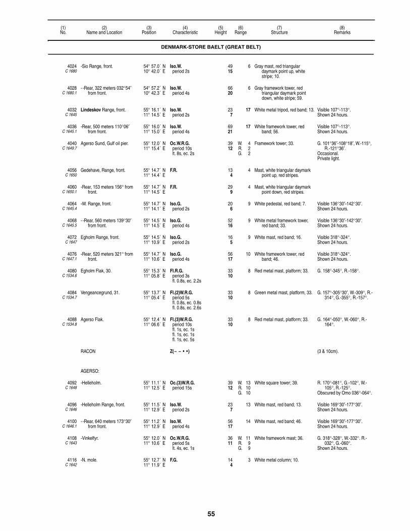
55
(1)No.
(2)Name and Location
(3)Position
(4)Characteristic
(5)Height
(6)Range
(7)Structure
(8)Remarks
4024C 1680
-Sio Range, front. 54° 57.0´ N10° 42.0´ E
Iso.W.period 2s
4915
6 Gray mast, red triangular daymark point up, white stripe; 10.
4028C 1680.1
- -Rear, 322 meters 032°54′ from front.
54° 57.2´ N10° 42.3´ E
Iso.W.period 4s
6620
6 Gray framework tower, red triangular daymark point down, white stripe; 59.
4032C 1645
Lindeskov Range, front. 55° 16.1´ N11° 14.5´ E
Iso.W.period 2s
237
17 White metal tripod, red band; 13. Visible 107°-113°.Shown 24 hours.
4036C 1645.1
-Rear, 500 meters 110°06′ from front.
55° 16.0´ N11° 15.0´ E
Iso.W.period 4s
6921
17 White framework tower, red band; 56.
Visible 107°-113°.Shown 24 hours.
4040C 1649.7
Agerso Sund, Gulf oil pier. 55° 12.0´ N11° 15.4´ E
Oc.W.R.G.period 10slt. 8s, ec. 2s
3912
W. 4R. 2G. 2
Framework tower; 33. G. 101°36′-108°18′, W.-115°, R.-121°36′.
Occasional. Private light.
4056C 1650
Gedehave, Range, front. 55° 14.7´ N11° 14.4´ E
F.R. 134
4 Mast, white triangular daymark point up, red stripes.
4060C 1650.1
-Rear, 153 meters 156° from front.
55° 14.7´ N11° 14.5´ E
F.R. 299
4 Mast, white triangular daymark point down, red stripes.
4064C 1645.4
-W. Range, front. 55° 14.7´ N11° 14.1´ E
Iso.G.period 2s
206
9 White pedestal, red band; 7. Visible 136°30′-142°30′.Shown 24 hours.
4068C 1645.5
- -Rear, 560 meters 139°30′ from front.
55° 14.5´ N11° 14.5´ E
Iso.G.period 4s
5216
9 White metal framework tower, red band; 33.
Visible 136°30′-142°30′.Shown 24 hours.
4072C 1647
Egholm Range, front. 55° 14.5´ N11° 10.9´ E
Iso.G.period 2s
165
9 White mast, red band; 16. Visible 318°-324°.Shown 24 hours.
4076C 1647.1
-Rear, 520 meters 321° from front.
55° 14.7´ N11° 10.6´ E
Iso.G.period 4s
5617
10 White framework tower, red band; 46.
Visible 318°-324°.Shown 24 hours.
4080C 1534.6
Egholm Flak, 30. 55° 15.3´ N11° 05.8´ E
Fl.R.G.period 3sfl. 0.8s, ec. 2.2s
3310
8 Red metal mast, platform; 33. G. 158°-345°, R.-158°.
4084C 1534.7
Vengeancegrund, 31. 55° 13.7´ N11° 05.4´ E
Fl.(2)W.R.G.period 5sfl. 0.8s, ec. 0.8sfl. 0.8s, ec. 2.6s
3310
8 Green metal mast, platform, 33. G. 157°-305°30′, W.-309°, R.-314°, G.-355°, R.-157°.
4088C 1534.8
Agerso Flak. 55° 12.4´ N11° 06.6´ E
Fl.(3)W.R.G.period 10sfl. 1s, ec. 1sfl. 1s, ec. 1sfl. 1s, ec. 5s
3310
8 Red metal mast, platform; 33. G. 164°-050°, W.-060°, R.-164°.
RACON Z(– – • •) (3 & 10cm).
AGERSO:
4092C 1648
-Helleholm. 55° 11.1´ N11° 12.5´ E
Oc.(3)W.R.G.period 15s
3912
W. 13R. 10G. 10
White square tower; 39. R. 170°-081°, G.-102°, W.-105°, R.-125°.
Obscured by Omo 036°-064°.
4096C 1646
-Helleholm Range, front. 55° 11.5´ N11° 12.9´ E
Iso.W.period 2s
237
13 White mast, red band; 13. Visible 169°30′-177°30′.Shown 24 hours.
4100C 1646.1
- -Rear, 640 meters 173°30′ from front.
55° 11.2´ N11° 12.9´ E
Iso.W.period 4s
5617
14 White mast, red band; 46. Visible 169°30′-177°30′.Shown 24 hours.
4108C 1643
-Vinkelfyr. 55° 12.0´ N11° 10.6´ E
Oc.W.R.G.period 5slt. 4s, ec. 1s
3611
W. 11R. 9G. 9
White framework mast; 36. G. 318°-328°, W.-332°. R.-032°, G.-060°.
Shown 24 hours.
4116C 1642
-N. mole. 55° 12.7´ N11° 11.9´ E
F.G. 144
3 White metal column; 10.
DENMARK-STORE BAELT (GREAT BELT)

56
(1)No.
(2)Name and Location
(3)Position
(4)Characteristic
(5)Height
(6)Range
(7)Structure
(8)Remarks
OMO:
4120C 1640
-Langelands Ore. 55° 09.6´ N11° 08.0´ E
Oc.(2)W.R.G.period 12slt. 2s, ec. 2slt. 6s, ec. 2s
6921
W. 17R. 14G. 14
Yellow round tower; 72. G. 266°-271°, W.-283°, R.-291°, G.-296°, W.-304°30′, R.-006°, G.-101°, W.-104°, R.-118°, G.-133°, W.-138°30′, R.-146°, G.-162°, W.-165°30′, R.-183°, G.-220°.
4124C 1638
-Omo Havn. 55° 10.3´ N11° 09.6´ E
Oc.W.R.G.period 5slt. 4s, ec. 1s
165
W. 6R. 4G. 4
Green framework mast; 10. W. 146°-180°, R.-228°, G.-146°.
ONSEVIG HAVN:
4136C 1730
-W. mole, head. 54° 56.8´ N11° 06.4´ E
F.R. 124
2 Mast; 20.
4140C 1726
-N. corner of harbor Range, front.
54° 56.8´ N11° 06.5´ E
F.G. 134
4 Post.
4144C 1726.1
- -Rear, S. mole, 112 meters 158° from front.
54° 56.9´ N11° 06.4´ E
F.G. 268
4 Post.
4148C 1720.4
-Lango Range, front. 54° 49.0´ N11° 00.0´ E
F.R. 268
6 Red mast, orange triangular daymark point up; 20.
Visible 161°36′-191°36′.
4152C 1720.41
- -Rear, 365 meters 176°36′ from front.
54° 49.0´ N10° 59.8´ E
F.R. 3310
6 Framework tower, orange triangular daymark point down; 33.
Visible 161°36′-191°36′.
4164C 1718
-Enehoje Islet Range, front. 54° 50.3´ N11° 00.9´ E
Iso.W.period 2s
5316
8 Orange tripod, orange triangular daymark point up; 52.
4168C 1718.1
- -Rear, 400 meters 119°24° from front.
54° 50.2´ N11° 01.2´ E
Iso.W.period 4s
7222
8 Orange framework tower, orange triangular daymark point down; 72.
4168.5C 1718.3
-Enehoje S. Range, front. 54° 50.0´ N11° 01.1´ E
Iso.G.period 2s
268
4 Pile, red triangular daymark point up; 13.
4168.51C 1718.31
- -Rear, 191 meters 095°30′ from front.
54° 50.0´ N11° 01.2´ E
Iso.G.period 4s
3611
4 Framework tower, red triangular daymark point down; 30.
4170C 1712
-Taars Ferry Range, front. 54° 52.5´ N11° 01.9´ E
F.R. 3310
8 Gray framework mast, orange triangular daymark point up; 23.
4171C 1712.1
- -Rear, 118 meters 085° from front.
54° 52.6´ N11° 02.0´ E
F.R. 4614
8 Gray framework mast, orange triangular daymark point down; 49.
4172C 1719
-Ramso Range, common front. 54° 50.0´ N11° 02.0´ E
F.W.G. 103
W. 8G. 6
Concrete base, orange triangular daymark point up; 3.
W. 259°-274°, G.-259°.
4176C 1718.9
- -Bogo, rear, 1000 meters 131°30′ from common front.
54° 49.1´ N11° 02.2´ E
F.G. 3310
6 Framework tower, orange triangular daymark point down; 30.
4180C 1719.1
- -Vesteroode, rear, 2.47 km. 264° from common front.
54° 49.0´ N10° 59.0´ E
F.W. 3310
9 Framework tower, orange triangular daymark point down; 30.
Leads through dredged channel to Barneholm. F.R. light is shown from head of E. mole at Lango Havn.
4184C 1719.4
-Rosnaes Range, front. 54° 50.0´ N11° 06.3´ E
Iso.W.period 2s
134
4 Red post, orange triangular daymark point up.
Visible 056°18′-071°18′.
4188C 1719.41
- -Rear, 265 meters 063°48′ from front.
54° 50.0´ N11° 06.5´ E
Iso.W.period 4s
309
4 Gray framework mast, orange triangular daymark point down; 33.
Visible 056°18′-071°18′.
DENMARK-STORE BAELT (GREAT BELT)

57
(1)No.
(2)Name and Location
(3)Position
(4)Characteristic
(5)Height
(6)Range
(7)Structure
(8)Remarks
LANGELAND:
4192C 1706
-Keldsnor. 54° 43.9´ N10° 43.3´ E
Fl.(2)W.period 15s
12839
17 White square tower; 112. Visible 200°-116°.Partially obscured 098°-135°.
-Auxiliary. Oc.W.R.G.period 5slt. 4s, ec. 1s
7222
W. 12R. 9G. 9
G. 218°-222°, W.-226°, R.-230°.
4196C 1708
-Bagenkop Havn. 54° 45.2´ N10° 40.2´ E
Fl.G.period 3s
206
4 Green framework mast; 33.Floodlit.
4197C 1708.5
- -E. pier, head. 54° 45.2´ N10° 40.4´ E
Fl.R.period 3s
216
4 Red framework mast; 10.Floodlit.
4208C 1710
- -Range, front. 54° 45.2´ N10° 40.4´ E
Iso.W.R.G.period 4s
3310
W. 8R. 5G. 5
Gray framework tower, red triangular daymark point up; 23.
G. 079°-099°, W.-106°, R.-126°.
4212C 1710.1
- - -Rear, 102°18′ from front. 54° 45.2´ N10° 40.5´ E
Iso.W.period 4s
4313
6 Gray framework tower, red triangular daymark point down; 49.
Visible 077°18′-127°18′.Synchronized with front.
4216C 1732
Vejro. 55° 02.3´ N11° 22.2´ E
Oc.W.R.G.period 5s
6219
W. 16R. 13G. 13
White hexagonal tower; 52. G. 154°-198°, W.-215°, R.-240°30′, G.-270°, W.-278°, R.-287°, G.-304°, R.-320°, G.-079°30′, W.-089°30′, R.-106°, G.-143°, W.-146°, R.-154°, obscured 295°-063°.
4220C 1723
-Range, front. 54° 55.1´ N11° 21.2´ E
F.R. 134
4 Mast, round daymark; 13. Visible 184°30′-244°30′.Marks cable to Fejo.
4224C 1723.1
- -Rear, 94 meters 214°30′ from front.
54° 55.1´ N11° 21.1´ E
F.R.W. (vert.) 268
4 Metal mast, round and diamond daymarks; 26.
Visible 184°30′-244°30′.2 meters apart.
4225C 1721.7
Kragenaes, Ferry Harbor Range, front.
54° 55.0´ N11° 21.6´ E
Iso.R.period 2s
237
4 Mast; 16. Visible 266°06′-272°06′.Shown 24 hours.
4225.1C 1721.71
-Rear, 59 meters 269°06′ from front.
54° 55.0´ N11° 21.5´ E
Iso.R.period 4s
3310
4 Mast; 26. Visible 266°06′-272°06′.Shown 24 hours.
FEMO HAVN:
4228C 1741
-ESE. of harbor Range, front. 54° 58.0´ N11° 31.0´ E
F.G. 165
5 Gray post, orange triangular daymark point up.
Visible 051°-141°.
4232C 1742
- -Rear, 120 meters 096° from front.
54° 58.3´ N11° 31.1´ E
F.G. 268
5 Gray framework mast, orange triangular daymark point down.
Visible 051°-141°.
4236C 1740
-W. mole. 54° 58.3´ N11° 30.8´ E
F.R. 144
Post; 10. Visible 338°-146°.
DENMARK-SMAALANDS FARVANDET
4240C 1734
Skalo Harbor, W. mole, head. 54° 57.4´ N11° 21.4´ E
F.W. 103
2 Red tower, white stripes; 7.
4248C 1752
Bandholm Channel Range, front.
54° 53.0´ N11° 27.1´ E
Iso.W.period 2s
206
8 Red post, red triangular daymark point up; 16.
Visible 289°12′-326°12′.
4252C 1752.1
-Rear, 110 meters 312°42′ from front.
54° 53.0´ N11° 27.0´ E
Iso.W.period 4s
4313
8 Red mast, red triangular daymark point down; 23.
Visible 289°12′-326°12′.
FEJO HAVN:
4256C 1736
-Range, front. 54° 56.7´ N11° 26.1´ E
Iso.R.period 2s
Building
DENMARK-STORE BAELT (GREAT BELT)
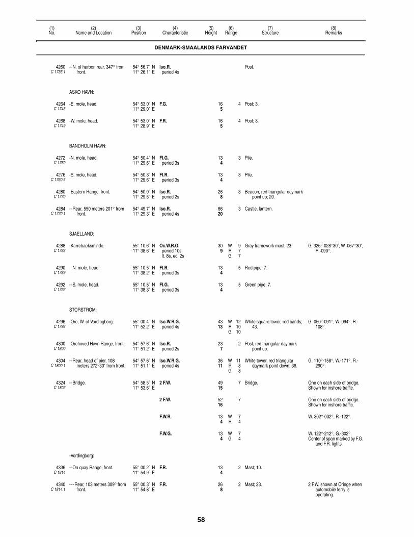
58
(1)No.
(2)Name and Location
(3)Position
(4)Characteristic
(5)Height
(6)Range
(7)Structure
(8)Remarks
4260C 1736.1
- -N. of harbor, rear, 347° from front.
54° 56.7´ N11° 26.1´ E
Iso.R.period 4s
Post.
ASKO HAVN:
4264C 1748
-E. mole, head. 54° 53.0´ N11° 29.0´ E
F.G. 165
4 Post; 3.
4268C 1749
-W. mole, head. 54° 53.0´ N11° 28.9´ E
F.R. 165
4 Post; 3.
BANDHOLM HAVN:
4272C 1760
-N. mole, head. 54° 50.4´ N11° 29.6´ E
Fl.G.period 3s
134
3 Pile.
4276C 1760.5
-S. mole, head. 54° 50.3´ N11° 29.6´ E
Fl.R.period 3s
134
3 Pile.
4280C 1770
-Eastern Range, front. 54° 50.0´ N11° 29.5´ E
Iso.R.period 2s
268
3 Beacon, red triangular daymark point up; 20.
4284C 1770.1
- -Rear, 550 meters 201° from front.
54° 49.7´ N11° 29.3´ E
Iso.R.period 4s
6620
3 Castle, lantern.
SJAELLAND:
4288C 1788
-Karrebaeksminde. 55° 10.6´ N11° 38.6´ E
Oc.W.R.G.period 10slt. 8s, ec. 2s
309
W. 9R. 7G. 7
Gray framework mast; 23. G. 326°-028°30′, W.-067°30′, R.-090°.
4290C 1789
- -N. mole, head. 55° 10.5´ N11° 38.2´ E
Fl.R.period 3s
134
5 Red pipe; 7.
4292C 1792
- -S. mole, head. 55° 10.5´ N11° 38.3´ E
Fl.G.period 3s
134
5 Green pipe; 7.
STORSTROM:
4296C 1798
-Ore, W. of Vordingborg. 55° 00.4´ N11° 52.2´ E
Iso.W.R.G.period 4s
4313
W. 12R. 10G. 10
White square tower, red bands; 43.
G. 050°-091°, W.-094°, R.-108°.
4300C 1800
-Orehoved Havn Range, front. 54° 57.6´ N11° 51.2´ E
Iso.R.period 2s
237
2 Post, red triangular daymark point up.
4304C 1800.1
- -Rear, head of pier, 108 meters 272°30′ from front.
54° 57.6´ N11° 51.1´ E
Iso.W.R.G.period 4s
3611
W. 11R. 8G. 8
White tower, red triangular daymark point down; 36.
G. 110°-158°, W.-171°, R.-290°.
4324C 1802
- -Bridge. 54° 58.5´ N11° 53.6´ E
2 F.W. 4915
7 Bridge. One on each side of bridge. Shown for inshore traffic.
2 F.W. 5216
7 One on each side of bridge.Shown for inshore traffic.
F.W.R. 134
W. 7R. 4
W. 302°-032°, R.-122°.
F.W.G. 134
W. 7G. 4
W. 122°-212°, G.-302°.Center of span marked by F.G.
and F.R. lights.
-Vordingborg:
4336C 1814
- -On quay Range, front. 55° 00.2´ N11° 54.9´ E
F.R. 134
2 Mast; 10.
4340C 1814.1
- - -Rear, 103 meters 309° from front.
55° 00.3´ N11° 54.8´ E
F.R. 268
2 Mast; 23. 2 F.W. shown at Oringe when automobile ferry is operating.
DENMARK-SMAALANDS FARVANDET

59
(1)No.
(2)Name and Location
(3)Position
(4)Characteristic
(5)Height
(6)Range
(7)Structure
(8)Remarks
4344C 1815
-Water tower. 55° 00.7´ N11° 55.3´ E
F.R. 17152
7 Water tower; 164.
GRONSUND:
-Stubbekobing:
4348C 1856
- -W. of village. 54° 53.6´ N12° 01.6´ E
Iso.W.R.G.period 4s
165
W. 12R. 9G. 9
White house, red band. G. 147°-150°, W.-152°, R.-179°.
4352C 1857
- -W. mole Range, front. 54° 53.6´ N12° 02.7´ E
F.G. 103
Post; 3. Visible 086°-266°.Marks dredged channel.Shown when harbor is clear of
ice.
4356C 1857.1
- - -Rear, 130 meters 176° from front.
54° 53.5´ N12° 02.7´ E
F.G. 237
Gray framework tower; 23. Visible 086°-266°.
4360C 1854
-Bogo Havn Range, front. 54° 54.8´ N12° 03.1´ E
F.G. 3310
4364C 1854.1
- -Rear, 355° from front. 54° 54.8´ N12° 03.1´ E
F.G. 3912
KALVEHAVE HAVN:
4368C 1844
-E. mole, head. 55° 00.0´ N12° 10.0´ E
F.G. 134
4 Post; 10.
4372C 1845
-SW. mole, head. 54° 59.7´ N12° 10.1´ E
F.R. 134
4 Post; 10.
4376C 1846
-W. mole, head. 54° 59.6´ N12° 10.1´ E
Fl.G.period 3sfl. 0.3s, ec. 2.7s
134
4 Mast; 7. Siren: (on Ulvsand bridge 500 meters SW.) 1 bl. ev. 30s.
STEGE HAVN:
4380C 1826
-N. Harbor. 54° 59.0´ N12° 17.0´ E
F.R. 82
White post; 3.
4384C 1828
- -S. mole, head. 54° 59.1´ N12° 16.9´ E
F.G. 82
White post; 3.
4392C 1838
Nyord, W. mole. 55° 02.4´ N12° 11.7´ E
F.R. 103
4 Black mast; 7. Occasional.
4394 Rodby Harbor Approach Buoy. 54° 38.3´ N11° 19.2´ E
L.Fl.W.period 10s
SAFE WATERRW, pillar, topmark.
RACON Long dash (—)period 120s
10
DENMARK-BALTIC SEA
LOLLAND:
4395C 2219
-Kramnitse Havn, W. mole, head.
54° 42.3´ N11° 14.9´ E
Fl.R.period 3s
134
3 Red pole.
-Rodby Havn:
4396C 2216
- -Entrance Range, front. 54° 39.2´ N11° 21.0´ E
Iso.R.period 2s
5617
6 Gray framework tower, red triangular daymark point up.
Visible 030°12′-060°12′.
4400C 2216.1
- - -Rear, 300 meters 045°12′ from front.
54° 39.3´ N11° 21.3´ E
Iso.R.period 4s
8526
6 Gray framework tower, red triangular daymark point down.
Visible 030°12′-060°12′.Synchronized with front.
DENMARK-SMAALANDS FARVANDET

60
(1)No.
(2)Name and Location
(3)Position
(4)Characteristic
(5)Height
(6)Range
(7)Structure
(8)Remarks
4404C 2218
- -W. mole, head. 54° 39.0´ N11° 20.7´ E
F.R. 268
5 Red framework mast; 16.
4408C 2218.2
- -E. mole, head. 54° 39.0´ N11° 20.7´ E
F.G. 268
5 Green framework mast, hut; 16. Horn: (on request.) 1 bl. ev. 20s (bl. 3s, si. 17s).
4420C 2210
-Nysted, Skansehage, S. of harbor.
54° 39.2´ N11° 44.0´ E
F.W. 3310
6 Framework tower; 23. Intensified 000°-005°.
-Rodsand Rende:
4424C 2188
- -S. head. 54° 32.8´ N11° 56.2´ E
Fl.(3)R.period 10sfl. 1s, ec. 1sfl. 1s, ec. 1sfl. 1s, ec. 5s
4313
10 Red pillar, lantern; 46.Floodlit.
Horn: 3 bl. ev. 30s (bl. 2s, si. 2s, bl. 2s, si. 2s, bl. 2s, si. 20s).
Fog detector light.
4428C 2192
- -N. head. 54° 33.8´ N11° 55.9´ E
Fl.R.period 3s
237
4 Gray post, round base.
4436C 2186
Gedser (Gjedser) Odde. 54° 33.8´ N11° 57.8´ E
Fl.(2)W.period 15s
8526
18 White hexagonal tower; 66. Visible 190°-100°.
GEDSER HAVN:
4440C 2196
-Range, front, E. mole. 54° 34.3´ N11° 55.7´ E
Iso.W.period 2s
5617
9 Framework mast, red triangular daymark point up; 49.
Visible 280°30′-060°30′.Shows toward Rodsand
channel.
4444C 2196.1
- -N. of harbor, rear, 376 meters 350°30′ from front.
54° 34.5´ N11° 55.6´ E
Iso.W.period 2s
8526
9 Framework mast, red triangular daymark point down; 98.
Visible 280°30′-060°30′.Synchronized with front.
4448C 2202
-W. mole, head. 54° 34.3´ N11° 55.6´ E
F.R. 237
Gray metal mast; 16. Fog detector light.
4452C 2203
-E. mole, head. 54° 34.3´ N11° 55.6´ E
F.G. 237
Hut. Bell sounded when ferries are expected.
Fog detector light.
4460C 2180
Hesnaes Havn Range, front. 54° 49.4´ N12° 08.3´ E
F.R. 165
White mast; 20.
4464C 2180.1
-Rear, inner part of NE. mole, 100 meters 018°30′ from front.
54° 49.4´ N12° 08.3´ E
F.R. 206
White mast; 23.
GRONSUND:
4468C 2152
-Hestehoved, S. point of entrance.
54° 50.0´ N12° 09.9´ E
Oc.(2)W.R.G.period 6slt. 3s, ec. 1slt. 1s, ec. 1s
4514
W. 11R. 9G. 9
White house; 13. R. 216°30′-264°, G.-290°, W.-342°, R.-007°, G.-024°.
4472C 2166
-Range, S. side of entrance, front, near pilot′s tower.
54° 53.0´ N12° 07.2´ E
Iso.W.period 2s
3912
12 White tower, red triangular daymark point up; 43.
Intensified 319°-329°.
4476C 2166.1
- -Rear, 520 meters 324° from front.
54° 53.2´ N12° 06.9´ E
Iso.W.period 4s
6620
12 Gray framework tower, red triangular daymark point down, white bands; 62.
Intensified 319°-329°.
4480C 2178
-Borgsted, SW. point of Mon. 54° 54.2´ N12° 06.5´ E
Oc.W.R.G.period 5slt. 4s, ec. 1s
113
W. 10R. 8G. 8
White house, red band; 13. G. 317°-320°, W.-323°, R.-332°30′.
4484C 2155.4
-Harbolle. 54° 53.3´ N12° 08.2´ E
Oc.W.R.G.period 10slt. 8s, ec. 2s
206
W. 12R. 9G. 9
Framework tower, red triangular daymark point up, white bands; 23.
G. 064°-101°30′, W.-106°30′, R.-117°.
4487C 2154.9
-S. Range, front. 54° 53.0´ N12° 08.9´ E
Iso.G.period 2s
3310
7 Framework tower, red triangular daymark point up, white bands; 23.
Intensified 347°30′-359°30′.
4488C 2155
- -Rear, 480 meters 353°30′ from front.
54° 53.3´ N12° 08.8´ E
Iso.G.period 4s
6921
8 Framework tower, red triangular daymark point down, white bands; 33.
Intensified 348°30′-358°30′.
DENMARK-BALTIC SEA

61
(1)No.
(2)Name and Location
(3)Position
(4)Characteristic
(5)Height
(6)Range
(7)Structure
(8)Remarks
4500C 2146
Klintholm Havn. 54° 57.1´ N12° 27.8´ E
Fl.R.period 3sfl. 0.5s, ec. 2.5s
134
4 Post; 10.
4504C 2148
-S. mole, head. 54° 57.1´ N12° 27.8´ E
Fl.G.period 3sfl. 0.5s, ec. 2.5s
165
4 White pedestal; 10.
4508C 2142
Mon. 54° 56.8´ N12° 32.4´ E
Fl.(4)W.period 30sfl. 0.5s, ec. 4.5sfl. 0.5s, ec. 4.5sfl. 0.5s, ec. 4.5sfl. 0.5s, ec. 14.5s
8225
21 Yellow square tower; 43. Visible 214°-071° and in Hjelm Bay.
4512C 2144
Hellehavn Nakke, NE. point of Mon.
55° 00.4´ N12° 31.3´ E
Fl.W.R.G.period 5sfl. 1s, ec. 4s
13140
W. 14R. 11G. 11
Red tower, white band; 20. G. 140°-165°, W.-279°, R.-320°.
4514 Buoy DW-79. 54° 46.1´ N12° 44.1´ E
Fl.(3)G.period 10s
STARBOARD (A)G, buoy, topmark.
RACON Z(– – • •) (3 & 10cm).
FAKSE (FAXE) HAVN:
4528C 2104
-Range, front. 55° 13.0´ N12° 09.8´ E
F.R. 268
3 Red post, red triangular daymark point up; 33.
Visible 233°-098°.Shown 24 hours.
4532C 2104.1
- -Rear, 111 meters 345°30′ from front.
55° 12.8´ N12° 09.7´ E
F.R. 3310
3 Red post, red triangular daymark point down; 46.
Visible 233°-098°.Shown 24 hours.
4552C 2098
Rodvig Havn, E. pier, head. 55° 15.1´ N12° 22.5´ E
Fl.G.period 3sfl. 0.8s, ec. 2.2s
165
3 Red pedestal, white band.
4556C 2099
-W. mole, head. 55° 15.1´ N12° 22.5´ E
Fl.R.period 3sfl. 0.8s, ec. 2.2s
165
3 Gray conical concrete hut; 7.
4560C 2100
-Middle mole, SE. head. 55° 15.2´ N12° 22.6´ E
F.R. 113
2 Gray post; 7.
4564C 2100.2
- -SW., head. 55° 15.2´ N12° 22.6´ E
F.G. 113
2 Gray post; 7.
4568C 2100.4
-W. side of E. mole. 55° 15.0´ N12° 23.0´ E
F.G. 113
2 Gray post; 7.
DENMARK-BALTIC SEA

62
(1)No.
(2)Name and Location
(3)Position
(4)Characteristic
(5)Height
(6)Range
(7)Structure
(8)Remarks
Section 4The Sound and Bornholm
DENMARK-THE SOUND
GILLELEJE HAVN:
4584C 1867
-Outer harbor, E. mole, head. 56° 07.8´ N12° 18.7´ E
Fl.R. (neon)period 3sfl. 1s, ec. 2s
237
3 Red reflective post; 13. Synchronized with 4572.
4592C 1872
Nakkehoved. 56° 07.2´ N12° 20.6´ E
Fl.(3)W.period 30s
17754
20 White four-sided tower; 69.
4596C 1876
Hornbaek Havn, W. breakwater, head.
56° 05.9´ N12° 27.7´ E
Fl.G.period 3sfl. 0.8s, ec. 2.2s
237
4 Green mast; 10.
4598C 1877
-E. breakwater, head. 56° 05.7´ N12° 27.6´ E
Fl.R.period 3sfl. 0.8s, ec. 2.2s
237
4 Red wooden mast; 13.Floodlit.
4602C 1881.5
Ellekilde Hage, N. Cable Range, front.
56° 05.5´ N12° 29.1´ E
F.R. 4614
5 Pylon, red round daymark, white border; 30.
Visible 216°18′-246°18′.
4603C 1881.51
-Rear, 218 meters 231°18′ from front.
56° 05.4´ N12° 29.0´ E
F.W.R. (vert.) 9529
W. 6R. 5
Pylon, white and red round daymark, red and white diamond daymark.
Visible 216°18′-246°18′.Marks N. boundary of cable
area to Sweden.6 meters apart.
4604C 1881
Ellekilde Hage, S. Cable Range, front.
56° 05.4´ N12° 30.0´ E
F.R. 5617
6 Pylon, red round daymark, white border.
Visible 216°18′-246°18′.
4608C 1881.1
-Rear, 144 meters 231°18′ from front.
56° 05.4´ N12° 29.9´ E
F.W.R. (vert.) 9830
W. 7R. 6
Pylon, white and red round daymark, red and white diamond daymark; 30.
Visible 216°18′-246°18′.Range marks S. boundary of
cable area to Sweden.6 meters apart.
4612C 1884
Julebaek. 56° 03.7´ N12° 34.3´ E
Oc.W.R.G.period 5slt. 4s, ec. 1s
268
W. 12R. 9G. 9
White hut, red band; 13. R. 258°-278°, G.-288°, W.-290°30′, R.-303°.
4616C 1900
Lappestensbatteri Cable Range, front.
56° 03.0´ N12° 35.5´ E
F.R. 7523
5 Framework tower, round daymark; 69.
Visible 191°30′-261°30′.
4620C 1900.1
-Rear, 110 meters 226°30′ from front.
56° 03.0´ N12° 35.4´ E
F.R.W. (vert.) 10532
5 Framework tower, round daymark, diamond daymark; 75.
Visible 191°30′-261°30′.Marks N. boundary of cable
area to Sweden.2 meters apart.
4624C 1898
Lappestensbatteri Cable Range, front.
56° 03.0´ N12° 35.6´ E
F.R. 5918
6 Framework tower, round daymark; 49.
Visible 194°-264°.
4628C 1898.1
-Rear, 167 meters 229° from front.
56° 02.9´ N12° 35.5´ E
F.R.W. (vert.) 11134
W. 8R. 6
Framework tower, round daymark, diamond daymark; 82.
Visible 194°-264°.Indicates direction of cable to
Sofiero in Sweden.2 meters apart.
4632C 1890
Marienlyst, N. Cable Range, front.
56° 02.8´ N12° 35.8´ E
F.R. 7924
5 Framework tower, round daymark; 59.
Visible 186°30′-296°30′.
4636C 1890.1
-Rear, 100 meters 241°30′ from front.
56° 02.8´ N12° 35.7´ E
F.R.W. (vert.) 12538
W. 7R. 5
Television tower, round daymark, diamond daymark; 279.
Visible 186°30′-296°30′.Indicates direction of cable to
Sweden.2 meters apart.
4640C 1891
Marienlyst, Middle Cable Range, front.
56° 02.8´ N12° 36.0´ E
F.R. 7523
6 Framework tower, round daymark; 69.
Visible 206°30′-276°30′.
4644C 1891.1
-Rear, 215 meters 241°30′ from front.
56° 02.7´ N12° 35.8´ E
F.R.W. (vert.) 11134
W. 8R. 6
Framework tower, round daymark, diamond daymark; 30.
Visible 206°30′-276°30′.Indicates direction of cable to
Sweden.2 meters apart.

63
(1)No.
(2)Name and Location
(3)Position
(4)Characteristic
(5)Height
(6)Range
(7)Structure
(8)Remarks
4648C 1894
Gronnehave Cable Range, front.
56° 02.5´ N12° 36.9´ E
F.R. 3310
Mast, round daymark; 26. Visible 186°-296°.
4652C 1894.1
-Rear, 240 meters 241° from front.
56° 02.4´ N12° 36.7´ E
F.R.W. (vert.) 5617
Mast, round daymark, diamond daymark; 52.
Visible 186°-296°.Marks S. boundary of cable
area to Sweden.3 meters apart.
HELSINGOR NORDHAVN:
4656C 1903
-N. outer breakwater, head. 56° 03.0´ N12° 37.0´ E
Fl.G.period 3sfl. 0.3s, ec. 2.7s
134
3 White tower; 7.
4660C 1904
-N. outer breakwater, 128 meters from head.
56° 02.7´ N12° 37.1´ E
Fl.W.period 5sfl. 1s, ec. 4s
134
3 Gray post; 7.
4664C 1902
-S. outer breakwater, head. 56° 02.6´ N12° 37.1´ E
Fl.R.period 3sfl. 0.7s, ec. 2.3s
134
3 White tower; 7.
4668C 1904.5
-S. inner breakwater, head. 56° 02.7´ N12° 37.1´ E
Fl.R.period 5sfl. 1s, ec. 4s
72
3 Gray post; 7.
4670 -Midchannel buoy M4. 56° 03.3´ N12° 39.2´ E
Iso.W.period 2s
SAFE WATERRW, pillar, topmark.
-RACON T(–)period 30s
4672C 1908
Kronborg. 56° 02.4´ N12° 37.3´ E
Oc.(2)W.R.G.period 6slt. 3s, ec. 1slt. 1s, ec. 1s
11234
W. 15R. 12G. 12
Castle tower; 102. G. 129°-137°, W.-145°, R.-161°, G.-214°, W.-311°, R.-349°, G.-352°, W.-356°, R.-017°, G.-027°.
Obscured by SE tower of castle.
Shown 24 hours.
HELSINGOR HAVN:
4676C 1912
-S. pier, head. 56° 02.1´ N12° 37.2´ E
F.R. 237
6 Red cylindrical metal tower; 20.Floodlit.
Obscured when bearing less than 219°.
4684C 1914
-N. mole, head. 56° 02.1´ N12° 37.2´ E
F.G. 237
6 Green cylindrical tower; 20.Floodlit.
4692C 1916
Snekkersten Havn, S. mole, head.
56° 00.5´ N12° 35.4´ E
F.R. 134
3 Post.
4696C 1918
Espergaerde Havn, S. mole, head.
55° 59.5´ N12° 33.8´ E
F.R. 113
4 White octagonal building. Visible 172°-325°.
4700C 1920
Humlebaek Havn, S. mole, head.
55° 58.3´ N12° 32.8´ E
F.R. 237
2 White post.
4704C 1924
Sletten Havn, S. mole, head. 55° 57.2´ N12° 32.3´ E
Fl.R.period 3sfl. 0.8s, ec. 2.2s
134
4 White post; 10. Visible 101°-349°.Fl.W. 5s 5M marks mole close
S.
4706C 1925
Niva, S. mole, head. 55° 56.4´ N12° 31.8´ E
F.R. 134
4 Red post; 7.
4708C 1926
Rungsted Havn, new S. mole, head.
55° 53.2´ N12° 33.0´ E
Fl.R.period 3sfl. 0.8s, ec. 2.2s
206
6 Red post; 16.
4712C 1940
Vedback Havn, E. mole, head. 55° 51.0´ N12° 34.4´ E
Fl.R.period 3sfl. 0.8s, ec. 2.2s
165
4 Red post; 7.
4713C 1938
-W. mole, head. 55° 51.0´ N12° 34.4´ E
Fl.G.period 3sfl. 0.8s, ec. 2.2s
165
4 Green post; 7.
DENMARK-THE SOUND
64
(1)No.
(2)Name and Location
(3)Position
(4)Characteristic
(5)Height
(6)Range
(7)Structure
(8)Remarks
4716C 1942
Taarbaek Havn, S. mole, head. 55° 47.2´ N12° 35.8´ E
F.R. 165
Gray post; 13.
SKOVSHOVED HAVN:
4720C 1945.4
-Breakwater, N. head. 55° 46.0´ N12° 36.0´ E
Fl.R.period 3s
165
4 Gray post; 10. Shown 24 hours.
4728C 1946
-N. mole, head. 55° 46.0´ N12° 36.0´ E
F.G. 206
5 Gray post; 10. Shown 24 hours.
4732C 1948
-S. mole, head. 55° 46.0´ N12° 36.0´ E
F.R. 206
5 Gray post; 10. Shown 24 hours.
4736C 1950
Hellerup, E. mole, head. 55° 43.9´ N12° 34.9´ E
Fl.G.period 3sfl. 0.8s, ec. 2.2s
165
4 Green lighthouse, copper roof; 13.
Visible 180°-090°.
KOBENHAVN (COPENHAGEN):
4760C 1964
-Middlegrunds Fort, W. 55° 43.3´ N12° 39.9´ E
Iso.W.R.G.period 8s
3611
8 Orange lighthouse. R. 005°-069°, G.-128°, R.-173°, G.-184°, W.-193°, R.-225°.
Shown 24 hours.
4764C 1965
- -E. 55° 43.2´ N12° 40.0´ E
Iso.W.R.G.period 4s
3611
8 Orange lighthouse. W. 204°30′-245°, R.-290°, G.-346°, W.-350°, R.-056°.
Shown 24 hours.
4768C 1966
-E. mole, head. 55° 43.2´ N12° 40.0´ E
F.G. 82
2 Post.
4772C 1967
-W. mole, head. 55° 43.1´ N12° 39.9´ E
F.R. 82
2 Post.
4776C 1968
-Quay wall, entrance Range, front.
55° 43.0´ N12° 40.0´ E
F.W. 165
3 Beacon, white triangular daymark point up.
Shown when a vessel is expected.
4780C 1968.1
- -Rear, 12 meters 000° from front.
55° 43.2´ N12° 40.0´ E
F.W. 196
3 Beacon, white triangular daymark point down.
Shown when a vessel is expected.
Synchronized with front.
4784C 1976
-Svanemollehavn, N. breakwater, head.
55° 43.1´ N12° 35.5´ E
Fl.G.period 5sfl. 1s, ec. 4s
165
4 Green tower; 10.
-Kalkbraenederi Havn:
4796C 1977
- -E. mole, SE. Range, front. 55° 43.2´ N12° 35.7´ E
Iso.R.period 2s
165
11 Red hut, white band. Intensified 205°30′-210°30′.Shown 24 hours, Oct. 1 to
Mar. 31.
4800C 1977.1
- -Rear, 955 meters 208°06′ from front.
55° 42.7´ N12° 35.3´ E
Iso.R.period 4s
3912
11 Mast. Intensified 205°30′-210°30′.Shown 24 hours Oct. 1 to Mar.
1.
4802C 1969
-Kobenhavn Nord. 55° 43.5´ N12° 37.9´ E
Dir.Iso.W.R.G.period 4s
8225
W. 7R. 6G. 5
G. 204°44′-207°14′, W.-212°14′, R-214°44′.
Shown 24 hours.
4804C 1978
-Trekroner. 55° 42.2´ N12° 36.9´ E
Iso.W.R.G.period 2s
6620
W. 17R. 13G. 13
White round tower; 39. G. 175°-221°, W.-224°, R.-255°, G.-316°30′, W.-320°, R.-336°.
4808C 1982
- -Frihavn, S. side of entrance, breakwater, N. head.
55° 42.5´ N12° 36.8´ E
Fl.R.period 3sfl. 0.8s, ec. 2.2s
237
8 Red round tower, white band; 23.
- -RACON T(–)period 120s
10 (3 cm).
4812C 1983
-Stubben, breakwater, E. head. 55° 42.5´ N12° 36.7´ E
Fl.G.period 3sfl. 0.8s, ec. 2.2s
237
8 Green round tower; 23.
DENMARK-THE SOUND

65
(1)No.
(2)Name and Location
(3)Position
(4)Characteristic
(5)Height
(6)Range
(7)Structure
(8)Remarks
4816C 1979
- -Kronlobet, N. Dir. Lt. 242°48′. 55° 42.3´ N12° 36.0´ E
Iso.W.G.period 4s
7523
W. 11G. 8
Framework tower. G. 240°36′-242°48′, W.-245°36′.
Range 4/3M by day.
4820C 1979.2
- - -S. Dir. Lt. 242°48′. 55° 42.3´ N12° 35.9´ E
Iso.W.R.period 4s
7523
W. 11R. 8
Framework tower. W. 240°-242°48′, R.-245°.Range 4/3M by day.
4824C 1994
- -Kronlobsbassin, N. side of entrance, mole, head.
55° 42.5´ N12° 36.3´ E
F.G. 206
6 Green house.
-Yderhavn:
4832C 1986
- -Lynettelobet, N. breakwater, S. head.
55° 41.9´ N12° 37.0´ E
Iso.W.R.G.period 4s
216
W. 4R. 3G. 3
Metal framework mast, green panels; 20.
W. 081°-089°, R.-094°, G.-263°, W.-269°30′, R.-278°, G.-081°.
Obscured 287°-291° and 308°-318°.
Shown 24 hours Oct. 1. to Mar. 31.
4836C 2002
- -Lystbadehavn, (Yacht Harbor), N. side of entrance.
55° 41.7´ N12° 36.0´ E
F.G. 113
Green post; 7. Shown 24 hours Apr. 1 to Nov. 15.
4840C 2003
- -Bomlobet, E. side, front. 55° 41.3´ N12° 36.1´ E
Iso.R.period 2s
134
4 Post. Visible 179°06′-209°06′.R. and G. lights mark channel
when bridge is open.
4844C 2003.1
- - -S. end, rear, about 90 meters 194°06′ from front.
55° 41.3´ N12° 36.1´ E
Iso.R.period 4s
237
4 Post; 23. Visible 179°06′-209°06′.
4848C 2006
- -Bomlobet, E. side. 55° 41.3´ N12° 36.1´ E
Iso.R.period 4s
103
3 Post; 23. Visible southward.
4866C 2012
-Teglvaerkslobet. 55° 39.3´ N12° 33.8´ E
F.W.R.G. 268
W. 7R. 5G. 5
White post. G. 034°18′-036°12′, W.-037°24′ R.-039°18′.
4888C 2074.7
-Slusehavnen, N. mole, head. 55° 38.6´ N12° 33.2´ E
Fl.G.period 3s
72
3
4900C 2072
-Fishing Harbor Range, front, S. pier, head.
55° 38.5´ N12° 32.6´ E
F.R. 134
3 Red pedestal, white band, white triangular daymark point up, red bands; 7.
Visible 216°-056°.
4904C 2072.1
- -Rear, 226 meters 315°30′ from front.
55° 38.6´ N12° 32.5´ E
F.R. 268
3 Post, white triangular daymark point down, red bands.
Visible 216°-056°.
4912C 2024
-Provesten. 55° 41.0´ N12° 38.2´ E
Oc.(3)W.R.G.period 15s
3310
W. 12R. 10G. 10
White framework tower, white hut, red band; 26.
G. 175°-178°12′, W.-180°18′, R.-182°06′, G.-203°.
F.R. and F.G. lights on posts 0.6 mile NW.
4916C 2030
-Provestenshavn Range, front. 55° 40.7´ N12° 38.1´ E
Iso.R.period 2s
4614
5 Red framework tower, red triangular daymark point up; 39.
Visible 219°54′-249°54′.
4920C 2030.1
- -Rear, 143 meters 234°54′ from front.
55° 40.6´ N12° 38.0´ E
Iso.R.period 2s
6219
5 Red framework tower, red triangular daymark point down; 56.
Visible 219°54′-249°54′.
4924C 2026
-N. detached breakwater, E. head.
55° 40.8´ N12° 38.4´ E
Fl.G.period 3sfl. 0.8s, ec. 2.2s
206
6 Green round tower; 10.
4928C 2028
-S. detached breakwater, N. head.
55° 40.7´ N12° 38.4´ E
Fl.R.period 3sfl. 0.8s, ec. 2.2s
206
6 Red round tower; 10.
HOLLAENDERDYBET:
4936C 2042
-Nordre Rose. 55° 38.2´ N12° 41.2´ E
Oc.(2)W.R.G.period 6slt. 3s, ec. 1slt. 1s, ec. 1s
4514
W. 17R. 13G. 13
Round granite tower; 56. R. 140°-157°30′, G.-176°30′, W.-181°, R.-186°, G.-030°30′.
Shown 24 hours.
-RACON M(– –) (3 & 10cm).
DENMARK-THE SOUND

66
(1)No.
(2)Name and Location
(3)Position
(4)Characteristic
(5)Height
(6)Range
(7)Structure
(8)Remarks
4940C 2060
Drogden, S. entrance to channel.
55° 32.2´ N12° 42.7´ E
Oc.(3)W.R.G.period 15slt. 2s, ec. 2slt. 2s, ec. 2slt. 5s, ec. 2s
5818
W. 18R. 13G. 13
White square tower, red bands, gray base; 66.
W.-357°30′-009°, R.-021°, G.-028°30′, W.-071°, R.-256°30′, G.-357°30′, partially obscured 219°-231°.
Shown 24 hours.Horn: Mo.(U) ev. 30s (bl. 1s,
si. 1s, bl. 1s, si. 1s, bl. 2s, si. 24s). Occasional.
Pilot station.
RACON X(– • • –) (3 & 10cm).
AMAGER:
4944C 2040
-Sundby Yacht Club, Harbor Range, front.
55° 39.9´ N12° 38.1´ E
F.R. 165
White beacon, red triangular daymark point up; 16.
4948C 2040.1
- -Rear, 155 meters 252° from front.
55° 39.9´ N12° 38.0´ E
F.R. 3310
White beacon, red triangular daymark point down; 16.
4964C 2044
-Kastrup Strandpark, S. mole, head.
55° 38.6´ N12° 39.2´ E
Fl.R.period 3sfl. 0.8s, ec. 2.2s
134
4 Red pillar; 7. Floodlights show mole heads.
4968C 2044.2
- -N. mole, head. 55° 38.6´ N12° 39.1´ E
Fl.G.period 3sfl. 0.8s, ec. 2.2s
134
4 Green pillar; 7.
4980C 2046
- -N. pier, head. 55° 38.2´ N12° 39.5´ E
F.G. 113
4 Green post; 7.
-Dragor Havn:
4996C 2054
- -S. pier, head. 55° 35.7´ N12° 40.9´ E
F.R. 237
4 Gray mast; 13. Shown 24 hours in reduced visibility.
5000C 2055
- -Range, front. 55° 35.6´ N12° 40.6´ E
Iso.R.period 2s
103
3 Mast, red triangular daymark point up; 13.
5004C 2055.1
- - -Rear, 154 meters 254° from front.
55° 35.6´ N12° 40.5´ E
Iso.R.period 2s
206
3 Mast, red triangular daymark point down; 23.
Synchronized with front.
-Dragor Faergehavn:
5008C 2056
- -Range, front. 55° 35.6´ N12° 40.8´ E
Iso.W.period 4s
4915
6 Gray mast, red triangular daymark point up; 43.
Visible 208°30′-248°30′.Shown 24 hours in reduced
visibility.
5012C 2056.01
- - -Rear, 187 meters 227°54′ from front.
55° 35.5´ N12° 40.7´ E
Iso.W.period 4s
8325
6 Gray mast, red triangular daymark point down; 75.
Visible 208°30′-248°30′.Synchronized with front.Shown 24 hours in reduced
visibility.
5016C 2056.4
-N. pier, head. 55° 35.7´ N12° 40.9´ E
Fl.G.period 3sfl. 0.3s, ec. 2.7s
278
4 Gray pedestal; 7.
5020C 2056.6
-E. pier, head. 55° 35.6´ N12° 41.0´ E
Fl.R.period 3sfl. 0.3s, ec. 2.7s
278
4 Gray pedestal; 7.
5024C 2057
-NE. mole, head. 55° 35.0´ N12° 41.0´ E
Fl.R.period 5sfl. 1s, ec. 4s
103
3 Gray post, concrete base; 7. Shown Apr. 1 to Nov. 15.
5028C 2057.2
-Ferry Harbor, E. mole. 55° 35.0´ N12° 41.0´ E
Fl.G.period 5sfl. 1s, ec. 4s
103
3 Gray post, concrete base; 7. Shown Apr. 1 to Nov. 15.
5030C 2065
-Avedore Harbor, W. mole. 55° 35.9´ N12° 29.1´ E
F.R. 309
4 Gray metal mast; 26.
5030.3C 2065.4
-E. Sector. 55° 36.2´ N12° 29.1´ E
Oc.W.R.G.period 10slt. 7.5s, ec. 2.5s
12538
W. 6R. 5G. 5
Gray metal framework tower; 115.
G. 351°15′-355°, W.- 357°30′, R.-001°15′.
Range 2/1M by day.Synchronized with 5030.6.Shown 24 hours.
DENMARK-THE SOUND

67
(1)No.
(2)Name and Location
(3)Position
(4)Characteristic
(5)Height
(6)Range
(7)Structure
(8)Remarks
5030.6C 2065.6
-W. Sector. 55° 36.2´ N12° 29.1´ E
Dir.W.R.G.period 10sfl. 7.5s, ec. 2.5s
12538
W. 6R. 5G. 5
Gray metal framework tower; 115.
Oc.G. 348°45′-352°30′, Oc.W.-355°, Oc.R.-358°45′.
Range 2/1M by day.Synchronized with 5030.3.Shown 24 hours.
5031C 2069
-AVIATION LIGHT. 55° 36.1´ N12° 28.7´ E
2 Fl.W. (vert.)period 2s
489149
12 Chimney. Shown 24 hours.76 meters apart.
KALVEBOD:
5032C 2068
-S. Range, front. 55° 36.7´ N12° 30.5´ E
Iso.W.period 2s
165
8 Mast, red triangular daymark point up.
Visible 358°54′-025°54′.
5036C 2068.1
- -Rear, 012°24′ from front. 55° 36.8´ N12° 30.6´ E
Iso.W.period 4s
309
8 Mast, red triangular daymark point down.
Visible 358°54′-025°54′.
5040C 2082
Mosede Havn, N. mole, head. 55° 34.0´ N12° 17.3´ E
Fl.G.period 3sfl. 0.8s, ec. 2.2s
134
2 White pedestal; 7.
5044C 2083
-S. mole, head. 55° 34.0´ N12° 17.3´ E
Oc.W.R.G.period 10slt. 8s, ec. 2s
134
W. 7R. 4G. 4
White pedestal; 7. G. 290°-306°, W.-316°, R.-290°.
KOGE HAVN:
5056C 2089
-S. mole, head. 55° 27.0´ N12° 12.0´ E
Fl.R.period 3sfl. 0.8s, ec. 2.2s
134
3 Red lantern; 7. Shown 24 hours.
5068C 2089.5
-N. mole, head. 55° 27.3´ N12° 12.2´ E
Fl.G.period 3sfl. 0.8s, ec. 2.2s
134
3 Green oval pedestal; 7. Shown 24 hours.
5080C 2094
Stevns Klint. 55° 17.4´ N12° 27.2´ E
L.Fl.W.period 25sfl. 3.2s, ec. 21.8s
21064
26 White round tower; 85.
SWEDEN-THE SOUND
5084C 2260
Kullen. 56° 18.1´ N12° 27.1´ E
Fl.W.period 5sfl. 0.3s, ec. 4.7s
25678
27 Gray tower, yellow house; 49. Visible 332°30′-249°30′.Shown by day Nov. 1 to Mar.
31.
5088C 2262
Kullen Vastra, foot of Kullaberg. 56° 18.1´ N12° 26.8´ E
Oc.(3)W.period 20s
3912
6 White lantern.
5092C 2264
Molle, outer mole, head. 56° 17.0´ N12° 29.5´ E
Fl.(2)W.R.G.period 6s
216
W. 8R. 5G. 4
White pedestal, red band. G. 356°-107°, W.-116°, R.-180°, W.-335°, R.-356°.
5096C 2265
Molle Hamn Range, front. 56° 17.0´ N12° 29.7´ E
F.R. 299
3 Column, orange triangular daymark point up.
5100C 2265.1
-Rear, 23 meters 113° from front.
56° 17.0´ N12° 29.8´ E
F.R. 3410
3 Column, orange triangular daymark point down.
5104C 2266
Nyhamnslage, NNW. of Hoganas.
56° 14.6´ N12° 31.9´ E
Fl.(3)W.R.G.period 9s
206
W. 8R. 6G. 5
Post. R. 330°-010°30′, G.-044°30′, W.-055°12′, R.-104°36′, G.-124°54′, W.-137°12′, R.-145°.
HOGANAS:
5108C 2268
-Pier, head. 56° 11.8´ N12° 32.5´ E
Oc.(2)W.R.G.period 8s
4112
W. 9R. 7G. 6
White tower, red band; 33.Floodlit.
G. 359°-090°06′, W.-097°30′, R.-147°30′.
5112C 2269
-Range, E. side, front. 56° 11.8´ N12° 33.3´ E
Iso.W.period 3s
5216
10 Pillar, red and white triangular daymark point up.
DENMARK-THE SOUND
68
(1)No.
(2)Name and Location
(3)Position
(4)Characteristic
(5)Height
(6)Range
(7)Structure
(8)Remarks
5116C 2269.1
- -Rear, 750 meters 092°54′ from front.
56° 11.8´ N12° 33.4´ E
Iso.W.period 3s
6821
10 Pillar, red and white triangular daymark point down.
Synchronized with front.
5120C 2270
Lerberget, N. pier, head. 56° 10.6´ N12° 33.2´ E
Fl.W.period 3s
6 Post, white lantern. Fishing light shown Sep. 1 to Nov. 1 and at other times when required.
Traffic signals.
5124C 2274
-Svinbadan. 56° 09.0´ N12° 32.4´ E
Iso.W.R.G.period 8s
7824
W. 17W. 8R. 17G. 16G. 14
Black tower, orange band, gray base, orange lantern ; 82.
Floodlit. Helicopter platform.
G. (unintensified) 314°54′-329°, G.-334°, W.-080°, R.-095°, G.-104°, W.-150°06′, R.-157°06′, G.-162°, G. (unintensified)- 188°18′, W. (unintensified)- 314°54′.
-RACON B(– • • • ) 15 (3 & 10cm).
5128C 2276
-Viken, pier, head. 56° 08.4´ N12° 34.6´ E
Q.W.R.G. 278
W. 9R. 7G. 4
White lantern. G. 310°-359°48′, W.-068°42′, R.-106°06′, G.-121°12′.
5130C 2276.8
-Kristenlunds Cable N. Range, front.
56° 08.3´ N12° 35.3´ E
Iso.R.period 6s
6219
7 Pylon, white triangular daymark point up, red border.
5130.1C 2276.81
- -Rear, 275 meters 052° from front.
56° 08.4´ N12° 35.5´ E
Iso.R.period 6s
8325
7 Pylon, white triangular daymark point down, red border.
Indicates northernmost cable to Denmark.
5132C 2277
-S. Cable Range, front. 56° 07.9´ N12° 35.6´ E
Oc.R.period 5slt. 4s, ec. 1s
6219
7 Framework tower, white triangular daymark point up, red border.
5136C 2277.1
- -Rear, 270 meters 052° from front.
56° 08.0´ N12° 35.7´ E
Oc.R.period 5s
9529
7 Framework tower, white triangular daymark point down, red border.
Marks S. boundary of cable area.
Synchronized with front.
5140C 2277.6
-Domstens, breakwater, N. head.
56° 07.0´ N12° 36.2´ E
Fl.(3)W.R.G.period 8s
103
W. 6R. 4G. 3
Post. G. 335°-019°54′, W.-030°12′, R.-060°12′, G.-090°, W.-120°06′, R.-144°42′.
5144C 2278
-Sofiero, front. 56° 05.1´ N12° 39.3´ E
Iso.R.period 4s
7222
7 Beacon, white diamond daymark.
Visible on range line only.
5148C 2278.1
- -Rear, 125 meters 046° from front.
56° 05.1´ N12° 39.4´ E
Iso.R.period 4s
10231
7 Beacon, white diamond daymark.
Visible on range line only. Marks N. boundary of cable
area.Synchronized with front.
5160C 2283
-Palsjo S. Kraftkabel Range, front.
56° 04.1´ N12° 40.5´ E
Iso.R.period 4s
8526
7 Mast, white triangular daymark point up, red border.
Visible on range line only. Marks S. cable.
5164C 2283.1
- -Rear, about 35 meters 061°30′ from front.
56° 04.2´ N12° 40.8´ E
Iso.R.period 4s
18857
7 Mast, white triangular daymark point down, red border.
Visible on range line only. Synchronized with front.
5184C 2288
-Helsingborg, near S. end of N. mole.
56° 02.6´ N12° 41.3´ E
Oc.W.R.G.period 15s
5617
W. 18R. 15G. 13
Tower, red house; 59. G. 335°-359°48′, W.-011°42′, R.-059°24′, G.-122°, W.-136°24′, R.-148°24′.
Shown by day Nov. 1 to Mar. 31.
5186C 2288.1
-Norra Hamnen. 56° 02.9´ N12° 41.0´ E
Oc.(2)W.R.G.period 10s
165
W. 6R. 4G. 4
Mast. G. 320°-058°30′, W.-127°30′, R.-195°.
5192C 2289
-Vastra Range, front. 56° 02.6´ N12° 41.3´ E
Q.W. 3611
9 Post, red triangular daymark point up.
Visible on range line only. Shown by day Nov. 1 to Mar.
31.
5196C 2289.1
- -Rear, 150 meters 000°48′ from front.
56° 02.7´ N12° 41.3´ E
Q.W. 5216
9 Framework tower, red triangular daymark point down.
Visible on range line only. Shown by day Nov. 1 to Mar
31.
5197C 2305.3
-Vasthamnen Range, front. 56° 01.7´ N12° 41.6´ E
Oc.R.period 4s
8626
12 Framework tower, red triangular daymark point up, white stripe.
5197.1C 2305.31
- -Rear, 236 meters 003° from front.
56° 01.9´ N12° 41.6´ E
Oc.R.period 4s
13842
12 Framework tower, red triangular daymark point down, white stripe.
Synchronized with front.
SWEDEN-THE SOUND

69
(1)No.
(2)Name and Location
(3)Position
(4)Characteristic
(5)Height
(6)Range
(7)Structure
(8)Remarks
5198C 2305.5
-Vasthamnen, W. breakwater, head.
56° 01.5´ N12° 41.5´ E
Fl.(3)R.period 10s
4714
12 Red framework tower.Floodlit.
Synchronized with 5199.
5199C 2305.4
- -E. breakwater, head. 56° 01.6´ N12° 41.6´ E
Fl.(3)G.period 10s
4714
10 Green framework tower. Synchronized with 5198.
5200C 2291
-S. mole head, N. side of N. entrance, No 4.
56° 02.5´ N12° 41.1´ E
Q.R. 278
8 Red lantern.Floodlit.
5204C 2292
-Detached breakwater No 3, N. head.
56° 02.4´ N12° 41.1´ E
Q.G. 278
7 Green lantern.
5208C 2294
-Detached breakwater No 2, SW. head.
56° 02.4´ N12° 41.2´ E
Iso.R.period 3s
278
8 Red lantern.
5212C 2296
-Pier No 1, N. head. 56° 02.4´ N12° 41.3´ E
Iso.G.period 3s
278
4 Green lantern.
5214C 2305
-Outfall range, front. 56° 02.1´ N12° 41.5´ E
F.R. 309
4 Lantern, white triangular daymark point up, black bands.
5214.1C 2305.1
- -Rear, 240 meters 067° from front.
56° 02.1´ N12° 41.7´ E
F.R. 4313
4 Lantern, white diamond daymark, black bands.
5216C 2306
-Sydhamn Range, front. 56° 01.5´ N12° 41.9´ E
Iso.W.period 3s
7222
12 White framework tower, yellow triangular daymark point up, red border.
Visible on range line only. Shown 24 hours.
5220C 2306.1
- -Rear, 254 meters 001°36′ from front.
56° 01.7´ N12° 41.9´ E
Iso.W.period 3s
9228
12 White framework tower, yellow triangular daymark point down, red border.
Visible on range line only. Synchronized with front.Shown 24 hours.
5224C 2307
-Head of mole W. side of entrance.
56° 01.1´ N12° 41.8´ E
Q.R. 3912
7 Red framework tower.Floodlit.
Shown by day Nov. 1 to Mar. 31.
5228C 2308
-Head of mole E. side of entrance.
56° 01.1´ N12° 41.9´ E
Q.G. 3912
6 Green framework tower.Floodlit.
Shown by day Nov. 1 to Mar. 31.
5230C 2314
-Outfall range, front. 56° 00.7´ N12° 42.3´ E
F.R. 206
5 White triangular daymark point up, red border.
5230.1C 2314.1
- -Rear, 90 meters 068° from front.
56° 00.7´ N12° 42.4´ E
F.R. 3912
5 White triangular daymark point down, red border.
-Bulkhamnen:
5232C 2311
- -Entrance range, front. 56° 00.5´ N12° 42.5´ E
Oc.W.period 4s
8727
15 Conveyor belt, orange triangular daymark point up, white border.
Visible on range line only. Shown by day Nov. 1 to Mar.
31.Buoyed channel leads into
harbor.
5236C 2311.1
- - -Rear, 500 meters 349°06′ from front.
56° 00.7´ N12° 42.4´ E
Oc.W.period 4s
26280
15 Chimney, orange triangular daymark point down, white border.
Visible on range line only. Shown by day Nov. 1 to Mar.
31.
5240C 2312
- -Entrance channel, E. side range, front.
56° 00.5´ N12° 42.5´ E
F.G. 7523
9 Building, green triangular daymark point up.
Shown by day Nov. 1 to Mar. 31.
5244C 2312.1
- - -Rear, 175 meters 349°30′ from front.
56° 00.6´ N12° 42.5´ E
F.G. 9228
9 Mast, green triangular daymark point down.
Shown by day Nov. 1 to Mar. 31.
--Entrance channel:
5248C 2313
- - -W. side range, front. 56° 00.4´ N12° 42.5´ E
F.R. 4915
11 Conveyor belt, red triangular daymark point up.
Shown by day Nov. 1 to Mar. 31.
5252C 2313.1
- - - -Rear, 275 meters 349°30′ from front.
56° 00.5´ N12° 42.5´ E
2 Iso.R. (vert.)period 2s
8927
11 Conveyor belt, two red triangular daymarks points down.
Shown by day Nov. 1 to Mar. 31.
3 meters apart.
5256C 2310
- -E. mole, head. 56° 00.3´ N12° 42.7´ E
Fl.G.period 3s
237
6 Gray beacon; 16.Floodlit.
Shown by day Nov. 1 to Mar. 31.
5260C 2309
- -W. mole, head. 56° 00.3´ N12° 42.4´ E
Fl.R.period 3s
165
6 Metal framework tower, white base.
Floodlit.
Shown by day Nov. 1 to Mar. 31.
SWEDEN-THE SOUND

70
(1)No.
(2)Name and Location
(3)Position
(4)Characteristic
(5)Height
(6)Range
(7)Structure
(8)Remarks
5264C 2316
Raa, head of pier. 55° 59.5´ N12° 44.5´ E
Q.W.R.G. 227
W. 9R. 6G. 5
Framework tower, white lantern. G. 304°-002°, W.-075°, R.-100°, G.-182°.
5265C 2316.4
-Raa, small craft harbor. 55° 59.3´ N12° 44.6´ E
F.R. 134
6 Post.
5268C 2318
Alabodarna, pier, head. 55° 56.3´ N12° 46.4´ E
Fl.W.period 3s
186
4 White metal framework tower.
VEN (HVEN):
5272C 1936
-Haken cable Range, front. 55° 54.6´ N12° 43.5´ E
Iso.W.R.G.period 8s
4915
W. 16R. 13R. 7G. 12
White tower, buildings; 39. R. 135°48′-148°54′, G.-162°, W.-170°36′, R.-311°12′, G.-343°06′, W.-350°30′, R.-004°54′.
Shown by day Nov. 1 to Mar. 31.
5272.1C 1936.1
- -Rear, 90 meters 245° from front.
55° 54.5´ N12° 43.4´ E
F.R. 7222
12 Lantern, red and white diamond daymark.
Visible on range line only. Range indicates cable and
pipeline crossing.
5280C 1932
-Vens Sodra Udde. 55° 53.5´ N12° 42.7´ E
Fl.(2)W.R.G.period 6s
11535
8 White tower, red band; 26. G. 254°12′-265°24′, W.-286°42′, R.-332°, G.-347°24′, W.-001°42′, R.-070°.
5284C 1928
-Ven, NW. point of island. 55° 55.1´ N12° 40.0´ E
L.Fl.W.R.G.period 10sfl. 2s, ec. 8s
7824
W. 16R. 13G. 12
White tower, red band; 26. G. 000°-084°, W.-167°, R.-179°, G.-182°, W.-250°, R.-252°12′.
5288C 1930
-Kyrkbacken, head of mole, SW. side of island.
55° 54.6´ N12° 40.3´ E
Iso.W.R.G.period 4s
237
W. 13R. 9G. 8
White tower. G. 321°06′-332°, W.-045°24′, R.-074°24′, G.-092°36′, W.-102°30′, R.-131°42′, G.-156°54′, W.-321°06′, partially obscured 158°-321°.
5290C 2320
Rustningshamn cable Range, front.
55° 55.6´ N12° 47.5´ E
F.R. 3310
8 Post, red and white diamond daymark.
Visible on range line only. Indicates cable and pipeline
crossing to Ven.
5290.1C 2320.1
-Rear, 90 meters 065° from front.
55° 55.6´ N12° 47.6´ E
F.R. 8225
8 Post, red and white diamond daymark.
Visible on range line only.
5292C 2324
Borstahusen, head of N. pier. 55° 53.7´ N12° 48.0´ E
L.Fl.W.R.G.period 7.5sfl. 2.5s, ec. 5s
227
W. 10R. 7G. 6
White pedestal. R. 355°30′-025°30′, G.-045°42′, W.-152°54′, R.-157°54′, obsc.- 200°36′, R.-320°06′.
LANDSKRONA:
5296C 2326
-Grasrannan. 55° 51.7´ N12° 47.7´ E
Oc.(2)W.R.G.period 7s
144
W. 12R. 10G. 8
White lantern, stone base. G. 105°-165°, W.-168°, R.-185°, G.-231°, G. 265°-338°, W.-342°, R.-001°30′.
-RACON G(– – • ) 8 (3 & 10cm).
5304C 2328
-Entrance channel, S. side range, front.
55° 52.0´ N12° 49.0´ E
Oc.G.period 4s
206
7 White pedestal, green top on dolphin.
Synchronized with rear. Also synchronized with 5312 and 5316 in line.
Shown by day Nov. 1 to Mar. 31.
5308C 2328.1
- -Rear, 500 meters 094° from front.
55° 52.0´ N12° 49.5´ E
Oc.G.period 4s
4614
10 Mast, green diamond daymark. Visible 084°-104°.Synchronized with front. Also
synchronized with 5312 and 5316 in line.
Shown by day Nov. 1 to Mar. 31.
5311 -Knolen Light Buoy. 55° 51.2´ N12° 44.4´ E
Q.(3)W.period 10s
134
E. CARDINALBYB, pillar, topmark.
-RACON K(– • –) 6 (3 & 10cm).
SWEDEN-THE SOUND

71
(1)No.
(2)Name and Location
(3)Position
(4)Characteristic
(5)Height
(6)Range
(7)Structure
(8)Remarks
5312C 2332
-Entrance channel, N. side range, common front.
55° 52.0´ N12° 49.0´ E
Oc.W.R.G.period 4s
216
W. 11R. 9G. 7
White and red hut on dolphin, white triangular daymark point up, orange border.
G. 096°30′-122°12′, W.-125°48′, R.-096°30′.
Shown by day Nov. 1 to Mar. 31.
5316C 2332.1
- -Rear, 450 meters 094° from common front.
55° 52.0´ N12° 49.4´ E
Oc.R.period 4s
4614
10 Building, red diamond daymark. Visible 084°-104°.Synchronized with common
front.Shown by day Nov. 1 to Mar.
31.
5317C 2331.9
- -Graen, rear, 380 meters 125° from common front.
55° 51.9´ N12° 49.2´ E
Oc.W.period 4s
3310
13 Gray column, white triangular daymark point down, orange border.
Visible 120°-130°.Synchronized with common
front.Shown by day Nov. 1 to Mar.
31.
5318 -Lous Flak Light Buoy. 55° 48.8´ N12° 42.7´ E
L.Fl.W.period 10s
SAFE WATERRW, pillar.
-RACON G(– – • )period 60s
(3 & 10cm).
5320C 2336
Pinhattan. 55° 45.2´ N12° 51.9´ E
L.Fl.W.R.G.period 8sfl. 2s, ec. 6s
4112
W. 14R. 11G. 10
Orange tower, black top, white lantern; 43.
Floodlit.
G. 313°48′-336°, W.-338°06′, R.-000°24′, G.-078°, W.-083°06′, R.-096°36′, G.-130°54′, W.-140°36′, R.-175°54′, G.-254°54′, R.-313°48′.
Shown by day Nov. 1 to Mar. 31.
RACON T(–) 13 (3 & 10cm).
BARSEBACKSHAMN:
5324C 2338
-Head of N. mole, front. 55° 45.4´ N12° 54.1´ E
Iso.R.G.period 4s
175
R. 6G. 5
White pedestal, black stripe. G. 031°30′-070°, R.-031°30′.
5328C 2338.1
- -Rear, 250 meters 088° from front.
55° 45.4´ N12° 54.3´ E
F.R. 3310
4 Tower, white triangular daymark point down.
Visible on range line only.
5332C 2340
-Barsebackverket, entrance range, front.
55° 44.6´ N12° 55.5´ E
F.R. 206
9 Mast, orange triangular daymark point up.
Occasional.
5336C 2340.1
- -Rear, 340 meters 334° from front.
55° 44.8´ N12° 55.4´ E
F.R. 3912
9 Mast, orange triangular daymark point down.
Occasional.
5340C 2346
-Vikhog, harbor mole, head. 55° 43.6´ N12° 57.5´ E
F.W.R.G. 144
W. 7R. 5G. 4
White lantern. G. 260°-003°, W.-057°, R.-185°.
Fishing light.
5344C 2348
-Lomma, N. pier, head. 55° 40.6´ N13° 03.3´ E
Fl.W.R.G.period 3s
268
W. 6R. 4G. 3
Red mast, white lantern; 16. G. 305°-050°, W.-095°, R.-119°, G.-185°.
5348C 2388
-Malmo Oljehamn range, front. 55° 38.1´ N13° 01.4´ E
Oc.W.period 6s
7222
13 Gray framework tower, orange triangular daymark point up.
Synchronized with front shoulder lights.
Oc.G. 6s, Q.G. mark starboard side of channel and Oc.R. 6s, Q.R. mark port side of channel.
Shown by day Nov. 1 to Mar. 31.
5352C 2388.1
- -Rear, 610 meters 132°12′ from front.
55° 37.9´ N13° 01.9´ E
Oc.W.period 6s
11535
13 Gray framework tower, orange triangular daymark point down.
Synchronized with rear shoulder lights.
MALMO HAMN:
Navigation lights may be marked by shore lights in this area.
5360C 2360
-W. Hulkajen, front. 55° 37.0´ N12° 59.7´ E
Oc.W.period 5s
4313
18 White tower, red triangular daymark point up; 33.
Synchronized with 5368 and 5384.
SWEDEN-THE SOUND
72
(1)No.
(2)Name and Location
(3)Position
(4)Characteristic
(5)Height
(6)Range
(7)Structure
(8)Remarks
5364C 2360.1
- -Rear, 430 meters 142°30′ from front.
55° 36.8´ N12° 59.9´ E
Q.W. 6620
18 White framework tower, red triangular daymark point down; 49.
5368C 2361
- -E. side, MA Range, front. 55° 37.1´ N12° 59.7´ E
Oc.R.period 5s
309
14 White metal framework tower, white diamond daymark, orange border; 30.
Visible on range line only. Synchronized with 5360 and
5384.
5372C 2361.1
- - -Rear, 130 meters 142°30′ from front.
55° 37.0´ N12° 59.8´ E
Q.R. 3912
14 White metal framework tower, white diamond daymark, orange border; 39.
Visible on range line only.
5376C 2358
-Malmo Vagbrytarbank, NE. corner.
55° 37.5´ N12° 58.6´ E
Iso.W.R.G.period 10s
3611
W. 13R. 10G. 7
White tower; 39.Floodlit.
W. 054°30′-056°30′, R.-067°, G.-077°30′, W.-090°, R.-129°, G.-136°30′, W.-151°, R.-206°, G.-223°, G. (unintensified)-276°06′, W. (unintensified)-285°30′, R. (unintensified)-329°, G. (unintensified)-041°30′.
Shown by day Nov. 1 to Mar. 31.
5380C 2364
-MA 7, pier head 50 meters W. of ship channel.
55° 37.3´ N12° 59.1´ E
Oc.W.R.G.period 3s
247
W. 7R. 5G. 4
White framework tower.Floodlit.
G. 147°-174°, W.-226°30′, R.-244°42′, G.-294°12′, W.-299°48′, R.-009°.
5384C 2365
-MA Range, front, east dock corner.
55° 37.1´ N12° 59.3´ E
Oc.G.period 5s
268
14 Mast, green triangular daymark point up; 98.
Synchronized with 5360 and 5368.
5384.1C 2365.1
- -Rear, 106 meters 143°30′ from front.
55° 37.1´ N12° 59.4´ E
Q.G. 5216
14 Green triangular daymark point down.
-Free Harbor:
5396C 2374
- -Range, front. 55° 36.9´ N13° 00.4´ E
Iso.W.period 4s
8024
15 Roof of house, orange triangular daymark point up.
5400C 2374.1
- - -Rear, 350 meters 117° from front.
55° 36.8´ N13° 00.7´ E
Q.W. 10532
14 White metal framework tower, orange diamond daymark; 98.
5404C 2372
- -FH 4, N. side of entrance. 55° 37.1´ N12° 59.8´ E
Q.R. 134
5 White pedestal.Floodlit.
Visible 275°30′-115°30′.
5408C 2370
- -FH 3 pier, head. 55° 37.1´ N12° 59.8´ E
Q.G. 227
4 White pedestal.Floodlit.
Visible 116°-300°.
-Commercial Harbor:
5412C 2378
- -Entrance range, front. 55° 37.5´ N13° 01.2´ E
Oc.W.period 3slt. 2.5s, ec. 0.5s
4012
12 White metal framework tower, orange diamond daymark.
5416C 2378.1
- - -Rear, 200 meters 082°30′ from front.
55° 37.6´ N13° 01.4´ E
Oc.W.period 3s
6520
12 White metal framework tower, orange diamond daymark.
Synchronized with front.
5420C 2384
- -Industrihamnen. 55° 37.4´ N13° 01.8´ E
Oc.W.R.G.period 3s
7924
W. 9R. 6G. 5
White metal framework tower, red bands; 164.
G. 084°-103°, W.-108°, R.-140°.
5424C 2380
- -No 11 mole, head. 55° 37.5´ N13° 01.2´ E
Q.R. 206
4 White pedestal, lantern.
5428C 2382
- -No 10 mole, head. 55° 37.5´ N13° 01.1´ E
Q.G. 206
3 White pedestal, lantern.
5432C 2357
-Turbinhamnen Norra. 55° 36.6´ N12° 58.3´ E
Oc.W.R.G.period 4s
206
W. 5R. 4G. 3
White tower, green band, base. G. 003°-113°, W.-122°, R.-175°.
5433C 2357.2
- -Sodra. 55° 36.6´ N12° 58.3´ E
F.G.
SWEDEN-THE SOUND

73
(1)No.
(2)Name and Location
(3)Position
(4)Characteristic
(5)Height
(6)Range
(7)Structure
(8)Remarks
5480C 2352.5
Flintrannan, NE. entrance to channel.
55° 36.8´ N12° 53.4´ E
Oc.(2)W.R.G.period 8s
3912
W. 16R. 12G. 8
White tower, red band.Floodlit.
G. 146°-217°, W.-274°, R.-146°.
Channel marked by lighted beacons.
RACON C(– • – •) 14 (3 & 10cm).
5482C 2349.32
-Oresund Bridge, NW. 55° 34.5´ N12° 49.6´ E
F.W.R.G. 22669
9 Pole on bridge path. G. 218°18′-220°, W.-220°54′, R.-222°.
-RACON T(–) 24 (3 & 10cm).
5482.1C 2349.31
- -SW. 55° 34.5´ N12° 49.5´ E
Iso.W.period 4s
22669
9 Pole on bridge path. W. 040°-042°.
5483C 2349.36
- -NE. 55° 34.5´ N12° 49.7´ E
Iso.W.period 4s
25377
9 W. 220°-223°.
5483.1C 2349.35
- -SE. 55° 34.5´ N12° 49.7´ E
F.W.R.G. 22669
9 Pole on bridge path. R. 038°42′-040°12′, W.-041°06′, G.-042°18′.
- -RACON T(–) 24 (3 & 10cm).
5485C 2349.26
-Flintrannan, No. 16. 55° 33.7´ N12° 48.6´ E
Iso.R.period 4s
3912
8 White tower, red stripe.Floodlit.
5486C 2349.28
- -No. 18. 55° 32.9´ N12° 47.4´ E
Iso.R.period 4s
3912
8 White tower, red stripe.Floodlit.
5490C 2349.03
Trindelspannet, center. 55° 34.2´ N12° 50.9´ E
Fl.W.period 3s
9 On N. and S. sides.
5490.1C 2349.02
-E. Pier. 55° 34.2´ N12° 51.0´ E
Fl.(2)R.period 4s
3912
7 On N. and S. sides.
5490.2C 2349.04
-W. Pier. 55° 34.2´ N12° 50.9´ E
Fl.G.period 2s
3912
7 On N. and S. sides.
5491C 2351.5
-Flintrannan, No. 4. 55° 36.0´ N12° 52.1´ E
Iso.R.period 4s
3912
8 White tower, red band.Floodlit.
5492C 2349.17
-Flintrannan, No 7. 55° 35.4´ N12° 50.7´ E
Iso.G.period 4s
4112
8 White structure, green stripe.Floodlit.
5493C 2350.5
- -No. 6. 55° 35.2´ N12° 51.0´ E
Iso.R.period 4s
3611
8 White tower, red band.Floodlit.
5494C 2349.5
- -SW. entrance to channel. 55° 31.1´ N12° 44.7´ E
Oc.(2)W.R.G.period 8s
3611
W. 16R. 13G. 11
White tower, red band.Floodlit.
W. 014°-129°, R.-337°, G.-014°.
-RACON C(– • – •) 14 (3 & 10cm).
5495C 2350
Sodrra Lillgrund. 55° 30.0´ N12° 45.9´ E
Fl.Y.period 3sfl. 0.3s, ec. 2.7s
3310
5 Mast; 213.
F.R. 20763
2
5496C 2408
Hollviken, channel, W. side. 55° 30.7´ N12° 50.9´ E
Fl.(2)W.R.G.period 6s
309
W. 8R. 6G. 4
Green tower, white top, white lantern; 34.
Floodlit.
G. 012°30′-017°, W.-019°, R.-057°, G.-064°06′, W.-069°06′, R.-132°, G.-145°, W.-149°, R.-163°, G.-174°, W.-177°42′, R.-193°, G.-325°, W.-334°30′, R.-012°30′.
Reserve light.Radar reflector.
RACON N(– • ) 12 (3 & 10cm).
5504C 2403
-Range, front. 55° 31.4´ N12° 53.7´ E
Q.R. 309
2 Metal framework tower, orange triangular daymark point up.
5508C 2403.1
- -Rear, 120 meters 076° from front.
55° 31.4´ N12° 53.8´ E
Iso.R.period 4s
5216
2 Metal framework tower, orange triangular daymark point down.
SWEDEN-THE SOUND

74
(1)No.
(2)Name and Location
(3)Position
(4)Characteristic
(5)Height
(6)Range
(7)Structure
(8)Remarks
5512C 2405
Klagshamnverket Range, front. 55° 31.5´ N12° 54.2´ E
F.G. 268
8 Column, white triangular daymark point up, red border.
Marks sewer outfall.
5516C 2405.1
-Rear, 300 meters 110° from front.
55° 31.5´ N12° 54.5´ E
F.G. 4614
8 Building, white triangular daymark point down, red border.
5517C 2406
Sydgas Range, front. 55° 31.2´ N12° 53.5´ E
Iso.Y.period 4s
4614
10 Gray framework mast, yellow diamond daymark.
5517.1C 2406.1
-Rear, 471 meters 093° from front.
55° 31.2´ N12° 53.9´ E
Q.Y. 6821
10 Gray framework mast, yellow diamond daymark.
5518C 2405.55
-N. Breakwater. 55° 31.4´ N12° 53.4´ E
F.R. 114
4
5518.1C 2405.56
-S. Breakwater. 55° 31.3´ N12° 53.4´ E
F.G. 114
4
FALSTERBOKANALEN:
5520C 2410
-Hollrevet, W. side of channel. 55° 26.9´ N12° 54.1´ E
Q.W. 196
7 White tower, green bands; 20. In line 155° with lights 5524 and 5528, marks W. limit of channel.
5524C 2412.2
-No 6, head of W. pier. 55° 24.9´ N12° 55.8´ E
Q.W. 196
14 White pedestal, black diamond daymark, yellow rectangular daymark.
Floodlit.
Visible on range 155° only.
5526C 2412
-No 5, head of E. pier. 55° 24.9´ N12° 55.8´ E
Q.W. 196
14 White pedestal, black diamond daymark, yellow rectangular daymark.
Floodlit.
Visible on range line only. In line 155° with 5530, marks
E. limit of channel.
5528C 2412.6
-No 4. 55° 24.1´ N12° 56.5´ E
Iso.W.period 2s
7924
13 Black framework tower; 69. Visible on range 155° and 330° only.
Synchronized with 5524.
5530C 2412.4
-No 3. 55° 24.1´ N12° 56.6´ E
Iso.W.period 2s
7924
14 Black framework tower; 69. Visible on range 155° only.Synchronized with 5526.
5532C 2413
-No 2, head of W. pier. 55° 23.6´ N12° 56.9´ E
Fl.G.period 3s
196
2 White pedestal, lantern.
5536C 2412.8
-No 1, E. pier, head. 55° 23.6´ N12° 57.0´ E
Oc.W.R.G.period 10s
227
W. 13W. 6R. 10G. 9
White lantern. R. 225°-303°, G.-328°, W.-333°, R.-005°, W. (unintensified)-065°, R. (unintensified)-175°.
In line 330° with 5528.Shown Nov. 1 to Mar. 31.
5540C 2414
Skanor, head of mole. 55° 25.0´ N12° 49.7´ E
L.Fl.(2)R.G.period 10sfl. 2s, ec. 2sfl. 2s, ec. 4s
237
R. 10G. 9
White tower; 20. G. 030°-063°, R.-130°, G.-171°, R.-223.
5544C 2414.3
-Range, front, on N. jetty. 55° 25.2´ N12° 49.7´ E
F.R. 165
Post, red triangular daymark point up.
5548C 2414.31
- -Rear, 35 meters 120° from front, NE. corner of harbor basin.
55° 25.2´ N12° 49.7´ E
F.R. 206
Post, red triangular daymark point down.
5552C 2414.4
-Inlopp, head of pier. 55° 25.2´ N12° 49.7´ E
F.G. 134
Framework tower.Floodlit.
5556C 2416
Falsterbo, near extremity of point.
55° 23.0´ N12° 49.0´ E
Oc.W.period 5s
7523
10 Yellowish gray round tower, black band, square base; 82.
V.Q.R. light shown on radar mast 1.6 miles ENE. during firing practice.
5560C 2417
Falsterborev. 55° 18.5´ N12° 39.4´ E
Fl.(4)W.R.period 12s
9529
W. 14R. 12
Orange tower, black bands; 98. W. 287°24′-190°, R.-287°24′.LED.
RACON M(– –) 16 (3 & 10cm).
SWEDEN-THE SOUND

75
(1)No.
(2)Name and Location
(3)Position
(4)Characteristic
(5)Height
(6)Range
(7)Structure
(8)Remarks
5564 Blenheim Buoy. 55° 16.7´ N12° 52.8´ E
Q.(6)+L.Fl.W.period 15s
S. CARDINALYB, pillar, topmark.
RACON B(– • • •) 14 (3 & 10cm).
5568C 2420
Skarelage, head of outer W. mole.
55° 22.5´ N13° 03.2´ E
Q.W.R.G. 247
W. 6R. 4G. 4
White framework tower, red square daymark.
G. 275°-343°, W.-002°, R.-125°.
TRELLEBORG (TRALLEBORG):
5572 -Trelleborg RACON. 55° 21.4´ N13° 09.0´ E
T(–) (3 & 10cm).
5576C 2425
-E. breakwater, head. 55° 22.0´ N13° 09.0´ E
Fl.(2)G.period 6s
268
6 Framework tower.
5580C 2425.1
-W. breakwater, head. 55° 22.0´ N13° 09.0´ E
Fl.R.period 3s
268
6 Framework tower.
5584C 2428
-E. Range, front. 55° 22.2´ N13° 09.3´ E
Oc.Y.period 4s
3912
14 White metal tower, black band, white triangular daymark point up.
Floodlit.
Visible on range line only.
5588C 2428.1
- -Rear, 540 meters 013°54′ from front.
55° 22.3´ N13° 09.3´ E
Oc.Y.period 4s
7122
14 Red and white framework tower, white triangular daymark point down.
Floodlit.
5604C 2445
Kullagrund. 55° 17.9´ N13° 19.3´ E
Fl.W.R.G.period 4s
6018
W. 16R. 12G. 12
Red tower, black band, balcony, gray base, white lantern; 66.
Floodlit.
R. 181°-244°, G.-270°54′, W.-105°06′, R.-120°, G.-181°.
RACON K(– • –) 14 (3 & 10cm).
5606C 2439
Smygehuk. 55° 20.3´ N13° 21.1´ E
Fl.(1+2)W.period 20sfl. 0.7s, ec. 8.2sfl. 0.7s, ec. 1.5sfl. 0.7s, ec. 8.2s
6219
8 White round tower; 56. Visible 262°-095°.
5608C 2440
Smygehamn Ostra Torp Range, front.
55° 20.0´ N13° 22.0´ E
F.R. 237
5 White framework structure, red triangular daymark point up.
Fishing light.Shown Aug. 1 to Jun. 1.
5612C 2440.1
-Rear, 100 meters 003° from front.
55° 20.4´ N13° 21.6´ E
F.R. 3210
5 White framework structure, red triangular daymark point down.
Shown Aug. 1 to Jun. 1.Fishing light.
5616C 2448
Abbekas, head of N. pier, front. 55° 23.0´ N13° 36.0´ E
F.R. 268
2 Pillar, red triangular daymark point up.
5620C 2448.1
-Rear, 85 meters 297° from front.
55° 23.7´ N13° 36.4´ E
F.R. 3310
2 Pillar, red triangular daymark point down.
YSTAD:
5624C 2450
-Range, front. 55° 25.5´ N13° 49.7´ E
Iso.W.period 4s
10231
15 Tower, orange triangular daymark point up.
5628C 2450.1
- -Rear, 250 meters 036° from front.
55° 25.6´ N13° 49.8´ E
Iso.W.period 4s
12137
15 Tower, orange triangular daymark point down.
5632C 2450.5
-Outer E. breakwater, head. 55° 25.0´ N13° 49.0´ E
Fl.(2)G.period 6s
268
7 White lantern.Floodlit.
5636C 2450.4
-Outer W. detached breakwater, S. head.
55° 25.1´ N13° 49.1´ E
Fl.R.period 3s
268
9 White hut.
5640 Obstruction light. 55° 26.5´ N13° 58.1´ E
V.Q.W. 13140
21 Mast. Occasional.
5644C 2458
Kaseberga Hamn, N. breakwater, head.
55° 23.1´ N14° 03.9´ E
Q.W.R.G. 237
W. 5R. 3G. 2
Red metal framework tower. R. 276°24′-288°18′, G.-301°48′, W.-033°18′, R.-063°36′.
SWEDEN-THE SOUND

76
(1)No.
(2)Name and Location
(3)Position
(4)Characteristic
(5)Height
(6)Range
(7)Structure
(8)Remarks
5648C 2460
Sandhammaren, SE. point of Sweden.
55° 23.2´ N14° 11.6´ E
Fl.W.period 5s
10131
22 Red metal tower, framework base; 95.
Visible 224°06′-053°42′.
DENMARK-BORNHOLM
5656C 2504
Hammershavnen, E. of harbor. 55° 16.7´ N14° 45.5´ E
Iso.W.R.G.period 2s
3912
White wooden hut; 10. G. 064°-073°, W.-077°, R.-086°.
5660C 2505
-N. mole. 55° 17.0´ N14° 45.0´ E
F.R. 227
Framework tower.
5664C 2503
-Head of N. mole, front. 55° 14.9´ N14° 44.2´ E
F.R. 134
5 White post; 7. Visible 040°-270°.
5668C 2503.1
-Rear, 56 meters 155° from front.
55° 14.9´ N14° 44.2´ E
F.R. 278
5 Mast; 16. Visible 040°-270°.
5680C 2494
Hasle Havn Range, front. 55° 11.3´ N14° 42.3´ E
Iso.W.R.G.period 4s
237
W. 6R. 4G. 4
Framework tower, red triangular daymark point up, white band; 16.
G. 085°-093°, W.-101°, R.-109°.
5684C 2494.1
-Rear, 120 meters 097° from front.
55° 11.4´ N14° 42.3´ E
Iso.W.period 4s
4915
7 Framework tower, red triangular daymark point down, white band; 20.
Visible 007°-187°.Synchronized with front.
5692C 2495
-W. mole, head. 55° 11.4´ N14° 42.0´ E
Fl.G.period 3sfl. 0.8s, ec. 2.2s
206
3 Framework tower, green base; 20.
5693C 2496
-N. mole, head. 55° 11.4´ N14° 42.1´ E
Fl.R.period 3sfl. 0.8s, ec. 2.2s
206
3 Gray mast, red base; 16.Floodlit.
RONNE HAVN:
5700C 2486
-S. breakwater, W. head. 55° 05.7´ N14° 41.3´ E
F.G. 309
6 Green square tower; 30.Floodlit.
Shown on request.
5704C 2488
-Trindelen Breakwater, S. head. 55° 05.8´ N14° 41.2´ E
F.R. 268
6 Red concrete column; 10.Floodlit.
Visible 185°-095°.Shown on request.
5705C 2489
- -Inner mole, head. 55° 05.9´ N14° 41.6´ E
F.R. 3611
5 Gray round granite tower; 30.
5706C 2484
-Shelter mole, head. 55° 05.6´ N14° 40.9´ E
Fl.G.period 3sfl. 0.8s, ec. 2.2s
3611
8 Green tower; 16.Floodlit.
Shown on request.
5707C 2484.2
-N. Shelter mole, head. 55° 05.7´ N14° 40.9´ E
Fl.R.period 3sfl. 0.8s, ec. 2.2s
3611
7 Red tower; 16.Floodlit.
Shown on request.
5716.5C 2483
-Range, front. 55° 05.9´ N14° 41.8´ E
Iso.W.period 2s
5216
9 Framework tower; 46. Visible 048°-081°.Range 2M by day, visible
062°-067°.
5716.51C 2483.1
- -Rear, 229 meters 064°30′ from front.
55° 06.0´ N14° 42.0´ E
Iso.W.period 4s
7924
9 Red mast; 39. Visible 048°-081°.Range 2M by day, visible
062°-067°.
5717 -Sector. 55° 06.5´ N14° 42.1´ E
Oc.W.R.G.period 5slt. 4s, ec. 1s
165
W. 6R. 4G. 4
White hut, two red bands; 10. G. 045°-090°, W.-105°, R.-180°.
5724C 2555.5
Ronne AVIATION LIGHT. 55° 04.2´ N14° 45.0´ E
Fl.W.period 3s
12839
Yellow control tower; 79. Occasional.
5732C 2550
Dueodde. 54° 59.5´ N15° 04.5´ E
Fl.(3)W.period 10sfl. 0.5s, ec. 1.3sfl. 0.5s, ec. 1.3sfl. 0.4s, ec. 6s
15748
20 White hexagonal tower; 154.
5736C 2548
Snogebaek Havn, S. head of W. mole, front.
55° 01.6´ N15° 07.4´ E
F.R. 134
1 Gray mast; 13. Visible 258°12′-018°12′.
SWEDEN-THE SOUND

77
(1)No.
(2)Name and Location
(3)Position
(4)Characteristic
(5)Height
(6)Range
(7)Structure
(8)Remarks
5740C 2548.1
-Rear, 49 meters 318°12′ from front.
55° 01.6´ N15° 07.3´ E
F.R. 206
1 Gray mast; 13. Visible 258°12′-018°12′.
NEKSO HAVN:
5744C 2542
-S. breakwater, head. 55° 04.0´ N15° 08.0´ E
F.R. 3310
Red tripod; 20.
5748C 2541
-Detached breakwater, head. 55° 03.9´ N15° 08.5´ E
Fl.R.period 3s
3912
Red framework tower; 30.
5752C 2546
-Near entrance to S. boat harbor, front.
55° 04.0´ N15° 08.0´ E
F.G. 309
Green framework tower; 26. Visible 130°-350°.
5756C 2546.1
- -Rear, 100 meters 232° from front.
55° 03.7´ N15° 08.1´ E
F.G. 3912
Building. Visible 130°-350°.
5760C 2540
Aarsdale Havn, front. 55° 02.0´ N15° 07.0´ E
F.R. 268
Mast, white triangular daymark point up.
Occasional.
5764C 2540.1
-Rear, 40 meters 248°30′ from front.
55° 06.5´ N15° 08.6´ E
F.R. 5116
Mast, white triangular daymark point down; 16.
Occasional.
SVANEKE:
5772C 2534
-Breakwater, head. 55° 08.2´ N15° 09.9´ E
Fl.G.period 3s
309
Green framework mast; 23.
5776C 2532
Svaneke.. 55° 08.1´ N15° 08.8´ E
Iso.W.R.G.period 4s
206
5 Green house; 13. G. 213°-218°, W.-222°, R.-227°.
5792C 2527
-Range, front. 55° 08.8´ N15° 06.6´ E
F.R. 309
4 Framework tower, red triangular daymark point up; 26.
Visible 131°36′-271°36′.Shown when vessel are
expected.
5796C 2527.1
- -Rear, 25 meters 201°36′ from front.
55° 08.8´ N15° 06.7´ E
F.R. 3611
4 Framework tower, red triangular daymark point down; 31.
Visible 131°36′-271°36′.Shown when vessel are
expected.
GUDHJEM:
5808C 2522
-Near harbor entrance, front. 55° 13.0´ N14° 58.0´ E
F.R. 3912
2 Mast, red triangular daymark point up.
Occasional.
5812C 2522.1
- -Rear, 50 meters 202° from front.
55° 12.8´ N14° 58.3´ E
F.R. 6520
2 Mast, red triangular daymark point down.
TEJN HAVN:
5824C 2516
-NW. of rear range. 55° 15.0´ N14° 50.0´ E
Fl.R.period 3sfl. 0.8s, ec. 2.2s
268
3 Red framework tower; 16.Floodlit.
5826C 2516.5
-Head of W. mole. 55° 15.0´ N14° 50.1´ E
Oc.W.R.G.period 5slt. 4s, ec. 1s
309
W. 7R. 4G. 4
Framework tower, building. W. 160°-204°, R.-238°, G.-160°.
5828C 2517
-Range, front. 55° 15.0´ N14° 50.0´ E
Iso.G.period 2s
237
4 Metal framework tower, red rectangular daymark point up; 20.
Visible 134°24′-154°24′.
5832C 2517.1
- -Rear, 144°24′ from front. 55° 14.9´ N14° 50.3´ E
Iso.G.period 4s
3310
4 Red framework tower, red rectangular daymark point down; 33.
Visible 134°24′-154°24′.
ALLINGE HAVN:
5836C 2512
-Head of S. mole. 55° 17.0´ N14° 48.0´ E
3 F.R. 134
4 Gray framework tower; 10. 1 meter apart.Shown when harbor is closed.
DENMARK-BORNHOLM

78
(1)No.
(2)Name and Location
(3)Position
(4)Characteristic
(5)Height
(6)Range
(7)Structure
(8)Remarks
5844C 2508
Hammerodde, N. end of Hammeren.
55° 17.9´ N14° 46.5´ E
Fl.(2)W.period 15s
6921
17 White square tower; 39. Visible 051°-300°, faintly visible elsewhere.
DGPS Station.
CHRISTIANSO:
5848C 2556
-Largest tower of fort. 55° 19.2´ N15° 11.2´ E
Fl.W.period 5sfl. 0.5s, ec. 4.5s
9529
18 White tower, fort; 52. Obscured when bearing 324°.Experimental lamp showing
yellowish-white.
5852C 2557
-Caution light, 110 meters 181° from Christianso.
55° 19.0´ N15° 11.0´ E
3 F.R. (vert.) 237
3 Shed. Occasional.
5856C 2558
-Frederikshlom, W. side of harbor.
55° 19.0´ N15° 11.0´ E
Iso.W.R.G.period 4s
237
W. 8R. 5G. 5
White house, red band; 10. G. 172°-186°, W.-194°, R.-204°, G.-347°, W.-350°, R.-358°.
Traffic signals.
5860C 2562
-Tat. 55° 19.8´ N15° 10.5´ E
Fl.(2)W.period 10sfl. 0.8s, ec. 1.2sfl. 0.8s, ec. 7.2s
237
8 White tower, red band; 7.
DENMARK-BORNHOLM

79
(1)No.
(2)Name and Location
(3)Position
(4)Characteristic
(5)Height
(6)Range
(7)Structure
(8)Remarks
Section 5Germany, Poland, Russia and South Coast of Sweden
GERMANY-BALTIC SEA
HIDDENSEE:
5864C 2588
-Der Dornbusch. 54° 35.9´ N13° 07.2´ E
Fl.W.R.period 10sfl. 0.8s, ec. 9.2s
31295
W. 25R. 20
White tower, red bands, gallery, red cupola; 92.
R. 023°-053°, W.-023°.
5866C 2589.6
-Vitte Range, front. 54° 34.1´ N13° 06.5´ E
Oc.R.period 4slt. 3s, ec. 1s
268
4 White mast, red band, pedestal; 23.
5867C 2589.61
- -Rear, 150 meters 289°30′ from front.
54° 34.1´ N13° 06.3´ E
Oc.R.period 4slt. 3s, ec. 1s
3912
4 White mast, red band, pedestal; 39.
5868C 2586
-Gellen. 54° 30.5´ N13° 04.5´ E
Oc.(2)W.R.G.period 10slt. 2s, ec. 1slt. 6s, ec. 1s
3210
W. 15R. 11G. 10
White tower, red gallery, lantern; 39.
R. 013°-074°, W.-106°, R.-169°, W.-184°, R.-219°, G.-238°, W.-013°.
F.R. (occasional) range lights, mark entrance to Neuendorf Plogshagen.
STRALSUND APPROACH:
5872C 2575.9
-Bock Range, front, 700 meters 142°06′ from rear.
54° 26.9´ N13° 02.0´ E
Oc.W.period 6slt. 5s, ec. 1s
3912
8 White framework tower, gray base; 43.
5876C 2576
-Zarrenzin. 54° 26.9´ N13° 01.5´ E
Oc.W.period 6slt. 5s, ec. 1s
7423
12 White framework tower, red gallery, gray base, lantern; 75.
Synchronized with 5872.
Oc.W.period 6slt. 5s, ec. 1s
10 Synchronized with 5880.
5880C 2576.1
- -Rear, 2.4 km. 195°06′ from Zarrenzin.
54° 25.6´ N13° 00.9´ E
Oc.W.period 6slt. 5s, ec. 1s
17152
15 White framework tower, red gallery, white roof, lantern; 79.
Visible on range line only. Synchronized with 5876.
5884C 2583
-Bootshaten Range, front. 54° 26.0´ N13° 02.0´ E
Oc.R.period 6slt. 5s, ec. 1s
237
1 White mast; 20.
5888C 2583.1
- -Rear, 37 meters 228°48′ from front.
54° 25.8´ N13° 01.6´ E
Oc.R.period 6slt. 5s, ec. 1s
3310
1 White mast; 23.
5892C 2585
-Range, near Bessiner Haken, front.
54° 22.0´ N13° 08.0´ E
Oc.W.period 6slt. 5s, ec. 1s
3912
12 White framework tower, red bands; 36.
5896C 2585.1
- -Rear, 2.4 km. 142°06′ from front.
54° 21.3´ N13° 09.3´ E
Oc.W.period 6slt. 5s, ec. 1s
10231
14 White framework tower, red bands; 59.
Synchronized with front.
5900C 2592
Arkona. 54° 40.8´ N13° 25.9´ E
Fl.(3)W.period 17sfl. 0.2s, ec. 4.1sfl. 0.2s, ec. 4.1sfl. 0.2s, ec. 8.2s
24675
22 Yellow tower, two galleries, red lantern; 115.
5912C 2596
Kollicker Ort. 54° 33.7´ N13° 40.7´ E
Fl.W.R.period 6sfl. 1.5s, ec. 4.5s
9830
W. 10R. 7
White tower, red gallery, pointed roof; 23.
W. 166°-340°, R.-356°.

80
(1)No.
(2)Name and Location
(3)Position
(4)Characteristic
(5)Height
(6)Range
(7)Structure
(8)Remarks
SASSNITZ:
5916C 2602
-E. mole, head. 54° 30.4´ N13° 38.2´ E
Oc.W.R.G.period 6slt. 5s, ec. 1s
4915
W. 12R. 8G. 7
Green octagonal tower, white band, gallery; 40.
W. 357°48′-224°48′, R.-245°, W.-283°24′, G.-357°48′.
5920C 2604
-W. mole, head. 54° 30.5´ N13° 38.2´ E
F.R. 3611
9 Red tower, red base, twelve-sided lantern.
3 F.R. lights on radio mast on the Leuzberg 0.7 mile NNW.
-Entrance Range, front. Oc.(2)R.period 10slt. 2s, ec. 1slt. 6s, ec. 1s
3310
3 Leads into port until abeam E. mole light.
5928C 2604.1
- -Rear, on quay 320 meters 007°30′ from front.
54° 30.7´ N13° 38.2´ E
Oc.(2)R.period 10slt. 2s, ec. 1slt. 6s, ec. 1s
4614
9 Gray framework tower; 46. Synchronized with front.
5938.7C 2614
-N. mole. 54° 28.6´ N13° 35.8´ E
Iso.G.period 4s
5216
10 Green tower, white bands, brown roof, green lantern; 46.
STRALSUND APPROACH:
5940C 2662
-Griefswalder Oie. 54° 14.9´ N13° 55.4´ E
Fl.W.period 3.8s
15748
26 Red octagonal tower, two galleries, gray lantern; 128.
5942C 2618
-Sellin. 54° 23.1´ N13° 42.1´ E
Fl.Y.period 4s
5 Post, silver dome, umbrella-shaped top, tourist diving gondola.
N. side of pier.
5944C 2656.6
-Ruden, N. 54° 12.3´ N13° 46.2´ E
Dir.W.R.G.period 6sfl. 5s, ec. 1s
8225
W. 7R. 4G. 4
White mast, red lantern; 75. Oc.R. 085°-089°30′, Oc.W.-090°30′, Oc.G.-095°.
5948C 2657
- -E. mole. 54° 12.2´ N13° 46.4´ E
F.G. 196
2 Green mast, platform; 13.
5956C 2657.9
-Ruden Range, front. 54° 11.8´ N13° 46.4´ E
Oc.W.period 6slt. 5s, ec. 1s
268
3 Gray round tower, gallery.
5960C 2658.1
- -Rear, 239°30′ from front. 54° 11.7´ N13° 45.9´ E
Oc.W.period 6slt. 5s, ec. 1s
5216
3 White and red mast. Synchronized with front.
5968C 2659
-Peenemunde (Guide light). 54° 11.1´ N13° 46.5´ E
Oc.W.R.G.period 6slt. 5s, ec. 1s
3912
W. 9R. 6G. 5
White round tower, red band, gallery, lantern; 36.
G. 190°-193°, W.-202°, R.-208°, R. 094°-096°, W.-098°, G.-101°.
5969C 2659.13
- -Pennemunde. S. 54° 08.1´ N13° 46.1´ E
Dir.W.R.G.period 6sfl. 5s, ec. 1s
3912
W. 10R. 9G. 9
Red mast, white bands, red hexagonal lantern.
Oc.R.345°48′-348°18′, Oc.W.-349°18′, Oc.G.-351°48′.
5970C 2659.2
- -Wave farm. 54° 08.9´ N13° 51.3´ E
Fl.Y.period 4s
5973C 2659.77
-Hohendorf, S. Range, front. 54° 01.2´ N13° 45.1´ E
Oc.(2)R.period 10slt. 2s, ec. 1slt. 6s, ec. 1s
3310
6 White framework tower; 26.
5973.1C 2659.78
- -Rear, 1014 meters 286°30′ from front.
54° 01.3´ N13° 44.2´ E
Oc.(2)R.period 10slt. 2s, ec. 1slt. 6s, ec. 1s
7924
8 White framework tower; 26. Synchronized with front.
5976C 2652
-Vilm. 54° 20.0´ N13° 33.0´ E
Oc.W.R.G.period 4slt. 3s, ec. 1s
7523
W. 7R. 4G. 4
White column, red lantern; 10. G. 308°-312°, W.-316°, R.-320°.
5988C 2652.4
-Lauterbach. 54° 20.0´ N13° 30.0´ E
Oc.W.R.G.period 6slt. 5s, ec. 1s
196
W. 6R. 4G. 3
White framework tower. G. 020°30′-024°, W.-029°, R.-031°30′.
GERMANY-BALTIC SEA
81
(1)No.
(2)Name and Location
(3)Position
(4)Characteristic
(5)Height
(6)Range
(7)Structure
(8)Remarks
5992C 2652.7
- -Range, front. 54° 21.0´ N13° 30.0´ E
Oc.(2)R.period 10slt. 2s, ec. 1slt. 6s, ec. 1s
3310
White framework tower, white triangular daymark point up, red border; 23.
5996C 2652.71
- - -Rear, 100 meters 313°24′ from front.
54° 20.6´ N13° 30.0´ E
Oc.(2)R.period 10slt. 2s, ec. 1slt. 6s, ec. 1s
4213
White framework beacon, white triangular daymark point down, red border; 33.
6004C 2655.2
-Eldena. 54° 05.2´ N13° 27.6´ E
Dir.W.R.G.period 10sfl. 2s, ec. 1sfl. 6s, ec. 1s
7523
W. 11R. 8G. 7
Gray framework tower, white diamond topmark, red border; 62.
Oc.(2)G. 179°54′-182°42′, Oc.(2)W.-183°06′, Oc.(2)R.-185°54′.
6008C 2654
-Wieck, N. mole, head. 54° 06.0´ N13° 28.0´ E
Q.(3)G.period 6.5s
165
3 Green pile; 10.
6012C 2652.8
-Falkenhagen Range, front. 54° 12.0´ N13° 18.0´ E
Oc.W.period 6slt. 5s, ec. 1s
4614
8 Gray framework tower; 39.
6016C 2652.81
- -Rear, 2.1 km. 269°48′ from front.
54° 12.3´ N13° 16.3´ E
Oc.W.period 6slt. 5s, ec. 1s
13140
8 Gray framework; 95.
6020C 2626
-Maltzien Range, front. 54° 14.0´ N13° 21.0´ E
Oc.W.period 6slt. 5s, ec. 1s
3912
7 White tower; 39.
6024C 2626.1
- -Rear, 675 meters 314°12′ from front.
54° 14.4´ N13° 20.9´ E
Oc.W.period 6slt. 5s, ec. 1s
9529
8 White framework tower; 59.
6028C 2628
-Grabow Range, front. 54° 14.0´ N13° 23.0´ E
Oc.(2)R.period 10slt. 2s, ec. 1slt. 6s, ec. 1s
3912
7 Red framework tower, white bands; 36.
6032C 2628.1
- -Rear, 450 meters 099°12′ from front.
54° 13.7´ N13° 23.8´ E
Oc.(2)R.period 10slt. 2s, ec. 1slt. 6s, ec. 1s
6319
7 Red framework tower, white bands; 56.
6056C 2634
-Devin. 54° 16.2´ N13° 10.6´ E
Dir.W.R.G.period 10sfl. 2s, ec. 1sfl. 6s, ec. 1s
5918
W. 15R. 11G. 11
White framework tower, red bands; 30.
Oc.(2)G. 290°12′-293°06′, Oc.(2)W.-293°18′, Oc.(2)R.-296°12′.
6064C 2638
-Drigge Range, front. 54° 17.0´ N13° 10.0´ E
Oc.(2)G.period 10slt. 2s, ec. 1slt. 6s, ec. 1s
4915
7 White framework tower, red bands; 46.
6068C 2638.1
- -Rear, 540 meters 316°36′ from front.
54° 17.7´ N13° 09.6´ E
Oc.(2)G.period 10slt. 2s, ec. 1slt. 6s, ec. 1s
7 White framework tower, red bands; 75.
Synchronized with front.
6084C 2644
-Andershof, Range, front. 54° 16.3´ N13° 07.4´ E
Dir.W.R.G.period 6sfl. 5s, ec. 1s
7222
W. 11R. 7G. 8
White framework tower, red bands, white triangular daymark point up, red border; 66.
Oc.R. 192°-194°48′, Oc.W.-195°12′, Oc.G.-198°.
Oc.R.period 6s
10
6096C 2644.1
- -Rear, 472 meters 248°36′ from front.
54° 16.2´ N13° 07.1´ E
Oc.R.period 6slt. 5s, ec. 1s
10532
10 White iron framework structure, red bands, white triangular daymark point down, red border; 23.
6100C 2645.1
-Danholm. 54° 18.0´ N13° 07.0´ E
Dir.W.R.G.period 6s
5918
W. 11R. 8G. 8
Gray framework tower; 52. Oc.G. 330°36′-333°12′, Oc.W.-334°, Oc.R.-336°36′.
6113C 2651.2
-Stralsund N. mole. 54° 19.1´ N13° 05.9´ E
Dir.W.R.G.period 6sfl. 5s, ec. 1s
4614
W. 9R. 8G. 8
Black mast, white bands, spiral staircase; 39.
Oc.R. 320°48′-323°48′, Oc.W.-324°48′, Oc.G.-327°48′.
GERMANY-BALTIC SEA

82
(1)No.
(2)Name and Location
(3)Position
(4)Characteristic
(5)Height
(6)Range
(7)Structure
(8)Remarks
POLAND-BALTIC SEA
SWINOUJSCIE:
6115C 2667.5
-Approach channel, No 11, W. side.
54° 00.9´ N14° 14.9´ E
Fl.G.period 2sfl. 0.5s, ec. 1.5s
4313
12 Green tower, concrete base. Synchronized with 6115.5.
6115.5C 2667.8
- -No 12, E. side. 54° 01.0´ N14° 15.2´ E
Fl.R.period 2sfl. 0.5s, ec. 1.5s
4313
12 Red tower, concrete base. Synchronized with 6115.
6116C 2668
-Pilot Tower. 53° 55.0´ N14° 17.1´ E
Oc.W.R.period 5slt. 4s, ec. 1s
21365
W. 25R. 9
Yellow round tower, red building. R. 029°-057°, W.-280°.
6117C 2672.3
-Zewnetrzny Entrance breakwater, head.
53° 55.9´ N14° 17.0´ E
Oc.G.period 6slt. 5s, ec. 1s
4313
2 Green tower, gallery. Visible 090°-000°.
6117.5C 2672.5
-E. breakwater, head. 53° 56.2´ N14° 16.8´ E
Oc.W.R.period 6slt. 5s, ec. 1s
4313
2 Red tower, gallery. W. 146°42′-302°06′, R.-146°42′.
6120C 2672
-E. mole, head. 53° 55.9´ N14° 16.7´ E
Fl.(2+1)R.period 10sfl. 0.5s, ec. 0.7sfl. 0.5s, ec. 2.1sfl. 0.5s, ec. 5.7s
4213
10 Red tower, green band, gallery. Reserve light Fl.R. 3s 6M.6 F.Y. shown along mole.
6124C 2670
-Mlyny Outer Range, front. W. mole, head.
53° 55.6´ N14° 16.6´ E
Oc.W.period 10slt. 7.5s, ec. 2.5s
3611
17 White beacon; 36. Visible 166°12′-174°12′.AIS (MMSI No 992611250).
6128C 2670.1
- -Galeriowa Beacon, rear, 522 meters 170°12′ from front.
53° 55.3´ N14° 16.7´ E
Oc.Or.period 10slt. 7.5s, ec. 2.5s
7523
17 White round tower, white triangular daymark point down; 79.
Visible 166°12′-174°12′.Synchronized with front.
POLAND-BALTIC SEA
SWINOUJSCIE:
6134C 2674
-Stocznioweg Basin. 53° 54.8´ N14° 16.5´ E
Fl.(2)G.period 8sfl. 1s, ec. 1sfl. 1s, ec. 5s
134
2 Green mast, gallery.
POLAND-BALTIC SEA
SWINOUJSCIE:
6134.2C 2673.5
-Gornikow, N. end of quay. 53° 54.7´ N14° 16.7´ E
Oc.(2)R.period 8slt. 1s, ec. 1slt. 5s, ec. 1s
206
2 Red mast, gallery.
6134.4C 2673.7
- -S. end of quay. 53° 54.6´ N14° 16.5´ E
Oc.(2)R.period 8slt. 1s, ec. 1slt. 5s, ec. 1s
206
2 Red mast, gallery.
6135C 2675
-CPN-2 quay. 53° 54.5´ N14° 16.4´ E
Oc.R.period 4slt. 3s, ec. 1s
206
2 Red post, dolphin.
6135.5C 2678.34
-Bosmanski Basin, pier head. 53° 54.3´ N14° 16.0´ E
Oc.R.period 4slt. 3s, ec. 1s
268
3 Red post.

83
(1)No.
(2)Name and Location
(3)Position
(4)Characteristic
(5)Height
(6)Range
(7)Structure
(8)Remarks
6135.6C 2678.4
-Ferry landing, Berth 6, NE. corner.
53° 54.3´ N14° 15.8´ E
Iso.R.period 2s
237
1 Red mast. Synchronized with 6135.61, 6135.62, 6150, 6150.1 and 6150.2.
6135.61C 2678.45
- -Berth 5, NE. corner. 53° 54.3´ N14° 15.7´ E
Iso.R.period 2s
237
1 Red mast. Synchronized with 6135.6, 6135.62, 6150, 6150.1 and 6150.2.
6135.62C 2678.5
- - -SW. corner. 53° 54.2´ N14° 15.6´ E
Iso.R.period 2s
237
1 Red mast. Synchronized with 6135.6, 6135.61, 6150, 6150.1 and 6150.2.
6136C 2678
-Kosa, N. end of quay. 53° 54.4´ N14° 15.5´ E
Oc.G.period 4slt. 3s, ec. 1s
278
2 White tower, green cupola, gallery; 26.
6140C 2678.75
- -S. point of quay. 53° 53.8´ N14° 15.0´ E
Oc.G.period 4slt. 3s, ec. 1s
227
2 Green tower, cupola, gallery.
6146C 2678.77
-Oil Terminal, S. end. 53° 53.6´ N14° 15.1´ E
Oc.(2)G.period 8slt. 1s, ec. 1slt. 5s, ec. 1s
237
4 Green post.
6147C 2678.78
-Mooring dolphin. 53° 53.7´ N14° 15.1´ E
Iso.G.period 2s
4 Green post, mooring dolphin.
6149C 2678.3
-Eastern Ferry Station. 53° 54.4´ N14° 15.5´ E
Oc.G.period 4slt. 3s, ec. 1s
237
3 Green post. Synchronized with 6149.1 and 6149.2.
6149.1C 2678.32
-Middle Ferry Station. 53° 54.4´ N14° 15.4´ E
Oc.G.period 4slt. 3s, ec. 1s
237
3 Green post. Synchronized with 6149 and 6149.2.
6149.2C 2678.33
-Western Ferry Station. 53° 54.4´ N14° 15.4´ E
Oc.G.period 4slt. 3s, ec. 1s
237
3 Green post. Synchronized with 6149 and 6149.1.
6150C 2678.55
-Berth 4, NE corner. 53° 54.1´ N14° 15.5´ E
Iso.R.period 2s
237
1 Red mast, gallery. Synchronized with 6135.6, 6135.61, 6135.62, 6150.1 and 6150.2.
6150.1C 2678.6
-Berth 3, SW corner. 53° 54.0´ N14° 15.4´ E
Iso.R.period 2s
237
1 Red mast, gallery. Synchronized with 6135.6, 6135.61, 6135.62, 6150 and 6150.2.
6150.2C 2678.7
-Berth 2, SW corner. 53° 53.9´ N14° 15.3´ E
Iso.R.period 2s
237
1 Red mast, gallery. Synchronized with 6135.6, 6135.61, 6135.62, 6150 and 6150.1.
6150.3C 2678.715
-Polwysep Kosa, E. quay. 53° 54.0´ N14° 15.1´ E
Q.G. 237
3 Green steel post, gallery.
6152C 2679.8
-Zatoka Pomorska basins Nos 1 and 2.
53° 53.7´ N14° 15.8´ E
Oc.W.R.G.period 6slt. 5s, ec. 1s
319
W. 6R. 4G. 4
Building, lantern. G. 068°42′-090°30′, W.-103°42′, R.-125°.
MIELINSKI KANAL:
6156C 2680
-Mielin. 53° 53.5´ N14° 15.5´ E
Q.R. 237
3 Red steel beacon, gallery.
6160C 2684
- -W. side. 53° 53.1´ N14° 16.0´ E
Iso.R.period 4s
309
3 White framework mast; 26. Three lights mark W. side of Wypsa Miehn.
6164C 2682
-N. and S. Ranges, common front.
53° 52.8´ N14° 16.4´ E
Oc.W.period 4slt. 3s, ec. 1s
4915
8 White framework mast. Visible 133°-147°.
Oc.G.period 4slt. 3s, ec. 1s
4915
8 Visible 241°-355°.
6168C 2682.1
- -N., rear, 220 meters 348°18′ from front.
53° 52.9´ N14° 16.4´ E
Oc.G.period 4s
6520
8 White framework mast, orange bands.
Visible 341°-355°.
POLAND-BALTIC SEA

84
(1)No.
(2)Name and Location
(3)Position
(4)Characteristic
(5)Height
(6)Range
(7)Structure
(8)Remarks
6172C 2681.9
- -S., rear, 220 meters 140° from front.
53° 52.7´ N14° 16.5´ E
Oc.W.period 4s
6520
8 White framework mast, orange bands.
Visible 133°-147°.
6174C 2681.7
- -E. side. 53° 52.7´ N14° 16.4´ E
Iso.R.period 4s
268
3 White framework mast.
6176C 2685
-Mielin. 53° 51.9´ N14° 16.8´ E
Iso.R.period 4s
237
3 Red tower, gallery, dome, two cross topmarks; 26.
Visible 310°-240°30′.
6178C 2691
-Karsibor W. side, 1. 53° 51.1´ N14° 16.9´ E
Oc.G.period 4slt. 3s, ec. 1s
309
3 White framework mast; 19. Synchronized with lights 6178.1, 6178.2 and 6178.3.
6178.1C 2686
- -2. 53° 50.9´ N14° 17.0´ E
Oc.G.period 4slt. 3s, ec. 1s
309
3 Radar tower. Synchronized with lights 6178, 6178.2 and 6178.3.
6178.2C 2688.1
- -3. 53° 50.7´ N14° 17.2´ E
Oc.G.period 4slt. 3s, ec. 1s
309
3 White framework mast. Synchronized with lights 6178, 6178.1 and 6178.3.
6178.3C 2692
- -4. 53° 50.6´ N14° 17.4´ E
Oc.G.period 4slt. 3s, ec. 1s
3611
3 White framework mast. Synchronized with lights 6178, 6178.1 and 6178.2.
6180C 2687
-Papronto Range, front. 53° 50.8´ N14° 17.1´ E
Oc.W.period 4slt. 3s, ec. 1s
4313
5 White framework mast; 46. Visible 164°18′-172°18′.
6184C 2687.1
- -Rear, 220 meters 168°18′ from front.
53° 50.7´ N14° 17.1´ E
Oc.W.period 4slt. 3s, ec. 1s
6520
5 White framework mast, red bands; 59.
Visible 164°18′-172°18′.Synchronized with front.
PIASTOWSKI KANAL:
6188C 2689
-Mielinek, N. end Wyspa Karsibor.
53° 51.6´ N14° 16.9´ E
Oc.(2)R.G.period 8slt. 1s, ec. 1slt. 1s, ec. 5s
247
3 Red tower, cupola, gallery, cross topmark.
R. 353°-169°, G.-283°.
6192C 2690
-Karsibor Range, front. 53° 51.1´ N14° 16.8´ E
Oc.Or.period 4slt. 3s, ec. 1s
4915
7 White tower, gallery, red conical roof.
Visible 317°18′-325°18′.
6196C 2690.1
- -Rear, 1.3 km. 321°18′ from front.
53° 51.6´ N14° 16.1´ E
Oc.Or.period 4slt. 3s, ec. 1s
12939
8 Red framework tower, white bands, two galleries.
Visible 317°18′-325°18′.Synchronized with front.
6200C 2693
-Entrance, E. 53° 48.5´ N14° 20.4´ E
Iso.W.period 2s
8225
7 Red framework tower, two galleries, concrete base; 85.
Visible 137°18′-145°18′ and 317°18′-325°18′.
6204C 2694
- -W. 53° 48.4´ N14° 20.2´ E
Iso.W.period 2s
8225
7 Green framework tower, two galleries, concrete base; 89.
Visible 137°18′-145°18′ and 317°18′-325°18′.
Nautophone: Mo.(K) ev. 60s.
Oc.(2)R.period 8slt. 1s, ec. 1slt. 5s, ec. 1s
7423
3 Visible 036°30′-086°.
6214C 2695.5
-W. breakwater, head. 53° 48.2´ N14° 20.5´ E
Oc.G.period 4slt. 3s, ec. 1s
3611
4 Green steel beacon. Visible 096°-046.5°. Synchronized with E.
breakwater.
6215C 2695.6
-E. breakwater, head. 53° 48.3´ N14° 20.7´ E
Oc.R.period 4slt. 3s, ec. 1s
3611
4 Red steel beacon. Synchronized with W. breakwater.
WIELKI ZALEW:
6216C 2700
-North Haff entrance, E. side of channel. (Brama Tower No 2).
53° 45.7´ N14° 24.3´ E
Fl.(2)W.period 8sfl. 1s, ec. 1sfl. 1s, ec. 5s
8225
13 Red framework tower, two galleries, concrete base; 69.
Visible 136°33′-146°03′ and 316°33′-326°03′.
POLAND-BALTIC SEA
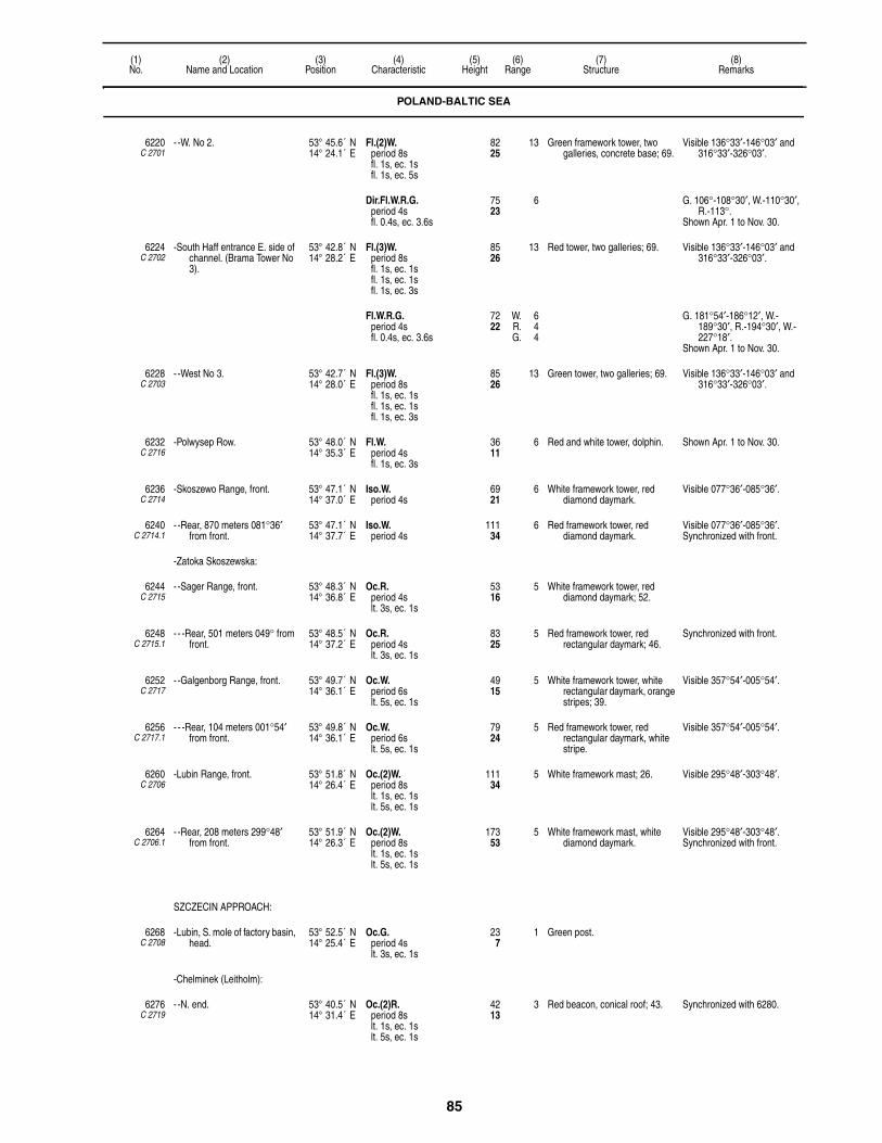
85
(1)No.
(2)Name and Location
(3)Position
(4)Characteristic
(5)Height
(6)Range
(7)Structure
(8)Remarks
6220C 2701
- -W. No 2. 53° 45.6´ N14° 24.1´ E
Fl.(2)W.period 8sfl. 1s, ec. 1sfl. 1s, ec. 5s
8225
13 Green framework tower, two galleries, concrete base; 69.
Visible 136°33′-146°03′ and 316°33′-326°03′.
Dir.Fl.W.R.G.period 4sfl. 0.4s, ec. 3.6s
7523
6 G. 106°-108°30′, W.-110°30′, R.-113°.
Shown Apr. 1 to Nov. 30.
6224C 2702
-South Haff entrance E. side of channel. (Brama Tower No 3).
53° 42.8´ N14° 28.2´ E
Fl.(3)W.period 8sfl. 1s, ec. 1sfl. 1s, ec. 1sfl. 1s, ec. 3s
8526
13 Red tower, two galleries; 69. Visible 136°33′-146°03′ and 316°33′-326°03′.
Fl.W.R.G.period 4sfl. 0.4s, ec. 3.6s
7222
W. 6R. 4G. 4
G. 181°54′-186°12′, W.-189°30′, R.-194°30′, W.-227°18′.
Shown Apr. 1 to Nov. 30.
6228C 2703
- -West No 3. 53° 42.7´ N14° 28.0´ E
Fl.(3)W.period 8sfl. 1s, ec. 1sfl. 1s, ec. 1sfl. 1s, ec. 3s
8526
13 Green tower, two galleries; 69. Visible 136°33′-146°03′ and 316°33′-326°03′.
6232C 2716
-Polwysep Row. 53° 48.0´ N14° 35.3´ E
Fl.W.period 4sfl. 1s, ec. 3s
3611
6 Red and white tower, dolphin. Shown Apr. 1 to Nov. 30.
6236C 2714
-Skoszewo Range, front. 53° 47.1´ N14° 37.0´ E
Iso.W.period 4s
6921
6 White framework tower, red diamond daymark.
Visible 077°36′-085°36′.
6240C 2714.1
- -Rear, 870 meters 081°36′ from front.
53° 47.1´ N14° 37.7´ E
Iso.W.period 4s
11134
6 Red framework tower, red diamond daymark.
Visible 077°36′-085°36′.Synchronized with front.
-Zatoka Skoszewska:
6244C 2715
- -Sager Range, front. 53° 48.3´ N14° 36.8´ E
Oc.R.period 4slt. 3s, ec. 1s
5316
5 White framework tower, red diamond daymark; 52.
6248C 2715.1
- - -Rear, 501 meters 049° from front.
53° 48.5´ N14° 37.2´ E
Oc.R.period 4slt. 3s, ec. 1s
8325
5 Red framework tower, red rectangular daymark; 46.
Synchronized with front.
6252C 2717
- -Galgenborg Range, front. 53° 49.7´ N14° 36.1´ E
Oc.W.period 6slt. 5s, ec. 1s
4915
5 White framework tower, white rectangular daymark, orange stripes; 39.
Visible 357°54′-005°54′.
6256C 2717.1
- - -Rear, 104 meters 001°54′ from front.
53° 49.8´ N14° 36.1´ E
Oc.W.period 6slt. 5s, ec. 1s
7924
5 Red framework tower, red rectangular daymark, white stripe.
Visible 357°54′-005°54′.
6260C 2706
-Lubin Range, front. 53° 51.8´ N14° 26.4´ E
Oc.(2)W.period 8slt. 1s, ec. 1slt. 5s, ec. 1s
11134
5 White framework mast; 26. Visible 295°48′-303°48′.
6264C 2706.1
- -Rear, 208 meters 299°48′ from front.
53° 51.9´ N14° 26.3´ E
Oc.(2)W.period 8slt. 1s, ec. 1slt. 5s, ec. 1s
17353
5 White framework mast, white diamond daymark.
Visible 295°48′-303°48′.Synchronized with front.
SZCZECIN APPROACH:
6268C 2708
-Lubin, S. mole of factory basin, head.
53° 52.5´ N14° 25.4´ E
Oc.G.period 4slt. 3s, ec. 1s
237
1 Green post.
-Chelminek (Leitholm):
6276C 2719
- -N. end. 53° 40.5´ N14° 31.4´ E
Oc.(2)R.period 8slt. 1s, ec. 1slt. 5s, ec. 1s
4213
3 Red beacon, conical roof; 43. Synchronized with 6280.
POLAND-BALTIC SEA

86
(1)No.
(2)Name and Location
(3)Position
(4)Characteristic
(5)Height
(6)Range
(7)Structure
(8)Remarks
6280C 2720
- -S. end. 53° 40.2´ N14° 32.0´ E
Oc.(2) R.period 8slt. 1s, ec. 1slt. 5s, ec. 1s
268
3 Red beacon; 26. Synchronized with 6276.
6284C 2722
-Brama Tower No 4, E. end. 53° 39.9´ N14° 32.0´ E
Iso.W.period 2s
8225
7 Red framework tower, two galleries.
Visible 137°18′-144°48′ and 320°18′-327°48′.
Synchronized with 6288.
6288C 2721
- -W. tower. 53° 39.8´ N14° 31.8´ E
Iso.W.period 2s
8225
7 Green framework tower, two galleries.
Visible 138°18′-145°48′ and 315°18′-322°48′.
Synchronized with 6284.
6292C 2728
-Mankow Range, front. 53° 37.1´ N14° 35.7´ E
Oc.(2)W.period 8slt. 1s, ec. 1slt. 5s, ec. 1s
4915
7 Red and white tower, two galleries, conical roof; 56.
Visible 137°36′-145°36′.
6296C 2728.1
- -Rear, about 1390 meters 141°36′ from front.
53° 36.5´ N14° 36.4´ E
Oc.(2)W.period 8slt. 1s, ec. 1slt. 5s, ec. 1s
10532
7 Red and white tower, two galleries, conical roof.
Visible 137°36′-145°36′.Synchronized with front.
-Trzebiez:
6300C 2724
- -N. beacon Range, front 53° 39.6´ N14° 31.1´ E
Oc.W.period 4slt. 3s, ec. 1s
3611
7 White framework tower, red rectangular daymark.
Visible 146°12′-154°12′.
6304C 2724.1
- - -Rear, 433 meters 150°12′ from front.
53° 39.4´ N14° 31.3´ E
Oc.W.period 4slt. 3s, ec. 1s
7122
7 Framework tower, red rectangular daymark.
Visible 146°12′-154°12′.
6308C 2724.4
- -Trzebiez, entrance, N. side. 53° 39.8´ N14° 31.0´ E
Iso.R.period 2s
196
2 Red post, gallery. Synchronized with 6312.
6312C 2724.6
- -NW. breakwater, head. 53° 39.7´ N14° 30.9´ E
Iso.G.period 2s
237
2 Green framework tower. Synchronized with 6308.
6316C 2724.8
- - -SE. side. 53° 39.6´ N14° 31.4´ E
Iso.G.period 4s
206
2 Green framework tower.
6320C 2725
- -S. breakwater, head. 53° 39.6´ N14° 31.4´ E
Iso.R.period 4s
309
2 Red post, gallery.
6324C 2725.4
-Trzebiez Range, front. 53° 39.8´ N14° 30.9´ E
Oc.Y.period 4slt. 3s, ec. 1s
3611
4 White framework tower, orange diamond daymark; 39.
Visible 297°12′-305°12′.
6328C 2725.5
- -Rear, 381 meters 301°12′ from front.
53° 39.9´ N14° 30.6´ E
Oc.Y.period 4slt. 3s, ec. 1s
5918
4 White framework tower, orange triangular daymark point down.
Visible 297°12′-305°12′.
6332C 2730
-Stepnica Range, front. 53° 38.1´ N14° 34.7´ E
Oc.W.period 8slt. 5s, ec. 3s
4915
5 Orange and white tower, two galleries, conical roof; 46.
Visible 344°-352°.
6336C 2730.1
- -Rear, 730 meters 348° from front.
53° 38.5´ N14° 34.6´ E
Oc.W.period 8slt. 5s, ec. 3s
8325
5 Orange and white framework tower, two galleries, conical roof.
Visible 344°-352°.Synchronized with front.
6348C 2726
-Great Stepenitz railway harbor Range, front.
53° 38.9´ N14° 37.3´ E
Oc.R.period 4slt. 3s, ec. 1s
3611
7 White framework tower.
6352C 2726.1
- -Rear, 153.5 meters 067°36′ from front.
53° 39.0´ N14° 37.5´ E
Oc.R.period 4slt. 3s, ec. 1s
6219
4 White framework structure, orange rectangular daymark, white stripe.
Synchronized with front.
6360C 2726.6
- -S. Mole. 53° 38.9´ N14° 37.2´ E
Iso.G.period 2s
196
3 Green mast, gallery.
6361C 2727
- -W. breakwater, head. 53° 39.0´ N14° 37.1´ E
Iso.R.period 4s
103
3 Red post.
6364C 2736
-Krepa Range, front. 53° 35.9´ N14° 35.6´ E
Oc.W.period 4slt. 3s, ec. 1s
4815
5 Orange and white tower, two galleries, conical roof.
Visible 352°-000°.
POLAND-BALTIC SEA
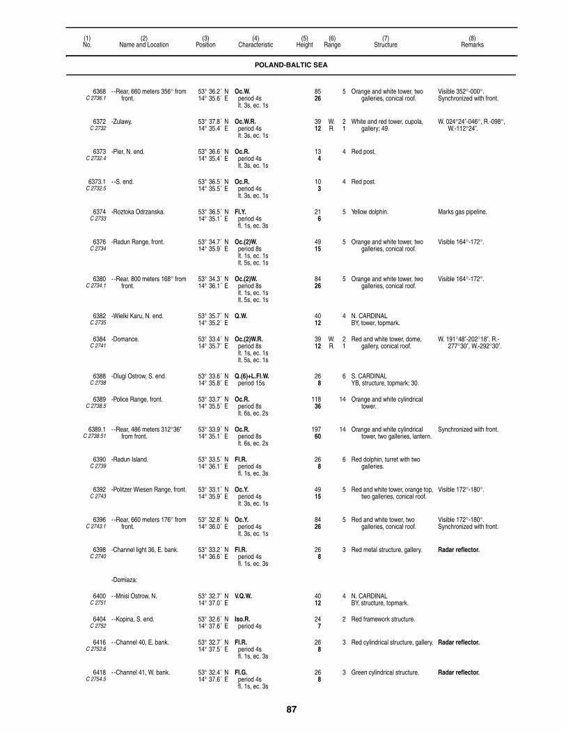
87
(1)No.
(2)Name and Location
(3)Position
(4)Characteristic
(5)Height
(6)Range
(7)Structure
(8)Remarks
6368C 2736.1
- -Rear, 660 meters 356° from front.
53° 36.2´ N14° 35.6´ E
Oc.W.period 4slt. 3s, ec. 1s
8526
5 Orange and white tower, two galleries, conical roof.
Visible 352°-000°.Synchronized with front.
6372C 2732
-Zulawy. 53° 37.8´ N14° 35.4´ E
Oc.W.R.period 4slt. 3s, ec. 1s
3912
W. 2R. 1
White and red tower, cupola, gallery; 49.
W. 024°24′-046°, R.-098°, W.-112°24′.
6373C 2732.4
-Pier, N. end. 53° 36.6´ N14° 35.4´ E
Oc.R.period 4slt. 3s, ec. 1s
134
4 Red post.
6373.1C 2732.5
- -S. end. 53° 36.5´ N14° 35.5´ E
Oc.R.period 4slt. 3s, ec. 1s
103
4 Red post.
6374C 2733
-Roztoka Odrzanska. 53° 36.5´ N14° 35.1´ E
Fl.Y.period 4sfl. 1s, ec. 3s
216
5 Yellow dolphin. Marks gas pipeline.
6376C 2734
-Radun Range, front. 53° 34.7´ N14° 35.9´ E
Oc.(2)W.period 8slt. 1s, ec. 1slt. 5s, ec. 1s
4915
5 Orange and white tower, two galleries, conical roof.
Visible 164°-172°.
6380C 2734.1
- -Rear, 800 meters 168° from front.
53° 34.3´ N14° 36.1´ E
Oc.(2)W.period 8slt. 1s, ec. 1slt. 5s, ec. 1s
8426
5 Orange and white tower, two galleries, conical roof.
Visible 164°-172°.
6382C 2735
-Wielki Karu, N. end. 53° 35.7´ N14° 35.2´ E
Q.W. 4012
4 N. CARDINALBY, tower, topmark.
6384C 2741
-Domance. 53° 33.4´ N14° 35.7´ E
Oc.(2)W.R.period 8slt. 1s, ec. 1slt. 5s, ec. 1s
3912
W. 2R. 1
Red and white tower, dome, gallery, conical roof.
W. 191°48′-202°18′, R.-277°30′, W.-292°30′.
6388C 2738
-Dlugi Ostrow, S. end. 53° 33.6´ N14° 35.8´ E
Q.(6)+L.Fl.W.period 15s
268
6 S. CARDINALYB, structure, topmark; 30.
6389C 2738.5
-Police Range, front. 53° 33.7´ N14° 35.5´ E
Oc.R.period 8slt. 6s, ec. 2s
11836
14 Orange and white cylindrical tower.
6389.1C 2738.51
- -Rear, 486 meters 312°36′ from front.
53° 33.9´ N14° 35.1´ E
Oc.R.period 8slt. 6s, ec. 2s
19760
14 Orange and white cylindrical tower, two galleries, lantern.
Synchronized with front.
6390C 2739
-Radun Island. 53° 33.5´ N14° 36.1´ E
Fl.R.period 4sfl. 1s, ec. 3s
268
6 Red dolphin, turret with two galleries.
6392C 2743
-Politzer Wiesen Range, front. 53° 33.1´ N14° 35.9´ E
Oc.Y.period 4slt. 3s, ec. 1s
4915
5 Red and white tower, orange top, two galleries, conical roof.
Visible 172°-180°.
6396C 2743.1
- -Rear, 660 meters 176° from front.
53° 32.8´ N14° 36.0´ E
Oc.Y.period 4slt. 3s, ec. 1s
8426
5 Red and white tower, two galleries, conical roof.
Visible 172°-180°.Synchronized with front.
6398C 2740
-Channel light 36, E. bank. 53° 33.2´ N14° 36.6´ E
Fl.R.period 4sfl. 1s, ec. 3s
268
3 Red metal structure, gallery. Radar reflector.
-Domiaza:
6400C 2751
- -Mnisi Ostrow, N. 53° 32.7´ N14° 37.0´ E
V.Q.W. 4012
4 N. CARDINALBY, structure, topmark.
6404C 2752
- -Kopina, S. end. 53° 32.6´ N14° 37.6´ E
Iso.R.period 4s
247
2 Red framework structure.
6416C 2752.6
- -Channel 40, E. bank. 53° 32.7´ N14° 37.5´ E
Fl.R.period 4sfl. 1s, ec. 3s
268
3 Red cylindrical structure, gallery. Radar reflector.
6418C 2754.5
- -Channel 41, W. bank. 53° 32.4´ N14° 37.6´ E
Fl.G.period 4sfl. 1s, ec. 3s
268
3 Green cylindrical structure. Radar reflector.
POLAND-BALTIC SEA

88
(1)No.
(2)Name and Location
(3)Position
(4)Characteristic
(5)Height
(6)Range
(7)Structure
(8)Remarks
6420C 2754
- - -Inskie. 53° 32.5´ N14° 38.1´ E
Oc.(2)W.R.period 8s
3912
W. 2R. 1
Red and white tower, dome; 46. W. 011°18′-025°30′, R.-107°, W.-118°06′.
6422C 2755
- -Channel 43, W. bank. 53° 32.1´ N14° 37.8´ E
Fl.G.period 4sfl. 1s, ec. 3s
268
3 Green cylindrical structure, gallery.
Radar reflector.
6423C 2754.7
- -Channel 44, E. bank. 53° 32.1´ N14° 37.9´ E
Fl.R.period 4sfl. 1s, ec. 3s
268
3 Red cylindrical structure, gallery.
6428C 2746.9
- -Ina N. Range, front, 614 meters 312°36′ from rear.
53° 32.2´ N14° 38.2´ E
Oc.W.period 8slt. 5s, ec. 3s
5116
5 Orange and white tower, orange dome, gallery.
Visible 128°36′-136°36′.
6432C 2747
- - -Common rear. 53° 32.0´ N14° 38.6´ E
Oc.W.period 8slt. 5s, ec. 3s
8526
5 Orange and white tower, orange dome, gallery.
Visible 128°36′-136°36′ and 014°-022°.
6436C 2747.1
- -Ina S. Range, front, 846 meters 198° from rear.
53° 31.5´ N14° 38.4´ E
Oc.W.period 8slt. 5s, ec. 3s
4614
5 Orange and white tower, orange dome, gallery.
Visible 014°-022°.
6438C 2749
- -Wyspy Rybi Island. 53° 31.8´ N14° 37.8´ E
V.Q.(6)+L.Fl.W.period 10s
4012
4 S. CARDINALYB, structure, topmark.
-Oder (Odra) River:
6440C 2758
- -Wyspa Zurawia, N. end. 53° 31.3´ N14° 37.9´ E
V.Q.W. 3912
5 N. CARDINALBY, structure, topmark.
6444C 2750
- -Babina, W. side of Mewia Wyspa.
53° 31.0´ N14° 38.4´ E
Oc.W.R.period 4s
3912
W. 2R. 1
Red and white tower, dome, gallery, conical roof.
W. 037°48′-058°24′, R.-133°42′, W.-154°12′.
6448C 2762
- -Bykowo Range, front. 53° 30.5´ N14° 38.1´ E
Oc.W.period 4slt. 3s, ec. 1s
4915
5 Red and white beacon, gallery. Visible 169°54′-177°54′.
6452C 2762.1
- - -Rear, 600 meters 173°54′ from front.
53° 30.2´ N14° 38.2´ E
Oc.W.period 4slt. 3s, ec. 1s
7924
5 Red and white beacon, gallery. Visible 169°54′-177°54′.
6452.5C 2764.75
-Steel Wharf, N. end. 53° 29.8´ N14° 37.3´ E
Oc.G.period 4slt. 3s, ec. 1s
206
2 Green mast, gallery.
6453C 2765.24
-Cementowe Wharf, S. end. 53° 29.5´ N14° 37.1´ E
Iso.G.period 2s
237
3 Green mast, gallery.
6454C 2765.42
- -Fosfatowy Platform, N. head. 53° 29.3´ N14° 36.9´ E
Oc.(2)G.period 8slt. 1s, ec. 1slt. 5s, ec. 1s
206
1 Green mast. Synchronized with 6454.1.
6454.1C 2765.44
- - -S. Head. 53° 29.2´ N14° 36.9´ E
Oc.(2)G.period 8slt. 1s, ec. 1slt. 5s, ec. 1s
206
2 Green mast. Synchronized with 6454.
6454.5C 2765.6
- -N. Snop 2 Wharf. 53° 28.9´ N14° 36.9´ E
Iso.G.period 4s
206
2 Green mast, gallery.
6455C 2767.6
- -Goclaw, N. end. 53° 28.8´ N14° 36.8´ E
Oc.G.period 4slt. 3s, ec. 1s
206
3 Green mast, gallery.
6455.1C 2770
- - -Basen, BTP. N. side. 53° 28.1´ N14° 36.1´ E
Iso.G.period 2s
206
3 Green mast.
6455.12C 2770.2
- - - -S. side. 53° 28.1´ N14° 36.1´ E
Iso.R.period 2s
206
3 Red mast.
6455.2C 2772
- - -Lighting Authority Basin, N. side.
53° 28.0´ N14° 36.1´ E
Iso.G.period 2s
257
3 Green mast.
6455.3C 2772.2
- - - -S. side. 53° 28.0´ N14° 36.0´ E
Iso.G.period 2s
206
3 Green mast.
POLAND-BALTIC SEA

89
(1)No.
(2)Name and Location
(3)Position
(4)Characteristic
(5)Height
(6)Range
(7)Structure
(8)Remarks
6456C 2764
- -Swieta Range, front. 53° 28.1´ N14° 36.5´ E
Oc.W.period 4slt. 3s, ec. 1s
4915
5 Orange and white tower, two galleries, conical roof.
Visible 194°-202°.
6460C 2764.1
- - -Rear, 850 meters 198° from front.
53° 27.7´ N14° 36.3´ E
Oc.W.period 4slt. 3s, ec. 1s
8526
5 Orange and white tower, two galleries, conical roof.
Visible 194°-202°.
6460.1C 2771.7
-Jachtowe Wharf, N. side. 53° 27.8´ N14° 36.0´ E
Oc.G.period 4slt. 3s, ec. 1s
165
3 Green tubular structure, gallery. Synchronized with 6460.2.
6460.2C 2771.5
- -S. side. 53° 27.7´ N14° 35.9´ E
Oc.G.period 4slt. 3s, ec. 1s
165
3 Green tubular structure, gallery. Synchronized with 6460.1.
-Szczecin:
6461C 2777.9
- -Basen Mlynski. 53° 27.3´ N14° 35.4´ E
Iso.G.period 4s
206
4 Green mast, gallery.
6461.5C 2777.95
- -Wyspa Okretowa, NW corner. 53° 27.3´ N14° 35.6´ E
Iso.R.period 4s
165
3 Red mast.
6462C 2813
- -Ostrow Grabowski. 53° 26.5´ N14° 35.6´ E
Iso.W.R.G.period 2s
268
W. 5R. 3G. 3
White beacon, two galleries. G. 185°-189°, W.-191°, R.-195°.
Q.W. 309
3 Visible 195°-185°.
6464C 2781.5
- -Pier, head. 53° 26.9´ N14° 35.1´ E
Iso.G.period 4s
268
3 Green mast.
6465C 2791.5
-Nabrzeze Krakowskie. 53° 26.4´ N14° 35.1´ E
Iso.G.period 2s
206
1 Gray mast, lantern.
6465.2C 2791.8
-Zatoka Pomorska. 53° 26.4´ N14° 34.9´ E
Fl.G.period 4sfl. 1s, ec. 3s
237
1 Green mast, support. Marks obstruction.
6465.3C 2793
-Niemieckie Wharf, W. end. 53° 26.3´ N14° 35.1´ E
Iso.R.period 4s
206
3 Red mast, gallery.
6465.4C 2793.5
- -E. end. 53° 26.2´ N14° 35.2´ E
Iso.G.period 4s
206
3 Green mast, gallery.
6466C 2799
-Kanal Debicki. 53° 25.9´ N14° 35.2´ E
Iso.R.period 4s
237
3 Red mast.
6467C 2801
- -Czeskie wharf. 53° 25.7´ N14° 35.0´ E
Iso.G.period 4s
237
1 Green post.
6469.1C 2817
- -NB. Zabrzonskie. 53° 24.6´ N14° 36.7´ E
Q.R. 206
1 Red mast, gallery, dolphin.
6472C 2876
-Nowe Warpno, N. landing. 53° 43.6´ N14° 16.9´ E
Oc.(2)W.R.G.period 8slt. 1s, ec. 1slt. 5s, ec. 1s
237
1 White post, gallery; 20. G. 152°-155°, W.-157°, R.-160°.
Whistle: bl ev. 15s (bl. 1s, si. 14s).
6476C 2876.2
- -Elbow of Mole. 53° 43.6´ N14° 16.9´ E
Iso.G.period 4s
237
2 Green mast, gallery; 23.
6477 - -Kanal Piastowski. 53° 49.3´ N14° 19.2´ E
Iso.G.period 4s
206
4 Green mast. 2 beacons.
POLAND-GERMANY-BALTIC SEA
NOWE WARPNO:
6480C 2874
- -Altwarp Oder-haff Dolphin 7. 53° 44.3´ N14° 16.4´ E
Fl.Y.period 4sfl. 1s, ec. 3s
237
2 Black pile, white bands. Visible 153°-010°.Indicates German-Polish
border.
POLAND-BALTIC SEA

90
(1)No.
(2)Name and Location
(3)Position
(4)Characteristic
(5)Height
(6)Range
(7)Structure
(8)Remarks
6484C 2860
-Uckermunde, W. mole, root. 53° 45.0´ N14° 04.0´ E
Oc.W.period 6slt. 5s, ec. 1s
3611
10 White column, gallery, red lantern; 36.
W. 113°-293°.Shown during open
navigation.
6488C 2867
-Kamp Kavnin Range, front. 53° 50.3´ N13° 51.5´ E
Oc.(3)R.period 15slt. 2s, ec. 1slt. 2s, ec. 1slt. 8s, ec. 1s
237
5 White framework beacon; 26.
6492C 2867.1
- -Rear, about 1,445 meters 283° from front.
53° 50.5´ N13° 50.3´ E
Oc.(3)R.period 15slt. 2s, ec. 1slt. 2s, ec. 1slt. 8s, ec. 1s
8325
7 White column; 79.
POLAND-BALTIC SEA
6496C 2892
Kikut. 53° 58.9´ N14° 34.8´ E
Iso.W.period 10s
30091
16 Gray round tower, white dome, gallery; 59.
Visible 063°-241°.
6500 Approach Bell Buoy DZI. 54° 04.0´ N14° 41.0´ E
L.Fl.W.period 10sfl. 3s, ec. 7s
White buoy, pillar, red stripes.
6508C 2897
-W. mole, head. 54° 01.4´ N14° 43.5´ E
Oc.(2)G.period 8slt. 1s, ec. 1slt. 5s, ec. 1s
3310
7 Green tower with gallery.
6512C 2896
-Entrance Range, front. 54° 01.2´ N14° 43.8´ E
Oc.W.period 4slt. 3s, ec. 1s
258
3 White framework tower, white diamond daymark.
Visible 138°42′-146°42′.
6516C 2896.1
- -Rear, 130 meters 142°42′ from front.
54° 01.1´ N14° 43.9´ E
Oc.W.period 4slt. 3s, ec. 1s
4213
3 White and red framework tower, white rectangular daymark.
Visible 138°42′-146°42′.Synchronized with front.
6520C 2904
Niechorze. 54° 05.7´ N15° 03.8´ E
Fl.W.period 10sfl. 0.5s, ec. 9.5s
20663
20 White octagonal tower, gallery, dome, red roof.
6524C 2905
Mrzezyno, on E. bank of Rega River entrance.
54° 08.8´ N15° 17.2´ E
Oc.(2)W.R.G.period 10slt. 2s, ec. 1slt. 6s, ec. 1s
237
5 Framework tower; 20. G. 050°-151°, W.-157°, R.-244°.
Nautophone: (30 meters N.) Mo.(P) ev. 60s.
6536C 2905.25
-E. Breakwater, head. 54° 09.0´ N15° 17.0´ E
Iso.R.period 4s
3310
5 Red column, gallery. Synchronized with 6540.
6540C 2905.27
-W. Breakwater, head. 54° 08.9´ N15° 17.2´ E
Iso.G.period 4s
3310
5 Green column, gallery. Synchronized with 6536.
KOLOBRZEG:
6544 -Approach buoy Kol. 54° 14.0´ N15° 31.0´ E
L.Fl.W.period 10sfl. 3s, ec. 7s
SAFE WATERRW, column, topmark.
Seasonal.
POLAND-BALTIC SEA
KOLOBRZEG:
6548C 2908
-E. mole, head. 54° 11.4´ N15° 32.9´ E
Oc.R.period 4slt. 3s, ec. 1s
268
Red post, gallery. Nautophone: Mo.(K) ev. 60s.
POLAND-GERMANY-BALTIC SEA
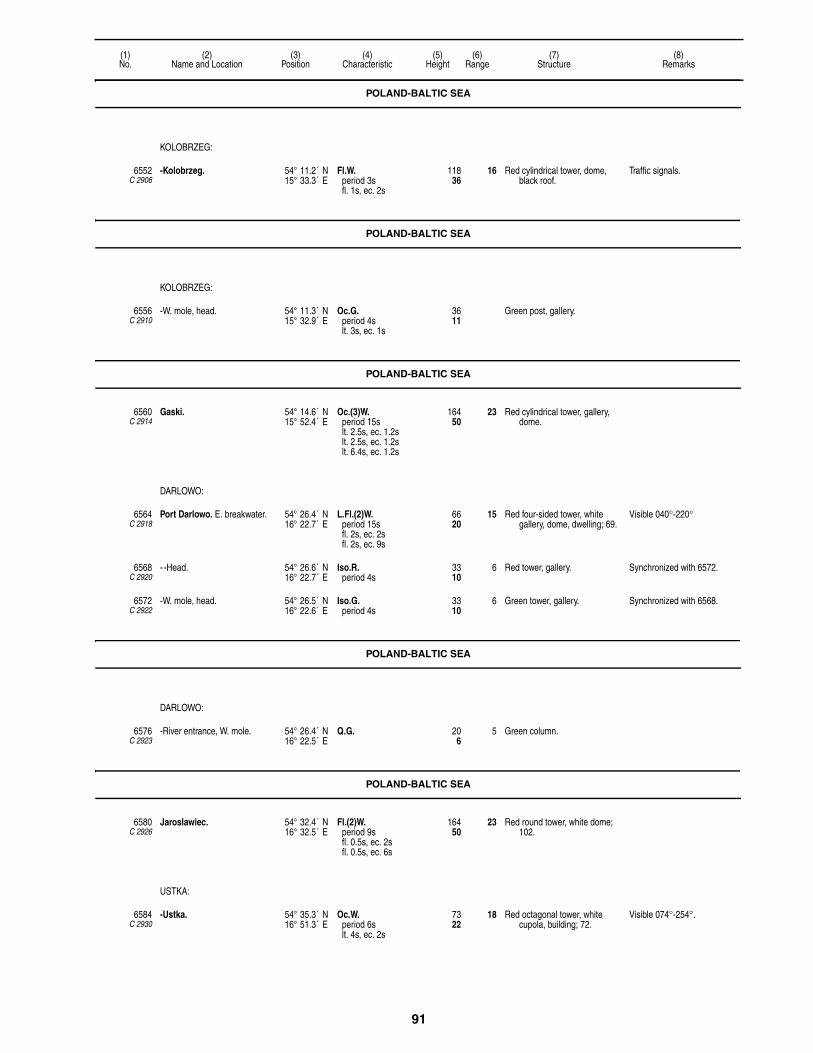
91
(1)No.
(2)Name and Location
(3)Position
(4)Characteristic
(5)Height
(6)Range
(7)Structure
(8)Remarks
POLAND-BALTIC SEA
KOLOBRZEG:
6552C 2906
-Kolobrzeg. 54° 11.2´ N15° 33.3´ E
Fl.W.period 3sfl. 1s, ec. 2s
11836
16 Red cylindrical tower, dome, black roof.
Traffic signals.
POLAND-BALTIC SEA
KOLOBRZEG:
6556C 2910
-W. mole, head. 54° 11.3´ N15° 32.9´ E
Oc.G.period 4slt. 3s, ec. 1s
3611
Green post, gallery.
POLAND-BALTIC SEA
6560C 2914
Gaski. 54° 14.6´ N15° 52.4´ E
Oc.(3)W.period 15slt. 2.5s, ec. 1.2slt. 2.5s, ec. 1.2slt. 6.4s, ec. 1.2s
16450
23 Red cylindrical tower, gallery, dome.
DARLOWO:
6564C 2918
Port Darlowo. E. breakwater. 54° 26.4´ N16° 22.7´ E
L.Fl.(2)W.period 15sfl. 2s, ec. 2sfl. 2s, ec. 9s
6620
15 Red four-sided tower, white gallery, dome, dwelling; 69.
Visible 040°-220°
6568C 2920
- -Head. 54° 26.6´ N16° 22.7´ E
Iso.R.period 4s
3310
6 Red tower, gallery. Synchronized with 6572.
6572C 2922
-W. mole, head. 54° 26.5´ N16° 22.6´ E
Iso.G.period 4s
3310
6 Green tower, gallery. Synchronized with 6568.
POLAND-BALTIC SEA
DARLOWO:
6576C 2923
-River entrance, W. mole. 54° 26.4´ N16° 22.5´ E
Q.G. 206
5 Green column.
POLAND-BALTIC SEA
6580C 2926
Jaroslawiec. 54° 32.4´ N16° 32.5´ E
Fl.(2)W.period 9sfl. 0.5s, ec. 2sfl. 0.5s, ec. 6s
16450
23 Red round tower, white dome; 102.
USTKA:
6584C 2930
-Ustka. 54° 35.3´ N16° 51.3´ E
Oc.W.period 6slt. 4s, ec. 2s
7322
18 Red octagonal tower, white cupola, building; 72.
Visible 074°-254°.
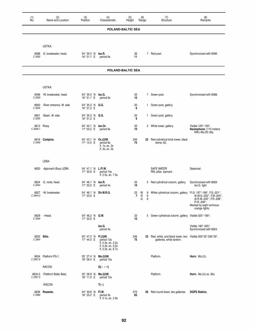
92
(1)No.
(2)Name and Location
(3)Position
(4)Characteristic
(5)Height
(6)Range
(7)Structure
(8)Remarks
POLAND-BALTIC SEA
USTKA:
6588C 2932
-E. breakwater, head. 54° 35.5´ N16° 51.1´ E
Iso.R.period 6s
3611
7 Red post. Synchronized with 6596.
POLAND-BALTIC SEA
USTKA:
6596C 2933
-W. breakwater, head. 54° 35.5´ N16° 51.1´ E
Iso.G.period 6s
3310
7 Green post. Synchronized with 6588.
6600C 2934
-River entrance, W. side. 54° 35.3´ N16° 51.2´ E
Q.G. 206
1 Green post, gallery.
6601C 2935
-Basin, W. side. 54° 35.3´ N16° 51.2´ E
Q.G. 206
1 Green post, gallery.
6612C 2939.1
Rowy. 54° 40.1´ N17° 03.2´ E
Iso.Or.period 6s
3310
2 White tower, gallery. Visible 129°-159°.Nautophone: (115 meters
NW.) Mo.(R) 30s.
6616C 2940
Czotpino. 54° 43.1´ N17° 14.5´ E
Oc.(2)W.period 8slt. 1s, ec. 2slt. 3s, ec. 2s
24675
22 Red cylindrical brick tower, black dome; 83.
LEBA:
6620 -Approach Buoy LEBA. 54° 47.1´ N17° 33.8´ E
L.Fl.W.period 10sfl. 2.5s, ec. 7.5s
SAFE WATERRW, pillar, topmark.
Seasonal.
6624C 2944
-E. mole, head. 54° 46.1´ N17° 33.0´ E
Iso.R.period 4s
3310
5 Red cylindrical column, gallery. Synchronized with 6629 Iso.G. light.
6627C 2944.5
-W. breakwater. 54° 46.1´ N17° 33.0´ E
Dir.W.R.G. 237
W. 8R. 6G. 6
White cylindrical column, gallery. Fl.G. 197°-198°, F.G.-201°, Al.W.G.-202°, F.W.-204°, Al.R.W.-205°, F.R.-208°, Fl.R.-209°.
Marked by eight luminous orange lights.
6629C 2945
- -Head. 54° 46.2´ N17° 33.0´ E
Q.W. 3310
5 Green cylindrical column, gallery. Visible 025°-180°.
Iso.G.period 4s
Visible 180°-025°.Synchronized with 6624.
6632C 2954
Stilo. 54° 47.2´ N17° 44.0´ E
Fl.(3)W.period 12sfl. 0.3s, ec. 2.2sfl. 0.3s, ec. 2.2sfl. 0.3s, ec. 6.7s
24675
23 Red, white, and black tower, two galleries, white lantern.
Visible 050°30′-290°30′.
6634C 2957.6
Platform PG-1. 55° 27.4´ N18° 09.4´ E
Mo.(U)W.period 15s
Platform. Horn: Mo.(U).
RACON G(– – • )
6634.5C 2957.5
-Platform Baltic Beta. 55° 28.9´ N18° 11.0´ E
Mo.(U)W.period 15s
Platform. Horn: Mo.(U) ev. 30s.
-RACON T(–)
6636C 2960
Rozewie. 54° 49.8´ N18° 20.2´ E
Fl.W.period 3sfl. 0.1s, ec. 2.9s
27283
26 Red round tower, two galleries. DGPS Station.
93
(1)No.
(2)Name and Location
(3)Position
(4)Characteristic
(5)Height
(6)Range
(7)Structure
(8)Remarks
POLWYSEP HEL:
6640C 2961
-Wladyslawowo, N. breakwater, head.
54° 47.8´ N18° 25.4´ E
Oc.G.period 5slt. 3s, ec. 2s
4313
5 Green hexagonal tower, lantern. Synchronized with 6648.5.
6644 - -Approach Buoy WLA. 54° 48.0´ N18° 27.0´ E
L.Fl.W.period 10sfl. 2.5s, ec. 7.5s
SAFE WATERRW, pillar, topmark.
6646C 2961.4
-Entrance Range, front. 54° 47.7´ N18° 25.2´ E
Oc.R.period 6slt. 4s, ec. 2s
4614
4 Yellow framework tower.
6646.1C 2961.41
- -Rear, 245 meters 260° from front.
54° 47.7´ N18° 25.0´ E
Oc.R.period 6slt. 4s, ec. 2s
7222
4 Building. Synchronized with front.
6648C 2964
-Inner mole, head, extending from N. breakwater.
54° 47.8´ N18° 25.4´ E
F.G. 216
2 Green post.
6648.5C 2963
-S. breakwater. 54° 47.8´ N18° 25.3´ E
Oc.R.period 5slt. 3s, ec. 2s
3912
3 Red post, gallery. Synchronized with 6640.
6649C 2964.6
-Fishery building. 54° 47.7´ N18° 24.6´ E
Aero F.R. 25678
23 Tower.
6650C 3002
-Kuznica Range, front. 54° 44.0´ N18° 34.9´ E
F.R. 4614
3 Gray framework tower, white triangular daymark point up, red border.
6650.1C 3002.1
- -Rear, 188 meters 339° from front.
54° 44.1´ N18° 34.9´ E
F.R. 5717
3 Gray framework tower, triangular daymark point down, red border.
6651C 3003
- -E. breakwater, entrance. 54° 43.9´ N18° 35.0´ E
L.Fl.G.period 5sfl. 2s, ec. 3s
206
3 Green post.
6651.1C 3003.1
- - -S. breakwater. 54° 43.9´ N18° 35.0´ E
L.Fl.R.period 5sfl. 2s, ec. 3s
206
3 Red post.
6652C 2983
-Jastarnia Bor Range, front. 54° 41.8´ N18° 40.5´ E
Iso.Or.period 2s
3410
4 Red pipe, white stripes, white triangular daymark point up, red border.
Iso.R. 6s and Iso.G. 6s mark breakwaters about 400 meters S.
6656C 2983.1
- -Rear, 188 meters 000°24′ from front.
54° 41.9´ N18° 40.5´ E
Oc.Or.period 4slt. 3s, ec. 1s
6219
4 Tower, red square daymark.
6660C 2986
- -On island, entrance to Jastarnia Bor.
54° 41.0´ N18° 40.4´ E
Fl.(3)W.R.period 10sfl. 0.5s, ec. 1.5sfl. 0.5s, ec. 1.5sfl. 0.5s, ec. 3.5s
309
W. 8R. 6
Red post, white band, gallery, gray concrete base.
W. 333°-083°, R.-333°.
6664C 2965
-Jastarnia Wies. 54° 42.0´ N18° 40.9´ E
Mo.(A)W.period 20sfl. 2s, ec. 2sfl. 9s, ec. 7s
7222
15 White round tower, red bands with gallery.
6672C 2968
-Hel. 54° 36.0´ N18° 48.8´ E
Iso.W.period 10s
12839
17 Red octagonal tower, gallery. Visible 151°-102°.
-Port Hel:
6676C 2972
- -Outer harbor, W. mole, head. 54° 36.0´ N18° 48.0´ E
Fl.R.period 4sfl. 0.5s, ec. 3.5s
299
4 Red post, gallery.
6680C 2974
- - -E. mole, head. 54° 36.0´ N18° 48.1´ E
Fl.W.G.period 4sfl. 0.5s, ec. 3.5s
299
4 White and green cylindrical tower, gallery.
W. 300°-010°, G.-300°.
POLAND-BALTIC SEA

94
(1)No.
(2)Name and Location
(3)Position
(4)Characteristic
(5)Height
(6)Range
(7)Structure
(8)Remarks
GULF OF DANZIG:
6708C 3010
-Rewa. 54° 38.0´ N18° 30.7´ E
Oc.W.R.G.period 4slt. 3s, ec. 1s
3310
W. 6R. 4G. 4
White post, red vertical bands, gallery.
G. 122°-167°, W.-177°, R.-222°.
6709C 3011
- -N. pipeline. 54° 37.1´ N18° 32.8´ E
Q.(3)W.period 10s
309
5 Yellow dolphin, gallery. Marks waste pipe.
6709.1C 3013
- -S. pipeline. 54° 37.0´ N18° 33.0´ E
Q.(3)W.period 10s
165
3 E. CARDINALBYB, dolphin, topmark.
Marks waste pipe.
PORT OF GDYNIA:
6716C 3018
-Kanal Portowy, entrance Range, front.
54° 32.2´ N18° 32.9´ E
Oc.Or.period 5slt. 3s, ec. 2s
5015
8 White framework tower, black stripe.
Range 3M by day.
6720C 3018.1
- -Yugoslav Quay, rear, on corner of quay, about 1060 meters 271°30′ from front.
54° 32.2´ N18° 31.9´ E
Oc.Or.period 5slt. 3s, ec. 2s
9830
8 Grey concrete tower. Leads from roadstead through middle entrance between breakwater to Awanport.
Range 5M by day.
6724C 3014
-Awanport, N. breakwater, head.
54° 32.4´ N18° 33.7´ E
Fl.G.period 3sfl. 0.3s, ec. 2.7s
258
3 Black framework tower.
6728C 3015
- -S. side of N. entrance. 54° 32.3´ N18° 33.7´ E
Fl.R.period 3sfl. 0.3s, ec. 2.7s
3410
3 Red framework tower, white band.
6729C 3015.2
- -S. side of detached breakwater.
54° 32.2´ N18° 33.8´ E
Iso.G.period 4s
4915
8 Gray concrete tower, gallery, dome.
Synchronized with 6732.
6732C 3016
- -S. side of main entrance, N. end.
54° 32.1´ N18° 33.8´ E
Iso.R.period 4s
5015
10 Gray concrete tower, gallery, dome.
Synchronized with 6729.
6736C 3016.2
-Main breakwater, S. head. 54° 31.0´ N18° 33.7´ E
Oc.G.period 10slt. 7.5s, ec. 2.5s
3912
9 Gray concrete tower, glass dome, flat roof.
6740C 3020.6
-Fuel berth. 54° 32.0´ N18° 33.7´ E
F.R. 237
3 Gray metal post, dolphin.
6744C 3020.62
-Fuel berth. 54° 31.9´ N18° 33.7´ E
F.R. 237
3 Gray metal post, dolphin.
6756C 3024
-Basin No 1. 54° 31.3´ N18° 33.6´ E
F.G. 196
2 Green pole.
6760C 3023.4
-Fisherman′s Pier, (English Quay) NE. head.
54° 31.5´ N18° 33.6´ E
F.R. 144
3 Red pole.
6768C 3022
-Swedish Quay, NE. head. 54° 31.8´ N18° 33.6´ E
F.R. 216
2 Red pole.
6769C 3022.1
-Basin No 3. 54° 31.8´ N18° 33.1´ E
F.W. 134
Dolphin.
6788C 3021
- -French Quay, NE. corner. 54° 32.0´ N18° 33.3´ E
F.R. 216
2 Red pole.
6790C 3021.5
-Holland Quay. 54° 32.0´ N18° 33.4´ E
F.G. 237
2 Green pole.
6792C 3026.2
-Kanal Portowy Entrance, S. side.
54° 32.1´ N18° 32.9´ E
Iso.R.period 2s
237
2 Red cylindrical structure. Synchronized with 6796.
6796C 3026
- -Portowy, entrance, N. mole, head.
54° 32.1´ N18° 32.9´ E
Iso.G.period 2s
237
2 Green cylindrical structure. Synchronized with 6792.
6800C 3028
-Basin No 4. 54° 32.0´ N18° 32.3´ E
Oc.G.period 5slt. 3s, ec. 2s
247
1 Green pole.
POLAND-BALTIC SEA

95
(1)No.
(2)Name and Location
(3)Position
(4)Characteristic
(5)Height
(6)Range
(7)Structure
(8)Remarks
6804C 3029
- -No 5. 54° 32.1´ N18° 32.1´ E
Oc.R.period 5slt. 3s, ec. 2s
237
1 Red pole.
6806C 3030.1
- -Basin No 5, Ro Ro. 54° 32.0´ N18° 31.6´ E
Fl.Or.period 4sfl. 1s, ec. 3s
237
1 Gray cylindrical steel post.
6808C 3029.2
- -Yugoslav Quay, E. corner. 54° 32.2´ N18° 31.9´ E
Oc.G.period 5slt. 3s, ec. 2s
237
1 Green pole.
6810C 3031
-Jugoslavian Wharf, NW. corner.
54° 32.2´ N18° 31.8´ E
Fl.R.period 4sfl. 1s, ec. 3s
237
Gray round steel post.
6818C 3018.5
-Jetty, head. 54° 32.3´ N18° 33.2´ E
Iso.W.period 2s
206
2 Framework tower, lantern.
6820C 3020
-Basin No 10, E. side of entrance.
54° 32.4´ N18° 33.3´ E
Q.G. 206
Black framework tower.
6824C 3020.2
- -W. side of entrance. 54° 32.4´ N18° 33.2´ E
Q.R. 206
Black framework tower.
6826C 3020.3
- -Inner mole. 54° 32.5´ N18° 33.4´ E
Iso.W.period 2s
134
2 Post.
6828C 3019
-Basin No 11. 54° 32.4´ N18° 33.5´ E
Oc.G.period 3slt. 2s, ec. 1s
206
Black framework tower.
6832C 3019.2
- -W. side of entrance. 54° 32.4´ N18° 33.4´ E
Oc.R.period 3slt. 2s, ec. 1s
206
Black framework tower.
GULF OF DANZIG:
6839C 3045.8
-NW. pipeline, head. 54° 27.2´ N18° 34.3´ E
Iso.Or.period 2s
165
2 Metal post, yellow platform. Marks waste pipe outlet.
6844C 3046
-Sopot. 54° 26.7´ N18° 34.2´ E
Fl.W.period 4sfl. 0.3s, ec. 3.7s
8225
7 White tower. Visible 192°30′-307°30′.
6846C 3047.4
- -S. breakwater, head. 54° 26.8´ N18° 34.7´ E
Fl.R.period 6sfl. 1.5s, ec. 4.5s
237
4 Red steel post.
6848C 3047.5
- -E. breakwater, head. 54° 26.8´ N18° 34.8´ E
Fl.G.period 6sfl. 1.5s, ec. 4.5s
237
4 Green steel post.
6850C 3049
-SE. pipeline head. 54° 26.2´ N18° 35.2´ E
Fl.Or.period 5sfl. 1s, ec. 4s
165
2 Orange round dolphin, gallery. Marks waste pipe outlet.
6860C 3062
- -Brzezno Gdanskie (Outer) Range, front.
54° 24.5´ N18° 38.4´ E
Iso.Y.period 5s
7523
13 White framework tower, white triangular daymark point up, red border; 79.
6864C 3062.1
- - -Rear, 330 meters 196° from front.
54° 24.3´ N18° 38.3´ E
Iso.Y.period 5s
10331
13 Black framework tower, triangular daymark point down.
Synchronized with front.
6868C 3064
- -Inner Range, front. 54° 24.6´ N18° 39.8´ E
Oc.G.period 5slt. 3s, ec. 2s
7523
8 White beacon, two white triangular daymarks point up, red border.
Range 3M by day.
6872C 3064.1
- - -Rear, 370 meters 147°42′ from front.
54° 24.5´ N18° 40.0´ E
Oc.G.period 5slt. 3s, ec. 2s
11635
8 Gray-black beacon, black triangular daymark point down.
Range 5M by day.
-Nowy Port (Neufahrwasser):
6876C 3068
- -E. breakwater, head. 54° 25.0´ N18° 39.5´ E
L.Fl.R.period 6sfl. 2s, ec. 4s
4413
7 Red tower.
POLAND-BALTIC SEA

96
(1)No.
(2)Name and Location
(3)Position
(4)Characteristic
(5)Height
(6)Range
(7)Structure
(8)Remarks
6880C 3066
- -W. breakwater, head. 54° 24.7´ N18° 39.5´ E
L.Fl.G.period 6sfl. 2s, ec. 4s
4313
8 Green tower.
6908C 3074
- -N. side of entrance to coal harbor.
54° 23.5´ N18° 40.3´ E
F.R. 268
2 Red pole.
6912C 3074.1
- -S. side of entrance to coal harbor.
54° 23.3´ N18° 40.2´ E
F.G. 268
2 Green pole.
6928C 3076.3
- -Entrance to Holmbecken I, NW. point.
54° 22.8´ N18° 39.5´ E
Fl.R.period 4sfl. 1s, ec. 3s
268
2 Red framework tower.
6952C 3081.02
-Entrance Range, front. 54° 23.8´ N18° 42.2´ E
Oc.Y.period 5slt. 3s, ec. 2s
5918
8 Orange concrete pole Range 4M by day.
6952.1C 3081.03
- -Rear, 900 meters 253°36′ from front.
54° 23.7´ N18° 41.4´ E
Oc.Y.period 5slt. 3s, ec. 2s
14845
8 Orange concrete pole. Range 4M by day.
6954C 3081.21
-Head of N. breakwater. 54° 24.2´ N18° 43.9´ E
Iso.G.period 5s
3912
6 Green four-sided concrete tower.
6956C 3081.26
- - -N. corner. 54° 24.5´ N18° 43.1´ E
Oc.Y.period 4slt. 3s, ec. 1s
237
3 Yellow pole.
6958C 3081.22
-N. breakwater, spar, head. 54° 24.3´ N18° 43.5´ E
Oc.G.period 4slt. 3s, ec. 1s
309
4 Green post.
6960C 3081.2
-Liquid fuel basin No 1 entrance, S. side.
54° 24.3´ N18° 43.4´ E
Oc.R.period 4slt. 3s, ec. 1s
309
4 Red post.
6961C 3081.28
-Liquid fuel basin No 2 entrance, N. side.
54° 24.2´ N18° 43.3´ E
Iso.G.period 6s
309
4 Green post, gallery.
6961.5C 3081.31
-S. entrance pier, head. 54° 24.1´ N18° 43.2´ E
Fl.(2)W.period 6sfl. 0.5s, ec. 1sfl. 0.5s, ec. 4s
165
3 Gray post, gallery. Fl.Y. 6s 6m 2M 315m W marks oil barrier under construction (T) 2015.
6962C 3081.5
-Detached breakwater, N. head.
54° 23.9´ N18° 43.5´ E
Iso.R.period 5s
3912
6 Red four-sided concrete tower.
6964C 3081.4
-Pomost Rudowy. 54° 23.6´ N18° 43.0´ E
Fl.Y.period 5sfl. 1s, ec. 4s
309
2 White pole.
6966C 3081.33
-Coal pier, head. 54° 24.0´ N18° 42.6´ E
Oc.Y.period 3s
309
4 White dolphin.
6968C 3080.8
-Harbor Master Office. 54° 24.0´ N18° 41.8´ E
Fl.(3)W.period 9sfl. 0.5s, ec. 1.5sfl. 0.5s, ec. 1.5sfl. 0.5s, ec. 4.5s
20061
25 Blue four-sided tower, white glass gallery.
Visible 140°-320°.Reserve light range 16M.
6970C 3081.9
W. breakwater, head. 54° 22.4´ N18° 46.6´ E
Fl.(2)G.period 5sfl. 1s, ec. 1sfl. 1s, ec. 2s
309
6 Green round tower, gallery.
6972C 3082
-E. breakwater, head. 54° 22.5´ N18° 46.7´ E
Fl.(2)R.period 5sfl. 1s, ec. 1sfl. 1s, ec. 2s
3611
6 Red round tower, gallery.
6974C 3082.2
- -W. bank. 54° 22.1´ N18° 46.8´ E
L.Fl.Or.period 6sfl. 2s, ec. 4s
237
2 Green framework tower.
6980C 3082.4
-Gdansk-Wschod. 54° 22.4´ N18° 52.2´ E
Fl.Y.period 4sfl. 1s, ec. 3s
206
3 Yellow dolphin. Marks outfall pipe.AIS (MMSI No 992611500).
POLAND-BALTIC SEA
97
(1)No.
(2)Name and Location
(3)Position
(4)Characteristic
(5)Height
(6)Range
(7)Structure
(8)Remarks
6995C 3087
-Mierzeja Wislana, W. 54° 20.9´ N19° 06.8´ E
Fl.Y.period 3sfl. 0.5s, ec. 2.5s
134
3
6996C 3090
Krynica Morska. 54° 23.1´ N19° 27.0´ E
L.Fl.(2)W.period 12sfl. 2s, ec. 2sfl. 2s, ec. 6s
17453
18 Red round tower, white gallery. Reserve light range 10M.AIS (MMSI No 002614100).
GULF OF DANZIG:
6998C 3091
-Mierzeja Wislana. 54° 24.3´ N19° 30.5´ E
Aero Q.W. 28988
Gray four-sided framework tower; 262.
Obstruction.
7036C 3251
- -Piaski Range, front. 54° 25.9´ N19° 36.1´ E
Fl.R.period 5sfl. 1s, ec. 4s
206
2 Red pipe structure, white triangular daymark point up, red border.
7040C 3251.1
- - -Rear, 145 meters 304° from front.
54° 25.8´ N19° 36.0´ E
Fl.R.period 5sfl. 1s, ec. 4s
4614
2 Red pipe structure, white triangular daymark point down, red border.
7048C 3095
-Boundary Line Range, front. 54° 27.5´ N19° 38.4´ E
Fl.W.period 5sfl. 0.5s, ec. 4.5s
8526
13 White four-sided framework tower, black stripe; 62.
Visible 130°36′-142°36′.Marks boundary between
Poland and Russia.
7052C 3095.1
- -Rear, 574 meters 136°36′ from front.
54° 27.2´ N19° 38.8´ E
Fl.W.period 5sfl. 0.5s, ec. 4.5s
14444
15 White four-sided framework tower, black stripe; 72.
Visible 130°36′-142°36′.Synchronized with front.
RUSSIA-BALTIC SEA
GULF OF DANZIG:
-Baltiysk, Vislinskiy Zaliv:
7056C 3096
- -Gross Brukh. 54° 31.4´ N19° 44.6´ E
Fl.W.period 4sfl. 1.5s, ec. 2.5s
16350
8 Black and white metal framework tower; 95.
7060C 3100
- -Entrance Range, front. 54° 38.6´ N19° 53.0´ E
Oc.W.period 12slt. 9s, ec. 3s
3912
12 Red metal framework tower, white square and trapezoid daymarks, black stripe; 69.
Visible 116°06′-128°06′.Shown 24 hours.Pilot signal. Storm signals.Traffic signals.
7064C 3100.1
- - -Rear, 770 meters 122°06′ from front.
54° 38.3´ N19° 53.6´ E
Oc.W.period 12slt. 9s, ec. 3s
9730
16 White round tower, red top, two galleries; 98.
Visible 265°-190°Shown 24 hours. Synchronized with front.
7114C 3255
Obzornyy. 54° 49.7´ N19° 57.2´ E
L.Fl.W.period 5sfl. 2s, ec. 3s
17754
20 Orange round tower, white bands, triangular daymark point up; 72.
Reserve light range 9M.
7116C 3256
Mys Taran. 54° 57.6´ N19° 58.8´ E
Oc.(3)W.period 15slt. 3s, ec. 1.5slt. 3s, ec. 1.5slt. 3s, ec. 3s
18055
21 Red octagonal tower, dwelling; 98.
Storm signals.Reserve light Iso.W. 4s 13M.Shown in reduced visibility.Horn: Mo.(A) ev. 15s.Radiobeacon.
PIONERSKIY:
7119C 3257
-Pionerskiy Range, front. 54° 57.3´ N20° 13.3´ E
Iso.R.period 4s
9529
7 Four-sided framework tower, white rectangular daymark, black stripe; 66.
Visible on range line only. Reserve light range 7M.
7119.1C 3257.1
- -Rear, 260 meters 175°30′ from front.
54° 57.1´ N20° 13.3´ E
Iso.R.period 4s
13140
7 Four-sided framework tower, white rectangular daymark, black stripe; 52.
Visible 303°-029°.Reserve light range 7M.
7120C 3259.6
-Inner Mole Spur. 54° 57.0´ N20° 13.0´ E
Fl.G.period 3sfl. 1s, ec. 2s
237
1 Green column, white bands; 16.
POLAND-BALTIC SEA

98
(1)No.
(2)Name and Location
(3)Position
(4)Characteristic
(5)Height
(6)Range
(7)Structure
(8)Remarks
7123C 3258
-N. mole, head. 54° 57.6´ N20° 13.0´ E
Fl.Y.period 4sfl. 1s, ec. 3s
3912
4 Red square metal framework tower; 26.
7124C 3259.5
-S. mole, head. 54° 57.5´ N20° 13.0´ E
Fl.R.period 3sfl. 1s, ec. 2s
237
1 Red column, white bands; 16.
7128C 3262
Mys Gvardeyskiy. 54° 57.5´ N20° 16.1´ E
Fl.W.period 4sfl. 1s, ec. 3s
16450
18 Framework tower, black and white rectangular daymark; 131.
7130C 3270
Lesnoy. 55° 01.0´ N20° 36.8´ E
Fl.(2)W.period 9sfl. 1s, ec. 2sfl. 1s, ec. 5s
14444
17 Four-sided framework tower, red rectangular daymark, white band; 131.
Reserve light range 9M.
KURSHSKIY ZALIV:
7132C 3277
-Rybackiy. 55° 10.2´ N20° 50.6´ E
Mo.(A)W.period 6sfl. 0.5s, ec. 1.5sfl. 2s, ec. 2s
18055
18 Red and white four-sided truncated pyramid, platform; 79.
Reserve light range 9M.
SWEDEN-SOUTHEAST COAST
7136C 7592
Skillinge Range, front. 55° 28.4´ N14° 17.0´ E
Fl.(2)W.R.G.period 6s
185
W. 9R. 6G. 5
Post, red triangular daymark point down.
G. 247°18′-286°54′, W.-293°12, R.-346°54.
7140C 7592.1
-Rear, 90 meters 290° from front.
55° 28.4´ N14° 17.0´ E
Fl.(2)W.period 6s
299
9 Mast, red triangular daymark point down.
Visible on range line only. Synchronized with front.
7144C 7588
Brantevik Range, front. 55° 30.8´ N14° 21.0´ E
F.R. 227
Post. Fishing light.
7148C 7588.1
-Rear, 85 meters 253° from front.
55° 30.7´ N14° 21.0´ E
F.R. 3511
Post. Fishing light.
7152C 7582
-Simrishamn. 55° 33.4´ N14° 21.6´ E
Iso.W.R.G.period 6s
5216
W. 13R. 11G. 9
White tower; 49. G. 150-159°24′, W.-222°06′, G.-237°42, W.-279°24′, R.-285°, W.-357°06′, R.-010°.
7156C 7586
-Simrislund Range, front. 55° 32.0´ N14° 22.0´ E
F.R. 165
White triangular daymark point up, red border.
7160C 7586.1
- -Rear, 35 meters 293° from front.
55° 32.0´ N14° 21.5´ E
F.R. 247
White triangular daymark point down, red border.
7164C 7584
-Range, front, on W. pier. 55° 33.5´ N14° 21.3´ E
Q.R. 3410
9 Metal framework tower, red triangular daymark point up.
Visible on range line only.
7168C 7584.1
- -Rear, 105 meters 249°30′ from front.
55° 33.5´ N14° 21.1´ E
Q.R. 4112
9 Metal framework tower, red triangular daymark point down.
Visible on range line only. Synchronized with front.
7176C 7578
Baskemolla Range, front. 55° 35.6´ N14° 18.9´ E
F.R. 196
Wooden post. Fishing light.
7180C 7578.1
-Rear, 56 meters 195° from front.
55° 35.7´ N14° 19.1´ E
F.R. 3611
Wooden post. Fishing light.
7184C 7574
Kivik Range, front. 55° 41.3´ N14° 13.6´ E
F.R. 196
Mast, white triangular daymark point up.
Fishing light.Occasional.
7188C 7574.1
-Rear, 50 meters 214° from front.
55° 41.3´ N14° 13.8´ E
F.R. 299
Mast, white triangular daymark point down.
Fishing light.Occasional.
7192C 7573
Vitemolla Range, front. 55° 41.9´ N14° 12.5´ E
F.G. 216
Post. Fishing light.
7196C 7573.1
-Rear, 80 meters 210° from front.
55° 41.9´ N14° 12.8´ E
F.G. 3310
Post. Fishing light.
RUSSIA-BALTIC SEA
99
(1)No.
(2)Name and Location
(3)Position
(4)Characteristic
(5)Height
(6)Range
(7)Structure
(8)Remarks
7198C 7572.6
Gropahalet, N. breakwater. 55° 51.4´ N14° 14.3´ E
Fl.Gperiod 3s
103
2 Post.
7199C 7572.62
-S. breakwater. 55° 51.5´ N14° 14.3´ E
Fl.R.period 3s
103
2 Post.
7200C 7572.7
Yngsjo Range, front. 55° 51.6´ N14° 13.5´ E
F.R. 237
5 Mast.
7204C 7572.8
-Rear, 75 meters 286° from front.
55° 51.6´ N14° 14.6´ E
F.R. 3611
5 Mast.
AHUS:
7208C 7568
-Baloren Range, front. 55° 56.7´ N14° 20.4´ E
Q.W. 206
11 White framework tower, red triangular daymark point up.
Visible on range line only.
7212C 7568.1
- -Rear, 830 meters 289°30′ from front.
55° 56.8´ N14° 19.6´ E
Oc.W.R.G.period 5s
5216
W. 14R. 12G. 10
White framework tower, red triangular daymark point down.
R. 276°42′-279°48′, G.-288°30′, W.-290°30′, R.-310°06′, G.-316°54′, R.-000°.
7216C 7570
-Revhaken Range, front. 55° 55.1´ N14° 20.2´ E
Iso.W.period 3s
237
6 Framework tower, red triangular daymark point up.
Visible on range line only.
7220C 7570.1
- -Rear, 550 meters 254°24′ from front.
55° 55.0´ N14° 19.7´ E
Q.W. 4614
7 Framework tower, red triangular daymark point down.
Visible on range line only.
7222C 7572.3
-Ahus Range, front. 55° 55.7´ N14° 19.3´ E
Q.R. 11535
12 Framework tower, red triangular daymark point up.
7222.1C 7572.31
- -Rear, 265 meters 275°18′ from front.
55° 55.7´ N14° 19.0´ E
Q.R. 16450
12 Silo, red triangular daymark point down.
7240C 7564
Lagerholmen. 55° 57.9´ N14° 28.2´ E
Fl.W.R.G.period 5sfl. 1s, ec. 4s
5617
W. 9R. 6G. 5
White concrete tower; 56. R. 359°54′-034°42, G.-055°36′, W.-084°54′, R.-114°06′, G.-144°06′, W.-148°06′, R.-192°06′, G.-196°06′, W.-198°18′, R.-269°54′, G.-289°18′, W.-359°54′.
7252C 7559.6
Herrmans Heja Range, front. 56° 02.2´ N14° 33.1´ E
F.G. 165
2 Post, red triangular daymark point up.
7256C 7559.61
-Rear, 95 meters 108° from front.
56° 02.2´ N14° 33.3´ E
F.G. 268
2 Post, red triangular daymark point down.
7260 Taggen Buoy. 55° 53.7´ N14° 35.0´ E
Q.(3)W.period 10s
E. CARDINALBYB, pillar, topmark.
SOLVESBORG:
7264C 7552
-Tunoren. 56° 00.1´ N14° 32.1´ E
Iso.W.R.G.period 4s
309
W. 7R. 5G. 4
White framework tower. G. 204°06′-308°30′, W.-318°30′, R.-356°18′, G.-118°42′, W.-131°18′, R.-204°06′.
F.R. fishing lights in line 349°, shown on Tostebergaudde.
7268C 7553
-Range, front. 56° 02.0´ N14° 35.2´ E
Oc.W.period 6slt. 4.5s, ec. 1.5s
237
10 White framework tower, red diamond daymark.
Visible on range line only.
7272C 7553.1
- -Rear, about 1.2 km. 026° from front.
56° 02.6´ N14° 35.7´ E
Q.W. 5617
14 White framework tower, red diamond daymark.
Visible on range line only.
7276C 7556
-Radmansholm Range, front. 56° 03.0´ N14° 36.0´ E
Iso.G.period 4s
134
6 White framework tower, red triangular daymark point up.
Visible on range line only.
7280C 7556.1
- -Rear, 175 meters 019° from front.
56° 02.8´ N14° 35.6´ E
Q.G. 237
5 White framework tower, red triangular daymark point down.
Visible on range line only.
SWEDEN-SOUTHEAST COAST

100
(1)No.
(2)Name and Location
(3)Position
(4)Characteristic
(5)Height
(6)Range
(7)Structure
(8)Remarks
7284C 7551
Torso Range, front. 56° 00.0´ N14° 39.0´ E
F.R. 144
3 Post. Fishing light.Shown Sep. 1 to Apr. 30,
when local fishing boats are at sea.
7288C 7551.1
-Rear, 25 meters 346°30′ from front.
56° 00.0´ N14° 39.1´ E
F.R. 268
3 Post. Fishing light.
7292C 7551.6
Sillnasudde. 55° 59.8´ N14° 36.7´ E
Fl.(2)W.R.G.period 6s
3912
W. 8R. 6G. 5
Red tower, white top; 36. R. 225-303°48′, G.-314°54′, W.-005°48′, R.-016°54′, G.-056°06′, R.-078°54, G.-180°.
7296C 7548
Hallevik. 56° 00.8´ N14° 42.2´ E
Iso.W.R.G.period 8s
268
W. 6R. 4G. 3
White concrete tower, lantern; 23.
G. 290°-016°30′, W.-024°, R.-040.
7300C 7550
-S. breakwater, head. 56° 00.5´ N14° 42.0´ E
Fl.(3)W.R.G.period 6s
299
W. 9R. 6G. 5
White metal framework tower; 23.
G. 000°-013°30′, W.-024°, R.-043°, W.-223°.
NOGERSUND:
7304C 7544
-E. breakwater, head. 56° 00.1´ N14° 44.1´ E
F.G. 175
2 White mast.
7308C 7546
-Range, on W. breakwater, front.
56° 00.2´ N14° 44.1´ E
F.R. 237
8 White framework tower, red triangular daymark point up.
Visible on range line only.
7312C 7546.1
- -Rear, 87 meters 008° from front.
56° 00.3´ N14° 44.1´ E
F.R. 3912
10 White framework tower, red triangular daymark point down.
Visible on range line only.
7316C 7538
Hano. 56° 00.8´ N14° 50.8´ E
Fl.(3)W.period 12s
23170
24 White concrete tower; 52.
7320C 7540.4
-S. breakwater, head. 56° 00.6´ N14° 50.0´ E
F.G. 134
2 Lantern.
7324C 7536
Bonsacken. 56° 01.1´ N14° 50.1´ E
Fl.(2)W.R.G.period 6s
3611
W. 9R. 6G. 5
Gray framework tower. G. 000°06′-020°06′, W.-054°12′, R.-133°54′, G.-149°54′, W.-239°, R.-255°06′, G.-268°12′.
7328C 7540
Hano Hamn Range, front. 56° 01.0´ N14° 50.0´ E
F.R. 216
3 Post, red triangular daymark point up.
Fishing light.
7332C 7540.1
-Rear, 140 meters 129° from front.
56° 00.6´ N14° 50.2´ E
F.R. 319
3 Post, red triangular daymark point down.
Fishing light.
7336C 7541
Hano Range, front. 56° 00.8´ N14° 50.1´ E
F.G. 3711
7 Post, red round daymark, white border.
Visible on range line only. Marks power cable.
7340C 7541.1
-Rear, 390 meters 122°30′ from front.
56° 00.8´ N14° 50.5´ E
F.G. 8526
7 Post, red round and diamond daymarks, white border.
Visible on range line only.
7344C 7535
Listershuvud Range, front. 56° 02.0´ N14° 46.8´ E
F.G. 6219
7 Mast, white triangular daymark point up, red border.
Visible on range line only. Marks power cable.
7348C 7535.1
-Rear, 185 meters 302°30′ from front.
56° 02.0´ N14° 46.7´ E
F.G. 9529
7 Mast, white triangular daymark point down, red border.
Visible on range line only.
7352C 7534
Listershuvud, E. point. 56° 02.1´ N14° 46.8´ E
Fl.(4)W.R.G.period 12s
3812
W. 9R. 6G. 5
White lantern. G. 152°-194°18′, W.-207°42′, R.-229°, G.-246°54′, W.-274°18′, R.-286°, G.-319°, W.-349°30′, R.-004°, G.-017°.
7356C 7530
Krokas Range, front. 56° 03.0´ N14° 46.0´ E
F.R. 319
Post. Fishing light.
7360C 7530.1
-Rear, 90 meters 256° from front.
56° 03.0´ N14° 45.3´ E
F.R. 4614
Post. Fishing light.
7364C 7532
Horvik. 56° 02.6´ N14° 46.1´ E
Fl.W.R.G.period 2s
216
W. 5R. 3G. 2
White framework tower . W. 304°-101°, R.-167°42′, G.-194°42′, W.-204°12′, R.-281°30′.
SWEDEN-SOUTHEAST COAST

101
(1)No.
(2)Name and Location
(3)Position
(4)Characteristic
(5)Height
(6)Range
(7)Structure
(8)Remarks
7372C 7528
Lorby Kladd. 56° 06.0´ N14° 42.9´ E
Fl.W.R.G.period 4s
216
W. 6R. 4G. 3
Lantern, gray base. W. 170°-243°, R.-249°, G.-287°.
Fishing light.Shown Apr. 1 to Sep. 30.
7376C 7527.7
Norje Range, front. 56° 07.2´ N14° 42.2´ E
F.R. 227
8 Post, white triangular daymark point up, black border.
Occasional.
7380C 7527.71
-Rear, 375 meters 272° from front.
56° 07.2´ N14° 41.7´ E
F.R. 4614
8 Post, white triangular daymark point down, black border.
Occasional.
7382C 7527.8
Ljungholmen Range, front. 56° 09.3´ N14° 43.8´ E
F.G. 206
6 Post, white triangular daymark point up, orange border.
Occasional.
7382.1C 7527.81
-Rear, 100 meters 008°42′from front.
56° 09.3´ N14° 43.8´ E
F.G. 3611
6 Post, white triangular daymark point down, orange border.
Occasional.
7384C 7527.6
Skapehale. 56° 09.3´ N14° 44.3´ E
F.R. 206
3 Post, orange square daymark. Fishing light.Shown Mar. 1 to Sep. 15.
KARLSHALL:
7392C 7527.1
-Gunnon. 56° 09.0´ N14° 46.5´ E
Iso.W.R.G.period 4s
3711
W. 14R. 11G. 10
White column, red bands, red and white triangular daymark point down.
G. 273°54′-294°42′, R.-305°54′, G.-323°12′, W.-326°48′, R.-339°48′, G.-032°42′, R.-054°. Partially obsured on bearing 302°.
Marks approach range on bearing 324°36′.
7396C 7527.3
-Stileryd Range, front. 56° 09.6´ N14° 48.8´ E
F.G. 268
7 Pole, orange triangular daymark point up, white border.
7400C 7527.31
- -Rear, 132 meters 346°12′ from front.
56° 09.7´ N14° 48.7´ E
F.G. 4915
7 Pole, orange triangular daymark point down, white border.
7404C 7527.2
-Kolo Range, front. 56° 09.3´ N14° 49.4´ E
Oc.W.R.G.period 6slt. 4s, ec. 2s
289
W. 13R. 10G. 9
Metal column, orange triangular daymark point up, red border.
R. 353°-003°, G.-005°24′, W.-012°18′, R.-016°, G.-052°, R.-103°.
7408C 7527.21
- -Rear, 347 meters 009°54′ from front.
56° 09.5´ N14° 49.5´ E
Q.W. 5617
13 Metal column, orange triangular daymark point down, red border.
Shown 24 hours Nov. 1 to Mar. 31.
7412C 7514
Tarno. 56° 06.8´ N14° 58.3´ E
Oc.W.R.G.period 10s
10231
W. 13R. 10G. 9
White lantern. G. 239°48′-276°54′, W.-354°, R.-026°12′, G.-040°54′, W.-043°24′, R.-098°, G.-135°24′.
Shown by day during poor visibility Nov. 1 to Mar. 31.
7416C 7516
Tarno Ostra. 56° 07.4´ N14° 58.9´ E
F.W.R.G. 165
W. 7R. 5G. 4
White lantern. R. (unintensified) 085°-099°, G. (unintensified)-129°, R. (unintensified)-142°, G. (unintensified)-175°, R. (unintensified)-179°, G. (unintensified)-262°, G.-291°, W.-333°, R.-352°.
Fishing light.
7420C 7512
Vitaskar. 56° 08.4´ N15° 06.0´ E
Q.W.R.G. 247
W. 6R. 4G. 3
White lantern. G. 121°54-335°36, W.-351°54, R.-121°54.
Fishing light.
KARLSHAMN:
7424C 7519
-Ortholmen. 56° 09.3´ N14° 52.5´ E
Fl.W.R.G.period 3s
196
W. 11R. 8G. 7
White lantern. G. 323°-336°24′, W.-358°54′, R.-013°, G.-143°, W.-149°, R.-163°.
7426C 7518
-Vagga. 56° 09.3´ N14° 53.1´ E
Fl.(2)W.R.G.period 4s
113
W. 8R. 6G. 5
White framework tower. G. 337°54′-344°12′, W.-354°12′, R.-000°18′, W. (unintensified)-000°18′.
Fishing light.Shown Jul. 15 to May 15.
SWEDEN-SOUTHEAST COAST

102
(1)No.
(2)Name and Location
(3)Position
(4)Characteristic
(5)Height
(6)Range
(7)Structure
(8)Remarks
7428C 7517
-Vagga Sodra. 56° 09.1´ N14° 53.1´ E
Fl.(3)W.R.G.period 9s
185
W. 6R. 4G. 3
White mast. R. 009°-120°, W.-224°, R.-309°, G.-348°, W.-009°.
7432C 7520
-On quay Range, front. 56° 09.8´ N14° 52.0´ E
Iso.R.period 2s
3310
10 Building, red triangular daymark point up, white border.
Visible on range line only.
7436C 7520.1
- -Rear, about 270 meters 339° from front.
56° 10.0´ N14° 51.9´ E
Iso.R.period 4s
4915
10 Framework tower, red triangular daymark point down, white border.
Visible on range line only.
7440C 7524
-Sutudden Range, front. 56° 09.5´ N14° 51.6´ E
Iso.G.period 3s
5918
8 Mast, orange triangular daymark point up.
Visible on range line only.
7444C 7524.1
- -Rear, 410 meters 318° from front.
56° 09.6´ N14° 51.4´ E
Q.G. 12137
8 Mast, orange triangular daymark point down.
Visible on range line only.
7448C 7525
-Sutudden pier, head. 56° 09.5´ N14° 51.7´ E
F.R. 206
3 Post.
7452C 7526
-Vindhamn Range, front. 56° 09.0´ N14° 51.0´ E
F.R. 4614
8 Orange triangular daymark point up.
Visible on range line only.
7456C 7526.1
- -Rear, 60 meters 206°30′ from front.
56° 08.7´ N14° 15.1´ E
F.R. 5617
8 Orange triangular daymark point down.
Visible on range line only.
7460C 7527
-Kastellet pier, head. 56° 09.5´ N14° 51.8´ E
F.G. 196
3 Post.
7464C 7510
Saltarna. 56° 08.7´ N15° 10.5´ E
Fl.(3)W.R.G.period 9s
237
W. 6R. 4G. 3
White lantern. G. 348°06′-001°48′, W.-017°, R.-028°54′.
RONNEBY APPROACH:
7468C 7490
-Gasfeten, Ronneby, W. entrance.
56° 07.3´ N15° 13.4´ E
L.Fl.(2)W.R.G.period 15s
3912
W. 9R. 7G. 6
White tower, red roof; 33. R. 267°06′-297°, G.-000°48′, W.-047°18′, R.-198°.
Radar reflector.
RACON G(– – • ) 13 (3 & 10cm).
7469C 7487
Tving AVIATION LIGHT. 56° 17.0´ N15° 30.0´ E
Q.W. 791241
21
7472C 7492
-Saxemara Range, front. 56° 09.2´ N15° 14.2´ E
Iso.W.period 4s
124
15 Brown and white lantern.
7476C 7492.1
- -Rear, 1.2 kilometers 018°30′ from front.
56° 09.8´ N15° 14.5´ E
Q.W. 3410
11 Brown and white lantern, two red bands.
7480C 7494
-Svanvik Range, front. 56° 09.4´ N15° 14.8´ E
Iso.R.period 4s
155
5 Orange pedestal, red and orange triangular daymark, point up.
7484C 7494.1
- -Rear, 550 meters 029°30′ from front.
56° 09.6´ N15° 15.1´ E
Q.R. 3310
4 Orange pedestal, red triangular daymark point down.
7488C 7495
-Svaniksudde, SE. point of Funko.
56° 09.3´ N15° 14.7´ E
Fl.W.R.G.period 3s
134
W. 6R. 4G. 4
Gray framework tower. G. 260°12′-266°36′, W.-268°54′, R.-275°12′.
7492C 7498
-Steko, S. part. 56° 09.5´ N15° 16.1´ E
Fl.W.R.G.period 3s
144
W. 7R. 4G. 4
Orange pedestal, white diamond daymark.
G. 050°48′-064°30′, W.-067°30′, R.-081°.
7504C 7504
-Sandviken. 56° 10.4´ N15° 18.4´ E
Fl.(4)W.R.G.period 12s
175
W. 7R. 5G. 5
Orange pedestal, white diamond daymark.
G. 014°30′-029°48′, W.-032°06′, R.-036°48′.
7508C 7506
-Ronneby Range, front. 56° 10.6´ N15° 18.1´ E
F.R. 4614
Post, red triangular daymark point up.
7512C 7506.1
- -Rear, 150 meters 358° from front.
56° 10.7´ N15° 18.1´ E
F.R. 5918
Post, red triangular daymark point down.
SWEDEN-SOUTHEAST COAST
103
(1)No.
(2)Name and Location
(3)Position
(4)Characteristic
(5)Height
(6)Range
(7)Structure
(8)Remarks
7520C 7453.2
Ronneskar. 56° 07.7´ N15° 23.0´ E
I.V.Q.W.R.G.period 6s
309
W. 6R. 4G. 3
White tower; 26. R. (unintensified) 196°36-205°30, G. (unintensified)-212°18′, R. (unintensified)-239°36′, G. (unintensified)-252°12′, R. (unintensified)-290°, R.-296°18′, G.-351°42′, W.-013°54, R.-043°24′.
KARLSKRONA APPROACH:
7524C 7453.6
-Kasaskar Range, front. 56° 06.6´ N15° 25.7´ E
Iso.W.period 4s
165
7 White pedestal, lantern. Fishing light.
7528C 7453.7
- -Rear, 500 meters 355°30′ from front.
56° 06.9´ N15° 25.6´ E
Q.W. 3310
6 Mast. Fishing light.
7532C 7455
-Hasslo. 56° 06.8´ N15° 26.3´ E
F.W.R.G. W. 5R. 3G. 3
White lantern. G. 000°-040°, W.-045°, R.-060°.
Fishing light.
7536C 7453.4
-Asla. 56° 05.7´ N15° 25.6´ E
Fl.(3)W.R.G.period 9s
196
W. 6R. 4G. 3
White lantern. R. 282°-299°, G.-328°, W.-025°, R.-097°, G.-116°, R.-197°.
Fishing light.Shown Jul. 15 to May 15.
7540C 7452.6
-Bollo. 56° 05.5´ N15° 29.0´ E
L.Fl.W.R.G.period 10sfl. 2s, ec. 8s
299
W. 7R. 5G. 4
Framework tower, white rectangular daymark.
G. 313°-349°, W.-009°, R.-075°, G.-090°, G. (unintensified)-155°, W. (unintensified)-268°, R.-313°.
Fishing light.
7544C 7454
-Ronnfjardsleden Range, front. 56° 06.0´ N15° 28.5´ E
Oc.R.period 3s
278
6 Post, red triangular daymark point up.
7548C 7454.1
- -Rear, 250 meters 343° from front.
56° 06.2´ N15° 28.4´ E
Oc.R.period 3s
4012
6 Post, red triangular daymark point down.
Synchronized with front.
7552C 7454.3
-Garpaviken. 56° 06.1´ N15° 28.6´ E
Q.W. 165
6 Post.
7556C 7460
-Stumholmen (Karlskrona) Range, front.
56° 09.5´ N15° 35.8´ E
Iso.R.period 6s
7222
16 White round concrete tower; 79.
7560C 7470
- -Rear, 1.3 km. 012°30′ from front.
56° 10.2´ N15° 36.1´ E
Iso.R.period 3s
12337
16 White round concrete tower; 49. Shown 24 hours Nov. 1 to Mar. 31.
7564C 7446
-Vastra Forsankningen. 56° 06.5´ N15° 34.5´ E
Iso.R.period 2s
206
6 Red and white dolphin.Floodlit.
-RACON K(– • –) 4 (3 & 10cm).
7566C 7447
-Ostra Forsankningen. 56° 06.5´ N15° 34.9´ E
Iso.G.period 2s
165
4 Floodlit.
7568C 7448
-Kungsholmen. 56° 06.6´ N15° 35.4´ E
F.R.G. 185
R. 6G. 5
Framework tower.Floodlit.
R. 148°36′-205°06′, G.-148°36′.
7572C 7449
-Godnatt, in Karlsdrona Road. 56° 08.5´ N15° 35.7´ E
Fl.W.R.G.period 3s
6520
W. 11R. 8G. 7
Gray fort. G. 003°18′-013°48′, W.-017°24′, R.-028°, G.-055°48′, R.-073°18′, G.-079°24′, W.-082°30′, R.-125°54′, G.-136°36′, W.-139°12′, R.-144°, G.-190°, R.-196°48′, G.-233°54, W.-242°24′, R.-301°42′, G.-330°48′, R.-003°18′.
Shown 24 hours Nov. 1 to Mar. 31.
7576C 7450
Bergaholmen. 56° 08.7´ N15° 33.2´ E
Fl.(3)W.R.G.period 9s
206
W. 5R. 4G. 3
White pedestal, lantern. G. 005°48′-047°12′, W.-049°48′, R.-070°48′, G.-112°, R.-181°48′, G.-251°30′, R.-303°06′, G.-328°18′, W.-331°18′, R.-005°48′.
SWEDEN-SOUTHEAST COAST
104
(1)No.
(2)Name and Location
(3)Position
(4)Characteristic
(5)Height
(6)Range
(7)Structure
(8)Remarks
7580C 7452
-Saltohammar. 56° 09.6´ N15° 34.0´ E
Q.W.R.G. 103
W. 8R. 5G. 4
Framework tower; 20. G. 308°-320°12′, R.-326°30′, G.-011°42′, W.-014°06′, R.-028°42′, G.-052°36′, R.-121°.
7584C 7450.5
-Aspeskar. 56° 08.5´ N15° 37.8´ E
F.W.R.G. 196
W. 6R. 4G. 3
Post. G. 304°-326°, W.-333°, R.-050°30′, G.-072°, W.-126°, R.-140°.
Occasional.
7588C 7462
-Laboratorieholm, at Karlskrona.
56° 09.7´ N15° 36.0´ E
Iso.W.R.G.period 4s
3511
W. 10R. 7G. 6
White tower; 36. G. 125°18′-146°48′, R.-159°48′, G.-238°42′, W.-245°36′, R.-258°42′, G.-281°06′, W.-283°12′, R.-313°30′, G.-326°42′, W.-339°06′, R.-350°36′.
Lighted daytime during poor visibility Nov. 1 to Mar. 31.
7592C 7464
-Kofferdihamnen Range, front. 56° 09.9´ N15° 35.7´ E
Q.R. 3310
7 Post. Visible on range line only.
7596C 7464.1
- -Rear, 95 meters 300° from front.
56° 09.9´ N15° 38.5´ E
Q.R. 4213
7 Post. Visible on range line only. Synchronized with front.
7600C 7468
-Vamoviken Range, front, Vammoviken.
56° 10.2´ N15° 36.3´ E
F.R. 134
7 White dolphin, red triangular daymark point up.
7604C 7468.1
- -Rear, 172 meters 321° from front.
56° 10.2´ N15° 36.2´ E
F.R. 237
7 Mast, red triangular daymark point down.
7608C 7472
-Oljehamn Range, front. 56° 10.1´ N15° 35.7´ E
Iso.R.period 4s
103
7 Post, red triangular daymark point up.
7612C 7472.1
- -Rear, 92 meters 279°30′ from front.
56° 10.1´ N15° 35.6´ E
Iso.R.period 4s
206
7 Mast, red triangular daymark point down.
7616C 7476
Verko, W. side. 56° 10.2´ N15° 37.8´ E
Fl.(2)W.R.G.period 6sfl. 1s, ec. 1sfl. 1s, ec. 3s
278
W. 7R. 5G. 4
White framework tower, white rectangular daymark.
G. 017°-023°42′, W.-026°, R.-035°30′.
7620C 7480
-Nattraby. 56° 11.3´ N15° 32.8´ E
Fl.R.period 3s
72
8 Red frame framework tower, dolphin.
7628C 7451.7
Djupasund. 56° 06.4´ N15° 38.0´ E
Oc.W.R.G.period 4s
237
W. 12R. 9G. 8
White pedestal. G. 355°-011°36′, W.-013°30′, R.-035°.
7632C 7451.4
Tjurko Range, front. 56° 06.2´ N15° 37.8´ E
F.W.R.G. 237
W. 11R. 8G. 7
Post, white triangular daymark point up.
R. 219°30′-341°30′, G.-007°30′, W.-010°30′, R.-139°30′.
Fishing light.
7636C 7451.5
-Rear, 120 meters 009° from front.
56° 06.3´ N15° 37.9´ E
F.W. 4915
11 Post, white triangular daymark point down.
Fishing light.
7640C 7451
Ekenabbens Fiskehamn Range, front.
56° 06.1´ N15° 38.2´ E
F.R. 268
2 Post, white triangular daymark point up.
Fishing light.
7644C 7451.1
-Rear, 60 meters 143° from front.
56° 06.0´ N15° 38.3´ E
F.R. 258
2 Post, white triangular daymark point down.
Fishing light.
7648C 7438.8
Flotjen. 56° 02.5´ N15° 46.0´ E
Fl.W.R.G.period 3s
3410
W. 6R. 4G. 3
White tower; 33. R. 337°-009°30′, G.-035°, W.-052°30′, R.-111°, R. 180°-203°, G.-273°, R.-292°.
Fishing light.
7652C 7438.4
Flundrebaden. 56° 02.6´ N15° 46.6´ E
Q.W.R.G. 216
W. 4R. 3G. 2
White pedestal, lantern. R. 334°-355°, G.-062°, W.-069°, R.-105°, G.-174°, W.-178°, R.-261°.
Fishing light.
7656C 7438.9
Stenshamn Range, front. 56° 01.8´ N15° 46.7´ E
F.R. 196
Fishing light.
7660C 7438.91
-Rear, 200 meters 178° from front.
56° 01.7´ N15° 46.8´ E
F.R. 3310
Fishing light.
SWEDEN-SOUTHEAST COAST

105
(1)No.
(2)Name and Location
(3)Position
(4)Characteristic
(5)Height
(6)Range
(7)Structure
(8)Remarks
7664C 7434
Langoren Range, front. 56° 03.9´ N15° 49.3´ E
Iso.W.period 4s
155
7 Framework tower, white rectangular daymark.
Visible on range line only.
7668C 7434.1
-Rear, 300 meters 307° from front.
56° 04.0´ N15° 49.0´ E
Q.W. 258
6 Framework tower, white rectangular daymark.
7672C 7436
Hommenabben Range, front. 56° 03.7´ N15° 49.5´ E
Iso.R.period 4s
155
5 Framework tower, red triangular daymark point up.
Visible on range line only.
7676C 7436.1
-Rear, 375 meters 160° from front.
56° 03.5´ N15° 49.6´ E
Fl.(3)W.R.G.period 9s
258
W. 6R. 4G. 3
Framework tower, red triangular daymark point down.
R. 250°18′, G.-285°42′, W.-318°54′, R.-001°54′.
7680C 7432
Torhamn. 56° 05.6´ N15° 49.4´ E
Fl.W.R.G.period 3s
206
W. 4R. 3G. 2
Framework tower, white rectangular daymark.
G. 002°30′-013°30′, W.-016°30′, R.-044°.
Storm signal.
7684C 7438
Ungskar Range, front. 56° 02.4´ N15° 48.2´ E
F.W. 206
Post. Fishing light.
7688C 7438.1
-Rear, 50 meters 300° from front.
56° 02.4´ N15° 48.2´ E
F.W. 268
Post. Fishing light.
SWEDEN-SOUTHEAST COAST
106
(1)No.
(2)Name and Location
(3)Position
(4)Characteristic
(5)Height
(6)Range
(7)Structure
(8)Remarks
Section 6Baltic Sea - East Coast of Sweden and Gotland
Including Oland
SWEDEN-BALTIC SEA
7692 Mocklosundbron Swingbridge. 56° 08.0´ N15° 45.0´ E
Q.R.G. Bridge signal lights shown from roof of operator′s hut.
When bridge is open a Q.G. light is shown; R. flashes mean Stop. Ships call bridge operator by sounding 2 long and 1 short blast when desiring passage. Should two vessels meet at the bridge the one going westward has the right-of-way.
7696C 7442
Utklippan. 55° 57.2´ N15° 42.1´ E
Fl.(2)W.R.G.period 6s
10231
W. 8R. 5G. 4
Red framework tower, fort; 98. G. 134°24′-140°12′, R.-189°36′, G.-233°12′, W.-240°12′, R.-298°54′, W.-134°24′.
Shown Nov. 1 to Mar. 31.
UTKLIPPAN FISHING HARBOR:
7700C 7444
-E. entrance to harbor, S. pier, head.
55° 57.3´ N15° 42.3´ E
Fl.W.R.G.period 3s
268
W. 4R. 2G. 2
White column, white pedestal. G. 239°-264°, W.-269°, R.-300°.
Fishing light.
7704C 7445
-Utklippans Hamn, W. 55° 57.3´ N15° 42.1´ E
Fl.(3)W.period 9s
268
White column, white pedestal. Fishing light.
7708C 7440
Utlangan. 56° 00.8´ N15° 47.3´ E
Oc.(2)W.R.G.period 12s
4213
W. 15R. 12G. 10
White tower, black top. G. 224°48′-232°06′, W.-010°48′, R.-022°24′, G.-052°48, W.-107°18′, R.-114°48, G.-134°48.
7712C 7431
Sandhamn Range, front. 56° 05.5´ N15° 51.5´ E
F.R. 185
8 Post, white triangular daymark point up.
Fishing light.
7716C 7431.1
-Rear, 500 meters 344°30′ from front.
56° 05.8´ N15° 51.4´ E
F.R. 4112
8 Post, white triangular daymark point down.
Fishing light.
7717C 7428.2
Windmotor No 1. 56° 09.6´ N16° 01.3´ E
Fl.Y.period 5s
3310
5
F.R. On top of structure.Windmotors no. 2 - 4 marked
by F.R. lights.
7717.1C 7428.1
-No 5. 56° 10.5´ N16° 01.3´ E
Fl.Y.period 5s
3310
5
F.R. On top of structure.
OLAND:
7720C 7280
-Olands Sodra Udde. 56° 11.8´ N16° 23.9´ E
Fl.(2)W.period 30s
13541
26 White round stone tower, black band; 138.
Shown 24 hours Nov. 1 to Mar. 31.
7724C 7284
-Olands Sodra Grund. 56° 04.2´ N16° 40.9´ E
L.Fl.W.period 8sfl. 2s, ec. 6s
10833
9 Black tower, red bands, gray base; 115.
Helicopter platform.
Marked by 4 Q.W. lights.
-RACON OE(– – – •). 17 (3 & 10cm).
7728C 7276
-Grasgard Range, front. 56° 19.0´ N16° 31.8´ E
F.R. 196
White framework tower, white triangular daymark point up.
Fishing light.
7732C 7276.1
- -Rear, 95 meters 322° 30′ from front.
56° 19.0´ N16° 31.9´ E
F.R. 3310
Black framework tower, black triangular daymark point down.
Fishing light.
107
(1)No.
(2)Name and Location
(3)Position
(4)Characteristic
(5)Height
(6)Range
(7)Structure
(8)Remarks
7736C 7274
-Segerstad. 56° 22.1´ N16° 34.0´ E
L.Fl.(3)W.R.G.period 20sfl. 2.5s, ec. 2.5sfl. 2.5s, ec. 2.5sfl. 2.5s, ec. 7.5s
6921
W. 12R. 10G. 8
White round stone tower; 72. G. 175°-205°48′, W.-005°54′, R.-025°.
Shown 24 hours Nov. 1 to Mar. 31.
7737C 7272
-Blasinge Range, front. 56° 37.3´ N16° 42.0´ E
F.R. 103
3 Post, white triangular daymark point up, black border.
7738C 7272.1
- -Rear, 95 meters 310° from front.
56° 37.4´ N16° 41.9´ E
F.R. 206
3 Post, white triangular daymark point down, black border.
7740C 7270
-Kapelludden. 56° 49.2´ N16° 50.7´ E
L.Fl.W.period 10sfl. 2s, ec. 8s
9730
12 Red framework tower; 105. Visible 178°24′-064°42′.Shown 24 hours Nov. 1 to
Mar. 31.
7744C 7268
-Karehamn Range, front. 56° 57.5´ N16° 53.0´ E
Q.R. 206
10 Pole, white triangular daymark point up, red border.
Fishing light.
7748C 7268.1
- -Rear, 180 meters 289° from front.
56° 57.5´ N16° 52.8´ E
Oc.R.period 5s
3611
10 Mast, white triangular daymark point down, red border.
Fishing light.Synchronized with front.
7752C 7266
-Hogby. 57° 08.8´ N17° 02.8´ E
L.Fl.(2)W.period 12sfl. 2s, ec. 2sfl. 2s, ec. 6s
7122
12 White framework tower; 75. Shown 24 hours Nov.1 to Mar. 31.
7756C 7260
-Olands Norra Udde. 57° 22.0´ N17° 05.8´ E
Fl.(4)W.period 15s
10331
14 White round stone tower; 105. Visible 048°-318°.Shown 24 hours Nov. 1 to
Mar. 31.
7760C 7262
-Grankullaviken Range, front. 57° 20.6´ N17° 05.3´ E
Q.R. 3310
9 Mast, white triangular daymark point up, black border.
Visible on range line only.
7764C 7262.1
- -Rear, 400 meters 219°12′ from front.
57° 20.4´ N17° 05.3´ E
Oc.R.period 6s
5216
9 Mast, white triangular daymark point down, black border.
Visible on range line only.
KALMARSUND:
7768C 7422
-Kristianopel Fishing Range, front.
56° 15.4´ N16° 02.8´ E
F.R. 299
4 Post, white triangular daymark point up, red border.
Floodlit.
Fishing light.Shown 24 hours Aug. 1 to
May 31.
7772C 7422.1
- -Rear, 340 meters 311° from front.
56° 15.5´ N16° 02.5´ E
F.R. 4614
4 Post, white triangular daymark point down, red border.
Fishing light.Shown 24 hours Aug. 1 to
May 31.
7776C 7416
-Garpen. 56° 23.4´ N16° 07.7´ E
Oc.W.R.G.period 8s
8727
W. 16R. 13G. 12
Gray concrete tower; 89. R. 201°-210°, G.-253°, W.-269°30′, R.-306°42′, W.-004°, R.-027°06′, W.(unintensified)-128°42′.
Shown 24 hours Nov. 1 to Mar. 31.
-Utgrunden:
7780C 7420
- -8.3 kilometers 102°30′ from Garpen.
56° 22.4´ N16° 15.4´ E
L.Fl.W.R.G.period 8s
9529
W. 8R. 5G. 4
Orange tower, base, gallery.Secondary structure: Mast.
G. 316°06′-348°06′, W.-019°54′, R.-057°36′, G.-185°, W.-193°06′, R.-231°36′.
F.R. 29590
- -RACON N(– • ) 10 (3 & 10cm).
7782C 7421.2
- - -Windmotor T1. 56° 20.1´ N16° 17.1´ E
Fl.Y.period 3s
3310
5 Four windmotors marked on top by F.R. lights between Windmotor T1 and Windmotor T7.
F.R. 21365
On hub.
7782.2C 7421.11
- - -Windmotor T4. 56° 20.7´ N16° 17.0´ E
Fl.Y.period 3s
3310
5
F.R. On top of structure.
SWEDEN-BALTIC SEA
108
(1)No.
(2)Name and Location
(3)Position
(4)Characteristic
(5)Height
(6)Range
(7)Structure
(8)Remarks
7783C 7421
- - -Windmotor T7. 56° 21.2´ N16° 16.4´ E
Fl.Y.period 3s
3310
5
F.R. 21365
On hub.
7784C 7425
-Gronhogen Range, front. 56° 16.0´ N16° 24.0´ E
Iso.R.period 3s
268
9 Post, yellow triangular daymark point up, red border.
7788C 7425.1
- -Rear, 80 meters 054° from front.
56° 16.0´ N16° 24.1´ E
Iso.R.period 3s
4313
9 Post, yellow triangular daymark point down, red border.
Synchronized with front.
-Degerhamn:
7792C 7402
- -S. Range, front. 56° 20.8´ N16° 24.4´ E
Iso.W.period 4s
5416
8 Mast, white triangular daymark point up, black border.
Visible on range line only.
7796C 7402.1
- - -Rear, 215 meters 052° from front.
56° 20.8´ N16° 24.6´ E
Q.W. 7924
8 Mast, white triangular daymark point down, black border.
Visible on range line only.
7800C 7400
- -Inner Range, front. 56° 21.0´ N16° 25.0´ E
F.R. 268
7 White triangular daymark point up, black border.
Two F.R. lights in line 018° and two F.G. lights in line 018° mark sides of fairway.
7804C 7400.1
- - -Rear, 65 meters 018° from front.
56° 21.3´ N16° 24.5´ E
F.R. 3912
7 White triangular daymark point down, black border.
-Bergkvara:
7808C 7408
- -Dalskar Range, front. 56° 23.5´ N16° 05.4´ E
Q.W.R.G. 268
W. 7R. 5G. 4
Gray framework tower, red triangular daymark point up.
G. 295°-300°48′, R.-327°12′, G.-334°06′, W.-344°, R.-348°.
7812C 7408.1
- - -Rear, 300 meters 302° from front.
56° 23.5´ N16° 05.2´ E
Iso.R.period 4s
4714
7 Gray framework tower, red triangular daymark point down.
7816C 7410
- -Outer Range, front. 56° 22.8´ N16° 05.5´ E
F.R. 299
4 Cairn, white square daymark.
7820C 7410.1
- - -Rear, 200 meters 263°30′ from front.
56° 22.8´ N16° 05.3´ E
F.R. 4915
4 Gray metal framework tower, black and white square daymark and white triangular daymark point down.
7832C 7394
- -E. quay of harbor Range, front.
56° 31.8´ N16° 22.5´ E
F.R. 299
8 Shed, orange triangular daymark point up, black border.
7836C 7394.1
- - -Rear, 200 meters 127°30′ from front light.
56° 31.7´ N16° 22.7´ E
F.R. 5517
8 Metal framework tower, orange triangular daymark point down, black border.
7844C 7390
-Skansgrundet. 56° 39.1´ N16° 22.5´ E
Oc.(2)W.R.G.period 20s
5918
W. 15R. 12G. 11
Black tower, green band, gray conical base, white lantern; 62.
Floodlit.
W. 196°48′-202°24′, R.-214°42′, G.-216°54′, R.-249°30′, G.-256°24′, R.-008°12′, G.-019°, W.-024°36′, R.-031°54′, G.-058°, R.-149°48′, G.-196°48′.
Shown 24 hours Nov. 1 to Mar. 31.
7848C 7378
- -N. breakwater, head. 56° 39.1´ N16° 27.6´ E
F.R. 134
White post.
7852C 7380
- -S. breakwater, head. 56° 39.0´ N16° 27.6´ E
F.G. 134
White post.
-Kalmar:
7864C 7360
- -Harbor entrance Range, front. 56° 39.7´ N16° 22.2´ E
Q.R. 268
8 Framework tower, red and white daymark.
7868C 7360.1
- - -Rear, 50 meters 277° from front.
56° 39.7´ N16° 22.1´ E
Iso.R.period 4s
3611
8 Framework tower, red and white daymark.
7872C 7358.4
-Huvudet. 56° 40.0´ N16° 23.1´ E
Fl.(3)R.period 4s
196
6 Red tower, black base; 23.
SWEDEN-BALTIC SEA
109
(1)No.
(2)Name and Location
(3)Position
(4)Characteristic
(5)Height
(6)Range
(7)Structure
(8)Remarks
7876C 7358
-Osvallsgrundet. 56° 40.3´ N16° 23.3´ E
Fl.R.period 3s
196
6 Red and black tower; 23.
7880C 7352
-Krongrundet. 56° 41.4´ N16° 24.3´ E
Oc.(2)W.R.G.period 8s
3410
W. 15W. 10R. 12G. 10
White tower, green and black stripe; 36.
Floodlit.
W. 022°30′-031°36′, R.-059°06′, G.-104°24′, W.-184°54′, R.-215°24′, G.-222°30′, W.-226°48′, R.-283°24′, G.-022°30′.
Shown 24 hours Nov. 1 to Mar. 31.
7884C 7354
-Olands Bridge, center. 56° 40.7´ N16° 23.7´ E
F.W. 12839
3 On N. and S. sides.
-RACON HS (• • • • • • • ) 6 (3 & 10cm).
7888C 7354.2
- -N. side, W. 56° 40.7´ N16° 23.7´ E
F.R. 11836
13
7892C 7354.4
- - -E. 56° 40.7´ N16° 23.8´ E
F.G. 11836
12
7896C 7354.6
- -S. side, W. 56° 40.7´ N16° 23.7´ E
F.R. 11836
13
7900C 7354.8
- - -E. 56° 40.7´ N16° 23.8´ E
F.G. 11836
12
7902C 7356
-Svensknabban Range, front. 56° 41.2´ N16° 22.3´ E
F.R. 155
9 Post, white triangular daymark point up.
7902.1C 7356.1
- -Rear, 560 meters 251° from front.
56° 41.1´ N16° 21.7´ E
F.R. 3410
9 Post, white triangular daymark point down.
7904C 7350
-Masknaggen. 56° 43.7´ N16° 28.2´ E
Q.W.R.G. 3310
W. 14R. 11G. 10
Black tower, orange top, gray base; 36.
Floodlit.
W. 042°18′-047°12′, R.-072°24′, G.-124°12′, R.-190°18′, G.-223°48′, W.-231°24′, R.-237°36′, G.-042°18′.
7908C 7349
-Ispeudde. 56° 44.6´ N16° 30.8´ E
L.Fl.(2)W.R.G.period 12sfl. 2s, ec. 2sfl. 2s, ec. 6s
247
W. 13R. 10G. 9
White tower; 23. G. 044°-053°, W.-057°, R.(unintensified)-088°, G.-166°, W.-191°, R.-198°30′.
-Farjestaden:
7912C 7370
- -Range, front. 56° 39.0´ N16° 27.8´ E
Iso.R.period 1.5s
124
2 Post, white triangular daymark point up.
Visible on range line only.
7916C 7370.1
- - -Rear, 140 meters 103° from front.
56° 39.0´ N16° 28.0´ E
Iso.R.period 1.5s
299
2 Post, white triangular daymark point down.
Visible on range line only. F.R. and F.G. lights mark
breakwater heads.Synchronized with front.
7920C 7348
-Olandskablarnas South Limit Range, front.
56° 45.0´ N16° 31.5´ E
F.R. 268
9 Yellow framework tower, yellow triangular daymark point up.
Visible on range line only.
7924C 7348.1
- -Rear, 60 meters 122° from front.
56° 45.0´ N16° 31.5´ E
F.R. 4213
9 Yellow framework tower, yellow triangular daymark point down.
Visible on range line only.
7944C 7342
-Olandskablarnas North Limit Range, front.
56° 46.8´ N16° 28.8´ E
F.R. 268
9 Yellow framework tower, yellow triangular daymark point up.
Visible on range line only.
7948C 7342.1
- -Rear, 75 meters 298° from front.
56° 46.8´ N16° 28.7´ E
F.R. 4213
9 Yellow framework tower, yellow triangular daymark point down.
Visible on range line only.
7952C 7340
-Sillasen. 56° 45.8´ N16° 29.8´ E
Fl.(3)W.R.G.period 8s
6520
W. 8R. 6G. 4
Black tower, white top, gray conical base; 72.
Floodlit.
G. 190°30′-196°30′, W.-200°, R.-264°30′, G.-356°, W.-008°30′, R.-033°, G.-046°, R.-190°30′.
Shown 24 hours Nov. 1 to Mar. 31.
-Borgholmen:
7958C 7334
- -W. 56° 52.6´ N16° 38.1´ E
Oc.W.R.period 4s
165
W. 5R. 3
Tower. W. 025°-177°48′, R.-235°.Shown May 1 to Sep. 30.
SWEDEN-BALTIC SEA
110
(1)No.
(2)Name and Location
(3)Position
(4)Characteristic
(5)Height
(6)Range
(7)Structure
(8)Remarks
7960C 7336
- -Outer harbor Range, front. 56° 52.7´ N16° 38.9´ E
Q.W. 237
2 Metal framework tower, white triangular daymark point up, red border.
7964C 7336.1
- - -Rear, 200 meters 111° from front.
56° 52.7´ N16° 39.0´ E
Oc.W.period 6s
4213
2 Metal framework tower, white triangular daymark point down, red border.
7968C 7338
- -Inner harbor Range, front. 56° 52.9´ N16° 38.9´ E
Q.R. 237
2 Green metal framework tower, white top.
7972C 7338.1
- - -Rear, 80 meters 081° from front.
56° 52.9´ N16° 39.0´ E
Oc.R.period 6s
3210
2 Green metal framework tower, white top.
7976C 7332
-Slottsbredan. 56° 55.7´ N16° 36.0´ E
Fl.(2)W.R.G.period 6s
6520
W. 8R. 6G. 4
Black tower, green band, gray conical base, lantern; 69.
G. 184°-202°, W.-208°, R.-359°, G.-018°, W.-022°, R.-048°, G.-098°, R.-184°.
-Monsteras Channel:
7980C 7328
- -Okno Range, front. 57° 00.2´ N16° 32.0´ E
Q.W. 175
12 White hut, lantern, red rectangular daymark, white stripe.
Visible on range line only.
7984C 7328.1
- - -Rear, 300 meters 270°30′ from front.
57° 00.2´ N16° 31.7´ E
Iso.W.period 2s
4112
12 White hut, red rectangular daymark, white stripe, lantern.
Visible on range line only.
7988C 7330
- -Karshamnsgrund Range, front.
57° 00.8´ N16° 31.4´ E
Iso.W.R.G.period 4s
93
W. 4R. 2G. 2
Pedestal, lantern. W. 132°-085°, G.-100°, W.-114°30′, R.-132°.
7992C 7330.1
- - -Rear, Echeloskar, 2.7 kilometers 309° from front.
57° 01.4´ N16° 29.9´ E
V.Q.W. 268
4 Post. Visible 229°-317°.
7996C 7324
-Damman. 57° 03.4´ N16° 41.4´ E
L.Fl.W.R.G.period 8s
6620
W. 10R. 7G. 6
Orange tower, black band, gray base; 69.
W. 169°-209°, R.-010°, G.-021°, W.-024°30′, R.-120°, G.-169°.
Shown 24 hours Nov. 1 to Mar. 31.
-RACON B(– • • • ) 16 (3 & 10cm).
8000C 7326
-Sandvik Range, front. 57° 04.2´ N16° 51.3´ E
Q.R. 247
7 Post, yellow triangular daymark point up, red border.
8004C 7326.1
- -Rear, 85 meters 084° from front.
57° 04.2´ N16° 51.4´ E
Oc.R.period 6s
3611
7 Mast, yellow triangular daymark point down, red border.
8008C 7318
-Asehorn Kalmarsud Range, front.
57° 06.9´ N16° 32.1´ E
Oc.R.period 6s
7523
9 Red metal framework tower, red triangular daymark point up.
8012C 7318.1
- -Rear, 800 meters 212° from front.
57° 06.5´ N16° 31.6´ E
Oc.R.period 6s
12839
9 Red metal framework tower, red triangular daymark point down; 105.
Synchronized with front.
8016C 7320
-Bokoskar Range, front. 57° 06.4´ N16° 33.7´ E
Iso.W.R.G.period 3s
134
7 Post, red triangular daymark point up.
R. 057°30′-135°12′, G.-154°54′, W.-159°18′, R.-174°.
8020C 7320.1
- -Rear, 820 meters 158° from front.
57° 06.1´ N16° 34.0´ E
Q.W. 5918
7 Red and white framework tower, red triangular daymark point down.
Visible on range line only.
8022C 7321
-Norsto Range, front. 57° 07.0´ N16° 33.7´ E
Q.W. 237
Red and yellow framework mast; 20.
8022.1C 7321.1
- -Rear, 011° from front. 57° 07.1´ N16° 33.7´ E
Oc.W.period 6s
309
Red and yellow framework mast; 23.
8032C 7317
-Paskallavik Range, front. 57° 09.7´ N16° 27.8´ E
F.R. 196
2 Rectangular daymark. Fishing light.Occasional.
8036C 7317.1
- -Rear, 110 meters 269° 30′ from front.
57° 09.7´ N16° 27.7´ E
F.R. 4915
2 Rectangular daymark. Fishing light.Occasional.
SWEDEN-BALTIC SEA

111
(1)No.
(2)Name and Location
(3)Position
(4)Characteristic
(5)Height
(6)Range
(7)Structure
(8)Remarks
8052C 7292
-Finnrevet. 57° 16.6´ N16° 38.1´ E
Fl.(2)W.R.G.period 6s
4514
W. 8R. 6G. 5
White tower, black band, gray conical base; 52.
Floodlit.
G. 155°48′-215°, W.-227°54′, R.-238°54′, G.-253°12′, W.-264°54′, R.-290°18′, W.-034°30′, R.-082°, G.-088°06′, W.-090°, R.-116°42′.
8068C 7295
-Tillingeo Range, front. 57° 17.0´ N16° 30.9´ E
Oc.W.R.G.period 10slt. 8s, ec. 2s
237
W. 14R. 11G. 10
Red triangular daymark point up. R. 264°-282°, G.-288°, W.-290°30′, R.-318°, G.-339°, R.-020°, R.-055°.
Shown 24 hours Nov. 1 to Mar. 31.
8072C 7295.1
- -Rear, 750 meters 289° from front.
57° 17.1´ N16° 30.2´ E
Oc.W.period 10s
5918
14 Red triangular daymark point down.
Shown 24 hours Nov. 1 to Mar. 31.
Synchronized with front.
8076C 7296
-Oskarshaman Range, common front.
57° 16.3´ N16° 28.8´ E
Iso.W.R.G.period 4s
3511
W. 12W. 14R. 9G. 8
Red framework tower, white lantern.
Visible on range line only. G. 264°24′-270°, W.-272°12′,
R.-293°, W. 312°12′-326°24′.
Shown 24 hours Nov. 1 to Mar. 31.
Intensified on range line.
8078C 7296.1
- -W. Range, rear, 650 meters 271° from common front.
57° 16.3´ N16° 28.2´ E
Q.W. 9830
14 Framework tower, red triangular daymark point down.
Visible on range line only. Shown 24 hours Nov. 1 to
Mar. 31.
8080C 7295.9
- -Grimskallen, N. Range, rear 360 meters 321° from common front.
57° 16.4´ N16° 28.6´ E
Q.W. 7924
11 White framework tower, red triangular daymark point down.
Visible on range line only.
8084C 7299
-Arnemar Range, front. 57° 15.7´ N16° 29.4´ E
Mo.(N)W.R.G.period 10s
268
W. 12R. 9G. 8
Pile, red rectangular daymark. R. 210°48′-242°12′, G.-243°42′, W.-246°, R.-247°18′, G.-251°54′, R.-268°18′.
Shown 24 hours Nov. 1 to Mar. 31.
8088C 7299.1
- -Rear, 425 meters 245° from front.
57° 15.6´ N16° 29.0´ E
Mo.(N)W.R.G.period 10s
4915
W. 12R. 9G. 8
Pedestal, red rectangular daymark.
R. 155°12′-170°24′, G.-191°, W.-195°30′, R.-214°48′.
Shown 24 hours Nov. 1 to Mar. 31.
Synchronized with front.
8092C 7298
-Ovadersudden Range, front. 57° 15.7´ N16° 28.5´ E
Fl.W.R.G.period 3s
196
W. 10R. 7G. 6
Orange metal post. G. 136°-231°54′, W.-236°, R.-244°, G.-251°06′.
8096C 7298.1
- -Rear, 208 meters 234° from front.
57° 15.6´ N16° 28.3´ E
F.G. 3912
9 Metal post, orange triangular daymark point down.
8100C 7300
-Badholmen. 57° 15.9´ N16° 27.3´ E
Q.W.R.G. 268
W. 9R. 6G. 5
White metal framework tower. G. 244°30′-280°54′, W.-287°, R.-319°30.
8104C 7295.5
-Stotbotten. 57° 16.5´ N16° 33.2´ E
Iso.W.R.G.period 8s
3912
W. 13R. 10G. 9
Red tower, gray concrete base; 43.
Floodlit.
W. 287°-289°30′, R.-313°24′, G.-346°48′, R.-075°36′, G.-098°54′, R.-159°18′, G.-243°36′, R.-274°12′, G.-287°.
Shown 24 hours.
-RACON O(– – –) 12 Floodlit. (3 & 10cm).
8108C 7288
-Tokenasudde. 57° 19.3´ N16° 59.8´ E
L.Fl.W.R.G.period 10s
237
W. 12R. 9G. 8
White lantern. G. 030°-042°, W.-190°, R.-210°.
8116C 7287
-Byxelkrok Range, front. 57° 19.6´ N17° 00.2´ E
Q.R. 237
4 White post, red triangular daymark point up.
Floodlit.
8120C 7287.1
- -Rear, 242 meters 125° from front.
57° 19.5´ N17° 00.5´ E
Oc.R.period 6s
4614
4 Hut, red triangular daymark point down.
8124C 7146
Grottlan. 57° 24.2´ N16° 40.0´ E
Fl.(2)W.R.G.period 6s
165
W. 10R. 7G. 6
White support, red lantern; 7.Floodlit.
G. 182°24′-237°, W.-245°30′, R.-251°48′, G.-264°36′, R.-351°06′.
SWEDEN-BALTIC SEA
112
(1)No.
(2)Name and Location
(3)Position
(4)Characteristic
(5)Height
(6)Range
(7)Structure
(8)Remarks
8125C 7147
-Simpevarp Range, front. 57° 24.5´ N16° 40.5´ E
Iso.R.period 4s
3611
12 Framework tower, red square daymark, yellow stripe.
8126C 7147.1
- -Rear, 370 meters 267° from front.
57° 24.5´ N16° 40.2´ E
Iso.R.period 4s
5617
12 Framework tower, red square daymark, yellow stripe.
Synchronized with front.
8144C 7140
Soen. 57° 27.6´ N16° 44.3´ E
Fl.(3)W.R.G.period 9s
165
W. 6R. 4G. 3
White lantern, red roof. R. 180°-199°, W.-227°, R.-330°, G.-341°, W.-343°, R.-006°, G.-029°.
8148C 7138
Galtbadan, 1.9 kilometers 016° from Soen light.
57° 28.6´ N16° 44.7´ E
Q.W.R.G. 196
W. 4R. 3G. 2
White pedestal, lantern. G. 003°-008°, W.-011°, R.-073°30′, W.(unintensified)-156°, G.-169°, R.-177°.
8150C 7137
Vino Bredhall. 57° 30.0´ N16° 45.9´ E
I.V.Q.W.R.G.period 6s
3210
W. 5R. 3G. 2
White tower, black bands. G. 120°-140°30′, W.-143°, R.-160°.
8152C 7136
Eko. 57° 30.0´ N16° 44.0´ E
Iso.W.R.G.period 4s
72
W. 6R. 4G. 3
White lantern. G. 170°30′-192°, W.-205°, R.-226°, G.(unintensified)-298°, obsc.-348°30′, G.-355°30′, W.-356°30′, R.-000°.
8160C 7132
Strupo Ljunskar. 57° 30.8´ N16° 46.3´ E
Fl.(2)W.R.G.period 6s
4413
W. 8R. 6G. 5
White concrete tower, black base; 30.
G. 255°-271°, W.-291°, R.-312°, G.-345°, R.-353°, G.-068°, R.-099°.
8164C 7130
Vinokrakan. 57° 30.8´ N16° 44.1´ E
Fl.W.R.G.period 3s
237
W. 7R. 5G. 4
White concrete tower, red band, black base; 23.
Floodlit.
G. 181°-273°30′, W.-276°, R.-305°, G.-349°.
RACON G(– – • )period 30s
12 (3 & 10cm).
8172C 7124
Mannen. 57° 33.0´ N16° 42.0´ E
Iso.W.R.G.period 4s
175
W. 7R. 5G. 4
White lantern, green top. G. 308°36′-322°, W.-323°06′, R.-052°12′, G.-130°54′, W.-134°, R.-143°36′.
8176C 7122
Mellanhall. 57° 34.0´ N16° 41.0´ E
Q.W.R.G. 175
W. 5R. 3G. 3
White pedestal, lantern.Floodlit.
R. 236°12′-342°42′, G.-351°42′, W.-358°48′, R.-040°24′.
8180C 7120
Lilla Bergo, N. point. 57° 33.0´ N16° 41.0´ E
Fl.W.R.G.period 3s
134
W. 6R. 4G. 3
White lantern.Floodlit.
G. 084°24′-219°, W.-228°30′, R.-290°54′.
8184C 7118
Tunnholmen. 57° 33.0´ N16° 41.0´ E
Fl.(2)W.R.G.period 6s
237
W. 6R. 4G. 4
White lantern.Floodlit.
G. 353°48′-080°48′, W.-083°54′, R.-172°48′, G.-206°06, W.-208°36′, R.-218°24′.
8188C 7114
Vastra Ekno Range, front. 57° 35.0´ N16° 43.0´ E
Q.R. 237
5 White pedestal, red triangular daymark point up.
Floodlit.
8192C 7114.1
-Rear, 250 meters 234° from front.
57° 35.2´ N16° 42.5´ E
Iso.R.period 2s
4012
7 White pedestal, red triangular daymark point down.
Floodlit.
8196C 7110
Alhallen. 57° 36.0´ N16° 45.0´ E
Fl.(2)W.R.G.period 6s
3711
W. 7R. 5G. 4
White concrete tower, black base; 20.
G. 054°48′-066°12′, W.-068°36′, R.-088°12′, G.-125°, W.(unintensified)-162°30′, G.-190°, W.-192°30′, R.-200°48′.
8200C 7108
Bussgrund. 57° 40.0´ N16° 46.0´ E
Fl.W.R.G.period 3s
289
W. 7R. 5G. 4
Red metal tower, white top, gray concrete base; 33.
G. 169°48′-178°30′, W.-182°48′, R.-222°48′, G.-235°, R.-254°12′, G.-357°24′, W.-359°30′, R.-007°36′.
2 F.R. range lights, 85 meters apart 320°, shown at Handelops.
8208C 7084
Hamnklabbshallan. 57° 40.1´ N16° 47.8´ E
Fl.(2)W.R.G.period 6s
258
W. 6R. 5G. 3
White tower, green band; 30. R. 330°12′-342°54′, G.-073°30′, W.-081°, R.-108°48′, G.-124°54′, W.-133°18′, R.-138°06′.
SWEDEN-BALTIC SEA

113
(1)No.
(2)Name and Location
(3)Position
(4)Characteristic
(5)Height
(6)Range
(7)Structure
(8)Remarks
8212C 7078
Kungsgrundet. 57° 41.1´ N16° 54.2´ E
L.Fl.(2)W.R.G.period 15sfl. 2s, ec. 2sfl. 2s, ec. 9s
8927
W. 10R. 7G. 6
Black tower, red band, white lantern.
R. 005°06′-048°06′, G.-088°12′, R.-121°30′, G.-192°54′, W.-005°06′.
Shown 24 hours Nov. 1 to Mar. 31.
RACON K(– • –) 17 (3 & 10cm).
8216C 7082
Ido Stangskar. 57° 40.3´ N16° 47.1´ E
Q.W.R.G. 4213
W. 8R. 6G. 5
White lantern, red base. G. 144°30′-150°, W.-152°06′, R.-158°24′, R.(unintensified)-301°54′, G.-320°42′, W.-324°, R.-337°42′.
8218C 7081
-Sparo, Common rear. 57° 43.3´ N16° 45.2´ E
Fl.W.R.G.period 1.5s
3310
W. 7R. 4G. 3
White tower; 26. G. 107°12′-108°24′, R.-121°36′, G.-189°42′, G. 214°18′-229°06′, W.-239°48′, R.-280°06′, G.-354°06′, W.-358°18′, R.-033°.
Intensified on range line.
8220C 7081
-Sparo, rear, 236° from front. 57° 42.6´ N16° 43.7´ E
Iso.W.period 6s
11836
14 White tower; 26. Shown 24 hours Nov. 1 to Mar. 31.
8228C 7086
Ido. 57° 42.9´ N16° 45.5´ E
Fl.(2)W.R.G.period 6s
237
W. 8R. 6G. 4
White lantern, green rectangular daymark.
R. 359°48′-006°06′, G.-180°18′, W.-182°36′, R.-188°42′, G.-210°42′.
LUSARNAFJARDEN:
8232C 7076
-Vasterbadan. 57° 44.8´ N16° 44.5´ E
Oc.W.R.G.period 10slt. 8s, ec. 2s
4614
W. 14R. 11G. 10
Red tower, black base; 49.Floodlit.
G. 112°-133°30′, R.-157°, R.(unintensified)-220°, R.-258°30′, G.-268°, W.-269°30′, R.-309°, G.-321°, R.-011°, G.-040°.
-RACON B(– • • •) 12 (3 & 10cm).
8236C 7074
-Slado Ask. 57° 47.1´ N16° 48.3´ E
Q.W.R.G. 299
W. 6R. 5G. 3
White concrete tower, red base; 30.
R. 180°36′-273°24′, G.-012°30′, W.-016°48′, R.-042°18′.
8240C 7072
-Finnkarten. 57° 46.7´ N16° 48.2´ E
Fl.(4)W.R.G.period 10s
3410
W. 7R. 5G. 4
White concrete tower, green base; 33.
G. 003°42′-018°54′, W.-024°24′, R.-043°48′, G.-094°36′, R.-157°12′, G.-195°06′, W.-199°36′, R.-219°18′.
8244C 7066
-Finnhallen. 57° 52.1´ N16° 48.3´ E
Fl.W.R.G.period 3s
299
W. 8R. 6G. 5
White tower, red band; 29. G. 173°54′-186°48′, W.-191°54′, R.-249°06′, G.-337°48′, W.-341°42′, R.-356°06′.
8247C 7087.3
-SE. Granso. 57° 44.1´ N16° 43.3´ E
I.V.Q.Y.period 6s
134
3 Yellow post. Visible 270°06′-030°.Radar reflector.
8248C 7088
-Tallskarshalet W. Range, front. 57° 43.5´ N16° 43.5´ E
Q.W.R.G. 165
W. 6R. 3G. 3
White tower. G. 142°-206°12′, W.-209°24′, R.-225°, W. 319°54′-038°06′.
8252C 7088.1
- -Rear, about 1 km. 207° from front.
57° 43.0´ N16° 43.1´ E
Iso.W.period 2s
6 Framework tower. Visible on range line only.
8264C 7098
-Borgo (Torkelborgen), NW. point.
57° 43.8´ N16° 41.6´ E
Fl.W.R.G.period 4sfl. 1s, ec. 3s
165
W. 7R. 5G. 4
White lantern. R. 119°-142°, G.-154°, W.-158°, R.-170°, G.-175°30′, W.-182°, R.-206°, G. 224°-264°, R.-267°.
8268C 7096
-Korphallan Range, front. 57° 43.9´ N16° 41.1´ E
Q.W. 103
7 White lantern.
8272C 7096.1
- -Rear, 180 meters 279° from front.
57° 43.9´ N16° 40.9´ E
Iso.W.period 4s
247
6 White lantern. Visible 260°-283°.
8280C 7100.1
- -Vitudden. 57° 45.7´ N16° 40.5´ E
Oc.W.R.G.period 4s
227
W. 6R. 4G. 4
White lantern. R. 326°-344°, G.-347°, W.-350°, R.-355°.
SWEDEN-BALTIC SEA

114
(1)No.
(2)Name and Location
(3)Position
(4)Characteristic
(5)Height
(6)Range
(7)Structure
(8)Remarks
8284C 7102
-Blockholmsundet, No 1, N. side.
57° 45.5´ N16° 40.2´ E
Iso.W.R.G.period 3s
185
W. 6R. 4G. 3
Green tower, gray base; 21.Floodlit.
G. 280°48′-300°36′, W.-306°30′, R.-119°24′.
8288C 7103
- -N. side, No 2. 57° 45.5´ N16° 40.1´ E
Q.G. 165
3 Green pedestal, gray base.Floodlit.
Synchronized with 8292 and 8296.
8292C 7104
- -S. side, No 3. 57° 45.4´ N16° 40.2´ E
Q.R. 165
3 Red pedestal, gray base.Floodlit.
Synchronized with 8288 and 8296.
8296C 7105
- - -No 4. 57° 45.5´ N16° 40.1´ E
Q.R. 165
3 Red pedestal, gray base.Floodlit.
Synchronized with 8288 and 8292.
8300C 7099
-Trebroderssund. 57° 44.7´ N16° 40.2´ E
F.R. 72
4 Pedestal; 7. Shown Aug. 1 to Nov. 31.
8304C 7068
Storklappen. 57° 50.6´ N16° 50.9´ E
L.Fl.W.R.G.period 10sfl. 2s, ec. 8s
6720
W. 11R. 8G. 7
Gray and brown tower. R.(unintensified) 040°-062°48′, G.(unintensified)-130°, G.-198°48′, W.-344°, R.-040°.
Shown 24 hours Nov. 1 to Mar. 31.
8308C 7070
Aleskar. 57° 50.3´ N16° 48.8´ E
Fl.W.R.G.period 3s
3310
W. 8R. 6G. 5
White tower, black base; 19. R. 170°18′-185°24′, G.-278°, W.-297°36′, R.-311°, G.-322°, W.-327°36′, R.-346°36′.
8312C 7064
Hommelskar Range, front. 57° 53.0´ N16° 48.0´ E
Iso.W.R.G.period 4s
155
W. 6R. 4G. 3
White hut, green band, lantern. G. 312°18′-332°48′, W.-343°42′, R.-086°54′, G.-187°18′, W.-188°54′, R.-206°48′.
8316C 7064.1
-Torroudd, rear, 402 meters 353° from front.
57° 53.1´ N16° 48.4´ E
Q.W.R.G. 237
W. 4R. 3G. 2
White pedestal, red band, lantern.
G. 181°12′-193°48′, W.-206°18′, R.-014°06′.
8320C 7060
Jarnklint. 57° 54.0´ N16° 49.0´ E
Fl.(2)W.R.G.period 6s
216
W. 6R. 4G. 3
White lantern. G. 007°18′-020°48′, W.-047°36′, R.-089°30′, G.-141°30′, W.-144°30′, R.-177°48′.
8324C 7058
Grindo. 57° 54.0´ N16° 48.0´ E
Q.W.R.G. 299
W. 6R. 4G. 3
White post, pedestal, green band.
G. 012°18′-030°12′, W.-210°06′, R.-254°54′, G.-279°42′.
8328C 7056
Alen Range, front. 57° 55.0´ N16° 49.0´ E
Q.W.R.G. 185
W. 7R. 4G. 3
Pedestal, green band, white lantern.
G. 072°24′-085°06′, W.-090°54′, R.-224°54′.
8332C 7056.1
-Tradskar, rear, about 550 meters 087° from front.
57° 54.4´ N16° 49.4´ E
Iso.W.R.G.period 2s
5717
W. 6R. 4G. 3
White concrete tower, black base, white lantern; 20.
W. 069°06′-178°18′, R.-268°18′, G.-307°18′, W.-313°12′, R.-336°18′.
8336C 7054
Foren. 57° 54.0´ N16° 49.0´ E
Fl.(2)W.R.G.period 6s
216
W. 6R. 4G. 3
White pedestal, lantern. R. 078°42′-142°42′, G.-205°12′, W.-210°06′, R.-232°.
8344C 7050
Prickhallan. 57° 57.0´ N16° 49.0´ E
Fl.(2)W.R.G.period 6s
196
W. 5R. 4G. 3
White concrete tower, green band, black base; 20.
R. 002°06′-045°24′, G.-139°06′, W.-154°36′, R.-256°, G.-359°36′, W.-002°06′.
8348C 7048
Torskklabb. 57° 58.0´ N16° 49.0´ E
Fl.W.R.G.period 3s
165
W. 6R. 4G. 3
White lantern, red band. G. 183°48′-205°18′, W.-230°06′, R.-304°30′, G.-340°24′, W.-344°30′, R.-002°06′.
8352C 7046
Algardsudde. 57° 59.0´ N16° 49.0´ E
L.Fl.W.R.G.period 8sfl. 2s, ec. 6s
216
W. 4R. 3G. 2
White pedestal, red band, lantern.
G. 140°-245°, R.-285°54′, G.-006°54′, W.-011°18′, R.-020°06′.
8356C 7044
Graskarshall Range, front. 57° 58.0´ N16° 49.0´ E
Iso.W.R.G.period 4s
103
W. 6R. 5G. 4
White lantern. G. 313°36′-359°42′, W.-001°12′, R.-005°48′, G.-049°12′, R.-129°06′, G.-160°12′, W.-184°30′.
8360C 7044.1
-Jungfruskar, rear, about 1 km. 178°30′ from front.
57° 57.5´ N16° 49.2´ E
Q.W.R.G. 3511
W. 6R. 4G. 3
White pedestal, green band, white square daymark.
G. 345°24′-002°18′, W.-008°18′, R.-086°48′, W.-186°06′.
SWEDEN-BALTIC SEA
115
(1)No.
(2)Name and Location
(3)Position
(4)Characteristic
(5)Height
(6)Range
(7)Structure
(8)Remarks
8364C 7040
Olsklabb. 58° 00.0´ N16° 49.0´ E
Fl.(2)W.R.G.period 6s
165
W. 6R. 5G. 4
White pedestal, green band, lantern.
R. 273°36′-105°30′, G.-138°12′, W.-165°18′, R.-183°12′.
8368C 7038
Torro Stickskar. 58° 00.0´ N16° 49.0´ E
Fl.(4)W.R.G.period 12s
237
W. 6R. 4G. 4
White concrete tower, green band, black base; 20.
G. 352°48′-017°, W.-024°06′, R.-119°24′, G.-174°42′, W.-195°18′, R.-222°30′.
8372C 7036
Torro Range, front. 58° 01.0´ N16° 48.0´ E
Iso.W.period 4s
216
9 White hut, red and white daymark.
Visible on range line only.
8376C 7036.1
-Rear, 500 meters 222° from front.
58° 00.5´ N16° 47.8´ E
Q.W. 5015
8 White hut, red and white daymark.
Visible on range line only.
8384C 7030
Ljusklabb. 58° 05.0´ N16° 51.0´ E
Q.W.R.G. 299
W. 6R. 4G. 3
White pedestal. G. 229°30′-244°18′, W.-247°24′, R.-271°24′, G.-299°06′, R.-004°24′.
8388C 7032
Svartbadan. 58° 05.5´ N16° 51.3´ E
Fl.(3)W.R.G.period 9s
278
W. 7R. 5G. 4
White tower, red band, black base; 23.
G. 149°42′-188°42′, R.-256°24′, G.- 261°, W.-264°18′, R.-312°48′, G.-349°48′, W.-353°42′, R.-018°48′.
8392C 7028
Halsoklabb. 58° 07.0´ N16° 53.0´ E
Fl.W.R.G.period 3s
4112
W. 6R. 4G. 3
White lantern. R. 239°24′-305°30′, G.-348°18′, W.-354°30′, R.-106°54′.
8396C 7026
Hagerokarten. 58° 07.5´ N16° 54.1´ E
Fl.(4)W.R.G.period 12s
3410
W. 8R. 6G. 5
White tower, green band, black base; 33.
G. 007°54′-039°, W.-045°, R.-075°42′, G.-174°36′, W.-181°18′, R.-235°30′, G.-254°54′, W.-263°48′, R.-278°24′.
8400C 7022
Haradskar. 58° 08.8´ N16° 59.2´ E
L.Fl.(3)W.period 20sfl. 2.5s, ec. 2.5sfl. 2.5s, ec. 2.5sfl. 2.5s, ec. 7.5s
11936
18 Red tower, framework base; 95. Shown 24 hours Nov. 1 to Mar. 31.
8404C 6964
Kattilo, NE. point. 58° 12.0´ N16° 54.0´ E
Fl.W.R.G.period 3s
134
W. 7R. 5G. 4
White hut, red band.Floodlit.
G. 160°48′-177°36′, W.-181°18′, R.-330°24′, G.-334°54′, W.-337°12′, R.-344°42′.
8408C 6962
Espskarsgrund. 58° 14.0´ N16° 54.0´ E
Fl.(2)W.R.G.period 6s
134
W. 7R. 5G. 4
White lantern, green stripe, black base, gray foundation.
G. 356°24′-000°36′, W.-003°12′, R.-043°, G.-176°54′, R.-178°24′.
8412C 6956
Stora Bockholme Range, front. 58° 15.0´ N16° 54.0´ E
Iso.W.period 4s
165
9 White hut, white and red daymark.
8416C 6956.1
-Rear, 500 meters 207° from front.
58° 14.3´ N16° 53.5´ E
Q.W. 3812
9 White hut, white and red daymark.
Visible on range line only.
8420C 6958
Bergholmen. 58° 16.0´ N16° 54.0´ E
Q.W.R.G. 3611
W. 6R. 4G. 3
White pedestal; 10. R. 256°18′-358°12′, G.-002°24′, W.-005°, R.-009°54′, G.-013°54′.
8424C 6978
Sandsankan. 58° 18.6´ N17° 09.8´ E
L.Fl.W.R.G.period 10sfl. 2s, ec. 8s
4915
W. 9R. 7G. 5
Black tower, gray conical base, lantern; 49.
R. 168°30′-183°24′, G.-210°54′, W.-329°54′, R.-357°30′, W.-109°48′.
8428C 6866
Norra Fallbadan. 58° 26.5´ N17° 06.2´ E
Fl.(3)W.R.G.period 9s
5216
W. 9R. 7G. 5
Black concrete tower, yellow band, white top, gray base; 56.
G. 108°30′-114°24′, W.-115°54′, R.-121°54′, G.(unintensified)-179°48′, R.(unintensified)-245°, G.-253°, W.-315°06′, R.-333°30′.
Radar reflector.
BAROSUND:
8432C 6966
-Sando, NW. of Haradskar. 58° 10.2´ N16° 55.3´ E
L.Fl.(2)W.R.G.period 15sfl. 2s, ec. 2sfl. 2s, ec. 9s
3912
W. 11R. 9G. 8
White concrete tower, green band, black base; 23.
Floodlit.
G. 319°-336°24′, W.-340°36′, R.-353°, G.-014°12′, W.-017°06′, R.-038°54′, G.-126°54′, W.-143°30′, R.-160°24′.
SWEDEN-BALTIC SEA

116
(1)No.
(2)Name and Location
(3)Position
(4)Characteristic
(5)Height
(6)Range
(7)Structure
(8)Remarks
8436C 6968
-Kvarnholmen. 58° 13.0´ N16° 54.0´ E
Fl.(3)W.R.G.period 9s
175
W. 7R. 5G. 4
White hut, red band. G. 190°12′-218°36′, R.-301°30′, G.-345°18′, W.-348°18′, R.-005°06′, G.-049°24′, W.-051°36′, R.-081°36′.
8440C 6954
Snuggholmen, E. side. 58° 17.0´ N16° 56.0´ E
Fl.(3)W.R.G.period 9s
237
W. 6R. 5G. 4
White hut, red band. G. 202°-220°48′, W.-223°36′, R.-014°24′, G.-023°, W.-026°12′, R.-040°.
8444C 6976
Enskar. 58° 19.0´ N16° 58.0´ E
Fl.W.R.G.period 3s
134
W. 6R. 4G. 3
White hut, red band. G. 166°48′-192°42′, W.-211°24′, R.-011°36′, G.-031°24′, W.-034°06′, R.-053°42′.
8448C 6974
Fagelon, W. side of Stora Fagelo.
58° 20.0´ N16° 59.0´ E
Q.W.R.G. 196
W. 6R. 4G. 3
White hut, green band. G. 358°18′-014°42′, W.-018°18′, R.-097°24′, G.-186°48′, W.-192°48′, R.-200°12′.
8452C 6990
Adkobb. 58° 21.0´ N16° 59.0´ E
Fl.(2)W.R.G.period 6s
185
W. 5R. 3G. 3
White pedestal. W. 005°54′-009°12′, R.-129°18′, G.-170°42′, W.-174°36′, R.-268°36′, G.-005°54′.
8460C 6982
-Stora Hogholmen Range, front.
58° 21.1´ N16° 59.2´ E
Iso.W.period 4s
3310
7 White tower, white and red daymark.
Visible 352°-115°.
8460.1C 6982.1
- -Rear, 115 meters 006°30′ from front
58° 21.1´ N16° 59.2´ E
Q.W. 4614
6 White hut, white and red daymark.
Visible 352°-178°.
8464C 6984
Horvelso. 58° 24.1´ N16° 56.6´ E
Fl.W.R.G.period 3s
124
W. 6R. 4G. 4
White hut, red band.Floodlit.
G. 154°-162°12′, W.-169°24′, R.-237°12′, G.-307°36′, W.-318°24′, R.-335°48′.
8468C 6988
Sodra Lamskar Range, front. 58° 24.0´ N16° 57.2´ E
Iso.W.period 4s
72
12 White structure, red square daymark, white stripe.
8472C 6988.1
-Rear, 1200 meters 338°30′ from front.
58° 24.6´ N16° 56.8´ E
Q.W. 299
12 White structure, red square daymark, white stripe.
8476C 6873
Jungfrusalen. 58° 27.0´ N16° 57.0´ E
Q.W.R.G. 196
W. 5R. 3G. 2
White hut, red band, lantern; 13. W. 013°36′-022°42′, R.-037°36′, G.-199°06′, W.-201°18′, R.-353°12′, G.-013°36′.
MEM APPROACH:
8480C 6874
-Lonshuvudfjarden. 58° 26.7´ N16° 51.1´ E
Fl.(2)W.R.G.period 6s
113
W. 7R. 5G. 4
White hut, green band, black base.
G. 195°-231°30′, W.-235°24′, R.-311°12′, G.-066°36′, W.-068°24′, R.-071°06′.
8484C 6876
-Bjorskar. 58° 25.5´ N16° 47.6´ E
Fl.W.R.G.period 3s
113
W. 6R. 4G. 4
White hut, red band, black base. G. 058°42′-074°12′, W.-077°06′, R.-117°, G.-199°12′, W.-212°18′, R.-224°.
8488C 6994
-Farholmen, S. point. 58° 25.0´ N16° 45.0´ E
Fl.(4)W.R.G.period 12s
206
W. 5R. 4G. 3
White hut, green band. G. 244°48′-253°24′, W.-257°42′, R.-012°42′, G.-084°, W.-094°54′, R.-097°54′.
8492C 6996
-Ettersundet. 58° 26.0´ N16° 40.0´ E
Fl.W.R.G.period 3s
134
W. 4R. 3G. 2
Dolphin, red band, white lantern. R. 088°-290°18′, G.-294°, W.-297°06′, R.-318°.
8496C 6998
- -W. 58° 26.0´ N16° 40.0´ E
Q.W.R.G. 144
W. 3R. 2G. 2
Dolphin, red band, white lantern. G. 256°42′-108°24′, W.-116°18′, R.-133°06′.
8504C 7004
Hackerstad. 58° 28.0´ N16° 32.0´ E
Fl.(2)W.R.G.period 6s
268
W. 6R. 4G. 3
White lantern, green band. G. 295°-309°24′, W.-314°48′, R.-333°, W.(unintensified)-077°, G.-097°54′, W.-102°18′, R.-119°54′.
SWEDEN-BALTIC SEA
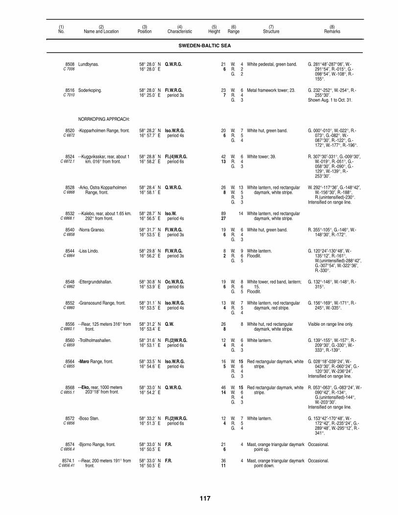
117
(1)No.
(2)Name and Location
(3)Position
(4)Characteristic
(5)Height
(6)Range
(7)Structure
(8)Remarks
8508C 7006
Lundbynas. 58° 28.0´ N16° 28.0´ E
Q.W.R.G. 216
W. 4R. 2G. 2
White pedestal, green band. G. 281°48′-287°06′, W.-291°54′, R.-015°, G.-098°54′, W.-108°, R.-155°.
8516C 7010
Soderkoping. 58° 28.0´ N16° 25.0´ E
Fl.W.R.G.period 3s
237
W. 6R. 4G. 3
Metal framework tower; 23. G. 232°-252°, W.-254°, R.-255°30′.
Shown Aug. 1 to Oct. 31.
NORRKOPING APPROACH:
8520C 6872
-Kopparholmen Range, front. 58° 28.2´ N16° 57.7´ E
Iso.W.R.G.period 4s
206
W. 7R. 5G. 4
White hut, green band. G. 000°-010°, W.-022°, R.-073°, G.-082°, W.-087°30′, R.-122°, G.-172°, W.-177°, R.-196°.
8524C 6872.1
- -Kuggviksskar, rear, about 1 km. 016° from front.
58° 28.8´ N16° 58.2´ E
Fl.(4)W.R.G.period 6s
4213
W. 6R. 4G. 3
White tower; 39. R. 307°30′-331°, G.-009°30′, W.-019°, R.-051°, G.-058°30′, R.-090°, G.-129°, W.-139°, R.-253°30′.
8528C 6868
-Arko, Ostra Kopparholmen Range, front.
58° 28.4´ N16° 58.1´ E
Q.W.R.G. 268
W. 13W. 5R. 3G. 3
White lantern, red rectangular daymark, white stripe.
W. 292°-117°36′, G.-148°42′, W.-156°30′, R.-188°, R.(unintensified)-230°.
Intensified on range line.
8532C 6868.1
- -Kalebo, rear, about 1.65 km. 292° from front.
58° 28.7´ N16° 56.5´ E
Iso.W.period 4s
8927
14 White lantern, red rectangular daymark, white stripe.
8540C 6858
-Norra Granso. 58° 31.7´ N16° 53.5´ E
Fl.W.R.G.period 3s
196
W. 6R. 4G. 3
White hut, green band. R. 355°-105°, G.-146°, W.-148°30′, R.-172°.
8544C 6864
-Liss Lindo. 58° 29.8´ N16° 56.2´ E
Fl.W.R.G.period 3s
82
W. 9R. 6G. 5
White lantern.Floodlit.
G. 120°24′-130°48′, W.-135°12′, R.-161°, W.(unintensified)-288°42′, G.-307°54′, W.-322°36′, R.-330°.
8548C 6862
-Ettergrundshallan. 58° 30.8´ N16° 53.9´ E
Oc.W.R.G.period 6s
196
W. 8R. 6G. 5
White tower, red band, lantern; 15.
Floodlit.
G. 132°-146°, W.-148°, R.-315°.
8552C 6860
-Gransosund Range, front. 58° 31.1´ N16° 53.5´ E
Iso.W.R.G.period 4s
134
W. 7R. 5G. 4
White lantern, red rectangular daymark, red stripe.
G. 156°-169°, W.-171°, R.-245°, W.-335°.
8556C 6860.1
- -Rear, 125 meters 316° from front.
58° 31.2´ N16° 53.4´ E
Q.W. 268
8 White hut, red rectangular daymark, white stripe.
Visible on range line only.
8560C 6859
-Trollholmashallen. 58° 31.6´ N16° 53.1´ E
Fl.(2)W.R.G.period 6s
124
W. 6R. 4G. 3
White lantern. G. 139°-155°, W.-157°, R.-209°30′, G.-330°, W.-333°, R.-139°.
8564C 6855
-Maro Range, front. 58° 33.5´ N16° 54.6´ E
Iso.W.R.G.period 4s
165
W. 15W. 6R. 4G. 3
Red rectangular daymark, white stripe.
G. 028°18′-039°24′, W.-043°30′, R.-060°24′, G.-120°30′, W.-236°24′.
Intensified on range line.
8568C 6855.1
- -Eko, rear, 1000 meters 203°18′ from front.
58° 33.0´ N16° 54.2´ E
Q.W.R.G. 4614
W. 15W. 6R. 4G. 3
Red rectangular daymark, white stripe.
R. 053°-063°, G.-083°24′, W.-090°42′, R.-134°, G.(unintensified)-144°, W.-203°30′.
Intensified on range line.
8572C 6856
-Boso Sten. 58° 33.2´ N16° 51.3´ E
Fl.(2)W.R.G.period 6s
124
W. 7R. 5G. 4
White lantern. G. 153°42′-170°48′, W.-172°42′, R.-235°24′, G.-289°48′, W.-295°12′, R.-341°.
8574C 6856.4
-Bjorno Range, front. 58° 33.0´ N16° 50.5´ E
F.R. 216
4 Mast, orange triangular daymark point up.
Occasional.
8574.1C 6856.41
- -Rear, 200 meters 191° from front.
58° 33.0´ N16° 50.5´ E
F.R. 3611
4 Mast, orange triangular daymark point down.
Occasional.
SWEDEN-BALTIC SEA

118
(1)No.
(2)Name and Location
(3)Position
(4)Characteristic
(5)Height
(6)Range
(7)Structure
(8)Remarks
8576C 6857.4
-Ramsholmen Range, front. 58° 33.7´ N16° 51.7´ E
Q.W. 165
8 Red hut, white stripe, red triangular daymark point up, yellow stripe.
8580C 6857.41
- -Rear, 250 meters 156°30′ from front.
58° 33.6´ N16° 51.8´ E
Oc.W.period 3s
309
8 White hut, red triangular daymark point down, yellow stripe, red square daymark, white stripe.
Visible on range line only.
8584C 6882
-Flaskogrund. 58° 35.0´ N16° 50.6´ E
Iso.W.R.G.period 4s
124
W. 6R. 4G. 4
White pillar, red band, black base; 13.
G. 130°-155°24′, W.-172°24′, R.-345°.
8588C 6888
-Flaskosund. 58° 34.9´ N16° 50.7´ E
Fl.G.period 3s
216
3 White tower, green band, black base; 20.
Visible 335°-170°.
8594C 6857
-Flasko. 58° 34.8´ N16° 50.7´ E
Fl.(2)R.period 6s
216
4 White hut, red band, lantern. Visible 155°-350°.
8596C 6878
-Flaskohallen. 58° 34.6´ N16° 51.1´ E
Fl.(3)G.period 9s
155
3 White hut, green band, black base; 10.
Visible 355°-155°.
8600C 6892
-Lono, N. side. 58° 36.3´ N16° 46.4´ E
Fl.W.R.G.period 4s
165
W. 9R. 6G. 5
White hut, red band; 7.Floodlit.
G. 090°-107°30′, W.-109°, R.-126°, G.-139°, W.-195°, R.-260°, G.-287°, W.-290°30′, R.-335°.
8604C 6890
-Hargokalv. 58° 36.4´ N16° 52.4´ E
Fl.(4)W.R.G.period 12s
5617
W. 8R. 6G. 5
Framework mast, white rectangular daymark, green band; 52.
Floodlit.
G. 255°-271°, W.-277°24′, R.-286°, G.-299°, R.-021°, G.-050°, W.-064°, R.-090°, G.-106°54′, W.-111°, R.-122°.
8608C 6829
-Gustaf Dalen. 58° 35.6´ N17° 28.0´ E
Fl.(2)W.period 6s
7924
12 Black round concrete tower, red top, gray base; 85.
Floodlit.
Red LED.
-RACON G(– – • ) 16 (3 & 10cm).
8612C 6836
-Norra Kranken. 58° 36.9´ N17° 23.1´ E
Fl.(3)W.R.G.period 9s
4112
W. 10R. 8G. 6
White tower, gray conical base; 36.
Floodlit.
W. 085°48′-088°06′, R.-100°, G.-154°30′, W.-159°, R.-204°12′, G.-207°06′, W.-210°24′, R.-241°36′, G.-260°54′, W.-287°54′, R.-349°, G.-085°48′.
-RACON K(– • –) 13 (3 & 10cm).
8616C 6832
-Havringe Range, front. 58° 36.2´ N17° 19.1´ E
Q.W. 309
14 White pedestal, black band, white square daymark.
Floodlit.
Visible on range line only.
8620C 6832.1
- -Rear, 183 meters 295°24′ from front.
58° 36.2´ N17° 19.0´ E
Iso.W.R.G.period 3s
7523
W. 16R. 13G. 11
White tower, black band; 72.Floodlit.
G. 109°48′-138°12′, W.-139°18′, R.-244°54′, G.-290°54′, W.-313°42′, R.-109°48′.
8624C 6834
-Vastra Korpen. 58° 36.3´ N17° 19.3´ E
Fl.(4)W.R.G.period 12s
268
W. 9R. 7G. 6
White tower; 23.Floodlit.
W.(unintensified) 029°54′-075°, G.-105°12′, W.-111°12′, R.-131°12′, G. 179°54′-311°42′, W.-320°48′, R.-341°30′.
8626C 6833
-W. Hallgrundet. 58° 39.1´ N17° 13.7´ E
Fl.R.period 3s
165
2 Cairn. Radar reflector.
8628C 6838
-Kopparnageln. 58° 36.5´ N17° 17.3´ E
Q.W.R.G. 227
W. 8R. 6G. 5
White tower, red band; 13.Floodlit.
G. 103°06′-249°48′, W.-257°42′, R.-103°06′.
Radar reflector.
8632C 6840
-Grasskaren, E. extremity. 58° 37.0´ N17° 14.2´ E
L.Fl.(2)W.R.G.period 15sfl. 2s, ec. 3sfl. 2s, ec. 8s
4112
W. 13R. 11G. 9
White tower, green band; 39.Floodlit.
G. 242°06′-263°42′, W.-267°42′, R.-284°12′, G.-301°12′, W.-099°, R.-131°.
8640C 6818
-Beten, W. side. 58° 38.7´ N17° 08.4´ E
Fl.(2)W.R.G.period 6s
3912
W. 13R. 10G. 8
White lantern.Floodlit.
G. 305°-332°, W.-343°54′, R.-028°36′, G.-063°, W.-066°06′, R.-074°48′, G.-124°54′, W.-131°54′, R.-155°.
SWEDEN-BALTIC SEA

119
(1)No.
(2)Name and Location
(3)Position
(4)Characteristic
(5)Height
(6)Range
(7)Structure
(8)Remarks
8644C 6842
-Vinterklasen Range, front. 58° 38.5´ N17° 07.8´ E
F.R. 309
9
8648C 6842.1
- -Rear, 75 meters 213° from front.
58° 38.4´ N17° 07.8´ E
Mo.(U)W.R.G.period 10sfl. 1s, ec. 1sfl. 1s, ec. 1sfl. 3s, ec. 3s
5617
W. 11R. 8G. 7
White hut, green band.Floodlit.
R. 177°30′-247°48′, G.-300°48′, W.-308°48′, R.-028°, G.-058°, W.-062°30′, R.-094°48′, G.-141°12′.
8652C 6845
-Falkens Grund. 58° 37.5´ N17° 02.2´ E
Fl.(3)W.R.G.period 9s
3611
W. 10R. 8G. 6
White tower, red top, concrete base; 23.
Floodlit.
R. 009°06′-063°, G.-076°54′, W.-080°12′, R.-209°54′, G.-254°42′, W.-262°42′, R.-288°54′, G.-009°06′.
Radar reflector.
8654C 6846.5
-Kungshamnsgrund. 58° 36.9´ N17° 02.1´ E
Oc.W.R.G.period 10slt. 8s, ec. 2s
134
8 Gray tower, red and white top; 16.
G. 060°48′-070°36′, W.-079°18′, R.-180°06′, G.-243°42′, W.-247°12′, R.-249°48′, G.-251°54′, W.-254°48′, R.-269°36′.
-RACON T(–)period 30s
8656C 6846
-Kungshamn Range, front. 58° 37.5´ N17° 01.2´ E
Iso.W.R.G.period 4s
3611
W. 10R. 7G. 6
White hut, red stripes, lantern. G. 255°-260°, W.-265°, R.-298°06′, W. 059°30′-078°30′.
8660C 6846.1
- -Rear, 600 meters 069°30′ from front.
58° 37.7´ N17° 01.8´ E
Q.W.R.G. 6219
W. 8R. 6G. 5
White hut, red stripe, lantern; 30. R. 237°-246°36′, G.-262°48′, W.-266°30′, R.-288°54′, G.-319°48′, W.-327°, R.-001°06′, G.-027°18′, W.-081°.
8664C 6848
-Mesen. 58° 37.1´ N16° 59.3´ E
Fl.W.R.G.period 3s
206
W. 9R. 6G. 5
White hut, red band, white base. R. 062°-150°, G.-251°, W.-253°, R.-260°.
8668C 6847
-Albacksgrund. 58° 37.4´ N16° 59.9´ E
Fl.(2)W.R.G.period 6s
237
W. 8R. 6G. 5
White lantern, green band, concrete base.
Floodlit.
G. 241°-267°30′, R.-000°, G.-062°, W.-067°30′, R.-090°.
8672C 6894
-Navekvarn, Braviken, N. side of channel.
58° 37.2´ N16° 48.7´ E
Fl.(2)W.R.G.period 6s
268
W. 9R. 6G. 5
White hut, green band; 7.Floodlit.
G. 270°-295°, W.-296°, R.-313°30′, G.-336°, R.-000°, G.-069°, W.-075°30′, R.-084°, G.-093°, W.-095°, R.-125°.
8676C 6896
-Karlsund, about 1.5 km. from center of Flinta.
58° 37.7´ N16° 42.3´ E
Q.W.R.G. 216
W. 8R. 6G. 5
Green hut, white roof, base.Floodlit.
G. 273°-280°, W.-282°, R.-330°, G.-022°, W.-070°, R.-088°, G.-095°54′, W.-099°, R.-120°.
8688C 6898
-Saterholmen. 58° 38.2´ N16° 35.3´ E
Fl.(4)W.R.G.period 12s
237
W. 12R. 9G. 8
White lantern, green band, pedestal.
Floodlit.
G. 270°-279°48′, W.-280°30′, R.-284°30′, G.-289°, W.-290°, R.-026°, G.-103°06′, W.-105°, R.-160°.
8692C 6901
-Algersgrund. 58° 39.1´ N16° 27.4´ E
Q.W.R.G. 165
W. 9R. 7G. 6
White hut, red band, black base, lantern.
W. 083°54′-247°36′, R.-273°, G.-083°54′.
8696C 6900
-Lovsgata. 58° 39.4´ N16° 27.3´ E
Fl.(2)W.R.G.period 6s
227
W. 8R. 6G. 5
White tower, green band; 20. G. 275°-286°12′, W.-288°06′, R.-302°18′, G.-069°36′, W.-071°36′, R.-078°18′, G.-084°18′, W.-088°18′, R.-105°.
8700C 6902
-Stora Juten. 58° 38.1´ N16° 19.5´ E
Fl.(3)W.R.G.period 9s
216
13 White tower, red lantern; 20. R. 123°48′-138°, W.-230°30′, R.-243°, G.-251°06′, W.-253°18′, R.-282°36′.
Norrkoping channel is marked by various W., R., and G. lights.
8702C 6904.8
-Lindo Harbor, N. 58° 36.7´ N16° 15.6´ E
Fl.G.period 3s
134
4 White pole, green band; 7. Shown Mar. 1 to Dec. 10.
8703C 6904.9
- -S. 58° 36.7´ N16° 15.7´ E
Fl.R.period 3s
134
4 White pole, red band; 7. Shown Mar. 1 to Dec. 10.
SWEDEN-BALTIC SEA
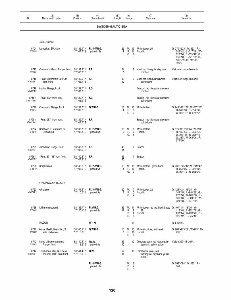
120
(1)No.
(2)Name and Location
(3)Position
(4)Characteristic
(5)Height
(6)Range
(7)Structure
(8)Remarks
OXELOSUND:
8704C 6820
-Ljungskar, SW. side. 58° 39.1´ N17° 07.7´ E
Fl.(4)W.R.G.period 12s
237
W. 13R. 11G. 8
White tower; 20.Floodlit.
G. 270°-323°, W.-327°, R.-345°42′, G.-017°48′, W.-023°06′, R.-035°12′, G.-050°18′, R.-071°06′, G.-135°, W.-141°48′, R.-190°.
8712C 6824
-Oxelosund Hamn Range, front. 58° 39.9´ N17° 06.3´ E
F.R. 216
9 Mast, red triangular daymark point up.
Visible on range line only.
8716C 6824.1
- -Rear, 280 meters 320°30′ from front.
58° 40.0´ N17° 06.1´ E
F.R. 3310
9 Mast, red triangular daymark point down.
Visible on range line only.
8718C 6814.5
-Harbor Range, front. 58° 39.7´ N17° 07.0´ E
F.G. Beacon, red triangular daymark point up.
8718.1C 6814.501
- -Rear, 332° from front. 58° 39.7´ N17° 06.9´ E
F.G. Beacon, red triangular daymark point down.
8720C 6814
-Oxelosund Range, front. 58° 39.7´ N17° 07.7´ E
Q.W.R.G. 134
W. 10R. 8G. 7
White lantern. G. 245°-281°36′, W.-307°18′, R.-347°30′, G.-054°36′, W.-062°12′, R.-078°12′.
8720.1C 6814.01
- -Rear, 057° from front. 58° 39.7´ N17° 07.7´ E
F.R. Beacon, red triangular daymark point down.
8724C 6816
-Korsholm, E. entrance to Oxelosund.
58° 39.7´ N17° 08.1´ E
Fl.(2)W.R.G.period 6s
103
W. 8R. 6G. 5
White lantern.Floodlit.
G. 075°12′-093°24′, W.-099°, R.-169°54′, G.-236°54′, W.-243°48′, R.-258°48′, G.-262°, W.-264°06′, R.-274°06′.
8725C 6810.1
-Jarnverket Range, front. 58° 40.8´ N17° 08.0´ E
F.R. 4614
7 Beacon.
8725.1C 6810.2
- -Rear, 271°18′ from front. 58° 40.8´ N17° 07.8´ E
F.R. 6620
7 Beacon.
8728C 6810
-Korpholmen. 58° 40.6´ N17° 08.6´ E
Fl.(2)W.R.G.period 6s
134
W. 13R. 10G. 9
White lantern, green band.Floodlit.
G. 231°-245°42′, W.-249°42′, R.-258°06′, G.-001°42′, W.-004°12′, R.-058°36′.
NYKOPING APPROACH:
8732C 6794.5
Kolhalsen. 58° 41.4´ N17° 10.5´ E
Fl.(3)W.R.G.period 9s
206
W. 7R. 5G. 4
White tower; 22.Floodlit.
G. 129°42′-139°24′, W.-144°18′, R.-248°36′, G.-277°30′, W.-281°36′, R.-300°06′, G.-320°30′, W.-321°48′, R.-337°36′.
8736C 6800
-Lillhammarsgrund. 58° 39.7´ N17° 20.1´ E
Fl.W.R.G.period 3s
3611
W. 11R. 9R. 2G. 8
White tower, red top, black base; 39.
Floodlit.
G. 101°18′-113°30′, W.-118°48′, R.-222°06′, G.-237°24′, W.-239°42′, R.-325°12′, G.-345°18′.
-RACON N(– • ) 11 (3 & 10cm).
8740C 6802
-Norra Masklubbshallan, S. side of channel.
58° 40.1´ N17° 16.8´ E
Q.W.R.G. 103
W. 13R. 10G. 8
White structure, red band.Floodlit.
G. 266°-275°30′, W.-279°, R.-296°.
8742C 6803
-Norra Lillhammarsgrund Range, front
58° 40.4´ N17° 19.2´ E
Iso.W.period 4s
3310
13 Concrete base, red rectangular daymark, yellow stripe.
Visible 297°48'-304°.
8744C 6803.1
- -Trutbadan, rear, N. side of channel, 301° from front.
58° 41.4´ N17° 16.0´ E
Q.W. 5216
13 Framework tower, red rectangular daymark, yellow stripe.
Fl.(4)W.R.G.period 12s
W. 6R. 4G. 3
G. 056°-084°, W.-093°, R.-101.
SWEDEN-BALTIC SEA

121
(1)No.
(2)Name and Location
(3)Position
(4)Characteristic
(5)Height
(6)Range
(7)Structure
(8)Remarks
8748C 6794
-Ledskar. 58° 42.1´ N17° 13.3´ E
Iso.W.R.G.period 3s
237
W. 7R. 5G. 4
White lantern. W. 040°42′-052°42′, R.-088°30′, G.-113°, R.-178°30′, G.-198°, W.-200°30′, R.-230°06′, G.-309°12′, R.-359°54′, G.-040°42′.
8752C 6795
-Salgrund. 58° 42.9´ N17° 08.5´ E
Fl.(2)W.R.G.period 6s
206
W. 6R. 4G. 3
Green hut, white band. G. 290°48′-300°36′, W.-320°42′, R.-051°12′, G.-120°36′, R.-157°06′.
8756C 6796
Nykoping AVIATION LIGHT. 58° 47.0´ N16° 55.0´ E
Fl.(7)W.period 19s
14845
23 Two masts.
8760C 6792
Stora Kampasen. 58° 42.8´ N17° 14.0´ E
Fl.W.R.G.period 3s
237
W. 6R. 4G. 3
Pylon, white hut. G. 240°-260°, W.-276°, R.-017°, G.-052°, W.-063°, R.-074°.
8764C 6790
Valaro, on mainland. 58° 43.3´ N17° 15.6´ E
Q.R.G. 155
R. 4G. 3
White hut. G. 270°-305°, R.-000°, G.-055°, R.-064°.
8768C 6788
Ornklubb. 58° 42.9´ N17° 16.7´ E
Fl.(2)R.G.period 6s
103
R. 4G. 3
White hut. G. 112°-126°, R.-180°, G.-274°, R.-284°.
8772C 6786
Espskarsklubb. 58° 43.3´ N17° 18.9´ E
Fl.R.G.period 3s
206
R. 4G. 3
White hut. G. 215°-225°, R.-019°, G.-051°, R.-055°.
8776C 6772
Skepna. 58° 44.8´ N17° 21.2´ E
Fl.W.R.G.period 3s
206
W. 6R. 5G. 3
White hut. G. 270°18′-305°, W.-310°, R.-332°06′, G.-015°54′, W.-019°54′, R.-090°12′.
8780C 6774
Langskar. 58° 44.2´ N17° 22.9´ E
Fl.(2)W.R.G.period 6s
268
W. 6R. 4G. 3
White lantern. G. 095°54′-110°06′, W.-116°18′, R.-136°, W.(unintensified)-214°12′, G.-229°06′, W.-233°06′, R.-243°18′.
8784C 6760
Bergo. 58° 45.1´ N17° 24.5´ E
Fl.W.R.period 3s
175
W. 10R. 8
White lantern.Floodlit.
W. 194°24′-225°30′, R.-030°.
8796C 6750
Savosund. 58° 45.9´ N17° 28.5´ E
Iso.W.R.G.period 3s
103
W. 10R. 8G. 5
White hut, green band; 7. G. 092°24′-101°30′, W.-108°12′, R.-148°06′, W.(unintensified)-246°36′, R.-252°18′, G.-271°54′, W.-274°48′, R.-295°12′.
8800C 6748
Herrsaten. 58° 45.8´ N17° 30.1´ E
Fl.(4)W.R.G.period 12s
165
W. 7R. 5G. 4
White hut, green band. G. 095°24′-100°30′, R.-110°42′, G.-126°54′, W.-137°, R.-221°54′, G.-237°, W.-241°18′, R.-267°12′.
8808C 6768
Hartso Stangskar. 58° 41.5´ N17° 27.7´ E
Fl.(4)W.R.G.period 12s
4514
W. 8R. 6G. 4
White tower, black base; 36. G. 003°18′-022°48′, W.-035°18′, R.-064°18′, G.-074°48′, W.-079°18′, R.-120°12′, G.-159°24′, W.-161°12′, R.-179°54′.
8812C 6766
Ringson Range, front. 58° 43.5´ N17° 26.3´ E
Iso.W.R.G.period 4s
289
W. 6R. 5G. 3
White tower, green base, red rectangular daymark, white stripe; 20.
G. 330°-331°36′, W.-342°12′, R.-046°24′, G.-118°12′, W.-125°36′, R.-139°18′.
8816C 6766.1
-Rear, 825 meters 338°30′ from front.
58° 43.9´ N17° 26.0´ E
Q.W. 6620
10 White pedestal, red rectangular daymark, white stripe, lantern.
Visible on range line only.
8820C 6764
Griskar Range, front. 58° 44.1´ N17° 25.0´ E
Iso.W.period 4s
196
White tower, red band; 20. Visible on range line only.
Iso.W.R.G.period 4s
W. 6R. 5G. 3
G. 153°18′-175°06′, W.-177°42′, R.-195°54′, G.-284°.
8824C 6764.1
-Rear, 450 meters 314°36′ from front.
58° 44.2´ N17° 24.6´ E
Q.W. 3912
8 White pedestal, red rectangular daymark, white stripe, lantern.
Visible on range line only.
8828C 6754
Marholmen Range, front. 58° 46.9´ N17° 27.6´ E
Q.W.R. 216
W. 8R. 6
White pedestal, red band, lantern.
W. 136°-269°36′, R.-136°.Intensified on range line.
SWEDEN-BALTIC SEA

122
(1)No.
(2)Name and Location
(3)Position
(4)Characteristic
(5)Height
(6)Range
(7)Structure
(8)Remarks
8832C 6754.1
-Rear, Bromdal, 700 meters 042° from front.
58° 47.1´ N17° 28.1´ E
Iso.W.R.G.period 4s
4213
W. 9R. 7G. 5
White pedestal, white square daymark, red band.
G. 306°30′-322°36′, R.-000°36′, G.-026°54′, W.-033°54′, R.-087°06′.
8836C 6752
Kallvik. 58° 46.8´ N17° 28.7´ E
Fl.W.R.G.period 3s
134
W. 9R. 7G. 5
White hut, red band.Floodlit.
G. 313°48′-332°18′, W.-339°18′, R.-050°42′, G.-115°24′, W.-125°18′, R.-134°.
8840C 6744
Tratbadan. 58° 46.7´ N17° 33.7´ E
Fl.(2)W.R.G.period 6s
237
W. 7R. 5G. 4
White tower, green band; 20. G. 060°42′-068°24′, W.-071°42′, R.-088°36′, G.-156°48′, W.-160°, R.-166°48′, G.-268°06′.
8844C 6742
Hoko Gupa. 58° 47.6´ N17° 32.9´ E
Fl.W.R.G.period 3s
165
W. 6R. 5G. 3
White lantern, red band. G. 170°12′-176°54′, W.-179°48′, R.-210°18′, G.-228°48′, W.-236°18′, R.-264°18′, G.-317°, W.-326°12′, R.-349°06′.
8848C 6738
Kockelskar Range, front. 58° 48.0´ N17° 33.3´ E
Iso.W.R.G.period 4s
237
W. 7R. 5G. 4
White tower, red base; 23. G. 197°48′-274°48′, W.-276°48′, R.-308°18′, G.-357°48′, R.-017°36′.
8852C 6738.1
-Rear, 215 meters 276° from front.
58° 48.0´ N17° 33.1´ E
Q.W. 6420
10 White tower, red square daymark.
Visible on range line only.
8856C 6740
Kockelhallan. 58° 47.8´ N17° 33.9´ E
Fl.(3)W.R.G.period 9s
175
W. 6R. 5G. 4
White hut, green band. G. 033°54′-053°18′, W.-076°24′, R.-132°54′, G.-169°36′, W.-173°24′, R.-193°42′, G.-265°12′, R.-275°48′.
8860C 6732
Asenskallen. 58° 47.0´ N17° 41.9´ E
Fl.W.R.G.period 3s
3812
W. 8R. 6G. 5
White tower, green band; 29. G. 091°06′-106°06′, W.-110°, R.-238°18′, G.-258°54′, W.-267°30′, R.-277°18′, G.-293°30′, R.-299°24′.
8864C 6730
Skvallran. 58° 47.3´ N17° 42.5´ E
Fl.(3)W.R.G.period 9s
3410
W. 7R. 5G. 4
White tower, red band; 38. G. 189°18′-203°06′, W.-220°36′, R.-257°30′, G.-270°48′, W.-278°48′, R.-344°18′, G.-060°12′, W.-080°, R.-095°, R.(unintensified)-115°06.
8868C 6734
Graskar. 58° 47.6´ N17° 39.9´ E
Q.W. 3210
7 Silver hut. Visible to W. toward Kockelskar range lights.
8872C 6726
Tornskar. 58° 48.9´ N17° 33.0´ E
Iso.W.R.G.period 4s
165
W. 6R. 5G. 3
Hut, green band, white lantern. R. 013°12′-150°12′, G.-170°54′, W.-173°12′, R.-187°54′, W.-226°42′, R.-239°54′.
8876C 6724
Bockholmen. 58° 50.1´ N17° 34.9´ E
Q.W.R.G. 124
W. 6R. 5G. 3
Hut, green band, white lantern. G. 359°30′-006°18′, W.-011°42′, R.-050°06′, G.-178°54′, W.-182°48′, R.-200°48′.
8880C 6722
Lysberget. 58° 50.3´ N17° 35.8´ E
Fl.(2)W.R.G.period 6s
278
W. 6R. 5G. 3
White lantern. G. 045°06′-049°30′, W.-052°30′, R.-064°.
8884C 6720
Boko. 58° 51.0´ N17° 36.0´ E
Iso.W.R.G.period 4s
165
W. 6R. 5G. 3
White lantern. G. 052°48′-060°06′, W.-229°24′, G.-249°06′, W.-252°12′, R.-260°24′.
8888C 6675.6
Vastra Roko. 58° 47.4´ N17° 46.8´ E
Iso.W.R.G.period 5s
4313
W. 9R. 7G. 6
White tower; 26.Floodlit.
G. 027°18′-084°12′, R.-114°24′, G.-151°36′, W.-161°36′, R.-170°54′.
8892C 6675.4
Rokogrundet. 58° 47.1´ N17° 46.6´ E
Q.W.R.G. 3310
W. 9R. 7G. 6
Black tower, white band; 30.Floodlit.
G. 024°24′-088°18′, W.-089°48′, R.-107°18′, G.-163°48′, W.-168°30′, R.-292°12′, G.-321°, W.-324°30′, R.-024°24′.
8896C 6675
Granklubben. 58° 47.9´ N17° 44.9´ E
Fl.(4)W.R.G.period 12s
4213
W. 13R. 10G. 9
White tower. G. 225°06′-297°48′, R.-312°36′, G.-316°48′, W.-320°, R.-329°12′, G.-010°42′, W.-054°24′, R.-074°54′.
SWEDEN-BALTIC SEA

123
(1)No.
(2)Name and Location
(3)Position
(4)Characteristic
(5)Height
(6)Range
(7)Structure
(8)Remarks
8900C 6675.8
Kolguskar. 58° 48.1´ N17° 46.6´ E
Fl.(2)W.R.G.period 6s
3310
W. 9R. 7G. 6
White hut, green roof.Floodlit.
G. 337°-001°30′, W.-012°, R.-022°, G.-135°, W.-138°, R.-155°.
8902C 6676.2
Torsken. 58° 49.5´ N17° 43.7´ E
Q.W.R.G. 216
W. 9R. 6G. 5
White hut, red band.Floodlit.
G. 018°42′-153°54′, W.-166°24′, R.-248°30′, G.-307°, W.-313°06′, R.-018°42′.
Radar reflector.
8904C 6676.3
Vattklubben. 58° 49.4´ N17° 44.4´ E
Iso.W.R.G.period 6s
3310
W. 10R. 7G. 6
White tower, green band; 20.Floodlit.
G. 304°18′-319°18′, W.-325°54′, R.-044°, G.-125°48′, W.-135°24′, R.-162°36′, G.-219°06′, R.-240°12′.
8906C 6676.6
Karinghallan. 58° 49.9´ N17° 43.6´ E
Fl.(2)G.period 6s
237
6 Metal structure, green square daymark.
Floodlit.
Radar reflector.
8908C 6676.5
Sodra Bergholmen. 58° 49.9´ N17° 45.3´ E
Fl.W.R.G.period 3s
237
W. 4R. 2G. 2
White pedestal, lantern. G. 206°18′-232°06′, W.-291°06′, R.-025°, G.-056°30′, W.-060°42′, R.-077°42′, G.-146°36′.
Occasional.
8952C 6676.8
Fifong. 58° 50.5´ N17° 43.4´ E
Fl.(3)W.R.G.period 9s
227
W. 9R. 7G. 6
White hut, red band.Floodlit.
G. 163°12′-169°30′, W.-172°, R.-175°30′, G.-244°48′, R.-311°54′, G.-351°48′, W.-359°12′, R.-004°06′, G.-017°36′.
8956C 6677.4
Svartahallen. 58° 52.0´ N17° 40.0´ E
Fl.(2)W.R.G.period 6s
165
W. 8R. 5G. 4
White hut, green band, lantern. G. 057°48'-069°48′, W.-071°12′, R.-158°48′, G.-218°, W.-225°42′, R.-244°36′, G.-271°18′, R.-284°.
8960C 6677
Sankhallan. 58° 52.0´ N17° 43.0´ E
Q.W.R.G. 216
W. 10R. 7G. 6
Red hut, white base.Floodlit.
G. 086°42′-180°06′, W.-185°24′, R.-192°54′, G.-204°36′, W.-216°18′, R.-270°06′, G.-340°18′, W.-345°54′, R.-086°42′.
8962C 6677.1
Ramsholmen. 58° 52.6´ N17° 43.2´ E
Fl.(2)G.period 6s
237
2 Yellow daymark.Floodlit.
Radar reflector.
8964C 6677.2
Galklubb. 58° 53.0´ N17° 43.0´ E
Iso.W.R.G.period 4s
185
W. 9R. 7G. 6
White hut, red roof.Floodlit.
R. 008°-081°, G.-158°, W.-179°30′, R.-288°, G.-297°, W.-299°, R.-347°, G.-357°, W.-008°.
8968C 6677.6
Stenskar. 58° 54.0´ N17° 43.0´ E
Fl.W.R.G.period 3sfl. 0.7s, ec. 2.3s
3310
W. 10R. 7G. 6
White hut, red roof.Floodlit.
G. 154°06′-179°54′, W.-184°42′, R.-284°48′, G.-348°18′, W.-353°54′, R.-002°12′, G.-022°, W.-023°12′, R.-057°54′.
8972C 6677.8
Egelsholm Range, front. 59° 00.0´ N17° 43.0´ E
Q.W.R.G. 103
W. 9R. 7G. 5
White hut, red top, lantern.Floodlit.
G. 135°-169°48′, W.-171°30′, R.-229°54′, G.-338°, W.-353°12′, R.-050°.
8976C 6677.81
-Regarn, rear, 4.8 km. 172° from front.
58° 57.9´ N17° 43.6´ E
Iso.W.R.G.period 4s
206
W. 6R. 5G. 3
White hut, green band, lantern. G. 354°-008°, W.-175°06′, R.-211°36′.
8980C 6678
Notholmen. 59° 03.0´ N17° 41.0´ E
Fl.W.R.G.period 3s
103
W. 9R. 7G. 5
Round hut, red roof, white lantern.
Floodlit.
G. 119°06′-160°30′, W.-166°30′, R.-296°36′, G.-307°42′, W.-319°12′, R.-341°48′.
8982C 6678.5
Farstanas. 59° 05.8´ N17° 39.9´ E
Fl.(3)W.R.Gperiod 9sfl. 0.7s, ec. 1sfl. 0.7s, ec. 1sfl. 0.7s, ec. 4.9s
165
W. 4R. 3G. 2
White hut, lantern. G. 276°54′-340°06′, W.-345°06′, R.-025°18′.
8984C 6678.4
Skjutholmen. 59° 06.0´ N17° 39.0´ E
Q.W. 4 Red rectangular daymark.
8992C 6679
Hallsfjarden. 59° 06.0´ N17° 42.0´ E
Fl.W.period 3s
134
8 White pedestal, lantern.
SWEDEN-BALTIC SEA
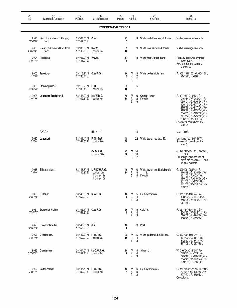
124
(1)No.
(2)Name and Location
(3)Position
(4)Characteristic
(5)Height
(6)Range
(7)Structure
(8)Remarks
8996C 6678.8
Viad, Brandalssund Range, front.
59° 06.0´ N17° 42.0´ E
Q.W. 227
9 White metal framework tower. Visible on range line only.
9000C 6678.81
-Rear, 600 meters 062° from front.
59° 06.5´ N17° 42.9´ E
Iso.W.period 4s
5918
9 White iron framework tower. Visible on range line only.
9004C 6679.2
Flasklosa. 59° 08.0´ N17° 41.0´ E
V.Q.W. 175
3 White mast, green band. Partially obscured by trees 180°-335°.
F.W. and F.Y. lights mark shoreline.
9005C 6680
Tegeltorp. 59° 13.9´ N17° 36.4´ E
Q.W.R.G. 165
W. 3R. 2G. 1
White pedestal, lantern. R. 338°-348°30′, G.-354°30′, W.-151°, R.-166°.
9006C 6680.3
Storviksgrundet. 59° 15.2´ N17° 35.1´ E
Fl.R.period 3s
3310
5
9008C 6583.6
Landsort Bredgrund. 58° 43.9´ N17° 52.5´ E
Iso.W.R.G.period 4s
5918
W. 16R. 12G. 8
Orange tower.Floodlit.
R. 001°36′-013°12′, G.-046°54′, W.-052°36′, R.-085°54′, G.-126°36′, R.-158°42′, G.-177°06′, R.-210°18′, G.-217°06′, W.-219°18′, R.-223°54′, G.-234°06′, R.-273°06′, G.-321°54′, R.-345°06′, G.-356°36′, W.-001°36′.
Shown 24 hours Nov. 1 to Mar. 31.
RACON B(– • • • ) 14 (3 & 10cm).
9012C 6584
Landsort. 58° 44.4´ N17° 51.9´ E
Fl.(1+4)W.period 60s
14845
22 White tower, red top; 82. Unintensified 190°-197°.Shown 24 hours Nov. 1 to
Mar. 31.
Oc.W.R.G.period 10s
9228
W. 14R. 10G. 7
G. 322°48′-351°12′, W.-358°, R.-023°.
F.R. range lights for use of pilots are shown at E. and W. pilot harbors.
9016C 6585
Tilljandersknalt. 58° 45.5´ N17° 49.6´ E
L.Fl.(2)W.R.G.period 12sfl. 2s, ec. 2sfl. 2s, ec. 6s
4614
W. 10R. 8G. 5
White tower, two black bands; 33.
Floodlit.
G. 029°06′-086°42′, R.-116°18′, G.-128°36′, W.-131°06′, R.-153°, G.-190°06′, R.-218°36′, G.-251°06′, R.-313°, G.-331°06′, W.-338°30′, R.-029°06′.
9020C 6587.6
Grisskar. 58° 46.8´ N17° 50.9´ E
Q.W.R.G. 165
W. 5R. 4G. 3
Framework tower. G. 011°36′-136°24′, W.-138°30′, R.-154°36′, G.-355°06′, W.-359°24′, R.-011°36′.
9024C 6587.7
Storpelles Holme. 58° 46.7´ N17° 51.8´ E
Q.W.R.G. 268
W. 5R. 4G. 3
Column. R. 281°24′-304°18′, G.-354°12′, W.-359°12′, R.-080°06′, G.-164°30′, W.-168°48′, R.-185°24′.
9025C 6587.8
Osterklintshallan. 58° 46.3´ N17° 52.0´ E
Q.Y. 103
3 Post.
9026C 6587.9
Grisblankan. 58° 46.0´ N17° 50.9´ E
Fl.W.R.G.period 3s
3310
W. 5R. 4G. 3
White pedestal, black base. G. 057°30′-102°30′, R.-167°36′, G.-181°, R.-342°12′, G.-347°, W.-357°06′, R.-057°30′.
9028C 6587.95
Olandssten. 58° 47.6´ N17° 52.1´ E
I.V.Q.W.R.G.period 6s
206
W. 5R. 4G. 3
Silver hut. W. 016°06′-019°54′, R.-039°30′, G.-073′, W.-075°18′, R.-220°30′, G.-254°48′, W.-258°48′, R.-329°36′, G.-016°06′.
9032C 6587.4
Bottenholmen. 58° 47.4´ N17° 50.0´ E
Fl.W.R.G.period 4s
134
W. 6R. 5G. 3
Framework tower. G. 245°-263°24′, W.-267°18′, R.-301°, G.-326°30′, W.-327°30′, R.-350°12′.
Occasional.
SWEDEN-BALTIC SEA

125
(1)No.
(2)Name and Location
(3)Position
(4)Characteristic
(5)Height
(6)Range
(7)Structure
(8)Remarks
9036C 6587.2
Vastra Kvarnhallan. 58° 47.6´ N17° 50.4´ E
Q.W.R.G. 82
W. 5R. 4G. 3
White pedestal, lantern. G. 143°-151°24′, W.-155°12′, R.-262°, G.-326°, W.-334°12′, R.-349°, G.-004°42′, W.-007°30′, R.-025°.
9040C 6576
Huvudskar. 58° 57.8´ N18° 34.1´ E
Mo.(N)W.period 25sfl. 4s, ec. 4sfl. 1s, ec. 16s
8526
12 White hut, concrete tower, black band; 51.
Unintensified 115°-205°.
9044C 6578
Vindbaden. 59° 00.1´ N18° 38.0´ E
Fl.W.period 3s
3 White metal framework tower, blue band.
Fishing light.Occasional.
9048C 6580
Skotrokan. 59° 00.8´ N18° 31.0´ E
Fl.R.period 3s
6921
3 White pedestal, blue band. Fishing light.Occasional.
9052C 6582
Torrmulen. 59° 06.0´ N18° 40.0´ E
Fl.W.period 5s
206
2 White lantern, blue band, red base.
Fishing light.Occasional.
9054C 6466
Peskobben. 59° 09.7´ N18° 49.4´ E
F.W. 206
3 Framework tower. Visible 097°-174° and 282°-330°.
Fishing light.Occasional.
9056C 6465
Almagrundet. 59° 09.3´ N19° 07.6´ E
Fl.(4)W.R.period 12s
9529
13 Black tower, red band; 98.Floodlit. Helicopter platform.
R. 045°30′-225°24′, W.-045°30′.
RACON G(– – • ) 14 (3 & 10cm).
9060C 6470
Revengegrundet. 59° 15.1´ N19° 00.8´ E
L.Fl.(2)W.R.G.period 18sfl. 3s, ec. 3sfl. 3s, ec. 9s
6720
W. 16R. 13G. 12
Red tower, black base; 69.Floodlit.
W. 000°-005°12′, R.-011°, G.-109°54′, R.-124°, G.-137°42′, W.-145°06′, R.-160°12′, G.-295°06′, W.-307°24′, R.-314°, G.-000°.
Radar reflector.
RACON RT(• – • –) 14 (3 & 10cm).
9064C 6471.6
Svangen. 59° 16.2´ N18° 58.5´ E
Q.W.R.G. 4614
W. 12R. 9G. 7
Red tower, black bands; 49.Floodlit.
G. 083°12′-116°30′, W.-122°24′, R.-186°36′, G.-282°36′, R.-083°12′.
SANDHAMNSLEDEN:
9068C 6468
-Sandhamn Stangskar. 59° 16.6´ N19° 00.0´ E
Iso.W.R.G.period 4s
3410
W. 8R. 5G. 4
Yellow round tower, white top; 24.
G. 294°48′-326°24′, W.-343°24′, R.-017°30′, G.-070°12′, W.-074°36′, R.-094°12′, G.-132°18′, W.(unintensified)-138°30′.
9070C 6468.5
-Gronskar. 59° 16.7´ N19° 01.5´ E
L.Fl.G.period 10sfl. 2s, ec. 8s
4
9076C 6463.5
Horssten, about 6.9 kilometers 067° from Gronskar.
59° 18.1´ N19° 08.0´ E
Fl.(4)W.R.G.period 12s
268
W. 6R. 4G. 3
White hut. G. 276°54′-312°, W.-037°42′, R.-110°42′, G.-131°24′, W.-138°30′, R.-149°12′, G.-169°30′.
Occasional.
9080C 6472
Prickgrundet. 59° 17.1´ N18° 55.8´ E
Fl.(3)W.R.G.period 9s
175
W. 5R. 6G. 13
White structure, yellow top. W. 005°48′-085°30′, G.(5M)-122°42′, R.-245°24′, G.-322°42′, R.-005°48′.
9084C 6472.1
Sandhamn, Sando pilot station. 59° 17.4´ N18° 54.9´ E
Oc.W.R.G.period 30s
3310
W. 11R. 13G. 11
Yellow tower, yellow house; 33. R. 294°30′-298°30′, G.-304°, W.-307°, R.-314°24′.
9096C 6476
-Stannkobben Range, front. 59° 18.4´ N18° 53.4´ E
Iso.R.period 4s
237
6 White pedestal, red rectangular daymark, yellow stripe.
Visible on range line only.
9100C 6476.1
- -Rear, 350 meters 352°06′ from front.
59° 18.5´ N18° 53.3´ E
Q.R. 6620
6 White pedestal, red rectangular daymark, yellow stripe.
Visible on range line only.
SWEDEN-BALTIC SEA

126
(1)No.
(2)Name and Location
(3)Position
(4)Characteristic
(5)Height
(6)Range
(7)Structure
(8)Remarks
9104C 6478
-Farfarsgrund. 59° 17.7´ N18° 53.3´ E
Iso.W.R.G.period 4s
165
W. 6R. 4G. 3
Red structure. G. 067°42′-122°30′, W.-206°54′, R.-335°48′.
9108C 6480
Getholmen. 59° 18.0´ N18° 52.5´ E
Fl.(2)W.R.G.period 6s
3611
W. 5R. 3G. 3
Hut, green band, white lantern.Floodlit.
G. 271°-298°, W.-307°, R.-032°, G.-102°, W.-110°, R.-141°.
9112C 6481
Smoraskan. 59° 18.0´ N18° 52.1´ E
Q.W. 206
6 Red structure.Floodlit.
9114 Utkiken RACON. 59° 17.2´ N18° 54.9´ E
T(–) 17 Tower. Azimuth coverage 215°-035°.(3 & 10cm).
9116C 6477
Vasterhalet. 59° 17.5´ N18° 52.7´ E
Q.W. 268
3 Gray beacon. Visible 165°-275°.
RACON T(–) 13 (3 & 10cm).
9120C 6484
-Skotkubben Range, front. 59° 17.2´ N18° 53.6´ E
Q.W.R.G. 237
W. 9R. 7G. 6
Orange tower, white top; 26.Floodlit.
G. 162°30′-172°06′, W.-182°48′, R.-271°, G.-344°42′, W.-357°12′, R.-016°, G.-048°.
9124C 6484.1
- -Adkubben, rear, 3 km. 177° from front.
59° 15.8´ N18° 53.8´ E
Iso.W.R.G.period 4s
237
W. 6R. 5G. 4
Red lantern. G. 164°30′-170°36′, W.-179°18′, R.-188°, W.(unintensified)-216°48′, G.-258°24′, W.-259°36′, R.-267°54′.
9128C 6482
-Svartgrund Range, front. 59° 16.9´ N18° 52.0´ E
Iso.W.R.G.period 4s
206
W. 6R. 4G. 3
Orange rectangular daymark. G. 268°42′-296°42′, W.-304°54′, R.-319°48′.
Radar reflector.
9132C 6482.1
- -Vindalso Islet, rear 704 meters 304°30′ from front.
59° 17.1´ N18° 51.5´ E
Q.W. 3912
8 Orange rectangular daymark. Radar reflector.
9134C 6485
-Stora Hastskar. 59° 15.5´ N18° 53.8´ E
Fl.(3)W.R.G.period 9sfl. 0.8s, ec. 1.2sfl. 0.8s, ec. 1.2sfl. 0.8s, ec. 4.2s
W. 7R. 5G. 4
R. 238°42′-241°54′, G.-248°18′, W.-250°, R.-256°12′, G.-268°30′.
9136C 6488
-Osterskar. 59° 15.4´ N18° 56.8´ E
Fl.W.R.G.period 3s
237
W. 6R. 5G. 4
Red structure. G. 097°-118°36′, W.-126°06′, R.-135°06′, G.-177°36′, W.-192°42′, R.-220°12′.
9140C 6588
Skrapan. 58° 47.4´ N17° 58.4´ E
Fl.(3)W.R.G.period 9s
4112
W. 6R. 5G. 3
Black tower, white band, white lantern; 37.
G. 000°42′-037°42′, W.-051°06′, R.-060°, R.(unintensified)-096°12′, G.(unintensified)-105°, G.-190°54′, W.-195°54′, R.-228°30′, G.-246°06′, W.-274°30′, R.-290°48′, G.-309°54′, W.-331°30′, R.-000°42′.
9144C 6592
Viksten Islet. 58° 47.2´ N17° 57.0´ E
Q.W. 309
5 White framework tower. May be obscured by islands SSW.
9146C 6590
-NW. point. 58° 47.5´ N17° 56.7´ E
Fl.(2)W.R.G.period 6s
5216
W. 7R. 5G. 4
White lantern, silver base. G. 018°06′-025°42′, W.-029°18′, R.-065°, G.-096°42′, W.-097°54′, R.-117°48′, G.-153°12′, R.-187°06′, G.-201°12′, W.-208°06′, R.-217°.
9148C 6594
Gunnarstenarna. 58° 46.5´ N18° 03.1´ E
L.Fl.(2)W.R.G.period 15sfl. 2s, ec. 2sfl. 2s, ec. 9s
4614
W. 8R. 6G. 4
White structure, red base. R. 000°-019°, G.-038°, R.-102°, G.-142°30′, W.-152°30′, R.-180°, G.-235°, W.-000°.
9152C 6596
Masknuv. 58° 51.4´ N18° 00.9´ E
Mo.(A)W.R.G.period 8sfl. 1s, ec. 1sfl. 3s, ec. 3s
4413
W. 13R. 10G. 7
White tower; 33. G. 009°36′-020°24′, W.-023°, R.-029°48′, W.-157°54′, G.-171°30′, W.-182°12′, R.-189°18′, G.-196°42′, W.-212°24′, R.-217°06′.
9164C 6602
Trehorningen. 58° 53.5´ N17° 56.8´ E
I.V.Q.W.R.G.period 6s
268
W. 10R. 8G. 5
White square metal framework tower.
G. 315°-358°36′, W.-359°36′, R.-025°18′.
SWEDEN-BALTIC SEA
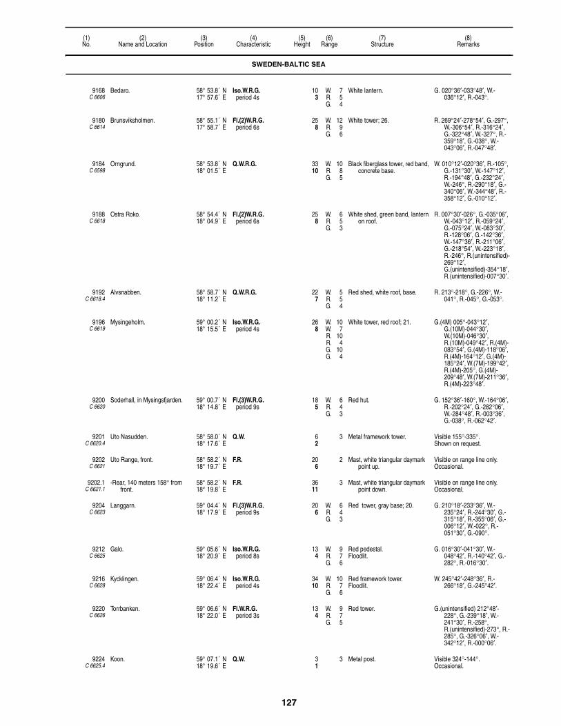
127
(1)No.
(2)Name and Location
(3)Position
(4)Characteristic
(5)Height
(6)Range
(7)Structure
(8)Remarks
9168C 6606
Bedaro. 58° 53.8´ N17° 57.6´ E
Iso.W.R.G.period 4s
103
W. 7R. 5G. 4
White lantern. G. 020°36′-033°48′, W.-036°12′, R.-043°.
9180C 6614
Brunsviksholmen. 58° 55.1´ N17° 58.7´ E
Fl.(2)W.R.G.period 6s
258
W. 12R. 9G. 6
White tower; 26. R. 269°24′-278°54′, G.-297°, W.-306°54′, R.-316°24′, G.-322°48′, W.-327°, R.-359°18′, G.-038°, W.-043°06′, R.-047°48′.
9184C 6598
Orngrund. 58° 53.8´ N18° 01.5´ E
Q.W.R.G. 3310
W. 10R. 8G. 5
Black fiberglass tower, red band, concrete base.
W. 010°12′-020°36′, R.-105°, G.-131°30′, W.-147°12′, R.-194°48′, G.-232°24′, W.-246°, R.-290°18′, G.-340°06′, W.-344°48′, R.-358°12′, G.-010°12′.
9188C 6618
Ostra Roko. 58° 54.4´ N18° 04.9´ E
Fl.(2)W.R.G.period 6s
258
W. 6R. 5G. 3
White shed, green band, lantern on roof.
R. 007°30′-026°, G.-035°06′, W.-043°12′, R.-059°24′, G.-075°24′, W.-083°30′, R.-128°06′, G.-142°36′, W.-147°36′, R.-211°06′, G.-218°54′, W.-223°18′, R.-246°, R.(unintensified)-269°12′, G.(unintensified)-354°18′, R.(unintensified)-007°30′.
9192C 6618.4
Alvsnabben. 58° 58.7´ N18° 11.2´ E
Q.W.R.G. 227
W. 5R. 5G. 4
Red shed, white roof, base. R. 213°-218°, G.-226°, W.-041°, R.-045°, G.-053°.
9196C 6619
Mysingeholm. 59° 00.2´ N18° 15.5´ E
Iso.W.R.G.period 4s
268
W. 10W. 7R. 10R. 4G. 10G. 4
White tower, red roof; 21. G.(4M) 005°-043°12′, G.(10M)-044°30′, W.(10M)-046°30′, R.(10M)-049°42′, R.(4M)-083°54′, G.(4M)-118°06′, R.(4M)-164°12′, G.(4M)-185°24′, W.(7M)-199°42′, R.(4M)-205°, G.(4M)-209°48′, W.(7M)-211°36′, R.(4M)-223°48′.
9200C 6620
Soderhall, in Mysingsfjarden. 59° 00.7´ N18° 14.8´ E
Fl.(3)W.R.G.period 9s
185
W. 6R. 4G. 3
Red hut. G. 152°36′-160°, W.-164°06′, R.-202°24′, G.-282°06′, W.-284°48′, R.-003°36′, G.-038°, R.-062°42′.
9201C 6620.4
Uto Nasudden. 58° 58.0´ N18° 17.6´ E
Q.W. 62
3 Metal framework tower. Visible 155°-335°.Shown on request.
9202C 6621
Uto Range, front. 58° 58.2´ N18° 19.7´ E
F.R. 206
2 Mast, white triangular daymark point up.
Visible on range line only. Occasional.
9202.1C 6621.1
-Rear, 140 meters 158° from front.
58° 58.2´ N18° 19.8´ E
F.R. 3611
3 Mast, white triangular daymark point down.
Visible on range line only. Occasional.
9204C 6623
Langgarn. 59° 04.4´ N18° 17.9´ E
Fl.(3)W.R.G.period 9s
206
W. 6R. 4G. 3
Red tower, gray base; 20. G. 210°18′-233°36′, W.-235°24′, R.-244°30′, G.-315°18′, R.-355°06′, G.-006°12′, W.-022°, R.-051°30′, G.-090°.
9212C 6625
Galo. 59° 05.6´ N18° 20.9´ E
Iso.W.R.G.period 8s
134
W. 9R. 7G. 6
Red pedestal.Floodlit.
G. 016°30′-041°30′, W.-048°42′, R.-140°42′, G.-282°, R.-016°30′.
9216C 6628
Kycklingen. 59° 06.4´ N18° 22.4´ E
Iso.W.R.G.period 4s
3410
W. 10R. 7G. 6
Red framework tower.Floodlit.
W. 245°42′-248°36′, R.-266°18′, G.-245°42′.
9220C 6626
Torrbanken. 59° 06.6´ N18° 22.0´ E
Fl.W.R.G.period 3s
134
W. 9R. 7G. 5
Red tower. G.(unintensified) 212°48′-228°, G.-239°18′, W.-241°30′, R.-258°, R.(unintensified)-273°, R.-285°, G.-326°06′, W.-342°12′, R.-000°06′.
9224C 6625.4
Koon. 59° 07.1´ N18° 19.6´ E
Q.W. 31
3 Metal post. Visible 324°-144°.Occasional.
SWEDEN-BALTIC SEA

128
(1)No.
(2)Name and Location
(3)Position
(4)Characteristic
(5)Height
(6)Range
(7)Structure
(8)Remarks
9232C 6632
Asposkar. 59° 06.8´ N18° 23.8´ E
Q.W.R.G. 165
W. 9R. 7G. 6
Metal framework tower, red hut. G. 329°36′-046°18′, W.-048°30′, R.-092°54′, G.-107°36′, W.-159°24′, R.-182°30′, G.-202°42′, W.-207°36′, R.-221°54′.
9236C 6634
Segelholm. 59° 06.8´ N18° 24.6´ E
Fl.(4)W.R.G.period 12s
103
W. 9R. 7G. 6
White hut, red roof.Floodlit.
G. 057°36′-071°36′, W.-080°18′, R.-147°, G.-221°36′, W.-229°12′, R.-236°54′.
9248C 6636
Riksdalerskaret. 59° 07.2´ N18° 25.6´ E
Fl.(2)W.R.G.period 6s
134
W. 9R. 7G. 6
White hut, red roof.Floodlit.
G. 037°42′-051°30′, W.-054°42′, R.-172°24′, G.-179°54′, W.-187°12′, R.-198°42′, G.(unintensified)-245°42′, W.(unintensified)-250°18′, R.(unintensified)-253°54′.
9250C 6649
Mickelsland, SW. 59° 07.0´ N18° 26.5´ E
Q.Y. 72
2 Post. Shown Oct. 1 to Mar. 31.
9252C 6642
Stenholmen, E. side of Korsholmen.
59° 07.7´ N18° 25.3´ E
Fl.W.R.G.period 3s
175
W. 4R. 3G. 2
Framework tower, red hut. G. 204°24′-217°24′, W.-221°06′, R.-282°12′.
9256C 6644
Genbote. 59° 07.9´ N18° 25.8´ E
Iso.W.R.G.period 3s
7824
W. 9R. 7G. 6
White structure, red band.Floodlit.
G. 344°12′-006°, W.-016°12′, R.-037°54′, G.-046°48′, W.-050°, R.-058°42′, W.(unintensified)-142°, G.(unintensified)-184°48′, W.-210°30′, R.-234°24′.
9260C 6648
Hummelklapp. 59° 08.4´ N18° 26.3´ E
Iso.W.R.G.period 4s
165
W. 11W. 9R. 8R. 7G. 7G. 6
Red tower; 22.Floodlit.
G.(intensified) 247°18′-251°54′, W.(intensified)-254°12′, R.(intensified)-282°36′, G.-302°24′, W.-309°54′, R.-343°18′, G.-032°, W.-038°, R.-047°48′, G.-052°42′, W.-055°18′, R.-065°06′.
9262C 6650
Piltholmsknall. 59° 08.6´ N18° 27.9´ E
Fl.(2)W.R.G.period 6s
237
W. 8R. 6G. 5
Green tower, white band.Floodlit.
R. 029°24′-061°36′, G.-066°48′, W.-071°24′, R.-213°24′, G.-249°06′, W.-253°18′, R.-336°30′, G.-029°24′.
Radar reflector.
9264C 6640
Jutholmen. 59° 07.5´ N18° 24.4´ E
Fl.(2)W.R.G.period 6s
103
W. 9R. 7G. 6
White hut, red roof.Floodlit.
G. 351°24′-030°18′, W.-038°48′, R.-043°54′, G.-094°48′, R.-110°, W.-223°36′.
9268C 6646
Dalaro, on Saltsacken Shoal. 59° 08.0´ N18° 25.2´ E
Fl.(3)W.R.G.period 9s
103
W. 9R. 7G. 6
Red lantern, gray stone base.Floodlit.
G. 030°54′-036°48′, W.-055°36′, G.-244°06′, W.-246°18′, R.-250°18′, G.-263°, R.-030°54′.
9280C 6654
Bo Kappel, entrance to Baggensfjarden.
59° 18.6´ N18° 17.8´ E
Fl.(2)W.period 6s
82
6 White hut, green band.
9284C 6658
Fjardhallan, in Jungfrufjarden. 59° 09.3´ N18° 33.3´ E
Fl.W.R.G.period 3s
237
W. 7R. 5G. 4
White round tower, black base; 23.
R. 005°48′-031°, G.-063°30′, W.-069°, R.-109°18′, G.-176°42′, R.-198°54′, G.-202°, W.-204°42′, R.-207°54′, G.-245°, G.(unintensified)-255°06′, W.(unintensified)-290°, W.-005°48′.
9288C 6660
Grono, W. of Namdofjarden. 59° 12.5´ N18° 34.0´ E
Iso.W.R.G.period 4s
237
W. 5R. 3G. 3
Red tower, white top; 27. G. 155°-246°36′, W.-308°18′, R.-331°30′, G.-352°36′, W.-358°36′, R.-015°24′, G.-052°36′, W.-078°24′, R.-091°24′.
SWEDEN-BALTIC SEA

129
(1)No.
(2)Name and Location
(3)Position
(4)Characteristic
(5)Height
(6)Range
(7)Structure
(8)Remarks
9292C 6662
Kofotsgrund. 59° 13.1´ N18° 36.8´ E
I.V.Q.W.R.G.period 9s
237
W. 6R. 4G. 3
Green tower, white top, gray base; 26.
G. 015°-034°48′, W.-038°12′, R.-049°30′, G.-062°48′, W.-065°54′, R.-075°, R.(unintensified)-133°48′, G.(unintensified)-203°, G.-212°48′, W.-219°48′, R.-234°, R.(unintensified)-313°. G.(unintensified)-015°.
9296C 6664
Kofoten. 59° 13.4´ N18° 37.1´ E
Fl.W.R.G.period 3s
206
W. 6R. 4G. 3
White hut, red band, lantern.Floodlit.
W. 213°-359°54′, G.-028°48′, W.-043°48′, R.-053°.
9300C 6666
Franska Stenarna. 59° 14.9´ N18° 39.9´ E
Fl.(2)W.R.G.period 6s
175
W. 6R. 4G. 3
White lantern, green band. G. 035°-042°48′, W.-064°, W.(unintensified)-210°30′, W.-239°30′, W.(unintensified)-305°18′, G.-312°, W.-314°06′, R.-321°, W.(unintensified)-035°.
9308C 6670
Runo. 59° 17.8´ N18° 42.9´ E
Fl.W.R.G.period 3s
206
W. 9R. 7G. 6
White lantern.Floodlit.
G. 200°30′-220°24′, W.-223°54′, R.-243°24′, W.(unintensified)-334°42′, G.(unintensified)-357°36′, W.-003°42′, R.-019°30′.
STOCKHOLM APPROACH:
9312C 6672
-Langholmen. 59° 18.3´ N18° 45.5´ E
Iso.W.R.G.period 4s
206
W. 6R. 4G. 3
White hut, green band, lantern; 20.
G. 030°54′-034°54′, W.-042°, R.-145°06′, G.-179°36′, W.-194°36′, R.-204°, G.-212°24′, W.-214°42′, R.-222°06′, G.-234°.
9316C 6409
-Fjardholmen, W. side of Stora Fjardholmen.
59° 21.4´ N18° 49.8´ E
Q.W.R.G. 165
W. 7R. 5G. 4
White tower, green band. G. 023°48′-030°24′, W.-046°, R.-059°, G.-184°, R.-199°, G.-214°30′, W.-216°, R.-235°.
9320C 6463.3
-Algeroren (Elgorn) islet, E. side.
59° 20.0´ N18° 56.0´ E
Q.W.R. 3310
W. 4R. 2
White pedestal, lantern. W. 160°-311°, R.-018°, W.-058°.
Fishing light.Occasional.
9328C 6462
-Prastkobben. 59° 24.0´ N19° 11.0´ E
Q.W.R.G. 309
W. 5R. 4G. 3
Gray lantern. G. 055°-107°30′, W.-111°, R.-181°, G.-224°, W.-232°, R.-314°, G.-335°30′, W.-349°, R.-055°.
Fishing light.Occasional.
9332C 6463.2
-Tvikobb Islet. 59° 24.0´ N19° 02.0´ E
Fl.W.period 3s
4 Metal framework tower. Fishing light.Occasional.
9336C 6406
-Palkobb. 59° 24.7´ N18° 54.4´ E
Fl.(4)W.R.G.period 10s
3310
W. 8R. 7G. 6
White tower, green band; 34. G.(unintensified) 010°-022°, G.-035°42′, W.-038°06′, R.-051°, R.(unintensified)-135°18′, G.(unintensified)-211°, G.-225°06′, W.-228°06′, R.-290°.
9340C 6408
-Stora Moja, E. side. 59° 24.8´ N18° 54.1´ E
Q.W.R.G. 196
W. 8R. 5G. 4
Red hut, white band, black base. G. 215°-233°12′, W.-028°, R.-050°.
9344C 6404
-Stenkobbsgrund. 59° 25.8´ N18° 57.1´ E
Fl.(2)W.R.G.period 6s
4112
W. 8R. 5G. 4
White tower, green band; 44. G. 047°-052°42′, W.-062°30′, R.-078°, R.(unintensified)-129°48′, G.(unintensified)-204°, G.-221°48', W.-224°30', R.-235°, R.(unintensified)-265°, R.-305°36′, G.(unintensified)-047°.
9348C 6402
-Morsken Rock. 59° 30.9´ N19° 05.3´ E
Fl.(3)W.R.G.period 8s
3611
W. 6R. 4G. 3
White cairn, red square daymark.
W. 020°42′-038°06′, R.-067°, W.-219°, R.-231°, G.-273°, W.-353°, G.-020°42′.
SWEDEN-BALTIC SEA
130
(1)No.
(2)Name and Location
(3)Position
(4)Characteristic
(5)Height
(6)Range
(7)Structure
(8)Remarks
9352C 6399
-Hundskarsknuv Rock. 59° 35.9´ N19° 07.5´ E
Fl.W.R.G.period 3s
299
W. 8R. 5G. 4
White tower, red band; 24. W. 001°24′-003°12′, R.-041°, G.-052°, G.(unintensified)-097°, G.-107°, R.-117°, R.(unintensified)-172°, R.-180°, G.-196°42′, W.-198°18′, R.-209°, R.(unintensified)-263°, G.(unintensified)-353°, G.-001°24′.
9356C 6400
-Mellgrundsknuv. 59° 36.5´ N19° 03.5´ E
Q.W.R.G. 237
W. 5R. 3G. 2
White framework tower. G. 067°-101°, W.-109°, R.-216°, G.-281°, W.-284°, R.-067°.
Fishing light.Occasional.
9360C 6396
-Vasterkobb Rock. 59° 39.7´ N19° 10.3´ E
Iso.W.R.G.period 4s
268
W. 8R. 5G. 4
White tower, green band; 24. G. 358°-017°30′, W.-019°30′, R.-136°, G.-180°, W.-183°, R.-191°.
9364C 6398
-Arskobben. 59° 39.7´ N19° 09.7´ E
Q.W.R.G. 185
W. 7R. 4G. 4
Stone hut, red band, white lantern.
G. 165°-194°, W.-007°06', R.-040°.
9368C 6669
-Tegelhallan. 59° 17.2´ N18° 42.6´ E
Fl.(2)W.R.G.period 6sfl. 0.3s, ec. 1sfl. 0.3s, ec. 4.4s
237
W. 7R. 5G. 4
Mast, white hut, red band, lantern; 23.
G. 036°24′-111°48′, R.-169°12′, G.-201°48′, W.-207°30′, R.-225°12′, G.-308°48′, W.-337°18′, R.-036°24′.
9372C 6673
-Trollharan, E. end of islet. 59° 19.0´ N18° 44.8´ E
Q.W.R.G. 4112
W. 4R. 3G. 2
White framework tower, white square daymark; 20.
G. 180°30′-202°24′, W.-037°54′, R.-045°06′.
9376C 6495
-Yxhammarskubben. 59° 18.8´ N18° 48.6´ E
Fl.(3)W.R.G.period 9sfl. 0.7s, ec. 1sfl. 0.7s, ec. 1sfl. 0.7s, ec. 4.9s
237
W. 6R. 4G. 3
Red house, white base; 23.Floodlit.
W. 094°42′-166°18′, R.-281°54′, G.-291°30′, W.-297°30′, R.-021°36′.
9380C 6496
-Gastholmsgrundet. 59° 19.1´ N18° 48.6´ E
Q.G. 247
3 Green pedestal, lantern. Radar reflector.
9392C 6502
-Norra Kanholmen. 59° 22.2´ N18° 44.7´ E
Q.R. 134
3 White metal post.Floodlit.
Visible 103°06′-327°48′.
9396C 6498
-Klovholmen. 59° 22.3´ N18° 45.1´ E
Fl.(2)W.R.G.period 6s
237
W. 6R. 4G. 3
Red tower, white top, red lantern. G. 298°-315°12′, W.-347°, R.-087°24′, G.-094°06′, W.-115°06′.
Radar reflector.
9400C 6503
-Branten. 59° 22.5´ N18° 42.9´ E
Iso.W.R.G.period 4s
237
W. 6R. 4G. 3
White tower, yellow top.Floodlit.
G. 261°06′-285°06′, W.-289°, R.-022°48′, G.-094°06′, W.-099°, R.-120°.
9401C 6505.5
-Sankgrundet. 59° 26.0´ N18° 38.7´ E
Fl.Y.period 4s
1 Occasional.
9402C 6505
-Gallnoport. 59° 23.6´ N18° 36.4´ E
Fl.W.R.G.period 3s
3310
W. 6R. 4G. 3
White lantern. W. 105°24′-130°30′, G.-285°12′-289°48′, W.-293°, R.-298°06′.
9404C 6506
-Sollenkroka. 59° 22.6´ N18° 40.4´ E
Fl.W.R.G.period 3s
134
W. 10R. 7G. 6
White lantern.Floodlit.
G. 075°-084°42′, W.-088°24′, R.-111°06′, G.-123°, W.-128°06′, R.-155°, R.(unintensified)-266°54′.
9408C 6504
-Magarna Rock. 59° 22.8´ N18° 39.3´ E
Fl.(3)W.R.G.period 9s
144
W. 6R. 4G. 3
White lantern. W. (unintensified) 208°06′-269°48′, G.-278°42′, W.-281°18′, R.-314°36′.
F.W. 350m SE. and 0.8M SW.
9420C 6508
-Kalvo. 59° 22.4´ N18° 36.9´ E
Fl.(2)W.R.G.period 6s
5216
W. 6R. 4G. 3
White tower; 34.Floodlit.
G. 225°-262°54′, W.-266°24′, R.-304°30′, W.-340°, W.(unintensified)-080°, W.-111°48′.
9424C 6510
-Boda. 59° 22.2´ N18° 36.4´ E
Q.W.R.G. 237
W. 5R. 4G. 3
White framework tower. G. 120°06′-132°06′, W.-144°06′, R.-158°, G.-233°, W.-251°, R.-275°.
SWEDEN-BALTIC SEA
131
(1)No.
(2)Name and Location
(3)Position
(4)Characteristic
(5)Height
(6)Range
(7)Structure
(8)Remarks
9428C 6514
-Sando Sugga. 59° 23.0´ N18° 34.3´ E
Fl.W.R.G.period 3s
237
W. 7R. 5G. 4
White framework tower, red band; 23.
W.(unintensified) 055°-099°24′, G.-122°36′, W.-129°06′, R.-232°42′, G.-298°48′, W.-306°, R.-325°30′.
9432C 6515
-Bolviksnas. 59° 23.7´ N18° 32.2´ E
Q.W.R.G. 237
W. 5R. 3G. 3
White hut, red band, red lantern. G. 144°30′-147°30′, W.-149°48′, R.-157°48′, G.-193°, R.-257°24′, G.-294°54′, W.-300°30′, R.-309°30′.
9436C 6516
-Nyvarp. 59° 24.3´ N18° 31.4´ E
Fl.W.R.G.period 3s
165
W. 6R. 4G. 3
White lantern.Floodlit.
R. 123°30′-140°, G.-151°06′, W.-157°, R.-161°54′, G.-166°54′, W.-170°, R.-251°30′, G.-309°18′, W.-312°42′, R.-320°48′.
9440C 6532
-Varmdolandet. 59° 24.0´ N18° 26.5´ E
Q.R.G. 175
R. 4G. 3
White metal framework tower; 13.
Floodlit.
G. 273°-345°, R.-167°.
9444C 6534
-Rinda, SW. side of Oxdjupet Channel.
59° 23.9´ N18° 26.2´ E
Q.R.G. 175
R. 4G. 3
White metal framework tower.Floodlit.
R. 115°-138°36′, G.-204°36′, R.-340°.
9448C 6518
-Lindalen Range, front. 59° 25.3´ N18° 29.1´ E
Iso.W.R.G.period 4s
82
W. 6R. 4G. 3
White lantern, gray base.Floodlit.
G. 265°06′-295°, W.-305°24′, R.-083°06′, G.-095°48′, W.-097°36′, R.-120°.
9452C 6518.1
- -Mansoren, rear, 900 meters 097° from front.
59° 25.2´ N18° 30.1´ E
Q.W. 3912
9 White pedestal, red rectangular daymark, yellow stripe.
Visible on range line only.
9456C 6522
-Stora Berteln, N. side. 59° 25.5´ N18° 24.7´ E
Q.W. 165
9 Red structure, concrete base.Floodlit.
Visible 098°48′-270°36′.
9460C 6524
-Brodstycket. 59° 25.4´ N18° 24.3´ E
Fl.W.R.G.period 3s
206
W. 9R. 7G. 6
White lantern, black base; 20.Floodlit.
W. 315°-039°42′, R.-075°42′, G.-107°54′, W.-132°42′, R.-240°.
9464C 6524.5
-Tisterogrundet, on Tistero Kummel.
59° 25.9´ N18° 23.5´ E
Fl.(3)W.R.G.period 4s
206
W. 9R. 7G. 6
White column, black pedestal.Floodlit.
G. 307°18′-323°24′, W.-339°54′, R.-348°48′, G.-002°54′, W.-150°12′, R.-214°.
9465 -Buoy TISTERO. 59° 26.0´ N18° 24.0´ E
Fl.Y.period 3s
SPECIALY, pillar.
-RACON T(–) 5 (3 & 10cm).
9468C 6525
-Vastra Ronnholmen, NW. point.
59° 25.7´ N18° 21.9´ E
Q.W.R.G. 134
W. 5R. 3G. 2
White masonry hut, red band, lantern.
W. 024°42′-206°, R.-220°, G.-224°, W.-235°18′, R.-257°12′.
9472C 6528
-Sandgrundet. 59° 23.7´ N18° 21.7´ E
Fl.W.R.G.period 3s
103
W. 5R. 3G. 2
White lantern. G. 086°-104°, W.-284°30′, R.-305°.
9476C 6544
-Furuholmen, Oxdjupet Channel, W. entrance.
59° 22.3´ N18° 20.1´ E
Fl.W.R.G.period 3s
165
W. 6R. 4G. 3
White lantern.Floodlit.
R. 340°-044°, G.-069°24′, W.-071°42′, R.-076°30′, G.-157°42′, W.-189°12′, R.-205°.
9480C 6545
-Bjornsgrundet. 59° 22.0´ N18° 18.6´ E
Iso.W.R.G.period 4s
206
W. 4R. 3G. 2
White pedestal, red band, black base.
G. 027°30′-072°12′, W.-081°36′, R.-119°42′, G.-130°18′, W.-141°06′, R.-172°48′, G.-241°18′, R.-027°30′.
Radar reflector.
9484C 6568
-Varmdo-Garpen. 59° 21.8´ N18° 22.6´ E
Oc.W.R.G.period 5s
134
W. 5R. 4G. 3
White lantern.Floodlit.
G. 093°-099°, W.-102°06′, R.-259°, G.-268°36′, W.-274°48′, R.-292°.
9488C 6572
-Sodernas. 59° 21.7´ N18° 27.1´ E
Fl.W.R.G.period 3s
206
W. 5R. 4G. 3
White lantern.Floodlit.
G. 336°-049°36′, W.-070°, R.-097°, G.-157°48′, W.-175°, R.-181°.
9492C 6571
-Lagnogrundet. 59° 21.5´ N18° 24.9´ E
Fl.(3)W.R.G.period 4s
216
W. 9R. 7G. 6
White pedestal, black base.Floodlit.
G. 108°-135°, R.-187°, G.-271°36′, W.-298°, R.-108°.
Radar reflector.
SWEDEN-BALTIC SEA
132
(1)No.
(2)Name and Location
(3)Position
(4)Characteristic
(5)Height
(6)Range
(7)Structure
(8)Remarks
9496C 6570
-Tynningo, Oxdjupet Channel, N. side.
59° 22.3´ N18° 23.3´ E
Fl.(2)W.R.G.period 6s
155
W. 6R. 4G. 3
Gray tower, white top; 20.Floodlit.
G. 294°-306°, W.-311°24′, R.-343°, W.(unintensified)-074°, G.-099°30′, W.-100°48′, R.-120°.
9504C 6536
-Bogesund. 59° 22.8´ N18° 18.2´ E
Fl.(2)W.R.G.period 6s
134
W. 6R. 4G. 3
White lantern, gray concrete base.
Floodlit.
R. 260°-268°, G.-281°24′, W.-284°06′, R.-000°, G.-090°24′, W.-094°48′, R.-106°.
9508C 6538
-Granholmen, W. extremity. 59° 22.7´ N18° 17.7´ E
Fl.W.R.G.period 3s
134
W. 12R. 9G. 7
White lantern.Floodlit.
G. 299°-319°18′, W.-349°54′, R.-039°, G.-049°42′, W.-054°30′, R.-084°, G.-094°18′, W.-098°48′, R.-285°.
9512C 6539
-Stora Hoggarnsbank. 59° 22.4´ N18° 16.8´ E
Q.W.R.G. 247
W. 8R. 6G. 5
White hut, black base.Floodlit.
G. 000°-035°24′, W.-041°12′, R.-060°, G.-178°, R.-224°, G.-283°, W.-286°, R.-000°.
Radar reflector.
9516C 6545.2
-Lilla Hoggarnsbank. 59° 21.9´ N18° 16.1´ E
Q.R. 206
4 White hut, red band, black base.Floodlit.
9520C 6546
-Alvviksgrundet. 59° 21.8´ N18° 15.5´ E
Iso.W.R.G.period 6s
216
W. 12R. 9G. 8
White tower, red base; 26.Floodlit.
G.(unintensified) 156°48′-174°, W.(unintensified)-177°30′, R.(unintensified)-187°, R.-211°06′, G.-229°, W.-235°48′, R.-250°30′, G.-270°30′, W.-343°24′, R.-010°18′, G.-032°42′, W.-043°42′, R.-054°12′, G.-069°30′.
9524C 6540
-Vastra Haga, on Vadero. 59° 23.6´ N18° 10.5´ E
Fl.(2)W.R.G.period 6s
165
W. 5R. 4G. 3
White lantern. G. 283°18′-290°, W.-297°18′, R.-328°30′, W.-059°12′, G.-088°06′, W.-091°, R.-100°.
Occasional.
9528C 6549
-Kungshamn, entrance to Skurusund.
59° 20.1´ N18° 12.5´ E
Fl.W.R.G.period 3s
206
W. 6R. 4G. 3
White lantern. G. 045°-058°30′, W.-061°54′, R.-076°12′, G.-090°48′, W.-097°54′, R.-205°18′, G.-219°, W.-227°30′, R.-255°.
9532C 6541
-Djursholmsudde. 59° 23.7´ N18° 06.1´ E
Fl.(4)W.R.G.period 12s
165
W. 6R. 4G. 3
White lantern. G. 269°54′-282°18′, W.-285°48′, R.-311°24′, G.-028°12′, W.-042°54′, R.-061°42′.
Occasional.
9536C 6542
-Aludden. 59° 23.5´ N18° 05.6´ E
Fl.(2)W.R.G.period 6s
185
W. 5R. 4G. 3
White lantern. G. 223°42′-238°, W.-260°, R.-275°30′, W.-357°12′, G.-001°42′, W.-019°54′, R.-036°48′.
Occasional.
STOCKHOLM:
9548C 6550
-Libertus, N. side. 59° 19.9´ N18° 10.6´ E
Fl.(3)W.R.G.period 9s
216
W. 5R. 4G. 3
White tower. G. 101°48′-122°36′, W.-126°30′, R.-191°30′, W.-261°30′.
2 F.R. shown N.
9556C 6558
-Blockhusudden. 59° 19.2´ N18° 09.3´ E
Fl.(2)W.R.G.period 6s
206
W. 6R. 4G. 3
White tower, gray base; 16. W. 186°-211°, R.-222°, G.-244°42′, W.-086°24′, R. 086°30′-095°.
9560C 6551.2
-Lilla Vartan 4. 59° 21.1´ N18° 07.0´ E
Q.R. 196
6 Pole, daymark.Floodlit.
Radar reflector.
STOCKHOLM APPROACH:
9576C 6386
-Tjarven. 59° 47.5´ N19° 22.2´ E
Fl.(4)W.period 12s
15 Shown 24 hours Nov. 1 to Mar. 31.
SWEDEN-BALTIC SEA

133
(1)No.
(2)Name and Location
(3)Position
(4)Characteristic
(5)Height
(6)Range
(7)Structure
(8)Remarks
9578C 6386.9
-Remmargrundets Norra Range, front.
59° 45.9´ N19° 19.0´ E
Iso.W.period 4s
268
3 White concrete tower, red band; 21.
Visible 035°-210°.Radar reflector.
9580C 6387
-Remmargrund, rear, 500m 182°30′ from front.
59° 45.5´ N19° 19.0´ E
L.Fl.W.R.G.period 8sfl. 2s, ec. 6s
6520
W. 13R. 10G. 9
Black round tower, red bands.Floodlit.
G. 061°-066°, W.-072°30′, R.-148°, G.-176°, W.-207°, R.-226°, G.-238°, W.-256°, R.-281°30′, G.-343°30′, R.-061°.
Radar reflector.
-RACON M(– –) 15 (3 & 10cm).
9581C 6387.2
- -Norrskaren. 59° 46.2´ N19° 18.2´ E
Fl.G.period 3s
289
2 White concrete tower, green band; 21.
Visible 155°-039°.Radar reflector.
9582C 6387.3
- -Osterskarsbadan. 59° 45.7´ N19° 17.7´ E
Fl.(2)G.period 6s
309
2 White concrete tower, green band; 21.
Visible 154°-041°.Radar reflector.
-Soderarmsleden Channel:
9584C 6388.5
- -Nygrund. 59° 45.0´ N19° 15.6´ E
Fl.(4)G.period 12s
309
5 Green tower, white top, gallery.
9588C 6390
- -Lerskarsgrund. 59° 44.3´ N19° 13.5´ E
Fl.(3)W.R.G.period 9s
3912
W. 13R. 9G. 8
Black round tower, red bands; 42.
Floodlit.
G. 060°-067°, W.-072°30′, R.-168°, G.-245°, W.-250°30′, R.-060°.
9592C 6389
- -Norra Lerskaret. 59° 44.3´ N19° 14.1´ E
Q.W.R.G. 165
W. 9R. 8G. 6
Orange pedestal, white top.Floodlit.
G. 060°-072°, W.-243°, R.-255°.
9596C 6391
-Botveskar. 59° 44.0´ N19° 11.0´ E
Fl.(2)W.R.G.period 6s
237
W. 13R. 9G. 8
White lantern.Floodlit.
G. 230°-249°30′, W.-253°, R.-259°, W.-354°, R.-008°, G.-064°, W.-068°, R.-076°, G.-084°.
9600C 6382
-Tjocko. 59° 45.3´ N19° 06.2´ E
Q.W.R.G. 216
W. 9R. 7G. 6
White pedestal, green band.Floodlit.
G. 315°-007°, W.-075°, R.-100°, G.-127°, W.-133°, R.-165°, G.-196°, W.-275°.
9604C 6394.5
-Farholmsrevet, Granhamnsfjarden.
59° 43.7´ N19° 06.7´ E
Iso.W.R.G.period 2s
113
W. 7R. 4G. 4
White hut. G. 235°-302°, W.-305°30′, R.-009°, G.-066°30′, W.-074°, R.-121°.
-Furusund Channel:
9608C 6412
- -Kapellskar. 59° 43.1´ N19° 04.8´ E
Fl.(4)W.R.G.period 12s
3611
W. 11R. 8G. 7
White tower, green band; 30.Floodlit.
G. 180°-194°, W.-204°30′, R.-228°, G.-251°, W.-259°30′, R.-269°, G.-304°30′, R.-013°30′, G.-037°30′, R.-058°.
9620C 6412.2
- -Svedjelandet Range, front. 59° 43.4´ N19° 03.8´ E
F.G. 134
7 Mast, green triangular daymark point up, white stripe.
Shown on request.
9624C 6412.21
- - -Rear, 100 meters 269°18′ from front.
59° 43.5´ N19° 04.0´ E
F.G. 196
7 Mast, green triangular daymark point down, white stripe.
Occasional.
9628C 6395
- -Idskarskobben. 59° 41.6´ N19° 07.4´ E
Fl.W.R.G.period 3s
237
W. 5R. 3G. 2
White framework tower. W. 008°-070°, R.-088°, G.-152°, W.-157°, R.-348°, G.-008°.
Fishing light.Occasional.
-Furusundsleden:
9632C 6416
- -Maro, N. point. 59° 42.2´ N19° 03.6´ E
Fl.W.R.G.period 5s
185
W. 10R. 7G. 6
Red lantern, white band.Floodlit.
R. 058°-061°, G.-071°, W.-094°, W.-180°30′, R.-213°30′, G.-221°30′, W.-230°30′, R.-247°30′.
9636C 6418
- -Alandskobb. 59° 41.2´ N18° 59.1´ E
Fl.(2)W.R.G.period 6s
185
W. 10R. 7G. 6
Green lantern, white band.Floodlit.
G. 235°30′-241°, W.-245°, R.-267°, R.(unintensified)-010°, G.(unintensified)-023° G.-042°, W.-049°30′, R.-057°.
SWEDEN-BALTIC SEA

134
(1)No.
(2)Name and Location
(3)Position
(4)Characteristic
(5)Height
(6)Range
(7)Structure
(8)Remarks
9640C 6419
- -Alandets Grund. 59° 40.9´ N18° 59.0´ E
Fl.W.R.G.period 3s
268
W. 9R. 7G. 6
Red tower, white band; 20.Floodlit.
W. 036°30′-039°, R.-048°, G.-052°, W.-055°, R.-066°, G.-128°, R.-229°, G.-237°, W.-240°, R.-305°, G.-036°30′.
Radar reflector.
9644C 6420
- -Furusund, on Yxlan. 59° 39.8´ N18° 55.9´ E
Oc.W.R.G.period 4slt. 3s, ec. 1s
206
W. 10R. 7G. 6
Green metal construction and white round concrete pillar.
Floodlit.
G. 200°-229°24′, W.-233°18′, R.-320°, G.-046°, W.-049°, R.-052°, G.-070°.
Radar reflector.
9646C 6401
- -Storvik. 59° 35.5´ N18° 54.7´ E
F.W.R.G. 185
W. 5R. 4G. 3
White hut; 10. R. 165°-215°42′, G.-244°12′, W.-250°12′, R.-257°06′, G.-263°12′, W.-266°30′, R.-287°36′, G.-045°.
Occasional.
9648C 6421
- -Gryten Islet, S. side. 59° 37.1´ N18° 49.1´ E
Fl.(4)W.R.G.period 10s
206
W. 9R. 7G. 6
White tower, green band.Floodlit.
R. 210°-228°, G.-233°, W.-234°30′, R.-257°, W.-021°, R.-038°, G.-051°30′, W.-053°, R.-077°.
9652C 6422
- -Yxlan, SW. side. 59° 35.5´ N18° 47.6´ E
Fl.(3)W.R.G.period 9s
237
W. 9R. 6G. 5
Red hut, white band.Floodlit.
G. 067°30′-075°, W.-077°, R.-096°, G.-210°, W.-216°30′, R.-235°.
9656C 6423
- -Vaxlet Norra. 59° 35.2´ N18° 43.7´ E
Fl.W.R.G.period 3s
227
W. 9R. 7G. 6
White concrete tower, red band. G. 058°-068°, W.-072°, R.-085°, W.(unintensified)-231°, G.-236°, W.-239°, R.-250°, G.-257°, W.-277°.
9660C 6424
- -Vaxlet Sodra. 59° 35.1´ N18° 43.9´ E
Fl.(2)W.R.G.period 6s
134
W. 9R. 7G. 6
White pedestal, green band, lantern.
Floodlit.
W. 253°-234°, R.-244°, G.-253°.
Radar reflector.
9664C 6426
- -Lunsen. 59° 34.5´ N18° 41.1´ E
Q.W.R.G. 227
W. 9R. 7G. 6
White pedestal, red band, lantern.
Floodlit.
G. 055°-064°, W.-082°, R.-096°, G.-249°30′, W.-252°30′, R.-260.
Radar reflector.
9672C 6430
- -Staboudde. 59° 33.7´ N18° 37.8´ E
Fl.(4)W.R.G.period 12s
103
W. 9R. 7G. 6
White structure, green band.Floodlit.
G. 237°-239°30′, W.-244°, R.-271°30′, G.-005°, W.-053°30′, R.-062°.
9676C 6431
- -Stabogrund. 59° 33.6´ N18° 37.7´ E
Q.W.R.G. 165
W. 9R. 7G. 6
Red structure, white band.Floodlit.
W. 059°-241°, R.-326°, G.-059°.
Radar reflector.
9680C 6432
- -Ryssmasterna. 59° 31.9´ N18° 32.9´ E
Fl.W.R.G.period 6sfl. 1s, ec. 5s
113
W. 10R. 7G. 6
Red lantern, white roof.Floodlit.
G. 046°-052°, W.-054°, R.-142°, G.-232°, W.-236°30′, R.-241°.
9684C 6433
- -Gullholmen. 59° 31.4´ N18° 31.2´ E
Fl.(2)W.R.G.period 6s
103
W. 10R. 7G. 6
Mast, green and white rectangular daymark.
Floodlit.
G. 230°-001°, W.-008°, R.-056°.
9688C 6440
- -Nykvarnsholmen. 59° 30.7´ N18° 29.6´ E
Iso.W.R.G.period 4s
165
W. 9R. 7G. 6
Green lantern, white band.Floodlit.
G. 200°-235°, W.-054°, R.-100°.
9692C 6442
- -Nykvarnsgrund. 59° 30.6´ N18° 29.5´ E
Q.W.R.G. 206
W. 9R. 7G. 6
Red lantern, white band.Floodlit.
G. 332°-052°, W.-231°, R.-322°.
Radar reflector.
9696C 6434
- -Sandkullen, Ostra Saxafjarden.
59° 30.1´ N18° 31.0´ E
Iso.W.R.G.period 4s
113
W. 10R. 7G. 6
Red lantern, white roof.Floodlit.
G. 021°06′-028°54′, W.-040°54′, R.-114°06′, G.-174°30′, W.-184°42′, R.-214°30′.
9700C 6444
- -Vallersvik. 59° 29.9´ N18° 27.6´ E
Fl.(4)W.R.G.period 12s
247
W. 10R. 7G. 6
White structure, green band.Floodlit.
G. 221°24′-231°54′, W.-234°36′, R.-312°30′, G.-019°24′, W.-022°12′, R.-034°30′.
9704C 6446
- -Mjolko, on Rodhall. 59° 27.4´ N18° 25.7´ E
Fl.(2)W.R.G.period 6s
134
W. 10R. 7G. 6
Green structure, white roof, base.
Floodlit.
G. 183°36′-196°06′, W.-203°12′, R.-306°54′, G.-352°54′, W.-029°, R.-039°12′.
SWEDEN-BALTIC SEA

135
(1)No.
(2)Name and Location
(3)Position
(4)Characteristic
(5)Height
(6)Range
(7)Structure
(8)Remarks
-Saxarfjarden:
9708C 6452
- -Ostra Alogrundet. 59° 26.7´ N18° 24.8´ E
Iso.W.R.G.period 4s
206
W. 6R. 4G. 3
White tower, green lantern; 25.Floodlit.
G. 200°48′-216°12′, W.-245°30′, R.-270°54′, G.-282°48′, W.-286°06′, R.-340°54′, G.-053°42′, W.-064°42′, R.-070°54′.
9712C 6453
- -Bjurogrund. 59° 26.6´ N18° 26.4´ E
Fl.(2)G.period 6s
134
6 Metal framework tower.Floodlit.
9716C 6454
- - -Valoarna, on N. rock. 59° 26.0´ N18° 29.9´ E
Fl.(4)W.R.G.period 12s
134
W. 6R. 4G. 3
White lantern. G. 320°06′-329°12′, W.-338°12′, R.-034°30′, G.-104°12′, W.-107°42′, R.-124°30′, G.-187°54′, W.-240°06′, R.-270°.
-Furusundsleden:
9724C 6436
- -Ikorn, on rock. 59° 29.3´ N18° 29.5´ E
Fl.(2)W.R.G.period 6s
237
W. 10R. 7G. 6
Red tower, white roof.Floodlit.
G. 202°-217°18′, W.-221°06′, R.-247°30′, G.-349°42′, W.-356°06′, R.-000°06′.
9728C 6448
- -Ekoren. 59° 28.1´ N18° 25.1´ E
Fl.W.R.G.period 4sfl. 1s, ec. 3s
103
W. 10R. 8G. 6
Red lantern, white roof.Floodlit.
G. 039°42′-045°06′, W.-050°54′, R.-155°30′, G.-223°24′, W.-224°42′, R.-244°30′.
9732C 6450
- -Lerviksudde, SE. side of point, S. entrance to channel.
59° 27.2´ N18° 23.2´ E
Fl.(2)W.R.G.period 6s
103
W. 10R. 7G. 6
White lantern, green band.Floodlit.
G. 210°-222°12′, W.-224°30′, R.-262°, G.-015°18′, W.-027°, R.-039°.
SWEDEN-GOTLAND
9736C 7210
Hoburg. 56° 55.3´ N18° 09.1´ E
Fl.W.period 5s
19058
27 White tower, black top; 71. Obscured near coast by high cliffs at Hoburg.
9740C 7212
Valar, entrance to Burgsvik Hamn.
57° 01.8´ N18° 13.1´ E
Fl.(2)W.R.G.period 6s
237
8 White tower; 20. G. 030°-065°, W.-091°30′, R.-185°, W.(unintensified)-211°, R.(unintensified)-230°.
9744C 7214
Burgsvik Range, front. 57° 03.0´ N18° 17.5´ E
Iso.W.period 4s
144
12 Post, white square daymark, red stripe.
Visible on range line only. Shown 24 hours.
9748C 7214.1
-Rear, 270 meters 073° from front.
57° 03.0´ N18° 17.5´ E
Iso.W.period 4s
5216
12 Post, white square daymark, red stripe.
Visible on range line only. Shown 24 hours.Synchronized with front.
9752C 7211
Nasrevet. 57° 03.4´ N18° 09.6´ E
Fl.W.R.G.period 3s
268
W. 7R. 5G. 4
Red tower, white top, gray base; 29.
R. 299°-356°, G.-026°, W.-151°, R.-170°, G.-185°.
F.R. 40m marks mast 1.4 miles SSW.
Lights mark 4 windmotors 1.5 miles SSW.
BURGSVIK HAMN:
9756C 7218
-Range, front. 57° 01.7´ N18° 15.6´ E
F.R. 237
White mast, white triangular daymark point up.
9760C 7218.1
- -Rear, 45 meters 175° from front.
57° 02.0´ N18° 15.7´ E
F.R. 3310
White mast, white triangular daymark point down.
9772C 7224
Stora Karlso. 57° 17.4´ N17° 57.5´ E
L.Fl.(2)W.R.period 12sfl. 2s, ec. 2sfl. 2s, ec. 6s
18456
W. 16R. 13
White tower, dwelling; 59. R. 192°42′-211°24′, W.-233°, R.-340°12′, W.-192°42′.
KLINTEHAMN:
9776C 7228
-Varsholmen Range, front. 57° 23.5´ N18° 11.3´ E
Iso.W.period 4s
227
11 White column. Visible on range line only. Shown 24 hours.
SWEDEN-BALTIC SEA
136
(1)No.
(2)Name and Location
(3)Position
(4)Characteristic
(5)Height
(6)Range
(7)Structure
(8)Remarks
9780C 7228.1
- -Rear, 120 meters 055° from front.
57° 24.0´ N18° 11.7´ E
Iso.W.period 4s
3912
11 White column. Visible on range line only. Shown 24 hours.Synchronized with front.
9782C 7235
Follingbo, AVIATION LIGHT. 57° 35.3´ N18° 22.3´ E
V.Q.W. 797243
21 Mast.
VISBY:
9792C 7236.5
-N. breakwater. 57° 38.1´ N18° 16.2´ E
Q.R. 309
9 White tower, green band; 20.Floodlit.
9796C 7236
-Approach. 57° 38.1´ N18° 16.4´ E
Iso.W.R.G.period 4s
3611
W. 12R. 9G. 8
White tower, red band; 28.Floodlit.
R. 007°-044°, G.-055°, W.-087°, R.-209°, G.-239°, W.-245°, R.-296°.
9800C 7238
-Old N. breakwater Range, front.
57° 38.4´ N18° 17.0´ E
Oc.R.period 12s
Pedestal, red triangular daymark point up, white band.
9804C 7238.1
- -Rear, 230 meters 055° from front.
57° 38.4´ N18° 17.4´ E
Oc.R.period 12s
Pedestal, orange triangular daymark point down, red band.
9808C 7242
Flundereviken Range, front. 57° 40.1´ N18° 19.8´ E
F.R. 165
5 Metal post, red triangular daymark point up, white band.
9812C 7242.1
-Rear, 27 meters 096° from front.
57° 40.1´ N18° 19.8´ E
F.R. 237
5 Metal post, red triangular daymark point down, white band.
9816C 7246
Stenkyrkehuk, NW. point of Gotland.
57° 49.2´ N18° 28.1´ E
Oc.(2)W.R.G.period 12slt. 6s, ec. 2slt. 2s, ec. 2s
13742
W. 10R. 8G. 7
White round metal tower; 49. G. 027°-037°, W.-220°, R.-236°.
9820C 7248
Lickershamn Range, front. 57° 49.6´ N18° 31.0´ E
F.G. 82
2 Post, white triangular daymark point up.
Visible on range line only. Occasional.
9824C 7248.1
-Rear, 40 meters 148° from front.
57° 49.7´ N18° 30.8´ E
F.G. 3410
2 Post, white triangular daymark point down.
Visible on range line only. Occasional.
9828C 7250
Hallshuk. 57° 55.4´ N18° 44.9´ E
L.Fl.(4)W.R.G.period 20sfl. 2s, ec. 2sfl. 2s, ec. 2sfl. 2s, ec. 2sfl. 2s, ec. 6s
10733
W. 14R. 11G. 10
White building. G. 110°-144°, W.-262°, R.-291°.
F.W. (occasional) lights shown at Lutterhorn and Lauters.
9830C 7252
Kappelshamn. 57° 50.2´ N18° 47.8´ E
Iso.W.R.G.period 4s
3611
W. 12R. 9G. 7
Framework tower. W.(unintensified) 109°-156°30′ G.-173°, W.-180°30′, R.-196°.
2 F.R. in line 168°30′ marks dredged channel.
GOTSKA SANDON:
9832C 7150
-Gotska Sandon. 58° 23.6´ N19° 11.6´ E
Fl.W.period 5s
13942
24 Brown wooden tower; 75. Partially obscured by vegetation 280°-013°.
F.R. 12137
15 Visible 164°-186°.
9836C 7156
-Kyrkudden, E. point. 58° 21.9´ N19° 19.3´ E
Fl.(3)W.period 9s
4112
7 White round tower; 41. Visible 149°-037°.
9840C 7154
-Hamnudden, SW. point. 58° 20.3´ N19° 12.9´ E
Fl.(2)W.period 6sfl. 0.3s, ec. 1sfl. 0.3s, ec. 4.4s
6620
7 White round tower; 49. Visible 294°-161°.
9844C 7162
Faro, Holmudden, E. point of Faro.
57° 57.6´ N19° 20.9´ E
Iso.W.R.period 8s
10231
W. 16R. 13
White round stone tower; 99. Obscured to W. and NW. by trees to 140°.
R. 007°54′-089°42′, W.-174°54′, R.-194°54′, W.-007°54′.
SWEDEN-GOTLAND
137
(1)No.
(2)Name and Location
(3)Position
(4)Characteristic
(5)Height
(6)Range
(7)Structure
(8)Remarks
9848C 7160
Faro Norsholm. 57° 59.9´ N19° 14.5´ E
Fl.W.R.G.period 3s
299
W. 5R. 3G. 2
White framework tower. G. 001°30′-100°12′, W.-209°06′, R.-237°12′, G.-265°36′, W.-267°12′, R.-001°30′.
9852C 7163
Bungeor, S. entrance to Farosund.
57° 49.5´ N19° 07.0´ E
L.Fl.(2)W.R.G.period 15sfl. 2s, ec. 2sfl. 2s, ec. 9s
4614
W. 9R. 7G. 6
White tower, black band; 46. G. 201°-206°36′, R.-216°, G.-231°06′, W.-235°54′, R.-264°30′, G.-308°54′, W.-004°12′, R.-031°06′, G.-157°30′, R.-182°30′.
9856C 7164
Farosund Sodra, on Flytan Shoal.
57° 50.9´ N19° 05.9´ E
Fl.W.R.G.period 3s
206
W. 7R. 5G. 4
Red tower; 23.Floodlit.
R. 114°06′-133°24′, G.-142°, W.-146°42′, R.-151°36′, G.-164°18′, W.(unintensified) 227°18′-271°30′, R.(unintensified)-290°, R.-302°24′, G.-344°36′, W.-351°, R.-001°30′.
9860C 7168
Farosund Norra Range, front. 57° 52.7´ N19° 01.9´ E
Iso.W.period 3s
3210
14 White pedestal, white triangular daymark point up.
Visible on range line only. Shown 24 hours Nov. 1 to
Mar. 31.
9864C 7168.1
-Boviken, rear, 1,500 meters 179° from front.
57° 51.8´ N19° 01.9´ E
Iso.W.period 3s
8225
14 White pedestal, white triangular daymark point down.
Visible on range line only. Shown 24 hours Nov. 1 to
Mar. 31.Synchronized with front.
9868C 7170
Aurgrund. 57° 55.3´ N19° 02.4´ E
Fl.(3)W.R.G.period 9s
4112
W. 11R. 9G. 8
White tower, black top; 34. G. 284°36′-011°54′, W.-029°06′, R.-103°54′, G.-141°12′, W.-198°06′, R.-218°06′, G.-225°42′.
9872C 7171
Svingrund. 57° 56.0´ N19° 00.9´ E
Fl.(2)W.R.G.period 6s
3611
W. 7R. 5G. 4
Orange tower, black band; 31. W. 102°12′-221°42′, R.-359°06′, G.-102°12′.
9876C 7169
Farosund (Haurevlar), 2.2 meters 208° from Aurgrun Light.
57° 54.3´ N19° 01.4´ E
Fl.(4)W.R.G.period 5s
268
W. 4R. 3G. 2
White framework tower, white pedestal, lantern.
R. 249°24′-306°, G.-320°54′, W.-329°54′, R.-349°54′.
9880C 7180
Kyllej Fishing Range, front. 57° 45.2´ N18° 57.0´ E
F.R. 237
2 Post, white triangular daymark point up.
Fishing light.Occasional.
9884C 7180.1
-Rear, about 110 meters 331° from front.
57° 45.1´ N18° 57.1´ E
F.R. 3611
2 Post, white triangular daymark point down.
Fishing light.Occasional.
9888C 7178
Grauten. 57° 43.6´ N19° 01.6´ E
Fl.(2)W.R.G.period 6s
3912
W. 7R. 5G. 4
Red tower; 36. R. 051°06′-094°18′, G.230°54′, W.-248°, R.-270°06′, W.-051°06′.
SLITE HAMN:
9892C 7182
-Mago, S. end. 57° 40.7´ N18° 51.3´ E
Fl.(3)W.R.G.period 9s
4313
W. 7R. 5G. 4
White tower; 20. R. 070°-107°, G.-112°, G.(unintensified)-242°, G.-263°, W.-070°.
9896C 7184
-Grundet, SW. end. 57° 41.7´ N18° 50.0´ E
Fl.(2)W.R.G.period 6s
134
W. 6R. 4G. 3
White lantern. G. 338°30′-001°, W.-012°, R.-032°30′, G.-137°30′, W.-139°, R.-149°30′, G.-160°30′, R.-167°.
9897C 7185
- -Range, front. 57° 42.8´ N18° 48.6´ E
Iso.R.period 4s
5216
8 Framework tower, orange and red triangular daymark point up.
9897.5C 7185.1
- - -Rear, 190 meters 320°30′ from front.
57° 42.8´ N18° 48.5´ E
Iso.R.period 4s
6520
8 Framework tower, orange and red triangular daymark point down.
9898C 7185.6
- -Lannahamnen Range, front. 57° 43.1´ N18° 48.6´ E
F.G. 165
4 Orange triangular daymark point up.
9898.1C 7185.61
- - -Rear, 331° from front. 57° 42.8´ N18° 48.7´ E
F.G. 237
4 Orange triangular daymark point down.
9900C 7186
Botvaldavik Range, front. 57° 35.1´ N18° 48.1´ E
F.R. 268
3 Post, white triangular daymark point up.
Fishing light.
SWEDEN-GOTLAND
138
(1)No.
(2)Name and Location
(3)Position
(4)Characteristic
(5)Height
(6)Range
(7)Structure
(8)Remarks
9904C 7186.1
-Rear, about 195 meters 255° from front.
57° 35.2´ N18° 48.4´ E
F.R. 3611
3 Post, white triangular daymark point down.
Fishing light.Occasional.
9908C 7192
Herrviken, W. breakwater, head.
57° 25.5´ N18° 54.9´ E
Fl.W.R.G.period 2s
206
4 White pedestal, lantern. G. 124°-196°, W.-222°, R.-265°, W.-124°.
9912C 7188
Ostergarnsholme. 57° 26.5´ N18° 59.1´ E
L.Fl.(2)W.R.period 15sfl. 2.5s, ec. 2.5sfl. 2.5s, ec. 7.5s
11936
W. 10R. 8
White round stone tower, black band; 95.
W. 130°48′-221°48′, R.-271°54′, W.-080°48′.
9916C 7189
-W. side of island. 57° 26.5´ N18° 57.6´ E
Fl.(2)W.R.G.period 6s
3912
W. 7R. 5G. 4
White lantern. G. 332°18′-344°36′, W.-021°12′, R.-042°48′, W.-089°06′, G.-111°36′, W.-113°36′, R.-139°24′, G.-156°42′, W.-190°36′, R.-205°30′.
9920C 7196
Ljugarn, near mole. 57° 19.4´ N18° 42.9´ E
Iso.W.R.G.period 4s
4614
W. 10R. 7G. 6
Tank; 39. W. 251°-301°, R.-342°, G.-000°.
9924C 7198
Laus Holmar. 57° 16.6´ N18° 45.7´ E
Fl.W.R.G.period 3s
268
W. 6R. 5G. 3
White tower; 20. R. 021°-030°, R.(unintensified)-115°, G.(unintensified)-119°, G.-211°, W.-021°.
Fishing light.
9928C 7200
Nar. 57° 13.1´ N18° 40.9´ E
Oc.W.R.period 8s
6921
W. 16R. 13
Red round metal tower, three white bands; 52.
R. 030°-058°, W.(unintensified)-178°, W.-194°, R.-200°, W.-030°.
9932C 7202
Ronehamn. 57° 10.3´ N18° 32.5´ E
Fl.(3)W.R.G.period 9sfl. 0.7s, ec. 1sfl. 0.7s, ec. 1sfl. 0.7s, ec. 4.9s
3310
W. 7R. 5G. 4
Black tower, white top, gray base; 36.
W. 052°-057°, R.-076°, G.(unintensified)-170°, R.(unintensified)-224°30′, G.-243°, W.-266°30′, R.-350°, G.-052°.
Radar reflector.
9936C 7202.4
Ronehamn Roda Range, front. 57° 10.4´ N18° 29.3´ E
F.R. 268
8 Post, red triangular daymark point up.
Visible on range line only. Shown 24 hours.
9940C 7202.5
-Rear, 690 meters 325° from front.
57° 10.6´ N18° 29.0´ E
F.R. 5617
8 Post, red triangular daymark point down.
Visible on range line only. Shown 24 hours.
9944C 7202.7
Ronehamn Grona Range, front. 57° 10.4´ N18° 29.7´ E
F.G. 3611
7 Mast, white triangular daymark point up.
Visible on range line only. Shown 24 hours.
9948C 7202.8
-Rear, 151 meters 332° 30′ from front.
57° 10.4´ N18° 29.8´ E
F.G. 5918
7 Mast, white triangular daymark point down.
Visible on range line only. Shown 24 hours.
9956C 7205
Vandburg Range, front. 56° 56.9´ N18° 18.4´ E
Q.R. 258
2 Mast, red triangular daymark point up.
9960C 7205.1
-Rear, about 165 meters 322° from front.
56° 56.9´ N18° 18.5´ E
Q.R. 3912
2 Mast, red triangular daymark point down.
F.G. lights in line 222° mark new fishing harbor 300 meters S.
9964C 7206
Heligholmen, S. end of islet. 56° 55.4´ N18° 17.1´ E
Fl.(2)W.R.G.period 6s
4313
W. 7R. 5G. 4
White tower; 30. G. 215°-255°06′, W.-040°48′, R.-080°.
SWEDEN-GOTLAND

139
(1)No.
(2)Name and Location
(3)Position
(4)Characteristic
(5)Height
(6)Range
(7)Structure
(8)Remarks
Section 7Gulf of Bothnia - East Coast of Sweden
Including Alands Sea
SWEDEN-AHVENAN MERI (ALANDS SEA)
9968C 6460
Svenska Hogarna. 59° 26.6´ N19° 30.1´ E
L.Fl.W.period 15sfl. 2s, ec. 13s
10231
15 Red metal tower; 59. Intensified 195°-075°.
9972C 6459
Svenska Bjorn, on S. Klatten. 59° 32.9´ N20° 01.1´ E
L.Fl.W.period 8sfl. 2s, ec. 6s
10632
9 Black tower, orange bands, gray base; 105.
Helicopter platform.
4 Q.W. 5216
3 Mark middle of tower.
RACON B(– • • •) (3 & 10cm).
9972.2C 6459.3
Troskeln Ostra. 59° 39.7´ N19° 55.2´ E
V.Q.(2)W.period 4s
4313
8 Orange and white metal post, white top.
Helicopter platform.
Radar reflector.
9976C 6362
Simpnasklubb, on Skoma Karen.
59° 53.6´ N19° 04.8´ E
L.Fl.W.R.G.period 8sfl. 2s, ec. 6s
6620
W. 10R. 7G. 6
White tower, black band; 52.Floodlit.
G. 135°-144°18′, W.-226°42′, R.-239°06′, G.-254°30′, W.-301°, R.-322°48′, G.-356°18′, R.(unintensified)-135°.
RACON N(– • ) 15 (3 & 10cm).
9984C 6360
-Bylehamn. 59° 54.4´ N18° 59.0´ E
F.W.R.G. 237
W. 5R. 4G. 3
White lantern. G. 215°-242°, W.-253°, R.-270°.
Fishing light.Occasional.
9992C 6290
Svartklubben. 60° 10.5´ N18° 49.5´ E
L.Fl.(2)W.R.G.period 15sfl. 2s, ec. 3sfl. 2s, ec. 8s
6219
W. 16R. 13G. 12
White round tower, black top; 39.Floodlit.
R.(unintensified) 020°-113°42′, G.(unintensified)-130°, G.-147°18′, W.-157°30′, R.-176°06′, G.-182°36′, W.-186°30′, R.-193°54′, G.-240°, W.-341°42′, R.-020°.
Shown 24 hours Nov. 1 to Mar. 31.
RACON K(– • –) 11 (3 & 10cm).
10000C 6281
-Singo Langor. 60° 10.9´ N18° 47.8´ E
Fl.W.R.G.period 3s
237
W. 6R. 4G. 3
Hut, white lantern. R. 058°54′-192°12′, G.-212°18′, W.-217°12′, R.-239°12′, G.-280°18′, R.-295°30′.
10004C 6282
- -Stangskar. 60° 11.7´ N18° 47.6´ E
Fl.(3)W.R.G.period 9s
216
W. 7R. 5G. 4
White tower, red top; 20. G. 117°54′-132°36′, R.-199°42′, G.-245°, R.- 293°24′, G.-313°18′, W.-319°36′, R.-321°54′.
10014 -Storlaget RACON 60° 12.4´ N18° 49.2´ E
T(–) 13 (3 & 10cm).
10016C 6288
Understen. 60° 16.5´ N18° 55.2´ E
Fl.(4)W.period 15s
15748
23 White round tower, black top; 128.
F.W.R.G. 11234
15 G. 176°42′-181°24′, W.-200°, R.-215°36′, W.(11M) 340°12′-352°, R.(9M)-013°30′.
10018C 6287.5
Marketskallen. 60° 18.5´ N19° 01.8´ E
Iso.W.period 4s
5116
6 Green tower, white band, gray base; 56.
Helicopter platform.
RACON M(– –) 15 (3 & 10cm).

140
(1)No.
(2)Name and Location
(3)Position
(4)Characteristic
(5)Height
(6)Range
(7)Structure
(8)Remarks
10028C 6285
Grundkallen. 60° 29.8´ N18° 51.0´ E
L.Fl.(3)W.R.G.period 20sfl. 2s, ec. 2sfl. 2s, ec. 2sfl. 2s, ec. 10s
10532
W. 9R. 7G. 6
Black tower, red top, gray base; 112.
Helicopter platform.
G. 021°30′-131°, W.-136°12′, R.-163°12′, W.-321°36′, G.-336°06′, W.-340°, R.-021°30′.
Obscured 050°-155° when within 900 meters from light.
RACON G(– – • ) 17 (3 & 10cm).
10030C 6287
S. Kvarken. 60° 25.7´ N19° 05.0´ E
Fl.(2)W.period 6s
4915
7 White structure, green band, gray plinth; 56.
RACON K(– • –) 15 (3 & 10cm).
SWEDEN-GULF OF BOTHNIA
10032C 6364
Gavlehasten. 59° 53.0´ N19° 05.1´ E
Q.R.G. 309
R. 4G. 3
Black tower, white top; 26. R. 075°-255°, G.-075°.Radar reflector.
10036C 6366
Naskubben. 59° 52.5´ N19° 05.0´ E
Fl.(3)W.R.G.period 9s
3210
W. 9R. 6G. 5
Red hut, white roof, white base; 23.
Floodlit.
G. 164°-171°, R.-271°, G.-333°, W.-347°, R.-015°.
10044C 6371
-Simpnasgrynnan. 59° 51.9´ N19° 05.1´ E
Iso.W.R.G.period 2s
237
W. 6R. 4G. 3
White tower, red top, red base.Floodlit.
G. 112°-179°30′, R.-205°, G.-234°, W.-239°, R.-298°, G.-338°30′, R.-000°, G.-025°.
10048C 6372
-Dejeudden. 59° 51.5´ N19° 05.0´ E
Q.W.R.G. 268
W. 9R. 7G. 6
Red tower, white base.Floodlit.
R. 188°-214°, G.-357°, W.-001°, R.-007°.
10052C 6370
-Arholma Range, front. 59° 50.7´ N19° 06.2´ E
Iso.W.period 4s
309
10 Red tower; 20. Visible on range line only.
10056C 6370.1
- -Rear, 500 meters 164°30′ from front.
59° 50.4´ N19° 06.3´ E
Q.W. 6921
9 Red metal framework tower. Visible on range line only.
10060C 6373
-Svedudden, on Bjorko. 59° 50.4´ N19° 04.9´ E
Fl.(4)W.R.G.period 12s
237
W. 10R. 7G. 6
White tower, red base.Floodlit.
G. 156°-187°, W.-197°, R.-270°, G. 314°, W.-350°, R.-030°.
10064C 6374
-Tyro, on islet. 59° 46.5´ N19° 07.3´ E
Fl.W.R.G.period 5sfl. 0.7s, ec. 4.3s
3310
W. 10R. 7G. 6
White lantern, green band.Floodlit.
G. 021°-028°, W.-035°, R.-090°, G.-156°, W.-161°, R.-169°.
10068C 6375
-Graddo, E. side of bay. 59° 46.1´ N19° 01.9´ E
Iso.W.R.G.period 4s
237
W. 6R. 4G. 3
White framework tower, red daymark.
Floodlit.
G. 089°-119°18′, R.-189°54′, G.-270°54′, W.-274°30′, R.-290°.
10072C 6376
-Jarnberget. 59° 46.3´ N19° 00.5´ E
Fl.W.R.G.period 3s
258
W. 5R. 4G. 3
White lantern, red band. G. 065°-100°48′, R.-180°18′, G.-219°54′, W.-232°48′, R.-258°48′, G.-283°36′, R.-320°.
Radar reflector.
10076C 6376.4
-Eknoudde, S. side. 59° 46.5´ N18° 58.9´ E
Fl.(2)W.R.G.period 6s
258
W. 5R. 4G. 3
Green pedestal, white lantern. G. 259°-279°, W.-281°, R.-001°, G.-097°, W.-100°, R.-109°.
10080C 6377
-Kobussoren Range, front. 59° 46.7´ N18° 57.8´ E
Iso.W.R.G.period 4s
216
W. 6R. 4G. 3
White tower, green base, lantern. G. 180°-286°, W.-024°, G.-089°, W.-092°, R.-110°.
Radar reflector.
10084C 6377.1
- -Rear, about 600 meters 090°30′ from front.
59° 46.6´ N18° 58.3´ E
Q.W. 3611
6 White tower, green base, lantern.
10088C 6377.5
-Tistelo, S. point. 59° 46.6´ N18° 51.0´ E
Fl.(2)W.R.G.period 6s
206
W. 5R. 4G. 3
White tower, green base, lantern. G. 251°42′-264°36′, W.-270°, R. 348°, G.-069°, W.-074°, R.-089°30′.
Radar reflector.
10092C 6378
-Harko, N. side of Tjuvholmen. 59° 45.6´ N18° 45.6´ E
Q.W.R.G. 155
W. 5R. 4G. 3
White tower, red base, lantern. G. 000°-076°, W.-179°, G.-241°, W.-250°, R.-260°.
SWEDEN-AHVENAN MERI (ALANDS SEA)
141
(1)No.
(2)Name and Location
(3)Position
(4)Characteristic
(5)Height
(6)Range
(7)Structure
(8)Remarks
10096C 6379
- -Range, front. 59° 45.4´ N18° 43.0´ E
Iso.Y.period 4s
165
6 Mast, orange triangular daymark point up.
Visible on range line only.
10100C 6379.1
- - -Rear, 95 meters 259° from front.
59° 45.4´ N18° 42.9´ E
Iso.Y.period 4s
3310
6 Mast, orange triangular daymark point down.
Visible on range line only. Synchronized with front.
NORRTALJERANNAN:
10104C 6379.3
-Norrtaljerannan No 1. 59° 45.5´ N18° 43.4´ E
F.G. 103
4 Dolphin. Radar reflector.
10108C 6379.4
- -No 2. 59° 45.4´ N18° 43.4´ E
F.R. 103
4 Dolphin. Radar reflector.
10112C 6379.41
- -No 3. 59° 45.4´ N18° 43.2´ E
F.R. 103
4 Dolphin. Radar reflector.
VADDO KANAL:
10116C 6314
-Hensviksudde. 60° 08.7´ N18° 38.0´ E
Fl.W.R.G.period 3s
103
W. 5R. 4G. 3
White lantern. G. 115°-126°18′, W.-128°54′, R.-147°, R.(unintensified)-225°30′, G.(unintensified)-271°, G.-288°06′, W.-290°, R.-306°.
Shown Jul. 6 to Jun. 6.
10168C 6280.1
-Rear, 195 meters 320° from front.
60° 12.3´ N18° 46.7´ E
Q.W. 258
12 White tower, red top.
10172C 6278
Rastensudde, N. point of Singo. 60° 13.3´ N18° 43.7´ E
Fl.W.R.G.period 3s
289
W. 9R. 6G. 5
White lantern, red band. G. 122°06′-128°24′, W.-132°36′, R.-180°12′, G.-228°12′, W.-270°12′, R.-289°24′, G.-306°18′, W.-309°42′, R.-340°.
10176C 6259.6
Skogsskar. 60° 14.0´ N18° 46.0´ E
Fl.(2)W.R.G.period 6s
268
W. 7R. 4G. 4
White hut, green band. G. 296°06′-015°36′, W.-061°30′, R.-072°, G.-101°, W.-108°, R.-119°54′.
10180C 6261
Vassarogrund. 60° 14.3´ N18° 41.7´ E
I.V.Q.W.R.G.period 8s
258
W. 5R. 4G. 3
White pedestal, red band. W. 048°12′-180°12′, R.-224°06′, G.-262°54′, W.-272°12′, R.-310°48′, G.-048°12′.
Radar reflector.
10188C 6260
-Jossan Range, front, 3.5M 114°30′ from rear.
60° 14.0´ N18° 44.1´ E
Iso.W.R.G.period 4s
185
W. 12W. 7R. 5G. 4
White lantern, red top.Floodlit.
G. 103°36′-108°42′, W.-115°06′, R.-218°54′, G.-291°54′, W.-295°30′.
10192C 6260.1
- -Tolvoregrundet Range, common rear.
60° 15.5´ N18° 37.6´ E
Q.W. 7723
12 Red and gray framework tower; 66.
Secondary structure: Masonry hut, red lantern, white band; 20.
Intensified on range lines.Shown Jul. 6 to Jun. 6.
- - -Auxiliary. Fl.W.R.G.period 3s
268
W. 9R. 6G. 5
Floodlit. G. 129°-131°, W.-134°12′, R.-197°06′, W. (unintensified)-279°, G.-293°12′, W.-294°36′, R.-305°24′.
10204C 6262
Hummelgarden. 60° 16.1´ N18° 36.0´ E
Fl.(3)W.R.G.period 9s
227
W. 9R. 6G. 5
Red pedestal.Floodlit.
G. 132°48′-140°, W.-141°24′, R.-223°30′, G.-299°42′, W.-303°, R.-306°24′.
Radar reflector.
10248C 6244
Djursten. 60° 22.1´ N18° 23.6´ E
L.Fl.W.R.G.period 9sfl. 2s, ec. 7s
6520
W. 11R. 9G. 7
White round stone tower, black band, lantern; 49.
Floodlit.
G. 136°30′-149°48′, W.-156°30′, R.-167°.
SWEDEN-GULF OF BOTHNIA
142
(1)No.
(2)Name and Location
(3)Position
(4)Characteristic
(5)Height
(6)Range
(7)Structure
(8)Remarks
10252C 6235.8
Storskaret. 60° 23.0´ N18° 17.0´ E
Fl.(2)W.R.G.period 6s
216
W. 6R. 4G. 3
Metal structure, red daymark; 19. G. 240°12′-252°12′, W.-266°06′, R.-282°18′, G.-288°18′.
9 meters high framework mast, red, yellow, red rectangular daymark in line 259° 180 meters from light.
10260C 6235.6
Stanggrundet. 60° 24.0´ N18° 14.0´ E
I.V.Q.W.R.G.period 6s
278
W. 6R. 4G. 3
Metal post, red triangular daymark point up; 20.
G. 090°-181°30′, W.-226°, R.-238°, G.-260°, W.-281°, R.-325°.
10264C 6243.4
Soderboda. 60° 27.0´ N18° 23.0´ E
Q.W. 247
3 Post. Visible 114°-172°.Fishing light.Occasional.
NORRBODA:
10268C 6240
-Norra. 60° 30.0´ N18° 22.0´ E
Q.W.R.G. 237
W. 3R. 2G. 1
Post. G. 144°-157°, W.-166°, R.-180°, W. 335°-026°.
Fishing light.
10272C 6241
-Sodra. 60° 28.0´ N18° 23.0´ E
Fl.W.R.G.period 3s
165
W. 4R. 2G. 1
Post. W. 290°-053°, G.-105°, W.-113°, R.-153°, W.-200°.
Fishing light.Occasional.
10276C 6243
-Engelska Grundet. 60° 27.9´ N18° 19.7´ E
Fl.(3)W.R.G.period 9s
7021
W. 9R. 6G. 5
White concrete tower, red top, gray base; 74.
G. 006°06′-108°, R.-126°, G.-142°, W.-184°06′, R.-219°, G.-265°18′, W.-270°24′, R.-295°30′, G.-339°, W.-345°12′, R.-006°06′.
Radar reflector.
10280C 6236
Orskar. 60° 31.6´ N18° 22.4´ E
L.Fl.(2)W.period 10sfl. 2s, ec. 2sfl. 2s, ec. 4s
11736
16 White octagonal tower, two black bands; 108.
Shown 24 hours Nov. 1 to Mar. 31.
10284C 6234
Angskarsskaten. 60° 30.0´ N18° 05.0´ E
Fl.(2)W.R.G.period 6s
196
W. 5R. 4G. 3
White lantern. W.(unintensified) 094°42′-115°36′, R.(unintensified)-213°48′, G.-228°42′, W.-236°42′, R.-246°54′, G.-269°54′, W.-272°, R.-276°54′, G.-281°06′, W.-287°, R.-324°54′.
Fishing light.
10288C 6233
Klungsten. 60° 33.2´ N18° 02.6´ E
Fl.W.R.G.period 3s
206
W. 6R. 4G. 2
White tower; 20. W. 045°12′-050°24′, R.-137°54′, G.-166°12′, R.-201°54′, G.-228°48′, W.-234°, R.-280°18′, G.-302°24′, R.-357°06′, G.-045°12′.
Occasional.
10292C 6227
Fagelsundet Vastra, Gavle. 60° 36.0´ N17° 56.1´ E
Fl.(2)W.R.G.period 6s
185
W. 5R. 3G. 2
White pedestal. G. 125°-132°, W.-143°, R.-158°.
Fishing light.Occasional.
10296C 6238
Argos Grund. 60° 37.7´ N18° 21.6´ E
Fl.W.period 3s
5617
8 White tower, black top, gray base; 59.
RACON O(– – –) 14 (3 & 10cm).
10300C 6226
Bjorn. 60° 38.3´ N17° 59.2´ E
L.Fl.W.R.G.period 10sfl. 2s, ec. 8s
7723
W. 10R. 7G. 6
Black and white tower; 82. W. 015°-060°, G.-082°, W.-128°, R.-136°, W.-311°, R.-329°, W.-345°, W.(unintensified)-015°.
10304C 6228
-Fagelsundet Ostra. 60° 36.2´ N17° 57.0´ E
Q.W.R.G. 185
W. 5R. 3G. 2
White pedestal. G. 080°-092°, R.-180°, G.-229°, R.-247°, G.-261°, W.-263°, R.-267°.
Fishing light.Reserve light.Occasional.
SWEDEN-GULF OF BOTHNIA
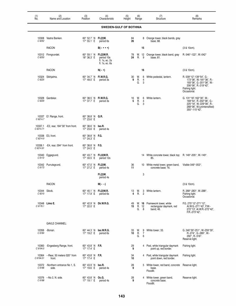
143
(1)No.
(2)Name and Location
(3)Position
(4)Characteristic
(5)Height
(6)Range
(7)Structure
(8)Remarks
10308C 6252
Vastra Banken. 60° 52.7´ N17° 55.1´ E
Fl.(2)W.period 6s
8426
8 Orange tower, black bands, gray base; 88.
RACON B(– • • •) 15 (3 & 10cm).
10312C 6250
Finngrundet. 60° 59.1´ N18° 36.3´ E
Fl.(2)W.R.period 10sfl. 1s, ec. 2sfl. 1s, ec. 6s
7824
W. 12R. 9
Orange tower, black band, gray base; 81.
R. 046°-122°, W.-042°
RACON N(– • ) 16 (3 & 10cm).
10324C 6225
Sikhjalma. 60° 34.7´ N17° 49.0´ E
Fl.W.R.G.period 3s
309
W. 6R. 4G. 3
White pedestal, lantern. R. 039°12′-139°54′, G.-173°36′, W.-181°36′, R.-193°36′, G.-201°36′, W.-206°06′, R.-219°42′.
Fishing light.Occasional.
10328C 6220
Gardskar. 60° 38.5´ N17° 37.7´ E
Fl.W.R.G.period 3s
165
W. 6R. 4G. 3
White lantern. G. 131°18′-162°30′, W.-169°54′, R.-202°36′, G.-225°18′, W.-229°06′, R.-268°06′, W.(unintensified) 355°-115°42′.
10337C 6214.7
E1 Range, front. 60° 38.8´ N17° 23.6´ E
Q.R.
10337.1C 6214.71
-E2, rear, 184°30′ from front. 60° 38.6´ N17° 23.6´ E
Iso.R.period 4s
10338C 6214.9
E3, front. 60° 38.8´ N17° 24.3´ E
F.G.
10338.1C 6214.91
-E4, rear, 094° from front. 60° 38.8´ N17° 24.5´ E
F.G.
10340C 6172
Eggegrund. 60° 43.7´ N17° 33.5´ E
Fl.(4)W.R.period 12s
14 White concrete tower, black top; 85.
R. 149°-205°, W.-149°.
10342C 6173
Purrutsgrund. 60° 47.0´ N17° 27.2´ E
Fl.(2)W.period 4s
3611
10 White metal tower, green band, concrete base; 16.
Visible 049°-053°.
Fl.(2)W.period 4s
3
RACON M(– –) (3 & 10cm).
10344C 6210
Sikvik. 60° 40.1´ N17° 17.9´ E
Fl.(2)W.R.period 6s
134
W. 3R. 2
White lantern. R. 268°-283°, W.-288°.Fishing light.Occasional.
10348C 6176.1
Limo E. 60° 42.9´ N17° 22.0´ E
Dir.W.R.G. 4915
W. 16R. 12G. 8
Framework tower, white rectangular daymark, red band; 46.
F.G. 270°12′-271°12′, Al.W.G.-271°43′, F.W.-272°13′, Al.W.R.-272°42′, F.R.-273°42′.
GAVLE CHANNEL:
10356C 6184
-Bonan. 60° 44.3´ N17° 19.2´ E
Iso.W.R.G.period 6s
3310
W. 9R. 7G. 6
White tower; 33. G. 240°30′-251°, W.-259°30′, R.-274°, G.-289°, W.-292°, R.-318°.
Reserve light.
10360C 6194.5
-Engesberg Range, front. 60° 43.8´ N17° 17.4´ E
F.R. 299
4 Post, white triangular daymark point up, red border.
Fishing light.
10364C 6194.51
- -Rear, 50 meters 020° from front.
60° 43.8´ N17° 17.4´ E
F.R. 3410
4 Post, white triangular daymark point down, red border.
Fishing light.
10372C 6186
-Northern entrance No 1, S. side.
60° 43.9´ N17° 19.6´ E
Iso.R.period 4s
289
5 White tower, red band, concrete base.
Floodlit.
Reserve light.
10376C 6188
- -No 2, N. side. 60° 43.8´ N17° 19.1´ E
Oc.G.period 4s
289
4 White tower, green band, concrete base.
Floodlit.
Reserve light.
SWEDEN-GULF OF BOTHNIA

144
(1)No.
(2)Name and Location
(3)Position
(4)Characteristic
(5)Height
(6)Range
(7)Structure
(8)Remarks
10380C 6190
- -No 3, N. side. 60° 43.7´ N17° 18.9´ E
Iso.G.period 4s
289
4 White tower, green band, concrete base.
Floodlit.
Reserve light.
10396C 6196
-Karskar. 60° 41.2´ N17° 16.5´ E
Iso.W.R.G.period 3s
3310
W. 9R. 7G. 5
Framework tower. R. 135°-160°, G.-169°30′, W.-178°30′, R.-196°30′, G.-212°.
10404C 6195
-Herosgrund. 60° 42.7´ N17° 16.7´ E
Oc.R.period 4s
196
6 Orange and gray tower.Floodlit.
10410C 6201
-Barsagrundet. 60° 41.0´ N17° 12.2´ E
Fl.G.period 3s
206
1 Occasional.
10424C 6175.9
Skraddarhallan. 60° 45.9´ N17° 21.6´ E
Fl.(2)W.R.G.period 6s
185
W. 7R. 5G. 4
White lantern. G. 307°-319°06′, W.-326°18′, R.-020°06′.
Fl.(2)R.period 6s
12
10428C 6174
Trodjehallan. 60° 48.4´ N17° 21.4´ E
Fl.(3)W.R.G.period 9s
4213
W. 7W. 6G. 5R. 4G. 4G. 3
White concrete tower, orange top; 33.
G. 174°54′-185°, W.-233°, R.-256°, R.(unintensified)-274°, G.-290°18′, W.-296°06′, R.-310°, G. 340°-348°18′, W.-349°06′, R.-016°.
10432C 6175
Skommarhallan. 60° 49.4´ N17° 19.1´ E
Q.W.R.G. 206
W. 5R. 4G. 3
White tower, red band. R. 186°-197°, G.-231°, W.- 269°, R.-341°, G.-007°, W.-011°, R.-029°.
Occasional.
10436C 6168
Iggo, SE. side. 60° 52.5´ N17° 19.7´ E
Fl.W.R.G.period 6s
216
W. 4R. 3G. 2
White pedestal. G. 190°-207°, W.-358°, R.-075°.
Fishing light.
NORRSUND HAMN:
10440C 6152
-Hallstensoren. 60° 56.9´ N17° 10.7´ E
Fl.(2)W.R.G.period 12sfl. 1s, ec. 2sfl. 1s, ec. 8s
216
W. 11R. 8G. 9
Orange framework tower, white lantern.
G. 234°-244°36′, W.-252°48′, R.-270°.
10444C 6154
-Ryttarharet. 60° 56.6´ N17° 10.5´ E
Oc.W.R.G.period 4s
309
W. 7R. 5G. 5
Framework tower, white lantern. W. 055°42′-056°36′, R.-063°06′, W.(unintensified) 112°54′-179°30′, G. 226°24′-231°30′, W-235°48′, R.-241°.
Reserve light.
10448C 6156
-Norrsundet Range, front. 60° 56.5´ N17° 09.6´ E
Iso.R.period 4s
268
7 Post, red triangular daymark point up, black stripe.
10452C 6156.1
- -Rear, 130 meters 244° from front.
60° 56.4´ N17° 09.5´ E
Q.R. 3611
6 Metal stand, red triangular daymark point down, black stripe.
10456C 6158
-Norrsundet Inre. 60° 56.2´ N17° 09.5´ E
Fl.W.R.G.period 3s
206
W. 3R. 2G. 2
Metal framework tower, white lantern.
W. 075°06′-125°42′, G.-225°36′, W.-228°, R.-245°.
10464C 6146
Gashallan. 61° 00.5´ N17° 17.2´ E
Fl.(4)W.R.G.period 12s
3310
W. 7R. 5G. 4
White tower; 26. R. 080°-097°, G.-125°, W.-174°, R.-198°, G.-220°, W.-325°, R.-332°, G.-348°, R.-003°, G.-031°, R.-048°, G.-080°.
10468C 6138
-Kushallan. 61° 02.4´ N17° 15.4´ E
Fl.(3)W.R.G.period 4s
268
W. 6R. 4G. 3
White lantern. R. 123°-145°30′, G.-179°, R.-256°, G.-282°, W.-328°, R.-359°.
10472C 6130
Sunnan. 61° 05.5´ N17° 13.6´ E
Fl.W.R.G.period 6s
165
W. 6R. 4G. 3
Tower. R. 109°36′-178°12′, G.-196°30′, W.-202°, R.-289°06′, G.-328°, R.-005°.
SWEDEN-GULF OF BOTHNIA

145
(1)No.
(2)Name and Location
(3)Position
(4)Characteristic
(5)Height
(6)Range
(7)Structure
(8)Remarks
10476C 6122
Storjungfrun. 61° 10.1´ N17° 20.1´ E
L.Fl.W.R.G.period 8sfl. 2s, ec. 6s
8827
W. 12R. 9G. 7
White tower, black top; 70. W. 090°-113°, R.-180°, G.-191°, W.-242°, R.-304°, G.-327°, W.-351°, R.-015°.
10480C 6125
Hogharen. 61° 06.2´ N17° 16.2´ E
Q.W.R.G. 196
W. 6R. 4G. 3
White lantern. G. 123°-157°, W.-173°, R.-204°, G.-222°, R.-245°, G.-268°, W.-275°, R.-296°.
Fishing light.
10484C 6132
Trollharen Range, front. 61° 05.3´ N17° 11.8´ E
F.R. 134
Post. Fishing light.Occasional.
10488C 6132.1
-Rear, 120 meters 213° from front.
61° 05.4´ N17° 12.1´ E
F.R. 196
Post. Fishing light.Occasional.
10492C 6116
Vallvik Quay Range, front. 61° 11.5´ N17° 10.3´ E
F.R. 4614
6 White framework tower, white triangular daymark point up, red border.
Auxiliary orange rectangular daymark.
10496C 6116.1
-Rear, 275 meters 145° from front.
61° 11.3´ N17° 10.5´ E
F.R. 5818
6 White framework tower, white triangular daymark point down, red border.
R. Lt. on chimney 400 meters SE.
10500C 6114
Storstensharet. 61° 12.5´ N17° 08.8´ E
L.Fl.W.R.G.period 8s
185
W. 10R. 7G. 6
White post; 10. R. 262°42′-284°48′, G.-300°, W.-304°54′, R.-309°42′, G.-321°06′, W.-326°, R.-340°.
10502C 6114.5
Storgrytan. 61° 12.2´ N17° 09.5´ E
Fl.W.period 3s
165
4 White hut, red bands.
10508C 6114.6
-Ljusne Sodra Range, front. 61° 12.0´ N17° 07.9´ E
F.G. 309
10 White triangular daymark point up.
10512C 6114.61
- -Rear, 90 meters 249° from front.
61° 12.0´ N17° 07.8´ E
F.G. 3912
10 White triangular daymark point down.
10516C 6114.4
-Tralhamn Range, front. 61° 12.3´ N17° 07.7´ E
F.G. 165
10 White triangular daymark point up.
10520C 6114.41
- -Rear, 120 meters 302°30′ from front.
61° 12.3´ N17° 07.6´ E
F.G. 268
10 White triangular daymark point down.
10524C 6112
Vallvik. 61° 11.5´ N17° 10.8´ E
Iso.W.R.G.period 4s
309
W. 12R. 8G. 6
White tower, red band. R. 146°-168°42′, G.-250°48′, R.-262°, G.-267°54′, W.-271°54′, R.-278°48′, G.-310°48′, W.-313°06′, R.-319°.
Reserve light.In line 269°30′ with orange
daymark on 10492.
SODERHAMN APPROACH:
10528C 6087
-Hallgrund. 61° 16.6´ N17° 23.8´ E
L.Fl.(2)W.R.G.period 15sfl. 2s, ec. 2sfl. 2s, ec. 9s
7222
W. 9R. 7G. 6
White tower, red band, gray base; 75.
W. 001°-007°30′, R.-018°, G.-024°, W.-033°, R.-054°, G.-075°, W.-078°30′, R.-086°, G.-137°30′, R.-146°, G.-174°, W.-340°, R.-350°, G.-001°.
Reserve light.
-RACON G(– – • ) 15 (3 & 10cm).
10532C 6088
-Norrutharet. 61° 15.5´ N17° 17.7´ E
Fl.(3)W.R.G.period 9s
3410
W. 7W. 6W. 3R. 5R. 4G. 4
White tower; 33. W. (unintensified) 067°-094°, W.-161°, R.-234°24′, G.-255°36′, W.-264°06′, R.-313°18′, G.-332°36′, W.-339°42′, R.-001°12′.
10536C 6092
-Klumpudden, N. side of Enskar.
61° 14.6´ N17° 16.6´ E
Fl.W.R.G.period 4s
165
W. 5R. 4G. 3
White lantern. G. 065°18′-104°24′, R.-111°42′, G.-156°48′, W.-162°12′, R.-216°42′, G.-271°12′, R.-300°.
SWEDEN-GULF OF BOTHNIA
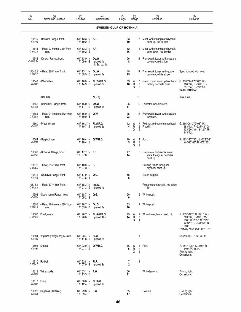
146
(1)No.
(2)Name and Location
(3)Position
(4)Characteristic
(5)Height
(6)Range
(7)Structure
(8)Remarks
10540C 6113
-Hovskar Range, front. 61° 13.3´ N17° 10.2´ E
F.R. 3310
6 Mast, white triangular daymark point up, red border.
10544C 6113.1
- -Rear, 92 meters 338° from front.
61° 13.3´ N17° 10.2´ E
F.R. 5216
6 Mast, white triangular daymark point down, red border.
10546C 6113.51
-Orrskar Range, front. 61° 13.0´ N17° 09.6´ E
Oc.W.period 4slt. 3s, ec. 1s
268
11 Framework tower, white square daymark, red stripe.
10546.1C 6113.5
- -Rear, 326° from front. 61° 13.1´ N17° 09.5´ E
Oc.W.period 4s
4915
11 Framework tower, red square daymark, white stripe.
Synchronized with front.
10548C 6093
-Otterhallen. 61° 16.0´ N17° 14.9´ E
Fl.(2)W.R.G.period 6s
3310
W. 5R. 3G. 3
Green round tower, yellow band, gallery, concrete base.
G. 238°06′-273°06′, W.-280°06′, R.-301°, G.-331°54′, R.-093°06′.
Radar reflector.
-RACON N(– • ) 10 (3 & 10cm).
10552C 6098
-Brandskar Range, front. 61° 16.0´ N17° 11.1´ E
Oc.W.period 4s
3611
13 Pedestal, white lantern.
10556C 6098.1
- -Rear, 914 meters 272° from front.
61° 16.0´ N17° 10.0´ E
Q.W. 7523
13 Framework tower, white square daymark.
10560C 6100
-Prastholmen. 61° 16.3´ N17° 10.7´ E
Fl.W.R.G.period 3s
124
W. 7R. 3G. 2
Red hut, red concrete pedestal.Floodlit.
G. 266°06′-279°06′, W.-283°12′, R.-324°42′, G.-133°30′, W.-134°24′, R.-143°12′.
10564C 6102
-Garpholmen. 61° 16.4´ N17° 10.4´ E
Q.W.R.G. 103
W. 7R. 3G. 2
Post. R. 123°-307°12′, G.-322°54′, W.-345°48′, R.-002°30′.
10568C 6106
-Ullbacka Range, front. 61° 17.7´ N17° 07.8´ E
F.R. 4714
6 Gray metal framework tower, white triangular daymark point up.
10573C 6106.2
- -Rear, 315° from front. 61° 18.0´ N17° 07.3´ E
F.R. Building, white triangular daymark point up.
10576C 6108
-Grundvik Range, front. 61° 17.9´ N17° 07.8´ E
Q.G. 155
Green dolphin.
10576.1C 6108.1
- -Rear, 327° from front. 61° 18.3´ N17° 07.3´ E
Iso.G.period 4s
Rectangular daymark, red stripe; 10.
10592C 6111
-Soderhamn Range, front. 61° 18.7´ N17° 05.2´ E
Q.G. 206
2 White post.
10596C 6111.1
- -Rear, 180 meters 289° from front.
61° 18.7´ N17° 05.0´ E
Oc.G.period 4s
3310
2 White post.
10600C 6086.2
Prastgrundet. 61° 20.7´ N17° 20.0´ E
Fl.(4)W.R.G.period 12s
4514
W. 7R. 5G. 4
White tower, black band; 19. R. 003°-077°, G.-091°, W.-093°30′, R.-135°, W.-236°, R.-265°, G.-275°, W.-323°, R.-341°30′, G.-003°.
Partially obscured 140°-165°.
10604C 6083
Vitgrund (Hvitgrund), N. side. 61° 23.4´ N17° 11.8´ E
Fl.W.period 3s
4 Shown Apr. 15 to Oct. 15.
10608C 6084
Skarsa. 61° 23.0´ N17° 07.7´ E
Q.W.R.G. 165
W. 5R. 4G. 3
Post. R. 154°-198°, G.-250°, R.-340°, W.-154°.
Fishing light.Occasional.
10610C 6084.5
Rodkull. 61° 22.8´ N17° 07.0´ E
Fl.R.period 3s
72
1
10612C 6079
Vatnasudde. 61° 33.1´ N17° 13.3´ E
F.W. 3611
White lantern. Fishing light.Occasional.
10616C 6080
Fiske. 61° 30.6´ N17° 12.4´ E
Fl.(3)W.period 9s
10620C 6081
Haganas (Kattskar). 61° 29.6´ N17° 09.4´ E
F.W. 5517
Column. Fishing light.Occasional.
SWEDEN-GULF OF BOTHNIA

147
(1)No.
(2)Name and Location
(3)Position
(4)Characteristic
(5)Height
(6)Range
(7)Structure
(8)Remarks
HUDIKSVALL APPROACH:
10624C 6060
-Ago. 61° 32.6´ N17° 28.0´ E
Fl.W.R.G.period 5sfl. 1s, ec. 4s
10231
W. 9R. 6G. 5
White tower, orange band; 49. G. 130°-141°30′, W.-143°, R.-162°, G.-198°, W.-280°, R.-293°, W.-035°, R.-094°.
Partially obscured 048°-094°.
10628C 6066
-Krako. 61° 33.3´ N17° 19.0´ E
Fl.(2)W.R.G.period 6s
237
W. 6R. 4G. 3
White lantern. G. 337°30′-350°, W.-007°30′, R.-043°, G.-126°-166°, W.-169°, R.-174°54′.
10632C 6062
-Krakskar. 61° 34.1´ N17° 19.6´ E
Fl.(4)W.R.G.period 12s
4915
W. 9R. 6G. 5
Orange tower, white top; 20. G. 109°-152°, W.-158°, R.-173°, G.-185°, W.-189°, R.-220°, G.-247°, W.-253°, R.-255°, G.-257°, W.-265°30′, R.-271°, G.-275°30′, W.-281°, R.-285°.
10636C 6057
-Holickskar. 61° 37.2´ N17° 26.6´ E
Iso.W.R.G.period 8s
3310
W. 10R. 7G. 6
White lantern. G. 277°30′-295°, W.-301°, R.-313°30′, G.-323°, W.-340°, R.-025°, G.-047°, W.-051°, R.-057°, G.-093°.
Reserve light.
10640C 6057.4
- -S. breakwater of fishing harbor, head.
61° 37.6´ N17° 26.1´ E
Q.W.R.G. 165
W. 8R. 6G. 5
Pedestal, lantern. G. 013°-070°, W.-077°, R.-094°30′, G.-127°, R.-145°.
Fishing light.Occasional.
10652C 6068
-Dukarsund, Mossolandet. 61° 37.4´ N17° 10.9´ E
Q.W.R.G. 103
W. 6R. 4G. 3
White lantern. G. 075°-082°30′, W.-085°12′, R.-103°, W.(unintensified)-247°, G.-268°30′, W.-273°, R.-283°.
The dredged channel to Iggesund is marked by lighted beacons.
10656C 6069
-Gasfjarden Range, front. 61° 37.2´ N17° 06.3´ E
Q.W. 11234
17 White framework tower, red rectangular daymark, white stripe.
Visible on range line only.
10660C 6069.1
- -Rear, about 498 meters 264°12′ from front.
61° 37.1´ N17° 05.2´ E
Iso.W.period 4s
15447
18 White framework tower, red rectangular daymark, white stripe.
Visible on range line only.
10664C 6070
-Ljusgrund Range, front. 61° 38.9´ N17° 16.0´ E
Q.W. 165
7 Red cairn. Visible on range line only.
10668C 6070.1
- -Rear, 1,300 meters 192° from front.
61° 38.2´ N17° 15.7´ E
Iso.W.period 4s
278
7 Red triangular daymark point down.
Visible on range line only.
10672C 6071
-Saltviksudde, W. entrance to Kudiksvallfjarden.
61° 40.8´ N17° 14.8´ E
L.Fl.W.R.G.period 8sfl. 2s, ec. 6s
3611
W. 13R. 10G. 9
White tower; 34. G.(unintensified) 140°-210°, R.(unintensified)-293°30′, G.(unintensified)-310°, G.-322°, W.-324°, R.-328°.
10676C 6072
-Gackero, SW. point, E. side of entrance.
61° 40.6´ N17° 16.7´ E
Fl.(2)W.R.G.period 6s
134
W. 9R. 7G. 6
White lantern. G. 332°-006°30′, W.-009°30′, R.-031°, G.-073°, W.-079°, R.-148°30′, G.-152°, W.-154°, R.-158°.
Shown 24 hours Nov. 1 to Mar. 31.
10680C 6075
-Lusholmen Range, front. 61° 41.3´ N17° 16.3´ E
Q.W. 237
12 Post, white triangular daymark point up, orange border.
10684C 6075.1
- -Rear, 340 meters 116° from front.
61° 41.2´ N17° 16.7´ E
Iso.W.period 4s
4915
12 Post, white triangular daymark point down, orange border.
10688C 6076
-Lingaro Range, front. 61° 42.4´ N17° 15.0´ E
Iso.W.period 3s
3711
8 Post, white triangular daymark point up, orange border.
10692C 6076.1
- -Rear, 120 meters 339° from front.
61° 42.5´ N17° 15.0´ E
Iso.W.period 3s
5617
8 Post, white triangular daymark point down, orange border.
SWEDEN-GULF OF BOTHNIA

148
(1)No.
(2)Name and Location
(3)Position
(4)Characteristic
(5)Height
(6)Range
(7)Structure
(8)Remarks
10696C 6056
Balso, Gashallan. 61° 43.3´ N17° 33.3´ E
Fl.(3)W.R.G.period 9s
3711
W. 8R. 5G. 4
White tower; 16. G. 174°-200°, W.-013°,R.-016°.
Reserve light.
10700C 6052
-Fishing harbor, W. side. 61° 43.6´ N17° 31.0´ E
Fl.(3)R.G.period 10s
216
R. 2G. 1
White pedestal. G. 000°-007°, R.-075°, G.-177°, R.-000°.
Fishing light.Occasional.
10704C 6048
Bergo, NE. point. 61° 48.9´ N17° 25.1´ E
Fl.W.period 3s
144
5 White pedestal, lantern. Fishing light.Shown Apr. 1 to Oct. 31.
10708C 6043
Mellanfjarden, on W. side of Jattendal Fjord.
61° 56.9´ N17° 20.7´ E
Q.W.R.G. 3310
W. 6R. 4G. 3
Framework tower, white lantern. W.(unintensified) 170°-275°, G.-283°, W.-292°30′, R.-308°30′, G.-330°.
10720C 6044.5
-Mellanfjardens Range, front. 61° 57.0´ N17° 21.0´ E
Iso.W.period 4s
206
Mast, white triangular daymark point up.
Two F.G. lights in line 006° located at Mellanfjarden Fishing Harbor, close E. of range lights.
10724C 6044.6
- -Rear, 90 meters 329° from front.
61° 57.6´ N17° 20.5´ E
Iso.W.period 4s
309
Mast, white triangular daymark point down.
Synchronized with front.
10732C 6042
Gran. 62° 00.8´ N17° 37.7´ E
Fl.W.R.G.period 5sfl. 1s, ec. 4s
9830
W. 9R. 7G. 6
Framework tower, white dwelling. R. 022°-039°, G.-056°, W.-059°30′, R.-080°, G.-125°30′, W.-197°, R.-234°, W.-022°.
10736C 6040
Furuskar, S. side. 62° 11.2´ N17° 32.3´ E
Fl.(2)W.R.G.period 8s
165
W. 5R. 4G. 3
White lantern. G. 299°-320°, W.-328°, R.-340°, W.(unintensified)-045°.
10740C 6041
Bramo Kalv. 62° 10.9´ N17° 40.5´ E
Fl.(4)W.R.G.period 12s
4012
W. 15R. 12G. 10
White tower; 30. G. 270°-284°, W.-313°, R.-351°30′, G.-008°30′, W.-014°, R.-024°30′, G.-068°, W.-071°, R.-085°, G.-180°, W.-200°.
10744C 6032
Bramo Cable Range, E. side, front.
62° 12.4´ N17° 40.8´ E
F.R. 3611
7 Framework tower, white triangular daymark point up, red border.
Marks Cable.
10748C 6032.1
-Rear, 70 meters 120° from front.
62° 12.4´ N17° 40.9´ E
F.R. 4915
7 Framework tower, white triangular daymark point down.
10752C 6030
Bramon. 62° 13.1´ N17° 44.4´ E
Oc.(2)W.R.G.period 20s
10231
W. 18R. 15G. 13
White stone tower, black band; 53.
G. 123°-137°, R.-152°, W.-340°, R.-022°.
Shown 24 hours Nov. 1 to Mar. 31.
10756C 6034
Lorudden, NE. side of Bramosund.
62° 14.0´ N17° 39.6´ E
Oc.W.R.G.period 5s
165
W. 10R. 7G. 6
White lantern. G. 148°-156°, W.-263°, R.-338°, G.-355°, W.-004°, R.-045°.
Shown 24 hours Nov. 1 to Mar. 31.
SUNDSVALL APPROACH:
10760C 6036
-Draghallan. 62° 20.4´ N17° 26.4´ E
Mo.(A)W.R.G.period 10sfl. 1s, ec. 1sfl. 3s, ec. 5s
4213
W. 16R. 13G. 12
White tower, orange top; 46. R. 052°36′-087°48′, G.-142°12′, W.-145°, R.-170°54′, G.-248°, W.-251°54′, R.-273°30′, G.-289°, W.-296°, R.-316°, G.-348°, G.(unintensified)-018°, G.-052°36′.
Shown 24 hours Nov. 1 to Mar. 31.
Radar reflector.
10764C 6036.4
-Sunsvall AVIATION LIGHT. 62° 22.1´ N17° 19.1´ E
V.Q.W. 1476450
21 Orange and white metal framework tower.
6 F.R. shown from same tower.
10766C 6037
-Kubikenborg Range, front. 62° 22.6´ N17° 22.0´ E
F.R. 155
6 Post, white triangular daymark point up, red border.
10766.1C 6037.1
- -Rear, 60 meters 310° from front.
62° 22.7´ N17° 22.0´ E
F.R. 258
7 White triangular daymark point down, red border.
SWEDEN-GULF OF BOTHNIA

149
(1)No.
(2)Name and Location
(3)Position
(4)Characteristic
(5)Height
(6)Range
(7)Structure
(8)Remarks
10768C 6037.4
-Tjuvholmen, W. side. 62° 23.1´ N17° 22.1´ E
Q.W.R.G. 124
W. 9R. 7G. 5
White lantern. G. 320°30′-325°30′, W.-331°, R.-035°, G.-105°48′, W.-114°18′, R.-125°.
2 F.R. 7M lights in line 267° mark pipeline 870 meters NNW.
10772C 6037.6
-Kokaren Range, front. 62° 23.9´ N17° 21.5´ E
F.R. 216
5 Pole, red triangular daymark point up.
10776C 6037.61
- -Rear, 65 meters 020° from front.
62° 23.9´ N17° 21.5´ E
F.R. 3310
5 Pole, red triangular daymark point down.
10778C 6039
-Alno Bridge. 62° 26.0´ N17° 23.9´ E
Oc.W.period 4s
Floodlit. Bridge marked by F.Y. lights.Numerous 2 F.R. range lights
mark cables in Alno Sundet.
-RACON HS(• • • • • • • ) 4 (3 & 10cm).
10780C 6028
Gistaholmen. 62° 29.4´ N17° 24.2´ E
Fl.W.R.G.period 3sfl. 0.7s, ec. 2.3s
3310
W. 6R. 4G. 3
Framework tower, white lantern. G. 054°-069°, W.-077°, R.-084°, R.(unintensified)-107°, W.(unintensified)-200°, R.(unintensified)-234°, G.-246°, W.-258°30, R.- 280°.
2 F.R. 7M lights in line 243° mark pipeline 2.1 miles WSW.
10784C 6025
Salsternarna. 62° 28.5´ N17° 28.5´ E
Q.W.R.G. 3310
W. 6R. 4G. 3
White tower, black top; 26. G. 121°48′-139°42′, W.-270°06′, R.-284°36′, G.-299°36′, W.-321°12′, R.-350°.
2 F.R. 8M lights in line 047° at Soraker 1.9 miles NNE.
Radar reflector.
10788C 6024
Granon. 62° 26.1´ N17° 31.4´ E
Fl.(2)W.R.G.period 6s
3310
W. 5R. 4G. 3
Framework tower, white lantern. G. 330°-343°, W.-357°, R.-015°, R. (unintensified)-090°, G. (unintensified)-150°, G.-161°, W.-164°, R.-166°30′, G.-169°30′, W.-172°30′, R.-180°.
10792C 6021
Rodogubben. 62° 23.0´ N17° 36.1´ E
Fl.W.R.G.period 3s
4313
W. 7R. 5G. 4
Black tower, white top; 39. G. 150°-180°, W.-232°, R.-252°, G.-270°, W.-347°, R.-015°.
10796C 6023
Spikarna. 62° 21.9´ N17° 31.8´ E
Q.W.R.G. 3310
W. 6R. 4G. 3
White tower. G. 280°-297°, W.-307°, R.-000°.
10800C 6022
Gubben. 62° 21.0´ N17° 34.7´ E
Oc.W.R.G.period 8s
4915
W. 12R. 9G. 8
White tower, red top; 33.Floodlit.
R. 021°-078°, G.-083°, W.-085°, R.-136°, G.-151°30′, W.-153°, R.-180°, G.-203°, W.-207°, R.-230°, G.-250°, W.-313°, R.-317°, G.-320°30′, W.-327°, R.-338°, G.-021°.
10804C 6020
Astholmsudde. 62° 23.3´ N17° 44.0´ E
Iso.W.R.G.period 8s
4614
W. 14R. 11G. 10
White lantern. G. 213°30′-216°, W.-051°, R.-059°, G.-070°, W.- 072°30′,R.-080°, G.-106°, W.-111°, R.-118°.
Shown 24 hours Nov. 1 to Mar 31.
Reserve light.
10805C 6020.5
Aston. 62° 25.6´ N17° 43.0´ E
Fl.W.R.G.period 7.5s
4313
W. 4R. 1G. 2
White hut, red band. W. 100°-180°, G.-228°, W.-280°, R.-315°.
10808C 6016
Skarpudden. 62° 28.8´ N17° 49.2´ E
L.Fl.W.R.G.period 12sfl. 2s, ec. 10s
4514
W. 6R. 4G. 3
White lantern. G. 230°-237°, W.-273°, R.-288°, W.-018°, R.-050°, G.-067°, W.-105°, R.-145°.
10810C 6015
Vanta Litetsgrund. 62° 29.5´ N18° 17.0´ E
Fl.W.period 3s
6219
9 Black tower, orange top; 66.
SWEDEN-GULF OF BOTHNIA

150
(1)No.
(2)Name and Location
(3)Position
(4)Characteristic
(5)Height
(6)Range
(7)Structure
(8)Remarks
10812C 6014
Storholmen, SW. point of Harnon.
62° 33.3´ N17° 55.8´ E
Fl.(2)W.R.period 6s
309
W. 6R. 4
White lantern. W. 322°54′-013°48′, R.-067°42′, W.-187°06′.
10820C 6012
Harnoklubb. 62° 36.0´ N18° 03.4´ E
Fl.(4)W.period 12s
12
10824C 6011
Harno Sodra. 62° 36.5´ N18° 03.8´ E
Q.W. 4213
6 White pedestal, lantern. Visible 180°06′-051°54′.
10828C 6008
Harnosand Hamn. 62° 38.7´ N17° 57.3´ E
Q.W.R.G. 268
W. 9R. 7G. 5
Red tower, white band; 21. G. 025°30′-141°30′, W.-157°54′, R.-198°, G.-230°24′, W.-264°06′, R.-275°.
ANGERMANALVEN:
10832C 5988
-Stromskaten. 62° 39.5´ N18° 00.2´ E
Fl.(2)W.R.G.period 6s
3912
W. 12R. 9G. 7
Orange lantern, white base.Floodlit.
G. 290°-313°24′, W.-323°30′, R.-062°42′, G.-154°48′, W.-174°, R.-210°.
10834C 5988.5
- -SE. point. 62° 38.5´ N18° 05.4´ E
Oc.W.period 6s
9529
9 White tower, black top; 95. Visible 213°-115°.Shown May to Oct.
10836C 5990
-Valo, NE. point. 62° 44.2´ N17° 59.3´ E
Fl.W.R.G.period 3s
3812
W. 6R. 4G. 3
White tower, orange top; 36. G. 138°-157°30′, W.-358°, R.-138°.
10840C 5992
-Abordso, W. side. 62° 47.1´ N17° 56.8´ E
Fl.(2)W.G.period 6s
3912
W. 9G. 5
White tower, orange top; 36.Floodlit.
W. 143°30′-066°, G.-143°30′.
10844C 5994
-Hornoholmen. 62° 48.8´ N17° 54.8´ E
Fl.(2)W.period 6s
3611
5 Aluminum framework tower, orange square daymark.
Radar reflector.
10848C 5998
-Sprangsviken, W. side of channel.
62° 51.8´ N17° 53.7´ E
Fl.W.period 3s
3611
9 Aluminum framework tower, orange square daymark.
Floodlit.
Radar reflector.
10850C 6000.6
-Svano Sodra. 62° 53.4´ N17° 52.2´ E
Q.W.R.G. 4915
W. 7R. 4G. 4
Framework tower, red rectangular daymark, white stripe.
G. 320°06′-328°06′, W.-331°36′, R.-345°42′, W. (unintensified)-100°.
10850.5C 6000
-Sandobron. 62° 53.1´ N17° 53.1´ E
Oc.W. 8225
2 Center of span. On both sides of bridge.
2 Oc.R.G.
2 Oc.G.(vert.) Mark starboard side of channel.
-RACON HS(• • • • • • • ) 2 (3 & 10cm).
10851C 6001
Svanon Isle, E. side. 62° 54.1´ N17° 51.9´ E
Iso. W.R.G.period 4s
206
W. 9R. 6G. 5
Aluminum framework tower. W. 005°30′-086°, R.-147°, G.-160°18′, W.-169°, R.-190°, G.-005°30′.
10852 -Kapellbommen. 62° 56.0´ N17° 47.8´ E
Q.R. 72
Float, lantern. Radar reflector: painted red and yellow.
Shown from Jul. 20 to May 20.
10856C 6004
-Litano, E. side of channel. 62° 58.0´ N17° 47.8´ E
Fl.(2)W.R.G.period 6s
144
W. 7R. 5G. 4
White lantern. G. 312°-320°30′, W.-329°30′, R.-355°, W.(unintensified)-085°, G.-111°30′, W.-116°30′, R.-131°, G.-164°.
10868C 5982
Karingsbergsudden. 62° 47.4´ N18° 11.1´ E
Fl.(2)W.R.G.period 6s
309
W. 8R. 5G. 4
Orange lantern. G. 249°48′-253°30′, W.-278°12′, R.-007°42′, G.-048°18′, W.-052°30′, R.-061°54′.
10872C 5983.4
Valsudde. 62° 46.1´ N18° 06.6´ E
Q.W. 4915
5 Metal framework tower, orange square daymark.
Radar reflector.
SWEDEN-GULF OF BOTHNIA

151
(1)No.
(2)Name and Location
(3)Position
(4)Characteristic
(5)Height
(6)Range
(7)Structure
(8)Remarks
10876C 5993.6
Hornon. 62° 47.9´ N17° 57.8´ E
Fl.(4)W.R.G.period 12s
4313
W. 6R. 4G. 3
Pylon. G. 292°24′-296°54′, W.-300°54′, R.-306°06′.
F.R. 600183
10878C 5993.3
Hogakustenbron Bridge. 62° 47.9´ N17° 56.3´ E
2 F.W. Center of span. One light visible from SE.One light visible from NW.
10878.1C 5993.4
-SW. side. 62° 47.6´ N17° 55.9´ E
Fl.R.period 3s
13140
3 Bridge.
10878.2C 5993.5
-NE. side. 62° 48.2´ N17° 56.7´ E
Fl.G.period 3s
13140
3 Bridge.
10880C 5993
Veda. 62° 47.6´ N17° 55.9´ E
Fl.W.R.G.period 3s
3812
W. 9R. 7G. 5
Pylon. R. 129°06′-135°42′, G.-142°42′, W.-147°42′, R.-153°30′, G.-258°42′, W.-279°06′, R.-303°54′, G.-328°, W.-333°06′, R.-347°54′.
F.R. 600183
10882 -Hogaskusten RACON. 62° 47.7´ N17° 56.0´ E
M(– –) 20 (3 & 10cm).
10884C 6001.4
Frano. 62° 54.1´ N17° 51.6´ E
I.V.Q.W.R.G.period 6s
3912
W. 9R. 6G. 5
Aluminum framework tower, orange square daymark.
Floodlit.
G. 135°-172°, W.-187°, R.-210°, G.-225°, R.-000°.
Reserve light.
10888C 5989
Sannasundet. 62° 42.1´ N17° 59.3´ E
Q.W.R.G. 3611
W. 9R. 7G. 5
Aluminum framework tower, orange square daymark facing S. and white square daymark facing N.
Floodlit.
G. 130°-183°30′, W.-356°30′, R.-130°.
Reserve light.Radar reflector.
10890C 5980
Hogbonden. 62° 52.0´ N18° 28.7´ E
Fl.(4)W.period 12s
24675
15 White tower; 46. Visible 190°-070°.Shown Nov. 1 to Mar. 31.
10891C 5979.6
Algsjo. 62° 53.3´ N18° 27.6´ E
Fl.W.period 3s
5
10892C 5978
Ytternasan. 62° 57.8´ N18° 33.4´ E
Iso.W.R.G.period 4s
4514
W. 13R. 10G. 9
White tower, black band; 26. G. 140°-192°42′, W.-210°06′, R.-237°, G.-266°54′, W.-288°, R.-307°36′, G.-341°06′, W.- 005°, R.-065°.
Shown 24 hours Jan. 1 to Mar. 31.
10896C 5979
Gnaggen, on rock, 2.7 kilometers S. of Sodra Ulvon.
62° 56.8´ N18° 37.2´ E
I.V.Q.W.R.G.period 6s
3310
W. 6R. 4G. 3
White pedestal, lantern. R. 024°-092°, G.-140°54′, W.-171°48′, R.-207°54′, G.-234°54′, W.-024°.
10900C 5976
Flasan, E. entrance to Ulvohamn.
63° 01.0´ N18° 41.3´ E
Fl.(3)W.R.G.period 9s
4313
W. 8R. 6G. 5
White concrete tower, black bands; 21.
G. 174°06′-191°12′, W.-192°30′, R.-202°, G.-213°18′, W.-337°54′, R.-347°54′, G.-357°48′, W.-008°30′, R.-050°, R.(unintensified)-099°06′, W.(unintensified)-174°06′.
10904C 5977
Ulvohamn Range, front. 63° 01.4´ N18° 39.8´ E
F.R. 3310
3 Post.
10908C 5977.1
-Rear, 40 meters 336° from front.
63° 01.2´ N18° 39.7´ E
F.R. 4112
3 Post.
10912C 5975
Askaret. 63° 01.5´ N18° 40.5´ E
Fl.(2)W.R.G.period 6sfl. 0.5s, ec. 1sfl. 0.5s, ec. 4s
3310
W. 6R. 4G. 3
White hut. G. 045°-059°30′, W.-060°36′, R.-188°06′, G.-203°42′, R.-221°54′, G.-235°36′, W.-238°42′, R.-243°36′, G.-264°36′, W.-308°42′, R.-330°.
SWEDEN-GULF OF BOTHNIA
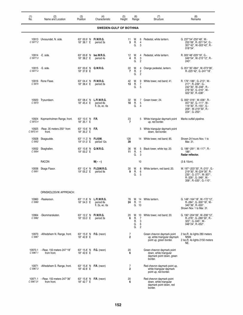
152
(1)No.
(2)Name and Location
(3)Position
(4)Characteristic
(5)Height
(6)Range
(7)Structure
(8)Remarks
10913C 5977.2
Ulvosundet, N. side. 63° 00.9´ N18° 38.1´ E
Fl.W.R.G.period 3s
113
W. 6R. 4G. 3
Pedestal, white lantern. G. 237°54′-250°48′, W.-255°06′, R.-321°54′, G.-357°42′, W.-003°42′, R.-018°54′.
10914C 5977.3
-E. side. 63° 00.8´ N18° 38.2´ E
Iso.W.R.G.period 4s
124
W. 4R. 3G. 2
Pedestal, white lantern. R. 005°48′-029°18′, G.-049°54′, W.-215°12′, R.-243°.
10915C 5977.4
-S. side. 63° 00.6´ N18° 37.8´ E
Q.W.R.G. 227
W. 4R. 2G. 2
Orange pedestal, lantern. G. 051°30′-064°, W.-073°06′, R.-225°42′, G.-241°18′.
10916C 5974
Rone Flase. 63° 04.4´ N18° 38.4´ E
Fl.W.R.G.period 3s
4213
W. 9R. 7G. 5
White tower, red band; 41. R. 176°-186°, G.-213°, W.-217°, R.-239°, G.-242°30′, W.-248°, R.-276°30′, G.-016°, W.-022°30′, R.-038°.
10920C 5973
Trysundaon. 63° 08.4´ N18° 45.4´ E
L.Fl.W.R.G.period 8sfl. 2s, ec. 6s
3210
W. 7R. 5G. 4
Green tower; 24. G. 000°-016°, W.-036°, R.-057°30′, G.-111°, W.-116°30′, R.-155°, G.-209°, W.-219°30′, R.-224°, G.-250°.
10924C 5972.4
Kopmanholmen Range, front. 63° 10.5´ N18° 35.1´ E
F.R. 237
5 White triangular daymark point up, red border.
Marks outfall pipeline.
10925C 5972.41
-Rear, 35 meters 250° from front.
63° 10.6´ N18° 35.2´ E
F.R. 5 White triangular daymark point down, red border.
10928C 5952
Skagsudde. 63° 11.3´ N19° 01.0´ E
Fl.(4)W.period 12s
12839
14 White tower, red band; 85. Shown 24 hours Nov. 1 to Mar. 31.
10932C 5954
Skaghallen. 63° 10.8´ N19° 00.2´ E
Q.W.R.G. 3611
W. 5R. 4G. 3
Black tower, white top; 20. G. 186°-291°, W.-117°, R.-186°.
Radar reflector.
RACON M(– –) 10 (3 & 10cm).
10936C 5951
Skags Flasor. 63° 12.4´ N19° 05.2´ E
Fl.(3)W.R.G.period 9s
309
W. 8R. 6G. 5
White lantern, red band; 20. W. 197°-203°30′, R.-215°, G.-219°30′, W.-224°30′, R.-235°, G.-277°, W.-307°, R.-326°, G.-348°, W.-358°, R.-035°, G.-110°.
ORNSKOLDSVIK APPROACH:
10960C 5960
-Raskarson. 63° 11.8´ N18° 54.5´ E
L.Fl.W.R.G.period 8sfl. 2s, ec. 6s
7824
W. 14R. 11G. 10
White lantern. G. 148°-164°18′, W.-172°12′, R.-284°, G.-300°18′, W.-340°36′, R.-000°.
Shown Nov. 1 to Mar. 31.
10964C 5962
-Skommarskaten. 63° 12.2´ N18° 53.0´ E
Fl.W.R.G.period 3s
206
W. 10R. 7R. 3G. 6G. 2
White tower, red band; 20. G. 190°-204°06′, W.-208°12′, R.-278°, G.-289°30′, R.-322°, G.-045°, W.-048°24′, R.-052°.
10970C 5967
-Alfredshem N. Range, front. 63° 15.9´ N18° 42.8´ E
F.G. (neon) 72
Green chevron daymark point up, white triangular daymark point up, green border.
2 Iso.R. 4s lights 280 meters NNW.
2 Iso.R. 4s lights 2150 meters NE.
10970.1C 5967.1
- -Rear, 150 meters 247°18′ from front.
63° 15.8´ N18° 42.6´ E
F.G. (neon) 206
Green chevron daymark point down, white triangular daymark point down, green border.
10971C 5967.3
-Alfredshem S. Range, front. 63° 15.8´ N18° 42.8´ E
F.R. (neon) 72
Red chevron daymark point up, white triangular daymark point up, red border.
10971.1C 5967.31
- -Rear, 150 meters 247°36′ from front.
63° 15.8´ N18° 42.7´ E
F.R. (neon) 206
Red chevron daymark point down, white triangular daymark point down, red border.
SWEDEN-GULF OF BOTHNIA
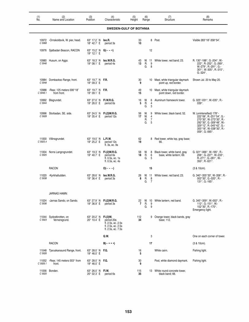
153
(1)No.
(2)Name and Location
(3)Position
(4)Characteristic
(5)Height
(6)Range
(7)Structure
(8)Remarks
10972C 5968
-Ornskoldsvik, W. pier, head. 63° 17.2´ N18° 42.7´ E
Iso.R.period 3s
3310
8 Post. Visible 283°18′-358°54′.
10976 Sjalbadan Beacon, RACON 63° 15.2´ N19° 12.1´ E
G(– – • ) 12
10980C 5946
Husum, on Aggo. 63° 18.3´ N19° 08.1´ E
Iso.W.R.G.period 4s
4313
W. 11R. 9G. 8
White tower, red band; 23. R. 130°-188°, G.-204°, W.-222°, R.-252°, G.-269°, W.-279°, R.-291°, G.-301°, W.-305°, R.-315°, G.-324°.
10984C 5948
Dombackso Range, front. 63° 19.7´ N19° 09.3´ E
F.R. 309
10 Mast, white triangular daymark point up, red border.
Shown Jul. 20 to May 20.
10988C 5948.1
-Rear, 125 meters 006°18′ from front.
63° 19.7´ N19° 09.1´ E
F.R. 4915
10 Mast, white triangular daymark point down, red border.
10992C 5944
Blagrundet. 63° 27.0´ N19° 26.0´ E
Fl.W.R.G.period 6s
165
W. 6R. 4G. 3
Aluminum framework tower. G. 025°-031°, W.-035°, R.-039°.
10996C 5928
Storbadan, SE. side. 63° 24.5´ N19° 35.4´ E
Fl.(3)W.R.G.period 12s
5617
W. 9W. 4R. 7G. 5
White tower, black band; 52. W. (unintensified) 178°-222°06′, R.-251°54′, G.-270°30′, W.-273°30′, R.-292°30′, G.-309°48′, W.-329°12′, R.-345°42′, G.-355°18′, W.-038°30′, R.-059°, G.-065°.
11000C 5925.4
Villinsgrundet. 63° 19.0´ N19° 25.2´ E
L.Fl.W.period 12sfl. 3s, ec. 9s
6219
8 Red tower, white top, gray base; 66.
11004C 5925
Norra Langrogrundet. 63° 19.3´ N19° 40.7´ E
Fl.(2)W.R.G.period 6sfl. 0.5s, ec. 1sfl. 0.5s, ec. 4s
5818
W. 8R. 6G. 5
Black tower, white band, gray base, white lantern; 69.
G. 021°-066°, W.-185°, R.-206°, G.-227°, W.-233°, R.-271°, G.-281°, W.-350°, R.-021°.
RACON O(– – –) 15 (3 & 10cm).
11020C 5938
-Kyrkhalludden. 63° 28.6´ N19° 36.4´ E
Iso.W.R.G.period 3s
268
W. 11R. 8G. 7
White tower, red band; 23. G. 340°-355°30′, W.-358°, R.-002°30′, G.-020°, R.-131°, G.-165°.
JARNAS HAMN:
11024C 5936
-Jarnas Sando, on Sando. 63° 27.9´ N19° 36.9´ E
Fl.(2)W.R.G.period 3s
227
W. 10R. 9G. 9
White lantern, red band. G. 345°-359°, W.-002°, R.-112°, G.-151°, W.-152°30′, R.-170°.
Emergency light.
11044C 5923
Sydostbrotten, on Vernersgrund.
63° 20.2´ N20° 10.4´ E
Fl.(3)W.period 20sfl. 2.5s, ec. 2.5sfl. 2.5s, ec. 2.5sfl. 2.5s, ec. 7.5s
11234
9 Orange tower, black bands, gray base; 112.
Q.W. 3 One on each corner of tower.
RACON B(– • • •) 17 (3 & 10cm).
11048C 5926
Tjaruskarssund Range, front. 63° 28.0´ N19° 46.0´ E
F.G. 165
White cairn. Fishing light.
11052C 5926.1
-Rear, 145 meters 003° from front.
63° 28.0´ N19° 46.0´ E
F.G. 309
Post, white diamond daymark. Fishing light.
11056C 5920
Bonden. 63° 26.0´ N20° 02.3´ E
Fl.W.period 6s
11535
13 White round concrete tower, black band; 66.
SWEDEN-GULF OF BOTHNIA

154
(1)No.
(2)Name and Location
(3)Position
(4)Characteristic
(5)Height
(6)Range
(7)Structure
(8)Remarks
NORRBYSKAREN HARBOR:
11068C 5910
-Norrbyskar. 63° 32.7´ N19° 50.0´ E
Iso.W.R.G.period 4s
165
W. 6R. 4G. 3
White tower, black base; 20. G. 001°-004°, W.-006°, R.-018°, G.-026°, W.-032°, R.-050°, obsc.-097°, G.(unintensified)-106°, obsc.-172°, G.(unintensified)-207°, W.(unintensified)-211°, R.(unintensified)-225°, G.(unintensified)-242°.
11076C 5912
-Bedragaren Rock. 63° 34.0´ N19° 51.0´ E
Q.R. 72
1 Black framework tower. Shown Sep. 15 to close of navigation.
11124C 5902
Norrmjole. 63° 39.3´ N20° 07.5´ E
F.W.R.G. 113
W. 3R. 2G. 1
Framework tower, white lantern. G. 310°-022°, W.-028°, R.-040°.
Fishing light.
UMEA APPROACH:
11132C 5880
-Gunvorsgrund. 63° 29.3´ N20° 26.6´ E
Fl.(3)W.R.G.period 9s
7222
W. 9R. 6G. 5
White tower, black band, gray base; 75.
R. 036°-064°, G.-075°, W.-083°, R.-171°, G.-186°, W.-036°.
-RACON G(– – • ) 16 (3 & 10cm).
11136C 5882
-Storbrannihgen. 63° 38.3´ N20° 22.0´ E
Fl.(3)W.R.G.period 9s
3310
W. 7R. 5G. 4
Red tower, white top, gray base; 26.
G. 070°-144°, W.-146°, R.-205°, G.-301°, R.-070°.
Radar reflector.
11140C 5881
-Vaktaren. 63° 36.9´ N20° 25.2´ E
L.Fl.(2)W.R.G.period 15sfl. 2s, ec. 3sfl. 2s, ec. 8s
6620
W. 9R. 7G. 6
Orange tower, white top, black base; 69.
W. 076°54′-080°, R.-107°, G.-138°, R.-146°, G.-203°, R.-255°, G.-292°, W.-312°42′, R.-317°, G.-321°24′, W.-327°18′, R.-350°, G.-076°54′.
4 Q.Y. 3310
2
-RACON K(– • –) 5 (3 & 10cm).
11144C 5878.9
-Petlandskar, Sodra, 115 meters from center light, rear.
63° 39.3´ N20° 23.6´ E
Q.W. 4313
7 Wooden framework tower. Visible on range line only. In line 268° with center light.
11148C 5879
- -Center, Ostra. 63° 39.4´ N20° 23.8´ E
Iso.W.period 4s
299
12 Wooden framework tower. Visible on range line only.
11152C 5879.1
- -Front, Vastra, 110 meters from center light.
63° 39.4´ N20° 23.7´ E
Q.W. 175
7 Wooden framework tower. Visible on range line only. In line 112°30′ with center
light.
11156C 5887
-Lillbaden. 63° 38.9´ N20° 20.5´ E
Fl.W.R.G.period 3s
216
W. 6R. 4G. 3
White hut, red base. G. 140°-162°, W.-167°, R.-254°, G.-273°48′, W.-290°12′, R.-310°.
Radar reflector (orange colored).
11160C 5887.5
-Revet. 63° 39.3´ N20° 20.5´ E
Fl.(2)W.R.G.period 3s
4915
W. 9R. 7G. 6
White tower, green band, gray base; 36.
Floodlit.
G. 014°-152°, W.-159°, R.-264°, G.-319°, W.-322°30′, R.-014°.
11164C 5884
-Bredskarssund on Obbola, front.
63° 39.7´ N20° 18.8´ E
Q.W. 247
13 White round tower; 23. Visible 220°-310°.Intensified on range line.
11168C 5884.1
- -Rear, 225 meters 000°30′ from front.
63° 39.8´ N20° 18.8´ E
Iso.W.period 4s
5216
13 White fiberglass tower, stone base.
Intensified on range line.
11172C 5886
-Bredskar Range, front. 63° 39.7´ N20° 19.7´ E
Q.W. 165
19 Framework tower, white square daymark.
Visible 220°-310°.Shown 24 hours Nov. 1 to
Mar. 31.
11176C 5886.1
- -Rear, 145 meters 318° from front.
63° 39.8´ N20° 19.5´ E
Iso.W.period 2s
4313
6 Framework tower, black band, white lantern, white square daymark.
Shown 24 hours Nov. 1 to Mar. 31.
SWEDEN-GULF OF BOTHNIA
155
(1)No.
(2)Name and Location
(3)Position
(4)Characteristic
(5)Height
(6)Range
(7)Structure
(8)Remarks
11178C 5887.8
-Dynan Shoal. 63° 39.4´ N20° 19.9´ E
Mo.(A)W.R.G.period 10s
8 White round tower, red top, gallery.
G. 170°30′-175°54′, W.-178°, R.-184°18′, G.-186°12′.
11180C 5888
-Fjardgrund. 63° 40.1´ N20° 20.5´ E
Oc.(2)W.R.G.period 12slt. 6s, ec. 2slt. 2s, ec. 2s
5918
W. 18R. 15R. 6G. 13G. 5
White tower, red band; 69.Floodlit.
G. 307°-329°30′, W.-333°, R.-342°, obsc.-008°, G.(unintensified)-018°, obsc.-091°, G.(unintensified)-110°, R.(unintensified)-120°.
Shown 24 hours from Nov. 1 to Mar. 31.
11184C 5889
-Hillskar Range, front. 63° 40.8´ N20° 20.5´ E
Iso.R.period 3s
3310
10 Tower, white triangular daymark point up, red border.
Visible on range line only.
11188C 5889.1
- -Rear, 301 meters 335° from front.
63° 40.9´ N20° 20.3´ E
Iso.R.period 3s
4915
10 Tower, white triangular daymark point down, red border.
Visible on range line only. Synchronized with front.
11192C 5890.6
- -Eastern Approach Range, front.
63° 41.4´ N20° 20.7´ E
F.G. 4 Mast, white rectangular daymark, green stripe; 89.
11196C 5890.61
- - -Rear, 306 meters 344°42′ from front.
63° 41.5´ N20° 20.6´ E
F.G. 4 Mast, white rectangular daymark, green stripe; 105.
11208C 5895
-Patholmsviken. 63° 41.6´ N20° 21.4´ E
Q.W.R.G. 165
W. 5R. 3G. 2
Pole, red triangular daymark point up.
G. 270°-340°, R.-349°, G.-017°, W.-022°, R.-085°.
Fishing light.Daymark in line 020° 470
yards from light.
11212C 5894
-Umea Uthamn Range, front. 63° 42.1´ N20° 20.9´ E
F.R. 6219
8 White mast, orange triangular daymark point up.
11216C 5894.1
- -Rear, 45 meters 034°48′ from front.
63° 42.1´ N20° 20.9´ E
F.R. 8225
8 Structure, orange triangular daymark point down.
11220C 5897
-Obbola Kablar Range, front. 63° 42.3´ N20° 19.7´ E
F.R. 268
3 Post, white rectangular daymark, red stripe.
11224C 5897.1
- -Rear, 268° from front. 63° 42.3´ N20° 19.5´ E
F.R. 7322
3 Post, white rectangular daymark, red stripe.
11228C 5891.5
-Bredviken. 63° 41.1´ N20° 18.3´ E
Q.W.R.G. 124
W. 5R. 3G. 2
Post. G. 205°-248°, W.-271°, R.-287°, G.-296°, W.-304°, R.-320°, G.-337°, R.-000°.
Occasional.
11232C 5898
-Tuvan Range, front. 63° 44.8´ N20° 19.1´ E
F.R. 124
12 Column, white triangular daymark point up, black stripe.
Visible on range line only. Shown Jul. 20 to close of
navigation season.Occasional.The channel to Umea above
Tuvan is marked by range beacons showing W., R., and G. lights of characteristic F., Fl. and Oc.
11236C 5898.1
- -Rear, 125 meters 347° from front.
63° 44.9´ N20° 19.1´ E
F.R. 237
12 Column, white triangular daymark point down, black stripe.
Visible on range line only. Shown Jul. 20 to close of
navigation season.Occasional.
11248C 5874
Nordvalen. 63° 32.2´ N20° 46.3´ E
Iso.W.R.G.period 8s
8024
W. 17R. 17G. 16
Black concrete tower, orange band, gray base, orange lantern; 85.
Floodlit. Helicopter platform.
W. 035°06′-039°36′, R.-051°, G.-139°, R.-230°42′, G.-246°54′, W.-261°36′, R.-284°36′, G.-035°06′.
Al.R.G. on bearing 139°, F.G. on 338°.
Shown 24 hours Nov. 1 to Mar. 31.
RACON N(– • ) 15 (3 & 10cm).
11252 Jagaroren RACON. 63° 40.8´ N20° 55.5´ E
OE(– – – •)period 30s
15
SWEDEN-GULF OF BOTHNIA
156
(1)No.
(2)Name and Location
(3)Position
(4)Characteristic
(5)Height
(6)Range
(7)Structure
(8)Remarks
11268C 5860
Byviken. 63° 48.3´ N20° 52.1´ E
Q.W.R.G. 268
W. 9R. 6G. 5
Column; 16. R. 135°-168°, G.-187°, W.-195°, R.-205°.
Shown from Aug. 1 to close of navigation season.
11272C 5864
Bergudden. 63° 47.5´ N20° 50.2´ E
Iso.W.R.G.period 6s
5818
W. 18R. 15G. 13
Brown wooden tower, white band on SW. side; 56.
G. 010°-028°, W.-038°, R.-051°30′, G.-197°, W.-206°, R.-230°.
Shown 24 hours Nov. 1 to Mar. 31.
Emergency light.
11276C 5862
Holmo Cable Range, front. 63° 48.0´ N20° 52.0´ E
F.R. 3310
7 Post, white triangular daymark point up, red border.
11280C 5862.1
-Rear, 240 meters 120° from front.
63° 48.2´ N20° 52.2´ E
F.R. 5216
7 Post, white triangular daymark point down, red border.
11282C 5866
Oston Range, front. 63° 49.4´ N20° 42.3´ E
F.W. 62
4 Post, white triangular daymark point up.
Shown during navigation season only.
11282.5C 5866.1
-Rear, 30 meters 279° from front.
63° 49.4´ N20° 42.3´ E
F.W. 103
4 Post, white triangular daymark point down.
Shown during sailing season only.
11284C 5854
Norrfjarden Outer Range, front. 63° 51.5´ N20° 44.1´ E
Q.R. 309
13 Post, yellow triangular daymark point up, red border.
11288C 5854.1
-Rear, 175 meters 284° from front.
63° 51.5´ N20° 44.4´ E
Fl.R.period 2s
4614
13 Post, yellow triangular daymark point down, red border.
11292C 5855
Norrfjarden Inner Range, front. 63° 51.8´ N20° 43.8´ E
Q.G. 216
13 Post, white triangular daymark point up, black border.
11296C 5855.1
-Rear, 55 meters 309° from front.
63° 51.8´ N20° 43.8´ E
Fl.G.period 2s
319
13 Post, white triangular daymark point down, black border.
11300C 5848
Rataskar. 63° 59.5´ N20° 53.9´ E
Mo.(D)W.R.G.period 20sfl. 6s, ec. 2sfl. 2s, ec. 2sfl. 2s, ec. 6s
8626
W. 17R. 14G. 12
White tower, white gable, building; 26.
R. 174°-215°, G.-237°, W.-256°, R.-270°, G.-280°, W.-332°, R.-006°, G.-011°30′, R.-017°.
Shown Jul. 1 to Jun. 10.Shown 24 hours Nov. 1 to
Mar. 31.
11304C 5852
Ratan Sodra, W. side of channel.
63° 59.2´ N20° 53.7´ E
Fl.W.R.G.period 3s
309
W. 9R. 7G. 5
White lantern. G.(unintensified) 125°-157°, W.(unintensified)-167°, R.(unintensified)-313°, R.-320°54′, G.-339°42′, W.-342°42°, R.-357°48′.
11308C 5847
Rata Storgrund. 63° 59.2´ N21° 06.8´ E
Fl.(2)W.period 6s
5216
8 Red tower, white top; 56. Radar reflector.
RACON G (– – •)
11312C 5844
Sikea, W. side of entrance. 64° 08.3´ N20° 59.1´ E
Fl.W.R.G.period 3s
206
W. 6W. 2R. 4G. 3
White lantern, red band. W.(unintensified) 179°-269°, G.-290°, W.-304°30′, R.-358°.
11316C 5846
-Hamn Range, front. 64° 10.0´ N20° 59.0´ E
F.R. 278
4 Post, building, white triangular daymark point up.
11320C 5846.1
-Rear, 420 meters 336° from front.
64° 09.5´ N20° 58.4´ E
F.R. 4915
4 Mast, white triangular daymark point down.
11324C 5840
Yttre Vannskar. 64° 09.7´ N21° 07.8´ E
Fl.(3)W.R.G.period 9sfl. 0.7s, ec. 1.3sfl. 0.7s, ec. 1.3sfl. 0.7s, ec. 4.3s
5216
W. 9R. 6G. 5
White tower, red top, black diagonal stripe; 36.
G. 219°30′-223°30′, W.-228°30′, R.-237°30′, G.-247°24′, W.-353°48′, R.-004°06′, G.-015°, W.-022°, R.-040°, R.(unintensified)-049°54′, W.(unintensified)-084°06′.
11328C 5833
Kallviksklubben. 64° 18.0´ N21° 22.6´ E
Q.W.R.G. 309
W. 6R. 4G. 3
White lantern, base. G. 177°42′-243°06′, W.-284°, R.-298°, G.-309°, W.-000°, R.-061°48′, G.-066°48′.
Fishing light.
SWEDEN-GULF OF BOTHNIA
157
(1)No.
(2)Name and Location
(3)Position
(4)Characteristic
(5)Height
(6)Range
(7)Structure
(8)Remarks
11332C 5836
Krakangersfjarden Range, front.
64° 18.2´ N21° 14.8´ E
F.R. 3310
5 Mast. Visible on range line only.
11336C 5836.1
-Rear, 220 meters 341° from front.
64° 18.2´ N21° 14.9´ E
F.R. 5918
5 Mast. Visible on range line only.
11340C 5834
Munkvik. 64° 19.0´ N21° 21.0´ E
F.W.R.G. 216
W. 3R. 2G. 1
Red framework tower, white lantern.
G. 255°-277°, W.-295°, R.-326°, obsc.-333°, G.-341°, W.-345°, R.-000°.
Fishing light. Shown on request.Occasional.
11344C 5833.3
Kallviken Range, front. 64° 19.9´ N21° 22.2´ E
F.R. 216
5 Mast, white triangular daymark point up.
Shown Jul. 20 to Dec. 31.
11348C 5833.31
-Rear, 110 meters 344° from front.
64° 19.8´ N21° 22.5´ E
F.R. 3310
5 Mast, white triangular daymark point down.
Shown Jul. 20 to Dec. 31.
11356C 5826
Bjuroklubb. 64° 28.8´ N21° 34.5´ E
Oc.W.period 10s
16450
18 Yellow stone tower, house; 23. Shown Jul. 1 to Jun. 10.Shown 24 hours Nov. 1 to
Mar. 31.
11360C 5828
-NE. 64° 28.9´ N21° 34.8´ E
Fl.(3)W.R.G.period 6s
3812
W. 10R. 8G. 6
White lantern. G. 167°-185°, W.-224°06′, R.-285°12′, G.-315°54′, W.-323°06′, R.-340°.
11364C 5824
Burea Hamn Range, front. 64° 37.0´ N21° 15.0´ E
F.R. 268
8 White triangular daymark point up, black border.
Visible on range line only. Shown from Jul. 20 to close of
navigation.Occasional.
11368C 5824.1
-Rear, 660 meters 275°30′ from front.
64° 37.1´ N21° 13.5´ E
F.R. 5316
8 White triangular daymark point down, black border.
Visible on range line only. Shown Jul. 20 to close of
navigation.Occasional.
SKELLEFTEA APPROACH:
11380C 5811.8
-Sor-Olsgrundet. 64° 38.7´ N21° 16.3´ E
Fl.W.R.G.period 5s
4614
W. 7R. 6G. 5
Framework tower; 46. R. 199°-244°, G.-258°30′, W.-270°, R.-300°, G.-310°, W.-199°.
-RACON M(– –) 12 (3 & 10cm).
11384C 5810
-Gasoren. 64° 39.8´ N21° 19.0´ E
L.Fl.(2)W.R.G.period 12sfl. 2s, ec. 2sfl. 2s, ec. 6s
5617
W. 16R. 13G. 12
White octagonal concrete tower, red band; 43.
G. 215°30′-276°30′, W.-285°30′, R.-301°30′, G.-314°30′, W.-315°30′, R.-329°, G.-348°, R.-066°, G.-114°, W.-122°, R.-215°30′.
Emergency light.
11384.2C 5810.5
- -Gamla Gasoren. 64° 39.8´ N21° 19.1´ E
Oc.W.period 10s
3611
5 Tower, dwelling. Visible 135°-235°, and 335°-090°.
11388C 5813
-Kopparudden. 64° 39.7´ N21° 16.8´ E
Fl.W.R.G.period 3s
4112
W. 9R. 7G. 6
Orange tower, white lantern; 20.Floodlit.
G. 226°36′-238°54′, R.-280°, G.-303°18′, W.-310°12′, R.-061°, G.-095°54′.
11392C 5816.4
-Nasgrundet. 64° 40.0´ N21° 18.0´ E
Q.W. 134
5 White cairn, black top. Radar reflector.
11396C 5816.9
-Tjuvkistan Range, front, 169 meters 158°48′ from common rear.
64° 40.9´ N21° 17.7´ E
Iso.G.period 3s
268
8 Mast, white triangular daymark point up, red border.
Synchronized with 11400.
11400C 5817
- -Common rear. 64° 41.0´ N21° 18.0´ E
Iso.W.period 3s
3611
13 Mast, white triangular daymark point down, red border.
11404C 5817.1
- -Front, 175 meters 159°42′ from common rear.
64° 40.9´ N21° 17.7´ E
Iso.R.period 3s
268
9 Mast, white triangular daymark point up, red border.
Synchronized with 11400.
11408C 5816
- -Oil Harbor entrance Range, front.
64° 41.0´ N21° 16.0´ E
Oc.W.R.G.period 8s
268
W. 9R. 6G. 5
Framework tower, white triangular daymark point up.
G. 320°30′-330°, R.-021°, G.-081°, W.(unintensified)-086°30′, R.(unintensified)-092°.
SWEDEN-GULF OF BOTHNIA

158
(1)No.
(2)Name and Location
(3)Position
(4)Characteristic
(5)Height
(6)Range
(7)Structure
(8)Remarks
11412C 5816.1
- - -Middle, 150 meters 329°54′ from front.
64° 41.0´ N21° 16.4´ E
Oc.W.period 8s
5918
14 Mast, white triangular daymark point down; 49.
Visible on range line only.
11416C 5816.2
- - -Rear, 295 meters 329°54′ from middle.
64° 41.1´ N21° 16.2´ E
Oc.W.period 8s
9228
14 Mast, white triangular daymark point down; 39.
Visible on range line only. Synchronized with 11412.
11420C 5817.4
- -Pilot Harbor, on pier head. 64° 41.0´ N21° 17.0´ E
F.R. 144
6 Post.
11424C 5818.4
-Railway embankment, W. of quay.
64° 41.0´ N21° 15.0´ E
Dir.W.R.G.period 6s
185
W. 9R. 7G. 6
White pedestal. L.Fl.G. 285°-288°, L.Fl.W.-291°, L.Fl.R.-299°.
11436C 5814.9
-Orviken Range, front, 725 meters 116° from common rear.
64° 41.0´ N21° 12.0´ E
Iso.G.period 4s
5216
8 White framework tower, white triangular daymark point up, red border.
11440C 5815
- -Common Rear. 64° 40.8´ N21° 11.5´ E
Oc.W.period 4s
7924
13 White framework tower, white triangular daymark point down, red border.
11444C 5815.1
-Skelleftehamn Range, front, 725 meters 116°30′ from common rear.
64° 40.6´ N21° 12.5´ E
Iso.R.period 4s
5216
9 White framework tower, white triangular daymark point up, red border.
11456C 5809
Kagnashallan. 64° 45.0´ N21° 18.2´ E
Q.W.R.G. 3310
W. 5R. 4G. 3
Pedestal, white lantern. G. 140°-182°, W.-193°, R.-236°, G.-259°, R.-311°, G.-336°, W.-340°, R.-346°.
Radar reflector.
11460C 5805
Bergskaret, in entrance to Kagefjarden.
64° 48.6´ N21° 07.1´ E
Fl.W.R.G.period 3s
3611
W. 8R. 5G. 4
Red tower, white lantern; 23. R. 080°-117°, G.-120°30′, W.-122°30′, R.-130°, G.-168°, R.-270°, G.-282°, W.-291°, R.-355°.
11464C 5806
Kage-Prickgrund. 64° 49.0´ N21° 06.0´ E
V.Q.W. 185
4 White metal framework tower.
11476C 5789
Nygran. 65° 01.0´ N21° 41.4´ E
L.Fl.W.period 8sfl. 2s, ec. 6s
6319
9 White round concrete tower, black band; 69.
Shown Jul. 10 to Jun. 1.
RACON G(– – • ) 15 (3 & 10cm).
PITEA APPROACH:
11488C 5790
-Leskar. 65° 08.2´ N21° 37.7´ E
Iso.W.R.G.period 3s
3912
W. 17R. 14G. 13
White tower, red band; 30. G. 120°-159°42′, W.-165°, R.-187°54′, G.-328°, W.-346°, R.-351°54′, G.-359°06′, W.-000°30′, R.-009°54′, G.-056°48′, W.-067°42′, R.-079°54′.
11492C 5790.82
-Medgrundet Range, front. 65° 12.5´ N21° 40.4´ E
Fl.W.period 2s
237
8 Post, red triangular daymark point up.
11496C 5790.83
- -Rear, 131 meters 145° from front.
65° 12.4´ N21° 40.5´ E
Q.W. 3310
8 Post, red triangular daymark point down.
11500C 5788
-Lillhorun Range, front. 65° 09.5´ N21° 41.5´ E
Iso.W.R.G.period 4s
268
W. 5R. 3G. 3
Mast, white triangular daymark point up.
G. 040°-086°36′, W.-091°36′, R.-102°24′, G.-135°48′, W. 159°42′-293°30′, R.-301°36′.
11504C 5788.1
- -Rear, about 1,850 meters 237° from front.
65° 09.0´ N21° 39.5´ E
Q.W.R.G. 5015
W. 5R. 3G. 2
Metal framework tower, white triangular daymark point down.
G. 010°-128°06′, R.-215°, G.-223°18′, W.-256°18′, R.-264°54′, partially obscured-270°06′.
11508C 5790.4
-Hamviken Range, front. 65° 10.6´ N21° 34.1´ E
Iso.W.period 4s
6018
16 Tower, white triangular daymark point up, black border.
Visible on range line only.
11512C 5790.41
- -Rear, 865 meters 226°30′ from front.
65° 10.2´ N21° 33.3´ E
Q.W. 8827
16 Tower, white triangular daymark point down, black border.
Visible on range line only.
11516C 5790.8
-Storsten Sudden Range, front. 65° 13.3´ N21° 39.8´ E
Q.W. 268
9 Pole, white triangular daymark point up, red border.
SWEDEN-GULF OF BOTHNIA

159
(1)No.
(2)Name and Location
(3)Position
(4)Characteristic
(5)Height
(6)Range
(7)Structure
(8)Remarks
11520C 5790.81
- -Rear, 127 meters 022° from front.
65° 13.3´ N21° 39.8´ E
Q.W. 4213
9 Pole, white triangular daymark point down, red border.
Synchronized with front.
11524C 5790.89
-Haraholmen Range, front. 65° 14.4´ N21° 37.5´ E
Oc.W.period 4s
11528C 5790.9
- -Rear, 306 meters 044°18′ from front.
65° 14.5´ N21° 37.7´ E
Oc.W.period 4s
11536C 5790.86
-Sandangen Range, front. 65° 14.9´ N21° 35.9´ E
Oc.(3)W.R.G.period 10s
268
W. 12R. 9G. 8
Post, white triangular daymark point up, red border.
G. 310°-318°36′, W.-320°18′, R.-345°06′, G.-355°, R.-010°.
11540C 5790.87
- -Rear, 600 meters 319°30′ from front.
65° 15.1´ N21° 35.4´ E
Oc.(3)W.period 10s
3912
13 Post, white triangular daymark point down, red border.
Synchronized with front.
11544C 5790.5
-Bondon Range, front. 65° 13.0´ N21° 40.1´ E
Iso.W.period 4s
5918
7 Tower, white triangular daymark point up, black border.
Visible on range line only.
11548C 5790.51
- -Rear, 725 meters 046°30′ from front.
65° 13.3´ N21° 40.7´ E
Iso.W.period 4s
8225
6 Tower, white triangular daymark point down, black border.
Visible on range line only. Synchronized with front.
11552C 5790.6
-Bondofjarden Range, front. 65° 14.5´ N21° 34.2´ E
Iso.W.period 3s
268
9 Tower, white triangular daymark point up, black border.
11556C 5790.61
- -Rear, 1,052 meters 320° from front.
65° 14.9´ N21° 33.3´ E
Iso.W.period 3s
5918
9 Tower, white triangular daymark point down, black border.
Synchronized with front.
11558C 5791
Renoragrundet. 65° 11.7´ N21° 35.0´ E
Fl.(3)W.R.G.period 4s
3310
W. 13R. 9G. 8
Red tower, white top, gray base; 36.
W. 161°06′-167°, R.-280°36′, G.-335°06′, W.-340°12′, R.-348°42′, G.-161°06′.
Shown Jul. 10 to Jun. 1.
11564C 5792.4
-Hogsbole Range, front. 65° 13.6´ N21° 31.8´ E
F.W. 206
8 Post. Visible on range line only.
11568C 5792.41
- -Rear, 400 meters 140° from front.
65° 13.4´ N21° 32.1´ E
F.W. 309
8 Post. Visible on range line only. Shown Jul. 10 to Jun. 1.
11572C 5792
-Pitsundet South Range, No 1, front.
65° 13.9´ N21° 30.8´ E
Oc.G.period 4s
185
8 Post, white square daymark, black band.
Visible on range line only. Shown Jul. 10 to Jun. 1.
11576C 5792.01
- -Rear, No 3, 120 meters 306° from front.
65° 14.0´ N21° 30.7´ E
Oc.G.period 4s
309
8 Post, white square daymark, black band.
Visible on range line only. Similar lights mark E. side of
channel.Synchronized with front.Shown Jul. 10 to Jun. 1.
11580C 5792.6
-Ferry slip, E. Range, front. 65° 14.1´ N21° 30.4´ E
F.R., F.G. 237
6 Post, white square daymark, black band.
NW. light R., SE. light G.
11584C 5792.61
- -Rear, 120 meters 207° from front.
65° 14.1´ N21° 30.4´ E
F.R., F.G. 319
6 Post, white square daymark, black band.
NW. light R., SE. light G.
11588C 5792.2
-Slammermora, N. Range, front.
65° 14.2´ N21° 30.5´ E
F.G. 165
5 Post, white square daymark, black band.
Visible on range line only.
11592C 5792.21
- -Rear, 130 meters 320° from front.
65° 14.2´ N21° 30.4´ E
F.G. 237
5 Post, white square daymark, black band.
Visible on range line only.
11596C 5792.8
-Pitholmsheden Range, front. 65° 14.2´ N21° 30.8´ E
Oc.R., Oc.G.period 4s
3310
6 Post, white square daymark, black band.
Shown Jul. 10 to Jun. 1.Intensified on range line.Separated by width of
channel, E. lights R., W. lights G.
11600C 5792.9
- -Rear, 65 meters 181° from front.
65° 14.3´ N21° 31.1´ E
Oc.R., Oc.G.period 4s
4413
6 Post, white square daymark, black band.
Shown Jul. 10 to Jun.1.Intensified on range line.Synchronized with front.Separated by width of
channel, E. lights R., W. lights G.
11602C 5793
-Pitsundet North Range, front. 65° 14.5´ N21° 31.0´ E
Q.W. 165
9 Post, white square daymark, black band.
11602.1C 5793.1
- -Rear, 115 meters 160° from front.
65° 14.4´ N21° 31.1´ E
Q.W. 268
10 Post, white square daymark, black band.
Synchronized with front.4 searchlights shown from
posts in channel.
SWEDEN-GULF OF BOTHNIA
160
(1)No.
(2)Name and Location
(3)Position
(4)Characteristic
(5)Height
(6)Range
(7)Structure
(8)Remarks
11622C 5796
Renon. 65° 20.0´ N21° 37.9´ E
F.R. 3 Mast.
11624C 5744
Norstromsgrund. 65° 06.6´ N22° 19.3´ E
Fl.W.period 3s
9529
8 Orange tower, black bands, gray base; 95.
RACON N(– • ) 16 (3 & 10cm).
RENON:
11628C 5745
-Rodkallen Sodra. 65° 18.9´ N22° 22.2´ E
L.Fl.W.R.G.period 10sfl. 2s, ec. 8s
7222
W. 9R. 7G. 6
Yellow building, red top, white lantern; 59.
G. 003°30′-011°, W.-015°, R.-023°, G.-119°, R.-169°, G.-194°, R.-244°, G.-264°, R.-296°, G.-337°, W.-340°30′, R.-003°30′.
Shown Jul. 10 to Jun. 1.Pilot station.
11632C 5746
Rodkallens Hamn Range, front. 65° 19.0´ N22° 23.0´ E
Q.R. Shown Jun. 1 to Sep. 30.
11636C 5746.1
-Rear, 32 meters 080° from front.
65° 18.6´ N22° 22.5´ E
Iso.R.period 4s
Shown Jun. 1 to Sep. 30.
11637C 5747
-Inner Range, front. 65° 18.7´ N22° 22.7´ E
Q.R. Shown Jun. 1 to Sep. 30.
11638C 5747.1
- -Rear, 45 meters 030° from front.
65° 18.9´ N22° 22.7´ E
Iso.R.period 4s
Shown Jun. 1 to Sep. 30.
11640C 5748
Farstugrunden. 65° 19.8´ N22° 45.0´ E
L.Fl.W.period 8sfl. 2s, ec. 6s
8827
13 Orange tower, gray base; 95.
RACON B(– • • • ) 17 (3 & 10cm).
LULEA APPROACH:
11644C 5749
-Borussiagrund. 65° 21.2´ N22° 16.1´ E
Fl.W.period 3s
5216
12 Red round tower, white band, gray base; 56.
Floodlit.
-RACON O(– – –) 14 (3 & 10cm).
11650 Grillklippan, RACON. 65° 22.7´ N22° 31.0´ E
K(– • –)period 30s
11
11660C 5778
-Moro (Taltskar). 65° 29.1´ N22° 57.6´ E
F.R. 113
4 Post. Fishing light.
11680C 5770
-Sandogrundet. 65° 33.0´ N22° 11.8´ E
Oc.W.R.period 4s
206
W. 12R. 9
White hut, stone base. R. 022°30′-148°48′, W.-168°.
11688C 5733
-Storbrando Range, front. 65° 30.5´ N22° 30.8´ E
F.R. 165
4 Post. Fishing light.
11692C 5733.1
- -Rear, 170 meters 143° from front.
65° 30.5´ N22° 30.9´ E
F.R. 185
4 Post. Fishing light.
11696C 5735
-Vitfagelrannan. 65° 29.2´ N22° 25.4´ E
Q.W.R.G. 4614
W. 13R. 10G. 9
Red tower, white fiberglass top, gray concrete base; 49.
W. 132°24′-141°12′, R.-161°18′, G.-180°18′, R.-303°30′, G.-314°54′ W.-324°48′, R.-334°54′, G.-346°48′, W.-351°06′, R.-050°, G.-132°24′.
Shown Jul. 10 to Jun. 1.
11700C 5734
-Larsgrundet. 65° 28.1´ N22° 27.8´ E
L.Fl.(3)W.R.G.period 20sfl. 2.5s, ec. 2.5sfl. 2.5s, ec. 2.5sfl. 2.5s, ec. 7.5s
5818
W. 16R. 13G. 12
Black and red tower, white top, gray base; 61.
Floodlit.
G. 295°-311°, W.-318°, R.-346°, G.-017°, R.-045°, G.-060°, R.-096°30′, G.-137°30′, W.-162°, R.-224°, G.-226°, R.-295°.
Shown Jul. 10 to Jun. 1 and shown 24 hours Nov. 1 to Mar. 31.
Radar reflector.
SWEDEN-GULF OF BOTHNIA

161
(1)No.
(2)Name and Location
(3)Position
(4)Characteristic
(5)Height
(6)Range
(7)Structure
(8)Remarks
11702C 5754.2
-Junkon Range, front. 65° 26.0´ N22° 21.3´ E
Q.W. 5216
14 Mast, red rectangular daymark, white stripe.
11702.1C 5754.3
- -Rear, 500 meters 009°30′ from front.
65° 26.2´ N22° 21.5´ E
Iso.W.period 3s
10833
14 Mast, red rectangular daymark, white stripe.
11708C 5736
-Bjornhallan Range, front. 65° 31.2´ N22° 19.6´ E
Iso.R.period 3s
3310
11 White tower, orange triangular daymark point up.
Visible on range line only. Shown 24 hours.
11712C 5736.1
- -Rear, 565 meters 308°30′ from front.
65° 31.4´ N22° 19.0´ E
Iso.R.period 3s
6018
11 White tower, orange triangular daymark point down.
Visible on range line only. Synchronized with front.Shown 24 hours.
11716C 5739
-Liggskar Range, front. 65° 31.2´ N22° 21.9´ E
Iso.W.period 3s
237
11 White tower, orange triangular daymark point up.
Visible 121°-128°.Shown 24 hours.
11720C 5739.1
- -Rear, 880 meters 128° from front.
65° 30.9´ N22° 22.8´ E
Iso.W.period 3s
4614
11 White tower, orange triangular daymark point down.
Synchronized with front.Shown 24 hours.
11724C 5740
-Finnklipporna Norra Range, front.
65° 32.4´ N22° 19.4´ E
Iso.G.period 3s
268
10 White beacon, orange triangular daymark point up.
11728C 5739.9
- -Rear, 320 meters 342° from front.
65° 32.6´ N22° 19.3´ E
Iso.G.period 3s
3912
10 Metal tower, orange triangular daymark point down.
Synchronized with front.Shown 24 hours Jul. 10 to
Jun. 1.
11732C 5740
-Finnklipporna Range, front. 65° 32.0´ N22° 20.0´ E
Iso.R.period 3s
268
11 White metal tower, orange triangular daymark point up.
Shown 24 hours.
11736C 5740.1
- -Rear, in line 100°30′ with front.
65° 32.3´ N22° 20.6´ E
Iso.R.period 3s
4815
11 White tower, orange triangular daymark point down.
Synchronized with front.Shown 24 hours.
11740C 5741
-Skvampen Range, front. 65° 32.7´ N22° 17.2´ E
Iso.R.period 4s
7021
6 White framework tower, orange triangular daymark point up.
Shown 24 hours.
11744C 5741.1
- -Rear, 310 meters 309° from front.
65° 32.8´ N22° 16.9´ E
Q.R. 9228
6 White framework tower, orange triangular daymark point down.
Synchronized with front.Shown 24 hours.
11748C 5743
-Svartosundet Range, front. 65° 32.4´ N22° 16.7´ E
Iso.W.period 4s
175
11 Pedestal, white triangular daymark point up, red border, concrete base.
Visible on range line only. Radar reflector.
11752C 5743.1
- -Rear, 800 meters 113° from front.
65° 32.2´ N22° 17.7´ E
Q.W. 3611
9 Pedestal, white triangular daymark point down, red border, concrete base.
Radar reflector.
11760C 5731.9
Kangso, S. mole of boat harbor, head.
65° 50.0´ N22° 22.0´ E
Fl.R.period 3s
113
1 White post. Shown Aug. 1 to close of navigation.
11764C 5731.5
Siknas Range, front. 65° 51.0´ N22° 42.0´ E
F.R. 206
3 Post, white triangular daymark point up.
Shown Aug. 1 to close of navigation.
11768C 5731.51
-Rear, 70 meters 279° from front.
65° 50.7´ N22° 41.5´ E
F.R. 3611
3 Post, white triangular daymark point down.
Shown Aug. 1 to close of navigation.
11824C 5730
Binnholmsskaten Range, front. 65° 45.9´ N22° 58.1´ E
F.R. 165
3 Post, white triangular daymark point up.
Fishing light.
11828C 5730.1
-Rear, 75 meters 063° from front.
65° 46.0´ N22° 58.4´ E
F.R. 3310
3 Post, white triangular daymark point down.
Fishing light.
11840C 5727.5
Storo. 65° 41.8´ N23° 05.8´ E
Fl.(3)W.R.G.period 9s
3611
W. 9R. 7G. 6
Red tower, white top, gray base; 33.
Floodlit.
G. 296°-302°, W.-306°, R.-321°, G.-347°, G.(unintensified)-005°, R.(unintensified)-059°, G.(unintensified)-122°30′, G.-130°, W.-133°, R.-142°.
Shown from Apr. 1 to Jun. 1 and Jul. 20 to close of navigation.
11844C 5728
Innergrundsviken Range, front. 65° 44.3´ N23° 05.6´ E
F.G. 165
2 Post, white triangular daymark point up.
Fishing light.Shown Aug. 1 to close of
navigation.
11848C 5728.1
-Rear, 80 meters 085° from front.
65° 44.4´ N23° 05.9´ E
F.G. 237
2 Post, white triangular daymark point down.
Fishing light.Shown Aug. 1 to close of
navigation.
SWEDEN-GULF OF BOTHNIA

162
(1)No.
(2)Name and Location
(3)Position
(4)Characteristic
(5)Height
(6)Range
(7)Structure
(8)Remarks
11852C 5729
Uddviken Range, front. 65° 43.9´ N23° 06.4´ E
F.R. 134
3 Post, white triangular daymark point up.
Fishing light.Shown Aug. 1 to close of
navigation.
11856C 5729.1
-Rear, 50 meters 145° from front.
65° 44.0´ N23° 05.7´ E
F.R. 237
3 Pole, white triangular daymark point down.
Fishing light.Shown Aug. 1 to close of
navigation.
11860C 5724.4
Marahamn Indre Range, front. 65° 45.7´ N23° 11.4´ E
F.R. 185
3 Pole, white triangular daymark point up.
Fishing light.
11864C 5724.41
-Rear, 216 meters 038° from front.
65° 45.8´ N23° 11.6´ E
F.R. 237
3 Pole, white triangular daymark point down.
Fishing light.
11868C 5725.5
Lutskarsgrund. 65° 39.6´ N23° 20.0´ E
L.Fl.W.R.G.period 8sfl. 2s, ec. 6s
5216
W. 8R. 6G. 5
Black tower, white top, orange base; 46.
W. 004°54′-009°, R.-105°42′, G.-195°06′, W.-196°06′, R.-216°54′, G.-252°54′, R.-308°48′, G.-333°06′, W.-336°24′, R.-349°, G.-004°54′.
Shown from Jul. 10 to Jun. 1.AIS (MMSI No 992652147).Radar reflector.
Iso.W.R.G.period 8s
12 G. 333°36′-334°48′, W.-336°, R.-337°12′.
Shown when required.Synchronized with
L.Fl.W.R.G.
11872C 5710
Maloren. 65° 31.7´ N23° 33.4´ E
L.Fl.(2)W.R.G.period 12sfl. 2s, ec. 2sfl. 2s, ec. 6s
7322
W. 14R. 11G. 10
Red conical tower; 57. R. 125°54′-136°24′, G.-156°54′, W.-160°54′, R.-195°54′, G.-211°54′, W.-213°36′, R.-218°54′, W.-125°54′.
Shown Jul. 10 to Jun. 1.
RACON M(– –) 12 (3 & 10cm).
11876C 5710.2
-Island, W. point. 65° 31.5´ N23° 32.3´ E
Q.W.R. 237
W. 5R. 3
White pedestal, red base, lantern.
W. 321°06′-214°48′, R.-321°06′.
11877C 5710.5
-Outer Range, front. 65° 31.6´ N23° 33.4´ E
Iso.W.period 5s
165
4 Post, white triangular daymark point up.
Shown Jul. 10 to Dec. 31.
11877.1C 5710.51
- -Rear, 048° from front. 65° 31.6´ N23° 33.5´ E
Q.W. 3310
4 Post, white triangular daymark point down.
Shown Jul. 10 to Dec. 31.
11878C 5710.6
-Inner Range, front. 65° 31.6´ N23° 33.3´ E
Iso.R.period 5s
165
2 Post, white triangular daymark point up.
Shown Jul. 10 to Dec. 31.
11878.1C 5710.61
- -Rear, 034° from front. 65° 31.6´ N23° 33.4´ E
Q.R. 3310
2 Post, white triangular daymark point down.
Shown Jul. 10 to Dec. 31.
KARLSBORG APPROACH:
11888C 5712.4
-Halso Klippor. 65° 43.1´ N23° 27.0´ E
Iso.W.R.G.period 3s
237
W. 7R. 5G. 4
Red tower, white top; 20. R.032°-060°, G.-113°, W.-118°, R.-131°30′, G.-200°, W.-203°30′, R.-340°.
Shown Apr. 1 to Jun. 1 and Jul. 20 to close of navigation.
-RACON G(– – • ) 12 (3 & 10cm).
11890C 5712.9
-Kallskar Range, front. 65° 42.5´ N23° 30.9´ E
Q.W. 206
12
-RACON K(– • –)
11890.1C 5712.91
- -Rear, 1700 meters 019°06′ from front.
65° 43.4´ N23° 31.6´ E
Iso.W.period 2s
3912
14
SWEDEN-GULF OF BOTHNIA

163
(1)No.
(2)Name and Location
(3)Position
(4)Characteristic
(5)Height
(6)Range
(7)Structure
(8)Remarks
11896C 5712.8
-Trutskarsbadan. 65° 44.2´ N23° 22.8´ E
Fl.(2)W.R.G.period 3s
268
W. 8R. 6G. 5
Red tower, white top; 23. G. 261°-296°24′, R.-305°18′, G.-318°48′, W.-320°54′, R.-359°42′, G.-014°, W.-015°12′, R.-019°48′, G.-069°48′, W.-121°24′, R.-137°42′, G.-149°06′, R.-171°48′.
Shown from Jul. 20 to May 25.
11900C 5725
-Ytterslandet Range, front. 65° 42.5´ N23° 16.8´ E
Iso.W.period 4s
165
8 Framework tower, white triangular daymark point up, red border.
Shown Jul. 20 to close of navigation.
11904C 5725.1
- -Rear, 700 meters 067° from front.
65° 42.7´ N23° 17.7´ E
Q.W. 4313
7 Framework tower, white triangular daymark point down, red border.
Shown Jul. 20 to close of navigation.
11908C 5718.5
-Dyrasholmen Range, front. 65° 47.0´ N23° 16.8´ E
Q.W. 206
6 Post, white rectangular daymark. Shown Jul. 20 to close of navigation.
11909C 5719
- -Rear, 317°30′ from front. 65° 46.9´ N23° 16.9´ E
Iso.W.period 4s
9228
12 Post, white rectangular daymark; 66.
11912C 5720
-Kvarnoren Range, front. 65° 46.7´ N23° 18.4´ E
Q.W.R.G. 247
W. 6R. 4G. 3
House, white rectangular daymark.
G. 334°42′-335°54′, W.-339°54′, R.-341°06′.
Shown Apr. 1 to Jun. 1 and Jul. 20 to close of navigation.
11916C 5720.1
- -Rear, Karlsborg, 4.1 kilometers 338° from front.
65° 47.8´ N23° 17.2´ E
Oc.R.period 5s
9429
12 House, white rectangular daymark.
Visible on range line only. Shown Apr. 1 to Jun. 1 and
Jul. 20 to close of navigation.
11920C 5724
-Laxholmen Range, front. 65° 48.3´ N23° 15.7´ E
F.G. 185
8 Framework tower, red rectangular daymark, white triangle point up in center.
11924C 5724.1
- -Riso, rear 550 meters 336° from front.
65° 48.6´ N23° 15.5´ E
F.G. 3912
7 Framework tower, red rectangular daymark, white triangle point down in center.
11928C 5714
Batskarsnas Yttre. 65° 47.0´ N23° 25.9´ E
Fl.R.G.period 3s
237
R. 6G. 5
Gray framework tower. R. 229°-301°, G.-322°, R.-339°.
HAPARANDAHAMN:
11932C 5713.4
-Vasterskarsgrund. 65° 45.3´ N23° 29.2´ E
Fl.(2)W.R.G.period 6s
237
W. 5R. 3G. 2
White pedestal, red base, lantern.
G. 180°06′-276°54′, W.-291°, R.-327°48′, G.-014°54′, W.-023°, R.-033°.
Shown Jul. 20 to close of navigation.
11936C 5713
-Halso. 65° 44.3´ N23° 29.3´ E
Fl.W.R.G.period 3s
268
W. 5R. 4G. 3
White pedestal, red base, lantern.
G. 345°-043°36′, W.-052°18′, R.-079°36′, G.-156°, R.-185°.
Shown Jul. 20 to close of navigation.
11938C 5725.8
-Haparanda, AVIATION LIGHT. 65° 56.0´ N23° 31.7´ E
V.Q.W. 1348411
17 Radio mast. Obstruction.6 F.R. lights range 6M.
11964C 5703
Haparandahamn Range, front. 65° 46.0´ N23° 55.0´ E
F.R. 144
Post, yellow triangular daymark point up.
Shown Jul. 20 to close of navigation.
11968C 5703.1
-Rear, 260 meters 057° from front.
65° 46.5´ N23° 54.7´ E
F.R. 278
Post, yellow triangular daymark point down.
Shown Jul. 20 to close of navigation.
11970C 5704
Karl Johan. 65° 46.4´ N23° 54.3´ E
Fl.W.R.G.period 3s
206
W. 5R. 3G. 2
Mast. G. 281°42′-314°42′, W.-321°54′, R.-008°.
11976C 5698
-Stora Knivskar Range, front. 65° 40.8´ N24° 08.6´ E
Q.W. 3310
8 Red rectangular daymark, white stripe.
Visible 296°36′-300°36′.Shown Apr. 1 to Jun. 6 and
Jul. 20 to close of navigation.
SWEDEN-GULF OF BOTHNIA

164
(1)No.
(2)Name and Location
(3)Position
(4)Characteristic
(5)Height
(6)Range
(7)Structure
(8)Remarks
11980C 5698.1
- -Rear, on Nalkakari Rock, 1.4 kilometers 298°36′ from front.
65° 41.2´ N24° 07.0´ E
L.Fl.W.period 8sfl. 2s, ec. 6s
10532
9 Red rectangular daymark, white stripe.
Visible 297°-301°.Shown Apr. 1 to Jun. 6 and
Jul. 20 to close of navigation.
SWEDEN-GULF OF BOTHNIA
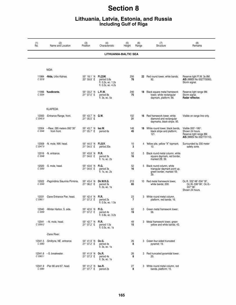
165
(1)No.
(2)Name and Location
(3)Position
(4)Characteristic
(5)Height
(6)Range
(7)Structure
(8)Remarks
Section 8Lithuania, Latvia, Estonia, and Russia
Including Gulf of Riga
LITHUANIA-BALTIC SEA
NIDA:
11984C 3318
-Nida, Urbo Kalnas. 55° 18.1´ N20° 59.8´ E
Fl.(2)W.period 5.8sfl. 0.2s, ec. 1.2sfl. 0.2s, ec. 4.2s
25678
22 Red round tower, white bands; 92.
Reserve light Fl.W. 3s 8M.AIS (MMSI No 002770090).Storm signal.
11996C 3334
Yuodkrante. 55° 33.2´ N21° 07.0´ E
L.Fl.W.period 8sfl. 3s, ec. 5s
24675
18 Black square metal framework tower, white rectangular daymark, platform; 66.
Reserve light range 9M.Storm signal. Radar reflector.
KLAIPEDA:
12000C 3345.9
-Entrance Range, front. 55° 43.7´ N21° 05.5´ E
Q.W. 10231
16 Red framework tower, white diamond and rectangular daymarks, black stripe; 95.
Visible on range line only.
12004C 3346
- -Rear, 285 meters 092°30′ from front.
55° 43.7´ N21° 05.7´ E
Iso.W.period 6s
14845
18 White round tower, black bands, black stripe and platform; 121.
Visible 000°-180°.Shown 24 hours.Reserve light range 8M.AIS (MMSI No 002770110).
12009C 3347.9
-N. mole, NW. head. 55° 44.0´ N21° 04.5´ E
Fl.(5)Y.period 20s
103
4 Yellow pile, yellow “X” topmark; 10.
Surrounded by 200 meter safety zone.
12016C 3348
-N. entrance. 55° 43.8´ N21° 04.6´ E
Fl.R.period 3sfl. 1s, ec. 2s
5216
5 Black round metal column, white square daymark, red border, marked 2B; 39.
12020C 3350
-S. mole, head. 55° 43.6´ N21° 04.6´ E
Fl.G.period 3sfl. 1s, ec. 2s
5216
5 Black round column, white triangular daymark point up, green border, marked 1B; 39.
12022C 3340
-Pagrindinis Siaurinis Pirminis. 55° 43.4´ N21° 06.2´ E
Dir.W.R.G.period 3sfl. 2s, ec. 1s
21365
10 Red metal framework tower, white bands; 200.
Oc.R. 332°48′-334°18′, Oc.W.-336°06′, Oc.G.-337°36′.
Shown 24 hours.
12031C 3360.1
-Dane Entrance Pier, head. 55° 42.4´ N21° 07.3´ E
Fl.R.period 2sfl. 0.5s, ec. 1.5s
237
3 White round metal column, platform, red bands; 16.
12040C 3359
-Winter Harbor, S. side. 55° 42.6´ N21° 07.2´ E
Fl.G.period 4sfl. 0.8s, ec. 3.2s
6219
3 Green metal framework tower; 56.
12041C 3359.2
- -N. mole, head. 55° 42.7´ N21° 07.2´ E
Fl.R.period 1.5sfl. 0.5s, ec. 1s
4915
3 Metal framework tower, green yellow and white bands; 43.
-Dane River:
12041.5C 3363
-Smiltyne, NE. entrance. 55° 41.9´ N21° 07.2´ E
Oc.G.period 4slt. 3s, ec. 1s
268
3 Green four-sided truncated pyramid; 19.
12041.6C 3363.1
- -S. breakwater. 55° 41.9´ N21° 07.3´ E
Oc.R.period 4slt. 3s, ec. 1s
268
3 Red truncated pyramidal tower; 20.
12041.9C 3364
-Pier 66 and 67, head. 55° 41.2´ N21° 07.7´ E
Iso.R.period 2s
278
3 White round metal column, red bands, platform; 15.
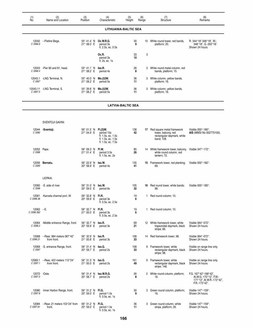
166
(1)No.
(2)Name and Location
(3)Position
(4)Characteristic
(5)Height
(6)Range
(7)Structure
(8)Remarks
12042C 3366.6
- -Pietine Bega. 55° 41.4´ N21° 08.0´ E
Oc.W.R.G.period 3slt. 2.5s, ec. 0.5s
309
10 White round tower, red bands, platform; 20.
R. 344°18′-346°18′, W.-348°18′, G.-350°18′.
Shown 24 hours.
Oc.R.period 3slt. 2s, ec. 1s
3310
3
12043C 3366.4
-Pier 80 and 81, head. 55° 41.1´ N21° 08.2´ E
Iso.R.period 4s
268
3 White round metal column, red bands, platform; 15.
12043.1C 3367
-LNG Terminal, N. 55° 40.0´ N21° 08.2´ E
Mo.(U)W.period 5s
3611
3 White column, yellow bands, platform; 16.
12043.11C 3367.5
-LNG Terminal, S. 55° 39.8´ N21° 08.2´ E
Mo.(U)W.period 5s
3611
3 White column, yellow bands, platform; 16.
LATVIA-BALTIC SEA
SVENTOJI GAVINI:
12044C 3382
-Sventoji. 56° 01.5´ N21° 04.9´ E
Fl.(3)W.period 15sfl. 1.5s, ec. 1.5sfl. 1.5s, ec. 1.5sfl. 1.5s, ec. 7.5s
13842
17 Red square metal framework tower, balcony, red rectangular daymark, white band; 128.
Visible 000°-180°.AIS (MMSI No 002770100).
12052C 3386
Pape. 56° 09.3´ N21° 01.4´ E
Fl.W.period 3.5sfl. 1.5s, ec. 2s
8526
14 White framework tower, balcony, white round column, red lantern; 72.
Visible 347°-172°.
12056C 3390
Bernatu. 56° 22.9´ N20° 58.9´ E
Iso.W.period 4s
13541
15 Framework tower, red planking; 69.
Visible 000°-182°.
LIEPAIA:
12060C 3396
-S. side of river. 56° 31.0´ N20° 59.5´ E
Iso.W.period 6s
10532
16 Red round tower, white bands; 98.
Visible 000°-180°.
12061C 3396.36
-Karosta channel port, W. 56° 32.8´ N20° 59.9´ E
Fl.R.period 3sfl. 0.5s, ec. 2.5s
196
1 Red round column; 10.
12062C 3396.362
- -E. 56° 32.7´ N21° 00.0´ E
Fl.R.period 3sfl. 0.5s, ec. 2.5s
196
1 Red round column; 10.
12064C 3396.2
-Middle entrance Range, front. 56° 32.7´ N20° 59.9´ E
Iso.R.period 3s
6921
12 White framework tower, white trapezoidal daymark, black stripe; 66.
Visible 064°-072°.Shown 24 hours.
12068C 3396.21
- -Rear, 984 meters 067°42′ from front.
56° 32.9´ N21° 00.8´ E
Iso.R.period 3s
10833
14 Red framework tower; 98. Visible 064°-072°.Shown 24 hours.
12069C 3397
-S. entrance Range, front. 56° 31.4´ N20° 59.7´ E
Iso.G.period 2s
10833
9 Framework tower, white rectangular daymark, black stripe; 98.
Visible on range line only. Shown 24 hours.
12069.1C 3397.1
- -Rear, 422 meters 112°24′ from front.
56° 31.3´ N21° 00.0´ E
Iso.G.period 2s
16149
9 Framework tower, white rectangular daymark, black stripe; 148.
Visible on range line only. Shown 24 hours.
12072C 3397.5
-Osta. 56° 31.4´ N20° 58.7´ E
Iso.W.R.G.period 2s
268
2 White round column, platform; 16.
F.G. 167°42′-168°42′, Al.W.G.-170°12′, F.W.-171°12′, Al.W.R.-172°42′, F.R.-173°42′.
12080C 3397.8
-Inner Harbor Range, front. 56° 31.2´ N20° 59.0´ E
Fl.G.period 1.5sfl. 0.5s, ec. 1s
309
3 Green round column, platform; 16.
Visible 147°-159°.Shown 24 hours.
12084C 3397.81
- -Rear, 21 meters 153°24′ from front.
56° 31.2´ N20° 59.0´ E
Fl.G.period 1.5sfl. 0.5s, ec. 1s
3611
3 Green round column, white stripe, platform; 26.
Visible 147°-159°.Shown 24 hours.
LITHUANIA-BALTIC SEA
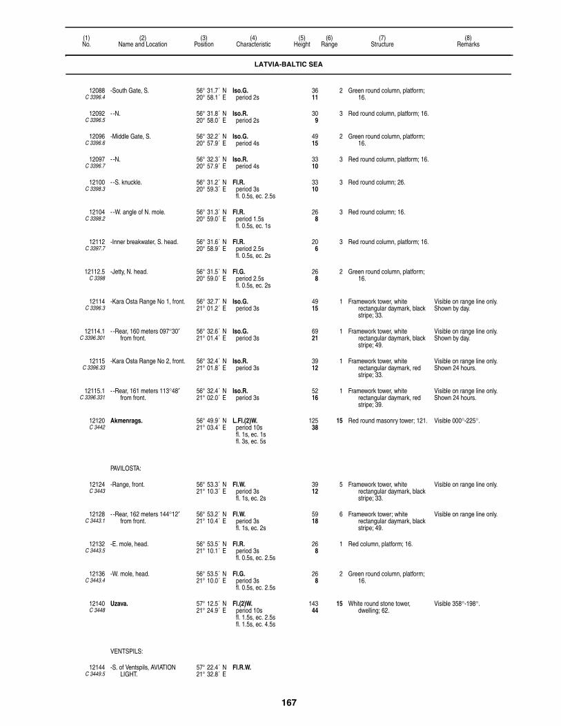
167
(1)No.
(2)Name and Location
(3)Position
(4)Characteristic
(5)Height
(6)Range
(7)Structure
(8)Remarks
12088C 3396.4
-South Gate, S. 56° 31.7´ N20° 58.1´ E
Iso.G.period 2s
3611
2 Green round column, platform; 16.
12092C 3396.5
- -N. 56° 31.8´ N20° 58.0´ E
Iso.R.period 2s
309
3 Red round column, platform; 16.
12096C 3396.6
-Middle Gate, S. 56° 32.2´ N20° 57.9´ E
Iso.G.period 4s
4915
2 Green round column, platform; 16.
12097C 3396.7
- -N. 56° 32.3´ N20° 57.9´ E
Iso.R.period 4s
3310
3 Red round column, platform; 16.
12100C 3398.3
- -S. knuckle. 56° 31.2´ N20° 59.3´ E
Fl.R.period 3sfl. 0.5s, ec. 2.5s
3310
3 Red round column; 26.
12104C 3398.2
- -W. angle of N. mole. 56° 31.3´ N20° 59.0´ E
Fl.R.period 1.5sfl. 0.5s, ec. 1s
268
3 Red round column; 16.
12112C 3397.7
-Inner breakwater, S. head. 56° 31.6´ N20° 58.9´ E
Fl.R.period 2.5sfl. 0.5s, ec. 2s
206
3 Red round column, platform; 16.
12112.5C 3398
-Jetty, N. head. 56° 31.5´ N20° 59.0´ E
Fl.G.period 2.5sfl. 0.5s, ec. 2s
268
2 Green round column, platform; 16.
12114C 3396.3
-Kara Osta Range No 1, front. 56° 32.7´ N21° 01.2´ E
Iso.G.period 3s
4915
1 Framework tower, white rectangular daymark, black stripe; 33.
Visible on range line only. Shown by day.
12114.1C 3396.301
- -Rear, 160 meters 097°30′ from front.
56° 32.6´ N21° 01.4´ E
Iso.G.period 3s
6921
1 Framework tower, white rectangular daymark, black stripe; 49.
Visible on range line only. Shown by day.
12115C 3396.33
-Kara Osta Range No 2, front. 56° 32.4´ N21° 01.8´ E
Iso.R.period 3s
3912
1 Framework tower, white rectangular daymark, red stripe; 33.
Visible on range line only. Shown 24 hours.
12115.1C 3396.331
- -Rear, 161 meters 113°48′ from front.
56° 32.4´ N21° 02.0´ E
Iso.R.period 3s
5216
1 Framework tower, white rectangular daymark, red stripe; 39.
Visible on range line only. Shown 24 hours.
12120C 3442
Akmenrags. 56° 49.9´ N21° 03.4´ E
L.Fl.(2)W.period 10sfl. 1s, ec. 1sfl. 3s, ec. 5s
12538
15 Red round masonry tower; 121. Visible 000°-225°.
PAVILOSTA:
12124C 3443
-Range, front. 56° 53.3´ N21° 10.3´ E
Fl.W.period 3sfl. 1s, ec. 2s
3912
5 Framework tower, white rectangular daymark, black stripe; 33.
Visible on range line only.
12128C 3443.1
- -Rear, 162 meters 144°12′ from front.
56° 53.2´ N21° 10.4´ E
Fl.W.period 3sfl. 1s, ec. 2s
5918
6 Framework tower; white rectangular daymark, black stripe; 49.
Visible on range line only.
12132C 3443.5
-E. mole, head. 56° 53.5´ N21° 10.1´ E
Fl.R.period 3sfl. 0.5s, ec. 2.5s
268
1 Red column, platform; 16.
12136C 3443.4
-W. mole, head. 56° 53.5´ N21° 10.0´ E
Fl.G.period 3sfl. 0.5s, ec. 2.5s
268
2 Green round column, platform; 16.
12140C 3448
Uzava. 57° 12.5´ N21° 24.9´ E
Fl.(2)W.period 10sfl. 1.5s, ec. 2.5sfl. 1.5s, ec. 4.5s
14344
15 White round stone tower, dwelling; 62.
Visible 358°-198°.
VENTSPILS:
12144C 3449.5
-S. of Ventspils, AVIATION LIGHT.
57° 22.4´ N21° 32.8´ E
Fl.R.W.
LATVIA-BALTIC SEA

168
(1)No.
(2)Name and Location
(3)Position
(4)Characteristic
(5)Height
(6)Range
(7)Structure
(8)Remarks
12145C 3450.5
-W. Fairway Range, front. 57° 24.5´ N21° 33.7´ E
Oc.R.period 6slt. 4s, ec. 2s
5617
14 Framework tower, black rectangular daymark, yellow stripe; 49.
Visible 102°-118°.Shown 24 hours.Synchronized with 12145.1
and 12145.2.
12145.1C 3450.51
- -Middle, 425 meters 109°54′ from front.
57° 24.4´ N21° 34.1´ E
Oc.R.period 6slt. 4s, ec. 2s
9228
14 Metal framework tower; 59. Visible 102°-118°.Shown 24 hours.Synchronized with 12145 and
12145.2.
12145.2C 3450.52
- -Rear, 912 meters 109°54′ from front.
57° 24.3´ N21° 34.6´ E
Oc.R.period 6slt. 4s, ec. 2s
13140
16 Framework tower, black rectangular daymark, yellow stripe; 98.
Visible 094°-126°.Shown 24 hours.Synchronized with 12145 and
12145.1.
12148C 3450
-Vkhodoy Range, front. 57° 23.7´ N21° 32.5´ E
Iso.R.period 3s
9228
14 Framework tower, red rectangular daymark, white stripe; 82.
Visible 136°-152°.Shown 24 hours.
12152C 3450.1
- -Rear, 940 meters 143°42′ from front.
57° 23.3´ N21° 33.1´ E
Iso.R.period 3s
14845
15 Framework tower, red rectangular daymark, white stripe; 115.
Visible 128°-160°.Shown 24 hours.Synchronized with front.
12156C 3451
-N. mole, head, outer harbor. 57° 24.5´ N21° 31.6´ E
Fl.(2)R.period 3sfl. 0.5s, ec. 0.5sfl. 0.5s, ec. 1.5s
4514
4 White round tower, red lantern; 36.
12160C 3452
-S. mole, head, outer harbor. 57° 24.3´ N21° 31.5´ E
Fl.(2)G.period 3sfl. 0.5s, ec. 0.5sfl. 0.5s, ec. 1.5s
4514
3 White round tower, green lantern; 36.
12168C 3455
-S. oil pier. 57° 23.9´ N21° 32.4´ E
Iso.W.period 2s
309
2 Red column, platform; 16.
12172C 3454
-N. oil pier. 57° 24.0´ N21° 32.6´ E
Fl.Y.period 1.5sfl. 0.5s, ec. 1s
268
1 Red column, red round structure, platform; 20.
12174C 3457
-New Fishing Port No 39. 57° 23.7´ N21° 32.3´ E
Fl.G.period 2sfl. 0.5s, ec. 1.5s
237
1 Green round column, platform; 16.
12176C 3458
-Fishing Harbor. 57° 23.7´ N21° 32.9´ E
Iso.R.period 2s
268
1 Red column, platform; 16.
12180C 3460
-Turning Basin, W. 57° 24.0´ N21° 34.3´ E
Fl.G.period 2sfl. 0.5s, ec. 1.5s
268
1 Green round column, platform; 16.
12181C 3461
- -E. 57° 23.9´ N21° 34.8´ E
Fl.G.period 3sfl. 0.5s, ec. 2.5s
268
1 Green round column, platform; 16.
12185C 3462.2
-E. pier. 57° 23.5´ N21° 35.1´ E
Fl.R.period 2.5sfl. 0.5s, ec. 2s
268
1 Red column, platform; 16.
LATVIA-GULF OF RIGA
12192C 3470
Ovisi, S. shore of entrance to Gulf of Riga.
57° 34.1´ N21° 43.0´ E
L.Fl.W.period 7.5sfl. 3s, ec. 4.5s
12538
15 White round tower; 121. Visible 024°-256°.
12194C 3474
Irbensky Strait. 57° 45.0´ N21° 43.4´ E
Fl.W.period 10sfl. 1s, ec. 9s
11535
10 White round tower, red bands, black base, two balconies; 121.
Helicopter platform.
RACON I( • •)period 15s
12 (3cm).
LATVIA-BALTIC SEA

169
(1)No.
(2)Name and Location
(3)Position
(4)Characteristic
(5)Height
(6)Range
(7)Structure
(8)Remarks
12196C 3476
Mikelbaka. 57° 36.0´ N21° 58.5´ E
Fl.(2)W.period 6sfl. 1s, ec. 1sfl. 1s, ec. 3s
19459
14 White round tower; 184. Visible 087°-251°.AIS (MMSI No 992751470).
RACON M(– –) 20
12204C 3477.3
Sikragciema. 57° 39.5´ N22° 13.0´ E
Fl.W.period 3sfl. 1s, ec. 2s
10733
15 Framework tower, white rectangular daymark; 89.
Visible 064°-242°.
12212C 3478
Kolka. 57° 48.1´ N22° 38.0´ E
Fl.(2)W.period 10sfl. 1s, ec. 1sfl. 1s, ec. 7s
6620
10 Red round tower, balcony; 69.
RACON K(– • –) 17 (3cm).
12216C 3486
Gipka. 57° 34.2´ N22° 39.4´ E
L.Fl.W.period 6sfl. 2s, ec. 4s
12037
15 Framework tower, two red trapezoidal daymarks, white rectangle in centers; 98.
Visible 144°-314°.
12220C 3482
Ruhnu Saar. 57° 48.1´ N23° 15.6´ E
Fl.W.period 4sfl. 1s, ec. 3s
21265
11 Red round metal tower, supporting pillars, balcony, lantern; 125.
Lower part obscured by forest.
12222C 3482.4
-Ringsu Harbor Range, front. 57° 46.8´ N23° 16.2´ E
Q.W. 268
3 Red post, orange trapezoidal daymark, black stripe; 13.
Visible 271°36′-301°36′.
12222.1C 3482.401
- -Rear, 642 meters 286°36′ from front.
57° 46.9´ N23° 15.6´ E
Iso.W.period 2s
7222
3 Red metal post, orange trapezoidal daymark, black stripe; 66.
Visible 271°36′-301°36′.
12223C 3482.5
- -W. mole, head. 57° 46.8´ N23° 16.3´ E
Fl.R.period 3sfl. 0.5s, ec. 2.5s
144
3 Red round metal tower; 6.
12223.1C 3482.51
- -E. mole, head. 57° 46.8´ N23° 16.3´ E
Fl.G.period 3sfl. 0.5s, ec. 2.5s
134
3 Green round metal tower; 6.
12224C 3489
Roja. 57° 30.5´ N22° 48.6´ E
Dir.W.R.G. 6219
W. 7R. 4G. 4
Red framework tower; 62. F.G. 210°24′-213°30′, F.W.-216°30′, F.R.-219°24′.
12228C 3494
Mersrags. 57° 22.0´ N23° 07.2´ E
Fl.W.period 5sfl. 0.2s, ec. 4.8s
8526
15 White tower, balcony, lantern; 62. Visible 130°-345°.Reserve light Iso.W. 6s 15M.
12232C 3496
-N. mole, head. 57° 20.1´ N23° 08.4´ E
Fl.G.period 3sfl. 0.5s, ec. 2.5s
237
2 White round column; 16. Shown Apr. 10 to Jun. 30.Radar reflector.
12248C 3501
Engure. 57° 10.0´ N23° 13.7´ E
Fl.(2)W.period 6sfl. 1s, ec. 1sfl. 1s, ec. 3s
8526
15 Red and white framework tower; 62.
Visible 160°-359°.
12252C 3502
Ragaciems. 57° 02.1´ N23° 29.2´ E
Iso.W.period 2s
12137
16 Framework tower, red rectangular daymark; 98.
Visible 095°-330°.
12256C 3503
Bulluciema. 56° 59.6´ N23° 53.2´ E
Fl.W.period 5sfl. 1.5s, ec. 3.5s
11836
16 Red and white framework tower; 92.
Visible 071°-240°.
ZAPADNAYA DVINA:
12268 -Buoy C. 57° 07.0´ N23° 57.0´ E
L.Fl.W.period 6s
SAFE WATERRW, buoy, topmark.
Radar reflector.
LATVIA-GULF OF RIGA

170
(1)No.
(2)Name and Location
(3)Position
(4)Characteristic
(5)Height
(6)Range
(7)Structure
(8)Remarks
DAUGAVA RIVER:
12272C 3526
-Daugavgrivas. 57° 03.6´ N24° 01.3´ E
F.Fl.W.period 4sfl. 0.3s, ec. 3.7s
12137
18 White round tower, black bands, balcony; 115.
Visible 035°-245°.AIS (MMSI No 992751075).
- -Reserve light. Fl.(2)W.period 7.5sfl. 0.2s, ec. 1.7sfl. 0.2s, ec. 5.4s
18
12276C 3528
-W. mole, head. 57° 03.9´ N24° 00.6´ E
Fl.G.period 3sfl. 0.5s, ec. 2.5s
3611
2 White round tower, platform; 23.
12280C 3530
-Daugavgriva Range, front. 57° 03.6´ N24° 01.3´ E
Iso.R.period 5s
6720
11 Red framework tower, platform, white trapezoidal daymark, red stripe; 49.
Visible on range line only. Shown 24 hours.
12284C 3530.1
- -Rear, 549 meters 141° from front.
57° 03.4´ N24° 01.6´ E
Iso.R.period 5s
9629
11 Red framework tower, white trapezoid daymark, red stripe; 85.
Visible on range line only.Synchronized with front.Traffic and Storm signals.Reserve light range 9M.
12286C 3536
-Mole, head. 57° 03.3´ N24° 01.9´ E
Fl.(3)Y.period 9sfl. 0.5s, ec. 1.5sfl. 0.5s, ec. 1.5sfl. 0.5s, ec. 4.5s
309
1 Red round column, forked top; 20.
Radar reflector.
12288C 3529
Mangal'sala, E. mole, head. 57° 04.1´ N24° 00.9´ E
Fl.R.period 3sfl. 0.5s, ec. 2.5s
3611
4 Red round tower, platform; 23. Radar reflector.
12296C 3535
-Vostochni Basseyn. 57° 03.1´ N24° 02.4´ E
Fl.(3)Y.period 9sfl. 0.5s, ec. 1.5sfl. 0.5s, ec. 1.5sfl. 0.5s, ec. 4.5s
309
2 White round column, platform; 23.
Radar reflector.
12297C 3536.2
-Kara harbor Range, front. 57° 03.1´ N24° 01.9´ E
Fl.G.period 3.2sfl. 0.7s, ec. 2.5s
4313
1 Round metal column, white rectangular daymark, black stripe; 39.
Visible on range line only. Shown by day in reduced
visibility.
12297.1C 3536.201
- -Rear, 89 meters 168°30′ from front.
57° 03.0´ N24° 01.9´ E
Fl.G.period 3.2sfl. 0.7s, ec. 2.5s
5617
1 Round metal column, white rectangular daymark, black stripe; 52.
Visible on range line only. Synchronized with front.Shown by day in reduced
visibility.
12304C 3538
-Bullupe Channel, E. side. 57° 03.0´ N24° 02.6´ E
Fl.(3)W.period 9sfl. 0.5s, ec. 1.5sfl. 0.5s, ec. 1.5sfl. 0.5s, ec. 4.5s
309
2 Red round column, platform; 23. Radar reflector.
12326C 3543
-Zvejas, N. gate, N. 57° 02.8´ N24° 03.9´ E
Fl.(3)R.period 9sfl. 0.5s, ec. 1.5sfl. 0.5s, ec. 1.5sfl. 0.5s, ec. 4.5s
3310
1 Red round column, platform; 20. Radar reflector.
12326.01C 3543.2
- -S. 57° 02.6´ N24° 04.3´ E
Fl.(3)G.period 9sfl. 0.5s, ec. 1.5sfl. 0.5s, ec. 1.5sfl. 0.5s, ec. 4.5s
309
1 White column, forked top; 20.
12328C 3544
-Taude, N. Mazilkeniyeshi. 57° 02.2´ N24° 04.8´ E
Fl.(3)W.period 9sfl. 0.5s, ec. 1.5sfl. 0.5s, ec. 1.5sfl. 0.5s, ec. 4.5s
268
1 White round column, forked top; 20.
Radar reflector.
12331C 3495.5
-Mersrags Inner Range, front. 57° 20.1´ N23° 07.8´ E
Iso.R.period 3s
3110
8 Metal framework tower, red rectangular daymark, white stripe; 30.
Visible on range line only. Shown 24 hours.
LATVIA-GULF OF RIGA

171
(1)No.
(2)Name and Location
(3)Position
(4)Characteristic
(5)Height
(6)Range
(7)Structure
(8)Remarks
12331.1C 3495.51
- -Rear, 236 meters 266°30′ from front.
57° 20.1´ N23° 07.8´ E
Iso.R.period 3s
5416
8 Metal framework tower, red rectangular daymark, white stripe; 52.
Visible on range line only. Synchronized with front.Shown 24 hours.
12332C 3532
-Rinuzi Range, front. 57° 02.4´ N24° 04.6´ E
Oc.G.period 5slt. 3s, ec. 2s
5216
5 Framework tower, red rectangular daymark, white stripe; 43.
Visible on range line only. Shown 24 hours.
12336C 3532.1
- -Rear, 587 meters 128°24′ from front.
57° 02.2´ N24° 05.0´ E
Oc.G.period 5slt. 3s, ec. 2s
7824
5 Framework tower, red trapezoidal daymark, white stripe; 72.
Visible on range line only. Synchronized with front.Shown 24 hours.
12340C 3547
-Balta-Baznitsa Range, front. 57° 01.9´ N24° 05.3´ E
Iso.Y.period 4s
4113
4 Column, white trapezoidal daymark, black stripe; 36.
Visible on range line only. Shown 24 hours.
12344C 3547.1
- -Middle, 205 meters 356°54′ from front.
57° 02.0´ N24° 05.2´ E
Iso.Y.period 4s
5918
4 Building, white rectangular daymark, black stripe; 52.
Visible on range line only. Synchronized with front.Shown 24 hours.
12348C 3547.2
- -Rear, 486 meters 356°54′ from front.
57° 02.2´ N24° 05.2´ E
Iso.Y.period 4s
6620
4 Tower; 59. Visible on range line only. Synchronized with front.Shown 24 hours.
12352C 3548.4
-E. Kurpnieksala. 57° 01.7´ N24° 05.4´ E
Fl.(3)R.period 9sfl. 0.5s, ec. 1.5sfl. 0.5s, ec. 1.5sfl. 0.5s, ec. 4.5s
3812
2 Red round column; 23. Radar reflector.
12353C 3546.2
- -Beacon No 1. 57° 01.6´ N24° 05.8´ E
Fl.(3)W.period 9sfl. 0.5s, ec. 1.5sfl. 0.5s, ec. 1.5sfl. 0.5s, ec. 4.5s
309
1 White round column, platform; 24.
Radar reflector.
12354C 3546.3
- -Beacon No 2. 57° 01.5´ N24° 06.1´ E
Fl.(3)W.period 9sfl. 0.5s, ec. 1.5sfl. 0.5s, ec. 1.5sfl. 0.5s, ec. 4.5s
309
1 White round column, platform; 24.
Radar reflector.
12356C 3546
- -Rutkusala, S. bank. 57° 01.4´ N24° 06.5´ E
Fl.(3)W.period 9sfl. 0.5s, ec. 1.5sfl. 0.5s, ec. 1.5sfl. 0.5s, ec. 4.5s
309
1 White round column, platform; 23.
Radar reflector.
12358C 3545.4
- -Milgravis Range, front. 57° 01.3´ N24° 07.1´ E
Oc.W.period 5slt. 3s, ec. 2s
4915
2 White round column, platform, red rectangular daymark, white stripe; 39.
Visible on range line only. Shown 24 hours.
12358.1C 3545.41
- - -Rear, 362 meters116°42′ from front.
57° 01.2´ N24° 07.4´ E
Oc.W.period 5slt. 3s, ec. 2s
7924
2 White mast; 69. Visible on range line only. Synchronized with front.Shown 24 hours.
12360C 3545
- -Jaunmilgravis. 57° 01.3´ N24° 06.8´ E
Fl.(3)R.period 9sfl. 0.5s, ec. 1.5sfl. 0.5s, ec. 1.5sfl. 0.5s, ec. 4.5s
268
1 Red round column, forked top; 20.
Radar reflector.
12364C 3548
-W. Kurpnieksala. 57° 01.2´ N24° 05.2´ E
Fl.(3)G.period 9sfl. 0.5s, ec. 1.5sfl. 0.5s, ec. 1.5sfl. 0.5s, ec. 4.5s
3110
1 White column, forked top; 26.
12365C 3543.5
-Hapaka gravja. 57° 02.2´ N24° 04.1´ E
Fl.(3)W.period 9sfl. 0.5s, ec. 1.5sfl. 0.5s, ec. 1.5sfl. 0.5s, ec. 4.5s
3310
2 White round column, forked top.
12367C 3549.3
-Kundzinsala pier, KS-32. 57° 00.3´ N24° 05.8´ E
Fl.(3)G.period 9sfl. 0.5s, ec. 1.5sfl. 0.5s, ec. 1.5sfl. 0.5s, ec. 4.5s
268
1 White column; 20. Visible 085°-155°.Radar reflector.
LATVIA-GULF OF RIGA
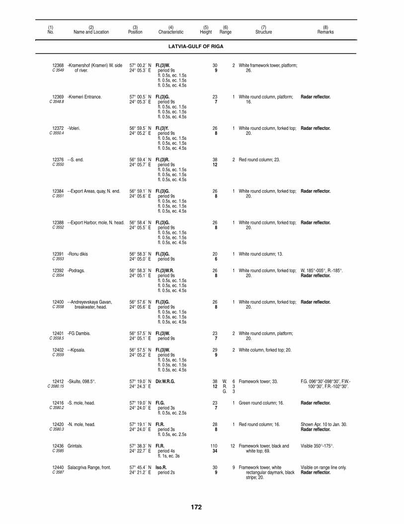
172
(1)No.
(2)Name and Location
(3)Position
(4)Characteristic
(5)Height
(6)Range
(7)Structure
(8)Remarks
12368C 3549
-Kramershof (Krameri) W. side of river.
57° 00.2´ N24° 05.3´ E
Fl.(3)W.period 9sfl. 0.5s, ec. 1.5sfl. 0.5s, ec. 1.5sfl. 0.5s, ec. 4.5s
309
2 White framework tower, platform; 26.
12369C 3548.8
-Kremeri Entrance. 57° 00.5´ N24° 05.3´ E
Fl.(3)G.period 9sfl. 0.5s, ec. 1.5sfl. 0.5s, ec. 1.5sfl. 0.5s, ec. 4.5s
237
1 White round column, platform; 16.
Radar reflector.
12372C 3550.4
-Voleri. 56° 59.5´ N24° 05.2´ E
Fl.(3)Y.period 9sfl. 0.5s, ec. 1.5sfl. 0.5s, ec. 1.5sfl. 0.5s, ec. 4.5s
268
1 White round column, forked top; 20.
Radar reflector.
12376C 3550
- -S. end. 56° 59.4´ N24° 05.7´ E
Fl.(3)R.period 9sfl. 0.5s, ec. 1.5sfl. 0.5s, ec. 1.5sfl. 0.5s, ec. 4.5s
3812
2 Red round column; 23.
12384C 3551
- -Export Areas, quay, N. end. 56° 59.1´ N24° 05.6´ E
Fl.(3)G.period 9sfl. 0.5s, ec. 1.5sfl. 0.5s, ec. 1.5sfl. 0.5s, ec. 4.5s
268
1 White round column, forked top; 20.
Radar reflector.
12388C 3552
- -Export Harbor, mole, N. head. 56° 58.4´ N24° 05.5´ E
Fl.(3)G.period 9sfl. 0.5s, ec. 1.5sfl. 0.5s, ec. 1.5sfl. 0.5s, ec. 4.5s
268
1 White round column, forked top; 20.
Radar reflector.
12391C 3553
-Ronu dikis 56° 58.3´ N24° 05.0´ E
Fl.(3)G.period 9s
206
1 White round column; 13.
12392C 3554
-Podrags. 56° 58.3´ N24° 05.1´ E
Fl.(3)W.R.period 9sfl. 0.5s, ec. 1.5sfl. 0.5s, ec. 1.5sfl. 0.5s, ec. 4.5s
268
1 White round column, forked top; 20.
W. 185°-005°, R.-185°.Radar reflector.
12400C 3558
- -Andreyevskaya Gavan, breakwater, head.
56° 57.6´ N24° 05.6´ E
Fl.(3)G.period 9sfl. 0.5s, ec. 1.5sfl. 0.5s, ec. 1.5sfl. 0.5s, ec. 4.5s
268
1 White round column, forked top; 20.
Radar reflector.
12401C 3558.5
-FG Dambis. 56° 57.5´ N24° 05.1´ E
Fl.(3)W.period 9s
237
2 White round column, platform; 20.
12402C 3559
- -Kipsala. 56° 57.5´ N24° 05.2´ E
Fl.(3)W.period 9sfl. 0.5s, ec. 1.5sfl. 0.5s, ec. 1.5sfl. 0.5s, ec. 4.5s
299
2 White column, forked top; 20.
12412C 3580.15
-Skulte, 098.5°. 57° 19.0´ N24° 24.3´ E
Dir.W.R.G. 3812
W. 6R. 3G. 3
Framework tower; 33. F.G. 096°30′-098°30′, F.W.-100°30′, F.R.-102°30′.
12416C 3580.2
-S. mole, head. 57° 19.0´ N24° 24.0´ E
Fl.G.period 3sfl. 0.5s, ec. 2.5s
237
1 Green round column; 16. Radar reflector.
12420C 3580.3
-N. mole, head. 57° 19.1´ N24° 24.0´ E
Fl.R.period 3sfl. 0.5s, ec. 2.5s
288
1 Red round column; 16. Shown Apr. 10 to Jan. 30.Radar reflector.
12436C 3585
Grintals. 57° 38.3´ N24° 22.7´ E
Fl.R.period 4sfl. 1s, ec. 3s
11034
12 Framework tower, black and white top; 69.
Visible 350°-175°.
12440C 3587
Salacgriva Range, front. 57° 45.4´ N24° 21.2´ E
Iso.R.period 2s
309
9 Framework tower, white rectangular daymark, black stripe; 20.
Visible on range line only. Radar reflector.
LATVIA-GULF OF RIGA

173
(1)No.
(2)Name and Location
(3)Position
(4)Characteristic
(5)Height
(6)Range
(7)Structure
(8)Remarks
12444C 3587.1
-Rear, about 207 meters 072°18′ from front.
57° 45.4´ N24° 21.4´ E
Iso.R.period 4s
7824
9 Framework tower, white rectangular daymark, black stripe; 59.
Visible on range line only.
12448C 3590
Ainazi. 57° 52.0´ N24° 21.6´ E
Iso.W.period 4s
7222
12 White tower, orange stripe; 59. Visible 019°-229°.
ESTONIA-GULF OF RIGA
12452C 3594.5
Haademeeste. 58° 04.4´ N24° 29.2´ E
Fl.W.period 5sfl. 1.5s, ec. 3.5s
11234
11 White framework tower, white planking on three sides; 92.
PARNU:
12456C 3606
-Approach Range, front. 58° 22.7´ N24° 27.9´ E
Q.R. 7723
10 Red round metal tower, white rectangular daymark, black stripe; 75.
Visible 019°54′-027°54′.
12460C 3606.1
- -Rear, about 820 meters 023°54′ from front.
58° 23.1´ N24° 28.3´ E
Iso.R.period 6s
13140
11 Metal framework tower, white rectangular daymark, black stripe; 112.
Visible 019°54′-027°54′.
F.R.
12464C 3603
-Manilaid, on S. end. 58° 12.2´ N24° 06.0´ E
Iso.W.R.G.period 4s
299
8 White round concrete tower, balcony, red lantern; 26.
W. 338°30′-011°, R.-075°, G.-103°, W.-125°30′, R.-154°, W.-310°, G.-338°30′.
12468C 3608
-Outer Range, front. 58° 22.7´ N24° 28.8´ E
Q.W. 5216
3 Metal framework tower, white rectangular daymark, orange stripe; 40.
Visible 036°-042°.
12472C 3608.1
- -Rear, 380 meters 039° from front.
58° 22.9´ N24° 29.1´ E
Iso.W.period 3s
8225
3 Metal framework tower, white rectangular daymark, orange stripe; 72.
Visible 036°-042°.
12476C 3612
-Inner Range, front. 58° 23.4´ N24° 29.2´ E
Iso.R.period 2s
5517
2 Metal framework tower, orange rectangular daymark, white stripe; 43.
Visible 022°12′-030°12′.
F.R.
12480C 3612.1
- -Rear, 230 meters 026°12′ from front.
58° 23.5´ N24° 29.3´ E
Iso.R.period 6s
9529
2 Metal framework tower, orange rectangular daymark, white stripe; 72.
Visible 022°12′-030°12′.
F.R.
12484C 3611
-E. mole, head. 58° 22.0´ N24° 27.9´ E
Fl.G.period 3sfl. 0.3s, ec. 2.7s
165
1 White metal column, green band, concrete base; 8.
12488C 3611.5
-W. mole, head. 58° 22.1´ N24° 27.7´ E
Fl.R.period 3sfl. 0.3s, ec. 2.7s
154
1 White metal column, red band, concrete base; 8.
12492C 3605
Liu. 58° 16.6´ N24° 15.9´ E
Oc.(2)W.period 5slt. 1s, ec. 0.5slt. 3s, ec. 0.5s
10733
7 Metal framework tower, white planking on three sides; 91.
12496C 3595
Someri Poolsaar. 58° 21.0´ N23° 44.4´ E
Fl.W.period 6sfl. 0.6s, ec. 5.4s
7824
9 White octagonal concrete tower; 69.
12500C 3596
Kihnu, Pitkana Ots. 58° 05.8´ N23° 58.3´ E
Fl.(2)W.R.period 12sfl. 1.5s, ec. 1.5sfl. 1.5s, ec. 7.5s
9930
11 White conical metal tower, balcony, lantern; 92.
W. 262°-225°, R.-262°.
LATVIA-GULF OF RIGA

174
(1)No.
(2)Name and Location
(3)Position
(4)Characteristic
(5)Height
(6)Range
(7)Structure
(8)Remarks
12508C 3602
Sorgu Saar. 58° 10.7´ N24° 12.0´ E
Fl.(2)W.R.period 9sfl. 1s, ec. 1sfl. 1s, ec. 6s
6319
7 Red round stone tower, balcony, lantern; 53.
W. 101°-342°, R.-101°.
MUHU VAIN:
12512C 3631
-Poorilaid, W. of Selglaid. 58° 27.7´ N23° 37.8´ E
F.Fl.(4)W.R.G.period 18sfl. 1s, ec. 1sfl. 1s, ec. 1sfl. 1s, ec. 1sfl. 1s, ec. 11s
4614
7 White round concrete tower, balcony, lantern; 43.
G. 340°30′-007°, W.-141°, R.-160°, W.-220°30′.
12516C 3636
-Viirelaid, S. entrance to Muhu Vain.
58° 32.7´ N23° 26.6´ E
Fl.W.R.period 8sfl. 1.5s, ec. 6.5s
4915
9 Red round concrete tower, balcony, lantern; 36.
W. 163°-349°, R.-163°.
12520C 3632
-Virtsu, W. point of peninsula. 58° 34.0´ N23° 30.1´ E
Fl.W.period 5sfl. 1.5s, ec. 3.5s
6319
11 White square concrete tower, red top; 59.
12522C 3634.5
-Kuivastu. 58° 34.4´ N23° 23.8´ E
Q.R. 258
2 Red concrete column, balcony; 17.
12524C 3632.6
- -Pier, head. 58° 34.6´ N23° 30.5´ E
Fl.W.R.period 2sfl. 0.5s, ec. 1.5s
258
W. 5R. 3
Red metal column, balcony; 16. W. 077°30′-099°, R.-077°30′.
12528C 3637
-Kesse Range, front. 58° 37.9´ N23° 24.9´ E
Q.W. 3912
5 Red metal post, white rectangular daymark, red stripe; 30.
Visible 318°-128°.
12532C 3637.1
- -Rear, 700 meters 123° from front.
58° 37.7´ N23° 25.5´ E
Iso.W.period 4s
7423
53
Yellow square metal framework tower, white rectangular daymark, red stripe; 59.
Visible 060°-128°, (unintensified)-118°.
-Muhu:
12540C 3638
- -Raugi Range, front. 58° 39.2´ N23° 18.4´ E
Oc.W.period 5slt. 3s, ec. 2s
10331
15 Metal framework tower, white rectangular daymark, black stripe; 86.
Visible 161°-165°.
12544C 3638.1
- - -Rear, 755 meters 163°12′ from front.
58° 38.8´ N23° 18.7´ E
Oc.W.period 5slt. 3s, ec. 2s
17453
15 Metal framework tower, white rectangular daymark, black stripe; 131.
Visible 161°-165°.
12548C 3639
- -Seanina Point, N. end of island.
58° 41.0´ N23° 11.5´ E
Fl.W.period 5sfl. 0.5s, ec. 4.5s
7523
8 White square metal framework tower, black top, planking on three sides; 52.
12550C 3640.8
Koinastu. 58° 38.8´ N23° 01.2´ E
Fl.W.period 2sfl. 0.5s, ec. 1.5s
6219
7 Metal framework tower, white planking, black stripe; 43.
VORMSIKURK:
12552C 3646
-Heltermaa Range, front. 58° 51.9´ N23° 02.9´ E
Q.R. 247
10 Metal framework structure, white diamond daymark, black stripe; 35.
Visible 251°48′-257°48′.
12556C 3646.1
- -Rear, 311 meters 254°42′ from front.
58° 51.9´ N23° 02.5´ E
Oc.R.period 4slt. 3s, ec. 1s
5818
10 Metal framework structure, white diamond daymark, black stripe; 59.
Visible 251°48′-257°48′.
12560C 3758.5
-Harilaid Range, front. 58° 58.0´ N23° 05.2´ E
Iso.W.period 2s
165
6 Metal cylinder, white rectangular daymark; 35.
Visible 326°18′-334°18′.
12564C 3758.51
- -Rear, 180 meters 330°18′ from front.
58° 58.1´ N23° 05.1´ E
Iso.W.R.G.period 4s
6018
5 White round tower, two balconies, lantern; 53.
obsc. 160°-167°, W.-250°, G.-314°, W.-336°30′, R.-131°, W.-160°.
12571C 3653
-Rohukula Range, front. 58° 54.5´ N23° 25.5´ E
Q.W. 3711
8 Metal framework tower, white rectangular daymark, black stripe; 39.
Visible 087°06′-093°06′.
ESTONIA-GULF OF RIGA
175
(1)No.
(2)Name and Location
(3)Position
(4)Characteristic
(5)Height
(6)Range
(7)Structure
(8)Remarks
12572C 3653.1
- -Rear, about 460 meters 090°06′ from front.
58° 54.5´ N23° 26.0´ E
Oc.W.period 3slt. 2.5s, ec. 0.5s
9128
8 Black metal tower, white rectangular daymark, black stripe; 66.
Visible 087°06′-093°06′.
12574C 3652.5
-Rohukula Harbor, pier, head. 58° 54.3´ N23° 25.4´ E
L.Fl.W.period 10sfl. 2s, ec. 8s
258
2 White concrete column; 17.
VOOSIKURK:
12588C 3652
-Range, front, Hobulaid Island, S. end.
58° 55.9´ N23° 23.2´ E
Fl.W.R.period 6sfl. 1.5s, ec. 4.5s
155
4 Red metal cylinder, concrete base, lantern; 22.
W. 211°30′-325°, R.-211°30′.
12588.1C 3652.1
- -Rukkirahu, N. end of islet, rear, 3706 meters 213°42′ from front.
58° 54.3´ N23° 21.0´ E
Fl.(2)W.R.period 6sfl. 0.3s, ec. 0.9sfl. 0.3s, ec. 4.5s
5818
6 White round concrete tower, balcony, lantern; 57.
W. 014°-104°, R.-194°, W.-216°, R.-243°, W.-283°, R.-014°.
12592C 3651
-Paralep Range, front. 58° 56.0´ N23° 29.0´ E
Q.W. 5216
6 White round concrete tower, balcony, lantern; 52.
Visible 150°42′-154°42′.
12596C 3651.1
- -Rear, 800 meters 152°42′ from front.
58° 55.7´ N23° 29.4´ E
Iso.W.period 4s
11635
6 White round concrete tower, black bands, balcony, black lantern; 112.
Visible 150°42′-154°42′.
12600C 3656
-Haapsalu Range, front. 58° 57.2´ N23° 30.8´ E
Q.R. 216
2 Metal structure, orange triangular daymark point up, yellow stripe; 26.
Visible 090°12′-098°12′.
12604C 3656.1
- -Rear, 600 meters 094°12′ from front.
58° 57.2´ N23° 31.4´ E
Iso.R.period 3s
4313
2 Metal structure, orange triangular daymark point up, yellow stripe, yellow round daymark; 42.
Visible 090°12′-098°12′.
12606C 3657
-Holmi Range, front. 58° 57.6´ N23° 30.7´ E
Q.G. 319
2 Metal framework structure, white rectangular daymark, black stripe; 21.
Visible 068°12′-078°12′.
12606.1C 3657.1
- -Rear, 390 meters073°12′ from front.
58° 57.6´ N23° 31.1´ E
Iso.G.period 3s
4915
2 Metal framework structure, white rectangular daymark, black stripe; 38.
Visible 068°12′-078°12′.
12608C 3650
-Hobulaid Range, front. 58° 58.5´ N23° 23.4´ E
Q.W. 3511
4 Red metal framework tower, white rectangular daymark, black stripe; 35.
Visible 183°-187°.
12612C 3650.1
- -Rear, 2253 meters 185° from front.
58° 57.1´ N23° 23.2´ E
Iso.W.period 3s
7824
6 Metal framework tower, white rectangular daymark, black stripe; 61.
Visible 183°-187°.
12614C 3759
-Norrby Range, front. 59° 01.2´ N23° 21.1´ E
Iso.W.period 2s
7222
12 White round concrete tower, balcony, lantern; 72.
Visible 188°24′-196°24′.
12614.1C 3759.1
- -Rear, 950 meters 192°24′ from front.
59° 00.7´ N23° 20.9´ E
Iso.W.period 4s
11836
12 White round concrete tower, red top, balcony, lantern; 103.
Visible 188°24′-196°24′.Lower part obscured by forest.
12616C 3759.5
-Ramsholmi, on shore of Pashlepa Bay, front.
59° 01.2´ N23° 26.0´ E
Q.R. 165
6 White round concrete tower, balcony, lantern; 33.
Visible 132°42′-142°42′.
12620C 3759.51
- -Rear, 510 meters 137°42′ from front.
59° 00.9´ N23° 26.4´ E
Oc.R.period 2s
5116
6 White round concrete tower, balcony, lantern; 47.
Visible 132°42′-142°42′.
VORMSIKURK:
12630C 3757.9
-Vormsi Range, rear, 1000 meters 140° from front.
59° 01.2´ N23° 07.7´ E
Iso.W.period 6s
13541
9 White square metal framework tower with planking, black top; 115.
Visible 136°-144°.Front 12631.
12631C 3758
- -Range. 59° 01.7´ N23° 07.0´ E
Iso.W.R.G.period 6s
8426
W. 9R. 7G. 5
White conical metal tower, balcony, lantern; 77.
W. (5M) 352°-008°, R.-066°, G.-134°, W.-148°, R.-213°.
Rear 12630.Front 12632. 003° from front.
ESTONIA-GULF OF RIGA

176
(1)No.
(2)Name and Location
(3)Position
(4)Characteristic
(5)Height
(6)Range
(7)Structure
(8)Remarks
12632C 3758.1
- -Range, front, Vormsi Island, E. end.
59° 01.5´ N23° 07.0´ E
Q.W. 3110
5 Metal framework tower, white rectangular daymark, black stripe; 56.
Visible 358°12′-006°12′.Rear 12631.
SAAREMAA:
12636C 3630
-Kubassaar. 58° 25.7´ N23° 18.0´ E
L.Fl.W.period 9sfl. 2.5s, ec. 6.5s
6720
11 White round concrete tower, black top, balcony, lantern; 59.
Visible 228°-048°.Shown Apr. 10 to Dec. 20.
12648C 3628
-Allirahu. 58° 18.0´ N22° 58.2´ E
Fl.W.period 7sfl. 1s, ec. 6s
6018
7 Metal framework tower with planking, black and white bands; 52.
12656C 3626
- -N. end of island. 58° 09.7´ N22° 47.2´ E
Fl.(2)W.period 12sfl. 1s, ec. 1.5sfl. 1s, ec. 8.5s
4915
7 Metal framework tower, orange planking; 32.
12658C 3627
-Saaretuki. 58° 15.6´ N22° 49.3´ E
Fl.(3)W.period 15sfl. 0.5s, ec. 1.5sfl. 0.5s, ec. 1.5sfl. 0.5s, ec. 10.5s
6520
6 White square concrete tower; 51.
12659C 3616
-Abruka Range, front. 58° 09.0´ N22° 32.1´ E
Q.W. 7423
8 Metal post, white and red rectangular daymark; 59.
Visible 257°18′-261°18′.
12660C 3616.1
- -Rear, 671 meters 259°18' from front.
58° 08.9´ N22° 31.5´ E
Iso.W.period 4s
12237
9 White round concrete tower, black bands; 113.
Intensified on range line.Visible 135°-045°, Intensified
257°18′-261°18′.
12662C 3612.3
-Kuressaare Range, front. 58° 14.6´ N22° 28.2´ E
Q.R. 309
6 Red metal cylinder, white rectangular daymark, red stripe; 23.
Visible 359°18′-003°18′.Shown May 1 to Dec. 1.
12662.1C 3612.31
- -Rear, 240 meters 001°18′ from front.
58° 14.8´ N22° 28.2´ E
Oc.R.period 1.5slt. 1s, ec. 0.5s
7422
6 Building, white rectangular daymark, red stripe; 10.
Visible 359°18′-003°18′.Shown May 1 to Dec. 1.
12664C 3622
-Roomassaare Range, front. 58° 12.8´ N22° 30.4´ E
Oc.W.R.G.period 4slt. 3s, ec. 1s
4614
6 Red metal framework tower, black rectangular daymark, white stripe; 39.
G. 023°30′-029°30′, W.-032°30′, R.-038°30′, W.(unintensified) 276°30′-006°30′.
12664.1C 3622.1
- -Rear, 721 meters 321°30′ from front.
58° 13.1´ N22° 29.9´ E
Oc.W.period 4slt. 3s, ec. 1s
10833
6 Metal framework tower, black rectangular daymark, white stripe; 98.
Visible 318°30′-324°30′.
12665C 3618
-Kirjurahu. 58° 06.0´ N22° 33.4´ E
Q.(5)W.period 12s
4313
9 Framework pyramid, metal ribs, balcony; 36.
12668C 3705.3
-Kaavi. 57° 58.9´ N22° 11.7´ E
Fl.W.period 2.5s
7423
6 Red square concrete tower, white band; 52.
12670C 3704.5
-Montu Range, front. 57° 57.1´ N22° 07.5´ E
Q.W. 5216
6 Metal framework tower, white rectangular daymark, black stripe; 36.
Visible 294°30′-302°30′.
12671C 3704.51
- -Rear, 209 meters 298°30′ from front.
57° 57.1´ N22° 07.3´ E
Iso.W.period 4s
8426
6 Metal framework tower, white rectangular daymark, black stripe; 49.
Visible 294°30′-302°30′.
12672C 3704
-Sorve Saar. 57° 54.6´ N22° 03.3´ E
F.Fl.W.period 15sfl. 0.5s, ec. 14.5s
17252
15 White conical concrete tower, black top, balcony, lantern; 174.
Seasonal F.W. fishing lights shown at Kaunispe, Karrust, Tammuna, Tiriu, Oesor, Tamma and Ragundis on Sorve Poolsaar.
12674C 3704.2
-Loode. 57° 58.4´ N21° 59.0´ E
Fl.(2)W.period 10sfl. 0.5s, ec. 1sfl. 0.5s, ec. 8s
6219
6 White square concrete tower, red top; 49.
ESTONIA-GULF OF RIGA

177
(1)No.
(2)Name and Location
(3)Position
(4)Characteristic
(5)Height
(6)Range
(7)Structure
(8)Remarks
ESTONIA-BALTIC SEA
SAAREMAA:
12679C 3710
-Lou Range, front. 58° 06.3´ N22° 10.8´ E
Q.(4)W.R.G.period 15s
3912
W. 7R. 3G. 3
White round concrete tower, balcony, lantern; 33.
G. 013°54′-101°, W.-105°, R.-192°18′.
12680C 3710.1
- -Rear, 3128 meters 103°06′ from front. Ansekula.
58° 05.9´ N22° 13.9´ E
Fl.W.period 1.5sfl. 0.5s, ec. 1s
14544
9 White square concrete tower, black top; 102.
12682C 3712
-Karala. 58° 16.3´ N21° 53.8´ E
Fl.W.period 5sfl. 1s, ec. 4s
14344
8 Black metal framework tower, red and white planking; 92.
12684C 3714
-Vilsandi Saar. 58° 23.0´ N21° 48.8´ E
F.Fl.(3)W.R.period 15sfl. 1s, ec. 2sfl. 1s, ec. 2sfl. 2s, ec. 7s
13140
12 White round stone tower; balcony, lantern; 122.
W. 212°-164°30′, R.-212°.
12690C 3642.2
-Triigi Range, front. 58° 35.5´ N22° 43.2´ E
Q.W.G. 319
W. 6G. 3
White metal post, orange trapezoidal daymark, black stripe; 19.
W. 128°36′-218°36′, G.-238°36′.
12690.1C 3642.3
- -Rear, 220 meters, 228°36′ from front.
58° 35.5´ N22° 43.0´ E
Iso.G.period 2s
4915
3 White metal post, orange trapezoidal daymark, black stripe; 39.
Visible 223°36′-233°36′.
12691C 3642.1
-Triigi Harbor. 58° 35.5´ N22° 43.1´ E
Fl.R.period 3sfl. 0.5s, ec. 2.5s
144
3 Red metal post; 7.
12693C 3641
Rannakula. 58° 37.5´ N22° 52.5´ E
Fl.(2)W.period 5sfl. 0.5s, ec. 0.5sfl. 0.5s, ec. 3.5s
6520
7 White framework tower, white planking on three sides; 52.
12694C 3717.5
-Panga. 58° 34.2´ N22° 17.3´ E
Fl.W.period 5sfl. 0.5s, ec. 4.5s
18055
7 Red metal framework tower, white trapezoidal daymark, planking; 98.
12695C 3717.3
-Saaremaa Harbor. 58° 32.2´ N22° 14.2´ E
Iso.R.period 4s
6419
3 Metal framework mast; 67.
12695.2C 3717.4
- -Pier. 58° 32.1´ N22° 14.4´ E
Fl.(2)G.period 6sfl. 0.5s, ec. 1sfl. 0.5s, ec. 4s
278
3 Green metal cylinder; 17.
12696C 3717
Merise, N. extremity. 58° 29.9´ N22° 08.3´ E
Fl.W.period 1.5s
6520
6 Metal framework tower, white planking; 36.
HIIUMAA:
12700C 3720
-Emmaste Range, front. 58° 41.4´ N22° 33.2´ E
Q.W. 3410
9 White round concrete tower, balcony, lantern; 36.
Visible 087°24′-091°24′.
12704C 3720.1
- -Rear, 1,100 meters 089°24′ from front.
58° 41.4´ N22° 34.3´ E
Iso.W.period 4s
8626
9 Square metal framework tower, red rectanglar daymark; 80.
Visible 087°24′-091°24′.
12707C 3721
-Soru Range, front. 58° 42.1´ N22° 29.5´ E
Q.W. 4112
6 White round concrete tower, red top, balcony, lantern; 36.
Visible 308°36′-314°36′.
12708C 3721.1
- -Rear, 480 meters 310°36′ from front.
58° 42.2´ N22° 29.2´ E
Iso.W.R.G.period 4s
6419
6 White round concrete tower, red top, balcony, lantern; 55.
W. 300°-003°, G.-044°, W.-074°30′, R.-086°30′, W.-133°.
12716C 3744
-Ristna. 58° 56.4´ N22° 03.3´ E
L.Fl.W.R.period 15sfl. 3s, ec. 12s
11836
12 Red round concrete tower, balcony, lantern; 89.
W. 348°-192°, R.-348°.
12720C 3746
-Kopu, on Andresemagi, near W. end of Hiumaa.
58° 55.0´ N22° 12.0´ E
Fl.(2)W.period 10s
335102
26 White square stone tower, retaining walls, balcony, red lantern; 118.

178
(1)No.
(2)Name and Location
(3)Position
(4)Characteristic
(5)Height
(6)Range
(7)Structure
(8)Remarks
12728C 3754
-Takhuna Point. 59° 05.5´ N22° 35.2´ E
F.L.Fl.(2)W.period 15sfl. 2s, ec. 2sfl. 2s, ec. 9s
15347
12 White conical metal tower, balcony with lantern; 148.
Visible 095°-253°30′.
12729C 3755.5
-Kardla Range, front. 59° 00.6´ N22° 45.3´ E
Fl.W.G.period 2sfl. 0.5s, ec. 1.5s
247
W. 5G. 2
Green metal cylinder, white rectangular daymark, green stripe; 16.
W. 160°12′-164°12′, G.-160°12′.
Shown May 1 to Nov. 1.
12729.1C 3755.51
- -Rear, 556 meters 162°12′ from front.
59° 00.3´ N22° 45.4´ E
Fl.W.period 2sfl. 0.5s, ec. 1.5s
7021
5 Gray metal framework, white rectangular daymark, green stripe; 56.
Visible 160°12′-164°12′.Shown May 1 to Nov. 1.
12730C 3756
-Hiiessaare. 59° 00.1´ N22° 50.3´ E
L.Fl.W.period 6sfl. 2s, ec. 4s
6219
7 White square concrete tower; 56.
12732C 3644
Oryaku Range, front. 58° 47.4´ N22° 46.3´ E
F.R. 4514
9 White round concrete tower, black stripe; 35.
Visible 001°42′-005°42′.Shown Apr. 20 to Dec. 10.
12736C 3644.1
-Rear, 540 meters 003°42′ from front.
58° 47.7´ N22° 46.3´ E
F.R. 7423
9 White round concrete tower, black stripe; 54.
Visible 001°42′-005°42′.Shown Apr. 20 to Dec. 10.
ESTONIA-GULF OF FINLAND
12748C 3760
Osmussaar. 59° 18.2´ N23° 21.7´ E
F.Fl.(2)W.period 18sfl. 1s, ec. 2sfl. 2s, ec. 13s
12839
11 White round concrete tower, black bands, balcony, lantern; 115.
12752C 3764
Poosaspea. 59° 13.7´ N23° 30.7´ E
Fl.W.period 3sfl. 0.3s, ec. 2.7s
6620
6 White square metal framework tower, red top, planking on three sides; 55.
12753C 3765
Dirhami Range, front. 59° 12.5´ N23° 30.2´ E
Iso.G.period 2s
3310
3 Metal framework tower, white trapezoidal daymark, black stripe; 20.
Visible on Range Line Only
12753.1C 3765.1
-Rear, 220 meters, 170°18′ from front.
59° 12.4´ N23° 30.3´ E
Iso.G.period 2s
5015
3 Metal framework tower, white trapezoidal daymark, black stripe; 27.
Visible on range line only. Visible 168°48′-171°48′.
12755C 3767
Krassi. 59° 20.7´ N23° 46.5´ E
Fl.(2)W.period 7sfl. 1s, ec. 2sfl. 1s, ec. 3s
4614
7 Orange metal tower, orange rectangular daymark on four sides; 30.
12756C 3768
Suur-Pakri. 59° 20.9´ N23° 51.8´ E
Fl.(2)W.period 12sfl. 0.6s, ec. 2.4sfl. 0.6s, ec. 8.4s
5316
6 White metal tower, red top, planking; 36.
12758C 3769
Väike-Pakri. 59° 21.4´ N23° 58.7´ E
Fl.W.period 6sfl. 0.6s, ec. 5.4s
11936
7 White metal tower, red rectangular daymark, white band, planking; 52.
12764C 3774
Pakri neem. 59° 23.2´ N24° 02.3´ E
F.L.Fl.W.period 15sfl. 5s, ec. 10s
24073
12 Red cylindrical stone tower, gallery, lantern; 171.
Visible 011°-243°.
12764.2C 3775.4
Paldiski Pohjasadam, W. mole. 59° 21.0´ N24° 02.9´ E
Fl.W.R.period 2sfl. 0.4s, ec. 1.6s
206
W. 6R. 4
Orange metal column; 10. W. 290°-130°, R.-162°.
12764.3C 3775.5
-E. mole. 59° 21.0´ N24° 03.1´ E
Fl.G.period 3sfl. 1s, ec. 2s
268
1 Green metal cylinder; 15. Visible 000°-120°.
12764.4C 3775.3
Oil pier. 59° 19.9´ N24° 04.8´ E
Fl.(2)W.period 6sfl. 0.5s, ec. 1sfl. 0.5s, ec. 4s
3110
2 Gray metal framework mast, orange truncated pyramid daymark; 19.
12764.5C 3775
South Harbor Range, front. 59° 19.9´ N24° 05.6´ E
Q.R. 4915
2 Metal cylinder, white rectangular daymark, black stripe; 35.
Visible 073°42′-076°42′.
ESTONIA-BALTIC SEA

179
(1)No.
(2)Name and Location
(3)Position
(4)Characteristic
(5)Height
(6)Range
(7)Structure
(8)Remarks
12764.51C 3775.1
-Rear, 263 meters 075°12′ from front.
59° 19.9´ N24° 05.9´ E
Q.R. 6620
2 Metal cylinder, white rectangular daymark, black stripe; 34.
Visible 073°42′-076°42′.
12765C 3778
Madise Range, front. 59° 17.7´ N24° 07.0´ E
Iso.W.period 2s
8526
75
Metal framework tower, white rectangular daymark, black stripe; 69.
Visible (5M) 095°-135°, (7M)-145°, (5M)-185°.
12765.1C 3778.1
-Rear, 593 meters 140° from front.
59° 17.4´ N24° 07.4´ E
Iso.W.period 4s
10833
8 Church steeple, lantern; 115. Visible 135°-145°.
12766C 3783
Lohusalu Range, front. 59° 24.2´ N24° 12.3´ E
Iso.R.period 2s
165
6 White metal post, white rectangular daymark, red stripe; 10.
Visible 231°48′-234°48′.Shown May 1 to Nov. 1.
12766.1C 3783.1
-Rear, 1297.1 meters 233°18′ from front.
59° 24.1´ N24° 12.3´ E
Iso.R.period 4s
268
6 White metal post, white rectangular daymark, red stripe; 16.
Visible 231°48′-234°48′.Shown May 1 to Nov. 1.
12767C 3786
Suurupi Range, front. 59° 28.3´ N24° 25.0´ E
Iso.W.period 3s
6620
11 White pyramidal wooden truncated tower; 52.
Visible 242°30′-250°30′.
12768C 3786.1
-Rear, 1.2 miles 246°30′ from front.
59° 27.8´ N24° 22.8´ E
Oc.(2)W.period 15slt. 4.5s, ec. 1.5slt. 4.5s, ec. 4.5s
21565
12 White round stone tower, balcony, black lantern; 76.
Visible 250°30′-242°30′.Intensified 242°30′-250°30′.
12772C 3790
Naissaar, on Virbi Ots. 59° 36.2´ N24° 30.6´ E
F.L.Fl.W.period 10sfl. 3s, ec. 7s
15748
12 White octagonal concrete tower, red top, balcony, lantern; 148.
Visible 025°-335°.
12776C 3794
Hulkari Ots. 59° 32.5´ N24° 33.8´ E
Fl.W.period 6sfl. 1s, ec. 5s
6620
6 Square framework tower, balcony, white planking; 48.
12779C 3795
Kakumae Harbor. 59° 27.1´ N24° 36.5´ E
Fl.(2)G.period 4sfl. 0.5s, ec. 1sfl. 0.5s, ec. 2s
155
2 Green metal cylinder; 10.
12780C 3792
-E. side, harbor. 59° 33.4´ N24° 33.0´ E
Fl.W.R.period 2sfl. 0.3s, ec. 1.7s
3210
5 White round concrete tower; 25. W. 170°-197°, R.-255°, W.-328°.
12780.1C 3792.5
- -Breakwater, head. 59° 33.4´ N24° 33.2´ E
Fl.G.period 2sfl. 0.5s, ec. 1.5s
237
2 Orange metal cylinder, balcony; 16.
KOPLI LAHT:
12781C 3799
-Kopli entrance Range, front. 59° 26.1´ N24° 40.8´ E
Iso.R.period 4s
3812
7 Red round metal post, grey base, white shields on sides; 37.
Visible 127°-139°.
12781.1C 3799.1
- -Rear, 410 meters 133° from front.
59° 26.0´ N24° 41.1´ E
Iso.R.period 4s
6319
7 Metal framework tower, white rectangular daymark, red stripe; 47.
Visible 127°-139°.
12782C 3800
-Vene-Balti, N. mole. 59° 27.4´ N24° 39.4´ E
Q.W. 3812
7 Gray square brick tower, balcony; 13.
12783C 3800.4
-Piirivalvesadam, breakwater, NW. end.
59° 27.3´ N24° 39.5´ E
Fl.R.period 3sfl. 0.5s, ec. 2.5s
299
4 Orange metal column; 12.
12783.1C 3800.6
- -SE. end. 59° 27.3´ N24° 39.6´ E
Fl.R.period 4sfl. 0.5s, ec. 3.5s
299
4 Orange metal column; 11.
12783.5C 3801
-Bekkeri, mole. 59° 27.2´ N24° 39.8´ E
Iso.R.period 2s
278
2 Red metal column, balcony; 12.
ESTONIA-GULF OF FINLAND
180
(1)No.
(2)Name and Location
(3)Position
(4)Characteristic
(5)Height
(6)Range
(7)Structure
(8)Remarks
TALLINN:
12784C 3842
-Tallinnamadal. 59° 42.7´ N24° 43.9´ E
F.Fl.(2)W.period 15sfl. 1s, ec. 1sfl. 1s, ec. 12s
9930
10 Red round metal tower, yellow top, black base, three galleries, lantern; 103.
-RACON K(– • –) 5 (3 &10cm).
12788C 3806
-Aegna, on reef. 59° 36.0´ N24° 43.8´ E
Fl.W.R.period 4sfl. 0.5s, ec. 3.5s
4614
6 Red metal post, yellow rectangular daymark; 41.
R. 053°30′-101°, W.-053°30′.
12790C 3808
-Aegna Harbor pier, head. 59° 34.3´ N24° 45.5´ E
Fl.W.R.G.period 4sfl. 1s, ec. 3s
237
W. 2R. 1G. 2
Orange round metal tower; 16. G. 288°-301°, R.-000°, W.-056°.
Shown Apr. 15 to Jan. 20.
12793C 3805
-Vahemadal. 59° 30.6´ N24° 40.0´ E
F.Fl.R.period 10sfl. 1s, ec. 9s
4614
6 Red octagonal truncated pyramid, white top; 43.
12796C 3810
-Tallinn, entrance range, front. 59° 26.2´ N24° 47.9´ E
Oc.W.G.period 5slt. 3.1s, ec. 1.9s
16249
W. 12G. 6
House, red conical tower; 59. G. 143°-154°30′, W.-165°.
12800C 3810.1
- -Rear, 1,097 meters 159°06′ from front.
59° 25.7´ N24° 48.3´ E
Q.(5)W.period 5s
26681
126
White round stone tower, black top, balcony, lantern; 132.
Visible (6M) 139°-154°30′, (12M)-163°30′, (6M)-187°30′.
12804C 3804
-Viimsi Range, E. side of Tallinna Laht, front.
59° 30.9´ N24° 48.9´ E
Iso.W.period 3s
13541
12 Metal framework tower, white rectangular daymark, orange stripe; 115.
Visible 081°36′-085°36′.
12808C 3804.1
- -Rear, 1,407 meters 083°36′ from front.
59° 31.0´ N24° 50.4´ E
Iso.W.period 3s
21967
13 Red round concrete tower, balcony, lantern; 44.
Visible 081°36′-085°36′.Synchronized with front.
-Vana Sadam (Old Harbor):
12810C 3812
- -N. entrance, N. mole. 59° 27.0´ N24° 46.5´ E
Fl.W.period 2sfl. 0.3s, ec. 1.7s
227
3 Green metal structure; 13.
12814C 3815.5
- -Cruise Quay. 59° 27.1´ N24° 45.8´ E
Fl.W.period 3sfl. 1s, ec. 2s
227
3 Orange concrete cylinder; 13.
12815C 3816
- -Cruise Quay No 2. 59° 27.2´ N24° 45.9´ E
Oc.W.period 2slt. 1.5s, ec. 0.5s
227
3 Orange concrete cylinder, cone top; 13.
-Fishing Harbor:
12852C 3830
- -Miinisadam Harbor, W. Gate, NW. side of breakwater, head.
59° 27.5´ N24° 43.5´ E
Fl(3)R.period 8sfl. 0.5s, ec. 1sfl. 0.5s, ec. 1sfl. 0.5s, ec. 4.5s
237
3 Red metal column, balcony; 16.
12856C 3832
- - -SE. breakwater, head. 59° 27.5´ N24° 43.4´ E
Fl.(3)G.period 8sfl. 0.5s, ec. 1sfl. 0.5s, ec. 1sfl. 0.5s, ec. 4.5s
268
3 Green metal column, balcony; 13.
12860C 3834
-Hundipea Harbor, NW. breakwater, head.
59° 27.6´ N24° 43.1´ E
Fl.W.period 7sfl. 1s, ec. 6s
196
2 Orange metal column, concrete base, lantern; 14.
12864C 3837
- Paljassaare Harbor, Entrance Range, front.
59° 27.4´ N24° 42.2´ E
Iso.R.period 6s
9429
3 Metal framework tower, white diamond daymark, red stripe; 81.
Visible 245°06′-253°06′.
12868C 3837.1
- -Rear, 210 meters 249°12′ from front.
59° 27.4´ N24° 42.0´ E
Iso.R.period 6s
12638
3 Metal framework tower, white diamond daymark, red stripe; 111.
Visible 245°06′-253°06′.
12869C 3822
-Lennusadama Harbor, E. mole.
59° 27.3´ N24° 44.2´ E
Fl.R.period 3sfl. 1s, ec. 2s
237
2 Red metal column, balcony; 16.
ESTONIA-GULF OF FINLAND
181
(1)No.
(2)Name and Location
(3)Position
(4)Characteristic
(5)Height
(6)Range
(7)Structure
(8)Remarks
12870C 3822.2
- -W. mole. 59° 27.3´ N24° 44.1´ E
Fl.G.period 3sfl. 1s, ec. 2s
247
2 Green metal column; 12.
12871C 3840.8
-Pirita Harbor Range, front. 59° 28.1´ N24° 49.2´ E
Iso.R.period 2s
3711
5 Orange round concrete tower, three white balconies; 33.
Visible 134°42′-137°42′.
12871.1C 3840.81
- -Rear, 400 meters 136°12′ from front.
59° 28.0´ N24° 49.5´ E
Iso.R.period 4s
10030
5 White square concrete tower; 87. Visible 134°42′-137°42′.
12873C 3841.84
-N. basin. 59° 29.9´ N24° 48.6´ E
Fl.W.period 3sfl. 1s, ec. 2s
288
3 Red metal cylinder; 16.
12874C 3841.9
-Miiduranna Harbor, Entrance Range, front.
59° 30.0´ N24° 48.9´ E
Fl.2(G).period 3s
4313
2 Building, yellow rectangular daymark, black stripe; 34.
Visible 041°-050°36′.
12874.1C 3841.91
- -Rear, 110 meters 044°24′ from front.
59° 30.0´ N24° 49.0´ E
Oc.G.period 5slt. 3s, ec. 2s
5918
2 Building, yellow rectangular daymark, black stripe; 44.
Visible 036°36′-051°24′.
12876C 3841
-S. mole, head. 59° 28.2´ N24° 49.1´ E
Fl.G.period 3sfl. 0.5s, ec. 2.5s
216
1 Green metal cylinder; 17. Shown May 1 to Nov. 1.
12876.5C 3841.2
-N. mole, head. 59° 28.2´ N24° 49.1´ E
Fl.R.period 3sfl. 0.5s, ec. 2.5s
227
2 Orange metal cylinder; 17. Shown May 1 to Nov. 1.
12878C 3841.6
-Miduranna Approach, dolphin. 59° 29.7´ N24° 48.0´ E
Fl.(3)R.period 4.5sfl. 0.5s, ec. 0.5sfl. 0.5s, ec. 0.5sfl. 0.5s, ec. 2s
299
2 Red metal column; 8.
12879C 3841.8
- -Miiduranna Harbor. S. basin. Pier, head.
59° 29.9´ N24° 48.9´ E
Q.R. 237
3 White metal column; 14.
12879.01C 3805.7
Rohuneeme Range, front. 59° 33.5´ N24° 47.6´ E
Oc.R.period 3slt. 2.5s, ec. 0.5s
165
2 Red metal post, black stripe, white trapezoidal daymark; 10.
Visible 133°42′-139°42′.
12879.02C 3805.71
-Rear, 92 meters 137°12', from front.
59° 33.5´ N24° 47.6´ E
Oc.R.period 3slt. 2.5s, ec. 0.5s
258
2 Red metal post, black stripe, white trapezoidal daymark; 19.
Visible 133°42′-139°42′.
12879.03C 3805.5
-Pierhead. 59° 33.6´ N24° 47.5´ E
Fl.G.period 3sfl. 1s, ec. 2s
155
3 Green metal post; 9.
12879.031C 3850.6
Kelvingi Harbor, N. mole. 59° 33.4´ N24° 50.3´ E
F.G. 103
2 Green metal column; 6. Shown May 1 to Nov. 1.
12879.032C 3850.7
-S. mole. 59° 33.3´ N24° 50.3´ E
F.R. 114
2 Red metal column; 6. Shown May 1 to Nov. 1.
12879.04C 3851.1
-Leppneeme Harbor, Entrance Range, front.
59° 33.1´ N24° 52.1´ E
Q.W. 196
2 Metal column, red rectangular daymark, white stripe; 16.
Visible 224°06′-228°06′.
12879.05C 3851.11
- -Rear, 87 meters 226°30′ from front.
59° 33.0´ N24° 52.0´ E
Oc.W.period 3s
3812
2 Metal column, red rectangular daymark, white stripe; 32.
Visible 224°06′-228°06′.
12879.06C 3851.13
-Pier. 59° 33.1´ N24° 52.1´ E
Fl.R.period 3sfl. 1s, ec. 2s
165
2 Red metal column; 10.
12879.07 -N. mole. 59° 33.2´ N24° 52.2´ E
Fl.G.period 3s
2
12879.1C 3854
-Muuga Range, front. 59° 29.6´ N24° 56.6´ E
Oc.R.period 5slt. 3s, ec. 2s
13240
10 White round metal tower, black rectangular daymarks; 114.
Visible 214°48′-220°48′.
12879.2C 3854.1
- -Rear, 500 meters 217°48′ from front.
59° 29.4´ N24° 56.2´ E
Oc.R.period 5slt. 3s, ec. 2s
19359
10 White round metal tower, black rectangular daymarks; 164.
Visible 214°48′-220°48′.
12879.23C 3854.45
- -Quay No 16. 59° 29.6´ N24° 57.9´ E
Fl.(5)Y.period 10s
268
3 Orange metal framework mast, truncated pyramid; 10.
ESTONIA-GULF OF FINLAND

182
(1)No.
(2)Name and Location
(3)Position
(4)Characteristic
(5)Height
(6)Range
(7)Structure
(8)Remarks
12879.24C 3854.5
- -Quay No 17. 59° 29.7´ N24° 58.1´ E
Fl.R.period 3sfl. 0.5s, ec. 2.5s
258
3 Orange metal framework mast, truncated pyramid; 9.
12879.25C 3805.2
-Approach Harbor Range light, front.
59° 33.5´ N24° 47.5´ E
Oc.R.period 2slt. 1.5s, ec. 0.5s
165
2 Orange metal post, orange trapezoidal daymark, black stripe; 10.
Visible 074°12′-084°12′.
12879.26C 3805.25
- -Rear, 143 meters 079°12′ from front.
59° 33.5´ N24° 47.7´ E
Oc.R.period 2slt. 1.5s, ec. 0.5s
3310
2 Orange metal post, orange trapezoidal daymark, black stripe; 22.
Visible 074°12′-084°12′.
PRANGLI SAAR:
12880C 3846
-NW. point. 59° 38.7´ N24° 58.1´ E
Q.(4)W.period 15s
5216
6 White round concrete tower; 43.
12882C 3849
-Kelnase Range, front. 59° 38.2´ N25° 00.8´ E
Q.G. 165
2 Metal column, red rectangular daymark, white stripe; 10.
Visible 219°42′-223°42′.
12882.1C 3849.1
- -Rear, 101 meters 222°48′ from front.
59° 38.2´ N25° 00.7´ E
Oc.G.period 4slt. 3s, ec. 1s
258
2 Metal column, red rectangular daymark, white stripe; 20.
Visible 219°42′-223°42′.
12884C 3850
-SE. point. 59° 36.9´ N25° 02.2´ E
Fl.(4)W.period 24sfl. 1.5s, ec. 1.5sfl. 1.5s, ec. 1.5sfl. 1.5s, ec. 1.5sfl. 1.5s, ec. 13.5s
12739
6 Metal framework tower, planking; 98.
Lower part of structure obscured by forest.
12885C 3851.2
Karbimadal. 59° 33.0´ N24° 58.3´ E
Q.(3)W.+L.Fl.W.R.G.period 10s
5517
6 Red round metal tower, white top, two red balconies; 49.
G.252°36′-257°36′, W.-262°36′, R.-267°36′, W.-252°36′.
12888C 3851.4
-Koljunuki Harbor, E. mole. 59° 30.3´ N25° 05.5´ E
Fl.W.period 5sfl. 0.5s, ec. 4.5s
134
3 White structure; 8. Visible 135°-315°.Shown May 1 to Nov. 1.
12896C 3844
Keri. 59° 41.9´ N25° 01.4´ E
F.L.Fl.W.period 15sfl. 2s, ec. 13s
10833
11 Red metal tower, balcony, lantern, brick base; 113.
12900.5C 3850.5
Aksi. 59° 35.7´ N25° 05.9´ E
Fl.G.period 3sfl. 1s, ec. 2s
7122
6 Black round metal tower, white cylinder in the middle; 49.
12908C 3860
Juminda Nina. 59° 38.8´ N25° 30.6´ E
L.Fl.(2)W.period 15sfl. 3s, ec. 2sfl. 3s, ec. 7s
12037
12 White round concrete tower, red top, two balconies, lantern; 96.
12912C 3868
Mohni Saar. 59° 41.0´ N25° 47.7´ E
L.Fl.W.period 20sfl. 4s, ec. 16s
12037
10 Red round stone tower, balcony, lantern; 87.
F. W.
VERGI:
12920C 3872
-Kaupa Island. 59° 36.1´ N26° 06.0´ E
Fl.W.R.G.period 3sfl. 0.5s, ec. 2.5s
3611
7 White round concrete tower, balcony, lantern; 32.
G. 120°-167°, W.-267°, R.-356°, W.-003°.
12924C 3874
Vainupaa. 59° 35.1´ N26° 15.9´ E
Fl.W.period 6sfl. 1s, ec. 5s
8024
7 Metal framework tower, white rectangular daymark, planking on three sides; 66.
12928C 3876
Vaindloo. 59° 49.0´ N26° 21.6´ E
F.Fl.W.R.period 15sfl. 1s, ec. 14s
6520
11 White conical metal tower, balcony, lantern; 56.
W. 065°-319°, R.-065°.
12935C 3877
Uhtju. 59° 40.6´ N26° 30.7´ E
Fl.W.period 4s
5818
6 Gray round metal tower, red top, gray cylindrical daymark; 43.
ESTONIA-GULF OF FINLAND

183
(1)No.
(2)Name and Location
(3)Position
(4)Characteristic
(5)Height
(6)Range
(7)Structure
(8)Remarks
KUNDA LAHT
12936C 3878
-Kunda Range, front. 59° 31.1´ N26° 33.4´ E
Iso.W.period 2s
3812
10 Yellow metal post, white rectangular daymark, red stripe; 27.
Visible 160°06′-163°06′.
12936.1C 3878.1
- -Rear, 920 meters 161°36′ from front.
59° 30.6´ N26° 33.7´ E
Oc.W.period 6slt. 4s, ec. 2s
8526
10 Yellow metal post, white rectangular daymark, red stripe; 58.
Visible 160°06′-163°06′.
12940C 3884
Letipea Neem, on extremity. 59° 33.1´ N26° 36.4´ E
Fl.(4)W.period 18sfl. 1s, ec. 1sfl. 1s, ec. 1sfl. 1s, ec. 1sfl. 1s, ec. 11s
6219
7 White square concrete tower; 49.
12944C 3888
Moldova. 59° 25.9´ N27° 03.3´ E
Fl.W.period 3sfl. 1s, ec. 2s
18657
12 Square metal framework tower, white planking on three sides, black top; 92.
12948C 3890
Valaste. 59° 26.7´ N27° 21.9´ E
Fl.W.period 2sfl. 0.3s, ec. 1.7s
24173
7 White metal framework mast, orange bands; 164.
12952C 3892
Sillamae Harbor, oil pier. 59° 25.6´ N27° 44.4´ E
Iso.W.period 2s
5517
6 Metal framework mast; 99.
VERGI:
12952.5C 3892.4
-W. mole. 59° 25.4´ N27° 43.6´ E
Q.G. 268
3 Green concrete column; 4.
12953C 3892.5
-E. mole. 59° 25.4´ N27° 44.6´ E
Fl.(2)G.period 6sfl. 0.5s, ec. 1sfl. 0.5s, ec. 4s
268
3 Green concrete column, yellow balcony; 4.
12956C 3894
-Narva-Joesuu entrance. 59° 28.1´ N28° 02.4´ E
L.Fl.(2)W.period 12sfl. 2s, ec. 3sfl. 2s, ec. 5s
11836
15 White round stone tower, red band, black balcony, lantern; 99.
12957C 3897
- -Narva-Joesuu Range, front. 59° 27.7´ N28° 02.9´ E
Iso.R.period 2s
3310
1 White rectangular daymark, black triangular daymark point up; 24.
Visible 157°-167°.
12957.1C 3897.1
- - -Rear, 90 meters 162° from front.
59° 27.7´ N28° 02.9´ E
Iso.R.period 4s
5216
1 White rectangular daymark, black triangular daymark point down; 39.
Visible 157°-167°.
RUSSIA-GULF OF FINLAND
12960C 3938
Ostrov Bol'shoy-Tyuters. 59° 51.3´ N27° 11.2´ E
Mo.(A)W.period 14sfl. 1s, ec. 1sfl. 3s, ec. 9s
24775
20 Red hexagonal brick tower; 79. Reserve light Fl.W. 4s 7M.
12964C 3940
Vigrund. 59° 46.6´ N27° 43.8´ E
Fl.W.period 5sfl. 0.5s, ec. 4.5s
7222
7 Red four-sided framework tower, wooden stripes, platform; 66.
12972C 3918
Kaybolovo. 59° 44.4´ N28° 01.8´ E
Iso.W.period 8s
19961
18 White four-sided framework tower; 121.
Reserve light range 8M.
12980C 3962
Rif Ostrovnoy. 59° 56.0´ N27° 59.0´ E
Fl.R.period 2sfl. 0.5s, ec. 1.5s
268
3 Red four-sided framework beacon, base; 20.
Shown May 15 to Jan. 15.
ESTONIA-GULF OF FINLAND
184
(1)No.
(2)Name and Location
(3)Position
(4)Characteristic
(5)Height
(6)Range
(7)Structure
(8)Remarks
LUZHSKAYA GUBA:
12984C 3976
-Mys Pikhlisar, W. side of bay. 59° 47.2´ N28° 10.3´ E
Fl.W.period 4sfl. 1s, ec. 3s
9429
7 Red four-sided framework tower, white rectangular daymark; 82.
12985C 3977
-Mys Luto. 59° 42.7´ N28° 13.5´ E
Fl.W.period 3sfl. 0.5s, ec. 2.5s
8225
5 Red four-sided framework tower, white rectangular daymark, black stripe; 69.
12986C 3981
-Luzhskiy Morskoy Range, front.
59° 04.2´ N28° 25.0´ E
Fl.R.period 1.5sfl. 0.5s, ec. 1s
7222
11 Three-sided framework tower, red rectangular daymark, white stripe; 66.
12987C 3981.1
- -Rear, 778 meters 164°06′ from front.
59° 39.8´ N28° 25.3´ E
Oc.R.period 3slt. 2.5s, ec. 0.5s
15447
11 Three-sided framework tower, red rectangular daymark, white stripe; 115.
12987.8C 3982.1
-Luzhskiy Morskoy-Zapadnyy Range, front.
59° 43.9´ N28° 26.8´ E
Fl.R.period 1.5sfl. 0.5s, ec. 1s
14444
10 Framework tower, white rectangular panel, black stripe; 138.
12987.81C 3982.2
- -Rear, 127.6° from front. 59° 43.6´ N28° 27.6´ E
Fl.R.period 1.5sfl. 0.5s, ec. 1s
22368
10 Framework tower, white rectangular panel, black stripe; 220.
12988C 3986
-Gorki. 59° 48.0´ N28° 29.8´ E
Iso.W.period 6s
509155
25 Red four-sided framework tower; 49.
Reserve light range 7M.
12992C 3988
Mys Kolgampya Range, near N. extremity, front.
59° 50.9´ N28° 32.7´ E
Q.W. 7924
7 Red four-sided framework tower, white rectangular daymark, black stripe; 69.
12996C 3988.1
-Rear, 1,189 meters 190° from front.
59° 50.3´ N28° 32.5´ E
Iso.W.period 4s
10532
10 Four-sided truncated pyramidal, black stripe, white trapezoidal daymark; 46.
Visible on range line only.
13004C 4004
Mys Shepelevskiy. 59° 59.1´ N29° 07.6´ E
L.Fl.(2)W.R.period 16sfl. 4s, ec. 2sfl. 4s, ec. 6s
12237
14 White round tower, red bands; 118.
R. 053°-100°, W.-265°, R.-280°.
Reserve light 10s 8M.
13008C 4006
Krasnaya Gorka. 59° 58.1´ N29° 22.7´ E
Iso.W.period 3s
19760
15 Redfour-sided framework tower, white stripe; 125.
Reserve light range 8M.
13012C 4010
Tolbukhin. 60° 02.5´ N29° 32.5´ E
L.Fl.W.period 12sfl. 3s, ec. 9s
9529
16 White round tower, building; 98. Reserve light range 10M.
13020C 4036
Srednyaya Gavan Range, front. 59° 58.6´ N29° 46.3´ E
Q.R. 5216
8 Tower, white rectangular daymark, red stripe; 39.
Visible on range line only. Shown 24 hours.
13020.1C 4036.1
-Middle, 23 meters 108.7° from front.
59° 58.5´ N29° 47.3´ E
Q.R. 9529
8 Tower, white rectangular daymark, red stripe; 82.
Visible on range line only.
13020.2C 4036.2
-Rear, 4.1 km. 108.7° from middle.
59° 57.8´ N29° 51.4´ E
Q.R. 15447
10 Tower, white rectangular daymark, red stripe; 131.
Visible on range line only.
OSTROV KOTLIN:
13021C 4011
-S. mole, W. side. 59° 59.4´ N29° 41.2´ E
Fl.(2)G.period 5sfl. 1s, ec. 1sfl. 1s, ec. 2s
5617
5 Green round tower, white band; 33.
13021.1C 4011.2
-N. mole, W. side. 59° 59.6´ N29° 41.4´ E
Fl.(2)R.period 5sfl. 1s, ec. 1sfl. 1s, ec. 2s
5617
5 Red round tower, white band; 33.
13022C 4011.4
-S. mole, E. side. 59° 59.3´ N29° 42.0´ E
Fl.(2)G.period 5sfl. 1s, ec. 1sfl. 1s, ec. 2s
4614
5 Green round tower, white band; 33.
RUSSIA-GULF OF FINLAND
185
(1)No.
(2)Name and Location
(3)Position
(4)Characteristic
(5)Height
(6)Range
(7)Structure
(8)Remarks
13022.1C 4011.6
-N. mole, E. side. 59° 59.5´ N29° 42.2´ E
Fl.(2)R.period 5sfl. 1s, ec. 1sfl. 1s, ec. 2s
4614
5 Red round tower, white band; 33.
KRONSHTADT:
13024C 4020
-Kabotazhnaya Gavan Range, front.
59° 59.0´ N29° 44.9´ E
Fl.R.period 2.5sfl. 0.5s, ec. 2s
5216
6 Four-sided framework tower, white trapezoidal daymark, black stripe; 49.
Visible on range line only. Shown 24 hours.
13024.1C 4020.1
- -Rear, 760 meters 091°12′ from front.
59° 59.0´ N29° 45.7´ E
Q.R. 10231
6 Four-sided framework tower, red trapezoidal daymark, black stripe; 95.
Visible on range line only.
13028C 4030
-Pverekhodnive Range, front. 59° 58.9´ N29° 45.5´ E
Iso.R.period 2s
3310
3 Red truncated pyramid, red trapezoidal daymark, black stripe; 23.
Visible on range line only. Shown 24 hours.
13028.1C 4030.1
- -Rear, 120 meters 315°06′ from front.
59° 59.0´ N29° 45.4´ E
Iso.R.period 2s
4614
3 Four-sided truncated pyramid, red trapezoidal daymark, black stripe; 36.
Visible on range line only. Synchronized with front.
13032C 4014
-Ostrov Kronshlot, N. extremity. 59° 58.8´ N29° 44.9´ E
Fl.W.period 4sfl. 1s, ec. 3s
237
1 Red round structure on base; 10.
13036C 4042
-Voyennaya Gavan Naval Harbor.
59° 58.2´ N29° 47.1´ E
Iso.W.period 4s
4614
3 Red round framework tower; 39. Visible 218°-150°.
13040C 4012.1
-Lomonosovskogo. 59° 58.3´ N29° 47.3´ E
F.G. 17152
4 Gray octagonal tower; 177. Visible 003°-008°.
13044C 4042.2
-Fairway No 15 Range, front. 59° 59.1´ N29° 48.0´ E
F.G. 4614
3 White round tower, black stripe; 39.
Visible on range line only.
13044.1C 4042.21
- -Rear, 127 meters 130°18′ from front.
59° 59.1´ N29° 47.9´ E
F.G. 5918
3 White round tower, black stripe; 52.
Visible on range line only.
13045C 4077.9
Aleksandrovskaya inner breakwater, W. mole.
60° 01.4´ N29° 50.0´ E
Fl.(2)G.period 5sfl. 1s, ec. 1sfl. 1s, ec. 2s
3912
5 Green tower, white bands; 26.
13045.1C 4077.8
-E. mole. 60° 01.4´ N29° 50.2´ E
Fl.(2)R.period 5sfl. 1s, ec. 1sfl. 1s, ec. 2s
3912
5 Green tower, white bands; 26.
13045.2C 4078.2
Aleksandrovskaya outer breakwater, W. mole.
60° 01.7´ N29° 49.8´ E
Fl.(2)G.period 5sfl. 1s, ec. 1sfl. 1s, ec. 2s
4614
5 Green tower, white bands; 26.
13045.3C 4078
-E. mole. 60° 01.7´ N29° 50.0´ E
Fl.(2)R.period 5sfl. 1s, ec. 1sfl. 1s, ec. 2s
4614
5 Red round tower, white bands; 26.
MORSKOY KANAL:
13048C 4059
-Morskoy Kanal Range, front. 59° 58.1´ N29° 46.0´ E
Fl.R.period 1.5sfl. 0.5s, ec. 1s
6219
12 Gray octagonal tower, white stripe; 66.
Visible on range line only. Shown 24 hours.
13048.1C 4059.1
- -Rear, about 2.2 km. 291°54′ from front.
59° 58.5´ N29° 43.9´ E
L.Fl.R.period 6sfl. 2s, ec. 4s
13140
13 Gray octagonal tower, black and white bands; 135.
Visible on range line only. Reserve light Q.W. 8M.
13052C 4047
-Lomonosov Fairway No 7 Range, front.
59° 55.5´ N29° 46.8´ E
F.R. 6219
3 White round tower, red rectangular daymark, white stripe; 46.
Visible on range line only. Reserve light Q.R. 3M.
13052.1C 4047.1
- -Rear, 530 meters 185°54′ from front.
59° 55.3´ N29° 46.7´ E
F.R. 9830
3 Post, red trapezoidal daymark, white stripe; 92.
Visible on range line only. Reserve light Iso.R. 4s 3M.
RUSSIA-GULF OF FINLAND

186
(1)No.
(2)Name and Location
(3)Position
(4)Characteristic
(5)Height
(6)Range
(7)Structure
(8)Remarks
13053C 4047.5
-Lomonosovskiy, W. breakwater.
59° 55.8´ N29° 46.8´ E
Fl.G.period 3sfl. 0.5s, ec. 2.5s
268
2 Green round tower; 16.
13054C 4048
-Lomonosov Fairway No 8 Range, front.
59° 55.3´ N29° 46.7´ E
Oc.G.period 3slt. 2s, ec. 1s
3310
5 White round tower, white diamond daymark, black stripe; 26.
Visible on range line only. Shown Apr. 20 to Dec. 1.
13054.1C 4048.1
- -Rear, 180 meters 205°30′ from front.
59° 55.2´ N29° 46.6´ E
Oc.G.period 3slt. 2s, ec. 1s
6219
5 Four-sided framework tower, white rectangular daymark, black stripe; 59.
Visible on range line only. Synchronized with front.
13056C 4050
-Petrodvorets Range, common front.
59° 53.5´ N29° 54.9´ E
Q.W. 206
5 White beacon, red stripes; 13.
13056.1C 4051
- -Fairway No 11 Rear, about 655 meters 240°12′ from front.
59° 53.3´ N29° 54.3´ E
Oc.W.period 3slt. 2s, ec. 1s
6620
5 Red four-sided framework tower, white rectangular daymark, black stripe; 59.
Visible on range line only. Shown Apr. 24 to Nov. 10.
13056.2C 4052
- -Rear, 495 meters 182°06′ from front.
59° 53.3´ N29° 54.9´ E
Iso.W.period 3s
3912
5 White multi-sided tower, red stripe, red top; 39.
Visible on range line only. Shown Apr. 24 to Nov. 10.
13058C 4063
-Strel'na Range, front. 59° 51.8´ N30° 02.8´ E
Oc.G.period 3slt. 2s, ec. 1s
4313
5 Metal framework tower, white rectangular daymark, red stripe; 33.
Visible on range line only. Shown May 15 to Nov. 15.
13058.1C 4063.01
- -Rear, about 470 meters 186°36′ from front.
59° 51.6´ N30° 02.8´ E
Oc.G.period 3slt. 2s, ec. 1s
9228
5 Metal framework tower, white rectangular daymark, red stripe; 82.
Visible on range line only. Synchronized with front.Shown May 15 to Nov. 15.
13059C 4063.6
-Vodokanala. 59° 51.5´ N30° 06.4´ E
Iso.R.period 4s
3 Visible 154°-214°.
13060C 4060
-Severnaya Damba, head. 59° 54.3´ N30° 05.5´ E
Fl.R.period 1.5sfl. 0.5s, ec. 1s
3611
3 Red round tower, white band, red base; 30.
13060.1C 4061
-Yuzhnaya Damba, head. 59° 54.1´ N30° 05.8´ E
Fl.G.period 1.5sfl. 0.5s, ec. 1s
3611
3 Black round tower, white bands, black base; 30.
13062C 4062
-Lesnoy Mol Range, front. 59° 53.0´ N30° 11.1´ E
Oc.R.period 3slt. 2s, ec. 1s
6921
10 Four-sided metal framework tower, red rectangular daymarks, black stripe; 52.
Visible on range line only.
13062.1C 4062.05
- -Middle, 330 meters 111°54′ from front.
59° 53.0´ N30° 11.4´ E
Oc.G.period 5slt. 3s, ec. 2s
8927
3 Black four-sided framework tower; 79.
Visible on range line only.
13062.2C 4062.2
- -Rear, about 1.6 km. 111°54′ from middle.
59° 52.7´ N30° 13.0´ E
Oc.R.period 4s
24976
10 Red structure, white bands, orange stripe; 239.
Visible on range line only.
SANKT-PETERBURG HARBOR:
13064C 4064
-Lesnoy Mol, N. corner. 59° 53.2´ N30° 12.0´ E
Fl.G.period 3sfl. 0.5s, ec. 2.5s
268
2 Black round column, white bands; 16.
13065C 4065
-Bol'shaya Turukhtannaya Gavan.
59° 52.4´ N30° 12.6´ E
Iso.G.period 6s
309
3 Green round metal tower, white band; 16.
13066C 4069
-Yuzhnaya Damba, NW. corner. 59° 53.4´ N30° 12.5´ E
Fl.W.period 3sfl. 0.5s, ec. 2.5s
309
2 Black round column, red bands; 20.
13068C 4070
- -SE. corner. 59° 53.3´ N30° 12.7´ E
Fl.R.period 3sfl. 0.5s, ec. 2.5s
309
2 Red round column, white bands; 20.
13069C 4072.5
-Poluostrov Gladkiy. 59° 53.0´ N30° 13.5´ E
Iso.G.period 4s
309
3 Green round metal tower, white band; 16.
13070C 4074
-Ostrov Kanonerskiy, N. end. 59° 54.8´ N30° 14.0´ E
Fl.R.period 3sfl. 0.3s, ec. 2.7s
309
2 Red round column, white bands; 16.
RUSSIA-GULF OF FINLAND

187
(1)No.
(2)Name and Location
(3)Position
(4)Characteristic
(5)Height
(6)Range
(7)Structure
(8)Remarks
13071C 4075.15
-Tamozhennaya. 59° 54.9´ N30° 15.4´ E
F.W.R.G. 8225
10 Four-sided tower, orange rectangular daymark, black stripe; 39.
R. 122°54′-131°06′, W.-134°30′, G.-142°54′.
Shown 24 hours.
13072C 4074.2
-Korabelnyy Kanal. 59° 54.8´ N30° 14.3´ E
Dir.W.R.G. 22368
W. 12R. 6G. 6
Red round tower, white bands; 39.
F.G. 113°42′-115°12′, F.W.-115°48′, F.R.-117°12′.
Shown Apr. 20 to Dec. 1.Range 6M by day.
13073C 4076
-Zheleznaya Stenka. 59° 54.8´ N30° 14.3´ E
Fl.W.period 1.5sfl. 0.5s, ec. 1s
268
2 Black round column, white bands; 16.
13074C 4076.2
-Naberezhnaya. 59° 54.9´ N30° 15.6´ E
Fl.R.period 1.5sfl. 0.5s, ec. 1s
309
2 Black round column, white bands; 20.
PASSAZHIRSKIY PORT:
13076C 4076.61
-Petroviskiy Kanal Range, front. 59° 54.9´ N29° 58.9´ E
Iso.R.period 6s
4915
8 White tower, red stripe; 33. Visible on range line only.
13076.1C 4076.611
- -Rear, 2 km. 245°30′ from front.
59° 54.5´ N29° 57.0´ E
Iso.R.period 6s
9830
8 White tower, red stripe; 82.
13077C 4076.5
-Ostrov Krestovskiy Range, front.
59° 58.2´ N30° 13.2´ E
F.R. 4614
11 White round tower, red stripe; 39. Visible on range line only. Visible 065°-066°.Shown Apr. 25 to Dec. 1.
Reserve light Fl.R. 2s 2M.
13077.1C 4076.51
- -Rear, 310 meters 065°30′ from front.
59° 58.3´ N30° 13.5´ E
F.R. 5918
11 White round tower, red stripe; 56. Visible on range line only. Visible 065°-066°.Reserve light Fl.R. 3s 2M.
13077.5C 4076.45
-Podkhodnogo Kanala Range, front.
59° 57.2´ N30° 07.5´ E
Iso.G.period 6s
3 Visible on range line only. Shown Apr. 25 to Dec. 1.
13077.51C 4076.451
- -Rear, 500 meters 281°12′ from front.
59° 57.3´ N30° 07.0´ E
Iso.G.period 6s
4 Visible on range line only.
13078C 4076.43
-S. side. 59° 56.7´ N30° 10.7´ E
Fl.(2)G.period 5sfl. 1s, ec. 1sfl. 1s, ec. 2s
4915
5 Green tower, white band; 36.
13078.1C 4076.44
-N. side. 59° 57.2´ N30° 11.0´ E
Fl.(2)R.period 5sfl. 1s, ec. 1sfl. 1s, ec. 2s
4915
5 Red tower, white band; 36.
13079C 4076.7
-Lakhtinskiy Gaven Range, front.
59° 59.2´ N30° 11.2´ E
Q.R. 4313
2 Black structure, red trapezoidal daymark, black stripe; 26.
Visible 014°18′-015°18′.Shown Apr. 20 to Dec. 1. Reserve light Fl.R. 3s 2M.
13079.1C 4076.71
- -Rear, 296 meters 014°48′ from front.
59° 59.4´ N30° 11.3´ E
Oc.R.period 3.5slt. 2s, ec. 1.5s
8225
2 Black structure, red rectangular daymark, black stripe; 66.
Visible 014°18′-015°18′. Reserve light Fl.R. 4s 2M.
13080C 5584
Stirsudden (Mys Seyveste). 60° 11.1´ N29° 01.8´ E
Fl.(2)W.period 15sfl. 0.4s, ec. 3.5sfl. 0.4s, ec. 10.7s
15347
21 White round concrete tower, red bands, balcony; 92.
Reserve light L.Fl.W. 5s 7M.
13081C 5586
-Mys Flotskiy. 60° 10.0´ N29° 09.0´ E
Fl.W.period 3sfl. 0.5s, ec. 2.5s
7924
7 Red four-sided framework tower, white rectangular daymark; 66.
13084C 5582
Kyurenniyemi. 60° 16.0´ N28° 55.0´ E
Fl.W.period 3sfl. 1s, ec. 2s
8325
7 Red four-sided framework tower, white trapezoidal daymark, black stripe; 69.
Visible on range line only.
13085C 5569
-Range, front. 60° 17.5´ N28° 51.0´ E
Fl.W.period 1.5sfl. 0.5s, ec. 1s
9529
10 Red round tower, white stripe; 82.
Visible on range line only. Shown 24 hours.
13086C 5569.1
- -Rear, 930 meters 030° from front.
60° 18.0´ N28° 51.6´ E
Oc.W.period 3slt. 2s, ec. 1s
20763
10 Red round tower, white stripe: 82.
Visible on range line only.
RUSSIA-GULF OF FINLAND
188
(1)No.
(2)Name and Location
(3)Position
(4)Characteristic
(5)Height
(6)Range
(7)Structure
(8)Remarks
13088C 5568
Ostrov Syarkkyaluoto. 60° 18.0´ N28° 48.0´ E
Fl.R.period 5sfl. 0.5s, ec. 4.5s
4915
3 Four-sided tower, white rectangular daymark, black bands; 39.
13092C 5567
Ostrov Dlinnoberezhnyy. 60° 18.0´ N28° 43.0´ E
Fl.W.R.G.period 2sfl. 0.5s, ec. 1.5s
196
W. 7R. 4G. 2
Red and white four-sided tower, white lantern.
G. 134°-139°, W.-275°, R.-280°, G.-285°, W.-316°, R.-344°.
13097.1C 5562.28
-Prichalnyy No 5. 60° 19.1´ N28° 43.9´ E
Iso.G.period 2s
3611
3 Green column, white band; 26.
13097.2C 5562.29
- -No 4. 60° 19.3´ N28° 43.9´ E
Iso.R.period 2s
3611
3 Red column, white band; 26.
13097.3C 5562.3
- -No 6. 60° 19.6´ N28° 43.9´ E
L.Fl.R.period 7sfl. 3s, ec. 4s
268
3 Red column; 16.
13100C 5562
Lotsmanskiy (Primorsk). 60° 21.0´ N28° 38.0´ E
Fl.(2)W.R.G.period 6sfl. 0.5s, ec. 1sfl. 0.5s, ec. 4s
8827
W. 7R. 4G. 2
Red framework beacon, white rectangular daymark, red stripe; 66.
G. 304°-310°, W.-316°, R.-035°, G.-105°, W.-115°, R.-150°.
13104C 5500
Ostrov Rondo (Ruonti) Range, front.
60° 27.0´ N28° 21.3´ E
Fl.W.R.G.period 1.5sfl. 0.5s, ec. 1s
4714
W. 9R. 6G. 5
Red framework beacon, white rectangular daymark, black stripe; 33.
G. 063°-068°, W.-077°, R.-128°, G.-162°, W.-183°, R.-201°, G.-214°, W.-234°, R.-252°, W.-063°.
13108C 5500.1
-Rear, 072°42′ from front, N. end of Ostrov Severnyy Berezovyy (Plysari).
60° 27.8´ N28° 26.4´ E
L.Fl.W.R.G.period 6sfl. 2s, ec. 4s
12939
W. 9R. 4G. 2
Red framework beacon, white rectangular daymark, black stripe; 115.
W. 012°-089°, R.-114°, G.-168°, W.-174°, R.-274°.
VYBORG APPROACH:
13112C 5506
-Ostrov Mayachnyy. 60° 34.5´ N28° 25.4´ E
Fl.W.R.G.period 1.5sfl. 0.5s, ec. 1s
6018
W. 7R. 4G. 2
White octagonal tower, red lantern; 43.
G. 351-359°, W.-009°, R.-020°, G.-029°, W.-231°, G.-249°, W.-255°, R.-270°.
13116C 5508
-Ostrov Vikhrevov-Saari, SE. point.
60° 33.8´ N28° 26.8´ E
L.Fl.W.R.G.period 6sfl. 2s, ec. 4s
165
W. 7R. 3G. 2
White octagonal structure, base; 10.
G. 163°-218°, W.-225°, R.-260°.
13117C 5511
-Ostrov Igrivyy Range, front. 60° 35.7´ N28° 26.4´ E
Fl.W.period 1.5sfl. 0.5s, ec. 1s
3310
9 Red post, white rectangular daymark, red stripe; 20.
Visible on range line only.
13118C 5511.1
- -Rear, 450 meters 041° from front.
60° 35.8´ N28° 26.7´ E
Fl.W.period 3sfl. 1s, ec. 2s
5918
9 Red post, white rectangular daymark, red stripe; 39.
Visible on range line only.
13119C 5513.4
-Detinets-Zapadnyy. 60° 35.6´ N28° 32.6´ E
Fl.(2).R.period 5sfl. 1s, ec. 1sfl. 1s, ec. 2s
3912
3 Red column, black band, platform; 26.
13119.1C 5513.2
-Detinets-Yuzhnyy. 60° 35.5´ N28° 33.1´ E
Fl.R.period 1.5sfl. 0.5s, ec. 1s
309
3 Red column, white band, platform; 17.
13119.2C 5513
-Portoflota. 60° 35.5´ N28° 33.5´ E
Fl.(2).G.period 5sfl. 1s, ec. 1sfl. 1s, ec. 2s
268
3 Green column, white band, platform; 17.
13120C 5514
-Range, front, Banka Khalliviki. 60° 36.5´ N28° 31.6´ E
Fl.Y.period 1.5sfl. 0.5s, ec. 1s
268
4 White round beacon, black stripe; 13.
13124C 5514.1
- -Rear, Mys Ostryy, 926 meters 043°18′ from front.
60° 36.9´ N28° 32.3´ E
Oc.Y.period 3slt. 2s, ec. 1s
6620
4 White round tower, black stripes; 52.
13140C 5520
-Malyy Vysotskiy, Yuzhnyy Range, front.
60° 37.8´ N28° 33.4´ E
Fl.W.period 1.5sfl. 0.5s, ec. 1s
206
5 White round structure, green stripe, white post; 16.
Visible on range line only.
13144C 5520.1
- -Rear, 205 meters 005°54′ from front.
60° 37.9´ N28° 33.5´ E
Iso.W.period 2s
299
5 White round structure, green stripe, white post; 16.
Visible on range line only.
RUSSIA-GULF OF FINLAND

189
(1)No.
(2)Name and Location
(3)Position
(4)Characteristic
(5)Height
(6)Range
(7)Structure
(8)Remarks
13148C 5521
-Pinkeli. 60° 37.4´ N28° 33.4´ E
Fl.G.period 2s
299
2 Post, green rectangular daymark, white band, base; 16.
13152C 5524
-Malyy Vysotskiy, Sevemyy Range, front.
60° 38.3´ N28° 34.1´ E
Fl.W.period 1.5sfl. 0.5s, ec. 1s
216
4 White round structure, red diamond daymark, white post; 16.
Visible 238°-346°.
13156C 5524.1
- -Rear, 135 meters 253°30′ from front.
60° 38.3´ N28° 33.9´ E
Iso.W.period 4s
309
4 White round structure, red diamond daymark, white post; 16.
Visible on range line only.
13160C 5530
-Ostrov Patteri Range, front. 60° 38.1´ N28° 34.5´ E
Q.W. 4213
8 White round tower, white truncated conical structure, red stripe; 36.
Visible on range line only.
13164C 5530.1
- -Rear, 222 meters 223°06′ from front.
60° 38.0´ N28° 34.3´ E
Iso.W.period 4s
7222
8 White round tower, white truncated conical structure, red stripe; 52.
Visible on range line only. Synchronized with front.
13168C 5522
-Khumallakhti Range, front. 60° 38.5´ N28° 34.5´ E
Fl.W.period 1.5sfl. 0.5s, ec. 1s
216
4 White round structure, green stripe, white post; 16.
Visible on range line only.
13172C 5522.1
- -Rear, 154 meters 024°54′ from front.
60° 38.6´ N28° 34.5´ E
Fl.W.period 3.5sfl. 1.5s, ec. 2s
4614
4 White round structure, green stripe, white post; 16.
Visible on range line only.
13176C 5528
-Ityapalu, E. end of channel, N. side.
60° 38.5´ N28° 35.1´ E
Fl.R.period 2sfl. 0.5s, ec. 1.5s
196
2 Red round beacon, white band, base; 10.
13180C 5539.4
-Dubovyy. 60° 40.2´ N28° 38.8´ E
Fl.G.period 2sfl. 0.5s, ec. 1.5s
196
2 Green column; 10. Occasional.
13184C 5539
-Likhaniyemi. 60° 40.1´ N28° 39.8´ E
Fl.W.period 2.5sfl. 0.5s, ec. 2s
258
3 White rectangular daymark, red stripe, red post; 23.
Visible 214°24′-034°24′.
13188C 5534
-Malyy Shchit Range, front. 60° 41.5´ N28° 40.9´ E
Fl.W.period 1.5s
4614
7 Red four-sided framework beacon, red rectangle daymark, black stripe; 33.
Visible on range line only.
13192C 5534.1
- -Rear, about 3 km. 043°06′ from front.
60° 42.9´ N28° 43.7´ E
F.W. 15146
7 Hexagonal tower, cupola, lantern; 243.
Visible on range line only.
13196C 5536
-Ostrov Ukazatelnyy Range, front.
60° 41.0´ N28° 41.4´ E
Fl.W.R.G.period 1.5sfl. 0.5s, ec. 1s
206
W. 3R. 2G. 1
White round structure, red stripe, white square base; 16.
W. 050°-063°, R.-090°, G.-210°, W.-215°, R.-221°.
13200C 5536.1
- -Rear, on Ostrov Kuposensari, 1020 meters 061°18′ from front.
60° 41.3´ N28° 42.5´ E
Iso.W.period 2s
268
3 White rectangular daymark, red stripe; 23.
Visible on range line only.
13208C 5542
-Pikarluoto Range, common front.
60° 41.5´ N28° 41.6´ E
Q.R. 206
2 White round beacon, red stripe; 10.
13212C 5541.9
- -Mariankivi, rear, 1,111 meters 035° 30′ from front.
60° 41.9´ N28° 42.4´ E
Oc.W.R.period 3slt. 2s, ec. 1s
4614
W. 4R. 2
Red four-sided framework tower, red round structure, white stripe; 36.
W. 150°-340°, R.-150°.
13216C 5542.1
- -Ostrov Zashcitnyy, rear, 600 meters 238°54′ from front.
60° 41.3´ N28° 41.1´ E
Oc.R.period 3slt. 2s, ec. 1s
3611
2 White round structure, red stripe, white post; 20.
Visible on range line only.
13222C 5543.9
- -Sokolinsky, rear, 1740 meters 151°06′ from front.
60° 41.1´ N28° 43.6´ E
Iso.Y.period 2s
6219
5 White round tower, white trapezoidal daymark; 56.
Visible on range line only. Shown Apr. 1 to Dec. 31.
13228C 5546
-Ostrov Kuposenkivi Range, front.
60° 41.6´ N28° 42.4´ E
Fl.W.R.period 1.5sfl. 0.5s, ec. 1s
206
W. 4R. 3
White round beacon, red stripe; 10.
R. 011°-188°, W.-246°.
13232C 5546.1
- -Rear, 2.1 kilometers 051° from front.
60° 42.4´ N28° 44.3´ E
Q.R. 10231
5 White tower, red stripe; 59. Visible on range line only.
13248C 5552.4
-Ostrov Kuposensari Range, front.
60° 41.2´ N28° 42.6´ E
Iso.R.period 2s
237
2 White beacon, white rectangular daymark, black stripe; 16.
Visible on range line only.
RUSSIA-GULF OF FINLAND

190
(1)No.
(2)Name and Location
(3)Position
(4)Characteristic
(5)Height
(6)Range
(7)Structure
(8)Remarks
13252C 5552.41
- -Rear, 66 meters 204°48′ from front.
60° 41.2´ N28° 42.5´ E
Iso.R.period 2s
3912
2 White beacon, white rectangular daymark, black stripe; 26.
Visible on range line only.
13254C 5553
-Pier head Range, common front.
60° 42.7´ N28° 43.2´ E
F.R. 237
1 Black beacon, white top; 7. Visible on range line only.
13254.1C 5553.1
- -Rear, 620 meters 350°48′ from front.
60° 43.0´ N28° 43.1´ E
Oc.R.period 3slt. 2s, ec. 1s
3310
2 White four-sided structure, black stripe; 7.
Visible on range line only. Shown Apr. 30 to Dec. 15.
13254.2C 5552.9
- -Rear, 110 meters 057°48′ from front.
60° 42.7´ N28° 43.3´ E
F.R. 309
1 White round post, black top, platform; 20.
Visible on range line only. Shown Apr. 30 to Dec. 15.
13256C 5492
Mys Krestovyy (Ristniemi). 60° 29.6´ N28° 15.8´ E
Fl.W.R.G.period 3.5sfl. 0.5s, ec. 3s
4614
W. 7R. 3G. 2
White round tower, black band, base; 49.
G. 074°-079°, W.-087°, R.-148°, G.-216°, W.-222°, R.-229°.
13258C 5505
Vyborgskiy. 60° 31.6´ N28° 22.5´ E
Fl.(2)W.period 8sfl. 1s, ec. 2sfl. 1s, ec. 4s
4614
10 White octagonal tower, red bands, base; 33.
Whistle.
13260C 5490
Landyshevvy Oritsari Range, front.
60° 30.4´ N28° 10.0´ E
Q.W.R.G. 268
W. 5R. 3G. 2
White octagonal tower; 20. G. 251°-278°, W.-310°, R.-345°, G.-018°, W.-045°, R.-082°.
13261C 5490.1
-Rear, 540 meters 036°30′ from front.
60° 30.6´ N28° 10.4´ E
Iso.W.period 4s
6620
8 Red metal framework tower, white rectangular daymark, black stripe; 56.
13262C 5491
-Range, front. 60° 32.6´ N28° 09.4´ E
Q.W. 4614
5 Red metal framework tower, white rectangular daymark, black stripe; 36.
Shown from Apr. 25 to Dec. 15.
13263C 5491.1
- -Rear, 730 meters 329°42′ from front.
60° 33.0´ N28° 09.0´ E
L.Fl.W.period 6sfl. 2s, ec. 4s
8526
5 Red metal framework tower, white rectangular daymark, black stripe; 53.
Shown Apr. 25 to Dec. 15.
13264C 5488
Ostrov Malyy Fiskar, SW. point. 60° 28.7´ N28° 05.9´ E
Fl.W.R.G.period 5sfl. 1s, ec. 4s
5717
W. 6R. 3G. 2
Red and white four-sided framework tower; 46.
G. 240°-255°, W.-257°, R.-278°, G.-350°, W.-068°, R.-093°.
13268C 5496
Skala Khalli. 60° 24.2´ N28° 08.2´ E
Fl.W.period 4sfl. 1.5s, ec. 2.5s
5216
9 Red four-sided framework tower, base, platform, white rectangular daymark; 39.
13272C 3946
Ostrov Nerva. 60° 14.8´ N27° 57.3´ E
Fl.W.period 8sfl. 1s, ec. 7s
14444
18 Red and white four-sided framework structure, black top; 121.
Reserve light range 14M.
13276C 3944
Ostrov Mayak. 60° 12.4´ N27° 38.5´ E
Fl.(2).W.period 10sfl. 1s, ec. 2sfl. 1s, ec. 6s
17453
14 Red four-sided framework truncated pyramid, white band; 121.
Reserve light Iso.W. 6M.
OSTROV MOSHCHNYY (LAVENSAARI):
13280C 3952
-Bashnya. 60° 02.2´ N27° 49.6´ E
Fl.(3)W.period 10sfl. 1s, ec. 1sfl. 1s, ec. 1sfl. 1s, ec. 5s
9830
15 Red octagonal metal framework tower; 95.
Reserve light Fl.W. 2s 7M.
-RACON Z(– – • •) 18 (3 & 10cm).
13284C 3964
Ostrov Malyy. 60° 01.6´ N28° 00.5´ E
L.Fl.W.period 6sfl. 2s, ec. 4s
12237
7 Red four-sided framework tower, white trapezoidal daymark, white rectangular daymarks, red stripe; 89.
OSTROV LESNOY (SEYSKARI):
13288C 3968
NW. point. 60° 02.1´ N28° 21.7´ E
Fl.(2)W.period 30sfl. 1s, ec. 6.5sfl. 1s, ec. 21.5s
9730
15 Red round tower, white band; 98. Visible 015°-330°.Reserve light Fl.W. 4s 8M.
RUSSIA-GULF OF FINLAND

191
(1)No.
(2)Name and Location
(3)Position
(4)Characteristic
(5)Height
(6)Range
(7)Structure
(8)Remarks
13292C 3972
-Pen Kheta-Stor, SE. point of island.
60° 00.4´ N28° 24.0´ E
Fl.(2)W.period 4sfl. 0.5s, ec. 1sfl. 0.5s, ec. 2s
8526
7 Red four-sided framework tower, white rectangular daymark, black stripe; 79.
Visible 170°-100°.
13296C 5482
Arkhipelag Bol shoy Fiskar, E. island of reefs.
60° 24.5´ N27° 56.5´ E
Fl.(2)W.period 8sfl. 1s, ec. 2sfl. 1s, ec. 4s
7222
8 White four-sided tower; 33.
13300C 5476
Khemminginletto. 60° 26.8´ N27° 50.4´ E
Fl.W.R.G.period 3.5sfl. 0.5s, ec. 3s
237
W. 5R. 3G. 2
Framework tower, white lantern; 20.
G. 233°-267°, W.-287°, R.-014°, G.-074°30′, W.-078°, R.-098°.
Shown Apr. 25 to Dec. 15.
13301C 5485
-Ryabinnik Range, front. 60° 28.6´ N27° 58.4´ E
Iso.W.period 2s
4915
12 Red metal framework tower, white rectangular daymark, black stripe; 53.
Visible on range line only.
13302C 5485.1
- -Rear, 1.9 miles 261°18′ from front.
60° 28.3´ N27° 54.7´ E
Iso.W.period 4s
15447
12 Red metal framework tower, white rectangular daymark, black stripe; 121.
Visible on range line only.
13304C 5474
Ostrov Kozlinyy (Pukkio). 60° 26.5´ N27° 47.5´ E
Fl.W.R.G.period 5s
278
W. 7R. 3G. 1
Framework tower, white lantern, black stripe; 20.
G. 244°-266°, W.-274°, R.-308°, G.-340°, W.-001°, R.-021°, G.-050°, W.-072°, R.-080°, G.-094°, W.-100°, R.-105°.
Shown Apr. 25 to Dec. 15.
13308C 5472
Ostrov Kopytin (Kinnarit) Range, front.
60° 25.8´ N27° 42.5´ E
Q.W. 7222
11 Red metal framework tower, white rectangular daymark, black stripe; 52.
Visible on range line only.
13312C 5472.1
-Rear, 550 meters 263°36′ from front.
60° 25.8´ N27° 42.0´ E
L.Fl.W.period 6sfl. 2s, ec. 4s
13441
12 Red metal framework tower, white rectangular daymark, black stripe; 102.
Visible on range line only.
RUSSIA-GULF OF FINLAND
192
(1)No.
(2)Name and Location
(3)Position
(4)Characteristic
(5)Height
(6)Range
(7)Structure
(8)Remarks
Section 9South Coast of Finland and Aland Islands
FINLAND-GULF OF FINLAND
13316C 5470
Huovari (Huovarinsaari). 60° 23.7´ N27° 42.3´ E
Fl.W.R.G.period 3sfl. 0.3s, ec. 2.7s
258
4 Column. R. 029°-040°, W.-071°, G.-094°, W.-155°, R.-167°.
Fishing light.Shown on request.
13320C 5468
Parrio. 60° 27.4´ N27° 42.4´ E
Fl.(2)W.R.G.period 6sfl. 0.3s, ec. 1.4sfl. 0.3s, ec. 4s
289
8 White round tower. G. 316°-329°, W.-340°, R.-067°, G.-094°, W.-098°, R.-156°.
13324C 5466.1
Jarviluoto Range, front. 60° 28.3´ N27° 38.3´ E
Q.W. 268
5 Red rectangular daymark, yellow stripe.
Visible 307°-315°.
13324.1C 5466.11
-Rear, 600 meters 311° from front.
60° 28.5´ N27° 37.8´ E
L.Fl.W.period 6sfl. 2s, ec. 4s
6219
6 Red rectangular daymark, yellow stripe.
Visible 307°-315°.
13332C 5465.9
Siikasaari. 60° 28.1´ N27° 37.0´ E
L.Fl.W.period 6s
3611
6 White rectangular daymark. Visible 031°30′-035°30′.
13340C 5465
Pulteri Range, front. 60° 27.3´ N27° 34.7´ E
Q.W. 124
6 Red rectangular daymark, yellow stripe.
Visible 260°-268°.
13344C 5465.1
-Rear, 0.5 miles 264° from front.
60° 27.3´ N27° 33.8´ E
L.Fl.W.period 6sfl. 2s, ec. 4s
299
6 Red rectangular daymark, yellow stripe.
Visible 260°-268°.
13348C 5464
Mustamaa. 60° 25.7´ N27° 32.5´ E
Q.W.R.G. 227
5 White round tower. G. 282°-297°, W.-304°, R.-041°, G.-115°, W.-121°30′, R.-144°.
13352C 5456
Lotouri. 60° 26.4´ N27° 26.9´ E
Q.(2)W.R.G.period 6s
185
7 White lantern, concrete base. G. 067°-084°, W.-088°, R.-140°, G.-184°, W.-258°, G.-274°.
13388C 5441.3
Vaskonkari. 60° 27.5´ N27° 18.9´ E
U.Q.(5)G.period 6s
134
2 Gray round tower.
13389C 5438.6
Kuorsalo Range, front. 60° 27.2´ N27° 22.4´ E
Q.W. 5617
9 Red rectangular daymark, yellow stripe.
Visible 018°-026°.
13390C 5438.61
-Rear, 022° from front. 60° 27.6´ N27° 22.8´ E
Iso.W.period 6s
10231
10 Red rectangular daymark, yellow stripe.
Visible 018°-026°.
13392C 5440
Vasikkaluoto Range, front. 60° 26.0´ N27° 20.5´ E
Q.W. 227
8 Yellow rectangular daymark, red stripe.
Visible 260°-264°.
13393C 5440.1
-Pitkakotka, rear, 1.2 miles 262° from front.
60° 25.8´ N27° 18.4´ E
L.Fl.W.period 6sfl. 2s, ec. 4s
4514
9 Yellow rectangular daymark, red stripe.
Visible 260°-264°.
13394C 5438.8
Houtere Range, front. 60° 26.7´ N27° 20.6´ E
Q.Y. 4915
5 Red rectangular daymark, yellow stripe.
Visible 118°30′-126°30′.Radar reflector.
13396C 5438.81
-Rear, 122°30′ from front. 60° 26.6´ N27° 21.2´ E
L.Fl.Y.period 6sfl. 2s, ec. 4s
7924
7 Red rectangular daymark, yellow stripe.
Visible 118°30′-126°30′.Radar reflector.
13398.2C 5438.7
Vastari Range, front. 60° 24.9´ N27° 23.6´ E
Q.W. 7723
5 Red rectangular daymark, yellow stripe.
Visible 135°-143°.
13398.4C 5438.71
-Rear, 139° from front. 60° 24.6´ N27° 24.1´ E
L.Fl.W.period 6sfl. 2s, ec. 4s
7924
6 Red rectangular daymark, yellow stripe.
Visible 135°-143°.
13399.4C 5438.4
Vatiniki Range, front. 60° 24.4´ N27° 18.2´ E
Q.Y. 206
6 Red rectangular daymark, yellow stripe.
Visible 050°-054°.
13399.8C 5438.41
-Rear, 052° from front. 60° 24.8´ N27° 19.4´ E
L.Fl.Y.period 6sfl. 2s, ec. 4s
8526
7 Red rectangular daymark, yellow stripe.
Visible 050°-054°.

193
(1)No.
(2)Name and Location
(3)Position
(4)Characteristic
(5)Height
(6)Range
(7)Structure
(8)Remarks
13400C 5438
Velperkari, N. side. 60° 22.4´ N27° 16.5´ E
V.Q.(5)W.period 5s
268
6 White lantern, concrete base.
13401C 5438.5
Tammio Range, front. 60° 24.3´ N27° 23.8´ E
Q.W. 165
8 Red rectangular daymark, yellow stripe.
Visible 069°-073°.
13401.5C 5438.51
-Rear, 071° from front. 60° 24.4´ N27° 24.3´ E
L.Fl.W.period 6sfl. 2s, ec. 4s
6620
9 Red rectangular daymark, yellow stripe.
Visible 069°-073°.
13402C 5438.58
Sunholma. 60° 22.1´ N27° 18.3´ E
Q.(5)W.period 6s
4915
7 White lantern, red band. Visible 200°-204°.
13404C 5412
Veitkari. 60° 16.0´ N27° 14.4´ E
Q.(2)W.R.G.period 6s
3310
7 White lantern, concrete base. G. 132°-146°, W.-177°, R.-232°, G.-283°, W.-023°, R.-026°, G.-029°, W.-071°, R.-087°.
Pilot station. Radar reflector.
RACON T(–) 10 (3cm).
13408C 5413
Luppi. 60° 14.3´ N27° 01.7´ E
Fl.W.R.G.period 3sfl. 0.5s, ec. 2.5s
268
6 Gray round tower. G. 257°-274°, W.-048°30′, R.-074°.
Fishing light.Shown on request.
13409C 5411
Haapasaari, E. side. 60° 17.4´ N27° 12.1´ E
U.Q.(10)Y.period 6s
134
3 Gray round tower. Visible 133°-310°.
13412C 5410
Kivikari, on rock. 60° 17.5´ N27° 12.3´ E
Q.W.R.G. 268
7 White rectangular daymark. G. 301°-317°, W.-320°30′, R.-008°, G.-135°, W.-142°30′, R.-162°.
13413C 5414
Kuutal-Petajaimen Range, front.
60° 18.3´ N27° 08.6´ E
Q.W. 3912
8 Red rectangular daymark, yellow stripe.
Visible 180°30′-184°30′.
13413.5C 5414.1
-Vanhankylanmaa Rear, 182°30′ from front.
60° 17.4´ N27° 08.5´ E
L.Fl.W.period 6sfl. 2s, ec. 4s
9228
9 Red rectangular daymark, yellow stripe.
Visible 180°30′-184°30′.
13414C 5414.3
Keskihallinkari. 60° 19.9´ N27° 11.1´ E
L.Fl.W.period 6sfl. 2s, ec. 4s
6620
9 White metal tower, red band. Visible 101°-105°.Radar reflector.
13416C 5415
Suur Musta. 60° 27.4´ N27° 09.4´ E
Fl.W.R.G.period 3sfl. 0.5s, ec. 2.5s
237
7 White rectangular daymark, black stripe.
G. 036°-079°30′, W.-083°, R.-170°.
13420C 5396
Vehkaluoto Range, front. 60° 27.0´ N27° 06.3´ E
Q.W. 247
5 Red rectangular daymark, yellow stripe.
Visible 112°30′-120°30′.
13424C 5396.1
-Rear, 365 meters 116°30′ from front.
60° 26.9´ N27° 06.5´ E
L.Fl.W.period 6sfl. 2s, ec. 4s
4614
6 Red rectangular daymark, yellow stripe.
Visible 114°30′-118°30′.
13425C 5416.4
-Lopaskeri Range, front. 60° 26.2´ N27° 09.7´ E
Q.W. 3310
5 Red rectangular daymark, yellow stripe.
Visible 157°-165°.
13425.5C 5416.41
- -Rear, 0.6 mile 161° from front.
60° 25.8´ N27° 10.0´ E
L.Fl.W.period 6sfl. 2s, ec. 4s
5216
6 Red rectangular daymark, yellow stripe.
Visible 158°30′-162°30′.
13425.7C 5414.4
Lopaskerinluoto Range, front. 60° 26.1´ N27° 09.3´ E
Q.W. 299
8 Yellow rectangular daymark, red stripe.
Visible 000°30′-004°30′.
13425.71C 5414.41
-Suur Musta, rear, 1.4 miles 002°30′ from front.
60° 27.4´ N27° 09.4´ E
L.Fl.W.period 6sfl. 2s, ec. 4s
6921
9 Yellow rectangular daymark, red stripe.
Visible 000°30′-004°30′.
13426C 5415.4
Einan Karinmatala. 60° 25.8´ N27° 08.1´ E
U.Q.(5)W.period 6s
3310
2 White round concrete tower, red band.
Radar reflector.
13427C 5418.4
Vehkaluoto Range, front. 60° 26.9´ N27° 06.5´ E
Q.W. 268
5 Red rectangular daymark, yellow stripe.
Visible 194°30′-202°30′.
13427.5C 5418.41
-Martinkari rear, 0.7 miles 198°30′ from front.
60° 26.3´ N27° 06.1´ E
L.Fl.W.period 6sfl. 2s, ec. 4s
5216
6 Red rectangular daymark, yellow stripe.
Visible 194°30′-202°30′.
FINLAND-GULF OF FINLAND
194
(1)No.
(2)Name and Location
(3)Position
(4)Characteristic
(5)Height
(6)Range
(7)Structure
(8)Remarks
HAMINA APPROACH:
13428C 5420.4
-Kaurakari. 60° 30.8´ N27° 10.3´ E
V.Q.(5)W.period 6s
144
4 White round daymark.
13432C 5418
-Sovinnonmatala. 60° 28.6´ N27° 08.4´ E
U.Q.(5)W.period 6s
4614
3 White column, red stripe. Radar reflector.
13433C 5416
-Varvio Range, front. 60° 28.7´ N27° 09.3´ E
Q.W. 4614
5 Red rectangular daymark, yellow stripe.
Visible 010°-014°.
13433.5C 5416.1
- -Rear, 330 meters, 012° from front.
60° 28.9´ N27° 09.4´ E
L.Fl.W.period 6sfl. 2s, ec. 4s
6921
6 Red rectangular daymark, yellow stripe.
Visible 010°-014°.
13434C 5417
-Pakaskeri Range, front. 60° 28.7´ N27° 06.5´ E
Q.Y. 268
5 Red rectangular daymark, yellow stripe.
Visible 337°30′-345°30′.
13434.5C 5417.1
- -Kuutinki, rear, 1.5 miles, 341°30′ from front.
60° 30.1´ N27° 05.5´ E
L.Fl.Y.period 6sfl. 2s, ec. 4s
8827
8 Red rectangular daymark, yellow stripe.
Visible 339°30′-343°30′.
13436C 5419.2
-Saunamaa Range, front, on NE. point.
60° 31.1´ N27° 06.5´ E
Q.W. 309
5 Red rectangular daymark, yellow stripe.
Visible 283°-287°.
13437C 5419.21
- -Kuusimaa, rear, 284° from front.
60° 31.1´ N27° 06.2´ E
L.Fl.W.period 6sfl. 2s, ec. 4s
5918
6 Red rectangular daymark, yellow stripe.
Visible 283°-287°.
13438C 5417.4
-Matomaa Range, front. 60° 30.7´ N27° 06.6´ E
Q.W. 237
7 Red rectangular daymark, yellow stripe.
Visible 339°-343°.
13438.5C 5417.41
- -Saunamaa, rear, 600 meters 341° from front.
60° 31.0´ N27° 06.4´ E
L.Fl.W.period 6sfl. 2s, ec. 4s
5617
7 Red rectangular daymark, yellow stripe
Visible 339°-343°.
13444C 5419.3
-Helinginsaari Range, front. 60° 32.2´ N27° 06.1´ E
Q.R. 134
6 White rectangular daymark, red stripe.
Visible 334°-338°.
13448C 5419.31
- -Rear, 336° from front. 60° 32.3´ N27° 06.0´ E
Q.R. 268
6 White rectangular daymark, red stripe.
Visible 334°-338°.Synchronized with front.
HAMINA HAAPASAARI:
13460C 5419
-Hillonniemi Range, front. 60° 31.1´ N27° 09.4´ E
Iso.W.period 2s
6921
15 Red rectangular daymark, yellow stripe.
Visible 014°-023°.
13464C 5419.1
- -Rear, 420 meters 018°30′ from front.
60° 31.4´ N27° 09.6´ E
Iso.W.period 4s
9529
16 Red rectangular daymark, yellow stripe.
Visible 014°-023°.Synchronized with front.
13465C 5438.9
-Ravaholma Range, front. 60° 30.3´ N27° 11.0´ E
Q.W. 7924
7 Red rectangular daymark, yellow stripe.
Visible 306°30′-310°30′.
13465.5C 5438.91
- -Rear, 540 meters, 308°30′ from front.
60° 30.4´ N27° 10.5´ E
L.Fl.W.period 6sfl. 2s, ec. 4s
10532
9 Red rectangular daymark, yellow stripe.
Visible 306°30′-310°30′.
13466C 5422
-Norskari. 60° 31.8´ N27° 11.4´ E
U.Q.(10)W.period 6s
185
3 White mast, red band. Radar reflector.
13468C 5420
-Kakarkari Range, front. 60° 31.8´ N27° 12.0´ E
Q.W. 206
5 Yellow rectangular daymark, red stripe.
Visible 041°30′-049°30′.
13472C 5420.1
- -Rear, Nurmilahti, 475 meters 045°30′ from front.
60° 32.0´ N27° 12.4´ E
L.Fl.W.period 6sfl. 2s, ec. 4s
3310
6 Yellow rectangular daymark, red stripe.
Visible 041°30′-049°30′.
13476C 5420.8
-Palokangas Range, front. 60° 31.7´ N27° 10.0´ E
F.G. 3912
2 White rectangular daymark, red triangular daymark point up.
Visible 334°-354°.
13480C 5420.81
- -Rear, 344° from front. 60° 31.8´ N27° 09.9´ E
F.G. 5918
2 White rectangular daymark, red triangular daymark point down.
Visible 334°-354°.
FINLAND-GULF OF FINLAND
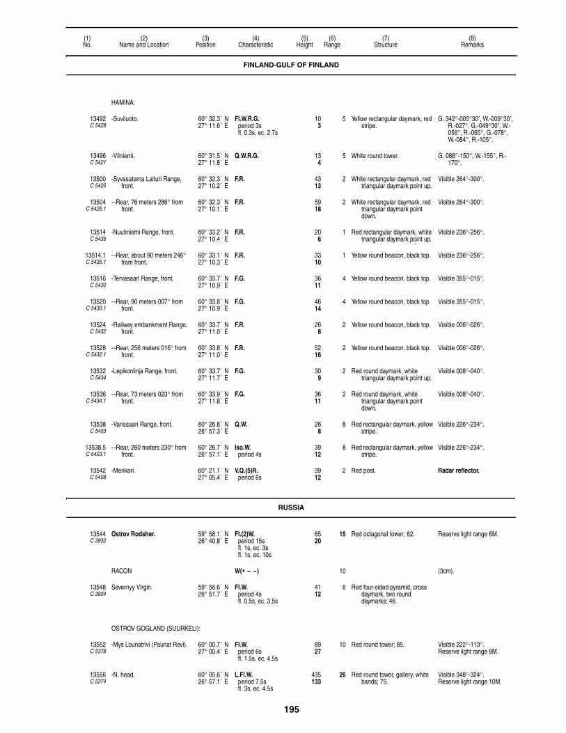
195
(1)No.
(2)Name and Location
(3)Position
(4)Characteristic
(5)Height
(6)Range
(7)Structure
(8)Remarks
HAMINA:
13492C 5428
-Suviluoto. 60° 32.3´ N27° 11.6´ E
Fl.W.R.G.period 3sfl. 0.3s, ec. 2.7s
103
5 Yellow rectangular daymark, red stripe.
G. 342°-005°30′, W.-009°30′, R.-027°, G.-049°30′, W.-056°, R.-065°, G.-078°, W.-084°, R.-105°.
13496C 5421
-Vilniemi. 60° 31.5´ N27° 11.8´ E
Q.W.R.G. 134
5 White round tower. G. 088°-150°, W.-155°, R.-170°.
13500C 5425
-Syvasatama Laituri Range, front.
60° 32.3´ N27° 10.2´ E
F.R. 4313
2 White rectangular daymark, red triangular daymark point up.
Visible 264°-300°.
13504C 5425.1
- -Rear, 76 meters 286° from front.
60° 32.3´ N27° 10.1´ E
F.R. 5918
2 White rectangular daymark, red triangular daymark point down.
Visible 264°-300°.
13514C 5435
-Nuutiniemi Range, front. 60° 33.2´ N27° 10.4´ E
F.R. 206
1 Red rectangular daymark, white triangular daymark point up.
Visible 236°-256°.
13514.1C 5435.1
- -Rear, about 90 meters 246° from front.
60° 33.1´ N27° 10.3´ E
F.R. 3310
1 Yellow round beacon, black top. Visible 236°-256°.
13516C 5430
-Tervasaari Range, front. 60° 33.7´ N27° 10.9´ E
F.G. 3611
4 Yellow round beacon, black top. Visible 355°-015°.
13520C 5430.1
- -Rear, 90 meters 007° from front.
60° 33.8´ N27° 10.9´ E
F.G. 4614
4 Yellow round beacon, black top. Visible 355°-015°.
13524C 5432
-Railway embankment Range, front.
60° 33.7´ N27° 11.0´ E
F.R. 268
2 Yellow round beacon, black top. Visible 006°-026°.
13528C 5432.1
- -Rear, 256 meters 016° from front.
60° 33.8´ N27° 11.0´ E
F.R. 5216
2 Yellow round beacon, black top. Visible 006°-026°.
13532C 5434
-Lepikonlinja Range, front. 60° 33.7´ N27° 11.7´ E
F.G. 309
2 Red round daymark, white triangular daymark point up.
Visible 008°-040°.
13536C 5434.1
- -Rear, 73 meters 023° from front.
60° 33.9´ N27° 11.8´ E
F.G. 3611
2 Red round daymark, white triangular daymark point down.
Visible 008°-040°.
13538C 5403
-Varissaari Range, front. 60° 26.8´ N26° 57.3´ E
Q.W. 268
8 Red rectangular daymark, yellow stripe.
Visible 226°-234°.
13538.5C 5403.1
- -Rear, 260 meters 230° from front.
60° 26.7´ N26° 57.1´ E
Iso.W.period 4s
3912
8 Red rectangular daymark, yellow stripe.
Visible 226°-234°.
13542C 5408
-Merikari. 60° 21.1´ N27° 05.4´ E
V.Q.(5)R.period 6s
3912
2 Red post. Radar reflector.
RUSSIA
13544C 3932
Ostrov Rodsher. 59° 58.1´ N26° 40.8´ E
Fl.(2)W.period 15sfl. 1s, ec. 3sfl. 1s, ec. 10s
6520
15 Red octagonal tower; 62. Reserve light range 6M.
RACON W(• – –) 10 (3cm).
13548C 3934
Severnyy Virgin. 59° 56.6´ N26° 51.7´ E
Fl.W.period 4sfl. 0.5s, ec. 3.5s
4112
6 Red four-sided pyramid, cross daymark, two round daymarks; 46.
OSTROV GOGLAND (SUURKELI):
13552C 5378
-Mys Lounatrivi (Paunat Revi). 60° 00.7´ N27° 00.4´ E
Fl.W.period 6sfl. 1.5s, ec. 4.5s
8927
10 Red round tower; 85. Visible 222°-113°.Reserve light range 8M.
13556C 5374
-N. head. 60° 05.6´ N26° 57.1´ E
L.Fl.W.period 7.5sfl. 3s, ec. 4.5s
435133
26 Red round tower, gallery, white bands; 75.
Visible 348°-324°.Reserve light range 10M.
FINLAND-GULF OF FINLAND

196
(1)No.
(2)Name and Location
(3)Position
(4)Characteristic
(5)Height
(6)Range
(7)Structure
(8)Remarks
FINLAND-GULF OF FINLAND
KOTKA APPROACH:
13560C 5380
-Kotkan Majakka. 60° 10.3´ N26° 39.1´ E
Fl.(4)W.period 30sfl. 1.5s, ec. 3.5sfl. 1.5s, ec. 3.5sfl. 1.5s, ec. 3.5sfl. 1.5s, ec. 13.5s
7423
12 Yellow metal column, blue band.Helicopter platform.
-RACON K(– • –) 11 (3 & 10cm).
13561C 5380.5
-Elo 2. 60° 14.2´ N26° 47.7´ E
V.Q.W. 3912
4 N. CARDINALBY, beacon, topmark.
Radar reflector.
13562C 5380.6
-Kaakoniemi. 60° 16.6´ N26° 52.1´ E
V.Q.(3)W.period 5s
3912
4 E. CARDINALBYB, beacon, topmark.
Radar reflector.
13563C 5381
-Kiviletto. 60° 17.6´ N26° 56.9´ E
L.Fl.W.period 6sfl. 2s, ec. 4s
6219
9 White metal mast, orange band. Visible 053°-057°.Radar reflector.
13564C 5386
Rankki. 60° 21.9´ N26° 58.1´ E
Fl.(3)W.R.G.period 10sfl. 0.4s, ec. 1.6sfl. 0.4s, ec. 1.6sfl. 0.4s, ec. 5.6s
3611
6 Black round concrete tower. G. 225°30′-290°, W.-295°, R.-048°, G.-096°, W.-101°, R.-127°.
13566C 5385
-Rankin Kivikari, reef, N. end. 60° 21.2´ N26° 57.2´ E
U.Q.(5)W.period 6s
3310
3 White metal post, red band. Radar reflector.
-RACON T(–) 9 (3 & 10cm).
13568C 5387
-Retonpaasi. 60° 21.9´ N27° 00.9´ E
U.Q.(5)W.period 6s
3310
2 Gray post. Radar reflector.
13569C 5382
-Harvassaari Range, front. 60° 24.7´ N26° 51.7´ E
Fl.W.period 3sfl. 1s, ec. 2s
4614
12 Red rectangular daymark, yellow stripe.
Visible 352°30′-357°30′.Range 7M by day.
13569.1C 5382.1
- -Rear, 1.3 miles 355° from front.
60° 26.0´ N26° 51.4´ E
Iso.W.period 12s
14143
14 Red rectangular daymark, yellow stripe.
Visible 352°30′-357°30′.Range 9M by day.
13570C 5382.5
-Mussalo. 60° 25.2´ N26° 54.2´ E
Iso.W.R.G.period 2s
309
11 Gray triangular daymark point up.
G. 010°-013°, W.-022°, R.-025°.
Range 3M by day.
13571C 5383
-Kukouri Range, front. 60° 25.8´ N26° 57.0´ E
Q.W. 165
7 Red rectangular daymark, yellow stripe.
Visible 047°24′-051°24′.
13571.1C 5394.4
- -Rear, 1850 meters 049°24′ from front.
60° 26.5´ N26° 58.5´ E
L.Fl.W.period 6sfl. 2s, ec. 4s
5818
9 Red rectangular daymark, yellow stripe.
Visible 047°24′-051°24′.Synchronized with front.
13571.3C 5383.3
-Viikarinsalmi. 60° 24.8´ N26° 54.7´ E
Fl.G.period 3sfl. 0.3s, ec. 2.7s
4112
4 Green round tower. Radar reflector.
13580C 5390
-Hietakari. 60° 23.8´ N27° 00.2´ E
Fl.W.R.G.period 3sfl. 0.3s, ec. 2.7s
165
6 White round tower. G. 339°-355°, W.-014°, R.-102°, G.-115°30′, W.-120°, R.-134°.
13584C 5388
-Lellerinsaaret. 60° 24.0´ N26° 58.3´ E
Fl.(2)W.R.G.period 5sfl. 0.4s, ec. 1sfl. 0.4s, ec. 3.2s
165
7 Red round tower, white stripe. G. 144°-167°, W.-174°, R.-244°, G.-330°30′, W.-336°, R.-354°.
13588C 5392
-Santakari Range, front. 60° 26.1´ N26° 58.4´ E
Q.Y. 134
7 Red rectangular daymark, yellow stripe.
Visible 054°-058°.Shown 24 hours.
13592C 5392.1
- -Rear, Laukkaanniemi, 2.2 km. 056° from front.
60° 26.8´ N27° 00.4´ E
L.Fl.Y.period 6sfl. 2s, ec. 4s
7523
10 Red rectangular daymark, yellow stripe.
Visible 052°-060°.
13596C 5394.4
-Lehmansaari Range, front. 60° 26.5´ N26° 58.5´ E
Q.W. 4614
5 Red rectangular daymark, white stripe.
Visible 171°-179°.
13600C 5394.41
- -Rear, 175° from front. 60° 25.5´ N26° 58.7´ E
L.Fl.W.period 6s
10933
8 Red rectangular daymark, white stripe.
Visible 171°-179°.
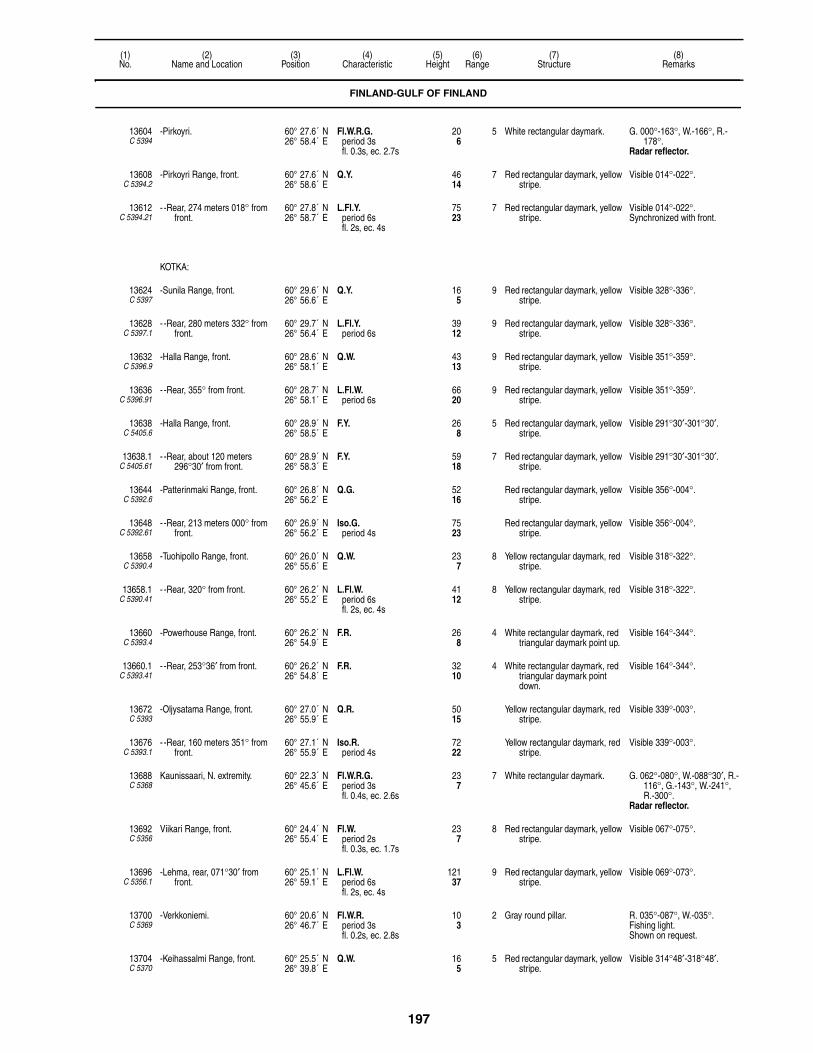
197
(1)No.
(2)Name and Location
(3)Position
(4)Characteristic
(5)Height
(6)Range
(7)Structure
(8)Remarks
13604C 5394
-Pirkoyri. 60° 27.6´ N26° 58.4´ E
Fl.W.R.G.period 3sfl. 0.3s, ec. 2.7s
206
5 White rectangular daymark. G. 000°-163°, W.-166°, R.-178°.
Radar reflector.
13608C 5394.2
-Pirkoyri Range, front. 60° 27.6´ N26° 58.6´ E
Q.Y. 4614
7 Red rectangular daymark, yellow stripe.
Visible 014°-022°.
13612C 5394.21
- -Rear, 274 meters 018° from front.
60° 27.8´ N26° 58.7´ E
L.Fl.Y.period 6sfl. 2s, ec. 4s
7523
7 Red rectangular daymark, yellow stripe.
Visible 014°-022°.Synchronized with front.
KOTKA:
13624C 5397
-Sunila Range, front. 60° 29.6´ N26° 56.6´ E
Q.Y. 165
9 Red rectangular daymark, yellow stripe.
Visible 328°-336°.
13628C 5397.1
- -Rear, 280 meters 332° from front.
60° 29.7´ N26° 56.4´ E
L.Fl.Y.period 6s
3912
9 Red rectangular daymark, yellow stripe.
Visible 328°-336°.
13632C 5396.9
-Halla Range, front. 60° 28.6´ N26° 58.1´ E
Q.W. 4313
9 Red rectangular daymark, yellow stripe.
Visible 351°-359°.
13636C 5396.91
- -Rear, 355° from front. 60° 28.7´ N26° 58.1´ E
L.Fl.W.period 6s
6620
9 Red rectangular daymark, yellow stripe.
Visible 351°-359°.
13638C 5405.6
-Halla Range, front. 60° 28.9´ N26° 58.5´ E
F.Y. 268
5 Red rectangular daymark, yellow stripe.
Visible 291°30′-301°30′.
13638.1C 5405.61
- -Rear, about 120 meters 296°30′ from front.
60° 28.9´ N26° 58.3´ E
F.Y. 5918
7 Red rectangular daymark, yellow stripe.
Visible 291°30′-301°30′.
13644C 5392.6
-Patterinmaki Range, front. 60° 26.8´ N26° 56.2´ E
Q.G. 5216
Red rectangular daymark, yellow stripe.
Visible 356°-004°.
13648C 5392.61
- -Rear, 213 meters 000° from front.
60° 26.9´ N26° 56.2´ E
Iso.G.period 4s
7523
Red rectangular daymark, yellow stripe.
Visible 356°-004°.
13658C 5390.4
-Tuohipollo Range, front. 60° 26.0´ N26° 55.6´ E
Q.W. 237
8 Yellow rectangular daymark, red stripe.
Visible 318°-322°.
13658.1C 5390.41
- -Rear, 320° from front. 60° 26.2´ N26° 55.2´ E
L.Fl.W.period 6sfl. 2s, ec. 4s
4112
8 Yellow rectangular daymark, red stripe.
Visible 318°-322°.
13660C 5393.4
-Powerhouse Range, front. 60° 26.2´ N26° 54.9´ E
F.R. 268
4 White rectangular daymark, red triangular daymark point up.
Visible 164°-344°.
13660.1C 5393.41
- -Rear, 253°36′ from front. 60° 26.2´ N26° 54.8´ E
F.R. 3210
4 White rectangular daymark, red triangular daymark point down.
Visible 164°-344°.
13672C 5393
-Oljysatama Range, front. 60° 27.0´ N26° 55.9´ E
Q.R. 5015
Yellow rectangular daymark, red stripe.
Visible 339°-003°.
13676C 5393.1
- -Rear, 160 meters 351° from front.
60° 27.1´ N26° 55.9´ E
Iso.R.period 4s
7222
Yellow rectangular daymark, red stripe.
Visible 339°-003°.
13688C 5368
Kaunissaari, N. extremity. 60° 22.3´ N26° 45.6´ E
Fl.W.R.G.period 3sfl. 0.4s, ec. 2.6s
237
7 White rectangular daymark. G. 062°-080°, W.-088°30′, R.-116°, G.-143°, W.-241°, R.-300°.
Radar reflector.
13692C 5356
Viikari Range, front. 60° 24.4´ N26° 55.4´ E
Fl.W.period 2sfl. 0.3s, ec. 1.7s
237
8 Red rectangular daymark, yellow stripe.
Visible 067°-075°.
13696C 5356.1
-Lehma, rear, 071°30′ from front.
60° 25.1´ N26° 59.1´ E
L.Fl.W.period 6sfl. 2s, ec. 4s
12137
9 Red rectangular daymark, yellow stripe.
Visible 069°-073°.
13700C 5369
-Verkkoniemi. 60° 20.6´ N26° 46.7´ E
Fl.W.R.period 3sfl. 0.2s, ec. 2.8s
103
2 Gray round pillar. R. 035°-087°, W.-035°.Fishing light.Shown on request.
13704C 5370
-Keihassalmi Range, front. 60° 25.5´ N26° 39.8´ E
Q.W. 165
5 Red rectangular daymark, yellow stripe.
Visible 314°48′-318°48′.
FINLAND-GULF OF FINLAND

198
(1)No.
(2)Name and Location
(3)Position
(4)Characteristic
(5)Height
(6)Range
(7)Structure
(8)Remarks
13708C 5370.1
- -Rear, 315°48′ from front. 60° 26.0´ N26° 38.8´ E
L.Fl.W.period 6sfl. 2s, ec. 4s
3310
9 Red rectangular daymark, yellow stripe.
Visible 312°-320°.
13720C 5366
Kalliokari. 60° 19.1´ N26° 44.7´ E
Fl.W.period 3sfl. 0.2s, ec. 2.8s
237
4 Gray round daymark. Fishing light.Shown on request.
13780C 5349
Lalatta, NE. islet. 60° 17.2´ N26° 33.1´ E
Q.(2)W.R.G.period 6s
319
5 Black round concrete tower. R.040°-052°, W.-062°30′, G.-150°, W.-152°30′, R.-188°, G.-213°, W.-222°, R.-232°.
Radar reflector.
13816C 5324
-Range, front. 60° 16.4´ N26° 27.0´ E
Q.W. 4313
13 Red rectangular daymark, yellow stripe.
Visible 019°30′-026°30′.
-RACON T(–) 10 (3 & 10cm).
13820C 5324.1
- -Rear, 463 meters 023° from front.
60° 16.6´ N26° 27.1´ E
Q.W. 8225
14 Red rectangular daymark, yellow stripe.
Visible 019°30′-026°30′.Synchronized with front.
13824C 5321
Tainio, 6.0 kilometers 099°15′ from Hamnskar.
60° 12.7´ N26° 24.5´ E
V.Q.(5)W.period 6s
5717
6 White round concrete tower, black top; 56.
Radar reflector.
RACON M(– –) 10 (3 & 10cm).
13828C 5328
Skarven. 60° 17.8´ N26° 20.7´ E
Fl.W.R.G.period 3sfl. 0.3s, ec. 2.7s
227
4 White beacon, black top. G. 051°-064°, W.-068°30′, R.-159°, G.-241°, W.-267°, R.-310°.
RACON T(–) 10 (3cm).
13932C 5320
Hamnskar, E. side. 60° 13.2´ N26° 18.2´ E
Fl.W.R.period 3sfl. 0.5s, ec. 2.5s
268
4 Red round tower. W. 100°-210°, R.-288°, W.-050°, R.-100°.
Fishing light.Shown on request.
13936C 5318
Tiiskeri. 60° 09.8´ N26° 15.5´ E
Fl.(2)W.period 10sfl. 0.5s, ec. 2sfl. 0.5s, ec. 7s
5416
9 Black concrete tower, orange top.
Wind generator.Radar reflector.
RACON T(–)period 90s
11 (3 & 10cm).
13940C 5284
Skarvgadderna. 60° 11.0´ N26° 07.6´ E
Fl.W.R.G.period 2sfl. 0.5s, ec. 1.5s
206
6 White concrete tower, black top. G. 054°-070°, W.-074°, R.-110°, G.-182°, W.-195°, R.-210°.
Radar reflector.
RACON G(– – • ) 9 (3 & 10cm).
13958 Gasskvatten Beacon, RACON. 60° 11.0´ N26° 03.0´ E
T(–)period 30s
10
14072C 5268
Aggskar, S. point. 60° 12.0´ N25° 45.0´ E
Fl.W.R.G.period 3sfl. 0.3s, ec. 2.7s
216
5 White lantern. G. 223°-235°, W.-257°, R.-337°, G.-008°, W.-011°30′, R.-130°.
14084C 5239
Kalbadagrund. 59° 59.1´ N25° 36.0´ E
L.Fl.(4)W.period 30sfl. 2s, ec. 3sfl. 2s, ec. 3sfl. 2s, ec. 3sfl. 2s, ec. 13s
8827
12 Red concrete tower, white stripe; 82.
Helicopter platform.
Visible 195°-180°.
RACON K(– • –) 13 (3 & 10cm).
14086 Jaktgrund Beacon, RACON. 59° 59.9´ N25° 33.3´ E
T(–)period 90s
10
14088C 5239.4
Porvoon Range, front. 60° 05.6´ N25° 35.9´ E
Fl.W.R.G.period 2sfl. 0.5s, ec. 1.5s
3410
7 Red tower, black band; 33. W. 004°-027°, R.-105°, G.-229°, W.-237°, R.-285°, G.-004°.
RACON T(–) 9 (3 & 10cm).
FINLAND-GULF OF FINLAND
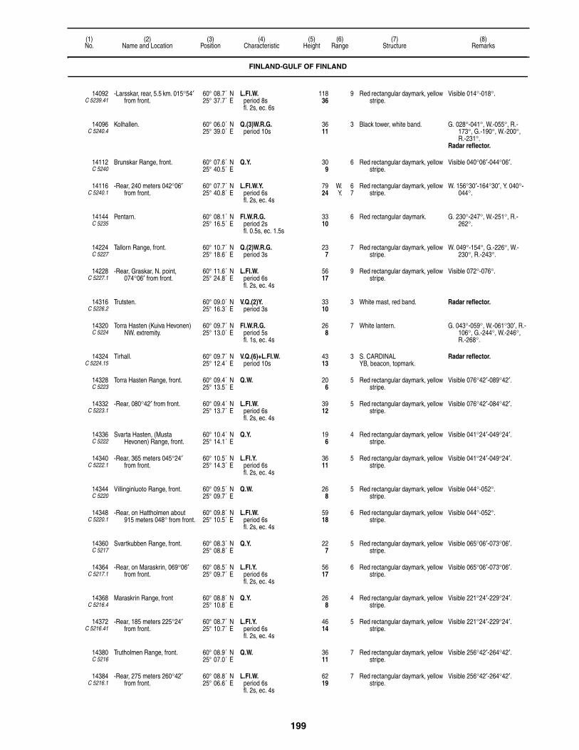
199
(1)No.
(2)Name and Location
(3)Position
(4)Characteristic
(5)Height
(6)Range
(7)Structure
(8)Remarks
14092C 5239.41
-Larsskar, rear, 5.5 km. 015°54′ from front.
60° 08.7´ N25° 37.7´ E
L.Fl.W.period 8sfl. 2s, ec. 6s
11836
9 Red rectangular daymark, yellow stripe.
Visible 014°-018°.
14096C 5240.4
Kolhallen. 60° 06.0´ N25° 39.0´ E
Q.(3)W.R.G.period 10s
3611
3 Black tower, white band. G. 028°-041°, W.-055°, R.-173°, G.-190°, W.-200°, R.-231°.
Radar reflector.
14112C 5240
Brunskar Range, front. 60° 07.6´ N25° 40.5´ E
Q.Y. 309
6 Red rectangular daymark, yellow stripe.
Visible 040°06′-044°06′.
14116C 5240.1
-Rear, 240 meters 042°06′ from front.
60° 07.7´ N25° 40.8´ E
L.Fl.W.Y.period 6sfl. 2s, ec. 4s
7924
W. 6Y. 7
Red rectangular daymark, yellow stripe.
W. 156°30′-164°30′, Y. 040°-044°.
14144C 5235
Pentarn. 60° 08.1´ N25° 16.5´ E
Fl.W.R.G.period 2sfl. 0.5s, ec. 1.5s
3310
6 Red rectangular daymark. G. 230°-247°, W.-251°, R.-262°.
14224C 5227
Tallorn Range, front. 60° 10.7´ N25° 18.6´ E
Q.(2)W.R.G.period 3s
237
7 Red rectangular daymark, yellow stripe.
W. 049°-154°, G.-226°, W.-230°, R.-243°.
14228C 5227.1
-Rear, Graskar, N. point, 074°06′ from front.
60° 11.6´ N25° 24.8´ E
L.Fl.W.period 6sfl. 2s, ec. 4s
5617
9 Red rectangular daymark, yellow stripe.
Visible 072°-076°.
14316C 5226.2
Trutsten. 60° 09.0´ N25° 16.3´ E
V.Q.(2)Y.period 3s
3310
3 White mast, red band. Radar reflector.
14320C 5224
Torra Hasten (Kuiva Hevonen) NW. extremity.
60° 09.7´ N25° 13.0´ E
Fl.W.R.G.period 5sfl. 1s, ec. 4s
268
7 White lantern. G. 043°-059°, W.-061°30′, R.-106°, G.-244°, W.-246°, R.-268°.
14324C 5224.15
Tirhall. 60° 09.7´ N25° 12.4´ E
V.Q.(6)+L.Fl.W.period 10s
4313
3 S. CARDINALYB, beacon, topmark.
Radar reflector.
14328C 5223
Torra Hasten Range, front. 60° 09.4´ N25° 13.5´ E
Q.W. 206
5 Red rectangular daymark, yellow stripe.
Visible 076°42′-089°42′.
14332C 5223.1
-Rear, 080°42′ from front. 60° 09.4´ N25° 13.7´ E
L.Fl.W.period 6sfl. 2s, ec. 4s
3912
5 Red rectangular daymark, yellow stripe.
Visible 076°42′-084°42′.
14336C 5222
Svarta Hasten, (Musta Hevonen) Range, front.
60° 10.4´ N25° 14.1´ E
Q.Y. 196
4 Red rectangular daymark, yellow stripe.
Visible 041°24′-049°24′.
14340C 5222.1
-Rear, 365 meters 045°24′ from front.
60° 10.5´ N25° 14.3´ E
L.Fl.Y.period 6sfl. 2s, ec. 4s
3611
5 Red rectangular daymark, yellow stripe.
Visible 041°24′-049°24′.
14344C 5220
Villinginluoto Range, front. 60° 09.5´ N25° 09.7´ E
Q.W. 268
5 Red rectangular daymark, yellow stripe.
Visible 044°-052°.
14348C 5220.1
-Rear, on Hattholmen about 915 meters 048° from front.
60° 09.8´ N25° 10.5´ E
L.Fl.W.period 6sfl. 2s, ec. 4s
5918
6 Red rectangular daymark, yellow stripe.
Visible 044°-052°.
14360C 5217
Svartkubben Range, front. 60° 08.3´ N25° 08.8´ E
Q.Y. 227
5 Red rectangular daymark, yellow stripe.
Visible 065°06′-073°06′.
14364C 5217.1
-Rear, on Maraskrin, 069°06′ from front.
60° 08.5´ N25° 09.7´ E
L.Fl.Y.period 6sfl. 2s, ec. 4s
5617
6 Red rectangular daymark, yellow stripe.
Visible 065°06′-073°06′.
14368C 5216.4
Maraskrin Range, front 60° 08.8´ N25° 10.8´ E
Q.Y. 268
4 Red rectangular daymark, yellow stripe.
Visible 221°24′-229°24′.
14372C 5216.41
-Rear, 185 meters 225°24′ from front.
60° 08.7´ N25° 10.7´ E
L.Fl.Y.period 6sfl. 2s, ec. 4s
4614
5 Red rectangular daymark, yellow stripe.
Visible 221°24′-229°24′.
14380C 5216
Trutholmen Range, front. 60° 08.9´ N25° 07.0´ E
Q.W. 3611
7 Red rectangular daymark, yellow stripe.
Visible 256°42′-264°42′.
14384C 5216.1
-Rear, 275 meters 260°42′ from front.
60° 08.8´ N25° 06.6´ E
L.Fl.W.period 6sfl. 2s, ec. 4s
6219
7 Red rectangular daymark, yellow stripe.
Visible 256°42′-264°42′.
FINLAND-GULF OF FINLAND

200
(1)No.
(2)Name and Location
(3)Position
(4)Characteristic
(5)Height
(6)Range
(7)Structure
(8)Remarks
14388C 5214
Jungfruholmen (Neitsytsaari). 60° 09.1´ N25° 05.9´ E
Fl.W.R.G.period 3sfl. 0.3s, ec. 2.7s
165
5 White lantern. G. 081°-099°, W.-106°, R.-195°, G.-279°, W.-281°, R.-307°.
HELSINKI (HELSINGFORS) APPROACH:
14396C 5212
-Koholmen, (Lehmasaari) N. point.
60° 09.4´ N25° 03.6´ E
Q.W.R.G. 82
5 White round tower. G. 085°-098°30′, W.-103°30, R.-232°, G.-285°30′, W.-290°, R.-301°.
14400C 5210
-Hastnas Channel, S. side. 60° 09.5´ N25° 02.9´ E
V.Q.(5)W.period 6s
144
9 White round beacon. Visible 038°-289°.
14404C 5208
-Bjorkholmen (Koivusaari), S. point.
60° 09.3´ N25° 01.5´ E
Q.W.R.G. 93
5 White round tower. G. 236°-256°, W.-268°, R.-282°, G.-290°, W.-293°, R.-340°, G.-007°, W.-011°, R.-056°, G.-122°, W.-124°, R.-146°.
14406C 5203
-Soberudden Range, front. 60° 08.1´ N25° 01.8´ E
Q.Y. 309
4 Yellow rectangular daymark, red stripe.
Visible 135°-143°.
14406.1C 5203.1
- -Rear, 140°18′ from front. 60° 08.1´ N25° 01.8´ E
L.Fl.Y.period 6sfl. 2s, ec. 4s
4614
5 Yellow rectangular daymark, red stripe.
Visible 135°-143°.
14407C 5203.4
-Notholmen Range, front. 60° 08.5´ N25° 01.6´ E
Q.Y. 165
4 Yellow rectangular daymark, red stripe.
Visible 351°12′-359°12′.
14407.1C 5203.41
- -Rear, 356° from front. 60° 08.5´ N25° 01.6´ E
L.Fl.Y.period 6sfl. 2s, ec. 4s
3310
5 Yellow rectangular daymark, red stripe.
Visible 351°12′-359°12′.
14408C 5154
-Trutkobben Range, front. 60° 05.8´ N24° 52.6´ E
Q.Y. 144
7 Metal framework tower, red rectangular daymark, yellow stripe.
Visible 073°-077°.
14412C 5154.1
- -Hamngrund, rear, 074°48′ from front.
60° 06.2´ N24° 55.1´ E
L.Fl.Y.period 6sfl. 2s, ec. 4s
7924
5 Red rectangular daymark, yellow stripe.
Visible 071°-079°.
14416C 5154.4
-Trutkubbsklackarna Rysakivi. 60° 06.1´ N24° 51.3´ E
V.Q.(3)Y.period 3s
3310
2 Black column, white bands.
14418C 5155.4
-Koirasaari Hudoren Range, front.
60° 05.1´ N24° 50.9´ E
Q.W. 165
7 Red rectangular daymark, yellow stripe.
Visible 327°30′-331°30′.
14418.1C 5155.41
- -Rysakouri, rear, about 1300 meters 329°06′ from front.
60° 06.0´ N24° 49.9´ E
L.Fl.W.period 6sfl. 2s, ec. 4s
9529
9 Red rectangular daymark, yellow stripe.
Visible 327°30′-331°30′.
14418.5C 5159
Melkki. 60° 07.8´ N24° 53.1´ E
Dir.W.R.G.period 2s
309
W. 7R. 6G. 6
Iso.G. 355°24′-357°24′, Iso.W.-359°24′, Iso.R.-001°24′.
14419C 5158
-Outer Melkohallen Range, front.
60° 07.7´ N24° 54.0´ E
Q.W. 185
5 Yellow rectangular daymark, red stripe.
Visible 040°-044°.
14420C 5158.1
- -Lantinen Pihlajasaari, rear 042° from front.
60° 08.2´ N24° 54.8´ E
L.Fl.W.period 6sfl. 2s, ec. 4s
4413
7 Yellow rectangular daymark, red stripe.
Visible 038°-046°.
14428C 5156
-Koirakari (Hundskar), 60° 07.4´ N24° 54.6´ E
Fl.W.R.G.period 3sfl. 1s, ec. 2s
206
7 White tower, black band. G. 063°-166°, R.-198°, G.-225°, W.-228°, R.-243°.
14432C 5157
-Hundskar Range, front. 60° 07.4´ N24° 54.6´ E
Iso.W.period 5s
206
10 Red rectangular daymark, yellow stripe.
Visible 002°-022°.F.W. 4M, visible 007°30′-
016°30′ by day.
14436C 5157.1
- -Ronnskar, rear, 1400 meters 012°30′ from front.
60° 08.2´ N24° 54.9´ E
Oc.W.period 10slt. 7.5s, ec. 2.5s
6620
11 Red rectangular daymark, yellow stripe.
Visible 002°-022°.F.W. 4M by day visible
007°30′-016°30′.
14440C 5160
-Tiirakari (Tirgrund). 60° 07.7´ N24° 55.6´ E
V.Q.(2)W.R.G.period 3s
165
7 White tower. G.040°-070°30′, W.-073°30′, R.-114°, G.-183°, W.-210°, R.-245°.
In line 072°36′ with 14544.
FINLAND-GULF OF FINLAND
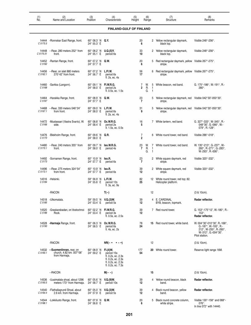
201
(1)No.
(2)Name and Location
(3)Position
(4)Characteristic
(5)Height
(6)Range
(7)Structure
(8)Remarks
14444C 5175.5
-Ronnskar East Range, front. 60° 08.3´ N24° 55.3´ E
Q.Y. 206
2 Yellow rectangular daymark, black top.
Visible 248°-256°.
14448C 5175.51
- -Rear, 280 meters 252° from front.
60° 08.2´ N24° 55.1´ E
U.Q.(5)Y.period 6s
3310
2 Yellow rectangular daymark, black top.
Visible 248°-256°.
14452C 5162
-Rantan Range, front. 60° 07.2´ N24° 57.7´ E
Q.W. 206
5 Red rectangular daymark, yellow stripe.
Visible 267°-275°.
14456C 5162.1
- -Rear, on islet 880 meters 270°42′ from front.
60° 07.2´ N24° 56.7´ E
L.Fl.W.period 6sfl. 2s, ec. 4s
5617
6 Red rectangular daymark, yellow stripe.
Visible 267°-275°.
14460C 5168
-Sarkka (Langorn). 60° 09.1´ N24° 58.0´ E
Fl.W.R.G.period 2sfl. 0.5s, ec. 1.5s
72
W. 5R. 1G. 1
White beacon, red band. G. 175°-186°, W.-191°, R.-280°.
14464C 5167
-Harakka Range, front. 60° 08.9´ N24° 57.7´ E
Q.W. 237
5 Yellow rectangular daymark, red stripe.
Visible 042°30′-050°30′.
14468C 5167.1
- -Rear, 330 meters 046°24′ from front.
60° 09.0´ N24° 58.0´ E
L.Fl.W.period 6sfl. 2s, ec. 4s
319
5 Yellow rectangular daymark, red stripe.
Visible 042°30′-050°30′.
14472C 5166
-Mustassari (Vastra Svarto), W. side.
60° 08.8´ N24° 58.4´ E
Oc.W.R.G.period 2slt. 1.5s, ec. 0.5s
165
7 White lantern, red band. G. 327°-333°, W.-345°, R.-048°30′, G.-066°, W.-079°, R.-128°.
14476C 5170
-Blekholm Range, front. 60° 09.6´ N24° 58.0´ E
Q.R. 72
6 White round tower, red band. Visible 286°-018°.
14480C 5170.1
- -Rear, 240 meters 355° from front.
60° 09.7´ N24° 58.0´ E
Iso.W.R.G.period 4s
237
W. 7R. 1G. 1
White round tower, red band. W. 135°-213°, G.-237°, W.-260°, R.-271°, G.-283°, W.-293°, R.-006°.
14492C 5173
-Sornamen Range, front. 60° 10.9´ N24° 57.7´ E
Iso.R.period 6s
237
2 White square daymark, red stripe.
Visible 320°-332°.
14496C 5173.1
- -Rear, 275 meters 324°54′ from front.
60° 10.9´ N24° 57.7´ E
Iso.R.period 6s
3912
2 White square daymark, red stripe.
Visible 320°-332°.
14516C 5184
-Helsinki. 59° 56.9´ N24° 55.6´ E
L.Fl.W.period 12sfl. 3s, ec. 9s
8225
12 White round tower, red top; 82.Helicopter platform.
-RACON T(–) 12 (3 & 10cm).
14518C 5185
-Ulkomatala. 59° 59.5´ N24° 53.4´ E
V.Q.(3)W.period 5s
3912
4 E. CARDINALBYB, beacon, topmark.
Radar reflector.
14520C 5186
-Graskarsbadan, on Vostochnoi Rock.
60° 02.2´ N24° 53.4´ E
Fl.W.R.G.period 3sfl. 0.5s, ec. 2.5s
3912
7 Red round tower. G. 153°-175°12′, W.-180°, R.-153°.
Radar reflector.
14528C 5190
-Harmaja Range, front. 60° 06.3´ N24° 58.5´ E
Oc.W.R.G.period 6slt. 4s, ec. 2s
7824
15 Red round tower, white band. W. 004°30′-010°30′, R.-168°, G.-187°, W.-193°, R.-212°, W.-250°, R.-260°, W.-312°, G.-004°30′.
Pilot station.
-RACON NR(– • • – •) 12 (3 & 10cm).
14532C 5190.1
- -Suomenlinnan, rear, on church, 4.82 km. 007°06′ from Harmaja.
60° 08.9´ N24° 59.2´ E
Fl.(4)W.period 15sfl. 0.2s, ec. 2.3sfl. 0.2s, ec. 2.3sfl. 0.2s, ec. 2.3sfl. 0.2s, ec. 7.3s
17754
20 White round tower. Reserve light range 16M.
- -RACON M(– –) 15 (3 & 10cm).
14536C 5190.5
-Uusimatala shoal, about 1296 meters 173° from Harmaja.
60° 05.6´ N24° 58.7´ E
V.Q.(9)W.period 10s
3912
4 Yellow round beacon, black band.
Radar reflector.
14540C 5190.4
-Flathallagrund Shoal, about 2.6 km. from Harmaja.
60° 05.0´ N24° 57.9´ E
V.Q.(3)W.period 5s
3912
4 Black round beacon, yellow band.
Radar reflector.
14544C 5188.1
-Lokkiluoto Range, front. 60° 07.9´ N24° 56.6´ E
Q.W. 206
5 Black round concrete column, white stripe.
Visible 130°-158° and 068°-076°.
In line 072° with 14440.
FINLAND-GULF OF FINLAND

202
(1)No.
(2)Name and Location
(3)Position
(4)Characteristic
(5)Height
(6)Range
(7)Structure
(8)Remarks
14548C 5188
- -Abrahaminluoto, rear, 1,204 meters 143°06′ from front.
60° 07.3´ N24° 57.4´ E
Iso.W.period 3s
3310
6 Black rectangular daymark, white band.
Visible 132°-159°.
14552C 5165
-Husunkivi. 60° 08.4´ N24° 57.8´ E
V.Q.(5)R.period 6s
3611
4 White round tower, red top. Radar reflector.
14556C 5171
-Lansi Mustasaari Range, front. 60° 08.9´ N24° 58.5´ E
Q.R. 3711
3 Red rectangular daymark, white triangular daymark point up; 33.
Visible 147°-155°.
14560C 5171.1
- -Rear, 107 meters 151°12′ from front.
60° 08.9´ N24° 58.5´ E
Q.R. 4915
3 White and red triangular daymarks point down.
Visible 147°-155°.
-Gustafsund:
14564C 5196
- -Kustaanmiekka (Gustavssvard) Range, front.
60° 08.3´ N24° 59.4´ E
Q.W.R. 278
8 Red rectangular daymark, white stripe.
W. 191°-026°, R.-067°.
14568C 5196.1
- - -Rear, 593 meters 009°42′ from front.
60° 08.6´ N24° 59.5´ E
L.Fl.W.period 6sfl. 2s, ec. 4s
6219
8 Red rectangular daymark, white stripe.
Visible 006°-014°.
14572C 5195
- -Remmarholmen. 60° 07.9´ N24° 59.6´ E
Q.(2)W.R.G.period 4s
3611
5 Red round concrete tower, white lantern.
G. 328°-347°, W.-359°, R.-007°, G.-031°, W.-044°, R.-077°, G.-121°, W.-141°, R.-198°.
14584C 5200
-Kuivassaari, N. part of Mjolokneckten.
60° 06.3´ N25° 01.2´ E
Q.(2)W.R.G.period 4s
206
7 White round lantern. G.141°-146°, W.-149°, R.-197°, G.-235°30′, W.-241°, R.-268°.
14585 -Harmaja 2. 60° 07.1´ N25° 01.3´ E
V.Q.W. 4514
4 N. CARDINALBY, beacon, topmark.
Radar reflector.
14588C 5202
-Isosaari Range, front. 60° 06.3´ N25° 03.6´ E
F.R. 72
2 White rectangular daymark, red stripe.
Visible 135°-143°.Fishing light.
14592C 5202.1
- -Rear, 139° from front. 60° 06.2´ N25° 03.8´ E
F.R. 3611
2 White rectangular daymark, red stripe.
Visible 135°-143°.Fishing light.
14596C 5206
-Vasikkasaari (Kalvholm), W. side.
60° 09.1´ N25° 00.6´ E
Fl.W.R.G.period 2sfl. 0.3s, ec. 1.7s
165
5 White round tower. G. 108°-116°30′, W.-119°, R.-126°, G.-136°30′, W.-143°, R.-151°.
14598C 5206.5
- -Neljanviitankari. 60° 09.8´ N24° 59.9´ E
U.Q.(5)W.period 6s
3912
1 Gray mast. Radar reflector.
14600C 5153.5
-Gasgrundet Range, front. 60° 05.2´ N24° 44.4´ E
Q.W. 134
3 Red rectangular daymark, yellow stripe.
Visible 039°18′-047°18′.
14604C 5153.51
- -Rear, 043°18′ from front. 60° 05.6´ N24° 45.2´ E
L.Fl.W.period 6sfl. 2s, ec. 4s
4213
4 Red rectangular daymark, yellow stripe.
Visible 039°18′-047°18′.
14608C 5153
Kyto, NW. point. 60° 04.4´ N24° 43.4´ E
V.Q.(5)W.period 6s
299
4 White round tower. Visible 046°30′-253°30′.
14612C 5147
-Kyto Range, front. 60° 03.8´ N24° 42.9´ E
Q.W. 6921
6 Red rectangular daymark, yellow stripe.
Visible 055°36′-059°36′.
14616C 5147.1
- -Rear, 057°30′ from front. 60° 04.0´ N24° 43.2´ E
L.Fl.W.period 6sfl. 2s, ec. 4s
10231
7 Red rectangular daymark, yellow stripe.
Visible 055°36′-059°36′.
14656C 5130
Porkkala Kallbada. 59° 52.1´ N24° 18.2´ E
Fl.(3)W.R.G.period 20sfl. 0.8s, ec. 3.2sfl. 0.8s, ec. 3.2sfl. 0.8s, ec. 11.2s
7021
12 Red four-sided tower. R. 070°-120°, G.-195°, W.-070°.
14657C 5129.5
-Inkoo No 2. 59° 52.0´ N24° 10.9´ E
Fl.(2)W.period 20s
3912
7 Red metal mast, white band. Radar reflector.
RACON K(– • –) 8 (3 & 10cm).
14660C 5121
Makiluoto Range, front. 59° 54.8´ N24° 20.1´ E
Q.W. 309
5 Red rectangular daymark, white stripe.
Visible 029°-037°.
FINLAND-GULF OF FINLAND
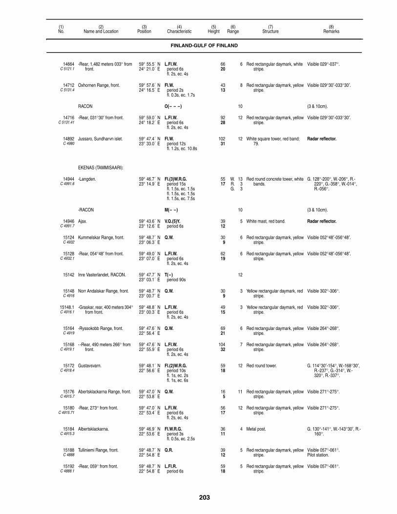
203
(1)No.
(2)Name and Location
(3)Position
(4)Characteristic
(5)Height
(6)Range
(7)Structure
(8)Remarks
14664C 5121.1
-Rear, 1,482 meters 033° from front.
59° 55.5´ N24° 21.0´ E
L.Fl.W.period 6sfl. 2s, ec. 4s
6620
6 Red rectangular daymark, white stripe.
Visible 029°-037°.
14712C 5131.4
Oxhornen Range, front. 59° 57.6´ N24° 16.5´ E
Fl.W.period 2sfl. 0.3s, ec. 1.7s
4313
8 Red rectangular daymark, yellow stripe.
Visible 029°30′-033°30′.
RACON O(– – –) 10 (3 & 10cm).
14716C 5131.41
-Rear, 031°30′ from front. 59° 59.0´ N24° 18.2´ E
L.Fl.W.period 6sfl. 2s, ec. 4s
9228
12 Red rectangular daymark, yellow stripe.
Visible 029°30′-033°30′.
14892C 4980
Jussaro, Sundharvn islet. 59° 47.4´ N23° 33.0´ E
Fl.W.period 12sfl. 1.2s, ec. 10.8s
10231
12 White square tower, red band; 79.
Radar reflector.
EKENAS (TAMMISAARI):
14944C 4991.6
-Langden. 59° 46.7´ N23° 14.9´ E
Fl.(3)W.R.G.period 15sfl. 1.5s, ec. 1.5sfl. 1.5s, ec. 1.5sfl. 1.5s, ec. 7.5s
5517
W. 13R. 3G. 3
Red round concrete tower, white bands.
G. 128°-200°, W.-206°, R.-220°, G.-358°, W.-014°, R.-056°.
-RACON M(– –) 10 (3 & 10cm).
14946C 4991.7
Ajax. 59° 43.6´ N23° 12.6´ E
V.Q.(5)Y.period 6s
3912
5 White mast, red band. Radar reflector.
15124C 4932
Kummelskar Range, front. 59° 48.7´ N23° 06.3´ E
Q.W. 309
6 Red rectangular daymark, yellow stripe.
Visible 052°48′-056°48′.
15128C 4932.1
-Rear, 054°48′ from front. 59° 49.0´ N23° 07.0´ E
L.Fl.W.period 6sfl. 2s, ec. 4s
6219
6 Red rectangular daymark, yellow stripe.
Visible 052°48′-056°48′.
15142 Inre Vasterlandet, RACON. 59° 47.7´ N23° 03.1´ E
T(–)period 90s
12
15148C 4916
Norr Andalskar Range, front. 59° 48.7´ N23° 00.7´ E
Q.W. 309
3 Yellow rectangular daymark, red stripe.
Visible 302°-306°.
15148.1C 4916.1
-Graskar, rear, 400 meters 304° from front.
59° 48.8´ N23° 00.3´ E
L.Fl.W.period 6sfl. 2s, ec. 4s
4915
3 Yellow rectangular daymark, red stripe.
Visible 302°-306°.
15164C 4919
-Ryssokobb Range, front. 59° 47.6´ N22° 56.4´ E
Q.W. 6921
6 Red rectangular daymark, yellow stripe.
Visible 264°-268°.
15168C 4919.1
- -Rear, 490 meters 266° from front.
59° 47.6´ N22° 55.9´ E
L.Fl.W.period 6sfl. 2s, ec. 4s
10432
7 Red rectangular daymark, yellow stripe.
Visible 264°-268°.
15172C 4918.4
Gustavsvarn. 59° 48.1´ N22° 56.6´ E
Fl.(2)W.R.G.period 10sfl. 1s, ec. 2sfl. 1s, ec. 6s
5918
12 Red round tower. G. 114°30′-154°, W.-168°30′, R.-237°, G.-314°, W.-320°, R.-337°.
15176C 4915.7
Abertsklackarna Range, front. 59° 47.0´ N22° 53.8´ E
Q.W. 165
11 Red rectangular daymark, yellow stripe.
Visible 271°-275°.
15180C 4915.71
-Rear, 273° from front. 59° 47.0´ N22° 53.4´ E
L.Fl.W.period 6sfl. 2s, ec. 4s
5617
12 Red rectangular daymark, yellow stripe.
Visible 271°-275°.
15184C 4915.3
Albertsklackarna. 59° 46.9´ N22° 53.6´ E
Fl.W.R.G.period 3sfl. 0.5s, ec. 2.5s
3611
4 Metal post. G. 130°-141°, W.-143°30′, R.-160°.
15188C 4888
Tulliniemi Range, front. 59° 48.7´ N22° 54.8´ E
Q.R. 3912
5 Red rectangular daymark, yellow stripe.
Visible 057°-061°.Pilot station.
15192C 4888.1
-Rear, 059° from front. 59° 48.7´ N22° 54.8´ E
L.Fl.R.period 6s
5918
5 Red rectangular daymark, yellow stripe.
Visible 057°-061°.
FINLAND-GULF OF FINLAND

204
(1)No.
(2)Name and Location
(3)Position
(4)Characteristic
(5)Height
(6)Range
(7)Structure
(8)Remarks
15196C 4892
Hangoudd Range, front, about 686 meters 061° from breakwater, head.
59° 48.7´ N22° 54.9´ E
Q.W. 268
6 Yellow rectangular daymark, red stripe.
Visible 269°42′-277°42′.
15200C 4892.1
-Rear, 730 meters 273°42′ from front.
59° 48.7´ N22° 54.1´ E
L.Fl.W.period 6sfl. 2s, ec. 4s
6018
8 Yellow rectangular daymark, red stripe.
Visible 264°42′-282°42′.
15204C 4915.6
Norrkoben Range, front. 59° 46.7´ N22° 55.1´ E
Q.Y. 309
11 Red rectangular daymark, yellow stripe.
Visible 119°-123°.
15208C 4915.61
-Russaro, rear, 121° from front. 59° 46.4´ N22° 56.0´ E
L.Fl.Y.period 6sfl. 2s, ec. 4s
6219
11 Yellow rectangular daymark, red stripes.
Visible 119°-123°.
15210C 4919.4
Hanko, No 1. 59° 44.1´ N23° 02.4´ E
V.Q.(3)W.period 5s
3912
6 E. CARDINALBYB, beacon, topmark.
Radar reflector.
15212C 4912
-Russaro. 59° 46.0´ N22° 56.9´ E
Fl.(4)W.period 45sfl. 1.4s, ec. 6.1sfl. 1.4s, ec. 6.1sfl. 1.4s, ec. 6.1sfl. 1.4s, ec. 21.1s
11234
16 Red round tower; 69. Visible 174°-115°.
15216C 4915.8
Lindskar Range, front. 59° 45.6´ N22° 57.7´ E
Q.W. 165
12 Red rectangular daymark, yellow stripe.
Visible 232°48′-236°48′.
15220C 4915.81
-Vasterbadan, rear, 234°48′ from front.
59° 45.2´ N22° 56.3´ E
L.Fl.W.period 6sfl. 2s, ec. 4s
6219
14 Red rectangular daymark, yellow stripe.
Visible 232°48′-236°48′.
15224C 4910
Lilla Tarnskar. 59° 45.2´ N22° 57.8´ E
Fl.W.period 5sfl. 0.5s, ec. 4.5s
4313
7 Black rectangular daymark; 33. Radar reflector.
-RACON T(–) 9 (3 & 10cm).
15228C 4914
-Masskar Range, front. 59° 47.5´ N22° 55.0´ E
Q.W. 3611
9 Yellow rectangular daymark, red stripe.
Visible 356°36′-004°36′.Shown on request.
15232C 4914.1
- -Rear, 463 meters 001° from front.
59° 47.8´ N22° 55.0´ E
L.Fl.W.period 6sfl. 2s, ec. 4s
6219
9 Yellow rectangular daymark, red stripe.
Visible 357°-005°.Shown on request.
15236C 4915
-Granskarsgrund Range, front. 59° 47.9´ N22° 53.6´ E
Fl.W.R.G.period 3sfl. 1s, ec. 2s
268
4 Black rectangular daymark, white stripe.
G. 079°-092°, W.-096°30′, R.-137°, W. 310°30′-314°30′.
15240C 4915.1
- -Kistskar, rear, 312° from front. 59° 48.2´ N22° 52.9´ E
Iso.W.period 4s
3611
9 Black rectangular daymark, white stripe.
Visible 308°-316°.Shown on request.
15244C 4920.2
-Djupkobben Range, front. 59° 48.4´ N22° 58.0´ E
Fl.W.period 3sfl. 1s, ec. 2s
268
11 Red rectangular daymark, yellow stripe.
Visible 324°24′-329°24′.Range 8M by day visible
321°24′-332°24′.
15248C 4920.21
- -Rear, about 1.6 km. 326°54′ from front.
59° 49.1´ N22° 57.0´ E
Iso.W.period 12s
7222
14 Red rectangular daymark, yellow stripe.
Visible 324°24′-329°24′.Range 9M by day visible
321°24′-332°24′.
15252C 4922
-Hogholm (Hanko), mole, head. 59° 49.2´ N22° 56.7´ E
Q.W.R.G. 237
5 White round tower. G. 024°-037°, W.-049°, R.-060°, G.-070°, W.-079°30′, R.-110°, W.-260°.
15256C 4924
-Hanko Range, front. 59° 49.2´ N22° 58.0´ E
F.R. 196
6 Red rectangular daymark, yellow stripe.
Visible 240°-060°.
15260C 4924.1
- -Rear, 238 meters 330°30′ from front.
59° 49.3´ N22° 57.8´ E
F.R. 3912
6 Red rectangular daymark, yellow stripe.
Visible 240°-060°.
15264C 4920.4
-Hakoniemi Range, front. 59° 49.3´ N22° 55.4´ E
Q.Y. 5216
6 Red rectangular daymark, yellow stripe.
Visible 315°-323°.
15264.1C 4920.41
- -Rear, 0.3km 319° from front. 59° 49.4´ N22° 55.2´ E
L.Fl.Y.period 6sfl. 2s, ec. 4s
8526
9 Red rectangular daymark, yellow stripe.
Visible 315°-323°.
FINLAND-GULF OF FINLAND
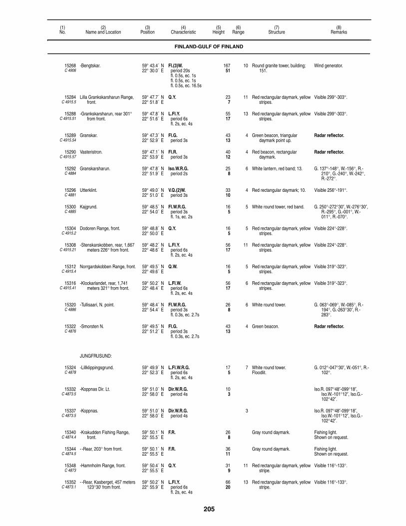
205
(1)No.
(2)Name and Location
(3)Position
(4)Characteristic
(5)Height
(6)Range
(7)Structure
(8)Remarks
15268C 4906
-Bengtskar. 59° 43.4´ N22° 30.0´ E
Fl.(3)W.period 20sfl. 0.5s, ec. 1sfl. 0.5s, ec. 1sfl. 0.5s, ec. 16.5s
16751
10 Round granite tower, building; 151.
Wind generator.
15284C 4915.5
Lilla Grankskarsharun Range, front.
59° 47.7´ N22° 51.8´ E
Q.Y. 237
11 Red rectangular daymark, yellow stripes.
Visible 299°-303°.
15288C 4915.51
-Grankskarsharun, rear 301° from front.
59° 47.8´ N22° 51.6´ E
L.Fl.Y.period 6sfl. 2s, ec. 4s
5517
13 Red rectangular daymark, yellow stripes.
Visible 299°-303°.
15289C 4915.54
Granskar. 59° 47.3´ N22° 52.9´ E
Fl.G.period 3s
4313
4 Green beacon, triangular daymark point up.
Radar reflector.
15290C 4915.57
Vasteristron. 59° 47.1´ N22° 53.9´ E
Fl.R.period 3s
4012
4 Red beacon, rectangular daymark.
Radar reflector.
15292C 4884
Granskarsharun. 59° 47.8´ N22° 51.9´ E
Iso.W.R.G.period 2s
258
6 White lantern, red band; 13. G. 137°-148°, W.-156°, R.-210°, G.-240°, W.-242°, R.-272°.
15296C 4881
Utterklint. 59° 49.0´ N22° 51.0´ E
V.Q.(2)W.period 3s
3310
4 Red rectangular daymark; 10. Visible 256°-191°.
15300C 4885
Kajgrund. 59° 48.5´ N22° 54.0´ E
Fl.W.R.G.period 3sfl. 1s, ec. 2s
165
5 White round tower, red band. G. 250°-272°30′, W.-276°30′, R.-295°, G.-001°, W.-011°, R.-070°.
15304C 4915.2
Dodoren Range, front. 59° 48.8´ N22° 50.0´ E
Q.Y. 165
5 Red rectangular daymark, yellow stripes.
Visible 224°-228°.
15308C 4915.21
-Stenskarskobben, rear, 1,667 meters 226° from front.
59° 48.2´ N22° 48.6´ E
L.Fl.Y.period 6sfl. 2s, ec. 4s
5617
11 Red rectangular daymark, yellow stripes.
Visible 224°-228°.
15312C 4915.4
Norrgardskobben Range, front. 59° 49.5´ N22° 49.6´ E
Q.W. 165
5 Red rectangular daymark, yellow stripes.
Visible 319°-323°.
15316C 4915.41
-Klockarlandet, rear, 1,741 meters 321° from front.
59° 50.2´ N22° 48.4´ E
L.Fl.W.period 6sfl. 2s, ec. 4s
5617
6 Red rectangular daymark, yellow stripes.
Visible 319°-323°.
15320C 4886
-Tullisaari, N. point. 59° 48.4´ N22° 54.4´ E
Fl.W.R.G.period 3sfl. 0.3s, ec. 2.7s
268
6 White round tower. G. 063°-069°, W.-085°, R.-194°, G.-263°30′, R.-283°.
15322C 4876
-Smorsten N. 59° 49.5´ N22° 51.2´ E
Fl.G.period 3sfl. 0.3s, ec. 2.7s
4313
4 Green beacon. Radar reflector.
JUNGFRUSUND:
15324C 4878
-Lillklippingsgrund. 59° 49.9´ N22° 52.3´ E
L.Fl.W.R.G.period 6sfl. 2s, ec. 4s
175
7 White round tower.Floodlit.
G. 012°-047°30′, W.-051°, R.-102°.
15332C 4873.5
-Koppnas Dir. Lt. 59° 51.0´ N22° 58.0´ E
Dir.W.R.G.period 4s
103
Iso.R. 097°48′-099°18′, Iso.W.-101°12′, Iso.G.-102°42′.
15337C 4873.5
-Koppnas. 59° 51.0´ N22° 58.0´ E
Dir.W.R.G.period 4s
3 Iso.R. 097°48′-099°18′, Iso.W.-101°12′, Iso.G.-102°42′.
15340C 4874.4
-Krakudden Fishing Range, front.
59° 50.1´ N22° 55.5´ E
F.R. 268
Gray round daymark. Fishing light.Shown on request.
15344C 4874.5
- -Rear, 203° from front. 59° 50.1´ N22° 55.5´ E
F.R. 3611
Gray round daymark. Fishing light.Shown on request.
15348C 4873
-Hamnholm Range, front. 59° 50.4´ N22° 55.5´ E
Q.Y. 319
11 Red rectangular daymark, yellow stripe.
Visible 116°-133°.
15352C 4873.1
- -Rear, Kasberget, 457 meters 123°30' from front.
59° 50.2´ N22° 55.9´ E
L.Fl.Y.period 6sfl. 2s, ec. 4s
6620
13 Red rectangular daymark, yellow stripe.
Visible 116°-133°.
FINLAND-GULF OF FINLAND

206
(1)No.
(2)Name and Location
(3)Position
(4)Characteristic
(5)Height
(6)Range
(7)Structure
(8)Remarks
15356C 4874
-Valnas Range, front. 59° 50.3´ N22° 55.9´ E
F.R. 237
Gray round daymark. Fishing light.Shown on request.
15360C 4874.1
- -Rear, 131° from front. 59° 50.3´ N22° 55.9´ E
F.R. 3310
Gray round daymark. Fishing light.Shown on request.
15364C 4872
-Flackgrund Range, front. 59° 52.4´ N22° 50.2´ E
Q.(2)W.R.G.period 3s
206
9 Red rectangular daymark, yellow stripe.
G. 270°-307°, W.-314°, R.-020°, G.-112°, W.-115°, R.-119°, G.-170°, R.-270°.
15368C 4872.1
- -Rear, 113°54′ from front, on islet.
59° 51.6´ N22° 53.9´ E
L.Fl.W.period 6sfl. 2s, ec. 4s
8526
9 Red rectangular daymark, white stripe.
Visible 111°24′-115°24′.
15372C 4871
-Maltskar Range, front. 59° 51.4´ N22° 47.1´ E
Q.W. 268
4 Red rectangular daymark, yellow stripe.
Visible 200°06′-208°06′.
15376C 4871.1
- -Rear, about 1,296 meters 204°06′ from front.
59° 50.8´ N22° 46.5´ E
L.Fl.W.period 6sfl. 2s, ec. 4s
6921
5 Red rectangular daymark, yellow stripe.
Visible 200°06′-208°06′.
15384C 4869
-Stubbkal. 59° 56.7´ N22° 48.2´ E
Fl.W.R.G.period 5sfl. 0.5s, ec. 4.5s
3912
7 White round tower, black stripe;13.
G. 166°30′-177°′, W.-179°, R.-346°30′.
15388C 4868.5
-Lerharu. 59° 54.8´ N22° 39.6´ E
Fl.W.R.G.period 3s
3912
7 White metal framework tower, red top.
G. 255°30′-293°, W.-294°30′, R.-005°30′, G.-100°30′, W.-102°, R-119°30′.
Radar reflector.
15392C 4868
-Galtarna. 59° 55.0´ N22° 36.4´ E
V.Q.(5)Y.period 6s
268
3 White round tower. Radar reflector.
15396C 4866
-Matlosharun Range, common front.
59° 55.4´ N22° 34.6´ E
Q.Y. 4012
3 Red rectangular daymark, yellow stripe.
Visible 062°30′-070°30′.
Q.W. 3310
4 Visible 285°12′-293°12′.
15398C 4865.9
- -Rear, 066°30′ from common front.
59° 56.0´ N22° 37.2´ E
L.Fl.Y.period 6sfl. 2s, ec. 4s
10532
5 Red rectangular daymark, yellow stripe.
Visible 062°30′-070°30′.
15400C 4866.1
- -Rear, 289°12′ from common front.
59° 55.8´ N22° 32.8´ E
L.Fl.W.period 6sfl. 2s, ec. 4s
11034
8 Red rectangular daymark, yellow stripe.
Visible 287°12′-291°12′.
15404C 4867
-Flackskarsgrund Range, front. 59° 55.4´ N22° 37.7´ E
Q.W. 258
5 Red rectangular daymark, yellow stripe.
Visible 079°-087°.
15408C 4867.1
- -Rear, 082°54′ from front. 59° 55.4´ N22° 38.4´ E
L.Fl.W.period 6sfl. 2s, ec. 4s
5216
5 Red rectangular daymark, yellow stripe in center.
Visible 079°-087°.
15412C 4861
-Idskar. 59° 54.9´ N22° 31.9´ E
V.Q.(5)R.period 6s
237
3 White lantern.
15416C 4864
-Killingskar Range, common front.
59° 55.0´ N22° 31.9´ E
Q.W. 3912
4 Red rectangular daymark, yellow stripe in center.
Visible 050°12′-058°12′and 258°54′-266°54′.
15418C 4863.9
- -Rear, 054°12′ from common front.
59° 55.2´ N22° 32.6´ E
L.Fl.W.period 6sfl. 2s, ec. 4s
9529
5 Red rectangular daymark, yellow stripe.
Visible 050°12′-058°12′.
15420C 4864.1
- -Rear, 262°54′ from common front.
59° 55.0´ N22° 31.3´ E
L.Fl.W.period 6sfl. 2s, ec. 4s
7222
5 Red rectangular daymark, yellow stripe.
Visible 258°54′-266°54′.
15432C 4865
-Batskar Range, front. 59° 54.3´ N22° 29.6´ E
Q.Y. 124
3 Red rectangular daymark, yellow stripe.
Visible 242°30′-250°30′.
15436C 4865.1
- -Rear, 246°30′ from front. 59° 54.2´ N22° 29.1´ E
L.Fl.Y.period 6sfl. 2s, ec. 4s
3611
4 Red rectangular daymark, yellow stripe.
Visible 242°30′-250°30′.
15448C 4862
-Idskarskubb. 59° 54.9´ N22° 32.3´ E
V.Q.(5)G.period 6s
206
2 White round tower, black band. Radar reflector.
FINLAND-GULF OF FINLAND

207
(1)No.
(2)Name and Location
(3)Position
(4)Characteristic
(5)Height
(6)Range
(7)Structure
(8)Remarks
15452C 4860
-Jarngrynnan. 59° 53.7´ N22° 27.8´ E
V.Q.(5)Y.period 6s
268
3 White concrete hut, red band. Radar reflector.
15456C 4858
-Fungskar Range, front. 59° 53.8´ N22° 25.8´ E
Q.W. 5216
4 Red rectangular daymark, yellow stripe.
Visible 144°-152°.
15460C 4858.1
- -Rear, 148° from front. 59° 53.6´ N22° 26.0´ E
L.Fl.W.period 6sfl. 2s, ec. 4s
8526
5 Steel mast, red rectangular daymark, yellow stripe.
Visible 144°-152°.
15464C 4856
-Pervetsgrund (Pervittenskar) Range, front.
59° 54.3´ N22° 24.9´ E
Q.W. 237
3 Yellow rectangular daymark, red stripe.
Visible 285°-317°.
15468C 4856.1
- -Aggaskar, rear, 301° from front.
59° 54.4´ N22° 24.4´ E
L.Fl.W.period 6sfl. 2s, ec. 4s
3611
3 Yellow rectangular daymark, red stripe.
Visible 285°-317°.
15470C 4855
-Kalholm. 59° 55.2´ N22° 23.6´ E
V.Q.(2)W.R.G.period 3s
237
6 Red rectangular daymark. G. 092°-170°, W.-171°30′, R.-271°.
15472C 4854
-Onholm, S. side. 59° 56.1´ N22° 22.9´ E
Fl.W.R.G.period 2sfl. 0.2s, ec. 1.8s
268
6 Red rectangular daymark. G. 295°30′-325°30′, W.-328°30′, R.-341°.
15476C 4852
-Kuggor, W. side. 59° 58.0´ N22° 23.0´ E
V.Q.(5)Y.period 6s
103
4 Rectangular fiberglass daymark.
15480C 4746.8
-Hallsten. 59° 53.0´ N22° 25.1´ E
V.Q.(2)W.R.G.period 3s
237
W. 5 Red round tower, white top. R. 202°-236°, G.-027°, W.-029°, R.-110°.
Radar reflector.
15484C 4863
-Hamnholmarna Range, front. 59° 52.8´ N22° 24.4´ E
Q.W. 237
3 Red rectangular daymark, yellow stripe.
Visible 244°30′-276°30′.
15488C 4863.1
- -Rear, 260°30′ from front. 59° 52.7´ N22° 23.5´ E
L.Fl.W.period 6sfl. 2s, ec. 4s
4614
3 Red rectangular daymark, yellow stripe.
Visible 244°30′-276°30′.
15492C 4863.5
-Kalvholm Range, front. 59° 52.4´ N22° 24.7´ E
Q.W. 309
4 Red rectangular daymark, yellow stripe.
Visible 230°12′-238°12′.
15496C 4863.51
- -Rear, 234°12′ from front. 59° 52.2´ N22° 24.1´ E
L.Fl.W.period 6sfl. 2s, ec. 4s
5918
5 Red rectangular daymark, yellow stripe.
Visible 230°12′-238°12′.
15500C 4746
Angskar Range, front. 59° 53.4´ N22° 22.5´ E
Fl.W.period 2sfl. 0.3s, ec. 1.7s
309
10 Red rectangular daymark, yellow stripe.
Visible 086°30′-090°30′.
15504C 4746.1
-Rear, 088°30′ from front. 59° 53.4´ N22° 24.1´ E
L.Fl.W.period 8sfl. 2s, ec. 6s
10833
11 Red rectangular daymark, yellow stripe.
Visible 086°30′-090°30′.
15508C 4746.2
Fjardskar, bank S. of Fjardskar. 59° 53.2´ N22° 23.3´ E
Fl.W.R.G.period 3sfl. 0.3s, ec. 2.7s
175
5 Red round tower, white band. G. 272°30′-288°, W.-294°, R.-013°, G.-097°, W.-105°, R.-120°30′.
15509C 4745.74
Hemoren. 59° 53.0´ N22° 13.6´ E
Fl.G.period 3sfl. 0.3s, ec. 2.7s
237
3 Green beacon.
15510C 4745.76
Tjuforn. 59° 54.2´ N22° 13.0´ E
Fl.G.period 3sfl. 0.3s, ec. 2.7s
237
3 Green beacon.
15512C 4745.8
Vitgrund Range, front. 59° 53.6´ N22° 20.0´ E
Q.W. 165
4 Red rectangular daymark, yellow stripe.
Visible 282°12′-290°12′.
15516C 4745.81
-Rear, 286°12′ from front. 59° 53.7´ N22° 19.0´ E
L.Fl.W.period 6sfl. 2s, ec. 4s
5216
5 Red rectangular daymark, yellow stripe.
Visible 282°12′-290°12′.
15520C 4745.6
Laderklobb Range, front. 59° 54.0´ N22° 10.0´ E
Q.Y. 237
8 Red rectangular daymark, yellow stripe.
Visible 077°-081°.
15524C 4745.61
-Rear, 079° from front. 59° 53.8´ N22° 11.4´ E
L.Fl.Y.period 6sfl. 2s, ec. 4s
9629
9 Red rectangular daymark, yellow stripe.
Visible 077°-081°.
FINLAND-GULF OF FINLAND

208
(1)No.
(2)Name and Location
(3)Position
(4)Characteristic
(5)Height
(6)Range
(7)Structure
(8)Remarks
15525C 4744.23
Korpskar Range, front. 59° 51.8´ N21° 41.0´ E
Q.W. 4213
9 Red rectangular daymark, yellow stripe.
Visible 077°30'-085°30'.
15525.1C 4744.24
-Rear, 081°42′ from light. 59° 52.1´ N21° 44.5´ E
L.Fl.W.period 6s
9128
10 Red rectangular daymark, yellow stripe.
Visible 077°30′-085°30′.
FINLAND-AHVENANMAA (ALAND ISLANDS)
15780C 4732
Lillharun. 59° 43.7´ N21° 24.0´ E
Fl.W.R.G.period 7s
5517
10 Black round tower, white top; 39. G. 262°-340°, W.-045°, R.-101°, G.-148°, W.-156°, R.-172°.
Radar reflector.
RACON T(–) 11 (3 & 10cm).
UTO:
15800C 4736
Uto. 59° 46.9´ N21° 22.1´ E
Fl.(2)W.period 12sfl. 0.3s, ec. 3.2sfl. 0.3s, ec. 8.2s
13040
18 White square granite tower, red stripes; 79.
Visible 235°-100°.Pilot station.
F.W. 12538
10 Visible 163°-253°.
15804C 4725
Kokarsoren. 59° 46.1´ N21° 01.1´ E
Fl.W.period 5sfl. 0.5s, ec. 4.5s
7824
9 Red rectangular daymark.
15808C 4734
-Approaching Range, front. 59° 46.9´ N21° 21.5´ E
Q.Y. 4915
11 Red rectangular daymark, yellow stripe.
Visible 000°-019°.
Q.W.R.G.Y. 4313
W. 8R. 2G. 2Y. 4
Y. 335°-090°, G.-156°, W.-165°30′, R.-176°, G.-242°.
15812C 4734.1
- -Rear, 630 meters 009°36′ from front.
59° 47.3´ N21° 21.6´ E
Iso.Y.period 6s
8526
12 Red rectangular daymark, yellow stripe.
Visible 000°-019°.
FINLAND-GULF OF FINLAND
15813C 4738
Enskar Harbor. 59° 47.2´ N21° 22.0´ E
Q.W.R.G. 103
W. 5R. 1G. 1
Gray mast. G. 040°-058°, W.-064°, R.-108°, G.-134°, W.-141°, R.-195°, G.-220°, W.-288°.
FINLAND-AHVENANMAA (ALAND ISLANDS)
15852C 4739
Skataskar Range, front. 59° 50.8´ N21° 19.6´ E
Q.W. 4614
7 Red rectangular daymark, white stripe.
Visible 347°30′-355°30′.
15856C 4739.1
-Rear, 365 meters 351°30′ from front.
59° 51.2´ N21° 19.4´ E
L.Fl.W.period 8sfl. 2s, ec. 6s
10231
7 Red rectangular daymark, white stripe.
Visible 347°30′-355°30′.
15860C 4743.2
Bokullankivi. 59° 50.8´ N21° 25.1´ E
Fl.W.R.G.period 5sfl. 0.5s, ec. 4.5s
309
W. 9R. 2G. 2
White tower, black band; 13. G. 009°-050°, W.-054°, R.-165°, G.-232°30′, W.-236°30′, R.-009°.
Wind generator.
RACON T(–) 11 (3cm).
FINLAND-GULF OF FINLAND

209
(1)No.
(2)Name and Location
(3)Position
(4)Characteristic
(5)Height
(6)Range
(7)Structure
(8)Remarks
16092C 4486
Bogskar, on W. rock. 59° 30.3´ N20° 20.9´ E
Fl.(3)W.period 20sfl. 1s, ec. 2sfl. 1s, ec. 2sfl. 1s, ec. 13s
9128
9 White round tower, blue band, lantern; 75.
Helicopter platform.
RACON T(–) 13 (3 & 10cm).
16094C 4487
Suomen Leijona. 59° 28.4´ N20° 48.8´ E
Fl.(2)W.period 12sfl. 0.4s, ec. 1.6sfl. 0.4s, ec. 9.6s
4413
9 White tower, orange band. Wind generator.Radar reflector.
RACON T(–) 11 (3 & 10cm).
16096C 4480
Lagskar, N. point. 59° 50.5´ N19° 54.7´ E
Fl.W.period 12sfl. 1.5s, ec. 10.5s
13842
11 Red square tower; 108.
16100C 4482
Flothan (Flotjan). 59° 48.5´ N19° 46.9´ E
Fl.(2)W.period 20sfl. 1.5s, ec. 2sfl. 1.5s, ec. 15s
8526
10 Red tower, white stripe; 72.
RACON T(–) 13 (3 & 10cm).
16106C 4485
Salkobb. 59° 54.2´ N20° 04.7´ E
Fl.W.R.G.period 5sfl. 0.5s, ec. 4.5s
3611
4 Red rectangular daymark. W. 003°-022°, R.-090°, G.-166°, W.-178°, R.-270°, G.-320°, W.-328°, R.-337°, G.-003°.
Shown on request.
16144C 4542
Ledskar, N. point. 59° 58.0´ N20° 10.0´ E
Q.(2)W.R.G.period 5s
309
8 White round tower. G. 080°-095°, W.-105°30′, R.-120°, G.-177°, R.-217° G.-254°, W.-260°, R.-275°.
16158C 4546
Fastorna. 59° 51.4´ N20° 20.6´ E
Fl.W.R.G.period 5sfl. 0.5s, ec. 4.5s
6219
7 Red truncated wooden tower. G. 193°-234°, W.-244°, R.-303°, G.-333°, W.-037°, R.-074°, G.-090°, W.-103°, R.-120°, G.-164°, W.-180°, R.-193°.
Fishing light.Shown on request.
RACON T(–) 11 (3 & 10cm).
16476C 4626
Kalkskarskobb. 60° 00.3´ N21° 04.7´ E
Fl.(4)W.R.G.period 10sfl. 1s, ec. 1sfl. 1s, ec. 1sfl. 1s, ec. 1sfl. 1s, ec. 3s
7222
W. 10R. 1G. 1
Red rectangular daymark, white band; 46.
R. 309°-081°, G.-145°, W.-155°, R.-185°, G.-222°, W.-227°, R.-289°, G.-306°, W.-309°.
Radar reflector.
RACON T(–) 10 (3 & 10cm).
16480C 4630
Kihti. 60° 04.6´ N21° 08.3´ E
Q.(3)W.R.G.period 10s
3611
9 Black round tower, white top; 36. G. 083°-092°, W.-095°, R.-173°, G.-239°, W.-244°, R.-268°.
RACON T(–) 12 (3cm).
16744C 4496
-Korso Range, SW. point of Yttre Korso, common front.
60° 02.0´ N19° 54.0´ E
Iso.W.R.G.period 2s
237
W. 9R. 2G. 2
Yellow rectangular daymark, red stripe; 10.
G. 318°-003°, W.-009°, R.-032°30′, G.-062°30′, W.-075°, R.-179°30′.
-RACON T(–) 8 (3 & 10cm).
16748C 4496.1
- -Rear, 180 meters 066° from common front.
60° 02.4´ N19° 54.2´ E
L.Fl.W.period 6sfl. 2s, ec. 4s
5617
8 Yellow rectangular daymark, red stripe.
Visible 062°-070°.
16752C 4495.9
- -Rear, 100 meters 051°30′ from common front.
60° 02.4´ N19° 54.1´ E
L.Fl.G.period 6sfl. 2s, ec. 4s
6921
11 Yellow rectangular daymark, red stripe.
Visible 045°30′-057°30′.
16756C 4494
Tvibenan, E. side. 60° 02.0´ N19° 53.0´ E
Q.W.R.G. 206
W. 4R. 1G. 1
White rectangular daymark. G. 184°-210°, W.-213°, R.-273°30′, G.-330°, W.-341°30′, R.-070°.
FINLAND-AHVENANMAA (ALAND ISLANDS)

210
(1)No.
(2)Name and Location
(3)Position
(4)Characteristic
(5)Height
(6)Range
(7)Structure
(8)Remarks
16760C 4490
Marhallan. 60° 01.8´ N19° 52.3´ E
Q.(3)W.R.G.period 6s
4915
W. 10R. 2G. 2
Red round tower, black band. W. 007°-120°, R.-175°, G.-219°, W.-244°, R.-333°, G.-007°.
Radar reflector.
16770C 4479
Utbadan. 60° 05.0´ N19° 42.4´ E
Fl.W.period 3sfl. 0.2s, ec. 2.8s
278
4 White beacon, orange band; 20. Radar reflector.
16774C 4473.5
Solovjeva. 60° 11.2´ N19° 10.3´ E
V.Q.(4)W.period 8s
4614
6 White mast, red band; 66. Radar reflector.
16788C 4478
Tollingbadan. 60° 11.3´ N19° 27.1´ E
Q.(2)W.R.G.period 5s
268
6 Orange round tower. W. 320°-055°, R.-088°, G.-106°, W.-109°, R.-140°, G.-179°, W.-182°30′, R.-195°, G.-205°, W.-234°, R.-307°, G.-320°.
16792C 4472
Market. 60° 18.1´ N19° 07.9´ E
Fl.W.period 5sfl. 0.4s, ec. 4.6s
5216
9 White rectangular daymark, red band.
16796C 4468
Adskar. 60° 21.0´ N19° 31.0´ E
Fl.W.R.G.period 3sfl. 0.3s, ec. 2.7s
3310
5 G. 090°-170°, W.-178°, R.-270°, G.-005°, W.-009°, R.-090°.
Shown on request.Fishing light.
16800C 4466
Sodra Salskar, W. side of S. islet.
60° 24.7´ N19° 35.6´ E
Fl.(2)W.period 12sfl. 1s, ec. 2sfl. 1s, ec. 8s
14544
12 White round brick tower; 105.
16808C 4465.4
Kallan. 60° 27.0´ N19° 44.4´ E
Fl.W.R.G.period 3sfl. 0.3s, ec. 2.7s
268
4 White round beacon. W. 117°30′-148°30′, R.-178°30′, G.-199°, W.-216°, R.-349°, G.-117°30′.
Fishing light.Shown on request.
16812C 4465
Koksnan. 60° 28.1´ N19° 56.2´ E
Fl.W.period 5sfl. 0.4s, ec. 4.6s
5617
6 White beacon, red band.
16814C 4464.4
Ranno. 60° 31.7´ N20° 11.9´ E
Q.(2)W.period 5s
6620
5 Red beacon. Fishing light.Shown on request.
RACON T(–) 13 (3cm).
16948C 4462.6
Inre Bredan. 60° 34.6´ N20° 42.9´ E
Fl.W.R.G.period 3sfl. 0.3s, ec. 2.7s
3310
5 White round tower. W. 169°-179°, R.-256°, G.-325°, W.-330°, R.-354°, G.-169°.
Fishing light.Shown on request.
16952C 4450.4
Sandbacks Sodra, on Sandbacks Norra.
60° 45.8´ N20° 44.3´ E
Fl.(3)W.period 10sfl. 0.5s, ec. 1sfl. 0.5s, ec. 1sfl. 0.5s, ec. 6.5s
4213
10 Orange round tower.Helicopter platform.
RACON T(–) 10 (3 & 10cm).
FINLAND-AHVENANMAA (ALAND ISLANDS)

211
(1)No.
(2)Name and Location
(3)Position
(4)Characteristic
(5)Height
(6)Range
(7)Structure
(8)Remarks
Section 10Gulf of Bothnia - West Coast of Finland
FINLAND-GULF OF BOTHNIA
16956C 4453.3
Ljungbergsinkivi. 60° 43.0´ N20° 56.0´ E
V.Q.W. 4112
3 N. CARDINALBY, mast, topmark.
16960C 4453.4
Isokari W. 60° 43.3´ N20° 58.5´ E
V.Q.(5)Y.period 6s
4112
2 White metal mast, red top. Radar reflector.
16967C 4449.9
Isokari Range, front. 60° 42.5´ N21° 01.1´ E
Q.W. 4614
7 Red rectangular daymark, yellow stripe.
Visible 339°48′-343°48′.
16968C 4450
-Isokari, rear, 370 meters 341°48′ from front.
60° 43.1´ N21° 00.6´ E
L.Fl.W.period 20sfl. 2.3s, ec. 17.7s
16249
19 White round tower, red bands; 122.
Pilot station.
16972C 4453
Keskikallio. 60° 41.6´ N21° 03.4´ E
V.Q.(4)W.R.G.period 6s
7021
7 White concrete tower, black top; 49.
G. 099°-115°42′, W.-116°42′, R.-292°, G.-300°, W.-302°, R.-311°.
16984C 4454
Iso Hauteri Range, front. 60° 39.8´ N21° 04.1´ E
Fl.W.period 2sfl. 0.3s, ec. 1.7s
3711
10 Red rectangular daymark, white stripe.
Visible 132°30′-136°30′.
16988C 4454.1
-Vaha Hauteri, rear, 1,611 meters 134°06′ from front.
60° 39.2´ N21° 05.4´ E
L.Fl.W.period 8sfl. 2s, ec. 6s
6018
11 Red rectangular daymark, white stripe.
Visible 132°30′-136°30′.
17000C 4680.6
Katanpaa Range, front. 60° 36.8´ N21° 09.8´ E
Q.W. 3410
5 Red rectanglular daymark, yellow stripe.
Visible 180°54′-188°54′.
17000.1C 4680.61
-Rear, 184°54′ from front. 60° 36.6´ N21° 09.8´ E
L.Fl.W.period 6sfl. 2s, ec. 4s
6720
6 Red rectangular daymark, yellow stripe.
Visible 180°54′-188°54′.
17192C 4447.6
Sammo Range, front. 60° 50.0´ N21° 07.0´ E
Q.W. 113
5 Red rectangular daymark, yellow stripe.
Visible 341°36′-349°36′.
17196C 4447.61
-Rear, 2,500 meters 345°36′ from front.
60° 51.1´ N21° 06.0´ E
L.Fl.W.period 6sfl. 2s, ec. 4s
5918
6 Red rectangular daymark, yellow stripe.
Visible 341°36′-349°36′.Same structure as Sammo
light.
UUSUIKAUPUNKI APPROACH:
17208C 4457.7
-Vilissalo Range, front. 60° 48.0´ N21° 23.0´ E
Q.W. 196
10 Yellow rectangular daymark, red stripe.
Visible 049°-069°.
17212C 4457.71
- -Rear, 059° from front. 60° 47.7´ N21° 23.7´ E
L.Fl.W.period 6sfl. 2s, ec. 4s
4915
13 Yellow rectangular daymark, red stripe.
Visible 049°-069°.
17224C 4445.5
Nurminen. 60° 53.0´ N21° 10.0´ E
Q.W. 309
6 Yellow rectangular daymark, red stripe.
Visible 172°-176°.
17246C 4444.3
-Santakarinluoto Range, front. 60° 57.3´ N21° 08.3´ E
Q.Y. 268
4 Red rectangular daymark, yellow stripe.
Visible 193°54′-201°54′.
17246.1C 4444.31
- -Rear, 197°54′ from front. 60° 56.6´ N21° 07.8´ E
L.Fl.Y.period 6sfl. 2s, ec. 4s
5216
5 Red rectangular daymark, yellow stripe.
Visible 193°54′-201°54′.
17248C 4445
Hylkkari. 60° 57.3´ N21° 09.5´ E
Q.(2)W.R.G.period 6s
268
W. 6 Red round concrete tower, white band.
G. 334°-356°, W.-009°, R.-111°, G.-134°, W.-147°, R.-173°.
17252C 4440
Kajakulma. 60° 59.9´ N21° 10.8´ E
Fl.W.R.G.period 2sfl. 0.3s, ec. 1.7s
309
W. 7R. 1G. 1
Red rectangular daymark, yellow stripe; 26.
R. 061°-097°, G.-125°, W.-137°, R.-178°, G.-191°, G. 242°-280°, W.-282°, R.-284°.
Radar reflector.
RACON T(–) 11 (3cm).

212
(1)No.
(2)Name and Location
(3)Position
(4)Characteristic
(5)Height
(6)Range
(7)Structure
(8)Remarks
RAUMA:
17268C 4417
-Main. 61° 09.0´ N21° 09.6´ E
Fl.(2)W.period 10sfl. 1s, ec. 2sfl. 1s, ec. 6s
7222
8 White tower, red top.Helicopter platform.
-RACON T(–) 12 (3 & 10cm).
-Nine Meter Channel:
17272C 4418
- -Rihtniemi Range, front. 61° 05.6´ N21° 16.9´ E
Iso.W.period 4s
4514
9 Red rectangular daymark, yellow stripe.
Visible 115°06′-123°06′.Range 12M shown in fog.
17276C 4418.1
- - -Rear, 119°06′ from front. 61° 05.3´ N21° 18.2´ E
Iso.W.period 12s
8526
9 Red rectangular daymark, yellow stripe.
Visible 115°06′-123°06′.Range 14M shown in fog.Synchronized with front.
17280C 4418.3
- -Urmluoto Range, front. 61° 05.2´ N21° 21.1´ E
Iso.W.period 2s
5818
8 Red rectangular daymark, yellow field.
Visible 106°24′-114°24′.Range 13M shown in fog.
17284C 4418.31
- - -Rear, 110°24′ from front. 61° 05.0´ N21° 22.3´ E
Iso.W.period 6s
11034
8 Red rectangular daymark, yellow stripe.
Visible 106°24′-114°24′.Range 14M shown in fog.Synchronized with front.
17288C 4418.5
- -No 1. 61° 06.2´ N21° 16.0´ E
Fl.R.period 3sfl. 0.3s, ec. 2.7s
4313
4 PORT (A)R, mast, topmark.
17296C 4418.7
- -No 3. 61° 06.0´ N21° 17.0´ E
Fl.R.period 3sfl. 0.5s, ec. 2.5s
3912
3 PORT (A)R, mast, topmark.
Range 5M shown in fog.
17304C 4418.9
- -No 5. 61° 05.8´ N21° 17.9´ E
Fl.R.period 3sfl. 0.5s, ec. 2.5s
3912
4 PORT (A)R, mast, topmark.
Range 5M shown in fog.
17308C 4419
- -Iso Jarviluoto Range, front. 61° 07.1´ N21° 25.8´ E
Iso.G.period 2s
4313
3 Red rectangular daymark, yellow stripe.
Visible 064°30′-072°30′.Range 10M shown in fog.
17312C 4419.1
- - -Rear, 1100 meters 068°30′ from front.
61° 07.3´ N21° 26.9´ E
Iso.G.period 6s
13541
10 Red rectangular daymark, yellow stripe.
Visible 064°30′-072°30′.
17316C 4419.3
- -No 6. 61° 05.8´ N21° 19.3´ E
Fl.G.period 3sfl. 0.5s, ec. 2.5s
3912
3 STARBOARD (A)G, mast, topmark.
Range 5M shown in fog.
17320C 4419.4
- -No 8. 61° 06.2´ N21° 21.1´ E
Fl.G.period 3sfl. 0.5s, ec. 2.5s
3912
3 STARBOARD (A)G, mast, topmark.
Range 5M shown in fog.
17321C 4419.7
-Hakuni Range, front. 61° 07.6´ N21° 25.8´ E
Iso.W.period 2s
6219
6 Gray beacon. Visible 024°-054°.Range 11M shown in fog.
17321.1C 4419.71
- -Rear, 039° from front. 61° 07.9´ N21° 26.3´ E
Iso.W.period 6s
8225
7 Gray beacon. Visible 024°-054°.Synchronized with front.Range 11M shown in fog.
17321.5C 4419.2
-Metsa-Rauma Range, front. 61° 06.9´ N21° 27.3´ E
Q.R. 4313
6 Red rectangular daymark, yellow stripe.
Visible 082°30′-090°30′.
17321.51C 4419.21
- -Rear, 230 meters 086°30′ from front.
61° 06.9´ N21° 27.6´ E
L.Fl.R.period 6sfl. 2s, ec. 4s
6520
6 Red rectangular daymark, yellow stripe.
Visible 082°30′-090°30′.
17324C 4421.6
-Kalapuda. 61° 08.0´ N21° 16.3´ E
Q.(5)Y.period 6s
3912
2 White pillar, red band. Radar reflector.
17328C 4421
-Kylmapihlaja. 61° 08.7´ N21° 18.2´ E
Fl.(4)W.period 45sfl. 1s, ec. 3.5sfl. 1s, ec. 3.5sfl. 1s, ec. 3.5sfl. 1s, ec. 30.5s
11836
17 White tower, red top; 105. Radar reflector.
17329C 4421.4
- -Range, front. 61° 08.6´ N21° 18.5´ E
Q.W. 134
2 White rectangular daymark, red stripe.
FINLAND-GULF OF BOTHNIA

213
(1)No.
(2)Name and Location
(3)Position
(4)Characteristic
(5)Height
(6)Range
(7)Structure
(8)Remarks
17329.1C 4421.41
- - -Rear, 207° from front. 61° 08.5´ N21° 18.4´ E
Iso.W.R.G.period 3s
309
3 Red rectangular daymark, white stripe.
G. 028°-072°, W.-315°, R.-028°.
17330C 4421.5
- -Range, front. 61° 08.6´ N21° 18.1´ E
Q.W. 237
6 Red rectangular daymark, yellow stripe.
Visible 059°30′-067°30′.
17330.1C 4421.51
- - -Rear, 063°18′ from front. 61° 08.7´ N21° 18.3´ E
Q.W. 4614
6 Red rectangular daymark, yellow stripe.
Visible 059°18′-067°18′.Synchronized with front.
17344C 4421.7
-Kloppi. 61° 08.8´ N21° 18.9´ E
Fl.W.R.G.period 2sfl. 0.2s, ec. 1.8s
268
5 White rectangular daymark; 20. G. 046°-007°, W.-015°, R.-046°.
17346C 4421.8
-Katavalouttu Range, front. 61° 08.3´ N21° 19.5´ E
Q.W. 268
3 Yellow rectangular daymark, red stripe.
Visible 091°30′-121°30′.
17346.1C 4421.81
- -Rear, 106°30′ from front. 61° 08.2´ N21° 19.7´ E
L.Fl.W.period 6s
4313
4 Yellow rectangular daymark, red stripe.
Visible 091°30′-121°30′.
17352C 4425
-Pihlus Range, front. 61° 10.5´ N21° 21.0´ E
Q.W. 278
3 White rectangular daymark, red stripe; 10.
Visible 317°-349°.
17356C 4425.1
- -Rear, 332°48′ from front. 61° 10.6´ N21° 20.9´ E
L.Fl.W.period 6s
4915
3 Red rectangular daymark, yellow stripe; 39.
Visible 317°-349°.
17358c 4437
-Pajukari Range, front. 61° 08.1´ N21° 23.5´ E
Q.W. 3812
4 White rectangular daymark, red stripe.
Visible 149°-157°.
17358.1c 4437.01
- -Rear, 152°48′ from front. 61° 07.9´ N21° 23.7´ E
L.Fl.W.period 6sfl. 2s, ec. 4s
5818
5 White rectangular daymark, red stripe.
Visible 149°-157°.
17360C 4424
-Suokari Range, front. 61° 09.7´ N21° 23.2´ E
Q.Y. 278
8 White rectangular daymark, red stripe.
Visible 098°48′-106°48′.
17364C 4424.1
- -Rear, 1482 meters 102°48′ from front.
61° 09.5´ N21° 24.8´ E
L.Fl.Y.period 8sfl. 2s, ec. 6s
7021
8 White rectangular daymark, red stripe.
Visible 098°48′-106°48′.
17368C 4430
-Valkeakari Range, front. 61° 09.5´ N21° 21.8´ E
Q.W. 165
3 Red rectangular daymark, yellow stripe.
Visible 294°-326°.
17372C 4430.1
- -Rear, on rock, 309°42′ from front.
61° 09.6´ N21° 21.7´ E
L.Fl.W.period 6sfl. 2s, ec. 4s
3310
3 Red rectangular daymark, yellow stripe.
Visible 294°-326°.
17392C 4432.3
-Petajas Range, front. 61° 08.2´ N21° 26.5´ E
Q.W. 196
8 Yellow rectangular daymark, red stripe.
Visible 098°30′-106°30′.
17396C 4432.31
- -Rear, 102°36′ from front. 61° 08.1´ N21° 26.7´ E
L.Fl.W.period 6sfl. 2s, ec. 4s
4614
8 Yellow rectangular daymark, red stripe.
Visible 098°30′-106°30′.
17406C 4434
-Satama Range, front. 61° 07.7´ N21° 27.6´ E
F.R. 6219
1 Gray beacon. Visible 337°30′-167°30′.
17406.1C 4434.1
- -Rear, 073°06′ from front. 61° 07.7´ N21° 27.9´ E
F.R. 9529
1 Gray beacon. Visible 337°30′-167°30′.
17407C 4435
-Martinkarta. 61° 07.6´ N21° 27.9´ E
F.G. 165
1 Post, green triangular daymark point up.
17436C 4406
Kalla. 61° 16.1´ N21° 21.2´ E
Fl.W.R.G.period 5sfl. 0.5s, ec. 4.5s
3410
7 Gray structure. R. 007°-036°, G.-093°, W.-184°, R.-215°, G.-252°, W.-007°.
17438C 4404
Fransinkari Range, front. 61° 21.8´ N21° 24.9´ E
Q.W. 165
4 Red rectangular daymark, white stripe.
Visible 057°-065°.
17438.1C 4404.1
-Rear, 061° from front. 61° 22.0´ N21° 25.8´ E
L.Fl.W.period 6sfl. 2s, ec. 4s
5316
5 Red rectangular daymark, white stripe.
Visible 057°-065°.
17440C 4399
Viasvesi Range, front. 61° 28.0´ N21° 33.9´ E
F.W. 206
8 White rectangular daymark, red band.
Visible 095°30′-099°30′.
17444C 4399.1
-Rear, 366 meters 097°30′ from front.
61° 27.8´ N21° 34.6´ E
F.W. 7523
8 White rectangular daymark, red band.
Visible 095°30′-099°30′.
FINLAND-GULF OF BOTHNIA

214
(1)No.
(2)Name and Location
(3)Position
(4)Characteristic
(5)Height
(6)Range
(7)Structure
(8)Remarks
17448C 4398
Sappi. 61° 28.7´ N21° 20.8´ E
Fl.(2+1)W.period 30sfl. 0.7s, ec. 3.1sfl. 0.7s, ec. 13.9sfl. 0.7s, ec. 10.9s
11435
10 White round tower; 102.
17452C 4374
Kaijakari. 61° 36.9´ N21° 21.4´ E
Fl.(2)W.period 20sfl. 0.5s, ec. 2sfl. 0.5s, ec. 17s
7523
10 White round tower, red band.
17456C 4376
Kallo Range, front. 61° 35.8´ N21° 27.5´ E
Iso.W.R.G.period 2s
4614
9 White tower. G. 106°-123°, W.-128°, R.-155°, G.-195°, W.-208°, R.-264°.
Pilot station. Radiobeacon , about 183
meters SSW.
17460C 4376.1
-Uniluoto, Pori approach, rear, 792 meters 124°54′ from front.
61° 35.4´ N21° 28.5´ E
Iso.W.period 4s
8927
5 Yellow rectangular daymark, red stripe.
Visible 108°30′-140°30′.
17462C 4382
Morris. 61° 34.8´ N21° 24.7´ E
Fl.(2)R.period 6sfl. 0.3s, ec. 1.9sfl. 0.3s, ec. 3.5s
4313
4 Red beacon. Radar reflector.
RACON T(–) 10 (3 & 10cm).
17463C 4384.5
Levo Range, front. 61° 35.3´ N21° 30.1´ E
Iso.W.period 4s
289
11 Gray square beacon. Visible 070°-074°30′.Range 7M by day, visible
067°-077°.Shown on request.
17463.1C 4384.51
-Rear, 072°36′ from front. 61° 35.4´ N21° 31.0´ E
Iso.W.period 12s
8526
14 Gray square beacon. Visible 070°30′-074°30′.Range 8M by day, visible
067°-077°.Shown on request.
17464C 4388
Vassikkaniemi (Mantyluoto) Range, front.
61° 36.0´ N21° 30.0´ E
Q.Y. 4714
5 White rectangular daymark, red field.
Visible 108°-145°.
17468C 4388.1
-Rear, 126° from front. 61° 35.6´ N21° 29.6´ E
L.Fl.Y.period 6sfl. 2s, ec. 4s
7723
5 White rectangular daymark, red stripe.
Visible 108°-145°.
17472C 4390
-Kirrinsanta Range, front. 61° 36.0´ N21° 30.0´ E
F.R. 309
2 Orange rectangular daymark.
17476C 4390.1
- -Rear, 350 meters 089° from front.
61° 35.8´ N21° 30.5´ E
F.R. 3310
2 Orange rectangular daymark.
REPOSAARI:
17480C 4378
-Rafso. 61° 36.3´ N21° 27.1´ E
Q.(4)W.R.G.period 6s
3210
9 White round tower. G. 291°-085°30′, W.-091°, R.-111°.
17484C 4394
-Commercial Harbor Range, front.
61° 37.0´ N21° 27.0´ E
F.R. 4413
1 Red rectangular daymark, yellow stripe.
Visible 215°30′-035°30′.The channel to Bjorneborg is
marked by 3 F.R. lights on the N. and E. sides, and 3 F.W. lights on the S. and W. sides.
17488C 4394.1
- -Naval Harbor, rear, on quay, 685 meters 305°30′ from front.
61° 37.1´ N21° 26.0´ E
F.R. 7723
1 Red round beacon. Visible 215°30′-035°30′.
17492C 4369
Kupeli. 61° 38.1´ N21° 19.7´ E
V.Q.(2)W.R.G.period 3sfl. 0.5s, ec. 2.5s
3611
7 White mast, orange stripe. W. 000°-090°, R.-222°, G.-246°, W.-252°, R.-324°, G.-000°.
RACON T(–) 9 (3 & 10cm).
17496C 4384
Kallo-Tiepenger Range, front. 61° 36.0´ N21° 28.0´ E
Q.W. 3210
8 Red rectangular daymark, yellow stripe.
Visible 047°30′-055°30′.
FINLAND-GULF OF BOTHNIA

215
(1)No.
(2)Name and Location
(3)Position
(4)Characteristic
(5)Height
(6)Range
(7)Structure
(8)Remarks
17500C 4384.1
-Rear, 051°18′ from front. 61° 37.0´ N21° 30.2´ E
L.Fl.W.period 6sfl. 2s, ec. 4s
9830
10 Red rectangular daymark, yellow stripe.
Visible 049°-054°.
17504C 4385
Kooshaka Range, front. 61° 37.0´ N21° 29.0´ E
Q.Y. 175
4 Red rectangular daymark, yellow stripe.
Visible 029°30′-037°30′.
17508C 4385.1
-Rear, 033°30′ from front. 61° 37.3´ N21° 29.4´ E
L.Fl.Y.period 6sfl. 2s, ec. 4s
4313
5 Red rectangular daymark, yellow stripe.
Visible 029°30′-037°30′.
17510C 4366
Tahkoluoto Range, front. 61° 38.3´ N21° 23.5´ E
Q.G. 4313
10 Red rectangular daymark, yellow stripe.
Visible 129°-138°.
17510.1C 4366.1
-Rear, 133°36′ from front. 61° 37.9´ N21° 24.4´ E
L.Fl.G.period 6s
10532
11 Red rectangular daymark, yellow stripe.
Visible 129°-138°.
17534C 4365
Porin Majakka. 61° 42.4´ N21° 13.4´ E
Fl.W.period 12sfl. 0.5s, ec. 11.5s
6219
10 Yellow structure, black top.
17544C 4356
Stakki Range, front. 61° 51.2´ N21° 18.5´ E
Q.W. 3511
5 Red rectangular daymark, yellow stripe.
Visible 076°30′-092°30′.
17548C 4356.1
-Rear, 084°30′ from front. 61° 51.3´ N21° 19.6´ E
L.Fl.W.period 6sfl. 2s, ec. 4s
5316
6 Red rectangular daymark, yellow stripe.
Visible 076°30′-092°30′.
17600C 4352
Malskeri Range, front. 61° 55.1´ N21° 20.4´ E
Q.W. 3912
6 Red rectangular daymark, yellow stripe.
Visible 024°-032°.
17604C 4352.1
-Rear, 028° from front. 61° 55.5´ N21° 20.9´ E
L.Fl.W.period 6sfl. 2s, ec. 4s
6921
7 Red rectangular daymark, yellow stripe.
Visible 024°-032°.
17608C 4350
Kasala Range, front. 61° 56.7´ N21° 20.8´ E
Q.W. 4915
10 Red rectangular daymark, yellow stripe.
Visible 086°-090°.
17610C 4350.1
-Rear, 088° from front. 61° 56.7´ N21° 21.3´ E
L.Fl.W.period 6sfl. 2s, ec. 4s
10231
10 Red rectangular daymark, yellow stripe.
Visible 086°-090°.
17612C 4351
-Merikarvia. 61° 55.8´ N21° 16.5´ E
Fl.(2)W.period 20sfl. 1.5s, ec. 2sfl. 1.5s, ec. 15s
5216
7 Red mast, white band. Radar reflector.
-RACON T(–) 10 (3 & 10cm).
17616C 4348
Yttergrund. 61° 58.8´ N21° 17.6´ E
L.Fl.(3)W.period 30sfl. 2.5s, ec. 2.5sfl. 2.5s, ec. 2.5sfl. 2.5s, ec. 17.5s
14344
16 White round tower, red top; 135. Visible 336°-180°.
17628C 4340
Sandskar-Idgrund Range, front. 62° 07.9´ N21° 17.1´ E
Q.R. 3611
3 White rectangular daymark, red band.
Visible 075°-105°.Fishing light.Shown on request.
17632C 4340.1
-Rear, 090° from front. 62° 07.9´ N21° 17.3´ E
L.Fl.R.period 6sfl. 2s, ec. 4s
4614
3 White rectangular daymark, red band.
Visible 075°-105°.Fishing light.Shown on request.
KRISTINESTAD APPROACH:
17648C 4330
-Harkmeri Range, front. 62° 11.5´ N21° 19.5´ E
Q.W. 309
7 Red rectangular daymark, yellow stripe.
Visible 067°30′-075°30′.
17652C 4330.1
- -Rear, 3148 meters 071°36′ from front.
62° 12.0´ N21° 22.9´ E
L.Fl.W.period 6sfl. 2s, ec. 4s
8024
8 Red rectangular daymark, yellow stripe.
Visible 067°30′-075°30′.
17662C 4328.3
-Norra Storbadan. 62° 13.4´ N21° 14.8´ E
U.Q.(5)W.period 6s
3912
4 White metal mast. Radar reflector.
FINLAND-GULF OF BOTHNIA

216
(1)No.
(2)Name and Location
(3)Position
(4)Characteristic
(5)Height
(6)Range
(7)Structure
(8)Remarks
17663C 4328.2
-Kristiiankaupunki. 62° 12.2´ N21° 10.2´ E
Fl.(2)W.period 20sfl. 1s, ec. 15s
7523
12 Black metal tower, yellow front.Helicopter platform.
-RACON T(–) 12 (3 & 10cm).
17680C 4328
-Batskar Range, front. 62° 14.8´ N21° 18.2´ E
Q.W. 4915
10 Red rectangular daymark, yellow stripe.
Visible 057°-061°.
17684C 4328.1
- -Rear, 059° from front. 62° 15.1´ N21° 19.3´ E
L.Fl.W.period 6sfl. 2s, ec. 4s
11234
11 Red rectangular daymark, yellow stripe.
Visible 057°-061°.
17708C 4318
Salgrund. 62° 20.1´ N21° 11.1´ E
L.Fl.W.period 30sfl. 3.2s, ec. 26.8s
9930
16 Red round tower, white band; 82.
17720 -Storremmargrund, RACON. 62° 19.8´ N21° 12.8´ E
T(–) 11 (3 & 10cm).
17768C 4312
Gashallan. 62° 34.4´ N21° 02.2´ E
Fl.W.R.G.period 3sfl. 0.3s, ec. 2.7s
3912
5 W. 009°-057°, R.-096°, G.-128°, W.-133°, R.-230°, G.-318°, W.-324°, R.-343°, G.-009°.
Fishing light.Shown on request.
17769C 4298.5
Ytterstgrund Range, front. 62° 40.1´ N21° 05.2´ E
Q.W. 185
6 Red rectangular daymark, yellow stripe.
Visible 130°24′-134°24′.
17769.1C 4298.51
-Rear, 132°24′ from front. 62° 40.7´ N21° 05.8´ E
L.Fl.W.period 6sfl. 2s, ec. 4s
6620
7 Red rectangular daymark, yellow stripe.
Visible 130°24′-134°24′.
17770C 4298.6
Halgrund Range, front. 62° 41.6´ N21° 05.3´ E
Q.Y. 247
4 Yellow rectangular daymark, red stripe.
Visible 053°30′-061°30′.
17770.1C 4298.61
-Rear, 057°30′ from front. 62° 41.6´ N21° 05.5´ E
L.Fl.Y.period 6sfl. 2s, ec. 4s
4614
5 Yellow rectangular daymark, red stripe.
Visible 053°30′-061°30′.
17780C 4299.2
Palnasgrynnan Range, front. 62° 45.2´ N21° 08.2´ E
Q.W. 237
5 Yellow rectangular daymark, red stripe.
Visible 097°-105°.Fishing light.Shown on request.
17784C 4299.21
-Rear, 101° from front. 62° 45.2´ N21° 08.9´ E
L.Fl.W.period 8sfl. 2s, ec. 6s
3310
6 Yellow rectangular daymark, red stripe.
Visible 097°-105°.Fishing light.Shown on request.
17800C 4300
Lillgrund. 62° 49.1´ N21° 05.3´ E
Fl.W.period 3sfl. 0.3s, ec. 2.7s
4313
5 Red round tower. Fishing light.Shown on request.
17804C 4302
Svettgrund. 62° 52.1´ N21° 04.3´ E
Fl.W.R.G.period 3sfl. 0.3s, ec. 2.7s
3611
5 W. 200°-024°, R.-056°, G.-084°, W.-097°, R.-200°.
Fishing light.Shown on request.
17808C 4302.02
Norra Salhuvudet. 62° 54.0´ N21° 06.0´ E
Fl.W.R.G.period 3sfl. 0.3s, ec. 2.7s
165
5 Yellow rectangular daymark. G. 337°-007°, W.-010°, R.-040°, obsc.-153°, G.-183°, W.-186°, R.-216°.
Fishing light.Shown on request.
17812C 4302.04
Tredjedelssternarna. 62° 55.0´ N21° 07.0´ E
Fl.W.R.G.period 3sfl. 0.3s, ec. 2.7s
165
5 White rectangular daymark. G. 114°-144°, W.-147°, R.-177°.
Fishing light.Shown on request.
17816C 4302.06
Moikipaagrund. 62° 55.6´ N21° 05.6´ E
Fl.W.R.G.period 3sfl. 0.3s, ec. 2.7s
165
5 White rectangular daymark. G. 152°-182°, W.-186°, R.-216°.
Fishing light.Shown on request.
17820C 4294
Strommingbadan, on Norra Kallan.
62° 58.8´ N20° 44.4´ E
L.Fl.(4)W.R.period 20sfl. 2s, ec. 2sfl. 2s, ec. 2sfl. 2s, ec. 2sfl. 2s, ec. 6s
5316
13 White round tower, red top; 43. W. 000°-170°, R.-200°, W.(unintensified)-310°, R.-000°.
FINLAND-GULF OF BOTHNIA

217
(1)No.
(2)Name and Location
(3)Position
(4)Characteristic
(5)Height
(6)Range
(7)Structure
(8)Remarks
VAASA-RITGRUND APPROACH:
17824C 4224
-Ritgrund Beacon. 63° 25.5´ N21° 30.6´ E
Fl.(2)W.R.G.period 10sfl. 0.5s, ec. 2sfl. 0.5s, ec. 7s
8225
9 Red column; 59. W. 004°-065°, G.-115°, W.-180°, R.-245°, G.-004°.
17828C 4238
-Truthallan Range, front. 63° 17.2´ N21° 31.9´ E
Q.W. 4313
8 Red rectangular daymark, yellow stripe.
Visible 169°-173°.
17832C 4238.1
- -Grillskar, rear, 1,111 meters. 171° from front.
63° 16.6´ N21° 32.1´ E
L.Fl.W.period 6sfl. 2s, ec. 4s
7523
9 Red rectangular daymark, yellow stripe.
Visible 169°-173°.
17836C 4241
-Holmgrund Range, front. 63° 14.0´ N21° 27.9´ E
Q.W. 3511
7 Yellow rectangular daymark, red stripe.
Visible 191°-199°.
17840C 4241.1
- -Replot, rear, about 1,574 meters 195° from front.
63° 12.8´ N21° 27.2´ E
L.Fl.W.period 6sfl. 2s, ec. 4s
8225
9 Yellow rectangular daymark, red stripe.
Visible 191°-199°.
17844C 4242
-Storgrund-Skjutskar Range, front.
63° 13.0´ N21° 30.0´ E
Q.W. 196
3 Yellow rectangular daymark, red stripe.
Visible 147°-179°.
17848C 4242.1
- -Fjallskar Norre, rear, 1,111 meters 163° from front.
63° 12.3´ N21° 29.3´ E
L.Fl.W.period 6sfl. 2s, ec. 4s
3912
4 Yellow rectangular daymark, red stripe.
Visible 147°-179°.
17852C 4243
-Ledsten Range, front. 63° 12.5´ N21° 28.9´ E
Q.W. 165
3 Yellow rectangular daymark, red stripe.
Visible 172°30′-204°30′.
17856C 4243.1
- -Margetor, rear, about 2.0 kilometers 188°30′ from front.
63° 11.3´ N21° 28.5´ E
L.Fl.W.period 6sfl. 2s, ec. 4s
3511
6 Yellow rectangular daymark, red stripe.
Visible 184°30′-192°30′.
17860C 4244
-Kuisa Range, front. 63° 09.7´ N21° 26.6´ E
Q.W. 237
4 Yellow rectangular daymark, red stripe.
Visible 182°30′-214°30′.
17864C 4274
- -Harmi, rear, 3.7 kilometers 198°30′ from front light.
63° 07.8´ N21° 25.2´ E
L.Fl.W.period 6sfl. 2s, ec. 4s
5818
6 Yellow rectangular daymark, red stripe.
Visible 194°30′-202°30′.
Q.W. 165
3 Visible 314°-346°.
17868C 4245
-Berggrund Range, front. 63° 12.0´ N21° 28.0´ E
Q.W. 134
4 Yellow rectangular daymark, red stripe.
Visible 019°-051°.
17872C 4245.1
-Fjallskar, rear, about 1,574 meters 035° from front.
63° 12.3´ N21° 29.6´ E
L.Fl.W.period 6sfl. 2s, ec. 4s
3611
5 Yellow rectangular daymark, red stripe.
Visible 019°-051°.
17876C 4246
-Vintervagsgrund Range, front. 63° 10.2´ N21° 25.4´ E
Q.W. 206
3 Yellow rectangular daymark, red stripe.
Visible 342°30′-014°30′.
17880C 4246.1
- -Rear, Espskar, about 2.6 kilometers 358°30′ from front.
63° 11.6´ N21° 25.3´ E
L.Fl.W.period 6sfl. 2s, ec. 4s
4313
6 Yellow rectangular daymark, red stripe.
Visible 354°30′-002°30′.
17884C 4264.5
Stigelskar Range, front. 63° 09.0´ N21° 25.0´ E
Q.Y. 4614
10 Red rectangular daymark, yellow stripe.
Visible 070°06′-078°06′.
17888C 4264.51
-Rear, 074°06′ from front. 63° 09.1´ N21° 27.7´ E
L.Fl.Y.period 6sfl. 2s, ec. 4s
10833
11 Red rectangular daymark, yellow stripe.
Visible 070°06′-078°06′.
17892C 4269.3
Furugrund Range, front. 63° 10.0´ N21° 16.0´ E
Q.W. 165
3 Yellow three-sided beacon, red stripe.
Visible 000°-032°.Shown on request.
17896C 4269.31
-Rear, 016° from front. 63° 09.8´ N21° 15.9´ E
L.Fl.W.period 6sfl. 2s, ec. 4s
237
3 Yellow three-sided beacon, red stripe.
Visible 000°-032°.Shown on request.
17900C 4264.3
Storkobben Range, front. 63° 06.1´ N21° 17.0´ E
Fl.Y.period 2sfl. 0.3s, ec. 1.7s
165
6 Red rectangular daymark, yellow stripe.
Visible 105°-113°.
FINLAND-GULF OF BOTHNIA

218
(1)No.
(2)Name and Location
(3)Position
(4)Characteristic
(5)Height
(6)Range
(7)Structure
(8)Remarks
17904C 4264.31
-Rear, about 1620 meters 109° from front.
63° 05.7´ N21° 18.8´ E
L.Fl.Y.period 8sfl. 2s, ec. 6s
6420
7 Red rectangular daymark, yellow stripe.
Visible 109°-113°.
17908C 4252
-Ostra Norrskar, S. side of NE. point of island.
63° 14.8´ N20° 41.5´ E
Fl.(4)W.R.G.period 15sfl. 0.5s, ec. 1.5sfl. 0.5s, ec. 1.5sfl. 0.5s, ec. 1.5sfl. 0.5s, ec. 8.5s
3912
7 Black square concrete tower, white band.
G. 110°-139°, W.-206°, R.-218°, G.-233°, W.-317°, R.-342°.
VAASA-WEST APPROACH:
17912C 4250
-Norrskar. 63° 14.0´ N20° 36.2´ E
L.Fl.(1+2)W.period 60sfl. 6s, ec. 21sfl. 3s, ec. 6sfl. 3s, ec. 21s
10532
16 Black round tower, white band.
L.Fl.W.period 6sfl. 2s, ec. 4s
10833
9 Visible 278°30′-282°30′.In line 280°30′ with 17913.
17912.5C 4253.5
-Lotsgrund. 63° 11.1´ N20° 43.0´ E
Fl.G.period 3s
4112
5 STARBOARD (A)G, beacon, topmark.
Radar reflector.
17913C 4250.5
- -Range, front. 63° 13.7´ N20° 40.5´ E
Fl.W.period 2sfl. 0.5s, ec. 1.5s
3310
9 Red rectangular daymark, yellow stripe.
Visible 278°30′-282°30′.In line 280°30′ with 17912.
17916C 4251
-Norkallan. 63° 14.3´ N20° 34.9´ E
Fl.W.R.G.period 5sfl. 0.5s, ec. 4.5s
3310
6 Red round concrete tower. R. 215°-327°, G.-354°, W.-215°.
Radar reflector.
17920C 4253
-Fletagrund Range, front. 63° 14.0´ N20° 37.0´ E
Q.W. 196
5 Red rectangular daymark, yellow stripe.
Visible 165°30′-173°30′.
17924C 4253.1
- -Rear, about 68 meters 169° from front.
63° 14.1´ N20° 37.4´ E
L.Fl.W.R.G.period 6sfl. 2s, ec. 4s
3410
5 Red rectangular daymark, yellow stripe.
G. 006°-025°, W.-035°, R.-059°30′, R. 079°30′-111°, G. 134°-165°30′, W.-173°30′, R.-182°, G. 339°-347°, W.-352°, R.-006°.
17928C 4261
-Vaasa. 63° 14.4´ N20° 55.7´ E
Fl.(2)W.R.G.period 10sfl. 1s, ec. 1sfl. 1s, ec. 7s
6620
12 White round metal tower, red top. R. 354°-055°, G.-061°, W.-065°, R.-105°, G.-116, W.-354°.
Radar reflector.
-RACON T(–) 10 (3 & 10cm).
17932C 4253.8
-Dersiskargrund. 63° 04.0´ N20° 49.0´ E
Fl.W.R.G.period 3sfl. 0.3s, ec. 2.7s
206
5 White round beacon. G. 356°-018°, W.-021°, R.-030°.
17937C 4254
-Ronnskarbaden Range, front. 63° 04.4´ N20° 49.3´ E
Q.W. 268
7 Red rectangular daymark, yellow stripe.
Visible 057°30′-065°30′.
17937.1C 4254.1
- -Rear, 061°30′ from front. 63° 04.6´ N20° 50.3´ E
L.Fl.W.period 6sfl. 2s, ec. 4s
6219
7 Red rectangular daymark, yellow stripe.
Visible 057°30′-065°30′.
- -Auxiliary light. Fl.W.R.G.period 3sfl. 0.3s, ec. 2.7s
3310
3 G. 002°-017°, W.-027°, R.-044°.
17940C 4292
-Tummelso Range, front. 63° 04.0´ N20° 51.0´ E
Q.R. 165
2 Red rectangular daymark, yellow stripe.
Visible 086°-117°.
17944C 4292.1
- -Rear, 213 meters 101° from front.
63° 04.1´ N20° 51.0´ E
L.Fl.R.period 6sfl. 2s, ec. 4s
268
2 Red rectangular daymark, yellow stripe.
Visible 086°-117°.
17946C 4258
-Medelbadan Range, front. 63° 05.7´ N20° 50.3´ E
Q.W. 206
7 Red rectangular daymark, yellow stripe.
Visible 259°30′-267°30′.
17946.1C 4257.5
- -Rear, 262°30′ from front. 63° 05.5´ N20° 46.0´ E
L.Fl.W.period 8sfl. 2s, ec. 6s
9228
9 Visible 258°-268°.
FINLAND-GULF OF BOTHNIA
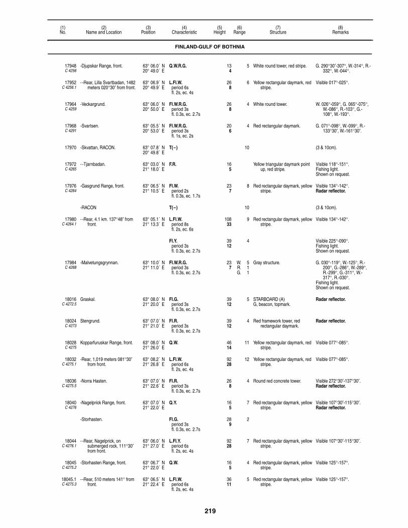
219
(1)No.
(2)Name and Location
(3)Position
(4)Characteristic
(5)Height
(6)Range
(7)Structure
(8)Remarks
17948C 4256
-Djupskar Range, front. 63° 06.0´ N20° 49.0´ E
Q.W.R.G. 134
5 White round tower, red stripe. G. 290°30′-307°, W.-314°, R.-332°, W.-044°.
17952C 4256.1
- -Rear, Lilla Svartbadan, 1482 meters 020°30′ from front.
63° 06.9´ N20° 49.9´ E
L.Fl.W.period 6sfl. 2s, ec. 4s
268
6 Yellow rectangular daymark, red stripe.
Visible 017°-025°.
17964C 4259
-Veckargrund. 63° 06.0´ N20° 50.0´ E
Fl.W.R.G.period 3sfl. 0.3s, ec. 2.7s
268
4 White round tower. W. 026°-059°, G. 065°-075°, W.-086°, R.-103°, G.-108°, W.-193°.
17968C 4291
-Svartsen. 63° 05.5´ N20° 53.0´ E
Fl.W.R.G.period 3sfl. 1s, ec. 2s
206
4 Red rectangular daymark. G. 071°-098°, W.-099°, R.-133°30′, W.-161°30′.
17970 -Skvattan, RACON. 63° 07.8´ N20° 49.8´ E
T(–) 10 (3 & 10cm).
17972C 4265
- -Tjarnbadan. 63° 03.0´ N21° 18.0´ E
F.R. 165
Yellow triangular daymark point up, red stripe.
Visible 118°-151°.Fishing light.Shown on request.
17976C 4264
-Gasgrund Range, front. 63° 06.5´ N21° 10.5´ E
Fl.W.period 2sfl. 0.3s, ec. 1.7s
237
8 Red rectangular daymark, yellow stripe.
Visible 134°-142°.Radar reflector.
-RACON T(–) 10 (3 & 10cm).
17980C 4264.1
- -Rear, 4.1 km. 137°48′ from front.
63° 05.1´ N21° 13.3´ E
L.Fl.W.period 8sfl. 2s, ec. 6s
10833
9 Red rectangular daymark, yellow stripe.
Visible 134°-142°.
Fl.Y.period 3sfl. 0.3s, ec. 2.7s
3912
4 Visible 225°-090°.Fishing light.Shown on request.
17984C 4268
-Malvetungsgrynnan. 63° 10.0´ N21° 11.0´ E
Fl.W.R.G.period 3sfl. 0.3s, ec. 2.7s
237
W. 5R. 1G. 1
Gray structure. G. 030°-119°, W.-125°, R.-200°, G.-286°, W.-289°, R.-299°, G.-311°, W.-317°, R.-030°.
Fishing light.Shown on request.
18016C 4272.5
Graskal. 63° 08.0´ N21° 20.0´ E
Fl.G.period 3sfl. 0.3s, ec. 2.7s
3912
5 STARBOARD (A)G, beacon, topmark.
Radar reflector.
18024C 4273
Stengrund. 63° 07.0´ N21° 21.0´ E
Fl.R.period 3sfl. 0.3s, ec. 2.7s
3912
4 Red framework tower, red rectangular daymark.
Radar reflector.
18028C 4275
Kopparfuruskar Range, front. 63° 08.0´ N21° 26.0´ E
Q.W. 4614
11 Yellow rectangular daymark, red stripe.
Visible 077°-085°.
18032C 4275.1
-Rear, 1,019 meters 081°30′ from front.
63° 08.2´ N21° 26.8´ E
L.Fl.W.period 6sfl. 2s, ec. 4s
9228
12 Yellow rectangular daymark, red stripe.
Visible 077°-085°.
18036C 4275.5
-Norra Hasten. 63° 07.0´ N21° 22.6´ E
Fl.R.period 3sfl. 0.3s, ec. 2.7s
268
4 Round red concrete tower. Visible 272°30′-137°30′.Radar reflector.
18040C 4276
-Nagelprick Range, front. 63° 07.0´ N21° 22.0´ E
Q.Y. 165
7 Red rectangular daymark, yellow stripe.
Visible 107°30′-115°30′.Radar reflector.
-Storhasten. Fl.G.period 3sfl. 0.3s, ec. 2.7s
289
2
18044C 4276.1
- -Rear, Nagelprick, on submerged rock, 111°30′ from front.
63° 06.0´ N21° 27.0´ E
L.Fl.Y.period 6sfl. 2s, ec. 4s
9228
7 Red rectangular daymark, yellow stripe.
Visible 107°30′-115°30′.
18045C 4275.2
-Storhasten Range, front. 63° 06.7´ N21° 22.0´ E
Q.W. 165
4 Red rectangular daymark, yellow stripe.
Visible 125°-157°.
18045.1C 4275.3
- -Rear, 510 meters 141° from front.
63° 06.5´ N21° 22.4´ E
L.Fl.W.period 6sfl. 2s, ec. 4s
3611
5 Red rectangular daymark, yellow stripe.
Visible 125°-157°.
FINLAND-GULF OF BOTHNIA
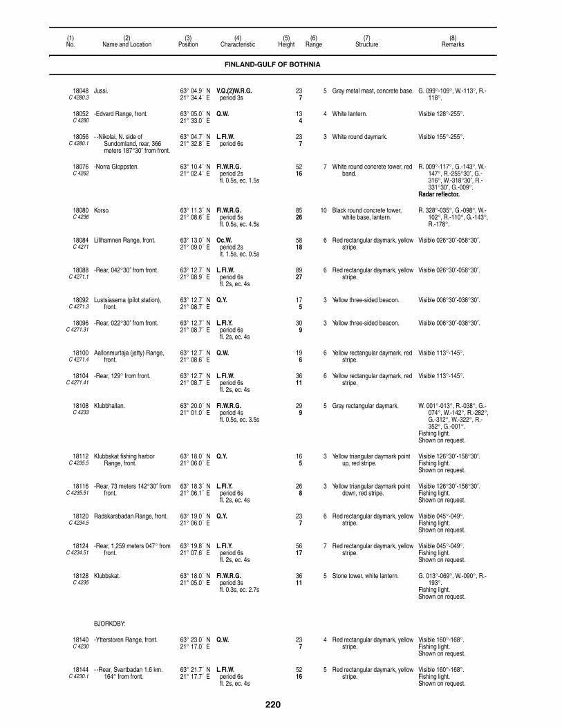
220
(1)No.
(2)Name and Location
(3)Position
(4)Characteristic
(5)Height
(6)Range
(7)Structure
(8)Remarks
18048C 4280.3
Jussi. 63° 04.9´ N21° 34.4´ E
V.Q.(2)W.R.G.period 3s
237
5 Gray metal mast, concrete base. G. 099°-109°, W.-113°, R.-118°.
18052C 4280
-Edvard Range, front. 63° 05.0´ N21° 33.0´ E
Q.W. 134
4 White lantern. Visible 128°-255°.
18056C 4280.1
- -Nikolai, N. side of Sundomland, rear, 366 meters 187°30′ from front.
63° 04.7´ N21° 32.8´ E
L.Fl.W.period 6s
237
3 White round daymark. Visible 155°-255°.
18076C 4262
-Norra Gloppsten. 63° 10.4´ N21° 02.4´ E
Fl.W.R.G.period 2sfl. 0.5s, ec. 1.5s
5216
7 White round concrete tower, red band.
R. 009°-117°, G.-143°, W.-147°, R.-255°30′, G.-316°, W.-318°30′, R.-331°30′, G.-009°.
Radar reflector.
18080C 4236
Korso. 63° 11.3´ N21° 08.6´ E
Fl.W.R.G.period 5sfl. 0.5s, ec. 4.5s
8526
10 Black round concrete tower, white base, lantern.
R. 328°-035°, G.-098°, W.-102°, R.-110°, G.-143°, R.-178°.
18084C 4271
Lillhamnen Range, front. 63° 13.0´ N21° 09.0´ E
Oc.W.period 2slt. 1.5s, ec. 0.5s
5818
6 Red rectangular daymark, yellow stripe.
Visible 026°30′-058°30′.
18088C 4271.1
-Rear, 042°30′ from front. 63° 12.7´ N21° 08.9´ E
L.Fl.W.period 6sfl. 2s, ec. 4s
8927
6 Red rectangular daymark, yellow stripe.
Visible 026°30′-058°30′.
18092C 4271.3
Lustsiasema (pilot station), front.
63° 12.7´ N21° 08.7´ E
Q.Y. 175
3 Yellow three-sided beacon. Visible 006°30′-038°30′.
18096C 4271.31
-Rear, 022°30′ from front. 63° 12.7´ N21° 08.7´ E
L.Fl.Y.period 6sfl. 2s, ec. 4s
309
3 Yellow three-sided beacon. Visible 006°30′-038°30′.
18100C 4271.4
Aallonmurtaja (jetty) Range, front.
63° 12.7´ N21° 08.6´ E
Q.W. 196
6 Yellow rectangular daymark, red stripe.
Visible 113°-145°.
18104C 4271.41
-Rear, 129° from front. 63° 12.7´ N21° 08.7´ E
L.Fl.W.period 6sfl. 2s, ec. 4s
3611
6 Yellow rectangular daymark, red stripe.
Visible 113°-145°.
18108C 4233
Klubbhallan. 63° 20.0´ N21° 01.0´ E
Fl.W.R.G.period 4sfl. 0.5s, ec. 3.5s
299
5 Gray rectangular daymark. W. 001°-013°, R.-038°, G.-074°, W.-142°, R.-282°, G.-312°, W.-322°, R.-352°, G.-001°.
Fishing light.Shown on request.
18112C 4235.5
Klubbskat fishing harbor Range, front.
63° 18.0´ N21° 06.0´ E
Q.Y. 165
3 Yellow triangular daymark point up, red stripe.
Visible 126°30′-158°30′.Fishing light.Shown on request.
18116C 4235.51
-Rear, 73 meters 142°30′ from front.
63° 18.3´ N21° 06.1´ E
L.Fl.Y.period 6sfl. 2s, ec. 4s
268
3 Yellow triangular daymark point down, red stripe.
Visible 126°30′-158°30′.Fishing light.Shown on request.
18120C 4234.5
Radskarsbadan Range, front. 63° 19.0´ N21° 06.0´ E
Q.Y. 237
6 Red rectangular daymark, yellow stripe.
Visible 045°-049°.Fishing light.Shown on request.
18124C 4234.51
-Rear, 1,259 meters 047° from front.
63° 19.8´ N21° 07.6´ E
L.Fl.Y.period 6sfl. 2s, ec. 4s
5617
7 Red rectangular daymark, yellow stripe.
Visible 045°-049°.Fishing light.Shown on request.
18128C 4235
Klubbskat. 63° 18.0´ N21° 05.0´ E
Fl.W.R.G.period 3sfl. 0.3s, ec. 2.7s
3611
5 Stone tower, white lantern. G. 013°-069°, W.-090°, R.-193°.
Fishing light.Shown on request.
BJORKOBY:
18140C 4230
-Ytterstoren Range, front. 63° 23.0´ N21° 17.0´ E
Q.W. 237
4 Red rectangular daymark, yellow stripe.
Visible 160°-168°.Fishing light.Shown on request.
18144C 4230.1
- -Rear, Svartbadan 1.6 km. 164° from front.
63° 21.7´ N21° 17.7´ E
L.Fl.W.period 6sfl. 2s, ec. 4s
5216
5 Red rectangular daymark, yellow stripe.
Visible 160°-168°.Fishing light.Shown on request.
FINLAND-GULF OF BOTHNIA

221
(1)No.
(2)Name and Location
(3)Position
(4)Characteristic
(5)Height
(6)Range
(7)Structure
(8)Remarks
18148C 4226
Valassaaret, W. side of Storskaret.
63° 25.3´ N21° 04.1´ E
Fl.(4)W.period 20sfl. 0.8s, ec. 3sfl. 0.8s, ec. 3sfl. 0.8s, ec. 3sfl. 0.8s, ec. 7.8s
12438
11 Red round tower; 118.
18152C 4227
Ebbskar Range, front. 63° 26.2´ N21° 04.1´ E
Q.W. 206
7 Red rectangular daymark, yellow stripe.
Visible 118°-126°.
18156C 4227.1
-Rear, 302 meters 122° from front.
63° 26.1´ N21° 04.5´ E
L.Fl.W.period 6sfl. 2s, ec. 4s
4313
7 Red rectangular daymark, yellow stripe.
Visible 118°-126°.
18160C 4228
Norra Storon Range, front. 63° 26.0´ N21° 04.0´ E
Q.Y. 165
2 Red rectangular daymark, yellow stripe.
Visible 089°30′-121°30′.
18164C 4228.1
-Rear, 210 meters 105°30′ from front.
63° 26.2´ N21° 04.7´ E
L.Fl.Y.period 6sfl. 2s, ec. 4s
299
3 Red rectangular daymark, yellow stripe.
Visible 089°30′-121°30′.
18168C 4229
Stora Nikersgrund. 63° 23.0´ N21° 10.0´ E
Fl.W.R.G.period 3sfl. 0.3s, ec. 2.7s
237
5 White lantern, concrete base. G. 100°-109°, W.-115°, R.-100°.
Fishing light.Shown on request.
18172C 4248
Utgrynnan. 63° 21.1´ N20° 45.8´ E
L.Fl.W.R.G.period 12sfl. 3s, ec. 9s
7924
12 Red round concrete tower, white band.
R. 029°-037°, G.-044°, W.-056°, R.-063°, G.-069°, W.-158°, R.-338°, G.-355°, W.-029°.
RACON T(–) 12 (3 & 10cm).
18174C 4222
Malon. 63° 18.2´ N21° 52.3´ E
Fl.W.R.period 4sfl. 0.5s, ec. 3.5s
268
5 Gray pole. R. 157°-162°, W. 162°-157°.Fishing light.Shown on request.
18176C 4219
Stubben, center of Lillskar Islet. 63° 31.5´ N22° 09.5´ E
L.Fl.(3)W.period 30sfl. 2.5s, ec. 2.5sfl. 2.5s, ec. 2.5sfl. 2.5s, ec. 17.5s
7021
11 White rectangular daymark. Visible 346°-302°.
18180C 4220
Remsan. 63° 31.0´ N22° 17.0´ E
Fl.W.R.G.period 4sfl. 0.5s, ec. 3.5s
258
5 Red metal framework tower. R. 008°-029°, G.-149°, W.-159°, R.-192°, G.-328°, W.-008°.
Fishing light.Shown on request.
18184C 4217
-Grisselo. 63° 37.0´ N22° 29.0´ E
Fl.W.R.G.period 4sfl. 0.5s, ec. 3.5s
165
5 Gray pole. G. 055°-090°, W.-097°, R.-104°, W.-169°, R.-177°, G.-185°, W.-055°.
Fishing light.Shown on request.
18188C 4218
Hallgrund. 63° 38.6´ N22° 25.2´ E
Fl.(2)W.R.G.period 6sfl. 0.5s, ec. 1sfl. 0.5s, ec. 4s
5617
7 White round tower. W. 119°-189°, R.-192°, G.-196°, W.-203°, R.-312°, G.-345°, W.-013°.
JAKOBSTAD APPROACH:
18192C 4216.7
-Nummersten. 63° 41.0´ N22° 34.2´ E
Q.W. 165
5 Gray pole. Fishing light.Shown on request.
18196C 4214
-Kallan. 63° 45.1´ N22° 31.4´ E
Q.(2)W.R.G.period 6s
8225
10 Red tower, white band; 62. G. 342°-047°, W.-160°, R.-209°.
Pilot station.
18197C 4214.3
-Pietarsaari. 63° 44.6´ N22° 31.7´ E
Fl.W.period 12sfl. 0.3s, ec. 11.7s
5617
10 Yellow concrete tower, black top.
-RACON T(–) 10 (3 & 10cm).
18200C 4212
-Rummelgrund Range, front. 63° 44.7´ N22° 34.7´ E
Q.W. 3912
9 Red rectangular daymark, yellow stripe.
Visible 085°-093°.
FINLAND-GULF OF BOTHNIA

222
(1)No.
(2)Name and Location
(3)Position
(4)Characteristic
(5)Height
(6)Range
(7)Structure
(8)Remarks
18204C 4212.1
- -Rear, Bredhallan, N. side, 089° from front.
63° 44.7´ N22° 35.4´ E
L.Fl.W.period 6sfl. 2s, ec. 4s
7523
10 Red rectangular daymark, yellow stripe.
Visible 085°-093°.
18206C 4215
-Adon Range, front. 63° 43.4´ N22° 37.1´ E
Q.Y. 3310
6 Red rectangular daymark, yellow stripe.
Visible 116°-124°.
18207C 4215.1
- -Rear 130 meters 120° from front.
63° 43.4´ N22° 37.4´ E
L.Fl.Y.period 6s
5216
9 Red rectangular daymark, yellow stripe.
Visible 116°-124°.
18208C 4216
-Borgmastargrund, front. 63° 43.1´ N22° 42.1´ E
Q.R. 3912
8 Red rectangular daymark, yellow stripe.
Visible 102°48′-110°48′.
18212C 4216.1
- -Rear, Halloren, N. extremity of Alholm, about 1.1 km. 106°48′ from front.
63° 43.0´ N22° 42.7´ E
L.Fl.R.period 6sfl. 2s, ec. 4s
6620
9 Red rectangular daymark, yellow stripe.
Visible 104°48′-108°48′.
18216C 4216.4
-Alholm Range, front. 63° 42.5´ N22° 41.3´ E
F.R. 268
3 Red triangular daymark point up. Visible 154°30′-184°30′.
18220C 4216.5
- -Rear, 169°30′ from front. 63° 42.5´ N22° 41.4´ E
F.R. 3310
3 Red triangular daymark point down.
Visible 154°30′-184°30′.
YKSPIHLAJA:
18224C 4200
-Tankar. 63° 57.0´ N22° 50.8´ E
Fl.W.period 3.5sfl. 0.5s, ec. 3s
12438
17 Red round metal tower, white band; 97.
Pilot station.
18228C 4201
-Tankar, E. side of island. 63° 57.0´ N22° 51.0´ E
Iso.G.period 2s
3310
6 Red rectangular daymark, yellow stripe.
Visible 281°30′-296°30′.
18232C 4202
-Range, front. 63° 57.1´ N22° 50.7´ E
Iso.W.period 2s
4213
6 White rectangular daymark, black stripe.
Visible 107°48′-197°48′.
18236C 4202.1
- -Rear, 152°48′ from front. 63° 57.0´ N22° 51.0´ E
Iso.W.period 6s
6620
9 Red round beacon. Visible 146°48′-158°48′.
18237C 4202.4
-Tankarin Range, front. 63° 57.0´ N22° 51.0´ E
Q.G. 237
5 Mast. Visible 181°24′-185°24′.
18237.1C 4202.41
- -Rear, 183°24′ from front. 63° 57.0´ N22° 51.2´ E
L.Fl.G.period 6sfl. 2s, ec. 4s
3310
5 Mast. Visible 181°24′-185°24′.
18238 -Bergbadan, RACON. 63° 57.8´ N22° 53.7´ E
T(–) 11 (3cm).
18240C 4203
-Kokkola. 63° 59.8´ N22° 51.8´ E
Fl.(2)W.R.G.period 10sfl. 1s, ec. 1sfl. 1s, ec. 7s
7322
12 White tower, red top; 75.Helicopter platform.
W. 065°-199°, R.-327°, G.-065°.
Channel to Kokkola marked by lighted beacons and buoys.
-RACON T(–) 12 (3 & 10cm).
18242C 4203.2
-Pietarinkanta. 63° 59.2´ N22° 51.4´ E
V.Q.(5)W.period 6s
3912
4 White framework tower, red band.
Radar reflector.
18244C 4205
-Repskar Range, front. 63° 55.9´ N22° 56.7´ E
Q.W. 309
11 Red rectangular daymark, yellow stripe.
Visible 146°54′-166°54′.
18248C 4205.1
- -Rear, 1,500 meters 156°54′ from front.
63° 55.2´ N22° 57.5´ E
L.Fl.W.period 8sfl. 2s, ec. 6s
6219
11 Red rectangular daymark, yellow stripe.
Visible 146°54′-166°54′.
18252C 4204
-Santapankki Range, front. 63° 56.9´ N22° 56.4´ E
Q.Y. 165
9 Red rectangular daymark, yellow stripe.
Visible 136°42′-144°42′.
18256C 4204.1
- -Rear, about 1,900 meters 140°42′ from front.
63° 56.1´ N22° 57.8´ E
L.Fl.Y.period 6sfl. 2s, ec. 4s
6921
10 Red rectangular daymark, yellow stripe.
Visible 136°42′-144°42′.
18258C 4203.4
-Trullevin Range, front. 63° 54.8´ N23° 04.5´ E
Q.W. 134
6 White triangular daymark point up.
Visible 143°30′-147°30′.Fishing light.
FINLAND-GULF OF BOTHNIA

223
(1)No.
(2)Name and Location
(3)Position
(4)Characteristic
(5)Height
(6)Range
(7)Structure
(8)Remarks
18258.1C 4203.41
- -Rear, 145° from front. 63° 54.7´ N23° 04.7´ E
L.Fl.W.period 6sfl. 2s, ec. 4s
268
7 Structure, white triangular daymark point down.
Visible 143°30′-147°30′.Fishing light.
18260C 4206
-Kladesklippan Range, front. 63° 54.0´ N23° 01.1´ E
Iso.Y.period 2s
237
10 Red rectangular daymark, yellow stripe.
Visible 132°42′-143°42′.
18264C 4206.1
- -Rear, 1111 meters 138°12′ from front.
63° 53.6´ N23° 01.9´ E
L.Fl.Y.period 6sfl. 2s, ec. 4s
6219
13 Red rectangular daymark, yellow stripe.
Visible 132°42′-143°42′.
18268C 4207
-Taulukari Range, front. 63° 51.5´ N23° 01.0´ E
Iso.Y.period 2s
6921
10 Red rectangular daymark, yellow stripe.
Visible 151°-171°.
18272C 4207.1
- -Rear, 1,436 meters 161° from front.
63° 50.8´ N23° 01.6´ E
Iso.Y.period 6s
9830
10 Red rectangular daymark, yellow stripe.
Visible 151°-171°.
18274C 4211.5
-Outokumpu Range, front. 63° 51.6´ N23° 02.5´ E
F.R. 3711
5 White rectangular daymark, red stripe.
Visible 053°30′-183°30′.
18275C 4211.51
- -Rear, 118°30′ from front. 63° 51.5´ N23° 02.7´ E
F.R. 5818
5 White rectangular daymark, red stripe.
Visible 053°30′-183°30′.
18276C 4208
-Krakholm Range, front. 63° 50.6´ N22° 59.8´ E
Q.W. 206
8 Red rectangular daymark, yellow stripe.
Visible 193°36′-197°36′.
18280C 4208.1
- -Rear, about 370 meters 195°36′ from front.
63° 50.2´ N22° 59.5´ E
L.Fl.W.period 6s
4915
9 Red rectangular daymark, yellow stripe.
Visible 193°36′-197°36′.
18292C 4211
-Private harbor Range, front. 63° 49.8´ N23° 02.3´ E
Iso.W.period 2s
268
8 White rectangular daymark, red stripe.
Visible 141°-149°.
18296C 4211.1
- -Rear, about 229 meters 145° from front.
63° 49.7´ N23° 02.5´ E
L.Fl.W.period 6s
3611
8 White rectangular daymark, red stripe.
Visible 141°-149°.
18300C 4209
-Breakwater, head. 63° 51.2´ N23° 00.3´ E
F.Y. 309
3 White round tower. Visible 320°-260°.
18304C 4199
Poroluodonkari. 63° 58.8´ N23° 08.8´ E
Fl.Y.period 3sfl. 0.3s, ec. 2.7s
6620
4 Gray post. Fishing light.Shown on request.
18308C 4194
Ohtakari. 64° 05.0´ N23° 25.0´ E
F.W. 7523
4 Gray framework tower. Fishing light.Shown on request.
18312C 4195
Ruoppausvayla Range, front. 64° 04.0´ N23° 38.0´ E
F.R. 165
2 Red rectangular daymark, yellow stripe.
Visible 018°-198°.Fishing light.Shown on request.
18316C 4195.1
-Rear, 108° from front. 64° 04.4´ N23° 38.4´ E
F.R. 309
2 Red rectangular daymark, yellow stripe.
Visible 018°-198°.Fishing light.Shown on request.
18328C 4198
Jokivayla Range, front. 64° 04.0´ N23° 38.0´ E
F.R. 165
2 Red rectangular daymark, yellow stripe.
Visible 041°-221°.Fishing light.Shown on request.
18332C 4198.1
-Rear, 131° from front. 64° 04.0´ N23° 38.5´ E
F.R. 268
2 Red rectangular daymark, yellow stripe.
Visible 041°-221°.Fishing light.Shown on request.
18334C 4196
Mansikkakari Range, front. 64° 05.4´ N23° 35.4´ E
Q.W. 268
7 White rectangular daymark, red stripe.
Visible 110°48′-114°48′.Fishing light.Shown on request.
18334.1C 4196.1
-Rear, 112°48′ from front. 64° 05.3´ N23° 35.6´ E
Fl.W.period 3sfl. 0.5s, ec. 2.5s
4313
7 White rectangular daymark, red stripe.
Visible 110°48′-114°48′.Fishing light.Shown on request.
18336C 4193.2
Piekko Range, front. 64° 13.0´ N23° 44.0´ E
Q.W. 237
8 Red rectangular daymark, yellow stripe.
Visible 160°48′-164°48′.
18340C 4193.21
-Rear, 162°48′ from front. 64° 13.3´ N23° 43.9´ E
L.Fl.W.period 6sfl. 2s, ec. 4s
4614
8 Red rectangular daymark, yellow stripe.
Visible 158°48′-166°48′.
18342 -Aijankallio RACON 64° 14.2´ N23° 36.6´ E
T(–) 10 (3cm).
FINLAND-GULF OF BOTHNIA
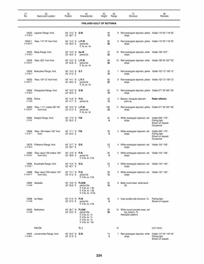
224
(1)No.
(2)Name and Location
(3)Position
(4)Characteristic
(5)Height
(6)Range
(7)Structure
(8)Remarks
18343C 4192.5
Lepanen Range, front. 64° 14.2´ N23° 38.7´ E
Q.W. 4012
8 Red rectangular daymark, yellow stripe.
Visible 110°30′-118°30′.
18343.1C 4192.51
-Rear, 114°18′ from front. 64° 14.0´ N23° 39.9´ E
L.Fl.W.period 6sfl. 2s, ec. 4s
8526
9 Red rectangular daymark, yellow stripe.
Visible 110°30′-118°30′.
18345C 4193.3
Rahja Range, front. 64° 14.0´ N23° 42.0´ E
Iso.W.period 2s
7222
10 Red rectangular daymark, white stripe.
Visible 199°-207°.
18346C 4193.31
-Rear, 203° from front. 64° 13.2´ N23° 42.8´ E
L.Fl.W.period 6sfl. 2s, ec. 4s
9830
10 Red rectangular daymark, white stripe.
Visible 199°30′-207°30′.
18349C 4192.7
Keskuskari Range, front. 64° 14.0´ N23° 47.0´ E
Q.Y. 3310
7 Red rectangular daymark, yellow stripe.
Visible 102°12′-106°12′.
18350C 4192.71
-Rear, 104°12′ from front. 64° 14.1´ N23° 48.2´ E
L.Fl.Y.period 6sfl. 2s, ec. 4s
8225
8 Red rectangular daymark, yellow stripe.
Visible 102°12′-106°12′.
18356C 4192.6
Vihaspauha Range, front. 64° 16.0´ N23° 50.0´ E
Q.W. 6219
11 Red rectangular daymark, yellow stripe.
Visible 071°30′-091°30′.
18358C 4193
Roima. 64° 14.8´ N23° 41.1´ E
Fl.G.period 3s
4313
4 Beacon, triangular daymark point up.
Radar reflector.
18360C 4192.61
-Rear, 1,111 meters 081°30′ from front.
64° 16.0´ N23° 51.0´ E
L.Fl.W.period 6sfl. 2s, ec. 4s
10833
11 Red rectangular daymark, yellow stripe.
Visible 071°30′-091°30′.
18364C 4191
Kalajoki Range, front. 64° 17.0´ N23° 55.0´ E
F.W. 206
2 White rectangular daymark, red stripe.
Visible 099°-179°.Fishing light.Shown on request.Occasional.
18368C 4191.1
-Rear, 180 meters 139° from front.
64° 17.1´ N23° 55.4´ E
F.W. 309
2 White rectangular daymark, red stripe.
Visible 099°-179°.Fishing light.Shown on request.Occasional.
18376C 4193.6
Pirttikarvo Range, front. 64° 12.7´ N23° 39.7´ E
Q.R. 237
4 White rectangular daymark, red stripe.
Visible 154°-158°.
18380C 4193.61
-Rear, about 185 meters 156° from front.
64° 12.6´ N23° 39.8´ E
Fl.R.period 3sfl. 0.5s, ec. 2.5s
309
5 White rectangular daymark, red stripe.
Visible 154°-158°.
18384C 4193.7
Kuusimalla Range, front. 64° 12.4´ N23° 40.7´ E
Q.G. 237
4 White rectangular daymark, red stripe.
Visible 142°-146°.
18388C 4193.71
-Rear, about 700 meters 144° from front.
64° 12.1´ N23° 41.2´ E
Fl.G.period 3sfl. 0.5s, ec. 2.5s
3912
5 White rectangular daymark, red stripe.
Visible 142°-146°.
18392C 4192
Ulkokalla. 64° 19.9´ N23° 26.8´ E
Fl.(3)W.period 20sfl. 0.3s, ec. 1.8sfl. 0.3s, ec. 1.8sfl. 0.3s, ec. 15.5s
5216
8 Black round tower, white band; 39.
18396C 4190
Iso Klippi. 64° 21.0´ N23° 57.0´ E
Fl.W.period 5sfl. 0.5s, ec. 4.5s
309
4 Gray wooden pile structure; 13. Fishing light.Shown on request.
18400C 4188
Nahkiainen. 64° 36.7´ N23° 53.3´ E
Fl.(4)W.period 20sfl. 0.5s, ec. 1sfl. 0.5s, ec. 1sfl. 0.5s, ec. 1sfl. 0.5s, ec. 15s
9228
10 White round concrete tower, red top, lantern; 79.
Helicopter platform.
RACON T(–) 13 (3 & 10cm).
18402C 4188.4
Lannennokka Range, front. 64° 34.0´ N24° 21.9´ E
Q.W. 134
7 Red rectangular daymark, white stripe.
Visible 141°54′-145°54′.Fishing light.Shown on request.
FINLAND-GULF OF BOTHNIA

225
(1)No.
(2)Name and Location
(3)Position
(4)Characteristic
(5)Height
(6)Range
(7)Structure
(8)Remarks
18402.1C 4188.41
-Rear, 143°54′ from front. 64° 33.8´ N24° 21.6´ E
Fl.W.period 3sfl. 0.5s, ec. 2.5s
206
8 Red rectangular daymark, white stripe.
Visible 141°54′-145°54′.Fishing light.
18404C 4183
Raahe. 64° 39.1´ N24° 13.4´ E
Fl.(2)Y.period 10sfl. 0.5s, ec. 1sfl. 0.5s, ec. 8s
7222
7 White round concrete tower, red band.
Radar reflector.
RACON T(–) 13 (3 & 10cm).
18408C 4184.4
-Virpipera Range, front. 64° 40.0´ N24° 25.0´ E
Q.Y. 5918
12 Red rectangular daymark, yellow stripe.
Visible 059°42′-064°42′.
18412C 4184.5
- -Rear, 062°12′ from front. 64° 40.2´ N24° 25.4´ E
Iso.Y.period 6s
10231
12 Red rectangular daymark, yellow stripe.
Visible 059°42′-064°42′.
18420C 4184
Heikinkari Range, front. 64° 39.0´ N24° 21.0´ E
Fl.W.period 3s
237
10 Red rectangular daymark, yellow stripe.
Visible 081°30′-089°30′.Range 4M by day.Radar reflector.
RACON T(–) 8 (3 & 10cm).
18424C 4184.1
-Elko, rear, 085°30′ from front. 64° 39.1´ N24° 24.0´ E
Iso.W.period 4s
6620
12 Red rectangular daymark, yellow stripe.
Visible 081°30′-089°30′.Range 5M by day.
18436C 4186
Rojuniemi Range, front. 64° 39.0´ N24° 25.0´ E
Fl.R.period 3sfl. 1s, ec. 2s
7924
14 Yellow mast. Visible 120°42′-131°42′.
18440C 4186.1
-Rear, 126°12′ from front. 64° 39.3´ N24° 25.3´ E
Iso.R.period 3s
11234
14 Red rectangular daymark, yellow stripe.
Visible 120°42′-131°42′.
18442C 4180
Karjula. 64° 46.4´ N24° 08.9´ E
Fl.(4)W.period 20sfl. 0.2s, ec. 1.8sfl. 0.2s, ec. 1.8sfl. 0.2s, ec. 1.8sfl. 0.2s, ec. 13.8s
4012
4 White beacon, red band.
18444C 4172
Tauvo (Haikaraki). 64° 48.8´ N24° 32.6´ E
L.Fl.W.period 6sfl. 2s, ec. 4s
10532
8 Black mast; 98. Visible 011°-191°.
18444.5C 4173
-Fishing. 64° 48.3´ N24° 32.9´ E
U.Q.(5)W.period 6s
165
2 Red post. Fishing light.Shown on request.
18444.7C 4174
Rautakallio. 64° 53.8´ N24° 45.5´ E
Q.R. 309
2 Gray framework tower. Seasonal.Radar reflector.
18445C 4170.6
Varjakka Range, front. 64° 55.2´ N25° 06.4´ E
Q.W. 103
7 Red square daymark, yellow stripe.
Visible 172°-176°.Fishing light.Seasonal.
18445.5C 4170.61
-Rear, 174° from front. 64° 55.1´ N25° 06.4´ E
Fl.W.period 3sfl. 0.5s, ec. 2.5s
299
8 Red square daymark, yellow stripe.
Visible 172°-176°.Fishing light.Seasonal.
OULU APPROACH:
18452C 4142.1
-Marjaniemi. 65° 02.4´ N24° 33.7´ E
Fl.(2)W.period 20sfl. 0.5s, ec. 2.2sfl. 0.5s, ec. 16.8s
9930
16 White round tower; 82. Visible 022°-225°.Pilot station.
18456C 4143
-Marjaniemi Range, front. 65° 02.4´ N24° 33.0´ E
Q.Y. 206
9 Red rectangular daymark, yellow stripe.
Visible 085°-105°.
18460C 4143.1
- -Rear, 095° from front. 65° 02.4´ N24° 33.4´ E
Iso.Y.period 4s
4915
10 Red rectangular daymark, yellow stripe.
Visible 085°-105°.
18464C 4145.8
-Holma. 65° 07.9´ N24° 18.1´ E
V.Q.(9)W.period 10s
4012
4 W. CARDINALYBY, beacon, topmark.
Radar reflector.
18470C 4145.4
-Oulu Portti. 65° 11.1´ N24° 22.2´ E
Fl.R.period 3s
3912
4 PORT (A)R, pile, topmark.
Radar reflector.
FINLAND-GULF OF BOTHNIA

226
(1)No.
(2)Name and Location
(3)Position
(4)Characteristic
(5)Height
(6)Range
(7)Structure
(8)Remarks
18472C 4145
-Oulu No 1. 65° 11.4´ N24° 30.2´ E
Fl.W.R.G.period 5sfl. 0.5s, ec. 4.5s
7222
11 Black round concrete tower, white band.
G. 041°-057°, W.-149°, R.-190°, G.-288°, W.-290°, R.-041°.
-RACON T(–) 14 (3 & 10cm).
18476C 4146
-Oulu No 2. 65° 10.5´ N24° 35.2´ E
Fl.(2)W.R.G.period 6sfl. 0.5s, ec. 1sfl. 0.5s, ec. 4s
7222
8 White masonry tower, black band; 79.
R. 005°-060°, G.-119°, W.-125°, R.-185°, G.-314°, W.-319°, R.-333°, G.-000° W.-005°.
18477C 4147.05
-Keskiniemi Range, front. 65° 04.8´ N24° 39.2´ E
Fl.W.period 6sfl. 0.5s, ec. 5.5s
309
6 White beacon. Rear beacon unlit, 4M 104°54′ from front.
Rear 18480.52.Radar reflector.
18478C 4146.5
-Valitamala. 65° 08.8´ N24° 32.5´ E
Fl.(4)Y.period 20sfl. 0.2s, ec. 1.8sfl. 0.2s, ec. 1.8sfl. 0.2s, ec. 1.8sfl. 0.2s, ec. 13.8s
3912
2 White pillar, red stripe. Radar reflector.
18480C 4147
-Oulu No 3. 65° 08.9´ N24° 39.5´ E
Fl.(3)W.R.G.period 10sfl. 0.5s, ec. 1sfl. 0.5s, ec. 1sfl. 0.5s, ec. 6.5s
7222
8 White round concrete tower, red band; 79.
G. 036°-135°, W.-136°, R.-216°, G.-296°, W.-298°, R.-036°.
18480.5C 4147.1
-Kotalahti Range, common front.
65° 07.3´ N24° 47.0´ E
Q.W. 3812
5 Red round tower, white stripe. Visible 233°30′-249°30′ and 106°48′-122°48′.
Radar reflector.
18480.51C 4147.11
- -W. rear, 1.2 miles 241°36′ from common front.
65° 06.7´ N24° 44.4´ E
L.Fl.W.period 6sfl. 2s, ec. 4s
8325
6 Red rectangular daymark, white stripe.
Visible 237°36′-245°36′.Radar reflector.
18480.52C 4147.09
- -E., rear, 1.2 miles 114°48′ from common front.
65° 06.7´ N24° 49.7´ E
L.Fl.W.period 6sfl. 2s, ec. 4s
9228
6 Red rectangular daymark, white stripe.
Visible 110°48′-118°48′.Radar reflector.
18481C 4147.15
-Liberta. 65° 08.2´ N24° 42.2´ E
Fl.G.period 3sfl. 0.3s, ec. 2.7s
3912
4 STARBOARD (A)G, pile, topmark.
Radar reflector.
18482C 4147.2
-Oulu No 4. 65° 07.6´ N24° 47.2´ E
Fl.R.period 3sfl. 0.3s, ec. 2.7s
4614
4 Red beacon. Radar reflector.
18484C 4147.3
- -No 5. 65° 08.1´ N24° 50.7´ E
Fl.G.period 3sfl. 0.3s, ec. 2.7s
3912
4 STARBOARD (A)G, beacon, topmark.
Radar reflector.
18485C 4147.5
-Hammasmatala. 65° 08.5´ N24° 53.1´ E
Fl.G.period 3sfl. 0.3s, ec. 2.7s
3912
4 STARBOARD (A)G, pile, topmark.
Radar reflector.
18488C 4148
-Hoikka Range, front. 65° 06.0´ N25° 01.7´ E
Q.W. 175
6 Red rectangular daymark, yellow stripe.
Visible 144°30′-152°30′.
18492C 4148.1
- -Rear, 149°24′ from front. 65° 05.7´ N25° 02.1´ E
L.Fl.W.period 6sfl. 2s, ec. 4s
4614
7 Red rectangular daymark, yellow stripe.
Visible 145°30′-153°30′.
18496C 4150
-Luodematala Range, front. 65° 10.1´ N24° 59.4´ E
Q.W. 319
8 Red round concrete tower; 23. Visible 057°-065°.
-RACON T(–) 11 (3cm).
18496.1C 4150.1
- -Lansiletto, rear, about 2780 meters 061°36′ from front.
65° 10.8´ N25° 02.7´ E
L.Fl.W.period 6sfl. 2s, ec. 4s
6319
9 Red square concrete tower; 49. Visible 057°36′-065°36′.
18498C 4106
-Nimeton Range, front. 65° 12.3´ N25° 01.9´ E
Q.W. 3310
6 Red rectangular daymark, yellow stripe.
Visible 165°42′-169°42′.
18499C 4106.1
- -Rear, about 1.5 miles 167°42′ from front.
65° 10.8´ N25° 02.7´ E
L.Fl.W.period 8sfl. 2s, ec. 4s
11635
9 Red rectangular daymark, yellow stripe.
Visible 165°42′-169°42′.Adjacent to Lansiletto rear.
FINLAND-GULF OF BOTHNIA
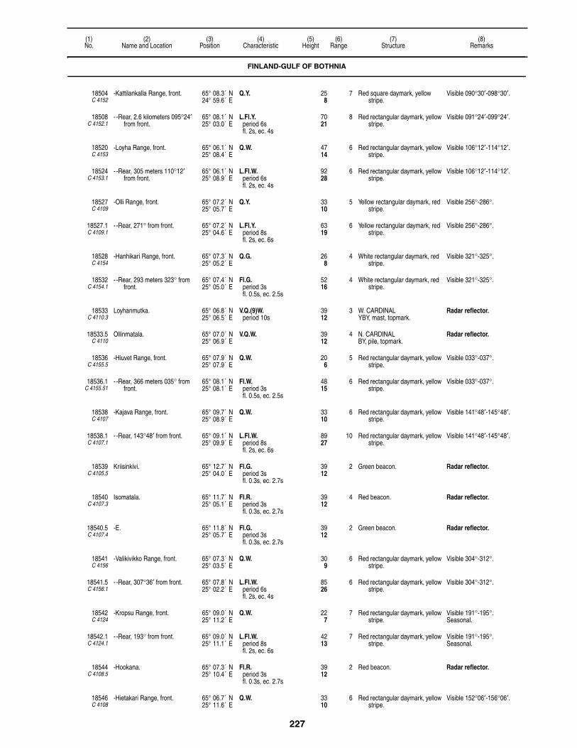
227
(1)No.
(2)Name and Location
(3)Position
(4)Characteristic
(5)Height
(6)Range
(7)Structure
(8)Remarks
18504C 4152
-Kattilankalla Range, front. 65° 08.3´ N24° 59.6´ E
Q.Y. 258
7 Red square daymark, yellow stripe.
Visible 090°30′-098°30′.
18508C 4152.1
- -Rear, 2.6 kilometers 095°24′ from front.
65° 08.1´ N25° 03.0´ E
L.Fl.Y.period 6sfl. 2s, ec. 4s
7021
8 Red rectangular daymark, yellow stripe.
Visible 091°24′-099°24′.
18520C 4153
-Loyha Range, front. 65° 06.1´ N25° 08.4´ E
Q.W. 4714
6 Red rectangular daymark, yellow stripe.
Visible 106°12′-114°12′.
18524C 4153.1
- -Rear, 305 meters 110°12′ from front.
65° 06.1´ N25° 08.9´ E
L.Fl.W.period 6sfl. 2s, ec. 4s
9228
6 Red rectangular daymark, yellow stripe.
Visible 106°12′-114°12′.
18527C 4109
-Olli Range, front. 65° 07.2´ N25° 05.7´ E
Q.Y. 3310
5 Yellow rectangular daymark, red stripe.
Visible 256°-286°.
18527.1C 4109.1
- -Rear, 271° from front. 65° 07.2´ N25° 04.6´ E
L.Fl.Y.period 8sfl. 2s, ec. 6s
6319
6 Yellow rectangular daymark, red stripe.
Visible 256°-286°.
18528C 4154
-Hanhikari Range, front. 65° 07.3´ N25° 05.2´ E
Q.G. 268
4 White rectangular daymark, red stripe.
Visible 321°-325°.
18532C 4154.1
- -Rear, 293 meters 323° from front.
65° 07.4´ N25° 05.0´ E
Fl.G.period 3sfl. 0.5s, ec. 2.5s
5216
4 White rectangular daymark, red stripe.
Visible 321°-325°.
18533C 4110.3
Loyhanmutka. 65° 06.8´ N25° 06.5´ E
V.Q.(9)W.period 10s
3912
3 W. CARDINALYBY, mast, topmark.
Radar reflector.
18533.5C 4110
Ollinmatala. 65° 07.0´ N25° 06.9´ E
V.Q.W. 3912
4 N. CARDINALBY, pile, topmark.
Radar reflector.
18536C 4155.5
-Hiuvet Range, front. 65° 07.9´ N25° 07.9´ E
Q.W. 206
5 Red rectangular daymark, yellow stripe.
Visible 033°-037°.
18536.1C 4155.51
- -Rear, 366 meters 035° from front.
65° 08.1´ N25° 08.1´ E
Fl.W.period 3sfl. 0.5s, ec. 2.5s
4815
6 Red rectangular daymark, yellow stripe.
Visible 033°-037°.
18538C 4107
-Kajava Range, front. 65° 09.7´ N25° 08.9´ E
Q.W. 3310
6 Red rectangular daymark, yellow stripe.
Visible 141°48′-145°48′.
18538.1C 4107.1
- -Rear, 143°48′ from front. 65° 09.1´ N25° 09.9´ E
L.Fl.W.period 8sfl. 2s, ec. 6s
8927
10 Red rectangular daymark, yellow stripe.
Visible 141°48′-145°48′.
18539C 4105.5
Kriisinkivi. 65° 12.7´ N25° 04.0´ E
Fl.G.period 3sfl. 0.3s, ec. 2.7s
3912
2 Green beacon. Radar reflector.
18540C 4107.3
Isomatala. 65° 11.7´ N25° 05.1´ E
Fl.R.period 3sfl. 0.3s, ec. 2.7s
3912
4 Red beacon. Radar reflector.
18540.5C 4107.4
-E. 65° 11.8´ N25° 05.7´ E
Fl.G.period 3sfl. 0.3s, ec. 2.7s
3912
2 Green beacon. Radar reflector.
18541C 4156
-Valikivikko Range, front. 65° 07.3´ N25° 03.5´ E
Q.W. 309
6 Red rectangular daymark, yellow stripe.
Visible 304°-312°.
18541.5C 4156.1
- -Rear, 307°36′ from front. 65° 07.8´ N25° 02.2´ E
L.Fl.W.period 6sfl. 2s, ec. 4s
8526
6 Red rectangular daymark, yellow stripe.
Visible 304°-312°.
18542C 4124
-Kropsu Range, front. 65° 09.0´ N25° 11.2´ E
Q.W. 227
7 Red rectangular daymark, yellow stripe.
Visible 191°-195°.Seasonal.
18542.1C 4124.1
- -Rear, 193° from front. 65° 09.0´ N25° 11.1´ E
L.Fl.W.period 8sfl. 2s, ec. 6s
4213
7 Red rectangular daymark, yellow stripe.
Visible 191°-195°.Seasonal.
18544C 4108.5
-Hookana. 65° 07.3´ N25° 10.4´ E
Fl.R.period 3sfl. 0.3s, ec. 2.7s
3912
2 Red beacon. Radar reflector.
18546C 4108
-Hietakari Range, front. 65° 06.7´ N25° 11.6´ E
Q.W. 3310
6 Red rectangular daymark, yellow stripe.
Visible 152°06′-156°06′.
FINLAND-GULF OF BOTHNIA
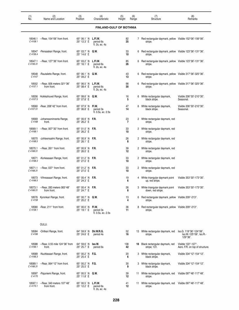
228
(1)No.
(2)Name and Location
(3)Position
(4)Characteristic
(5)Height
(6)Range
(7)Structure
(8)Remarks
18546.1C 4108.1
- -Rear, 154°06′ from front. 65° 06.1´ N25° 12.3´ E
L.Fl.W.period 6sfl. 2s, ec. 4s
8225
7 Red rectangular daymark, yellow stripe.
Visible 152°06′-156°06′.
18547C 4156.4
-Pensaskari Range, front. 65° 03.7´ N25° 14.6´ E
Q.W. 3310
6 Red rectangular daymark, yellow stripe.
Visible 123°36′-131°36′.
18547.1C 4156.41
- -Rear, 127°36′ from front. 65° 03.2´ N25° 16.1´ E
L.Fl.W.period 6sfl. 2s, ec. 4s
8526
6 Red rectangular daymark, yellow stripe.
Visible 123°36′-131°36′.
18548C 4157
-Rautaletto Range, front. 65° 06.1´ N25° 09.2´ E
Q.W. 4313
6 Red rectangular daymark, yellow stripe.
Visible 317°36′-325°36′.
18552C 4157.1
- -Rear, 926 meters 321°36′ from front.
65° 06.5´ N25° 08.4´ E
L.Fl.W.period 6sfl. 2s, ec. 4s
9830
6 Red rectangular daymark, yellow stripe.
Visible 317°36′-325°36′.
18556C 4107.5
Hoikkahiuvet Range, front. 65° 08.6´ N25° 07.8´ E
Q.W. 165
6 White rectangular daymark, black stripe.
Visible 206°30′-210°30′.Seasonal.
18560C 4107.51
-Rear, 208°42′ from front. 65° 07.9´ N25° 06.8´ E
Fl.W.period 3sfl. 0.5s, ec. 2.5s
4714
6 White rectangular daymark, black stripe.
Visible 206°30′-210°30′.Seasonal.
18569C 4168
-Johanssoninranta Range, front.
65° 00.9´ N25° 26.2´ E
F.R. 237
2 White rectangular daymark, red stripe.
18569.1C 4168.1
- -Rear, 007°30′ from front. 65° 01.0´ N25° 26.2´ E
F.R. 3310
2 White rectangular daymark, red stripe.
18570C 4168.5
-Johteensalmi Range, front. 65° 00.9´ N25° 26.1´ E
F.R. 268
2 White rectangular daymark, red stripe.
18570.1C 4168.51
- -Rear, 261° from front. 65° 00.9´ N25° 26.0´ E
F.R. 3912
2 White rectangular daymark, red stripe.
18571C 4168.3
-Korkeasaari Range, front. 65° 01.2´ N25° 27.0´ E
F.R. 3310
2 White rectangular daymark, red stripe.
18571.1C 4168.31
- -Rear, 037° from front. 65° 01.2´ N25° 27.0´ E
F.R. 3310
2 White rectangular daymark, red stripe.
18573C 4166.5
-Vihreasaari Range, front. 65° 00.4´ N25° 24.3´ E
F.R. 196
4 White triangular daymark point up, red stripe.
Visible 353°30′-173°30′.
18573.1C 4166.51
- -Rear, 283 meters 083°48′ from front.
65° 00.4´ N25° 24.7´ E
F.R. 268
3 White triangular daymark point down, red stripe.
Visible 353°30′-173°30′.
18576C 4158
Kyronkari Range, front. 65° 00.7´ N25° 20.2´ E
Q.W. 134
6 Red rectangular daymark, yellow stripe.
Visible 209°-213°.
18580C 4158.1
-Rear, 211° from front. 65° 00.0´ N25° 19.1´ E
Fl.W.period 3sfl. 0.5s, ec. 2.5s
3611
8 Red rectangular daymark, yellow stripe.
Visible 209°-213°.
OULU:
18584C 4166
-Oritkari Range, front. 64° 59.9´ N25° 24.6´ E
Dir.W.R.G.period 4s
5216
13 White rectangular daymark, red stripe.
Iso.G. 119°36′-124°06′, Iso.W.-125°06′, Iso.R.-129°36′.
18588C 4166.1
- -Rear, 0.55 mile 124°36′ from front.
64° 59.6´ N25° 25.7´ E
Iso.W.period 6s
13842
18 Black rectangular daymark, red stripe; 131.
Visible 122°-127°.Aero. F.R. on top of structure.
18589C 4166.3
-Nuottasaari Range, front. 65° 00.2´ N25° 25.4´ E
F.G. 206
3 White rectangular daymark, black stripe.
Visible 334°12′-154°12′.
18589.1C 4166.31
- -Rear, 064°12′ from front. 65° 00.2´ N25° 25.5´ E
F.G. 309
3 White rectangular daymark, black stripe.
Visible 334°12′-154°12′.
18597C 4170
-Pajuniemi Range, front. 65° 00.5´ N25° 11.8´ E
Q.W. 3912
11 White rectangular daymark, red stripe.
Visible 097°48′-117°48′.
18597.1C 4170.1
- -Rear, 340 meters 107°48′ from front.
65° 00.5´ N25° 12.2´ E
L.Fl.W.period 6sfl. 2s, ec. 4s
4112
11 White rectangular daymark, red stripe.
Visible 097°48′-117°48′.
FINLAND-GULF OF BOTHNIA
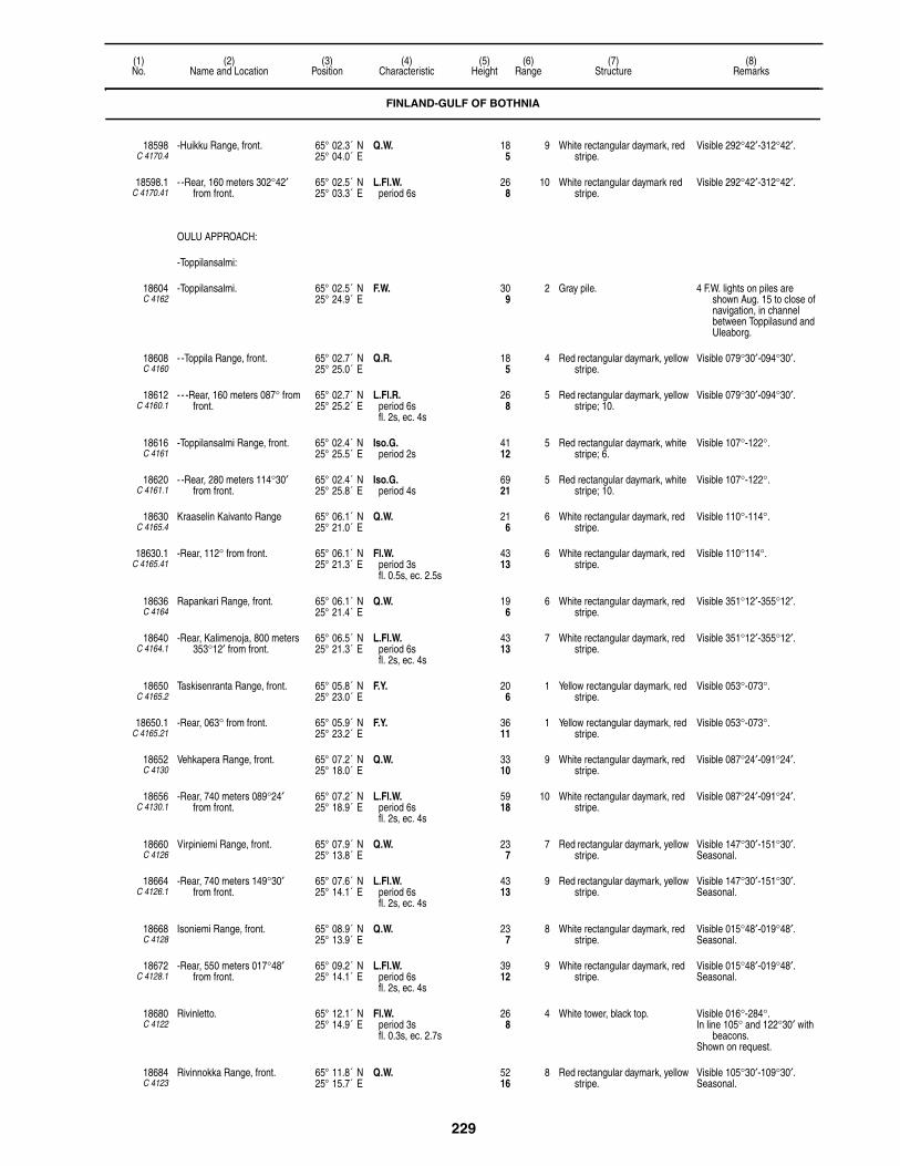
229
(1)No.
(2)Name and Location
(3)Position
(4)Characteristic
(5)Height
(6)Range
(7)Structure
(8)Remarks
18598C 4170.4
-Huikku Range, front. 65° 02.3´ N25° 04.0´ E
Q.W. 185
9 White rectangular daymark, red stripe.
Visible 292°42′-312°42′.
18598.1C 4170.41
- -Rear, 160 meters 302°42′ from front.
65° 02.5´ N25° 03.3´ E
L.Fl.W.period 6s
268
10 White rectangular daymark red stripe.
Visible 292°42′-312°42′.
OULU APPROACH:
-Toppilansalmi:
18604C 4162
-Toppilansalmi. 65° 02.5´ N25° 24.9´ E
F.W. 309
2 Gray pile. 4 F.W. lights on piles are shown Aug. 15 to close of navigation, in channel between Toppilasund and Uleaborg.
18608C 4160
- -Toppila Range, front. 65° 02.7´ N25° 25.0´ E
Q.R. 185
4 Red rectangular daymark, yellow stripe.
Visible 079°30′-094°30′.
18612C 4160.1
- - -Rear, 160 meters 087° from front.
65° 02.7´ N25° 25.2´ E
L.Fl.R.period 6sfl. 2s, ec. 4s
268
5 Red rectangular daymark, yellow stripe; 10.
Visible 079°30′-094°30′.
18616C 4161
-Toppilansalmi Range, front. 65° 02.4´ N25° 25.5´ E
Iso.G.period 2s
4112
5 Red rectangular daymark, white stripe; 6.
Visible 107°-122°.
18620C 4161.1
- -Rear, 280 meters 114°30′ from front.
65° 02.4´ N25° 25.8´ E
Iso.G.period 4s
6921
5 Red rectangular daymark, white stripe; 10.
Visible 107°-122°.
18630C 4165.4
Kraaselin Kaivanto Range 65° 06.1´ N25° 21.0´ E
Q.W. 216
6 White rectangular daymark, red stripe.
Visible 110°-114°.
18630.1C 4165.41
-Rear, 112° from front. 65° 06.1´ N25° 21.3´ E
Fl.W.period 3sfl. 0.5s, ec. 2.5s
4313
6 White rectangular daymark, red stripe.
Visible 110°114°.
18636C 4164
Rapankari Range, front. 65° 06.1´ N25° 21.4´ E
Q.W. 196
6 White rectangular daymark, red stripe.
Visible 351°12′-355°12′.
18640C 4164.1
-Rear, Kalimenoja, 800 meters 353°12′ from front.
65° 06.5´ N25° 21.3´ E
L.Fl.W.period 6sfl. 2s, ec. 4s
4313
7 White rectangular daymark, red stripe.
Visible 351°12′-355°12′.
18650C 4165.2
Taskisenranta Range, front. 65° 05.8´ N25° 23.0´ E
F.Y. 206
1 Yellow rectangular daymark, red stripe.
Visible 053°-073°.
18650.1C 4165.21
-Rear, 063° from front. 65° 05.9´ N25° 23.2´ E
F.Y. 3611
1 Yellow rectangular daymark, red stripe.
Visible 053°-073°.
18652C 4130
Vehkapera Range, front. 65° 07.2´ N25° 18.0´ E
Q.W. 3310
9 White rectangular daymark, red stripe.
Visible 087°24′-091°24′.
18656C 4130.1
-Rear, 740 meters 089°24′ from front.
65° 07.2´ N25° 18.9´ E
L.Fl.W.period 6sfl. 2s, ec. 4s
5918
10 White rectangular daymark, red stripe.
Visible 087°24′-091°24′.
18660C 4126
Virpiniemi Range, front. 65° 07.9´ N25° 13.8´ E
Q.W. 237
7 Red rectangular daymark, yellow stripe.
Visible 147°30′-151°30′.Seasonal.
18664C 4126.1
-Rear, 740 meters 149°30′ from front.
65° 07.6´ N25° 14.1´ E
L.Fl.W.period 6sfl. 2s, ec. 4s
4313
9 Red rectangular daymark, yellow stripe.
Visible 147°30′-151°30′.Seasonal.
18668C 4128
Isoniemi Range, front. 65° 08.9´ N25° 13.9´ E
Q.W. 237
8 White rectangular daymark, red stripe.
Visible 015°48′-019°48′.Seasonal.
18672C 4128.1
-Rear, 550 meters 017°48′ from front.
65° 09.2´ N25° 14.1´ E
L.Fl.W.period 6sfl. 2s, ec. 4s
3912
9 White rectangular daymark, red stripe.
Visible 015°48′-019°48′.Seasonal.
18680C 4122
Rivinletto. 65° 12.1´ N25° 14.9´ E
Fl.W.period 3sfl. 0.3s, ec. 2.7s
268
4 White tower, black top. Visible 016°-284°.In line 105° and 122°30′ with
beacons.Shown on request.
18684C 4123
Rivinnokka Range, front. 65° 11.8´ N25° 15.7´ E
Q.W. 5216
8 Red rectangular daymark, yellow stripe.
Visible 105°30′-109°30′.Seasonal.
FINLAND-GULF OF BOTHNIA

230
(1)No.
(2)Name and Location
(3)Position
(4)Characteristic
(5)Height
(6)Range
(7)Structure
(8)Remarks
18684.1C 4123.1
-Rear, 230 meters 107°30′ from front.
65° 11.7´ N25° 16.2´ E
Iso.W.period 6s
8927
9 Red rectangular daymark, yellow stripe.
Visible 105°30′-109°30′.Seasonal.
18686C 4120
Halkorsnta Range, front. 65° 11.7´ N25° 17.7´ E
F.Y. 134
7 Red rectangular daymark, yellow stripe.
Visible 134°30′-138°30′.
18686.1C 4120.1
-Rear, 138° from front. 65° 11.7´ N25° 17.8´ E
F.Y. 278
7 Red rectangular daymark, yellow stripe.
Visible 134°30′-137°30′.
18692C 4121
Haukipudas Range, front. 65° 12.8´ N25° 17.2´ E
Q.W. 206
6 Red rectangular daymark, white stripe.
Visible 066°30′-070°30′.Seasonal.
18696C 4121.1
-Rear, 068°30′ from front. 65° 12.8´ N25° 17.4´ E
L.Fl.W.period 8sfl. 2s, ec. 6s
5216
7 Red rectangular daymark, white stripe.
Visible 066°30′-070°30′.Seasonal.
18705C 4118
Kriisi. 65° 14.6´ N25° 11.6´ E
Q.(2)W.period 6s
4915
4 Black and yellow square wooden building.
Visible 313°-175°.Fishing light.Seasonal.
18706C 4119
-E. Range, front. 65° 14.8´ N25° 12.7´ E
Q.W. 134
5 White rectangular daymark, red stripe.
Visible 223°-226°.Seasonal.
18706.1C 4119.1
-Rear, 224°30′ from front. 65° 14.7´ N25° 12.4´ E
Fl.W.period 3sfl. 0.5s, ec. 2.5s
309
5 White rectangular daymark, red stripe.
Visible 223°-226°.Seasonal.
18708C 4116
Satakari Range, front. 65° 15.9´ N25° 13.3´ E
Q.W. 134
6 Red rectangular daymark, yellow stripe.
Visible 359°30′-004°30′.Seasonal.
18708.1C 4116.1
-Rear, 001°30′ from front. 65° 16.6´ N25° 13.4´ E
Fl.W.period 3sfl. 0.5s, ec. 2.5s
4915
6 Red rectangular daymark, yellow stripe.
Visible 359°30′-004°30′.Seasonal.
18712C 4115
Pitkaniemi, front. 65° 16.5´ N25° 16.1´ E
Q.W. 237
5 White rectangular daymark, red stripe.
Visible 168°-171°.Seasonal.
18716C 4115.1
-Rear, 110 meters 169°30′ from front.
65° 16.4´ N25° 16.2´ E
Fl.W.period 3sfl. 0.5s, ec. 2.5s
4614
5 White rectangular daymark, red stripe.
Visible 168°-171°.Seasonal.
18720C 4114.5
Sekaletto Range, front. 65° 17.4´ N25° 16.4´ E
Q.Y. 278
4 White rectangular daymark, red stripe.
Visible 147°30′-150°30′.Seasonal.
18724C 4114.51
-Rear, 91 meters 149° from front.
65° 17.3´ N25° 16.5´ E
V.Q.(5)Y.period 6s
5116
4 White rectangular daymark, red stripe.
Visible 147°30′-150°30′.Seasonal.
18732C 4114.2
-Range, front. 65° 18.3´ N25° 14.5´ E
Q.G. 165
1 Red rectangular daymark, white stripe.
Visible 160°-193°.Seasonal.
18736C 4114.21
- -Rear, 176°30′ from front. 65° 18.3´ N25° 14.5´ E
Fl.G.period 3sfl. 0.5s, ec. 2.5s
309
2 Red rectangular daymark, white stripe.
Visible 160°-193°.Seasonal.
18740C 4113
Tangonsaari, front. 65° 19.0´ N25° 16.0´ E
Q.W. 227
7 White rectangualr daymark, red stripe.
Visible 004°-008°.Seasonal.
18744C 4113.1
-Rear, 550 meters 006° from front.
65° 19.0´ N25° 16.1´ E
L.Fl.W.period 6sfl. 2s, ec. 4s
4915
8 White rectangular daymark, red stripe.
Visible 004°-008°.Seasonal.
18752C 4112.6
Rontii W. Range, front. 65° 21.0´ N25° 15.0´ E
Q.W. 134
6 White rectangular daymark, black stripe.
Visible 147°-151°.Seasonal.
18756C 4112.61
-Rear, 500 meters 149° from front.
65° 20.3´ N25° 15.3´ E
Fl.W.period 3sfl. 0.5s, ec. 2.5s
3912
6 White rectangular daymark, black stripe.
Visible 147°-151°.Seasonal.
18760C 4112.4
Kayranletto Range, front. 65° 22.0´ N25° 15.0´ E
Q.W. 165
6 White rectangular daymark, red stripe.
Visible 056°30′-060°30′.Seasonal.
18760.1C 4112.41
-Hiuvet, rear, 058°30′ from front.
65° 22.2´ N25° 17.4´ E
Fl.W.period 3sfl. 0.5s, ec. 2.5s
4614
6 White rectangular daymark, red stripe.
Visible 056°30′-060°30′.Seasonal.
18764C 4112.3
Rontti Range, front. 65° 22.0´ N25° 14.0´ E
Q.W. 289
10 Red rectangular daymark, yellow stripe.
Visible 169°-173°.Seasonal.
FINLAND-GULF OF BOTHNIA

231
(1)No.
(2)Name and Location
(3)Position
(4)Characteristic
(5)Height
(6)Range
(7)Structure
(8)Remarks
18768C 4112.31
-Rear, N. beach on Rontti, 2.3 miles 171° from front.
65° 20.7´ N25° 15.0´ E
L.Fl.W.period 8sfl. 2s, ec. 6s
9830
12 Red rectangular daymark, yellow stripe.
Visible 169°-173°.Seasonal.
18772C 4082
Kemi 1. 65° 23.1´ N24° 05.7´ E
Fl.W.period 4sfl. 0.8s, ec. 3.2s
8225
10 Black round concrete tower, red band; 69.
Helicopter platform.
Radar reflector.
RACON T(–) 12 (3 & 10cm).
18776C 4101
Ulkokrunni Range, front. 65° 23.4´ N24° 50.4´ E
Fl.W.period 2sfl. 0.3s, ec. 1.7s
3310
8 Red rectangular daymark, yellow stripe.
Visible 143°-149°.
18780C 4101.1
-Rear, 146° from front. 65° 23.4´ N24° 50.5´ E
L.Fl.W.period 6sfl. 2s, ec. 4s
8927
9 Red four-sided pyramidal tower, white rectangular daymark.
Visible 143°-149°.
18784C 4102
Maakrunni Range, front. 65° 24.0´ N25° 00.0´ E
Q.W. 3310
8 Red rectangular daymark, yellow stripe.
Visible 109°36′-113°36′.
18788C 4102.1
-Rear, 111°36′ from front. 65° 24.2´ N25° 01.4´ E
L.Fl.W.period 6sfl. 2s, ec. 4s
10030
9 Red rectangular daymark, yellow stripe.
Visible 109°30′-113°30′.
18788.5C 4102.5
Pohjanletto. 65° 25.4´ N24° 51.5´ E
V.Q.(3)W.period 5s
3912
3 E. CARDINALBYB, beacon, topmark.
Radar reflector.
18789C 4103
Pohjanletto Range, front. 65° 24.0´ N24° 52.1´ E
Q.W. 3310
6 Red rectangular daymark, yellow stripe.
Visible 331°-335°.
18789.1C 4103.1
-Rear, 333° from front. 65° 25.0´ N24° 50.9´ E
L.Fl.W.period 8sfl. 2s, ec. 6s
10231
9 Red rectangular daymark, yellow stripe.
Visible 331°-335°.
18790C 4104
Tyni Range, front. 65° 21.5´ N24° 53.8´ E
Q.W. 3310
6 Red rectangular daymark, yellow stripe.
Visible 170°30′-174°30′.
18790.1C 4104.1
-Rear, 172°30′ from front. 65° 20.9´ N24° 54.0´ E
L.Fl.W.period 6sfl. 2s, ec. 4s
7222
7 Red rectangular daymark, yellow stripe.
Visible 170°30′-174°30′.
18791C 4105
Kraasukka Range, front. 65° 19.4´ N24° 58.2´ E
Q.W. 3310
6 Red rectangular daymark, yellow stripe.
Visible 345°42′-349°42′.
18791.1C 4105.1
-Rear, 347°42′ from front. 65° 20.9´ N24° 57.8´ E
L.Fl.W.period 6sfl. 2s, ec. 4s
9228
7 Red rectangular daymark, yellow stripe.
Visible 345°42′-349°42′.
18792C 4100
Harkaletto. 65° 30.0´ N24° 50.6´ E
Fl.W.R.G.period 5sfl. 0.5s, ec. 4.5s
4815
9 Black four-sided concrete tower, white top; 36.
G. 329°-348°, W.-353°, R.-004°, G.-018°, W.-027°, R.-077°, G.-094°30′, W.-097°30′, R.-122°30′, G.-146°, G. 206°-235°, W.-243°, R.-272°.
18796C 4082.5
Kemi 2. 65° 30.3´ N24° 22.4´ E
Fl.(2)W.period 6sfl. 0.3s, ec. 1.5sfl. 0.3s, ec. 3.9s
4313
5 White round tower, red band. Radar reflector.
18800C 4112
Liippa Range, front. 65° 32.1´ N25° 02.0´ E
Q.W. 144
6 Red rectangular daymark, yellow stripe.
Visible 293°-297°.Seasonal.
18804C 4112.1
-Rear, 113 meters 295° from front.
65° 32.1´ N25° 01.8´ E
Fl.W.period 3sfl. 0.5s, ec. 2.5s
309
8 Red rectangular daymark, yellow stripe.
Visible 293°-297°.Seasonal.
18808C 4099.4
Tiuranen Range, front. 65° 37.0´ N24° 57.2´ E
Q.W. 309
6 White rectangular daymark, red stripe.
Visible 092°-096°.Seasonal.
18812C 4099.5
-Rear, Korkeakari W. Beach, about 1200 meters 094° from front.
65° 35.9´ N24° 58.8´ E
V.Q.(5)W.period 6s
5416
6 White rectangular daymark, red stripe.
Visible 092°-096°.Seasonal.
18816C 4099
Mantaja Range, front. 65° 37.3´ N24° 52.5´ E
Q.W. 289
6 White rectangular daymark, red stripe.
Visible 320°-324°.Seasonal.
18820C 4099.1
-Rear, about 1850 meters 322° from front.
65° 38.1´ N24° 51.1´ E
V.Q.(5)W.period 6s
5918
6 White rectangular daymark, red stripe.
Visible 320°-324°.Seasonal.
FINLAND-GULF OF BOTHNIA

232
(1)No.
(2)Name and Location
(3)Position
(4)Characteristic
(5)Height
(6)Range
(7)Structure
(8)Remarks
18824C 4098.5
Ykskivi. 65° 36.1´ N24° 42.0´ E
Fl.W.R.G.period 4sfl. 0.5s, ec. 3.5s
309
4 Red and white tower. G. 106°-117°30′, W.-123°, R.-137°.
Seasonal.
18828C 4083
Keminkraaseli. 65° 36.7´ N24° 33.5´ E
Fl.(3)W.R.G.period 12sfl. 0.4s, ec. 1.1sfl. 0.4s, ec. 1.1sfl. 0.4s, ec. 8.6s
8225
W. 7R. 2G. 2
White round concrete tower, upper part black; 78.
Helicopter platform.
G. 246°-264°, W.-268°, R.-279°30′, G.-334°, G.-339°, W.-344°, R.-022°, G.-036°, W.-041°, R.-076°, G.-135°30′, W.-141°, R.-153°30′.
RACON T(–) 12 (3 & 10cm).
18830 Pohjantahti Beacon, RACON. 65° 37.6´ N24° 22.4´ E
T(–) 11 (3cm).
18832C 4083.7
Valikivikko. 65° 30.3´ N24° 37.5´ E
U.Q.(5)W.period 6s
4915
5 White mast, black top; 46.
18836C 4095
Ajoskrunni Range, front. 65° 37.7´ N24° 35.5´ E
L.Fl.W.period 6s
3912
6 Red rectangular daymark, yellow stripe.
Visible 053°-057°.
18840C 4095.1
-Rear, about 275 meters 055° from front.
65° 37.8´ N24° 35.8´ E
L.Fl.W.period 6sfl. 2s, ec. 4s
7924
7 Red rectangular daymark, yellow stripe.
Visible 053°-057°.
L.Fl.W.period 6sfl. 2s, ec. 4s
7924
7 Visible 227°-231°.
18844C 4096.3
Ruumiskari Range, front. 65° 39.2´ N24° 39.5´ E
Q.Y. 237
5 Red rectangular daymark, yellow stripe.
Visible 046°30′-050°30′.
18848C 4096.31
-Rear, 048°30′ from front. 65° 39.2´ N24° 39.6´ E
L.Fl.Y.period 8sfl. 2s, ec. 6s
4313
6 Red rectangular daymark, yellow stripe.
Visible 046°30′-050°30′.
18852C 4096.34
Satamaranta Range, front. 65° 40.2´ N24° 39.1´ E
Q.W. 185
8 Red rectangular daymark, yellow stripe.
Visible 128°-132°.
18856C 4096.35
-Rear, 130° from front. 65° 40.0´ N24° 39.6´ E
L.Fl.W.period 6sfl. 2s, ec. 4s
299
9 Red rectangular daymark, yellow stripe.
Visible 128°-132°.
18860C 4097
Pihlajakarilla Range, front. 65° 39.9´ N24° 36.1´ E
Iso.W.period 2s
237
10 Red rectangular daymark, yellow stripe.
Visible 018°-029°.
18864C 4097.1
-Rear, 023°30′ from front. 65° 40.3´ N24° 36.5´ E
L.Fl.W.period 6sfl. 2s, ec. 4s
4915
13 Red rectangular daymark, yellow stripe.
Visible 018°-029°.
18868C 4096.4
Rytikaripenger Range, front. 65° 40.8´ N24° 38.2´ E
Q.R. 3611
10 Red rectangular daymark, white stripe.
Visible 354°-359°.
18872C 4096.41
-Rear, 356°30′ from front. 65° 41.1´ N24° 38.1´ E
Iso.R.period 6s
6520
10 Red rectangular daymark, white stripe.
Visible 354°-359°.
18880C 4096.5
Kannonnokka Range, front. 65° 41.3´ N24° 35.8´ E
Q.W. 5918
7 Red rectangular daymark, yellow stripe.
Visible 307°30′-311°30′.
18884C 4096.51
-Rear, 309°30′ from front. 65° 41.4´ N24° 35.5´ E
L.Fl.W.period 8sfl. 2s, ec. 6s
8526
9 Red rectangular daymark, yellow stripe.
Visible 307°30′-311°30′.
KEMI:
18892C 4084
-Ajos Range, front. 65° 39.8´ N24° 30.8´ E
Iso.Y.period 2s
7222
12 Red rectangular daymark, yellow stripe.
Visible 012°-017°.Pilot station.
18896C 4084.1
- -Rear, 1130 meters 014°30′ from front.
65° 40.5´ N24° 31.2´ E
Iso.Y.period 6s
12137
12 Red rectangular daymark, yellow stripe.
Visible 012°-017°.
18898C 4096.15
-Ajos Murhanicmenkallio Range, front.
65° 39.6´ N24° 35.4´ E
Q.W. 165
6 White rectangular daymark, black stripe.
Visible 332°30′-336°30′.Seasonal.
18898.1C 4096.16
- -Rear, about 890 meters 334°30′ from front.
65° 40.0´ N24° 35.0´ E
Fl.W.period 3sfl. 0.5s, ec. 2.5s
4614
6 White rectangular daymark, black stripe.
Visible 332°30′-336°30′.Seasonal.
FINLAND-GULF OF BOTHNIA

233
(1)No.
(2)Name and Location
(3)Position
(4)Characteristic
(5)Height
(6)Range
(7)Structure
(8)Remarks
18900C 4083.5
-Kemi 3, border marker. 65° 36.1´ N24° 28.0´ E
V.Q.(6)+L.Fl.W.period 10s
3912
3 S. CARDINALYB, beacon, topmark.
Radar reflector.
18908C 4085.4
-Lehtikari Range, front. 65° 41.5´ N24° 30.1´ E
Q.W. 165
5 Red rectangular daymark, yellow stripe.
Visible 343°-003°.
18912C 4085.41
- -Rear, 180 meters 353°12′ from front.
65° 41.6´ N24° 30.1´ E
L.Fl.W.period 6sfl. 2s, ec. 4s
309
6 Red rectangular daymark, yellow stripe.
Visible 343°-003°.
18916C 4085.7
-Tuomilahti Range, front. 65° 40.6´ N24° 31.8´ E
Q.W. 165
6 White rectangular daymark, red stripe.
Visible 190°30′-195°30′.
18920C 4085.71
- -Rear, 193° from front. 65° 40.5´ N24° 31.8´ E
Iso.W.period 6s
309
7 White rectangular daymark, red stripe.
Visible 190°30′-195°30′.
18924C 4085.8
-Laitakari Range, front. 65° 43.1´ N24° 34.4´ E
Q.W. 175
6 Red rectangular daymark, yellow stripe.
Visible 036°-041°.
18928C 4085.81
- -Rear 039° from front. 65° 43.4´ N24° 35.1´ E
Iso.W.period 6s
4112
7 Red rectangular daymark, yellow stripe.
Visible 036°-041°.
18932C 4085.6
-Munakari Range, front. 65° 41.8´ N24° 33.7´ E
Q.W. 155
6 White rectangular daymark, red stripe.
Visible 041°30′-046°30′.
18936C 4085.61
- -Rear, 043°30′ from front. 65° 43.1´ N24° 34.2´ E
L.Fl.W.period 8sfl. 2s, ec. 6s
3812
7 White rectangular daymark, red stripe.
Visible 041°30′-046°30′.
18948C 4086
-Mansikkanokka Range, front. 65° 43.6´ N24° 33.6´ E
F.R. 268
2 Red rectangular daymark, yellow stripe.
Visible 311°-071°.
18948.1C 4086.1
- -Rear, 630 meters 010°30′ from front.
65° 43.9´ N24° 33.8´ E
F.R. 13441
4 Tower. Visible 354°-038°.
18952C 4090
-Pajusaari Range, front, S. beach of Kukeli Island.
65° 44.5´ N24° 32.3´ E
F.R. 155
4 White rectangular daymark, black stripe.
Visible 260°-080°.
18956C 4090.1
- -Rear, 337° from front. 65° 44.6´ N24° 32.3´ E
F.R. 309
4 White rectangular daymark, black stripe.
Visible 260°-080°.
TORNIO:
18960C 5694
-Mainua Range, front. 65° 39.5´ N24° 16.6´ E
Q.W. 206
7 Red rectangular daymark, yellow stripe.
Visible 305°-309°.
18964C 5694.1
- -Rear, Mainua Island, SE. side, about 2.2 km. 307°24′ from front.
65° 40.3´ N24° 14.3´ E
L.Fl.W.period 8sfl. 2s, ec. 6s
8526
9 Red square daymark, yellow stripe.
Visible 305°-309°.
18965C 5700
-Hamnskar Range, front. 65° 41.4´ N24° 09.3´ E
Q.W. 3912
6 Red rectangular daymark, white stripe.
Visible 314°30′-318°30′.Shown Apr. 1 to Jun. 1 and
Jul. 20 to close of navigation.
18965.1C 5700.1
- -Rear, l.6 miles 316°30′ from front.
65° 42.5´ N24° 06.8´ E
L.Fl.W.period 8s
9529
6 Red rectangular daymark, white stripe.
Visible 314°30′-318°30′.Shown Apr. 1 to Jun. 1 and
Jul. 20 to close of navigation.
KEMI:
18968C 5697
-Roytta Range, front, on wharf. 65° 46.0´ N24° 09.0´ E
Iso.W.period 2s
206
10 Red rectangular daymark, yellow stripe.
Visible 337°-357°.
18972C 5697.1
- -Rear, 585 meters 347° from front.
65° 46.2´ N24° 08.8´ E
Fl.W.R.G.period 3sfl. 1s, ec. 2s
8325
W. 15R. 3G. 1
Red rectangular daymark, yellow stripe.
G. 342°-346°30′, W.-347°30′, R.-352°.
18976C 5697.3
Koivuluodonletto. 65° 46.0´ N24° 14.0´ E
V.Q.(3)W.period 5s
216
4 Gray mast. Fishing light.
FINLAND-GULF OF BOTHNIA

234
(1)No.
(2)Name
(3)Position
(4)Characteristic
(5)Range
(6)Sequence
(7)Frequency
(8)Remarks
Section 11Radiobeacons
GERMANY
100 Kiel Light Station 54° 30.0´ N10° 16.5´ E
KI(– • – • •).
20 310A1A.
110 Friedrichsort Light Station Calibration Radiobeacon
54° 23.5´ N10° 11.7´ E
FB(• • – • – • • •).
312.6, 2168A2A.
Transmits on request to Wasser and Schiffahrtsamt, Lubeck through Revierzentrale Travemunde, telephone (04502) 71117, telex 261 419.
130 Travemunde Calibration Radiobeacon
53° 57.8´ N10° 53.0´ E
UB(• • – – • • •).
312.6, 2168A2A.
Transmits on request to Wasser and Schiffahrtsamt, Lubeck through Revierzentrale Travemunde, telephone (04502) 84750, fax (04502) 8475527, telex 261 419.
140 Warnemunde Calibration Radiobeacon
54° 10.6´ N12° 05.9´ E
LHD(• – • • • • • • – • •).
312, 2200A1A, A2A.
Transmits on request to Warnemunde Pilot Station on VHF channel 12 or telephone (50-01) 539 1407. Iso.W. light shown from pilot station.
150 Sassnitz Calibration Radiobeacon
54° 30.7´ N13° 38.7´ E
SAZ(• • • • – – – • •).
312, 2200A1A, A2A.
Transmits on request to Sassnitz Harbor Master on VHF channel 14. 24 hour notice required.
POLAND
200 Swinoujscie 53° 55.0´ N14° 17.2´ E
S(• • • ).
50 296.5A1A.
201 Swinoujscie Calibration Radiobeacon
S(• • • ).
296.5A1A.
Transmits on request to Swinoujscie main light on VHF channels 12 and 16.
210 Darlowo Calibration Radiobeacon
54° 26.5´ N16° 22.9´ E
D(– • •).
309A1A, A2A.
Transmits on request to Darlowo light on VHF channel 16.
RUSSIA
260 Baltiysk 54° 38.0´ N19° 55.0´ E
BK(– • • • –).
80 VI 299A1A.
LATVIA
300 Mys Taran (Brusterort) Light Station, Russia
54° 57.7´ N19° 59.0´ E
BT(– • • • –).
period 360str (interrupted bya long dash) 60ssi 300s
120 V 312.5A1A.
311 Ventspils Calibration Radiobeacon
P(• – – •).
20 300.5, 309.5A1A.
Transmits on request to Port Captain, Ventspils through Ventspils (UNI) on VHF channel 16. Two hours prior notice required.
320 Irbenskiy Light Station 57° 45.1´ N21° 44.1´ E
YuH(• • – – • • • •).
period 360str(6) 19.5s, si 1s(—) 25s, si 1str(2) 6.5s, si 307s
35 285.5A1A.
235
(1)No.
(2)Name
(3)Position
(4)Characteristic
(5)Range
(6)Sequence
(7)Frequency
(8)Remarks
RUSSIA
420 Mys Lounatrivi Light Station 60° 00.7´ N27° 00.5´ E
YuG(• • – – – – • ).
50 294.5A1A.
430 Kaybolovo Light Station 59° 44.5´ N28° 02.0´ E
KA(– • – • –).
period 360str(4) 20s(—) 25str(2) 10ssi 305s
70 I 294.5A2A.
FINLAND
470 Porkkala Pilot Station 59° 52.1´ N24° 18.4´ E
PR(• – – • • – •).
60 284.5A1A.
480 Mantyluoto 61° 35.6´ N21° 27.9´ E
MYa(– – • – • –).
60 297.5A1A.

237
(1)No.
(2)Name
(3)Position
(4)Station ID
(5)Range
(6)Frequency
(7)Transfer Rate
(8)Remarks
Section 12Differential GPS Stations
DENMARK
10 Hammer Odde 55° 17.9´ N14° 46.4´ E
T 451 178 289.5 100 Message Types: 3,7,9,16.
20 Skagen, W 57° 44.9´ N10° 35.7´ E
T 453 145 296 100 Message Types: 3,7,9,16.
POLAND
40 Dziwnow 54° 01.3´ N14° 43.9´ E
T 481 80 283.5 200 Message Types: 1,3,7,16.
FINLAND
160 Mantyluoto 61° 35.6´ N21° 27.7´ E
T 401R 601
135 287.5 100 Message Types: 3,6,7,9,16.
170 Outokumpu 62° 41.0´ N29° 01.6´ E
T 403R 603
49 304.5 100 Message Types: 3,6,7,9,16.
180 Porkkala 59° 58.5´ N24° 23.7´ E
T 400R 600
135 293.5 100 Message Types: 3,6,7,9,16.
190 Puumala 61° 24.3´ N28° 13.8´ E
T 402R 602
49 290 100 Message Types: 3,6,7,9,16.
200 Turku 60° 25.9´ N22° 13.2´ E
T 404R 604
108 301.5 100 Message Types: 3,6,7,9,16.
SWEDEN
210 Bjurokklubb 64° 28.9´ N21° 34.8´ E
T 461 108 311.5 100 Message Types: 3,6,7,9,16.
220 Jarnas 63° 28.7´ N19° 39.2´ E
T 462 130 289 100 Message Types: 3,6,7,9,16.
250 Nynashamn 58° 55.0´ N17° 56.9´ E
T 468 130 298 100 Message Types: 3,6,7,9,16.
260 Hoburg 56° 55.3´ N18° 09.1´ E
T 465 130 297.5 100 Message Types: 3,6,7,9,16.
270 Kullen 56° 18.1´ N12° 27.1´ E
T 466 108 293 100 Message Types: 3,6,7,9,16.
280 Hjortens Udde 58° 38.3´ N12° 40.0´ E
T 467 68 302 100 Message Types: 3,6,7,9,16.
INDEX – LIGHTS
237
AAALBAEK HAVN . . . . . . . . . . . . . . . . . . . . . . 1572Aalborg Havn . . . . . . . . . . . . . . . . . . . . . . . . . 1884Aallonmurtaja . . . . . . . . . . . . . . . . . . . . . . . . 18100Aaro . . . . . . . . . . . . . . . . . . . . . . . . . . . . . . . . 2628Aarsdale . . . . . . . . . . . . . . . . . . . . . . . . . . . . . 5760Abbekas . . . . . . . . . . . . . . . . . . . . . . . . . . . . . 5616Abertsklackarna . . . . . . . . . . . . . . . . . . . . . . 15176Abordso . . . . . . . . . . . . . . . . . . . . . . . . . . . . 10840Abrahaminluoto . . . . . . . . . . . . . . . . . . . . . . . 14548Abruka . . . . . . . . . . . . . . . . . . . . . . . . . . . . . 12660Adkobb . . . . . . . . . . . . . . . . . . . . . . . . . . . . . . 8452Adkubben . . . . . . . . . . . . . . . . . . . . . . . . . . . . 9124Adskar . . . . . . . . . . . . . . . . . . . . . . . . . . . . . . 16796Aebelo . . . . . . . . . . . . . . . . . . . . . . . . . . . . . . . 2432Aegna . . . . . . . . . . . . . . . . . . . . . . . . . . . . . . 12788AEGNA HARBOR . . . . . . . . . . . . . . . . . . . . . 12790AERO . . . . . . . . . . . . . . . . . . . . . . . . . . . . . . . 2792Aeroskobing Havn . . . . . . . . . . . . . . . . . . . . . 2808AGERSO . . . . . . . . . . . . . . . . . . . . . . . . . . . . 4092Agerso Sund . . . . . . . . . . . . . . . . . . . . . . . . . . 4040Aggskar . . . . . . . . . . . . . . . . . . . . . . . . . . . . . 14072Ago . . . . . . . . . . . . . . . . . . . . . . . . . . . . . . . . 10624AHUS . . . . . . . . . . . . . . . . . . . . . . . . . . . . . . . 7208Ainazi . . . . . . . . . . . . . . . . . . . . . . . . . . . . . . 12448Ajax . . . . . . . . . . . . . . . . . . . . . . . . . . . . . . . . 14946Ajos . . . . . . . . . . . . . . . . . . . . . . . . . . . . . . . . 18892Ajos Murhanicmenkallio . . . . . . . . . . . . . . . . 18898Ajoskrunni . . . . . . . . . . . . . . . . . . . . . . . . . . . 18836Akmenrags . . . . . . . . . . . . . . . . . . . . . . . . . . 12120Aksi Island. . . . . . . . . . . . . . . . . . . . . . . . . 12900.5Alabodarna . . . . . . . . . . . . . . . . . . . . . . . . . . . 5268Alandets Grund . . . . . . . . . . . . . . . . . . . . . . . . 9640Alandskobb . . . . . . . . . . . . . . . . . . . . . . . . . . . 9636Albertsklackarna . . . . . . . . . . . . . . . . . . . . . . 15184Alen . . . . . . . . . . . . . . . . . . . . . . . . . . . . . . . . . 8328Aleskar . . . . . . . . . . . . . . . . . . . . . . . . . . . . . . 8308Alfredshem . . . . . . . . . . . . . . . . . . . . . . . . . . 10970Algardsudde . . . . . . . . . . . . . . . . . . . . . . . . . . 8352Algeroren . . . . . . . . . . . . . . . . . . . . . . . . . . . . 9320Algersgrund . . . . . . . . . . . . . . . . . . . . . . . . . . 8692Algsjo . . . . . . . . . . . . . . . . . . . . . . . . . . . . . . 10891Alhallen . . . . . . . . . . . . . . . . . . . . . . . . . . . . . . 8196Alholm . . . . . . . . . . . . . . . . . . . . . . . . . . . . . . 18216ALLINGE HAVN . . . . . . . . . . . . . . . . . . . . . . . 5836Allirahu . . . . . . . . . . . . . . . . . . . . . . . . . . . . . 12648Alno . . . . . . . . . . . . . . . . . . . . . . . . . . . . . . . . 10778Als Fjord . . . . . . . . . . . . . . . . . . . . . . . . . . . . . 2688Als Odde . . . . . . . . . . . . . . . . . . . . . . . . . . . . . 1912Aludden . . . . . . . . . . . . . . . . . . . . . . . . . . . . . . 9536Alvshorashamnen . . . . . . . . . . . . . . . . . . . . 1124.5Alvsnabben . . . . . . . . . . . . . . . . . . . . . . . . . . . 9192Alvviksgrundet . . . . . . . . . . . . . . . . . . . . . . . . 9520AMAGER . . . . . . . . . . . . . . . . . . . . . . . . . . . . 4944Andershof . . . . . . . . . . . . . . . . . . . . . . . . . . . . 6084Andreyevskaya Gavan . . . . . . . . . . . . . . . . . 12400Angelholm . . . . . . . . . . . . . . . . . . . . . . . . . . . . 1492ANGERMANALVEN . . . . . . . . . . . . . . . . . . . 10832Angholmen . . . . . . . . . . . . . . . . . . . . . . . . . . . . 668Angskarsskaten . . . . . . . . . . . . . . . . . . . . . . 10284Anholt . . . . . . . . . . . . . . . . . . . . . . . . . . . . . . . 1976Ansekula . . . . . . . . . . . . . . . . . . . . . . . . . . . . 12680Argos Grund . . . . . . . . . . . . . . . . . . . . . . . . . 10296Arholma . . . . . . . . . . . . . . . . . . . . . . . . . . . . 10052Arildslage . . . . . . . . . . . . . . . . . . . . . . . . . . . . 1512Arkhipelag Bol shoy Fiskar . . . . . . . . . . . . . . 13296
Arkona . . . . . . . . . . . . . . . . . . . . . . . . . . . . . . 5900Arnemar . . . . . . . . . . . . . . . . . . . . . . . . . . . . . 8084Asehorn Kalmarsud . . . . . . . . . . . . . . . . . . . . 8008Askaret . . . . . . . . . . . . . . . . . . . . . . . . . . . . . 10912ASKO HAVN . . . . . . . . . . . . . . . . . . . . . . . . . . 4264Asla . . . . . . . . . . . . . . . . . . . . . . . . . . . . . . . . . 7536Asnaes . . . . . . . . . . . . . . . . . . . . . . . . . . . . . . 3596Asnaesvaerket . . . . . . . . . . . . . . . . . . . . . . . . 3616Aspeskar . . . . . . . . . . . . . . . . . . . . . . . . . . . . . 7584Aspholmen . . . . . . . . . . . . . . . . . . . . . . . . . . . . 826Asposkar . . . . . . . . . . . . . . . . . . . . . . . . . . . . . 9232ASSENS . . . . . . . . . . . . . . . . . . . . . . . . . . . . . 2616Astholmsudde . . . . . . . . . . . . . . . . . . . . . . . . 10804Aston. . . . . . . . . . . . . . . . . . . . . . . . . . . . . . . 10805Aurgrund . . . . . . . . . . . . . . . . . . . . . . . . . . . . . 9868Avedore . . . . . . . . . . . . . . . . . . . . . . . . . . . . . 5030Avernakke Pynt. . . . . . . . . . . . . . . . . . . . . . . . 3796AVERNAKO . . . . . . . . . . . . . . . . . . . . . . . . . . 2784Awanport . . . . . . . . . . . . . . . . . . . . . . . . . . . . . 6724
BBabina . . . . . . . . . . . . . . . . . . . . . . . . . . . . . . . 6444Badholmen . . . . . . . . . . . . . . . . . . . . . . . . . . . 8100Baekkehave . . . . . . . . . . . . . . . . . . . . . . . . . . 3924Bagenkop Havn . . . . . . . . . . . . . . . . . . . . . . . 4196Ballebro . . . . . . . . . . . . . . . . . . . . . . . . . . . . . . 2704Ballen . . . . . . . . . . . . . . . . . . . . . . . . . . . . . . . 3926Baloren . . . . . . . . . . . . . . . . . . . . . . . . . . . . . . 7208Balso . . . . . . . . . . . . . . . . . . . . . . . . . . . . . . . 10696Baltiysk, Vislinskiy Zaliv . . . . . . . . . . . . . . . . . 7056Bandholm Channel . . . . . . . . . . . . . . . . . . . . . 4248BANDHOLM HAVN . . . . . . . . . . . . . . . . . . . . 4272BAROSUND . . . . . . . . . . . . . . . . . . . . . . . . . . 8432Barren . . . . . . . . . . . . . . . . . . . . . . . . . . . . . . . 1940BARSEBACKSHAMN . . . . . . . . . . . . . . . . . . . 5324Barsebackverket . . . . . . . . . . . . . . . . . . . . . . . 5332Bashnya . . . . . . . . . . . . . . . . . . . . . . . . . . . . 13280Baskemolla . . . . . . . . . . . . . . . . . . . . . . . . . . . 7176Bastad . . . . . . . . . . . . . . . . . . . . . . . . . . . . . . . 1444Batskarsnas Yttre . . . . . . . . . . . . . . . . . . . . . 11928Bedaro . . . . . . . . . . . . . . . . . . . . . . . . . . . . . . 9168Bedragaren Rock . . . . . . . . . . . . . . . . . . . . . 11076Bengtskar . . . . . . . . . . . . . . . . . . . . . . . . . . . 15268Benskar . . . . . . . . . . . . . . . . . . . . . . . . . . . . . . 1012Bergaholmen . . . . . . . . . . . . . . . . . . . . . . . . . 7576Bergbadan . . . . . . . . . . . . . . . . . . . . . . . . . . 18238Berggrund . . . . . . . . . . . . . . . . . . . . . . . . . . . 17868Bergholmen . . . . . . . . . . . . . . . . . . . . . . . . . . 8420Bergkvara . . . . . . . . . . . . . . . . . . . . . . . . . . . . 7808Bergo . . . . . . . . . . . . . . . . . . . . . . . . . . . . . . . 8784Bergskaret . . . . . . . . . . . . . . . . . . . . . . . . . . 11460Bergudden . . . . . . . . . . . . . . . . . . . . . . . . . . 11272Berlin Islet . . . . . . . . . . . . . . . . . . . . . . . . . . . . . 680Bernatu . . . . . . . . . . . . . . . . . . . . . . . . . . . . . 12056Billingen . . . . . . . . . . . . . . . . . . . . . . . . . . . . . 1144Binnholmsskaten . . . . . . . . . . . . . . . . . . . . . 11824Bissen . . . . . . . . . . . . . . . . . . . . . . . . . . . . . . . . 114Bjorkholmen (Koivusaari) . . . . . . . . . . . . . . . 14404Bjorko . . . . . . . . . . . . . . . . . . . . . . . . . . . . . . . . 928Bjorn . . . . . . . . . . . . . . . . . . . . . . . . . . . . . . . 10300Bjornhallan . . . . . . . . . . . . . . . . . . . . . . . . . . 11708Bjorningarna . . . . . . . . . . . . . . . . . . . . . . . . . . . 828Bjorno . . . . . . . . . . . . . . . . . . . . . . . . . . . . . . . 2748Bjuroklubb . . . . . . . . . . . . . . . . . . . . . . . . . . . 11356Blackhall . . . . . . . . . . . . . . . . . . . . . . . . . . . . . . 376Blasinge . . . . . . . . . . . . . . . . . . . . . . . . . . . . . 7737
Blekholm . . . . . . . . . . . . . . . . . . . . . . . . . . . . 14476Blockholmsundet . . . . . . . . . . . . . . . . . . . . . . 8284Blockhusudden . . . . . . . . . . . . . . . . . . . . . . . . 9556Bockholmen . . . . . . . . . . . . . . . . . . . . . . . . . . 8876BOGENSE HAVN . . . . . . . . . . . . . . . . . . . . . . 2448Bogesund . . . . . . . . . . . . . . . . . . . . . . . . . . . . 9504Bogo . . . . . . . . . . . . . . . . . . . . . . . . . . . . . . . . 4176Bogo Havn . . . . . . . . . . . . . . . . . . . . . . . . . . . 4360Bogskar . . . . . . . . . . . . . . . . . . . . . . . . . . . . 16092Bojden . . . . . . . . . . . . . . . . . . . . . . . . . . . . . . 2640Boko . . . . . . . . . . . . . . . . . . . . . . . . . . . . . . . . 8884Bokullankivi . . . . . . . . . . . . . . . . . . . . . . . . . . 15860Bollo . . . . . . . . . . . . . . . . . . . . . . . . . . . . . . . . 7540Bomlobet . . . . . . . . . . . . . . . . . . . . . . . . . . . . 4840Bonan . . . . . . . . . . . . . . . . . . . . . . . . . . . . . . 10356Bonden . . . . . . . . . . . . . . . . . . . . . . . . . . . . . 11056Bondofjarden . . . . . . . . . . . . . . . . . . . . . . . . 11552Bondon . . . . . . . . . . . . . . . . . . . . . . . . . . . . . 11544BONNERUP . . . . . . . . . . . . . . . . . . . . . . . . . . 2000Bonsacken . . . . . . . . . . . . . . . . . . . . . . . . . . . 7324Bootshaten . . . . . . . . . . . . . . . . . . . . . . . . . . . 5884Borgholmen . . . . . . . . . . . . . . . . . . . . . . . . . . 7960Borgmastargrund . . . . . . . . . . . . . . . . . . . . . 18208Borgo (Torkelborgen) . . . . . . . . . . . . . . . . . . . 8264Borgsted . . . . . . . . . . . . . . . . . . . . . . . . . . . . . 4480Borstahusen . . . . . . . . . . . . . . . . . . . . . . . . . . 5292BORUP . . . . . . . . . . . . . . . . . . . . . . . . . . . . . . 2540Borussiagrund . . . . . . . . . . . . . . . . . . . . . . . 11644Boso Sten . . . . . . . . . . . . . . . . . . . . . . . . . . . . 8572Bostrup . . . . . . . . . . . . . . . . . . . . . . . . . . . . . . 3956Bottenholmen . . . . . . . . . . . . . . . . . . . . . . . . . 9032Botvaldavik . . . . . . . . . . . . . . . . . . . . . . . . . . . 9900Botveskar . . . . . . . . . . . . . . . . . . . . . . . . . . . . 9596Boviken . . . . . . . . . . . . . . . . . . . . . . . . . . . . . . 9864Bramo Kalv . . . . . . . . . . . . . . . . . . . . . . . . . . 10740Bramskar . . . . . . . . . . . . . . . . . . . . . . . . . . . . . 136Brande Holmen . . . . . . . . . . . . . . . . . . . . . . . . . 168Brandskar . . . . . . . . . . . . . . . . . . . . . . . . . . . 10552Branten . . . . . . . . . . . . . . . . . . . . . . . . . . . . . . 9400Brantevik . . . . . . . . . . . . . . . . . . . . . . . . . . . . . 7144Brato . . . . . . . . . . . . . . . . . . . . . . . . . . . . . . . . . 592Brattogrundet . . . . . . . . . . . . . . . . . . . . . . . . . . 760Bredhage . . . . . . . . . . . . . . . . . . . . . . . . . . . . 1828Bredskar . . . . . . . . . . . . . . . . . . . . . . . . . . . . 11172Bredskarssund . . . . . . . . . . . . . . . . . . . . . . . 11164Breviksudde . . . . . . . . . . . . . . . . . . . . . . . . . . . 356Brodstycket . . . . . . . . . . . . . . . . . . . . . . . . . . . 9460Brofjorden Angoring . . . . . . . . . . . . . . . . . . . . . 428Brunskar . . . . . . . . . . . . . . . . . . . . . . . . . . . . 14112Brunsviksholmen . . . . . . . . . . . . . . . . . . . . . . 9180Brzezno Gdanskie . . . . . . . . . . . . . . . . . . . . . 6860Buahamn . . . . . . . . . . . . . . . . . . . . . . . . . . . . 1288Buk . . . . . . . . . . . . . . . . . . . . . . . . . . . . . . . . . 3412Bulk . . . . . . . . . . . . . . . . . . . . . . . . . . . . . . . . . 3084Bulkhamnen . . . . . . . . . . . . . . . . . . . . . . . . . . 5232Bulluciema . . . . . . . . . . . . . . . . . . . . . . . . . . 12256Bungeor . . . . . . . . . . . . . . . . . . . . . . . . . . . . . 9852Burea Hamn . . . . . . . . . . . . . . . . . . . . . . . . . 11364Burger See . . . . . . . . . . . . . . . . . . . . . . . . . . . 3200Burgstaaken Hafen . . . . . . . . . . . . . . . . . . . . . 3192Burgsvik . . . . . . . . . . . . . . . . . . . . . . . . . . . . . 9744BURGSVIK HAMN . . . . . . . . . . . . . . . . . . . . . 9756Bussgrund . . . . . . . . . . . . . . . . . . . . . . . . . . . 8200Bykowo . . . . . . . . . . . . . . . . . . . . . . . . . . . . . . 6448Bylehamn . . . . . . . . . . . . . . . . . . . . . . . . . . . . 9984Byviken . . . . . . . . . . . . . . . . . . . . . . . . . . . . . 11268Byxelkrok . . . . . . . . . . . . . . . . . . . . . . . . . . . . 8116
238
INDEX – LIGHTS
CChelminek (Leitholm) . . . . . . . . . . . . . . . . . . . 6276CHRISTIANSO . . . . . . . . . . . . . . . . . . . . . . . . 5852Czotpino . . . . . . . . . . . . . . . . . . . . . . . . . . . . . 6616
DDagelokke Havn . . . . . . . . . . . . . . . . . . . . . . . 3984Dalaro . . . . . . . . . . . . . . . . . . . . . . . . . . . . . . . 9268Dalskar . . . . . . . . . . . . . . . . . . . . . . . . . . . . . . 7808Damgaard . . . . . . . . . . . . . . . . . . . . . . . . . . . . 2552Damman . . . . . . . . . . . . . . . . . . . . . . . . . . . . . 7996DAMP . . . . . . . . . . . . . . . . . . . . . . . . . . . . . . . 3060Dane . . . . . . . . . . . . . . . . . . . . . . . . . . . . . . . 12031Danholm . . . . . . . . . . . . . . . . . . . . . . . . . . . . . 6100Dannekroken . . . . . . . . . . . . . . . . . . . . . . . . . . 944Daugavgriva . . . . . . . . . . . . . . . . . . . . . . . . . 12280Degerhamn . . . . . . . . . . . . . . . . . . . . . . . . . . . 7792Dejeudden . . . . . . . . . . . . . . . . . . . . . . . . . . 10048Dejro . . . . . . . . . . . . . . . . . . . . . . . . . . . . . . . . 2818Der Dornbusch . . . . . . . . . . . . . . . . . . . . . . . . 5864Dersiskargrund . . . . . . . . . . . . . . . . . . . . . . . 17932Devin . . . . . . . . . . . . . . . . . . . . . . . . . . . . . . . . 6056Dirhami . . . . . . . . . . . . . . . . . . . . . . . . . . . . . 12753Djupasund . . . . . . . . . . . . . . . . . . . . . . . . . . . . 7628Djupskar . . . . . . . . . . . . . . . . . . . . . . . . 160, 17948Djursholmsudde . . . . . . . . . . . . . . . . . . . . . . . 9532Dlugi Ostrow . . . . . . . . . . . . . . . . . . . . . . . . . . 6388Dodoren . . . . . . . . . . . . . . . . . . . . . . . . . . . . 15304Domance . . . . . . . . . . . . . . . . . . . . . . . . . . . . 6384Domiaza . . . . . . . . . . . . . . . . . . . . . . . . . . . . . 6400Domstens . . . . . . . . . . . . . . . . . . . . . . . . . . . . 5140Donso . . . . . . . . . . . . . . . . . . . . . . . . . . . . . . . 1152Donsohuvud . . . . . . . . . . . . . . . . . . . . . . . . . . 1184Dragor Faergehavn . . . . . . . . . . . . . . . . . . . . . 5008Drejensodde . . . . . . . . . . . . . . . . . . . . . . . . . . 2572Drigge . . . . . . . . . . . . . . . . . . . . . . . . . . . . . . . 6064Drogden . . . . . . . . . . . . . . . . . . . . . . . . . . . . . 4940Dubovyy . . . . . . . . . . . . . . . . . . . . . . . . . . . . 13180Dueodde . . . . . . . . . . . . . . . . . . . . . . . . . . . . . 5732Dukarsund . . . . . . . . . . . . . . . . . . . . . . . . . . 10652Dynabrott . . . . . . . . . . . . . . . . . . . . . . . . . . . . . 320Dynen . . . . . . . . . . . . . . . . . . . . . . . . . . . . . . . 3796Dyrasholmen . . . . . . . . . . . . . . . . . . . . . . . . . 11909Dyreborg Havn . . . . . . . . . . . . . . . . . . . . . . . . 2760
EEbeltoft . . . . . . . . . . . . . . . . . . . . . . . . . . . . . . 2234EBELTOFT VIG . . . . . . . . . . . . . . . . . . . . . . . 2212ECKERNFORDE . . . . . . . . . . . . . . . . . . . . . . 3068Edvard . . . . . . . . . . . . . . . . . . . . . . . . . . . . . 18052Ega . . . . . . . . . . . . . . . . . . . . . . . . . . . . . . . . . 2271Egensekloster . . . . . . . . . . . . . . . . . . . . 1766, 1768EGERNSUND . . . . . . . . . . . . . . . . . . . . . . . . . 2960Eggegrund . . . . . . . . . . . . . . . . . . . . . . . . . . 10340Eggskar . . . . . . . . . . . . . . . . . . . . . . . . . . . . . . . 664Egholm . . . . . . . . . . . . . . . . . . . . . . . . . . . . . . 4072Egholm Flak . . . . . . . . . . . . . . . . . . . . . . . . . . 4080Einan Karinmatala . . . . . . . . . . . . . . . . . . . . 13426Ejby . . . . . . . . . . . . . . . . . . . . . . . . . . . . . . . . . 2204Ekenabbens Fiskehamn . . . . . . . . . . . . . . . . . 7640Ekenas . . . . . . . . . . . . . . . . . . . . . . . . . . . . . . . . 48EKENAS (TAMMISAARI) . . . . . . . . . . . . . . . 14944Eknoudde . . . . . . . . . . . . . . . . . . . . . . . . . . . 10076Eko . . . . . . . . . . . . . . . . . . . . . . . . . . . . . . . . . 8152
Ekoren . . . . . . . . . . . . . . . . . . . . . . . . . . . . . . 9728Elko . . . . . . . . . . . . . . . . . . . . . . . . . . . . . . . . 18424Elo . . . . . . . . . . . . . . . . . . . . . . . . . . . . . . . . . 13561Emmaste . . . . . . . . . . . . . . . . . . . . . . . . . . . . 12700Enebaerodde . . . . . . . . . . . . . . . . . . . . . . . . . 2440Engelska Grundet . . . . . . . . . . . . . . . . . . . . . 10276Engesberg . . . . . . . . . . . . . . . . . . . . . . . . . . 10360Engholm . . . . . . . . . . . . . . . . . . . . . . . . . . . . . 1836Engure . . . . . . . . . . . . . . . . . . . . . . . . . . . . . 12248Espergaerde Havn . . . . . . . . . . . . . . . . . . . . . 4696Espskarsgrund . . . . . . . . . . . . . . . . . . . . . . . . 8408Espskarsklubb . . . . . . . . . . . . . . . . . . . . . . . . 8772Ettersundet . . . . . . . . . . . . . . . . . . . . . . . . . . . 8492
FFAABORG FJORD . . . . . . . . . . . . . . . . . . . . . 2752Faaborg Havn . . . . . . . . . . . . . . . . . . . . . . . . . 2776Faeno . . . . . . . . . . . . . . . . . . . . . . . . . . . . . . . 2596Fagelon . . . . . . . . . . . . . . . . . . . . . . . . . . . . . . 8448Fagelsundet Ostra . . . . . . . . . . . . . . . . . . . . 10304Fagelsundet Vastra . . . . . . . . . . . . . . . . . . . . 10292Faldsled Havn . . . . . . . . . . . . . . . . . . . . . . . . . 2648FALKENBERGS HAMN . . . . . . . . . . . . . . . . . 1368Falkenhagen . . . . . . . . . . . . . . . . . . . . . . . . . . 6012Falsterbo . . . . . . . . . . . . . . . . . . . . . . . . . . . . . 5556FALSTERBOKANALEN . . . . . . . . . . . . . . . . . 5520Falsterborev . . . . . . . . . . . . . . . . . . . . . . . . . . 5560Farfarsgrund . . . . . . . . . . . . . . . . . . . . . . . . . . 9104Farholmsrevet . . . . . . . . . . . . . . . . . . . . . . . . . 9604Farjestaden . . . . . . . . . . . . . . . . . . . . . . . . . . . 7912Faro . . . . . . . . . . . . . . . . . . . . . . . . . . . . . . . . 9844Farosund (Haurevlar) . . . . . . . . . . . . . . . . . . . 9876Farosund Norra . . . . . . . . . . . . . . . . . . . . . . . . 9860Farosund Sodra . . . . . . . . . . . . . . . . . . . . . . . 9856Farstugrunden . . . . . . . . . . . . . . . . . . . . . . . 11640Fastorna . . . . . . . . . . . . . . . . . . . . . . . . . . . . 16158FEHMARN . . . . . . . . . . . . . . . . . . . . . . . . . . . 3168Fehmarnsund . . . . . . . . . . . . . . . . . . . . . . . . . 3228FEJO HAVN . . . . . . . . . . . . . . . . . . . . . . . . . . 4256FEMO HAVN . . . . . . . . . . . . . . . . . . . . . . . . . 4228Fifong . . . . . . . . . . . . . . . . . . . . . . . . . . . . . . . 8952Finngrundet . . . . . . . . . . . . . . . . . . . . . . . . . . 10312Finnhallen . . . . . . . . . . . . . . . . . . . . . . . . . . . . 8244Finnkarten . . . . . . . . . . . . . . . . . . . . . . . . . . . . 8240Finnklipporna . . . . . . . . . . . . . . . . . . . . . . . . 11732Finnklipporna Norra . . . . . . . . . . . . . . . . . . . 11724Finnrevet . . . . . . . . . . . . . . . . . . . . . . . . . . . . . 8052Fiskebacksvik . . . . . . . . . . . . . . . . . . . . . . . . . . 328Fisketangen . . . . . . . . . . . . . . . . . . . . . . . . . . . 308FISTETAGEN . . . . . . . . . . . . . . . . . . . . . . . . . . 340FJALLBACKA APPROACH . . . . . . . . . . . . . . . 160Fjallskar . . . . . . . . . . . . . . . . . . . . . . . . . . . . 17872Fjallskar Norre . . . . . . . . . . . . . . . . . . . . . . . 17848Fjardgrund . . . . . . . . . . . . . . . . . . . . . . . . . . 11180Fjardhallan . . . . . . . . . . . . . . . . . . . . . . . . . . . 9284Fjardskar . . . . . . . . . . . . . . . . . . . . . . . . . . . . 15508Fjordskar . . . . . . . . . . . . . . . . . . . . . . . . . . . . . 1244Flackgrund . . . . . . . . . . . . . . . . . . . . . . . . . . 15364Flackskarsgrund . . . . . . . . . . . . . . . . . . . . . . 15404Fladehavn . . . . . . . . . . . . . . . . . . . . . . . . . . . . 1628Flasan . . . . . . . . . . . . . . . . . . . . . . . . . . . . . . 10900Flasklosa . . . . . . . . . . . . . . . . . . . . . . . . . . . . . 9004Flaskogrund . . . . . . . . . . . . . . . . . . . . . . . . . . 8584Flaskohallen . . . . . . . . . . . . . . . . . . . . . . . . . . 8596Flaskosund . . . . . . . . . . . . . . . . . . . . . . . . . . . 8588Flathallagrund Shoal . . . . . . . . . . . . . . . . . . . 14540
Flato . . . . . . . . . . . . . . . . . . . . . . . . . . . . . . . . . 476Flattarna . . . . . . . . . . . . . . . . . . . . . . . . . . . . . . 348FLENSBORG FJORD . . . . . . . . . . . . . . . . . . 2876Fletagrund . . . . . . . . . . . . . . . . . . . . . . . . . . 17920Fliemstorf . . . . . . . . . . . . . . . . . . . . . . . . . . . . 3364Flintrannan . . . . . . . . . . . . . . . . . . . . . . 5492, 5494Flothan (Flotjan) . . . . . . . . . . . . . . . . . . . . . . 16100Flotjen . . . . . . . . . . . . . . . . . . . . . . . . . . . . . . . 7648Flugge . . . . . . . . . . . . . . . . . . . . . . . . . . . . . . . 3220Flundereviken . . . . . . . . . . . . . . . . . . . . . . . . . 9808Flundrebaden . . . . . . . . . . . . . . . . . . . . . . . . . 7652Foren . . . . . . . . . . . . . . . . . . . . . . . . . . . . . . . 8336Forhavn . . . . . . . . . . . . . . . . . . . . . . . . . . . . . 1548Frankeklint . . . . . . . . . . . . . . . . . . . . . . . . . . . 3968Frano . . . . . . . . . . . . . . . . . . . . . . . . . . . . . . 10884Franska Stenarna . . . . . . . . . . . . . . . . . . . . . . 9300Fredagsholmen . . . . . . . . . . . . . . . . . . . . . . . . . 448Frederikshlom . . . . . . . . . . . . . . . . . . . . . . . . . 5856Frederikso . . . . . . . . . . . . . . . . . . . . . . . . . . . . 3884Frederikssund . . . . . . . . . . . . . . . . . . . . . . . . . 2096Free Harbor . . . . . . . . . . . . . . . . . . . . . . . . . . 5396Frieshaken . . . . . . . . . . . . . . . . . . . . . . . . . . . 2966Frihavn . . . . . . . . . . . . . . . . . . . . . . . . . . . . . . 4816Frydenstrand . . . . . . . . . . . . . . . . . . . . . . . . . 1788Fungskar . . . . . . . . . . . . . . . . . . . . . . . . . . . . 15456Furugrund . . . . . . . . . . . . . . . . . . . . . . . . . . . 17892Furuholmen . . . . . . . . . . . . . . . . . . . . . . . . . . 9476Furuskar . . . . . . . . . . . . . . . . . . . . . . . . . . . . 10736Furusund . . . . . . . . . . . . . . . . . . . . . . . . . . . . 9644Furusundsleden . . . . . . . . . . . . . . . . . . 9632, 9724FYN . . . . . . . . . . . . . . . . . . . . . . . . . . . . . . . . 3926Fynshavn . . . . . . . . . . . . . . . . . . . . . . . . . . . . 2728
GGackero . . . . . . . . . . . . . . . . . . . . . . . . . . . . 10676Galgenborg . . . . . . . . . . . . . . . . . . . . . . . . . . . 6252Galo . . . . . . . . . . . . . . . . . . . . . . . . . . . . . . . . 9212Galtaback . . . . . . . . . . . . . . . . . . . . . . . . . . . . 1348Galtarna . . . . . . . . . . . . . . . . . . . . . . . . . . . . 15392Galtbadan . . . . . . . . . . . . . . . . . . . . . . . . . . . . 8148Galteron . . . . . . . . . . . . . . . . . . . . . . . . . . . . . . 808Gammel-Pol . . . . . . . . . . . . . . . . . . . . . . . . . . 2872Gardskar . . . . . . . . . . . . . . . . . . . . . . . . . . . . 10328Garpaviken . . . . . . . . . . . . . . . . . . . . . . . . . . . 7552Garpen . . . . . . . . . . . . . . . . . . . . . . . . . . . . . . 7776Garpholmen . . . . . . . . . . . . . . . . . . . . . . . . . 10564Gasfeten . . . . . . . . . . . . . . . . . . . . . . . . . . . . . 7468Gasfjarden . . . . . . . . . . . . . . . . . . . . . . . . . . 10656Gasgrund . . . . . . . . . . . . . . . . . . . . . . . . . . . 17976Gasgrundet . . . . . . . . . . . . . . . . . . . . . . . . . . 14600Gashallan . . . . . . . . . . . . . . . . . . . . . 10464, 17768Gaski . . . . . . . . . . . . . . . . . . . . . . . . . . . . . . . 6560Gasoren . . . . . . . . . . . . . . . . . . . . . . . . . . . . 11384Gasskvatten . . . . . . . . . . . . . . . . . . . . . . . . . 13958GAVLE CHANNEL . . . . . . . . . . . . . . . . . . . . 10356Gavlehasten . . . . . . . . . . . . . . . . . . . . . . . . . 10032Gedehave . . . . . . . . . . . . . . . . . . . . . . . . . . . . 4056Gedser (Gjedser) Odde . . . . . . . . . . . . . . . . . 4436GEDSER HAVN . . . . . . . . . . . . . . . . . . . . . . . 4440Gellen . . . . . . . . . . . . . . . . . . . . . . . . . . . . . . . 5868Genbote . . . . . . . . . . . . . . . . . . . . . . . . . . . . . 9256Gerrild . . . . . . . . . . . . . . . . . . . . . . . . . . . . . . . 2008Gipka . . . . . . . . . . . . . . . . . . . . . . . . . . . . . . 12216Gisselore . . . . . . . . . . . . . . . . . . . . . . . . . . . . 3600Gistaholmen . . . . . . . . . . . . . . . . . . . . . . . . . 10780Glommen . . . . . . . . . . . . . . . . . . . . . . . . . . . . 1356
INDEX – LIGHTS
239
Gnaggen . . . . . . . . . . . . . . . . . . . . . . . . . . . . 10896Goclaw . . . . . . . . . . . . . . . . . . . . . . . . . . . . . . 6455Goden . . . . . . . . . . . . . . . . . . . . . . . . . . . . . . . . 496Godnatt . . . . . . . . . . . . . . . . . . . . . . . . . . . . . . 7572Golwitz . . . . . . . . . . . . . . . . . . . . . . . . . . . . . . 3330Gorki . . . . . . . . . . . . . . . . . . . . . . . . . . . . . . . 12988GOTEBORG (GOTHEBURG) . . . . . . . . . . . . . 1148GOTEBORG APPROACH . . . . . . . . . . . . . . . 1176GOTSKA SANDON . . . . . . . . . . . . . . . . . . . . . 9832Gotska Sandon . . . . . . . . . . . . . . . . . . . . . . . . 9832Graberget . . . . . . . . . . . . . . . . . . . . . . . . . . . . . 716Grabow . . . . . . . . . . . . . . . . . . . . . . . . . . . . . . 6028Graddo . . . . . . . . . . . . . . . . . . . . . . . . . . . . . 10068Graen . . . . . . . . . . . . . . . . . . . . . . . . . . . . . . . 5317Granholmen . . . . . . . . . . . . . . . . . . . . . . . . . . 9508Grankskarsharun . . . . . . . . . . . . . . . . . . . . . 15288Grankullaviken . . . . . . . . . . . . . . . . . . . . . . . . 7760Granon . . . . . . . . . . . . . . . . . . . . . . . . . . . . . 10788Granskar . . . . . . . . . . . . . . . . . . . . . . . . . . . . 15289Granskarsgrund . . . . . . . . . . . . . . . . . . . . . . 15236Grasgard . . . . . . . . . . . . . . . . . . . . . . . . . . . . . 7728Graskal . . . . . . . . . . . . . . . . . . . . . . . . . . . . . 18016Graskar . . . . . . . . . . . . . . . . . . . . . . 8868, 15148.1Graskarsbadan . . . . . . . . . . . . . . . . . . . . . . . 14520Graskarshall . . . . . . . . . . . . . . . . . . . . . . . . . . 8356Grasrannan . . . . . . . . . . . . . . . . . . . . . . . . . . . 5296Grasten . . . . . . . . . . . . . . . . . . . . . . . . . . . . . . 3864Grauten . . . . . . . . . . . . . . . . . . . . . . . . . . . . . . 9888Great Stepenitz . . . . . . . . . . . . . . . . . . . . . . . . 6348GREBBESTAD . . . . . . . . . . . . . . . . . . . . . . . . . 140GRENAO HAVN . . . . . . . . . . . . . . . . . . . . . . . 2020Griefswalder Oie . . . . . . . . . . . . . . . . . . . . . . . 5940Grillklippan . . . . . . . . . . . . . . . . . . . . . . . . . . 11650Grillskar . . . . . . . . . . . . . . . . . . . . . . . . . . . . . 17832Grimskallen . . . . . . . . . . . . . . . . . . . . . . . . . . . 8080Grimsnis . . . . . . . . . . . . . . . . . . . . . . . . . . . . . 3044Grindo . . . . . . . . . . . . . . . . . . . . . . . . . . . . . . . 8324Grintals . . . . . . . . . . . . . . . . . . . . . . . . . . . . . 12436Griskar . . . . . . . . . . . . . . . . . . . . . . . . . . . . . . 8820Grisselo . . . . . . . . . . . . . . . . . . . . . . . . . . . . . 18184Grisskar . . . . . . . . . . . . . . . . . . . . . . . . . . . . . 9020Gronhogen . . . . . . . . . . . . . . . . . . . . . . . . . . . 7784Grono . . . . . . . . . . . . . . . . . . . . . . . . . . . . . . . 9288GRONSUND . . . . . . . . . . . . . . . . . . . . . 4348, 4468Gropahalet . . . . . . . . . . . . . . . . . . . . . . . . . . . 7198Gross Brukh . . . . . . . . . . . . . . . . . . . . . . . . . . 7056Grota Holme . . . . . . . . . . . . . . . . . . . . . . . . . . . 819Groto . . . . . . . . . . . . . . . . . . . . . . . . . . . . . . . . . 432Grottlan . . . . . . . . . . . . . . . . . . . . . . . . . . . . . . 8124Grotvik . . . . . . . . . . . . . . . . . . . . . . . . . . . . . . 1408Grundet . . . . . . . . . . . . . . . . . . . . . . . . . . . . . . 9896Grundkallen . . . . . . . . . . . . . . . . . . . . . . . . . 10028Grundsund . . . . . . . . . . . . . . . . . . . . . . . . . . . . 436Grundvik . . . . . . . . . . . . . . . . . . . . . . . . . . . . 10576Gryten Islet . . . . . . . . . . . . . . . . . . . . . . . . . . . 9648Gubben . . . . . . . . . . . . . . . . . . . . . . . . . . . . . 10800GUDHJEM . . . . . . . . . . . . . . . . . . . . . . . . . . . 5808GULF OF DANZIG . . . . . . . . . . . . . . . . . . . . . 7056Gullholmen . . . . . . . . . . . . . . . . . . . . . . . . . . . 9684Gunnarstenarna . . . . . . . . . . . . . . . . . . . . . . . 9148Gunnon . . . . . . . . . . . . . . . . . . . . . . . . . . . . . . 7392Gunvorsgrund . . . . . . . . . . . . . . . . . . . . . . . . 11132Gustafsund . . . . . . . . . . . . . . . . . . . . . . . . . . 14564Gustavsvarn . . . . . . . . . . . . . . . . . . . . . . . . . 15172
HHaademeeste . . . . . . . . . . . . . . . . . . . . . . . . 12452Haapasaari . . . . . . . . . . . . . . . . . . . . . . . . . . 13409Haapsalu . . . . . . . . . . . . . . . . . . . . . . . . . . . . 12600Haganas (Kattskar) . . . . . . . . . . . . . . . . . . . . 10620Hagerokarten . . . . . . . . . . . . . . . . . . . . . . . . . 8396Haldrup . . . . . . . . . . . . . . . . . . . . . . . . . . . . . . 2384Halla . . . . . . . . . . . . . . . . . . . . . . . . . . . . . . . 13632Hallands Svartskar . . . . . . . . . . . . . . . . . . . . . 1172Hallands Vadero . . . . . . . . . . . . . . . . . . . . . . . 1452Hallevik . . . . . . . . . . . . . . . . . . . . . . . . . . . . . . 7296Hallgrund . . . . . . . . . . . . . . . . . . . . . 10528, 18188Hallsfjarden . . . . . . . . . . . . . . . . . . . . . . . . . . . 8992Hallshuk . . . . . . . . . . . . . . . . . . . . . . . . . . . . . 9828Hallso . . . . . . . . . . . . . . . . . . . . . . . . . . . . . . . . 936Hallsten . . . . . . . . . . . . . . . . . . . . . . . . . . . . . 15480Hallstensoren . . . . . . . . . . . . . . . . . . . . . . . . 10440HALMSTAD HAMN . . . . . . . . . . . . . . . . . . . . . 1412Hals . . . . . . . . . . . . . . . . . . . . . . . . . . . . . . . . . 1812Hals Barre . . . . . . . . . . . . . . . . . . . . . . . . . . . . 1744Halse Nabb . . . . . . . . . . . . . . . . . . . . . . . . . . . . 810Halso . . . . . . . . . . . . . . . . . . . . . . . . . . . . . . . 11936Halsoklabb . . . . . . . . . . . . . . . . . . . . . . . . . . . 8392Halsorholmen . . . . . . . . . . . . . . . . . . . . . . . . . . . 36HAMINA . . . . . . . . . . . . . . . . . . . . . . . . . . . . 13492HAMINA APPROACH . . . . . . . . . . . . . . . . . . 13428Hammasmatala . . . . . . . . . . . . . . . . . . . . . . . 18485Hammerodde . . . . . . . . . . . . . . . . . . . . . . . . . 5844Hammershavnen . . . . . . . . . . . . . . . . . . . . . . 5656Hamn . . . . . . . . . . . . . . . . . . . . . . . . . 1240, 11316Hamngrund . . . . . . . . . . . . . . . . . . . . . . . . . . 14412Hamnholm . . . . . . . . . . . . . . . . . . . . . . . . . . 15348Hamnholmarna . . . . . . . . . . . . . . . . . . . . . . . 15484Hamnklabbshallan . . . . . . . . . . . . . . . . . . . . . 8208Hamnskar . . . . . . . . . . . . . . . . . . . . . . . . . . . 13932Hamnudden . . . . . . . . . . . . . . . . . . . . . . . . . . 9840Hamviken . . . . . . . . . . . . . . . . . . . . . . . . . . . 11508Hangoudd . . . . . . . . . . . . . . . . . . . . . . . . . . . 15196Hanhikari . . . . . . . . . . . . . . . . . . . . . . . . . . . . 18528Hanko . . . . . . . . . . . . . . . . . . . . . . . . . . . . . . 15256Hano . . . . . . . . . . . . . . . . . . . . . . . . . . . . . . . . 7316Hano Hamn . . . . . . . . . . . . . . . . . . . . . . . . . . . 7328HAPARANDAHAMN . . . . . . . . . . . . . . . . . . . 11932Haradskar . . . . . . . . . . . . . . . . . . . . . . . . . . . . 8400Haraholmen . . . . . . . . . . . . . . . . . . . . . . . . . 11524Harakka . . . . . . . . . . . . . . . . . . . . . . . . . . . . 14464Harbolle . . . . . . . . . . . . . . . . . . . . . . . . . . . . . 4484HARI KURK . . . . . . . . . . . . . . . . . . . . . . . . . 12632Harilaid . . . . . . . . . . . . . . . . . . . . . . . . . . . . . 12560Harkaletto . . . . . . . . . . . . . . . . . . . . . . . . . . . 18792Harmaja . . . . . . . . . . . . . . . . . . . . . . . . . . . . 14528Harmi . . . . . . . . . . . . . . . . . . . . . . . . . . . . . . 17864Harno Sodra . . . . . . . . . . . . . . . . . . . . . . . . . 10824Harnoklubb . . . . . . . . . . . . . . . . . . . . . . . . . . 10820Harnosand . . . . . . . . . . . . . . . . . . . . . . . . . . 10828Hartso Stangskar . . . . . . . . . . . . . . . . . . . . . . 8808Harvassaari . . . . . . . . . . . . . . . . . . . . . . . . . . 13569Hasle Havn . . . . . . . . . . . . . . . . . . . . . . . . . . . 5680Hasslo . . . . . . . . . . . . . . . . . . . . . . . . . . . . . . . 7532Hastnas Channel . . . . . . . . . . . . . . . . . . . . . 14400Hatteberget . . . . . . . . . . . . . . . . . . . . . . . . . . . . 708Hatterrev . . . . . . . . . . . . . . . . . . . . . . . . . . . . . 3548Havden Grona . . . . . . . . . . . . . . . . . . . . . . . . . 776Havden Roda . . . . . . . . . . . . . . . . . . . . . . . . . . 768Havringe . . . . . . . . . . . . . . . . . . . . . . . . . . . . . 8616Havsno . . . . . . . . . . . . . . . . . . . . . . . . . . . . . . 3580
Havstenssund . . . . . . . . . . . . . . . . . . . . . . . . . . 120Heikinkari . . . . . . . . . . . . . . . . . . . . . . . . . . . 18420Heilig Road . . . . . . . . . . . . . . . . . . . . . . . . . . . 3156HEILIGENHAFEN . . . . . . . . . . . . . . . . . . . . . . 3140Heligholmen . . . . . . . . . . . . . . . . . . . . . . . . . . 9964Helinginsaari . . . . . . . . . . . . . . . . . . . . . . . . . 13444Hellehavn Nakke . . . . . . . . . . . . . . . . . . . . . . 4512Helleholm . . . . . . . . . . . . . . . . . . . . . . . . . . . . 4092Hellerup . . . . . . . . . . . . . . . . . . . . . . . . . . . . . 4736Helnaes . . . . . . . . . . . . . . . . . . . . . . . . . . . . . 2636Helsingborg . . . . . . . . . . . . . . . . . . . . . . . . . . 5184HELSINGOR HAVN . . . . . . . . . . . . . . . . . . . . 4676HELSINGOR NORDHAVN . . . . . . . . . . . . . . . 4656Helsinki . . . . . . . . . . . . . . . . . . . . . . . . . . . . . 14516HELSINKI (HELSINGFORS) APPROACH . . 14452Heltermaa . . . . . . . . . . . . . . . . . . . . . . . . . . . 12552Hemoren . . . . . . . . . . . . . . . . . . . . . . . . . . . . 15509Herosgrund . . . . . . . . . . . . . . . . . . . . . . . . . . 10404Herrmans Heja . . . . . . . . . . . . . . . . . . . . . . . . 7252Herrsaten . . . . . . . . . . . . . . . . . . . . . . . . . . . . 8800Herrviken . . . . . . . . . . . . . . . . . . . . . . . . . . . . 9908Hesnaes . . . . . . . . . . . . . . . . . . . . . . . . . . . . . 4460Hesselo . . . . . . . . . . . . . . . . . . . . . . . . . . . . . . 2044Hestehoved . . . . . . . . . . . . . . . . . . . . . . . . . . 4468HIDDENSEE . . . . . . . . . . . . . . . . . . . . . . . . . . 5864Hietakari . . . . . . . . . . . . . . . . . . . . . . . . . . . . 13580HIIUMAA . . . . . . . . . . . . . . . . . . . . . . . . . . . . 12700Hillonniemi . . . . . . . . . . . . . . . . . . . . . . . . . . 13460Hillskar . . . . . . . . . . . . . . . . . . . . . . . . . . . . . 11184HIRSHOLM . . . . . . . . . . . . . . . . . . . . . . . . . . . 1588Hirsholm . . . . . . . . . . . . . . . . . . . . . . . . . . . . . 1584HJARTOFJORD (HIERTO FJORD) . . . . . . . . . 648Hjelm . . . . . . . . . . . . . . . . . . . . . . . . . . . . . . . 2208Hobulaid . . . . . . . . . . . . . . . . . . . . . . . . . . . . 12608Hoburg . . . . . . . . . . . . . . . . . . . . . . . . . . . . . . 9736Hog Grona . . . . . . . . . . . . . . . . . . . . . . . . . . . . 792Hog Roda . . . . . . . . . . . . . . . . . . . . . . . . . . . . . 800HOGANAS . . . . . . . . . . . . . . . . . . . . . . . . . . . 5108Hogbonden . . . . . . . . . . . . . . . . . . . . . . . . . . 10890Hogby . . . . . . . . . . . . . . . . . . . . . . . . . . . . . . . 7752Hogharen . . . . . . . . . . . . . . . . . . . . . . . . . . . 10480Hogholm (Hanko) . . . . . . . . . . . . . . . . . . . . . 15252Hogsbole . . . . . . . . . . . . . . . . . . . . . . . . . . . 11564Hohen Wieschendorf . . . . . . . . . . . . . . . . . . . 3316Hoikka . . . . . . . . . . . . . . . . . . . . . . . . . . . . . . 18488Hoikkahiuvet . . . . . . . . . . . . . . . . . . . . . . . . . 18556Hojbjerg . . . . . . . . . . . . . . . . . . . . . . . . . . . . . 3932Hoko Gupa . . . . . . . . . . . . . . . . . . . . . . . . . . . 8844Holbaek Havn . . . . . . . . . . . . . . . . . . . . . . . . . 2172Holbaek Marina . . . . . . . . . . . . . . . . . . . . . . . 2172Holickskar . . . . . . . . . . . . . . . . . . . . . . . . . . . 10636HOLLAENDERDYBET . . . . . . . . . . . . . . . . . . 4936Holland Quay . . . . . . . . . . . . . . . . . . . . . . . . . 6790Hollrevet . . . . . . . . . . . . . . . . . . . . . . . . . . . . . 5520Hollviken . . . . . . . . . . . . . . . . . . . . . . . . . . . . . 5496Holmgrund . . . . . . . . . . . . . . . . . . . . . . . . . . 17836Holnis . . . . . . . . . . . . . . . . . . . . . . . . . . . . . . . 2928Hommelskar . . . . . . . . . . . . . . . . . . . . . . . . . . 8312Hommenabben . . . . . . . . . . . . . . . . . . . . . . . . 7672Hono Huvud . . . . . . . . . . . . . . . . . . . . . . . . . . . 992Honsehalsen . . . . . . . . . . . . . . . . . . . . . . . . . . 2168Hookana . . . . . . . . . . . . . . . . . . . . . . . . . . . . 18544Horby . . . . . . . . . . . . . . . . . . . . . . . . . . . . . . . 2176Hornenaes . . . . . . . . . . . . . . . . . . . . . . . . . . . 2736Hornoholmen . . . . . . . . . . . . . . . . . . . . . . . . 10844Hornon . . . . . . . . . . . . . . . . . . . . . . . . . . . . . 10876Horsens . . . . . . . . . . . . . . . . . . . . . . . . . . . . . 2400
240
INDEX – LIGHTS
HORSENS FJORD . . . . . . . . . . . . . . . . . . . . . 2376HORSENS HAVN . . . . . . . . . . . . . . . . . . . . . . 2408Horssten . . . . . . . . . . . . . . . . . . . . . . . . . . . . . 9076Horuphav Havn . . . . . . . . . . . . . . . . . . . . . . . . 2893Horvik . . . . . . . . . . . . . . . . . . . . . . . . . . . . . . . 7364Hou . . . . . . . . . . . . . . . . . . . . . . . . . . . . . . . . . 1742Houtere . . . . . . . . . . . . . . . . . . . . . . . . . . . . . 13394Hov . . . . . . . . . . . . . . . . . . . . . . . . . . . . . . . . . 3964Hovskar . . . . . . . . . . . . . . . . . . . . . . . . . . . . . 10540HUDIKSVALL APPROACH . . . . . . . 10624, 10700Huikku . . . . . . . . . . . . . . . . . . . . . . . . . . . . . . 18598Humlebaek Havn . . . . . . . . . . . . . . . . . . . . . . 4700Hummelklapp . . . . . . . . . . . . . . . . . . . . . . . . . 9260Hummelvig . . . . . . . . . . . . . . . . . . . . . . . . . . . 2864Hundested Havn . . . . . . . . . . . . . . . . . . . . . . . 2056Hundipea Sadam . . . . . . . . . . . . . . . . . . . . . 12860Hundskar . . . . . . . . . . . . . . . . . . . . . . . . . . . 14432Hundskarsknuv Rock . . . . . . . . . . . . . . . . . . . 9352Huovari (Huovarinsaari) . . . . . . . . . . . . . . . . 13316Husum . . . . . . . . . . . . . . . . . . . . . . . . . . . . . 10980Husunkivi . . . . . . . . . . . . . . . . . . . . . . . . . . . 14552Huvudet . . . . . . . . . . . . . . . . . . . . . . . . . . . . . 7872Huvudskar . . . . . . . . . . . . . . . . . . . . . . . . . . . . 9040Hylkkari . . . . . . . . . . . . . . . . . . . . . . . . . . . . . 17248
IIdo . . . . . . . . . . . . . . . . . . . . . . . . . . . . . . . . . . 8228Ido Stangskar . . . . . . . . . . . . . . . . . . . . . . . . . 8216Idskar . . . . . . . . . . . . . . . . . . . . . . . . . . . . . . 15412Idskarskobben . . . . . . . . . . . . . . . . . . . . . . . . 9628Idskarskubb . . . . . . . . . . . . . . . . . . . . . . . . . 15448Iggo . . . . . . . . . . . . . . . . . . . . . . . . . . . . . . . . 10436Ikorn . . . . . . . . . . . . . . . . . . . . . . . . . . . . . . . . 9724Indre . . . . . . . . . . . . . . . . . . . . . . . . . . . . . . . . 3620Innergrundsviken . . . . . . . . . . . . . . . . . . . . . 11844Inre Bredan . . . . . . . . . . . . . . . . . . . . . . . . . . 16948Inre Vasterlandet . . . . . . . . . . . . . . . . . . . . . 15142Insel Walfisch . . . . . . . . . . . . . . . . . . . . . . . . . 3344Inskie . . . . . . . . . . . . . . . . . . . . . . . . . . . . . . . 6420Irbensky Strait . . . . . . . . . . . . . . . . . . . . . . . . 12194Iso Hauteri . . . . . . . . . . . . . . . . . . . . . . . . . . 16984Iso Jarviluoto . . . . . . . . . . . . . . . . . . . . . . . . . 17308Iso Klippi . . . . . . . . . . . . . . . . . . . . . . . . . . . . 18396Isokari . . . . . . . . . . . . . . . . . . . . . . . . 16960, 16967Isomatala . . . . . . . . . . . . . . . . . . . . . . . . . . . 18540Isoniemi . . . . . . . . . . . . . . . . . . . . . . . . . . . . 18668Isosaari . . . . . . . . . . . . . . . . . . . . . . . . . . . . . 14588Ityapalu . . . . . . . . . . . . . . . . . . . . . . . . . . . . . 13176
JJachtfen . . . . . . . . . . . . . . . . . . . . . . . . . . . . . 3060Jagersberg . . . . . . . . . . . . . . . . . . . . . . . . . . . 3104JAKOBSTAD APPROACH . . . . . . . . . . . . . . 18192Jaktgrund . . . . . . . . . . . . . . . . . . . . . . . . . . . 14086JARNAS HAMN . . . . . . . . . . . . . . . . . . . . . . 11024Jarnas Sando . . . . . . . . . . . . . . . . . . . . . . . . 11024Jarnberget . . . . . . . . . . . . . . . . . . . . . . . . . . . 10072Jarngrynnan . . . . . . . . . . . . . . . . . . . . . . . . . 15452Jarnklint . . . . . . . . . . . . . . . . . . . . . . . . . . . . . 8320Jarviluoto . . . . . . . . . . . . . . . . . . . . . . . . . . . 13324Jaunmilgravis . . . . . . . . . . . . . . . . . . . . . . . . 12360Jokivayla . . . . . . . . . . . . . . . . . . . . . . . . . . . . 18328Jomfruhoj . . . . . . . . . . . . . . . . . . . . . . . . . . . . 3780Jossan . . . . . . . . . . . . . . . . . . . . . . . . . . . . . 10188Juelsminde Havn . . . . . . . . . . . . . . . . . . . . . . 2416
Julebaek . . . . . . . . . . . . . . . . . . . . . . . . . . . . . 4612Juminda Nina . . . . . . . . . . . . . . . . . . . . . . . . 12908Jungfruholmen . . . . . . . . . . . . . . . . . . . . . . . 14388Jungfruskar . . . . . . . . . . . . . . . . . . . . . . . . . . . 8360JUNGFRUSUND . . . . . . . . . . . . . . . . . . . . . 15324Jussaro . . . . . . . . . . . . . . . . . . . . . . . . . . . . . 14892Jutholmen . . . . . . . . . . . . . . . . . . . . . . . . . . . . 9264
KKaakoniemi . . . . . . . . . . . . . . . . . . . . . . . . . . 13562Kaavi . . . . . . . . . . . . . . . . . . . . . . . . . . . . . . . 12668Kabblingarna . . . . . . . . . . . . . . . . . . . . . . . . . . . . 44Kafra . . . . . . . . . . . . . . . . . . . . . . . . . . . . . . . . . 372Kage-Prickgrund . . . . . . . . . . . . . . . . . . . . . . 11464Kagnashallan . . . . . . . . . . . . . . . . . . . . . . . . 11456Kaijakari . . . . . . . . . . . . . . . . . . . . . . . . . . . . 17452Kajakulma . . . . . . . . . . . . . . . . . . . . . . . . . . . 17252Kajgrund . . . . . . . . . . . . . . . . . . . . . . . . . . . . 15300Kakarkari . . . . . . . . . . . . . . . . . . . . . . . . . . . . 13468Kakholmen . . . . . . . . . . . . . . . . . . . . . . . . . . . . 892Kalajoki . . . . . . . . . . . . . . . . . . . . . . . . . . . . . 18364Kalapuda . . . . . . . . . . . . . . . . . . . . . . . . . . . . 17324Kalkbraenederi Havn . . . . . . . . . . . . . . . . . . . 4796Kalkgrund . . . . . . . . . . . . . . . . . . . . . . . . . . . . 2900Kalkskarskobb . . . . . . . . . . . . . . . . . . . . . . . 16476Kalla . . . . . . . . . . . . . . . . . . . . . . . . . . . . . . . 17436Kallan . . . . . . . . . . . . . . . . . . . . . . . . 16808, 18196Kallo Knipplan . . . . . . . . . . . . . . . . . . . . . . . . . . 920Kallo-Tiepenger . . . . . . . . . . . . . . . . . . . . . . 17496Kallvik . . . . . . . . . . . . . . . . . . . . . . . . . . . . . . . 8836Kallviken . . . . . . . . . . . . . . . . . . . . . . . . . . . . 11344Kallviksklubben . . . . . . . . . . . . . . . . . . . . . . . 11328Kalmar . . . . . . . . . . . . . . . . . . . . . . . . . . . . . . 7864KALMARSUND . . . . . . . . . . . . . . . . . . . . . . . . 7768KALUNDBORG HAVN . . . . . . . . . . . . . . . . . . 3616KALVEBOD . . . . . . . . . . . . . . . . . . . . . . . . . . 5032KALVEHAVE HAVN . . . . . . . . . . . . . . . . . . . . 4368Kalvholm . . . . . . . . . . . . . . . . . . . . . . . . . . . . 15492Kalvo . . . . . . . . . . . . . . . . . . . . . . . . . . . . . . . . 9420KALVO VIG . . . . . . . . . . . . . . . . . . . . . . . . . . . 2260Kalvon . . . . . . . . . . . . . . . . . . . . . . . . . . . . . . . . 498Kalvoskar . . . . . . . . . . . . . . . . . . . . . . . . . . . . . 180Kamp Kavnin . . . . . . . . . . . . . . . . . . . . . . . . . 6488Kanal Portowy . . . . . . . . . . . . . . . . . . . . . . . . . 6796Kangso . . . . . . . . . . . . . . . . . . . . . . . . . . . . . 11760Kannonnokka . . . . . . . . . . . . . . . . . . . . . . . . 18880Kapellbommen . . . . . . . . . . . . . . . . . . . . . . . 10852Kapelludden . . . . . . . . . . . . . . . . . . . . . . . . . . 7740Kappeln . . . . . . . . . . . . . . . . . . . . . . . . . . . . . . 3052Kappelshamn . . . . . . . . . . . . . . . . . . . . . . . . . 9830Karehamn . . . . . . . . . . . . . . . . . . . . . . . . . . . . 7744Karholmeskar . . . . . . . . . . . . . . . . . . . . . . . . . 1156Karinghallan . . . . . . . . . . . . . . . . . . . . . . . . . . 8906Karingo Kummel . . . . . . . . . . . . . . . . . . . . . . . . 572Karl Johan . . . . . . . . . . . . . . . . . . . . . . . . . . . 11970KARLSBORG APPROACH . . . . . . . . . . . . . 11888KARLSHALL . . . . . . . . . . . . . . . . . . . . . . . . . . 7392KARLSHAMN . . . . . . . . . . . . . . . . . . . . . . . . . 7424KARLSKRONA APPROACH . . . . . . . . 7524, 7564Karsibor . . . . . . . . . . . . . . . . . . . . . . . . . . . . . 6192Karskar . . . . . . . . . . . . . . . . . . . . . . . . . . . . . 10396Kasala . . . . . . . . . . . . . . . . . . . . . . . . . . . . . . 17608Kasaskar . . . . . . . . . . . . . . . . . . . . . . . . . . . . . 7524Kaseberga Hamn . . . . . . . . . . . . . . . . . . . . . . 5644Kastellet . . . . . . . . . . . . . . . . . . . . . . . . . . . . . 7460Kastrup Strandpark . . . . . . . . . . . . . . . . . . . . . 4964
Kattholmen . . . . . . . . . . . . . . . . . . . . . . . . . . . . . . 4Kattilankalla . . . . . . . . . . . . . . . . . . . . . . . . . 18504Kattilo . . . . . . . . . . . . . . . . . . . . . . . . . . . . . . . 8404Kaunissaari . . . . . . . . . . . . . . . . . . . . . . . . . . 13688Kaupa Island . . . . . . . . . . . . . . . . . . . . . . . . . 12920Kaurakari . . . . . . . . . . . . . . . . . . . . . . . . . . . 13428Kaybolovo . . . . . . . . . . . . . . . . . . . . . . . . . . . 12972Kayranletto . . . . . . . . . . . . . . . . . . . . . . . . . . 18760Kegnaes . . . . . . . . . . . . . . . . . . . . . . . . . . . . . 2876Keihassalmi . . . . . . . . . . . . . . . . . . . . . . . . . 13704Keldsnor . . . . . . . . . . . . . . . . . . . . . . . . . . . . . 4192Kelnase . . . . . . . . . . . . . . . . . . . . . . . . . . . . . 12882Kelvingi . . . . . . . . . . . . . . . . . . . . . . . . . .12879.031KEMI . . . . . . . . . . . . . . . . . . . . . . . . . . . . . . . 18968Keminkraaseli . . . . . . . . . . . . . . . . . . . . . . . . 18828Keskihallinkari . . . . . . . . . . . . . . . . . . . . . . . . 13414Keskikallio . . . . . . . . . . . . . . . . . . . . . . . . . . . 16972Keskuskari . . . . . . . . . . . . . . . . . . . . . . . . . . 18349Kesse . . . . . . . . . . . . . . . . . . . . . . . . . . . . . . 12528Khemminginletto . . . . . . . . . . . . . . . . . . . . . . 13300Khumallakhti . . . . . . . . . . . . . . . . . . . . . . . . . 13168KIEL . . . . . . . . . . . . . . . . . . . . . . . . . . . . . . . . 3112KIELER FORDE . . . . . . . . . . . . . . . . . . . . . . . 3084Kielseng . . . . . . . . . . . . . . . . . . . . . . . . . . . . . 2972Kihnu . . . . . . . . . . . . . . . . . . . . . . . . . . . . . . 12500Kihti . . . . . . . . . . . . . . . . . . . . . . . . . . . . . . . . 16480Kikut . . . . . . . . . . . . . . . . . . . . . . . . . . . . . . . . 6496Killingskar . . . . . . . . . . . . . . . . . . . . . . . . . . . 15416Kirjurahu . . . . . . . . . . . . . . . . . . . . . . . . . . . . 12665Kirkegrund . . . . . . . . . . . . . . . . . . . . . . . . . . . 1948Kirrinsanta . . . . . . . . . . . . . . . . . . . . . . . . . . 17472Kistskar . . . . . . . . . . . . . . . . . . . . . . . . . . . . . 15240Kivik . . . . . . . . . . . . . . . . . . . . . . . . . . . . . . . . 7184Kivikari . . . . . . . . . . . . . . . . . . . . . . . . . . . . . 13412Kiviletto . . . . . . . . . . . . . . . . . . . . . . . . . . . . . 13563KJERTEMINDE HAVN . . . . . . . . . . . . . . . . . . 3652Klagshamnverket . . . . . . . . . . . . . . . . . . . . . . 5512KLAIPEDA . . . . . . . . . . . . . . . . . . . . . . . . . . 12000Klava . . . . . . . . . . . . . . . . . . . . . . . . . . . . . . . . 1004KLINTEHAMN . . . . . . . . . . . . . . . . . . . . . . . . 9776Klintholm . . . . . . . . . . . . . . . . . . . . . . . . . . . . . 4500Klockarlandet . . . . . . . . . . . . . . . . . . . . . . . . 15316Kloppi . . . . . . . . . . . . . . . . . . . . . . . . . . . . . . 17344Klubbhallan . . . . . . . . . . . . . . . . . . . . . . . . . . 18108Klubbskat . . . . . . . . . . . . . . . . . . . . . . . . . . . 18112Klumpudden . . . . . . . . . . . . . . . . . . . . . . . . . 10536Klungsten . . . . . . . . . . . . . . . . . . . . . . . . . . . 10288Knarrholmen . . . . . . . . . . . . . . . . . . . . . . . . . . 1188Knudshoved . . . . . . . . . . . . . . . . . . . . . . . . . . 3752KOBENHAVN (COPENHAGEN) . . . . . . . . . . 4760Kobussoren . . . . . . . . . . . . . . . . . . . . . . . . . 10080Kockelhallan . . . . . . . . . . . . . . . . . . . . . . . . . . 8856Kockelskar . . . . . . . . . . . . . . . . . . . . . . . . . . . 8848Kofferdihamnen . . . . . . . . . . . . . . . . . . . . . . . 7592Kofoten . . . . . . . . . . . . . . . . . . . . . . . . . . . . . . 9296Kofotsgrund . . . . . . . . . . . . . . . . . . . . . . . . . . 9292Koholmen . . . . . . . . . . . . . . . . . . . . . . . . . . . 14396Koirakari . . . . . . . . . . . . . . . . . . . . . . . . . . . . 14428Koirasaari Hudoren . . . . . . . . . . . . . . . . . . . . 14418Koivuluodonletto . . . . . . . . . . . . . . . . . . . . . . 18976Kokaren . . . . . . . . . . . . . . . . . . . . . . . . . . . . 10772Kokarsoren . . . . . . . . . . . . . . . . . . . . . . . . . . 15804Kokkola . . . . . . . . . . . . . . . . . . . . . . . . . . . . . 18240Kolby Kaas Havn . . . . . . . . . . . . . . . . . . . . . . 2332KOLDING HAVN . . . . . . . . . . . . . . . . . . . . . . 2576Kolebadan . . . . . . . . . . . . . . . . . . . . . . . . . . . . 260Kolhallen . . . . . . . . . . . . . . . . . . . . . . . . . . . . 14096

INDEX – LIGHTS
241
Kolhalsen . . . . . . . . . . . . . . . . . . . . . . . . . . . . 8732Koljunuki Harbor.
. . . . . . . . . . . . . . . . . . . . . . . . . . . . . . . . . . . 12888Kollholm . . . . . . . . . . . . . . . . . . . . . . . . . . . . . . 832Kollicker Ort . . . . . . . . . . . . . . . . . . . . . . . . . . 5912KOLOBRZEG . . . . . . . . . . . . . . . . . . . . . . . . . 6544Koon . . . . . . . . . . . . . . . . . . . . . . . . . . . . . . . . 9224Kooshaka . . . . . . . . . . . . . . . . . . . . . . . . . . . 17504Kopina . . . . . . . . . . . . . . . . . . . . . . . . . . . . . . . 6404Kopmanholmen . . . . . . . . . . . . . . . . . . . . . . . 10924Kopparholmen . . . . . . . . . . . . . . . . . . . . . . . . 8520Kopu . . . . . . . . . . . . . . . . . . . . . . . . . . . . . . . 12720Korphallan . . . . . . . . . . . . . . . . . . . . . . . . . . . . 8268Korpholmen . . . . . . . . . . . . . . . . . . . . . . . . . . 8728Korshavn . . . . . . . . . . . . . . . . . . . . . . . . . . . . . 2436Korsholm . . . . . . . . . . . . . . . . . . . . . . . . 1760, 8724Korso . . . . . . . . . . . . . . . . . . . . . . . . 16744, 18080Korsor . . . . . . . . . . . . . . . . . . . . . . . . . . . . . . . 3744Kosa . . . . . . . . . . . . . . . . . . . . . . . . . . . . . . . . 6136Kostersundet Sodra . . . . . . . . . . . . . . . . . . . . . . 68KOTKA . . . . . . . . . . . . . . . . . . . . . . . . . . . . . 13624KOTKA APPROACH . . . . . . . . . . . . . . . . . . . 13560Kotkan Majakka . . . . . . . . . . . . . . . . . . . . . . 13560Kraaselin . . . . . . . . . . . . . . . . . . . . . . . . . . . . 18630Kraasukka . . . . . . . . . . . . . . . . . . . . . . . . . . . 18791Krakangersfjarden . . . . . . . . . . . . . . . . . . . . 11332Krakholm . . . . . . . . . . . . . . . . . . . . . . . . . . . . 18276Krako . . . . . . . . . . . . . . . . . . . . . . . . . . . . . . 10628Krakskar . . . . . . . . . . . . . . . . . . . . . . . . . . . . 10632Kraksundsgap S. . . . . . . . . . . . . . . . . . . . . . . . 608Krakudden . . . . . . . . . . . . . . . . . . . . . . . . . . 15340Kramershof (Krameri) . . . . . . . . . . . . . . . . . . 12368Krasnaya Gorka . . . . . . . . . . . . . . . . . . . . . . 13008Krassi . . . . . . . . . . . . . . . . . . . . . . . . . . . . . . 12755Kriisinkivi . . . . . . . . . . . . . . . . . . . . . . . . . . . . 18539Kristhallan . . . . . . . . . . . . . . . . . . . . . . . . . . . . . . 32Kristianopel . . . . . . . . . . . . . . . . . . . . . . . . . . . 7768Kristiansminde . . . . . . . . . . . . . . . . . . . . . . . . 3876KRISTINESTAD APPROACH . . . . . . . . . . . . 17648Krokas . . . . . . . . . . . . . . . . . . . . . . . . . . . . . . . 7356Kronborg . . . . . . . . . . . . . . . . . . . . . . . . . . . . . 4672Krongrundet . . . . . . . . . . . . . . . . . . . . . . . . . . 7880Kronlobsbassin . . . . . . . . . . . . . . . . . . . . . . . . 4824Kubassaar . . . . . . . . . . . . . . . . . . . . . . . . . . . 12636Kubikenborg . . . . . . . . . . . . . . . . . . . . . . . . . 10766Kuggor . . . . . . . . . . . . . . . . . . . . . . . . . . . . . 15476Kuggviksskar . . . . . . . . . . . . . . . . . . . . . . . . . 8524Kuisa . . . . . . . . . . . . . . . . . . . . . . . . . . . . . . . 17860Kuivassaari . . . . . . . . . . . . . . . . . . . . . . . . . . 14584Kukouri . . . . . . . . . . . . . . . . . . . . . . . . . . . . . 13571Kullagrund . . . . . . . . . . . . . . . . . . . . . . . . . . . . 5604Kullen . . . . . . . . . . . . . . . . . . . . . . . . . . . . . . . 5084Kullen Vastra . . . . . . . . . . . . . . . . . . . . . . . . . 5088Kummelskar . . . . . . . . . . . . . . . . . . . . . . . . . 15124Kungsbacka . . . . . . . . . . . . . . . . . . . . . . . . . . 1256Kungsgrundet . . . . . . . . . . . . . . . . . . . . . . . . . 8212Kungshamn . . . . . . . . . . . . . . . . . . . . . . . . . . . 9528Kungshamnsgrund . . . . . . . . . . . . . . . . . . . . . 8654Kuorsalo . . . . . . . . . . . . . . . . . . . . . . . . . . . . 13389Kupeli . . . . . . . . . . . . . . . . . . . . . . . . . . . . . . 17492KURSHSKIY ZALIV . . . . . . . . . . . . . . . . . . . . 7132Kushallan . . . . . . . . . . . . . . . . . . . . . . . . . . . 10468Kustaanmiekka . . . . . . . . . . . . . . . . . . . . . . . 14564Kuusimalla . . . . . . . . . . . . . . . . . . . . . . . . . . 18384Kuutal-Petajaimen . . . . . . . . . . . . . . . . . . . . 13413Kvarnholmen . . . . . . . . . . . . . . . . . . . . . . . . . . 8436
Kycklingen . . . . . . . . . . . . . . . . . . . . . . . . . . . 9216Kyllej . . . . . . . . . . . . . . . . . . . . . . . . . . . . . . . . 9880Kylmapihlaja . . . . . . . . . . . . . . . . . . . . . . . . . 17328Kyndbyvaerket Havn . . . . . . . . . . . . . . . . . . . . 2140Kyrkbacken . . . . . . . . . . . . . . . . . . . . . . . . . . . 5288Kyrkhalludden . . . . . . . . . . . . . . . . . . . . . . . . 11020Kyrkudden . . . . . . . . . . . . . . . . . . . . . . . . . . . . 9836Kyronkari . . . . . . . . . . . . . . . . . . . . . . . . . . . . 18576Kyto . . . . . . . . . . . . . . . . . . . . . . . . . . . . . . . . 14608Kyurenniyemi . . . . . . . . . . . . . . . . . . . . . . . . 13084
LLaagemade . . . . . . . . . . . . . . . . . . . . . . . . . . . 2952Laboe . . . . . . . . . . . . . . . . . . . . . . . . . . . . . . . 3100Laboratorieholm . . . . . . . . . . . . . . . . . . . . . . . 7588Laderklobb . . . . . . . . . . . . . . . . . . . . . . . . . . 15520LAESO . . . . . . . . . . . . . . . . . . . . . . . . . . . . . . 1648Laeso Rende . . . . . . . . . . . . . . . . . . . . . . . . . 1696Lagerholmen . . . . . . . . . . . . . . . . . . . . . . . . . . 7240Lagnogrundet . . . . . . . . . . . . . . . . . . . . . . . . . 9492Lagskar . . . . . . . . . . . . . . . . . . . . . . . . . . . . . 16096Laitakari . . . . . . . . . . . . . . . . . . . . . . . . . . . . 18924Lalatta . . . . . . . . . . . . . . . . . . . . . . . . . . . . . . 13780LANDSKRONA . . . . . . . . . . . . . . . . . . . . . . . . 5296Landsort . . . . . . . . . . . . . . . . . . . . . . . . . . . . . 9012Landyshevvy Oritsari . . . . . . . . . . . . . . . . . . 13260Langballigau . . . . . . . . . . . . . . . . . . . . . . . . . . 2920Langden . . . . . . . . . . . . . . . . . . . . . . . . . . . . 14944Langedrag . . . . . . . . . . . . . . . . . . . . . . . . . . . . 1132LANGELAND . . . . . . . . . . . . . . . . . . . . 3928, 4192Langelands Ore . . . . . . . . . . . . . . . . . . . . . . . 4120Langelandsbaelt N. . . . . . . . . . . . . . . . . . . . . . 3960Langelandsbaelt S. . . . . . . . . . . . . . . . . . . . . . 3928Langgarn . . . . . . . . . . . . . . . . . . . . . . . . . . . . . 9204Langholmen . . . . . . . . . . . . . . . . . . . . . . . . . . . 208Lango . . . . . . . . . . . . . . . . . . . . . . . . . . . . . . . 4148Langoren . . . . . . . . . . . . . . . . . . . . . . . . . . . . . 7664Langskar . . . . . . . . . . . . . . . . . . . . . . . . . . . . . 8780Lannahamnen . . . . . . . . . . . . . . . . . . . . . . . . . 9898Lansi Mustasaari . . . . . . . . . . . . . . . . . . . . . . 14556Lantinen Pihlajasaari . . . . . . . . . . . . . . . . . . 14420Larsskar . . . . . . . . . . . . . . . . . . . . . . . . . . . . 14092Lauterbach . . . . . . . . . . . . . . . . . . . . . . . . . . . 5988Laxholmen . . . . . . . . . . . . . . . . . . . . . . . . . . 11920LEBA . . . . . . . . . . . . . . . . . . . . . . . . . . . . . . . . 6620Ledskar . . . . . . . . . . . . . . . . . . . . . . . . 8748, 16144Ledsten . . . . . . . . . . . . . . . . . . . . . . . . . . . . . 17852Lehma . . . . . . . . . . . . . . . . . . . . . . . . . . . . . . 13696Lehmansaari . . . . . . . . . . . . . . . . . . . . . . . . . 13596Lehtikari . . . . . . . . . . . . . . . . . . . . . . . . . . . . 18908Lekskar . . . . . . . . . . . . . . . . . . . . . . . . . . . . . . . 876Lellerinsaaret . . . . . . . . . . . . . . . . . . . . . . . . 13584Lepikonlinja . . . . . . . . . . . . . . . . . . . . . . . . . . 13532Leppneeme . . . . . . . . . . . . . . . . . . . . . . . .12879.04Lerberget . . . . . . . . . . . . . . . . . . . . . . . . . . . . 5120Lerharu . . . . . . . . . . . . . . . . . . . . . . . . . . . . . 15388Lerkils . . . . . . . . . . . . . . . . . . . . . . . . . . . . . . . 1166Lerskarsgrund . . . . . . . . . . . . . . . . . . . . . . . . . 9588Lerviksudde . . . . . . . . . . . . . . . . . . . . . . . . . . 9732Leskar . . . . . . . . . . . . . . . . . . . . . . . . . . . . . . 11488Letipea Neem . . . . . . . . . . . . . . . . . . . . . . . . 12940Liberta . . . . . . . . . . . . . . . . . . . . . . . . . . . . . . 18481Libertus . . . . . . . . . . . . . . . . . . . . . . . . . . . . . . 9548Lickershamn . . . . . . . . . . . . . . . . . . . . . . . . . . 9820LIEPAIA . . . . . . . . . . . . . . . . . . . . . . . . . . . . 12060Liggskar . . . . . . . . . . . . . . . . . . . . . . . . . . . . 11716
Liippa . . . . . . . . . . . . . . . . . . . . . . . . . . . . . . 18800Likhaniyemi . . . . . . . . . . . . . . . . . . . . . . . . . . 13184Likholmen . . . . . . . . . . . . . . . . . . . . . . . . . . . . . . 40Lilla Bergo . . . . . . . . . . . . . . . . . . . . . . . . . . . . 8180Lilla Brattskar . . . . . . . . . . . . . . . . . . . . . . . . . . . 84Lilla Grankskarsharun . . . . . . . . . . . . . . . . . . 15284Lilla Kotto . . . . . . . . . . . . . . . . . . . . . . . . . . . . . 184Lilla Sjoholmen . . . . . . . . . . . . . . . . . . . . . . . . 1196Lilla Tarnskar . . . . . . . . . . . . . . . . . . . . . . . . 15224Lilla Varholmen . . . . . . . . . . . . . . . . . . . . . . . . . 960Lilla Vartan . . . . . . . . . . . . . . . . . . . . . . . . . . . 9560Lillbaden . . . . . . . . . . . . . . . . . . . . . . . . . . . . 11156Lillgrund . . . . . . . . . . . . . . . . . . . . . . . . . . . . 17800Lillhammarsgrund . . . . . . . . . . . . . . . . . . . . . . 8736Lillhamnen . . . . . . . . . . . . . . . . . . . . . . . . . . 18084Lillhorun . . . . . . . . . . . . . . . . . . . . . . . . . . . . 11500Lillklippingsgrund . . . . . . . . . . . . . . . . . . . . . 15324LIMFJORDEN ENTRANCE . . . . . . . . . . . . . . 1732Lindalen . . . . . . . . . . . . . . . . . . . . . . . . . . . . . 9448Lindeskov . . . . . . . . . . . . . . . . . . . . . . . . . . . . 4032Lindholmen Mellersta . . . . . . . . . . . . . . . . . . . . 324Lindholmen Ostra . . . . . . . . . . . . . . . . . . . . . . . 329Lindholmen Vastra . . . . . . . . . . . . . . . . . . . . . . 330Lindskar . . . . . . . . . . . . . . . . . . . . . . . . . . . . 15216Lingaro . . . . . . . . . . . . . . . . . . . . . . . . . . . . . 10688Listershuvud . . . . . . . . . . . . . . . . . . . . . . . . . . 7344Litano . . . . . . . . . . . . . . . . . . . . . . . . . . . . . . 10856Liu, Cape Kirikunina. . . . . . . . . . . . . . . . . . . 12492Ljugarn . . . . . . . . . . . . . . . . . . . . . . . . . . . . . . 9920Ljungbergsinkivi . . . . . . . . . . . . . . . . . . . . . . 16956Ljungholmen . . . . . . . . . . . . . . . . . . . . . . . . . . 7382Ljusgrund . . . . . . . . . . . . . . . . . . . . . . . . . . . 10664Ljusklabb . . . . . . . . . . . . . . . . . . . . . . . . . . . . 8384Lohals Havn . . . . . . . . . . . . . . . . . . . . . . . . . . 3972Lokkiluoto . . . . . . . . . . . . . . . . . . . . . . . . . . . 14544LOLLAND . . . . . . . . . . . . . . . . . . . . . . . . . . . . 4396Lomma . . . . . . . . . . . . . . . . . . . . . . . . . . . . . . 5344Lonnbacken . . . . . . . . . . . . . . . . . . . . . . . . . . . 872Loode . . . . . . . . . . . . . . . . . . . . . . . . . . . . . . 12674Lopaskeri . . . . . . . . . . . . . . . . . . . . . . . . . . . 13425Lopaskerinluoto . . . . . . . . . . . . . . . . . . . . .13425.7Lorby Kladd . . . . . . . . . . . . . . . . . . . . . . . . . . 7372Loserup . . . . . . . . . . . . . . . . . . . . . . . . . . . . . . 2164Lotouri . . . . . . . . . . . . . . . . . . . . . . . . . . . . . . 13352Lotseninsel . . . . . . . . . . . . . . . . . . . . . . . . . . . 3036Lotsmanskiy (Primorsk) . . . . . . . . . . . . . . . . 13100Lou . . . . . . . . . . . . . . . . . . . . . . . . . . . . . . . . 12679Loyhanmutka . . . . . . . . . . . . . . . . . . . . . . . . 18533LULEA APPROACH . . . . . . . . . . . . . . . . . . . 11644Lundeborg Havn . . . . . . . . . . . . . . . . . . . . . . . 3832Lunsen . . . . . . . . . . . . . . . . . . . . . . . . . . . . . . 9664Luppi . . . . . . . . . . . . . . . . . . . . . . . . . . . . . . . 13408LUSARNAFJARDEN . . . . . . . . . . . . . . . . . . . 8232Lusholmen . . . . . . . . . . . . . . . . . . . . . . . . . . 10680Lustsiasema . . . . . . . . . . . . . . . . . . . . . . . . . 18092Lutskarsgrund . . . . . . . . . . . . . . . . . . . . . . . . 11868LUZHSKAYA GUBA . . . . . . . . . . . . . . . . . . . 12984Lygtepulle . . . . . . . . . . . . . . . . . . . . . . . . . . . . 3740Lynaes Havn . . . . . . . . . . . . . . . . . . . . . . . . . . 2072Lynettelobet . . . . . . . . . . . . . . . . . . . . . . . . . . 4832Lyngs Odde . . . . . . . . . . . . . . . . . . . . . . . . . . 2524Lyngsbaek Bro . . . . . . . . . . . . . . . . . . . . . . . . 2232Lyr . . . . . . . . . . . . . . . . . . . . . . . . . . . . . . . . . . . 600Lysberget . . . . . . . . . . . . . . . . . . . . . . . . . . . . 8880Lysegrund . . . . . . . . . . . . . . . . . . . . . . . . . . . . 2040Lystbadehavn . . . . . . . . . . . . . . . . . . . . 2034, 4836
242
INDEX – LIGHTS
MMaakrunni . . . . . . . . . . . . . . . . . . . . . . . . . . . 18784Magarna Rock . . . . . . . . . . . . . . . . . . . . . . . . 9408Mago . . . . . . . . . . . . . . . . . . . . . . . . . . . . . . . . 9892Mainua . . . . . . . . . . . . . . . . . . . . . . . . . . . . . 18960Makiluoto . . . . . . . . . . . . . . . . . . . . . . . . . . . 14660MALMO HAMN . . . . . . . . . . . . . . . . . . . . . . . . 5360Malmo Oljehamn . . . . . . . . . . . . . . . . . . . . . . . 5348Malmo Vagbrytarbank . . . . . . . . . . . . . . . . . . . 5376Malon . . . . . . . . . . . . . . . . . . . . . . . . . . . . . . 18174Malskeri . . . . . . . . . . . . . . . . . . . . . . . . . . . . 17600Maltskar . . . . . . . . . . . . . . . . . . . . . . . . . . . . 15372Maltzien . . . . . . . . . . . . . . . . . . . . . . . . . . . . . 6020Malvetungsgrynnan . . . . . . . . . . . . . . . . . . . 17984Malyy Shchit . . . . . . . . . . . . . . . . . . . . . . . . . 13188Mangal'sala . . . . . . . . . . . . . . . . . . . . . . . . . . 12288Manilaid . . . . . . . . . . . . . . . . . . . . . . . . . . . . 12464Mankow . . . . . . . . . . . . . . . . . . . . . . . . . . . . . 6292Mannen . . . . . . . . . . . . . . . . . . . . . . . . . . . . . . 8172Mansikkanokka . . . . . . . . . . . . . . . . . . . . . . . 18948Mantaja . . . . . . . . . . . . . . . . . . . . . . . . . . . . . 18816Marahamn Indre . . . . . . . . . . . . . . . . . . . . . . 11860Maraskrin . . . . . . . . . . . . . . . . . . . . . . . . . . . 14368Margetor . . . . . . . . . . . . . . . . . . . . . . . . . . . . 17856Marhallan . . . . . . . . . . . . . . . . . . . . . . . . . . . 16760Marholmen . . . . . . . . . . . . . . . . . . . . . . . . . . . 8828MARIAGER FJORD . . . . . . . . . . . . . . . . . . . . 1912Mariankivi . . . . . . . . . . . . . . . . . . . . . . . . . . . 13212Marienleuchte . . . . . . . . . . . . . . . . . . . . . . . . . 3188Marina . . . . . . . . . . . . . . . . . . . . . . . . . . . . . . . 2940Marjaniemi . . . . . . . . . . . . . . . . . . . . . . . . . . 18456Market . . . . . . . . . . . . . . . . . . . . . . . . . . . . . . 16792Maro . . . . . . . . . . . . . . . . . . . . . . . . . . . . . . . . 9632Marodde . . . . . . . . . . . . . . . . . . . . . . . . . . . . . 3848Marselisborg . . . . . . . . . . . . . . . . . . . . . . . . . . 2294Marstal Havn . . . . . . . . . . . . . . . . . . . . . . . . . . 2820Masknaggen . . . . . . . . . . . . . . . . . . . . . . . . . . 7904Masknuv . . . . . . . . . . . . . . . . . . . . . . . . . . . . . 9152Masskar . . . . . . . . . . . . . . . . . . . . . . . . . . . . 15228Matlosharun . . . . . . . . . . . . . . . . . . . . . . . . . 15396Matomaa . . . . . . . . . . . . . . . . . . . . . . . . . . . . 13438Matskar . . . . . . . . . . . . . . . . . . . . . . . . . . . . . . 1164Mattholm . . . . . . . . . . . . . . . . . . . . . . . . . . . . . . 508Mavholmsbadan . . . . . . . . . . . . . . . . . . . . . . . . 980Medgrundet . . . . . . . . . . . . . . . . . . . . . . . . . . 11492Melbank . . . . . . . . . . . . . . . . . . . . . . . . . . . . . 1964Melkki . . . . . . . . . . . . . . . . . . . . . . . . . . . . 14418.5Mellanfjarden . . . . . . . . . . . . . . . . . . . . . . . . 10708Mellanhall . . . . . . . . . . . . . . . . . . . . . . . . . . . . 8176Mellempolde . . . . . . . . . . . . . . . . . . . . . . . . . . 1968Mellgrundsknuv . . . . . . . . . . . . . . . . . . . . . . . . 9356MEM APPROACH . . . . . . . . . . . . . . . . . . . . . 8480Merise . . . . . . . . . . . . . . . . . . . . . . . . . . . . . . 12696Mersrags . . . . . . . . . . . . . . . . . . . . . . . . . . . . 12228Mesen . . . . . . . . . . . . . . . . . . . . . . . . . . . . . . . 8664Metsa-Rauma . . . . . . . . . . . . . . . . . . . . . . 17321.5MIDDELFART . . . . . . . . . . . . . . . . . . . . . . . . . 2528Middlefart . . . . . . . . . . . . . . . . . . . . . . . . . . . . 2592Middlegrunds Fort . . . . . . . . . . . . . . . . . . . . . . 4760Mielin . . . . . . . . . . . . . . . . . . . . . . . . . . 6156, 6176Mielinek . . . . . . . . . . . . . . . . . . . . . . . . . . . . . . 6188Mielinski Canal light. . . . . . . . . . . . . . . . . . . . . 6174MIELINSKI KANAL . . . . . . . . . . . . . . . . . . . . . 6156Miiduranna - Reidikai . . . . . . . . . . . . . . . . . . 12878Milgravis . . . . . . . . . . . . . . . . . . . . . . . . . . . . 12356Mitholmarna . . . . . . . . . . . . . . . . . . . . . . . . . . . 752
Mlyny . . . . . . . . . . . . . . . . . . . . . . . . . . . . . . . 6124Mocklosundbron . . . . . . . . . . . . . . . . . . . . . . . 7692Mohni Saar . . . . . . . . . . . . . . . . . . . . . . . . . . 12912Moikipaagrund . . . . . . . . . . . . . . . . . . . . . . . 17816Moldova . . . . . . . . . . . . . . . . . . . . . . . . . . . . 12944Molle . . . . . . . . . . . . . . . . . . . . . . . . . . . . . . . . 5092Molle Hamn . . . . . . . . . . . . . . . . . . . . . . . . . . . 5096MOMMARK (MUMMARK) . . . . . . . . . . . . . . . 2852Mon . . . . . . . . . . . . . . . . . . . . . . . . . . . . . . . . . 4508Monsteras Channel . . . . . . . . . . . . . . . . . . . . . 7980Morlanda . . . . . . . . . . . . . . . . . . . . . . . . . . . . . . 480Moro (Taltskar) . . . . . . . . . . . . . . . . . . . . . . . 11660Morris . . . . . . . . . . . . . . . . . . . . . . . . . . . . . . 17462Morsken Rock . . . . . . . . . . . . . . . . . . . . . . . . . 9348MORSKOY KANAL . . . . . . . . . . . . . . . . . . . . 13048Morups Tange . . . . . . . . . . . . . . . . . . . . . . . . . 1360Mosede Havn . . . . . . . . . . . . . . . . . . . . . . . . . 5040Muhu . . . . . . . . . . . . . . . . . . . . . . . . . . . . . . . 12540Munakari . . . . . . . . . . . . . . . . . . . . . . . . . . . . 18932Munke . . . . . . . . . . . . . . . . . . . . . . . . . . . . . . . 2788Munkholm . . . . . . . . . . . . . . . . . . . . . . . . . . . . 2780Munkvik . . . . . . . . . . . . . . . . . . . . . . . . . . . . . 11340Mussalo . . . . . . . . . . . . . . . . . . . . . . . . . . . . 13570Mustamaa . . . . . . . . . . . . . . . . . . . . . . . . . . . 13348Mustassari (Vastra Svarto) . . . . . . . . . . . . . . 14472Muuga (Karbimadal lighthouse) . . . . . . . . . . 12885Mys Flotskiy . . . . . . . . . . . . . . . . . . . . . . . . . 13081Mys Gvardeyskiy . . . . . . . . . . . . . . . . . . . . . . 7128Mys Krestovyy (Ristniemi) . . . . . . . . . . . . . . 13256Mys Pikhlisar . . . . . . . . . . . . . . . . . . . . . . . . . 12984Mys Shepelevskiy . . . . . . . . . . . . . . . . . . . . . 13004Mysingeholm . . . . . . . . . . . . . . . . . . . . . . . . . . 9196
NNabrzeze Krakowskie . . . . . . . . . . . . . . . . . . . 6465Nagelprick . . . . . . . . . . . . . . . . . . . . . . . . . . . 18040Nahkiainen . . . . . . . . . . . . . . . . . . . . . . . . . . 18400Naissaar . . . . . . . . . . . . . . . . . . . . . . . . . . . . 12772Nakkehoved . . . . . . . . . . . . . . . . . . . . . . . . . . 4592Nakkeodde . . . . . . . . . . . . . . . . . . . . . . . . . . . 2784Nappedam . . . . . . . . . . . . . . . . . . . . . . . . . . . 2262Nar . . . . . . . . . . . . . . . . . . . . . . . . . . . . . . . . . 9928Naskubben . . . . . . . . . . . . . . . . . . . . . . . . . . 10036Nasrevet . . . . . . . . . . . . . . . . . . . . . . . . . . . . . 9752Nattraby . . . . . . . . . . . . . . . . . . . . . . . . . . . . . 7620NEKSELO . . . . . . . . . . . . . . . . . . . . . . . . . . . . 3572NEKSO HAVN . . . . . . . . . . . . . . . . . . . . . . . . 5744Neljanviitankari . . . . . . . . . . . . . . . . . . . . . . . 14598Neuland . . . . . . . . . . . . . . . . . . . . . . . . . . . . . 3136NEUSTADT . . . . . . . . . . . . . . . . . . . . . . . . . . 3252Neustadt-Wiek . . . . . . . . . . . . . . . . . . . . . . . . 3260NIDA . . . . . . . . . . . . . . . . . . . . . . . . . . . . . . . 11984Niechorze . . . . . . . . . . . . . . . . . . . . . . . . . . . . 6520Nikolai . . . . . . . . . . . . . . . . . . . . . . . . . . . . . . 18056Nimeton . . . . . . . . . . . . . . . . . . . . . . . . . . . . 18498Nine Meter Channel . . . . . . . . . . . . . . . . . . . 17272NOGERSUND . . . . . . . . . . . . . . . . . . . . . . . . 7304Nordborg . . . . . . . . . . . . . . . . . . . . . . . . . . . . . 2652Nordholmarna . . . . . . . . . . . . . . . . . . . . . . . . . . 730Nord-Ostsee-Kanal . . . . . . . . . . . . . . . . . . . . . 3116Nordre Ronner . . . . . . . . . . . . . . . . . . . . . . . . 1648Nordre Rose . . . . . . . . . . . . . . . . . . . . . . . . . . 4936Nordvalen . . . . . . . . . . . . . . . . . . . . . . . . . . . 11248Norje . . . . . . . . . . . . . . . . . . . . . . . . . . . . . . . . 7376Norr Andalskar . . . . . . . . . . . . . . . . . . . . . . . 15148Norra Fallbadan . . . . . . . . . . . . . . . . . . . . . . . 8428
Norra Gloppsten . . . . . . . . . . . . . . . . . . . . . . 18076Norra Hasten . . . . . . . . . . . . . . . . . . . . . . . . 18036Norra Kyrkesund . . . . . . . . . . . . . . . . . . . . . . . . 632Norra Langrogrundet . . . . . . . . . . . . . . . . . . 11004Norra Lerskaret . . . . . . . . . . . . . . . . . . . . . . . . 9592Norra Lillhammarsgrund . . . . . . . . . . . . . . . . . 8742Norra Masklubbshallan . . . . . . . . . . . . . . . . . . 8740Norra Salhuvudet . . . . . . . . . . . . . . . . . . . . . 17808Norra Storbadan . . . . . . . . . . . . . . . . . . . . . . 17662NORRBODA . . . . . . . . . . . . . . . . . . . . . . . . . 10268Norrbyskar . . . . . . . . . . . . . . . . . . . . . . . . . . 11068NORRBYSKAREN HARBOR . . . . . . . . . . . . 11068Norrgardskobben . . . . . . . . . . . . . . . . . . . . . 15312Norrkoben . . . . . . . . . . . . . . . . . . . . . . . . . . . 15204NORRKOPING APPROACH . . . . . . . . . . . . . 8520Norrmjole . . . . . . . . . . . . . . . . . . . . . . . . . . . 11124Norrskar . . . . . . . . . . . . . . . . . . . . . . . . . . . . 17912Norrskaren . . . . . . . . . . . . . . . . . . . . . . . . . . . 9581NORRSUND HAMN . . . . . . . . . . . . . . . . . . . 10440Norrsundet Inre . . . . . . . . . . . . . . . . . . . . . . . 10456NORRTALJERANNAN . . . . . . . . . . . . . . . . . 10104Norrutharet . . . . . . . . . . . . . . . . . . . . . . . . . . 10532Norskari . . . . . . . . . . . . . . . . . . . . . . . . . . . . 13466Norsminde . . . . . . . . . . . . . . . . . . . . . . . . . . . 2296Norstromsgrund . . . . . . . . . . . . . . . . . . . . . . 11624NOWE WARPNO . . . . . . . . . . . . . . . . . . . . . . 6480Nowy Port (Neufahrwasser) . . . . . . . . . . . . . . 6860Nurminen . . . . . . . . . . . . . . . . . . . . . . . . . . . 17224NYBORG FJORD . . . . . . . . . . . . . . . . . . . . . . 3772Nyborg Havn . . . . . . . . . . . . . . . . . . . . . . . . . . 3804Nygran . . . . . . . . . . . . . . . . . . . . . . . . . . . . . 11476Nygrund . . . . . . . . . . . . . . . . . . . . . . . . . . . . . 9584Nyhamnslage . . . . . . . . . . . . . . . . . . . . . . . . . 5104Nykobing Havn . . . . . . . . . . . . . . . . . . . . . . . . 2132Nykoping . . . . . . . . . . . . . . . . . . . . . . . . . . . . . 8756NYKOPING APPROACH . . . . . . . . . . . . . . . . 8736Nykvarnsgrund . . . . . . . . . . . . . . . . . . . . . . . . 9692Nykvarnsholmen . . . . . . . . . . . . . . . . . . . . . . . 9688Nyord . . . . . . . . . . . . . . . . . . . . . . . . . . . . . . . 4392Nysted . . . . . . . . . . . . . . . . . . . . . . . . . . . . . . 4420Nyvarp . . . . . . . . . . . . . . . . . . . . . . . . . . . . . . 9436
OObbola Kablar . . . . . . . . . . . . . . . . . . . . . . . . 11220Obzornyy . . . . . . . . . . . . . . . . . . . . . . . . . . . . 7114Odden . . . . . . . . . . . . . . . . . . . . . . . . . . . . . . . 3520Oder (Odra) River . . . . . . . . . . . . . . . . . . . . . . 6440Ohtakari . . . . . . . . . . . . . . . . . . . . . . . . . . . . 18308Okno . . . . . . . . . . . . . . . . . . . . . . . . . . . . . . . . 7980OLAND . . . . . . . . . . . . . . . . . . . . . . . . . . . . . . 7720Olands Norra Udde . . . . . . . . . . . . . . . . . . . . . 7756Olands Sodra . . . . . . . . . . . . . . . . . . . . . . . . . 7724Olands Sodra Udde . . . . . . . . . . . . . . . . . . . . 7720Olandskablarnas North . . . . . . . . . . . . . . . . . . 7944Olandskablarnas South . . . . . . . . . . . . . . . . . 7920Oljehamn . . . . . . . . . . . . . . . . . . . . . . . . . . . . 7608Oljysatama . . . . . . . . . . . . . . . . . . . . . . . . . . 13672Olli . . . . . . . . . . . . . . . . . . . . . . . . . . . . . . . . 18527Ollinmatala . . . . . . . . . . . . . . . . . . . . . . . . .18533.5Olsklabb . . . . . . . . . . . . . . . . . . . . . . . . . . . . . 8364OMO . . . . . . . . . . . . . . . . . . . . . . . . . . . . . . . . 4120Omo Havn . . . . . . . . . . . . . . . . . . . . . . . . . . . 4124Onholm . . . . . . . . . . . . . . . . . . . . . . . . . . . . . 15472ONSEVIG HAVN . . . . . . . . . . . . . . . . . . . . . . 4136Ore . . . . . . . . . . . . . . . . . . . . . . . . . . . . . . . . . 4296Orehoved Havn . . . . . . . . . . . . . . . . . . . . . . . 4300

INDEX – LIGHTS
243
Oritkari . . . . . . . . . . . . . . . . . . . . . . . . . . . . . 18584Ornekullen . . . . . . . . . . . . . . . . . . . . . . . . . . . . 452Orngrund . . . . . . . . . . . . . . . . . . . . . . . . . . . . . 9184Ornklubb . . . . . . . . . . . . . . . . . . . . . . . . . . . . . 8768Ornskoldsvik . . . . . . . . . . . . . . . . . . . . . . . . . 10972Orskar . . . . . . . . . . . . . . . . . . . . . . . . . . . . . . 10280Orth . . . . . . . . . . . . . . . . . . . . . . . . . . . . . . . . . 3236Ortholmen . . . . . . . . . . . . . . . . . . . . . . . . . . . . 7424Orviken . . . . . . . . . . . . . . . . . . . . . . . . . . . . . 11436Oryaku . . . . . . . . . . . . . . . . . . . . . . . . . . . . . 12732Oshavn . . . . . . . . . . . . . . . . . . . . . . . . . . . . . . 1568Oskarshaman . . . . . . . . . . . . . . . . . . . . . . . . . 8076Osmussaar . . . . . . . . . . . . . . . . . . . . . . . . . . 12748Oso . . . . . . . . . . . . . . . . . . . . . . . . . . . . . . . . . . 512Ostergarnsholme . . . . . . . . . . . . . . . . . . . . . . 9912Osterhede . . . . . . . . . . . . . . . . . . . . . . . . . . . . 2764Oster-Hurup . . . . . . . . . . . . . . . . . . . . . . . . . . 1904Osterrenden . . . . . . . . . . . . . . . . . . . . . . . . . . 3682Osterskar . . . . . . . . . . . . . . . . . . . . . . . . . . . . 9136Osterskarsbadan . . . . . . . . . . . . . . . . . . . . . . 9582Osthavn . . . . . . . . . . . . . . . . . . . . . . . . . . . . . 1564Oston . . . . . . . . . . . . . . . . . . . . . . . . . . . . . . 11282Ostra Alogrundet . . . . . . . . . . . . . . . . . . . . . . . 9708Ostra Norrskar . . . . . . . . . . . . . . . . . . . . . . . 17908Ostra Roko . . . . . . . . . . . . . . . . . . . . . . . . . . . 9188Ostrov Bol'shoy-Tyuters . . . . . . . . . . . . . . . . 12960Ostrov Dlinnoberezhnyy . . . . . . . . . . . . . . . . 13092OSTROV GOGLAND (SUURKELI) . . . . . . . 13552Ostrov Igrivyy . . . . . . . . . . . . . . . . . . . . . . . . 13117Ostrov Kopytin (Kinnarit) . . . . . . . . . . . . . . . . 13308Ostrov Kozlinyy (Pukkio) . . . . . . . . . . . . . . . . 13304Ostrov Kuposenkivi . . . . . . . . . . . . . . . . . . . . 13228Ostrov Kuposensari . . . . . . . . . . . . . . . . . . . 13248OSTROV LESNOY (SEYSKARI) . . . . . . . . . 13288Ostrov Malyy . . . . . . . . . . . . . . . . . . . . . . . . . 13284Ostrov Malyy Fiskar . . . . . . . . . . . . . . . . . . . 13264Ostrov Mayachnyy . . . . . . . . . . . . . . . . . . . . 13112Ostrov Mayak . . . . . . . . . . . . . . . . . . . . . . . . 13276OSTROV MOSHCHNYY (LAVENSAARI) . . 13280Ostrov Nerva . . . . . . . . . . . . . . . . . . . . . . . . . 13272Ostrov Patteri . . . . . . . . . . . . . . . . . . . . . . . . 13160Ostrov Rondo (Ruonti) . . . . . . . . . . . . . . . . . 13104Ostrov Syarkkyaluoto . . . . . . . . . . . . . . . . . . 13088Ostrov Ukazatelnyy . . . . . . . . . . . . . . . . . . . . 13196Ostrov Vikhrevov-Saari . . . . . . . . . . . . . . . . . 13116Ostrov Zashcitnyy . . . . . . . . . . . . . . . . . . . . . 13216Ostseebad Wustrow . . . . . . . . . . . . . . . . . . . . 3512Osvallsgrundet . . . . . . . . . . . . . . . . . . . . . . . . 7876Otterhallen . . . . . . . . . . . . . . . . . . . . . . . . . . 10548Ottero . . . . . . . . . . . . . . . . . . . . . . . . . . . . . . . . 140OULU . . . . . . . . . . . . . . . . . . . . . . . . . . . . . . 18584OULU APPROACH . . . . . . . . . . . . . . 18452, 18604Ovadersudden . . . . . . . . . . . . . . . . . . . . . . . . 8092Ovisi . . . . . . . . . . . . . . . . . . . . . . . . . . . . . . . 12192OXELOSUND . . . . . . . . . . . . . . . . . . . . . . . . . 8704Oxelosund . . . . . . . . . . . . . . . . . . . . . . . . . . . . 8712Oxhornen . . . . . . . . . . . . . . . . . . . . . . . . . . . 14712Oxskar . . . . . . . . . . . . . . . . . . . . . . . . . . . . . . . 584
PPagrindinis Siaurinis Pirminis . . . . . . . . . . . . 12022Pajukari . . . . . . . . . . . . . . . . . . . . . . . . . . . . . 17358Pajuniemi . . . . . . . . . . . . . . . . . . . . . . . . . . . 18597Pajusaari . . . . . . . . . . . . . . . . . . . . . . . . . . . . 18952Pakaskeri . . . . . . . . . . . . . . . . . . . . . . . . . . . 13434Pakrineem . . . . . . . . . . . . . . . . . . . . . . . . . . . 12764
Paljassaare Harbour . . . . . . . . . . . . . . . . . . . 12864Palkobb . . . . . . . . . . . . . . . . . . . . . . . . . . . . . . 9336Palnasgrynnan . . . . . . . . . . . . . . . . . . . . . . . 17780Palokangas . . . . . . . . . . . . . . . . . . . . . . . . . . 13476Palsjo S. Kraftkabel . . . . . . . . . . . . . . . . . . . . 5160Papronto . . . . . . . . . . . . . . . . . . . . . . . . . . . . . 6180Paralep . . . . . . . . . . . . . . . . . . . . . . . . . . . . . 12592PARNU . . . . . . . . . . . . . . . . . . . . . . . . . . . . . 12456Parrio . . . . . . . . . . . . . . . . . . . . . . . . . . . . . . 13320Paskallavik . . . . . . . . . . . . . . . . . . . . . . . . . . . 8032Patholmsviken . . . . . . . . . . . . . . . . . . . . . . . 11208Patterinmaki . . . . . . . . . . . . . . . . . . . . . . . . . 13644PAVILOSTA . . . . . . . . . . . . . . . . . . . . . . . . . 12124Peenemunde . . . . . . . . . . . . . . . . . . . . . . . . . 5968Pen Kheta-Stor . . . . . . . . . . . . . . . . . . . . . . . 13292Pengeskarsbadan . . . . . . . . . . . . . . . . . . . . . . . 268Pensaskari . . . . . . . . . . . . . . . . . . . . . . . . . . 18547Pentarn . . . . . . . . . . . . . . . . . . . . . . . . . . . . . 14144Pervetsgrund (Pervittenskar) . . . . . . . . . . . . 15464Petajas . . . . . . . . . . . . . . . . . . . . . . . . . . . . . 17392Petersdorf . . . . . . . . . . . . . . . . . . . . . . . . . . . . 3432Petlandskar . . . . . . . . . . . . . . . . . . . . . . . . . . 11144Pezlerhaken . . . . . . . . . . . . . . . . . . . . . . . . . . 3248PIASTOWSKI KANAL . . . . . . . . . . . . . . . . . . . 6188Piekko . . . . . . . . . . . . . . . . . . . . . . . . . . . . . . 18336Pietarsaari . . . . . . . . . . . . . . . . . . . . . . . . . . . 18197Pihlajakarilla . . . . . . . . . . . . . . . . . . . . . . . . . 18860Pihlus . . . . . . . . . . . . . . . . . . . . . . . . . . . . . . 17352Piirivalvesadam Harbour . . . . . . . . . . . . . . . . 12783Pikarluoto . . . . . . . . . . . . . . . . . . . . . . . . . . . 13208Piltholmsknall . . . . . . . . . . . . . . . . . . . . . . . . . 9262Pinkeli . . . . . . . . . . . . . . . . . . . . . . . . . . . . . . 13148Pioetarinkanta . . . . . . . . . . . . . . . . . . . . . . . . 18242PIONERSKIY . . . . . . . . . . . . . . . . . . . . . . . . . 7120Pirkoyri . . . . . . . . . . . . . . . . . . . . . . . . . . . . . 13604Pirttikarvo . . . . . . . . . . . . . . . . . . . . . . . . . . . 18376PITEA APPROACH . . . . . . . . . . . . . . . . . . . 11488Pitholmsheden . . . . . . . . . . . . . . . . . . . . . . . 11596Pitkakotka . . . . . . . . . . . . . . . . . . . . . . . . . . . 13393Pitkaniemi . . . . . . . . . . . . . . . . . . . . . . . . . . . 18712Pitsundet . . . . . . . . . . . . . . . . . . . . . . . . . . . . 11572Podrags . . . . . . . . . . . . . . . . . . . . . . . . . . . . 12392Poel . . . . . . . . . . . . . . . . . . . . . . . . . . . . . . . . . 3348Pohjanletto . . . . . . . . . . . . . . . . . . . . . . . . . . 18789Pohjantahti . . . . . . . . . . . . . . . . . . . . . . . . . . 18830Politzer Wiesen . . . . . . . . . . . . . . . . . . . . . . . . 6392POLWYSEP HEL . . . . . . . . . . . . . . . . . . . . . . 6640Polwysep Row . . . . . . . . . . . . . . . . . . . . . . . . 6232Poorilaid . . . . . . . . . . . . . . . . . . . . . . . . . . . . 12512Poosaspea . . . . . . . . . . . . . . . . . . . . . . . . . . 12752Porkkala Kallbada . . . . . . . . . . . . . . . . . . . . . 14656Poroluodonkari . . . . . . . . . . . . . . . . . . . . . . . 18304Port Darlowo. . . . . . . . . . . . . . . . . . . . . . . . . . 6564Port Hel . . . . . . . . . . . . . . . . . . . . . . . . . . . . . . 6676PORT OF GDYNIA . . . . . . . . . . . . . . . . . . . . . 6716Port of Mersraga . . . . . . . . . . . . . . . . . . . . . . 12331Porvoon . . . . . . . . . . . . . . . . . . . . . . . . . . . . 14088Potenitz . . . . . . . . . . . . . . . . . . . . . . . . . . . . . . 3302PRANGLI SAAR . . . . . . . . . . . . . . . . . . . . . . 12880Prastgrundet . . . . . . . . . . . . . . . . . . . . . . . . . 10600Prastholmen . . . . . . . . . . . . . . . . . . . . . . . . . 10560Prastkobben . . . . . . . . . . . . . . . . . . . . . . . . . . 9328Prickhallan . . . . . . . . . . . . . . . . . . . . . . . . . . . 8344Priwall . . . . . . . . . . . . . . . . . . . . . . . . . . . . . . . 3296Provestenshavn . . . . . . . . . . . . . . . . . . . . . . . 4916Pulteri . . . . . . . . . . . . . . . . . . . . . . . . . . . . . . 13340Putnu Sala . . . . . . . . . . . . . . . . . . . . . . . . . . 12376
Puttgarden . . . . . . . . . . . . . . . . . . . . . . . . . . . 3172
RRaa . . . . . . . . . . . . . . . . . . . . . . . . . . . . . . . . . 5264Raahe . . . . . . . . . . . . . . . . . . . . . . . . . . . . . . 18404Rabbehuvud . . . . . . . . . . . . . . . . . . . . . . . . . . . 616Radmansholm . . . . . . . . . . . . . . . . . . . . . . . . 7276Radskarsbadan . . . . . . . . . . . . . . . . . . . . . . 18120Radun . . . . . . . . . . . . . . . . . . . . . . . . . . . . . . . 6376Radun Island . . . . . . . . . . . . . . . . . . . . . . . . . 6390Ragaciems . . . . . . . . . . . . . . . . . . . . . . . . . . 12252Rahja . . . . . . . . . . . . . . . . . . . . . . . . . . . . . . 18345Ramsholmen . . . . . . . . . . . . . . . . . . . . . . . . . 8962Ramsholmi . . . . . . . . . . . . . . . . . . . . . . . . . . 12616Ramsjo Hamn Roda . . . . . . . . . . . . . . . . . . . . 1476Ramskar . . . . . . . . . . . . . . . . . . . . . . . . . . . . . . 116Ramso . . . . . . . . . . . . . . . . . . . . . . . . . . . . . . 4172RANDERS FJORD . . . . . . . . . . . . . . . . . . . . . 1936Rankin Kivikari . . . . . . . . . . . . . . . . . . . . . . . 13566Rankki . . . . . . . . . . . . . . . . . . . . . . . . . . . . . . 13564Rannakula . . . . . . . . . . . . . . . . . . . . . . . . . . 12693Ranno . . . . . . . . . . . . . . . . . . . . . . . . . . . . . . 16814Rantan . . . . . . . . . . . . . . . . . . . . . . . . . . . . . 14452Rao . . . . . . . . . . . . . . . . . . . . . . . . . . . . . . . . . . 540Rapankari . . . . . . . . . . . . . . . . . . . . . . . . . . . 18636Raskarson . . . . . . . . . . . . . . . . . . . . . . . . . . 10960Rastensudde . . . . . . . . . . . . . . . . . . . . . . . . 10172Rata Storgrund . . . . . . . . . . . . . . . . . . . . . . . 11308Ratan Sodra . . . . . . . . . . . . . . . . . . . . . . . . . 11304Rataskar . . . . . . . . . . . . . . . . . . . . . . . . . . . . 11300Rattaren . . . . . . . . . . . . . . . . . . . . . . . . . . . . . 1180Ratzausminde . . . . . . . . . . . . . . . . . . . . . . . .3924.7Rauai . . . . . . . . . . . . . . . . . . . . . . . . . . . . . . 12540RAUMA . . . . . . . . . . . . . . . . . . . . . . . . . . . . . 17268Rautaletto . . . . . . . . . . . . . . . . . . . . . . . . . . . 18548Ravaholma . . . . . . . . . . . . . . . . . . . . . . . . . . 13465Ravsnasudde . . . . . . . . . . . . . . . . . . . . . . . . . . 484Redd . . . . . . . . . . . . . . . . . . . . . . . . . . . . . . . . . 416Remmargrund . . . . . . . . . . . . . . . . . . . . . . . . . 9580Remmargrundets Norra . . . . . . . . . . . . . . . . . 9578Remmarholmen . . . . . . . . . . . . . . . . . . . . . . 14572Remsan . . . . . . . . . . . . . . . . . . . . . . . . . . . . 18180RENON . . . . . . . . . . . . . . . . . . . . . . . . . . . . . 11628Replot . . . . . . . . . . . . . . . . . . . . . . . . . . . . . . 17840REPOSAARI . . . . . . . . . . . . . . . . . . . . . . . . . 17480Repskar . . . . . . . . . . . . . . . . . . . . . . . . . . . . 18244Retonpaasi . . . . . . . . . . . . . . . . . . . . . . . . . . 13568Revengegrundet . . . . . . . . . . . . . . . . . . . . . . . 9060Revhaken . . . . . . . . . . . . . . . . . . . . . . . . . . . . 7216Rewa . . . . . . . . . . . . . . . . . . . . . . . . . . . . . . . 6708Rif Ostrovnoy . . . . . . . . . . . . . . . . . . . . . . . . 12980Riga . . . . . . . . . . . . . . . . . . . . . . . . . . . . . . . 12384Rihtniemi . . . . . . . . . . . . . . . . . . . . . . . . . . . . 17272Riksdalerskaret . . . . . . . . . . . . . . . . . . . . . . . . 9248Rinda . . . . . . . . . . . . . . . . . . . . . . . . . . . . . . . 9444Ringhals . . . . . . . . . . . . . . . . . . . . . . . . . . . . . 1272Ringson . . . . . . . . . . . . . . . . . . . . . . . . . . . . . 8812Ringsu . . . . . . . . . . . . . . . . . . . . . . . . . . . . . 12222Rinkenaes . . . . . . . . . . . . . . . . . . . . . . . . . . . . 2944Riso . . . . . . . . . . . . . . . . . . . . . . . . . . . . . . . 11924Ristinmatala . . . . . . . . . . . . . . . . . . . . . . . . . 18900Ristna . . . . . . . . . . . . . . . . . . . . . . . . . . . . . . 12716Ritgrund . . . . . . . . . . . . . . . . . . . . . . . . . . . . 17824Rivinletto . . . . . . . . . . . . . . . . . . . . . . . . . . . . 18680Rivinnokka . . . . . . . . . . . . . . . . . . . . . . . . . . 18684Rivo . . . . . . . . . . . . . . . . . . . . . . . . . . . . . . . . 1208
244
INDEX – LIGHTS
Rodby Havn . . . . . . . . . . . . . . . . . . . . . . . . . . 4396Rodkallens Hamn . . . . . . . . . . . . . . . . . . . . . 11632Rodogubben . . . . . . . . . . . . . . . . . . . . . . . . . 10792Rodsand Rende . . . . . . . . . . . . . . . . . . . . . . . 4424Rodvig Havn . . . . . . . . . . . . . . . . . . . . . . . . . . 4552Rohukula . . . . . . . . . . . . . . . . . . . . . . . . . . . . 12571Rohuneeme Sadam . . . . . . . . . . . . . . . . 12879.26Rojuniemi . . . . . . . . . . . . . . . . . . . . . . . . . . . 18436Romso Tue . . . . . . . . . . . . . . . . . . . . . . . . . . . 3648Rone Flase . . . . . . . . . . . . . . . . . . . . . . . . . . 10916Ronehamn . . . . . . . . . . . . . . . . . . . . . . . . . . . 9932Ronehamn Grona . . . . . . . . . . . . . . . . . . . . . . 9944Ronehamn Roda . . . . . . . . . . . . . . . . . . . . . . . 9936RONNE HAVN . . . . . . . . . . . . . . . . . . . . . . . . 5700RONNEBY APPROACH . . . . . . . . . . . . . . . . . 7468Ronnerhavn . . . . . . . . . . . . . . . . . . . . . . . . . . 1630Ronneskar . . . . . . . . . . . . . . . . . . . . . . . . . . . 7520Ronnfjardsleden . . . . . . . . . . . . . . . . . . . . . . . 7544Ronnskar . . . . . . . . . . . . . . . . . . . . . . . . . . . 14436Ronsten Grund . . . . . . . . . . . . . . . . . . . . . . . . 2260Rontii . . . . . . . . . . . . . . . . . . . . . . . . . . . . . . . 18752Rontti Range . . . . . . . . . . . . . . . . . . . . . . . . . 18764Ronu dikis . . . . . . . . . . . . . . . . . . . . . . . . . . . 12391Roomassaare . . . . . . . . . . . . . . . . . . . . . . . . 12664Roskilde Havn . . . . . . . . . . . . . . . . . . . . . . . . . 2116Rosnaes . . . . . . . . . . . . . . . . . . . . . . . . . . . . . 4184Rosnaes Puller . . . . . . . . . . . . . . . . . . . . . . . . 3592Roytta . . . . . . . . . . . . . . . . . . . . . . . . . . . . . . 18968Roztoka Odrzanska . . . . . . . . . . . . . . . . . . . . 6374Ruden . . . . . . . . . . . . . . . . . . . . . . . . . . . . . . . 5956Rudkobing Havn . . . . . . . . . . . . . . . . . . . . . . . 4016RUDKOBING LOB . . . . . . . . . . . . . . . . . . . . . 3992Ruhnu Saar . . . . . . . . . . . . . . . . . . . . . . . . . . 12220Rummelgrund . . . . . . . . . . . . . . . . . . . . . . . . 18200Rundegra . . . . . . . . . . . . . . . . . . . . . . . . . . . . . . 88Rungsted Havn . . . . . . . . . . . . . . . . . . . . . . . . 4708Runo . . . . . . . . . . . . . . . . . . . . . . . . . . . . . . . . 9308Ruoppausvayla . . . . . . . . . . . . . . . . . . . . . . . 18312Russaro . . . . . . . . . . . . . . . . . . . . . . . . . . . . 15208Rustningshamn . . . . . . . . . . . . . . . . . . . . . . . . 5290Rutkusala . . . . . . . . . . . . . . . . . . . . . . . . . . . 12356Ruumiskari . . . . . . . . . . . . . . . . . . . . . . . . . . 18844Ryabinnik . . . . . . . . . . . . . . . . . . . . . . . . . . . 13301Ryssmasterna . . . . . . . . . . . . . . . . . . . . . . . . . 9680Ryssokobb . . . . . . . . . . . . . . . . . . . . . . . . . . 15164Rytikaripenger . . . . . . . . . . . . . . . . . . . . . . . . 18868Ryttarharet . . . . . . . . . . . . . . . . . . . . . . . . . . 10444
SSAAREMAA . . . . . . . . . . . . . . . . . . . 12636, 12680Saaretuki . . . . . . . . . . . . . . . . . . . . . . . . . . . . 12658SAEBY HAVN . . . . . . . . . . . . . . . . . . . . . . . . . 1636Saelvig . . . . . . . . . . . . . . . . . . . . . . . . . . . . . . 2328Sager . . . . . . . . . . . . . . . . . . . . . . . . . . . . . . . 6244Salacgriva . . . . . . . . . . . . . . . . . . . . . . . . . . . 12440Salgrund . . . . . . . . . . . . . . . . . . . . . . . . . . . . 17708Salkobb . . . . . . . . . . . . . . . . . . . . . . . . . . . . . 16106Sallebecke . . . . . . . . . . . . . . . . . . . . . . . . . . . 1260Salo . . . . . . . . . . . . . . . . . . . . . . . . . . . . . . . . . . 884Salsternarna . . . . . . . . . . . . . . . . . . . . . . . . . 10784Saltarna . . . . . . . . . . . . . . . . . . . . . . . . . . . . . 7464Saltohammar . . . . . . . . . . . . . . . . . . . . . . . . . 7580Saltviksudde . . . . . . . . . . . . . . . . . . . . . . . . . 10672Sammo . . . . . . . . . . . . . . . . . . . . . . . . . . . . . 17192SAMSO . . . . . . . . . . . . . . . . . . . . . . . . . . . . . . 2328Sanct Olovs . . . . . . . . . . . . . . . . . . . . . . . . . . . 648
Sandangen . . . . . . . . . . . . . . . . . . . . . . . . . . 11536Sandbacks Sodra . . . . . . . . . . . . . . . . . . . . . 16952Sandbjerg Vig . . . . . . . . . . . . . . . . . . . . . . . . . 2420Sandgrundet . . . . . . . . . . . . . . . . . . . . . . . . . . 9472Sandhammaren . . . . . . . . . . . . . . . . . . . . . . . 5648Sandhamn . . . . . . . . . . . . . . . . . . . . . . 7712, 9084Sandhamn Stangskar . . . . . . . . . . . . . . . . . . . 9068SANDHAMNSLEDEN . . . . . . . . . . . . . . . . . . . 9068Sandkullen . . . . . . . . . . . . . . . . . . . . . . . . . . . 9696Sando . . . . . . . . . . . . . . . . . . . . . . . . . . . . . . . 8432Sandogrundet . . . . . . . . . . . . . . . . . . . . . . . . 11680Sandsankan . . . . . . . . . . . . . . . . . . . . . . . . . . 8424Sandskar-Idgrund . . . . . . . . . . . . . . . . . . . . . 17628Sandtrap . . . . . . . . . . . . . . . . . . . . . . . . . . . . . 1668Sandvik . . . . . . . . . . . . . . . . . . . . . . . . . . . . . . 8000Sandviken . . . . . . . . . . . . . . . . . . . . . . . . . . . . 7504Sandviksholmen . . . . . . . . . . . . . . . . . . . . . . . . 200Sannasundet . . . . . . . . . . . . . . . . . . . . . . . . . 10888Santakari . . . . . . . . . . . . . . . . . . . . . . . . . . . . 13588Santapankki . . . . . . . . . . . . . . . . . . . . . . . . . 18252Sappi . . . . . . . . . . . . . . . . . . . . . . . . . . . . . . . 17448Sarkka (Langorn) . . . . . . . . . . . . . . . . . . . . . 14460SASSNITZ . . . . . . . . . . . . . . . . . . . . . . . . . . . 5916Satakari . . . . . . . . . . . . . . . . . . . . . . . . . . . . . 18708Saten . . . . . . . . . . . . . . . . . . . . . . . . . . . . . . . . 500Saunamaa . . . . . . . . . . . . . . . . . . . . . . . . . . 13436Savosund . . . . . . . . . . . . . . . . . . . . . . . . . . . . 8796Saxarfjarden . . . . . . . . . . . . . . . . . . . . . . . . . . 9708Saxemara . . . . . . . . . . . . . . . . . . . . . . . . . . . . 7472Scheermole . . . . . . . . . . . . . . . . . . . . . . . . . . . 3128SCHLEI . . . . . . . . . . . . . . . . . . . . . . . . . . . . . . 3000Schleimunde . . . . . . . . . . . . . . . . . . . . . . . . . . 3000Seanina Point . . . . . . . . . . . . . . . . . . . . . . . . 12548Seeburg . . . . . . . . . . . . . . . . . . . . . . . . . . . . . 3272Segelholm . . . . . . . . . . . . . . . . . . . . . . . . . . . . 9236Segerstad . . . . . . . . . . . . . . . . . . . . . . . . . . . . 7736Sejero . . . . . . . . . . . . . . . . . . . . . . . . . . . . . . . 3556Sejet . . . . . . . . . . . . . . . . . . . . . . . . . . . . . . . . 2392Sekaletto . . . . . . . . . . . . . . . . . . . . . . . . . . . . 18720Severnyy Virgin . . . . . . . . . . . . . . . . . . . . . . . 13548Siikasaari . . . . . . . . . . . . . . . . . . . . . . . . . . . 13332Sikhjalma . . . . . . . . . . . . . . . . . . . . . . . . . . . 10324Sikragciema . . . . . . . . . . . . . . . . . . . . . . . . . 12204Sikvik . . . . . . . . . . . . . . . . . . . . . . . . . . . . . . 10344Silla . . . . . . . . . . . . . . . . . . . . . . . . . . . . . . . . 12476Sillamae Harbour . . . . . . . . . . . . . . . . . . . .12952.5Sillasen . . . . . . . . . . . . . . . . . . . . . . . . . . . . . . 7952Sillnasudde . . . . . . . . . . . . . . . . . . . . . . . . . . . 7292Simpevarp . . . . . . . . . . . . . . . . . . . . . . . . . . . . 8125Simpnasklubb . . . . . . . . . . . . . . . . . . . . . . . . . 9976Simrishamn . . . . . . . . . . . . . . . . . . . . . . . . . . . 7152Simrislund . . . . . . . . . . . . . . . . . . . . . . . . . . . . 7156Singo Langor . . . . . . . . . . . . . . . . . . . . . . . . 10000Sisserodde . . . . . . . . . . . . . . . . . . . . . . . . . . . 2752SJAELLAND . . . . . . . . . . . . . . . . . . . . . . . . . . 4288Sjaellands Odde . . . . . . . . . . . . . . . . . . . . . . . 3532Sjaellands Rev . . . . . . . . . . . . . . . . . . . 2036, 3524Sjalbadan . . . . . . . . . . . . . . . . . . . . . . . . . . . 10976Skadden Rock . . . . . . . . . . . . . . . . . . . . . . . . 1092Skaerbaek . . . . . . . . . . . . . . . . . . . . . . . . . . . . 2560SKAFTO . . . . . . . . . . . . . . . . . . . . . . . . . . . . . . 432Skaghallen . . . . . . . . . . . . . . . . . . . . . . . . . . 10932Skags Flasor . . . . . . . . . . . . . . . . . . . . . . . . . 10936Skagsudde . . . . . . . . . . . . . . . . . . . . . . . . . . 10928Skalholmen . . . . . . . . . . . . . . . . . . . . . . . . . . . . 196Skallen . . . . . . . . . . . . . . . . . . . . . . . . . . . . . . . 712Skallkroken Roda . . . . . . . . . . . . . . . . . . . . . . 1401
Skalo . . . . . . . . . . . . . . . . . . . . . . . . . . . . . . . . 4240Skanor . . . . . . . . . . . . . . . . . . . . . . . . . . . . . . 5540Skansgrundet . . . . . . . . . . . . . . . . . . . . . . . . . 7844Skapehale . . . . . . . . . . . . . . . . . . . . . . . . . . . . 7384Skarelage . . . . . . . . . . . . . . . . . . . . . . . . . . . . 5568Skareskar . . . . . . . . . . . . . . . . . . . . . . . . . . . . . . 92Skarhamn Harbor . . . . . . . . . . . . . . . . . . . . . . . 656Skaro . . . . . . . . . . . . . . . . . . . . . . . . . . . . . . . 3927Skarsa . . . . . . . . . . . . . . . . . . . . . . . . . . . . . 10608Skarvasatt . . . . . . . . . . . . . . . . . . . . . . . . . . . . . 242Skarven . . . . . . . . . . . . . . . . . . . . . . . . . . . . 13828Skarvgadderna . . . . . . . . . . . . . . . . . . . . . . . 13940Skataskar . . . . . . . . . . . . . . . . . . . . . . . . . . . 15852SKELLEFTEA APPROACH . . . . . . . . . . . . . 11380Skelleftehamn . . . . . . . . . . . . . . . . . . . . . . . . 11444Skepna . . . . . . . . . . . . . . . . . . . . . . . . . . . . . . 8776Skeppsbron . . . . . . . . . . . . . . . . . . . . . . . . . . 1148Skifteskar . . . . . . . . . . . . . . . . . . . . . . . . . . . . 1212Skillinge . . . . . . . . . . . . . . . . . . . . . . . . . . . . . 7136Skjaerbaek Fiskerihavn . . . . . . . . . . . . . . . . . 2556Skjoldnaes . . . . . . . . . . . . . . . . . . . . . . . . . . . 2792Skjutholmen . . . . . . . . . . . . . . . . . . . . . . . . . . 8984Skodsbol (Schottsbull) . . . . . . . . . . . . . . . . . . 2932Skodshoved . . . . . . . . . . . . . . . . . . . . . . . . . . 2258Skogsskar . . . . . . . . . . . . . . . . . . . . . . . . . . . 10176Skommarskaten . . . . . . . . . . . . . . . . . . . . . . 10964Skongaard . . . . . . . . . . . . . . . . . . . . . . . . . . . 1868Skoszewo . . . . . . . . . . . . . . . . . . . . . . . . . . . . 6236Skotkubben . . . . . . . . . . . . . . . . . . . . . . . . . . . 9120Skotrokan . . . . . . . . . . . . . . . . . . . . . . . . . . . . 9048SKOVSHOVED HAVN . . . . . . . . . . . . . . . . . . 4720Skraddarhallan . . . . . . . . . . . . . . . . . . . . . . . 10424Skrapan . . . . . . . . . . . . . . . . . . . . . . . . . . . . . 9140Skudehavn . . . . . . . . . . . . . . . . . . . . . . . . . . . 2250Skvampen . . . . . . . . . . . . . . . . . . . . . . . . . . . 11740Skvattan . . . . . . . . . . . . . . . . . . . . . . . . . . . . 17970Slado Ask . . . . . . . . . . . . . . . . . . . . . . . . . . . . 8236Slaggabaden . . . . . . . . . . . . . . . . . . . . . . . . . . 404Slammermora . . . . . . . . . . . . . . . . . . . . . . . . 11588Sletten Havn . . . . . . . . . . . . . . . . . . . . . . . . . . 4704Slipshavn . . . . . . . . . . . . . . . . . . . . . . . . . . . . 3772SLITE HAMN . . . . . . . . . . . . . . . . . . . . . . . . . 9892Slottsbredan . . . . . . . . . . . . . . . . . . . . . . . . . . 7976Sluse . . . . . . . . . . . . . . . . . . . . . . . . . . . . . . . . 4888Smiltyne . . . . . . . . . . . . . . . . . . . . . . . . . . .12041.5Smorbadan . . . . . . . . . . . . . . . . . . . . . . . . . . . 1216Smygehamn Ostra Torp . . . . . . . . . . . . . . . . . 5608Sneholm . . . . . . . . . . . . . . . . . . . . . . . . . . . . . . . 64Snekkersten Havn . . . . . . . . . . . . . . . . . . . . . 4692Snogebaek Havn . . . . . . . . . . . . . . . . . . . . . . 5736Snoholmarna . . . . . . . . . . . . . . . . . . . . . . . . . . 756Snuggholmen . . . . . . . . . . . . . . . . . . . . . . . . . 8440Soby Havn . . . . . . . . . . . . . . . . . . . . . . . . . . . 2804Soderarmsleden Channel . . . . . . . . . . . . . . . . 9584Soderboda . . . . . . . . . . . . . . . . . . . . . . . . . . 10264Soderhall . . . . . . . . . . . . . . . . . . . . . . . . . . . . 9200Soderhamn . . . . . . . . . . . . . . . . . . . . . . . . . . 10592SODERHAMN APPROACH . . . . . . . . . . . . . 10528Soderkoping . . . . . . . . . . . . . . . . . . . . . . . . . . 8516Sodernas . . . . . . . . . . . . . . . . . . . . . . . . . . . . 9488Sodra Bergholmen . . . . . . . . . . . . . . . . . . . . . 8908Sodra Langon . . . . . . . . . . . . . . . . . . . . . . . . . . . 20Sodra Salskar . . . . . . . . . . . . . . . . . . . . . . . . 16800Sodra Syster . . . . . . . . . . . . . . . . . . . . . . . . . . . 164Sofiero . . . . . . . . . . . . . . . . . . . . . . . . . . . . . . 5144Sollenkroka . . . . . . . . . . . . . . . . . . . . . . . . . . . 9404Solovjeva . . . . . . . . . . . . . . . . . . . . . . . . . . . 16774

INDEX – LIGHTS
245
SOLVESBORG . . . . . . . . . . . . . . . . . . . . . . . . 7264Someri Poolsaar . . . . . . . . . . . . . . . . . . . . . . 12496Sonderborg . . . . . . . . . . . . . . . . . . . . . . . . . . . 2880Soo (Ramsvik) . . . . . . . . . . . . . . . . . . . . . . . . . 220Sopot . . . . . . . . . . . . . . . . . . . . . . . . . . . . . . . 6844Sorgrundsberg . . . . . . . . . . . . . . . . . . . . . . . . . 384Sorgu Saar . . . . . . . . . . . . . . . . . . . . . . . . . . 12508Sornamen . . . . . . . . . . . . . . . . . . . . . . . . . . . 14492Soru . . . . . . . . . . . . . . . . . . . . . . . . . . . . . . . 12708Sorve Saar . . . . . . . . . . . . . . . . . . . . . . . . . . 12672SOTE FJORD . . . . . . . . . . . . . . . . . . . . . . . . . . 208Sotens Svartskar . . . . . . . . . . . . . . . . . . . . . . . 204Sottrupskov . . . . . . . . . . . . . . . . . . . . . . . . . . . 2708Sovinnonmatala . . . . . . . . . . . . . . . . . . . . . . 13432Sparo . . . . . . . . . . . . . . . . . . . . . . . . . . . . . . . 8218Spikarna . . . . . . . . . . . . . . . . . . . . . . . . . . . . 10796Spodsbjaerg . . . . . . . . . . . . . . . . . . . . . . . . . . 3936Spodsbjerg . . . . . . . . . . . . . . . . . . . . . . . . . . . 3952Sprangsviken . . . . . . . . . . . . . . . . . . . . . . . . 10848St. Jorgens . . . . . . . . . . . . . . . . . . . . . . . . . . . 3888Staberhuk . . . . . . . . . . . . . . . . . . . . . . . . . . . . 3192Stabogrund . . . . . . . . . . . . . . . . . . . . . . . . . . . 9676Staboudde . . . . . . . . . . . . . . . . . . . . . . . . . . . 9672Stakki . . . . . . . . . . . . . . . . . . . . . . . . . . . . . . 17544Stangeskar . . . . . . . . . . . . . . . . . . . . . . . . . . . . 132Stanggrundet . . . . . . . . . . . . . . . . . . . . . . . . 10260Stangholmen . . . . . . . . . . . . . . . . . . . . . . . . . . . 388Stannkobben . . . . . . . . . . . . . . . . . . . . . . . . . . 9096Stavrby Skov . . . . . . . . . . . . . . . . . . . . . . . . . . 2508STEGE HAVN . . . . . . . . . . . . . . . . . . . . . . . . . 4380Steko . . . . . . . . . . . . . . . . . . . . . . . . . . . . . . . . 7492Stengrund . . . . . . . . . . . . . . . . . . . . . . . . . . . 18024Stenholmen . . . . . . . . . . . . . . . . . . . . . . . . . . . 9252Stenkobbsgrund . . . . . . . . . . . . . . . . . . . . . . . 9344Stenkyrkehuk . . . . . . . . . . . . . . . . . . . . . . . . . 9816Stenshamn . . . . . . . . . . . . . . . . . . . . . . . . . . . 7656Stenskarskobben . . . . . . . . . . . . . . . . . . . . . 15308Stenung . . . . . . . . . . . . . . . . . . . . . . . . . . . . . . 784Stepnica . . . . . . . . . . . . . . . . . . . . . . . . . . . . . 6332Stevns Klint . . . . . . . . . . . . . . . . . . . . . . . . . . . 5080Stickskar . . . . . . . . . . . . . . . . . . . . . . . . . . . . . 8220Stigelskar . . . . . . . . . . . . . . . . . . . . . . . . . . . 17884Stileryd . . . . . . . . . . . . . . . . . . . . . . . . . . . . . . 7396Stirsudden (Mys Seyveste) . . . . . . . . . . . . . . 13080STOCKHOLM . . . . . . . . . . . . . . . . . . . . . . . . . 9548STOCKHOLM APPROACH . . . . . . . . . . . . . . 9312Stocznioweg . . . . . . . . . . . . . . . . . . . . . . . . . . 6134Stora Berteln . . . . . . . . . . . . . . . . . . . . . . . . . . 9456Stora Deje . . . . . . . . . . . . . . . . . . . . . . . . . . . . . 836Stora Hoggarnsbank . . . . . . . . . . . . . . . . . . . . 9512Stora Hogholmen . . . . . . . . . . . . . . . . . . . . . . 8460Stora Kampasen . . . . . . . . . . . . . . . . . . . . . . . 8760Stora Kanso . . . . . . . . . . . . . . . . . . . . . . . . . . 1056Stora Knivskar . . . . . . . . . . . . . . . . . . . . . . . 11976Stora Moja . . . . . . . . . . . . . . . . . . . . . . . . . . . 9340Stora Nikersgrund . . . . . . . . . . . . . . . . . . . . . 18168Stora Polsan . . . . . . . . . . . . . . . . . . . . . . . . . . . 888Stora Sillesund . . . . . . . . . . . . . . . . . . . . . . . . . 868Stora Varholmen . . . . . . . . . . . . . . . . . . . . . . . . 968Storbadan . . . . . . . . . . . . . . . . . . . . . . . . . . . 10996Storbrando . . . . . . . . . . . . . . . . . . . . . . . . . . 11688Storbrannihgen . . . . . . . . . . . . . . . . . . . . . . . 11136Storgrund-Skjutskar . . . . . . . . . . . . . . . . . . . 17844Storgrytan . . . . . . . . . . . . . . . . . . . . . . . . . . . 10502Storhasten . . . . . . . . . . . . . . . . . . . . . . . . . . 18045Storholmen . . . . . . . . . . . . . . . . . . . . . . . . . . 10812Storjungfrun . . . . . . . . . . . . . . . . . . . . . . . . . 10476
Storklappen . . . . . . . . . . . . . . . . . . . . . . . . . . . 8304Storkobben . . . . . . . . . . . . . . . . . . . . . . . . . . 17900Storlaget . . . . . . . . . . . . . . . . . . . . . . . . . . . . 10014Storo . . . . . . . . . . . . . . . . . . . . . . . . . . . . . . . 11840Storpelles Holme . . . . . . . . . . . . . . . . . . . . . . 9024Storskaret . . . . . . . . . . . . . . . . . . . . . . . . . . . 10252Storsten Sudden . . . . . . . . . . . . . . . . . . . . . . 11516STORSTROM . . . . . . . . . . . . . . . . . . . . . . . . . 4296Stotbotten . . . . . . . . . . . . . . . . . . . . . . . . . . . . 8104STRALSUND APPROACH . . . . . . . . . . 5872, 5940Strandanas . . . . . . . . . . . . . . . . . . . . . . . . . . . . 824Strander Bucht . . . . . . . . . . . . . . . . . . . . . . . . 3096Stretudden . . . . . . . . . . . . . . . . . . . . . . . . . . . . 332Strib . . . . . . . . . . . . . . . . . . . . . . . . . . . . . . . . 2472Strommingbadan . . . . . . . . . . . . . . . . . . . . . 17820Stromskaten . . . . . . . . . . . . . . . . . . . . . . . . . 10832Stromstad (Killingsholmen) . . . . . . . . . . . . . . . . . 28Strukkamphuk . . . . . . . . . . . . . . . . . . . . . . . . . 3216Strupo Ljunskar . . . . . . . . . . . . . . . . . . . . . . . . 8160Stryno . . . . . . . . . . . . . . . . . . . . . . . . . . . . . . . 2840Stubbekobing . . . . . . . . . . . . . . . . . . . . . . . . . 4348Stubben . . . . . . . . . . . . . . . . . . . . . . . . . . . . 18176Stubbkal . . . . . . . . . . . . . . . . . . . . . . . . . . . . 15384Studstrupvaerkets Havn . . . . . . . . . . . . . . . . . 2264Stumholmen (Karlskrona) . . . . . . . . . . . . . . . . 7556Sundby . . . . . . . . . . . . . . . . . . . . . . . . . . . . . . 4944SUNDSVALL APPROACH . . . . . . . . . . . . . . 10760Sunholma . . . . . . . . . . . . . . . . . . . . . . . . . . . 13402Sunila . . . . . . . . . . . . . . . . . . . . . . . . . . . . . . 13624Sunsvall . . . . . . . . . . . . . . . . . . . . . . . . . . . . 10764Suokari . . . . . . . . . . . . . . . . . . . . . . . . . . . . . 17360Suomen Leijona . . . . . . . . . . . . . . . . . . . . . . 16094Suomenlinna . . . . . . . . . . . . . . . . . . . . . . . . . 14532Sutudden . . . . . . . . . . . . . . . . . . . . . . . . . . . . 7440Suur Musta . . . . . . . . . . . . . . . . . . . . . . . . . . 13416Suur-Pakri . . . . . . . . . . . . . . . . . . . . . . . . . . . 12756Suviluoto . . . . . . . . . . . . . . . . . . . . . . . . . . . . 13492Svanemollehavn . . . . . . . . . . . . . . . . . . . . . . . 4784Svangen . . . . . . . . . . . . . . . . . . . . . . . . . 112, 9064Svaniksudde . . . . . . . . . . . . . . . . . . . . . . . . . . 7488Svano Sodra . . . . . . . . . . . . . . . . . . . . . . . . . 10850Svanon . . . . . . . . . . . . . . . . . . . . . . . . . . . . . 10851Svanshall . . . . . . . . . . . . . . . . . . . . . . . . . . . . 1508Svanvik . . . . . . . . . . . . . . . . . . . . . . . . . . . . . . 7480Svarta Baden . . . . . . . . . . . . . . . . . . . . . . . . . 1036Svarta Hasten . . . . . . . . . . . . . . . . . . . . . . . . 14336Svartbadan . . . . . . . . . . . . . . . . . . . . . . . . . . . 8388Svartgrund . . . . . . . . . . . . . . . . . . . . . . . . . . . 9128Svartkubben . . . . . . . . . . . . . . . . . . . . . . . . . 14360Svartosundet . . . . . . . . . . . . . . . . . . . . . . . . . 11748Svartsen . . . . . . . . . . . . . . . . . . . . . . . . . . . . 17968Svedjelandet . . . . . . . . . . . . . . . . . . . . . . . . . . 9620Svedudden . . . . . . . . . . . . . . . . . . . . . . . . . . 10060Svendborg Havn . . . . . . . . . . . . . . . . . . . . . . . 3884SVENDBORG SUND . . . . . . . . . . . . . . 3836, 3916Svenska Bjorn . . . . . . . . . . . . . . . . . . . . . . . . . 9972Svenska Hogarna . . . . . . . . . . . . . . . . . . . . . . 9968Sventoji . . . . . . . . . . . . . . . . . . . . . . . . . . . . . 12044SVENTOJI GAVINI (Sventoji harbour) . . . . . 12044Svettgrund . . . . . . . . . . . . . . . . . . . . . . . . . . 17804Svinbadan . . . . . . . . . . . . . . . . . . . . . . . . . . . . 5124Svinnas . . . . . . . . . . . . . . . . . . . . . . . . . . . . . . . 144Swieta . . . . . . . . . . . . . . . . . . . . . . . . . . . . . . . 6456SWINOUJSCIE . . . . . . . . . . . . . . . . . . . . . . . . 6116Sydhavn . . . . . . . . . . . . . . . . . . . . . . . . . . . . . 2660Sydostbrotten . . . . . . . . . . . . . . . . . . . . . . . . 11044Syvasatama Laituri . . . . . . . . . . . . . . . . . . . . 13500
Szczecin . . . . . . . . . . . . . . . . . . . . . . . . . . . . . 6462SZCZECIN APPROACH . . . . . . . . . . . . . . . . 6268
TTaarbaek Havn . . . . . . . . . . . . . . . . . . . . . . . . 4716Taars . . . . . . . . . . . . . . . . . . . . . . . . . . . . . . . 4170Taasinge . . . . . . . . . . . . . . . . . . . . . . . . . . . . . 3840Tainio . . . . . . . . . . . . . . . . . . . . . . . . . . . . . . 13824Takhuna Point . . . . . . . . . . . . . . . . . . . . . . . 12728Taksensand . . . . . . . . . . . . . . . . . . . . . . . . . . 2716TALLINN . . . . . . . . . . . . . . . . . . . . . . . . . . . . 12784Tallinn . . . . . . . . . . . . . . . . . . . . . . . . . . . . . . 12796Tallinnamadal . . . . . . . . . . . . . . . . . . . . . . . . 12784Tallorn . . . . . . . . . . . . . . . . . . . . . . . . . . . . . . 14224Tallskarshalet . . . . . . . . . . . . . . . . . . . . . . . . . 8248Tammio . . . . . . . . . . . . . . . . . . . . . . . . . . . . . 13401Tan . . . . . . . . . . . . . . . . . . . . . . . . . . . . . . . . . . 340Tangonsaari . . . . . . . . . . . . . . . . . . . . . . . . . 18740Tangudden . . . . . . . . . . . . . . . . . . . . . . . . . . . . 972Tankar . . . . . . . . . . . . . . . . . . . . . . . . . . . . . 18224Tanneskar . . . . . . . . . . . . . . . . . . . . . . . . . . . . 1068Tarneskar . . . . . . . . . . . . . . . . . . . . . . . . . . . . . 468Tarno . . . . . . . . . . . . . . . . . . . . . . . . . . . . . . . 7412Tarno Ostra . . . . . . . . . . . . . . . . . . . . . . . . . . 7416Tat . . . . . . . . . . . . . . . . . . . . . . . . . . . . . . . . . 5860Taude . . . . . . . . . . . . . . . . . . . . . . . . . . . . . . 12328Taulukari . . . . . . . . . . . . . . . . . . . . . . . . . . . . 18268Tauvo (Haikaraki) . . . . . . . . . . . . . . . . . . . . . 18444Tegelhallan . . . . . . . . . . . . . . . . . . . . . . . . . . . 9368Teglvaerkslobet. . . . . . . . . . . . . . . . . . . . . . . . 4866TEJN HAVN . . . . . . . . . . . . . . . . . . . . . . . . . . 5824Tervasaari . . . . . . . . . . . . . . . . . . . . . . . . . . . 13516Testholmen . . . . . . . . . . . . . . . . . . . . . . . . . . . . 176Tiirakari (Tirgrund) . . . . . . . . . . . . . . . . . . . . 14440Tiiskeri . . . . . . . . . . . . . . . . . . . . . . . . . . . . . 13936Tillingeo . . . . . . . . . . . . . . . . . . . . . . . . . . . . . 8068Timmendorf . . . . . . . . . . . . . . . . . . . . . . . . . . 3328Tirhall . . . . . . . . . . . . . . . . . . . . . . . . . . . . . . 14324Tirpitzhafen . . . . . . . . . . . . . . . . . . . . . . . . . . . 3124Tistelo . . . . . . . . . . . . . . . . . . . . . . . . . . . . . . 10088Tisterogrundet . . . . . . . . . . . . . . . . . . . . . . . . 9464Tistlarna . . . . . . . . . . . . . . . . . . . . . . . . . . . . . 1160Tiuranen . . . . . . . . . . . . . . . . . . . . . . . . . . . . 18808Tjarnbadan . . . . . . . . . . . . . . . . . . . . . . . . . . 17972Tjaruskarssund . . . . . . . . . . . . . . . . . . . . . . . 11048Tjarven . . . . . . . . . . . . . . . . . . . . . . . . . . . . . . 9576Tjocko . . . . . . . . . . . . . . . . . . . . . . . . . . . . . . . 9600Tjuforn . . . . . . . . . . . . . . . . . . . . . . . . . . . . . 15510Tjurholmsknappen . . . . . . . . . . . . . . . . . . . . . . . . 8Tjurko . . . . . . . . . . . . . . . . . . . . . . . . . . . . . . . 7632Tjuvholmen . . . . . . . . . . . . . . . . . . . . . . . . . . 10768Tjuvkistan . . . . . . . . . . . . . . . . . . . . . . . . . . . 11400Tokenasudde . . . . . . . . . . . . . . . . . . . . . . . . . 8108Tolbukhin . . . . . . . . . . . . . . . . . . . . . . . . . . . 13012Tollingbadan . . . . . . . . . . . . . . . . . . . . . . . . . 16788Tolvoregrundet . . . . . . . . . . . . . . . . . . . . . . . 10192Toppila . . . . . . . . . . . . . . . . . . . . . . . . . . . . . 18608Toppilansalmi . . . . . . . . . . . . . . . . . . . . . . . . 18604TOREKOV . . . . . . . . . . . . . . . . . . . . . . . . . . . 1460Torhamn . . . . . . . . . . . . . . . . . . . . . . . . . . . . . 7680TORNIO . . . . . . . . . . . . . . . . . . . . . . . . . . . . 18960Tornskar . . . . . . . . . . . . . . . . . . . . . . . . . . . . . 8872Torra Hasten . . . . . . . . . . . . . . . . . . . . . . . . . 14320Torrbanken . . . . . . . . . . . . . . . . . . . . . . . . . . . 9220Torrmulen . . . . . . . . . . . . . . . . . . . . . . . . . . . . 9052Torro Stickskar . . . . . . . . . . . . . . . . . . . . . . . . 8368

246
INDEX – LIGHTS
Torroudd . . . . . . . . . . . . . . . . . . . . . . . . . . . . . 8316Torskklabb . . . . . . . . . . . . . . . . . . . . . . . . . . . 8348Torso . . . . . . . . . . . . . . . . . . . . . . . . . . . . . . . . 7284Tradskar . . . . . . . . . . . . . . . . . . . . . . . . . . . . . 8332Tralhamn . . . . . . . . . . . . . . . . . . . . . . . . . . . . 10516Tranerodde . . . . . . . . . . . . . . . . . . . . . . . . . . . 2712Traslov . . . . . . . . . . . . . . . . . . . . . . . . . . . . . . 1344TRAVEMUNDE . . . . . . . . . . . . . . . . . . . . . . . . 3296Trebroderssund . . . . . . . . . . . . . . . . . . . . . . . 8300Tredjedelssternarna . . . . . . . . . . . . . . . . . . . 17812TRELLEBORG (TRALLEBORG) . . . . . . . . . . 5572Trodjehallan . . . . . . . . . . . . . . . . . . . . . . . . . 10428Troense . . . . . . . . . . . . . . . . . . . . . . . . . . . . . . 3852Trollharen . . . . . . . . . . . . . . . . . . . . . . . . . . . 10484Trubaduren . . . . . . . . . . . . . . . . . . . . . . . . . . . 1024Trullevin . . . . . . . . . . . . . . . . . . . . . . . . . . . . 18258Trutbadan . . . . . . . . . . . . . . . . . . . . . . . . . . . . 8744Truthallan . . . . . . . . . . . . . . . . . . . . . . . . . . . 17828Trutholmen . . . . . . . . . . . . . . . . . . . . . . . . . . 14380Trutkobben . . . . . . . . . . . . . . . . . . . . . . . . . . 14408Trutkubbsklackarna Rysakivi . . . . . . . . . . . . 14416Trutskarsbadan . . . . . . . . . . . . . . . . . . . . . . . 11896Trutsten . . . . . . . . . . . . . . . . . . . . . . . . . . . . . 14316Trybergsholm . . . . . . . . . . . . . . . . . . . . . . . . . . 172Trysundaon . . . . . . . . . . . . . . . . . . . . . . . . . . 10920Trzebiez . . . . . . . . . . . . . . . . . . . . . . . . . . . . . 6300Tullholm (Tullisaari) . . . . . . . . . . . . . . . . . . . . 15320Tulliniemi . . . . . . . . . . . . . . . . . . . . . . . . . . . . 15188Tummelso . . . . . . . . . . . . . . . . . . . . . . . . . . . 17940Tunnholmen . . . . . . . . . . . . . . . . . . . . . . . . . . 8184TUNO . . . . . . . . . . . . . . . . . . . . . . . . . . . . . . . 2300Tunoren . . . . . . . . . . . . . . . . . . . . . . . . . . . . . 7264Tuomilahti . . . . . . . . . . . . . . . . . . . . . . . . . . . 18916Tuvan . . . . . . . . . . . . . . . . . . . . . . . . . . . . . . 11232Tvibenan . . . . . . . . . . . . . . . . . . . . . . . . . . . . 16756Tvikobb Islet . . . . . . . . . . . . . . . . . . . . . . . . . . 9332Tylogrund . . . . . . . . . . . . . . . . . . . . . . . . . . . . 1404Tyni . . . . . . . . . . . . . . . . . . . . . . . . . . . . . . . . 18790Tynningo . . . . . . . . . . . . . . . . . . . . . . . . . . . . . 9496
UUckermunde . . . . . . . . . . . . . . . . . . . . . . . . . . 6484Udbyhoi . . . . . . . . . . . . . . . . . . . . . . . . . . . . . . 1972Udbyhoj (Vasehuse) . . . . . . . . . . . . . . . . . . . . 1936UDDEVALLA APPROACH . . . . . . . . . . . . . . . . 732Uddviken . . . . . . . . . . . . . . . . . . . . . . . . . . . . 11852Ulkokalla . . . . . . . . . . . . . . . . . . . . . . . . . . . . 18392Ulkokrunni . . . . . . . . . . . . . . . . . . . . . . . . . . . 18776Ulkomatala . . . . . . . . . . . . . . . . . . . . . . . . . . 14518Ullbacka . . . . . . . . . . . . . . . . . . . . . . . . . . . . 10568Ulvohamn . . . . . . . . . . . . . . . . . . . . . . . . . . . 10904Ulvosundet . . . . . . . . . . . . . . . . . . . . . . . . . . 10913UMEA APPROACH . . . . . . . . . . . . . . . . . . . 11132Umea Uthamn . . . . . . . . . . . . . . . . . . . . . . . . 11212Understen . . . . . . . . . . . . . . . . . . . . . . . . . . . 10016Ungskar . . . . . . . . . . . . . . . . . . . . . . . . . . . . . 7684Urbe Kalis Hill . . . . . . . . . . . . . . . . . . . . . . . . 11984Urmluoto . . . . . . . . . . . . . . . . . . . . . . . . . . . . 17280USTKA . . . . . . . . . . . . . . . . . . . . . . . . . . . . . . 6584Ustka . . . . . . . . . . . . . . . . . . . . . . . . . . . . . . . . 6584Utbadan . . . . . . . . . . . . . . . . . . . . . . . . . . . . 16770Utgrunden . . . . . . . . . . . . . . . . . . . . . . . . . . . . 7780Utgrynnan . . . . . . . . . . . . . . . . . . . . . . . . . . . 18172Utklippan . . . . . . . . . . . . . . . . . . . . . . . . . . . . . 7696UTKLIPPAN FISHING HARBOR . . . . . . . . . . 7700Utlangan . . . . . . . . . . . . . . . . . . . . . . . . . . . . . 7708
UTO . . . . . . . . . . . . . . . . . . . . . . . . . . . . . . . 15808Utterklint . . . . . . . . . . . . . . . . . . . . . . . . . . . . 15296Uusimatala . . . . . . . . . . . . . . . . . . . . . . . . . . 14536UUSUIKAUPUNKI APPROACH . . . . . . . . . . 17208Uzava . . . . . . . . . . . . . . . . . . . . . . . . . . . . . . 12140
VVaasa . . . . . . . . . . . . . . . . . . . . . . . . . . . . . . 17928VAASA-RITGRUND APPROACH . . . . . . . . 17824VAASA-WEST APPROACH . . . . . . . . . . . . . 17912Vacker Rock . . . . . . . . . . . . . . . . . . . . . . . . . . . 128VADDO KANAL . . . . . . . . . . . . . . . . . . . . . . 10116Vagga Sodra . . . . . . . . . . . . . . . . . . . . . . . . . . 7428Vaha Hauteri . . . . . . . . . . . . . . . . . . . . . . . . . 16988Vahemadal . . . . . . . . . . . . . . . . . . . . . . . . . . 12793Vaindlo . . . . . . . . . . . . . . . . . . . . . . . . . . . . . 12928Vainupaa . . . . . . . . . . . . . . . . . . . . . . . . . . . . 12924Vaktaren . . . . . . . . . . . . . . . . . . . . . . . . . . . . 11140Valar . . . . . . . . . . . . . . . . . . . . . . . . . . . . . . . . 9740Valaro . . . . . . . . . . . . . . . . . . . . . . . . . . . . . . . 8764Valassaaret . . . . . . . . . . . . . . . . . . . . . . . . . . 18148Valaste . . . . . . . . . . . . . . . . . . . . . . . . . . . . . 12948Valikivikko . . . . . . . . . . . . . . . . . . . . . 18541, 18832Valkeakari . . . . . . . . . . . . . . . . . . . . . . . . . . . 17368Vallersvik . . . . . . . . . . . . . . . . . . . . . . . . . . . . 9700Vallvik . . . . . . . . . . . . . . . . . . . . . . . . 10492, 10524Valnas . . . . . . . . . . . . . . . . . . . . . . . . . . . . . . 15356Valo . . . . . . . . . . . . . . . . . . . . . . . . . . . . . . . . 10836Valo (Varo) . . . . . . . . . . . . . . . . . . . . . . . . . . . 1176Valsudde . . . . . . . . . . . . . . . . . . . . . . . . . . . . 10872Vamoviken . . . . . . . . . . . . . . . . . . . . . . . . . . . 7600Vana Sadam . . . . . . . . . . . . . . . . . . . . . . . . . 12810Vandburg . . . . . . . . . . . . . . . . . . . . . . . . . . . . 9956Vanta Litetsgrund . . . . . . . . . . . . . . . . . . . . . 10810VARBERG . . . . . . . . . . . . . . . . . . . . . . . . . . . 1304Varissaari . . . . . . . . . . . . . . . . . . . . . . . . . . . 13538Varjakka . . . . . . . . . . . . . . . . . . . . . . . . . . . . 18445Varmdo-Garpen . . . . . . . . . . . . . . . . . . . . . . . 9484Varmdolandet . . . . . . . . . . . . . . . . . . . . . . . . . 9440Varvio . . . . . . . . . . . . . . . . . . . . . . . . . . . . . . 13433Vasikkaluoto . . . . . . . . . . . . . . . . . . . . . . . . . 13392Vasikkapulteri . . . . . . . . . . . . . . . . . . . . . . . . 13344Vasikkasaari (Kalvholm) . . . . . . . . . . . . . . . . 14596Vaskonkari . . . . . . . . . . . . . . . . . . . . . . . . . . 13388Vassarogrund . . . . . . . . . . . . . . . . . . . . . . . . 10180Vassikkaniemi (Mantyluoto) . . . . . . . . . . . . . 17464Vasskarsgrund . . . . . . . . . . . . . . . . . . . . . . . . 1080Vastari . . . . . . . . . . . . . . . . . . . . . . . . . . . . .13398.2Vasterbadan . . . . . . . . . . . . . . . . . . . . 8232, 15220Vasterhalet . . . . . . . . . . . . . . . . . . . . . . . . . . . 9116Vasteristron . . . . . . . . . . . . . . . . . . . . . . . . . . 15290Vasterkobb Rock . . . . . . . . . . . . . . . . . . . . . . 9360Vasterskarsgrund . . . . . . . . . . . . . . . . . . . . . 11932Vastra . . . . . . . . . . . . . . . . . . . . . . . . . . . . . . . 5192Vastra Banken . . . . . . . . . . . . . . . . . . . . . . . 10308Vastra Ekno . . . . . . . . . . . . . . . . . . . . . . . . . . 8188Vastra Forsankningen . . . . . . . . . . . . . . . . . . . 7564Vastra Haga . . . . . . . . . . . . . . . . . . . . . . . . . . 9524Vastra Korpen . . . . . . . . . . . . . . . . . . . . . . . . . 8624Vastra Kvarnhallan . . . . . . . . . . . . . . . . . . . . . 9036Vastra Roko . . . . . . . . . . . . . . . . . . . . . . . . . . 8888Vatiniki . . . . . . . . . . . . . . . . . . . . . . . . . . . .13399.4Vatnasudde . . . . . . . . . . . . . . . . . . . . . . . . . . 10612Vattenholmen . . . . . . . . . . . . . . . . . . . . . . . . . . . 76Vattklubben . . . . . . . . . . . . . . . . . . . . . . . . . . . 8904Vaxlet Norra . . . . . . . . . . . . . . . . . . . . . . . . . . 9656
Vaxlet Sodra . . . . . . . . . . . . . . . . . . . . . . . . . . 9660Veckargrund . . . . . . . . . . . . . . . . . . . . . . . . . 17964Veda . . . . . . . . . . . . . . . . . . . . . . . . . . . . . . . 10880Vedback Havn . . . . . . . . . . . . . . . . . . . . . . . . 4712Vehkaluoto . . . . . . . . . . . . . . . . . . . . . . . . . . 13420Vehkapera . . . . . . . . . . . . . . . . . . . . . . . . . . 18652Veitkari . . . . . . . . . . . . . . . . . . . . . . . . . . . . . 13404VEJLE FJORD . . . . . . . . . . . . . . . . . . . . . . . . 2460Vejle Havn . . . . . . . . . . . . . . . . . . . . . . . . . . . 2464Vejro . . . . . . . . . . . . . . . . . . . . . . . . . . . . . . . . 4216Velperkari . . . . . . . . . . . . . . . . . . . . . . . . . . . 13400Ven . . . . . . . . . . . . . . . . . . . . . . . . . . . . . . . . . 5284VEN (HVEN) . . . . . . . . . . . . . . . . . . . . . . . . . . 5272VENE-BALTI . . . . . . . . . . . . . . . . . . . . . . . . . 12782Vengeancegrund . . . . . . . . . . . . . . . . . . . . . . 4084Vens Sodra Udde . . . . . . . . . . . . . . . . . . . . . . 5280VENTSPILS . . . . . . . . . . . . . . . . . . . . . . . . . 12145Ventspils. . . . . . . . . . . . . . . . . . . . . . . . . . . . 12144VERGI . . . . . . . . . . . . . . . . . . . . . . . . . . . . . 12920Verkkoniemi . . . . . . . . . . . . . . . . . . . . . . . . . 13700Verko . . . . . . . . . . . . . . . . . . . . . . . . . . . . . . . 7616Vestero Havn . . . . . . . . . . . . . . . . . . . . . . . . . 1664Vesteroode . . . . . . . . . . . . . . . . . . . . . . . . . . . 4180Viad . . . . . . . . . . . . . . . . . . . . . . . . . . . . . . . . 8996Viasvesi . . . . . . . . . . . . . . . . . . . . . . . . . . . . 17440Vigrund . . . . . . . . . . . . . . . . . . . . . . . . . . . . . 12964Vihaspauha . . . . . . . . . . . . . . . . . . . . . . . . . . 18356Viikari . . . . . . . . . . . . . . . . . . . . . . . . . . . . . . 13692Viikarinsalmi . . . . . . . . . . . . . . . . . . . . . . . .13571.3Viimsi . . . . . . . . . . . . . . . . . . . . . . . . . . . . . . 12804Viirelaid . . . . . . . . . . . . . . . . . . . . . . . . . . . . . 12516Viken . . . . . . . . . . . . . . . . . . . . . . . . . . . . . . . . 5128Vikhog . . . . . . . . . . . . . . . . . . . . . . . . . . . . . . . 5340Vilissalo . . . . . . . . . . . . . . . . . . . . . . . . . . . . 17208Villinginluoto . . . . . . . . . . . . . . . . . . . . . . . . . 14344Villinsgrundet . . . . . . . . . . . . . . . . . . . . . . . . 11000Vilniemi . . . . . . . . . . . . . . . . . . . . . . . . . . . . . 13496Vilsandi Saar . . . . . . . . . . . . . . . . . . . . . . . . 12684Vindalso Islet . . . . . . . . . . . . . . . . . . . . . . . . . 9132Vindbaden . . . . . . . . . . . . . . . . . . . . . . . . . . . 9044Vindebyore . . . . . . . . . . . . . . . . . . . . . . . . . . . 3892Vindhamn . . . . . . . . . . . . . . . . . . . . . . . . . . . . 7452VINGA SAND . . . . . . . . . . . . . . . . . . . . . . . . . 1020Vinga Ungar . . . . . . . . . . . . . . . . . . . . . . . . . . 1044Vingaskar . . . . . . . . . . . . . . . . . . . . . . . . . . . . 1456Vinkelfyr. . . . . . . . . . . . . . . . . . . . . . . . . . . . . . 4108Vinokrakan . . . . . . . . . . . . . . . . . . . . . . . . . . . 8164Vinterholmen . . . . . . . . . . . . . . . . . . . . . . . . . . 754Vinterklasen . . . . . . . . . . . . . . . . . . . . . . . . . . 8644Vintervagsgrund . . . . . . . . . . . . . . . . . . . . . . 17876Virpiniemi . . . . . . . . . . . . . . . . . . . . . . . . . . . 18660Virpipera . . . . . . . . . . . . . . . . . . . . . . . . . . . . 18408Virtsu . . . . . . . . . . . . . . . . . . . . . . . . . . . . . . 12520VISBY . . . . . . . . . . . . . . . . . . . . . . . . . . . . . . . 9792Vitaskar . . . . . . . . . . . . . . . . . . . . . . . . . . . . . . 7420Vitemolla . . . . . . . . . . . . . . . . . . . . . . . . . . . . . 7192Viten . . . . . . . . . . . . . . . . . . . . . . . . . . . . . . . . 1040Vitfagelrannan . . . . . . . . . . . . . . . . . . . . . . . 11696Vitgrund . . . . . . . . . . . . . . . . . . . . . . 10604, 15512Vitso . . . . . . . . . . . . . . . . . . . . . . . . . . . . . . . . 2796Vitudden . . . . . . . . . . . . . . . . . . . . . . . . . . . . . 8280Vkhodoy . . . . . . . . . . . . . . . . . . . . . . . . . . . . 12148VOOSIKURK . . . . . . . . . . . . . . . . . . . . . . . . 12600Vordingborg . . . . . . . . . . . . . . . . . . . . . . . . . . 4336VORMSIKURK . . . . . . . . . . . . . . . . . . . . . . . 12552Vostochni Basseyn . . . . . . . . . . . . . . . . . . . . 12296VYBORG APPROACH . . . . . . . . . . . . . . . . . 13112
INDEX – LIGHTS
247
Vyborgskiy . . . . . . . . . . . . . . . . . . . . . . . . . . 13258
WWallhamn Roda . . . . . . . . . . . . . . . . . . . . . . . . 736Warder . . . . . . . . . . . . . . . . . . . . . . . . . . . . . . 3148Warnemunde . . . . . . . . . . . . . . . . . . . . . . . . . 3428WARNEMUNDE-HAFEN . . . . . . . . . . . . . . . . 3428Wendorf Seebad . . . . . . . . . . . . . . . . . . . . . . . 3356West Bratten . . . . . . . . . . . . . . . . . . . . . . . . . . 3908West Kurpnieksala . . . . . . . . . . . . . . . . . . . . 12364Westermarkelsdorf . . . . . . . . . . . . . . . . . . . . . 3164Wieck . . . . . . . . . . . . . . . . . . . . . . . . . . . . . . . 6008Wielki Karu . . . . . . . . . . . . . . . . . . . . . . . . . . . 6382
WIELKI ZALEW . . . . . . . . . . . . . . . . . . . . . . . 6216WISMAR . . . . . . . . . . . . . . . . . . . . . . . . . . . . . 3372Wyspa Zurawia . . . . . . . . . . . . . . . . . . . . . . . . 6440
YYderflak . . . . . . . . . . . . . . . . . . . . . . . . . . . . . . 3528Yderhavn . . . . . . . . . . . . . . . . . . . . . . . . . . . . 4832Ykskivi . . . . . . . . . . . . . . . . . . . . . . . . . . . . . . 18824YKSPIHLAJA . . . . . . . . . . . . . . . . . . . . . . . . 18224Yngsjo . . . . . . . . . . . . . . . . . . . . . . . . . . . . . . . 7200YSTAD . . . . . . . . . . . . . . . . . . . . . . . . . . . . . . 5624Ytternasan . . . . . . . . . . . . . . . . . . . . . . . . . . 10892Ytterslandet . . . . . . . . . . . . . . . . . . . . . . . . . . 11900
Ytterstoren . . . . . . . . . . . . . . . . . . . . . . . . . . 18140Yttre Vannskar . . . . . . . . . . . . . . . . . . . . . . . 11324Yugoslav . . . . . . . . . . . . . . . . . . . . . . . . . . . . . 6808Yuodkrante . . . . . . . . . . . . . . . . . . . . . . . . . . 11996Yxhammarskubben . . . . . . . . . . . . . . . . . . . . . 9376Yxlan . . . . . . . . . . . . . . . . . . . . . . . . . . . . . . . . 9652
ZZAPADNAYA DVINA . . . . . . . . . . . . . . . . . . 12268Zatoka Skoszewska . . . . . . . . . . . . . . . . . . . . 6244Zulawy . . . . . . . . . . . . . . . . . . . . . . . . . . . . . . 6372

INDEX – RADIOBEACONS
249
BBaltiysk . . . . . . . . . . . . . . . . . . . . . . . . . . . . . . . 260
DDarlowo . . . . . . . . . . . . . . . . . . . . . . . . . . . . . . 210
FFriedrichsort . . . . . . . . . . . . . . . . . . . . . . . . . . . 110
IIrbenskiy . . . . . . . . . . . . . . . . . . . . . . . . . . . . . . 320
KKaybolovo . . . . . . . . . . . . . . . . . . . . . . . . . . . . 430Kiel . . . . . . . . . . . . . . . . . . . . . . . . . . . . . . . . . . 100
MMantyluoto . . . . . . . . . . . . . . . . . . . . . . . . . . . . 480Mys Lounatrivi . . . . . . . . . . . . . . . . . . . . . . . . . 420Mys Taran . . . . . . . . . . . . . . . . . . . . . . . . . . . . 300
PPorkkala . . . . . . . . . . . . . . . . . . . . . . . . . . . . . . 470
SSassnitz . . . . . . . . . . . . . . . . . . . . . . . . . . . . . . 150Swinoujscie . . . . . . . . . . . . . . . . . . . . . . . . . . . 200
TTravemunde . . . . . . . . . . . . . . . . . . . . . . . . . . . 130
WWarnemunde . . . . . . . . . . . . . . . . . . . . . . . . . . 140
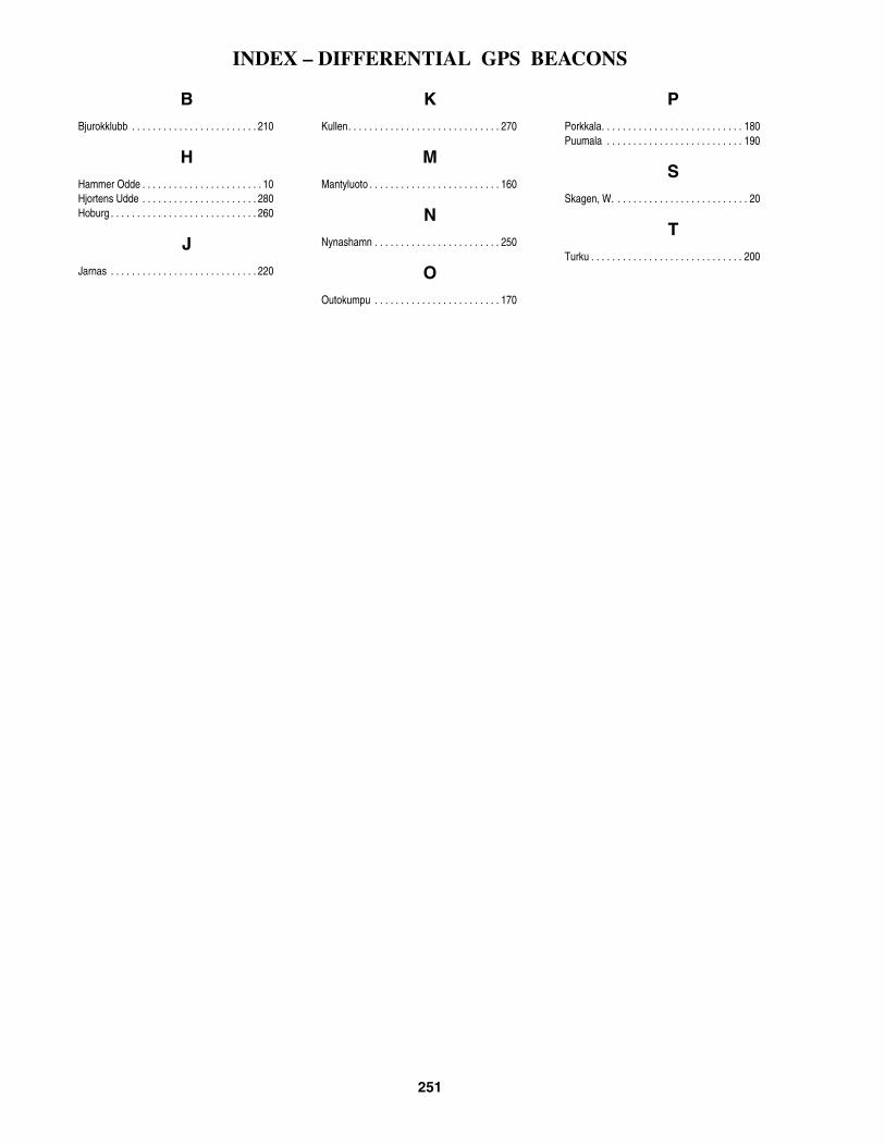
INDEX – DIFFERENTIAL GPS BEACONS
251
BBjurokklubb . . . . . . . . . . . . . . . . . . . . . . . . 210
HHammer Odde . . . . . . . . . . . . . . . . . . . . . . . 10Hjortens Udde . . . . . . . . . . . . . . . . . . . . . . 280Hoburg . . . . . . . . . . . . . . . . . . . . . . . . . . . . 260
JJarnas . . . . . . . . . . . . . . . . . . . . . . . . . . . . 220
KKullen. . . . . . . . . . . . . . . . . . . . . . . . . . . . . 270
MMantyluoto . . . . . . . . . . . . . . . . . . . . . . . . . 160
NNynashamn . . . . . . . . . . . . . . . . . . . . . . . . 250
OOutokumpu . . . . . . . . . . . . . . . . . . . . . . . . 170
PPorkkala. . . . . . . . . . . . . . . . . . . . . . . . . . . 180Puumala . . . . . . . . . . . . . . . . . . . . . . . . . . 190
SSkagen, W. . . . . . . . . . . . . . . . . . . . . . . . . . 20
TTurku . . . . . . . . . . . . . . . . . . . . . . . . . . . . . 200

CROSS REFERENCE - INTERNATIONAL vs. U.S. LIGHT NUMBER
253
Inter. — U.S. Inter. — U.S. Inter. — U.S. Inter. — U.S.
C0001 . . . . . . . . . . . . . . . . . 1520C0002 . . . . . . . . . . . . . . . . . 1524C0004 . . . . . . . . . . . . . . . . . 1544C0004.4 . . . . . . . . . . . . . . . 1540C0006 . . . . . . . . . . . . . . . . . 1548C0009 . . . . . . . . . . . . . . . . . 1556C0010 . . . . . . . . . . . . . . . . . 1560C0016 . . . . . . . . . . . . . . . . . 1576C0017 . . . . . . . . . . . . . . . . . 1572C0020 . . . . . . . . . . . . . . . . . 1584C0024 . . . . . . . . . . . . . . . . . 1588C0025 . . . . . . . . . . . . . . . . . 1598C0025.1 . . . . . . . . . . . . . . . 1598.1C0026 . . . . . . . . . . . . . . . . . 1596C0026.3 . . . . . . . . . . . . . . . 1597C0027 . . . . . . . . . . . . . . . . . 1592C0027.3 . . . . . . . . . . . . . . . 1593C0027.6 . . . . . . . . . . . . . . . 1630C0028 . . . . . . . . . . . . . . . . . 1608C0029 . . . . . . . . . . . . . . . . . 1610C0029.5 . . . . . . . . . . . . . . . 1602C0031 . . . . . . . . . . . . . . . . . 1612C0031.2 . . . . . . . . . . . . . . . 1616C0032 . . . . . . . . . . . . . . . . . 1628C0033 . . . . . . . . . . . . . . . . . 1632C0034 . . . . . . . . . . . . . . . . . 1636C0036 . . . . . . . . . . . . . . . . . 1640C0038 . . . . . . . . . . . . . . . . . 1644C0044 . . . . . . . . . . . . . . . . . 1648C0048 . . . . . . . . . . . . . . . . . 1664C0049 . . . . . . . . . . . . . . . . . 1668C0050 . . . . . . . . . . . . . . . . . 1672C0050.1 . . . . . . . . . . . . . . . 1676C0054 . . . . . . . . . . . . . . . . . 1656C0055 . . . . . . . . . . . . . . . . . 1660C0057 . . . . . . . . . . . . . . . . . 1652C0061 . . . . . . . . . . . . . . . . . 1696C0065 . . . . . . . . . . . . . . . . . 1742C0065.2 . . . . . . . . . . . . . . . 1743C0066 . . . . . . . . . . . . . . . . . 1744C0066.8 . . . . . . . . . . . . . . . 1724C0067 . . . . . . . . . . . . . . . . . 1732C0067.2 . . . . . . . . . . . . . . . 1736C0069 . . . . . . . . . . . . . . . . . 1748C0069.5 . . . . . . . . . . . . . . . 1752C0072 . . . . . . . . . . . . . . . . . 1760C0072.1 . . . . . . . . . . . . . . . 1764C0073 . . . . . . . . . . . . . . . . . 1766C0076 . . . . . . . . . . . . . . . . . 1768C0076.1 . . . . . . . . . . . . . . . 1772C0078 . . . . . . . . . . . . . . . . . 1776C0079.9 . . . . . . . . . . . . . . . 1800C0080 . . . . . . . . . . . . . . . . . 1804C0080.1 . . . . . . . . . . . . . . . 1808C0082 . . . . . . . . . . . . . . . . . 1812C0082.1 . . . . . . . . . . . . . . . 1816C0084 . . . . . . . . . . . . . . . . . 1780C0084.1 . . . . . . . . . . . . . . . 1784C0088.9 . . . . . . . . . . . . . . . 1796C0089 . . . . . . . . . . . . . . . . . 1788C0089.1 . . . . . . . . . . . . . . . 1792C0098 . . . . . . . . . . . . . . . . . 1828C0098.1 . . . . . . . . . . . . . . . 1832C0100.9 . . . . . . . . . . . . . . . 1840C0101 . . . . . . . . . . . . . . . . . 1836
C0101.1 . . . . . . . . . . . . . . . 1841C0102 . . . . . . . . . . . . . . . . 1844C0102.1 . . . . . . . . . . . . . . . 1848C0106 . . . . . . . . . . . . . . . . 1860C0106.1 . . . . . . . . . . . . . . . 1864C0110 . . . . . . . . . . . . . . . . 1868C0110.1 . . . . . . . . . . . . . . . 1872C0121.6 . . . . . . . . . . . . . . . 1884C0121.7 . . . . . . . . . . . . . . . 1888C0124 . . . . . . . . . . . . . . . . 1904C0125 . . . . . . . . . . . . . . . . 1908C0126 . . . . . . . . . . . . . . . . 1912C0126.1 . . . . . . . . . . . . . . . 1916C0127 . . . . . . . . . . . . . . . . 1920C0127.1 . . . . . . . . . . . . . . . 1924C0128 . . . . . . . . . . . . . . . . 1928C0128.1 . . . . . . . . . . . . . . . 1932C0164 . . . . . . . . . . . . . . . . 1976C0166 . . . . . . . . . . . . . . . . 1980C0168 . . . . . . . . . . . . . . . . 1984C0170 . . . . . . . . . . . . . . . . 1992C0172 . . . . . . . . . . . . . . . . 1988C0176 . . . . . . . . . . . . . . . . 1936C0178 . . . . . . . . . . . . . . . . 1940C0178.1 . . . . . . . . . . . . . . . 1944C0182 . . . . . . . . . . . . . . . . 1948C0182.1 . . . . . . . . . . . . . . . 1952C0184 . . . . . . . . . . . . . . . . 1956C0184.1 . . . . . . . . . . . . . . . 1960C0186 . . . . . . . . . . . . . . . . 1964C0188 . . . . . . . . . . . . . . . . 1968C0190 . . . . . . . . . . . . . . . . 1972C0195 . . . . . . . . . . . . . . . . 2000C0195.2 . . . . . . . . . . . . . . . 2004C0200 . . . . . . . . . . . . . . . . 2008C0204 . . . . . . . . . . . . . . . . 2012C0209 . . . . . . . . . . . . . . . . 2020C0210 . . . . . . . . . . . . . . . . 2024C0212 . . . . . . . . . . . . . . . . 2028C0214 . . . . . . . . . . . . . . . . 2032C0214.4 . . . . . . . . . . . . . . . 2034C0214.6 . . . . . . . . . . . . . . . 2034.1C0220 . . . . . . . . . . . . . . . . 2040C0222 . . . . . . . . . . . . . . . . 2044C0226 . . . . . . . . . . . . . . . . 2052C0228 . . . . . . . . . . . . . . . . 2056C0230 . . . . . . . . . . . . . . . . 2060C0233 . . . . . . . . . . . . . . . . 2080C0234 . . . . . . . . . . . . . . . . 2084C0237 . . . . . . . . . . . . . . . . 2076C0238 . . . . . . . . . . . . . . . . 2072C0239.42 . . . . . . . . . . . . . . 2096C0239.43 . . . . . . . . . . . . . . 2100C0239.44 . . . . . . . . . . . . . . 2104C0239.45 . . . . . . . . . . . . . . 2108C0239.7 . . . . . . . . . . . . . . . 2116C0239.71 . . . . . . . . . . . . . . 2120C0242 . . . . . . . . . . . . . . . . 2140C0242.1 . . . . . . . . . . . . . . . 2144C0243 . . . . . . . . . . . . . . . . 2204C0244 . . . . . . . . . . . . . . . . 2196C0246 . . . . . . . . . . . . . . . . 2200C0248 . . . . . . . . . . . . . . . . 2180C0248.1 . . . . . . . . . . . . . . . 2184C0253 . . . . . . . . . . . . . . . . 2172
C0254 . . . . . . . . . . . . . . . . . 2176C0255 . . . . . . . . . . . . . . . . . 2152C0255.1 . . . . . . . . . . . . . . . 2156C0257 . . . . . . . . . . . . . . . . . 2168C0257.5 . . . . . . . . . . . . . . . 2164C0260.5 . . . . . . . . . . . . . . . 2132C0260.6 . . . . . . . . . . . . . . . 2136C0260.7 . . . . . . . . . . . . . . . 2138C0262 . . . . . . . . . . . . . . . . . 2208C0277 . . . . . . . . . . . . . . . . . . . . 4C0279 . . . . . . . . . . . . . . . . . . . . 8C0280 . . . . . . . . . . . . . . . . . . . 12C0280.01 . . . . . . . . . . . . . . . . 16C0281 . . . . . . . . . . . . . . . . . . . 20C0281.01 . . . . . . . . . . . . . . . . 24C0282 . . . . . . . . . . . . . . . . . . . 28C0283 . . . . . . . . . . . . . . . . . . . 32C0284 . . . . . . . . . . . . . . . . . . . 36C0285 . . . . . . . . . . . . . . . . . . . 40C0287 . . . . . . . . . . . . . . . . . . . 44C0289 . . . . . . . . . . . . . . . . . . . 56C0289.01 . . . . . . . . . . . . . . . . 60C0290 . . . . . . . . . . . . . . . . . . . 48C0291 . . . . . . . . . . . . . . . . . . . 64C0291.1 . . . . . . . . . . . . . . . . . 52C0293 . . . . . . . . . . . . . . . . . . . 76C0298 . . . . . . . . . . . . . . . . . . . 68C0298.01 . . . . . . . . . . . . . . . . 72C0300 . . . . . . . . . . . . . . . . . . . 84C0301 . . . . . . . . . . . . . . . . . . . 88C0302 . . . . . . . . . . . . . . . . . . . 92C0304 . . . . . . . . . . . . . . . . . . . 96C0306 . . . . . . . . . . . . . . . . . . 112C0308 . . . . . . . . . . . . . . . . . . 116C0310 . . . . . . . . . . . . . . . . . . 114C0312 . . . . . . . . . . . . . . . . . . 120C0312.01 . . . . . . . . . . . . . . . 124C0314 . . . . . . . . . . . . . . . . . . 128C0316 . . . . . . . . . . . . . . . . . . 152C0316.01 . . . . . . . . . . . . . . . 156C0317 . . . . . . . . . . . . . . . . . . 144C0317.01 . . . . . . . . . . . . . . . 148C0319 . . . . . . . . . . . . . . . . . . 140C0320 . . . . . . . . . . . . . . . . . . 132C0322 . . . . . . . . . . . . . . . . . . 160C0324 . . . . . . . . . . . . . . . . . . 136C0327 . . . . . . . . . . . . . . . . . . 184C0328 . . . . . . . . . . . . . . . . . . 176C0329 . . . . . . . . . . . . . . . . . . 172C0330 . . . . . . . . . . . . . . . . . . 168C0331 . . . . . . . . . . . . . . . . . . 164C0334 . . . . . . . . . . . . . . . . . . 196C0335 . . . . . . . . . . . . . . . . . . 192C0337 . . . . . . . . . . . . . . . . . . 180C0338 . . . . . . . . . . . . . . . . . . 200C0339 . . . . . . . . . . . . . . . . . . 204C0340 . . . . . . . . . . . . . . . . . . 208C0340.01 . . . . . . . . . . . . . . . 212C0344 . . . . . . . . . . . . . . . . . . 220C0344.1 . . . . . . . . . . . . . . . . 224C0352 . . . . . . . . . . . . . . . . . . 240C0353 . . . . . . . . . . . . . . . . . . 242C0354 . . . . . . . . . . . . . . . . . . 244C0354.1 . . . . . . . . . . . . . . . . 248C0360 . . . . . . . . . . . . . . . . . . 356
C0360.1 . . . . . . . . . . . . . . . .360C0361 . . . . . . . . . . . . . . . . . .260C0364 . . . . . . . . . . . . . . . . . .308C0364.1 . . . . . . . . . . . . . . . .312C0366 . . . . . . . . . . . . . . . . . .348C0368 . . . . . . . . . . . . . . . . . .272C0369 . . . . . . . . . . . . . . . . . .268C0370 . . . . . . . . . . . . . . . . . .284C0370.1 . . . . . . . . . . . . . . . .288C0371 . . . . . . . . . . . . . . . . . .282C0372 . . . . . . . . . . . . . . . . . .292C0372.1 . . . . . . . . . . . . . . . .296C0375 . . . . . . . . . . . . . . . . . .276C0376 . . . . . . . . . . . . . . . . . .316C0376.2 . . . . . . . . . . . . . . . .320C0376.4 . . . . . . . . . . . . . . . .324C0376.41 . . . . . . . . . . . . . . .328C0376.42 . . . . . . . . . . . . . . .329C0376.43 . . . . . . . . . . . . . . .330C0376.5 . . . . . . . . . . . . . . . .332C0376.51 . . . . . . . . . . . . . . .336C0378.2 . . . . . . . . . . . . . . . .340C0378.4 . . . . . . . . . . . . . . . .372C0378.6 . . . . . . . . . . . . . . . .344C0379 . . . . . . . . . . . . . . . . . .364C0380 . . . . . . . . . . . . . . . . . .376C0381 . . . . . . . . . . . . . . . . . .378C0381.5 . . . . . . . . . . . . . . . .380C0382 . . . . . . . . . . . . . . . . . .396C0384 . . . . . . . . . . . . . . . . . .392C0388 . . . . . . . . . . . . . . . . . .388C0390 . . . . . . . . . . . . . . . . . .400C0390.5 . . . . . . . . . . . . . . . .402C0392 . . . . . . . . . . . . . . . . . .404C0392.5 . . . . . . . . . . . . . . . .416C0392.7 . . . . . . . . . . . . . . . .417C0392.8 . . . . . . . . . . . . . . . .418C0394 . . . . . . . . . . . . . . . . . .432C0398 . . . . . . . . . . . . . . . . . .436C0400 . . . . . . . . . . . . . . . . . .440C0402 . . . . . . . . . . . . . . . . . .444C0404 . . . . . . . . . . . . . . . . . .448C0409 . . . . . . . . . . . . . . . . . .452C0409.1 . . . . . . . . . . . . . . . .456C0409.5 . . . . . . . . . . . . . . . .460C0409.6 . . . . . . . . . . . . . . . .464C0410 . . . . . . . . . . . . . . . . . .468C0410.1 . . . . . . . . . . . . . . . .472C0410.5 . . . . . . . . . . . . . . . .476C0411 . . . . . . . . . . . . . . . . . .480C0411.4 . . . . . . . . . . . . . . . .484C0411.5 . . . . . . . . . . . . . . . .488C0411.6 . . . . . . . . . . . . . . . .492C0411.9 . . . . . . . . . . . . . . . .496C0412 . . . . . . . . . . . . . . . . . .498C0412.5 . . . . . . . . . . . . . . . .500C0412.7 . . . . . . . . . . . . . . . .504C0413 . . . . . . . . . . . . . . . . . .512C0413.3 . . . . . . . . . . . . . . . .508C0413.5 . . . . . . . . . . . . . . . .516C0414 . . . . . . . . . . . . . . . . . .840C0414.5 . . . . . . . . . . . . . . . .848.1, 848.2C0416 . . . . . . . . . . . . . . . . . .852C0416.1 . . . . . . . . . . . . . . . .856

CROSS REFERENCE - INTERNATIONAL vs. U.S. LIGHT NUMBER
254
Inter. — U.S. Inter. — U.S. Inter. — U.S. Inter. — U.S.
C0417 . . . . . . . . . . . . . . . . . . 836C0417.5 . . . . . . . . . . . . . . . . 832C0418 . . . . . . . . . . . . . . . . . . 828C0419 . . . . . . . . . . . . . . . . . . 826C0422 . . . . . . . . . . . . . . . . . . 528C0426 . . . . . . . . . . . . . . . . . . 544.1C0427 . . . . . . . . . . . . . . . . . . 544C0428 . . . . . . . . . . . . . . . . . . 540C0430 . . . . . . . . . . . . . . . . . . 548C0434 . . . . . . . . . . . . . . . . . . 552C0434.1 . . . . . . . . . . . . . . . . 556C0438 . . . . . . . . . . . . . . . . . . 560C0438.1 . . . . . . . . . . . . . . . . 564C0444 . . . . . . . . . . . . . . . . . . 568C0446 . . . . . . . . . . . . . . . . . . 572C0447 . . . . . . . . . . . . . . . . . . 576C0447.1 . . . . . . . . . . . . . . . . 580C0448 . . . . . . . . . . . . . . . . . . 584C0450 . . . . . . . . . . . . . . . . . . 604C0452 . . . . . . . . . . . . . . . . . . 608C0456 . . . . . . . . . . . . . . . . . . 588C0458 . . . . . . . . . . . . . . . . . . 592C0460 . . . . . . . . . . . . . . . . . . 596C0462 . . . . . . . . . . . . . . . . . . 600C0463 . . . . . . . . . . . . . . . . . . 612C0464 . . . . . . . . . . . . . . . . . . 616C0468 . . . . . . . . . . . . . . . . . . 620C0468.1 . . . . . . . . . . . . . . . . 624C0472 . . . . . . . . . . . . . . . . . . 628C0474 . . . . . . . . . . . . . . . . . . 632C0474.1 . . . . . . . . . . . . . . . . 636C0482 . . . . . . . . . . . . . . . . . . 648C0482.1 . . . . . . . . . . . . . . . . 652C0485 . . . . . . . . . . . . . . . . . . 656C0485.1 . . . . . . . . . . . . . . . . 660C0486 . . . . . . . . . . . . . . . . . . 664C0488 . . . . . . . . . . . . . . . . . . 668C0488.1 . . . . . . . . . . . . . . . . 672C0489 . . . . . . . . . . . . . . . . . . 708C0489.4 . . . . . . . . . . . . . . . . 701C0490 . . . . . . . . . . . . . . . . . . 680C0490.6 . . . . . . . . . . . . . . . . 684C0491 . . . . . . . . . . . . . . . . . . 688C0491.1 . . . . . . . . . . . . . . . . 690C0491.4 . . . . . . . . . . . . . . . . 692C0491.5 . . . . . . . . . . . . . . . . 696C0493 . . . . . . . . . . . . . . . . . . 712C0494 . . . . . . . . . . . . . . . . . . 720C0494.8 . . . . . . . . . . . . . . . . 716C0496 . . . . . . . . . . . . . . . . . . 724C0498 . . . . . . . . . . . . . . . . . . 728C0499 . . . . . . . . . . . . . . . . . . 730C0500 . . . . . . . . . . . . . . . . . . 731C0501 . . . . . . . . . . . . . . . . . . 732C0502 . . . . . . . . . . . . . . . . . . 752C0502.2 . . . . . . . . . . . . . . . . 736C0502.21 . . . . . . . . . . . . . . . 740C0502.4 . . . . . . . . . . . . . . . . 744C0502.41 . . . . . . . . . . . . . . . 748C0503 . . . . . . . . . . . . . . . . . . 754C0503.4 . . . . . . . . . . . . . . . . 760C0503.6 . . . . . . . . . . . . . . . . 756C0504.2 . . . . . . . . . . . . . . . . 768C0504.21 . . . . . . . . . . . . . . . 772C0504.3 . . . . . . . . . . . . . . . . 776
C0504.31 . . . . . . . . . . . . . . . 780C0504.36 . . . . . . . . . . . . . . . 784C0504.37 . . . . . . . . . . . . . . . 788C0504.4 . . . . . . . . . . . . . . . . 792C0504.41 . . . . . . . . . . . . . . . 796C0504.6 . . . . . . . . . . . . . . . . 800C0504.61 . . . . . . . . . . . . . . . 804C0506 . . . . . . . . . . . . . . . . . 808C0507 . . . . . . . . . . . . . . . . . 810C0508 . . . . . . . . . . . . . . . . . 816C0510 . . . . . . . . . . . . . . . . . 812C0511 . . . . . . . . . . . . . . . . . 820C0511.4 . . . . . . . . . . . . . . . . 819C0512 . . . . . . . . . . . . . . . . . 824C0514 . . . . . . . . . . . . . . . . . 860C0514.1 . . . . . . . . . . . . . . . . 864C0517 . . . . . . . . . . . . . . . . . 868C0520 . . . . . . . . . . . . . . . . . 876C0521 . . . . . . . . . . . . . . . . . 872C0523 . . . . . . . . . . . . . . . . . 888C0525 . . . . . . . . . . . . . . . . . 884C0525.5 . . . . . . . . . . . . . . . . 886C0526 . . . . . . . . . . . . . . . . . 892C0526.1 . . . . . . . . . . . . . . . . 896C0528 . . . . . . . . . . . . . . . . . 916C0530 . . . . . . . . . . . . . . . . . 920C0530.1 . . . . . . . . . . . . . . . . 924C0532 . . . . . . . . . . . . . . . . . 928C0532.1 . . . . . . . . . . . . . . . . 932C0536 . . . . . . . . . . . . . . . . . 936C0536.1 . . . . . . . . . . . . . . . . 940C0552 . . . . . . . . . . . . . . . . . 960C0552.1 . . . . . . . . . . . . . . . . 964C0556 . . . . . . . . . . . . . . . . . 968C0556.3 . . . . . . . . . . . . . . . . 959C0556.5 . . . . . . . . . . . . . . . . 958C0557 . . . . . . . . . . . . . . . . . 944C0557.1 . . . . . . . . . . . . . . . . 948C0558 . . . . . . . . . . . . . . . . . 972C0558.7 . . . . . . . . . . . . . . . . 973C0559 . . . . . . . . . . . . . . . . . 974C0559.1 . . . . . . . . . . . . . . . . 975C0560 . . . . . . . . . . . . . . . . . 992C0561 . . . . . . . . . . . . . . . . . 996C0562 . . . . . . . . . . . . . . . . 1012C0562.6 . . . . . . . . . . . . . . . 1000C0563 . . . . . . . . . . . . . . . . 1004C0564 . . . . . . . . . . . . . . . . 1044C0564.5 . . . . . . . . . . . . . . . 1042C0565 . . . . . . . . . . . . . . . . 1020C0566 . . . . . . . . . . . . . . . . 1048C0566.1 . . . . . . . . . . . . . . . 1052C0567 . . . . . . . . . . . . . . . . 1040C0569 . . . . . . . . . . . . . . . . 1024C0570 . . . . . . . . . . . . . . . . 1064C0571 . . . . . . . . . . . . . . . . 1075C0571.6 . . . . . . . . . . . . . . . 1080C0573 . . . . . . . . . . . . . . . . 1088C0574 . . . . . . . . . . . . . . . . . 943C0575 . . . . . . . . . . . . . . . . 1092C0577 . . . . . . . . . . . . . . . . 1068C0583 . . . . . . . . . . . . . . . . 1124.2C0583.1 . . . . . . . . . . . . . . . 1124.21C0583.5 . . . . . . . . . . . . . . . 1124.5C0583.51 . . . . . . . . . . . . . . 1124.6
C0589 . . . . . . . . . . . . . . . . . 1144C0594 . . . . . . . . . . . . . . . . . 1148C0618 . . . . . . . . . . . . . . . . . 1058C0619 . . . . . . . . . . . . . . . . . 1056C0620 . . . . . . . . . . . . . . . . . 1036C0623 . . . . . . . . . . . . . . . . . 1156C0624 . . . . . . . . . . . . . . . . . 1152C0625 . . . . . . . . . . . . . . . . . 1160C0626 . . . . . . . . . . . . . . . . . 1164C0628 . . . . . . . . . . . . . . . . . 1176C0630 . . . . . . . . . . . . . . . . . 1180C0632 . . . . . . . . . . . . . . . . . 1184C0634 . . . . . . . . . . . . . . . . . 1196C0636 . . . . . . . . . . . . . . . . . 1188C0644 . . . . . . . . . . . . . . . . . 1200C0650 . . . . . . . . . . . . . . . . . 1212C0652 . . . . . . . . . . . . . . . . . 1208C0654 . . . . . . . . . . . . . . . . . 1216C0656 . . . . . . . . . . . . . . . . . 1132C0658 . . . . . . . . . . . . . . . . . 1168C0659 . . . . . . . . . . . . . . . . . 1166C0660 . . . . . . . . . . . . . . . . . 1172C0664 . . . . . . . . . . . . . . . . . 1240C0666 . . . . . . . . . . . . . . . . . 1232C0670 . . . . . . . . . . . . . . . . . 1228C0671 . . . . . . . . . . . . . . . . . 1296C0673 . . . . . . . . . . . . . . . . . 1236C0674 . . . . . . . . . . . . . . . . . 1244C0680 . . . . . . . . . . . . . . . . . 1256C0682 . . . . . . . . . . . . . . . . . 1268C0682.5 . . . . . . . . . . . . . . . 1285C0682.51 . . . . . . . . . . . . . . 1285.1C0682.6 . . . . . . . . . . . . . . . 1272C0682.61 . . . . . . . . . . . . . . 1276C0682.7 . . . . . . . . . . . . . . . 1280C0682.71 . . . . . . . . . . . . . . 1284C0683 . . . . . . . . . . . . . . . . . 1288C0683.1 . . . . . . . . . . . . . . . 1292C0683.2 . . . . . . . . . . . . . . . 1294C0683.21 . . . . . . . . . . . . . . 1295C0683.4 . . . . . . . . . . . . . . . 1260C0683.5 . . . . . . . . . . . . . . . 1264C0684 . . . . . . . . . . . . . . . . . 1300C0692 . . . . . . . . . . . . . . . . . 1304C0692.1 . . . . . . . . . . . . . . . 1308C0693 . . . . . . . . . . . . . . . . . 1312C0693.1 . . . . . . . . . . . . . . . 1316C0698 . . . . . . . . . . . . . . . . . 1328C0698.1 . . . . . . . . . . . . . . . 1332C0698.4 . . . . . . . . . . . . . . . 1320C0698.5 . . . . . . . . . . . . . . . 1324C0704 . . . . . . . . . . . . . . . . . 1340C0706 . . . . . . . . . . . . . . . . . 1344C0708 . . . . . . . . . . . . . . . . . 1348C0708.1 . . . . . . . . . . . . . . . 1352C0714 . . . . . . . . . . . . . . . . . 1356C0716 . . . . . . . . . . . . . . . . . 1360C0722 . . . . . . . . . . . . . . . . . 1368C0724 . . . . . . . . . . . . . . . . . 1372C0724.1 . . . . . . . . . . . . . . . 1376C0726 . . . . . . . . . . . . . . . . . 1380C0726.1 . . . . . . . . . . . . . . . 1384C0728.2 . . . . . . . . . . . . . . . 1396C0728.3 . . . . . . . . . . . . . . . 1400C0734 . . . . . . . . . . . . . . . . . 1401
C0734.1 . . . . . . . . . . . . . . .1401.1C0734.2 . . . . . . . . . . . . . . .1403C0734.21 . . . . . . . . . . . . . .1403.1C0735 . . . . . . . . . . . . . . . . .1404C0737 . . . . . . . . . . . . . . . . .1408C0738 . . . . . . . . . . . . . . . . .1416C0739 . . . . . . . . . . . . . . . . .1428C0739.1 . . . . . . . . . . . . . . .1432C0739.4 . . . . . . . . . . . . . . .1441C0739.5 . . . . . . . . . . . . . . .1442C0740 . . . . . . . . . . . . . . . . .1436C0740.1 . . . . . . . . . . . . . . .1440C0746 . . . . . . . . . . . . . . . . .1420C0746.1 . . . . . . . . . . . . . . .1424C0752 . . . . . . . . . . . . . . . . .1444C0752.1 . . . . . . . . . . . . . . .1448C0772 . . . . . . . . . . . . . . . . .2220C0773.4 . . . . . . . . . . . . . . .2232C0774 . . . . . . . . . . . . . . . . .2234C0774.1 . . . . . . . . . . . . . . .2234.1C0776 . . . . . . . . . . . . . . . . .2233C0776.1 . . . . . . . . . . . . . . .2233.1C0776.3 . . . . . . . . . . . . . . .2248C0776.4 . . . . . . . . . . . . . . .2244C0777 . . . . . . . . . . . . . . . . .2250C0780.4 . . . . . . . . . . . . . . .2218.1C0781 . . . . . . . . . . . . . . . . .2218C0782 . . . . . . . . . . . . . . . . .2212C0782.1 . . . . . . . . . . . . . . .2216C0786 . . . . . . . . . . . . . . . . .2252C0789.5 . . . . . . . . . . . . . . .2294C0792 . . . . . . . . . . . . . . . . .2280C0793 . . . . . . . . . . . . . . . . .2282C0793.5 . . . . . . . . . . . . . . .2281C0793.9 . . . . . . . . . . . . . . .2283C0794.5 . . . . . . . . . . . . . . .2287C0795 . . . . . . . . . . . . . . . . .2289C0796 . . . . . . . . . . . . . . . . .2286C0796.1 . . . . . . . . . . . . . . .2286.1C0797.8 . . . . . . . . . . . . . . .2287.5C0802.05 . . . . . . . . . . . . . .2275C0803 . . . . . . . . . . . . . . . . .2275.1C0804 . . . . . . . . . . . . . . . . .2275.2C0808 . . . . . . . . . . . . . . . . .2292C0810 . . . . . . . . . . . . . . . . .2258C0812 . . . . . . . . . . . . . . . . .2271C0812.5 . . . . . . . . . . . . . . .2271.1C0813 . . . . . . . . . . . . . . . . .2269C0813.2 . . . . . . . . . . . . . . .2270C0814 . . . . . . . . . . . . . . . . .2264C0814.1 . . . . . . . . . . . . . . .2268C0818 . . . . . . . . . . . . . . . . .2262C0819 . . . . . . . . . . . . . . . . .2260C0821 . . . . . . . . . . . . . . . . .2296C0822 . . . . . . . . . . . . . . . . .2300C0824 . . . . . . . . . . . . . . . . .2304C0837 . . . . . . . . . . . . . . . . .2328C0838 . . . . . . . . . . . . . . . . .2332C0839 . . . . . . . . . . . . . . . . .2336C0842 . . . . . . . . . . . . . . . . .2340C0844 . . . . . . . . . . . . . . . . .2344C0846 . . . . . . . . . . . . . . . . .2345C0856 . . . . . . . . . . . . . . . . .2368C0856.1 . . . . . . . . . . . . . . .2372C0860 . . . . . . . . . . . . . . . . .2376

CROSS REFERENCE - INTERNATIONAL vs. U.S. LIGHT NUMBER
255
Inter. — U.S. Inter. — U.S. Inter. — U.S. Inter. — U.S.
C0860.1 . . . . . . . . . . . . . . . 2380C0866 . . . . . . . . . . . . . . . . . 2384C0866.1 . . . . . . . . . . . . . . . 2388C0870 . . . . . . . . . . . . . . . . . 2392C0870.1 . . . . . . . . . . . . . . . 2396C0876 . . . . . . . . . . . . . . . . . 2400C0876.1 . . . . . . . . . . . . . . . 2404C0877 . . . . . . . . . . . . . . . . . 2406C0880 . . . . . . . . . . . . . . . . . 2408C0884 . . . . . . . . . . . . . . . . . 2416C0885 . . . . . . . . . . . . . . . . . 2420C0888 . . . . . . . . . . . . . . . . . 2436C0890 . . . . . . . . . . . . . . . . . 2440C0890.2 . . . . . . . . . . . . . . . 2442C0890.21 . . . . . . . . . . . . . . 2442.1C0890.4 . . . . . . . . . . . . . . . 2444C0893.5 . . . . . . . . . . . . . . . 2432C0894 . . . . . . . . . . . . . . . . . 2460C0900 . . . . . . . . . . . . . . . . . 2464C0900.1 . . . . . . . . . . . . . . . 2468C0904 . . . . . . . . . . . . . . . . . 2448C0908 . . . . . . . . . . . . . . . . . 2452C0908.1 . . . . . . . . . . . . . . . 2456C0911 . . . . . . . . . . . . . . . . . 2484C0918 . . . . . . . . . . . . . . . . . 2492C0919 . . . . . . . . . . . . . . . . . 2496C0919.4 . . . . . . . . . . . . . . . 2512C0919.41 . . . . . . . . . . . . . . 2516C0920 . . . . . . . . . . . . . . . . . 2500C0920.2 . . . . . . . . . . . . . . . 2504C0922 . . . . . . . . . . . . . . . . . 2472C0923 . . . . . . . . . . . . . . . . . 2524C0924 . . . . . . . . . . . . . . . . . 2508C0925 . . . . . . . . . . . . . . . . . 2520C0928 . . . . . . . . . . . . . . . . . 2528C0932 . . . . . . . . . . . . . . . . . 2536C0934 . . . . . . . . . . . . . . . . . 2544C0936 . . . . . . . . . . . . . . . . . 2540C0938 . . . . . . . . . . . . . . . . . 2548C0944 . . . . . . . . . . . . . . . . . 2552C0948 . . . . . . . . . . . . . . . . . 2560C0949 . . . . . . . . . . . . . . . . . 2564C0949.1 . . . . . . . . . . . . . . . 2568C0950 . . . . . . . . . . . . . . . . . 2556C0956 . . . . . . . . . . . . . . . . . 2572C0958 . . . . . . . . . . . . . . . . . 2576C0958.1 . . . . . . . . . . . . . . . 2580C0959 . . . . . . . . . . . . . . . . . 2588C0960 . . . . . . . . . . . . . . . . . 2584C0962 . . . . . . . . . . . . . . . . . 2596C0964 . . . . . . . . . . . . . . . . . 2592C0968 . . . . . . . . . . . . . . . . . 2608C0969 . . . . . . . . . . . . . . . . . 2628C0970 . . . . . . . . . . . . . . . . . 2620C0970.4 . . . . . . . . . . . . . . . 2624C0970.6 . . . . . . . . . . . . . . . 2632C0977 . . . . . . . . . . . . . . . . . 2616C0982 . . . . . . . . . . . . . . . . . 2617C0983 . . . . . . . . . . . . . . . . . 2618C0988 . . . . . . . . . . . . . . . . . 2636C0988.4 . . . . . . . . . . . . . . . 2648C0989.4 . . . . . . . . . . . . . . . 2644C0989.6 . . . . . . . . . . . . . . . 2640C0989.8 . . . . . . . . . . . . . . . 2736C0989.81 . . . . . . . . . . . . . . 2740
C0991 . . . . . . . . . . . . . . . . 2748C0992 . . . . . . . . . . . . . . . . 2752C0994 . . . . . . . . . . . . . . . . 2760C0998 . . . . . . . . . . . . . . . . 2764C0998.1 . . . . . . . . . . . . . . . 2768C1004 . . . . . . . . . . . . . . . . 2776C1004.1 . . . . . . . . . . . . . . . 2780C1016 . . . . . . . . . . . . . . . . 2788C1020 . . . . . . . . . . . . . . . . 2784C1020.5 . . . . . . . . . . . . . . . 3926C1021.4 . . . . . . . . . . . . . . . 3927C1021.41 . . . . . . . . . . . . . . 3927.1C1022 . . . . . . . . . . . . . . . . 3924C1030 . . . . . . . . . . . . . . . . 2652C1032 . . . . . . . . . . . . . . . . 2712C1034 . . . . . . . . . . . . . . . . 2716C1035.3 . . . . . . . . . . . . . . . 2718C1035.4 . . . . . . . . . . . . . . . 2720C1035.8 . . . . . . . . . . . . . . . 2724C1037 . . . . . . . . . . . . . . . . 2728C1037.1 . . . . . . . . . . . . . . . 2732C1042 . . . . . . . . . . . . . . . . 2852C1046 . . . . . . . . . . . . . . . . 2856C1050 . . . . . . . . . . . . . . . . 2660C1050.1 . . . . . . . . . . . . . . . 2664C1052 . . . . . . . . . . . . . . . . 2668C1052.1 . . . . . . . . . . . . . . . 2672C1055 . . . . . . . . . . . . . . . . 2676C1055.1 . . . . . . . . . . . . . . . 2680C1065 . . . . . . . . . . . . . . . . 2684C1066 . . . . . . . . . . . . . . . . 2704C1067 . . . . . . . . . . . . . . . . 2696C1067.1 . . . . . . . . . . . . . . . 2700C1067.4 . . . . . . . . . . . . . . . 2688C1067.5 . . . . . . . . . . . . . . . 2692C1068 . . . . . . . . . . . . . . . . 2796C1068.1 . . . . . . . . . . . . . . . 2800C1070 . . . . . . . . . . . . . . . . 2792C1074 . . . . . . . . . . . . . . . . 2804C1076 . . . . . . . . . . . . . . . . 2812C1076.1 . . . . . . . . . . . . . . . 2816C1077 . . . . . . . . . . . . . . . . 2818C1078 . . . . . . . . . . . . . . . . 2808C1082 . . . . . . . . . . . . . . . . 2836C1084 . . . . . . . . . . . . . . . . 2833C1084.1 . . . . . . . . . . . . . . . 2833.1C1084.3 . . . . . . . . . . . . . . . 2834C1084.31 . . . . . . . . . . . . . . 2834.1C1086 . . . . . . . . . . . . . . . . 2820C1086.1 . . . . . . . . . . . . . . . 2824C1087 . . . . . . . . . . . . . . . . 2825C1087.1 . . . . . . . . . . . . . . . 2825.1C1087.8 . . . . . . . . . . . . . . . 2826C1088 . . . . . . . . . . . . . . . . 2828C1088.1 . . . . . . . . . . . . . . . 2832C1098 . . . . . . . . . . . . . . . . 2864C1098.1 . . . . . . . . . . . . . . . 2868C1100 . . . . . . . . . . . . . . . . 2872C1104 . . . . . . . . . . . . . . . . 2876C1113 . . . . . . . . . . . . . . . . 2900C1115.4 . . . . . . . . . . . . . . . 2893C1115.5 . . . . . . . . . . . . . . . 2880C1116.4 . . . . . . . . . . . . . . . 2888C1117 . . . . . . . . . . . . . . . . 2892C1122 . . . . . . . . . . . . . . . . 2708
C1126 . . . . . . . . . . . . . . . . . 2920C1126.1 . . . . . . . . . . . . . . . 2924C1134 . . . . . . . . . . . . . . . . . 2928C1136 . . . . . . . . . . . . . . . . . 2932C1136.1 . . . . . . . . . . . . . . . 2936C1137 . . . . . . . . . . . . . . . . . 2940C1140 . . . . . . . . . . . . . . . . . 2952C1140.1 . . . . . . . . . . . . . . . 2956C1146 . . . . . . . . . . . . . . . . . 2960C1146.1 . . . . . . . . . . . . . . . 2964C1166 . . . . . . . . . . . . . . . . . 2944C1166.1 . . . . . . . . . . . . . . . 2948C1175 . . . . . . . . . . . . . . . . . 2966C1175.5 . . . . . . . . . . . . . . . 2966.1C1176 . . . . . . . . . . . . . . . . . 2972C1180 . . . . . . . . . . . . . . . . . 2980C1180.1 . . . . . . . . . . . . . . . 2984C1186 . . . . . . . . . . . . . . . . . 3000C1188 . . . . . . . . . . . . . . . . . 3004C1188.1 . . . . . . . . . . . . . . . 3008C1189 . . . . . . . . . . . . . . . . . 3036C1189.1 . . . . . . . . . . . . . . . 3040C1190 . . . . . . . . . . . . . . . . . 3044C1190.1 . . . . . . . . . . . . . . . 3048C1192 . . . . . . . . . . . . . . . . . 3052C1192.1 . . . . . . . . . . . . . . . 3056C1197 . . . . . . . . . . . . . . . . . 3057C1198 . . . . . . . . . . . . . . . . . 3058C1202 . . . . . . . . . . . . . . . . . 3060C1203 . . . . . . . . . . . . . . . . . 3064C1206 . . . . . . . . . . . . . . . . . 3068C1210 . . . . . . . . . . . . . . . . . 3072C1214 . . . . . . . . . . . . . . . . . 3074C1215 . . . . . . . . . . . . . . . . . 3080C1216 . . . . . . . . . . . . . . . . . 3084C1220 . . . . . . . . . . . . . . . . . 3096C1222 . . . . . . . . . . . . . . . . . 3100C1226 . . . . . . . . . . . . . . . . . 3104C1226.1 . . . . . . . . . . . . . . . 3108C1230 . . . . . . . . . . . . . . . . . 3112C1237 . . . . . . . . . . . . . . . . . 3128C1238 . . . . . . . . . . . . . . . . . 3124C1246 . . . . . . . . . . . . . . . . . 3116C1248 . . . . . . . . . . . . . . . . . 3120C1251 . . . . . . . . . . . . . . . . . 3121C1276 . . . . . . . . . . . . . . . . . 3136C1280 . . . . . . . . . . . . . . . . . 3164C1281 . . . . . . . . . . . . . . . . . 3172C1281.1 . . . . . . . . . . . . . . . 3176C1282 . . . . . . . . . . . . . . . . . 3180C1282.2 . . . . . . . . . . . . . . . 3184C1284 . . . . . . . . . . . . . . . . . 3188C1286 . . . . . . . . . . . . . . . . . 3192C1287 . . . . . . . . . . . . . . . . . 3194C1288 . . . . . . . . . . . . . . . . . 3216C1288.1 . . . . . . . . . . . . . . . 3220C1300 . . . . . . . . . . . . . . . . . 3228C1312 . . . . . . . . . . . . . . . . . 3236C1316 . . . . . . . . . . . . . . . . . 3200C1322 . . . . . . . . . . . . . . . . . 3208C1324 . . . . . . . . . . . . . . . . . 3212C1326 . . . . . . . . . . . . . . . . . 3196C1328 . . . . . . . . . . . . . . . . . 3156C1329 . . . . . . . . . . . . . . . . . 3148C1329.1 . . . . . . . . . . . . . . . 3152
C1336 . . . . . . . . . . . . . . . . .3140C1338 . . . . . . . . . . . . . . . . .3144C1342 . . . . . . . . . . . . . . . . .3244C1346 . . . . . . . . . . . . . . . . .3248C1348 . . . . . . . . . . . . . . . . .3252C1348.1 . . . . . . . . . . . . . . .3256C1348.4 . . . . . . . . . . . . . . .3260C1348.41 . . . . . . . . . . . . . .3264C1350 . . . . . . . . . . . . . . . . .3272C1350.1 . . . . . . . . . . . . . . .3276C1360 . . . . . . . . . . . . . . . . .3304C1362 . . . . . . . . . . . . . . . . .3308C1365.9 . . . . . . . . . . . . . . .3302C1365.95 . . . . . . . . . . . . . .3303C1370 . . . . . . . . . . . . . . . . .3296C1370.1 . . . . . . . . . . . . . . .3300C1380.2 . . . . . . . . . . . . . . .3315.1C1380.3 . . . . . . . . . . . . . . .3315.2C1382 . . . . . . . . . . . . . . . . .3316C1382.1 . . . . . . . . . . . . . . .3320C1386 . . . . . . . . . . . . . . . . .3328C1386.4 . . . . . . . . . . . . . . .3315C1387.8 . . . . . . . . . . . . . . .3342C1387.9 . . . . . . . . . . . . . . .3344C1388 . . . . . . . . . . . . . . . . .3348C1388.1 . . . . . . . . . . . . . . .3352C1388.6 . . . . . . . . . . . . . . .3356C1388.7 . . . . . . . . . . . . . . .3360C1390 . . . . . . . . . . . . . . . . .3364C1390.1 . . . . . . . . . . . . . . .3368C1392 . . . . . . . . . . . . . . . . .3372C1392.1 . . . . . . . . . . . . . . .3376C1398 . . . . . . . . . . . . . . . . .3330C1398.5 . . . . . . . . . . . . . . .3331C1400 . . . . . . . . . . . . . . . . .3412C1404 . . . . . . . . . . . . . . . . .3428C1405 . . . . . . . . . . . . . . . . .3452C1415 . . . . . . . . . . . . . . . . .3432C1415.1 . . . . . . . . . . . . . . .3436C1436 . . . . . . . . . . . . . . . . .3512C1440 . . . . . . . . . . . . . . . . .3516C1440.5 . . . . . . . . . . . . . . .3517C1470 . . . . . . . . . . . . . . . . .3520C1476 . . . . . . . . . . . . . . . . .3524C1478 . . . . . . . . . . . . . . . . .2036C1480 . . . . . . . . . . . . . . . . .3528C1483 . . . . . . . . . . . . . . . . .3532C1483.1 . . . . . . . . . . . . . . .3536C1484 . . . . . . . . . . . . . . . . .3540C1484.2 . . . . . . . . . . . . . . .3544C1486 . . . . . . . . . . . . . . . . .3556C1487.1 . . . . . . . . . . . . . . .3564C1487.2 . . . . . . . . . . . . . . .3560C1489 . . . . . . . . . . . . . . . . .3572C1489.1 . . . . . . . . . . . . . . .3576C1491 . . . . . . . . . . . . . . . . .3580C1495 . . . . . . . . . . . . . . . . .3589C1497 . . . . . . . . . . . . . . . . .3548C1497.4 . . . . . . . . . . . . . . .3552C1498 . . . . . . . . . . . . . . . . .3592C1500 . . . . . . . . . . . . . . . . .3596C1504 . . . . . . . . . . . . . . . . .3600C1507.3 . . . . . . . . . . . . . . .3616C1508 . . . . . . . . . . . . . . . . .3618C1509 . . . . . . . . . . . . . . . . .3620
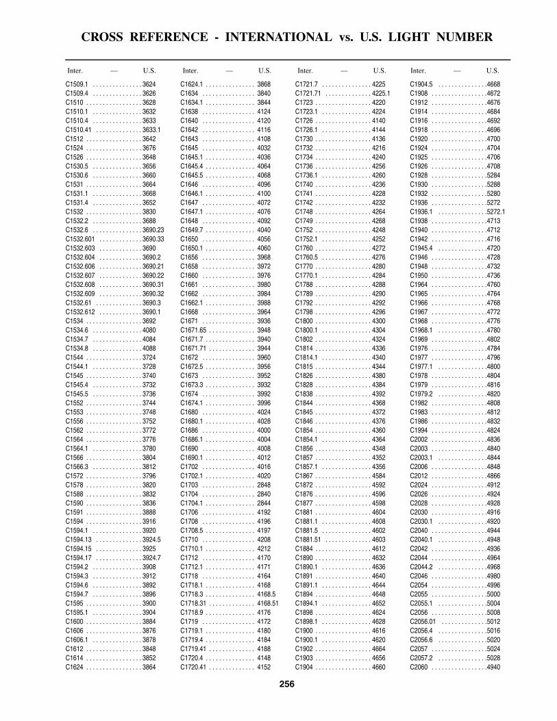
CROSS REFERENCE - INTERNATIONAL vs. U.S. LIGHT NUMBER
256
Inter. — U.S. Inter. — U.S. Inter. — U.S. Inter. — U.S.
C1509.1 . . . . . . . . . . . . . . . 3624C1509.4 . . . . . . . . . . . . . . . 3626C1510 . . . . . . . . . . . . . . . . . 3628C1510.1 . . . . . . . . . . . . . . . 3632C1510.4 . . . . . . . . . . . . . . . 3633C1510.41 . . . . . . . . . . . . . . 3633.1C1512 . . . . . . . . . . . . . . . . . 3642C1524 . . . . . . . . . . . . . . . . . 3676C1526 . . . . . . . . . . . . . . . . . 3648C1530.5 . . . . . . . . . . . . . . . 3656C1530.6 . . . . . . . . . . . . . . . 3660C1531 . . . . . . . . . . . . . . . . . 3664C1531.1 . . . . . . . . . . . . . . . 3668C1531.4 . . . . . . . . . . . . . . . 3652C1532 . . . . . . . . . . . . . . . . . 3830C1532.2 . . . . . . . . . . . . . . . 3688C1532.6 . . . . . . . . . . . . . . . 3690.23C1532.601 . . . . . . . . . . . . . 3690.33C1532.603 . . . . . . . . . . . . . 3690C1532.604 . . . . . . . . . . . . . 3690.2C1532.606 . . . . . . . . . . . . . 3690.21C1532.607 . . . . . . . . . . . . . 3690.22C1532.608 . . . . . . . . . . . . . 3690.31C1532.609 . . . . . . . . . . . . . 3690.32C1532.61 . . . . . . . . . . . . . . 3690.3C1532.612 . . . . . . . . . . . . . 3690.1C1534 . . . . . . . . . . . . . . . . . 3692C1534.6 . . . . . . . . . . . . . . . 4080C1534.7 . . . . . . . . . . . . . . . 4084C1534.8 . . . . . . . . . . . . . . . 4088C1544 . . . . . . . . . . . . . . . . . 3724C1544.1 . . . . . . . . . . . . . . . 3728C1545 . . . . . . . . . . . . . . . . . 3740C1545.4 . . . . . . . . . . . . . . . 3732C1545.5 . . . . . . . . . . . . . . . 3736C1552 . . . . . . . . . . . . . . . . . 3744C1553 . . . . . . . . . . . . . . . . . 3748C1556 . . . . . . . . . . . . . . . . . 3752C1562 . . . . . . . . . . . . . . . . . 3772C1564 . . . . . . . . . . . . . . . . . 3776C1564.1 . . . . . . . . . . . . . . . 3780C1566 . . . . . . . . . . . . . . . . . 3804C1566.3 . . . . . . . . . . . . . . . 3812C1572 . . . . . . . . . . . . . . . . . 3796C1578 . . . . . . . . . . . . . . . . . 3820C1588 . . . . . . . . . . . . . . . . . 3832C1590 . . . . . . . . . . . . . . . . . 3836C1591 . . . . . . . . . . . . . . . . . 3888C1594 . . . . . . . . . . . . . . . . . 3916C1594.1 . . . . . . . . . . . . . . . 3920C1594.13 . . . . . . . . . . . . . . 3924.5C1594.15 . . . . . . . . . . . . . . 3925C1594.17 . . . . . . . . . . . . . . 3924.7C1594.2 . . . . . . . . . . . . . . . 3908C1594.3 . . . . . . . . . . . . . . . 3912C1594.6 . . . . . . . . . . . . . . . 3892C1594.7 . . . . . . . . . . . . . . . 3896C1595 . . . . . . . . . . . . . . . . . 3900C1595.1 . . . . . . . . . . . . . . . 3904C1600 . . . . . . . . . . . . . . . . . 3884C1606 . . . . . . . . . . . . . . . . . 3876C1606.1 . . . . . . . . . . . . . . . 3878C1612 . . . . . . . . . . . . . . . . . 3848C1614 . . . . . . . . . . . . . . . . . 3852C1624 . . . . . . . . . . . . . . . . . 3864
C1624.1 . . . . . . . . . . . . . . . 3868C1634 . . . . . . . . . . . . . . . . 3840C1634.1 . . . . . . . . . . . . . . . 3844C1638 . . . . . . . . . . . . . . . . 4124C1640 . . . . . . . . . . . . . . . . 4120C1642 . . . . . . . . . . . . . . . . 4116C1643 . . . . . . . . . . . . . . . . 4108C1645 . . . . . . . . . . . . . . . . 4032C1645.1 . . . . . . . . . . . . . . . 4036C1645.4 . . . . . . . . . . . . . . . 4064C1645.5 . . . . . . . . . . . . . . . 4068C1646 . . . . . . . . . . . . . . . . 4096C1646.1 . . . . . . . . . . . . . . . 4100C1647 . . . . . . . . . . . . . . . . 4072C1647.1 . . . . . . . . . . . . . . . 4076C1648 . . . . . . . . . . . . . . . . 4092C1649.7 . . . . . . . . . . . . . . . 4040C1650 . . . . . . . . . . . . . . . . 4056C1650.1 . . . . . . . . . . . . . . . 4060C1656 . . . . . . . . . . . . . . . . 3968C1658 . . . . . . . . . . . . . . . . 3972C1660 . . . . . . . . . . . . . . . . 3976C1661 . . . . . . . . . . . . . . . . 3980C1662 . . . . . . . . . . . . . . . . 3984C1662.1 . . . . . . . . . . . . . . . 3988C1668 . . . . . . . . . . . . . . . . 3964C1671 . . . . . . . . . . . . . . . . 3936C1671.65 . . . . . . . . . . . . . . 3948C1671.7 . . . . . . . . . . . . . . . 3940C1671.71 . . . . . . . . . . . . . . 3944C1672 . . . . . . . . . . . . . . . . 3960C1672.5 . . . . . . . . . . . . . . . 3956C1673 . . . . . . . . . . . . . . . . 3952C1673.3 . . . . . . . . . . . . . . . 3932C1674 . . . . . . . . . . . . . . . . 3992C1674.1 . . . . . . . . . . . . . . . 3996C1680 . . . . . . . . . . . . . . . . 4024C1680.1 . . . . . . . . . . . . . . . 4028C1686 . . . . . . . . . . . . . . . . 4000C1686.1 . . . . . . . . . . . . . . . 4004C1690 . . . . . . . . . . . . . . . . 4008C1690.1 . . . . . . . . . . . . . . . 4012C1702 . . . . . . . . . . . . . . . . 4016C1702.1 . . . . . . . . . . . . . . . 4020C1703 . . . . . . . . . . . . . . . . 2848C1704 . . . . . . . . . . . . . . . . 2840C1704.1 . . . . . . . . . . . . . . . 2844C1706 . . . . . . . . . . . . . . . . 4192C1708 . . . . . . . . . . . . . . . . 4196C1708.5 . . . . . . . . . . . . . . . 4197C1710 . . . . . . . . . . . . . . . . 4208C1710.1 . . . . . . . . . . . . . . . 4212C1712 . . . . . . . . . . . . . . . . 4170C1712.1 . . . . . . . . . . . . . . . 4171C1718 . . . . . . . . . . . . . . . . 4164C1718.1 . . . . . . . . . . . . . . . 4168C1718.3 . . . . . . . . . . . . . . . 4168.5C1718.31 . . . . . . . . . . . . . . 4168.51C1718.9 . . . . . . . . . . . . . . . 4176C1719 . . . . . . . . . . . . . . . . 4172C1719.1 . . . . . . . . . . . . . . . 4180C1719.4 . . . . . . . . . . . . . . . 4184C1719.41 . . . . . . . . . . . . . . 4188C1720.4 . . . . . . . . . . . . . . . 4148C1720.41 . . . . . . . . . . . . . . 4152
C1721.7 . . . . . . . . . . . . . . . 4225C1721.71 . . . . . . . . . . . . . . 4225.1C1723 . . . . . . . . . . . . . . . . . 4220C1723.1 . . . . . . . . . . . . . . . 4224C1726 . . . . . . . . . . . . . . . . . 4140C1726.1 . . . . . . . . . . . . . . . 4144C1730 . . . . . . . . . . . . . . . . . 4136C1732 . . . . . . . . . . . . . . . . . 4216C1734 . . . . . . . . . . . . . . . . . 4240C1736 . . . . . . . . . . . . . . . . . 4256C1736.1 . . . . . . . . . . . . . . . 4260C1740 . . . . . . . . . . . . . . . . . 4236C1741 . . . . . . . . . . . . . . . . . 4228C1742 . . . . . . . . . . . . . . . . . 4232C1748 . . . . . . . . . . . . . . . . . 4264C1749 . . . . . . . . . . . . . . . . . 4268C1752 . . . . . . . . . . . . . . . . . 4248C1752.1 . . . . . . . . . . . . . . . 4252C1760 . . . . . . . . . . . . . . . . . 4272C1760.5 . . . . . . . . . . . . . . . 4276C1770 . . . . . . . . . . . . . . . . . 4280C1770.1 . . . . . . . . . . . . . . . 4284C1788 . . . . . . . . . . . . . . . . . 4288C1789 . . . . . . . . . . . . . . . . . 4290C1792 . . . . . . . . . . . . . . . . . 4292C1798 . . . . . . . . . . . . . . . . . 4296C1800 . . . . . . . . . . . . . . . . . 4300C1800.1 . . . . . . . . . . . . . . . 4304C1802 . . . . . . . . . . . . . . . . . 4324C1814 . . . . . . . . . . . . . . . . . 4336C1814.1 . . . . . . . . . . . . . . . 4340C1815 . . . . . . . . . . . . . . . . . 4344C1826 . . . . . . . . . . . . . . . . . 4380C1828 . . . . . . . . . . . . . . . . . 4384C1838 . . . . . . . . . . . . . . . . . 4392C1844 . . . . . . . . . . . . . . . . . 4368C1845 . . . . . . . . . . . . . . . . . 4372C1846 . . . . . . . . . . . . . . . . . 4376C1854 . . . . . . . . . . . . . . . . . 4360C1854.1 . . . . . . . . . . . . . . . 4364C1856 . . . . . . . . . . . . . . . . . 4348C1857 . . . . . . . . . . . . . . . . . 4352C1857.1 . . . . . . . . . . . . . . . 4356C1867 . . . . . . . . . . . . . . . . . 4584C1872 . . . . . . . . . . . . . . . . . 4592C1876 . . . . . . . . . . . . . . . . . 4596C1877 . . . . . . . . . . . . . . . . . 4598C1881 . . . . . . . . . . . . . . . . . 4604C1881.1 . . . . . . . . . . . . . . . 4608C1881.5 . . . . . . . . . . . . . . . 4602C1881.51 . . . . . . . . . . . . . . 4603C1884 . . . . . . . . . . . . . . . . . 4612C1890 . . . . . . . . . . . . . . . . . 4632C1890.1 . . . . . . . . . . . . . . . 4636C1891 . . . . . . . . . . . . . . . . . 4640C1891.1 . . . . . . . . . . . . . . . 4644C1894 . . . . . . . . . . . . . . . . . 4648C1894.1 . . . . . . . . . . . . . . . 4652C1898 . . . . . . . . . . . . . . . . . 4624C1898.1 . . . . . . . . . . . . . . . 4628C1900 . . . . . . . . . . . . . . . . . 4616C1900.1 . . . . . . . . . . . . . . . 4620C1902 . . . . . . . . . . . . . . . . . 4664C1903 . . . . . . . . . . . . . . . . . 4656C1904 . . . . . . . . . . . . . . . . . 4660
C1904.5 . . . . . . . . . . . . . . .4668C1908 . . . . . . . . . . . . . . . . .4672C1912 . . . . . . . . . . . . . . . . .4676C1914 . . . . . . . . . . . . . . . . .4684C1916 . . . . . . . . . . . . . . . . .4692C1918 . . . . . . . . . . . . . . . . .4696C1920 . . . . . . . . . . . . . . . . .4700C1924 . . . . . . . . . . . . . . . . .4704C1925 . . . . . . . . . . . . . . . . .4706C1926 . . . . . . . . . . . . . . . . .4708C1928 . . . . . . . . . . . . . . . . .5284C1930 . . . . . . . . . . . . . . . . .5288C1932 . . . . . . . . . . . . . . . . .5280C1936 . . . . . . . . . . . . . . . . .5272C1936.1 . . . . . . . . . . . . . . .5272.1C1938 . . . . . . . . . . . . . . . . .4713C1940 . . . . . . . . . . . . . . . . .4712C1942 . . . . . . . . . . . . . . . . .4716C1945.4 . . . . . . . . . . . . . . .4720C1946 . . . . . . . . . . . . . . . . .4728C1948 . . . . . . . . . . . . . . . . .4732C1950 . . . . . . . . . . . . . . . . .4736C1964 . . . . . . . . . . . . . . . . .4760C1965 . . . . . . . . . . . . . . . . .4764C1966 . . . . . . . . . . . . . . . . .4768C1967 . . . . . . . . . . . . . . . . .4772C1968 . . . . . . . . . . . . . . . . .4776C1968.1 . . . . . . . . . . . . . . .4780C1969 . . . . . . . . . . . . . . . . .4802C1976 . . . . . . . . . . . . . . . . .4784C1977 . . . . . . . . . . . . . . . . .4796C1977.1 . . . . . . . . . . . . . . .4800C1978 . . . . . . . . . . . . . . . . .4804C1979 . . . . . . . . . . . . . . . . .4816C1979.2 . . . . . . . . . . . . . . .4820C1982 . . . . . . . . . . . . . . . . .4808C1983 . . . . . . . . . . . . . . . . .4812C1986 . . . . . . . . . . . . . . . . .4832C1994 . . . . . . . . . . . . . . . . .4824C2002 . . . . . . . . . . . . . . . . .4836C2003 . . . . . . . . . . . . . . . . .4840C2003.1 . . . . . . . . . . . . . . .4844C2006 . . . . . . . . . . . . . . . . .4848C2012 . . . . . . . . . . . . . . . . .4866C2024 . . . . . . . . . . . . . . . . .4912C2026 . . . . . . . . . . . . . . . . .4924C2028 . . . . . . . . . . . . . . . . .4928C2030 . . . . . . . . . . . . . . . . .4916C2030.1 . . . . . . . . . . . . . . .4920C2040 . . . . . . . . . . . . . . . . .4944C2040.1 . . . . . . . . . . . . . . .4948C2042 . . . . . . . . . . . . . . . . .4936C2044 . . . . . . . . . . . . . . . . .4964C2044.2 . . . . . . . . . . . . . . .4968C2046 . . . . . . . . . . . . . . . . .4980C2054 . . . . . . . . . . . . . . . . .4996C2055 . . . . . . . . . . . . . . . . .5000C2055.1 . . . . . . . . . . . . . . .5004C2056 . . . . . . . . . . . . . . . . .5008C2056.01 . . . . . . . . . . . . . .5012C2056.4 . . . . . . . . . . . . . . .5016C2056.6 . . . . . . . . . . . . . . .5020C2057 . . . . . . . . . . . . . . . . .5024C2057.2 . . . . . . . . . . . . . . .5028C2060 . . . . . . . . . . . . . . . . .4940

CROSS REFERENCE - INTERNATIONAL vs. U.S. LIGHT NUMBER
257
Inter. — U.S. Inter. — U.S. Inter. — U.S. Inter. — U.S.
C2065 . . . . . . . . . . . . . . . . . 5030C2065.4 . . . . . . . . . . . . . . . 5030.3C2065.6 . . . . . . . . . . . . . . . 5030.6C2068 . . . . . . . . . . . . . . . . . 5032C2068.1 . . . . . . . . . . . . . . . 5036C2069 . . . . . . . . . . . . . . . . . 5031C2072 . . . . . . . . . . . . . . . . . 4900C2072.1 . . . . . . . . . . . . . . . 4904C2074.7 . . . . . . . . . . . . . . . 4888C2082 . . . . . . . . . . . . . . . . . 5040C2083 . . . . . . . . . . . . . . . . . 5044C2089 . . . . . . . . . . . . . . . . . 5056C2089.5 . . . . . . . . . . . . . . . 5068C2094 . . . . . . . . . . . . . . . . . 5080C2098 . . . . . . . . . . . . . . . . . 4552C2099 . . . . . . . . . . . . . . . . . 4556C2100 . . . . . . . . . . . . . . . . . 4560C2100.2 . . . . . . . . . . . . . . . 4564C2100.4 . . . . . . . . . . . . . . . 4568C2104 . . . . . . . . . . . . . . . . . 4528C2104.1 . . . . . . . . . . . . . . . 4532C2142 . . . . . . . . . . . . . . . . . 4508C2144 . . . . . . . . . . . . . . . . . 4512C2146 . . . . . . . . . . . . . . . . . 4500C2148 . . . . . . . . . . . . . . . . . 4504C2152 . . . . . . . . . . . . . . . . . 4468C2154.9 . . . . . . . . . . . . . . . 4487C2155 . . . . . . . . . . . . . . . . . 4488C2155.4 . . . . . . . . . . . . . . . 4484C2166 . . . . . . . . . . . . . . . . . 4472C2166.1 . . . . . . . . . . . . . . . 4476C2178 . . . . . . . . . . . . . . . . . 4480C2180 . . . . . . . . . . . . . . . . . 4460C2180.1 . . . . . . . . . . . . . . . 4464C2186 . . . . . . . . . . . . . . . . . 4436C2188 . . . . . . . . . . . . . . . . . 4424C2192 . . . . . . . . . . . . . . . . . 4428C2196 . . . . . . . . . . . . . . . . . 4440C2196.1 . . . . . . . . . . . . . . . 4444C2202 . . . . . . . . . . . . . . . . . 4448C2203 . . . . . . . . . . . . . . . . . 4452C2210 . . . . . . . . . . . . . . . . . 4420C2216 . . . . . . . . . . . . . . . . . 4396C2216.1 . . . . . . . . . . . . . . . 4400C2218 . . . . . . . . . . . . . . . . . 4404C2218.2 . . . . . . . . . . . . . . . 4408C2219 . . . . . . . . . . . . . . . . . 4395C2242 . . . . . . . . . . . . . . . . . 1452C2246 . . . . . . . . . . . . . . . . . 1456C2248 . . . . . . . . . . . . . . . . . 1468C2248.1 . . . . . . . . . . . . . . . 1472C2252 . . . . . . . . . . . . . . . . . 1460C2252.1 . . . . . . . . . . . . . . . 1464C2254 . . . . . . . . . . . . . . . . . 1476C2254.1 . . . . . . . . . . . . . . . 1480C2254.4 . . . . . . . . . . . . . . . 1484C2254.5 . . . . . . . . . . . . . . . 1488C2258 . . . . . . . . . . . . . . . . . 1500C2258.1 . . . . . . . . . . . . . . . 1504C2258.4 . . . . . . . . . . . . . . . 1492C2258.6 . . . . . . . . . . . . . . . 1496C2259 . . . . . . . . . . . . . . . . . 1508C2259.5 . . . . . . . . . . . . . . . 1512C2260 . . . . . . . . . . . . . . . . . 5084C2262 . . . . . . . . . . . . . . . . . 5088
C2264 . . . . . . . . . . . . . . . . 5092C2265 . . . . . . . . . . . . . . . . 5096C2265.1 . . . . . . . . . . . . . . . 5100C2266 . . . . . . . . . . . . . . . . 5104C2268 . . . . . . . . . . . . . . . . 5108C2269 . . . . . . . . . . . . . . . . 5112C2269.1 . . . . . . . . . . . . . . . 5116C2270 . . . . . . . . . . . . . . . . 5120C2274 . . . . . . . . . . . . . . . . 5124C2276 . . . . . . . . . . . . . . . . 5128C2276.8 . . . . . . . . . . . . . . . 5130C2276.81 . . . . . . . . . . . . . . 5130.1C2277 . . . . . . . . . . . . . . . . 5132C2277.1 . . . . . . . . . . . . . . . 5136C2277.6 . . . . . . . . . . . . . . . 5140C2278 . . . . . . . . . . . . . . . . 5144C2278.1 . . . . . . . . . . . . . . . 5148C2283 . . . . . . . . . . . . . . . . 5160C2283.1 . . . . . . . . . . . . . . . 5164C2288 . . . . . . . . . . . . . . . . 5184C2288.1 . . . . . . . . . . . . . . . 5186C2289 . . . . . . . . . . . . . . . . 5192C2289.1 . . . . . . . . . . . . . . . 5196C2291 . . . . . . . . . . . . . . . . 5200C2292 . . . . . . . . . . . . . . . . 5204C2294 . . . . . . . . . . . . . . . . 5208C2296 . . . . . . . . . . . . . . . . 5212C2305 . . . . . . . . . . . . . . . . 5214C2305.1 . . . . . . . . . . . . . . . 5214.1C2305.3 . . . . . . . . . . . . . . . 5197C2305.31 . . . . . . . . . . . . . . 5197.1C2305.4 . . . . . . . . . . . . . . . 5199C2305.5 . . . . . . . . . . . . . . . 5198C2306 . . . . . . . . . . . . . . . . 5216C2306.1 . . . . . . . . . . . . . . . 5220C2307 . . . . . . . . . . . . . . . . 5224C2308 . . . . . . . . . . . . . . . . 5228C2309 . . . . . . . . . . . . . . . . 5260C2310 . . . . . . . . . . . . . . . . 5256C2311 . . . . . . . . . . . . . . . . 5232C2311.1 . . . . . . . . . . . . . . . 5236C2312 . . . . . . . . . . . . . . . . 5240C2312.1 . . . . . . . . . . . . . . . 5244C2313 . . . . . . . . . . . . . . . . 5248C2313.1 . . . . . . . . . . . . . . . 5252C2314 . . . . . . . . . . . . . . . . 5230C2314.1 . . . . . . . . . . . . . . . 5230.1C2316 . . . . . . . . . . . . . . . . 5264C2316.4 . . . . . . . . . . . . . . . 5265C2318 . . . . . . . . . . . . . . . . 5268C2320 . . . . . . . . . . . . . . . . 5290C2320.1 . . . . . . . . . . . . . . . 5290.1C2324 . . . . . . . . . . . . . . . . 5292C2326 . . . . . . . . . . . . . . . . 5296C2328 . . . . . . . . . . . . . . . . 5304C2328.1 . . . . . . . . . . . . . . . 5308C2331.9 . . . . . . . . . . . . . . . 5317C2332 . . . . . . . . . . . . . . . . 5312C2332.1 . . . . . . . . . . . . . . . 5316C2336 . . . . . . . . . . . . . . . . 5320C2338 . . . . . . . . . . . . . . . . 5324C2338.1 . . . . . . . . . . . . . . . 5328C2340 . . . . . . . . . . . . . . . . 5332C2340.1 . . . . . . . . . . . . . . . 5336C2346 . . . . . . . . . . . . . . . . 5340
C2348 . . . . . . . . . . . . . . . . . 5344C2349.02 . . . . . . . . . . . . . . 5490.1C2349.03 . . . . . . . . . . . . . . 5490C2349.04 . . . . . . . . . . . . . . 5490.2C2349.17 . . . . . . . . . . . . . . 5492C2349.26 . . . . . . . . . . . . . . 5485C2349.28 . . . . . . . . . . . . . . 5486C2349.31 . . . . . . . . . . . . . . 5482.1C2349.32 . . . . . . . . . . . . . . 5482C2349.35 . . . . . . . . . . . . . . 5483.1C2349.36 . . . . . . . . . . . . . . 5483C2349.5 . . . . . . . . . . . . . . . 5494C2350 . . . . . . . . . . . . . . . . . 5495C2350.5 . . . . . . . . . . . . . . . 5493C2351.5 . . . . . . . . . . . . . . . 5491C2352.5 . . . . . . . . . . . . . . . 5480C2357 . . . . . . . . . . . . . . . . . 5432C2357.2 . . . . . . . . . . . . . . . 5433C2358 . . . . . . . . . . . . . . . . . 5376C2360 . . . . . . . . . . . . . . . . . 5360C2360.1 . . . . . . . . . . . . . . . 5364C2361 . . . . . . . . . . . . . . . . . 5368C2361.1 . . . . . . . . . . . . . . . 5372C2364 . . . . . . . . . . . . . . . . . 5380C2365 . . . . . . . . . . . . . . . . . 5384C2365.1 . . . . . . . . . . . . . . . 5384.1C2370 . . . . . . . . . . . . . . . . . 5408C2372 . . . . . . . . . . . . . . . . . 5404C2374 . . . . . . . . . . . . . . . . . 5396C2374.1 . . . . . . . . . . . . . . . 5400C2378 . . . . . . . . . . . . . . . . . 5412C2378.1 . . . . . . . . . . . . . . . 5416C2380 . . . . . . . . . . . . . . . . . 5424C2382 . . . . . . . . . . . . . . . . . 5428C2384 . . . . . . . . . . . . . . . . . 5420C2388 . . . . . . . . . . . . . . . . . 5348C2388.1 . . . . . . . . . . . . . . . 5352C2403 . . . . . . . . . . . . . . . . . 5504C2403.1 . . . . . . . . . . . . . . . 5508C2405 . . . . . . . . . . . . . . . . . 5512C2405.1 . . . . . . . . . . . . . . . 5516C2405.55 . . . . . . . . . . . . . . 5518C2405.56 . . . . . . . . . . . . . . 5518.1C2406 . . . . . . . . . . . . . . . . . 5517C2406.1 . . . . . . . . . . . . . . . 5517.1C2408 . . . . . . . . . . . . . . . . . 5496C2410 . . . . . . . . . . . . . . . . . 5520C2412 . . . . . . . . . . . . . . . . . 5526C2412.2 . . . . . . . . . . . . . . . 5524C2412.4 . . . . . . . . . . . . . . . 5530C2412.6 . . . . . . . . . . . . . . . 5528C2412.8 . . . . . . . . . . . . . . . 5536C2413 . . . . . . . . . . . . . . . . . 5532C2414 . . . . . . . . . . . . . . . . . 5540C2414.3 . . . . . . . . . . . . . . . 5544C2414.31 . . . . . . . . . . . . . . 5548C2414.4 . . . . . . . . . . . . . . . 5552C2416 . . . . . . . . . . . . . . . . . 5556C2417 . . . . . . . . . . . . . . . . . 5560C2420 . . . . . . . . . . . . . . . . . 5568C2425 . . . . . . . . . . . . . . . . . 5576C2425.1 . . . . . . . . . . . . . . . 5580C2428 . . . . . . . . . . . . . . . . . 5584C2428.1 . . . . . . . . . . . . . . . 5588C2439 . . . . . . . . . . . . . . . . . 5606
C2440 . . . . . . . . . . . . . . . . .5608C2440.1 . . . . . . . . . . . . . . .5612C2445 . . . . . . . . . . . . . . . . .5604C2448 . . . . . . . . . . . . . . . . .5616C2448.1 . . . . . . . . . . . . . . .5620C2450 . . . . . . . . . . . . . . . . .5624C2450.1 . . . . . . . . . . . . . . .5628C2450.4 . . . . . . . . . . . . . . .5636C2450.5 . . . . . . . . . . . . . . .5632C2458 . . . . . . . . . . . . . . . . .5644C2460 . . . . . . . . . . . . . . . . .5648C2483 . . . . . . . . . . . . . . . . .5716.5C2483.1 . . . . . . . . . . . . . . .5716.51C2484 . . . . . . . . . . . . . . . . .5706C2484.2 . . . . . . . . . . . . . . .5707C2486 . . . . . . . . . . . . . . . . .5700C2488 . . . . . . . . . . . . . . . . .5704C2489 . . . . . . . . . . . . . . . . .5705C2494 . . . . . . . . . . . . . . . . .5680C2494.1 . . . . . . . . . . . . . . .5684C2495 . . . . . . . . . . . . . . . . .5692C2496 . . . . . . . . . . . . . . . . .5693C2503 . . . . . . . . . . . . . . . . .5664C2503.1 . . . . . . . . . . . . . . .5668C2504 . . . . . . . . . . . . . . . . .5656C2505 . . . . . . . . . . . . . . . . .5660C2508 . . . . . . . . . . . . . . . . .5844C2512 . . . . . . . . . . . . . . . . .5836C2516 . . . . . . . . . . . . . . . . .5824C2516.5 . . . . . . . . . . . . . . .5826C2517 . . . . . . . . . . . . . . . . .5828C2517.1 . . . . . . . . . . . . . . .5832C2522 . . . . . . . . . . . . . . . . .5808C2522.1 . . . . . . . . . . . . . . .5812C2527 . . . . . . . . . . . . . . . . .5792C2527.1 . . . . . . . . . . . . . . .5796C2532 . . . . . . . . . . . . . . . . .5776C2534 . . . . . . . . . . . . . . . . .5772C2540 . . . . . . . . . . . . . . . . .5760C2540.1 . . . . . . . . . . . . . . .5764C2541 . . . . . . . . . . . . . . . . .5748C2542 . . . . . . . . . . . . . . . . .5744C2546 . . . . . . . . . . . . . . . . .5752C2546.1 . . . . . . . . . . . . . . .5756C2548 . . . . . . . . . . . . . . . . .5736C2548.1 . . . . . . . . . . . . . . .5740C2550 . . . . . . . . . . . . . . . . .5732C2555.5 . . . . . . . . . . . . . . .5724C2556 . . . . . . . . . . . . . . . . .5848C2557 . . . . . . . . . . . . . . . . .5852C2558 . . . . . . . . . . . . . . . . .5856C2562 . . . . . . . . . . . . . . . . .5860C2575.9 . . . . . . . . . . . . . . .5872C2576 . . . . . . . . . . . . . . . . .5876C2576.1 . . . . . . . . . . . . . . .5880C2583 . . . . . . . . . . . . . . . . .5884C2583.1 . . . . . . . . . . . . . . .5888C2585 . . . . . . . . . . . . . . . . .5892C2585.1 . . . . . . . . . . . . . . .5896C2586 . . . . . . . . . . . . . . . . .5868C2588 . . . . . . . . . . . . . . . . .5864C2589.6 . . . . . . . . . . . . . . .5866C2589.61 . . . . . . . . . . . . . .5867C2592 . . . . . . . . . . . . . . . . .5900C2596 . . . . . . . . . . . . . . . . .5912
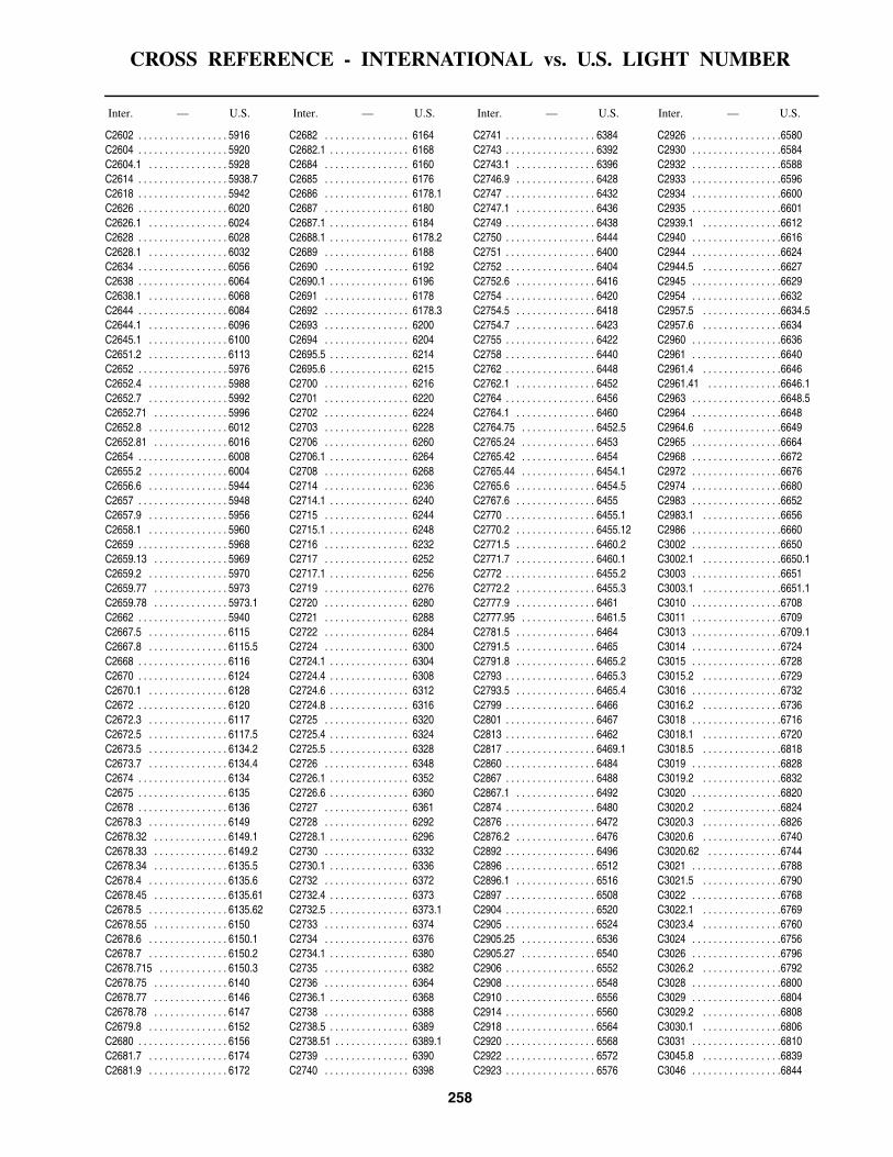
CROSS REFERENCE - INTERNATIONAL vs. U.S. LIGHT NUMBER
258
Inter. — U.S. Inter. — U.S. Inter. — U.S. Inter. — U.S.
C2602 . . . . . . . . . . . . . . . . . 5916C2604 . . . . . . . . . . . . . . . . . 5920C2604.1 . . . . . . . . . . . . . . . 5928C2614 . . . . . . . . . . . . . . . . . 5938.7C2618 . . . . . . . . . . . . . . . . . 5942C2626 . . . . . . . . . . . . . . . . . 6020C2626.1 . . . . . . . . . . . . . . . 6024C2628 . . . . . . . . . . . . . . . . . 6028C2628.1 . . . . . . . . . . . . . . . 6032C2634 . . . . . . . . . . . . . . . . . 6056C2638 . . . . . . . . . . . . . . . . . 6064C2638.1 . . . . . . . . . . . . . . . 6068C2644 . . . . . . . . . . . . . . . . . 6084C2644.1 . . . . . . . . . . . . . . . 6096C2645.1 . . . . . . . . . . . . . . . 6100C2651.2 . . . . . . . . . . . . . . . 6113C2652 . . . . . . . . . . . . . . . . . 5976C2652.4 . . . . . . . . . . . . . . . 5988C2652.7 . . . . . . . . . . . . . . . 5992C2652.71 . . . . . . . . . . . . . . 5996C2652.8 . . . . . . . . . . . . . . . 6012C2652.81 . . . . . . . . . . . . . . 6016C2654 . . . . . . . . . . . . . . . . . 6008C2655.2 . . . . . . . . . . . . . . . 6004C2656.6 . . . . . . . . . . . . . . . 5944C2657 . . . . . . . . . . . . . . . . . 5948C2657.9 . . . . . . . . . . . . . . . 5956C2658.1 . . . . . . . . . . . . . . . 5960C2659 . . . . . . . . . . . . . . . . . 5968C2659.13 . . . . . . . . . . . . . . 5969C2659.2 . . . . . . . . . . . . . . . 5970C2659.77 . . . . . . . . . . . . . . 5973C2659.78 . . . . . . . . . . . . . . 5973.1C2662 . . . . . . . . . . . . . . . . . 5940C2667.5 . . . . . . . . . . . . . . . 6115C2667.8 . . . . . . . . . . . . . . . 6115.5C2668 . . . . . . . . . . . . . . . . . 6116C2670 . . . . . . . . . . . . . . . . . 6124C2670.1 . . . . . . . . . . . . . . . 6128C2672 . . . . . . . . . . . . . . . . . 6120C2672.3 . . . . . . . . . . . . . . . 6117C2672.5 . . . . . . . . . . . . . . . 6117.5C2673.5 . . . . . . . . . . . . . . . 6134.2C2673.7 . . . . . . . . . . . . . . . 6134.4C2674 . . . . . . . . . . . . . . . . . 6134C2675 . . . . . . . . . . . . . . . . . 6135C2678 . . . . . . . . . . . . . . . . . 6136C2678.3 . . . . . . . . . . . . . . . 6149C2678.32 . . . . . . . . . . . . . . 6149.1C2678.33 . . . . . . . . . . . . . . 6149.2C2678.34 . . . . . . . . . . . . . . 6135.5C2678.4 . . . . . . . . . . . . . . . 6135.6C2678.45 . . . . . . . . . . . . . . 6135.61C2678.5 . . . . . . . . . . . . . . . 6135.62C2678.55 . . . . . . . . . . . . . . 6150C2678.6 . . . . . . . . . . . . . . . 6150.1C2678.7 . . . . . . . . . . . . . . . 6150.2C2678.715 . . . . . . . . . . . . . 6150.3C2678.75 . . . . . . . . . . . . . . 6140C2678.77 . . . . . . . . . . . . . . 6146C2678.78 . . . . . . . . . . . . . . 6147C2679.8 . . . . . . . . . . . . . . . 6152C2680 . . . . . . . . . . . . . . . . . 6156C2681.7 . . . . . . . . . . . . . . . 6174C2681.9 . . . . . . . . . . . . . . . 6172
C2682 . . . . . . . . . . . . . . . . 6164C2682.1 . . . . . . . . . . . . . . . 6168C2684 . . . . . . . . . . . . . . . . 6160C2685 . . . . . . . . . . . . . . . . 6176C2686 . . . . . . . . . . . . . . . . 6178.1C2687 . . . . . . . . . . . . . . . . 6180C2687.1 . . . . . . . . . . . . . . . 6184C2688.1 . . . . . . . . . . . . . . . 6178.2C2689 . . . . . . . . . . . . . . . . 6188C2690 . . . . . . . . . . . . . . . . 6192C2690.1 . . . . . . . . . . . . . . . 6196C2691 . . . . . . . . . . . . . . . . 6178C2692 . . . . . . . . . . . . . . . . 6178.3C2693 . . . . . . . . . . . . . . . . 6200C2694 . . . . . . . . . . . . . . . . 6204C2695.5 . . . . . . . . . . . . . . . 6214C2695.6 . . . . . . . . . . . . . . . 6215C2700 . . . . . . . . . . . . . . . . 6216C2701 . . . . . . . . . . . . . . . . 6220C2702 . . . . . . . . . . . . . . . . 6224C2703 . . . . . . . . . . . . . . . . 6228C2706 . . . . . . . . . . . . . . . . 6260C2706.1 . . . . . . . . . . . . . . . 6264C2708 . . . . . . . . . . . . . . . . 6268C2714 . . . . . . . . . . . . . . . . 6236C2714.1 . . . . . . . . . . . . . . . 6240C2715 . . . . . . . . . . . . . . . . 6244C2715.1 . . . . . . . . . . . . . . . 6248C2716 . . . . . . . . . . . . . . . . 6232C2717 . . . . . . . . . . . . . . . . 6252C2717.1 . . . . . . . . . . . . . . . 6256C2719 . . . . . . . . . . . . . . . . 6276C2720 . . . . . . . . . . . . . . . . 6280C2721 . . . . . . . . . . . . . . . . 6288C2722 . . . . . . . . . . . . . . . . 6284C2724 . . . . . . . . . . . . . . . . 6300C2724.1 . . . . . . . . . . . . . . . 6304C2724.4 . . . . . . . . . . . . . . . 6308C2724.6 . . . . . . . . . . . . . . . 6312C2724.8 . . . . . . . . . . . . . . . 6316C2725 . . . . . . . . . . . . . . . . 6320C2725.4 . . . . . . . . . . . . . . . 6324C2725.5 . . . . . . . . . . . . . . . 6328C2726 . . . . . . . . . . . . . . . . 6348C2726.1 . . . . . . . . . . . . . . . 6352C2726.6 . . . . . . . . . . . . . . . 6360C2727 . . . . . . . . . . . . . . . . 6361C2728 . . . . . . . . . . . . . . . . 6292C2728.1 . . . . . . . . . . . . . . . 6296C2730 . . . . . . . . . . . . . . . . 6332C2730.1 . . . . . . . . . . . . . . . 6336C2732 . . . . . . . . . . . . . . . . 6372C2732.4 . . . . . . . . . . . . . . . 6373C2732.5 . . . . . . . . . . . . . . . 6373.1C2733 . . . . . . . . . . . . . . . . 6374C2734 . . . . . . . . . . . . . . . . 6376C2734.1 . . . . . . . . . . . . . . . 6380C2735 . . . . . . . . . . . . . . . . 6382C2736 . . . . . . . . . . . . . . . . 6364C2736.1 . . . . . . . . . . . . . . . 6368C2738 . . . . . . . . . . . . . . . . 6388C2738.5 . . . . . . . . . . . . . . . 6389C2738.51 . . . . . . . . . . . . . . 6389.1C2739 . . . . . . . . . . . . . . . . 6390C2740 . . . . . . . . . . . . . . . . 6398
C2741 . . . . . . . . . . . . . . . . . 6384C2743 . . . . . . . . . . . . . . . . . 6392C2743.1 . . . . . . . . . . . . . . . 6396C2746.9 . . . . . . . . . . . . . . . 6428C2747 . . . . . . . . . . . . . . . . . 6432C2747.1 . . . . . . . . . . . . . . . 6436C2749 . . . . . . . . . . . . . . . . . 6438C2750 . . . . . . . . . . . . . . . . . 6444C2751 . . . . . . . . . . . . . . . . . 6400C2752 . . . . . . . . . . . . . . . . . 6404C2752.6 . . . . . . . . . . . . . . . 6416C2754 . . . . . . . . . . . . . . . . . 6420C2754.5 . . . . . . . . . . . . . . . 6418C2754.7 . . . . . . . . . . . . . . . 6423C2755 . . . . . . . . . . . . . . . . . 6422C2758 . . . . . . . . . . . . . . . . . 6440C2762 . . . . . . . . . . . . . . . . . 6448C2762.1 . . . . . . . . . . . . . . . 6452C2764 . . . . . . . . . . . . . . . . . 6456C2764.1 . . . . . . . . . . . . . . . 6460C2764.75 . . . . . . . . . . . . . . 6452.5C2765.24 . . . . . . . . . . . . . . 6453C2765.42 . . . . . . . . . . . . . . 6454C2765.44 . . . . . . . . . . . . . . 6454.1C2765.6 . . . . . . . . . . . . . . . 6454.5C2767.6 . . . . . . . . . . . . . . . 6455C2770 . . . . . . . . . . . . . . . . . 6455.1C2770.2 . . . . . . . . . . . . . . . 6455.12C2771.5 . . . . . . . . . . . . . . . 6460.2C2771.7 . . . . . . . . . . . . . . . 6460.1C2772 . . . . . . . . . . . . . . . . . 6455.2C2772.2 . . . . . . . . . . . . . . . 6455.3C2777.9 . . . . . . . . . . . . . . . 6461C2777.95 . . . . . . . . . . . . . . 6461.5C2781.5 . . . . . . . . . . . . . . . 6464C2791.5 . . . . . . . . . . . . . . . 6465C2791.8 . . . . . . . . . . . . . . . 6465.2C2793 . . . . . . . . . . . . . . . . . 6465.3C2793.5 . . . . . . . . . . . . . . . 6465.4C2799 . . . . . . . . . . . . . . . . . 6466C2801 . . . . . . . . . . . . . . . . . 6467C2813 . . . . . . . . . . . . . . . . . 6462C2817 . . . . . . . . . . . . . . . . . 6469.1C2860 . . . . . . . . . . . . . . . . . 6484C2867 . . . . . . . . . . . . . . . . . 6488C2867.1 . . . . . . . . . . . . . . . 6492C2874 . . . . . . . . . . . . . . . . . 6480C2876 . . . . . . . . . . . . . . . . . 6472C2876.2 . . . . . . . . . . . . . . . 6476C2892 . . . . . . . . . . . . . . . . . 6496C2896 . . . . . . . . . . . . . . . . . 6512C2896.1 . . . . . . . . . . . . . . . 6516C2897 . . . . . . . . . . . . . . . . . 6508C2904 . . . . . . . . . . . . . . . . . 6520C2905 . . . . . . . . . . . . . . . . . 6524C2905.25 . . . . . . . . . . . . . . 6536C2905.27 . . . . . . . . . . . . . . 6540C2906 . . . . . . . . . . . . . . . . . 6552C2908 . . . . . . . . . . . . . . . . . 6548C2910 . . . . . . . . . . . . . . . . . 6556C2914 . . . . . . . . . . . . . . . . . 6560C2918 . . . . . . . . . . . . . . . . . 6564C2920 . . . . . . . . . . . . . . . . . 6568C2922 . . . . . . . . . . . . . . . . . 6572C2923 . . . . . . . . . . . . . . . . . 6576
C2926 . . . . . . . . . . . . . . . . .6580C2930 . . . . . . . . . . . . . . . . .6584C2932 . . . . . . . . . . . . . . . . .6588C2933 . . . . . . . . . . . . . . . . .6596C2934 . . . . . . . . . . . . . . . . .6600C2935 . . . . . . . . . . . . . . . . .6601C2939.1 . . . . . . . . . . . . . . .6612C2940 . . . . . . . . . . . . . . . . .6616C2944 . . . . . . . . . . . . . . . . .6624C2944.5 . . . . . . . . . . . . . . .6627C2945 . . . . . . . . . . . . . . . . .6629C2954 . . . . . . . . . . . . . . . . .6632C2957.5 . . . . . . . . . . . . . . .6634.5C2957.6 . . . . . . . . . . . . . . .6634C2960 . . . . . . . . . . . . . . . . .6636C2961 . . . . . . . . . . . . . . . . .6640C2961.4 . . . . . . . . . . . . . . .6646C2961.41 . . . . . . . . . . . . . .6646.1C2963 . . . . . . . . . . . . . . . . .6648.5C2964 . . . . . . . . . . . . . . . . .6648C2964.6 . . . . . . . . . . . . . . .6649C2965 . . . . . . . . . . . . . . . . .6664C2968 . . . . . . . . . . . . . . . . .6672C2972 . . . . . . . . . . . . . . . . .6676C2974 . . . . . . . . . . . . . . . . .6680C2983 . . . . . . . . . . . . . . . . .6652C2983.1 . . . . . . . . . . . . . . .6656C2986 . . . . . . . . . . . . . . . . .6660C3002 . . . . . . . . . . . . . . . . .6650C3002.1 . . . . . . . . . . . . . . .6650.1C3003 . . . . . . . . . . . . . . . . .6651C3003.1 . . . . . . . . . . . . . . .6651.1C3010 . . . . . . . . . . . . . . . . .6708C3011 . . . . . . . . . . . . . . . . .6709C3013 . . . . . . . . . . . . . . . . .6709.1C3014 . . . . . . . . . . . . . . . . .6724C3015 . . . . . . . . . . . . . . . . .6728C3015.2 . . . . . . . . . . . . . . .6729C3016 . . . . . . . . . . . . . . . . .6732C3016.2 . . . . . . . . . . . . . . .6736C3018 . . . . . . . . . . . . . . . . .6716C3018.1 . . . . . . . . . . . . . . .6720C3018.5 . . . . . . . . . . . . . . .6818C3019 . . . . . . . . . . . . . . . . .6828C3019.2 . . . . . . . . . . . . . . .6832C3020 . . . . . . . . . . . . . . . . .6820C3020.2 . . . . . . . . . . . . . . .6824C3020.3 . . . . . . . . . . . . . . .6826C3020.6 . . . . . . . . . . . . . . .6740C3020.62 . . . . . . . . . . . . . .6744C3021 . . . . . . . . . . . . . . . . .6788C3021.5 . . . . . . . . . . . . . . .6790C3022 . . . . . . . . . . . . . . . . .6768C3022.1 . . . . . . . . . . . . . . .6769C3023.4 . . . . . . . . . . . . . . .6760C3024 . . . . . . . . . . . . . . . . .6756C3026 . . . . . . . . . . . . . . . . .6796C3026.2 . . . . . . . . . . . . . . .6792C3028 . . . . . . . . . . . . . . . . .6800C3029 . . . . . . . . . . . . . . . . .6804C3029.2 . . . . . . . . . . . . . . .6808C3030.1 . . . . . . . . . . . . . . .6806C3031 . . . . . . . . . . . . . . . . .6810C3045.8 . . . . . . . . . . . . . . .6839C3046 . . . . . . . . . . . . . . . . .6844
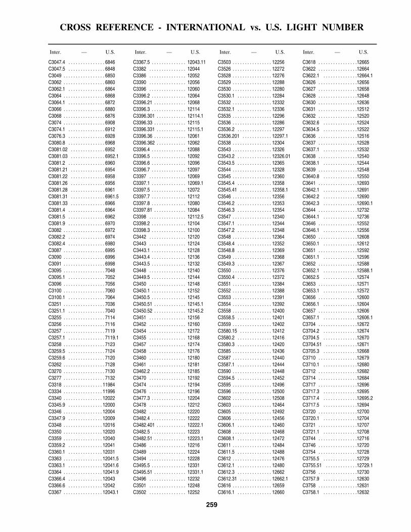
CROSS REFERENCE - INTERNATIONAL vs. U.S. LIGHT NUMBER
259
Inter. — U.S. Inter. — U.S. Inter. — U.S. Inter. — U.S.
C3047.4 . . . . . . . . . . . . . . . 6846C3047.5 . . . . . . . . . . . . . . . 6848C3049 . . . . . . . . . . . . . . . . . 6850C3062 . . . . . . . . . . . . . . . . . 6860C3062.1 . . . . . . . . . . . . . . . 6864C3064 . . . . . . . . . . . . . . . . . 6868C3064.1 . . . . . . . . . . . . . . . 6872C3066 . . . . . . . . . . . . . . . . . 6880C3068 . . . . . . . . . . . . . . . . . 6876C3074 . . . . . . . . . . . . . . . . . 6908C3074.1 . . . . . . . . . . . . . . . 6912C3076.3 . . . . . . . . . . . . . . . 6928C3080.8 . . . . . . . . . . . . . . . 6968C3081.02 . . . . . . . . . . . . . . 6952C3081.03 . . . . . . . . . . . . . . 6952.1C3081.2 . . . . . . . . . . . . . . . 6960C3081.21 . . . . . . . . . . . . . . 6954C3081.22 . . . . . . . . . . . . . . 6958C3081.26 . . . . . . . . . . . . . . 6956C3081.28 . . . . . . . . . . . . . . 6961C3081.31 . . . . . . . . . . . . . . 6961.5C3081.33 . . . . . . . . . . . . . . 6966C3081.4 . . . . . . . . . . . . . . . 6964C3081.5 . . . . . . . . . . . . . . . 6962C3081.9 . . . . . . . . . . . . . . . 6970C3082 . . . . . . . . . . . . . . . . . 6972C3082.2 . . . . . . . . . . . . . . . 6974C3082.4 . . . . . . . . . . . . . . . 6980C3087 . . . . . . . . . . . . . . . . . 6995C3090 . . . . . . . . . . . . . . . . . 6996C3091 . . . . . . . . . . . . . . . . . 6998C3095 . . . . . . . . . . . . . . . . . 7048C3095.1 . . . . . . . . . . . . . . . 7052C3096 . . . . . . . . . . . . . . . . . 7056C3100 . . . . . . . . . . . . . . . . . 7060C3100.1 . . . . . . . . . . . . . . . 7064C3251 . . . . . . . . . . . . . . . . . 7036C3251.1 . . . . . . . . . . . . . . . 7040C3255 . . . . . . . . . . . . . . . . . 7114C3256 . . . . . . . . . . . . . . . . . 7116C3257 . . . . . . . . . . . . . . . . . 7119C3257.1 . . . . . . . . . . . . . . . 7119.1C3258 . . . . . . . . . . . . . . . . . 7123C3259.5 . . . . . . . . . . . . . . . 7124C3259.6 . . . . . . . . . . . . . . . 7120C3262 . . . . . . . . . . . . . . . . . 7128C3270 . . . . . . . . . . . . . . . . . 7130C3277 . . . . . . . . . . . . . . . . . 7132C3318 . . . . . . . . . . . . . . . . 11984C3334 . . . . . . . . . . . . . . . . 11996C3340 . . . . . . . . . . . . . . . . 12022C3345.9 . . . . . . . . . . . . . . 12000C3346 . . . . . . . . . . . . . . . . 12004C3347.9 . . . . . . . . . . . . . . 12009C3348 . . . . . . . . . . . . . . . . 12016C3350 . . . . . . . . . . . . . . . . 12020C3359 . . . . . . . . . . . . . . . . 12040C3359.2 . . . . . . . . . . . . . . 12041C3360.1 . . . . . . . . . . . . . . 12031C3363 . . . . . . . . . . . . . . . . 12041.5C3363.1 . . . . . . . . . . . . . . 12041.6C3364 . . . . . . . . . . . . . . . . 12041.9C3366.4 . . . . . . . . . . . . . . 12043C3366.6 . . . . . . . . . . . . . . 12042C3367 . . . . . . . . . . . . . . . . 12043.1
C3367.5 . . . . . . . . . . . . . . 12043.11C3382 . . . . . . . . . . . . . . . 12044C3386 . . . . . . . . . . . . . . . 12052C3390 . . . . . . . . . . . . . . . 12056C3396 . . . . . . . . . . . . . . . 12060C3396.2 . . . . . . . . . . . . . . 12064C3396.21 . . . . . . . . . . . . . 12068C3396.3 . . . . . . . . . . . . . . 12114C3396.301 . . . . . . . . . . . . 12114.1C3396.33 . . . . . . . . . . . . . 12115C3396.331 . . . . . . . . . . . . 12115.1C3396.36 . . . . . . . . . . . . . 12061C3396.362 . . . . . . . . . . . . 12062C3396.4 . . . . . . . . . . . . . . 12088C3396.5 . . . . . . . . . . . . . . 12092C3396.6 . . . . . . . . . . . . . . 12096C3396.7 . . . . . . . . . . . . . . 12097C3397 . . . . . . . . . . . . . . . 12069C3397.1 . . . . . . . . . . . . . . 12069.1C3397.5 . . . . . . . . . . . . . . 12072C3397.7 . . . . . . . . . . . . . . 12112C3397.8 . . . . . . . . . . . . . . 12080C3397.81 . . . . . . . . . . . . . 12084C3398 . . . . . . . . . . . . . . . 12112.5C3398.2 . . . . . . . . . . . . . . 12104C3398.3 . . . . . . . . . . . . . . 12100C3442 . . . . . . . . . . . . . . . 12120C3443 . . . . . . . . . . . . . . . 12124C3443.1 . . . . . . . . . . . . . . 12128C3443.4 . . . . . . . . . . . . . . 12136C3443.5 . . . . . . . . . . . . . . 12132C3448 . . . . . . . . . . . . . . . 12140C3449.5 . . . . . . . . . . . . . . 12144C3450 . . . . . . . . . . . . . . . 12148C3450.1 . . . . . . . . . . . . . . 12152C3450.5 . . . . . . . . . . . . . . 12145C3450.51 . . . . . . . . . . . . . 12145.1C3450.52 . . . . . . . . . . . . . 12145.2C3451 . . . . . . . . . . . . . . . 12156C3452 . . . . . . . . . . . . . . . 12160C3454 . . . . . . . . . . . . . . . 12172C3455 . . . . . . . . . . . . . . . 12168C3457 . . . . . . . . . . . . . . . 12174C3458 . . . . . . . . . . . . . . . 12176C3460 . . . . . . . . . . . . . . . 12180C3461 . . . . . . . . . . . . . . . 12181C3462.2 . . . . . . . . . . . . . . 12185C3470 . . . . . . . . . . . . . . . 12192C3474 . . . . . . . . . . . . . . . 12194C3476 . . . . . . . . . . . . . . . 12196C3477.3 . . . . . . . . . . . . . . 12204C3478 . . . . . . . . . . . . . . . 12212C3482 . . . . . . . . . . . . . . . 12220C3482.4 . . . . . . . . . . . . . . 12222C3482.401 . . . . . . . . . . . . 12222.1C3482.5 . . . . . . . . . . . . . . 12223C3482.51 . . . . . . . . . . . . . 12223.1C3486 . . . . . . . . . . . . . . . 12216C3489 . . . . . . . . . . . . . . . 12224C3494 . . . . . . . . . . . . . . . 12228C3495.5 . . . . . . . . . . . . . . 12331C3495.51 . . . . . . . . . . . . . 12331.1C3496 . . . . . . . . . . . . . . . 12232C3501 . . . . . . . . . . . . . . . 12248C3502 . . . . . . . . . . . . . . . 12252
C3503 . . . . . . . . . . . . . . . . 12256C3526 . . . . . . . . . . . . . . . . 12272C3528 . . . . . . . . . . . . . . . . 12276C3529 . . . . . . . . . . . . . . . . 12288C3530 . . . . . . . . . . . . . . . . 12280C3530.1 . . . . . . . . . . . . . . 12284C3532 . . . . . . . . . . . . . . . . 12332C3532.1 . . . . . . . . . . . . . . 12336C3535 . . . . . . . . . . . . . . . . 12296C3536 . . . . . . . . . . . . . . . . 12286C3536.2 . . . . . . . . . . . . . . 12297C3536.201 . . . . . . . . . . . . 12297.1C3538 . . . . . . . . . . . . . . . . 12304C3543 . . . . . . . . . . . . . . . . 12326C3543.2 . . . . . . . . . . . . . . 12326.01C3543.5 . . . . . . . . . . . . . . 12365C3544 . . . . . . . . . . . . . . . . 12328C3545 . . . . . . . . . . . . . . . . 12360C3545.4 . . . . . . . . . . . . . . 12358C3545.41 . . . . . . . . . . . . . 12358.1C3546 . . . . . . . . . . . . . . . . 12356C3546.2 . . . . . . . . . . . . . . 12353C3546.3 . . . . . . . . . . . . . . 12354C3547 . . . . . . . . . . . . . . . . 12340C3547.1 . . . . . . . . . . . . . . 12344C3547.2 . . . . . . . . . . . . . . 12348C3548 . . . . . . . . . . . . . . . . 12364C3548.4 . . . . . . . . . . . . . . 12352C3548.8 . . . . . . . . . . . . . . 12369C3549 . . . . . . . . . . . . . . . . 12368C3549.3 . . . . . . . . . . . . . . 12367C3550 . . . . . . . . . . . . . . . . 12376C3550.4 . . . . . . . . . . . . . . 12372C3551 . . . . . . . . . . . . . . . . 12384C3552 . . . . . . . . . . . . . . . . 12388C3553 . . . . . . . . . . . . . . . . 12391C3554 . . . . . . . . . . . . . . . . 12392C3558 . . . . . . . . . . . . . . . . 12400C3558.5 . . . . . . . . . . . . . . 12401C3559 . . . . . . . . . . . . . . . . 12402C3580.15 . . . . . . . . . . . . . 12412C3580.2 . . . . . . . . . . . . . . 12416C3580.3 . . . . . . . . . . . . . . 12420C3585 . . . . . . . . . . . . . . . . 12436C3587 . . . . . . . . . . . . . . . . 12440C3587.1 . . . . . . . . . . . . . . 12444C3590 . . . . . . . . . . . . . . . . 12448C3594.5 . . . . . . . . . . . . . . 12452C3595 . . . . . . . . . . . . . . . . 12496C3596 . . . . . . . . . . . . . . . . 12500C3602 . . . . . . . . . . . . . . . . 12508C3603 . . . . . . . . . . . . . . . . 12464C3605 . . . . . . . . . . . . . . . . 12492C3606 . . . . . . . . . . . . . . . . 12456C3606.1 . . . . . . . . . . . . . . 12460C3608 . . . . . . . . . . . . . . . . 12468C3608.1 . . . . . . . . . . . . . . 12472C3611 . . . . . . . . . . . . . . . . 12484C3611.5 . . . . . . . . . . . . . . 12488C3612 . . . . . . . . . . . . . . . . 12476C3612.1 . . . . . . . . . . . . . . 12480C3612.3 . . . . . . . . . . . . . . 12662C3612.31 . . . . . . . . . . . . . 12662.1C3616 . . . . . . . . . . . . . . . . 12659C3616.1 . . . . . . . . . . . . . . 12660
C3618 . . . . . . . . . . . . . . . .12665C3622 . . . . . . . . . . . . . . . .12664C3622.1 . . . . . . . . . . . . . .12664.1C3626 . . . . . . . . . . . . . . . .12656C3627 . . . . . . . . . . . . . . . .12658C3628 . . . . . . . . . . . . . . . .12648C3630 . . . . . . . . . . . . . . . .12636C3631 . . . . . . . . . . . . . . . .12512C3632 . . . . . . . . . . . . . . . .12520C3632.6 . . . . . . . . . . . . . .12524C3634.5 . . . . . . . . . . . . . .12522C3636 . . . . . . . . . . . . . . . .12516C3637 . . . . . . . . . . . . . . . .12528C3637.1 . . . . . . . . . . . . . .12532C3638 . . . . . . . . . . . . . . . .12540C3638.1 . . . . . . . . . . . . . .12544C3639 . . . . . . . . . . . . . . . .12548C3640.8 . . . . . . . . . . . . . .12550C3641 . . . . . . . . . . . . . . . .12693C3642.1 . . . . . . . . . . . . . .12691C3642.2 . . . . . . . . . . . . . .12690C3642.3 . . . . . . . . . . . . . .12690.1C3644 . . . . . . . . . . . . . . . .12732C3644.1 . . . . . . . . . . . . . .12736C3646 . . . . . . . . . . . . . . . .12552C3646.1 . . . . . . . . . . . . . .12556C3650 . . . . . . . . . . . . . . . .12608C3650.1 . . . . . . . . . . . . . .12612C3651 . . . . . . . . . . . . . . . .12592C3651.1 . . . . . . . . . . . . . .12596C3652 . . . . . . . . . . . . . . . .12588C3652.1 . . . . . . . . . . . . . .12588.1C3652.5 . . . . . . . . . . . . . .12574C3653 . . . . . . . . . . . . . . . .12571C3653.1 . . . . . . . . . . . . . .12572C3656 . . . . . . . . . . . . . . . .12600C3656.1 . . . . . . . . . . . . . .12604C3657 . . . . . . . . . . . . . . . .12606C3657.1 . . . . . . . . . . . . . .12606.1C3704 . . . . . . . . . . . . . . . .12672C3704.2 . . . . . . . . . . . . . .12674C3704.5 . . . . . . . . . . . . . .12670C3704.51 . . . . . . . . . . . . .12671C3705.3 . . . . . . . . . . . . . .12668C3710 . . . . . . . . . . . . . . . .12679C3710.1 . . . . . . . . . . . . . .12680C3712 . . . . . . . . . . . . . . . .12682C3714 . . . . . . . . . . . . . . . .12684C3717 . . . . . . . . . . . . . . . .12696C3717.3 . . . . . . . . . . . . . .12695C3717.4 . . . . . . . . . . . . . .12695.2C3717.5 . . . . . . . . . . . . . .12694C3720 . . . . . . . . . . . . . . . .12700C3720.1 . . . . . . . . . . . . . .12704C3721 . . . . . . . . . . . . . . . .12707C3721.1 . . . . . . . . . . . . . .12708C3744 . . . . . . . . . . . . . . . .12716C3746 . . . . . . . . . . . . . . . .12720C3754 . . . . . . . . . . . . . . . .12728C3755.5 . . . . . . . . . . . . . .12729C3755.51 . . . . . . . . . . . . .12729.1C3756 . . . . . . . . . . . . . . . .12730C3757.9 . . . . . . . . . . . . . .12630C3758 . . . . . . . . . . . . . . . .12631C3758.1 . . . . . . . . . . . . . .12632

CROSS REFERENCE - INTERNATIONAL vs. U.S. LIGHT NUMBER
260
Inter. — U.S. Inter. — U.S. Inter. — U.S. Inter. — U.S.
C3758.5 . . . . . . . . . . . . . . 12560C3758.51 . . . . . . . . . . . . . 12564C3759 . . . . . . . . . . . . . . . . 12614C3759.1 . . . . . . . . . . . . . . 12614.1C3759.5 . . . . . . . . . . . . . . 12616C3759.51 . . . . . . . . . . . . . 12620C3760 . . . . . . . . . . . . . . . . 12748C3764 . . . . . . . . . . . . . . . . 12752C3765 . . . . . . . . . . . . . . . . 12753C3765.1 . . . . . . . . . . . . . . 12753.1C3767 . . . . . . . . . . . . . . . . 12755C3768 . . . . . . . . . . . . . . . . 12756C3769 . . . . . . . . . . . . . . . . 12758C3774 . . . . . . . . . . . . . . . . 12764C3775 . . . . . . . . . . . . . . . . 12764.5C3775.1 . . . . . . . . . . . . . . 12764.51C3775.3 . . . . . . . . . . . . . . 12764.4C3775.4 . . . . . . . . . . . . . . 12764.2C3775.5 . . . . . . . . . . . . . . 12764.3C3778 . . . . . . . . . . . . . . . . 12765C3778.1 . . . . . . . . . . . . . . 12765.1C3783 . . . . . . . . . . . . . . . . 12766C3783.1 . . . . . . . . . . . . . . 12766.1C3786 . . . . . . . . . . . . . . . . 12767C3786.1 . . . . . . . . . . . . . . 12768C3790 . . . . . . . . . . . . . . . . 12772C3792 . . . . . . . . . . . . . . . . 12780C3792.5 . . . . . . . . . . . . . . 12780.1C3794 . . . . . . . . . . . . . . . . 12776C3795 . . . . . . . . . . . . . . . . 12779C3799 . . . . . . . . . . . . . . . . 12781C3799.1 . . . . . . . . . . . . . . 12781.1C3800 . . . . . . . . . . . . . . . . 12782C3800.4 . . . . . . . . . . . . . . 12783C3800.6 . . . . . . . . . . . . . . 12783.1C3801 . . . . . . . . . . . . . . . . 12783.5C3804 . . . . . . . . . . . . . . . . 12804C3804.1 . . . . . . . . . . . . . . 12808C3805 . . . . . . . . . . . . . . . . 12793C3805.2 . . . . . . . . . . . . . . 12879.25C3805.25 . . . . . . . . . . . . . 12879.26C3805.5 . . . . . . . . . . . . . . 12879.03C3805.7 . . . . . . . . . . . . . . 12879.01C3805.71 . . . . . . . . . . . . . 12879.02C3806 . . . . . . . . . . . . . . . . 12788C3808 . . . . . . . . . . . . . . . . 12790C3810 . . . . . . . . . . . . . . . . 12796C3810.1 . . . . . . . . . . . . . . 12800C3812 . . . . . . . . . . . . . . . . 12810C3815.5 . . . . . . . . . . . . . . 12814C3816 . . . . . . . . . . . . . . . . 12815C3822 . . . . . . . . . . . . . . . . 12869C3822.2 . . . . . . . . . . . . . . 12870C3830 . . . . . . . . . . . . . . . . 12852C3832 . . . . . . . . . . . . . . . . 12856C3834 . . . . . . . . . . . . . . . . 12860C3837 . . . . . . . . . . . . . . . . 12864C3837.1 . . . . . . . . . . . . . . 12868C3840.8 . . . . . . . . . . . . . . 12871C3840.81 . . . . . . . . . . . . . 12871.1C3841 . . . . . . . . . . . . . . . . 12876C3841.2 . . . . . . . . . . . . . . 12876.5C3841.6 . . . . . . . . . . . . . . 12878C3841.8 . . . . . . . . . . . . . . 12879C3841.84 . . . . . . . . . . . . . 12873
C3841.9 . . . . . . . . . . . . . . 12874C3841.91 . . . . . . . . . . . . . 12874.1C3842 . . . . . . . . . . . . . . . 12784C3844 . . . . . . . . . . . . . . . 12896C3846 . . . . . . . . . . . . . . . 12880C3849 . . . . . . . . . . . . . . . 12882C3849.1 . . . . . . . . . . . . . . 12882.1C3850 . . . . . . . . . . . . . . . 12884C3850.5 . . . . . . . . . . . . . . 12900.5C3850.6 . . . . . . . . . . . . . . 12879.031C3850.7 . . . . . . . . . . . . . . 12879.032C3851.1 . . . . . . . . . . . . . . 12879.04C3851.11 . . . . . . . . . . . . . 12879.05C3851.13 . . . . . . . . . . . . . 12879.06C3851.2 . . . . . . . . . . . . . . 12885C3851.4 . . . . . . . . . . . . . . 12888C3854 . . . . . . . . . . . . . . . 12879.1C3854.1 . . . . . . . . . . . . . . 12879.2C3854.45 . . . . . . . . . . . . . 12879.23C3854.5 . . . . . . . . . . . . . . 12879.24C3860 . . . . . . . . . . . . . . . 12908C3868 . . . . . . . . . . . . . . . 12912C3872 . . . . . . . . . . . . . . . 12920C3874 . . . . . . . . . . . . . . . 12924C3876 . . . . . . . . . . . . . . . 12928C3877 . . . . . . . . . . . . . . . 12935C3878 . . . . . . . . . . . . . . . 12936C3878.1 . . . . . . . . . . . . . . 12936.1C3884 . . . . . . . . . . . . . . . 12940C3888 . . . . . . . . . . . . . . . 12944C3890 . . . . . . . . . . . . . . . 12948C3892 . . . . . . . . . . . . . . . 12952C3892.4 . . . . . . . . . . . . . . 12952.5C3892.5 . . . . . . . . . . . . . . 12953C3894 . . . . . . . . . . . . . . . 12956C3897 . . . . . . . . . . . . . . . 12957C3897.1 . . . . . . . . . . . . . . 12957.1C3918 . . . . . . . . . . . . . . . 12972C3932 . . . . . . . . . . . . . . . 13544C3934 . . . . . . . . . . . . . . . 13548C3938 . . . . . . . . . . . . . . . 12960C3940 . . . . . . . . . . . . . . . 12964C3944 . . . . . . . . . . . . . . . 13276C3946 . . . . . . . . . . . . . . . 13272C3952 . . . . . . . . . . . . . . . 13280C3962 . . . . . . . . . . . . . . . 12980C3964 . . . . . . . . . . . . . . . 13284C3968 . . . . . . . . . . . . . . . 13288C3972 . . . . . . . . . . . . . . . 13292C3976 . . . . . . . . . . . . . . . 12984C3977 . . . . . . . . . . . . . . . 12985C3981 . . . . . . . . . . . . . . . 12986C3981.1 . . . . . . . . . . . . . . 12987C3982.1 . . . . . . . . . . . . . . 12987.8C3982.2 . . . . . . . . . . . . . . 12987.81C3986 . . . . . . . . . . . . . . . 12988C3988 . . . . . . . . . . . . . . . 12992C3988.1 . . . . . . . . . . . . . . 12996C4004 . . . . . . . . . . . . . . . 13004C4006 . . . . . . . . . . . . . . . 13008C4010 . . . . . . . . . . . . . . . 13012C4011 . . . . . . . . . . . . . . . 13021C4011.2 . . . . . . . . . . . . . . 13021.1C4011.4 . . . . . . . . . . . . . . 13022C4011.6 . . . . . . . . . . . . . . 13022.1
C4012.1 . . . . . . . . . . . . . . 13040C4014 . . . . . . . . . . . . . . . 13032C4020 . . . . . . . . . . . . . . . 13024C4020.1 . . . . . . . . . . . . . . 13024.1C4030 . . . . . . . . . . . . . . . 13028C4030.1 . . . . . . . . . . . . . . 13028.1C4036 . . . . . . . . . . . . . . . 13020C4036.1 . . . . . . . . . . . . . . 13020.1C4036.2 . . . . . . . . . . . . . . 13020.2C4042 . . . . . . . . . . . . . . . 13036C4042.2 . . . . . . . . . . . . . . 13044C4042.21 . . . . . . . . . . . . . 13044.1C4047 . . . . . . . . . . . . . . . 13052C4047.1 . . . . . . . . . . . . . . 13052.1C4047.5 . . . . . . . . . . . . . . 13053C4048 . . . . . . . . . . . . . . . 13054C4048.1 . . . . . . . . . . . . . . 13054.1C4050 . . . . . . . . . . . . . . . 13056C4051 . . . . . . . . . . . . . . . 13056.1C4052 . . . . . . . . . . . . . . . 13056.2C4059 . . . . . . . . . . . . . . . 13048C4059.1 . . . . . . . . . . . . . . 13048.1C4060 . . . . . . . . . . . . . . . 13060C4061 . . . . . . . . . . . . . . . 13060.1C4062 . . . . . . . . . . . . . . . 13062C4062.05 . . . . . . . . . . . . . 13062.1C4062.2 . . . . . . . . . . . . . . 13062.2C4063 . . . . . . . . . . . . . . . 13058C4063.01 . . . . . . . . . . . . . 13058.1C4063.6 . . . . . . . . . . . . . . 13059C4064 . . . . . . . . . . . . . . . 13064C4065 . . . . . . . . . . . . . . . 13065C4069 . . . . . . . . . . . . . . . 13066C4070 . . . . . . . . . . . . . . . 13068C4072.5 . . . . . . . . . . . . . . 13069C4074 . . . . . . . . . . . . . . . 13070C4074.2 . . . . . . . . . . . . . . 13072C4075.15 . . . . . . . . . . . . . 13071C4076 . . . . . . . . . . . . . . . 13073C4076.2 . . . . . . . . . . . . . . 13074C4076.43 . . . . . . . . . . . . . 13078C4076.44 . . . . . . . . . . . . . 13078.1C4076.45 . . . . . . . . . . . . . 13077.5C4076.451 . . . . . . . . . . . . 13077.51C4076.5 . . . . . . . . . . . . . . 13077C4076.51 . . . . . . . . . . . . . 13077.1C4076.61 . . . . . . . . . . . . . 13076C4076.611 . . . . . . . . . . . . 13076.1C4076.7 . . . . . . . . . . . . . . 13079C4076.71 . . . . . . . . . . . . . 13079.1C4077.8 . . . . . . . . . . . . . . 13045.1C4077.9 . . . . . . . . . . . . . . 13045C4078 . . . . . . . . . . . . . . . 13045.3C4078.2 . . . . . . . . . . . . . . 13045.2C4082 . . . . . . . . . . . . . . . 18772C4082.5 . . . . . . . . . . . . . . 18796C4083 . . . . . . . . . . . . . . . 18828C4083.5 . . . . . . . . . . . . . . 18900C4083.7 . . . . . . . . . . . . . . 18832C4084 . . . . . . . . . . . . . . . 18892C4084.1 . . . . . . . . . . . . . . 18896C4085.4 . . . . . . . . . . . . . . 18908C4085.41 . . . . . . . . . . . . . 18912C4085.6 . . . . . . . . . . . . . . 18932C4085.61 . . . . . . . . . . . . . 18936
C4085.7 . . . . . . . . . . . . . . 18916C4085.71 . . . . . . . . . . . . . 18920C4085.8 . . . . . . . . . . . . . . 18924C4085.81 . . . . . . . . . . . . . 18928C4086 . . . . . . . . . . . . . . . 18948C4086.1 . . . . . . . . . . . . . . 18948.1C4090 . . . . . . . . . . . . . . . 18952C4090.1 . . . . . . . . . . . . . . 18956C4095 . . . . . . . . . . . . . . . 18836C4095.1 . . . . . . . . . . . . . . 18840C4096.15 . . . . . . . . . . . . . 18898C4096.16 . . . . . . . . . . . . . 18898.1C4096.3 . . . . . . . . . . . . . . 18844C4096.31 . . . . . . . . . . . . . 18848C4096.34 . . . . . . . . . . . . . 18852C4096.35 . . . . . . . . . . . . . 18856C4096.4 . . . . . . . . . . . . . . 18868C4096.41 . . . . . . . . . . . . . 18872C4096.5 . . . . . . . . . . . . . . 18880C4096.51 . . . . . . . . . . . . . 18884C4097 . . . . . . . . . . . . . . . 18860C4097.1 . . . . . . . . . . . . . . 18864C4098.5 . . . . . . . . . . . . . . 18824C4099 . . . . . . . . . . . . . . . 18816C4099.1 . . . . . . . . . . . . . . 18820C4099.4 . . . . . . . . . . . . . . 18808C4099.5 . . . . . . . . . . . . . . 18812C4100 . . . . . . . . . . . . . . . 18792C4101 . . . . . . . . . . . . . . . 18776C4101.1 . . . . . . . . . . . . . . 18780C4102 . . . . . . . . . . . . . . . 18784C4102.1 . . . . . . . . . . . . . . 18788C4102.5 . . . . . . . . . . . . . . 18788.5C4103 . . . . . . . . . . . . . . . 18789C4103.1 . . . . . . . . . . . . . . 18789.1C4104 . . . . . . . . . . . . . . . 18790C4104.1 . . . . . . . . . . . . . . 18790.1C4105 . . . . . . . . . . . . . . . 18791C4105.1 . . . . . . . . . . . . . . 18791.1C4105.5 . . . . . . . . . . . . . . 18539C4106 . . . . . . . . . . . . . . . 18498C4106.1 . . . . . . . . . . . . . . 18499C4107 . . . . . . . . . . . . . . . 18538C4107.1 . . . . . . . . . . . . . . 18538.1C4107.3 . . . . . . . . . . . . . . 18540C4107.4 . . . . . . . . . . . . . . 18540.5C4107.5 . . . . . . . . . . . . . . 18556C4107.51 . . . . . . . . . . . . . 18560C4108 . . . . . . . . . . . . . . . 18546C4108.1 . . . . . . . . . . . . . . 18546.1C4108.5 . . . . . . . . . . . . . . 18544C4109 . . . . . . . . . . . . . . . 18527C4109.1 . . . . . . . . . . . . . . 18527.1C4110 . . . . . . . . . . . . . . . 18533.5C4110.3 . . . . . . . . . . . . . . 18533C4112 . . . . . . . . . . . . . . . 18800C4112.1 . . . . . . . . . . . . . . 18804C4112.3 . . . . . . . . . . . . . . 18764C4112.31 . . . . . . . . . . . . . 18768C4112.4 . . . . . . . . . . . . . . 18760C4112.41 . . . . . . . . . . . . . 18760.1C4112.6 . . . . . . . . . . . . . . 18752C4112.61 . . . . . . . . . . . . . 18756C4113 . . . . . . . . . . . . . . . 18740C4113.1 . . . . . . . . . . . . . . 18744

CROSS REFERENCE - INTERNATIONAL vs. U.S. LIGHT NUMBER
261
Inter. — U.S. Inter. — U.S. Inter. — U.S. Inter. — U.S.
C4114.2 . . . . . . . . . . . . . . 18732C4114.21 . . . . . . . . . . . . . 18736C4114.5 . . . . . . . . . . . . . . 18720C4114.51 . . . . . . . . . . . . . 18724C4115 . . . . . . . . . . . . . . . . 18712C4115.1 . . . . . . . . . . . . . . 18716C4116 . . . . . . . . . . . . . . . . 18708C4116.1 . . . . . . . . . . . . . . 18708.1C4118 . . . . . . . . . . . . . . . . 18705C4119 . . . . . . . . . . . . . . . . 18706C4119.1 . . . . . . . . . . . . . . 18706.1C4120 . . . . . . . . . . . . . . . . 18686C4120.1 . . . . . . . . . . . . . . 18686.1C4121 . . . . . . . . . . . . . . . . 18692C4121.1 . . . . . . . . . . . . . . 18696C4122 . . . . . . . . . . . . . . . . 18680C4123 . . . . . . . . . . . . . . . . 18684C4123.1 . . . . . . . . . . . . . . 18684.1C4124 . . . . . . . . . . . . . . . . 18542C4124.1 . . . . . . . . . . . . . . 18542.1C4126 . . . . . . . . . . . . . . . . 18660C4126.1 . . . . . . . . . . . . . . 18664C4128 . . . . . . . . . . . . . . . . 18668C4128.1 . . . . . . . . . . . . . . 18672C4130 . . . . . . . . . . . . . . . . 18652C4130.1 . . . . . . . . . . . . . . 18656C4142.1 . . . . . . . . . . . . . . 18452C4143 . . . . . . . . . . . . . . . . 18456C4143.1 . . . . . . . . . . . . . . 18460C4145 . . . . . . . . . . . . . . . . 18472C4145.4 . . . . . . . . . . . . . . 18470C4145.8 . . . . . . . . . . . . . . 18464C4146 . . . . . . . . . . . . . . . . 18476C4146.5 . . . . . . . . . . . . . . 18478C4147 . . . . . . . . . . . . . . . . 18480C4147.05 . . . . . . . . . . . . . 18477C4147.09 . . . . . . . . . . . . . 18480.52C4147.1 . . . . . . . . . . . . . . 18480.5C4147.11 . . . . . . . . . . . . . 18480.51C4147.15 . . . . . . . . . . . . . 18481C4147.2 . . . . . . . . . . . . . . 18482C4147.3 . . . . . . . . . . . . . . 18484C4147.5 . . . . . . . . . . . . . . 18485C4148 . . . . . . . . . . . . . . . . 18488C4148.1 . . . . . . . . . . . . . . 18492C4150 . . . . . . . . . . . . . . . . 18496C4150.1 . . . . . . . . . . . . . . 18496.1C4152 . . . . . . . . . . . . . . . . 18504C4152.1 . . . . . . . . . . . . . . 18508C4153 . . . . . . . . . . . . . . . . 18520C4153.1 . . . . . . . . . . . . . . 18524C4154 . . . . . . . . . . . . . . . . 18528C4154.1 . . . . . . . . . . . . . . 18532C4155.5 . . . . . . . . . . . . . . 18536C4155.51 . . . . . . . . . . . . . 18536.1C4156 . . . . . . . . . . . . . . . . 18541C4156.1 . . . . . . . . . . . . . . 18541.5C4156.4 . . . . . . . . . . . . . . 18547C4156.41 . . . . . . . . . . . . . 18547.1C4157 . . . . . . . . . . . . . . . . 18548C4157.1 . . . . . . . . . . . . . . 18552C4158 . . . . . . . . . . . . . . . . 18576C4158.1 . . . . . . . . . . . . . . 18580C4160 . . . . . . . . . . . . . . . . 18608C4160.1 . . . . . . . . . . . . . . 18612
C4161 . . . . . . . . . . . . . . . 18616C4161.1 . . . . . . . . . . . . . . 18620C4162 . . . . . . . . . . . . . . . 18604C4164 . . . . . . . . . . . . . . . 18636C4164.1 . . . . . . . . . . . . . . 18640C4165.2 . . . . . . . . . . . . . . 18650C4165.21 . . . . . . . . . . . . . 18650.1C4165.4 . . . . . . . . . . . . . . 18630C4165.41 . . . . . . . . . . . . . 18630.1C4166 . . . . . . . . . . . . . . . 18584C4166.1 . . . . . . . . . . . . . . 18588C4166.3 . . . . . . . . . . . . . . 18589C4166.31 . . . . . . . . . . . . . 18589.1C4166.5 . . . . . . . . . . . . . . 18573C4166.51 . . . . . . . . . . . . . 18573.1C4168 . . . . . . . . . . . . . . . 18569C4168.1 . . . . . . . . . . . . . . 18569.1C4168.3 . . . . . . . . . . . . . . 18571C4168.31 . . . . . . . . . . . . . 18571.1C4168.5 . . . . . . . . . . . . . . 18570C4168.51 . . . . . . . . . . . . . 18570.1C4170 . . . . . . . . . . . . . . . 18597C4170.1 . . . . . . . . . . . . . . 18597.1C4170.4 . . . . . . . . . . . . . . 18598C4170.41 . . . . . . . . . . . . . 18598.1C4170.6 . . . . . . . . . . . . . . 18445C4170.61 . . . . . . . . . . . . . 18445.5C4172 . . . . . . . . . . . . . . . 18444C4173 . . . . . . . . . . . . . . . 18444.5C4174 . . . . . . . . . . . . . . . 18444.7C4180 . . . . . . . . . . . . . . . 18442C4183 . . . . . . . . . . . . . . . 18404C4184 . . . . . . . . . . . . . . . 18420C4184.1 . . . . . . . . . . . . . . 18424C4184.4 . . . . . . . . . . . . . . 18408C4184.5 . . . . . . . . . . . . . . 18412C4186 . . . . . . . . . . . . . . . 18436C4186.1 . . . . . . . . . . . . . . 18440C4188 . . . . . . . . . . . . . . . 18400C4188.4 . . . . . . . . . . . . . . 18402C4188.41 . . . . . . . . . . . . . 18402.1C4190 . . . . . . . . . . . . . . . 18396C4191 . . . . . . . . . . . . . . . 18364C4191.1 . . . . . . . . . . . . . . 18368C4192 . . . . . . . . . . . . . . . 18392C4192.5 . . . . . . . . . . . . . . 18343C4192.51 . . . . . . . . . . . . . 18343.1C4192.6 . . . . . . . . . . . . . . 18356C4192.61 . . . . . . . . . . . . . 18360C4192.7 . . . . . . . . . . . . . . 18349C4192.71 . . . . . . . . . . . . . 18350C4193 . . . . . . . . . . . . . . . 18358C4193.2 . . . . . . . . . . . . . . 18336C4193.21 . . . . . . . . . . . . . 18340C4193.3 . . . . . . . . . . . . . . 18345C4193.31 . . . . . . . . . . . . . 18346C4193.6 . . . . . . . . . . . . . . 18376C4193.61 . . . . . . . . . . . . . 18380C4193.7 . . . . . . . . . . . . . . 18384C4193.71 . . . . . . . . . . . . . 18388C4194 . . . . . . . . . . . . . . . 18308C4195 . . . . . . . . . . . . . . . 18312C4195.1 . . . . . . . . . . . . . . 18316C4196 . . . . . . . . . . . . . . . 18334C4196.1 . . . . . . . . . . . . . . 18334.1
C4198 . . . . . . . . . . . . . . . . 18328C4198.1 . . . . . . . . . . . . . . 18332C4199 . . . . . . . . . . . . . . . . 18304C4200 . . . . . . . . . . . . . . . . 18224C4201 . . . . . . . . . . . . . . . . 18228C4202 . . . . . . . . . . . . . . . . 18232C4202.1 . . . . . . . . . . . . . . 18236C4202.4 . . . . . . . . . . . . . . 18237C4202.41 . . . . . . . . . . . . . 18237.1C4203 . . . . . . . . . . . . . . . . 18240C4203.2 . . . . . . . . . . . . . . 18242C4203.4 . . . . . . . . . . . . . . 18258C4203.41 . . . . . . . . . . . . . 18258.1C4204 . . . . . . . . . . . . . . . . 18252C4204.1 . . . . . . . . . . . . . . 18256C4205 . . . . . . . . . . . . . . . . 18244C4205.1 . . . . . . . . . . . . . . 18248C4206 . . . . . . . . . . . . . . . . 18260C4206.1 . . . . . . . . . . . . . . 18264C4207 . . . . . . . . . . . . . . . . 18268C4207.1 . . . . . . . . . . . . . . 18272C4208 . . . . . . . . . . . . . . . . 18276C4208.1 . . . . . . . . . . . . . . 18280C4209 . . . . . . . . . . . . . . . . 18300C4211 . . . . . . . . . . . . . . . . 18292C4211.1 . . . . . . . . . . . . . . 18296C4211.5 . . . . . . . . . . . . . . 18274C4211.51 . . . . . . . . . . . . . 18275C4212 . . . . . . . . . . . . . . . . 18200C4212.1 . . . . . . . . . . . . . . 18204C4214 . . . . . . . . . . . . . . . . 18196C4214.3 . . . . . . . . . . . . . . 18197C4215 . . . . . . . . . . . . . . . . 18206C4215.1 . . . . . . . . . . . . . . 18207C4216 . . . . . . . . . . . . . . . . 18208C4216.1 . . . . . . . . . . . . . . 18212C4216.4 . . . . . . . . . . . . . . 18216C4216.5 . . . . . . . . . . . . . . 18220C4216.7 . . . . . . . . . . . . . . 18192C4217 . . . . . . . . . . . . . . . . 18184C4218 . . . . . . . . . . . . . . . . 18188C4219 . . . . . . . . . . . . . . . . 18176C4220 . . . . . . . . . . . . . . . . 18180C4222 . . . . . . . . . . . . . . . . 18174C4224 . . . . . . . . . . . . . . . . 17824C4226 . . . . . . . . . . . . . . . . 18148C4227 . . . . . . . . . . . . . . . . 18152C4227.1 . . . . . . . . . . . . . . 18156C4228 . . . . . . . . . . . . . . . . 18160C4228.1 . . . . . . . . . . . . . . 18164C4229 . . . . . . . . . . . . . . . . 18168C4230 . . . . . . . . . . . . . . . . 18140C4230.1 . . . . . . . . . . . . . . 18144C4233 . . . . . . . . . . . . . . . . 18108C4234.5 . . . . . . . . . . . . . . 18120C4234.51 . . . . . . . . . . . . . 18124C4235 . . . . . . . . . . . . . . . . 18128C4235.5 . . . . . . . . . . . . . . 18112C4235.51 . . . . . . . . . . . . . 18116C4236 . . . . . . . . . . . . . . . . 18080C4238 . . . . . . . . . . . . . . . . 17828C4238.1 . . . . . . . . . . . . . . 17832C4241 . . . . . . . . . . . . . . . . 17836C4241.1 . . . . . . . . . . . . . . 17840C4242 . . . . . . . . . . . . . . . . 17844
C4242.1 . . . . . . . . . . . . . .17848C4243 . . . . . . . . . . . . . . . .17852C4243.1 . . . . . . . . . . . . . .17856C4244 . . . . . . . . . . . . . . . .17860C4245 . . . . . . . . . . . . . . . .17868C4245.1 . . . . . . . . . . . . . .17872C4246 . . . . . . . . . . . . . . . .17876C4246.1 . . . . . . . . . . . . . .17880C4248 . . . . . . . . . . . . . . . .18172C4250 . . . . . . . . . . . . . . . .17912C4250.5 . . . . . . . . . . . . . .17913C4251 . . . . . . . . . . . . . . . .17916C4252 . . . . . . . . . . . . . . . .17908C4253 . . . . . . . . . . . . . . . .17920C4253.1 . . . . . . . . . . . . . .17924C4253.5 . . . . . . . . . . . . . .17912.5C4253.8 . . . . . . . . . . . . . .17932C4254 . . . . . . . . . . . . . . . .17937C4254.1 . . . . . . . . . . . . . .17937.1C4256 . . . . . . . . . . . . . . . .17948C4256.1 . . . . . . . . . . . . . .17952C4257.5 . . . . . . . . . . . . . .17946.1C4258 . . . . . . . . . . . . . . . .17946C4259 . . . . . . . . . . . . . . . .17964C4261 . . . . . . . . . . . . . . . .17928C4262 . . . . . . . . . . . . . . . .18076C4264 . . . . . . . . . . . . . . . .17976C4264.1 . . . . . . . . . . . . . .17980C4264.3 . . . . . . . . . . . . . .17900C4264.31 . . . . . . . . . . . . .17904C4264.5 . . . . . . . . . . . . . .17884C4264.51 . . . . . . . . . . . . .17888C4265 . . . . . . . . . . . . . . . .17972C4268 . . . . . . . . . . . . . . . .17984C4269.3 . . . . . . . . . . . . . .17892C4269.31 . . . . . . . . . . . . .17896C4271 . . . . . . . . . . . . . . . .18084C4271.1 . . . . . . . . . . . . . .18088C4271.3 . . . . . . . . . . . . . .18092C4271.31 . . . . . . . . . . . . .18096C4271.4 . . . . . . . . . . . . . .18100C4271.41 . . . . . . . . . . . . .18104C4272.5 . . . . . . . . . . . . . .18016C4273 . . . . . . . . . . . . . . . .18024C4274 . . . . . . . . . . . . . . . .17864C4275 . . . . . . . . . . . . . . . .18028C4275.1 . . . . . . . . . . . . . .18032C4275.2 . . . . . . . . . . . . . .18045C4275.3 . . . . . . . . . . . . . .18045.1C4275.5 . . . . . . . . . . . . . .18036C4276 . . . . . . . . . . . . . . . .18040C4276.1 . . . . . . . . . . . . . .18044C4280 . . . . . . . . . . . . . . . .18052C4280.1 . . . . . . . . . . . . . .18056C4280.3 . . . . . . . . . . . . . .18048C4291 . . . . . . . . . . . . . . . .17968C4292 . . . . . . . . . . . . . . . .17940C4292.1 . . . . . . . . . . . . . .17944C4294 . . . . . . . . . . . . . . . .17820C4298.5 . . . . . . . . . . . . . .17769C4298.51 . . . . . . . . . . . . .17769.1C4298.6 . . . . . . . . . . . . . .17770C4298.61 . . . . . . . . . . . . .17770.1C4299.2 . . . . . . . . . . . . . .17780C4299.21 . . . . . . . . . . . . .17784
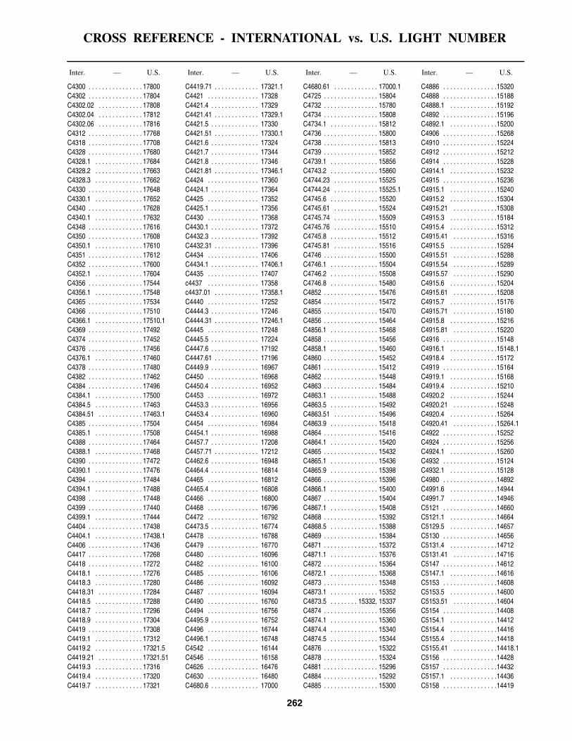
CROSS REFERENCE - INTERNATIONAL vs. U.S. LIGHT NUMBER
262
Inter. — U.S. Inter. — U.S. Inter. — U.S. Inter. — U.S.
C4300 . . . . . . . . . . . . . . . . 17800C4302 . . . . . . . . . . . . . . . . 17804C4302.02 . . . . . . . . . . . . . 17808C4302.04 . . . . . . . . . . . . . 17812C4302.06 . . . . . . . . . . . . . 17816C4312 . . . . . . . . . . . . . . . . 17768C4318 . . . . . . . . . . . . . . . . 17708C4328 . . . . . . . . . . . . . . . . 17680C4328.1 . . . . . . . . . . . . . . 17684C4328.2 . . . . . . . . . . . . . . 17663C4328.3 . . . . . . . . . . . . . . 17662C4330 . . . . . . . . . . . . . . . . 17648C4330.1 . . . . . . . . . . . . . . 17652C4340 . . . . . . . . . . . . . . . . 17628C4340.1 . . . . . . . . . . . . . . 17632C4348 . . . . . . . . . . . . . . . . 17616C4350 . . . . . . . . . . . . . . . . 17608C4350.1 . . . . . . . . . . . . . . 17610C4351 . . . . . . . . . . . . . . . . 17612C4352 . . . . . . . . . . . . . . . . 17600C4352.1 . . . . . . . . . . . . . . 17604C4356 . . . . . . . . . . . . . . . . 17544C4356.1 . . . . . . . . . . . . . . 17548C4365 . . . . . . . . . . . . . . . . 17534C4366 . . . . . . . . . . . . . . . . 17510C4366.1 . . . . . . . . . . . . . . 17510.1C4369 . . . . . . . . . . . . . . . . 17492C4374 . . . . . . . . . . . . . . . . 17452C4376 . . . . . . . . . . . . . . . . 17456C4376.1 . . . . . . . . . . . . . . 17460C4378 . . . . . . . . . . . . . . . . 17480C4382 . . . . . . . . . . . . . . . . 17462C4384 . . . . . . . . . . . . . . . . 17496C4384.1 . . . . . . . . . . . . . . 17500C4384.5 . . . . . . . . . . . . . . 17463C4384.51 . . . . . . . . . . . . . 17463.1C4385 . . . . . . . . . . . . . . . . 17504C4385.1 . . . . . . . . . . . . . . 17508C4388 . . . . . . . . . . . . . . . . 17464C4388.1 . . . . . . . . . . . . . . 17468C4390 . . . . . . . . . . . . . . . . 17472C4390.1 . . . . . . . . . . . . . . 17476C4394 . . . . . . . . . . . . . . . . 17484C4394.1 . . . . . . . . . . . . . . 17488C4398 . . . . . . . . . . . . . . . . 17448C4399 . . . . . . . . . . . . . . . . 17440C4399.1 . . . . . . . . . . . . . . 17444C4404 . . . . . . . . . . . . . . . . 17438C4404.1 . . . . . . . . . . . . . . 17438.1C4406 . . . . . . . . . . . . . . . . 17436C4417 . . . . . . . . . . . . . . . . 17268C4418 . . . . . . . . . . . . . . . . 17272C4418.1 . . . . . . . . . . . . . . 17276C4418.3 . . . . . . . . . . . . . . 17280C4418.31 . . . . . . . . . . . . . 17284C4418.5 . . . . . . . . . . . . . . 17288C4418.7 . . . . . . . . . . . . . . 17296C4418.9 . . . . . . . . . . . . . . 17304C4419 . . . . . . . . . . . . . . . . 17308C4419.1 . . . . . . . . . . . . . . 17312C4419.2 . . . . . . . . . . . . . . 17321.5C4419.21 . . . . . . . . . . . . . 17321.51C4419.3 . . . . . . . . . . . . . . 17316C4419.4 . . . . . . . . . . . . . . 17320C4419.7 . . . . . . . . . . . . . . 17321
C4419.71 . . . . . . . . . . . . . 17321.1C4421 . . . . . . . . . . . . . . . 17328C4421.4 . . . . . . . . . . . . . . 17329C4421.41 . . . . . . . . . . . . . 17329.1C4421.5 . . . . . . . . . . . . . . 17330C4421.51 . . . . . . . . . . . . . 17330.1C4421.6 . . . . . . . . . . . . . . 17324C4421.7 . . . . . . . . . . . . . . 17344C4421.8 . . . . . . . . . . . . . . 17346C4421.81 . . . . . . . . . . . . . 17346.1C4424 . . . . . . . . . . . . . . . 17360C4424.1 . . . . . . . . . . . . . . 17364C4425 . . . . . . . . . . . . . . . 17352C4425.1 . . . . . . . . . . . . . . 17356C4430 . . . . . . . . . . . . . . . 17368C4430.1 . . . . . . . . . . . . . . 17372C4432.3 . . . . . . . . . . . . . . 17392C4432.31 . . . . . . . . . . . . . 17396C4434 . . . . . . . . . . . . . . . 17406C4434.1 . . . . . . . . . . . . . . 17406.1C4435 . . . . . . . . . . . . . . . 17407c4437 . . . . . . . . . . . . . . . 17358c4437.01 . . . . . . . . . . . . . 17358.1C4440 . . . . . . . . . . . . . . . 17252C4444.3 . . . . . . . . . . . . . . 17246C4444.31 . . . . . . . . . . . . . 17246.1C4445 . . . . . . . . . . . . . . . 17248C4445.5 . . . . . . . . . . . . . . 17224C4447.6 . . . . . . . . . . . . . . 17192C4447.61 . . . . . . . . . . . . . 17196C4449.9 . . . . . . . . . . . . . . 16967C4450 . . . . . . . . . . . . . . . 16968C4450.4 . . . . . . . . . . . . . . 16952C4453 . . . . . . . . . . . . . . . 16972C4453.3 . . . . . . . . . . . . . . 16956C4453.4 . . . . . . . . . . . . . . 16960C4454 . . . . . . . . . . . . . . . 16984C4454.1 . . . . . . . . . . . . . . 16988C4457.7 . . . . . . . . . . . . . . 17208C4457.71 . . . . . . . . . . . . . 17212C4462.6 . . . . . . . . . . . . . . 16948C4464.4 . . . . . . . . . . . . . . 16814C4465 . . . . . . . . . . . . . . . 16812C4465.4 . . . . . . . . . . . . . . 16808C4466 . . . . . . . . . . . . . . . 16800C4468 . . . . . . . . . . . . . . . 16796C4472 . . . . . . . . . . . . . . . 16792C4473.5 . . . . . . . . . . . . . . 16774C4478 . . . . . . . . . . . . . . . 16788C4479 . . . . . . . . . . . . . . . 16770C4480 . . . . . . . . . . . . . . . 16096C4482 . . . . . . . . . . . . . . . 16100C4485 . . . . . . . . . . . . . . . 16106C4486 . . . . . . . . . . . . . . . 16092C4487 . . . . . . . . . . . . . . . 16094C4490 . . . . . . . . . . . . . . . 16760C4494 . . . . . . . . . . . . . . . 16756C4495.9 . . . . . . . . . . . . . . 16752C4496 . . . . . . . . . . . . . . . 16744C4496.1 . . . . . . . . . . . . . . 16748C4542 . . . . . . . . . . . . . . . 16144C4546 . . . . . . . . . . . . . . . 16158C4626 . . . . . . . . . . . . . . . 16476C4630 . . . . . . . . . . . . . . . 16480C4680.6 . . . . . . . . . . . . . . 17000
C4680.61 . . . . . . . . . . . . . 17000.1C4725 . . . . . . . . . . . . . . . . 15804C4732 . . . . . . . . . . . . . . . . 15780C4734 . . . . . . . . . . . . . . . . 15808C4734.1 . . . . . . . . . . . . . . 15812C4736 . . . . . . . . . . . . . . . . 15800C4738 . . . . . . . . . . . . . . . . 15813C4739 . . . . . . . . . . . . . . . . 15852C4739.1 . . . . . . . . . . . . . . 15856C4743.2 . . . . . . . . . . . . . . 15860C4744.23 . . . . . . . . . . . . . 15525C4744.24 . . . . . . . . . . . . . 15525.1C4745.6 . . . . . . . . . . . . . . 15520C4745.61 . . . . . . . . . . . . . 15524C4745.74 . . . . . . . . . . . . . 15509C4745.76 . . . . . . . . . . . . . 15510C4745.8 . . . . . . . . . . . . . . 15512C4745.81 . . . . . . . . . . . . . 15516C4746 . . . . . . . . . . . . . . . . 15500C4746.1 . . . . . . . . . . . . . . 15504C4746.2 . . . . . . . . . . . . . . 15508C4746.8 . . . . . . . . . . . . . . 15480C4852 . . . . . . . . . . . . . . . . 15476C4854 . . . . . . . . . . . . . . . . 15472C4855 . . . . . . . . . . . . . . . . 15470C4856 . . . . . . . . . . . . . . . . 15464C4856.1 . . . . . . . . . . . . . . 15468C4858 . . . . . . . . . . . . . . . . 15456C4858.1 . . . . . . . . . . . . . . 15460C4860 . . . . . . . . . . . . . . . . 15452C4861 . . . . . . . . . . . . . . . . 15412C4862 . . . . . . . . . . . . . . . . 15448C4863 . . . . . . . . . . . . . . . . 15484C4863.1 . . . . . . . . . . . . . . 15488C4863.5 . . . . . . . . . . . . . . 15492C4863.51 . . . . . . . . . . . . . 15496C4863.9 . . . . . . . . . . . . . . 15418C4864 . . . . . . . . . . . . . . . . 15416C4864.1 . . . . . . . . . . . . . . 15420C4865 . . . . . . . . . . . . . . . . 15432C4865.1 . . . . . . . . . . . . . . 15436C4865.9 . . . . . . . . . . . . . . 15398C4866 . . . . . . . . . . . . . . . . 15396C4866.1 . . . . . . . . . . . . . . 15400C4867 . . . . . . . . . . . . . . . . 15404C4867.1 . . . . . . . . . . . . . . 15408C4868 . . . . . . . . . . . . . . . . 15392C4868.5 . . . . . . . . . . . . . . 15388C4869 . . . . . . . . . . . . . . . . 15384C4871 . . . . . . . . . . . . . . . . 15372C4871.1 . . . . . . . . . . . . . . 15376C4872 . . . . . . . . . . . . . . . . 15364C4872.1 . . . . . . . . . . . . . . 15368C4873 . . . . . . . . . . . . . . . . 15348C4873.1 . . . . . . . . . . . . . . 15352C4873.5 . . . . . . . . 15332, 15337C4874 . . . . . . . . . . . . . . . . 15356C4874.1 . . . . . . . . . . . . . . 15360C4874.4 . . . . . . . . . . . . . . 15340C4874.5 . . . . . . . . . . . . . . 15344C4876 . . . . . . . . . . . . . . . . 15322C4878 . . . . . . . . . . . . . . . . 15324C4881 . . . . . . . . . . . . . . . . 15296C4884 . . . . . . . . . . . . . . . . 15292C4885 . . . . . . . . . . . . . . . . 15300
C4886 . . . . . . . . . . . . . . . .15320C4888 . . . . . . . . . . . . . . . .15188C4888.1 . . . . . . . . . . . . . .15192C4892 . . . . . . . . . . . . . . . .15196C4892.1 . . . . . . . . . . . . . .15200C4906 . . . . . . . . . . . . . . . .15268C4910 . . . . . . . . . . . . . . . .15224C4912 . . . . . . . . . . . . . . . .15212C4914 . . . . . . . . . . . . . . . .15228C4914.1 . . . . . . . . . . . . . .15232C4915 . . . . . . . . . . . . . . . .15236C4915.1 . . . . . . . . . . . . . .15240C4915.2 . . . . . . . . . . . . . .15304C4915.21 . . . . . . . . . . . . .15308C4915.3 . . . . . . . . . . . . . .15184C4915.4 . . . . . . . . . . . . . .15312C4915.41 . . . . . . . . . . . . .15316C4915.5 . . . . . . . . . . . . . .15284C4915.51 . . . . . . . . . . . . .15288C4915.54 . . . . . . . . . . . . .15289C4915.57 . . . . . . . . . . . . .15290C4915.6 . . . . . . . . . . . . . .15204C4915.61 . . . . . . . . . . . . .15208C4915.7 . . . . . . . . . . . . . .15176C4915.71 . . . . . . . . . . . . .15180C4915.8 . . . . . . . . . . . . . .15216C4915.81 . . . . . . . . . . . . .15220C4916 . . . . . . . . . . . . . . . .15148C4916.1 . . . . . . . . . . . . . .15148.1C4918.4 . . . . . . . . . . . . . .15172C4919 . . . . . . . . . . . . . . . .15164C4919.1 . . . . . . . . . . . . . .15168C4919.4 . . . . . . . . . . . . . .15210C4920.2 . . . . . . . . . . . . . .15244C4920.21 . . . . . . . . . . . . .15248C4920.4 . . . . . . . . . . . . . .15264C4920.41 . . . . . . . . . . . . .15264.1C4922 . . . . . . . . . . . . . . . .15252C4924 . . . . . . . . . . . . . . . .15256C4924.1 . . . . . . . . . . . . . .15260C4932 . . . . . . . . . . . . . . . .15124C4932.1 . . . . . . . . . . . . . .15128C4980 . . . . . . . . . . . . . . . .14892C4991.6 . . . . . . . . . . . . . .14944C4991.7 . . . . . . . . . . . . . .14946C5121 . . . . . . . . . . . . . . . .14660C5121.1 . . . . . . . . . . . . . .14664C5129.5 . . . . . . . . . . . . . .14657C5130 . . . . . . . . . . . . . . . .14656C5131.4 . . . . . . . . . . . . . .14712C5131.41 . . . . . . . . . . . . .14716C5147 . . . . . . . . . . . . . . . .14612C5147.1 . . . . . . . . . . . . . .14616C5153 . . . . . . . . . . . . . . . .14608C5153.5 . . . . . . . . . . . . . .14600C5153.51 . . . . . . . . . . . . .14604C5154 . . . . . . . . . . . . . . . .14408C5154.1 . . . . . . . . . . . . . .14412C5154.4 . . . . . . . . . . . . . .14416C5155.4 . . . . . . . . . . . . . .14418C5155.41 . . . . . . . . . . . . .14418.1C5156 . . . . . . . . . . . . . . . .14428C5157 . . . . . . . . . . . . . . . .14432C5157.1 . . . . . . . . . . . . . .14436C5158 . . . . . . . . . . . . . . . .14419

CROSS REFERENCE - INTERNATIONAL vs. U.S. LIGHT NUMBER
263
Inter. — U.S. Inter. — U.S. Inter. — U.S. Inter. — U.S.
C5158.1 . . . . . . . . . . . . . . 14420C5159 . . . . . . . . . . . . . . . . 14418.5C5160 . . . . . . . . . . . . . . . . 14440C5162 . . . . . . . . . . . . . . . . 14452C5162.1 . . . . . . . . . . . . . . 14456C5165 . . . . . . . . . . . . . . . . 14552C5166 . . . . . . . . . . . . . . . . 14472C5167 . . . . . . . . . . . . . . . . 14464C5167.1 . . . . . . . . . . . . . . 14468C5168 . . . . . . . . . . . . . . . . 14460C5170 . . . . . . . . . . . . . . . . 14476C5170.1 . . . . . . . . . . . . . . 14480C5171 . . . . . . . . . . . . . . . . 14556C5171.1 . . . . . . . . . . . . . . 14560C5173 . . . . . . . . . . . . . . . . 14492C5173.1 . . . . . . . . . . . . . . 14496C5175.5 . . . . . . . . . . . . . . 14444C5175.51 . . . . . . . . . . . . . 14448C5184 . . . . . . . . . . . . . . . . 14516C5185 . . . . . . . . . . . . . . . . 14518C5186 . . . . . . . . . . . . . . . . 14520C5188 . . . . . . . . . . . . . . . . 14548C5188.1 . . . . . . . . . . . . . . 14544C5190 . . . . . . . . . . . . . . . . 14528C5190.1 . . . . . . . . . . . . . . 14532C5190.4 . . . . . . . . . . . . . . 14540C5190.5 . . . . . . . . . . . . . . 14536C5195 . . . . . . . . . . . . . . . . 14572C5196 . . . . . . . . . . . . . . . . 14564C5196.1 . . . . . . . . . . . . . . 14568C5200 . . . . . . . . . . . . . . . . 14584C5202 . . . . . . . . . . . . . . . . 14588C5202.1 . . . . . . . . . . . . . . 14592C5203 . . . . . . . . . . . . . . . . 14406C5203.1 . . . . . . . . . . . . . . 14406.1C5203.4 . . . . . . . . . . . . . . 14407C5203.41 . . . . . . . . . . . . . 14407.1C5206 . . . . . . . . . . . . . . . . 14596C5206.5 . . . . . . . . . . . . . . 14598C5208 . . . . . . . . . . . . . . . . 14404C5210 . . . . . . . . . . . . . . . . 14400C5212 . . . . . . . . . . . . . . . . 14396C5214 . . . . . . . . . . . . . . . . 14388C5216 . . . . . . . . . . . . . . . . 14380C5216.1 . . . . . . . . . . . . . . 14384C5216.4 . . . . . . . . . . . . . . 14368C5216.41 . . . . . . . . . . . . . 14372C5217 . . . . . . . . . . . . . . . . 14360C5217.1 . . . . . . . . . . . . . . 14364C5220 . . . . . . . . . . . . . . . . 14344C5220.1 . . . . . . . . . . . . . . 14348C5222 . . . . . . . . . . . . . . . . 14336C5222.1 . . . . . . . . . . . . . . 14340C5223 . . . . . . . . . . . . . . . . 14328C5223.1 . . . . . . . . . . . . . . 14332C5224 . . . . . . . . . . . . . . . . 14320C5224.15 . . . . . . . . . . . . . 14324C5226.2 . . . . . . . . . . . . . . 14316C5227 . . . . . . . . . . . . . . . . 14224C5227.1 . . . . . . . . . . . . . . 14228C5235 . . . . . . . . . . . . . . . . 14144C5239 . . . . . . . . . . . . . . . . 14084C5239.4 . . . . . . . . . . . . . . 14088C5239.41 . . . . . . . . . . . . . 14092C5240 . . . . . . . . . . . . . . . . 14112
C5240.1 . . . . . . . . . . . . . . 14116C5240.4 . . . . . . . . . . . . . . 14096C5268 . . . . . . . . . . . . . . . 14072C5284 . . . . . . . . . . . . . . . 13940C5318 . . . . . . . . . . . . . . . 13936C5320 . . . . . . . . . . . . . . . 13932C5321 . . . . . . . . . . . . . . . 13824C5324 . . . . . . . . . . . . . . . 13816C5324.1 . . . . . . . . . . . . . . 13820C5328 . . . . . . . . . . . . . . . 13828C5349 . . . . . . . . . . . . . . . 13780C5356 . . . . . . . . . . . . . . . 13692C5356.1 . . . . . . . . . . . . . . 13696C5366 . . . . . . . . . . . . . . . 13720C5368 . . . . . . . . . . . . . . . 13688C5369 . . . . . . . . . . . . . . . 13700C5370 . . . . . . . . . . . . . . . 13704C5370.1 . . . . . . . . . . . . . . 13708C5374 . . . . . . . . . . . . . . . 13556C5378 . . . . . . . . . . . . . . . 13552C5380 . . . . . . . . . . . . . . . 13560C5380.5 . . . . . . . . . . . . . . 13561C5380.6 . . . . . . . . . . . . . . 13562C5381 . . . . . . . . . . . . . . . 13563C5382 . . . . . . . . . . . . . . . 13569C5382.1 . . . . . . . . . . . . . . 13569.1C5382.5 . . . . . . . . . . . . . . 13570C5383 . . . . . . . . . . . . . . . 13571C5383.3 . . . . . . . . . . . . . . 13571.3C5385 . . . . . . . . . . . . . . . 13566C5386 . . . . . . . . . . . . . . . 13564C5387 . . . . . . . . . . . . . . . 13568C5388 . . . . . . . . . . . . . . . 13584C5390 . . . . . . . . . . . . . . . 13580C5390.4 . . . . . . . . . . . . . . 13658C5390.41 . . . . . . . . . . . . . 13658.1C5392 . . . . . . . . . . . . . . . 13588C5392.1 . . . . . . . . . . . . . . 13592C5392.6 . . . . . . . . . . . . . . 13644C5392.61 . . . . . . . . . . . . . 13648C5393 . . . . . . . . . . . . . . . 13672C5393.1 . . . . . . . . . . . . . . 13676C5393.4 . . . . . . . . . . . . . . 13660C5393.41 . . . . . . . . . . . . . 13660.1C5394 . . . . . . . . . . . . . . . 13604C5394.2 . . . . . . . . . . . . . . 13608C5394.21 . . . . . . . . . . . . . 13612C5394.4 . . . . . . . . . . . . . . 13571.1, 13596C5394.41 . . . . . . . . . . . . . 13600C5396 . . . . . . . . . . . . . . . 13420C5396.1 . . . . . . . . . . . . . . 13424C5396.9 . . . . . . . . . . . . . . 13632C5396.91 . . . . . . . . . . . . . 13636C5397 . . . . . . . . . . . . . . . 13624C5397.1 . . . . . . . . . . . . . . 13628C5403 . . . . . . . . . . . . . . . 13538C5403.1 . . . . . . . . . . . . . . 13538.5C5405.6 . . . . . . . . . . . . . . 13638C5405.61 . . . . . . . . . . . . . 13638.1C5408 . . . . . . . . . . . . . . . 13542C5410 . . . . . . . . . . . . . . . 13412C5411 . . . . . . . . . . . . . . . 13409C5412 . . . . . . . . . . . . . . . 13404C5413 . . . . . . . . . . . . . . . 13408
C5414 . . . . . . . . . . . . . . . . 13413C5414.1 . . . . . . . . . . . . . . 13413.5C5414.3 . . . . . . . . . . . . . . 13414C5414.4 . . . . . . . . . . . . . . 13425.7C5414.41 . . . . . . . . . . . . . 13425.71C5415 . . . . . . . . . . . . . . . . 13416C5415.4 . . . . . . . . . . . . . . 13426C5416 . . . . . . . . . . . . . . . . 13433C5416.1 . . . . . . . . . . . . . . 13433.5C5416.4 . . . . . . . . . . . . . . 13425C5416.41 . . . . . . . . . . . . . 13425.5C5417 . . . . . . . . . . . . . . . . 13434C5417.1 . . . . . . . . . . . . . . 13434.5C5417.4 . . . . . . . . . . . . . . 13438C5417.41 . . . . . . . . . . . . . 13438.5C5418 . . . . . . . . . . . . . . . . 13432C5418.4 . . . . . . . . . . . . . . 13427C5418.41 . . . . . . . . . . . . . 13427.5C5419 . . . . . . . . . . . . . . . . 13460C5419.1 . . . . . . . . . . . . . . 13464C5419.2 . . . . . . . . . . . . . . 13436C5419.21 . . . . . . . . . . . . . 13437C5419.3 . . . . . . . . . . . . . . 13444C5419.31 . . . . . . . . . . . . . 13448C5420 . . . . . . . . . . . . . . . . 13468C5420.1 . . . . . . . . . . . . . . 13472C5420.4 . . . . . . . . . . . . . . 13428C5420.8 . . . . . . . . . . . . . . 13476C5420.81 . . . . . . . . . . . . . 13480C5421 . . . . . . . . . . . . . . . . 13496C5422 . . . . . . . . . . . . . . . . 13466C5425 . . . . . . . . . . . . . . . . 13500C5425.1 . . . . . . . . . . . . . . 13504C5428 . . . . . . . . . . . . . . . . 13492C5430 . . . . . . . . . . . . . . . . 13516C5430.1 . . . . . . . . . . . . . . 13520C5432 . . . . . . . . . . . . . . . . 13524C5432.1 . . . . . . . . . . . . . . 13528C5434 . . . . . . . . . . . . . . . . 13532C5434.1 . . . . . . . . . . . . . . 13536C5435 . . . . . . . . . . . . . . . . 13514C5435.1 . . . . . . . . . . . . . . 13514.1C5438 . . . . . . . . . . . . . . . . 13400C5438.4 . . . . . . . . . . . . . . 13399.4C5438.41 . . . . . . . . . . . . . 13399.8C5438.5 . . . . . . . . . . . . . . 13401C5438.51 . . . . . . . . . . . . . 13401.5C5438.58 . . . . . . . . . . . . . 13402C5438.6 . . . . . . . . . . . . . . 13389C5438.61 . . . . . . . . . . . . . 13390C5438.7 . . . . . . . . . . . . . . 13398.2C5438.71 . . . . . . . . . . . . . 13398.4C5438.8 . . . . . . . . . . . . . . 13394C5438.81 . . . . . . . . . . . . . 13396C5438.9 . . . . . . . . . . . . . . 13465C5438.91 . . . . . . . . . . . . . 13465.5C5440 . . . . . . . . . . . . . . . . 13392C5440.1 . . . . . . . . . . . . . . 13393C5441.3 . . . . . . . . . . . . . . 13388C5456 . . . . . . . . . . . . . . . . 13352C5464 . . . . . . . . . . . . . . . . 13348C5465 . . . . . . . . . . . . . . . . 13340C5465.1 . . . . . . . . . . . . . . 13344C5465.9 . . . . . . . . . . . . . . 13332C5466.1 . . . . . . . . . . . . . . 13324
C5466.11 . . . . . . . . . . . . .13324.1C5468 . . . . . . . . . . . . . . . .13320C5470 . . . . . . . . . . . . . . . .13316C5472 . . . . . . . . . . . . . . . .13308C5472.1 . . . . . . . . . . . . . .13312C5474 . . . . . . . . . . . . . . . .13304C5476 . . . . . . . . . . . . . . . .13300C5482 . . . . . . . . . . . . . . . .13296C5485 . . . . . . . . . . . . . . . .13301C5485.1 . . . . . . . . . . . . . .13302C5488 . . . . . . . . . . . . . . . .13264C5490 . . . . . . . . . . . . . . . .13260C5490.1 . . . . . . . . . . . . . .13261C5491 . . . . . . . . . . . . . . . .13262C5491.1 . . . . . . . . . . . . . .13263C5492 . . . . . . . . . . . . . . . .13256C5496 . . . . . . . . . . . . . . . .13268C5500 . . . . . . . . . . . . . . . .13104C5500.1 . . . . . . . . . . . . . .13108C5505 . . . . . . . . . . . . . . . .13258C5506 . . . . . . . . . . . . . . . .13112C5508 . . . . . . . . . . . . . . . .13116C5511 . . . . . . . . . . . . . . . .13117C5511.1 . . . . . . . . . . . . . .13118C5513 . . . . . . . . . . . . . . . .13119.2C5513.2 . . . . . . . . . . . . . .13119.1C5513.4 . . . . . . . . . . . . . .13119C5514 . . . . . . . . . . . . . . . .13120C5514.1 . . . . . . . . . . . . . .13124C5520 . . . . . . . . . . . . . . . .13140C5520.1 . . . . . . . . . . . . . .13144C5521 . . . . . . . . . . . . . . . .13148C5522 . . . . . . . . . . . . . . . .13168C5522.1 . . . . . . . . . . . . . .13172C5524 . . . . . . . . . . . . . . . .13152C5524.1 . . . . . . . . . . . . . .13156C5528 . . . . . . . . . . . . . . . .13176C5530 . . . . . . . . . . . . . . . .13160C5530.1 . . . . . . . . . . . . . .13164C5534 . . . . . . . . . . . . . . . .13188C5534.1 . . . . . . . . . . . . . .13192C5536 . . . . . . . . . . . . . . . .13196C5536.1 . . . . . . . . . . . . . .13200C5539 . . . . . . . . . . . . . . . .13184C5539.4 . . . . . . . . . . . . . .13180C5541.9 . . . . . . . . . . . . . .13212C5542 . . . . . . . . . . . . . . . .13208C5542.1 . . . . . . . . . . . . . .13216C5543.9 . . . . . . . . . . . . . .13222C5546 . . . . . . . . . . . . . . . .13228C5546.1 . . . . . . . . . . . . . .13232C5552.4 . . . . . . . . . . . . . .13248C5552.41 . . . . . . . . . . . . .13252C5552.9 . . . . . . . . . . . . . .13254.2C5553 . . . . . . . . . . . . . . . .13254C5553.1 . . . . . . . . . . . . . .13254.1C5562 . . . . . . . . . . . . . . . .13100C5562.28 . . . . . . . . . . . . .13097.1C5562.29 . . . . . . . . . . . . .13097.2C5562.3 . . . . . . . . . . . . . .13097.3C5567 . . . . . . . . . . . . . . . .13092C5568 . . . . . . . . . . . . . . . .13088C5569 . . . . . . . . . . . . . . . .13085C5569.1 . . . . . . . . . . . . . .13086C5582 . . . . . . . . . . . . . . . .13084

CROSS REFERENCE - INTERNATIONAL vs. U.S. LIGHT NUMBER
264
Inter. — U.S. Inter. — U.S. Inter. — U.S. Inter. — U.S.
C5584 . . . . . . . . . . . . . . . . 13080C5586 . . . . . . . . . . . . . . . . 13081C5694 . . . . . . . . . . . . . . . . 18960C5694.1 . . . . . . . . . . . . . . 18964C5697 . . . . . . . . . . . . . . . . 18968C5697.1 . . . . . . . . . . . . . . 18972C5697.3 . . . . . . . . . . . . . . 18976C5698 . . . . . . . . . . . . . . . . 11976C5698.1 . . . . . . . . . . . . . . 11980C5700 . . . . . . . . . . . . . . . . 18965C5700.1 . . . . . . . . . . . . . . 18965.1C5703 . . . . . . . . . . . . . . . . 11964C5703.1 . . . . . . . . . . . . . . 11968C5704 . . . . . . . . . . . . . . . . 11970C5710 . . . . . . . . . . . . . . . . 11872C5710.2 . . . . . . . . . . . . . . 11876C5710.5 . . . . . . . . . . . . . . 11877C5710.51 . . . . . . . . . . . . . 11877.1C5710.6 . . . . . . . . . . . . . . 11878C5710.61 . . . . . . . . . . . . . 11878.1C5712.4 . . . . . . . . . . . . . . 11888C5712.8 . . . . . . . . . . . . . . 11896C5712.9 . . . . . . . . . . . . . . 11890C5712.91 . . . . . . . . . . . . . 11890.1C5713 . . . . . . . . . . . . . . . . 11936C5713.4 . . . . . . . . . . . . . . 11932C5714 . . . . . . . . . . . . . . . . 11928C5718.5 . . . . . . . . . . . . . . 11908C5719 . . . . . . . . . . . . . . . . 11909C5720 . . . . . . . . . . . . . . . . 11912C5720.1 . . . . . . . . . . . . . . 11916C5724 . . . . . . . . . . . . . . . . 11920C5724.1 . . . . . . . . . . . . . . 11924C5724.4 . . . . . . . . . . . . . . 11860C5724.41 . . . . . . . . . . . . . 11864C5725 . . . . . . . . . . . . . . . . 11900C5725.1 . . . . . . . . . . . . . . 11904C5725.5 . . . . . . . . . . . . . . 11868C5725.8 . . . . . . . . . . . . . . 11938C5727.5 . . . . . . . . . . . . . . 11840C5728 . . . . . . . . . . . . . . . . 11844C5728.1 . . . . . . . . . . . . . . 11848C5729 . . . . . . . . . . . . . . . . 11852C5729.1 . . . . . . . . . . . . . . 11856C5730 . . . . . . . . . . . . . . . . 11824C5730.1 . . . . . . . . . . . . . . 11828C5731.5 . . . . . . . . . . . . . . 11764C5731.51 . . . . . . . . . . . . . 11768C5731.9 . . . . . . . . . . . . . . 11760C5733 . . . . . . . . . . . . . . . . 11688C5733.1 . . . . . . . . . . . . . . 11692C5734 . . . . . . . . . . . . . . . . 11700C5735 . . . . . . . . . . . . . . . . 11696C5736 . . . . . . . . . . . . . . . . 11708C5736.1 . . . . . . . . . . . . . . 11712C5739 . . . . . . . . . . . . . . . . 11716C5739.1 . . . . . . . . . . . . . . 11720C5739.9 . . . . . . . . . . . . . . 11728C5740 . . . . . . . . . . 11724, 11732C5740.1 . . . . . . . . . . . . . . 11736C5741 . . . . . . . . . . . . . . . . 11740C5741.1 . . . . . . . . . . . . . . 11744C5743 . . . . . . . . . . . . . . . . 11748C5743.1 . . . . . . . . . . . . . . 11752C5744 . . . . . . . . . . . . . . . . 11624
C5745 . . . . . . . . . . . . . . . 11628C5746 . . . . . . . . . . . . . . . 11632C5746.1 . . . . . . . . . . . . . . 11636C5747 . . . . . . . . . . . . . . . 11637C5747.1 . . . . . . . . . . . . . . 11638C5748 . . . . . . . . . . . . . . . 11640C5749 . . . . . . . . . . . . . . . 11644C5754.2 . . . . . . . . . . . . . . 11702C5754.3 . . . . . . . . . . . . . . 11702.1C5770 . . . . . . . . . . . . . . . 11680C5778 . . . . . . . . . . . . . . . 11660C5788 . . . . . . . . . . . . . . . 11500C5788.1 . . . . . . . . . . . . . . 11504C5789 . . . . . . . . . . . . . . . 11476C5790 . . . . . . . . . . . . . . . 11488C5790.4 . . . . . . . . . . . . . . 11508C5790.41 . . . . . . . . . . . . . 11512C5790.5 . . . . . . . . . . . . . . 11544C5790.51 . . . . . . . . . . . . . 11548C5790.6 . . . . . . . . . . . . . . 11552C5790.61 . . . . . . . . . . . . . 11556C5790.8 . . . . . . . . . . . . . . 11516C5790.81 . . . . . . . . . . . . . 11520C5790.82 . . . . . . . . . . . . . 11492C5790.83 . . . . . . . . . . . . . 11496C5790.86 . . . . . . . . . . . . . 11536C5790.87 . . . . . . . . . . . . . 11540C5790.89 . . . . . . . . . . . . . 11524C5790.9 . . . . . . . . . . . . . . 11528C5791 . . . . . . . . . . . . . . . 11558C5792 . . . . . . . . . . . . . . . 11572C5792.01 . . . . . . . . . . . . . 11576C5792.2 . . . . . . . . . . . . . . 11588C5792.21 . . . . . . . . . . . . . 11592C5792.4 . . . . . . . . . . . . . . 11564C5792.41 . . . . . . . . . . . . . 11568C5792.6 . . . . . . . . . . . . . . 11580C5792.61 . . . . . . . . . . . . . 11584C5792.8 . . . . . . . . . . . . . . 11596C5792.9 . . . . . . . . . . . . . . 11600C5793 . . . . . . . . . . . . . . . 11602C5793.1 . . . . . . . . . . . . . . 11602.1C5796 . . . . . . . . . . . . . . . 11622C5805 . . . . . . . . . . . . . . . 11460C5806 . . . . . . . . . . . . . . . 11464C5809 . . . . . . . . . . . . . . . 11456C5810 . . . . . . . . . . . . . . . 11384C5810.5 . . . . . . . . . . . . . . 11384.2C5811.8 . . . . . . . . . . . . . . 11380C5813 . . . . . . . . . . . . . . . 11388C5814.9 . . . . . . . . . . . . . . 11436C5815 . . . . . . . . . . . . . . . 11440C5815.1 . . . . . . . . . . . . . . 11444C5816 . . . . . . . . . . . . . . . 11408C5816.1 . . . . . . . . . . . . . . 11412C5816.2 . . . . . . . . . . . . . . 11416C5816.4 . . . . . . . . . . . . . . 11392C5816.9 . . . . . . . . . . . . . . 11396C5817 . . . . . . . . . . . . . . . 11400C5817.1 . . . . . . . . . . . . . . 11404C5817.4 . . . . . . . . . . . . . . 11420C5818.4 . . . . . . . . . . . . . . 11424C5824 . . . . . . . . . . . . . . . 11364C5824.1 . . . . . . . . . . . . . . 11368C5826 . . . . . . . . . . . . . . . 11356
C5828 . . . . . . . . . . . . . . . . 11360C5833 . . . . . . . . . . . . . . . . 11328C5833.3 . . . . . . . . . . . . . . 11344C5833.31 . . . . . . . . . . . . . 11348C5834 . . . . . . . . . . . . . . . . 11340C5836 . . . . . . . . . . . . . . . . 11332C5836.1 . . . . . . . . . . . . . . 11336C5840 . . . . . . . . . . . . . . . . 11324C5844 . . . . . . . . . . . . . . . . 11312C5846 . . . . . . . . . . . . . . . . 11316C5846.1 . . . . . . . . . . . . . . 11320C5847 . . . . . . . . . . . . . . . . 11308C5848 . . . . . . . . . . . . . . . . 11300C5852 . . . . . . . . . . . . . . . . 11304C5854 . . . . . . . . . . . . . . . . 11284C5854.1 . . . . . . . . . . . . . . 11288C5855 . . . . . . . . . . . . . . . . 11292C5855.1 . . . . . . . . . . . . . . 11296C5860 . . . . . . . . . . . . . . . . 11268C5862 . . . . . . . . . . . . . . . . 11276C5862.1 . . . . . . . . . . . . . . 11280C5864 . . . . . . . . . . . . . . . . 11272C5866 . . . . . . . . . . . . . . . . 11282C5866.1 . . . . . . . . . . . . . . 11282.5C5874 . . . . . . . . . . . . . . . . 11248C5878.9 . . . . . . . . . . . . . . 11144C5879 . . . . . . . . . . . . . . . . 11148C5879.1 . . . . . . . . . . . . . . 11152C5880 . . . . . . . . . . . . . . . . 11132C5881 . . . . . . . . . . . . . . . . 11140C5882 . . . . . . . . . . . . . . . . 11136C5884 . . . . . . . . . . . . . . . . 11164C5884.1 . . . . . . . . . . . . . . 11168C5886 . . . . . . . . . . . . . . . . 11172C5886.1 . . . . . . . . . . . . . . 11176C5887 . . . . . . . . . . . . . . . . 11156C5887.5 . . . . . . . . . . . . . . 11160C5887.8 . . . . . . . . . . . . . . 11178C5888 . . . . . . . . . . . . . . . . 11180C5889 . . . . . . . . . . . . . . . . 11184C5889.1 . . . . . . . . . . . . . . 11188C5890.6 . . . . . . . . . . . . . . 11192C5890.61 . . . . . . . . . . . . . 11196C5891.5 . . . . . . . . . . . . . . 11228C5894 . . . . . . . . . . . . . . . . 11212C5894.1 . . . . . . . . . . . . . . 11216C5895 . . . . . . . . . . . . . . . . 11208C5897 . . . . . . . . . . . . . . . . 11220C5897.1 . . . . . . . . . . . . . . 11224C5898 . . . . . . . . . . . . . . . . 11232C5898.1 . . . . . . . . . . . . . . 11236C5902 . . . . . . . . . . . . . . . . 11124C5910 . . . . . . . . . . . . . . . . 11068C5912 . . . . . . . . . . . . . . . . 11076C5920 . . . . . . . . . . . . . . . . 11056C5923 . . . . . . . . . . . . . . . . 11044C5925 . . . . . . . . . . . . . . . . 11004C5925.4 . . . . . . . . . . . . . . 11000C5926 . . . . . . . . . . . . . . . . 11048C5926.1 . . . . . . . . . . . . . . 11052C5928 . . . . . . . . . . . . . . . . 10996C5936 . . . . . . . . . . . . . . . . 11024C5938 . . . . . . . . . . . . . . . . 11020C5944 . . . . . . . . . . . . . . . . 10992C5946 . . . . . . . . . . . . . . . . 10980
C5948 . . . . . . . . . . . . . . . .10984C5948.1 . . . . . . . . . . . . . .10988C5951 . . . . . . . . . . . . . . . .10936C5952 . . . . . . . . . . . . . . . .10928C5954 . . . . . . . . . . . . . . . .10932C5960 . . . . . . . . . . . . . . . .10960C5962 . . . . . . . . . . . . . . . .10964C5967 . . . . . . . . . . . . . . . .10970C5967.1 . . . . . . . . . . . . . .10970.1C5967.3 . . . . . . . . . . . . . .10971C5967.31 . . . . . . . . . . . . .10971.1C5968 . . . . . . . . . . . . . . . .10972C5972.4 . . . . . . . . . . . . . .10924C5972.41 . . . . . . . . . . . . .10925C5973 . . . . . . . . . . . . . . . .10920C5974 . . . . . . . . . . . . . . . .10916C5975 . . . . . . . . . . . . . . . .10912C5976 . . . . . . . . . . . . . . . .10900C5977 . . . . . . . . . . . . . . . .10904C5977.1 . . . . . . . . . . . . . .10908C5977.2 . . . . . . . . . . . . . .10913C5977.3 . . . . . . . . . . . . . .10914C5977.4 . . . . . . . . . . . . . .10915C5978 . . . . . . . . . . . . . . . .10892C5979 . . . . . . . . . . . . . . . .10896C5979.6 . . . . . . . . . . . . . .10891C5980 . . . . . . . . . . . . . . . .10890C5982 . . . . . . . . . . . . . . . .10868C5983.4 . . . . . . . . . . . . . .10872C5988 . . . . . . . . . . . . . . . .10832C5988.5 . . . . . . . . . . . . . .10834C5989 . . . . . . . . . . . . . . . .10888C5990 . . . . . . . . . . . . . . . .10836C5992 . . . . . . . . . . . . . . . .10840C5993 . . . . . . . . . . . . . . . .10880C5993.3 . . . . . . . . . . . . . .10878C5993.4 . . . . . . . . . . . . . .10878.1C5993.5 . . . . . . . . . . . . . .10878.2C5993.6 . . . . . . . . . . . . . .10876C5994 . . . . . . . . . . . . . . . .10844C5998 . . . . . . . . . . . . . . . .10848C6000 . . . . . . . . . . . . . . . .10850.5C6000.6 . . . . . . . . . . . . . .10850C6001 . . . . . . . . . . . . . . . .10851C6001.4 . . . . . . . . . . . . . .10884C6004 . . . . . . . . . . . . . . . .10856C6008 . . . . . . . . . . . . . . . .10828C6011 . . . . . . . . . . . . . . . .10824C6012 . . . . . . . . . . . . . . . .10820C6014 . . . . . . . . . . . . . . . .10812C6015 . . . . . . . . . . . . . . . .10810C6016 . . . . . . . . . . . . . . . .10808C6020 . . . . . . . . . . . . . . . .10804C6020.5 . . . . . . . . . . . . . .10805C6021 . . . . . . . . . . . . . . . .10792C6022 . . . . . . . . . . . . . . . .10800C6023 . . . . . . . . . . . . . . . .10796C6024 . . . . . . . . . . . . . . . .10788C6025 . . . . . . . . . . . . . . . .10784C6028 . . . . . . . . . . . . . . . .10780C6030 . . . . . . . . . . . . . . . .10752C6032 . . . . . . . . . . . . . . . .10744C6032.1 . . . . . . . . . . . . . .10748C6034 . . . . . . . . . . . . . . . .10756C6036 . . . . . . . . . . . . . . . .10760

CROSS REFERENCE - INTERNATIONAL vs. U.S. LIGHT NUMBER
265
Inter. — U.S. Inter. — U.S. Inter. — U.S. Inter. — U.S.
C6036.4 . . . . . . . . . . . . . . 10764C6037 . . . . . . . . . . . . . . . . 10766C6037.1 . . . . . . . . . . . . . . 10766.1C6037.4 . . . . . . . . . . . . . . 10768C6037.6 . . . . . . . . . . . . . . 10772C6037.61 . . . . . . . . . . . . . 10776C6039 . . . . . . . . . . . . . . . . 10778C6040 . . . . . . . . . . . . . . . . 10736C6041 . . . . . . . . . . . . . . . . 10740C6042 . . . . . . . . . . . . . . . . 10732C6043 . . . . . . . . . . . . . . . . 10708C6044.5 . . . . . . . . . . . . . . 10720C6044.6 . . . . . . . . . . . . . . 10724C6048 . . . . . . . . . . . . . . . . 10704C6052 . . . . . . . . . . . . . . . . 10700C6056 . . . . . . . . . . . . . . . . 10696C6057 . . . . . . . . . . . . . . . . 10636C6057.4 . . . . . . . . . . . . . . 10640C6060 . . . . . . . . . . . . . . . . 10624C6062 . . . . . . . . . . . . . . . . 10632C6066 . . . . . . . . . . . . . . . . 10628C6068 . . . . . . . . . . . . . . . . 10652C6069 . . . . . . . . . . . . . . . . 10656C6069.1 . . . . . . . . . . . . . . 10660C6070 . . . . . . . . . . . . . . . . 10664C6070.1 . . . . . . . . . . . . . . 10668C6071 . . . . . . . . . . . . . . . . 10672C6072 . . . . . . . . . . . . . . . . 10676C6075 . . . . . . . . . . . . . . . . 10680C6075.1 . . . . . . . . . . . . . . 10684C6076 . . . . . . . . . . . . . . . . 10688C6076.1 . . . . . . . . . . . . . . 10692C6079 . . . . . . . . . . . . . . . . 10612C6080 . . . . . . . . . . . . . . . . 10616C6081 . . . . . . . . . . . . . . . . 10620C6083 . . . . . . . . . . . . . . . . 10604C6084 . . . . . . . . . . . . . . . . 10608C6084.5 . . . . . . . . . . . . . . 10610C6086.2 . . . . . . . . . . . . . . 10600C6087 . . . . . . . . . . . . . . . . 10528C6088 . . . . . . . . . . . . . . . . 10532C6092 . . . . . . . . . . . . . . . . 10536C6093 . . . . . . . . . . . . . . . . 10548C6098 . . . . . . . . . . . . . . . . 10552C6098.1 . . . . . . . . . . . . . . 10556C6100 . . . . . . . . . . . . . . . . 10560C6102 . . . . . . . . . . . . . . . . 10564C6106 . . . . . . . . . . . . . . . . 10568C6106.2 . . . . . . . . . . . . . . 10573C6108 . . . . . . . . . . . . . . . . 10576C6108.1 . . . . . . . . . . . . . . 10576.1C6111 . . . . . . . . . . . . . . . . 10592C6111.1 . . . . . . . . . . . . . . 10596C6112 . . . . . . . . . . . . . . . . 10524C6113 . . . . . . . . . . . . . . . . 10540C6113.1 . . . . . . . . . . . . . . 10544C6113.5 . . . . . . . . . . . . . . 10546.1C6113.51 . . . . . . . . . . . . . 10546C6114 . . . . . . . . . . . . . . . . 10500C6114.4 . . . . . . . . . . . . . . 10516C6114.41 . . . . . . . . . . . . . 10520C6114.5 . . . . . . . . . . . . . . 10502C6114.6 . . . . . . . . . . . . . . 10508C6114.61 . . . . . . . . . . . . . 10512C6116 . . . . . . . . . . . . . . . . 10492
C6116.1 . . . . . . . . . . . . . . 10496C6122 . . . . . . . . . . . . . . . 10476C6125 . . . . . . . . . . . . . . . 10480C6130 . . . . . . . . . . . . . . . 10472C6132 . . . . . . . . . . . . . . . 10484C6132.1 . . . . . . . . . . . . . . 10488C6138 . . . . . . . . . . . . . . . 10468C6146 . . . . . . . . . . . . . . . 10464C6152 . . . . . . . . . . . . . . . 10440C6154 . . . . . . . . . . . . . . . 10444C6156 . . . . . . . . . . . . . . . 10448C6156.1 . . . . . . . . . . . . . . 10452C6158 . . . . . . . . . . . . . . . 10456C6168 . . . . . . . . . . . . . . . 10436C6172 . . . . . . . . . . . . . . . 10340C6173 . . . . . . . . . . . . . . . 10342C6174 . . . . . . . . . . . . . . . 10428C6175 . . . . . . . . . . . . . . . 10432C6175.9 . . . . . . . . . . . . . . 10424C6176.1 . . . . . . . . . . . . . . 10348C6184 . . . . . . . . . . . . . . . 10356C6186 . . . . . . . . . . . . . . . 10372C6188 . . . . . . . . . . . . . . . 10376C6190 . . . . . . . . . . . . . . . 10380C6194.5 . . . . . . . . . . . . . . 10360C6194.51 . . . . . . . . . . . . . 10364C6195 . . . . . . . . . . . . . . . 10404C6196 . . . . . . . . . . . . . . . 10396C6201 . . . . . . . . . . . . . . . 10410C6210 . . . . . . . . . . . . . . . 10344C6214.7 . . . . . . . . . . . . . . 10337C6214.71 . . . . . . . . . . . . . 10337.1C6214.9 . . . . . . . . . . . . . . 10338C6214.91 . . . . . . . . . . . . . 10338.1C6220 . . . . . . . . . . . . . . . 10328C6225 . . . . . . . . . . . . . . . 10324C6226 . . . . . . . . . . . . . . . 10300C6227 . . . . . . . . . . . . . . . 10292C6228 . . . . . . . . . . . . . . . 10304C6233 . . . . . . . . . . . . . . . 10288C6234 . . . . . . . . . . . . . . . 10284C6235.6 . . . . . . . . . . . . . . 10260C6235.8 . . . . . . . . . . . . . . 10252C6236 . . . . . . . . . . . . . . . 10280C6238 . . . . . . . . . . . . . . . 10296C6240 . . . . . . . . . . . . . . . 10268C6241 . . . . . . . . . . . . . . . 10272C6243 . . . . . . . . . . . . . . . 10276C6243.4 . . . . . . . . . . . . . . 10264C6244 . . . . . . . . . . . . . . . 10248C6250 . . . . . . . . . . . . . . . 10312C6252 . . . . . . . . . . . . . . . 10308C6259.6 . . . . . . . . . . . . . . 10176C6260 . . . . . . . . . . . . . . . 10188C6260.1 . . . . . . . . . . . . . . 10192C6261 . . . . . . . . . . . . . . . 10180C6262 . . . . . . . . . . . . . . . 10204C6278 . . . . . . . . . . . . . . . 10172C6280.1 . . . . . . . . . . . . . . 10168C6281 . . . . . . . . . . . . . . . 10000C6282 . . . . . . . . . . . . . . . 10004C6285 . . . . . . . . . . . . . . . 10028C6287 . . . . . . . . . . . . . . . 10030C6287.5 . . . . . . . . . . . . . . 10018C6288 . . . . . . . . . . . . . . . 10016
C6290 . . . . . . . . . . . . . . . . . 9992C6314 . . . . . . . . . . . . . . . . 10116C6360 . . . . . . . . . . . . . . . . . 9984C6362 . . . . . . . . . . . . . . . . . 9976C6364 . . . . . . . . . . . . . . . . 10032C6366 . . . . . . . . . . . . . . . . 10036C6370 . . . . . . . . . . . . . . . . 10052C6370.1 . . . . . . . . . . . . . . 10056C6371 . . . . . . . . . . . . . . . . 10044C6372 . . . . . . . . . . . . . . . . 10048C6373 . . . . . . . . . . . . . . . . 10060C6374 . . . . . . . . . . . . . . . . 10064C6375 . . . . . . . . . . . . . . . . 10068C6376 . . . . . . . . . . . . . . . . 10072C6376.4 . . . . . . . . . . . . . . 10076C6377 . . . . . . . . . . . . . . . . 10080C6377.1 . . . . . . . . . . . . . . 10084C6377.5 . . . . . . . . . . . . . . 10088C6378 . . . . . . . . . . . . . . . . 10092C6379 . . . . . . . . . . . . . . . . 10096C6379.1 . . . . . . . . . . . . . . 10100C6379.3 . . . . . . . . . . . . . . 10104C6379.4 . . . . . . . . . . . . . . 10108C6379.41 . . . . . . . . . . . . . 10112C6382 . . . . . . . . . . . . . . . . . 9600C6386 . . . . . . . . . . . . . . . . . 9576C6386.9 . . . . . . . . . . . . . . . 9578C6387 . . . . . . . . . . . . . . . . . 9580C6387.2 . . . . . . . . . . . . . . . 9581C6387.3 . . . . . . . . . . . . . . . 9582C6388.5 . . . . . . . . . . . . . . . 9584C6389 . . . . . . . . . . . . . . . . . 9592C6390 . . . . . . . . . . . . . . . . . 9588C6391 . . . . . . . . . . . . . . . . . 9596C6394.5 . . . . . . . . . . . . . . . 9604C6395 . . . . . . . . . . . . . . . . . 9628C6396 . . . . . . . . . . . . . . . . . 9360C6398 . . . . . . . . . . . . . . . . . 9364C6399 . . . . . . . . . . . . . . . . . 9352C6400 . . . . . . . . . . . . . . . . . 9356C6401 . . . . . . . . . . . . . . . . . 9646C6402 . . . . . . . . . . . . . . . . . 9348C6404 . . . . . . . . . . . . . . . . . 9344C6406 . . . . . . . . . . . . . . . . . 9336C6408 . . . . . . . . . . . . . . . . . 9340C6409 . . . . . . . . . . . . . . . . . 9316C6412 . . . . . . . . . . . . . . . . . 9608C6412.2 . . . . . . . . . . . . . . . 9620C6412.21 . . . . . . . . . . . . . . 9624C6416 . . . . . . . . . . . . . . . . . 9632C6418 . . . . . . . . . . . . . . . . . 9636C6419 . . . . . . . . . . . . . . . . . 9640C6420 . . . . . . . . . . . . . . . . . 9644C6421 . . . . . . . . . . . . . . . . . 9648C6422 . . . . . . . . . . . . . . . . . 9652C6423 . . . . . . . . . . . . . . . . . 9656C6424 . . . . . . . . . . . . . . . . . 9660C6426 . . . . . . . . . . . . . . . . . 9664C6430 . . . . . . . . . . . . . . . . . 9672C6431 . . . . . . . . . . . . . . . . . 9676C6432 . . . . . . . . . . . . . . . . . 9680C6433 . . . . . . . . . . . . . . . . . 9684C6434 . . . . . . . . . . . . . . . . . 9696C6436 . . . . . . . . . . . . . . . . . 9724C6440 . . . . . . . . . . . . . . . . . 9688
C6442 . . . . . . . . . . . . . . . . .9692C6444 . . . . . . . . . . . . . . . . .9700C6446 . . . . . . . . . . . . . . . . .9704C6448 . . . . . . . . . . . . . . . . .9728C6450 . . . . . . . . . . . . . . . . .9732C6452 . . . . . . . . . . . . . . . . .9708C6453 . . . . . . . . . . . . . . . . .9712C6454 . . . . . . . . . . . . . . . . .9716C6459 . . . . . . . . . . . . . . . . .9972C6459.3 . . . . . . . . . . . . . . .9972.2C6460 . . . . . . . . . . . . . . . . .9968C6462 . . . . . . . . . . . . . . . . .9328C6463.2 . . . . . . . . . . . . . . .9332C6463.3 . . . . . . . . . . . . . . .9320C6463.5 . . . . . . . . . . . . . . .9076C6465 . . . . . . . . . . . . . . . . .9056C6466 . . . . . . . . . . . . . . . . .9054C6468 . . . . . . . . . . . . . . . . .9068C6468.5 . . . . . . . . . . . . . . .9070C6470 . . . . . . . . . . . . . . . . .9060C6471.6 . . . . . . . . . . . . . . .9064C6472 . . . . . . . . . . . . . . . . .9080C6472.1 . . . . . . . . . . . . . . .9084C6476 . . . . . . . . . . . . . . . . .9096C6476.1 . . . . . . . . . . . . . . .9100C6477 . . . . . . . . . . . . . . . . .9116C6478 . . . . . . . . . . . . . . . . .9104C6480 . . . . . . . . . . . . . . . . .9108C6481 . . . . . . . . . . . . . . . . .9112C6482 . . . . . . . . . . . . . . . . .9128C6482.1 . . . . . . . . . . . . . . .9132C6484 . . . . . . . . . . . . . . . . .9120C6484.1 . . . . . . . . . . . . . . .9124C6485 . . . . . . . . . . . . . . . . .9134C6488 . . . . . . . . . . . . . . . . .9136C6495 . . . . . . . . . . . . . . . . .9376C6496 . . . . . . . . . . . . . . . . .9380C6498 . . . . . . . . . . . . . . . . .9396C6502 . . . . . . . . . . . . . . . . .9392C6503 . . . . . . . . . . . . . . . . .9400C6504 . . . . . . . . . . . . . . . . .9408C6505 . . . . . . . . . . . . . . . . .9402C6505.5 . . . . . . . . . . . . . . .9401C6506 . . . . . . . . . . . . . . . . .9404C6508 . . . . . . . . . . . . . . . . .9420C6510 . . . . . . . . . . . . . . . . .9424C6514 . . . . . . . . . . . . . . . . .9428C6515 . . . . . . . . . . . . . . . . .9432C6516 . . . . . . . . . . . . . . . . .9436C6518 . . . . . . . . . . . . . . . . .9448C6518.1 . . . . . . . . . . . . . . .9452C6522 . . . . . . . . . . . . . . . . .9456C6524 . . . . . . . . . . . . . . . . .9460C6524.5 . . . . . . . . . . . . . . .9464C6525 . . . . . . . . . . . . . . . . .9468C6528 . . . . . . . . . . . . . . . . .9472C6532 . . . . . . . . . . . . . . . . .9440C6534 . . . . . . . . . . . . . . . . .9444C6536 . . . . . . . . . . . . . . . . .9504C6538 . . . . . . . . . . . . . . . . .9508C6539 . . . . . . . . . . . . . . . . .9512C6540 . . . . . . . . . . . . . . . . .9524C6541 . . . . . . . . . . . . . . . . .9532C6542 . . . . . . . . . . . . . . . . .9536C6544 . . . . . . . . . . . . . . . . .9476

CROSS REFERENCE - INTERNATIONAL vs. U.S. LIGHT NUMBER
266
Inter. — U.S. Inter. — U.S. Inter. — U.S. Inter. — U.S.
C6545 . . . . . . . . . . . . . . . . . 9480C6545.2 . . . . . . . . . . . . . . . 9516C6546 . . . . . . . . . . . . . . . . . 9520C6549 . . . . . . . . . . . . . . . . . 9528C6550 . . . . . . . . . . . . . . . . . 9548C6551.2 . . . . . . . . . . . . . . . 9560C6558 . . . . . . . . . . . . . . . . . 9556C6568 . . . . . . . . . . . . . . . . . 9484C6570 . . . . . . . . . . . . . . . . . 9496C6571 . . . . . . . . . . . . . . . . . 9492C6572 . . . . . . . . . . . . . . . . . 9488C6576 . . . . . . . . . . . . . . . . . 9040C6578 . . . . . . . . . . . . . . . . . 9044C6580 . . . . . . . . . . . . . . . . . 9048C6582 . . . . . . . . . . . . . . . . . 9052C6583.6 . . . . . . . . . . . . . . . 9008C6584 . . . . . . . . . . . . . . . . . 9012C6585 . . . . . . . . . . . . . . . . . 9016C6587.2 . . . . . . . . . . . . . . . 9036C6587.4 . . . . . . . . . . . . . . . 9032C6587.6 . . . . . . . . . . . . . . . 9020C6587.7 . . . . . . . . . . . . . . . 9024C6587.8 . . . . . . . . . . . . . . . 9025C6587.9 . . . . . . . . . . . . . . . 9026C6587.95 . . . . . . . . . . . . . . 9028C6588 . . . . . . . . . . . . . . . . . 9140C6590 . . . . . . . . . . . . . . . . . 9146C6592 . . . . . . . . . . . . . . . . . 9144C6594 . . . . . . . . . . . . . . . . . 9148C6596 . . . . . . . . . . . . . . . . . 9152C6598 . . . . . . . . . . . . . . . . . 9184C6602 . . . . . . . . . . . . . . . . . 9164C6606 . . . . . . . . . . . . . . . . . 9168C6614 . . . . . . . . . . . . . . . . . 9180C6618 . . . . . . . . . . . . . . . . . 9188C6618.4 . . . . . . . . . . . . . . . 9192C6619 . . . . . . . . . . . . . . . . . 9196C6620 . . . . . . . . . . . . . . . . . 9200C6620.4 . . . . . . . . . . . . . . . 9201C6621 . . . . . . . . . . . . . . . . . 9202C6621.1 . . . . . . . . . . . . . . . 9202.1C6623 . . . . . . . . . . . . . . . . . 9204C6625 . . . . . . . . . . . . . . . . . 9212C6625.4 . . . . . . . . . . . . . . . 9224C6626 . . . . . . . . . . . . . . . . . 9220C6628 . . . . . . . . . . . . . . . . . 9216C6632 . . . . . . . . . . . . . . . . . 9232C6634 . . . . . . . . . . . . . . . . . 9236C6636 . . . . . . . . . . . . . . . . . 9248C6640 . . . . . . . . . . . . . . . . . 9264C6642 . . . . . . . . . . . . . . . . . 9252C6644 . . . . . . . . . . . . . . . . . 9256C6646 . . . . . . . . . . . . . . . . . 9268C6648 . . . . . . . . . . . . . . . . . 9260C6649 . . . . . . . . . . . . . . . . . 9250C6650 . . . . . . . . . . . . . . . . . 9262C6654 . . . . . . . . . . . . . . . . . 9280C6658 . . . . . . . . . . . . . . . . . 9284C6660 . . . . . . . . . . . . . . . . . 9288C6662 . . . . . . . . . . . . . . . . . 9292C6664 . . . . . . . . . . . . . . . . . 9296C6666 . . . . . . . . . . . . . . . . . 9300C6669 . . . . . . . . . . . . . . . . . 9368C6670 . . . . . . . . . . . . . . . . . 9308C6672 . . . . . . . . . . . . . . . . . 9312
C6673 . . . . . . . . . . . . . . . . 9372C6675 . . . . . . . . . . . . . . . . 8896C6675.4 . . . . . . . . . . . . . . . 8892C6675.6 . . . . . . . . . . . . . . . 8888C6675.8 . . . . . . . . . . . . . . . 8900C6676.2 . . . . . . . . . . . . . . . 8902C6676.3 . . . . . . . . . . . . . . . 8904C6676.5 . . . . . . . . . . . . . . . 8908C6676.6 . . . . . . . . . . . . . . . 8906C6676.8 . . . . . . . . . . . . . . . 8952C6677 . . . . . . . . . . . . . . . . 8960C6677.1 . . . . . . . . . . . . . . . 8962C6677.2 . . . . . . . . . . . . . . . 8964C6677.4 . . . . . . . . . . . . . . . 8956C6677.6 . . . . . . . . . . . . . . . 8968C6677.8 . . . . . . . . . . . . . . . 8972C6677.81 . . . . . . . . . . . . . . 8976C6678 . . . . . . . . . . . . . . . . 8980C6678.4 . . . . . . . . . . . . . . . 8984C6678.5 . . . . . . . . . . . . . . . 8982C6678.8 . . . . . . . . . . . . . . . 8996C6678.81 . . . . . . . . . . . . . . 9000C6679 . . . . . . . . . . . . . . . . 8992C6679.2 . . . . . . . . . . . . . . . 9004C6680 . . . . . . . . . . . . . . . . 9005C6680.3 . . . . . . . . . . . . . . . 9006C6720 . . . . . . . . . . . . . . . . 8884C6722 . . . . . . . . . . . . . . . . 8880C6724 . . . . . . . . . . . . . . . . 8876C6726 . . . . . . . . . . . . . . . . 8872C6730 . . . . . . . . . . . . . . . . 8864C6732 . . . . . . . . . . . . . . . . 8860C6734 . . . . . . . . . . . . . . . . 8868C6738 . . . . . . . . . . . . . . . . 8848C6738.1 . . . . . . . . . . . . . . . 8852C6740 . . . . . . . . . . . . . . . . 8856C6742 . . . . . . . . . . . . . . . . 8844C6744 . . . . . . . . . . . . . . . . 8840C6748 . . . . . . . . . . . . . . . . 8800C6750 . . . . . . . . . . . . . . . . 8796C6752 . . . . . . . . . . . . . . . . 8836C6754 . . . . . . . . . . . . . . . . 8828C6754.1 . . . . . . . . . . . . . . . 8832C6760 . . . . . . . . . . . . . . . . 8784C6764 . . . . . . . . . . . . . . . . 8820C6764.1 . . . . . . . . . . . . . . . 8824C6766 . . . . . . . . . . . . . . . . 8812C6766.1 . . . . . . . . . . . . . . . 8816C6768 . . . . . . . . . . . . . . . . 8808C6772 . . . . . . . . . . . . . . . . 8776C6774 . . . . . . . . . . . . . . . . 8780C6786 . . . . . . . . . . . . . . . . 8772C6788 . . . . . . . . . . . . . . . . 8768C6790 . . . . . . . . . . . . . . . . 8764C6792 . . . . . . . . . . . . . . . . 8760C6794 . . . . . . . . . . . . . . . . 8748C6794.5 . . . . . . . . . . . . . . . 8732C6795 . . . . . . . . . . . . . . . . 8752C6796 . . . . . . . . . . . . . . . . 8756C6800 . . . . . . . . . . . . . . . . 8736C6802 . . . . . . . . . . . . . . . . 8740C6803 . . . . . . . . . . . . . . . . 8742C6803.1 . . . . . . . . . . . . . . . 8744C6810 . . . . . . . . . . . . . . . . 8728C6810.1 . . . . . . . . . . . . . . . 8725
C6810.2 . . . . . . . . . . . . . . . 8725.1C6814 . . . . . . . . . . . . . . . . . 8720C6814.01 . . . . . . . . . . . . . . 8720.1C6814.5 . . . . . . . . . . . . . . . 8718C6814.501 . . . . . . . . . . . . . 8718.1C6816 . . . . . . . . . . . . . . . . . 8724C6818 . . . . . . . . . . . . . . . . . 8640C6820 . . . . . . . . . . . . . . . . . 8704C6824 . . . . . . . . . . . . . . . . . 8712C6824.1 . . . . . . . . . . . . . . . 8716C6829 . . . . . . . . . . . . . . . . . 8608C6832 . . . . . . . . . . . . . . . . . 8616C6832.1 . . . . . . . . . . . . . . . 8620C6833 . . . . . . . . . . . . . . . . . 8626C6834 . . . . . . . . . . . . . . . . . 8624C6836 . . . . . . . . . . . . . . . . . 8612C6838 . . . . . . . . . . . . . . . . . 8628C6840 . . . . . . . . . . . . . . . . . 8632C6842 . . . . . . . . . . . . . . . . . 8644C6842.1 . . . . . . . . . . . . . . . 8648C6845 . . . . . . . . . . . . . . . . . 8652C6846 . . . . . . . . . . . . . . . . . 8656C6846.1 . . . . . . . . . . . . . . . 8660C6846.5 . . . . . . . . . . . . . . . 8654C6847 . . . . . . . . . . . . . . . . . 8668C6848 . . . . . . . . . . . . . . . . . 8664C6855 . . . . . . . . . . . . . . . . . 8564C6855.1 . . . . . . . . . . . . . . . 8568C6856 . . . . . . . . . . . . . . . . . 8572C6856.4 . . . . . . . . . . . . . . . 8574C6856.41 . . . . . . . . . . . . . . 8574.1C6857 . . . . . . . . . . . . . . . . . 8594C6857.4 . . . . . . . . . . . . . . . 8576C6857.41 . . . . . . . . . . . . . . 8580C6858 . . . . . . . . . . . . . . . . . 8540C6859 . . . . . . . . . . . . . . . . . 8560C6860 . . . . . . . . . . . . . . . . . 8552C6860.1 . . . . . . . . . . . . . . . 8556C6862 . . . . . . . . . . . . . . . . . 8548C6864 . . . . . . . . . . . . . . . . . 8544C6866 . . . . . . . . . . . . . . . . . 8428C6868 . . . . . . . . . . . . . . . . . 8528C6868.1 . . . . . . . . . . . . . . . 8532C6872 . . . . . . . . . . . . . . . . . 8520C6872.1 . . . . . . . . . . . . . . . 8524C6873 . . . . . . . . . . . . . . . . . 8476C6874 . . . . . . . . . . . . . . . . . 8480C6876 . . . . . . . . . . . . . . . . . 8484C6878 . . . . . . . . . . . . . . . . . 8596C6882 . . . . . . . . . . . . . . . . . 8584C6888 . . . . . . . . . . . . . . . . . 8588C6890 . . . . . . . . . . . . . . . . . 8604C6892 . . . . . . . . . . . . . . . . . 8600C6894 . . . . . . . . . . . . . . . . . 8672C6896 . . . . . . . . . . . . . . . . . 8676C6898 . . . . . . . . . . . . . . . . . 8688C6900 . . . . . . . . . . . . . . . . . 8696C6901 . . . . . . . . . . . . . . . . . 8692C6902 . . . . . . . . . . . . . . . . . 8700C6904.8 . . . . . . . . . . . . . . . 8702C6904.9 . . . . . . . . . . . . . . . 8703C6954 . . . . . . . . . . . . . . . . . 8440C6956 . . . . . . . . . . . . . . . . . 8412C6956.1 . . . . . . . . . . . . . . . 8416C6958 . . . . . . . . . . . . . . . . . 8420
C6962 . . . . . . . . . . . . . . . . .8408C6964 . . . . . . . . . . . . . . . . .8404C6966 . . . . . . . . . . . . . . . . .8432C6968 . . . . . . . . . . . . . . . . .8436C6974 . . . . . . . . . . . . . . . . .8448C6976 . . . . . . . . . . . . . . . . .8444C6978 . . . . . . . . . . . . . . . . .8424C6982 . . . . . . . . . . . . . . . . .8460C6982.1 . . . . . . . . . . . . . . .8460.1C6984 . . . . . . . . . . . . . . . . .8464C6988 . . . . . . . . . . . . . . . . .8468C6988.1 . . . . . . . . . . . . . . .8472C6990 . . . . . . . . . . . . . . . . .8452C6994 . . . . . . . . . . . . . . . . .8488C6996 . . . . . . . . . . . . . . . . .8492C6998 . . . . . . . . . . . . . . . . .8496C7004 . . . . . . . . . . . . . . . . .8504C7006 . . . . . . . . . . . . . . . . .8508C7010 . . . . . . . . . . . . . . . . .8516C7022 . . . . . . . . . . . . . . . . .8400C7026 . . . . . . . . . . . . . . . . .8396C7028 . . . . . . . . . . . . . . . . .8392C7030 . . . . . . . . . . . . . . . . .8384C7032 . . . . . . . . . . . . . . . . .8388C7036 . . . . . . . . . . . . . . . . .8372C7036.1 . . . . . . . . . . . . . . .8376C7038 . . . . . . . . . . . . . . . . .8368C7040 . . . . . . . . . . . . . . . . .8364C7044 . . . . . . . . . . . . . . . . .8356C7044.1 . . . . . . . . . . . . . . .8360C7046 . . . . . . . . . . . . . . . . .8352C7048 . . . . . . . . . . . . . . . . .8348C7050 . . . . . . . . . . . . . . . . .8344C7054 . . . . . . . . . . . . . . . . .8336C7056 . . . . . . . . . . . . . . . . .8328C7056.1 . . . . . . . . . . . . . . .8332C7058 . . . . . . . . . . . . . . . . .8324C7060 . . . . . . . . . . . . . . . . .8320C7064 . . . . . . . . . . . . . . . . .8312C7064.1 . . . . . . . . . . . . . . .8316C7066 . . . . . . . . . . . . . . . . .8244C7068 . . . . . . . . . . . . . . . . .8304C7070 . . . . . . . . . . . . . . . . .8308C7072 . . . . . . . . . . . . . . . . .8240C7074 . . . . . . . . . . . . . . . . .8236C7076 . . . . . . . . . . . . . . . . .8232C7078 . . . . . . . . . . . . . . . . .8212C7081 . . . . . . . . . . . .8218, 8220C7082 . . . . . . . . . . . . . . . . .8216C7084 . . . . . . . . . . . . . . . . .8208C7086 . . . . . . . . . . . . . . . . .8228C7087.3 . . . . . . . . . . . . . . .8247C7088 . . . . . . . . . . . . . . . . .8248C7088.1 . . . . . . . . . . . . . . .8252C7096 . . . . . . . . . . . . . . . . .8268C7096.1 . . . . . . . . . . . . . . .8272C7098 . . . . . . . . . . . . . . . . .8264C7099 . . . . . . . . . . . . . . . . .8300C7100.1 . . . . . . . . . . . . . . .8280C7102 . . . . . . . . . . . . . . . . .8284C7103 . . . . . . . . . . . . . . . . .8288C7104 . . . . . . . . . . . . . . . . .8292C7105 . . . . . . . . . . . . . . . . .8296C7108 . . . . . . . . . . . . . . . . .8200C7110 . . . . . . . . . . . . . . . . .8196

CROSS REFERENCE - INTERNATIONAL vs. U.S. LIGHT NUMBER
267
Inter. — U.S. Inter. — U.S. Inter. — U.S. Inter. — U.S.
C7114 . . . . . . . . . . . . . . . . . 8188C7114.1 . . . . . . . . . . . . . . . 8192C7118 . . . . . . . . . . . . . . . . . 8184C7120 . . . . . . . . . . . . . . . . . 8180C7122 . . . . . . . . . . . . . . . . . 8176C7124 . . . . . . . . . . . . . . . . . 8172C7130 . . . . . . . . . . . . . . . . . 8164C7132 . . . . . . . . . . . . . . . . . 8160C7136 . . . . . . . . . . . . . . . . . 8152C7137 . . . . . . . . . . . . . . . . . 8150C7138 . . . . . . . . . . . . . . . . . 8148C7140 . . . . . . . . . . . . . . . . . 8144C7146 . . . . . . . . . . . . . . . . . 8124C7147 . . . . . . . . . . . . . . . . . 8125C7147.1 . . . . . . . . . . . . . . . 8126C7150 . . . . . . . . . . . . . . . . . 9832C7154 . . . . . . . . . . . . . . . . . 9840C7156 . . . . . . . . . . . . . . . . . 9836C7160 . . . . . . . . . . . . . . . . . 9848C7162 . . . . . . . . . . . . . . . . . 9844C7163 . . . . . . . . . . . . . . . . . 9852C7164 . . . . . . . . . . . . . . . . . 9856C7168 . . . . . . . . . . . . . . . . . 9860C7168.1 . . . . . . . . . . . . . . . 9864C7169 . . . . . . . . . . . . . . . . . 9876C7170 . . . . . . . . . . . . . . . . . 9868C7171 . . . . . . . . . . . . . . . . . 9872C7178 . . . . . . . . . . . . . . . . . 9888C7180 . . . . . . . . . . . . . . . . . 9880C7180.1 . . . . . . . . . . . . . . . 9884C7182 . . . . . . . . . . . . . . . . . 9892C7184 . . . . . . . . . . . . . . . . . 9896C7185 . . . . . . . . . . . . . . . . . 9897C7185.1 . . . . . . . . . . . . . . . 9897.5C7185.6 . . . . . . . . . . . . . . . 9898C7185.61 . . . . . . . . . . . . . . 9898.1C7186 . . . . . . . . . . . . . . . . . 9900C7186.1 . . . . . . . . . . . . . . . 9904C7188 . . . . . . . . . . . . . . . . . 9912C7189 . . . . . . . . . . . . . . . . . 9916C7192 . . . . . . . . . . . . . . . . . 9908C7196 . . . . . . . . . . . . . . . . . 9920C7198 . . . . . . . . . . . . . . . . . 9924C7200 . . . . . . . . . . . . . . . . . 9928C7202 . . . . . . . . . . . . . . . . . 9932C7202.4 . . . . . . . . . . . . . . . 9936C7202.5 . . . . . . . . . . . . . . . 9940C7202.7 . . . . . . . . . . . . . . . 9944C7202.8 . . . . . . . . . . . . . . . 9948C7205 . . . . . . . . . . . . . . . . . 9956C7205.1 . . . . . . . . . . . . . . . 9960C7206 . . . . . . . . . . . . . . . . . 9964C7210 . . . . . . . . . . . . . . . . . 9736C7211 . . . . . . . . . . . . . . . . . 9752C7212 . . . . . . . . . . . . . . . . . 9740C7214 . . . . . . . . . . . . . . . . . 9744C7214.1 . . . . . . . . . . . . . . . 9748C7218 . . . . . . . . . . . . . . . . . 9756C7218.1 . . . . . . . . . . . . . . . 9760C7224 . . . . . . . . . . . . . . . . . 9772C7228 . . . . . . . . . . . . . . . . . 9776C7228.1 . . . . . . . . . . . . . . . 9780C7235 . . . . . . . . . . . . . . . . . 9782C7236 . . . . . . . . . . . . . . . . . 9796C7236.5 . . . . . . . . . . . . . . . 9792
C7238 . . . . . . . . . . . . . . . . 9800C7238.1 . . . . . . . . . . . . . . . 9804C7242 . . . . . . . . . . . . . . . . 9808C7242.1 . . . . . . . . . . . . . . . 9812C7246 . . . . . . . . . . . . . . . . 9816C7248 . . . . . . . . . . . . . . . . 9820C7248.1 . . . . . . . . . . . . . . . 9824C7250 . . . . . . . . . . . . . . . . 9828C7252 . . . . . . . . . . . . . . . . 9830C7260 . . . . . . . . . . . . . . . . 7756C7262 . . . . . . . . . . . . . . . . 7760C7262.1 . . . . . . . . . . . . . . . 7764C7266 . . . . . . . . . . . . . . . . 7752C7268 . . . . . . . . . . . . . . . . 7744C7268.1 . . . . . . . . . . . . . . . 7748C7270 . . . . . . . . . . . . . . . . 7740C7272 . . . . . . . . . . . . . . . . 7737C7272.1 . . . . . . . . . . . . . . . 7738C7274 . . . . . . . . . . . . . . . . 7736C7276 . . . . . . . . . . . . . . . . 7728C7276.1 . . . . . . . . . . . . . . . 7732C7280 . . . . . . . . . . . . . . . . 7720C7284 . . . . . . . . . . . . . . . . 7724C7287 . . . . . . . . . . . . . . . . 8116C7287.1 . . . . . . . . . . . . . . . 8120C7288 . . . . . . . . . . . . . . . . 8108C7292 . . . . . . . . . . . . . . . . 8052C7295 . . . . . . . . . . . . . . . . 8068C7295.1 . . . . . . . . . . . . . . . 8072C7295.5 . . . . . . . . . . . . . . . 8104C7295.9 . . . . . . . . . . . . . . . 8080C7296 . . . . . . . . . . . . . . . . 8076C7296.1 . . . . . . . . . . . . . . . 8078C7298 . . . . . . . . . . . . . . . . 8092C7298.1 . . . . . . . . . . . . . . . 8096C7299 . . . . . . . . . . . . . . . . 8084C7299.1 . . . . . . . . . . . . . . . 8088C7300 . . . . . . . . . . . . . . . . 8100C7317 . . . . . . . . . . . . . . . . 8032C7317.1 . . . . . . . . . . . . . . . 8036C7318 . . . . . . . . . . . . . . . . 8008C7318.1 . . . . . . . . . . . . . . . 8012C7320 . . . . . . . . . . . . . . . . 8016C7320.1 . . . . . . . . . . . . . . . 8020C7321 . . . . . . . . . . . . . . . . 8022C7321.1 . . . . . . . . . . . . . . . 8022.1C7324 . . . . . . . . . . . . . . . . 7996C7326 . . . . . . . . . . . . . . . . 8000C7326.1 . . . . . . . . . . . . . . . 8004C7328 . . . . . . . . . . . . . . . . 7980C7328.1 . . . . . . . . . . . . . . . 7984C7330 . . . . . . . . . . . . . . . . 7988C7330.1 . . . . . . . . . . . . . . . 7992C7332 . . . . . . . . . . . . . . . . 7976C7334 . . . . . . . . . . . . . . . . 7958C7336 . . . . . . . . . . . . . . . . 7960C7336.1 . . . . . . . . . . . . . . . 7964C7338 . . . . . . . . . . . . . . . . 7968C7338.1 . . . . . . . . . . . . . . . 7972C7340 . . . . . . . . . . . . . . . . 7952C7342 . . . . . . . . . . . . . . . . 7944C7342.1 . . . . . . . . . . . . . . . 7948C7348 . . . . . . . . . . . . . . . . 7920C7348.1 . . . . . . . . . . . . . . . 7924C7349 . . . . . . . . . . . . . . . . 7908
C7350 . . . . . . . . . . . . . . . . . 7904C7352 . . . . . . . . . . . . . . . . . 7880C7354 . . . . . . . . . . . . . . . . . 7884C7354.2 . . . . . . . . . . . . . . . 7888C7354.4 . . . . . . . . . . . . . . . 7892C7354.6 . . . . . . . . . . . . . . . 7896C7354.8 . . . . . . . . . . . . . . . 7900C7356 . . . . . . . . . . . . . . . . . 7902C7356.1 . . . . . . . . . . . . . . . 7902.1C7358 . . . . . . . . . . . . . . . . . 7876C7358.4 . . . . . . . . . . . . . . . 7872C7360 . . . . . . . . . . . . . . . . . 7864C7360.1 . . . . . . . . . . . . . . . 7868C7370 . . . . . . . . . . . . . . . . . 7912C7370.1 . . . . . . . . . . . . . . . 7916C7378 . . . . . . . . . . . . . . . . . 7848C7380 . . . . . . . . . . . . . . . . . 7852C7390 . . . . . . . . . . . . . . . . . 7844C7394 . . . . . . . . . . . . . . . . . 7832C7394.1 . . . . . . . . . . . . . . . 7836C7400 . . . . . . . . . . . . . . . . . 7800C7400.1 . . . . . . . . . . . . . . . 7804C7402 . . . . . . . . . . . . . . . . . 7792C7402.1 . . . . . . . . . . . . . . . 7796C7408 . . . . . . . . . . . . . . . . . 7808C7408.1 . . . . . . . . . . . . . . . 7812C7410 . . . . . . . . . . . . . . . . . 7816C7410.1 . . . . . . . . . . . . . . . 7820C7416 . . . . . . . . . . . . . . . . . 7776C7420 . . . . . . . . . . . . . . . . . 7780C7421 . . . . . . . . . . . . . . . . . 7783C7421.11 . . . . . . . . . . . . . . 7782.2C7421.2 . . . . . . . . . . . . . . . 7782C7422 . . . . . . . . . . . . . . . . . 7768C7422.1 . . . . . . . . . . . . . . . 7772C7425 . . . . . . . . . . . . . . . . . 7784C7425.1 . . . . . . . . . . . . . . . 7788C7428.1 . . . . . . . . . . . . . . . 7717.1C7428.2 . . . . . . . . . . . . . . . 7717C7431 . . . . . . . . . . . . . . . . . 7712C7431.1 . . . . . . . . . . . . . . . 7716C7432 . . . . . . . . . . . . . . . . . 7680C7434 . . . . . . . . . . . . . . . . . 7664C7434.1 . . . . . . . . . . . . . . . 7668C7436 . . . . . . . . . . . . . . . . . 7672C7436.1 . . . . . . . . . . . . . . . 7676C7438 . . . . . . . . . . . . . . . . . 7684C7438.1 . . . . . . . . . . . . . . . 7688C7438.4 . . . . . . . . . . . . . . . 7652C7438.8 . . . . . . . . . . . . . . . 7648C7438.9 . . . . . . . . . . . . . . . 7656C7438.91 . . . . . . . . . . . . . . 7660C7440 . . . . . . . . . . . . . . . . . 7708C7442 . . . . . . . . . . . . . . . . . 7696C7444 . . . . . . . . . . . . . . . . . 7700C7445 . . . . . . . . . . . . . . . . . 7704C7446 . . . . . . . . . . . . . . . . . 7564C7447 . . . . . . . . . . . . . . . . . 7566C7448 . . . . . . . . . . . . . . . . . 7568C7449 . . . . . . . . . . . . . . . . . 7572C7450 . . . . . . . . . . . . . . . . . 7576C7450.5 . . . . . . . . . . . . . . . 7584C7451 . . . . . . . . . . . . . . . . . 7640C7451.1 . . . . . . . . . . . . . . . 7644C7451.4 . . . . . . . . . . . . . . . 7632
C7451.5 . . . . . . . . . . . . . . .7636C7451.7 . . . . . . . . . . . . . . .7628C7452 . . . . . . . . . . . . . . . . .7580C7452.6 . . . . . . . . . . . . . . .7540C7453.2 . . . . . . . . . . . . . . .7520C7453.4 . . . . . . . . . . . . . . .7536C7453.6 . . . . . . . . . . . . . . .7524C7453.7 . . . . . . . . . . . . . . .7528C7454 . . . . . . . . . . . . . . . . .7544C7454.1 . . . . . . . . . . . . . . .7548C7454.3 . . . . . . . . . . . . . . .7552C7455 . . . . . . . . . . . . . . . . .7532C7460 . . . . . . . . . . . . . . . . .7556C7462 . . . . . . . . . . . . . . . . .7588C7464 . . . . . . . . . . . . . . . . .7592C7464.1 . . . . . . . . . . . . . . .7596C7468 . . . . . . . . . . . . . . . . .7600C7468.1 . . . . . . . . . . . . . . .7604C7470 . . . . . . . . . . . . . . . . .7560C7472 . . . . . . . . . . . . . . . . .7608C7472.1 . . . . . . . . . . . . . . .7612C7476 . . . . . . . . . . . . . . . . .7616C7480 . . . . . . . . . . . . . . . . .7620C7487 . . . . . . . . . . . . . . . . .7469C7490 . . . . . . . . . . . . . . . . .7468C7492 . . . . . . . . . . . . . . . . .7472C7492.1 . . . . . . . . . . . . . . .7476C7494 . . . . . . . . . . . . . . . . .7480C7494.1 . . . . . . . . . . . . . . .7484C7495 . . . . . . . . . . . . . . . . .7488C7498 . . . . . . . . . . . . . . . . .7492C7504 . . . . . . . . . . . . . . . . .7504C7506 . . . . . . . . . . . . . . . . .7508C7506.1 . . . . . . . . . . . . . . .7512C7510 . . . . . . . . . . . . . . . . .7464C7512 . . . . . . . . . . . . . . . . .7420C7514 . . . . . . . . . . . . . . . . .7412C7516 . . . . . . . . . . . . . . . . .7416C7517 . . . . . . . . . . . . . . . . .7428C7518 . . . . . . . . . . . . . . . . .7426C7519 . . . . . . . . . . . . . . . . .7424C7520 . . . . . . . . . . . . . . . . .7432C7520.1 . . . . . . . . . . . . . . .7436C7524 . . . . . . . . . . . . . . . . .7440C7524.1 . . . . . . . . . . . . . . .7444C7525 . . . . . . . . . . . . . . . . .7448C7526 . . . . . . . . . . . . . . . . .7452C7526.1 . . . . . . . . . . . . . . .7456C7527 . . . . . . . . . . . . . . . . .7460C7527.1 . . . . . . . . . . . . . . .7392C7527.2 . . . . . . . . . . . . . . .7404C7527.21 . . . . . . . . . . . . . .7408C7527.3 . . . . . . . . . . . . . . .7396C7527.31 . . . . . . . . . . . . . .7400C7527.6 . . . . . . . . . . . . . . .7384C7527.7 . . . . . . . . . . . . . . .7376C7527.71 . . . . . . . . . . . . . .7380C7527.8 . . . . . . . . . . . . . . .7382C7527.81 . . . . . . . . . . . . . .7382.1C7528 . . . . . . . . . . . . . . . . .7372C7530 . . . . . . . . . . . . . . . . .7356C7530.1 . . . . . . . . . . . . . . .7360C7532 . . . . . . . . . . . . . . . . .7364C7534 . . . . . . . . . . . . . . . . .7352C7535 . . . . . . . . . . . . . . . . .7344

CROSS REFERENCE - INTERNATIONAL vs. U.S. LIGHT NUMBER
268
Inter. — U.S. Inter. — U.S. Inter. — U.S. Inter. — U.S.
C7535.1 . . . . . . . . . . . . . . . 7348C7536 . . . . . . . . . . . . . . . . . 7324C7538 . . . . . . . . . . . . . . . . . 7316C7540 . . . . . . . . . . . . . . . . . 7328C7540.1 . . . . . . . . . . . . . . . 7332C7540.4 . . . . . . . . . . . . . . . 7320C7541 . . . . . . . . . . . . . . . . . 7336C7541.1 . . . . . . . . . . . . . . . 7340C7544 . . . . . . . . . . . . . . . . . 7304C7546 . . . . . . . . . . . . . . . . . 7308C7546.1 . . . . . . . . . . . . . . . 7312C7548 . . . . . . . . . . . . . . . . . 7296C7550 . . . . . . . . . . . . . . . . . 7300
C7551 . . . . . . . . . . . . . . . . 7284C7551.1 . . . . . . . . . . . . . . . 7288C7551.6 . . . . . . . . . . . . . . . 7292C7552 . . . . . . . . . . . . . . . . 7264C7553 . . . . . . . . . . . . . . . . 7268C7553.1 . . . . . . . . . . . . . . . 7272C7556 . . . . . . . . . . . . . . . . 7276C7556.1 . . . . . . . . . . . . . . . 7280C7559.6 . . . . . . . . . . . . . . . 7252C7559.61 . . . . . . . . . . . . . . 7256C7564 . . . . . . . . . . . . . . . . 7240C7568 . . . . . . . . . . . . . . . . 7208C7568.1 . . . . . . . . . . . . . . . 7212
C7570 . . . . . . . . . . . . . . . . . 7216C7570.1 . . . . . . . . . . . . . . . 7220C7572.3 . . . . . . . . . . . . . . . 7222C7572.31 . . . . . . . . . . . . . . 7222.1C7572.6 . . . . . . . . . . . . . . . 7198C7572.62 . . . . . . . . . . . . . . 7199C7572.7 . . . . . . . . . . . . . . . 7200C7572.8 . . . . . . . . . . . . . . . 7204C7573 . . . . . . . . . . . . . . . . . 7192C7573.1 . . . . . . . . . . . . . . . 7196C7574 . . . . . . . . . . . . . . . . . 7184C7574.1 . . . . . . . . . . . . . . . 7188C7578 . . . . . . . . . . . . . . . . . 7176
C7578.1 . . . . . . . . . . . . . . .7180C7582 . . . . . . . . . . . . . . . . .7152C7584 . . . . . . . . . . . . . . . . .7164C7584.1 . . . . . . . . . . . . . . .7168C7586 . . . . . . . . . . . . . . . . .7156C7586.1 . . . . . . . . . . . . . . .7160C7588 . . . . . . . . . . . . . . . . .7144C7588.1 . . . . . . . . . . . . . . .7148C7592 . . . . . . . . . . . . . . . . .7136C7592.1 . . . . . . . . . . . . . . .7140
Related Documents