PT. Galempa Sejahtera Bersama | April 2014 – Summary of Management Plan 1 PT. Galempa Sejahtera Bersama (Austindo Nusantara Jaya Agri Group) Empat Lawang Regency South Sumatera Province Indonesia Summary of Management Plan April 2014

Welcome message from author
This document is posted to help you gain knowledge. Please leave a comment to let me know what you think about it! Share it to your friends and learn new things together.
Transcript
PT. Galempa Sejahtera Bersama | April 2014 – Summary of Management Plan 1
PT. Galempa Sejahtera Bersama
(Austindo Nusantara Jaya Agri Group)
Empat Lawang Regency
South Sumatera Province
Indonesia
Summary of Management Plan
April 2014
PT. Galempa Sejahtera Bersama | April 2014 – Summary of Management Plan 2
Summary of Management Plan
PT. Galempa Sejahtera Bersama – Empat Lawang, South Sumatera, Indonesia
1. Executive Summary
PT Galempa Sejahtera Bersama is a company established in Indonesia for as development of a new concession of 20,000 Ha into a palm oil
plantation integrated with the mill. The concession area located in Ulu Musi Sub District, Empat Lawang Regency, South Sumatera Province.
The land status is “APL” (“other land use”, allowed for development) according to the current government land use master plan.
PT Galempa Sejahtera Bersama (PT GSB) is a subsidiary of PT Austindo Nusantara Jaya Agri, a member of RSPO.
New development plant, PT GSB commit to conduct a HCV and SIA Assessment by hired a Lead Assessor that registered by RSPO. The HCV
and SIA Final Report summarized separately and have been integrated with the company management plan.
The company has conduct the socialization to the community about the company operational activity.
2. Reference Documents
SIA Assessment Report : SIA Assessm ent PT Galempa Sejahtera Bersama, November 2012 – February 2013, was
conducted and prepared by Focus Consulting Group, Indonesia
HCV Assessment Report : HCV Assessment Report PT Galempa Sejahtera Bersama, November 2012 – February 2013, was
conducted and prepared by Focus Consulting Group, Indonesia
Location Permit : Nomor 525/535/KEP/HUTBUNTAMBEN/2012, date April 20th 2012, covering area of 20,000
Ha
AMDAL Approval : SK Gubernur Sumatera Selatan No. 210 tahun 2013, tanggal 1 Mei 2013.
Indonesia HCV Identification Toolkit version June 2nd
, 2008 and High Conservation Value Area Development and Monitoring
Project Draft issued by HCV RSPO Indonesia Working Group on August 2009

PT. Galempa Sejahtera Bersama | April 2014 – Summary of Management Plan 3
Indonesia Government Regulation related to conservation management and monitoring, IUCN Red List, CITES and PP No. 7 Tahun
1999
Location Map
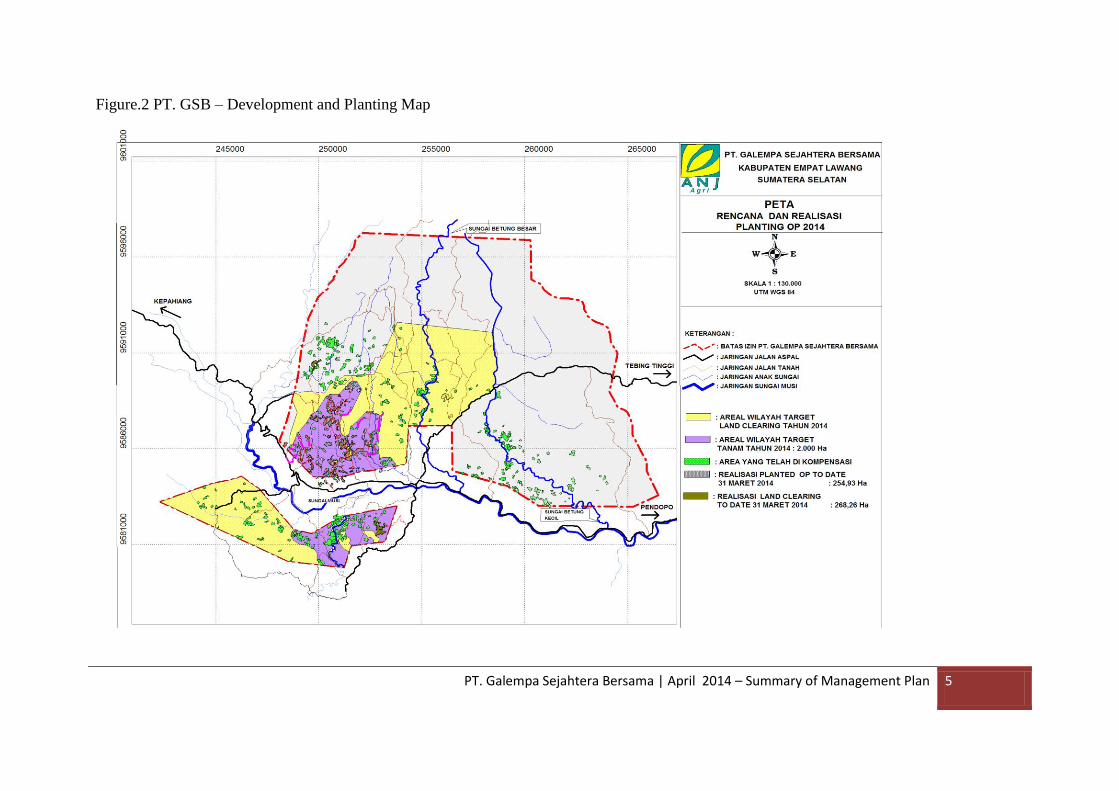
Development and Planting Map

PT. Galempa Sejahtera Bersama | April 2014 – Summary of Management Plan 4
Figure.1 PT. GSB - Location Map
PT. Galempa Sejahtera Bersama | April 2014 – Summary of Management Plan 5
Figure.2 PT. GSB – Development and Planting Map
PT. Galempa Sejahtera Bersama | April 2014 – Summary of Management Plan 6
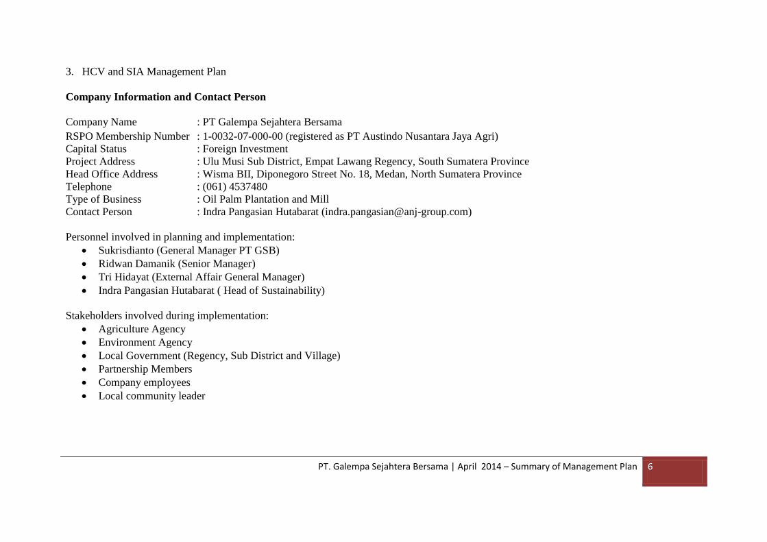
3. HCV and SIA Management Plan
Company Information and Contact Person
Company Name : PT Galempa Sejahtera Bersama
RSPO Membership Number : 1-0032-07-000-00 (registered as PT Austindo Nusantara Jaya Agri)
Capital Status : Foreign Investment
Project Address : Ulu Musi Sub District, Empat Lawang Regency, South Sumatera Province
Head Office Address : Wisma BII, Diponegoro Street No. 18, Medan, North Sumatera Province
Telephone : (061) 4537480
Type of Business : Oil Palm Plantation and Mill
Contact Person : Indra Pangasian Hutabarat ([email protected])
Personnel involved in planning and implementation:
Sukrisdianto (General Manager PT GSB)
Ridwan Damanik (Senior Manager)
Tri Hidayat (External Affair General Manager)
Indra Pangasian Hutabarat ( Head of Sustainability)
Stakeholders involved during implementation:
Agriculture Agency
Environment Agency
Local Government (Regency, Sub District and Village)
Partnership Members
Company employees
Local community leader

PT. Galempa Sejahtera Bersama | April 2014 – Summary of Management Plan 7
4.a. Summary of Management and Mitigation Plan (SIA)
Strategic issue Program/activity Challenge Change Strategy Output PIC Time
Most of the
villagers have less
information
regarding
company’s
program
Conducting the
socialization
gradually, whether
in group or
individual
There are still many
villagers that do not
know entirely about
the program of the
company
There is no other
palm oil company
that operating
around the Company
Most of the villagers
and public figure
support the activity of
company
Some of people in
society or society
generally cultivate the
palm plantation or has
been work in the palm
oil plantation even in
the outside of the
region
Socialization should be
conducted gradually, and focus
to the owner of land in the
company’s concession
Socialization that conducted to
the people in society who don’t
have land should be focused on
the adventage for the society
such as creating job
opportunity and increasing
economic value for the village
Makes the socialization
materials simple and easy to be
understood by the society
entirely
Document of
socialization
plan for the
society
Div legal
and Div
External
Affairs
Begin on
2012
The owner of land
still doubt to
release their land
because due to
their anxious of
the lost income
source
Conducts the
socialization and
makes the
alternative income
program for the
famers before the
realization of
plasma scheme
Part of society lands recently are planted with candlenut, coffee, and black or white pepper and if it’s given to the Company, they will lost their potential
New palm oil can produce after 3-4 years old.
Potential income from
the palm oil is
relative bigger
compared with
comodity that recently
has been planted by
society
Palm oil can produce
monthly income,
besides, the majority
of commodity which
has been planted by
society is the annual
trees
Engage with the villagers that
has 1-2 Ha by making the
agreement which contain that
if they are willing to release
their land, beside getting the
plasma, the Company also
guarantee they still can work
with the company as long as
they want to follow the
regulation of labor force.
Make the socialization about
the advantages of planting
the palm compare to other
commodity that are being
developed by society
recently.
Document of
alternative
income program
for the owner
of lands who
release their
lands
MGR
plantatio
n and Div
External
Affairs
2012-
forward
PT. Galempa Sejahtera Bersama | April 2014 – Summary of Management Plan 8
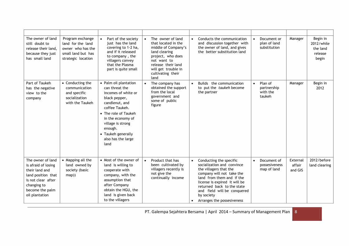
The owner of land
still doubt to
release their land,
because they just
has small land
Program exchange
land for the land
owner who has the
small land but has
strategic location
Part of the society just has the land covering to 1-2 ha, and if it released to company , the villagers convey that the Plasma part is quite small
The owner of land that located in the middle of Company’s land clearing project, who does not want to release their land will get trouble in cultivating their land
Conducts the communication and discussion together with the owner of land, and gives the better substitution land
Document or plan of land substitution
Manager Begin in
2012/while
the land
release
begin
Part of Taukeh
has the negative
view to the
company
Conducting the
communication
and specific
socialization
with the Taukeh
Palm oil plantation
can threat the
incomes of white or
black pepper,
candlenut, and
coffee Taukeh.
The role of Taukeh
in the economy of
village is strong
enough.
Taukeh generally
also has the large
land
The company has obtained the support from the local government and some of public figure
Builds the communication to put the taukeh become the partner
Plan of partnership with the taukeh
Manager Begin in
2012
The owner of land
is afraid of losing
their land and
land position that
is not clear after
changing to
become the palm
oil plantation
Mapping all the
land owned by
society (basic
map))
Most of the owner of
land is willing to
cooperate with
company, with the
assumption that
after Company
obtain the HGU, the
land is given back
to the villagers
Product that has been cultivated by villagers recently is not give the continually income
Conducting the specific socialization and convince the villagers that the company will not take the land from them and if the license is expired it will be returned back to the state and field will be conquered by society
Arranges the possesiveness
Document of possesiveness map of land
External
affair
and GIS
2012/before
land clearing

PT. Galempa Sejahtera Bersama | April 2014 – Summary of Management Plan 9
map of society’s land, so the location of society land become clear, although in the level tapak/border sign has occured the land usage
Communication
of company with
the stakeholders
still lack/needs
to be improved
Builds the
communication
and network with
the entire
stakeholders that
related with the
company
Type and characteristic of stakeholders are diversity
The varian kind of stakeholder’s interest
Communication between the company with the stakeholders have been conducted
Village government and some of public figure support the company
Makes the routine schedule of meeting
Determines the theme for every meeting
Conducts the documentation to the result of meeting
Conducts the follows up for the result of meeting
Builds the communication and coordination between the company and the entire stakeholders
Establishes the same vision and understanding between the company and stkeholder
Div
External
Affairs
Begin in
2012
Acceptance of
workers from the
local society is
still less
Increases the
involvement of
local society as the
company employees
Most of the society ever work in the palm oil company
Needs to cultural adjustment
Villagers is feeling interest to work in the company
mapping of potential worker in the village in surrounding company
Planning of worker acceptance from local society
Manager/
personne
l
Begin in
2012

PT. Galempa Sejahtera Bersama | April 2014 – Summary of Management Plan 10
4.b. Summary of Management and Mitigation Plan (HCV)
Types of HCV Location Monitored Indicators
Monitoring Objectives
Measures
Monitoring methods
Data collection and
analysis methods
Monitoring
Period
HCV1.1.
Areas that
contains or
provide
Biodiversity
Support Function
to Protection or
Conservation
Areas
Betung Riparian (Rip).
Latak Rip.
Keruh Rip.
Betung-1 Hill
Kunjung-1 Hill
Kunjung-2 Hill
Pematang Ngongop Hill
Mandi Angin Hill
Intensity of disturbance to sites of HCV 1.1, including the danger of fire.
Development of land cover conditions in the area that have HCV 1.1.
Realization of activities and the survival rate (percentage of living)of rehabilitation and restoration activities in areas containing HCV 1.1.
Knowing the intensity of disturbance to sites of HCV 1.1, including the hazard of fire.
Determine the development of land cover conditions periodically at locations which have HCV 1.1.
Knowing the realization of activity and the survival rate (percentage of living)of rehabilitation and restoration activities in areas containing HCV 1.1.
Good:
There is no interference and
forested areas containing HCV
1.1 has increased.
Medium:
The Area that contains of
disturbed HCV 1.1 are low
(<25%), moderate levels of
disturbance and remain
forested acreage or acreage
containing HCV 1.1 are
impaired (<50%), low noise
level, and the area remains
forested.
Tools and materials: Map of work, GPS, camera, compass, binoculars, tally sheet, tape measure, plastic mines, and stationeries.
Measurement methods: direct observation in the region have managed HCV 1.1.
Data analysis methods: descriptive analysis of each monitoring period.
Methods of inference: If the indicator value by the monitoring result were moderate of
To the disturbance
intensity
conducted once a
month, while other
monitoring
indicators
conducted once a
year and will begin
in 2014 RKAP
Document of
social activity or
CSR from the
company has not
been given before
Makes the CSR plan
for short, middle
and long term.
The assistance that is needed by villagers is much enough
Company has budgeted the specific fund for the CSR purposes
Makes the prirority scale
Social activity is not only charity characteristic but also economic empowerment to increase the society capability which is not only depended on company only.
Plan Document of social activity in the middle, and long term.
External
affair
2012-
forward

PT. Galempa Sejahtera Bersama | April 2014 – Summary of Management Plan 11
Types of HCV Location Monitored Indicators
Monitoring Objectives
Measures
Monitoring methods
Data collection and
analysis methods
Monitoring
Period
Worse:
The area that contains of
disturbed HCV1.1 are large (>
50%), high noise levels, and
decreased forested area.
worse, so the management activities in HCV 1.1 areas need to be improve.
HCV 1.3 Areas
which are Habitat
for Endangered,
Restricted Range
or Protected
Viable Species
Population
Betung Rip.
Betung Kecil Rip.
Gaman Rip.
Keruh Rip.
Landai Rip.
Latak Rip.
Betung -1 hill
Betung -2 hill
Betung Kecil hill
Gesam Hill
Latak Hill
Pematang Damar Hill
Pematang Kambing hill
Kunjung-1 hill
Kunjung-2 hill Pematang Ngongop hill
Mandi Angin hill
Pematang Tewas Hill
Disturbance intensity to sites of HCV 1.3, including the hazard of fire.
Development of land cover conditions in the areas containing HCV 1.3.
Realization of planting activities and the survival rate (percentage of living) of rehabilitation and restoration activities in areas containing HCV 1.3.
Diversity and density/ abundance condition of plants species and protected/ endangered wildlife.
Knowing the disturbance intensity to sites of HCV 1.3, including the hazard of fire.
Determine the development of land cover conditions periodically at locations which have HCV 1.3.
Knowing the realization of planting activity and the survival rate (percentage of living) of rehabilitation and restoration activities in areas containing HCV 1.3.
Good:
Diversity and
density/abundance condition of
plants and wildlife species that
are protected/endangered and
its habitat remains or better
than the previous condition.
Medium:
Diversity and
density/abundance condition of
plants and wildlife species that
are protected/endangered and
its habitat has decreased by
25-50% compared to the
previous condition.
Worse:
Diversity and
Tools and materials: Work Map, GPS, camera, compass, binocular, tally sheet, tape measure, plastic mines, and stationeries.
Measurement methods: direct observation in the area that contains of managed HCV 1.3 areas.
Data analysis methods: descriptive analysis of each monitoring period.
Inference Methods: If the indicator value from the monitoring results were moderate and the worse, the management activities in the area consist of HCV 1.3 needs to be improved.
To the disturbance
intensity conduct
once a month,
while other
monitoring
indicators
conducted once a
year and will begin
in 2014 RKAP

PT. Galempa Sejahtera Bersama | April 2014 – Summary of Management Plan 12
Types of HCV Location Monitored Indicators
Monitoring Objectives
Measures
Monitoring methods
Data collection and
analysis methods
Monitoring
Period
density/abundance condition of
plants and wildlife species that
are protected/endangered and
its habitat has decreased by >
50% compared to the previous
condition.
HCV1.4.
Areas which are
Habitat for
Temporary
Species or
Congregations of
Species
Betung Rip.
Latak Rip.
Keruh Rip.
Betung-1 Hill
Kunjung-1 Hill
Kunjung-2 Hill
Pematang Ngongop Hill
Mandi Angin Hill
Disturbance intensity to sites of HCV 1.4, including the hazard of fire.
Development of land cover conditions in the region that contains HCV 1.4.
Progress in implementation of the monitoring and security of the area that contains HCV 1.4.
Knowing the disturbance intensity to sites of HCV 1.4, including the hazard of fire.
Determine the development of land cover conditions periodically at areas which contains HCV 1.4.
Knowing the actual implementation of the monitoring and security of the area contains HCV 1.4.
Good:
There is no disturbance to the
forested area in areas
containing HCV 1.4 or forested
areas have increased.
Medium:
The Area that contains of
disturbed HCV 1.4 are low
(<25%), moderate levels of
disturbance and remain
forested acreage or acreage
containing HCV 1.4 are
impaired (<50%), low noise
level, and the area remains
forested.
Worse:
The area that contains of
Tools and materials: Map of work, GPS, camera, compass, binocular, tally sheet, tape measure, plastic mines, and stationery.
Measurement methods: direct observation in the region have managed HCV 1.4.
Methods of data analysis: descriptive analysis of each monitoring period.
Methods of inference: If the value of the indicator is derived from the results of the monitoring were moderate and the worse, the management activities in the region who have HCV 1.4 was done needs to be
To the disturbance
intensity conduct
once a month,
while other
indicators
monitoring
conduct once a
year and will begin
in 2014 RKAP
PT. Galempa Sejahtera Bersama | April 2014 – Summary of Management Plan 13
Types of HCV Location Monitored Indicators
Monitoring Objectives
Measures
Monitoring methods
Data collection and
analysis methods
Monitoring
Period
disturbed HCV1.4 are large (>
50%), high noise levels, and
decreased forested area.
improved.
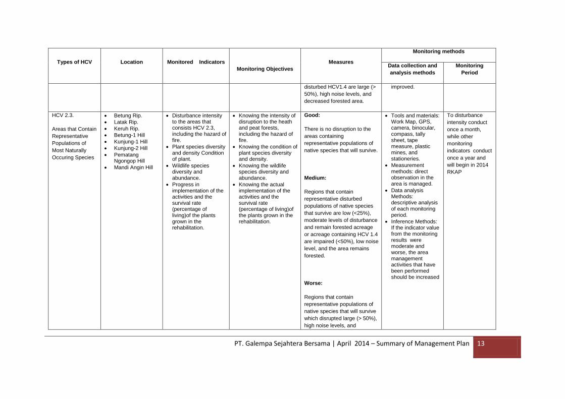
HCV 2.3.
Areas that Contain
Representative
Populations of
Most Naturally
Occuring Species
Betung Rip.
Latak Rip.
Keruh Rip.
Betung-1 Hill
Kunjung-1 Hill
Kunjung-2 Hill
Pematang Ngongop Hill
Mandi Angin Hill
Disturbance intensity to the areas that consists HCV 2.3, including the hazard of fire.
Plant species diversity and density Condition of plant.
Wildlife species diversity and abundance.
Progress in implementation of the activities and the survival rate (percentage of living)of the plants grown in the rehabilitation.
Knowing the intensity of disruption to the heath and peat forests, including the hazard of fire.
Knowing the condition of plant species diversity and density.
Knowing the wildlife species diversity and abundance.
Knowing the actual implementation of the activities and the survival rate (percentage of living)of the plants grown in the rehabilitation.
Good:
There is no disruption to the
areas containing
representative populations of
native species that will survive.
Medium:
Regions that contain
representative disturbed
populations of native species
that survive are low (<25%),
moderate levels of disturbance
and remain forested acreage
or acreage containing HCV 1.4
are impaired (<50%), low noise
level, and the area remains
forested.
Worse:
Regions that contain
representative populations of
native species that will survive
which disrupted large (> 50%),
high noise levels, and
Tools and materials: Work Map, GPS, camera, binocular, compass, tally sheet, tape measure, plastic mines, and stationeries.
Measurement methods: direct observation in the area is managed.
Data analysis Methods: descriptive analysis of each monitoring period.
Inference Methods: If the indicator value from the monitoring results were moderate and worse, the area management activities that have been performed should be increased
To disturbance
intensity conduct
once a month,
while other
monitoring
indicators conduct
once a year and
will begin in 2014
RKAP
PT. Galempa Sejahtera Bersama | April 2014 – Summary of Management Plan 14
Types of HCV Location Monitored Indicators
Monitoring Objectives
Measures
Monitoring methods
Data collection and
analysis methods
Monitoring
Period
decreased forested area.
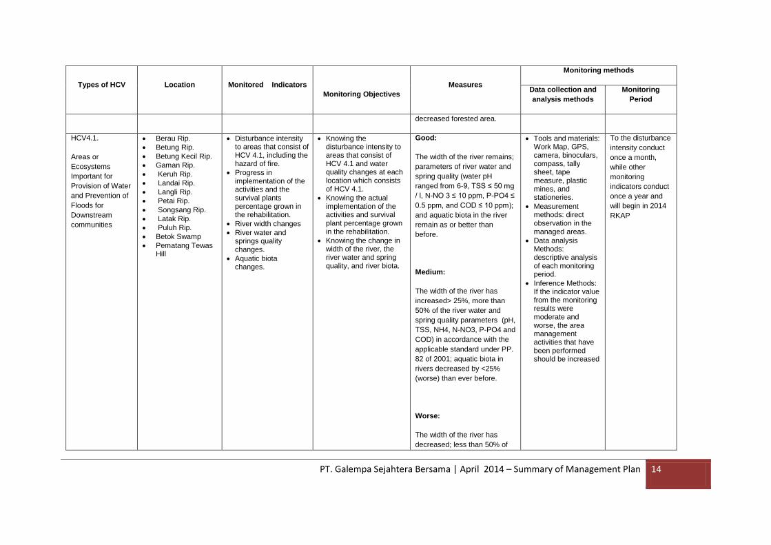
HCV4.1.
Areas or
Ecosystems
Important for
Provision of Water
and Prevention of
Floods for
Downstream
communities
Berau Rip.
Betung Rip.
Betung Kecil Rip.
Gaman Rip.
Keruh Rip.
Landai Rip.
Langli Rip.
Petai Rip.
Songsang Rip.
Latak Rip.
Puluh Rip.
Betok Swamp
Pematang Tewas Hill
Disturbance intensity to areas that consist of HCV 4.1, including the hazard of fire.
Progress in implementation of the activities and the survival plants percentage grown in the rehabilitation.
River width changes
River water and springs quality changes.
Aquatic biota changes.
Knowing the disturbance intensity to areas that consist of HCV 4.1 and water quality changes at each location which consists of HCV 4.1.
Knowing the actual implementation of the activities and survival plant percentage grown in the rehabilitation.
Knowing the change in width of the river, the river water and spring quality, and river biota.
Good:
The width of the river remains;
parameters of river water and
spring quality (water pH
ranged from 6-9, TSS ≤ 50 mg
/ l, N-NO 3 ≤ 10 ppm, P-PO4 ≤
0.5 ppm, and COD ≤ 10 ppm);
and aquatic biota in the river
remain as or better than
before.
Medium:
The width of the river has
increased> 25%, more than
50% of the river water and
spring quality parameters (pH,
TSS, NH4, N-NO3, P-PO4 and
COD) in accordance with the
applicable standard under PP.
82 of 2001; aquatic biota in
rivers decreased by <25%
(worse) than ever before.
Worse:
The width of the river has
decreased; less than 50% of
Tools and materials: Work Map, GPS, camera, binoculars, compass, tally sheet, tape measure, plastic mines, and stationeries.
Measurement methods: direct observation in the managed areas.
Data analysis Methods: descriptive analysis of each monitoring period.
Inference Methods: If the indicator value from the monitoring results were moderate and worse, the area management activities that have been performed should be increased
To the disturbance
intensity conduct
once a month,
while other
monitoring
indicators conduct
once a year and
will begin in 2014
RKAP
PT. Galempa Sejahtera Bersama | April 2014 – Summary of Management Plan 15
Types of HCV Location Monitored Indicators
Monitoring Objectives
Measures
Monitoring methods
Data collection and
analysis methods
Monitoring
Period
the river water and spring
quality parameters (pH, TSS,
NH4, N-NO3, P-PO4 and
COD) in accordance with the
applicable standard under PP.
82 of 2001, and aquatic biota
in the river has decreased>
50% (worse) than ever before.
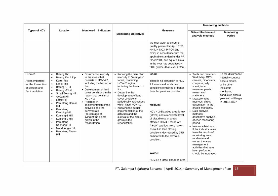
HCV4.2.
Areas Important
for the Prevention
of Erosion and
Sedimentation
Betung Rip.
Betung Kecil Rip
Keruh Rip
Langli Rip
Betung-1 Hill
Betung -2 Hill
Small Betung Hill
Gesam Hill
Latak Hill
Pematang Damar Hill
Pematang Kambing Hill
Kunjung-1 Hill
Kunjung-2 Hill
Pematang Ngongop Hill
Mandi Angin Hill
Pematang Tewas Hill
Disturbance intensity to the areas that consists of HCV 4.2, including the hazard of fire.
Development of land cover conditions in the region that consist of HCV 4.2.
Progress in implementation of the activities and the survival rate (percentage of living)of the plants grown in the rehabilitation.
Knowing the disruption intensity to “kerangas” forest, containing HCV4.2 region, including the hazard of fire.
Determine the development of land cover conditions periodically at locations which have HCV 4.2.
Knowing the actual implementation of the activities and the survival of the plants grown in the rehabilitation.
Good:
There is no disruption to HCV
4.2 areas and land cover
conditions remained or better
than the previous condition.
Medium:
HCV 4.2 disturbed area is low
(<25%) and a moderate level
of disturbance or areas
affected HCV4.2 moderate
(<50%) and low noise levels,
as well as land closing
conditions decreased by 25%
compared to the previous
condition.
Worse:
HCV4.2 a large disturbed area
Tools and materials: Work Map, GPS, camera, binoculars, compass, tally sheet, tape measure, plastic mines, and stationery.
Measurement methods: direct observation in the area is managed.
Data analysis methods: descriptive analysis of each monitoring period.
Inference Methods: If the indicator value from the results of monitoring were moderate and worse, the area management activities that have been performed should be increased
To the disturbance
intensity conduct
once a month,
while other
indicators
monitoring
conducted once a
year and will begin
in 2014 RKAP
PT. Galempa Sejahtera Bersama | April 2014 – Summary of Management Plan 16
Types of HCV Location Monitored Indicators
Monitoring Objectives
Measures
Monitoring methods
Data collection and
analysis methods
Monitoring
Period
(> 50%) and high levels of
interference, as well as closing
conditions land decreased by>
50% compared to the previous
condition.
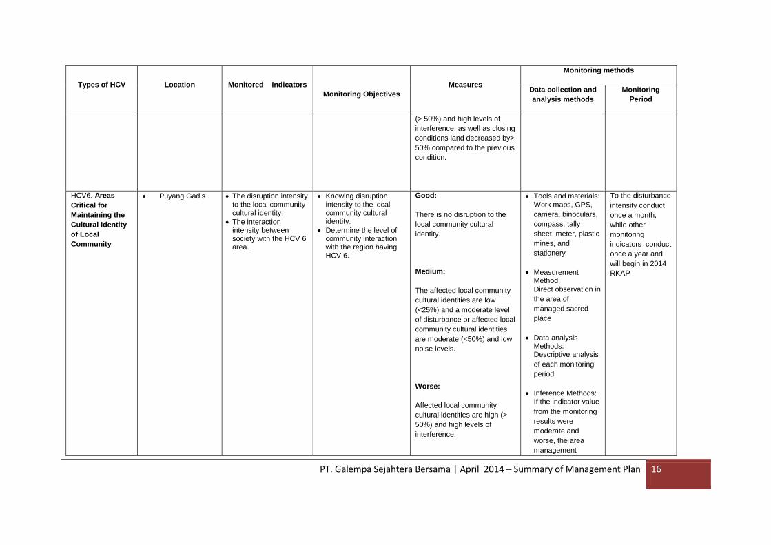
HCV6. Areas
Critical for
Maintaining the
Cultural Identity
of Local
Community
Puyang Gadis The disruption intensity to the local community cultural identity.
The interaction intensity between society with the HCV 6 area.
Knowing disruption intensity to the local community cultural identity.
Determine the level of community interaction with the region having HCV 6.
Good:
There is no disruption to the
local community cultural
identity.
Medium:
The affected local community
cultural identities are low
(<25%) and a moderate level
of disturbance or affected local
community cultural identities
are moderate (<50%) and low
noise levels.
Worse:
Affected local community
cultural identities are high (>
50%) and high levels of
interference.
Tools and materials: Work maps, GPS,
camera, binoculars,
compass, tally
sheet, meter, plastic
mines, and
stationery
Measurement Method: Direct observation in
the area of
managed sacred
place
Data analysis Methods: Descriptive analysis
of each monitoring
period
Inference Methods: If the indicator value
from the monitoring
results were
moderate and
worse, the area
management
To the disturbance
intensity conduct
once a month,
while other
monitoring
indicators conduct
once a year and
will begin in 2014
RKAP
PT. Galempa Sejahtera Bersama | April 2014 – Summary of Management Plan 17
Types of HCV Location Monitored Indicators
Monitoring Objectives
Measures
Monitoring methods
Data collection and
analysis methods
Monitoring
Period
activities that have
been performed
sacred place needs
to be improved

PT. Galempa Sejahtera Bersama | April 2014 – Summary of Management Plan 18
Period and time of management plan (HCV)
No. HCV Area
Land cover
inventory and
identifcaton at
HCV area
(ha)
Boundary
designation
at HCV area
(Km)
Maintenance
of boundary
designation
(km)
Protected area, Folra and fauna
Rehabilitaion and
enrichment of area
HCV (Ha)
Community
Socialitation
Training for
Staff and
worker
(people)
Drafting and
Revision of
SOP
Organization Stakeholder
consultation Sign board
(buah)
Prohibition Signs for
Hunting and cuting Plant Maintenance of sign
board
Patrol
(ha)
1 SS Berau 29,60 12,02 12,02 3 3 6 29,60 29,60
Tanjung
Agung, Muara
Kalangan,
Batu Lintang,
Simpang
Parigi, Padang
Tepong,
Galang
villages
20 PT. GSB office PT. GSB
office
- Drafting of MoU on wildlife poaching, held at PT. GSB office
- Coordination with related stkaeholder at the Village, Sub ditsrict and Regency level around the concession of PT. GSB, will be held by the Manager
2 SS Betung 135,69 27,54 27,54 4 4 8 135,69 135,69
3 SS Betung Kecil 209,91 42,54 42,54 4 4 8 209,91 209,91
4 SS Gaman 12,91 12,96 12,96 2 2 4 12,91 12,91
5 SS Keruh 77,79 8,80 8,80 3 3 6 77,79 77,79
6 SS Landai 26,41 10,74 10,74 3 3 6 26,41 26,41
7 SS Langli 5,03 5,16 5,16 2 2 4 5,03 5,03
8 SS Petai 13,38 13,48 13,48 2 2 4 13,38 13,38
9 SS Songsang 10,58 10,72 10,72 2 2 4 10,58 10,58
10 SS Latak 169,68 34,08 34,08 4 4 8 169,68 169,68
11 SS Puluh 3,52 3,58 3,58 1 1 2 3,52 3,52
12 Rawa Betok 3,10 0,70 0,70 1 1 2 3,10 3,10
13 Bukit Betung-1 71,97 3,39 3,39 3 3 6 71,97 71,97
14 Bukit Betung-2 20,14 1,80 1,80 3 3 6 20,14 20,14
15 Bukit Betung Kecil 97,27 3,95 3,95 3 3 6 97,27 97,27
16 Bukit Gesam 190,06 5,52 5,52 4 4 8 190,06 190,06
17 Bukit Latak 55,35 2,98 2,98 3 3 6 55,35 55,35
18 Bukit Pematang Damar 80,44 3,59 3,59 3 3 6 80,44 80,44
19 Bukit Pematang Kambing 22,61 1,86 1,86 3 3 6 22,61 22,61
20 Bukit Kunjung-1 54,18 2,95 2,95 3 3 6 54,18 54,18
21 Bukit Kunjung-2 8,86 1,19 1,19 2 2 4 8,86 8,86
22 Bukit Pematang Ngongop 137,95 4,70 4,70 4 4 8 137,95 137,95
23 Bukit Mandi Angin 171,49 5,24 5,24 4 4 8 171,49 171,49
24 Bukit Pematang Tewas 1801,67 16,98 16,98 5 5 10 1801,67 1801,67
25 Puyang Gadis 0,00 0,40 0,40 1 0 1 1,00 0,00
Period and time management of
HCV
Only one time in
RKAP 2014
Gradualy
and start in
RKAP 2014
Every year and
start in 2014
Gradualy
and start in
RKAP 2014
Gradualy and start in
RKAP 2014
Every year and start
in 2014
Evry
Month,
start in
RKAP
Gradualy and start in
RKAP 2014
Twice a year ,
start in RKAP
Only one
time in
RKAP 2014
Once a month

PT. Galempa Sejahtera Bersama | April 2014 – Summary of Management Plan 19
No. HCV Area
Land cover
inventory and
identifcaton at
HCV area
(ha)
Boundary
designation
at HCV area
(Km)
Maintenance
of boundary
designation
(km)
Protected area, Folra and fauna
Rehabilitaion and
enrichment of area
HCV (Ha)
Community
Socialitation
Training for
Staff and
worker
(people)
Drafting and
Revision of
SOP
Organization Stakeholder
consultation Sign board
(buah)
Prohibition Signs for
Hunting and cuting Plant Maintenance of sign
board
Patrol
(ha)
2014 2014
Only one
time in
RKAP
2014
Only one time
in RKAP 2014

PT. Galempa Sejahtera Bersama | April 2014 – Summary of Management Plan 20
5. Internal Responsibility
This Summary of Management Plan PT GSB has been approved by the management of PT GSB
April 2014
Sukrisdianto
General Manager PT. KAL
Indra P. Hutabarat
Head of Sustainability Department
Related Documents