Proximity sensitive messaging MP-CU_Proximityv3iv.doc 1 Proximity-Sensitive Messaging Mark Perry and Caroline Umashangar Brunel University, UK Abstract: As an approach to the delivery of context-appropriate services, proximity offers a rich and different set of features compared to those of location. We illustrate this by demonstrating how proximity- sensitive services could be utilised in a prototype communications application that supports interpersonal media messaging. Three wireless ‘sensing’ technologies are used to support proximity- sensitive messaging at different levels of distance, loosely characterised as measuring over the short (<50cm), medium (<10 metre) and long (> 10 metre) ranges, allowing message attachment to places and entities at different granularities of scale. This paper also shows how we can utilise the distinctive properties of the various proximity technologies employed to achieve different communicative affordances, as well as allowing access to messages at these different levels of spatial proximity. This type of proximity-sensitive technology offers a far more relational form of interaction than simple location, and physical environments that are already becoming saturated with sensor technologies offer a ready-made infrastructure for such proximity- sensitive services. Keywords: Media messaging; Mobile and collaborative computing; Proximity-dependent and sensitive services. Proximity-sensitive communication We often need access to, or find useful, information that relates to people, places or objects that are nearby, and which are not possible to pin down to an absolute grid reference. Indeed, people often leave personal messages and reminders to others in specific places and on objects, the post-it note being a prime example of such a paper- based technology. Yet not all informationally interesting entities reside in a fixed physical location – people and small objects, in particular are more commonly not located in a static space, but dynamically move around a variety of locations, all of which have different configurations and resources associated with them. Moreover, we often wish to mark information at various levels of scale, from making a note on a small object (e.g. a book, a desk, a bag), to marking entities or places at a larger range (e.g. a room, a person, a vehicle), or to post messages over a wide area (e.g. a building, a shopping centre, car park). We may therefore wish to mark messages onto objects are both mobile and which can only meaningfully be interpreted when the message annotation is scaled to an appropriate distance from the thing that it is appended to. Using location-based technologies to electronically tag these objects and places with information is therefore problematic, and we have examined the notion of proximity, rather than location, as a means of resolving this. The mobility of computing devices has created the potential for locating mobile devices in close spatial proximity to deliver proximity-sensitive messages to mobile technology users. In this respect, a number of technologies allow us to offer proximity-sensitive services, most notably, Bluetooth, RFID, Barcoding and Infra-red. When used in concert with wireless data communications systems such as GPRS, WiFi, 3G and other forms of network access, these can offer users access to remotely-held information about the electronically enhanced objects that they may temporarily become co-located with. However, existing messaging systems

Welcome message from author
This document is posted to help you gain knowledge. Please leave a comment to let me know what you think about it! Share it to your friends and learn new things together.
Transcript

Proximity sensitive messaging
MP-CU_Proximityv3iv.doc 1
Proximity-Sensitive Messaging
Mark Perry and Caroline Umashangar
Brunel University, UK
Abstract: As an approach to the delivery of context-appropriate services, proximity offers a rich and
different set of features compared to those of location. We illustrate this by demonstrating how proximity-
sensitive services could be utilised in a prototype communications application that supports interpersonal
media messaging. Three wireless ‘sensing’ technologies are used to support proximity- sensitive messaging
at different levels of distance, loosely characterised as measuring over the short (<50cm), medium (<10
metre) and long (> 10 metre) ranges, allowing message attachment to places and entities at different
granularities of scale. This paper also shows how we can utilise the distinctive properties of the various
proximity technologies employed to achieve different communicative affordances, as well as allowing
access to messages at these different levels of spatial proximity. This type of proximity-sensitive
technology offers a far more relational form of interaction than simple location, and physical environments
that are already becoming saturated with sensor technologies offer a ready-made infrastructure for such
proximity- sensitive services.
Keywords: Media messaging; Mobile and collaborative computing; Proximity-dependent and sensitive services.
Proximity-sensitive communication
We often need access to, or find useful, information that relates to people, places or objects that are nearby, and
which are not possible to pin down to an absolute grid reference. Indeed, people often leave personal messages
and reminders to others in specific places and on objects, the post-it note being a prime example of such a paper-
based technology. Yet not all informationally interesting entities reside in a fixed physical location – people and
small objects, in particular are more commonly not located in a static space, but dynamically move around a
variety of locations, all of which have different configurations and resources associated with them. Moreover,
we often wish to mark information at various levels of scale, from making a note on a small object (e.g. a book,
a desk, a bag), to marking entities or places at a larger range (e.g. a room, a person, a vehicle), or to post
messages over a wide area (e.g. a building, a shopping centre, car park). We may therefore wish to mark
messages onto objects are both mobile and which can only meaningfully be interpreted when the message
annotation is scaled to an appropriate distance from the thing that it is appended to. Using location-based
technologies to electronically tag these objects and places with information is therefore problematic, and we
have examined the notion of proximity, rather than location, as a means of resolving this.
The mobility of computing devices has created the potential for locating mobile devices in close spatial
proximity to deliver proximity-sensitive messages to mobile technology users. In this respect, a number of
technologies allow us to offer proximity-sensitive services, most notably, Bluetooth, RFID, Barcoding and
Infra-red. When used in concert with wireless data communications systems such as GPRS, WiFi, 3G and other
forms of network access, these can offer users access to remotely-held information about the electronically
enhanced objects that they may temporarily become co-located with. However, existing messaging systems

Proximity sensitive messaging
MP-CU_Proximityv3iv.doc 2
have not evolved to support such messaging among mobile device users, although the potential for this exists,
and has been utilised in a limited variety of ways in a number of research projects.
Recent advances in sensing technologies have made it possible to embed and relocate various sensors on people
and objects, and within places (echoing Hewlett-Packard’s Cooltown slogan ‘people, places and things’;
Kindberg et al., 2000) in the environment. Such device discovery has the potential to support a wide variety of
applications on mobile devices. At its simplest level it may just be used to determine the presence of another
device (for example the Lovegetty, see Iwatani, 1998), to supporting far more complex interrelationships:
commercial systems already allow mobile devices with integrated sensors to offer communication, data transfer
and resource sharing (for example, printers and fax machines) facilities while research developments have
further explored the possibilities of using integrated sensors in providing location-based applications on mobile
devices. But whilst numerous location-based systems have been implemented using integrated sensors, none of
these have so far attempted to use pre-existing and diverse sensor types that allow operation across different
environments and sensor infrastructures, nor have they explored the various options supporting the marking of
people, places and objects across these environments and infrastructures.
Although associating real-word places and entities with messages is a relatively recent area of interest, much of
the ‘tagging’ technology that enables that is not new: bar-coding products for example has long allowed users to
access remote information about the objects that they are stuck to, and this is something that RFID technologies
are expected to enhance further. Similarly, we have already begun to see proximity-sensitive signalling, such as
dating profiles held on mobile devices that trigger when apparently compatible prospective mates pass nearby
systems (known as ‘proxidating’ or ‘bluedating’). A related service called Serendipity (Eagle and Pentland,
2004) makes use of users’ online profiles to instigate serendipitous interactions between co-located Bluetooth-
enabled devices. Yet these technologies are relatively simple in terms of the services offered, and few offer any
great degree of user-configurability or dynamism within the interaction or whilst mobile. They are typically
used as electronic initiators for face-to-face communication, or communication in another media (e.g. initiating
a subsequent web-based interaction), rather than tools for conducting electronic communication through.
This lack of support for mobile communicative interactivity utilising proximity is not entirely absent: the Nokia
‘sensor’ application (Nokia, 2007) allows a more sophisticated form of proximal interaction than these other
short-range sensor-based applications. The sensor application runs on a mobile telephone, and passively scans
the area for other Bluetooth devices running the same application. Users can initiate connections with other
Sensor users in the immediate vicinity, and is intended as a social networking tool. The application supports
information sharing between users, so that once a connection between devices has been established, users can
browse user profiles, and messages can be sent between devices. Notably, the Sensor application is limited to
co-present proximal interaction (connections are not persistent over time), and when devices move out of range,
connections are lost. It is not intended that users be able to leave messages in places or on people, just to use a
sensed proximal connection as an initiator of an electronic communication. Nevertheless, this is an interesting
development, and offers an insight into the value and potential utility that commercial developers are beginning
to place on proximity-based systems.
Proximity sensitive systems have had some notable developments and research findings in the area of gaming,
such as Pirates! (Björk et al., 2001; Falk et al., 2001) and Feeding Yoshi (Bell et al., 2006). It appears that

Proximity sensitive messaging
MP-CU_Proximityv3iv.doc 3
proximity has a particular role to play in game-playing on mobile devices as developers attempt to build systems
that bring mobile participants into physical contact with one another and with the material environment as a
means of enriching the gaming experience (which itself is often relatively impoverished on a mobile gaming
platform). Pirates!, for example, has a thing-to-thing, and a thing-to-place model of interaction, although
proximity-driven events are fixed as to their meaning, and cue interaction with the game rather than enriching
other forms of connectedness. Thus in sensed player-to-place events, players are informed that they are near to
an island, whilst player-to-player relationships show that they are close to other players (Falk, 2001). As with
our own work on the Marked Space system, Pirates! employs a ‘relative’ model of interaction – rather than an
absolute model of where people are located in real space.
There is one notable proximity-sensitive communication system: Hummingbird (Redström et al., 1999;
Holmquist, Falk and Wigström, 1999) – the first and one of the only systems that we have seen use to the term
‘proximity-sensitive’ in the way that we have applied it here. Hummingbird devices provided users with an
awareness of other Hummingbird users in their proximity that had a predetermined wish to communicate.
Hummingbird is a particularly interesting research project to us in that it has made explicit its interest in ‘local
interactions’ based on proximity as a device for social interaction, albeit on with a strong notion of synchronous
interaction to support interpersonal awareness (they call their device an IPAD, or interpersonal awareness
device). Notably, the Hummingbird researchers were also interested in integrating people and places into their
system, although technologies to support place were relatively poorly developed. The Hummingbird system had
a fixed model of proximity – with little or no notion of scale – this is an understanding of proximity as that
which could be measured by the computer (in this case, roughly 100 meters), rather than its more human
counterpart of varying levels of space and scale. Like our own system developed in the rest of the paper, the
Hummingbirds did not depend on an installed infrastructure, making them flexible and open to use in a wide
variety of settings. Yet, although proximity was used by Hummingbird as a mechanism to enable interpersonal
awareness, and in the research papers that describe it, little is made of the notion of proximity other than its
effects on awareness, which is a very limited lens with which to examine this complex notion through.
Alongside this previous research, the widespread use of mobile devices with integrated sensors inspired us to
explore the possibilities to use integrated sensors to leave an electronic ‘mark’ on people, place and objects. The
work presented in this paper exploits the diverse characteristics of existing wireless sensing technologies in a
proximity-sensitive messaging system that incorporates people, places and objects. We present details of our
system architecture that is designed to deliver messages with different levels of proximity in both indoor and
outdoor environments. This architecture comprises of a single software application running on a mobile device
that detects signals from existing wireless devices that our physical environment is already richly populated
with. Here, we briefly discuss a generic architecture that utilises embedded sensors to offer proximity-sensitive
messaging to mobile device users. We explain how the design exploits the distinctive characteristics of different
types of commonly available wireless sensors to resolve the environmental and proximity issues faced in
offering messaging across various environments with different levels of proximity. Through this, we explore the
properties of the different sensor technologies in terms of the communicative roles and affordances that they
offer.

Proximity sensitive messaging
MP-CU_Proximityv3iv.doc 4
Location-based messaging systems
Whilst traditional, non-computational, technologies such as paper and pins, sticky tack and tape, and recently,
PostIt notes, have evolved to support communication that enables proximal or location-based relationships, most
electronic communication systems do not have such a sense of place, or indeed, offer the interactional potential
to be placed. Information and communications are received and sent from device to device, irrespective of the
relationships between of those devices and the other entities that surround them. Although mobile technology
allows us to communicate ‘anytime, anywhere’, this is not necessarily appropriate to its location (see, for e.g.
Perry, et al. 2001) because of the very placelessness of that communication and its temporal
decontextualisation. Such communications technologies do not, for example, allow a user to send a message to
someone reminding them to post a letter on their way home that will only be received when that person leaves
their office. This is a serious failing in the promise of computing in enabling richer interaction with the world,
and enabling a symbolic layering of content over the things that we encounter in the world around us.
In practice, most existing location-based technologies have focused on locating, but not marking. However,
researchers have begun developing a number of outdoor and indoor location-based systems that allow users to
locate devices and to offer variety of services such as tracking, messaging and data collection. One of the best-
known messaging systems is ComMotion (Schmandt, et al., 2000); this is a typical example of a location-based
service that supports personal messaging on mobile devices. ComMotion allowed its users to leave reminders
and messages in frequently visited locations. These locations are not user-defined, but automatically generated
by the device.
Following developments from the ComMotion project, GeoNotes (Espinoza et al. 2001) has attempted to
resolve some of the volume problems that would be expected occur as the number of messages scales up by
looking at interaction issues in filtering notes and messages. Both of the ComMotion and GeoNotes projects
have utilised fixed location-based technologies (although sensor types have changed over their development
lifecycles), and did not allow users to utilise a variety of sensors or to control the distances over which
messaging could be conducted. Similar to these projects, Skyline (Multaharju et al., 2004), Egraffiti (Burrell and
Gay, 2002) and PlaceMail (Ludford et al., 2007) are public messaging systems that allow users to view and post
messages at their current location. These systems are both based on wireless LAN (WLAN) technology, and so
again only support indoor messaging at a single proximity range on a single sensor type. The Urban Tapestries
project (Lane, 2003) also allows users to create and access public annotations using GPS location-enabled
networked handheld computers to build ‘urban histories’ of places.
Messaging systems need not be wholly electronically mediated through sensor discovery, although this can
increase the cognitive and physical effort associated with marking and receiving messages. For example, the
Yellow Arrow project (Yellowarrow.net) allows mobile telephone users to generate publicly accessible content
that is linked to spatially located and physically embodied messaging objects. Participants stick uniquely
identifiable arrows at different locations and objects in the world, and messages are associated with the arrows
by sending a text message (SMS) from their mobile telephone to a specific telephone number beginning with the
arrow’s unique code, along with a message in the text that becomes linked to the location where the sticker is
placed. When another person encounters the arrow, he or she can send the unique code on this arrow to the
visible number and will immediately receive the associated message on their mobile phone as a text reply. An

Proximity sensitive messaging
MP-CU_Proximityv3iv.doc 5
associated website extends this location-based exchange by allowing participants to annotate their arrows with
photographs and maps in an online gallery of tagged yellow arrows.
Geotagging allows geographic metadata to be added to electronic information such as photographs (e.g.
flikr.com) or websites (e.g. geocaching.com). This is necessarily specific to a fixed location, rather than a
proximal relationship, although an element of communication may be involved, either physically in the location
itself (as a physical message or graffiti), or in messages associated with the geotagged location that can accessed
over a web connection. A more interactive experience of geotagging can be seen in Hewlett-Packard’s mscape
system (mscapers.com) presents a ‘mediascape’ that attempts to deliver context-aware services, such as media
elements that are associated with tagged GPS locations, and which can be accessed (or more typically, media are
automatically played) as users move around those spaces on their mobile devices. Typically, elements within
these mediascapes are not intended to be generated in real-time, and so they offer a weak interactive element
necessary for communication, but this platform (although tied as it is to GPS location data) does offer potential
for rich media messaging, albeit one that is currently unrealised.
One other project is worthy of mention: the SLAM (Scalable Location-Aware Monitoring) system at MIT,
featuring the Cricket indoor location system, which is intended to support wide range of tracking and controlling
applications (Priyantha et al., 2000). Although this is not tailored for messaging services, the system uses a
similar technique to the one we have proposed to resolve the restricted coverage limitations in location
monitoring systems. It achieves this using multi-sensor discovery from different technologies such as ultrasonic,
GPS and RFID sensors to provide coverage across various environments and distances. The clear distinction
between SLAM and what we discuss here is that SLAM uses purposely designed ultrasonic beacons to offer
high accuracy in indoor environments whereas we have based our design on wireless sensors that are already a
part of our existing electronic environmental and personal infrastructures. Thus the similarities between SLAM
and our own system are more to do with the nature of sensor discovery than the purposes to which the systems
are put. In order to explain the function and architecture of our own system, we now turn to describe this in
detail.
The ‘Marked Space’ System
The proximity-based messaging system that we have developed is known as the ‘Marked Space’ system. It is
intended to allow users to generate messages in a variety of media (text, images and audio) ‘in situ’ on their
mobile devices and to associate them with electronically identifiable entities or places. These messages can then
be accessed asynchronously by their recipients when triggered by their coming into proximity with the entities
or places associated with the message. Messages can be associated with three levels of proximity; these levels of
proximity can be generally interpreted as the zones of the body, the social and the locality (note that sensors
may not be available for all three levels of proximity at any one time due to their physical availability or
presence). Of course, messages may never be accessed by their recipient – unlike an SMS/text message that is
likely to be delivered irrespective of its recipient’s location, a Marked Space messaging system user with
messages awaiting them may not come into range of their message triggers. This is intentional, and should not
be seen as a disadvantage of the system – messages are intended to be connected to people, places and things,
and if these are not physically encountered, then their content is unlikely to be highly relevant.
In its design, our system is very different to the other forms of messaging system described: we have

Proximity sensitive messaging
MP-CU_Proximityv3iv.doc 6
deliberately focused on user interaction with the interaction being drive by proximal relationships (and not by
location). Within this notion of proximity-driven interaction, we are interested in scalar issues of proximity, this
being a relational association that is naturally derived from spatial distance. Having three levels of distance will
allow us to explore both the technical issues related to the implementation and how convergence operates in
practice, as well as the social and interactional repercussions of different levels of proximal distance as users
struggle to make sense of how others will interpret their messages and how they can generate their messages to
be used in the way that they are intended, and how messages will be interpreted and made use of by their
recipients. Nevertheless, this is an ongoing research project, and the current research objectives are to develop
the architecture of the system and explore its potential for sense-making and its application in interaction design.
At the core of this is the development and exploration of proximity-based interaction on mobile devices, with a
secondary element looking at how this can be supported over different levels of proximity that are enabled
through a multisensor architecture. Utilising a multisensor architecture supports a degree of robustness, so that
messaging is possible in a variety of environments where the availability of sensor infrastructures is
unpredictable.
In order to understand the operation of the Marked Space system, and how this will lead to implications for its
use and interaction design, we need to examine its underlying design. In this respect, the Marked Space system
is composed of three notable functions with respect to its proximity-sensitivity: device discovery, marking, and
proximity matching. We discuss each of these in turn below.
Device discovery
In order to offer proximity-sensitive messaging among mobile device users, it is necessary to discover these
devices in the environment. Mobile devices are already capable of using integrated sensors (e.g. Bluetooth) to
proactively find themselves in relation to other sensors that are in close enough proximity (see Treu and Küpper,
2005, for a discussion on the distinction between proactive and reactive proximity detection). We have therefore
explored the possibility of using the proximity between devices to piggyback proximity-sensitive messaging
services to mobile device users without building a new infrastructure. To provide such messaging services
across all environments it was necessary to use sensors that are capable of offering coverage in various
environments. No current single sensing technology is capable of providing coverage across indoor and outdoor
environments and across a different proximity ranges. We have exploited current sensing technologies and their
distinctive coverage capabilities to resolve this problem. In the proposed system, we bring together different
types of sensors that work in and across different environments into a unified system that provides pervasive
coverage in both outdoor and indoor environments.
Many sensors and sensor-enabled devices offer the opportunity for users to understand more about what the
sensors are connected to. For example, Bluetooth sensors (and to a lesser extent WLAN-enabled/802.11 devices
and access points) allows users to discover more details about their context than acting as a simple identifier: as
well as providing a unique MAC address, they can be queried to provide additional details that allow us to
determine (or at least make a reasonable guess about) their location, whether they are fixed or mobile, their
forms of use or the identity of their user/s. It is worth emphasising that this information is already available to
mobile device users to support such messaging, and does not require any information to be added to the sensors
to enable this. This information allows senders and recipients to make reasonable judgements about what or who
Proximity sensitive messaging
MP-CU_Proximityv3iv.doc 7
is being tagged and allows senders to form an opinion on how their tagged messages might be interpreted by
their recipients. Location data from GPS co-ordinates are less specific as to their contextual relationships, but
due to the physical size of the area that can be marked (this is not limited to co-present sensor range), this is less
of a problem, as long as this wider messaging range is clear to message senders and recipients. Similarly, RFID
and other very short-range and manually-selected sensor types (including printed barcodes) require users to be
physically very close to tagged items, and so the relationships between the object and the sensor and the are
likely to be clearly evident from this. Nevertheless, these sensors typically offer up little recoverable contextual
information about their relationships (for example, RFID tags are not normally labelled with information about
who they were placed by, or what specifically about the object that they are placed on they relate to). Senders
may therefore need to manage their message content to allow their recipients to make appropriate connections
between the message and the entities or places that the message relates to.
Marking
Marking involves making electronic annotations using a variety of media on people, places and objects. This
marking facility gives the opportunity to mobile device users to choose a person, place or an object and to leave
a message attached to this for other users of the system to retrieve. Whilst several systems like ComMotion
(Schmandt et al., 2000) have addressed aspects of this marking in the past, we have added more flexibility into
our system by allowing users to choose any person, place or an object by simply discovering them in the
environment through the use of integrated sensors.
In the Marked Space system, once the sender’s device discovers other sensors and devices, it identifies them and
users can attach messages to them. Messages are not physically stored on the marked device or sensor, but are
tagged against a unique identifier (such as a MAC address), these details are stored on a central messaging
server’s database. When the message recipient’s device discovers a marked sensor, and they are identified as its
recipient, message delivery is automatically triggered. For reasons of optimising connection to the remote
messaging server, messages are downloaded and stored locally on recipients’ devices until their devices
discover a marked sensor. At this point message delivery is triggered to the mobile device, and the message
becomes accessible in the user interface. Notably, this message caching is purely intended as a practical solution
to the problems of network latency and connection costs; given a faster network connection and more
economical data connectivity charges, we would have used a real-time, proximity triggered message delivery
system, as this would have a number of advantages, including problems arising as the number of potentially
large size multimedia messages scaled up with their attendant memory demands on the mobile device.
If the sender’s device fails to discover any devices to mark people, place or an object to attach messages, a user
can place a small, non-complex and cheap sensor, such as passive Radio Frequency Identity (RFID) tags, on the
object to be marked. The increasing prevalence of already existing RFID tags within the commercial and
consumer environments means that it is increasingly likely that such sensors are likely to be increasingly useful
and available for supporting proximity-sensitive services. Similarly, if the environment or nature of the message
are not well supported by local device or sensor co-discovery, we have used the Global Positioning System
(GPS) to provide us with spatial co-ordinates that we can associate with messages, allowing users to send and
receive messages when they are able to pick up a GPS signal.
Proximity sensitive messaging
MP-CU_Proximityv3iv.doc 8
Proximity matching
Proximity matching involves delimiting and determining the proximity range of a marked physical area through
the use of sensor discovery. There are many instances where people want to deliver messages to other mobile
device users within a particular proximity range: by limiting message delivery to a particular range users can
post messages where they are expected to be most relevant. For the purpose of our design, we have grouped
proximity range into short range (a few centimetres) utilising RFID technology, medium range (up to 10 metres)
utilising Bluetooth signals, and long range (beyond 10 metres) utilising the GPS system. No single type of
transponder or sensor has the potential to accurately cover all three ranges and we therefore took advantage of
sensors with different proximity ranges and integrated them into a single system to work in a complementary
manner. Notably, this choice of sensors to associate messages with also allows users to make use of the
particular properties of the various sensors beyond that of simple sensor range.
System design
In order to explain how the prototype Marked Space system has been developed to support proximity-sensitive
messaging, we need to explore the basic architecture of the system. This section explains the generic system
architecture and its functionality without going into the details of its implementation. We have used an ‘open’
architecture designed to adapt to and accommodate the different kinds of sensing technologies available for
mobile devices. Our rationale for keeping the architecture open is so that future developers are free to choose
sensor technologies and to integrate them into the system to meet their different messaging requirements and to
keep pace with technology developments and sensor availability. The current user interface to the system is
presented below, showing both the send and receive functionality (fig. 1). This interface is being used for testing
purposes, and does not include all of the functionality and features that the architecture of the system has the
potential to support: the reason for its inclusion in the paper at this stage is to visually demonstrate the
functionality of the system relating to the proximity and message-related information that is available to users.

Proximity sensitive messaging
MP-CU_Proximityv3iv.doc 9
fig. 1. Prototype interface to the Marked Space system.
As can be seen, figure 1 shows three radio buttons at the top of the interface that become activated according to
the services available: thus if a GPS signal is available ‘Long’ will be enabled, if another Bluetooth device is
discovered, ‘Medium’ will be enabled, and if an RFID tag is detected, ‘Short’ will be enabled. The user can
choose to ‘attach’ a message an appropriate environmental entity to using these radio buttons. If a user wishes to
send a message, they will need select an enabled radio button, then touch the ‘To:’ menu to choose a contact
name to send the message to. This will list potential recipients’ phone numbers for the user to select, allowing an
SMS message to be sent (in the prototype they may also select an email address). Please note that in the
system’s current manifestation, SMS has been used as the primary medium through which messages are sent,
although email is used for testing purposes. We are open minded as to how messages can be best propagated to
recipients, and this use of the short messaging service is a pragmatic solution to our system testing needs. The
‘Tag To:’ menu is a dynamic menu that provides a list of discovered sensors or the current GPS location (this is
dependent on the choice of range/sensor type that users have selected from the radio buttons. Thus, if the user
has chosen to send a message to a medium range sensor, it will display all the Bluetooth sensors available, and
will include both its MAC address and ‘friendly’ name). The text box below this (‘Write your message here’)
allows user to enter the text of their message. The Marked Space architecture allows other forms of media to be
sent other than text, but for development and testing purposes, this has been limited to text annotations. Below
this, the interface elements relate to received messages.
The first box in the received messages part of the interface lists all received messages that relate to the current
environment. This box displays the sender's address (either a phone number or email address), alongside details
of the sensors that have been detected in the environment with their identifying details. Users can highlight a
message from this list and see further details of this in the next two boxes: the first box displays sender details,

Proximity sensitive messaging
MP-CU_Proximityv3iv.doc 10
while the second box shows the content of the message. It needs to be recognised that this interface design is not
intended as a final product, and has not undergone user testing and does not include the full range of
functionality that we have planned, and although this not present in the interface, it is supported by the software
and system design and can be relatively easily added at a later date. These include additional features such as a
list of sensors that have been previously encountered, with their associated messages. These will be developed
as the project progresses. The information available at the interface is drawn from the underlying messaging
architecture, and this is described in the following section.
Messaging Architecture
Four functional components are responsible for the operation of our proximity-sensitive messaging system:
1. The Discovering and Marking Component (DMC) is responsible for finding the signals from proximate
environmental sensors and for associating messages with the unique identifying characteristics of these sensors.
2. The User Interface (UI) provides a front end to the application, allowing senders to identify proximity range
that messages are associated with and for recipients to make sense of what received messages are attached to, as
well as authoring, filtering, editing and personalising messages. This can be seen in fig. 1.
3. The Database Engine (DE) provides data management necessary for storing and maintaining messages and
their associated information on a remote central messaging server. It also manages message routing between
sender and recipient mobile devices.
4. The Link Processor (LP) subsystem provides an internal interface between various sensor and other
components of the system within the mobile messaging device. It takes its input from the UI and passes it to the
DMC to initiate device discovery then gathers information about any discoveries, feeding this back to the UI.
The LP also takes care of communication between the UI and DE, connecting wirelessly with the external
messaging server to deliver and receive messages.
The interrelationships between these four components are shown in Figure 2, which gives an overview of the
generic system architecture. The arrows in the diagram indicate the direction of information flow between
components. The DMC, UI and LP components are embedded into the mobile device while the DE is hosted
remotely on a server, and can be accessed by multiple mobile devices.
Figure 2: Messaging Architecture
Proximity sensitive messaging
MP-CU_Proximityv3iv.doc 11
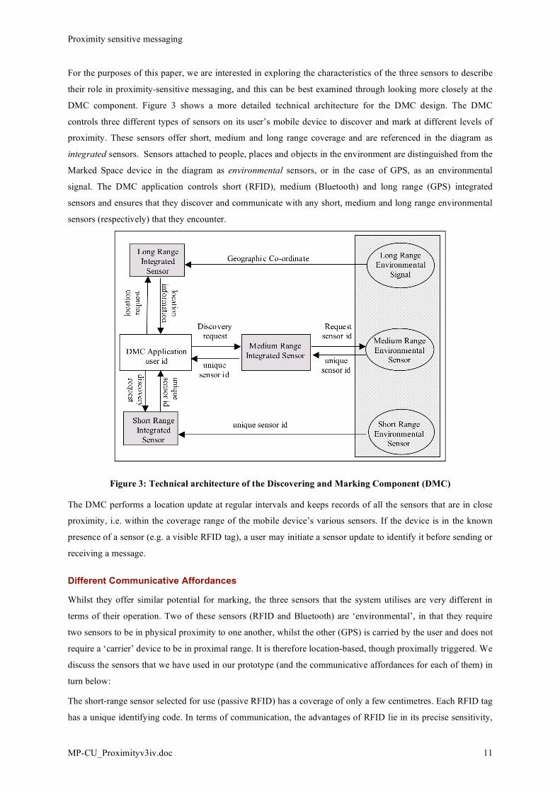
For the purposes of this paper, we are interested in exploring the characteristics of the three sensors to describe
their role in proximity-sensitive messaging, and this can be best examined through looking more closely at the
DMC component. Figure 3 shows a more detailed technical architecture for the DMC design. The DMC
controls three different types of sensors on its user’s mobile device to discover and mark at different levels of
proximity. These sensors offer short, medium and long range coverage and are referenced in the diagram as
integrated sensors. Sensors attached to people, places and objects in the environment are distinguished from the
Marked Space device in the diagram as environmental sensors, or in the case of GPS, as an environmental
signal. The DMC application controls short (RFID), medium (Bluetooth) and long range (GPS) integrated
sensors and ensures that they discover and communicate with any short, medium and long range environmental
sensors (respectively) that they encounter.
Figure 3: Technical architecture of the Discovering and Marking Component (DMC)
The DMC performs a location update at regular intervals and keeps records of all the sensors that are in close
proximity, i.e. within the coverage range of the mobile device’s various sensors. If the device is in the known
presence of a sensor (e.g. a visible RFID tag), a user may initiate a sensor update to identify it before sending or
receiving a message.
Different Communicative Affordances
Whilst they offer similar potential for marking, the three sensors that the system utilises are very different in
terms of their operation. Two of these sensors (RFID and Bluetooth) are ‘environmental’, in that they require
two sensors to be in physical proximity to one another, whilst the other (GPS) is carried by the user and does not
require a ‘carrier’ device to be in proximal range. It is therefore location-based, though proximally triggered. We
discuss the sensors that we have used in our prototype (and the communicative affordances for each of them) in
turn below:
The short-range sensor selected for use (passive RFID) has a coverage of only a few centimetres. Each RFID tag
has a unique identifying code. In terms of communication, the advantages of RFID lie in its precise sensitivity,

Proximity sensitive messaging
MP-CU_Proximityv3iv.doc 12
and as it is an un-powered sensor, it allows relatively cheap ‘fit-and-forget’ placement. In order to make contact
with a passive RFID tag, users need to bring their devices into very close range with the tag, most likely in a
deliberate act of swiping over it (although chance proximal connections are possible). This has an interesting
side-effect in that the requirement for such deliberateness of interaction has a presumption of interest for the
recipient: they are not likely to enable such a proximal interaction without their having an interest in finding out
whether a message has been left for them. Thus, the automaticity of message delivery is itself mediated through
a deliberate act of ‘finding out’ if a message has been left. Senders of messages are therefore likely to (at least if
they understand how the system needs to be used) develop their messages in a form that fits with this act of
deliberate interaction. They are also able to ensure (to a certain level) that their recipient is clearly able to relate
the received message to the entity to which that message is attached, and that it will not simply ‘appear’ on the
recipient’s device without an indication of what it is attached to.
The medium range sensor selected for use (Bluetooth) has an intermediate coverage of several metres, although
they require a power source. Bluetooth signal transmission may be weakened by metal structures (which may
include some walls and other building structures), an apparent disadvantage that has a positive side effect of
allowing room-level location sensitivity in some instances. Many devices in the environment are already
Bluetooth enabled (e.g. cellphones, wireless headsets, vehicle navigation systems, media players, notebook and
desktop computers, printers, mice, keyboard, medical devices, gaming devices, camcorders, projectors and
digital cameras). As of November 2006, there is an estimated installed base of over 1 billion Bluetooth products
in some form or another (Bluetooth SIG, 2006) giving a huge existing infrastructure for message placement: this
is a huge advantage over other, less numerous wireless forms of sensor. Moreover, it is possible to distinguish a
good deal of information from the Bluetooth identifying signal beyond its unique identifier (its MAC address),
including the type of device (‘device class’ e.g. mobile telephone, PDA, headphones, etc.) and a user generated
‘device name’ for that device (e.g. “Mark’s Palmtop”). Such information allows senders and recipients of
messages to make better-informed judgements of when and under what circumstances their messages will be
received and how to interpret their content. One of the particular features of Bluetooth sensors of relevance to
our work is that these are commonly used in mobile telephones and for practical reasons they are likely to be
‘discoverable’, thus enabling person (or more accurately, intimate personal device) discovery and marking.
The long range sensor selected (GPS) can locate a signal at varying ranges of precision. It is unlike the other two
sensors which need to detect other devices within signalling range. While the location information provided by
RFID and Bluetooth is relative (because they are only able to determine their location in relation to the signal
recipient), the GPS sensor positioning is absolute, in that the location of the sensor (unlike the other two forms
above) is mapped within geographic space: relationships between the device and its associated proximal
message identifier are therefore inferred, rather than directly sensed. This has an interesting side-effect that is
again different to the other two forms of sensor: for relative sensors, the sensor and the marked spatial location
need to be within range to activate–this is not the case for an absolute positional sensor, which is able to specify
its current proximity to a tagged place or object (if it is immobile), independent of any environmental markers.
One potential disadvantage of (unassisted) GPS is that it is sensitive to signal loss within structures, although as
we later discuss, this may have a communicative relevance to users. To allow a broad, yet meaningful scale of
proximity, we have bounded the GPS range to within 100 metres by using matched x and y co-ordinates ± 50

Proximity sensitive messaging
MP-CU_Proximityv3iv.doc 13
metres. This range of course has scope to be adapted (possibly across multiple or even user-defined ranges)
following user evaluation in the field, although this has yet to be completed.
The differences between these sensor variations means that applications built on top of them can be put to
different uses – the reasons why a user would tag a space to a range of a few centimetres are likely to be
different to why they would do so where the range and accuracy of the tag is in the order of a radius of 5, or 100
metres. Whilst each of these sensor technologies may be used independently, they can also be used in
conjunction with one another, due to the different capabilities and constraints that they carry.
There are other types of sensor that could be added to the system with different constraints to those that we have
discussed, some of which may carry additional constraints and offer new opportunities for developing
proximity-sensitive services. Indeed, the wireless environment has an incredibly rich existing infrastructure of
uniquely identifiable resources, and provides a ready-made platform for developing proximity-sensitive
applications. Examples of this within an indoor environment include potentially integrating infra-red and
ultrasound beacons (e.g. Randell et al. 2002) and another related technology, audio networking (Madhavapeddy
et al., 2003), in which spaces and things can be easily and cheaply demarcated with inaudible audio signals
running off commonly available sound hardware, and which can be picked up with microphone on mobile
devices. These technologies offer room-level precision, as infra-red and audio signals are bounded by walls, and
this may be a useful property for controlling the range of the broadcast signal. As these are not already
commonly available in the environment, this infrastructure would need to be created; however, this is not to say
that such devices would not necessarily become more mainstream at some later date. Another technology that
could be integrated is Wireless LAN, as has been seen in a number of existing location-based projects as noted
earlier: WLANs have a greater range than Bluetooth, although they are likely to be less frequently encountered,
are less likely to be mobile (and therefore act as a personal signifier), and like ultrasound beacons and audio
networking, typically have less metadata with which to make interpretations about the context of the message
(or proximity-related service) discovered. Even the humble barcode offers opportunities for marking objects,
and has the advantage of being extremely cheap to place. Indeed, like the barcode, any uniquely identifiable and
easily captured information media can be used for marking, ranging from written and manually inputted
telephone numbers to visual tags (e.g. Madhavapeddy et al., 2004), icons or pictorial images that can be
automatically recognised by the camera in a mobile telephone. Where electrical power is available, it may be
possible to physically mark environmental sensors to either support precise sensor discovery (e.g. determining
what messages relate to), or simply to determine that a message has been associated with a sensor, and that it
should be investigated further (e.g. by scanning a passive RFID tag). If such sensors were networked, this
interactivity could be made specific to individual users, as sensors recognised that they had an association with a
message recipient. This set of suggestions is not to say that we would recommend such developments, rather
they serve to illustrate the different properties of messaging techniques and sensors, and to illustrate the resultant
implications for messaging for use that they might engender: most have different communicative affordances,
offer different opportunities for use and would subsequently give rise to different opportunities for framing the
communication. Clearly, the particular constraints and properties of sensors used is likely to have a major
impact on the ways that they are incorporated in use practices, and how we might need to consider adapting
interaction designs to accommodate these different proximity-supporting media.
Proximity sensitive messaging
MP-CU_Proximityv3iv.doc 14
Discussion
The provision of access to information in place and relating to that place is poorly supported in existing mobile
and ubiquitous computing technologies. Current computer technologies tend to serve as central repositories for
electronic data and services, housing our email, instant messaging and web pages, while mobile telephones and
handheld devices attempt to provide mobile support that is also centralised on a device. These existing
electronic hubs provide us with access to all of our electronic information–whether it is relevant to our current
context or not. Proximity-sensitive systems provide a solution to this disconnect. Of course, developing
proximity-sensitive systems is not a simple matter for all manner of technical (e.g. battery limitations, device
and infrastructural limitations, vested commercial interests) and interactional reasons (e.g. how to represent
sensors to senders and recipients), some of which we have encountered during the development of our own
prototype, others of which are likely to fall out of detailed user studies or though the commercialisation of such
proximity-sensitive systems. Below, we draw some lessons in developing proximity-sensitive systems drawn
from our experience so far of developing the marked space system:
1) We have attempted to make use of existing environmental sensors for two reasons, and would recommend
this to other researchers and developers. The first of these is cost: the expense of developing a rich and
pervasive sensor infrastructure is far more expensive than simply using an existing set of sensor resources.
The second reason for this choice is that there are an increasing numbers of sensors that are already
available on mobile devices that can detect signals that are already pervasive within the environment, and
this means that people do not need to add to their existing complement of devices that they carry around
with them: proximity-sensitive applications can be developed relatively easily on top of the currently and
commercially available devices without costly and complex customisations, and the reliability problems
that these are likely to introduce.
2) There is value to proximity-sensitive systems in supporting different levels of proximity. The notion of
proximity is a relative one – and depending on the form of the marked entity, the notion of ‘nearby’ is only
meaningful at different level of scale. Furthermore, utilising a single level of proximity is communicatively
limiting for reasons of access (it provides fewer opportunities for discovering a proximal relationship),
spatial association (only a single relational distances between sensors could be associated with a service)
and its communicative affordances (a single level of proximity affords less variations on content
interpretation). However, these different levels of proximity should be clearly made known to users, so that
they are able to make appropriate associations as to their use or meaning.
3) The user interface to proximity sensitive systems should allow users to make better informed judgements
about the constraints of the various sensors (e.g. robustness and range of signal reception) that they are
utilising. This is not something that is naturally visible to users, particularly as these signals are wirelessly
transmitted and often invisible, and this needs to be made apparent in the interface of the mobile device in
some way so that it is possible to determine these constrains and so use and interpret the system
appropriately. Although this could be done explicitly, through user manuals, or on-screen instructions, this
could also be achieved by allowing the system’s users to easily visualise the constraints of the sensors, for
example, showing them when GPS signals are lost when inside buildings.
Proximity sensitive messaging
MP-CU_Proximityv3iv.doc 15
4) Placing and locating messages is not a simple matter: senders may not fully realise or understand where or
on what they are placing a message; similarly, recipients may be awaiting a message and not know
precisely where to receive it, or they may receive a message, but not know where or what it is attached to.
We can build on top of existing metadata, such as Bluetooth’s device class and name, which allows users
some insight into the message’s relationship with the physical world actually is, but much of this must be
inferred. This is likely to be easier with GPS signals and RFID sensors, although, for example, users need to
know that their GPS location has been updated and is current, and given that sometimes slow signals or
where the GPS signal has been blocked by physical structures, this is not always the case; similarly, it is
possible that in some cases, such as multiple RFID sensors stuck in the pages of a book, several sensors
may be triggered simultaneously, and it will be hard to determine precise message-sensor relationships.
There is a clear design relevant point to make about making as much information available to users as to the
nature of the signals: making visible to the user the type of sensors that can be connected to messages or
that messages are attached to, their signal range, how recently the sensor was detected, and making relevant
metadata relating to the message sensor available are clearly valuable in supporting users in making
meaningful interpretations about the message. This point can be extended beyond proximity-sensitive
messaging to other proximity-sensitive services. Some of these design considerations are clearly dependent
on whether these are multi-sensor systems, but making the nature of the service-sensor relationship is
important in determining precisely what, where and how this relationship is embodied.
5) Just as we can associate messages with people, places and things, so can we use this information for
tracking whereabouts, introducing potential problems in intrusions into personal privacy and the ability to
track where people have been and what they have come into contact with. This is not an issue wholly
unique to this technology, and has also been considered in other location-based technology developments
such as Place Lab (Hong et al. 2003), and Reno (Consolvo et al., 2005). However, unlike location-based
systems, the notion of location within Marked Space is inferred from proximity (other than by its GPS
component), which adds a degree of fuzziness to a user’s whereabouts. Whilst proximity relationships may
be equally interesting and useful to nefarious users of the system, this means that the precision as to where
users of the system have physically been is less easy to determine. Of course, may be possible to tell what
entities that users have come into contact with from accessing the Database Engine, although in practice, as
the system is currently designed, metadata about environmental proximity sensors is managed at the level of
the local device, and the only information sent to the remote server (and used in the Database Engine) are
the abstract, unique identifier details, such as RFID codes and Bluetooth MAC addresses that are much
harder to identify with a particular person, place or thing. It is important to note that we are not making any
more information about people or devices available than is already present: we are simply utilising the
information that users are already making available through, for example, their use of a Bluetooth enabled
cellphone. Users are already publicly broadcasting this information, and we are simply making use of this
as an enabler for determining proximity. Further to this, in the system that we have developed, there is
explicitly no feedback to message senders that their messages have been received (as can be requested in
SMS/text messaging for example) so that user activities cannot be traced. GPS data may transmitted back to
the remote server (although not in our current design which relies on caching), but again, this is not stored
as would be required for a tracking application, rather, incoming GPS location information would merely be

Proximity sensitive messaging
MP-CU_Proximityv3iv.doc 16
matched to the database to see if a messaging match had been made and then discarded. There is no need to
store information on a user’s location for the purposes of this application, so that privacy concerns should
be allayed; of course, whether users will be aware of this model of information use by the system is yet to
be determined.
One point of caution must be made that relates broadly to privacy: by allowing proximity-based tagging, we
make it possible to attach messages to people in a way that they might be uncomfortable, to give a puerile
example, it may be analogous to pinning a ‘kick me’ message onto someone’s back. The person to whom
the message is attached is likely to be completely unaware that they have been tagged or labelled, and may
have no mechanism to remove such messages (other than to turn off or put down their devices) even were
they to realise that such a message had been left. This is something of a hard problem to resolve. Solutions
may be to allow people to examine and edit messages that are associated with sensors that they are
responsible for, although this is itself open to abuse. It is likely that were the system to become widespread
that we would see an etiquette developing around such proximity-sensitive messaging and other services
that would provide a set of acceptable forms of behaviour.
6) The idea that sensors could be ‘improved’ so that signals were more accurate or could be received in a
wider range of environments may not be as useful as it initially appears. The very fact that constraints are
imposed on system use as it currently operates may allow users to make better informed judgements on how
their message might be interpreted or about what the sender had intended: that a message could not be
received and is understood not to be receivable in certain contexts (or vice versa) is important in enriching
the meaningfulness of communication, and ensuring uniformally pervasive reception across sensor types
may have detrimental communicative value. The utility of this seamfulness (see Chalmers, 2004) of sensor
reception may therefore actually carry value to users, although this would need to be examined in field
evaluations. This final point on seamfulness in proximity-sensitive systems is particularly important in that
it offers the potential to both form and aid users’ understanding about the nature of the proximal connection
with the world, and allows its users (as well as designers the of future services on such systems) to be
creative with the ways that personal communications and other services are provided by making use of
these seams in connectivity to support interpretation. This is stark contrast to systems like Place Lab, in
which all of the sensors in the system are fused into a single notion of location and this does not allow users
to make any particular interpretations of how those places might have been understood or selected by the
sender, to convey their message.
Returning to the broader theme of the paper, we have developed three key concepts relating to the use of
proximity on developing context-sensitive services and messaging and these can be seen in the features
developed as a part of the Marked Space system described. The first of these concepts lies in highlighting the
importance and unique nature of proximity as a relational property in mediating the relationship between initial
communicative intention and information retrieval. It follows that proximity-sensitive technologies are a distinct
and nuanced form of locating, and offer different communicative affordances to those presented by location-
based technologies, with different design considerations that need to be accounted for. Second, by giving users a
differentiated view of proximity offers those users more meaningful communicative functionality that operates
at a more human scale of distance: ‘nearby’ has a very different notion of scale depending on users’ physical
contexts (in the countryside versus in the office), their activities (walking around versus reading a book) and
Proximity sensitive messaging
MP-CU_Proximityv3iv.doc 17
their intentions (warning someone about something dangerous versus informing someone about something that
might be interesting). To set this at a single arbitrary distance, as has been done in almost all of the existing
location and proximity-based systems developed so far, is to artificially and arbitrarily cut across these levels of
scale, and makes the system useable only under a particular set of conditions, thereby reducing the set of
circumstances under which the system will be useful. There is a secondary effect to this following a reduction in
the possible circumstances of system use in its potentially falling below the critical mass of use necessary to
maintain interest in the system, and its falling into disuse. The third key feature is that different mechanisms of
detecting proximity offer different resources and constraints in their operation and thus offer different
communicative affordances to users. The particular communicative affordances of the sensors offer system
users a variety of mechanisms to complement the mediated proximal relationship between the generator of
information and its recipient. The use of different sensors also allows us to utilise the existing infrastructures in
the environment in a way that is more richly pervasive than relying on a single form of sensory input. Together
these three features of the Marked Space system described offer what are relatively simple techniques in terms
of the technology being utilised, but which offer a unique and powerful mechanism for communication and the
delivery of services to users.
We envisage proximity-sensitive systems and services to have application across areas as diverse as in situ
access to product information, targeted mobile advertising, mobile guides, context-sensitive instructions and
user manuals of various kinds, support for product inspections and servicing, mobile educational tools utilising
situated and exploratory learning, mobile games and interactive entertainment, and awareness-based
collaborative systems amongst others. The three concepts identified above apply are likely to apply to all of
these areas to a greater or lesser extent depending on the form of the application. Once proximity-sensitive
software is present in mobile devices, many of these applications can be relatively easily developed on top of
these with relatively little effort beyond the provision of novel content and the services themselves, allowing
developers to concentrate on their own offerings and without having to roll out and introduce the technology
from scratch. At an interactional level, these techniques also offer techniques for user interface design and
content provision based on physical proximity. By utilising the natural zooming effect of users approaching and
moving away from sensor-enabled interactive devices, information can be presented in different forms or at
different levels of detail, for example, situated displays (cf. O’Hara et al., 2003) that change their font size or
display interactive features as users approach them. This paper presents a first attempt to explore these issues
systematically (within the context of asynchronous proximity-sensitive messaging) and, although this area is
clearly still in its infancy, there seems great potential to employing the approach across a broad range of
application areas that have so far received little attention.
In conclusion, we have discussed some of the implications for proximity-sensitive messaging systems and
services and the notion of differentiated proximity sensitivity, but this field is ripe for further investigation and
offers enormous opportunities for novel forms of data access and communication services.
References
1. Kindberg, T., Barton, J., Morgan, J., Becker, G., Caswell, D., Debaty, P., Gopal, G., Frid, M., Krishnan, V.,
Morris, H., Schettino, J., & Serra. B. People Places, Things: Web Presence for the real world. Tech Report
HPL-2000-16, Hewlett-Packard Laboratories, 2000.
Proximity sensitive messaging
MP-CU_Proximityv3iv.doc 18
2. Eagle, N. and Alex Pentland, A. (2004) Social Serendipity: Proximity Sensing and Cueing. MIT Media
Laboratory Technical Note 580, May 2004.
3. Schmandt, C., Marmasse, N., Marti, S., Sawhney, N. and Wheeler, S. (2000) Everywhere messaging. IBM
Systems Journal, 39, (3-4), 660-677.
4. Espinoza, F., Persson, P., Sandin, A., Nyström, H., Cacciatore. E. and Bylund, M. (2001) GeoNotes: Social
and navigational aspects of location-based information systems. In Proc. Ubicomp 2001, Eds. Abowd, et al.,
Atlanta, Georgia. Berlin: Springer, 2-17.
5. Multaharju, M., Koskinen, K., Spacil, R., Ikonen, J. and Porras, J. (2004) Floating note - a location based
messaging application. 2nd Workshop on Applications of Wireless Communications, p. 9-16, 5th August
2004, Lappeenranta, Finland.
6. Burrell, J. & Gay, G. (2002) Egraffitti: evaluating real-world use of a context aware system. Interacting with
Computers, 14, 301-312.
7. Lane, G. (2003) Urban Tapestries: Wireless networking, public authoring and social knowledge. Personal
and Ubiquitous Computing, 7, (3-4), 169-175.
8. Yellowarrow.net (2006) Yellow Arrow. Last viewed on 9th Jan 2007. Available at
<http://yellowarrow.net/index2.php>
9. Priyantha, N.B., Chakraborty, A., Balakrishnan, H. (2000) The Cricket Location-Support system. In
Proceedings of 6th ACM MOBICOM, Boston, MA, August 2000.
10. Treu, G. and Küpper, A. (2005) Efficient Proximity Detection for Location-based Services. In Proc. 2nd
Workshop on Positioning, Navigation and Communication (WPNC'05), Shaker Publishing, Hannover,
Germany, March 2005.
11. Chalmers, M. and Galani, A. (2004) Seamful Interweaving: Heterogeneity in the Theory and Design of
Interactive Systems. In Proc. ACM DIS 2004, Cambridge, MA, USA, August 1-4, 243-252.
12. Perry, M., O'Hara, K., Sellen, A. Harper, R. and Brown, B.A.T. (2001) Dealing with mobility: understanding
access anytime, anywhere. ACM Transactions on Computer-Human Interaction, 8 (4), 323-347.
13. Nokia (2007) Nokia Sensor. Available at: <http://www.nokia.com/sensor>. Last viewed on 18/07/2007.
14. Bluetooth SIG (2006) Bluetooth® wireless technology surpasses one billion devices. Available at: <
http://www.bluetooth.com/Bluetooth/Press/SIG/bluetooth_wireless_technology_surpasses_one_billion_devic
es.htm>. Last viewed on 19/07/2007.
15. Ludford, PJ., Frankowski, D., Reily, K., Wilms, K. and Terveen, L. (2007) Because I carry my cell phone
anyway: functional location-based reminder applications.
16. Randell, C., MacColl, I., Muller, H. and Rogers. Y. (2002) Exploring the Potential of Ultrasonic Position
Measurement as a Research Tool. In IEE Communication Networks and Services Professional Network,
editors, First European Workshop on Location Based Services, pages 171-4, Savoy Place, London WC2R
0BL, September 2002. Institution of Electrical Engineers.
Madhavapeddy, A., Scott, D., Sharp, R. and Upton, E. (2004) Using Camera-Phones to Enhance Human–
Computer Interaction. Adjunct Proceedings of the Sixth International Conference on Ubiquitous Computing
Proximity sensitive messaging
MP-CU_Proximityv3iv.doc 19
(UBICOMP 2004).
Madhavapeddy, A., Scott, D. and Sharp, R. (2003) Context-Aware Computing with Sound. Proceedings of the
Fifth International Conference on Ubiquitous Computing (UBICOMP 2003).
Björk, S., Falk, J., Hansson, R. and Ljungstrand, P. (2001) Pirates! - Using the Physical World as a Game
Board. Proceedings of the 8th IFIP TC13 International Conference on Human-Computer Interaction
(INTERACT). Tokyo, Japan, July 9-13.
Falk, J., Ljungstrand, P., Björk, S. and Hansson, R. (2001) Pirates: Proximity-Triggered Interaction in a Multi-
Player Game. Proceedings of the ACM Conference on Human Factors in Computing Systems (CHI 2001). 119-
120.
Redström, J., Dahlberg, P., Ljungstrand, P. and Holmquist, L. E. (1999). Designing for Local Interaction. In:
Nixon, P., Lacey, G. & Dobson, S. (Eds.) Managing Interactions in Smart Environments: 1st International
Workshop on Managing Interactions in Smart Environments (MANSE '99), Dublin, December 1999, pp. 227-
238. Springer-Verlag.
Bell, M., Chalmers, M., Barkhuus, L., Hall, M., Sherwood, S., Tennent, P., Brown, B., Rowland, D. and
Benford, S. (2006) Interweaving Mobile Games with Everyday Life. Proceedings of the ACM Conference on
Human Factors in Computing Systems (CHI 2006), pp. 417-426, ACM Press.
Holmquist, L.E., Falk J. and Wigström, J. (1999) Supporting group collaboration with inter-personal awareness
devices. Journal of Personal Technologies, 3(1-2), 13-21.
Iwatani, Y. (1998) Love: Japanese Style. In Wired News, 11 June 1998. Available at
http://www.wired.com/culture/lifestyle/news/1998/06/12899. Last viewed on: 25/07/2007.
Consolvo, S. Smith, I.E., Matthews, T. LaMarca, A. Tabert, J. and Powledge, P. (2005) Location disclosure to
social relations: why, when, & what people want to share. In Proceedings of ACM CHI 2005, April 2–7, 2005,
Portland, Oregon, USA, pp. 81-90.
Hong, J.I., Boriello, G., Landay, J.A., McDonald, D.W., Schilit. B.N., Tygar, J. D. (2003) Privacy and security
in the location-enhanced world wide web. In Proceedings of Fifth International Conference on Ubiquitous
Computing: Ubicomp 2003 (Workshop on Ubicomp Communities: Privacy as Boundary Negotiation), Seattle,
WA.
O’Hara, K., Perry, M., Churchill, E. and Russell, D. (Eds.) (2003) Public and situated displays: social and
interactional aspects of shared display technologies (edited collection), Dordrecht, the Netherlands: Kluwer
International CSCW series.
Related Documents
![Raumwirkung: the case of Wozzeck - Brunel University Londonpeople.brunel.ac.uk/dap/Raumwirkung.pdf · 2015-02-05 · Downloaded by [Brunel University London] at 10:40 05 February](https://static.cupdf.com/doc/110x72/5f2b216cc9346e1bff11a611/raumwirkung-the-case-of-wozzeck-brunel-university-2015-02-05-downloaded-by.jpg)