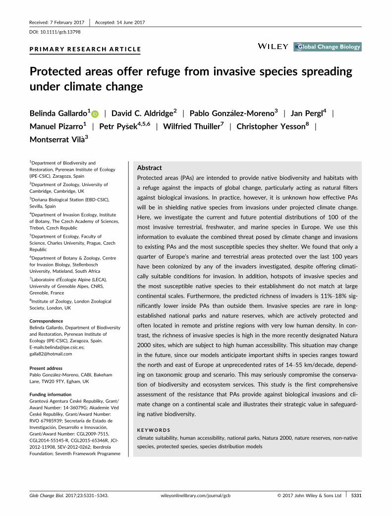
PRIMARY RESEARCH ARTICLE Protected areas offer refuge from invasive species spreading under climate change Belinda Gallardo 1 | David C. Aldridge 2 | Pablo Gonz alez-Moreno 3 | Jan Pergl 4 | Manuel Pizarro 1 | Petr Py sek 4,5,6 | Wilfried Thuiller 7 | Christopher Yesson 8 | Montserrat Vil a 3 1 Department of Biodiversity and Restoration, Pyrenean Institute of Ecology (IPE-CSIC), Zaragoza, Spain 2 Department of Zoology, University of Cambridge, Cambridge, UK 3 Do~ nana Biological Station (EBD-CSIC), Sevilla, Spain 4 Department of Invasion Ecology, Institute of Botany, The Czech Academy of Sciences, T rebo n, Czech Republic 5 Department of Ecology, Faculty of Science, Charles University, Prague, Czech Republic 6 Department of Botany & Zoology, Centre for Invasion Biology, Stellenbosch University, Matieland, South Africa 7 Laboratoire d’ Ecologie Alpine (LECA), University of Grenoble Alpes, CNRS, Grenoble, France 8 Institute of Zoology, London Zoological Society, London, UK Correspondence Belinda Gallardo, Department of Biodiversity and Restoration, Pyrenean Institute of Ecology (IPE-CSIC), Zaragoza, Spain. E-mails:[email protected]; [email protected] Present address Pablo González-Moreno, CABI, Bakeham Lane, TW20 9TY, Egham, UK Funding information Grantov a Agentura Cesk e Republiky, Grant/ Award Number: 14-36079G; Akademie V ed Cesk e Republiky, Grant/Award Number: RVO 67985939; Secretar ıa de Estado de Investigaci on, Desarrollo e Innovaci on, Grant/Award Number: CGL2009-7515, CGL2014-55145-R, CGL2015-65346R, JCI- 2012-11908, SEV-2012-0262; Iberdrola Foundation; Seventh Framework Programme Abstract Protected areas (PAs) are intended to provide native biodiversity and habitats with a refuge against the impacts of global change, particularly acting as natural filters against biological invasions. In practice, however, it is unknown how effective PAs will be in shielding native species from invasions under projected climate change. Here, we investigate the current and future potential distributions of 100 of the most invasive terrestrial, freshwater, and marine species in Europe. We use this information to evaluate the combined threat posed by climate change and invasions to existing PAs and the most susceptible species they shelter. We found that only a quarter of Europe’s marine and terrestrial areas protected over the last 100 years have been colonized by any of the invaders investigated, despite offering climati- cally suitable conditions for invasion. In addition, hotspots of invasive species and the most susceptible native species to their establishment do not match at large continental scales. Furthermore, the predicted richness of invaders is 11%–18% sig- nificantly lower inside PAs than outside them. Invasive species are rare in long- established national parks and nature reserves, which are actively protected and often located in remote and pristine regions with very low human density. In con- trast, the richness of invasive species is high in the more recently designated Natura 2000 sites, which are subject to high human accessibility. This situation may change in the future, since our models anticipate important shifts in species ranges toward the north and east of Europe at unprecedented rates of 14–55 km/decade, depend- ing on taxonomic group and scenario. This may seriously compromise the conserva- tion of biodiversity and ecosystem services. This study is the first comprehensive assessment of the resistance that PAs provide against biological invasions and cli- mate change on a continental scale and illustrates their strategic value in safeguard- ing native biodiversity. KEYWORDS climate suitability, human accessibility, national parks, Natura 2000, nature reserves, non-native species, protected species, species distribution models Received: 7 February 2017 | Accepted: 14 June 2017 DOI: 10.1111/gcb.13798 Glob Change Biol. 2017;23:5331–5343. wileyonlinelibrary.com/journal/gcb © 2017 John Wiley & Sons Ltd | 5331

Welcome message from author
This document is posted to help you gain knowledge. Please leave a comment to let me know what you think about it! Share it to your friends and learn new things together.
Transcript
P R IMA R Y R E S E A R CH A R T I C L E
Protected areas offer refuge from invasive species spreadingunder climate change
Belinda Gallardo1 | David C. Aldridge2 | Pablo Gonz�alez-Moreno3 | Jan Pergl4 |
Manuel Pizarro1 | Petr Py�sek4,5,6 | Wilfried Thuiller7 | Christopher Yesson8 |
Montserrat Vil�a3
1Department of Biodiversity and
Restoration, Pyrenean Institute of Ecology
(IPE-CSIC), Zaragoza, Spain
2Department of Zoology, University of
Cambridge, Cambridge, UK
3Do~nana Biological Station (EBD-CSIC),
Sevilla, Spain
4Department of Invasion Ecology, Institute
of Botany, The Czech Academy of Sciences,
T�rebo�n, Czech Republic
5Department of Ecology, Faculty of
Science, Charles University, Prague, Czech
Republic
6Department of Botany & Zoology, Centre
for Invasion Biology, Stellenbosch
University, Matieland, South Africa
7Laboratoire d’�Ecologie Alpine (LECA),
University of Grenoble Alpes, CNRS,
Grenoble, France
8Institute of Zoology, London Zoological
Society, London, UK
Correspondence
Belinda Gallardo, Department of Biodiversity
and Restoration, Pyrenean Institute of
Ecology (IPE-CSIC), Zaragoza, Spain.
E-mails:[email protected];
Present address
Pablo González-Moreno, CABI, Bakeham
Lane, TW20 9TY, Egham, UK
Funding information
Grantov�a Agentura �Cesk�e Republiky, Grant/
Award Number: 14-36079G; Akademie V�ed�Cesk�e Republiky, Grant/Award Number:
RVO 67985939; Secretar�ıa de Estado de
Investigaci�on, Desarrollo e Innovaci�on,
Grant/Award Number: CGL2009-7515,
CGL2014-55145-R, CGL2015-65346R, JCI-
2012-11908, SEV-2012-0262; Iberdrola
Foundation; Seventh Framework Programme
Abstract
Protected areas (PAs) are intended to provide native biodiversity and habitats with
a refuge against the impacts of global change, particularly acting as natural filters
against biological invasions. In practice, however, it is unknown how effective PAs
will be in shielding native species from invasions under projected climate change.
Here, we investigate the current and future potential distributions of 100 of the
most invasive terrestrial, freshwater, and marine species in Europe. We use this
information to evaluate the combined threat posed by climate change and invasions
to existing PAs and the most susceptible species they shelter. We found that only a
quarter of Europe’s marine and terrestrial areas protected over the last 100 years
have been colonized by any of the invaders investigated, despite offering climati-
cally suitable conditions for invasion. In addition, hotspots of invasive species and
the most susceptible native species to their establishment do not match at large
continental scales. Furthermore, the predicted richness of invaders is 11%–18% sig-
nificantly lower inside PAs than outside them. Invasive species are rare in long-
established national parks and nature reserves, which are actively protected and
often located in remote and pristine regions with very low human density. In con-
trast, the richness of invasive species is high in the more recently designated Natura
2000 sites, which are subject to high human accessibility. This situation may change
in the future, since our models anticipate important shifts in species ranges toward
the north and east of Europe at unprecedented rates of 14–55 km/decade, depend-
ing on taxonomic group and scenario. This may seriously compromise the conserva-
tion of biodiversity and ecosystem services. This study is the first comprehensive
assessment of the resistance that PAs provide against biological invasions and cli-
mate change on a continental scale and illustrates their strategic value in safeguard-
ing native biodiversity.
K E YWORD S
climate suitability, human accessibility, national parks, Natura 2000, nature reserves, non-native
species, protected species, species distribution models
Received: 7 February 2017 | Accepted: 14 June 2017
DOI: 10.1111/gcb.13798
Glob Change Biol. 2017;23:5331–5343. wileyonlinelibrary.com/journal/gcb © 2017 John Wiley & Sons Ltd | 5331

1 | INTRODUCTION
Global species and habitat diversity are declining at unprecedented
rates with no signs of abatement in spite of international efforts to
halt biodiversity loss (Butchart et al., 2010). Biological invasions and
climate change are two key drivers behind such declines (Walther
et al., 2009). The proliferation of invasive species can be linked to
58% of recent species extinctions and is currently considered a
major threat for the conservation of native flora and fauna around
the world (Bellard, Cassey, & Blackburn, 2016). This impact will be
aggravated by climate change, expected to accelerate the risk of
extinction for up to one in six species, depending on region (Bellard,
Bertelsmeier, Leadley, Thuiller, & Courchamp, 2012; Urban, 2015).
The problem is particularly acute in Europe, where the number of
invasive species has increased fourfold in the last century (Hulme,
Pysek, Nentwig, & Vila, 2009), and is likely to continue increasing
with the intensification of socioeconomic activities coupled with
ongoing climate changes (Seebens et al., 2015, 2017).
Protected areas (PAs), as cornerstones of global conservation
efforts, are championed as refugia for native species, locally prevent-
ing habitat degradation attributable to human activities (Rodrigues
et al., 2004), facilitating the adaptation of species and communities to
ongoing climate changes (Ga€uz�ere, Jiguet, & Devictor, 2016; Johnston
et al., 2013; Thomas et al., 2012), and acting as a natural filter against
invasions (Foxcroft, Jaro�s�ık, Py�sek, Richardson, & Rouget, 2011; Py�sek,
Jaro�s�ık, & Ku�cera, 2003). In practice, however, little is known about
the effectiveness of PAs in shielding native species from biological
invasions (Py�sek, Genovesi, Pergl, Monaco, & Wild, 2013).
Europe has one of the largest coordinated networks of protected
areas in the world. The Natura 2000 network of protected sites,
coupled with national designated areas such as national parks and
nature reserves, provides crucial shelter from the damaging effects
of human-related stressors to over 1,100 species listed by the Habi-
tats (92/43/EEC) and Birds (2009/147/EC) Directives (Gaston, Jack-
son, Nagy, Cant�u-Salazar, & Johnson, 2008; Gruber et al., 2012).
Several studies over recent years have documented how climate
change—and associated changes in land-use and human transportation—
progressively removes physiological constraints for the growth and spread
of some invasive species, particularly those introduced from warm cli-
mates, facilitating their expansion into regions where they previously
could not survive and reproduce (Walther et al., 2009). However, no stud-
ies have explored to what extent climate change may facilitate (or con-
strain) the expansion of invasive species into PAs at continental scales.
Here, we investigate the current and future distribution of some
of the most serious invasive species across Europe, integrating for
the first time the study of the terrestrial, freshwater, and marine
environments at a scale of an entire continent. We use this informa-
tion to evaluate the combined threat posed by climate change and
biological invasions to existing PAs and the most susceptible species
they harbor. To guarantee a high relevance to researchers and envi-
ronmental practitioners, we focus on “100 of the most invasive spe-
cies in Europe,” a representative set of invaders with different life
strategies, invaded habitats, and impacts (Vil�a et al., 2009). The
spread of these invaders poses a serious threat to a large variety of
native European species through competition, predation, parasitism,
hybridization, and indirect habitat alteration (Hulme et al., 2009). For
this reason, here we evaluate the effectiveness of protected areas in
shielding native biota from the current and future impacts of inva-
sive species. Findings from this study are pivotal to support the
implementation of the Habitats and Birds Directives as well as the
European Regulation (1143/2014) on invasive alien species, all of
which prioritize the protection of native biodiversity, habitats, and
related ecosystem services.
2 | MATERIALS AND METHODS
2.1 | Invasive species occurrence
Information on the current global (i.e., native and invaded) spatial
distribution of 100 of the most invasive species in Europe (see the
list of species in http://www.europe-aliens.org/speciesTheWorst.do)
was obtained from multiple international and regional data gateways:
the Global Biodiversity Information Facility (GBIF, http://www.gbif.
org/), the Biological Collection Access Service for Europe (BioCase,
http://www.biocase.org/), the Ocean Biogeography Information Sys-
tem (IOBIS, http://www.iobis.org/), the UK’s National Biodiversity
Network (https://data.nbn.org.uk/), DiscoverLife (http://www.disc
overlife.org/), Aquamaps (http://www.aquamaps.org/), and the Inte-
grated Digitized Biocollections (iDigBio, https://www.idigbio.org/).
To cover gaps in the distribution of invaders (i.e., no georefer-
enced records in regions where the species is suspected to be pre-
sent), data were checked against the global distribution of each
species described in CABI-Invasive Species Compendium (CABI-ISC,
http://www.cabi.org/isc/) that lists countries (or major oceanic
regions) where the species has been reported (either as native or
introduced). We then performed an extensive ISI Web of Knowledge
literature review using a combination of keywords including the spe-
cies taxonomic name and the specific data-missing region (Supple-
mentary Material, Table S1).
As a result, over 1.15 million georeferenced locations were com-
piled from 184 countries across the globe, detailing the native and
invasive distribution of candidate invasive species. Because data
quality (sample size, spatial errors, spatial autocorrelation) strongly
determines the performance of distribution models (Graham et al.,
2008; Wisz et al., 2008), we applied an exhaustive cleaning protocol
(see Supplementary Materials) that removes erroneous records (e.g.,
duplicates, misleading values, low-resolution coordinates), reduces
sampling bias, and ultimately allows analysis of macroecological pat-
terns (Garc�ıa-Rosell�o et al., 2015). As a result, the number of georef-
erenced records available for this study was reduced to 238,000,
with an average 2,767 per species. Species with less than 100 occur-
rence records were discarded for further modeling to avoid any
potential influence of low sample sizes (Barbet-Massin, Jiguet, Albert,
& Thuiller, 2012), so that 86 species (27 terrestrial animals, 18 ter-
restrial plants, 13 freshwater, and 28 marine organisms) were finally
evaluated (see the complete list of species in Table S2).
5332 | GALLARDO ET AL.

2.2 | Susceptible protected species
To identify the native protected species that may be affected by the 86
focus invaders, we consulted impact information from the Global Inva-
sive Species Database (GISD, http://www.iucngisd.org/gisd/), CABI-
ISC, the European Network on Invasive Alien Species (NOBANIS,
https://www.nobanis.org/), and the European Alien Species Information
Network (EASIN, http://easin.jrc.ec.europa.eu/). We restricted our anal-
ysis to species: (1) considered native in Europe, (2) with published evi-
dence of negative impact from any of the 86 focus invaders, and (3)
protected under the Birds or Habitats Directives, or by other interna-
tionally relevant Conventions (e.g., Bern Convention, OSPAR Conven-
tion, Bonn Convention, Helsinki Convention, and Barcelona SPA/BD
Protocol). It must, thus, be noted that invasive species in our list may
affect directly and indirectly a much larger number of native (as well as
other invasive) species that do not meet our criteria for selection.
As a result, we identified 148 native protected species that may be
susceptible to the expansion of our focus invaders (54 terrestrial ani-
mals, 37 semi-aquatic animals, 24 freshwater organisms, 22 terrestrial
plants, and 9 marine organisms) (Table S3). Their conservation status
according to the IUCN European Red List was variable: 2 Data Deficient,
22 Not Evaluated, 79 Least Concern, 13 Near Threatened, 15 Vulnera-
ble, 9 Endangered, and 8 Critically Endangered. Examples of the latter
include the European eel (Anguilla anguilla), several bivalve freshwater
mussels (Margaritifera auricularia, M. margaritifera, and Unio gibbus), the
berlengensis Armeria (Armeria berlengensis), Maltese cliff-orache
(Cremnophyton lanfrancoi), and Maltese everlasting (Helichrysum meli-
tense). The most threatening invaders in our list included the American
mink (affecting 37 species), brown rat (29), and red-swamp crayfish (16),
altogether posing a threat to 69 native protected species (Table S3).
2.3 | Protected areas in Europe
In this study, we investigate the potential joint threat posed by cli-
mate change and the concurrent expansion of invasive species on
the conservation of protected areas and species in Europe. We
restricted our analyses to PAs with area >1 km2 to match the resolu-
tion of information on invasive species occurrence and environmen-
tal predictors. Two sources of PAs were used (more details in
Supplementary Material):
• Nationally designated areas. We extracted from the World Data-
base on Protected Areas (WDPA, http://protectedplanet.net/) a map
including PAs belonging to IUCN categories I and II that correspond
to nature reserves and national parks, respectively. Once PAs>1 km2
in Europe were extracted, 2,038 nationally designated sites were
obtained (1,882 inland covering both terrestrial and freshwater envi-
ronments, 156 in marine areas). Nationally designated areas are large
unmodified or slightly modified areas, without permanent or signifi-
cant human habitation, which are strictly protected to preserve bio-
diversity and ecosystem processes. They are on average
22 � 16 years old (designation between 1920 and 2015) and have
a size of 73 � 305 km2 (area range: 1–5,551 km2).
• Natura 2000. We extracted from the European Commission’s
repository (http://ec.europa.eu/environment) the Natura 2000
database and shapefile containing information from 11,046 inland
(terrestrial and freshwater) and 2,064 marine PAs >1 km2. Natura
2000 areas in our database have been more recently designated
(11 � 5 years old, designation between 1940 and 2015) and are
generally larger (89 � 317 km2, range: 1–9,016 km2) than nation-
ally designated areas. As many as 90% of nationally designated
areas in our database are also integrated within Natura 2000
(Fig. S1). Natura 2000 is not a system of strict nature reserves
from which all human activities are excluded, but low-intensity
human activities are allowed on most of the land.
These two distinct networks, totaling 15,148 PAs (18% of Eur-
ope’s inland and 6% of marine surface), allow the assessment of the
effectiveness of protected areas in shielding native biota from the
current and future impacts of invasive species.
First, using our comprehensive database on the global occurrence
of Europe’s 86 most invasive species, we identified the invaders
already reported from each protected area (Richness Invasive Species,
RIS). We must note, however, that this is likely an underestimation
since rigorous data on the continent-wide distribution and abundance
of invasive species within PAs are rarely available (Py�sek et al., 2013).
With this information, we calculated the number of invasive species
recorded per unit area protected over time. Second, we obtained the
incidence of the 148 susceptible native species in each protected area
from the European Nature Information System (EUNIS, http://eu
nis.eea.europa.eu/), which lists all protected areas with known popula-
tions of each listed species. While EUNIS is useful to identify the
protected areas that shelter each native species investigated, lack of
spatially explicit information (georeferenced locations) prevented mod-
eling the distribution of native species under future scenarios. Finally,
because EUNIS depends on information provided by member states
and may underestimate the known distribution of susceptible native
species, we complemented it with additional records from GBIF.
2.4 | Environmental predictors
2.4.1 | Terrestrial and freshwater scenarios
Candidate environmental predictors to model the potential expansion
of 58 inland invasive species (i.e., terrestrial and freshwater) included
19 bioclimatic variables extracted from WorldClim-Global Climate
Data (http://www.worldclim.org/). Bioclimatic variables represent
annual trends, seasonality, extremes, or limiting environmental factors
related to temperature and precipitation for the 1950–2000 reference
period (Hijmans, Cameron, Parra, Jones, & Jarvis, 2005), which are
commonly used in species distribution models. To account for the
strong human relationship usually displayed by invasive species, we
incorporated an “accessibility” proxy as covariate. Produced by the
European Commission (http://forobs.jrc.ec.europa.eu/products/gam/),
this proxy measures the travel time to the nearest city (i.e., population
>50,000), thereby integrating both distance to urban areas and the
GALLARDO ET AL. | 5333

presence of transportation networks (Nelson, 2008). This map has
been used before to compensate sampling bias toward areas with
high accessibility (Fourcade, Engler, R€odder, & Secondi, 2014), which
may be particularly important in the case of invasive species.
Identifying the most appropriate variables for modeling is crucial
to maximize the accuracy of distribution models and their projection
in space in time. In this study, we followed a selection protocol that
involved removing highly correlated and multi-collinear variables
while prioritizing predictors that are ecologically meaningful to
explain the large-scale distribution of flora and fauna (Tables S4–S5).
Final variables considered for modeling included accessibility (travel
time, hours), maximum annual temperature (°C), minimum annual
temperature (°C), maximum annual precipitation (mm), minimum
annual precipitation (mm), and precipitation seasonality (Fig. S2). For
all inland predictors, we chose a high resolution of 30 arc seconds
(1 9 1 km approximately), which allows a better characterization of
the climatic niche of species and identification of areas most vulner-
able to invasion than using coarser resolutions.
To account for uncertainty in future scenarios, we used three
different Global Circulation Models: the Community Climate System
Model, version 4 (CCSM4), the Hadley Global Environmental Model
—Earth System, version 2 (HadGEM2-ES), and the climate model
developed by the National Centre for Meteorological Research, ver-
sion 5 (CNRM-CM5) (see Supplementary Materials). Within each
GCM, different scenario alternatives are provided based on increas-
ing Representative Concentration Pathways (RCPs), that is, green-
house gas concentration trajectories. For this study, we chose the
2.6 and 8.5 RCPs because they represent two extremes of the
potential range of future conditions. All scenarios were downloaded
for the “medium-term” (representing average conditions predicted
for 2041–2060) and the “long-term” (average for 2061–2080) from
WorldClim. As a result, we obtained climatic proxies for 12 different
scenarios (3 GCMs 9 2 RCPs 9 2 time periods, see Table S6).
Accessibility was considered to remain at least the same under
future climate scenarios, although we may expect it to keep increas-
ing in the future, as transportation and urban development contin-
ues, which may affect the expansion of invasive species (Seebens
et al., 2015).
2.4.2 | Marine scenarios
For modeling of the 38 marine species, nine candidate variables were
obtained from Bio-Oracle (Ocean Rasters for Analysis of Climate and
Environment, http://www.oracle.ugent.be/, Tyberghein et al., 2012):
salinity, sea surface temperature (mean, minimum, maximum, and
range), and air temperature (mean, minimum, maximum, and range).
Variables represent current conditions calculated with reference data
from 1961 to 2010 (Tyberghein et al., 2012). Bathymetry was
obtained from MarSpec—Ocean Climate Layers for Marine Spatial
Ecology (http://www.marspec.org). Accessibility was in this case calcu-
lated in QGIS v 2.6.1 as the Euclidean distance to commercial ports,
weighted by their total cargo volume (see more details in Gallardo,
Zieritz, & Aldridge, 2015). The maximum available spatial resolution
for marine predictors was 5 arc-minutes (10 9 10 km approx.). After
the selection protocol, predictors considered for modeling marine
invasive species included bathymetry (m), salinity (PSS) annual range
of air temperature (°C), annual maximum and range of sea surface tem-
perature (°C), and accessibility (km) (Fig. S3).
The range of future scenarios available for modeling the marine
environment was more limited than for the inland in terms of GCM
and time frames. Thus, in this study, we could only focus on a single
GCM: the UKMO-HadCM3 developed by the Hadley Centre for Cli-
mate Prediction and Research (Gordon et al., 2000). This model has
been used extensively for climate prediction and other climate sensi-
tivity studies in the marine environment. Three greenhouse gas emis-
sion trends are considered (Davidson & Metz, 2000): A1B, A2, and
B1 (see Supplementary Materials). For each emission trend, we
obtained “medium-” and “long-term” future predictions correspond-
ing to 2087–2096 and 2187–2196, respectively. This makes a total
of five future marine scenarios (B1 not available for 2187–2196, see
Table S7). Please note that available time frames for the inland
(2041–2060 and 2061–2080) and marine (2087–2096 and 2187–
2196) environments differ, and are hereafter termed medium- and
long-term future scenarios, respectively, to avoid confusion.
Bathymetry and accessibility were considered to remain constant
under future marine scenarios, although we may expect accessibility
to increase with ongoing globalization (Seebens et al., 2015), and
sea-level rise to expand the total coastal area susceptible to marine
invasions (Courchamp, Hoffmann, Russell, Leclerc, & Bellard, 2014;
Hellmann, Byers, Bierwagen, & Dukes, 2008).
2.5 | Statistical analyses
2.5.1 | Summary of invasion
To provide a general overview of the current state of invasion, we
first obtained the total area of inland and marine Europe from the
European Environment Agency repository (EEA, https://www.eea.eu
ropa.eu/). In the marine environment, the EEA uses the Economic
Exclusive Zone (200NM from the coast) as reference for natural
resources evaluation. We then calculated the number of spatial units
(at 30-arc-second resolution ~1 km2) in Europe occupied by any of
our 86 invasive species. Likewise, we calculated the total surface
covered by the network of protected areas (nationally designated
areas and Natura 2000, excluding those smaller than 1 km2), and the
proportion occupied by our focus invaders.
2.5.2 | Spatial correlation analysis
All correlations reported in this study were evaluated using Pearson’s
correlation coefficients. The significance of correlations between
spatial patterns (e.g., between the richness of invasive and suscepti-
ble species) were estimated using Dutilleul’s spatially corrected
degrees of freedom (Dutilleul, Clifford, Richardson, & Hemon, 1993).
This method modifies the effective degrees of freedom by a normal-
ization factor estimated from the degree of spatial autocorrelation in
5334 | GALLARDO ET AL.

the variables. Spatial correlations and their significance were
assessed using package “SpatialPack” (Osorio, Vallejos, & Cuevas,
2012) in R 3.1.3 (R Core Team, 2015).
2.5.3 | Changes in the richness of invasive speciesin PAs over time
We analyzed changes in the richness of invasive species with time
since designation of the protected area, using the accessibility, area,
and type of protected area (nationally designated areas vs. Natura
2000 sites) as covariates. Because of the database structure (~75%
of the protected areas have not been colonized by any of the inva-
ders evaluated), we used zero-inflated negative binomial regression
(ZINB). This method is used to model count data that has an excess
of zero counts and is especially suited to data with overdispersion
(i.e., variance much larger than the mean). A ZINB assumes that zero
outcome is due to two different processes. In our specific case, we
may assume that a protected area has not been colonized because
the invasive species did not have the opportunity to invade. In this
case, without any propagule pressure, the only outcome possible is
zero. If there is opportunity to invade (positive propagule pressure),
it is then a count process: the richness of invasive species can be 0
or higher depending on the protected area’s suitability for the spe-
cies establishment. ZINB was run using package “pscl” (Jackman,
2008), and plots were developed with “ggplot2” (Wickham, 2016).
2.5.4 | Species distribution models
To investigate the potential consequences of climate change, an
ensemble of distribution models was used to calculate climate suit-
ability for each of the invasive species evaluated. Species distribution
models (SDM) were performed using R package BIOMOD2 version
3.1-64 (Thuiller, Georges, & Engler, 2014). Because data quality and
modeling settings determine strongly the performance of distribution
models (Ara�ujo & Guisan, 2006; Pearson & Dawson, 2003), sensitiv-
ity tests were conducted to investigate, and where possible compen-
sate, for the influence of modeling algorithm, strategy of pseudo-
absence selection, maximum number of presence records, sampling
bias, and extrapolation onto novel climates (Figs. S4–S9).
For input, we used the dataset of species occurrences and the
set of predictors that might affect the likelihood of species establish-
ment. As no independent data existed to evaluate the predictive per-
formance of the models, data were split randomly into two subsets:
70% of the original data was used for training the models and the
remaining 30% for evaluation (Ara�ujo & New, 2007). This repeated
split sampling was repeated five times to account for the uncertainty
associated to dataset partition (Thuiller, 2003). Four different algo-
rithms (GLM, GBM, RF, and GAM, see Supplementary Materials) and
three independent sets of pseudo-absences were generated to con-
trast presences. Thus, for each species, 60 model replicates were run
(4 algorithms 9 3 pseudo-absence datasets 9 5 split samplings).
Four criteria available in BIOMOD2 were considered for model
evaluation: the area under the receiver operating characteristic
(ROC) curve (AUC), the True Skill Statistic (TSS), Kappa, and the
success rate (i.e., percentage of correctly predicted occurrence loca-
tions, SR). However, since statistics were consistent and highly cor-
related, we subsequently used TSS because it is independent of
prevalence (i.e., ratio of presence to pseudo-absence data) (Allouche,
Tsoar, & Kadmon, 2006).
An “ensemble model” (Thuiller et al., 2014) was finally created
averaging the 60 model replicates weighted by their predictive per-
formance (TSS), with a threshold of TSS> 0.7. After calibration,
ensemble models were projected onto Europe to obtain binary suit-
ability maps, using the optimal threshold maximizing the TSS of the
model, which has been consistently found to produce the most accu-
rate predictions (Barbet-Massin et al., 2012; Jimenez-Valverde &
Lobo, 2007). Binary maps allow the identification of broad geo-
graphic regions where suitable climatic conditions may facilitate the
successful establishment of an invasive species. Finally, all binary
suitability maps were combined together to produce a composite
map of Predicted Richness of Invasion (PRI, number of invasive spe-
cies predicted to find suitable conditions for colonization per unit
area).
2.5.5 | The null model of invasion
A null model was designed to discard that any significant difference
found in the predicted richness of invasion (PRI) inside and outside
PAs is not simply a consequence of the random distribution of inva-
ders across Europe. To that end, we first calculated the difference in
PRI between a number of cells randomly located inside and outside
PAs (5.000 for inland Europe, and 1.000 in marine Europe). We then
randomly permuted the classification of sites into inside/outside cat-
egories, recalculated the difference in PRI, and repeated this proce-
dure 5,000 times. If the difference between cells located inside vs.
outside PAs is not significant when shuffling categories, then we can
reject the null hypothesis that there is no difference in the predicted
richness of invasion.
2.5.6 | Range change under climate change
To quantify the potential range expansion of invasive species after
climate change, we calculated the total suitable area gained and lost
under each climate change scenario using R package BIOMOD2
(Thuiller, 2003). Range change indicates potential expansion/contrac-
tion of the species range of distribution, but does not assess for any
migration shifts as it strictly compares the range sizes between pre-
sent and future projections. Thus, we located the centroid of each
binary present and future distribution and calculated latitudinal and
longitudinal shifts between them (in km/decade) using R package
“rgeos” (Bivand & Rundel, 2016).
2.5.7 | Extent of extrapolation
Distribution models sometimes extrapolate suitability in areas and
times outside the training data, a pervasive problem in distribution
GALLARDO ET AL. | 5335

modeling (Elith, Kearney, & Phillips, 2010). To measure uncertainty
associated to extrapolation, we used Multivariate Environmental
Similarity Surfaces (MESS) using R package “dismo” (Hijmans, Phillips,
Leathwick, & Elith, 2013). This method measures the similarity in
terms of predictor variables of any given point to a reference set of
points. In this study, MESS maps for each invasive species were
combined into a single map reflecting the total number of species
that may encounter nonanalog climates to their current range. It is
important to note that nonanalog climates do not necessarily mean
incorrect predictions, since invasive species have often shown their
ability to colonize new environments, but areas were predictions
may be relatively uncertain.
3 | RESULTS
3.1 | Invasive species in protected areas
In this study, we compiled 41,000 records for 86 of Europe’s most
invasive species within the European network of protected areas
(nationally designated areas and Natura 2000 sites), affecting 26% of
Europe’s PAs (25% by area invaded, Table 1). Marine PAs are more
frequently affected by invasive species (38%), probably because of
their closeness to the coastline and thus high accessibility (Table 1).
Overall, 85% of the area colonized by invaders is located outside
PAs.
Invasive species are not evenly distributed across PAs, but con-
centrated in central and northwest Europe (Figure 1a). In contrast,
the most susceptible species to the establishment of our focus inva-
ders are scattered in PAs across continental Europe (Figure 1b).
Accordingly, latitudinal patterns of invasive vs. susceptible species
are only partially correlated (modified t test of spatial association,
r = �.12, p < .001, Figure 1c).
According to a Zero-Inflated Negative Binomial regression (ZINB,
Table 2), the richness of invasive species (RIS) significantly decreases
with travel time to major cities (Figure 2a). Interestingly, accessibility
was the most important factor of the count part of the model but
not of the zero part (Table 2). This means that invaded PAs are usu-
ally highly accessible, which is not the case for uninvaded PAs that
show different levels of accessibility. The richness of invaders shows
a unimodal response to the year of designation, peaking at those
declared in the 1990s (Figure 2b). In accordance, areas protected
before the 1950s provide shelter to a large number of susceptible
species but none of our focus 86 invasive species, and the richness
of invaders increases rapidly in PAs designated after the 1970s (Fig-
ure 1d). We must note that older PAs tend to be located in more
inaccessible areas (correlation between accessibility and year of des-
ignation, t = �0.11, F = 10.10 on 1 and 874 DF, p = .0015) and may
thus be subject to a lower propagule pressure than newer, more
accessible PAs. The response of RIS to surface of the PA followed
the common species–area curve (Figure 2c), basically reflecting the
higher probability to find invasive species at larger PAs (also indi-
cated by Figure 1d). It is also noteworthy that the richness of inva-
sive species is less than half in nationally designated areas than in
Natura 2000 sites (Figure 2d).
3.2 | Invasive species under climate change
We used the complete database of >200,000 records reflecting
the global distribution of our focus invaders to model their
potential expansion across Europe under current conditions, and
in the medium and long terms. Model evaluation indicated excel-
lent performance (AUC of globally calibrated models range 0.87–
0.99, TSS 0.61–0.97, see Table S8). Most important predictors
included minimum annual temperature and accessibility for ter-
restrial and freshwater species, and bathymetry for marine inva-
ders (Fig. S10). Overall, 57%–74% of terrestrial and freshwater
invaders showed range expansion (i.e., positive range change) in
the medium-term and 62%–69% in the long-term, depending on
the future scenario investigated (Table S9). In contrast, fewer
marine organisms are predicted to expand (43%–54% of species
in the medium term and 39%–43% in the long term, Table S10).
Species particularly favored by climate change include the knot-
grass (Paspalum paspalodes L.), the coypu (Myocastor coypu
Molina, 1782), the tree of heaven (Ailanthus altissima (Mill.)
Swingle), and the American bullfrog (Lithobates catesbeianus
Shaw, 1802) showing over a 20% expansion in their current dis-
tribution (Table S9). The spatial distribution of some invaders is
predicted to contract, with examples like the rugose rose (Rosa
rugosa Thunb.) and the raccoon dog (Nyctereutes procyonoides
Gray, 1834), expected to lose more than 20% of their current
climate suitability (Table S9).
Predictions of single-species invasion potential were overlaid to
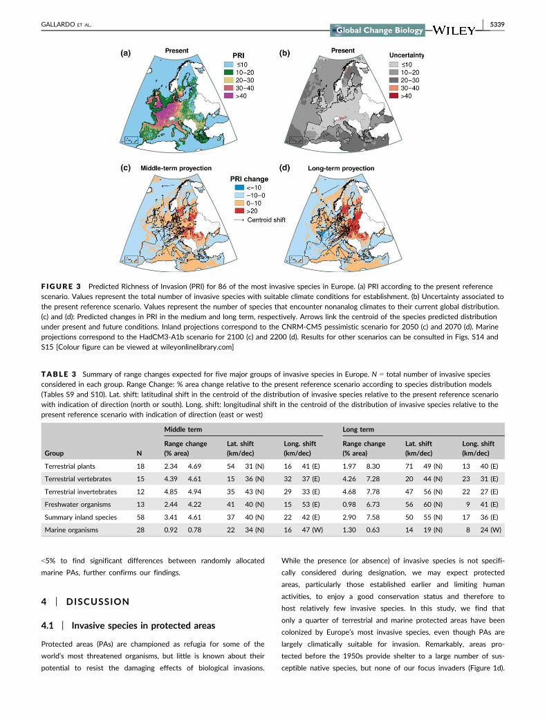
create a heat-map of Predicted Richness of Invasion (PRI, Figure 3).
Under the reference present scenario, which may represent the
potential for short-term expansion, PRI is highest in the northwest
of Europe, covering the Atlantic biogeographic region, the North &
Celtic Seas, and Bay of Biscay (Figure 3a, see Fig. S11 for the
biogeographic regions considered). The uncertainty associated with
this scenario was highest at high latitude (Artic) and altitude (Alpine)
biogeographic regions and relatively low in the rest of Europe (Fig-
ure 3b). Under future conditions, the uncertainty associated to the
TABLE 1 Summary of the area affected by 86 of the mostinvasive species in Europe. Data are provided for the EuropeanUnion (28 member states) and for the network of Protected Areas(PA), including nationally designated areas and Natura 2000 sites.Units are million hectares (Mha). Also indicated, the total number ofPAs and the % affected by any of the invaders investigated
Inland Marine Total
Total EU area 442 MHa 572 Mha 1,014 Mha
EU area invaded 159 Mha (36%) 40 Mha (7%) 199 Mha (19%)
Total PA area 88 Mha 34 Mha 122 Mha
PA area invaded 24 Mha (27%) 7 Mha (20%) 31 Mha (25%)
Total num. PAs 12,928 2,220 15,148
Num. invaded PAs 3,152 (24%) 847 (38%) 3,999 (26%)
5336 | GALLARDO ET AL.

F IGURE 1 Spatial patterns of invasive and susceptible species within protected areas (PAs) in Europe. The size of bubbles represents thenumber of invasive (a) and susceptible (b) species currently known to occur in any of the 12,928 inland and 2,220 marine PAs evaluated (totalN = 15,148). While 64% (9,749) of PAs host susceptible species, only a third (28%; 4,361) has been invaded. (c) Latitudinal distribution ofinvasive and susceptible species (spatially corrected Pearson, r = �.12, p < .001). The solid line and shaded area represent the mean andstandard error of the number of species, fitted by LOESS with a 0.1 span. (d) Number of susceptible and invasive species per unit area coveredby PAs designated in the last hundred years. Bars represent the cumulative area protected over time. See Fig. S1 for a map of protected areas(only those >1 km2 considered here) [Colour figure can be viewed at wileyonlinelibrary.com]
TABLE 2 Results from a Zero-Inflated Negative Binomial model (ZINB) between the Richness of Invasive Species (RIS) and the year ofdesignation, area, accessibility, and type (nationally designated areas or RN 2000) of protected areas. N = 15,142 marine and terrestrialprotected areas considered
Factors Estimate SE CI (5/95%) z-value p-value
Count model coefficients (Poisson with log link)
Intercept 0.57 0.04 0.50/0.68 12.57 ***
Year �0.25 2.21 �4.59/4.08 �0.11 n.s.
Year2 �19.12 2.65 �24.34/�13.93 �7.21 ***
Area 11.42 0.56 10.32/12.51 20.38 ***
Area2 �4.93 0.61 �6.13/�3.73 �8.04 ***
Accessibility �41.36 5.90 �52.93/�29.79 �7.01 ***
Accessibility2 19.54 5.93 7.92/31.17 3.29 ***
Type: RN 2000 0.26 0.04 0.17/0.35 5.78 ***
Zero-inflation model coefficients (binomial with logit link)
Intercept 1.10 0.10 0.90/1.30 10.92 ***
Year 31.75 4.44 23.04/40.45 7.15 ***
Year2 41.71 5.29 31.34/52.08 7.88 ***
Area �384.11 19.13 �421.62/�346.60 �20.07 ***
Area2 171.69 9.99 152.10/191.29 17.17 ***
Accessibility 20.88 8.83 �3.57/38.19 0.02 *
Accessibility2 �9.36 8.01 �25.07/6.33 �1.17 n.s.
Type: RN 2000 �0.70 0.09 �0.89/�0.51 �7.20 ***
Log-likelihood: 1.62 x 10⁴ on 16 DF
***significant at p < .001; *significant at p < .05; n.s.: not significant.
GALLARDO ET AL. | 5337

Artic and Alpine regions declines, probably because of the general
increase in temperatures anticipated for these areas (Table S11,
Fig. S12). By contrast, uncertainty increases in the Mediterranean
and Pannonian biogeographic regions, where future scenarios antici-
pate unprecedented warm and dry conditions (Gibelin & D�equ�e,
2003; Giorgi & Lionello, 2008). Uncertainty in the marine environ-
ment was highest in the Red and Mediterranean Seas and the Can-
ary Current (Table S12 and Fig. S13).
Rather than an increase in total area suitable to invaders, we
found a shift in species ranges. The core suitable distribution for
inland invasive species is predicted to shift at an average rate of 37–
50 km per decade toward the north and 17–22 km per decade
toward the east of Europe (Table 3, Figure 3c and d).
The direction and magnitude of niche shifts was highly variable
for marine invaders: those species currently distributed in the
eastern part of the Mediterranean Sea are generally predicted to
move northward and westwards (e.g., Saurida undosquamis,
Table S12). In contrast, species currently distributed in the north-
ern seas of Europe are predicted to shift further toward the
Northeast (Figure 3c and d). Species with widespread populations
in both seas showed multidirectional shifts with no clear trends
(Table S13). Consequently, average centroid shifts for marine inva-
ders at 14–22 km/decade northwards and 8–16 km/decade west-
wards are considerably slower than those predicted for inland
species (Table 3).
3.3 | Invasive species under climate change inprotected areas
The predicted richness of invasion (PRI) under the current reference
scenario is 18% lower inside inland protected areas than outside
them (Welch Two Sample t test between 5,000 random cells located
inside and outside inland PAs, t = �15.42, df = 8674, p < .001). The
null model assuming random distribution of PAs across Europe fur-
ther allowed us to reject the null hypothesis of equal PRI inside and
outside inland PAs (<5% probability of significant difference at ran-
dom). This is likely related to the 67% lower accessibility inside PAs
(accessibility inside vs. outside inland PAs, Welch Two Sample t test:
t = 19.6, df = 8674, p < .001). Under future climate change scenar-
ios, PRI is predicted to remain 19%–22% lower inside inland PAs
than outside them.
In the marine environment, PRI under the current reference
scenario is 11% lower inside marine PAs than outside them
(Welch Two Sample t test between 1,000 random cells located
inside and outside marine PAs, t = �4.44, df = 1404, p < .001).
This difference is maintained under future scenarios (8%–11%
lower PRI inside PAs than outside them depending on scenario).
This may again be related to the proximity of marine protected
areas to the coast and thus higher human accessibility (accessibil-
ity inside vs. outside marine PAs, Welch Two Sample t test:
t = 9.9, df = 1404, p < .001). The null model, showing a probability
2.00
3.00
Accessibility (travel time)
(a) (b)
(c) (d)
F IGURE 2 Response of the Richness of Invasive Species (RIS) registered in protected areas (PA) to: (a) accessibility measured as travel timeto major cities, (b) the year of designation of the PA, please note zero RIS projected for PAs designated before the 1960s, (c) the total surfaceof the PA, and (d) the type of PA (Nationally Designated Areas vs. Natura 2000 sites). The solid line and shaded area represent the mean andstandard error of the richness of species, fitted by LOESS with a 0.1 span. Statistics from a zero-inflated negative binomial model can beconsulted in Table 2
5338 | GALLARDO ET AL.
<5% to find significant differences between randomly allocated
marine PAs, further confirms our findings.
4 | DISCUSSION
4.1 | Invasive species in protected areas
Protected areas (PAs) are championed as refugia for some of the
world’s most threatened organisms, but little is known about their
potential to resist the damaging effects of biological invasions.
While the presence (or absence) of invasive species is not specifi-
cally considered during designation, we may expect protected
areas, particularly those established earlier and limiting human
activities, to enjoy a good conservation status and therefore to
host relatively few invasive species. In this study, we find that
only a quarter of terrestrial and marine protected areas have been
colonized by Europe’s most invasive species, even though PAs are
largely climatically suitable for invasion. Remarkably, areas pro-
tected before the 1950s provide shelter to a large number of sus-
ceptible native species, but none of our focus invaders (Figure 1d).
F IGURE 3 Predicted Richness of Invasion (PRI) for 86 of the most invasive species in Europe. (a) PRI according to the present referencescenario. Values represent the total number of invasive species with suitable climate conditions for establishment. (b) Uncertainty associated tothe present reference scenario. Values represent the number of species that encounter nonanalog climates to their current global distribution.(c) and (d): Predicted changes in PRI in the medium and long term, respectively. Arrows link the centroid of the species predicted distributionunder present and future conditions. Inland projections correspond to the CNRM-CM5 pessimistic scenario for 2050 (c) and 2070 (d). Marineprojections correspond to the HadCM3-A1b scenario for 2100 (c) and 2200 (d). Results for other scenarios can be consulted in Figs. S14 andS15 [Colour figure can be viewed at wileyonlinelibrary.com]
TABLE 3 Summary of range changes expected for five major groups of invasive species in Europe. N = total number of invasive speciesconsidered in each group. Range Change: % area change relative to the present reference scenario according to species distribution models(Tables S9 and S10). Lat. shift: latitudinal shift in the centroid of the distribution of invasive species relative to the present reference scenariowith indication of direction (north or south). Long. shift: longitudinal shift in the centroid of the distribution of invasive species relative to thepresent reference scenario with indication of direction (east or west)
Middle term Long term
Group NRange change(% area)
Lat. shift(km/dec)
Long. shift(km/dec)
Range change(% area)
Lat. shift(km/dec)
Long. shift(km/dec)
Terrestrial plants 18 2.34 � 4.69 54 � 31 (N) 16 � 41 (E) 1.97 � 8.30 71 � 49 (N) 13 � 40 (E)
Terrestrial vertebrates 15 4.39 � 4.61 15 � 36 (N) 32 � 37 (E) 4.26 � 7.28 20 � 44 (N) 23 � 31 (E)
Terrestrial invertebrates 12 4.85 � 4.94 35 � 43 (N) 29 � 33 (E) 4.68 � 7.78 47 � 56 (N) 22 � 27 (E)
Freshwater organisms 13 2.44 � 4.22 41 � 40 (N) 15 � 53 (E) 0.98 � 6.73 56 � 60 (N) 9 � 41 (E)
Summary inland species 58 3.41 � 4.61 37 � 40 (N) 22 � 42 (E) 2.90 � 7.58 50 � 55 (N) 17 � 36 (E)
Marine organisms 28 0.92 � 0.78 22 � 34 (N) 16 � 47 (W) 1.30 � 0.63 14 � 19 (N) 8 � 24 (W)
GALLARDO ET AL. | 5339

What is more, hotspots of biological invasions and their most sus-
ceptible native species do not match at large scales (Figure 1c).
This mismatch agrees with Bellard, Genovesi, and Jeschke (2016),
showing how the worldwide distribution of species threatened by
biological invasions, and concentrated in the Americas, India,
Indonesia, Australia, and New Zealand, overlap only partially with
hotspots of invasion in Europe, Asia, and South America. Our
results can be explained by the low human accessibility of pro-
tected areas generally, and especially those protected in the early
20th century, often located in remote and pristine regions with
very low human density and limited economic value, usually high
mountains (Gaston et al., 2008). In addition, active management of
human impacts may also explain the low number of invasive spe-
cies found in nationally designated areas that are usually con-
trolled to ensure protection of the conservation values.
In contrast, the richness of invasive species increases rapidly in
PAs designated after the 1970s (Figure 1), which may reflect the
intense proliferation of invaders in Europe registered after a five-
fold increase in global trade over the last decades (Butchart et al.,
2010; Seebens et al., 2015). Concurrently, the number and size of
European PAs has experienced an exponential growth since the
1990s (Gruber et al., 2012), explaining the increase in both sus-
ceptible and invasive species found in PAs by a simple species/
area relationship (i.e., the larger total area protected, the more
probabilities to find both native and invasive species). The larger
number of invasive species registered in Natura2000 in compar-
ison to nationally designated areas can be related to their recent
designation, large area, high human accessibility, and permissive
management (Figure 2). Actually, while Natura 2000 includes
strictly protected nature reserves, low-intensity human activities
are allowed on most of the land, which can reasonably explain
their higher levels of invasion.
Altogether, these observations suggest that the early establish-
ment and restriction of human activities within PAs provide an effec-
tive barrier against biological invasions (Py�sek et al., 2003). The
difficulty for invasive species to colonize protected areas can be
attributed to a combination of factors including natural biotic resis-
tance of taxonomically rich resident communities promoted by the
relatively pristine conditions of protected areas (Foxcroft et al.,
2011), restriction of human activities and intensive conservation
management (Py�sek et al., 2003), low human accessibility and thus
low propagule pressure, and the time lag between a species’ initial
colonization of disturbed areas and its wider expansion toward more
natural—and typically more diverse—landscapes (Gonz�alez-Moreno,
Diez, Richardson, & Vil�a, 2015). In this sense, Hiley, Bradbury, and
Thomas (2014) cautioned that while PAs do not facilitate the colo-
nization of invasive species at their initial stage, they are more sus-
ceptible to invasion as populations establish and spread.
Understanding the relative contribution of these factors to explain
PAs susceptibility to biological invasions is beyond the objectives of
this study, but fundamental to optimize PA’s design and manage-
ment for the conservation of native species and habitats undergoing
global changes.
4.2 | Invasive species under climate change
Predictions extracted from distribution models match the empirical
evidence that the level of invasion in the Atlantic biogeographic
region (6,600 non-native species according to Zieritz, Gallardo, &
Aldridge, 2014) is among the highest in the world. This pattern has
been attributed to several colluding factors: the presence of several
large ports such as Antwerp and Hamburg, which rank among the
top 20 ports with the highest invasion risk (Seebens, Gastner, & Bla-
sius, 2013), mild temperate conditions (B�ellard et al., 2013), high
habitat disturbance, dense human population and transportation net-
works, and high degree of economic activity (Gallardo et al., 2015).
Such concurrence of risk factors may also explain the concentration
of invasive species in protected areas around the British Channel
observed in Figure 1a. Furthermore, our results match observations
of climate-related increases in fish richness in the North Sea over
the last two decades (Hiddink & Ter Hofstede, 2008), and of the
northward expansion of invaders from the southern (Levant Sea)
toward the northern (Adriatic and Liguarian Seas) coasts registered
in the Mediterranean Sea (Bianchi & Morri, 2000).
As temperature increases across inland habitats, our models pre-
dict invasive species to shift northwards at an average pace of 37
(middle-term) to 55 (long-term) km/decade (Table 3), which is two to
nine times faster than previously predicted for native terrestrial spe-
cies (17.6 � 2.9 km/decade, Chen, Hill, Ohlem€uller, Roy, & Thomas,
2011, 6.1; � 2.4 km/decade, Parmesan & Yohe, 2003). Multidirec-
tional shifts in the marine environment—with important differences
among species currently located in the Mediterranean, the northern
Seas, or both—lead to lower average centroid shift rates of 14 (mid-
dle-term) to 22 (long-term) km/decade (Table 3). Indeed, rapid range
changes have been documented for invasive species in terrestrial
and marine environments (see examples in Hellmann et al., 2008;
Walther et al., 2009), often associated to their competitive ecological
traits (Estrada, Morales-Castilla, Caplat, & Early, 2016). However,
more research is still needed to allow direct comparison of realized
range shifts between native species and their invasive counterparts.
Not all invasive species are predicted to expand their distribution
as a response to climate change, but 33%–48% of the invasive spe-
cies are predicted to lose areas climatically suitable across Europe.
Reduced climate suitability may indeed impair the performance of
some invaders, eventually increasing their vulnerability to other fac-
tors, including management (B�ellard et al., 2013; Bezeng et al.,
2017). It is nevertheless reasonable to expect invasive species to
adapt and persist under increasing temperatures, particularly in the
case of rapidly reproducing taxa (Thomas et al., 2004). Furthermore,
global warming is facilitating the migration of new invasive species
from lower latitudes that will increase the pressure of biological
invasions in southern Europe. As way of example, the Mediterranean
Sea is currently experiencing the massive migration of Lessepsian
invaders from the Red Sea via the Suez Canal (Por, 2012), and mos-
quito-borne tropical diseases like malaria, dengue, or the West Nile
Virus are undergoing rapid expansion toward northern latitudes in
continental Europe (Lafferty, 2009).
5340 | GALLARDO ET AL.

Large and rapid distributional shifts reported in this study derive
from a wide diversity of species-specific responses, as evidenced by
the large overdispersion of range change and centroid shift metrics
reported in Table 3 (extended in Tables S9–S12). The realized shift of
each species will ultimately depend on biological characteristics of its
populations, including the interaction with other species, as well as on
how they cope with the drivers of change. In this sense, most of the
species investigated here are highly fertile and/or fecund; have a
broad diet, mobile adult, or juvenile forms; and are habitat generalists
able to persist under unfavorable conditions (DAISIE, 2009). All of
these characteristics have been linked to the extraordinary ability of
invasive species to circumvent geographic barriers profiting from the
intense transportation of people and commodities across the world
(Capinha, Essl, Seebens, Moser, & Pereira, 2015; Seebens et al., 2015),
and consequently with the potential to occupy all of their climatically
suitable habitats (Estrada et al., 2016). Nevertheless, some taxonomic
groups that are difficult to detect such as parasites, fungi and algae,
may have been underrepresented here, a pervasive taxonomic bias in
the invasive species literature. Finally, species are distressed to differ-
ent extents by nonclimatic factors (e.g., landscape structure, human-
induced disturbances, and habitat characteristics) and by multispecies
interactions, which themselves depend on a variety of environmental
drivers. However, these factors are more likely to affect local and
regional distributions of species rather than the continental patterns
described here (Pearson & Dawson, 2003).
4.3 | Invasive species under climate change inprotected areas
Biological invasions constitute one of the most important threats
associated with species extinction (Bellard et al., 2016), both via
direct impacts on resident species and through synergies with other
extinction drivers (Walther et al., 2009). Here, we show that range
expansion is likely to prevail over contraction for many environments,
taxonomic groups, life-history strategies, and future scenarios. Our
results suggest that climate change could not only drive protected
species out of the boundaries of static protected areas (Ara�ujo, Ala-
gador, Cabeza, Nogu�es-Bravo, & Thuiller, 2011) but also facilitate the
colonization by invasive species (Py�sek et al., 2013), thereby increas-
ing the pressure posed upon native populations. As temperature
increases, species are largely predicted to shift northwards at a much
faster pace than previously envisioned for native species (Chen et al.,
2011; Parmesan & Yohe, 2003), which may seriously compromise the
conservation of biodiversity and ecosystem services. Considering the
successful history of invasion of the species investigated, their biolog-
ical traits and human-related dispersal, our projections indicate a wor-
rying increase in invasion intensity in Europe. Fortunately, this trend
is somewhat tempered by our analyses that reveal that the observed
and expected intensity of invasion are less pronounced within the
network of inland and marine protected areas. While the static nature
of PAs has been largely questioned (Hannah et al., 2007), studies
have demonstrated their essential role to protect species shifting their
ranges as a response to climate change (Ara�ujo, Cabeza, Thuiller,
Hannah, & Williams, 2004) and to facilitate the adaptation of resident
communities (Ga€uz�ere et al., 2016; Johnston et al., 2013; Thomas
et al., 2012). We conclude that protected areas have the potential to
provide strategic refugia to native species from the expansion of inva-
sive species spreading under climate change. Understanding the
mechanisms underlying such potential is crucial in facilitating the
identification of areas of future conservation concern as well as
opportunities for restoration.
ACKNOWLEDGEMENTS
The data reported in this article are tabulated in the Supplemen-
tary Materials. Research was supported by the Spanish Program
of R+D+I (JCI-2012-11908, SEV-2012-0262, CGL2014-55145-R,
CGL2015-65346R, and CGL2009-7515), Iberdrola Foundation (2014
Energy and Environment Scholarships), the Czech Science Founda-
tion (project no. 14-36079G, Centre of Excellence PLADIAS), The
Czech Academy of Sciences (project RVO 67985939), and the Euro-
pean Community’s Seventh Framework Programme FP7/2007-2013
(grant agreement no. 281422, TEEMBIO). BG designed the research;
DCA helped to develop the focus; MP, BG, and PG-M conducted
analyses; BG, DCA, JP, MV, WT, PP, and CY contributed to writing
the manuscript. The authors thank M.P. Larrea who provided exten-
sive GIS support. This research contributes to COST Action Alien
Challenge (TD1209).
REFERENCES
Allouche, O., Tsoar, A., & Kadmon, R. (2006). Assessing the accuracy of
species distribution models: Prevalence, kappa and the true skill
statistic (TSS). Journal of Applied Ecology, 43, 1223–1232.
Ara�ujo, M. B., Alagador, D., Cabeza, M., Nogu�es-Bravo, D., & Thuiller, W.
(2011). Climate change threatens European conservation areas. Ecol-
ogy Letters, 14, 484–492.
Ara�ujo, M. B., Cabeza, M., Thuiller, W., Hannah, L., & Williams, P. H.
(2004). Would climate change drive species out of reserves? An
assessment of existing reserve-selection methods. Global Change Biol-
ogy, 10, 1618–1626.
Ara�ujo, M. B., & Guisan, A. (2006). Five (or so) challenges for species dis-
tribution modelling. Journal of Biogeography, 33, 1677–1688.
Ara�ujo, M. B., & New, M. (2007). Ensemble forecasting of species distri-
butions. Trends in Ecology & Evolution, 22, 42–47.
Barbet-Massin, M., Jiguet, F., Albert, C. H., & Thuiller, W. (2012). Select-
ing pseudo-absences for species distribution models: How, where
and how many? Methods in Ecology and Evolution, 3, 327–338.
Bellard, C., Bertelsmeier, C., Leadley, P., Thuiller, W., & Courchamp, F.
(2012). Impacts of climate change on the future of biodiversity. Ecol-
ogy Letters, 15, 365–377.
Bellard, C., Cassey, P., & Blackburn, T. M. (2016). Alien species as a driver
of recent extinctions. Biology Letters, 12, 20150623.
Bellard, C., Genovesi, P., & Jeschke, J. M. (2016). Global patterns in
threats to vertebrates by biological invasions. Proceedings of the Royal
Society of London B: Biological Sciences, 283, 20152454.
B�ellard, C., Thuiller, W., Leroy, B., Genovesi, P., Bakkenes, M., & Cour-
champ, F. (2013). Will climate change promote future invasions? Glo-
bal Change Biology, 19, 3740–3748.
Bezeng, B. S., Morales-Castilla, I., Van Der Bank, M., Yessoufou, K., Daru,
B. H., & Davies, T. J. (2017). Climate change may reduce the spread
of non-native species. Ecosphere, 8, e01694.
GALLARDO ET AL. | 5341
Bianchi, C. N., & Morri, C. (2000). Marine biodiversity of the Mediter-
ranean Sea: Situation, problems and prospects for future research.
Marine Pollution Bulletin, 40, 367–376.
Bivand, R., & Rundel, C. (2016). rgeos: Interface to geometry engine-open
source (GEOS). R package version 0.3-19.
Butchart, S. H. M., Walpole, M., Collen, B., vanStrien, A., Scharlemann, J.
P., Almond, R. E. . . . Watson, R. (2010). Global biodiversity: Indicators
of recent declines. Science, 328, 1164–1168.
Capinha, C., Essl, F., Seebens, H., Moser, D., & Pereira, H. M. (2015). The
dispersal of alien species redefines biogeography in the Anthro-
pocene. Science, 348, 1248–1251.
Chen, I.-C., Hill, J. K., Ohlem€uller, R., Roy, D. B., & Thomas, C. D. (2011).
Rapid range shifts of species associated with high levels of climate
warming. Science, 333, 1024–1026.
Core Team, R. (2015). R: A Language and Environment for Statistical Com-
puting. Vienna: Austria, R Foundation for Statistical Computing.
Courchamp, F., Hoffmann, B. D., Russell, J. C., Leclerc, C., & Bellard, C.
(2014). Climate change, sea-level rise, and conservation: Keeping
island biodiversity afloat. Trends in Ecology & Evolution, 29, 127–130.
Daisie. (2009). Handbook of alien species in Europe. Knoxville, TN, USA:
Springer.
Davidson, O., & Metz, B. (2000). IPCC special report—emissions scenar-
ios: Summary for policy makers. pp Page, Intergovernmental Panel on
Climate Change.
Dutilleul, P., Clifford, P., Richardson, S., & Hemon, D. (1993). Modifying
the t test for assessing the correlation between two spatial pro-
cesses. Biometrics, 49, 305–314.
Elith, J., Kearney, M., & Phillips, S. (2010). The art of modelling range-
shifting species. Methods in Ecology and Evolution, 1, 330–342.
Estrada, A., Morales-Castilla, I., Caplat, P., & Early, R. (2016). Usefulness
of species traits in predicting range shifts. Trends in Ecology & Evolu-
tion, 31, 190–203.
Fourcade, Y., Engler, J. O., R€odder, D., & Secondi, J. (2014). Mapping spe-
cies distributions with MAXENT using a geographically biased sample
of presence data: A performance assessment of methods for correct-
ing sampling bias. PLoS ONE, 9, e97122.
Foxcroft, L. C., Jaro�s�ık, V., Py�sek, P., Richardson, D. M., & Rouget, M.
(2011). Protected-area boundaries as filters of plant invasions. Con-
servation Biology, 25, 400–405.
Gallardo, B., Zieritz, A., & Aldridge, D. C. (2015). The importance of the
human footprint in shaping the global distribution of terrestrial, fresh-
water and marine invaders. PLoS ONE, 10, e0125801.
Garc�ıa-Rosell�o, E., Guisande, C., Manjarr�es-Hern�andez, A., Gonz�alez-
Dacosta, J., Heine, J., Pelayo-Villamil, P., . . . Lobo, J. M. (2015). Can we
derive macroecological patterns from primary Global Biodiversity Infor-
mation Facility data? Global Ecology and Biogeography, 24, 335–347.
Gaston, K. J., Jackson, S. F., Nagy, A., Cant�u-Salazar, L., & Johnson, M.
(2008). Protected areas in Europe. Annals of the New York Academy
of Sciences, 1134, 97–119.
Ga€uz�ere, P., Jiguet, F., & Devictor, V. (2016). Can protected areas miti-
gate the impacts of climate change on bird’s species and communi-
ties? Diversity and Distributions, 22, 625–637.
Gibelin, A.-L., & D�equ�e, M. (2003). Anthropogenic climate change over
the Mediterranean region simulated by a global variable resolution
model. Climate Dynamics, 20, 327–339.
Giorgi, F., & Lionello, P. (2008). Climate change projections for the
Mediterranean region. Global and Planetary Change, 63, 90–104.
Gonz�alez-Moreno, P., Diez, J. M., Richardson, D. M., & Vil�a, M. (2015).
Beyond climate: Disturbance niche shifts in invasive species. Global
Ecology and Biogeography, 24, 360–370.
Gordon, C. C., Cooper, C. A., Senior, C. A., Hewitt, H. T., Gregory, J. M.,
Johns, T. C., . . . Wood, R. A. (2000). The simulation of SST, sea ice
extents and ocean heat transports in a version of the Hadley Centre
coupled model without flux adjustments. Climate Dynamics, 16, 147–
168.
Graham, C. H., Elith, J., Hijmans, R. J., Guisan, A., Townsend Peterson, A.,
& Loiselle, B. A.; The Nceas Predicting Species Distributions Working
G. (2008). The influence of spatial errors in species occurrence data
used in distribution models. Journal of Applied Ecology, 45, 239–247.
Gruber, B., Evans, D., Henle, K., Bauch, B., Schmeller, D. S., Dziock, F., . . .
Dormann, C. F. (2012). “Mind the gap!”: How well does Natura 2000
cover species of European interest? Nature Conservation, 3, 45.
Hannah, L., Midgley, G., Andelman, S., Ara�ujo, M., Hughes, G., Martinez-
Meyer, E., . . . Williams, P. (2007). Protected area needs in a changing
climate. Frontiers in Ecology and the Environment, 5, 131–138.
Hellmann, J. J., Byers, J. E., Bierwagen, B. G., & Dukes, J. S. (2008). Five
potential consequences of climate change for invasive species. Con-
servation Biology, 22, 534–543.
Hiddink, J. G., & Ter Hofstede, R. (2008). Climate induced increases in
species richness of marine fishes. Global Change Biology, 14, 453–
460.
Hijmans, R. J., Cameron, S. E., Parra, J. L., Jones, P. G., & Jarvis, A.
(2005). Very high resolution interpolated climate surfaces for global
land areas. International Journal of Climatology, 25, 1965–1978.
Hijmans, R. J., Phillips, S., Leathwick, J., & Elith, J. (2013). dismo: Species
distribution modeling. R package version 0.8-17.
Hiley, J. R., Bradbury, R. B., & Thomas, C. D. (2014). Introduced and nat-
ural colonists show contrasting patterns of protected area association
in UK wetlands. Diversity and Distributions, 20, 943–951.
Hulme, P. E., Pysek, P., Nentwig, W., & Vila, M. (2009). Will threat of bio-
logical invasions unite the European Union? Science, 324, 40–41.
Jackman, S. (2008). pscl: classes and methods for R developed in the
political science computational laboratory. R package version 0.95.
Jimenez-Valverde, A., & Lobo, J. M. (2007). Threshold criteria for conver-
sion of probability of species presence to either-or presence-absence.
Acta Oecologica-International Journal of Ecology, 31, 361–369.
Johnston, A., Ausden, M., Dodd, A. M., Bradbury, R. B., Chamberlain, D.
E., Jiguet, F., . . . Pearce-Higgins, J. W. (2013). Observed and pre-
dicted effects of climate change on species abundance in protected
areas. Nature Climate Change, 3, 1055–1061.
Lafferty, K. D. (2009). The ecology of climate change and infectious dis-
eases. Ecology, 90, 888–900.
Nelson, A. (2008). Travel time to major cities: A global map of accessibil-
ity. Global Environment Monitoring Unit - Joint Research Centre of
the European Commission. Retrieved from http://forobs.jrc.ec.eu
ropa.eu/products/gam/
Osorio, F., Vallejos, R., & Cuevas, F. (2012). SpatialPack: package for anal-
ysis of spatial data. R package version 0.2.
Parmesan, C., & Yohe, G. (2003). A globally coherent fingerprint of cli-
mate change impacts across natural systems. Nature, 421, 37–42.
Pearson, R. G., & Dawson, T. P. (2003). Predicting the impacts of climate
change on the distribution of species: Are bioclimate envelope mod-
els useful? Global Ecology and Biogeography, 12, 361–371.
Por, F. D. (2012). Lessepsian migration: The influx of Red Sea biota into the
Mediterranean by way of the Suez Canal. Berlin: Springer Science &
Business Media.
Py�sek, P., Genovesi, P., Pergl, J., Monaco, A., & Wild, J. (2013). Plant
invasions of protected areas in Europe: An old continent facing new
problems. In L. C. Foxcroft (Ed.), Invading Nature (pp. 209–240). Dor-
drecht: Springer.
Py�sek, P., Jaro�s�ık, V., & Ku�cera, T. (2003). Inclusion of native and alien
species in temperate nature reserves: An historical study from Cen-
tral Europe. Conservation Biology, 17, 1414–1424.
Rodrigues, A. S. L., Akcakaya, H. R., Andelman, S. J., Bakarr, M. I., Boitani,
L., Brooks, T. M., . . . Yan, X. (2004). Global gap analysis: Priority
regions for expanding the global protected-area network. BioScience,
54, 1092–1100.
Seebens, H., Blackburn, T. M., Dyer, E. E., Genovesi, P., Hulme, P. E.,
Jeschke, J. M., . . . Essl, F. (2017). No saturation in the accumulation
of alien species worldwide. Nature Communications, 8, 14435.
5342 | GALLARDO ET AL.

Seebens, H., Essl, F., Dawson, W., Fuentes, N., Moser, D., Pergl, J., . . .
Blasius, B. (2015). Global trade will accelerate plant invasions in
emerging economies under climate change. Global Change Biology, 21,
4128–4140.
Seebens, H., Gastner, M. T., & Blasius, B. (2013). The risk of marine
bioinvasion caused by global shipping. Ecology Letters, 16, 782–790.
Thomas, C. D., Cameron, A., Green, R. E., Bakkenes, M., Beaumont, L. J.,
Collingham, Y. C., . . . Williams, S. E. (2004). Extinction risk from cli-
mate change. Nature, 427, 145–148.
Thomas, C. D., Gillingham, P. K., Bradbury, R. B., Roy, D. B., Anderson, B.
J., Baxter, J. M., . . . Hill, J. K. (2012). Protected areas facilitate spe-
cies’ range expansions. Proceedings of the National Academy of
Sciences of the United States of America, 109, 14063–14068.
Thuiller, W. (2003). BIOMOD - optimizing predictions of species distribu-
tions and projecting potential future shifts under global change. Glo-
bal Change Biology, 9, 1353–1362.
Thuiller, W., Georges, D., & Engler, R. (2014). biomod2: Ensemble plat-
form for species distribution modeling. R package version 3.1-64.
Tyberghein, L., Verbruggen, H., Pauly, K., Troupin, C., Mineur, F., & De
Clerck, O. (2012). Bio-ORACLE: A global environmental dataset for
marine species distribution modelling. Global Ecology and Biogeogra-
phy, 21, 272–281.
Urban, M. C. (2015). Accelerating extinction risk from climate change.
Science, 348, 571–573.
Vil�a, M., Basnou, C., Gollasch, S., Josefsson, M., Pergl, J., & Scalera, R.
(2009). One hundred of the most invasive alien species in Europe. In
J. A. Drake (Ed.), Handbook of alien species in Europe (pp. 265–268).
Heidelberg: Springer.
Walther, G.-R., Roques, A., Hulme, P. E., Sykes, M. T., Pysek, P., K€uhn, I.,
. . . Settele, J. (2009). Alien species in a warmer world: Risks and
opportunities. Trends in Ecology & Evolution, 24, 686–693.
Wickham, H. (2016). ggplot2: Elegant graphics for data analysis. New York:
Springer.
Wisz, M. S., Hijmans, R. J., Li, J., Peterson, A. T., Graham, C. H., & Guisan,
A.; Group NPSDW. (2008). Effects of sample size on the performance
of species distribution models. Diversity and Distributions, 14, 763–
773.
Zieritz, A., Gallardo, B., & Aldridge, D. C. (2014). Registry of non-native
species in the Two Seas region countries (Great Britain, France, Bel-
gium and the Netherlands). Neobiota, 23, 65–80.
SUPPORTING INFORMATION
Additional Supporting Information may be found online in the sup-
porting information tab for this article.
How to cite this article: Gallardo B, Aldridge DC, Gonz�alez-
Moreno P, et al. Protected areas offer refuge from invasive
species spreading under climate change. Glob Change Biol.
2017;23:5331–5343. https://doi.org/10.1111/gcb.13798
GALLARDO ET AL. | 5343
Related Documents