Habitat International ] (]]]]) ]]]–]]] Prospects for historic neighborhoods in atypical Islamic cities: the view from Amman, Jordan Nabil Abu-Dayyeh Department of Architecture, Faculty of Engineering and Technology, University of Jordan, Amman, Jordan Abstract What is the function and future prospect for older and more historic neighborhoods in an atypical Islamic city? This study case from Amman, Jordan, identifies three main factors that have circumscribed the neighborhood’s urban development: changes to landuse, rent-control bylaws, and processes of land succession. A survey of the ownership registry for 666 plots for the period 1946–2002 reveals that inheritance plays an important role in the processes of land succession. Such processes, based as they are on Islamic thinking about inheritance, are expected to be the most persistent factor affecting the future form and function of the neighborhood. The effect of such processes of land succession may be compared to the function observed elsewhere for waqf property in terms of contributing to the sustainability of traditional crafts and trades in old bazaars; in the case presented here, however, processes of land succession, are contributing to the creation of opportunities for development and redevelopment by freeing a sizeable percentage of available land, built or unbuilt, with the passing of every generation. Thus, in contrast to the often cited adverse effect such processes have in rural areas when leading to the fragmentation of agricultural farming areas, the same processes are here found to be conducive to urban regeneration and redevelopment. r 2004 Published by Elsevier Ltd. Keywords: Historic neighborhood development; Urban development; Islamic cities; Jordan ARTICLE IN PRESS www.elsevier.com/locate/habitatint 0197-3975/$ - see front matter r 2004 Published by Elsevier Ltd. doi:10.1016/j.habitatint.2004.06.003 Tel.: +962-6-535-5000x2728; fax: +962-6-535-5588. E-mail address: [email protected] (N. Abu-Dayyeh).

Welcome message from author
This document is posted to help you gain knowledge. Please leave a comment to let me know what you think about it! Share it to your friends and learn new things together.
Transcript
ARTICLE IN PRESS
Habitat International ] (]]]]) ]]]–]]]
0197-3975/$ -
doi:10.1016/j.
�Tel.: +962
E-mail add
www.elsevier.com/locate/habitatint
Prospects for historic neighborhoods in atypical Islamic cities:the view from Amman, Jordan
Nabil Abu-Dayyeh�
Department of Architecture, Faculty of Engineering and Technology, University of Jordan, Amman, Jordan
Abstract
What is the function and future prospect for older and more historic neighborhoods in an atypicalIslamic city? This study case from Amman, Jordan, identifies three main factors that have circumscribed theneighborhood’s urban development: changes to landuse, rent-control bylaws, and processes of landsuccession. A survey of the ownership registry for 666 plots for the period 1946–2002 reveals thatinheritance plays an important role in the processes of land succession. Such processes, based as they are onIslamic thinking about inheritance, are expected to be the most persistent factor affecting the future formand function of the neighborhood. The effect of such processes of land succession may be compared to thefunction observed elsewhere for waqf property in terms of contributing to the sustainability of traditionalcrafts and trades in old bazaars; in the case presented here, however, processes of land succession, arecontributing to the creation of opportunities for development and redevelopment by freeing a sizeablepercentage of available land, built or unbuilt, with the passing of every generation. Thus, in contrast to theoften cited adverse effect such processes have in rural areas when leading to the fragmentation ofagricultural farming areas, the same processes are here found to be conducive to urban regeneration andredevelopment.r 2004 Published by Elsevier Ltd.
Keywords: Historic neighborhood development; Urban development; Islamic cities; Jordan
see front matter r 2004 Published by Elsevier Ltd.
habitatint.2004.06.003
-6-535-5000x2728; fax: +962-6-535-5588.
ress: [email protected] (N. Abu-Dayyeh).

ARTICLE IN PRESS
N. Abu-Dayyeh / Habitat International ] (]]]]) ]]]–]]]2
Introduction
The intersection of issues related to land ownership and succession, zoning ordinances, rent-control bylaws, and a rising aesthetic and historical consciousness, within one of the historicalneighborhoods of Amman, is considered a unique case for understanding the main factors thatcircumscribe urban development and redevelopment at the scale of a neighborhood. In spite of theuniqueness of this case, the results shed light on possible patterns of urban development not onlyin other historic neighborhoods of the city of Amman but possibly in other Islamic cities wheresimilar land succession processes, dependent on Islamic thinking about inheritance, are applied.For some time now, processes of land succession have been recognized as a determining force in
the shaping of Arab-Islamic cities in general. The formation of the characteristic physical urbanfabric of the pre-modern Arab-Islamic city, such as can be seen by looking at the aerial photo ofthe older parts of traditional Arab-Islamic cities from Fez to Aleppo, woven, as these are, out of alarge number of miniscule residential units that have no apparent geometrical order or definition,shouldering each other in a continuous fabric without any setbacks, has been attributed, in greatmeasure, to the specificity of land succession mechanisms that are dependent on Islamic thinkingabout inheritance. According to Islamic law, all heirs are entitled to a piece of every singleinherited property, a house for example, if they so wished, even if the inheritance contains severalsimilar such houses. This had historically lead to the subdivisioning of property, even singlehouses among different heirs, and resulted in the familiar and characteristic closely-knit physicalurban fabric, which in turn had led to complex rules about right of access, privacy, noise andpollution controls, that have formed the core of much Islamic thinking about urban legislationand practice (Al-Hathloul, 1981, 1994).In rural areas, however, such processes of land succession have long been identified as having
an adverse effect leading, as they often do, to the fragmentation of agricultural farming areas intofarming areas too small to be sustainable and/or economically viable. In one documented casefrom Jordan, such processes of land succession had been shown to be operational in rural areaseven long before Land Registration became institutionalized during the Ottoman reforms in thesecond half of the nineteenth century (Wahlin, 1994), and well before land settlement operationsduring the British Mandate Period (Fischbach, 1994).No research, however, has yet been done in urban areas to determine what role these processes
might be having on the present form and future prospects of the physical urban environment inthe contemporary Arab city. Evidently, unlike their historical role where these processes hadsignificantly influenced the morphology of the physical urban fabric of the city, their role in thecontemporary city is circumscribed by the currently applicable planning ordinances which onthe whole include a limitation on minimum plot area, a matter that currently acts to prevent thecontinuous and endless subdivisioning of plots and/or buildings according to past Islamic practicewitnessed in many of the traditional Arab-Islamic cities and which had permitted the mostminiscule subdivisioning of a property if so demanded by any one of the legitimate heirs.Nevertheless, even though such processes of land succession are today circumscribed by
currently applicable planning ordinances, and as such cannot affect the same miniscule urbanfabric as historically witnessed in many Arab-Islamic cities from Fez to Aleppo, yet they seem tohave a considerable, albeit not so visible or conspicuous, effect on the availability of land, built orunbuilt, for urban redevelopment.

ARTICLE IN PRESS
N. Abu-Dayyeh / Habitat International ] (]]]]) ]]]–]]] 3
In this study case from Amman, capital of the Hashemite Kingdom of Jordan, the study of landregistry archives over a period of around 50 years for a considerable number of plots constitutingthe core of one of the older neighborhoods of Amman, revealed that processes of land successionremain an important element in the overall transformation of land ownership in theneighborhood, and, along with other factors, seem to have contributed to the overallsustainability of the neighborhood through inducing considerable periodic change in propertyownership. Moreover, by making land available at competitive prices, these land successionprocesses seem to have contributed to maintaining the competitiveness of small lower-rent-seekingtrades and professions, thus performing a function observed elsewhere for waqf1 property in termsof contributing to the sustainability of traditional crafts and trades in old bazaars, as had beenshown for the case of Yazd in Iran (Bonine, 1987), here, however, favoring lower-rent-seekingcultural and artistic establishments, and lower-waged professional occupations with an artistic orcultural inclination.
Methodology
It is fairly understandable and a matter to be expected that land would rapidly change hands atthe period of peak construction activity in any area, when land is expected to be in high demand,and thus land turnover would be accelerated. What happens, however, after the whole area hadbecome almost totally built up, is something that is open to all kinds of possibilities.In 2002 records of land ownership available from the registry of the Department of Lands and
Survey (DLS) were compiled and summarized for the 666 plots forming the study area, and forthe whole period covered by the registry extending as far back as 1946.2 The study area todayforms only part of a bigger administrative entity with the same name, Jabal Lweibdeh, a historicneighborhood of the city of Amman which according to the current subdivisions adopted by theMunicipality of Greater Amman covers an area of 181.5 hectares and has a population of around20,000 inhabitants (DoS, 2003). The research presented depends on the study of the area formingthe older part of this neighborhood, covering close to 56 hectares forming close to 30% of thewhole neighborhood.Data about construction activity was taken from the most recent General Census of Population
and Housing in Jordan, done in 1994 (DoS, 1997). The Department of Statistics (DoS) gathers theCensus data according to statistical blocks which are the department’s own units of fieldoperation, that unfortunately do not match up with the exact limits of the study area that was heredefined according to the cadastral maps and land registry archive. Therefore, data aboutconstruction activity derived, as it was, from the General Census had to be restructured andreassembled to coincide with the spatial definition of the study area. In such an operation no exactmatch is possible, so a reasonably close match was sought for and achieved.Other spatial data, however, included landuse maps obtained from the Municipality of Greater
Amman, and aerial photography for several years between 1955 and 2000 made available through
1Waqf is an Arabic word denoting Islamic religious endowments.2The Land Settlement Law was enacted in 1933 but the settlement operations began in the north of the country;
apparently they were begun in the study area only as early as 1946.

ARTICLE IN PRESS
Table 1
Plot registration history (numbers and percentages by decade)
Decade # of plots %
1940s 139 21
1950s 235 35
1960s 90 14
1970s 85 13
1980s 50 8
1990s 62 9
2000s 5 1
Total 666 100
N. Abu-Dayyeh / Habitat International ] (]]]]) ]]]–]]]4
the Royal Jordanian Geographic Center (RJGC). Additionally, a limited number of interviewswith longtime residents of the neighborhood were done on a selective basis.The first step was to check the comprehensiveness of the land registry archive. Not surprisingly,
not all records for all 666 plots were complete; a number of plots had not been registered untilvery late. The breakdown of the registration history for all plots covering the whole period from1946 to 2002 showed that about 70% of all plots (464 plots) have records earlier than 1970, andonly 10% after 1990, while the remaining plots have records dating to the 1970s and 1980samounting to 21% (Table 1). Thus the archive provided a reasonably sufficient record of landsuccession.Subsequently, changes to land ownership were compiled and organized into change periods
covering the period from 1946 to 2002, and thereby totaled seven decades, 1940s–2000s. Data forthe last decade, naturally covered only the first two years of the decade, and therefore wasinconsequential for the analysis made here. This data was later used for comparison with thepattern of construction activity throughout the whole period.Regarding construction activity, data was available for a much longer period, beginning at the
turn of the century; but, only the periods for which data about land ownership was available, wereconsidered. This made it possible to compare change patterns for land ownership to constructionactivity.Meanwhile, a base map was produced using GIS software (ArcView 3.1), whereby a recent
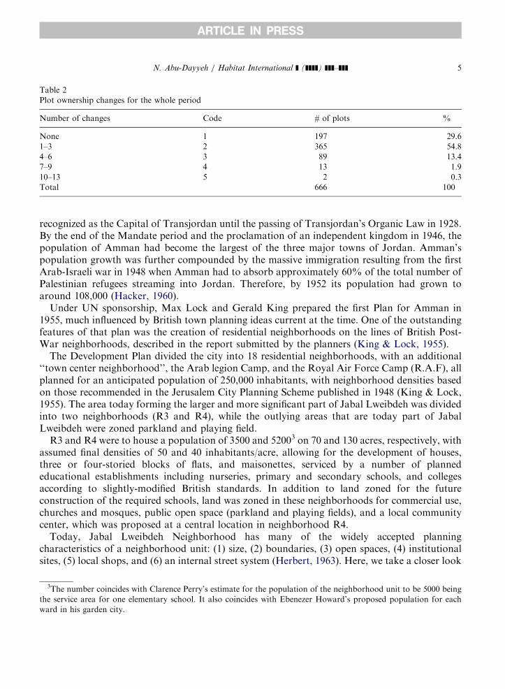
color ortho-photo was laid over and matched to the digital cadastral map of the study area. Landownership database files were then appended to this map and queries performed to deduce thespatial distribution of land ownership change over the years in question. No particular spatialpattern of any significance emerged but the process was useful for providing general data thathelped correlate land ownership change to plot area (Table 2).
The making of a capital and its neighborhoods
In 1922, the League of Nations declared the territory extending east of the Jordan Riverknown as Transjordan under the British Mandate. It had an area of 90; 000km2 and a populationof approximately 130,000–140,000 (Kliot & Soffer, 1986). Amman, however, was not officially
ARTICLE IN PRESS
Table 2
Plot ownership changes for the whole period
Number of changes Code # of plots %
None 1 197 29.6
1–3 2 365 54.8
4–6 3 89 13.4
7–9 4 13 1.9
10–13 5 2 0.3
Total 666 100
N. Abu-Dayyeh / Habitat International ] (]]]]) ]]]–]]] 5
recognized as the Capital of Transjordan until the passing of Transjordan’s Organic Law in 1928.By the end of the Mandate period and the proclamation of an independent kingdom in 1946, thepopulation of Amman had become the largest of the three major towns of Jordan. Amman’spopulation growth was further compounded by the massive immigration resulting from the firstArab-Israeli war in 1948 when Amman had to absorb approximately 60% of the total number ofPalestinian refugees streaming into Jordan. Therefore, by 1952 its population had grown toaround 108,000 (Hacker, 1960).Under UN sponsorship, Max Lock and Gerald King prepared the first Plan for Amman in
1955, much influenced by British town planning ideas current at the time. One of the outstandingfeatures of that plan was the creation of residential neighborhoods on the lines of British Post-War neighborhoods, described in the report submitted by the planners (King & Lock, 1955).The Development Plan divided the city into 18 residential neighborhoods, with an additional
‘‘town center neighborhood’’, the Arab legion Camp, and the Royal Air Force Camp (R.A.F), allplanned for an anticipated population of 250,000 inhabitants, with neighborhood densities basedon those recommended in the Jerusalem City Planning Scheme published in 1948 (King & Lock,1955). The area today forming the larger and more significant part of Jabal Lweibdeh was dividedinto two neighborhoods (R3 and R4), while the outlying areas that are today part of JabalLweibdeh were zoned parkland and playing field.R3 and R4 were to house a population of 3500 and 52003 on 70 and 130 acres, respectively, with
assumed final densities of 50 and 40 inhabitants/acre, allowing for the development of houses,three or four-storied blocks of flats, and maisonettes, serviced by a number of plannededucational establishments including nurseries, primary and secondary schools, and collegesaccording to slightly-modified British standards. In addition to land zoned for the futureconstruction of the required schools, land was zoned in these neighborhoods for commercial use,churches and mosques, public open space (parkland and playing fields), and a local communitycenter, which was proposed at a central location in neighborhood R4.Today, Jabal Lweibdeh Neighborhood has many of the widely accepted planning
characteristics of a neighborhood unit: (1) size, (2) boundaries, (3) open spaces, (4) institutionalsites, (5) local shops, and (6) an internal street system (Herbert, 1963). Here, we take a closer look
3The number coincides with Clarence Perry’s estimate for the population of the neighborhood unit to be 5000 being
the service area for one elementary school. It also coincides with Ebenezer Howard’s proposed population for each
ward in his garden city.
ARTICLE IN PRESS
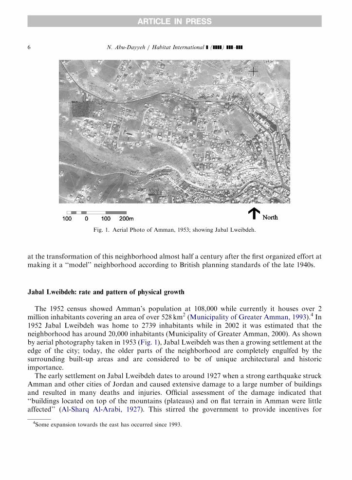
Fig. 1. Aerial Photo of Amman, 1953; showing Jabal Lweibdeh.
N. Abu-Dayyeh / Habitat International ] (]]]]) ]]]–]]]6
at the transformation of this neighborhood almost half a century after the first organized effort atmaking it a ‘‘model’’ neighborhood according to British planning standards of the late 1940s.
Jabal Lweibdeh: rate and pattern of physical growth
The 1952 census showed Amman’s population at 108,000 while currently it houses over 2million inhabitants covering an area of over 528km2 (Municipality of Greater Amman, 1993).4 In1952 Jabal Lweibdeh was home to 2739 inhabitants while in 2002 it was estimated that theneighborhood has around 20,000 inhabitants (Municipality of Greater Amman, 2000). As shownby aerial photography taken in 1953 (Fig. 1), Jabal Lweibdeh was then a growing settlement at theedge of the city; today, the older parts of the neighborhood are completely engulfed by thesurrounding built-up areas and are considered to be of unique architectural and historicimportance.The early settlement on Jabal Lweibdeh dates to around 1927 when a strong earthquake struck
Amman and other cities of Jordan and caused extensive damage to a large number of buildingsand resulted in many deaths and injuries. Official assessment of the damage indicated that‘‘buildings located on top of the mountains (plateaus) and on flat terrain in Amman were littleaffected’’ (Al-Sharq Al-Arabi, 1927). This stirred the government to provide incentives for
4Some expansion towards the east has occurred since 1993.
ARTICLE IN PRESS
N. Abu-Dayyeh / Habitat International ] (]]]]) ]]]–]]] 7
residents to build out and away from the crowded center lying as it was in the valleys and on theslopes of the surrounding plateaus. One incentive was the provision of salary advances togovernment employees equivalent to three months salary if they would build new homes out andaway from the crowded center (Ghanma, 2002); another was the construction of new waterreservoirs on high ground to serve the outlaying areas, one in Jabal Lweibdeh and two in JabalAmman (Al-Musa, 1988).Many government employees took advantage of these incentives, bought land and began
building new homes on the relatively flat edges of the plateaus surrounding the city center butwithin the closest distance from the city center below. Several factors favored the plateaus of JabalLweibdeh and Jabal Amman: ease of climb, better prospects and security. The latter wasparticularly important in view of the fact that until late into the 1920s there were still recurrentWahhabi incursions into the southern and eastern outskirts of the city (Abu Nowar, 2000); thusthe plateaus of Jabal Lweibdeh and Jabal Amman, lying away from the city’s eastern andsouthern access routes, were less threatened by these incursions, and therefore enjoyed bettersecurity.Throughout the 1930s and 1940s Amman rapidly attracted people from other towns and
villages of Jordan, and in 1948 it had to absorb a large number of Palestinian refugees. Until mid-or late 1950s an estimated minimum of 600 were living in tents and huts on the edge of JabalLweibdeh near the steep southern slopes, soon to be evacuated to the new United Nations Reliefand Works Agency (UNRWA) camp set up at the southern edge of the city (Hacker, 1960).5
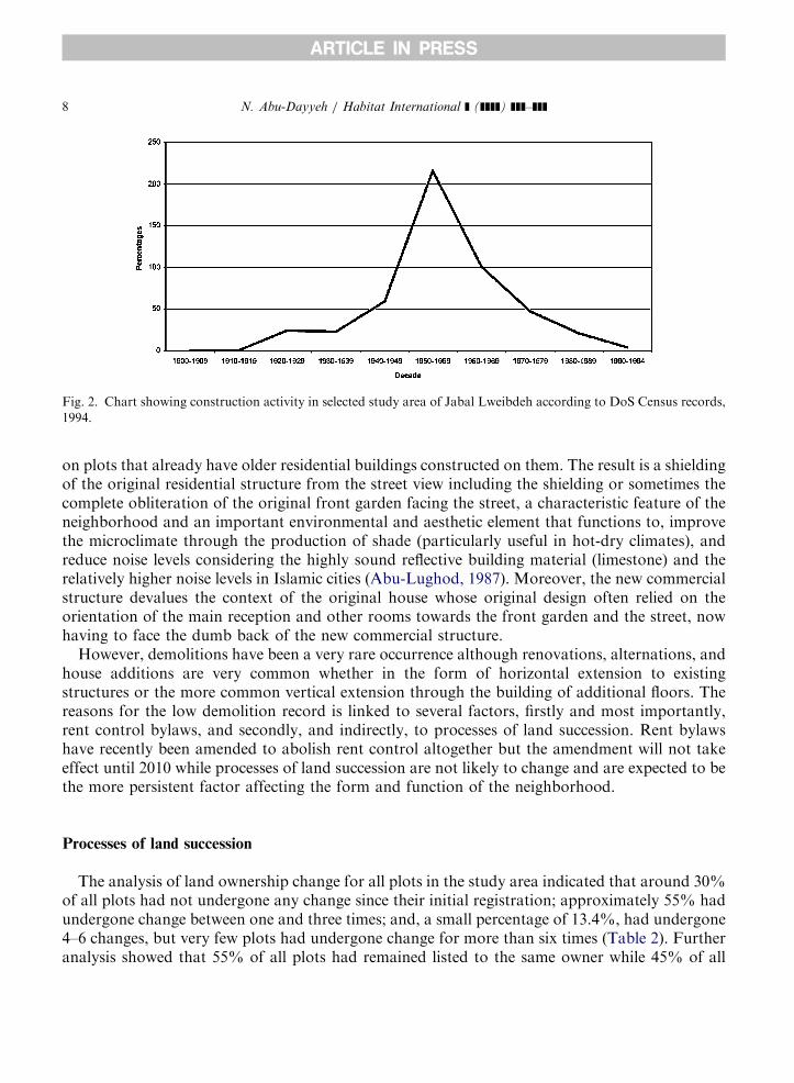
However, conditions at the higher plateau areas of the neighborhood were remarkably different.By late 1950s Jabal Lweibdeh and Jabal Amman had become the most fashionable residentialareas of the city, described by one British observer as places where ‘‘Long and shiny cars inscarlet, turquoise or tan, flash round the hairpin bends, past the ‘Pasha’s Palaces’’’ (Hacker, 1960,p. 43). That period was the peak decade for construction activity in Jabal Lweibdeh. In theimmediate study area that concerns the research presented here, around 37% of all buildings inthat area were constructed in the 1950s; and, by the end of the 1960s around 73% of all buildingstoday standing in that area of Jabal Lweibdeh, had been constructed (Fig. 2).By the year 2000 almost the whole study area had been built up, with only 72 plots vacant,
making for 11% of all plots in the area. The built-up area totaled 25 hectares making thepercentage of built-up to unbuilt area 44.7%, a number that is close to the official allowablepercentage according to the current zoning regulations of that area, being on the whole mostlyresidential Type-C which allows for a maximum percentage of 52% for the built up area withineach plot.6
Although most of the area has been zoned for residential use, however, in the course of theyears some areas had become zoned for commercial use thereby promoting certain commercialactivities but adversely affecting the overall quality of the built environment. Along several mainstreets within the neighborhood landuse had been changed from residential to commercial use.According to planning bylaws this change permits the construction of buildings along the frontboundary of the plot without the need for a front setback as in the case of residential landuse.Such change from residential to commercial use often results in the construction of new buildings
5Not all refugees moved to the new UNRWA camp; many settled permanently in Jabal Lweibdeh and elsewhere.6Built-up area is equivalent to the footprint of the building not to the total area of the building.
ARTICLE IN PRESS
Fig. 2. Chart showing construction activity in selected study area of Jabal Lweibdeh according to DoS Census records,
1994.
N. Abu-Dayyeh / Habitat International ] (]]]]) ]]]–]]]8
on plots that already have older residential buildings constructed on them. The result is a shieldingof the original residential structure from the street view including the shielding or sometimes thecomplete obliteration of the original front garden facing the street, a characteristic feature of theneighborhood and an important environmental and aesthetic element that functions to, improvethe microclimate through the production of shade (particularly useful in hot-dry climates), andreduce noise levels considering the highly sound reflective building material (limestone) and therelatively higher noise levels in Islamic cities (Abu-Lughod, 1987). Moreover, the new commercialstructure devalues the context of the original house whose original design often relied on theorientation of the main reception and other rooms towards the front garden and the street, nowhaving to face the dumb back of the new commercial structure.However, demolitions have been a very rare occurrence although renovations, alternations, and
house additions are very common whether in the form of horizontal extension to existingstructures or the more common vertical extension through the building of additional floors. Thereasons for the low demolition record is linked to several factors, firstly and most importantly,rent control bylaws, and secondly, and indirectly, to processes of land succession. Rent bylawshave recently been amended to abolish rent control altogether but the amendment will not takeeffect until 2010 while processes of land succession are not likely to change and are expected to bethe more persistent factor affecting the form and function of the neighborhood.
Processes of land succession
The analysis of land ownership change for all plots in the study area indicated that around 30%of all plots had not undergone any change since their initial registration; approximately 55% hadundergone change between one and three times; and, a small percentage of 13.4%, had undergone4–6 changes, but very few plots had undergone change for more than six times (Table 2). Furtheranalysis showed that 55% of all plots had remained listed to the same owner while 45% of all
ARTICLE IN PRESS
Table 3
Summary of plot ownership change according to identity of plot owner
Type of change Code # of plots %
Same family 1 366 55.0
Different family 2 247 37.1
NGO 3 4 0.6
Municipality of greater Amman 4 19 2.9
Company 5 6 0.9
Waqf 6 11 1.7
Bank 7 4 0.6
Government 8 6 0.9
Embassy 9 3 0.5
Total 666 100
Same 1 366 55
Summary of different 2–11 300 45
N. Abu-Dayyeh / Habitat International ] (]]]]) ]]]–]]] 9
plots had undergone a change in ownership: 37% to a different family, and the remainder in verysmall percentages to NGO, Municipality of Greater Amman, company, waqf, bank, government,or embassy (Table 3).This is a relatively high rate of turnover if compared to village areas in Jordan where a special
study of the turnover of tribal land comprising eight villages and parts of three more duringapproximately 35 years of settlement from 1942–44 to 1979 including 2400 plots covering 130 km2
had shown rates of turnover of land to vary from less than 5% to over 25%, with an average of14% (Wahlin, 1994).The distribution of all land ownership change over the whole period extending between 1946
and 2002 shows twin peaks, in the 1950s and in the 1990s, amounting to 31% and 23%consecutively, thereby indicating high turnover in both decades. Moreover, if we compare thelength of time land has been held by its current owners we observe a similar twin peak, in the1950s and the 1990s. Thus it is clear that the 1990s had witnessed a great percentage in landownership change and that a high percentage (34%) of the current ownership dates to that periodwhich makes it a key period for understanding the processes of succession to land (Fig. 3).The peak of change in the 1950s coincides with the peak in construction activity for the study
area, as indicated by the construction activity chart deduced from the records of the GeneralCensus of Population and Housing done in 1994 (refer back to Fig. 2). According to these records,more than one-third of all buildings in the study area were constructed in the 1950s (37.3%), andby the end of the peak decade of the 1950s around 56% of all buildings constructed in the studyarea had been constructed, then 85% by the end of the 1980s.7 Thus the high rate of landownership change in the 1950s is clearly and understandably linked to the boom in constructionactivity in that decade.
7There is an inevitable slight misfit between the study area comprising the 666 plots and the data for construction
because DoS’s data is available only for whole statistical blocks, which do not always coincide with the exact
boundaries of the study area. An approximate fit was here used to show general trends.

ARTICLE IN PRESS
Table 4
Categories of sale for plots that had changed ownership after 1990
Category # of plots %
Heirs 44 59
Partners 3 4
Normal sale 16 22
Bank 3 4
Waqf 2 3
Other 6 8
Total 74 100
Fig. 3. Chart showing land ownership change over the whole period, 1946–2002.
N. Abu-Dayyeh / Habitat International ] (]]]]) ]]]–]]]10
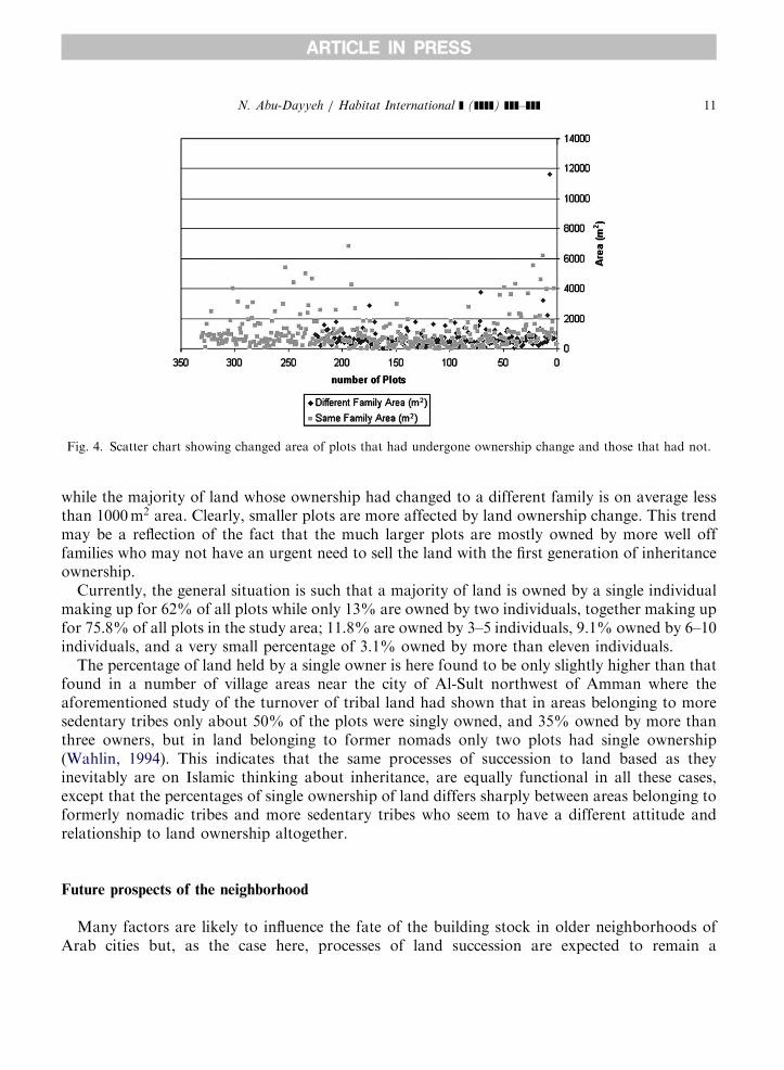
However, the high percentage of plot ownership change in the 1990s needed closer examination.Investigation into the details of that intense trading in the post-1990 period8 revealed that 59% ofall change had taken place due to inheritance, while only 22% seemed to have been sales unrelatedto inheritance issues (Table 4).9 The majority of that exchange, therefore, seems to have beencaused by the need to sell plots whose ownership had devolved into a relatively large number ofowners when the inherited land, built-up or vacant, was indivisible either because of currentapplicable land subdivision regulations, or where the division may not have been economicallyfeasible.Comparison of the areas of plots whose ownership had changed to a different family to those
that have remained within the hold of the same family was consequential to the understanding ofthe pattern of land ownership change. As shown in the scatter chart (Fig. 4), the majority of thevery large-sized plots (2000m2 and over) have remained within the same family (except for 5 plots)
8The plots that have only very late registration records such as in the 1990s and beyond have been here excluded from
this count.9Of course, without going into all the cases case by case it would impossible to be absolutely sure about the exact
percentages, for example, in one investigated case the inheritor was a single individual yet he chose to sell the land all
the same because he already had been living in Europe for some years before inheriting the land.
ARTICLE IN PRESS
Fig. 4. Scatter chart showing changed area of plots that had undergone ownership change and those that had not.
N. Abu-Dayyeh / Habitat International ] (]]]]) ]]]–]]] 11
while the majority of land whose ownership had changed to a different family is on average lessthan 1000m2 area. Clearly, smaller plots are more affected by land ownership change. This trendmay be a reflection of the fact that the much larger plots are mostly owned by more well offfamilies who may not have an urgent need to sell the land with the first generation of inheritanceownership.Currently, the general situation is such that a majority of land is owned by a single individual
making up for 62% of all plots while only 13% are owned by two individuals, together making upfor 75.8% of all plots in the study area; 11.8% are owned by 3–5 individuals, 9.1% owned by 6–10individuals, and a very small percentage of 3.1% owned by more than eleven individuals.The percentage of land held by a single owner is here found to be only slightly higher than that
found in a number of village areas near the city of Al-Sult northwest of Amman where theaforementioned study of the turnover of tribal land had shown that in areas belonging to moresedentary tribes only about 50% of the plots were singly owned, and 35% owned by more thanthree owners, but in land belonging to former nomads only two plots had single ownership(Wahlin, 1994). This indicates that the same processes of succession to land based as theyinevitably are on Islamic thinking about inheritance, are equally functional in all these cases,except that the percentages of single ownership of land differs sharply between areas belonging toformerly nomadic tribes and more sedentary tribes who seem to have a different attitude andrelationship to land ownership altogether.
Future prospects of the neighborhood
Many factors are likely to influence the fate of the building stock in older neighborhoods ofArab cities but, as the case here, processes of land succession are expected to remain a
ARTICLE IN PRESS
N. Abu-Dayyeh / Habitat International ] (]]]]) ]]]–]]]12
considerable force. In this study case, three main factors seem to affect the survival and prospectsof the building stock, (1) landuse changes, (2) rent bylaws, and (3) processes of land succession.Once implemented, landuse changes, such as commercial zoning, are almost irreversible since
commercial zoning is considered in economic terms an enhancement of the land’s value; therefore,any reversal of the landuse back to residential would be a cause for serious litigation on the part ofthe owners against the municipality which is likely to have to pay compensation, which meansthat the matter would hardly gain the approval of the city council which often has a high numberof its elected members coming from the ranks of local merchants, businessmen, and entrepreneurs.All that can be hoped for is that such transformation of residential into commercial landuse ishalted and not repeated in the future.On the other hand, the recent passing of the Law for the Protection of Architectural Heritage
(2003, No. 49), gives a special mandate for a new committee, the National Committee for theProtection of Architectural Heritage (NCPAH), to declare any building or area as a heritage site,and thenceforth impose restrictions on any modifications or abuse in terms of the building’s orsite’s form or function without proper approval of the aforementioned committee and accordingto its regulations and under its supervision. However, the law was issued as an emergency measureand has yet to obtain the final approval of the parliament as is expected to happen soon. However,it is unlikely that the NCPAH will have enough power or funds to reverse previous planningordinances regarding commercial zoning in the area but it is expected at least to help safeguardfrom its wider application, and in general promote awareness about issues related to theconservation and sustainability of historic neighborhoods.Rent bylaws, however, are not area specific as they apply to the whole city of Amman, and the
whole country. Until recently, their application had kept physical changes to a high percentage ofthe physical fabric of the city to a minimum, but at the same time they have not been conducive tobuilding maintenance or upgrading in terms of materials, equipment and installations, or theurban landscape within the immediate context (such as planting, landscaping, entrances, lighting,etc.). On the other hand rent control bylaws have helped maintain a relative slow pace of changeto the social composition of the neighborhood through the reduced need for changing livingquarters, especially by lower-income groups, thus circumventing the processes that have resultedin strong centripetal and centrifugal driving forces that attract or dispel certain economic stratainto or out of the central areas of the city, evidenced in cities that have no rent controlmechanisms. However, a recent amendment to the Owners and Lessees Law No. 29 of 1982,completely abolished rent control, but the amendment will not be in effect until the year 2010.Processes of land succession are an important factor affecting the future of the building stock
and the availability of urban land, and, compared to the previous two, is the most permanent andcharacteristic of Islamic cities in general. Its importance may be compared to the importance ofwaqf in Ottoman-Islamic cities, which according to one view represents ‘‘a modern and persistentinstitution which still exists and is part of urban form, function, and social life’’ (Ehlers, 1992).Itself, waqf property in Jabal Lweibdeh has a minimal share of land ownership which indicates itsrelative unimportance in the form and function of the neighborhood, but the effect of processes ofland succession, as shown here, is significant.In some Islamic cities waqf property had effectively contributed to the maintaining of the
competitiveness of smaller retail and crafts such as in the bazaars. In Jabal Lweibdeh, processes ofland succession combined with rent control bylaws have produced a somewhat similar effect
ARTICLE IN PRESS
N. Abu-Dayyeh / Habitat International ] (]]]]) ]]]–]]] 13
although here favoring small retail, offices for relatively lower-earning lower-waged professionalssuch as small legal firms, small engineering and architectural firms, small advertising and graphicdesign, crafts, artists’ studios, some NGO’s and other culture or art-related establishments. Allthese benefit from lower rents and a somewhat historic low-density neighborly environment.This trend may be compared to the trend for loft living that had become popular and
fashionable since the 1970s in some American and West European cities where formermanufacturing spaces along the canals of Amsterdam, near the London docks, and in the oldsweatshop districts of New York, were converted to residential use. That trend began by artistswho were attracted to the those nineteenth century former manufacturing spaces because of theirspaciousness and the abundance of light afforded by large glazed windows, but it soon attractedthe attention of real estate developers who became involved in investments in loft living,particularly in US cities that have been most sensitive to the flight and return of middle-classresidents and investment capital (Zukin, 1982).A comparable trend is occurring in Jabal Lweibdeh which has recently been described in the
local press as a neighborhood with a ‘‘cultural character’’ because so many governmental andnon-governmental institutions involved in social, cultural and/or artistic activities have chosen tolocate their headquarters there (Jarrar, 2002), attracted by lower rents, and a low-densityresidential area with an historic architectural character.The future prospect for the neighborhood will be a result of a complex process involving all the
previously mentioned factors that have so far circumscribed the neighborhood’s pastdevelopment. The process cannot be easily abstracted but a number of general remarks can bemade:
(1)
The once affluent older neighborhoods such as Jabal Lweibdeh are likely to contain a goodnumber of buildings of architectural or historic importance.(2)
The most significant period of construction in the older more affluent neighborhoods, the1950s, coincides with the early decades of independence, which heightens the heritage value ofsuch neighborhoods. It also coincides with the foundational decade for the profession ofarchitecture and civil engineering in general, thus attracting further interest in the pioneeringand foundational efforts of the leading architects and engineers.(3)
Changes to landuse from residential to commercial have in general adversely affected thequality of the built environment, but are unfortunately practically irreversible.(4)
Rent control has so far safeguarded the physical fabric from serious changes such asdemolitions but has not been conducive to proper maintenance and upgrading.(5)
Processes of land succession have so far performed a function similar to that of waqf in otherparts and cities of the Islamic world by maintaining the competitiveness of small lower-rent-seeking trades and professions; in this case, cultural and artistic activities.(6)
The year 2010, when rent control is destined to be totally eliminated in Jordan, will be alandmark year as it remains to be seen if the neighborhood will manage to go into arenaissance (or total gentrification, perhaps?) with a wholesale transformation of the existingsocial and physical fabric, or if the processes of land succession would on their own be able tomaintain the competitiveness of the area for lower-rent-seeking individuals, families, andestablishments, and thereby preserve the historic neighborly character that the neighborhoodhas long been known for.
ARTICLE IN PRESS
N. Abu-Dayyeh / Habitat International ] (]]]]) ]]]–]]]14
Conclusion
With the advent of modern physical planning in the 20th century, and, among other things, itsalmost inevitable associated prescriptions on minimum plot area, the historical importance ofprocesses of land succession in the shaping of the physical urban fabric of the Arab-Islamic citywas eliminated, or at best severely restricted. However, along with waqf, that characteristicOttoman Islamic religious institution, processes of land succession, seem to be the only tworemaining institutions that could today qualify a city as Islamic, albeit atypically so.The effect of waqf has recently become a focus of research (Bonine, 1987; Ehlers, 1992), but no
work has so far been devoted to the analysis of what might have possibly remained of the effect ofprocesses of land succession on the physical urban fabric of the modern city in Islamic contexts,whether directly in the sense historically identified in Arab-Islamic cities (Al-Hathloul, 1981, 1994)or indirectly, as has been done here through a close examination of land turnover rates and theirconnection to construction activity.As had been shown in the study case presented here, rent control mechanisms have acted in a
manner that created a kind of inertia or at least a very slow pace of development in the area,while, on the other hand, processes of land succession have acted as a stimulus for development,not withstanding its incremental and slow pace. The two processes have together forged the imageand character of this neighborhood, as they must surely many of the older neighborhoods of thecity of Amman, and perhaps other Arab cities of the region where similar mechanisms areoperative.Thus, in contrast to the adverse effect processes of land succession sometimes have in rural
areas, leading, as so often is the case, to the fragmentation of agricultural farmlands, the sameprocesses may be expected in urban areas and under certain conditions, as has been documentedin the case study presented here, to have a positive effect on urban redevelopment not only orsimply by freeing land, built or unbuilt, for redevelopment at a ratio that can be expected to reachup to 10–15% of the total plot ownership every 30–40 years approximately after its peakconstruction period, but also at ensuring the competitiveness of its pricing relative to landspeculation mechanisms that continuously plague efforts at securing urban land for developmentand redevelopment particularly in the residential areas surrounding the city center.Consequently, it is important that planners, law-makers and those involved in different forms
of urban administration, recognize the different and contrasting effects that processes of landsuccession have in urban areas, compared to their effect in rural areas, and be able to developways of mitigating their adverse effects on agricultural areas without jeopardizing the wholesaleelimination of their role in contributing to the availability of land in urban areas, particularly ininner city areas that always have the potential of presenting fresh and innovative opportunities fordevelopment and redevelopment.
Acknowledgements
The author would like to acknowledge the assistance received in the course of this research:financial support from the Deanship of Scientific Research at the University of Jordan;Municipality of Greater Amman for providing landuse maps; Department of Lands and Survey
ARTICLE IN PRESS
N. Abu-Dayyeh / Habitat International ] (]]]]) ]]]–]]] 15
for facilitating use of their registry; Department of Statistics for information on constructionactivity; Firas Ziadat for help with GIS mapping; Hiba Ammari and Rania Ksar for help withDLS registry; two anonymous referees whose remarks contributed to sharpening the focus of thiswork; and, my wife and son for their patience.
References
Abu Nowar, M. (2000). Tarikh al-Mamlaka al-Urduniyya al-Hashimiyya (History of the Hashemite kingdom of
Jordan) Part I. Al-Muassasah al-Sahafiyya al-Urduniyya, Amman, Jordan.
Abu-Lughod, J. (1987). The Islamic city: historic myth, Islamic essence, and contemporary relevance. International
Journal of Middle East Studies (IJMES), 19, 155–176.
Al-Hathloul, S. (1981). The Arab muslim city: tradition, continuity and change in the physical environment. Ph.D. thesis,
Department of Architecture, Massachusetts Institute of Technology, Cambridge, MA.
Al-Hathloul, S. (1994). Al-Madina Al-Arabiyya Al-Islamiyya: Athar al-Tashree’ fi Takween al-Bee’a al-Umraniyya
(The Arab muslim city: the influence of legislation in the formation of the built environment). Riyadh, Saudi Arabia:
Published by the author.
Al-Musa, S. (1988). Amman, A’simat al-Urdun (Amman, capital of Jordan). Municipality of Greater Amman,
Amman, Jordan.
Al-Sharq Al-Arabi (1927). A report on the earthquake. 15 August, No. 163, 5–9.
Bonine, M.E. (1987). Islam and commerce: waqf and the bazaar of Yazd Iran. Erdkunde, 41, 182–196.
Department of Statistics (DoS) (1997). Results of the general Census of population and housing of Jordan 1994: vol. 1,
Buildings and housing characteristics. Jordan: Department of Statistics.
Department of Statistics (DoS) (2003). Population Estimates for 2002. Department of Statistics, Jordan.
Ehlers, E. (1992). The city of the Islamic middle east. In E. Ehlers (Ed.), Modeling the city: cross-cultural perspectives.
(pp. 89–107). Bonn: Ferd Dumlers.
Fischbach, M. (1994). British land policy in Transjordan. In E. Rogan, & T. Tell, (Eds.), Village, steppe and state: the
social origins of modern Jordan. (pp. 80–107). London New York: British Academic Press.
Ghanma, F. (2002). Interview at his house in Jabal Lweibdeh. 8 June.
Hacker, J. (1960). Amman: a social study. Department of Geography. University of Durham, Durham, UK.
Herbert, G. (1963). The neighborhood unit principle and organic theory. Sociological Review Xt (July), reprinted in
The Search for Synthesis: Selected Writings on Architecture and Planning, 1997. The Architectural Heritage
Research Center, Haifa, 105–136.
Jarrar, S. (2002). Jabal Lweibdeh wa al-shakhsiyya al-thaqafiyya (The cultural character of Jabal Lweibdeh). Al-Ra’i
Newspaper, 6 September, No. 11681, 27.
King, G. W., & Lock, M. (1955). The final report of the United Nations field town planner, Jordan.
Kliot, N., & Stoffer, A. (1986). The emergence of a metropolitan core area in a new state—the case of Jordan. Asian and
African Studies, 20, 217–232.
Law for the Protection of Architectural Heritage (2003). No. 49 for the Year 2003.
Municipality of Greater Amman (1993). Greater Amman urban development. Cities, 37–49.
Municipality of Greater Amman (2000). Mantiqat al-Abdali 2000 (Abdali area 2000).
Wahlin, L. (1994). How long has land been privately held in northern al-Balqa, Jordan? Geografiska Annaler, 76B(1),
3–19.
Zukin, S. (1982). Loft living: culture and capital in urban change. Baltimore: Johns Hopkins University Press.
Related Documents


