Photonirvachak Joumal of the Indian Society of Remote Sensing, Vol. 34, No. 2, 2006 PROSPECTING GROUND WATER RESOURCES USING RS-GIS - A CASE STUDY FROM ARID WESTERN RAJASTHAN OF INDIA M.A. KHAN@, PRATAP NARAIN AND P.C. MOHARANA Central Arid Zone Research Institute, Jodhpur-342003, India ~:;orresponding author : [email protected] ABSTRACT In arid regions, inherent climatic conditions and adverse terrain condition pose perpetual shortage of water. The dominant aeolian topography conceals older geological formations making it difficult to infer prospects of ground water and tapping the same. A ground water prospect map has been prepared for a part of Jodhpur district in western Rajasthan through integrated analysis of four major controlling factors: geology, geomorphology, structure and hydrology. Through visual interpretation of satellite data and using Geographical Information System, twenty-five hydro-geomorphic units (prospect units) have been delineated and mapped. Potential of each prospect unit have been discussed in reference to hydro-geomorphic units, their influence and well inventory like well yield, water table level and quality of drinking water. 34 % of the area was classified to have high groundwater potential and 5.8 % area was classified into low potential categories. Most of the area (60.2 %) is of moderate ground water potential. Introduction Arid regions experience low water potential due to adverse climate, unfavorable terrain and poor surface and subsurface drainage system. Western Rajasthan forms the principal arid region of India constituting nearly 62 % of the total arid area. As per 1991 census, this region had 17.51 million population with an average density of 84 per km 2 against 37 km z in 1961. By the end of 2010, the estimated population is projected up to 23.9 millions (Purohit, 1997) reaching density of 110 km 2. The water resources of the region are mainly monsoon driven which is highly erratic with 40-60% coefficient of variation. Ground water, a liquid gold in'western Rajasthan, is defined through few unconsolidated aquifers or potential Received 17 June, 2005; in final form 22 March, 2006

Welcome message from author
This document is posted to help you gain knowledge. Please leave a comment to let me know what you think about it! Share it to your friends and learn new things together.
Transcript
Photonirvachak Joumal of the Indian Society of Remote Sensing, Vol. 34, No. 2, 2006
P R O S P E C T I N G G R O U N D W A T E R R E S O U R C E S U S I N G R S - G I S - A C A S E S T U D Y F R O M
A R I D W E S T E R N R A J A S T H A N OF I N D I A
M.A. KHAN@, PRATAP NARAIN AND P.C. MOHARANA Central Arid Zone Research Institute, Jodhpur-342003, India
~:;orresponding author : [email protected]
ABSTRACT
In arid regions, inherent climatic conditions and adverse terrain condition pose perpetual shortage of water. The dominant aeolian topography conceals older geological formations making it difficult to infer prospects of ground water and tapping the same. A ground water prospect map has been prepared for a part of Jodhpur district in western Rajasthan through integrated analysis of four major controlling factors: geology, geomorphology, structure and hydrology. Through visual interpretation of satellite data and using Geographical Information System, twenty-five hydro-geomorphic units (prospect units) have been delineated and mapped. Potential of each prospect unit have been discussed in reference to hydro-geomorphic units, their influence and well inventory like well yield, water table level and quality of drinking water. 34 % of the area was classified to have high groundwater potential and 5.8 % area was classified into low potential categories. Most of the area (60.2 %) is of moderate ground water potential.
Introduction
Arid regions experience low water potential due to adverse climate, unfavorable terrain and poor surface and subsurface drainage system. Western Rajasthan forms the principal arid region of India constituting nearly 62 % of the total arid area. As per 1991 census, this region had 17.51 million population
with an average density of 84 per km 2 against 37 km z in 1961. By the end of 2010, the estimated population is projected up to 23.9 millions (Purohit, 1997) reaching density of 110 km 2. The water resources of the region are mainly monsoon driven which is highly erratic with 40-60% coefficient of variation. Ground water, a liquid gold in'western Rajasthan, is defined through few unconsolidated aquifers or potential
Received 17 June, 2005; in final form 22 March, 2006
172 M.A. Khan et al.
targets. Due to pressing demands from growing population of human and animal resources, frequent targeting of few such areas has led-to depletion in water levels in many parts of the state. The aeolian terrain covers many older geological formations making it difficult to infer other favorable hydrogeological units. Studies in western Rajasthan indicate that the Thar Desert in Rajasthan still has 1800 mcm surplus exploitable water potential (Venkateswarlu et al., 1990). How practically, such quantum of water can be exploited by boring at a reasonable cost, has always been the key issue of desert science. S tud i e s in thepas t (Ghosee ta l . , 1975; Chatterji et al., 1979; Shankarnarayan et al., 1983) have established relationship between groundwater resources, yield of wells and water quality with hydrogeological formation, geomorphology and terrain characteristics. Subsequently, hydro- geological and hydro-geomorphology maps were prepared to delineate groundwater prospect zones using large-scale aerial photographs and Landsat TM (Thematic Mapper) data.
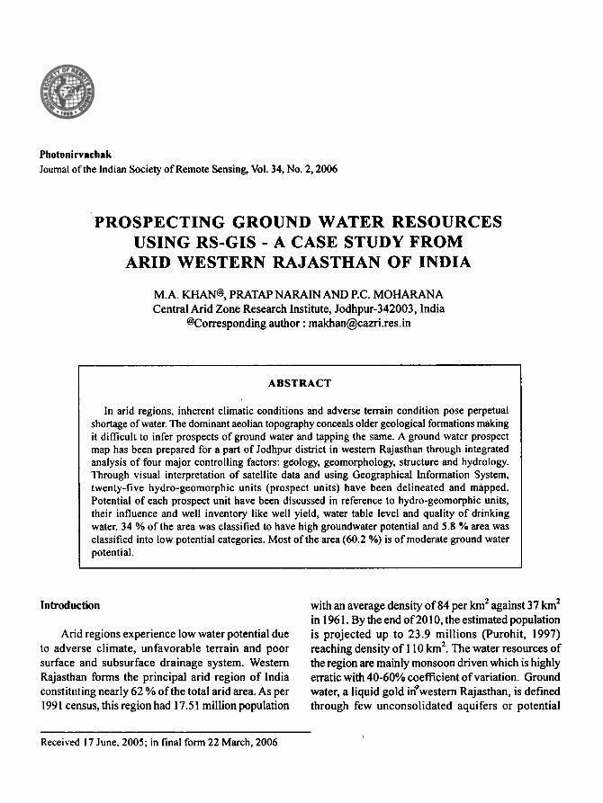
between longitudes 72 ~ 15' E to 72 ~ 30' E and latitudes 26 ~ 15'N to 26 ~ 30'N (Fig. 1) covering 690 km 2 area. Physiographically, the area has sandy uplands in the west and south and a small patch of rocky uplands in the eastern region. The highest relief (290-330 m above msl) is in the eastern part near Balesar. The general slope is towards southwestern direction to Tena, Bhungra and Shergarh. Few ephemeral streams like Kheton ki nadi (northeast to southwest) and Ghati nadi (north to southeast) contribute to few patches of alluvial plains but get subsequently buried by sandy uplands. The region receives mean annual rainfall of 366 ram, average monthly summer temperature varies between 38 to 42~ and winter temperature between 6 to 10~ The population of Shergarh tehsil has increased by 28.1% between 1981 and 1991 showing a population density of 94 persons per km 2.
In recent years, advent of high-resolution satellite data products with improved sensors in both visible and invisible bands have helped research relating to ground water exploration (SAC, 1986; NRSA, 1995; Reddy et al., 1996). Sahai (1993), Rao et al. (2003) and Lokesha et al. (2005) also applied remote sensing techniques in the delineation of ground water potential zones. However, most of the previous studies represent conventional mapping mainly depicting relationship between geological units and ground water potential. The present work depicts systematic evaluation of many of the factors (rock type, slope, the relief, and depth of weathering, nature of weathered material presence of fractures and aquifer material) that control the ground water regime.
Fig. 1. Location map of study area in Jodhpur district, western Rajasthan
Study Area Data Utilized and Methodology
The studied region is a part of Shergarh tehsil of Jodhpur district in western Rajasthan lying
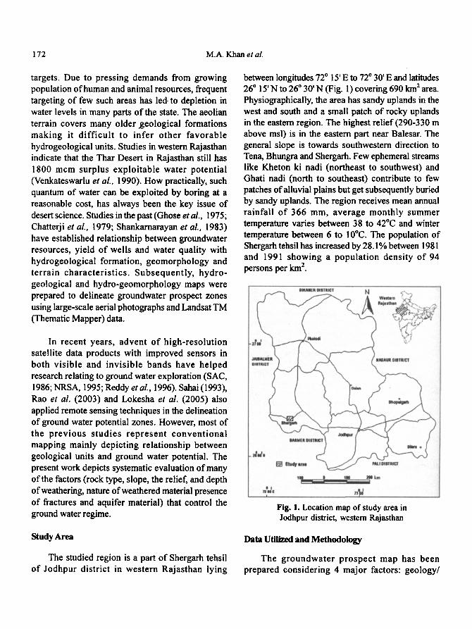
The groundwater prospect map has been prepared considering 4 major factors: geology/
Prospecting Ground Water Resources Using... 173
lithology, structure, geomorphology (landforms), and hydrological recharge conditions. The broad outline for preparing this composite map has been given in Fig. 2, based on the guidelines of National Remote Sensing Agency (NRSA, 2000) under Rajiv Gandht Drinking Water Mission programme. Survey of India (SOl) topographic sheet (No 45 B/7, 1:50,000) was used to prepare base and drainage maps. Remotely sensed image data from IRS IC (LISS III) false color composites (FCC) acquired February 1992 at 1: 50,000 scale were visually interpreted for tone, texture, size, shape, relief, drainage pattern, vegetation association and other factors. The data helped in the interpretation and delineation of landforms, geological structures, and hydrological information like drainage and irrigated area. Geological map from Geological Survey of India at 1:253,440 scale, was used to identify and outline the boundaries of lithological units and other associated well data. Secondary groundwater well data like static water level, recharge condition, nature of aquifer material were collected from the state Ground Water Department and also through field survey to support the mapping. Arc/Info GIS was used for creating thematic layers followed by their overlaying, analysis, correlation, integration of thematic layers using an Arc Macro Language (AML) and generating ground water prospect map. The details of thematic layers generated and used in the study are presented in Fig. 2. The use of AML in GIS helped in analyzing a large number of spatial and non-spatial data with minimum time, with much data accuracy and avoided data redundancy.
Results and Di scuss ion
Geological characteristics
Geologically, the study area is underlain by Sonia sandstones and Malani igneous suites comprising of sandstones, rhyolites and mixed shale- sand stones. Quaternary sediments consisting of recent alluvium, gravels, sand, silt and clay are present along drainages. Malani suites are represented by effusive phase in the form of rhyolite,
SOl eaqmokK, t ~ Pbuneee amuin I,,n-~ I 45~.t:5o.o0o I I I ~cc lasxc(ussJ.) I
r i I I I
, , ' I Goomorohology
map overlay [ I
Map composition and integration I Umon of maps and 8enemtion [ tlSlnp GIS ] of l lydro- g�9162 map ._J
I J
. . . . . . . i . . . . . . . . I Ground water preapeet map I
Fig. 2. Flow chart of methodology for preparation of groundwater prospect map
tufts and ash beds, Rhyolites are exposed in the form of hillocks, hummocks, and ridges between Shergarh and Balesar but in the south, these are buried under aeolian sand. Similarly Sonia formations are exposed through hillocks of rhyolite and sand stone in the northern part.
Hydro-geologically, sandstones of Jodhpur group and rhyolites of Malani igneous suit are tile major formations. Sandstones are pebbly, arkosic and associated with shale, are the dominant aquifers. Ground water generally occurs under unconfined conditions. In the western part, where the sandstones have higher percentage of shale and other argillaceous material, the quality of groundwater is mostly non-potable with high TDS (Total Dissolved Solid) value and diminishing discharge from the wells. Rhyolites on the otherhand are hard and compact with limited weathered and fractured zone. It occupies southern part of the study area with a depth to water range between 15- 61 m below ground level (bgl). The water quality is brackish but potable.
Lineaments and hydro-geological features were interpreted from the satellite images. Lineaments are

174 M.A. Khan et al.
interpreted as fault, fracture, major joint and long �9 linear geological formation, the straight course of streams and vegetation alignment. Two dominant trends for lineaments were interpreted in NW-SE and NE-SW direction (Fig. 3).
Hills-pediments-buried pediment-inselbergs- older alluvial plains are the common landforms of fluvial origin in the region. Hills are isolated and residual of sandstone origin; occur near Balesar and west of Shergarh town. Within the hills, a number
Fig. 3. Geology, lineament and drainage map
Geomorphologic characteristics
Geomorphic units based on their origin, material content and climatic conditions have definite bearing on the ground water regime. The synoptic view of the terrain indicates possible interplay of two major geomorphic processes; fluvial and aeolian, in the formation of a number of landforms (Table 1) in the region.
of plateaus occur with dissected surfaces along with some significant valleys. In the foothills of the plateaus, the area has pediments (surfaces with rocky and gravels) and inselbergs. In the lower end of pediment area, the plains are gently sloping (buried pediments), having a shallow aeolian cover (0-1 m). Older alluvial plains (AP) comprising sand, silt and gravels are moderately deep (40-50 cm). Major streams (Ghati nadi in the north and Khet0n
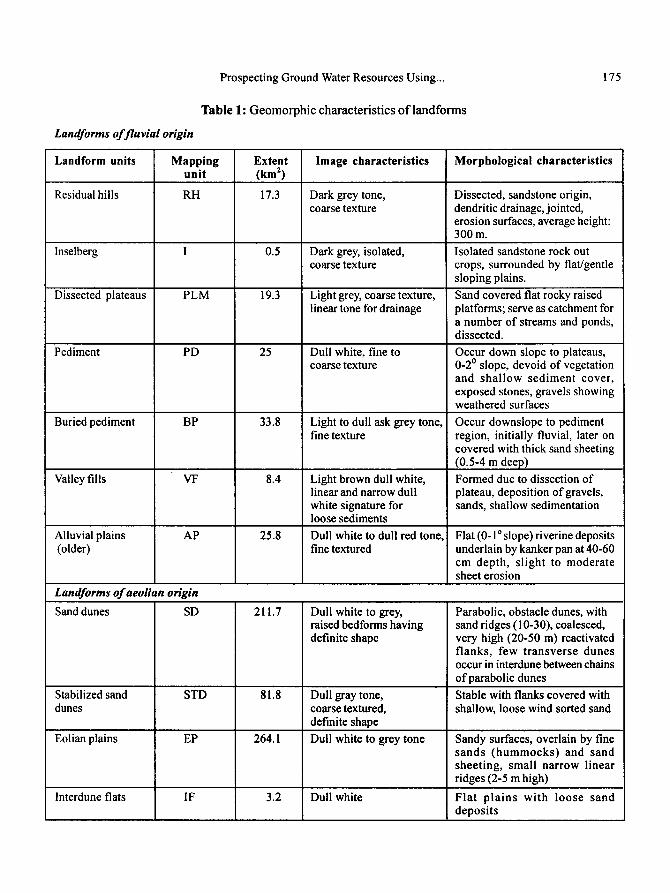
Landforms of fluvial origin
Prospecting Ground Water Resources Using...
Table 1: Geomorphic characteristics o f landforms
175
Landform units
Residual hills
Inselberg
Dissected plateaus
Pediment
Buried pediment
Valley fills
Mapping unit
RH
PLM
PD
BP
Extent (km 2)
17.3
0.5
19.3
25
33.8
8.4
Image characteristics
Dark grey tone, coarse texture
Dark grey, isolated, coarse texture
Light grey, coarse texture, linear tone for drainage
Dull white, fine to coarse texture
Light to dull ask grey tone, fine texture
Light brown dull white, linear and narrow dull white signature for loose sediments
Morphological characteristics
Dissected, sandstone origin, dendritic drainage, jointed, erosion surfaces, average height: 300 m.
Isolated sandstone rock out crops, surrounded by flat/gentle sloping plains.
Sand covered fiat rocky raised platforms; serve as catchment for a number of streams and ponds, dissected.
Occur down slope to plateaus, 0-2 o slope, devoid of vegetation and shallow sediment cover, exposed stones, gravels showing weathered surfaces
Occur downslope to pediment region, initially fluvial, later on covered with thick sand sheeting (0.5-4 m deep)
Formed due to dissection of plateau, deposition of gravels, sands, shallow sedimentation
Alluvial plains AP 25.8 Dull white to dull red tone, Flat (0-1 ~ slope) riverine deposits (older) fine textured underlain by kanker pan at 40-60
cm depth, slight to moderate sheet erosion
Landforras of aeolian origin Sand dunes SD 211.7 Dull white to grey,
raised bedforms having definite shape
Parabolic, obstacle dunes, with sand ridges (10-30), coalesced, very high (20-50 m) reactivated flanks, few transverse dunes occur in interdune between chains of parabolic dunes
Stabilized sand STD 81.8 Dull gray tone, Stable with flanks covered with dunes coarse textured, shallow, loose wind sorted sand
definite shape
Eolian plains EP 264.1 Dull white to grey tone Sandy surfaces, overlain by fine sands (hummocks) and sand sheeting, small narrow linear ridges (2-5 m high)
Interdune fiats IF 3.2 Dull white Flat p la ins with loose sand deposits
176 M.A. Khan et al.
ki nadi in the south) control the sediments of these plains. These are further mapped as shallow (0-10 m) and moderately deep (10-20 m) plains. This piedmont region is surrounded by dominant aeolian terrain having sand dunes, few stable sand dunes, interdune flats and eolian plains. Except stable sand dunes, others have erosional bedforms having reactivated surfaces, sand sheeting and wind sorted sand deposits. Such aeolian activities have concealed the aquifers in some parts of the region.
Groundwater prospect zones and their evaluation
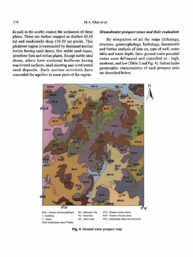
By integration of all the maps (lithology, structure, geomorphology, hydrology, lineaments) and further analysis of data on, type of well, water table and water depth, three ground water potential zones were delineated and classified as : high, moderate, and low (Table 2 and Fig. 4). Salient hydro geomorphic characteristics of such prospect units are described below.
Fig. 4. Ground water prospect map
Prospecting Ground Water Resources Using... 177
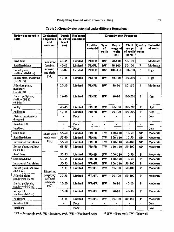
Table 2: Groundwater potential under different formations
Hydro-geomorphic units
Geological Depth Recharge sequence to water conditions
and level code no. (m)
Groundwater Prospects
Aquifer Type Depth Yield Quality Potential material of range of range of of wells
wel ls wells of wells water (m) (Ipm)
Sand dune
Stabilized dune
Eolian plain, shallow (0-10 m)
Eolian plain, moderate (10-20 m)
Alluvium plain, moderate (10-20 m)
Buried pediplain, shallow (BPS) (0-10m )
Valley
Pediment
Plateau moderately dissected
Residual hill
Inselberg
Sand dune
Stabilized dune
Interdunal flat plains
Eolian plain, shallow (0-1o m)
Sand dune
Stabilized dune
Interdunal flat plains
Eolian plain, shallow (0-1o m) Alluvial plain, shallow (0-10 m)
Buried pediplain, shallow (0-10 m)
Valley fill, shallow (0-10 m)
Pediment
Residual hill
Inselberg
Sandstone 40-45 Limited PR+FR BW 90-100 50-100 P (pebbly, 40-45 Limited PR+FR BW 90-100 50-100 P
arkosic 30-87 Limited PR+FR BW 100-110 100-200 P and shale
(51) 40-45 Limited PR+FR BW 80-100 100-200 P
Moderate
Moderate
High
High
Moderate
Moderate
Moderate
Moderate
Moderate
Moderate
Moderate
Moderate
Low
Low
* PR = Permeable rock; FR - Fractured rock; WR = Weathered rock; ** BW -- Bore well; TW - Tubewell
Rhyolite,
porphyry 30-55 Limited ~R+FR BW 90-100 50-100 P tuff and
ash beds 17-20 Limited WR+FR BW 70-80 40-80 P (42)
15-18 Limited WR+FR BW 70-80 40-80 P
18-55 Limited WR+FR BW 90-100 80-150 P
Poor - -
Poor - - -
50-55 Limited PR+FR BW 100-110 10-50 P
50-55 Limited PR+FR BW 100-110 10-50 P
50-55 Limited WR+FR BW 100-110 50-100 P
18-81 Limited WR+FR BW 90-100 50-100 P
Poor - - Low
Poor - - - Low
Shale with 55-60 Limited PR+FR T W 100-110 10-50 NP Moderate
sandstone 55-60 Limited PR+FR T W 100-110 ! 10-50 NP Moderate
(52) 55-60 Limited PR+FR TW 100-110 50-100 NP Moderate
61-65 Limited PR+FR T W 110-120 50-100 NP Moderate
18-40 Limited PR+FR BW 80-90 100-200 P High
40-45 Limited PR+FR BW 90-100 100-200 P High
40-45 Limited PR+FR BW 90-100 ! 00-200 P High
Poor - - Low
20-30 Limited PR+FR BW 80-90 80- ! 50 P i Moderate
178 M.A. Khan et al.
High potential zones cover nearly 34% area in the northeast of Shergarh and surrounding Balesar town. Except few occurrences of sand dunes (SD- 51), stabilized sand dunes (STD-51), the rest of the area are under eolian plains (EP-51), alluvial plains (AP-51), buried pediments (BP-51), valley fills (VFS- 51) and pediments (PD-51). These are nearly level slopes with good number of drainage channels, has few lineaments and tanks. Sonia sandstones, the major geological formation, are known for being prospective aquifers. The wells (dug well and bore wells) are shallow having static water level (SWL) between 30 m to 60 m under eolian plains and 18 m to 40 m under buried pediments. Such areas are characterized by deep weathered zone of thickness (>15m) and moderate recharge condition. The aquifers are permeable and fractured. In the area mapped under shallow buried pediments (BPS) and alluvial plains (APM) categories, tapping of ground water is encouraging using bore wells as water is available at shallow depth. Well depth of 80-100 m has been found suitable in dune areas (with expected yield of 50-100 lpm) and in slightly undulating area under eolian plains, buried pediments and alluvial plains, the yield is expected between 100-200 lpm. In contrast, for pediment- covered area, bore wells (90-100 m deep) are suggested because of limited recharge potential.
Moderate potential zone is spread in 416.2 km 2 (60.2%) area in the south and western part. These plains are more undulating and have moderate slopes with very few lineaments. The geomorphic units (sand dunes (SD-52), stabilized sand dunes (STD- 52), inter-dune plains (ID-52) and eolian plains (EP- 52) are developed under two distinct formations. In the western part, the aquifers (shales and sandstones) are both permeable and fractured. The total dissolved salts (TDS) value has been found to be very high and the water is non-potable. The water table is deep with average depth 55-65 m bgl (below ground level). The recharge is moderate. Few tube wells, 100-120 m deep, are found suitable. The expected yield of water varies from 10-50 lpm in sand dune areas to 50-100 ipm in eroded rocky plains, Between the southern
part of Shergarh and northeast of Balesar town, the area is dominated by Malani igneous rocks, known for compactness and has very limited weathered surfaces and fractured zone, therefore, ground water is only available under unconfined situation. The water table is deep (50-55 m bgl) in sand dune areas and shallow (I 5 -20 m bgl) in buried pediments, valley fill and under aeolian plains and alluvial plains, the water table depth is at 18-61 m bgl and 30-35 m bgl, respectively. Therefore, except buried pediments and valley fills, the depth of wells is deep (100-110 m) in other hydro-geomorphic units. Due to such depth limitations in water table, the expected yield of water is poorer (10-50 lpm) in sandy areas and higher (50- 1 O0 lpm) in other areas.
Low potential zones covering about 5% area include hilly and rocky terrain having residual hills (RH-51), inselbergs (I-51) and moderately dissected plateaus (PLM-51). These plains mainly act as run- off zones with emergence of few ephemeral channels.
Conclusion
In spite of efforts from local governments, the rural areas in western Rajasthan still have problems of proper source of drinking water. It is a common site to witness villagers, especially women folks, struggling to arrange water for their family for most part of the day. They have to walk several kilometers of distances or move on camel driven carts to fetch water and try to store the limited water for more than one day. The present information, depicted in the form of a prospect map would provide firsthand information to local authorities and planners about the areas suitable for searching ground water followed by its suitable exploration based on information given for type of well, well depth, water quality and success rate of wells.
The groundwater prospect map is a systematic effort and has been prepared considering major controlling factors, which influence the water yield and quality of ground water. The map depicts
Prospecting Ground Water Resources Using... 179
hydrogeomorphological aspects, which are essential as basis for planning and execution of groundwater exploration. The high potential zone because of suitable surface and sub-surface conditions like occurrence of lineaments, permeable aquifers and nearness to streams create conducive environment for higher water yield as well as favorable discharge. In the moderately potential zone, there are very few but scattered lineaments. Water availabil i ty is confined to wes te rn par t where shales and sandstones have moderate water yield capacity but deeper water table. On the other hand, the south and northeastern part in this zone because of compact and unfavorable formations, provides limited scope for water yield. Low potential zones include rocky area, which act as run-off zones. The aquifers are deep and yield is very poor.
References
Chatterji, EC., Singh, S. and Qureshi, Z.H. (1979). Hydrogeomorphoiogy of the central Luni basin, western Rajasthan (India). Geoforum, 9(3): 211-224.
Ghose, B., Singh, S. and Areal Kar (1975). Geo- morphology of prior and present drainage networks and their control on groundwater in Dyana tehsil - Annual Report, CAZRI, Jodhpur.
Lokesha, N., Gopalakrishna Gowda, H.H., Gupta, A.K. (2005). Delineation of ground water potential zones in a hard rock terrain in Mysore district, Karnataka using IRS data and GIS techniques. J. Indian Soc. Remote Sensing, 33(3): 405-412.
NRSA (1995). Integrated Mission for Sustainable Development - Technical Guidelines, National Remote Sensing Agency, Dept. of Space, Hyderabad.
NRSA (2000). Technical guidelines for preparation of groundwater prospects map. Rajiv Gandhi National Drinking Water Mission, National Remote Sensing Agency, Hyderabad.
Purohit, M.L. (1997). Impact of recent spurt in human and livestock population on arid ecosystem. In: Desertification control in the arid ecosystem of lndia for sustainable development (Eds. Surendra Singh and Amal Kar), Agro Botanical Publishers (India), Bikaner, pp. 198-210
Ran, Y. Srinivasa and Jugran, D. K. (2003). Delineation of groundwater potential zones and zones of groundwater quality suitable for domestic purposes using remote sensing and G1S. Hydrological Sciences, 48(5): 821-833.
Reddy, ER., Kumar, K.V. and Seshadri, K. (1996). Use of IRS-IC data in groundwater studies. Current Science, 70(7): 600-605.
SAC (1986). Report on ground water potential maps of Rajasthan (Based on visual interpretation of landsat thematic Mapper Data) Space Application Centre, Ahmedabad.
Sahai, B. 0993). Remote Sensing of deserts, the Indian experience. Journal of Arid Environments, 25(1): 173-185.
Shankarnarayan, K.A., Chatterji, EC. and Singh, S. (1983). Role of remote sensing in ground water extraction for problem villages and habitants of hard rock regions of western Rajasthan. Proceedings llnd All India Conference on Drilling Equipment for Ground Water Extraction held at New Delhi - pp. 1/3- !/25.
Venkateswarlu, J., Sen, A.K., Dubey, J.C., Joshi, N.L. and Kar, A. (1990). Water 2000 AD- the scenario for Arid Rajasthan, CAZRI, Jodhpur, 491).
Related Documents