Ahmed Gamal Aly et al, International Journal of Computer Science and Mobile Applications, Vol.1 Issue. 4, October- 2013, pg. 17-28 ISSN: 2321-8363 © 2013, IJCSMA All Rights Reserved, www.ijcsma.com 17 INTERNATIONAL JOURNAL OF COMPUTER SCIENCE AND MOBILE APPLICATIONS Proposed Model of GIS-based Cloud Computing Architecture for Emergency System Ahmed Gamal Aly 1 , Nevine Makram Labib 2 1 Department of Information Systems, Sadat Academy, Cairo, Egypt, [email protected] 2 Assoc. Prof. at Department of Information Systems, the British University, Cairo, Egypt, [email protected] Abstract Recent emergency situations in the world display the inclination that the occurrence frequency of natural catastrophes is anticipated to increase in future. Thus new approaches for crisis administration need to be elaborated based on the newest IT expansion. Cloud computing is advised as possible way to smaller the cost and complexity of computing by supplying applications that run on the Internet. This paper discus proposed GIS-model based Cloud computing for emergency management. GIS application has been implemented for earthquakes prediction and earthquakes emergency management based Cloud computing platform (Microsoft Windows Azure). Performance of GIS application has been measured in different platform one of them based on Cloud technology and the other local host. Keywords: Cloud Computing; Emergency Management; GIS; Windows Azure 1. Introduction Emergency management has been the hot topic in recent times. Emergency events imply all events that endanger normal functioning of services and companies, endanger lives or resources (living environment) as well as events that are threatening stability of state. All situations resulting from fires, explosions, technological and traffic accidents, terrorist attacks, transport of hazardous materials all comprise hazardous events. Individuals and organizations responsible for emergency management use many tools to preserve economic assets before, during and after a catastrophic event. Correct and timely information is a critical part of any successful emergency management program. One of the greatest usages of GIS is in emergency management systems such as Natural Disasters that Impact Humans (Earthquakes, Volcanoes, Tsunamis, Landslides, Fires, Floods, Tornadoes, and Hurricanes). A geographic information system (GIS) can provide that sort of information and tools for the analysis of the spatial data and the representation of the results in spatial format [1]. Cloud computing can be defined as a new style of computing in which dynamically scalable and often virtualized resources are provided as a services over the Internet. Cloud computing has become a significant technology trend, and many experts expect that cloud computing will reshape information technology (IT) processes and the IT marketplace.

Welcome message from author
This document is posted to help you gain knowledge. Please leave a comment to let me know what you think about it! Share it to your friends and learn new things together.
Transcript

Ahmed Gamal Aly et al, International Journal of Computer Science and Mobile Applications,
Vol.1 Issue. 4, October- 2013, pg. 17-28 ISSN: 2321-8363
© 2013, IJCSMA All Rights Reserved, www.ijcsma.com 17
INTERNATIONAL JOURNAL OF COMPUTER SCIENCE AND MOBILE APPLICATIONS
Proposed Model of GIS-based Cloud Computing Architecture for
Emergency System
Ahmed Gamal Aly1, Nevine Makram Labib2
1Department of Information Systems, Sadat Academy, Cairo, Egypt, [email protected] 2 Assoc. Prof. at Department of Information Systems, the British University, Cairo, Egypt,
Abstract Recent emergency situations in the world display the inclination that the occurrence frequency of natural catastrophes is anticipated to increase in future. Thus new approaches for crisis administration need to be elaborated based on the newest IT expansion. Cloud computing is advised as possible way to smaller the cost and complexity of computing by supplying applications that run on the Internet. This paper discus proposed GIS-model based Cloud computing for emergency management. GIS application has been implemented for earthquakes prediction and earthquakes emergency management based Cloud computing platform (Microsoft Windows Azure). Performance of GIS application has been measured in different platform one of them based on Cloud technology and the other local host. Keywords: Cloud Computing; Emergency Management; GIS; Windows Azure
1. Introduction Emergency management has been the hot topic in recent times. Emergency events imply all events that endanger normal functioning of services and companies, endanger lives or resources (living environment) as well as events that are threatening stability of state. All situations resulting from fires, explosions, technological and traffic accidents, terrorist attacks, transport of hazardous materials all comprise hazardous events. Individuals and organizations responsible for emergency management use many tools to preserve economic assets before, during and after a catastrophic event. Correct and timely information is a critical part of any successful emergency management program. One of the greatest usages of GIS is in emergency management systems such as Natural Disasters that Impact Humans (Earthquakes, Volcanoes, Tsunamis, Landslides, Fires, Floods, Tornadoes, and Hurricanes). A geographic information system (GIS) can provide that sort of information and tools for the analysis of the spatial data and the representation of the results in spatial format [1]. Cloud computing can be defined as a new style of computing in which dynamically scalable and often virtualized resources are provided as a services over the Internet. Cloud computing has become a significant technology trend, and many experts expect that cloud computing will reshape information technology (IT) processes and the IT marketplace.

Ahmed Gamal Aly et al, International Journal of Computer Science and Mobile Applications,
Vol.1 Issue. 4, October- 2013, pg. 17-28 ISSN: 2321-8363
© 2013, IJCSMA All Rights Reserved, www.ijcsma.com 18
With the cloud computing technology, users use a variety of devices, including PCs, laptops, smart phones, and PDAs to access programs, storage, and application-development platforms over the Internet, via services offered by cloud computing providers. Advantages of the cloud computing technology include cost savings, high availability, and easy scalability [2]. The main problems of this research is centered on limitation of current techniques adapted by GIS for efficient emergency management system, particularly in the field of earthquakes, which is one of the most important issues that deal with a large amount of spatial data. The large amount of spatial data is one of the most important problem can be found in traditional GIS; therefore more technologies in GIS should be discovered such as cloud. Cloud focus on large-scale resource, sharing and low cost for big data storage technology. The main objective of this research is to propose an applicable cloud computing architecture using GIS technology to improve emergency system, overcome the large scale spatial data problems found in traditional GIS and Finding solutions for big spatial data problems in emergency management.
2. Related work 2.1 Geographical information systems Geographical Information Systems or Geospatial Information Systems (GIS) is a collection of tools that captures, stores, analyzes, manages, and presents data that are linked to geographical locations and displaying all forms of geographically referenced information. GIS allows us to view, understand, question, interpret, and visualize data in many ways that reveal relationships, patterns, and trends in the form of maps, globes, reports, and charts. A GIS helps you answer questions and solve problems by looking at your data in a way that is quickly understood and easily shared. GIS technology can be integrated into any enterprise information system framework [3]. 2.2 Shortcomings for traditional geographic information platform GIS applications are generally both compute and data intensive in nature. GIS technology has been around for decades. These mature technologies are increasingly using geospatial and non-spatial data. Advance data collection technologies have facilitated large amounts of rich data to be collected at diverse data sources. In time, size of these data would grow to be large enough to restrict any single organization to maintain and handle these data. In addition, GIS functions and services that operate on these data are geographically and logically distributed due to the source of data, location of computing facilities and organizations. The spatial analysis on large amount of data is complex and computationally intensive. In order to share and collaborate GIS data and the computation results among geographically dispersed users, a scalable and low cost computation platform, such as Cloud Computing is required for GIS application [4]. There are some shortcomings for traditional geographic information platform, as briefly showed below:
The computing power of large-scale spatial data is relatively weak. It is difficult to get on-demand resources, including computing and storing resources. The users need to take a lot of money and time to buy and customize the professional software, and to
upgrade or maintain their applications. The geographical data and services are usually provided by special organization, the others are unable
to act as an intelligent sensor and can't be the data, information and services provider, so the resources are limited.
Geographic information, services and resources are often consumed by the governors, or the researchers. They are always unreachable for the public in their daily life at anytime, anywhere.
Cloud computing technologies maybe can used to deal with these problems as mentioned above. So in the constructing of the geographic information services platform, the concept and technologies of cloud computing can be applied [5]. 2.3 Cloud computing Cloud computing is the next generation platform that provides dynamic resources, virtualization and high availability. Cloud computing is not associated with a particular technology, protocol or provider. In practice,

Ahmed Gamal Aly et al, International Journal of Computer Science and Mobile Applications,
Vol.1 Issue. 4, October- 2013, pg. 17-28 ISSN: 2321-8363
© 2013, IJCSMA All Rights Reserved, www.ijcsma.com 19
applications and data are no longer on the local computer but in a “cloud” composed by a number of remote servers and left interconnected using bandwidth. Cloud computing describes a new supplement, consumption and delivery model for IT services based on Internet, and it typically involves the provision of dynamically scalable and often virtualized resources as a service[6]. Cloud computing, as defined by the National Institute of Standards and Technology (NIST), covers the most comprehensive vision of the cloud computing model: “Cloud computing is a model for enabling convenient, on-demand network access to a shared pool of configurable computing resources (for example, networks, servers, storage, applications, and services) that can be rapidly provisioned and released with minimal management effort or service provider interaction”[7]. There are different categories of cloud services such as “ XaaS” where X is refer to everything such as Software, Hardware, Platform, Infrastructure, data, Business etc. these services are delivered and consumed in real-time over the internet. Three models of service are the most used Infrastructure as a Service (IaaS), Software as a Service (SaaS) and Platform as a Service (PaaS)[8].
Figure 1: Cloud Computing Service Model
Cloud computing can be delivered with four deployment models: private, public, hybrid or community These deployment models describe who owns, manages and is responsible for the services [9]. 1- Private cloud Private cloud (or internal cloud) refers to cloud computing on private networks. Private clouds are built for the exclusive use of one client, providing full control over data, security, and quality of service. Private clouds can be built and managed by a company’s own IT organization or by a cloud provider [2]. 2- Public cloud A public cloud is built over the Internet, which can be accessed by any user who has paid for the service. Public clouds are owned by service providers. They are accessed by subscription. Many companies have built public clouds, namely Google App Engine, Amazon AWS, Microsoft Azure, IBM Blue Cloud, and Salesforce Force.com [10]. 3- Community cloud The community cloud combines aspects of the private cloud and public cloud: resources are shared, but only with other customers that have the same requirements. “The cloud infrastructure is shared by several organizations and supports a specific community that has shared concerns (e.g., mission, security requirements, policy, and compliance considerations). It may be managed by the organizations or a third party and may exist on premise or off premise” [9].

Ahmed Gamal Aly et al, International Journal of Computer Science and Mobile Applications,
Vol.1 Issue. 4, October- 2013, pg. 17-28 ISSN: 2321-8363
© 2013, IJCSMA All Rights Reserved, www.ijcsma.com 20
4- Hybrid cloud In simpler terms hybrid cloud is a combination of a public and private cloud that interoperates. In this model users generally farm out no business- critical information and processing to the public cloud, while keeping business-critical services and data in their command. Hybrid Clouds are usually a combination of private clouds and public clouds, usually, managed using the same administration and monitoring consoles. A hybrid cloud also can be used to handle planned workload spikes. Sometimes called surge computing, a public cloud can be used to perform periodic tasks that can be deployed easily on a public cloud [8].
Figure 2: Public, private, and hybrid clouds over the Internet and intranets
NIST defined five characteristics the describe cloud computing [11]. 1- On-demand self-service A consumer can unilaterally provision computing capabilities such as server time and network storage as needed automatically, without requiring human interaction with a service provider. 2- Broad network access Capabilities are available over the network and accessed through standard mechanisms that promote use by heterogeneous thin or thick client platforms (e.g., mobile phones, laptops, and PDAs) as well as other traditional or cloud based software services. 3- Resource pooling The provider’s computing resources are pooled to serve multiple consumers using a multi-tenant model, with different physical and virtual resources dynamically assigned and reassigned according to consumer demand. There is a degree of location independence in that the customer generally has no control or knowledge over the exact location of the provided resources, but may be able to specify location at a higher level of abstraction (e.g., country, state, or datacenter). Examples of resources include storage, processing, memory, network bandwidth, and virtual machines. Even private clouds tend to pool resources between different parts of the same organization. 4- Rapid elasticity Capabilities can be rapidly and elastically provisioned in some cases automatically to quickly scale out; and rapidly released to quickly scale in. To the consumer, the capabilities available for provisioning often appear to be unlimited and can be purchased in any quantity at any time. 5- Measured service Cloud systems automatically control and optimize resource usage by leveraging a metering capability at some level of abstraction appropriate to the type of service (e.g., storage, processing, bandwidth, or active user accounts). Resource usage can be monitored, controlled, and reported.

Ahmed Gamal Aly et al, International Journal of Computer Science and Mobile Applications,
Vol.1 Issue. 4, October- 2013, pg. 17-28 ISSN: 2321-8363
© 2013, IJCSMA All Rights Reserved, www.ijcsma.com 21
2.4 GIS in cloud computing Cloud GIS is a next generation Web GIS (Geographic Information System) solution with advanced capability of collecting, processing, analyzing and publishing geospatial and database data. The main goal is to provide the power of desktop GIS solutions on a web based platform and in such way bring GIS closer to a wide audience [12]. GIS and Cloud Computing will provide full featured GIS available over the web in any browser with powerful data processing capability. These web browsers provide tools working with maps including spatial analysis. Cloud Computing emerged as a new technology, no doubt introducing new opportunities for GIS. Clients do not need to install updates delivered over the network, with cloud GIS users share single geographical data storage that is updated centrally. With this kind of usage, update propagations are user transparent. All users and editors of GIS have consistent spatial data while sufficient implementations made. Moreover, cloud provides low user training costs for non-expert GIS users. The map engine in GIS cloud provides desktop-like GIS experience in any browser. The wide range of supported vector, raster file and geographical data storage formats can be processed in GIS cloud together with other GIS solutions. An example of GIS in the cloud is ESRI’s ArcGIS Server announced at by ESRI in 2010. This is also an example for the other services model of Cloud Computing IaaS and a public cloud in terms of deployment model offered by Amazon. With this new option customers have an option to purchase a cloud-based subscription to ArcGIS Server on Amazon Elastic Compute Cloud (EC2) infrastructure. ArcGIS Server software gives the ability to create, manage and distribute GIS services over the web to support desktop, mobile and web mapping applications [13]. 3. Description of the implemented system 3.1 The proposed model The proposed model is designing and implementing a cloud computing paradigm in the GIS field. The benefits of this GIS Cloud system architecture are reduction in development cost, easy use and management of data and application and high security. Microsoft Windows Azure platform was selected as the public cloud computing environment. GIS Cloud system provides analysis services, storage platform to the GIS Cloud client. The following diagram describes the architecture of our GIS Cloud using Windows Azure as Cloud platform.
Figure 3: Proposed GIS Cloud System Architecture
The proposed GIS Cloud model consists of six layers: 1- The GIS Cloud Client Layer The GIS Cloud Client layer is the top layer in the GIS Cloud model. This layer provides flexible and robust web based interface which will be one of the core components of GIS Cloud. The Client layer is the GUI directly oriented to users to manipulate spatial data and information.

Ahmed Gamal Aly et al, International Journal of Computer Science and Mobile Applications,
Vol.1 Issue. 4, October- 2013, pg. 17-28 ISSN: 2321-8363
© 2013, IJCSMA All Rights Reserved, www.ijcsma.com 22
2- The GIS Cloud Application Layer This layer provides the applications (the application for earthquakes prediction) and services which can be executed in the GIS cloud by end users. The application and services containing in this layer are built based on lower layers such as the GIS platform layer. 3-The GIS Cloud Data Management Layer This layer will govern all the processes, mechanisms and procedures used to store and access of spatial, non-spatial data in the GIS Cloud System. This layer unify the communication between a GIS Cloud System and the spatial- non spatial DBMS used for the system such as SQL Azure Database with spatial data types. The SQL Database service, formerly known as SQL Azure Database, is an ideal solution. It enables organizations to rapidly create, scale and extend applications into the cloud with familiar tools and is built on core SQL Server technology [14]. 4- The Cloud Storage Layer In this layer data is not stored in the user's computer, but in virtualized pools of storage, through this layer the GIS Cloud System uses the Cloud Storage Services such as Azure Virtual Machine Storage. 5- The GIS Platform Layer This layer provides some basic GIS functions and services such as map services, metadata services and spatial analysis. GIS Cloud System uses ArcGIS JavaScript API. The ArcGIS JavaScript API is a lightweight way to embed the GIS maps and tasks in Web applications. For example, Display an interactive map of the data, execute a GIS model on the server and display the results, display the data on an ArcGIS Online base map, search for features or attributes in GIS data and display the results. To deploy applications built with this API, just need to have an ArcGIS Server available that can access through a URL. ESRI has provided several sample servers [15]. 6- The Infrastructure Layer In this layer the GIS Cloud model uses the windows azure cloud infrastructure (infrastructure as a service).The Windows Azure Virtual Machines comprise the Infrastructure as a Service (IaaS) offering from Microsoft for their public cloud. Through this layer can create Virtual Machines, of which they have complete control, to run the Microsoft Data Centers. The Virtual Machines supported Windows Server 2008 and 2012 operating systems. This model have been used to apply earthquakes prediction application to give warning of potentially damaging earthquakes early enough to allow appropriate response to the disaster, enabling people to minimize loss of life and property. Historical earthquakes data and GIS technology have been used to estimate the likelihood of future earthquakes in a cloud computing environment. We are concentrated on the Mitigation phase of emergency management. In the proposed model, the user can upload the historical earthquake’s data and geo-spatial data to the database. Then search for certain data by date and visualize the output layers on the map viewer for further analysis and queries to estimate the next earthquake time and position and generate useful reports. The following figure shows the workflow of the application.

Ahmed Gamal Aly et al, International Journal of Computer Science and Mobile Applications,
Vol.1 Issue. 4, October- 2013, pg. 17-28 ISSN: 2321-8363
© 2013, IJCSMA All Rights Reserved, www.ijcsma.com 23
Figure 4: GIS Cloud Application workflow 3.2 Description of earthquake prediction system It may never be possible to predict the exact time and location of earthquake. However, when predicting where the next big earthquake might occur, seismologists look closely at areas where major earthquakes have occurred in the past. Steps:
First step is to download and format the historical earthquakes data in space time dimensions. Using latitude and longitude fields to plot the data in a GIS. Analyzing patterns by querying records and overlaying datasets (e.g. countries, plate’s vector layers).
We will examine earthquake distributions, monitor current earthquake activity, and try to predict where the next big earthquake will occur on Earth.
This phase of The Application consists of the following items:
1- Map viewer
Using ArcGIS Javascript API to build map viewer to display vector maps Navigation toolbar to navigate on the map viewer (Zoom in, Zoom out, Pan, Previous Zoom, Next
Zoom, Fit Map) Measurements tools (Area, Distance, Point) Setting Base map: the ability to change the base map of the viewer (e.g. switch to Imagery map, Street
map, Topographic map, …) Share map: the ability to share map with others Print Map
2- Downloading data
Countries layer: a vector layer that carry the boundaries of the whole world countries (.shp file format)
Tectonic Plates layer: a vector layer that carry the tectonic plates boundaries (.shp file format) Significant Historical earthquakes data – earthquakes with magnitude greater than 7 – because an
earthquake is considered to be big if it has a magnitude of 7.0 or greater (.cvs file format) 3- Formatting data We have tested both shape files and cvs files formats on the viewer. And we noted that it is slow because our data is big. We have done research at this point, and we have found that the ArcGIS JavaScript API convert any input format to an intermediate format (Esri GeoJson) then display it over the map. We have solved that problem by importing all our data (both shape file format and cvs file format) to the intermediate format (Esri GeoJson) before using it in the system. as shown in following figure.

Ahmed Gamal Aly et al, International Journal of Computer Science and Mobile Applications,
Vol.1 Issue. 4, October- 2013, pg. 17-28 ISSN: 2321-8363
© 2013, IJCSMA All Rights Reserved, www.ijcsma.com 24
Figure 5: Formatting data
4- Creating Storage Account We use Azure cloud storage by creating a Microsoft Azure Storage Account to use Blob storage. All access to Windows Azure Storage is done through a storage account. Creating a container: A container provides a grouping of a set of blobs. All blobs must be in a container. Our container name is “earthquakes” and it will be used to store our data. 5- Uploading data The data (Esri GeoJson format) will be uploaded to blob which can store a large amount of data. It will be suitable for our system to carry the historical earthquakes data of big size. Blob may be a file of any type and size. A single block blob can be up to 200GB in size. Also we can list all uploaded data files in the container and delete any file from container.
Figure 6: Uploading data
6- Opening data on viewer Loading maps and historical earthquakes data from blobs and display it over the viewer. User can know detailed information about any feature by clicking it.
Ahmed Gamal Aly et al, International Journal of Computer Science and Mobile Applications,
Vol.1 Issue. 4, October- 2013, pg. 17-28 ISSN: 2321-8363
© 2013, IJCSMA All Rights Reserved, www.ijcsma.com 25
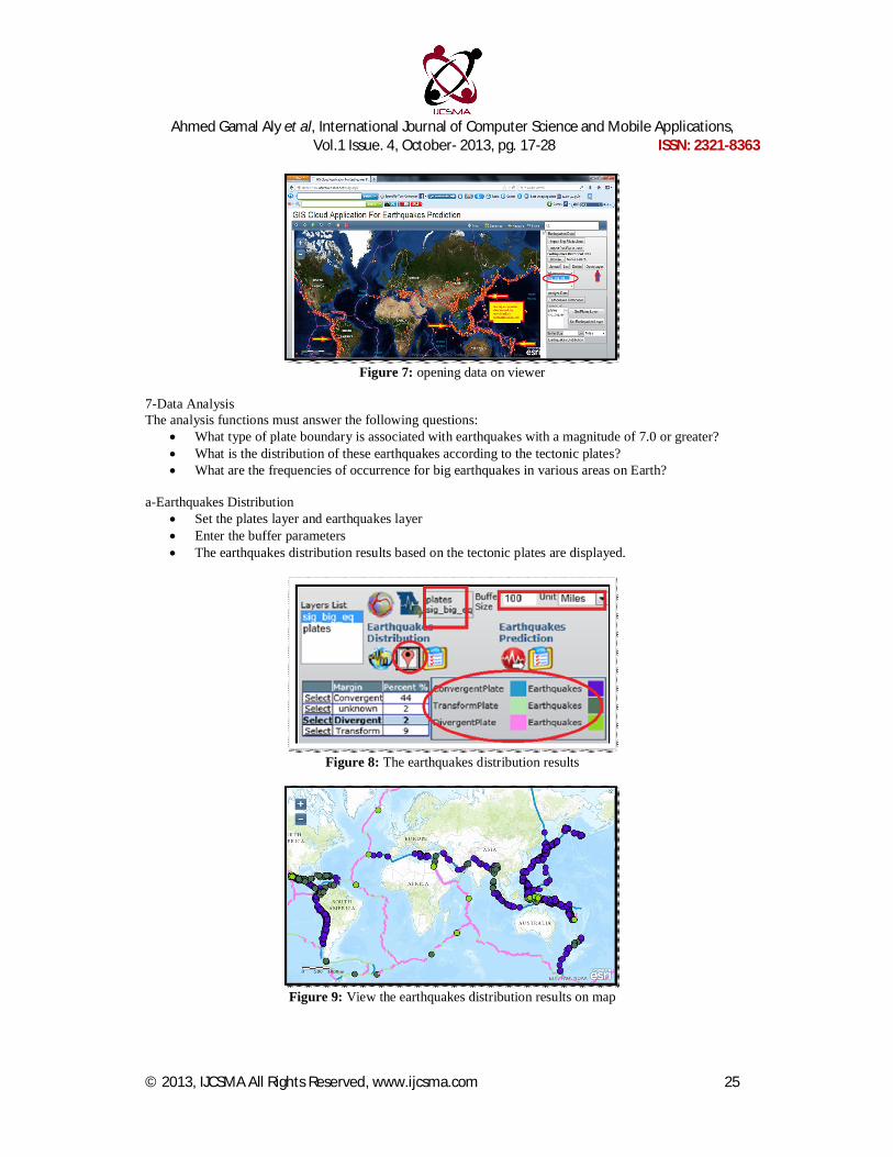
Figure 7: opening data on viewer
7-Data Analysis The analysis functions must answer the following questions:
What type of plate boundary is associated with earthquakes with a magnitude of 7.0 or greater? What is the distribution of these earthquakes according to the tectonic plates? What are the frequencies of occurrence for big earthquakes in various areas on Earth?
a-Earthquakes Distribution
Set the plates layer and earthquakes layer Enter the buffer parameters The earthquakes distribution results based on the tectonic plates are displayed.
Figure 8: The earthquakes distribution results
Figure 9: View the earthquakes distribution results on map

Ahmed Gamal Aly et al, International Journal of Computer Science and Mobile Applications,
Vol.1 Issue. 4, October- 2013, pg. 17-28 ISSN: 2321-8363
© 2013, IJCSMA All Rights Reserved, www.ijcsma.com 26
b-Earthquakes Predication Set the plates and earthquakes layers Click “Earthquakes Predication” button
Figure 10: Earthquakes Predication
Figure 11: Earthquakes Predication results
4. Tests and results 4.1 Monitoring a windows azure application The application uses Windows Azure services such as storage and Windows Azure SQL Database, so we must monitor these services to understand the overall health of our solution. The Windows Azure Management Portal monitors and displays the state of the hosted application, and can be used to determine the overall health of the application deployment.
Figure 12: Web site Monitoring

Ahmed Gamal Aly et al, International Journal of Computer Science and Mobile Applications,
Vol.1 Issue. 4, October- 2013, pg. 17-28 ISSN: 2321-8363
© 2013, IJCSMA All Rights Reserved, www.ijcsma.com 27
Figure 13: Database Monitoring
4.2 Tests and results The performance of earthquakes distribution based on plates function have been measured on local host and windows azure to compare the performance time between them. This is done by deploying the application on different platforms one of them windows azure platform and running the function multiple times with different buffer sizes and measure the processing time.
Table 1. Measures of processing time
Buffer Size (Miles) local host Azure 50 12.8s 4.2s 100 13.1s 5.9s 150 14.6s 6.8s 200 16.6s 7.0s 300 16.7s 7.7s
Figure 14: processing time
As shown in the figure 14, the performance has been enhanced using windows azure as cloud computing platform.

Ahmed Gamal Aly et al, International Journal of Computer Science and Mobile Applications,
Vol.1 Issue. 4, October- 2013, pg. 17-28 ISSN: 2321-8363
© 2013, IJCSMA All Rights Reserved, www.ijcsma.com 28
5. Conclusion Using cloud computing technology provides a plethora of benefits for GIS applications as compared to the traditional approaches, such as scalability. In this paper proposed GIS model based cloud computing for earthquakes prediction has been presented. We implemented this model using windows azure as cloud computing platform, power of processing and storage of GIS applications have been enhanced. We try to transfer our GIS applications and services to the cloud computing environment and build up a kind of geocloud to enhance the GIS field particularly emergency management which depends on GIS. 6. Future work We have planned to use GIS with cloud computing technology, but we have faced some obstacles such as the cost which due to using of free trial of cloud computing with small virtual machines and using ArcGIS java script API as GIS platform. In future work, we hope to use high computing and large scale of virtual machines to enhance the services and performance of GIS applications using ArcGIS Server as GIS platform which is costly. References [1] Leonid V. Stoimenov, Member, IAENG, Aleksandar Lj. Milosavljević, and Aleksandar S. Stanimirović 2007, "GIS as
a Tool in Emergency Management Process", Proceedings of the World Congress on Engineering Vol I, London, UK. pp. 238-242.
[2] Borko Furht , Armando Escalante, 2010, “Handbook of Cloud Computing”, Springer Science+Business Media, LLC , pp.3-4.
[3] Esri: http://www.esri.com/what-is-gis/overview# overview_panel [4] Suraj Pandey,” Cloud Computing Technology & GIS Applications”, April 22-24, 2010, The 8th Asian Symposium on
Geographic Information Systems From Computer & Engineering View (ASGIS 2010), ChongQing, China. [5] Yang Xiaoqiang, Deng Yuejin, 2007, “Exploration of Cloud Computing Technologies for Geographic Information
Services”, Sponsored by the project of National 863 plan, program number: 2007AA120501. [6] Asma BEN LETAIFA, Amel HAJI, Maha JEBALIA, Sami TABBANE, December 2010, “State of the Art and
Research Challenges of new services architecture technologies: Virtualization, SOA and Cloud Computing”, International Journal of Grid and Distributed Computing, Vol. 3, No. 4, pp. 69-88.
[7] J. Lakshmi, Sathish S. Vadhiyar , September 2011, “Cloud Computing: A Bird’s Eye View”, Cloud Computing-TR01 SERC, IISc., Bangalore.
[8] Muzafar Ahmad Bhat, Razeef Mohd Shah, Bashir Ahmad, Inayat Rasool Bhat, December 2010 , “Cloud Computing: A Solution to Information Support Systems (ISS)”, International Journal of Computer Applications (0975 – 8887) Volume 11, No.5.
[9] J. Noltes, 2011, “Data Location Compliance In Cloud Computing”, Master thesis, Document Number: EEMCS – 0089990, University of Twenty.
[10] Kai Hwang, Geoffrey Fox, and Jack Dongarra, 2010, “Cloud Architecture and Datacenter Design”, (57 pages) in Distributed Computing: Clusters, Grids and Clouds, Ch.7.
[11] NASCIO Cloud Computing Series: http:// www.nascio.org/ [12] GIS Cloud Platform: http:// www.omnisdata.com /lang/en/news/gis-cloud-platform/ [13] Ahmet İlhan AYŞAN, Hikmet YİĞİT, Güray YILMAZ, 2011, “GIS Applications in Cloud Computing Platform and
Recent Advances”, IEEE. [14] Windows Azure: http://www.windowsazure.com/en-us/home/features/data-management/ [15] Esri: http://resources.esri.com/help/9.3/arcgisserver/apis /javascript /arcgis/help/overview_api.htm
Related Documents