Ryefield Tore Ross-shire IV6 7SB Tel: 01463 811310 Mobile: 07891 578998/07776 027306 [email protected] www.rossandcromarch.co.uk PROPOSED FELLING COUPES WITHIN A82 PROJECT ZONE, INVERNESS ROSS & SKYE FOREST DISTRICT ARCHAEOLOGICAL DESK-BASED ASSESSMENT AND WALKOVER SURVEY Creag Nan Eun forest block – South Loch Ness

Welcome message from author
This document is posted to help you gain knowledge. Please leave a comment to let me know what you think about it! Share it to your friends and learn new things together.
Transcript
Ryefield Tore Ross-shire IV6 7SB
Tel: 01463 811310 Mobile: 07891 578998/07776 027306 [email protected] www.rossandcromarch.co.uk
PROPOSED FELLING COUPES WITHIN A82 PROJECT
ZONE, INVERNESS ROSS & SKYE FOREST DISTRICT
ARCHAEOLOGICAL DESK-BASED ASSESSMENT AND
WALKOVER SURVEY
Creag Nan Eun forest block – South Loch Ness
CNE14 – Creag Nan Eun Forest Block, South Loch Ness: Archaeological Walkover Survey
1
PROPOSED FELLING COUPES WITHIN A82 PROJECT ZONE, INVERNESS
ROSS & SKYE FOREST DISTRICT
ARCHAEOLOGICAL DESK-BASED ASSESSMENT AND WALKOVER
SURVEY
Creag Nan Eun forest block – South Loch Ness
Client
Forestry Commission Scotland
National Grid Reference
NH 46175 20126(Centred)
Site Code
CNE14
Report Number
2014-09/CNE14
Author
Lynn Fraser
Date
14-03-2014
Approved by
Mary Peteranna
Date
14-03-2014
OASIS No.
rosscrom1-174705
CNE14 – Creag Nan Eun Forest Block, South Loch Ness: Archaeological Walkover Survey
2
Contents
List of Figures 3
List of Plates 3
Acknowledgements 3
Summary 4
1.0 Introduction 4
2.0 Site Location 4
3.0 Archaeological and Historical Background 4
4.0 Methodology 6
4.1 Desk-Based Assessment
4.2 Walkover Survey
5.0 Results 6
5.1 Desk-Based Assessment 6
5.1.1 Cartographic Sources
5.1.2 Highland Council Historic Environment Record
5.2 Walkover Survey Results 13
6.0 Discussion 25
7.0 Recommendations 25
8.0 References 26
Appendix 1 Gazetteer of Archaeological Sites 27
Appendix 2 Index of Photographs 40
CNE14 – Creag Nan Eun Forest Block, South Loch Ness: Archaeological Walkover Survey
3
List of Figures
Figure 1: Location of the survey area 5
Figure 2: Excerpt from the OS 1st edition map 8
Figure 3: Excerpt from the OS 1st edition map 8
Figure 4: Excerpt from the OS 1st edition map 9
Figure 5: Location of the archaeological sites at the W end of the survey area 13
Figure 6: Location of the archaeological sites in the vicinity of Allt Saigh 14
Figure 7: Location of the archaeological sites at the E extremity of the survey area 14
Figure 8: Sites 1-3 16
Figure 9: Sites 4-8 and 11 17
Figure 10: Sites 9, 10 and 13-18 18
Figure 11: Site 12 19
Figure 12: Sites 19-23 20
Figure 13: Sites 24-30 20
Figure 14: Sites 31-42 23
Figure 15: Sites 43-46 24
Figure 16: Sites 47-49 24
List of Plates
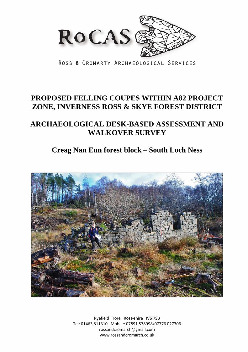
Cover: Structure 1d showing the S wall standing up to 2m high, looking NE
Plate 1: Site 1a-c, a house 15
Plate 2: Site 1d-f, a house 15
Plate 3: Site 8 16
Plate 4: Site 13, the lade 18
Plate 5: Site 14, a revetted track 18
Plate 6: Site 31, showing the fireplace in the gable wall 21
Plate 7: Site 35, showing the NW wall revetted into the slope 22
Plate 8: Site 40 22
Acknowledgements
We wish to thank Giles Brockman of Forestry Commission Scotland for commissioning the work.
Fieldwork was carried out by Lynn Fraser, Mary Peteranna and Steven Birch. All mapping, unless
otherwise stated, is reproduced by permission of Landmark Information Group license LIG1044. This
is an unpublished report.
CNE14 – Creag Nan Eun Forest Block, South Loch Ness: Archaeological Walkover Survey
4
Summary
An archaeological desk-based assessment and walkover survey was carried out between 6and 28
February 2014 on behalf of Forestry Commission Scotland at Creag Nan Eun Forest Block, South
Loch Ness, Inverness-shire in advance of proposed tree felling along the A82 trunk road. The work
was undertaken to establish the baseline extent and condition of any archaeological sites on the
property, by recording and identifying any features that may need conservation management, and to
inform forest design and operational planning The survey identified forty-nine archaeological sites,
including Post Medieval settlement, boundary walls and clearance cairns. No recommendation is
made for further investigative work.
1.0 Introduction
A desk-based assessment and walkover survey of the visible archaeological monuments surviving
within the boundaries of the Creag Nan Eun Forest Block, South Loch Ness (centred at grid reference
NH 46175 20126) was carried out by Ross and Cromarty Archaeological Services between 6 and 28
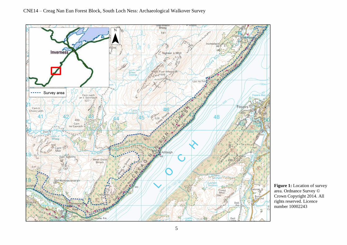
February 2014 (Figure 1). The survey was requested by Giles Brockman on behalf of Forestry
Commission Scotland (FCS) due to concerns about slope stability in relation to mature stands of trees
along the line of the Loch Ness road (A82); FCS is considering advancing its felling programmes in
order to manage the potential risk to the road from falling trees and land slips.
The purpose of the desk-based assessment and archaeological walkover survey was to identify the
cultural heritage baseline within the Creag Nan Eun Forest Block by recording and identifying any
features that may need conservation management in order to inform forest design and operational
planning. The Scottish Planning Policy 20101 describes how archaeology should be managed when
considering planning decisions and determining conditions for developments that have an impact on
the historic environment.
2.0 Site Location
The Creag Nan Eun Forest Block extends to 679ha and is located within the Great Glen on the
northwest bank of Loch Ness, lying between Invermoriston and Drumnadrochit. The block is bounded
along its south-eastern extent by the A82 trunk road; beyond its north-western reaches is open hillside.
The survey area slopes uphill from southeast to northwest, with varying degrees of steepness, and
comprises a mixture of tree stands at different stages in their rotation. There are several water courses
running through the area. The underlying bedrock comprises psammite of the Loch Eil Group;
metamorphic bedrock formed approximately 545 to 1000 million years ago2.
3.0 Archaeological and Historical Background
The Creag Nan Eun forest block is situated on the western side of Loch Ness between Invermoriston
and Drumnadrochit, which lie approximately 27 and 14.5 miles south-west of Inverness respectively.
Invermoriston dates back to at least 1600, and in the 1640s a sawmill was in operation processing the
surrounding woodland for export by boat. Tracks along the west side of Loch Ness were in place in
the 1770s, and used by Johnson and Boswell during their travels in 1773. It was not until 1813 and the
arrival of Thomas Telford that roads were built3.
1 The Scottish Government 2010 2 British Geological Survey 2013 3 Undiscovered Scotland 2013
CNE14 – Creag Nan Eun Forest Block, South Loch Ness: Archaeological Walkover Survey
5
Figure 1: Location of survey
area. Ordnance Survey ©
Crown Copyright 2014. All
rights reserved. Licence
number 10002243
CNE14 – Creag Nan Eun Forest Block, South Loch Ness: Archaeological Walkover Survey
6
The area falls in the former parish of Boleskine and Abertarff4, which is naturally divided into sections
by hills, moors, rivers and lochs. Despite the rugged nature of the land, it has been occupied for
millennia – mostly, it would seem, on the south-eastern side of Loch Ness where there is a smattering
of prehistoric monuments and post-medieval structures5.
4.0 Methodology
The overall aim of this assessment was to provide the cultural heritage baseline for the Creag Nan Eun
forest block. The specific objectives were to verify known archaeological sites or features and identify
and record any previously unknown archaeological sites or features within the survey area, which
would inform conservation management, forest design and operational planning.
4.1 Desk-based assessment
A desk-based assessment was conducted prior to commencement of the survey in order to assess the
archaeological potential of the area based on previously recorded sites and any historical
documentation. This was done in accordance with the Institute for Archaeologists’ (IfA) Standards
and guidance for archaeological desk-based assessment6.
The drawings of the area, as supplied by the client, were checked in detail against the Ordnance
Survey 1:25000 Map, Highland Council’s Historic Environment Record (HHER), the National
Monuments Record of Scotland (NMRS) and Historic Scotland’s records of scheduled monuments and
listed buildings. Online aerial photographs were checked and the map collections of the National
Library of Scotland (NLS) were studied. Other literary sources were also consulted.
4.2 Walkover survey
The objectives were to identify and record all archaeological sites within the forest block.
Archaeological sites were recorded individually including using high-resolution digital photography
where possible, while sketch survey drawings were produced where necessary. The individual site
locations were plotted using and ArcPad GIS software on a handheld Windows Mobile-based
computer capable of sub-metre accuracy. When a reliable satellite signal was unavailable, site
locations were recorded using a handheld Garmin GPS. Details relating to the individual sites and
monuments located during the survey can be found in the Gazetteer of Archaeological Sites in
Appendix 1.
Survey and recording methods from the Royal Commission on the Ancient and Historical Monuments
of Scotland (RCAHMS)7 were employed and all work was conducted in strict adherence to the
Institute for Archaeologists’ (IfA) Code of Conduct8.
5.0 Results
5.1 Desk-based assessment
A desk-based assessment was carried out in advance of the walkover survey in order to assess the
archaeological potential of the area based on previously recorded sites and any historical
documentation.
4 Scotland’s Places 2013 5 HER 2013 6 IfA 2008 7 RCAHMS 2004 8 IfA 2009

CNE14 – Creag Nan Eun Forest Block, South Loch Ness: Archaeological Walkover Survey
7
5.1.1 Cartographic sources
Mapping held at the National Library of Scotland (NLS) in Edinburgh was checked on-line and
produced the following results:
Blaeu’s Atlas of Scotland, 1654
Innermorifden (Invermoriston) and Wrchart C (Urquhart Castle) are marked on this map, but there is
no detail within the survey area.
Herman Moll’s The East Part of the Shire of Inverness with Badenoch, 1732
Inner Morisden (Invermoriston) and Urchard C. (Urquhart Castle) are marked on the map, but there is
no detail within the survey area.
John Thomson’s Northern Part of Inverness-shire, 1832
Invermorrison and Urquhart Castle are again shown on this map. In addition, settlement is shown at
Altsay (Alltsigh) within the survey area. A single road is now in existence running along south-eastern
edge of the survey area to the northeast of Altsay, where it splits in two.
Ordnance Survey 6 inch to 1 mile 1st Edition
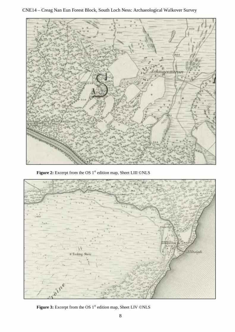
Inverness-shire (Mainland), Sheet LIII - Surveyed 1871, published 1874
At the western extremity of the survey area, to the west of Invermoriston, bordered by the Allt na
Criche burn, is a boundary dyke that runs parallel with the burn before turning to the northeast and
then north (Figure 2). This dyke continues outwith the survey area. To the east of the dyke, and on the
western side of an unnamed burn, is a long T-shaped building with an irregularly shaped enclosure. A
track runs from this farmstead outwith the survey area to the settlement of Achnaconeran to the east. A
boundary dyke runs in a NNE-SSW direction from the lower edge of the survey area running past
Achnaconeran. An unroofed building is depicted to the west of the track leading south from
Achnaconeran to the south of two enclosed fields.
To the northeast on Invermoriston House there are boundary dykes depicted together with a sluice and
mill lead on the eastern side of the Allt Coinneag.
Ordnance Survey 6 inch to 1 mile 2nd
Edition
Inverness-shire (Mainland), Sheet LIII – Surveyed 1901, published 1904
The T-shaped building is now shown as a smaller, rectangular building and two further buildings have
been erected including a T-shaped house. The dykes and enclosure are unchanged.
Ordnance Survey 6 inch to 1 mile 1st Edition
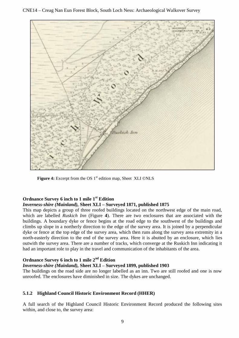
Inverness-shire (Mainland), Sheet LIV - Surveyed 1871, published 1874
At the south-western corner of the north-western bank of Loch Ness, a single building and enclosure
are depicted, although these are most likely outwith the survey area. To the west of Alltsigh is a
‘Rocking Stone’ on the western slopes of Meall na Sroine (Figure 3). Alltsigh is depicted as a scattered
settlement of five buildings and boundary dykes forming small enclosures. At the north-eastern corner
of the north-western bank is a single unroofed building within an enclosure; this area is now known as
Primrose Bay and is outwith the survey area.
Ordnance Survey 6 inch to 1 mile 2nd
Edition
Inverness-shire (Mainland), Sheet LIV – Surveyed 1899, published 1904
Alltsigh is now depicted as four roofed buildings, four unroofed buildings and associated enclosures
and dykes. There is an unroofed building depicted at the location of Primrose Bay, but the enclosure is
no longer shown.
CNE14 – Creag Nan Eun Forest Block, South Loch Ness: Archaeological Walkover Survey
8
Figure 2: Excerpt from the OS 1st edition map, Sheet LIII ©NLS
Figure 3: Excerpt from the OS 1
st edition map, Sheet LIV ©NLS
CNE14 – Creag Nan Eun Forest Block, South Loch Ness: Archaeological Walkover Survey
9
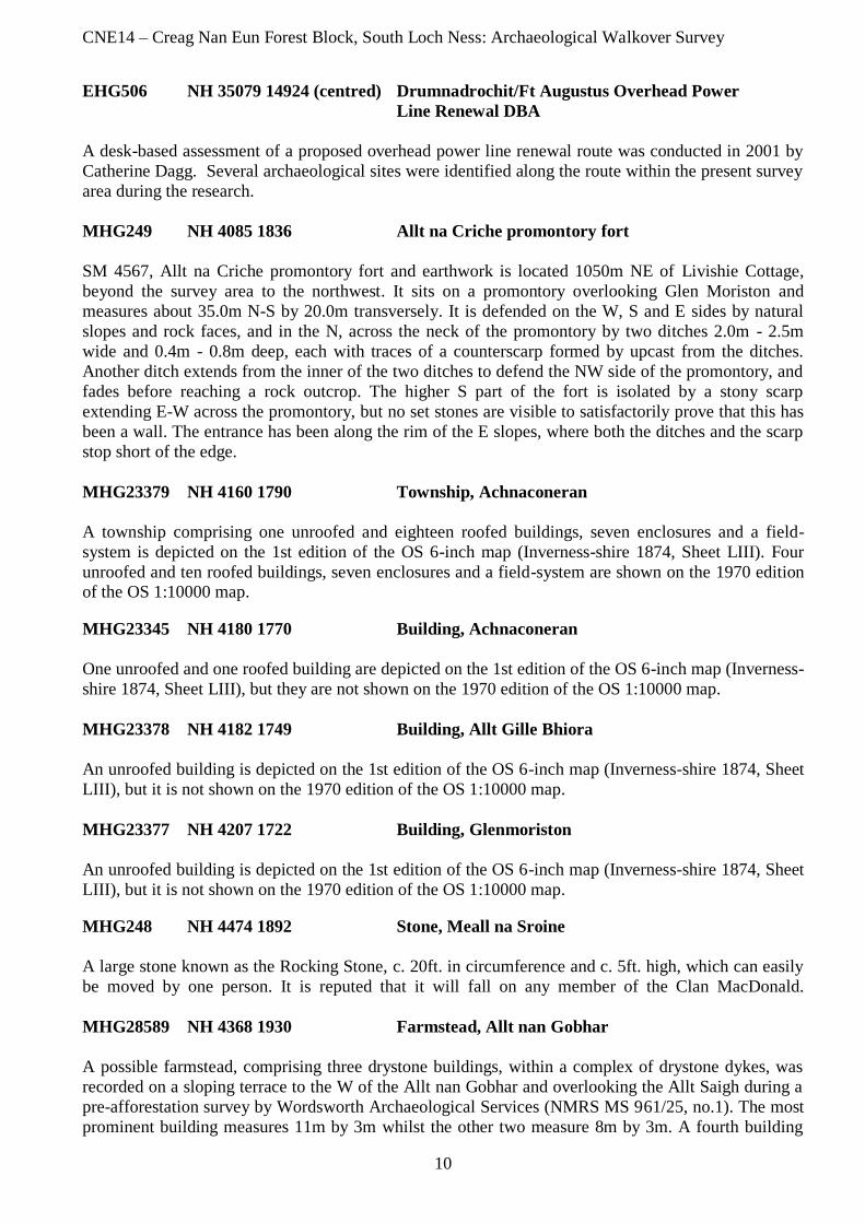
Figure 4: Excerpt from the OS 1
st edition map, Sheet XLI ©NLS
Ordnance Survey 6 inch to 1 mile 1st Edition
Inverness-shire (Mainland), Sheet XLI – Surveyed 1871, published 1875
This map depicts a group of three roofed buildings located on the northwest edge of the main road,
which are labelled Ruskich Inn (Figure 4). There are two enclosures that are associated with the
buildings. A boundary dyke or fence begins at the road edge to the southwest of the buildings and
climbs up slope in a northerly direction to the edge of the survey area. It is joined by a perpendicular
dyke or fence at the top edge of the survey area, which then runs along the survey area extremity in a
north-easterly direction to the end of the survey area. Here it is abutted by an enclosure, which lies
outwith the survey area. There are a number of tracks, which converge at the Ruskich Inn indicating it
had an important role to play in the travel and communication of the inhabitants of the area.
Ordnance Survey 6 inch to 1 mile 2nd
Edition
Inverness-shire (Mainland), Sheet XLI – Surveyed 1899, published 1903
The buildings on the road side are no longer labelled as an inn. Two are still roofed and one is now
unroofed. The enclosures have diminished in size. The dykes are unchanged.
5.1.2 Highland Council Historic Environment Record (HHER)
A full search of the Highland Council Historic Environment Record produced the following sites within, and close to, the survey area:
CNE14 – Creag Nan Eun Forest Block, South Loch Ness: Archaeological Walkover Survey
10
EHG506 NH 35079 14924 (centred) Drumnadrochit/Ft Augustus Overhead Power
Line Renewal DBA
A desk-based assessment of a proposed overhead power line renewal route was conducted in 2001 by
Catherine Dagg. Several archaeological sites were identified along the route within the present survey
area during the research.
MHG249 NH 4085 1836 Allt na Criche promontory fort
SM 4567, Allt na Criche promontory fort and earthwork is located 1050m NE of Livishie Cottage,
beyond the survey area to the northwest. It sits on a promontory overlooking Glen Moriston and
measures about 35.0m N-S by 20.0m transversely. It is defended on the W, S and E sides by natural
slopes and rock faces, and in the N, across the neck of the promontory by two ditches 2.0m - 2.5m
wide and 0.4m - 0.8m deep, each with traces of a counterscarp formed by upcast from the ditches.
Another ditch extends from the inner of the two ditches to defend the NW side of the promontory, and
fades before reaching a rock outcrop. The higher S part of the fort is isolated by a stony scarp
extending E-W across the promontory, but no set stones are visible to satisfactorily prove that this has
been a wall. The entrance has been along the rim of the E slopes, where both the ditches and the scarp
stop short of the edge.
MHG23379 NH 4160 1790 Township, Achnaconeran
A township comprising one unroofed and eighteen roofed buildings, seven enclosures and a field-
system is depicted on the 1st edition of the OS 6-inch map (Inverness-shire 1874, Sheet LIII). Four
unroofed and ten roofed buildings, seven enclosures and a field-system are shown on the 1970 edition of the OS 1:10000 map.
MHG23345 NH 4180 1770 Building, Achnaconeran
One unroofed and one roofed building are depicted on the 1st edition of the OS 6-inch map (Inverness-
shire 1874, Sheet LIII), but they are not shown on the 1970 edition of the OS 1:10000 map.
MHG23378 NH 4182 1749 Building, Allt Gille Bhiora
An unroofed building is depicted on the 1st edition of the OS 6-inch map (Inverness-shire 1874, Sheet
LIII), but it is not shown on the 1970 edition of the OS 1:10000 map.
MHG23377 NH 4207 1722 Building, Glenmoriston
An unroofed building is depicted on the 1st edition of the OS 6-inch map (Inverness-shire 1874, Sheet
LIII), but it is not shown on the 1970 edition of the OS 1:10000 map.
MHG248 NH 4474 1892 Stone, Meall na Sroine
A large stone known as the Rocking Stone, c. 20ft. in circumference and c. 5ft. high, which can easily
be moved by one person. It is reputed that it will fall on any member of the Clan MacDonald.
MHG28589 NH 4368 1930 Farmstead, Allt nan Gobhar
A possible farmstead, comprising three drystone buildings, within a complex of drystone dykes, was
recorded on a sloping terrace to the W of the Allt nan Gobhar and overlooking the Allt Saigh during a
pre-afforestation survey by Wordsworth Archaeological Services (NMRS MS 961/25, no.1). The most
prominent building measures 11m by 3m whilst the other two measure 8m by 3m. A fourth building
CNE14 – Creag Nan Eun Forest Block, South Loch Ness: Archaeological Walkover Survey
11
also measuring 8m by 3m, and reduced to footings, lies to the SE adjacent to the modern forestry
boundary. Although there is no evidence of rig, the series of stone dykes suggest that this area was
formerly cultivated rather than for just pasturing animals. At the N end of the dykes, a sinuous dyke
runs parallel with the Allt nan Gobhar, before running E to join a head-dyke (NH41NW 17).
MHG28590 NH 4374 1960 Head dyke, Allt Saigh
A substantial turf-built dyke, possibly a head-dyke, running over the S-facing slope between the Allt
Saigh and the Allt Ruighe Bhacain was recorded during a pre-afforestation survey by Wordsworth
Archaeological Services (NMRS MS 961/25, no.3). The dyke has decayed to a spread 2m wide by up
to 0.4m high.
MHG28591 NH 4405 1953 Platform, Allt Saigh
A platform, measuring 8m in diameter, was recorded on the S-facing slope overlooking the Allt Saigh
during a pre-afforestation survey by Wordsworth Archaeological Services (NMRS MS 961/25, no.4).
Although poorly defined, the platform has stone revetting around its S edge and may be the remains of
a prehistoric roundhouse or later structure.
MHG28592 NH 4422 1963 Shieling hut, Allt Saigh
A possible shieling-hut measuring 4m by 5.5m was recorded on a flat grassy flush, about 100m NW of
a fence, during a pre-afforestation survey by Wordsworth Archaeological Services (NMRS MS
961/25, no.5).
MHG23333 NH 4450 1980 Building, Allt Saigh
An unroofed building is depicted on the 1st edition of the OS 6-inch map (Inverness-shire 1874, Sheet
LIV), but it is not shown on the 1975 edition of the OS 1:10000 map.
MHG28595 NH 4460 1970 Sheepfold, Allt Saigh
A sheepfold is depicted to the E of an unnamed burn on the W side of the Allt Ruighe Bhacain, on the
1st edition of the OS 6-inch map (Inverness-shire 1874, Sheet LIV), but it is not shown on the 1975
edition of the OS 1:10000 map.
MHG28593 NH 4476 1983 Structure, Allt Saigh
A structure, measuring 8m from N to S by 4m, was recorded about 65m W of the Allt Ruighe Bhacain
and 15m N of the fence-line on the upper edge of the Creag Nan Eun Forest, during a pre-afforestation
survey by Wordsworth Archaeological Services (NMRS MS 961/25, no.6.). The edges of the structure
are not clearly defined.
MHG15679 NH 45675 19095 Alltsaigh Cottage
This is a Grade B Listed, earlier 19th century two storey, three bay house, which was possibly raised
from an original single storey to two storey height.
MHG23374 NH 4690 2040 Farmstead, Primrose Bay
What may be a farmstead comprising one unroofed building lying within a field is depicted on the 1st
edition of the OS 6-inch map (Inverness-shire 1874, Sheet LIV), but it is not shown on the 1975
edition of the OS 1:10000 map.
CNE14 – Creag Nan Eun Forest Block, South Loch Ness: Archaeological Walkover Survey
12
MHG2700 NH 4720 2190 Battle site, Lon na Fola
Lon na Fola was the scene of the defeat by the MacKenzies of the Macdonalds of Glengarry took place
at Lon na Fala, the Meadow of Blood, on the west shore of Loch Ness. The Macdonalds, under Allan
MacRanald (Allan Dubh), were returning from an invasion in September 1603, of the Mackenzie
country and the burning of the Church of Kilchrist.
MHG23391 NH 4718 2213 Farmstead, Lon na Fola
A farmstead, comprising one unroofed building and one enclosure is depicted on the 1st edition of the
OS 6-inch map (Inverness-shire 1875, Sheet XLI), but it is not shown on the1975 edition of the OS
1:10000 map.
MHG2699 NH 4913 2358 Fort, Dun Scriben
This is a fort, situated on a flat-topped knoll and known locally as Dun Scriben. It is sub-oval on plan
and measures 26.0m WNW-ESE by c. 30.0m overall, with the outer face of its tumbled drystone wall
visible in the W and E arcs. The W face has been excavated and it survives to a maximum height of c.
1.0m; it is built of small thin slabs roughly coursed and braced with occasional blocks on edge. In the
E, the base course of the face is occasionally visible in the slope of the knoll, but in the N it has slipped
down the slope and in the S it is obscured by tumble. Only three or four stones of the inner face are
visible, in the S, and a true wall thickness cannot be established, but the width of tumble and the
position of the outer face below the lip of the knoll suggest a thickness of between 3.5m and 4.0m. The
entrance is not evident, although the RCAHMS (1957) state that it is in the S, on the easiest line of
approach. The footings of a modern wall overlie the wall in the E, and a modern shelter is built against
it.
MHG30671 NH 4918 2353 Stone, Grotaig
A possible carved stone (holed) was reported by Neil Oram to Richard Wallace, Forestry Commission,
Dingwall.
MHG2701 NH 4950 2402 Chapel, Lag an t-Seapail
MHG40704 NH 4950 2402 Cemetery, Lag an t-Seapail
There was in those olden times (temp SS Merchard, Columba and Curadan) a chapel at Lag an t-
Seapail - the Hollow of the Chapel - in Bunloit, where traces of old graves are still visible"
W MacKay 1914. However, when the site was visited by Ordnance Survey in 1975 no trace of a
chapel was found. The graveyard at NM 4950 2402 is roughly oval measuring about 20.0m NE-SW by
16.5m within a tumbled wall reduced to a low band of overgrown rubble about 1.5m wide, overlaid in
parts by piles of later stone clearance and virtually destroyed in the NW. There are some earth-fast
stones and slabs in the interior but none certainly identifiable as grave markers. Set erect in the wall
core in the N, is a dressed stone slab and outside the graveyard to the SW is another displaced slab.
MHG23380 NH 4958 2405 Enclosure, Lag an t-Seapail
An enclosure is depicted on the 1st edition of the OS 6-inch map (Inverness-shire 1875, Sheet XLI),
but it is not shown on the 1975 edition of the OS 1:10000 map.
MHG23376 NH 4910 2412 Township, Balbeg
CNE14 – Creag Nan Eun Forest Block, South Loch Ness: Archaeological Walkover Survey
13
A township, comprising eight roofed buildings, one partially roofed building and one unroofed
building is depicted on the 1st edition of the OS 6-inch map (Inverness-shire 1875, Sheet XLI). Eight
roofed buildings and one unroofed building are shown on the 1975 edition of the OS 1:10000 map.
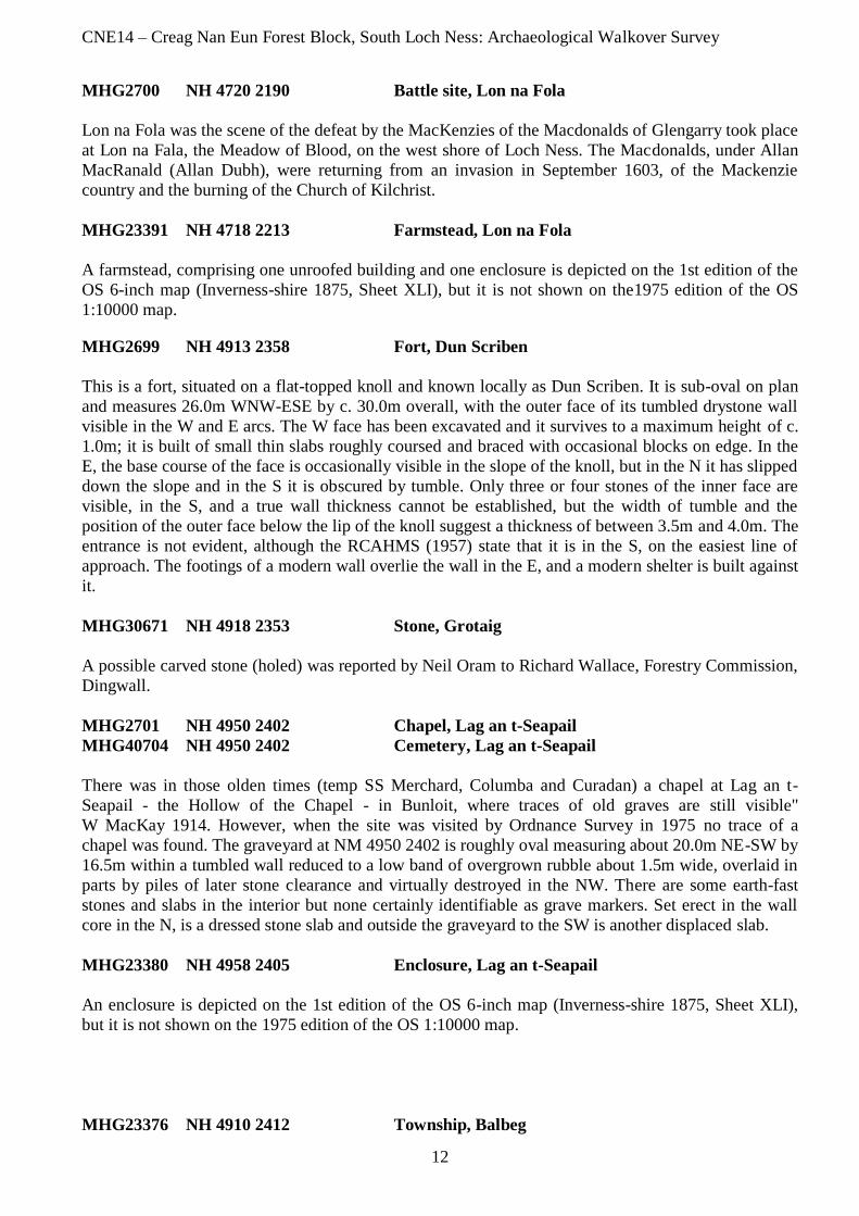
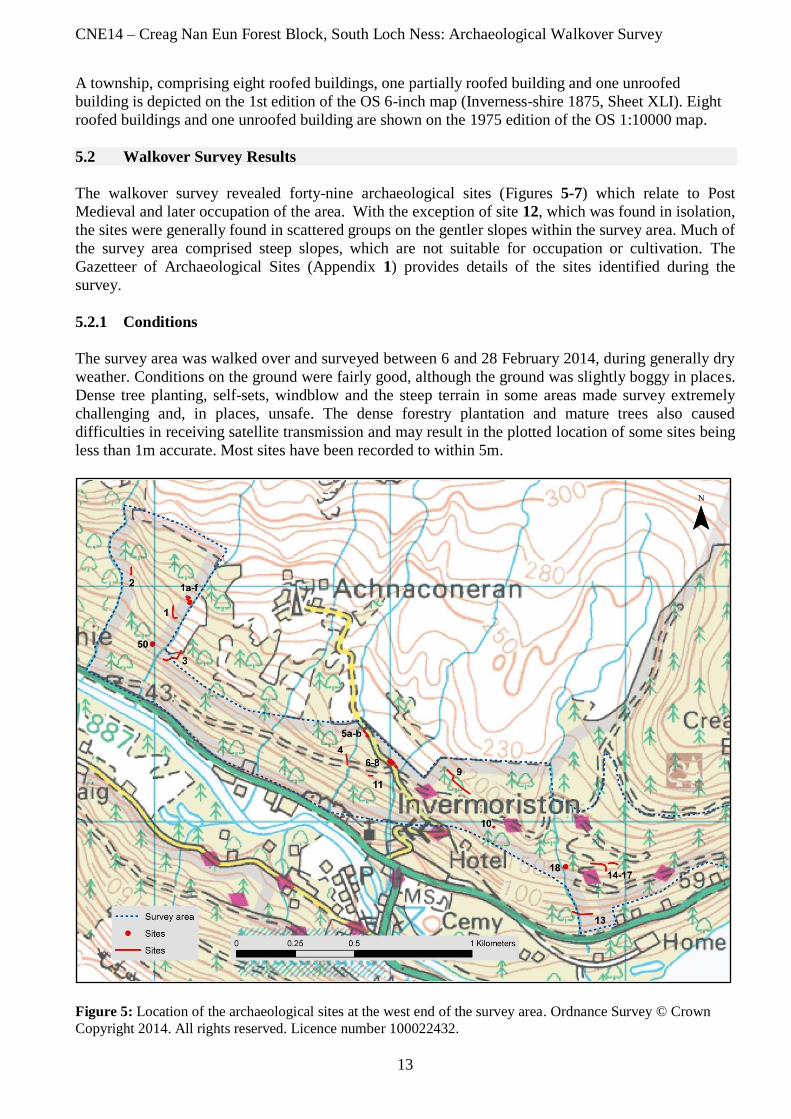
5.2 Walkover Survey Results
The walkover survey revealed forty-nine archaeological sites (Figures 5-7) which relate to Post
Medieval and later occupation of the area. With the exception of site 12, which was found in isolation,
the sites were generally found in scattered groups on the gentler slopes within the survey area. Much of
the survey area comprised steep slopes, which are not suitable for occupation or cultivation. The
Gazetteer of Archaeological Sites (Appendix 1) provides details of the sites identified during the
survey.
5.2.1 Conditions
The survey area was walked over and surveyed between 6 and 28 February 2014, during generally dry
weather. Conditions on the ground were fairly good, although the ground was slightly boggy in places.
Dense tree planting, self-sets, windblow and the steep terrain in some areas made survey extremely
challenging and, in places, unsafe. The dense forestry plantation and mature trees also caused
difficulties in receiving satellite transmission and may result in the plotted location of some sites being
less than 1m accurate. Most sites have been recorded to within 5m.
Figure 5: Location of the archaeological sites at the west end of the survey area. Ordnance Survey © Crown
Copyright 2014. All rights reserved. Licence number 100022432.
CNE14 – Creag Nan Eun Forest Block, South Loch Ness: Archaeological Walkover Survey
14
Figure 6: Location of the archaeological sites in the vicinity of Allt Saigh. Ordnance Survey © Crown
Copyright 2014. All rights reserved. Licence number 100022432.
Figure 7: Location of the archaeological sites at the eastern extremity of the survey area. Ordnance
Survey © Crown Copyright 2014. All rights reserved. Licence number 100022432.
CNE14 – Creag Nan Eun Forest Block, South Loch Ness: Archaeological Walkover Survey
15
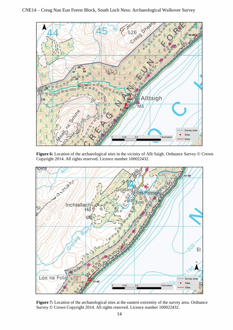
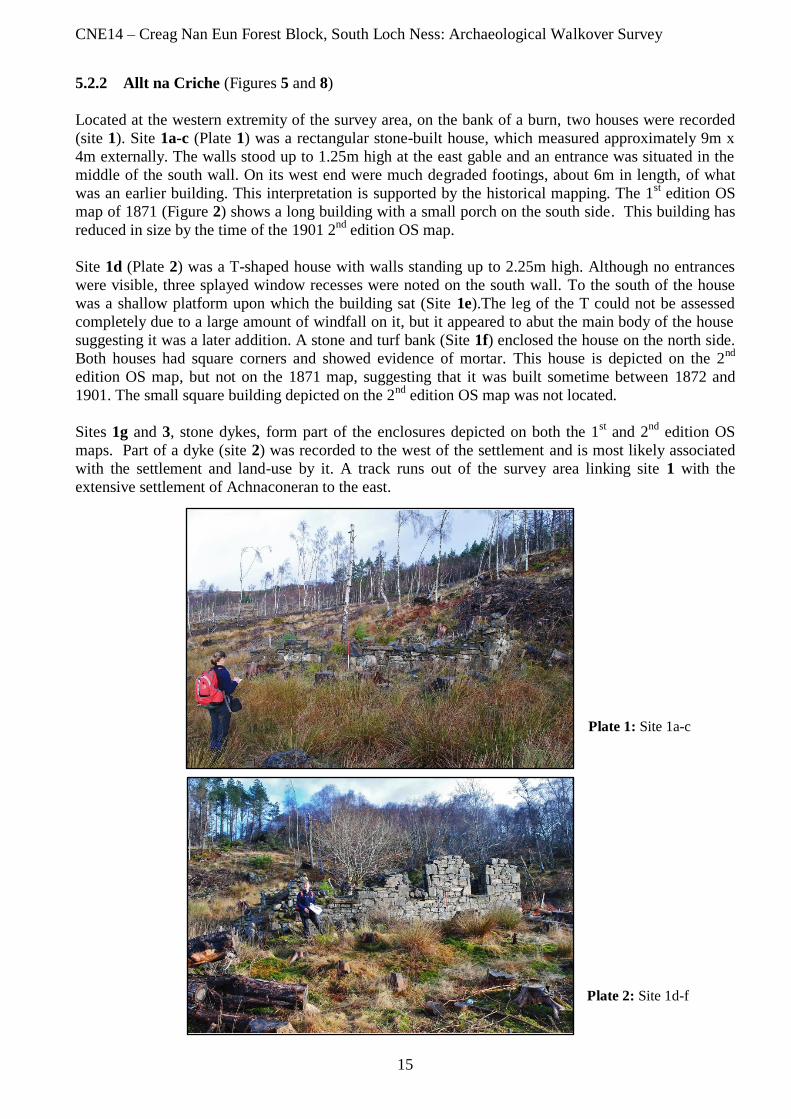
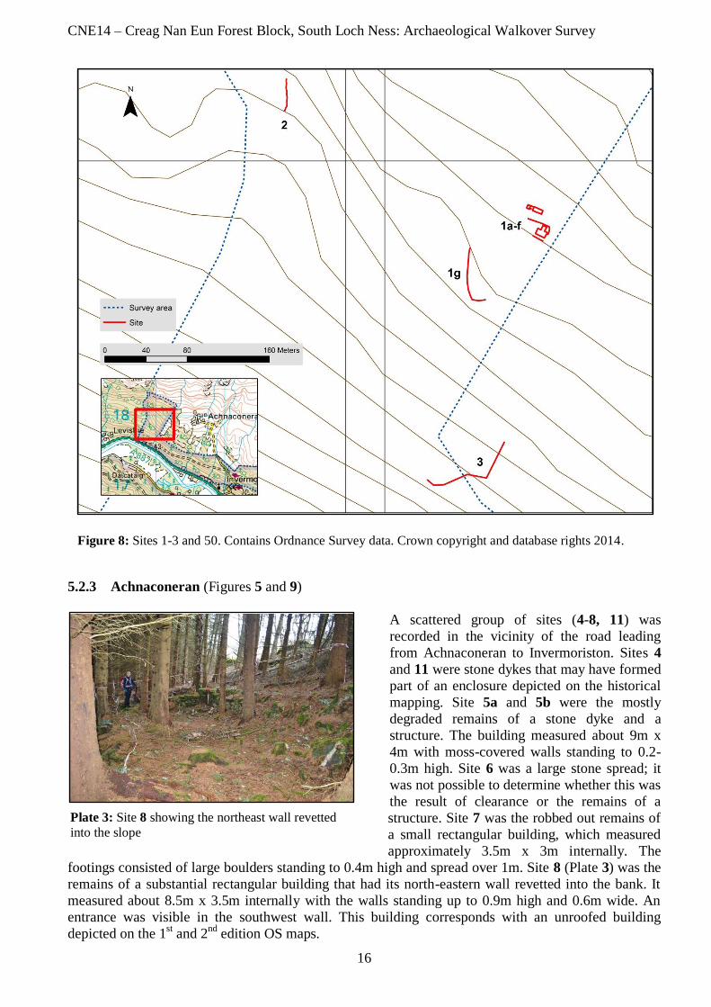
5.2.2 Allt na Criche (Figures 5 and 8)
Located at the western extremity of the survey area, on the bank of a burn, two houses were recorded
(site 1). Site 1a-c (Plate 1) was a rectangular stone-built house, which measured approximately 9m x
4m externally. The walls stood up to 1.25m high at the east gable and an entrance was situated in the
middle of the south wall. On its west end were much degraded footings, about 6m in length, of what
was an earlier building. This interpretation is supported by the historical mapping. The 1st edition OS
map of 1871 (Figure 2) shows a long building with a small porch on the south side. This building has
reduced in size by the time of the 1901 2nd
edition OS map.
Site 1d (Plate 2) was a T-shaped house with walls standing up to 2.25m high. Although no entrances
were visible, three splayed window recesses were noted on the south wall. To the south of the house
was a shallow platform upon which the building sat (Site 1e).The leg of the T could not be assessed
completely due to a large amount of windfall on it, but it appeared to abut the main body of the house
suggesting it was a later addition. A stone and turf bank (Site 1f) enclosed the house on the north side.
Both houses had square corners and showed evidence of mortar. This house is depicted on the 2nd
edition OS map, but not on the 1871 map, suggesting that it was built sometime between 1872 and
1901. The small square building depicted on the 2nd
edition OS map was not located.
Sites 1g and 3, stone dykes, form part of the enclosures depicted on both the 1st and 2
nd edition OS
maps. Part of a dyke (site 2) was recorded to the west of the settlement and is most likely associated
with the settlement and land-use by it. A track runs out of the survey area linking site 1 with the
extensive settlement of Achnaconeran to the east.
Plate 1: Site 1a-c
Plate 2: Site 1d-f
CNE14 – Creag Nan Eun Forest Block, South Loch Ness: Archaeological Walkover Survey
16
Figure 8: Sites 1-3 and 50. Contains Ordnance Survey data. Crown copyright and database rights 2014.
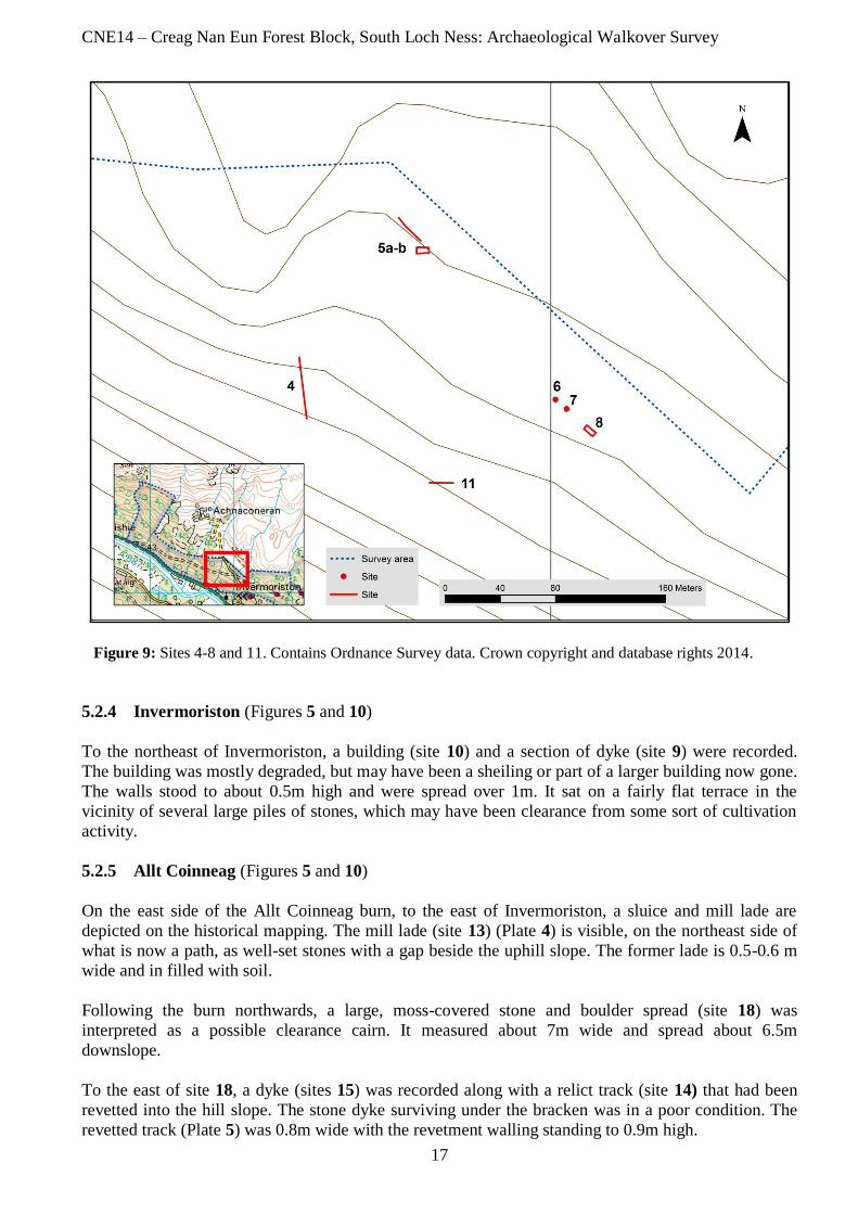
5.2.3 Achnaconeran (Figures 5 and 9)
A scattered group of sites (4-8, 11) was
recorded in the vicinity of the road leading
from Achnaconeran to Invermoriston. Sites 4
and 11 were stone dykes that may have formed
part of an enclosure depicted on the historical
mapping. Site 5a and 5b were the mostly
degraded remains of a stone dyke and a
structure. The building measured about 9m x
4m with moss-covered walls standing to 0.2-
0.3m high. Site 6 was a large stone spread; it
was not possible to determine whether this was
the result of clearance or the remains of a
structure. Site 7 was the robbed out remains of
a small rectangular building, which measured
approximately 3.5m x 3m internally. The
footings consisted of large boulders standing to 0.4m high and spread over 1m. Site 8 (Plate 3) was the
remains of a substantial rectangular building that had its north-eastern wall revetted into the bank. It
measured about 8.5m x 3.5m internally with the walls standing up to 0.9m high and 0.6m wide. An
entrance was visible in the southwest wall. This building corresponds with an unroofed building
depicted on the 1st and 2
nd edition OS maps.
Plate 3: Site 8 showing the northeast wall revetted
into the slope
CNE14 – Creag Nan Eun Forest Block, South Loch Ness: Archaeological Walkover Survey
17
Figure 9: Sites 4-8 and 11. Contains Ordnance Survey data. Crown copyright and database rights 2014.
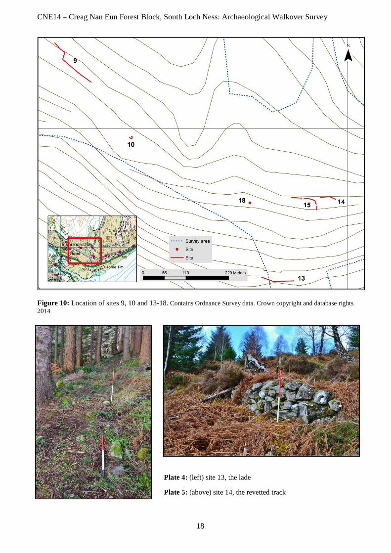
5.2.4 Invermoriston (Figures 5 and 10)
To the northeast of Invermoriston, a building (site 10) and a section of dyke (site 9) were recorded.
The building was mostly degraded, but may have been a sheiling or part of a larger building now gone.
The walls stood to about 0.5m high and were spread over 1m. It sat on a fairly flat terrace in the
vicinity of several large piles of stones, which may have been clearance from some sort of cultivation
activity.
5.2.5 Allt Coinneag (Figures 5 and 10)
On the east side of the Allt Coinneag burn, to the east of Invermoriston, a sluice and mill lade are
depicted on the historical mapping. The mill lade (site 13) (Plate 4) is visible, on the northeast side of
what is now a path, as well-set stones with a gap beside the uphill slope. The former lade is 0.5-0.6 m
wide and in filled with soil.
Following the burn northwards, a large, moss-covered stone and boulder spread (site 18) was
interpreted as a possible clearance cairn. It measured about 7m wide and spread about 6.5m
downslope.
To the east of site 18, a dyke (sites 15) was recorded along with a relict track (site 14) that had been
revetted into the hill slope. The stone dyke surviving under the bracken was in a poor condition. The
revetted track (Plate 5) was 0.8m wide with the revetment walling standing to 0.9m high.
CNE14 – Creag Nan Eun Forest Block, South Loch Ness: Archaeological Walkover Survey
18
Figure 10: Location of sites 9, 10 and 13-18. Contains Ordnance Survey data. Crown copyright and database rights
2014
Plate 4: (left) site 13, the lade
Plate 5: (above) site 14, the revetted track

CNE14 – Creag Nan Eun Forest Block, South Loch Ness: Archaeological Walkover Survey
19
5.2.6 Creag nan Eun
Unlike the remainder of the sites located, site 12 (Figure 11) was found in isolation. Situated to the
southeast of Creag nan Eun, it was a degraded stone/rubble building, which measured 4.5-5m x 3.5m
over walls spread to 1.5-2m wide and standing to 1.5m high. It was built into the north face of the hill
with a possible entrance at the south end.
Figure 11: Location of site 12. Contains Ordnance Survey data. Crown copyright and database rights 2014
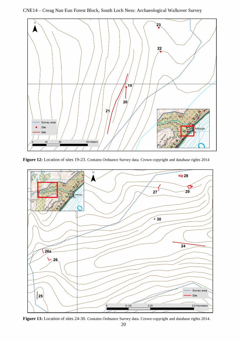
5.2.7 Allt Saigh
Two groups of sites were found in the Allt Saigh area. The first was located at the southeast edge of
the survey area in the vicinity of the modern houses that constitute Allt Saigh today. The sites at this
location comprised a structure (site 19), a dyke (site 20), a relict track (site 21), a bridge (site 22) and a
terrace (site 23) (Figure 12). The structure was in a much degraded condition and comprised a possible
building platform. Wall coursing was visible at the south-southwest end on the uphill side. The dyke
ran off this structure on a north-south alignment. The much degraded relict track was located about 8m
to the west. These sites correspond with the central building of a group of three, wall and track
depicted on the 1871 OS map to the west of the Allt Sigh burn. The bridge and terrace were located to
the northeast of this small group of sites. The bridge is also depicted on the 1871 map with a track
leading from the group of three buildings to a further two with associated dyke and enclosure. The flat
terrace recorded corresponds with the dyke or enclosure.
CNE14 – Creag Nan Eun Forest Block, South Loch Ness: Archaeological Walkover Survey
20
Figure 12: Location of sites 19-23. Contains Ordnance Survey data. Crown copyright and database rights 2014
Figure 13: Location of sites 24-30. Contains Ordnance Survey data. Crown copyright and database rights 2014.
CNE14 – Creag Nan Eun Forest Block, South Loch Ness: Archaeological Walkover Survey
21
The second scattered group of sites was located at the north-western edge of the survey area in the
vicinity of the Allt Saigh (Figure 13) and comprised a relict track (site 24), three dykes (sites 25-27), a
building (site 28), a sheepfold (site 29) and a structure (site 30). The three dykes would have been part
of the land use associated with the buildings and sheepfold. Site 28 was a stone-built, L-shaped
structure. Four compartments were recorded, with three entrances in the north wall and one in the
south wall. The sheepfold was located to the south of the building. Its double-faced walls stood up to
0.8m high and 1.2m wide, with an entrance in the southeast corner. The building, sheepfold and track
are depicted on both the 1st and 2
nd edition OS maps. The final structure in this area was sub-circular,
open-ended and rubble-built.
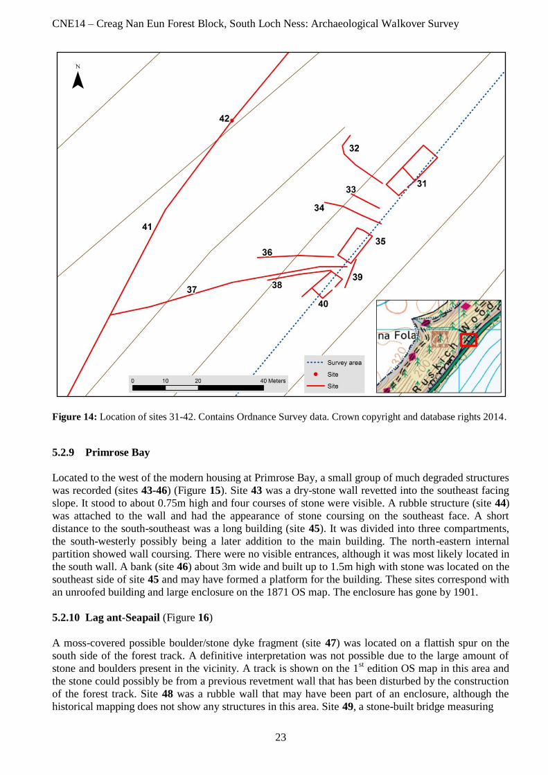
5.2.8 Ruskich Inn
The remains of the former Ruskich Inn and associated buildings are clearly visible on the northwest
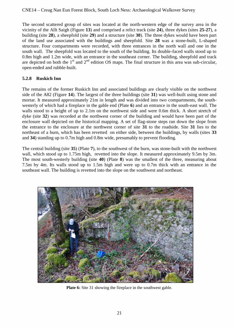
side of the A82 (Figure 14). The largest of the three buildings (site 31) was well-built using stone and
mortar. It measured approximately 21m in length and was divided into two compartments, the south-
westerly of which had a fireplace in the gable end (Plate 6) and an entrance in the south-east wall. The
walls stood to a height of up to 2.1m on the northwest side and were 0.6m thick. A short stretch of
dyke (site 32) was recorded at the northwest corner of the building and would have been part of the
enclosure wall depicted on the historical mapping. A set of flag-stone steps ran down the slope from
the entrance to the enclosure at the northwest corner of site 31 to the roadside. Site 31 lies to the
northeast of a burn, which has been revetted on either side, between the buildings, by walls (sites 33
and 34) standing up to 0.7m high and 0.8m wide, presumably to prevent flooding.
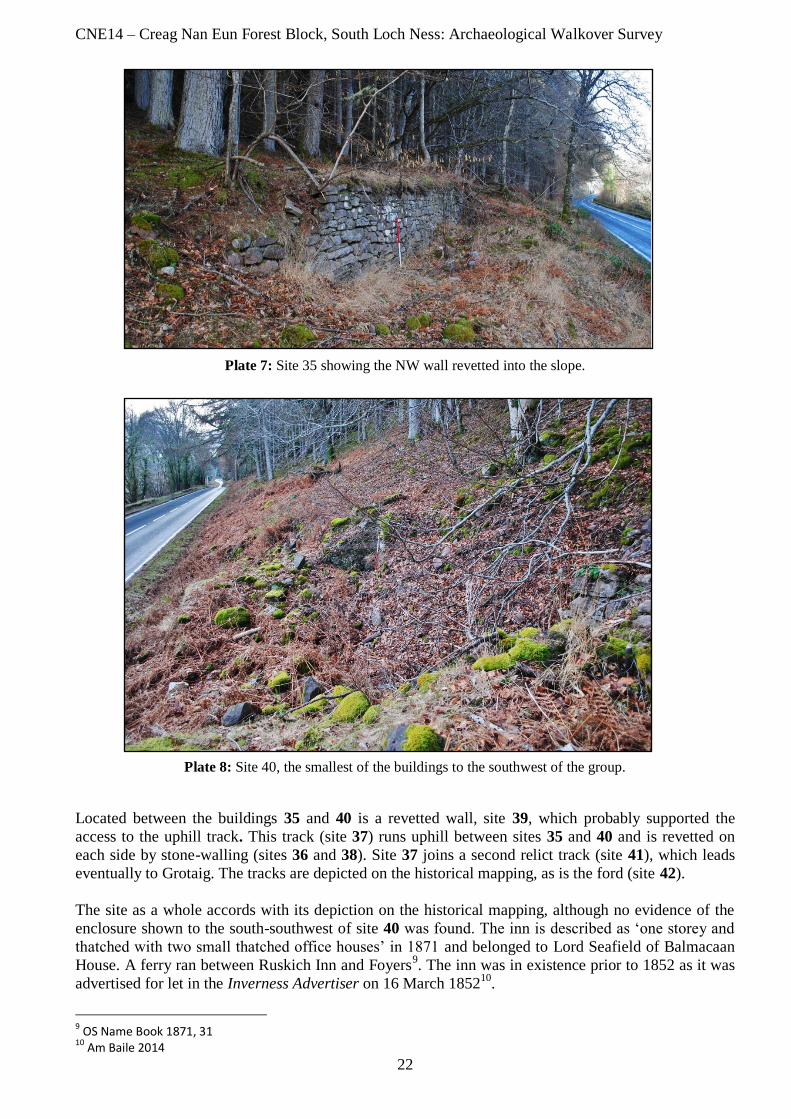
The central building (site 35) (Plate 7), to the southwest of the burn, was stone-built with the northwest
wall, which stood up to 1.75m high, revetted into the slope. It measured approximately 9.5m by 3m.
The most south-westerly building (site 40) (Plate 8) was the smallest of the three, measuring about
7.5m by 4m. Its walls stood up to 1.5m high and were up to 0.7m thick with an entrance in the
southeast wall. The building is revetted into the slope on the southwest and northeast.
Plate 6: Site 31 showing the fireplace in the southwest gable.
CNE14 – Creag Nan Eun Forest Block, South Loch Ness: Archaeological Walkover Survey
22
Plate 7: Site 35 showing the NW wall revetted into the slope.
Plate 8: Site 40, the smallest of the buildings to the southwest of the group.
Located between the buildings 35 and 40 is a revetted wall, site 39, which probably supported the
access to the uphill track. This track (site 37) runs uphill between sites 35 and 40 and is revetted on
each side by stone-walling (sites 36 and 38). Site 37 joins a second relict track (site 41), which leads
eventually to Grotaig. The tracks are depicted on the historical mapping, as is the ford (site 42).
The site as a whole accords with its depiction on the historical mapping, although no evidence of the
enclosure shown to the south-southwest of site 40 was found. The inn is described as ‘one storey and
thatched with two small thatched office houses’ in 1871 and belonged to Lord Seafield of Balmacaan
House. A ferry ran between Ruskich Inn and Foyers9. The inn was in existence prior to 1852 as it was
advertised for let in the Inverness Advertiser on 16 March 185210
.
9 OS Name Book 1871, 31 10 Am Baile 2014
CNE14 – Creag Nan Eun Forest Block, South Loch Ness: Archaeological Walkover Survey
23
Figure 14: Location of sites 31-42. Contains Ordnance Survey data. Crown copyright and database rights 2014.
5.2.9 Primrose Bay
Located to the west of the modern housing at Primrose Bay, a small group of much degraded structures
was recorded (sites 43-46) (Figure 15). Site 43 was a dry-stone wall revetted into the southeast facing
slope. It stood to about 0.75m high and four courses of stone were visible. A rubble structure (site 44)
was attached to the wall and had the appearance of stone coursing on the southeast face. A short
distance to the south-southeast was a long building (site 45). It was divided into three compartments,
the south-westerly possibly being a later addition to the main building. The north-eastern internal
partition showed wall coursing. There were no visible entrances, although it was most likely located in
the south wall. A bank (site 46) about 3m wide and built up to 1.5m high with stone was located on the
southeast side of site 45 and may have formed a platform for the building. These sites correspond with
an unroofed building and large enclosure on the 1871 OS map. The enclosure has gone by 1901.
5.2.10 Lag ant-Seapail (Figure 16)
A moss-covered possible boulder/stone dyke fragment (site 47) was located on a flattish spur on the
south side of the forest track. A definitive interpretation was not possible due to the large amount of
stone and boulders present in the vicinity. A track is shown on the 1st edition OS map in this area and
the stone could possibly be from a previous revetment wall that has been disturbed by the construction
of the forest track. Site 48 was a rubble wall that may have been part of an enclosure, although the
historical mapping does not show any structures in this area. Site 49, a stone-built bridge measuring
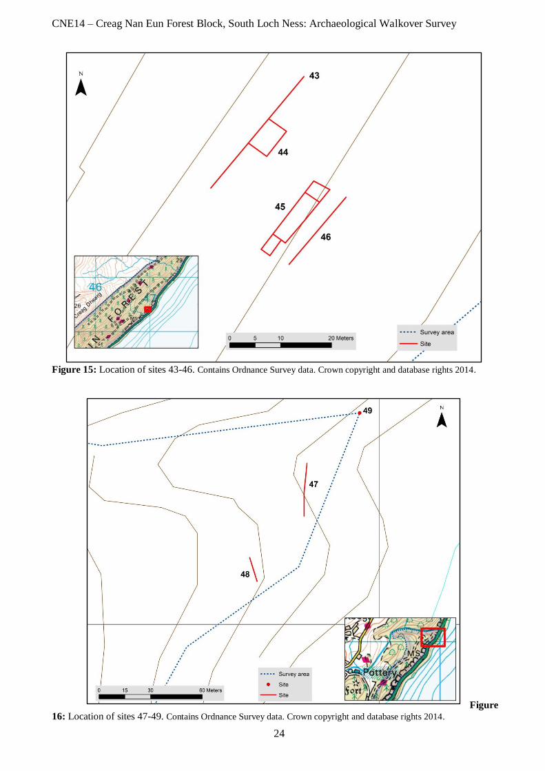
CNE14 – Creag Nan Eun Forest Block, South Loch Ness: Archaeological Walkover Survey
24
Figure 15: Location of sites 43-46. Contains Ordnance Survey data. Crown copyright and database rights 2014.
Figure
16: Location of sites 47-49. Contains Ordnance Survey data. Crown copyright and database rights 2014.
CNE14 – Creag Nan Eun Forest Block, South Loch Ness: Archaeological Walkover Survey
25
about 3m wide with a span of about 2.5-3m, although just outwith the survey area was noted as it
appears to be unrecorded.
6.0 Discussion
The walkover survey recorded forty-nine archaeological sites within the survey area. Generally the
sites recorded can be ascribed to the Post-Medieval era, although some are of indeterminate age due to
their much degraded state.
The survey area comprised a large amount of fairly steep ground; however the Post-Medieval
settlement and structures indicate that the area was used where possible. Movement through the survey
area by the inhabitants is attested to by the number of relict tracks recorded. Not only would there have
been movement between the settlements, but there would have been traffic through the glen by those
travelling longer distances. The need for shelter and sustenance by the travellers would have been
catered for by the likes of the Ruskich Inn.
Several of the buildings recorded were depicted as already unroofed on the 1871 1st edition map with
the number increasing on the 2nd
edition map of 1901. This suggests that settlement of this part of
South Loch Ness was already in decline in the late 1800s with the trend continuing into the 1900s.
7.0 Recommendations
There is no recommendation for further investigative work to be carried out within the survey area.
CNE14 – Creag Nan Eun Forest Block, South Loch Ness: Archaeological Walkover Survey
26
8.0 References
Am Baile 2014. Newspaper Indexes. Accessed on 14 March 2014 at
http://www.ambaile.org.uk/en/newspapers/search_results.jsp?newspaper=1&PrimarySubject=0&starty
ear=*&endyear=*&keywords=ruskich&StartRow=0&MaxRows=25&inforequest=&x=55&y=2
British Geological Survey (BGS) 2013 Digmap625, downloaded from Http://bgs.ac.uk
Dagg, C. 2001. Archaeological Desk-based Assessment of Overhead Power Line Refurbishments
between Drumnadrochit and Fort Augustus, and Invermoriston and Cluanie Dam.
Highland Council 2012 Standards for Archaeological Work, v.1.
Http://www.highland.gov.uk/yourenvironment/conservation/archaeology/developmentguidance.htm.
Highland Historic Environment Record (HER) 2014. Accessed 5 February 2014 at
http://her.highland.gov.uk
Institute for Archaeologists, 2008. Standards and guidance for archaeological desk-based assessment.
Reading: IfA.
Institute for Archaeologists, 2012. By-laws of the Institute for Archaeologists: Code of Conduct:
Reading, IfA.
NLS 2012. National Library of Scotland. Accessed February 2014 at http://maps.nls.uk/
Ordnance Survey 1871. Name Book of the Parishes of Urquhart and Glenmoriston.
Royal Commission on the Ancient and Historical Monuments of Scotland, 2004. Corporate Plan
2004-9: Annex - Survey and Recording Policy accessed 19 March 2012 at
http://www.rcahms.gov.uk/rcahms_media/files/foi/survey_and_recording_policy.pdf
The Scottish Government 2010. Scottish Planning Policy
Http://www.scotland.gov.uk/Resource/Doc/300760/0093908.pdf
CNE14 – Creag Nan Eun Forest Block, South Loch Ness: Archaeological Walkover Survey
27
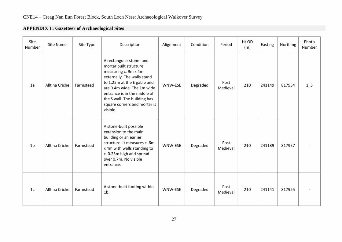
APPENDIX 1 : Gazetteer of Archaeological Sites
Site Number
Site Name Site Type Description Alignment Condition Period Ht OD
(m) Easting Northing
Photo Number
1a Allt na Criche Farmstead
A rectangular stone- and mortar built structure measuring c. 9m x 4m externally. The walls stand to 1.25m at the E gable and are 0.4m wide. The 1m wide entrance is in the middle of the S wall. The building has square corners and mortar is visible.
WNW-ESE Degraded Post
Medieval 210 241149 817954 1, 5
1b Allt na Criche Farmstead
A stone-built possible extension to the main building or an earlier structure. It measures c. 6m x 4m with walls standing to c. 0.25m high and spread over 0.7m. No visible entrance.
WNW-ESE Degraded Post
Medieval 210 241139 817957 -
1c Allt na Criche Farmstead
A stone-built footing within 1b.
WNW-ESE Degraded Post
Medieval 210 241141 817955 -
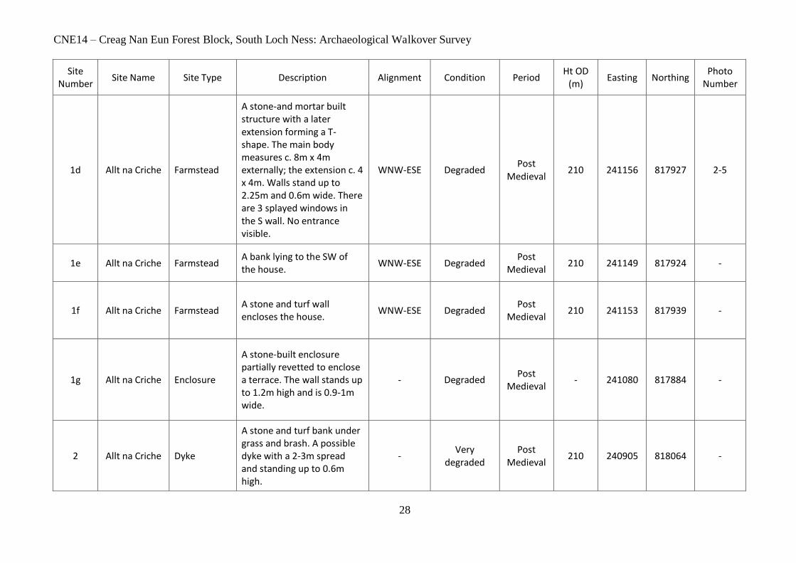
CNE14 – Creag Nan Eun Forest Block, South Loch Ness: Archaeological Walkover Survey
28
Site Number
Site Name Site Type Description Alignment Condition Period Ht OD
(m) Easting Northing
Photo Number
1d Allt na Criche Farmstead
A stone-and mortar built structure with a later extension forming a T-shape. The main body measures c. 8m x 4m externally; the extension c. 4 x 4m. Walls stand up to 2.25m and 0.6m wide. There are 3 splayed windows in the S wall. No entrance visible.
WNW-ESE Degraded Post
Medieval 210 241156 817927 2-5
1e Allt na Criche Farmstead A bank lying to the SW of the house.
WNW-ESE Degraded Post
Medieval 210 241149 817924 -
1f Allt na Criche Farmstead A stone and turf wall encloses the house.
WNW-ESE Degraded Post
Medieval 210 241153 817939 -
1g Allt na Criche Enclosure
A stone-built enclosure partially revetted to enclose a terrace. The wall stands up to 1.2m high and is 0.9-1m wide.
- Degraded Post
Medieval - 241080 817884 -
2 Allt na Criche Dyke
A stone and turf bank under grass and brash. A possible dyke with a 2-3m spread and standing up to 0.6m high.
- Very
degraded Post
Medieval 210 240905 818064 -
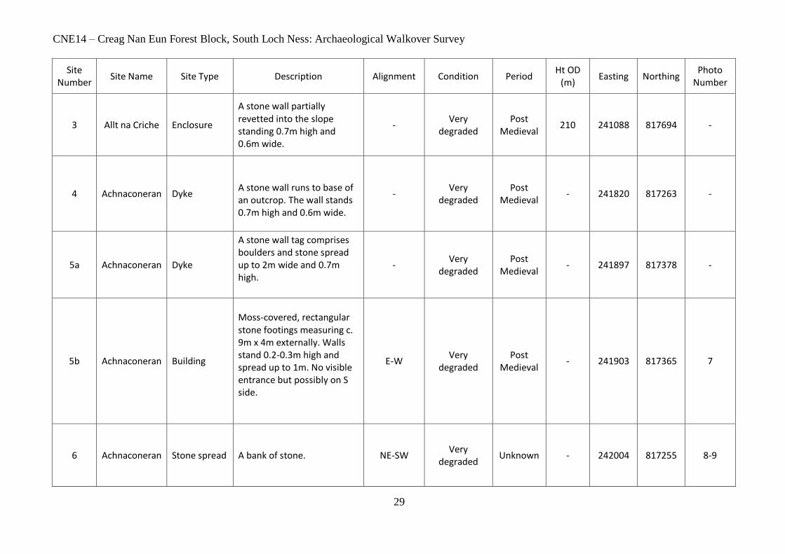
CNE14 – Creag Nan Eun Forest Block, South Loch Ness: Archaeological Walkover Survey
29
Site Number
Site Name Site Type Description Alignment Condition Period Ht OD
(m) Easting Northing
Photo Number
3 Allt na Criche Enclosure
A stone wall partially revetted into the slope standing 0.7m high and 0.6m wide.
- Very
degraded Post
Medieval 210 241088 817694 -
4 Achnaconeran Dyke
A stone wall runs to base of an outcrop. The wall stands 0.7m high and 0.6m wide.
- Very
degraded Post
Medieval - 241820 817263 -
5a Achnaconeran Dyke
A stone wall tag comprises boulders and stone spread up to 2m wide and 0.7m high.
- Very
degraded Post
Medieval - 241897 817378 -
5b Achnaconeran Building
Moss-covered, rectangular stone footings measuring c. 9m x 4m externally. Walls stand 0.2-0.3m high and spread up to 1m. No visible entrance but possibly on S side.
E-W Very
degraded Post
Medieval - 241903 817365 7
6 Achnaconeran Stone spread
A bank of stone.
NE-SW Very
degraded Unknown - 242004 817255 8-9
CNE14 – Creag Nan Eun Forest Block, South Loch Ness: Archaeological Walkover Survey
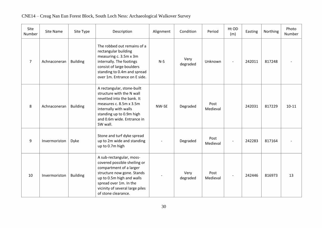
30
Site Number
Site Name Site Type Description Alignment Condition Period Ht OD
(m) Easting Northing
Photo Number
7 Achnaconeran Building
The robbed out remains of a rectangular building measuring c. 3.5m x 3m internally. The footings consist of large boulders standing to 0.4m and spread over 1m. Entrance on E side.
N-S Very
degraded Unknown - 242011 817248 -
8 Achnaconeran Building
A rectangular, stone-built structure with the N wall revetted into the bank. It measures c. 8.5m x 3.5m internally with walls standing up to 0.9m high and 0.6m wide. Entrance in SW wall.
NW-SE Degraded Post
Medieval 242031 817229 10-11
9 Invermoriston Dyke Stone and turf dyke spread up to 2m wide and standing up to 0.7m high
- Degraded Post
Medieval - 242283 817164 -
10 Invermoriston Building
A sub-rectangular, moss-covered possible sheiling or compartment of a larger structure now gone. Stands up to 0.5m high and walls spread over 1m. In the vicinity of several large piles of stone clearance.
- Very
degraded Post
Medieval - 242446 816973 13

CNE14 – Creag Nan Eun Forest Block, South Loch Ness: Archaeological Walkover Survey
31
Site Number
Site Name Site Type Description Alignment Condition Period Ht OD
(m) Easting Northing
Photo Number
11 Achnaconeran Wall
Walling of four courses standing up to 0.5m high. Revetted into the bank on its S side.
E-W Degraded Post
Medieval 241920 817195 18
12 Creag nan Eun Building
A stone-rubble building that measures 4.5-5m by 3.5m over walls spread 1.5-2m wide and 1.5m high. It is built into the N face of the hill with a possible entrance at S the end.
N-S Degraded Unknown - 244015 817142 23-24
13 Allt Coinneag Lade
Well-set upright stones in places with a wet gap to one side of the revetment, which is now path. The former lade is 0.5-0.6 wide and in filled with soil with a further 1m out to revetment edge.
N-S Degraded Post
Medieval - 242819 816606 21-22
14 Allt Coinneag Track
Revetted with stone and covered in fallen trees and bracken at W end; 0.8m wide 0.9m high.
E-W Degraded Unknown - 242951 816823 28-29
15 Allt Coinneag Dyke Survives in bracken area and not in good condition.
- Degraded Unknown - 242908 816817 30-32
CNE14 – Creag Nan Eun Forest Block, South Loch Ness: Archaeological Walkover Survey
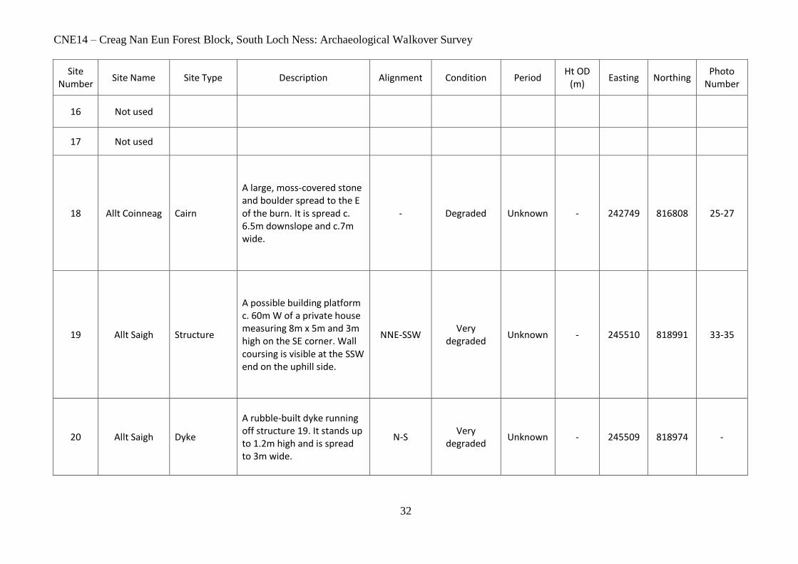
32
Site Number
Site Name Site Type Description Alignment Condition Period Ht OD
(m) Easting Northing
Photo Number
16 Not used
17 Not used
18 Allt Coinneag Cairn
A large, moss-covered stone and boulder spread to the E of the burn. It is spread c. 6.5m downslope and c.7m wide.
- Degraded Unknown - 242749 816808 25-27
19 Allt Saigh Structure
A possible building platform c. 60m W of a private house measuring 8m x 5m and 3m high on the SE corner. Wall coursing is visible at the SSW end on the uphill side.
NNE-SSW Very
degraded Unknown - 245510 818991 33-35
20 Allt Saigh Dyke
A rubble-built dyke running off structure 19. It stands up to 1.2m high and is spread to 3m wide.
N-S Very
degraded Unknown - 245509 818974 -
CNE14 – Creag Nan Eun Forest Block, South Loch Ness: Archaeological Walkover Survey
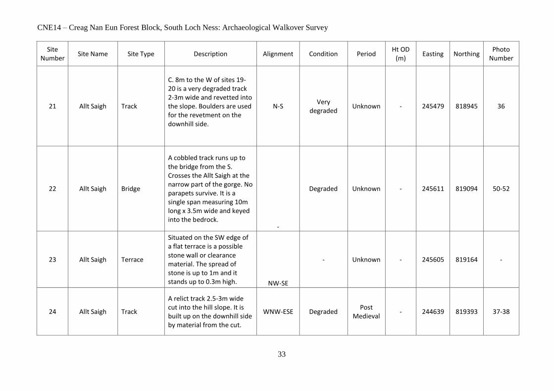
33
Site Number
Site Name Site Type Description Alignment Condition Period Ht OD
(m) Easting Northing
Photo Number
21 Allt Saigh Track
C. 8m to the W of sites 19-20 is a very degraded track 2-3m wide and revetted into the slope. Boulders are used for the revetment on the downhill side.
N-S Very
degraded Unknown - 245479 818945 36
22 Allt Saigh Bridge
A cobbled track runs up to the bridge from the S. Crosses the Allt Saigh at the narrow part of the gorge. No parapets survive. It is a single span measuring 10m long x 3.5m wide and keyed into the bedrock.
-
Degraded Unknown - 245611 819094 50-52
23 Allt Saigh Terrace
Situated on the SW edge of a flat terrace is a possible stone wall or clearance material. The spread of stone is up to 1m and it stands up to 0.3m high. NW-SE
- Unknown - 245605 819164 -
24 Allt Saigh Track
A relict track 2.5-3m wide cut into the hill slope. It is built up on the downhill side by material from the cut.
WNW-ESE Degraded Post
Medieval - 244639 819393 37-38
CNE14 – Creag Nan Eun Forest Block, South Loch Ness: Archaeological Walkover Survey
34
Site Number
Site Name Site Type Description Alignment Condition Period Ht OD
(m) Easting Northing
Photo Number
25 Allt Saigh Dyke
A small section of stone and turf dyke spread up 2.5m wide.
N-S Very
degraded Unknown - 243769 819098 39
26 Allt Saigh Dyke
Section of stone and turf dyke.
- Very
degraded Unknown - 243836 819301 -
26a Allt Saigh Dyke
Section of stone and turf dyke.
- Very
degraded Unknown - 243803 819351 -
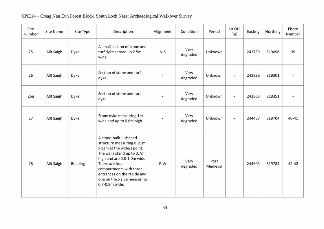
27 Allt Saigh Dyke Stone dyke measuring 1m wide and up to 0.8m high.
- Very
degraded Unknown - 244467 819704 40-41
28 Allt Saigh Building
A stone-built L-shaped structure measuring c. 21m x 12m at the widest point. The walls stand up to 0.7m high and are 0.8-1.0m wide. There are four compartments with three entrances on the N side and one on the S side measuring 0.7-0.8m wide.
E-W Very
degraded Post
Medieval - 244603 819784 42-42

CNE14 – Creag Nan Eun Forest Block, South Loch Ness: Archaeological Walkover Survey
35
Site Number
Site Name Site Type Description Alignment Condition Period Ht OD
(m) Easting Northing
Photo Number
29 Allt Saigh Sheepfold
A moss-covered, stone-built sheepfold with double-faced walls standing up to 0.7-0.8m high and 1.2m wide. There is an entrance in the SE corner.
- Very
degraded Post
Medieval - 244646 819728 44-47
30 Allt Saigh Structure
A sub-circular, open-ended, rubble-built structure measuring 5m NE-SW over walls 1.2m wide at the base and standing up to 0.9m high.
- Ruinous Unknown-FCS built?
- 244445 819534 48-49
31 Ruskich Building
A well-built stone and mortar building revetted into hillside. There are two compartments, 10m long and 6m long. The walls stand up to 2.1m on the NW side and 1m on the SE side and are 0.6m thick. Joist holes in the NW wall suggest an upper floor.
NE-SW Degraded Post
Medieval 40 248135 821922 53-54
CNE14 – Creag Nan Eun Forest Block, South Loch Ness: Archaeological Walkover Survey
36
Site Number
Site Name Site Type Description Alignment Condition Period Ht OD
(m) Easting Northing
Photo Number
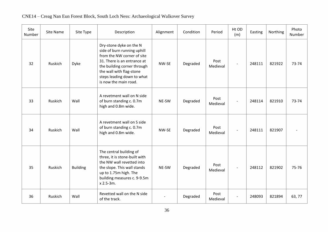
32 Ruskich Dyke
Dry-stone dyke on the N side of burn running uphill from the NW corner of site 31. There is an entrance at the building corner through the wall with flag-stone steps leading down to what is now the main road.
NW-SE Degraded Post
Medieval - 248111 821922 73-74
33 Ruskich Wall
A revetment wall on N side of burn standing c. 0.7m high and 0.8m wide.
NE-SW Degraded Post
Medieval - 248114 821910 73-74
34 Ruskich Wall
A revetment wall on S side of burn standing c. 0.7m high and 0.8m wide.
NW-SE Degraded Post
Medieval - 248111 821907 -
35 Ruskich Building
The central building of three, it is stone-built with the NW wall revetted into the slope. This wall stands up to 1.75m high. The building measures c. 9-9.5m x 2.5-3m.
NE-SW Degraded Post
Medieval - 248112 821902 75-76
36 Ruskich Wall Revetted wall on the N side of the track.
- Degraded Post
Medieval - 248093 821894 63, 77
CNE14 – Creag Nan Eun Forest Block, South Loch Ness: Archaeological Walkover Survey
37
Site Number
Site Name Site Type Description Alignment Condition Period Ht OD
(m) Easting Northing
Photo Number
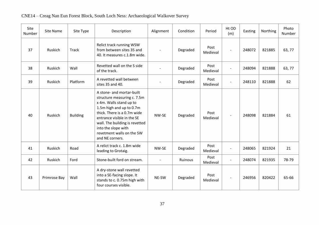
37 Ruskich Track Relict track running WSW from between sites 35 and 40. It measures c.1.8m wide.
- Degraded Post
Medieval - 248072 821885 63, 77
38 Ruskich Wall Revetted wall on the S side of the track.
- Degraded Post
Medieval - 248094 821888 63, 77
39 Ruskich Platform A revetted wall between sites 35 and 40.
- Degraded Post
Medieval - 248110 821888 62
40 Ruskich Building
A stone- and mortar-built structure measuring c. 7.5m x 4m. Walls stand up to 1.5m high and up to 0.7m thick. There is a 0.7m wide entrance visible in the SE wall. The building is revetted into the slope with revetment walls on the SW and NE corners.
NW-SE Degraded Post
Medieval - 248098 821884 61
41 Ruskich Road A relict track c. 1.8m wide leading to Grotaig.
NW-SE Degraded Post
Medieval - 248065 821924 21
42 Ruskich Ford Stone-built ford on stream. - Ruinous Post
Medieval - 248074 821935 78-79
43 Primrose Bay Wall
A dry-stone wall revetted into a SE-facing slope. It stands to c. 0.75m high with four courses visible.
NE-SW Degraded Post
Medieval - 246956 820422 65-66
CNE14 – Creag Nan Eun Forest Block, South Loch Ness: Archaeological Walkover Survey
38
Site Number
Site Name Site Type Description Alignment Condition Period Ht OD
(m) Easting Northing
Photo Number
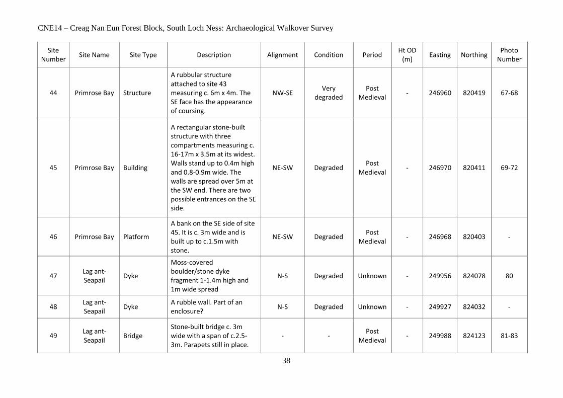
44 Primrose Bay Structure
A rubbular structure attached to site 43 measuring c. 6m x 4m. The SE face has the appearance of coursing.
NW-SE Very
degraded Post
Medieval - 246960 820419 67-68
45 Primrose Bay Building
A rectangular stone-built structure with three compartments measuring c. 16-17m x 3.5m at its widest. Walls stand up to 0.4m high and 0.8-0.9m wide. The walls are spread over 5m at the SW end. There are two possible entrances on the SE side.
NE-SW Degraded Post
Medieval - 246970 820411 69-72
46 Primrose Bay Platform
A bank on the SE side of site 45. It is c. 3m wide and is built up to c.1.5m with stone.
NE-SW Degraded Post
Medieval - 246968 820403 -
47 Lag ant-Seapail
Dyke
Moss-covered boulder/stone dyke fragment 1-1.4m high and 1m wide spread
N-S Degraded Unknown - 249956 824078 80
48 Lag ant-Seapail
Dyke A rubble wall. Part of an enclosure?
N-S Degraded Unknown - 249927 824032 -
49 Lag ant-Seapail
Bridge Stone-built bridge c. 3m wide with a span of c.2.5-3m. Parapets still in place.
- - Post
Medieval - 249988 824123 81-83
CNE14 – Creag Nan Eun Forest Block, South Loch Ness: Archaeological Walkover Survey
39
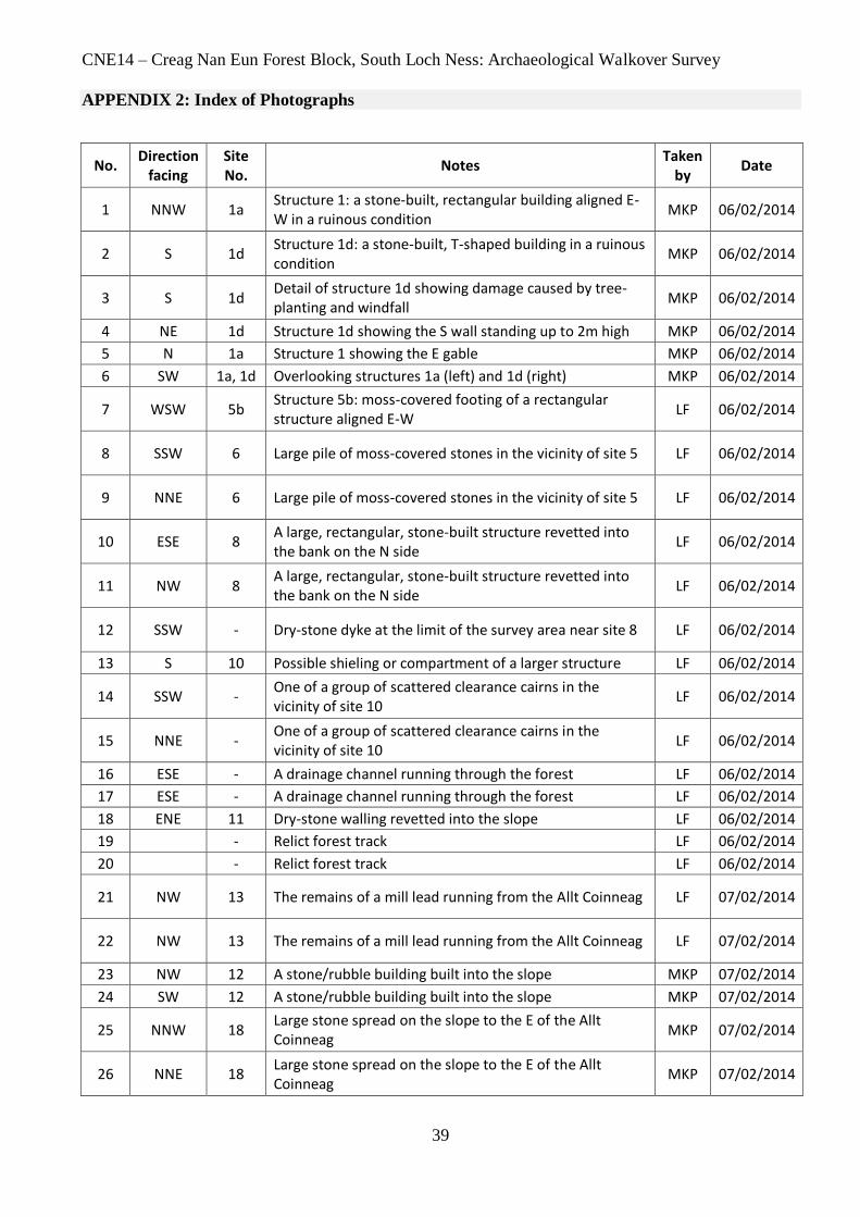
APPENDIX 2: Index of Photographs
No. Direction
facing Site No.
Notes Taken
by Date
1 NNW 1a Structure 1: a stone-built, rectangular building aligned E-W in a ruinous condition
MKP 06/02/2014
2 S 1d Structure 1d: a stone-built, T-shaped building in a ruinous condition
MKP 06/02/2014
3 S 1d Detail of structure 1d showing damage caused by tree-planting and windfall
MKP 06/02/2014
4 NE 1d Structure 1d showing the S wall standing up to 2m high MKP 06/02/2014
5 N 1a Structure 1 showing the E gable MKP 06/02/2014
6 SW 1a, 1d Overlooking structures 1a (left) and 1d (right) MKP 06/02/2014
7 WSW 5b Structure 5b: moss-covered footing of a rectangular structure aligned E-W
LF 06/02/2014
8 SSW 6 Large pile of moss-covered stones in the vicinity of site 5 LF 06/02/2014
9 NNE 6 Large pile of moss-covered stones in the vicinity of site 5 LF 06/02/2014
10 ESE 8 A large, rectangular, stone-built structure revetted into the bank on the N side
LF 06/02/2014
11 NW 8 A large, rectangular, stone-built structure revetted into the bank on the N side
LF 06/02/2014
12 SSW - Dry-stone dyke at the limit of the survey area near site 8 LF 06/02/2014
13 S 10 Possible shieling or compartment of a larger structure LF 06/02/2014
14 SSW - One of a group of scattered clearance cairns in the vicinity of site 10
LF 06/02/2014
15 NNE - One of a group of scattered clearance cairns in the vicinity of site 10
LF 06/02/2014
16 ESE - A drainage channel running through the forest LF 06/02/2014
17 ESE - A drainage channel running through the forest LF 06/02/2014
18 ENE 11 Dry-stone walling revetted into the slope LF 06/02/2014
19 - Relict forest track LF 06/02/2014
20 - Relict forest track LF 06/02/2014
21 NW 13 The remains of a mill lead running from the Allt Coinneag LF 07/02/2014
22 NW 13 The remains of a mill lead running from the Allt Coinneag LF 07/02/2014
23 NW 12 A stone/rubble building built into the slope MKP 07/02/2014
24 SW 12 A stone/rubble building built into the slope MKP 07/02/2014
25 NNW 18 Large stone spread on the slope to the E of the Allt Coinneag
MKP 07/02/2014
26 NNE 18 Large stone spread on the slope to the E of the Allt Coinneag
MKP 07/02/2014
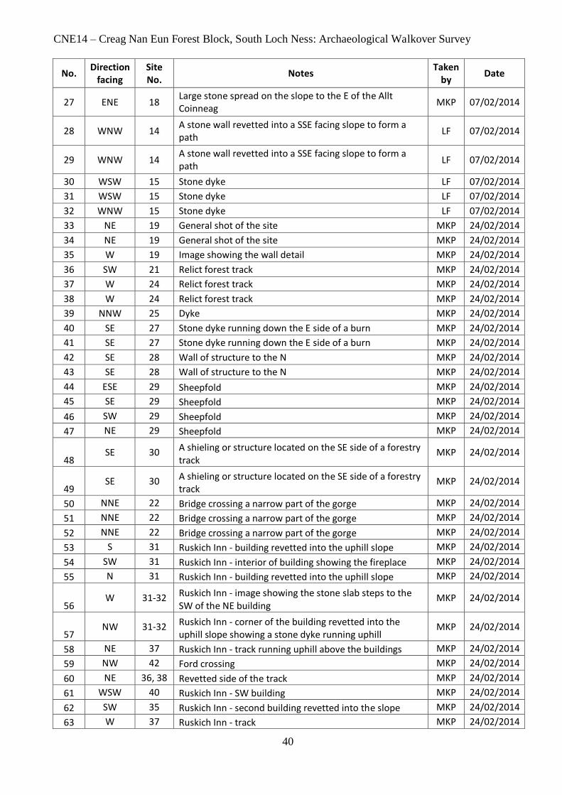
CNE14 – Creag Nan Eun Forest Block, South Loch Ness: Archaeological Walkover Survey
40
No. Direction
facing Site No.
Notes Taken
by Date
27 ENE 18 Large stone spread on the slope to the E of the Allt Coinneag
MKP 07/02/2014
28 WNW 14 A stone wall revetted into a SSE facing slope to form a path
LF 07/02/2014
29 WNW 14 A stone wall revetted into a SSE facing slope to form a path
LF 07/02/2014
30 WSW 15 Stone dyke LF 07/02/2014
31 WSW 15 Stone dyke LF 07/02/2014
32 WNW 15 Stone dyke LF 07/02/2014
33 NE 19 General shot of the site MKP 24/02/2014
34 NE 19 General shot of the site MKP 24/02/2014
35 W 19 Image showing the wall detail MKP 24/02/2014
36 SW 21 Relict forest track MKP 24/02/2014
37 W 24 Relict forest track MKP 24/02/2014
38 W 24 Relict forest track MKP 24/02/2014
39 NNW 25 Dyke MKP 24/02/2014
40 SE 27 Stone dyke running down the E side of a burn MKP 24/02/2014
41 SE 27 Stone dyke running down the E side of a burn MKP 24/02/2014
42 SE 28 Wall of structure to the N MKP 24/02/2014
43 SE 28 Wall of structure to the N MKP 24/02/2014
44 ESE 29 Sheepfold MKP 24/02/2014
45 SE 29 Sheepfold MKP 24/02/2014
46 SW 29 Sheepfold MKP 24/02/2014
47 NE 29 Sheepfold MKP 24/02/2014
48 SE 30 A shieling or structure located on the SE side of a forestry
track MKP 24/02/2014
49 SE 30 A shieling or structure located on the SE side of a forestry
track MKP 24/02/2014
50 NNE 22 Bridge crossing a narrow part of the gorge MKP 24/02/2014
51 NNE 22 Bridge crossing a narrow part of the gorge MKP 24/02/2014
52 NNE 22 Bridge crossing a narrow part of the gorge MKP 24/02/2014
53 S 31 Ruskich Inn - building revetted into the uphill slope MKP 24/02/2014
54 SW 31 Ruskich Inn - interior of building showing the fireplace MKP 24/02/2014
55 N 31 Ruskich Inn - building revetted into the uphill slope MKP 24/02/2014
56 W 31-32 Ruskich Inn - image showing the stone slab steps to the
SW of the NE building MKP 24/02/2014
57 NW 31-32 Ruskich Inn - corner of the building revetted into the
uphill slope showing a stone dyke running uphill MKP 24/02/2014
58 NE 37 Ruskich Inn - track running uphill above the buildings MKP 24/02/2014
59 NW 42 Ford crossing MKP 24/02/2014
60 NE 36, 38 Revetted side of the track MKP 24/02/2014
61 WSW 40 Ruskich Inn - SW building MKP 24/02/2014
62 SW 35 Ruskich Inn - second building revetted into the slope MKP 24/02/2014
63 W 37 Ruskich Inn - track MKP 24/02/2014

CNE14 – Creag Nan Eun Forest Block, South Loch Ness: Archaeological Walkover Survey
41
No. Direction
facing Site No.
Notes Taken
by Date
64 NW - Primrose Bay - track to a private water tank MKP 27/02/2014
65 NW 43 Dry-stone wall within forestry to the W of Primrose Bay MKP 27/02/2014
66 NW 43 Dry-stone wall within forestry to the W of Primrose Bay MKP 27/02/2014
67 N 44 'Pen' attached to the dry-stone dyke MKP 27/02/2014
68 N 44 'Pen' attached to the dry-stone dyke MKP 27/02/2014
69 W 45 Building to the S of the dry-stone dyke. Image shows an
attached compartment MKP 27/02/2014
70 W 45 Building to the S of the dry-stone dyke. Image shows an
attached compartment MKP 27/02/2014
71 NNE 45 Detail of the coursing visible on the internal wall of the
building MKP 27/02/2014
72 NW 46 Showing the bank below the building MKP 27/02/2014
73
NNE 33 Ruskich Inn - showing the wall revetted into the slope adjacent to the stream, one of the buildings and the dry-stone dyke running uphill
MKP 27/02/2014
74
NNE 33 Ruskich Inn - showing the wall revetted into the slope adjacent to the stream, one of the buildings and the dry-stone dyke running uphill
MKP 27/02/2014
75 NNE 35 Ruskich Inn - showing the central building revetted into
the slope MKP 27/02/2014
76 SW 35 Ruskich Inn - showing the central building revetted into
the slope MKP 27/02/2014
77 W 37 Looking up the track at Ruskich Inn MKP 27/02/2014
78 N 42 The ford built as part of the track above Ruskich Inn MKP 27/02/2014
79 N 42 The ford built as part of the track above Ruskich Inn MKP 27/02/2014
80 NNE 47 Possible wall or dyke MKP 28/02/2014
80 NE 49 Bridge adjacent to the forestry access located at NH 4998
2409 MKP 28/02/2014
81 NE 49 Bridge adjacent to the forestry access located at NH 4998
2409 MKP 28/02/2014
82 NE 49 Bridge adjacent to the forestry access located at NH 4998
2409 MKP 28/02/2014
Related Documents