Proposed 132kV Grid Connection to Earlshaugh Windfarm May 2015 Consultation Document

Welcome message from author
This document is posted to help you gain knowledge. Please leave a comment to let me know what you think about it! Share it to your friends and learn new things together.
Transcript
Proposed 132kV Grid Connection to Earlshaugh WindfarmMay 2015
Consultation Document

P
Consultation Document Proposed 132kV Grid Connection to Earlshaugh Windfarm
May 2015
Contents
Summary
1.0 Introduction 1
2.0 Proposed Development 3
3.0 Overhead Transmission Line Routeing 9
4.0 Study Area Environment 13
5.0 Route Options and Preferred Route Alignment 25
6.0 Way Forward 31
Appendices 1. Preliminary Environmental Review 2. Preliminary List of Potential Effects 3. Preliminary List of Proposed Desk and Field Studies
Tables 1. Approach to Routeing and EIA of Overhead Transmission Lines 2. Summary of Preliminary Environmental Review of Route Options
Figures Introduction 1.1 Location Plan
Proposed Development 2.1 132kV Single Circuit Lattice Steel Tower & Typical Underground Cable Trench Detail Study Area Environment 4.1 Designated Areas, Features and Infrastructure 4.2 Scottish Natural Heritage (SNH) Landscape Character Assessment 4.3 Indicative Visual Spaces and Vantage Points
Route Options and Preferred Route Alignment 5.1 Route Corridor Options 5.2 Preferred Route 5.3 Preferred Route Aerial Photographs (1- 4) Moffat Substation to Earlshaugh Windfarm
References
Glossary
Project Ref: 304_Environmental Designworks Status: Final Issue No: 7 Date: 26th May 2015
Summary
Scottish Power Energy Networks (SPEN), through its transmission licence holder Scottish Power Transmission plc (SPT) proposes to construct a new 132kV grid connection in the Scottish Borders and Dumfries and Galloway. As the transmission licence holder, SPEN is obliged to provide this connection, which is needed to allow the proposed Windfarm development at Earlshaugh to input to the electricity network. The proposed overhead line will be a 132kV single circuit on a lattice steel tower of the L7(C) series. The tower design has been determined following a detailed review of the engineering and technical requirements for the connection. Towers will be approximately 27m in height and may be extended or reduced to ensure adherence with minimum safety clearances. The average span between towers will be approximately 250m and the associated wayleave corridor 40m to either side of the route. A short section of the proposed grid connection will be undergrounded when exiting the proposed Windfarm and linking to Moffat Substation. This will use oil free cables contained in a trench approximately 1.5-2.0m wide and 1.3m depth. This Consultation Document provides details of the initial stages of work undertaken to identify a Preferred Route alignment for the grid connection. This has involved the review of key environmental features of the Study Area, identification of alternative routes and analysis of route options. From the outset, SPEN has focused on reducing the environmental impact of the proposed development, whilst remaining technically and economically viable. At this Consultation Stage, the Preferred Route to the north of Moffat Substation crosses the Evan Water and passes to the east of Lochhouse Tower to cross the A701. The route then passes to the west of Coats Hill and follows the alignment of the existing 400kV overhead line parallel to the A74 (M). The route then crosses Coatsgate Quarry and rises to an area of rough grassland to the east of Blacklaw Forest and crosses the B719 to the west of an existing Gas Valve Compound. The route then passes through the coniferous plantation of Raecleuch Forest following existing fire breaks and compartment divisions (coupes) wherever possible, crossing the A701 to the north to reach the proposed Windfarm at Earlshaugh. The total length of this new grid connection will be approximately 16.5 km. Consultation at this route selection stage follows the approach adopted by SPEN to line routeing and is part of the ongoing engineering design, technical development, and environmental review of the proposed development. The eventual route selected by SPEN for the grid connection will take into account views expressed during this Consultation Stage. A Proposed Route will then be carried forward to a detailed Environmental Impact Assessment (EIA), the results of which will be reported in an Environmental Statement. The Environmental Statement will support the Section 37 application under the Electricity Act 1989 to Scottish Government for consent to construct and operate the grid connection. Any comments made during this Consultation Stage are not representations to The Scottish Government Energy Consents and Deployment Unit. Following submission of the Section 37 Application by SPEN, interested parties will have the opportunity to make representations to the Scottish Government on these proposals.
Proposed 132kV Grid Connection to Earlshaugh Windfarm I Consultation Document
1
1 . 0 I n t r o d u c t i o n
Project Need 1.1 Scottish Power Energy Networks (SPEN), through its transmission licence holder Scottish
Power Transmission plc (SPT) proposes to construct a new 132kV grid connection in the Scottish Borders and Dumfries and Galloway. The proposed development is needed to allow a connection for the proposed Windfarm at Earlshaugh to the electricity grid network at Moffat Substation (Figure 1.1).
1.2 SPEN is responsible for electricity transmission in the South of Scotland, and as an electricity transmission licence holder through SPT is required “to develop and maintain an efficient, co-ordinated and economical system of electricity transmission”1. To comply with the licence obligations, SPT must provide the proposed Windfarm at Earlshaugh with a connection to the electricity grid.
1.3 The Scottish Government as part of the strategy of reducing total energy demand by 12% by
2020, has set a target “to meet at least 30% of overall energy demand from renewables by 2020”2. Energy from windfarms forms part of this renewable energy mix.
Legislative Framework
1.4 The legal provisions applying to the development of overhead lines in Scotland are principally the Electricity Act 1989 and the Electricity Works (EIA)(Scotland) Regulations 2000. All transmission licence holders are required under Section 9 of the Electricity Act to take account of the following factors in formulating any relevant proposals: - a) “to have regard to the desirability of preserving natural beauty, of conserving flora, fauna
and geological or physiographical features of special interest and of protecting sites, buildings and objects of architectural, historic or archaeological interest; and,
b) to do what he reasonably can to mitigate any effect the proposals would have on the natural beauty of the countryside or on any such flora, fauna, features, sites, buildings or objects”
1.5 SPEN interprets the words “reasonably can” to mean that it should make every effort to
mitigate the environmental effects, whilst bearing in mind the technical constraints imposed by overhead transmission line technology, and its duties under Section 9 of the Electricity Act. In summary, SPEN needs to balance technical, economic and environmental considerations as part of the process of developing proposals for electricity grid connections.
Purpose of the Public Consultation Document 1.6 The purpose of this Report is to provide a review of the route selection process to identify the
Preferred Route alignment and invite comment. Following consultation on this Preferred Route, feedback will be reviewed and considered in order to inform the route development process to identify the “Proposed Route”. Consultation at the route selection stage follows the approach adopted by SPEN to line routeing and is part of the ongoing environmental impact assessment of the proposed development.
1 as defined in the Electricity Act 1989 (as amended by the Utilities Act 2000) 2 Scottish Government (2014) National Planning Framework 3. Para 3.8, p31.
Proposed 132kV Grid Connection to Earlshaugh Windfarm I Consultation Document 2
Environmental Statement 1.7 The proposed route will then be carried forward to detailed Environmental Impact Assessment
(EIA), the results of which will be reported in an Environmental Statement (ES). SPEN considers that the proposed 132kV grid connection qualifies as an EIA development under Schedule 2 of the Electricity Works (EIA) (Scotland) Regulations 2000. Scoping Report
1.8 To ensure that the Environmental Statement (ES) covers all the relevant issues and that the concerns of external stakeholders are taken into account, a Scoping Report shall be prepared to identify and review potential significant effects of the proposed development on the environment. The Scoping Report will then be submitted to Scottish Ministers to seek an opinion under Schedule 7 of the Electricity Works (EIA)(Scotland) Regulations 2000 as to the proposed scope of information to be provided in the ES.
Statutory Consent
1.9 An application for consent to construct and operate the proposed grid connection will be submitted to Scottish Ministers under Section 37 of the Electricity Act 1989. The ES will support the application for consent. The Ministers are required to consult with the Planning Authority within whose area the proposed application is located. For the proposed development this will be Scottish Borders Council and Dumfries and Galloway Council.
Previous Studies 1.10 A Consultation Document and Scoping Report were prepared and published in 2007 and 2009
for a grid connection for the proposed Windfarm at Earlshaugh. Given the time lapse since these studies were undertaken, SPEN decided to restart the project to ensure all current engineering, environmental and economic issues could be revisited and reviewed. This process has identified a Preferred Route to the west of Coats Hill as reviewed in this Report. Structure of the Consultation Document
1.11 The Consultation Document is organised into the following Chapters: Chapter 2: Proposed Development Chapter 3: Overhead Transmission Line Routeing Chapter 4: Study Area Environment Chapter 5: Route Options and Preferred Route Alignment Chapter 6: Way Forward
1.12 At the back of the Consultation Document are the Appendices, References and a Glossary.
Project Team 1.13 This Report has been prepared for SPEN by Environmental Designworks, an environmental
planning and landscape design practice, with specialist input from: SP EnergyNetworks on the characteristics of the project and technical issues; CFA Archaeology Ltd; BSG Ecology; Golder Associates and Scottish Woodlands Ltd.
1.14 If you would like any further information or discuss any aspect of the proposed development, please contact SPEnergyNetworks either by email: [email protected] or by post to: Ochil House, 10 Technology Avenue, Hamilton International Technology Park, Glasgow G72 OHT.
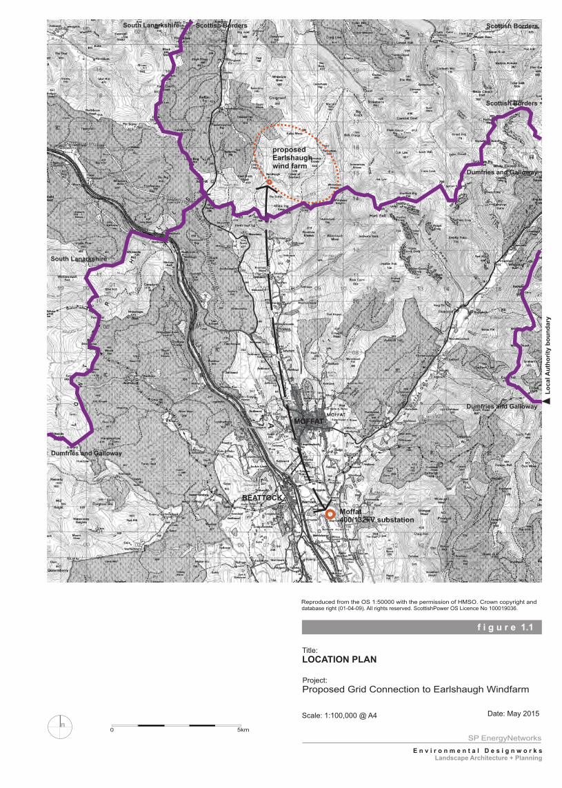
f i g u r e 1.1
Title:
Project:
Scale: 1:100,000 @ A4 Date: May 2015
LOCATION PLAN
Proposed Grid Connection to Earlshaugh Windfarm
SP EnergyNetworks
E n v i r o n m e n t a l D e s i g n w o r k s
Landscape Architecture + Planning
Reproduced from the OS 1:50000 with the permission of HMSO. Crown copyright and database right (01-04-09). All rights reserved. ScottishPower OS Licence No 100019036.
n0 5km
MOFFAT
Lo
ca
l A
uth
ori
ty b
ou
nd
ary
MOFFAT
BEATTOCK
Scottish Borders
Scottish Borders
Dumfries and Galloway
South Lanarkshire
Moffat 400/132kV substation
proposedEarlshaughwind farm
Scottish BordersSouth Lanarkshire
Dumfries and Galloway
Dumfries and Galloway
Proposed 132kV Grid Connection to Earlshaugh Windfarm I Consultation Document
3
2 . 0 P r o p o s e d D e v e l o p m e n t
Proposed Grid Connection 2.1 The grid connection from the proposed Windfarm at Earlshaugh to Moffat Substation will be
approximately 16.5km in length. This will comprise of an overhead line (OHL) with an underground cable section at either end, connecting to the proposed Windfarm and electricity grid at Moffat Substation. The total length of underground cable will be approximately 3km. Proposed Overhead Line (OHL) Design Choice of Support and Components
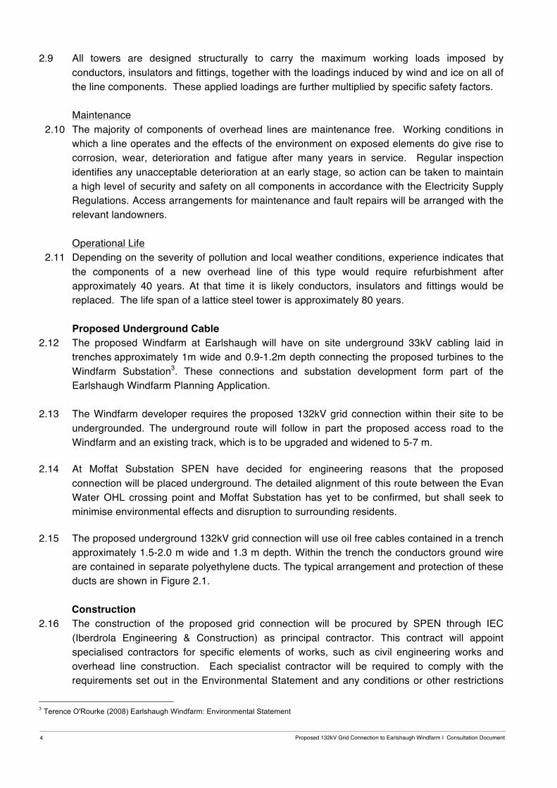
2.2 The proposed overhead line will be constructed of lattice steel towers of L7(C) design operating at a voltage of 132kV (Figure 2.1). This design of support for the proposed grid connection has been chosen to meet the technical engineering constraints presented in the Study Area primarily associated with altitude and ground conditions.
2.3 The standard height of a 132kV L7(C) design lattice steel tower above ground is 27m and
may be extended or reduced to ensure adherence with minimum safety clearances. The OHL will comprise of a combination of types of steel lattice towers from the L7(C) series. These include • Suspension tower; • Turning Tower (for up to 30 degree deviations); • Turning tower (for up to 60 degree deviations); and • Terminal tower.
2.4 For each tower type there are a number of permutations of potential heights and support leg length to allow for ground conditions and to ensure that the minimum ground clearances are achieved mid span. The maximum and minimum tower height for the proposed OHL will be determined at detailed design stage.
2.5 The distance between supports will vary depending on topography and altitude, and to ensure adherence with minimum safety clearances. The average span of a 132kV L7(C) line at this stage is considered to be 250m. The span lengths for the proposed OHL will be determined at detailed design stage following survey of the proposed route.
2.6 The statutory minimum ground clearance for a 132kV L7C line is 6.7m. The associated
wayleave will be a maximum of 40m to either side of the proposed OHL. 2.7 The tower members will be fabricated mainly from hot dipped galvanised mild and high yield
steel, and painted at intervals of approximately 15 to 20 years for continued protection against corrosion. The steelwork is assembled using galvanised high yield steel bolts with nuts and locking devices.
2.8 The single circuit line comprises three separate phases attached to the tower cross arms.
There is also an earth wire required to protect the line from lightning strike and fault conditions, and this is located at the top of the towers. Insulators are supported on the tower cross arm and prevent electric current from crossing to the tower. These are made from porcelain, glass or modern composite materials.
Proposed 132kV Grid Connection to Earlshaugh Windfarm I Consultation Document 4
2.9 All towers are designed structurally to carry the maximum working loads imposed by
conductors, insulators and fittings, together with the loadings induced by wind and ice on all of the line components. These applied loadings are further multiplied by specific safety factors.
Maintenance
2.10 The majority of components of overhead lines are maintenance free. Working conditions in which a line operates and the effects of the environment on exposed elements do give rise to corrosion, wear, deterioration and fatigue after many years in service. Regular inspection identifies any unacceptable deterioration at an early stage, so action can be taken to maintain a high level of security and safety on all components in accordance with the Electricity Supply Regulations. Access arrangements for maintenance and fault repairs will be arranged with the relevant landowners.
Operational Life
2.11 Depending on the severity of pollution and local weather conditions, experience indicates that the components of a new overhead line of this type would require refurbishment after approximately 40 years. At that time it is likely conductors, insulators and fittings would be replaced. The life span of a lattice steel tower is approximately 80 years.
Proposed Underground Cable
2.12 The proposed Windfarm at Earlshaugh will have on site underground 33kV cabling laid in trenches approximately 1m wide and 0.9-1.2m depth connecting the proposed turbines to the Windfarm Substation3. These connections and substation development form part of the Earlshaugh Windfarm Planning Application.
2.13 The Windfarm developer requires the proposed 132kV grid connection within their site to be undergrounded. The underground route will follow in part the proposed access road to the Windfarm and an existing track, which is to be upgraded and widened to 5-7 m.
2.14 At Moffat Substation SPEN have decided for engineering reasons that the proposed
connection will be placed underground. The detailed alignment of this route between the Evan Water OHL crossing point and Moffat Substation has yet to be confirmed, but shall seek to minimise environmental effects and disruption to surrounding residents.
2.15 The proposed underground 132kV grid connection will use oil free cables contained in a trench
approximately 1.5-2.0 m wide and 1.3 m depth. Within the trench the conductors ground wire are contained in separate polyethylene ducts. The typical arrangement and protection of these ducts are shown in Figure 2.1.
Construction
2.16 The construction of the proposed grid connection will be procured by SPEN through IEC (Iberdrola Engineering & Construction) as principal contractor. This contract will appoint specialised contractors for specific elements of works, such as civil engineering works and overhead line construction. Each specialist contractor will be required to comply with the requirements set out in the Environmental Statement and any conditions or other restrictions
3 Terence O'Rourke (2008) Earlshaugh Windfarm: Environmental Statement
Proposed 132kV Grid Connection to Earlshaugh Windfarm I Consultation Document
5
placed upon the Section 37 consent, through the Construction Environmental Management Plan (CEMP).
Construction Environmental Management Plan
2.17 A Construction Environmental Management Plan (CEMP) in conjunction with SPEN’s Construction, Health, Safety and Welfare requirements will control all potential environmental effects of the construction works. The CEMP controls and guides working practices during construction such as: implementation timescales; detailed design measures to safeguard sensitive habitats and species; further surveys as required before commencing works etc. The document will also incorporate SNH, SEPA and other relevant guidelines by adopting current best practice in protecting the environment during the works.
2.18 Construction Method Statements will be used to describe the nature of proposed works and the
protection measures being applied for specific activities in accordance with the CEMP. This will aim to ensure all activities are carried out to minimise the environmental effects. Programme
2.19 The construction timescale for a grid connection of this scale is anticipated to take approximately 18 months. The programme will be determined at detailed design stage and start following the granting of statutory consents and after all necessary land purchase/ wayleave arrangements have been concluded.
2.20 Prior to commencing with works on site, SPEN, IEC and appointed Contractors will seek to liaise further with those directly affected by the proposed development to ensure all effects during construction are minimised.
Pre-Construction Activities
2.21 Prior to commencing the construction of the OHL, a precision ground survey will be carried out to determine the ground profile along the centre of the line route and for 25m on either side where the ground profile slopes across the line route. This is to ensure that the locations selected for towers and the relationship with each other comply with the technical limits laid down for maximum span lengths, maximum sum of adjacent spans and safe clearance to live conductors in the final siting. Further consideration is also given to the detailed environmental effects as outlined in the CEMP and landowner requirements.
2.22 Where the route of the line passes over or is in close proximity to trees that could infringe safe clearance to ‘live’ conductors, the tree must be felled or pruned prior to the construction. Any trees felled as part of the proposed development wayleave will be in adherence to the mitigation measures as listed in the CEMP.
Construction Method for an OHL
2.23 The overhead line will be constructed following established methods. The bulk of the construction work will take place at the proposed tower sites where excavations are required for the concrete foundations on which the tower is supported. The towers are then formed by the installation of steel lattice sections fabricated off site from galvanised steel sections and connected to the pre-placed foundations. On completion of the tower, the insulators and conductors are fitted prior to preparation for energizing the line.
Proposed 132kV Grid Connection to Earlshaugh Windfarm I Consultation Document 6
Sequence 2.24 Overhead line construction follows a standard sequence of activities as outlined below.
• Agree and prepare temporary access routes. • Excavate tower foundations. • Delivery of tower steelwork and erect towers. • Undergrounding or diversion of lower voltage lines where necessary for safety clearances. • Delivery of conductor drums and stringing equipment. • Insulator and conductor stringing. • Reinstate temporary access routes.
Land Use and Access During Construction
2.25 One or more temporary construction compounds and storage area will be required for the duration of the construction works. Temporary vehicular access of not more than 5m width is also required to every tower site for foundation excavation, concrete delivery and a crane to erect the towers. At the tower sites an approximate area of 30m by 30m is required for construction and a 5m wide tract under the route, for conductor stringing.
2.26 The storage area(s) and detailed access routes will be determined at the detailed design stage
and agreed with landowners with the aim of minimising environmental effects and disturbance to current landuse and management practices. The principle method employed to achieve this will be to maximise the use of existing tracks with upgrading as necessary. Helicopters may be used to facilitate access in sensitive or remote areas.
2.27 Where temporary access tracks are required, the type will be determined on the ground
conditions, landuse and environmental sensitivity of the location. The three main types of access are: • Low pressure vehicle use. • Floating tracks. • Wood/ Steel Matting.
2.28 Watercourse crossings will be designed to comply with the Controlled Activities (Scotland) Regulations. These will adhere to the general binding rules and may, in some instance require a Licence.
2.29 All temporary construction areas, access routes and watercourse crossings will be clearly demarcated and adhered to for the duration of the works.
Services
2.30 The proposed transmission line may cross underground pipelines and services. In these locations all requirements of the appropriate authority will be adhered to, both at the detailed design stage when locating individual towers and ensuring minimum clearances are provided, and at the construction stage by complying with relevant Codes of Practice and adopting Safe Working Procedures and Operations. Existing overhead lines have to be either switched off, deviated or protected using “live line” scaffolds.
2.31 Prior to stringing the conductors, any roads, which are to be crossed by the proposed overhead line, have to be protected by building a scaffold tunnel “sky cradle” through which vehicles can safely pass.
Proposed 132kV Grid Connection to Earlshaugh Windfarm I Consultation Document
7
Tower Construction and Stringing
2.32 The construction of a steel tower requires an excavation to allow the steel foundation braces to be positioned and the concrete foundations formed. All concrete is anticipated to be imported to site ready mixed.
2.33 Following the setting of the concrete foundations, the tower bases are then backfilled and consolidated in layers, normally with the original materials. Excavated topsoil is reserved for the top layer reinstatement and temporarily stored in accordance with BS 4428. Any surplus subsoil or rock will be removed from the site in accordance with the agreed Site Waste Management Plan.
2.34 The foundation type and design for the proposed towers will be confirmed following detailed soil investigations at each location. Typical foundations are excavated. The excavation dimensions will depend on both the tower type and the ground conditions, but typically will be between 16m2 by 4m deep for suspension, or line, towers and 25m2 by 5m deep for tension, for angle, towers.
2.35 Depending on ground conditions, mini-piled, auger foundations or rock foundations maybe
required. These generally require less ground disturbance but a greater volume of concrete. This method involves the drilling of several holes for each tower leg, which are then reinforced with steel before being concreted.
2.36 The tower steelwork connection points to foundations are known as ‘stubs’ and these are
located and fixed in place by means of a pile cap at each tower leg position. The tower body is then constructed from galvanised lattice steel sections pre-fabricated off site and assembled on site to a pre-determined pattern using a crane or derrick rig to hoist the steelwork into position.
2.37 On completion of all the towers, the intermediate towers are fitted with insulator supports.
Running blocks are fitted to the bottom of the insulator support and the conductor is fitted using the ‘Continuous Tension Stringing’ method, which ensures the conductors are held aloft at all times and do not touch the ground or any other structure.
2.38 Drums of conductor and a tensioner with a hydraulic brake are located at one end of the line
section, with the pulling winch at the other. The conductor is joined to a single, heavy-duty pilot wire and drawn through the section, one conductor at a time, under constant tension. During stringing, radio communication is maintained between the operators of the pulling winch, the tensioner, hydraulic brake and intermediate observation points, so the pulling can be stopped if problems arise. Drums of conductors are delivered as close as possible to the angle or tension poles site from which the conductors are pulled.
2.39 The basic transport used for tower construction is a general-purpose cross-country vehicle with
four-wheel drive weighing some 6 tonnes and incorporating a lifting device. If necessary, tractors adapted to carry such loads are used to transport drums to the tower site.
Completion
2.40 Tower construction is completed with the reinstatement of ground around the towers, access routes and construction compound, all in accordance with the CEMP and as agreed with the
Proposed 132kV Grid Connection to Earlshaugh Windfarm I Consultation Document 8
landowner. Any surplus material will be treated in accordance with the CEMP and Site Waste Management Plan. Construction Method for an Underground Cable
2.41 Topsoil and subsoil from the trench will be carefully excavated and stored separately for backfilling. Cable ducts will be laid on and surrounded by cement bound sand, which will be protected from external damage by a cable protection cover, with a plastic warning tape above and then backfilled. Subsequently, the underground cables will be pulled through the ducts.
2.42 The detailed construction method and specification will be subject to engineering review at the detailed design stage, as this will depend on ground conditions along the finalised cable route. Where it is not possible to install the conductors through open trenching, directional drilling maybe used to install ducts.
f i g u r e 2.1
Title:
Project:
Scale: na Date: May 2015
132kV Single Circuit Lattice Steel Tower & Typical Underground Cable Trench Detail
Proposed Grid Connection to Earlshaugh Windfarm
SP EnergyNetworks
E n v i r o n m e n t a l D e s i g n w o r k s
Landscape Architecture + Planning
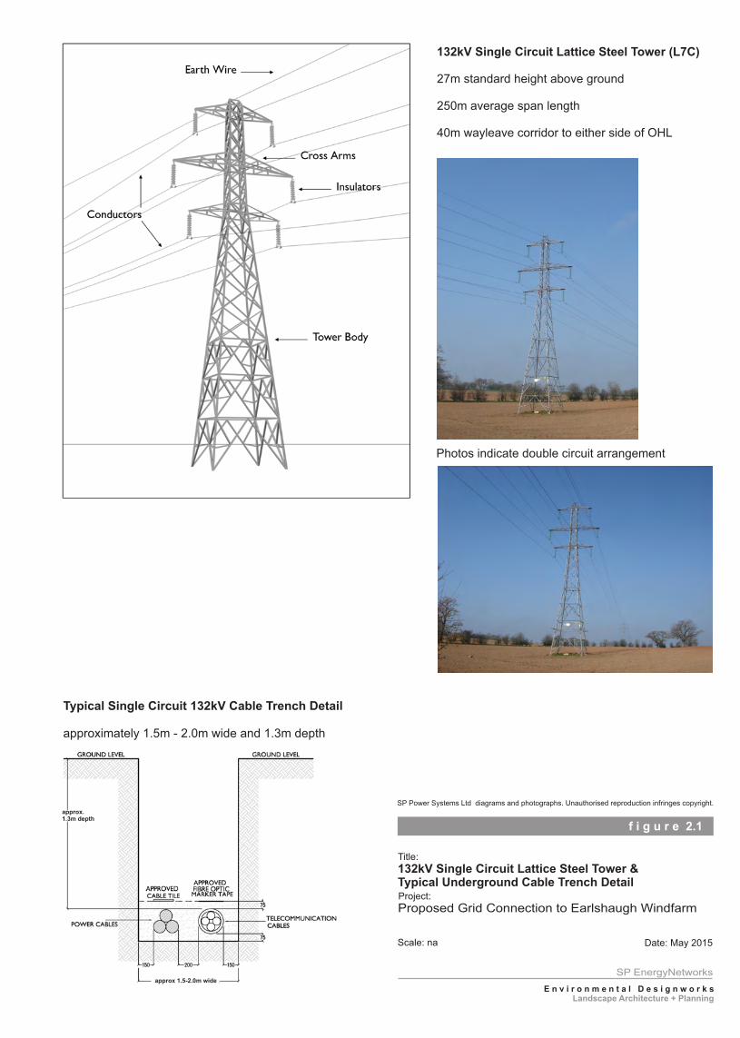
132kV Single Circuit Lattice Steel Tower (L7C)
27m standard height above ground
250m average span length
40m wayleave corridor to either side of OHL
Typical Single Circuit 132kV Cable Trench Detail
approximately 1.5m - 2.0m wide and 1.3m depth
approx. 1.3m depth
approx 1.5-2.0m wide
SP Power Systems Ltd diagrams and photographs. Unauthorised reproduction infringes copyright.
Photos indicate double circuit arrangement
Proposed 132kV Grid Connection to Earlshaugh Windfarm I Consultation Document
9
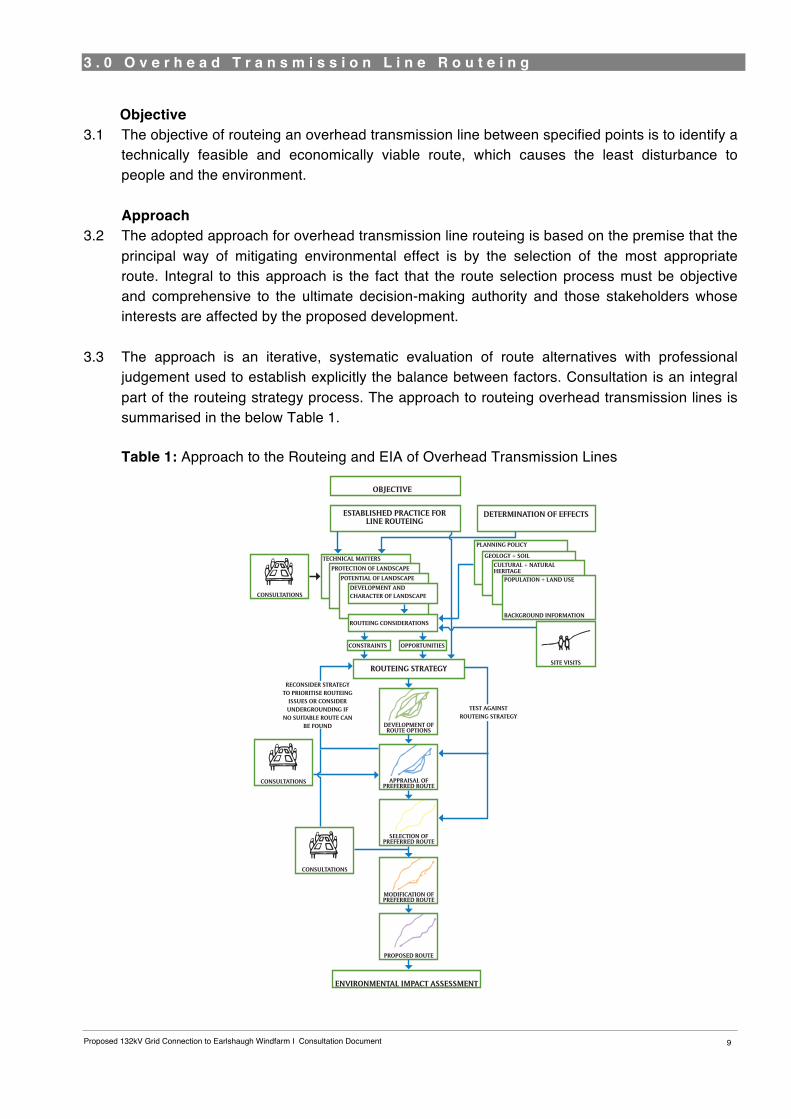
3 . 0 O v e r h e a d T r a n s m i s s i o n L i n e R o u t e i n g 3
Objective 3.1 The objective of routeing an overhead transmission line between specified points is to identify a
technically feasible and economically viable route, which causes the least disturbance to people and the environment. Approach
3.2 The adopted approach for overhead transmission line routeing is based on the premise that the principal way of mitigating environmental effect is by the selection of the most appropriate route. Integral to this approach is the fact that the route selection process must be objective and comprehensive to the ultimate decision-making authority and those stakeholders whose interests are affected by the proposed development.
3.3 The approach is an iterative, systematic evaluation of route alternatives with professional judgement used to establish explicitly the balance between factors. Consultation is an integral part of the routeing strategy process. The approach to routeing overhead transmission lines is summarised in the below Table 1.
Table 1: Approach to the Routeing and EIA of Overhead Transmission Lines
16
RECONSIDER STRATEGY TO PRIORITISE ROUTEING
ISSUES OR CONSIDER UNDERGROUNDING IF
NO SUITABLE ROUTE CAN BE FOUND
TEST AGAINST ROUTEING STRATEGY
OBJECTIVE
ESTABLISHED PRACTICE FOR LINE ROUTEING
CONSULTATIONS
SITE VISITS
POPULATION + LAND USE
BACKGROUND INFORMATION
PLANNING POLICY
TECHNICAL MATTERS
PROTECTION OF LANDSCAPE
POTENTIAL OF LANDSCAPE
DEVELOPMENT AND CHARACTER OF LANDSCAPE
ROUTEING CONSIDERATIONS
CONSTRAINTS OPPORTUNITIES
ROUTEING STRATEGY
CONSULTATIONS
DEVELOPMENT OF ROUTE OPTIONS
APPRAISAL OF PREFERRED ROUTE
SELECTION OF PREFERRED ROUTE
MODIFICATION OF PREFERRED ROUTE
PROPOSED ROUTE
ENVIRONMENTAL IMPACT ASSESSMENT
GEOLOGY + SOILCULTURAL + NATURAL HERITAGE
DETERMINATION OF EFFECTS
CONSULTATIONS
Proposed 132kV Grid Connection to Earlshaugh Windfarm I Consultation Document 10
The Holford Rules
3.4 It is generally accepted across the electricity industry that the guidelines developed by the late Lord Holford in 1959 for routeing overhead lines, ‘The Holford Rules’, should continue to be employed as the basis for routeing high voltage overhead lines. The Holford Rules were reviewed circa 1992 by the National Grid Company (NGC) Plc. (now National Grid Transmission (NGT)) as owner and operator of the electricity transmission network in England and Wales, with notes of clarification added to update the Rules. A subsequent review of the Holford Rules (and NGC clarification notes) was undertaken by Scottish Hydro Electric Transmission Limited (SHETL) in 2003 to reflect Scottish circumstances. The Holford Rules also include Supplementary Notes on the Siting of Substations. Rule 1: Avoid altogether, if possible, the major areas of highest amenity value4, by so planning the general route of the line in the first place, even if the total mileage is somewhat increased in consequence.
Rule 2: Avoid smaller areas of high amenity value, or scientific interest by deviation; provided that this can be done without using too many angle towers, i.e. the more massive structures which are used when lines change direction.
Rule 3: Other things being equal, choose the most direct line, with no sharp changes of direction and thus with few angle towers.
Rule 4: Choose tree and hill backgrounds in preference to sky backgrounds, wherever possible; and when the line has to cross a ridge, secure this opaque background as long as possible and cross obliquely when a dip in the ridge provides an opportunity. Where it does not, cross directly, preferably between belts of trees.
Rule 5: Prefer moderately open valleys with woods where the apparent height of towers will be reduced, and views of the line will be broken by trees.
Rule 6: In country which is flat and sparsely planted, keep the high voltage lines as far as possible independent of smaller lines, converging routes, distribution poles and other masts, wires and cables, so as to avoid a concatenation or ‘wirescape’.
Rule 7: Approach urban areas through industrial zones, where they exist; and when pleasant residential and recreational land intervenes between the approach line and the substation, go carefully into the comparative costs of undergrounding, for lines other than those of the highest voltage.
Forestry Commission Guidance 3.5 Guidelines have also been produced by the Forestry Commission for the routeing of overhead
lines through forest areas. In summary, these guidelines state that overhead lines should be routed to follow open space and to run alongside, not through, woodland. Where there is no alternative route; an overhead line through a forested area should:
4 often interpreted now as ‘environmental’ value to reflect wider intrinsic value
Proposed 132kV Grid Connection to Earlshaugh Windfarm I Consultation Document
11
• avoid areas of landscape sensitivity;
• avoid the line of sight of important views;
• be kept in valleys and depressions;
• not divide a hill into two similar parts where it crosses over a summit;
• cross skyline or ridges where they drop to a low point;
• follow alignments diagonal to tile contour as far as possible;
• be inflected upwards in hollows and downwards on ridges. 3.6 With respect to the design of the overhead line corridor, within the forest, the overhead line
should seem to pass through a series of irregular spaces. The forest should appear to meet across the open space in some places so that the corridor does not split the forest completely.
Potential Impacts
3.7 An overhead transmission line is a linear feature within the landscape. SPEN’s approach to route selection is based on the premise that the major effect of an overhead transmission line is visual and that the degree of visual intrusion can be reduced by careful routeing. This can be achieved by routeing the line to fit the topography, by using topography and trees to provide screening and/or background, and by routeing the line at a distance from settlements and roads. Other potential environmental effects of such a development are likely to be interactions with visual amenity, the landscape character, landuse, nature conservation, cultural heritage, recreation and tourism. In addition to permanent effects, the construction and operational effects also need to be considered.
3.8 Potential visual and physical effects relate primarily to the structure carrying the transmission lines. The structure and conductors may be visible from properties, roads, tourist attractions and other important locations, and may alter the character of the landscape. Physical effects relate primarily to the proposed structure such as the ground area occupied, underground disturbance of features to construct the required foundations and possible requirement for temporary access tracks during construction. Transmission line conductors require specific safety clearances and may, for example, necessitate the removal of trees. The location and siting of the structure and conductors may also have an effect on bird movement.
Routeing Considerations 3.9 The review of potential effects, together with established routeing practice, allows the main
technical and environmental considerations to be identified which promote the routeing of a transmission line with the least visual intrusion, and minimum disturbance to people and the environment. These routeing considerations include topography, landscape character, visual amenity, areas of nature conservation and historic interest, and other features such as areas of recreational or tourist value.
Proposed 132kV Grid Connection to Earlshaugh Windfarm I Consultation Document 12
Routeing Strategy 3.10 The review of technical and environmental considerations for the Study Area, together with
established practice, guides the routeing strategy and allows a number of route options to be developed. This approach establishes considerations that are used to identify broad corridors (routeing issues) and those which are used to modify routes (deviation issues). Routeing issues are generally strategic and extensive in area, whilst deviation issues tend to be of local importance and smaller in scale. Development and Evaluation of Route Options
3.11 Based on the routeing strategy, a number of route options are then developed and the effect on the routeing considerations recorded. At this stage a route option may be rejected, modified or studied in more detail. The objective of this process remains that of identifying a Preferred Route, which has the least likely adverse environmental effects, whilst being technically feasible and economically viable.
Selection of a Preferred Route 3.12 After the comparative evaluation of route options, a Preferred Route alignment is selected and
a document for public consultation prepared. This Consultation Document aims to provide an objective and transparent understanding of the routeing strategy process to date to identify the Preferred Route. Consultation
3.13 Following consultation on this Preferred Route, any comments raised will be considered to inform the identification of a “Proposed Route”. The stages following the review of feedback from the Consultation Document are set out in Chapter 6.0: Way Forward.
Proposed 132kV Grid Connection to Earlshaugh Windfarm I Consultation Document
13
4 . 0 S t u d y A r e a E n v i r o n m e n t 4
Study Area
4.1 The Study Area was identified at the outset of the Project to establish and define an area of search for route options and the gathering of environmental baseline data. This area was defined by the broad corridors within which it would be feasible to construct an overhead line between the proposed Windfarm at Earlshaugh and existing Substation at Moffat. A wider area encompassing the potential route corridors area was then identified extending approximately 5km to form the boundary of the Study Area. Environmental Baseline
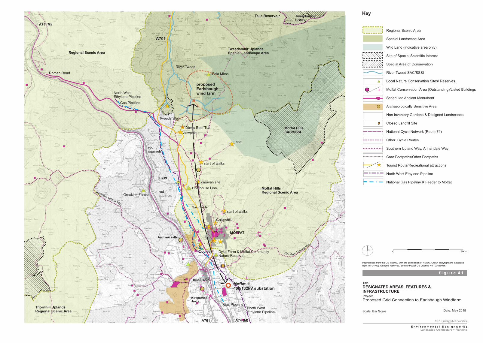
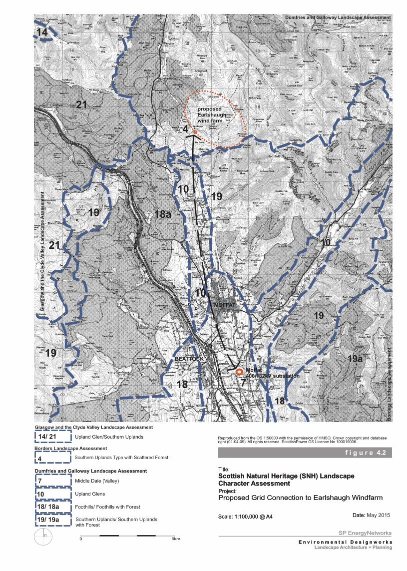
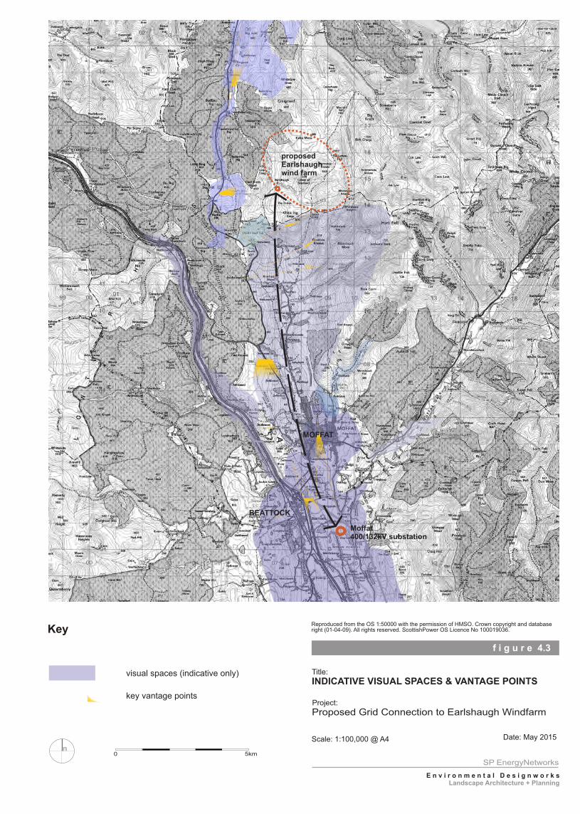
4.2 Information regarding the environmental features and sensitivities of the proposed Study Area at this initial stage of the Project is presented below and in the accompanying Figures 4.1- 4.3 (placed at the end of this Chapter). Previous detailed ecological survey work undertaken for the initial proposed grid connection study (2007-2009) is also reviewed. Figure 4.1: presents environmental designations and other features such as long distance footpaths and major infrastructure aligned through the Study Area. Figure 4.2: presents information regarding the landscape character types for the Study Area as identified by Scottish Natural Heritage (SNH). Figure 4.3: presents indicative visual spaces and key vantage points within the Study Area.
4.3 The information for these Figures and provided in this Chapter was collected from published
documents, site visits and initial contact with a number of consultees. In detail, the following has been undertaken: - • Desk study of aerial photographs • Desk review of current environmental data, designations and policies relating to the Study
Area. • Site appraisal of the environmental resources and potential receptors within the Study Area • Reference to the Dumfries and Galloway, Borders and Clyde Valley Landscape
Assessments by Scottish Natural Heritage. • Information available from: Local Development Plans/Local Plans covering the Study Area,
Historic Scotland, West of Scotland Archaeology Service (WoSAS), Scottish Borders and Dumfries and Galloway Council Archaeological Services, Scottish Gas Networks, Transco, Essar UK and the Forestry Commission.
Planning Context (Figure 1.1) 4.4 The following development plans cover the Study Area: -
• Scottish Borders Consolidated Local Plan 2011. • Scottish Borders Consolidated Structure Plan 2009. • Draft Scottish Borders Local Development Plan (LDP) 2014 • Dumfries and Galloway LDP 2014. • South Lanarkshire LDP 2015 • Glasgow and Clyde Valley Strategic Development Plan 2012
Proposed 132kV Grid Connection to Earlshaugh Windfarm I Consultation Document 14
Key Landscape Features of the Study Area (Figure 4.1) Landform
4.5 To the south of the Study Area is the wide valley of Annandale aligned in a north- south direction. To the north of Moffat Substation, the valley divides into a number of narrower valleys following the alignment of rivers- the Evan Water, River Annan and Moffat Water, which all flow southwards. At the head of the Annandale valley is a spectacular steep sided hollow, 250 m deep, named the Devils Beef Tub, a natural feature described by Walter Scott “as if four hills were laying their heads together, to shut out daylight from the dark hollow space between them5”.
4.6 An elevated range of hills divides the watersheds of the River Annan and River Tweed with Annanhead Hill at 478m AOD. To the north, is the source of the River Tweed, which flows northwards across the Southern Upland plateau.
Landcover 4.7 The landcover along the Annandale Valley is mainly improved and semi improved pasture,
bounded by hedgerows, stone walls, and post and wire fences. The valley sides and higher ground are semi improved or open unimproved rough grassland. Along the valley, areas of deciduous or mixed woodland are mainly associated with areas of higher ground and larger properties.
4.8 To the north of Moffat Substation, the narrow valley containing the Evan Water is aligned to the north west. Along this valley is extensive coniferous plantations extending from the low to high ground, and areas of rough grassland.
4.9 To the north of the settlement of Moffat are a number of linear strips of deciduous woodland aligned west- east following the alignment of smaller watercourses flowing into the River Annan. A number of small blocks and strips of coniferous woodland are also scattered along the valley side and around Ericstane to the north of the valley. On the higher ground are larger coniferous plantations. To the north, along the River Tweed, the landcover is either large scale coniferous plantations or open rough grassland.
Landuse 4.10 The landuse of the Study Area is largely determined by the topography and elevation. The
Annandale valley floor is primarily agricultural land used for sheep and cattle grazing. The main settlements of Moffat and Beattock, and many scattered properties and farmsteads are located in this lower sheltered area. Moffat historically developed as a spa resort in Victorian times and is still an important tourist destination.
4.11 Aligned along the Annandale valley in a north-south direction are the main transport corridors that form part of the local, regional and national network of routes. To the north of Beattock, the A74 (M) and railway line follow the narrow Evan Water valley. The 400kV overhead line grid connection is also routed along the Annandale valley and passes into the Evan Water valley to the north west of Beattock.
5 Scott, W (1842) Redgauntlet
Proposed 132kV Grid Connection to Earlshaugh Windfarm I Consultation Document
15
4.12 The valley slopes and higher ground to the north are primarily upland farmland and commercial forestry plantations.
Landscape Designations 4.13 The following regional landscape designations are located within or adjacent to the Study Area
Tweedsmuir Uplands Special Landscape Area Moffat Hills Regional Scenic Area Regional Scenic Area encompassing the south-eastern part of South Lanarkshire.
4.14 A map of “Wild Land”6 encompassing semi natural landscapes, with minimal signs of human
influence, has been prepared by Scottish Natural Heritage(SNH). The map indicates an approximate area encompassing the uplands to the north and east of the Devils Beef Tub and A701.
4.15 Although not a statutory designation, National Planning Framework 37 recognises Wild Land as a “nationally important asset,” and indicates Scotland’s wildest landscapes merit strong protection. Scottish Planning Policy sets out how this should be achieved. This includes the identification of Wild Land and safeguards in Development Plans and in Spatial Frameworks for onshore windfarms, and the need for development to “demonstrate that any significant effects on the qualities of these areas can be substantially overcome by siting, design or other mitigation”8. Landscape Character Assessment (Figure 4.2)
4.16 Scottish Natural Heritage (SNH) has undertaken a series of Regional Landscape Character Assessments covering the whole of Scotland. Following established guidance9, the Landscape Character Assessment divides the landscape into a number of Landscape Character Types and Areas, and provides guidance and advice as to how development could be accommodated in the landscape.
4.17 The landscape character of the Study Area is described in the following documents:- • Dumfries and Galloway Landscape Assessment. • Borders Landscape Assessment. • Glasgow and Clyde Valley Landscape Assessment.
4.18 The different landscape types located in the Study Area are listed below and illustrated in Figure 4.2. Dumfries and Galloway • Middle Dale (Valley) -7 • Upland Glens -10 • Foothills/ Foothills with Forest -18/18a • Southern Uplands/ Southern Uplands with Forest -19/19a
6 SNH (2014) Wild Land Areas 7 Scottish Government (2014) NPF3 & SPP 8 SPP Para 215 p 49. 9 Landuse Consultants (1991) Landscape Assessment Principles and Practice & Countryside Commission (1993) Landscape Assessment Guidance (CCP423).
Proposed 132kV Grid Connection to Earlshaugh Windfarm I Consultation Document 16
Borders • Southern Uplands Type with Scattered Forest - 4 South Lanarkshire • Southern Uplands - 14 • Upland Glen - 21
4.19 A Landscape Capacity Study has been prepared by Dumfries and Galloway, which reviews the
landscape and visual sensitivities of each of the Landscape Character types relative to the consideration and determination of proposals for windfarm developments10. The sensitivities of each of the Landscape Character Areas identified in the Scottish Borders to wind energy are reviewed in Supplementary Planning Guidance11.
Key Visual Qualities of the Study Area (Figure 4.3) Visual Spaces 4.20 The main vantage points from which to view the area and indicative visual spaces which divide
the Study Area, are illustrated in Figure 4.3. In summary there are three main visual spaces: the broad Annandale valley to the south of Moffat; the Annandale valley to the north of Moffat; and Evan Water valley to the north west of Beattock. In addition to stationary vantage points, transient views are also afforded of the Study Area: from the roads, in particular the A74 (M) motorway, A701 and B917; footpaths which includes the long distance Southern Upland Way and Annandale Way; and cycle routes. Visual Receptors
4.21 The main visual receptors located in the Study Area are: residential encompassing the settlements of Moffat and Beattock and scattered properties; recreational e.g. visitors primarily to Moffat, users of public footpaths and cycle routes, Moffat golf course; and travellers using the A74 (M) motorway, A701, B719 and minor roads in the Study Area.
Protected Areas and Features (Figure 4.1)
Nature Conservation 4.22 The following international and national designated areas are located within the Study Area
• River Tweed Special Area of Conservation (SAC)12/SSSI13 (crossed by the proposed underground section)
• Moffat Hills SAC/SSSI (approximately 4.4 km to the east) 4.23 The Tweedsmuir Hills SSSI covers a high range of Silurian Hills at the headwaters of the River
Tweed and Megget Water. The area has relatively intact upland communities, including a range of uncommon artic-alpine plant species, and an important bird community. Breeding birds include common sandpiper, curlew, dunlin, golden plover, ring ouzel, dipper and red
10 Anderson, C & Grant, A (2011) Dumfries and Galloway Windfarm Landscape Capacity Study 11 Scottish Borders Council (2011) Wind Energy Supplementary Planning Guidance 12 European designation made under the Council Directive 92/43/EEC on the Conservation of natural habitats and of wild fauna and flora and transposed in Scottish legislation via the Conservation (Natural Habitats & c) Regulations, 1994 13 National designation afforded protection under the Wildlife and Countryside Act, 1981 and the Nature Conservation (Scotland) Act, 2004.
Proposed 132kV Grid Connection to Earlshaugh Windfarm I Consultation Document
17
grouse. Several specially protected (Schedule 1) bird species occur, either as breeders, in winter or on passage.
4.24 The River Tweed SAC and SSSI are protected as a prime example of a “whole river system”. The river supports other qualifying features such as in-river Ranunculus (water crowfoot) beds, salmon, lamprey, otters, rare plant assemblages and unusual assemblages of invertebrates. The designated SAC area encompasses the source of the River Tweed at Tweed’s Well.
4.25 The Moffat Hills SAC and SSSI is an upland massif of Silurian greywackes and shales that
forms a watershed between the Tweed and Annan river systems. The site supports a wide range of upland plant communities and a rich assemblage of montane and sub-montane plant species. The site is also noted for its glacial geological and geomorphological interest.
4.26 The following local wildlife sites and local nature reserves have been identified at this stage of
the study • Holehouse Linn - important for its rich bryrophyte flora, which includes rare liverworts. • Holehouse Linn/ Harley Crag- local red squirrel site. • Fala Moss north of Earlshaugh - important for its peatland and associated vegetation. • Dyke Farm and Moffat Community Nature Reserves.
4.27 The Scottish Borders Biological Records Centre (SBBC) previously provided the following
records of habitats of conservation concern: • Cor Water Valley (NT 060 140) – priority habitat: blanket bog; and • Foal Burn Head (NT 060 140) – priority habitat: fens.
Habitats
4.28 The Study Area encompasses low flat pasture farmland in the vicinity of Moffat, northwards to the upland moorland areas in the vicinity of the proposed Earlshaugh Windfarm. The lowland areas are dominated by improved and semi-improved grassland. Further north as the ground rises, there are areas of rough grazing and plantation woodland comprising of planting coupes of varying age interspersed by fire breaks, tracks and areas that have been clear-felled. To the north there is open moorland comprising areas of acid and marshy grassland, and intact and degraded blanket bog that are bisected by small upland streams.
Bird Interest Summary 4.29 During the previous consultation exercise undertaken in 2009, the Royal Society for the
Protection of Birds (RSPB) Scotland advised that the construction and operation of an overhead grid connection within the Study Area had the potential to significantly disturb breeding and foraging birds, and the potential for collisions of flying birds. The RSPB also previously advised that the following key species may be present in the area: short-eared owl, peregrine falcon, merlin and goshawk, all of which are Annex 1 species as designated in Directive 2009/147/EC on the conservation of wild birds. There was also noted evidence of black grouse interest in the area.
4.30 The RSPB also previously advised that the floodplain of the River Annan is used as a feeding ground for wintering pink footed geese, which roost on the Castle Loch Special Protection Area (SPA) approximately 20 km to the south (at NY088 816). It is considered likely that this advice
Proposed 132kV Grid Connection to Earlshaugh Windfarm I Consultation Document 18
remains valid, although local changes in habitat quality, such as that resulting from felling activity, may have had localised effects on the distribution of birds.
4.31 Natural Research Projects (NRP) previously undertook ornithological surveys during the period
May 2007 to August 2008. These surveys covered a now superseded Route Option, which included some sections currently being considered. Surveys undertaken during this period were: • barn owl survey; • vantage point flight activity survey; • breeding bird survey; and • black grouse survey.
4.32 These surveys are being repeated by BSG Ecology, the surveys commencing in May 2014.
The repeat surveys cover the current Preferred Route together with a buffer area either side.
4.33 The barn owl surveys in 2007/8 and in 2014/2015 found no evidence that breeding barn owl was present. In the earlier survey barn owls were found to be using one roost at Bearholm located at the southern end of the proposed route (NT 095 015).
4.34 Twenty-two bird species were recorded during the vantage point watches in 2007/8, including the following: • Four species listed in Schedule 1 of the Wildlife and Countryside Act (WCA) 1981 and
Annex 1 of the EC Directive (79/409/EEC) on the Conservation of Wild Birds (The Birds Directive 1979) (whooper swan, merlin, peregrine and golden plover); and
• Two priority species listed in the UK Biodiversity Action Plan (BAP) (curlew and lapwing).
4.35 During the surveys carried out in 2014/15 a similar range of species was recorded.
4.36 Of the bird species recorded in 2007/8, three (peregrine, curlew and lapwing) were recorded flying at heights that might bring them into conflict with the overhead lines (assumed to be 10-20m) and therefore likely to be of material concern regarding the proposed development. However, the proportion of time spent flying at ‘risk height’ was low in each case.
4.37 At that time NRP concluded that peregrines were not likely to be at significant risk from the proposed overhead lines because of the distance to the nearest nest site and relatively small proportion of time spent flying at risk height. Curlews and lapwings may be at risk of collision with overhead lines during aerial displays, but the results of the assessment carried out at that time indicated that any impact would not have a detectable effect on regional populations.
4.38 The survey data from 2014/15 is currently being analysed and preliminary findings indicate that
no key focal species are regularly recorded flying at heights that would bring them into conflict with the proposed overhead lines. Peregrine was recorded on a number of occasions.
4.39 Other survey work carried out in 2007-2008 identified 61 species as definite or likely breeders
and of these, one species, crossbill, is listed on Schedule 1 of the WCA. Six of the recorded breeding species are included on the Birds of Conservation Concern (BoCC) Red List: skylark, song thrush, grasshopper warbler, spotted flycatcher, starling and house sparrow. In addition to
Proposed 132kV Grid Connection to Earlshaugh Windfarm I Consultation Document
19
these species, the following are also included on the Scottish Biodiversity List: lapwing, curlew, bullfinch, reed bunting, tree pipit, dunnock and lesser redpoll.
4.40 In 2014/15 slightly fewer species were identified as definite or likely breeders, but the
assemblage also included crossbill. BoCC Red List species recorded were: skylark, song thrush, spotted flycatcher, starling and house sparrow.
4.41 Woodland surveys conducted during 2007/8 produced records for 14 species, including
crossbill, song thrush and lesser redpoll, which are of conservation concern. There was no evidence of breeding black grouse, with just one incidental sighting of a male bird. Similar observations were made during the surveys in 2014/15.
Other Species Interest
4.42 Recent desk study and walkover surveys indicates that several species listed on the Scottish Biodiversity List are evident in the Study Area and vicinity of the Preferred Route. The River Annan has high water quality and is known to host otter, water vole and salmonid fish. Red squirrel has previously been recorded in 2006/07 in Raecleuch (NT 042 125) and Blacklaw (NT 053 076) woodland blocks. The Preferred Route runs through Howcleuch Priority Woodland (Raecleuch Forest), which is one of 23 priority woodlands identified across southern Scotland as being important to the long-term conservation of red squirrels. Whilst it is possible that this species is present in some woodland blocks within the Study Area, survey work carried out in 2014/15 found no definite evidence of red squirrel presence along the Preferred Route.
Summary
4.43 Key natural heritage interests include: • Qualifying interests of the River Tweed SAC / SSSI and their hydrological requirements. • River Annan and its tributaries, which are of high water quality and known to be used by
salmonid fish, otter and water vole. • Breeding, foraging and passage birds in the area, and potential for collisions with overhead
lines. • Habitats used by red squirrels, which may be present in several wooded areas in the Study
Area. • Badgers, which may use areas in and around the overhead line route corridor, • Notable habitats including blanket bog, acid grassland, marshy grassland, acid flush, base
rich flush, deciduous woodland, mature trees, hedgerows and unimproved grassland. • The identification of ground water dependant terrestrial ecosystems (GWDTE) within the
open areas of the route to the north of the Study Area. The identification of GWDTE within other open areas of the Study Area is also being considered.
4.44 Following review of past data survey work and consultation, the following survey work has
been progressed along the Preferred Route in the Study Area: • Extended Phase 1 Habitat Survey, • NVC survey of the route and 250m buffer north of Tweed’s Well, • Breeding bird surveys, • Vantage point flight activity surveys, • Red squirrel survey in any areas to be felled. • Badger survey of the route corridor.
Proposed 132kV Grid Connection to Earlshaugh Windfarm I Consultation Document 20
• Otter and water vole surveys of watercourses that will be crossed by the route, • Collating information to inform an Appropriate Assessment of the River Tweed SAC.
Cultural Heritage
4.45 Digital baseline information on known cultural heritage assets recorded within a search area of 384km2 (NGRs NY 000 960 - NT 000 200 - NT 160 200 – NY 160 960) was obtained in March 2014 from datasets curated by Historic Scotland, Scottish Borders Council (SBC), Dumfries and Galloway Council (DGC) and West of Scotland Archaeology Service (WoSAS).
4.46 Within the search area, designated cultural heritage features consist of: • 57 Scheduled Monuments of national importance and with statutory protection. • 154 Listed Buildings with statutory protection (8 Category A; 74 Category B, 72 Category C). • 1 Conservation Area of regional importance and with statutory protection, at Moffat (within
which many of the Listed Buildings are located). • 5 non-Inventory Designed Landscapes of at least regional /local importance. • 1 Archaeologically Sensitive Area of regional importance (designated by Dumfries and
Galloway Council). 4.47 In addition, local authority Historic Environment Records (HERs) contain details of
approximately 900 undesignated sites and monuments of archaeological and cultural heritage interest present within the search area.
4.48 These assets reflect human occupation and exploitation of the landscape since early prehistory. They include prehistoric burial sites and settlements; Roman military forts, camps and roads; medieval or later rural aristocratic and farming settlements; and historic buildings and designed landscapes dating mainly to within the last 300 years.
Hydrology/ Hydrogeology
4.49 The River Annan is the main surface water feature in the Study Area. Tributaries to River Annan include Tweedhope Burn, Acre, Burn, Larie Burn, March Burn, Watch Burn, Mere Beck, Granton Burn, Holehouse Linn, Gardenholm Linn and Reddings Gill. These tributaries are largely fed by springs located on the hillsides. Evan Water and Moffat Water join the River Annan south of Moffat. Flood mapping developed by the Scottish Environment Protection Agency (SEPA) identifies that there is a risk of river flooding focused in the Annandale Valley and around Moffat where the River Annan, Moffat Water and Evan Water converge. There are also localised areas of surface water flooding risk in the Study Area, which are focussed around the streams.
4.50 Springs and streams in the Study Area are known to be used for water supply. Surface water abstractions were identified in the upper catchment of the River Annan as part of the Environmental Statement for the proposed Earlshaugh Windfarm; these tended to be positioned in the Annandale Valley from the River Annan or from the lower reaches of its tributaries. It is likely that there are more water supplies from surface water located the southern part of the Study Area, which will be identified as part of later work.
4.51 Geological mapping prepared by the British Geological Survey indicates that peat is present in
the northern part of the Study Area near the proposed Earlshaugh Windfarm. Other superficial deposits mapped include Glacial Till, Alluvium and Glaciofluvial Deposits. The Alluvium and
Proposed 132kV Grid Connection to Earlshaugh Windfarm I Consultation Document
21
Glaciofluvial Deposits are concentrated in Annan Valley. The underlying bedrock comprises the Queensberry Formation (part of the Gala Group), which is a series of faulted sandstones, mudstones, siltstones and conglomerates. The Gala Group is classified as a low productivity aquifer. Around Moffat, and in a narrow band running north of Moffat up the Annandale Valley, is the Hartfield Formation (part of the Stewartry Group), which comprises sandstone, pebbly sandstone and conglomerate. This is classified as a regionally important highly productive aquifer. It is possible that there are groundwater abstractions from this productive aquifer, which will be identified as part of later work.
4.52 The River Tweed SAC and SSSI are protected as a prime example of a “whole river system”
and include the source of the River Tweed at Tweed’s Well. The river system supports fauna and habitats that are SAC/SSSI qualifying features (including fluvial Ranunculus beds, salmon, otters, rare plants, rare fish and unusual assemblages of invertebrates). Local Wildlife Site Falla Moss (located north of Earlshaugh) supports blanket bog habitat, Cor Water Valley is a priority habitat for its blanket bog, and Foal Burn Head is a priority habitat for its fens. All of these habitats rely on the quality and availability of water to support them. As part of the Environmental Statement for the proposed Earlshaugh Windfarm, a series of habitats were identified that are, or could be, Groundwater Dependent Terrestrial Ecosystems (GWDTEs) including habitats M23 (GWDTE), M25 (moderately GWDTE depending on hydrogeological setting), and M15d (moderately GWDTE depending on hydrogeological setting). These, and other GWDTE habitats, may also be present in the proposed overhead line Study Area and will be identified in conjunction with the Ecology studies.
4.53 Based on the above, the key hydrological and hydrogeological aspects of interest located within the Study Area are: The quality and quantity of spring and surface water input to the River Tweed SAC/SSSI; Areas that are prone to flooding; Surface water and groundwater that provide sources of public and private water supply; and Hydrological/hydrogeological regimes supporting GWDTEs and habitats such as fen and bog
(in collaboration with the Ecology Assessment).
Commercial Forestry 4.54 The main areas of commercial forestry within the Study Area are predominately Sitka spruce
plantations of mixed age from 1 year (new restocking) to 40 years (mature timber stands). The commercial forestry plantations located between the A74 (M) and A701 comprise of Blacklaw Forest (Forestry Commission) and two private forestry holdings, Raecleuch Forest under management by Tilhill Forestry Ltd and Ericstane Forest managed by Scottish Woodlands Ltd.
4.55 All commercial forests have long-term 20-year Forest Plans as sustainable cropping plantations compliant UK Forestry Commission (FC) standards. Each area of commercial forestry is required to allocate 1% of the plantation area as a “natural reserve” which are long term often wooded, minimum intervention areas. Two reserves are located to the west of the Devils Beef Tub. A bog area immediately to the north of the A701 and an area of mature Scots Pine forming the north east corner of the forested area.
4.56 The Lowther Hills Uplands in this area were previously under use as marginal hill sheep
farming and has been planted up for commercial coniferous forestry since around the 1960’s. The total area of forestry in this locality now amounts to over 9000 Ha.
Proposed 132kV Grid Connection to Earlshaugh Windfarm I Consultation Document 22
4.57 The Scottish Government has developed a policy on the control of woodland removal to
provide direction for decisions on woodland removal in Scotland14. The guiding principles for implementing this policy15 notes “Planning conditions and agreements are used to mitigate the environmental impacts arising from development and Forestry Commission Scotland will also encourage their application to development-related woodland removal”. In summary, the FCS is currently seeking compensatory woodland planting of an equivalent area of any trees removed as part of new major developments.
4.58 Initial feedback from the Forestry Commission has indicated that existing wayleaves, firebreaks
and forest compartment boundaries (coupes) should be followed wherever possible for a proposed overhead line. To accommodate the proposed OHL and associated wayleave corridor further felling maybe required to obtain a windfirm plantation edge. Initial review of the Long Term Forestry Plans has been undertaken and these will be studied in detail to ensure a proposed OHL route can be factored in as best as possible with existing and proposed coupes, including associated forestry access routes for thinning and felling.
Recreation Features/ Routes
4.59 The main recreational features and attractions located in the Study Area are as follows: - • A701 - a designated tourist route passing through Moffat to reach Edinburgh and now
forming part of the Robert the Bruce car trail. In the Study Area, the Robert Bruce Trail follows the A701 to Ericstane and also passes along the A74 (M) to the B7040 to Wanlockhead and B7020 to Lochmaben.
• Moffat- a popular tourist and visitor destination with an Annual Sheep Races and Walking Festival.
• Devils Beef Tub - a spectacular natural landform with a designated stopping place and
information point on the A701.
• Various springs around Ericstane - the reason for growth of Moffat as a spa resort, for example; Chalybeate Spring contained by a beehive stone structure, famed for its healing powers.
• Hartfell summit, 808 m - destination for many walks; historic associations as reputed to be
the seat of Merlin.
• Source of the River Tweed.
• Moffat Golf Course.
• Caravan Sites - to north and south of Moffat.
14 Forestry Commission (2009) The Scottish Governments Policy on Control of Woodland Removal 15 Scottish Government (2013) Guidance to Forestry Commission staff on implementing the Scottish Governments Control of Woodland Removal Policy
Proposed 132kV Grid Connection to Earlshaugh Windfarm I Consultation Document
23
• Corehead Farm- a 640Ha upland farm purchased by the Borders Forest Trust an environmental charity, which aims to conserve, restore and manage native woodlands for the benefit of people and wildlife.
• Southern Upland Way- national cross country walking route.
• Annandale Way- new waymarked national trail with a circular walk encompassing
Annanhead Hill, Great Hill, Chalk Rig Edge, down the valley of Tweed Hope which then passes southwards along the Annandale Valley to link with the Southern Upland Way.
• Numerous walks identified as Core Paths and other footpaths e.g. south of Moffat Golf
Course passing between the A74 (M) across Coats Hill to Moffat, around Gallow Hill, and crossing the upland area of Earlshaugh.
• National cycle route along the B7076 and local cycle routes.
Other
4.60 Other features of note within the Study Area include the alignment of the following major pipelines, which have associated safety and clearance zones: • North West Ethylene Pipeline. • National Gas Pipeline. • Regional Gas Pipeline to Moffat.
4.61 Coatsgate Quarry is located immediately to the east of the A74 (M) and north west of Moffat
Golf Course. The quarry has been operational since the 1930s and extracts a sequence of rock types including gritstone, siltstone and mudstone (collectively known as Greywacke). The site is accessed from the northwest via the B7076 and a bridge over the A74 (M), between junctions 14 and 15.
4.62 The site is not currently being worked but an application for extension of time for extraction was approved by the Council in April 2012. The remaining reserves are to be worked in three phases, which will progress in a northerly direction. This will be on a “campaign” basis, whereby minerals are only extracted when there is a clear market demand. This material would be processed on site using mobile plant, which would only be present as and when required.

Proposed 132kV Grid Connection to Earlshaugh Windfarm I Consultation Document 24
Holehouse Linnred squirrels
red squirrels
Greskine Forest
Devils Beef Tub
Key
Regional Scenic Area
Special Landscape Area
Wild Land (indicative area only)
Site of Special Scientific Interest
Special Area of Conservation
River Tweed SAC/SSSI
Local Nature Conservation Sites/ Reserves
Moffat Conservation Area (Outstanding)/Listed Buildings
Scheduled Ancient Monument
Archaeologically Sensitive Area
Non Inventory Gardens & Designed Landscapes
Closed Landfill Site
National Cycle Network (Route 74)
Other Cycle Routes
Southern Upland Way/ Annandale Way
Core Footpaths/Other Footpaths
Tourist Route/Recreational attractions
North West Ethylene Pipeline
National Gas Pipeline & Feeder to Moffat
n0 5km
f i g u r e 4.1
Title:
Project:
Scale: Bar Scale Date: May 2015
DESIGNATED AREAS, FEATURES & INFRASTRUCTURE
Proposed Grid Connection to Earlshaugh Windfarm
SP EnergyNetworks
E n v i r o n m e n t a l D e s i g n w o r k s
Landscape Architecture + Planning
Reproduced from the OS 1:25000 with the permission of HMSO. Crown copyright and database right (01-04-09). All rights reserved. ScottishPower OS Licence No 100019036.
Moffat 400/132kV substation
proposedEarlshaughwind farm
TweedsmuirSSSI
Moffat Hills Regional Scenic Area
A701
BEATTOCK
MOFFAT
Moffat HillsSAC/SSSI
Regional Scenic Area
Thornhill UplandsRegional Scenic Area
Tweedsmuir UplandsSpecial Landscape Area
spa
start of walks
viewpoint
Gallowhill
caravan site
Fala Moss
Dyke Farm & Moffat CommunityNature Reserve
Tweeds Well
A701
Talla Reservoir
Fruid Reservoir
start of walks
Golf Course
A74 (M)
A74 (M)
River Tweed
Gas Pipeline
Gas PipelineNorth West Ethylene Pipeline
Roman Road
North West Ethylene Pipeline
B719
Gas Feeder
Auchencastle
KirkpatrickJuxta
f i g u r e 4.2
Title:
Project:
Scale: 1:100,000 @ A4 Date:
Scottish Natural Heritage (SNH) LandscapeCharacter Assessment
Proposed Grid Connection to Earlshaugh Windfarm
SP EnergyNetworks
E n v i r o n m e n t a l D e s i g n w o r k s
Landscape Architecture + Planning
f i g u r e 4.2
Title:
Project:
Scale: 1:100,000 @ A4 Date: May 2015
Scottish Natural Heritage (SNH) LandscapeCharacter Assessment
Proposed Grid Connection to Earlshaugh Windfarm
SP EnergyNetworks
E n v i r o n m e n t a l D e s i g n w o r k s
Landscape Architecture + Planning
Reproduced from the OS 1:50000 with the permission of HMSO. Crown copyright and database right (01-04-09). All rights reserved. ScottishPower OS Licence No 100019036.
n0 5km
4
14
21
19
19
19
19
10
7
18
19a
18a
18
10
21
10
14/ 21
4
7
10
18/ 18a
19/ 19a
Glasgow and the Clyde Valley Landscape Assessment
Upland Glen/Southern Uplands
Dumfries and Galloway Landscape Assessment
Borders Landscape Assessment
Southern Uplands Type with Scattered Forest
Middle Dale (Valley)
Upland Glens
Foothills/ Foothills with Forest
Southern Uplands/ Southern Uplandswith Forest
MOFFAT
Gla
sg
ow
an
d t
he C
lyd
e V
all
ey L
an
dsca
pe
As
se
ss
me
nt
Bo
rders
Lan
dscap
e A
ssessm
en
t
BEATTOCK
Dumfries and Galloway Landscape Assessment
Moffat 400/132kV substation
proposedEarlshaughwind farm
f i g u r e 4.3
Title:
Project:
Scale: 1:100,000 @ A4 Date: May 2015
INDICATIVE VISUAL SPACES & VANTAGE POINTS
Proposed Grid Connection to Earlshaugh Windfarm
SP EnergyNetworks
E n v i r o n m e n t a l D e s i g n w o r k s
Landscape Architecture + Planning
Reproduced from the OS 1:50000 with the permission of HMSO. Crown copyright and database right (01-04-09). All rights reserved. ScottishPower OS Licence No 100019036.
n0 5km
MOFFAT
BEATTOCK
visual spaces (indicative only)
key vantage points
Key
Moffat 400/132kV substation
proposedEarlshaughwind farm
Proposed 132kV Grid Connection to Earlshaugh Windfarm I Consultation Document
25
5 . 0 R o u t e O p t i o n s a n d P r e f e r r e d R o u t e A l i g n m e n t 5
Preliminary Environmental Review
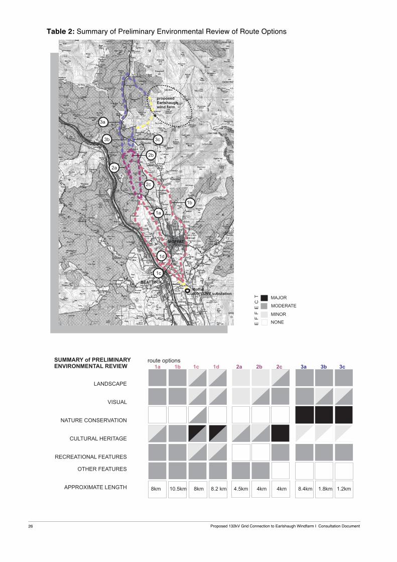
5.1 Following a desk review of environmental baseline data for the Study Area and a number of site visits, broad route corridors were initially identified between the proposed Windfarm at Earlshaugh and Substation at Moffat. This followed the approach to routeing an overhead line as outlined in Chapter 3. This process was reiterated and refined to identify the proposed route options as indicated in Figure 5.1 and finally a Preferred Route. The Preferred Route alignment corridor is indicated in Figure 5.2 and indicatively illustrated on aerial photographs in Figures 5.3 a-d.
5.2 A number of route options were identified, reviewed and rejected in the route selection process. The developed route options as illustrated in Figure 5.1, have been subjected to a preliminary environmental appraisal, which is detailed in Appendix 1. This appraisal was undertaken qualitatively, employing specialist professional judgement drawing upon: knowledge of the Study Area at this stage; the baseline environmental information collated to date; and understanding of the potential environmental effects of overhead transmission lines.
5.3 The key environmental considerations used for the comparison of route options have been: -
• Landscape: landform, landcover, landuse, designation, landscape character (SNH) and summary of effect.
• Visual: visibility, receptor type and summary of effect. • Protected Areas & Features: nature conservation, heritage, recreational attractions/ routes,
commercial forestry and any other important features. 5.4 Table 2 summarises the findings of the Preliminary Environmental Review of the route options
as a simple matrix, which provides a preliminary ranking of the potential effect of each route option. This allows recording of the comparative assessment of route options undertaken at this project stage. The Table is supported by the following text, which explains the key differences between the route options leading to the identification of the Preferred Route.
Proposed 132kV Grid Connection to Earlshaugh Windfarm I Consultation Document 26
Table 2: Summary of Preliminary Environmental Review of Route Options
Proposed 132kV Grid Connection to Earlshaugh Windfarm I Consultation Document
27
Landscape Character 5.5 Routes 1a and b pass through areas of similar landform, landcover and landuse, and through
the Moffat Hills Regional Scenic Area (RSA). Route Options 1c and 1d are routed out of the Annandale Valley and to the west of the Regional Scenic Area.
5.6 Routes 2a, b and c all pass through an area of coniferous plantation. A detailed review of aerial photographs covering this area in conjunction with site survey work has allowed the identification of routes, which fit the general topography while passing through existing wayleaves, firebreaks or coup boundaries. Route 2c passes through the western edge of the designated Moffat Hills RSA. Route 2a alignment utilises the most of existing clearings by passing parallel to an existing pipeline wayleave for the majority of its length.
5.7 Route 3a parallels the western side of the A701 to Tweedhopefoot. The route is then aligned
along an existing forest track and open upland to reach the proposed Windfarm at Earlshaugh. The A701 is a designated tourist route and on crossing the local authority boundary into the Scottish Borders passes through the Tweedsmuir Uplands Special Landscape Area.
5.8 Route 3b is aligned across an area of felled coniferous plantation to the north of the A701 and
then open upland. Route 3c passes along a forest break and on crossing the A701 is routed parallel to an existing road, which will be used to access the proposed Windfarm at Earlshaugh. In summary, the landscape character through which Route 3b and 3c are aligned is similar and both cross the Tweedsmuir Uplands Special Landscape Area to reach the proposed Windfarm.
Visual Effect
5.9 Glimpse, partial and open views would be afforded of Routes 1a, 1b, 1c and 1d. Views of Route 1a and 1b would be afforded along the Annandale Valley and settlement of Moffat. Routes 1c and d would be visible from the settlement of Beattock and travellers along the A 74(M).
5.10 The visibility of Routes 2a, b and c will be limited to primarily glimpse views by the alignment through coniferous plantation. The greatest effect will be associated with the alignment of Route 2c, which parallel part of the Roman Road Scheduled Ancient Monument. All the proposed route options cross the Roman Road SAM.
5.11 Route 3a will be visible to travellers along the A701, which is a designated tourist route. Routes
3b and 3c cross the A701 to the west of the Devils Beef Tub where there is a viewpoint and layby for visitors. Route 3b would be aligned very close to an existing monument and 3c would parallel part of the Annanhead Way, which leads to Annanhead Hill.
Protected Areas & Features
Nature Conservation 5.12 Route 1a would pass to the west of Dyke Farm Local Nature and Holehouse Linn Local Nature
Reserve, and an area of woodland to the north of Moffat. The southern part of Route 1a, 1c and 1d would cross the Evan Water. Route 1b would cross the Evan Water and River Annan. Both of these watercourses support features of ecological interest.
Proposed 132kV Grid Connection to Earlshaugh Windfarm I Consultation Document 28
5.13 None of the routes have a direct effect on any designated national or local nature conservation site. Route 1c would require the felling of an area of native woodland to the south of the A701 to accommodate required wayleave clearances. This woodland has been identified as supporting features of ecological interest.
5.14 Routes 2a, b and c pass through open corridors or felled areas within coniferous plantations. None of the routes would have a direct effect on any designated nature conservation area.
5.15 Routes 3a, b and c would pass along the edge of coniferous plantations. Route 3a passes to
the west of the designated Special Area of Conservation (SAC) encompassing Tweeds Well at the head of the River Tweed. It is proposed that Route 3a at Tweedhopefoot would pass along the verge of an existing forest track eastwards to reach the proposed Windfarm at Earlshaugh.
5.16 Routes 3b and 3c would cross the Long term Forestry Plan “natural reserve”, an area of open
wetland bog adjacent the A701 and an area of mature Scots Pine to the north. All routes would cross open ground and require the crossing of tributaries of the River Tweed SAC/SSSI.
Cultural Heritage 5.17 An overhead line along Routes 1c and 1d has greater potential to cause significant effects on
cultural heritage assets than one along Routes 1a or 1b. This is principally because Routes 1c and 1d intersect an Archaeologically Sensitive Area (ASA), although within it is an existing overhead transmission line corridor. The ASA contains a scheduled motte (SM686) and a concentration of other prehistoric and more recent archaeological features. Route 1d passes to the north east of Lochhouse Tower Listed Building.
5.18 Routes 1a and 1b both intersect a Scheduled Monument at one point (1a, SM3347; 1b, SM 684), and there are several Listed Buildings and a non-Inventory Designed Landscape in proximity to Route 1b. Outside the designated areas there are recorded archaeological features close to each route option, and each route option crosses the complex of Roman military camps to the north of Moffat Substation.
5.19 Route options 2a and 2b would require the overhead line to cross the route of a scheduled Roman road whereas option 2c would follow the route of the Roman Road (SM3330) for over 3km. For this reason route option 2c is significantly less preferable on cultural heritage grounds than options 2a or 2b. An overhead line on route options 2a or 2b would need to be designed to avoid any direct effect on the character, and to minimise the indirect effect on the setting, of the Roman road and a small number of known undesignated features.
5.20 Of route options 3a, 3b and 3c, on current evidence none appears significantly preferable to
any other. In each case the route would need to be designed carefully to avoid significant effects arising on the character or setting of the few cultural heritage assets identified in proximity to the route options.
Recreation features/ routes
5.21 Routes 1a, 1b, 1c and 1d would all cross over the Southern Upland Way. Route 1a and 1d would also parallel the Annanhead Way. Routes 1a, 1c and 1d would cross the A701 tourist route. Route 1a would pass along the eastern edge of Moffat Golf Course encompassing Coats Hill. Route 1b passes to the east of Gallow Hill where there is a picnic site and car parking for

Proposed 132kV Grid Connection to Earlshaugh Windfarm I Consultation Document
29
walks along the Birnock Water to the north- east of Moffat. Further north the route would pass near a caravan site located at Howslack. Routes 1c and 1d pass to the west of Moffat Golf Course on lower ground parallel to the A74 (M).
5.22 Route Options 2a and 2b would not effect any designated tourist or recreational attractions. Route 2c is aligned close to the A701 tourist route and parallels part of the Annanhead Way footpath to the south of Ericstane Hill.
5.23 Route Option 3a parallels the A701 which is a designated tourist route and passes to the west
of Tweeds Well, the source of the River Tweed. A lay-by provides a stopping place for visitors to this area.
5.24 Routes 3b and 3c would directly cross the A701 and pass to the west of the Devils Beef Tub. A
lay-by and viewpoint is provided on the A701 for visitors to stop and look at this natural feature. The Annanhead Way crosses this area leading to Annanhead Hill and Great Rigg, and forms part of a circular route, which is aligned eastwards along the high ridge and then down to Ericstane. To the north of the A701, Route 3c is routed parallel to part of this footpath. Route 3b crosses the A701 further north adjacent a monument.
Other Features 5.25 The southern part of Route 1a is aligned to the west and east of the North West Ethylene
Pipeline and would cross at one point. Further north, Route 1a would cross the North West Ethylene Pipeline and National Gas Pipeline at one point, and the Regional Gas Feeder Pipeline to Moffat in two places. The southern part of Route 1b would cross the North West Ethylene Pipeline. Routes 1c and 1d would parallel and cross the National Gas Pipeline and North West Ethylene Pipeline, and pass to the immediate west of Coatsgate Quarry.
5.26 Routes 2a and 2b are aligned parallel to the North West Ethylene and National Gas Pipeline routes along the corridor cleared for these pipelines through the coniferous plantation. Route 2c is aligned further to the west of both pipelines along a separate corridor and clearings through the woodland.
5.27 No other features have been identified at this project stage for Route Options 3a, 3b and 3c.
Preferred Route Alignment 5.28 The Preferred Route as indicated in Figures 5.2 and 5.3, is considered at this project stage to
have on balance the least likely adverse environmental effects, whilst being technically feasible and economically viable. The approximate length of the Preferred Route alignment between the proposed Windfarm and Moffat Substation comprising of Route Options 1d, 2a and 3c is 16.5km.
5.29 The previous study undertaken in 2007-2009 rejected an overhead line route option to the west
of Coats Hill and Moffat Golf Course as it was considered at that stage to be technically unfeasible for the proposed wood pole overhead line design. It is considered that a lattice steel tower route is currently feasible for this route.
5.30 From Moffat Substation, the routeing of the Preferred Route at this project stage seeks to
minimise adverse effects through the following alignment:
Proposed 132kV Grid Connection to Earlshaugh Windfarm I Consultation Document 30
Route 1d • proposed underground cable to exit Moffat substation; • overhead line crossing of the Evan Water; • direct route to the north west across the valley floor crossing the National Gas Pipeline and
passing to the east of Lochhouse Tower Listed Building to cross the A701;
• alignment parallel to the existing 400kV OHL and A74(M) on lower ground to to the west of Coats Hill and Moffat Golf course, crossing the designated Archaeological Sensitive Area and passing to the west of an existing Scheduled Monument;
• alignment between the A74(M) and Coatshill Quarry; • alignment up hillside below crest of Black Rig and Muckle Hill, and along the edge of
Blacklaw Forest; • passing through an existing clearing in the coniferous plantation to the west of the existing
Gas Valve Compound and directly crossing the B719. Route 2a • alignment through Raecleuch Forest using primarily existing wayleaves or recent plantation
clearings whilst passing on lower ground to the west and north of Black Fell; • direct crossing of the Roman Road SAM.
Route 3c • alignment through Raecleuch Forest using an existing firebreak allowing a direct route
screened from the A701; • direct crossing of the A701 tourist route; • alignment parallel to the proposed Earlshaugh Windfarm access road; • proposed underground cable route to cross open upland to the grid connection Substation
for the proposed Windfarm. Detailed alignment to parallel the proposed Windfarm access road.
5.31 At this project stage, the Preferred Route should be viewed as a corridor within which the
detailed route alignment can be developed through localised deviations to avoid or reduce identified effects during the detailed environmental assessment process. A preliminary list of potential significant effects of the proposed development on the environment, and proposed desk and field surveys are listed in Appendices 2 and 3.
5.32 Chapter 6 outlines how the Preferred Route will become the Proposed Route through the public consultation process.
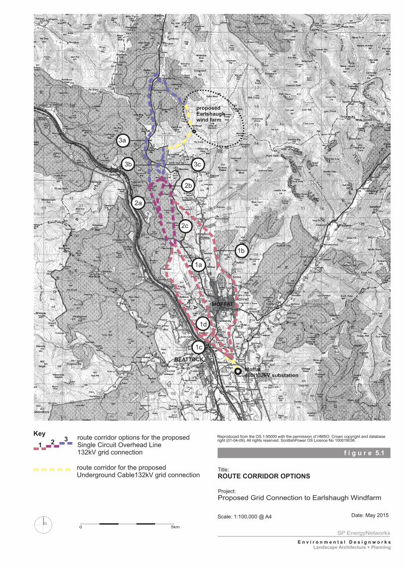
f i g u r e 5.1
Title:
Project:
Scale: 1:100,000 @ A4 Date: May 2015
ROUTE CORRIDOR OPTIONS
Proposed Grid Connection to Earlshaugh Windfarm
SP EnergyNetworks
E n v i r o n m e n t a l D e s i g n w o r k s
Landscape Architecture + Planning
Reproduced from the OS 1:50000 with the permission of HMSO. Crown copyright and database right (01-04-09). All rights reserved. ScottishPower OS Licence No 100019036.
n0 5km
MOFFATMOFFAT
BEATTOCK
Moffat 400/132kV substation
proposedEarlshaughwind farm
3b
3a
2c
1b
2a
2b
1a
Keyroute corridor options for the proposed Single Circuit Overhead Line 132kV grid connection
route corridor for the proposed Underground Cable132kV grid connection
1 2 3
1c
3c
1d
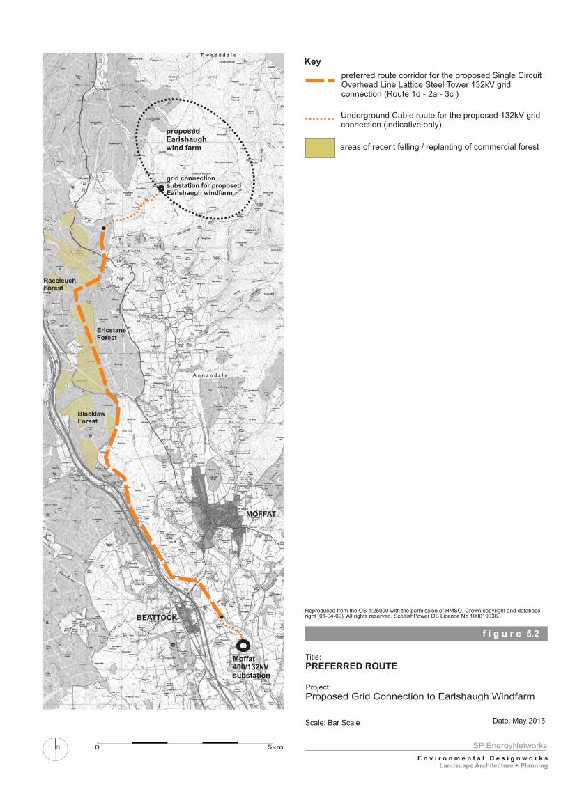
BEATTOCK
MOFFAT
preferred route corridor for the proposed Single Circuit Overhead Line Lattice Steel Tower 132kV grid connection (Route 1d - 2a - 3c )
Key
Underground Cable route for the proposed 132kV grid connection (indicative only)
areas of recent felling / replanting of commercial forest
proposedEarlshaughwind farm
Moffat 400/132kVsubstation
grid connectionsubstation for proposedEarlshaugh windfarm
RaecleuchForest
EricstaneForest
BlacklawForest
0 5kmn
f i g u r e 5.2
Title:
Project:
Scale: Bar Scale Date: May 2015
PREFERRED ROUTE
Proposed Grid Connection to Earlshaugh Windfarm
SP EnergyNetworks
E n v i r o n m e n t a l D e s i g n w o r k s
Landscape Architecture + Planning
Reproduced from the OS 1:25000 with the permission of HMSO. Crown copyright and database right (01-04-09). All rights reserved. ScottishPower OS Licence No 100019036.
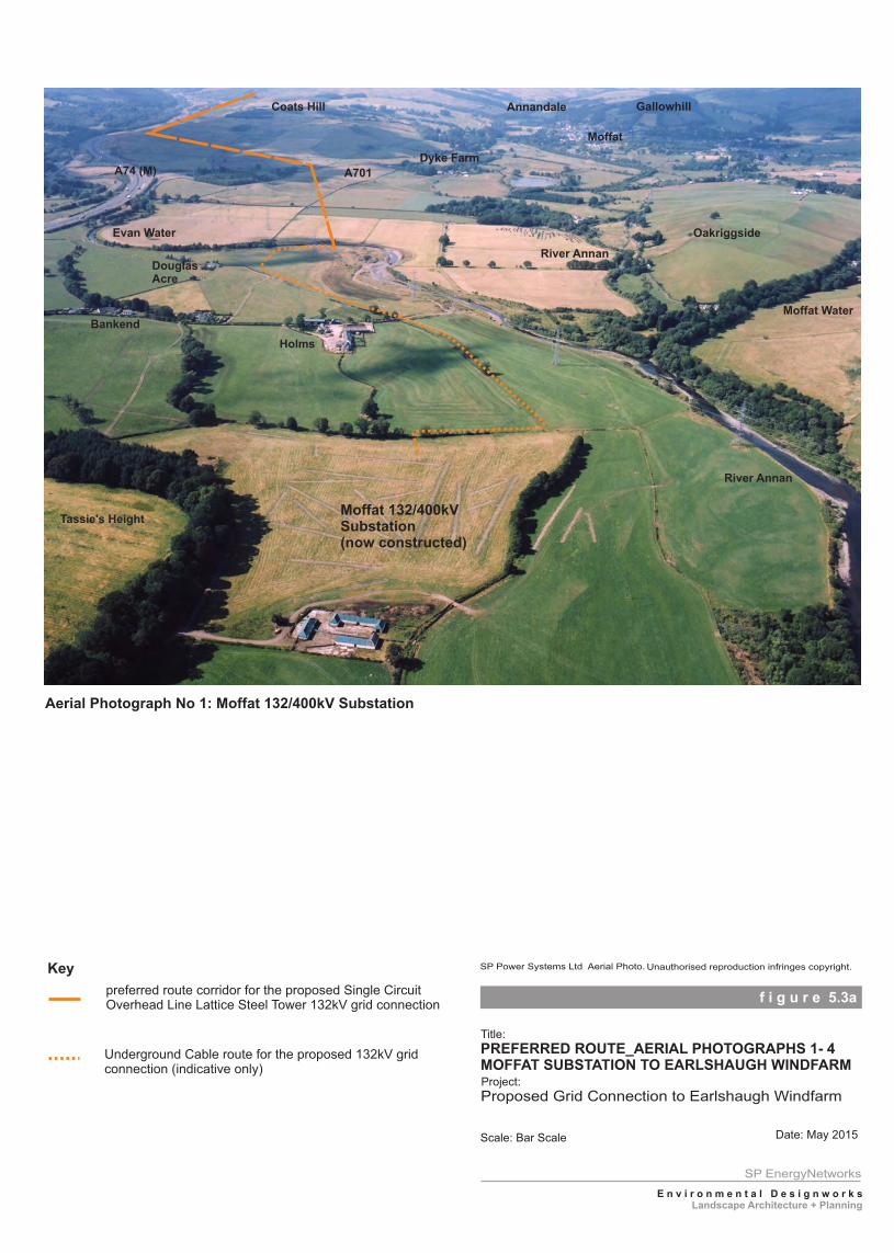
preferred route corridor for the proposed Single Circuit Overhead Line Lattice Steel Tower 132kV grid connection
Key
Underground Cable route for the proposed 132kV grid connection (indicative only)
Coats Hill
River Annan
Moffat Water
Moffat
GallowhillAnnandale
A74 (M)
Holms
Tassie's Height
Evan Water
A701
Moffat 132/400kVSubstation(now constructed)
Bankend
Oakriggside
Aerial Photograph No 1: Moffat 132/400kV Substation
Dyke Farm
River AnnanDouglasAcre
f i g u r e 5.3a
Title:
Project:
Scale: Bar Scale Date: May 2015
SP Power Systems Ltd Aerial Photo. Unauthorised reproduction infringes copyright.
PREFERRED ROUTE_AERIAL PHOTOGRAPHS 1- 4MOFFAT SUBSTATION TO EARLSHAUGH WINDFARM
Proposed Grid Connection to Earlshaugh Windfarm
SP EnergyNetworks
E n v i r o n m e n t a l D e s i g n w o r k s
Landscape Architecture + Planning
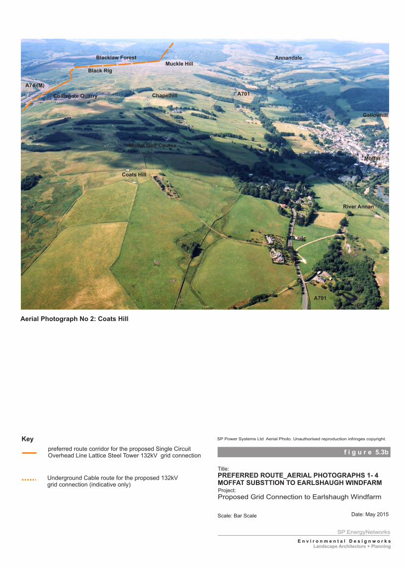
preferred route corridor for the proposed Single CircuitOverhead Line Lattice Steel Tower 132kV grid connection
Key
Underground Cable route for the proposed 132kVgrid connection (indicative only)
Chapelhill
Moffat Golf Course
Moffat
Gallowhill
Annandale
A74 (M)
A701
Aerial Photograph No 2: Coats Hill
A701
Muckle Hill
Coats Hill
River Annan
Coatsgate Quarry
Blacklaw Forest
Black Rig
f i g u r e 5.3b
Title:
Project:
Scale: Bar Scale Date: May 2015
. SP Power Systems Ltd Aerial Photo. Unauthorised reproduction infringes copyright.
PREFERRED ROUTE_AERIAL PHOTOGRAPHS 1- 4MOFFAT SUBSTTION TO EARLSHAUGH WINDFARM
Proposed Grid Connection to Earlshaugh Windfarm
SP EnergyNetworks
E n v i r o n m e n t a l D e s i g n w o r k s
Landscape Architecture + Planning
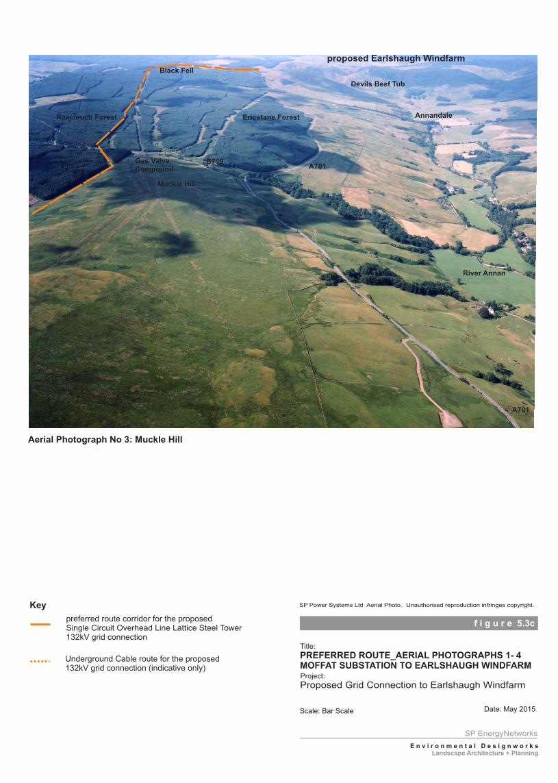
preferred route corridor for the proposed Single Circuit Overhead Line Lattice Steel Tower132kV grid connection
Key
Underground Cable route for the proposed 132kV grid connection (indicative only)
proposed Earlshaugh Windfarm
Aerial Photograph No 3: Muckle Hill
Black Fell
B719Gas ValveCompound
Muckle Hill
A701
Devils Beef Tub
Annandale
A701
River Annan
Raecleuch Forest Ericstane Forest
f i g u r e 5.3c
Title:
Project:
Scale: Bar Scale Date: May 2015
.
SP Power Systems Ltd Aerial Photo. Unauthorised reproduction infringes copyright.
PREFERRED ROUTE_AERIAL PHOTOGRAPHS 1- 4MOFFAT SUBSTATION TO EARLSHAUGH WINDFARM
Proposed Grid Connection to Earlshaugh Windfarm
SP EnergyNetworks
E n v i r o n m e n t a l D e s i g n w o r k s
Landscape Architecture + Planning
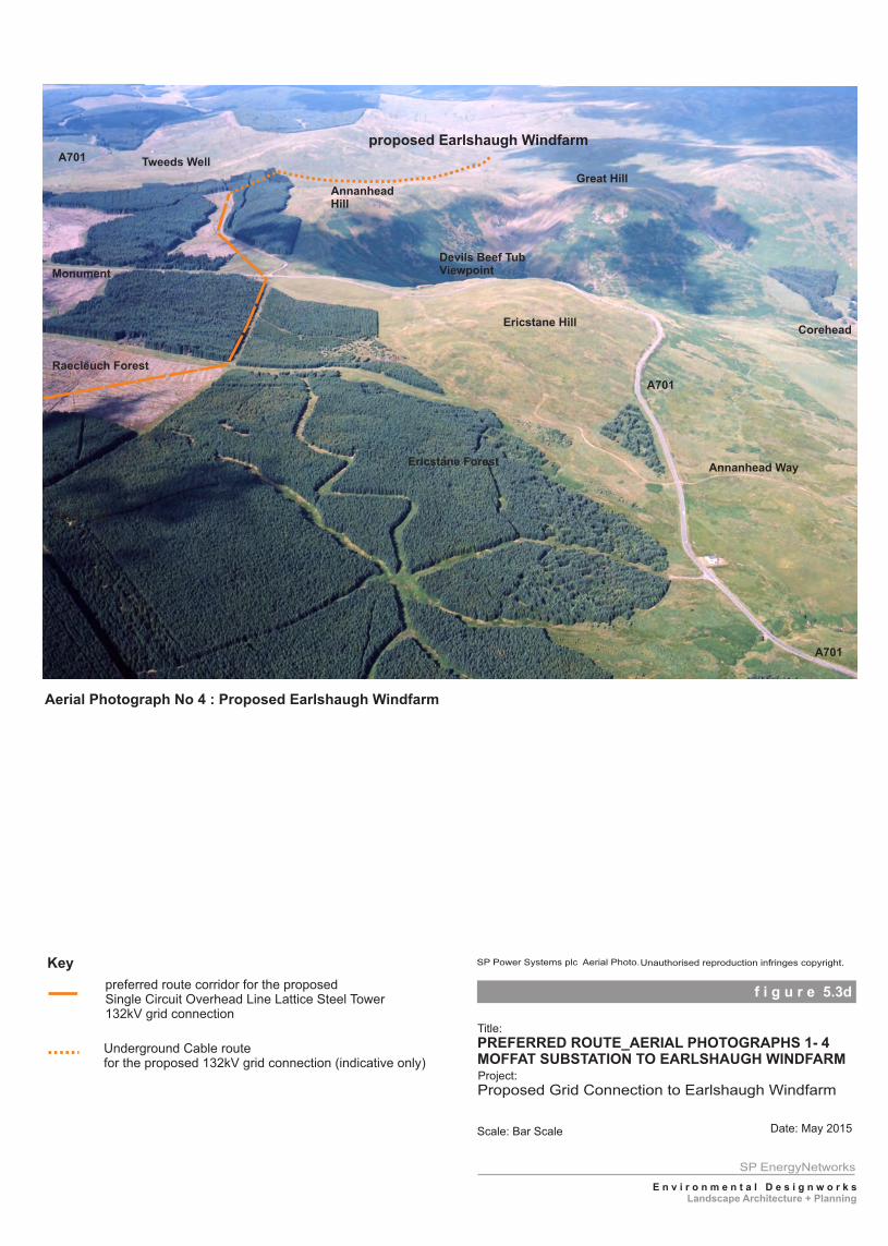
preferred route corridor for the proposed Single Circuit Overhead Line Lattice Steel Tower132kV grid connection
Key
Underground Cable route for the proposed 132kV grid connection (indicative only)
Aerial Photograph No 4 : Proposed Earlshaugh Windfarm
Black Fell
A701
Devils Beef TubViewpoint
Corehead
A701
proposed Earlshaugh Windfarm
Monument
A701 Tweeds Well
Ericstane Hill
AnnanheadHill
Great Hill
Ericstane ForestAnnanhead Way
Raecleuch Forest
f i g u r e 5.3d
Title:
Project:
Scale: Bar Scale Date: May 2015
. SP Power Systems plc Aerial Photo.Unauthorised reproduction infringes copyright.
PREFERRED ROUTE_AERIAL PHOTOGRAPHS 1- 4MOFFAT SUBSTATION TO EARLSHAUGH WINDFARM
Proposed Grid Connection to Earlshaugh Windfarm
SP EnergyNetworks
E n v i r o n m e n t a l D e s i g n w o r k s
Landscape Architecture + Planning
Proposed 132kV Grid Connection to Earlshaugh Windfarm I Consultation Document
31
6 . 0 W a y F o r w a r d 6
Consultation
6.1 SPEN actively seeks comment from all stakeholders to inform the project. This Consultation Document has been circulated to statutory consultees and other appropriate stakeholders to provide an understanding of the proposed development and seek comment regarding the Preferred Route.
6.2 Copies of the Consultation Document will also be placed from June to August 2015 for public review during normal working hours at the following locations:
Moffat Library, Town Hall, High Street, Moffat DG10 9HF. Peebles Library, High Street, Peebles EH45 8AG. Dumfries and Galloway Council, Planning and Environment Services, Council Offices, Kirkbank, English Street, Dumfries, DG1 2HS. Scottish Borders Council, Council Headquarters, Newton St Boswells, Melrose, TD6 0SA.
6.3 The Consultation Document can also be accessed and is available to download on the ScottishPower Energy Networks website: http://www.spenergynetworks.co.uk/pages/earlshaugh_windfarm_grid_connection.asp
6.4 An Information Leaflet has also been prepared which contains the core information within this Document and where to obtain further information. Copies of the Leaflet will be issued to Consultees including Tweedsmuir Community Council, Moffat and District Community Council and all landowners along the Preferred Route.
6.5 In addition, a Public Exhibition illustrating much of the information contained in this Document will be held in June 2015 at Tweedsmuir Village Hall and Moffat Town Hall. Representatives from SPEN and their consultants will be available at these Exhibitions to discuss the Project as a whole or any specific elements. Exhibition dates and times have been placed below:-
Moffat Town Hall: Monday 1st June 2015 14.00 – 20.00 hrs Moffat Town Hall: Tuesday 2nd June 2015 12.00 – 20.00 hrs Tweedsmuir Village Hall: Wednesday 3rd June 2015 12.00 – 20.00 hrs Tweedsmuir Village Hall: Thursday 4th June 2015 2015 12.00 – 19.00 hrs
6.6 The Exhibition will also be placed in June 2015 on display at Moffat Library (Weeks 8th & 15th
June) and Peebles Library (Week 22nd June) to allow further opportunity to see the proposals and comment as appropriate.
6.7 SPEN seeks comment on the “Preferred Route” described within this Consultation Document by
Monday 31st August 2015.
6.8 If you would like to comment on any aspect of the proposed development, please contact
SPEnergyNetworks either by email: [email protected] or by post to: Ochil House, 10 Technology Avenue, Hamilton International Technology Park, Glasgow G72 OHT.
Proposed 132kV Grid Connection to Earlshaugh Windfarm I Consultation Document 32
Next Stage 6.9 Following receipt of comments and any additional information relating to the Study Area, SPEN
will review the consultation responses and either confirm, modify or amend the Preferred Route as required. The outcome of this review process will be the confirmation of a final proposed grid connection route corridor to the proposed Windfarm at Earlshaugh. The Proposed Route will then be carried forward to detailed environmental impact assessment and discussion with relevant landowners.
Scoping 6.10 Following this consultation stage, it is SPEN’s intention to submit a Scoping Report to the
Scottish Ministers with a written request under Regulation 7 of the Electricity Works (Environmental Impact Assessment)(Scotland) Regulations 2000 for their opinion as to the information to be provided in the Environmental Statement that SPEN intends to prepare. The Scoping Report will set out the proposed structure and content of the Environmental Statement and identify the possible effects on the environment of the Proposed Route alignment. The Scoping Report will reference this Consultation Document.
Environmental Statement 6.11 Following receipt of the Scoping Opinion as to the proposed information to be provided in the
Environmental Statement, the Project Team will undertake the required specialist studies and detailed environmental impact assessment for the Proposed Route. In undertaking the detailed environmental and technical assessment, localised deviations from the Proposed Route maybe identified in order to mitigate local impacts.
6.12 The Environmental Statement will identify and describe in detail the environmental effects of the proposed overhead line construction and operation, and will identify all appropriate mitigation measures. The completed Environmental Statement will accompany the Section 37 application for the proposed overhead line and copies will be available for public comment.
Comments during Consultation Stage 6.13 Please note that any comments made during this Consultation Stage are not representations to
The Scottish Government Energy Consents and Deployment Unit, who will determine any subsequent application for consent. Following the submission of the Section 37 Application, interested parties will have the opportunity to make representations to the Scottish Government on these proposals

A p p e n d i c e s
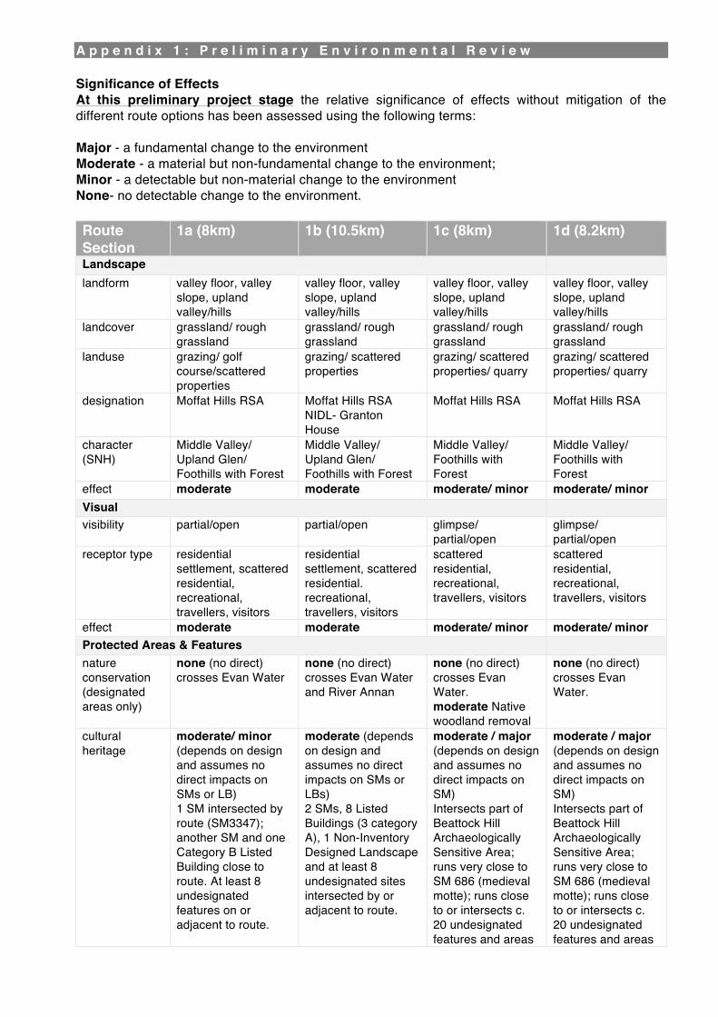
A p p e n d i x 1 : P r e l i m i n a r y E n v i r o n m e n t a l R e v i e w Significance of Effects At this preliminary project stage the relative significance of effects without mitigation of the different route options has been assessed using the following terms: Major - a fundamental change to the environment Moderate - a material but non-fundamental change to the environment; Minor - a detectable but non-material change to the environment None- no detectable change to the environment. Route Section
1a (8km) 1b (10.5km) 1c (8km) 1d (8.2km)
Landscape landform valley floor, valley
slope, upland valley/hills
valley floor, valley slope, upland valley/hills
valley floor, valley slope, upland valley/hills
valley floor, valley slope, upland valley/hills
landcover grassland/ rough grassland
grassland/ rough grassland
grassland/ rough grassland
grassland/ rough grassland
landuse grazing/ golf course/scattered properties
grazing/ scattered properties
grazing/ scattered properties/ quarry
grazing/ scattered properties/ quarry
designation Moffat Hills RSA Moffat Hills RSA NIDL- Granton House
Moffat Hills RSA Moffat Hills RSA
character (SNH)
Middle Valley/ Upland Glen/ Foothills with Forest
Middle Valley/ Upland Glen/ Foothills with Forest
Middle Valley/ Foothills with Forest
Middle Valley/ Foothills with Forest
effect moderate moderate moderate/ minor moderate/ minor Visual visibility partial/open partial/open glimpse/
partial/open glimpse/ partial/open
receptor type residential settlement, scattered residential, recreational, travellers, visitors
residential settlement, scattered residential. recreational, travellers, visitors
scattered residential, recreational, travellers, visitors
scattered residential, recreational, travellers, visitors
effect moderate moderate moderate/ minor moderate/ minor Protected Areas & Features nature conservation (designated areas only)
none (no direct) crosses Evan Water
none (no direct) crosses Evan Water and River Annan
none (no direct) crosses Evan Water. moderate Native woodland removal
none (no direct) crosses Evan Water.
cultural heritage
moderate/ minor (depends on design and assumes no direct impacts on SMs or LB) 1 SM intersected by route (SM3347); another SM and one Category B Listed Building close to route. At least 8 undesignated features on or adjacent to route.
moderate (depends on design and assumes no direct impacts on SMs or LBs) 2 SMs, 8 Listed Buildings (3 category A), 1 Non-Inventory Designed Landscape and at least 8 undesignated sites intersected by or adjacent to route.
moderate / major (depends on design and assumes no direct impacts on SM) Intersects part of Beattock Hill Archaeologically Sensitive Area; runs very close to SM 686 (medieval motte); runs close to or intersects c. 20 undesignated features and areas
moderate / major (depends on design and assumes no direct impacts on SM) Intersects part of Beattock Hill Archaeologically Sensitive Area; runs very close to SM 686 (medieval motte); runs close to or intersects c. 20 undesignated features and areas
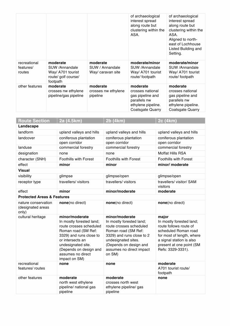
of archaeological interest spread along route but clustering within the ASA.
of archaeological interest spread along route but clustering within the ASA. Aligned to north- east of Lochhouse Listed Building and Setting.
recreational features/ routes
moderate SUW /Annandale Way/ A701 tourist route/ golf course/ footpath
moderate SUW / Annandale Way/ caravan site
moderate/minor SUW /Annandale Way/ A701 tourist route/ footpath
moderate/minor SUW /Annandale Way/ A701 tourist route/ footpath
other features moderate crosses nw ethylene pipeline/gas pipeline
moderate crosses nw ethylene pipeline
moderate crosses national gas pipeline and parallels nw ethylene pipeline. Coatsgate Quarry
moderate crosses national gas pipeline and parallels nw ethylene pipeline. Coatsgate Quarry
Route Section 2a (4.5km) 2b (4km) 2c (4km) Landscape landform upland valleys and hills upland valleys and hills upland valleys and hills landcover coniferous plantation
open corridor coniferous plantation open corridor
coniferous plantation open corridor
landuse commercial forestry commercial forestry commercial forestry designation none none Moffat Hills RSA character (SNH) Foothills with Forest Foothills with Forest Foothills with Forest effect minor minor minor/ moderate Visual visibility glimpse glimpse/open glimpse/open receptor type travellers/ visitors travellers/ visitors travellers/ visitor/ SAM
visitors effect minor minor/moderate moderate Protected Areas & Features nature conservation (designated areas only)
none(no direct) none(no direct) none(no direct)
cultural heritage
minor/moderate In mostly forested land; route crosses scheduled Roman road (SM Ref: 3329) and runs close to or intersects an undesignated site. (Depends on design and assumes no direct impact on SM)
minor/moderate In mostly forested land; route crosses scheduled Roman road (SM Ref: 3329) and runs close to 2 undesignated sites. (Depends on design and assumes no direct impact on SM)
major In mostly forested land; route follows route of scheduled Roman road for most of length, where a signal station is also present at one point (SM Refs: 3329-3331).
recreational features/ routes
none none moderate A701 tourist route/ footpath
other features moderate north west ethylene pipeline/ national gas pipeline
moderate crosses north west ethylene pipeline/ gas pipeline
none
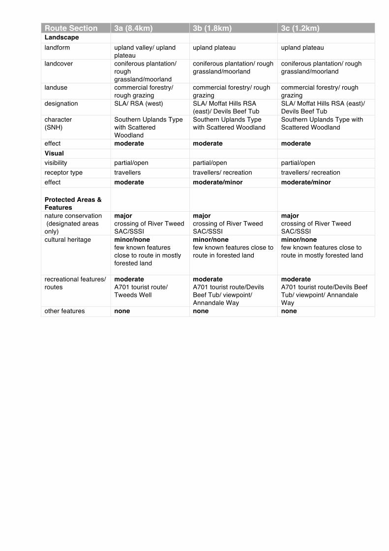
Route Section 3a (8.4km) 3b (1.8km) 3c (1.2km) Landscape landform upland valley/ upland
plateau upland plateau upland plateau
landcover coniferous plantation/ rough grassland/moorland
coniferous plantation/ rough grassland/moorland
coniferous plantation/ rough grassland/moorland
landuse commercial forestry/ rough grazing
commercial forestry/ rough grazing
commercial forestry/ rough grazing
designation SLA/ RSA (west) SLA/ Moffat Hills RSA (east)/ Devils Beef Tub
SLA/ Moffat Hills RSA (east)/ Devils Beef Tub
character (SNH)
Southern Uplands Type with Scattered Woodland
Southern Uplands Type with Scattered Woodland
Southern Uplands Type with Scattered Woodland
effect moderate moderate moderate Visual visibility partial/open partial/open partial/open receptor type travellers travellers/ recreation travellers/ recreation effect moderate moderate/minor moderate/minor Protected Areas & Features
nature conservation (designated areas only)
major crossing of River Tweed SAC/SSSI
major crossing of River Tweed SAC/SSSI
major crossing of River Tweed SAC/SSSI
cultural heritage
minor/none few known features close to route in mostly forested land
minor/none few known features close to route in forested land
minor/none few known features close to route in mostly forested land
recreational features/ routes
moderate A701 tourist route/ Tweeds Well
moderate A701 tourist route/Devils Beef Tub/ viewpoint/ Annandale Way
moderate A701 tourist route/Devils Beef Tub/ viewpoint/ Annandale Way
other features none none none
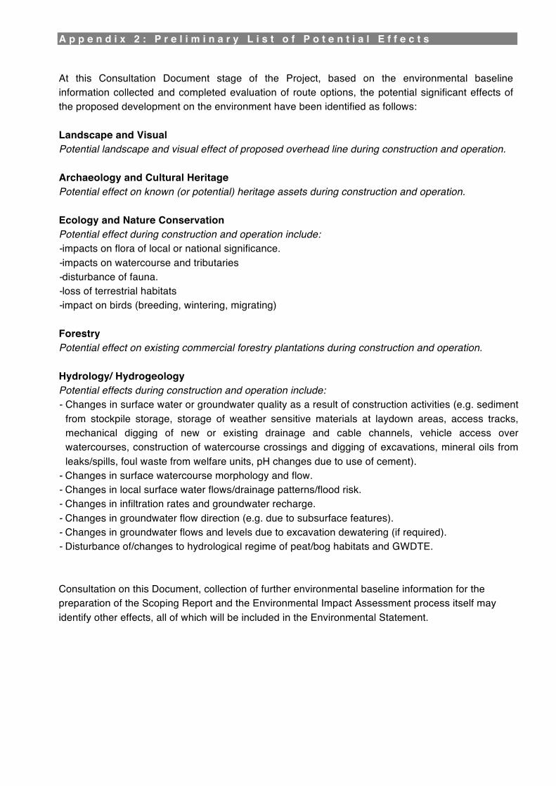
A p p e n d i x 2 : P r e l i m i n a r y L i s t o f P o t e n t i a l E f f e c t s At this Consultation Document stage of the Project, based on the environmental baseline information collected and completed evaluation of route options, the potential significant effects of the proposed development on the environment have been identified as follows: Landscape and Visual Potential landscape and visual effect of proposed overhead line during construction and operation.
Archaeology and Cultural Heritage Potential effect on known (or potential) heritage assets during construction and operation. Ecology and Nature Conservation Potential effect during construction and operation include: - impacts on flora of local or national significance. - impacts on watercourse and tributaries - disturbance of fauna. - loss of terrestrial habitats - impact on birds (breeding, wintering, migrating) Forestry Potential effect on existing commercial forestry plantations during construction and operation. Hydrology/ Hydrogeology Potential effects during construction and operation include: - Changes in surface water or groundwater quality as a result of construction activities (e.g. sediment
from stockpile storage, storage of weather sensitive materials at laydown areas, access tracks, mechanical digging of new or existing drainage and cable channels, vehicle access over watercourses, construction of watercourse crossings and digging of excavations, mineral oils from leaks/spills, foul waste from welfare units, pH changes due to use of cement).
- Changes in surface watercourse morphology and flow. - Changes in local surface water flows/drainage patterns/flood risk. - Changes in infiltration rates and groundwater recharge. - Changes in groundwater flow direction (e.g. due to subsurface features). - Changes in groundwater flows and levels due to excavation dewatering (if required). - Disturbance of/changes to hydrological regime of peat/bog habitats and GWDTE. Consultation on this Document, collection of further environmental baseline information for the preparation of the Scoping Report and the Environmental Impact Assessment process itself may identify other effects, all of which will be included in the Environmental Statement.
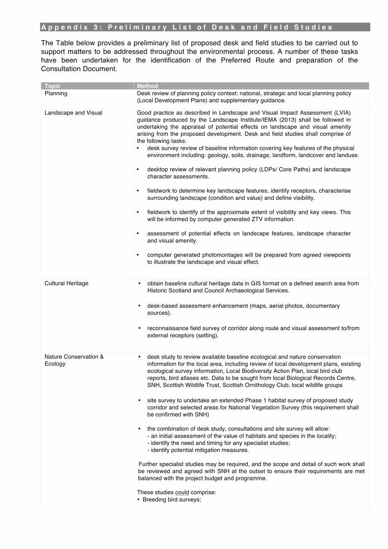
A p p e n d i x 3 : P r e l i m i n a r y L i s t o f D e s k a n d F i e l d S t u d i e s The Table below provides a preliminary list of proposed desk and field studies to be carried out to support matters to be addressed throughout the environmental process. A number of these tasks have been undertaken for the identification of the Preferred Route and preparation of the Consultation Document.
Topic Method Planning Desk review of planning policy context: national, strategic and local planning policy
(Local Development Plans) and supplementary guidance.
Landscape and Visual Good practice as described in Landscape and Visual Impact Assessment (LVIA) guidance produced by the Landscape Institute/IEMA (2013) shall be followed in undertaking the appraisal of potential effects on landscape and visual amenity arising from the proposed development. Desk and field studies shall comprise of the following tasks: • desk survey review of baseline information covering key features of the physical
environment including: geology, soils, drainage, landform, landcover and landuse.
• desktop review of relevant planning policy (LDPs/ Core Paths) and landscape character assessments.
• fieldwork to determine key landscape features, identify receptors, characterise
surrounding landscape (condition and value) and define visibility. • fieldwork to identify of the approximate extent of visibility and key views. This
will be informed by computer generated ZTV information. • assessment of potential effects on landscape features, landscape character
and visual amenity. • computer generated photomontages will be prepared from agreed viewpoints
to illustrate the landscape and visual effect.
Cultural Heritage • obtain baseline cultural heritage data in GIS format on a defined search area from Historic Scotland and Council Archaeological Services.
• desk-based assessment enhancement (maps, aerial photos, documentary
sources). • reconnaissance field survey of corridor along route and visual assessment to/from
external receptors (setting).
Nature Conservation & Ecology
• desk study to review available baseline ecological and nature conservation information for the local area, including review of local development plans, existing ecological survey information, Local Biodiversity Action Plan, local bird club reports, bird atlases etc. Data to be sought from local Biological Records Centre, SNH, Scottish Wildlife Trust, Scottish Ornithology Club, local wildlife groups
• site survey to undertake an extended Phase 1 habitat survey of proposed study
corridor and selected areas for National Vegetation Survey (this requirement shall be confirmed with SNH)
• the combination of desk study, consultations and site survey will allow:
- an initial assessment of the value of habitats and species in the locality; - identify the need and timing for any specialist studies; - identify potential mitigation measures.
Further specialist studies may be required, and the scope and detail of such work shall be reviewed and agreed with SNH at the outset to ensure their requirements are met balanced with the project budget and programme. These studies could comprise: • Breeding bird surveys;
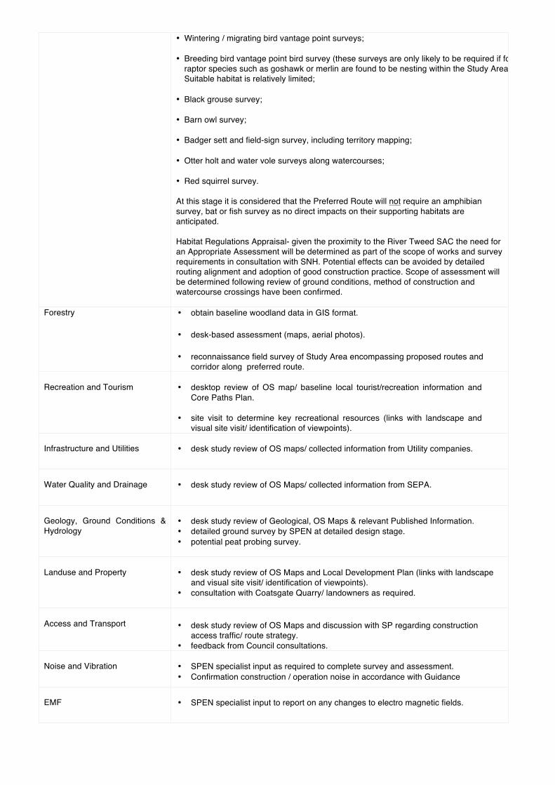
• Wintering / migrating bird vantage point surveys; • Breeding bird vantage point bird survey (these surveys are only likely to be required if focal
raptor species such as goshawk or merlin are found to be nesting within the Study Area) Suitable habitat is relatively limited;
• Black grouse survey; • Barn owl survey; • Badger sett and field-sign survey, including territory mapping; • Otter holt and water vole surveys along watercourses; • Red squirrel survey. At this stage it is considered that the Preferred Route will not require an amphibian survey, bat or fish survey as no direct impacts on their supporting habitats are anticipated. Habitat Regulations Appraisal- given the proximity to the River Tweed SAC the need for an Appropriate Assessment will be determined as part of the scope of works and survey requirements in consultation with SNH. Potential effects can be avoided by detailed routing alignment and adoption of good construction practice. Scope of assessment will be determined following review of ground conditions, method of construction and watercourse crossings have been confirmed.
Forestry • obtain baseline woodland data in GIS format. • desk-based assessment (maps, aerial photos). • reconnaissance field survey of Study Area encompassing proposed routes and
corridor along preferred route. Recreation and Tourism
• desktop review of OS map/ baseline local tourist/recreation information and
Core Paths Plan. • site visit to determine key recreational resources (links with landscape and
visual site visit/ identification of viewpoints). Infrastructure and Utilities
• desk study review of OS maps/ collected information from Utility companies.
Water Quality and Drainage
• desk study review of OS Maps/ collected information from SEPA.
Geology, Ground Conditions & Hydrology
• desk study review of Geological, OS Maps & relevant Published Information. • detailed ground survey by SPEN at detailed design stage. • potential peat probing survey.
Landuse and Property
• desk study review of OS Maps and Local Development Plan (links with landscape
and visual site visit/ identification of viewpoints). • consultation with Coatsgate Quarry/ landowners as required.
Access and Transport
• desk study review of OS Maps and discussion with SP regarding construction
access traffic/ route strategy. • feedback from Council consultations.
Noise and Vibration
• SPEN specialist input as required to complete survey and assessment. • Confirmation construction / operation noise in accordance with Guidance
EMF
• SPEN specialist input to report on any changes to electro magnetic fields.
R e f e r e n c e s Anderson, C & Grant, A (2011) Dumfries and Galloway Windfarm Landscape Capacity Study. ASH Consulting Group (1998) The Borders Landscape Assessment. Scottish Natural Heritage Review No 112. Countryside Commission (1993) Landscape Assessment Guidance (CCP423). Dumfries and Galloway Council (2014) Dumfries and Galloway Local Development Plan. East Dunbartonshire, East Renfrewshire, Glasgow City, Inverclyde, North Lanarkshire, South Lanarkshire, Renfrewshire, West Dunbartonshire (2012) Glasgow and Clyde Valley Strategic Development Plan. Forestry Commission (1994) Forest Landscape Design Guidelines, 2nd Edition (Wetherby, Forestry Commission). Forestry Commission (2009) The Scottish Governments Policy on Control of Woodland Removal. Historic Scotland (1987-) Inventory of Gardens and Designed Landscapes. Holford, W (1959) Power Production and Transmission in the Countryside: Preserving Amenities. Paper presented to Royal Society of Arts, 25 November, London. Landscape Institute with the Institute of Environmental Management and Assessment (2013) Guidelines for Landscape and Visual Impact Assessment, Third Edition, Routeledge, London. Land Use Consultants (1991) Landscape Assessment Principles and Practice. Land Use Consultants (1998) Dumfries and Galloway Landscape Assessment SNH Review No 94. Publications Section, Battleby, UK ISBN 1350-3111. Landuse Consultants in association with Glasgow University Archaeological Research Division (1999) Glasgow and Clyde Valley Landscape Assessment. SNH Review Series. SNH. Perth. LUC for ScottishPower (2015) Major Electrical Infrastructure Project: Approach to Routeing and Environmental Impact Assessment. Marshall, R & Baxter, R (2002) Policy and Practice: Strategic Routeing and Environmental Impact Assessment for Overhead Electrical Transmission Lines. Journal of Environmental Planning and Management, 45(5), 747-764, 2002. National Grid Company (1992) Guidelines for the Routeing of New High Voltage Overhead Transmission Lines (Coventry, National Grid Company plc). Scott, W (1842) Redgauntlet. Scottish Borders Council (2009) Scottish Borders Consolidated Structure Plan. Adopted 2009. Scottish Borders Council (2011) Scottish Borders Consolidated Local Plan. Adopted 2011. Scottish Borders Council (2011) Wind Energy Supplementary Planning Guidance. Scottish Borders Council (2012) Local Landscape Designations Supplementary Planning Guidance. Scottish Borders Council (2014) Draft Scottish Borders Local Development Plan. Scottish Government (2014) Scottish Planning Policy. Scottish Government (2014) National Planning Framework 3.

Scottish Government (2013) Guidance to Forestry Commission Staff on implementing the Scottish Governments Control of Woodland Removal Policy. SNH (2014) Wild Land Areas. SHETL (2004) Electricity Transmission Development Proposals in Scotland: The Scottish Hydro- Electric Transmission Ltd (SHETL) Approach. High Voltage Steel Lattice Tower Transmission Lines. The Holford Rules: Guidelines for the Routeing of New High Voltage Overhead Transmission Lines with NGC1992 and SHETL 2003 Notes. South Lanarkshire Council (2015) South Lanarkshire Local Development Plan. Adopted April 2015 Terence O'Rourke (2008) Earlshaugh Windfarm: Environmental Statement Terence O'Rourke (2011) Earlshaugh Windfarm: Supplementary Environmental Information Wind Energy Ltd (2013) Earlshaugh Windfarm: Supplementary Environmental Information Maps British Geological Survey (BGS) online geological and hydrogeological mapping (http://www.bgs.ac.uk) Scottish Environment Protection Agency (SEPA) online flood mapping (http://www.sepa.org.uk). British Geological Survey () Solid Edition MLURI (1986) Land Capability for Agriculture. MISR (1982) Soil Survey of Scotland, OS Explorer OS Landranger Relevant Planning Policy Background and Guidance SPP Planning System (2014) PAN 42: Archaeology the Planning Process and Scheduled Monument Procedures PAN 58: Environmental Impact Assessment PAN 60: Planning for Natural Heritage Relevant Legislation The Electricity Act 1989 (as amended by the Utilities Act 2000) Electricity Works (Environmental Impact Assessment)(Scotland) Regulations 2000
G l o s s a r y Transmission Equipment The following are general definitions of terms used in relation to transmission equipment.
Term Explanation Cable Generally refers to an underground “cable” suitably insulated, used for transmitting
electricity.
Conductor Wire strung between pylons, used for transmitting electricity.
Earthwire Wire strung between the tops of pylons, used for lightning and system protection. May also be used to carry telecommunication signals
Electricity lines Either an overhead line or an underground cable used to transmit electricity.
Gas Insulated Switchgear (GIS)
Metal enclosed switchgear in which the insulation is obtained, at least partly by an insulating gas other than air at atmospheric pressure.
Insulator Used to attach the conductors to the pylons preventing electrical discharge to the steelwork. Usually made from porcelain glass units, joined together to form an insulator ring.
kV Kilovolt (one thousand volts)
MW Megawatt (one million watts or one thousand kilowatts)
Outage The withdrawal from service of any part of the transmission system for a period of time in connection with repair, maintenance, or construction of the transmission system as a result of breakdown or failure.
Overhead Line An electric line installed above ground usually supported by lattice steel towers or wooden poles.
SPEN Scottish Power Energy Networks. Develop and operate the transmission system on behalf of Scottish Power Transmission Ltd.
SPT Scottish Power Transmission Ltd. Licence holder under the Electricity Act 1989, responsible for the transmission network from the English/ Scottish border to just north of Stirling.
Sealing End Compound
The compound area surrounding the terminal tower, where an overhead line converts to an underground cable.
Substations Transforming or switching stations to control the voltage and direction of electricity. Transforming stations are used to increase the supply of electricity (to 275kV or 400kV) into the national grid system for transmission, and to reduce the voltage to lower levels (to 132kV) for distribution. Switching controls the direction of electricity and ensures fault protection.
Switchgear Combination of electrical disconnect switches, fuses or circuit breakers used to control, protect and isolate electrical equipment.
Transformer A static electrical device that transfers energy by inductive coupling between its winding circuits. They are used to vary the relative voltage of circuits and in some cases isolate them.
Wayleave An agreement granted by the owner or occupier of land whereby transmission equipment is permitted to be installed on, over or under the land so owned or occupied in return for annual payments.
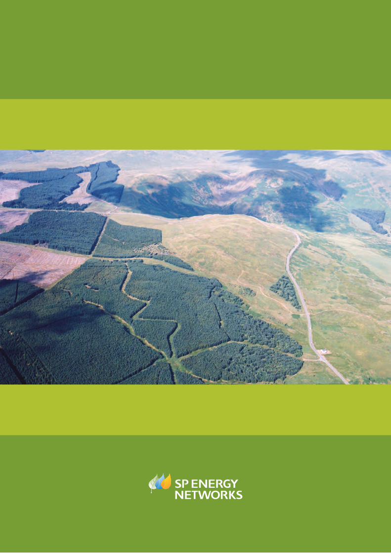
Related Documents