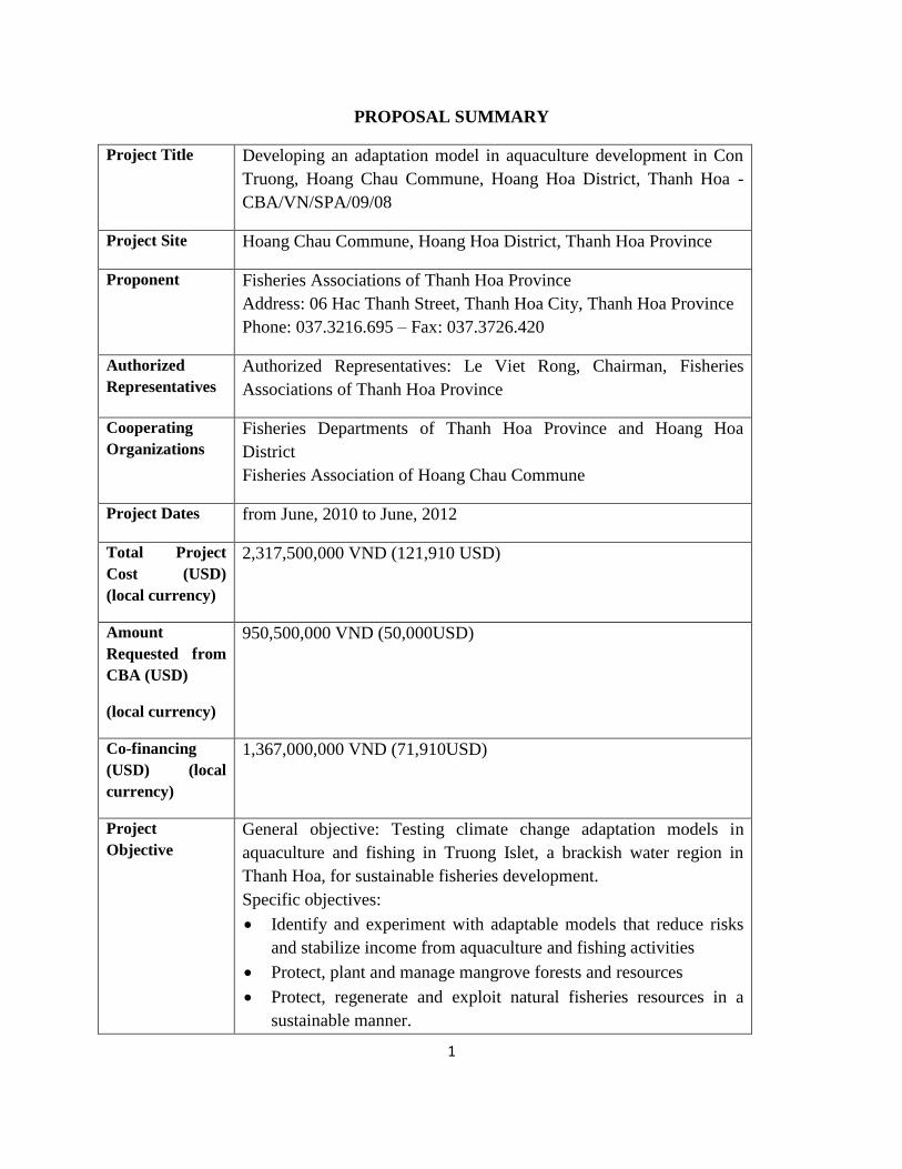
1 PROPOSAL SUMMARY Project Title Developing an adaptation model in aquaculture development in Con Truong, Hoang Chau Commune, Hoang Hoa District, Thanh Hoa - CBA/VN/SPA/09/08 Project Site Hoang Chau Commune, Hoang Hoa District, Thanh Hoa Province Proponent Fisheries Associations of Thanh Hoa Province Address: 06 Hac Thanh Street, Thanh Hoa City, Thanh Hoa Province Phone: 037.3216.695 – Fax: 037.3726.420 Authorized Representatives Authorized Representatives: Le Viet Rong, Chairman, Fisheries Associations of Thanh Hoa Province Cooperating Organizations Fisheries Departments of Thanh Hoa Province and Hoang Hoa District Fisheries Association of Hoang Chau Commune Project Dates from June, 2010 to June, 2012 Total Project Cost (USD) (local currency) 2,317,500,000 VND (121,910 USD) Amount Requested from CBA (USD) (local currency) 950,500,000 VND (50,000USD) Co-financing (USD) (local currency) 1,367,000,000 VND (71,910USD) Project Objective General objective: Testing climate change adaptation models in aquaculture and fishing in Truong Islet, a brackish water region in Thanh Hoa, for sustainable fisheries development. Specific objectives: Identify and experiment with adaptable models that reduce risks and stabilize income from aquaculture and fishing activities Protect, plant and manage mangrove forests and resources Protect, regenerate and exploit natural fisheries resources in a sustainable manner.

Welcome message from author
This document is posted to help you gain knowledge. Please leave a comment to let me know what you think about it! Share it to your friends and learn new things together.
Transcript
1
PROPOSAL SUMMARY
Project Title Developing an adaptation model in aquaculture development in Con
Truong, Hoang Chau Commune, Hoang Hoa District, Thanh Hoa -
CBA/VN/SPA/09/08
Project Site Hoang Chau Commune, Hoang Hoa District, Thanh Hoa Province
Proponent Fisheries Associations of Thanh Hoa Province
Address: 06 Hac Thanh Street, Thanh Hoa City, Thanh Hoa Province
Phone: 037.3216.695 – Fax: 037.3726.420
Authorized
Representatives
Authorized Representatives: Le Viet Rong, Chairman, Fisheries
Associations of Thanh Hoa Province
Cooperating
Organizations
Fisheries Departments of Thanh Hoa Province and Hoang Hoa
District
Fisheries Association of Hoang Chau Commune
Project Dates from June, 2010 to June, 2012
Total Project
Cost (USD)
(local currency)
2,317,500,000 VND (121,910 USD)
Amount
Requested from
CBA (USD)
(local currency)
950,500,000 VND (50,000USD)
Co-financing
(USD) (local
currency)
1,367,000,000 VND (71,910USD)
Project
Objective
General objective: Testing climate change adaptation models in
aquaculture and fishing in Truong Islet, a brackish water region in
Thanh Hoa, for sustainable fisheries development.
Specific objectives:
Identify and experiment with adaptable models that reduce risks
and stabilize income from aquaculture and fishing activities
Protect, plant and manage mangrove forests and resources
Protect, regenerate and exploit natural fisheries resources in a
sustainable manner.
2
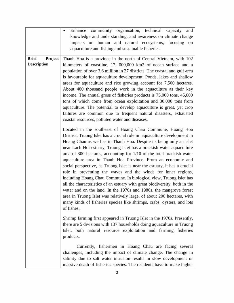
Enhance community organisation, technical capacity and
knowledge and understanding, and awareness on climate change
impacts on human and natural ecosystems, focusing on
aquaculture and fishing and sustainable fisheries
Brief Project
Description
Thanh Hoa is a province in the north of Central Vietnam, with 102
kilometers of coastline, 17, 000,000 km2 of ocean surface and a
population of over 3,6 million in 27 districts. The coastal and gulf area
is favourable for aquaculture development. Ponds, lakes and shallow
areas for aquaculture and rice growing account for 7,500 hectares.
About 480 thousand people work in the aquaculture as their key
income. The annual gross of fisheries products is 75,000 tons, 45,000
tons of which come from ocean exploitation and 30,000 tons from
aquaculture. The potential to develop aquaculture is great, yet crop
failures are common due to frequent natural disasters, exhausted
coastal resources, polluted water and diseases.
Located in the southeast of Hoang Chau Commune, Hoang Hoa
District, Truong Islet has a crucial role in aquaculture development in
Hoang Chau as well as in Thanh Hoa. Despite its being only an islet
near Lach Hoi estuary, Truong Islet has a brackish water aquaculture
area of 300 hectares, accounting for 1/10 of the total brackish water
aquaculture area in Thanh Hoa Province. From an economic and
social perspective, as Truong Islet is near the estuary, it has a crucial
role in preventing the waves and the winds for inner regions,
including Hoang Chau Commune. In biological view, Truong Islet has
all the characteristics of an estuary with great biodiversity, both in the
water and on the land. In the 1970s and 1980s, the mangrove forest
area in Truong Islet was relatively large, of about 200 hectares, with
many kinds of fisheries species like shrimps, crabs, oysters, and lots
of fishes.
Shrimp farming first appeared in Truong Islet in the 1970s. Presently,
there are 5 divisions with 137 households doing aquaculture in Truong
Islet, both natural resource exploitation and farming fisheries
products.
Currently, fishermen in Hoang Chau are facing several
challenges, including the impact of climate change. The change in
salinity due to salt water intrusion results in slow development or
massive death of fisheries species. The residents have to make higher

3
dykes to cope with higher sea level. The temperature fluctuations
weaken fisheries species and make them susceptible to diseases and
death. Small floods which come earlier make the residents harvest
shrimps prematurely, affecting the economic values.
Fisheries resources in the region are seriously degrading. In recent
years, Ma River has been polluted due to human activities, affecting
the aquaculture in Truong Islet. Aquaculture in Truong islet is at high
risk because of environmental pollution and unpredictable weather.
Aquaculture techniques have not changed ever since they started this
trade: they still use the conventional methods although breeds, climate
and natural resources conditions have changed a lot because of the
degraded environment and negative impacts of climate change.
The proposed project includes the following key activities:
1. Improve farming techniques in aquaculture and fishing to adapt to
climate change
2. Plant mangrove forests to reduce impact of natural disasters, to
protect the surrounding banks and prevent erosion caused by sea
level rise
3. Protect and regenerate natural fisheries resources for sustainable
exploitation of natural fisheries resources in the project area
4. Experiment with a community revolving loan programme to assist
affected fishermen in aquaculture development and disaster
emergency
5. Enhance community capacity and awareness on climate change
and sustainable aquaculture issues
1.0 RATIONALE
1.1 Community/Ecosystem context
Hoang Chau is a commune in the southeast of Hoang Hoa District, 12 kilometers away from the
district capital. The total are of natural land is 109.5 hectares, 401.5 hectares of which is water
surface (37% ) and it is used for aquaculture. Hoang Chau has a population of 8,264 people, with
4
1,844 households, 5,620 of whom are workers. The number of workers in the aquaculture
industry is 820 people, accounting for 14.6% of the total number. Agriculture is considered the
main trade in the commune and the main source of income for the local residents. It contributes a
big part to paying for the children’s tuition fees and household appliances, and to improving their
living standards. Data from Fishery Association of Thanh Hoa show that the annual income per
capita from agriculture is 2.5 million VND/ a year while it is 7 million VND/ a year from
aquaculture.
Located in the southeast of Hoang Chau (Hoang Hoa, Thanh Hoa), Truong Islet has a crucial role
in aquaculture development in Hoang Chau as well as Thanh Hoa. Despite its being only an islet
near Lach Hoi estuary, Truong Islet has a brackish water aquaculture area of 300 hectares,
accounting for 1/10 of the total brackish water aquaculture area in Thanh Hoa Province.
Economically and socially, Truong Islet, being near the estuary, plays a crucial role in preventing
the winds and the waves from the ocean, serving as a shield to inland residential areas, including
Hoang Chau Commune. Biologically, Truong Islet has all the characteristics of an estuary with
the biodiversity of the soil and underwater environment. In the 1970s and 1980s, the mangrove
forest area in Truong Islet was relatively large, about 200 hectares (in the residents’ estimation),
with many kinds of fisheries animals like shrimps, crabs, oysters, many fishes.
Shrimp farms in Hoang Chau are mainly in Truong Islet (over 300 hectares, accounting for 3/4
of the water surface area for aquaculture). Shrimp farming first appeared in Truong Islet in the
1970s. However, the farming method has not much improved since then, mainly extensive
farming and improved extensive farming, using natural and artificial food. This farming method
highly relies on nature, therefore it is very risky. Presently, there are 5 divisions with 137
households doing aquaculture in Truong Islet. Shrimps and crabs are the main products. The
harvest is spring-summer, from March to August when they shrimps and crabs. In other months,
due to weather difficulties, people mainly harvest natural resources in the area. People still use
destructive methods and together with over exploitation, this is the key reason of resource
degradation in the area.
Truong Islet is very important to shrimp farmers in Hoang Chau, and Thanh Hoa Province.
Being near the estuary, Truong Islet is a very sensitive region because it can be affected by the
sea (i.e. winds, waves and salt contamination) and inland factors (i.e. water pollution from Ma
River headwater and human activities). Nowadays, though most of Truong Islet area is used for
aquaculture, the small mangrove forest area still remains, thanks to the help from domestic and
international projects. In several reports, Truong Islet dyke is mentioned but it is simply banks of
shrimp farms built by local residents. In many locations, the dyke has been seriously degraded,
due to the winds and waves and it needs improvement. In fact, to protect shrimp farms, though
the owners have invested a lot of money to reinforce the banks, they still become degraded after
a short time. This is among the most costly steps in investing for aquaculture in Truong Islet. In
addition, although the banks can benefit many people in the area, the contribution is given by

5
only farm owners so these banks lack the synchrony. Only those who can afford build better
banks and this results in inadequate strength for the banks. An interesting fact, confirmed by the
residents, is that the strength of the banks is not a concern in areas with mangrove forest because
the mangrove trees serve as a shield from the winds and the waves.
Currently, fishermen in Hoang Chau are facing several challenges.
Impact of climate change
Although there has been no detailed evaluation of the impact of climate change on
aquaculture, considerable changes have recently been inflicted on the local residents’ husbandry
activities. The residents had to build dykes from 0.5 to 1 meter higher, yet it is not safe enough
because the water sometimes still overflows, possibly due to of the rising sea level. Also,
although the number of typhoons does not increase, high waves become more frequent. High
salinity also seriously affects the local residents’ husbandry activities. The salinity in the ponds
used to be 10 – 15 ‰ but it has risen to 25 - 30‰ in the lagoons a few times, which causes slow
development rate, or even massive death to fish.
The temperature fluctuation has recently caused many difficulties to the residents. The weather
has become hot earlier and more unpredictable than before; the drastic temperature fluctuations
among days has weakened the animals and made them more susceptible to diseases and death.
Small floods that come sooner have also made people harvest the shrimps even before they are
fully grown and this greatly affects the economic value of the shrimps.
The impact of climate change on decreasing the value of fisheries products is also a
concern in the commune because fisheries cultivation is the residents' main business. Apart from
the impact of climate change, the use of destructive fishing tools as shown below, is also a threat
to the sustainable exploitation of fisheries products in the region.
Impact of water environment
The water environment of Ma River has recently been seriously polluted due to human activities,
which affects aquaculture in the islet. There has been no research on the pollution level in Ma
River and its impact on aquaculture at Truong Islet, but the information from the residents should
be considered. One typical example is the waste disposal in Quang Chau Drain, the main drain of
Thanh Hoa City and industrial zones. Whenever people dispose waste, animals in the area die
massively and the farmers in the fields get itchy.
Impact of degraded resources
Natural fisheries resources in the islet area used to be very diverse, but they are now seriously
degraded. According to local residents' estimation, some fisheries animals have been completely
extinct (Nhan fish (local name), part of Keo fish family), while others have decreased to only 20
6
– 30% (natural fish like don, dat, rao shrimp,…). Another sad reality is the aquaculture
exploitation by electrical equipment, which is also the main reason for degraded natural
resources. Currently, around 70 fishing ships use electric equipment to fish fisheries products.
Although this does not directly cause the degradation of resources in Truong Islet, this method
has been forbidden due to its destruction of resources. Local residents still use this method
because of their limited awareness and the need to earn a living.
Risks for aquaculture
The difficulties can make aquaculture in Truong Islet face a very high risk. Although this trade
can bring high incomes to some local residents and enable them to afford new houses and an
education for their children in big cities, other residents still owe money from banks and can
hardly repay.
Inadequate farming techniques
As mentioned above, the farming methods have experienced little change since the residents
started this trade. Despite the drastic change in breeds, weather and natural resources, local
people still use conventional methods. Some residents have considered changing farming crops,
methods or even hatching species; still, due to limited financial capability, the majority of them
dare not invest in those changes or if did, only in experimental scale. Thus, experiments on
suitable farming models are really necessary to the local people.
To face these difficulties, local people are looking for appropriate production models that can
adapt to extreme climate change. The project of “Community participation in minimizing
negative impact of climate change for sustainable aquaculture” is expected to meet the local
residents' expectations, help to solve the present problems and bring them a better life in the
future.
1.2 Current (Baseline) Climate and Risk
We can use meteorological data from Thanh Hoa weather station (15 kilometers from Hoang
Chau, along Ma River) to describe the specific climate conditions in Hoang Chau, Hoang
Hoa.
Like other provinces in the North Central Region of Vietnam, Thanh Hoa in general, and Hoang
Chau in particular, has a tropical monsoon climate with a cold and low-precipitation winter and
a humid, hot and rainy summer. However, due to its vicinity to Ma River, only 8 kilometers from
Ma River estuary and the sea, Hoang Chau has many harsh natural disasters, such as typhoons,
tropical low pressures, heavy rains, severe cold, dry and hot West wind, droughts and salt
contamination, etc.
7
Winter: from November to April, with a typical climate of low temperature and precipitation.
The main natural disasters are severe cold weather, winter-to-spring droughts and salt
contamination. From December to February, monsoons from the northeast usually (averagely 3
to 4 times a month) cause long cold spells (sometimes severe cold weather lasts over 20 days, the
temperature drops to under 10oc at night or even to 5oC for 5 to 10 days). The highest wind
speed is 18 – 20 meters per second (as in 1999, 2003, 2006, 2008), doing great harm to
agriculture and animal husbandry in the area. January has the lowest average temperature (17oC).
The total precipitation in winter only accounts for 15% of the annual precipitation (around 1700
– 1800 mm/year. In Thanh Hoa weather station: 1745mm/year). January and December have the
lowest precipitation of 24.9mm and 28.5 mm respectively. The period from November to
February, there are often long and severe droughts. The salinity rises to 28-30 ‰ or even 33 ‰
in some years, making animals and fisheries products hardly grow or die massively and strange
diseases appear. November and April are the two transitional months between seasons. In these
months, the weather is very complicated and unpredictable with frequent whirlwinds and hails.
Although the average precipitation has been only around 76.5mm for many years, November can
have a precipitation of up to 229mm/day.
Summer: from May to October, is the rainy season with floods. The typical climate is the heat
and high precipitation. The main natural disasters are summer-to-fall droughts, typhoons, tropical
low pressures and heavy rains causing floods. In early summer (May to July), the frequent dry
and hot monsoons from the southwest (2-3 times a year, of 3 – 5 days each time) lead to hot
sunny days, with low humidity, high air temperature of 41 to 42oC maximum and high ground
temperature of 69oC to 71oC maximum. Such hot sunny periods have appeared frequently in
recent years and some even lasted for 20 – 35 days, causing severe droughts. July has the highest
average temperature (29oC ). The total precipitation of the rainy season is 1454 mm, 85 % of
that in the whole year. In the rainy season, normally there are heavy rains (about 200 – 400mm
per day or even 731.3mm as on September 24th
, 1963). September has the highest average
precipitation of 404mm, followed by August with 278 mm.
Tropical cyclones???? and typhoons are the most destructive natural disasters to Thanh Hoa and
Hoang Hoa. In 1996, 1998, 2002, 2004, 2006 and 2008, Thanh Hoa suffered from typhoons of
force 9 or 10 or even higher,of 12 or 13, which caused a loss in people and property. In 1996, a
typhoon of force 6 killed 168 fishermen in Hau Loc; in 2006, another one of force 8 killed 12
people, 4 of whom were from Hoang Hoa. Many ships sank, houses and sea, river and dykes for
aquaculture were destroyed (over 30 – 40 km), estimated damage cost hundreds of billions VND,
including a complete loss of crops of rice, cereals and fisheries products. The year 2009 alone
saw typhoons of force 8 and 9 which damaged the property and the people due to heavy rains
and high floods.
In comparison to the last decade of the 20th
century, the frequency of storms and floods in recent
years (2000 – 2009) has been much higher. Floods, in particular, come often and extends from
the mountains to coastal plains with serious destruction. Sometimes the precipitation reaches 600
8
– 1000 mm, as in 2002, 2006 and 2008. In September of 2009 in particular, a long spell of rain
happened in southern districts of Thanh Hoa, from Hoang Hoa, through Tinh Gia to Trieu Son,
Nong Cong, Nhu Xuan.
Natural disasters cause devastating and widespread aftermaths in the whole area and coastal
plains flooded by tides and floodwater are the most dangerous. Sea dykes in all coastal districts,
including Hoang Hoa, have been completely destroyed and have to be rebuilt and reinforced
every year, which is very costly. Disasters are getting more destructive, with stronger winds,
waves and water that flood villages, fields and affect people’s life, their property, as well as
agricultural and aquaculture production. While droughts increase the salinity up to 30‰, floods
reduce it to 0‰, causing a drop in aquaculture efficiency.
In addition to typhoons, heavy rains and floods, droughts and salt contamination are causing
serious economic impact, pollute the environment and degrade the soil. In agriculture, droughts
in the harvests from winter to spring and spring to summer dry the soil and make it salty, causing
a loss of billions of VND to the rice and cereal crops. In aquaculture, due to Ma River exhaustion,
the aquaculture area of 401,5 hectares becomes dry and its salinity increases, causing the death
of shrimps , fish and crabs on the farms, resulting in a loss of billions of VND. The harvesting of
hundreds of tons of fully grown fisheries products cannot be done so they develop slowly or die
massively; thousands of tons of algae die or can no longer develop; natural products like don,
giat die massively, leading to a loss of tens of billions of VND.
1.4Impact context
Climate change has been witnessed in Vietnam and along the coast of North Central Vietnam in
particular for the last 50 years, according to meteorological observation.
Temperatures: the average temperature in Vietnam has increased by 0.5 – 0.70C for the last 50
years (1958 – 2007). In 2007, the average temperature in Ha Noi, Da nang and Ho Chi Minh
City was 0.8 – 1.3oC higher than that from 1931 to 1940, and 0.4 – 0.5 higher than that from
1991 – 2000.
Precipitation: the average annual precipitation has decreased by 2% in the last 50 years.
Precipitation decreases in Northern regions and increases in Southern ones. Droughts come
frequently and affect a wide area, especially Central Vietnam.
Cold air: The number of cold air spells affecting Vietnam has decreased remarkably in the last
two decades. However, some strange phenomena have appeared. Most recently, a severe cold
spell has lasted of 38 days in January and February in the North, causing a great damage to
agriculture.
Typhoons: In recent years, stronger typhoons have appeared more frequently. Their route tends
to be southward and it gets more complicated, and the stormy season ends later.
Sea level rise: The rising speed of the average sea level in Vietnam is 3mm/ year (1993 – 2008),
the same as the world’s rising speed.

9
Impact of climate change in Hoang Chau Commune
According to the climate change forecast of the 21st century, , compared to 1980 – 1999, the
average temperature in the coast of North Central Vietnam can increase by 1.5oC (in 2050) and
by 2.8oC in 2100 ; the yearly precipitation can increase by 4% in 2050 and by 7.7% in 2100. Of
note, the precipitation from March to May can decrease by 5.2% in 2050 and by 9.9% in 2100,
while from June to August it can increase by 7.6% in 2050 and by 14.6% in 2100. The sea level
can increase by 30cm in 2050 and by 75cm in 2100. International scientists have recently warned
that the sea level in Vietnam can rise 1m or more, with the current rate of temperature rise and
ice melting in the North and South Poles.
The negative climate phenomena will happen more frequently due to climate change. Droughts
will become more severe in winter-to-spring and summer-to-fall periods, causing soil
degradation and salt contamination. Although Hoang Chau could protect 120 hectares of
mangrove forest, the possibility of river and sea dykes being broken and soil erosion in the
region is very high due to the concurrent effects of typhoons, tropical low pressures, heavy rains
and the rising sea level causing floods. Broken dykes would be a disaster to Hoang Chau and
Truong Islet which is the tentative location for the project. The 401 hectares (71.5% the total
natural land) used for aquaculture is of weak structure and is just slightly above the sea level
(mostly 0.5 – 0.8m or even only 0.03m).
Although the residents in Hoang Chau are unaware of climate change, they start to recognise the
negative changes that affect their life:
-They have built the sea dykes to prevent waves around the Islet based on personal experience:
they keep making the dykes higher as the water rises so that these dykes can be higher than the
highest tides. However, according to the local residents, even though the dykes are 0.5 – 1m
higher than before, they are still over-flown by the tides. This might be an impact of rising sea
level. Also, strong waves have become more frequent although the number of typhoons and
storms does not increase. Change in salinity also seriously affects aquaculture. The salinity in
farming lakes used to be about 10 – 15 ‰ but nowadays, it can be up to 25 - 30‰ in case of
droughts or goes down to 0‰ in case of floods at Ma River headwater, making fisheries animals
develop slowly or die massively.
-Big temperature fluctuations are also an unfavorable factor. Recently the temperature fluctuates
unpredictably, causing lots of difficulty to the residents. The weather gets hot sooner and
becomes more unpredictable than before. This change, together with big gaps in temperatures
between consecutive days, has caused the residents to harvest shrimps even before they are fully
grown. This also affects the economic value of fisheries products.
1.3Project approach

10
a. Improve aquaculture techniques to adapt to changes in cultivation environment
and aquaculture in Truong Islet.
The project approach includes building experimental models to improve fisheries techniques and
select suitable fisheries animals for the changing conditions, especially for the unpredictable
climate and the salt intrusion. An area of about 50 hectares in the northeast of Truong Islet will
be chosen to carry out the experimental models, which will include:
Aquaculture model modified with a change in crop: start earlier to avoid the early small floods
and catch the summer. This idea has been considered by many members in the community and
expected to be experimented but no one has had the adequate conditions to carry this out.
According to local experience, conventionally, the main shrimp farming season starts in March
and ends in July – August. However, recently, it gets hot sooner and floods also come earlier.
Therefore, it is necessary to create a change in farming habits to adapt to the climate change so
as to minimize risks caused by the unpredictable weather. Yet, changing their habits is very
difficult to local residents because they are so used to farming practices based on their own
experience without applying new technology. Built on the local knowledge and experts' technical
support in applying new technology, this model provides a good opportunity for local residents
to learn new things and to develop their trade.
Alternate farming model: shrimps – crabs, shrimps – fish, … to select suitable fisheries products
with higher salinity. Alternate farming is also a recommended method in unpredictable
conditions. A suitable combination of species will make good use of food sources and minimize
the risk of losing everything. Species raised alternately with the conventional ones should have
good resistance to high salinity and big temperature fluctuations.
Fish farming: bong bop fish, chem fish
bong bop fish, chem fish are local fish of high economic value and they used to be available in
nature but nowadays their number has decreased due to natural and human activities. With the
help of technological advances, scientists have artificially bred these species in Vietnam.
Therefore, bringing these species to farming in Hoang Chau to test is necessary.
Addressing water pollution and salt water intrusion is considered to be among the most important
issue to local residents. In addition, the conventional fisheries farming techniques are no longer
suitable in current conditions; therefore new techniques like reservoirs and best management
practices will be introduced to address water issues.
b. Planting mangrove forests to protect the dykes and to prevent erosion
The project plans to use the ecosystem to solve problems related to rising sea level and strong
waves. Planting mangrove forests is a solution to minimizing the impact of rising sea level and
strong waves for aquaculture development and disaster management. Around 20 hectares of
mangrove forests will be planted around the Islet to create a barrier protecting the dykes, and to
11
improve the environment and natural resources. A long-term plan to manage and develop
mangrove forests needs to be discussed and put into effect. In areas where the mangrove forests
have already been well developed, the community and the authorities strengthen protection as
well as effectively exploit the mangrove resources to create additional income such as
beekeeping.
c. Community-managed revolving loan programme
Community-managed revolving loan programme will partly minimize the risks in aquaculture
development especially post disaster. In reality, residents who have earned some profit can
contribute to the fund to help those who have lost the crops so that they can continue their
business in the next season. This has been discussed and advovated by local residents. A
revolving loan programme will be developed and managed by the fisheries community in the
project area.
d. Enhancing capacity and awareness and community organization to minimize CC
impacts
Training and communication activities to improve the community capacity and awareness is very
necessary because the local residents’ knowledge about sustainable aquaculture and CC impact is
limited. These activities will help the community proactively adapt to CC impact on their
aquaculture development in their local context.
To create a bond among members of the community, a set of community rules will be compiled
and monitored by the community. These rules will serve as a basis for the residents to adjust
their own behavior, observe each other and build a better community.
e. Protect and regenerate natural fisheries resources
Aquaculture in Truong Islet largely depends on the environment and natural fisheries resources;
therefore, the protection of natural resources around the Islet is crucial. Community rules,
including rules to protect natural resources, will be the basis for the farmers to manufacture and
protect the natural resources. Exploitation with destructive methods will be strictly monitored
and stop when the rules are approved. A communal approach, together with government’s
restriction, will limit and gradually end destructive exploitation activities in the commune.
Growing mangrove forests is also a method to protect and regenerate natural resources. In
addition, activities like building a crab bank model and releasing more breeds to the sea will also
be experimented.
Crab bank model description: this model, founded in Thailand, is simple and easy to implement.
Local residents create a small farming racket and put it near or inside mangrove forests.
Harvested pregnant crabs will be put in that racket and until they deliver and release their
offsprings to nature, then the mother crabs can be sold. This model has been very successful and
12
widely applied in Thailand. In Truong Islet, locations to put those rackets should be discussed
among local residents and locations to be selected should be places with a rich source of crabs.
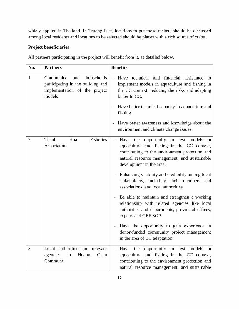
Project beneficiaries
All partners participating in the project will benefit from it, as detailed below.
No. Partners Benefits
1 Community and households
participating in the building and
implementation of the project
models
- Have technical and financial assistance to
implement models in aquaculture and fishing in
the CC context, reducing the risks and adapting
better to CC.
- Have better technical capacity in aquaculture and
fishing.
- Have better awareness and knowledge about the
environment and climate change issues.
2 Thanh Hoa Fisheries
Associations
- Have the opportunity to test models in
aquaculture and fishing in the CC context,
contributing to the environment protection and
natural resource management, and sustainable
development in the area.
- Enhancing visibility and credibility among local
stakeholders, including their members and
associations, and local authorities
- Be able to maintain and strengthen a working
relationship with related agencies like local
authorities and departments, provincial offices,
experts and GEF SGP.
- Have the opportunity to gain experience in
donor-funded community project management
in the area of CC adaptation.
3 Local authorities and relevant
agencies in Hoang Chau
Commune
- Have the opportunity to test models in
aquaculture and fishing in the CC context,
contributing to the environment protection and
natural resource management, and sustainable

13
development in the area.
- Gain more information and basis to create and
adjust environmental and aquaculture
management policies
- Be able to develop a working partnership with
the project partners, i.e. the Fisheries
Associations of Thanh Hoa, departments, local
authorities, experts and GEF SGP.
2.0 COMMUNITY OWNERSHIP
2.1 Project formulation
The project gives top priority to the participation by the community and fishermen in the project
area. During the project design stage, opinions are collected among the community on priority
issues to be resolved in changes in climate and weather in project areas and their impact on
people’s livelihoods and with a focus on aquaculture, and related environmental issues. The
project idea has been formed, based on the local residents’ expectations. Climate change has
affected the aquaculture in the region, and although local residents have had attempts to improve
the situation, the outcomes do not meet their expectations. The residents realize the need to get
assistance from organizations and local authorities so that they can have improved production
models to adapt to the climate change impact. Thanh Hoa Fisheries Associations has initiated the
project after many discussions with local residents through community workshops and exchange
through the interviews. Key content of the proposed project was discussed at the stakeholders’
workshop to seek their comments for the finalization of the project proposal to be submitted to
GEF SGP Viet Nam for funding.
2.1 Project implementation
Project management is based on the principle of transparency and community participation and
ownership. the community will be the main factor in all project activities. Main activities, such
as developing and testing aquaculture models, regenerating and growing mangrove forests, will
be carried out by the community, with the experts' advice and technical support. Participating
households will be selected based on criteria set out by the project, and will receive technical and
financial assistance from the project to carry out the models in accordance with the project
revolving loan programme managed by the community. A cross-check supervision system
between members of the community will be created to maintain the equitability in the
14
community. The implementation of aquaculture models will need the community participation
and contribution so that they can have more responsibility in implementing the project. Capacity
building is given priority aiming to ensure project success, sustainability and replicability.
During the project implementation, training and awareness raising activities to enhance the
community’s technical capacity and knowledge will be frequently held. The community also
participate in project monitoring and evaluation activities.
Women’s participation receives due attention and priority during project development and
implementation. Information is widely spread to the community through commune systems,
meetings of project and commune mass organisations, workshops, and project printed materials.
2.3 Phase-Out Mechanism and Sustainability
The project will end after two years. The participating households will continue the practices if
the project is successful in minimizing the risks from natural disasters and climate change impact
to their aquaculture development, hence stabilizing and increasing their income. Experimental
models will be evaluated and lessons learned to be drawn to share among the community in the
project area and other areas where the community face similar challenges in aquaculture
development. Technical guidelines on the design and implementation of the models will be
compiled based on the results of the models and shared for the purpose of learning and model
expansion and replication.
Funding for the projects will be recollected and used for micro credit and loans in the community
to replicate the models. Mangrove forests will be managed by local residents and monitored
exploitation is conducted with community rules. Building community rules is also expected to
bring positive impact to the community in governance and social monitoring after the completion
of the project.
The project will work in closely with relevant government agencies, including Provincial and the
District Fisheries Departments who will use the results of the project models for expansion and
replication in implementing the government-funded programmes and projects.
3.0 PROPONENT DESCRIPTION
Name of the proponent: Thanh Hoa Fisheries Associations
Address: 06 Hac Thanh, Tan Son Ward, Thanh Hoa City, Thanh Hoa.
Phone: 037.3216.795 – Fax: 037.3726.420
Representative: Mr. Le Viet Rong: fisheries engineer – Chairman of Thanh Hoa Fisheries
Associations . Cellular phone: 0936.899.484 – Home phone: 037.3950.653
Contact person: Mr. Le Minh Chau – fisheries engineer – General secretary of Thanh Hoa
Fisheries Associations and Director of Technologies Advising, Training and fisheries services
Center. Cell phone: 0168.249.3768 – home phone: 037.3859.989

15
Human capacity and project management experience
Human resources: Thanh Hoa Fisheries Associations Management Board consists of 7 members
who are both retired and government managers/officers in the area of fisheries. In their network,
there are 42 associations at the district and commune levels. The total number of members is
2,450. Thanh Hoa Fisheries Associations have strong expertise in the following areas:
1. Trainings and capacity building in aquaculture and fishing
2. Providing technical services and consultancy for the implementation of projects in the
area of aquaculture and fishing
Financial resources: Thanh Hoa Fisheries Associations is a social professional organization with
no funding from the Government. So they have to balance their own budget from many sources
for their operations: membership fees, funding from government and donor funded projects, and
technical services and consultancies for projects.
4.0 PROJECT DESCRIPTION
4.1 Objective, outcomes and planned outputs
Project objective: Testing climate change adaptation models in aquaculture and fishing in Truong
Islet, a brackish water region in Thanh Hoa, for sustainable fisheries development.
Outcome 1.0: Building and testing models to adapt to climate change in
brackish water aquaculture and fishing
Output 1.1: 3 Models with suitable species and crops are
designed and tested.
Output 1.2: A number of 20 households participate and
directly benefit from the models.
Outcome 2.0: mangrove forests and resources are managed and used in
a sustainable manner.
Output 2.1: A commune plan to plant, protect and exploit
mangrove forests is constructed.
Output 2.2: At least 20 hectares of mangrove forests are
planted.
Output 2.3: At least 20 households directly benefit from
beekeeping models in mangrove forests.
Outcome 3.0: A revolving loan programme is developed and managed
by the community.
Output 3.1: At least 20 households join the loan programme in
the first year.
Output 3.2: At least 30 more households join the loan
programme by the end of the project.

16
Output 3.3: The investment for experimental models are repaid
and put in the loan programme for revolving.
Outcome 4.0: Training and awareness raising activities on CC issues
and sustainable fisheries are conducted.
Output 4.1: At least 4 awareness raising workshops are held
for at least 300 participants.
Output 4.2: At least 12 training sessions and 10 community
workshops are held for at least 500 participants.
Output 4.3: About 50 community meetings are held to discuss
project issues and activities.
Output 4.4: Groups of key fishermen for monitoring
environment protection, mangrove forest protection,
exploitation of fisheries resources protection are formed and
operated.
Output 4.5: Community regulation is developed and widely
applied.
Output 4.6: Working relationship with related agencies in
water management is strengthened to manage the water source
and protect community’s rights.
Outcome 5.0: fisheries resources are regenerated.
Output 5.1: Build a crab bank model at 3 different locations
around Truong islet.
Output 5.2: Organize 3 fish and shrimp releases in the project
area.
4.3 Risks and barriers
Risk description Likelihood Solutions
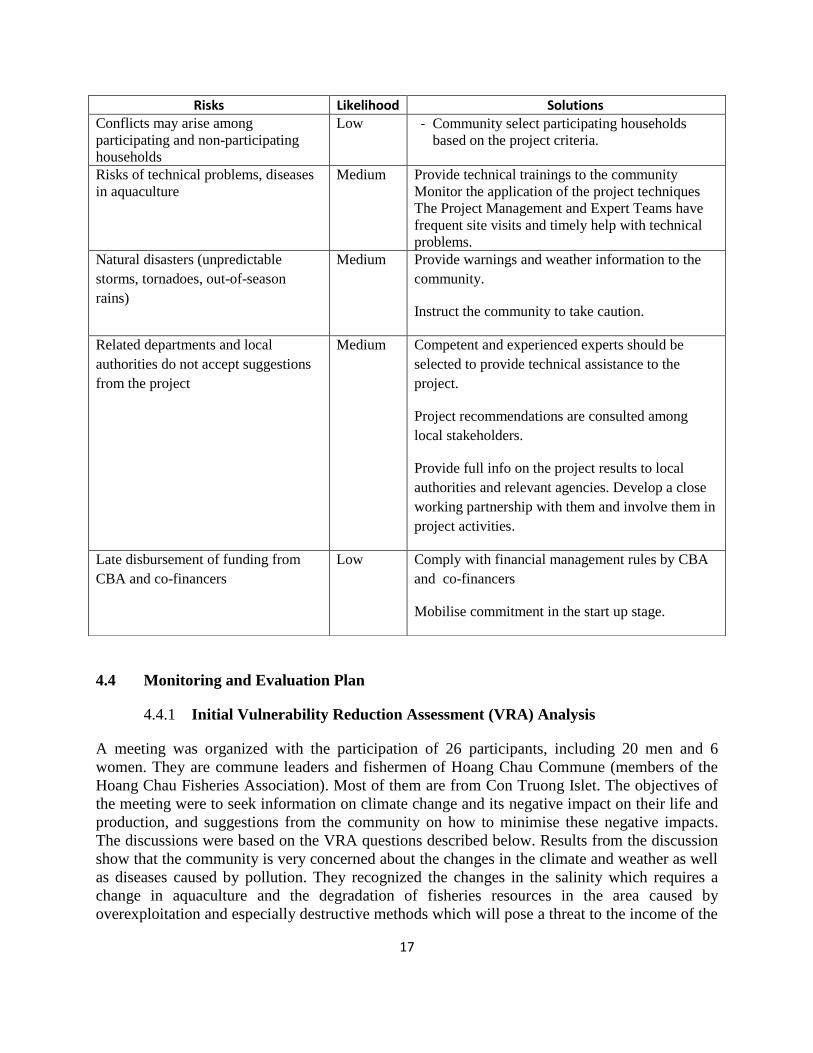
17
4.4 Monitoring and Evaluation Plan
4.4.1 Initial Vulnerability Reduction Assessment (VRA) Analysis
A meeting was organized with the participation of 26 participants, including 20 men and 6
women. They are commune leaders and fishermen of Hoang Chau Commune (members of the
Hoang Chau Fisheries Association). Most of them are from Con Truong Islet. The objectives of
the meeting were to seek information on climate change and its negative impact on their life and
production, and suggestions from the community on how to minimise these negative impacts.
The discussions were based on the VRA questions described below. Results from the discussion
show that the community is very concerned about the changes in the climate and weather as well
as diseases caused by pollution. They recognized the changes in the salinity which requires a
change in aquaculture and the degradation of fisheries resources in the area caused by
overexploitation and especially destructive methods which will pose a threat to the income of the
Risks Likelihood Solutions Conflicts may arise among
participating and non-participating
households
Low - Community select participating households
based on the project criteria.
Risks of technical problems, diseases
in aquaculture
Medium Provide technical trainings to the community
Monitor the application of the project techniques
The Project Management and Expert Teams have
frequent site visits and timely help with technical
problems.
Natural disasters (unpredictable
storms, tornadoes, out-of-season
rains)
Medium Provide warnings and weather information to the
community.
Instruct the community to take caution.
Related departments and local
authorities do not accept suggestions
from the project
Medium Competent and experienced experts should be
selected to provide technical assistance to the
project.
Project recommendations are consulted among
local stakeholders.
Provide full info on the project results to local
authorities and relevant agencies. Develop a close
working partnership with them and involve them in
project activities.
Late disbursement of funding from
CBA and co-financers
Low Comply with financial management rules by CBA
and co-financers
Mobilise commitment in the start up stage.
18
fishermen. They are well aware of the need for protection and development of mangrove forests
to cope with the natural disaster which becomes more frequent in their localities. They are
interested in the idea that enhances community support each other with a revolving loan
programme as well as community monitoring to stop destructive fishing. In general, the
community is aware that there are a lot of risks for aquaculture and fishing and they need to
change their business way of doing in aquaculture and fishing as the environment has been
changing and natural disasters are more frequent and therefore eager to learn new methods for
sustainable aquaculture and fishing in the CC context.
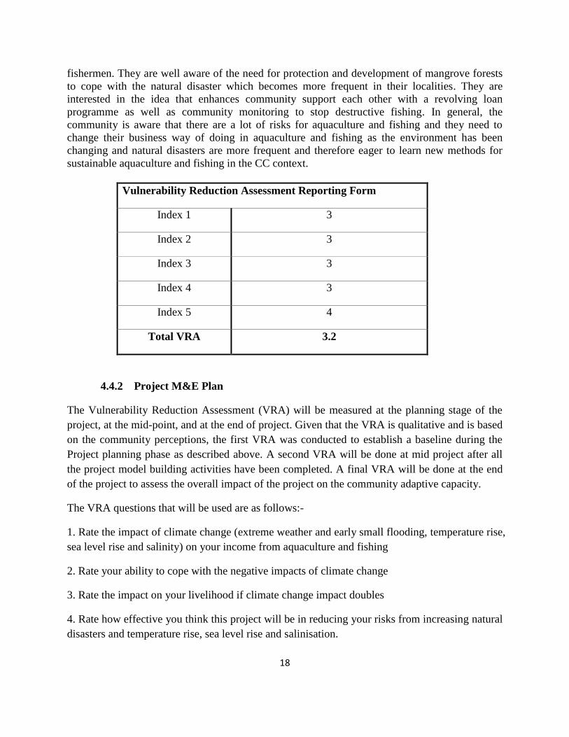
Vulnerability Reduction Assessment Reporting Form
Index 1 3
Index 2 3
Index 3 3
Index 4 3
Index 5 4
Total VRA 3.2
4.4.2 Project M&E Plan
The Vulnerability Reduction Assessment (VRA) will be measured at the planning stage of the
project, at the mid-point, and at the end of project. Given that the VRA is qualitative and is based
on the community perceptions, the first VRA was conducted to establish a baseline during the
Project planning phase as described above. A second VRA will be done at mid project after all
the project model building activities have been completed. A final VRA will be done at the end
of the project to assess the overall impact of the project on the community adaptive capacity.
The VRA questions that will be used are as follows:-
1. Rate the impact of climate change (extreme weather and early small flooding, temperature rise,
sea level rise and salinity) on your income from aquaculture and fishing
2. Rate your ability to cope with the negative impacts of climate change
3. Rate the impact on your livelihood if climate change impact doubles
4. Rate how effective you think this project will be in reducing your risks from increasing natural
disasters and temperature rise, sea level rise and salinisation.
19
5. Rate your confidence that the project will continue to reduce climate change risks after the
project ends.
The Impact Assessment System (IAS) indicator will be measured at the end of the project using
the following components:
(1) The number of hectares/models of aquaculture development applying the project
techniques in sustainable aquaculture and fishing to adapt to CC impact
(2) The number of hectares of mangroves protected and planted
(3) number of innovations developed/applied under the project
(4) The number of policy recommendations proposed in environmental protection and
sustainable use of natural resources (fisheries and mangroves) for sustainable aquaculture
and fishing in the climate change context
The targets for the above are as follows:
(1) Three (3) models will be tested by the project.
(2) 15-20 ha of mangroves will be protected and planted.
(3) 2-3 innovations developed/applied under the project
(4) Three to four recommendations on policies in sustainable aquaculture and fishing in the
climate change context will be proposed to local authorities
UNDP ADAPTATION INDICATORS:
The project will contribute to the UNDP adaptation indicators adopted by the Viet Nam CBA
country programme strategy, namely:
1. The number of measures that address the additional risks posed by climate change
deployed as part of sustainable resource management activities;
2. Percentage of area concern in which climate change risk management activities, in the
context of sustainable resource management are implemented; and
3. Number of local and national level policy recommendations proposed as a result of
lessons from CBA projects
The targets for the UNDP Adaptation indicators are outlined below:
(1) Three (3) models will be tested as part of the activities for sustainable aquaculture and
fishing in the project area.
(2) Five percent (5%) of project area will be engaged in climate-resilient farming activities.
Three to four policy recommendations proposed as a result of lessons from the project.
4.5 Project Management
4.5.1 Management Structures

20
The Project Management Team:
- Thanh Hoa Fisheries Associations is the grantee organization and is accountable for the project.
- In order to manage the project, Thanh Hoa Fisheries Associations establishes a Project
Management Team who manage the project to achieve the project objective, outcomes and
planned outputs set up in the project’s document approved by CBA. The Project Management
Team undertakes management tasks following the CBA project management rules and operates
in a democratic and transparent manner. Monthly meetings are organised to discuss the project
issues and decisions are made at the meetings. Ad hoc meetings will be held when needed and
once requested by the Team leader of the Project Management Team to resolve in time all the
project’s important issues. Members of the Project Management Team, besides the meetings,
will exchange information and seek agreement in implementing the project through various
communication channels.
+ The Project Management Team comprises of 5 members:
- 3 members (Project Management Team leader, Secretary and Accountant) from Thanh
Hoa Fisheries Associations
- 1 member from Hoang Chau Commune People’s Committee
- 1 member representing fishermen community in Hoang Chau Commune
The project management team has the following functions:
Develop project workplans and budget for the project’s activities
Organize activities according to the approved workplans and budget.
Monitor, evaluate, report on the project’s implementation progress and use of resources
for CBA, the local authority and local’s stakeholders.
Select and sing the subcontract with the project’s expert group and oversight the
deployment of the technical advice contract done by those experts.
Establish relations with local authorities and relevant agencies to seek their
supports and mobilize resources for the project.
Manage the project’s resources financed by CBA
Mobilize and oversight co-financing given by organizations and community, report the
results achieved by using this resource.
Make announcement and discussion with CBA to find solutions and adjustments to the
problems encountered during the implementation of the project
Keep archives of the project
The project’s sub-contracts

21
The project will have a sub-contract which provides equipment and materials for the project’s
demonstration models. The Project Management Team will sign the sub contract with suppiers in
Thanh Hoa for purchasing equipment and materials for the project’s demonstration models.
The project’s sub-contractor of technical assistance
A contract of technical experts will be signed to supply the project’s technical assistance
services. The Project Management Team in comsultations with CBA to recruit the expert group
to carry out the technical activities of the project. The main responsibilities of the expert group
are:
Provide technical assistance in implementing the project: provide training and technical
support for community to deploy the technical measures of the project.
Supervise, evaluate the results of the project, draw lessons and make recommendations
on policies for stakeholders.
Develop project technical documents.
The expert group includes:
3 qualified experts (from research institutions and universities) with specialization and
experience in the fields of climate change, aquaculture, fishing and mangroves.
3-4 local technical staff who have specialization and experience in aquaculture, fishing
and community-based projects, responsible for the implementation of activities on the
ground under the experts’ guidance.
- The consultant services fall under the supervision of The Project Management Team, based on
the contract of technical support signed by the Project Management Team and the expert group.
The latter makes plans, cost estimate and reports in accordance with to the principles set in the
contract. It also has an internal working mechanism agreed by the Project Management Team.
During the implementation of the project, the expert group collaborates closely with the Project
Management Team to hold a meeting every six months to evaluate the project’s progress, draw
lessons and suggest necessary adjustments.
Project monitoring and evaluation
In project monitoring and evaluation, the project management team’s responsibilities are defined
as follow:
The project management team is responsible for monitoring projects in terms of technology and
finance in order to gather required information for project management. Besides monthly
meetings, the project management team will hold site visits (every 3 months) with aims to:
22
Examine the practical situation, checking the rate of projects’ activities.
Solve potential problems during the projects’ execution/implementation.
Gathering information for building action plan, cost estimates and making reports.
Draw lessons learnt from the project implementation.
The project management team held a meeting every 6 month with the expert group to review the
progress and results based on the project workplans and technical assistance contract.
Project evalutaion
Project midterm and final evaluation is conducted in the middle and by the end of the project.
The purpose of the evaluation is aimed at:
- Evaluating the progress and extent of achieveing the project outputs and outcomes
and objective
- Evaluating the potential for project expansion and replication, making the
recommendation about project sustainability and expansion and replication based on
the project’s results.
- Revising the project if necessary so as to best achieve the project objective.
- Drawing experience and lessons learned in project management and project models.
- Evaluating the effectiveness of projects design and efficiency and effectiveness of
using the project resources.
The content for evaluation is based on the objectives, outcomes and outputs, and success
indicators stated in the project document. Participatory methods will be adopted on project
monitoring and evaluation. To have information for project monitoring and evaluation, baseline
data will be collected during the project inceptions.
VRA meetings will be organized to assess the adaptive capacity as described above.
4.5.2 Relationship and Responsibilities of Proponent and Project Partners
The project will cooperate with the People’s Committee of Hoang Hoa District, Hoang Chau
Commune and relevant departments like Department of Agriculture and Rural Development,
Department of Natural Resources and Environment, Department of Science and Technology, etc.
to conduct activities of the project, such as:
- Share the project experience with coordinating programs and projects with similar
objectives.
- Organize education activities about environmental issues, project models and training
classes.
- Create a cooperative relationship with related agencies to gain financial assistance and
support for households that implement the models.
23
- Work with GEF SGP to evaluate and summarize results, compile and publicize technical
materials and draw lessons learned.
- Suggest related issues and plans for the replication of the project models.
Related Documents


![[Young Marketers Marathon - Elite Assignment] Hoang Tthach - Hoang Lan](https://static.cupdf.com/doc/110x72/55d72dcfbb61eb890a8b45bd/young-marketers-marathon-elite-assignment-hoang-tthach-hoang-lan.jpg)