This article appeared in a journal published by Elsevier. The attached copy is furnished to the author for internal non-commercial research and education use, including for instruction at the authors institution and sharing with colleagues. Other uses, including reproduction and distribution, or selling or licensing copies, or posting to personal, institutional or third party websites are prohibited. In most cases authors are permitted to post their version of the article (e.g. in Word or Tex form) to their personal website or institutional repository. Authors requiring further information regarding Elsevier’s archiving and manuscript policies are encouraged to visit: http://www.elsevier.com/copyright

Welcome message from author
This document is posted to help you gain knowledge. Please leave a comment to let me know what you think about it! Share it to your friends and learn new things together.
Transcript

This article appeared in a journal published by Elsevier. The attachedcopy is furnished to the author for internal non-commercial researchand education use, including for instruction at the authors institution
and sharing with colleagues.
Other uses, including reproduction and distribution, or selling orlicensing copies, or posting to personal, institutional or third party
websites are prohibited.
In most cases authors are permitted to post their version of thearticle (e.g. in Word or Tex form) to their personal website orinstitutional repository. Authors requiring further information
regarding Elsevier’s archiving and manuscript policies areencouraged to visit:
http://www.elsevier.com/copyright
Author's personal copy
Projection of tourist scenarios onto fragility maps: Framework for determinationof provisional tourist carrying capacity in a Brazilian show cave
Heros Augusto Santos Lobo a,b,*, Eleonora Trajano c, Maurício de Alcântara Marinho b,d,Maria Elina Bichuette e, José Antonio Basso Scaleante b,f, Oscarlina Aparecida Furquim Scaleante f,Bárbara Nazaré Rocha d, Francisco Villela Laterza d,g
aDepartamento de Geografia, Turismo e Humanidades, Universidade Federal de São Carlos (DGTH/UFSCAR), Brazilb Seção de Espeleoturismo e Sociedade Brasileira de Espeleologia (SeTur/SBE), BrazilcDepartamento de Zoologia, Instituto de Biociências, Universidade de São Paulo (IB/USP), Brazild Faculdade de Filosofia, Letras e Ciências Humanas, Universidade de São Paulo (FFLCH/USP), BrazileDepartamento de Biologia e Ecologia Evolutiva, Universidade Federal de São Carlos (DBEE/UFSCAR), Brazilf Estação Floresta Assessoria Ambiental e Turismo Ltda, BrazilgGeoklock Consultoria e Engenharia Ambiental, Brazil
h i g h l i g h t s
< This is the first method tested of simultaneous management of 32 tourist caves.< We changed the traditional deterministic methods of tourist carrying capacity.< The framework created is a decision-making method for tourist carrying capacity.< The method divides the liability of tourism planning among all the stakeholders.< The continuous monitoring of cave environment is a key factor of the method.
a r t i c l e i n f o
Article history:Received 4 June 2011Accepted 30 July 2012
Keywords:Carrying capacityManagement of show cavesTourism in cavesSustainable tourism
a b s t r a c t
Traditionally, the concept of tourist carrying capacity has been understood as a tool for planning tourismin natural areas. As such it has focused on quantifying impacts that are consistent with maintaininga specific environment. In this article tourist carrying capacity is considered from a different viewpoint ina case study of a Brazilian show cave, the Diabo cave, near Eldorado city, São Paulo state. In this instancedecisions concerning tourism had been based primarily on the advantages that tourism could provide inmaintaining economic-administrative sustainability and community support. More recently, otherfactors based on natural limitations have been considered in a process of participative discussion amongstakeholders seeking to preserve the caves and their sustainable usage. This process led to the conclusionthat the carrying capacity of the caves should be flexible, conditioned by protocols of environmentalmonitoring with reference to levels of demand. Such monitoring, it is hoped, will permit the adjustmentof the initial cave limits as a function of changes in the patterns of consumption, local realities, and theidentification of unanticipated yet unacceptable environmental impacts.
� 2012 Elsevier Ltd. All rights reserved.
1. Introduction
Many aspects of nature have a great potential for tourism.Among them we can mention mountains, canyons, islands, bea-ches, rivers and waterfalls, as well as wildlife and vegetation. In thisvast panorama of options, caves stand out due to their uniquefeatures, both scientific and esthetic, resulting in a high degree ofattractiveness.
On the other hand, subterranean habitats are among the mostfragile environments in the world, as a consequence of geographic
* Corresponding author. Universidade Federal de São Carlos, Campus Sorocaba,Departamento de Geografia, Turismo e Humanidades, Rodovia João Leme dosSantos (SP 264), Km 110, Bairro Itinga, CEP 18052-780 e Sorocaba, SP, Brazil.Tel.: þ55 19 3816 6741.
E-mail addresses: [email protected], [email protected] (H.A.S. Lobo),[email protected] (E. Trajano), [email protected] (M.A. Marinho),[email protected] (M.E. Bichuette), [email protected] (J.A.B.Scaleante), [email protected] (O.A.F. Scaleante), [email protected] (B.N. Rocha), [email protected] (F.V. Laterza).
Contents lists available at SciVerse ScienceDirect
Tourism Management
journal homepage: www.elsevier .com/locate/ tourman
0261-5177/$ e see front matter � 2012 Elsevier Ltd. All rights reserved.http://dx.doi.org/10.1016/j.tourman.2012.07.008
Tourism Management 35 (2013) 234e243
Author's personal copy
fragmentation, spatial confinement, climatic stability and thepermanent absence of light. Caves also depend on the epigeanregion (surface) for nutrient inputs (Bichuette & Trajano, 2010;Gillieson, 1996).
The management of tourist related activities, in protected areas,requires a solid and scientifically based knowledge of the envi-ronment, with special emphasis on the limits of the resilience of thegeo and ecosystems directly and indirectly affected by such activ-ities. The interests of the local communities involved in the tourismactivities should also be considered.
Subterranean habitats require a special planning if they areintended to a sustainable use. Their unique ecological interactions,as well as their flow of mass and energy, differ from what isobserved in other natural environments (Cigna & Forti, 1988;Pulido-Bosch, Martín-Rosales, López-Chicano, Rodríguez-Navarro,& Vallejos, 1997). The confined space, in conjunction with limita-tions in geological and biological processes make the anthropo-genic impacts last longer, and in some cases forever.
The most frequently used procedure to reduce the magnitudeof direct human disturbance is the regulation of public use, bysetting limits on time, space, and behavior (Lobo, 2011). Suchlimits would be stipulated as a function of the theoreticallyacceptable variations in the key parameters of the affected envi-ronment, which are known to be related to the level of theanthropic pressure, thus leading to the idea of environmentalfragility (Trajano, 2010).
The analysis of limitation of use based on fragility, associatedwith procedures for the evaluation of the tourist potential of caves,as developed in Brazil by Lino (1988), Labegalini (1990), Marinho(2002) and Lobo (2007), was the basis of this proposal for touristplanning and management for caves, which was designed toidentify a starting point for visitation. Themethod herein presentedwas developed for the first step in tourist planning: the establish-ment of the provisional tourist carrying capacity of caves (PTCC).
Traditionally, carrying capacity is a quantitative approach usedto justify limitations for tourist use, based on the maximummagnitude of human impacts within the resilience limits of theenvironment. Cigna (1993), Gillieson (1996) and Hoyos, Soler,Cañaveras, Sánchez-Moral, and Sanz-Rubio (1998) establisheda conceptual basis for caves. Practical methodologies are presentedin Cifuentes (1992), Hoyos et al. (1998) and Calaforra, Fernández-Cortés, Sánchez-Martos, Gisbert, and Pulido-Bosch (2003), amongothers. In the case that Cifuentes (1992) studied, the method thatwas developed initially to be used in trails andwas adapted to cavesin the studies by Boggiani et al. (2007) and Lobo (2008). Originally,Cifuentes proposed an addition of the factors considered to becritical. This operational logic considerably reduces the number ofvisitors without considering a direct cause between the problemsand the intensity of the visitation.
On the other hand, Hoyos et al. (1998) and Calaforra et al. (2003)adopted a linear perspective of cause and effect between caveatmospheric parameters and the presence of visitors, focusing onthe size of the visiting groups in specific situations, such as in thepresence of rupestrian art.
The establishment of the carrying capacity depends on theenvironmental diagnoses, which incorporate data related tomonitored visitations (Fernández-Cortés, Calaforra, & Sánchez-Martos, 2006). In underground systems, different levels ofexchange of mass and energy are involved (Calaforra et al., 2003;Cigna & Burri, 2000; Heaton, 1986; Hoyos et al., 1998) and theenvironmental processes take place over long periods of time,making especially difficult to establish the exact number of visitorsdesired for a given cave. Traditional methods are based on thenotion of fixed situations and definitive numbers, withouta continuous feedback provided by regular monitoring. These
methods have been used merely to satisfy planning needs andobligations in the development of management plans (Cigna &Burri, 2000). In fact, in many places the carrying capacity, simplyreduced to a numeric issue, is used to obtain permanent numbers ofvisitors, leaving aside the seasonal dynamics of the environmentand the tourist seasonality, which are very important issues incaves.
One of the challenges for the management of show caves is thedetermination of numerical and spatial limits for the routes to bedesigned. The starting point is the understanding of the concept ofthe carrying capacity as a tool for the improvement of the use ofnatural attractions for tourism purposes compatible with theenvironmental conservation. The carrying capacity concept was notdesigned to simply limit the massive access of people, but rather toidentify a rate of visitationwhich would be acceptable in relation tothe anthropically-induced changes in an area (Boggiani et al., 2007;Cifuentes, 1992; Cigna & Forti, 1988; Stankey, Cole, Lucas, Petersen,& Frissell, 1985). Moreover, the concept of carrying capacity cannotbe reduced to a numerical calculation just to provide a single result,but rather, it should be a means for supporting managementdecisions. It is a dynamic technique, whose outcomemay change asa result of the variables being analyzed (Cifuentes, 1992; Lobo,2008). Although carrying capacity is usually based on the naturalcharacteristics of the environment, there are authors (e.g. Gillieson,1996; Lobo, 2008; Santana-Jiménez & Hernández, 2010) who agreethat the point of view of the visitors should also be taken intoaccount. Physical levels of comfort, psychological limits for groupdensity, as well as preferences for types of activities should also betaken into consideration.
The method herein presented is different from the othermethods traditionally used in caves (e.g. Boggiani et al., 2007;Calaforra et al., 2003), in its theoretical conceptualization andprocedural logics. Leaving aside the search for “magical numbers”,the adopted approach was closer to the decision-making frame-works, as the Limits of Acceptable Changes (LAC), proposed byStankey et al. (1985). However, the LAC framework requires a widerange of financial, human and time resources, hampering itsapplication in countries such as Brazil, as previously pointed byCeballos-Lascuráin (1998).
The first step was the delimitation of the hypothetical scenarios,initially designed to meet the social, economic and psychologicalneeds of various stakeholders involved in tourism, includingscientists, environmental authorities, local leaderships, parkmanagers and others. Proposals for visitation schedules aresubmitted to analysis as a function of feasibility, especially inrelation to bottlenecks established from diagnostic maps outliningthe fragility of the environment. Discussions between the stake-holders define spatial and temporal limits, which generatesmodifications in the scenarios previously projected by specialists intourism management. Issues to be discussed include the size of thegroups of tourists, their routes, the pre-requisites to allow thevisitation of relative more fragile areas and the limitations for dailyvisitation, resulting in the establishment of the provisional carryingcapacity.
2. Methodology
2.1. Study area
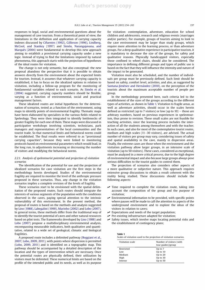
The present method was applied in 50 proposed touristscenarios in 32 caves located in a mosaic of natural protected areas.Those areas were designed to preserve significant remnants of theAtlantic Coastal Rain Forest, covering the Upper Ribeira Valley, inthe Southern State of São Paulo, SE Brazil (Fig. 1). They are situatedin the transition from the Atlantic Forest to the Araucaria Forest
H.A.S. Lobo et al. / Tourism Management 35 (2013) 234e243 235
Author's personal copy
domains (sensu Ab’Saber, 1977); the climate is subtropical humid,without a typical dry season. There is a significant variation inaltitude, from 1040 m to 137 m in the karst area of the IntervalesState Park (Sallun Filho, Ferrari, Hiruma, Sallun, & Karmann, 2010),that is one of these protected areas where the caves are located.
In the Alto Ribeira karst area, there are more than 500 caves sofar recorded, many located in protected areas. This karst area isformed by Middle Proterozoic carbonate rocks of the AçunguiGroup, comprising lenses of metamorphic limestone and dolomiticlimestone intercalated with lenses of insoluble rocks, all intensivelyfolded. The area features different stages of development of thekarst, beginning with fluvial valleys, which then becomesegmented by closed depressions, and then evolve to a classicalpolygonal karst (Auler & Farrant, 1996). Geomorphologically, aswell as in phytogeographic and climatic terms, this area is differentfrom the most extensive karst areas in Brazil.
The unique combination of geomorphological, phytogeographicand climatic features, in a relatively small geographic area, makesthe Alto Ribeira amost relevant area for Conservation, imposing theneed of a very careful planning for any kind of human use, includingtourism.
The caves in this area started being regularly visited in the mid-1960’s, with the pioneering initiatives exploring the Diabo andSantana caves (Le Bret, 1995). Organized tourismwas intensified inthe 1980s, with the creation of three State Parks and other cate-gories of natural protected areas in the region (Marinho, 2002).
Some caves, such as Diabo, Santana, Água Suja and Morro Preto,received an average of 30,000 tourists/year in the last decade.
In 2008, after years of visitation, the tourist caves of the abovementioned regionwere closed by a judicial determination, since nomanagement plans had been developed, either for the parks or thecaves. Moreover, accidents involving tourists had roused publicconcerns about safety. This prevention of visitation, however, wasextremely harmful to local communities which depend on theresources from tourism, once the flow of visitation was reduced topractically zero for months (Lobo, 2008). These events led to theelaboration of plans for the speleological management of 32 cavesin four state parks in the region (Fig. 1).
The method herein described was developed and applied tothose 32 caves based on environmental studies conducted fromJanuary 2009 to December 2010, complemented by data previouslyavailable for most of them. As an example, we present the results ofits application to the Diabo cave (also known as Tapagem cave), oneof the most important of all the Brazilian show caves.
2.2. A new approach to tourist carrying capacity: provisional touristcarrying capacity in caves (PTCC)
The application of the traditional carrying capacity indexes isnot the scope of the present study, due to doubts as to their prac-tical application and usefulness for long-term conservation. It isnecessary, however, to have a procedure to provide practical
Fig. 1. Localization of the studied caves in the Upper Ribeira Valley, with special emphasis to Diabo cave.
H.A.S. Lobo et al. / Tourism Management 35 (2013) 234e243236
Author's personal copy
responses to legal, social and environmental questions about themanagement of cave tourism. From a theoretical point of view, thelimitations in the definition and application of carrying capacityindexes discussed by Cifuentes (1992), Gillieson (1996), Lindberg,McCool, and Stankey (1997) and Simón, Narangajavana, andMarqués (2004) were fundamental to develop this new approachaiming to establish a provisional carrying capacity under a newlogic. Instead of trying to find the limitations imposed by naturalphenomena, this approach starts with the projection of hypothesesof the ideal routes for visitation.
The change is not only semantic, but also conceptual: the newproposal abandons the perspective that it is possible to obtainanswers directly from the environment about the expected limitsfor tourism. Instead, it assumes that whatever carrying capacity isestablished, it has to focus on the idealized options in relation tovisitation, including a follow-up program for the monitoring offundamental variables related to each scenario. As Simón et al.(2004) suggested, carrying capacity numbers should be flexible,varying as a function of environmental, social and practicalmanagement factors.
These idealized routes are initial hypotheses for the determi-nation of scenarios, tested as a function of the environment, usingmaps to identify points of environmental fragility. Thematic mapshave been elaborated by specialists in the various fields related toSpeleology. They were then integrated to identify bottlenecks ofgreater fragility for each one of them. Thesemapswere discussed inparticipative workshops involving scientists, technicians, parkmanagers and representatives of the local communities and thetourist trade. So that numerical limits and behavioral norms couldbe established. The final results were referred to as “provisionalcarrying capacities”, because they were linked to monitoringprotocols based on environmental parameters which would lead, inthe long run, to adjustments increasing or decreasing the numberof visitors and modifying the behavioral norms.
2.2.1. Analysis of speleotourist potential and projection of visitationscenarios
The identification of the potential for use and the projection ofidealized scenarios for cave visitation are the first steps in themethodology herein developed. Studies of the environmentalfragility are required to monitor the level of the anthropic pressureproposed in these scenarios. Thus, any change in the visitationscenarios implies a complete revision of the levels of fragility.
These scenarios start to be envisioned with the spatial delim-itation of the proposed routes. Such routes should integrate theinterests of various segments of the population with the conditionsobserved in the caves, paying special attention to the intrinsicvulnerability of this environment. In the present method, theproposal of routes is based on the methods and analysis suggestedby Lino (1988), Labegalini (1990), Marinho (2002) and Lobo (2007).In general terms, these methods differ from the traditional way ofto identify the tourist potential of caves and other natural resourcesbased on pilot tests. The frameworks developed by Lino (1988) andLobo (2007) propose a multidisciplinary environmental analysis,encompassing measurable indicators, both qualitative and quanti-tative, related to a wide set of geological, climatic and biologicalfragilities.
A proposed route includes a delimited pathway (Boggiani et al.,2007; Lobo, 2009, 2011), with points where dispersion is permitted(Lobo, 2009, 2011) and is identified on a topographic map. Thispathway should be accompanied by a detailed description of thelocation and the types of intervention which are necessary. Oncethe potential routes are physically defined, their utilization byvisitors must be delimited. These numerical limits are based on theprofile of the intended public and its needs, as well as its purpose
for visitation: contemplation, adventure, education for schoolchildren and adolescents, research and religious events (marriagesand/or parties). For example, groups of tourists aiming to look tothe cave environment may be larger than study groups, whichrequire more attention to the learning process, or than adventuregroups. For a deep qualitative experience in participative tourism, itis mandatory to decrease the size of the groups, for safety andqualitative reasons. Physically handicapped visitors, especiallythose confined to wheel chairs, should also be considered. Theimportance in defining different groups and types of public use isbased on the fact that theywill influence the intensity and nature ofthe impact to be generated.
Visitation must also be scheduled, and the number of individ-uals per group must be previously defined. Such limit should bebased on safety, comfort level, activities, and also, as suggested bySantana-Jiménez and Hernández (2010), on the perception of thetourists about the maximum acceptable number of people pergroup.
In the methodology presented here, such criteria led to theestablishment of the sizes of the groups according to the differenttypes of activities, as shown in Table 1. Visitation to fragile areas, aswell as adventure activities, should occur in the scales hereindefined as restricted (up to 7 visitors) or low (up to 10) e those arearbitrary numbers, based on previous experiences in speleotour-ism, thus prone to revision. These small scales are not feasible forteaching activities, since the learning process includes the inter-action of all the students among themselves and with the teacher.In such cases, and also for most of the contemplative tourist routes,medium and high scales (11e30 visitors), are advised. The actualnumber of visitors per group may vary, considering issues of safetyand spatial availability in the cave, mainly in dispersion areas.Finally, the extreme cases are those when the environment and thevisitation pathway allow larger groups, in an intensive scale ofvisitation (up to 50 visitors). These cases, considered as exceptional,must be analyzed in a more critical process, due to the high degreeof environmental impact and also because large groups always poseserious difficulties to the tourist guides to control them.
The projection of scenarios also considers other aspects ofa more qualitative or subjective nature. This approach requiresextensive group discussions to obtain a result coherent with thereality being studied. These discussions should include thefollowing aspects:
U Time required to complete the visitation route, taking intoaccount the composition of the group and the purpose ofvisitation;
U Environmental information to be provided, with specific pointswhere pauses will be made to call the attention to aspects of theunderground environment and to explore the ideas of thevisitors in relation to caves;
U Expectations and needs of the target population;U Pre-existing infrastructure adapted for visitation;U Safety issues, which involve maps locating potential risks and
the establishment of contingency plans;
Table 1Scales of visitation used to the projection of visitation scenarios.
Visitation scale Number of visitors (withtour guides)/group
Restricted Up to 7Low Up to 10Medium Up to 20High Up to 30Intense Up to 50
H.A.S. Lobo et al. / Tourism Management 35 (2013) 234e243 237
Author's personal copy
U Demand, since certain routes revealing specific curiosities willdrive greater interest than others; moreover, some routesshould be limited to visits of more experienced speleologicaltourists;
U Needs of local communities and tourist agents, since theconcept of carrying capacity is also designed to guarantee moresustainable and lasting use.
2.2.2. Analysis of fragility of cave environmentBased on the evaluation of the anthropic impacts on specific
characteristics of the environment, the classification of its fragilitiesis the second step to organize potential routes and pathways. It isnoteworthy that fragility is a relative concept, not designed toidentify intrinsic susceptibility of specific elements in karst systems(cf. Ford & Williams, 2007) but, rather, to relate causes to effects asa function of quantitative levels and qualitative aspects of thehuman presence (Lobo, 2011; Trajano, 2010). A similar perspectivefor analysis in relation to the human presence was adopted byArrowsmith and Inbakaran (2002) in their study of the environ-mental resilience of biotic and abiotic factors related to tourism ina National Park in Australia.
The fragilities of the underground environment are identifiedafter diagnoses made by professionals in different fields of spele-ology, usually based on scientific studies designed specifically fortthis purpose, following the appropriate procedures of data collec-tion, analysis and interpretation. The fragilities identified for eacharea of the caves are showed on the thematic maps.
All the studies are necessarily governed by the norms of thedistinct thematic studies. The results are presented in various formsof evaluation and classification of the cave’s environment, whichcertainly complicates any attempt to compare the importance and/or weight of the specific data. Thus, the first methodologicalpremise adopted was the definition of levels of fragility, corre-sponding to values expressed as percentages, allowing for thecomparison of independent types of data. The classification oflevels of fragility herein defined is presented in Table 2.
The scale of fragility levels may be applied to the whole cave (insmall or homogeneous caves) or to some sections, such as a largeroom, a conduit, a stream, or a climatic zone. These fragility unitsare established based on the interpolation or extrapolation of thedata from the surveyed points. It must be stressed that the levelreferred as “unclassified/inexistent” does not necessarily imply theabsence of fragility, because in some instances, it is not scientificallypossible to prove it. In such cases, this classification indicates theneed of more research in that specific region of the cave.
The classification of the levels of fragility based on specificcriteria for each of the four thematic areas considered is showed onTable 3.
The total fragility in relation to each thematic study is thenestimated for each zone or for the cave as a whole. At first, the sumof the values attributed by each area is divided by the total numberof criteria (Equation (1)):
FTx ¼ IF1 þ IF2 þ IF3.þ IFnPIFs
(1)
where, FTx ¼ Fragility of zone x of a cave for the thematic area,IF1,2,3.n ¼ Values and/or weights for each criteria of fragility,P
IFs ¼ Total number of criteria utilized in classification of eachzone or cave.
The results obtained will invariably fit into one of the categoriesshowed on Table 2.
2.2.3. Integration of the thematic mapsThe next step in the analysis of the fragilities involves the
overlapping of the thematic maps, producing integrated maps foreach cave or cave section. Two types of maps were drawn:
U Maximum fragility maps, corresponding to the greatest fragilityidentified from any scientific point of view;
U Average fragility maps, by averaging the values obtained fromthe assessment of various areas.
These maps create zones in each cave, depending on thepercentage scores of levels of fragility from Table 2, once a finalscore has been obtained for each cave or cave zone.
2.2.4. Provisional tourist carrying capacity (PTCC)The results from these integrated fragility maps can be used in
two ways: a) in discussions amidst specialists attempting to reacha consensus, or b) the application of indices for the reduction theoriginal amount of visitors proposed in the scenarios, to compen-sate the fragility of specific academic studies, using a calculationsimilar to that proposed for the carrying capacity of Cifuentes(1992).
The preferred procedure is the consensus reached after somediscussions, because the methodology hereby described was
Table 2Levels of fragility considered in the present study.
Fragility level Values (%)a Color of legend Brief description
Absolute 75.01e100 Black Incompatibility of the specificarea for tourist use.
High 50.01e75 Red Relative compatibility of aspecific area for a projectedscenario of tourism.
Medium 25.01e50 YellowLow 0.01e25 GreenUnclassified/
inexistente Translucent Absence of studies and/or
undetected fragilities.
a The four levels of fragility reflect an arbitrary division of the totally 100%.
Table 3Criteria used in analysis of underground environments in relation to visitation.
Thematic study Examples of criteria used
Speleogeology U Total extension of the cave conduitsU Total depth of the caveU Volume of large roomsU Presence, variety, location and rarity of morphological
featuresU Presence of clastic depositsU Potential of clastic deposits for sedimentology studiesU Existence, variety and location of speleothems and
mineralogy involvedUGeological singularities
Paleontology andarcheology
U Presence of remnantsU Existence of previous studies and rescue of remnants
in some casesMicroclimatea U Climatic connectivity with the outside
U Carbon dioxide concentrationSpeleobiologyb U Presence and richness of troglomorphic species
UOccurrence of species with low population densitiesU Presence of putative new speciesU Presence of species indicating good quality of water
(Megaloptera, Trichoptera, Ephemeroptera, Plecoptera,Odonata and Decapoda Aeglidae, Amphipoda)
UGranulation of substrate in streamsUGranulation along river banks
a Other atmospheric parameters, such as the concentration of radon, wind flow,and condensation rates, in addition to the temperature of the water and cave walls,should be considered in microclimatic studies. However, the time and expensesinvolved in such studies tend to render the use of these parameters unfeasible in thepresent method.
b The classification of subterranean organisms into the SchinereRacovitza systemfollowed Trajano (2005).
H.A.S. Lobo et al. / Tourism Management 35 (2013) 234e243238
Author's personal copy
designed to provide support for the decision-making, rather thana deterministic calculation. This discussion should involve thehigher number possible of specialists in different disciplines ofspeleology (biologists, geologists, geographers, climatologists,paleontologists, archaeologists, tourist managers and other scien-tists, when needed) as well as stakeholders involved with thepublic use of the cave, such as environmental managers, govern-ment representatives, research workers familiar with the region,tourist agencies and local guides. To properly conduct the discus-sion, the following outline was prepared:
1. Presentation of the thematic maps showing the idealizedroute(s), and also tables and boards explaining the projectedscenarios for visitation, so that everybody can understand thelevel of impact to be expected;
2. Presentation of the thematic maps showing the fragility of thedifferent zones of the cave based on studies by specialists, whoshould identify the points of the greatest fragility and justifytheir inclusion, one by one;
3. Presentation of the integrated fragility maps, showing bothmaximum and average fragilities, so that the areas that are themost susceptible to environmental disturbance can beidentified.
At the end of the presentation of these materials, the discussionamong all the stakeholders begins, aiming to verify the pros andcons about the implementation of each tourist scenario. The maingoal of the discussion is to reach a consensus about a specific touristscenario, focused on:
U The definitive tourist route and pathway;U The isolation of specific areas of higher fragility levels, or even
the incompatibility with the visitation;U The number of tourists and tour guides per group, in view of the
difficulties of the tour routes, and also of the quality of theservices to be rendered; These numbers may vary in function ofmany factors, such as the day of the week (e.g. different groupsfor each tourist profile, in working days and in weekends);
U The final identification of the PTCC allowed, considering groupsizes, duration of the tour and the total time of visitation ina day.
If no consensus is reached, an alternative, less desirable strategyto determine the PTCC would involve the application of the indicesof average fragilities or the use of indices of maximum fragility.Mathematically, this second way is expressed by the Equation (2):
PTCCDet ¼ FzðMAX or AVGÞ*CV (2)
where, PTCCDet ¼ Provisional tourist carrying capacity determined,Fz (MAX or AVG) ¼ Index of maximum fragility or average fragility,CV ¼ Scenarios for visitation as proposed.
3. Results and discussion
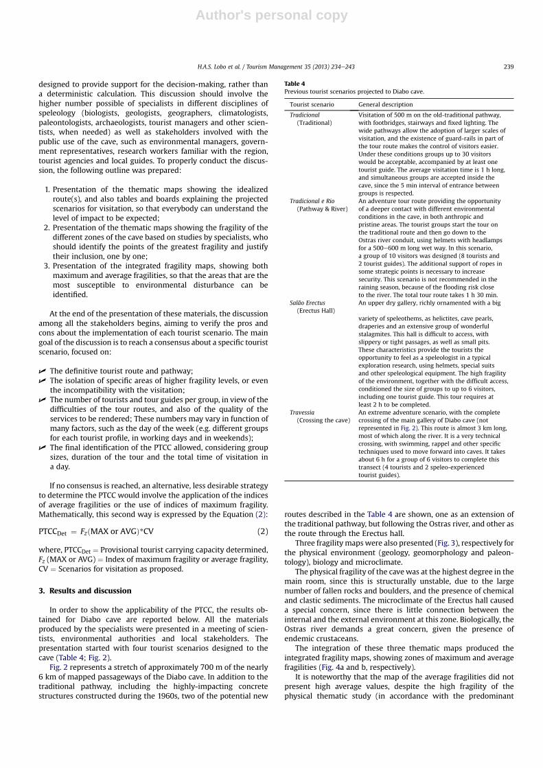
In order to show the applicability of the PTCC, the results ob-tained for Diabo cave are reported below. All the materialsproduced by the specialists were presented in a meeting of scien-tists, environmental authorities and local stakeholders. Thepresentation started with four tourist scenarios designed to thecave (Table 4; Fig. 2).
Fig. 2 represents a stretch of approximately 700 m of the nearly6 km of mapped passageways of the Diabo cave. In addition to thetraditional pathway, including the highly-impacting concretestructures constructed during the 1960s, two of the potential new
routes described in the Table 4 are shown, one as an extension ofthe traditional pathway, but following the Ostras river, and other asthe route through the Erectus hall.
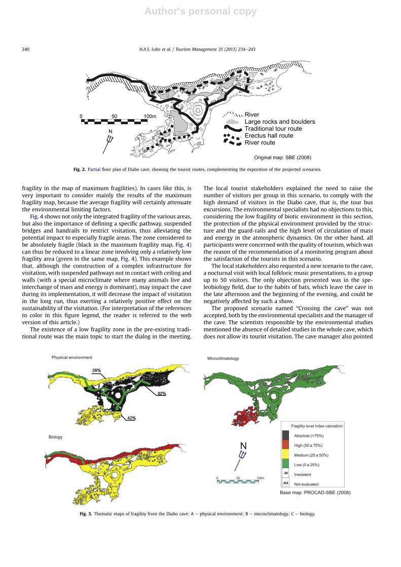
Three fragility mapswere also presented (Fig. 3), respectively forthe physical environment (geology, geomorphology and paleon-tology), biology and microclimate.
The physical fragility of the cavewas at the highest degree in themain room, since this is structurally unstable, due to the largenumber of fallen rocks and boulders, and the presence of chemicaland clastic sediments. The microclimate of the Erectus hall causeda special concern, since there is little connection between theinternal and the external environment at this zone. Biologically, theOstras river demands a great concern, given the presence ofendemic crustaceans.
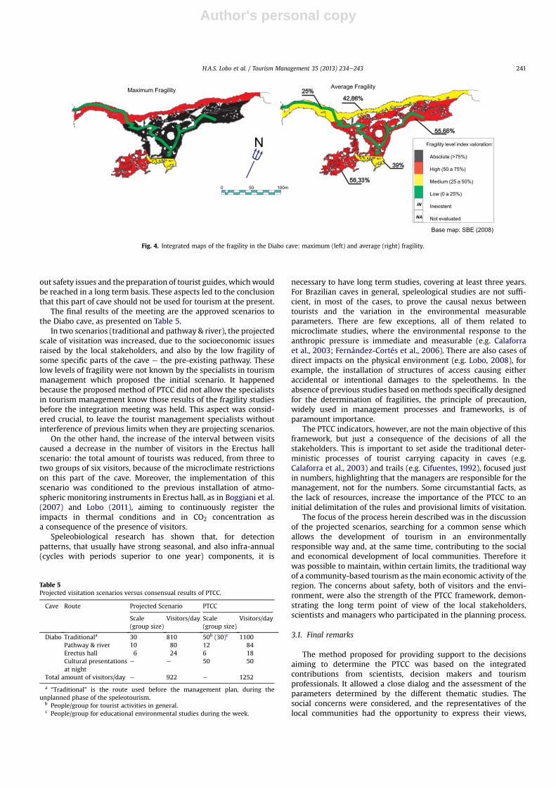
The integration of these three thematic maps produced theintegrated fragility maps, showing zones of maximum and averagefragilities (Fig. 4a and b, respectively).
It is noteworthy that the map of the average fragilities did notpresent high average values, despite the high fragility of thephysical thematic study (in accordance with the predominant
Table 4Previous tourist scenarios projected to Diabo cave.
Tourist scenario General description
Tradicional(Traditional)
Visitation of 500 m on the old-traditional pathway,with footbridges, stairways and fixed lighting. Thewide pathways allow the adoption of larger scales ofvisitation, and the existence of guard-rails in part ofthe tour route makes the control of visitors easier.Under these conditions groups up to 30 visitorswould be acceptable, accompanied by at least onetourist guide. The average visitation time is 1 h long,and simultaneous groups are accepted inside thecave, since the 5 min interval of entrance betweengroups is respected.
Tradicional e Rio(Pathway & River)
An adventure tour route providing the opportunityof a deeper contact with different environmentalconditions in the cave, in both anthropic andpristine areas. The tourist groups start the tour onthe traditional route and then go down to theOstras river conduit, using helmets with headlampsfor a 500e600 m long wet way. In this scenario,a group of 10 visitors was designed (8 tourists and2 tourist guides). The additional support of ropes insome strategic points is necessary to increasesecurity. This scenario is not recommended in theraining season, because of the flooding risk closeto the river. The total tour route takes 1 h 30 min.
Salão Erectus(Erectus Hall)
An upper dry gallery, richly ornamented with a big
variety of speleothems, as helictites, cave pearls,draperies and an extensive group of wonderfulstalagmites. This hall is difficult to access, withslippery or tight passages, as well as small pits.These characteristics provide the tourists theopportunity to feel as a speleologist in a typicalexploration research, using helmets, special suitsand other speleological equipment. The high fragilityof the environment, together with the difficult access,conditioned the size of groups to up to 6 visitors,including one tourist guide. This tour requires atleast 2 h to be completed.
Travessia(Crossing the cave)
An extreme adventure scenario, with the completecrossing of the main gallery of Diabo cave (notrepresented in Fig. 2). This route is almost 3 km long,most of which along the river. It is a very technicalcrossing, with swimming, rappel and other specifictechniques used to move forward into caves. It takesabout 6 h for a group of 6 visitors to complete thistransect (4 tourists and 2 speleo-experiencedtourist guides).
H.A.S. Lobo et al. / Tourism Management 35 (2013) 234e243 239
Author's personal copy
fragility in the map of maximum fragilities). In cases like this, isvery important to consider mainly the results of the maximumfragility map, because the average fragility will certainly attenuatethe environmental limiting factors.
Fig. 4 shows not only the integrated fragility of the various areas,but also the importance of defining a specific pathway, suspendedbridges and handrails to restrict visitation, thus alleviating thepotential impact to especially fragile areas. The zone considered tobe absolutely fragile (black in the maximum fragility map, Fig. 4)can thus be reduced to a linear zone involving only a relatively lowfragility area (green in the same map, Fig. 4). This example showsthat, although the construction of a complex infrastructure forvisitation, with suspended pathways not in contact with ceiling andwalls (with a special microclimate where many animals live andinterchange of mass and energy is dominant), may impact the caveduring its implementation, it will decrease the impact of visitationin the long run, thus exerting a relatively positive effect on thesustainability of the visitation. (For interpretation of the referencesto color in this figure legend, the reader is referred to the webversion of this article.)
The existence of a low fragility zone in the pre-existing tradi-tional route was the main topic to start the dialog in the meeting.
The local tourist stakeholders explained the need to raise thenumber of visitors per group in this scenario, to comply with thehigh demand of visitors in the Diabo cave, that is, the tour busexcursions. The environmental specialists had no objections to this,considering the low fragility of biotic environment in this section,the protection of the physical environment provided by the struc-ture and the guard-rails and the high level of circulation of massand energy in the atmospheric dynamics. On the other hand, allparticipants were concernedwith the quality of tourism, whichwasthe reason of the recommendation of a monitoring program aboutthe satisfaction of the tourists in this scenario.
The local stakeholders also requested a new scenario to the cave,a nocturnal visit with local folkloric music presentations, to a groupup to 50 visitors. The only objection presented was in the spe-leobiology field, due to the habits of bats, which leave the cave inthe late afternoon and the beginning of the evening, and could benegatively affected by such a show.
The proposed scenario named “Crossing the cave” was notaccepted, both by the environmental specialists and themanager ofthe cave. The scientists responsible by the environmental studiesmentioned the absence of detailed studies in the whole cave, whichdoes not allow its tourist visitation. The cave manager also pointed
Physical environment Microclimatology
Biology
28%
42%
92%
0 50 100m
N
Fragility level index valoration:
Absolute (>75%)
High (50 a 75%)
Medium (25 a 50%)
Low (0 a 25%)
Inexistent
Not evaluated
IN
NA
Base map: PROCAD-SBE (2008)
Fig. 3. Thematic maps of fragility from the Diabo cave: A e physical environment; B e microclimatology; C e biology.
Fig. 2. Partial floor plan of Diabo cave, showing the tourist routes, complementing the exposition of the projected scenarios.
H.A.S. Lobo et al. / Tourism Management 35 (2013) 234e243240
Author's personal copy
out safety issues and the preparation of tourist guides, whichwouldbe reached in a long term basis. These aspects led to the conclusionthat this part of cave should not be used for tourism at the present.
The final results of the meeting are the approved scenarios tothe Diabo cave, as presented on Table 5.
In two scenarios (traditional and pathway & river), the projectedscale of visitation was increased, due to the socioeconomic issuesraised by the local stakeholders, and also by the low fragility ofsome specific parts of the cave e the pre-existing pathway. Theselow levels of fragility were not known by the specialists in tourismmanagement which proposed the initial scenario. It happenedbecause the proposed method of PTCC did not allow the specialistsin tourism management know those results of the fragility studiesbefore the integration meeting was held. This aspect was consid-ered crucial, to leave the tourist management specialists withoutinterference of previous limits when they are projecting scenarios.
On the other hand, the increase of the interval between visitscaused a decrease in the number of visitors in the Erectus hallscenario: the total amount of tourists was reduced, from three totwo groups of six visitors, because of the microclimate restrictionson this part of the cave. Moreover, the implementation of thisscenario was conditioned to the previous installation of atmo-spheric monitoring instruments in Erectus hall, as in Boggiani et al.(2007) and Lobo (2011), aiming to continuously register theimpacts in thermal conditions and in CO2 concentration asa consequence of the presence of visitors.
Speleobiological research has shown that, for detectionpatterns, that usually have strong seasonal, and also infra-annual(cycles with periods superior to one year) components, it is
necessary to have long term studies, covering at least three years.For Brazilian caves in general, speleological studies are not suffi-cient, in most of the cases, to prove the causal nexus betweentourists and the variation in the environmental measurableparameters. There are few exceptions, all of them related tomicroclimate studies, where the environmental response to theanthropic pressure is immediate and measurable (e.g. Calaforraet al., 2003; Fernández-Cortés et al., 2006). There are also cases ofdirect impacts on the physical environment (e.g. Lobo, 2008), forexample, the installation of structures of access causing eitheraccidental or intentional damages to the speleothems. In theabsence of previous studies based onmethods specifically designedfor the determination of fragilities, the principle of precaution,widely used in management processes and frameworks, is ofparamount importance.
The PTCC indicators, however, are not the main objective of thisframework, but just a consequence of the decisions of all thestakeholders. This is important to set aside the traditional deter-ministic processes of tourist carrying capacity in caves (e.g.Calaforra et al., 2003) and trails (e.g. Cifuentes, 1992), focused justin numbers, highlighting that the managers are responsible for themanagement, not for the numbers. Some circumstantial facts, asthe lack of resources, increase the importance of the PTCC to aninitial delimitation of the rules and provisional limits of visitation.
The focus of the process herein described was in the discussionof the projected scenarios, searching for a common sense whichallows the development of tourism in an environmentallyresponsible way and, at the same time, contributing to the socialand economical development of local communities. Therefore itwas possible to maintain, within certain limits, the traditional wayof a community-based tourism as the main economic activity of theregion. The concerns about safety, both of visitors and the envi-ronment, were also the strength of the PTCC framework, demon-strating the long term point of view of the local stakeholders,scientists and managers who participated in the planning process.
3.1. Final remarks
The method proposed for providing support to the decisionsaiming to determine the PTCC was based on the integratedcontributions from scientists, decision makers and tourismprofessionals. It allowed a close dialog and the assessment of theparameters determined by the different thematic studies. Thesocial concerns were considered, and the representatives of thelocal communities had the opportunity to express their views,
Maximum Fragility
0 50 100m
N Fragility level index valoration:
Absolute (>75%)
High (50 a 75%)
Medium (25 a 50%)
Low (0 a 25%)
Inexistent
Not evaluated
IN
NA
Base map: SBE (2008)
Average Fragility
42,66%
39%
55,66%
58,33%
25%
Fig. 4. Integrated maps of the fragility in the Diabo cave: maximum (left) and average (right) fragility.
Table 5Projected visitation scenarios versus consensual results of PTCC.
Cave Route Projected Scenario PTCC
Scale(group size)
Visitors/day Scale(group size)
Visitors/day
Diabo Traditionala 30 810 50b (30)c 1100Pathway & river 10 80 12 84Erectus hall 6 24 6 18Cultural presentationsat night
e e 50 50
Total amount of visitors/day e 922 e 1252
a “Traditional” is the route used before the management plan, during theunplanned phase of the speleotourism.
b People/group for tourist activities in general.c People/group for educational environmental studies during the week.
H.A.S. Lobo et al. / Tourism Management 35 (2013) 234e243 241
Author's personal copy
marked by the ideal of an environmental conservation compatiblewith the protection of natural areas. Local tourist operators werealso able to point their needs in relation to the limits and categoriesof visitation to be respected. This approach modified the traditionalconcept of carrying capacity, consolidated as a planning tooldesigned to open possibilities.
The projected scenarios and the thematic maps that wereproduced, followed by the wide discussion in a multidisciplinarymeeting, showed the applicability of the method. The commonsense of stakeholders interested in sustainable tourism in caves,allied to a qualified discussion based on thematic studies, solvedthe initial problems involved in the limitation of tourist access tocaves and the terms to the tourist use. A responsible interactionbetween all the participants was fundamental to establish thelimits and the possibilities of use of sensitive areas, not only forcaves but also for other special environments (e.g. coral reefs,archaeological and paleontological sites, snowy mountains etc). Insuch cases, the central challenge to adapt the present method is theidentification of the criteria to analyze the environment in itsrelationship with the tourist use.
Thus, it is understood that carrying capacities based on a flexiblemodel, aligning an analysis of situations of environmental conser-vation with the needs of the management and the maintenance oftourism, provides flexible results based on a reasoning which takesthe idea of capacity beyond the simple idea of limitation. Thus theconcept of carrying capacity is reaffirmed as a possibility fora rational and sustainable use, rather than simply limiting it.
Finally, given the characteristics of themethod, it is important toemphasize that the results obtainedmust alwaysbe considered tobeprovisional. Future developments and the application of protocolsfor environmental monitoring based are essential, on at least thecritical factors identified for each tourist cave, within the acceptablelimits for any alteration of the environment. Further studies willallow a more realistic approach to the actual limits which eachenvironment being managed could sustain. Therefore, changes intourist demand should also be considered, in order to adjust thevisitation levels to the prospect number of tourists, without dis-regarding the needs of local people which depend directly on thecommunity-based tourism, alwayswithin the perspective of a long-term use, for the present and the future generations.
References
Ab’Saber, A. N. (1977). Os domínios morfoclimáticoa na América do Sul. Geo-morfologia, 52, 1e22.
Arrowsmith, C., & Inbakaran, R. (2002). Estimating environmental resilience for theGrampians National Park, Victoria, Australia: a quantitative approach. TourismManagement, 23(3), 295e309.
Auler, A., & Farrant, A. A. (1996). A brief introduction to karst and caves in Brazil.Proceedings of the University of Bristol Speleological Society, 20, 187e200.
Bichuette, M. E., & Trajano, E. (2010). Conservation of subterranean fishes. InE. Trajano, M. E. Bichuette, & B. G. Kapoor (Eds.), Biology of subterranean fishes(pp. 65e80). Enfield: Science Publ.
Boggiani, P. C., Silva, O. J., Gesicki, A. L. D., Galati, E., Salles, L. O., & Lima, M. M. E. R.(2007). Definição de capacidade de carga turística das cavernas do MonumentoNatural Gruta do Lago Azul (Bonito, MS). Geociências, 26(4), 333e348.
Calaforra, J. M., Fernández-Cortés, A., Sánchez-Martos, F., Gisbert, J., & Pulido-Bosch, A. (2003). Environmental control for determining human impact andpermanent visitor capacity in a potential show cave before tourist use. Envi-ronmental Conservation, 30(2), 160e167.
Ceballos-Lascuráin, H. (1998). Ecoturismo, naturaleza y desarrollo sostenible. MéxicoD.F.: Editorial Diana.
Cifuentes, M. C. (1992). Determinación de capacidad de carga turística en áreas pro-tegidas. Turrialba: CATIE.
Cigna, A. A. (1993). Environmental management of tourist caves: the examples ofGrotta di Castellana and Grotta Grande del Vento, Italy. Environmental Geology,21, 173e180.
Cigna, A. A., & Burri, E. (2000). Development, management and economy of showcaves. International Journal of Speleology, 29(1), 1e27.
Cigna, A. A., & Forti, P. (1988). The environmental impact assessment of a touristcave. In UIS. (Ed.), Cave Tourism International Symposium at 170eAnniversary ofPostojnska Jama.
Fernández-Cortés, A., Calaforra, J. M., & Sánchez-Martos, F. (2006). Spatiotem-poral analysis of air condition as a tool for the environmental managementof a show cave (Cueva del Agua, Spain). Atmospheric Environment, 40, 7378e7394.
Ford, D., & Williams, P. (2007). Karst hydrogeology and geomorphology (2nd ed.).West Sussex: Wiley.
Gillieson, D. (1996). Caves: Processes, development and management. Cambridge:Blackwell.
Heaton, T. (1986). Caves: a tremendous range in energy environments on earth.National Speleological Society News, 8(44), 301e304.
Hoyos, M., Soler, V., Cañaveras, J. C., Sánchez-Moral, S., & Sanz-Rubio, E. (1998).Microclimatic characterization of a Karstic cave: human impact on microenvi-ronmental parameters of a prehistoric rock art cave (Candamo cave, NorthernSpain). Environmental Geology, 33(4), 231e242.
Labegalini, J. A. (1990). Infraestructura para cavernas turísticas. Spelaion, 1(1), 33e39.Le Bret, M. (1995). Maravilhoso Brasil subterrâneo. Jundiaí: Japi/SBE.Lindberg, K., McCool, S., & Stankey, G. (1997). Rethinking carrying capacity. Annals of
Tourism Research, 24, 461e465.Lino, C. F. (1988). Manejo de cavernas para fins turísticos: base conceitual e metodo-
lógica. São Paulo: C.F.Lino.Lobo, H. A. S. (2007). Método para avaliação do potencial espeleoturístico do
Parque Nacional da Serra da Bodoquena, MS. Caderno Virtual de Turismo, 7(3),99e110.
Lobo, H. A. S. (2008). Capacidade de carga real (CCR) da caverna de Santana, PETAR-SP e indicações para o seu manejo turístico. Geociências, 27(3), 369e385.
Lobo, H. A. S. (2009). Zoneamento ambiental espeleológico (ZAE): aproximaçãoteórica e delimitação metodológica. Tourism and Karst Areas, 2(2), 113e129.
Lobo, H. A. S. (2011). Study of the dynamics of the subterranean atmosphere in thedetermination of carrying capacity of show caves (CCSC): Case study in the cave ofSantana (PETAR e Iporanga, SP e Brazil). Unpublished thesis. São Paulo StateUniversity, Rio Claro, São Paulo.
Marinho, M. de A. (2002). Projeto “plano de uso recreativo do PETAR, Iporanga e Apiaí/SP. São Paulo: WWF/Ing_Ong.
Pulido-Bosch, A., Martín-Rosales, W., López-Chicano, M., Rodríguez-Navarro, M., &Vallejos, A. (1997). Human impact in a tourist karstic cave (Aracena, Spain).Environmental Geology, 31(3/4), 142e149.
Sallun Filho, W., Ferrari, J. A., Hiruma, S. T., Sallun, A. E. M., & Karmann, I. (2010).O carste no plano de manejo do Parque Estadual Intervales e zona de amor-tecimento, Estado de São Paulo, Brasil. Revista Escola de Minas, 63(3), 441e448.
Santana-Jiménez, Y., & Hernández, J. M. (2010). Estimating the effect of over-crowding on tourist attraction: the case of Canary Islands. Tourism Management,32(2), 415e425.
SBE e Sociedade Brasileira de Espeleologia. (2008). Mapa da caverna do Diabo.Campinas: SBE.
Simón, F. G., Narangajavana, Y., & Marqués, D. P. (2004). Carrying capacity in thetourism industry: a case study of Hengistbury Head. Tourism Management,25(2), 275e283.
Stankey, G. H., Cole, D. N., Lucas, R. C., Petersen, M. E., & Frissell, S. S. (1985). Thelimits of acceptable change (LAC) system for wilderness planning. Ogden: USDAForest Service/Intermountain Forest and Range Experiment Station.
Trajano, E. (2005). Evolution of lineages. In D. C. Culver, & W. B. White (Eds.), Theencyclopedia of caves (pp. 230e234). San Diego: Elsevier Academic Press.
Trajano, E. (2010). Políticas de conservação e critérios ambientais: princípios, con-ceitos e protocolos. Estudos Avançados, 24(68), 135e146.
H.A.S. Lobo et al. / Tourism Management 35 (2013) 234e243242
Author's personal copy
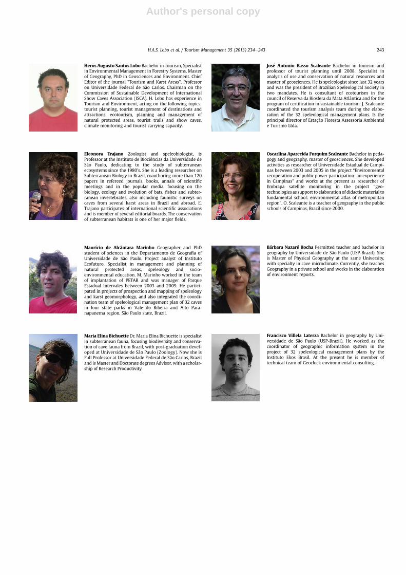
Heros Augusto Santos Lobo Bachelor in Tourism, Specialistin Environmental Management in Forestry Systems, Masterof Geography, PhD in Geosciences and Environment. ChiefEditor of the journal "Tourism and Karst Areas". Professoron Universidade Federal de São Carlos. Chairman on theCommission of Sustainable Development of InternationalShow Caves Association (ISCA). H. Lobo has experience inTourism and Environment, acting on the following topics:tourist planning, tourist management of destinations andattractions, ecotourism, planning and management ofnatural protected areas, tourist trails and show caves,climate monitoring and tourist carrying capacity.
Eleonora Trajano Zoologist and speleobiologist, isProfessor at the Instituto de Biociências da Universidade deSão Paulo, dedicating to the study of subterraneanecosystems since the 1980’s. She is a leading researcher onSubterranean Biology in Brazil, coauthoring more than 120papers in refereed journals, books, annals of scientificmeetings and in the popular media, focusing on thebiology, ecology and evolution of bats, fishes and subter-ranean invertebrates, also including faunistic surveys oncaves from several karst areas in Brazil and abroad. E.Trajano participates of international scientific associationsand is member of several editorial boards. The conservationof subterranean habitats is one of her major fields.
Maurício de Alcântara Marinho Geographer and PhDstudent of sciences in the Departamento de Geografia ofUniversidade de São Paulo. Project analyst of InstitutoEcofuturo. Specialist in management and planning ofnatural protected areas, speleology and socio-environmental education. M. Marinho worked in the teamof implantation of PETAR and was manager of ParqueEstadual Intervales between 2003 and 2009. He partici-pated in projects of prospection and mapping of speleologyand karst geomorphology, and also integrated the coordi-nation team of speleological management plan of 32 cavesin four state parks in Vale do Ribeira and Alto Para-napanema region, São Paulo state, Brazil.
Maria Elina BichuetteDr. Maria Elina Bichuette is specialistin subterranean fauna, focusing biodiversity and conserva-tion of cave fauna from Brazil, with post-graduation devel-oped at Universidade de São Paulo (Zoology). Now she isFull Professor at Universidade Federal de São Carlos, Braziland isMaster and Doctorate degrees Advisor, with a scholar-ship of Research Productivity.
José Antonio Basso Scaleante Bachelor in tourism andprofessor of tourist planning until 2008. Specialist inanalysis of use and conservation of natural resources andmaster of geosciences. He is speleologist since last 32 yearsand was the president of Brazilian Speleological Society intwo mandates. He is consultant of ecotourism in thecouncil of Reserva da Biosfera da Mata Atlântica and for theprogram of certification in sustainable tourism. J. Scaleantecoordinated the tourism analysis team during the elabo-ration of the 32 speleological management plans. Is theprincipal director of Estação Floresta Assessoria Ambientale Turismo Ltda.
Oscarlina Aparecida Furquim Scaleante Bachelor in peda-gogy and geography, master of geosciences. She developedactivities as researcher of Universidade Estadual de Campi-nas between 2003 and 2005 in the project “Environmentalrecuperation and public power participation: an experiencein Campinas” and works at the present as researcher ofEmbrapa satellite monitoring in the project “geo-technologies as support to elaboration of didacticmaterial tofundamental school: environmental atlas of metropolitanregion”. O. Scaleante is a teacher of geography in the publicschools of Campinas, Brazil since 2000.
Bárbara Nazaré Rocha Permitted teacher and bachelor ingeography by Universidade de São Paulo (USP-Brazil). Sheis Master of Physical Geography at the same University,with specialty in cave microclimate. Currently, she teachesGeography in a private school and works in the elaborationof environment reports.
Francisco Villela Laterza Bachelor in geography by Uni-versidade de São Paulo (USP-Brazil). He worked as thecoordinator of geographic information system in theproject of 32 speleological management plans by theInstituto Ekos Brasil. At the present he is member oftechnical team of Geoclock environmental consulting.
H.A.S. Lobo et al. / Tourism Management 35 (2013) 234e243 243
Related Documents