Welcome message from author
This document is posted to help you gain knowledge. Please leave a comment to let me know what you think about it! Share it to your friends and learn new things together.
Transcript


i
Project Personnel
Project Coordinator Nidhi Kundu
Sr. Scientific Assistant ‘SG’
Co- Coordinator Dr. Kapil Rohilla
Assistant Scientist
Team Members Deep chand
Sunil Saxena
Chander Shekhar
(Project Assistant)
Overall Coordination Dr. V. S. Arya
Director, HARSAC
ii
PREFACE
The emergence of GIS and its development over the last two decades have revolutionized the
planner’s mode of working and their art of decision making. The field of GIS is currently
expanding at a tremendous rate and it has been found applicable in a number of natural
resources, urban & infrastructure planning and environmental management task like utility
planning, facilities location, landuse,Transportation, site selection and land suitability analysis.
The system supports different types of analysis and provides agencies, organizations and
institutions with a more powerful decision support tool to make more informed decisions
regarding natural resources, infrastructure and environmentl management.
The primary responsibility entrusted upon HARSAC is the evolution of the databases on
natural resources, infrastucture and environment in the state to ensure their management for
sustainable use. HARSAC has already developed a lot of database on various themes using
remote sensing and GIS techniques.
For quick visualization and appreciation of an area, maps are the best source of information.
Keeping in view the importance of spatial data, the present, “Mapping of Dry wells in karnal
District Using High Resolution imagery and GIS Techniques”has been brought out by
HARSAC. I hope this study will serve as a very good reference material for the administrator,
planner, researchers and the students.
(Dr. V. S. Arya)
Director, HARSAC
iii
ACKNOWLEDGEMENTS
The project entitled, “Mapping of Dry wells in karnal District Using High Resolution
imagery and GIS Techniques” has been sponsored by Department of Environment & Climate
Change, Haryana to provide mapping of dry wells in Karnal District.
We extend our sincere thanks to Smt. Dheera khandelwal additional chief secretary
Environment & Climate Change, Sh. Vijayendra Kumar, IAS, Director General, Dr. R. K.
Chauhan, Joint Director, Environment & Climate Change Haryana for imposing trust in the
state-of-the-art technology and providing financial assistance for the study.
We also extend our thanks to Dr. Ashok Khemka, IAS, Principal Secretary to Govt. Haryana,
Science & Technology Department cum Chairman HARSAC for his all over support to this
scientific study.
Thanks are also due to Sh. Praveen Kumar, IAS, Director General, Science & Technology,
Haryana cum Director HARAC for his consistent encouragement and help of this study.
We extremely thankful to Director, HARSAC for his constant support and help in all aspects of
project work.
We would like to place on records the heartfelt thanks to Dr. R. K. Chauhan, Joint Director,
Environment & Climate Change Haryana for continuous interaction with HARSAC in
connection with project related activities. Help rendered by other staff members of HARSAC is
also fully acknowledged.
Authors

iv
CONTENTS
Page No.
Project Personnel i
Preface ii
Acknowledgement iii
List of Figures v
List of Tables v
Excutive Summary vi
1.Introduction 1-2
2.Description of the study area 3-7
2.1 Ground water scenario of the study area 4
2.1.1 Hydrogeology 4
2.2 Rainfall & Climate 5
2.3 Geomorphology & Soil types 5
2.4 Physiography and Drainage 6
3. Methodology 8-9
3.1 Development of mobile application 8
3.1.1 Database Used 8
3.1.2 Application Programming Interface 8
3.1.3 Hypertext Markup Language 8
3.1.4 Java Script 8
4. Results and discussion 10
5. Conclusions 13
Recommendations 13
References 14

v
LIST OF FIGURES
Fig. No. Description Page No.
Fig.1. Location map of study area 7
Fig.2. Flow chart showing the working of Android based Mobile App 9
Fig.3. A view of Android based Mobile App used for mapping of dry wells 10
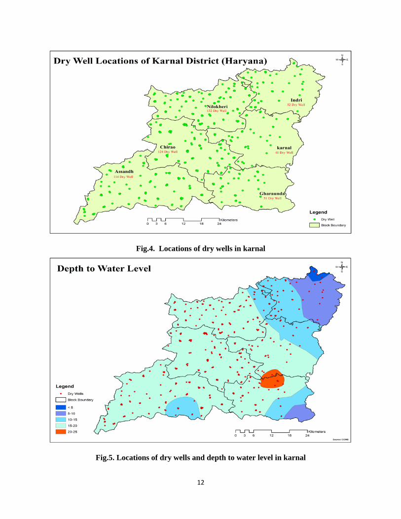
Fig.4. Location dry wells in Karnal 12
Fig.5. Location of dry wells and depth to water level in Karnal 12
LIST OF TABLES
Table. No. Description Page No.
Table.1 Spatial distribution of dry wells in Karnal 11
vi
EXECUTIVE SUMMARY
The ground water development in all the blocks of the district has exceeded the available
recharge and thus all the blocks have been categorized as over exploited.Water for irrigation in
the district is based on both ground water and canal surface water. Ground water contributes 95
% of the total need for agriculture. Ground water is being extracted through a large number of
shallow tubewells and dug cum bore holes which tap unconfined layer up to the average depth of
60-80m. Entire drinking water supply to all rural as well as urban parts of the district is based on
ground water only. This is basically due to the fact that the quality of ground water is fresh and
potable all over.Therefore, most of water wells have been converted into dry wells. Drywells can
be used to facilitate stormwater infiltration and groundwater recharge in areas where drainage
and diversion of storm flows is problematic. Historically, drywells have predominantly been
used as a form of stormwater management in locations that receive high volumes of
precipitation; however the use of drywells is increasingly being evaluated as a method to
supplement groundwater recharge, especially in areas facing severe drought.
Department of Environment & Climate Change, Haryna approached HARSAC to provide the
spatial as well as statistical information on dry wells in Karnal District using high resolution
imagery and GIS techniques. The present report describes the methodology and results of
locations of dry wells in different blocks of karnal distict.
An Android based Mobile App was developed for GPS based dry well mapping.GIS
Mapping of Dry wells in Karnal was conducted using the mobile based App.A team was
deployed block wise to map all the dry wells in a village. Attributes such as Diameter, Depth to
vii
water table and type of well (lined or unlined) etc. were also be collected during field survey. All
this data collected were individually processed and analysed in GIS environment.
Total no of dry wells in district were observed to be 514.Study indicates that the maximum of
dry wells are in Nilokheri block and minimum no of wells in the Karnal block of the district.It
was also observed that the all of wells were lined and dried. All the blocks fall under over-
exploited category which leads to constant decline of water level over past years in whole district
except some of the area. There is no scope for further ground water development. Only measures
should be taken to reduce dependency on ground water and to enhance the ground water
recharging resources. Excess rain water in agricultural field, surplus canal water and rooftop rain
water can be injected to ground water system. Recharging shafts and injection wells are
recharging structures suitable for the district.

1
1. Introduction
Dry wells are bored holes completed in alluvial deposits above the water table, designed
to efficiently dispose of storm water into the subsurface. Dry well is a storm water runoff
reduction tools that can be used to achieve the goals of minimizing hydrologic changes
associated with urbanization. As impervious surfaces expand with urbanization, rain is
unable to penetrate the soil. This creates large volumes of runoff that are typically directed
into piped storm water conveyance system which increases the volume of runoff and the
speed in which it reaches local waterways. This change in the urban hydrograph reduces the
potential for groundwater recharge and damages aquatic habitat in creeks and rivers. Dry
wells can help minimize these effects by allowing storm water to bypass soils with poor
infiltration rates to reach more permeable layers.
These qualities of dry wells make them a useful tool to help meet storm water
management requirements. Dry wells also provide a sustainable and environmentally
friendly drainage solution that avoids costly, underground mechanical devices and can serve
as a Low Impact Development tool. They can incorporate pretreatment features such as
grassy swales and sedimentation basins for additional storm water treatment. Dry wells
can protect waterways from erosion caused by direct storm water discharge and reduce the
harmful effects that traditional storm water management practices have had on the aquatic
ecosystem. Dry wells not only aid in storm water runoff reduction and increase groundwater
recharge, but they can also minimize the risk of flooding, are economical and have minimal
space requirements.
Dry wells can be used to reduce the increased volume of stormwater runoff caused by roofs
of buildings. While generally not a significant source of runoff pollution, roofs are one of the
2
most important sources of new or increased runoff volume from land development sites. Dry
wells can also be used to indirectly enhance water quality by reducing the amount of stormwater
quality design storm runoff volume to be treated by the other, downstream stormwater
management facilities. Dry well use has been limited in some places by the concern that dry
wells could contaminate groundwater, including drinking water, by reducing the distance
contaminated stormwater must travel through sediment in order to reach groundwater. Surface
soil and underground sediment remove contaminants by acting as a natural filter, but dry wells
allow stormwater contaminants to bypass many underground layers.
Efficient management of land and water resources requires comprehensive knowledge on
many variables including climate, soil, land use, crops,water availability, water distribution
networks, management practices, etc. Most of these data are spatially distributed and their
integration and use in ground water requires widespread utilization of Geographic Information
Systems (GIS) and other modern information technologies. GIS technology in conjunction with
Remote Sensing has proved to be effective for land use and water management. Effective
decision making on water use and ground water management, calls for generation of spatial and
non-spatial database in GIS platform. In fact, the employment of geo-referenced databases
enables faster exchange and aggregation of information coming from different sources, and
easier interaction of those data with models and decision support tools. Therefore, the present
study is planned with the following objectives:
1. Development of an Android based Mobile App for GPS based dry well mapping.
2. GIS Mapping of Dry wells in Karnal using the mobile based App.
3. Measurement of Diameter and depth to water table of dry wells.
4. Identification of Dry wells (lined or unlined).
3
2. Description of the study area
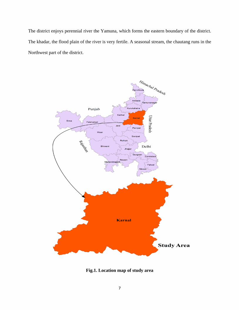
Karnal district lies on the western bank of the river Yamuna, which forms its eastern
boundary and separates Haryana from Uttar Pradesh and is bounded by North latitudes
29025’05”& 29059’20” and East longitudes 76027’40”& 77013’08” is shown in Fig.1, Its height
above sea level is around 240 meters The district covers 5.69% area of the state and is bordered
by Kurukshetra District on its northwest, Jind & Kaithal Districts on its west, Panipat District on
its south and Uttar Pradesh state on the east. The district is well connected by roads and railways.
The SherShah Sri Marg (NH No.1) runs through the entire length of the district. A broad gauge
railway line connecting Delhi with Ambala runs almost parallel to the NH No.1. Karnal is the
district headquarters. The main townships are Karnal, Indri, Assandh, Nissang, Nilokheri and
Gharaunda. Administratively the district comes under Rohtak division and it has five Tehsils,
three Sub-Tehsils and Six blocks. The district is one of the most densely populated districts of
the state. The total population of the district as per 2011census is 15,06,323. The district has a
population density of 587 per square kilometer (1,550 /sq mi). Its population growth rate over the
decade 2001-2011 was 18.22%. Karnal has a sex ratio of 886 females for every 1000 males, and
a literacy rate of 76.4%.
The district is a part of the Indus-Ganges plain (Upper Yamuna Basin) and has a well-spread
network of western Yamuna canals. Its geographical area has been divided into three
agroclimatic regions: Khadar, Bangar and Nardak belt. The river Yamuna which marks the
eastern boundary of the Haryana State as well as Karnal district provides the major drainage in
the area. Irrigation in the district is done by surface water as well as ground water. 70% of the net
irrigated area is covered through ground water. Karnal district was covered under water balance
studies of Upper Jamuna Project by CGWB during 1971-1978. The district was also covered
4
under Reappraisal hydrogeological studies during field season programme of CGWB during
1981-82 , 2004-05.
2.1 Ground water scenario of the study area
2.1.1 Hydrogeology
The area falls in the Upper Yamuna Basin and the principal ground water reservoir in the
area is unconsolidated alluvial deposits of Quaternary age. Ground water in near surface zone
occurs under water table conditions and occurs under semi confined to confined conditions in
deeper aquifers. Rain fall and seepage from the river Yamuna, canal networks and irrigation is
the principal source of ground water recharge in the area.The study of exploratory boreholes
drilled in the district during the Upper Yamuna Project of Central Ground Water Board indicated
presence of three tier aquifer groups upto 463 m depth below ground level.
Aquifer group-I: The Aquifer group I is composed of different sand and clay lenses and extends
from surface downwards to different depth varying down to 90m to 180m at different places and
occurs all over the area. This is composed of relatively coarser sediments. This group of aquifers
is underlain by a clayey horizon 10-15m thick which is regionally extensive. The average
transmissivity of this group was calculated by the Upper Yamuna Project of CGWB to be of the
order of 2200 m2/day, lateral permeability of the order of 24m/day and average storativity as
0.12.
Aquifer group-II: This group is composed of different sand and clay lenses and lies below
aquifer group-I and occurs at varying depths ranging between 115m and 195 m to 215m and
285m. The sediments of this group are less coarse and are mixed with some kankar. This group
is underlain by another clayey horizon, which is considerable thick at places and appears to be
5
regionally extensive. The average transmissivity of this group is 700m2/day, the average lateral
permeability is 7.2m/day and the average storativity is 1x10⁻³.
Aquifer group-III: The aquifer group III is composed of thin sand layers alternating with
thicker clay layers and occurs at variable depths ranging between 314 m to 405m.bgl. The
granular material of this group is generally finer and more so in the southerly direction. This
group has an average transmissivity value of 525m2/day, and average lateral permeability and
average storativity values of the order of 7.1m/day and 4.5x10⁻⁴ respectively.
2.2 Rainfall & Climate
The climate of the district is characterized by the dryness of the air with an intensely hot
summer and a cold winter. The year may be divided in to four seasons. The cold season starts by
late November and extends to the middle of March. It is followed by hot season which continues
to the end of June when the southwest monsoon arrives over the district. July to September is the
southwest monsoon season. The post monsoon season period is from October to December. The
normal annual rainfall of the district is 582mm recorded in 32 rainy days in a year. About
82.39% of the annual rainfall is recorded during the southwest monsoon from July to September.
August is the wettest month of the year with an average of 9.0 rainy days and 221.5 mm rainfall.
Maximum rainfall of 1404mm and minimum rainfall of 255mm were observed in the years 1998
and 1987 respectively.
2.3 Geomorphology & Soil types
The area represents almost an alluvial plain without any conspicuous topographical features
and forms a part of the vast Indo-Gangetic plain. The elevation of the area above mean sea level
ranges from 256 m amsl in the north to 245 m amsl in the south with an average elevation of
240m.amsl.The general slope of the area is southwards. In the north western part of the district
6
the land slopes south west wards. There are many topographical depressions in the area of which
the most pronounced is at Daha, south of Karnal.
The river Yamuna which marks the eastern boundary of the Haryana State as well as Karnal
district provides the major drainage in the area. The river Yamuna emerges from Yamnotri off
the Bansur-Punch glacier in Tehri Garhwal district of Uttarakhand at an elevation of 6330
meters. It emerges into the plains from the foothills at Kalesar just north of Tajewala. The
Chantang Nala is the other drainage line and flows from north to southwest in the western part of
the district and disappears near Assandh. The soils in Gharaunda and SE half of Karnal blocks
are young, stratified with no profile development. They are sandy to fine sandy loams. The soils
in SE half of Nilokheri, SW extremity of Karnal block touching Nilokheri, eastern portion of
Nissang, Western half of Gharaunda block are heavily textured varying from sandy loam at the
surface to clayey loam at about one meter depth.
2.4 Physiography and Drainage
The district is a part of alluvial plain of Yamuna river. It slope from west to east and water
of the area flows towards Yamuna. There are two major physiograpic units in the area.
The khadar, existing within one mile of Yamuna river. It has light soil and the water table very
near to surface. It is a flood plain of the river Yamuna and is suitable for rice and sugarcane
cultivation.
The other unit is the upland plain spreading in the western part of the district and is inclined
towards the south and south-west and covers the karnal Banger area. This area is eastward
extension of the upland plain of kaithal district. It is irrigated by tubewells and canals and is a
prosperous agricultural area.
7
The district enjoys perennial river the Yamuna, which forms the eastern boundary of the district.
The khadar, the flood plain of the river is very fertile. A seasonal stream, the chautang runs in the
Northwest part of the district.
Fig.1. Location map of study area

8
3. Methodology
3.1 Development of mobile application
The dry well mapping application has been developed using database, designing, coding, and
API (application programming interface). A flow chart showing the working of Android based
Mobile App used for maaping of dry wells is shown in Fig.2. Fig 3.provides graphical interface
of Android based Mobile App.
3.1.1 Database used: The application is developed by using Postgre SQL relational database
management system which provides the effective and modern features like views, transactions,
concurrency control and complex queries of SQL.
3.1.2 Application programming Interface: It has been designed by using the Eclipse
environment. API acts as a means of communication between frontend (user interface) and
backend (database). These APIs are mainly used for the positioning with the help of GPS.
3.1.3 Hypertext markup language: It is a markup language mainly used for the designing
purpose. This language is mainly based on the tags which performs different functions. The main
reason to use this language is its features like easy to learn and handling.
3.1.4 Java script: It is used for making the services of the application which respond according
to the given input.
The application consists of various fields which found to be mandatory in order to collect the
proper data of the dry wells which are following:
GPS Location
Phone Number
Dry Well Diameter
Water depth
Dry well condition
Height of well from ground
Landmark
Remark
Take photo

9
Fig.2. Flow chart showing the working of Android based Mobile App
Reach the specific location of drywell and open the application installed in mobile
Open the GPS location if not ON
Latitude and Longitude will be captured by the App
automatically
Capture the image of dry well using app
Submit the data to server
Fill the required fields in the mobile App

10
Fig.3. A view of Android based Mobile App used for mapping of dry wells
4. Results and discussion
The study has been carried with the help of Android based Mobile App. A team was
deployed block wise to map all the dry wells in a village. Android based Mobile app/GPS was
used for Mapping of Dry wells in Karnal. Attributes such as Diameter, Depth to water table and
type of well (lined or unlined) etc. were also be collected during field survey. All this data
collected were individually processed and analysed in GIS environment. Dry wells and its
attributes collected block wise during field survey are shown in Table 1. During the field survey,
the maximum of of dry wells was spotted in Nilokheri block and minimum no of wells in karnal
block of district.It was also observed that the all of wells were lined and dried.
11
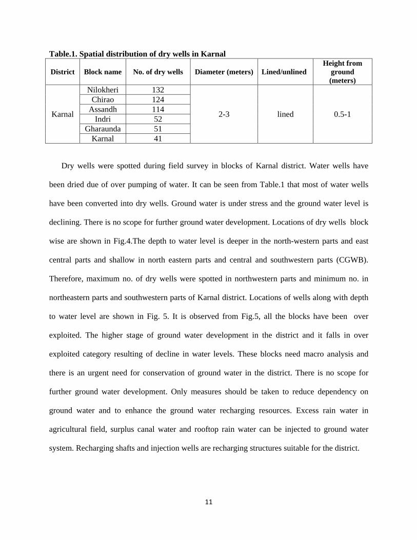
Table.1. Spatial distribution of dry wells in Karnal
District Block name No. of dry wells Diameter (meters) Lined/unlined Height from
ground (meters)
Karnal
Nilokheri 132
2-3 lined 0.5-1
Chirao 124 Assandh 114
Indri 52 Gharaunda 51
Karnal 41
Dry wells were spotted during field survey in blocks of Karnal district. Water wells have
been dried due of over pumping of water. It can be seen from Table.1 that most of water wells
have been converted into dry wells. Ground water is under stress and the ground water level is
declining. There is no scope for further ground water development. Locations of dry wells block
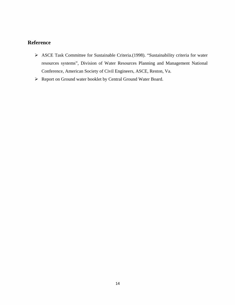
wise are shown in Fig.4.The depth to water level is deeper in the north-western parts and east
central parts and shallow in north eastern parts and central and southwestern parts (CGWB).
Therefore, maximum no. of dry wells were spotted in northwestern parts and minimum no. in
northeastern parts and southwestern parts of Karnal district. Locations of wells along with depth
to water level are shown in Fig. 5. It is observed from Fig.5, all the blocks have been over
exploited. The higher stage of ground water development in the district and it falls in over
exploited category resulting of decline in water levels. These blocks need macro analysis and
there is an urgent need for conservation of ground water in the district. There is no scope for
further ground water development. Only measures should be taken to reduce dependency on
ground water and to enhance the ground water recharging resources. Excess rain water in
agricultural field, surplus canal water and rooftop rain water can be injected to ground water
system. Recharging shafts and injection wells are recharging structures suitable for the district.
12
Fig.4. Locations of dry wells in karnal
Fig.5. Locations of dry wells and depth to water level in karnal

13
5. Conclusions
Based upon study it is concluded that All the blocks fall under over-exploited category which leads to constant decline of water
level over past years in whole district except some of the area.
Maximum no. of dry wells in Nilokheri block and minimum no of wells in karnal block
of district were spotted.
It was observed that the all of wells were lined and dried.
Recommendations Based upon study, we come out with the following recommendations. Dry wells can be used for storm water runoff reduction and increase groundwater
recharge, but they can also minimize the risk of flooding. Dry wells can help minimize these effects by allowing storm water to by pass soils
with poor infiltration rates to reach more permeable layers.
The construction of roof top rainwater harvesting and diverts the water to nearest dry
wells to recharge the ground water.
The contribution of surface water to irrigation in the district is very less. Measures should be made to increase the canal water supply for irrigation.
Change in cropping pattern is recommended to reduce the heavy pumping of ground
water. Ground water pumping from deep aquifers is recommended to reduce stress on the
shallow aquifers. Ground water pumping for supplies should be shifted to the active flood plains all along
the river Yamuna.
14
Reference
ASCE Task Committee for Sustainable Criteria.(1998). “Sustainability criteria for water
resources systems”, Division of Water Resources Planning and Management National
Conference, American Society of Civil Engineers, ASCE, Reston, Va.
Report on Ground water booklet by Central Ground Water Board.
Related Documents