Project no. 505361 RECONDES Conditions for Restoration and Mitigation of Desertified Areas Using Vegetation Specific Targeted Research or Innovation Project Sustainable development, global change and ecosystems DELIVERABLE NO 1: LITERATURE AND EXISTING DATA COMPILATION Due date of deliverable: 31 July 2004 Actual submission date: 10 March 2005 Start date of project: 1 February 2004 Duration: 3 Years Organisation name of lead contractor for this deliverable: University of Portsmouth Final Version Project co-funded by the European Commission within the Sixth Framework Programme (2002-2006) Dissemination Level PU Public PU PP Restricted to other programme participants (including the Commission Services) RE Restricted to a group specified by the consortium (including the Commission Services) CO Confidential, only for members of the consortium (including the Commission Services)

Welcome message from author
This document is posted to help you gain knowledge. Please leave a comment to let me know what you think about it! Share it to your friends and learn new things together.
Transcript
Project no. 505361
RECONDES
Conditions for Restoration and Mitigation of Desertified Areas Using Vegetation
Specific Targeted Research or Innovation Project
Sustainable development, global change and ecosystems
DELIVERABLE NO 1: LITERATURE AND EXISTING DATA COMPILATION
Due date of deliverable: 31 July 2004 Actual submission date: 10 March 2005 Start date of project: 1 February 2004 Duration: 3 Years Organisation name of lead contractor for this deliverable: University of Portsmouth Final Version
Project co-funded by the European Commission within the Sixth Framework Programme (2002-2006) Dissemination Level
PU Public PU PP Restricted to other programme participants (including the Commission Services) RE Restricted to a group specified by the consortium (including the Commission Services) CO Confidential, only for members of the consortium (including the Commission Services)
RECONDES: Conditions For Restoration And Mitigation Of
Desertified Areas In Southern Europe Using Vegetation
REVIEW OF LITERATURE AND PRESENT KNOWLEDGE
January 2005
Edited by JANET HOOKE
University of Portsmouth, UK
SSiixxtthh FFrraammeewwoorrkk PPrrooggrraammmmee
UNIVERSITEIT VAN AMSTERDAM

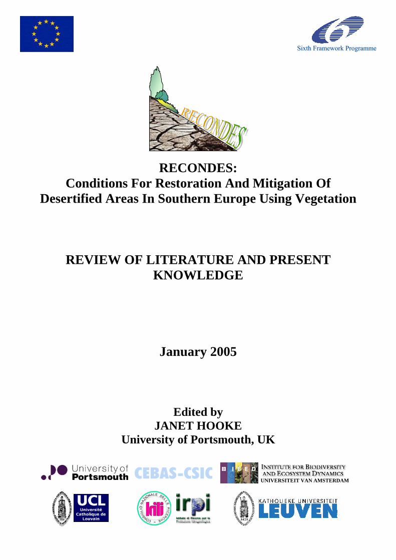
CONTENTS 1. Introduction 5 CROSS-CUTTING THEMES 9 2. Processes 10
2.1 Hydrological and erosion models 11 2.2 Gullies and rills in the Mediterranean environment 23 2.3 Floods and discharge 33 2.4 Sediment connectivity 39 2.5 Sedimentation processes 53
3. Soil and Vegetation Characteristics 61
3.1 Soil properties and types 63 3.2 Flora and communities of SE Spain 71 3.3 Regional plant assemblages, Tuscany 81 3.4 Vegetation pattern and land degradation 87
4. Vegetation effects and interactions 93
4.1 Effects of plants on runoff, erosion and sedimentation 95 4.2 Hydraulic interactions of plants and flow 103 4.3 The effects of plant root characteristics on soil erosion 113 4.4 Effects of plants on soil properties 125 4.5 Plant and crop water requirements 133 4.6 Seedling establishment 141
5. Policy and environmental frameworks 152
5.1 Soil and water conservation practices 153 5.2 Desertification indicators 163 5.3 Restoration guidelines 171 5.4 Climate fluctuations and predictions 175 5.5 Land use scenarios 181
LAND UNITS 187 6. Reforested land 189 7. Rainfed cropland 197 8. Abandoned and semi-natural land 209 9. Hillslopes 223 10. River valleys 233 11. Catchments 255 12. Summary and conceptual models 271
1
dino
11. Catchments
dino
9. Hillslopes
dino
2. Processes
dino
3. Soil and Vegetation Characteristics
dino
4. Vegetation effects and interactions
dino
8. Abandoned and semi-natural land

2
List of Contributors Barberá, G.G. Centro de Edafologia y Biologia Aplicada del Segura
(CEBAS), Department of Soil and Water Conservation, Campus Universitario de Espinardo, Murcia, 30100, PO Box 164, Spain
Bartolini, D. Consiglio Nazionale Della Ricerche - Istituto di Ricerca
per la Protezione Idrogeologica (CNR-IPRI), Unità Staccata di Firenze (IRPI-FI), Piazzale delle Cascine 15/28, Firenze, 50144, Italy
Borselli, L. Consiglio Nazionale Della Ricerche - Istituto di Ricerca
per la Protezione Idrogeologica (CNR-IPRI), Unità Staccata di Firenze (IRPI-FI), Piazzale delle Cascine 15/28, Firenze, 50144, Italy
Busoni, E. Consiglio Nazionale Della Ricerche - Istituto di Ricerca
per la Protezione Idrogeologica (CNR-IPRI), Unità Staccata di Firenze (IRPI-FI), Piazzale delle Cascine 15/28, Firenze, 50144, Italy
Calzolari, C. Consiglio Nazionale Della Ricerche - Istituto di Ricerca
per la Protezione Idrogeologica (CNR-IPRI), Unità Staccata di Firenze (IRPI-FI), Piazzale delle Cascine 15/28, Firenze, 50144, Italy
Cammeraat, L.H. Instituut voor Biodiversiteit en Ecosysteem Dynamica
(IBED)- Universiteit van Amsterdam, Nieuwe Achtergracht 166, NL 1018 WV, Amsterdam
Castillo, V. Centro de Edafologia y Biologia Aplicada del Segura
(CEBAS), Department of Soil and Water Conservation, Campus Universitario de Espinardo, Murcia, 30100, PO Box 164, Spain
Chiarucci, A. Department of Environmental Sciences “G. Sarfatti”,
University of Siena, Via P.A. Mattiolo 4, 53100 Siena, Italy
De Baets, S. Laboratory for Experimental Geomorphology,
Redingenstraat 16, K.U.Leuven, B-3000, Belgium Hooke, J.M. Department of Geography, The University of
Portsmouth, Buckingham Building, Lion Terrace, Portsmouth, P01 3HE, United Kingdom
Lesschen, J.P. Instituut voor Biodiversiteit en Ecosysteem Dynamica
(IBED)- Universiteit van Amsterdam, Nieuwe Achtergracht 166, NL 1018 WV, Amsterdam
3
Maccherini, S. Department of Environmental Sciences “G. Sarfatti”,
University of Siena, Via P.A. Mattiolo 4, 53100 Siena, Italy
Marignani, M. Department of Environmental Sciences “G. Sarfatti”,
University of Siena, Via P.A. Mattiolo 4, 53100 Siena, Italy
Meerkerk, A. Geography Department, Place Louis Pasteur 3,
Louvain-la-Neuve, 1348, Belgium Navarro-Cano, J.A. Centro de Edafologia y Biologia Aplicada del Segura
(CEBAS), Department of Soil and Water Conservation, Campus Universitario de Espinardo, Murcia, 30100, PO Box 164, Spain
Poesen, J. Laboratory for Experimental Geomorphology,
Redingenstraat 16, K.U.Leuven, B-3000, Belgium Salvador Sanchis, M.P. Consiglio Nazionale Della Ricerche - Istituto di Ricerca
per la Protezione Idrogeologica (CNR-IPRI), Unità Staccata di Firenze (IRPI-FI), Piazzale delle Cascine 15/28, Firenze, 50144, Italy
Sandercock, P.J. Department of Geography, The University of
Portsmouth, Buckingham Building, Lion Terrace, Portsmouth, P01 3HE, United Kingdom
Torri, D. Consiglio Nazionale Della Ricerche - Istituto di Ricerca
per la Protezione Idrogeologica (CNR-IPRI), Unità Staccata di Firenze (IRPI-FI), Piazzale delle Cascine 15/28, Firenze, 50144, Italy
van Wesemael, B. Geography Department, Place Louis Pasteur 3,
Louvain-la-Neuve, 1348, Belgium
4
RECONDES literature review 11 Catchments
Chapter 11
LAND DEGRADATION AND VEGETATION: A CATCHMENT VIEW
Lorenzo Borselli1, Ermanno Busoni1, Costanza Calzolari1, Alessandro Chiarucci2, Simona Maccherini2 Michela Marignani1,2, Dino Torri1
1/ Consiglio Nazionale Delle Ricerche - Istituto di Ricerca per la Protezione Idrogeologica (CNR-IRPI), Italy
2/ Dip. Scienze Ambientali, Università di Siena, Italy The Communication from the Commission to the Council, the European Parliament, the Economic and Social Committee and the Committee of the Regions - Towards a Thematic Strategy for Soil Protection (COM/2002/0179 final) recognizes the following threats to soil: erosion, decline in organic matter, soil contamination (local and diffuse soil contamination), soil sealing, soil compaction, decline in soil biodiversity, salinisation and, last but not least, floods and landslides. All these processes may somewhat be linked to, or to be considered as triggers for land degradation and, in the worst cases, to desertification. Land degradation has to be considered as the first step to desertification, according to the UNCCD (1994) definition. Climate change, locally or globally considered, is another great threat that can lead to land degradation and desertification. Land degradation in the Mediterranean region has increased recently for a variety of reasons and is estimated to threaten over 60% of the land in southern Europe (UNEP, 1991). Desertification is the final result of the degradation process that affects the area with relevant impact on ecosystem and human activities (Perez-Trejo,1992; Puigdefabregas and Mendizabal,1998; Thornes ,1999; Yassoglou,1999). Soil erosion processes have a strong impact on desertification in Mediterranean areas. These processes have been reviewed by Poesen and Hooke (1999), and received a specialized efforts in modelling (Kirkby et al. 1998 ). Land degradation: processes and thresholds Land degradation and desertification are processes of paramount importance as they are both effects and engines of the accelerated climatic change that our planet seems to be experiencing. Among the land degradation types soil erosion plays an important role. It is actually the most widespread form of soil degradation, affecting about 109 Mha by water erosion and 549 Mha by wind erosion (Lal, 2003). When soil is eroded soil organic matter is also eroded. The organic carbon exported in this way amounts roughly to 4-6 Pg a-1, 20% of which returns to the atmosphere due to mineralization (Lal, 2003), hence substantially contributing to greenhouse gas emission. Combating land degradation and desertification must be done by approaching the problem from different angles: soil erosion and desertification are the result of many factors interacting among them at different scales. Here we will try to review the interaction at a catchment scale. This scale definition is ambiguous because catchments can be represented at scales varying from fine (micro-catchment) to extremely coarse (continental catchment) and the approach is realized always in order to have insights within the catchment divide. As it is quite useless to deliberately throw away available pieces of information just because they are too detailed, people collect and use data at a mixture of scales: usually a finer scale for representing relief and a broader scale for all the other catchment characteristics, the coarser often being the one for meteorological data. In any case, catchments are not represented as units but as many connected pieces so that the insight is not anymore the one of a black-box catchment but that of a series of tessera each one with its own characteristics. Consequently, most “catchment scale” views are hillslope or field-size views. Nevertheless, something that is aggregated at an upper level can be found when the object of the study is either a very large basin or the approach is landscape based, with regional or even continental implications. Recent papers, dealing with causes of land degradation, point to improper
255
RECONDES literature review 11 Catchments
farming practices, overgrazing, conversion of rangelands to croplands in marginal areas and uncontrolled expansion of urban and rural settlement. Khresat et al. (1998) attribute land degradation in north-western Jordan to loss of soil fertility and productivity, overgrazing and water and wind erosion. Salinity, especially that induced by irrigation, is a degradation process of which farmers are usually aware such as for the Tragowel Plains, Victoria, Australia (Haw et al., 2000), but that is often under represented in official cartography (Curtis et al., 2003). Boardman et al. (2003) consider past overgrazing as the most likely cause of the degradation that brought the development of the badland and gully systems in the Sneeuberg uplands of the Great Karoo, South Africa. Puigdefabregas and Mendizabal (1998) point to the overexploitation of irrigated lands as hot spots of desertification. Most of these irrigated sites are vulnerable to rainfall variability and water is overexploited. This brings soil salinization, exhaustion and deterioration of aquifers, and finally damages fluvial and wetland systems downstream. Besides the direct causes of land degradation exemplified in the papers cited above, the relevance of agricultural policies in land degradation cannot be omitted. Barbier (2000) examined some case studies in Sudan, Malawi, Nigeria, Ghana and Kenya to illustrate how policies, through economic incentives, can influence the attitude of poor rural households to conserve or degrade their land. Simpson et al. (2001) realized that regulations to prevent overgrazing were already in place from at least the 1200s AD in Iceland. Nevertheless, the efforts to prevent land degradations were unsuccessful relative to the common lands. Failure to remove domestic livestock before the end of the growing season and lack of control were more likely to contribute to land degradation than absolute numbers of animals. Fortunately, a recent agreement was made between sheep farmers and the Iceland government, linking part of the production subsidies to “quality management”, including sustainable land use (Arnald and Bakarson (2003). Poverty remains one of the major causes of land degradation, as exemplified by Nyssen et al. (2004) when discussing present trends in land degradation in Ethiopia. The authors state that causes are to be found in the nature of past and present regional social relations and in the international unequal development. The authors express their belief that, with improved socio-economic conditions, land husbandry can become sustainable and reverse the present desertification and land degradation trend of the Ethiopian highlands. Labatt et al. (2004) have recently shown that the present-day climatic change is bringing an intensification of the hydrological cycle and continental runoff in the last century. They found that an increase of 1°C of the global annual temperature is likely to bring a 4% increase in continental runoff. At the regional scale both increasing and decreasing trends were identified, depending on more “local” conditions. At the catchment scale, runoff is certainly dominated by the type of attributes of the catchment and by their spatial distribution. A zone of higher infiltration capacity at the main channel or near the catchment outlet increases the precipitation thresholds for runoff. As the experience, summarised by the Curve Number Soil Conservation method for predicting catchment daily runoff (USDA-SCS,1969), exemplifies, vegetation (land use) plays the major role in runoff generation while soil and lithology are less important. Nevertheless, Godsey et al. (2004) showed that saturated hydraulic conductivity and its variation with depth can be responsible for major differences in the hydrological response of two basins covered by a dense rain forest but with different lithologies. Obviously, disentanglement of factors is not always possible and often is a complex set of subtle interactions that define the trend, as shown by Sullivan et al. (2004) for the increased flood frequency of the River Camel in Cornwall. Montgomery and Brandon (2002) showed that a linear relationship between slope and erosion rate describes observations only at low gradient values. On steep, tectonically active mountains the relationships are non-linear. Mass movements contribute to keep rates of relief lowering at a pace compatible with channel incision. Threshold, or near-threshold slopes observed along the gorge of
256
RECONDES literature review 11 Catchments
the Indus river and inside the Olympic Mountains support this view (Burbank et al.,1996; Montgomery,2001). Hence, erosion rates in steep terrain increase greatly with only minor increases in slope or topographic relief, thus causing the relationship between gradient and erosion rate to be non-linear. These relationships have been further examined and improved by Montgomery (2003) who distinguishes between three different types of landscape with different slope-erosion rate relationships: tectonically active ranges where the relationship is non-linear, post-orogenetic zones, where the relation is about linear, and ancient cratons where erosion rate at catchment scale is dominated by the weathering rate when chemical denudation exceeds mechanical. Vegetation, especially in semiarid and arid environments, is rarely uniformly distributed but presents distinct patterns which are linked to strategies to survive droughts. Consequently there are situations where vegetation can flourish even in arid conditions because it grows in particular sites where it can collect water from areas around, even exploiting floods, (e.g., Domingo et al., 2001) or the alternation between bare soil and vegetated patches at a more detailed scale (see Valentin et al., 1999). Cammeraat and Imeson (1999) from the study in SE Spain concluded that vegetation patterns are important in explaining hillslope hydrology and patterns in soil erosion. They must be considered in upscaling to catchment size because patterns are not randomly distributed. At the hillslope and basin scale, the spatial vegetation pattern determines overland flow concentration and soil erosion in a complex way that depends on how the vegetated spot or bands are oriented with respect to flow lines, how effective the vegetated bands are in catching and infiltrating rain and runon. The review made by Rey et al. (2004) about the vegetation and its effects on soil erosion defines an upper threshold of 70% of vegetation cover for hortonian overland flow to occur. Above such a threshold only saturated flow can be observed. Below 70% cover a homogeneously distributed vegetation keeps runoff diffuse, while a patchy distribution favours flow concentration. Still, cover density variations between 43 and 15% trigger rapid changes of sediment production while below 15% cover there is practically no effect of vegetation on erosion. This non-linear and non-exponential effect of vegetation cover is appreciable at catchment scale too as exemplified by Rey et al. (2004). Position of vegetation patches within gully systems can dramatically change runoff and sediment export from the gully catchment. Holm et al. (2002) examined the relationships between rainfall and plant growth on a hierarchical basis within a landscape approach. Studying arid landscapes in which the movement of resources important for plant growth was moderated by either individual shrubs and bushes (low-shrubland), or by bands or groves of trees and shrubs (low-woodland), they found that rainfall-use efficiency (defined by dividing surface density of phytomass at each grid-point by the corresponding annual rainfall) is positively related to primary productivity. Dysfunctional (i.e. degraded) landscapes have lower rainfall-use efficiencies. Better fit was obtained at the coarser spatial scales of patch-mosaics than at a scale of individual patches. Conditions and thresholds for vegetation In the following paragraphs the different conditions acting as thresholds for vegetation life and re-vegetation strategies have been subdivided according to the main affecting factors. Obviously relationships between topics are complex and crosscutting references are unavoidable. Most of the cited studies do not refer specifically to the watershed scale, but contain interesting approaches for the RECONDES project. Soil moisture control Even if it is difficult to highlight a direct, unique cause-effect relationship, soil moisture content, and soil properties related to this, has been recognized as one of the most effective factors in controlling vegetation distribution at hillslope (and catchment) scale (Cantòn et al., 2004b; Gomez-
257
RECONDES literature review 11 Catchments
Plaza et al., 2001; Chiarucci et al., 1995). In a Spanish semi-arid badlands area, Cantòn et al. (2004a) studied 4 different soil surface covers: bare marl regolite; lichen crust; Stipa tenacissima scattered cover; dwarf shrubs and annual shrubs. As expected the most arid zones were associated with bare soils, while under vegetation, with better developed soils, water content was higher. Lichen crusts seemed to be associated with different hydrological conditions depending on rainfall intensities: with higher intensities runoff production increased, leading to a lower soil moisture content, while with lower intensities lichens favoured infiltration, leading to higher moisture content. The moisture content was also detected as a main factor in controlling vegetation dynamics in a sub-humid badland area in Italy (Chiarucci et al., 1995) where a soil moisture trend was recognized associated with geomorphologic dynamics: most structured vegetation was associated with more stable surfaces and/or wetter conditions. Both the conditions were linked to the presence of deeper, better developed and structured soils (i.e. higher available water capacity). In wetter conditions, in mountainous badlands of Spain, Regues et al. (2000) found that the microclimatic factors affecting growing period, temperature and solar radiation, were more important for vegetation recovery than the available water content. In other words, in sub-humid areas moisture content, even in shallow soils, can be negligible, contrary to Mediterranean areas. Topographic control Topography exerts a direct and indirect control on vegetation distribution, acting in regulating soil moisture control. In the cited work on Italian badlands (Chiarucci et al., 1995) the moisture content was linked to soil characteristics, these last being strictly linked to topography. In Spain Cantòn et al. (2004a) demonstrated the topographic control over the vegetation distribution in badland catchments of Tabernas. The authors found that the distribution of different ground-cover types, namely Stipa association, perennials, annuals, xero-halophytes, stratified vegetation, and more or less bare soil, is strongly influenced by terrain attributes such as slope, aspect, curvature, length of the slope, etc, and that the different ground cover types react differently to each attribute. As a general rule the stronger control on ground-cover types is exerted by local short range terrain attributes, i.e. slope, aspect and elevation, while a weaker influence is given by wider scale attributes, such as contributing area or slope length factor. This can be explained by the lack of continuity in runoff pattern, in the case of the Tabernas badlands site mostly due to scarce runoff production. This topic will be expanded in next paragraphs. In a small catchment in semi-arid Spain, Gomez-Plaza et al. (2001) recognized a topographic control on soil moisture content in vegetated areas: upslope contributing area, aspect, soil profile curvature and soil depth were the most correlated factors. Temporal dynamics were also found linked to the vegetation cycle. Soil depth control The direct effect of soil depth on vegetation has been described by Kosmas et al. (2000a) in Lesvos Island. The authors defined critical soil characteristics for natural vegetation establishment: in the semi-arid conditions of insular Greece soil depth was found to be the most effective control factor, with a threshold value of 25-30 cm. The highly variable environment of Lesvos Island (Kosmas et al., 2000b) was studied also for correlating vegetation performance to climate, soil texture, parent material, topography (slope angle) and degree of degradation at a more general scale: soil and vegetation maps and climatic characteristics were taken into account, showing broad, long term relations. Effects of vegetation Vegetation and erosion have competitive interactions (Thornes 1985, 1990b; Trimble, 1990). Vegetation has strong and direct influence on wind and water soil erosion (Rey ,2004) and usually the vegetation effects are implemented in the most important soil erosion models (Kirkby et al. 1998; Merritt et al. 2003). Vegetation treatments have a role in mitigating erosion processes at field and catchment scales (Weltz et al.. 1997) and they will be treated in a specific paragraph.
258
RECONDES literature review 11 Catchments
Vegetation control on soil properties and on runoff and soil erosion has been much studied at plot and slope scale, while less work has been done at the catchment scale. Catchment studies are usually aimed at model application/validation/calibration, GIS and/or Remote Sensing techniques implementation, and integration between the two (among the others Doe et al., 1996). Hence, most of the studies deal with these topics. The scale of them is nevertheless too broad and the methods too general to be positively implemented at RECONDES level. A number of plot or slope level researches have been conducted on sufficiently widespread conditions, so as to cover representative land units inside larger watershed. We will refer to these, trying to point out the most interesting topics. Catchment scale studies have been conducted in Australia (Connolly et al., 1997). Starting from previous studies in the area the authors integrated the runoff field measurements with estimates obtained with the aid of modelling tools (ANSWER). The interaction among soil properties related to hydrology and vegetation cover has been investigated, in a 9.7 ha catchment, in a semi-arid area of Australia, characterized by different stage recovery of vegetation, succeeding a period of overgrazing. Vegetation regrowth reduced runoff to 5% of rainfall, mainly reducing runoff generation for small rainfall events, while it did not affect runoff for greater events. Rainfall simulation showed that increased cover reduced surface sealing and increased hydraulic conductivity. Revegetation strategy effectiveness was also investigated using scenario analysis. Scenario analysis has been applied in several works. Chen et al. (2003) in the loess plateau of China used LISEM model for simulating different land use scenarios. Simulations showed the importance of natural vegetation in controlling soil erosion on steeper areas of a catchment. This last work is contained in a Catena Special issue devoted to participatory approach in land use planning with particular reference to soil erosion control (Ritsema (Ed.), 2003), and reporting the results of the EU funded project EROCHINA. These are subdivided in 4 sections, the first of which is dedicated to plant and soil properties. Wang et al.(2003) studied relationships between organic matter and nutrient content, and land use and topography, showing the positive effects of natural and semi-natural vegetation. Liu et al.(2003) showed the effects of land use on random roughness, soil cohesion and aggregate stability, while Stolte et al. (2003) evidenced the effect on hydraulic conductivity. The effect of land use on spatial and temporal soil moisture variations is shown by Fu et al. (2003). In their study the authors found that soil moisture in shrubland was significantly lower than in other land use types, mostly due to root pattern and depth. The Catena special issue deals with a participatory approach in order to integrate social and economic issues in land use planning, as abandonment and re-vegetation, positively linked to soil erosion control, can lower a farmer's income. ANSWER model was also used in Argentina (Braud et al., 2001), for assessing the role of land cover in reducing erosion and runoff in an enclosed (from grazing) catchment. The authors, beside an unsatisfactory behaviour of runoff pathway modelling, described a strong scale effect in runoff measures in differently covered areas of the catchment: a dramatic runoff decrease was registered passing from plot scale measures to catchment scale. The same decrease was observed in other catchment scale studies and explained by Bergkamp (1998), and again in many other studies (for example Fitzjohn et al. 1998), with the lack of runoff connectivity between runoff production areas and catchment outlet due to partial reinfiltration between these areas. Bergkamp et al (1998) suggest that the “development of spatial structures in vegetation and soil forms a positive feedback with non-uniform infiltration and increased soil water retention. The assessment of land degradation could benefit greatly from acknowledging the importance of non-uniformity in hydrological processes. Furthermore, the presented measurements indicate that in discontinuous environments runoff measurements at fine scales cannot be extrapolated directly. In these environments a scaled approach needs to be adopted emphasizing the importance of different hydrological processes at different scales.”
259
RECONDES literature review 11 Catchments
Francis et al. (1986) discussed scale dependency in assessing topographic control on soil moisture, vegetation and soil erosion. The non-uniform hydrology of patterned vegetation sites have been described in many papers, mostly in Spain (Bergkamp et al., 1996; Cammeraat and Imeson, 1999). Still, Bergkamp (1998) propose an interpretation of different scale observation within a hierarchical frame connecting different spatial scales from the finer to the broader. The influence of vegetation on soil characteristics, assessed by many authors (see again Bergkamp, 1998, for a review) must be assessed at different spatial and temporal scales. Vegetation role in controlling soil erosion have been studied in different parts of world. A controversial result about vegetation role on runoff and erosion control was found by Descroix et al. (2001) in mountainous areas of Mexico, where more vegetated areas showed higher erosion and runoff rates. The authors concluded that soil surface properties, such as stone cover percentage, soil texture, organic matter content and aggregate stability, played a major role in reducing runoff and erosion. Casermeiro et al. (2004) focus on the relationships between composition and structure of natural scrub communities involved in soil erosion processes, in 29 scrub communities plots representative of the natural vegetation selected in a semi-arid Spanish basin. The effect of scrubs was assessed in rainfall simulation field experiments. The conclusion of the study, beside stating the importance of plant cover in reducing runoff and in supplying organic matter, stressed the importance of plant community growth form and structure, nanophanerophytes in pluristratified areas being the most effective in protecting from erosion. Bochet et al. (1999, 1998) also studied scrubland in Spanish semi-arid areas. The studies focused on effects of some species (Stipa tenacissima, Rosmarinus officinalis, and Anthyllis cytisoides) on spatial variability of soil properties and erosion protection. Stipa and Rosmarinus showed the most positive effects. Archer et al. (2002) studied the below-ground characteristics in open non-shrub areas and shrub areas, in terms of hydraulic conductivity, root structure and distribution and soil texture. This allowed them to to create a conceptual model of below-ground features to understand water redistribution in shrub and non-shrub areas in a two-phase mosaic vegetation, in a catena of soils and vegetation in Rambla Honda catchment in southern Spain. They developed a conceptual model showing that the presence of coarse woody roots distributed to deeper soil depths in shrub areas allows for a more effective use of water. The increase in soil aggregate size and stability, and organic matter content was found to be affected by different water regimes, in shrubbed and unshrubbed microenvironments by Sarah and Rodeh (2004) in Israel. In dryer conditions organic matter accumulation and effects are less strong, suggesting a possible strategy in recovering natural vegetation in semi-arid degraded areas. Chisci et al. (2001) in a small catchment of central Italy studied the effect of a perennial agri-forestry system, namely an association of Sulla (Hedysarum coronarium L.) and Saltbush (Atriplex halymus L.), on soil properties. Physical soil characteristics, such as aggregate stability and total porosity were positively correlated to sulla/atriplex association as compared to durum wheat cultivation, resulting in a higher protective capacity for runoff and erosion processes. Effects of vegetation on aggregate stability were also reported by Cerdà (1996, 1998) in different landscapes of Spain. Different types of vegetation were considered in different climatic and environmental conditions. The effect of different types of vegetations on water balance was studied by Bellot et al. (1999) by means of simulation models, assessing the role for differently structured vegetation on evapotranspiration, soil moisture content and deep percolation. Williamson et al. (2004), studied the effect of a grass land recovery on a ex chaparral area in Mediterranean USA. The resilience of matorral environment in southern Spain was investigated by Lopez-Bermudez, et al. (1998), who demonstrated that there are no important degradation processes in the natural vegetation even if grazed, and that the vegetation recovery after disturbance (i.e. cropping) was quite effective. A recent review (Andreassian, 2004) presents an historical perspective of the controversy concerning the hydrological impact of forests and gives an up-to-date overview of the paired-watershed experiments conducted during the last century, identifying research issues to focus on.
260
RECONDES literature review 11 Catchments
Land management and vegetation treatments One of the driving factors of desertification and land degradation is intensive agriculture and inappropriate land management strategies. Matson et al. (1997) and Tilman (2001) discussed the impact of agricultural activities intensification on ecosystems at a global scale in the last 50 years. In the Mediterranean region the detrimental effects of bad agricultural practices on soil qualities including erosion, desertification, salinization, compaction, and pollution have been discussed by several authors (Kosmas, 1999; Zalidis et al., 2002). Appropriate land management is currently put forward as a key point for mitigation of desertification risk or/and control of the desertification process (Yassoglou ,1999). Land abandonment has been one of the most diffused answers to the marginalization of agriculture and agricultural policies, aimed also at reduction of soil erosion, often encourage land abandonment. Effects of abandonment have been studied by several authors, both at catchment and hillslope scale. Fu et al. 2003 in China studied the effect of land use change on soil erosion at catchment scale, taking into account also the variation in soil nutrients (i.e. total nitrogen, available nitrogen, organic matter and moisture). The changes, mainly from crops to natural or semi-natural vegetation produced a decrease in soil erosion. The arrangement of different land covers was also important in affecting watershed hydrology, runoff production and soil erosion. In the cited study in Lesvos Island, Kosmas et al. (2000a) controlled the effect of land use changes on soil characteristics, such as fertility status, water storage capacity, erosion resistance and vegetation characteristics. The authors found that land abandonment showed the most significant soil improvement in soil organic matter content, while local conditions played a major role in vegetation establishment and erosion control. The positive impact of land abandonment on regeneration of semi-natural vegetation has been investigated using Rambla del Chortal as a case study (Obando, 2002). Increases in plant productivity and biomass generally lead to an improvement of the hydrological conditions and hence a decrease in soil erosion and land degradation in the long term. Organic matter content, water holding capacity aggregation and structural stability were shown to be positively correlated to land abandonment and natural vegetation re-establishment in El Ardal study area (Martínez-Fernández et al., 1995), while positive effects on soil fertility index were also described in tropical environments affected by land abandonment and vegetation recovery (Paniagua et al., 1999). Vegetation recovery can be improved by appropriate vegetation treatments. These have a fundamental impact in arid and semiarid ecosystems to prevent desertification or improve rehabilitation of desertification prone areas (Martinez-Fernandez et al. 1995,1996). Vegetation treatments depend on the specific environment and on specific objectives. Restoration of degraded arid and semiarid lands by the reintroduction of woody species has become increasingly important worldwide as a measure to protect soils, to combat desertification, to supply natural resources and to provide space for recreation (Maestre et al., 2004). In the last few years there has been an increasing concern among land managers, scientists, restoration practitioners and non-governmental organizations on the impacts of extensive coniferous plantations in Mediterranean countries. Common techniques currently used for afforestation in the Mediterranean basin consider the pre-existing vegetation (mainly shrubs) as a source of competition for trees, and consequently it is generally eliminated before planting. Nevertheless, it has been demonstrated that woody plants can facilitate the establishment of understory seedlings in environments that, like the Mediterranean area, are characterized by a pronounced dry season. Castro at al (2002), experimentally analysed the usefulness of shrubs as nurse plants for reforestation of two native conifers, Pinus sylvestris L. (Scots pine) and Pinus nigra Arnold (black pine). The results show that the use of shrubs as nurse
261
RECONDES literature review 11 Catchments
plants is a technique that offers both economic and ecological advantages, in terms of savings in labour and plant material and reduced impact on the pre-existing vegetation. Recently, Maestre et al. (2004) contributed to the debate on the suitability of mono-specific extensive P. halepensis plantations, and suggest that reforestation programmes should be revised. According to this review, the extensive, single-specific plantations of P. halepensis are not useful to restore semiarid Mediterranean areas, especially when they replace native shrublands and are performed with heavy machinery. In Calabria, southern Italy, extensive reforestation using Pinus and Eucalyptus has taken place since the early 1960's to control expansion of calanchi and biancane (Sorriso-Valvo et al, 1995). Three small catchments were established to monitor the effect of reforestation on hydrological response and sediment yield; rainfall simulation experiments were carried out on plots in these catchments to determine more precisely the effect of tree and ground vegetation on surface runoff and erosional response. Results show that reforestation and logging practices can strongly affect the hydrological and erosional response on these hillslopes. Bare south-facing slopes with negligible vegetation produce large amounts of sediment and runoff. Colonization by grass can significantly reduce both, but will be effective only on north-facing slopes. Establishment of trees and development of continuous litter will further reduce sediment production, but will probably lead to increased runoff discharge. Following insights from earlier researchers who drew attention to the potential influence of vegetation on fluvial systems, a large body of literature has emerged in recent years that has highlighted the role of vegetation on fluvial processes (among the others Shafroth, P.B, et al. 1999, Brooks et al., 2003, Hyatt et al., 2004). Riparian vegetation has different impacts on stream processes depending upon its position in a catchment (Wissmar et al, 1998). In this context, native riparian vegetation is increasingly becoming the favoured stream management tool, but managers need to locate revegetation schemes where they will most effectively achieve ecological, geomorphological, or other, project goals (Abernethy et al., 1998). Using the Latrobe River in SE Australia as an example, Abernethy et al. (1998) illustrate a structured decision-making approach for assessing the role of vegetation in stream bank erosion at different points throughout a catchment. Considering different variables, the authors define a critical zone in which revegetation will be most effective in reducing bank erosion (Abernethy et al., 1998). Rangelands, defined as a portion of land on which the natural vegetation is predominantly native grasses, grass-like plants, forbs, or shrubs valuable for forage, are widespread in Mediterranean semi-arid environments, where erosion and desertification risks are more diffused. In rangeland the vegetation treatment aim to maintain an acceptable land quality and value under grazing stresses and under other types of event as wildfires, climatic change or drought. All these types of stress contribute to land degradation and desertification mainly acting on vegetation dynamics: reducing vegetation cover, quality and biodiversity. Appropriate treatment and management of vegetation allow mitigation of the negative effects. Economic value of rangeland is often associated with grazing and vegetation management/treatment. In these cases grazing rate and overstocking control is a primary form of management (Allegretti et al. 1997; Grant et al., 1999), also for humid or sub-humid climates (Samsom, 1999). The vegetation recovery can be favoured by artificial sowing of native species. The impact of sowing a seed mixture to recreate a semi-natural community in combination with six cutting and/or grazing treatments on the vegetation that developed on former agricultural land has been studied by Warren et al. 2002. Snyman (2003) studied different over-sown species and mechanical restoration methods were evaluated for the restoration of bare areas.
262
RECONDES literature review 11 Catchments
Fire is one of the processes that cause a direct vegetation cover degradation and also change of functionality and properties of an entire territory (Scott and Van Wyk, 1990; Brown 1990; Prosser, and Williams1998; Cerdà 1998, Moreno, 1999). Nevertheless, planned burning is sometime a specialised technique to control the bush development in rangeland (White and Hanselka, 1994.). Planned fires are a current practice for range management in some semiarid and arid environments such as Texas and New Mexico (White and Hanselka, 1994; Grant et al., 1999, Rango et al. 2002). Fire effectively suppresses most woody plants while encouraging grass and fodder plant to grow and increase the animal production. The planned fires always require a well experienced and tested technique and cannot probably be exported everywhere. Post-wildfire rehabilitation techniques are developed to accelerate the revegetation (Ne’eman et al., 1995; Fijwkin et al. 1998; Radoglou, 2000; Espelta eta al. 2003.). In areas subject to salinization risk specific studies have been conducted to mitigate the salinisation process by appropriate techniques of management and studied processes of rehabilitation using species resistant to high salt concentration in the soil (Maas, 1990; Barrett-Lennard, 2002). The increase of salt affected land is in fact another important process of land degradation, desertification and reduction of arable lands and rangeland (Szabolcs, 1979,1987; FAO, 1988; Rhoades, 1990, Szabolcs, 1996; Zalidis et al., 1999). The total surface affected by induced salinization is assessed as more than 900 Mha in the world, with abnormal presence in some countries (as central Asia and Australia) (Ghassemi et al. 1995; O’Hara, 1997; Metternicht and Zinck, 2003). Studies on land management in the past, at regional and catchment scale in the Mediterranean area (Martinez-Fernandez et al. 1995,1996; Hill et al. 1998; Khresat et al. 1998; Kosmas et al. 2000, Tanrivermis, 2003, Portnov and Safriel, 2004 ) are considerable help for the definition of future Land Use Planning (LUP) strategies that are the basis of appropriate land management. LUP may be defined as: “the systematic assessment of land and water potential, alternatives for land use and economic and social conditions in order to select and adopt the best land-use options. Its purpose is to select and put into practice those land uses that will best meet the needs of the people while safeguarding resources for the future. The driving force in planning is the need for change, the need for improved management or the need for a quite different pattern of land use dictated by changing circumstances” (FAO, 1999). The definition of LUP, may also be strengthened: “Land use planning in the technical co-operation is an iterative process based on the dialogue amongst all participants. It is aimed at the definition of decisions on a sustainable form of land use in rural areas and the initiation of the appropriate measures for implementation and monitoring land use planning considers cultural viewpoints and builds up on local environmental knowledge” (Amler et al. 1999). The definitions indicate the complex processes of a rational land use planning and the non uniqueness of the solutions. Verheye (1998) reviews the most important LUP strategies. In the last few decades there has emerged a new framework to approach LUP problems by the participatory methods and other evaluation processes (FAO-UNEP, 1996; Keen, 1997; Radcliffe, 1998; Amler et al. 1999; Oxley and Lemon 2003). LUP has a prominent role in mitigating desertification risk in Mediterranean area (Stroosnijder 2000), and in integrating planning and management at various scales (Martin de Santa Olalla 2000, Bathurst 2003). Development of appropriate indicators has a fundamental importance in synthesis and practical application of results of research in desertification prone areas (Muat et al. 1997; Rubio and Bochet, 1998; Imeson, 2000). Specific indicators has been developed for the Mediterranean environment (European Commission, 1999) where, together, climatic and soil parameters, vegetation characteristics and dynamics have a prominent role. The integrated modelling approach to predict the effects of climatic fluctuations and disturbance frequency on local and regional patterns in species dominance and composition of grasslands and
263
RECONDES literature review 11 Catchments
shrub lands is promising. (Peters 2002 ; Peters and Herrick . 2002 ). References Abernethy B., Rutherfurd I.D.,1998. Where along a river's length will vegetation most effectively
stabilise stream banks? Geomorphology, 23,1: 55-75 Allegretti L.I., Passera C.B., Robles A.B.. 1997. Short- and long-term effects of shrub
management on vegetation in the Monte, Argentina. Journal of Arid Environments 35: 685–693
Amler B., Betke D., Eger H., C.Ehrich, Kohler A., Kutter A., von Lossau A., Müller U., Seidemann S., Steurer R., Zimmermann W.. 1999. Land Use Planning Methods, Strategies and Tools. Deutsche Gesellschaft für Technische Zusammenarbeit (GTZ) GmbH. 198 pp.
Andréassian V., 2004. Waters and forests: from historical controversy to scientific debate. Journal of Hydrology, 291: 1-27
Archer, N. A. L.; Quinton, J. N.; Hess, T. M., 2002. Below-ground relationships of soil texture, roots and hydraulic conductivity in two-phase mosaic vegetation in South-east Spain. Journal of Arid Environments, 52: 535-553
Arnalds O., Barkarson B.H., 2003. Soil erosion and land use policy in Iceland in relation to sheep grazing and government subsidies. Environmental Science & Policy 6: 105–113
Barbier E.B., 2000. The economic linkages between rural poverty and land degradation: some evidence from Africa. Agriculture, Ecosystems and Environment, 82: 355–370.
Barrett-Lennard E.G. 2002. Restoration of saline land through revegetation. Agricultural Water Management 53: 213–226
Bathurst J.C., Sheffield J., Leng X., Quaranta G. 2003 Decision support system for desertification mitigation in the Agri basin, southern Italy. Physics and Chemistry of the Earth 28 (2003) 579–587
Bellot J., Sanchez J. R., Chirino E., Hernandez N., Abdelli F. and Martinez J. M., 1999. Effect of Different Vegetation Type Cover on the Soil Water Balance in Semi-Arid Areas of South Eastern Spain. Physics and Chemistry of the Earth, Part B: Hydrology, Oceans and Atmosphere Volume 24, Issue 4 , 353-357
Bergkamp, G., 1998. A hierarchical view of the interactions of runoff and infiltration with vegetation and micotopography in semiarid shrublands. Catena, 33:201-220
Bergkamp, G.; Cammeraat, L.H.; Martinez-Fernández, J., 1996. "Water movement and vegetation patterns on shrublands and an abandoned field in two desertification-threatened areas in Spain". Earth Surface Processes and Landforms, 21: 1073-1090
Boardman J., Parsons A.J., Holland R., Holmes P.J., Washington R., 2003. Development of badlands and gullies in the Sneeuberg, Great Karoo, South Africa. Catena 50: 165– 184
Bochet, E.; Rubio, J.L.; Poesen, J., 1998 Relative efficiency of three representative matorral species in reducing water erosion at the microscale in a semi-arid climate (Valencia, Spain). Geomorphology, 23: 139-150 .
Bochet, E.; Rubio, J.L.; Poesen, J., 1999. Modified topsoil islands within patchy Mediterranean vegetation in SE Spain. Catena, 38: 23-44.
Braud, I., Vich, A.I.J., Zuluaga, J., Fornero, L., Pedrani, A., 2001. Vegetation influence on runoff and sediment yield in the Andes region: observation and modelling. Journal of Hydrology, 254: 124-144.
Brooks, A.P., Brierley, G.J. and Millar, R.G. 2003. The long-term control of vegetation and woody debris on channel and flood-plain evolution; insights from a paired catchment study in southeastern Australia. Geomorphology. 51: 7-29.
Brown, A.G. 1990. Soil erosion and fire in areas of Mediterranean type vegetation: results from chaparral in southern California, USA and matorral in Andalucia, southern Spain. In Thornes. J.B. (ed),: Vegetation and Erosion. Processes and Environments, John Wiley & Sons, New York: 289-316.
Burbank D.W., Leland J, Fielding E., Anderson R.S., Brozovic N., Reid M.R., Duncan C., 1996.
264
RECONDES literature review 11 Catchments
Bedrock incision, rock uplift and threshold hillslopes in the northwestern Himalayas. Nature 379, 505–510.
Cammeraat L.H. , Imeson A.C., 1999. The evolution and significance of soil–vegetation patterns following land abandonment and fire in Spain. Catena, 37: 107–127.
Cantòn Y.; Del Barrio G.; Sole-Benet A.; Lazaro R., 2004a. Topographic controls on the spatial distribution of ground cover in the Tabernas badlands of SE Spain. Catena, 55: 341-365.
Cantòn, Y.; Sole-Benet, A.; Domingo, F., 2004b. Temporal and spatial patterns of soil moisture in semiarid badlands of SE Spain. Journal of Hydrology, 285: 199-214.
Casermeiro, M.A.; Molina, J.A.; de la Cruz Caravaca, M.T.; Hernando Costa, J.; Hernando Massanet, M.I.; Moreno, P.S., 2004. Influence of scrubs on runoff and sediment loss in soils of Mediterranean climate. Catena, 57: 91-107
Castro J., Zamora R., Hódar J. A., Gómez J. A. (2002) Use of shrubs as nurse plants: a new technique for reforestation in Mediterranean mountains. Restoration Ecology, 10. 2: 297-305
Cerdà A., 1998. Soil aggregate stability under different Mediterranean vegetation types. Catena, 32: 73-86
Cerdà, A. 1998. Changes in overland flow and infiltration after a rangeland fire in a Mediterranean scrubland. Hydrological Processes, 12: 1031-1042.
Cerdà, A., 1996. Soil aggregate stability in three mediterranean environments. Soil Technology, 9: 133–140. `
Chen, L., Messing, I., Zhang, S., Fu, B., Ledin, S., 2003. Land use evaluation and scenario analysis towards sustainable planning on the Loess Plateau in China—case study in a small catchment. Catena, 54: 303-316
Chiarucci, A., De Dominicis, V., Ristori, J., Calzolari, C., 1995. Biancana badland vegetation in relation to morphology and soil in Orcia valley, central Italy. Phytocoenologia 25: 69–87.
Chisci G. C., Bazzoffi P., Pagliai M., Papini R., Pellegrini S. and Vignozzi N., 2001. Association of sulla and atriplex shrub for the physical improvement of clay soils and environmental protection in central Italy. Agriculture, Ecosystems & Environment, 84(1): 45-53
Connolly, R.D., Ciesiolka, C.A.A., Silburn, D.M., Carroll, C., 1997. Distributed parameter hydrology model (ANSWERS) applied to a range of catchment scales using rainfall simulator data. IV. Evaluating pasture catchment hydrology. J. Hydrol. 201, 311–328.
Curtis A., Byron I., McDonald S., 2003. Integrating spatially referenced social and biophysical data to explore landholder responses to dryland salinity in Australia. Journal of Environmental Management 68: 397–407
Descroix, L.; Viramontes, D.; Vauclin, M.; Gonzalez Barrios, J.L.; Estèves M., 2001. Influence of soil surface features and vegetation on runoff and erosion in the Western Sierra Madre (Durango, Northwest Mexico). Catena: 43: 115-135.
Doe, W.W., Saghafian, B., Julien, P.Y., 1996. Land-use impact on watershed response: the integration of two-dimensional hydrological modelling and geographical information systems. Hydrol. Processes 10 (11), 1503–1511.
Domingo F., Villagarcia L., Boer M.M.,. Alados-Arboledas L., Puigdefabregas J., 2001.Evaluating the long-term water balance of arid zone stream bed vegetation using evapotranspiration modelling and hillslope runoff measurements. Journal of Hydrology 243: 17–30.
Espelta J. M., Retana J., Habrouk A. 2003. An economic and ecological multi-criteria evaluation of reforestation methods to recover burned Pinus nigra forests in NE Spain. Forest Ecology and Management 180:185–198.
European Commission. 1999. Medalus Project- Mediterranean Desertification and Land Use. Manual of Key Indicators of Desertification and Mapping Environmentally Sensitive Areas to Desertification. Edited by C. Kosmas C., M.C. Kirkby , N. Geeson. Luxemborurg: Office for Official Pubblications of the European Communities. 87 pp.
FAO, 1999. The Future of Our Land - facing the challenge FAO, Rome . 88.pp FAO, 1988. Salt-affected soils and their management. Bulletin No. 39, FAO, Rome. FAO-UNEP (1996) - Our land, our future: A new approach to land use planning and management.
FAO, Rome, 48 p.
265
RECONDES literature review 11 Catchments
FAO-UNEP (1998).Workshop on Integrated Planning and Management of Land Resources. Proceedings 30 March – 3 April 1998. Mbabane, Swaziland. 131 pp.
Fijwkin Z., Seligman N.G., Noy-Mjdr I., Kafkafi U., Gutman M.. 1998. Rehabilitation of Mediterranean dwarf-shrub rangeland with herbicides, fertilizers, and fire. J. Range Manage. 51:193-199 .
Fitzjohn, C.; Ternan, J.L.; Williams, A.G., "Soil moisture variability in a semi-arid gully catchment: implications for runoff and erosion control" Catena 1998 pp. 55-70
Francis, C.F.; Thornes, J.B.; Romero Diaz, A.; Lopez-Bermudez, F.; Fisher, G.C., 1986. Topographic control of soil moisture, vegetation cover and land degradation in a moisture stressed Mediterranean environment. Catena: 13, 211-225
Fu, Bojie; Wang, Jun; Chen, Liding; Qiu, Yang, 2003. The effects of land use on soil moisture variation in the Danangou catchment of the Loess Plateau, China. Catena, 54: 197-213.
Gerontidis C., Marathianou S.M.2000. The effect of land use change on soils and vegetation over various lithological formations on Lesvos (Greece). Catena 40: 51–68
Ghassemi, F., A. J. Jakeman and H.A. Nix, 1995. Salinisation of land and water resources: human causes, extent, management and case studies. Canberra, Australia: The Australian National University, Wallingford, Oxon, UK: CAB International.
Godsey S., Elsenbeer H., Stallard R., 2004. Overland flow generation in two lithologically distinct rainforest catchments. Journal of Hydrology, 295: 276–290.
Gomez-Plaza, A., Martinez-Mena, M., Albaladejo, J., Castillo, V.M., 2001. Factors regulating spatial distribution of soil water content in small semiarid catchments. Journal of Hydrology 253, 211–226.
Grant W.E.,. Hamilton W.T, Quintanilla E. 1999. Sustainability of agroecosystems in semi-arid grasslands: simulated management of woody vegetation in the Rio Grande Plains of southern Texas and northeastern Mexico Ecological Modelling 124: 29–42
Gupta, R.K. and I.P. Abrol, 1990. Salt-affected soils: Their reclamation and management for crop production. Advances in Soil Science, .11: 223-288.
Haw M., Cocklin C., Mercer D., 2000. A pinch of salt: landowner perception and adjustment to the salinity hazard in Victoria, Australia. Journal of Rural Studies 16: 155-169
Hill J., Hostert P., Tsiourlis G., Kasapidis P., Udelhoven Th., Diemer C. 1998. Monitoring 20 years of increased grazing impact on the Greek island of Crete with earth observation satellites. Journal of Arid Environments 39: 165–178
Holm A.McR., Loneragan W.A,. Mark A.A.,2002. Do variations on a model of landscape function assist in interpreting the growth response of vegetation to rainfall in arid environments?. Journal of Arid Environments, 50: 23-52.
Holmes, P.M., Richardson, D.M., Van Wilgen, B.W., Gelderblom C. 2000. Recovery of South African fynbos vegetation following alien woody plant clearing and fire: implications for restoration. Austral Ecology, 25, 631–639
Hyatt T.L., Waldo T.Z., Beechie T. J., 2004. A watershed scale assessment of riparian forests,with implications for restoration. Restoration Ecology. 12(2): 175-183
Imeson A.C., 2000. Indicators of Land degradation in the Mediterranean basin. In Enne G., Zanolla Ch., Peter D. (eds) “Desertification in Europe: Mitigation strategies ,Land Use Planning –Advanced study course. Office for Official Pubblications of the European Communities. 509 pp.
Keen M., 1997. Catalysts for change: the emerging role of participatory research in land management. The Environmentalist, 17: 87-96
Khresat S. A., Rawajfih Z.. Mohammad M., 1998. Land degradation in north-western Jordan: causes and processes. Journal of Arid Environments, 39: 623–629
Kirkby M.J., Abrahart R.,. McMahon M.D , Shao J., Thornes J.B.. 1998. MEDALUS soil erosion models for global change. Geomorphology. 24: 35–49
Kosmas C. 1999. The impact of Agricolture in desertification. . In P. Balabanis, D. Peter, A. Ghazi, N. Tsogas (eds). Mediterranean Desertification research results and policy implications. Proceedings of International Conference: 29 oct.-1 nov. 1996,Crete, Grece.Vol. 1: Plenary session- keynote speakers. Office for Official Pubblications of the European
266
RECONDES literature review 11 Catchments
Communities. 429 pp. Kosmas, C.; Gerontidis, St.; Marathianou, M., 2000a. The effect of land use change on soils and
vegetation over various lithological formations on Lesvos (Greece). Catena, 40: 51-68. Kosmas, C.; Danalatos, N.G.; Gerontidis, St., 2000b The effect of land parameters on vegetation
performance and degree of erosion under Mediterranean conditions. Catena, 40: 3-17. Labat D., Godderis Y., Probst J.L., Guyot J.L., 2004. Evidence for global runoff increase related to
climate warming. Advances in Water Resources. 27: 631–642 Lal R., 2003. Soil erosion and the global carbon budget. Environment International. 29: 437– 450. Liu, Guobin; Xu, Mingxiang; Ritsema, Coen, 2003. A study of soil surface characteristics in a
small watershed in the hilly, gullied area on the Chinese Loess Plateau. Catena, 54: 31-44 López-Bermúdez, F.; Romero-Díaz A., Martínez-Fernandez J., 1998. Vegetation and soil erosion
under a semi-arid Mediterranean climate: a case study from Murcia (Spain). Geomorphology 24, 51-58
Maas, E.V., 1990. Crop salt tolerance. In: Tanji, K.K. (ed.) Agricultural Salinity Assessment and Management Manual. ASCE, New York, pp. 262– 304.
Maestre F. T., Cortina J., 2004. Are Pinus halepensis plantations useful as a restoration tool in semiarid Mediterranean areas? Forest Ecology and Management, in press
Martin de Santa Olalla, F. ; Gil A.; Bromley J., Batchelor C.; Brasa A.; Legoburo A,. 2000. Integrated catchment management in sustainable Agricolture. In Balabanis P., Peter D., Ghazi A., Tsogas N. (Eds). “Mediterranean Desertification research results and policy implications”, Proceedings of International Conference: 29 oct. 1 nov. 1996, Crete, Grece.Vol. 2: Summary of Project Results. Office for Official Pubblications of the European Communities. 615 pp.
Martinez-Fernandez, J., Lopez-Bermudez, F., Martinez-Fernandez, J., Romezo-Diaz, A., 1995. Land use and soil-vegetation relationships in a Mediterranean ecosystem: El Ardal Murcia, Spain. Catena 25, 153–167.
Martinez-Fernandez, J., Martinez-Fernandez, J., Lopez-Bermudez, F., Romero-Diaz, M.A., Belmonte-Serrato, F., 1996. Evolution of vegetation and pedological characteristics in fields with different age of abandonment: a case study in Murcia Spain. Soil degradation and desertification in Mediterranean environments.Geoforma Ediciones, pp. 279–290.
Martínez-Fernández, J.; López-Bermúdez, F.; Martínez-Fernández, J.; Romezo-Díaz, A., 1995. Land use and soil-vegetation relationships in a Mediterranean ecosystem: El Ardal, Murcia, Spain. Catena, 153-167.
Matson P.A., Parton W.J., Power A.G., Swift M. J., 1997. Agricultural Intensification and Ecosystem Properties. Science: 277:504-509
Merritt W.S., Letcher R.A., Jakeman A.J. 2003. A review of erosion and sediment transport models Environmental Modelling & Software 18 (2003) 761–799
Metternicht G.I., Zinck J.A. 2003. Remote sensing of soil salinity: potentials and constraints. Remote Sensing of Environment 85:1 –20
Montgomery D.R., Dietrich W.E., 1994. Landscape dissection and drainage area-slope thresholds. In: M.J. Kirkby (Ed.), Process Models and Theoretical Geomorphology, John Wiley & Sons,Chichester, UK, pp. 221– 246.
Montgomery D.R., Brandon M.T., 2002. Non-linear controls on erosion rates in tectonically active mountain ranges; Earth Planet. Sci. Lett. 201: 481–489.
Montgomery D.R., 2001. Slope distributions, threshold hillslopes, and steady-state topography; Am. J. Sci. 301 (2001) 432–454.
Montgomery D.R., 2003. Predicting landscape-scale erosion rates using digital elevation models. C. R. Geoscience, 335: 1121–1130.
Moreno J.M. 1999. Forest fires: trends and implications in desertification prone areas of southern Europe .In “Mediterranean Desertification research results and policy implications”, Proceedings of International Conference: 29 oct. 1 nov. 1996, Crete, Grece.Vol. 1:Plenary session- keynote speakers. P. Balabanis, D. Peter, A. Ghazi, N. Tsogas (Eds). Office for Official Pubblications of the European Communities. 429 pp.
Mouat D., Lancaster J, Wade T., Wickham J., Fox J., Kepner W., Ball T. 1997. Desertification
267
RECONDES literature review 11 Catchments
evaluated using an integrated environmental assessment model. Environmental Monitoring and Assessment 48: 139–156.
Ne’eman G., Lahav H., Izhaki I. 1995. Recovery of vegetation in a natural east Mediterranenan Pine Forest on Mount carmel, Israel as affected by management strategies. Forest Ecology and Management 75:17-26.
Nyssen J., Poesen J., Moeyersons J., Deckers J., Haile M., Lang A., 2004. Human impact on the environment in the Ethiopian and Eritrean highlands—a state of the art. Earth-Science Reviews 64: 273–32
O’Hara S.L. 1997. Irrigation and land degradation: implications for agriculture in Turkmenistan, central Asia. Journal of Arid Environments 37: 165–179
Obando J.A., 2002. The impact of land abandonment on regeneration of semi-natural vegetation: a case study from the Guadalentin. In N.A. Geeson, C.J. Brandt and J.B. Thornes (eds) “Mediterranean desertification: a mosaic of processes and responses”– Wiley & Sons, Ltd
Oxley T., Lemon M. 2003. From social-enquiry to decision support tools: towards an integrative method in the mediterranean rural environment. Journal of Arid Environments (2003) 54: 595–617
Paniagua, A.; Kammerbauer, J.; Avedillo, M.; Andrews, A.M., 1999. Relationship of soil characteristics to vegetation successions on a sequence of degraded and rehabilitated soils in Honduras. Agriculture, Ecosystems & Environment, 72: 215-225
Perez-Trejo, F. 1992. Desertification and land degradation in the European Mediterranean. Report EUR 14850 EN. Brussels: European Commission, DG Science, Research and Development. 63 pp.
Peters D.P.C, and Herrick J.E. 2002. Modelling Vegetation Change and Land Degradation in Semiarid and Arid Ecosystems: An Integrated Hierarchical Approach. Advances in Environmental Monitoring and Modelling. Vol. 2 No. 1:1-29 http://www.kcl.ac.uk/advances (electronic format)
Peters D.P.C. 2002.Plant species dominance at a grassland–shrubland ecotone: an individual-based gap dynamics model of herbaceous and woody species. Ecological Modelling 152(1):5-32
Poesen J., Hooke J.M., 1999. Erosion, Flooding and Channel Management in desertification Prone Areas of Th European Mediterranean. . In P. Balabanis, D. Peter, A. Ghazi, N. Tsogas (Eds) Mediterranean Desertification research results and policy implication. Proceedings of International Conference: 29 oct. 1 nov. 1996,Crete, Grece.Vol. 1: Plenary session- keynote speakers. Office for Official Pubblications of the European Communities. 429 pp.
Portnov B.A., Safriel U.N 2004. Combating desertication in the Negev: dryland agriculture vs. dryland urbanization. Journal of Arid Environments 56 :659–680
Prosser, I.P. and Williams, L. 1998. The effect of wildfire on runoff and erosion in native Eucalyptus forest. Hydrological Processes, 12: 251-265.
Puigdefabregas J., Mendizabal T., 1998. Perspectives on desertification: western Mediterranean. Journal of Arid Environments 39: 209–224
Radcliffe D.J. 1998. Guidelines For Integrated Land Use Planning In”Workshop onIntegrated Planning and Management of Land Resources. Proceedings FAO-UNEP, 30 March – 3 April 1998, Mbabane, Swaziland. 131 pp.
Radoglou K., 2000. Rehabilitation of ecosystem in the mediterranean vegetation zone in Grece under natural methods. In Balabanis, D. Peter, A. Ghazi, N. Tsogas (Eds) Mediterranean Desertification research results and policy implications, Proceedings of International Conference: 29 oct.-1 nov. 1996, Crete, Grece.Vol. 2: Summary of Project Results. P. Office for Official Pubblications of the European Communities. 615 pp.
Rango A, Goslee S., Herrick J., Chopping M., Havstad K., Huenneke L., Gibbens R., Beck R., McNeely R. 2002. Remote sensing documentation of historic rangeland remediation treatments in southern New Mexico Journal of Arid Environments 50: 549–572 .
Regues, D., Guardia, R. and Gallart, F. 2000. Geomorphic agents versus vegetation spreading as causes of badland occurrence in a Mediterranean subhumid mountainous area. Catena, 40: 173-187.
Rey F., Ballais J.L., Marre A., Rovéra G., 2004. Rôle de la végétation dans la protection contre
268
RECONDES literature review 11 Catchments
l’érosion hydrique de surface. C. R. Geoscience 336: 991–998 Rhoades J.D., 1990. Soil salinity – causes and controls. In A.S. Goude (ed.) Techniques for desert
reclamation, Wiley, New York, 1990, pp. 109–134. Rubio J. L, Bochet E. 1998. Desertification indicators as diagnosis criteria for desertification risk
assessment in Europe. Journal of Arid Environments 39: 113–120 Samsom J. 1999. Upland Vegetation Management: The Impact of Overstocking. Wat. Sci. Tech.
39(12):85-92. Sarah, P.; Rodeh, Y., 2004. Soil structure variations under manipulations of water and vegetation.
Journal of Arid Environments, 58: 43-57 Schuster J.L. 1996. Soil and Vegetation Management: Keys to water conservation on rangeland.
Texas Agricoltural Extension Service. B-6040. 12 pp. Scott, D.F. and Van Wyk, D.B. 1990. The effects of wildfire on soil wettability and hydrological
behaviour of an afforested catchment. J. Hydrology, 121: 239-256. Shafroth, P.B. Tellman, B. and Briggs, M.K. 1999.(Eds) Riparian ecosystem restoration in the Gila
River basin; opportunities and constraints; workshop proceedings. Issue Paper (University of Arizona. Water Resources Research Center). 21, 78 pages
Simpson I.A., Dugmore A.J., Thomson A., 2001. Crossing the thresholds: human ecology and historical patterns of landscape degradation. Catena 42: 175–192.
Snyman H.A., 2003 . Revegetation of bare patches in a semi-arid rangeland of South Africa: an evaluation of various techniques . Journal of Arid Environments 55: 417–432.
Sorriso-Valvo M., Bryan R.B., Yair A., Iovino F., Antronico L., 1995 Impact of afforestation on hydrological response and sediment production in a small Calabrian catchment, Catena 25: 89-104
Stolte, J. van Venrooij, B., Zhang, G. Trouwborst, K. O., Liu, G.; Ritsema, C. J.; 2003. Land-use induced spatial heterogeneity of soil hydraulic properties on the Loess Plateau in China. Catena, 54: 59-75.
Stroosnijder DR. L., 2000. Land Use planning for mitigating desertification in europe. In G. Enne, Ch. Zanolla and D. Peter (eds) Desertification I Europe: Mitigation stratgies ,Land Use Planning –Advanced study course. Office for Official Pubblications of the European Communities. 509 pp.
Sullivan A., Ternan J.L., Williams A.G., 2004.Land use change and hydrological response in the Camel catchment, Cornwall. Applied Geography 24: 119–137
Szabolcs, I., 1979. Review of research on salt-affected soils. Nature Resource Res., XV,UNESCO, Paris, 137 pp.
Szabolcs, I., 1987. The global problems of salt-affected soils. Acta Agronomica Hungarica, 36:159-172.
Szabolcs, I., 1996. An overview of soil salinity and alkalinity in Europe. In: Misopolinos, N., Szabolcs, I. (Eds.), Soil Salinization and Alkalization in Europe. European Society for Soil Conservation (special publication). Giahudis Giapulis. Thessaloniki, Greece, 1–12
Tanrivermis H. 2003. Agricultural land use change and sustainable use of land resources in the mediterranean region of Turkey. Journal of Arid Environments 54: 553–564
Thornes J.B. 1999. Mediterranean Desertification:The Issues. In P. Balabanis, D. Peter, A. Ghazi, N. Tsogas (Eds) “Mediterranean Desertification research results and policy implications”, Proceedings of International Conference: 29 oct. 1 nov. 1996,Crete, Grece.Vol. 1:Plenary session- keynote speakers. Office for Official Pubblications of the European Communities. 429 pages.
Thornes, J.B. (1985). The ecology of erosion. Geography, 70: 222-236. Thornes, J.B., 1990, The interaction of erosional and vegetational dynamics in land
degradation:spatial outcomes. In Thornes, J.B., ed., Vegetation and Erosion, New York, John Wiley and Sons Ltd., 41-53.
Tilman D. 2001.Forecasting Agriculturally Driven Global Environmental Change. Science 292: 281-284
Trimble, S.W., 1990, Geomorphic effects of vegetation cover and management: some time and space considerations in prediction of erosion and sediment yeld. In Thornes, J.B., ed.,
269
RECONDES literature review 11 Catchments
Vegetation and Erosion, New York, John Wiley and Sons Ltd., p. 55-65. UNCCD. 1994. UN Convention to Combat Prevention and reduction of land degradation;
rehabilitation of partly Desertification (UNCCD) UNEP, 1991. Status of Desertification and Implementation of the United Nations Plan of Action to
the Combat Desertification.United Nations Environment Programme, Nairobi USDA-SCS (1969) - Soil Conservation Service National Engineering
Handbook, section 4, Hydrology. USDA-SCS, Washington, USA.
Valentin C., d’Herbes J.M., Poesen J., 1999. Soil and water components of banded vegetation patterns. Catena 37 1999 1–24.
Vallauri, D.R., Aronson J., Barbero, M. (2002) An Analysis of Forest Restoration 120 Years after Reforestation on Badlands in the Southwestern Alps. Restoration Ecology, 10(1): 16-26
Verheye W H. 1998. The fao-unep approach to land use planning - A Review. In proceedings of the workshop on Integrated Planning and Management of Land Resources. FAO-UNEP, 30 March – 3 April 1998, Mbabane, Swaziland. 131 pp.
Wang, J.; Fu, B.; Qiu, Y.; Chen, L.. 2003. Analysis on soil nutrient characteristics for sustainable land use in Danangou catchment of the Loess Plateau, China. Catena, 54: 17-29.
Warren J., Christal A., Wilson F. 2002. Effects of sowing and management on vegetation succession during grassland habitat restoration. Agriculture, Ecosystems and Environment 93 (2002) 393–402.
Weltz, M.A., Kidwell M.R., Hemandez M., Jemison RL., 1997. Vegetation and soil surface cover adjustments to interrill soil erodibility on rangeland, p. 977-982. In: Proc. of the Conf. on Management of Landscapes Disturbed by Channel Incision, Oxford, Mass.
White L.D., Hanselka C.W. 1994. Prescribed Range Burning In Texas. Texas Agricoltural Extension Service. B1210. 9 pp.
Williamson Tanja N., Graham Robert C. and Shouse Peter J., 2004. Effects of a chaparral-to-grass conversion on soil physical and hydrologic properties after four decades. Geoderma, in press
Wissmar, Robert C. & Beschta, Robert L. 1998. Restoration and management of riparian ecosystems: a catchment perspective. Freshwater Biology, 40(3): 571-585.
Yassoglou N., 1999. Land, Desertification vulnerability and Management in Mediterranean Landscape. . In P. Balabanis, D. Peter, A. Ghazi, N. Tsogas (Eds). Mediterranean Desertification research results and policy implications. Proceedings of the International Conference: 29 oct. 1 nov. 1996, Crete, Grece.Vol. 1: Plenary session- keynote speakers. Office for Official Publications of the European Communities. 429 pp.
Zalidis G., Stamatiadis S., Takavakoglou V, Eskridge K., Misopolinos N. 2002. Impacts of agricultural practices on soil and water quality in the Mediterranean region and proposed assessment methodology Agriculture, Ecosystems and Environment, 88:137–146
Zalidis, G., Gerakis, A., Misopolinos, N., Prodromou, K., Apostolakis, A., 1999. The impact of soil and water resources management on salt accumulation in Greece. In: Leone, A.P., Steduto, P. (Eds.), Salinity as a Limiting Factor for Agricultural Productivity in the Mediterranean Basin. Proceedings of the First Trans-National Meeting, Naples, 24–25 March 1997, pp. 87–95
270
Related Documents