Sunrise Powerlink Project Project Modification Report Submitted to: California Public Utilities Commission Bureau of Land Management U.S. Department of Interior May 14, 2010

Welcome message from author
This document is posted to help you gain knowledge. Please leave a comment to let me know what you think about it! Share it to your friends and learn new things together.
Transcript
Sunrise Powerlink Project
Project Modification Report
Submitted to:
California Public Utilities Commission
Bureau of Land Management U.S. Department of Interior
May 14, 2010

P r o j e c t M o d i f i c a t i o n R e p o r t P a g e | i 0 5 . 1 4 . 1 0
CONTENTS
Attachments................................................................................................................................................. vi Charts and Illustrations ................................................................................................................................ vi Tables ........................................................................................................................................................... vi Figures.........................................................................................................................................................viii Abbreviations and Acronyms........................................................................................................................ix
Summary………………………………………………………………………………………………………………………………………………S‐1
1. Purpose, Methodology, and Organization ......................................................................................1‐1
1.1 Purpose....................................................................................................................................1‐1
1.2 Methodology ...........................................................................................................................1‐2
1.2.1 Modification Process ..............................................................................................................1‐2
1.2.2 PMR Units...............................................................................................................................1‐3
1.2.3 Impact Calculations ................................................................................................................1‐8
1.2.4 Impact Evaluations and Comparisons ....................................................................................1‐8
1.3 Organization ............................................................................................................................1‐9
2. Structure, Yard, and Telecom Update .............................................................................................2‐1
2.1 Structures ................................................................................................................................2‐1
2.2 Construction Yards.................................................................................................................2‐15
2.3 Telecommunication Sites and Equipment.............................................................................2‐16
3. Project‐Level Impact Evaluation and Comparison ..........................................................................3‐1
3.1 Approach, Terminology, and Criteria ......................................................................................3‐1
3.2 Summary of Results .................................................................................................................3‐2
3.3 Impact Evaluation and Comparison.........................................................................................3‐3
3.3.1 Changes in Project Components and Total Ground Disturbance...........................................3‐3
3.3.2 Impacts to Air Resources........................................................................................................3‐6
3.3.3 Impacts to Biological Resources .............................................................................................3‐6
3.3.3.1 Sensitive Vegetation Communities ................................................................................3‐7
3.3.3.2 Desert pavement..........................................................................................................3‐11
3.3.3.3 Special Status Plants ....................................................................................................3‐11

Sunrise Powerlink Contents
i i | P a g e P r o j e c t M o d i f i c a t i o n R e p o r t 0 5 . 1 4 . 1 0
3.3.3.4 Special Status Wildlife..................................................................................................3‐14
Quino Checkerspot Butterfly ...................................................................................................3‐14
Arroyo Toad .............................................................................................................................3‐19
Barefoot Banded Gecko ...........................................................................................................3‐21
Flat Tailed Horned Lizard .........................................................................................................3‐21
Coastal California Gnatcatcher ................................................................................................3‐22
Golden Eagle ............................................................................................................................3‐23
Least Bell’s Vireo ......................................................................................................................3‐24
Southwestern Willow Flycatcher .............................................................................................3‐24
Peninsular Bighorn Sheep (PBS)...............................................................................................3‐25
Stephens’ Kangaroo Rat...........................................................................................................3‐25
3.3.3.5 Potential Effects of Structure Lighting on Special Status Wildlife ...............................3‐25
Potential Effects on Birds.........................................................................................................3‐26
Potential Effects on Bats ..........................................................................................................3‐26
3.3.3.6 Riparian Conservation Areas........................................................................................3‐26
3.3.4 Impacts to Cultural Resources..............................................................................................3‐30
3.3.5 Impacts To Geological and Mineral Resources ....................................................................3‐38
3.3.6 Impacts to Land Use .............................................................................................................3‐39
3.3.6.1 Private Lands ................................................................................................................3‐39
3.3.6.2 Cleveland National Forest ............................................................................................3‐40
Total Impacts............................................................................................................................3‐40
Back County Non‐Motorized Zones .........................................................................................3‐46
3.3.6.3 Sensitive Receptors ......................................................................................................3‐47
3.3.6.4 Regional Habitat Conservation Programs ....................................................................3‐51
3.3.7 Public Safety/Fire Hazards....................................................................................................3‐52
3.3.8 Impacts to Traffic/Transportation........................................................................................3‐52
3.3.9 Impacts to Visual Resources.................................................................................................3‐53
3.3.10 Impacts to Water Resources ...............................................................................................3‐54
3.3.10.1 Federal and State Jurisdictional Waters ..................................................................3‐54
Basis for the Estimates.............................................................................................................3‐54
Waters of the US ......................................................................................................................3‐56
State Waters ............................................................................................................................3‐58
Contents Sunrise Powerlink
P r o j e c t M o d i f i c a t i o n R e p o r t P a g e | i i i 0 5 . 1 4 . 1 0
3.3.10.2 Water Use ................................................................................................................3‐59
Related Air Quality Considerations ..........................................................................................3‐61
Related Traffic Impact Considerations.....................................................................................3‐61
Related Noise Impact Considerations......................................................................................3‐62
Water Use Summary ................................................................................................................3‐62
3.4 Literature Cited......................................................................................................................3‐62
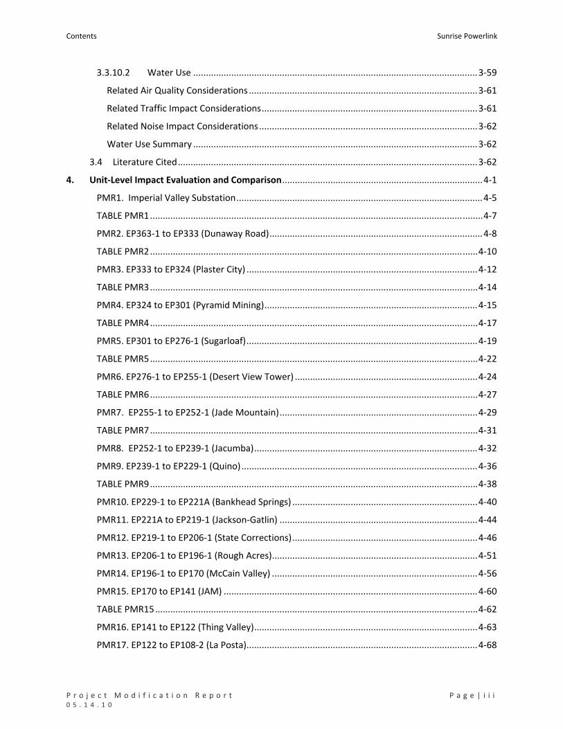
4. Unit‐Level Impact Evaluation and Comparison...............................................................................4‐1
PMR1. Imperial Valley Substation.................................................................................................4‐5
TABLE PMR1...................................................................................................................................4‐7
PMR2. EP363‐1 to EP333 (Dunaway Road)....................................................................................4‐8
TABLE PMR2.................................................................................................................................4‐10
PMR3. EP333 to EP324 (Plaster City) ...........................................................................................4‐12
TABLE PMR3.................................................................................................................................4‐14
PMR4. EP324 to EP301 (Pyramid Mining)....................................................................................4‐15
TABLE PMR4.................................................................................................................................4‐17
PMR5. EP301 to EP276‐1 (Sugarloaf)...........................................................................................4‐19
TABLE PMR5.................................................................................................................................4‐22
PMR6. EP276‐1 to EP255‐1 (Desert View Tower) ........................................................................4‐24
TABLE PMR6.................................................................................................................................4‐27
PMR7. EP255‐1 to EP252‐1 (Jade Mountain)..............................................................................4‐29
TABLE PMR7.................................................................................................................................4‐31
PMR8. EP252‐1 to EP239‐1 (Jacumba)........................................................................................4‐32
PMR9. EP239‐1 to EP229‐1 (Quino).............................................................................................4‐36
TABLE PMR9.................................................................................................................................4‐38
PMR10. EP229‐1 to EP221A (Bankhead Springs) .........................................................................4‐40
PMR11. EP221A to EP219‐1 (Jackson‐Gatlin) ..............................................................................4‐44
PMR12. EP219‐1 to EP206‐1 (State Corrections).........................................................................4‐46
PMR13. EP206‐1 to EP196‐1 (Rough Acres).................................................................................4‐51
PMR14. EP196‐1 to EP170 (McCain Valley) .................................................................................4‐56
PMR15. EP170 to EP141 (JAM) ....................................................................................................4‐60
TABLE PMR15...............................................................................................................................4‐62
PMR16. EP141 to EP122 (Thing Valley)........................................................................................4‐63
PMR17. EP122 to EP108‐2 (La Posta)...........................................................................................4‐68
Sunrise Powerlink Contents
i v | P a g e P r o j e c t M o d i f i c a t i o n R e p o r t 0 5 . 1 4 . 1 0
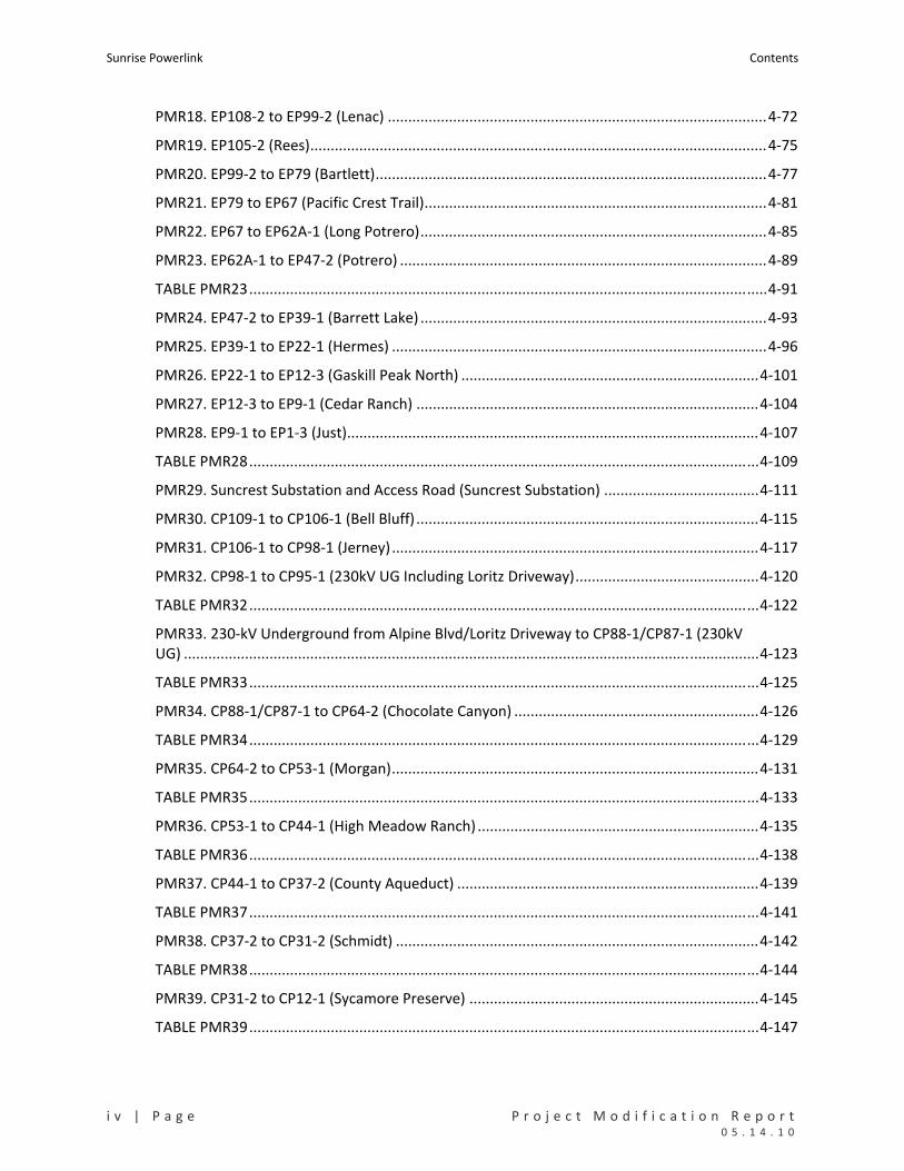
PMR18. EP108‐2 to EP99‐2 (Lenac) .............................................................................................4‐72
PMR19. EP105‐2 (Rees)................................................................................................................4‐75
PMR20. EP99‐2 to EP79 (Bartlett)................................................................................................4‐77
PMR21. EP79 to EP67 (Pacific Crest Trail)....................................................................................4‐81
PMR22. EP67 to EP62A‐1 (Long Potrero).....................................................................................4‐85
PMR23. EP62A‐1 to EP47‐2 (Potrero) ..........................................................................................4‐89
TABLE PMR23...............................................................................................................................4‐91
PMR24. EP47‐2 to EP39‐1 (Barrett Lake) .....................................................................................4‐93
PMR25. EP39‐1 to EP22‐1 (Hermes) ............................................................................................4‐96
PMR26. EP22‐1 to EP12‐3 (Gaskill Peak North) .........................................................................4‐101
PMR27. EP12‐3 to EP9‐1 (Cedar Ranch) ....................................................................................4‐104
PMR28. EP9‐1 to EP1‐3 (Just).....................................................................................................4‐107
TABLE PMR28.............................................................................................................................4‐109
PMR29. Suncrest Substation and Access Road (Suncrest Substation) ......................................4‐111
PMR30. CP109‐1 to CP106‐1 (Bell Bluff) ....................................................................................4‐115
PMR31. CP106‐1 to CP98‐1 (Jerney)..........................................................................................4‐117
PMR32. CP98‐1 to CP95‐1 (230kV UG Including Loritz Driveway).............................................4‐120
TABLE PMR32.............................................................................................................................4‐122
PMR33. 230‐kV Underground from Alpine Blvd/Loritz Driveway to CP88‐1/CP87‐1 (230kV UG) .............................................................................................................................................4‐123
TABLE PMR33.............................................................................................................................4‐125
PMR34. CP88‐1/CP87‐1 to CP64‐2 (Chocolate Canyon) ............................................................4‐126
TABLE PMR34.............................................................................................................................4‐129
PMR35. CP64‐2 to CP53‐1 (Morgan)..........................................................................................4‐131
TABLE PMR35.............................................................................................................................4‐133
PMR36. CP53‐1 to CP44‐1 (High Meadow Ranch) .....................................................................4‐135
TABLE PMR36.............................................................................................................................4‐138
PMR37. CP44‐1 to CP37‐2 (County Aqueduct) ..........................................................................4‐139
TABLE PMR37.............................................................................................................................4‐141
PMR38. CP37‐2 to CP31‐2 (Schmidt) .........................................................................................4‐142
TABLE PMR38.............................................................................................................................4‐144
PMR39. CP31‐2 to CP12‐1 (Sycamore Preserve) .......................................................................4‐145
TABLE PMR39.............................................................................................................................4‐147

Contents Sunrise Powerlink
P r o j e c t M o d i f i c a t i o n R e p o r t P a g e | v 0 5 . 1 4 . 1 0
PMR40. CP12‐1 to CP3 (Stonebridge) ........................................................................................4‐148
TABLE PMR40.............................................................................................................................4‐150
PMR41. CP3 to CP1A (Sycamore Substation).............................................................................4‐151
TABLE PMR41.............................................................................................................................4‐153
PMR42. Sycamore Canyon to Pomerado Substation (TL6915/6924) Reconductoring (Pomerado) ................................................................................................................................4‐154
TABLE PMR42.............................................................................................................................4‐157
PMR43. Sycamore Canyon to Elliott Substation (TL639) Reconductoring (Elliott)....................4‐158
TABLE PMR43.............................................................................................................................4‐160
PMR44. Sycamore Canyon to Scripps Substation (TL 6916) Reconductoring (Scripps).............4‐161
TABLE PMR44.............................................................................................................................4‐163

Sunrise Powerlink Contents
v i | P a g e P r o j e c t M o d i f i c a t i o n R e p o r t 0 5 . 1 4 . 1 0
Attachments
Attachment A. GIS Methodology for Impact Determination
Attachment B. Cultural Resource Inventory Summary Table
Attachment C. Powered Haulage Estimated Acoustical Impact Report
Attachment D. Air Quality Impacts Method
Charts and Illustrations
Illustration 1‐1. PMR Units in Relation to Project Links and Mileposts ....................................................1‐6
Illustration 2‐1. Microwave Telecommunication Equipment as Mounted on Structures ......................2‐16
Chart 3‐1. Permanent and Temporary Ground Disturbance for the Modified Project and FESSR...........3‐6
Tables
TABLE S‐1. COMPONENTS AND IMPACTS OF THE FESSR AND MODIFIED PROJECT ...............................................S‐3
TABLE S‐2. SUMMARY OF UNIT‐LEVEL IMPACT EVALUATION AND COMPARISON BASED ON PMR DATABASE .............................................................................................................................................S‐8
TABLE 1‐1. MMCRP MEASURES PROMPTING MODIFICATIONS............................................................................. 1‐4
TABLE 1‐2. SURVEYS AND STUDIES PRODUCING DATA USED IN THE PMR............................................................ 1‐5
TABLE 1‐3. PMR UNITS BY LOCATION ALONG THE FESSR ...................................................................................... 1‐7
TABLE 1‐4. PROJECT COMPONENT CATEGORIES IN THE GIS IMPACT CALCULATIONS .......................................... 1‐9
TABLE 2‐1. LIST OF STRUCTURES IN THE MODIFIED PROJECT................................................................................ 2‐2
TABLE 2‐2. SPANS IDENTIFIED FOR MARKER BALLS ............................................................................................. 2‐12
TABLE 2‐3. CONSTRUCTION YARDS FOR THE MODIFIED PROJECT....................................................................... 2‐15
TABLE 3‐1. SUMMARY OF FESSR AND MODIFIED PROJECT COMPONENTS AND ASSOCIATED FEATURES ............................................................................................................................................. 3‐4
TABLE 3‐2. SUMMARY OF FESSR AND MODIFIED PROJECT COMPONENTS AND ESTIMATE GROUND DISTURBANCE BY LINK BASED ON PMR DATABASE ............................................................................. 3‐4
TABLE 3‐3. FESSR AND MODIFIED PROJECT IMPACTS TO SENSITIVE VEGETATION COMMUNITIES BASED ON EIR/EIS AND PMR DATABASES............................................................................................ 3‐8
TABLE 3‐4. FESSR AND MODIFIED PROJECT IMPACTS TO SENSITIVE VEGETATION SUBTYPES BASED ON THE PMR DATABASE...................................................................................................................... 3‐9
TABLE 3‐5. OFFSITE AND ONSITE MITIGATION RATIOS FOR PERMANENT AND TEMPORARY IMPACTS TO SENSITIVE VEGETATION COMMUNITIES....................................................................................... 3‐10
TABLE 3‐6. SPECIAL STATUS PLANTS POTENTIALLY AFFECTED BY THE FESSR OR MODIFIED PROJECT BASED ON THE PMR DATABASE......................................................................................................... 3‐12
Contents Sunrise Powerlink
P r o j e c t M o d i f i c a t i o n R e p o r t P a g e | v i i 0 5 . 1 4 . 1 0
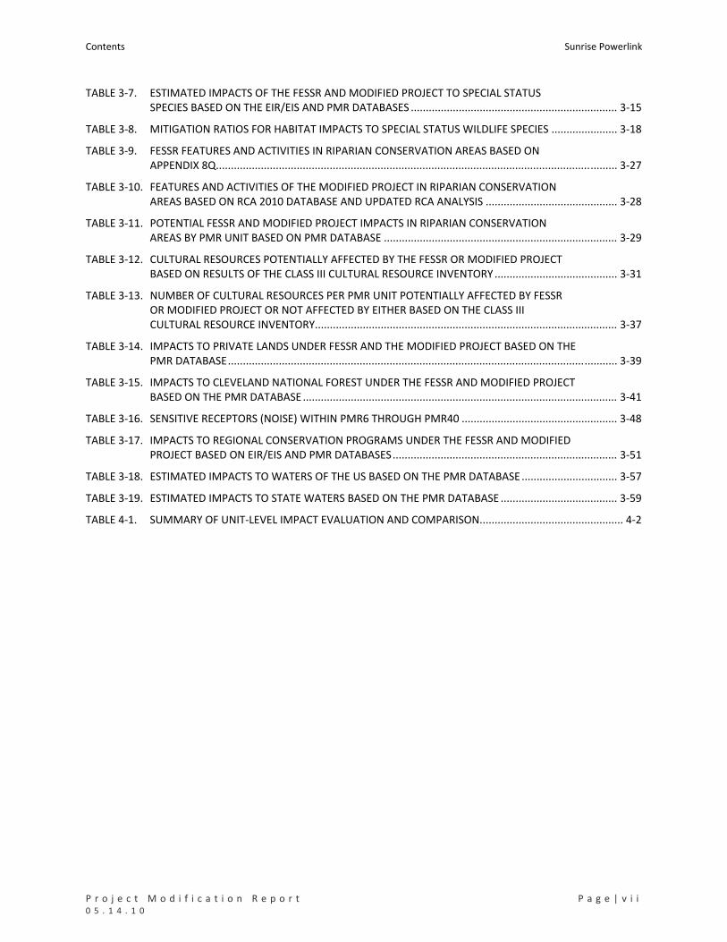
TABLE 3‐7. ESTIMATED IMPACTS OF THE FESSR AND MODIFIED PROJECT TO SPECIAL STATUS SPECIES BASED ON THE EIR/EIS AND PMR DATABASES ..................................................................... 3‐15
TABLE 3‐8. MITIGATION RATIOS FOR HABITAT IMPACTS TO SPECIAL STATUS WILDLIFE SPECIES ...................... 3‐18
TABLE 3‐9. FESSR FEATURES AND ACTIVITIES IN RIPARIAN CONSERVATION AREAS BASED ON APPENDIX 8Q...................................................................................................................................... 3‐27
TABLE 3‐10. FEATURES AND ACTIVITIES OF THE MODIFIED PROJECT IN RIPARIAN CONSERVATION AREAS BASED ON RCA 2010 DATABASE AND UPDATED RCA ANALYSIS ............................................ 3‐28
TABLE 3‐11. POTENTIAL FESSR AND MODIFIED PROJECT IMPACTS IN RIPARIAN CONSERVATION AREAS BY PMR UNIT BASED ON PMR DATABASE .............................................................................. 3‐29
TABLE 3‐12. CULTURAL RESOURCES POTENTIALLY AFFECTED BY THE FESSR OR MODIFIED PROJECT BASED ON RESULTS OF THE CLASS III CULTURAL RESOURCE INVENTORY ......................................... 3‐31
TABLE 3‐13. NUMBER OF CULTURAL RESOURCES PER PMR UNIT POTENTIALLY AFFECTED BY FESSR OR MODIFIED PROJECT OR NOT AFFECTED BY EITHER BASED ON THE CLASS III CULTURAL RESOURCE INVENTORY..................................................................................................... 3‐37
TABLE 3‐14. IMPACTS TO PRIVATE LANDS UNDER FESSR AND THE MODIFIED PROJECT BASED ON THE PMR DATABASE.................................................................................................................................. 3‐39
TABLE 3‐15. IMPACTS TO CLEVELAND NATIONAL FOREST UNDER THE FESSR AND MODIFIED PROJECT BASED ON THE PMR DATABASE......................................................................................................... 3‐41
TABLE 3‐16. SENSITIVE RECEPTORS (NOISE) WITHIN PMR6 THROUGH PMR40 .................................................... 3‐48
TABLE 3‐17. IMPACTS TO REGIONAL CONSERVATION PROGRAMS UNDER THE FESSR AND MODIFIED PROJECT BASED ON EIR/EIS AND PMR DATABASES........................................................................... 3‐51
TABLE 3‐18. ESTIMATED IMPACTS TO WATERS OF THE US BASED ON THE PMR DATABASE ................................ 3‐57
TABLE 3‐19. ESTIMATED IMPACTS TO STATE WATERS BASED ON THE PMR DATABASE ....................................... 3‐59
TABLE 4‐1. SUMMARY OF UNIT‐LEVEL IMPACT EVALUATION AND COMPARISON................................................ 4‐2
Sunrise Powerlink Contents
v i i i | P a g e P r o j e c t M o d i f i c a t i o n R e p o r t 0 5 . 1 4 . 1 0
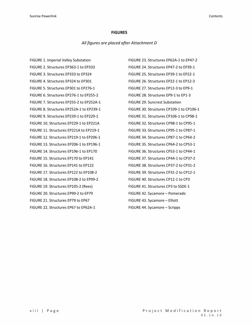
FIGURES
All figures are placed after Attachment D
FIGURE 1. Imperial Valley Substation FIGURE 23. Structures EP62A‐1 to EP47‐2
FIGURE 2. Structures EP363‐1 to EP333 FIGURE 24. Structures EP47‐2 to EP39‐1
FIGURE 3. Structures EP333 to EP324 FIGURE 25. Structures EP39‐1 to EP22‐1
FIGURE 4. Structures EP324 to EP301 FIGURE 26. Structures EP22‐1 to EP12‐3
FIGURE 5. Structures EP301 to EP276‐1 FIGURE 27. Structures EP12‐3 to EP9‐1
FIGURE 6. Structures EP276‐1 to EP255‐2 FIGURE 28. Structures EP9‐1 to EP1‐3
FIGURE 7. Structures EP255‐2 to EP252A‐1 FIGURE 29. Suncrest Substation
FIGURE 8. Structures EP252A‐1 to EP239‐1 FIGURE 30. Structures CP109‐1 to CP106‐1
FIGURE 9. Structures EP239‐1 to EP229‐1 FIGURE 31. Structures CP106‐1 to CP98‐1
FIGURE 10. Structures EP229‐1 to EP221A FIGURE 32. Structures CP98‐1 to CP95‐1
FIGURE 11. Structures EP221A to EP219‐1 FIGURE 33. Structures CP95‐1 to CP87‐1
FIGURE 12. Structures EP219‐1 to EP206‐1 FIGURE 34. Structures CP87‐1 to CP64‐2
FIGURE 13. Structures EP206‐1 to EP196‐1 FIGURE 35. Structures CP64‐2 to CP53‐1
FIGURE 14. Structures EP196‐1 to EP170 FIGURE 36. Structures CP53‐1 to CP44‐1
FIGURE 15. Structures EP170 to EP141 FIGURE 37. Structures CP44‐1 to CP37‐2
FIGURE 16. Structures EP141 to EP122 FIGURE 38. Structures CP37‐2 to CP31‐2
FIGURE 17. Structures EP122 to EP108‐2 FIGURE 39. Structures CP31‐2 to CP12‐1
FIGURE 18. Structures EP108‐2 to EP99‐2 FIGURE 40. Structures CP12‐1 to CP3
FIGURE 19. Structures EP105‐2 (Rees) FIGURE 41. Structures CP3 to SSDE‐1
FIGURE 20. Structures EP99‐2 to EP79 FIGURE 42. Sycamore – Pomerado
FIGURE 21. Structures EP79 to EP67 FIGURE 43. Sycamore – Elliott
FIGURE 22. Structures EP67 to EP62A‐1 FIGURE 44. Sycamore – Scripps

Contents Sunrise Powerlink
P r o j e c t M o d i f i c a t i o n R e p o r t P a g e | i x 0 5 . 1 4 . 1 0
Abbreviations and Acronyms
BLM Bureau of Land Management, U.S. Department of Interior
BMP Best Management Practice(s)
BO Biological Opinion
CDFG California Department of Fish and Game
CNDDB California Natural Diversity Database
CPUC California Public Utilities Commission
FEIR/EIS Final Environmental Impact Report & Environmental Impact Statement
FESSR Final Environmentally Superior Southern Route
Gnatcatcher Coastal California gnatcatcher
LBV Least Bell’s Vireo
MMCRP Mitigation Monitoring Compliance, and Reporting Plan
MP Mile Post
MS Map (Book) Sheet
PBS Peninsular Bighorn Sheep
Quino Quino checkerspot butterfly
RCA Riparian Conservation Area
ROW Right‐of‐Way
SDG&E San Diego Gas and Electric Company
SKR Stephens’ Kangaroo Rat
SRPL Sunrise Powerlink
SWF Southwestern Willow Flycatcher
SWPL Southwest Powerlink
USFS United States Forest Service, U.S. Department of Agriculture
USGS United States Geological Survey
USFWS United States Fish and Wildlife Service
Water(s) of the US Jurisdictional Waters of the United States

Sunrise Powerlink Contents
x | P a g e P r o j e c t M o d i f i c a t i o n R e p o r t 0 5 . 1 4 . 1 0

P r o j e c t M o d i f i c a t i o n R e p o r t P a g e | S ‐ 1 0 5 . 1 4 . 1 0
SUMMARY
This Project Modification Report (PMR) was prepared by San Diego Gas and Electric Company (SDG&E)
to comply with Section 4.2.1 of the Mitigation Monitoring Compliance and Reporting Plan (MMCRP) for
the Sunrise Powerlink Project (SRPL, Project). The PMR presents the final engineering and design of the
Project and identifies the modifications that have been made since adoption of the Final Environmental
Impact Report/Environmental Impact Statement (Final EIR/EIS) and approval of the Project by the
California Public Utilities Commission (CPUC) and the U.S. Department of Interior Bureau of Land
Management (BLM).
The modifications described in this PMR are the result of SDG&E’s implementation of measures in the
MMCRP to avoid and minimize impacts to sensitive resources, reduce or eliminate engineering
constraints, and accommodate landowner location preferences where possible. They include changes in
the alignment, placement of towers and poles, size and location of temporary work areas, number and
size of temporary construction yards, number and length of new access roads, and construction
methods (conventional or helicopter). As required by MMCRP Section 4.2.1, the changes are presented
in relation to the Final Environmentally Superior Southern Route (FESSR) identified in the Final EIR/EIS
for the Project. Hereafter, “FESSR” is used when referring to the routing and components of the Project
as described in the Final EIR/EIS; “modified Project” is used when referring to the FESSR as modified by
the changes in this PMR. The PMR Mapbook shows the entire alignment and components of the FESSR
and modified Project at a 1”=4’ scale. The PMR text describes the differences between the FESSR and
the modified Project in terms of changes made at specific locations and in terms of changes in the
environmental effects identified in the Final EIR/EIS. FESSR impacts are identified based on information
in the Final EIR/EIS, including the databases used in the EIR/EIS analyses. This information is cited in the
PMR as the “EIR/EIS database.” Since issuance of the Final EIR/EIS, additional field surveys and data
collection have taken place, pursuant to agency requests and required mitigation measures. As a result,
additional information is now available regarding sensitive resources along both the FESSR and the
modified Project alignment. This additional information has been combined with the EIR/EIS database
and comprises the “PMR database.” The PMR database is used for the impact estimates for the
modified Project. Where appropriate, it also has been applied to the FESSR to provide an additional
context for comparing impacts.
Table S‐1 summarizes the components and impacts of the FESSR and the modified Project in their
entirety (i.e., looking at the Project as a whole). Table S‐2 summarizes the evaluation and comparison of
impacts at different locations along the alignment. In the second analysis, the Project was divided into
44 units that include the ROW, structures, and associated components for the FESSR and modified
Project in that geographic area. The units vary in size and typically reflect a portion of the line affected
by interrelated changes.
As indicated in the “components” section of Table S‐1, the modified Project and FESSR mainly have the
same constituent parts and differ in terms of the number of structures and associated features and
Sunrise Powerlink Summary
2 | P a g e P r o j e c t M o d i f i c a t i o n R e p o r t 0 5 . 1 4 . 1 0
number of structures designated for helicopter construction. The one minor exception is that the
modified Project includes a pre‐engineered storage facility on already disturbed land within the existing
Imperial Valley Substation that which was not included in the FESSR (see Section 4, PMR1). Overall, the
modified Project has fewer structures, fewer new access roads, fewer wire stringing areas, and fewer
construction yards; a smaller Suncrest Substation; and more structures designated for helicopter
construction than the FESSR. As summarized in the “environmental impact” section of Table S‐1, these
differences equate to a 46% reduction in permanent and temporary ground disturbance compared with
the FESSR. The “environmental impact” section of Table S‐1 presents FESSR impacts as estimated in the
Final EIR/EIS (modeled after and using information from Table 8P of the Final EIR/EIS), FESSR impacts
based on the PMR database, and modified Project impacts based on the PMR database.
Table S‐1 illustrates that the modified Project would reduce overall on‐the‐ground impacts, thereby
reducing impacts to biological, cultural, land use, and wetland/stream resources when compared to the
FESSR. Impacts of the modified Project to other resources are similar in nature to the FESSR’s and, with
few exceptions, also reduced. No new significant impacts would result.
Table S‐2 illustrates that there are many locations along the alignment where modifications would
reduce FESSR impacts identified in the Final EIR/EIS and only a few locations where modifications would
increase impacts. There are also are many locations where the modified Project would have
substantially the same impact as the FESSR. No new significant impacts would result from any of the
modifications.
In summary, through the implementation of mitigation measures included in the Final EIR/EIS, the
modified Project would reduce but not eliminate significant impacts associated with the FESSR and
would not result in any new significant impacts. Because the modified Project would result in less
impact to the environment and would better protect natural and cultural resources, it is
environmentally preferred to the components and initial routing of the FESSR.
Summary Sunrise Powerlink
P r o j e c t M o d i f i c a t i o n R e p o r t P a g e | S ‐ 3 0 5 . 1 4 . 1 0
TABLE S‐1. COMPONENTS AND IMPACTS OF THE FESSR AND MODIFIED PROJECT
PROJECT COMPONENTS
Change Resulting from Modification Variable FESSR
Modified Project Number %
Length (miles) 119 117 (2) 1.6% decrease
Structures (number) 481 443 (38) 7.9% decrease
Wire Stringing Sites (number) 129 78 (51) 39.5% decrease
New Access Roads (miles) 125.23 51.12 (74.11) 59.2% decrease
Tower Staging Access Pads (number) 108 162 58 53.8% increase
Construction Yards (number) 43 19 (24) 55.8% decrease
Suncrest Substation (acres) 128.18 75.66 (52.52) 41.0% decrease
Reconductoring Replacement Poles (69kV) 11 17 6 54.4% increase
ENVIRONMENTAL IMPACTS
Alignment
December 2008
FESSR
December 2008
FESSR
May 2010 Modified Project
Data Source EIR/EIS
Database
PMR
Database
PMR
Database
SENSITIVE VEGETATION COMMUNITIES Acres Acres Acres
Permanent Impacts
Desert Scrub and Dune Habitats 93.08 91.88 36.37
Coastal and Montane Scrub Habitats 54.52 53.56 27.47
Grasslands and Meadows 14.37 13.74 4.15
Chaparrals 320.17 294.36 181.19
Woodlands and Forests 6.54 17.89 4.24
Herbaceous Wetlands, Freshwater, and Streams (Non‐vegetated Channel) 0.13 3.17 1.10
Riparian Scrubs 0.57 0.38 0.00
Riparian Forests and Woodlands 0.58 0.88 0.25
Total Permanent Impacts to Sensitive Communities 489.96 475.86 254.77
Temporary Impacts
Desert Scrub and Dune Habitats 269.47 282.13 142.27
Coastal and Montane Scrub Habitats 118.39 114.56 66.94
Grasslands and Meadows 172.89 161.49 48.40
Chaparrals 271.20 321.44 223.96
Woodlands and Forests 12.78 30.57 3.93
Herbaceous Wetlands, Freshwater, and Streams (Non‐vegetated Channel) 3.03 10.73 2.37
Riparian Scrubs 1.08 0.69 0.00
Riparian Forests and Woodlands <0.01 2.96 0.10
Total Temporary Impacts to Sensitive Communities 848.85 924.57 487.97
TOTAL IMPACTS TO SENSITIVE VEGETATION COMMUNITIES 1338.81 1400.43 742.74
Other Ground Disturbance
Non‐native Vegetation, Developed Areas, and Disturbed Habitat
Permanent ‐‐ 79.15 43.65
Temporary ‐‐ 335.75 197.16
TOTAL GROUND DISTURBANCE ‐‐ 1815.34 983.53

Sunrise Powerlink Summary
4 | P a g e P r o j e c t M o d i f i c a t i o n R e p o r t 0 5 . 1 4 . 1 0
ENVIRONMENTAL IMPACTS
Alignment
December 2008
FESSR
December 2008
FESSR
May 2010 Modified Project
Data Source EIR/EIS
Database
PMR
Database
PMR
Database
SPECIAL STATUS SPECIES1 (acres or number)
(acres or number)
(acres or number)
QUINO CHECKERSPOT BUTTERFLY
USFWS Critical Habitat (2002 or 2009) 2
Permanent Impacts 19.20 11.46 4.45
Temporary Impacts 55.72 16.93 1.59
USFWS Occupied Habitat (USFWS Data) 3
Permanent Impacts ‐‐ 36.16 15.16
Temporary Impacts ‐‐ 84.76 17.49
ARROYO TOAD
USFWS Proposed Critical Habitat4
Permanent Impacts ‐‐ 7.13 2.46
Temporary Impacts ‐‐ 100.67 44.23
USFS Suitable Habitat [USFS Habitat Model]
Permanent Impacts 32.45 33.09 11.92
Temporary Impacts 150.69 154.97 63.00
USFS Suitable Habitat in CNF [USFS Habitat Model]
Permanent Impacts ‐‐ 3.83 3.49
Temporary Impacts ‐‐ 20.53 0.01
BAREFOOT BANDED GECKO (SUITABLE HABITAT)
Permanent Impacts ‐‐ 20.63 10.84
Temporary Impacts ‐‐ 17.16 4.53
FLAT‐TAILED HORNED LIZARD
Permanent Impacts
Management Areas 22.62 22.26 9.54
Habitat Outside of Management Areas 52.95 71.16 26.35
Total Permanent Impacts 75.57 93.42 35.89
Temporary Impacts
Management Areas 91.31 103.25 36.87
Habitat Outside of Management Areas 141.53 170.67 94.88
Total Temporary Impacts 232.84 273.92 131.75

Summary Sunrise Powerlink
P r o j e c t M o d i f i c a t i o n R e p o r t P a g e | S ‐ 5 0 5 . 1 4 . 1 0
ENVIRONMENTAL IMPACTS
Alignment
December 2008
FESSR
December 2008
FESSR
May 2010 Modified Project
Data Source EIR/EIS
Database
PMR
Database
PMR
Database
COASTAL CALIFORNIA GNATCATCHER
Number of Pairs Affected ‐‐ ‐‐ 2
Number of Unpaired Individuals Affected ‐‐ ‐‐ 1
USFWS Critical Habitat
Permanent Impacts 2.22 10.06 3.88
Temporary Impacts 32.97 17.84 21.58
USFWS Occupied Habitat (USFWS Data)
Permanent Impacts 05 1.46 0.16
Temporary Impacts 05 1.83 8.11
USFS Suitable Habitat [USFS Habitat Model]
Permanent Impacts 25.52 25.03 11.97
Temporary Impacts 52.69 48.50 15.67
USFS Suitable Habitat in CNF [USFS Habitat Model]
Permanent Impacts ‐‐ 2.65 1.12
Temporary Impacts ‐‐ 7.07 0.60
GOLDEN EAGLE6
Nest Sites Potentially Affected 4 ‐‐ 95
LEAST BELL'S VIREO7
USFWS Occupied Habitat [USFWS Data]
Permanent Impacts 0.94 0.89 0.00
Temporary Impacts 0.00 0.32 0.00
USFS Suitable Habitat in CNF [USFS Habitat Model] 7
Permanent Impacts ‐‐ 1.32 0.19
Temporary Impacts ‐‐ 0.00 0.00
SOUTHWESTERN WILLOW FLYCATCHER7
USFS Suitable Habitat in CNF (USFS Modeled Habitat]
Permanent Impacts ‐‐ 5,14 3,98
Temporary Impacts ‐‐ 14.39 0.74
PENINSULAR BIGHORN SHEEP
2001 Designated Critical Habitat/Occupied Habitat8
Permanent Impacts 60.42 30.41 10.36
Temporary Impacts 111.81 34.64 20.24
2009 Designated Critical Habitat
Permanent Impacts N/A 16.04 5.41
Temporary Impacts N/A 17.16 1.41

Sunrise Powerlink Summary
6 | P a g e P r o j e c t M o d i f i c a t i o n R e p o r t 0 5 . 1 4 . 1 0
ENVIRONMENTAL IMPACTS
Alignment
December 2008
FESSR
December 2008
FESSR
May 2010 Modified Project
Data Source EIR/EIS
Database
PMR
Database
PMR
Database
STEPHENS’ KANGAROO RAT7
USFS Suitable Habitat in CNF [USFS Habitat Model] 7
Permanent Impacts 0 0.71 0.18
Temporary Impacts 0 0.03 0.00
OTHER RESOURCES9
Cultural Resources
Number of Sites Potentially Affected ‐‐ 206 147
Impacts to Waters of the US (acres)
Permanent ‐‐ 14.49 3.86
Temporary ‐‐ 80.21 7.25
Impacts to State Waters (acres)
Permanent ‐‐ 15.39 4.14
Temporary ‐‐ 82.81 7.87
SUMMARY OF OTHER CHANGES IN THE EFFECTS OF THE FESSR
Air Resources Some reductions in emissions from reduced ground disturbance. No significant change in net emissions of trucks, helicopters, and equipment.
Geology/Minerals Some reductions in erosion, slope stability, and mineral resource impacts from reduced ground disturbance. Impact minimization measures built into FESSR and carried over to the modified Project.
Land Uses/Noise Reduced impacts to private property and federal lands; reduced inconsistency with plans, policies, and habitat conservation programs; some reductions in potential noise impacts on sensitive receptors.
Public Safety/Fire Hazards
Reroutes and new construction yards within same fire hazard areas as FESSR; impact minimization measures and safety requirements carried over to the modified Project.
Traffic/Transportation Some reductions in traffic impacts with reduced use of trucks for construction. Increased helicopter use and truck transport of water.
Visual Some reductions in skylining and long‐term land scarring; impact minimization measures built into FESSR carried over to the modified Project.
Water Sources/Uses Similar potential for use of non‐groundwater sources, including reclaimed water. Potential for reduced water use because of reduction in ground disturbance.
Notes
1 In this summary of impacts to special status species, the focus is on the following habitat categories:
USFWS critical habitat (designated or proposed), USFWS occupied habitat (areas that USFWS considers
occupied by the species based on available information and/or assumptions); mapped habitat and
management areas for flat‐tailed horned lizard; mapped suitable habitat for barefoot banded gecko; and
suitable habitat as identified by habitat models used by USFS (USFS Suitable Habitat). Where the
information in the Final EIR/EIS is not broken into a category used in the PMR database or is assessed
qualitatively rather than quantified, the entry is “‐‐.”
2 The estimate of critical habitat for the FESSR in the Final EIR/EIS is based on the 2002 designation; the
estimate for the FESSR in column two is based on the current designation, which also applies to the
modified Project.

Summary Sunrise Powerlink
P r o j e c t M o d i f i c a t i o n R e p o r t P a g e | S ‐ 7 0 5 . 1 4 . 1 0
3 USFWS Occupied Habitat includes areas of known Quino populations and sightings and a buffer that
typically encompasses all host plants in the vicinity. Some of the USFWS occupied habitat areas also are
part of designated critical habitat (e.g., the Jacumba population).
4 Critical habitat for arroyo toad was proposed after completion of the Final EIR/EIS.
5 Appendix 8P of the Final EIR/EIS does not include the specific category of “USFWS Occupied” but
shows “0” as the amount of “occupied” habitat. In the USFWS BO for the Project, the estimate
is that the FESSR would result in permanent impacts to 8.30 acres and temporary impacts to
12.70 acres of USFWS Occupied habitat.
6 SDG&E is currently conducting a golden eagle nest area study. Surveys are being conducted
following USFWS’ Interim Golden Eagle Inventory and Monitoring Protocols; and Other
Recommendations (February 2010). The purpose of the surveys is to record and report
occupancy (Phase 1) and productivity (Phase 2) of resident golden eagle individual activities,
nests, and territories within a 4‐mile radius of the Project. Preliminary results of Phase 1 indicate
there are 9 nests (active territories) within a 4‐mile radius of the modified Project’s activity
areas.
7 Focused surveys conducted subsequent to the Final EIR/EIS have determined that this species
would not occur in the FESSR or modified Project impact areas. The USFS habitat model results
have been retained for lands in the CNF.
8 USFWS considers areas formerly designated as critical habitat for Peninsular bighorn sheep to be
occupied habitat.
9 The impact estimates in this subsection are based on the results of surveys required under the
MMCRP and conducted following approval of the Final EIR/EIS.

Sunrise Powerlink Summary
8 | P a g e P r o j e c t M o d i f i c a t i o n R e p o r t 0 5 . 1 4 . 1 0
TABLE S‐2. SUMMARY OF UNIT‐LEVEL IMPACT EVALUATION AND COMPARISON BASED ON PMR DATABASE
Total Ground
Disturbance Changes to the Effects of the FESSR Resulting from the Modification
PMR Unit Structures/Yards
FESS
R
Mo
dif
ied P
roje
ct
Sen
siti
ve
Ve
geta
tio
n
Spe
cial S
tatu
s
Spe
cie
s
Cu
ltu
ral
Re
sou
rce
s
Vis
ual R
eso
urc
es
Wat
ers o
f U
S &
Stre
amb
eds
Summary Conclusion/Notes
PMR1 Imperial Valley Substation
‐‐ ‐‐ NSC NSC NSC NSC NSC Adds storage facility within existing substation.
PMR2 EP363‐1 to EP333 IV Sub Yard, Dunaway Road Yard
240.82 58.03 R R R NSC R Reduces impacts
PMR3 EP333 to EP324 Plaster City Yard
55.92 32.92 R/I R R NSC R
Avoids sensitive resources with the exception of a slight temporary increase in impacts to desert scrub.
PMR4 EP324 to EP301
100.21 29.71 R R R NSC R Coordination with quarry activities initiated for FESSR would continue.
PMR5 EP301 to EP276‐1 (BLM) S2 Yard
69.89 49.04 R/NSC R R/NSC NSC R Coordination with quarry activities initiated for FESSR would continue.
PMR6 EP276‐1 to EP255‐1 AER Yard
56.35 20.48 R R R NSC/R R Reduces size of construction yard and associated impacts
PMR7 EP255‐1 to EP252‐1
10.42 16.36 R/I R/I R NSC NSC/I Temporary impacts to dry washes, PBS habitat, and waters increase slightly.
PMR8 EP252‐1 to EP239‐1 Jacumba Airport Yard Jacumba Valley Ranch Yard
36.67 55.90 R/I I/R R I/NSC E
The yard responsible for the impact increases replaces one in PMR9 eliminated to avoid Quino impacts.
PMR9 EP239‐1 to EP229‐1
59.09 7.59 R R R NSC/R E Avoids impacts to rare plants. Avoids conflict with Nature Conservancy lands.
PMR10 EP229‐1 to EP221A
19.84 4.49 R/NSC R NSC/R NSC I Slight reduction in impacts
PMR11 EP221A to EP219‐1
48.17 5.49 R NSC E NSC R Reduction in waters of US impacts.
PMR12 EP219‐1 to EP206‐1
44.12 18.74 R NSC NSC/R NSC R Reductions in impacts
PMR13 EP206‐1 to EP196‐1 Rough Acres Yard
52.11 106.60 I R NSC/R NSC R Increase in temporary impacts to Jacumba milk‐vetch
PMR14 EP196‐1 to EP170 McCain Valley Yard
62.10 68.59 I/NSC NSC/I NSC NSC I No substantial change

Summary Sunrise Powerlink
P r o j e c t M o d i f i c a t i o n R e p o r t P a g e | S ‐ 9 0 5 . 1 4 . 1 0
Total Ground
Disturbance Changes to the Effects of the FESSR Resulting from the Modification
PMR Unit Structures/Yards
FESS
R
Mo
dif
ied P
roje
ct
Sen
siti
ve
Ve
geta
tio
n
Spe
cial S
tatu
s
Spe
cie
s
Cu
ltu
ral
Re
sou
rce
s
Vis
ual R
eso
urc
es
Wat
ers o
f U
S &
Stre
amb
eds
Summary Conclusion/Notes
PMR15 EP170 to EP141
31.26 10.97 R R E R/NSC NSC RCA impacts reduced. Inconsistency with BCNM Zone.
PMR16 EP141 to EP122 Thing Valley Yard
28.09 49.39 I I NSC/R I/NSC R Avoids impacts to rare plants. RCA impacts increase.
PMR17 EP122 to EP108‐2
75.52 11.67 R R R R/NSC R RCA impacts reduced.
PMR18 EP108‐2 to EP99‐2
70.78 15.62 R I/R NSC NSC E RCA impacts reduced.
PMR19 EP105‐2
0.44 2.36 I I/NSC NSC NSC I/NSC No substantial change.
PMR20 EP99‐2 to EP79 Bartlett/Hauser Creek Yard
103.77 66.43 R NSC NSC NSC NSC/I RCA impacts avoided.
PMR21 EP79 to EP67
19.87 6.79 R R NSC/R I/NSC R RCA impacts avoided.
PMR22 EP67 to EP62A‐1
10.62 6.72 R R NSC NSC E RCA impacts avoided.
PMR23 EP62A‐1 to EP47‐2 Kreutzkamp Yard
67.79 41.41 R R R R/NSC R RCA impacts increase.
PMR24 EP47‐2 to EP39‐1 Barrett Canyon Yard
17.28 7.04 R NSC NSC R/NSC E Size and impacts of construction yard reduced
PMR25 EP39‐1 to EP22‐1 SWAT Training Facility Yard
51.86 35.01 R/I R E NSC R Reduction in impacts to rare plants. RCA impacts mixed.
PMR26 EP22‐1 to EP12‐3
18.11 4.58 R E/NSC NSC NSC E/NSC Impacts to rare plants avoided. RCA impacts reduced.
PMR27 EP12‐3 to P9‐1
17.02 4.58 R R NSC NSC NSC RCA impacts avoided.
PMR28 EP9‐1 to EP1‐3
17.47 6.50 R R NSC NSC E RCA impacts increase
PMR29 Suncrest Substation Wilson Yard
181.63 86.47 R NSC R/NSC NSC R Reduction in impacts to rare plants. RCA impacts avoided.
PMR30 CP109‐1 to CP106‐1
4.79 0.87 R NSC E/NSC NSC NSC Impacts to rare plants avoided
PMR31 CP106‐1 to CP98‐1
14.30 4.74 R E/NSC E NSC/R NSC RCA impacts avoided

Sunrise Powerlink Summary
1 0 | P a g e P r o j e c t M o d i f i c a t i o n R e p o r t 0 5 . 1 4 . 1 0
Total Ground
Disturbance Changes to the Effects of the FESSR Resulting from the Modification
PMR Unit Structures/Yards
FESS
R
Mo
dif
ied P
roje
ct
Sen
siti
ve
Ve
geta
tio
n
Spe
cial S
tatu
s
Spe
cie
s
Cu
ltu
ral
Re
sou
rce
s
Vis
ual R
eso
urc
es
Wat
ers o
f U
S &
Stre
amb
eds
Summary Conclusion/Notes
PMR32 CP98‐1 to CP95‐1
4.58 6.20 I/NSC I/NSC NSC NSC I/NSC No substantial change
PMR33 CP95‐1 to CP88‐1/CP87‐1 Alpine HQ, Alpine Yards
0.00 38.94 I NSC NSC I I/NSC No substantial change
PMR34 CP88‐1/CP87‐1 to CP64‐2 Hartung Yard
77.38 31.55 R R R NSC R Reduction in impacts to rare plants. RCA impacts reduced.
PMR35 CP64‐2 to CP53‐1
28.51 6.51 R R E NSC R Impacts to rare plants avoided
PMR36 CP53‐1 to CP44‐1 Helix Yard
28.91 29.25 I/R I NSC I R Slight increase in temporary effects
PMR37 CP44‐1 to CP37‐2
22.05 3.54 R R NSC NSC E Hansen Aggregate has access for mining operations.
PMR38 CP37‐2 to CP31‐2
40.30 2.83 R NSC NSC NSC/I E Modest reduction in impacts
PMR39 CP31‐2 to CP12‐1
12.01 9.56 R R NSC/R NSC NSC No substantial change
PMR40 CP12‐1 to CP3 Stowe/Kirkham Yard
4.24 23.56 I I NSC I NSC Increase in impacts
PMR41 CP3 to CP1A
11.03 0.30 R NSC NSC NSC NSC No substantial change
PMR42 Sycamore – Pomerado
0.00 2.91 I/NSC NSC NSC NSC/I NSC No significant change
PMR43 Sycamore – Elliott
0.00 1.70 I/NSC NSC NSC NSC/I NSC No substantial change
PMR44 Sycamore – Scripps
0.00 1.59 I/NSC NSC NSC NSC NSC No substantial change
Codes
E = All impacts to a resource category eliminated I = Increase in Impacts NSC = No substantial change in impacts; also applies to no change in quantified impacts. R = Reduction in Impacts

P r o j e c t M o d i f i c a t i o n R e p o r t P a g e | 1 ‐ 1 0 5 . 1 4 . 1 0
1. PURPOSE, METHODOLOGY, AND ORGANIZATION
1.1 PURPOSE
This Project Modification Report (PMR) was prepared by San Diego Gas & Electric Company (SDG&E) to
comply with section 4.2.1 of the Mitigation, Monitoring, and Compliance Reporting Program (MMCRP)
for the Sunrise Powerlink Project (SRPL, Project). The MMCRP was approved by the California Public
Utilities Commission (CPUC) and U.S. Department of Interior Bureau of Land Management (BLM)
following the CPUC’s certification of and BLM’s record of decision for the Final Environmental Impact
Report and Environmental Impact Statement (Final EIR/EIS) for the SRPL. Section 4.2.1 of the MMCRP
concerns changes to the Project resulting from final project design and engineering and reads as follows:
4.2.1 Transition from Preliminary Design to Final Engineering
The EIR/EIS analysis of the Sunrise Powerlink Project is based on preliminary design, as described
in Section B.1 of the Final EIR/EIS, which states that:
[The Project Description] section includes maps of the Proposed Project area
that illustrate land‐ownership and general routing. Appendix 11 of the
Environmental Impact Report/Environmental Impact Statement (EIR/EIS)
includes detailed maps that illustrate the approximate proposed locations of
each transmission structure and associated facilities based upon the status of
SDG&E’s preliminary engineering studies to date.
Because the project has now been approved by CPUC, BLM, and other jurisdictional agencies,
SDG&E is in the process of completing final project design and engineering. Some project
component locations are being modified as engineering is completed and to comply with
mitigation measures requiring resource avoidance to minimize or avoid environmental impacts
and reduce or eliminate feasibility constraints. In addition, some project components will be
moved to accommodate landowner location preferences where possible, in compliance with
Mitigation Measure L‐2b (Revise project elements to minimize land use conflicts).
SDG&E will submit to the Lead Agencies a construction plan that illustrates the location of project
components at the time of the Final EIR/EIS, and any changes that have been made since that
time. All changes will be reviewed by the CPUC and BLM, to ensure that there are no changes that
require additional CEQA or NEPA compliance review (i.e., that no new or more severe impacts are
created by the changes). A memorandum will be prepared to document the changes and the
impacts of the final plan. This memorandum will be approved by the CPUC and BLM. Detailed
maps will be presented on the project website.1
1 Sunrise Powerlink Transmission Project: Mitigation, Monitoring, and Compliance Reporting Program. Final. California Public Utilities Commission and U.S. Department of Interior Bureau of Land Management. April 1, 2010. Pages 38‐39.

Sunrise Powerlink 1. Purpose, Methodology, and Organization
1 ‐ 2 | P a g e P r o j e c t M o d i f i c a t i o n R e p o r t 0 5 . 1 4 . 1 0
This PMR identifies the changes that SDG&E has made in connection with final project design and
engineering, compliance with impact avoidance and reduction measures, and accommodation of
landowner location preferences. The PMR provides maps and text that identify changes in the location
and impacts of SRPL components in relation to the Final Environmentally Superior Southern Route
(FESSR) identified in the Final EIR/EIS. Hereafter, the term “FESSR” is used when referring to the routing
and components of the FESSR as described in the Final EIR/EIS. The term “modified Project” is used
when referring to the FESSR as modified by the changes in this PMR.
This PMR has been submitted to the CPUC and BLM to fulfill SDG&E’s requirements under MMCRP
section 4.2.1. The PMR also has been distributed to the U.S. Department of Agriculture Forest Service
(USFS), U.S. Fish and Wildlife Service (USFWS), U.S. Army Corps of Engineers (ACOE), California
Department of Fish and Game (CDFG), and California Environmental Protection Agency State Water
Resources Control Board (SWRCB).
In addition to compliance with MMCRP section 4.2.1, the PMR will be used to:
Update and clarify the description of the SRPL for purposes of the permits, field work, and other reports/plans that SDG&E must complete prior to construction;
Update the estimated impacts and corresponding mitigation requirements for the Project; and
Support SDG&E’s requests for Notices to Proceed with work on components of the Project.
1.2 METHODOLOGY
The PMR was developed in cooperation with the CPUC, BLM, USFS, USFWS, CDFG, ACOE, SWB, and the
consultant team who prepared the Final EIR/EIS.
1.2.1 MODIFICATION PROCESS
The modifications identified in this PMR were initiated in response to:
1. Additional field review of the FESSR, which is identified in the Final EIR/EIS as the
Interstate 8 Alternative, except where it is changed by: 1) SWPL Archaeological Site
Revision and Jacumba Breakaway Revision; BCD Alternative Revision and BCD South
Option Revision; 2) Modified Route D Alternative, including the Modified Route D
Alternative Substation, the Cameron Revision, PCT Reroute Option A, Western Modified
Route D Alternative Revisions; 3) Chocolate Canyon Option Revision, High Meadows
Reroute and Highway 67 Hansen Quarry Reroute; and 4) The Environmentally Superior
Northern Route Alternative (as defined in [Final EIR/EIS] Section 7.1.7) from where it
joins the Interstate 8 Alternative.2
2. Further project design and engineering; and
2 Final Environmental Impact Report and Environmental Impact Statement for the Sunrise Powerlink Transmission Project. California Public Utilities Commission and U.S. Department of Interior Bureau of Land Management. October 2008. Page ES‐69.

1. Purpose, Methodology, and Organization Sunrise Powerlink
P r o j e c t M o d i f i c a t i o n R e p o r t P a g e | 1 ‐ 3 0 5 . 1 4 . 1 0
3. The results of additional traffic, noise, and water use studies and additional surveys for
biological, cultural, and wetland resources, performed to comply with MMCRP requirements.
MMCRP requirements prompting modifications include but are not limited to the measures listed in
Table 1‐1. All mitigation measures associated with the Project are identified and described in greater
detail in the MMCRP. Measure L‐2b in particular prompted an extensive consideration of construction
modifications and reroutes. In compliance with L‐2b, SDG&E notified affected land owners within 1,000
feet of any project facility through a combination of direct mail, published notices, website postings, and
community meetings. Those land owners were provided the opportunity to identify potential reroutes
of the alignment that would be mutually acceptable to SDG&E and the land owner, but that would not
create adverse impacts to resources greater than those that would occur from the original alignment.
Additionally, a number of measures requiring avoidance or minimization of impacts to sensitive
resources resulted in project modifications that have reduced the estimated impacts associated with the
FESSR alignment.
The additional studies and surveys performed in response to MMCRP requirements that produced
information used to identify and evaluate modifications are identified in Table 1‐2.
Modifications were proposed on a site‐specific basis and typically entailed multiple iterations in which
different combinations of changes were evaluated. All changes in the location and size of Project
components were mapped by the SRPL technical team, entered into the Project GIS database, and
shown in relation to the initial FESSR routing as described in the Final EIR/EIS.
1.2.2 PMR UNITS
To reflect the site‐specific nature of the modifications and provide a basis for examining changes in
different locations along the alignment, the PMR divides the Project into 44 units. Each unit includes a
portion of the alignment and associated components (structures, access roads, yards, work areas, etc).
The units are numbered PMR1 through PMR44, and structure numbers and mileposts (MP) are used to
indicate the start and end point of each unit. As in the Final EIR/EIS, mileposts run from east to west in
ascending order, with MP0 located at the existing Imperial Valley Substation. Structure numbers run
from east to west in descending order. To differentiate between the 500kV and 230kV portions of the
line, 500kV structure numbers have an “EP” prefix and 230kV structures have a “CP” prefix.
Illustration 1‐1 shows the PMR units in relation to the five links of the Project. Table 1‐3 identifies the
units by PMR number, MPs, name, the structures, and construction yards (if any) in each unit. Only
construction yards proposed as part of the modified Project are included in Table 1‐3.

Sunrise Powerlink 1. Purpose, Methodology, and Organization
1 ‐ 4 | P a g e P r o j e c t M o d i f i c a t i o n R e p o r t 0 5 . 1 4 . 1 0
TABLE 1‐1. MMCRP MEASURES PROMPTING MODIFICATIONS
MMCRP No. MMCRP Requirement
AG‐1a Avoid interference with agricultural operations
AQ‐4a Offset construction phase greenhouse gas emissions with carbon credits
B‐1a Provide restoration/compensation for impacted sensitive vegetation communities
B‐1L Work with USFS to minimize impacts to the riparian conservation area between structures 184 and 187
B‐2a Avoid impacts to any jurisdictional areas to the extent feasible
B‐7i Conduct Quino checkerspot butterfly surveys and implement appropriate avoidance/minimization/compensation strategies
B‐7j Conduct arroyo toad surveys and implement appropriate avoidance/minimization/compensation strategies
BIO‐APM‐18 Avoid/minimize impacts to environmentally sensitive areas, including but not limited to high‐value wildlife habitats, sensitive vegetation communities, and high‐value plant habitats
C‐1b Avoid and protect potentially significant cultural and paleontological resources
C‐6f Reduce adverse visual intrusions to the Desert View Tower viewshed
CR‐APM‐2 Avoid/minimize impacts to archeological sites
F‐2b Install existing conductors on steel poles
GEO‐APM‐4 Place structures on geologically stable areas
GEO‐APM‐5 Design and implement project construction to avoid or minimize ground disturbing activities
L‐2b Revise project elements to minimize land use conflicts
S‐2b Protect underground utilities
V‐1a Reduce visibility of construction activities and equipment
V‐2a Reduce in line view of land scars
V‐2d Consider construction by helicopter to avoid land scarring in sensitive viewsheds or where construction would occur on slopes over 15 percent
V‐68a Eliminate skylining of ridgeline towers and conductors
WQ‐APM‐1 Conduct construction and maintenance activities to minimize impacts to riparian/wetland vegetation, drainage channels, and intermittent and perennial banks
WQ‐APM‐2 Design right of way (ROW) features to avoid impacts to sensitive features, such as watercourses
WQ‐APM‐4 Design construction elements to minimize impacts to sensitive waters, including surface waters, riparian areas, and floodplains
WR‐1a Coordinate schedules and activities with recreation areas (including open space preserves) and locate construction equipment to avoid temporary preclusion of recreation areas
WR‐2a Develop a reroute for the BCD Alternative Revision along the southern boundary of the JAM properties to shorten the route and minimize effects on BLM lands, USFS land, and private property
WR‐2b Evaluate and implement Pacific Crest Trail Route Revision

1. Purpose, Methodology, and Organization Sunrise Powerlink
P r o j e c t M o d i f i c a t i o n R e p o r t P a g e | 1 ‐ 5 0 5 . 1 4 . 1 0
TABLE 1‐2. SURVEYS AND STUDIES PRODUCING DATA USED IN THE PMR
Type Date Submitted/Status Conducted By
Biological
2009 Arroyo toad habitat assessment and surveys Oct 2009 1st submittal; Jan 2010 2
nd submittal RECON Environmental, Inc.
2009 Barefoot banded gecko habitat assessment and surveys Habitat surveyed Oct 2009; Mar 2010
Eric Dugan
2009 Bat surveys Feb 2010 San Diego Natural
History Museum
2009 Coastal California gnatcatcher habitat assessment and surveys
Sept 2009 1st submittal; Jan 2010 2
nd submittal Chambers Group, Inc.
2009 Golden eagle nest area survey and analysis Mar 2010 1st phase Wildlife Research
Institute
2009 Peninsular bighorn sheep monitoring Jan‐Dec 2009 results Art Davenport
2009 Quino checkerspot butterfly habitat assessment and surveys
Oct 2009 1st submittal; Jan 2010 2
nd submittal Chambers Group, Inc.
2009 Stephens’ Kangaroo Rat survey Feb 2010 Steve Montgomery
2009 Rare plant surveys Nov 2009 RECON Environmental,
Inc.
2009 Riparian bird habitat assessment and surveys Oct 2009 1st submittal; Jan 2010 2nd submittal
RECON Environmental, Inc.
2009 Weed (exotic invasive plant) inventory Apr 2009 to Sept 2009 results included in Weed Control Plan
RECON Environmental, Inc.
Cultural
Class III surveys Feb 2010
Under Agency Team Review
ASM Affiliates
Geological
Geotechnical and Geological Hazards Investigation and Geotechnical Design Information for the Overhead Transmission Line
Mar 2010 URS
Geotechnical Evaluation Access Roads and Structure Pads URS
Geotechnical Investigation for 230 kV Underground, Alpine, CA Mar 2010 Geosyntec
Scour Analysis for the Underground Transmission Line Feb 2010 Black & Veatch
Suncrest Substation Geotechnical Evaluation Dec 2009 URS
Noise
Powered Haulage Estimated Acoustical Impact Potential Apr 2010 (See Attachment B) Investigative Science
and Engineering, Inc.
Sensitive Receptors Inventory Analysis and Report being Finalized
Investigative Science and Engineering, Inc.
Traffic

Sunrise Powerlink 1. Purpose, Methodology, and Organization
1 ‐ 6 | P a g e P r o j e c t M o d i f i c a t i o n R e p o r t 0 5 . 1 4 . 1 0
Type Date Submitted/Status Conducted By
Construction Transportation Management Plan KOA Corporation
Traffic Impact Study Apr 2010 KOA Corporation
Water Use
Water Resource Availability Study – Non‐Groundwater Sources GeoSyntec
Wetlands and Streams
Preliminary Jurisdictional Delineation Apr 2010 WRA
Riparian Conservation Area Analysis Apr 2010 WRA
Streambed Alteration Agreement Application Update Contained in this PMR‐‐Chapter 3
ICF, WRA
Air
Air Quality Impacts from the Final Water Use Plan Mar 2010 Bluescape
ILLUSTRATION 1‐1. PMR UNITS IN RELATION TO PROJECT LINKS AND MILEPOSTS
FESSR Links, Mileposts, and PMR
Link 5
Link 4 Link 3 Link 2
Link 1
MP89 to MP92 MP98 to MP117 230kV Overhead
&
MP92 to MP98 230kV ‐
Underground
MP89 Suncrest
Substation
MP53 to MP89500kV ‐ Forest
MP0 to MP53 500kV ‐ Desert
PMR30 & PMR31 PMR34 to
PMR44
PMR32 & PMR33
PMR29
PMR16 to PMR28
PMR1 to PMR15

1. Purpose, Methodology, and Organization Sunrise Powerlink
P r o j e c t M o d i f i c a t i o n R e p o r t P a g e | 1 ‐ 7 0 5 . 1 4 . 1 0
TABLE 1‐3. PMR UNITS BY LOCATION ALONG THE FESSR
Structures and Yards included in the PMR Unit PMR Unit Mileposts Name
Structures Construction Yard(s)
PMR1 MP0 IV Substation Imperial Valley Substation
PMR2 MP0‐MP9.7 Dunaway Road EP363‐1 to EP333 IV Sub, Dunaway Road
PMR3 MP9.7‐MP12.7 Plaster City EP333 to EP324 Plaster City
PMR4 MP12.7‐MP19.1 Pyramid Mining EP324 to EP301
PMR5 MP19.1‐MP24.2 Sugarloaf EP301 to EP276‐1 (BLM) S2
PMR6 MP24.2‐MP30.3 Desert View Tower EP276‐1 to EP255‐1 AER
PMR7 MP30.3‐MP30.9 Jade Mountain EP255‐1 to EP252‐1
PMR8 MP30.9‐MP34.2 Jacumba EP252‐1 to EP239‐1 Jacumba Airport, Jacumba Valley Ranch
PMR9 MP34.2‐MP36.6 Quino EP239‐1 to EP229‐1
PMR10 MP36.6‐MP38.3 Bankhead Springs EP229‐1 to EP221A
PMR11 MP38.3‐MP39.2 Jackson‐Gatlin EP221A to EP219‐1
PMR12 MP39.2‐MP41.6 State Corrections EP219‐1 to EP206‐1
PMR13 MP41.6‐MP44.1 Rough Acres EP206‐1 to EP196‐1 Rough Acres
PMR14 MP44.1‐MP50.4 McCain Valley EP196‐1 to EP170 McCain Valley
PMR15 MP50.4‐MP53.4 JAM EP170 to EP141
PMR16 MP53.4‐MP57.9 Thing Valley EP141 to EP122 Thing Valley
PMR17 MP57.9‐MP61 La Posta EP122 to EP108‐2
PMR18 MP61‐MP63 Lenac EP108‐2 to EP99‐2 [minus EP105‐2]
PMR19 MP61.2 Rees EP105‐2
PMR20 MP63‐MP67.4 Bartlett EP99‐2 to EP79 Bartlett/Hauser Creek
PMR21 MP67.4‐MP70.6 Pacific Crest Trail EP79 to EP67
PMR22 MP70.6‐MP72.2 Long Potrero EP67 to EP62A‐1
PMR23 MP72.2‐MP75.3 Roung Potrero EP62A‐1 to EP47‐2 Kreutzkamp
PMR24 MP75.3‐MP78.1 Barrett Lake EP47‐2 to EP39‐1 Barrett Canyon
PMR25 MP78.1‐MP82.7 Hermes EP39‐1 to EP22‐1 SWAT Training Facility
PMR26 MP82.7‐MP85.2 Gaskill Peak North EP22‐1 to EP12‐3
PMR27 MP85.2‐MP86 Cedar Ranch EP12‐3 to P9‐1
PMR28 MP86‐MP89 Just EP9‐1 to EP1‐3
PMR29 MP89 Suncrest Substation Suncrest Substation Wilson
PMR30 MP89‐MP89.4 Bell Bluff CP109‐1 to CP106‐1
PMR31 MP89.4‐MP91.5 Jerney/Loritz CP106‐1 to CP98‐1
PMR32 MP91.5‐PM91.8 230kVUG CP98‐1 to CP95‐1
PMR33 MP91.8‐MP98 230kVUG CP95‐1 to CP88‐1/CP87‐1 Alpine HQ, Alpine Yards
PMR34 MP98‐MP103.1 Chocolate Canyon CP88‐1/CP87‐1 to CP64‐2 Hartung
PMR35 MP103.1‐MP106 Morgan CP64‐2 to CP53‐1

Sunrise Powerlink 1. Purpose, Methodology, and Organization
1 ‐ 8 | P a g e P r o j e c t M o d i f i c a t i o n R e p o r t 0 5 . 1 4 . 1 0
Structures and Yards included in the PMR Unit PMR Unit Mileposts Name
Structures Construction Yard(s)
PMR36 MP106‐MP108.3 High Meadow Ranch CP53‐1 to CP44‐1 Helix
PMR37 MP108.3‐MP110 County Aqueduct CP44‐1 to CP37‐2
PMR38 MP110‐MP111.7 Schmidt CP37‐2 to CP31‐2
PMR39 MP111.7‐MP115.3 Sycamore Preserve CP31‐2 to CP12‐1
PMR40 MP115.3‐MP116.8 Stonebridge CP12‐1 to CP3 Stowe/Kirkham
PMR41 MP116.8‐MP117 Sycamore Substation CP3 to CP1A
PMR42 NA Pomerado Sycamore – Pomerado
PMR43 NA Elliott Sycamore – Elliott
PMR44 NA Scripps Sycamore – Scripps
1.2.3 IMPACT CALCULATIONS
Permanent and temporary ground disturbance for the modified Project as a whole and within each PMR
unit were calculated based on the same assumptions in the Final EIR/EIS regarding the shape and size of
components. Table 1‐4 identifies the Project components included in the calculations, the assumptions
applied regarding impact areas, and whether the impact is categorized as permanent (the impact area
will not be restored to pre‐construction conditions) or temporary (the impact area can and will be
restored to pre‐construction conditions).
As discussed in additional detail in Section 3 of this PMR, the analysis of impacts to sensitive resources
(e.g., biological, cultural, land use, etc.) in the Final EIR/EIS used information from a variety of sources
available at that time, including habitat assessments, field surveys, and existing databases. This
information is cited in the PMR as the “EIR/EIS database.” Since issuance of the Final EIR/EIS, additional
field surveys and data collection have taken place, pursuant to agency requests and required mitigation
measures. As a result, additional data are now available regarding sensitive resources along both the
FESSR and the modified Project alignment. This additional information has been combined with the
EIR/EIS database and is cited herein as the “PMR database.” In this PMR, FESSR impacts are presented
as stated in the Final EIR/EIS (modeled after and using information from tables in the Final EIR/EIS). The
PMR database is used for the impact estimates for the modified Project. Where appropriate, the PMR
database also has been applied to the FESSR to provide an additional context for comparing impacts.
1.2.4 IMPACT EVALUATIONS AND COMPARISONS
The modified Project as a whole and the changes within each PMR unit are evaluated in terms of their
potential for resulting in impacts that are less than, greater than, or substantially the same in type and
scale as those identified for the FESSR in the Final EIR/EIS. The terminology and criteria used in the
evaluations and comparisons are the same as in the Final EIR/EIS (see section 3.1 for details).
Attachment A provides a detailed description of the GIS methodology used in the impact analysis.

1. Purpose, Methodology, and Organization Sunrise Powerlink
P r o j e c t M o d i f i c a t i o n R e p o r t P a g e | 1 ‐ 9 0 5 . 1 4 . 1 0
TABLE 1‐4. PROJECT COMPONENT CATEGORIES IN THE GIS IMPACT CALCULATIONS
Impact Type Project Component
Perm1 Temp2 Description
Structure Footings X Concrete foundations (ground‐anchors) for structures
Structure Pad Area X 100 ft x 100 ft area at each structure
Work Area X 200 ft x 200 ft or 200 ft x 400 ft areas encompassing a structure pad area
Maintenance Area X 75 ft x 35 ft area established for maintenance after construction
Stringing Area X Work area for the equipment and activities required for stringing power lines; size varies by site.
Tower Staging Area Pad (TSAP)
X 100‐ft diameter equipment loading/work staging area
Guard Structure X Structures to protect roads crossed by conductors during construction
New Access Road X X Roads constructed as part of Project; site specific mapping.
Existing Road – Improvements
X Existing roads improved as part of the Project; counted as ground disturbance.
Construction Yard X Areas for equipment storage, helicopter access and operations, field offices, and other facilities; site specific mapping.
Other Grading X Grading not encompassed by other components
Suncrest Substation Area X As mapped.
Notes
1 An impact is categorized as “permanent” if the affected area will not be restored to pre‐construction conditions.
2 An impact is categorized “temporary” if the area can and will be restored to pre‐construction conditions.
1.3 ORGANIZATION
The PMR is organized as follows:
Section 1 (this section) states the purpose of the PMR and summarizes the methodology used to
determine and evaluate modifications to the FESSR.
Section 2 (Structure, Yard, and Telecom Update) provides updated information on:
1. The number, type, and height of structures, as well as construction method and lighting;
2. Spans of the line that require marker balls;
3. The number, size, function, location, and duration of work at construction yards; and
4. Telecommunication equipment at sites and on structures.

Sunrise Powerlink 1. Purpose, Methodology, and Organization
1 ‐ 1 0 | P a g e P r o j e c t M o d i f i c a t i o n R e p o r t 0 5 . 1 4 . 1 0
Section 3 (Project‐level Impact Evaluation and Comparison) examines the potential
environmental effects of the modified Project as a whole in relation to the analysis of the FESSR
in the Final EIR/EIS.
Section 4 (Unit‐level Impact Evaluation and Comparison) describes the modifications within
each PMR unit and examines the resulting change in FESSR impacts at those locations.
Attachment A describes the GIS methodology used in the impact analysis and presents the
metadata for the GIS files on the disk included with this PMR.
Attachment B is a summary table developed from data in the Cultural Resources Inventory. It
indicates the results of the inventory in relation to the ROWs and impacts of the modified
Project and FESSR. It also indicates cultural resources in PMR units that would not be affected.
Attachment C contains the report “Powered Haulage Estimated Acoustical Impact Potential,”
Investigative Science and Engineering, Inc., April 15, 2010.
Attachment D contains the memo “Air Quality Impacts from the Final Water Use Plan,”
Bluescape Environmental, March 17, 2010.
PMR Figures consists of 44 maps that show the alignment and components of the modified
Project and FESSR within each PMR unit.
PMR Map Book (bound separately) consists of detailed maps that show the modified Project
and FESSR at a scale of 1 inch = 400 feet, beginning at MP0.

P r o j e c t M o d i f i c a t i o n R e p o r t P a g e | 2 ‐ 1 0 5 . 1 4 . 1 0
2. STRUCTURE, YARD, AND TELECOM UPDATE
This section provides updated information regarding the structures, construction yards, and
telecommunication sites and equipment for the modified Project.
2.1 STRUCTURES
The modified Project includes 443 structures (lattice towers, poles, substation deadends, and risers):
337 structures for the 500 kV line,
99 structures for the overhead 230kV line, and
7 structures within substations (1 at Imperial Valley, 3 at Suncrest, and 3 at Sycamore Canyon).
In addition to constructing the 443 structures, the modified Project entails replacing 17 existing poles as
part of the reconductoring of 69kV lines from the Sycamore Canyon Substation (see PMR42, PMR43, and
PMR44). Table 2‐1 lists the structures and identifies the type, height, and construction methods for
each; it also identifies structures where infrared lighting or telecom equipment will be installed. Table 2‐
2 indicates the transmission‐line spans that require marker balls.
The use of lighting and marker balls is a standard part of transmission line design and operation and was
anticipated as part of the FESSR in the Final EIR/EIS. SDG&E is currently working with several agencies
(Federal Aviation Administration (FAA), Border Patrol (BP), Navy, Marine Corps Air Station (MCAS)
Miramar, California Highway Patrol (CHP), and others) to determine aircraft safety lighting for the
overhead structures.
Table 2‐1 below shows the current lighting scheme for overhead towers which are subject to final
evaluation by SDG&E and the appropriate agencies. Most of these towers evaluated will be equipped
with infrared lights visible by night vision instruments/equipment. Under the current modified Project,
infrared (IR) emitter lights will be installed on approximately 323 of the total 453 Project structures. The
fixtures proposed for SRPL structures (Carmanah Model A702 IR) are approximately 13 inches tall and 6
inches wide, and contain 24 IR light emitting diodes (LEDs) that emit at a wavelength of 870 nanometers
(nm), which is well outside the detectable visible light spectrum (approximately 400 to 700 nm) and
within the near IR spectrum. SDG&E will install two IR units on each of the designated 500kV structures
and one IR unit on each of the designated 230 kV structures (although it is currently being determined
whether two may need to be installed for reliability). Where applicable and required by regulation,
visible red lights approved by FAA will be utilized.
Structure color as it relates to reducing visual impacts is being addressed in the Scenery Conservation
Plan that is currently being prepared in cooperation with USFS.

Sunrise Powerlink 2. Structure, Yard, and Telecom Update
2 ‐ 2 | P a g e P r o j e c t M o d i f i c a t i o n R e p o r t 0 5 . 1 4 . 1 0
TABLE 2‐1. LIST OF STRUCTURES IN THE MODIFIED PROJECT
Structure
Number1 Structure Type2 Height (ft)
Construction
Method Lighting Telecom3
SSDE5 SSDE Substation 500kv Rack 130 Conventional
EP363‐1 EXLD Lattice 151 Conventional Infrared
EP362‐1 EXLA Lattice 149 Conventional Infrared
EP361 EXLA Lattice 152 Conventional
EP360 EXMT Lattice 155 Conventional
EP359 EXMT Lattice 161 Conventional
EP358 EXMT Lattice 158 Conventional
EP357 EXMT Lattice 164 Conventional
EP356 EXMT Lattice 164 Conventional
EP355 EXMT Lattice 140 Conventional
EP354 EXMT Lattice 164 Conventional
EP353 EXMT Lattice 167 Conventional
EP352 EXMT Lattice 167 Conventional
EP351 EXMT Lattice 167 Conventional
EP350 EXMT Lattice 143 Conventional
EP349 EXMT Lattice 158 Conventional
EP348 EXMT Lattice 152 Conventional
EP347 EXMT Lattice 152 Conventional
EP346 EXMT Lattice 164 Conventional
EP345 EXMT Lattice 158 Conventional
EP344 EXMT Lattice 164 Conventional
EP343 EXMT Lattice 161 Conventional
EP342 EXLD Lattice 154 Conventional Infrared
EP341 EXLD Lattice 148 Conventional Infrared
EP340 EXMT Lattice 134 Conventional
EP339 EXMT Lattice 155 Conventional
EP338 EXMT Lattice 164 Conventional
EP337 EXMT Lattice 155 Conventional
EP336 EXMT Lattice 161 Conventional
EP335 EXMT Lattice 164 Conventional
EP334 EXMT Lattice 158 Conventional
EP333 EXLA Lattice 146 Conventional
EP332 EXMT Lattice 143 Conventional
EP331 EXMT Lattice 155 Conventional Infrared
EP330‐1 EXLD Lattice 160 Conventional Infrared
EP329‐1 EXMA Lattice 161 Conventional
EP328‐1 EXLA Lattice 155 Conventional
EP327 EXMT Lattice 164 Conventional
EP326 EXMT Lattice 164 Conventional
EP325‐2 EXMT Lattice 164 Conventional
EP324 EXMA Lattice 135 Helicopter
EP323‐1 EXMT Lattice 128 Helicopter
EP322‐1 EXMT Lattice 155 Conventional
EP321‐1 EXMT Lattice 155 Conventional
EP320‐1 EXMT Lattice 164 Conventional
EP319 EXMA Lattice 143 Conventional
EP318‐1 EXMT Lattice 143 Conventional

2. Structure, Yard, and Telecom Update Sunrise Powerlink
P r o j e c t M o d i f i c a t i o n R e p o r t P a g e | 2 ‐ 3 0 5 . 1 4 . 1 0
Structure
Number1 Structure Type2 Height (ft)
Construction
Method Lighting Telecom3
EP317 EXMT Lattice 143 Helicopter Infrared
EP316‐2 EXMT Lattice 164 Conventional Infrared
EP315‐1 EXMT Lattice 146 Helicopter
EP314 EXMT Lattice 158 Helicopter
EP313 EXMT Lattice 158 Conventional
EP312 EXMT Lattice 131 Helicopter
EP311‐1 EXMT Lattice 143 Helicopter
EP310 EXMT Lattice 167 Helicopter
EP309 EXMT Lattice 167 Conventional
EP308 EXMT Lattice 161 Conventional
EP307‐1 EXTT Lattice 170 Conventional
EP306‐1 EXTT Lattice 170 Conventional
EP305‐3 EXMT Lattice 179 Helicopter
EP304‐2 EXLD Lattice 169 Conventional Infrared
EP303‐2 EXLD Lattice 169 Conventional Infrared
EP302‐1 EXMT Lattice 155 Conventional Infrared
EP301 EXMD Lattice 160 Conventional Infrared
EP300‐1 EXMT Lattice 170 Conventional Infrared
EP299 EXMT Lattice 140 Conventional Infrared
EP298 EXMT Lattice 155 Conventional
EP297 EXMT Lattice 158 Conventional
EP296 EXMT Lattice 134 Conventional Infrared
EP295 EXMT Lattice 158 Conventional Infrared
EP294 EXMT Lattice 155 Conventional
EP293 EXMT Lattice 131 Conventional
EP292‐1 EXMT Lattice 140 Conventional
EP291‐1 EXMT Lattice 167 Conventional Infrared
EP290 EXHD Lattice 136 Conventional Infrared
EP281 EXLD Lattice 157 Helicopter
EP280‐1 EXMT Lattice 170 Helicopter
EP279‐1 EXMT Lattice 176 Helicopter
EP278‐1 EXMT Lattice 143 Helicopter
EP277‐1 EXLA Lattice 158 Helicopter
EP276‐1 EXLA Lattice 116 Helicopter
EP275‐1 EXLA Lattice 110 Helicopter
EP274‐1 EXMT Lattice 146 Helicopter
EP273‐1 EXMT Lattice 149 Helicopter
EP272‐3 EXMT Lattice 179 Helicopter
EP271‐2 EXHD Lattice 145 Helicopter
EP270‐2 EXHD Lattice 157 Helicopter
EP269‐1 EXHD Lattice 142 Helicopter Infrared
EP267‐2 EXLD Lattice 130 Helicopter Infrared
EP266‐2 EXMA Lattice 170 Helicopter
EP265‐2 EXLD Lattice 163 Helicopter
EP264‐4 EXHD Lattice 148 Helicopter
EP263B‐2 EXHD Lattice 157 Helicopter Infrared
EP263A‐2 EXMD Lattice 169 Helicopter Infrared
EP262‐4 EXLD Lattice 172 Helicopter Infrared

Sunrise Powerlink 2. Structure, Yard, and Telecom Update
2 ‐ 4 | P a g e P r o j e c t M o d i f i c a t i o n R e p o r t 0 5 . 1 4 . 1 0
Structure
Number1 Structure Type2 Height (ft)
Construction
Method Lighting Telecom3
EP261A EXMT Lattice 149 Helicopter Infrared
EP261‐2 EXLD Lattice 163 Helicopter Infrared
EP259B EXMT Lattice 122 Helicopter
EP259‐3 EXMT Lattice 170 Helicopter Infrared
EP258‐3 EXMT Lattice 164 Conventional Infrared
EP257 EXMA Lattice 164 Conventional
EP256 EXMT Lattice 149 Conventional Infrared
EP255‐2 EXHD Lattice 163 Conventional Infrared
EP254‐3 EXHD Lattice 136 Helicopter Infrared
EP253‐2 EXMT Lattice 122 Helicopter
EP252A‐1 EXMA Lattice 137 Helicopter Infrared
EP252‐1 EXMA Lattice 170 Conventional Infrared
EP251 EXMT Lattice 167 Conventional Infrared
EP250 EXMT Lattice 167 Conventional Infrared
EP249 EXMT Lattice 170 Conventional Infrared
EP248 EXMT Lattice 167 Conventional Infrared
EP247 EXMT Lattice 170 Conventional Infrared
EP246 EXMT Lattice 152 Conventional Infrared
EP245‐1 EXMT Lattice 170 Conventional Infrared
EP244 EXMT Lattice 170 Conventional Infrared
EP243 EXMT Lattice 170 Conventional Infrared
EP242 EXLA Lattice 170 Conventional
EP240 EXMT Lattice 170 Conventional Infrared
EP239‐1 EXHA Lattice 170 Conventional Infrared
EP238‐1 EXMT Lattice 146 Helicopter Infrared
EP237‐1 EXMT Lattice 152 Helicopter Infrared
EP236‐1 EXLA Lattice 155 Helicopter Infrared
EP235‐1 EXMT Lattice 155 Helicopter
EP234‐1 EXMT Lattice 146 Helicopter Infrared
EP233‐1 EXMT Lattice 152 Helicopter Infrared
EP232‐1 EXMT Lattice 110 Helicopter Infrared
EP231A EXMT Lattice 107 Helicopter
EP231‐1 EXMT Lattice 101 Helicopter
EP230‐1 EXMT Lattice 155 Helicopter Infrared
EP229‐1 EXLD Lattice 139 Helicopter Infrared
EP228 EXMT Lattice 155 Helicopter Infrared
EP227 EXMT Lattice 140 Helicopter
EP226‐1 EXMT Lattice 143 Helicopter Infrared
EP225‐1 EXLA Lattice 176 Helicopter Infrared
EP224‐1 EXHD Lattice 163 Helicopter Infrared
EP223‐1 EXHD Lattice 166 Helicopter Infrared
EP221A EXLD Lattice 163 Helicopter Infrared
EP221‐2 EXMT Lattice 164 Helicopter Infrared
EP220‐1 EXMD Lattice 160 Conventional Infrared
EP219‐1 EXMD Lattice 142 Conventional Infrared
EP218‐1 EXMT Lattice 146 Conventional
EP217‐1 EXMT Lattice 143 Conventional Infrared
EP215 EXHD Lattice 142 Conventional Infrared
2. Structure, Yard, and Telecom Update Sunrise Powerlink
P r o j e c t M o d i f i c a t i o n R e p o r t P a g e | 2 ‐ 5 0 5 . 1 4 . 1 0
Structure
Number1 Structure Type2 Height (ft)
Construction
Method Lighting Telecom3
EP214 EXMT Lattice 152 Conventional Infrared
EP213 EXMA Lattice 155 Conventional
EP211 EXMD Lattice 133 Conventional Infrared
EP210 EXMD Lattice 118 Conventional Infrared
EP209‐1 EXMT Lattice 155 Conventional Infrared
EP208 EXMT Lattice 152 Conventional
EP207 EXMT Lattice 158 Conventional
EP206‐1 EXLA Lattice 149 Conventional Infrared
EP205‐2 EXLA Lattice 158 Conventional Infrared
EP204‐3 EXMT Lattice 167 Conventional
EP203‐3 EXMT Lattice 167 Conventional Infrared
EP202‐3 EXMT Lattice 167 Conventional
EP201‐3 EXMT Lattice 152 Conventional
EP200A‐1 EXMT Lattice 122 Conventional
EP200‐3 EXMD Lattice 124 Conventional Infrared
EP199‐3 EXMT Lattice 122 Conventional
EP198‐3 EXMD Lattice 112 Conventional Infrared
EP197‐2 EXMT Lattice 146 Conventional
EP196‐1 EXMD Lattice 136 Conventional Infrared
EP195‐1 EXMT Lattice 137 Helicopter
EP194‐2 EXMT Lattice 170 Helicopter Infrared
EP193‐1 EXTT Lattice 170 Conventional
EP192‐1 EXTT Lattice 167 Conventional
EP191‐1 EXMT Lattice 161 Conventional
EP190‐2 EXLA Lattice 152 Conventional Infrared
EP189‐3 EXMA Lattice 158 Helicopter
EP188‐1 EXLA Lattice 164 Helicopter
EP187‐2 EXMD Lattice 157 Conventional Infrared
EP186‐1 EXMT Lattice 170 Conventional Infrared
EP185‐1 EXMT Lattice 170 Conventional
EP184‐1 EXMT Lattice 146 Conventional
EP183 EXMT Lattice 146 Helicopter Infrared
EP182 EXMT Lattice 146 Conventional
EP181 EXMT Lattice 152 Conventional Infrared
EP180 EXMT Lattice 152 Conventional
EP179 EXMT Lattice 137 Conventional
EP178 EXMT Lattice 149 Conventional
EP177 EXMT Lattice 152 Conventional Infrared
EP176 EXMT Lattice 152 Conventional
EP175 EXMT Lattice 152 Conventional Infrared
EP174 EXMT Lattice 152 Conventional Infrared
EP173‐1 EXMT Lattice 152 Conventional
EP172 EXMT Lattice 158 Conventional Infrared
EP171 EXMT Lattice 155 Conventional
EP170 EXLD Lattice 136 Conventional Infrared
EP152‐2 EXMT Lattice 152 Helicopter Infrared
EP151 EXMT Lattice 170 Helicopter
EP150 EXMT Lattice 170 Helicopter Infrared

Sunrise Powerlink 2. Structure, Yard, and Telecom Update
2 ‐ 6 | P a g e P r o j e c t M o d i f i c a t i o n R e p o r t 0 5 . 1 4 . 1 0
Structure
Number1 Structure Type2 Height (ft)
Construction
Method Lighting Telecom3
EP149‐1 EXLD Lattice 172 Helicopter Infrared
EP148‐1 EXMT Lattice 164 Helicopter Infrared
EP147 EXMT Lattice 137 Helicopter Infrared
EP146 EXHD Lattice 112 Helicopter Infrared Telecom
EP145 EXMT Lattice 122 Helicopter Infrared
EP144 EXHD Lattice 157 Helicopter Infrared
EP143‐1 EXLD Lattice 166 Helicopter Infrared
EP142‐1 EXMT Lattice 164 Helicopter Infrared
EP141 EXHD Lattice 163 Conventional Infrared
EP140 EXMA Lattice 155 Helicopter Infrared
EP139‐1 EXHA Lattice 167 Helicopter Infrared
EP138‐2 EXMA Lattice 176 Helicopter Infrared
EP137 EXMT Lattice 143 Helicopter Infrared
EP136 EXMT Lattice 179 Helicopter Infrared
EP135 EXHA Lattice 161 Helicopter Infrared
EP134‐1 EXMT Lattice 161 Helicopter Infrared
EP132‐2 EXLD Lattice 169 Helicopter Infrared
EP131 EXLA Lattice 170 Conventional Infrared
EP130‐1 EXLD Lattice 166 Conventional Infrared
EP129 EXLD Lattice 160 Helicopter Infrared
EP128 EXMT Lattice 164 Helicopter
EP127 EXHA Lattice 164 Conventional Infrared
EP126‐1 EXMT Lattice 116 Conventional
EP125 EXMT Lattice 131 Conventional
EP124 EXMT Lattice 122 Helicopter
EP123‐1 EXMT Lattice 122 Helicopter Infrared
EP122‐1 EXMD Lattice 109 Helicopter Infrared
EP121A‐1 EXMT Lattice 101 Helicopter Infrared
EP121‐3 EXLD Lattice 121 Helicopter Infrared
EP120A EXMT Lattice 131 Helicopter Infrared
EP120‐4 EXLD Lattice 157 Helicopter Infrared
EP119‐2 EXLD Lattice 148 Helicopter Infrared
EP118‐2 EXLD Lattice 157 Helicopter Infrared
EP117‐2 EXMT Lattice 155 Helicopter Infrared
EP116‐1 EXMA Lattice 158 Helicopter Infrared
EP115‐1 EXHA Lattice 179 Helicopter Infrared
EP114‐2 EXHA Lattice 179 Helicopter Infrared
EP113‐4 EXHD Lattice 124 Conventional Infrared
EP112A EXMT Lattice 113 Conventional Infrared
EP112‐3 EXMD Lattice 163 Conventional Infrared
EP111‐4 EXMT Lattice 158 Helicopter Infrared
EP110‐2 EXMT Lattice 137 Helicopter Infrared
EP109‐1 EXLA Lattice 149 Helicopter Infrared
EP108‐2 EXMD Lattice 139 Helicopter Infrared
EP107‐3 EXMT Lattice 128 Helicopter Infrared
EP106‐3 EXMD Lattice 169 Helicopter Infrared
EP105‐2 EXMT Lattice 170 Conventional Infrared
EP104‐2 EXMA Lattice 128 Conventional Infrared

2. Structure, Yard, and Telecom Update Sunrise Powerlink
P r o j e c t M o d i f i c a t i o n R e p o r t P a g e | 2 ‐ 7 0 5 . 1 4 . 1 0
Structure
Number1 Structure Type2 Height (ft)
Construction
Method Lighting Telecom3
EP103A EXLD Lattice 109 Conventional Infrared
EP103‐2 EXMD Lattice 91 Helicopter Infrared
EP102A‐1 EXMA Lattice 110 Helicopter Infrared
EP102‐3 EXLA Lattice 113 Helicopter Infrared
EP101‐2 EXMT Lattice 134 Helicopter Infrared
EP99‐2 EXHD Lattice 160 Conventional Infrared
EP98‐1 EXMT Lattice 167 Conventional
EP97 EXMT Lattice 167 Conventional Infrared
EP96 EXMT Lattice 167 Conventional
EP95 EXLA Lattice 101 Conventional Infrared
EP94 EXMT Lattice 161 Conventional
EP93 EXMA Lattice 143 Conventional Infrared
EP92 EXMT Lattice 125 Conventional
EP91 EXMD Lattice 157 Conventional Infrared
EP90‐1 EXMT Lattice 164 Conventional Infrared
EP89‐1 EXMD Lattice 154 Conventional Infrared
EP88‐2 EXLD Lattice 157 Helicopter Infrared
EP87‐1 EXHT Lattice 158 Helicopter Infrared Telecom
EP86‐1 EXMD Lattice 166 Helicopter Infrared
EP85‐2 EXLD Lattice 166 Conventional Infrared
EP84 EXMD Lattice 157 Conventional Infrared
EP83 EXMD Lattice 145 Helicopter Infrared
EP82 EXMT Lattice 161 Helicopter Infrared
EP81 EXMT Lattice 164 Helicopter Infrared
EP80 EXMD Lattice 133 Helicopter Infrared
EP79 EXMD Lattice 163 Helicopter Infrared
EP78A EXMT Lattice 170 Helicopter Infrared
EP78 EXMT Lattice 170 Helicopter Infrared
EP77 EXMT Lattice 170 Helicopter Infrared
EP76‐2 EXHD Lattice 151 Helicopter Infrared
EP75‐2 EXLD Lattice 178 Helicopter Infrared
EP74‐1 EXHT Lattice 173 Helicopter Infrared
EP73 EXMT Lattice 143 Helicopter Infrared
EP72 EXMT Lattice 134 Helicopter
EP71 EXMT Lattice 152 Helicopter Infrared
EP70 EXMT Lattice 140 Helicopter Infrared
EP69 EXMD Lattice 136 Helicopter Infrared
EP68 EXMT Lattice 131 Conventional Infrared
EP67 EXMD Lattice 133 Conventional Infrared
EP66 EXMT Lattice 170 Conventional Infrared
EP65‐1 EXMT Lattice 158 Conventional Infrared
EP64 EXHT Lattice 155 Helicopter Infrared
EP63 EXHT Lattice 149 Helicopter Infrared
EP62A‐1 EXMD Lattice 160 Helicopter Infrared
EP58‐2 EXMD Lattice 163 Helicopter Infrared
EP57‐1 EXMT Lattice 128 Helicopter Infrared
EP56‐3 EXMT Lattice 170 Helicopter Infrared
EP54 EXMA Lattice 137 Conventional Infrared

Sunrise Powerlink 2. Structure, Yard, and Telecom Update
2 ‐ 8 | P a g e P r o j e c t M o d i f i c a t i o n R e p o r t 0 5 . 1 4 . 1 0
Structure
Number1 Structure Type2 Height (ft)
Construction
Method Lighting Telecom3
EP53‐2 EXHT Lattice 167 Helicopter Infrared
EP52‐1 EXLD Lattice 130 Conventional
EP51‐1 EXTT Lattice 179 Conventional Infrared
EP50 EXTT Lattice 161 Helicopter Infrared
EP49 EXMT Lattice 167 Conventional Infrared
EP48 EXHT Lattice 161 Helicopter Infrared
EP47‐2 EXLD Lattice 160 Helicopter Infrared
EP45‐1 EXLD Lattice 157 Helicopter Infrared
EP44 EXHD Lattice 130 Helicopter Infrared
EP43‐1 EXHD Lattice 160 Helicopter Infrared
EP42 EXHD Lattice 127 Conventional Infrared
EP41 EXMT Lattice 161 Helicopter Infrared
EP40‐1 EXMT Lattice 92 Helicopter Infrared
EP39‐1 EXHD Lattice 154 Conventional Infrared
EP37‐2 EXHT Lattice 167 Helicopter Infrared
EP36‐1 EXHD Lattice 166 Conventional Infrared
EP35‐1 EXLD Lattice 121 Helicopter Infrared
EP34‐1 EXHT Lattice 116 Helicopter Infrared Telecom
EP33‐1 EXHD Lattice 130 Helicopter Infrared
EP32‐1 EXHD Lattice 166 Conventional Infrared
EP31‐1 EXHT Lattice 167 Helicopter Infrared
EP30‐2 EXMT Lattice 158 Conventional
EP29‐2 EXMT Lattice 164 Helicopter Infrared
EP28‐3 EXHT Lattice 122 Helicopter Infrared
EP27‐1 EXMT Lattice 170 Conventional
EP26‐1 EXMT Lattice 158 Conventional
EP25‐2 EXMT Lattice 146 Helicopter Infrared
EP24‐1 EXLD Lattice 166 Conventional Infrared
EP23‐2 EXLD Lattice 166 Helicopter Infrared
EP22‐1 EXLD Lattice 115 Helicopter Infrared
EP21‐1 EXLD Lattice 178 Helicopter Infrared
EP20‐2 EXHD Lattice 175 Helicopter Infrared
EP19‐1 EXHD Lattice 160 Helicopter Infrared
EP18 EXLD Lattice 91 Helicopter Infrared
EP17 EXMD Lattice 151 Helicopter Infrared
EP16‐1 EXMT Lattice 170 Helicopter Infrared
EP15 EXMT Lattice 167 Helicopter Infrared
EP14‐1 EXHD Lattice 151 Helicopter Infrared
EP13‐3 EXHT Lattice 143 Helicopter Infrared
EP12‐3 EXMD Lattice 118 Conventional Infrared
EP11‐3 EXHT Lattice 137 Conventional
EP10‐2 EXMD Lattice 157 Helicopter Infrared
EP9‐1 EXHD Lattice 121 Conventional Infrared
EP8‐2 EXHD Lattice 157 Helicopter Infrared
EP7‐1 EXHD Lattice 109 Helicopter Infrared
EP6‐1 EXHT Lattice 158 Helicopter Infrared
EP5‐2 EXHD Lattice 109 Helicopter Infrared
EP4‐3 EXMT Lattice 113 Helicopter Infrared
2. Structure, Yard, and Telecom Update Sunrise Powerlink
P r o j e c t M o d i f i c a t i o n R e p o r t P a g e | 2 ‐ 9 0 5 . 1 4 . 1 0
Structure
Number1 Structure Type2 Height (ft)
Construction
Method Lighting Telecom3
EP3‐3 EXLD Lattice 163 Helicopter Infrared
EP2‐3 EXHD Lattice 169 Helicopter Infrared
EP1‐3 EXHD Lattice 169 Conventional
SSDE4 SSDE Substation 500kv Rack 130 Conventional
SSDE3 SSDE Substation 230kv Rack 80 Conventional
SSDE2 SSDE Substation 230kv Rack 80 Conventional
CP109‐1 CXSD Lattice 143 Helicopter Infrared
CP108 CXTA Lattice 124 Helicopter Infrared Telecom
CP107 CXPT Lattice 166 Helicopter Infrared
CP106‐1 CXSD Lattice 173 Helicopter Infrared
CP105‐1 CXPT Lattice 166 Helicopter Infrared
CP104‐1 CXPT Lattice 163 Helicopter
CP103‐2 CXTL Lattice 166 Helicopter Infrared
CP101‐1 CXSD Lattice 164 Helicopter Infrared
CP100‐1 CXSD Lattice 137 Conventional Infrared
CP99‐2 Steel Pole Strain Tubular Pole 142 Conventional Infrared
CP98‐1 Steel Pole Deadend Tubular Pole 126 Conventional
CP96‐1 Riser Pole Tubular Pole 159 Conventional Infrared
CP95‐1 Riser Pole Tubular Pole 159 Conventional Infrared
CP88‐1 Riser Pole Tubular Pole 159 Conventional Infrared
CP87‐1 Riser Pole Tubular Pole 159 Conventional Infrared
CP86 CXSD Lattice 116 Helicopter Infrared
CP85‐1 CXTA Lattice 127 Helicopter Infrared
CP84 CXPT Lattice 151 Helicopter Infrared
CP83 CXRS Lattice 173 Helicopter Infrared
CP82‐1 CXPT Lattice 148 Helicopter Infrared Telecom
CP81‐1 CXRS Lattice 173 Helicopter Infrared
CP80‐1 CXTA Lattice 151 Helicopter Infrared
CP79‐1 CXPT Lattice 115 Helicopter Infrared
CP78‐2 CXPT Lattice 130 Helicopter
CP77 CXTA Lattice 166 Helicopter Infrared
CP76‐1 CXPT Lattice 136 Helicopter Infrared
CP75‐1 CXSD Lattice 119 Helicopter Infrared
CP74‐2 CXRS Lattice 173 Helicopter Infrared
CP73‐2 CXTA Lattice 124 Helicopter Infrared
CP72‐2 CXPT Lattice 139 Helicopter Infrared
CP71 CXRS Lattice 131 Helicopter Infrared
CP70‐3 CXSD Lattice 173 Conventional Infrared
CP69‐2 CXSD Lattice 185 Conventional Infrared
CP68‐1 CXSD Lattice 131 Helicopter Infrared
CP67‐3 CXSD Lattice 119 Helicopter Infrared
CP66‐2 CXSD Lattice 149 Helicopter Infrared
CP65‐1 CXTL Lattice 160 Helicopter
CP64‐2 CXRS Lattice 146 Helicopter Infrared
CP63‐3 CXTL Lattice 134 Helicopter Infrared
CP62‐2 CXPT Lattice 121 Helicopter Infrared
CP62A CXRS Lattice 167 Helicopter Infrared
CP61‐1 CXPT Lattice 166 Helicopter Infrared
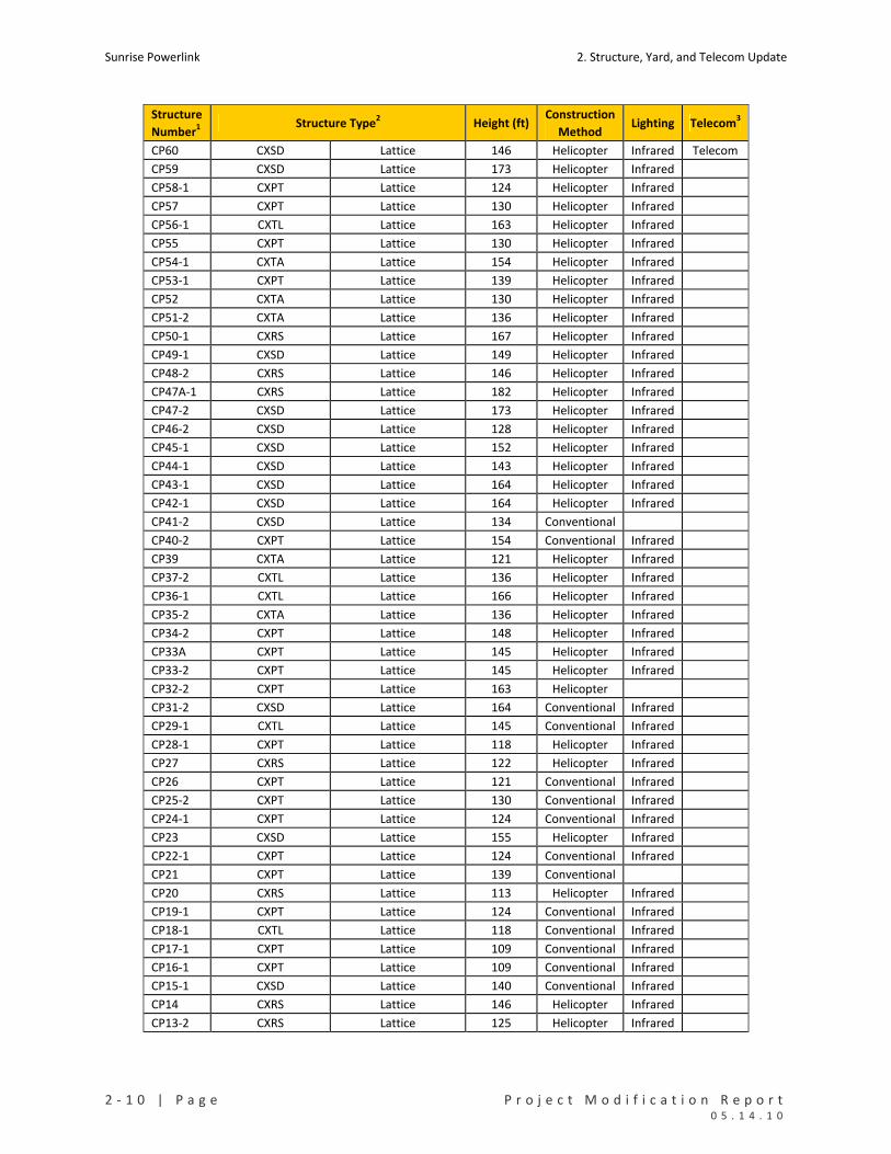
Sunrise Powerlink 2. Structure, Yard, and Telecom Update
2 ‐ 1 0 | P a g e P r o j e c t M o d i f i c a t i o n R e p o r t 0 5 . 1 4 . 1 0
Structure
Number1 Structure Type2 Height (ft)
Construction
Method Lighting Telecom3
CP60 CXSD Lattice 146 Helicopter Infrared Telecom
CP59 CXSD Lattice 173 Helicopter Infrared
CP58‐1 CXPT Lattice 124 Helicopter Infrared
CP57 CXPT Lattice 130 Helicopter Infrared
CP56‐1 CXTL Lattice 163 Helicopter Infrared
CP55 CXPT Lattice 130 Helicopter Infrared
CP54‐1 CXTA Lattice 154 Helicopter Infrared
CP53‐1 CXPT Lattice 139 Helicopter Infrared
CP52 CXTA Lattice 130 Helicopter Infrared
CP51‐2 CXTA Lattice 136 Helicopter Infrared
CP50‐1 CXRS Lattice 167 Helicopter Infrared
CP49‐1 CXSD Lattice 149 Helicopter Infrared
CP48‐2 CXRS Lattice 146 Helicopter Infrared
CP47A‐1 CXRS Lattice 182 Helicopter Infrared
CP47‐2 CXSD Lattice 173 Helicopter Infrared
CP46‐2 CXSD Lattice 128 Helicopter Infrared
CP45‐1 CXSD Lattice 152 Helicopter Infrared
CP44‐1 CXSD Lattice 143 Helicopter Infrared
CP43‐1 CXSD Lattice 164 Helicopter Infrared
CP42‐1 CXSD Lattice 164 Helicopter Infrared
CP41‐2 CXSD Lattice 134 Conventional
CP40‐2 CXPT Lattice 154 Conventional Infrared
CP39 CXTA Lattice 121 Helicopter Infrared
CP37‐2 CXTL Lattice 136 Helicopter Infrared
CP36‐1 CXTL Lattice 166 Helicopter Infrared
CP35‐2 CXTA Lattice 136 Helicopter Infrared
CP34‐2 CXPT Lattice 148 Helicopter Infrared
CP33A CXPT Lattice 145 Helicopter Infrared
CP33‐2 CXPT Lattice 145 Helicopter Infrared
CP32‐2 CXPT Lattice 163 Helicopter
CP31‐2 CXSD Lattice 164 Conventional Infrared
CP29‐1 CXTL Lattice 145 Conventional Infrared
CP28‐1 CXPT Lattice 118 Helicopter Infrared
CP27 CXRS Lattice 122 Helicopter Infrared
CP26 CXPT Lattice 121 Conventional Infrared
CP25‐2 CXPT Lattice 130 Conventional Infrared
CP24‐1 CXPT Lattice 124 Conventional Infrared
CP23 CXSD Lattice 155 Helicopter Infrared
CP22‐1 CXPT Lattice 124 Conventional Infrared
CP21 CXPT Lattice 139 Conventional
CP20 CXRS Lattice 113 Helicopter Infrared
CP19‐1 CXPT Lattice 124 Conventional Infrared
CP18‐1 CXTL Lattice 118 Conventional Infrared
CP17‐1 CXPT Lattice 109 Conventional Infrared
CP16‐1 CXPT Lattice 109 Conventional Infrared
CP15‐1 CXSD Lattice 140 Conventional Infrared
CP14 CXRS Lattice 146 Helicopter Infrared
CP13‐2 CXRS Lattice 125 Helicopter Infrared
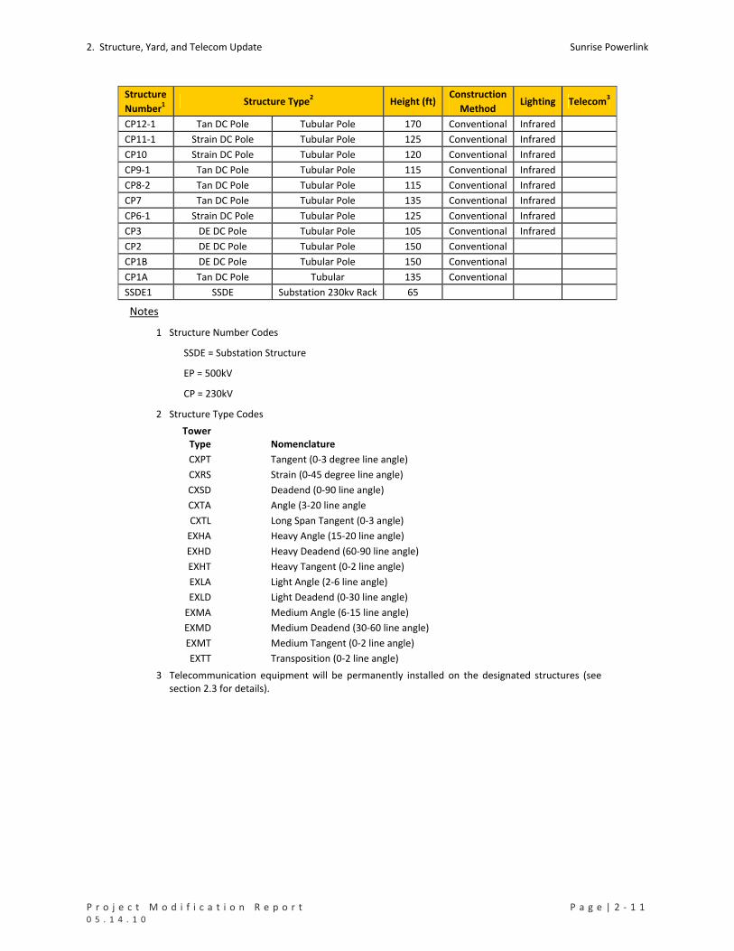
2. Structure, Yard, and Telecom Update Sunrise Powerlink
P r o j e c t M o d i f i c a t i o n R e p o r t P a g e | 2 ‐ 1 1 0 5 . 1 4 . 1 0
Structure
Number1 Structure Type2 Height (ft)
Construction
Method Lighting Telecom3
CP12‐1 Tan DC Pole Tubular Pole 170 Conventional Infrared
CP11‐1 Strain DC Pole Tubular Pole 125 Conventional Infrared
CP10 Strain DC Pole Tubular Pole 120 Conventional Infrared
CP9‐1 Tan DC Pole Tubular Pole 115 Conventional Infrared
CP8‐2 Tan DC Pole Tubular Pole 115 Conventional Infrared
CP7 Tan DC Pole Tubular Pole 135 Conventional Infrared
CP6‐1 Strain DC Pole Tubular Pole 125 Conventional Infrared
CP3 DE DC Pole Tubular Pole 105 Conventional Infrared
CP2 DE DC Pole Tubular Pole 150 Conventional
CP1B DE DC Pole Tubular Pole 150 Conventional
CP1A Tan DC Pole Tubular 135 Conventional
SSDE1 SSDE Substation 230kv Rack 65
Notes
1 Structure Number Codes
SSDE = Substation Structure
EP = 500kV
CP = 230kV
2 Structure Type Codes
Tower Type Nomenclature
CXPT Tangent (0‐3 degree line angle)
CXRS Strain (0‐45 degree line angle)
CXSD Deadend (0‐90 line angle)
CXTA Angle (3‐20 line angle
CXTL Long Span Tangent (0‐3 angle)
EXHA Heavy Angle (15‐20 line angle)
EXHD Heavy Deadend (60‐90 line angle)
EXHT Heavy Tangent (0‐2 line angle)
EXLA Light Angle (2‐6 line angle)
EXLD Light Deadend (0‐30 line angle)
EXMA Medium Angle (6‐15 line angle)
EXMD Medium Deadend (30‐60 line angle)
EXMT Medium Tangent (0‐2 line angle)
EXTT Transposition (0‐2 line angle)
3 Telecommunication equipment will be permanently installed on the designated structures (see section 2.3 for details).

Sunrise Powerlink 2. Structure, Yard, and Telecom Update
2 ‐ 1 2 | P a g e P r o j e c t M o d i f i c a t i o n R e p o r t 0 5 . 1 4 . 1 0
TABLE 2‐2. SPANS IDENTIFIED FOR MARKER BALLS
Link Span ID From Structure To Structure # of Marker Balls
1 24 EP342 EP341 11
1 34 EP331 EP330‐1 11
1 48 EP317 EP316‐2 11
1 61 EP304‐2 EP303‐2 11
1 65 EP300‐1 EP299 11
1 69 EP296 EP295 11
1 74 EP291‐1 EP290 13
1 75 EP290 EP281 13
1 77 EP280‐1 EP279‐1 13
1 78 EP279‐1 EP278‐1 11
1 79 EP278‐1 EP277‐1 9
1 80 EP277‐1 EP276‐1 13
1 81 EP276‐1 EP275‐1 11
1 82 EP275‐1 EP274‐1 9
1 85 EP272‐3 EP271‐2 13
1 86 EP271‐2 EP270‐2 15
1 87 EP270‐2 EP269‐1 11
1 88 EP269‐1 EP267‐2 15
1 90 EP266‐2 EP265‐2 11
1 91 EP265‐2 EP264‐4 9
1 93 EP263B‐2 EP263A‐2 13
1 94 EP263A‐2 EP262‐4 13
1 99 EP259‐3 EP258‐3 11
1 107 EP252‐1 EP251 9
1 115 EP244 EP243 9
1 119 EP239‐1 EP238‐1 10
1 133 EP226‐1 EP225‐1 11
1 135 EP224‐1 EP223‐1 13
1 139 EP220‐1 EP219‐1 11
1 151 EP206‐1 EP205‐2 9
1 192 EP149‐1 EP148‐1 9
1 193 EP148‐1 EP147 7
1 194 EP147 EP146 11
1 195 EP146 EP145 11
1 197 EP144 EP143‐1 11
1 198 EP143‐1 EP142‐1 13
2 202 EP139‐1 EP138‐2 9
2 204 EP137 EP136 9
2 205 EP136 EP135 7
2 206 EP135 EP134‐1 11
2 222 EP120‐4 EP119‐2 11
2 225 EP117‐2 EP116‐1 9
2 233 EP110‐2 EP109‐1 9
2 254 EP90‐1 EP89‐1 7
2 259 EP85‐2 EP84 9
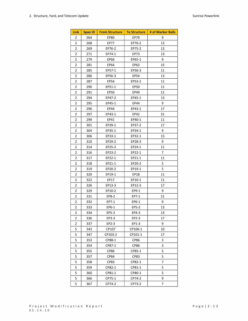
2. Structure, Yard, and Telecom Update Sunrise Powerlink
P r o j e c t M o d i f i c a t i o n R e p o r t P a g e | 2 ‐ 1 3 0 5 . 1 4 . 1 0
Link Span ID From Structure To Structure # of Marker Balls
2 264 EP80 EP79 9
2 268 EP77 EP76‐2 13
2 269 EP76‐2 EP75‐2 13
2 271 EP74‐1 EP73 13
2 279 EP66 EP65‐1 9
2 281 EP64 EP63 15
2 285 EP57‐1 EP56‐3 11
2 286 EP56‐3 EP54 13
2 287 EP54 EP53‐2 11
2 290 EP51‐1 EP50 11
2 291 EP50 EP49 11
2 294 EP47‐2 EP45‐1 13
2 295 EP45‐1 EP44 9
2 296 EP44 EP43‐1 17
2 297 EP43‐1 EP42 31
2 299 EP41 EP40‐1 11
2 301 EP39‐1 EP37‐2 17
2 304 EP35‐1 EP34‐1 9
2 306 EP33‐1 EP32‐1 15
2 310 EP29‐2 EP28‐3 9
2 314 EP25‐2 EP24‐1 11
2 316 EP23‐2 EP22‐1 7
2 317 EP22‐1 EP21‐1 11
2 318 EP21‐1 EP20‐2 5
2 319 EP20‐2 EP19‐1 5
2 320 EP19‐1 EP18 11
2 322 EP17 EP16‐1 11
2 326 EP13‐3 EP12‐3 17
2 329 EP10‐2 EP9‐1 9
2 331 EP8‐2 EP7‐1 21
2 332 EP7‐1 EP6‐1 9
2 333 EP6‐1 EP5‐2 13
2 334 EP5‐2 EP4‐3 13
2 336 EP3‐3 EP2‐3 17
2 337 EP2‐3 EP1‐3 9
5 343 CP107 CP106‐1 10
5 347 CP103‐2 CP101‐1 17
5 353 CP88‐1 CP86 3
5 354 CP87‐1 CP86 3
5 355 CP86 CP85‐1 5
5 357 CP84 CP83 5
5 358 CP83 CP82‐1 7
5 359 CP82‐1 CP81‐1 5
5 360 CP81‐1 CP80‐1 5
5 366 CP75‐1 CP74‐2 9
5 367 CP74‐2 CP73‐2 7
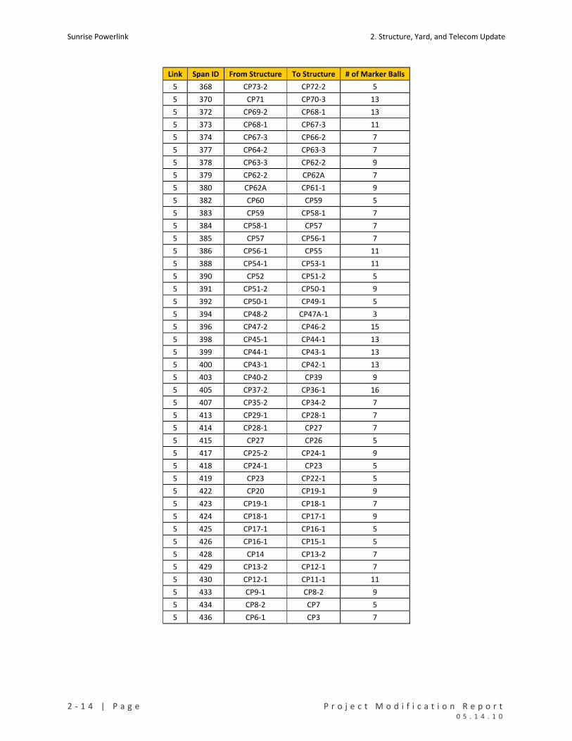
Sunrise Powerlink 2. Structure, Yard, and Telecom Update
2 ‐ 1 4 | P a g e P r o j e c t M o d i f i c a t i o n R e p o r t 0 5 . 1 4 . 1 0
Link Span ID From Structure To Structure # of Marker Balls
5 368 CP73‐2 CP72‐2 5
5 370 CP71 CP70‐3 13
5 372 CP69‐2 CP68‐1 13
5 373 CP68‐1 CP67‐3 11
5 374 CP67‐3 CP66‐2 7
5 377 CP64‐2 CP63‐3 7
5 378 CP63‐3 CP62‐2 9
5 379 CP62‐2 CP62A 7
5 380 CP62A CP61‐1 9
5 382 CP60 CP59 5
5 383 CP59 CP58‐1 7
5 384 CP58‐1 CP57 7
5 385 CP57 CP56‐1 7
5 386 CP56‐1 CP55 11
5 388 CP54‐1 CP53‐1 11
5 390 CP52 CP51‐2 5
5 391 CP51‐2 CP50‐1 9
5 392 CP50‐1 CP49‐1 5
5 394 CP48‐2 CP47A‐1 3
5 396 CP47‐2 CP46‐2 15
5 398 CP45‐1 CP44‐1 13
5 399 CP44‐1 CP43‐1 13
5 400 CP43‐1 CP42‐1 13
5 403 CP40‐2 CP39 9
5 405 CP37‐2 CP36‐1 16
5 407 CP35‐2 CP34‐2 7
5 413 CP29‐1 CP28‐1 7
5 414 CP28‐1 CP27 7
5 415 CP27 CP26 5
5 417 CP25‐2 CP24‐1 9
5 418 CP24‐1 CP23 5
5 419 CP23 CP22‐1 5
5 422 CP20 CP19‐1 9
5 423 CP19‐1 CP18‐1 7
5 424 CP18‐1 CP17‐1 9
5 425 CP17‐1 CP16‐1 5
5 426 CP16‐1 CP15‐1 5
5 428 CP14 CP13‐2 7
5 429 CP13‐2 CP12‐1 7
5 430 CP12‐1 CP11‐1 11
5 433 CP9‐1 CP8‐2 9
5 434 CP8‐2 CP7 5
5 436 CP6‐1 CP3 7
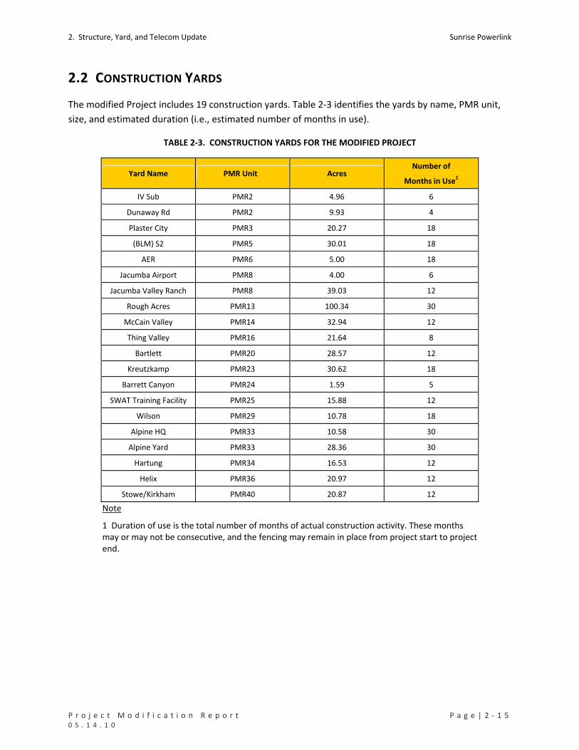
2. Structure, Yard, and Telecom Update Sunrise Powerlink
P r o j e c t M o d i f i c a t i o n R e p o r t P a g e | 2 ‐ 1 5 0 5 . 1 4 . 1 0
2.2 CONSTRUCTION YARDS
The modified Project includes 19 construction yards. Table 2‐3 identifies the yards by name, PMR unit,
size, and estimated duration (i.e., estimated number of months in use).
TABLE 2‐3. CONSTRUCTION YARDS FOR THE MODIFIED PROJECT
Yard Name PMR Unit Acres Number of
Months in Use1
IV Sub PMR2 4.96 6
Dunaway Rd PMR2 9.93 4
Plaster City PMR3 20.27 18
(BLM) S2 PMR5 30.01 18
AER PMR6 5.00 18
Jacumba Airport PMR8 4.00 6
Jacumba Valley Ranch PMR8 39.03 12
Rough Acres PMR13 100.34 30
McCain Valley PMR14 32.94 12
Thing Valley PMR16 21.64 8
Bartlett PMR20 28.57 12
Kreutzkamp PMR23 30.62 18
Barrett Canyon PMR24 1.59 5
SWAT Training Facility PMR25 15.88 12
Wilson PMR29 10.78 18
Alpine HQ PMR33 10.58 30
Alpine Yard PMR33 28.36 30
Hartung PMR34 16.53 12
Helix PMR36 20.97 12
Stowe/Kirkham PMR40 20.87 12
Note
1 Duration of use is the total number of months of actual construction activity. These months may or may not be consecutive, and the fencing may remain in place from project start to project end.
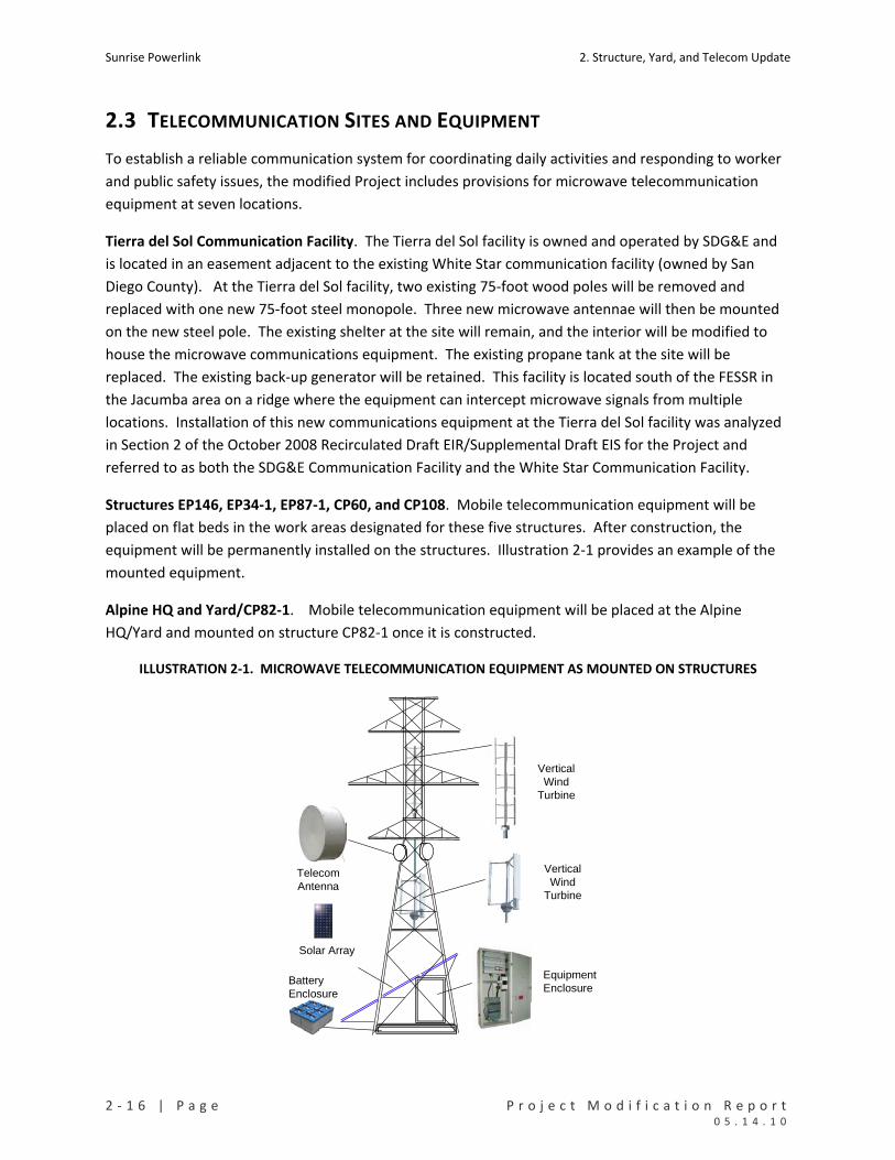
Sunrise Powerlink 2. Structure, Yard, and Telecom Update
2 ‐ 1 6 | P a g e P r o j e c t M o d i f i c a t i o n R e p o r t 0 5 . 1 4 . 1 0
2.3 TELECOMMUNICATION SITES AND EQUIPMENT
To establish a reliable communication system for coordinating daily activities and responding to worker
and public safety issues, the modified Project includes provisions for microwave telecommunication
equipment at seven locations.
Tierra del Sol Communication Facility. The Tierra del Sol facility is owned and operated by SDG&E and
is located in an easement adjacent to the existing White Star communication facility (owned by San
Diego County). At the Tierra del Sol facility, two existing 75‐foot wood poles will be removed and
replaced with one new 75‐foot steel monopole. Three new microwave antennae will then be mounted
on the new steel pole. The existing shelter at the site will remain, and the interior will be modified to
house the microwave communications equipment. The existing propane tank at the site will be
replaced. The existing back‐up generator will be retained. This facility is located south of the FESSR in
the Jacumba area on a ridge where the equipment can intercept microwave signals from multiple
locations. Installation of this new communications equipment at the Tierra del Sol facility was analyzed
in Section 2 of the October 2008 Recirculated Draft EIR/Supplemental Draft EIS for the Project and
referred to as both the SDG&E Communication Facility and the White Star Communication Facility.
Structures EP146, EP34‐1, EP87‐1, CP60, and CP108. Mobile telecommunication equipment will be
placed on flat beds in the work areas designated for these five structures. After construction, the
equipment will be permanently installed on the structures. Illustration 2‐1 provides an example of the
mounted equipment.
Alpine HQ and Yard/CP82‐1. Mobile telecommunication equipment will be placed at the Alpine
HQ/Yard and mounted on structure CP82‐1 once it is constructed.
ILLUSTRATION 2‐1. MICROWAVE TELECOMMUNICATION EQUIPMENT AS MOUNTED ON STRUCTURES
Equipment Enclosure
Solar Array
Vertical Wind
Turbine
Telecom Antenna
Vertical Wind
Turbine
Battery Enclosure

P r o j e c t M o d i f i c a t i o n R e p o r t P a g e | 3 ‐ 1 0 5 . 1 4 . 1 0
3. PROJECT‐LEVEL IMPACT EVALUATION AND COMPARISON
This section of the PMR evaluates the modified Project in terms of its potential to result in impacts that
are lesser than, greater than, or substantially the same in type and scale as those of the FESSR as
analyzed in the Final EIR/EIS. Impacts of the modified Project as a whole are considered. See Section 4
for an evaluation and comparison of impacts within each PMR unit.
3.1 APPROACH, TERMINOLOGY, AND CRITERIA
The information in this section about the components and alignment of the modified Project is based on
the final engineering and design plans prepared by SDG&E and presented by the descriptions in this
PMR and the maps in the PMR Mapbook. The environmental impacts of the modified Project were
quantified where possible by overlaying the footprint of the modified Project (i.e., the location of
structures, new roads, yards, wire stringing sites, etc.) on the layers of the PMR databases. Where
impacts could not be quantified, a qualitative assessment was conducted. The results then were
compared with the components, alignment, and environmental effects of the FESSR.
The Information in this section about the components and alignment of the FESSR is from the Final
EIR/EIS, including the data that were used for the analysis and maps in the EIR/EIS. The data used in the
EIR/EIS include survey results, habitat assessments, available databases, and other relevant information
as of 2008, with most of the data collected in 2007. Hereafter, these data are cited as the “EIR/EIS
database.” The environmental impacts of the FESSR are presented in two ways. First, quantified
estimates and qualitative assessments were taken from the Final EIR/EIS, including but not limited to the
following parts of the document:
1. Analysis of impacts to resources (biological, cultural, land use, visual, etc.) in Sections D and E;
2. Consolidated biological impact matrix in Appendix 8P;
3. Riparian Conservation Area analysis in Appendix 8Q;
4. Comparison of alternatives in Section H;
5. Analysis of consistency with adopted policies and plans in Section D.16 and Appendix 2; and
6. Analysis of consistency with existing and draft regional conservation plans in Appendix 8O.
Also, to provide additional context for comparing impacts, FESSR impacts are presented in terms of the
PMR database – i.e., the footprint of the FESSR as identified in the Final EIR/EIS was overlaid on the
updated data layers, and the impacts were calculated. This step was taken to provide a comparison of
impacts based on current information and indicate where new information has become available since
issuance of the Final EIR/EIS.

Sunrise Powerlink 3. Project‐level Impact Evaluation and Comparison
3 ‐ 2 | P a g e P r o j e c t M o d i f i c a t i o n R e p o r t 0 5 . 1 4 . 1 0
As part of the evaluation of the modified Project, the degree to which the modifications would change
the type and scale of FESSR impacts was considered. In this evaluation, the following criteria were
applied:
An increase in impacts is considered significant if it would change a Class II or Class III impact in
the Final EIR/EIS to a Class I impact or cause the Project to result in a Class I or II impact not
addressed in the Final EIR/EIS.
A reduction in impacts is considered significant if it would eliminate a Class I or II impact
identified in the Final EIR/EIS or reduce a Class I to a Class II or lower impact.
A modification is considered environmentally preferred to the FESSR in the Final EIR/EIS if it
would result in less damage to the environment and would better protect natural and cultural
resources.
Impact classes are the same as in the Final EIR/EIS (see Section D.1.4.3 of the Final EIR/EIS):
Class I is used to identify significant and unavoidable impacts; Class I impacts are significant
impacts that cannot be mitigated to a less‐than‐significant level.
Class II is used to identify significant impacts that can be mitigated to a less‐than‐significant
level.
Class III is used to identify adverse but less than significant impacts.
3.2 SUMMARY OF RESULTS
The components of the modified Project are primarily the same as the FESSR, with differences in the
number of structures and associated features and number of structures designated for helicopter
construction. The one minor exception is that the modified Project includes the addition of a pre‐
engineered storage facility on already disturbed land within the existing Imperial Valley Substation,
which was not included in the FESSR (see Section 4, PMR1). Overall, the modified Project has fewer
structures, fewer new access roads, fewer wire stringing areas, and fewer construction yards; a smaller
Suncrest Substation; and more structures designated for helicopter construction than the FESSR. These
differences equate to an approximate 46% reduction in permanent and temporary ground disturbance
compared with the FESSR.
Consistent with the reduction in overall on‐the‐ground impacts, the modified Project would result in
reduced impacts to biological, cultural, land use, and water resources when compared to the FESSR.
Impacts of the modified Project to other resources are similar in nature to the FESSR’s and, with few
exceptions, significantly reduced. There are many locations where the modified Project eliminates
impacts to one or more sensitive resources, and only a few locations where impacts increase to
resources already evaluated in the Final EIR/EIS. There are no new significant impacts associated with
the modified Project.
3. Project‐level Impact Evaluation and Comparison Sunrise Powerlink
P r o j e c t M o d i f i c a t i o n R e p o r t P a g e | 3 ‐ 3 0 5 . 1 4 . 1 0
In summary, through the implementation of mitigation measures included in the Final EIR/EIS, the
modified Project would reduce but not eliminate significant impacts associated with the FESSR and
would not result in any new significant impacts. Because the modified Project would result in less
impact to the environment and would better protect natural and cultural resources, it is
environmentally preferred to the components and initial routing of the FESSR.
3.3 IMPACT EVALUATION AND COMPARISON
3.3.1 CHANGES IN PROJECT COMPONENTS AND TOTAL GROUND DISTURBANCE
Table 3‐1 summarizes the primary components and related features of the FESSR and modified Project
and indicates the differences. Table 3‐2 indicates components and resulting ground disturbance overall
and by SRPL Link. The impact estimates for the FESSR in Table 3‐2 were generated using the PMR
database. Total ground disturbance was estimated for both the FESSR and modified Project because it is
a key indicator of potential impacts to biological, cultural, land use, water, and other resources; it also
demonstrates that the modified Project is designed to reduce ground disturbance overall (not just
impacts to vegetated lands).
With one minor exception, the modified Project and FESSR have the same components. The exception
is that the modified Project includes the addition of a pre‐engineered steel storage facility on already
disturbed land within the existing Imperial Valley Substation (PMR1). There are no new significant
impacts associated with PMR1 (see Section 4).
As indicated in Tables 3‐1 and 3‐2, the modified Project includes fewer structures, fewer new access
roads, fewer wire stringing areas, and fewer construction yards; a smaller Suncrest Substation; more
TSAPs due to a reduction in new access roads to minimize and reduce visible land scarring and
replacement poles as part of reconductoring; and less ground disturbance than the FESSR as described
in the Final EIR/EIS. Within Links along the alignment, the differences between the modified Project and
FESSR vary. The greatest reductions in ground disturbance under the modified Project are in Link 1 and
Link 2. In Link 1, permanent ground disturbance drops by approximately 100 acres and temporary
disturbance drops by approximately 300 acres. In Link 2, temporary ground disturbance is reduced by
approximately 200 acres, permanent ground disturbance by approximately 40 acres. Reductions in both
Links reflect the designation of more structures for helicopter construction and a corresponding
reduction in new access roads under the modified Project. There is more temporary ground disturbance
in Link 4 in connection with reconductoring than estimated for the FESSR; however, the increase in
ground disturbance in these locations would not result in new significant impacts (see PMR33 and
PMR42‐44 in Section 4). The modified Project as a whole would result in an approximate 46% reduction
in permanent and temporary ground disturbance compared with the FESSR. Chart 3‐1 displays the
differences in ground disturbance per Links under the modified Project and FESSR (reconductoring is
included in Link 5 in the chart).
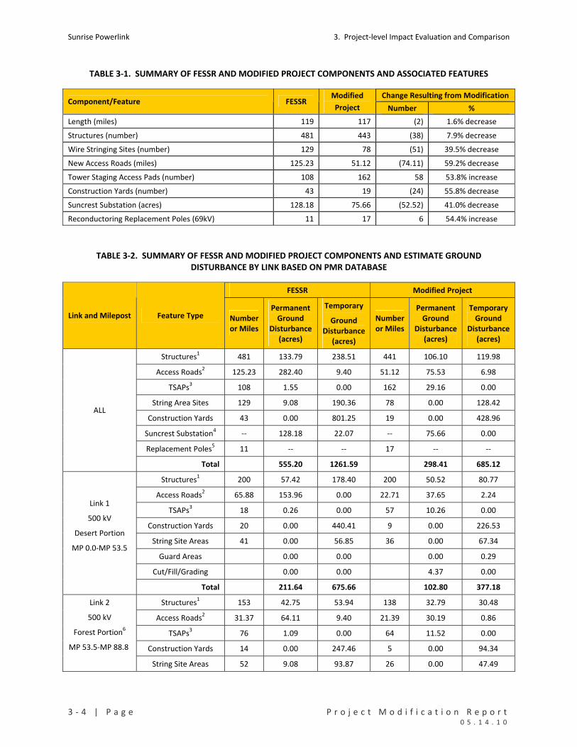
Sunrise Powerlink 3. Project‐level Impact Evaluation and Comparison
3 ‐ 4 | P a g e P r o j e c t M o d i f i c a t i o n R e p o r t 0 5 . 1 4 . 1 0
TABLE 3‐1. SUMMARY OF FESSR AND MODIFIED PROJECT COMPONENTS AND ASSOCIATED FEATURES
Change Resulting from Modification Component/Feature FESSR
Modified
Project Number %
Length (miles) 119 117 (2) 1.6% decrease
Structures (number) 481 443 (38) 7.9% decrease
Wire Stringing Sites (number) 129 78 (51) 39.5% decrease
New Access Roads (miles) 125.23 51.12 (74.11) 59.2% decrease
Tower Staging Access Pads (number) 108 162 58 53.8% increase
Construction Yards (number) 43 19 (24) 55.8% decrease
Suncrest Substation (acres) 128.18 75.66 (52.52) 41.0% decrease
Reconductoring Replacement Poles (69kV) 11 17 6 54.4% increase
TABLE 3‐2. SUMMARY OF FESSR AND MODIFIED PROJECT COMPONENTS AND ESTIMATE GROUND DISTURBANCE BY LINK BASED ON PMR DATABASE
FESSR Modified Project
Link and Milepost Feature Type Number or Miles
Permanent Ground
Disturbance (acres)
Temporary
Ground Disturbance
(acres)
Number or Miles
Permanent Ground
Disturbance (acres)
Temporary Ground
Disturbance(acres)
Structures1 481 133.79 238.51 441 106.10 119.98
Access Roads2 125.23 282.40 9.40 51.12 75.53 6.98
TSAPs3 108 1.55 0.00 162 29.16 0.00
String Area Sites 129 9.08 190.36 78 0.00 128.42
Construction Yards 43 0.00 801.25 19 0.00 428.96
Suncrest Substation4 ‐‐ 128.18 22.07 ‐‐ 75.66 0.00
Replacement Poles5 11 ‐‐ ‐‐ 17 ‐‐ ‐‐
ALL
Total 555.20 1261.59 298.41 685.12
Structures1 200 57.42 178.40 200 50.52 80.77
Access Roads2 65.88 153.96 0.00 22.71 37.65 2.24
TSAPs3 18 0.26 0.00 57 10.26 0.00
Construction Yards 20 0.00 440.41 9 0.00 226.53
String Site Areas 41 0.00 56.85 36 0.00 67.34
Guard Areas 0.00 0.00 0.00 0.29
Cut/Fill/Grading 0.00 0.00 4.37 0.00
Link 1
500 kV
Desert Portion
MP 0.0‐MP 53.5
Total 211.64 675.66 102.80 377.18
Structures1 153 42.75 53.94 138 32.79 30.48
Access Roads2 31.37 64.11 9.40 21.39 30.19 0.86
TSAPs3 76 1.09 0.00 64 11.52 0.00
Construction Yards 14 0.00 247.46 5 0.00 94.34
Link 2
500 kV
Forest Portion6
MP 53.5‐MP 88.8
String Site Areas 52 9.08 93.87 26 0.00 47.49

3. Project‐level Impact Evaluation and Comparison Sunrise Powerlink
P r o j e c t M o d i f i c a t i o n R e p o r t P a g e | 3 ‐ 5 0 5 . 1 4 . 1 0
FESSR Modified Project
Link and Milepost Feature Type Number or Miles
Permanent Ground
Disturbance (acres)
Temporary
Ground Disturbance
(acres)
Number or Miles
Permanent Ground
Disturbance (acres)
Temporary Ground
Disturbance(acres)
Guard Areas 0.00 0.00 0.00 0.28
Cut/Fill/Grading 0.00 0.00 5.09 0.00
Total 117.03 404.67 79.58 173.45
Suncrest Pad Plus4 ‐‐4 128.18 22.07 ‐‐4 75.66 0.00
Access Roads 0.01 0.00 0.03
Construction Yards 1 0.00 10.78
Link 3
MP 88.8‐MP 89.3
Total 128.18 22.07 75.66 10.81
Structures1 2 0.14 0.75 0 0.00 0.32
Access Roads2 0.66 1.57 0.00 0.97 2.39 0.02
TSAPs3 0 0.00 0.00 0 0.00 0.00
Construction Yards 0 0.00 0.00 1 0.00 38.94
String Site Areas 2 0.00 2.80 2 0.00 1.35
Guard Areas 0.00 0.00 0.00 0.00
Cut/Fill/Grading 0.00 0.00 1.18 0.00
Link 4
230 kV Underground
MP 92.0‐MP 98.2
Total 1.71 3.55 3.58 40.62
Structures1 123 33.48 5.42 100 22.79 4.84
Access Roads2 27.32 62.76 0.00 6.04 5.30 3.84
TSAPs3 14 0.20 0.00 41 7.38 0.00
Construction Yards 9 0.00 113.38 3 0.00 58.37
String Site Areas 30 0.00 35.57 14 0.00 9.61
Guard Areas 0.00 0.00 0.00 0.21
Cut/Fill/Grading 0.00 0.00 1.31 0.00
Link 5
230kV Overhead
MP 89.3‐MP 92.0
MP 98.2‐MP 117.2
Total 96.44 154.37 36.79 76.87
Replacement Poles 11 ‐‐ ‐‐ 17 ‐‐ ‐‐
String Site Areas 0.0 1.27 0.00 2.63
Work Areas 0.0 0.0 0.00 3.56
Other 0.20 0.00 0.00 0.00
Reconductoring
Total 0.20 1.27 0.00 6.19
Notes
1 Structures include lattice towers, poles, substation deadends, and risers (see Table 2‐1).
2 Access Roads = new access roads to be constructed and existing roads that require improvement.
3 TSAP = tower staging access pads to support helicopter construction.
4 The Suncrest Substation Pad includes 3 structures.
5 Replacement poles are for the 69kV reconductor projects associated with the system upgrades
6 This portion includes privately owned lands as well as Forest Service owned and operated lands

Sunrise Powerlink 3. Project‐level Impact Evaluation and Comparison
3 ‐ 6 | P a g e P r o j e c t M o d i f i c a t i o n R e p o r t 0 5 . 1 4 . 1 0
CHART 3‐1. PERMANENT AND TEMPORARY GROUND DISTURBANCE FOR THE MODIFIED PROJECT AND FESSR
0
100
200
300
400
500
600
700
acre
s
FESSR Per
man
ent
Mod
. Pro
j. Per
man
ent
FESSR Tem
pora
ry
Mod
. Pro
j. Tem
pora
ry
Link 5
Link 4
Link 3
Link 2
Link 1
3.3.2 IMPACTS TO AIR RESOURCES
The modified Project would not introduce a new source of air emissions or result in a new significant
impact to air quality compared with the FESSR. Some reductions in emissions from ground disturbance
would result under the modified Project, but there would not be a significant reduction in net emissions
from the use of trucks, helicopters, and equipment. The modified Project and FESSR would result in
similar air quality impacts.
3.3.3 IMPACTS TO BIOLOGICAL RESOURCES
With regard to biological impacts, this section focuses on effects to: 1) sensitive vegetation
communities; 2) desert pavement 3) special status plants (federally and/or state‐listed as well as non‐
listed); 4) special status wildlife; 5) effects of infrared lighting on special status species; and 5) riparian
conservation areas (RCAs) in the Cleveland National Forest (CNF).
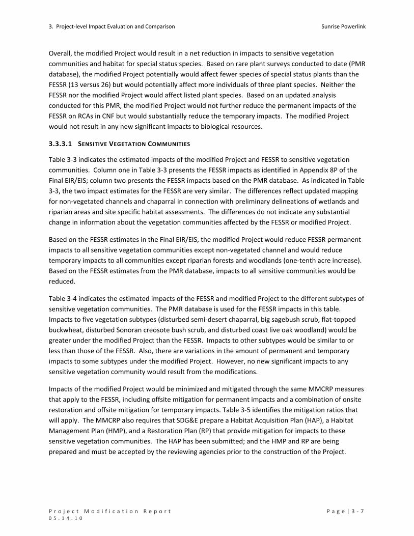
3. Project‐level Impact Evaluation and Comparison Sunrise Powerlink
P r o j e c t M o d i f i c a t i o n R e p o r t P a g e | 3 ‐ 7 0 5 . 1 4 . 1 0
Overall, the modified Project would result in a net reduction in impacts to sensitive vegetation
communities and habitat for special status species. Based on rare plant surveys conducted to date (PMR
database), the modified Project potentially would affect fewer species of special status plants than the
FESSR (13 versus 26) but would potentially affect more individuals of three plant species. Neither the
FESSR nor the modified Project would affect listed plant species. Based on an updated analysis
conducted for this PMR, the modified Project would not further reduce the permanent impacts of the
FESSR on RCAs in CNF but would substantially reduce the temporary impacts. The modified Project
would not result in any new significant impacts to biological resources.
3.3.3.1 SENSITIVE VEGETATION COMMUNITIES
Table 3‐3 indicates the estimated impacts of the modified Project and FESSR to sensitive vegetation
communities. Column one in Table 3‐3 presents the FESSR impacts as identified in Appendix 8P of the
Final EIR/EIS; column two presents the FESSR impacts based on the PMR database. As indicated in Table
3‐3, the two impact estimates for the FESSR are very similar. The differences reflect updated mapping
for non‐vegetated channels and chaparral in connection with preliminary delineations of wetlands and
riparian areas and site specific habitat assessments. The differences do not indicate any substantial
change in information about the vegetation communities affected by the FESSR or modified Project.
Based on the FESSR estimates in the Final EIR/EIS, the modified Project would reduce FESSR permanent
impacts to all sensitive vegetation communities except non‐vegetated channel and would reduce
temporary impacts to all communities except riparian forests and woodlands (one‐tenth acre increase).
Based on the FESSR estimates from the PMR database, impacts to all sensitive communities would be
reduced.
Table 3‐4 indicates the estimated impacts of the FESSR and modified Project to the different subtypes of
sensitive vegetation communities. The PMR database is used for the FESSR impacts in this table.
Impacts to five vegetation subtypes (disturbed semi‐desert chaparral, big sagebush scrub, flat‐topped
buckwheat, disturbed Sonoran creosote bush scrub, and disturbed coast live oak woodland) would be
greater under the modified Project than the FESSR. Impacts to other subtypes would be similar to or
less than those of the FESSR. Also, there are variations in the amount of permanent and temporary
impacts to some subtypes under the modified Project. However, no new significant impacts to any
sensitive vegetation community would result from the modifications.
Impacts of the modified Project would be minimized and mitigated through the same MMCRP measures
that apply to the FESSR, including offsite mitigation for permanent impacts and a combination of onsite
restoration and offsite mitigation for temporary impacts. Table 3‐5 identifies the mitigation ratios that
will apply. The MMCRP also requires that SDG&E prepare a Habitat Acquisition Plan (HAP), a Habitat
Management Plan (HMP), and a Restoration Plan (RP) that provide mitigation for impacts to these
sensitive vegetation communities. The HAP has been submitted; and the HMP and RP are being
prepared and must be accepted by the reviewing agencies prior to the construction of the Project.
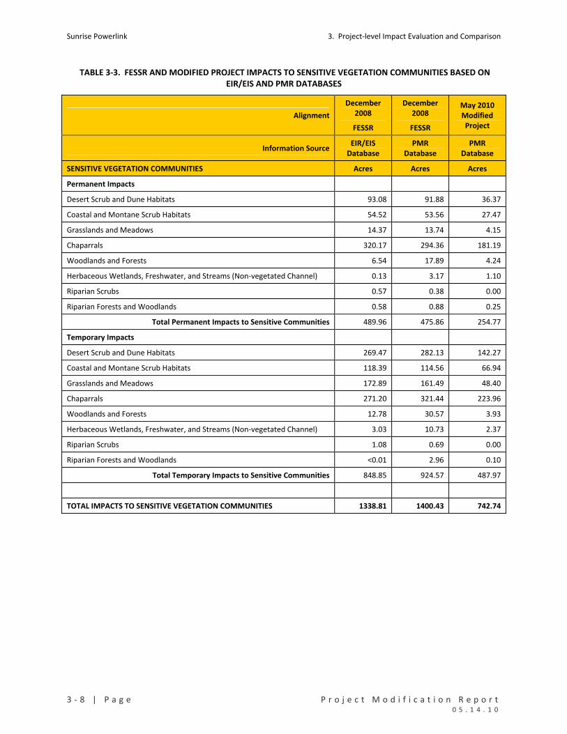
Sunrise Powerlink 3. Project‐level Impact Evaluation and Comparison
3 ‐ 8 | P a g e P r o j e c t M o d i f i c a t i o n R e p o r t 0 5 . 1 4 . 1 0
TABLE 3‐3. FESSR AND MODIFIED PROJECT IMPACTS TO SENSITIVE VEGETATION COMMUNITIES BASED ON EIR/EIS AND PMR DATABASES
Alignment
December 2008
FESSR
December 2008
FESSR
May 2010 Modified Project
Information Source EIR/EIS
Database PMR
Database PMR
Database
SENSITIVE VEGETATION COMMUNITIES Acres Acres Acres
Permanent Impacts
Desert Scrub and Dune Habitats 93.08 91.88 36.37
Coastal and Montane Scrub Habitats 54.52 53.56 27.47
Grasslands and Meadows 14.37 13.74 4.15
Chaparrals 320.17 294.36 181.19
Woodlands and Forests 6.54 17.89 4.24
Herbaceous Wetlands, Freshwater, and Streams (Non‐vegetated Channel) 0.13 3.17 1.10
Riparian Scrubs 0.57 0.38 0.00
Riparian Forests and Woodlands 0.58 0.88 0.25
Total Permanent Impacts to Sensitive Communities 489.96 475.86 254.77
Temporary Impacts
Desert Scrub and Dune Habitats 269.47 282.13 142.27
Coastal and Montane Scrub Habitats 118.39 114.56 66.94
Grasslands and Meadows 172.89 161.49 48.40
Chaparrals 271.20 321.44 223.96
Woodlands and Forests 12.78 30.57 3.93
Herbaceous Wetlands, Freshwater, and Streams (Non‐vegetated Channel) 3.03 10.73 2.37
Riparian Scrubs 1.08 0.69 0.00
Riparian Forests and Woodlands <0.01 2.96 0.10
Total Temporary Impacts to Sensitive Communities 848.85 924.57 487.97
TOTAL IMPACTS TO SENSITIVE VEGETATION COMMUNITIES 1338.81 1400.43 742.74

3. Project‐level Impact Evaluation and Comparison Sunrise Powerlink
P r o j e c t M o d i f i c a t i o n R e p o r t P a g e | 3 ‐ 9 0 5 . 1 4 . 1 0
TABLE 3‐4. FESSR AND MODIFIED PROJECT IMPACTS TO SENSITIVE VEGETATION SUBTYPES BASED ON THE PMR DATABASE
FESSR Modified Project Vegetation Category
Vegetation Subtype Perm Temp Total Perm Temp Total
Chamise Chaparral 55.66 54.43 110.09 33.54 29.89 63.43
Chamise Chaparral – Burned 2.25 2.83 5.08 2.14 3.82 5.97
Chamise Chaparral – Disturbed 0.45 0.05 0.50 0.00 0.00 0.00
Northern Mixed Chaparral 101.25 79.04 180.30 66.43 51.40 117.83
Northern Mixed Chaparral – Disturbed 11.56 1.84 13.39 11.19 0.00 11.19
Redshank Chaparral 6.16 7.54 13.70 1.76 2.56 4.32
Scrub Oak Chaparral 4.22 6.07 10.29 0.29 0.00 0.29
Scrub Oak Chaparral – Disturbed 0.00 0.02 0.02 1.41 1.16 2.58
Semi‐desert Chaparral 31.32 82.45 113.78 21.21 62.62 83.83
Semi‐desert Chaparral – Disturbed 1.17 7.86 9.03 2.10 56.16 58.27
Southern Mixed Chaparral 56.44 67.09 123.53 28.60 9.35 37.95
Southern Mixed Chaparral – Burned 19.76 12.21 31.97 9.84 7.00 16.84
Chaparrals
Southern Mixed Chaparral – Disturbed 4.13 0.00 4.13 2.68 0.00 2.68
Chaparrals Total 294.36 321.44 615.80 181.20 223.97 405.17
Big Sagebrush Scrub 1.26 8.97 10.23 0.74 8.43 9.17
Big Sagebrush Scrub – Disturbed 0.05 0.00 0.05 0.00 0.00 0.00
Coastal Sage‐Chaparral Scrub 9.72 16.55 26.26 6.25 1.76 8.01
Coastal Sage‐Chaparral Scrub – Disturbed 0.27 0.00 0.27 0.00 0.00 0.00
Diegan Coastal Sage Scrub 20.31 36.68 56.99 11.52 16.39 27.91
Diegan Coastal Sage Scrub – Burned 3.66 3.20 6.86 0.00 0.00 0.00
Diegan Coastal Sage Scrub – Disturbed 7.65 2.37 10.02 2.84 3.77 6.60
Diegan Coastal Sage Scrub, Inland Form 9.41 44.21 53.62 5.09 6.47 11.56
Diegan Coastal Sage Scrub, Inland Disturbed 0.49 0.22 0.70 0.39 0.50 0.89
Flat‐topped Buckwheat Scrub 0.74 2.37 3.11 0.63 28.45 29.09
Coastal and Montane
Scrubs
Flat‐topped Buckwheat Scrub, Disturbed 0.00 0.00 0.00 0.00 1.17 1.17
Coastal and Montane Scrubs Total 53.56 114.56 168.13 27.46 66.94 94.39
Desert Saltbush Scrub 0.72 1.05 1.76 0.00 0.00 0.00
Sonoran Creosote Bush Scrub 41.61 171.17 212.78 14.88 89.28 104.16
Sonoran Creosote Bush Scrub – Disturbed 4.50 17.31 21.81 3.86 28.12 31.98
Sonoran Desert Mixed Scrub 19.32 35.79 55.11 5.91 2.48 8.39
Sonoran Desert Scrub 1.80 2.21 4.01 0.94 3.47 4.41
Sonoran Desert Wash Scrub 1.76 7.01 8.77 0.45 0.58 1.03
Sonoran Mixed Woody and Succulent Scrub 11.89 30.23 42.12 5.15 6.75 11.91
Sonoran Mixed Woody Scrub 8.23 13.28 21.52 5.03 11.44 16.46
Sonoran Mixed Woody Scrub – Disturbed 0.91 4.05 4.96 0.15 0.15 0.29
Desert Scrubs
Sonoran Wash Scrub 1.14 0.02 1.16 0.00 0.00 0.00
Desert Scrubs Total 91.88 282.13 374.01 36.36 142.26 178.62
Meadow 2.93 41.43 44.37 0.00 0.00 0.00
Non‐native Grassland 10.03 106.45 116.47 3.95 48.31 52.26
Non‐native Grassland – Disturbed 0.08 13.61 13.70 0.00 0.09 0.09
Valley Needlegrass Grassland 0.51 0.00 0.51 0.20 0.00 0.20
Grasslands and
Meadows
Valley Needlegrass Grassland – Disturbed 0.19 0.00 0.19 0.00 0.00 0.00
Grasslands and Meadows Total 13.74 161.49 175.23 4.14 48.41 52.55
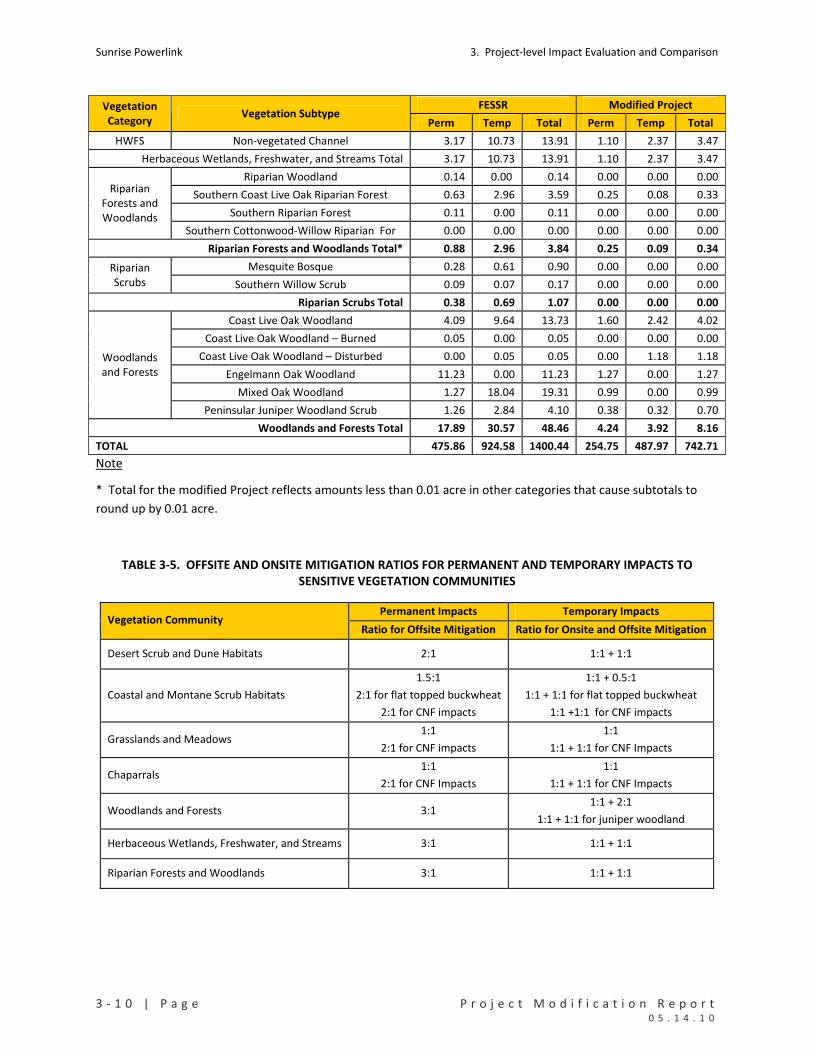
Sunrise Powerlink 3. Project‐level Impact Evaluation and Comparison
3 ‐ 1 0 | P a g e P r o j e c t M o d i f i c a t i o n R e p o r t 0 5 . 1 4 . 1 0
FESSR Modified Project Vegetation Category
Vegetation Subtype Perm Temp Total Perm Temp Total
HWFS Non‐vegetated Channel 3.17 10.73 13.91 1.10 2.37 3.47
Herbaceous Wetlands, Freshwater, and Streams Total 3.17 10.73 13.91 1.10 2.37 3.47
Riparian Woodland 0.14 0.00 0.14 0.00 0.00 0.00
Southern Coast Live Oak Riparian Forest 0.63 2.96 3.59 0.25 0.08 0.33
Southern Riparian Forest 0.11 0.00 0.11 0.00 0.00 0.00
Riparian Forests and Woodlands
Southern Cottonwood‐Willow Riparian For 0.00 0.00 0.00 0.00 0.00 0.00
Riparian Forests and Woodlands Total* 0.88 2.96 3.84 0.25 0.09 0.34
Mesquite Bosque 0.28 0.61 0.90 0.00 0.00 0.00 Riparian Scrubs Southern Willow Scrub 0.09 0.07 0.17 0.00 0.00 0.00
Riparian Scrubs Total 0.38 0.69 1.07 0.00 0.00 0.00
Coast Live Oak Woodland 4.09 9.64 13.73 1.60 2.42 4.02
Coast Live Oak Woodland – Burned 0.05 0.00 0.05 0.00 0.00 0.00
Coast Live Oak Woodland – Disturbed 0.00 0.05 0.05 0.00 1.18 1.18
Engelmann Oak Woodland 11.23 0.00 11.23 1.27 0.00 1.27
Mixed Oak Woodland 1.27 18.04 19.31 0.99 0.00 0.99
Woodlands and Forests
Peninsular Juniper Woodland Scrub 1.26 2.84 4.10 0.38 0.32 0.70
Woodlands and Forests Total 17.89 30.57 48.46 4.24 3.92 8.16
TOTAL 475.86 924.58 1400.44 254.75 487.97 742.71
Note
* Total for the modified Project reflects amounts less than 0.01 acre in other categories that cause subtotals to
round up by 0.01 acre.
TABLE 3‐5. OFFSITE AND ONSITE MITIGATION RATIOS FOR PERMANENT AND TEMPORARY IMPACTS TO SENSITIVE VEGETATION COMMUNITIES
Permanent Impacts Temporary Impacts Vegetation Community
Ratio for Offsite Mitigation Ratio for Onsite and Offsite Mitigation
Desert Scrub and Dune Habitats 2:1 1:1 + 1:1
Coastal and Montane Scrub Habitats
1.5:1
2:1 for flat topped buckwheat
2:1 for CNF impacts
1:1 + 0.5:1
1:1 + 1:1 for flat topped buckwheat
1:1 +1:1 for CNF impacts
Grasslands and Meadows 1:1
2:1 for CNF impacts
1:1
1:1 + 1:1 for CNF Impacts
Chaparrals 1:1
2:1 for CNF Impacts
1:1
1:1 + 1:1 for CNF Impacts
Woodlands and Forests 3:1 1:1 + 2:1
1:1 + 1:1 for juniper woodland
Herbaceous Wetlands, Freshwater, and Streams 3:1 1:1 + 1:1
Riparian Forests and Woodlands 3:1 1:1 + 1:1

3. Project‐level Impact Evaluation and Comparison Sunrise Powerlink
P r o j e c t M o d i f i c a t i o n R e p o r t P a g e | 3 ‐ 1 1 0 5 . 1 4 . 1 0
3.3.3.2 DESERT PAVEMENT
Desert pavement is an exposure of bedrock or pebbles, closely packed after the removal of finer rock
material, polished or smoothed by blown sand so that, eventually, the upper surfaces of the bedrock or
pebbles are ground flat. The pebbles are often bonded together by salts, drawn to the surface in
solution and precipitated by evaporation, which act as a cement (Final EIR/EIS, page D2‐285). West of
the Dunaway turn‐off the Final EIR/EIS estimated that the FESSR would have impacted approximately
2.52 acres of desert pavement permanently and 3.3 acres temporarily (Final EIR/EIS, page D2‐287).
These impacts were considered adverse but less than significant (Class III), and no mitigation is required.
Subsequently, SDG&E surveyed the areas from tower EP333 to EP324 (PMR3) identified as having desert
pavement. Also, SDG&E surveyed the area proposed for the Plaster City construction yard (PMR3). The
findings were:
The area around EP 328‐1 is 70% disturbed by off‐road vehicle traffic with a small area of
pavement.
The area around EP 327‐1 is less than 10% disturbed by off‐road vehicle traffic and has
pavement cover of 85%.
The area around EP 326‐1 is less than 10% disturbed by off‐road vehicle traffic and has
pavement cover of 85%.
The area around EP 325‐1 has pavement cover of 85%.
The area around EP 324‐1 has pavement cover of 0%.
Moreover, towers EP325 through EP328 fall within a designated OHV use area and are likely to be
further degraded over time. Since the modified Project is very similar to the FESSR alignment there is
no change to the conclusion in the Final EIR/EIS that impacts to desert pavement will not be significant.
3.3.3.3 SPECIAL STATUS PLANTS
As indicated in Section D and Appendix 8P of the Final EIR/EIS, the impacts of the FESSR on special status
plants were assessed based on available information from the California Natural Diversity Database
(CNDDB), USFWS and CDFG databases, USFS habitat models, and available data from focused surveys for
specific plants. The numbers of each special status plant potentially affected by the FESSR are totaled in
Appendix 8P. If current survey information was not available the plant was assumed to be present in
appropriate habitat. As required by MMCRP measure B‐5a, SDG&E subsequently completed additional
focused surveys for rare plants in the areas affected by the Project. These surveys were initiated in
2008, with most surveys conducted in 2009. Table 3‐6 indicates the results of the surveys to date. The
plant species identified in the table include those included in Appendix 8P of the Final EIR/EIS and
additional special status plants included in the rare plant surveys.
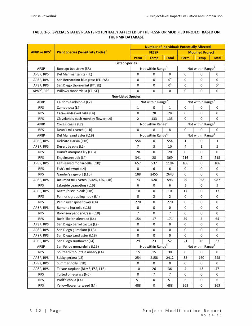
Sunrise Powerlink 3. Project‐level Impact Evaluation and Comparison
3 ‐ 1 2 | P a g e P r o j e c t M o d i f i c a t i o n R e p o r t 0 5 . 1 4 . 1 0
TABLE 3‐6. SPECIAL STATUS PLANTS POTENTIALLY AFFECTED BY THE FESSR OR MODIFIED PROJECT BASED ON THE PMR DATABASE
Number of Individuals Potentially Affected
FESSR Modified Project AP8P or RPS1 Plant Species (Sensitivity Code) 2
Perm Temp Total Perm Temp Total
Listed Species
AP8P Borrego bedstraw (SR) Not within Range3 Not within Range3
AP8P, RPS Del Mar manzanita (FE) 0 0 0 0 0 0
AP8P, RPS San Bernardino bluegrass (FE, FSS) 0 0 04 0 0 0
AP8P, RPS San Diego thorn‐mint (FT, SE) 0 0 05 0 0 05
AP8P6, RPS Willowy monardella (FE, SE) 0 0 0 0 0 0
Non‐Listed Species
AP8P California adolphia (L2) Not within Range3 Not within Range
3
RPS Campo pea (L4) 1 0 1 0 0 0
RPS Caraway‐leaved Gilia (L4) 0 28 28 0 0 0
RPS Cleveland's bush monkey flower (L4) 2 133 135 0 0 0
AP8P Coves' cassia (L2) Not within Range3 Not within Range3
RPS Dean's milk‐vetch (L1B) 0 8 8 0 0 0
AP8P Del Mar sand aster (L1B) Not within Range3 Not within Range3
AP8P, RPS Delicate clarkia (L1B) 554 0 554 1 0 1
AP8P, RPS Desert beauty (L2) 7 3 10 4 1 5
RPS Dunn's mariposa lily (L1B) 20 0 20 0 0 0
RPS Engelmann oak (L4) 341 28 369 216 2 218
AP8P, RPS Felt‐leaved monardella (L1B)7 657 537 1194 106 0 106
RPS Fish's milkwort (L4) 0 6 6 0 0 0
RPS Gander's ragwort (L1B) 188 2455 2643 0 0 0
AP8P, RPS Jacumba milk‐vetch (BLMS, FSS, L1B) 73 520 593 29 958 987
RPS Lakeside ceanothus (L1B) 6 0 6 5 0 5
AP8P, RPS Nuttall's scrub oak (L1B) 10 0 10 17 0 17
RPS Palmer's grappling hook (L4) 0 2 2 0 0 0
RPS Peninsular spineflower (L4) 270 0 270 0 0 0
AP8P, RPS Ramona horkelia (L1B) 0 0 0 0 0 0
RPS Robinson pepper‐grass (L1B) 7 0 7 0 0 0
RPS Rush‐like bristleweed (L4) 154 17 171 59 5 64
AP8P. RPS San Diego barrel cactus (L2) 0 0 0 0 0 0
AP8P. RPS San Diego gumplant (L1B) 0 0 0 0 0 0
AP8P, RPS San Diego sand aster (L1B) 0 0 0 0 0 0
AP8P, RPS San Diego sunflower (L4) 29 23 52 21 16 37
AP8P San Felipe monardella (L1B) Not within Range3 Not within Range3
RPS Southern mountain misery (L4) 15 15 30 0 0 0
AP8P, RPS Sticky geraea (L2) 254 2158 2412 88 160 248
AP8P, RPS Summer holly (L1B) 0 0 0 0 0 0
AP8P, RPS Tecate tarplant (BLMS, FSS, L1B) 10 26 36 4 43 47
RPS Tufted pine‐grass (NC) 0 7 7 0 0 0
RPS Wolf's cholla (L4) 51 0 51 6 0 6
RPS Yellowflower tarweed (L4) 488 0 488 363 0 363

3. Project‐level Impact Evaluation and Comparison Sunrise Powerlink
P r o j e c t M o d i f i c a t i o n R e p o r t P a g e | 3 ‐ 1 3 0 5 . 1 4 . 1 0
Notes and Codes
1 Ap8P = species identified in consolidated matrix in Appendix 8P of the Final EIR/EIS; RPS =
species included in the focused surveys for rare plants conducted in compliance with the
MMCRP in 2008, 2009, and to date in 2010.
2 Sensitivity Codes
FE=federally endangered, FT=federally threatened, SR=state rare, L1B = CNPS List 1B, L2=CNPS
List 2, L4= CNPS List 4, FSS=Forest Service Sensitive, BLMS=Bureau of Land Management
Sensitive, NC=no listing or CNPS code.
3 Not within Range = This species was included in Appendix 8P in connection with other
alternatives that included lands within the species’ range. The impact areas of the FESSR and
modified Project are outside the range of the species.
4 At the time of the Final EIR/EIS, San Bernardino bluegrass was assumed to be present between
Structures 159 and 161 of the BCD South Option Revision based on the presence of USFS
modeled habitat for the species. Focused surveys have determined that the plant species is
not present in the impact areas of the FESSR or modified Project.
5 At the time of the Final EIR/EIS, San Diego thorn‐mint was assumed to be present between mileposts
MRD‐13.7 and 16.1 based on the presence of USFS modeled habitat for the species (USDA, 2007; see
Impact B‐5 in Section E.4.2.2 of the Draft EIR/EIS). Focused surveys to date indicate that this plant
species is not present in or adjacent to the impact areas of the FESSR or modified Project. The
CNDDB indicates 0.34 acre of habitat for this species within the impact areas of the modified Project
(0.18 acre in the FESSR). Focused surveys of the area that included the CNDDB habitat indicate that
the plant is not present in the FESSR or modified Project impact areas.
6 Willowy monardella is not included in the list in Appendix 8P but is addressed in the analysis of
biological impacts in Section D of the Final EIR/EIS.
7 Focused surveys in a limited area were conducted for felt‐leaved monardella for the Final
EIR/EIS. Those surveys detected 70 willowy monardella plants within FESSR impact areas.

Sunrise Powerlink 3. Project‐level Impact Evaluation and Comparison
3 ‐ 1 4 | P a g e P r o j e c t M o d i f i c a t i o n R e p o r t 0 5 . 1 4 . 1 0
As indicated in Table 3‐6, neither the FESSR nor the modified Project would have direct impacts on
federally or state listed plant species. The FESSR potentially would affect 26 non‐listed special status
plant species; the modified Project potentially would affect 13 species. With three exceptions, the
modified Project would likely affect fewer or a similar number of individual plants. The exceptions are
Jacumba milk‐vetch, Nuttall’s scrub oak, and Tecate tarplant. The modified Project would have lower
permanent but higher temporary impacts to Jacumba milk‐vetch and Tecate tarplant and higher
permanent impacts to Nuttall’s scrub oak. Although the impacts to these three plant species would be
greater than under the FESSR, the impacts would not be a new type of effect or be at a scale that would
jeopardize local and regional populations of these species. Impacts to all the rare plant species would
be minimized and mitigated under the FESSR and the modified Project in the same way ‐‐ through
avoidance, minimization, salvage, and relocation, as specified in MMCRP measure B‐5a.
3.3.3.4 SPECIAL STATUS WILDLIFE
Table 3‐7 indicates the estimated impacts of the modified Project and FESSR to special status wildlife
species. The species are those identified in Appendix 8P of the Final EIR/EIS, excluding species not
affected by the FESSR (Appendix 8P considered other alternatives, not just the FESSR). As in Table 3‐3,
the estimated impacts of the FESSR are presented as calculated in the Final EIR/EIS (column one) and
based on the PMR database. Habitat impacts are quantified for USFWS critical habitat (designated and
proposed), USFWS occupied habitat (as per USFWS’s database), the mapped distribution of habitat for
flat tailed horned lizard (a species now proposed for federal listing) in and outside the BLM management
area for this species, the mapped distribution of habitat for the barefoot banded gecko (a state‐listed
species), and distribution of habitat for various species based on USFS habitat models (with a focus on
habitats in CNF).
Overall, the modified Project would reduce FESSR impacts to the habitat of special status species. There
are some instances where the modified Project potentially would affect more acres of a habitat category
than would the FESSR (see species discussions below). The effects of the modified Project on the
special status species would be minimized and mitigated through the same measures that apply to the
FESSR, including the mitigation ratios for permanent and temporary impacts identified in Table 3‐8. No
new significant impacts would result from the modified Project.
Quino Checkerspot Butterfly
In the Final EIR/EIS, FESSR impacts to the Quino checkerspot butterfly (Quino) were assessed but not
quantified except for impacts to designated critical habitat at that time. Additional habitat assessments
and protocol surveys for Quino subsequently have been conducted within suitable habitat along the
alignment. USFWS also has updated its database to identify areas of occupied habitat. Results to date
of the assessments and surveys and USFWS’s Quino occupied habitat have been added to the PMR
database (see Table 3‐7).

3. Project‐level Impact Evaluation and Comparison Sunrise Powerlink
P r o j e c t M o d i f i c a t i o n R e p o r t P a g e | 3 ‐ 1 5 0 5 . 1 4 . 1 0
TABLE 3‐7. ESTIMATED IMPACTS OF THE FESSR AND MODIFIED PROJECT TO SPECIAL STATUS SPECIES BASED ON THE EIR/EIS AND PMR DATABASES
Alignment December
2008 FESSR
December 2008 FESSR
May 2010 Modified Project
Data Source EIR/EIS
Database PMR
Database PMR
Database
SPECIAL STATUS SPECIES1 (acres or number)
(acres or number)
(acres or number)
QUINO CHECKERSPOT BUTTERFLY
USFWS Critical Habitat (2002 or 2009) 2
Permanent Impacts 19.20 11.46 4.45
Temporary Impacts 55.72 16.93 1.59
USFWS Occupied Habitat (USFWS Data) 3
Permanent Impacts ‐‐ 36.16 15.16
Temporary Impacts ‐‐ 84.76 17.49
ARROYO TOAD
USFWS Proposed Critical Habitat4
Permanent Impacts ‐‐ 7.13 2.46
Temporary Impacts ‐‐ 100.67 44.23
USFS Suitable Habitat [USFS Habitat Model]
Permanent Impacts 32.45 33.09 11.92
Temporary Impacts 150.69 154.97 63.00
USFS Suitable Habitat in CNF [USFS Habitat Model]
Permanent Impacts ‐‐ 3.83 3.49
Temporary Impacts ‐‐ 20.53 0.01
BAREFOOT BANDED GECKO (SUITABLE HABITAT)
Permanent Impacts ‐‐ 20.63 10.84
Temporary Impacts ‐‐ 17.16 4.53
FLAT‐TAILED HORNED LIZARD
Permanent Impacts
Management Areas 22.62 22.26 9.54
Habitat Outside of Management Areas 52.95 71.16 26.35
Total Permanent Impacts 75.57 93.42 35.89
Temporary Impacts
Management Areas 91.31 103.25 36.87
Habitat Outside of Management Areas 141.53 170.67 94.88
Total Temporary Impacts 232.84 273.92 131.75
COASTAL CALIFORNIA GNATCATCHER
Number of Pairs Affected ‐‐ ‐‐ 2
Number of Unpaired Individuals Affected ‐‐ ‐‐ 1

Sunrise Powerlink 3. Project‐level Impact Evaluation and Comparison
3 ‐ 1 6 | P a g e P r o j e c t M o d i f i c a t i o n R e p o r t 0 5 . 1 4 . 1 0
Alignment December
2008 FESSR
December 2008 FESSR
May 2010 Modified Project
Data Source EIR/EIS
Database PMR
Database PMR
Database
SPECIAL STATUS SPECIES1 (acres or number)
(acres or number)
(acres or number)
USFWS Critical Habitat
Permanent Impacts 2.22 10.06 3.88
Temporary Impacts 32.97 17.84 21.58
USFWS Occupied Habitat (USFWS Data)
Permanent Impacts 05 1.46 0.16
Temporary Impacts 05 1.83 8.11
USFS Suitable Habitat [USFS Habitat Model]
Permanent Impacts 25.52 25.03 11.97
Temporary Impacts 52.69 48.50 15.67
USFS Suitable Habitat in CNF [USFS Habitat Model]
Permanent Impacts ‐‐ 2.65 1.12
Temporary Impacts ‐‐ 7.07 0.60
GOLDEN EAGLE6
Nest Sites Potentially Affected 4 ‐‐ 95
LEAST BELL'S VIREO7
USFWS Occupied Habitat [USFWS Data]
Permanent Impacts 0.94 0.89 0.00
Temporary Impacts 0.00 0.32 0.00
USFS Suitable Habitat in CNF [USFS Habitat Model] 7
Permanent Impacts ‐‐ 1.32 0.19
Temporary Impacts ‐‐ 0.00 0.00
SOUTHWESTERN WILLOW FLYCATCHER7
USFS Suitable Habitat in CNF (USFS Modeled Habitat]
Permanent Impacts ‐‐ 5,14 3,98
Temporary Impacts ‐‐ 14.39 0.74
PENINSULAR BIGHORN SHEEP
2001 Designated Critical Habitat/Occupied Habitat8
Permanent Impacts 60.42 30.41 10.36
Temporary Impacts 111.81 34.64 20.24
2009 Designated Critical Habitat
Permanent Impacts N/A 16.04 5.41
Temporary Impacts N/A 17.16 1.41

3. Project‐level Impact Evaluation and Comparison Sunrise Powerlink
P r o j e c t M o d i f i c a t i o n R e p o r t P a g e | 3 ‐ 1 7 0 5 . 1 4 . 1 0
Alignment December
2008 FESSR
December 2008 FESSR
May 2010 Modified Project
Data Source EIR/EIS
Database PMR
Database PMR
Database
SPECIAL STATUS SPECIES1 (acres or number)
(acres or number)
(acres or number)
STEPHENS’ KANGAROO RAT7
USFS Suitable Habitat in CNF [USFS Habitat Model] 7
Permanent Impacts 0 0.71 0.18
Temporary Impacts 0 0.03 0.00
Notes
1 In this summary of impacts to special status species, the focus is on the following habitat categories: USFWS critical habitat (designated or proposed), USFWS occupied habitat (areas that USFWS considers occupied by the species based on available information and/or assumptions); mapped habitat and management areas for flat‐tailed horned lizard; mapped suitable habitat for barefoot banded gecko; and suitable habitat as identified by habitat models used by USFS (USFS Suitable Habitat). Where the information in the Final EIR/EIS is not broken into a category used in the PMR database or is assessed qualitatively rather than quantified, the entry is “‐‐.”
2 The estimate of critical habitat for the FESSR in the Final EIR/EIS is based on the 2002 designation; the estimate for the FESSR in column two is based on the current designation, which also applies to the modified Project.
3 USFWS Occupied Habitat includes areas of known Quino populations and sightings and a buffer that typically encompasses all host plants in the vicinity. Some of the USFWS occupied habitat areas also are part of designated critical habitat (e.g., the Jacumba population).
4 Critical habitat for arroyo toad was proposed after completion of the Final EIR/EIS.
5 Appendix 8P of the Final EIR/EIS does not include the specific category of “USFWS Occupied” but shows “0” as the amount of “occupied” habitat. In the USFWS BO for the Project, the estimate is that the FESSR would result in permanent impacts to 8.30 acres and temporary impacts to 12.70 acres of USFWS Occupied habitat.
6 SDG&E is currently conducting a golden eagle nest area study. Surveys are being conducted following USFWS’ Interim Golden Eagle Inventory and Monitoring Protocols; and Other Recommendations (February 2010). The purpose of the surveys is to record and report occupancy (Phase 1) and productivity (Phase 2) of resident golden eagle individual activities, nests, and territories within a 4‐mile radius of the Project. Preliminary results of Phase 1 indicate there are 9 nests (active territories) within a 4‐mile radius of the modified Project’s activity areas.
7 Focused surveys conducted subsequent to the Final EIR/EIS have determined that this species would not occur in the FESSR or modified Project impact areas. The USFS habitat model results have been retained for lands in the CNF.
8 USFWS considers areas formerly designated as critical habitat for Peninsular bighorn sheep to be occupied habitat.

Sunrise Powerlink 3. Project‐level Impact Evaluation and Comparison
3 ‐ 1 8 | P a g e P r o j e c t M o d i f i c a t i o n R e p o r t 0 5 . 1 4 . 1 0
TABLE 3‐8. MITIGATION RATIOS FOR HABITAT IMPACTS TO SPECIAL STATUS WILDLIFE SPECIES
Permanent Impacts Temporary Impacts Species Habitat Category
Ratio for Offsite Mitigation Ratio for Onsite and Offsite
Mitigation
Quino Checkerspot Occupied Habitat
Critical Habitat
3:1
3:1
1:1 + 1:1
1:1 + 1:1
Arroyo Toad
Occupied Breeding Habitat
Occupied Upland Habitat
Critical Habitat1
3:1
2:1
3:1
1:1 + 2:1
1:1 + 1:1
1:1 + 1:1
Barefoot Banded
Gecko Suitable Habitat TBD
2 TBD2
Flat Tailed Horned
Lizard
In FTHL Management Area
Outside FTHL Management Area
5.5:1 (4.5:1)3 or in lieu fee
1:1 or in lieu Fee
3.5 (2.5:1)3 or in lieu fee
1:1 or in lieu fee
California
Gnatcatcher
Occupied Habitat
Critical Habitat
2:1
2:1
1:1 + 1:1
1:1 + 1:1
Least Bell’s Vireo Occupied Habitat 3:1 1:1 + 2:1
Southwestern
Willow Flycatcher Occupied Habitat 3:1 1:1 + 2:1
Peninsular Bighorn
Sheep
Occupied Habitat
Critical Habitat
5:1
5:1
1:1 + 2:1
1:1 + 2:1
Stephens’ Kangaroo
Rat Occupied Habitat 2:1 1:1 + 1:1
Note
1 The Final EIR/EIS does not specify a mitigation ratio for impacts to arroyo toad critical habitat (designated
or proposed) because the FWS did not propose to revise arroyo toad critical habitat to include the project
until October 2009. For planning purposes, SDG&E has assumed that impacts to arroyo toad critical
habitat would require 3:1 mitigation for permanent impacts and 2:1 mitigation for temporary impacts.
Actual mitigation requirements would be specified in a USFWS conference determination.
2 CDFG has not specified a mitigation ratio for impacts to barefoot banded gecko; mitigation will be
determined by CDFG in connection with SDG&E’s application for a Section 2081 incidental take permit.
The application was submitted in April 2010.
3 Ratios in parentheses apply to agriculture and disturbed habitat.

3. Project‐level Impact Evaluation and Comparison Sunrise Powerlink
P r o j e c t M o d i f i c a t i o n R e p o r t P a g e | 3 ‐ 1 9 0 5 . 1 4 . 1 0
Based on PMR database, the FESSR and modified Project entail impacts to Quino habitat in the same
PMR units (PMR9, PMR10, PMR18, PMR21‐PMR25, PMR37, and PMR39‐PMR40). Under the FESSR,
most impacts to Quino are associated with construction yards (approximately 33 acres), roads (32
acres), and wire stringing areas (30 acres). FESSR permanent impacts to Quino habitat (all categories)
are estimated at approximately 48 acres; temporary impacts are estimated at approximately 102 acres.
Under the modified Project, yard and stringing area impacts are eliminated and road impacts are
reduced to 4.6 acres. Permanent impacts to Quino habitat (all categories) under the modified Project
would be reduced to approximately 19.6 acres, temporary impacts to approximately 19.1 acres. Under
the FESSR and modified Project, most impacts are to areas that USFWS identifies as occupied Quino
habitat. The modified Project would reduce permanent impacts to occupied habitat from 37.83 acres to
15.16 acres and temporary impacts from 86.59 acres to 17.49 acres. As anticipated in the Final EIR/EIS,
critical habitat for Quino was revised in 2009. Under both the initial and revised critical habitat
designations (see Table 3‐7), the modified Project would have fewer impacts to critical habitat than the
FESSR.
Impacts of the modified Project on Quino would be minimized and mitigated through the same
measures that apply to the FESSR. As specified in the MMCRP and BO, these measures include impact
site avoidance and minimization as well as onsite and offsite mitigation. The MMCRP also requires that
the HAP identify mitigation lands within Quino habitat, that the HMP cover management of Quino
habitat and populations, and that the RP provide for onsite restoration of Quino habitat.
Arroyo Toad
In the Final EIR/EIS, FESSR impacts on arroyo toad were calculated in terms of suitable breeding and
suitable upland habitat. These two categories were mapped based on the information from the USFWS
and CDFG databases, the USFS model for arroyo toad habitat, and additional information provided from
habitat assessments conducted by Helix Environmental in 2007. In Table 3‐7, the two categories are
combined.
Based on the Final EIR/EIS, the FESSR would result in 32.65 acres of permanent impacts and 150.69 acres
of temporary impacts to arroyo toad upland habitat. The estimate under the PMR database is very
similar: 33.09 acres of permanent, and 154.97 acres of temporary impacts in areas modeled as suitable
habitat. Of these amounts, 3.83 acres of the permanent impacts and 20.53 acres of the temporary
impacts would be in CNF. Most FESSR impacts would result from proposed construction yards and
would occur in seven PMR units (PMR15‐PMR18, PMR22, PMR28, and PMR34). Based on the PMR
database, the modified Project would result in 11.92 acres of permanent impacts and 63.00 acres of
temporary impacts to the modeled suitable habitat for arroyo toad. Of these amounts, 3.49 acres of
permanent impacts and 0.01 acre of temporary impacts would be CNF. The modified Project would
result in 11.92 acres of permanent and 63.00 acres of temporary impacts in areas modeled as suitable
habitat. Of these amounts, 3.49 acres of permanent impacts and 0.01 acre of temporary impacts would
occur in CNF. As with the FESSR, the impacts are in multiple PMR units (PMR15‐PMR17, PMR22, PMR28,
and PMR34). The reduction in impacts under the modified Project is substantial and is due to the
elimination of several construction yards.
Sunrise Powerlink 3. Project‐level Impact Evaluation and Comparison
3 ‐ 2 0 | P a g e P r o j e c t M o d i f i c a t i o n R e p o r t 0 5 . 1 4 . 1 0
In 2009, the Project database on arroyo toad habitat and occurrence was expanded. RECON conducted
focused protocol surveys to determine if suitable habitat and arroyo toads were present between the
existing Imperial Valley Substation (MP0) and Sycamore Substation (MP117). The surveys were
conducted from April 14 through June 26, 2009 in accordance with the USFWS protocol. Each drainage
and any areas modeled as suitable or known to be occupied were visually evaluated by RECON biologists
during this protocol survey. Based on this initial evaluation, 31 sites were assessed in greater detail for
habitat suitability. The habitat assessments focused on determining the suitability of the sites to support
breeding arroyo toads based on the elements of modeled suitable habitat outlined by USFWS as well as
core habitat features: presence of flowing water, sandy substrates, and presence of sandy terraces
adjacent to or within each drainage. The assessments consisted of visually assessing each drainage
crossing the proposed Project alignment. Using GIS data combined with global positioning system (GPS)
units, previously mapped drainages and areas modeled as suitable habitat or occupied habitat were
evaluated. Habitat and drainages near the proposed alignment that provided suitable connectivity also
were considered and evaluated.
Of the 31 sites that were evaluated, 13 were determined to provide potentially suitable habitat for
arroyo toad. These 13 sites were subsequently surveyed using the USFWS protocol and the results
provided to the USFWS per the protocol requirements. The results of the surveys were negative ‐ no
arroyo toads (adult, juvenile, larvae, or egg masses) were observed within the Project ROW and
associated components. No arroyo toads were observed within USFS modeled suitable habitat. Two
adult arroyo toads were incidentally observed less than 1 km from the Project ROW on an existing dirt
road. However, because there is an approximate 1,000‐foot elevation difference over steep and rocky
terrain between the arroyo toad observations and Project ROW, the project is not expected to have
adverse impacts to these individuals.
At the time of the Final EIR/EIS, no designated critical habitat for arroyo toad occurred in the Project
area. Subsequently USFWS proposed a revised critical habitat rule that would designate critical habitat
in the San Diego, Sweetwater River, and Cottonwood Creek basins. If the proposed rule is adopted as is,
the modified Project would result in 2.46 acres of permanent impacts and 44.23 acres of temporary
impacts to arroyo toad critical habitat. The impacts would occur in seven PMR units: PMR17, PMR 19,
PMR21‐22, PMR24, PMR 32, PMR34, and PMR36. Most of the impacts are in PMR34 and PMR36 in
connection with two construction yards. The two yards (Hartung in PMR34 and Helix in PMR36) occur
on non‐federal lands. Hartung Is located in an open, shallow, sandy wash with sparse vegetation cover.
Helix is located within cleared land probably used for agriculture and is dominated by high cover, non‐
native grassland. Both areas were included in the 2009 habitat assessments and were determined to
have moderate potential for breeding and foraging habitat. No water was present in 2009. Protocol
surveys were recommended and are being conducted in 2010. Results of the 2010 arroyo toad surveys
will be submitted to USFWS and will be used to further refine the impact estimates for these areas.
If the proposed critical habitat rule is adopted, an additional category of habitat impacts would require
mitigation (similar to what applies for Quino). However, the additional category of habitat impacts
would not constitute a new significant impact to arroyo toad. Impacts to critical habitat under the
3. Project‐level Impact Evaluation and Comparison Sunrise Powerlink
P r o j e c t M o d i f i c a t i o n R e p o r t P a g e | 3 ‐ 2 1 0 5 . 1 4 . 1 0
modified Project would be similar in type and scale as the FESSR impacts to suitable and occupied
habitat considered in the Final EIR/EIS.
Impacts of the modified Project to arroyo toad would be minimized and mitigated through the same
measures identified for the FESSR in the MMCRP and BO. The MMCRP and BO currently require pre‐
construction surveys in suitable habitat, impact site avoidance and minimization measures, and onsite
and offsite mitigation. The HAP, HMP, and RP each must address arroyo toad mitigation requirements.
Additional measures for impacts to critical habitat may be required if the proposed rule is adopted and
would be determined by USFWS.
Barefoot Banded Gecko
In the Final EIR/EIS, it was assumed that all suitable habitat between mileposts 23 and 39 was occupied
by barefoot banded gecko; no calculation was made of habitat acreage, which was assessed
qualitatively. Subsequently, habitat suitability assessments of this area were performed in 2009 and
2010, and habitat occupancy is being assessed in May‐July 2010, in more detail.
Based on the PMR database, FESSR impacts to barefoot banded gecko would occur in PMR5 and PMR6;
approximately 20.63 acres of permanent and 17.16 acres of temporary habitat disturbance would occur.
A construction yard and new access road in PMR6 account for most of the FESSR impacts. Under the
modified Project, impacts would occur in PMR8 as well as PMR5 and PMR6. Impacts from the FESSR
yard in PMR6 would be eliminated, and impacts from an access road in PMR8 would be added. Overall,
the modified Project would reduce both the permanent and temporary impacts of the FESSR on
barefoot banded gecko. Permanent impacts would be reduced to 10.84 acres, temporary impacts to
4.53 acres.
Mitigation requirements for the Project are being determined in connection with the Project’s CESA
2081 Incidental Take Permit Application, which was submitted to CDFG in April 2010. The HAP includes
mitigation lands suitable for and occupied by barefoot banded gecko, and those lands are also identified
in the 2081 application as potential compensatory mitigation. The HMP will address management of
gecko habitat and populations and will incorporate measures specified by CDFG in the 2081 permit. The
RP also will include the relevant measures from the 2081 permit.
Flat Tailed Horned Lizard
In the Final EIR/EIS, impacts to flat tailed horned lizard were estimated in terms of two habitat
categories: habitat within BLM’s Flat Tailed Horned Lizard (FTHL) Management Area and habitat outside
the Management Area. As indicated in Table 3‐7, permanent impacts were estimated at 22.62 acres in
the Management Area and 52.95 acres outside the Management Areas; temporary impacts were
estimated at 91.31 acres in and 141.53 acres outside. There are some differences in the split of
permanent and temporary FESSR impacts when measured by the PMR 2010 databases (see Table 3‐7),
but total FESSR impacts are substantially the same under both calculations. The PMR 2010 calculation is
used in the comparisons below.

Sunrise Powerlink 3. Project‐level Impact Evaluation and Comparison
3 ‐ 2 2 | P a g e P r o j e c t M o d i f i c a t i o n R e p o r t 0 5 . 1 4 . 1 0
As indicated in Table 3‐7, the FESSR would result in an estimated 93.42 acres of permanent impacts and
273.92 acres of temporary impacts to FTHL habitat. Most of these impacts are attributable to proposed
construction yards (151.6 acres), temporary work pads (105.9 acres) and roads (71.7). Under the
modified Project, permanent impacts are estimated at 35.89 acres, temporary impacts at 131.75 acres.
Yard impacts would be reduced to 62.4 acres, temporary work pad impacts would be eliminated, and
road impacts would be reduced to 15.4 acres. Permanent and temporary impacts in and outside the
FTHL Management Area would be reduced.
SDG&E has provided advance mitigation for impacts to flat tailed horned lizard through payment of the
in lieu fee identified in MMCRP measure B‐7b. Payment of $348,450 was made to BLM based on the
estimated permanent and temporary impacts of the FESSR in Appendix 8P of the Final EIR/EIS. In
addition, the MMCRP requires pre‐construction surveys and impact site avoidance and minimization
measures. The HAP, HMP, and RP also will include provisions for FTHL.
Since publication of the Final EIR/EIS, USFWS has reinstated the proposed rule to list flat tailed horned
lizard as a threatened species and reopened the public comment period in March 2010. SDG&E will
seek authorization for incidental take through a pre‐listing conference determination from the USFWS.
Coastal California Gnatcatcher
FESSR impacts on the California gnatcatcher were calculated in the Final EIR/EIS based on USFWS and
CDFG databases, USFS habitat suitability modeling, and field surveys. Modeled suitable habitat and
designated critical habitat were the primary category in the calculations. Three categories of habitat are
considered here: suitable habitat based on the USFS habitat model, USFWS occupied habitat, and
critical habitat.
As indicated in Table 3‐7, the Final EIR/EIS estimated that the FESSR would result in 25.52 acres of
permanent impacts and 52.69 acres of temporary impacts to modeled suitable habitat. The estimated
impacts to suitable habitat are very similar to those calculated using the PMR database (25.03 acres of
permanent and 48.50 acres of temporary impacts). Of the modeled suitable habitat, 2.65 acres of
permanent impacts and 7.07 acres of temporary impacts would occur in CNF. The FESSR impacts would
occur in PMR25‐PMR28, PMR 31, PMR34‐PMR37, and PMR39. Construction yards account for most of
the FESSR temporary impacts, primarily a proposed yard in PMR35. The modified Project would reduce
FESSR impacts to 11.97 acres of permanent and 15.67 acres of temporary impacts (1.12 acres of
permanent and 0.01 acre of temporary impacts in CNF). The impacts under the modified Project would
occur in PMR25, PMR27, PMR28, PMR34‐PMR37, PMR39, and PMR40. The modified Project would
eliminate FESSR gnatcatcher impacts in PMR26 and PMR31 and add habitat impacts in PMR36 and
PMR40. Most of the modified Project’s temporary impacts would occur in PMR36 as the result of a
construction yard (Helix).
Focused surveys were conducted in 2009 to assess gnatcatcher habitat and identify occupied areas in all
suitable habitat potentially affected by the Project. The surveys included habitat in Links 2, 3, 4, and 5,
including along the reconductoring routes. Link 1 was excluded because it is well east of historic and
currently known ranges for the species and does not contain suitable habitat. The habitat assessment
3. Project‐level Impact Evaluation and Comparison Sunrise Powerlink
P r o j e c t M o d i f i c a t i o n R e p o r t P a g e | 3 ‐ 2 3 0 5 . 1 4 . 1 0
focused on the FESSR ROW and approximately 500 feet on either side. USFS modeled habitat and
historic gnatcatcher locations were included. Protocol surveys were conducted on approximately 900
acres and detected 11 gnatcatcher pairs, a single adult male, and dispersing juveniles in the survey area.
No gnatcatchers were detected in the USFS modeled suitable habitat affected by the FESSR.
Appendix 8P of the Final EIR/EIS does not include “USFWS Occupied Habitat” as a specific category but
estimates impacts to occupied habitat at 0. However, in the USFWS BO for the Project, the FESSR was
estimated to result in 8.30 acres of permanent and 12.70 acres of temporary impacts to USFWS
occupied habitat. This is higher than the estimate under the PMR database, which indicates that the
FESSR would result in 1.46 acres of permanent and 1.83 acres of temporary impacts to USFWS occupied
habitat. The modified Project also would result in 0.16 acre of permanent impacts and 8.11 acres of
temporary impacts to USFWS occupied habitat.
The critical habitat impact estimate for the FESSR in the Final EIR/EIS is identified in Table 8P as 2.22
permanent acres and 32.97 temporary acres. The FESSR estimate under the PMR database as indicated
in Table 3‐7 would result in 10.06 acres of permanent impacts and 17.84 acres of temporary impacts to
designated critical habitat. The modified Project would reduce permanent impacts to 3.88 and increase
temporary impacts to 21.58. As identified in the Final EIR/EIS much of the temporary impacts to
designated critical habitat is to non occupied, agricultural lands. Overall, the modified Project would
likely have lower combined permanent impacts and similar temporary impacts as the FESSR. No new
significant impacts would result.
Impacts of the modified Project would be minimized and mitigated through the same measures in the
MMCRP and BO that apply to the FESSR, including pre‐construction surveys, impact site avoidance and
minimization, and onsite and offsite mitigation. The HAP, HMP, and RP would include provisions for
mitigating impacts to this species.
Golden Eagle
The Final EIR/EIS disclosed that there were four golden eagle nest areas that potentially would be
affected by activities within the Project area. The four nest areas were identified based on USFS’s
database and other information available at that time. In March 2010, SDG&E initiated a golden eagle
nest area study. Surveys are being conducted following USFWS’ Interim Golden Eagle Inventory and
Monitoring Protocols; and Other Recommendations (February 2010). The purpose of the surveys is to
record and report occupancy (Phase 1) and productivity (Phase 2) of resident golden eagle individual
activities, nests, and territories within a 4‐mile radius of the Project. Phase 1 surveys began late March
and were completed by mid‐April. Phase 2 surveys will be conducted in May. Preliminary results of the
2010 survey indicate that there are 9 active nest areas within a 4‐mile radius of the modified Project’s
impact areas. Results of the survey will be used to adjust construction activities, including helicopter
flights, to avoid and reduce the potential for inadvertent impacts on golden eagles during the nesting
season. All project activities will be subject to a number of mitigation measures that are consistent with
and more conservative than USFWS’ existing protocols for avoiding take of golden eagles under the Bald
and Golden Eagle Protection Act, currently found in the Utah Field Office Guidelines for Raptor

Sunrise Powerlink 3. Project‐level Impact Evaluation and Comparison
3 ‐ 2 4 | P a g e P r o j e c t M o d i f i c a t i o n R e p o r t 0 5 . 1 4 . 1 0
Protection from Human and Land Disturbances (2002). Among these measures is MMCRP measure B‐
7h, which prohibits construction or maintenance activities from taking place within 4,000 feet of an
eagle nest during the eagle breeding season (December through June). By contrast USFWS Guidelines
only identify a spatial buffer of 2,640 feet during the nesting season, which can be reduced even further
to 1,320 feet for industrial activities such as transmission line construction during the latter stages of the
nesting period. Additional generalized mitigation measures to protect avian species will also assist in
avoiding and minimizing impacts to this species.
Least Bell’s Vireo
In the Final EIR/EIS, FESSR impacts to least Bell’s vireo (LBV) were calculated based on USFS modeled
habitat and areas identified as USFWS Occupied habitat. The FESSR was estimated to result in 8.58
acres of permanent impacts and 13.53 acres of temporary impacts to LBV habitat. Subsequently,
habitat assessments and surveys for LBV and other riparian birds have been conducted in all areas that
have potentially suitable habitat and would be affected by the Project. The assessments and surveys
have determined that LBV would not be directly affected by the FESSR or modified Project. The results
of the habitat modeling have been retained as an indicator of LBV potential habitat in CNF. Based on
the PMR database, the FESSR would affect 1.32 acres of suitable habitat in CNF; the modified Project
would affect 0.19 acres. The 0.19 acre occurs in two locations within CNF (PMR25 and PMR28). The two
locations were included in the 2009 riparian bird surveys and were not occupied by LBV.
Habitat impacts would be minimized and mitigated as per the MMCRP and any conditions included in
the wetland and streambed permits for the Project. Pre‐construction surveys for nesting birds would be
conducted ten days prior to construction to further ensure that LBV would not be affected.
Southwestern Willow Flycatcher
As with LBV, FESSR impacts to southwestern willow flycatcher were calculated in the Final EIR/EIS based
primarily on USFS modeled habitat. As indicated in Table 3‐7, the FESSR was estimated to have 22.75
acres of permanent impacts and 33.14 acres of temporary impacts in areas modeled as suitable habitat.
Subsequently, riparian bird surveys and habitat assessments have determined that neither the FESSR
nor the modified Project would have direct impacts to this species. The results of the habitat modeling
have been retained as an indicator of potential habitat for southwestern willow flycatcher in CNF.
Based on the PMR database, the FESSR would have 5.14 acres of permanent and 14.39 acres of
temporary impacts on suitable habitat in CNF; the modified Project would have 3.98 acres of permanent
and 0.74 acres of temporary impacts.
Habitat impacts would be minimized and mitigated as per the MMCRP and any conditions included in
the wetland and streambed permits for the Project.
3. Project‐level Impact Evaluation and Comparison Sunrise Powerlink
P r o j e c t M o d i f i c a t i o n R e p o r t P a g e | 3 ‐ 2 5 0 5 . 1 4 . 1 0
Peninsular Bighorn Sheep (PBS)
In the Final EIR/EIS, FESSR impacts to Peninsular bighorn sheep (PBS) were calculated in terms of
impacts to designated critical habitat at that time. As indicated in Table 3‐7, the FESSR was estimated to
result in 60.42 acres of permanent impacts and 111.81 acres of temporary impacts.
Since approval of the Final EIR/EIS, PBS critical habitat was revised (as anticipated). The databases were
revised to reflect the new, smaller critical habitat boundaries and, at USFWS’s direction, to treat areas
that were formerly designated as critical habitat as occupied PBS habitat.
Based on the updated database, the FESSR impacts to PBS habitat would be lower than estimated in the
Final EIR/EIS, with 46.45 acres of permanent impacts and 51.78 acres of temporary impacts. Most of
these impacts would occur as a result of construction yards in PMR6 and PMR13 and impacts from
structures, roads, and other features in five other units. Under the modified Project, the construction
yard in PMR13 would be eliminated and the yard in PMR6 would be reduced from 16 to 5 acres. Total
impacts to PBS habitat under the modified Project would be reduced to approximately 15.77 of
permanent and 21.65 acres of temporary impacts.
Habitat impacts under the modified Project would be mitigated through the same measures identified
for the FESSR in the MMCRP and BO, including seasonal restriction on activities, population monitoring,
and on and offsite mitigation. The HAP, HMP, and RP will include provisions for PBS.
Stephens’ Kangaroo Rat
Appendix 8P in the Final EIR/EIS did not identify any impacts to USFS modeled habitat for Stephens’
kangaroo rat under the FESSR, and the BO determined there would be no impacts to SKR because the
Project impact areas were not within the species’ range. USFS modeled habitat indicates the FESSR
would affect approximately 0.74 acre of potential SKR habitat in CNF and that the modified Project
would affect 0.19 acre. The areas have been surveyed for Stephens’ kangaroo rat, and none were
detected. It is not anticipated that either the FESSR or the modified Project would result in impacts to
actual habitat for Stephens’ kangaroo rat.
3.3.3.5 POTENTIAL EFFECTS OF STRUCTURE LIGHTING ON SPECIAL STATUS WILDLIFE
As indicated in section 2.1, IR emitter lights would be installed on approximately 323 of 453 structures
under the modified Project. The fixtures proposed for SRPL structures (Carmanah Model A702 IR) are
approximately 13 inches tall and 6 inches wide, and contain 24 IR light emitting diodes (LEDs) that emit
at a wavelength of 870 nanometers (nm), which is well outside the detectable visible light spectrum
(approximately 400 to 700 nm) and within the near IR spectrum. SDG&E would install two IR units on
500kV structures and one IR unit on 230 kV structures (although it is currently being determined
whether two may be installed for reliability). The following assessment of potential impacts of structure
lighting on special status wildlife is based on available scientific information. Full citations for the
literature referenced are in section 3.4.
Sunrise Powerlink 3. Project‐level Impact Evaluation and Comparison
3 ‐ 2 6 | P a g e P r o j e c t M o d i f i c a t i o n R e p o r t 0 5 . 1 4 . 1 0
Potential Effects on Birds
Avian mortality from collision with visual lighted towers during seasonal bird migrations under low‐
ceiling cloud effects is a well‐documented risk to migrating birds (Gehring 2009, Drewitt 2008, Horn
2006, and CEC 2007). Therefore, Section D.2 of the Final EIR/EIS identifies Impact B‐10, the potential for
migrating birds to collide with transmission towers or lines. The proposed structure lights associated
with the modified Project emit near IR radiation from dusk to dawn at 870 nm, well outside the 400 –
700 nm visible light range of birds (Zeigler 1993). Therefore, the infrared lighting proposed where
lighting is required for safety purposes would not directly attract birds or increase the potential for
collisions.
Infrared lights may attract insects that are capable of detecting IR. Documented insect groups with
species that may be capable of IR detection include beetles and butterflies (Briscoe 2001). The likelihood
that concentrations of these insects would occur in the vicinity of towers with infrared lights and the
potential that foraging birds (or bats) would collide with towers in such circumstances is not known.
Nocturnal insectivores would be the avian species potentially affected. In the Project vicinity in San
Diego and western Imperial counties they would likely be limited to western screech owl (Megascops
kennicottii) and common poorwill (Phalaenoptilus nuttalli) which are permanent residents, and lesser
nighthawk (Chordeiles acutipennis) which is a frequent summer visitor. Flammulated owl (Otus
flammeolus) is rare and sporadic in San Diego County mountains (Unitt, 2006), and this species is not
likely to occur in the vicinity of the Project due to a lack of suitable pine forest habitat in and/or adjacent
to the ROW. Although the potential for indirect impacts from IR lights are unknown, any effects would
likely be limited to individuals of the three avian species throughout the Project ROW. The Final EIR/EIS
found that collision impacts to migrating birds (at night) was significant and not mitigable (Class I
Impact) and that it was difficult to determine the extent of the impact. Similarly, little is known about
the potential effect of attracting insects and avian insectivores. Thus, the proposed tower IR lighting
associated with the modified Project does not significantly alter the conclusions of the Final EIR/EIS.
Potential Effects on Bats
Project structures with IR emitters installed are not anticipated to result in impacts to bats. Bats have
well‐studied echo location abilities and can avoid stationary towers with or without lighting in nocturnal
situations. Bat mortality has been shown in several recent studies to be unaffected by the presence of
aviation lighting (on wind turbines) (Horn 2006). Although insect frequency in these areas increased on
lighted turbines, the bats are expected to be echo locating during pursuit of insects near tower lights
and would therefore sense the tower structure and avoid collision (Stokes 2010).
3.3.3.6 RIPARIAN CONSERVATION AREAS
In response to a USFS request included in the agency’s comments to the Draft EIR/EIS, Helix
Environmental conducted an analysis for the Final EIR/EIS of Project impacts to RCAs within CNF. A 5‐
step RCA analysis was completed for all of the individual alternative routing segments that would occur
on the CNF (both segments across CNF that were selected for the FESSR and alternative segments that
were not selected) as well as for the FESSR as a whole. USFS provided a GIS shapefile of buffers
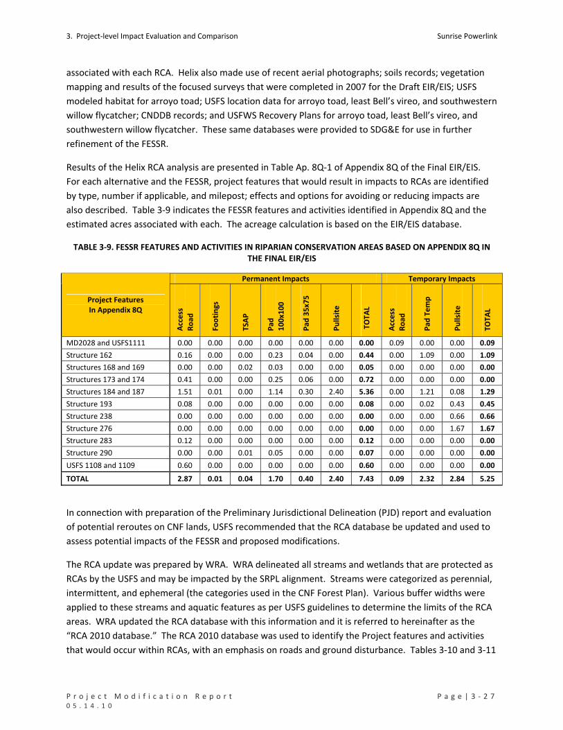
3. Project‐level Impact Evaluation and Comparison Sunrise Powerlink
P r o j e c t M o d i f i c a t i o n R e p o r t P a g e | 3 ‐ 2 7 0 5 . 1 4 . 1 0
associated with each RCA. Helix also made use of recent aerial photographs; soils records; vegetation
mapping and results of the focused surveys that were completed in 2007 for the Draft EIR/EIS; USFS
modeled habitat for arroyo toad; USFS location data for arroyo toad, least Bell’s vireo, and southwestern
willow flycatcher; CNDDB records; and USFWS Recovery Plans for arroyo toad, least Bell’s vireo, and
southwestern willow flycatcher. These same databases were provided to SDG&E for use in further
refinement of the FESSR.
Results of the Helix RCA analysis are presented in Table Ap. 8Q‐1 of Appendix 8Q of the Final EIR/EIS.
For each alternative and the FESSR, project features that would result in impacts to RCAs are identified
by type, number if applicable, and milepost; effects and options for avoiding or reducing impacts are
also described. Table 3‐9 indicates the FESSR features and activities identified in Appendix 8Q and the
estimated acres associated with each. The acreage calculation is based on the EIR/EIS database.
TABLE 3‐9. FESSR FEATURES AND ACTIVITIES IN RIPARIAN CONSERVATION AREAS BASED ON APPENDIX 8Q IN THE FINAL EIR/EIS
Permanent Impacts Temporary Impacts
Project Features In Appendix 8Q
Acc
ess
Ro
ad
Foo
tin
gs
TSA
P
Pad
10
0x1
00
Pad
35
x75
Pu
llsit
e
TO
TAL
Acc
ess
Ro
ad
Pad
Te
mp
Pu
llsit
e
TOTA
L
MD2028 and USFS1111 0.00 0.00 0.00 0.00 0.00 0.00 0.00 0.09 0.00 0.00 0.09
Structure 162 0.16 0.00 0.00 0.23 0.04 0.00 0.44 0.00 1.09 0.00 1.09
Structures 168 and 169 0.00 0.00 0.02 0.03 0.00 0.00 0.05 0.00 0.00 0.00 0.00
Structures 173 and 174 0.41 0.00 0.00 0.25 0.06 0.00 0.72 0.00 0.00 0.00 0.00
Structures 184 and 187 1.51 0.01 0.00 1.14 0.30 2.40 5.36 0.00 1.21 0.08 1.29
Structure 193 0.08 0.00 0.00 0.00 0.00 0.00 0.08 0.00 0.02 0.43 0.45
Structure 238 0.00 0.00 0.00 0.00 0.00 0.00 0.00 0.00 0.00 0.66 0.66
Structure 276 0.00 0.00 0.00 0.00 0.00 0.00 0.00 0.00 0.00 1.67 1.67
Structure 283 0.12 0.00 0.00 0.00 0.00 0.00 0.12 0.00 0.00 0.00 0.00
Structure 290 0.00 0.00 0.01 0.05 0.00 0.00 0.07 0.00 0.00 0.00 0.00
USFS 1108 and 1109 0.60 0.00 0.00 0.00 0.00 0.00 0.60 0.00 0.00 0.00 0.00
TOTAL 2.87 0.01 0.04 1.70 0.40 2.40 7.43 0.09 2.32 2.84 5.25
In connection with preparation of the Preliminary Jurisdictional Delineation (PJD) report and evaluation
of potential reroutes on CNF lands, USFS recommended that the RCA database be updated and used to
assess potential impacts of the FESSR and proposed modifications.
The RCA update was prepared by WRA. WRA delineated all streams and wetlands that are protected as
RCAs by the USFS and may be impacted by the SRPL alignment. Streams were categorized as perennial,
intermittent, and ephemeral (the categories used in the CNF Forest Plan). Various buffer widths were
applied to these streams and aquatic features as per USFS guidelines to determine the limits of the RCA
areas. WRA updated the RCA database with this information and it is referred to hereinafter as the
“RCA 2010 database.” The RCA 2010 database was used to identify the Project features and activities
that would occur within RCAs, with an emphasis on roads and ground disturbance. Tables 3‐10 and 3‐11

Sunrise Powerlink 3. Project‐level Impact Evaluation and Comparison
3 ‐ 2 8 | P a g e P r o j e c t M o d i f i c a t i o n R e p o r t 0 5 . 1 4 . 1 0
presents the results of the analysis. To provide the basis for a comparison, the RCA 2010 database also
was applied to the FESSR. Table 3‐12 presents the results. Approximately 50% of the total acreage
impacts are associated with improvements to existing roads (including those currently used for other
non‐project related purposes) within the existing roadbed, or associated with improving turns for the
existing roadbed. No existing roads are proposed to be widened.
TABLE 3‐10. FEATURES AND ACTIVITIES OF THE MODIFIED PROJECT IN RIPARIAN CONSERVATION AREAS BASED ON RCA 2010 DATABASE AND UPDATED RCA ANALYSIS
Roads Measured in Miles
Project Impact Areas
Permanent Temporary
Existing Roads (miles)
Minor Improvement 1.925 0
Major Improvement 3.913 0
TOTAL Improvements to Existing Roads 5.838 0 5.838
Roads Measured in Acres
Project Impact Areas
Permanent Temporary Total
New Roads (acres) 0.52 0.09 0.61
Existing Roads (acres)
Minor Improvement 1.16 0 1.16
Major Improvement 7.86 0 7.86
Total Improvements to Existing Roads 9.01 0 9.62
Stream Crossings by Road
New Road Stream Crossings 2
Existing Road Stream Crossings 39
Total Road Stream Crossings 41
Other Project Features Measured in Acres
Project Impact Areas
Permanent Temporary Total
Footings 0.02 0.02
Grading 0.56 0.56
Guard_Areas 0.04 0.04
TSAP 0.85 0.85
Structure Impact Area 2.63 2.63
Maintenance Pad 0.38 0.38
Work Area 2.33 2.33
String Site Area 2.29 2.29
Total Other Project Impacts 4.44 4.66 9.10
Total Project Features in Acres
Project Impact Areas
Permanent Temporary Total
Total 13.97 4.75 18.72

3. Project‐level Impact Evaluation and Comparison Sunrise Powerlink
P r o j e c t M o d i f i c a t i o n R e p o r t P a g e | 3 ‐ 2 9 0 5 . 1 4 . 1 0
TABLE 3‐11. POTENTIAL FESSR AND MODIFIED PROJECT IMPACTS IN RIPARIAN CONSERVATION AREAS BY PMR UNIT BASED ON PMR DATABASE
FESSR (acres) FESSR (acres) PMR Unit
Temporary Permanent Total Permanent Temporary Total
15 0.44 1.09 1.53 0.27 0.00 0.27
16 1.29 0.00 1.29 9.06 0.17 9.23
17 7.18 15.90 23.08 2.02 1.00 3.03
18 0.14 14.82 14.97 0.00 0.12 0.12
20 0.00 0.09 0.09 0.00 0.00 0.00
21 0.73 0.52 1.25 0.00 0.00 0.00
22 0.00 0.66 0.66 0.00 0.00 0.00
23 0.00 0.00 0.00 0.09 0.00 0.09
25 1.32 8.41 9.73 1.58 2.40 3.99
26 0.52 1.08 1.60 0.57 0.18 0.76
27 0.00 0.00 0.01 0.00 0.00 0.00
28 0.49 2.83 3.32 0.28 0.87 1.16
29 0.00 6.39 6.39 0.00 0.00 0.00
31 0.05 0.00 0.05 0.00 0.00 0.00
34 0.80 0.32 1.12 0.08 0.00 0.08
Total 12.96 52.13 65.10 13.97 4.75 18.72
As indicated in Table 3‐9, the FESSR structures and features identified in Appendix 8Q would occur on
approximately 12.68 acres of RCAs, potentially resulting in 7.43 acres of permanent impacts and 5.25
acres of temporary impacts to RCAs within CNF. This estimate is based on the EIR/EIS database, not the
updated RCA 2010 database. If the RCA 2010 database is applied to the FESSR, structures and other
features would occur on approximately 65.10 acres of RCAs, potentially resulting in 12.96 acres of
permanent impacts and 52.13 acres of temporary impacts.
As indicated in Table 3‐10, structures and features of the modified Project would occur on
approximately 18.72 acres within RCAs, potentially resulting in 13.97 acres of permanent and 4.75 acres
of temporary impacts within RCAs. Approximately 50% of the total acreage impacts are associated with
improvements to existing roads (including those currently used for other non‐project related purposes)
within the existing roadbed, or associated with improving turns for the existing roadbed. No existing
roads are proposed to be widened.
Measured by the RCA 2010 database (prepared by WRA), both the FESSR and modified Project would
have similar permanent impacts (12.96 acres and 13.97 acres respectively). Temporary impacts would
be greatly reduced in the modified Project. Measured against the EIR/EIS 2008 databases (provided by
the USFS), the modified Project would affect approximately 6 more acres of RCAs than the FESSR, much
of which is associated with already existing roads. These results are consistent with the fact that the
portions of the FESSR on USFS lands are part of routes that were designed and revised in consultation
with USFS staff to minimize impacts to other resources on CNF. The primary example is the
improvements requested by the USFS to Thing Valley Road (La Posta Road north of I‐8) where most of its
length falls within an RCA.

Sunrise Powerlink 3. Project‐level Impact Evaluation and Comparison
3 ‐ 3 0 | P a g e P r o j e c t M o d i f i c a t i o n R e p o r t 0 5 . 1 4 . 1 0
In summary, no new or significantly greater impacts to RCAs would result because of changes identified
in the modified Project.
For a comprehensive summary of Project impacts to CNF under the FESSR and modified Project see
Table 3‐15.
3.3.4 IMPACTS TO CULTURAL RESOURCES
Since completion of the Final EIR/EIS, Class III cultural resource surveys have been completed for the
entire alignment, as required by MMCRP measure C‐1a. Measure C‐1a requires SDG&E to conduct and
submit for CPUC and BLM approval an inventory of cultural resources within the project’s final Areas of
Potential Effect (APE). (The APE is the horizontal and vertical extent of anticipated impacts that could
affect historic properties. This includes direct impacts (physical disturbance from any project activity
during or after construction) and indirect impacts, such as noise, vibration, visual intrusion, or erosion.)
This Class III inventory supplements inventories conducted for the Final EIR/EIS and is required pursuant
to the National Historic Preservation Act Section 106 programmatic agreement. The survey was
conducted in accordance with the Secretary of the Interior’s Standards and Guidelines (Secretary’s
Standards) (36 CFR 61).
The inventory has been completed and encompasses the APEs for both the FESSR and the modified
Project. The project alternatives presented in the Final EIR/EIS that combine to create the FESSR are the
Interstate 8 Alternative from MP 0 to MP 40, the BCD Alternative, the BCD South Option Alternative, the
Modified Route D Alternative, the Modified Route D Star Valley Option, the I‐8 Alternative MP 71 to MP
79.5, the Interstate 8 Mitigation Reroute Peutz Valley/Chocolate Canyon, and the I‐8 Alternative MP
82.5 to 92.7. The impacts to cultural resources in these segments are defined in the Final EIR/EIS as Class
I or Class II and are analyzed in Section E of the Final EIR/EIS.
Results of the Class III inventory have been submitted in a separate report to CPUC and BLM and will be
reviewed by the appropriate Native American Tribal representatives. Based on all of the accumulated
cultural resource data, the FESSR has the potential to directly impact 206 of the identified resources; the
modified Project has the potential to directly impact 147. Table 3‐12 summarizes the potentially
affected resources based on data from the Final EIR/EIS survey and the Class III Inventory. The resources
are categorized by site type labels. Table 3‐13 indicates the distribution of all identified cultural
resources by PMR unit and location relative to the direct impact areas of the FESSR and modified
Project. Details regarding the type of resources in each PMR unit and the difference in impacts under
the FESSR and modified Project are provided in Section 4. A comprehensive summary table of the
inventory results is Attachment B.
The project modification process and the completed Class III inventory has allowed for a careful review
of the correspondence between identified cultural resource sites and features and proposed on‐the‐
ground project impacts. As a general rule each proposed modification to the FESSR was reviewed for
potential effects on cultural resources, and adjustments were made to avoid or minimize the potential
impacts during the design process. All of the cultural resource sites that have been identified are
assumed to be eligible for nomination to the National Register of Historic Places. Only a small number of

3. Project‐level Impact Evaluation and Comparison Sunrise Powerlink
P r o j e c t M o d i f i c a t i o n R e p o r t P a g e | 3 ‐ 3 1 0 5 . 1 4 . 1 0
resources have been subjected to eligibility evaluation. Sites that can’t be avoided will be evaluated for
eligibility prior to any ground disturbance.
As a result of these planning actions, there would be a reduction or no net change in the overall
potential for impacts on cultural resources within 33 of the PMR units. The modified Project will avoid
all direct impacts to cultural resources on the Cleveland National Forest. In the other 10 units, there
would be increased potential for impacts to cultural resource sites, however, impacts will be avoided or
minimized by establishing Environmentally Sensitive Areas (ESAs), which will protect most of these
resource areas by excluding them from activities and protecting them from ground disturbance during
construction. With the installation of ESAs, impacts to most cultural resources within the footprint of
the modified Project will be avoided.
TABLE 3‐12. CULTURAL RESOURCES POTENTIALLY AFFECTED BY THE FESSR OR MODIFIED PROJECT BASED ON RESULTS OF THE CLASS III CULTURAL RESOURCE INVENTORY
Number Potentially Affected Resource Category ID in Cultural Resource Inventory
FESSR Modified Project
SDI‐19036 1 1
SDI‐19037 1 1 Bedrock Milling
SPMD‐S‐2 1 1
Habitation Site IMP‐269 1 1
Historic Military 37‐014261 2 2
BC‐24/SPNB‐S‐4 1 Historic Mining
SPED‐S‐7 1
SDI‐18063 1
SDI‐6893/16823 1
SPED‐S‐18 1 1
SPED‐S‐22 1
Historic Refuse
SPPA‐S‐1 1 1
Historic Refuse Scatter BW‐150 1
37‐019275 1
IMP‐7886 1 1 Historic Road
SPAP‐S‐5 1 1
Historic Trail SDI‐12821 1 1
IMP‐2085 1 1
IMP‐8740 1 1
IMP‐8744 1 1
IMP‐8810 1 1
IMP‐8824 1 1
SDI‐7051 1 1
SDI‐7052 1 1
Lithic Scatter
SPED‐S‐13 1
IMP‐8665 1 1 Lithic Scatter/Ceramic Scatter
SDI‐19035 1 1
Lithic Scatter/Mining IMP‐8741 1 1
Lithic Scatter/Rock Carin IMP‐8739 1 1

Sunrise Powerlink 3. Project‐level Impact Evaluation and Comparison
3 ‐ 3 2 | P a g e P r o j e c t M o d i f i c a t i o n R e p o r t 0 5 . 1 4 . 1 0
Number Potentially Affected Resource Category ID in Cultural Resource Inventory
FESSR Modified Project
AGH‐5 1 1
BB‐S‐1 1 1 No info
SPED‐S‐17 1
Not a Site SPAP‐S‐14 1 1
Old Highway 80 37‐024023 1 1
9C‐3 1 1
BC‐12 1 1
BC‐37 1
BC‐57 1
BC‐61 1
BW‐128 1
BW‐149 1
BW‐154 1
BW‐158 1
BW‐84 1
IMP‐1015/4348 1 1
IMP‐3784/3785/4340/4341/4344 1 1
IMP‐4706 1 1
LMP‐S‐61/SPBB‐S‐7 1 1
SDI‐11686 1 1
SDI‐19039 1
SDI‐19293 1 1
SDI‐7059 1 1
SDI‐7060 1 1
Prehistoric Artifact Scatter
SDI‐7073/7083/8306 1 1
BW‐28 1 1 Prehistoric Artifact Scatter/Historic Refuse
SDI‐19276 1
BC‐13 1
BC‐19 1
BC‐33 1
BC‐50 1 1
BW‐116 1
BW‐129 1
BW‐145 1
BW‐59 1 1
SDI‐10040 1 1
SDI‐11670 1
SDI‐14041 1
SDI‐17987 1
SDI‐18436 1
SDI‐19036/19037 1 1
SDI‐19279 1 1
SDI‐19301 1 1
SDI‐19303 1 1
Prehistoric Bedrock Milling
SDI‐4724 1 1

3. Project‐level Impact Evaluation and Comparison Sunrise Powerlink
P r o j e c t M o d i f i c a t i o n R e p o r t P a g e | 3 ‐ 3 3 0 5 . 1 4 . 1 0
Number Potentially Affected Resource Category ID in Cultural Resource Inventory
FESSR Modified Project
SDI‐4788 2 2
SDI‐6902 1
SDI‐7030/7951/9153/19268 1 1
SDI‐8440 1 1
SDI‐9188 1 1
SPED‐S‐15 1
SPED‐S‐5 1 1
SPMD‐S‐3 1
SPNB‐S‐2/SPMD‐S‐1 1 1
SPNB‐S‐7 1
Prehistoric Bedrock Milling/Historic Mining SDI‐8251 1 1
BC‐21 1 Prehistoric Ceramic Scatter
BW‐S‐09 1 1
Prehistoric Ceramic Scatter/Historic Refuse SPED‐S‐2 1 1
Prehistoric Ceramic Scatter; Historic Refuse SPED‐S‐3 1 1
BW‐25 1
IMP‐4228 1 1
SDI‐13651 1 1
SDI‐19001 2 2
SDI‐19018 1 1
Prehistoric Habitation
SDI‐7074/7075/7076/15879 2 2
Prehistoric Habitation, Trail IMP‐103/3710 1 1
Prehistoric Isolate (Debitage/Ceramic) SPNB‐S‐1 1 1
10B‐8 1 1
8C‐3 1
9C‐15 1
AGH‐1 1
BC‐2/SPED‐S‐5 1 1
BC‐5 1 1
BC‐53 1
BC‐60 1
BC‐8 1 1
BC‐9 1
BW‐130 1
BW‐156 1
BW‐157 1
BW‐27 1
BW‐35 1 1
BW‐78 1
BW‐85 1
IMP‐2304 1 1
IMP‐4237 1 1
IMP‐8737 1 1
IMP‐8766 1 1
Prehistoric Lithic Scatter
IMP‐8793 1 1

Sunrise Powerlink 3. Project‐level Impact Evaluation and Comparison
3 ‐ 3 4 | P a g e P r o j e c t M o d i f i c a t i o n R e p o r t 0 5 . 1 4 . 1 0
Number Potentially Affected Resource Category ID in Cultural Resource Inventory
FESSR Modified Project
SDI‐13826 1
SDI‐18346 1 1
SDI‐19281/SPED‐S‐12 1 1
SDI‐19304 1
SDI‐7044/7046/7087/8432 1 1
SDI‐8442 1 1
SPBB‐S‐1 1 1
SPED‐S‐11 1 1
Prehistoric Lithic Scatter, Trail IMP‐3708 1 1
BC‐6 1 1
IMP‐3773 1 1 Prehistoric Lithic Scatter/Historic Refuse
SDI‐7077 1
Prehistoric Lithic Scatter/Trail IMP‐3762 1 1
Prehistoric Lithic/Shell Scatter BW‐60 1 1
Prehistoric Projectile Point; Historic Refuse SPED‐S‐1 1
BW‐50 1 1 Prehistoric Rock Feature
IMP‐4744 1
Rock Shelter SDM‐C‐553 1 1
SDI‐7086 1 1 Temporary Camp
SDI‐7087 1 1
LD‐S‐2 1 Unknown
SDI‐19298 1 1
IMP‐3710 1 1 No info
SPSB‐S‐5 1 1
Potentially Affected only by FESSR
Historic Quarry SDI‐18999 1
Historic Refuse Scatter SDI‐9160H 1
Historic Road IMP‐7886 1
Historic Structure Remains 37‐028924 1
Historic Trail Fages‐De Anza Trail 1
BW‐22 1
IMP‐3766 1
IMP‐8666 1
IMP‐8669 1
Prehistoric Artifact Scatter
IMP‐8767 1
BW‐29 1
SDI‐19292 1 Prehistoric Bedrock Milling
SDI‐6904 1
Prehistoric Ceramic Scatter SDI‐19033 1
IMP‐2623 1
IMP‐4716 1
IMP‐4718 1
IMP‐4724 1
IMP‐8697 1
Prehistoric Habitation
SDI‐11687 1

3. Project‐level Impact Evaluation and Comparison Sunrise Powerlink
P r o j e c t M o d i f i c a t i o n R e p o r t P a g e | 3 ‐ 3 5 0 5 . 1 4 . 1 0
Number Potentially Affected Resource Category ID in Cultural Resource Inventory
FESSR Modified Project
Prehistoric Hearth, Ceramic and Lithic Scatter SDI‐6116A 1
Prehistoric Isolate (Debitage) IMP‐3767 1
BW‐41 1
IMP‐2086 1
IMP‐2303 1
IMP‐2372 1
IMP‐3731 1
IMP‐3736 1
IMP‐3749 1
IMP‐3755 1
IMP‐3756/3757 1
IMP‐3768 1
IMP‐8731 1
IMP‐8743 1
IMP‐8812 1
IMP‐8844 1
Prehistoric Lithic Scatter
IMP‐8868 1
IMP‐2074A 1 Prehistoric Lithic Scatter, Trail
IMP‐2074B 1
Prehistoric Rock Feature IMP‐4711 1
Prehistoric Rock Feature and Artifact Scatter IMP‐8813 1
Prehistoric Trail IMP‐4717 1
Roasting Pit/Lithic Scatter/Ceramic Scatter SDI‐6116B 1
Temporary Camp IMP‐4349 1
Bedrock Milling SDI‐19307 1
Duplicate SDI‐8432 1
Historic Mine/Structure BC‐7 1
9C‐14 1
9C‐9 1
SDI‐19267 1 Historic Mining
SPED‐S‐21 1
Historic Refuse SDI‐9167 1
Historic Rock Feature SPBB‐S‐8 1
Historic Trail IMP‐3396 1
SDI‐11684 1
SDI‐17999 1 Lithic Scatter
SDI‐19280 1
No info IMP‐334 1
9C‐20 1
BC‐18 1 Prehistoric Artifact Scatter
BC‐30/SPNB‐I‐4 1
9C‐13 1
BC‐51 1
BW‐113 1
Prehistoric Bedrock Milling
BW‐52 1

Sunrise Powerlink 3. Project‐level Impact Evaluation and Comparison
3 ‐ 3 6 | P a g e P r o j e c t M o d i f i c a t i o n R e p o r t 0 5 . 1 4 . 1 0
Number Potentially Affected Resource Category ID in Cultural Resource Inventory
FESSR Modified Project
BW‐72 1
SDI‐6776 1
SDI‐7873/19250 1
SDI‐13652 1
SDI‐9189 1 Prehistoric Habitation
SDI‐9522 1
Prehistoric Isolate (Debitage) IMP‐8838 1
Prehistoric Isolate (Ground Stone) IMP‐4745 1
9C‐10 1
BC‐1 1
BW‐36 1
IMP‐3728 1
IMP‐3734 1
IMP‐3735 1
IMP‐8705 1
SDI‐19302 1
Prehistoric Lithic Scatter
SPED‐S‐10 1
Prehistoric Lithic Scatter/Historic Refuse SDI‐7053/9166 1
IMP‐4733 1 Prehistoric Rock Feature
SDI‐6120 1
Rock Shelter SDI‐4913 1
Temporary Camp SDI‐13605 1
BS‐S‐40 1
BW‐161 1
IMP‐3720H 1
IMP‐3774 1
IMP‐3775 1
IMP‐8706 1
IMP‐8742 1
LD‐S‐1 1
SPAP‐S‐12 1
SPAP‐S‐15 1
SPAP‐S‐16 1
SPBB‐S‐4 1
SPED‐S‐9 1
SPSB‐S‐2 1
SPSB‐S‐6 1
SU‐29 1
No info
W‐671 1
Historic Homestead SDI‐19116 1
SDI‐19291 1 Ceramic Sherds
SDI‐680 1
Artifact Scatter SDI‐7044 1
Quarry, Quartz SDI‐7046 1
Bedrock Milling with Artifacts SDI‐17998 1

3. Project‐level Impact Evaluation and Comparison Sunrise Powerlink
P r o j e c t M o d i f i c a t i o n R e p o r t P a g e | 3 ‐ 3 7 0 5 . 1 4 . 1 0
Number Potentially Affected Resource Category ID in Cultural Resource Inventory
FESSR Modified Project
Quarry, Andesite SDI‐8430 1
Isolate, Core SDI‐9170 1
TOTAL 206 147
TABLE 3‐13. NUMBER OF CULTURAL RESOURCES PER PMR UNIT POTENTIALLY AFFECTED BY FESSR OR MODIFIED
PROJECT OR NOT AFFECTED BY EITHER BASED ON THE CLASS III CULTURAL RESOURCE INVENTORY
# of Cultural Resources Affected by Project* PMR Unit
FESSR Modified Project No Impacts
1 0 0 0
2 41 18 21
3 7 1 1
4 12 2 6
5 11 7 5
6 18 11 11
7 5 2 0
8 25 25 7
9 11 5 2
10 2 1 1
11 2 6 3
12 3 2 0
13 6 8 2
14 12 16 0
15 3 3 4
16 2 3 5
17 6 4 1
18 0 1 0
19 0 0 0
20 0 0 0
21 3 4 2
22 2 4 1
23 2 4 0
24 0 0 1
25 2 0 3
26 0 0 1
27 0 0 0

Sunrise Powerlink 3. Project‐level Impact Evaluation and Comparison
3 ‐ 3 8 | P a g e P r o j e c t M o d i f i c a t i o n R e p o r t 0 5 . 1 4 . 1 0
# of Cultural Resources Affected by Project* PMR Unit
FESSR Modified Project No Impacts
28 0 0 0
29 5 5 0
30 1 0 0
31 1 0 1
32 0 0 0
33 0 0 4
34 8 7 4
35 2 1 1
36 0 0 3
37 1 1 5
38 1 2 4
39 5 3 1
40 1 1 0
41 0 0 0
42 0 0 0
43 0 0 0
44 0 1 0
Note
* Totals are not given because a given cultural resource may be affected by activities at more than one PMR unit depending on the location and size of the cultural resource.
3.3.5 IMPACTS TO GEOLOGICAL AND MINERAL RESOURCES
The modified Project would result in less ground disturbance than the FESSR and consequently would
have reduced potential for erosion and slope stability impacts than the FESSR. Impact avoidance and
minimization measures identified for the FESSR also would apply to the modified Project. No new
significant impacts would result from the modified Project.
Both the FESSR and modified Project would be subject to requirements for ensuring and minimizing
constraints on access to mineral resources on federal lands, especially where transmission lines cross
existing mining operations on BLM lands. MMCRP measure G‐9a applies equally to both. SDG&E
initiated coordination with quarry operations during preparation of the EIR/EIS and continued the
coordination through the project modification process. No new significant impacts would result from
the modified Project.

3. Project‐level Impact Evaluation and Comparison Sunrise Powerlink
P r o j e c t M o d i f i c a t i o n R e p o r t P a g e | 3 ‐ 3 9 0 5 . 1 4 . 1 0
3.3.6 IMPACTS TO LAND USE
Since approval of the Final EIR/EIS, SDG&E has addressed the following land use issues in connection
with proposed modifications to the FESSR: impacts to private lands, impacts to CNF, impacts to
sensitive receptors (noise), and impacts to areas covered by regional habitat conservation programs.
3.3.6.1 PRIVATE LANDS
MMCRP measure L‐2b required SDG&E to notify landowners of parcels within 1,000 feet of the
centerline of the alignment regarding the specific location of the ROW, individual towers, staging areas,
pull sites, access roads, and other facilities associated with the project. Notified landowners were then
provided the option of identifying conflicts with any existing structures or planned development and
requesting modifications of the alignment, if reasonable and feasible. In response to these landowner
requests and as a result of changes in design and engineering, the modified Project reduces impacts to
private lands from a combined total (permanent and temporary) of 834.34 acres to 492.52 acres. Table
3‐14 provides a comparison of impacts to private lands by PMR unit. With five exceptions, impacts are
reduced in each PMR. The exceptions are PMR8, PMR13, PMR25, PMR32, and PMR33.
TABLE 3‐14. IMPACTS TO PRIVATE LANDS UNDER FESSR AND THE MODIFIED PROJECT BASED ON THE PMR DATABASE
FESSR (acres) Modified Project (acres)
Perm. Temp. Total Perm. Temp. Total
1 0.00 0.00 0.00 0.00 0.00 0.00
2 4.57 39.19 43.76 2.13 5.26 7.38
3 0.10 0.00 0.10 0.00 0.00 0.00
4 0.00 0.00 0.00 0.00 0.00 0.00
5 4.89 1.52 6.41 0.45 0.64 1.09
6 8.09 28.49 36.58 3.70 9.56 13.26
7 4.74 5.66 10.40 1.43 4.93 6.36
8 7.17 9.99 17.15 4.30 39.48 43.77
9 11.86 47.23 59.09 4.17 3.41 7.59
10 8.35 11.45 19.80 2.76 1.73 4.49
11 2.47 45.19 47.66 2.17 3.24 5.41
12 8.18 33.63 41.81 5.31 12.14 17.46
13 0.00 17.90 17.90 0.30 93.02 93.32
14 2.76 0.00 2.76 2.91 1.22 4.13
15 3.13 17.53 20.65 0.00 0.00 0.00
16 0.00 15.70 15.70 0.00 0.00 0.00
17 4.15 15.22 19.37 0.73 0.01 0.74
18 6.37 33.42 39.79 1.91 2.88 4.79
19 0.44 0.00 0.44 2.28 0.07 2.36
20 10.99 84.64 95.63 7.81 49.02 56.83
21 2.65 7.74 10.40 1.18 1.56 2.74
22 2.43 6.59 9.02 1.13 5.21 6.34
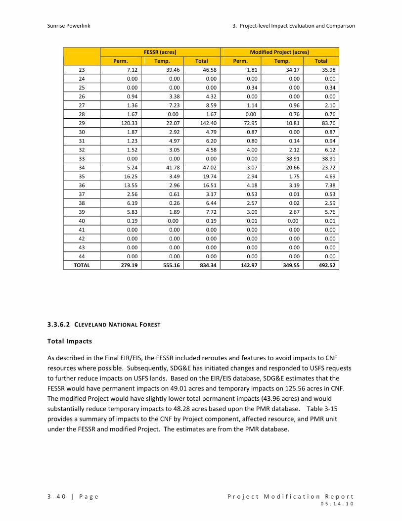
Sunrise Powerlink 3. Project‐level Impact Evaluation and Comparison
3 ‐ 4 0 | P a g e P r o j e c t M o d i f i c a t i o n R e p o r t 0 5 . 1 4 . 1 0
FESSR (acres) Modified Project (acres)
Perm. Temp. Total Perm. Temp. Total
23 7.12 39.46 46.58 1.81 34.17 35.98
24 0.00 0.00 0.00 0.00 0.00 0.00
25 0.00 0.00 0.00 0.34 0.00 0.34
26 0.94 3.38 4.32 0.00 0.00 0.00
27 1.36 7.23 8.59 1.14 0.96 2.10
28 1.67 0.00 1.67 0.00 0.76 0.76
29 120.33 22.07 142.40 72.95 10.81 83.76
30 1.87 2.92 4.79 0.87 0.00 0.87
31 1.23 4.97 6.20 0.80 0.14 0.94
32 1.52 3.05 4.58 4.00 2.12 6.12
33 0.00 0.00 0.00 0.00 38.91 38.91
34 5.24 41.78 47.02 3.07 20.66 23.72
35 16.25 3.49 19.74 2.94 1.75 4.69
36 13.55 2.96 16.51 4.18 3.19 7.38
37 2.56 0.61 3.17 0.53 0.01 0.53
38 6.19 0.26 6.44 2.57 0.02 2.59
39 5.83 1.89 7.72 3.09 2.67 5.76
40 0.19 0.00 0.19 0.01 0.00 0.01
41 0.00 0.00 0.00 0.00 0.00 0.00
42 0.00 0.00 0.00 0.00 0.00 0.00
43 0.00 0.00 0.00 0.00 0.00 0.00
44 0.00 0.00 0.00 0.00 0.00 0.00
TOTAL 279.19 555.16 834.34 142.97 349.55 492.52
3.3.6.2 CLEVELAND NATIONAL FOREST
Total Impacts
As described in the Final EIR/EIS, the FESSR included reroutes and features to avoid impacts to CNF
resources where possible. Subsequently, SDG&E has initiated changes and responded to USFS requests
to further reduce impacts on USFS lands. Based on the EIR/EIS database, SDG&E estimates that the
FESSR would have permanent impacts on 49.01 acres and temporary impacts on 125.56 acres in CNF.
The modified Project would have slightly lower total permanent impacts (43.96 acres) and would
substantially reduce temporary impacts to 48.28 acres based upon the PMR database. Table 3‐15
provides a summary of impacts to the CNF by Project component, affected resource, and PMR unit
under the FESSR and modified Project. The estimates are from the PMR database.
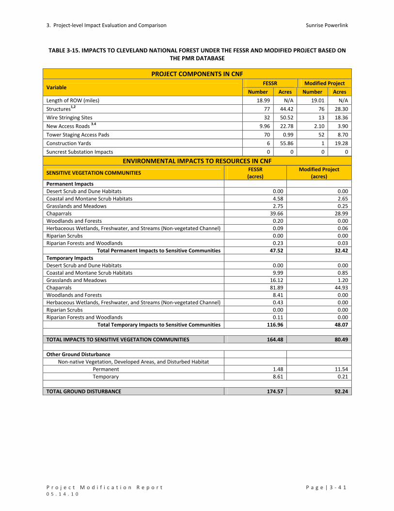
3. Project‐level Impact Evaluation and Comparison Sunrise Powerlink
P r o j e c t M o d i f i c a t i o n R e p o r t P a g e | 3 ‐ 4 1 0 5 . 1 4 . 1 0
TABLE 3‐15. IMPACTS TO CLEVELAND NATIONAL FOREST UNDER THE FESSR AND MODIFIED PROJECT BASED ON THE PMR DATABASE
PROJECT COMPONENTS IN CNF
FESSR Modified Project Variable
Number Acres Number Acres
Length of ROW (miles) 18.99 N/A 19.01 N/A
Structures1,2 77 44.42 76 28.30
Wire Stringing Sites 32 50.52 13 18.36
New Access Roads 3.4 9.96 22.78 2.10 3.90
Tower Staging Access Pads 70 0.99 52 8.70
Construction Yards 6 55.86 1 19.28
Suncrest Substation Impacts 0 0 0 0
ENVIRONMENTAL IMPACTS TO RESOURCES IN CNF
SENSITIVE VEGETATION COMMUNITIES FESSR (acres)
Modified Project (acres)
Permanent Impacts
Desert Scrub and Dune Habitats 0.00 0.00
Coastal and Montane Scrub Habitats 4.58 2.65
Grasslands and Meadows 2.75 0.25
Chaparrals 39.66 28.99
Woodlands and Forests 0.20 0.00
Herbaceous Wetlands, Freshwater, and Streams (Non‐vegetated Channel) 0.09 0.06
Riparian Scrubs 0.00 0.00
Riparian Forests and Woodlands 0.23 0.03
Total Permanent Impacts to Sensitive Communities 47.52 32.42
Temporary Impacts
Desert Scrub and Dune Habitats 0.00 0.00
Coastal and Montane Scrub Habitats 9.99 0.85
Grasslands and Meadows 16.12 1.20
Chaparrals 81.89 44.93
Woodlands and Forests 8.41 0.00
Herbaceous Wetlands, Freshwater, and Streams (Non‐vegetated Channel) 0.43 0.00
Riparian Scrubs 0.00 0.00
Riparian Forests and Woodlands 0.11 0.00
Total Temporary Impacts to Sensitive Communities 116.96 48.07
TOTAL IMPACTS TO SENSITIVE VEGETATION COMMUNITIES 164.48 80.49
Other Ground Disturbance
Non‐native Vegetation, Developed Areas, and Disturbed Habitat
Permanent 1.48 11.54
Temporary 8.61 0.21
TOTAL GROUND DISTURBANCE 174.57 92.24
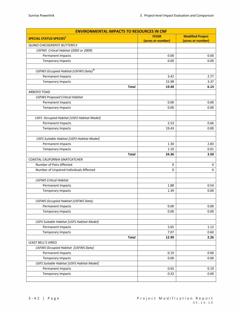
Sunrise Powerlink 3. Project‐level Impact Evaluation and Comparison
3 ‐ 4 2 | P a g e P r o j e c t M o d i f i c a t i o n R e p o r t 0 5 . 1 4 . 1 0
ENVIRONMENTAL IMPACTS TO RESOURCES IN CNF
SPECIAL STATUS SPECIES5 FESSR
(acres or number) Modified Project
(acres or number)
QUINO CHECKERSPOT BUTTERFLY
USFWS Critical Habitat (2002 or 2009)
Permanent Impacts 0.00 0.00
Temporary Impacts 0.00 0.00
USFWS Occupied Habitat (USFWS Data) 6
Permanent Impacts 3.42 2.77
Temporary Impacts 15.98 3.37
Total 19.40 6.14
ARROYO TOAD
USFWS Proposed Critical Habitat
Permanent Impacts 0.00 0.00
Temporary Impacts 0.00 0.00
USFS Occupied Habitat [USFS Habitat Model]
Permanent Impacts 2.53 0.66
Temporary Impacts 19.43 0.00
USFS Suitable Habitat [USFS Habitat Model]
Permanent Impacts 1.30 2.83
Temporary Impacts 1.10 0.01
Total 24.36 3.50
COASTAL CALIFORNIA GNATCATCHER
Number of Pairs Affected 0 0
Number of Unpaired Individuals Affected 0 0
USFWS Critical Habitat
Permanent Impacts 1.88 0.54
Temporary Impacts 1.39 0.00
USFWS Occupied Habitat (USFWS Data)
Permanent Impacts 0.00 0.00
Temporary Impacts 0.00 0.00
USFS Suitable Habitat [USFS Habitat Model]
Permanent Impacts 2.65 1.12
Temporary Impacts 7.07 0.60
Total 12.99 2.26
LEAST BELL'S VIREO
USFWS Occupied Habitat [USFWS Data]
Permanent Impacts 0.19 0.00
Temporary Impacts 0.00 0.00
USFS Suitable Habitat [USFS Habitat Model]
Permanent Impacts 0.65 0.19
Temporary Impacts 0.32 0.00

3. Project‐level Impact Evaluation and Comparison Sunrise Powerlink
P r o j e c t M o d i f i c a t i o n R e p o r t P a g e | 3 ‐ 4 3 0 5 . 1 4 . 1 0
ENVIRONMENTAL IMPACTS TO RESOURCES IN CNF USFS Occupied Habitat [USFS Habitat Model]
Permanent Impacts 0.24 0.00
Temporary Impacts 0.00 0.00
Total 1.40 0.19
SOUTHWESTERN WILLOW FLYCATCHER
USFS Suitable Habitat (USFS Modeled Habitat]
Permanent Impacts 5.14 3.98
Temporary Impacts 14.39 0.74
Total 19.53 4.72
STEPHENS’ KANGAROO RAT
USFS Suitable Habita (USFS Modeled Habitat)
Permanent Impacts 0.71 0.18
Temporary Impacts 0.03 0.00
Total 0.74 0.18
JURISDICTIONAL WATERS AND RCA’S FESSR
(acres)
Modified Project
(acres)
IMPACTS TO WATERS OF THE US (WOUS) 7
Permanent 0.24 0.06
Temporary 0.31 0.00
Total 0.55 0.06
IMPACTS TO WATERS OF THE STATE (WOS) 7
Permanent 0.26 0.09
Temporary 0.53 0.00
Total 0.80 0.09
IMPACTS TO USFS RCAs BY LAND COVER TYPE8
Permanent Impacts
Desert Scrub and Dune Habitats 0.00 0.00
Coastal and Montane Scrub Habitats 2.26 0.48
Grasslands and Meadows 2.39 0.23
Chaparrals 2.44 4.66
Woodlands and Forests 0.20 0.00
Herbaceous Wetlands, Freshwater, and Streams (Non‐vegetated Channel) 0.01 0.06
Riparian Scrubs 0.00 0.00
Riparian Forests and Woodlands 0.23 0.03
Non‐Native Vegetation, Developed Areas, and Disturbed Habitat 0.64 8.51
Total Permanent Impacts inside RCAs 8.17 13.97
Temporary Impacts
Desert Scrub and Dune Habitats 0.00 0.00
Coastal and Montane Scrub Habitats 3.24 0.66
Grasslands and Meadows 9.90 0.08
Chaparrals 11.58 3.93
Woodlands and Forests 7.47 0.00
Herbaceous Wetlands, Freshwater, and Streams (Non‐vegetated Channel) 0.02 0.00
Riparian Scrubs 0.00 0.00
Riparian Forests and Woodlands 0.09 0.00
Non‐Native Vegetation, Developed Areas, and Disturbed Habitat 0.30 0.07
Total Temporary Impacts inside RCAs 32.61 4.75
TOTAL RCA IMPACTS 40.78 18.72

Sunrise Powerlink 3. Project‐level Impact Evaluation and Comparison
3 ‐ 4 4 | P a g e P r o j e c t M o d i f i c a t i o n R e p o r t 0 5 . 1 4 . 1 0
ENVIRONMENTAL IMPACTS TO RESOURCES IN CNF FESSR Modified Project
SPECIAL STATUS PLANT SPECIES9 Perm. Temp. Perm. Temp.
Dean’s milk‐vetch (BLMS, FSS, L1B) 0 0 0 0
Jacumba milk‐vetch (BLMS, FSS, L1B) 0 0 0 0
Descanso milk‐vetch (BLMS, FSS, L1B) 0 0 0 0
Orcutt’s brodiaea (BLMS, FSS, L1B) 0 0 0 0
Dunn’s mariposa lily (SR, FSS, L1B) 20 0 0 0
Tufted pine‐grass 0 7 0 0
Payson’s Jewelflower (FSS) 0 0 0 1,350
Lakeside ceanothus (BLMS, FSS, L1B) 0 0 0 0
Southern mountain misery 15 15 0 0
Long‐spined spineflower (FSS, L1B) 0 0 0 0
Delicate clarkia (FSS, L1B) 0 0 0 0
Tecate tarplant (BLMS, FSS, L1B) 0 0 0 8
Vanishing buckwheat (L1B) 0 0 0 0
Sticky geraea (L2) 5 1,839 0 0
Mission Canyon bluecup (FSS) 0 0 0 0
Ramona horkelia (FSS, L1B) 0 0 0 0
Heart‐leaved pitcher sage (FSS, L1B) 0 0 0 0
Robinson pepper‐grass 4 0 0 0
Laguna linanthus (BLMS, FSS, L1B) 0 0 0 0
Cleveland’s bush monkeyflower 2 133 0 0
Felt‐leaved monardella (FSS, L1B) 0 537 0 0
Chaparral beargrass (FSS, L1B) 0 0 0 0
Gander’s ragwort (SR, FSS, L1B) 188 2,455 0 0
Moreno currant (BLMS, FSS, L1B) 0 0 0 0
Fish’s milkwort 0 6 0 0
Caraway‐leaved gilia 0 28 0 0
San Miguel savory (FSS, L1B) 0 0 0 0
Hammitt’s clay‐cress (FSS, L1B) 0 0 0 0
Southern jewelflower (FSS, L1B) 0 0 0 0
Parry’s tetracoccus (BLMS, FSS, L1B) 0 0 0 0
Rush‐like bristleweed 0 11 7 5
GROUND DISTURBANCE BY PMR UNIT
FESSR (acres) Modified Project (acres) MR Unit
Permanent Temporary Total Permanent Temporary Total
15 1.09 1.09 2.19 0.82 0 0.82
16 8.82 3.56 12.38 18.61 30.78 49.39
17 15.51 39.09 54.60 5.86 5.00 10.85
18 1.10 19.48 20.58 0.37 3.78 4.16
20 0 1.52 1.52 0 0 0
21 0.75 1.44 2.20 0.04 0 0.04
22 0.04 0.66 0.70 0.00 0 0.00
23 0 0 0 0.71 0.00 0.71
25 4.84 17.72 22.56 5.02 4.13 9.15

3. Project‐level Impact Evaluation and Comparison Sunrise Powerlink
P r o j e c t M o d i f i c a t i o n R e p o r t P a g e | 3 ‐ 4 5 0 5 . 1 4 . 1 0
ENVIRONMENTAL IMPACTS TO RESOURCES IN CNF 26 5.06 8.73 13.78 3.92 0.65 4.58
27 1.80 6.36 8.16 1.64 0.85 2.48
28 4.79 11.01 15.80 3.65 2.07 5.71
29 0 7.75 7.75 0 0 0
31 3.30 4.81 8.10 2.78 1.02 3.80
34 1.91 2.34 4.25 0.54 0.00 0.54
Total 49.01 125.56 174.57 43.95 48.28 92.23
Notes
1 EIR estimate includes 20.13 acres of permanent impacts (tower footings, 100 x 100 foot pads, and 35 by 75 foot pads) and 24.29 acres of temporary impacts (temporary pads).
2 PMR estimate includes 18.09 acres of permanent impacts (tower footings, 100 x 100 foot pads, and 35 by 75 foot pads) and 10.21 acres of temporary impacts (temporary pads).
3 EIR estimate includes 20.98 acres of permanent impacts and 1.80 acre of temporary impacts.
4 PMR estimate includes 3.54 acres of permanent impacts and 0.36 acre of temporary impacts.
5 In this summary of impacts to special status species, the focus is on the following habitat categories: USFWS critical habitat (designated or proposed), USFWS occupied habitat (areas that USFWS considers occupied by the species based on available information and/or assumptions); mapped habitat and management areas for flat‐tailed horned lizard; mapped suitable habitat for barefoot banded gecko; and suitable habitat in the Cleveland National Forest (CNF) as identified by habitat models used by USFS. For arroyo toad and coastal California gnatcatcher, suitable habitat identified by the USFS models on USFS lands also is identified.
6 USFWS Occupied Habitat includes areas of known Quino populations and sightings and a buffer that typically encompasses all host plants in the vicinity. Some of the USFWS occupied habitat areas also are part of designated critical habitat (e.g., the Jacumba reference population).
7 FEIR/EIS impacts to WOUS/WOS are calculated based on the vegetation proxy for jurisdictional waters utilized in 2008. PMR impacts to WOUS/WOS are calculated based on the 2009/2010 PMR database which includes project‐specific jurisdictional resources mapping prepared by WRA.
8 FEIR/EIS RCA impacts are based on USFS RCA mapping. PMR RCA impacts are based on the updated 2009/2010 PMR database which includes the RCA mapping update prepared by WRA.
9 Status of special status plant species is provided in parentheses for each species. Codes are: FE=federally endangered, FT=federally threatened, SR=state rare, L1B or L2=CNPS List 1B or CNPS List 2, FSS=Forest Service Sensitive, BLMS=Bureau of Land Management Sensitive.

Sunrise Powerlink 3. Project‐level Impact Evaluation and Comparison
3 ‐ 4 6 | P a g e P r o j e c t M o d i f i c a t i o n R e p o r t 0 5 . 1 4 . 1 0
Back County Non‐Motorized Zones
MMCRP measure WR‐2a requires SDG&E to fine‐tune the location of the BCD Alternative Revision
component of the FESSR in order to shorten the route and minimize effects on BLM land, Forest land,
and private property. Specifically, portions of the original BCD Alternative alignment crossed areas
within CNF designated within the Back Country Non‐Motorized (BCNM) land use zone. As the EIR/EIS
(Section D.17) explains, “major utility corridors and roads are not suitable within BCNM,” and “plan
amendments would be required for those alternatives crossing the BCNM land use zone.” The Final
EIR/EIS also noted that within the BCNM zone “except for trails, facility construction is generally not
allowed, but may occur in remote locations where road access is not needed for maintenance.”
Accordingly, prior to issuance of the Final EIR/EIS, SDG&E planned a routing change to the BCD
Alternative that would enter CNF north of the modified Project location of Structure EP142 across a
private in‐holding owned by JAM Investments Inc. (JAM). The route traversed the JAM property from
the northeast to the southwest before reentering CNF. This route avoided BCNM land and minimized
disturbance to CNF land, and it was analyzed in the Recirculated Draft EIR/Supplemental Draft EIS issued
in July 2008. In response, however, the private landowner opposed the reroute and sent written
comments to the CPUC. In October 2008, the CPUC issued a response to comments from the affected
landowner, which was published as “Response to Comments Set G0017” in the Final EIR/EIS. The
response from the CPUC acknowledged that the BCD Alternative Revision was designed by SDG&E in
response to a request from the USFS that BCNM land uses be avoided and impacts to USFS land be
minimized. The response also acknowledged the impacts to the JAM property and identified mitigation
measure WR‐2a, which states as follows:
WR‐2a: Develop a reroute for the BCD Alternative Revision to reduce effects on recreation.
SDG&E shall relocate the overhead 500 kV transmission line along the southern boundary of JAM
properties as shown in Figure E.2.1‐b to shorten the route and minimize effects on BLM land,
Forest land, and private property. This reroute and its ground‐disturbing components shall avoid
Back Country Non‐Motorized land use zones of the Cleveland National Forest, while also
minimizing towers and disturbance on private property. SDG&E shall submit a memo to the
CPUC for review and approval that documents its attempts to fine‐tune the location of the BCD
Alternative Revision, as well as the submittal of final construction plans for review and approval
at least 120 days prior to the start of construction.
The following discussion is meant to meet the requirement of submitting a memo as discussed in the
measure above.
While WR‐2a calls for avoiding BCNM areas, it also calls for minimizing impacts to private landowners.
“Minimization” also is the term used in the effectiveness criteria cited in the MMCRP for WR‐2a. The
effectiveness criterion for WR‐2a is that the reroute “minimizes impacts to [BCNM] zones and
towers/disturbance on private lands.”
In order to comply with WR‐2a, SDG&E had several meetings and telephone conferences with the CPUC
and USFS to discuss alternatives to the BCD route that would avoid the JAM property. On November 6,
2008, a meeting was held with the USFS to discuss three alternatives. Two of the alternatives were

3. Project‐level Impact Evaluation and Comparison Sunrise Powerlink
P r o j e c t M o d i f i c a t i o n R e p o r t P a g e | 3 ‐ 4 7 0 5 . 1 4 . 1 0
eliminated because of impacts to sensitive resources and riparian areas, leaving one alternative that
shifted the route south of the JAM property, spanning the BCNM land use zone completely. However, in
November 2008, the site was surveyed and due to span lengths and structure types, SDG&E was unable
to span the BCNM because of the topography of the area. Therefore, it was concluded that in order to
avoid the JAM property and other sensitive resources, one structure, currently known as EP142, would
be located in the BCNM land use zone. The impact would occur at the northern edge of a narrow strip
of land designated as BCNM. CNF land use designations on either side of the area allow for some
motorized use, within specific limitation. To minimize disturbance on the BCNM area, SDG&E
eliminated access roads and designated EP142 for helicopter construction and maintenance. See
PMR15 for details.
On December 10, 2008 and then again on January 8, 2009, the current JAM re‐route shown on PMR
Figure 15 was reviewed with representatives from the USFS, and it was agreed that the route minimized
impacts to private lands and BCNM land, in compliance with the effectiveness criteria of MMCRP
measure WR‐2a, because BCNM could not be avoided altogether by any suitable solution. As the Final
EIR/EIS disclosed, an amendment to the CNF Forest Plan would be required to allow for the proposed
use. The impact in PMR15 is the only Project impact to a BCNM area.
3.3.6.3 SENSITIVE RECEPTORS
The Final EIR/EIS included an analysis of residential structures within 1000 feet of the ROW and
associated features of the various routes comprising the FESSR and other alternatives. To address
MMCRP measure N‐1a, which requires implementation of best management practices for noise and the
implementation of various noise‐supression techniques, and to examine changes in noise impacts under
the modified Project, Investigative Science and Engineering, Inc. (ISE) prepared a draft Estimated
Acoustic Impact Potential study [ISE 2010].
The initial phase of the study considered baseline acoustic conditions and identified areas where the
Project could increase the ambient background noise level above the Community Noise Equivalence
Level (CNEL) to the point of being discernable or creating adverse conditions to sensitive receptor areas.
Forty areas were identified (see ISE 2010).
As part of the study, ISE identified sensitive receptors within one‐quarter mile of all Project impact areas
(including access roads) in PMR5 through PMR40. This inventory supplements information already
available on sensitive receptors within PMR1 through PMR5 and PMR41 through PMR44. The ISE
analysis focused on residential, commercial, and industrial sites as identified using aerial imagery and
parcel information. Table 3‐16 indicates the number of these sensitive receptor types per PMR unit,
together with the Project features within one‐quarter mile of the receptors.
Based on the updated inventory and information from the Final EIR/EIS, the modified Project and FESSR
are similar in their potential for impacts to sensitive receptors and would be subject to the same impact
avoidance and minimization measures. There are locations where the modified Project is closer or
farther away from individual receptors, but there are no new significant impacts associated with the
modified Project.

Sunrise Powerlink 3. Project‐level Impact Evaluation and Comparison
3 ‐ 4 8 | P a g e P r o j e c t M o d i f i c a t i o n R e p o r t 0 5 . 1 4 . 1 0
TABLE 3‐16. SENSITIVE RECEPTORS (NOISE) WITHIN PMR6 THROUGH PMR40
PMR Unit Receptor Type Noise Source Number
6 SF RESIDENTIAL SPL TSAP 1
7 None None 0
INDUSTRIAL SPL PP SAAR 1 8
SF RESIDENTIAL CY 2
9 None None 0
COMMERCIAL SPL TSAP PP EAR 1
EAR 2
SPL 3 10
SF RESIDENTIAL
SPL PP 1
COMMERCIAL SPL TSAP PP 1
EAR 3
SPL EAR SAAR PP 1 11
SF RESIDENTIAL
TAR SAAR 5
12 None None 0
13 SF RESIDENTIAL SPL PP SAAR 1
14 None None 0
15 None None 0
16 None None 0
SPL 1
SPL TSAP PP 1 17 SF RESIDENTIAL
SPL TSAP PP EAR 3
18 SF RESIDENTIAL PP TAR SAAR 1
19 None None 0
CY 1
SPL 2
SPL PP SAAR 10
SPL PP TAR SAAR 4
SPL PP TSAP 1
SPL TSAP PP 3
SPL TSAP PP SAAR 5
TAR SAAR 1
20
SF RESIDENTIAL
TSAP PP SAAR 1
SPL 1
SPL PP 1
SPL PP EAR PP 1
SPL TSAP PP 2
21 SF RESIDENTIAL
SPL TSAP PP EAR 2
22 SF RESIDENTIAL PP 1
23 None None 0
24 None None 0
COMMERCIAL EAR SAAR 1
EAR SAAR 2
PP TAR SAAR 1
SPL PP 1
25 SF RESIDENTIAL
SPL TSAP PP 1
26 SF RESIDENTIAL TSAP PP 4
PP TAR SAAR 1 COMMERCIAL
SPL PP TAR SAAR 1
27
SF RESIDENTIAL PP SAAR 1

3. Project‐level Impact Evaluation and Comparison Sunrise Powerlink
P r o j e c t M o d i f i c a t i o n R e p o r t P a g e | 3 ‐ 4 9 0 5 . 1 4 . 1 0
PMR Unit Receptor Type Noise Source Number
PP TAR SAAR 1
COMMERCIAL SPL 1
SPL TSAP PP SAAR 1 28 SF RESIDENTIAL
TSAP PP SAAR 1
29 None None 0
30 None None 0
31 None None 0
SPL 11
SPL PP SAAR 1
SPL PP TAR SAAR 8
SPL SAAR 1
32 SF RESIDENTIAL
SPL TAR SAAR 4
SPL 114 COMMERCIAL
SPL CY 1
INDUSTRIAL SPL 1
MF RESIDENTIAL SPL 110
CY 258
SAAR SPL 1
SPL 756
SPL CY 3
33
SF RESIDENTIAL
SPL SAAR 2
COMMERCIAL SPL 3
CY PP 1
SPL 35
SPL EAR SAAR TAR 1
SPL PP SAAR 1
SPL PP TAR SAAR 2
SPL SAAR 1
SPL TSAP PP 4
TSAP CY 1
34 SF RESIDENTIAL
TSAP PP 1
COMMERCIAL CY TAR SAAR 2
CY 1
CY TAR SAAR 4
EAR SAAR TAR 1
PP TAR EAR 1
SPL 1
SPL PP TAR EAR 1
SPL TSAP 1
SPL TSAP PP 7
TAR SAAR 5
35 SF RESIDENTIAL
TSAP PP 1
EAR 2
SPL 1
SPL EAR 3
SPL PP TAR EAR 1
SPL TSAP 1
SPL TSAP PP 3
36 SF RESIDENTIAL
TSAP PP 2
37 SF RESIDENTIAL SPL 2

Sunrise Powerlink 3. Project‐level Impact Evaluation and Comparison
3 ‐ 5 0 | P a g e P r o j e c t M o d i f i c a t i o n R e p o r t 0 5 . 1 4 . 1 0
PMR Unit Receptor Type Noise Source Number
COMMERCIAL SPL TSAP PP 1
SPL 1 38
SF RESIDENTIAL SPL TSAP PP 1
COMMERCIAL SPL 1
SPL 2
SPL PP 1
SPL PP SAAR 4
SPL PP TAR SAAR 5
TAR 1
39 SF RESIDENTIAL
TAR SAAR 3
SPL 32 40 SF RESIDENTIAL
SPL PP SAAR 28
Total 1522
Codes
SF = Single Family
MF = Multi Family
TSAP = Tower Staging Access Pads
CY = construction yards
PP = permanent pads
TAR = temp access roads
EAR = existing access roads to be improved
AAR = Sunrise alignment access roads
SPL = Sunrise power link alignment itself

3. Project‐level Impact Evaluation and Comparison Sunrise Powerlink
P r o j e c t M o d i f i c a t i o n R e p o r t P a g e | 3 ‐ 5 1 0 5 . 1 4 . 1 0
3.3.6.4 REGIONAL HABITAT CONSERVATION PROGRAMS
Appendix 8O in the Final EIR/EIS addressed comments regarding the effects of the FESSR and other
alternatives on the approved and draft regional habitat conservation programs in San Diego County and
adjacent areas. The appendix provided an estimation of the FESSR’s (and other alternatives') impacts to
the different components of approved and draft regional programs, including impacts to already
preserved lands. Table 3‐17 indicates the impact estimates for the FESSR from Appendix 8O and the
corresponding estimates under the modified Project. Estimated impacts of the modified Project within
the East San Diego County MSCP planning area also are included for informational purposes. The East
County MSCP is still in early planning stages; however, the County has developed a map identifying focus
planning areas and a list of potentially covered species.
The Project is not covered by or subject to the City and County Multiple Species Conservation Plans
(MSCPs), which apply to land uses under City and County jurisdiction. As with water districts and several
private entities in the San Diego region, SDG&E has its own MSCP for its existing facilities and proposes
to develop a comparable plan for SRPL operations and maintenance. SDG&E is mitigating for the
impacts to the MSCP areas via the mitigation requirements and ratios applied to sensitive communities
and special status species. In identifying potential mitigation lands for the Project’s species and habitat
impacts, SDG&E has identified lands that would augment existing preserves and build out the preserve
systems of the regional programs.
As shown in Table 3‐17, impacts to existing regional conservation programs under either the FESSR or
the modified Project are extremely minor and not significant. The modified Project further reduces
these impacts by 55 percent from 115.1 acres to 63.89 acres.
TABLE 3‐17. IMPACTS TO REGIONAL CONSERVATION PROGRAMS UNDER THE FESSR AND MODIFIED PROJECT BASED ON EIR/EIS AND PMR DATABASES
Estimated Impacts (acres)
FESSR Modified Project Regional Conservation Program
Perm. Temp. Total Perm. Temp. Total
City of San Diego MHPA 4.1 2.6 6.7 3.67 2.13 5.80
City of San Diego San Vicente Cornerstone Lands 5.5 1.8 7.3 1.38 1.66 3.04
City of Poway San Vicente Cornerstone Lands 0 0 0 ‐‐ ‐‐ ‐‐
South San Diego County Hardline Preserve 3.6 0.6 4.2 0.35 0.02 0.37
South San Diego County Pre‐approved Mitigation Area 52.7 33.8 86.5 16.65 28.84 45.49
North San Diego County Draft Preserve (Draft) 0 0 0 0 0 0
North San Diego County Pre‐approved Mitigation Area 0 0 0 0 0 0
MCAS Miramar (Integrated Resources Management Plan) 5.2 5.2 10.4 3.50 5.69 9.19
Other (not in Appendix 80)
Poway Subarea (All) ‐‐ ‐‐ ‐‐ 0.78 0 0.78
Helix Water District Subarea (All) ‐‐ ‐‐ ‐‐ 0 0.24 0.24
East County MSCP Planning Area ‐‐ ‐‐ ‐‐ 177.77 306.61 484.38

Sunrise Powerlink 3. Project‐level Impact Evaluation and Comparison
3 ‐ 5 2 | P a g e P r o j e c t M o d i f i c a t i o n R e p o r t 0 5 . 1 4 . 1 0
3.3.7 PUBLIC SAFETY/FIRE HAZARDS
In the Final EIR/EIS, the public safety and fire risks of the FESSR were evaluated using GIS modeling to
identify fire hazard areas and estimate the number of homes at risk and the miles of fire containment
conflict. As part of the modification process, SDG&E reviewed the modified Project against the FESSR.
The review determined that modifications in 38 of the PMR units resulted in no change to fire impacts.
For the modifications involving tower alignment, 31 had an adjustment to the route centerline of less
than .25 miles and 6 had adjustments between .25 and .85 miles. The modifications with less than .25
miles show no substantial change in fire impacts, particularly with the number of homes at risk and the
miles of fire containment conflict. Two of the six modifications of greater than .25 miles move the route
further away from homes resulting in a reduced fire impact. The modified Project would be subject to
the same public safety requirements as the FESSR. The modified Project would not result in any new
significant public safety or fire hazard impacts.
3.3.8 IMPACTS TO TRAFFIC/TRANSPORTATION
The modified Project would entail a different mix of vehicles and use of some local roads than the FESSR
but would have traffic impacts similar to those of the FESSR. Based on a Traffic Study prepared by KOA,
there are three locations, all in Link 5, where traffic impacts would require mitigation via preparation
and implementation of traffic control plans and related measures. The intersection analysis for
locations along Link 5 indicates that these three locations would operate with poor levels of service and
vehicular delay exceeding the significance standards to cause a potentially significant traffic impact. All
of these locations are located along SR‐67.
The first location is the signalized intersection of SR‐67 and Scripps Poway Parkway. Scripps Poway
Parkway currently carries heavy eastbound traffic volumes during the PM peak hour (between 4:00 p.m.
to 6:00 p.m.). The vast majority of this eastbound traffic either turns left towards Ramona or right
towards Lakeside at the intersection with SR‐67. In addition, SR‐67 also carries significant northbound
and southbound traffic volumes at this location. Under existing conditions, the intersection provides
dual left‐turn lanes on the SR‐67 northbound approach and one‐and‐one‐half left‐turn lanes (an
exclusive left‐turn lane and a shared left‐turn/through travel lane) on the Scripps Poway Parkway
eastbound approach. These two movements experience the heaviest left‐turn traffic volumes.
Measures that will be employed to lessen the degree of impact include shifting some of the traffic
demand associated with the project from peak to non‐peak hours, encouraging the use of carpools or
multiple‐occupant vehicles to transport employees, or taking alternative routes so that peak‐hour trips
can avoid this intersection.
The second location is the signalized intersection of SR‐67 and Willow Road which is an existing T
intersection with SR‐67 carrying substantial northbound and southbound traffic volumes. Under the
existing condition the intersection provides a single northbound and southbound through lane, an
exclusive northbound right‐turn lane, one southbound left‐turn lane and a shared left through right lane
on Willow Road. The temporary project related construction traffic will be added to the northbound and
southbound through movements currently experiencing long delays in the peak hours. By limiting the

3. Project‐level Impact Evaluation and Comparison Sunrise Powerlink
P r o j e c t M o d i f i c a t i o n R e p o r t P a g e | 3 ‐ 5 3 0 5 . 1 4 . 1 0
amount of delivery trips during peak hours or by rerouting project trips that would use this intersection,
project impacts would be avoided.
The third location is the signalized intersection of Willow Road and Wildcat Canyon which is an existing
all‐way stop controlled intersection. Under the existing condition the intersection provides a single lane
on each approach. The temporary project related construction traffic will be added to the northbound,
southbound, eastbound and westbound approaches currently experiencing delays in the peak hours. By
limiting the amount of delivery trips during peak hours or by rerouting project trips that would use this
intersection, project impacts would be avoided.
As noted, the impacts at these locations would be mitigated through measures identified in the MMCRP.
The modified Project would not result in new significant traffic impacts.
3.3.9 IMPACTS TO VISUAL RESOURCES
This subsection addresses the overall visual effects of the modified Project in relation to the FESSR,
including the potential effects of structure lighting on sensitive resources such as the Palomar Mountain
Astronomical Observatory.
The modified Project would reduce skylining of the FESSR in several locations including 10 towers near
the Desert Tower in Link 1, several towers in El Monte Valley and at the I‐8 crossing near La Posta Road.
Additionally, the modified Project substantially increases construction by helicopter thereby reducing
access road construction land scarring compared with the FESSR. There are some locations where the
modified Project would have greater visual impacts than the FESSR (See Section 4). However, the visual
impacts in these locations do not differ in type or scale from those considered in the Final EIR/EIS.
The visual impacts of infrared lighting on structures are inconsequential because the lighting is not
visible to humans without night vision equipment. The additional requirement for marker balls on spans
between structures will result in increased visual impacts; however, the additional lighting and marker
balls are required for safety reasons based on structure height and line location. In sum, while some
degree of visual impact is reduced by the modified Project, visual resources will continue to be
significant and not mitigable as discussed in the Final EIS/EIR.
IR lighting installed on the Project structures also would not produce any sky glow and therefore should
not negatively impact the astronomical research being conducted at Palomar Mountain with visible light
telescopes (200‐inch Hale Telescope, 48‐inch Samuel Oschin Telescope, 60‐inch Telescope, Palomar
Testbed Interferometer, Planet Search Telescope, 18‐inch Schmidt Telescope, and the 24‐inch
Telescope). The lattice towers of the Project are located over 35 miles south of the observatory, and
both of the IR cameras developed for the 200‐inch Hale telescope (the Wide‐field Infrared Camera which
produces panoramic surveys and the Palomar High Angular Resolution Observer (PHARO) Camera)
would be focusing on visible areas of sky above the horizon. The highest SRPL Project tower, at
approximately 5,628 feet above mean sea level (AMSL) would appear barely at the horizon line from the
observatory platform at 5,700 feet AMSL and would not interfere with IR astronomical observations on
Palomar Mountain. Most of the lighted structures are well below this elevation. Note that the Earth’s
Sunrise Powerlink 3. Project‐level Impact Evaluation and Comparison
3 ‐ 5 4 | P a g e P r o j e c t M o d i f i c a t i o n R e p o r t 0 5 . 1 4 . 1 0
atmosphere is also known to both emit and absorb IR, which is why high elevation peaks in dry areas are
selected for IR astronomical research (Rieke 2009).
Specific actions have been and will continue to be taken to minimize the visible disturbance of the
Sunrise Powerlink on the naturally established scenery of the Forest. The end result of these actions will
be presented in the Scenery Conservation Plan which will present the final direction to best achieve the
spirit and intent of the Scenic Integrity Objectives of the Cleveland National Forest Land and Resource
Management Plan.
3.3.10 IMPACTS TO WATER RESOURCES
The modified Project would result in fewer impacts to federal and state jurisdictional waters than the
FESSR. The modified Project also potentially would result in less use of surface water than the FESSR
and, because of the reduction in total ground disturbance, less overall water use.
3.3.10.1 FEDERAL AND STATE JURISDICTIONAL WATERS
No impacts to federal or state wetlands or any perennial stream would result from the modified Project.
Estimated impacts to ephemeral streams, dry washes, and streambeds are discussed below.
Basis for the Estimates
The Final EIR/EIS concluded that direct and/or indirect impacts to jurisdictional waters and possibly
wetlands (i.e., areas regulated by the ACOE and Regional Water Quality Control Board (RWQCB) and/or
CDFG) could occur from construction of the FESSR, and that those impacts would likely be Class II, given
the required mitigation measures (See Final EIR/EIS Sections E.1.2, E.2.2, and E.4.2 describing Impact B‐2
and the associated mitigation measures). This conclusion was based on vegetation mapping conducted
for the FESSR, which identified the following often jurisdictional vegetation communities: Sonoran wash
scrub, mesquite bosque, mule fat scrub, southern willow scrub, southern cottonwood willow riparian
forest, southern riparian forest, and southern coast live oak riparian woodland. The Final EIR/EIS
explained that specific impacts to jurisdictional areas would be defined when a final route was selected
that included project‐specific features and final engineering, Based on that route, a formal jurisdictional
delineation would be conducted to define the precise presence and extent of waters and wetlands and
thereby determine the exact impacts so that SDG&E could apply for appropriate permits from the ACOE,
RWQCB, and CDFG prior to construction (See Final EIR/EIS Sections E.1.2, E.2.2, and E.4.2 describing
Impact B‐2).
As directed by the Final EIR/EIS, the jurisdictional delineation has been completed, and the total
estimated project impacts to all jurisdictional waters, wetlands, and dry washes have been calculated for
this PMR with a very high degree of precision. Where the Final EIR/EIS used a model based on existing
vegetation mapping as a proxy to determine the potential Project impacts to jurisdictional resources
(explained above), the calculations in the PMR are the result of a multi‐stage delineation and Project
design process that began in January 2009, extended through January 2010, and included:

3. Project‐level Impact Evaluation and Comparison Sunrise Powerlink
P r o j e c t M o d i f i c a t i o n R e p o r t P a g e | 3 ‐ 5 5 0 5 . 1 4 . 1 0
1. Creation of project specific delineation protocols for waters of the US, waters of the State,
wetlands, and USFS RCAs;
2. Completion of a two‐day training course for all Project delineators in the protocols including
office and field workshops;
3. Completion of field delineations and collection of data per the Project protocols;
4. Review of collected data and redesign of selected Project components to minimize impacts;
and
5. Field verification of Project redesigns and jurisdictional feature avoidance.
Beginning in January 2009, WRA identified potential jurisdictional features within and adjacent to the
Project ROW utilizing a GIS hydrologic model that was created based on available topographic
information for the project area. This model was verified and further enhanced through high‐resolution
aerial photograph interpretation. The enhanced model of potential waters, wetlands, and/or dry wash
locations was then overlaid with the proposed project designs (February 2009). Any modeled
jurisdictional feature within 100 feet of a permanent or temporary impact area for the Project was
included in a survey list. From March through May 2009, field delineations of all potential jurisdictional
impact areas on the list utilizing the Project specific delineation protocols for waters of the US, waters of
the State, wetlands, and RCAs were conducted by trained delineators from ICF International, Inc. and
Merkel Associates, Inc.
The efficacy of the WRA hydrologic model was verified during the field delineation work, and due to
limits of the model associated with the desert portion of the project where topographic contours were
less pronounced, a 100 percent coverage delineation of the desert portion of the project ROW
(approximately mileposts 0 through 23) was completed. The model was confirmed to be highly accurate
in the inland valleys, mountains, and coastal slope portions of the Project ROW so additional delineation
work was not required outside of impact areas from mileposts 23 through 117. At each stream or dry
wash, both OHWM data for determining the limits of ACOE jurisdiction and top of bank (TOB) data for
determining the limits of SWRCB and CDFG jurisdiction were collected. If riparian vegetation was
present, the limits of the riparian canopy were delineated to determine the extents of CDFG jurisdiction.
If wetlands were present, the boundaries were recorded and ACOE Arid West data forms were
completed. USFS RCA limits were calculated with GIS by WRA after field data collection was completed
utilizing the stream and riparian vegetation data. Note that only the ACOE jurisdictional streams, dry
washes, and wetland data were presented in the Final Preliminary JD Report referenced above.
After the initial data collection process for the Project ROW was completed, the digital data were
compiled by WRA in June 2009 and overlaid with the Project engineering design data. This data review
facilitated an analysis of impacts to jurisdictional resources and dictated a redesign of selected portions
of the Project ROW to minimize overall impacts to (ephemeral and intermittent) stream channels and
desert dry washes, and avoid impacts to wetlands and perennial streams. The Project redesign during
Sunrise Powerlink 3. Project‐level Impact Evaluation and Comparison
3 ‐ 5 6 | P a g e P r o j e c t M o d i f i c a t i o n R e p o r t 0 5 . 1 4 . 1 0
the summer of 2009 included several general and specific measures implemented by SDG&E design
engineers that were intended to minimize overall impacts to jurisdictional resources including:
1. Reducing the area of temporary construction and maintenance pads for structures by half; the
pads for most structures were reduced from 200 by 400 feet to 200 by 200 feet to minimize
temporary impacts.
2. Eliminating new access roads and utilizing existing roads and short “spur” roads to structures
whenever possible to minimize permanent impacts.
3. Relocating and/or reshaping construction yards and pull sites to avoid streams and dry washes
whenever possible to minimize temporary impacts. In addition, several proposed construction
yards were abandoned as they were determined to occur entirely or partially within wetlands.
4. Designing conventional structures to be helicopter constructed and serviced when conventional
access would require crossing RCAs, wetlands, or streams to minimize permanent and/or
temporary impacts.
5. Relocating structures laterally within the ROW to avoid permanent impacts to streams, dry
washes, and riparian vegetation whenever possible.
The resulting modified project alignment was field verified with SDG&E engineering, survey, and
delineation crews from August through November 2009. In addition, supplemental delineation data
were collected during this period in areas where the Project ROW had been rerouted to maintain
avoidance of other sensitive biological resources (State‐ and Federally‐listed species, rare plants) that
were identified during the 2009 survey season or to comply with MMCRP measure L‐2b. The same field
data collection and Project redesign process were completed for the reroute portions of the Project
ROW and minor Project design refinements that have been made through April 2010 to reduce Project
impacts to jurisdictional resources. The result in 2010 is a modified Project design that avoids impacts
to wetlands and perennial streams, and significantly minimizes impacts to ephemeral streams, dry
washes, and RCAs.
Waters of the US
Two calculations of impacts to waters of the US are provided in this section. One from the PJD, based
on the configuration of the modified Project in February 2010; and one calculated based on the
modified Project as presented in this PMR. The latter was generated using the database compiled for
the PJD and the shapefiles for the current configuration of the modified Project.
As presented in the PJD, total impacts to jurisdictional waters of the US are estimated at 12.52 acres,
consisting of 3.56 acres of permanent and 8.96 acres of temporary impacts. As calculated for the
modified Project as described in this PMR, total impacts to jurisdictional waters of the US are estimated
at 11.02 acres, consisting of 3.77 acres of permanent and 7.25 acres of temporary impacts. The PMR
estimate includes 0.24 acre of permanent impacts that will result from major and minor access road
improvements that were not included in the PJD report, and 0.03 acre of permanent impact reductions
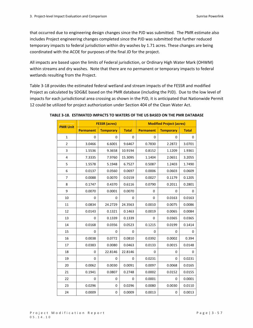
3. Project‐level Impact Evaluation and Comparison Sunrise Powerlink
P r o j e c t M o d i f i c a t i o n R e p o r t P a g e | 3 ‐ 5 7 0 5 . 1 4 . 1 0
that occurred due to engineering design changes since the PJD was submitted. The PMR estimate also
includes Project engineering changes completed since the PJD was submitted that further reduced
temporary impacts to federal jurisdiction within dry washes by 1.71 acres. These changes are being
coordinated with the ACOE for purposes of the final JD for the project.
All impacts are based upon the limits of Federal jurisdiction, or Ordinary High Water Mark (OHWM)
within streams and dry washes. Note that there are no permanent or temporary impacts to federal
wetlands resulting from the Project.
Table 3‐18 provides the estimated federal wetland and stream impacts of the FESSR and modified
Project as calculated by SDG&E based on the PMR database (including the PJD). Due to the low level of
impacts for each jurisdictional area crossing as shown in the PJD, it is anticipated that Nationwide Permit
12 could be utilized for project authorization under Section 404 of the Clean Water Act.
TABLE 3‐18. ESTIMATED IMPACTS TO WATERS OF THE US BASED ON THE PMR DATABASE
FESSR (acres) Modified Project (acres) PMR Unit
Permanent Temporary Total Permanent Temporary Total
1 0 0 0 0 0 0
2 3.0466 6.6001 9.6467 0.7830 2.2872 3.0701
3 1.5536 9.3658 10.9194 0.8152 1.1209 1.9361
4 7.3335 7.9760 15.3095 1.1404 2.0651 3.2055
5 1.5578 5.1948 6.7527 0.5087 1.2403 1.7490
6 0.0137 0.0560 0.0697 0.0006 0.0603 0.0609
7 0.0088 0.0070 0.0159 0.0027 0.1179 0.1205
8 0.1747 0.4370 0.6116 0.0790 0.2011 0.2801
9 0.0070 0.0001 0.0070 0 0 0
10 0 0 0 0 0.0163 0.0163
11 0.0834 24.2729 24.3563 0.0010 0.0075 0.0086
12 0.0143 0.1321 0.1463 0.0019 0.0065 0.0084
13 0 0.1339 0.1339 0 0.0365 0.0365
14 0.0168 0.0356 0.0523 0.1215 0.0199 0.1414
15 0 0 0 0 0 0
16 0.0038 0.0772 0.0810 0.0392 0.0002 0.394
17 0.0383 0.0080 0.0463 0.0133 0.0015 0.0148
18 0 22.8146 22.8146 0 0 0
19 0 0 0 0.0231 0 0.0231
20 0.0062 0.0030 0.0091 0.0097 0.0068 0.0165
21 0.1941 0.0807 0.2748 0.0002 0.0152 0.0155
22 0 0 0 0.0001 0 0.0001
23 0.0296 0 0.0296 0.0080 0.0030 0.0110
24 0.0009 0 0.0009 0.0013 0 0.0013
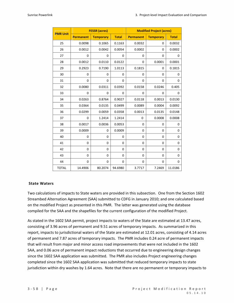
Sunrise Powerlink 3. Project‐level Impact Evaluation and Comparison
3 ‐ 5 8 | P a g e P r o j e c t M o d i f i c a t i o n R e p o r t 0 5 . 1 4 . 1 0
FESSR (acres) Modified Project (acres) PMR Unit
Permanent Temporary Total Permanent Temporary Total
25 0.0098 0.1065 0.1163 0.0032 0 0.0032
26 0.0012 0.0042 0.0054 0.0002 0 0.0002
27 0 0 0 0 0 0
28 0.0012 0.0110 0.0122 0 0.0001 0.0001
29 0.2923 0.7190 1.0113 0.1815 0 0.1815
30 0 0 0 0 0 0
31 0 0 0 0 0 0
32 0.0080 0.0311 0.0392 0.0158 0.0246 0.405
33 0 0 0 0 0 0
34 0.0263 0.8764 0.9027 0.0118 0.0013 0.0130
35 0.0364 0.0135 0.0499 0.0089 0.0004 0.0092
36 0.0299 0.0059 0.0358 0.0013 0.0135 0.0148
37 0 1.2414 1.2414 0 0.0008 0.0008
38 0.0017 0.0036 0.0053 0 0 0
39 0.0009 0 0.0009 0 0 0
40 0 0 0 0 0 0
41 0 0 0 0 0 0
42 0 0 0 0 0 0
43 0 0 0 0 0 0
44 0 0 0 0 0 0
TOTAL 14.4906 80.2074 94.6980 3.7717 7.2469 11.0186
State Waters
Two calculations of impacts to State waters are provided in this subsection. One from the Section 1602
Streambed Alternation Agreement (SAA) submitted to CDFG in January 2010; and one calculated based
on the modified Project as presented in this PMR. The latter was generated using the database
compiled for the SAA and the shapefiles for the current configuration of the modified Project.
As stated in the 1602 SAA permit, project impacts to waters of the State are estimated at 13.47 acres,
consisting of 3.96 acres of permanent and 9.51 acres of temporary impacts. As summarized in this
report, impacts to jurisdictional waters of the State are estimated at 12.01 acres, consisting of 4.14 acres
of permanent and 7.87 acres of temporary impacts. The PMR includes 0.24 acre of permanent impacts
that will result from major and minor access road improvements that were not included in the 1602
SAA, and 0.06 acre of permanent impact reductions that occurred due to engineering design changes
since the 1602 SAA application was submitted. The PMR also includes Project engineering changes
completed since the 1602 SAA application was submitted that reduced temporary impacts to state
jurisdiction within dry washes by 1.64 acres. Note that there are no permanent or temporary impacts to

3. Project‐level Impact Evaluation and Comparison Sunrise Powerlink
P r o j e c t M o d i f i c a t i o n R e p o r t P a g e | 3 ‐ 5 9 0 5 . 1 4 . 1 0
state wetlands resulting from the Project. Table 3‐19 presents the estimate impacts of both the FESSR
and modified Project on State waters.
3.3.10.2 WATER USE
Geosyntec performed a Water Resources Availability Study of Non‐Groundwater Sources (Water Study)
to identify feasible water sources for the construction of the Project [Geosyntec, 2010]. The Water
Study concluded that sufficient supplies of surface water, reclaimed water, and potable water are
available to construct the Project.
The conclusions from the Water Study are based on an approximate average daily demand of 300,000
gallons per day for construction water for a period of approximately 18 to 24 months and total water
usage of approximately 575 acre‐feet. Several sources were identified as each being feasible
contributors of more than 300,000 gallons per day; no single source would be utilized for the entire
project demands for construction water thereby further reducing individual source‐specific water
demands. Water use will be greatly reduced in those areas identified for helicopter‐only construction,
as opposed to conventional construction, such as on USFS lands where approximately 75% of the
structures will be installed by helicopter.
The Water Study determined that sufficient supplies of surface water, reclaimed water, and potable
water would be available to meet Project demand. The following non‐groundwater sources could each
provide greater than 300,000 gallons of water per day for construction needs: City of San Diego
reclaimed, potable, and raw surface water; Padre Dam Municipal Water District reclaimed and potable
water; Lakeside Water District potable water; Imperial Irrigation District (IID) raw surface water; and
Seeley County Water District (SCWD) potable water.
TABLE 3‐19. ESTIMATED IMPACTS TO STATE WATERS BASED ON THE PMR DATABASE
FESSR as in Final EIR/EIS Modified Project PMR Unit
Perm. Temp. Total Perm. Temp. Total
1 0 0 0 0 0 0
2 3.0753 6.6780 9.7533 0.8064 2.3413 3.1477
3 1.5575 9.3661 10.9236 0.8152 1.1209 1.9362
4 7.7611 8.8666 16.6277 1.1998 2.2470 3.4468
5 1.5655 5.2294 6.7949 0.5225 1.3077 1.8302
6 0.0222 0.0788 0.1010 0.0041 0.0669 0.0709
7 0.0156 0.0118 0.0274 0.0027 0.1210 0.1237
8 0.2951 0.6992 0.9942 0.0999 0.3243 0.4241
9 0.0173 0.0004 0.0177 0 0 0
10 0 0 0 0 0.0807 0.0807
11 0.0856 24.2733 24.3589 0.0020 0.0225 0.0245
12 0.0267 0.2195 0.2462 0.0040 0.0115 0.0155
13 0 0.4878 0.4878 0 0.0853 0.0853
14 0.0315 0.0548 0.0863 0.2392 0.0302 0.2694
15 0 0 0 0 0 0
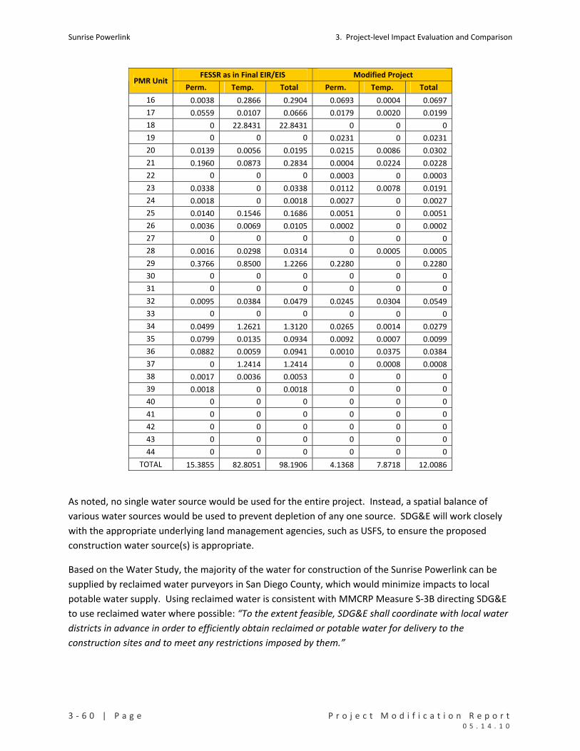
Sunrise Powerlink 3. Project‐level Impact Evaluation and Comparison
3 ‐ 6 0 | P a g e P r o j e c t M o d i f i c a t i o n R e p o r t 0 5 . 1 4 . 1 0
FESSR as in Final EIR/EIS Modified Project PMR Unit
Perm. Temp. Total Perm. Temp. Total
16 0.0038 0.2866 0.2904 0.0693 0.0004 0.0697
17 0.0559 0.0107 0.0666 0.0179 0.0020 0.0199
18 0 22.8431 22.8431 0 0 0
19 0 0 0 0.0231 0 0.0231
20 0.0139 0.0056 0.0195 0.0215 0.0086 0.0302
21 0.1960 0.0873 0.2834 0.0004 0.0224 0.0228
22 0 0 0 0.0003 0 0.0003
23 0.0338 0 0.0338 0.0112 0.0078 0.0191
24 0.0018 0 0.0018 0.0027 0 0.0027
25 0.0140 0.1546 0.1686 0.0051 0 0.0051
26 0.0036 0.0069 0.0105 0.0002 0 0.0002
27 0 0 0 0 0 0
28 0.0016 0.0298 0.0314 0 0.0005 0.0005
29 0.3766 0.8500 1.2266 0.2280 0 0.2280
30 0 0 0 0 0 0
31 0 0 0 0 0 0
32 0.0095 0.0384 0.0479 0.0245 0.0304 0.0549
33 0 0 0 0 0 0
34 0.0499 1.2621 1.3120 0.0265 0.0014 0.0279
35 0.0799 0.0135 0.0934 0.0092 0.0007 0.0099
36 0.0882 0.0059 0.0941 0.0010 0.0375 0.0384
37 0 1.2414 1.2414 0 0.0008 0.0008
38 0.0017 0.0036 0.0053 0 0 0
39 0.0018 0 0.0018 0 0 0
40 0 0 0 0 0 0
41 0 0 0 0 0 0
42 0 0 0 0 0 0
43 0 0 0 0 0 0
44 0 0 0 0 0 0
TOTAL 15.3855 82.8051 98.1906 4.1368 7.8718 12.0086
As noted, no single water source would be used for the entire project. Instead, a spatial balance of
various water sources would be used to prevent depletion of any one source. SDG&E will work closely
with the appropriate underlying land management agencies, such as USFS, to ensure the proposed
construction water source(s) is appropriate.
Based on the Water Study, the majority of the water for construction of the Sunrise Powerlink can be
supplied by reclaimed water purveyors in San Diego County, which would minimize impacts to local
potable water supply. Using reclaimed water is consistent with MMCRP Measure S‐3B directing SDG&E
to use reclaimed water where possible: “To the extent feasible, SDG&E shall coordinate with local water
districts in advance in order to efficiently obtain reclaimed or potable water for delivery to the
construction sites and to meet any restrictions imposed by them.”

3. Project‐level Impact Evaluation and Comparison Sunrise Powerlink
P r o j e c t M o d i f i c a t i o n R e p o r t P a g e | 3 ‐ 6 1 0 5 . 1 4 . 1 0
As detailed in Section 2.1 of the Water Study (Regulatory Compliance for Use of Reclaimed Water),
SDG&E’s use of reclaimed water would be conducted in full compliance with state law.
SDG&E has initiated the application process for obtaining reclaimed water from the City of San Diego
and the Padre Dam Municipal Water District (PDMWD). SDG&E’s current plan for water use in San
Diego County is to utilize the reclaimed water from the City of San Diego as the primary source with a
backup reclaimed water source being PDMWD reclaimed water, and a backup surface water source
being the City of San Diego raw reservoir water. The current plan for water use in Imperial County is
Imperial Irrigation District (IID) raw canal water.
Additional transport of reclaimed water would be required to distribute the water to construction sites
across San Diego County from the reclaimed water sources located in the western portion of San Diego
County. Therefore, supplemental evaluations, summaries of which are provided below, have been
conducted to assess potential impacts to air quality, traffic, and noise related to the trucking of
reclaimed water.
Related Air Quality Considerations
To address Sunrise Mitigation Measures AQ‐1a, AQ‐1h, and AQ‐4a, Bluescape Environmental prepared a
draft memorandum entitled Air Quality Impacts from the Water Use Plan for the Final Environmentally
Superior Southern Route [Bluescape, 2010] (See Attachment C). The memorandum conservatively
assumed the “worst case scenario” transport of reclaimed water in heavy‐duty diesel combustion trucks
from the most distant reclaimed water source from the construction areas, the City of San Diego’s North
City Treatment Plant. The memorandum concludes that project air emissions from on‐road truck fuel
combustion associated with the trucking of reclaimed water is not expected to result in new impacts,
nor the need to revise previous air quality impact analyses. Because the total heavy‐duty truck trips
were conservatively overestimated for the CPUC‐approved June 2009 Construction Emissions
Monitoring Plan for the project, the transportation of reclaimed water does not cause the need to
update the project air quality impact analysis, and does not create an additional significant
environmental impact.
Related Traffic Impact Considerations
To address Sunrise Mitigation Measure T‐9a, KOA Corporation prepared the Traffic Impact Study
performed as part of the Construction Transportation Management Plan [KOA, 2010]. The Traffic
Impact Study considered construction worker commuter trips, equipment deliveries, material hauling,
and reclaimed water deliveries from the “worst case scenario” source location. The Traffic Impact Study
indicated that construction of the Sunrise Powerlink will result in a temporary increase in traffic volumes
on regional and local roadways that provide access to individual construction sites. Six areas were
identified with potential to create traffic impacts. Recommendations for mitigation were provided,
including submittal of additional traffic control plans for approval by local agencies prior to commencing
construction activities, employee shuttling, and the restriction of peak‐time deliveries. The executive
summary for this report concludes that the presented mitigation measures will adequately address

Sunrise Powerlink 3. Project‐level Impact Evaluation and Comparison
3 ‐ 6 2 | P a g e P r o j e c t M o d i f i c a t i o n R e p o r t 0 5 . 1 4 . 1 0
identified impacts to traffic associated with the water transportation required for construction of the
Sunrise Powerlink, and no additional significant environmental impacts are created.
Related Noise Impact Considerations
To address Sunrise Mitigation Measure N‐1a, Investigative Science and Engineering, Inc. (ISE) prepared a
Power Haulage Estimated Acoustic Impact Potential study [ISE, 2010] (See Attachment B). The study
utilized a two‐tiered approach using data provided by the KOA Traffic Impact Study [KOA 2010]. The
initial phase of the study considered baseline acoustic conditions along roadways anticipated for “worst
case scenario” transportation use during construction, compared to acoustic conditions associated with
the sum of existing and predicted project traffic conditions. The comparison identified 40 potential
candidate areas where the proposed project action could increase the ambient background noise level
above the Community Noise Equivalence Level (CNEL) to the point of being discernable or creating
adverse conditions to sensitive receptor areas. However, the second phase of the assessment utilized
Geographic Information System (GIS) methods to ascertain whether or not the identified candidate
areas would impact sensitive receptor areas. The study concluded that examination of each of the
identified candidate areas did not identify any sensitive receptors likely to be exposed to increased noise
associated with transportation of reclaimed water for the construction of the Sunrise Powerlink.
Therefore, mitigation of increased noise will not be necessary for the transportation of reclaimed water
during the construction of the Sunrise Powerlink, and no significant environmental impacts were
identified.
Water Use Summary
In compliance with MMCRP measure S‐3b, SDG&E proposes to utilize reclaimed water for the majority
of the construction along the project alignment. The Water Study has identified ample sources of
reclaimed water, and SDG&E will abide by all procedural and regulatory requirements for this use.
Finally, the proposed transportation of reclaimed water for the construction of Sunrise Powerlink will
not create additional significant impacts to air quality, traffic, noise, or water use.
3.4 LITERATURE CITED
Avian Power line Interaction Committee (APLIC). 2006. Suggested Practices for Avian Protection on
Power Lines: The State of the Art in 2006. Edison Electric Institute, APLIC, and California Energy
Commission. Washington, D.C. And Sacramento, California.
Bluescape Environmental, 2010. Memorandum – Air Quality Impacts from the Final Water use
Plan, Sunrise Powerlink, Southern California, prepared for San Diego Gas & Electric
Company, March 17, 2010 (See Attachment C).
Briscoe, A.D. and L. Chittka. 2001. The Evolution of Color Vision in Insects. Annual Review of
Entomology. 46:471‐510.

3. Project‐level Impact Evaluation and Comparison Sunrise Powerlink
P r o j e c t M o d i f i c a t i o n R e p o r t P a g e | 3 ‐ 6 3 0 5 . 1 4 . 1 0
California Energy Commission. 2007. California Guidelines for Reducing Impacts to Birds and Bats from
Wind Energy Development. Final Committee Report. CEC ‐700‐2007‐008‐CTF.
California Institute of Technology (Caltech).October 15, 2002. Press Release. Accessed at
http://media.caltech.edu/press_releases/12301.
Drewitt, A.L. and Langston, R.H.W., 2008. Collision Effects of Wind‐power Generators and Other
Obstacles on Birds. Annals of the New York Academy of Sciences, 1134(1 The Year in Ecology
and Conservation Biology 2008), pp. 233‐266.
Gehring J., P. Kerlinger, and A.M. Manville II. 2009. Communication Towers, Lights, and Birds:
Successful Methods of Reducing the Frequency of Avian Collisions. Ecological Applications: 19(2),
2009, pp 505‐514.
Geosyntec, 2010. Water Resources Availability Study, Non‐Groundwater Sources, Sunrise Powerlink,
Southern California, prepared for San Diego Gas & Electric Company, April 23, 2010.
Horn, J.W., E.B. Arnett and T.H. Kunz. 2006. Behavioral Response of Bats to Operating Wind Turbines.
Journal of Wildlife Management, 72(1), pp. 123 ‐132.
ISE, 2010. Sunrise Powerlink Powered Haulage Estimated Acoustical Impact Potential, Southern
California, prepared for San Diego Gas & Electric Company, April 15, 2010 (See Attachment C).
KOA Corporation, 2010. Traffic Impact Study Report, Sunrise Powerlink, Southern California, prepared
for San Diego Gas & Electric Company, April 23, 2010.
Stokes, Drew. 2010. Personal Communication with Karen Wilson at SDG&E. San Diego Museum of
Natural History.
Zeigler H.P. and H.J. Bischof Eds. 1993. Vision, Brain, and Behavior in Birds. Cambridge, MA: MIT Press.
439 pp.

Sunrise Powerlink 3. Project‐level Impact Evaluation and Comparison
3 ‐ 6 4 | P a g e P r o j e c t M o d i f i c a t i o n R e p o r t 0 5 . 1 4 . 1 0

P r o j e c t M o d i f i c a t i o n R e p o r t P a g e | 4 ‐ 1 0 5 . 1 4 . 1 0
4. UNIT‐LEVEL IMPACT EVALUATION AND COMPARISON
This section describes the modifications made to the FESSR within each of the 44 PMR units and
evaluates and compares the environmental effects of the modified Project with those of the FESSR as
analyzed in the Final EIR/EIS. In the evaluation and comparison of effects, the primary focus is on
impacts to biological, cultural, visual, and water resources. Other effects also are addressed, with
varying levels of details depending on the issues within the PMR unit. Where the effects of the modified
Project would be substantially the same as those of the FESSR, that point is noted.
For each PMR unit, the evaluation and comparison of impacts is presented on a form and table. The
form identifies the location of the PMR unit, describes the details and purpose of the modification, and
provides an assessment of the impacts associated with the modification in relation to the effects of the
FESSR in that same area. The table includes the quantified impact estimates for the FESSR and modified
Project for the PMR unit. Estimates on the forms and tables are based on the PMR database and the
EIR/EIS database where available at the PMR unit level. The purpose of evaluating and comparing
impacts in each PMR unit is to identify the changes made to the FESSR in greater detail and examine
whether impacts would decrease, increase, or remain substantially the same along that portion of the
alignment. The unit‐level analysis augments the Project‐level assessment in Section 3 with information
about changes in specific locations.
Table 4‐1 summarizes the unit‐level analysis in terms of total ground disturbance in each PMR unit
under the FESSR and modified Project and the changes in environmental effects that would result from
the modifications. Changes in effects are identified as eliminated (E), reduced (R), increased (I), no
substantial change (NSC), or a combination of these categories. “NSC” also is used when the quantified
impacts would be the same for the FESSR and modified Project. “E” is reserved for instances where a
modification avoids all impacts to a resource that would have been affected by the FESSR in that
location. For example, the modification avoids all impacts to cultural resources or all impacts to special
status species. Combinations indicate where there is a mix of R, I, and NSC effects described on the PMR
form. For example, there may be a decrease in permanent impacts and increase in temporary impacts
to sensitive vegetation communities. The entry on Table 4‐1 would be R/I or I/R, depending on whether
the decrease or increase is the more notable change.
As indicated in Table 4‐1, there are 16 PMR units where impacts have been eliminated to at least one
resource category, mainly instances where changes were made to avoid waters of the US and State
waters. There are 28 PMR units where impacts to at least two resource categories (i.e., sensitive
vegetation, cultural resources, visual, etc.) are reduced (R); there are four PMR units where impacts
increase to at least two resource categories. These counts exclude combination impacts that include a
reduction or increase. None of the modifications would result in new significant impacts within a PMR
unit.

Sunrise Powerlink 4. Unit‐level Impact Evaluation and Comparison
4 ‐ 2 | P a g e P r o j e c t M o d i f i c a t i o n R e p o r t 0 5 . 1 4 . 1 0
TABLE 4‐1. SUMMARY OF UNIT‐LEVEL IMPACT EVALUATION AND COMPARISON
Total Ground
Disturbance Changes to the Effects of the FESSR Resulting from the Modification
PMR Unit Structures/Yards
FESS
R
Mo
dif
ied P
roje
ct
Sen
siti
ve
Ve
geta
tio
n
Spe
cial S
tatu
s
Spe
cie
s
Cu
ltu
ral
Re
sou
rce
s
Vis
ual R
eso
urc
es
Wat
ers o
f U
S &
Stre
amb
eds
Summary Conclusion/Notes
PMR1 Imperial Valley Substation
‐‐ ‐‐ NSC NSC NSC NSC NSC Adds storage facility within existing substation.
PMR2 EP363‐1 to EP333 IV Sub Yard, Dunaway Road Yard
240.82 58.03 R R R NSC R Reduces impacts
PMR3 EP333 to EP324 Plaster City Yard
55.92 32.92 R/I R R NSC R
Avoids sensitive resources with the exception of a slight temporary increase in impacts to desert scrub.
PMR4 EP324 to EP301
100.21 29.71 R R R NSC R Coordination with quarry activities initiated for FESSR would continue.
PMR5 EP301 to EP276‐1 (BLM) S2 Yard
69.89 49.04 R/NSC R R/NSC NSC R Coordination with quarry activities initiated for FESSR would continue.
PMR6 EP276‐1 to EP255‐1 AER Yard
56.35 20.48 R R R NSC/R R Reduces size of construction yard and associated impacts
PMR7 EP255‐1 to EP252‐1
10.42 16.36 R/I R/I R NSC NSC/I Temporary impacts to dry washes, PBS habitat, and waters increase slightly.
PMR8 EP252‐1 to EP239‐1 Jacumba Airport Yard Jacumba Valley Ranch Yard
36.67 55.90 R/I I/R R I/NSC E
The yard responsible for the impact increases replaces one in PMR9 eliminated to avoid Quino impacts.
PMR9 EP239‐1 to EP229‐1
59.09 7.59 R R R NSC/R E Avoids impacts to rare plants. Avoids conflict with Nature Conservancy lands.
PMR10 EP229‐1 to EP221A
19.84 4.49 R/NSC R NSC/R NSC I Slight reduction in impacts
PMR11 EP221A to EP219‐1
48.17 5.49 R NSC E NSC R Reduction in waters of US impacts.
PMR12 EP219‐1 to EP206‐1
44.12 18.74 R NSC NSC/R NSC R Reductions in impacts
PMR13 EP206‐1 to EP196‐1 Rough Acres Yard
52.11 106.60 I R NSC/R NSC R Increase in temporary impacts to Jacumba milk‐vetch
PMR14 EP196‐1 to EP170 McCain Valley Yard
62.10 68.59 I/NSC NSC/I NSC NSC I No substantial change
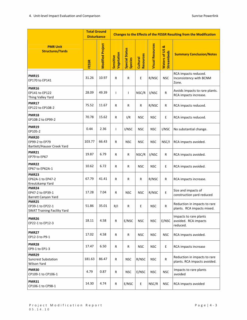
4. Unit‐level Impact Evaluation and Comparison Sunrise Powerlink
P r o j e c t M o d i f i c a t i o n R e p o r t P a g e | 4 ‐ 3 0 5 . 1 4 . 1 0
Total Ground
Disturbance Changes to the Effects of the FESSR Resulting from the Modification
PMR Unit Structures/Yards
FESS
R
Mo
dif
ied P
roje
ct
Sen
siti
ve
Ve
geta
tio
n
Spe
cial S
tatu
s
Spe
cie
s
Cu
ltu
ral
Re
sou
rce
s
Vis
ual R
eso
urc
es
Wat
ers o
f U
S &
Stre
amb
eds
Summary Conclusion/Notes
PMR15 EP170 to EP141
31.26 10.97 R R E R/NSC NSC RCA impacts reduced. Inconsistency with BCNM Zone.
PMR16 EP141 to EP122 Thing Valley Yard
28.09 49.39 I I NSC/R I/NSC R Avoids impacts to rare plants. RCA impacts increase.
PMR17 EP122 to EP108‐2
75.52 11.67 R R R R/NSC R RCA impacts reduced.
PMR18 EP108‐2 to EP99‐2
70.78 15.62 R I/R NSC NSC E RCA impacts reduced.
PMR19 EP105‐2
0.44 2.36 I I/NSC NSC NSC I/NSC No substantial change.
PMR20 EP99‐2 to EP79 Bartlett/Hauser Creek Yard
103.77 66.43 R NSC NSC NSC NSC/I RCA impacts avoided.
PMR21 EP79 to EP67
19.87 6.79 R R NSC/R I/NSC R RCA impacts avoided.
PMR22 EP67 to EP62A‐1
10.62 6.72 R R NSC NSC E RCA impacts avoided.
PMR23 EP62A‐1 to EP47‐2 Kreutzkamp Yard
67.79 41.41 R R R R/NSC R RCA impacts increase.
PMR24 EP47‐2 to EP39‐1 Barrett Canyon Yard
17.28 7.04 R NSC NSC R/NSC E Size and impacts of construction yard reduced
PMR25 EP39‐1 to EP22‐1 SWAT Training Facility Yard
51.86 35.01 R/I R E NSC R Reduction in impacts to rare plants. RCA impacts mixed.
PMR26 EP22‐1 to EP12‐3
18.11 4.58 R E/NSC NSC NSC E/NSC Impacts to rare plants avoided. RCA impacts reduced.
PMR27 EP12‐3 to P9‐1
17.02 4.58 R R NSC NSC NSC RCA impacts avoided.
PMR28 EP9‐1 to EP1‐3
17.47 6.50 R R NSC NSC E RCA impacts increase
PMR29 Suncrest Substation Wilson Yard
181.63 86.47 R NSC R/NSC NSC R Reduction in impacts to rare plants. RCA impacts avoided.
PMR30 CP109‐1 to CP106‐1
4.79 0.87 R NSC E/NSC NSC NSC Impacts to rare plants avoided
PMR31 CP106‐1 to CP98‐1
14.30 4.74 R E/NSC E NSC/R NSC RCA impacts avoided

Sunrise Powerlink 4. Unit‐level Impact Evaluation and Comparison
4 ‐ 4 | P a g e P r o j e c t M o d i f i c a t i o n R e p o r t 0 5 . 1 4 . 1 0
Total Ground
Disturbance Changes to the Effects of the FESSR Resulting from the Modification
PMR Unit Structures/Yards
FESS
R
Mo
dif
ied P
roje
ct
Sen
siti
ve
Ve
geta
tio
n
Spe
cial S
tatu
s
Spe
cie
s
Cu
ltu
ral
Re
sou
rce
s
Vis
ual R
eso
urc
es
Wat
ers o
f U
S &
Stre
amb
eds
Summary Conclusion/Notes
PMR32 CP98‐1 to CP95‐1
4.58 6.20 I/NSC I/NSC NSC NSC I/NSC No substantial change
PMR33 CP95‐1 to CP88‐1/CP87‐1 Alpine HQ, Alpine Yards
0.00 38.94 I NSC NSC I I/NSC No substantial change
PMR34 CP88‐1/CP87‐1 to CP64‐2 Hartung Yard
77.38 31.55 R R R NSC R Reduction in impacts to rare plants. RCA impacts reduced.
PMR35 CP64‐2 to CP53‐1
28.51 6.51 R R E NSC R Impacts to rare plants avoided
PMR36 CP53‐1 to CP44‐1 Helix Yard
28.91 29.25 I/R I NSC I R Slight increase in temporary effects
PMR37 CP44‐1 to CP37‐2
22.05 3.54 R R NSC NSC E Hansen Aggregate has access for mining operations.
PMR38 CP37‐2 to CP31‐2
40.30 2.83 R NSC NSC NSC/I E Modest reduction in impacts
PMR39 CP31‐2 to CP12‐1
12.01 9.56 R R NSC/R NSC NSC No substantial change
PMR40 CP12‐1 to CP3 Stowe/Kirkham Yard
4.24 23.56 I I NSC I NSC Increase in impacts
PMR41 CP3 to CP1A
11.03 0.30 R NSC NSC NSC NSC No substantial change
PMR42 Sycamore – Pomerado
0.00 2.91 I/NSC NSC NSC NSC/I NSC No significant change
PMR43 Sycamore – Elliott
0.00 1.70 I/NSC NSC NSC NSC/I NSC No substantial change
PMR44 Sycamore – Scripps
0.00 1.59 I/NSC NSC NSC NSC NSC No substantial change
Codes
E = All impacts to a resource category eliminated I = Increase in Impacts NSC = No substantial change in impacts; also applies to no change in quantified impacts. R = Reduction in Impacts
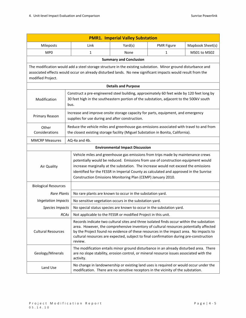
4. Unit‐level Impact Evaluation and Comparison Sunrise Powerlink
P r o j e c t M o d i f i c a t i o n R e p o r t P a g e | 4 ‐ 5 0 5 . 1 4 . 1 0
PMR1. Imperial Valley Substation
Mileposts Link Yard(s) PMR Figure Mapbook Sheet(s)
MP0 1 None 1 MS01 to MS02
Summary and Conclusion
The modification would add a steel storage structure in the existing substation. Minor ground disturbance and
associated effects would occur on already disturbed lands. No new significant impacts would result from the
modified Project.
Details and Purpose
Modification
Construct a pre‐engineered steel building, approximately 60 feet wide by 120 feet long by
30 feet high in the southeastern portion of the substation, adjacent to the 500kV south
bus.
Primary Reason Increase and improve onsite storage capacity for parts, equipment, and emergency
supplies for use during and after construction.
Other Considerations
Reduce the vehicle miles and greenhouse gas emissions associated with travel to and from
the closest existing storage facility (Miguel Substation in Bonita, California).
MMCRP Measures AQ‐4a and 4b.
Environmental Impact Discussion
Air Quality
Vehicle miles and greenhouse gas emissions from trips made by maintenance crews
potentially would be reduced. Emissions from use of construction equipment would
increase marginally at the substation. The increase would not exceed the emissions
identified for the FESSR in Imperial County as calculated and approved in the Sunrise
Construction Emissions Monitoring Plan (CEMP) January 2010.
Biological Resources
Rare Plants No rare plants are known to occur in the substation yard.
Vegetation Impacts No sensitive vegetation occurs in the substation yard.
Species Impacts No special status species are known to occur in the substation yard.
RCAs Not applicable to the FESSR or modified Project in this unit.
Cultural Resources
Records indicate two cultural sites and three isolated finds occur within the substation area. However, the comprehensive inventory of cultural resources potentially affected by the Project found no evidence of these resources in the impact area. No impacts to cultural resources are expected, subject to final confirmation during pre‐construction review.
Geology/Minerals The modification entails minor ground disturbance in an already disturbed area. There are no slope stability, erosion control, or mineral resource issues associated with the activity.
Land Use No change in landownership or existing land uses is required or would occur under the modification. There are no sensitive receptors in the vicinity of the substation.

Sunrise Powerlink 4. Unit‐level Impact Evaluation and Comparison
4 ‐ 6 | P a g e P r o j e c t M o d i f i c a t i o n R e p o r t 0 5 . 1 4 . 1 0
PMR1. Imperial Valley Substation
Noise Installation of the building and truck traffic to and from the facility would not result in increased noise levels that would exceed the levels identified in connection with Project construction.
Public Safety/Hazards
Storage of equipment and materials would be subject to the same public safety and
hazard control measures that would apply to the FESSR. The FESSR and PMR1 are in
close enough proximity that there would be no change to fire/fuels analysis or modeling
results.
Traffic
The modification would result in a slight increase in truck traffic to this location than
would have occurred without the storage facility, and there would be a corresponding
decrease in truck traffic to other storage sites. This provides an overall reduction on
transportation and traffic impacts.
Visual The proposed modification would not noticeably change overall impacts on visual
resources along this route segment.
Water Resource
Waters of US No impacts.
State Waters No impacts.
Water Use The modification would not increase the need for or use of water for construction or operations and maintenance at this location.

4. Unit‐level Impact Evaluation and Comparison Sunrise Powerlink
P r o j e c t M o d i f i c a t i o n R e p o r t P a g e | 4 ‐ 7 0 5 . 1 4 . 1 0
TABLE PMR1
Impacts to Rare Plants (number of individuals detected in impact areas)
No impacts from FESSR or modified Project in this unit.
Impacts to Sensitive Vegetation Communities and Total Ground Disturbance (acres)
No impacts from FESSR or modified Project in this unit.
Impacts to Special Status Species (acres)
No impacts from FESSR or modified Project in this unit.
Impacts to RCAs in CNF (acres)
Not applicable to modified Project or FESSR in this unit.
Impacts to Cultural Resources (number of sites potentially affected)
No impacts from FESSR or modified Project in this unit.
Impacts to Waters of the US (acres)
No impacts from FESSR or modified Project in this unit.
Impacts to State Waters (acres)
No impacts from FESSR or modified Project in this unit.

Sunrise Powerlink 4. Unit‐level Impact Evaluation and Comparison
4 ‐ 8 | P a g e P r o j e c t M o d i f i c a t i o n R e p o r t 0 5 . 1 4 . 1 0
PMR2. EP363‐1 to EP333 (Dunaway Road)
Mileposts Link Yard(s) PMR Figure Mapbook Sheet(s)
MP0 to MP9.7 1 IV Sub
Dunaway Road 2 MS01 to MS11
Summary and Conclusion
The modification would shift the ROW to the southwest to avoid sensitive resources and accommodate the
Tessera Solar (Stirling Energy) transmission line crossing, relocate and reduce the size of two construction yards,
and eliminate a yard near MP5. The modification would reduce FESSR impacts to sensitive vegetation
communities, flat tailed horned lizard, cultural resources, waters of the US, and State waters in the PRM unit.
Other effects of the modification would be substantially the same as those of the FESSR. No new significant
impacts would result from the modification.
Details and Purpose
Modification
Reroute
ROW shifted to accommodate the Stirling Energy transmission line crossing
with the SWPL and SRPL transmissions lines.
Two structures moved out of dry washes.
Work areas shifted and access changed to avoid cultural resources.
New access road eliminated.
Number and size of wire stringing sites reduced.
Guard structures added at road crossings.
IV Sub Construction Yard
Yard relocated northwest of Imperial Valley Substation to accommodate
flight path.
Size of yard reduced from 26.36 acres to 4.96 acres.
Dunaway Road Construction Yard
Size of construction yard reduced from 30.69 to 9.93 acres.
Other
Eliminate construction yard near MP5.
Primary Reason
Accommodate Stirling Energy transmission line crossing.
Accommodate flight path (cannot fly steel over the 500‐kV line).
Reduce impacts to sensitive vegetation and species, cultural resources, and dry washes
Reduce ground disturbance
Other Considerations Adjust for improved engineering design and constructability.
MMCRP Measures B‐1a, C‐1a and 1b, GEO‐APM‐5, PU‐APM‐1, and WQ‐APM‐2
4. Unit‐level Impact Evaluation and Comparison Sunrise Powerlink
P r o j e c t M o d i f i c a t i o n R e p o r t P a g e | 4 ‐ 9 0 5 . 1 4 . 1 0
PMR2. EP363‐1 to EP333 (Dunaway Road)
Environmental Impact Discussion
Air Quality No substantial changes to the effects of the FESSR.
Biological Resources See Table PMR2 below.
Rare Plants No rare plants would be affected by the modified Project or FESSR.
Vegetation Impacts The modification would reduce FESSR impacts to desert scrub and non‐vegetated
channels and would eliminate impacts to riparian scrub in this location.
Species Impacts The modification would reduce FESSR impacts to flat tailed horned lizard habitat in this
location.
RCAs Not applicable to the FESSR or modified Project in this unit.
Cultural Resources
There are 62 cultural sites and 35 isolated finds in this PMR unit, most of which were
identified in the surveys for the EIR/EIS. Of these resources, 19 would be affected by
the FESSR and modified Project and an additional 23 would be affected by the FESSR.
The modified Project shifted work areas at two structures and access roads to five
structures to avoid cultural resources. Impacts under the modified Project would be
reduced. See Table PMR2 below.
Geology/Minerals The modification would reduce ground disturbance and the associated slope stability and erosion effects in this PMR unit.
Land Use
The proposed modification and FESSR would occur on BLM lands. The modification
would reduce the total area of federal land affected by the Project in this location.
There are no sensitive receptors in the vicinity of the FESSR or modified Project. The
construction yard is in close proximity to the Dunaway OHV Staging Area and
appropriate coordination with the Recreation Officer is in process in an effort to reduce
impacts to recreationists utilizing this area.
Noise No substantial changes to the effects of the FESSR.
Public Safety/Hazards No substantial changes to the effects of the FESSR.
Traffic No substantial changes to the effects of the FESSR.
Visual
The modification would not noticeably change the overall impacts of the FESSR on
visual resources, although the reduction in ground disturbance would reduce long‐term
visible land scarring. Because it would still be prominently visible to OHV recreationists
accessing the Yuha Desert south of I‐8, the Dunaway Yard would have similar
temporary visual effects as the FESSR yard.
Water Resources See Table PMR2 below.
Waters of US The modification would reduce impacts to waters of the US.
State Waters The modification would reduce impacts to State waters.
Water Use No substantial change to the effects of the FESSR, with some potential for reduction
because of the reduced ground disturbance.

Sunrise Powerlink 4. Unit‐level Impact Evaluation and Comparison
4 ‐ 1 0 | P a g e P r o j e c t M o d i f i c a t i o n R e p o r t 0 5 . 1 4 . 1 0
TABLE PMR2
Impacts to Rare Plants (number of individuals detected in impact areas)
No impacts from FESSR or modified Project in this unit.
Impacts to Sensitive Vegetation Communities and Total Ground Disturbance (acres)
Permanent Temporary Total
Desert Scrub and Dune Habitats 21.85 101.50 123.35
Herbaceous Wetlands, Freshwater, and Streams 0.44 1.03 1.47
Non‐native Vegetation, Developed Areas, and Disturbed Habitat 8.49 106.54 115.03 FESSR
Riparian Scrubs 0.36 0.61 0.97
FESSR Total 31.14 209.68 240.82
Permanent Temporary Total
Desert Scrub and Dune Habitats 8.33 33.58 41.91
Herbaceous Wetlands, Freshwater, and Streams 0.26 0.60 0.86 Modified Project
Non‐native Vegetation, Developed Areas, and Disturbed Habitat 5.18 10.08 15.26
Mod Proj Total 13.77 44.25 58.03 Impacts to Special Status Species (acres)
Permanent Temporary Total
BLM Management Area 22.26 103.25 125.51 FESSR Flat Tailed Horned Lizard
Distribution Area 8.88 12.96 21.84
BLM Management Area 9.54 36.87 46.41 Modified Project Flat Tailed Horned Lizard
Distribution Area 4.23 7.38 11.61 Impacts to RCAs in CNF (acres)
Not applicable to FESSR or modified Project in this unit.
Impacts to Cultural Resources (number of sites potentially affected)
Resource Type ID in Cultural resource Inventory FESSR Modified Project
Habitation Site IMP‐269 1 1
IMP‐2085 1 1
IMP‐8740 1 1
IMP‐8744 1 1 Lithic Scatter
IMP‐8824 1 1
Lithic Scatter/Ceramic Scatter IMP‐8665 1 1
Lithic Scatter/Mining IMP‐8741 1 1
Lithic Scatter/Rock Carin IMP‐8739 1 1
Pending id AGH‐5 1 1
IMP‐1015/4348 1 1 Prehistoric Artifact Scatter
IMP‐3784/3785/4340/4341/4344 1 1
10B‐8 1 1
IMP‐2304 1 1
IMP‐8737 1 1
IMP‐8766 1 1
Prehistoric Lithic Scatter
IMP‐8793 1 1
Prehistoric Lithic Scatter/Historic Refuse IMP‐3773 1 1
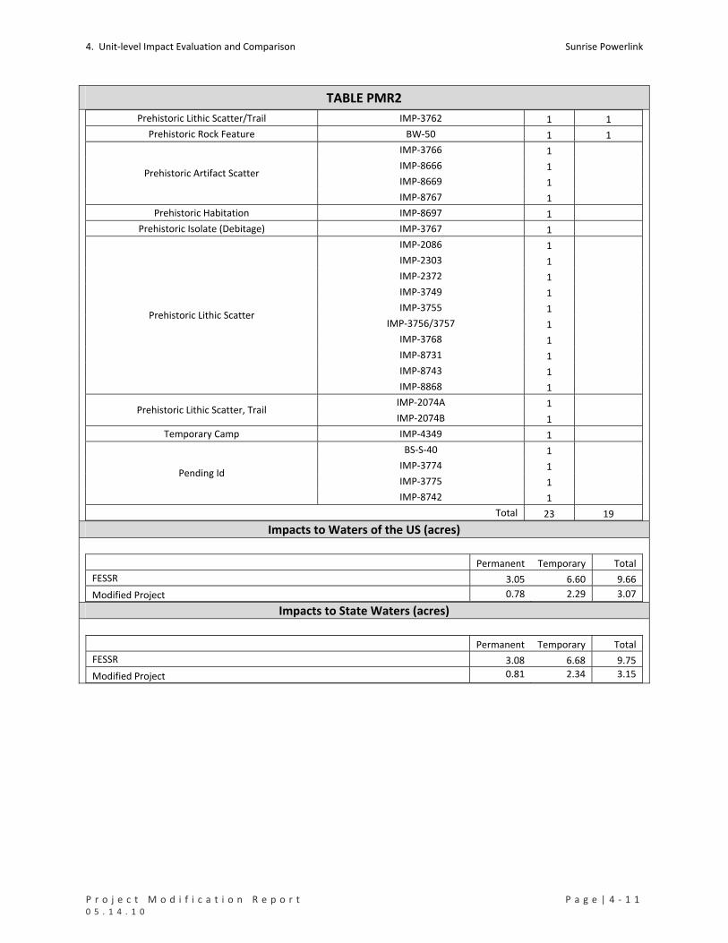
4. Unit‐level Impact Evaluation and Comparison Sunrise Powerlink
P r o j e c t M o d i f i c a t i o n R e p o r t P a g e | 4 ‐ 1 1 0 5 . 1 4 . 1 0
TABLE PMR2
Prehistoric Lithic Scatter/Trail IMP‐3762 1 1
Prehistoric Rock Feature BW‐50 1 1
IMP‐3766 1
IMP‐8666 1
IMP‐8669 1 Prehistoric Artifact Scatter
IMP‐8767 1
Prehistoric Habitation IMP‐8697 1
Prehistoric Isolate (Debitage) IMP‐3767 1
IMP‐2086 1
IMP‐2303 1
IMP‐2372 1
IMP‐3749 1
IMP‐3755 1
IMP‐3756/3757 1
IMP‐3768 1
IMP‐8731 1
IMP‐8743 1
Prehistoric Lithic Scatter
IMP‐8868 1
IMP‐2074A 1 Prehistoric Lithic Scatter, Trail
IMP‐2074B 1
Temporary Camp IMP‐4349 1
BS‐S‐40 1
IMP‐3774 1
IMP‐3775 1 Pending Id
IMP‐8742 1
Total 23 19 Impacts to Waters of the US (acres)
Permanent Temporary Total
FESSR 3.05 6.60 9.66
Modified Project 0.78 2.29 3.07 Impacts to State Waters (acres)
Permanent Temporary Total
FESSR 3.08 6.68 9.75
Modified Project 0.81 2.34 3.15

Sunrise Powerlink 4. Unit‐level Impact Evaluation and Comparison
4 ‐ 1 2 | P a g e P r o j e c t M o d i f i c a t i o n R e p o r t 0 5 . 1 4 . 1 0
PMR3. EP333 to EP324 (Plaster City)
Mileposts Link Yard(s) PMR Figure Mapbook Sheet(s)
MP9.7 to MP12.7 1 Plaster City 3 MS11 to MS14
Summary and Conclusion
The modification would shift the alignment to the northeast to avoid sensitive resources and relocate and reduce
the size of the Plaster City construction yard. The modification would reduce FESSR impacts to dry washes, flat
tailed horned lizard habitat, cultural resources, waters of the US, and State waters in this PRM unit. There would
be an increase in temporary impacts to desert scrub habitat. Other effects of the modification would be
substantially the same as those of the FESSR. No new significant impacts would result from the modification.
Details and Purpose
Modification
Reroute
ROW shifted to avoid cultural resources, a wetland, and a dry wash.
Size of temporary work areas reduced at all structures.
Number of wire stringing sites reduced.
New access road parallel to SWPL eliminated
Guard structures added at road crossings.
Plaster City Construction Yard
Construction yard moved from near EP329‐1 to north of Evan Hewes Highway
80 and EP330‐1
Yard size reduced from 30.13 acres to 20.27 acres.
Primary Reason Reduce impacts to sensitive vegetation, cultural resources, and dry washes.
Other Considerations Protect desert pavement.
MMCRP Measures B‐1a, B‐7b, Bio‐APM‐1, C1‐a and –b, G‐2a, GEO‐APM‐5, WQ‐APM‐1, and WQ‐APM‐2
Environmental Impact Discussion
Air Quality No substantial change to the effects of the FESSR.
Biological Resources See Table PMR3 below.
Rare Plants No rare plants would be affected by the modified Project or FESSR.
Vegetation Impacts The modified Project would have more temporary impacts to desert scrub than the
FESSR but would reduce permanent and temporary impacts to dry washes.
Species Impacts
Neither the FESSR nor the modified Project affect the FTHL Management Area; the
modified Project would reduce impacts to flat tailed horned lizard outside the
Management Area.
RCAs Not applicable to the FESSR or modified Project in this unit.
4. Unit‐level Impact Evaluation and Comparison Sunrise Powerlink
P r o j e c t M o d i f i c a t i o n R e p o r t P a g e | 4 ‐ 1 3 0 5 . 1 4 . 1 0
PMR3. EP333 to EP324 (Plaster City)
Cultural Resources
There are 6 cultural sites and 5 isolated finds in this PMR unit. The FESSR would affect
7 resources, and the modified Project would affect 1 resource. Under the modified
Project, EP333 through SP324 were shifted and spur roads were designed to avoid
cultural resources. Both the FESSR and modified Project potentially would affect a
prehistoric lithic scatter. If possible, an Environmentally Sensitive Area would be
established around this site and as many sites as possible in close proximity to
construction activities. If a site could not be avoided by direct ground impacts,
eligibility evaluations would be completed. Sites that are found to be eligible for
nomination to the National Register would require additional mitigation prior to the
initiation of ground disturbance. See Table PMR3 below.
Geology/Minerals The modification would reduce ground disturbance and the associated slope stability and erosion effects in this PMR unit.
Land Use
The modified Project reduces total impacts to BLM lands and eliminates impacts to private lands in this location. There are no sensitive receptors in the vicinity of the FESSR or modified Project impact areas in PMR3. The construction yard is in proximity of the Plaster City West OHV Staging Area and appropriate coordination with the Recreation Officer is in process in an effort to reduce impacts to recreationists utilizing this area.
Noise No substantial changes to the effects of the FESSR.
Public Safety/Hazards No substantial changes to the effects of the FESSR.
Traffic No substantial changes to the effects of the FESSR.
Visual
The modification would not noticeably change the overall visual impacts of the FESSR
in this PMR unit. There would be some reduction in long‐term visible land scarring
because of the reduced ground disturbance. The modification to the Plaster City
Construction Yard would reduce temporary view blockage of the Coyote and Fish Creek
Mountains to the northwest but cause temporary view blockage of the Fish Creek
Mountains to the north and from of the Plaster City West OHV Staging Area.
Water Resources See Table PMR3 below.
Waters of US The modification would reduce impacts to waters of the US.
State Waters The modification would reduce impacts to State waters.
Water Use No substantial change to the effects of the FESSR, with some potential for reduction because of the reduced ground disturbance.

Sunrise Powerlink 4. Unit‐level Impact Evaluation and Comparison
4 ‐ 1 4 | P a g e P r o j e c t M o d i f i c a t i o n R e p o r t 0 5 . 1 4 . 1 0
TABLE PMR3
Impacts to Rare Plants (number of individuals detected in impact areas)
No impacts from FESSR or modified Project in this unit.
Impacts to Sensitive Vegetation Communities and Total Ground Disturbance (acres)
Permanent Temporary Total
Desert Scrub and Dune Habitats 4.25 16.58 20.83
Herbaceous Wetlands, Freshwater, and Streams 0.06 0.05 0.11 FESSR
Non‐native Vegetation, Developed Areas, and Disturbed Habitat 7.59 27.40 34.98
FESSR Total 11.89 44.03 55.92
Desert Scrub and Dune Habitats 2.59 24.05 26.64
Herbaceous Wetlands, Freshwater, and Streams 0.03 0.03 0.06 Modified Project
Non‐native Vegetation, Developed Areas, and Disturbed Habitat 3.15 3.07 6.22
Mod Proj Total 5.77 27.15 32.92 Impacts to Special Status Species (acres)
Permanent Temporary Total
FESSR Flat Tailed Horned Lizard Distribution Area 11.89 44.03 55.92
Modified Project Flat Tailed Horned Lizard Distribution Area 5.77 27.15 32.92 Impacts to RCAs in CNF (acres)
Not applicable to FESSR or modified Project in this unit.
Impacts to Cultural Resources (number of sites potentially affected)
Resource Type ID in Cultural Resource Inventory FESSR
Modified Project
Prehistoric Lithic Scatter IMP‐4237 1 1
Historic Road IMP‐7886 1
Historic Trail Fages‐De Anza Trail 1
Historic Trail IMP‐3396 1
Prehistoric Lithic Scatter IMP‐8705 1
IMP‐8706 1 Pending Id
SU‐29 1
Total 7 1 Impacts to Waters of the US (acres) Permanent Temporary Total
FESSR 1.55 9.37 10.92
Modified Project 0.82 1.12 1.94 Impacts to State Waters (acres)
Permanent Temporary Total
FESSR 1.56 9.37 10.92
Modified Project 0.82 1.12 1.94

4. Unit‐level Impact Evaluation and Comparison Sunrise Powerlink
P r o j e c t M o d i f i c a t i o n R e p o r t P a g e | 4 ‐ 1 5 0 5 . 1 4 . 1 0
PMR4. EP324 to EP301 (Pyramid Mining)
Mileposts Link Yard(s) PMR Figure Mapbook Sheet(s)
MP12.7 to MP19.1 1 None 4 MS14 to MS20
Summary and Conclusion
The modification would make minor shifts in the alignment to the south to improve construction and engineering
design, reduce the size of work areas, add TSAPs to support helicopter construction, and eliminate a yard south of
the ROW. FESSR impacts to desert scrubs, dry washes, flat tailed horned lizard, Peninsular bighorn sheep, cultural
resources, waters of the US, and State waters would be reduced. Coordination with quarry activities would
continue to ensure access to mineral resources. Other effects of the modification would be substantially the same
as the FESSR. No new significant impacts would result from the modification.
Details and Purpose
Modification
ROW shifted south between EP318‐1 and EP314 and between EP303‐2 and EP301.
Work areas and access shifted to avoid cultural resources.
Access roads to EP323‐1 and EP324 eliminated to avoid impacts to dry washes.
Two TSAPs added to support helicopter construction.
Guard structures added at road crossings.
Yard south of ROW, between EP304‐2 and EP303‐2, eliminated.
Primary Reason Reduce impacts to sensitive vegetation, cultural resources, and dry washes
Other Considerations Improve construction and engineering design.
MMCRP Measures B‐1a, C‐1a and 1b, G‐9a, GEO‐APM‐4, WQ‐APM‐1, and WQ‐APM‐2
Environmental Impact Discussion
Air Quality
The increased use of helicopters would not exceed the fuel‐use cap or emissions
identified for the FESSR or as calculated and approved in the Sunrise Construction
Emissions Monitoring Plan (CEMP) January 2010. No substantial change to the effects of
the FESSR
Biological Resources See Table PMR4 below.
Rare Plants Neither the modified Project nor the FESSR would affect rare plants in these locations.
Vegetation Impacts The modification reduces FESSR impacts to desert scrub and dry washes in this unit.
Species Impacts Both the modification and FESSR would affect flat tailed horned lizard outside of the FTHL Management Area and Peninsular bighorn sheep habitat; the modification reduces the habitat impacts.
RCAs Not applicable to the FESSR or modified Project in this unit.
Cultural Resources
There are 14 cultural sites in PMR4, most of which were identified in the FESSR surveys.
The FESSR potentially would affect 12 sites; the modified Project potentially would
affect 2. The reduced impacts under the modification are from changes in the size and
location of work areas at three structures and the design of access to two structures.
Environmentally Sensitive exclusion areas would be established around as many
resources as possible prior to the initiation of ground disturbance. Sites that could not
be avoided of direct impacts would be evaluated for eligibility. Sites that are
determined eligible would require the completion of additional mitigation measures
prior to the initiation of ground disturbance. See Table PMR4 below.
Sunrise Powerlink 4. Unit‐level Impact Evaluation and Comparison
4 ‐ 1 6 | P a g e P r o j e c t M o d i f i c a t i o n R e p o r t 0 5 . 1 4 . 1 0
PMR4. EP324 to EP301 (Pyramid Mining)
Geology/Mineral Resources
The modification reduces ground disturbance and the associated slope stability and
erosion effects in this PMR unit. From structure EP302 to EP301, both the FESSR and the
modification would impinge on Pyramid Mining’s quarry operations on BLM lands.
SDG&E has met and coordinated with BLM and the Pyramid mining operators regarding
operations in and near the SRPL alignment since 2007. During an onsite meeting in
December 2008, SDG&E reviewed the current alignment with both parties and
discussed how the ongoing mining operations, their access, and/or their long‐range
plans might be affected. The shared information resulted in SDG&E siting its access
roads, structures, wire stringing sites, and maintenance pads at locations that would
minimize impacts to the mining operations and the operators’ ability to access and
extract material. BLM played a critical role in these discussions, as the operators are
mining on BLM lands under mining contracts. SDG&E subsequently provided the
revised layout and grading plan to BLM in February 2009 for use in guiding the mining
operations. This coordination is a continuation of efforts initiated for the FESSR and is
the mitigation measure G‐9a identified in the MMRCP for this circumstance. As
identified in MMCRP measure G‐9a, SDG&E will continue to coordinate with BLM and
the appropriate mining operators to reach an agreement which would ensure the safe
operating rights of the Project and limit loss of mining rights to aggregate resources.
The modification reduces but does not eliminate effects on mineral resources and
would not result in a new significant impact.
Land Use
The modification reduces impacts to BLM lands from 100 to approximately 30 acres.
The modified Project is slightly closer to the nearest sensitive receptor which is
approximately 1225 feet from the alignment yielding no substantial changes to the
effects of the FESSR.
Noise No substantial change to the effects of the FESSR.
Public Safety/Hazards No substantial change to effects of the FESSR. However, accommodation of mining
operations would entail additional safety and hazard considerations.
Traffic No substantial change to the effects of the FESSR.
Visual The proposed modification would not noticeably change overall visual impacts but
would reduce long‐term visible land scarring.
Water Resources See Table PMR4 below.
Waters of US The modification would reduce impacts to waters of the US in this unit.
State Waters The modification would reduce impacts to State waters in this unit.
Water Use No substantial change to the effects of the FESSR, with some potential for reduction because of the reduced ground disturbance.
4. Unit‐level Impact Evaluation and Comparison Sunrise Powerlink
P r o j e c t M o d i f i c a t i o n R e p o r t P a g e | 4 ‐ 1 7 0 5 . 1 4 . 1 0
TABLE PMR4 Impacts to Rare Plants (number of individuals detected in impact areas)
No impacts from FESSR or modified Project in this unit.
Impacts to Sensitive Vegetation Communities and Total Ground Disturbance (acres)
Permanent Temporary Total
Desert Scrub and Dune Habitats 8.74 42.19 50.93
Herbaceous Wetlands, Freshwater, and Streams 1.59 2.16 3.76 FESSR
Non‐native Vegetation, Developed Areas, and Disturbed Habitat 20.69 24.83 45.52
FESSR Total 31.03 69.18 100.21
Desert Scrub and Dune Habitats 3.50 7.42 10.92
Herbaceous Wetlands, Freshwater, and Streams 0.18 0.62 0.80 Modified Project
Non‐native Vegetation, Developed Areas, and Disturbed Habitat 7.13 10.86 17.99
Mod Proj Total 10.81 18.90 29.71 Impacts to Special Status Species (acres)
Permanent Temporary Total
Flat Tailed Horned Lizard Distribution Area 31.02 69.18 100.21 FESSR
Peninsular Bighorn Sheep USFWS Occupied Habitat 8.64 12.15 20.79
Flat Tailed Horned Lizard Distribution Area 10.81 18.90 29.71 Modified Project Peninsular Bighorn Sheep USFWS Habitat 3.48 6.22 9.71
Impacts to RCAs in CNF (acres)
Not applicable to FESSR or modified Project in this unit.
Impacts to Cultural Resources (number of sites potentially affected)
Resource Type ID in Cultural Resource Inventory FESSR
Modified Project
Lithic Scatter IMP‐8810 1 1
Prehistoric Ceramic Scatter BW‐S‐09 1 1
BW‐41 1
IMP‐3731 1
IMP‐3736 1
IMP‐8812 1
Prehistoric Lithic Scatter
IMP‐8844 1
Prehistoric Rock Feature and Artifact Sc IMP‐8813 1
Prehistoric Isolate (Debitage) IMP‐8838 1
IMP‐3728 1
IMP‐3734 1 Prehistoric Lithic Scatter
IMP‐3735 1
Total 12 2

Sunrise Powerlink 4. Unit‐level Impact Evaluation and Comparison
4 ‐ 1 8 | P a g e P r o j e c t M o d i f i c a t i o n R e p o r t 0 5 . 1 4 . 1 0
TABLE PMR4 Impacts to Waters of the US (acres) Permanent Temporary Total
FESSR 7.33 7.98 15.31
Modified Project 1.14 2.07 3.21 Impacts to State Waters (acres)
Permanent Temporary Total
FESSR 1,57 5.23 6.78
Modified Project 0.52 1.31 1.83

4. Unit‐level Impact Evaluation and Comparison Sunrise Powerlink
P r o j e c t M o d i f i c a t i o n R e p o r t P a g e | 4 ‐ 1 9 0 5 . 1 4 . 1 0
PMR5. EP301 to EP276‐1 (Sugarloaf)
Mileposts Link Yard(s) PMR Figure Mapbook Sheets
MP19.1 to MP24.2 1 (BLM) S2 5 MS20 to MS27
Summary and Conclusion
The modification would shift the location of structures within the FESSR ROW, eliminate a new access road,
relocate a yard, and designate more structures for helicopter construction. FESSR permanent impacts to desert
scrubs, temporary impacts to dry washes, and permanent impacts to barefoot banded gecko, flat tailed horned
lizard, and Peninsular bighorn sheep would be reduced as well as impacts to cultural resources, waters of the US,
and streambeds. Other impacts would be substantially the same as the FESSR. No new significant impacts would
result from the modification.
Details and Purpose
Modification
Reroute
Structures shifted within the FESSR ROW.
Three structures added
Seven structures changed from conventional to helicopter construction.
New access road eliminated
(BLM) S2 Construction Yard
Construction yard relocated from adjacent to ROW to north of County Road
S2
Construction yard size increased from approximately 22 to 30 acres.
Primary Reason Reduce impacts to cultural resources.
Other Considerations Reduce ground disturbance and impacts to sensitive vegetation and dry washes.
Reduce visual resource and recreation area impacts.
MMCRP Measures B‐1a, C‐1a, C‐1b and WQ‐APM‐2
Environmental Impact Discussion
Air Quality
The increased use of helicopters would not exceed the fuel‐use cap or emissions
identified for the FESSR or as calculated and approved in the Sunrise Construction
Emissions Monitoring Plan (CEMP) January 2010. No substantial change in the effects
of the FESSR.
Biological Resources See Table PMR5 below.
Rare Plants Neither the modified Project nor FESSR affect rare plants in these locations,
Vegetation Impacts
The modification would reduce permanent impacts to desert scrub and temporary
impacts to dry washes; temporary impacts to desert scrub and permanent impacts to
dry washes would be similar to the FESSR.

Sunrise Powerlink 4. Unit‐level Impact Evaluation and Comparison
4 ‐ 2 0 | P a g e P r o j e c t M o d i f i c a t i o n R e p o r t 0 5 . 1 4 . 1 0
PMR5. EP301 to EP276‐1 (Sugarloaf)
Species Impacts
The modification reduces or has impacts similar to the FESSR on barefoot banded
gecko, flat tailed horned lizard outside of FTHL Management Area, and Peninsular
bighorn sheep.
RCAs Not applicable to the FESSR or modified Project in this unit.
Cultural Resources
There are 12 cultural sites and 4 isolated finds in this location, which were identified in
the FESSR surveys. The FESSR potentially would affect 11 resources; the modified
Project potentially would affect 7. The modification reduces impacts by relocating
structures, and changing the construction methods near MP22 to helicopter to avoid
highly sensitive resources. There are seven sites with the potential for direct ground
impacts. Two are not identified as to type and there is one each identified as
prehistoric artifact scatter, prehistoric habitation, prehistoric habitation with trail,
prehistoric lithic scatter, and prehistoric lithic scatter with a trail. See Table PMR5
below.
Geology/Minerals
The FESSR route would have a pull site for the 500 kV transmission line in an existing Amex sand and gravel pit at Ocotillo, thereby causing potential impacts to aggregate extraction and mining operations. The PMR5 modification would cross both the Amex and Calgrade aggregate pits, however, the line would span above the two pits in a straight line. If the mining operators are able to maintain safety parameters and mine under the transmission line then substantially more aggregate would be available with the PMR5 modification. As part of ensuring access, the minimum clearance to ground between structures EP291 and EP302 would be 48.61 ft. The modification would reduce but not eliminate the impacts associated with the FESSR. As required by MMCRP measure G‐9a coordination with quarry activities that was initiated for the
FESSR would continue. The modification would reduce ground disturbance and the associated slope stability and erosion effects in this PMR unit. No new significant impacts would result from the modification.
Land Use
The FESSR and modified Project are located on public BLM lands and cross through a portion of one private property parcel. The modification reduces permanent impacts to BLM lands; temporary impacts remain essentially the same. There are no sensitive receptors within one‐quarter mile of the modified Project or FESSR in this PMR unit.
Noise The modification would have increased noise from helicopters and decreased noise from truck traffic.
Public Safety/Hazards No substantial change to effects of the FESSR. As in PMR4, accommodation of mining
operations would entail additional safety and hazard considerations.
Traffic No substantial change to the effects of the FESSR.
Visual
The modification would have similar visual impacts as the FESSR, with a reduction in
long‐term visible land scarring because of reduced ground disturbance. The
concentration of yard activities in a larger construction yard in close proximity to
Imperial Highway (County Road S2) would slightly increase the temporary visual
impact on County Road S2.
Water Resources The modification would reduce impacts to waters of the US. Water use impacts would be similar to or less than the FESSR. See Table PMR5 below.

4. Unit‐level Impact Evaluation and Comparison Sunrise Powerlink
P r o j e c t M o d i f i c a t i o n R e p o r t P a g e | 4 ‐ 2 1 0 5 . 1 4 . 1 0
PMR5. EP301 to EP276‐1 (Sugarloaf)
Waters of US The modification would reduce permanent and temporary impacts to waters of the US, mainly as a result of moving the yard.
State Waters The modification would reduce impacts to State waters.
Water Use No substantial change to the effects of the FESSR, with some potential for reduction because of the reduced ground disturbance.

Sunrise Powerlink 4. Unit‐level Impact Evaluation and Comparison
4 ‐ 2 2 | P a g e P r o j e c t M o d i f i c a t i o n R e p o r t 0 5 . 1 4 . 1 0
TABLE PMR5 Impacts to Rare Plants (number of individuals detected in impact areas)
No impacts from FESSR or modified Project in this unit.
Impacts to Sensitive Vegetation Communities and Total Ground Disturbance (acres)
Permanent Temporary Total
Desert Scrub and Dune Habitats 22.32 38.81 61.13
Herbaceous Wetlands, Freshwater, and Streams 0.04 1.23 1.27 FESSR
Non‐native Vegetation, Developed Areas, and Disturbed Habitat 3.03 4.45 7.48
FESSR Total 25.40 44.49 69.89
Desert Scrub and Dune Habitats 6.82 40.07 46.90
Herbaceous Wetlands, Freshwater, and Streams 0.05 0.43 0.48 Modified Project
Non‐native Vegetation, Developed Areas, and Disturbed Habitat 0.72 0.94 1.66
Mod Proj Total 7.59 41.45 49.04 Impacts to Special Status Species (acres)
Permanent Temporary Total
Barefoot Banded Gecko Suitable Habitat 6.06 6.06
Flat Tailed Horned Lizard Distribution Area 19.37 44.49 63.86
USFWS Critical Habitat 0.12 0.12 FESSR
Peninsular Bighorn Sheep USFWS Occupied Habitat 9.24 9.24
Barefoot Banded Gecko Suitable Habitat 2.05 2.05
Flat Tailed Horned Lizard Distribution Area 5.54 41.45 46.99
USFWS Critical Habitat 0.25 0.25
Modified Project
Peninsular Bighorn Sheep USFWS Occupied Habitat 1.62 1.62
Impacts to RCAs in CNF (acres)
Not applicable to FESSR or modified Project in this unit.
Impacts to Cultural Resources (number of sites potentially affected)
Resource Type ID in Cultural Resource Inventory FESSR
Modified Project
Prehistoric Artifact Scatter LMP‐S‐61/SPBB‐S‐7 1 1
Prehistoric Habitation IMP‐4228 1 1
Prehistoric Habitation, Trail IMP‐103/3710 1 1
Prehistoric Lithic Scatter BW‐35 1 1
Prehistoric Lithic Scatter, Trail IMP‐3708 1 1
IMP‐3710 1 1 Prehistoric Habitation, Trial
SPSB‐S‐5 1 1
Pending Id IMP‐334 1
Prehistoric Lithic Scatter BW‐36 1
IMP‐3720H 1 Historic
SPSB‐S‐6 1
Total 11 7

4. Unit‐level Impact Evaluation and Comparison Sunrise Powerlink
P r o j e c t M o d i f i c a t i o n R e p o r t P a g e | 4 ‐ 2 3 0 5 . 1 4 . 1 0
TABLE PMR5 Impacts to Waters of the US (acres) Permanent Temporary Total
FESSR 1.56 5.19 6.75
Modified Project 0.51 1.24 1.75 Impacts to State Waters (acres)
Permanent Temporary Total
FESSR 1.57 5.23 6.79
Modified Project 0.52 1.31 1.83

Sunrise Powerlink 4. Unit‐level Impact Evaluation and Comparison
4 ‐ 2 4 | P a g e P r o j e c t M o d i f i c a t i o n R e p o r t 0 5 . 1 4 . 1 0
PMR6. EP276‐1 to EP255‐1 (Desert View Tower)
Mileposts Link Yard(s) PMR Figure Mapbook Sheet(s)
MP24.2 to MP30.3 1 AER 6 MS27 to MS35
Summary and Conclusion
The modification would shift the alignment west, closer to Interstate 8 but at lower elevation to reduce visual
impacts from Desert View Tower. This is made possible by adding 3 towers to the modification. One construction
yard would be eliminated and another (AER) reduced in size. The modification would reduce impacts to a rare
plant, four sensitive vegetation communities, two listed species, cultural resources, waters of the US, and
streambeds. Other effects would be substantially the same as the FESSR. The modification would not result in any
new significant impacts.
Details and Purpose
Modification
Reroute
ROW shifted on improved engineering design.
EP264‐4 through EP258‐2 moved west and lower in elevation to reduce direct visual impacts.
Construction accomplished via helicopter access for 18 structures.
Temporary construction pad added for 3 conventional construction structures.
One wire pull site eliminated.
New access road eliminated, replaced with spur roads from existing roads.
Guard structures added at road crossings.
AER Construction Yard
Size of construction yard reduced from 9.91 acres to 5 acres.
Construction yard remains in the same location.
Other
Yard at I‐8 split and Old Highway 80 eliminated.
Primary Reason Reduce visual impacts of project as viewed from Desert View Tower, Old Highway 80, and Interstate 8.
Other Considerations
Reduce Impacts to listed species and sensitive vegetation types.
Reduce impacts to cultural resources.
Move structures to more level, stable terrain.
MMCRP Measures C‐1a and ‐1b, C‐6a, C‐6e, C‐6f, GEO‐APM‐4, V‐2a and VR‐APM‐6
Environmental Impact Discussion
Air Quality
The increased use of helicopters would not exceed the fuel‐use cap or emissions
identified for the FESSR or as calculated and approved in the Sunrise Construction
Emissions Monitoring Plan (CEMP) January 2010. No substantial changes to the effects
of the FESSR.
4. Unit‐level Impact Evaluation and Comparison Sunrise Powerlink
P r o j e c t M o d i f i c a t i o n R e p o r t P a g e | 4 ‐ 2 5 0 5 . 1 4 . 1 0
PMR6. EP276‐1 to EP255‐1 (Desert View Tower)
Biological Resources
Rare Plants The modification would reduce impacts to Wolf’s cholla.
Vegetation Impacts The modification would reduce impacts to desert scrubs and dry washes and eliminate
impacts to chaparral and riparian scrub.
Species Impacts The modification would reduce impacts to two listed species: barefoot banded gecko
(state‐listed) and Peninsular bighorn sheep (federally‐listed).
RCAs Not applicable to the FESSR or modified Project in this unit.
Cultural Resources
There are 31 cultural sites and 10 isolated finds in this unit. The FESSR would affect 18
sites; the modification would affect 5. Most of the modification is designed to reduce
impacts to two known cultural resources: Old Highway 80 and Desert View Tower.
Environmentally Sensitive Areas would be established around as many sites as possible.
At sites that cannot be avoided by direct impacts, eligibility evaluations would be
completed. Those sites that are found to be eligible for nomination to the National
Register would require additional mitigation prior to the initiation of ground
disturbance. See Table PMR6 below.
Geology/Minerals The modification reduces ground disturbance and the associated slope stability and
erosion effects in this PMR unit.
Land Use The modification reduces impacts to both federal (BLM) and private lands. The modification would place a structure and TSAP closer to a single family residence (sensitive receptor) than the FESSR. This is the only sensitive receptor in the PMR unit.
Noise Noise from helicopter operations would increase, and noise from truck traffic would decrease. Noise impacts will be minimized and mitigated through the applicable MMCRP measures as may be required. Otherwise substantially the same as the FESSR.
Public Safety/Hazards No substantial changes to the effects of the FESSR.
Traffic No substantial changes to the effects of the FESSR. However, there would be a
reduction in truck traffic.
Visual
The reroute from EP265 to EP258‐1 moves the ROW closer to Interstate 8 and adds
three structures in this location. One portion of eastbound Interstate 8 will have direct
in‐line view of the structures. Lattice structures would be closer to both Desert View
Tower and Interstate 8 but would be treated with a light‐ to medium‐gray color to
blend in with the landscape. The proposed modification would generally be less
visually impacting to views from Desert Tower and Interstate 8 (I‐8). The FESSR would
be situated higher on the ridge, with more occurrences of skylining. The modification
would tend to cause less skylining and be more frequently backdropped by the high‐
contrast boulder slopes. The exception is the direct view from the short stretch of
eastbound I‐8. The construction yard in this location was considered for an alternate
site south of Jade Mountain, however a suitable site could not be determined that
would avoid flight paths that cross over the top of the existing and adjacent 500kV
transmission line. Some visual impacts would be reduced but the effects of the FESSR
would not substantially change.

Sunrise Powerlink 4. Unit‐level Impact Evaluation and Comparison
4 ‐ 2 6 | P a g e P r o j e c t M o d i f i c a t i o n R e p o r t 0 5 . 1 4 . 1 0
PMR6. EP276‐1 to EP255‐1 (Desert View Tower)
Water Resources See Table PMR 6 below.
Waters of US The modification would reduce impacts to waters of the US.
State Waters The modification would reduce impacts to State waters.
Water Use No substantial change to the effects of the FESSR, with some potential for reduction because of the reduced ground disturbance.
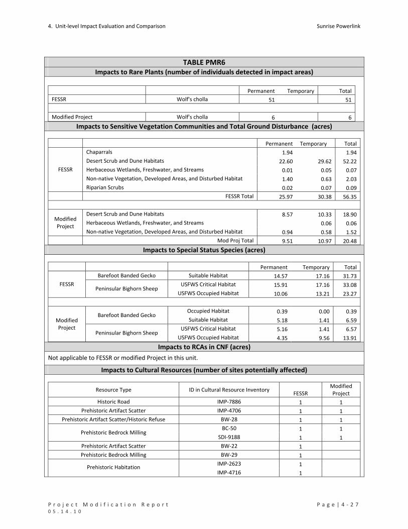
4. Unit‐level Impact Evaluation and Comparison Sunrise Powerlink
P r o j e c t M o d i f i c a t i o n R e p o r t P a g e | 4 ‐ 2 7 0 5 . 1 4 . 1 0
TABLE PMR6 Impacts to Rare Plants (number of individuals detected in impact areas)
Permanent Temporary Total
FESSR Wolf's cholla 51 51
Modified Project Wolf's cholla 6 6 Impacts to Sensitive Vegetation Communities and Total Ground Disturbance (acres)
Permanent Temporary Total
Chaparrals 1.94 1.94
Desert Scrub and Dune Habitats 22.60 29.62 52.22
Herbaceous Wetlands, Freshwater, and Streams 0.01 0.05 0.07
Non‐native Vegetation, Developed Areas, and Disturbed Habitat 1.40 0.63 2.03
FESSR
Riparian Scrubs 0.02 0.07 0.09
FESSR Total 25.97 30.38 56.35
Desert Scrub and Dune Habitats 8.57 10.33 18.90
Herbaceous Wetlands, Freshwater, and Streams 0.06 0.06 Modified Project
Non‐native Vegetation, Developed Areas, and Disturbed Habitat 0.94 0.58 1.52
Mod Proj Total 9.51 10.97 20.48 Impacts to Special Status Species (acres)
Permanent Temporary Total
Barefoot Banded Gecko Suitable Habitat 14.57 17.16 31.73
USFWS Critical Habitat 15.91 17.16 33.08 FESSR Peninsular Bighorn Sheep
USFWS Occupied Habitat 10.06 13.21 23.27
Occupied Habitat 0.39 0.00 0.39 Barefoot Banded Gecko
Suitable Habitat 5.18 1.41 6.59
USFWS Critical Habitat 5.16 1.41 6.57
Modified Project
Peninsular Bighorn Sheep USFWS Occupied Habitat 4.35 9.56 13.91
Impacts to RCAs in CNF (acres)
Not applicable to FESSR or modified Project in this unit.
Impacts to Cultural Resources (number of sites potentially affected)
Resource Type ID in Cultural Resource Inventory FESSR
Modified Project
Historic Road IMP‐7886 1 1
Prehistoric Artifact Scatter IMP‐4706 1 1
Prehistoric Artifact Scatter/Historic Refuse BW‐28 1 1
BC‐50 1 1 Prehistoric Bedrock Milling
SDI‐9188 1 1
Prehistoric Artifact Scatter BW‐22 1
Prehistoric Bedrock Milling BW‐29 1
IMP‐2623 1 Prehistoric Habitation IMP‐4716 1

Sunrise Powerlink 4. Unit‐level Impact Evaluation and Comparison
4 ‐ 2 8 | P a g e P r o j e c t M o d i f i c a t i o n R e p o r t 0 5 . 1 4 . 1 0
TABLE PMR6 IMP‐4718 1
IMP‐4724 1
Prehistoric Rock Feature IMP‐4711 1
Prehistoric Trail IMP‐4717 1
Prehistoric Bedrock Milling BC‐51 1
Prehistoric Habitation SDI‐9189 1
Prehistoric Isolate (Ground Stone) IMP‐4745 1
IMP‐4733 1 Prehistoric Rock Feature
SDI‐6120 1
Total 18 5 Impacts to Waters of the US (acres) Permanent Temporary Total
FESSR 0.01 0.06 0.07
Modified Project 0.00 0.06 0.06 Impacts to State Waters (acres)
Permanent Temporary Total
FESSR 0.02 0.08 0.10
Modified Project 0.00 0.07 0.07
4. Unit‐level Impact Evaluation and Comparison Sunrise Powerlink
P r o j e c t M o d i f i c a t i o n R e p o r t P a g e | 4 ‐ 2 9 0 5 . 1 4 . 1 0
PMR7. EP255‐1 to EP252‐1 (Jade Mountain)
Mileposts Link Yard(s) PMR Figure Mapbook Sheet(s)
MP30.2 to MP30.9 1 None 7 MS35
Summary and Conclusion
The modification relocates structures lower on the slopes of Jade Mountain and eliminates an access road. There
would be a reduction in impacts to desert scrubs and a slight increase in impacts to dry washes, Peninsular bighorn
sheep habitat, waters of the US, and streambeds. Effects on cultural resources would be reduced, and those on
visual and other resources would be substantially the same as for the FESSR. The modification would not result in
any new significant impacts.
Details and Purpose
Modification
Reroute
Lowered structures on the slopes of Jade Mountain and eliminated the access
road to structures.
Added one structure to accommodate reroute.
Primary Reason Reduce visual impacts of structures on Jade Mountain.
Other Considerations Reduce impacts to sensitive vegetation and dry washes.
Reduce ground disturbance.
MMCRP Measures GEO‐APM‐5, B‐1a, and C‐1b.
Environmental Impact Discussion
Air Quality No substantial changes in the effects of the FESSR.
Biological Resources See Table PMR7 below.
Rare Plants No rare plants would be affected.
Vegetation Impacts The modification would reduce impacts to desert scrub but result in a slight increase in impacts to non‐vegetated channels. The increase would not be a new significant impact.
Species Impacts The modification would reduce permanent impacts and increase temporary impacts to Peninsular bighorn sheep habitat. The increase would not be a new significant impact.
RCAs Not applicable to the FESSR or modified Project in this unit.
Cultural Resources
There are 4 cultural sites and one isolated find in this location; all of which are previously recorded sites. The FESSR would affect all five; the modification would affect two sites. Environmentally Sensitive Areas would be established to protect as many sites as possible from direct impacts. Sites that cannot be avoided by impacts will be evaluated for eligibility. Sites that are determined to be eligible for the National Register will require additional mitigation prior to any ground disturbance. The modification would reduce impacts to cultural resources but the impacts would remain significant. See Table PMR7 below.
Geology/Minerals No substantial changes in the effects of the FESSR.

Sunrise Powerlink 4. Unit‐level Impact Evaluation and Comparison
4 ‐ 3 0 | P a g e P r o j e c t M o d i f i c a t i o n R e p o r t 0 5 . 1 4 . 1 0
PMR7. EP255‐1 to EP252‐1 (Jade Mountain)
Land Use The modification reduces impacts to private lands by eliminating the access road. There are no sensitive receptors within one‐quarter mile of the FESSR or modified Project in this unit.
Noise No substantial changes in the effects of the FESSR.
Public Safety/Hazards No substantial changes in the effects of the FESSR.
Traffic No substantial changes in the effects of the FESSR.
Visual
The Jade Mountain modification would slightly reduce the impact on views from
Interstate 8 because the down‐slope shift in alignment would eliminate the structure
skylining that would occur at the eastern‐most structure on Jade Mountain. However,
the modification would not measurably change the impact on views from Old Highway
80 because the reduction in structure skylining would be offset by the visibility of
additional structures. No new significant effects would result from the modification,
and the effects of the FESSR in this area would not be substantially changed.
Water Resources See Table PMR7 below.
Waters of US The modification would increase temporary impacts to waters of the US by approximately 0.10 acre. The increase would not be a new significant impact.
State Waters The modification would increase temporary impacts to State waters by approximately 0.10 acre. The increase would not be a new significant impact.
Water Use No substantial changes in the effects of the FESSR.
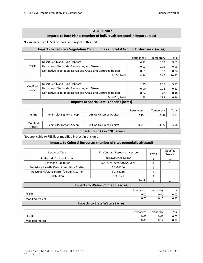
4. Unit‐level Impact Evaluation and Comparison Sunrise Powerlink
P r o j e c t M o d i f i c a t i o n R e p o r t P a g e | 4 ‐ 3 1 0 5 . 1 4 . 1 0
TABLE PMR7 Impacts to Rare Plants (number of individuals detected in impact areas)
No impacts from FESSR or modified Project in this unit.
Impacts to Sensitive Vegetation Communities and Total Ground Disturbance (acres)
Permanent Temporary Total
Desert Scrub and Dune Habitats 4.13 5.52 9.65
Herbaceous Wetlands, Freshwater, and Streams 0.02 0.01 0.03 FESSR
Non‐native Vegetation, Developed Areas, and Disturbed Habitat 0.61 0.13 0.74
FESSR Total 4.76 5.66 10.42
Desert Scrub and Dune Habitats 1.39 4.38 5.77
Herbaceous Wetlands, Freshwater, and Streams 0.00 0.12 0.12 Modified Project
Non‐native Vegetation, Developed Areas, and Disturbed Habitat 0.04 0.42 0.46
Mod Proj Total 1.43 4.93 6.36 Impacts to Special Status Species (acres)
Permanent Temporary Total
FESSR Peninsular Bighorn Sheep USFWS Occupied Habitat 2.15 2.68 4.83
Modified Project
Peninsular Bighorn Sheep USFWS Occupied Habitat 0.71 4.25 4.96
Impacts to RCAs in CNF (acres)
Not applicable to FESSR or modified Project in this unit.
Impacts to Cultural Resources (number of sites potentially affected)
Resource Type ID in Cultural Resource Inventory FESSR
Modified Project
Prehistoric Artifact Scatter SDI‐7073/7083/8306 1 1
Prehistoric Habitation SDI‐7074/7075/7076/15879 1 1
Prehistoric Hearth, Ceramic and Lithic Scatter SDI‐6116A 1
Roasting Pit/Lithic Scatter/Ceramic Scatter SDI‐6116B 1
Isolate, Core SDI‐9170 1
Total 5 2 Impacts to Waters of the US (acres) Permanent Temporary Total
FESSR 0.01 0.01 0.02
Modified Project 0.00 0.12 0.12
Impacts to State Waters (acres)
Permanent Temporary Total
FESSR 0.02 0.01 0.03
Modified Project 0.00 0.12 0.12

Sunrise Powerlink 4. Unit‐level Impact Evaluation and Comparison
4 ‐ 3 2 | P a g e P r o j e c t M o d i f i c a t i o n R e p o r t 0 5 . 1 4 . 1 0
PMR8. EP252‐1 to EP239‐1 (Jacumba)
Mileposts Link Yard(s) PMR Figure Mapbook Sheet(s)
MP30.9 to MP34.2 1 Jacumba Airport
Jacumba Valley Ranch 8 MS35 to MS39
Summary and Conclusion
The modification would adjust engineering design and constructability, and add a 34.51‐acre construction yard to
replace a construction yard moved out of Quino habitat in PMR9. Permanent impacts to sensitive vegetation
would be reduced and temporary impacts would increase. Barefoot banded gecko would be affected along the
alignment. Impacts to cultural resources would be reduced, and impacts to visual resources would increase or
remain substantially the same as the FESSR. No new significant impacts would result from the modification.
Details and Purpose
Modification
Reroute
One wire pull site eliminated.
Temporary construction pads reduced at all structures.
Guard structures added at road crossings.
Jacumba Valley Ranch Construction Yard
New 34.51‐acre yard located south of Interstate 8, adjacent to EP242. Replaces yard in PMR9 eliminated to avoid Quino.
Primary Reason Improve engineering design and constructability and replace yard in PMR9
Other Considerations Reduce impacts to sensitive vegetation and dry washes
Reduce impacts to cultural resources
MMCRP Measures B‐1, C‐1a and 1b, Ag‐1a, CR‐APM‐2, and GEO‐APM‐5.
Environmental Impact Discussion
Air Quality
The increased use of helicopters would not exceed the fuel‐use cap or emissions
identified for the FESSR or as calculated and approved in the Sunrise Construction
Emissions Monitoring Plan (CEMP) January 2010. No substantial changes in the effects
of the FESSR.
Biological Resources See Table PMR8 below.
Rare Plants No impacts to rare plants would occur under the FESSR or modification.
Vegetation Impacts
The modification would reduce permanent impacts to sensitive vegetation types but would increase temporary impacts to chaparral and desert scrub. The increase is associated with the Jacumba Valley Ranch Yard, which replaces a 30‐acre yard in desert scrub in PMR9.
Species Impacts
The modification would result in impacts to one state listed species – barefoot banded gecko. The FESSR would not affect gecko at this location, but impacts of the FESSR on this gecko were considered in the Final EIR/EIS. SDG&E has submitted a 2081 Incidental Take Permit Application to CDFG and is seeking authorization for take. The modification reduces impacts to Quino occupied habitat by providing a feasible location for a large construction yard along this portion of the route.
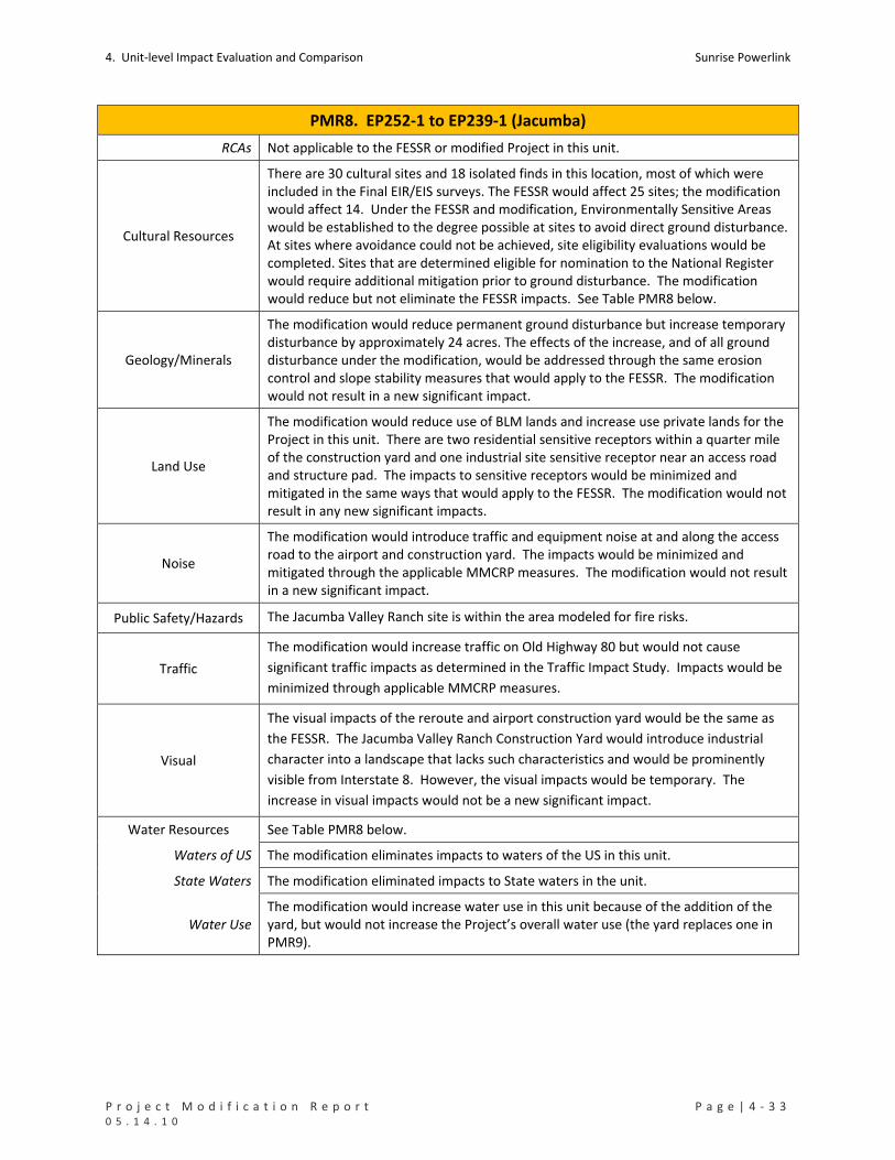
4. Unit‐level Impact Evaluation and Comparison Sunrise Powerlink
P r o j e c t M o d i f i c a t i o n R e p o r t P a g e | 4 ‐ 3 3 0 5 . 1 4 . 1 0
PMR8. EP252‐1 to EP239‐1 (Jacumba)
RCAs Not applicable to the FESSR or modified Project in this unit.
Cultural Resources
There are 30 cultural sites and 18 isolated finds in this location, most of which were included in the Final EIR/EIS surveys. The FESSR would affect 25 sites; the modification would affect 14. Under the FESSR and modification, Environmentally Sensitive Areas would be established to the degree possible at sites to avoid direct ground disturbance. At sites where avoidance could not be achieved, site eligibility evaluations would be completed. Sites that are determined eligible for nomination to the National Register would require additional mitigation prior to ground disturbance. The modification would reduce but not eliminate the FESSR impacts. See Table PMR8 below.
Geology/Minerals
The modification would reduce permanent ground disturbance but increase temporary disturbance by approximately 24 acres. The effects of the increase, and of all ground disturbance under the modification, would be addressed through the same erosion control and slope stability measures that would apply to the FESSR. The modification would not result in a new significant impact.
Land Use
The modification would reduce use of BLM lands and increase use private lands for the Project in this unit. There are two residential sensitive receptors within a quarter mile of the construction yard and one industrial site sensitive receptor near an access road and structure pad. The impacts to sensitive receptors would be minimized and mitigated in the same ways that would apply to the FESSR. The modification would not result in any new significant impacts.
Noise
The modification would introduce traffic and equipment noise at and along the access road to the airport and construction yard. The impacts would be minimized and mitigated through the applicable MMCRP measures. The modification would not result in a new significant impact.
Public Safety/Hazards The Jacumba Valley Ranch site is within the area modeled for fire risks.
Traffic
The modification would increase traffic on Old Highway 80 but would not cause
significant traffic impacts as determined in the Traffic Impact Study. Impacts would be
minimized through applicable MMCRP measures.
Visual
The visual impacts of the reroute and airport construction yard would be the same as
the FESSR. The Jacumba Valley Ranch Construction Yard would introduce industrial
character into a landscape that lacks such characteristics and would be prominently
visible from Interstate 8. However, the visual impacts would be temporary. The
increase in visual impacts would not be a new significant impact.
Water Resources See Table PMR8 below.
Waters of US The modification eliminates impacts to waters of the US in this unit.
State Waters The modification eliminated impacts to State waters in the unit.
Water Use The modification would increase water use in this unit because of the addition of the yard, but would not increase the Project’s overall water use (the yard replaces one in PMR9).
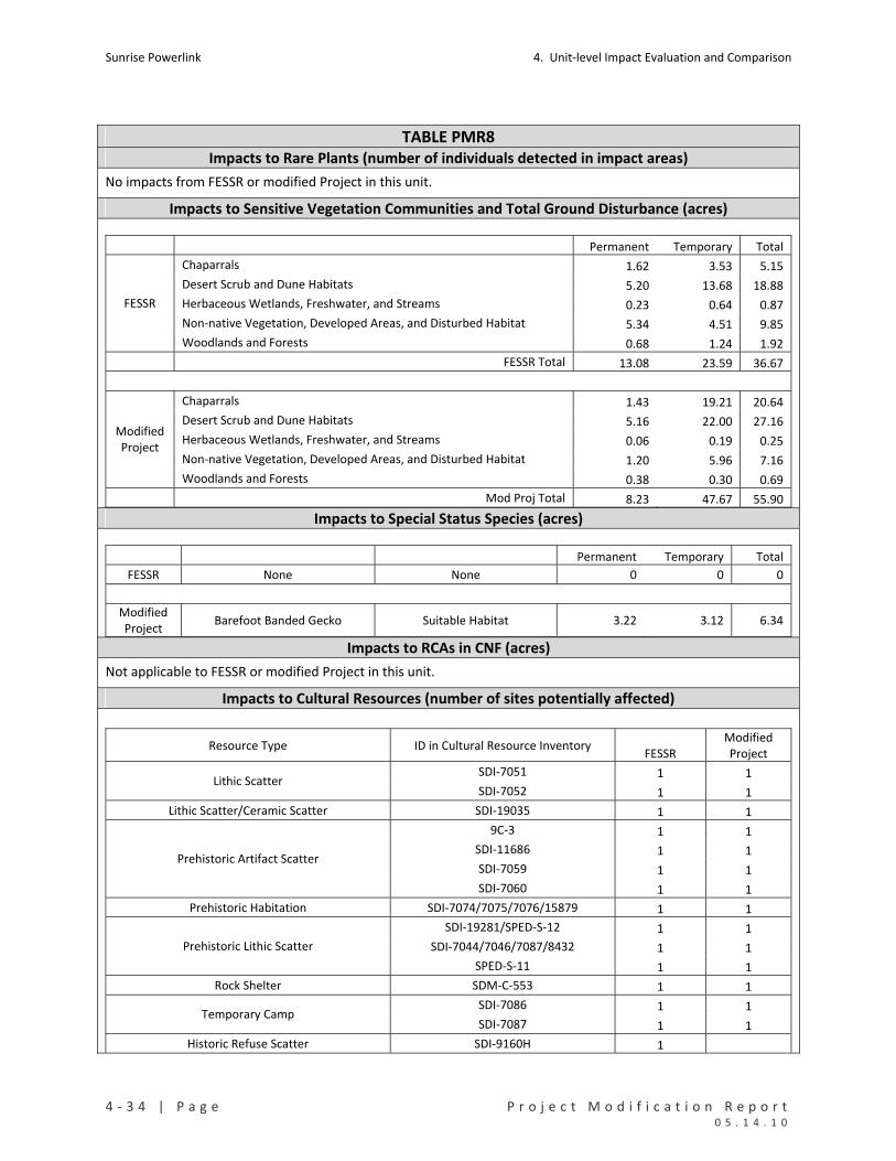
Sunrise Powerlink 4. Unit‐level Impact Evaluation and Comparison
4 ‐ 3 4 | P a g e P r o j e c t M o d i f i c a t i o n R e p o r t 0 5 . 1 4 . 1 0
TABLE PMR8 Impacts to Rare Plants (number of individuals detected in impact areas)
No impacts from FESSR or modified Project in this unit.
Impacts to Sensitive Vegetation Communities and Total Ground Disturbance (acres)
Permanent Temporary Total
Chaparrals 1.62 3.53 5.15
Desert Scrub and Dune Habitats 5.20 13.68 18.88
Herbaceous Wetlands, Freshwater, and Streams 0.23 0.64 0.87
Non‐native Vegetation, Developed Areas, and Disturbed Habitat 5.34 4.51 9.85
FESSR
Woodlands and Forests 0.68 1.24 1.92
FESSR Total 13.08 23.59 36.67
Chaparrals 1.43 19.21 20.64
Desert Scrub and Dune Habitats 5.16 22.00 27.16
Herbaceous Wetlands, Freshwater, and Streams 0.06 0.19 0.25
Non‐native Vegetation, Developed Areas, and Disturbed Habitat 1.20 5.96 7.16
Modified Project
Woodlands and Forests 0.38 0.30 0.69
Mod Proj Total 8.23 47.67 55.90 Impacts to Special Status Species (acres)
Permanent Temporary Total
FESSR None None 0 0 0
Modified Project
Barefoot Banded Gecko Suitable Habitat 3.22 3.12 6.34
Impacts to RCAs in CNF (acres)
Not applicable to FESSR or modified Project in this unit.
Impacts to Cultural Resources (number of sites potentially affected)
Resource Type ID in Cultural Resource Inventory FESSR
Modified Project
SDI‐7051 1 1 Lithic Scatter
SDI‐7052 1 1
Lithic Scatter/Ceramic Scatter SDI‐19035 1 1
9C‐3 1 1
SDI‐11686 1 1
SDI‐7059 1 1 Prehistoric Artifact Scatter
SDI‐7060 1 1
Prehistoric Habitation SDI‐7074/7075/7076/15879 1 1
SDI‐19281/SPED‐S‐12 1 1
SDI‐7044/7046/7087/8432 1 1 Prehistoric Lithic Scatter
SPED‐S‐11 1 1
Rock Shelter SDM‐C‐553 1 1
SDI‐7086 1 1 Temporary Camp
SDI‐7087 1 1
Historic Refuse Scatter SDI‐9160H 1
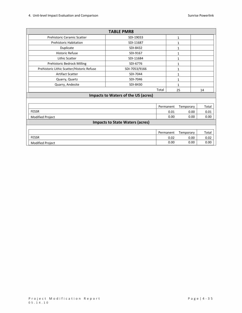
4. Unit‐level Impact Evaluation and Comparison Sunrise Powerlink
P r o j e c t M o d i f i c a t i o n R e p o r t P a g e | 4 ‐ 3 5 0 5 . 1 4 . 1 0
TABLE PMR8 Prehistoric Ceramic Scatter SDI‐19033 1
Prehistoric Habitation SDI‐11687 1
Duplicate SDI‐8432 1
Historic Refuse SDI‐9167 1
Lithic Scatter SDI‐11684 1
Prehistoric Bedrock Milling SDI‐6776 1
Prehistoric Lithic Scatter/Historic Refuse SDI‐7053/9166 1
Artifact Scatter SDI‐7044 1
Quarry, Quartz SDI‐7046 1
Quarry, Andesite SDI‐8430 1
Total 25 14 Impacts to Waters of the US (acres)
Permanent Temporary Total
FESSR 0.01 0.00 0.01
Modified Project 0.00 0.00 0.00 Impacts to State Waters (acres)
Permanent Temporary Total
FESSR 0.02 0.00 0.02
Modified Project 0.00 0.00 0.00
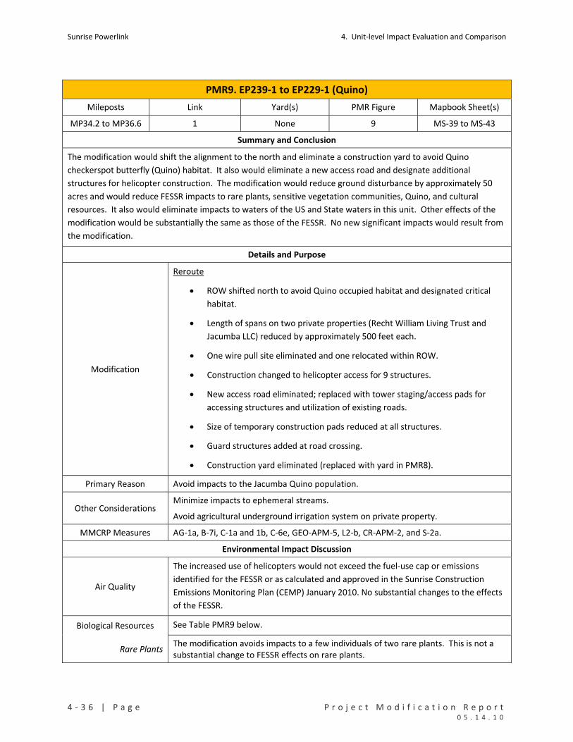
Sunrise Powerlink 4. Unit‐level Impact Evaluation and Comparison
4 ‐ 3 6 | P a g e P r o j e c t M o d i f i c a t i o n R e p o r t 0 5 . 1 4 . 1 0
PMR9. EP239‐1 to EP229‐1 (Quino)
Mileposts Link Yard(s) PMR Figure Mapbook Sheet(s)
MP34.2 to MP36.6 1 None 9 MS‐39 to MS‐43
Summary and Conclusion
The modification would shift the alignment to the north and eliminate a construction yard to avoid Quino
checkerspot butterfly (Quino) habitat. It also would eliminate a new access road and designate additional
structures for helicopter construction. The modification would reduce ground disturbance by approximately 50
acres and would reduce FESSR impacts to rare plants, sensitive vegetation communities, Quino, and cultural
resources. It also would eliminate impacts to waters of the US and State waters in this unit. Other effects of the
modification would be substantially the same as those of the FESSR. No new significant impacts would result from
the modification.
Details and Purpose
Modification
Reroute
ROW shifted north to avoid Quino occupied habitat and designated critical
habitat.
Length of spans on two private properties (Recht William Living Trust and
Jacumba LLC) reduced by approximately 500 feet each.
One wire pull site eliminated and one relocated within ROW.
Construction changed to helicopter access for 9 structures.
New access road eliminated; replaced with tower staging/access pads for
accessing structures and utilization of existing roads.
Size of temporary construction pads reduced at all structures.
Guard structures added at road crossing.
Construction yard eliminated (replaced with yard in PMR8).
Primary Reason Avoid impacts to the Jacumba Quino population.
Other Considerations Minimize impacts to ephemeral streams.
Avoid agricultural underground irrigation system on private property.
MMCRP Measures AG‐1a, B‐7i, C‐1a and 1b, C‐6e, GEO‐APM‐5, L2‐b, CR‐APM‐2, and S‐2a.
Environmental Impact Discussion
Air Quality
The increased use of helicopters would not exceed the fuel‐use cap or emissions
identified for the FESSR or as calculated and approved in the Sunrise Construction
Emissions Monitoring Plan (CEMP) January 2010. No substantial changes to the effects
of the FESSR.
Biological Resources See Table PMR9 below.
Rare Plants The modification avoids impacts to a few individuals of two rare plants. This is not a substantial change to FESSR effects on rare plants.

4. Unit‐level Impact Evaluation and Comparison Sunrise Powerlink
P r o j e c t M o d i f i c a t i o n R e p o r t P a g e | 4 ‐ 3 7 0 5 . 1 4 . 1 0
PMR9. EP239‐1 to EP229‐1 (Quino)
Vegetation Impacts The modification would reduce impacts chaparrals, desert scrubs, and non‐vegetated channels.
Species Impacts The modification would reduce impacts to Quino occupied and designated critical habitat.
RCAs Not applicable to the FESSR or modified Project in this unit.
Cultural Resources There are 18 cultural resource sites in this unit. The FESSR would affect 11; the modified Project would affect 2. The modification results in direct avoidance of 8 archaeological sites. See Table PMR9 below.
Geology/Minerals The modification would reduce ground disturbance and the associated slope stability and erosion effects in this PMR unit.
Land Use
The modification would reduce impacts to private lands, including conserved lands
owned by the Nature Conservancy, primarily through elimination of the construction
yard and access road and incorporation of helicopter construction. Although reduced,
impacts to conserved lands would still occur. The modification also reduces impacts to
Jacumba Valley Ranch crop land and avoids impacts to an underground irrigation
system.
Noise No substantial changes to the effects of the FESSR.
Public Safety/Hazards
The ROW has been moved further away from homes in Jacumba and the SWPL,
reducing risk to homes and reducing containment conflict. Fire risk would remain the
same. No substantial change in effects to the FESSR.
Traffic No substantial changes to the effects of the FESSR, with some reduction in truck traffic
because of the increase in helicopter construction and relocation of construction yard.
Visual
The modification would reduce the impact on views from the community of Jacumba
and Old Highway 80 because the shift in alignment to the north would reduce (though
not eliminate) structure skylining at four structure locations visible from Jacumba and
the road. However, there would not be substantial change in overall visual impacts.
Water Resources See Table PMR9 below.
Waters of US The modification would eliminate 0.01 acre of impacts to waters of the US.
State Waters The modification would eliminate 0.02 acre of impacts to State Waters.
Water Use No substantial change in effects, with some potential for a reduction in water use because of the reduced ground disturbance.
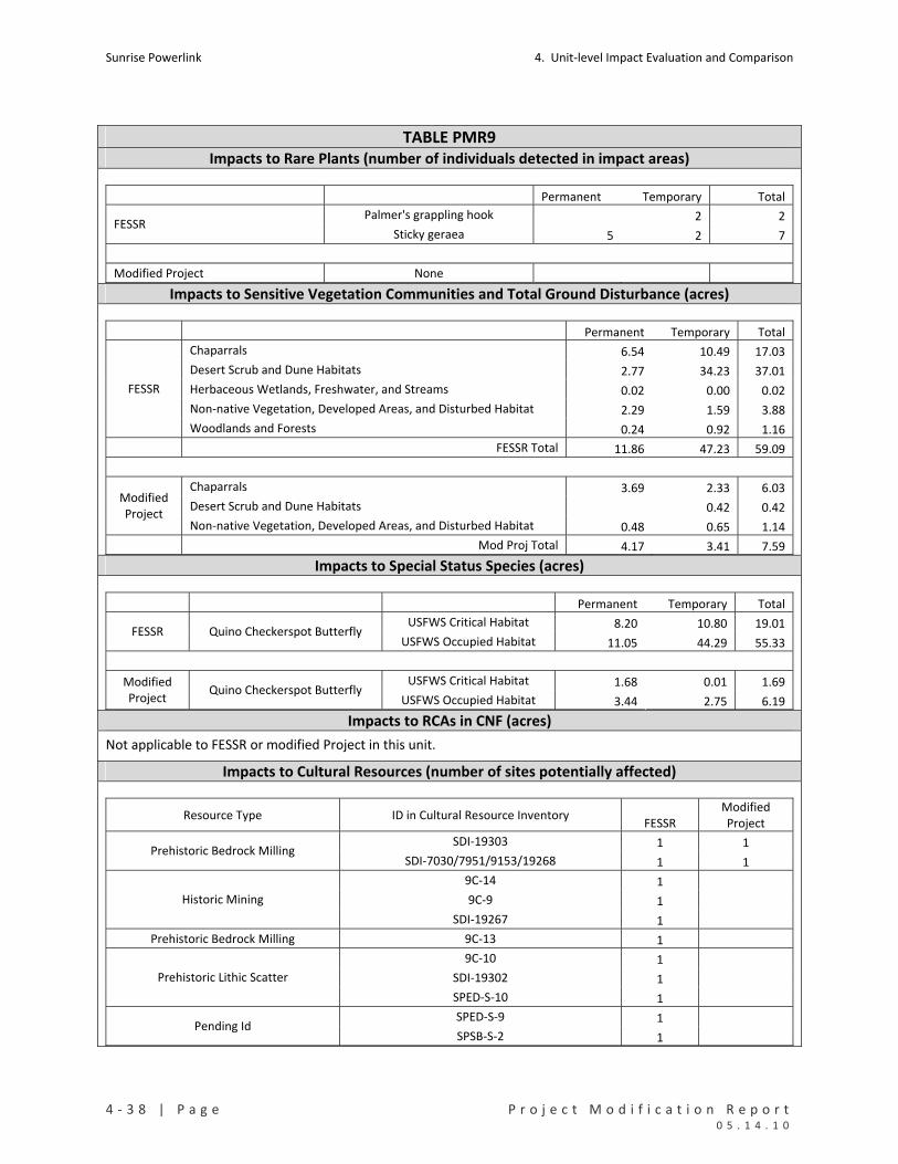
Sunrise Powerlink 4. Unit‐level Impact Evaluation and Comparison
4 ‐ 3 8 | P a g e P r o j e c t M o d i f i c a t i o n R e p o r t 0 5 . 1 4 . 1 0
TABLE PMR9 Impacts to Rare Plants (number of individuals detected in impact areas)
Permanent Temporary Total
Palmer's grappling hook 2 2 FESSR
Sticky geraea 5 2 7
Modified Project None Impacts to Sensitive Vegetation Communities and Total Ground Disturbance (acres)
Permanent Temporary Total
Chaparrals 6.54 10.49 17.03
Desert Scrub and Dune Habitats 2.77 34.23 37.01
Herbaceous Wetlands, Freshwater, and Streams 0.02 0.00 0.02
Non‐native Vegetation, Developed Areas, and Disturbed Habitat 2.29 1.59 3.88
FESSR
Woodlands and Forests 0.24 0.92 1.16
FESSR Total 11.86 47.23 59.09
Chaparrals 3.69 2.33 6.03
Desert Scrub and Dune Habitats 0.42 0.42 Modified Project
Non‐native Vegetation, Developed Areas, and Disturbed Habitat 0.48 0.65 1.14
Mod Proj Total 4.17 3.41 7.59 Impacts to Special Status Species (acres)
Permanent Temporary Total
USFWS Critical Habitat 8.20 10.80 19.01 FESSR Quino Checkerspot Butterfly
USFWS Occupied Habitat 11.05 44.29 55.33
USFWS Critical Habitat 1.68 0.01 1.69 Modified Project
Quino Checkerspot Butterfly USFWS Occupied Habitat 3.44 2.75 6.19
Impacts to RCAs in CNF (acres)
Not applicable to FESSR or modified Project in this unit.
Impacts to Cultural Resources (number of sites potentially affected)
Resource Type ID in Cultural Resource Inventory FESSR
Modified Project
SDI‐19303 1 1 Prehistoric Bedrock Milling
SDI‐7030/7951/9153/19268 1 1
9C‐14 1
9C‐9 1 Historic Mining
SDI‐19267 1
Prehistoric Bedrock Milling 9C‐13 1
9C‐10 1
SDI‐19302 1 Prehistoric Lithic Scatter
SPED‐S‐10 1
SPED‐S‐9 1 Pending Id
SPSB‐S‐2 1
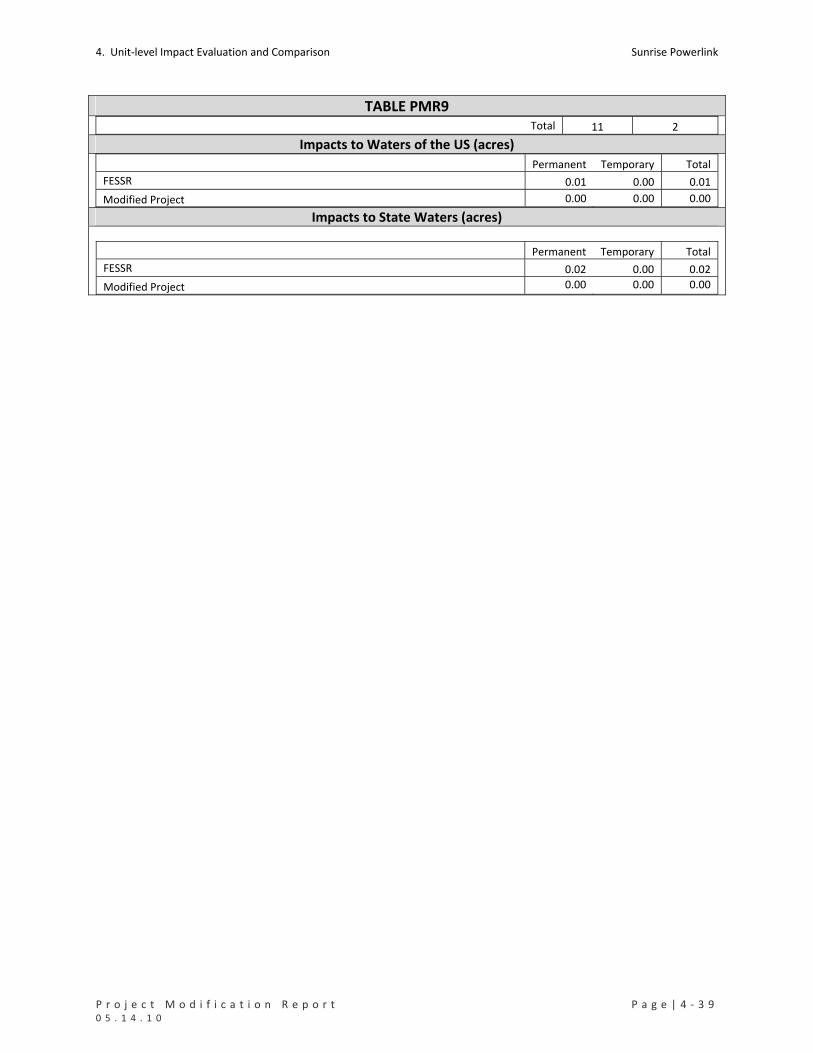
4. Unit‐level Impact Evaluation and Comparison Sunrise Powerlink
P r o j e c t M o d i f i c a t i o n R e p o r t P a g e | 4 ‐ 3 9 0 5 . 1 4 . 1 0
TABLE PMR9 Total 11 2
Impacts to Waters of the US (acres) Permanent Temporary Total
FESSR 0.01 0.00 0.01
Modified Project 0.00 0.00 0.00 Impacts to State Waters (acres)
Permanent Temporary Total
FESSR 0.02 0.00 0.02
Modified Project 0.00 0.00 0.00
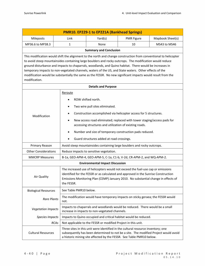
Sunrise Powerlink 4. Unit‐level Impact Evaluation and Comparison
4 ‐ 4 0 | P a g e P r o j e c t M o d i f i c a t i o n R e p o r t 0 5 . 1 4 . 1 0
PMR10. EP229‐1 to EP221A (Bankhead Springs)
Mileposts Link Yard(s) PMR Figure Mapbook Sheet(s)
MP36.6 to MP38.3 1 None 10 MS43 to MS46
Summary and Conclusion
This modification would shift the alignment to the north and change construction from conventional to helicopter
to avoid steep mountainsides containing large boulders and rocky outcrops. The modification would reduce
ground disturbance and impacts to chaparrals, woodlands, and Quino habitat. There would be increases in
temporary impacts to non‐vegetated channels, waters of the US, and State waters. Other effects of the
modification would be substantially the same as the FESSR. No new significant impacts would result from the
modification.
Details and Purpose
Modification
Reroute
ROW shifted north.
Two wire pull sites eliminated.
Construction accomplished via helicopter access for 5 structures.
New access road eliminated; replaced with tower staging/access pads for
accessing structures and utilization of existing roads.
Number and size of temporary construction pads reduced.
Guard structures added at road crossings.
Primary Reason Avoid steep mountainsides containing large boulders and rocky outcrops.
Other Considerations Reduce impacts to sensitive vegetation.
MMCRP Measures B‐1a, GEO‐APM‐4, GEO‐APM‐5, C‐1a, C1‐b, V‐2d, CR‐APM‐2, and WQ‐APM‐2.
Environmental Impact Discussion
Air Quality
The increased use of helicopters would not exceed the fuel‐use cap or emissions
identified for the FESSR or as calculated and approved in the Sunrise Construction
Emissions Monitoring Plan (CEMP) January 2010. No substantial change in effects of
the FESSR.
Biological Resources See Table PMR10 below.
Rare Plants The modification would have temporary impacts on sticky geraea; the FESSR would not.
Vegetation Impacts Impacts to chaparrals and woodlands would be reduced. There would be a small increase in impacts to non‐vegetated channels.
Species Impacts Impacts to Quino occupied and critical habitat would be reduced.
RCAs Not applicable to the FESSR or modified Project in this unit.
Cultural Resources Three sites in this unit were identified in the cultural resource inventory; one subsequently has been determined to not be a site. The modified Project would avoid a historic mining site affected by the FESSR. See Table PMR10 below.
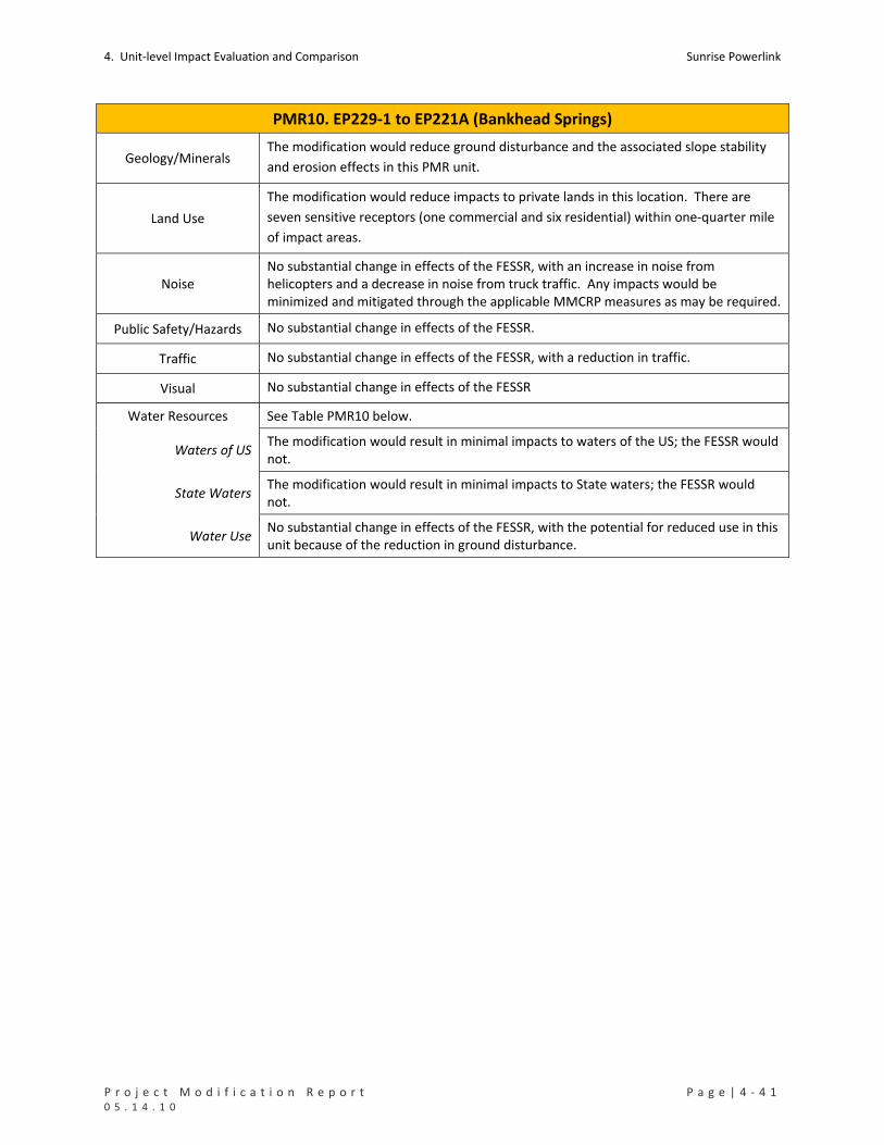
4. Unit‐level Impact Evaluation and Comparison Sunrise Powerlink
P r o j e c t M o d i f i c a t i o n R e p o r t P a g e | 4 ‐ 4 1 0 5 . 1 4 . 1 0
PMR10. EP229‐1 to EP221A (Bankhead Springs)
Geology/Minerals The modification would reduce ground disturbance and the associated slope stability
and erosion effects in this PMR unit.
Land Use
The modification would reduce impacts to private lands in this location. There are
seven sensitive receptors (one commercial and six residential) within one‐quarter mile
of impact areas.
Noise No substantial change in effects of the FESSR, with an increase in noise from helicopters and a decrease in noise from truck traffic. Any impacts would be minimized and mitigated through the applicable MMCRP measures as may be required.
Public Safety/Hazards No substantial change in effects of the FESSR.
Traffic No substantial change in effects of the FESSR, with a reduction in traffic.
Visual No substantial change in effects of the FESSR
Water Resources See Table PMR10 below.
Waters of US The modification would result in minimal impacts to waters of the US; the FESSR would not.
State Waters The modification would result in minimal impacts to State waters; the FESSR would not.
Water Use No substantial change in effects of the FESSR, with the potential for reduced use in this unit because of the reduction in ground disturbance.
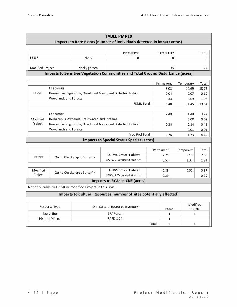
Sunrise Powerlink 4. Unit‐level Impact Evaluation and Comparison
4 ‐ 4 2 | P a g e P r o j e c t M o d i f i c a t i o n R e p o r t 0 5 . 1 4 . 1 0
TABLE PMR10 Impacts to Rare Plants (number of individuals detected in impact areas)
Permanent Temporary Total
FESSR None 0 0 0
Modified Project Sticky geraea 25 25 Impacts to Sensitive Vegetation Communities and Total Ground Disturbance (acres)
Permanent Temporary Total
Chaparrals 8.03 10.69 18.72
Non‐native Vegetation, Developed Areas, and Disturbed Habitat 0.04 0.07 0.10 FESSR
Woodlands and Forests 0.33 0.69 1.02
FESSR Total 8.40 11.45 19.84
Chaparrals 2.48 1.49 3.97
Herbaceous Wetlands, Freshwater, and Streams 0.08 0.08
Non‐native Vegetation, Developed Areas, and Disturbed Habitat 0.28 0.14 0.43
Modified Project
Woodlands and Forests 0.01 0.01
Mod Proj Total 2.76 1.73 4.49 Impacts to Special Status Species (acres)
Permanent Temporary Total
USFWS Critical Habitat 2.75 5.13 7.88 FESSR Quino Checkerspot Butterfly
USFWS Occupied Habitat 0.57 1.37 1.94
USFWS Critical Habitat 0.85 0.02 0.87 Modified Project
Quino Checkerspot Butterfly USFWS Occupied Habitat 0.39 0.39
Impacts to RCAs in CNF (acres)
Not applicable to FESSR or modified Project in this unit.
Impacts to Cultural Resources (number of sites potentially affected)
Resource Type ID in Cultural Resource Inventory FESSR
Modified Project
Not a Site SPAP‐S‐14 1 1
Historic Mining SPED‐S‐21 1
Total 2 1

4. Unit‐level Impact Evaluation and Comparison Sunrise Powerlink
P r o j e c t M o d i f i c a t i o n R e p o r t P a g e | 4 ‐ 4 3 0 5 . 1 4 . 1 0
TABLE PMR10 Impacts to Waters of the US (acres) Permanent Temporary Total
FESSR 0.00 0.00 0.00
Modified Project 0.00 0.02 0.02 Impacts to State Waters (acres) Permanent Temporary Total
FESSR 0.00 0.00 0.00
Modified Project 0.00 0.08 0.08
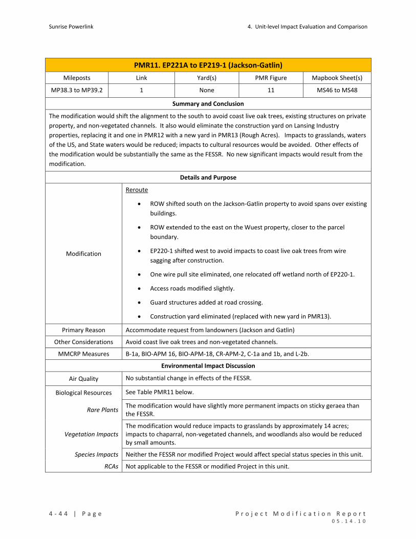
Sunrise Powerlink 4. Unit‐level Impact Evaluation and Comparison
4 ‐ 4 4 | P a g e P r o j e c t M o d i f i c a t i o n R e p o r t 0 5 . 1 4 . 1 0
PMR11. EP221A to EP219‐1 (Jackson‐Gatlin)
Mileposts Link Yard(s) PMR Figure Mapbook Sheet(s)
MP38.3 to MP39.2 1 None 11 MS46 to MS48
Summary and Conclusion
The modification would shift the alignment to the south to avoid coast live oak trees, existing structures on private
property, and non‐vegetated channels. It also would eliminate the construction yard on Lansing Industry
properties, replacing it and one in PMR12 with a new yard in PMR13 (Rough Acres). Impacts to grasslands, waters
of the US, and State waters would be reduced; impacts to cultural resources would be avoided. Other effects of
the modification would be substantially the same as the FESSR. No new significant impacts would result from the
modification.
Details and Purpose
Modification
Reroute
ROW shifted south on the Jackson‐Gatlin property to avoid spans over existing
buildings.
ROW extended to the east on the Wuest property, closer to the parcel
boundary.
EP220‐1 shifted west to avoid impacts to coast live oak trees from wire
sagging after construction.
One wire pull site eliminated, one relocated off wetland north of EP220‐1.
Access roads modified slightly.
Guard structures added at road crossing.
Construction yard eliminated (replaced with new yard in PMR13).
Primary Reason Accommodate request from landowners (Jackson and Gatlin)
Other Considerations Avoid coast live oak trees and non‐vegetated channels.
MMCRP Measures B‐1a, BIO‐APM 16, BIO‐APM‐18, CR‐APM‐2, C‐1a and 1b, and L‐2b.
Environmental Impact Discussion
Air Quality No substantial change in effects of the FESSR.
Biological Resources See Table PMR11 below.
Rare Plants The modification would have slightly more permanent impacts on sticky geraea than the FESSR.
Vegetation Impacts The modification would reduce impacts to grasslands by approximately 14 acres; impacts to chaparral, non‐vegetated channels, and woodlands also would be reduced by small amounts.
Species Impacts Neither the FESSR nor modified Project would affect special status species in this unit.
RCAs Not applicable to the FESSR or modified Project in this unit.
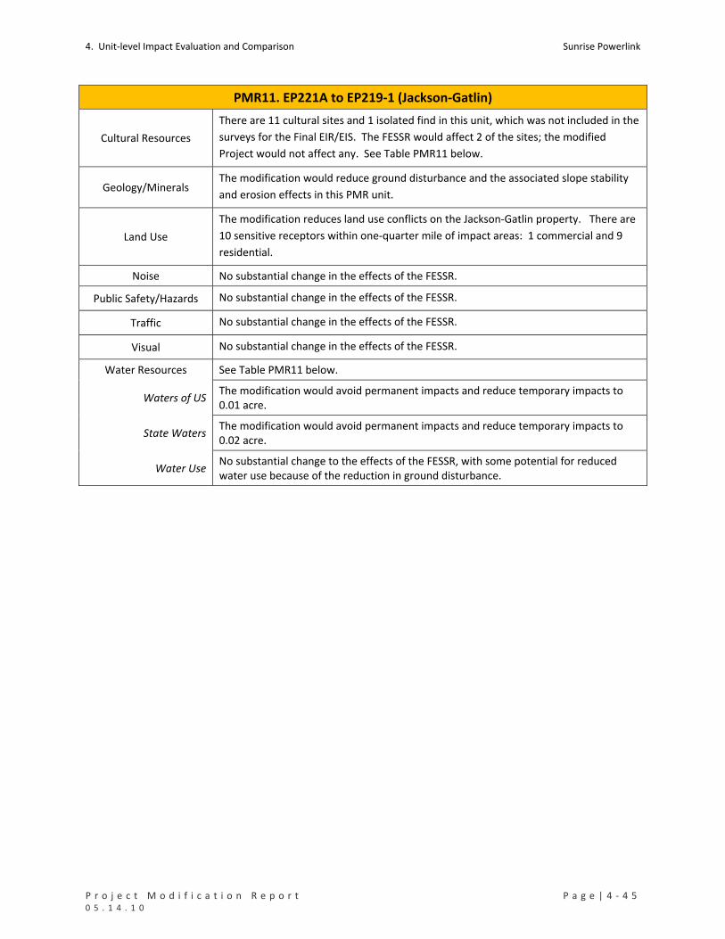
4. Unit‐level Impact Evaluation and Comparison Sunrise Powerlink
P r o j e c t M o d i f i c a t i o n R e p o r t P a g e | 4 ‐ 4 5 0 5 . 1 4 . 1 0
PMR11. EP221A to EP219‐1 (Jackson‐Gatlin)
Cultural Resources
There are 11 cultural sites and 1 isolated find in this unit, which was not included in the
surveys for the Final EIR/EIS. The FESSR would affect 2 of the sites; the modified
Project would not affect any. See Table PMR11 below.
Geology/Minerals The modification would reduce ground disturbance and the associated slope stability
and erosion effects in this PMR unit.
Land Use
The modification reduces land use conflicts on the Jackson‐Gatlin property. There are
10 sensitive receptors within one‐quarter mile of impact areas: 1 commercial and 9
residential.
Noise No substantial change in the effects of the FESSR.
Public Safety/Hazards No substantial change in the effects of the FESSR.
Traffic No substantial change in the effects of the FESSR.
Visual No substantial change in the effects of the FESSR.
Water Resources See Table PMR11 below.
Waters of US The modification would avoid permanent impacts and reduce temporary impacts to 0.01 acre.
State Waters The modification would avoid permanent impacts and reduce temporary impacts to 0.02 acre.
Water Use No substantial change to the effects of the FESSR, with some potential for reduced water use because of the reduction in ground disturbance.

Sunrise Powerlink 4. Unit‐level Impact Evaluation and Comparison
4 ‐ 4 6 | P a g e P r o j e c t M o d i f i c a t i o n R e p o r t 0 5 . 1 4 . 1 0
TABLE PMR11 Impacts to Rare Plants (number of individuals detected in impact areas)
Permanent Temporary Total
Desert beauty 5 5 FESSR
Sticky geraea 16 16
Desert beauty 2 2 Modified Project
Sticky geraea 30 30 Impacts to Sensitive Vegetation Communities and Total Ground Disturbance (acres)
Permanent Temporary Total
Chaparrals 2.00 4.09 6.09
Coastal and Montane Scrub Habitats 0.27 0.91 1.18
Grasslands and Meadows 0.08 14.14 14.23
Herbaceous Wetlands, Freshwater, and Streams 0.01 0.12 0.13
Non‐native Vegetation, Developed Areas, and Disturbed Habitat 0.14 25.63 25.76
FESSR
Woodlands and Forests 0.77 0.77
FESSR Total 2.51 45.66 48.17
Chaparrals 1.79 2.95 4.74
Coastal and Montane Scrub Habitats 0.14 0.14
Grasslands and Meadows 0.09 0.09
Herbaceous Wetlands, Freshwater, and Streams 0.00 0.02 0.02
Modified Project
Non‐native Vegetation, Developed Areas, and Disturbed Habitat 0.44 0.05 0.49
Mod Proj Total 2.24 3.25 5.49 Impacts to Special Status Species (acres)
No impacts from FESSR or modified Project.
Impacts to RCAs in CNF (acres)
Not applicable to FESSR or modified Project in this unit.
Impacts to Cultural Resources (number of sites potentially affected)
Resource Type ID in Cultural Resource Inventory FESSR
Modified Project
Prehistoric Bedrock Milling SDI‐6904 1
Prehistoric Artifact Scatter 9C‐20 1
Total 2 0 Impacts to Waters of the US (acres) Permanent Temporary Total
FESSR 0.08 24.27 24.36
Modified Project 0.00 0.01 0.01 Impacts to State Waters (acres) Permanent Temporary Total
FESSR 0.09 24.27 24.36
Modified Project 0.00 0.02 0.02
PMR12. EP219‐1 to EP206‐1 (State Corrections)
Mileposts Link Yard(s) PMR Figure Mapbook Sheet(s)

4. Unit‐level Impact Evaluation and Comparison Sunrise Powerlink
P r o j e c t M o d i f i c a t i o n R e p o r t P a g e | 4 ‐ 4 7 0 5 . 1 4 . 1 0
PMR12. EP219‐1 to EP206‐1 (State Corrections)
MP39.2 to MP41.6 1 None 12 MS48 to MS50
Summary and Conclusion
The modification would shift the alignment to the north where it parallels I‐8 and to the east to improve
engineering design. It also would eliminate a construction yard west of EP215, replacing it and the construction
yard from PMR11 with a new construction yard in PMR13 (Rough Acres). The modification would reduce ground
disturbance and impacts to chaparrals, coastal and montane scrubs, non‐vegetated channels, waters of the US,
and State waters. Other effects would be substantially the same as the FESSR. No new significant effects would
result from the modification.
Details and Purpose
Modification
Reroute
One structure eliminated.
New access road eliminated, replaced with smaller spur access roads and use
of existing roads.
Size of the temporary construction pads reduced.
Guard structures added at road crossings.
Eliminate yard west of EP215
Primary Reason Improve engineering design
Other Considerations Reduce ground disturbance and impacts to US and State waters.
MMCRP Measures B‐1a, GEO‐APM‐5, T‐1a, C‐1a, C‐1b, CR‐APM‐2, and WQ‐APM‐2.
Environmental Impact Discussion
Air Quality No substantial change in effects of the FESSR.
Biological Resources See Table PMR12 below.
Rare Plants The modification would affect more Jacumba milk‐vetch and sticky geraea than the
FESSR.
Vegetation Impacts
The modification would reduce impacts to chaparrals, coastal and montane scrubs, and
non‐vegetated channels. There would be a half‐acre increase in temporary impacts to
non‐vegetated channels.
Species Impacts Neither the FESSR nor the modification would affect special status wildlife.
RCAs Not applicable to the FESSR or modified Project in this unit.
Cultural Resources There are 4 cultural sites and 5 isolated finds in this PMR unit. The FESSR would affect
3; the modification would affect 2. See Table PMR12 below.
Geology/Minerals The modification would reduce ground disturbance and the associated slope stability
and erosion effects in this PMR unit.
Land Use The modification would reduce impacts to private lands in this unit; there also would be a small reduction in impacts to State lands. There are no sensitive receptors within one‐quarter mile of impact areas.

Sunrise Powerlink 4. Unit‐level Impact Evaluation and Comparison
4 ‐ 4 8 | P a g e P r o j e c t M o d i f i c a t i o n R e p o r t 0 5 . 1 4 . 1 0
PMR12. EP219‐1 to EP206‐1 (State Corrections)
Noise No substantial change to the effects of the FESSR.
Public Safety/Hazards No substantial change to the effects of the FESSR.
Traffic No substantial change to the effects of the FESSR.
Visual No substantial change to the effects of the FESSR.
Water Resources See Table PMR12 below.
Waters of US The modification would reduce impacts to waters of the US.
State Waters The modification would reduce impacts to State waters.
Water Use No substantial change to the effects of the FESSR, with some potential for reduced
water use because of the reduction in ground disturbance.

4. Unit‐level Impact Evaluation and Comparison Sunrise Powerlink
P r o j e c t M o d i f i c a t i o n R e p o r t P a g e | 4 ‐ 4 9 0 5 . 1 4 . 1 0
TABLE PMR12 Impacts to Rare Plants (number of individuals detected in impact areas)
Permanent Temporary Total
Campo pea 1 1
Jacumba milk‐vetch 25 3 28 FESSR
Sticky geraea 33 46 79
Jacumba milk‐vetch 14 16 30 Modified Project
Sticky geraea 11 77 88 Impacts to Sensitive Vegetation Communities and Total Ground Disturbance (acres)
Permanent Temporary Total
Chaparrals 4.24 15.92 20.17
Coastal and Montane Scrub Habitats 3.60 16.74 20.34
Grasslands and Meadows 0.40 0.40
Herbaceous Wetlands, Freshwater, and Streams 0.03 0.22 0.25
Non‐native Vegetation, Developed Areas, and Disturbed Habitat 0.67 1.42 2.09
FESSR
Woodlands and Forests 0.87 0.87
FESSR Total 8.94 35.18 44.12
Chaparrals 1.77 6.79 8.55
Coastal and Montane Scrub Habitats 2.50 5.04 7.54
Grasslands and Meadows 0.34 0.65 0.99
Herbaceous Wetlands, Freshwater, and Streams 0.00 0.00 0.01
Modified Project
Non‐native Vegetation, Developed Areas, and Disturbed Habitat 1.16 0.49 1.65
Mod Proj Total 5.76 12.97 18.74 Impacts to Special Status Species (acres)
No impacts from FESSR or modified Project in this unit.
Impacts to RCAs in CNF (acres)
Not applicable to FESSR or modified Project in this unit.
Impacts to Cultural Resources (number of sites potentially affected)
Resource Type ID in Cultural Resource Inventory FESSR
Modified Project
Prehistoric Bedrock Milling SDI‐4788 1 1
Prehistoric Lithic Scatter BC‐8 1 1
Historic Mine/Structure BC‐7 1
Total 3 2

Sunrise Powerlink 4. Unit‐level Impact Evaluation and Comparison
4 ‐ 5 0 | P a g e P r o j e c t M o d i f i c a t i o n R e p o r t 0 5 . 1 4 . 1 0
TABLE PMR12 Impacts to Waters of the US (acres) Permanent Temporary Total
FESSR 0.01 0.13 0.15
Modified Project 0.01 0.01 0.02 Impacts to State Waters (acres)
Permanent Temporary Total
FESSR 0.03 0.22 0.25
Modified Project 0.00 0.01 0.02
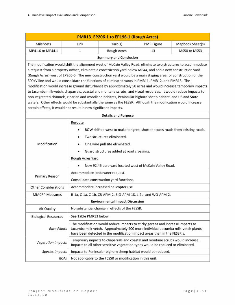
4. Unit‐level Impact Evaluation and Comparison Sunrise Powerlink
P r o j e c t M o d i f i c a t i o n R e p o r t P a g e | 4 ‐ 5 1 0 5 . 1 4 . 1 0
PMR13. EP206‐1 to EP196‐1 (Rough Acres)
Mileposts Link Yard(s) PMR Figure Mapbook Sheet(s)
MP41.6 to MP44.1 1 Rough Acres 13 MS50 to MS53
Summary and Conclusion
The modification would shift the alignment west of McCain Valley Road, eliminate two structures to accommodate
a request from a property owner, eliminate a construction yard below MP44, and add a new construction yard
(Rough Acres) west of EP205‐6. The new construction yard would be a main staging area for construction of the
500kV line and would consolidate the functions of eliminated yards in PMR11, PMR12, and PMR13. The
modification would increase ground disturbance by approximately 50 acres and would increase temporary impacts
to Jacumba milk‐vetch, chaparrals, coastal and montane scrubs, and visual resources. It would reduce impacts to
non‐vegetated channels, riparian and woodland habitats, Peninsular bighorn sheep habitat, and US and State
waters. Other effects would be substantially the same as the FESSR. Although the modification would increase
certain effects, it would not result in new significant impacts.
Details and Purpose
Modification
Reroute
ROW shifted west to make tangent, shorter access roads from existing roads.
Two structures eliminated.
One wire pull site eliminated.
Guard structures added at road crossings.
Rough Acres Yard
New 92.46‐acre yard located west of McCain Valley Road.
Primary Reason Accommodate landowner request.
Consolidate construction yard functions.
Other Considerations Accommodate increased helicopter use
MMCRP Measures B‐1a, C‐1a, C‐1b, CR‐APM‐2, BIO‐APM‐18, L‐2b, and WQ‐APM‐2.
Environmental Impact Discussion
Air Quality No substantial change in effects of the FESSR.
Biological Resources See Table PMR13 below.
Rare Plants The modification would reduce impacts to sticky geraea and increase impacts to Jacumba milk‐vetch. Approximately 400 more individual Jacumba milk‐vetch plants have been detected in the modification impact areas than in the FESSR’s.
Vegetation Impacts Temporary impacts to chaparrals and coastal and montane scrubs would increase. Impacts to all other sensitive vegetation types would be reduced or eliminated.
Species Impacts Impacts to Peninsular bighorn sheep habitat would be reduced.
RCAs Not applicable to the FESSR or modification in this unit.

Sunrise Powerlink 4. Unit‐level Impact Evaluation and Comparison
4 ‐ 5 2 | P a g e P r o j e c t M o d i f i c a t i o n R e p o r t 0 5 . 1 4 . 1 0
PMR13. EP206‐1 to EP196‐1 (Rough Acres)
Cultural Resources There are 11 cultural resource sites and 15 isolated finds in this unit. The FESSR would affect 6, and the modification would affect 5. The impacts of the modification would be substantially the same as the FESSR. See Table PMR13 below.
Geology/Minerals
The modification would increase ground disturbance in this unit. Slope stability and erosion control issues would be addressed through the same measures that apply to the FESSR. Although ground disturbance would increase, the type and severity of impacts would not be greater than that associated with construction yards in other PMR units. There also would be a concomitant reduction in ground disturbance in PMR11 and PMR12 where yards were eliminated.
Land Use
The modification would reduce impacts to federal (BLM) lands and eliminates impacts to Tribal lands in this unit. The amount of private land used for the Project substantially increases with the addition of the Rough Acres Yard. There is one sensitive receptor (residential) within one‐quarter mile of the impacts areas. Although the modified construction yard is proposed in a new location, the land owner was notified about the project during the EIR/EIS process regarding other project impacts including the eliminated construction yards. The land owner has confirmed that the landing strip is not in operation at this time and will not be adversely impacted by the project use.
Noise
The modification would result in increased noise in the vicinity of the Rough Acres Yards. The type and severity of the effects would not be greater than that associated with the yards proposed for the FESSR in other PMR units. Any impacts would be minimized and mitigated through the applicable MMCRP measures as may be required.
Public Safety/Hazards
Although there are safety and hazard risks associated with the Rough Acres Yard, the
yard is located in a remote area and would not pose significant risks to adjacent
residences or businesses. Safety and hazard issues would be addressed in the same
way that applies to other yards under the FESSR or modified Project.
Traffic
Because the Rough Acres Construction Yard would be a main staging area for the
500kV line and would be larger than the eliminated yard, it would generate more
traffic than the FESSR construction yard(s). Effects of the increase would be minimized
and mitigated through traffic management measures as coordinated with the
appropriate jurisdictions.
Visual
Although the proposed modification would result in an increase in ground disturbance
(which would increase long‐term visible land scarring), the consolidation of
construction yards from three to one would reduce the overall prominence of
construction yards along this route segment. The reroute would cause a greater
degree of view blockage of McCain Valley and ridges to the southwest and west when
viewed from southbound McCain Valley Road, but the modification and the FESSR
route would generally exhibit similar structure visibility and prominence. The effects of
the modification would be substantially the same as the FESSR.

4. Unit‐level Impact Evaluation and Comparison Sunrise Powerlink
P r o j e c t M o d i f i c a t i o n R e p o r t P a g e | 4 ‐ 5 3 0 5 . 1 4 . 1 0
PMR13. EP206‐1 to EP196‐1 (Rough Acres)
Water Resources See Table PMR13 below.
Waters of US Impacts to waters of the US would be reduced.
State Waters Impacts to State waters would be reduced.
Water Use Water use in the unit potentially would increase because of the increase in ground disturbance. However, there would be a concomitant reduction in uses in the units where construction yards were eliminated.

Sunrise Powerlink 4. Unit‐level Impact Evaluation and Comparison
4 ‐ 5 4 | P a g e P r o j e c t M o d i f i c a t i o n R e p o r t 0 5 . 1 4 . 1 0
TABLE PMR13 Impacts to Rare Plants (number of individuals detected in impact areas)
Permanent Temporary Total
Desert beauty 2 2
Jacumba milk‐vetch 33 509 542 FESSR
Sticky geraea 26 211 237
Desert beauty 1 1
Jacumba milk‐vetch 13 928 941 Modified Project
Sticky geraea 15 15 Impacts to Sensitive Vegetation Communities and Total Ground Disturbance (acres)
Permanent Temporary Total
Chaparrals 4.21 22.40 26.62
Coastal and Montane Scrub Habitats 0.05 17.83 17.88
Grasslands and Meadows 1.38 1.38
Herbaceous Wetlands, Freshwater, and Streams 0.49 0.49
Non‐native Vegetation, Developed Areas, and Disturbed Habitat 0.10 0.79 0.88
Riparian Forests and Woodlands 2.52 2.52
FESSR
Woodlands and Forests 2.34 2.34
FESSR Total 4.36 47.75 52.11
Chaparrals 4.30 49.54 53.83
Coastal and Montane Scrub Habitats 0.47 28.42 28.89
Herbaceous Wetlands, Freshwater, and Streams 0.05 0.05
Non‐native Vegetation, Developed Areas, and Disturbed Habitat 0.06 22.59 22.65
Modified Project
Woodlands and Forests 1.18 1.18
Mod Proj Total 4.82 101.78 106.60 Impacts to Special Status Species (acres)
Permanent Temporary Total
FESSR Peninsular Bighorn Sheep USFWS Occupied Habitat 0.32 6.58 6.90
Modified Project
Peninsular Bighorn Sheep USFWS Occupied Habitat 0.17 0.10 0.27
Impacts to RCAs in CNF (acres)
Not applicable to FESSR or modified Project in this unit.
Impacts to Cultural Resources (number of sites potentially affected)
Resource Type ID in Cultural Resource Inventory FESSR
Modified Project
SDI‐19301 1 1
SDI‐4788 1 1 Prehistoric Bedrock Milling
SPED‐S‐5 1 1
Prehistoric Habitation SDI‐19001 1 1
Prehistoric Lithic Scatter BC‐2/SPED‐S‐5 1 1
Prehistoric Lithic Scatter BC‐1 1

4. Unit‐level Impact Evaluation and Comparison Sunrise Powerlink
P r o j e c t M o d i f i c a t i o n R e p o r t P a g e | 4 ‐ 5 5 0 5 . 1 4 . 1 0
TABLE PMR13 Total 6 5
Impacts to Waters of the US (acres) Permanent Temporary Total
FESSR 0.00 0.13 0.15
Modified Project 0.00 0.04 0.04 Impacts to State Waters (acres)
Permanent Temporary Total
FESSR 0.00 0.49 0.49
Modified Project 0.00 0.09 0.09

Sunrise Powerlink 4. Unit‐level Impact Evaluation and Comparison
4 ‐ 5 6 | P a g e P r o j e c t M o d i f i c a t i o n R e p o r t 0 5 . 1 4 . 1 0
PMR14. EP196‐1 to EP170 (McCain Valley)
Mileposts Link Yard(s) PMR Figure Mapbook Sheet(s)
MP44.1 to MP50.4 1 McCain Valley 14 MS53 to MS60
Summary and Conclusion
The modification would shift the alignment to the east slightly and add temporary work areas to facilitate
construction. It also would slightly expand the McCain Valley construction yard identified in the FESSR. The
modification would reduce permanent impacts and increase temporary impacts to chaparrals. Impacts to US and
State waters also would increase. Other effects would be substantially the same as the FESSR. No new significant
impacts would result from the modification.
Details and Purpose
Modification
Reroute
Temporary work areas (200 feet by 200 feet) added to facilitate construction.
Structures shifted lower on the slopes and/or away from rock outcrops.
Two wire pull sites relocated within the ROW.
Construction accomplished via helicopter access for 3 structures.
New access road eliminated and/or modified, some replaced with tower
staging/access pads, smaller spur access roads and use of existing roads.
Guard structures added at road crossings.
McCain Valley Construction Yard
Construction yard resized to 32.93 acres.
Primary Reason Improve engineering design.
Other Considerations Reduce visual impacts.
MMCRP Measures GEO‐APM‐4, GEO‐APM‐5, V‐2a, V‐2d, V‐3a, V‐6a, C‐1a, C‐1b, and CR‐APM‐2.
Environmental Impact Discussion
Air Quality
The increased use of helicopters would not exceed the fuel‐use cap or emissions
identified for the FESSR or as calculated and approved in the Sunrise Construction
Emissions Monitoring Plan (CEMP) January 2010. No substantial change to effects of
the FESSR.
Biological Resources See Table PMR14 below.
Rare Plants The FESSR and modification would affect the same rare plants; differences in impacts are relatively small.
Vegetation Impacts The modification would result in increased temporary impacts and reduced permanent impacts to chaparrals. Impacts to other sensitive vegetation types would be similar to the FESSR.
Species Impacts The modification would affect 0.14 acre of Peninsular bighorn sheep habitat; the FESSR would not.
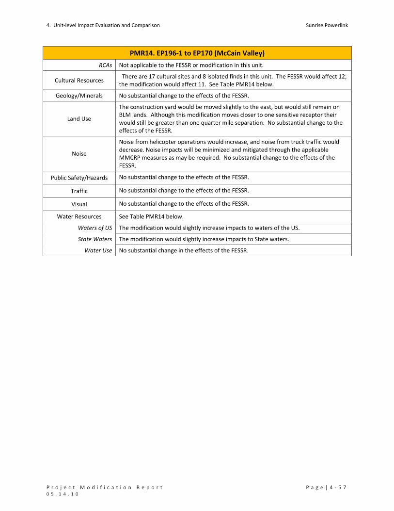
4. Unit‐level Impact Evaluation and Comparison Sunrise Powerlink
P r o j e c t M o d i f i c a t i o n R e p o r t P a g e | 4 ‐ 5 7 0 5 . 1 4 . 1 0
PMR14. EP196‐1 to EP170 (McCain Valley)
RCAs Not applicable to the FESSR or modification in this unit.
Cultural Resources There are 17 cultural sites and 8 isolated finds in this unit. The FESSR would affect 12; the modification would affect 11. See Table PMR14 below.
Geology/Minerals No substantial change to the effects of the FESSR.
Land Use
The construction yard would be moved slightly to the east, but would still remain on BLM lands. Although this modification moves closer to one sensitive receptor their would still be greater than one quarter mile separation. No substantial change to the effects of the FESSR.
Noise
Noise from helicopter operations would increase, and noise from truck traffic would decrease. Noise impacts will be minimized and mitigated through the applicable MMCRP measures as may be required. No substantial change to the effects of the FESSR.
Public Safety/Hazards No substantial change to the effects of the FESSR.
Traffic No substantial change to the effects of the FESSR.
Visual No substantial change to the effects of the FESSR.
Water Resources See Table PMR14 below.
Waters of US The modification would slightly increase impacts to waters of the US.
State Waters The modification would slightly increase impacts to State waters.
Water Use No substantial change in the effects of the FESSR.

Sunrise Powerlink 4. Unit‐level Impact Evaluation and Comparison
4 ‐ 5 8 | P a g e P r o j e c t M o d i f i c a t i o n R e p o r t 0 5 . 1 4 . 1 0
TABLE PMR14 Impacts to Rare Plants (number of individuals detected in impact areas)
Permanent Temporary Total
Desert beauty 2 1 3
Jacumba milk‐vetch 15 8 23 FESSR
Sticky geraea 64 3 67
Desert beauty 1 1 2
Jacumba milk‐vetch 2 14 16 Modified Project
Sticky geraea 40 12 52 Impacts to Sensitive Vegetation Communities and Total Ground Disturbance (acres)
Permanent Temporary Total
Chaparrals 21.61 37.48 59.09
Coastal and Montane Scrub Habitats 1.16 1.71 2.86
Herbaceous Wetlands, Freshwater, and Streams 0.03 0.05 0.09 FESSR
Non‐native Vegetation, Developed Areas, and Disturbed Habitat 0.02 0.03 0.06
FESSR Total 22.82 39.28 62.10
Chaparrals 16.62 49.03 65.65
Coastal and Montane Scrub Habitats 0.91 0.64 1.55
Herbaceous Wetlands, Freshwater, and Streams 0.12 0.03 0.15
Modified Project
Non‐native Vegetation, Developed Areas, and Disturbed Habitat 1.22 0.02 1.24
Mod Proj Total 18.87 49.72 68.59 Impacts to Special Status Species (acres)
Permanent Temporary Total
FESSR None
Modified Project
Peninsular Bighorn Sheep USFWS Habitat 0.03 0.11 0.14
Impacts to RCAs in CNF (acres)
Not applicable to FESSR or modified Project in this unit.
Impacts to Cultural Resources (number of sites potentially affected)
Resource Type ID in Cultural Resource Inventory FESSR
Modified Project
Historic Refuse SPED‐S‐18 1 1
BC‐12 1 1 Prehistoric Artifact Scatter
SDI‐19293 1 1
Prehistoric Ceramic Scatter/Historic Refuse SPED‐S‐2 1 1
Prehistoric Ceramic Scatter/Historic Refuse SPED‐S‐3 1 1
SDI‐19001 1 1 Prehistoric Habitation
SDI‐19018 1 1
BC‐5 1 1 Prehistoric Lithic Scatter
SPBB‐S‐1 1 1

4. Unit‐level Impact Evaluation and Comparison Sunrise Powerlink
P r o j e c t M o d i f i c a t i o n R e p o r t P a g e | 4 ‐ 5 9 0 5 . 1 4 . 1 0
TABLE PMR14 Prehistoric Lithic Scatter/Historic Refuse BC‐6 1 1
Unknown SDI‐19298 1 1
Prehistoric Bedrock Milling SDI‐19292 1
Total 12 11 Impacts to Waters of the US (acres) Permanent Temporary Total
FESSR 0.02 0.04 0.05
Modified Project 0.12 0.02 0.14 Impacts to State Waters (acres)
Permanent Temporary Total
FESSR 0.03 0.05 0.09
Modified Project 0.24 0.03 0.27
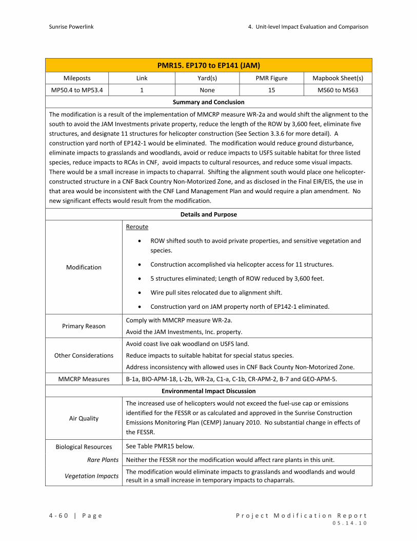
Sunrise Powerlink 4. Unit‐level Impact Evaluation and Comparison
4 ‐ 6 0 | P a g e P r o j e c t M o d i f i c a t i o n R e p o r t 0 5 . 1 4 . 1 0
PMR15. EP170 to EP141 (JAM)
Mileposts Link Yard(s) PMR Figure Mapbook Sheet(s)
MP50.4 to MP53.4 1 None 15 MS60 to MS63
Summary and Conclusion
The modification is a result of the implementation of MMCRP measure WR‐2a and would shift the alignment to the
south to avoid the JAM Investments private property, reduce the length of the ROW by 3,600 feet, eliminate five
structures, and designate 11 structures for helicopter construction (See Section 3.3.6 for more detail). A
construction yard north of EP142‐1 would be eliminated. The modification would reduce ground disturbance,
eliminate impacts to grasslands and woodlands, avoid or reduce impacts to USFS suitable habitat for three listed
species, reduce impacts to RCAs in CNF, avoid impacts to cultural resources, and reduce some visual impacts.
There would be a small increase in impacts to chaparral. Shifting the alignment south would place one helicopter‐
constructed structure in a CNF Back Country Non‐Motorized Zone, and as disclosed in the Final EIR/EIS, the use in
that area would be inconsistent with the CNF Land Management Plan and would require a plan amendment. No
new significant effects would result from the modification.
Details and Purpose
Modification
Reroute
ROW shifted south to avoid private properties, and sensitive vegetation and
species.
Construction accomplished via helicopter access for 11 structures.
5 structures eliminated; Length of ROW reduced by 3,600 feet.
Wire pull sites relocated due to alignment shift.
Construction yard on JAM property north of EP142‐1 eliminated.
Primary Reason Comply with MMCRP measure WR‐2a.
Avoid the JAM Investments, Inc. property.
Other Considerations
Avoid coast live oak woodland on USFS land.
Reduce impacts to suitable habitat for special status species.
Address inconsistency with allowed uses in CNF Back County Non‐Motorized Zone.
MMCRP Measures B‐1a, BIO‐APM‐18, L‐2b, WR‐2a, C1‐a, C‐1b, CR‐APM‐2, B‐7 and GEO‐APM‐5.
Environmental Impact Discussion
Air Quality
The increased use of helicopters would not exceed the fuel‐use cap or emissions
identified for the FESSR or as calculated and approved in the Sunrise Construction
Emissions Monitoring Plan (CEMP) January 2010. No substantial change in effects of
the FESSR.
Biological Resources See Table PMR15 below.
Rare Plants Neither the FESSR nor the modification would affect rare plants in this unit.
Vegetation Impacts The modification would eliminate impacts to grasslands and woodlands and would result in a small increase in temporary impacts to chaparrals.

4. Unit‐level Impact Evaluation and Comparison Sunrise Powerlink
P r o j e c t M o d i f i c a t i o n R e p o r t P a g e | 4 ‐ 6 1 0 5 . 1 4 . 1 0
PMR15. EP170 to EP141 (JAM)
Species Impacts The modification would avoid USFS modeled habitat for Laguna Mountains skipper and San Bernardino bluegrass and reduce impacts to USFS modeled habitat for arroyo toad.
RCAs The modification would eliminate temporary impacts and reduce permanent impacts to RCAs in CNF.
Cultural Resources There are 12 cultural sites and 1 isolated find in this unit. The FESSR would affect 3, and the modification would not affect any. See Table PMR15 below.
Geology/Minerals The modification would reduce ground disturbance and the associated slope stability and erosion effects in this PMR unit.
Land Use
The modification would eliminate impacts to private lands and increase impacts to
BLM lands. The modification would place a helicopter‐constructed structure in a CNF
Back County Non‐Motorized Zone. As indicated in the Final EIR/EIS, that use would be
inconsistent with the CNF Land Management Plan, and an amendment to the Land
Management Plan would be required to allow the use. See section 3.3.6 for additional
details.
Noise No substantial change to the effects of the FESSR. Any impacts would be minimized and mitigated through the applicable MMCRP measures as may be required.
Public Safety/Hazards The ROW has been moved further away from the JAM ranch and reducing risk to
homes.
Traffic No substantial change in the effects of the FESSR.
Visual
The proposed modification would reduce the visual impact along this route segment.
By diverging from McCain Valley Road sooner, views from the road would be
somewhat less impacted at the northern extent of this segment. Also, by turning the
line sooner, the route would be kept further to the south from Cottonwood
Campground. However, structures would still be prominently visible from the
campground as the route ascends and crosses Tecate Divide. There would not be a
substantial change in the overall visual effects of the FESSR in this unit. Specific actions
have been and will continue to be taken to minimize the visible disturbance of the
Sunrise Powerlink on the naturally established scenery of the Forest. The end result of
these actions including the appropriate coloration of structures will be presented in the
Scenery Conservation Plan which will present the final direction to best achieve the
spirit and intent of the Scenic Integrity Objectives of the Cleveland National Forest
Land Management Plan.
Water Resources See Table PMR15 below.
Waters of US Neither the FESSR nor the modification would affect waters of the US.
State Waters Neither the FESSR nor the modification would affect State waters.
Water Use No substantial change in effects of the FESSR, with some potential for reduced water use because of the reduction in ground disturbance.
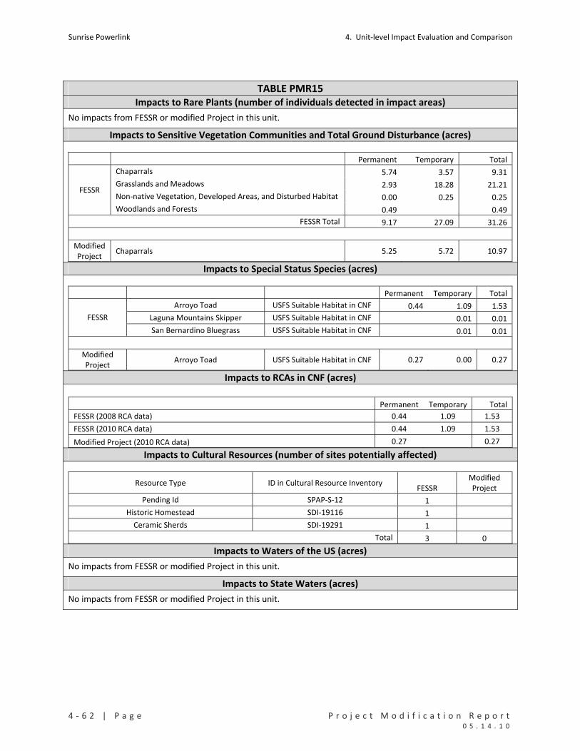
Sunrise Powerlink 4. Unit‐level Impact Evaluation and Comparison
4 ‐ 6 2 | P a g e P r o j e c t M o d i f i c a t i o n R e p o r t 0 5 . 1 4 . 1 0
TABLE PMR15 Impacts to Rare Plants (number of individuals detected in impact areas)
No impacts from FESSR or modified Project in this unit.
Impacts to Sensitive Vegetation Communities and Total Ground Disturbance (acres)
Permanent Temporary Total
Chaparrals 5.74 3.57 9.31
Grasslands and Meadows 2.93 18.28 21.21
Non‐native Vegetation, Developed Areas, and Disturbed Habitat 0.00 0.25 0.25 FESSR
Woodlands and Forests 0.49 0.49
FESSR Total 9.17 27.09 31.26
Modified Project
Chaparrals 5.25 5.72 10.97
Impacts to Special Status Species (acres)
Permanent Temporary Total
Arroyo Toad USFS Suitable Habitat in CNF 0.44 1.09 1.53
Laguna Mountains Skipper USFS Suitable Habitat in CNF 0.01 0.01 FESSR
San Bernardino Bluegrass USFS Suitable Habitat in CNF 0.01 0.01
Modified Project
Arroyo Toad USFS Suitable Habitat in CNF 0.27 0.00 0.27
Impacts to RCAs in CNF (acres)
Permanent Temporary Total
FESSR (2008 RCA data) 0.44 1.09 1.53
FESSR (2010 RCA data) 0.44 1.09 1.53
Modified Project (2010 RCA data) 0.27 0.27 Impacts to Cultural Resources (number of sites potentially affected)
Resource Type ID in Cultural Resource Inventory FESSR
Modified Project
Pending Id SPAP‐S‐12 1
Historic Homestead SDI‐19116 1
Ceramic Sherds SDI‐19291 1
Total 3 0 Impacts to Waters of the US (acres)
No impacts from FESSR or modified Project in this unit.
Impacts to State Waters (acres)
No impacts from FESSR or modified Project in this unit.
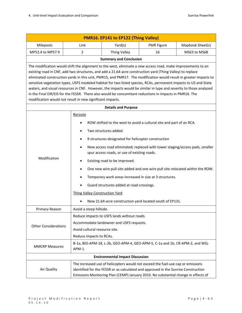
4. Unit‐level Impact Evaluation and Comparison Sunrise Powerlink
P r o j e c t M o d i f i c a t i o n R e p o r t P a g e | 4 ‐ 6 3 0 5 . 1 4 . 1 0
PMR16. EP141 to EP122 (Thing Valley)
Mileposts Link Yard(s) PMR Figure Mapbook Sheet(s)
MP53.4 to MP57.9 2 Thing Valley 16 MS63 to MS68
Summary and Conclusion
The modification would shift the alignment to the west, eliminate a new access road, make improvements to an
existing road in CNF, add two structures, and add a 21.64‐acre construction yard (Thing Valley) to replace
eliminated construction yards in this unit, PMR15, and PMR17. The modification would result in greater impacts to
sensitive vegetation types, USFS modeled habitat for two listed species, RCAs, permanent impacts to US and State
waters, and visual resources in CNF. However, the impacts would be similar in type and severity to those analyzed
in the Final EIR/EIS for the FESSR. There also would be concomitant reductions in impacts in PMR16. The
modification would not result in new significant impacts.
Details and Purpose
Modification
Reroute
ROW shifted to the west to avoid a cultural site and part of an RCA.
Two structures added.
9 structures designated for helicopter construction
New access road eliminated; replaced with tower staging/access pads, smaller
spur access roads, or use of existing roads.
Existing road to be improved.
One new wire pull site added and one wire pull site relocated within the ROW.
Temporary work areas increased in size at 3 structures.
Guard structures added at road crossings.
Thing Valley Construction Yard
New 21.64‐acre construction yard located south of EP131.
Primary Reason Avoid a steep hillside.
Other Considerations
Reduce impacts to USFS lands without roads.
Accommodate landowner and USFS requests.
Avoid cultural resource site.
Reduce impacts to RCAs.
MMCRP Measures B‐1a, BIO‐APM‐18, L‐2b, GEO‐APM‐4, GEO‐APM‐5, C‐1a and 1b, CR‐APM‐2, and WQ‐
APM‐1.
Environmental Impact Discussion
Air Quality
The increased use of helicopters would not exceed the fuel‐use cap or emissions
identified for the FESSR or as calculated and approved in the Sunrise Construction
Emissions Monitoring Plan (CEMP) January 2010. No substantial change in effects of

Sunrise Powerlink 4. Unit‐level Impact Evaluation and Comparison
4 ‐ 6 4 | P a g e P r o j e c t M o d i f i c a t i o n R e p o r t 0 5 . 1 4 . 1 0
PMR16. EP141 to EP122 (Thing Valley)
the FESSR.
Biological Resources See Table PMR16 below.
Rare Plants The modification avoids impacts to the sticky geraea affected by the FESSR in this unit.
Vegetation Impacts
The modification would increase temporary impacts to chaparrals, mainly in connection with the new construction yard. There would be relatively small increases in impacts to woodlands and non‐vegetated channels and a new impact (0.03 acre) to riparian forests and woodlands.
Species Impacts The modification would increase impacts to USFS modeled habitat for arroyo toad and southwestern willow flycatcher in CNF.
RCAs The modification would result in increased impacts to RCAs in CNF, at a total of 9.23 acres. Approximately 7.8 acres of those impacts would result from improvements to an existing road that currently is and would continue to be used for other purposes.
Cultural Resources There are 6 cultural sites and 4 isolated finds in this unit. The FESSR would affect 2 sites; the modification would affect 1. See Table PMR16 below.
Geology/Minerals The modification would increase ground disturbance. Slope stability and erosion control would be addressed through the same measures that would apply to the FESSR.
Land Use
The modification would affect more acres in CNF than would the FESSR. No private lands would be affected by the modification (including the Thing Valley Construction Yard). As a result of this modification there are two residential sensitive receptors within a quarter mile, however they are located at the interface boundary between this PMR unit and the next, PMR17. Therefore, these sensitive receptors are addressed in more detail as part of PMR17 and included as such in Table 3‐16 of Section 3.
Noise No substantial change to the effects of the FESSR.
Public Safety/Hazards No substantial change to the effects of the FESSR.
Traffic No substantial change in the effects of the FESSR.
Visual
The addition of Thing Valley Construction Yard would result in an increase in visual
impacts by introducing a large construction yard with industrial character into a
landscape presently lacking such character. The Thing Valley Construction Yard would
be more prominently visible (intersection of Thing Valley Road and Thing Rich Road)
than the eliminated construction yard on JAM property north of EP142‐1 or the
eliminated construction yard in the unit. However, the elimination of the construction
yard on the JAM property avoids significant biological resource impacts, and the visual
impacts would be temporary and similar in type and scale as the visual impacts
analyzed in the Final EIR/EIS. Specific actions have been and will continue to be taken
to minimize the visible disturbance of the Sunrise Powerlink on the naturally
established scenery of the Forest. The end result of these actions including the
appropriate coloration of structures will be presented in the Scenery Conservation Plan
which will present the final direction to best achieve the spirit and intent of the Scenic
Integrity Objectives of the Cleveland National Forest Land Management Plan.

4. Unit‐level Impact Evaluation and Comparison Sunrise Powerlink
P r o j e c t M o d i f i c a t i o n R e p o r t P a g e | 4 ‐ 6 5 0 5 . 1 4 . 1 0
PMR16. EP141 to EP122 (Thing Valley)
Water Resources See Table PMR16 below.
Waters of US The modification eliminates temporary and adds minor permanent impacts to US waters.
State Waters The modification eliminates temporary and adds minor permanent impacts to State waters.
Water Use No substantial change in effects of the FESSR, with some potential for increased water use because of the increase in ground disturbance.

Sunrise Powerlink 4. Unit‐level Impact Evaluation and Comparison
4 ‐ 6 6 | P a g e P r o j e c t M o d i f i c a t i o n R e p o r t 0 5 . 1 4 . 1 0
TABLE PMR16 Impacts to Rare Plants (number of individuals detected in impact areas)
Permanent Temporary Total
FESSR Sticky geraea 0 26 26
Modified Project None 0 0 0 Impacts to Sensitive Vegetation Communities and Total Ground Disturbance (acres)
Permanent Temporary Total
Chaparrals 8.67 14.80 23.47
Herbaceous Wetlands, Freshwater, and Streams 0.00 0.29 0.29
Non‐native Vegetation, Developed Areas, and Disturbed Habitat 0.11 3.62 3.72 FESSR
Woodlands and Forests 0.03 0.57 0.60
FESSR Total 8.82 19.27 28.09
Chaparrals 8.28 29.55 37.83
Herbaceous Wetlands, Freshwater, and Streams 0.06 0.00 0.06
Non‐native Vegetation, Developed Areas, and Disturbed Habitat 9.81 0.13 9.94
Riparian Forests and Woodlands 0.03 0.03
Modified Project
Woodlands and Forests 0.44 1.09 1.53
Mod Proj Total 18.61 30.78 49.39 Impacts to Special Status Species (acres)
Permanent Temporary Total
Arroyo Toad USFS Suitable Habitat in CNF 0.72 0.72 FESSR
Southwestern Willow Flycatcher USFS Suitable Habitat in CNF 0.13 0.13
USFS Occupied Habitat in CNF 0.23 0.23 Arroyo Toad
USFS Suitable Habitat in CNF 2.55 0.01 2.56 Modified Project
Southwestern Willow Flycatcher USFS Suitable Habitat in CNF 3.05 0.01 3.05 Impacts to RCAs in CNF (acres)
Permanent Temporary Total
FESSR (2008 RCA data) 0.77 0.77
FESSR (2010 RCA data) 1.29 1.29
Modified Project (2010 RCA data) 9.06 0.17 9.23 Impacts to Cultural Resources (number of sites potentially affected)
Resource Type ID in Cultural Resource Inventory FESSR
Modified Project
Historic Road SPAP‐S‐5 1 1
Prehistoric Artifact Scatter BC‐18 1
Total 2 1
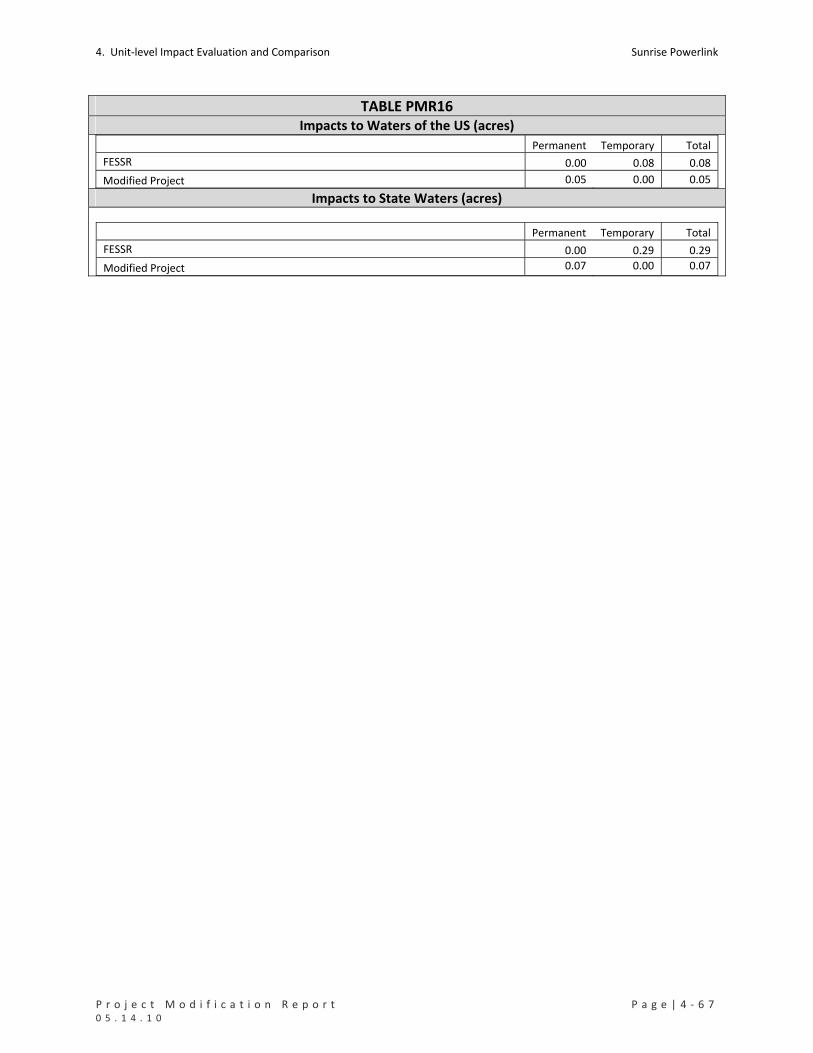
4. Unit‐level Impact Evaluation and Comparison Sunrise Powerlink
P r o j e c t M o d i f i c a t i o n R e p o r t P a g e | 4 ‐ 6 7 0 5 . 1 4 . 1 0
TABLE PMR16 Impacts to Waters of the US (acres) Permanent Temporary Total
FESSR 0.00 0.08 0.08
Modified Project 0.05 0.00 0.05 Impacts to State Waters (acres)
Permanent Temporary Total
FESSR 0.00 0.29 0.29
Modified Project 0.07 0.00 0.07

Sunrise Powerlink 4. Unit‐level Impact Evaluation and Comparison
4 ‐ 6 8 | P a g e P r o j e c t M o d i f i c a t i o n R e p o r t 0 5 . 1 4 . 1 0
PMR17. EP122 to EP108‐2 (La Posta)
Mileposts Link Yard(s) PMR Figure Mapbook Sheet(s)
MP57.9 to MP61 2 None 17 MS68 to MS71
Summary and Conclusion
The modification would shift the alignment to the east until the I‐8 crossing and then northwesterly to reduce
visual impacts and would eliminate a construction yard north of EP115‐1. Impacts to sensitive vegetation,
potential habitat for two listed species, RCAs, cultural resources, visual resources, and US and State waters would
be reduced. The modification in this unit would reduce impacts to the types of resources affected by increased
impacts in PMR16. No new significant impacts would result from the modification.
Details and Purpose
Modification
Reroute
EP114‐2, EP115‐1, and EP116‐1 moved to side slopes and EP120‐4 and EP120A
moved immediately north of Interstate 8 to minimize visual impacts.
EP109‐1 and EP110‐2 relocated north to avoid cultural resource sites.
Long access road eliminated; replaced with spurs off La Posta Truck Trail.
Two wire pull sites eliminated.
Guard structures added at road crossings.
Construction yard north of EP115 eliminated.
Primary Reason Reduce visual impacts.
Reduce impacts to CNF .
Other Considerations
Accommodate landowner requests.
Reduce ground disturbance.
Offset increased impacts in PMR16.
MMCRP Measures B‐1a, B‐1l, C‐1a and 1b, L‐2b, V‐1a, V‐2d, CR‐APM‐2, V‐68a, and WQ‐APM‐1.
Environmental Impact Discussion
Air Quality No substantial change to the effects of the FESSR.
Biological Resources See Table PMR17 below.
Rare Plants Neither the FESSR nor the modification would affect rare plants in this unit.
Vegetation Impacts The modification would reduce or eliminate impacts to sensitive vegetation types affected by the FESSR.
Species Impacts The modifications would reduce impacts to USFS‐identified habitat in CNF for arroyo toad and southwestern willow flycatcher; there would be an 0.16‐acre impact to proposed critical habitat for arroyo toad.
RCAs The modification would substantially reduce but not eliminate impacts to RCAs on USFS‐owned land.

4. Unit‐level Impact Evaluation and Comparison Sunrise Powerlink
P r o j e c t M o d i f i c a t i o n R e p o r t P a g e | 4 ‐ 6 9 0 5 . 1 4 . 1 0
PMR17. EP122 to EP108‐2 (La Posta)
Cultural Resources There are 11 cultural sites and 3 isolated finds in this unit. The FESSR would affect 6 sites; the modification would affect 2. See Table PMR17 below.
Geology/Minerals The modification would reduce ground disturbance and the associated slope stability and erosion effects in this PMR unit.
Land Use The modification would eliminate impacts on BLM land, reduce impacts to CNF, and limit impacts to private lands to under one acre. There are six sensitive residential receptors within one‐quarter mile of impact areas.
Noise No substantial changes to the effects of the FESSR. Noise impacts will be minimized and mitigated through the applicable MMCRP measures as may be required.
Public Safety/Hazards No substantial changes to the effects of the FESSR.
Traffic No substantial changes to the effects of the FESSR.
Visual
The modification would reduce structure prominence, view blockage and skylining.
However, the reduction would not substantially change the overall visual effects of the
FESSR in this unit. Specific actions have been and will continue to be taken to minimize
the visible disturbance of the Sunrise Powerlink on the naturally established scenery of
the Forest. The end result of these actions including the appropriate coloration of
structures will be presented in the Scenery Conservation Plan which will present the
final direction to best achieve the spirit and intent of the Scenic Integrity Objectives of
the Cleveland National Forest Land Management Plan.
Water Resources See Table PMR17 below.
Waters of US The modification would reduce impacts to US waters.
State Waters The modification would reduce impacts to State waters.
Water Use No substantial change to the effects of the FESSR, with some potential for reduced water use because of the reduction in ground disturbance.
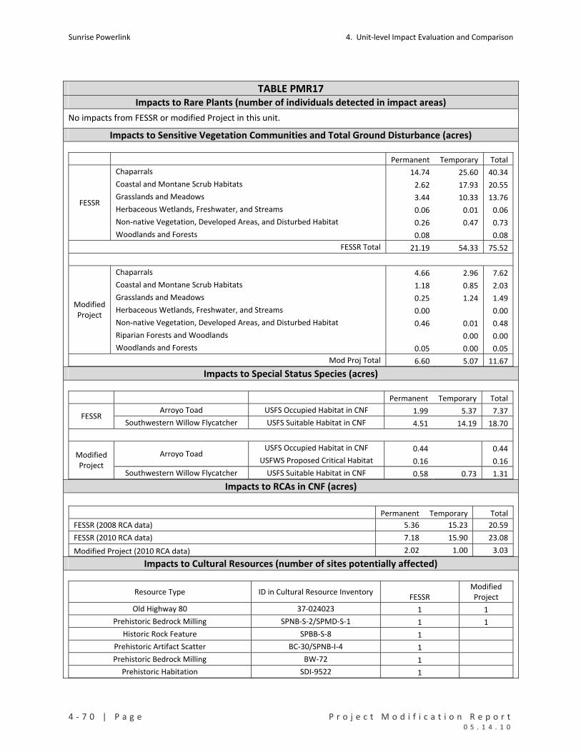
Sunrise Powerlink 4. Unit‐level Impact Evaluation and Comparison
4 ‐ 7 0 | P a g e P r o j e c t M o d i f i c a t i o n R e p o r t 0 5 . 1 4 . 1 0
TABLE PMR17 Impacts to Rare Plants (number of individuals detected in impact areas)
No impacts from FESSR or modified Project in this unit.
Impacts to Sensitive Vegetation Communities and Total Ground Disturbance (acres)
Permanent Temporary Total
Chaparrals 14.74 25.60 40.34
Coastal and Montane Scrub Habitats 2.62 17.93 20.55
Grasslands and Meadows 3.44 10.33 13.76
Herbaceous Wetlands, Freshwater, and Streams 0.06 0.01 0.06
Non‐native Vegetation, Developed Areas, and Disturbed Habitat 0.26 0.47 0.73
FESSR
Woodlands and Forests 0.08 0.08
FESSR Total 21.19 54.33 75.52
Chaparrals 4.66 2.96 7.62
Coastal and Montane Scrub Habitats 1.18 0.85 2.03
Grasslands and Meadows 0.25 1.24 1.49
Herbaceous Wetlands, Freshwater, and Streams 0.00 0.00
Non‐native Vegetation, Developed Areas, and Disturbed Habitat 0.46 0.01 0.48
Riparian Forests and Woodlands 0.00 0.00
Modified Project
Woodlands and Forests 0.05 0.00 0.05
Mod Proj Total 6.60 5.07 11.67 Impacts to Special Status Species (acres)
Permanent Temporary Total
Arroyo Toad USFS Occupied Habitat in CNF 1.99 5.37 7.37 FESSR
Southwestern Willow Flycatcher USFS Suitable Habitat in CNF 4.51 14.19 18.70
USFS Occupied Habitat in CNF 0.44 0.44 Arroyo Toad
USFWS Proposed Critical Habitat 0.16 0.16 Modified Project
Southwestern Willow Flycatcher USFS Suitable Habitat in CNF 0.58 0.73 1.31 Impacts to RCAs in CNF (acres)
Permanent Temporary Total
FESSR (2008 RCA data) 5.36 15.23 20.59
FESSR (2010 RCA data) 7.18 15.90 23.08
Modified Project (2010 RCA data) 2.02 1.00 3.03 Impacts to Cultural Resources (number of sites potentially affected)
Resource Type ID in Cultural Resource Inventory FESSR
Modified Project
Old Highway 80 37‐024023 1 1
Prehistoric Bedrock Milling SPNB‐S‐2/SPMD‐S‐1 1 1
Historic Rock Feature SPBB‐S‐8 1
Prehistoric Artifact Scatter BC‐30/SPNB‐I‐4 1
Prehistoric Bedrock Milling BW‐72 1
Prehistoric Habitation SDI‐9522 1
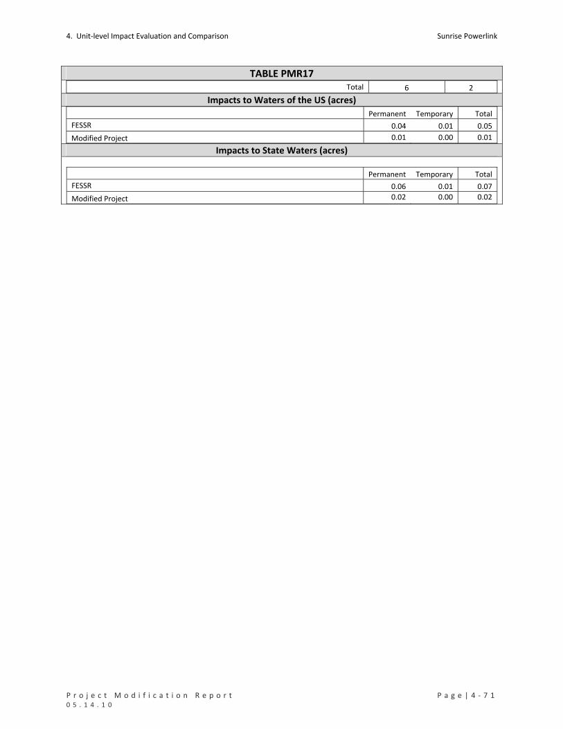
4. Unit‐level Impact Evaluation and Comparison Sunrise Powerlink
P r o j e c t M o d i f i c a t i o n R e p o r t P a g e | 4 ‐ 7 1 0 5 . 1 4 . 1 0
TABLE PMR17 Total 6 2
Impacts to Waters of the US (acres) Permanent Temporary Total
FESSR 0.04 0.01 0.05
Modified Project 0.01 0.00 0.01 Impacts to State Waters (acres)
Permanent Temporary Total
FESSR 0.06 0.01 0.07
Modified Project 0.02 0.00 0.02

Sunrise Powerlink 4. Unit‐level Impact Evaluation and Comparison
4 ‐ 7 2 | P a g e P r o j e c t M o d i f i c a t i o n R e p o r t 0 5 . 1 4 . 1 0
PMR18. EP108‐2 to EP99‐2 (Lenac)
Mileposts Link Yard(s) PMR Figure Mapbook Sheet(s)
MP61 to MP63 2 None
18
See MS 72 and MS72A for
eliminated yards.
MS71 to MS75
Summary and Conclusion
The area covered by this modification excludes EP105‐2, which is in PMR19. The PMR18 modification would shift
the alignment to the east at the request of a landowner (Lenac), eliminate an access road through the McQuaide
property, reduce structure height as requested by the Department of Defense, and eliminate two yards on USFS
and Tulloch properties. The modification would reduce ground disturbance and impacts to sensitive vegetation,
USFS‐identified habitat for arroyo toad and Quino. There would be a 2‐acre increase in impacts to critical habitat
for Quino. Impacts to US and State waters would be eliminated, and impacts to RCAs in CNF would be reduced to
0.12 acre. Cameron Truck Trail will be utilized for access to the structures in this PMR unit. Drivability and
accessibility of the road will be maintained throughout construction. No new significant impacts would result from
the modification.
Details and Purpose
Modification
Reroute
Structure height reduced to avoid skylining and impacts to helicopter
operations per the request by the Department of Defense.
Eliminated one wire pull site outside of the ROW.
Access road through the McQuaide property eliminated.
Access spur roads from Cameron Truck Trail shifted (see PMR unit 19).
Guard structures added at road crossings.
Construction yards on USFS and Tulloch properties eliminated (see MS72 and
MS72A for location of eliminated yards).
Primary Reason Accommodate landowner and DOD requests.
Reduce ground disturbance.
Other Considerations Consolidate construction yard functions.
MMCRP Measures B‐1a, V‐68a, C‐1a, C‐1b, and L‐2b.
Environmental Impact Discussion
Air Quality No substantial changes to the effects of the FESSR.
Biological Resources See Table PMR18 below.
Rare Plants Neither the FESSR nor the modification would affect rare plants in this unit.
Vegetation Impacts Impacts to all sensitive vegetation types affected by the FESSR would be reduced or eliminated.
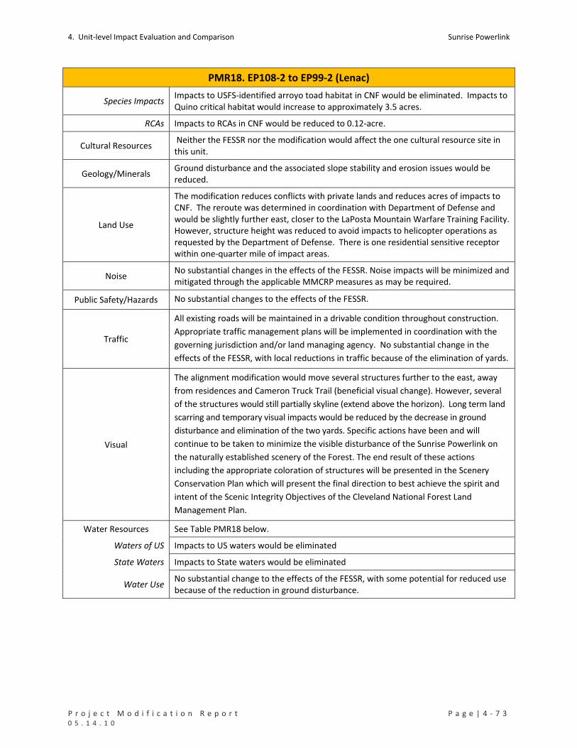
4. Unit‐level Impact Evaluation and Comparison Sunrise Powerlink
P r o j e c t M o d i f i c a t i o n R e p o r t P a g e | 4 ‐ 7 3 0 5 . 1 4 . 1 0
PMR18. EP108‐2 to EP99‐2 (Lenac)
Species Impacts Impacts to USFS‐identified arroyo toad habitat in CNF would be eliminated. Impacts to Quino critical habitat would increase to approximately 3.5 acres.
RCAs Impacts to RCAs in CNF would be reduced to 0.12‐acre.
Cultural Resources Neither the FESSR nor the modification would affect the one cultural resource site in this unit.
Geology/Minerals Ground disturbance and the associated slope stability and erosion issues would be reduced.
Land Use
The modification reduces conflicts with private lands and reduces acres of impacts to CNF. The reroute was determined in coordination with Department of Defense and would be slightly further east, closer to the LaPosta Mountain Warfare Training Facility. However, structure height was reduced to avoid impacts to helicopter operations as requested by the Department of Defense. There is one residential sensitive receptor within one‐quarter mile of impact areas.
Noise No substantial changes in the effects of the FESSR. Noise impacts will be minimized and mitigated through the applicable MMCRP measures as may be required.
Public Safety/Hazards No substantial changes to the effects of the FESSR.
Traffic
All existing roads will be maintained in a drivable condition throughout construction.
Appropriate traffic management plans will be implemented in coordination with the
governing jurisdiction and/or land managing agency. No substantial change in the
effects of the FESSR, with local reductions in traffic because of the elimination of yards.
Visual
The alignment modification would move several structures further to the east, away
from residences and Cameron Truck Trail (beneficial visual change). However, several
of the structures would still partially skyline (extend above the horizon). Long term land
scarring and temporary visual impacts would be reduced by the decrease in ground
disturbance and elimination of the two yards. Specific actions have been and will
continue to be taken to minimize the visible disturbance of the Sunrise Powerlink on
the naturally established scenery of the Forest. The end result of these actions
including the appropriate coloration of structures will be presented in the Scenery
Conservation Plan which will present the final direction to best achieve the spirit and
intent of the Scenic Integrity Objectives of the Cleveland National Forest Land
Management Plan.
Water Resources See Table PMR18 below.
Waters of US Impacts to US waters would be eliminated
State Waters Impacts to State waters would be eliminated
Water Use No substantial change to the effects of the FESSR, with some potential for reduced use because of the reduction in ground disturbance.

Sunrise Powerlink 4. Unit‐level Impact Evaluation and Comparison
4 ‐ 7 4 | P a g e P r o j e c t M o d i f i c a t i o n R e p o r t 0 5 . 1 4 . 1 0
TABLE PMR18 Impacts to Rare Plants (number of individuals detected in impact areas)
No impacts from FESSR or modified Project in this unit.
Impacts to Sensitive Vegetation Communities and Total Ground Disturbance (acres)
Permanent Temporary Total
Chaparrals 9.56 17.09 26.65
Coastal and Montane Scrub Habitats 0.17 0.17
Grasslands and Meadows 1.03 32.12 33.14
Herbaceous Wetlands, Freshwater, and Streams 0.04 0.04
Non‐native Vegetation, Developed Areas, and Disturbed Habitat 1.57 1.57
FESSR
Woodlands and Forests 9.21 9.21
FESSR Total 12.32 58.46 70.78
Chaparrals 5.07 10.36 15.42 Modified Projecct Non‐native Vegetation, Developed Areas, and Disturbed Habitat 0.13 0.07 0.20
Mod Proj Total 5.19 10.43 15.62 Impacts to Special Status Species (acres)
Permanent Temporary Total
Arroyo Toad USFS Occupied Habitat in CNF 0.08 13.07 13.15 FESSR
Quino Checkerspot Butterfly USFWS Critical Habitat 0.51 1.00 1.51
Modified Project
Quino Checkerspot Butterfly USFWS Critical Habitat 1.91 1.56 3.47
Impacts to RCAs in CNF (acres)
Permanent Temporary Total
FESSR (2008 RCA data) 0.08 13.52 13.60
FESSR (2010 RCA data) 0.14 14.82 14.97
Modified Project (2010 RCA data) 0.12 0.12 Impacts to Cultural Resources (number of sites potentially affected)
No impacts from FESSR or modified Project in this unit.
Impacts to Waters of the US (acres) Permanent Temporary Total
FESSR 0.00 22.81 22.81
Modified Project 0.00 0.00 0.00 Impacts to State Waters (acres) Permanent Temporary Total
FESSR 0.00 22.84 22.82
Modified Project 0.00 0.00 0.00

4. Unit‐level Impact Evaluation and Comparison Sunrise Powerlink
P r o j e c t M o d i f i c a t i o n R e p o r t P a g e | 4 ‐ 7 5 0 5 . 1 4 . 1 0
PMR19. EP105‐2 (Rees)
Mileposts Link Yard(s) PMR Figure Mapbook Sheet(s)
MP61.2 2 None 19 MS73
Summary and Conclusion
The modification would relocate the access road to EP105‐2 at the request of the landowner (Rees) to spur off of
Cameron Truck Trail, west of the structure and south of the originally proposed road. The modification would
increase the impacts of the access road to chaparrals and add small impacts to non‐vegetated channels, proposed
critical habitat for arroyo toad, and US and State waters. All impacts would occur on the Rees property. No new
significant impacts would result from the modification.
Details and Purpose
Modification Access road to EP105‐2 shifted south.
Primary Reason Accommodate landowner request.
Other Considerations None
MMCRP Measures B‐1a, L‐2b, C‐1a, and WQ‐APM‐2.
Environmental Impact Discussion
Air Quality No substantial change to the effects of the FESSR.
Biological Resources See Table PMR19 below.
Rare Plants Neither the FESSR nor the modification would affect rare plants.
Vegetation Impacts The modification increase impacts to chaparrals and adds a small impact (0.02 acre) to non‐vegetated channels.
Species Impacts The modification adds a small impact (0.23 acre) to Quino critical habitat.
RCAs Not applicable to the FESSR or modification in this unit.
Cultural Resources Neither the FESSR nor the modification would affect cultural resources (no resources in either ROW).
Geology/Minerals The modification would reduce ground disturbance and the associated slope stability and erosion effects in this PMR unit.
Land Use All impacts would occur on private property with the concurrence of the owner.
Noise No substantial changes to the effects of the FESSR.
Public Safety/Hazards No substantial changes to the effects of the FESSR.
Traffic No substantial changes to the effects of the FESSR.
Visual No substantial changes to the effects of the FESSR.
Water Resources See Table PMR19 below.
Waters of US The modification would add a small impact to waters of the US.
State Waters The modification would add a small impact to State waters.
Water Use No substantial change in effects of the FESSR.
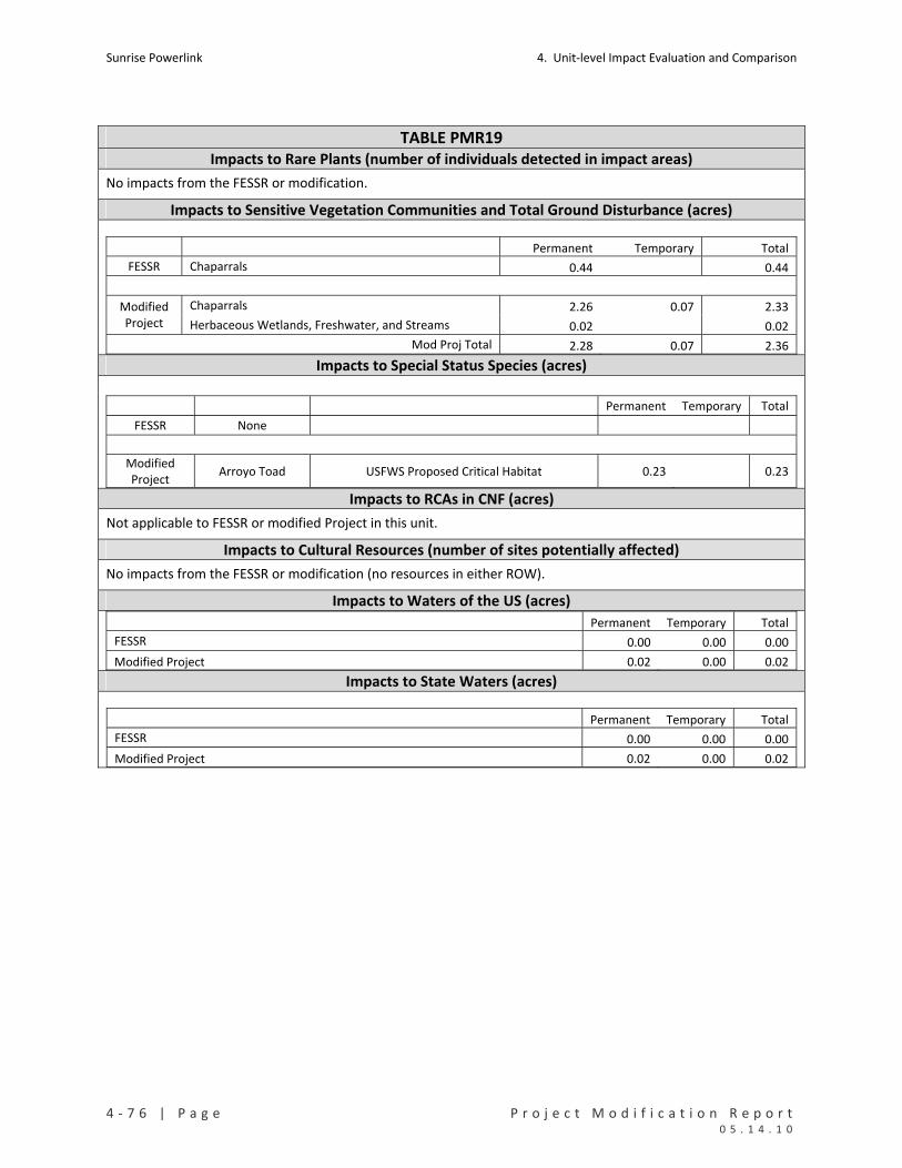
Sunrise Powerlink 4. Unit‐level Impact Evaluation and Comparison
4 ‐ 7 6 | P a g e P r o j e c t M o d i f i c a t i o n R e p o r t 0 5 . 1 4 . 1 0
TABLE PMR19 Impacts to Rare Plants (number of individuals detected in impact areas)
No impacts from the FESSR or modification.
Impacts to Sensitive Vegetation Communities and Total Ground Disturbance (acres)
Permanent Temporary Total
FESSR Chaparrals 0.44 0.44
Chaparrals 2.26 0.07 2.33 Modified Project Herbaceous Wetlands, Freshwater, and Streams 0.02 0.02
Mod Proj Total 2.28 0.07 2.36 Impacts to Special Status Species (acres)
Permanent Temporary Total
FESSR None
Modified Project
Arroyo Toad USFWS Proposed Critical Habitat 0.23 0.23
Impacts to RCAs in CNF (acres)
Not applicable to FESSR or modified Project in this unit.
Impacts to Cultural Resources (number of sites potentially affected)
No impacts from the FESSR or modification (no resources in either ROW).
Impacts to Waters of the US (acres) Permanent Temporary Total
FESSR 0.00 0.00 0.00
Modified Project 0.02 0.00 0.02 Impacts to State Waters (acres)
Permanent Temporary Total
FESSR 0.00 0.00 0.00
Modified Project 0.02 0.00 0.02

4. Unit‐level Impact Evaluation and Comparison Sunrise Powerlink
P r o j e c t M o d i f i c a t i o n R e p o r t P a g e | 4 ‐ 7 7 0 5 . 1 4 . 1 0
PMR20. EP99‐2 to EP79 (Bartlett)
Mileposts Link Yard(s) PMR Figure Mapbook Sheet(s)
MP63‐MP67.4 2 Bartlett/Hauser
Creek 20 MS75 to MS80
Summary and Conclusion
The modification would shift the alignment to the east and add temporary work areas to improve engineering
design and facilitate construction. It also would reduce the Bartlett/Hauser Creek yard. The modification would
reduce impacts to sticky geraea, chaparrals, grasslands, and woodlands and eliminate impacts to riparian forest
and RCAs. The modification would result in slightly higher temporary impacts to coastal and montane scrubs and
would add relatively small (0.02 and 0.03 acre) impacts to US and State waters. Other effects would be
substantially the same as the FESSR. No new significant effects would result.
Details and Purpose
Modification
Reroute
Temporary construction pads added for 6 of the structures.
Three wire pulling sites were eliminated.
Over one mile of access roads have been eliminated.
Construction accomplished via helicopter access for 5 structures.
Over one mile of new access road eliminated, replaced with tower
staging/access pads, smaller spur access roads, or use of existing roads.
One wood pole between EP90 and EP91, evaluated for replacement to steel
poles because of proximity to the ROW.
Guard structures added at road crossings.
Bartlett/Hauser Creek
Size of yard reduced to 28.57 acres.
Yard remains in the same location.
Primary Reason Improve engineering design and constructability (increase structure stability).
Other Considerations Reduce number and length of access roads.
Reduce ground disturbance and impacts to RCAs
MMCRP Measures F‐2b, C‐1a, V‐2d, and GEO‐APM‐5
Environmental Impact Discussion
Air Quality
The increased use of helicopters would not exceed the fuel‐use cap or emissions
identified for the FESSR or as calculated and approved in the Sunrise Construction
Emissions Monitoring Plan (CEMP) January 2010. No substantial changes in the effects
of the FESSR.
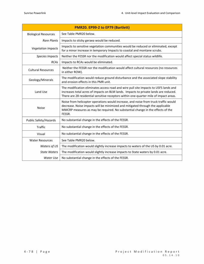
Sunrise Powerlink 4. Unit‐level Impact Evaluation and Comparison
4 ‐ 7 8 | P a g e P r o j e c t M o d i f i c a t i o n R e p o r t 0 5 . 1 4 . 1 0
PMR20. EP99‐2 to EP79 (Bartlett)
Biological Resources See Table PMR20 below.
Rare Plants Impacts to sticky geraea would be reduced.
Vegetation Impacts Impacts to sensitive vegetation communities would be reduced or eliminated, except for a minor increase in temporary Impacts to coastal and montane scrubs.
Species Impacts Neither the FESSR nor the modification would affect special status wildlife.
RCAs Impacts to RCAs would be eliminated.
Cultural Resources Neither the FESSR nor the modification would affect cultural resources (no resources in either ROW).
Geology/Minerals The modification would reduce ground disturbance and the associated slope stability and erosion effects in this PMR unit.
Land Use The modification eliminates access road and wire pull site impacts to USFS lands and increases total acres of impacts on BLM lands. Impacts to private lands are reduced. There are 28 residential sensitive receptors within one‐quarter mile of impact areas.
Noise
Noise from helicopter operations would increase, and noise from truck traffic would decrease. Noise impacts will be minimized and mitigated through the applicable MMCRP measures as may be required. No substantial change in the effects of the FESSR.
Public Safety/Hazards No substantial change in the effects of the FESSR.
Traffic No substantial change in the effects of the FESSR.
Visual No substantial change in the effects of the FESSR.
Water Resources See Table PMR20 below.
Waters of US The modification would slightly increase impacts to waters of the US by 0.01 acre.
State Waters The modification would slightly increase impacts to State waters by 0.01 acre.
Water Use No substantial change in the effects of the FESSR.

4. Unit‐level Impact Evaluation and Comparison Sunrise Powerlink
P r o j e c t M o d i f i c a t i o n R e p o r t P a g e | 4 ‐ 7 9 0 5 . 1 4 . 1 0
TABLE PMR20 Impacts to Rare Plants (number of individuals detected in impact areas)
Permanent Temporary Total
FESSR Sticky geraea 105 31 136
Modified Project Sticky geraea 4 31 35 Impacts to Sensitive Vegetation Communities and Total Ground Disturbance (acres)
Permanent Temporary Total
Chaparrals 15.09 19.77 34.86
Coastal and Montane Scrub Habitats 0.74 7.81 8.55
Grasslands and Meadows 1.10 16.00 17.10
Herbaceous Wetlands, Freshwater, and Streams 0.01 0.01 0.02
Non‐native Vegetation, Developed Areas, and Disturbed Habitat 0.08 42.69 42.77
Riparian Forests and Woodlands 0.11 0.11
FESSR
Woodlands and Forests 0.37 0.37
FESSR Total 17.02 86.75 103.77
Chaparrals 12.00 11.99 23.98
Coastal and Montane Scrub Habitats 0.74 8.30 9.03
Grasslands and Meadows 1.09 2.62 3.71
Herbaceous Wetlands, Freshwater, and Streams 0.01 0.01 0.02
Non‐native Vegetation, Developed Areas, and Disturbed Habitat 0.53 29.02 29.55
Modified Project
Woodlands and Forests 0.14 0.14
Mod Proj Total 14.37 52.07 66.43 Impacts to Special Status Species (acres)
No impacts from FESSR or modified Project in this unit.
Impacts to RCAs in CNF (acres)
Permanent Temporary Total
FESSR (2008 RCA data) 0.09 0.09
FESSR (2010 RCA data) 0.09 0.09
Modified Project (2010 RCA data) 0.00 0.00 0.00 Impacts to Cultural Resources (number of sites potentially affected)
No impacts from FESSR or modified Project in this unit.

Sunrise Powerlink 4. Unit‐level Impact Evaluation and Comparison
4 ‐ 8 0 | P a g e P r o j e c t M o d i f i c a t i o n R e p o r t 0 5 . 1 4 . 1 0
TABLE PMR20 Impacts to Waters of the US (acres) Permanent Temporary Total
FESSR 0.01 0.00 0.01
Modified Project 0.01 0.01 0.02 Impacts to State Waters (acres)
Permanent Temporary Total
FESSR 0.01 0.00 0.01
Modified Project 0.02 0.01 0.03
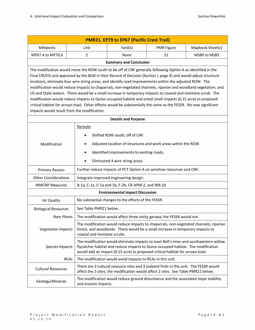
4. Unit‐level Impact Evaluation and Comparison Sunrise Powerlink
P r o j e c t M o d i f i c a t i o n R e p o r t P a g e | 4 ‐ 8 1 0 5 . 1 4 . 1 0
PMR21. EP79 to EP67 (Pacific Crest Trail)
Mileposts Link Yard(s) PMR Figure Mapbook Sheet(s)
MP67.4 to MP70.6 2 None 21 MS80 to MS83
Summary and Conclusion
The modification would move the ROW south to be off of CNF generally following Option A as identified in the
Final EIR/EIS and approved by the BLM in their Record of Decision (Section I, page 4) and would adjust structure
locations, eliminate four wire string areas, and identify road improvements within the adjusted ROW. The
modification would reduce impacts to chaparrals, non‐vegetated channels, riparian and woodland vegetation, and
US and State waters. There would be a small increase in temporary impacts to coastal and montane scrub. The
modification would reduce impacts to Quino occupied habitat and entail small impacts (0.15 acre) to proposed
critical habitat for arroyo toad. Other effects would be substantially the same as the FESSR. No new significant
impacts would result from the modification.
Details and Purpose
Modification
Reroute
Shifted ROW south, off of CNF.
Adjusted location of structures and work areas within the ROW.
Identified improvements to existing roads.
Eliminated 4 wire string areas.
Primary Reason Further reduce impacts of PCT Option A on sensitive resources and CNF.
Other Considerations Integrate improved engineering design.
MMCRP Measures B‐1a, C‐1a, C‐1a and 1b, F‐2b, CR‐APM‐2, and WR‐2b
Environmental Impact Discussion
Air Quality No substantial changes to the effects of the FESSR.
Biological Resources See Table PMR21 below.
Rare Plants The modification would affect three sticky geraea; the FESSR would not.
Vegetation Impacts The modification would reduce impacts to chaparrals, non‐vegetated channels, riparian forest, and woodlands. There would be a small increase in temporary impacts to coastal and montane scrubs.
Species Impacts The modification would eliminate impacts to least Bell’s vireo and southwestern willow flycatcher habitat and reduce impacts to Quino occupied habitat. The modification would add an impact (0.15 acre) to proposed critical habitat for arroyo toad.
RCAs The modification would avoid impacts to RCAs in this unit.
Cultural Resources There are 3 cultural resource sites and 3 isolated finds in this unit. The FESSR would affect the 3 sites; the modification would affect 2 sites. See Table PMR21 below.
Geology/Minerals The modification would reduce ground disturbance and the associated slope stability and erosion impacts.

Sunrise Powerlink 4. Unit‐level Impact Evaluation and Comparison
4 ‐ 8 2 | P a g e P r o j e c t M o d i f i c a t i o n R e p o r t 0 5 . 1 4 . 1 0
PMR21. EP79 to EP67 (Pacific Crest Trail)
Land Use and Recreation
No substantial changes to the effects of the FESSR. In compliance with MMCRP measure WR‐2b, consultations are occurring with the USFS, BLM and Pacific Crest Trail Assosiation to determine possible mitigation reroutes to reduce the number of times the alignment crosses the Pacific Crest Trail. There are 6 sensitive residential receptors within 1000 feet of the impact areas (7 within one‐quarter mile).
Noise Noise impacts will be minimized and mitigated with consideration of the sensitive receptors through the applicable MMCRP measures as may be required. No substantial changes to the effects of the FESSR.
Public Safety/Hazards No substantial changes to the effects of the FESSR.
Traffic No substantial changes to the effects of the FESSR.
Visual The modification would have the same visual effects as the FESSR.
Water Resources See Table PMR21 below.
Waters of US The modification would reduce impacts to waters of the US.
State Waters The modification would reduce impacts to State waters.
Water Use No substantial changes in the effects of the FESSR.
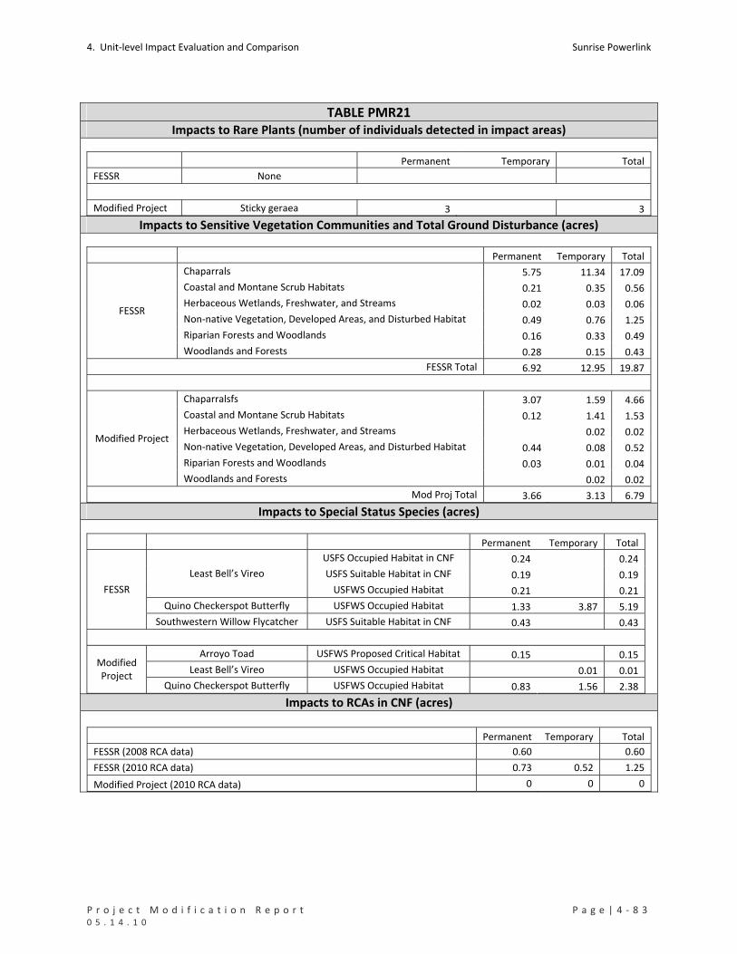
4. Unit‐level Impact Evaluation and Comparison Sunrise Powerlink
P r o j e c t M o d i f i c a t i o n R e p o r t P a g e | 4 ‐ 8 3 0 5 . 1 4 . 1 0
TABLE PMR21 Impacts to Rare Plants (number of individuals detected in impact areas)
Permanent Temporary Total
FESSR None
Modified Project Sticky geraea 3 3 Impacts to Sensitive Vegetation Communities and Total Ground Disturbance (acres)
Permanent Temporary Total
Chaparrals 5.75 11.34 17.09
Coastal and Montane Scrub Habitats 0.21 0.35 0.56
Herbaceous Wetlands, Freshwater, and Streams 0.02 0.03 0.06
Non‐native Vegetation, Developed Areas, and Disturbed Habitat 0.49 0.76 1.25
Riparian Forests and Woodlands 0.16 0.33 0.49
FESSR
Woodlands and Forests 0.28 0.15 0.43
FESSR Total 6.92 12.95 19.87
Chaparralsfs 3.07 1.59 4.66
Coastal and Montane Scrub Habitats 0.12 1.41 1.53
Herbaceous Wetlands, Freshwater, and Streams 0.02 0.02
Non‐native Vegetation, Developed Areas, and Disturbed Habitat 0.44 0.08 0.52
Riparian Forests and Woodlands 0.03 0.01 0.04
Modified Project
Woodlands and Forests 0.02 0.02
Mod Proj Total 3.66 3.13 6.79 Impacts to Special Status Species (acres)
Permanent Temporary Total
USFS Occupied Habitat in CNF 0.24 0.24
USFS Suitable Habitat in CNF 0.19 0.19 Least Bell’s Vireo
USFWS Occupied Habitat 0.21 0.21
Quino Checkerspot Butterfly USFWS Occupied Habitat 1.33 3.87 5.19
FESSR
Southwestern Willow Flycatcher USFS Suitable Habitat in CNF 0.43 0.43
Arroyo Toad USFWS Proposed Critical Habitat 0.15 0.15
Least Bell’s Vireo USFWS Occupied Habitat 0.01 0.01 Modified Project
Quino Checkerspot Butterfly USFWS Occupied Habitat 0.83 1.56 2.38 Impacts to RCAs in CNF (acres)
Permanent Temporary Total
FESSR (2008 RCA data) 0.60 0.60
FESSR (2010 RCA data) 0.73 0.52 1.25
Modified Project (2010 RCA data) 0 0 0

Sunrise Powerlink 4. Unit‐level Impact Evaluation and Comparison
4 ‐ 8 4 | P a g e P r o j e c t M o d i f i c a t i o n R e p o r t 0 5 . 1 4 . 1 0
TABLE PMR21 Impacts to Cultural Resources (number of sites potentially affected)
Resource Category Cultural Resource Inventory ID FESSR Modified Project
SDI‐10040 1 1 Prehistoric Bedrock Milling
SDI‐4724 1 1
Prehistoric Isolate (Debitage/Ceramic) SPNB‐S‐1 1 1
Total 3 2 Impacts to Waters of the US (acres) Permanent Temporary Total
FESSR 0.19 0.08 0.27
Modified Project 0.00 0.02 0.02 Impacts to State Waters (acres)
Permanent Temporary Total
FESSR 0.20 0.09 0.28
Modified Project 0.00 0.02 0.02
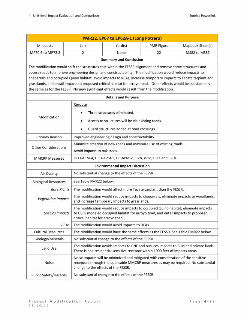
4. Unit‐level Impact Evaluation and Comparison Sunrise Powerlink
P r o j e c t M o d i f i c a t i o n R e p o r t P a g e | 4 ‐ 8 5 0 5 . 1 4 . 1 0
PMR22. EP67 to EP62A‐1 (Long Potrero)
Mileposts Link Yard(s) PMR Figure Mapbook Sheet(s)
MP70.6 to MP72.2 2 None 22 MS82 to MS85
Summary and Conclusion
The modification would shift the structures east within the FESSR alignment and remove some structures and
access roads to improve engineering design and constructability. The modification would reduce impacts to
chaparrals and occupied Quino habitat, avoid impacts to RCAs, increase temporary impacts to Tecate tarplant and
grasslands, and entail impacts to proposed critical habitat for arroyo toad. Other effects would be substantially
the same as for the FESSR. No new significant effects would result from the modification.
Details and Purpose
Modification
Reroute
Three structures eliminated.
Access to structures will be via existing roads.
Guard structures added at road crossings.
Primary Reason Improved engineering design and constructability.
Other Considerations Minimize creation of new roads and maximize use of existing roads.
Avoid impacts to oak trees.
MMCRP Measures GEO‐APM‐4, GEO‐APM‐5, CR‐APM‐2, F‐2b, V‐2d, C‐1a and C‐1b.
Environmental Impact Discussion
Air Quality No substantial change to the effects of the FESSR.
Biological Resources See Table PMR22 below.
Rare Plants The modification would affect more Tecate tarplant than the FESSR.
Vegetation Impacts The modification would reduce impacts to chaparrals, eliminate impacts to woodlands, and increase temporary impacts to grasslands.
Species Impacts The modification would reduce impacts to occupied Quino habitat, eliminate impacts to USFS modeled occupied habitat for arroyo toad, and entail impacts to proposed critical habitat for arroyo toad.
RCAs The modification would avoid impacts to RCAs.
Cultural Resources The modification would have the same effects as the FESSR. See Table PMR22 below.
Geology/Minerals No substantial change to the effects of the FESSR.
Land Use The modification avoids impacts to CNF and reduces impacts to BLM and private lands. There is one residential sensitive receptor within 1000 feet of impacts areas.
Noise Noise impacts will be minimized and mitigated with consideration of the sensitive receptors through the applicable MMCRP measures as may be required. No substantial change to the effects of the FESSR.
Public Safety/Hazards No substantial change to the effects of the FESSR.

Sunrise Powerlink 4. Unit‐level Impact Evaluation and Comparison
4 ‐ 8 6 | P a g e P r o j e c t M o d i f i c a t i o n R e p o r t 0 5 . 1 4 . 1 0
PMR22. EP67 to EP62A‐1 (Long Potrero)
Traffic No substantial change to the effects of the FESSR.
Visual No substantial change to the effects of the FESSR.
Water Resources See Table PMR22 below.
Waters of US Neither the modification nor the FESSR would affect US waters.
State Waters Neither the modification nor the FESSR would affect State waters.
Water Use No substantial change to the effects of the FESSR.

4. Unit‐level Impact Evaluation and Comparison Sunrise Powerlink
P r o j e c t M o d i f i c a t i o n R e p o r t P a g e | 4 ‐ 8 7 0 5 . 1 4 . 1 0
TABLE PMR22 Impacts to Rare Plants (number of individuals detected in impact areas)
Permanent Temporary Total
FESSR Tecate tarplant 26 26
Modified Project Tecate tarplant 43 43 Impacts to Sensitive Vegetation Communities and Total Ground Disturbance (acres)
Permanent Temporary Total
Chaparrals 2.46 6.71 9.17
Coastal and Montane Scrub Habitats 0.00 0.09 0.09
Grasslands and Meadows 0.25 0.43 0.68
Non‐native Vegetation, Developed Areas, and Disturbed Habitat 0.11 0.24 0.35
FESSR
Woodlands and Forests 0.32 0.32
FESSR Total 3.15 7.47 10.62
Chaparrals 1.18 4.46 5.64
Coastal and Montane Scrub Habitats 0.06 0.06
Grasslands and Meadows 0.08 0.84 0.92
Modified Project
Non‐native Vegetation, Developed Areas, and Disturbed Habitat 0.10 0.00 0.10
Mod Proj Total 1.36 5.36 6.72 Impacts to Special Status Species (acres)
Permanent Temporary Total
Arroyo Toad USFS Occupied Habitat in CNF 0.66 0.66 FESSR
Quino Checkerspot Butterfly USFWS Occupied Habitat 2.10 7.47 9.58
USFS Occupied Habitat in CNF 0.00 0.00 Arroyo Toad
USFWS Proposed Critical Habitat 0.63 5.36 5.99 Modified Project
Quino Checkerspot Butterfly USFWS Occupied Habitat 0.90 5.36 6.27 Impacts to RCAs in CNF (acres)
Permanent Temporary Total
FESSR (2008 RCA data) 0.66 0.66
FESSR (2010 RCA data) 0.66 0.66
Modified Project (2010 RCA data) 0.00 0.00 Impacts to Cultural Resources (number of sites potentially affected)
Resource Category Cultural Resource Inventory Number FESSR Modified Project
Bedrock Milling SPMD‐S‐2 1 1
Prehistoric Bedrock Milling SDI‐19279 1 1
Total 2 2

Sunrise Powerlink 4. Unit‐level Impact Evaluation and Comparison
4 ‐ 8 8 | P a g e P r o j e c t M o d i f i c a t i o n R e p o r t 0 5 . 1 4 . 1 0
TABLE PMR22 Impacts to Waters of the US (acres)
No impacts from FESSR or modified Project in this unit.
Impacts to State Waters (acres)
No impacts from FESSR or modified Project in this unit.

4. Unit‐level Impact Evaluation and Comparison Sunrise Powerlink
P r o j e c t M o d i f i c a t i o n R e p o r t P a g e | 4 ‐ 8 9 0 5 . 1 4 . 1 0
PMR23. EP62A‐1 to EP47‐2 (Potrero)
Mileposts Link Yard(s) PMR Figure Mapbook Sheet(s)
MP72.2 to MP75.3 2 Kreutzkamp 23 MS85 to MS88
Summary and Conclusion
The modification would shift the alignment approximately 2,000 to 4,000 feet north, shorten the alignment by
aprpoximately 0.34 acre, reduce road impacts, and eliminate four wire stringing sites. No change would be made
to the Kreutzkamp Construction Yard. The modification would reduce total ground disturbance, reduce impacts to
chaparrals, eliminate impacts to other sensitive vegetation types, and reduce impacts to occupied Quino habitat,
cultural resources, and US and State waters. There would a 0.09‐acre impact to a RCA in CNF. No new significant
impacts would result from the modification.
Details and Purpose
Modification
Reroute
ROW moved north, shifting a portion of the ROW off of Back Country Land
Trust property and eliminating a wire pull site on the property.
Span across the Kreutzkamp property reduced by approximately 4700 feet.
Road improvements minimized.
4 wire pull sites eliminated, and 2 wire pull sites relocated within the ROW.
Guard structures added at road crossings.
Kreutzkamp Construction Yard
No change (same location and same size ‐‐ 30.62 acres)
Primary Reason Improve engineering design and constructability
Other Considerations Reduce impacts to Back Country Trust property
Reduce road‐related impacts
MMCRP Measures B‐1a,F‐2b, C‐1a, C‐1b, V‐2d, GEO‐APM‐4, GEO‐APM‐5, L‐2b, WQ‐APM‐1, and WQ‐APM‐2
Environmental Impact Discussion
Air Quality No substantial change in effects of the FESSR.
Biological Resources See Table PMR23 below.
Rare Plants The modification would affect fewer Tecate tarplants than the FESSR.
Vegetation Impacts The modification would reduce impacts to chaparrals and eliminate impacts to other sensitive vegetation types.
Species Impacts The modification would reduce impacts to occupied Quino habitat.
RCAs The modification would entail impacts to 0.09 acre of an RCA.
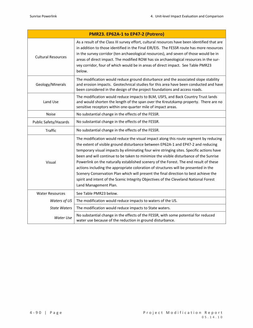
Sunrise Powerlink 4. Unit‐level Impact Evaluation and Comparison
4 ‐ 9 0 | P a g e P r o j e c t M o d i f i c a t i o n R e p o r t 0 5 . 1 4 . 1 0
PMR23. EP62A‐1 to EP47‐2 (Potrero)
Cultural Resources
As a result of the Class III survey effort, cultural resources have been identified that are
in addition to those identified in the Final EIR/EIS. The FESSR route has more resources
in the survey corridor (ten archaeological resources), and seven of those would be in
areas of direct impact. The modified ROW has six archaeological resources in the sur‐
vey corridor, four of which would be in areas of direct impact. See Table PMR23
below.
Geology/Minerals The modification would reduce ground disturbance and the associated slope stability and erosion impacts. Geotechnical studies for this area have been conducted and have been considered in the design of the project foundations and access roads.
Land Use The modification would reduce impacts to BLM, USFS, and Back Country Trust lands and would shorten the length of the span over the Kreutzkamp property. There are no sensitive receptors within one‐quarter mile of impact areas.
Noise No substantial change in the effects of the FESSR.
Public Safety/Hazards No substantial change in the effects of the FESSR.
Traffic No substantial change in the effects of the FESSR.
Visual
The modification would reduce the visual impact along this route segment by reducing
the extent of visible ground disturbance between EP62A‐1 and EP47‐2 and reducing
temporary visual impacts by eliminating four wire stringing sites. Specific actions have
been and will continue to be taken to minimize the visible disturbance of the Sunrise
Powerlink on the naturally established scenery of the Forest. The end result of these
actions including the appropriate coloration of structures will be presented in the
Scenery Conservation Plan which will present the final direction to best achieve the
spirit and intent of the Scenic Integrity Objectives of the Cleveland National Forest
Land Management Plan.
Water Resources See Table PMR23 below.
Waters of US The modification would reduce impacts to waters of the US.
State Waters The modification would reduce impacts to State waters.
Water Use No substantial change in the effects of the FESSR, with some potential for reduced water use because of the reduction in ground disturbance.

4. Unit‐level Impact Evaluation and Comparison Sunrise Powerlink
P r o j e c t M o d i f i c a t i o n R e p o r t P a g e | 4 ‐ 9 1 0 5 . 1 4 . 1 0
TABLE PMR23 Impacts to Rare Plants (number of individuals detected in impact areas)
Permanent Temporary Total
FESSR Tecate tarplant 10 10
Modified Project Tecate tarplant 4 4 Impacts to Sensitive Vegetation Communities and Total Ground Disturbance (acres)
Chaparrals 11.78 18.17 29.95
Coastal and Montane Scrub Habitats 0.42 0.42
Grasslands and Meadows 0.52 1.85 2.38
Herbaceous Wetlands, Freshwater, and Streams 0.01 0.01
Non‐native Vegetation, Developed Areas, and Disturbed Habitat 4.12 30.91 35.02
FESSR
Woodlands and Forests 0.00 0.00
FESSR Total 16.43 51.35 67.79
Chaparrals 3.77 2.10 5.87
Herbaceous Wetlands, Freshwater, and Streams 0.00 0.00 0.00 Modified Project
Non‐native Vegetation, Developed Areas, and Disturbed Habitat 1.37 34.16 35.53
Mod Proj Total 5.14 36.27 41.41 Impacts to Special Status Species (acres)
Permanent Temporary Total
FESSR Quino Checkerspot Butterfly USFWS Occupied Habitat 8.49 10.41 18.90
Modified Project
Quino Checkerspot Butterfly USFWS Occupied Habitat 2.50 0.02 2.52
Impacts to RCAs in CNF (acres)
Permanent Temporary Total
FESSR (2008 RCA data)
FESSR (2010 RCA data)
Modified Project (2010 RCA data) 0.09 0.09 Impacts to Cultural Resources (number of sites potentially affected)
FESSR Modified Project
Prehistoric Habitation with Bedrock Milling SDI‐8440 1 1
Prehistoric Lithic Scatter SDI‐8442 1 1
SDI‐17999 1 Prehistoric Lithic Scatter
SDI‐19280 1
Prehistoric Bedrock Milling BW‐113 1
Pending Id LD‐S‐1 1
Bedrock Milling with Artifacts SDI‐17998 1
Total 7 2
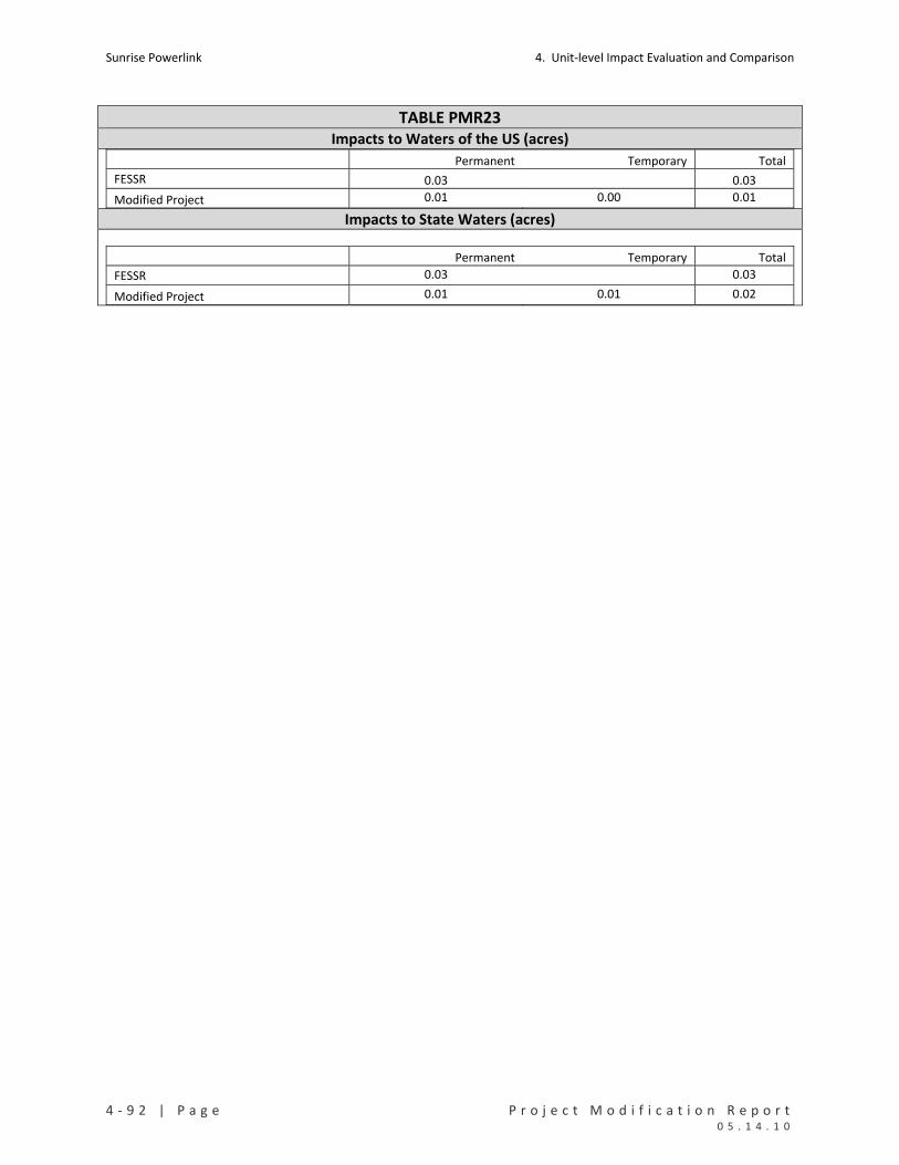
Sunrise Powerlink 4. Unit‐level Impact Evaluation and Comparison
4 ‐ 9 2 | P a g e P r o j e c t M o d i f i c a t i o n R e p o r t 0 5 . 1 4 . 1 0
TABLE PMR23 Impacts to Waters of the US (acres)
Permanent Temporary Total
FESSR 0.03 0.03
Modified Project 0.01 0.00 0.01
Impacts to State Waters (acres)
Permanent Temporary Total
FESSR 0.03 0.03
Modified Project 0.01 0.01 0.02

4. Unit‐level Impact Evaluation and Comparison Sunrise Powerlink
P r o j e c t M o d i f i c a t i o n R e p o r t P a g e | 4 ‐ 9 3 0 5 . 1 4 . 1 0
PMR24. EP47‐2 to EP39‐1 (Barrett Lake)
Mileposts Link Yard(s) PMR Figure Mapbook Sheet(s)
MP75.3 to MP78.1 2 Barrett Canyon 24 MS88 to MS91
Summary and Conclusion
The modification would eliminate eight structures by increasing the span length between structures. Access would
be removed and replaced with tower staging/access pads and two temporary work areas would increase in size.
The Barrett Canyon construction yard would be expanded to 1.59 acres. No new significant impacts would result
from the modification.
Details and Purpose
Modification
Reroute
Eight structures eliminated.
Two wire pull sites eliminated.
TSAPs added at EP45‐1 and EP44.
Temporary work areas around two structures increased in size.
Guard structures added at road crossings.
Barrett Canyon Construction Yard
Construction yard expanded to 1.59 acres within ROW in the same location.
Primary Reason Improve engineering design.
Other Considerations Reduce visual impacts.
MMCRP Measures B‐1a, GEO‐APM‐4, GEO‐APM‐5, V‐1a , V‐2d, C‐1a, C‐1b and WQ‐APM‐1
Environmental Impact Discussion
Air Quality No substantial change in the effects of the FESSR.
Biological Resources See Table PMR24 below.
Rare Plants The modification would avoid impacts to Dean’s milk‐vetch, slightly increase permanent and reduce temporary impacts to San Diego sunflower.
Vegetation Impacts The modification would reduce impacts to chaparrals.
Species Impacts Neither the modification nor the FESSR would affect special status wildlife in this unit.
RCAs Not applicable to the modification or the FESSR in this unit.
Cultural Resources There is one cultural resource site and one isolated find in this unit. Neither the modification nor the FESSR would affect the site.
Geology/Minerals The modification would reduce ground disturbance and the associated slope stability and erosion effects in this PMR unit.
Land Use The modification reduces impacts to BLM and City of San Diego lands. There are no residential sensitive receptors within one‐quarter mile of impact areas.
Noise No substantial change in the effects of the FESSR.

Sunrise Powerlink 4. Unit‐level Impact Evaluation and Comparison
4 ‐ 9 4 | P a g e P r o j e c t M o d i f i c a t i o n R e p o r t 0 5 . 1 4 . 1 0
PMR24. EP47‐2 to EP39‐1 (Barrett Lake)
Public Safety/Hazards No substantial change in the effects of the FESSR.
Traffic No substantial change in the effects of the FESSR.
Visual
The modification would reduce visual impacts along this route segment by eliminating
eight towers and reducing long‐term visible land scarring through the reduction of
access roads and pads. However, the reduced impact would not change the overall
impact assessment or significance conclusion for this route segment.
Water Resources
Waters of US Neither the modification nor the FESSR would affect waters of the US.
State Waters Neither the modification nor the FESSR would affect State waters.
Water Use No substantial change in effects of the FESSR, with some potential for reduced water use because of the reduction in ground disturbance.

4. Unit‐level Impact Evaluation and Comparison Sunrise Powerlink
P r o j e c t M o d i f i c a t i o n R e p o r t P a g e | 4 ‐ 9 5 0 5 . 1 4 . 1 0
TABLE PMR24
Impacts to Rare Plants (number of individuals detected in impact areas)
Permanent Temporary Total
Dean's milk‐vetch 8 8 FESSR
San Diego sunflower 11 23 34
Modified Project San Diego sunflower 13 15 28 Impacts to Sensitive Vegetation Communities and Total Ground Disturbance (acres)
Permanent Temporary Total
FESSR Chaparrals 6.98 10.30 17.28
Modified Project
Chaparrals 4.61 2.42 7.04
Impacts to Special Status Species (acres)
No impacts from FESSR or modified Project in this unit.
Impacts to RCAs in CNF (acres)
Not applicable to FESSR or modified Project in this unit.
Impacts to Cultural Resources (number of sites potentially affected)
No impacts from FESSR or modified Project in this unit.
Impacts to Waters of the US (acres)
No impacts from FESSR or modified Project in this unit.
Impacts to State Waters (acres)
No impacts from FESSR or modified Project in this unit.

Sunrise Powerlink 4. Unit‐level Impact Evaluation and Comparison
4 ‐ 9 6 | P a g e P r o j e c t M o d i f i c a t i o n R e p o r t 0 5 . 1 4 . 1 0
PMR25. EP39‐1 to EP22‐1 (Hermes)
Mileposts Link Yard(s) PMR Figure Mapbook Sheet(s)
MP78.1 to MP82.7 2 SWAT Training
Facility 25 MS91 to MS98
Summary and Conclusion
The modification would shift the alignment east to a straight northerly route, reduce the number and size of wire
stringing sites, and reduce the size the SWAT Training Facility Yard. The modification would avoid impacts to the
rare plants and sensitive vegetation types affected by the FESSR and entail impacts to one rare plant and one
vegetation type not affected by the FESSR. Impacts to the Hermes copper butterfly habitat and occupied Quino
checkerspot butterfly habitat and USFS modeled habitat for coastal California gnatcatcher would decrease;
impacts to USFS modeled habitat for least Bell’s vireo and southwestern willow flycatcher would increase. Impacts
to US and State waters would decrease. Both the modification and FESSR would result in permanent and
temporary impacts to RCAs in CNF. Other effects of the modification would be substantially the same as the
FESSR. No new significant impacts would result from the modification.
Details and Purpose
Modification
Reroute
ROW shifted up to 4,300 feet east to a straight northerly route.
Length of ROW reduced to 4.6 miles from 5.22 miles.
One wire pull site eliminated; the others relocated within ROW and reduced in size.
Access road to EP36‐1 redesigned
Guard structures added at road crossings.
SWAT Training Facility Construction Yard
Size of construction yard reduced to 15.88 acres.
No change in construction yard location.
Primary Reason
Request from USFS to move structures and change to helicopter construction to avoid
Hermes copper butterfly habitat and to relocate access road to avoid impacts to
occupied Quino habitat.
Other Considerations Reduce visual impacts from Lyons Valley Road.
MMCRP Measures B‐1a, BIO‐APM‐18, V‐2d, C‐1a, C‐1a and 1b, GEO‐APM‐4, L2B, and WQ‐APM‐1
Environmental Impact Discussion
Air Quality
The increased use of helicopters would not exceed the fuel‐use cap or emissions
identified for the FESSR or as calculated and approved in the Sunrise Construction
Emissions Monitoring Plan (CEMP) January 2010.No substantial change in the effects of
the FESSR.
Biological Resources See Table PMR25 below.

4. Unit‐level Impact Evaluation and Comparison Sunrise Powerlink
P r o j e c t M o d i f i c a t i o n R e p o r t P a g e | 4 ‐ 9 7 0 5 . 1 4 . 1 0
PMR25. EP39‐1 to EP22‐1 (Hermes)
Rare Plants
The modification would avoid impacts to 10 rare plants affected by the FESSR, including large numbers of felt‐leaved monardella, Gander’s ragwort, and sticky geraea. The modification would affect one rare plant – rush‐like bristleweed – not affected by the FESSR.
Vegetation Impacts
The modification would reduce the total impacts to each sensitive vegetation type affected by the FESSR, with higher permanent impacts to grasslands and woodlands. The modification would affect one vegetation type – coastal and montane scrub – not affected by the FESSR.
Species Impacts
The modification would reduce impacts to Quino occupied habitat and USFS modeled habitat for coastal California gnatcatcher and avoid impacts to Hermes copper butterfly habitat. The modification would affect more areas identified by USFS models as suitable habitat for least Bell’s vireo and southwestern willow flycatcher than would the FESSR. However, surveys have determined that the areas are not occupied by the species.
RCAs Both the FESSR and modification would affect RCAs in CNF.
Cultural Resources There are three cultural resource sites and no isolated finds in this unit. The FESSR would potentially affect 2 sites; the modification would affect none. See Table PMR25 below.
Geology/Minerals The modification would reduce ground disturbance and the associated slope stability and erosion effects in this PMR unit.
Land Use The modification reduces total impacts on USFS and City of San Diego lands and accommodates USFS’ request. There are five residential sensitive receptors and 1 commercial sensitive receptor within one‐quarter mile of the impact areas.
Noise
Noise from helicopter operations would increase, and noise from truck traffic would decrease. Noise impacts will be minimized and mitigated through the applicable MMCRP measures as may be required. Otherwise, no substantial change in the effects of the FESSR.
Public Safety/Hazards No substantial change in the effects of the FESSR.
Traffic No substantial change in effects of the FESSR.
Visual
The proposed Hermes modification would not noticeably change overall impacts on
visual resources along this route segment. Although the route would be moved further
to the east, and would not parallel Lyons Valley Road directly over the road as
proposed in the FESSR (beneficial effect), the new route would now pass through the
center of Lyons Valley (primary visual draw along this route segment) immediately to
the east of Lyons Valley Road. As a result, views from Lyons Valley Road would still be
substantially affected and the overall impact assessment and significance conclusions
would not change for this route segment. Specific actions have been and will continue
to be taken to minimize the visible disturbance of the Sunrise Powerlink on the
naturally established scenery of the Forest. The end result of these actions including
the appropriate coloration of structures will be presented in the Scenery Conservation
Plan which will present the final direction to best achieve the spirit and intent of the
Scenic Integrity Objectives of the Cleveland National Forest Land Management Plan.

Sunrise Powerlink 4. Unit‐level Impact Evaluation and Comparison
4 ‐ 9 8 | P a g e P r o j e c t M o d i f i c a t i o n R e p o r t 0 5 . 1 4 . 1 0
PMR25. EP39‐1 to EP22‐1 (Hermes)
Water Resources See Table PMR25 below.
Waters of US The modification would reduce impacts to waters of the US.
State Waters The modification would reduce impacts to State waters.
Water Use No substantial change in the effects of the FESSR, with some potential for reduced water use because of the reduction in ground disturbance.

4. Unit‐level Impact Evaluation and Comparison Sunrise Powerlink
P r o j e c t M o d i f i c a t i o n R e p o r t P a g e | 4 ‐ 9 9 0 5 . 1 4 . 1 0
TABLE PMR25
Impacts to Rare Plants (number of individuals detected in impact areas)
Permanent Temporary Total
Caraway‐leaved Gilia 28 28
Cleveland's bush monkey flower 2 133 135
Dunn's mariposa lily 20 20
Felt‐leaved monardella 537 537
Fish's milkwort 6 6
Gander's ragwort 188 2455 2643
Robinson pepper‐grass 7 7
Southern mountain misery 15 15 30
Sticky geraea 5 1839 1844
FESSR
Tufted pine‐grass 7 7
Modified Project Rush‐like bristleweed 7 5 12 Impacts to Sensitive Vegetation Communities and Total Ground Disturbance (acres)
Permanent Temporary Total
Chaparrals 7.50 16.65 24.15
Grasslands and Meadows 0.66 25.22 25.88
Herbaceous Wetlands, Freshwater, and Streams 0.01 0.15 0.17
Non‐native Vegetation, Developed Areas, and Disturbed Habitat 0.19 0.37 0.56
Riparian Forests and Woodlands 0.09 0.09
FESSR
Woodlands and Forests 1.00 1.00
FESSR Total 8.46 43.40 51.86
Chaparrals 5.17 7.19 12.37
Coastal and Montane Scrub Habitats 1.13 0.90 2.03
Grasslands and Meadows 0.88 17.67 18.54
Herbaceous Wetlands, Freshwater, and Streams 0.00 0.00
Non‐native Vegetation, Developed Areas, and Disturbed Habitat 1.99 0.07 2.06
Modified Project
Woodlands and Forests 0.01 0.01
Mod Proj 9.18 25.83 35.01 Impacts to Special Status Species (acres)
Permanent Temporary Total
Coastal California Gnatcatcher USFS Suitable Habitat in CNF 0.48 0.63 1.12
Quino Checkerspot Butterfly USFWS Occupied Habitat 4.10 15.40 19.50 FESSR
Southwestern Willow Flycatcher USFS Suitable Habitat in CNF 0.07 0.20 0.27
Coastal California Gnatcatcher USFS Suitable Habitat in CNF 0.10 0.01 0.11
Least Bell’s Vireo USFS Suitable Habitat in CNF 0.07 0.00 0.07
Quino Checkerspot Butterfly USFWS Occupied Habitat 3.65 4.59 8.24
Modified Project
Southwestern Willow Flycatcher USFS Suitable Habitat in CNF 0.24 0.00 0.24
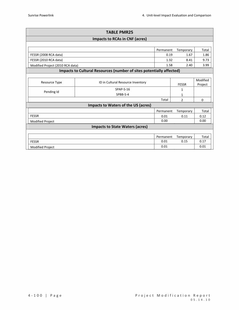
Sunrise Powerlink 4. Unit‐level Impact Evaluation and Comparison
4 ‐ 1 0 0 | P a g e P r o j e c t M o d i f i c a t i o n R e p o r t 0 5 . 1 4 . 1 0
TABLE PMR25
Impacts to RCAs in CNF (acres)
Permanent Temporary Total
FESSR (2008 RCA data) 0.19 1.67 1.86
FESSR (2010 RCA data) 1.32 8.41 9.73
Modified Project (2010 RCA data) 1.58 2.40 3.99 Impacts to Cultural Resources (number of sites potentially affected)
Resource Type ID in Cultural Resource Inventory FESSR
ModifiedProject
SPAP‐S‐16 1 Pending Id
SPBB‐S‐4 1
Total 2 0 Impacts to Waters of the US (acres) Permanent Temporary Total
FESSR 0.01 0.11 0.12
Modified Project 0.00 0.00
Impacts to State Waters (acres)
Permanent Temporary Total
FESSR 0.01 0.15 0.17
Modified Project 0.01 0.01
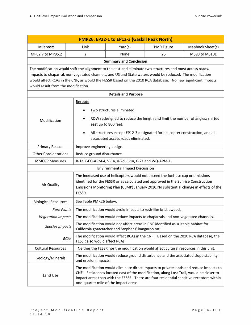
4. Unit‐level Impact Evaluation and Comparison Sunrise Powerlink
P r o j e c t M o d i f i c a t i o n R e p o r t P a g e | 4 ‐ 1 0 1 0 5 . 1 4 . 1 0
PMR26. EP22‐1 to EP12‐3 (Gaskill Peak North)
Mileposts Link Yard(s) PMR Figure Mapbook Sheet(s)
MP82.7 to MP85.2 2 None 26 MS98 to MS101
Summary and Conclusion
The modification would shift the alignment to the east and eliminate two structures and most access roads.
Impacts to chaparral, non‐vegetated channels, and US and State waters would be reduced. The modification
would affect RCAs in the CNF, as would the FESSR based on the 2010 RCA database. No new significant impacts
would result from the modification.
Details and Purpose
Modification
Reroute
Two structures eliminated.
ROW redesigned to reduce the length and limit the number of angles; shifted
east up to 800 feet.
All structures except EP12‐3 designated for helicopter construction, and all
associated access roads eliminated.
Primary Reason Improve engineering design.
Other Considerations Reduce ground disturbance.
MMCRP Measures B‐1a, GEO‐APM‐4, V‐1a, V‐2d, C‐1a, C‐2a and WQ‐APM‐1.
Environmental Impact Discussion
Air Quality
The increased use of helicopters would not exceed the fuel‐use cap or emissions
identified for the FESSR or as calculated and approved in the Sunrise Construction
Emissions Monitoring Plan (CEMP) January 2010.No substantial change in effects of the
FESSR.
Biological Resources See Table PMR26 below.
Rare Plants The modification would avoid impacts to rush‐like bristleweed.
Vegetation Impacts The modification would reduce impacts to chaparrals and non‐vegetated channels.
Species Impacts The modification would not affect areas in CNF identified as suitable habitat for California gnatcatcher and Stephens’ kangaroo rat.
RCAs The modification would affect RCAs in the CNF. Based on the 2010 RCA database, the FESSR also would affect RCAs.
Cultural Resources Neither the FESSR nor the modification would affect cultural resources in this unit.
Geology/Minerals The modification would reduce ground disturbance and the associated slope stability and erosion impacts.
Land Use
The modification would eliminate direct impacts to private lands and reduce impacts to CNF. Residences located east of the modification, along Lost Trail, would be closer to impact areas than with the FESSR. There are four residential sensitive receptors within one‐quarter mile of the impact areas.

Sunrise Powerlink 4. Unit‐level Impact Evaluation and Comparison
4 ‐ 1 0 2 | P a g e P r o j e c t M o d i f i c a t i o n R e p o r t 0 5 . 1 4 . 1 0
PMR26. EP22‐1 to EP12‐3 (Gaskill Peak North)
Noise No substantial change in effects of the FESSR, with an increase in helicopter‐related noise and decrease in truck‐related noise. Noise impacts will be minimized and mitigated through the applicable MMCRP measures as may be required.
Public Safety/Hazards No substantial change in effects of the FESSR.
Traffic No substantial change in effects of the FESSR, with some reduction in local traffic
effects because of the increased use of helicopter construction.
Visual
No substantial change in effects of the FESSR, with a slight reduction in visual impacts
from the elimination of two structures and from the decrease in long‐term land
scarring. Specific actions have been and will continue to be taken to minimize the
visible disturbance of the Sunrise Powerlink on the naturally established scenery of the
Forest. The end result of these actions including the appropriate coloration of
structures will be presented in the Scenery Conservation Plan which will present the
final direction to best achieve the spirit and intent of the Scenic Integrity Objectives of
the Cleveland National Forest Land Management Plan.
Water Resources See Table PMR26 below.
Waters of US The modification would reduce impacts to waters of the US.
State Waters The modification would reduce impacts to State waters.
Water Use No substantial change in effects of the FESSR, with some potential for reduction in water use because of the reduced ground disturbance.
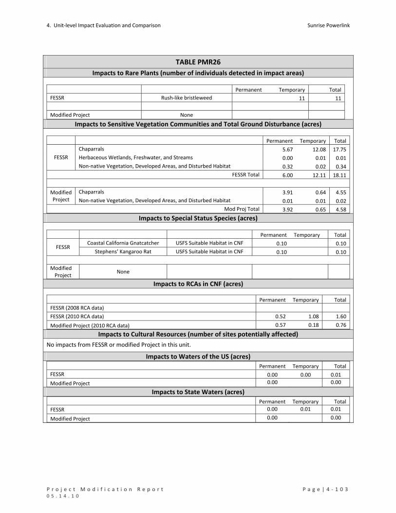
4. Unit‐level Impact Evaluation and Comparison Sunrise Powerlink
P r o j e c t M o d i f i c a t i o n R e p o r t P a g e | 4 ‐ 1 0 3 0 5 . 1 4 . 1 0
TABLE PMR26
Impacts to Rare Plants (number of individuals detected in impact areas)
Permanent Temporary Total
FESSR Rush‐like bristleweed 11 11
Modified Project None Impacts to Sensitive Vegetation Communities and Total Ground Disturbance (acres)
Permanent Temporary Total
Chaparrals 5.67 12.08 17.75
Herbaceous Wetlands, Freshwater, and Streams 0.00 0.01 0.01 FESSR
Non‐native Vegetation, Developed Areas, and Disturbed Habitat 0.32 0.02 0.34
FESSR Total 6.00 12.11 18.11
Chaparrals 3.91 0.64 4.55 Modified Project Non‐native Vegetation, Developed Areas, and Disturbed Habitat 0.01 0.01 0.02
Mod Proj Total 3.92 0.65 4.58 Impacts to Special Status Species (acres)
Permanent Temporary Total
Coastal California Gnatcatcher USFS Suitable Habitat in CNF 0.10 0.10 FESSR
Stephens’ Kangaroo Rat USFS Suitable Habitat in CNF 0.10 0.10
Modified Project
None
Impacts to RCAs in CNF (acres)
Permanent Temporary Total
FESSR (2008 RCA data)
FESSR (2010 RCA data) 0.52 1.08 1.60
Modified Project (2010 RCA data) 0.57 0.18 0.76 Impacts to Cultural Resources (number of sites potentially affected)
No impacts from FESSR or modified Project in this unit.
Impacts to Waters of the US (acres) Permanent Temporary Total
FESSR 0.00 0.00 0.01
Modified Project 0.00 0.00
Impacts to State Waters (acres) Permanent Temporary Total
FESSR 0.00 0.01 0.01
Modified Project 0.00 0.00

Sunrise Powerlink 4. Unit‐level Impact Evaluation and Comparison
4 ‐ 1 0 4 | P a g e P r o j e c t M o d i f i c a t i o n R e p o r t 0 5 . 1 4 . 1 0
PMR27. EP12‐3 to EP9‐1 (Cedar Ranch)
Mileposts Link Yard(s) PMR Figure Mapbook Sheet(s)
MP85.2 to MP86 2 None 27 MS101 to MS103
Summary and Conclusion
The modification would shift the alignment to the southeast, eliminate one structure, and eliminate a yard. The
modification would reduce impacts to chaparrals and USFS suitable habitat for Gnatcatcher in CNF. Other effects
would be the same as for the FESSR. No new significant impacts would result from the modification.
Details and Purpose
Modification
Reroute
One structure eliminated.
ROW shifted away from Japatul Road.
Wire pull sites relocated within the ROW.
Guard structures added at road crossings.
Primary Reason Improve engineering design.
Other Considerations Reduce number and length of new access roads.
Maximize use of existing roads.
MMCRP Measures B1‐a, GEO‐APM‐4, V‐2d, C‐1a, and GEO‐APM‐5.
Environmental Impact Discussion
Air Quality No substantial change to effects of the FESSR.
Biological Resources See Table PMR27 below.
Rare Plants Neither the FESSR nor the modification would affect rare plants.
Vegetation Impacts The modification would reduce impacts to chaparrals and would entail a small permanent impact to grasslands.
Species Impacts The modification would reduce impacts to areas identified as USFS suitable habitat for Gnatcatcher in CNF.
RCAs The modification would not affect RCAs. The RCA 2010 database indicates a minimal impact (0.01 acre) to RCAs from the FESSR.
Cultural Resources Neither the FESSR nor the modification would affect cultural resources.
Geology/Minerals The modification would reduce ground disturbance and the associated slope stability and erosion impacts.
Land Use The modification reduces impacts to private lands and CNF. There are four sensitive receptors (two residential and twp commercial) within one‐quarter mile of the impact areas.
Noise No substantial change to effects of the FESSR.
Public Safety/Hazards No substantial change to effects of the FESSR.
Traffic No substantial change to effects of the FESSR.
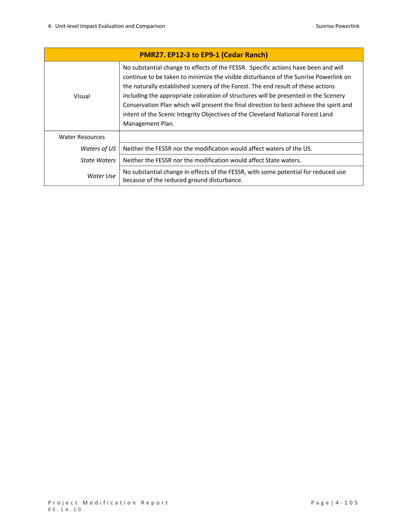
4. Unit‐level Impact Evaluation and Comparison Sunrise Powerlink
P r o j e c t M o d i f i c a t i o n R e p o r t P a g e | 4 ‐ 1 0 5 0 5 . 1 4 . 1 0
PMR27. EP12‐3 to EP9‐1 (Cedar Ranch)
Visual
No substantial change to effects of the FESSR. Specific actions have been and will
continue to be taken to minimize the visible disturbance of the Sunrise Powerlink on
the naturally established scenery of the Forest. The end result of these actions
including the appropriate coloration of structures will be presented in the Scenery
Conservation Plan which will present the final direction to best achieve the spirit and
intent of the Scenic Integrity Objectives of the Cleveland National Forest Land
Management Plan.
Water Resources
Waters of US Neither the FESSR nor the modification would affect waters of the US.
State Waters Neither the FESSR nor the modification would affect State waters.
Water Use No substantial change in effects of the FESSR, with some potential for reduced use because of the reduced ground disturbance.
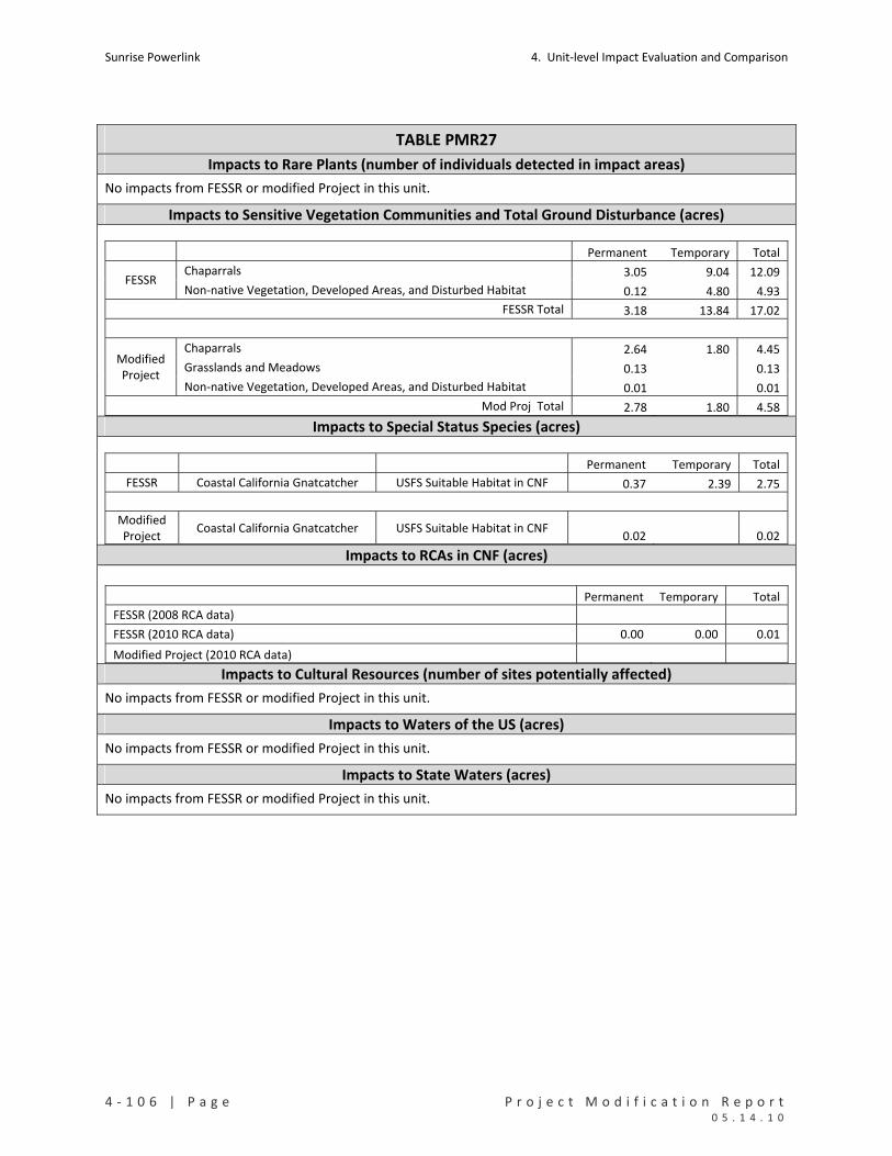
Sunrise Powerlink 4. Unit‐level Impact Evaluation and Comparison
4 ‐ 1 0 6 | P a g e P r o j e c t M o d i f i c a t i o n R e p o r t 0 5 . 1 4 . 1 0
TABLE PMR27
Impacts to Rare Plants (number of individuals detected in impact areas)
No impacts from FESSR or modified Project in this unit.
Impacts to Sensitive Vegetation Communities and Total Ground Disturbance (acres)
Permanent Temporary Total
Chaparrals 3.05 9.04 12.09 FESSR
Non‐native Vegetation, Developed Areas, and Disturbed Habitat 0.12 4.80 4.93
FESSR Total 3.18 13.84 17.02
Chaparrals 2.64 1.80 4.45
Grasslands and Meadows 0.13 0.13 Modified Project
Non‐native Vegetation, Developed Areas, and Disturbed Habitat 0.01 0.01
Mod Proj Total 2.78 1.80 4.58 Impacts to Special Status Species (acres)
Permanent Temporary Total
FESSR Coastal California Gnatcatcher USFS Suitable Habitat in CNF 0.37 2.39 2.75
Modified Project
Coastal California Gnatcatcher USFS Suitable Habitat in CNF 0.02 0.02
Impacts to RCAs in CNF (acres)
Permanent Temporary Total
FESSR (2008 RCA data)
FESSR (2010 RCA data) 0.00 0.00 0.01
Modified Project (2010 RCA data) Impacts to Cultural Resources (number of sites potentially affected)
No impacts from FESSR or modified Project in this unit.
Impacts to Waters of the US (acres)
No impacts from FESSR or modified Project in this unit.
Impacts to State Waters (acres)
No impacts from FESSR or modified Project in this unit.

4. Unit‐level Impact Evaluation and Comparison Sunrise Powerlink
P r o j e c t M o d i f i c a t i o n R e p o r t P a g e | 4 ‐ 1 0 7 0 5 . 1 4 . 1 0
PMR28. EP9‐1 to EP1‐3 (Just)
Mileposts Link Yard(s) PMR Figure Mapbook Sheet(s)
MP86 to MP89 2 None 28 MS102 to MS107
Summary and Conclusion
The modification would eliminate three wire stringing sites and reduce the number and length of new access
roads. Impacts to sensitive vegetation types and US and State waters would be reduced; and impacts to suitable
habitat for listed species would increase and decrease slightly. Both the modification and FESSR would result in
impacts to RCAs in CNF. No new significant impacts would result from the modification.
Details and Purpose
Modification
Reroute
Three wire pull sites removed.
Access roads reduced in length or eliminated.
Primary Reason Accommodate landowner request (Just/Nowak).
Other Considerations Reduce ground disturbance.
MMCRP Measures B‐1a, C‐1a and 1b, L‐2b, V‐2d and V‐1b.
Environmental Impact Discussion
Air Quality
The increased use of helicopters would not exceed the fuel‐use cap or emissions
identified for the FESSR or as calculated and approved in the Sunrise Construction
Emissions Monitoring Plan (CEMP) January 2010. No substantial changes in effects of
the FESSR.
Biological Resources See Table PMR28 below.
Rare Plants Neither the modification nor the FESSR would affect rare plants.
Vegetation Impacts The modification would reduce impacts to chaparrals, coastal and montane scrubs,
grasslands, and non‐vegetated channels.
Species Impacts
The modification would reduce impacts to suitable habitat for arroyo toad and
Gnatcatcher. There would be small impacts in areas identified as suitable for least
Bell’s vireo and southwestern willow flycatcher (surveys have determined that the
areas are not occupied by these species).
RCAs Both the FESSR and the modification would affect RCAs in CNF.
Cultural Resources Neither the FESSR nor the modification would affect cultural resources.
Geology/Minerals The modification would reduce ground disturbance and the associated slope stability and erosion impacts.
Land Use The modification would reduce impacts to private property and the CNF. There is two residential and one commercial sensitive receptors within one‐quarter mile of the impacts areas.
Noise Noise from helicopter operations would increase, and noise from truck traffic would decrease. Noise impacts will be minimized and mitigated through the applicable MMCRP measures as may be required. No substantial changes in effects of the FESSR.

Sunrise Powerlink 4. Unit‐level Impact Evaluation and Comparison
4 ‐ 1 0 8 | P a g e P r o j e c t M o d i f i c a t i o n R e p o r t 0 5 . 1 4 . 1 0
PMR28. EP9‐1 to EP1‐3 (Just)
Public Safety/Hazards No substantial changes in effects of the FESSR.
Traffic No substantial changes in effects of the FESSR.
Visual No substantial changes in effects of the FESSR.
Water Resources See Table PMR28 below.
Waters of US The modification would reduce impacts to waters of the US.
State Waters The modification would reduce impacts to State waters.
Water Use No substantial changes in effects of the FESSR, with some potential for reduced use because of the reduction in ground disturbance.
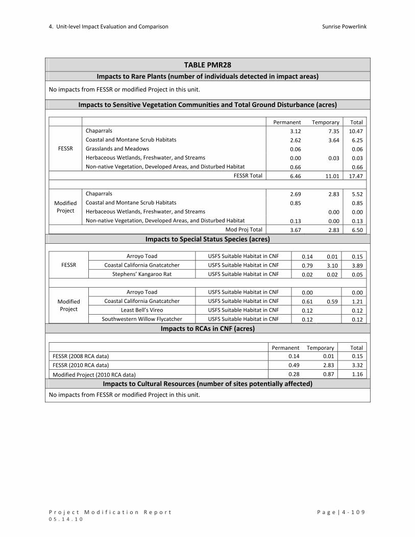
4. Unit‐level Impact Evaluation and Comparison Sunrise Powerlink
P r o j e c t M o d i f i c a t i o n R e p o r t P a g e | 4 ‐ 1 0 9 0 5 . 1 4 . 1 0
TABLE PMR28
Impacts to Rare Plants (number of individuals detected in impact areas)
No impacts from FESSR or modified Project in this unit.
Impacts to Sensitive Vegetation Communities and Total Ground Disturbance (acres)
Permanent Temporary Total
Chaparrals 3.12 7.35 10.47
Coastal and Montane Scrub Habitats 2.62 3.64 6.25
Grasslands and Meadows 0.06 0.06
Herbaceous Wetlands, Freshwater, and Streams 0.00 0.03 0.03
FESSR
Non‐native Vegetation, Developed Areas, and Disturbed Habitat 0.66 0.66
FESSR Total 6.46 11.01 17.47
Chaparrals 2.69 2.83 5.52
Coastal and Montane Scrub Habitats 0.85 0.85
Herbaceous Wetlands, Freshwater, and Streams 0.00 0.00
Modified Project
Non‐native Vegetation, Developed Areas, and Disturbed Habitat 0.13 0.00 0.13
Mod Proj Total 3.67 2.83 6.50 Impacts to Special Status Species (acres)
Arroyo Toad USFS Suitable Habitat in CNF 0.14 0.01 0.15
Coastal California Gnatcatcher USFS Suitable Habitat in CNF 0.79 3.10 3.89 FESSR
Stephens’ Kangaroo Rat USFS Suitable Habitat in CNF 0.02 0.02 0.05
Arroyo Toad USFS Suitable Habitat in CNF 0.00 0.00
Coastal California Gnatcatcher USFS Suitable Habitat in CNF 0.61 0.59 1.21
Least Bell’s Vireo USFS Suitable Habitat in CNF 0.12 0.12
Modified Project
Southwestern Willow Flycatcher USFS Suitable Habitat in CNF 0.12 0.12 Impacts to RCAs in CNF (acres)
Permanent Temporary Total
FESSR (2008 RCA data) 0.14 0.01 0.15
FESSR (2010 RCA data) 0.49 2.83 3.32
Modified Project (2010 RCA data) 0.28 0.87 1.16 Impacts to Cultural Resources (number of sites potentially affected)
No impacts from FESSR or modified Project in this unit.

Sunrise Powerlink 4. Unit‐level Impact Evaluation and Comparison
4 ‐ 1 1 0 | P a g e P r o j e c t M o d i f i c a t i o n R e p o r t 0 5 . 1 4 . 1 0
TABLE PMR28
Impacts to Waters of the US (acres) Permanent Temporary Total
FESSR 0.00 0.01 0.01
Modified Project 0.00 0.00
Impacts to State Waters (acres)
Permanent Temporary Total
FESSR 0.00 0.03 0.03
Modified Project 0.00 0.00
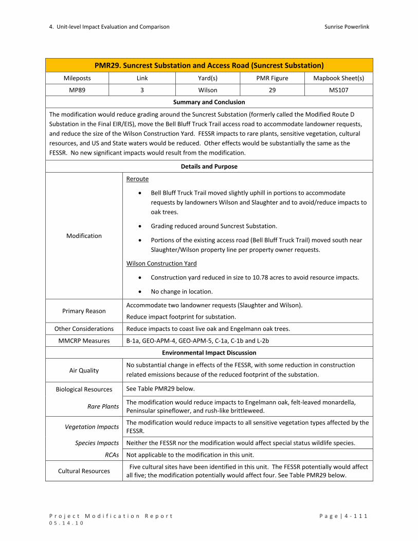
4. Unit‐level Impact Evaluation and Comparison Sunrise Powerlink
P r o j e c t M o d i f i c a t i o n R e p o r t P a g e | 4 ‐ 1 1 1 0 5 . 1 4 . 1 0
PMR29. Suncrest Substation and Access Road (Suncrest Substation)
Mileposts Link Yard(s) PMR Figure Mapbook Sheet(s)
MP89 3 Wilson 29 MS107
Summary and Conclusion
The modification would reduce grading around the Suncrest Substation (formerly called the Modified Route D
Substation in the Final EIR/EIS), move the Bell Bluff Truck Trail access road to accommodate landowner requests,
and reduce the size of the Wilson Construction Yard. FESSR impacts to rare plants, sensitive vegetation, cultural
resources, and US and State waters would be reduced. Other effects would be substantially the same as the
FESSR. No new significant impacts would result from the modification.
Details and Purpose
Modification
Reroute
Bell Bluff Truck Trail moved slightly uphill in portions to accommodate
requests by landowners Wilson and Slaughter and to avoid/reduce impacts to
oak trees.
Grading reduced around Suncrest Substation.
Portions of the existing access road (Bell Bluff Truck Trail) moved south near
Slaughter/Wilson property line per property owner requests.
Wilson Construction Yard
Construction yard reduced in size to 10.78 acres to avoid resource impacts.
No change in location.
Primary Reason Accommodate two landowner requests (Slaughter and Wilson).
Reduce impact footprint for substation.
Other Considerations Reduce impacts to coast live oak and Engelmann oak trees.
MMCRP Measures B‐1a, GEO‐APM‐4, GEO‐APM‐5, C‐1a, C‐1b and L‐2b
Environmental Impact Discussion
Air Quality No substantial change in effects of the FESSR, with some reduction in construction
related emissions because of the reduced footprint of the substation.
Biological Resources See Table PMR29 below.
Rare Plants The modification would reduce impacts to Engelmann oak, felt‐leaved monardella, Peninsular spineflower, and rush‐like brittleweed.
Vegetation Impacts The modification would reduce impacts to all sensitive vegetation types affected by the FESSR.
Species Impacts Neither the FESSR nor the modification would affect special status wildlife species.
RCAs Not applicable to the modification in this unit.
Cultural Resources Five cultural sites have been identified in this unit. The FESSR potentially would affect all five; the modification potentially would affect four. See Table PMR29 below.

Sunrise Powerlink 4. Unit‐level Impact Evaluation and Comparison
4 ‐ 1 1 2 | P a g e P r o j e c t M o d i f i c a t i o n R e p o r t 0 5 . 1 4 . 1 0
PMR29. Suncrest Substation and Access Road (Suncrest Substation)
Geology/Minerals The modification would reduce ground disturbance and the associated slope stability and erosion impacts.
Land Use The modification accommodates landowner requests and eliminated impacts to CNF.
There are no sensitive receptors within one‐quarter mile of impact areas.
Noise No substantial change in effects of the FESSR.
Public Safety/Hazards No substantial change in effects of the FESSR.
Traffic No substantial change in effects of the FESSR.
Visual No substantial change in effects of the FESSR.
Water Resources See Table PMR29 below.
Waters of US The modification would reduce impacts to waters of the US.
State Waters The modification would reduce impacts to State waters.
Water Use No substantial change in effects of the FESSR, with some potential for reduced use because of the reduction in ground disturbance.
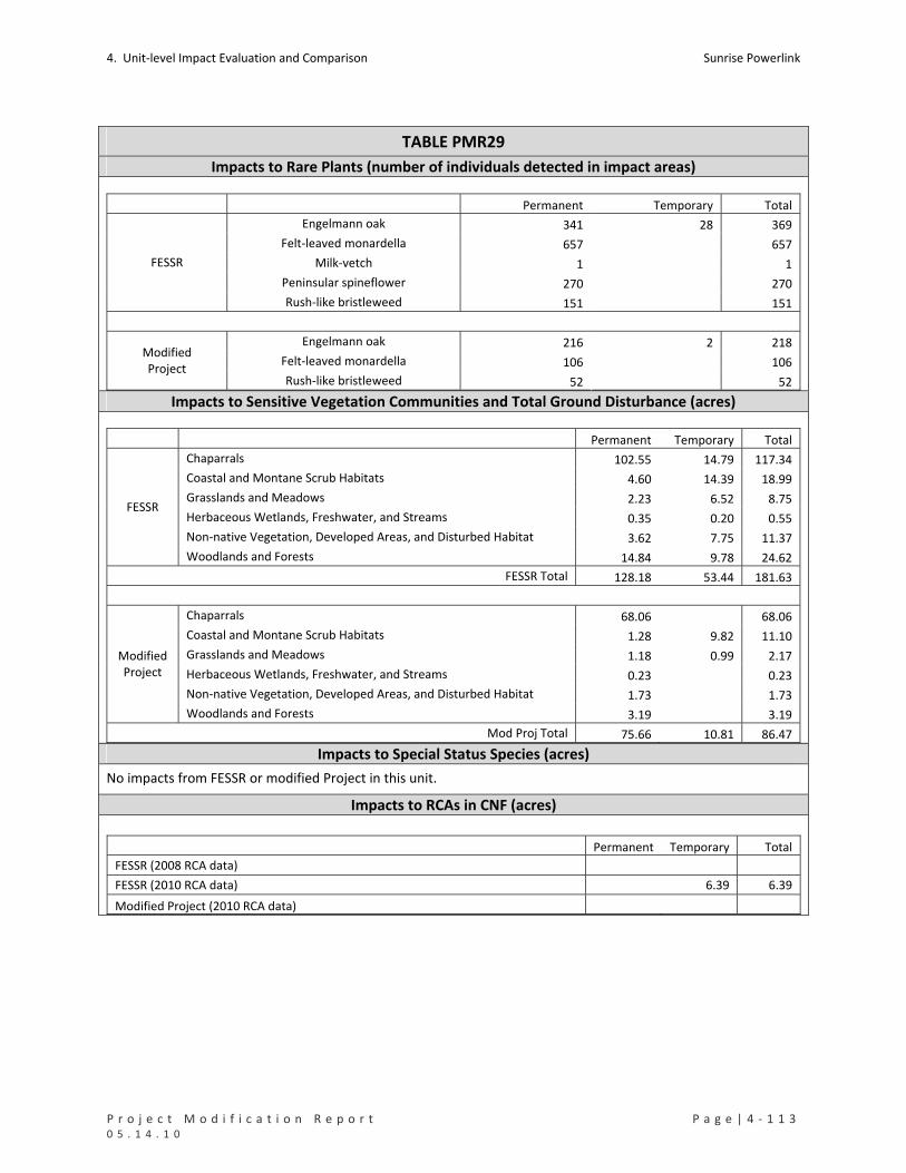
4. Unit‐level Impact Evaluation and Comparison Sunrise Powerlink
P r o j e c t M o d i f i c a t i o n R e p o r t P a g e | 4 ‐ 1 1 3 0 5 . 1 4 . 1 0
TABLE PMR29
Impacts to Rare Plants (number of individuals detected in impact areas)
Permanent Temporary Total
Engelmann oak 341 28 369
Felt‐leaved monardella 657 657
Milk‐vetch 1 1
Peninsular spineflower 270 270
FESSR
Rush‐like bristleweed 151 151
Engelmann oak 216 2 218
Felt‐leaved monardella 106 106 Modified Project
Rush‐like bristleweed 52 52 Impacts to Sensitive Vegetation Communities and Total Ground Disturbance (acres)
Permanent Temporary Total
Chaparrals 102.55 14.79 117.34
Coastal and Montane Scrub Habitats 4.60 14.39 18.99
Grasslands and Meadows 2.23 6.52 8.75
Herbaceous Wetlands, Freshwater, and Streams 0.35 0.20 0.55
Non‐native Vegetation, Developed Areas, and Disturbed Habitat 3.62 7.75 11.37
FESSR
Woodlands and Forests 14.84 9.78 24.62
FESSR Total 128.18 53.44 181.63
Chaparrals 68.06 68.06
Coastal and Montane Scrub Habitats 1.28 9.82 11.10
Grasslands and Meadows 1.18 0.99 2.17
Herbaceous Wetlands, Freshwater, and Streams 0.23 0.23
Non‐native Vegetation, Developed Areas, and Disturbed Habitat 1.73 1.73
Modified Project
Woodlands and Forests 3.19 3.19
Mod Proj Total 75.66 10.81 86.47 Impacts to Special Status Species (acres)
No impacts from FESSR or modified Project in this unit.
Impacts to RCAs in CNF (acres)
Permanent Temporary Total
FESSR (2008 RCA data)
FESSR (2010 RCA data) 6.39 6.39
Modified Project (2010 RCA data)

Sunrise Powerlink 4. Unit‐level Impact Evaluation and Comparison
4 ‐ 1 1 4 | P a g e P r o j e c t M o d i f i c a t i o n R e p o r t 0 5 . 1 4 . 1 0
TABLE PMR29
Impacts to Cultural Resources (number of sites potentially affected)
Resource Category ID in Cultural Resource Inventory FESSR
Modified Project
SDI‐19036 1 1 Bedrock Milling
SDI‐19037 1 1
Historic Refuse SPPA‐S‐1 1 1
Pending Id BB‐S‐1 1 1
Prehistoric Bedrock Milling BW‐52 1
Total 7 5 4
Impacts to Waters of the US (acres) Permanent Temporary Total
FESSR 0.29 0.72 1.01
Modified Project 0.18 0.18
Impacts to State Waters (acres)
Permanent Temporary Total
FESSR 0.38 0.85 1.23
Modified Project 0.23 0.23
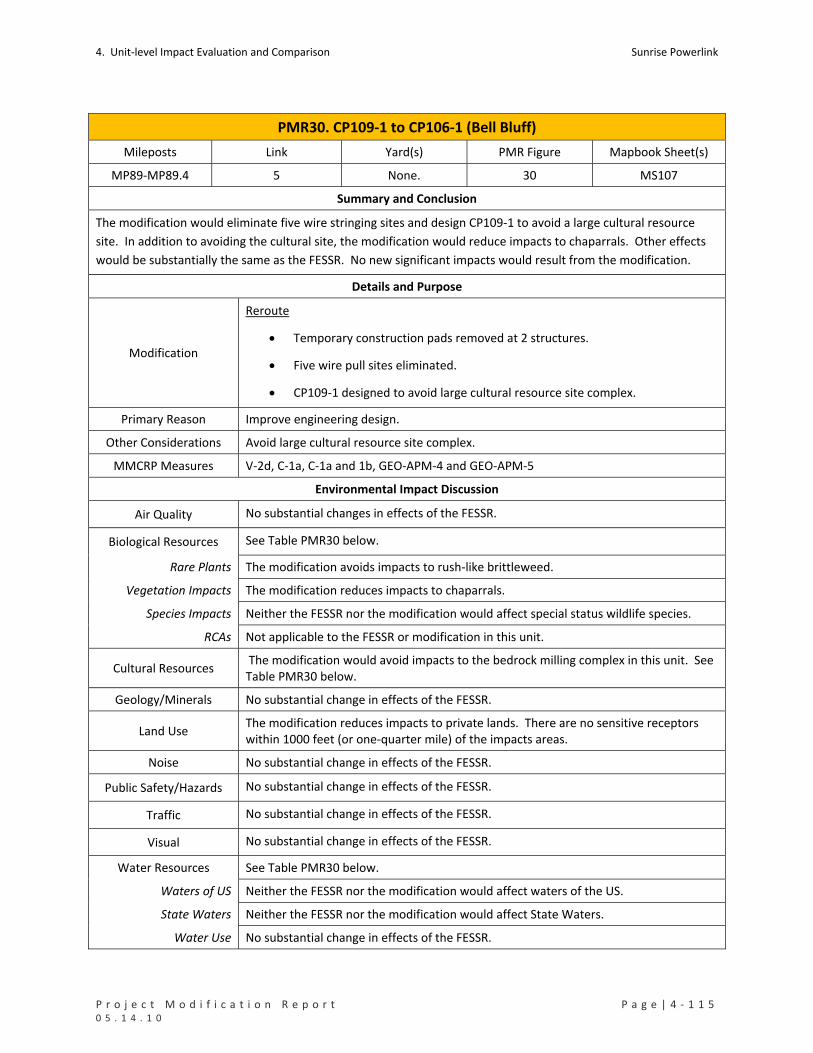
4. Unit‐level Impact Evaluation and Comparison Sunrise Powerlink
P r o j e c t M o d i f i c a t i o n R e p o r t P a g e | 4 ‐ 1 1 5 0 5 . 1 4 . 1 0
PMR30. CP109‐1 to CP106‐1 (Bell Bluff)
Mileposts Link Yard(s) PMR Figure Mapbook Sheet(s)
MP89‐MP89.4 5 None. 30 MS107
Summary and Conclusion
The modification would eliminate five wire stringing sites and design CP109‐1 to avoid a large cultural resource
site. In addition to avoiding the cultural site, the modification would reduce impacts to chaparrals. Other effects
would be substantially the same as the FESSR. No new significant impacts would result from the modification.
Details and Purpose
Modification
Reroute
Temporary construction pads removed at 2 structures.
Five wire pull sites eliminated.
CP109‐1 designed to avoid large cultural resource site complex.
Primary Reason Improve engineering design.
Other Considerations Avoid large cultural resource site complex.
MMCRP Measures V‐2d, C‐1a, C‐1a and 1b, GEO‐APM‐4 and GEO‐APM‐5
Environmental Impact Discussion
Air Quality No substantial changes in effects of the FESSR.
Biological Resources See Table PMR30 below.
Rare Plants The modification avoids impacts to rush‐like brittleweed.
Vegetation Impacts The modification reduces impacts to chaparrals.
Species Impacts Neither the FESSR nor the modification would affect special status wildlife species.
RCAs Not applicable to the FESSR or modification in this unit.
Cultural Resources The modification would avoid impacts to the bedrock milling complex in this unit. See Table PMR30 below.
Geology/Minerals No substantial change in effects of the FESSR.
Land Use The modification reduces impacts to private lands. There are no sensitive receptors within 1000 feet (or one‐quarter mile) of the impacts areas.
Noise No substantial change in effects of the FESSR.
Public Safety/Hazards No substantial change in effects of the FESSR.
Traffic No substantial change in effects of the FESSR.
Visual No substantial change in effects of the FESSR.
Water Resources See Table PMR30 below.
Waters of US Neither the FESSR nor the modification would affect waters of the US.
State Waters Neither the FESSR nor the modification would affect State Waters.
Water Use No substantial change in effects of the FESSR.

Sunrise Powerlink 4. Unit‐level Impact Evaluation and Comparison
4 ‐ 1 1 6 | P a g e P r o j e c t M o d i f i c a t i o n R e p o r t 0 5 . 1 4 . 1 0
TABLE PMR30
Impacts to Rare Plants (number of individuals detected in impact areas)
Permanent Temporary Total
FESSR Rush‐like bristleweed 3 6 9
Modified Project None Impacts to Sensitive Vegetation Communities and Total Ground Disturbance (acres)
Permanent Temporary Total
Chaparrals 1.85 2.91 4.76 FESSR
Non‐native Vegetation, Developed Areas, and Disturbed Habitat 0.02 0.01 0.03
FESSR Total 1.87 2.92 4.79
Modified Project
Chaparrals 0.87 0.87
Impacts to Special Status Species (acres)
No impacts from FESSR or modified Project in this unit.
Impacts to RCAs in CNF (acres)
Not applicable to FESSR or modified Project in this unit.
Impacts to Cultural Resources (number of sites potentially affected)
Resource Type ID in Cultural Resource Inventory FESSR
Modified Project
Bedrock Milling BW‐161 1 Impacts to Waters of the US (acres)
No impacts from FESSR or modified Project in this unit.
Impacts to State Waters (acres)
No impacts from FESSR or modified Project in this unit.
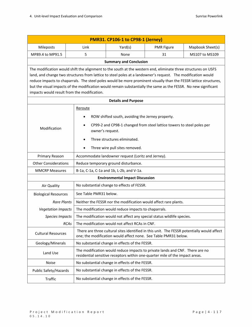
4. Unit‐level Impact Evaluation and Comparison Sunrise Powerlink
P r o j e c t M o d i f i c a t i o n R e p o r t P a g e | 4 ‐ 1 1 7 0 5 . 1 4 . 1 0
PMR31. CP106‐1 to CP98‐1 (Jerney)
Mileposts Link Yard(s) PMR Figure Mapbook Sheet(s)
MP89.4 to MP91.5 5 None 31 MS107 to MS109
Summary and Conclusion
The modification would shift the alignment to the south at the western end, eliminate three structures on USFS
land, and change two structures from lattice to steel poles at a landowner’s request. The modification would
reduce impacts to chaparrals. The steel poles would be more prominent visually than the FESSR lattice structures,
but the visual impacts of the modification would remain substantially the same as the FESSR. No new significant
impacts would result from the modification.
Details and Purpose
Modification
Reroute
ROW shifted south, avoiding the Jerney property.
CP99‐2 and CP98‐1 changed from steel lattice towers to steel poles per
owner’s request.
Three structures eliminated.
Three wire pull sites removed.
Primary Reason Accommodate landowner request (Loritz and Jerney).
Other Considerations Reduce temporary ground disturbance.
MMCRP Measures B‐1a, C‐1a, C‐1a and 1b, L‐2b, and V‐1a.
Environmental Impact Discussion
Air Quality No substantial change to effects of FESSR.
Biological Resources See Table PMR31 below.
Rare Plants Neither the FESSR nor the modification would affect rare plants.
Vegetation Impacts The modification would reduce impacts to chaparrals.
Species Impacts The modification would not affect any special status wildlife species.
RCAs The modification would not affect RCAs in CNF.
Cultural Resources There are three cultural sites identified in this unit. The FESSR potentially would affect one; the modification would affect none. See Table PMR31 below.
Geology/Minerals No substantial change in effects of the FESSR.
Land Use The modification would reduce impacts to private lands and CNF. There are no residential sensitive receptors within one‐quarter mile of the impact areas.
Noise No substantial change in effects of the FESSR.
Public Safety/Hazards No substantial change in effects of the FESSR.
Traffic No substantial change in effects of the FESSR.
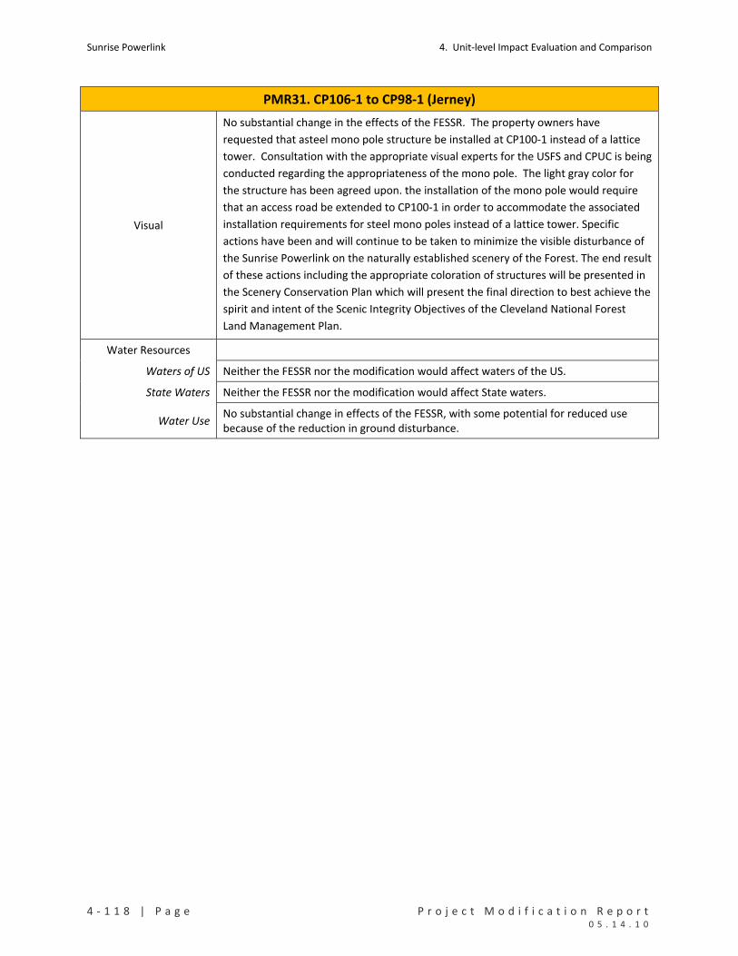
Sunrise Powerlink 4. Unit‐level Impact Evaluation and Comparison
4 ‐ 1 1 8 | P a g e P r o j e c t M o d i f i c a t i o n R e p o r t 0 5 . 1 4 . 1 0
PMR31. CP106‐1 to CP98‐1 (Jerney)
Visual
No substantial change in the effects of the FESSR. The property owners have
requested that asteel mono pole structure be installed at CP100‐1 instead of a lattice
tower. Consultation with the appropriate visual experts for the USFS and CPUC is being
conducted regarding the appropriateness of the mono pole. The light gray color for
the structure has been agreed upon. the installation of the mono pole would require
that an access road be extended to CP100‐1 in order to accommodate the associated
installation requirements for steel mono poles instead of a lattice tower. Specific
actions have been and will continue to be taken to minimize the visible disturbance of
the Sunrise Powerlink on the naturally established scenery of the Forest. The end result
of these actions including the appropriate coloration of structures will be presented in
the Scenery Conservation Plan which will present the final direction to best achieve the
spirit and intent of the Scenic Integrity Objectives of the Cleveland National Forest
Land Management Plan.
Water Resources
Waters of US Neither the FESSR nor the modification would affect waters of the US.
State Waters Neither the FESSR nor the modification would affect State waters.
Water Use No substantial change in effects of the FESSR, with some potential for reduced use because of the reduction in ground disturbance.
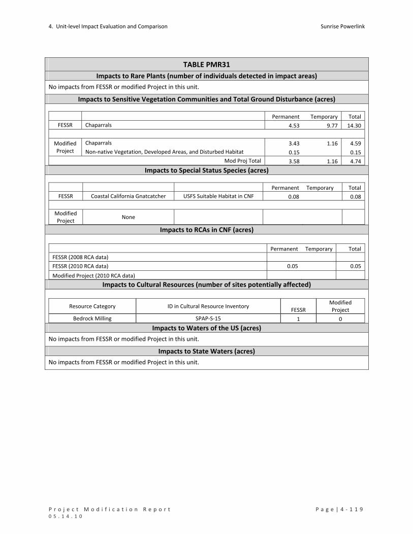
4. Unit‐level Impact Evaluation and Comparison Sunrise Powerlink
P r o j e c t M o d i f i c a t i o n R e p o r t P a g e | 4 ‐ 1 1 9 0 5 . 1 4 . 1 0
TABLE PMR31
Impacts to Rare Plants (number of individuals detected in impact areas)
No impacts from FESSR or modified Project in this unit.
Impacts to Sensitive Vegetation Communities and Total Ground Disturbance (acres)
Permanent Temporary Total
FESSR Chaparrals 4.53 9.77 14.30
Chaparrals 3.43 1.16 4.59 Modified Project Non‐native Vegetation, Developed Areas, and Disturbed Habitat 0.15 0.15
Mod Proj Total 3.58 1.16 4.74 Impacts to Special Status Species (acres)
Permanent Temporary Total
FESSR Coastal California Gnatcatcher USFS Suitable Habitat in CNF 0.08 0.08
Modified Project
None
Impacts to RCAs in CNF (acres)
Permanent Temporary Total
FESSR (2008 RCA data)
FESSR (2010 RCA data) 0.05 0.05
Modified Project (2010 RCA data) Impacts to Cultural Resources (number of sites potentially affected)
Resource Category ID in Cultural Resource Inventory FESSR
Modified Project
Bedrock Milling SPAP‐S‐15 1 0 Impacts to Waters of the US (acres)
No impacts from FESSR or modified Project in this unit.
Impacts to State Waters (acres)
No impacts from FESSR or modified Project in this unit.
Sunrise Powerlink 4. Unit‐level Impact Evaluation and Comparison
4 ‐ 1 2 0 | P a g e P r o j e c t M o d i f i c a t i o n R e p o r t 0 5 . 1 4 . 1 0
PMR32. CP98‐1 to CP95‐1 (230kV UG Including Loritz Driveway)
Mileposts Link Yard(s) PMR Figure Mapbook Sheet(s)
MP91.5‐PM91.8 4 None 32 MS109
Summary and Conclusion
The modification would shift the alignment slightly to the west, relocate an access road through a driveway on the
Loritz property, and revise the 230 kV overhead‐to‐underground transition location to accommodate a
landowner’s request. The modification would entail greater ground disturbance and more impacts to chaparrals,
riparian forest, and US and State waters than the FESSR. The modification also would entail a small impact (0.57
acre) to proposed critical habitat for arroyo toad. The increased impacts and impacts to proposed critical habitat
would not be different in type or scale than the impacts to these resources analyzed in the Final EIR/EIS. No new
significant impacts would result from the modification.
Details and Purpose
Modification
Reroute
Cable poles relocated to an east/west position rather than a north/south
position midline to the original structure positions.
Access road originally approved to run through Star Valley road and the Jerney
property, relocated entirely through a driveway on the Loritz property.
Primary Reason Accommodate landowner request (Loritz and Jerney).
Other Considerations Reduce impacts to oak trees.
MMCRP Measures B‐1a, L‐2b, V‐1b, C‐1a, C‐1a and 1b, and WQ‐APM‐1.
Environmental Impact Discussion
Air Quality No substantial change in effects of the FESSR.
Biological Resources See Table PMR32 below.
Rare Plants Neither the FESSR nor the modification would affect rare plants in this unit.
Vegetation Impacts The modification both increases and decreases impacts to sensitive vegetation types affected by the FESSR and entails impacts to riparian forest/woodland that would not occur under the FESSR. The increases and decreases would be small.
Species Impacts The FESSR would not affect special status wildlife species. The modification would affect 0.57 acre of proposed critical habitat for arroyo toad.
RCAs Not applicable to the FESSR or modification in this unit.
Cultural Resources Neither the FESSR nor the modification would affect cultural resources in this unit.
Geology/Minerals No substantial change in the effects of the FESSR; the increase in ground disturbance and its associated impacts would be addressed through the same measures that would apply to the FESSR.
Land Use
The modification would remove the ROW entirely from the Jerney property and relocate it entirely on the Loritz property. As such, the modification would reduce the impact to one landowner and slightly increase the impact to a different landowner with their consent. There are 25 residential sensitive receptors within one‐quarter mile of the impacts areas.

4. Unit‐level Impact Evaluation and Comparison Sunrise Powerlink
P r o j e c t M o d i f i c a t i o n R e p o r t P a g e | 4 ‐ 1 2 1 0 5 . 1 4 . 1 0
PMR32. CP98‐1 to CP95‐1 (230kV UG Including Loritz Driveway)
Noise Noise impacts will be minimized and mitigated through the applicable MMCRP measures as may be required. No substantial change in the effects of the FESSR.
Public Safety/Hazards No substantial change in the effects of the FESSR.
Traffic No substantial change in the effects of the FESSR.
Visual The modification would result in more long‐term visible land scarring than the FESSR,
but visual impacts overall would be substantially the same as for the FESSR.
Water Resources See Table PMR32 below.
Waters of US The modification would have greater impacts on waters of the US than would the FESSR.
State Waters The modification would have substantially the same impacts on State waters as would the FESSR.
Water Use No substantial change in effects of the FESSR.

Sunrise Powerlink 4. Unit‐level Impact Evaluation and Comparison
4 ‐ 1 2 2 | P a g e P r o j e c t M o d i f i c a t i o n R e p o r t 0 5 . 1 4 . 1 0
TABLE PMR32
Impacts to Rare Plants (number of individuals detected in impact areas)
No impacts from FESSR or modified Project in this unit.
Impacts to Sensitive Vegetation Communities and Total Ground Disturbance (acres)
Permanent Temporary Total
Chaparrals 1.47 2.09 3.56
Coastal and Montane Scrub Habitats 0.22 0.22
Herbaceous Wetlands, Freshwater, and Streams 0.01 0.04 0.04
Non‐native Vegetation, Developed Areas, and Disturbed Habitat 0.05 0.70 0.74
FESSR
Riparian Forests and Woodlands 0.00 0.00
FESSR Total 1.52 3.05 4.58
Chaparrals 2.64 1.69 4.33
Coastal and Montane Scrub Habitats 0.18 0.16 0.34
Herbaceous Wetlands, Freshwater, and Streams 0.02 0.03 0.06
Non‐native Vegetation, Developed Areas, and Disturbed Habitat 1.04 0.18 1.22
Modified Project
Riparian Forests and Woodlands 0.19 0.06 0.25
Mod Proj Total 4.08 2.12 6.20 Impacts to Special Status Species (acres)
Permanent Temporary Total
FESSR None
Modified Project
Arroyo Toad USFWS Proposed Critical
Habitat 0.57 0.57 Impacts to RCAs in CNF (acres)
Not applicable to FESSR or modified Project in this unit.
Impacts to Cultural Resources (number of sites potentially affected)
No impacts from FESSR or modified Project in this unit.
Impacts to Waters of the US (acres)
Permanent Temporary Total
FESSR 0.01 0.03 0.04
Modified Project 0.09 0.02 0.11
Impacts to State Waters (acres)
Permanent Temporary Total
FESSR 0.01 0.04 0.05
Modified Project 0.02 0.03 0.05

4. Unit‐level Impact Evaluation and Comparison Sunrise Powerlink
P r o j e c t M o d i f i c a t i o n R e p o r t P a g e | 4 ‐ 1 2 3 0 5 . 1 4 . 1 0
PMR33. 230‐kV Underground from Alpine Blvd/Loritz Driveway to CP88‐1/CP87‐1 (230kV UG)
Mileposts Link Yard(s) PMR Figure Mapbook Sheet(s)
MP91.8 to MP98 4 Alpine HQ
Alpine Yard 33 MS109 to MS110
Summary and Conclusion
The modification would add an access road on the Bauer property, adjust the ROW to avoid a Caltrans drainage
easement, add a 10.58‐acre field office headquarters, and add a 28.36‐acre construction yard. The addition of the
field office and construction yard would increase ground disturbance and associated noise, traffic, and visual
impacts. These impacts would be reduced and mitigated through the same MMCRP measures that would apply to
construction yards proposed in Links 4 and 5 as part of the FESSR. No new significant impacts would result from
the modification.
Details and Purpose
Modification
Reroute
Added access road on Bauer property to access cable pole.
ROW shifted from drainage installed by Caltrans near EP88‐1.
Underground ROW essentially same as in Final EIR/EIS.
Alpine Regional Field Offices
Add 10.58‐acre field office site (Project headquarters), south of Tavern Road.
Alpine Construction Yard
Add 28.36‐acre construction yard, north of Tavern Road.
Primary Reason Accommodate private landowner and Caltrans request.
Establish field office headquarters for Project and provide additional yard capacity.
Other Considerations Avoid all identified utilities and provide adequate operational and safety buffering.
MMCRP Measures L‐2b, C‐1a, S‐2b and C‐1a and 1b, V‐66a
Environmental Impact Discussion
Air Quality No substantial change in the effects of the FESSR.
Biological Resources See Table PMR33 below.
Rare Plants Neither the FESSR nor the modification would affect rare plants.
Vegetation Impacts
The modification would have temporary impacts to chaparrals and coastal montane scrubs; the FESSR would not. The office and yard areas in the modification were configured to exclude vegetation except where required for fuel modification zones to maintain appropriate fire safety at the field office site.
Species Impacts
The modification would not have direct impacts on any special status wildlife species. The office and yard areas in the modification were configured to exclude potential habitat and would be subject to the same site monitoring and impact avoidance measures that apply to other components of the Project.

Sunrise Powerlink 4. Unit‐level Impact Evaluation and Comparison
4 ‐ 1 2 4 | P a g e P r o j e c t M o d i f i c a t i o n R e p o r t 0 5 . 1 4 . 1 0
PMR33. 230‐kV Underground from Alpine Blvd/Loritz Driveway to CP88‐1/CP87‐1 (230kV UG)
RCAs Not applicable.
Cultural Resources
The area affected by the modification was included in the cultural resources inventory.
There are four cultural sites and one isolated find in this PMR unit, which was not
included in the surveys for the Final EIR/EIS. None of these resources are within an
area of proposed direct ground impact, but are in the ROW for the Project. Neither the
FESSR nor the modification would directly affect the resources.
Geology/Minerals No substantial change in the effects of the FESSR.
Land Use
The modification would be located adjacent to residential and commercial development. There would be 115 commercial structures, 1 industrial structure, 110 multifamily residences, and 1020 single family residences within one‐quarter mile of the modification’s impact areas. The residential development o the north east of the construction yard was notified of the project during the EIR/EIS process through the multiple newspaper circular and public venue notice postings in the Alpine area.
Noise
The modification would result in increased noise impacts during establishment of the field offices and yard and during operation of the yard. Impacts would be reduced and mitigated in accordance with the MMCRP and applicable local regulations. The modification would not result in new significant noise impacts.
Public Safety/Hazards
Operation of the yard in the modification would increase public safety impacts and
hazard risks compared with the FESSR in this location. The impacts of the modification
would be reduced and mitigated through the MMCRP public health and safety
measures and applicable regulations. The modification would not result in new
significant public safety/hazard impacts.
Traffic
The construction yard in the modification, and to a lesser degree the field offices,
would result in increased local traffic impacts. Temporary lane closures and/or
congestion could result during the delivery of construction materials and equipment
along Victoria Park Terrace and Tavern Road. Impacts would be reduced and mitigated
through the traffic planning and control measures in the MMCRP and applicable local
regulations. The modification would not result in new significant traffic impacts.
Visual
The modification would result in increased visual impacts along this route segment
because of the addition of the yard in close proximity to or within the viewshed of
several residential developments. Measures to reduce and mitigate visual impacts
would be specified in the site plans for the yard and would include the applicable
MMCRP measures regarding lighting, fencing, hours of operation, etc. The
construction yard impacts would be temporary and would not be different in type or
scale than those considered in the Final EIR/EIS. The modification would not result in
new significant visual impacts.
Water Resources
Waters of US No impacts would occur under the FESSR or modification.
State Waters No impacts would occur under the FESSR or modification.
Water Use No substantial change in the effects of the FESSR.

4. Unit‐level Impact Evaluation and Comparison Sunrise Powerlink
P r o j e c t M o d i f i c a t i o n R e p o r t P a g e | 4 ‐ 1 2 5 0 5 . 1 4 . 1 0
TABLE PMR33 Impacts to Rare Plants (number of individuals detected in impact areas)
No impacts from FESSR or modification in this unit.
Impacts to Sensitive Vegetation Communities and Total Ground Disturbance (acres)
Permanent Temporary Total
FESSR None
Chaparrals 1.27 1.27
Coastal and Montane Scrub Habitats 1.89 1.89 Modified Project
Non‐native Vegetation, Developed Areas, and Disturbed Habitat 35.77 35.77
Mod Proj Total 38.94 38.94 Impacts to Special Status Species (acres)
No impacts from FESSR or modification in this unit.
Impacts to RCAs in CNF (acres)
Not applicable to FESSR or modification in this unit.
Impacts to Cultural Resources (number of sites potentially affected)
No impacts from FESSR or modification in this unit.
Impacts to Waters of the US (acres)
No impacts from FESSR or modification in this unit.
Impacts to State Waters (acres)
No impacts from FESSR or modification in this unit.
Sunrise Powerlink 4. Unit‐level Impact Evaluation and Comparison
4 ‐ 1 2 6 | P a g e P r o j e c t M o d i f i c a t i o n R e p o r t 0 5 . 1 4 . 1 0
PMR34. CP88‐1/CP87‐1 to CP64‐2 (Chocolate Canyon)
Mileposts Link Yard(s) PMR Figure Mapbook Sheet(s)
MP98 to MP103.1 5 Hartung 34 MS117 to MS122
Summary and Conclusion
The modification would shift the alignment west, eliminate six structures, reduce the ROW by nearly 0.5 mile,
modify the access roads to improve engineering design, eliminate the FESSR construction yard at Chocolate
Mountain Ranch, and reduce the size of the Hartung Construction Yard. The modification would reduce impacts to
rare plants, sensitive vegetation types, Gnatcatcher critical habitat, RCAs, cultural resources, and US and State
waters. The modification would entail impacts to proposed critical habitat for arroyo toad and increase the
visibility of some structures. Other effects would be substantially the same as the FESSR. No new significant
impacts would result from the modification.
Details and Purpose
Modification
Reroute
Structures and access roads relocated or removed to avoid cultural resources
and limit the number of angle structures and wire pull sites.
Six structures eliminated.
14 structures changed from conventional to helicopter construction.
ROW length reduced by approximately 0.5 mile.
Wire pull site and access roads modified.
One mile of access roads eliminated.
Guard structures added at road crossings.
Hartung Construction Yard
Yard reduced in size to 16.53 acres (same location as for FESSR).
Other
Chocolate Mountain Ranch Construction Yard eliminated.
Primary Reason
Improve engineering design.
Implement mitigation measure V‐2d.
Minimize impacts to oak trees and San Diego River.
Other Considerations
Avoid direct impacts to cultural resources.
Reduce impacts to jurisdictional waters.
Reduce impacts to CNF.
MMCRP Measures B‐1a, C‐1a, C‐1a and 1b, F‐2b, V‐2d, GEO‐APM‐4, GEO‐APM‐5, and WQ‐APM‐1.
Environmental Impact Discussion
Air Quality No substantial change in effects of the FESSR.
4. Unit‐level Impact Evaluation and Comparison Sunrise Powerlink
P r o j e c t M o d i f i c a t i o n R e p o r t P a g e | 4 ‐ 1 2 7 0 5 . 1 4 . 1 0
PMR34. CP88‐1/CP87‐1 to CP64‐2 (Chocolate Canyon)
Biological Resources See Table PMR34 below.
Rare Plants The modification would reduce impacts to delicate clarkia and San Diego sunflower.
Vegetation Impacts The modification would reduce impacts to all sensitive vegetation types affected by the FESSR.
Species Impacts
The modification would reduce impacts to critical habitat for Gnatcatcher and impacts
to USFS suitable habitat in CNF for arroyo toad, Gnatcatcher, least Bell’s vireo, and SKR.
The modification also would entail impacts to proposed critical habitat for arroyo toad.
The impact would occur at the Hartung construction yard, which Is located in an open,
shallow, sandy wash with sparse vegetation cover. The yard area was included in the
2009 arroyo toad habitat assessments and was determined to have moderate potential
for breeding and foraging habitat. No water was present in 2009. Protocol surveys
were recommended and are being conducted now. Results of the 2010 arroyo toad
surveys will be submitted to USFWS and will be used to further refine the impact
estimate for this modification. Impacts of the modified Project to arroyo toad would
be minimized and mitigated through the same measures identified for the FESSR in the
MMCRP and BO. The MMCRP and BO currently require pre‐construction surveys in
suitable habitat, impact site avoidance and minimization measures, and onsite and
offsite mitigation. Additional measures for impacts to critical habitat may be required
if the proposed rule is adopted and would be determined by USFWS. The impact to
proposed critical habitat was not addressed in the Final EIR/EIS (the proposed
designation was issued in 2009 after the issuance of the Final EIR/EIS) but entails the
same type and scale of effects that were considered (i.e., the potential for take and for
loss of breeding and foraging habitat). No new significant impact to arroyo toad or
other wildlife species would result from the modification.
RCAs The modification would reduce impacts to RCAs in the CNF.
Cultural Resources
There are 12 cultural resource sites and two isolated finds in this unit, which was not included in the Final EIR/EIS surveys. The FESSR potentially would affect eight sites; the modification potentially would affect three. See Table PMR34 below.
The modification includes the following impact avoidance and reduction measures:
Relocation of CP80‐1 and elimination of access road reduces impact to a sensitive archaeological site (SDI‐7873/19250/SPNB‐S‐7), Bedrock milling site).
Relocation of CP68‐1 and the access road and the pull site at that structure will avoid impact to a large archaeological site (SDI‐18999, Prehistoric Quarry).
Relocation of access road to CP65‐1 avoids impacts to a large archeological site (SDI‐8251, Bedrock milling and historic mining).
Two newly recorded sites correspond with the Hartung Construction Yard and can be avoided through staking of ESAs.
Geology/Minerals The modification would reduce ground disturbance and the associated slope stability and erosion impacts.
Land Use The modification reduces impacts to private, City of San Diego, and USFS lands. There are 47 residential and 3 commercial structures within one‐quarter mile of the modification’s impact areas.
Sunrise Powerlink 4. Unit‐level Impact Evaluation and Comparison
4 ‐ 1 2 8 | P a g e P r o j e c t M o d i f i c a t i o n R e p o r t 0 5 . 1 4 . 1 0
PMR34. CP88‐1/CP87‐1 to CP64‐2 (Chocolate Canyon)
Noise No substantial change in effects of the FESSR.
Public Safety/Hazards No substantial changes in effects of the FESSR.
Traffic No substantial changes in effects of the FESSR
Visual
The modification would eliminate six structures and decrease ground disturbance, which
would reduce the visual impacts of structures and long‐term land scarring. However,
the modification would also result in the higher elevation placement of several
structures, which would increase their visibility. Overall, the modification would not
substantially change the visual impacts of the FESSR in this unit. Specific actions have
been and will continue to be taken to minimize the visible disturbance of the Sunrise
Powerlink on the naturally established scenery of the Forest. The end result of these
actions including the appropriate coloration of structures will be presented in the
Scenery Conservation Plan which will present the final direction to best achieve the
spirit and intent of the Scenic Integrity Objectives of the Cleveland National Forest
Land Management Plan.
Water Resources See Table PMR34 below.
Waters of US The modification would reduce impacts to waters of the US.
State Waters The modification would reduce impacts to State waters.
Water Use No substantial change in effects of the FESSR, with some potential for reduced use because of the reduction in ground disturbance.

4. Unit‐level Impact Evaluation and Comparison Sunrise Powerlink
P r o j e c t M o d i f i c a t i o n R e p o r t P a g e | 4 ‐ 1 2 9 0 5 . 1 4 . 1 0
TABLE PMR34 Impacts to Rare Plants (number of individuals detected in impact areas)
Permanent Temporary Total
Delicate clarkia 154 154 FESSR
San Diego sunflower 16 16
Delicate clarkia 1 1 Modified Project
San Diego sunflower 8 8 Impacts to Sensitive Vegetation Communities and Total Ground Disturbance (acres)
Permanent Temporary Total
Chaparrals 10.96 7.75 18.70
Coastal and Montane Scrub Habitats 10.03 21.09 31.12
Grasslands and Meadows 1.69 1.69
Herbaceous Wetlands, Freshwater, and Streams 0.05 1.30 1.35
Non‐native Vegetation, Developed Areas, and Disturbed Habitat 5.12 15.92 21.04
Riparian Forests and Woodlands 0.24 0.24
FESSR
Woodlands and Forests 0.58 2.66 3.24
FESSR Total 26.97 50.41 77.38
Chaparrals 4.05 1.29 5.34
Coastal and Montane Scrub Habitats 5.45 2.61 8.07
Grasslands and Meadows 0.89 0.89
Herbaceous Wetlands, Freshwater, and Streams 0.01 0.03 0.03
Non‐native Vegetation, Developed Areas, and Disturbed Habitat 0.70 15.62 16.32
Riparian Forests and Woodlands 0.01 0.01
Modified Project
Woodlands and Forests 0.16 0.73 0.89
Mod Proj Total 10.38 21.18 31.55 Impacts to Special Status Species (acres)
Permanent Temporary Total
Arroyo Toad USFS Occupied Habitat in CNF 0.46 0.32 0.78
USFS Suitable Habitat in CNF 0.83 0.95 1.77 Coastal California Gnatcatcher
USFWS Critical Habitat 9.07 5.67 14.74
Least Bell’s Vireo USFS Suitable Habitat in CNF 0.46 0.32 0.78
FESSR
Stephens’ Kangaroo Rat USFS Suitable Habitat in CNF 0.59 0.00 0.59
USFS Occupied Habitat in CNF 0.00 0.00 Arroyo Toad
USFWS Proposed Critical Habitat 0.69 17.16 17.85
USFS Suitable Habitat in CNF 0.39 0.39 Coastal California Gnatcatcher
USFWS Critical Habitat 3.63 0.48 4.11
Modified Project
Stephens’ Kangaroo Rat USFS Suitable Habitat in CNF 0.18 0.00 0.19
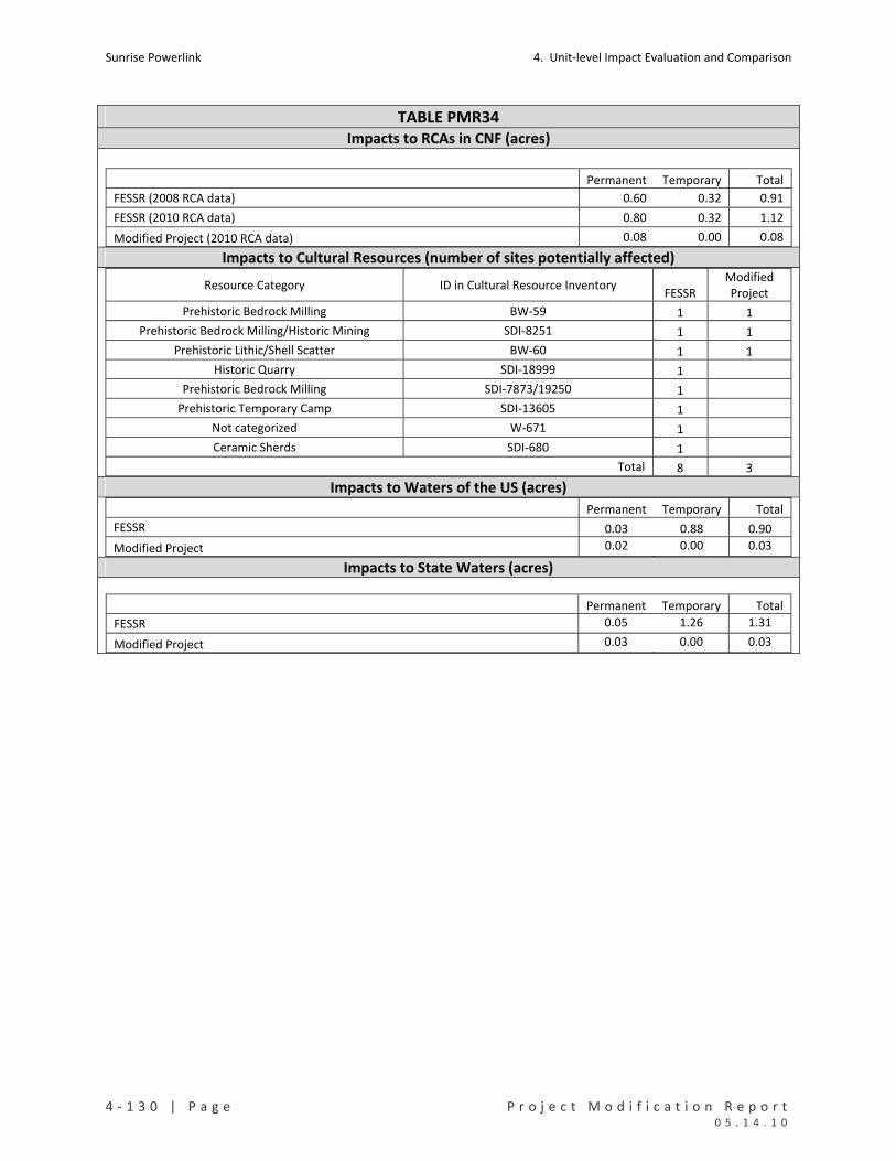
Sunrise Powerlink 4. Unit‐level Impact Evaluation and Comparison
4 ‐ 1 3 0 | P a g e P r o j e c t M o d i f i c a t i o n R e p o r t 0 5 . 1 4 . 1 0
TABLE PMR34 Impacts to RCAs in CNF (acres)
Permanent Temporary Total
FESSR (2008 RCA data) 0.60 0.32 0.91
FESSR (2010 RCA data) 0.80 0.32 1.12
Modified Project (2010 RCA data) 0.08 0.00 0.08 Impacts to Cultural Resources (number of sites potentially affected)
Resource Category ID in Cultural Resource Inventory FESSR
Modified Project
Prehistoric Bedrock Milling BW‐59 1 1
Prehistoric Bedrock Milling/Historic Mining SDI‐8251 1 1
Prehistoric Lithic/Shell Scatter BW‐60 1 1
Historic Quarry SDI‐18999 1
Prehistoric Bedrock Milling SDI‐7873/19250 1
Prehistoric Temporary Camp SDI‐13605 1
Not categorized W‐671 1
Ceramic Sherds SDI‐680 1
Total 8 3 Impacts to Waters of the US (acres) Permanent Temporary Total
FESSR 0.03 0.88 0.90
Modified Project 0.02 0.00 0.03
Impacts to State Waters (acres)
Permanent Temporary Total
FESSR 0.05 1.26 1.31
Modified Project 0.03 0.00 0.03

4. Unit‐level Impact Evaluation and Comparison Sunrise Powerlink
P r o j e c t M o d i f i c a t i o n R e p o r t P a g e | 4 ‐ 1 3 1 0 5 . 1 4 . 1 0
PMR35. CP64‐2 to CP53‐1 (Morgan)
Mileposts Link Yard(s) PMR Figure Mapbook Sheet(s)
MP103.1 to MP106 5 None 35 MS122 to MS128
Summary and Conclusion
The modification would shift the ROW upslope locally, increase helicopter construction, eliminate two pull sites,
reduce work area size, and remove approximately 2,000 feet of access road. The modification would reduce
impacts to sensitive vegetation (except for a small increase in temporary impacts to chaparrals), Gnatcatcher
occupied habitat and critical habitat, cultural resources, and US and State waters. Other effects would be
substantially the same as the FESSR. No new significant impacts would result from the modification.
Details and Purpose
Modification
Reroute
ROW shifted between structures CP64‐2 and CP60 per property owner
request.
Three wire pull sites were eliminated.
Work areas reduced in size.
New access roads eliminated; existing roads used instead.
Guard structures added at road crossings.
Primary Reason Accommodate land owner request.
Other Considerations Improve engineering design.
Reduce visual impact.
MMCRP Measures L‐2b, B‐1a, V‐2d, C‐1a, C‐1a and 1b, GEO‐APM‐4, GEO‐APM‐5, and WQ‐APM‐1.
Environmental Impact Discussion
Air Quality No substantial change in the effects of the FESSR.
Biological Resources See Table PMR35 below.
Rare Plants The modification would avoid impacts to delicate clarkia.
Vegetation Impacts The modification would reduce impacts to all sensitive vegetation types, except for a small increase in temporary impacts to chaparrals.
Species Impacts The modification would reduce impacts to USFWS occupied and critical habitat for Gnatcatcher.
RCAs Not applicable to the FESSR or modification.
Cultural Resources There are two cultural site and no isolated finds in this unit. The FESSR would affect all three sites; the modification avoids the sites. See Table PMR35 below.
Geology/Minerals The modification would reduce ground disturbance and the associated slope stability and erosion impacts.
Land Use The modification reduces impacts to private property and lands managed by the County of San Diego. There are 23 residential structures and 2 commercial structures within one‐quarter mile of the modification’s impact areas.
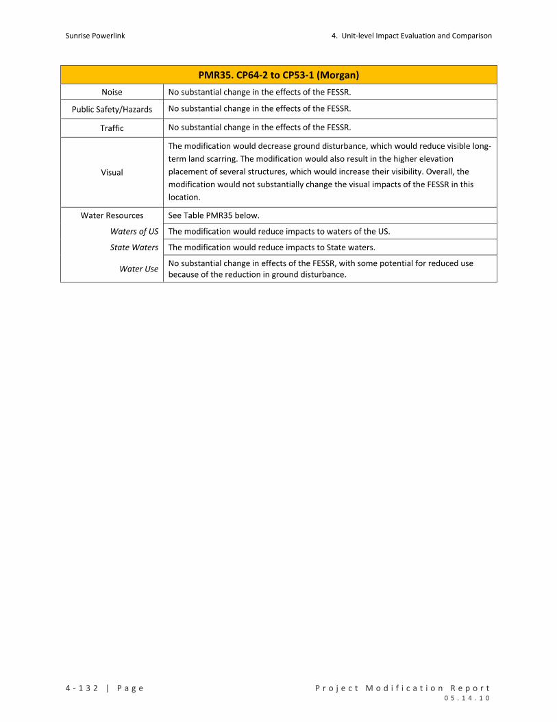
Sunrise Powerlink 4. Unit‐level Impact Evaluation and Comparison
4 ‐ 1 3 2 | P a g e P r o j e c t M o d i f i c a t i o n R e p o r t 0 5 . 1 4 . 1 0
PMR35. CP64‐2 to CP53‐1 (Morgan)
Noise No substantial change in the effects of the FESSR.
Public Safety/Hazards No substantial change in the effects of the FESSR.
Traffic No substantial change in the effects of the FESSR.
Visual
The modification would decrease ground disturbance, which would reduce visible long‐
term land scarring. The modification would also result in the higher elevation
placement of several structures, which would increase their visibility. Overall, the
modification would not substantially change the visual impacts of the FESSR in this
location.
Water Resources See Table PMR35 below.
Waters of US The modification would reduce impacts to waters of the US.
State Waters The modification would reduce impacts to State waters.
Water Use No substantial change in effects of the FESSR, with some potential for reduced use because of the reduction in ground disturbance.

4. Unit‐level Impact Evaluation and Comparison Sunrise Powerlink
P r o j e c t M o d i f i c a t i o n R e p o r t P a g e | 4 ‐ 1 3 3 0 5 . 1 4 . 1 0
TABLE PMR35 Impacts to Rare Plants (number of individuals detected in impact areas) Permanent Temporary Total
FESSR Delicate clarkia 400 400
Modified Project None Impacts to Sensitive Vegetation Communities and Total Ground Disturbance (acres)
Permanent Temporary Total
Chaparrals 4.85 1.55 6.40
Coastal and Montane Scrub Habitats 9.38 5.13 14.51
Herbaceous Wetlands, Freshwater, and Streams 0.08 0.01 0.09
Non‐native Vegetation, Developed Areas, and Disturbed Habitat 7.17 0.00 7.18
FESSR
Riparian Forests and Woodlands 0.35 0.35
FESSR Total 21.84 6.69 28.54
Chaparrals 1.70 1.73 3.44
Coastal and Montane Scrub Habitats 2.42 0.00 2.42
Herbaceous Wetlands, Freshwater, and Streams 0.01 0.00 0.01
Non‐native Vegetation, Developed Areas, and Disturbed Habitat 0.63 0.63
Riparian Forests and Woodlands 0.01 0.01
Modified Project
Woodlands and Forests 0.00 0.00
Mod Proj Total 4.77 1.75 6.51 Impacts to Special Status Species (acres)
Permanent Temporary Total
USFWS Critical Habitat 0.99 12.17 13.17 FESSR Coastal California Gnatcatcher
USFWS Occupied Habitat 1.22 1.22
Modified Project
Coastal California Gnatcatcher USFWS Critical Habitat 0.24 0.24
Impacts to RCAs in CNF (acres)
Not applicable to FESSR or modification in this unit.
Impacts to Cultural Resources (number of sites potentially affected)
Resource Category ID in Cultural Resource Inventory FESSR
Modified Project
Prehistoric Habitation SDI‐13652 1
Rock Shelter SDI‐4913 1
Total 2 0

Sunrise Powerlink 4. Unit‐level Impact Evaluation and Comparison
4 ‐ 1 3 4 | P a g e P r o j e c t M o d i f i c a t i o n R e p o r t 0 5 . 1 4 . 1 0
TABLE PMR35 Impacts to Waters of the US (acres) Permanent Temporary Total
FESSR 0.04 0.01 0.05
Modified Project 0.01 0.00 0.01
Impacts to State Waters (acres)
Permanent Temporary Total
FESSR 0.08 0.01 0.09
Modified Project 0.01 0.00 0.01
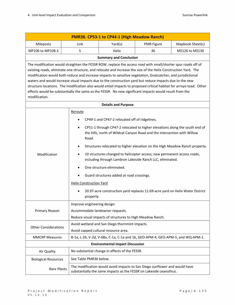
4. Unit‐level Impact Evaluation and Comparison Sunrise Powerlink
P r o j e c t M o d i f i c a t i o n R e p o r t P a g e | 4 ‐ 1 3 5 0 5 . 1 4 . 1 0
PMR36. CP53‐1 to CP44‐1 (High Meadow Ranch)
Mileposts Link Yard(s) PMR Figure Mapbook Sheet(s)
MP106 to MP108.3 5 Helix 36 MS126 to MS130
Summary and Conclusion
The modification would straighten the FESSR ROW, replace the access road with small/shorter spur roads off of
existing roads, eliminate one structure, and relocate and increase the size of the Helix Construction Yard. The
modification would both reduce and increase impacts to sensitive vegetation, Gnatcatcher, and jurisdictional
waters and would increase visual impacts due to the construction yard but reduce impacts due to the new
structure locations. The modification also would entail impacts to proposed critical habitat for arroyo toad. Other
effects would be substantially the same as the FESSR. No new significant impacts would result from the
modification.
Details and Purpose
Modification
Reroute
CP49‐1 and CP47‐2 relocated off of ridgelines.
CP51‐1 through CP47‐2 relocated to higher elevations along the south end of
the hills, north of Wildcat Canyon Road and the intersection with Willow
Road.
Structures relocated to higher elevation on the High Meadow Ranch property.
10 structures changed to helicopter access; new permanent access roads,
including through Lambron Lakeside Ranch LLC, eliminated.
One structure eliminated.
Guard structures added at road crossings.
Helix Construction Yard
20.97‐acre construction yard replaces 11.69‐acre yard on Helix Water District
property.
Primary Reason
Improve engineering design.
Accommodate landowner requests.
Reduce visual impacts of structures to High Meadow Ranch.
Other Considerations Avoid wetland and San Diego thornmint impacts.
Avoid capped cultural resource area.
MMCRP Measures B‐1a, L‐2b, V‐2d, V‐68a, C‐1a, C‐1a and 1b, GEO‐APM‐4, GEO‐APM‐5, and WQ‐APM‐1.
Environmental Impact Discussion
Air Quality No substantial change in effects of the FESSR.
Biological Resources See Table PMR36 below.
Rare Plants The modification would avoid impacts to San Diego sunflower and would have substantially the same impacts as the FESSR on Lakeside ceanothus.

Sunrise Powerlink 4. Unit‐level Impact Evaluation and Comparison
4 ‐ 1 3 6 | P a g e P r o j e c t M o d i f i c a t i o n R e p o r t 0 5 . 1 4 . 1 0
PMR36. CP53‐1 to CP44‐1 (High Meadow Ranch)
Vegetation Impacts The modification would both reduce and increase impacts to sensitive vegetation types. There would be reduced permanent impacts to chaparrals, coastal and montane scrub, non‐vegetated channels, and riparian forests. There would be increased temporary impacts to coastal and montane scrub, grasslands, and non‐vegetated channels. The primary increase would be in temporary impacts to grasslands in connection with the yard. The area is cleared land probably used for agriculture and is dominated by high cover, non‐native grassland. The impact would not be different in type or scale than the vegetation impacts considered in the Final EIR/EIS.
Species Impacts The modification would reduce impacts to USFWS occupied Gnatcatcher habitat. It
also would affect designated critical habitat for Gnatcatcher and proposed critical
habitat for arroyo toad, which the FESSR would not.
Focused surveys were conducted in 2009 to assess gnatcatcher habitat and identify
occupied areas in all suitable habitat potentially affected by the Project. No
gnatcatchers were detected in the originally proposed or the currently proposed yard.
The BO for the Project covers impacts to occupied habitat and critical habitat.
The yard in the modification also was included in the 2009 arroyo toad habitat
assessments and was determined to have moderate potential for breeding and
foraging habitat. No water was present in 2009. Protocol surveys were recommended
and are being conducted in 2010. Results of the 2010 arroyo toad surveys will be
submitted to USFWS and will be used to further refine the impact estimates for these
areas.
Results of the 2010 arroyo toad surveys will be submitted to USFWS and will be used to
further refine the impact estimate for this modification. Impacts of the modified
Project to arroyo toad would be minimized and mitigated through the same measures
identified for the FESSR in the MMCRP and BO. The MMCRP and BO currently require
pre‐construction surveys in suitable habitat, impact site avoidance and minimization
measures, and onsite and offsite mitigation. Additional measures for impacts to critical
habitat may be required if the proposed rule is adopted and would be determined by
USFWS. The impact to proposed critical habitat was not addressed in the Final EIR/EIS
(the proposed designation was issued in 2009 after the issuance of the Final EIR/EIS)
but entails the same type and scale of effects that were considered (i.e., the potential
for take and for loss of breeding and foraging habitat).
No new significant impact to Gnatcatcher, arroyo toad, or other wildlife species would
result from the modification.
RCAs Not applicable to the FESSR or modification.
Cultural Resources
There are three cultural sites and no isolated finds in this unit. Two of these sites are
identified as historic cisterns and one is a historic road segment. Neither the FESSR not
the modification would affect the sites.
Geology/Minerals The modification would reduce permanent and increase temporary ground disturbance. Total ground disturbance would be substantially the same as the FESSR.

4. Unit‐level Impact Evaluation and Comparison Sunrise Powerlink
P r o j e c t M o d i f i c a t i o n R e p o r t P a g e | 4 ‐ 1 3 7 0 5 . 1 4 . 1 0
PMR36. CP53‐1 to CP44‐1 (High Meadow Ranch)
Land Use The modification would increase impacts on Helix Water District lands. There are thirteen residential structures within one‐quarter mile of the modification’s impact areas.
Noise No substantial change in effects of the FESSR.
Public Safety/Hazards No substantial change in effects of the FESSR.
Traffic No substantial change in effects of the FESSR.
Visual
The reroute by itself would result in a slight decrease in ground disturbance, which
would reduce visible long‐term land scarring. However, the modification would still result in
the considerable structure skylining along the ridgeline, which exacerbates structure
visibility and prominence.
The modification also would increase visual impacts by introducing a larger construction
yard than originally proposed and shifting the location to the south side of the San
Diego River, into the center of the valley. This new location would place the facility in a
more spatially prominent location within the primary cone of vision of travelers on El
Monte Road. Given the high visibility of the site from El Monte Road, it has been
recommended that some form of temporary screening be required along the west,
south and east perimeters of the site. The size and locational prominence of the yard
would exacerbate visual contrast. However, the impacts would have a relatively short‐
term duration (approximately 12 months).
The increased visual impacts would not be different in type or scale than those
considered in the Final EIR/EIS. The new significant visual impacts would result from
the modification.
The modification would, however, reduce visual impacts due to structures being
relocated from the FESSR locations. The visual impacts to High Meadows Ranch were
reduced by moving the structure locations down slope.
Water Resources See Table PMR36 below.
Waters of US The modification would reduce permanent impacts to jurisdictional waters.
State Waters The modification would reduce permanent and increase temporary impact to State waters.
Water Use No substantial change in effects of the FESSR.
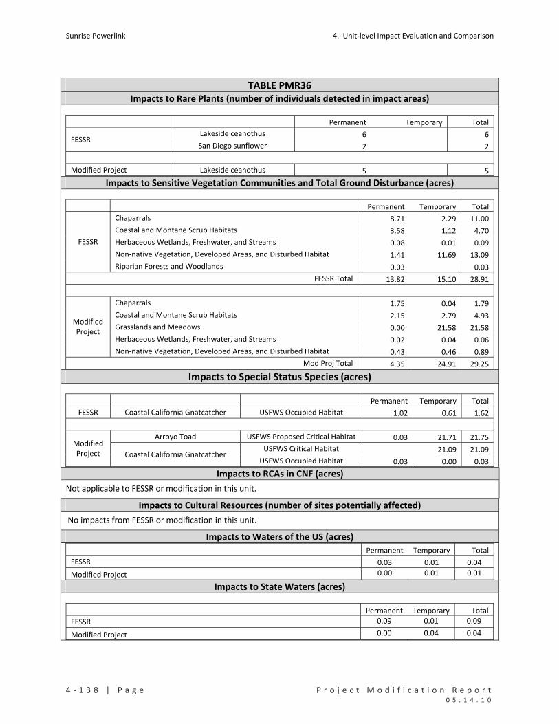
Sunrise Powerlink 4. Unit‐level Impact Evaluation and Comparison
4 ‐ 1 3 8 | P a g e P r o j e c t M o d i f i c a t i o n R e p o r t 0 5 . 1 4 . 1 0
TABLE PMR36 Impacts to Rare Plants (number of individuals detected in impact areas)
Permanent Temporary Total
Lakeside ceanothus 6 6 FESSR
San Diego sunflower 2 2
Modified Project Lakeside ceanothus 5 5 Impacts to Sensitive Vegetation Communities and Total Ground Disturbance (acres)
Permanent Temporary Total
Chaparrals 8.71 2.29 11.00
Coastal and Montane Scrub Habitats 3.58 1.12 4.70
Herbaceous Wetlands, Freshwater, and Streams 0.08 0.01 0.09
Non‐native Vegetation, Developed Areas, and Disturbed Habitat 1.41 11.69 13.09
FESSR
Riparian Forests and Woodlands 0.03 0.03
FESSR Total 13.82 15.10 28.91
Chaparrals 1.75 0.04 1.79
Coastal and Montane Scrub Habitats 2.15 2.79 4.93
Grasslands and Meadows 0.00 21.58 21.58
Herbaceous Wetlands, Freshwater, and Streams 0.02 0.04 0.06
Modified Project
Non‐native Vegetation, Developed Areas, and Disturbed Habitat 0.43 0.46 0.89
Mod Proj Total 4.35 24.91 29.25
Impacts to Special Status Species (acres)
Permanent Temporary Total
FESSR Coastal California Gnatcatcher USFWS Occupied Habitat 1.02 0.61 1.62
Arroyo Toad USFWS Proposed Critical Habitat 0.03 21.71 21.75
USFWS Critical Habitat 21.09 21.09 Modified Project Coastal California Gnatcatcher
USFWS Occupied Habitat 0.03 0.00 0.03 Impacts to RCAs in CNF (acres)
Not applicable to FESSR or modification in this unit.
Impacts to Cultural Resources (number of sites potentially affected)
No impacts from FESSR or modification in this unit.
Impacts to Waters of the US (acres) Permanent Temporary Total
FESSR 0.03 0.01 0.04
Modified Project 0.00 0.01 0.01
Impacts to State Waters (acres)
Permanent Temporary Total
FESSR 0.09 0.01 0.09
Modified Project 0.00 0.04 0.04
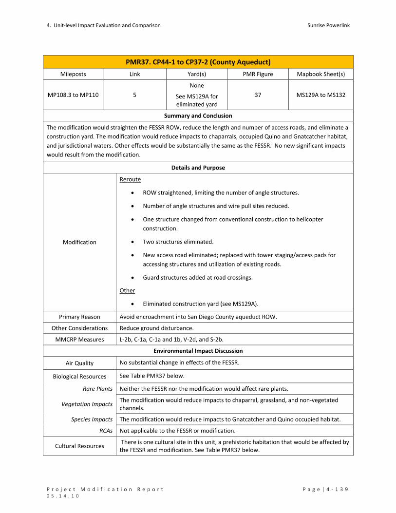
4. Unit‐level Impact Evaluation and Comparison Sunrise Powerlink
P r o j e c t M o d i f i c a t i o n R e p o r t P a g e | 4 ‐ 1 3 9 0 5 . 1 4 . 1 0
PMR37. CP44‐1 to CP37‐2 (County Aqueduct)
Mileposts Link Yard(s) PMR Figure Mapbook Sheet(s)
MP108.3 to MP110 5
None
See MS129A for eliminated yard
37 MS129A to MS132
Summary and Conclusion
The modification would straighten the FESSR ROW, reduce the length and number of access roads, and eliminate a
construction yard. The modification would reduce impacts to chaparrals, occupied Quino and Gnatcatcher habitat,
and jurisdictional waters. Other effects would be substantially the same as the FESSR. No new significant impacts
would result from the modification.
Details and Purpose
Modification
Reroute
ROW straightened, limiting the number of angle structures.
Number of angle structures and wire pull sites reduced.
One structure changed from conventional construction to helicopter
construction.
Two structures eliminated.
New access road eliminated; replaced with tower staging/access pads for
accessing structures and utilization of existing roads.
Guard structures added at road crossings.
Other
Eliminated construction yard (see MS129A).
Primary Reason Avoid encroachment into San Diego County aqueduct ROW.
Other Considerations Reduce ground disturbance.
MMCRP Measures L‐2b, C‐1a, C‐1a and 1b, V‐2d, and S‐2b.
Environmental Impact Discussion
Air Quality No substantial change in effects of the FESSR.
Biological Resources See Table PMR37 below.
Rare Plants Neither the FESSR nor the modification would affect rare plants.
Vegetation Impacts The modification would reduce impacts to chaparral, grassland, and non‐vegetated channels.
Species Impacts The modification would reduce impacts to Gnatcatcher and Quino occupied habitat.
RCAs Not applicable to the FESSR or modification.
Cultural Resources There is one cultural site in this unit, a prehistoric habitation that would be affected by the FESSR and modification. See Table PMR37 below.
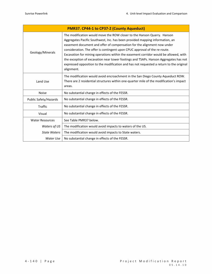
Sunrise Powerlink 4. Unit‐level Impact Evaluation and Comparison
4 ‐ 1 4 0 | P a g e P r o j e c t M o d i f i c a t i o n R e p o r t 0 5 . 1 4 . 1 0
PMR37. CP44‐1 to CP37‐2 (County Aqueduct)
Geology/Minerals
The modification would move the ROW closer to the Hanson Quarry. Hanson
Aggregates Pacific Southwest, Inc. has been provided mapping information, an
easement document and offer of compensation for the alignment now under
consideration. The offer is contingent upon CPUC approval of the re‐route.
Excavation for mining operations within the easement corridor would be allowed, with
the exception of excavation near tower footings and TSAPs. Hanson Aggregates has not
expressed opposition to the modification and has not requested a return to the original
alignment.
Land Use
The modification would avoid encroachment in the San Diego County Aqueduct ROW.
There are 2 residential structures within one‐quarter mile of the modification’s impact
areas.
Noise No substantial change in effects of the FESSR.
Public Safety/Hazards No substantial change in effects of the FESSR.
Traffic No substantial change in effects of the FESSR.
Visual No substantial change in effects of the FESSR.
Water Resources See Table PMR37 below.
Waters of US The modification would avoid impacts to waters of the US.
State Waters The modification would avoid impacts to State waters.
Water Use No substantial change in effects of the FESSR.

4. Unit‐level Impact Evaluation and Comparison Sunrise Powerlink
P r o j e c t M o d i f i c a t i o n R e p o r t P a g e | 4 ‐ 1 4 1 0 5 . 1 4 . 1 0
TABLE PMR37
Impacts to Rare Plants (number of individuals detected in impact areas)
No impacts from FESSR or the modification in this unit.
Impacts to Sensitive Vegetation Communities and Total Ground Disturbance (acres)
Permanent Temporary Total
Chaparrals 6.65 3.21 9.86
Coastal and Montane Scrub Habitats 0.35 0.35
Grasslands and Meadows 1.19 1.19
Herbaceous Wetlands, Freshwater, and Streams 2.54 2.54
FESSR
Non‐native Vegetation, Developed Areas, and Disturbed Habitat 1.37 6.74 8.11
FESSR Total 8.37 13.68 22.05
Chaparrals 1.19 1.54 2.73
Coastal and Montane Scrub Habitats 0.41 0.01 0.42
Herbaceous Wetlands, Freshwater, and Streams 0.00 0.00
Modified Project
Non‐native Vegetation, Developed Areas, and Disturbed Habitat 0.26 0.13 0.39
Mod Proj Total 1.86 1.68 3.54 Impacts to Special Status Species (acres)
Permanent Temporary Total
Coastal California Gnatcatcher USFWS Occupied Habitat 0.25 0.25 FESSR
Quino Checkerspot Butterfly USFWS Occupied Habitat 5.83 5.83
Coastal California Gnatcatcher USFWS Occupied Habitat 0.06 0.06 Modified Project Quino Checkerspot Butterfly USFWS Occupied Habitat 1.27 1.67 2.95
Impacts to RCAs in CNF (acres)
Not applicable.
Impacts to Cultural Resources (number of sites potentially affected)
Resource Category ID in Cultural Resource Inventory FESSR
Modified Project
Prehistoric Habitation SDI‐13651 1 1 Impacts to Waters of the US (acres) Permanent Temporary Total
FESSR 1.24 1.24
Modified Project 0.00 0.00
Impacts to State Waters (acres)
Permanent Temporary Total
FESSR 1.24 1.24
Modified Project 0.00 0.00

Sunrise Powerlink 4. Unit‐level Impact Evaluation and Comparison
4 ‐ 1 4 2 | P a g e P r o j e c t M o d i f i c a t i o n R e p o r t 0 5 . 1 4 . 1 0
PMR38. CP37‐2 to CP31‐2 (Schmidt)
Mileposts Link Yard(s) PMR Figure Mapbook Sheet(s)
MP110 to MP111.7 5
None
See MS124A for eliminated yard
38 MS132 to MS134,
also MS124A
Summary and Conclusion
The modification would move the FESSR ROW west, add two structures to accommodate the relocated spans,
reduce the number and length of access roads, and eliminate a construction yard. The modification would reduce
ground disturbance and impacts to sensitive vegetation and jurisdictional waters and would increase certain visual
impacts. Other effects would be substantially the same as the FESSR. No new significant impacts would result from
the modification.
Details and Purpose
Modification
Reroute
ROW moved west on the Arnold Schmidt parcel to provide the owner greater
development opportunities, per the landowner request.
ROW shifted, moving CP34‐2 onto Hanson Aggregates Pacific Southwest Inc.
property.
Two structures eliminated.
Corner structure wire pull sites outside ROW at P31‐2 moved closer to ROW
and reduced to 1/3 typical size.
Length and number of access roads reduced.
Guard structures added at road crossings.
Other
Construction yard eliminated (see MS124A). [Note: The eliminated yard is
not in close proximity to the ROW in this or other PMR unit. It is included in
this PMR unit for purposes of accounting for eliminated FESSR yards.]
Primary Reason Accommodate landowner request.
Other Considerations Reduce visual impacts.
Reduce ground disturbance.
MMCRP Measures L‐2b, C‐1a, C‐1a and 1b, V‐1a, and V‐2d.
Environmental Impact Discussion
Air Quality No substantial change in effects of the FESSR.
Biological Resources See Table PMR38 below.
Rare Plants Neither the FESSR nor the modification would affect rare plants.
Vegetation Impacts The modification would reduce impacts to sensitive vegetation types.
Species Impacts Neither the FESSR nor the modification would affect special status wildlife.

4. Unit‐level Impact Evaluation and Comparison Sunrise Powerlink
P r o j e c t M o d i f i c a t i o n R e p o r t P a g e | 4 ‐ 1 4 3 0 5 . 1 4 . 1 0
PMR38. CP37‐2 to CP31‐2 (Schmidt)
RCAs Not applicable to the FESSR or modification.
Cultural Resources There are six cultural sites in this unit. The FESSR and modification each would potentially affect the same site, a prehistoric lithic scatter. See Table PMR38 below.
Geology/Minerals The modification would reduce ground disturbance and the associated slope stability and erosion impacts. The modification moves a structure on to Hanson Aggregate property but not in a location that would affect quarry operations.
Land Use No substantial change in effects of the FESSR. There are 2 residential structures and 1
commercial structure within one‐quarter mile of the modification’s impacts areas.
Noise No substantial change in effects of the FESSR.
Public Safety/Hazards No substantial change in effects of the FESSR.
Traffic No substantial change in effects of the FESSR.
Visual
The modification would decrease ground disturbance, which would reduce visible long‐
term land scarring. It would also result in a higher‐elevation shift of structures west of
SR 67. The relocation of these structures to higher elevations on the ridges would
noticeably increase visible structure skylining and prominence (from SR 67). This
increase in impacts would not be different in type or scale than the effects identified in
the Final EIR/EIS.
Water Resources See Table PMR38 below.
Waters of US The modification would avoid impacts to waters of the US.
State Waters The modification would avoid impacts to State waters.
Water Use No substantial change in effects of the FESSR, with some potential for reduced use because of the reduced ground disturbance.

Sunrise Powerlink 4. Unit‐level Impact Evaluation and Comparison
4 ‐ 1 4 4 | P a g e P r o j e c t M o d i f i c a t i o n R e p o r t 0 5 . 1 4 . 1 0
TABLE PMR38 Impacts to Rare Plants (number of individuals detected in impact areas)
No impacts from FESSR or modification.
Impacts to Sensitive Vegetation Communities and Total Ground Disturbance (acres)
Permanent Temporary Total
Chaparrals 2.05 2.05
Coastal and Montane Scrub Habitats 3.63 0.53 4.16
Grasslands and Meadows 1.03 32.34 33.37
Herbaceous Wetlands, Freshwater, and Streams 0.00 0.00 0.01
Non‐native Vegetation, Developed Areas, and Disturbed Habitat 0.71 0.71
FESSR
Woodlands and Forests 0.01 0.01
FESSR Total 7.42 32.87 40.30
Chaparrals 0.88 0.01 0.89
Coastal and Montane Scrub Habitats 1.45 0.01 1.46
Grasslands and Meadows 0.20 0.20
Herbaceous Wetlands, Freshwater, and Streams 0.00 0.00
Modified Project
Non‐native Vegetation, Developed Areas, and Disturbed Habitat 0.28 0.28
Mod Proj Total 2.81 0.02 2.83 Impacts to Special Status Species (acres)
No impacts from FESSR or modification.
Impacts to RCAs in CNF (acres)
Not applicable to FESSR or modification.
Impacts to Cultural Resources (number of sites potentially affected)
Resource Category ID in Cultural Resource Inventory FESSR
Modified Project
Prehistoric Lithic Scatter SDI‐18346 1 1 Impacts to Waters of the US (acres) Permanent Temporary Total
FESSR 0.00 0.00 0.01
Modified Project
Impacts to State Waters (acres)
Permanent Temporary Total
FESSR 0.00 0.00 0.01
Modified Project

4. Unit‐level Impact Evaluation and Comparison Sunrise Powerlink
P r o j e c t M o d i f i c a t i o n R e p o r t P a g e | 4 ‐ 1 4 5 0 5 . 1 4 . 1 0
PMR39. CP31‐2 to CP12‐1 (Sycamore Preserve)
Mileposts Link Yard(s) PMR Figure Mapbook Sheet(s)
MP111.7 to MP115.3 5 None 39 MS134 to MS137
Summary and Conclusion
This modification would move structures within the ROW slightly, change access road locations, and reduce the
length and number of access roads.
Details and Purpose
Modification
Reroute
New access road eliminated; replaced with utilization of existing roads and
spurs off of existing roads.
Length and number of access roads reduced.
Wire pull sites relocated adjacent to/on existing roads.
Guard structures added at road crossings.
Primary Reason Improve engineering design.
Other Considerations Reduce impacts to sensitive receptors.
MMCRP Measures C‐1a, C‐1a and 1b, V‐2d, GEO‐APM‐4, and GEO‐APM‐5.
Environmental Impact Discussion
Air Quality No substantial change in effects of the FESSR.
Biological Resources See Table PMR39 below.
Rare Plants The modification would reduce impacts to yellowflower tarweed.
Vegetation Impacts The modification reduces impacts to coastal and montane scrub and entails impacts to grasslands and woodlands.
Species Impacts The modification would reduce impacts to Quino and Gnatcatcher USFWS occupied habitat.
RCAs Not applicable to the FESSR or modification.
Cultural Resources
There are four cultural sites and four isolated finds in this location. One is the remains of an historic structure, one is identified as an historic military site, one is an historic trail and one is a prehistoric bedrock milling site. The FESSR would potentially affect all three sites; the modification potentially would affect two. See Table PMR39 below.
Geology/Minerals No substantial change in effects of the FESSR.
Land Use No substantial change in effects of the FESSR. There are 16 residential structures and 1 commercial structure within one‐quarter mile of the modification’s impact areas.
Noise No substantial change in effects of the FESSR.
Public Safety/Hazards No substantial change in effects of the FESSR.
Traffic No substantial change in effects of the FESSR.
Visual No substantial change in effects of the FESSR.

Sunrise Powerlink 4. Unit‐level Impact Evaluation and Comparison
4 ‐ 1 4 6 | P a g e P r o j e c t M o d i f i c a t i o n R e p o r t 0 5 . 1 4 . 1 0
PMR39. CP31‐2 to CP12‐1 (Sycamore Preserve)
Water Resources
Waters of US No impacts from the FESSR or modification.
State Waters No impacts from the FESSR or modification.
Water Use No substantial change in effects of the FESSR.

4. Unit‐level Impact Evaluation and Comparison Sunrise Powerlink
P r o j e c t M o d i f i c a t i o n R e p o r t P a g e | 4 ‐ 1 4 7 0 5 . 1 4 . 1 0
TABLE PMR39
Impacts to Rare Plants (number of individuals detected in impact areas)
Permanent Temporary Total
FESSR Yellowflower tarweed 488 488
Modified Project Yellowflower tarweed 363 363 Impacts to Sensitive Vegetation Communities and Total Ground Disturbance (acres)
Permanent Temporary Total
Coastal and Montane Scrub Habitats 7.24 3.74 10.98
Herbaceous Wetlands, Freshwater, and Streams 0.00 0.00 FESSR
Non‐native Vegetation, Developed Areas, and Disturbed Habitat 0.97 0.07 1.04
FESSR Total 8.21 3.81 12.01
Coastal and Montane Scrub Habitats 3.82 3.53 7.35
Grasslands and Meadows 0.27 0.27
Non‐native Vegetation, Developed Areas, and Disturbed Habitat 0.95 0.55 1.50
Modified Project
Woodlands and Forests 0.44 0.44
Mod Proj Total 4.76 4.79 9.56 Impacts to Special Status Species (acres)
Permanent Temporary Total
Coastal California Gnatcatcher USFWS Occupied Habitat 0.19 0.19 FESSR
Quino Checkerspot Butterfly USFWS Occupied Habitat 1.97 1.95 3.93
Coastal California Gnatcatcher USFWS Occupied Habitat 0.07 0.07 Modified Project Quino Checkerspot Butterfly USFWS Occupied Habitat 1.18 1.54 2.72
Impacts to RCAs in CNF (acres)
Not applicable to FESSR or modification.
Impacts to Cultural Resources (number of sites potentially affected)
Resource Category ID in Cultural Resource Inventory FESSR
Modified Project
Historic Military 37‐014261 1 1
Historic Trail SDI‐12821 1 1
Historic Structure Remains 37‐028924 1
Total 3 2 Impacts to Waters of the US (acres)
No impacts from FESSR or modification.
Impacts to State Waters (acres)
No impacts from FESSR or modification.

Sunrise Powerlink 4. Unit‐level Impact Evaluation and Comparison
4 ‐ 1 4 8 | P a g e P r o j e c t M o d i f i c a t i o n R e p o r t 0 5 . 1 4 . 1 0
PMR40. CP12‐1 to CP3 (Stonebridge)
Mileposts Link Yard(s) PMR Figure Mapbook Sheet(s)
MP115.3 to MP116.8
5 Stowe/Kirkham 40 MS137 to MS140
Summary and Conclusion
The modification would shift structures slightly within the FESSR ROW, eliminate two structures, eliminate a new
access road, and add the Stowe/Kirkham construction yard. The modification would increase ground disturbance,
impacts to Nuttall’s scrub oaks and Gnatcatcher USFWS occupied habitat, and visual impacts from the yard and
some structures. The increases would not be different in type or scale than those analyzed in the Final EIR/EIS.
Other effects of the modification would be substantially the same as the FESSR. No new significant impacts would
result from the modification.
Details and Purpose
Modification
Reroute
Two structures and the associated work areas, access roads, and wire pull
sites eliminated, avoiding additional property owner impacts.
New access road eliminated; replaced with utilization of existing roads and
spurs off of existing roads.
One wire pull site eliminated.
Lattice towers replaced with steel poles per landowner requests.
Guard structures added at road crossings.
Stowe/Kirkham Construction Yard
New 20.87‐ acre construction yard added south of Kirkham Road.
Primary Reason Accommodate landowner request
Support assembly of structures and reconductoring activities.
Other Considerations Avoid the San Diego County Water Authority parcel.
Avoid conflicts with other utilities.
MMCRP Measures L‐2b, C‐1a, C‐1a and 1b, PSU‐APM‐1, and GEO‐APM‐5.
Environmental Impact Discussion
Air Quality No substantial change in effects of the FESSR.
Biological Resources See Table PMR40 below.
Rare Plants The modification would increase impacts to Nuttall’s scrub oak.
Vegetation Impacts The modification would reduce permanent impacts to coastal and montane scrub.
Species Impacts The modification would have similar impacts to Quino and greater impacts to Gnatcatcher than the FESSR.
RCAs Not applicable to the FESSR or modification.

4. Unit‐level Impact Evaluation and Comparison Sunrise Powerlink
P r o j e c t M o d i f i c a t i o n R e p o r t P a g e | 4 ‐ 1 4 9 0 5 . 1 4 . 1 0
PMR40. CP12‐1 to CP3 (Stonebridge)
Cultural Resources There is a historic military site in this unit that would potentially be affected by the FESSR and the modification. For both, the impacts would be avoidable. See Table PMR40 below.
Geology/Minerals
The modification would increase ground disturbance. The resulting slope stability and erosion impacts would be reduced and mitigated through the same MMCRP measures that would apply to FESSR construction yards in other locations. No new significant impact would result.
Land Use
The modification increases impacts to private lands. There are 60 residential
structures within one‐quarter mile of the modification’s impact areas. Property
owners were notified about the project through newspaper circulars and public venue
postings throughout the EIR/EIS process. Property owners will continue to be notified
of construction activities regarding the use of the Stowe/Kirkham Construction Yard.
Noise No substantial change in the effects of the FESSR, with a local increase in the vicinity of the proposed new yard. The increased impacts would be reduced and mitigated in accordance with the MMCRP and applicable regulations.
Public Safety/Hazards
No substantial change in the effects of the FESSR, with a local increase in risks in the
vicinity of the proposed new yard. The increased impacts would be reduced and
mitigated in accordance with the MMCRP and applicable regulations.
Traffic
No substantial change in the effects of the FESSR, with a local increase in the vicinity of
the proposed new yard. The increased impacts would be reduced and mitigated in
accordance with the MMCRP and applicable regulations.
Visual
The proposed modification would increase visual impacts along this route segment by
introducing a construction yard in a visibly prominent location relative to the new
residential developments along the hilltops immediately south of the site. The
industrial character of the facility would cause visual contrast, However, the impacts
would have a relatively short duration (approximately 12 months). The change from
lattice to steel‐pole structures along this route segment also would increase visual
impacts by increasing structure prominence when viewed from the Stonebridge
residential development. The increased impacts would not be different in type or scale
than those analyzed in the Final EIR/EIS and would be reduced and mitigated in
accordance with the MMCRP. No new significant impacts would result.
Water Resources
Waters of US No impacts from the FESSR or modification.
State Waters No impacts from the FESSR or modification.
Water Use No substantial change in the effects of the FESSR, with some potential for increased use because of the increase in ground disturbance.
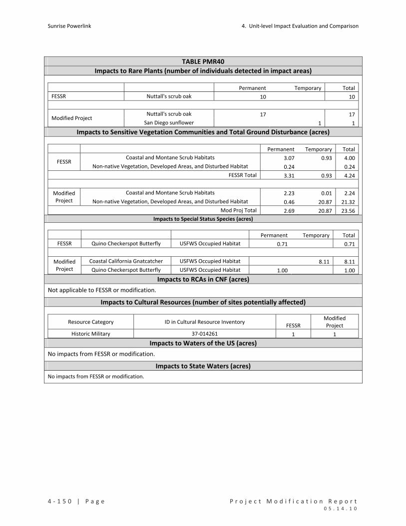
Sunrise Powerlink 4. Unit‐level Impact Evaluation and Comparison
4 ‐ 1 5 0 | P a g e P r o j e c t M o d i f i c a t i o n R e p o r t 0 5 . 1 4 . 1 0
TABLE PMR40
Impacts to Rare Plants (number of individuals detected in impact areas)
Permanent Temporary Total
FESSR Nuttall's scrub oak 10 10
Nuttall's scrub oak 17 17 Modified Project
San Diego sunflower 1 1 Impacts to Sensitive Vegetation Communities and Total Ground Disturbance (acres)
Permanent Temporary Total
Coastal and Montane Scrub Habitats 3.07 0.93 4.00 FESSR
Non‐native Vegetation, Developed Areas, and Disturbed Habitat 0.24 0.24
FESSR Total 3.31 0.93 4.24
Coastal and Montane Scrub Habitats 2.23 0.01 2.24 Modified Project Non‐native Vegetation, Developed Areas, and Disturbed Habitat 0.46 20.87 21.32
Mod Proj Total 2.69 20.87 23.56 Impacts to Special Status Species (acres)
Permanent Temporary Total
FESSR Quino Checkerspot Butterfly USFWS Occupied Habitat 0.71 0.71
Coastal California Gnatcatcher USFWS Occupied Habitat 8.11 8.11 Modified Project Quino Checkerspot Butterfly USFWS Occupied Habitat 1.00 1.00
Impacts to RCAs in CNF (acres)
Not applicable to FESSR or modification.
Impacts to Cultural Resources (number of sites potentially affected)
Resource Category ID in Cultural Resource Inventory FESSR
Modified Project
Historic Military 37‐014261 1 1 Impacts to Waters of the US (acres)
No impacts from FESSR or modification.
Impacts to State Waters (acres)
No impacts from FESSR or modification.
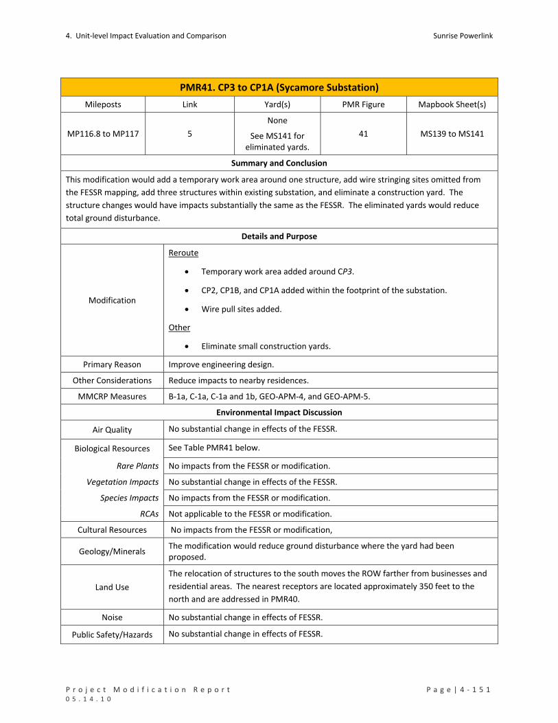
4. Unit‐level Impact Evaluation and Comparison Sunrise Powerlink
P r o j e c t M o d i f i c a t i o n R e p o r t P a g e | 4 ‐ 1 5 1 0 5 . 1 4 . 1 0
PMR41. CP3 to CP1A (Sycamore Substation)
Mileposts Link Yard(s) PMR Figure Mapbook Sheet(s)
MP116.8 to MP117 5
None
See MS141 for eliminated yards.
41 MS139 to MS141
Summary and Conclusion
This modification would add a temporary work area around one structure, add wire stringing sites omitted from
the FESSR mapping, add three structures within existing substation, and eliminate a construction yard. The
structure changes would have impacts substantially the same as the FESSR. The eliminated yards would reduce
total ground disturbance.
Details and Purpose
Modification
Reroute
Temporary work area added around CP3.
CP2, CP1B, and CP1A added within the footprint of the substation.
Wire pull sites added.
Other
Eliminate small construction yards.
Primary Reason Improve engineering design.
Other Considerations Reduce impacts to nearby residences.
MMCRP Measures B‐1a, C‐1a, C‐1a and 1b, GEO‐APM‐4, and GEO‐APM‐5.
Environmental Impact Discussion
Air Quality No substantial change in effects of the FESSR.
Biological Resources See Table PMR41 below.
Rare Plants No impacts from the FESSR or modification.
Vegetation Impacts No substantial change in effects of the FESSR.
Species Impacts No impacts from the FESSR or modification.
RCAs Not applicable to the FESSR or modification.
Cultural Resources No impacts from the FESSR or modification,
Geology/Minerals The modification would reduce ground disturbance where the yard had been proposed.
Land Use
The relocation of structures to the south moves the ROW farther from businesses and
residential areas. The nearest receptors are located approximately 350 feet to the
north and are addressed in PMR40.
Noise No substantial change in effects of FESSR.
Public Safety/Hazards No substantial change in effects of FESSR.
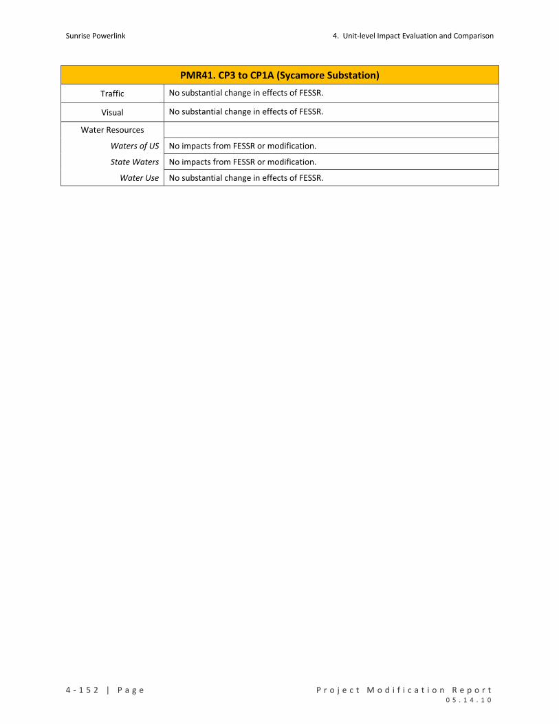
Sunrise Powerlink 4. Unit‐level Impact Evaluation and Comparison
4 ‐ 1 5 2 | P a g e P r o j e c t M o d i f i c a t i o n R e p o r t 0 5 . 1 4 . 1 0
PMR41. CP3 to CP1A (Sycamore Substation)
Traffic No substantial change in effects of FESSR.
Visual No substantial change in effects of FESSR.
Water Resources
Waters of US No impacts from FESSR or modification.
State Waters No impacts from FESSR or modification.
Water Use No substantial change in effects of FESSR.
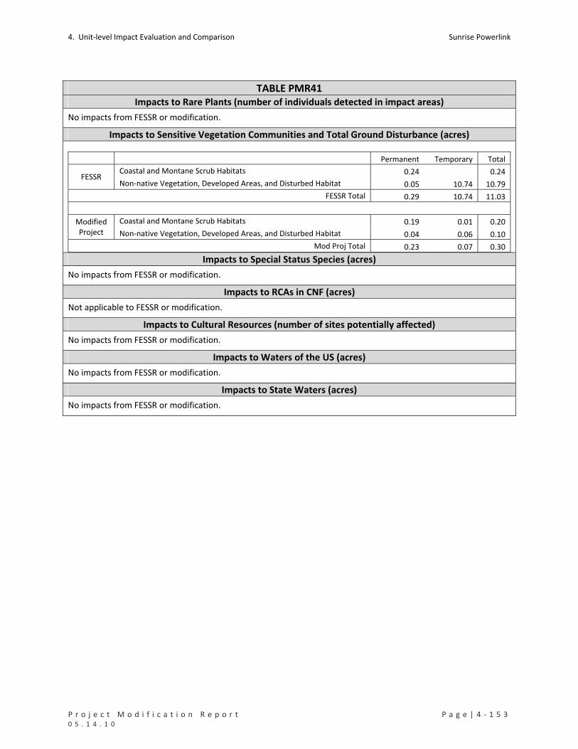
4. Unit‐level Impact Evaluation and Comparison Sunrise Powerlink
P r o j e c t M o d i f i c a t i o n R e p o r t P a g e | 4 ‐ 1 5 3 0 5 . 1 4 . 1 0
TABLE PMR41 Impacts to Rare Plants (number of individuals detected in impact areas)
No impacts from FESSR or modification.
Impacts to Sensitive Vegetation Communities and Total Ground Disturbance (acres)
Permanent Temporary Total
Coastal and Montane Scrub Habitats 0.24 0.24 FESSR
Non‐native Vegetation, Developed Areas, and Disturbed Habitat 0.05 10.74 10.79
FESSR Total 0.29 10.74 11.03
Coastal and Montane Scrub Habitats 0.19 0.01 0.20 Modified Project Non‐native Vegetation, Developed Areas, and Disturbed Habitat 0.04 0.06 0.10
Mod Proj Total 0.23 0.07 0.30 Impacts to Special Status Species (acres)
No impacts from FESSR or modification.
Impacts to RCAs in CNF (acres)
Not applicable to FESSR or modification.
Impacts to Cultural Resources (number of sites potentially affected)
No impacts from FESSR or modification.
Impacts to Waters of the US (acres)
No impacts from FESSR or modification.
Impacts to State Waters (acres)
No impacts from FESSR or modification.

Sunrise Powerlink 4. Unit‐level Impact Evaluation and Comparison
4 ‐ 1 5 4 | P a g e P r o j e c t M o d i f i c a t i o n R e p o r t 0 5 . 1 4 . 1 0
PMR42. Sycamore Canyon to Pomerado Substation (TL6915/6924) Reconductoring (Pomerado)
Mileposts Link Yard(s) PMR Figure Mapbook Sheet(s)
‐‐ 5 None 42 MS139, RC01 to RC02
Summary and Conclusion
The modification would replace an existing conductor with a higher capacity conductor; replace insulators, circuit
breakers, and related equipment at the Pomerado Substation; replace four existing transmission poles; and
replace hardware and insulators on 15 existing poles for two 69kV circuits (TL’s 6915 and 6924) both supported on
either side of a double circuit structure alignment between the Sycamore Canyon and Pomerado substations. No
substantial changes to the effects of the FESSR and no new significant impacts would result from the modification.
Details and Purpose
Modification
The modification would replace an existing conductor with a higher capacity
conductor, replace insulators, replace four existing transmission poles, requiring two
new wire pull sites, and removal of existing poles and foundations. The remainder
transmission poles will not be replaced. Only the pole top hardware and insulators will
be replaced on the remaining structures. No new access roads or widening of existing
roads is required; minor grading of existing roads may be required.
Upgrade work within the Pomerado Substation also would be conducted to
accommodate the increased circuit flows resulting from the 69kV reconductoring
upgrades proposed for the Sycamore Canyon to Pomerado transmission lines (TL6915
and TL6923). This work includes the replacement of four 69‐kV circuit breakers, ten 69‐
kV disconnects, and other associated equipment. All work associated with this
Substation upgrade would take place within the existing fence‐line of the Substation.
There would be no increase in the total acreage of the Substation and no additional
buildings will be constructed.
Primary Reason Increase power delivery/export capacity at the Sycamore Canyon Substation.
Other Considerations
Elimination of the proposed Coastal Link in the Final EIR/EIS necessitated additional system upgrades to improve overall reliability of the system because the two new Sunrise 230kV transmission lines both terminate into the Sycamore Canyon Substation. The power flowing from Sunrise into Sycamore Canyon Substation will be dispersed to adjoining substations via the existing 69kV, 138kV and 230kV transmission lines connecting Sycamore Canyon Substation to other substations in the SDG&E grid. The amount of power flowing on each of these lines is determined by each lines electrical resistance characteristics (or impedance), and not by its voltage or the size of the conductors themselves. A study of the operating conditions after the addition of the Sunrise 230kV lines demonstrated that in addition to TL639 (PMR43 – Elliott), which was already identified as experiencing an overload even with the Coastal Link, three additional 69kV lines at Sycamore Canyon Substation experienced overloads (TL’s 6915, 6924 (PMR42 – Pomerado), and 6916 (PMR44 – Scripps)). The power flowing in these lines exceeded the rating of the conductors. Therefore, the lines are being reconductored to relieve these overloaded conditions.
MMCRP Measures AQ‐4a, c‐1a, BIO‐APM‐18, GEO‐APM‐4, and GEO‐APM‐5.
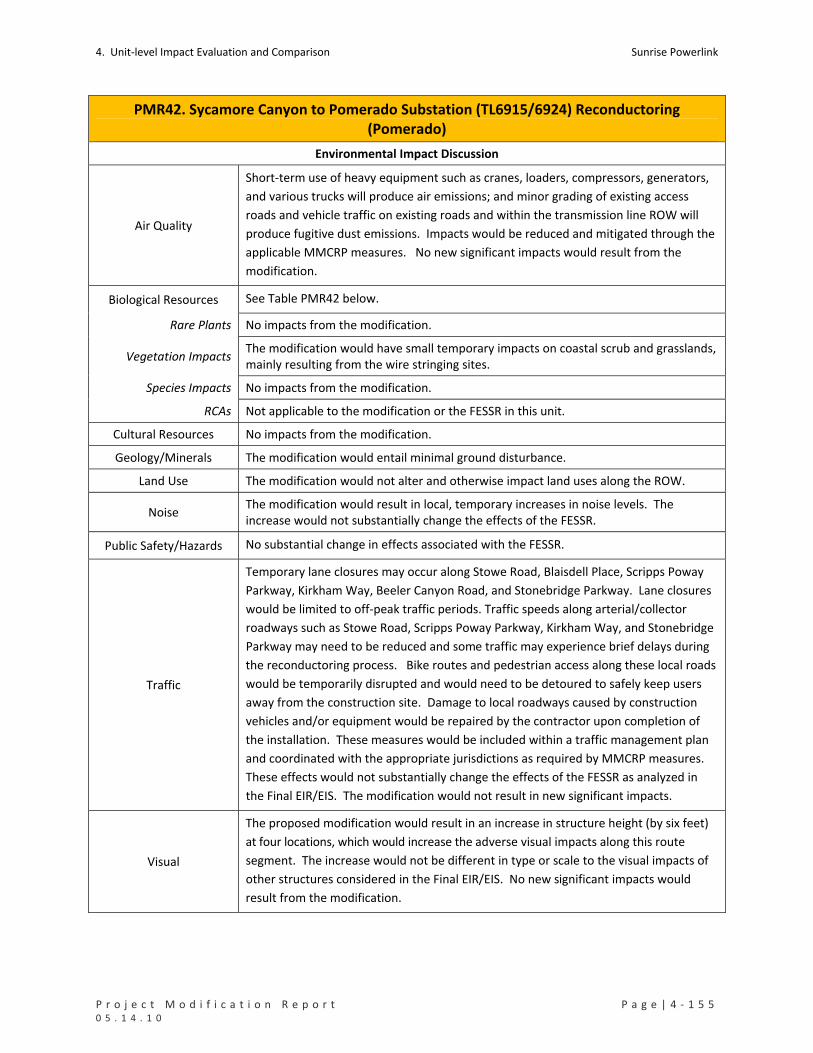
4. Unit‐level Impact Evaluation and Comparison Sunrise Powerlink
P r o j e c t M o d i f i c a t i o n R e p o r t P a g e | 4 ‐ 1 5 5 0 5 . 1 4 . 1 0
PMR42. Sycamore Canyon to Pomerado Substation (TL6915/6924) Reconductoring (Pomerado)
Environmental Impact Discussion
Air Quality
Short‐term use of heavy equipment such as cranes, loaders, compressors, generators,
and various trucks will produce air emissions; and minor grading of existing access
roads and vehicle traffic on existing roads and within the transmission line ROW will
produce fugitive dust emissions. Impacts would be reduced and mitigated through the
applicable MMCRP measures. No new significant impacts would result from the
modification.
Biological Resources See Table PMR42 below.
Rare Plants No impacts from the modification.
Vegetation Impacts The modification would have small temporary impacts on coastal scrub and grasslands, mainly resulting from the wire stringing sites.
Species Impacts No impacts from the modification.
RCAs Not applicable to the modification or the FESSR in this unit.
Cultural Resources No impacts from the modification.
Geology/Minerals The modification would entail minimal ground disturbance.
Land Use The modification would not alter and otherwise impact land uses along the ROW.
Noise The modification would result in local, temporary increases in noise levels. The increase would not substantially change the effects of the FESSR.
Public Safety/Hazards No substantial change in effects associated with the FESSR.
Traffic
Temporary lane closures may occur along Stowe Road, Blaisdell Place, Scripps Poway
Parkway, Kirkham Way, Beeler Canyon Road, and Stonebridge Parkway. Lane closures
would be limited to off‐peak traffic periods. Traffic speeds along arterial/collector
roadways such as Stowe Road, Scripps Poway Parkway, Kirkham Way, and Stonebridge
Parkway may need to be reduced and some traffic may experience brief delays during
the reconductoring process. Bike routes and pedestrian access along these local roads
would be temporarily disrupted and would need to be detoured to safely keep users
away from the construction site. Damage to local roadways caused by construction
vehicles and/or equipment would be repaired by the contractor upon completion of
the installation. These measures would be included within a traffic management plan
and coordinated with the appropriate jurisdictions as required by MMCRP measures.
These effects would not substantially change the effects of the FESSR as analyzed in
the Final EIR/EIS. The modification would not result in new significant impacts.
Visual
The proposed modification would result in an increase in structure height (by six feet)
at four locations, which would increase the adverse visual impacts along this route
segment. The increase would not be different in type or scale to the visual impacts of
other structures considered in the Final EIR/EIS. No new significant impacts would
result from the modification.

Sunrise Powerlink 4. Unit‐level Impact Evaluation and Comparison
4 ‐ 1 5 6 | P a g e P r o j e c t M o d i f i c a t i o n R e p o r t 0 5 . 1 4 . 1 0
PMR42. Sycamore Canyon to Pomerado Substation (TL6915/6924) Reconductoring (Pomerado)
Water Resources
Waters of US No impacts from the modification.
State Waters No impacts from the modification.
Water Use No substantial change in effects of the FESSR.
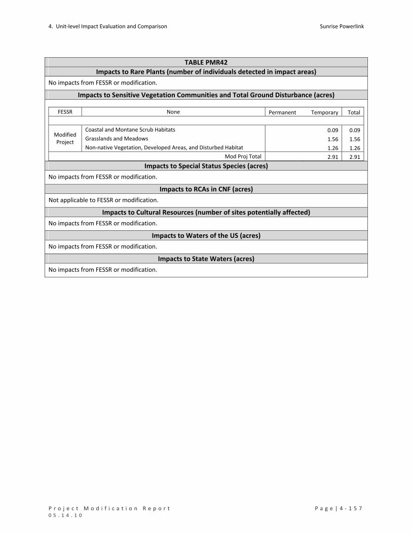
4. Unit‐level Impact Evaluation and Comparison Sunrise Powerlink
P r o j e c t M o d i f i c a t i o n R e p o r t P a g e | 4 ‐ 1 5 7 0 5 . 1 4 . 1 0
TABLE PMR42
Impacts to Rare Plants (number of individuals detected in impact areas)
No impacts from FESSR or modification.
Impacts to Sensitive Vegetation Communities and Total Ground Disturbance (acres)
FESSR None Permanent Temporary Total
Coastal and Montane Scrub Habitats 0.09 0.09
Grasslands and Meadows 1.56 1.56 Modified Project
Non‐native Vegetation, Developed Areas, and Disturbed Habitat 1.26 1.26
Mod Proj Total 2.91 2.91 Impacts to Special Status Species (acres)
No impacts from FESSR or modification.
Impacts to RCAs in CNF (acres)
Not applicable to FESSR or modification.
Impacts to Cultural Resources (number of sites potentially affected)
No impacts from FESSR or modification.
Impacts to Waters of the US (acres)
No impacts from FESSR or modification.
Impacts to State Waters (acres)
No impacts from FESSR or modification.
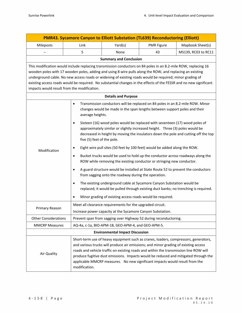
Sunrise Powerlink 4. Unit‐level Impact Evaluation and Comparison
4 ‐ 1 5 8 | P a g e P r o j e c t M o d i f i c a t i o n R e p o r t 0 5 . 1 4 . 1 0
PMR43. Sycamore Canyon to Elliott Substation (TL639) Reconductoring (Elliott)
Mileposts Link Yard(s) PMR Figure Mapbook Sheet(s)
‐‐ 5 None 43 MS139, RC03 to RC11
Summary and Conclusion
This modification would include replacing transmission conductors on 84 poles in an 8.2‐mile ROW, replacing 16
wooden poles with 17 wooden poles, adding and using 8 wire pulls along the ROW, and replacing an existing
underground cable. No new access roads or widening of existing roads would be required; minor grading of
existing access roads would be required. No substantial changes in the effects of the FESSR and no new significant
impacts would result from the modification.
Details and Purpose
Modification
Transmission conductors will be replaced on 84 poles in an 8.2‐mile ROW. Minor
changes would be made in the span lengths between support poles and their
average heights.
Sixteen (16) wood poles would be replaced with seventeen (17) wood poles of
approximately similar or slightly increased height. Three (3) poles would be
decreased in height by moving the insulators down the pole and cutting off the top
five (5) feet of the pole.
Eight wire pull sites (50 feet by 100 feet) would be added along the ROW.
Bucket trucks would be used to hold up the conductor across roadways along the
ROW while removing the existing conductor or stringing new conductor.
A guard structure would be installed at State Route 52 to prevent the conductors
from sagging onto the roadway during the operation.
The existing underground cable at Sycamore Canyon Substation would be
replaced; it would be pulled through existing duct banks; no trenching is required.
Minor grading of existing access roads would be required.
Primary Reason Meet all clearance requirements for the upgraded circuit.
Increase power capacity at the Sycamore Canyon Substation.
Other Considerations Prevent span from sagging over Highway 52 during reconductoring.
MMCRP Measures AQ‐4a, c‐1a, BIO‐APM‐18, GEO‐APM‐4, and GEO‐APM‐5.
Environmental Impact Discussion
Air Quality
Short‐term use of heavy equipment such as cranes, loaders, compressors, generators,
and various trucks will produce air emissions; and minor grading of existing access
roads and vehicle traffic on existing roads and within the transmission line ROW will
produce fugitive dust emissions. Impacts would be reduced and mitigated through the
applicable MMCRP measures. No new significant impacts would result from the
modification.

4. Unit‐level Impact Evaluation and Comparison Sunrise Powerlink
P r o j e c t M o d i f i c a t i o n R e p o r t P a g e | 4 ‐ 1 5 9 0 5 . 1 4 . 1 0
PMR43. Sycamore Canyon to Elliott Substation (TL639) Reconductoring (Elliott)
Biological Resources See Table PMR43 below.
Rare Plants No impacts from the modification.
Vegetation Impacts The modification would result in temporary impacts to 0.18 acre of vegetation.
Species Impacts No impacts from the modification.
RCAs Not applicable to the FESSR or modification.
Cultural Resources There are seven cultural sites in this unit. None would be affected by the modification.
Geology/Minerals The modification would entail minimal ground disturbance.
Land Use The modification would not alter and otherwise impact land uses along the ROW. Sensitive receptors include residences, a university, and businesses.
Noise The modification would result in local, temporary increases in noise levels. The increase would not substantially change the effects of the FESSR.
Public Safety/Hazards No substantial changes in the risks posed by the FESSR would result from the
modification.
Traffic
Temporary lane closures may occur along Scripps Lake Road, Scripps Ranch Boulevard,
Ironwood Road, Pomerado Road, and Rue Biarittz. Lane closures would be limited to
off‐peak traffic period. Traffic speeds along arterial/collector roadways such as Scripps
Ranch Boulevard and Pomerado Road may need to be reduced and some traffic may
experience brief delays during the reconductoring process. Due to the temporary
nature of the lane closures, operation and access by emergency services would not be
affected. Bike routes and pedestrian access along these local roads would be
temporarily disrupted and would need to be detoured to safely keep users away from
the construction site. Damage to local roadways would be repaired by the contractor
upon completion of the installation. These measures would be included within a traffic
management plan and coordinated with the appropriate jurisdictions as required by
MMCRP measures. These effects would not substantially change the effects of the
FESSR as analyzed in the Final EIR/EIS. The modification would not result in new
significant impacts.
Visual
The modification would result in an increase in structure height at eight locations and the
reduction in structure height at three locations. No substantial change in the FESSR’s
visual impacts and no new significant visual impact would result from the modification.
Water Resources
Waters of US No impacts from the modification.
State Waters No impacts from the modification.
Water Use No substantial changes in the effects of the FESSR.

Sunrise Powerlink 4. Unit‐level Impact Evaluation and Comparison
4 ‐ 1 6 0 | P a g e P r o j e c t M o d i f i c a t i o n R e p o r t 0 5 . 1 4 . 1 0
TABLE PMR43 Impacts to Rare Plants (number of individuals detected in impact areas)
No impacts from FESSR or modification.
Impacts to Sensitive Vegetation Communities and Total Ground Disturbance (acres)
FESSR None Permanent Temporary Total
Chaparrals 0.10 0.10
Coastal and Montane Scrub Habitats 0.08 0.08 Modified Project
Non‐native Vegetation, Developed Areas, and Disturbed Habitat 1.52 1.52
Mod Proj Total 1.70 1.70 Impacts to Special Status Species (acres)
No impacts from FESSR or modification.
Impacts to RCAs in CNF (acres)
No impacts from FESSR or modification.
Impacts to Cultural Resources (number of sites potentially affected)
No impacts from FESSR or modification.
Impacts to Waters of the US (acres)
No impacts from FESSR or modification.
Impacts to State Waters (acres)
No impacts from FESSR or modification.

4. Unit‐level Impact Evaluation and Comparison Sunrise Powerlink
P r o j e c t M o d i f i c a t i o n R e p o r t P a g e | 4 ‐ 1 6 1 0 5 . 1 4 . 1 0
PMR44. Sycamore Canyon to Scripps Substation (TL 6916) Reconductoring (Scripps)
Mileposts Link Yard(s) PMR Figure Mapbook Sheet(s)
‐‐ 5 None 44 MS139, RC12 to
RC15, MS141
Summary and Conclusion
This modification would include replacing transmission conductors on 48 poles in a 6.4 mile ROW, 8 wire pulls
along the ROW, two underground upgrades, one new 900‐foot‐long double circuit 69 kV duct package and one
7,725 replacement cable within existing underground cable ducts, and circuit breakers, and related equipment at
the Scripps Substation. No substantial changes in the effects of the FESSR and no new significant impacts would
result from the modification.
Details and Purpose
Modification
Transmission conductors would be replaced on 48 poles in a 6.4‐mile ROW.
8 wire pull sites (50 feet by 100 feet) added along the ROW.
No replacement of existing poles or addition of new poles.
Two underground upgrades: 1) new 900‐foot‐long double circuit 69kV duct package located in the street on Rue Biarritz, and 2) 7,725 feet of replacement cable from Ironwood Road to the Scripps Substation.
Minor grading of existing access roads required.
Upgrade work within the Scripps Substation also would be conducted to accommodate the increased circuit flows resulting from the 69kV reconductoring upgrades proposed for the Sycamore Canyon to Scripps transmission line (TL6916). This work includes the replacement of 69‐kV circuit breakers and disconnects, and other associated equipment. All work associated with this Substation upgrade would take place within the existing fence‐line of the Substation. There would be no increase in the total acreage of the Substation and no additional buildings will be constructed.
Primary Reason Increase power capacity at the Sycamore Canyon Substation.
Other Considerations
Install underground upgrades.
Elimination of the proposed Coastal Link in the Final EIR/EIS necessitated additional system upgrades to improve overall reliability of the system because the two new Sunrise 230kV transmission lines both terminate into the Sycamore Canyon Substation. The power flowing from Sunrise into Sycamore Canyon Substation will be dispersed to adjoining substations via the existing 69kV, 138kV and 230kV transmission lines connecting Sycamore Canyon Substation to other substations in the SDG&E grid. The amount of power flowing on each of these lines is determined by each lines electrical resistance characteristics (or impedance), and not by its voltage or the size of the conductors themselves. A study of the operating conditions after the addition of the Sunrise 230kV lines demonstrated that in addition to TL639 (PMR43 – Elliott), which was already identified as experiencing an overload even with the Coastal Link, three additional 69kV lines at Sycamore Canyon Substation experienced overloads (TL’s 6915, 6924 (PMR42 – Pomerado), and 6916 (PMR44 – Scripps)). The power flowing in these lines exceeded the rating of the conductors. Therefore, this line is being reconductored to relieve the overloaded conditions.
MMCRP Measures AQ‐4a, c‐1a, BIO‐APM‐18, GEO‐APM‐4, and GEO‐APM‐5.
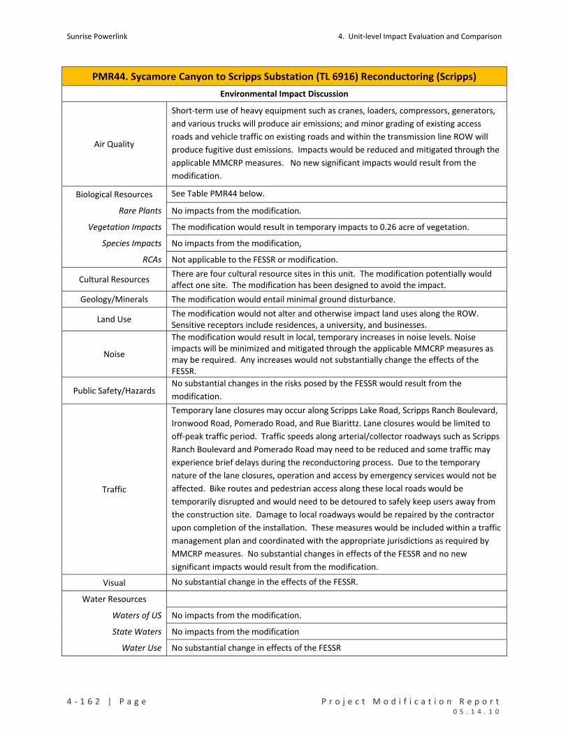
Sunrise Powerlink 4. Unit‐level Impact Evaluation and Comparison
4 ‐ 1 6 2 | P a g e P r o j e c t M o d i f i c a t i o n R e p o r t 0 5 . 1 4 . 1 0
PMR44. Sycamore Canyon to Scripps Substation (TL 6916) Reconductoring (Scripps)
Environmental Impact Discussion
Air Quality
Short‐term use of heavy equipment such as cranes, loaders, compressors, generators,
and various trucks will produce air emissions; and minor grading of existing access
roads and vehicle traffic on existing roads and within the transmission line ROW will
produce fugitive dust emissions. Impacts would be reduced and mitigated through the
applicable MMCRP measures. No new significant impacts would result from the
modification.
Biological Resources See Table PMR44 below.
Rare Plants No impacts from the modification.
Vegetation Impacts The modification would result in temporary impacts to 0.26 acre of vegetation.
Species Impacts No impacts from the modification,
RCAs Not applicable to the FESSR or modification.
Cultural Resources There are four cultural resource sites in this unit. The modification potentially would affect one site. The modification has been designed to avoid the impact.
Geology/Minerals The modification would entail minimal ground disturbance.
Land Use The modification would not alter and otherwise impact land uses along the ROW. Sensitive receptors include residences, a university, and businesses.
Noise
The modification would result in local, temporary increases in noise levels. Noise impacts will be minimized and mitigated through the applicable MMCRP measures as may be required. Any increases would not substantially change the effects of the FESSR.
Public Safety/Hazards No substantial changes in the risks posed by the FESSR would result from the
modification.
Traffic
Temporary lane closures may occur along Scripps Lake Road, Scripps Ranch Boulevard,
Ironwood Road, Pomerado Road, and Rue Biarittz. Lane closures would be limited to
off‐peak traffic period. Traffic speeds along arterial/collector roadways such as Scripps
Ranch Boulevard and Pomerado Road may need to be reduced and some traffic may
experience brief delays during the reconductoring process. Due to the temporary
nature of the lane closures, operation and access by emergency services would not be
affected. Bike routes and pedestrian access along these local roads would be
temporarily disrupted and would need to be detoured to safely keep users away from
the construction site. Damage to local roadways would be repaired by the contractor
upon completion of the installation. These measures would be included within a traffic
management plan and coordinated with the appropriate jurisdictions as required by
MMCRP measures. No substantial changes in effects of the FESSR and no new
significant impacts would result from the modification.
Visual No substantial change in the effects of the FESSR.
Water Resources
Waters of US No impacts from the modification.
State Waters No impacts from the modification
Water Use No substantial change in effects of the FESSR
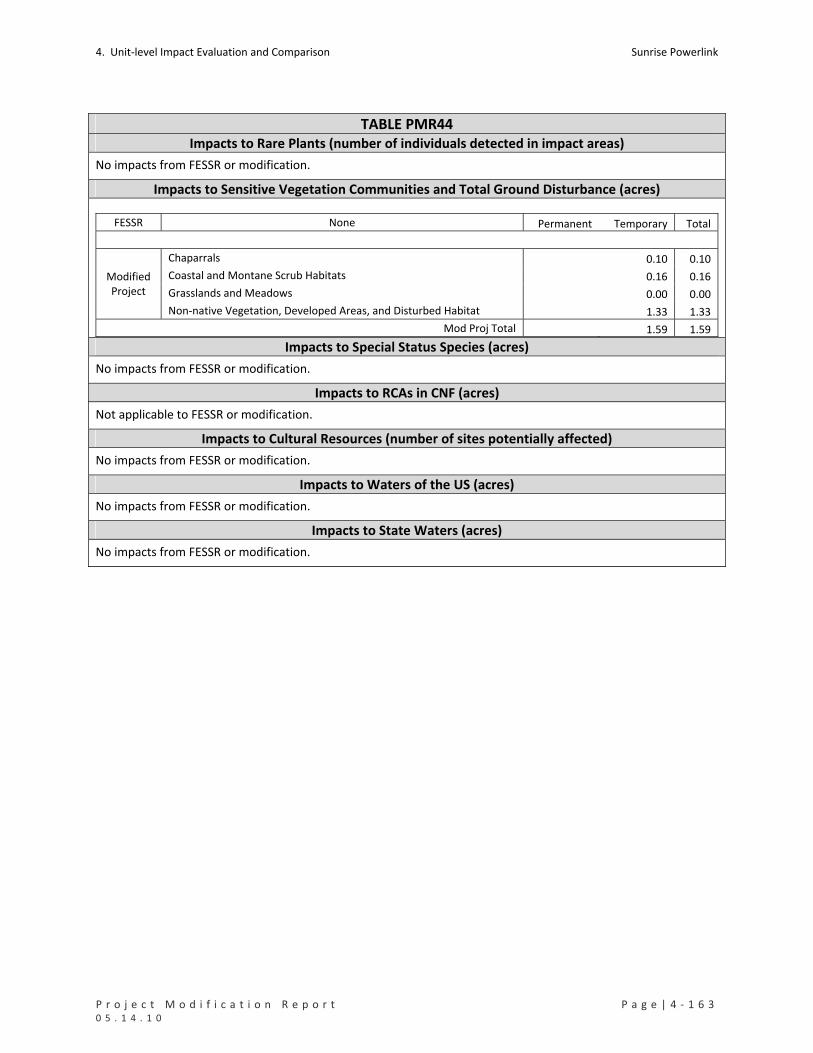
4. Unit‐level Impact Evaluation and Comparison Sunrise Powerlink
P r o j e c t M o d i f i c a t i o n R e p o r t P a g e | 4 ‐ 1 6 3 0 5 . 1 4 . 1 0
TABLE PMR44 Impacts to Rare Plants (number of individuals detected in impact areas)
No impacts from FESSR or modification.
Impacts to Sensitive Vegetation Communities and Total Ground Disturbance (acres)
FESSR None Permanent Temporary Total
Chaparrals 0.10 0.10
Coastal and Montane Scrub Habitats 0.16 0.16
Grasslands and Meadows 0.00 0.00
Modified Project
Non‐native Vegetation, Developed Areas, and Disturbed Habitat 1.33 1.33
Mod Proj Total 1.59 1.59 Impacts to Special Status Species (acres)
No impacts from FESSR or modification.
Impacts to RCAs in CNF (acres)
Not applicable to FESSR or modification.
Impacts to Cultural Resources (number of sites potentially affected)
No impacts from FESSR or modification.
Impacts to Waters of the US (acres)
No impacts from FESSR or modification.
Impacts to State Waters (acres)
No impacts from FESSR or modification.

Sunrise Powerlink 4. Unit‐level Impact Evaluation and Comparison
4 ‐ 1 6 4 | P a g e P r o j e c t M o d i f i c a t i o n R e p o r t 0 5 . 1 4 . 1 0

P r o j e c t M o d i f i c a t i o n R e p o r t A t t a c h m e n t A 0 5 . 1 4 . 1 0
ATTACHMENT A

P r o j e c t M o d i f i c a t i o n R e p o r t A t t a c h m e n t A 0 5 . 1 4 . 1 0

Sunrise Powerlink Project
GIS Methodology for Impact Determination Section A. Impact Classification and Hierarchy of Proposed Infrastructure Developments In order to determine impact area, the proposed infrastructure developments for the Sunrise Powerlink Project have been itemized according to their subject matter. The proposed infrastructure developments have a potential if constructed to disturb the existing state of the ground surface there by becoming an impact. Ground impacts are considered either permanent or temporary. Each potential development or ground impact is identified with a GIS Layer to represent the subject matter of concern. There are 17 subject matters listed as GIS Layers of which 5 (not listed below) are considered survey and measurement guidelines and will have no impact. The list below represents the hierarchy in order by necessary impact, starting with “1” as the most necessary. The hierarchy is determined and based on the infrastructure development need or requirement in order to construct and maintain the proposed transmission line. Following the Impact Classification and GIS Definitions Sections A and B, there will be further explanation of GIS data development and the hierarchy model used to calculate potential impacts.
PERMANENT IMPACTS TEMPORARY IMPACTS
1) Substation 8) Guard Structure
2) Footings 9) Pad_Area ‐ Work Area
3) Pad_Area ‐ TSAP 10) Pad_Area ‐ Stringing Area
4) Road_Area – New Construction AND Improvements 11) Construction Yard
5) Pad_Area ‐ Maintenance Pad 12) Road_Area – New Construction
6) Grading
7) Pad_Area ‐ Structure Pad Area
Section B. GIS Data Layer Names and Definitions Each subject matter or GIS Layer above in Section A is listed in hierarchical order and defined below. The Sunrise Powerlink Impact Analysis GIS Database currently consists of 12 alignment features classes. Below lists the feature class name and geometry type along with a brief definition and classification if present.
1
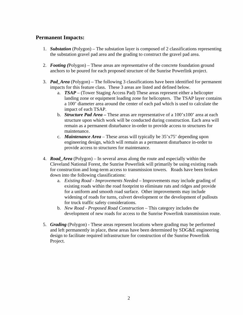
Permanent Impacts:
1. Substation (Polygon) – The substation layer is composed of 2 classifications representing the substation gravel pad area and the grading to construct the gravel pad area.
2. Footing (Polygon) – These areas are representative of the concrete foundation ground
anchors to be poured for each proposed structure of the Sunrise Powerlink project. 3. Pad_Area (Polygon) – The following 3 classifications have been identified for permanent
impacts for this feature class. These 3 areas are listed and defined below. a. TSAP – (Tower Staging Access Pad) These areas represent either a helicopter
landing zone or equipment loading zone for helicopters. The TSAP layer contains a 100’ diameter area around the center of each pad which is used to calculate the impact of each TSAP.
b. Structure Pad Area – These areas are representative of a 100’x100’ area at each structure upon which work will be conducted during construction. Each area will remain as a permanent disturbance in-order to provide access to structures for maintenance.
c. Maintenance Area – These areas will typically be 35’x75’ depending upon engineering design, which will remain as a permanent disturbance in-order to provide access to structures for maintenance.
4. Road_Area (Polygon) – In several areas along the route and especially within the
Cleveland National Forest, the Sunrise Powerlink will primarily be using existing roads for construction and long-term access to transmission towers. Roads have been broken down into the following classifications:
a. Existing Road - Improvements Needed – Improvements may include grading of existing roads within the road footprint to eliminate ruts and ridges and provide for a uniform and smooth road surface. Other improvements may include widening of roads for turns, culvert development or the development of pullouts for truck traffic safety considerations.
b. New Road - Proposed Road Construction – This category includes the development of new roads for access to the Sunrise Powerlink transmission route.
5. Grading (Polygon) - These areas represent locations where grading may be performed
and left permanently in place, these areas have been determined by SDG&E engineering design to facilitate required infrastructure for construction of the Sunrise Powerlink Project.
2
Temporary Impacts:
6. GuardArea (Polygon) – These areas show where structures will be erected to restrict travel by people. Guard structures will need to be placed in specific areas where construction activities are planned for the Sunrise Powerlink Project. The purpose of these areas is to restrict any though fare by people where construction of the Sunrise Powerlink Project is planned or present.
7. Pad_Area (Polygon) – The following 2 classifications have been identified as temporary
impacts for this feature class. These 2 areas are listed and defined below. a. Work Area – These are larger work areas which encompass the smaller 100’x100’
structure pad areas and are either 200’x200’ or 200’x 400’ areas for additional work space.
b. Stringing Area – These areas are used for the stringing of power lines during construction. These areas include the stringing operations area; associated grading area including road grading, and any required road improvements or new road developments.
8. Construction_Yard (Polygon) – These areas will contain equipment storage, helicopter
access and operations, as well as field offices and other facilities for the construction of the Sunrise Powerlink Project.
9. Road_Area (Polygon) – In several areas along the route and especially within the
Cleveland National Forest, the Sunrise Powerlink will primarily be using existing roads for construction and long-term access to transmission towers. Roads have been broken down into the following classifications:
a. New Road - Proposed Road Construction – This category includes the development of new roads for access to the Sunrise Powerlink transmission route.
No Impacts:
10. ROW (Polygon) – These areas show property either owned by SDG&E or property under negotiations for ownership by SDG&E.
11. Route_CenterLine (Line) – This is an imaginary line that represents the shortest path
between the center points of each transmission tower along the route of the Sunrise Powerlink Project.
12. Structure (Point) – These points are representative of the center for each proposed
transmission tower structure along the route of the Sunrise Powerlink Project. 13. Milepost (Point) – These points represent a measurement in 1 mile units along the route
centerline of the Sunrise Powerlink Project. Mile posts start in the east with mile post MP-0 and end in the west with mile post MP-118. The purpose of these point features is to reference a distance (miles) from the beginning (Imperial Valley Substation) of the
3
Sunrise Powerlink Project alignment to the end. Distance is measured along the route centerline from east to west.
14. Road_Area (Polygon) – In several areas along the route and especially within the
Cleveland National Forest, the Sunrise Powerlink will primarily be using existing roads for construction and long-term access to transmission towers. Roads have been broken down into the following classifications:
a. Existing Road - No Improvements Needed – No road improvements required. 15. Road_CenterLine (Line) – These lines represent the center lines of either proposed or
existing roads that will be used in the construction and future maintenance of the Sunrise Powerlink.
a. Existing Road - No Improvements Needed – No road improvements required. b. Existing Road - Improvements Needed – Improvements may include grading of
existing roads within the road footprint to eliminate ruts and ridges and provide for a uniform and smooth road surface. Other improvements may include widening of roads for turns, culvert development or the development of pullouts for truck traffic safety considerations.
c. New Road - Proposed Road Construction – This category includes the development of new roads for access to the Sunrise Powerlink transmission route.
Figure 1. GIS Impact Analysis Workflow The figure below represents a visual interpretation of the workflow involved in the production of information used to determine the proposed alignment options. Databases, Processes, and Hierarchies are simplified and displayed graphically below.
4

Sunrise Powerlink Project GIS Methodology for Impact Determination
Workflow Model(Figure 1)
Components Impact Model Hierarchy(ArcGIS Model Builder Process)
Alignment components are listed numericallyto represent the spatial processing of
importance for each constraint.
This workflow model provides a visual representation of how data is
processed to produce the information used for alignment determination.
Map Production(Map 1 and 2)
Quantitative Reporting(Example 1‐ Pivot Table)
Dynamic Alignment Determination
PERMANENT IMPACTS:
1) Substation
2) Footings
3) Pad_Area ‐ TSAP
4) Road_Area – New Construction AND Improvements
5) Pad_Area ‐ Maintenance Area
6) Grading
7) Pad_Area ‐ Structure Pad Area
TEMPORARY IMPACTS:
8) Guard Structure
9) Pad_Area ‐ Work Area
10) Pad_Area ‐ Stringing Area
11) Construction Yard
12) Road_Area – New Construction
Spatial Data(Vector, Raster and Tabular)
Data Processes:
MigrationTopologyStandardization
Metadata
Proposed Alignment (GIS Data Input)
Resource/Constraints Alignment
(GIS Data Input)
Proposed Alignment Ground Impact
(GIS Data Output)
Data Processes:
Quality Control
Quality Assurance
Resource/Constraint Alignment Impact(GIS Data Output)
Data Processes:
Data Organization
Data Selection
Section C. Software Version and Spatial Data Coordinate System Spatial analysis has been performed using ArcGIS Desktop Version 9.3.1 all data deliverables will reside in this version. All spatial data includes any vector or raster data sets developed from photogrammetric companies, Trimble GPS RTK (Real Time Kinematic) survey, Leica GPS Conventional Survey Methods, CAD data, and GIS data. All spatial data is maintained in ArcSDE and projected in the following Coordinate System: NAD_1983_StatePlane_California_VI_FIPS_0406_Feet Horizontal Details: Projection: Lambert_Conformal_Conic False_Easting: 6561666.666667 False_Northing: 1640416.666667 Central_Meridian: -116.250000 Standard_Parallel_1: 32.783333 Standard_Parallel_2: 33.883333 Latitude_Of_Origin: 32.166667 Linear Unit: Foot_US (0.304801) Geographic Coordinate System: GCS_North_American_1983 Angular Unit: Degree (0.017453292519943295) Prime Meridian: Greenwich (0.000000000000000000) Datum: D_North_American_1983 Spheroid: GRS_1980 Semimajor Axis: 6378137.000000000000000000 Semiminor Axis: 6356752.314140356100000000 Inverse Flattening: 298.257222101000020000 Section D. Case Studies – Maps of GIS Data Layer Names and Hierarchy Impact Example This section has been developed for the purposes of describing case studies to demonstrate how various products could be generated. This section also addresses familiarity with the GIS Layers and their definitions, as well as a step by step explanation of the hierarchy model and GIS layer usage within the hierarchy model. Map 1. Alignment Components and Constraints – Pre Impact Analysis
5
6
The figure below displays a visual example of the definitions described in “Section B. GIS Data Layer Names and Definitions”. Although it is not possible to have an example area which shows all of the alignment components with constraints, we have added in the missing GIS Layers for the area of interest below. Note that not all alignment components are actually proposed for the Project Modification Report on the map below and the map below has been developed for demonstration purposes only. Each GIS Layer is depicted for the area surrounding structures EP220-1 and EP221-2 along with one constraint (vegetation). Please notice the legend symbology for identification of the GIS Layers. Map 2. Alignment Components and Constraints – Post Impact Analysis This figure shows the potential impacts that may be incurred by construction. The component types can be quantified and represented in pivot tables. Appendix 1. Impact Hierarchy Example (McCain Valley Construction Yard) Appendix 1 will demonstrate how the hierarchy model is applied step by step. The McCain Valley Construction Yard has been selected as the area of interest for this example.

MP-39
EP221AEP221A
EP221-2EP221-2
EP220-1EP220-1
116°14’25"W116°14’30"W116°14’35"W116°14’40"W116°14’45"W116°14’50"W116°14’55"W116°15’0"W116°15’5"W32
°39
’45
"N
32°3
9’4
5"N
32°3
9’4
0"N
32°3
9’4
0"N
32°3
9’3
5"N
32°3
9’3
5"N
32°3
9’3
0"N
32°3
9’3
0"N
32°3
9’2
5"N
32°3
9’2
5"N
Map 1Alignment Components and Constraints
Pre-Impact Analysis
California, USASunrise Powerlink Alignment
1 inch = 267 feet
1:3,200Environmentally SuperiorSouthern Route
10-019 PMR GIS Map 1 11x8 3600 JFC.mxd
0 110 220 330 44055
Feet
0 25 50 75 10012.5
Meters
SDG&E is providing this map to you as a courtesy, SDG&E does not represent that the information contained herein is accurate. SDG&E disclaims all warranties, express or implied,including the warranty of fitness for a particular purpose. You are solely responsible for selecting this map to use and you are solely responsible for any consequences resulting from your use. Reproduction, duplication, or modification of this map is not allowed without permission.
Work Area
Stringing Area
Structure Pad Area
Current Sunrise Structure
Right of Way
TSAP (Tower Staging Access Pad)
Grading
Road - Existing - Improvements RequiredRoad - New Construction - Permanent
EP1-3EP1-3
Road - New Construction - Temporary
Construction Yard in EIRbut Not Current
Maintenance Pad
Legend
Vegetation Communities
Chaparrals
Redshank Chaparral (RSC)
Redshank Chaparral - Disturbed (RSC-D)
Scrub Oak Chaparral (SOC)
Scrub Oak Chaparral - Disturbed (SOC-D)
Semi-desert Chaparral (SDC)
Semi-desert Chaparral - Disturbed (SDC-D)

EP221AEP221A
EP221-2EP221-2
EP220-1EP220-1
116°14’25"W116°14’30"W116°14’35"W116°14’40"W116°14’45"W116°14’50"W116°14’55"W116°15’0"W116°15’5"W32
°39
’45
"N
32°3
9’4
5"N
32°3
9’4
0"N
32°3
9’4
0"N
32°3
9’3
5"N
32°3
9’3
5"N
32°3
9’3
0"N
32°3
9’3
0"N
32°3
9’2
5"N
32°3
9’2
5"N
Map 2Alignment Components and Constraints
Post-Impact Analysis
California, USASunrise Powerlink Alignment
1 inch = 267 feet
1:3,200Environmentally SuperiorSouthern Route
10-019 PMR GIS Map 1 11x8 3600 JFC.mxd
0 110 220 330 44055
Feet
0 25 50 75 10012.5
Meters
SDG&E is providing this map to you as a courtesy, SDG&E does not represent that the information contained herein is accurate. SDG&E disclaims all warranties, express or implied,including the warranty of fitness for a particular purpose. You are solely responsible for selecting this map to use and you are solely responsible for any consequences resulting from your use. Reproduction, duplication, or modification of this map is not allowed without permission.
Work Area
Stringing Area
Structure Pad Area
Current Sunrise Structure
Right of Way
TSAP (Tower Staging Access Pad)
Grading
Road - Existing - Improvements RequiredRoad - New Construction - Permanent
EP1-3EP1-3
Road - New Construction - Temporary
Construction Yard in EIRbut Not Current
Maintenance Pad
Legend
Vegetation Communities
Chaparrals
Redshank Chaparral (RSC)
Redshank Chaparral - Disturbed (RSC-D)
Scrub Oak Chaparral (SOC)
Scrub Oak Chaparral - Disturbed (SOC-D)
Semi-desert Chaparral (SDC)
Semi-desert Chaparral - Disturbed (SDC-D)
Areas of Impacts to Vegetation
GIS Methodology for Impact Determination
Hierarchy Example
(Appendix 1)

Sunrise Powerlink ProjectImpact Analysis
• In order to determine total ground disturbance impact areas for the Sunrise Powerlink Project, overlapping areas must be identified and attributed properly according to the hierarchal model.
• The hierarchal model has been developed to ensure that overlapping ground disturbance impact areas are not double counted and that accurate assessments of the total area of impact is properly determined.
CChadbou
Typewritten Text
CChadbou
Typewritten Text
CChadbou
Typewritten Text
CChadbou
Typewritten Text
CChadbou
Typewritten Text
CChadbou
Typewritten Text
The McCain Valley
Construction Yard(Case Study)
• The McCain Valley Construction Yard is a good example of where overlapping ground disturbances may occur.
• The McCain Valley Construction Yard has a tower structure located near it’s center. There are other potential overlapping ground disturbance impacts as a result of this planned development.
• The next few slides will demonstrate step by step an example of the hierarchy of overlapping impacts how overlapping impacts areaccounted for.

The data displayed below shows an overview map of the McCain Valley Construction Yard and other potential Impacts.


The McCain Valley Construction Yard contains additional ground disturbances. Examples of these are shown below:
This Road Area willbe used to constructand maintain theSunrise Powerlink.
These Pad Areaswill be used to constructand maintain the Sunrise Powerlink.This area is a Stringing
Area which will be used to perform activities related to the installation of conductors on tower structures along theSunrise Powerlink
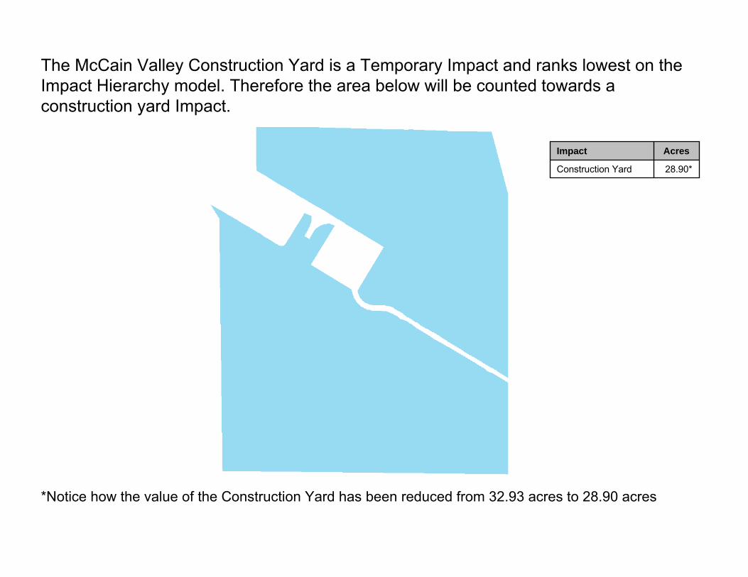
28.90*Construction Yard
AcresImpact
The McCain Valley Construction Yard is a Temporary Impact and ranks lowest on the Impact Hierarchy model. Therefore the area below will be counted towards a construction yard Impact.
*Notice how the value of the Construction Yard has been reduced from 32.93 acres to 28.90 acres
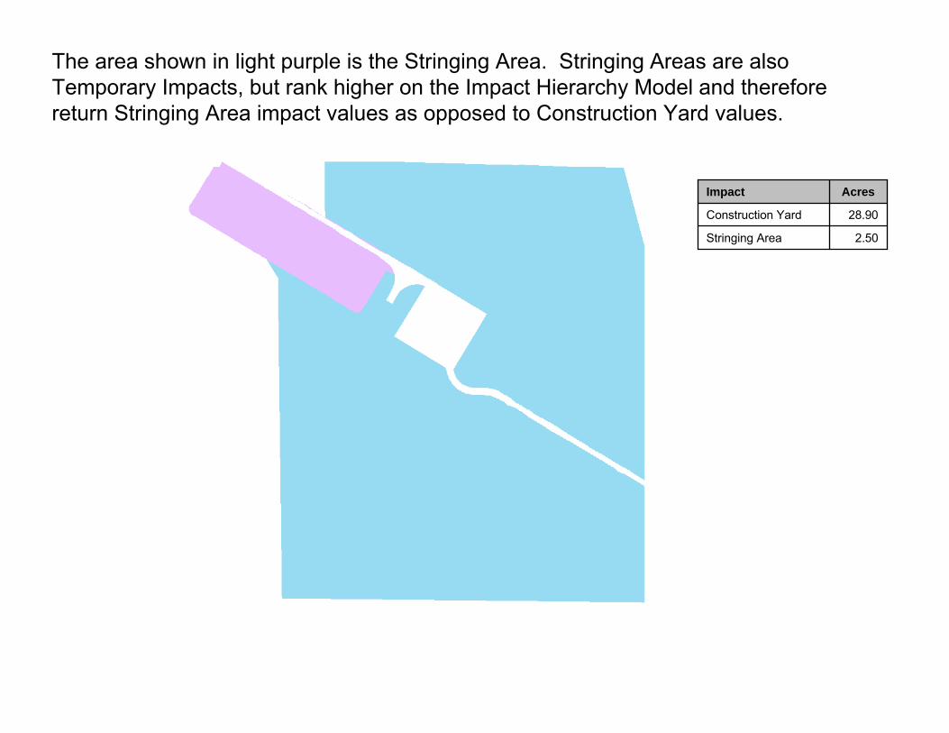
2.50Stringing Area
28.90Construction Yard
AcresImpact
The area shown in light purple is the Stringing Area. Stringing Areas are alsoTemporary Impacts, but rank higher on the Impact Hierarchy Model and thereforereturn Stringing Area impact values as opposed to Construction Yard values.
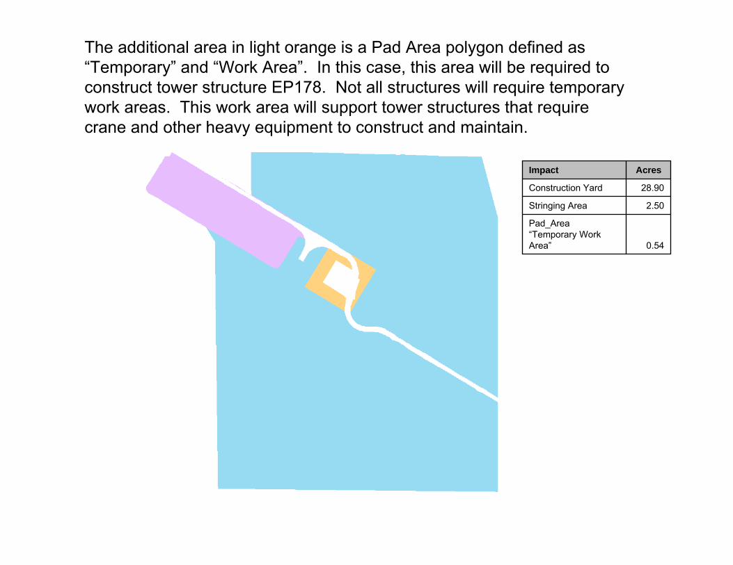
0.54
Pad_Area“Temporary Work Area”
2.50Stringing Area
28.90Construction Yard
AcresImpact
The additional area in light orange is a Pad Area polygon defined as “Temporary” and “Work Area”. In this case, this area will be required to construct tower structure EP178. Not all structures will require temporary work areas. This work area will support tower structures that require crane and other heavy equipment to construct and maintain.

0.19
Pad_Area ““Structure Impact Area”
0.54
Pad_Area“Temporary Work Area”
2.50Stringing Area
28.90Construction Yard
AcresImpact
The additional area with the darker orange color is another Pad Area defined as" Structure Pad Area”. Each tower structure along the proposed alignment will have an associated area of permanent impact for future maintenance of the tower structures.
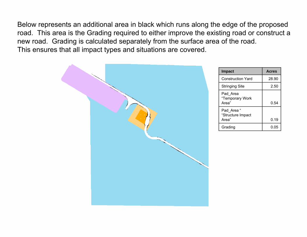
0.05Grading
0.19
Pad_Area ““Structure Impact Area”
0.54
Pad_Area“Temporary Work Area”
2.50Stringing Site
28.90Construction Yard
AcresImpact
Below represents an additional area in black which runs along the edge of the proposed road. This area is the Grading required to either improve the existing road or construct anew road. Grading is calculated separately from the surface area of the road.This ensures that all impact types and situations are covered.
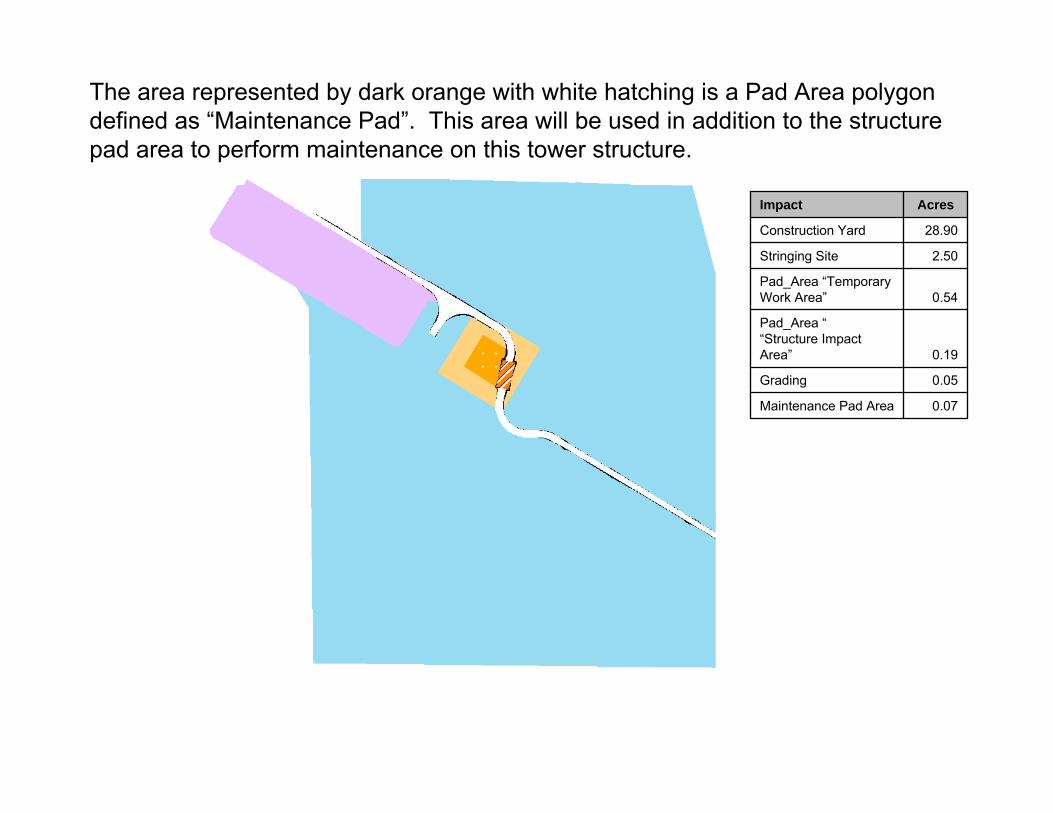
0.07Maintenance Pad Area
0.05Grading
0.19
Pad_Area ““Structure Impact Area”
0.54Pad_Area “Temporary Work Area”
2.50Stringing Site
28.90Construction Yard
AcresImpact
The area represented by dark orange with white hatching is a Pad Area polygon defined as “Maintenance Pad”. This area will be used in addition to the structure pad area to perform maintenance on this tower structure.

0.68New Access Road Area
0.07Maintenance Pad Area
0.05Grading
0.19Pad_Area ““Structure Impact Area”
0.54Pad_Area “Temporary Work Area”
2.50Stringing Area
28.90Construction Yard
AcresImpact
This area represented with red depicts the actual width of the New Access Road.
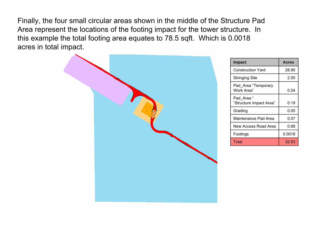
32.93Total
0.0018Footings
0.68New Access Road Area
0.07Maintenance Pad Area
0.05Grading
0.19Pad_Area ““Structure Impact Area”
0.54Pad_Area “Temporary Work Area”
2.50Stringing Site
28.90Construction Yard
AcresImpact
Finally, the four small circular areas shown in the middle of the Structure Pad Area represent the locations of the footing impact for the tower structure. In this example the total footing area equates to 78.5 sqft. Which is 0.0018 acres in total impact.

P r o j e c t M o d i f i c a t i o n R e p o r t A t t a c h m e n t A 0 5 . 1 4 . 1 0

P r o j e c t M o d i f i c a t i o n R e p o r t A t t a c h m e n t B 0 5 . 1 4 . 1 0
ATTACHMENT B

P r o j e c t M o d i f i c a t i o n R e p o r t A t t a c h m e n t B 0 5 . 1 4 . 1 0

1
SUMMARY OF CLASS III CULTURAL RESOURCE INVENTORY FOR THE FESSR AND MODIFIED PROJECT
PMR Unit Location of Resource Resource Category Inventory ID/Map Label In FESSR
Impact AreaIn ROW
Not In EIR/EIS
Total
02 Habitation Site IMP‐269 1 1
Lithic Scatter IMP‐2085 1 1
IMP‐8740 1 1
IMP‐8744 1 1
IMP‐8824 1 1
Lithic Scatter/Ceramic Scatter IMP‐8665 1 1
Lithic Scatter/Mining IMP‐8741 1 1
Lithic Scatter/Rock Carin IMP‐8739 1 1
No info AGH‐5 1 1
Prehistoric Artifact Scatter IMP‐1015/4348 1 1
IMP‐3784/3785/4340/4341/4344 1 1
Prehistoric Lithic Scatter 10B‐8 1 1
IMP‐2304 1 1
IMP‐8737 1 1
IMP‐8766 1 1
IMP‐8793 1 1
Prehistoric Lithic Scatter/Historic Refu IMP‐3773 1 1
Prehistoric Lithic Scatter/Trail IMP‐3762 1 1
In Modified Project Impact Area
Prehistoric Rock Feature BW‐50 1 1
In Modified Project Impact Area Total 19 19
Historic Marker 10B‐6H 1 1
Historic Refuse IMP‐8699 1 1
Lithic Scatter IMP‐3757 1 1
Prehistoric Artifact Scatter IMP‐3766 1 1
IMP‐8666 1 1
IMP‐8669 1 1
IMP‐8698/13‐009549 1 1
IMP‐8767 1 1
Prehistoric Habitation IMP‐8697 1 1
Prehistoric Isolate (Debitage) IMP‐3767 1 1
Prehistoric Lithic Scatter 10B‐7 1 1
In Modified Project ROW
IMP‐2077 1 1

2
SUMMARY OF CLASS III CULTURAL RESOURCE INVENTORY FOR THE FESSR AND MODIFIED PROJECT
PMR Unit Location of Resource Resource Category Inventory ID/Map Label In FESSR
Impact AreaIn ROW
Not In EIR/EIS
Total
IMP‐2086 1 1
IMP‐2303 1 1
IMP‐2372 1 1
IMP‐3749 1 1
IMP‐3752 1 1
IMP‐3753 1 1
IMP‐3754 1 1
IMP‐3755 1 1
IMP‐3756/3757 1 1
IMP‐3763 1 1
IMP‐3764 1 1
IMP‐3765 1 1
IMP‐3768 1 1
IMP‐3769 1 1
IMP‐4874 1 1
IMP‐8731 1 1
IMP‐8732 1 1
IMP‐8734 1 1
IMP‐8735 1 1
IMP‐8736 1 1
IMP‐8738 1 1
IMP‐8743 1 1
IMP‐8746 1 1
IMP‐8769 1 1
IMP‐8845 1 1
IMP‐8868 1 1
Prehistoric Lithic Scatter, Trail IMP‐2074A 1 1
IMP‐2074B 1 1
Temporary Camp IMP‐4349 1 1
Unknown D2‐S‐287 1 1
(blank) IMP‐3756 1 1
In Modified Project ROW Total 19 21 3 43
(blank) BS‐S‐40 1 1
In FESSR ROW
IMP‐3774 1 1
3
SUMMARY OF CLASS III CULTURAL RESOURCE INVENTORY FOR THE FESSR AND MODIFIED PROJECT
PMR Unit Location of Resource Resource Category Inventory ID/Map Label In FESSR
Impact AreaIn ROW
Not In EIR/EIS
Total
IMP‐3775 1 1
IMP‐8720 1 1
IMP‐8742 1 1
In FESSR ROW Total 4 1 5
02 Total 42 22 3 67
03 In Modified Project Impact Area Prehistoric Lithic Scatter IMP‐4237 1 1
In Modified Project Impact Area Total 1 1
In Modified Project ROW Historic Road IMP‐7886 1 1
Historic Trail Fages‐De Anza Trail 1 1
Prehistoric Isolate (Hammerstone) IMP‐3748 1 1
Prehistoric Lithic Scatter BW‐43 1 1
IMP‐8804 1 1
In Modified Project ROW Total 2 1 2 5
In FESSR ROW Historic Trail IMP‐3396 1 1
Prehistoric Lithic Scatter IMP‐8705 1 1
Prehistoric Lithic Scatter, Trail IMP‐2074 1 1
(blank) IMP‐8706 1 1
SU‐29 1 1
In FESSR ROW Total 4 1 5
03 Total 7 2 2 11
04 In Modified Project Impact Area Lithic Scatter IMP‐8810 1 1
Prehistoric Ceramic Scatter BW‐S‐09 1 1
In Modified Project Impact Area Total 2 2
In Modified Project ROW Prehistoric Lithic Scatter BC‐47 1 1
BW‐41 1 1
IMP‐3731 1 1
IMP‐3733 1 1
IMP‐3736 1 1
IMP‐3737 1 1
IMP‐8808 1 1
IMP‐8809 1 1
IMP‐8812 1 1
IMP‐8844 1 1

4
SUMMARY OF CLASS III CULTURAL RESOURCE INVENTORY FOR THE FESSR AND MODIFIED PROJECT
PMR Unit Location of Resource Resource Category Inventory ID/Map Label In FESSR
Impact AreaIn ROW
Not In EIR/EIS
Total
SPBB‐S‐9 1 1
Prehistoric Rock Feature and Artifact Sc IMP‐8813 1 1
In Modified Project ROW Total 6 6 12
In FESSR ROW Prehistoric Isolate (Debitage) IMP‐8838 1 1
Prehistoric Lithic Scatter IMP‐3728 1 1
IMP‐3734 1 1
IMP‐3735 1 1
In FESSR ROW Total 4 4
04 Total 12 6 18
05 In Modified Project Impact Area Prehistoric Artifact Scatter LMP‐S‐61/SPBB‐S‐7 1 1
Prehistoric Habitation IMP‐4228 1 1
Prehistoric Habitation, Trail IMP‐103/3710 1 1
Prehistoric Lithic Scatter BW‐35 1 1
Prehistoric Lithic Scatter, Trail IMP‐3708 1 1
(blank) IMP‐3710 1 1
SPSB‐S‐5 1 1
In Modified Project Impact Area Total 7 7
In Modified Project ROW Historic Mining IMP‐8806 1 1
Historic Railroad IMP‐8489 1 1
Historic Refuse IMP‐4225H 1 1
(blank) IMP‐4230 1 1
IMP‐8795 1 1
In Modified Project ROW Total 5 5
In FESSR ROW No info IMP‐334 1 1
Prehistoric Lithic Scatter BW‐36 1 1
(blank) IMP‐3720H 1 1
SPSB‐S‐6 1 1
In FESSR ROW Total 4 4
05 Total 11 5 16
06 In Modified Project Impact Area Historic Road IMP‐7886 1 1
Prehistoric Artifact Scatter BC‐57 1 1
BC‐61 1 1
IMP‐4706 1 1

5
SUMMARY OF CLASS III CULTURAL RESOURCE INVENTORY FOR THE FESSR AND MODIFIED PROJECT
PMR Unit Location of Resource Resource Category Inventory ID/Map Label In FESSR
Impact AreaIn ROW
Not In EIR/EIS
Total
Prehistoric Artifact Scatter/Historic Re BW‐28 1 1
Prehistoric Bedrock Milling BC‐50 1 1
SDI‐9188 1 1
Prehistoric Habitation BW‐25 1 1
Prehistoric Lithic Scatter BC‐60 1 1
BW‐27 1 1
Prehistoric Rock Feature IMP‐4744 1 1
In Modified Project Impact Area Total 5 2 4 11
In Modified Project ROW Prehistoric Artifact Scatter BC‐59 1 1
BW‐21 1 1
BW‐22 1 1
BW‐23 1 1
Prehistoric Bedrock Milling BW‐166 1 1
BW‐167 1 1
BW‐29 1 1
BW‐46 1 1
Prehistoric Habitation IMP‐2623 1 1
IMP‐4701 1 1
IMP‐4716 1 1
IMP‐4718 1 1
IMP‐4724 1 1
Prehistoric Isolate (Core) IMP‐4697 1 1
Prehistoric Lithic Scatter BW‐24 1 1
Prehistoric Rock Feature IMP‐2622 1 1
IMP‐4711 1 1
IMP‐4743 1 1
SDI‐6125 1 1
Prehistoric Trail IMP‐4717 1 1
In Modified Project ROW Total 8 9 3 20
In FESSR ROW Prehistoric Artifact Scatter BW‐47 1 1
Prehistoric Bedrock Milling BC‐51 1 1
BW‐45 1 1
Prehistoric Ceramic Scatter INK‐S‐2 1 1

6
SUMMARY OF CLASS III CULTURAL RESOURCE INVENTORY FOR THE FESSR AND MODIFIED PROJECT
PMR Unit Location of Resource Resource Category Inventory ID/Map Label In FESSR
Impact AreaIn ROW
Not In EIR/EIS
Total
Prehistoric Habitation IMP‐2431 1 1
SDI‐9189 1 1
Prehistoric Isolate (Ground Stone) IMP‐4745 1 1
Prehistoric Lithic Scatter/Historic Refu BW‐30 1 1
Prehistoric Rock Feature IMP‐4733 1 1
SDI‐6120 1 1
In FESSR ROW Total 5 5 10
06 Total 18 16 7 41
07 In Modified Project Impact Area Prehistoric Artifact Scatter SDI‐7073/7083/8306 1 1
Prehistoric Habitation SDI‐7074/7075/7076/15879 1 1
In Modified Project Impact Area Total 2 2
In Modified Project ROW Duplicate SDI‐7076 1 1
Prehistoric Hearth, Ceramic and Lithic S SDI‐6116A 1 1
Roasting Pit/Lithic Scatter/Ceramic Scat SDI‐6116B 1 1
In Modified Project ROW Total 2 1 3
In FESSR ROW Isolate, Core SDI‐9170 1 1
In FESSR ROW Total 1 1
07 Total 5 1 6
08 In Modified Project Impact Area Historic Refuse SDI‐18063 1 1
SPED‐S‐22 1 1
Lithic Scatter SDI‐7051 1 1
SDI‐7052 1 1
SPED‐S‐13 1 1
Lithic Scatter/Ceramic Scatter SDI‐19035 1 1
Prehistoric Artifact Scatter 9C‐3 1 1
BW‐154 1 1
BW‐158 1 1
SDI‐11686 1 1
SDI‐7059 1 1
SDI‐7060 1 1
Prehistoric Habitation SDI‐7074/7075/7076/15879 1 1
Prehistoric Lithic Scatter AGH‐1 1 1
BC‐53 1 1

7
SUMMARY OF CLASS III CULTURAL RESOURCE INVENTORY FOR THE FESSR AND MODIFIED PROJECT
PMR Unit Location of Resource Resource Category Inventory ID/Map Label In FESSR
Impact AreaIn ROW
Not In EIR/EIS
Total
BW‐156 1 1
BW‐157 1 1
SDI‐19281/SPED‐S‐12 1 1
SDI‐19304 1 1
SDI‐7044/7046/7087/8432 1 1
SPED‐S‐11 1 1
Prehistoric Lithic Scatter/Historic Refu SDI‐7077 1 1
Rock Shelter SDM‐C‐553 1 1
Temporary Camp SDI‐7086 1 1
SDI‐7087 1 1
In Modified Project Impact Area Total 14 5 6 25
In Modified Project ROW Historic Refuse Scatter SDI‐9160H 1 1
Prehistoric Artifact Scatter 9C‐5 1 1
Prehistoric Ceramic Scatter SDI‐19033 1 1
Prehistoric Habitation SDI‐11687 1 1
Prehistoric Lithic Scatter SDI‐7042 1 1
In Modified Project ROW Total 3 2 5
In FESSR ROW Duplicate SDI‐8432 1 1
Historic Refuse SDI‐9167 1 1
Lithic Scatter SDI‐11684 1 1
Prehistoric Bedrock Milling SDI‐6776 1 1
Prehistoric Lithic Scatter/Historic Refu SDI‐7053/9166 1 1
Artifact Scatter SDI‐7044 1 1
Quarry, Quartz SDI‐7046 1 1
Quarry, Andesite SDI‐8430 1 1
In FESSR ROW Total 8 8
08 Total 25 7 6 38
09 In Modified Project Impact Area Prehistoric Bedrock Milling SDI‐19303 1 1
SDI‐7030/7951/9153/19268 1 1
Prehistoric Lithic Scatter BW‐78 1 1
In Modified Project Impact Area Total 2 1 3
In Modified Project ROW Historic Railroad 37‐025680 1 1
Prehistoric Bedrock Milling SDI‐11692 1 1
8
SUMMARY OF CLASS III CULTURAL RESOURCE INVENTORY FOR THE FESSR AND MODIFIED PROJECT
PMR Unit Location of Resource Resource Category Inventory ID/Map Label In FESSR
Impact AreaIn ROW
Not In EIR/EIS
Total
Prehistoric Lithic Scatter BW‐77 1 1
BW‐79 1 1
BW‐80 1 1
In Modified Project ROW Total 1 4 5
In FESSR ROW Historic Mining 9C‐14 1 1
9C‐9 1 1
SDI‐19267 1 1
Lithic Scatter SDI‐9154 1 1
Prehistoric Bedrock Milling 9C‐13 1 1
Prehistoric Lithic Scatter 9C‐10 1 1
SDI‐19302 1 1
SPED‐S‐10 1 1
(blank) SPED‐S‐9 1 1
SPSB‐S‐2 1 1
In FESSR ROW Total 9 1 10
09 Total 11 2 5 18
10 In Modified Project Impact Area Not a Site SPAP‐S‐14 1 1
In Modified Project Impact Area Total 1 1
In FESSR ROW Historic Mining SPED‐S‐21 1 1
(blank) SPAP‐S‐15 1 1
In FESSR ROW Total 1 1 2
10 Total 2 1 3
11 In Modified Project Impact Area Historic Mining SPED‐S‐7 1 1
Historic Refuse SDI‐6893/16823 1 1
Historic Refuse Scatter BW‐150 1 1
Prehistoric Artifact Scatter/Historic Re SDI‐19276 1 1
Prehistoric Bedrock Milling SDI‐6902 1 1
Prehistoric Lithic Scatter 9C‐15 1 1
In Modified Project Impact Area Total 1 5 6
In Modified Project ROW Historic Refuse SDI‐19282 1 1
Prehistoric Bedrock Milling SDI‐6904 1 1
Prehistoric Ceramic Scatter 9C‐17 1 1
Prehistoric Lithic Scatter 9C‐16 1 1
9
SUMMARY OF CLASS III CULTURAL RESOURCE INVENTORY FOR THE FESSR AND MODIFIED PROJECT
PMR Unit Location of Resource Resource Category Inventory ID/Map Label In FESSR
Impact AreaIn ROW
Not In EIR/EIS
Total
(blank) SPED‐S‐19 1 1
In Modified Project ROW Total 1 2 2 5
In FESSR ROW Prehistoric Artifact Scatter 9C‐20 1 1
Prehistoric Lithic Scatter 9C‐18 1 1
In FESSR ROW Total 1 1 2
11 Total 2 4 7 13
12 In Modified Project Impact Area Prehistoric Bedrock Milling SDI‐4788 1 1
Prehistoric Lithic Scatter BC‐8 1 1
In Modified Project Impact Area Total 2 2
In Modified Project ROW Historic Refuse SDI‐19277 1 1
In Modified Project ROW Total 1 1
In FESSR ROW Historic Mine/Structure BC‐7 1 1
In FESSR ROW Total 1 1
12 Total 3 1 4
13 In Modified Project Impact Area Prehistoric Artifact Scatter BW‐84 1 1
Prehistoric Bedrock Milling SDI‐19301 1 1
SDI‐4788 1 1
SPED‐S‐5 1 1
Prehistoric Habitation SDI‐19001 1 1
Prehistoric Lithic Scatter BC‐2/SPED‐S‐5 1 1
BW‐130 1 1
BW‐85 1 1
In Modified Project Impact Area Total 5 3 8
In Modified Project ROW Prehistoric Artifact Scatter SDI‐19045 1 1
Prehistoric Lithic Scatter BW‐83 1 1
SDI‐17829 1 1
In Modified Project ROW Total 1 2 3
In FESSR ROW Prehistoric Lithic Scatter BC‐1 1 1
Bedrock Milling with Artifacts SDI‐17822 1 1
In FESSR ROW Total 1 1 2
13 Total 6 2 5 13
14 In Modified Project Impact Area Historic Refuse SPED‐S‐18 1 1
Prehistoric Artifact Scatter BC‐12 1 1
10
SUMMARY OF CLASS III CULTURAL RESOURCE INVENTORY FOR THE FESSR AND MODIFIED PROJECT
PMR Unit Location of Resource Resource Category Inventory ID/Map Label In FESSR
Impact AreaIn ROW
Not In EIR/EIS
Total
BC‐37 1 1
BW‐128 1 1
BW‐149 1 1
SDI‐19293 1 1
Prehistoric Ceramic Scatter/Historic Ref SPED‐S‐2 1 1
Prehistoric Ceramic Scatter; Historic Re SPED‐S‐3 1 1
Prehistoric Habitation SDI‐19001 1 1
SDI‐19018 1 1
Prehistoric Lithic Scatter BC‐5 1 1
BC‐9 1 1
SPBB‐S‐1 1 1
Prehistoric Lithic Scatter/Historic Refu BC‐6 1 1
Prehistoric Projectile Point; Historic R SPED‐S‐1 1 1
Unknown SDI‐19298 1 1
In Modified Project Impact Area Total 11 5 16
In Modified Project ROW Prehistoric Bedrock Milling SDI‐19292 1 1
In Modified Project ROW Total 1 1
14 Total 12 5 17
15 In Modified Project Impact Area Historic Mining BC‐24/SPNB‐S‐4 1 1
Prehistoric Bedrock Milling BC‐13 1 1
Unknown LD‐S‐2 1 1
In Modified Project Impact Area Total 1 2 3
In Modified Project ROW Historic Dam BC‐16 1 1
Historic Mining BC‐23 1 1
Prehistoric Artifact Scatter SPNB‐S‐5 1 1
Prehistoric Bedrock Milling BC‐15 1 1
BC‐17 1 1
BC‐25 1 1
SDI‐10980 1 1
SDI‐10981 1 1
SDI‐8711 1 1
In Modified Project ROW Total 9 9
In FESSR ROW Habitation Site SDI‐19111 1 1
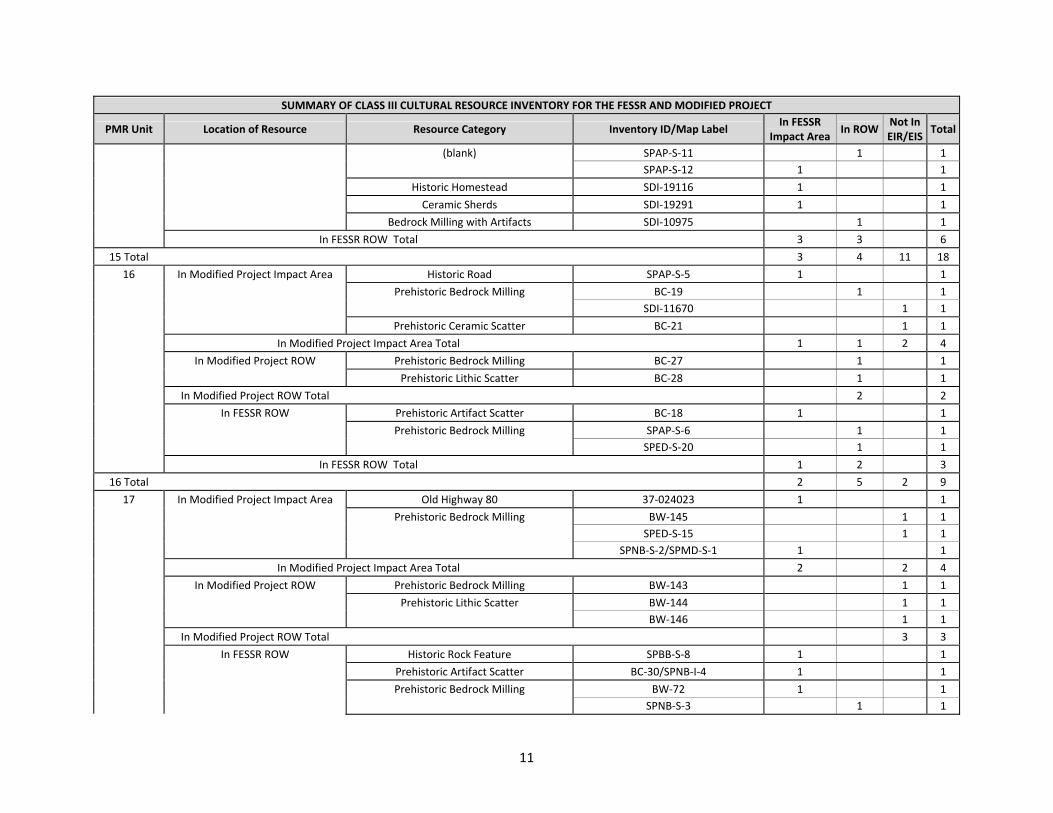
11
SUMMARY OF CLASS III CULTURAL RESOURCE INVENTORY FOR THE FESSR AND MODIFIED PROJECT
PMR Unit Location of Resource Resource Category Inventory ID/Map Label In FESSR
Impact AreaIn ROW
Not In EIR/EIS
Total
(blank) SPAP‐S‐11 1 1
SPAP‐S‐12 1 1
Historic Homestead SDI‐19116 1 1
Ceramic Sherds SDI‐19291 1 1
Bedrock Milling with Artifacts SDI‐10975 1 1
In FESSR ROW Total 3 3 6
15 Total 3 4 11 18
16 In Modified Project Impact Area Historic Road SPAP‐S‐5 1 1
Prehistoric Bedrock Milling BC‐19 1 1
SDI‐11670 1 1
Prehistoric Ceramic Scatter BC‐21 1 1
In Modified Project Impact Area Total 1 1 2 4
In Modified Project ROW Prehistoric Bedrock Milling BC‐27 1 1
Prehistoric Lithic Scatter BC‐28 1 1
In Modified Project ROW Total 2 2
In FESSR ROW Prehistoric Artifact Scatter BC‐18 1 1
Prehistoric Bedrock Milling SPAP‐S‐6 1 1
SPED‐S‐20 1 1
In FESSR ROW Total 1 2 3
16 Total 2 5 2 9
17 In Modified Project Impact Area Old Highway 80 37‐024023 1 1
Prehistoric Bedrock Milling BW‐145 1 1
SPED‐S‐15 1 1
SPNB‐S‐2/SPMD‐S‐1 1 1
In Modified Project Impact Area Total 2 2 4
In Modified Project ROW Prehistoric Bedrock Milling BW‐143 1 1
Prehistoric Lithic Scatter BW‐144 1 1
BW‐146 1 1
In Modified Project ROW Total 3 3
In FESSR ROW Historic Rock Feature SPBB‐S‐8 1 1
Prehistoric Artifact Scatter BC‐30/SPNB‐I‐4 1 1
Prehistoric Bedrock Milling BW‐72 1 1
SPNB‐S‐3 1 1

12
SUMMARY OF CLASS III CULTURAL RESOURCE INVENTORY FOR THE FESSR AND MODIFIED PROJECT
PMR Unit Location of Resource Resource Category Inventory ID/Map Label In FESSR
Impact AreaIn ROW
Not In EIR/EIS
Total
Prehistoric Habitation SDI‐9522 1 1
In FESSR ROW Total 4 1 5
17 Total 6 1 5 12
18 In Modified Project ROW Prehistoric Artifact Scatter BW‐86 1 1
In Modified Project ROW Total 1 1
18 Total 1 1
21 In Modified Project Impact Area Prehistoric Artifact Scatter SDI‐19039 1 1
Prehistoric Bedrock Milling SDI‐10040 1 1
SDI‐4724 1 1
Prehistoric Isolate (Debitage/Ceramic) SPNB‐S‐1 1 1
In Modified Project Impact Area Total 3 1 4
In Modified Project ROW Prehistoric Bedrock Milling 8D‐1 1 1
In Modified Project ROW Total 1 1
21 Total 3 2 5
22 In Modified Project Impact Area Bedrock Milling SPMD‐S‐2 1 1
Prehistoric Bedrock Milling BW‐116 1 1
BW‐129 1 1
SDI‐19279 1 1
In Modified Project Impact Area Total 2 2 4
In Modified Project ROW Prehistoric Bedrock Milling 8C‐1 1 1
In Modified Project ROW Total 1 1
22 Total 2 1 2 5
23 In Modified Project Impact Area Prehistoric Bedrock Milling SDI‐17987 1 1
SDI‐8440 1 1
Prehistoric Lithic Scatter 8C‐3 1 1
SDI‐8442 1 1
In Modified Project Impact Area Total 2 2 4
In FESSR ROW Lithic Scatter SDI‐17999 1 1
SDI‐19280 1 1
Prehistoric Bedrock Milling BW‐113 1 1
Prehistoric Lithic Scatter SDI‐8439 1 1
(blank) LD‐S‐1 1 1
SPAP‐S‐2 1 1
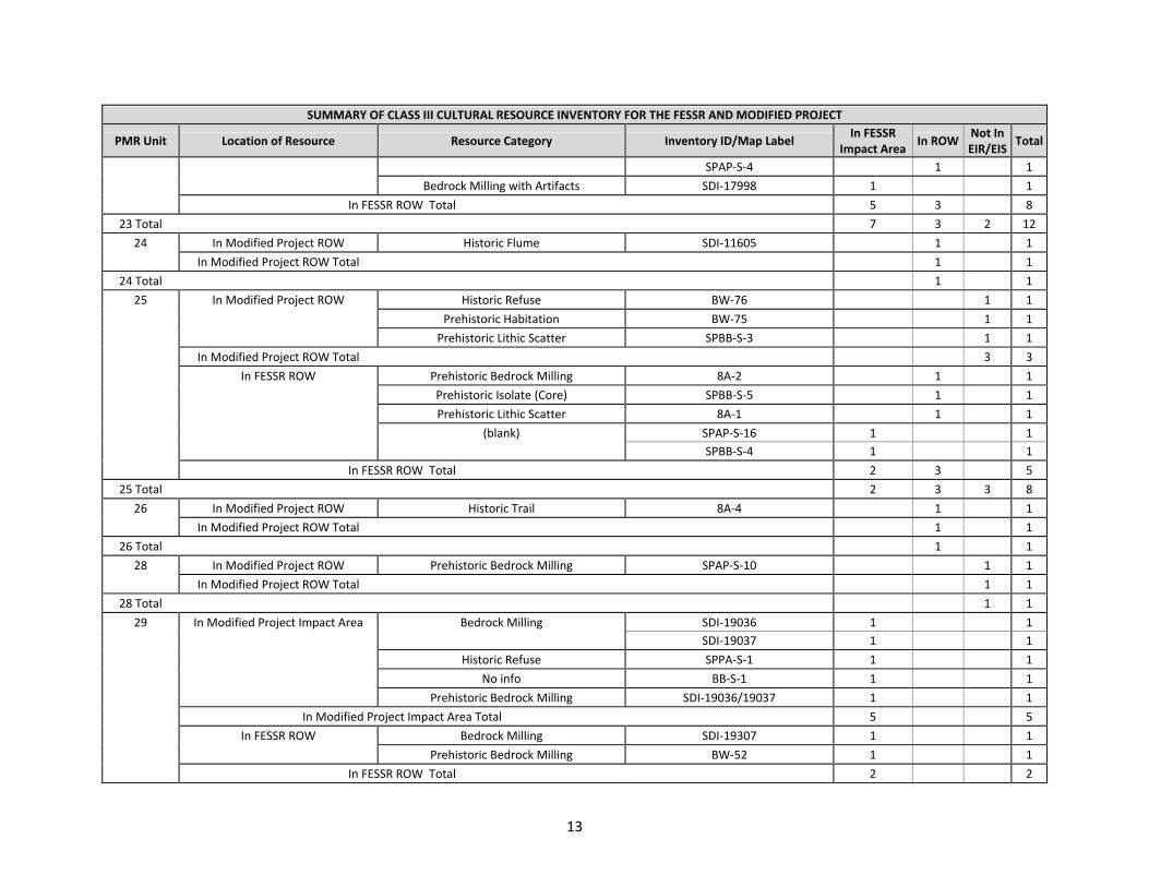
13
SUMMARY OF CLASS III CULTURAL RESOURCE INVENTORY FOR THE FESSR AND MODIFIED PROJECT
PMR Unit Location of Resource Resource Category Inventory ID/Map Label In FESSR
Impact AreaIn ROW
Not In EIR/EIS
Total
SPAP‐S‐4 1 1
Bedrock Milling with Artifacts SDI‐17998 1 1
In FESSR ROW Total 5 3 8
23 Total 7 3 2 12
24 In Modified Project ROW Historic Flume SDI‐11605 1 1
In Modified Project ROW Total 1 1
24 Total 1 1
25 In Modified Project ROW Historic Refuse BW‐76 1 1
Prehistoric Habitation BW‐75 1 1
Prehistoric Lithic Scatter SPBB‐S‐3 1 1
In Modified Project ROW Total 3 3
In FESSR ROW Prehistoric Bedrock Milling 8A‐2 1 1
Prehistoric Isolate (Core) SPBB‐S‐5 1 1
Prehistoric Lithic Scatter 8A‐1 1 1
(blank) SPAP‐S‐16 1 1
SPBB‐S‐4 1 1
In FESSR ROW Total 2 3 5
25 Total 2 3 3 8
26 In Modified Project ROW Historic Trail 8A‐4 1 1
In Modified Project ROW Total 1 1
26 Total 1 1
28 In Modified Project ROW Prehistoric Bedrock Milling SPAP‐S‐10 1 1
In Modified Project ROW Total 1 1
28 Total 1 1
29 In Modified Project Impact Area Bedrock Milling SDI‐19036 1 1
SDI‐19037 1 1
Historic Refuse SPPA‐S‐1 1 1
No info BB‐S‐1 1 1
Prehistoric Bedrock Milling SDI‐19036/19037 1 1
In Modified Project Impact Area Total 5 5
In FESSR ROW Bedrock Milling SDI‐19307 1 1
Prehistoric Bedrock Milling BW‐52 1 1
In FESSR ROW Total 2 2

14
SUMMARY OF CLASS III CULTURAL RESOURCE INVENTORY FOR THE FESSR AND MODIFIED PROJECT
PMR Unit Location of Resource Resource Category Inventory ID/Map Label In FESSR
Impact AreaIn ROW
Not In EIR/EIS
Total
29 Total 7 7
30 In FESSR ROW (blank) BW‐161 1 1
In FESSR ROW Total 1 1
30 Total 1 1
31 In Modified Project ROW Prehistoric Bedrock Milling SDI‐19038 1 1
In Modified Project ROW Total 1 1
In FESSR ROW Prehistoric Bedrock Milling SPNB‐S‐6 1 1
(blank) SPAP‐S‐15 1 1
In FESSR ROW Total 1 1 2
31 Total 1 1 1 3
33 In Modified Project ROW Prehistoric Artifact Scatter SDI‐18998 1 1
Prehistoric Habitation SDI‐4798 1 1
Prehistoric Lithic Scatter SDI‐19258 1 1
Unknown SP‐S‐02 1 1
In Modified Project ROW Total 4 4
33 Total 4 4
34 In Modified Project Impact Area Historic Road 37‐019275 1 1
No info SPED‐S‐17 1 1
Prehistoric Bedrock Milling BC‐33 1 1
BW‐59 1 1
SPNB‐S‐7 1 1
Prehistoric Bedrock Milling/Historic Min SDI‐8251 1 1
Prehistoric Lithic/Shell Scatter BW‐60 1 1
In Modified Project Impact Area Total 3 2 2 7
In Modified Project ROW Historic Quarry SDI‐18999 1 1
Prehistoric Bedrock Milling SDI‐13615 1 1
SDI‐13616 1 1
SDI‐13617 1 1
SPNB‐S‐8 1 1
In Modified Project ROW Total 1 1 3 5
In FESSR ROW Bedrock Milling SDI‐13614 1 1
Prehistoric Bedrock Milling SDI‐7873/19250 1 1
Temporary Camp SDI‐13605 1 1

15
SUMMARY OF CLASS III CULTURAL RESOURCE INVENTORY FOR THE FESSR AND MODIFIED PROJECT
PMR Unit Location of Resource Resource Category Inventory ID/Map Label In FESSR
Impact AreaIn ROW
Not In EIR/EIS
Total
(blank) W‐671 1 1
Ceramic Sherds SDI‐680 1 1
In FESSR ROW Total 4 1 5
34 Total 8 4 5 17
35 In Modified Project Impact Area Prehistoric Bedrock Milling SPMD‐S‐3 1 1
In Modified Project Impact Area Total 1 1
In FESSR ROW Prehistoric Habitation SDI‐13652 1 1
Rock Shelter SDI‐4913 1 1
In FESSR ROW Total 2 2
35 Total 2 1 3
36 In Modified Project ROW Historic Cistern BW‐63 1 1
BW‐65 1 1
Historic Road BW‐64 1 1
In Modified Project ROW Total 3 3
36 Total 3 3
37 In Modified Project Impact Area Prehistoric Habitation SDI‐13651 1 1
In Modified Project Impact Area Total 1 1
In Modified Project ROW Historic Road SDI‐17656 1 1
Prehistoric Bedrock Milling SDI‐17652B 1 1
In Modified Project ROW Total 1 1 2
In FESSR ROW Bedrock Milling SDI‐17652A 1 1
Prehistoric Bedrock Milling SDI‐17286 1 1
SDI‐17651 1 1
Bedrock Milling with Artifacts SDI‐13849 1 1
In FESSR ROW Total 4 4
37 Total 1 5 1 7
38 In Modified Project Impact Area Prehistoric Bedrock Milling SDI‐14041 1 1
Prehistoric Lithic Scatter SDI‐18346 1 1
In Modified Project Impact Area Total 1 1 2
In FESSR ROW Prehistoric Bedrock Milling BW‐67 1 1
BW‐68 1 1
SDI‐18344 1 1
Bedrock Milling with Artifacts SDI‐14040 1 1
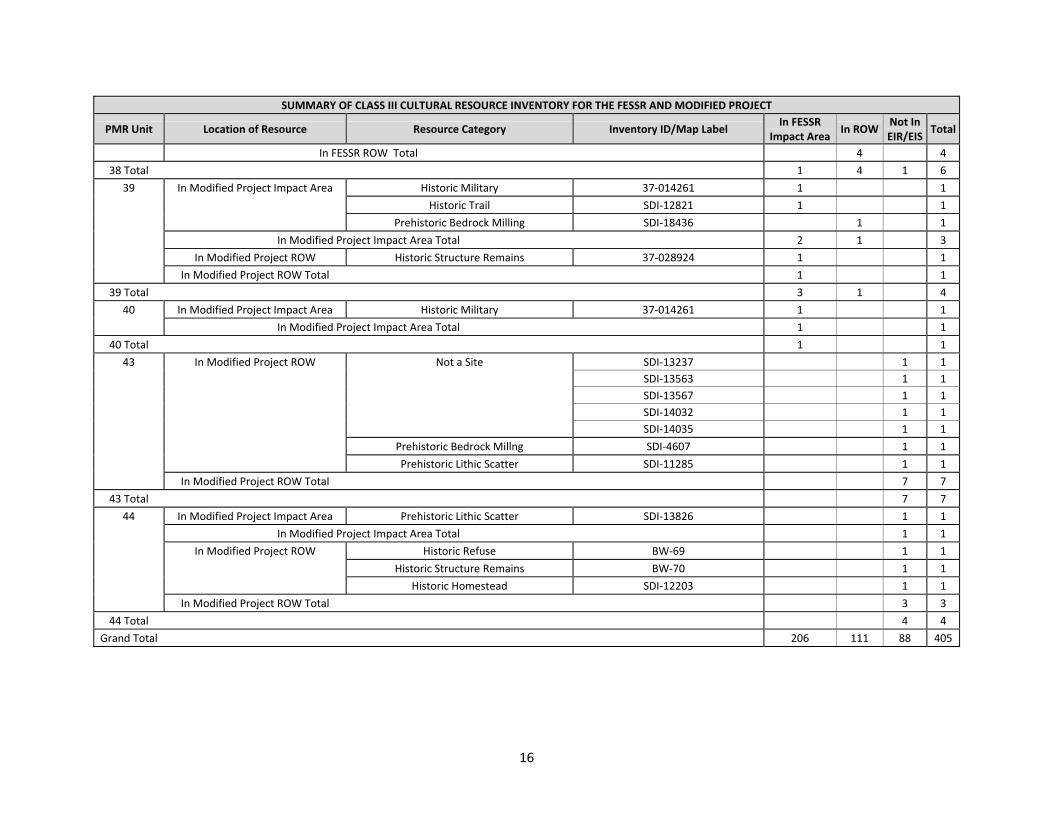
16
SUMMARY OF CLASS III CULTURAL RESOURCE INVENTORY FOR THE FESSR AND MODIFIED PROJECT
PMR Unit Location of Resource Resource Category Inventory ID/Map Label In FESSR
Impact AreaIn ROW
Not In EIR/EIS
Total
In FESSR ROW Total 4 4
38 Total 1 4 1 6
39 In Modified Project Impact Area Historic Military 37‐014261 1 1
Historic Trail SDI‐12821 1 1
Prehistoric Bedrock Milling SDI‐18436 1 1
In Modified Project Impact Area Total 2 1 3
In Modified Project ROW Historic Structure Remains 37‐028924 1 1
In Modified Project ROW Total 1 1
39 Total 3 1 4
40 In Modified Project Impact Area Historic Military 37‐014261 1 1
In Modified Project Impact Area Total 1 1
40 Total 1 1
43 In Modified Project ROW Not a Site SDI‐13237 1 1
SDI‐13563 1 1
SDI‐13567 1 1
SDI‐14032 1 1
SDI‐14035 1 1
Prehistoric Bedrock Millng SDI‐4607 1 1
Prehistoric Lithic Scatter SDI‐11285 1 1
In Modified Project ROW Total 7 7
43 Total 7 7
44 In Modified Project Impact Area Prehistoric Lithic Scatter SDI‐13826 1 1
In Modified Project Impact Area Total 1 1
In Modified Project ROW Historic Refuse BW‐69 1 1
Historic Structure Remains BW‐70 1 1
Historic Homestead SDI‐12203 1 1
In Modified Project ROW Total 3 3
44 Total 4 4
Grand Total 206 111 88 405

P r o j e c t M o d i f i c a t i o n R e p o r t A t t a c h m e n t C 0 5 . 1 4 . 1 0
ATTACHMENT C

P r o j e c t M o d i f i c a t i o n R e p o r t A t t a c h m e n t C 0 5 . 1 4 . 1 0

ACOUSTICS – VIBRATION – AIR & WATER QUALITY – FORENSIC ENGINEERING EXPERT WITNESS – ENVIRONMENTAL ASSESSMENTS AND COMPLIANCE
Scientific, Environmental, and Forensic Consultants INVESTIGATIVE SCIENCE AND ENGINEERING, INC.
SAN DIEGO CORPORATE OFFICE P.O. Box 488 / 1134 D Street, Ramona, CA 92065
Phone: 760-787-0016 Fax: 760-787-9165
www.ise.us
The leader in Scientific Consulting and Research…
DATE: April 15, 2010 TO: Linda Collins ([email protected])
Dayle Cheever ([email protected]) Doug Baumwirt ([email protected])
Veryl Wittig ([email protected]) Seth Torma ([email protected])
James Westbrook ([email protected]) FROM: Rick Tavares, Ph.D. SUBJECT: SUNRISE POWERLINK POWERED HAULAGE ESTIMATED ACOUSTICAL IMPACT POTENTIAL
ISE PROJECT #10-007
The following information describes the powered haulage impact potential as it pertains to on-road construction trips associated with the Sunrise Powerlink project, the estimated vehicular trip noise emission levels, the associated impact contour distances, and the potential for impact to any sensitive land use areas. Background and Need
Powered on-road haulage has been predicted by the project traffic engineer (KOA Engineering, Inc., 4/10/10) for each affected roadway segment within the project’s sphere of influence. Segments where excessive daily vehicular trips are anticipated have the potential to increase background noise levels (denoted in California as the Community Noise Equivalence Level, or CNEL) to the point of being discernable or creating adverse conditions to sensitive receptor areas. Significance
Local significance criteria for the proposed short-term action would fall under General Plan policies established by the County of San Diego pursuant to CEQA.1 The specific abatement thresholds are identified under Policy 4b of the County of San Diego’s Noise Element of the County’s General Plan. Under these standards, it can be inferred that a significant impact2 would occur, if the following two conditions were met:
1 As revised July 2006.
2 Defined under Section 15382 of CEQA as, “… a substantial, or potentially substantial, adverse change in any of the physical conditions within the area affected by the project including land, air, water, minerals, flora, fauna, ambient noise, and objects of historic or aesthetic significance.” For general environmental acoustical analysis, this threshold point is taken where the absolute change becomes audible above the existing background noise, namely 3.0 dBA.
VIA ELECTRONIC DELIVERY
Project Memorandum Sunrise Powerlink Powered Haulage – Estimated Acoustical Impact Potential
ISE Project #10-007 April 15, 2010
Page 2
© 2010 Investigative Science and Engineering, Inc.
The leader in Scientific Consulting and Research…
1. Project-related traffic produces a net increase to the ambient CNEL level of 3.0 dBA or greater,
and,
2. The increase exposes sensitive receptor areas to a sound level of 60 dBA CNEL or greater where it was not exposed to this level before the addition of the proposed project action.
Analysis Protocol
ISE performed a two-tiered screening of the KOA traffic data, first by identifying all roadway segments where the absolute ambient noise level increase was 3.0 dBA CNEL or greater due to the proposed project action. The conversion from daily traffic segment volumes (i.e., ADT’s) to reference sound pressure level (i.e., dBA CNEL) was facilitated using the ISE RoadNoise v2.4 traffic noise prediction model3, using California (CALVENO, FHWA/CA/TL-87/03) noise emission factors. Contour calculations were performed assuming acoustically ‘soft’ ground conditions and standard acoustical engineering principles.
Upon selecting potentially impacted segments meeting the above criteria, each segment
was examined using Geographic Information System (GIS) methods to ascertain whether or not the absolute 60-dBA CNEL contour impacted any sensitive areas, and if this increase was due to the project. Areas found to be impacted, would be subject to engineering controls to reduce levels to below the identified levels of significance. Findings
Table 1a, starting on the following page, identifies the existing segment traffic conditions along all affected roadways. For each roadway segment examined within this table, the worst case average daily traffic volume (ADT), observed/predicted speeds, and roadway level of service (LOS) are shown, along with the corresponding reference noise level (SPL) at 50-feet (in dBA). Additionally, the line-of-sight distance from the roadway centerline to the 60 through 75 dBA CNEL contours are provided as an indication of the worst-case unobstructed theoretical traffic noise contour placement.
Table 1b, starting on Page 9 of this memorandum, identifies the same roadway segments
and data for the existing + project traffic condition (i.e., the existing traffic volumes plus the added increment of construction traffic due to the proposed project action).
The comparison of the previous two tables is provided in Table 2, starting on Page 15 of
this memorandum. As can be seen, there are 40 potential candidate segments where the proposed project action would increase the ambient background noise level by 3.0 dBA CNEL or greater. The average contour increase along these potentially affected segments is 21-feet (with a minimum extent of 7-feet and a maximum of 43-feet).
Finally, each segment under GIS screening is provided as Attachment A to this
memorandum. Examination of each of the segments did not identify any sensitive receptors exposed to a 60 dBA CNEL contour within any outdoor sensitive use space.
3 Based upon the Federal Highway Administration’s RD-77-108 Noise Prediction Model.
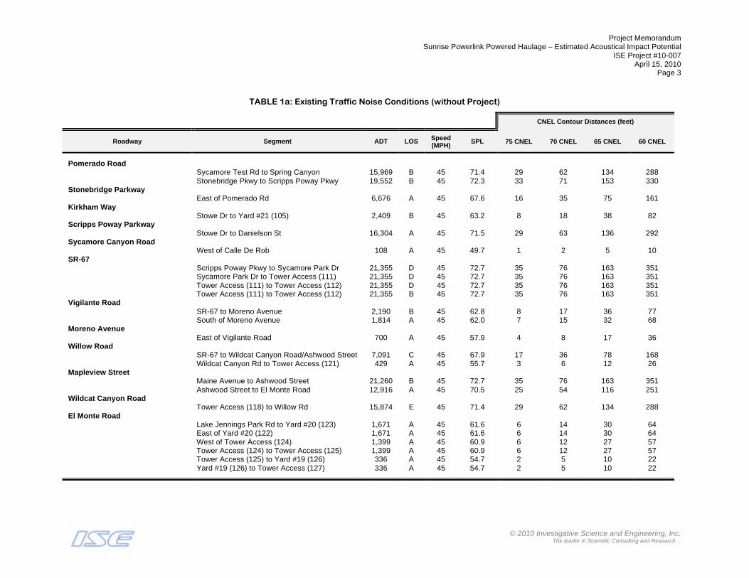
Project Memorandum Sunrise Powerlink Powered Haulage – Estimated Acoustical Impact Potential
ISE Project #10-007 April 15, 2010
Page 3
© 2010 Investigative Science and Engineering, Inc.
The leader in Scientific Consulting and Research…
TABLE 1a: Existing Traffic Noise Conditions (without Project)
CNEL Contour Distances (feet)
Roadway Segment ADT LOS Speed (MPH)
SPL 75 CNEL 70 CNEL 65 CNEL 60 CNEL
Pomerado Road Sycamore Test Rd to Spring Canyon 15,969 B 45 71.4 29 62 134 288 Stonebridge Pkwy to Scripps Poway Pkwy 19,552 B 45 72.3 33 71 153 330 Stonebridge Parkway East of Pomerado Rd 6,676 A 45 67.6 16 35 75 161 Kirkham Way Stowe Dr to Yard #21 (105) 2,409 B 45 63.2 8 18 38 82 Scripps Poway Parkway Stowe Dr to Danielson St 16,304 A 45 71.5 29 63 136 292 Sycamore Canyon Road West of Calle De Rob 108 A 45 49.7 1 2 5 10 SR-67 Scripps Poway Pkwy to Sycamore Park Dr 21,355 D 45 72.7 35 76 163 351 Sycamore Park Dr to Tower Access (111) 21,355 D 45 72.7 35 76 163 351 Tower Access (111) to Tower Access (112) 21,355 D 45 72.7 35 76 163 351 Tower Access (111) to Tower Access (112) 21,355 B 45 72.7 35 76 163 351 Vigilante Road SR-67 to Moreno Avenue 2,190 B 45 62.8 8 17 36 77 South of Moreno Avenue 1,814 A 45 62.0 7 15 32 68 Moreno Avenue East of Vigilante Road 700 A 45 57.9 4 8 17 36 Willow Road SR-67 to Wildcat Canyon Road/Ashwood Street 7,091 C 45 67.9 17 36 78 168 Wildcat Canyon Rd to Tower Access (121) 429 A 45 55.7 3 6 12 26 Mapleview Street Maine Avenue to Ashwood Street 21,260 B 45 72.7 35 76 163 351 Ashwood Street to El Monte Road 12,916 A 45 70.5 25 54 116 251 Wildcat Canyon Road Tower Access (118) to Willow Rd 15,874 E 45 71.4 29 62 134 288 El Monte Road Lake Jennings Park Rd to Yard #20 (123) 1,671 A 45 61.6 6 14 30 64 East of Yard #20 (122) 1,671 A 45 61.6 6 14 30 64 West of Tower Access (124) 1,399 A 45 60.9 6 12 27 57 Tower Access (124) to Tower Access (125) 1,399 A 45 60.9 6 12 27 57 Tower Access (125) to Yard #19 (126) 336 A 45 54.7 2 5 10 22 Yard #19 (126) to Tower Access (127) 336 A 45 54.7 2 5 10 22

Project Memorandum Sunrise Powerlink Powered Haulage – Estimated Acoustical Impact Potential
ISE Project #10-007 April 15, 2010
Page 4
© 2010 Investigative Science and Engineering, Inc.
The leader in Scientific Consulting and Research…
TABLE 1a (cont.): Existing Traffic Noise Conditions (without Project)
CNEL Contour Distances (feet)
Roadway Segment ADT LOS Speed (MPH)
SPL 75 CNEL 70 CNEL 65 CNEL 60 CNEL
Alpine Boulevard Arnold Way to Peutz Valley Rd 855 A 45 58.7 4 9 19 41 East of Tavern Rd 9,942 D 45 69.4 21 46 98 212 East of E. Victoria Dr/S. Grade Rd 4,270 A 45 65.7 12 26 56 120 West of Star Valley Rd 885 A 45 58.9 4 9 20 42 Peutz Valley Road North of Alpine Blvd 595 C+ 45 57.1 3 7 15 32 Tavern Road West of Victoria Park Terrace 624 A 45 57.4 3 7 16 34 Victoria Park Terrace to I-8 Westbound Ramps 7,067 B 45 67.9 17 36 78 168 I-8 Eastbound Ramps to Alpine Blvd 19,093 B 45 72.2 33 70 151 325 Victoria Park Terrace North of Tavern Rd 4,588 C 45 66.0 13 27 58 126 Japatul Valley Road North of Bell Bluff Truck Trail 1,111 A 45 59.9 5 11 23 49 South of Bell Bluff Truck Trail 1,111 A 45 59.9 5 11 23 49 Bell Bluff Truck Trail West of Japatul Valley Rd 32 C+ 45 44.5 0 1 2 5 Japatul Road West of Hidden Glen Rd 915 A 45 59.0 4 9 20 43 East of High Glen Rd 915 A 45 59.0 4 9 20 43 Lyons Valley Road Japatul Rd to Tower Access (226) 430 A 45 55.7 3 6 12 26 Tower Access (226) to Yard #16 (227) 430 A 45 55.7 3 6 12 26 Yard #15 (228) to Tower Access (229) 423 A 45 55.7 3 6 12 26 Tower Access (229) to Honey Springs Rd 423 A 45 55.7 3 6 12 26 Honey Springs Road Lyons Valley Rd to Deerhorn Valley Rd 958 A 45 59.2 4 10 21 44 Deerhorn Valley Road East of Honey Springs Rd 950 A 45 59.2 4 10 21 44 West of Cinnamon Dr 259 A 45 53.5 2 4 9 18 East of Cinnamon Dr 259 C+ 45 53.5 2 4 9 18 Manzanita Way Deerhorn Valley Rd to Yard #14 (234) 62 C+ 45 47.3 1 2 3 7

Project Memorandum Sunrise Powerlink Powered Haulage – Estimated Acoustical Impact Potential
ISE Project #10-007 April 15, 2010
Page 5
© 2010 Investigative Science and Engineering, Inc.
The leader in Scientific Consulting and Research…
TABLE 1a (cont.): Existing Traffic Noise Conditions (without Project)
CNEL Contour Distances (feet)
Roadway Segment ADT LOS Speed (MPH)
SPL 75 CNEL 70 CNEL 65 CNEL 60 CNEL
SR-94 (Campo Road) SR-188 (Tecate Rd) to Potrero Valley Rd 1,775 A 45 61.9 7 14 31 67 East of Potrero Valley Rd 1,196 A 45 60.2 5 11 24 52 Portrero Valley Road Round Portrero Rd to SR-94 (Campo Rd) 1,421 A 45 60.9 6 12 27 57 West of Harris Ranch Rd 21 A 45 42.6 0 1 2 3 Lake Morena Drive Tower Access (309) to Tower Access (310) 607 A 45 57.2 3 7 15 33 Tower Access (310) to Buckman Springs Rd 607 A 45 57.2 3 7 15 33 Buckman Springs Road South of Old Hwy 80 3,405 A 45 64.7 10 22 48 103 Oak Dr to Tower Access (315) 2,375 A 45 63.2 8 18 38 82 Tower Access (315) to Tower Access (316) 2,375 A 45 63.2 8 18 38 82 Tower Access (316) to Lake Morena Dr 2,375 A 45 63.2 8 18 38 82 Lake Morena Dr to SR-94 (Campo Rd) 2,465 A 45 63.3 8 18 39 83 Old Highway 80 Kitchen Creek Rd to Cameron Truck Trail 689 A 45 57.8 4 8 17 36 Cameron Truck Trail to La Posta Rd 689 A 45 57.8 4 8 17 36 La Posta Road
Tower Access (323) to Cameron Truck Trail (324)
346 A 45 54.8 2 5 10 23
Cameron Truck Trail (324) to Old Hwy 80 346 A 45 54.8 2 5 10 23 North of Old Hwy 80 44 A 45 45.8 1 1 3 6 Thing Valley Road South of Yard #10 (326) 14 C+ 45 40.9 0 1 1 3 North of Yard #10 (326) 14 C+ 45 40.9 0 1 1 3 McCain Valley Road West of Yard #9 (404) 8 C+ 45 38.4 0 0 1 2 East of Yard #9 (404) 8 C+ 45 38.4 0 0 1 2 North of Old Hwy 80 119 A 45 50.2 1 2 5 11 Ribbonwood Road I-8 Eastbound Ramps to Old Hwy 80 1,229 A 45 60.3 5 11 24 52
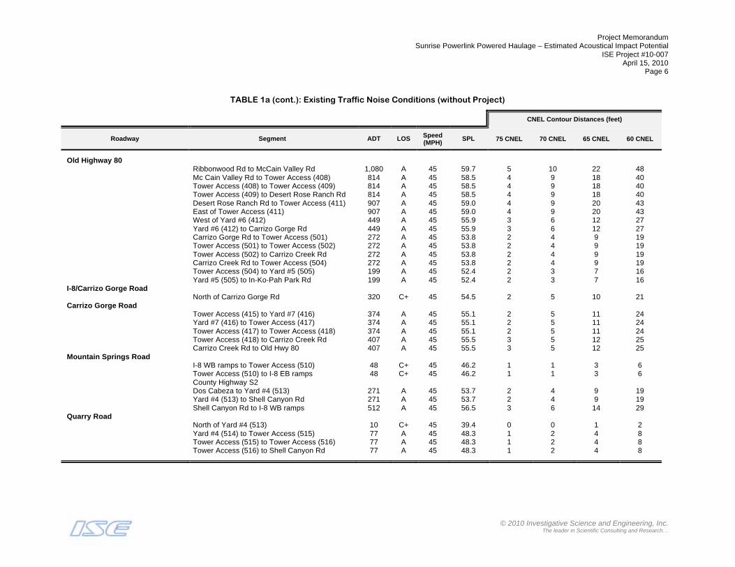
Project Memorandum Sunrise Powerlink Powered Haulage – Estimated Acoustical Impact Potential
ISE Project #10-007 April 15, 2010
Page 6
© 2010 Investigative Science and Engineering, Inc.
The leader in Scientific Consulting and Research…
TABLE 1a (cont.): Existing Traffic Noise Conditions (without Project)
CNEL Contour Distances (feet)
Roadway Segment ADT LOS Speed (MPH)
SPL 75 CNEL 70 CNEL 65 CNEL 60 CNEL
Old Highway 80 Ribbonwood Rd to McCain Valley Rd 1,080 A 45 59.7 5 10 22 48 Mc Cain Valley Rd to Tower Access (408) 814 A 45 58.5 4 9 18 40 Tower Access (408) to Tower Access (409) 814 A 45 58.5 4 9 18 40 Tower Access (409) to Desert Rose Ranch Rd 814 A 45 58.5 4 9 18 40 Desert Rose Ranch Rd to Tower Access (411) 907 A 45 59.0 4 9 20 43 East of Tower Access (411) 907 A 45 59.0 4 9 20 43 West of Yard #6 (412) 449 A 45 55.9 3 6 12 27 Yard #6 (412) to Carrizo Gorge Rd 449 A 45 55.9 3 6 12 27 Carrizo Gorge Rd to Tower Access (501) 272 A 45 53.8 2 4 9 19 Tower Access (501) to Tower Access (502) 272 A 45 53.8 2 4 9 19 Tower Access (502) to Carrizo Creek Rd 272 A 45 53.8 2 4 9 19 Carrizo Creek Rd to Tower Access (504) 272 A 45 53.8 2 4 9 19 Tower Access (504) to Yard #5 (505) 199 A 45 52.4 2 3 7 16 Yard #5 (505) to In-Ko-Pah Park Rd 199 A 45 52.4 2 3 7 16 I-8/Carrizo Gorge Road North of Carrizo Gorge Rd 320 C+ 45 54.5 2 5 10 21 Carrizo Gorge Road Tower Access (415) to Yard #7 (416) 374 A 45 55.1 2 5 11 24 Yard #7 (416) to Tower Access (417) 374 A 45 55.1 2 5 11 24 Tower Access (417) to Tower Access (418) 374 A 45 55.1 2 5 11 24 Tower Access (418) to Carrizo Creek Rd 407 A 45 55.5 3 5 12 25 Carrizo Creek Rd to Old Hwy 80 407 A 45 55.5 3 5 12 25 Mountain Springs Road I-8 WB ramps to Tower Access (510) 48 C+ 45 46.2 1 1 3 6 Tower Access (510) to I-8 EB ramps 48 C+ 45 46.2 1 1 3 6 County Highway S2 Dos Cabeza to Yard #4 (513) 271 A 45 53.7 2 4 9 19 Yard #4 (513) to Shell Canyon Rd 271 A 45 53.7 2 4 9 19 Shell Canyon Rd to I-8 WB ramps 512 A 45 56.5 3 6 14 29 Quarry Road North of Yard #4 (513) 10 C+ 45 39.4 0 0 1 2 Yard #4 (514) to Tower Access (515) 77 A 45 48.3 1 2 4 8 Tower Access (515) to Tower Access (516) 77 A 45 48.3 1 2 4 8 Tower Access (516) to Shell Canyon Rd 77 A 45 48.3 1 2 4 8

Project Memorandum Sunrise Powerlink Powered Haulage – Estimated Acoustical Impact Potential
ISE Project #10-007 April 15, 2010
Page 7
© 2010 Investigative Science and Engineering, Inc.
The leader in Scientific Consulting and Research…
TABLE 1a (cont.): Existing Traffic Noise Conditions (without Project)
CNEL Contour Distances (feet)
Roadway Segment ADT LOS Speed (MPH)
SPL 75 CNEL 70 CNEL 65 CNEL 60 CNEL
Shell Canyon Road North of County Hwy S2 72 A 45 48.0 1 2 4 8 County Highway S80 West of Tower Access (601) 234 A 45 53.1 2 4 8 17 Tower Access (601) to Yard #3 (602) 234 A 45 53.1 2 4 8 17 East of Yard #3 (602) 234 A 45 53.1 2 4 8 17 East of New River Road 2,981 A 45 64.1 9 20 44 94 East of Brown Road 2,468 A 45 63.3 8 18 39 83 Dunaway Road South of I-8 Eastbound Ramps 70 C+ 45 47.9 1 2 4 8 SR-98 (Yuha Cutoff) West of Yard #1 (606) 1,210 A 45 60.2 5 11 24 52 East of Yard #1 (606) 1,210 A 45 60.2 5 11 24 52 New River Road North of County Hwy S80 157 A 45 51.4 1 3 6 13 Oak Drive East of Lake Morena Drive 901 A 45 59.0 4 9 20 43 Lake Morena Avenue North of OakDrive 962 A 45 59.2 4 10 21 44 Prospect Avenue East of Magnolia Avenue 21,127 B 45 72.7 35 76 163 351 East of Cuyamaca Street 12,100 A 45 70.2 24 52 111 239 West of Cuyamaca Street 11,048 A 45 69.8 23 48 104 225 Magnolia Avenue North of Prospect Avenue 30,428 B 45 74.2 44 95 205 442 Cuyamaca Street North of Prospect Avenue 19,188 A 45 72.2 33 70 151 325 Mission Gorge Road East of Big Rock Road 13,410 A 45 70.7 26 56 120 258 Big Rock Road South of Mission Gorge Road 6,324 A 45 67.4 16 34 72 156 Scripps Ranch Boulevard South of Meanley Drive 9,522 A 45 69.2 21 44 95 205 Meanley Drive East of Scripps Ranch Boulevard 1,582 A 45 61.4 6 13 29 62
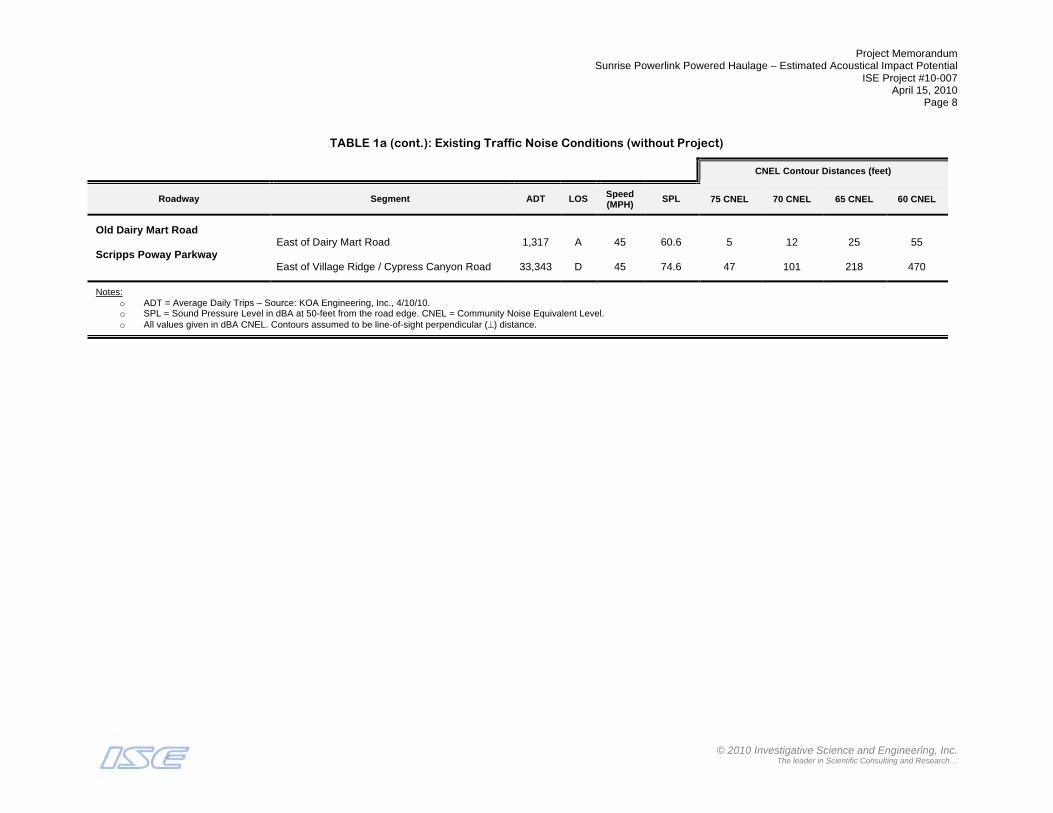
Project Memorandum Sunrise Powerlink Powered Haulage – Estimated Acoustical Impact Potential
ISE Project #10-007 April 15, 2010
Page 8
© 2010 Investigative Science and Engineering, Inc.
The leader in Scientific Consulting and Research…
TABLE 1a (cont.): Existing Traffic Noise Conditions (without Project)
CNEL Contour Distances (feet)
Roadway Segment ADT LOS Speed (MPH)
SPL 75 CNEL 70 CNEL 65 CNEL 60 CNEL
Old Dairy Mart Road East of Dairy Mart Road 1,317 A 45 60.6 5 12 25 55 Scripps Poway Parkway East of Village Ridge / Cypress Canyon Road 33,343 D 45 74.6 47 101 218 470
Notes: o ADT = Average Daily Trips – Source: KOA Engineering, Inc., 4/10/10. o SPL = Sound Pressure Level in dBA at 50-feet from the road edge. CNEL = Community Noise Equivalent Level. o All values given in dBA CNEL. Contours assumed to be line-of-sight perpendicular (!) distance.

Project Memorandum Sunrise Powerlink Powered Haulage – Estimated Acoustical Impact Potential
ISE Project #10-007 April 15, 2010
Page 9
© 2010 Investigative Science and Engineering, Inc.
The leader in Scientific Consulting and Research…
TABLE 1b: Existing Traffic Noise Conditions (with Project)
CNEL Contour Distances (feet)
Roadway Segment ADT LOS Speed (MPH)
SPL 75 CNEL 70 CNEL 65 CNEL 60 CNEL
Pomerado Road
Sycamore Test Rd to Spring Canyon 16,699 B 45 71.6 30 64 138 297 Stonebridge Pkwy to Scripps Poway Pkwy 20,166 B 45 72.4 34 72 156 335 Stonebridge Parkway East of Pomerado Rd 7,040 B 45 67.9 17 36 78 168 Kirkham Way Stowe Dr to Yard #21 (105) 2,951 B 45 64.1 9 20 44 94 Scripps Poway Parkway Stowe Dr to Danielson St 16,934 A 45 71.7 30 65 140 301 Sycamore Canyon Road West of Calle De Rob 214 A 45 52.7 2 4 8 16 SR-67 Scripps Poway Pkwy to Sycamore Park Dr 22,329 D 45 72.9 36 78 168 362 Sycamore Park Dr to Tower Access (111) 22,332 D 45 72.9 36 78 168 362 Tower Access (111) to Tower Access (112) 22,335 D 45 72.9 36 78 168 362 Tower Access (111) to Tower Access (112) 22,338 B 45 72.9 36 78 168 362 Vigilante Road SR-67 to Moreno Avenue 2,290 B 45 63.0 8 17 37 79 South of Moreno Avenue 2,104 B 45 62.6 7 16 35 75 Moreno Avenue East of Vigilante Road 818 A 45 58.5 4 9 18 40 Willow Road SR-67 to Wildcat Canyon Road/Ashwood Street 7,381 D 45 68.1 17 37 80 173 Wildcat Canyon Rd to Tower Access (121) 433 A 45 55.8 3 6 12 26 Mapleview Street Maine Avenue to Ashwood Street 21,910 B 45 72.8 36 77 166 357 Ashwood Street to El Monte Road 13,806 A 45 70.8 26 57 122 262 Wildcat Canyon Road Tower Access (118) to Willow Rd 15,886 E 45 71.4 29 62 134 288 El Monte Road Lake Jennings Park Rd to Yard #20 (123) 2,561 B 45 63.5 9 18 40 86 East of Yard #20 (122) 2,221 B 45 62.9 8 17 36 78 West of Tower Access (124) 1,949 B 45 62.3 7 15 33 71 Tower Access (124) to Tower Access (125) 1,937 B 45 62.3 7 15 33 71 Tower Access (125) to Yard #19 (126) 874 A 45 58.8 4 9 19 42 Yard #19 (126) to Tower Access (127) 492 A 45 56.3 3 6 13 28
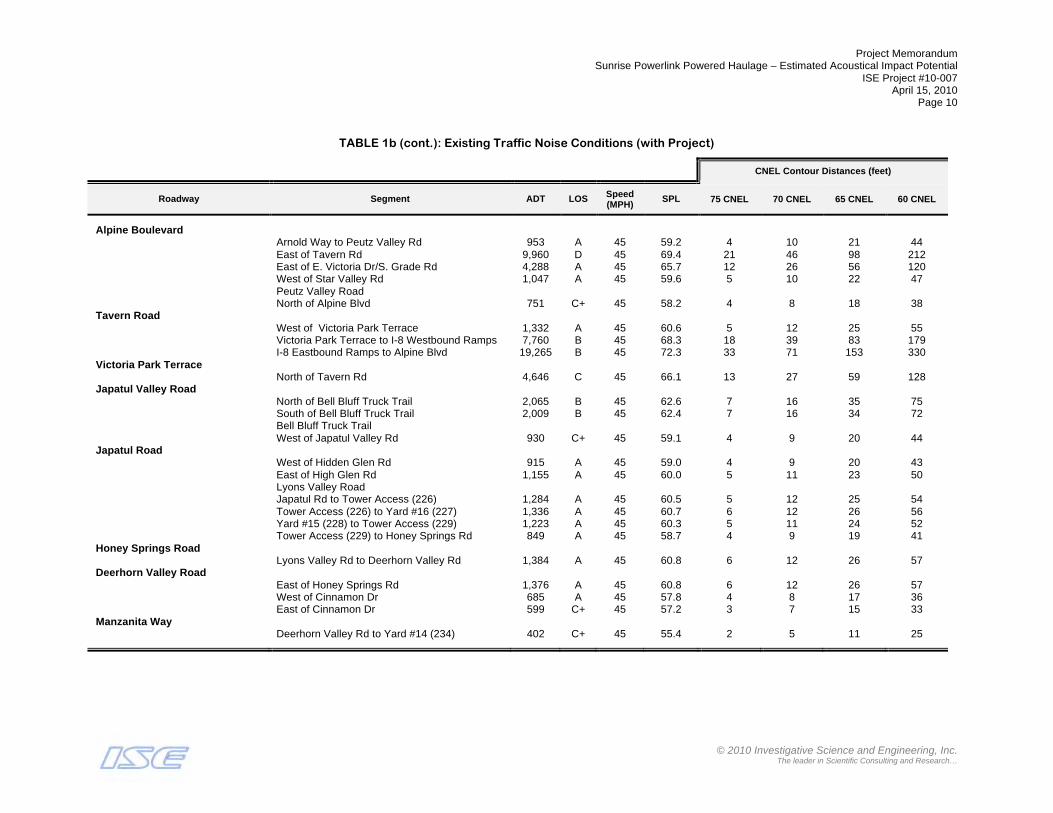
Project Memorandum Sunrise Powerlink Powered Haulage – Estimated Acoustical Impact Potential
ISE Project #10-007 April 15, 2010
Page 10
© 2010 Investigative Science and Engineering, Inc.
The leader in Scientific Consulting and Research…
TABLE 1b (cont.): Existing Traffic Noise Conditions (with Project)
CNEL Contour Distances (feet)
Roadway Segment ADT LOS Speed (MPH)
SPL 75 CNEL 70 CNEL 65 CNEL 60 CNEL
Alpine Boulevard Arnold Way to Peutz Valley Rd 953 A 45 59.2 4 10 21 44 East of Tavern Rd 9,960 D 45 69.4 21 46 98 212 East of E. Victoria Dr/S. Grade Rd 4,288 A 45 65.7 12 26 56 120 West of Star Valley Rd 1,047 A 45 59.6 5 10 22 47 Peutz Valley Road North of Alpine Blvd 751 C+ 45 58.2 4 8 18 38 Tavern Road West of Victoria Park Terrace 1,332 A 45 60.6 5 12 25 55 Victoria Park Terrace to I-8 Westbound Ramps 7,760 B 45 68.3 18 39 83 179 I-8 Eastbound Ramps to Alpine Blvd 19,265 B 45 72.3 33 71 153 330 Victoria Park Terrace North of Tavern Rd 4,646 C 45 66.1 13 27 59 128 Japatul Valley Road North of Bell Bluff Truck Trail 2,065 B 45 62.6 7 16 35 75 South of Bell Bluff Truck Trail 2,009 B 45 62.4 7 16 34 72 Bell Bluff Truck Trail West of Japatul Valley Rd 930 C+ 45 59.1 4 9 20 44 Japatul Road West of Hidden Glen Rd 915 A 45 59.0 4 9 20 43 East of High Glen Rd 1,155 A 45 60.0 5 11 23 50 Lyons Valley Road Japatul Rd to Tower Access (226) 1,284 A 45 60.5 5 12 25 54 Tower Access (226) to Yard #16 (227) 1,336 A 45 60.7 6 12 26 56 Yard #15 (228) to Tower Access (229) 1,223 A 45 60.3 5 11 24 52 Tower Access (229) to Honey Springs Rd 849 A 45 58.7 4 9 19 41 Honey Springs Road Lyons Valley Rd to Deerhorn Valley Rd 1,384 A 45 60.8 6 12 26 57 Deerhorn Valley Road East of Honey Springs Rd 1,376 A 45 60.8 6 12 26 57 West of Cinnamon Dr 685 A 45 57.8 4 8 17 36 East of Cinnamon Dr 599 C+ 45 57.2 3 7 15 33 Manzanita Way Deerhorn Valley Rd to Yard #14 (234) 402 C+ 45 55.4 2 5 11 25
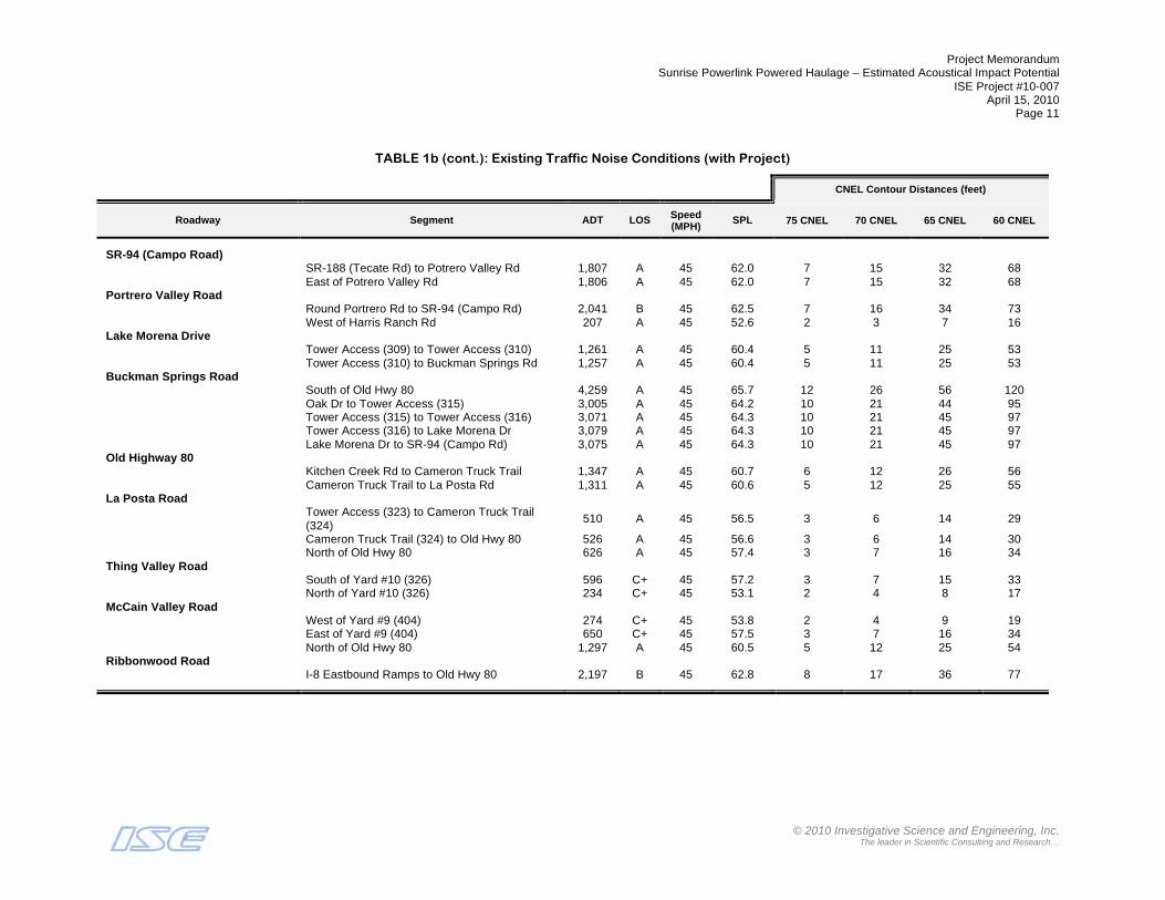
Project Memorandum Sunrise Powerlink Powered Haulage – Estimated Acoustical Impact Potential
ISE Project #10-007 April 15, 2010
Page 11
© 2010 Investigative Science and Engineering, Inc.
The leader in Scientific Consulting and Research…
TABLE 1b (cont.): Existing Traffic Noise Conditions (with Project)
CNEL Contour Distances (feet)
Roadway Segment ADT LOS Speed (MPH)
SPL 75 CNEL 70 CNEL 65 CNEL 60 CNEL
SR-94 (Campo Road) SR-188 (Tecate Rd) to Potrero Valley Rd 1,807 A 45 62.0 7 15 32 68 East of Potrero Valley Rd 1,806 A 45 62.0 7 15 32 68 Portrero Valley Road Round Portrero Rd to SR-94 (Campo Rd) 2,041 B 45 62.5 7 16 34 73 West of Harris Ranch Rd 207 A 45 52.6 2 3 7 16 Lake Morena Drive Tower Access (309) to Tower Access (310) 1,261 A 45 60.4 5 11 25 53 Tower Access (310) to Buckman Springs Rd 1,257 A 45 60.4 5 11 25 53 Buckman Springs Road South of Old Hwy 80 4,259 A 45 65.7 12 26 56 120 Oak Dr to Tower Access (315) 3,005 A 45 64.2 10 21 44 95 Tower Access (315) to Tower Access (316) 3,071 A 45 64.3 10 21 45 97 Tower Access (316) to Lake Morena Dr 3,079 A 45 64.3 10 21 45 97 Lake Morena Dr to SR-94 (Campo Rd) 3,075 A 45 64.3 10 21 45 97 Old Highway 80 Kitchen Creek Rd to Cameron Truck Trail 1,347 A 45 60.7 6 12 26 56 Cameron Truck Trail to La Posta Rd 1,311 A 45 60.6 5 12 25 55 La Posta Road
Tower Access (323) to Cameron Truck Trail (324)
510 A 45 56.5 3 6 14 29
Cameron Truck Trail (324) to Old Hwy 80 526 A 45 56.6 3 6 14 30 North of Old Hwy 80 626 A 45 57.4 3 7 16 34 Thing Valley Road South of Yard #10 (326) 596 C+ 45 57.2 3 7 15 33 North of Yard #10 (326) 234 C+ 45 53.1 2 4 8 17 McCain Valley Road West of Yard #9 (404) 274 C+ 45 53.8 2 4 9 19 East of Yard #9 (404) 650 C+ 45 57.5 3 7 16 34 North of Old Hwy 80 1,297 A 45 60.5 5 12 25 54 Ribbonwood Road I-8 Eastbound Ramps to Old Hwy 80 2,197 B 45 62.8 8 17 36 77

Project Memorandum Sunrise Powerlink Powered Haulage – Estimated Acoustical Impact Potential
ISE Project #10-007 April 15, 2010
Page 12
© 2010 Investigative Science and Engineering, Inc.
The leader in Scientific Consulting and Research…
TABLE 1b (cont.): Existing Traffic Noise Conditions (with Project)
CNEL Contour Distances (feet)
Roadway Segment ADT LOS Speed (MPH)
SPL 75 CNEL 70 CNEL 65 CNEL 60 CNEL
Old Highway 80 Ribbonwood Rd to McCain Valley Rd 2,072 A 45 62.6 7 16 35 75 Mc Cain Valley Rd to Tower Access (408) 1,008 A 45 59.4 5 10 21 46 Tower Access (408) to Tower Access (409) 992 A 45 59.4 5 10 21 46 Tower Access (409) to Desert Rose Ranch Rd 980 A 45 59.3 4 10 21 45 Desert Rose Ranch Rd to Tower Access (411) 1,057 A 45 59.6 5 10 22 47 East of Tower Access (411) 1,215 A 45 60.2 5 11 24 52 West of Yard #6 (412) 757 A 45 58.2 4 8 18 38 Yard #6 (412) to Carrizo Gorge Rd 947 A 45 59.2 4 10 21 44 Carrizo Gorge Rd to Tower Access (501) 670 A 45 57.7 4 8 16 35 Tower Access (501) to Tower Access (502) 702 A 45 57.9 4 8 17 36 Tower Access (502) to Carrizo Creek Rd 696 A 45 57.8 4 8 17 36 Carrizo Creek Rd to Tower Access (504) 690 A 45 57.8 4 8 17 36 Tower Access (504) to Yard #5 (505) 629 A 45 57.4 3 7 16 34 Yard #5 (505) to In-Ko-Pah Park Rd 727 A 45 58.0 4 8 17 37 I-8/Carrizo Gorge Road North of Carrizo Gorge Rd 888 C+ 45 58.9 4 9 20 42 Carrizo Gorge Road Tower Access (415) to Yard #7 (416) 942 A 45 59.1 4 9 20 44 Yard #7 (416) to Tower Access (417) 850 A 45 58.7 4 9 19 41 Tower Access (417) to Tower Access (418) 836 A 45 58.6 4 9 19 40 Tower Access (418) to Carrizo Creek Rd 763 A 45 58.2 4 8 18 38 Carrizo Creek Rd to Old Hwy 80 625 A 45 57.4 3 7 16 34 Mountain Springs Road I-8 WB ramps to Tower Access (510) 52 C+ 45 46.6 1 1 3 6 Tower Access (510) to I-8 EB ramps 52 C+ 45 46.6 1 1 3 6 County Highway S2 Dos Cabeza to Yard #4 (513) 461 A 45 56.0 3 6 13 27 Yard #4 (513) to Shell Canyon Rd 783 A 45 58.3 4 8 18 39 Shell Canyon Rd to I-8 WB ramps 1,094 A 45 59.8 5 10 23 48 Quarry Road North of Yard #4 (513) 418 C+ 45 55.6 3 5 12 25 Yard #4 (514) to Tower Access (515) 197 A 45 52.3 2 3 7 15 Tower Access (515) to Tower Access (516) 259 A 45 53.5 2 4 9 18 Tower Access (516) to Shell Canyon Rd 387 A 45 55.3 2 5 11 24

Project Memorandum Sunrise Powerlink Powered Haulage – Estimated Acoustical Impact Potential
ISE Project #10-007 April 15, 2010
Page 13
© 2010 Investigative Science and Engineering, Inc.
The leader in Scientific Consulting and Research…
TABLE 1b (cont.): Existing Traffic Noise Conditions (with Project)
CNEL Contour Distances (feet)
Roadway Segment ADT LOS Speed (MPH)
SPL 75 CNEL 70 CNEL 65 CNEL 60 CNEL
Shell Canyon Road North of County Hwy S2 404 A 45 55.5 3 5 12 25 County Highway S80 West of Tower Access (601) 616 A 45 57.3 3 7 15 33 Tower Access (601) to Yard #3 (602) 846 A 45 58.7 4 9 19 41 East of Yard #3 (602) 841 A 45 58.7 4 9 19 41 East of New River Road 3,013 A 45 64.2 10 21 44 95 East of Brown Road 2,636 A 45 63.6 9 19 40 87 Dunaway Road South of I-8 Eastbound Ramps 576 C+ 45 57.0 3 7 15 32 SR-98 (Yuha Cutoff) West of Yard #1 (606) 1,426 A 45 60.9 6 12 27 57 East of Yard #1 (606) 1,482 A 45 61.1 6 13 27 59 New River Road North of County Hwy S80 293 A 45 54.1 2 4 9 20 Oak Drive East of Lake Morena Drive 1,173 A 45 60.1 5 11 24 51 Lake Morena Avenue North of OakDrive 1,276 A 45 60.5 5 12 25 54 Prospect Avenue East of Magnolia Avenue 21,249 B 45 72.7 35 76 163 351 East of Cuyamaca Street 12,344 A 45 70.3 24 52 113 243 West of Cuyamaca Street 11,184 A 45 69.9 23 49 106 229 Magnolia Avenue North of Prospect Avenue 30,564 B 45 74.3 45 97 208 449 Cuyamaca Street North of Prospect Avenue 19,324 A 45 72.3 33 71 153 330 Mission Gorge Road East of Big Rock Road 13,682 A 45 70.8 26 57 122 262 Big Rock Road South of Mission Gorge Road 6,596 A 45 67.6 16 35 75 161 Scripps Ranch Boulevard South of Meanley Drive 9,794 A 45 69.3 21 45 97 208 Meanley Drive East of Scripps Ranch Boulevard 1,854 A 45 62.1 7 15 32 69

Project Memorandum Sunrise Powerlink Powered Haulage – Estimated Acoustical Impact Potential
ISE Project #10-007 April 15, 2010
Page 14
© 2010 Investigative Science and Engineering, Inc.
The leader in Scientific Consulting and Research…
TABLE 1b (cont.): Existing Traffic Noise Conditions (with Project)
CNEL Contour Distances (feet)
Roadway Segment ADT LOS Speed (MPH)
SPL 75 CNEL 70 CNEL 65 CNEL 60 CNEL
Old Dairy Mart Road East of Dairy Mart Road 1,589 A 45 61.4 6 13 29 62 Scripps Poway Parkway East of Village Ridge / Cypress Canyon Road 33,494 E 45 74.7 48 103 222 477
Notes: o ADT = Average Daily Trips – Source: KOA Engineering, Inc., 4/10/10. o SPL = Sound Pressure Level in dBA at 50-feet from the road edge. CNEL = Community Noise Equivalent Level. o All values given in dBA CNEL. Contours assumed to be line-of-sight perpendicular (!) distance.
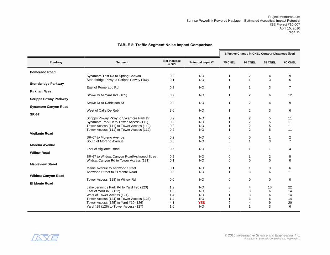
Project Memorandum Sunrise Powerlink Powered Haulage – Estimated Acoustical Impact Potential
ISE Project #10-007 April 15, 2010
Page 15
© 2010 Investigative Science and Engineering, Inc.
The leader in Scientific Consulting and Research…
TABLE 2: Traffic Segment Noise Impact Comparison
Effective Change in CNEL Contour Distances (feet)
Roadway Segment Net Increase in SPL
Potential Impact? 75 CNEL 70 CNEL 65 CNEL 60 CNEL
Pomerado Road
Sycamore Test Rd to Spring Canyon 0.2 NO 1 2 4 9 Stonebridge Pkwy to Scripps Poway Pkwy 0.1 NO 1 1 3 5 Stonebridge Parkway East of Pomerado Rd 0.3 NO 1 1 3 7 Kirkham Way Stowe Dr to Yard #21 (105) 0.9 NO 1 2 6 12 Scripps Poway Parkway Stowe Dr to Danielson St 0.2 NO 1 2 4 9 Sycamore Canyon Road West of Calle De Rob 3.0 NO 1 2 3 6 SR-67 Scripps Poway Pkwy to Sycamore Park Dr 0.2 NO 1 2 5 11 Sycamore Park Dr to Tower Access (111) 0.2 NO 1 2 5 11 Tower Access (111) to Tower Access (112) 0.2 NO 1 2 5 11 Tower Access (111) to Tower Access (112) 0.2 NO 1 2 5 11 Vigilante Road SR-67 to Moreno Avenue 0.2 NO 0 0 1 2 South of Moreno Avenue 0.6 NO 0 1 3 7 Moreno Avenue East of Vigilante Road 0.6 NO 0 1 1 4 Willow Road SR-67 to Wildcat Canyon Road/Ashwood Street 0.2 NO 0 1 2 5 Wildcat Canyon Rd to Tower Access (121) 0.1 NO 0 0 0 0 Mapleview Street Maine Avenue to Ashwood Street 0.1 NO 1 1 3 6 Ashwood Street to El Monte Road 0.3 NO 1 3 6 11 Wildcat Canyon Road Tower Access (118) to Willow Rd 0.0 NO 0 0 0 0 El Monte Road Lake Jennings Park Rd to Yard #20 (123) 1.9 NO 3 4 10 22 East of Yard #20 (122) 1.3 NO 2 3 6 14 West of Tower Access (124) 1.4 NO 1 3 6 14 Tower Access (124) to Tower Access (125) 1.4 NO 1 3 6 14 Tower Access (125) to Yard #19 (126) 4.1 YES 2 4 9 20 Yard #19 (126) to Tower Access (127) 1.6 NO 1 1 3 6

Project Memorandum Sunrise Powerlink Powered Haulage – Estimated Acoustical Impact Potential
ISE Project #10-007 April 15, 2010
Page 16
© 2010 Investigative Science and Engineering, Inc.
The leader in Scientific Consulting and Research…
TABLE 2 (cont.): Traffic Segment Noise Impact Comparison
Effective Change in CNEL Contour Distances (feet)
Roadway Segment Net Increase in SPL
Potential Impact? 75 CNEL 70 CNEL 65 CNEL 60 CNEL
Alpine Boulevard
Arnold Way to Peutz Valley Rd 0.5 NO 0 1 2 3 East of Tavern Rd 0.0 NO 0 0 0 0 East of E. Victoria Dr/S. Grade Rd 0.0 NO 0 0 0 0 West of Star Valley Rd 0.7 NO 1 1 2 5 Peutz Valley Road 0.0 NO 0 0 0 0 North of Alpine Blvd 1.1 NO 1 1 3 6 Tavern Road West of Victoria Park Terrace 3.2 YES 2 5 9 21 Victoria Park Terrace to I-8 Westbound Ramps 0.4 NO 1 3 5 11 I-8 Eastbound Ramps to Alpine Blvd 0.1 NO 0 1 2 5 Victoria Park Terrace North of Tavern Rd 0.1 NO 0 0 1 2 Japatul Valley Road North of Bell Bluff Truck Trail 2.7 NO 2 5 12 26 South of Bell Bluff Truck Trail 2.5 NO 2 5 11 23 Bell Bluff Truck Trail 0.0 NO 0 0 0 0 West of Japatul Valley Rd 14.6 YES 4 8 18 39 Japatul Road West of Hidden Glen Rd 0.0 NO 0 0 0 0 East of High Glen Rd 1.0 NO 1 2 3 7 Lyons Valley Road 0.0 NO 0 0 0 0 Japatul Rd to Tower Access (226) 4.8 YES 2 6 13 28 Tower Access (226) to Yard #16 (227) 5.0 YES 3 6 14 30 Yard #15 (228) to Tower Access (229) 4.6 YES 2 5 12 26 Tower Access (229) to Honey Springs Rd 3.0 NO 1 3 7 15 Honey Springs Road Lyons Valley Rd to Deerhorn Valley Rd 1.6 NO 2 2 5 13 Deerhorn Valley Road East of Honey Springs Rd 1.6 NO 2 2 5 13 West of Cinnamon Dr 4.3 YES 2 4 8 18 East of Cinnamon Dr 3.7 YES 1 3 6 15 Manzanita Way Deerhorn Valley Rd to Yard #14 (234) 8.1 YES 1 3 8 18
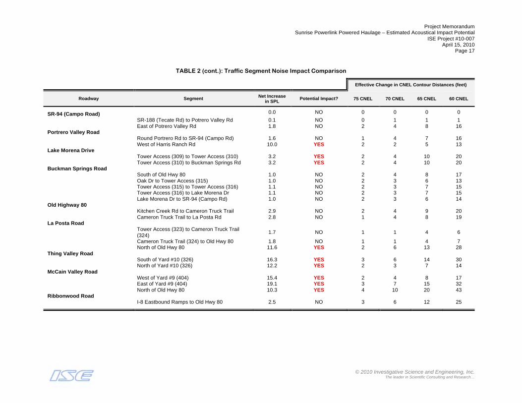
Project Memorandum Sunrise Powerlink Powered Haulage – Estimated Acoustical Impact Potential
ISE Project #10-007 April 15, 2010
Page 17
© 2010 Investigative Science and Engineering, Inc.
The leader in Scientific Consulting and Research…
TABLE 2 (cont.): Traffic Segment Noise Impact Comparison
Effective Change in CNEL Contour Distances (feet)
Roadway Segment Net Increase in SPL
Potential Impact? 75 CNEL 70 CNEL 65 CNEL 60 CNEL
SR-94 (Campo Road) 0.0 NO 0 0 0 0
SR-188 (Tecate Rd) to Potrero Valley Rd 0.1 NO 0 1 1 1 East of Potrero Valley Rd 1.8 NO 2 4 8 16 Portrero Valley Road Round Portrero Rd to SR-94 (Campo Rd) 1.6 NO 1 4 7 16 West of Harris Ranch Rd 10.0 YES 2 2 5 13 Lake Morena Drive Tower Access (309) to Tower Access (310) 3.2 YES 2 4 10 20 Tower Access (310) to Buckman Springs Rd 3.2 YES 2 4 10 20 Buckman Springs Road South of Old Hwy 80 1.0 NO 2 4 8 17 Oak Dr to Tower Access (315) 1.0 NO 2 3 6 13 Tower Access (315) to Tower Access (316) 1.1 NO 2 3 7 15 Tower Access (316) to Lake Morena Dr 1.1 NO 2 3 7 15 Lake Morena Dr to SR-94 (Campo Rd) 1.0 NO 2 3 6 14 Old Highway 80 Kitchen Creek Rd to Cameron Truck Trail 2.9 NO 2 4 9 20 Cameron Truck Trail to La Posta Rd 2.8 NO 1 4 8 19 La Posta Road
Tower Access (323) to Cameron Truck Trail (324)
1.7 NO 1 1 4 6
Cameron Truck Trail (324) to Old Hwy 80 1.8 NO 1 1 4 7 North of Old Hwy 80 11.6 YES 2 6 13 28 Thing Valley Road South of Yard #10 (326) 16.3 YES 3 6 14 30 North of Yard #10 (326) 12.2 YES 2 3 7 14 McCain Valley Road West of Yard #9 (404) 15.4 YES 2 4 8 17 East of Yard #9 (404) 19.1 YES 3 7 15 32 North of Old Hwy 80 10.3 YES 4 10 20 43 Ribbonwood Road I-8 Eastbound Ramps to Old Hwy 80 2.5 NO 3 6 12 25

Project Memorandum Sunrise Powerlink Powered Haulage – Estimated Acoustical Impact Potential
ISE Project #10-007 April 15, 2010
Page 18
© 2010 Investigative Science and Engineering, Inc.
The leader in Scientific Consulting and Research…
TABLE 2 (cont.): Traffic Segment Noise Impact Comparison
Effective Change in CNEL Contour Distances (feet)
Roadway Segment Net Increase in SPL
Potential Impact? 75 CNEL 70 CNEL 65 CNEL 60 CNEL
Old Highway 80
Ribbonwood Rd to McCain Valley Rd 2.9 NO 2 6 13 27 Mc Cain Valley Rd to Tower Access (408) 0.9 NO 1 1 3 6 Tower Access (408) to Tower Access (409) 0.9 NO 1 1 3 6 Tower Access (409) to Desert Rose Ranch Rd 0.8 NO 0 1 3 5 Desert Rose Ranch Rd to Tower Access (411) 0.6 NO 1 1 2 4 East of Tower Access (411) 1.2 NO 1 2 4 9 West of Yard #6 (412) 2.3 NO 1 2 6 11 Yard #6 (412) to Carrizo Gorge Rd 3.3 YES 1 4 9 17 Carrizo Gorge Rd to Tower Access (501) 3.9 YES 2 4 7 16 Tower Access (501) to Tower Access (502) 4.1 YES 2 4 8 17 Tower Access (502) to Carrizo Creek Rd 4.0 YES 2 4 8 17 Carrizo Creek Rd to Tower Access (504) 4.0 YES 2 4 8 17 Tower Access (504) to Yard #5 (505) 5.0 YES 1 4 9 18 Yard #5 (505) to In-Ko-Pah Park Rd 5.6 YES 2 5 10 21 I-8/Carrizo Gorge Road North of Carrizo Gorge Rd 4.4 YES 2 4 10 21 Carrizo Gorge Road Tower Access (415) to Yard #7 (416) 4.0 YES 2 4 9 20 Yard #7 (416) to Tower Access (417) 3.6 YES 2 4 8 17 Tower Access (417) to Tower Access (418) 3.5 YES 2 4 8 16 Tower Access (418) to Carrizo Creek Rd 2.7 NO 1 3 6 13 Carrizo Creek Rd to Old Hwy 80 1.9 NO 0 2 4 9 Mountain Springs Road I-8 WB ramps to Tower Access (510) 0.4 NO 0 0 0 0 Tower Access (510) to I-8 EB ramps 0.4 NO 0 0 0 0 County Highway S2 0.0 NO 0 0 0 0 Dos Cabeza to Yard #4 (513) 2.3 NO 1 2 4 8 Yard #4 (513) to Shell Canyon Rd 4.6 YES 2 4 9 20 Shell Canyon Rd to I-8 WB ramps 3.3 YES 2 4 9 19 Quarry Road North of Yard #4 (513) 16.2 YES 3 5 11 23 Yard #4 (514) to Tower Access (515) 4.0 YES 1 1 3 7 Tower Access (515) to Tower Access (516) 5.2 YES 1 2 5 10 Tower Access (516) to Shell Canyon Rd 7.0 YES 1 3 7 16
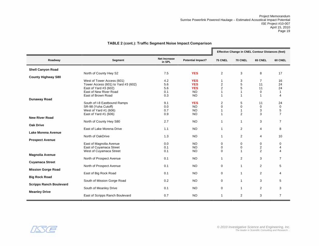
Project Memorandum Sunrise Powerlink Powered Haulage – Estimated Acoustical Impact Potential
ISE Project #10-007 April 15, 2010
Page 19
© 2010 Investigative Science and Engineering, Inc.
The leader in Scientific Consulting and Research…
TABLE 2 (cont.): Traffic Segment Noise Impact Comparison
Effective Change in CNEL Contour Distances (feet)
Roadway Segment Net Increase in SPL
Potential Impact? 75 CNEL 70 CNEL 65 CNEL 60 CNEL
Shell Canyon Road
North of County Hwy S2 7.5 YES 2 3 8 17 County Highway S80 West of Tower Access (601) 4.2 YES 1 3 7 16 Tower Access (601) to Yard #3 (602) 5.6 YES 2 5 11 24 East of Yard #3 (602) 5.6 YES 2 5 11 24 East of New River Road 0.1 NO 1 1 0 1 East of Brown Road 0.3 NO 1 1 1 4 Dunaway Road South of I-8 Eastbound Ramps 9.1 YES 2 5 11 24 SR-98 (Yuha Cutoff) 0.0 NO 0 0 0 0 West of Yard #1 (606) 0.7 NO 1 1 3 5 East of Yard #1 (606) 0.9 NO 1 2 3 7 New River Road North of County Hwy S80 2.7 NO 1 1 3 7 Oak Drive East of Lake Morena Drive 1.1 NO 1 2 4 8 Lake Morena Avenue North of OakDrive 1.3 NO 1 2 4 10 Prospect Avenue East of Magnolia Avenue 0.0 NO 0 0 0 0 East of Cuyamaca Street 0.1 NO 0 0 2 4 West of Cuyamaca Street 0.1 NO 0 1 2 4 Magnolia Avenue North of Prospect Avenue 0.1 NO 1 2 3 7 Cuyamaca Street North of Prospect Avenue 0.1 NO 0 1 2 5 Mission Gorge Road East of Big Rock Road 0.1 NO 0 1 2 4 Big Rock Road South of Mission Gorge Road 0.2 NO 0 1 3 5 Scripps Ranch Boulevard South of Meanley Drive 0.1 NO 0 1 2 3 Meanley Drive East of Scripps Ranch Boulevard 0.7 NO 1 2 3 7

Project Memorandum Sunrise Powerlink Powered Haulage – Estimated Acoustical Impact Potential
ISE Project #10-007 April 15, 2010
Page 20
© 2010 Investigative Science and Engineering, Inc.
The leader in Scientific Consulting and Research…
TABLE 2 (cont.): Traffic Segment Noise Impact Comparison
Effective Change in CNEL Contour Distances (feet)
Roadway Segment Net Increase in SPL
Potential Impact? 75 CNEL 70 CNEL 65 CNEL 60 CNEL
Old Dairy Mart Road
East of Dairy Mart Road 0.8 NO 1 1 4 7 Scripps Poway Parkway East of Village Ridge / Cypress Canyon Road 0.1 NO 1 2 4 7
Notes: o ADT = Average Daily Trips – Source: KOA Engineering, Inc., 4/10/10. o SPL = Sound Pressure Level in dBA at 50-feet from the road edge. CNEL = Community Noise Equivalent Level. o All values given in dBA CNEL. Contours assumed to be line-of-sight perpendicular (!) distance.

Project Memorandum Sunrise Powerlink Powered Haulage – Estimated Acoustical Impact Potential
ISE Project #10-007 April 15, 2010
Page 21
© 2010 Investigative Science and Engineering, Inc.
The leader in Scientific Consulting and Research…
Conclusion Based upon the analysis, it is ISE’s opinion that short-term powered haulage due to the proposed Sunrise Powerlink would not cause a significant acoustical impact to any adjacent sensitive receptors. No mitigation is identified.
Should you have any questions regarding the above findings or conclusions, please do not hesitate to contact me at (760) 787-0016.
Attachment A: GIS Receptor Inspection Panes (in alphabetical order)
Carrizo Gorge Road

Project Memorandum Sunrise Powerlink Powered Haulage – Estimated Acoustical Impact Potential
ISE Project #10-007 April 15, 2010
Page 22
© 2010 Investigative Science and Engineering, Inc.
The leader in Scientific Consulting and Research…
County Highway S80
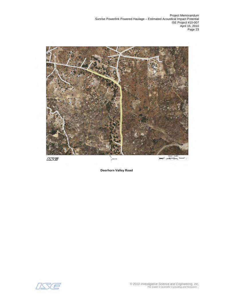
Project Memorandum Sunrise Powerlink Powered Haulage – Estimated Acoustical Impact Potential
ISE Project #10-007 April 15, 2010
Page 23
© 2010 Investigative Science and Engineering, Inc.
The leader in Scientific Consulting and Research…
Deerhorn Valley Road

Project Memorandum Sunrise Powerlink Powered Haulage – Estimated Acoustical Impact Potential
ISE Project #10-007 April 15, 2010
Page 24
© 2010 Investigative Science and Engineering, Inc.
The leader in Scientific Consulting and Research…
Dunaway Road

Project Memorandum Sunrise Powerlink Powered Haulage – Estimated Acoustical Impact Potential
ISE Project #10-007 April 15, 2010
Page 25
© 2010 Investigative Science and Engineering, Inc.
The leader in Scientific Consulting and Research…
El Monte Road

Project Memorandum Sunrise Powerlink Powered Haulage – Estimated Acoustical Impact Potential
ISE Project #10-007 April 15, 2010
Page 26
© 2010 Investigative Science and Engineering, Inc.
The leader in Scientific Consulting and Research…
I8-Carrizo Gorge Road Connector

Project Memorandum Sunrise Powerlink Powered Haulage – Estimated Acoustical Impact Potential
ISE Project #10-007 April 15, 2010
Page 27
© 2010 Investigative Science and Engineering, Inc.
The leader in Scientific Consulting and Research…
Japatul Road

Project Memorandum Sunrise Powerlink Powered Haulage – Estimated Acoustical Impact Potential
ISE Project #10-007 April 15, 2010
Page 28
© 2010 Investigative Science and Engineering, Inc.
The leader in Scientific Consulting and Research…
Japatul Valley Road

Project Memorandum Sunrise Powerlink Powered Haulage – Estimated Acoustical Impact Potential
ISE Project #10-007 April 15, 2010
Page 29
© 2010 Investigative Science and Engineering, Inc.
The leader in Scientific Consulting and Research…
La Posta Road
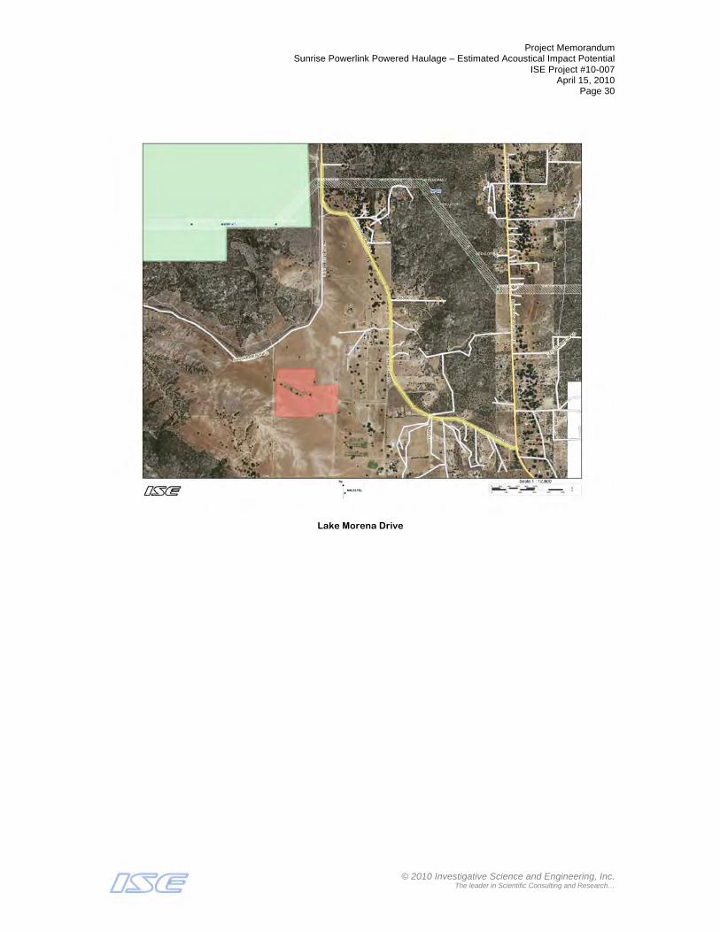
Project Memorandum Sunrise Powerlink Powered Haulage – Estimated Acoustical Impact Potential
ISE Project #10-007 April 15, 2010
Page 30
© 2010 Investigative Science and Engineering, Inc.
The leader in Scientific Consulting and Research…
Lake Morena Drive

Project Memorandum Sunrise Powerlink Powered Haulage – Estimated Acoustical Impact Potential
ISE Project #10-007 April 15, 2010
Page 31
© 2010 Investigative Science and Engineering, Inc.
The leader in Scientific Consulting and Research…
Manzanita Way

Project Memorandum Sunrise Powerlink Powered Haulage – Estimated Acoustical Impact Potential
ISE Project #10-007 April 15, 2010
Page 32
© 2010 Investigative Science and Engineering, Inc.
The leader in Scientific Consulting and Research…
McCain Valley Road

Project Memorandum Sunrise Powerlink Powered Haulage – Estimated Acoustical Impact Potential
ISE Project #10-007 April 15, 2010
Page 33
© 2010 Investigative Science and Engineering, Inc.
The leader in Scientific Consulting and Research…
Mountain Springs Road
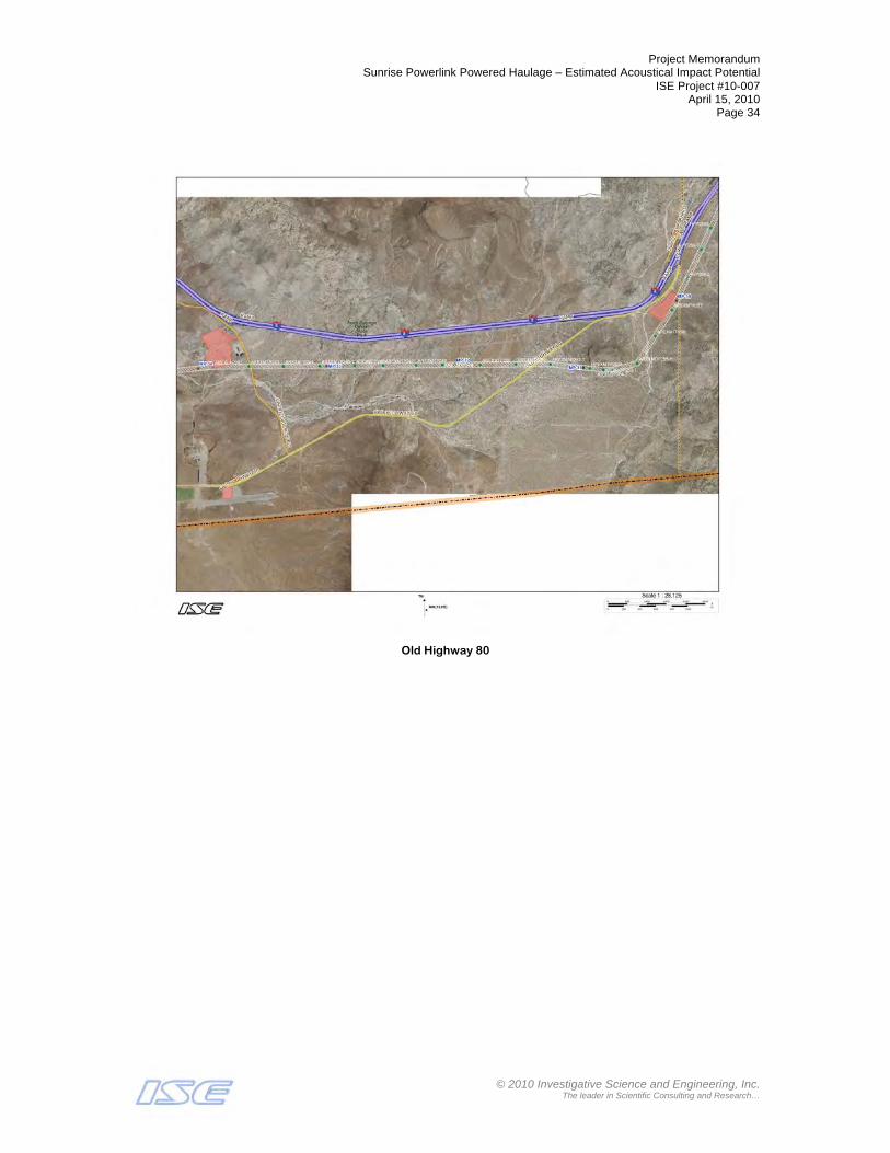
Project Memorandum Sunrise Powerlink Powered Haulage – Estimated Acoustical Impact Potential
ISE Project #10-007 April 15, 2010
Page 34
© 2010 Investigative Science and Engineering, Inc.
The leader in Scientific Consulting and Research…
Old Highway 80

Project Memorandum Sunrise Powerlink Powered Haulage – Estimated Acoustical Impact Potential
ISE Project #10-007 April 15, 2010
Page 35
© 2010 Investigative Science and Engineering, Inc.
The leader in Scientific Consulting and Research…
Portrero Valley Road
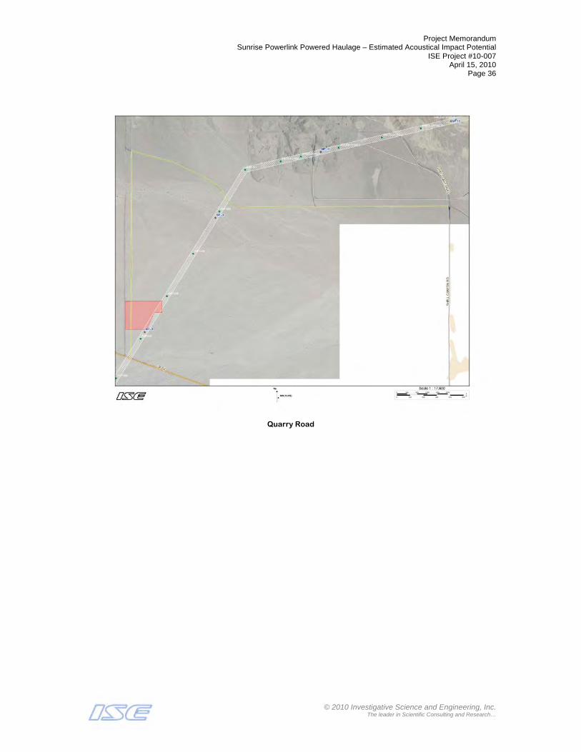
Project Memorandum Sunrise Powerlink Powered Haulage – Estimated Acoustical Impact Potential
ISE Project #10-007 April 15, 2010
Page 36
© 2010 Investigative Science and Engineering, Inc.
The leader in Scientific Consulting and Research…
Quarry Road
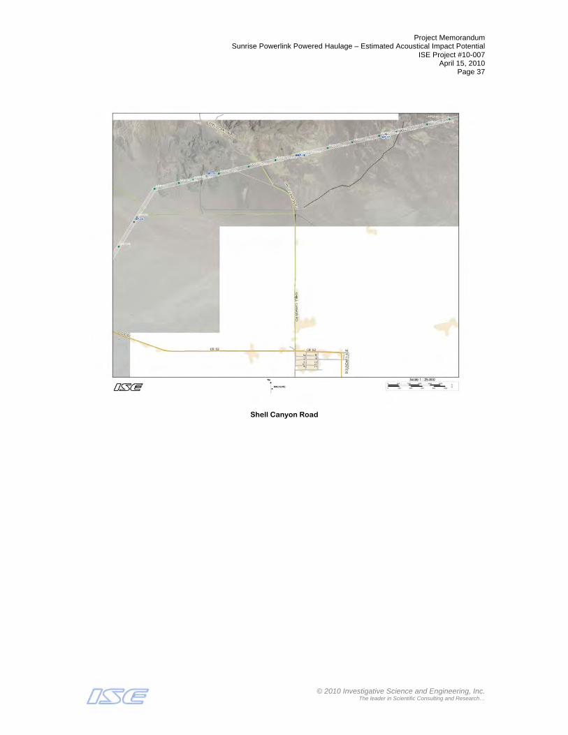
Project Memorandum Sunrise Powerlink Powered Haulage – Estimated Acoustical Impact Potential
ISE Project #10-007 April 15, 2010
Page 37
© 2010 Investigative Science and Engineering, Inc.
The leader in Scientific Consulting and Research…
Shell Canyon Road

Project Memorandum Sunrise Powerlink Powered Haulage – Estimated Acoustical Impact Potential
ISE Project #10-007 April 15, 2010
Page 38
© 2010 Investigative Science and Engineering, Inc.
The leader in Scientific Consulting and Research…
Tavern Road

Project Memorandum Sunrise Powerlink Powered Haulage – Estimated Acoustical Impact Potential
ISE Project #10-007 April 15, 2010
Page 39
© 2010 Investigative Science and Engineering, Inc.
The leader in Scientific Consulting and Research…
Thing Valley Road

P r o j e c t M o d i f i c a t i o n R e p o r t A t t a c h m e n t C 0 5 . 1 4 . 1 0

P r o j e c t M o d i f i c a t i o n R e p o r t A t t a c h m e n t D 0 5 . 1 4 . 1 0
ATTACHMENT D

P r o j e c t M o d i f i c a t i o n R e p o r t A t t a c h m e n t D 0 5 . 1 4 . 1 0

MEMORANDUM
March 17, 2010
To: Ms. Linda Collins, LLC
From: James A. Westbrook, BlueScape Environmental
Subject: Air Quality Impacts from the Final Water Use Plan, Final Environmentally Superior Southern Route
At the request of San Diego Gas & Electric, BlueScape Environmental (“BlueScape”) reviewed potential air quality impacts from the final Water Use Plan for the Sunrise Powerlink Transmission Project Final Environmentally Superior Southern Route (FESSR). According to the plan, water for construction purposes and dust mitigation will be trucked in either 9,000 gallon or 3,000 gallon heavy-duty tankers from the San Diego North County Treatment Plant, the Imperial Irrigation District or area reservoirs. The prior Water Use Plan for the FESSR was to utilize groundwater sources nearer the construction areas. For this review, BlueScape considered impacts from diesel combustion in heavy-duty trucks.
Project air emissions from onroad truck fuel combustion associated with the Water Use Plan are not expected to result in new impacts, nor the need to revise previous air quality impact analysis. In the final project EIR/EIS completed for the Northern Route, onroad air emissions from water transportation were based upon about 5.2 million vehicle miles travelled (VMT). This total did not include local water truck deliveries within construction areas. In comparison, the worst-case

Ms. Linda Collins San Diego Gas & Electric March 17, 2010 Page 2
total water transportation under the final Water Use Plan for FESSR is considerably less, estimated to be about 1.2 million VMT over a 12-month period.
The CPUC approved the Construction Emissions Monitoring Plan for the project, including water transportation activity, on February 1, 2010. The Monitoring Plan contains a heavy-duty vehicle activity target of 1.9 million VMT, based upon air emission calculations for the FESSR submitted in June 2009. Because total heavy-duty truck trips were conservatively overestimated for the Monitoring Plan, the Sunrise project is expected to continue to meet the total activity target. Therefore, the final Water Use Plan does not cause the need to update the project air quality impact analysis.
Related Documents