Project Location Texas City Texas City Hitchcock Hitchcock Galveston Galveston La Marque La Marque Tiki Island Tiki Island 45 197 3 146 6 Scholes Field Swan Lake Swan Lake B a s f o rdB a y o u B a s f o rdB a y o u Exhibit A Project Location LP 197 Direct Connectors Galveston County, Texas CSJ: 0500-04-112 January 2006 Galveston County N:\460122_09\projects\EA_Maps\Exhibit_A_Proj_Loc.mxd Legend Project Location 0 8,000 16,000 4,000 Feet Scale: 1:96,000 1 inch equal 8,000 feet

Welcome message from author
This document is posted to help you gain knowledge. Please leave a comment to let me know what you think about it! Share it to your friends and learn new things together.
Transcript
Project Location
Texas CityTexas City
HitchcockHitchcock
GalvestonGalveston
La MarqueLa Marque
Tiki IslandTiki Island
45
197
3
146
6
Scholes Field
Swan LakeSwan Lake
Basford BayouBasford Bayou
Exhibit AProject Location
LP 197 Direct ConnectorsGalveston County, Texas
CSJ: 0500-04-112
January 2006
GalvestonCounty
N:\460122_09\projects\EA_Maps\Exhibit_A_Proj_Loc.mxd
LegendProject Location
0 8,000 16,0004,000Feet
Scale: 1:96,0001 inch equal 8,000 feet

Project Location
Exhibit BTopographic Map
LP 197 Direct ConnectorsGalveston County, Texas
CSJ: 0500-04-112
January 2006
GalvestonCounty
N:\460122_09\Projects\EA_Maps\Exhibit_B_Topo.mxd
LegendProject Location
0 2,000 4,0001,000Feet
Source: Virginia Point, Texas USGS 7.5' Quadrangle, Galveston County
Scale: 1:24,0001 inch equal 2,000 feet

M1UBL
PUSKx
E2EM1N
E1UBL
PUSKx
E1UBL
PSS3A
E1UBL
PSS3A
PSS3A
PEM1A
M1UBL
PEM1A
PUBHx
PEM1A
PUBFx
PUBHx
L1UBHx
PEM1A
E1UBLx
E2EM1P
PEM1A
PEM1A
PUBHx
E2EM1N
PSS3A
L1UBHx
L1UBHx
E2EM1N
E2USN
E2EM1N
PUBHx
E1UBLx
PSS3A
PEM1F
PSS3A
PUBHx
PUBHx
PUBHx
PUBKx
PUBKx
PEM1A
PEM1A
PEM1Kx
E2EM1P
PSS3A
PSS1Ah
PSS3A
PUSCx
PUBFx
E1UBL
E1UBLx
E2EM1P
E2EM1N
E1UBLx E1UBLx
E2EM1N
E1UBLx
PUBFh
PUBKx
E2EM1P
E1UBLx E1UBLxE1UBLxE1UBLx
PEM1A
E1UBLx
E2EM1N
PUSKx
PSS3A
E2EM1N
PEM1A
E1UBLx
PEM1A
PEM1A
PEM1C
PSS3A
PSS3A
PUBFx
E2EM1N
PEM1C
E2EM1NPFO1Ah
E1UBLx
PEM1C
PEM1C
E1UBLx
PEM1C
PEM1Cs
PEM1C
E1UBLx
PSS3A
E1UBLx
E2EM1N
PEM1A
PEM1Cs
E1UBLx
PEM1A
PEM1Ch
E1UBLx
PEM1CPEM1Ah
E2EM1N
PEM1APUBFx
E2EM1N
PEM1C
PEM1Cx
E2EM1P
PEM1C
PUBHx
PUBFx
PEM1A
PFO1A
E2EM1N
PSS1A
E2EM1P
PEM1A
PEM1A
PUSCx
E2EM1N
PUSCx
PEM1Cx
PEM1A
PEM1Cs
PUBHx
E1UBLx
PFO1Ah
E2EM1P
E1UBLx
PEM1A
PEM1A
PEM1A
PEM1Ax
PEM1A
E1UBLx
PEM1Ax
PEM1Ah
PUBFx
PEM1Ax
PEM1AE2EM1N
PUSKx
PUBFx
PUBFx
PEM1C
Na
Iu
Na
W
Na
W
Fo
Tx
ImA
Fr
Ed
Na
Tx
Fo
Tc
ImA
W
ImB
ImA
Le
Iu
W
W
W
W
Le
W
NaW
W
W
W
W
ImA
W
W
W
W
Fo
Na
W
Vx
Fo
Vx
W
Fo
Le
Na
W
W
W
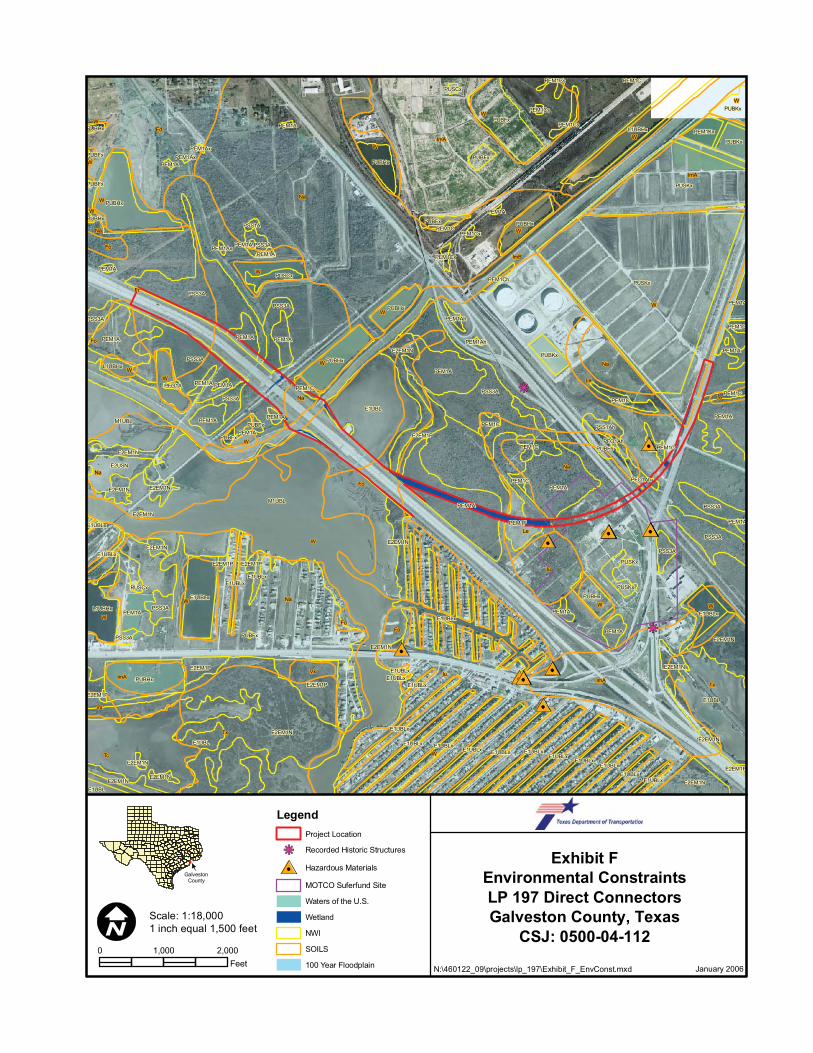
Exhibit FEnvironmental ConstraintsLP 197 Direct ConnectorsGalveston County, Texas
CSJ: 0500-04-112
January 2006
GalvestonCounty
N:\460122_09\projects\lp_197\Exhibit_F_EnvConst.mxd
LegendProject Location
Recorded Historic Structures
Hazardous Materials
MOTCO Suferfund Site
Waters of the U.S.
Wetland
NWI
SOILS
100 Year Floodplain
0 2,0001,000Feet
Scale: 1:18,0001 inch equal 1,500 feet
45
3
26
1
BEGIN PROJECT
DP
2
Fo
W
FoFr
Fr
Wet
7
Wat
er 1
DP
27
DP
26
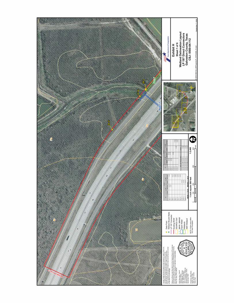
Exhi
bit H
Wet
land
Del
inea
tion
Layo
utLP
197
Dire
ct C
onne
ctor
sG
alve
ston
Cou
nty,
Tex
asC
SJ: 0
500-
04-1
12
N:\E
NV
\460
122_
09\P
roje
cts\
LP_1
97\E
xhib
it_H
.mxd
Sep
tem
ber 7
, 200
6
Shee
t 1 o
f 6
1:2,
400
1 in
ch e
qual
s 20
0 fe
et0
200
400
600
100
Feet
I her
eby
certi
fy th
at th
e lo
catio
ns o
f the
wet
land
s, w
ater
s of
the
U.S
.,an
d da
ta p
oint
s sh
own
here
are
bas
ed o
n an
act
ual o
n th
egr
ound
sur
vey,
exc
ept t
hose
as
note
d, u
nder
my
supe
rvis
ion,
have
a p
ositi
onal
acc
urac
y of
6 fe
et o
r les
s an
d ar
e tru
e an
d co
rrect
to th
e be
st o
f my
know
ledg
e.
Stam
p is
affi
xed
unde
r Rul
e 66
3.23
of t
he G
ener
al R
ules
of P
roce
dure
san
d Pr
actic
es d
efin
ed b
y th
e Te
xas
Boa
rd o
f Pro
fess
iona
l Sur
veyi
ngan
d do
es n
ot in
tend
to re
pres
ent a
sta
ndar
d or
resp
onsi
bilit
y.Ar
thur
M. S
tory
, RPL
S #4
034
RO
W B
ound
ary:
TxD
OT
Wet
land
s: P
BS&
JN
WI W
etla
nds:
USF
WS
Soils
: NR
CS
SSU
RG
O10
0 Yr
Flo
odpl
ain:
FEM
A Q
3Ae
rial P
hoto
grap
hy: H
GAC
Aeria
l Dat
e: 2
004
Proj
ectio
n: S
tate
Pla
neD
atum
: NAD
198
3Zo
ne: S
outh
Cen
tral
Uni
ts: F
eet
MH
W =
1.2
0 ft
M
HH
W =
1.4
0 ft
NO
TE: E
ntire
are
a w
ithin
100
Year
Flo
odpl
ain
Dat
a P
oint
Wet
land
Bou
nd S
take
SS
UR
GO
Soi
lEx
istin
g R
OW
LP 1
97 C
onne
ctor
MH
W /
MH
HW
Wet
land
sO
pen
Wat
er
NW
I Wet
land
Acres
§ 10
§ 404
ID
Water
Wetland
Water Wetland
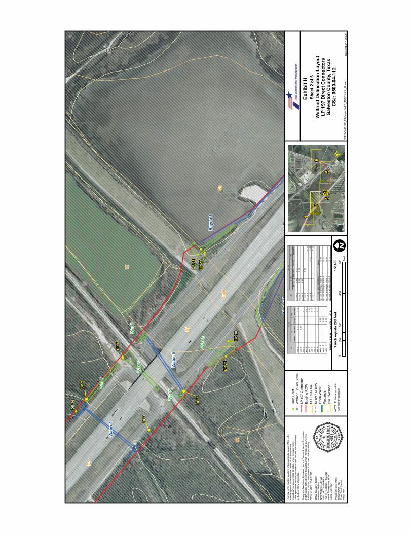
Wet 1
0.13
5.59
Wet 2
0.07
Wet 3
0.17
Wet 4
0.01
Wet 5
0.04
Wet 6
0.19
Wet 7
0.12
Wet 8
0.15
Water 1
0.16
Water 3
0.18
Water 5
0.12
Water
Wetland
Water
Wetland
Bayou 1
0.43
0.17
Bayou 2
0.62
0.59
Bayou 3
0.16
Ditch 2
0.02
Ditch 3
0.12
Ditch 4
0.02
0.28
Ditch 5
0.01
Acres
Upland Drainage Ditch 1
0.04
Upland Drainage Ditch 6
0.06
0.05
0.11
Upland Drainage Ditch 8
Upland Drainage Ditch 7
Non-Jurisdictional
ID
Acres
§ 10
§ 404
45
3
26
1
Wet
8
DP
2
DP
3
DP
4
DP
1
Fo
Na
Na
W
ImB
W
Bay
ou 1
Bay
ou2
Wet
6
Wet
7
Wat
er 1
Wat
er 5
Wet
5
Wet
5
DP
31
DP
30
DP
29
DP
26
DP
28
Exhi
bit H
Wet
land
Del
inea
tion
Layo
utLP
197
Dire
ct C
onne
ctor
sG
alve
ston
Cou
nty,
Tex
asC
SJ: 0
500-
04-1
12
N:\E
NV
\460
122_
09\P
roje
cts\
LP_1
97\E
xhib
it_H
.mxd
Sep
tem
ber 7
, 200
6
Shee
t 2 o
f 6
1:2,
400
1 in
ch e
qual
s 20
0 fe
et0
200
400
600
100
Feet
I her
eby
certi
fy th
at th
e lo
catio
ns o
f the
wet
land
s, w
ater
s of
the
U.S
.,an
d da
ta p
oint
s sh
own
here
are
bas
ed o
n an
act
ual o
n th
egr
ound
sur
vey,
exc
ept t
hose
as
note
d, u
nder
my
supe
rvis
ion,
have
a p
ositi
onal
acc
urac
y of
6 fe
et o
r les
s an
d ar
e tru
e an
d co
rrect
to th
e be
st o
f my
know
ledg
e.
Stam
p is
affi
xed
unde
r Rul
e 66
3.23
of t
he G
ener
al R
ules
of P
roce
dure
san
d Pr
actic
es d
efin
ed b
y th
e Te
xas
Boa
rd o
f Pro
fess
iona
l Sur
veyi
ngan
d do
es n
ot in
tend
to re
pres
ent a
sta
ndar
d or
resp
onsi
bilit
y.Ar
thur
M. S
tory
, RPL
S #4
034
RO
W B
ound
ary:
TxD
OT
Wet
land
s: P
BS&
JN
WI W
etla
nds:
USF
WS
Soils
: NR
CS
SSU
RG
O10
0 Yr
Flo
odpl
ain:
FEM
A Q
3Ae
rial P
hoto
grap
hy: H
GAC
Aeria
l Dat
e: 2
004
Proj
ectio
n: S
tate
Pla
neD
atum
: NAD
198
3Zo
ne: S
outh
Cen
tral
Uni
ts: F
eet
MH
W =
1.2
0 ft
M
HH
W =
1.4
0 ft
NO
TE: E
ntire
are
a w
ithin
100
Year
Flo
odpl
ain
Dat
a P
oint
Wet
land
Bou
nd S
take
SS
UR
GO
Soi
lEx
istin
g R
OW
LP 1
97 C
onne
ctor
MH
W /
MH
HW
Wet
land
sO
pen
Wat
er
NW
I Wet
land
Acres
§ 10
§ 404
ID
Water
Wetland
Water Wetland
Wet 1
0.13
5.59
Wet 2
0.07
Wet 3
0.17
Wet 4
0.01
Wet 5
0.04
Wet 6
0.19
Wet 7
0.12
Wet 8
0.15
Water 1
0.16
Water 3
0.18
Water 5
0.12
Water
Wetland
Water
Wetland
Bayou 1
0.43
0.17
Bayou 2
0.62
0.59
Bayou 3
0.16
Ditch 2
0.02
Ditch 3
0.12
Ditch 4
0.02
0.28
Ditch 5
0.01
Acres
Upland Drainage Ditch 1
0.04
Upland Drainage Ditch 6
0.06
0.05
0.11
Upland Drainage Ditch 8
Upland Drainage Ditch 7
Non-Jurisdictional
ID
Acres
§ 10
§ 404

45
3
26
1
INSE
T (S
HEE
T 4)
Na
MHW 1.20 MHHW 1.40
Wet
1
Bay
ou 2
DP
5
DP
11
DP
DP
08
DP
07
DP
06
DP
10
DP
09
Na
Fo
Na
Le
Fo
Bay
ou 2
Bay
ou 3
Bay
ou 1
Wet
2 Ditc
h 2
Bay
ou 2
Ditc
h 2
Wet
2PI
Wet
1
Exhi
bit H
Wet
land
Del
inea
tion
Layo
utLP
197
Dire
ct C
onne
ctor
sG
alve
ston
Cou
nty,
Tex
asC
SJ: 0
500-
04-1
12
N:\E
NV
\460
122_
09\P
roje
cts\
LP_1
97\E
xhib
it_H
.mxd
Sep
tem
ber 7
, 200
6
Shee
t 3 o
f 6
1:2,
400
1 in
ch e
qual
s 20
0 fe
et0
200
400
600
100
Feet
I her
eby
certi
fy th
at th
e lo
catio
ns o
f the
wet
land
s, w
ater
s of
the
U.S
.,an
d da
ta p
oint
s sh
own
here
are
bas
ed o
n an
act
ual o
n th
egr
ound
sur
vey,
exc
ept t
hose
as
note
d, u
nder
my
supe
rvis
ion,
have
a p
ositi
onal
acc
urac
y of
6 fe
et o
r les
s an
d ar
e tru
e an
d co
rrect
to th
e be
st o
f my
know
ledg
e.
Stam
p is
affi
xed
unde
r Rul
e 66
3.23
of t
he G
ener
al R
ules
of P
roce
dure
san
d Pr
actic
es d
efin
ed b
y th
e Te
xas
Boa
rd o
f Pro
fess
iona
l Sur
veyi
ngan
d do
es n
ot in
tend
to re
pres
ent a
sta
ndar
d or
resp
onsi
bilit
y.Ar
thur
M. S
tory
, RPL
S #4
034
RO
W B
ound
ary:
TxD
OT
Wet
land
s: P
BS&
JN
WI W
etla
nds:
USF
WS
Soils
: NR
CS
SSU
RG
O10
0 Yr
Flo
odpl
ain:
FEM
A Q
3Ae
rial P
hoto
grap
hy: H
GAC
Aeria
l Dat
e: 2
004
Proj
ectio
n: S
tate
Pla
neD
atum
: NAD
198
3Zo
ne: S
outh
Cen
tral
Uni
ts: F
eet
MH
W =
1.2
0 ft
M
HH
W =
1.4
0 ft
NO
TE: E
ntire
are
a w
ithin
100
Year
Flo
odpl
ain
Dat
a P
oint
Wet
land
Bou
nd S
take
SS
UR
GO
Soi
lEx
istin
g R
OW
LP 1
97 C
onne
ctor
MH
W /
MH
HW
Wet
land
sO
pen
Wat
er
NW
I Wet
land
Acres
§ 10
§ 404
ID
Water
Wetland
Water Wetland
Wet 1
0.13
5.59
Wet 2
0.07
Wet 3
0.17
Wet 4
0.01
Wet 5
0.04
Wet 6
0.19
Wet 7
0.12
Wet 8
0.15
Water 1
0.16
Water 3
0.18
Water 5
0.12
Water
Wetland
Water
Wetland
Bayou 1
0.43
0.17
Bayou 2
0.62
0.59
Bayou 3
0.16
Ditch 2
0.02
Ditch 3
0.12
Ditch 4
0.02
0.28
Ditch 5
0.01
Acres
Upland Drainage Ditch 1
0.04
Upland Drainage Ditch 6
0.06
0.05
0.11
Upland Drainage Ditch 8
Upland Drainage Ditch 7
Non-Jurisdictional
ID
Acres
§ 10
§ 404

MHW 1.20
MHHW 1.40
(1.4
2ft)
Wet
land
Bou
ndar
ySt
ake
Elev
atio
n
Existin
g I-45
ROW
Bay
ou 2
Bay
ou 1
Existin
g I-45
ROW
Loop
197
Con
nect
or
Loop
197
Con
nect
or
DP
06 (1
.06) D
P 07
(0.1
7)
DP
08 (1
.74)
Wet
1
Wet
1
Wet
2
Ditc
h 2
FoN
a
500
5010
025
Feet
Exhi
bit H
Wet
land
Del
inea
tion
Layo
utLP
197
Dire
ct C
onne
ctor
sG
alve
ston
Cou
nty,
Tex
asC
SJ: 0
500-
04-1
12
Sep
tem
ber 7
, 200
6
Shee
t 4 o
f 6 (I
NSE
T)
1:60
01
inch
equ
als
50 fe
et
I her
eby
certi
fy th
at th
e lo
catio
ns o
f the
wet
land
s, w
ater
s of
the
U.S
.,an
d da
ta p
oint
s sh
own
here
are
bas
ed o
n an
act
ual o
n th
egr
ound
sur
vey,
exc
ept t
hose
as
note
d, u
nder
my
supe
rvis
ion,
have
a p
ositi
onal
acc
urac
y of
6 fe
et o
r les
s an
d ar
e tru
e an
d co
rrect
to th
e be
st o
f my
know
ledg
e.
Stam
p is
affi
xed
unde
r Rul
e 66
3.23
of t
he G
ener
al R
ules
of P
roce
dure
san
d Pr
actic
es d
efin
ed b
y th
e Te
xas
Boa
rd o
f Pro
fess
iona
l Sur
veyi
ngan
d do
es n
ot in
tend
to re
pres
ent a
sta
ndar
d or
resp
onsi
bilit
y.Ar
thur
M. S
tory
, RPL
S #4
034
RO
W B
ound
ary:
TxD
OT
Wet
land
s: P
BS&
JN
WI W
etla
nds:
USF
WS
Soils
: NR
CS
SSU
RG
O10
0 Yr
Flo
odpl
ain:
FEM
A Q
3Ae
rial P
hoto
grap
hy: H
GAC
Aeria
l Dat
e: 2
004
Proj
ectio
n: S
tate
Pla
neD
atum
: NAD
198
3Zo
ne: S
outh
Cen
tral
Uni
ts: F
eet
NO
TE: E
ntire
are
a w
ithin
100
Year
Flo
odpl
ain
Dat
a P
oint
Wet
land
Bou
nd S
take
SS
UR
GO
Soi
lEx
istin
g R
OW
LP 1
97 C
onne
ctor
MH
W /
MH
HW
Wet
land
sO
pen
Wat
er
NW
I Wet
land
MH
W =
1.2
0 ft
M
HH
W =
1.4
0 ft
45
3
26
1
N:\E
NV
\460
122_
09\P
roje
cts\
LP_1
97\E
xhib
itH_I
nset
.mxd
Water
Wetland
Water
Wetland
Water
Wetland
Water
Wetland
Wet 1
0.13
5.59
Bayou 1
0.43
0.17
Wet 2
0.07
Bayou 2
0.62
0.59
Wet 3
0.17
Bayou 3
0.16
Wet 4
0.01
Ditch 2
0.02
Wet 5
0.04
Ditch 3
0.12
Wet 6
0.19
Ditch 4
0.02
0.28
Wet 7
0.12
Ditch 5
0.01
Wet 8
0.15
Wet 7
0.16
Acres
Water 3
0.18
Upland Drainage Ditch 1
0.04
Water 5
0.12
Upland Drainage Ditch 6
0.06
0.05
0.11
Upland Drainage Ditch 8
§ 10
§ 404
Acres
ID
Upland Drainage Ditch 7
Non-Jurisdictional
ID
Acres
§ 10
§ 404
45
3
26
1
Le
Na
Na
Na
Na
Na
Na
DP
14
DP
17
DP
20
DP
19
DP
18
DP
16
DP
13
DP
15
DP
11
DP
12
Le
Na
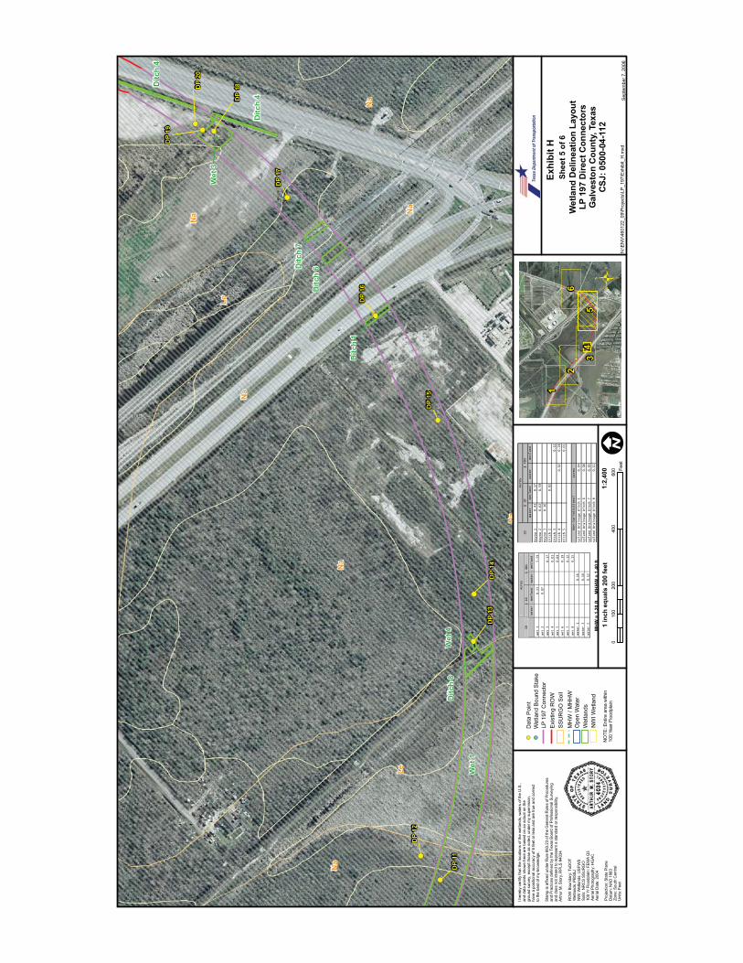
Wet
1
Wet
3
Ditc
h 6D
itch
7
Ditc
h 4
Ditc
h 4
Ditc
h 1
Wet
4D
itch
8
Exhi
bit H
Wet
land
Del
inea
tion
Layo
utLP
197
Dire
ct C
onne
ctor
sG
alve
ston
Cou
nty,
Tex
asC
SJ: 0
500-
04-1
12
N:\E
NV
\460
122_
09\P
roje
cts\
LP_1
97\E
xhib
it_H
.mxd
Sep
tem
ber 7
, 200
6
Shee
t 5 o
f 6
1:2,
400
1 in
ch e
qual
s 20
0 fe
et0
200
400
600
100
Feet
I her
eby
certi
fy th
at th
e lo
catio
ns o
f the
wet
land
s, w
ater
s of
the
U.S
.,an
d da
ta p
oint
s sh
own
here
are
bas
ed o
n an
act
ual o
n th
egr
ound
sur
vey,
exc
ept t
hose
as
note
d, u
nder
my
supe
rvis
ion,
have
a p
ositi
onal
acc
urac
y of
6 fe
et o
r les
s an
d ar
e tru
e an
d co
rrect
to th
e be
st o
f my
know
ledg
e.
Stam
p is
affi
xed
unde
r Rul
e 66
3.23
of t
he G
ener
al R
ules
of P
roce
dure
san
d Pr
actic
es d
efin
ed b
y th
e Te
xas
Boa
rd o
f Pro
fess
iona
l Sur
veyi
ngan
d do
es n
ot in
tend
to re
pres
ent a
sta
ndar
d or
resp
onsi
bilit
y.Ar
thur
M. S
tory
, RPL
S #4
034
RO
W B
ound
ary:
TxD
OT
Wet
land
s: P
BS&
JN
WI W
etla
nds:
USF
WS
Soils
: NR
CS
SSU
RG
O10
0 Yr
Flo
odpl
ain:
FEM
A Q
3Ae
rial P
hoto
grap
hy: H
GAC
Aeria
l Dat
e: 2
004
Proj
ectio
n: S
tate
Pla
neD
atum
: NAD
198
3Zo
ne: S
outh
Cen
tral
Uni
ts: F
eet
MH
W =
1.2
0 ft
M
HH
W =
1.4
0 ft
NO
TE: E
ntire
are
a w
ithin
100
Year
Flo
odpl
ain
Dat
a P
oint
Wet
land
Bou
nd S
take
SS
UR
GO
Soi
lEx
istin
g R
OW
LP 1
97 C
onne
ctor
MH
W /
MH
HW
Wet
land
sO
pen
Wat
er
NW
I Wet
land
Acres
§ 10
§ 404
ID
Water
Wetland
Water Wetland
Wet 1
0.13
5.59
Wet 2
0.07
Wet 3
0.17
Wet 4
0.01
Wet 5
0.04
Wet 6
0.19
Wet 7
0.12
Wet 8
0.15
Water 1
0.16
Water 3
0.18
Water 5
0.12
Water
Wetland
Water
Wetland
Bayou 1
0.43
0.17
Bayou 2
0.62
0.59
Bayou 3
0.16
Ditch 2
0.02
Ditch 3
0.12
Ditch 4
0.02
0.28
Ditch 5
0.01
Acres
Upland Drainage Ditch 1
0.04
Upland Drainage Ditch 6
0.06
0.05
0.11
Upland Drainage Ditch 8
Upland Drainage Ditch 7
Non-Jurisdictional
ID
Acres
§ 10
§ 404

45
3
26
1
Na
END
PR
OJE
CT
DP
21
DP
25
DP
22
DP
23
DP
24
WLe
Le
Na
Na
Na
Le
Wat
er 3
Ditc
h 4
Ditc
h 3
Ditc
h 4
Ditc
h 5
Ditc
h 3
Ditc
h 5
Exhi
bit H
Wet
land
Del
inea
tion
Layo
utLP
197
Dire
ct C
onne
ctor
sG
alve
ston
Cou
nty,
Tex
asC
SJ: 0
500-
04-1
12
N:\E
NV
\460
122_
09\P
roje
cts\
LP_1
97\E
xhib
it_H
.mxd
Sep
tem
ber 7
, 200
6
Shee
t 6 o
f 6
1:2,
400
1 in
ch e
qual
s 20
0 fe
et0
200
400
600
100
Feet
I her
eby
certi
fy th
at th
e lo
catio
ns o
f the
wet
land
s, w
ater
s of
the
U.S
.,an
d da
ta p
oint
s sh
own
here
are
bas
ed o
n an
act
ual o
n th
egr
ound
sur
vey,
exc
ept t
hose
as
note
d, u
nder
my
supe
rvis
ion,
have
a p
ositi
onal
acc
urac
y of
6 fe
et o
r les
s an
d ar
e tru
e an
d co
rrect
to th
e be
st o
f my
know
ledg
e.
Stam
p is
affi
xed
unde
r Rul
e 66
3.23
of t
he G
ener
al R
ules
of P
roce
dure
san
d Pr
actic
es d
efin
ed b
y th
e Te
xas
Boa
rd o
f Pro
fess
iona
l Sur
veyi
ngan
d do
es n
ot in
tend
to re
pres
ent a
sta
ndar
d or
resp
onsi
bilit
y.Ar
thur
M. S
tory
, RPL
S #4
034
RO
W B
ound
ary:
TxD
OT
Wet
land
s: P
BS&
JN
WI W
etla
nds:
USF
WS
Soils
: NR
CS
SSU
RG
O10
0 Yr
Flo
odpl
ain:
FEM
A Q
3Ae
rial P
hoto
grap
hy: H
GAC
Aeria
l Dat
e: 2
004
Proj
ectio
n: S
tate
Pla
neD
atum
: NAD
198
3Zo
ne: S
outh
Cen
tral
Uni
ts: F
eet
MH
W =
1.2
0 ft
M
HH
W =
1.4
0 ft
NO
TE: E
ntire
are
a w
ithin
100
Year
Flo
odpl
ain
Dat
a P
oint
Wet
land
Bou
nd S
take
SS
UR
GO
Soi
lEx
istin
g R
OW
LP 1
97 C
onne
ctor
MH
W /
MH
HW
Wet
land
sO
pen
Wat
er
NW
I Wet
land
Acres
§ 10
§ 404
ID
Water
Wetland
Water Wetland
Wet 1
0.13
5.59
Wet 2
0.07
Wet 3
0.17
Wet 4
0.01
Wet 5
0.04
Wet 6
0.19
Wet 7
0.12
Wet 8
0.15
Water 1
0.16
Water 3
0.18
Water 5
0.12
Water
Wetland
Water
Wetland
Bayou 1
0.43
0.17
Bayou 2
0.62
0.59
Bayou 3
0.16
Ditch 2
0.02
Ditch 3
0.12
Ditch 4
0.02
0.28
Ditch 5
0.01
Acres
Upland Drainage Ditch 1
0.04
Upland Drainage Ditch 6
0.06
0.05
0.11
Upland Drainage Ditch 8
Upland Drainage Ditch 7
Non-Jurisdictional
ID
Acres
§ 10
§ 404
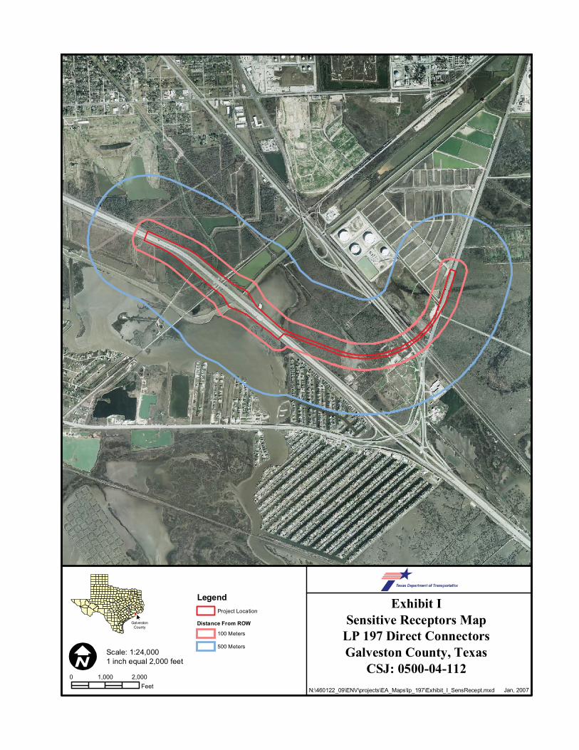
Exhibit ISensitive Receptors Map
LP 197 Direct ConnectorsGalveston County, Texas
CSJ: 0500-04-112Jan, 2007
GalvestonCounty
N:\460122_09\ENV\projects\EA_Maps\lp_197\Exhibit_I_SensRecept.mxd
LegendProject Location
Distance From ROW
100 Meters
500 Meters
0 2,0001,000Feet
Scale: 1:24,0001 inch equal 2,000 feet

1
Exhibit JNoise Receiver Location Map
LP 197 Direct ConnectorsGalveston County, Texas
CSJ: 0500-04-112
March 2007
GalvestonCounty
N:\ENV\460122_09\projects\LP_197\Exhibit_I_Noise Receiver.mxd
0 2,0001,000Feet
Scale: 1:12,0001 inch equal 1,000 feet
1
LP 197 ROW
Related Documents