JR EI 17-053 Project for Master Plan on Logistics in Northern Economic Corridor Final Report Annex - Data Book - Volume 3 March 2017 Japan International Cooperation Agency (JICA) Nippon Koei Co., Ltd. Eight-Japan Engineering Consultants Inc. PADECO Co., Ltd. The Republic of Kenya Ministry of Transport, Infrastructure, Housing and Urban Development The Republic of Uganda Ministry of Works and Transport

Welcome message from author
This document is posted to help you gain knowledge. Please leave a comment to let me know what you think about it! Share it to your friends and learn new things together.
Transcript

JREI
17-053
Project for Master Plan on Logisticsin Northern Economic Corridor
Final ReportAnnex - Data Book -
Volume 3
March 2017
Japan International Cooperation Agency (JICA)
Nippon Koei Co., Ltd.Eight-Japan Engineering Consultants Inc.
PADECO Co., Ltd.
The Republic of KenyaMinistry of Transport, Infrastructure, Housing and Urban DevelopmentThe Republic of UgandaMinistry of Works and Transport


Project for Master Plan on Logistics in Northern Economic Corridor
Annex - Databook - Volume 3
i
Table of Contents
Data 6: Strategic Environmental Assessment (Uganda)
Data 7: List of Data Source in the Master Plan


Data 6:
Strategic
Environmental
Assessment
(Uganda)

The business of sustainability
Final Strategic Environmental Assessment (SEA) for the Formulation of a Master Plan on Logistics in the Northern Economic Corridor, Uganda SEA Report February 2017 www.erm.com
SEA Report
Final Strategic Environmental Assessment (SEA) for the Formulation of a Master Plan on Logistics in the Northern Economic Corridor, Uganda
February 2017
www.erm.com
Prepared by:
For and on behalf of
Environmental Resources Management Approved by: Mike Everett
Signed: Position: Partner Date: February 2017
This reportl is provided solely for the purposes set out in it and may not, in whole or in part, be used for any other purpose without ERM's prior written consent. This proposal may not, in whole or in part, be reproduced without ERM's prior written consent..
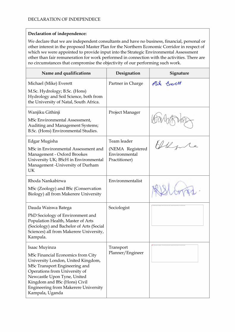
DECLARATION OF INDEPENDECE
Declaration of independence:
We declare that we are independent consultants and have no business, financial, personal or other interest in the proposed Master Plan for the Northern Economic Corridor in respect of which we were appointed to provide input into the Strategic Environmental Assessment other than fair remuneration for work performed in connection with the activities. There are no circumstances that compromise the objectivity of our performing such work.
Name and qualifications Designation Signature
Michael (Mike) Everett
M.Sc. Hydrology; B.Sc. (Hons) Hydrology and Soil Science, both from the University of Natal, South Africa.
Partner in Charge
Wanjiku Githinji
MSc Environmental Assessment, Auditing and Management Systems; B.Sc. (Hons) Environmental Studies.
Project Manager
Edgar Mugisha
MSc in Environmental Assessment and Management - Oxford Brookes University UK; BScH in Environmental Management -University of Durham UK
Team leader
(NEMA Registered Environmental Practitioner)
Rhoda Nankabirwa
MSc (Zoology) and BSc (Conservation Biology) all from Makerere University
Environmentalist
Dauda Waiswa Batega
PhD Sociology of Environment and Population Health, Master of Arts (Sociology) and Bachelor of Arts (Social Sciences) all from Makerere University, Kampala.
Sociologist
Isaac Muyinza
MSc Financial Economics from City University London, United Kingdom, MSc Transport Engineering and Operations from University of Newcastle Upon Tyne, United Kingdom and BSc (Hons) Civil Engineering from Makerere University Kampala, Uganda
Transport Planner/Engineer

Declaration of independence:
We declare that we are independent consultants and have no business, financial, personal or other interest in the proposed Master Plan for the Northern Economic Corridor in respect of which we were appointed to provide input into the Strategic Environmental Assessment other than fair remuneration for work performed in connection with the activities. There are no circumstances that compromise the objectivity of our performing such work.
Name and qualifications Designation Signature
Charles Amooti Koojo
PhD Physical Planning/ Land Use and Environmental Planning-Makerere University, Uganda, MSc, Physical/Environmental Planning, Makerere University, Kampala, Uganda, MSc, Geography, Lvov University, Ukraine
Physical Planner
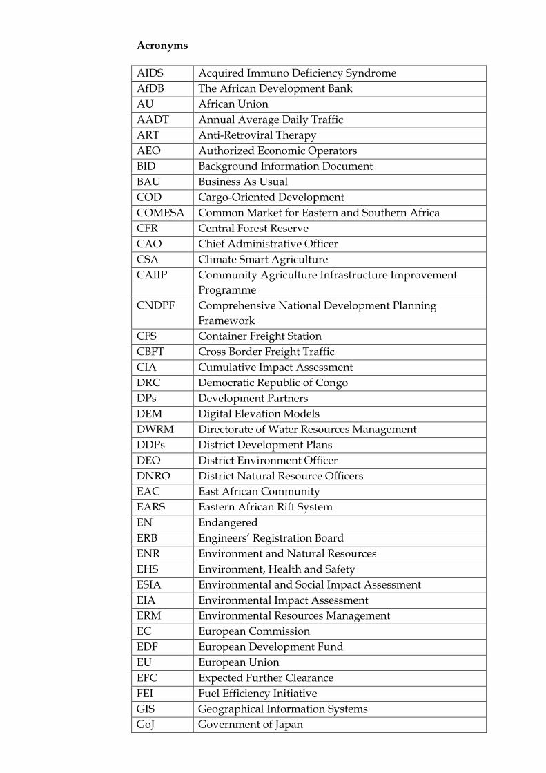
Acronyms
AIDS Acquired Immuno Deficiency Syndrome
AfDB The African Development Bank
AU African Union
AADT Annual Average Daily Traffic
ART Anti-Retroviral Therapy
AEO Authorized Economic Operators
BID Background Information Document
BAU Business As Usual
COD Cargo-Oriented Development
COMESA Common Market for Eastern and Southern Africa
CFR Central Forest Reserve
CAO Chief Administrative Officer
CSA Climate Smart Agriculture
CAIIP Community Agriculture Infrastructure Improvement
Programme
CNDPF Comprehensive National Development Planning
Framework
CFS Container Freight Station
CBFT Cross Border Freight Traffic
CIA Cumulative Impact Assessment
DRC Democratic Republic of Congo
DPs Development Partners
DEM Digital Elevation Models
DWRM Directorate of Water Resources Management
DDPs District Development Plans
DEO District Environment Officer
DNRO District Natural Resource Officers
EAC East African Community
EARS Eastern African Rift System
EN Endangered
ERB Engineers’ Registration Board
ENR Environment and Natural Resources
EHS Environment, Health and Safety
ESIA Environmental and Social Impact Assessment
EIA Environmental Impact Assessment
ERM Environmental Resources Management
EC European Commission
EDF European Development Fund
EU European Union
EFC Expected Further Clearance
FEI Fuel Efficiency Initiative
GIS Geographical Information Systems
GoJ Government of Japan
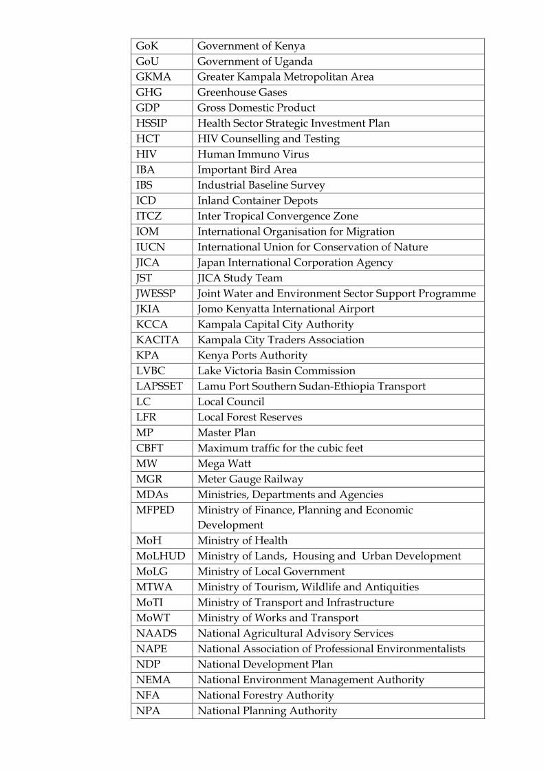
GoK Government of Kenya
GoU Government of Uganda
GKMA Greater Kampala Metropolitan Area
GHG Greenhouse Gases
GDP Gross Domestic Product
HSSIP Health Sector Strategic Investment Plan
HCT HIV Counselling and Testing
HIV Human Immuno Virus
IBA Important Bird Area
IBS Industrial Baseline Survey
ICD Inland Container Depots
ITCZ Inter Tropical Convergence Zone
IOM International Organisation for Migration
IUCN International Union for Conservation of Nature
JICA Japan International Corporation Agency
JST JICA Study Team
JWESSP Joint Water and Environment Sector Support Programme
JKIA Jomo Kenyatta International Airport
KCCA Kampala Capital City Authority
KACITA Kampala City Traders Association
KPA Kenya Ports Authority
LVBC Lake Victoria Basin Commission
LAPSSET Lamu Port Southern Sudan-Ethiopia Transport
LC Local Council
LFR Local Forest Reserves
MP Master Plan
CBFT Maximum traffic for the cubic feet
MW Mega Watt
MGR Meter Gauge Railway
MDAs Ministries, Departments and Agencies
MFPED Ministry of Finance, Planning and Economic
Development
MoH Ministry of Health
MoLHUD Ministry of Lands, Housing and Urban Development
MoLG Ministry of Local Government
MTWA Ministry of Tourism, Wildlife and Antiquities
MoTI Ministry of Transport and Infrastructure
MoWT Ministry of Works and Transport
NAADS National Agricultural Advisory Services
NAPE National Association of Professional Environmentalists
NDP National Development Plan
NEMA National Environment Management Authority
NFA National Forestry Authority
NPA National Planning Authority
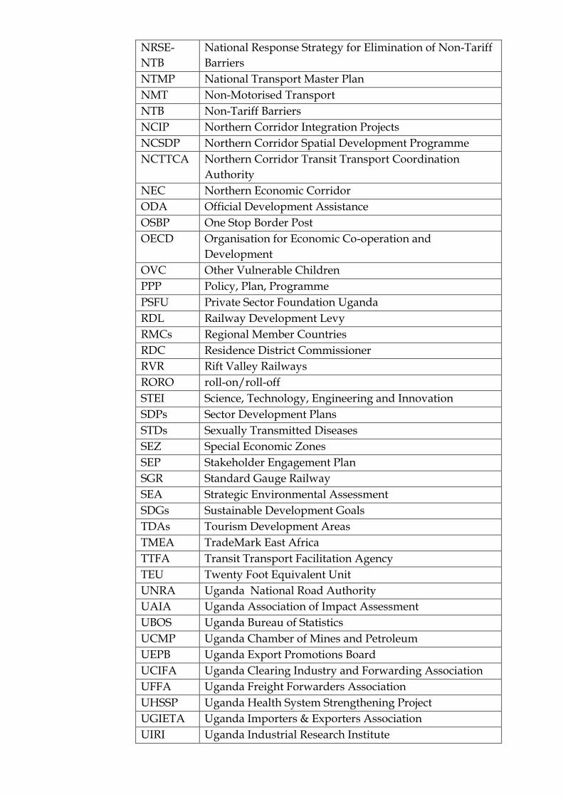
NRSE-
NTB
National Response Strategy for Elimination of Non-Tariff
Barriers
NTMP National Transport Master Plan
NMT Non-Motorised Transport
NTB Non-Tariff Barriers
NCIP Northern Corridor Integration Projects
NCSDP Northern Corridor Spatial Development Programme
NCTTCA Northern Corridor Transit Transport Coordination
Authority
NEC Northern Economic Corridor
ODA Official Development Assistance
OSBP One Stop Border Post
OECD Organisation for Economic Co-operation and
Development
OVC Other Vulnerable Children
PPP Policy, Plan, Programme
PSFU Private Sector Foundation Uganda
RDL Railway Development Levy
RMCs Regional Member Countries
RDC Residence District Commissioner
RVR Rift Valley Railways
RORO roll-on/roll-off
STEI Science, Technology, Engineering and Innovation
SDPs Sector Development Plans
STDs Sexually Transmitted Diseases
SEZ Special Economic Zones
SEP Stakeholder Engagement Plan
SGR Standard Gauge Railway
SEA Strategic Environmental Assessment
SDGs Sustainable Development Goals
TDAs Tourism Development Areas
TMEA TradeMark East Africa
TTFA Transit Transport Facilitation Agency
TEU Twenty Foot Equivalent Unit
UNRA Uganda National Road Authority
UAIA Uganda Association of Impact Assessment
UBOS Uganda Bureau of Statistics
UCMP Uganda Chamber of Mines and Petroleum
UEPB Uganda Export Promotions Board
UCIFA Uganda Clearing Industry and Forwarding Association
UFFA Uganda Freight Forwarders Association
UHSSP Uganda Health System Strengthening Project
UGIETA Uganda Importers & Exporters Association
UIRI Uganda Industrial Research Institute
UMA Uganda Manufacturers Association
UNCCI Uganda National Chamber of Commerce and Industry
UNMA Uganda National Meteorology Authority
URC Uganda Railways Corporation
URF Uganda Road Fund
URSSI Uganda Road Sector Support Initiative
USSIA Uganda Small Scale Industries Association
USMID Uganda support to Municipal Infrastructure
Development
UWA Uganda Wildlife Authority
UN United Nations
USEPA United States Environmental Protection Agency
UPE Universal Primary Education
VECs Valued Ecosystem Components
VHT Village Health Team
VU Vulnerable
Wfp Water for Production
YLP Youth Livelihood Programme
NDC Nationally Determined Contributions
WHO World Health Organisation
PM Particulate Matter
Abbreviations
m3 Cubic metres
μg Micro grams
NO2 Nitrogen dioxide
O3 Ozone
SO2 Sulphur dioxide
ERM/ATACAMA CONSULTING JST/MOWT
I
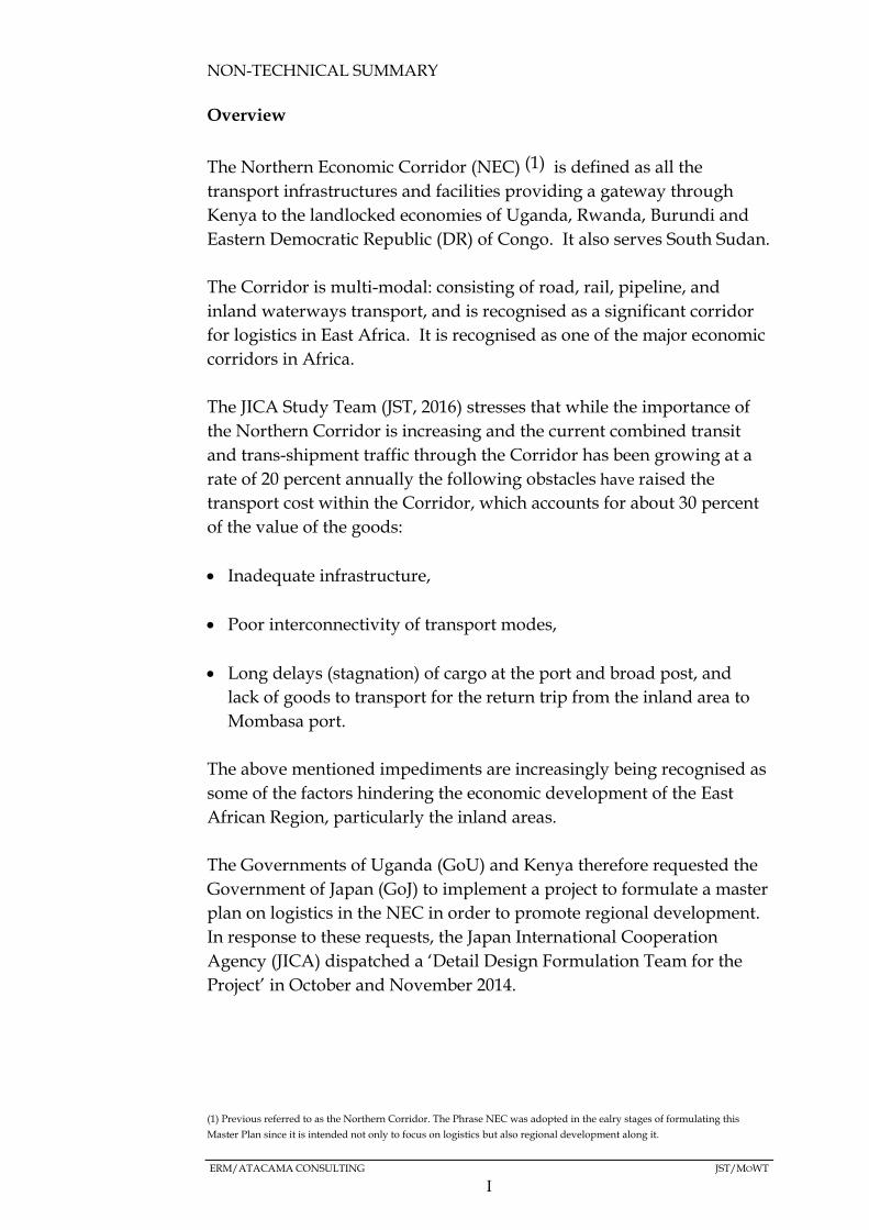
NON-TECHNICAL SUMMARY
Overview
The Northern Economic Corridor (NEC) (1) is defined as all the
transport infrastructures and facilities providing a gateway through
Kenya to the landlocked economies of Uganda, Rwanda, Burundi and
Eastern Democratic Republic (DR) of Congo. It also serves South Sudan.
The Corridor is multi-modal: consisting of road, rail, pipeline, and
inland waterways transport, and is recognised as a significant corridor
for logistics in East Africa. It is recognised as one of the major economic
corridors in Africa.
The JICA Study Team (JST, 2016) stresses that while the importance of
the Northern Corridor is increasing and the current combined transit
and trans-shipment traffic through the Corridor has been growing at a
rate of 20 percent annually the following obstacles have raised the
transport cost within the Corridor, which accounts for about 30 percent
of the value of the goods:
Inadequate infrastructure,
Poor interconnectivity of transport modes,
Long delays (stagnation) of cargo at the port and broad post, and
lack of goods to transport for the return trip from the inland area to
Mombasa port.
The above mentioned impediments are increasingly being recognised as
some of the factors hindering the economic development of the East
African Region, particularly the inland areas.
The Governments of Uganda (GoU) and Kenya therefore requested the
Government of Japan (GoJ) to implement a project to formulate a master
plan on logistics in the NEC in order to promote regional development.
In response to these requests, the Japan International Cooperation
Agency (JICA) dispatched a ‘Detail Design Formulation Team for the
Project’ in October and November 2014.
(1) Previous referred to as the Northern Corridor. The Phrase NEC was adopted in the ealry stages of formulating this
Master Plan since it is intended not only to focus on logistics but also regional development along it.

ERM/ATACAMA CONSULTING JST/MOWT
II
The Team proposed to develop a concept that would cover not only
logistics, but also regional development along the NEC. The
Governments of Kenya and Uganda agreed with the concept and signed
the Record of Discussion with JICA for the implementation of the Project
for Formulation of the Master Plan on Logistics in the Northern Economic
Corridor (the Master Plan).
In order to ensure that potential environmental and social challenges
attributed to the NEC Master Plan are addressed holistically and in a
proactive manner, it was decided that the Master Plan be subjected to a
Strategic Environmental Assessment (SEA), ie, “an assessment that is
implemented at the policy, planning, and program levels, but not a
project-level EIA (JICA, 2010),” in line with JICA’s Guidelines for
Environmental amd Social Considerations (2010) , as well as the
prevailing in-country environmental legal and regulatory framework.
The SEA process in Uganda was undertaken by Environmental
Resources Management (ERM) and Atacama Consulting, the latter being
a Uganda Environmental Consultancy firm.
Aim and Objectives
The overall aim of the SEA is to ensure that environmental and social
considerations are well integrated into the NEC Master Plan. The key
objectives of the SEA are to:
Describe, identify and assess the potential significant effects on the
environment of implementing the Master Plan;
Furnish decision makers of both Governments (GoU and GoJ) with
the relevant information required to make informed choices about the
sustainability of the Master Plan, and
Provide robust recommendations on mitigation and management
measures that are to be factored into the Master Plan, with negative
impacts being minimised and positive ones enhanced.
Master Plan Proponent
In Uganda, the Master Plan Proponent is the Ministry of Works and
Transport (MoWT) which has a mandate to plan, develop and maintain
economic, efficient and effective transport infrastructure and transport
services by road, rail, water, and air.

ERM/ATACAMA CONSULTING JST/MOWT
III
MoWT is also mandated with managing public works including
Government Structures and promoting standards in the construction
industry. MoWT also aims to promote adequate, safe and well
maintained public works and transport infrastructure and services, so as
to effectively contribute to the socio-economic development of the
country.
Brief Description of the NEC Master Plan
The proposed NEC Master Plan is anchored on the vision: “To be the
Leading Economic Corridor with Integrated Transport and Logistics
Systems in Africa”.
A number of alternatives and development strategies have been
identified by JST to enable the realisation of the development, with the
principal development strategies being regional, industrial and
transport strategies, which will be supported by organisation/policy
and financial strategies.
The overall objective of the Master Plan is to improve logistics for the
NEC as well as provide an integrated regional development strategy
consistent with sub-regional development plans and national
development plans (JST, 2016). It is hoped that this will spur regional
economic development within Uganda and the Region.
A number of development alternatives and associated strategies have
been identified for meeting the main objective of and realising the vision
of the Master Plan. The three main alternatives which also include the
“Do minimum” or “Business As Usual (BAU)” alternative are as
indicated below.

ERM/ATACAMA CONSULTING JST/MOWT
IV
Figure 1.1 Main Alternatives
Source: JST, 2016
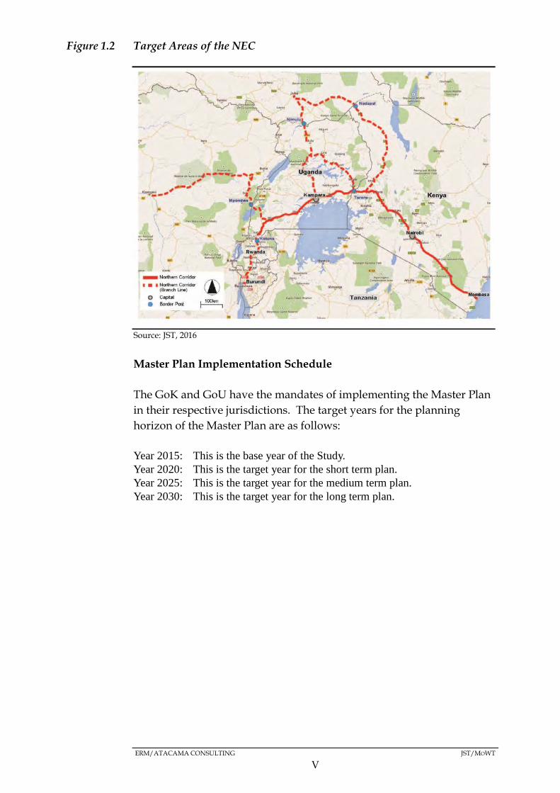
Target Area of the NEC
The Master Plan will target the following routes (Figure 1.2) which make
up the NEC and its surrounding areas, inclusive of a 50km radius on
either side of the routes.
ERM/ATACAMA CONSULTING JST/MOWT
V
Figure 1.2 Target Areas of the NEC
Source: JST, 2016
Master Plan Implementation Schedule
The GoK and GoU have the mandates of implementing the Master Plan
in their respective jurisdictions. The target years for the planning
horizon of the Master Plan are as follows:
Year 2015: This is the base year of the Study.
Year 2020: This is the target year for the short term plan.
Year 2025: This is the target year for the medium term plan.
Year 2030: This is the target year for the long term plan.
ERM/ATACAMA CONSULTING JST/MOWT
VI
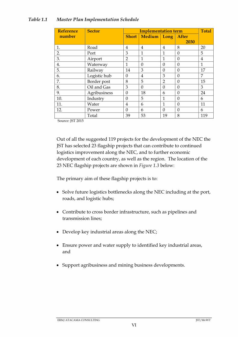
Table 1.1 Master Plan Implementation Schedule
Reference number
Sector Implementation term Total
Short Medium Long After 2030
1. Road 4 4 4 8 20
2. Port 3 1 1 0 5
3. Airport 2 1 1 0 4
4. Waterway 1 0 0 0 1
5. Railway 14 3 0 0 17
6. Logistic hub 0 4 3 0 7
7. Border post 8 5 2 0 15
8. Oil and Gas 3 0 0 0 3
9. Agribusiness 0 18 6 0 24
10. Industry 0 5 1 0 6
11. Water 4 6 1 0 11
12. Power 0 6 0 0 6
Total 39 53 19 8 119 Source: JST 2015
Out of all the suggested 119 projects for the development of the NEC the
JST has selected 23 flagship projects that can contribute to continued
logistics improvement along the NEC, and to further economic
development of each country, as well as the region. The location of the
23 NEC flagship projects are shown in Figure 1.3 below:
The primary aim of these flagship projects is to:
Solve future logistics bottlenecks along the NEC including at the port,
roads, and logistic hubs;
Contribute to cross border infrastructure, such as pipelines and
transmission lines;
Develop key industrial areas along the NEC;
Ensure power and water supply to identified key industrial areas,
and
Support agribusiness and mining business developments.

ERM/ATACAMA CONSULTING JST/MOWT
VII
Figure 1.3 Location of NEC Flagship Projects
Source: JST, 2016
ERM/ATACAMA CONSULTING JST/MOWT
VIII
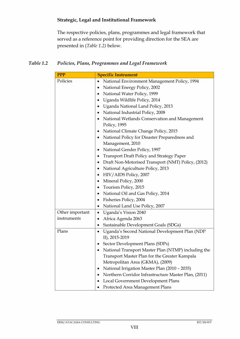
Strategic, Legal and Institutional Framework
The respective policies, plans, programmes and legal framework that
served as a reference point for providing direction for the SEA are
presented in (Table 1.2) below.
Table 1.2 Policies, Plans, Programmes and Legal Framework
PPP Specific Instrument
Policies National Environment Management Policy, 1994
National Energy Policy, 2002
National Water Policy, 1999
Uganda Wildlife Policy, 2014
Uganda National Land Policy, 2013
National Industrial Policy, 2008
National Wetlands Conservation and Management
Policy, 1995
National Climate Change Policy, 2015
National Policy for Disaster Preparedness and
Management, 2010
National Gender Policy, 1997
Transport Draft Policy and Strategy Paper
Draft Non-Motorised Transport (NMT) Policy, (2012)
National Agriculture Policy, 2013
HIV/AIDS Policy, 2007
Mineral Policy, 2000
Tourism Policy, 2015
National Oil and Gas Policy, 2014
Fisheries Policy, 2004
National Land Use Policy, 2007
Other important
instruments
Uganda’s Vision 2040
Africa Agenda 2063
Sustainable Development Goals (SDGs)
Plans Uganda’s Second National Development Plan (NDP
II), 2015-2019
Sector Development Plans (SDPs)
National Transport Master Plan (NTMP) including the
Transport Master Plan for the Greater Kampala
Metropolitan Area (GKMA), (2009)
National Irrigation Master Plan (2010 – 2035)
Northern Corridor Infrastructure Master Plan, (2011)
Local Government Development Plans
Protected Area Management Plans
ERM/ATACAMA CONSULTING JST/MOWT
IX
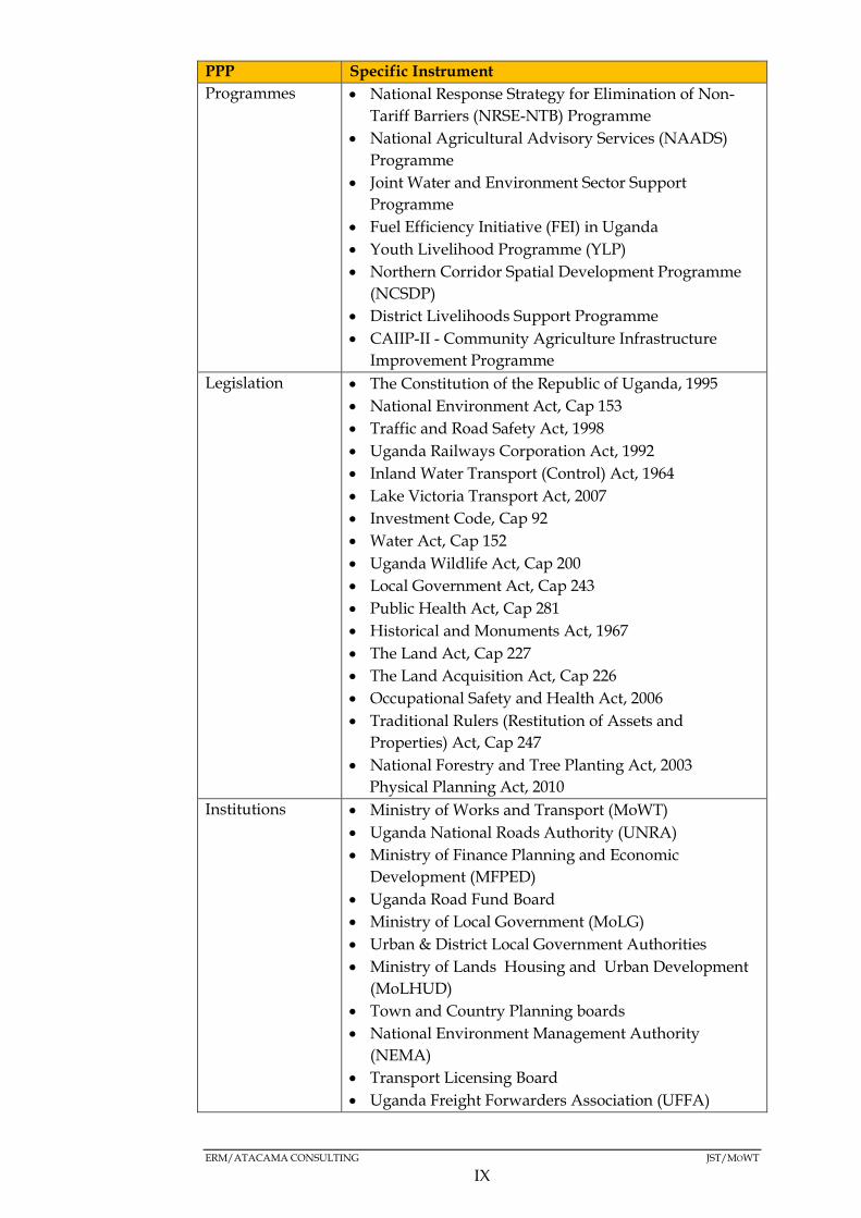
PPP Specific Instrument
Programmes National Response Strategy for Elimination of Non-
Tariff Barriers (NRSE-NTB) Programme
National Agricultural Advisory Services (NAADS)
Programme
Joint Water and Environment Sector Support
Programme
Fuel Efficiency Initiative (FEI) in Uganda
Youth Livelihood Programme (YLP)
Northern Corridor Spatial Development Programme
(NCSDP)
District Livelihoods Support Programme
CAIIP-II - Community Agriculture Infrastructure
Improvement Programme
Legislation The Constitution of the Republic of Uganda, 1995
National Environment Act, Cap 153
Traffic and Road Safety Act, 1998
Uganda Railways Corporation Act, 1992
Inland Water Transport (Control) Act, 1964
Lake Victoria Transport Act, 2007
Investment Code, Cap 92
Water Act, Cap 152
Uganda Wildlife Act, Cap 200
Local Government Act, Cap 243
Public Health Act, Cap 281
Historical and Monuments Act, 1967
The Land Act, Cap 227
The Land Acquisition Act, Cap 226
Occupational Safety and Health Act, 2006
Traditional Rulers (Restitution of Assets and
Properties) Act, Cap 247
National Forestry and Tree Planting Act, 2003
Physical Planning Act, 2010
Institutions Ministry of Works and Transport (MoWT)
Uganda National Roads Authority (UNRA)
Ministry of Finance Planning and Economic
Development (MFPED)
Uganda Road Fund Board
Ministry of Local Government (MoLG)
Urban & District Local Government Authorities
Ministry of Lands Housing and Urban Development
(MoLHUD)
Town and Country Planning boards
National Environment Management Authority
(NEMA)
Transport Licensing Board
Uganda Freight Forwarders Association (UFFA)

ERM/ATACAMA CONSULTING JST/MOWT
X
PPP Specific Instrument
National Planning Authority (NPA)
Uganda Railways Corporation (URC)
Uganda Revenue Authority
Uganda National Meteorology Authority
Lake Victoria Basin Commission
Uganda Chamber of Mines and Petroleum (UCMP)
ERM/ATACAMA CONSULTING JST/MOWT
XI
Methodology and Approach
Methodology
Screening
The SEA process for the Master Plan for the NEC was initiated in 2014
by screening the need and possible objectives for conducting an SEA.
Through the screening process, a platform (organisation of the SEA
process) for the SEA was established.
Scoping
An important objective of scoping was to identify key environmental
and social issues as a basis for the SEA process as well as developing
the Terms of Reference (ToR) for the SEA based on the vision of the
Master Plan and input from the relevant stakeholders.
Detailed SEA Study
This phase entailed collecting and analysing baseline data. A number of
methods were used and these included:
Literature Surveys;
Opinion/Questionnaire Surveys;
Geographical Information Systems, and;
Constraints Mapping.
Stakeholder Engagement
A regional consultative approach was favoured because of the spatial
extent of the NEC Master Plan. Workshops were held in three strategic
regions, namely Kampala, Mbarara and Tororo Districts. Stakeholder
engagement was undertaken at the scoping and detailed assessment
stages. The SEA consultations methodology and approach were
consistent with the Uganda ESIA Legislative Framework as well as the
JICA Guidelines for Environmental and Social Considerations, 2010.
Stakeholder consultations were held to gather baseline data and
identify impacts.

ERM/ATACAMA CONSULTING JST/MOWT
XII
Expert Judgment
This was used as a way of drawing meaningful conclusions following
the internalisation of the data and information collected using the
various assessment methods listed above.
Transport Modelling and Forecasting
The data collected during the JST 2015 Traffic Survey clearly identified
the amount of Cross Border Freight Traffic (CBFT) – which data
included; the origins and destinations of the traffic, the weight and type
of cargo carried, in addition to other key information.
Matrices
These were used to examine the significance of the impacts likely to
arise from the implementation of the Master Plan. This was conducted
by evaluating the relationship between the magnitude of the impacts
and the sensitivity of the environmental and social receptors.
Approach
Although there are a number of approaches for conducting SEA, an
EIA-based approach was adopted for this assessment (1) . Equally of
importance was the model that was chosen for linking the SEA process
with the NEC Logistics Master Plan formulation process. A parallel
model which entailed the SEA process being conducted in parallel with
the Master Plan formulation process was chosen.
Potential Impact Identification
The significance of impacts was formulated as a function of the
environmental or social receptor (sensitivity) and the magnitude of the
impact (change) as indicated below.
(1) EIA and SEA have many similarities and a common environmental foundation, although SEA has been largely
developed as a response to the levels and types of decision-making that are not covered by EIA. In doing so, SEA has
derived, adapted and implemented EIA arrangements, procedure and methodology, particularly at the plan and
programme level (http://www.unep.ch/etu/publications/textONUBr.pdf).

ERM/ATACAMA CONSULTING JST/MOWT
XIII
Table 1.3 Receptor Sensitivity
Sensitivity Description
Very High Very high importance and rarity, international scale and
very limited potential for substitution
High High importance and rarity, national scale, and limited
potential for substitution
Medium High or medium importance and rarity, regional scale,
limited potential for substitution.
Low Medium or low importance and rarity and local scale.
Negligible Very low importance and rarity, local scale.
Table 1.4 Magnitude of Impacts
Magnitude Description
Major Loss of resource and/or quality and integrity of resource;
severe damage to key characteristics and/or features
(Adverse).
Large scale or major improvement of resource quality;
extensive restoration or enhancement; major improvement of
attribute quality (Beneficial).
Moderate Loss of resource, but not adversely affecting the integrity;
partial loss of/damage of key characteristics and/or features
(Adverse).
Benefit to, or addition of key characteristics, features or
elements; improvement of attributes quality (Beneficial)
Minor Some measurable change in attributes, quality or
vulnerability; minor loss or alteration to, one (may be more)
key characteristics, features or elements (Adverse).
Minor benefits to, or addition of one (maybe more) key
characteristics, features or elements; some beneficial impact
on attribute or a reduced risk of negative impact occurring
(Beneficial).
Negligible Very minor loss or detrimental alteration to one or more
characteristics, features or elements (Adverse).
Very minor benefit to or positive addition of one or more
characteristics, features or elements (Beneficial).
No change No loss or alteration of characteristics, features or elements;
no observable impact in either direction.
The impact significance was determined by evaluating the magnitude
of the impact and the sensitivity of the environmental and social
receptors. The five significance categories gave rise to eight potential
outcomes.
ERM/ATACAMA CONSULTING JST/MOWT
XIV
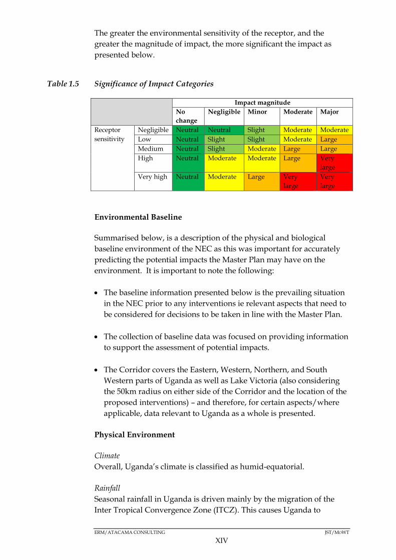
The greater the environmental sensitivity of the receptor, and the
greater the magnitude of impact, the more significant the impact as
presented below.
Table 1.5 Significance of Impact Categories
Impact magnitude
No
change
Negligible Minor Moderate Major
Receptor
sensitivity
Negligible Neutral Neutral Slight Moderate Moderate
Low Neutral Slight Slight Moderate Large
Medium Neutral Slight Moderate Large Large
High Neutral Moderate Moderate Large Very
large
Very high Neutral Moderate Large Very
large
Very
large
Environmental Baseline
Summarised below, is a description of the physical and biological
baseline environment of the NEC as this was important for accurately
predicting the potential impacts the Master Plan may have on the
environment. It is important to note the following:
The baseline information presented below is the prevailing situation
in the NEC prior to any interventions ie relevant aspects that need to
be considered for decisions to be taken in line with the Master Plan.
The collection of baseline data was focused on providing information
to support the assessment of potential impacts.
The Corridor covers the Eastern, Western, Northern, and South
Western parts of Uganda as well as Lake Victoria (also considering
the 50km radius on either side of the Corridor and the location of the
proposed interventions) – and therefore, for certain aspects/where
applicable, data relevant to Uganda as a whole is presented.
Physical Environment
Climate
Overall, Uganda’s climate is classified as humid-equatorial.
Rainfall
Seasonal rainfall in Uganda is driven mainly by the migration of the
Inter Tropical Convergence Zone (ITCZ). This causes Uganda to

ERM/ATACAMA CONSULTING JST/MOWT
XV
experience two distinct rainfall seasons – the ‘short’ rains in August to
December, and the ‘long’ rains in March to May. These gradually merge
into one long rainy season the further north one moves from the
equator.
Uganda’s rainfall varies from as little as 400mm per annum in the more
arid zones (north eastern parts of Uganda traversed by the Tororo –
Gulu route) to over 2000mm per annum in the Lake Victoria region.
Extreme rainfall events are among the issues that are predicted to
become more pronounced as a result climate change.
Temperature
Temperatures in Uganda vary little throughout the year, with average
temperatures increasing in the north of the country as the elevation
decreases towards the Sudanese plain.
The country's temperature ranges between 16oC and 34oC, but the
situation countrywide indicates great disparities.
Mean annual temperatures range from about 16°C in the south-western
highlands to 25°C in the north-west and in the north-east, the climate
becomes more arid with temperatures exceeding 30°C for 254 days of
the year.
Air Quality
A pilot cross – sectional spatial assessment of the state of ambient air
quality conducted between 30 June and 17 July, 2014 (dry season) in
two Ugandan urban centres (Kampala and Jinja, both within the NEC)
demonstrated presence of high Particulate Matter (PM) concentrations
(PM2.5 concentrations - 5.3 fold above the limit defined by World Health
Organisation (WHO)) and low gas phase air pollutant levels (NO2, SO2
and O3). Particulate air pollution levels were greatest in areas with high
commercial/industrial land use and unpaved roads.
Transport related emissions within the NEC tend to be high largely as a
result of the large stock of used vehicles imported into the country. The
fuel efficiency of such vehicles tends to be poor leading to the high
emission of Greenhouse gases that affect air quality.
Hydrology
The NEC traverses the Lake Victoria Basin, Lake Edward Basin, Lake
Kyoga Basin, Victoria Nile Basin and the Albert Nile Basin.
ERM/ATACAMA CONSULTING JST/MOWT
XVI
Due to the interconnected nature of the surface water resources of
Uganda, the Corridor traverses some of the country’s major wetlands
in the Lake Kyoga Basin (Tororo - Gulu route) and Lake Victoria
Basin (Kampala - Mbarara route). Also important to consider is the
River Nile crossing along the Tororo - Kampala route as well as the
Kazinga Channel crossing along the Mbarara - Mpondwe route.
The road infrastructure along the NEC traverses some of Uganda’s
permanent wetlands including but not limited to; Kibimba Wetland
in Bugiri District along the main Tororo – Kampala – Katuna route,
Lake Mburo wetland along the Kampala – Mbarara route as well as
along the Lake Kyoga wetland along the Tororo - Gulu – Elegu route.
Water Quality
Available water quality data for point sources, non-point sources,
rivers and streams, and for lakes, has some extreme values indicating
the surface waters are threatened by pollution.
The major sources of pollution include sewerage and municipal or
urban effluents, industrial effluents, domestic effluents, agricultural
run-off and changing land use leading to soil erosion, natural
conditions, floating aquatic macrophites, as well as atmospheric
deposition of pollutants.
Flooding
Of the 39 districts traversed by the NEC, 23 are prone to flooding. More
so, floods had already occurred (2013) in 14 of the 23 flood prone
districts. Half of the districts where floods had occurred are along the
Tororo – Gulu route.
Ground Water
The main aquifers in Uganda are in weathered crystalline basement.
These are generally low-permeability and low-storage aquifers, and the
physical properties are largely a function of tectonic history and long-
term cycles of weathering and erosion. Unconsolidated deposits also
form aquifers of local importance.
Groundwater quality in Uganda is generally good, although high
concentrations of iron and manganese are common in the crystalline
basement aquifers, and microbial contamination related to faecal waste
has been observed in shallow urban aquifers. High fluoride

ERM/ATACAMA CONSULTING JST/MOWT
XVII
concentrations are often observed in igneous groundwater, for example
at Kisoro and Mbale (Tororo – Kampala – Katuna border route).
Table 1.6 Topography
Route Altitude range (m.a.s.l)
Tororo - Kampala – Mbarara
route
1163m to 1462m
Mbarara – Katuna border
route
1462m to 1804m
Mbarara – Mpondwe border
route
1462m to 1804m
Drops to between 864m to 1163m in the later
sections
Tororo - Gulu route 864m to 1163m
Kampala – Gulu route 864m to 1163m
Drops to between 52m and 864m in Amuru
District
Table 1.7 Geology
Route Geology
Tororo -
Kampala route
Nyanzanian Basement complex in Tororo District and the
Buganda-Toro Proterozoic rocks in the Busoga region
districts
Kampala –
Katuna border
route
Proterozoic rocks and undifferentiated basement complex
Mbarara –
Mpondwe
border route
Within Mbarara District -Karagwe-Ankolean Proterozoic
rocks but proceeds further into undifferentiated basement
complex and meso/Cenozoic sediments and meso/Cenozoic
volcanics to the Mpondwe border
Tororo - Gulu
route
Undifferentiated basement complex
Kampala –
Gulu route
Undifferentiated basement complex. In addition, a section of
the route, specifically in Masindi District, is underlain by the
Bukoban Proterozoic rocks
Seismicity
The Eastern African Rift System (EARS) is one of the tectonic features
most associated with seismicity in Uganda. The others are the Katonga
fault break which starts from the foot hills of the Rwenzori Block
Mountains, traverses Lake Victoria and connects to the Kavirondo Gulf
in south-western Kenya and the Speke Gulf south of Lake Victoria in
ERM/ATACAMA CONSULTING JST/MOWT
XVIII
Tanzania; and, the Aswa shear zone that starts from Nimule at the
South Sudan-Uganda border and joins Mt. Elgon on the Eastern border.
As pertains to the NEC, the Mbarara-Mpondwe Border route, Kampala-
Gulu route, and the Tororo-Gulu route are at a higher risk of seismic
activity (earthquakes) because they traverse the Eastern African Rift
System (EARS).
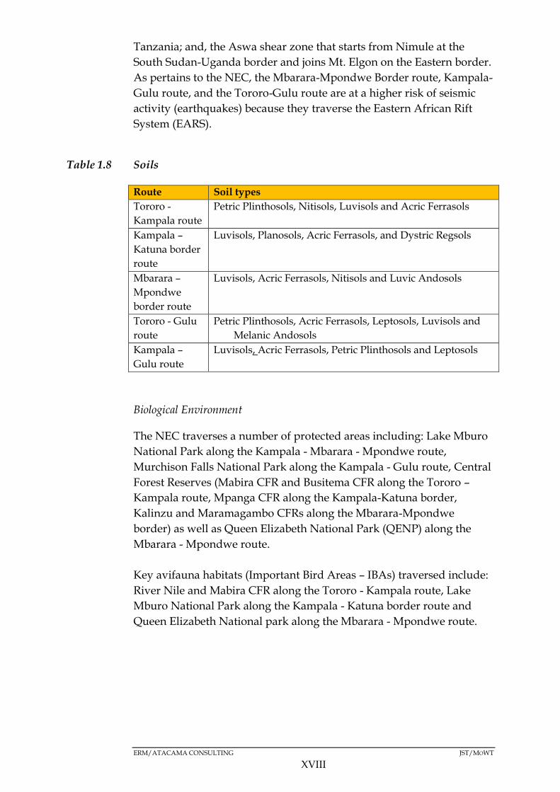
Table 1.8 Soils
Route Soil types
Tororo -
Kampala route
Petric Plinthosols, Nitisols, Luvisols and Acric Ferrasols
Kampala –
Katuna border
route
Luvisols, Planosols, Acric Ferrasols, and Dystric Regsols
Mbarara –
Mpondwe
border route
Luvisols, Acric Ferrasols, Nitisols and Luvic Andosols
Tororo - Gulu
route
Petric Plinthosols, Acric Ferrasols, Leptosols, Luvisols and
Melanic Andosols
Kampala –
Gulu route
Luvisols, Acric Ferrasols, Petric Plinthosols and Leptosols
Biological Environment
The NEC traverses a number of protected areas including: Lake Mburo
National Park along the Kampala - Mbarara - Mpondwe route,
Murchison Falls National Park along the Kampala - Gulu route, Central
Forest Reserves (Mabira CFR and Busitema CFR along the Tororo –
Kampala route, Mpanga CFR along the Kampala-Katuna border,
Kalinzu and Maramagambo CFRs along the Mbarara-Mpondwe
border) as well as Queen Elizabeth National Park (QENP) along the
Mbarara - Mpondwe route.
Key avifauna habitats (Important Bird Areas – IBAs) traversed include:
River Nile and Mabira CFR along the Tororo - Kampala route, Lake
Mburo National Park along the Kampala - Katuna border route and
Queen Elizabeth National park along the Mbarara - Mpondwe route.
ERM/ATACAMA CONSULTING JST/MOWT
XIX
Socio-Economic Baseline
Physical Planning within the NEC
Most of the major towns within the NEC (Tororo, Jinja, Mbale, Soroti,
Lira, Gulu, Masindi, Kampala, Masaka, and Mbarara) have Physical
Development Plans but are not consistent with aspects such as multi
modal transport, among other things.
There are other physical planning projects ongoing in the urban realm
which are aimed at upgrading of slums (in Mbale, Jinja, Mbarara and
Gulu where 60 percent of the urban population reside), provision of
infrastructure, and regional and other plans which could contribute to
the strategy to build an effective physical planning system.
All the major urban towns within the NEC conurbation have spread de
facto beyond the Municipality’s boundaries and are rapidly impacting
on the peri- urban areas as they sprawl without any development
control guidance from the relevant authorities.
Green Belts
Uganda’s urban towns do not have distinctive green belts between the
urban and rural settlements. The physical plans within the corridor of
the urban centers in Uganda have reserved some areas as green belts in
form of public spaces but these are very limited.
There are however green belts which were mostly created as parks and
open spaces in many major towns within the corridor ie Malukhu
wetland in Mbale, Kauda grounds and Pece wetland in Gulu, although
these have been encroached and built upon.
The few developed and maintained gardens in Kampala city are
concentrated in the city centre and generally closed off from the public.
The wetland areas are used for recreation; however, landfilling for
playfields contributes to their further degradation.
Transport
The transport infrastructure in Uganda includes road, water, air and
railway. However, road transport, as is common in other East African
countries, is the commonest means for movement of goods, with over
95 percent of cargo and passenger traffic using road transport.
Road Transport
ERM/ATACAMA CONSULTING JST/MOWT
XX
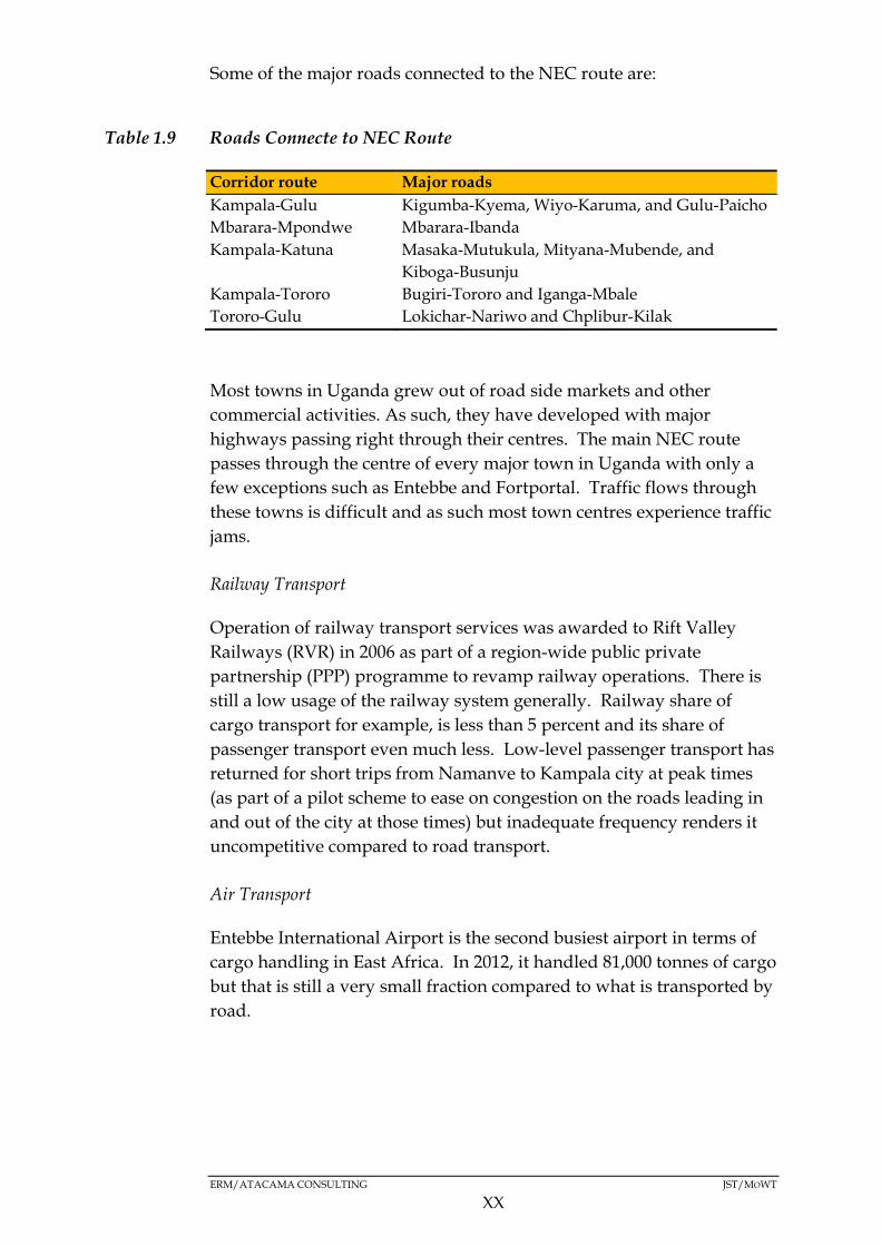
Some of the major roads connected to the NEC route are:
Table 1.9 Roads Connecte to NEC Route
Corridor route Major roads
Kampala-Gulu Kigumba-Kyema, Wiyo-Karuma, and Gulu-Paicho
Mbarara-Mpondwe Mbarara-Ibanda
Kampala-Katuna Masaka-Mutukula, Mityana-Mubende, and
Kiboga-Busunju
Kampala-Tororo Bugiri-Tororo and Iganga-Mbale
Tororo-Gulu Lokichar-Nariwo and Chplibur-Kilak
Most towns in Uganda grew out of road side markets and other
commercial activities. As such, they have developed with major
highways passing right through their centres. The main NEC route
passes through the centre of every major town in Uganda with only a
few exceptions such as Entebbe and Fortportal. Traffic flows through
these towns is difficult and as such most town centres experience traffic
jams.
Railway Transport
Operation of railway transport services was awarded to Rift Valley
Railways (RVR) in 2006 as part of a region-wide public private
partnership (PPP) programme to revamp railway operations. There is
still a low usage of the railway system generally. Railway share of
cargo transport for example, is less than 5 percent and its share of
passenger transport even much less. Low-level passenger transport has
returned for short trips from Namanve to Kampala city at peak times
(as part of a pilot scheme to ease on congestion on the roads leading in
and out of the city at those times) but inadequate frequency renders it
uncompetitive compared to road transport.
Air Transport
Entebbe International Airport is the second busiest airport in terms of
cargo handling in East Africa. In 2012, it handled 81,000 tonnes of cargo
but that is still a very small fraction compared to what is transported by
road.
ERM/ATACAMA CONSULTING JST/MOWT
XXI
Water Transport
There is currently very little use of water transport in the NEC. Uganda
Railways Corporation (which is the entity in charge of cargo water
ferries)1 has only one commercial cargo ferry still operational. Railway
connection to Port Bell is out of service currently and ferries are not
operated as rail-wagon ferries.
1 Uganda National Roads Authority (UNRA) only operates passenger ferries between selected
islands in Uganda only.
ERM/ATACAMA CONSULTING JST/MOWT
XXII
Road Safety
Uganda has the highest accident rates in the Great Lakes region. The
highest number of road accidents and fatalities attributed to high traffic
volumes, numerous urban centres (with inadequate pedestrian crossing
facilities and the generally haphazard nature of crossing by pedestrians)
resulting in high pedestrian/vehicle interactions, several accident ‘black
spots’ and, high traffic speeds, mainly occur within the NEC.
Current Freight Traffic Demand
A traffic survey was conducted by JST in 2015 to establish the current
traffic demand on the NEC, at key border posts along the Uganda
border and at three key locations along the NEC (the Kampala – Tororo
route, Kampala – Mbarara route and Kampala – Gulu route). This
survey established that:
The most critical border crossing along the NEC is Malaba where
most border crossing movements take place.
Traffic originating from Uganda reaches the border before traffic
from Kenya due to the shorter distance generally from the Uganda
side to Malaba
A single peak occurs during the day for both traffic from Kenya (4pm
to 10pm) and Uganda (3pm to 10pm)
The peak seems to occur as truck drivers target to take their rest
break at the Malaba border.
The average arrival from the Ugandan side during the peak
period is about 45 trucks per hour and from the Kenya side 55
trucks per hour.
Social and Cultural Conditions
Population
Wakiso District is the most populous district in the Ugandan Section of
the NEC followed by Kampala district. Ngora, Rubirizi and Lyantonde
districts are the least populated.

ERM/ATACAMA CONSULTING JST/MOWT
XXIII
Population Density
Kampala District has the highest population density, while
Nakasongola is the least densely populated.
Urbanisation
Within the NEC, the level of urbanisation is highest in Kampala city.
Education and Literacy Levels
Based on the Educational Sector Performance Report of 2013-2014,
within the NEC, the Tororo - Gulu and, Kampala - Mbarara – Katuna
Border routes have the highest education and literacy levels (85.2
percent and 87 percent for males and females respectively). The Tororo
– Kampala route has the lowest education and literacy levels (55
percent and 55.2 percent for males and females respectively).
Livelihoods
The major livelihood activities along the NEC, mainly concentrated in
Kampala, Wakiso, Tororo and Kasese Districts are:
Agriculture;
Fisheries, mainly carried out in the open water bodies of Lakes
Victoria, Edward, and George;
Business, mainly carried out in all major towns, and
Industrialisation
Most of the livelihood activities are land based, with subsistence
agriculture being the major source of livelihood in Uganda. Land is
therefore the most precious asset that the people possess.
Income Levels
The Kampala - Katuna border route, the Mbarara - Mpondwe route as
well as a section of the Kampala - Gulu route (central Uganda region),
fall primarily within areas of low poverty. On the other hand, the
Tororo - Gulu route as well as a section of the Kampala - Gulu route
(northern Uganda region) fall within a zone of high poverty.
ERM/ATACAMA CONSULTING JST/MOWT
XXIV
Land Tenure Customary ownership is the major form of land tenure system along
the Tororo-Gulu route and the Mbarara-Mpondwe Border route, while
a mixture of Mailo/Freehold/Kibanja, Leasehold and Customary
ownership are the major forms of land tenure along the Kampala-Gulu
route, Tororo-Kampala route, and the Kampala-Mbarara-Katuna Border
route.
Access to Health Services
Based on selected performance indicators used to assess the health
performance of various districts in Uganda, seven of the top fifteen
performing districts are within the NEC (Gulu, Kampala, Jinja,
Rukungiri, Mbale, Bushenyi and Mbarara).
Sanitation
The Kampala - Katuna border route, the Mbarara - Mpondwe route as
well as a section of the Kampala - Gulu route (central Uganda region),
fall primarily within areas with a high record of sanitation facilities. On
the other hand, the Tororo - Gulu route as well as a section of the
Kampala - Gulu route (northern Uganda region) fall within a low
record of sanitation facilities.
Access to Safe Water
The Tororo-Kampala route has the lowest access to safe water at 26
percent, while the Mbarara-Mpondwe border route has the highest
access to safe water at 78 percent.
HIV/AIDS
HIV/AIDS remains a major socio-economic challenge in Uganda. The
prevalence rate in the general population among adults stands at 7.4
percent according to the 2012/2013 survey1.
According to the International Organisation for Immigration report,
2009, mobility has been identified as one of the key factors behind the
spread of HIV/AIDS in East Africa due to the high risk environments
associated with transport corridors which often facilitate multiple
concurrent sexual partnerships.
12014 Uganda HIV and AIDS Country Progress report, 2015

ERM/ATACAMA CONSULTING JST/MOWT
XXV
Lighting
Paraffin (Tadooba) is the major source of energy used for lighting along
the Tororo–Gulu route, Kampala-Mbarara-Katuna Border route, and
the Mbarara-Mpondwe Border route, while electricity is the major
source of energy along the Kampala – Gulu route and the Tororo –
Kampala route.
Cooking
Firewood is the major source of energy used for cooking along the
Tororo – Gulu route, Kampala-Mbarara-Katuna Border route, and the
Mbarara-Mpondwe Border route while charcoal is the major source of
energy used along the Kampala-Gulu route and Tororo-Kampala route.
Gender
The GoU adopted a National Gender Policy (1997), whose main
objective is to mainstream gender concerns in national development
processes through guiding resource allocation in all sectors to address
gender inequality.
During the second round of stakeholder consultations, the stakeholders
expressed the need for the deliberate inclusion of gender
mainstreaming issues in the SEA for consideration during the Master
Plan formulation.
Vulnerable Groups A vulnerable group is a population that has some specific
characteristics that make it at higher risk of falling into poverty than
others living in areas targeted by a project/plan (World Bank, 2015) in
this case the Master Plan.
Results from the opinion survey conducted during the stakeholder
conusltative meetings indicate that groups identified as vulnerable by
the respondents include: slum dwellers, people in traditional houses,
the disabled, the poor, as well as the Karamajong (an ethnic group of
agro-pastoral herders living mainly in the north-east of Uganda).
ERM/ATACAMA CONSULTING JST/MOWT
XXVI
Stakeholder Engagement
Stakeholder engagement was conducted throughout the SEA process.
Table 1.10 below shows selected key outcomes, attitudes, concerns, and
expectations following the stakeholder engagement process during the
detailed SEA study. A more detailed presentation of all of these as
gathered during the SEA is provided in Chapter 7 of this report.
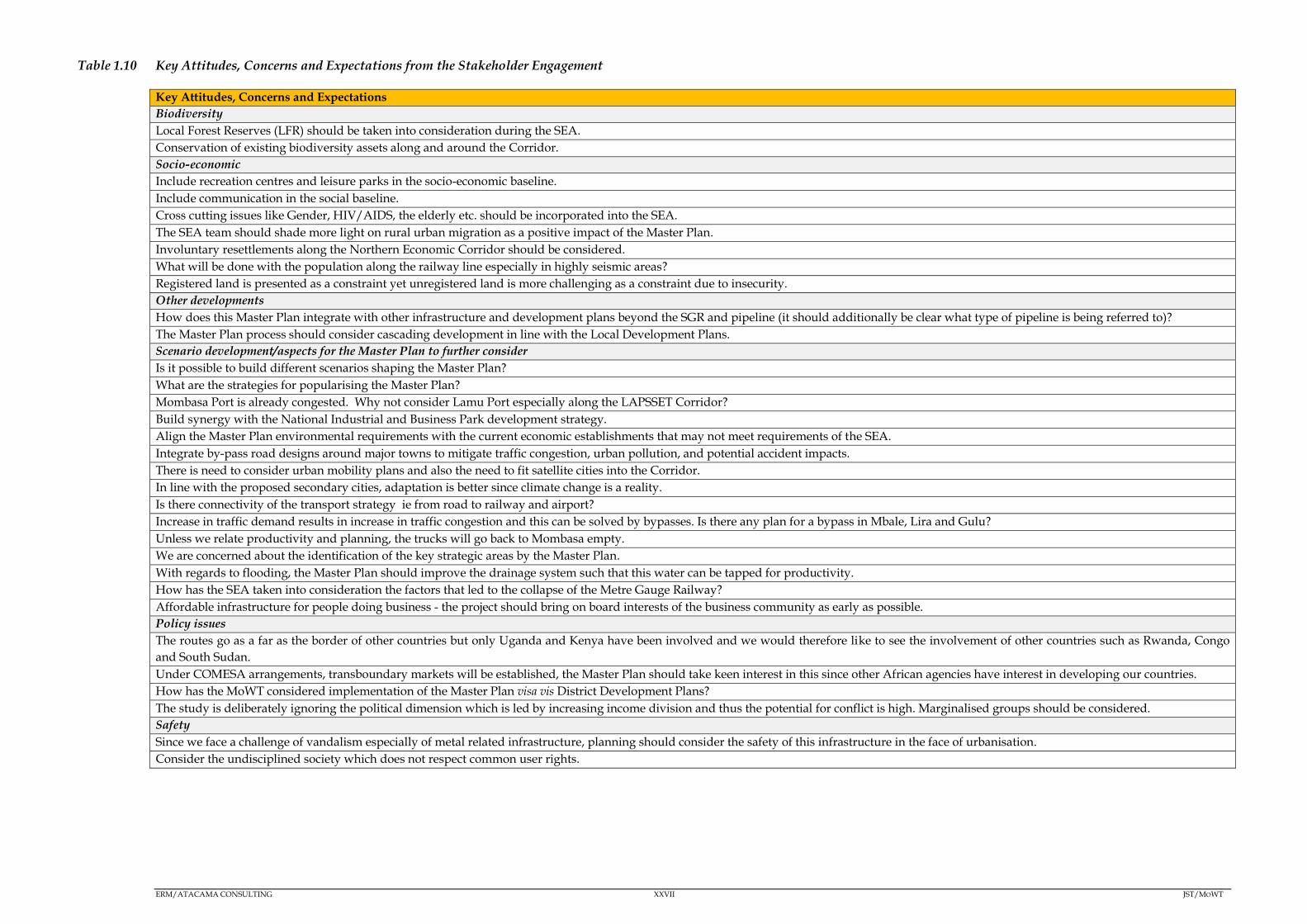
ERM/ATACAMA CONSULTING XXVII JST/MOWT
Table 1.10 Key Attitudes, Concerns and Expectations from the Stakeholder Engagement
Key Attitudes, Concerns and Expectations
Biodiversity
Local Forest Reserves (LFR) should be taken into consideration during the SEA.
Conservation of existing biodiversity assets along and around the Corridor.
Socio-economic
Include recreation centres and leisure parks in the socio-economic baseline.
Include communication in the social baseline.
Cross cutting issues like Gender, HIV/AIDS, the elderly etc. should be incorporated into the SEA.
The SEA team should shade more light on rural urban migration as a positive impact of the Master Plan.
Involuntary resettlements along the Northern Economic Corridor should be considered.
What will be done with the population along the railway line especially in highly seismic areas?
Registered land is presented as a constraint yet unregistered land is more challenging as a constraint due to insecurity.
Other developments
How does this Master Plan integrate with other infrastructure and development plans beyond the SGR and pipeline (it should additionally be clear what type of pipeline is being referred to)?
The Master Plan process should consider cascading development in line with the Local Development Plans.
Scenario development/aspects for the Master Plan to further consider
Is it possible to build different scenarios shaping the Master Plan?
What are the strategies for popularising the Master Plan?
Mombasa Port is already congested. Why not consider Lamu Port especially along the LAPSSET Corridor?
Build synergy with the National Industrial and Business Park development strategy.
Align the Master Plan environmental requirements with the current economic establishments that may not meet requirements of the SEA.
Integrate by-pass road designs around major towns to mitigate traffic congestion, urban pollution, and potential accident impacts.
There is need to consider urban mobility plans and also the need to fit satellite cities into the Corridor.
In line with the proposed secondary cities, adaptation is better since climate change is a reality.
Is there connectivity of the transport strategy ie from road to railway and airport?
Increase in traffic demand results in increase in traffic congestion and this can be solved by bypasses. Is there any plan for a bypass in Mbale, Lira and Gulu?
Unless we relate productivity and planning, the trucks will go back to Mombasa empty.
We are concerned about the identification of the key strategic areas by the Master Plan.
With regards to flooding, the Master Plan should improve the drainage system such that this water can be tapped for productivity.
How has the SEA taken into consideration the factors that led to the collapse of the Metre Gauge Railway?
Affordable infrastructure for people doing business - the project should bring on board interests of the business community as early as possible.
Policy issues
The routes go as a far as the border of other countries but only Uganda and Kenya have been involved and we would therefore like to see the involvement of other countries such as Rwanda, Congo
and South Sudan.
Under COMESA arrangements, transboundary markets will be established, the Master Plan should take keen interest in this since other African agencies have interest in developing our countries.
How has the MoWT considered implementation of the Master Plan visa vis District Development Plans?
The study is deliberately ignoring the political dimension which is led by increasing income division and thus the potential for conflict is high. Marginalised groups should be considered.
Safety
Since we face a challenge of vandalism especially of metal related infrastructure, planning should consider the safety of this infrastructure in the face of urbanisation.
Consider the undisciplined society which does not respect common user rights.

ERM/ATACAMA CONSULTING JST/MOWT
XXVIII
Analysis of Alternative and Strategy Options
The following alternatives were considered by the JST during the
Master Plan formulation process:
A: Super Double-Core Type - for concentrating investments on capitals
as usual;
B: Double-core with Regional Industrial Promotion Type, for expanding
exports with industrial promotion), and
C: Multi-core with Regional Industrial Development Type, for expanding
exports with industrial promotion and balanced development))
The above were all considered as possible development options based
on three main criteria, speicifically public benefit, public intervention
and vision.
Alternative C (Multi-core with Regional Industrial Development Type)
was selected as the preferred alternative and includes the following
strategies:
Expanding export with industrial promotion and balanced
development through the promotion of “Regional Production
Centers” ;
Promotion of urban and logistics functions of “Secondary Cities” into
hubs of business, commerce, service and logistics for surrounding
regions with the local government involvement; and
Establishment and enhancement of an efficient transport network.
Alternative C was determined to be the most suitable alternative for the
Master Plan on the balance of its implications on the SEA objectives and
based on a set of environmental conditions, specifically:
Maintain the integrity of water bodies;
Maintain the integrity of soils and geology conditions;
Maintain and enhance air quality;
Minimise noise and vibrations;
Minimise impact on protected areas;
Conserve and enhance biodiversity outside protected areas;
Safeguard public health and safety;
ERM/ATACAMA CONSULTING JST/MOWT
XXIX
Minimise land take and disruption of livelihoods;
Well integrated modes of transport;
Protect integrity of archaeological and cultural heritage sites; and
Minimise visual impacts.
The impact identification and analysis was therefore based on the
preferred Alternative C.
Key Impacts
Only the impacts that were deemed to be negative and ‘major’ in scope
were taken forward for the detailed impact assessment1. Positive
impacts were also identified and measures to enahance them were also
proposed. A summary of the key negative impacts is provided in Table
1.11.
1 The assessment process was preceded by the identification and evaluation of potentially
significant environmental impacts likely to be attributed to the implementation of the Master
Plan. However, only the significant issues are the focus of any SEA, and the reference point for
the level of significance of potential impacts in the current study were the SEA objectives.

ERM/ATACAMA CONSULTING XXX JST/MOWT
Table 1.11 Summary of Negative Impacts associated with the NEC Master Plan
Impact Regional Strategy Industrial Strategy Transport Strategy Applicable
constraints Strategy Options
Linking
agricultural
productive
areas and
mineral
resources
areas
through
development
secondary
cities
Linking
with
LAPSSET,
central
corridor
and
Kampala-
Juba-
Addis
Ababa-
Djibouti
Corridor
Establishment
of logistic
hubs with
Inland
Container
Depots (ICD)
and Logistic
Centre
Connecting
industrial
areas to
logistic hubs
through
Cargo-
Oriented
Development
(COD)
Promotion
of growth
drivers to
increase
export,
reduce
import,
and
develop
local
economy
Modal
shift
from
truck to
rail and
pipeline
Reduction
of
bottlenecks
of freight
traffic and
logistics
Enhancement
of transport
infrastructure
Impacts on
the integrity
of water
bodies
Very large Very large Very large Large Rivers; Nile
Katonga,
Rwizi
Lakes; Kyoga,
Victoria,
Albert
Wetlands;
Kibimba,
Northern
shores of Lake
Victoria, Lake
Kyoga
wetlands,
Lake Mburo
wetlands.
Impacts on
soils and
Slight Very large Agricultural
areas
ERM/ATACAMA CONSULTING XXXI JST/MOWT
Impact Regional Strategy Industrial Strategy Transport Strategy Applicable
constraints Strategy Options
Linking
agricultural
productive
areas and
mineral
resources
areas
through
development
secondary
cities
Linking
with
LAPSSET,
central
corridor
and
Kampala-
Juba-
Addis
Ababa-
Djibouti
Corridor
Establishment
of logistic
hubs with
Inland
Container
Depots (ICD)
and Logistic
Centre
Connecting
industrial
areas to
logistic hubs
through
Cargo-
Oriented
Development
(COD)
Promotion
of growth
drivers to
increase
export,
reduce
import,
and
develop
local
economy
Modal
shift
from
truck to
rail and
pipeline
Reduction
of
bottlenecks
of freight
traffic and
logistics
Enhancement
of transport
infrastructure
geology
Impact on
air quality
(Greenhouse
gas
emissions)
Moderate Protected
Areas,
Internationally
Designated
Areas,
Sensitive
ecosystems,
Biodiversity
(flora and
fauna),
Rivers, lakes
and wetlands,
Agricultural
areas,
Settlements,
and
Existing
infrastructure.

ERM/ATACAMA CONSULTING XXXII JST/MOWT
Impact Regional Strategy Industrial Strategy Transport Strategy Applicable
constraints Strategy Options
Linking
agricultural
productive
areas and
mineral
resources
areas
through
development
secondary
cities
Linking
with
LAPSSET,
central
corridor
and
Kampala-
Juba-
Addis
Ababa-
Djibouti
Corridor
Establishment
of logistic
hubs with
Inland
Container
Depots (ICD)
and Logistic
Centre
Connecting
industrial
areas to
logistic hubs
through
Cargo-
Oriented
Development
(COD)
Promotion
of growth
drivers to
increase
export,
reduce
import,
and
develop
local
economy
Modal
shift
from
truck to
rail and
pipeline
Reduction
of
bottlenecks
of freight
traffic and
logistics
Enhancement
of transport
infrastructure
Impact on
air quality
(dust
emissions)
Large Settlements
Noise and
vibration
impacts
Large Settlements
Impacts to
Biodiversity
in Protected
Areas
Very large Very large Very
large
Moderate Large Mabira CFR,
Mpanga CFR,
Moroto CFR,
Murchison
Falls National
Park, Lake
Mburo
National Park,
Kibale
National Park,
Queen
Elizabeth
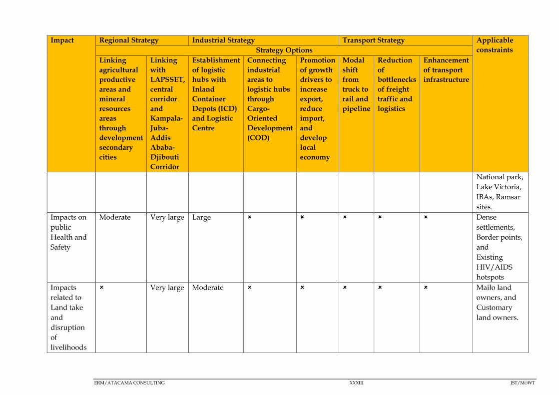
ERM/ATACAMA CONSULTING XXXIII JST/MOWT
Impact Regional Strategy Industrial Strategy Transport Strategy Applicable
constraints Strategy Options
Linking
agricultural
productive
areas and
mineral
resources
areas
through
development
secondary
cities
Linking
with
LAPSSET,
central
corridor
and
Kampala-
Juba-
Addis
Ababa-
Djibouti
Corridor
Establishment
of logistic
hubs with
Inland
Container
Depots (ICD)
and Logistic
Centre
Connecting
industrial
areas to
logistic hubs
through
Cargo-
Oriented
Development
(COD)
Promotion
of growth
drivers to
increase
export,
reduce
import,
and
develop
local
economy
Modal
shift
from
truck to
rail and
pipeline
Reduction
of
bottlenecks
of freight
traffic and
logistics
Enhancement
of transport
infrastructure
National park,
Lake Victoria,
IBAs, Ramsar
sites.
Impacts on
public
Health and
Safety
Moderate Very large Large Dense
settlements,
Border points,
and
Existing
HIV/AIDS
hotspots
Impacts
related to
Land take
and
disruption
of
livelihoods
Very large Moderate Mailo land
owners, and
Customary
land owners.
ERM/ATACAMA CONSULTING JST/MOWT
XXXIV
Following assessment of the SEA objectives where major negative
impacts will potentially occur during the implementation of the Master
Plan, bearing in mind the uncertainties surrounding: e protection of the
integrity of archaeological and cultural heritage sites for the regional
strategy, industrial strategy and transport strategy, and, minimising
land take and disruption of livelihoods for the industrial strategy
alternative associated with the promotion of growth drivers to increase
export, reduce import, and develop local economy, the following are
the findings:-
Impacts of major significance identified include impacts on the integrity
of water bodies and impacts on biodiversity in protected areas. This is
because:-
The NEC traverses the Lake Victoria Basin, Lake Edward Basin, Lake
Kyoga Basin, Victoria Nile Basin and the Albert Nile Basin.
Additionally, due to the interconnected nature of the surface water
resources of Uganda, the Corridor (specifically, the road
infrastructure associated with it) traverses some of the country’s
major wetlands (of social and ecological importance) including but
not limited to permanent wetlands such as; the Lake Kyoga wetland
(Tororo - Gulu –Elegu route) Kibimba wetland in Bugiri along the
main Tororo – Kampala – Katuna route and, Lake Mburo wetland
along the Kampala – Mbarara route. Also important to consider is
the River Nile crossing along the Tororo - Kampala route as well as
the Kazinga channel crossing along the Mbarara - Mpondwe route.
The NEC traverses a number of protected areas including: Lake
Mburo National Park along the Kampala - Mbarara - Mpondwe
route, Murchison Falls National Park along the Kampala - Gulu
route, Central Forest Reserves (Mabira CFR and Busitema CFR along
the Tororo – Kampala route, Mpanga CFR along the Kampala-
Katuna border, Kalinzu and Maramagambo CFRs along the
Mbarara-Mpondwe border) as well as Queen Elizabeth National
Park (QENP) along the Mbarara - Mpondwe route. Key avifauna
habitats (Important Bird Areas – IBAs) traversed include: R. Nile and
Mabira CFR along the Tororo - Kampala route, Lake Mburo National
Park along the Kampala - Katuna border route and Queen Elizabeth
National park along the Mbarara - Mpondwe route.
ERM/ATACAMA CONSULTING JST/MOWT
XXXV
The regional strategy of linking with LAPSSET, Central Corridor and
Kampala-Juba-Addis-Ababa-Djibouti Corridor has the highest
number of impacts with very large significance (4 impacts), followed
by the industrial strategy of promotion of growth drivers to increase
export, reduce import and develop local economy (3 impacts), and
the transport strategy of reduction of bottlenecks of freight traffic
and logistics (2 impacts). This is the case since the proposed projects
associated with these options will most likely be implemented in
protected areas such as Lake Victoria and CFRs.
The strategies with the least number of impacts were; the transport
strategies of enhancement of transport infrastructure, and, modal
shift from truck to rail and pipeline (with 1 impact each), and, the
industrial strategy of connecting industrial areas to logistic hubs
through Cargo Oriented Development (COD) which had no impacts.
This is the case since the shift of cargo to either pipeline or rail
transport does not involve direct physical disturbance of the
biophysical and social environment other than making use of
available infrastructure. The industrial strategy of connecting
industrial areas to logistic hubs through Cargo Oriented
Development (COD) had no impacts since by its nature it was
supporting the establishment of logistics hub strategy.
It is important to note however that, certain strategies within the Master
Plan are highly interdependent and one cannot be implemented or
realised without the other. For example, the regional strategy of linking
with LAPSSET, Central Corridor and Kampala-Juba-Addis-Ababa-
Djibouti Corridor, cannot be implemented without the transport
strategy of enhancement of transport infrastructure because,
establishment of the inland waterway linkage routes is to some extent,
largely dependent on rehabilitation of the ports on the lake, and
therefore, the impacts of both these strategies would need to be
considered.
Cumulative Impact Assessment
Cumulative Impact Assessment (CIA) is a systematic procedure for
identifying and evaluating the significance of impacts from multiple
activities. The CIA undertaken during this SEA, as guided by the
guidelines for Cumulative Effects Assessment in SEA of Plans (Cooper,
2004), indicated the following:

ERM/ATACAMA CONSULTING JST/MOWT
XXXVI
Cumulative impacts will not be realised in some instances because
other innovations aimed at streamlining developments within the
NEC, contain similar projects as the Master Plan for example, the
following:-
Under the NCIP (designed to generate sustainable political will to
fast track the implementation of the projects identified in the
Northern Corridor) - Standard Gauge Railway, ICT Infrastructure,
Oil refinery development, Power generation, transmission and
interconnectivity, Crude oil pipeline development, Refined
petroleum products pipeline development, Commodities
exchange, Single customs territory;
Under Vision 2040 (conceptualized around strengthening the
fundamentals of the economy to harness the abundant
opportunities around the country) - oil and gas, tourism, minerals,
ICT business, trade, water resources, industrialisation, and
agriculture. On the other hand, the fundamentals include:
infrastructure for (energy, transport, water, oil and gas and ICT);
and
Under The second National Development Plan (NDP II) (designed
to propel Uganda towards middle income status by 2020, in line
with the aspirations of Uganda’s Vision 2040) – Agriculture,
Tourism, Minerals, oil and gas, Infrastructure development.
Therefore, even without implementation of the Master Plan, if these
other PPPs are implemented, these impacts will still be realised.
However, there are other PPPs, which if implemented, even within the
Master Plan itself alone ( eg a combination of different industrial,
transport and regional strategies), will result in cumulative impacts
(particularly those PPPs affecting the same receptor, or PPPs that would
need to be implemented at the same time/within a short time period of
the other).
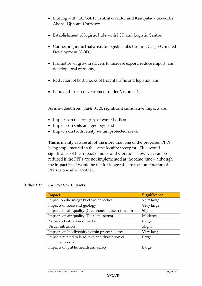
This is particularly true for the cumulative impacts arising from the
interactions between the following interventions, which would result in
the significance ratings indicated in (Table 1.12):-
Linking agricultural productive areas and mineral resources areas
through development of secondary cities;
ERM/ATACAMA CONSULTING JST/MOWT
XXXVII
Linking with LAPSSET, central corridor and Kampala-Juba-Addis
Ababa- Djibouti Corridor;
Establishment of logistic hubs with ICD and Logistic Centre;
Connecting industrial areas to logistic hubs through Cargo-Oriented
Development (COD);
Promotion of growth drivers to increase export, reduce import, and
develop local economy;
Reduction of bottlenecks of freight traffic and logistics; and
Land and urban development under Vision 2040.
As is evident from (Table 0.12), significant cumulative impacts are:
Impacts on the integrity of water bodies;
Impacts on soils and geology; and
Impacts on biodiversity within protected areas.
This is mainly as a result of the more than one of the proposed PPPs
being implemented in the same locality/receptor. The overall
significance of the impact of noise and vibrations however, can be
reduced if the PPPs are not implemented at the same time – although
the impact itself would be felt for longer due to the combination of
PPPs ie one after another.
Table 1.12 Cumulative Impacts
Impact Significance
Impact on the integrity of water bodies Very large
Impacts on soils and geology Very large
Impacts on air quality (Greenhouse gases emissions) Slight
Impacts on air quality (Dust emissions) Moderate
Noise and vibration impacts Large
Visual intrusion Slight
Impacts on biodiversity within protected areas Very large
Impacts related to land-take and disruption of
livelihoods
Large
Impacts on public health and safety Large
ERM/ATACAMA CONSULTING JST/MOWT
XXXVIII
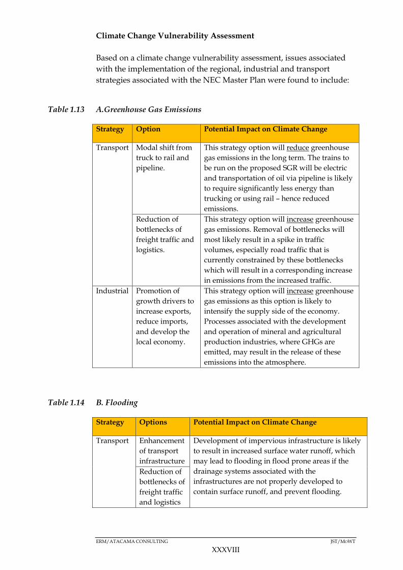
Climate Change Vulnerability Assessment
Based on a climate change vulnerability assessment, issues associated
with the implementation of the regional, industrial and transport
strategies associated with the NEC Master Plan were found to include:
Table 1.13 A.Greenhouse Gas Emissions
Strategy Option Potential Impact on Climate Change
Transport Modal shift from
truck to rail and
pipeline.
This strategy option will reduce greenhouse
gas emissions in the long term. The trains to
be run on the proposed SGR will be electric
and transportation of oil via pipeline is likely
to require significantly less energy than
trucking or using rail – hence reduced
emissions.
Reduction of
bottlenecks of
freight traffic and
logistics.
This strategy option will increase greenhouse
gas emissions. Removal of bottlenecks will
most likely result in a spike in traffic
volumes, especially road traffic that is
currently constrained by these bottlenecks
which will result in a corresponding increase
in emissions from the increased traffic.
Industrial Promotion of
growth drivers to
increase exports,
reduce imports,
and develop the
local economy.
This strategy option will increase greenhouse
gas emissions as this option is likely to
intensify the supply side of the economy.
Processes associated with the development
and operation of mineral and agricultural
production industries, where GHGs are
emitted, may result in the release of these
emissions into the atmosphere.
Table 1.14 B. Flooding
Strategy Options Potential Impact on Climate Change
Transport Enhancement
of transport
infrastructure
Development of impervious infrastructure is likely
to result in increased surface water runoff, which
may lead to flooding in flood prone areas if the
drainage systems associated with the
infrastructures are not properly developed to
contain surface runoff, and prevent flooding.
Reduction of
bottlenecks of
freight traffic
and logistics

ERM/ATACAMA CONSULTING JST/MOWT
XXXIX
Strategy Options Potential Impact on Climate Change
Regional Linking
agricultural
productive
areas and
mineral
resources
through
development
of secondary
cities
Development of secondary cities (currently
planned for Mbarara, Gulu, Arua and Mbale) will
result in major infrastructural development that
increase paved surfaces areas – resulting in
increased surface water runoff, which is
exacerbated if drainage systems are not properly
designed, constructed and maintained.
Additionally, development of secondary cities
could encroach on green field sites such as
wetlands which are supposed to regulate water
flow thereby exacerbating the flooding situation.
This is particularly important for Mbarara and
Gulu districts – which are prone to flooding.
Industrial Establishment
of logistic
hubs with
ICD and
Logistic
Centre
Establishment of logistic hubs is likely to result in
an increase in the pave surface area which can also
have an effect on runoff speeds/flooding potential.
In light of the above, climate change adaptation strategies such as
Sustainable development goal 9 - “Build resilient infrastructure, promote
inclusive and sustainable industrialization and foster innovation” (SDG,
2015), integration of climate into existing infrastructure risk assessments
and, climate proof building need to be considered.
With regards to agricultural production areas - promote agricultural
best practices, sustainable utilisation of agricultural products and, new
technologies in processing and industry to enhance cleaner production.
Traffic management in secondary cities to reduce traffic congestion and
emissions and promoting investment in low-carbon emissions, should
also be considered.
Mitigation and Management
Following the identification of the key environmental and social
impacts associated with the implementation of the Master Plan, a
number of key recommendations for the minimisation of negative
impacts have been identified.
ERM/ATACAMA CONSULTING JST/MOWT
XL
Key among these, based on the components of the environment likely
to be most affected by the proposed NEC Master Plan (despite the
strategy(ies) chosen for implementation), are the mitigation measures
and monitoring recommendations linked to the management of impacts
on water resources and biodiversity within protected areas traversed by
the NEC.
Linked to the above, a number of Government Institutions will need to
be involved in the monitoring of impacts associated with the
implementation of the Master Plan and it is therefore essential that the
capacity of these institutions is developed, so as to allow them to duly
undertake their responsibilities during implementation.
SEAs are designed to complement, not replace EIAs within the
planning process therefore, it is imperative that EIAs for specific
infrastructure projects are undertaken and that, these follow the SEA of
the NEC Master Plan to ensure that local/project-specific issues are
evaluated in detail, and the ‘broader’ mitigation measures under this
Master Plan considered.
Contents
1 INTRODUCTION 1-1
OVERVIEW 1-1 1.1
PURPOSE OF THE REPORT 1-2 1.2
AIM OF THE SEA 1-3 1.3
MASTER PLAN PROPONENT 1-3 1.4
SEA STEERING TEAM 1-3 1.5
MASTER PLAN STUDY TEAM 1-4 1.6
SEA CONSULTANTS 1-4 1.7
1.7.1 Environmental Management Resources (ERM) 1-4
1.7.2 Atacama Consulting 1-5
REPORT STRUCTURE 1-5 1.8
2 DESCRIPTION OF THE NEC 2-1
BOTTLENECKS TO EFFICIENT CARGO TRANSPORTATION 2-1 2.1
2.1.1 Road Congestion 2-1
2.1.2 Mombasa Port Operations 2-1
2.1.3 Cross Border Delays 2-1
OBJECTIVES OF THE NEC MASTER PLAN 2-2 2.2
TARGET AREAS 2-2 2.3
REGIONAL STRUCTURE PLAN 2-3 2.4
SECTOR DEVELOPMENT IN KENYA AND UGANDA 2-4 2.5
2.5.1 Industrial Development 2-4
2.5.2 Agriculture Development 2-4
2.5.3 Mining and Petroleum Sector Development 2-5
2.5.4 Manufacturing Sector Development 2-5
2.5.5 Tourism Sector Development 2-6
KEY GROWTH DRIVERS 2-6 2.6
TRANSPORT AND LOGISTICS INFRASTRUCTURE DEVELOPMENT 2-8 2.7
2.7.1 Overview 2-8
2.7.2 Current and Future Gaps 2-8
2.7.3 Future Total Freight Forecasting 2-11
2.7.4 Future Traffic Forecasting 2-11
DEVELOPMENT SCENARIO FOR TRANSPORT AND LOGISTICS INFRASTRUCTURE 2.8
DEVELOPMENT 2-12
2.8.1 Scenario Modelling 2-12
2.8.2 Transport Network Improvements 2-13
DEVELOPMENT VISION AND STRATEGIES 2-14 2.9
2.9.1 Regional Strategy: Linking Production Centres and Corridors 2-15
2.9.2 Industrial Strategy: Effective and Efficient Logistical System for Industry
and Trade 2-16
2.9.3 Transport Strategy: Efficient and Integrated Multi-Modal Transportation
System 2-21
2.9.4 Financial Strategy 2-26
2.9.5 Organisational and Policy Strategy 2-27
OVERALL IMPLEMENTATION STRATEGY 2-28 2.10
IMPLEMENTATION PLAN AND TIME SCHEDULE 2-30 2.11
3 STRATEGIC, LEGAL AND INSTITUTIONAL FRAMEWORK 3-1
STRATEGIC FRAMEWORK (POLICIES, PLANS AND PROGRAMMES) 3-13.1
3.1.1 Relevant Policies 3-23.1.2 Relevant Plans 3-53.1.3 Relevant Programmes 3-6
LEGAL FRAMEWORK 3-7 3.2
3.2.1 National Legal Framework 3-7
3.2.2 Regional and International Legal Framework/ Treaties 3-7
3.2.3 Institutional Framework 3-7
3.2.4 National Institutions 3-8
3.2.5 Regional Institutions 3-8
3.2.6 International Institutions 3-103.2.7 Key Legislation Relevant to the NEC logistics Master Plan 3-12
3.2.8 Key National Institutions Relevant to the SEA/Master Plan 3-17
INTERNATIONAL REGULATIONS AND REQUIREMENTS 3-213.3
3.3.1 The Japan International Co-operation Agency (JICA) Guidelines for
Environmental and Social Considerations, 2010 3-21
3.3.2 The Organisation for Economic Co-operation and Development (OECD)
Guidelines and Reference Series for Applying Strategic Environmental
Assessment, 2006 3-21
CONSISTENCY ANALYSIS OF THE MASTER PLAN WITH OTHER PPPS 3-223.4
3.4.1 Consistency Analysis for Relevant Policies with the Master Plan 3-23
3.4.2 Consistency Analysis for Relevant Plans with the Master Plan 3-28
3.4.3 Consistency Analysis for Relevant Programmes with the Master Plan 3-30
4 METHODOLOGY AND APPROACH 4-1
GENERAL APPROACH TO THE SEA 4-1 4.1
4.1.1 Screening 4-1
4.1.2 Scoping 4-1
4.1.3 Detailed SEA Study 4-2
ASSESSMENT METHODS 4-2 4.2
4.2.1 Literature Surveys 4-2
4.2.2 Stakeholder Engagement 4-3
4.2.3 Geographical Information Systems (GIS) 4-3
4.2.4 Constraints Mapping 4-4
4.2.5 Expert Judgment 4-4
4.2.6 Transport Modelling and Forecasting 4-5
4.2.7 Matrices 4-7
ASSESSMENT APPROACH 4-7 4.3
4.3.1 Potential Impact Identification 4-8
4.3.2 Assessing the Significance of Environmental Impacts 4-8
4.3.3 Impact significance 4-10
GAPS AND UNCERTAINTIES 4-10 4.4
4.4.1 Environmental Baseline Gaps and Uncertainties 4-10
4.4.2 Social Baseline Gaps and Uncertainties 4-11
5 ENVIRONMENTAL BASELINE 5-1
PHYSICAL ENVIRONMENT 5-1 5.1
5.1.1 Climate 5-1
5.1.2 Air Quality 5-55.1.3 Hydrology and Water Resources 5-65.1.4 Flooding 5-105.1.5 Groundwater 5-125.1.6 Topography 5-135.1.7 Geology 5-165.1.8 Seismicity 5-185.1.9 Soils 5-20
BIOLOGICAL ENVIRONMENT 5-265.2
5.2.1 Description of the biological environment 5-265.2.2 Flora 5-265.2.3 Fauna 5-27
6 SOCIO-ECONOMIC BASELINE 6-1
PHYSICAL PLANNING IN UGANDA 6-1 6.1
6.1.1 District and County Headquarters 6-1
PHYSICAL PLANNING WITHIN THE NEC 6-4 6.2
6.2.1 Green Belts 6-5
TRANSPORT 6-6 6.3
6.3.1 Road Transport 6-7
6.3.2 Railway Transport 6-7
6.3.3 Air Transport 6-8
6.3.4 Water Transport 6-8
6.3.5 Road Safety 6-9
6.3.6 Current Freight Traffic Demand 6-10
SOCIO-CULTURAL AND SOCIO ECONOMIC CONDITIONS 6-13 6.4
6.4.1 Population and Urbanisation 6-17
6.4.2 Education 6-19
6.4.3 Livelihoods 6-19
6.4.4 Mining 6-21
6.4.5 Income Levels 6-24
6.4.6 Land tenure and Land Use 6-26
6.4.7 Tourism 6-29
6.4.8 Access to Health Services 6-32
6.4.9 HIV/AIDS 6-32
6.4.10 Gender 6-35
6.4.11 Vulnerable Groups 6-35
6.4.12 Sanitation 6-35
6.4.13 Energy 6-38
6.4.14 Archaeological and Cultural Heritage Sites 6-39
6.4.15 Political Environment 6-41
7 STAKEHOLDER ENGAGEMENT 7-1
OVERVIEW 7-17.1

OBJECTIVES OF STAKEHOLDER ENGAGEMENT 7-17.2
OUTCOMES OF STAKEHOLDER ENGAGEMENT 7-27.3
STAKEHOLDER IDENTIFICATION AND MAPPING 7-27.4
7.4.1 Stakeholder Identification 7-27.4.2 Stakeholder Mapping 7-37.4.3 Assessing Stakeholder Contribution 7-37.4.4 Assessing Stakeholder Influence 7-47.4.5 Stakeholder Analysis Matrix 7-5
STAKEHOLDER ENGAGEMENT 7-87.5
7.5.1 Engagement during the Scoping Study 7-87.5.2 Engagement during the Detailed SEA study 7-87.5.3 Baseline Phase Engagement 7-107.5.4 Validation Engagement 7-10
OUTCOMES OF STAKEHOLDER ENGAGEMENT 7-127.6
7.6.1 Key Outcomes 7-12
8 ANALYSIS OF ALTERNATIVES AND STRATEGY OPTIONS 8-1
ALTERNATIVES 8-1 8.1
8.1.1 Alternative A: Super Double Core Type/Business as usual 8-1
8.1.2 Alternative B: Double Core with Regional Industrial Promotion Type 8-2
8.1.3 Alternative C: Multi-Core with Regional Industrial Development Type 8-3
PREFERRED ALTERNATIVE 8-5 8.2
9 KEY IMPACTS 9-1
INTRODUCTION 9-1 9.1
IMPACT ASSESSMENT APPROACH 9-8 9.2
ASSESSMENT OF THE PHYSICAL IMPACTS 9-11 9.3
9.3.1 Regional Strategy 9-11
9.3.2 Industrial Strategy 9-13
9.3.3 Transport Strategy 9-18
ASSESSMENT OF BIOLOGICAL IMPACTS 9-22 9.4
9.4.1 Regional Strategy 9-22
9.4.2 Industrial Strategy 9-25
9.4.3 Transport Strategy 9-27
ASSESSMENT OF SOCIAL IMPACTS 9-32 9.5
9.5.1 Regional Strategy 9-32
9.5.2 Industrial Strategy 9-34
9.5.3 Transport Strategy 9-36
CUMULATIVE IMPACTS 9-39 9.6
9.6.1 CIA Approach and Methodology 9-40
9.6.2 Situation Analysis 9-42
9.6.3 Cumulative Impact assessment 9-43
VULNERABILITY TO CLIMATE CHANGE 9-53 9.7
9.7.1 Climate Change Risks to the Master Plan 9-53
9.7.2 Impacts of the Master Plan in the context of climate change 9-55
9.7.3 Sector Objectives for Climate Change Adaptation Relevant for the Master
Plan 9-57
9.7.4 Projections of Climate Change Variability and the Predicted Impacts 9-60

9.7.5 Impacts of Climate Change on the Feasibility of the Master Plan 9-60
9.7.6 Summary of Impacts 9-62
10 MITIGATION AND MANAGEMENT 10-1
DESCRIPTION OF MITIGATION MEASURES 10-1 10.1
10.1.1 Mitigation Measures for Cumulative Impacts Associated With
Implementation of the Master Plan 10-19
MONITORING OF IMPLEMENTATION OF THE MASTER PLAN 10-20 10.2
11 CONCLUSIONS AND RECOMMENDATIONS 11-1
ANNEX A STAKEHOLDER ENGAGEMENT PLAN (SEP) 11
ANNEX A1 STAKEHOLDER DATABASE 13
ANNEX A2 MINUTES OF THE STAKEHOLDER MEETING 14
ANNEX A3 -SEA OPINION SURVEY SHEET AND BID 15

ERM/ATACAMA CONSULTING JST/MOWT
1-1
1 INTRODUCTION
OVERVIEW 1.1
The Northern EconomicCorridor (NEC) is defined as all the transport
infrastructures and facilities providing a gateway through Kenya to the
landlocked economies of Uganda, Rwanda, Burundi and Eastern DR
Congo. It also serves South Sudan.
The NEC is multi-modal: consisting of road, rail, pipeline, and inland
waterways transport, and is recognized as a significant corridor for
logistics in East Africa. It is recognized as one of the major economic
corridors in Africa.
The main road network that makes up the NEC runs from Mombasa
Sea Port through Kenya and Uganda to Rwanda and Burundi, and to
the Democratic Republic of Congo (DRC). The road network also links
Kenya and Uganda to Juba in South Sudan.
The importance of the NEC is increasing, and the current combined
transit and trans-shipment traffic through the Corridor has been
growing at a rate of 20 percent annually (JICA Study Team, 2015).
However, there are some obstacles in the NEC that include:
Inadequate infrastructure;
Poor interconnectivity of transport modes;
Long delays (stagnation) of cargo at the port and broad post; and
Lack of goods to transport for the return trip from the inland area to
Mombasa Port.
These obstacles raise the transport cost within the Corridor, which
accounts for about 30 percent of the value of the goods (JICA Study
Team, 2015).
The above mentioned impediments are increasingly being recognised
as some of the factors that are hindering economic development of the
region, particularly the inland area.

ERM/ATACAMA CONSULTING JST/MOWT
1-2
The Governments of Uganda (GoU) and Kenya therefore requested the
Government of Japan (GoJ) to implement a project to formulate a
master plan on logistics in the NEC in order to promote regional
development. In response to these requests, the Japan International
Cooperation Agency (JICA) dispatched a ‘Detail Design Formulation
Team for the Project’ in October and November 2014. The Team
proposed to develop a concept that would cover not only logistics, but
also regional development along the NEC. The Governments of Kenya
and Uganda agreed with the concept and signed the Record of
Discussion with JICA for the implementation of the Project for
Formulation of the Master Plan on Logistics in the Northern Economic
Corridor (the Master Plan).
In order to ensure that potential environmental and social challenges
attributed to the Master Plan are addressed holistically and in a
proactive manner, it was decided that the Master Plan be subjected to a
Strategic Environmental Assessment (SEA) - “an assessment that is
implemented at the policy, planning, and program levels, but not a project-
level EIA (JICA, 2010),” in line with JICA’s environmental and social
guidelines, as well as the prevailing in-country environmental legal and
regulatory framework.
The SEA process in Uganda was undertaken by Environmental
Resources Management (ERM) and Atacama Consulting, the latter
being a Uganda Environmental Consultancy firm.
PURPOSE OF THE REPORT 1.2
The purpose of this SEA Study Report is to present the findings of the
SEA. Specifically, it presents the key environmental and social impacts
that will be associated with the implementation of the NEC Master Plan
and the recommendations for the minimisation of negative impacts and
enhancement of positive impacts.
It is important to note that due to the nature of this assignment (1) a
high level assessment needed to guide decision making on the Master
Plan has been conducted. Future projects that will be identified as part
of programmes emanating from the Master Plan will need to be
subjected to independent ESIA where project-specific impacts will be
identified and appropriate mitigation measures identified for the
minimisation of the negative impacts (as well as enhancement of
positive ones).
(1) it is an SEA and not an Environmental and Social Impact Assessment (ESIA)
ERM/ATACAMA CONSULTING JST/MOWT
1-3
AIM OF THE SEA 1.3
The overall aim of the SEA was to ensure that environmental and social
considerations are well integrated into the Master Plan.
The integration process meant that the SEA was undertaken in parallel
with the Master Plan formulation process. This way, environmental
and social considerations were addressed in a proactive manner so as to
better inform the decision making processes.
Some of the key objectives of the SEA were to:
Describe, identify and assess the potential significant effects on the
environment of implementing the Master Plan;
Furnish decision makers of both Governments (GoU and GoJ) with
the relevant information required to make informed choices about
the sustainability of the Master Plan; and
Provide robust recommendations on mitigation and management
measures that are to be factored into the Master Plan, with negative
impacts being minimised and positive ones enhanced.
MASTER PLAN PROPONENT 1.4
In Uganda, the Master Plan Proponent is the Ministry of Works and
Transport (MoWT). MoWT has a mandate to plan, develop and
maintain an economic, efficient and effective transport infrastructure;
and transport services by road, rail, water, and air. They are also
mandated to manage public works including Government Structures,
and promote standards in the construction industry. MoWT also aims
to promote adequate, safe and well maintained public works and
transport infrastructure and services so as to effectively contribute to
the socio-economic development of the country.
SEA STEERING TEAM 1.5
An SEA Steering Team was also formulated to steer the implementation
of SEA and give approval from relevant organisations. The Steering
Team was facilitated to guide and review the work of the SEA team
throughout the duration of the consultancy.
ERM/ATACAMA CONSULTING JST/MOWT
1-4
The Team consisted of representatives from MoWT, Ministry of
Finance, Planning and Economic Development, Ministry of Trade
Industry and Cooperatives, Ministry of Energy and Mineral
Development, Ministry of Water and Environment, Ministry of
Agriculture, Animal, Industry and Fisheries, Ministry of Local
Government, Ministry of Information, Communication and Technology
and JICA.
MASTER PLAN STUDY TEAM 1.6
The JICA Study Team (JST), consisting of 16 experts with the following
expertise, is currently undertaking the Master Plan study in both
Uganda and Kenya:
Team Leader/ Development Planning;
Logistics Plan;
Infrastructure Development;
Logistics Infrastructure 1;
Logistics Infrastructure 2 (Railway);
Freight Traffic Analysis and Demand Forecasting;
Industrial Development and Investment Promotion;
Public-Private Partnership;
Mineral Resources and Energy;
Power;
Agriculture and Agri-Business;
Urban Development/Land Use Specialist;
Water;
Economist (Socio Economic Analysis);
Environmentalist (Social and Environmental Consideration); and
Coordinator/Human Resource Development.
SEA CONSULTANTS 1.7
1.7.1 Environmental Management Resources (ERM)
ERM is a global environmental consulting organisation with over 150
offices in 40 countries employing more than 5,000 people. ERM, the
world’s leading sustainability consultancy, has operated throughout
Africa for over thirty-five years, and its Sub-Saharan Africa Business
Division with over 200 employees, is currently based in South Africa
(Cape Town, Durban and Johannesburg), Mozambique (Maputo) and
East Africa (Nairobi).
ERM/ATACAMA CONSULTING JST/MOWT
1-5
1.7.2 Atacama Consulting
Atacama Consulting is a leading environmental consultancy firm based
in Kampala, Uganda. The firm was established in 2004 with the sole
purpose of providing cutting edge consultancy services in the
environmental management arena and related areas. Atacama’s core
service areas include; Environmental related Trainings, Environmental
Assessments and Audits, Evaluations, and Technical Advice and Policy
Analysis. The firm is registered with the Uganda National
Environment Management Authority (NEMA) for purposes of
conducting environmental assessments.
Both ERM and Atacama were appointed by JST to undertake the SEA
for the Master Plan. ERM/Atacama and any specialists appointed by
ERM during the course of this SEA have no financial ties to, nor are
they a subsidiary, legally or financially, of the JST.
REPORT STRUCTURE1.8
The Structure of this SEA Report is as follows:
Table 1.1 SEA Report Structure
Section Contents
Chapter 1
Introduction
Contains a brief overview of the NEC and
the Master Plan, purpose of the report,
Master Plan objectives, aim of the SEA, PPP
owner, SEA consultants and an outline of
the report structure.
Chapter 2
Description of the Northern Economic
Corridor Logistics Master Plan
Contains a description of the NEC Master
Plan and its extent.
Chapter 3
Legal and Institutional Framework
Outlines the legislative and policy
requirements applicable to the PPP
Chapter 4
Methodology and Approach
Outlines the approach to the SEA and
summarises the process undertaken to date.
Chapter 5
Environmental Baseline
Describes the receiving environmental
baseline environment.
Chapter 6
Socio-economic Baseline
Describes the receiving socio-economic
baseline environment.
Chapter 7
Stakeholder Engagement
Presents the objectives of stakeholder
engagement, stakeholder identification and
mapping, stakeholder consultations
undertaken and the outcomes of
stakeholder engagement.

ERM/ATACAMA CONSULTING JST/MOWT
1-6
Section Contents
Chapter 8
Analysis of Alternatives and Strategy
Options
Describes alternative PPP options that have
been considered and compared against
environmental indicators, a justification for
the preferred alternatives and alternative
policy, options and strategies.
Chapter 9
Key Impacts
Describes the key environmental, socio-
economic and cumulative impacts, and the
linkages with ongoing projects and how
they fit in the proposed PPP
Chapter 10
Mitigation and Management
Specifies the mitigation and management
measures to be undertaken
Chapter 11
Conclusions and Recommendations
Presents the conclusions and
recommendations made for proper
implementation of the Master Plan.
In addition, the Report includes the following annexures:
Annex A: Stakeholder Engagement Plan (SEP)
ERM/ATACAMA CONSULTING JST/MOWT
2-1
2 DESCRIPTION OF THE NEC
This Chapter provides an overview of the Northern Economic Corridor
(NEC) and Master Plan. The main source of information for this Chapter
is the Master Plan on Logistics in the Northern Economic Corridor -
Interim Report (2016) prepared by the JICA Study Team (JST).
BOTTLENECKS TO EFFICIENT CARGO TRANSPORTATION2.1
According to the JST (2016), bottlenecks to efficient cargo transportation,
which have hindered the economic development of the region, include:
2.1.1 Road Congestion
This occurs mainly around Mombasa, Nairobi, Nakuru, Eldoret, Kisumu
and Malaba in Kenya and also around Jinja, Kampala and Entebbe in
Uganda. The congestion around these points is caused by both cargo
and passenger traffic. According to the JST (2016), while improvement
of existing road networks and construction of new ones have been
aggressively implemented, road congestion still remains a serious
problem.
2.1.2 Mombasa Port Operations
Mombasa Port is the only international seaport on the NEC, and while
the Port has implemented projects with capacity expansion and
efficiency improvement, these developments have not matched the 10
percent average annual growth rate in demand for import cargo
registered in the past five years (JST, 2016). As the container terminal
construction and cargo handling improvement cannot catch up with the
rapid increase in cargo demand, this translates to longer time at the Port.
In addition to the congestion of Mombasa port, Mombasa city is
characterised by inadequate road capacity and inappropriately sited
container freight stations. These factors make Mombasa to be the most
heavily congested section by trucks in the NEC (JST, 2016)
2.1.3 Cross Border Delays
One Stop Border Post (OSBP) projects have greatly contributed to
improved operational efficiency but it still a takes long time to cross the
borders.
ERM/ATACAMA CONSULTING JST/MOWT
2-2
At the Malaba border located between Kenya and Uganda, for example,
queues of more than 3km are commonly witnessed during the daytime.
In addition, custom clearance procedures are still inefficient due to a
lack of human capacity, electricity, internet communication, inadequate
parking lots, and access roads, amongst others
OBJECTIVES OF THE NEC MASTER PLAN2.2
Based on the bottlenecks described in Section 2.1, the overall objective of
the Master Plan is to therefore to improve logistics for the NEC as well
as to provide an integrated regional development strategy consistent
with sub-regional and national development plans. It is hoped that this
will spur regional economic development within Kenya and Uganda.
TARGET AREAS 2.3
The target area of the Master Plan study covers the following routes and
surrounding areas (see Figure 2.1 below):
Main route
Mombasa – Nairobi – Tororo –Kampala – Katuna – Kigali
(Rwanda)
Sub-routes
Eldoret – Nadapal – Juba (South Sudan)
Tororo – Gulu – Elegu – Juba
Kampala – Gulu – Elegu – Juba
Mbarara – Mpondwe – Kisangani (DRC)
ERM/ATACAMA CONSULTING JST/MOWT
2-3
Figure 2.1 Routes of the Northern Economic Corridor
Source: JST, 2016
REGIONAL STRUCTURE PLAN 2.4
The significant issues with regards to the current spatial structure
include an excess of imports and the concentration of functions on the
respective country’s capitals. The rate of import and export of East
African Community (EAC) countries are 92 percent and 8 percent
respectively, meaning that most of the income is outflowing to outside
of the region. The area within a 50 km radius of Nairobi and Kampala
accounts for 33 percent and 37 percent of the urban population in Kenya
and Uganda respectively. Nairobi for instance, generates 40-50 percent
of the GDP in Kenya, according to Kenya Vision 2030.
Three alternative spatial structures for the NEC were examined, taking
into account the following factors:
i) regional industrial development: promoting regional industrial
development;
ii) urban centers of the region: centralizing urban functions or
decentralizing; and
iii) Transport network: promoting regional linkage.
ERM/ATACAMA CONSULTING JST/MOWT
2-4
These alternatives are discussed separately in the Alternatives Chapter
of this report (Chapter 7). The preferred alternative for the NEC, as
concluded by the JST (2016) is described in this Chapter in Section 2.9
below.
SECTOR DEVELOPMENT IN KENYA AND UGANDA 2.5
2.5.1 Industrial Development
Despite primary commodities production from both the agricultural and
mining sectors in Kenya and Uganda, value-addition within both
countries is limited. Some products consumed in the domestic and/or
regional market are processed; these products include primarily dairy
and meat products and cement production, based on limestone deposits.
Kenya does have a relatively developed system of industries and a
connection to the export market through the Port of Mombasa, as well
as a relatively well facilitated air cargo network. The connectivity
advantage further gives Kenya opportunities for an increased share in
the domestic and regional markets. As such, Kenya’s industrial
development should expand the production not only of currently
available products, but also of products which can serve the multiple
sectors across the region.
Uganda’s value addition activities are still at the infancy stage.
Manufacturing using imported materials does occur, and this serves
both the domestic and export market in the other corridor countries,
such as the DRC and South Sudan.
2.5.2 Agriculture Development
With regards to agricultural development in Kenya, the candidate
agricultural products selected as growth drivers for the Project include
tea, coffee, cut flowers, processed fruits and vegetables, rice, and meat
products.
With regards to agricultural development in Uganda, the candidate
agricultural products selected as growth drivers for the Project include
coffee, oil seed, palm oil, rice, meat production, and maize.
These growth drivers were selected based on future demand from the
global, regional, and domestic markets.

ERM/ATACAMA CONSULTING JST/MOWT
2-5
2.5.3 Mining and Petroleum Sector Development
Coal, crude oil, natural gas, soda ash, niobium and rare earth elements
will be growth drivers for the mining and energy sectors in the NEC
region in Kenya.
Petroleum and crude oil will be growth drivers in the NEC region for
Uganda.
With regards to the expansion and extension of the regional oil product
pipeline, construction of an oil product pipeline in the East African
Community (EAC) member nations has been endorsed by EAC member
nations, and the project is considered to have the potential to contribute
to the economic development, as well as energy security, in the region.
The pipeline system in Kenya will be extended further and tied into
Uganda’s system, and further extended to Kigali in Rwanda, and/or
Tanzania.
2.5.4 Manufacturing Sector Development
Growth drivers for Kenya’s and Uganda’s manufacturing sector are
provided in Table 2.1 and Table 2.2 below:
Table 2.1 Categories of Kenya’s Manufacturing Growth Drivers
Category Timeframe for
Development
Examples of Industries
Processing for domestic
and regional market
Short to mid-term Construction materials (
eg, iron and steel, glass),
consumer goods ( eg,
soaps and detergents,
processed foods),
plastics packaging
Note: It can be both heavy
and light industry.
Export-oriented light
manufacturing
Short to mid-term Textile and apparel,
Leather

ERM/ATACAMA CONSULTING JST/MOWT
2-6
Table 2.2 Manufacturing sector in Uganda
Industries Production and Income Increase
Construction materials ( eg, iron and
steel)
The demand in domestic and regional
markets will provide the income
through the industry.
Consumer goods ( eg, soaps and
detergents)
The demand in domestic and regional
markets will provide the income
through the industry.
Leather World market is growing.
2.5.5 Tourism Sector Development
Kenya Vision 2030 has identified tourism as one of the six priority
sectors. However, limited resources, poor infrastructure and facilities
in and around the national parks, and security concerns have been
cited as barriers for the sector’s development. The development of cities
as tourism hubs will generate additional flow of goods and passengers
along the NEC, and the Corridor will also serve as a key infrastructure to
tourist sites.
In Uganda, the total number of visitors has largely increased in recent
years, although the rate of increase in tourism numbers year-on year has
become slow and unstable. Six Tourism Development Areas (TDAs) are
designated according to the current major and potential destination
locations. TDAs will be connected to each other by air or by road, and
the NEC will act as the necessary infrastructure to ensure access to most
of these TDAs, which will serve to boost regional development.
KEY GROWTH DRIVERS 2.6
Key growth drivers considered in both Kenya and Uganda include those
which will:
i) Expand domestic and regional, and international markets for net
profit;
ii) Produce strategic products or industries which provide significant
solutions for industrial structure upgrading; and
iii) Includes industries with strong forward and backward linkages.
ERM/ATACAMA CONSULTING JST/MOWT
2-7
Growth drivers categorized for both Kenya and Uganda are shown
below.
Table 2.3 Candidates for Growth Drivers
Source of Growth Kenya Uganda
i) Expanding
domestic and
regional, and
international
markets for net
profit
Soda Ash, Niobium
and Rare Earth
Elements
Coffee, Tea, Rice, ,
Processed Fruits and
Vegetables, Meat
Products
Consumer Goods
(soaps, cosmetics and
detergents),
Construction
Materials (cement,
iron and steel)
Coffee, Dairy
Products,
Consumer Goods (
eg, soaps and
detergents),
Leather Products,
Rice, Maize,
Construction
Materials (iron and
steel), Meat
Products
ii) Strategic
products or
industries
which provide
significant
solutions for
industrial
structure
upgrading
Crude Oil
Coal, Natural Gas
Crude Oil
Petroleum
Phosphate
iii) Industries with
strong forward
and backward
linkages
Cut Flowers
Apparel Industry
Leather Industry,
Packaging
Oil Seeds
Other Minerals ( eg,
gold, iron ore),
wolfram, tin, tantalite,
copper etc.) Palm Oil
iv) Other Services Tourism, Logistics
Services
Tourism, Logistics
Services
Total 20 Drivers 15 Drivers
The above 35 growth drivers have the potential for:
i) Increasing exports to the East African region or international
markets;
ii) Decreasing imports through the expansion of domestic production;
and
ERM/ATACAMA CONSULTING JST/MOWT
2-8
iii) Increasing the contribution to add value to the local economy.
TRANSPORT AND LOGISTICS INFRASTRUCTURE DEVELOPMENT 2.7
2.7.1 Overview
The current transport and logistics situation for the NEC is that the
movement of cargo is heavily influenced by road traffic congestion, the
operation of the Mombasa Port, and cross border operations.
For future operations, other important aspects such as how the corridor
interacts with both the central and Lamu Port Southern Sudan-Ethiopia
Transport (LAPSSET) corridors, how to deal with an increasing demand
in logistics for minerals from Uganda, DRC and South Sudan to the port
of Mombasa, and how to develop local industries and promote local
products for export, needs to be considered.
2.7.2 Current and Future Gaps
Roads in Kenya
Major bottlenecks for road traffic are witnessed in the city centers of
Mombasa, Nairobi, Nakuru, Eldoret, Kisumu and their surrounding
areas, as well as around the borders of Malaba (in Kenya) and Busia (in
Uganda), Mombasa Port and at railway stations.
Currently very long queues of trucks and trailers of more than 2km can
be seen in both Mombasa urban areas and at Malaba’s border area
during the day.
Although the road surface on the main route is generally good, heavy
trucks cause a deterioration in the road surface over relatively short
periods of time. There is a need, therefore for continuous improvement
and maintenance of the road network, to meet increasing traffic
demand, for both safe and efficient logistics and passenger transport.
ERM/ATACAMA CONSULTING JST/MOWT
2-9
Roads in Uganda
In Uganda, bottleneck points for road traffic can be seen in the city
centers of Kampala, Entebbe and Jinja. Passenger car demand is
greater than cargo truck demand. Therefore, such bottlenecks should
be dealt wi t h through an urban transport management plan, rather
than through cargo traffic management.
Bottleneck points also exist at the Malaba border with Kenya, and
around the Inland Container Depots (ICDs) and railway cargo station
in Kampala. In order to unlock the bottlenecks, it will be necessary to
expand network capacity by construction of new expressways,
bypasses, ring roads, over/under passes, additional climbing lanes and
conducting traffic demand management.
Railways
Rift Valley Railways (RVR) has invested in infrastructure and equipment
but overall, it appears to have lost market share of cargo transportation
to trucking. Further strengthening of track and infrastructure and
additions to rolling stock should be considered to enable RVR to
increase its cargo share.
The project to implement a standard gauge railway (SGR) serving the
NEC has been commissioned, with the line between Mombasa and
Nairobi expected to be complete, and in operation, by June 2017. The
SGR project has as its objective, the provision of a world class railway
service along the NEC, and to increase its competitive advantage by
increasing its market share of cargo from trucking to rail.
Port
Although dwell time and loading/unloading times in the Mombasa
Port have significantly reduced, it still takes too long to import and
export cargo, to clear customs and to move cargo out of the port. Dwell
time and loading/unloading times are the dominant factors in the total
travel time for cargo in and out of the Mombasa port.
The roads within the Mombasa urban area are also heavily congested,
resulting in cargo traffic rendered immobile during the day-time. The
most fundamental problem is an inadequate road network and the
capacity of the trunk road, with an urgent need to construct the
Southern by-pass. Moreover, relocation of Container Freight Station
(CFSs) services outside the port should be considered in the short term
in order to avoid a concentration of cargo traffic on the Mombasa Port
road.
ERM/ATACAMA CONSULTING JST/MOWT
2-10
Waterways
Currently only one ferry is in operation and very few boats come to Port
Bell (in Uganda) from Kisumu port (in Kenya). Cargo throughput at
Port Bell in Uganda has rapidly declined since 2005, with only 8,100 tons
of cargo handled in Port Bell in 2014; this in relation to the peak figure of
478,115 tons of cargo handled in 2002.
Strategic targeting of several cargos with potential demand for lake
transport as a form of transport should be considered. In this regard,
inter-regional trade or Expected Further Clearance (EFCs’) trade with
both Uganda and Tanzania, as well as international trade, should be
investigated. Kisumu and Port Bell should be well linked with Mwanza
port (in Tanzania), through an improvement in infrastructure of
wagon/car ferry ports, as well as through the provision of new vessels,
including car ferries and passenger vessels.
Pipelines
Demand for petroleum products has increased significantly and a
further increase is forecast. In addition, transit oil products to inland
countries adjacent to Kenya, including Uganda, South Sudan, the DRC,
etc. are also increasing. The majority of these transit oils are transported
via Kenya’s pipeline system. In order to meet the increasing demand,
the capacity of the pipeline needs to be expanded. Currently, Line 5 is
under construction so as to increase the capacity of the oil pipeline from
Mombasa to Nairobi, replacing the old (Line 1) system. The Line 3, from
Sinendet to Kisumu, will also be replaced with Line 6. Line 2 will also
be decommissioned at the time of upgrading of Line 4.
Border Posts
The most serious bottleneck is the east side border between Kenya and
Uganda, especially at the Malaba border, where the largest number and
longest queues of heavy goods vehicles are witnessed. Projected future
bottlenecks are also expected to occur on the DRC borders, such as the
Mpondwe and Goli border posts, where border infrastructure is
insufficient, despite the fact that future cargo demand will probably
increase due to DRC’s envisaged increases in mineral and timber export.
Inland Container Depots (ICDs)
Although the Kenya Ports Authority (KPA) currently operates two
Inland Container Depots (ICDs), namely one in Nairobi (in Embaski)
and the other in Kisumu, their performance is relatively low.

ERM/ATACAMA CONSULTING JST/MOWT
2-11
The Embaski ICD for instance, has an annual handling capacity of 180
000 Twenty Foot Equivalent Unit (TEU’s), but less than 10 percent of this
capacity is utilized. The Kisumu ICD has almost stopped operations
due to the collapse of the railway service to Western Kenya from 1994.
The low performances of ICDs are due mainly to poor railway
performance, delays, unreliable service, and low frequency of trains,
amongst other factors.
Construction of the new Mukono ICD in Uganda was completed in July
2015 and as such, all container cargo handling will be shifted from the
current Kampala railway terminal from the beginning of 2016. The
location of the new Mukono ICD is strategically located along the
Kampala-Jinja highway, allowing for ease of access for both the
Kampala city and industrial areas.
2.7.3 Future Total Freight Forecasting
Total freight forecasting shows that total import freight (tonnage/year)
from the port of Mombasa is projected at 57 million tons in 2030,
growing 2.4 times from the 24 million tons of freight in 2015. Total
export freight in 2030 is estimated at 4,650 thousand tons, growing 1.9
times from the 2,451 thousand tons in 2015.
From the forecast results, it is predicted that the SGR and MGR railway
share will become at least 50 percent between the Mombasa port and
those zones with main railway stations.
2.7.4 Future Traffic Forecasting
Figure 2.2 indicates shows the main bottlenecks on the road by 2030,
where:
Maximum traffic for the cubic feet (CBFT) in 2030 is estimated at
21,000 pcu/day, on the section between Nairobi and Mombasa;
In the future, total traffic will exceed 30,000 passenger car units per
day (pcu/day) between Nairobi and Nakuru, and around the
Kampala area.

ERM/ATACAMA CONSULTING JST/MOWT
2-12
Figure 2.2 Bottlenecks on the Road in 2030
Source: JST, 2016
DEVELOPMENT SCENARIO FOR TRANSPORT AND LOGISTICS INFRASTRUCTURE2.8
DEVELOPMENT
2.8.1 Scenario Modelling
Several scenarios emerge from the future demand forecasting, which are
described below:
In the Base case in 2030, railway is forecasted to carry 20.4 million
tons of cargo per year, and will achieve a market share of 33 percent
between truck carrying cargo, railways and pipelines, for cargo at the
Mombasa port. If the pipeline is excluded, railway will achieve a
market share of 42 percent, with the truck cargo’s share at 58 percent.
In the Optimistic case for 2030, railway is forecasted to carry 28.5
million tons per year, obtaining a 46 percent share amongst truck
carrying cargo, railways and pipelines for cargo at Mombasa port. If
the pipeline is excluded, the share is 59 percent for railways, whereas
truck carrying cargo’s share is 33 percent. The Optimistic case is as
highly effective case for controlling truck use, even though total ton-
kilometers by trucks will increase by 22 percent, from 19,809 million
ton kilometers to 24,283 million ton- kilometers.

ERM/ATACAMA CONSULTING JST/MOWT
2-13
In the Pessimistic case for 2030, railways are forecasted to carry 9.2
million tons per year, obtaining a market share of 15 percent amongst
truck carrying cargo, railways and pipelines for cargo at Mombasa
port. If the pipeline is excluded, the market share for railways is 19
percent, whereas for truck carrying cargo it is 81 percent.
2.8.2 Transport Network Improvements
Based on these scenarios, the following improvement scenarios for the
NEC, to result in transport improvements, should be achieved:
The NEC should be built as a Comprehensive Multimodal Transport
System consisting of road transport, railways, airways, waterways
and pipelines in order to effectively utilize the existing and
planned assets of infrastructure, to maximize efficiencies and to
provide for eco-friendly transport in the future.
A Modal shift from truck to rail and other modes of transport is
a key issue in the Northern Economic Corridor in the near future.
Currently 95 percent of cargo from Mombasa port to EACs is
reported to be carried by truck. Railway is usually a cost-efficient
mode for long distance, heavy and large volumes of freight (such
as coal, cement, construction materials etc.). In future, railways (and
in particular, the SGR) should be used more for cargo transport.
Moreover, the pipeline should be promoted for oil transport; and
inland water transport on Lake Victoria should be revived as an eco-
friendly transport means, especially between Kenya, Uganda and
Tanzania.
Improvement of the bottlenecks and safety on roads is urgently
required; particularly in Mombasa, Nairobi, Nakuru, Eldoret,
Kisumu, Kampala and their surrounding areas. There is an increasing
traffic demand, and bottlenecks of road traffic around these areas is
steadily worsening; it is therefore necessary to expand the capacity
of the road network through road widening.
Logistics hubs near the Mombasa port, railway and airport cargo
terminals, at the junction of major roads, at ICDs and borders, and
within industrial park developments (for manufacturing,
warehousing, fishery /agricultural/ timber processing etc.) should be
planned. Such development can be referred to as Cargo-Oriented
Development (COD), and will activate regional economic vitality, will
create jobs and effectively promote international trade.
ERM/ATACAMA CONSULTING JST/MOWT
2-14
As a result, it would lead to an improvement between the import and
export of cargo, and will decrease the number of unloaded trucks and
empty containers on the road back to the Mombasa port.
Transit times for import must be improved through improved
customs procedures at both the Mombasa port and border posts.
DEVELOPMENT VISION AND STRATEGIES 2.9
The development vision for the NEC is: ‘to be the leading economic corridor
with integrated transport and logistics systems in Africa’. The Development
Vision has four key words/phrases which make the NEC distinct from
other corridors, and these are:
Leading, to be the leading, most efficient and reliable in Africa and the
success can be applied to other corridors;
Integrated transportation system, which offers diversified and multi-
modal options (road, rail, waterway, and pipeline) and facilitates
regional integration in East Africa;
Integrated logistic hub, in which multi-modal options are available, and
industrial areas connected and promoted by transport and logistic
infrastructure; and
Economic corridor, stimulate regional economic development in the
area surrounding the corridor through development of transport
infrastructure, logistic facilities and creating industries (JST, 2016).
The proposed Development Vision will be attained through the
implementation of 5 strategies, namely regional, industrial, and
transport strategies, which will be strengthened by organizational and
policy strategy as illustrated in Figure 2.3 below and summarised in the
Sections below.

ERM/ATACAMA CONSULTING JST/MOWT
2-15
Figure 2.3 Proposed Five Strategies for the NEC Master Plan
Source: JST, 2016
2.9.1 Regional Strategy: Linking Production Centres and Corridors
Linking Agriculturally Productive Areas and Mineral Resources through the
Development of Secondary Cities
Major cities and economic activities have been developed along the
NEC, and it is essential to link potential agricultural productive areas
and mineral resources through feeder roads. In this regard, the JST
proposes, as a spatial structure of the NEC, the development of multi-
centers with regional development (distributing urban functions with a
regional industries system), considering the distribution of growth
drivers. The spatial structure plan has the following characteristics:
i) Balanced growth and efficient logistics in the NEC region through
promoting urban functions of 12 “Secondary Cities”; and
ii) Secondary Cities that serve as regional urban centers, which supply
urban services and act as logistics hubs, which connects Regional
Production Centers and Primary Cities as consumption areas.
The expected impact of this regional strategy is to realize smooth
movement of products and the balanced development of the NEC
region. This strategy is depicted in Figure 2.4 below.

ERM/ATACAMA CONSULTING JST/MOWT
2-16
Figure 2.4 Proposed Spatial Structure Plan for the NEC
Source: JST, 2016
2.9.2 Industrial Strategy: Effective and Efficient Logistical System for
Industry and Trade
Promotion of Growth Drivers to increase export, reduce import and develop the
Local Economy
From an industrial development viewpoint within the NEC region, 35
growth drivers consisting of manufacturing, agriculture and livestock,
and energy and mining products etc. are nominated. The JST
deduced that growth drivers have the potential for:
i) Increasing export to the East African region or the international
market;
ii) Decreasing imports through the expansion of domestic production;
and
iii) Contributing by adding value to the local economy.
Candidates for growth drivers are shown in Table 2.3.
ERM/ATACAMA CONSULTING JST/MOWT
2-17
Connecting Industrial Areas To Logistics Hubs through Cargo
Orientated Development (COD) Logistic hubs can be constructed at
strategic locations such as at SGR stations, strategic cities, key
industrial areas, and so on. The harmonization of such developments
with industrial plans, mineral resource developments, and agricultural
developments is key for transport and logistics planning.
Such developments can be referred to as Cargo-Oriented Developments
(COD). The expected impact of such CODs is to realize an efficient and
reliable logistics network for industry.
Special Economic Zones (SEZs) in Mombasa, Naivasha, Eldoret, and
Kisumu), Industrial Parks (at Voi and Athi River) and Inland Container
Depots (ICDs) at Konza City) are planned to be implemented along the
NEC in Kenya.
Currently, ICDs are operational in Embakasi (Nairobi), Kisumu, and
Eldoret. SGR stations will be constructed in Mombasa, Mariakani, Voi,
Mtito Andei, Sultan Hamud, Athi River, Nairobi, Longonot, Narok,
Bomet, Sondu, Ahero, Kisumu, Yala, Mumias and Malaba, and will be
significant for transport and logistics activities in future.
If a logistic hub’s catchment area is assumed to be 200km in diameter,
requiring approximately three hours of travel time, making it possible to
do a one days’ round-trip, it becomes logical to install logistic hubs in at
least 3 locations (namely Nairobi, Kisumu and Voi/Mombasa) in Kenya.
In Uganda, seven economic areas (Gulu, Moroto, Kabale, Mpondwe,
Kampala, Nakasongola, Hoima) and three trade zones are proposed in
the Vision 2040 document. In addition, the Vision 2040 document
identifies four regional cities (Gulu, Arua, Mbale, and Mbarara) and five
strategic cities (Jinja, Moroto, Fort Portal, Hoima, and Nakasongola).
Cross border markets are also proposed in five border cities (Nimule,
Mpondwe, Kabale, Busia, Bubulo) while ICDs are located in Mukono,
Jinja, and Tororo. Gulu will be a strategic and regional location for
transportation to South Sudan and Northern Uganda. Mbarara can
serve as a strategic location to link with mining areas and border trade
with both Rwanda and DRC. Pakwach can be a strategic and regional
location to link DRC and inland waterways connecting to the oil and gas
areas in Lake Albert. Soroti or Tororo/Mbale can be a strategic location
for mineral resource transport from Moroto.
As in the case of Kenya, if the catchment area for the logistics hub is
200km, it is logical to install a logistic hub in at least four locations
(Kampala (Mukono), Tororo, Gulu, and Mbarara) in Uganda.
ERM/ATACAMA CONSULTING JST/MOWT
2-18
Establishment of Logistics Hubs with ICD and Logistics Centre
A logistic hub is defined as a center or specific area designated to deal
with activities related to transportation, collection, distribution, and
storage of goods for national and international transit, where traffic is
exchanged across several modes of transport.
A potential logistic hub could have multi-modal facilities such as an ICD
that connects railway to road, inland water, and/or an airport. In
addition to multi-modal facilities, a logistic hub provides a logistic
center with facilities and services such as warehousing, a distribution
center, and a “one-stop shop”. Logistics Hubs therefore connect roads
and railways through an ICD to domestic “door” delivery through a
logistics center. Logistic hubs with ICDs and logistics centers are
designed to connect with industrial parks, mineral resource areas, and
agricultural zones in order to facilitate economic activities and
investment opportunities.
The expected impacts of such logistics hubs will be to:
i) Establish effective linkages between rail and truck modes;
ii) Reduce empty container movement (by 7 percent in Mombasa);
and
iii) Expand local logistics service providers, based on c l i e n t s ’ needs.
Major Suggested Projects for the Industrial Strategy
Agricultural Projects
The following projects are identified in both Kenya and Uganda for
agricultural and fishery development, and agribusiness development.
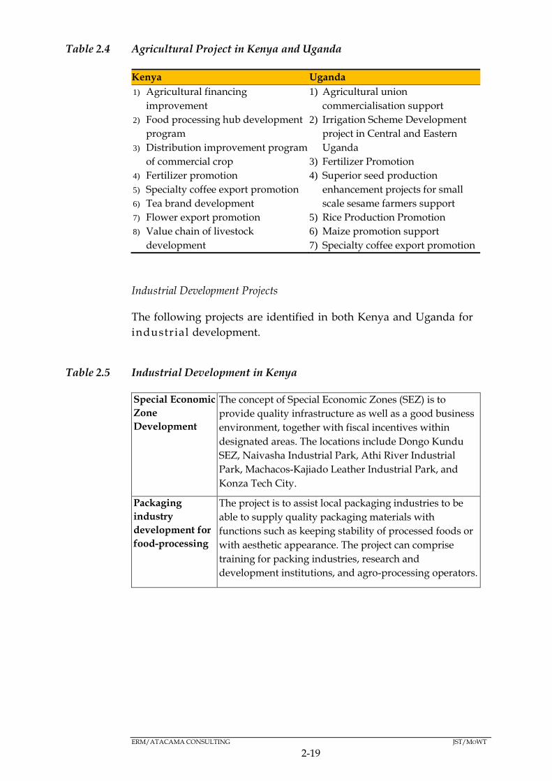
ERM/ATACAMA CONSULTING JST/MOWT
2-19
Table 2.4 Agricultural Project in Kenya and Uganda
Kenya Uganda
1) Agricultural financing
improvement
2) Food processing hub development
program
3) Distribution improvement program
of commercial crop
4) Fertilizer promotion
5) Specialty coffee export promotion
6) Tea brand development
7) Flower export promotion
8) Value chain of livestock
development
9) Mwea Irrigation
1) Agricultural union
commercialisation support
2) Irrigation Scheme Development
project in Central and Eastern
Uganda
3) Fertilizer Promotion
4) Superior seed production
enhancement projects for small
scale sesame farmers support
5) Rice Production Promotion
6) Maize promotion support
7) Specialty coffee export promotion
8) Livestock processed products
promotion
9) Kalangala PPP
Industrial Development Projects
The following projects are identified in both Kenya and Uganda for
industrial development.
Table 2.5 Industrial Development in Kenya
Special Economic
Zone
Development
The concept of Special Economic Zones (SEZ) is to
provide quality infrastructure as well as a good business
environment, together with fiscal incentives within
designated areas. The locations include Dongo Kundu
SEZ, Naivasha Industrial Park, Athi River Industrial
Park, Machacos-Kajiado Leather Industrial Park, and
Konza Tech City.
Packaging
industry
development for
food-processing
The project is to assist local packaging industries to be
able to supply quality packaging materials with
functions such as keeping stability of processed foods or
with aesthetic appearance. The project can comprise
training for packing industries, research and
development institutions, and agro-processing operators.
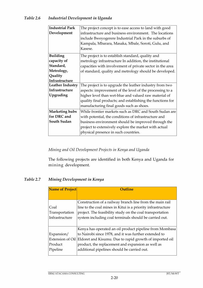
ERM/ATACAMA CONSULTING JST/MOWT
2-20
Table 2.6 Industrial Development in Uganda
Industrial Park
Development
The project concept is to ease access to land with good
infrastructure and business environment. The locations
include Bweyogerere Industrial Park in the suburbs of
Kampala, Mbarara, Masaka, Mbale, Soroti, Gulu, and
Kasese.
Building
capacity of
Standard,
Metrology,
Quality
Infrastructure
The project is to establish standard, quality and
metrology infrastructure In addition, the institutional
capacities with involvement of private sector in the area
of standard, quality and metrology should be developed.
Leather Industry
Infrastructure
Upgrading
The project is to upgrade the leather industry from two
aspects: improvement of the level of the processing to a
higher level than wet-blue and valued raw material of
quality final products; and establishing the functions for
manufacturing final goods such as shoes.
Marketing hubs
for DRC and
South Sudan
While frontier markets such as DRC and South Sudan are
with potential, the conditions of infrastructure and
business environment should be improved through the
project to extensively explore the market with actual
physical presence in such countries.
Mining and Oil Development Projects in Kenya and Uganda
The following projects are identified in both Kenya and Uganda for
mining development.
Table 2.7 Mining Development in Kenya
Name of Project Outline
Coal
Transportation
Infrastructure
Construction of a railway branch line from the main rail
line to the coal mines in Kitui is a priority infrastructure
project. The feasibility study on the coal transportation
system including coal terminals should be carried out.
Expansion/
Extension of Oil
Product
Pipeline
Kenya has operated an oil product pipeline from Mombasa
to Nairobi since 1978, and it was further extended to
Eldoret and Kisumu. Due to rapid growth of imported oil
product, the replacement and expansion as well as
additional pipelines should be carried out.

ERM/ATACAMA CONSULTING JST/MOWT
2-21
Table 2.8 Mining Development in Uganda
Name of Project Outline
Refinery and Oil
Product Tailing
Pipeline
Construction
Refinery Project consists of refining facilities and oil
product shipping pipeline from the refinery to an oil
product terminal near Kampala. Project entity will be
founded through a PPP scheme.
Cross Border
Product Oil
Pipeline
With the economic development of these land locked
countries, demand of product oils has increased
significantly and road traffic has started to be over loaded.
To mitigate the road traffic situation, and to enhance the
traffic safety, extension of the pipeline to Kampala, and to
Kigali will be constructed.
Mining Master
Plan
The Project objective is to maximize the value of mineral
resources and boost initial part of the economic
development of the country. The master plan includes: i)
Mineral Strategy , ii) List of Strategic Minerals and Target
area, iii) Development of Strategic Mineral Mapping and
Database, vi) Mineral Identification Capability, etc.
Logistics Hub Projects
Logistic Hubs should be constructed at Mombasa, Nairobi, Kisumu,
Tororo, Kampala, Gulu, and Mbarara.
Most of the logistics hubs have two common functions, namely:
i) ICD function for modal shift and empty container depot service as far
as SGR extension is expected; and
ii) Logistics center function, which focuses on inventory and delivery
service whose catchment area is set up at approximately a 200km
radius, in order to achieve one-day delivery.
2.9.3 Transport Strategy: Efficient and Integrated Multi-Modal
Transportation System
Modal Shift from truck to railway and pipeline
In both Kenya and Uganda, around 95 percent of cargo freight is
transported by trucks, while other transport modes such as railways
and inland waterways, contribute less than 5 percent of total freight.
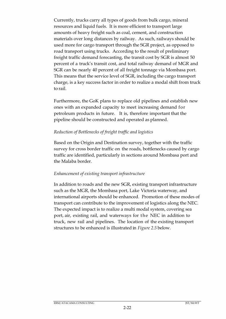
ERM/ATACAMA CONSULTING JST/MOWT
2-22
Currently, trucks carry all types of goods from bulk cargo, mineral
resources and liquid fuels. It is more efficient to transport large
amounts of heavy freight such as coal, cement, and construction
materials over long distances by railway. As such, railways should be
used more for cargo transport through the SGR project, as opposed to
road transport using trucks. According to the result of preliminary
freight traffic demand forecasting, the transit cost by SGR is almost 50
percent of a truck’s transit cost, and total railway demand of MGR and
SGR can be nearly 40 percent of all freight tonnage via Mombasa port.
This means that the service level of SGR, including the cargo transport
charge, is a key success factor in order to realize a modal shift from truck
to rail.
Furthermore, the GoK plans to replace old pipelines and establish new
ones with an expanded capacity to meet increasing demand for
petroleum products in future. It is, therefore important that the
pipeline should be constructed and operated as planned.
Reduction of Bottlenecks of freight traffic and logistics
Based on the Origin and Destination survey, together with the traffic
survey for cross border traffic on the roads, bottlenecks caused by cargo
traffic are identified, particularly in sections around Mombasa port and
the Malaba border.
Enhancement of existing transport infrastructure
In addition to roads and the new SGR, existing transport infrastructure
such as the MGR, the Mombasa port, Lake Victoria waterway, and
international airports should be enhanced. Promotion of these modes of
transport can contribute to the improvement of logistics along the NEC.
The expected impact is to realize a multi modal system, covering sea
port, air, existing rail, and waterways for the NEC in addition to
truck, new rail and pipelines. The location of the existing transport
structures to be enhanced is illustrated in Figure 2.5 below.
ERM/ATACAMA CONSULTING JST/MOWT
2-23
Figure 2.5 Location of the Existing Transport Infrastructure to be Enhance
Source: JST, 2016
Major Suggested Projects for Transport Strategies
Roads
Logistics Highway Project
The main route of the NEC from Mombasa, Nairobi, Kampala, Kigali
and Bujumbura should have at least a dual carriageway. This is due to
the fact that most sections of this route will require four lane capacity, at
least up to 2030. A double carriageway with a median strip is much
safer than a single carriageway without a median strip.
Truck Service Stations Project:
Truck Service Stations should be established which must be large
enough to accommodate at least 100 trucks, as more than 100 heavy
goods vehicles heading in one direction are currently witnessed during
the daytime on many sections of the NEC. In addition, sufficient
accommodation, open 24 hours a day, should be provided for long
distance drivers. Traffic restriction information should also be provided
to drivers before selecting a border to pass.
ERM/ATACAMA CONSULTING JST/MOWT
2-24
Railways
The Base case railway strategy has several elements:
Short term:
Determine an operating format for the Mombasa-Nairobi SGR:
Implement SGR from Nairobi to Malaba and Malaba to Kampala.
Involve the private sector in railway investments such as in ICDs or
terminals or smaller initiatives, such as leasing rail wagons and
locomotives to the railways and shippers.
Medium term:
Implement SGR to Gulu, Pakwach and Nimule.
Implement ICDs and railway yards and obtain operators.
Develop a plan for meter gauge and standard gauge side-by-side
operations.
Use policies and regulations to support the shift of cargo from road to
rail.
Long term:
Invest in and maintain the standard gauge railway.
It is expected that Kenya and Uganda will retain ownership of the SGR
infrastructure and contract operations to a private company. The two
countries should closely monitor the condition of the railway and ensure
that sufficient time and expenditure is devoted to maintenance.
Port
The Mombasa port is expected to be one of the hub ports in the world in
the long term, and will need to be able to handle more than 3 million
TEUs per year. The following projects should be completed in the short
to medium term in order to at least accommodate such volumes:
Construction of Second Container Terminal (depth: 15m and 11m;
2xberths);
Construction of an access road (approx. 1.6km);
ERM/ATACAMA CONSULTING JST/MOWT
2-25
Dredging works (dredging volume: approx. 3 million cubic meters);
Construction of a new SGR linking Mombasa with Nairobi, Kampala
and other hinterland destinations; and
Construction of a southern by-pass for Mombasa linking the south to
north coasts.
Airport
Jomo Kenyatta International Airport (JKIA) is improving capacity to
deal with increasing passenger and cargo demand through an on-going
project. JKIA already has 5 cargo terminals which are privatised. Air
carriers can choose cargo terminals depending on the service standard
and cost performance. The service improvement will be a key factor to
becoming an Air-Air Cargo Hub in the region.
The Eldoret International Airport runway and cargo handling facilities
will be expanded to start export of fresh agricultural produce. This
runway will be extended to 4.3km, from its present length of 3.5km.
The Entebbe International Airport will improve its air cargo facilities.
Considering the current (good) JKIA performance, the Entebbe
International Airport should adopt a fresh strategy, such as an air and
truck services with good cross border facilitation, to for example,
facilitate the cross border movement of higher value goods into the
DRC.
Waterways
From a cargo and tourist transport point of view, several alternatives
for Lake Victoria waterways should be examined. Currently, the
rehabilitation of Port Bell in Uganda is being supported by the World
Bank and EU, and is underway.
Development of Mwambani port in Tanga, Musoma Port and New
Kampala Port at Bukasa are also projects under consideration. The
Bukasa Port development project, as the new port, was proposed in
the past to realize better port functions, expand port-areas, and to add
not only wagon ferries but also roll-on/roll-off (RORO) boats. Further
review of the project should be considered.

ERM/ATACAMA CONSULTING JST/MOWT
2-26
Border Posts
Malaba border is the main border crossing for several countries and
therefore its congestion is a serious bottleneck for the whole of the EAC
region. In order to reduce the risks of congestion, the following two
interventions should be considered;
(i) Establishing multiple lanes
It is a common practice in the world to set up multiple lanes at the
border as they help in reducing congestion;
(ii) Designated lanes for specific commodities/transporters (fast lanes).
Dedicated lanes (fast lanes) will be an incentive for Authorized
Economic Operators (AEO). A dedicated lane for petroleum products
will be beneficial for speeding up its border crossing, also to be
considered for other commodities.
2.9.4 Financial Strategy
Financial Capacity in Kenya and Uganda
Kenya
The Government of Kenya established a Railway Development Fund,
which collects 1.5 percent as Railway Development Levy (RDL) on
all imports. It is projected that the RDL will increase from Ksh 19.7
billion in 2013/14 to Ksh 32.3 billion in 2017/18. The RDL is to be
used solely for the financing of the SGR.
The transport sector stands at 26 percent of the total capital
expenditure, a figure that will increase to 41 percent in 2015/16,
mainly due to increased expenditure in the railway sub-sector. The
construction of the SGR has been prioritized in the transport and logistic
sectors over the medium term, with the SGR section between Nairobi
and Mombasa expected to be complete by 2017. The road sector is also
expected to increase steadily by an annual average growth rate of 15
percent. The expenditure pressure for the road sector remains strong,
despite the recent emphasis of a shift from truck to railway for freight
cargo. The expenditure for marine transport and air transport accounts
for 2.2 percent and 3.4 percent respectively of the total transport
expenditure.
ERM/ATACAMA CONSULTING JST/MOWT
2-27
Uganda
The 2nd National Development Plan 2015/16-2019/20 adopted an
expenditure strategy focusing on infrastructure and human capital
development. The Works and Transport Sector received the largest
share in the Ugandan budget, from 18.2 percent to 23.4 percent of the
budget between 2015/16 and 2018/19 (2nd National Development Plan
2015/16-2019/20, Uganda). The continued allocation of the lion’s share
of the national budget to the works and transport sector is bound to
continue as good transport infrastructure has been earmarked as a key
driver of Uganda’s socio-economic transformation ambitions.
Diversifying Financial Sources
Currently, financing for infrastructure is largely limited to government
grants and external sources. It is therefore important to diversify
sources of funding, especially from the private sector to more
commercially oriented projects through a PPP arrangement and by
issuance of infrastructure bonds. To minimize transaction costs and
duplication, regional financing mechanisms can be sought for regional
projects.
Expanding the revenue sources of the governments for cost recovery
Related to the above, internally generated sources, or cost recovery from
users, are currently limited to road maintenance and airport operations
in the transport sector. Cost recovery from users should be expanded to
the extent possible, in order to respond to increasing financing needs
and for financial sustainability. The largest financing needs for the NEC
is the SGR investment in the medium to long term, and a principle of
cost recovery should be analyzed to the extent possible for this
investment.
2.9.5 Organisational and Policy Strategy
Regional Coordination for logistics improvement
The organizational and regulatory framework for logistics and multi-
modal transportation needs to be established at the regional level.
Regional coordination for planning and monitoring for the NEC is so
far being implemented by the Northern Corridor Transit Transport
Coordination Authority (NCTTCA). NCTTCA’s coordination function
with concerned ministries for both Kenya and Uganda should be
maintained. On the other hand, regional coordination mechanisms
and private sector involvement are being developed through the
Northern Corridor Integration Projects (NCIP).
ERM/ATACAMA CONSULTING JST/MOWT
2-28
Proposed Organisational Framework
Considering the current situation, some recommendations for
organizational framework as well as organizational structure are
proposed.
Once the Management Plan is approved and implementation thereof has
commenced, there must be a monitoring and evaluation mechanism. It
is essential therefore, under the initiative of Ministry of Transport and
Infrastructure (MoTI) in Kenya / MoWT in Uganda, to establish a
taskforce covering various ministries/agencies in charge of transport,
finance, trade, industry, agriculture, mining, energy, water etc. as well
as private sector organizations and NCTTCA, to monitor and evaluate
the implementation of this Plan.
It is recommended that the working group and steering committee
should be maintained after the JICA study as a further monitoring and
implementation mechanism.
OVERALL IMPLEMENTATION STRATEGY 2.10
Out of all the suggested 119 projects for the development of the NEC the
JST has selected 23 flagship projects that can contribute to continued
logistics improvement along the NEC, and to further economic
development of each country, as well as the region. The location of the
23 NEC flagship projects are shown in Figure 2.6 below:
The primary aim of these flagship projects is to:
Solve future logistics bottlenecks along the NEC including at the port,
roads, and logistic hubs;
Contribute to cross border infrastructure, such as pipelines and
transmission lines;
Develop key industrial areas along the NEC;
Ensure power and water supply to identified key industrial areas;
and
Support agribusiness and mining business developments.

2-29
Figure 2.6 Location of NEC Flagship Projects
Source: JST, 2016
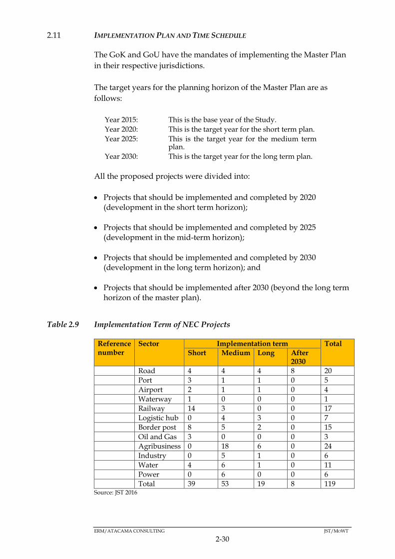
ERM/ATACAMA CONSULTING JST/MOWT
2-30
IMPLEMENTATION PLAN AND TIME SCHEDULE 2.11
The GoK and GoU have the mandates of implementing the Master Plan
in their respective jurisdictions.
The target years for the planning horizon of the Master Plan are as
follows:
Year 2015: This is the base year of the Study.
Year 2020: This is the target year for the short term plan.
Year 2025: This is the target year for the medium term plan.
Year 2030: This is the target year for the long term plan.
All the proposed projects were divided into:
Projects that should be implemented and completed by 2020 (development in the short term horizon);
Projects that should be implemented and completed by 2025 (development in the mid-term horizon);
Projects that should be implemented and completed by 2030 (development in the long term horizon); and
Projects that should be implemented after 2030 (beyond the long term horizon of the master plan).
Table 2.9 Implementation Term of NEC Projects
Reference number
Sector Implementation term Total
Short Medium Long After 2030
1. Road 4 4 4 8 20
2. Port 3 1 1 0 5
3. Airport 2 1 1 0 4
4. Waterway 1 0 0 0 1
5. Railway 14 3 0 0 17
6. Logistic hub 0 4 3 0 7
7. Border post 8 5 2 0 15
8. Oil and Gas 3 0 0 0 3
9. Agribusiness 0 18 6 0 24
10. Industry 0 5 1 0 6
11. Water 4 6 1 0 11
12. Power 0 6 0 0 6
Total 39 53 19 8 119 Source: JST 2016
ERM/ATACAMA CONSULTING JST/MOWT
3-31
3 STRATEGIC, LEGAL AND INSTITUTIONAL FRAMEWORK
STRATEGIC FRAMEWORK (POLICIES, PLANS AND PROGRAMMES) 3.1
The respective policies, plans and programmes (PPPs) that will serve as
a reference point for providing direction for the assessment are
presented in Table 3.1, Table 3.2, and Table 3.3 respectively. They have
been considered from a national, regional and international context
coupled with other requirements that are deemed of importance in
informing the SEA.
It is worth noting that although Uganda has a National Environment
Management Policy in place and the pertinent mix of policy tools for
ensuring its implementation, the guidelines governing SEA are still in
Draft form and have not been formally approved. Therefore, in the
absence of the guidelines, SEA has largely remained a voluntary
endeavour although in certain instances the Government has had to
make it a mandatory requirement as part of proactive environmental
management.
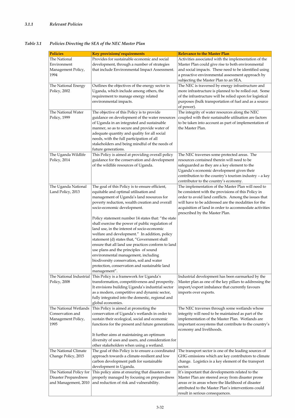
3-32
3.1.1 Relevant Policies
Table 3.1 Policies Directing the SEA of the NEC Master Plan
Policies Key provisions/ requirements Relevance to the Master Plan
The National
Environment
Management Policy,
1994
Provides for sustainable economic and social
development, through a number of strategies
that include Environmental Impact Assessment.
Activities associated with the implementation of the
Master Plan could give rise to both environmental
and social impacts. These need to be identified using
a proactive environmental assessment approach by
subjecting the Master Plan to an SEA.
The National Energy
Policy, 2002
Outlines the objectives of the energy sector in
Uganda, which include among others, the
requirement to manage energy related
environmental impacts.
The NEC is traversed by energy infrastructure and
more infrastructure is planned to be rolled out. Some
of the infrastructure will be relied upon for logistical
purposes (bulk transportation of fuel and as a source
of power).
The National Water
Policy, 1999
The objective of this Policy is to provide
guidance on development of the water resources
of Uganda in an integrated and sustainable
manner, so as to secure and provide water of
adequate quantity and quality for all social
needs, with the full participation of all
stakeholders and being mindful of the needs of
future generations.
The integrity of water resources along the NEC
coupled with their sustainable utilisation are factors
to be taken into account as part of implementation of
the Master Plan.
The Uganda Wildlife
Policy, 2014
This Policy is aimed at providing overall policy
guidance for the conservation and development
of the wildlife resources of Uganda.
The NEC traverses some protected areas. The
resources contained therein will need to be
safeguarded as they are a key element to the
Uganda’s economic development given their
contribution to the country’s tourism industry – a key
contributor to the country’s economy.
The Uganda National
Land Policy, 2013
The goal of this Policy is to ensure efficient,
equitable and optimal utilisation and
management of Uganda’s land resources for
poverty reduction, wealth creation and overall
socio-economic development.
Policy statement number 14 states that: “the state
shall exercise the power of public regulation of
land use, in the interest of socio-economic
welfare and development.” In addition, policy
statement (d) states that, “Government shall
ensure that all land use practices conform to land
use plans and the principles of sound
environmental management, including
biodiversity conservation, soil and water
protection, conservation and sustainable land
management”.
The implementation of the Master Plan will need to
be consistent with the provisions of this Policy in
order to avoid land conflicts. Among the issues that
will have to be addressed are the modalities for the
acquisition of land in order to accommodate activities
prescribed by the Master Plan.
The National Industrial
Policy, 2008
This Policy is a framework for Uganda’s
transformation, competitiveness and prosperity.
It envisions building Uganda’s industrial sector
as a modern, competitive and dynamic sector,
fully integrated into the domestic, regional and
global economies.
Industrial development has been earmarked by the
Master plan as one of the key pillars to addressing the
import/export imbalance that currently favours
imports over exports.
The National Wetlands
Conservation and
Management Policy,
1995
This Policy is aimed at promoting the
conservation of Uganda’s wetlands in order to
sustain their ecological, social and economic
functions for the present and future generations.
It further aims at maintaining an optimum
diversity of uses and users, and consideration for
other stakeholders when using a wetland.
The NEC traverses through some wetlands whose
integrity will need to be maintained as part of the
implementation of the Master Plan. Wetlands are
important ecosystems that contribute to the country’s
economy and livelihoods.
The National Climate
Change Policy, 2015
The goal of this Policy is to ensure a coordinated
approach towards a climate-resilient and low
carbon development path for sustainable
development in Uganda.
The transport sector is one of the leading sources of
GHG emissions which are key contributors to climate
change. Logistics is a key element of the transport
sector.
The National Policy for
Disaster Preparedness
and Management, 2010
This policy aims at ensuring that disasters are
properly managed by focusing on preparedness
and reduction of risk and vulnerability.
It’s important that developments related to the
Master Plan are steered away from disaster prone
areas or in areas where the likelihood of disaster
attributed to the Master Plan’s interventions could
result in serious consequences.

3-33
Policies Key provisions/ requirements Relevance to the Master Plan
The National Gender
Policy, 1997
The aim of this Policy is to guide and direct at all
levels, the planning, resource mobilisation and
implementation of development programmes
with a gender perspective.
Gender concerns will have to be mainstreamed into
the Master Plan, so as to ensure that it is gender
sensitive and responsive.
Transport Draft Policy
and Strategy Paper
The transport sector is expected to provide cost
effective, efficient, safe and environmentally
sensitive transport services. Some of the key
features of the policy and strategy paper include:
the need to increase trade, employment,
economic output and reduce poverty; equitable
treatment of different modes of transport taking
into account efficiency and modal suitability to
determine modal split; promote modal
integration; and maintaining high quality
trading links through the Northern and central
corridors.
An effective transport policy framework is key to
having efficient mode(s) of transportation that in turn
determines the degree of efficiency of the logistics
system.
Draft Non Motorised
Transport (NMT)
Policy
The policy is intended to: raise the profile of
NMT within planning and programming for
transport in general; and to provide guidelines
for the inclusion of NMT needs within transport
projects, among other things.
A large section of the population along the Northern
corridor are NMT users and therefore conditions for
walking and cycling within the corridor have to be
taken into account by the Master Plan. The
conditions can be improved through allocation of
more space for pedestrians and cyclists, reduction of
vehicle speeds, and promoting compact and mixed
land use.
National Agriculture
Policy (2013)
The overall objective is to promote food and
nutrition security and to improve household
incomes through coordinated interventions that
will enhance sustainable agricultural
productivity and value addition, provide
employment opportunities, and promote
agribusinesses, investments and trade.
Majority of the people within the Northern corridor
derive their livelihood from Agriculture directly or
linkages related to the agricultural sector. It is also
among the sectors for which the Master Plan has
earmarked some interventions that are aimed at
boosting Uganda’s exports.
HIV/AIDS Policy
(2007)
It aims at preventing new HIV/AIDS infections
and eliminating the socio-economic burden of
HIV and AIDS in the country and all categories
of its population.
According to UNAIDS, mobility has been identified
as one of the key factors behind the spread of
HIV/AIDS in East Africa due to the high risk
environments associated with transport corridors,
which often facilitate multiple concurrent sexual
partnerships.
Mineral Policy (2000) It aims at building the mineral sector for it to
contribute significantly to the national, social
and economic growth.
Exploitation of the country’s mineral wealth is among
the Master Plan’s interventions as part of process of
boosting export led economic growth.
Tourism Policy (2015) This Policy aims to ensure that tourism becomes
a vehicle for poverty reduction through wide
participation of Ugandan and foreign investors.
The policy particularly seeks to assist in the
effort to promote the economy and the
livelihoods of the people, through encouraging
the development of sustainable quality tourism
that is culturally and socially acceptable,
ecologically friendly, environmentally
sustainable, and economically viable.
There are some biodiversity hotspots as well and
cultural and heritage sites within the NEC and these
happen to be important tourism hubs for the country
from which the country generates most of its tourism
revenue.
National Oil and Gas
Policy (2008)
This policy aims to use the country’s oil and gas
resources to help eradicate poverty and to create
lasting value to society. It addresses the entire
chain that includes; exploration, development,
production and utilisation of the country’s oil
and gas.
In order for the country to successfully harness its oil
and gas reserves, efficiency of logistics will be the
key. According to the results of an oil and gas
Industrial Baseline Survey (IBS) for Uganda (that was
launched in 2014); from a transportation and logistics
perspective, at the peak of operations up to 1,200
trucks will be required per month for transportation
of equipment, raw bulky material, food and water.
Majority of these will pass through NEC.

3-34
Policies Key provisions/ requirements Relevance to the Master Plan
Fisheries Policy (2004) The goal of the policy is to ensure increased and
sustainable fish production and utilisation by
properly managing the capture of fish;
promoting aquaculture and reducing post-
harvest losses. This goal contributes to the
overall national development policy of poverty
eradication and food security. The policy
provides that participatory planning and policy-
making form the basis of fisheries management,
so as to ensure that fisheries management
systems are based on dynamic processes that
take account of technical, biological, social,
economic, environmental and cultural aspects.
The policy further provides that adverse
environmental impacts on fisheries are to be
minimised, and mechanisms established at
appropriate levels to achieve this by protecting
fisheries and aquatic ecosystems from adverse
environmental impacts
The Master Plan advocates for the upgrade of and use
of water transport for movement of cargo,
particularly around the Lake Victoria basin. Lake
Victoria is a major source of fish and fish is among
the leading non-traditional exports from East Africa.
National Land Use
Policy (2007)
The aim of the policy is to: “achieve sustainable
and equitable socio-economic development
through optimal land management and
utilisation”. The specific goals include;
To adopt improved agriculture and other land
use systems that will provide lasting benefits for
Uganda.
To reverse and alleviate adverse environmental
effects at local, national, regional and global
levels.
To promote land use activities that ensure
sustainable utilisation and management of
environmental, natural and cultural resources
for national socio-economic development.
To ensure planned, environmentally friendly,
affordable and well-distributed human; and
settlements for both rural and urban areas.
To update and harmonise all land use related
policies and laws, and strengthen institutional
capacity at all levels of Government.
It’s important that the interventions of the Master
Plan conform to sustainable land use practices within
the Northern Corridor.
Other Important Instruments
Uganda’s Vision 2040 This Vision is Uganda’s socio-economic
transformation roadmap aimed at transforming
Uganda from a predominantly subsistence based
low income economy, into a middle income
economy by 2040.
Contribution to economic and social development
along the NEC is among the key objectives of the
Master Plan and this is in tandem with Uganda’s
socio-economic transformation theme of Vision 2040.
Africa Agenda 2063 This is Africa’s transformation plan over the next
50 years and sets out a number of aspirations
that are to be realised during that period. The
Agenda has since been adopted by the African
Union (AU).
The Agenda advocates for a number of actions that
are in tandem with some of the aspirations of the
Master Plan. Some of key actions include: eradication
of poverty through skills enhancement and improved
incomes; transform, grow and industrialise Africa’s
economies through beneficiation and value addition
of natural resources; consolidate the modernisation of
African agriculture and agro-businesses; and connect
Africa through world class infrastructure including in
the transport sector, among other sectors.
Sustainable
Development Goals
(SDGs)
The SDGs were formally adopted by Uganda
and other member states in September 2015 as an
integral part of the 2030 Agenda on Sustainable
Development. SDG indicators and targets are to
be integrated in the appropriate Sector and Local
Government Plans and budgets coupled with
implementation, monitoring and evaluation
frameworks.
Interventions in the Master Plan are closely linked
with some of the SDGs particularly;
SDG 1: End Poverty.
SDG 9: Resilient infrastructure, sustainable
industrialisation and innovation.
SDG 11: inclusive, resilient, sustainable cities.
SDG 12: Ensure sustainable consumption and
production patterns.

3-35
3.1.2 Relevant Plans
Table 3.2 Plans Directing the SEA of the NEC Master Plan
Plans Key provisions/ requirements Relevance to the Master Plan
Uganda’s Second National Development
Plan (NDP II), 2015-2019
The Plan aims to strengthen the country’s
competitiveness for sustainable wealth
creation, employment and inclusive
growth. It is the second of a series of 5-
year NDPs geared towards the realisation
of Vision 2040.
All development interventions in the
country including those contained in the
Master Plan are expected to be consistent
with the NDP and feed into it as opposed
to being parallel intervention to the
Master Plan.
Sector Development Plans (SDPs) Proactive vision-based planning is the
basis of the SDPs. Policies, Strategies and
Programmes of Ministries, Departments
and Agencies (MDAs) are meant to be
consolidated into the SDPs that are then
aligned to the NDP and Uganda Vision
2040.
The Master Plans interventions in the
respective sectors must be consistent with
the SDPs.
National Transport Master Plan (NTMP)
including the Transport Master Plan for
the Greater Kampala Metropolitan Area
(GKMA) (2009)
This Master Plan sets out a framework for
the development of the transport sector
over the next 15 years (2008 – 2023)
The NTMP and the Master Plan for the
GKMA pronounce themselves on the
need for integration of the different
modes of transport, which is critical for
the NEC, a multi-modal transport
corridor.
National Irrigation Master Plan (2010 –
2035)
The overall objective of the plan is to
alleviate poverty and promote economic
growth through the sustainable
realisation of the country’s irrigation
potential thereby contributing to the
transformation of Ugandan society from a
peasant to a modern and prosperous
country.
Irrigation has been earmarked among the
interventions of the Master Plan in the
agricultural sector.
Regional Plans
Northern Corridor Infrastructure Master
Plan (2011)
The main objective of the Northern
Corridor Infrastructure Master Plan is to
provide for the development of transport
infrastructure in the region by among
other things, transforming the Corridor
into an economic development corridor
that offers internationally competitive
transit transport services.
Good infrastructure is a key factor in
overcoming logistical bottlenecks and
related inefficiencies.
Local Plans
Local Government Development Plans It is a requirement that all Districts have
5-year District Development Plans (DDPs)
in place as a basis for tracking
government programs and directing
development investment.
Interventions in the Master Plans will
have to conform to the Local Government
Development Plans as the plans are
consistent with the NDP and Vision 2040.
Protected area management plans. These are planning documents that guide
all activities in each of the protected areas
including but not limited to, National
Parks, Forest reserves, among others.
Their main purpose is to ensure that the
core objectives for which the protected
areas were designated are not
compromised by potential developments
within or in their vicinity.
Developments associated with the
proposed Master Plan could potentially
have an effect on protected areas.
However, it is essential that these
developments do not infringe upon the
purposes for which these protected areas
were designated.
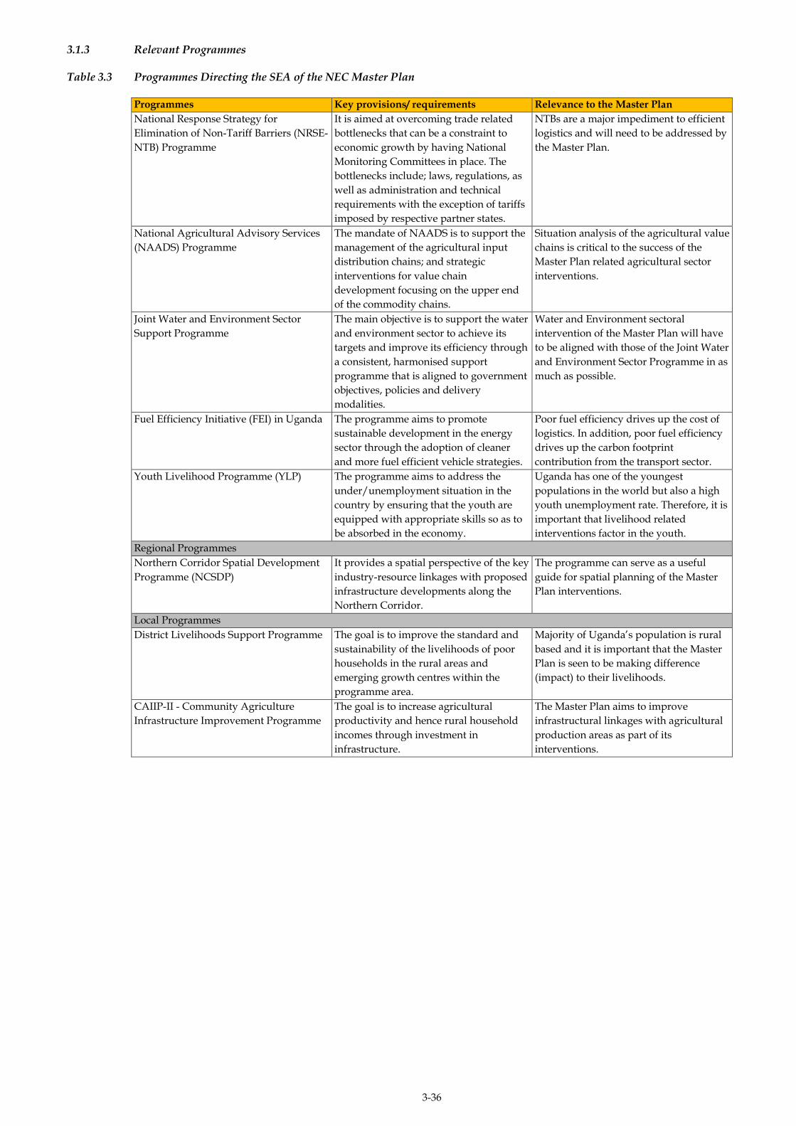
3-36
3.1.3 Relevant Programmes
Table 3.3 Programmes Directing the SEA of the NEC Master Plan
Programmes Key provisions/ requirements Relevance to the Master Plan
National Response Strategy for
Elimination of Non-Tariff Barriers (NRSE-
NTB) Programme
It is aimed at overcoming trade related
bottlenecks that can be a constraint to
economic growth by having National
Monitoring Committees in place. The
bottlenecks include; laws, regulations, as
well as administration and technical
requirements with the exception of tariffs
imposed by respective partner states.
NTBs are a major impediment to efficient
logistics and will need to be addressed by
the Master Plan.
National Agricultural Advisory Services
(NAADS) Programme
The mandate of NAADS is to support the
management of the agricultural input
distribution chains; and strategic
interventions for value chain
development focusing on the upper end
of the commodity chains.
Situation analysis of the agricultural value
chains is critical to the success of the
Master Plan related agricultural sector
interventions.
Joint Water and Environment Sector
Support Programme
The main objective is to support the water
and environment sector to achieve its
targets and improve its efficiency through
a consistent, harmonised support
programme that is aligned to government
objectives, policies and delivery
modalities.
Water and Environment sectoral
intervention of the Master Plan will have
to be aligned with those of the Joint Water
and Environment Sector Programme in as
much as possible.
Fuel Efficiency Initiative (FEI) in Uganda The programme aims to promote
sustainable development in the energy
sector through the adoption of cleaner
and more fuel efficient vehicle strategies.
Poor fuel efficiency drives up the cost of
logistics. In addition, poor fuel efficiency
drives up the carbon footprint
contribution from the transport sector.
Youth Livelihood Programme (YLP) The programme aims to address the
under/unemployment situation in the
country by ensuring that the youth are
equipped with appropriate skills so as to
be absorbed in the economy.
Uganda has one of the youngest
populations in the world but also a high
youth unemployment rate. Therefore, it is
important that livelihood related
interventions factor in the youth.
Regional Programmes
Northern Corridor Spatial Development
Programme (NCSDP)
It provides a spatial perspective of the key
industry-resource linkages with proposed
infrastructure developments along the
Northern Corridor.
The programme can serve as a useful
guide for spatial planning of the Master
Plan interventions.
Local Programmes
District Livelihoods Support Programme The goal is to improve the standard and
sustainability of the livelihoods of poor
households in the rural areas and
emerging growth centres within the
programme area.
Majority of Uganda’s population is rural
based and it is important that the Master
Plan is seen to be making difference
(impact) to their livelihoods.
CAIIP-II - Community Agriculture
Infrastructure Improvement Programme
The goal is to increase agricultural
productivity and hence rural household
incomes through investment in
infrastructure.
The Master Plan aims to improve
infrastructural linkages with agricultural
production areas as part of its
interventions.

ERM/ATACAMA CONSULTING JST/MOWT
3-37
LEGAL FRAMEWORK 3.2
Following on from the strategic framework that was presented above, it
is important to understand the legal and regulatory conditions that the
Master Plan would be expected to comply with although these do not
set a strategic direction for the Master Plan like the strategic framework
does. Aspects of the respective legal requirements are discussed below.
3.2.1 National Legal Framework
Implementation of the NEC logistics Master Plan will have to abide by
the existing national laws and regulations. For purposes of this SEA,
specific sections of the existing national laws and regulations that have
been deemed to be of relevance to the development and
implementation of the Master Plan from an environmental and social
point of view have been reviewed and presented in Table 3.4 below.
3.2.2 Regional and International Legal Framework/ Treaties
Uganda is a member of regional and international organisations like the
East African Community (EAC), African Union (AU) and United
Nations (UN). These organisations have a number of regulations in
place which are binding on all the member states. With respective to the
Master Plan, the following regional and international regulations are
deemed to be of relevance.
The Constitutive Act of the African Union, 2000;
Treaty for the Common Market for Eastern and Southern Africa,
1993;
Treaty for the establishment of the East African Community (EAC),
1999; and
Northern Corridor Transit and Transport Agreement, 2007.
3.2.3 Institutional Framework
There are a number of institutions with vested interests in Uganda’s
transport sector. It is especially important to understand their
respective roles and responsibilities in the context of decision related to
the SEA for the Master Plan. The institutions include; national, regional
and international organisations.

ERM/ATACAMA CONSULTING JST/MOWT
3-38
Those deemed to be of critical importance in as far as the Master Plan is
concerned are discussed in Sections 3.4.1 to 3.4.3 below while the
complete list is presented in Chapter 7 (Stakeholder Engagement).
3.2.4 National Institutions
Table 3.5 National Institutionsindicates the institutions that are
deemed to be of National significance for purposes of the SEA for the
Master Plan.
3.2.5 Regional Institutions
East African Community
The East African Community (EAC) is the regional co-operation that
comprises the Republic of Tanzania, Kenya, Burundi, Rwanda and
Uganda. Under the EAC, a number of common transport and
communications programmes and projects aiming at simplifying
transport and communications in the region are being developed.
Most of the constraints to cross-border trade and investment in the
region are considered to be related to the limited development of
transport and communications networks in the region and to
inadequacies in the rules and regulations governing trade, payments
and investment in the different countries.
The EAC is therefore undertaking huge efforts to improve
infrastructure in the region, especially road and rail transport, the
upgrading of ports and the construction of new ports along the Indian
Ocean coast which is in line with the Record of Discussion signed
between the GoU and GoK with JICA for the implementation of the
Project for Formulation of the Master Plan.
The Community of Eastern and Southern Africa (COMESA)
COMESA is a regional organisation, based in Lusaka, Zambia, which
also undertakes transport planning activities for an extensive area of
Eastern and Southern Africa. Under COMESA, transport corridors are a
key focus of trade facilitation in the region and are viewed as a solution
to the challenge of fragmentation among countries in the region by
providing the much needed facilitation; particularly for landlocked
countries like Uganda.

ERM/ATACAMA CONSULTING JST/MOWT
3-39
African Development Bank
The African Development Bank (AfDB) is a regional multilateral
development finance institution established to contribute to the
economic development and social progress of African countries that are
the institution’s Regional Member Countries (RMCs) (1)
The African Development Bank Transport Forum (ATF) 2015 ended on
November 27, 2015, with the AfDB reiterating its support for transport
development to ensure economic growth on the continent.
The construction of 23.7-kilometre expressway from Busega to Mpigi
(in the Northern Corridor) is one of the transport projects which will be
financed with funds already approved by the AfDB in a bid to boost
regional trade while decongesting traffic from Kampala to Mpigi. This
is in line with the transport strategy of the Master Plan.
The Northern Corridor Transit Transport Coordination Authority
The Northern Corridor Transit Transport Coordination Authority
(NCTTCA) was created in the mid-1980s, following the signing of the
Northern Corridor Transit Agreement (the Treaty), by Burundi, Kenya,
Rwanda and Uganda. The Democratic Republic of Congo became a
contracting state of the NCTTCA in 1987 after ratifying the treaty,
(International Conference on the Great Lakes Region, August, 2006).
The NCTTCA mandate is stipulated in the Transit Agreement and it
includes:
Safeguarding the freedom of transit and right of access to and from
the sea for the landlocked countries;
Ensuring implementation of and compliance with the provisions of
the Transit Agreement;
Joint promotion and coordination of the development of regional
transport infrastructure;
Reduction of transport costs through the removal of all customs
barriers in the corridor;
Harmonisation of transit transport policies and technical standards
in order to facilitate operations along the corridor;
(1) http://www.afdb.org/en/about-us/frequently-asked-questions/

ERM/ATACAMA CONSULTING JST/MOWT
3-40
Promotion of regional consensus on all matters relating to the
management of the corridor and which are of mutual benefit to the
member States; and
Cooperation with other international organizations.
The mandate of NCTTCA mirrors the project’s objective of formulation
of a Master Plan on Logistics for the Northern Economic Corridor.
Trade and Markets East Africa
Trade and Markets East Africa (Trade Mark East Africa – TMEA) is an
East African not-for profit Company Limited by Guarantee established
in 2010 to support the growth of trade - both regional and international
- in East Africa. TMEA is focused on ensuring gains from trade result
in tangible gains for East Africans. TMEA provided input on the
Master Plan formulation by being part of the technical and the Steering
Committees at Ministry of Works.
The Central Corridor Transit Transport Facilitation Agency (TTFA)
The TTFA was formed in recognition of the right of landlocked
countries to transit trade as declared under specific United Nations
General Assembly Resolution 56/180 on particular needs of
Landlocked Developing Countries from which other declarations and
action programmes evolved.
Through co-operation amongst private and public sector stakeholders
the TTFA is charged with the promotion of transport utilisation of the
Central Corridor, encouraging the maintenance, upgrading,
improvement and development of infrastructure and supporting
service facilities at port, rail, lake, road border posts and along the route
to meet user requirements, ensure open competition and reduce the
costs of transit transport for land-locked Member States of which
Uganda is among. Linking with the Central Corridor is one of the
Regional strategic options provided with which the Master Plan will
improve logistics in the NEC.
3.2.6 International Institutions
Japan International Cooperation Agency
Japan International Cooperation Agency (JICA) is a governmental
agency that coordinates Official Development Assistance (ODA) for the
GoJ.
ERM/ATACAMA CONSULTING JST/MOWT
3-41
JICA aims to contribute to the promotion of international development
cooperation and addressing the global agenda by supporting the socio-
economic development, recovery and economic stability of developing
countries. The Official Development Assistance coordinated by JICA is
broadly divided into bilateral aid, in which assistance is given directly
to developing countries, and multilateral aid, provided through
international organizations.
JICA is responsible for the formulation and implementation of the
Master Plan where the JICA Study Team is to provide relevant technical
assistance to MoWT until the completion of Stakeholder Validation
Meeting and the preparation of SEA Final Report.
European Union
The European Union (EU) is both a bilateral donor and a multilateral
donor. The development cooperation in Eastern Africa is delivered at
different levels: national, regional, continental and thematic, all of
which are financed either by the 11th European Development Fund or
the EU budget. The European Commission (EC) and Uganda have
partnered in development for more than 30 years since the opening of
its Delegation to Uganda in 1976(1).
Transport infrastructure is one of three identified thematic/focal areas
for which the EU is providing support to Uganda since the 1970’s. The
EU grant contribution to the Northern Corridor Route Improvement
Project stands at 129 million Euros. Under the 11th European
Development Fund (EDF) support to Uganda, the EU is providing
Uganda none repayable grants, the sum of € 578 million for the period
2014-2020. At least 40 percent of the support is dedicated to Transport
Infrastructure development over the period (2).
(1) http://independent.co.ug/supplement/99-33-years-of-eu-uganda-development-partnership (2) (http://www.eeas.europa.eu/delegations/uganda/press_corner/all_news/news/2015/20150821_en.htm
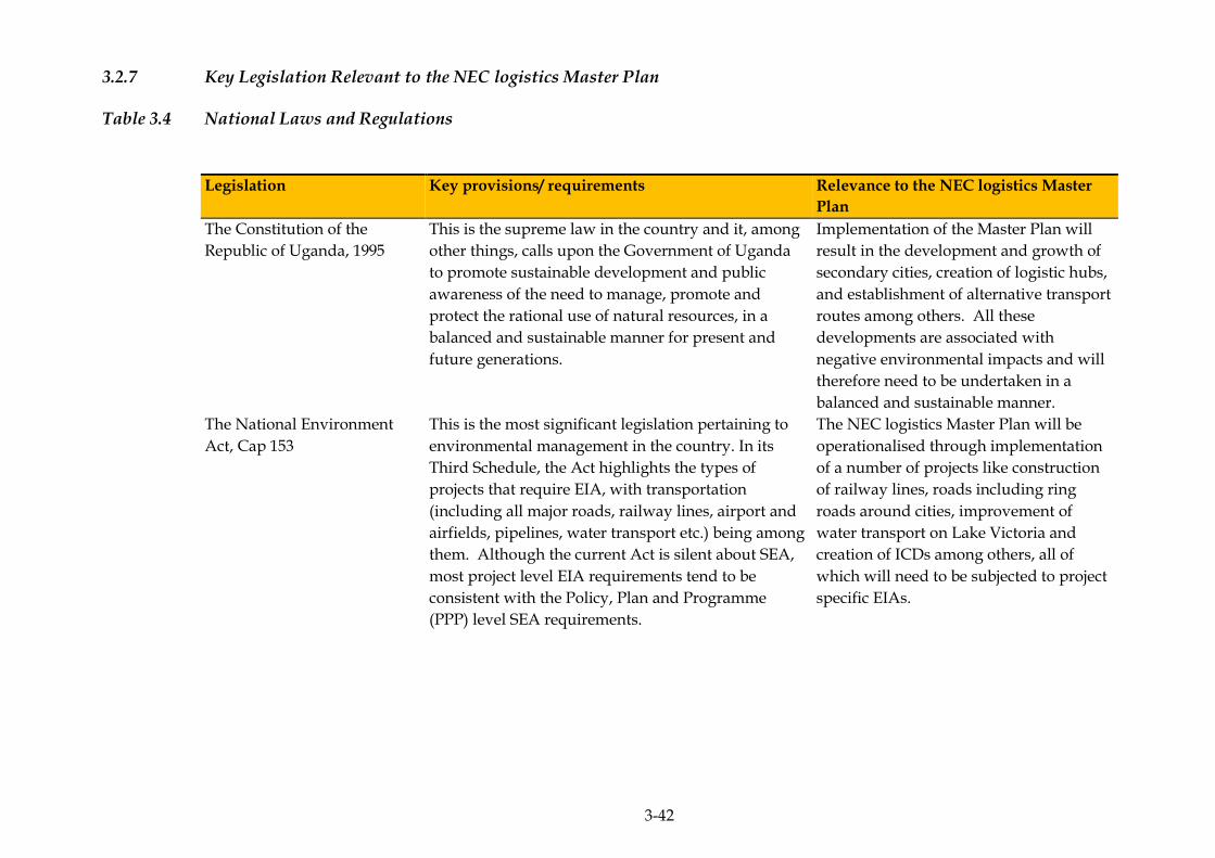
3-42
3.2.7 Key Legislation Relevant to the NEC logistics Master Plan
Table 3.4 National Laws and Regulations
Legislation Key provisions/ requirements Relevance to the NEC logistics Master
Plan
The Constitution of the
Republic of Uganda, 1995
This is the supreme law in the country and it, among
other things, calls upon the Government of Uganda
to promote sustainable development and public
awareness of the need to manage, promote and
protect the rational use of natural resources, in a
balanced and sustainable manner for present and
future generations.
Implementation of the Master Plan will
result in the development and growth of
secondary cities, creation of logistic hubs,
and establishment of alternative transport
routes among others. All these
developments are associated with
negative environmental impacts and will
therefore need to be undertaken in a
balanced and sustainable manner.
The National Environment
Act, Cap 153
This is the most significant legislation pertaining to
environmental management in the country. In its
Third Schedule, the Act highlights the types of
projects that require EIA, with transportation
(including all major roads, railway lines, airport and
airfields, pipelines, water transport etc.) being among
them. Although the current Act is silent about SEA,
most project level EIA requirements tend to be
consistent with the Policy, Plan and Programme
(PPP) level SEA requirements.
The NEC logistics Master Plan will be
operationalised through implementation
of a number of projects like construction
of railway lines, roads including ring
roads around cities, improvement of
water transport on Lake Victoria and
creation of ICDs among others, all of
which will need to be subjected to project
specific EIAs.
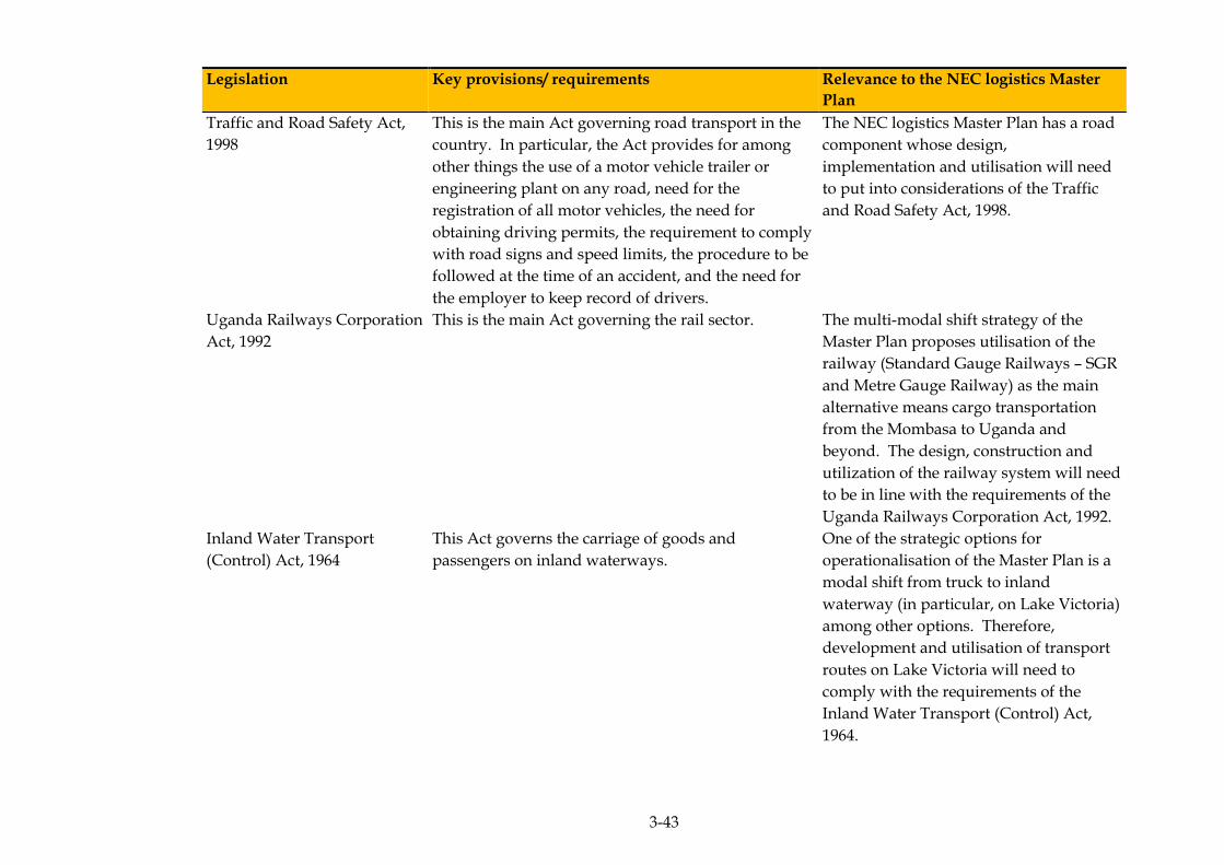
3-43
Legislation Key provisions/ requirements Relevance to the NEC logistics Master
Plan
Traffic and Road Safety Act,
1998
This is the main Act governing road transport in the
country. In particular, the Act provides for among
other things the use of a motor vehicle trailer or
engineering plant on any road, need for the
registration of all motor vehicles, the need for
obtaining driving permits, the requirement to comply
with road signs and speed limits, the procedure to be
followed at the time of an accident, and the need for
the employer to keep record of drivers.
The NEC logistics Master Plan has a road
component whose design,
implementation and utilisation will need
to put into considerations of the Traffic
and Road Safety Act, 1998.
Uganda Railways Corporation
Act, 1992
This is the main Act governing the rail sector. The multi-modal shift strategy of the
Master Plan proposes utilisation of the
railway (Standard Gauge Railways – SGR
and Metre Gauge Railway) as the main
alternative means cargo transportation
from the Mombasa to Uganda and
beyond. The design, construction and
utilization of the railway system will need
to be in line with the requirements of the
Uganda Railways Corporation Act, 1992.
Inland Water Transport
(Control) Act, 1964
This Act governs the carriage of goods and
passengers on inland waterways.
One of the strategic options for
operationalisation of the Master Plan is a
modal shift from truck to inland
waterway (in particular, on Lake Victoria)
among other options. Therefore,
development and utilisation of transport
routes on Lake Victoria will need to
comply with the requirements of the
Inland Water Transport (Control) Act,
1964.
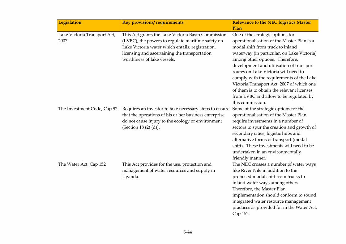
3-44
Legislation Key provisions/ requirements Relevance to the NEC logistics Master
Plan
Lake Victoria Transport Act,
2007
This Act grants the Lake Victoria Basin Commission
(LVBC), the powers to regulate maritime safety on
Lake Victoria water which entails; registration,
licensing and ascertaining the transportation
worthiness of lake vessels.
One of the strategic options for
operationalisation of the Master Plan is a
modal shift from truck to inland
waterway (in particular, on Lake Victoria)
among other options. Therefore,
development and utilisation of transport
routes on Lake Victoria will need to
comply with the requirements of the Lake
Victoria Transport Act, 2007 of which one
of them is to obtain the relevant licenses
from LVBC and allow to be regulated by
this commission.
The Investment Code, Cap 92 Requires an investor to take necessary steps to ensure
that the operations of his or her business enterprise
do not cause injury to the ecology or environment
(Section 18 (2) (d)).
Some of the strategic options for the
operationalisation of the Master Plan
require investments in a number of
sectors to spur the creation and growth of
secondary cities, logistic hubs and
alternative forms of transport (modal
shift). These investments will need to be
undertaken in an environmentally
friendly manner.
The Water Act, Cap 152 This Act provides for the use, protection and
management of water resources and supply in
Uganda.
The NEC crosses a number of water ways
like River Nile in addition to the
proposed modal shift from trucks to
inland water ways among others.
Therefore, the Master Plan
implementation should conform to sound
integrated water resource management
practices as provided for in the Water Act,
Cap 152.

3-45
Legislation Key provisions/ requirements Relevance to the NEC logistics Master
Plan
Uganda Wildlife Act, Cap 200 This Act provides for sustainable management of
wildlife.
Uganda has a number of protected areas
which are homes to diverse wildlife.
Implementation of the Master Plan will
have to consider the need to maintain the
integrity of the existing protected areas
which are a key factor in Uganda’s
tourism industry and economic
development.
The Local Government Act,
Cap 243
This Act provides for the decentralised governance
and devolution of central government functions,
powers and services to local governments that have
their own political and administrative set-ups.
Through this provision, local governments can enact
ordinances and by-laws, as long as they are consistent
with the Constitution of the Republic of Uganda,
1995. Environmental by-laws are a case in point.
The NEC traverses a number of local
governments (in particular, districts). The
Master Plan implementation will need to
observe the requirements of the
ordinances and by-laws of all the districts
traversed in addition to the national laws.
Public Health Act, Cap 281
This Act provides local authorities with
administrative powers to take all lawful, necessary
and reasonable measures to prevent the occurrence
of, or deal with, any outbreak or prevalence of any
infectious, communicable or preventable disease and
to safeguard and promote public health.
The necessary public health safeguards
will have to be factored into the Master
Plan, especially given the fact that
HIV/AIDS hotspots have been identified
along the transit routes within the
corridor.
The Historical and
Monuments Act, 1967
It provides for the preservation and protection of
historical monuments and objects of archaeological,
paleontological, ethnographical and traditional
interest.
All reasonable measures will need to be
taken to ensure that the integrity of any
historical monuments and objects of
archaeological, paleontological,
ethnographical and traditional interest
along the NEC are not affected by the
implementation of the Master Plan.
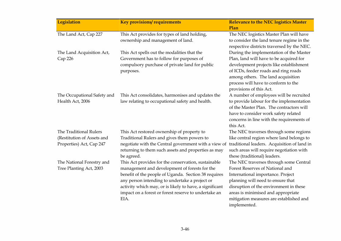
3-46
Legislation Key provisions/ requirements Relevance to the NEC logistics Master
Plan
The Land Act, Cap 227 This Act provides for types of land holding,
ownership and management of land.
The NEC logistics Master Plan will have
to consider the land tenure regime in the
respective districts traversed by the NEC.
The Land Acquisition Act,
Cap 226
This Act spells out the modalities that the
Government has to follow for purposes of
compulsory purchase of private land for public
purposes.
During the implementation of the Master
Plan, land will have to be acquired for
development projects like establishment
of ICDs, feeder roads and ring roads
among others. The land acquisition
process will have to conform to the
provisions of this Act.
The Occupational Safety and
Health Act, 2006
This Act consolidates, harmonises and updates the
law relating to occupational safety and health.
A number of employees will be recruited
to provide labour for the implementation
of the Master Plan. The contractors will
have to consider work safety related
concerns in line with the requirements of
this Act.
The Traditional Rulers
(Restitution of Assets and
Properties) Act, Cap 247
This Act restored ownership of property to
Traditional Rulers and gives them powers to
negotiate with the Central government with a view of
returning to them such assets and properties as may
be agreed.
The NEC traverses through some regions
like central region where land belongs to
traditional leaders. Acquisition of land in
such areas will require negotiation with
these (traditional) leaders.
The National Forestry and
Tree Planting Act, 2003
This Act provides for the conservation, sustainable
management and development of forests for the
benefit of the people of Uganda. Section 38 requires
any person intending to undertake a project or
activity which may, or is likely to have, a significant
impact on a forest or forest reserve to undertake an
EIA.
The NEC traverses through some Central
Forest Reserves of National and
International importance. Project
planning will need to ensure that
disruption of the environment in these
areas is minimised and appropriate
mitigation measures are established and
implemented.

3-47
Legislation Key provisions/ requirements Relevance to the NEC logistics Master
Plan
Physical Planning Act, 2010 This is the principle Act governing the preparation of
physical development plans at all levels including
Regional Development Plans. It stipulates the
contents of the Plans and their relationship to one
another.
Physical plan aspects enshrined in the
Master Plan will have to conform to the
provisions of this Act.
3.2.8 Key National Institutions Relevant to the SEA/Master Plan
Table 3.5 National Institutions
Organisation Main Functions and roles Relevance to the NEC logistics Master
Plan
Ministry of Works and
Transport (MoWT)
Main role is policy, planning and regulatory
functions.
The Master Plan is housed within this
ministry.
Uganda National Roads
Authority (UNRA)
Construction and maintenance of national road
network; resort to force account; and pursuing long-
term performance contracting.
UNRA will be responsible for
implementation of the desirable
institutional changes as well as road
construction.
Ministry of Finance Planning
and Economic Development
(MFPED)
Its overall responsibility is for entire public financial
management cycle, planning, budgeting, execution
and accounting.
Working closely with JICA to implement
the bilateral financing modalities between
the GoJ and GoU.
Uganda Road Fund Board Administration of maintenance funds derived from
fuel levy.
Oversight of UNRA activities.
Uganda road fund will be responsible for
administration of fuel levy for the
improvement of the road infrastructure.
Ministry of Local
Government (MoLG)
The MoLG is responsible for coordinating the
financing and delivery of road services on local road
networks.
MoLG is expected to harmonise and
coordinate requests for inputs from Local
Governments or from MoWT.
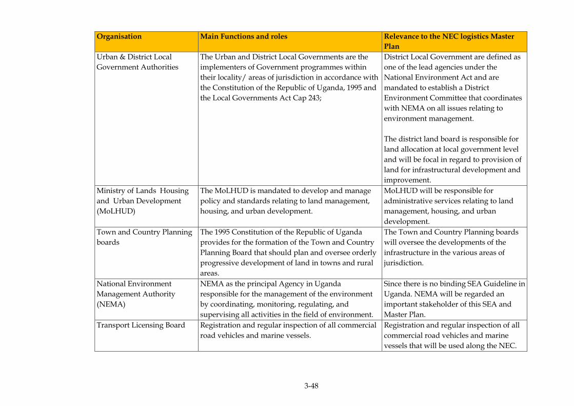
3-48
Organisation Main Functions and roles Relevance to the NEC logistics Master
Plan
Urban & District Local
Government Authorities
The Urban and District Local Governments are the
implementers of Government programmes within
their locality/ areas of jurisdiction in accordance with
the Constitution of the Republic of Uganda, 1995 and
the Local Governments Act Cap 243;
District Local Government are defined as
one of the lead agencies under the
National Environment Act and are
mandated to establish a District
Environment Committee that coordinates
with NEMA on all issues relating to
environment management.
The district land board is responsible for
land allocation at local government level
and will be focal in regard to provision of
land for infrastructural development and
improvement.
Ministry of Lands Housing
and Urban Development
(MoLHUD)
The MoLHUD is mandated to develop and manage
policy and standards relating to land management,
housing, and urban development.
MoLHUD will be responsible for
administrative services relating to land
management, housing, and urban
development.
Town and Country Planning
boards
The 1995 Constitution of the Republic of Uganda
provides for the formation of the Town and Country
Planning Board that should plan and oversee orderly
progressive development of land in towns and rural
areas.
The Town and Country Planning boards
will oversee the developments of the
infrastructure in the various areas of
jurisdiction.
National Environment
Management Authority
(NEMA)
NEMA as the principal Agency in Uganda
responsible for the management of the environment
by coordinating, monitoring, regulating, and
supervising all activities in the field of environment.
Since there is no binding SEA Guideline in
Uganda. NEMA will be regarded an
important stakeholder of this SEA and
Master Plan.
Transport Licensing Board Registration and regular inspection of all commercial
road vehicles and marine vessels.
Registration and regular inspection of all
commercial road vehicles and marine
vessels that will be used along the NEC.
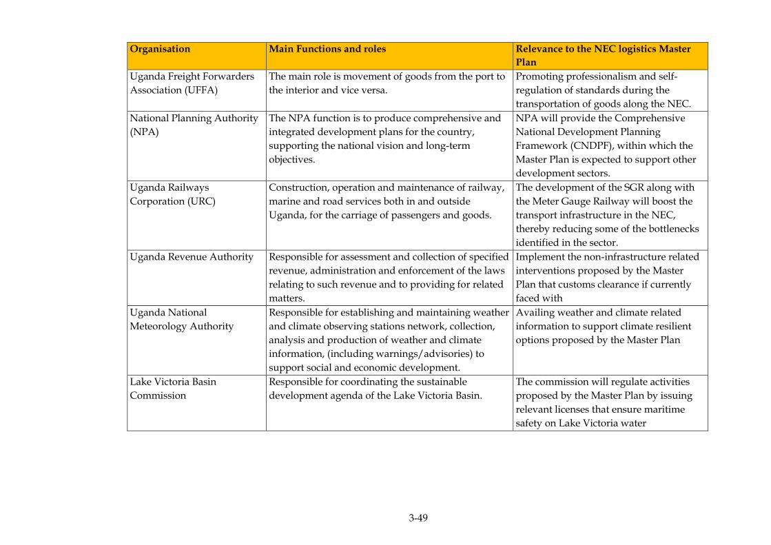
3-49
Organisation Main Functions and roles Relevance to the NEC logistics Master
Plan
Uganda Freight Forwarders
Association (UFFA)
The main role is movement of goods from the port to
the interior and vice versa.
Promoting professionalism and self-
regulation of standards during the
transportation of goods along the NEC.
National Planning Authority
(NPA)
The NPA function is to produce comprehensive and
integrated development plans for the country,
supporting the national vision and long-term
objectives.
NPA will provide the Comprehensive
National Development Planning
Framework (CNDPF), within which the
Master Plan is expected to support other
development sectors.
Uganda Railways
Corporation (URC)
Construction, operation and maintenance of railway,
marine and road services both in and outside
Uganda, for the carriage of passengers and goods.
The development of the SGR along with
the Meter Gauge Railway will boost the
transport infrastructure in the NEC,
thereby reducing some of the bottlenecks
identified in the sector.
Uganda Revenue Authority Responsible for assessment and collection of specified
revenue, administration and enforcement of the laws
relating to such revenue and to providing for related
matters.
Implement the non-infrastructure related
interventions proposed by the Master
Plan that customs clearance if currently
faced with
Uganda National
Meteorology Authority
Responsible for establishing and maintaining weather
and climate observing stations network, collection,
analysis and production of weather and climate
information, (including warnings/advisories) to
support social and economic development.
Availing weather and climate related
information to support climate resilient
options proposed by the Master Plan
Lake Victoria Basin
Commission
Responsible for coordinating the sustainable
development agenda of the Lake Victoria Basin.
The commission will regulate activities
proposed by the Master Plan by issuing
relevant licenses that ensure maritime
safety on Lake Victoria water

3-50
Organisation Main Functions and roles Relevance to the NEC logistics Master
Plan
Uganda Road Sector Support
Initiative (URSSI)
To facilitate coherent and timely development and
planning of road transport and urban development in
Uganda with particular emphasis on roads, municipal
planning and sustainable transport management both
in rural and urban areas.
URSSI advocates for professionally
designed, wide roads of international
standard that are well planned and
maintained with better drainage systems,
and unencumbered road reserves which is
also true for the reduction of bottlenecks
as envisaged by the Master Plan
Uganda Chamber of Mines
and Petroleum (UCMP)
To promote, through the collective action of
members, the growth and development of Uganda's
mining and petroleum industry, for the benefit of all
Ugandans and investors.
Oil and gas and other mining projects
have been identified as priority areas for
rolling out the Master Plan for which
UCMP wants to ensure proper
dissemination of information. The
organisation wants to ensure proper
dissemination of information within the
mines and petroleum sector.
ERM/ATACAMA CONSULTING JST/MOWT
3-51
INTERNATIONAL REGULATIONS AND REQUIREMENTS 3.3
3.3.1 The Japan International Co-operation Agency (JICA) Guidelines for
Environmental and Social Considerations, 2010
The objectives of the guidelines are to encourage project proponents to
have appropriate consideration for environmental and social impacts,
as well as to ensure that JICA’s support for and examination of
environmental and social considerations are conducted accordingly.
The guidelines outline JICA’s responsibilities and procedures, along
with its requirements for project proponents etc., in order to facilitate
the achievement of these objectives. In doing so, JICA endeavours to
ensure transparency, predictability, and accountability in its support for
and examination of environmental and social considerations.
Given that the GoJ through JICA is financing the Master Plan it is
pertinent that the JICA guidelines are taken into account in line with
lenders environmental and social requirements.
3.3.2 The Organisation for Economic Co-operation and Development
(OECD) Guidelines and Reference Series for Applying Strategic
Environmental Assessment, 2006
The Organisation for Economic Cooperation and Development is a
unique forum where the governments of 34 democracies with market
economies work with each other, as well as with more than 70 non-
member economies to promote economic growth, prosperity, and
sustainable development. The OECD Guidelines for Multinational
Enterprises are far reaching recommendations for responsible business
conduct that 44 adhering governments – representing all regions of the
world and accounting for 85 percent of foreign direct investment –
encourage their enterprises to observe wherever they operate. The
ultimate objectives of the guidelines are to ensure that:
Environmental considerations, and their linkages with social and
economic factors, are adequately understood, recognising the
contribution of environmental management to economic growth and
poverty reduction.
Environmental and social considerations are appropriately analysed
and taken into account in development policy, planning and strategic
decision making at the formative stage and appropriate response
measures, effectively integrated into the development of PPPs and
projects.

ERM/ATACAMA CONSULTING JST/MOWT
3-52
As a result of the above, the outcomes of PPPs have better prospects
to contribute to sustainable development and attainment of the
Sustainable Development Goals (SDGs).
In the absence of SEA guidelines in Uganda, the OECD guidelines
supplemented the JICA guidelines for Environmental and Social
Considerations during the SEA Study.
CONSISTENCY ANALYSIS OF THE MASTER PLAN WITH OTHER PPPS 3.4
Consistency analysis, Table 3.6, Table 3.7 and Table 3.8 was carried out to
check the consistency of the Master Plan with key policies, plans and
programmes.
As part of the analysis, it had to be ascertained as to whether the
policies, plans and programmes:
Generate opportunities for the Master Plan;
Set environmental and socio-economic conditions for the Master
Plan; and
The likelihood for conflict with the Master Plan
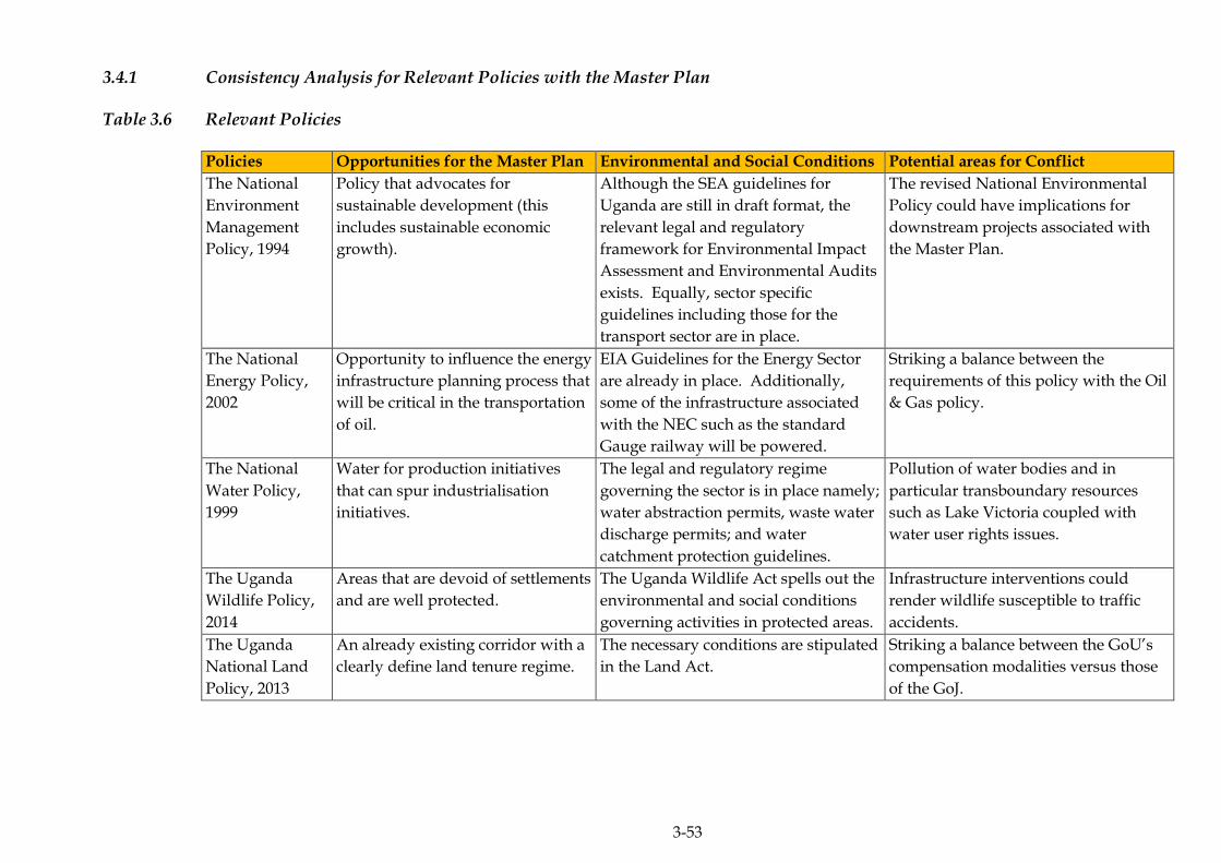
3-53
3.4.1 Consistency Analysis for Relevant Policies with the Master Plan
Table 3.6 Relevant Policies
Policies Opportunities for the Master Plan Environmental and Social Conditions Potential areas for Conflict
The National
Environment
Management
Policy, 1994
Policy that advocates for
sustainable development (this
includes sustainable economic
growth).
Although the SEA guidelines for
Uganda are still in draft format, the
relevant legal and regulatory
framework for Environmental Impact
Assessment and Environmental Audits
exists. Equally, sector specific
guidelines including those for the
transport sector are in place.
The revised National Environmental
Policy could have implications for
downstream projects associated with
the Master Plan.
The National
Energy Policy,
2002
Opportunity to influence the energy
infrastructure planning process that
will be critical in the transportation
of oil.
EIA Guidelines for the Energy Sector
are already in place. Additionally,
some of the infrastructure associated
with the NEC such as the standard
Gauge railway will be powered.
Striking a balance between the
requirements of this policy with the Oil
& Gas policy.
The National
Water Policy,
1999
Water for production initiatives
that can spur industrialisation
initiatives.
The legal and regulatory regime
governing the sector is in place namely;
water abstraction permits, waste water
discharge permits; and water
catchment protection guidelines.
Pollution of water bodies and in
particular transboundary resources
such as Lake Victoria coupled with
water user rights issues.
The Uganda
Wildlife Policy,
2014
Areas that are devoid of settlements
and are well protected.
The Uganda Wildlife Act spells out the
environmental and social conditions
governing activities in protected areas.
Infrastructure interventions could
render wildlife susceptible to traffic
accidents.
The Uganda
National Land
Policy, 2013
An already existing corridor with a
clearly define land tenure regime.
The necessary conditions are stipulated
in the Land Act.
Striking a balance between the GoU’s
compensation modalities versus those
of the GoJ.
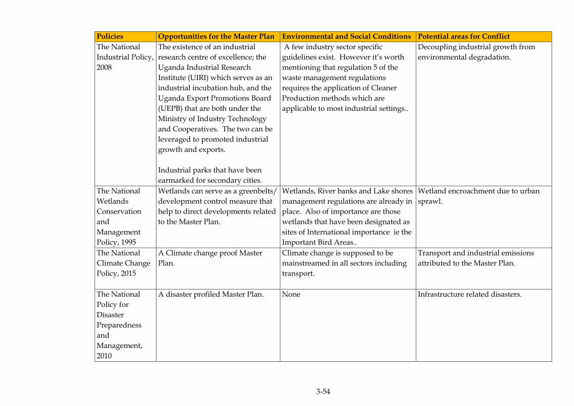
3-54
Policies Opportunities for the Master Plan Environmental and Social Conditions Potential areas for Conflict
The National
Industrial Policy,
2008
The existence of an industrial
research centre of excellence; the
Uganda Industrial Research
Institute (UIRI) which serves as an
industrial incubation hub, and the
Uganda Export Promotions Board
(UEPB) that are both under the
Ministry of Industry Technology
and Cooperatives. The two can be
leveraged to promoted industrial
growth and exports.
Industrial parks that have been
earmarked for secondary cities.
A few industry sector specific
guidelines exist. However it’s worth
mentioning that regulation 5 of the
waste management regulations
requires the application of Cleaner
Production methods which are
applicable to most industrial settings..
Decoupling industrial growth from
environmental degradation.
The National
Wetlands
Conservation
and
Management
Policy, 1995
Wetlands can serve as a greenbelts/
development control measure that
help to direct developments related
to the Master Plan.
Wetlands, River banks and Lake shores
management regulations are already in
place. Also of importance are those
wetlands that have been designated as
sites of International importance ie the
Important Bird Areas..
Wetland encroachment due to urban
sprawl.
The National
Climate Change
Policy, 2015
A Climate change proof Master
Plan.
Climate change is supposed to be
mainstreamed in all sectors including
transport.
Transport and industrial emissions
attributed to the Master Plan.
The National
Policy for
Disaster
Preparedness
and
Management,
2010
A disaster profiled Master Plan. None Infrastructure related disasters.

3-55
Policies Opportunities for the Master Plan Environmental and Social Conditions Potential areas for Conflict
The National
Gender Policy,
1997
Mainstreaming gender issues into
the Master plan thereby ensuring
that its gender sensitive.
Gender issues are cross cutting and so
are embedded in the environmental
and social conditions of most sectors.
Displacement and employment related
issues to do with women and children.
Transport Draft
Policy and
Strategy Paper
An existing corridor with multi-
modal infrastructure that can be
improved.
EIA Regulations for the transport
sector already exist. In addition,
related legislation such as the road and
traffic Acts exists.
Changes to the Northern Corridor
Integration Projects that may be
reflected in the final policy.
Draft Non
Motorised
Transport
(NMT) Policy
Integration of NMT with the other
transport modes in the Master Plan.
Conditions imposed by the existing
transport and road safety Act as well as
the highway code. However, these will
have to be reviewed to factor in the
NMT.
Improvements in motorised transport
logistics might compromise the safety
of NMT users.
Agricultural
Policy (2011)
A sector that accounts for the
majority of the country’s exports;
employs majority of Ugandan’s;
and is ready for commercialisation.
Agricultural support sector legislation
such as the Agricultural Seeds and
Plant Act, The Control of Agricultural
Chemicals Act, The National
Environment (Minimum Standards for
Management of Soil Quality)
Regulations etc.
The push for increased exports could
result in unsustainable agricultural
practices.
HIV/AIDS
Policy (2007)
HIV/AIDS awareness initiatives at
HIV/AIDS hotspots along the
Northern Corridor.
Addressed as a cross cutting issue in
most sector interventions.
Increased mobility along the NEC
could lead to a rise in the HIV/AIDS
prevalence rate(s) along the NEC
HIV/AIDS hotspots.
Mineral Policy
(2000)
Availability of good mineral
resource data based on airborne
geophysical surveys that were
conducted across the country a few
years ago.
EIA Guidelines for the mining sector
are now in place.
Licensing regime related bureaucracy.

3-56
Policies Opportunities for the Master Plan Environmental and Social Conditions Potential areas for Conflict
Tourism Policy
(2015)
Untapped natural and cultural
resources with a high potential for
tourism within the NEC. The
market for international and
domestic tourism remain high.
Laws and regulations set by most of the
environment protection agencies apply.
The agencies include; UWA, NEMA
and NFA.
Maintaining the integrity of tourism
sites in line with sustainable tourism
practices.
National Oil and
Gas Policy (2014)
Governments’ intention to channel
a big percentage of oil and gas
revenues towards infrastructural
development.
Laws governing the sector are in place
and include; the Petroleum
(Exploration, Development and
Production) Act 2013 and the
Petroleum (Refining, Conversion,
Transmission and Midstream Storage)
Act 2013. These are supplemented by
the relevant legal and regulatory
framework governing the Environment
and Natural Resources (ENR) sectors.
Sharing infrastructure.
Fisheries Policy
(2004)
Export oriented fish industry that’s
conversant with the respective
phyto-sanitary standards governing
exports.
EIA Guidelines for the fisheries sector
and Environmental Audit Manual for
the fish processing sector.
Transboundary issues relating to use of
a shared resource (Lake Victoria).
National Land
Use Policy (2007)
Sustainable use of land. Use of structure plans to steer
development as per the respective
zoning regimes contained therein.
Planning obligations.
Other Important Instruments
Uganda’s Vision
2040
Political buy-in and therefore
budgetary allocations for
interventions which are consistent
with Vision 2040.
Indicators and targets in the respective
NDP’s for implementing Vision 2040.
Master Plan Interventions that may be
parallel to Vision 2040.
Africa Agenda
2063
Timeframe for the Master Plan is
well within the 50 year timeframe
for the vision which allows for
flexibility in re-aligning the Master
Plan with Africa’s evolving needs.
As part of proposed actions, the vision
calls on African countries to: Act with a
sense of urgency on climate change and
the environment.
Aligning GoJ interests with those of
Africa Agenda 2063 in as much as
possible.
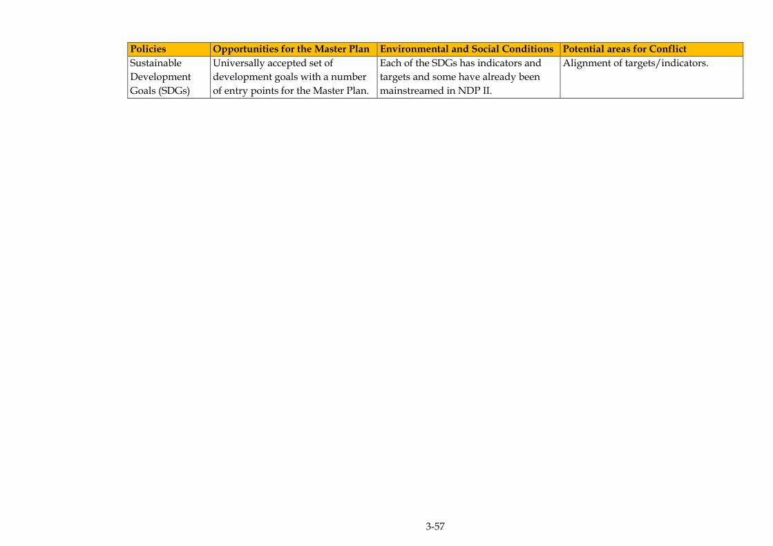
3-57
Policies Opportunities for the Master Plan Environmental and Social Conditions Potential areas for Conflict
Sustainable
Development
Goals (SDGs)
Universally accepted set of
development goals with a number
of entry points for the Master Plan.
Each of the SDGs has indicators and
targets and some have already been
mainstreamed in NDP II.
Alignment of targets/indicators.
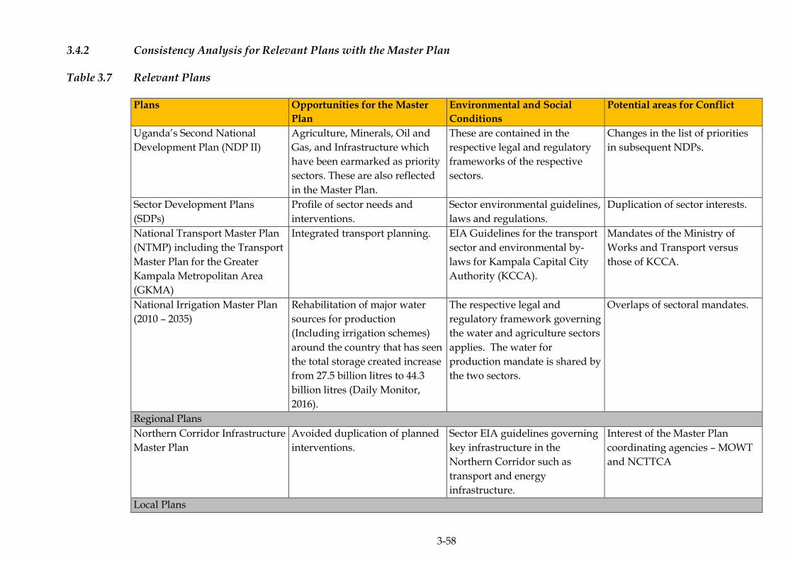
3-58
3.4.2 Consistency Analysis for Relevant Plans with the Master Plan
Table 3.7 Relevant Plans
Plans Opportunities for the Master
Plan
Environmental and Social
Conditions
Potential areas for Conflict
Uganda’s Second National
Development Plan (NDP II)
Agriculture, Minerals, Oil and
Gas, and Infrastructure which
have been earmarked as priority
sectors. These are also reflected
in the Master Plan.
These are contained in the
respective legal and regulatory
frameworks of the respective
sectors.
Changes in the list of priorities
in subsequent NDPs.
Sector Development Plans
(SDPs)
Profile of sector needs and
interventions.
Sector environmental guidelines,
laws and regulations.
Duplication of sector interests.
National Transport Master Plan
(NTMP) including the Transport
Master Plan for the Greater
Kampala Metropolitan Area
(GKMA)
Integrated transport planning. EIA Guidelines for the transport
sector and environmental by-
laws for Kampala Capital City
Authority (KCCA).
Mandates of the Ministry of
Works and Transport versus
those of KCCA.
National Irrigation Master Plan
(2010 – 2035)
Rehabilitation of major water
sources for production
(Including irrigation schemes)
around the country that has seen
the total storage created increase
from 27.5 billion litres to 44.3
billion litres (Daily Monitor,
2016).
The respective legal and
regulatory framework governing
the water and agriculture sectors
applies. The water for
production mandate is shared by
the two sectors.
Overlaps of sectoral mandates.
Regional Plans
Northern Corridor Infrastructure
Master Plan
Avoided duplication of planned
interventions.
Sector EIA guidelines governing
key infrastructure in the
Northern Corridor such as
transport and energy
infrastructure.
Interest of the Master Plan
coordinating agencies – MOWT
and NCTTCA
Local Plans
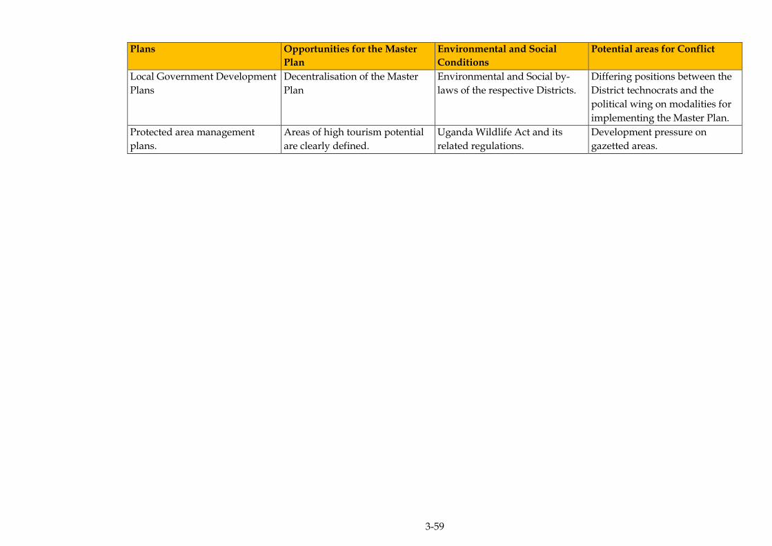
3-59
Plans Opportunities for the Master
Plan
Environmental and Social
Conditions
Potential areas for Conflict
Local Government Development
Plans
Decentralisation of the Master
Plan
Environmental and Social by-
laws of the respective Districts.
Differing positions between the
District technocrats and the
political wing on modalities for
implementing the Master Plan.
Protected area management
plans.
Areas of high tourism potential
are clearly defined.
Uganda Wildlife Act and its
related regulations.
Development pressure on
gazetted areas.

3-60
3.4.3 Consistency Analysis for Relevant Programmes with the Master Plan
Table 3.8 Relevant Programmes
Programmes Opportunities for the Master
Plan
Environmental and Social
Conditions
Potential areas of Conflict
National Response Strategy for
Elimination of Non-Tariff
Barriers (NRSE-NTB)
Programme
Operational electronic NTB
reporting system that is web-
based or Phone-based. Under
the phone based system, one has
to dial *201# and select NTB to
report and send.
All respective institutions have
to respond to their NTB
complaints.
Selective use of NTBs by partner
states.
National Agricultural Advisory
Services (NAADS) Programme
National footprint of the
Agricultural extension services.
Agricultural phytosanitary
standards.
Conflicting roles of the scientists
and the military in
implementing projects.
Joint Water and Environment
Sector Support Programme
Water for Production (Wfp) is a
key component of the JWESSP
and it’s critical for the Master
Plan’s agricultural sector
interventions. There is a chance
to leverage joint funding from
different Development Partners
(DPs).
Embedded in the policy, strategy
and legal frameworks of the
respective JWESSP components.
Differing policies and strategic
areas of support of the respective
Development Partners.
Fuel Efficiency Initiative (FEI) in
Uganda
Energy efficient transport
systems.
Provisions in the climate change
policy, renewable energy policy
and energy efficiency bill.
Prevailing environment levy on
imported second hand vehicles
(35 percent of vehicles older than
5 year but less than 10 years; and
50 percent on vehicles older than
10 years).
The high cost of new vehicles
and tax waivers on certain
classes of used vehicles (for
example on some heavy goods
vehicles).
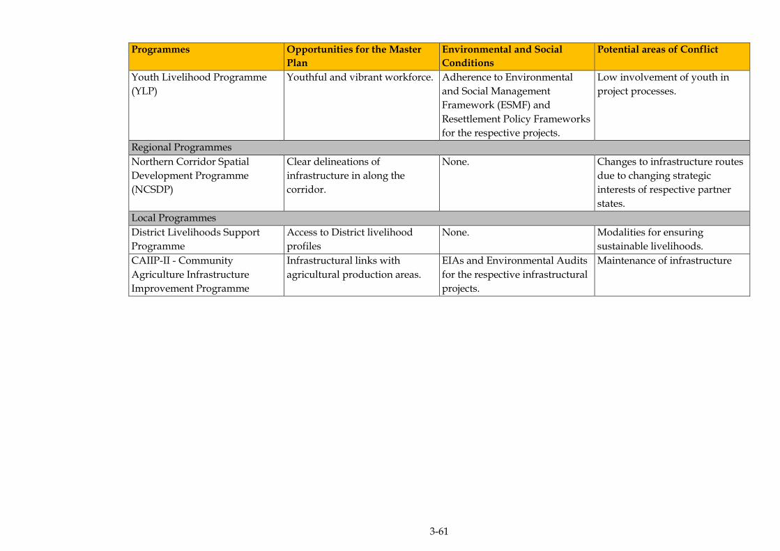
3-61
Programmes Opportunities for the Master
Plan
Environmental and Social
Conditions
Potential areas of Conflict
Youth Livelihood Programme
(YLP)
Youthful and vibrant workforce. Adherence to Environmental
and Social Management
Framework (ESMF) and
Resettlement Policy Frameworks
for the respective projects.
Low involvement of youth in
project processes.
Regional Programmes
Northern Corridor Spatial
Development Programme
(NCSDP)
Clear delineations of
infrastructure in along the
corridor.
None. Changes to infrastructure routes
due to changing strategic
interests of respective partner
states.
Local Programmes
District Livelihoods Support
Programme
Access to District livelihood
profiles
None. Modalities for ensuring
sustainable livelihoods.
CAIIP-II - Community
Agriculture Infrastructure
Improvement Programme
Infrastructural links with
agricultural production areas.
EIAs and Environmental Audits
for the respective infrastructural
projects.
Maintenance of infrastructure

ERM/ATACAMA CONSULTING JST/MOWT
4-1
4 METHODOLOGY AND APPROACH
GENERAL APPROACH TO THE SEA 4.1
The approach to the SEA was structured around the key phases of the
SEA process, namely: screening, scoping and the detailed SEA study.
The respective phases of the SEA are discussed in Sections 4.1.1 - 4.1.3
below.
4.1.1 Screening
Screening is carried out to establish whether an SEA is appropriate and
relevant to the development of a PPP. It is used to determine the
potential of a PPP to result in significant impacts on the environment
and to determine if a SEA is required. The screening stage of the SEA is
when:
Objectives are set; and
The process of identifying stakeholders is carried out.
The SEA process for the Master Plan for the NEC was initiated in 2015
by JST in Uganda, by establishing the need and possible objectives for
starting an SEA.
As there is no binding SEA Guideline in Uganda, it was agreed that the
National Environment Management Authority (NEMA) would be regarded as
an important stakeholder.
4.1.2 Scoping
The scoping stage establishes the focus and content of the SEA and the
relevant criteria for assessment. The scoping study identified the
potentially significant environmental and social impacts relating to the
PPP that needed to be addressed as part of the SEA Study. The scoping
study was carried out by Atacama in Uganda between October 2015
and February 2016.
During the scoping stage, key stakeholders were identified and
consulted as part of national level consultation meetings, in key
strategic regions (Kampala, Mbarara and Tororo) along the NEC. The
consultation meetings were held jointly with JST and MoWT.

ERM/ATACAMA CONSULTING JST/MOWT
4-2
As part of the consultation process, opinion survey questionnaires were
also issued out to the respective participants to seek their views on the
Master Plan (see summary of the results in Chapter 5).
The purpose of the Scoping was to:
Highlight key issues that the detailed SEA study would focus on as
part of the Master Plan development process; and
Select methodologies for the collection of baseline data and impact
assessment.
4.1.3 Detailed SEA Study
The phase entailed collecting baseline data that would inform the
detailed SEA study. The data was used to supplement what was
collected during the scoping phase.
ASSESSMENT METHODS 4.2
A combination of methods was used for the assessment (see Sections
4.2.1- 4.2.7).
4.2.1 Literature Surveys
Due to the extent and magnitude of the NEC, no primary baseline data
was collected and as such a number of documents related to the Master
Plan were reviewed as part of the literature review. These documents
included:
Progress and Interim Reports from JST;
Existing PPPs;
Uganda’s Vision 2040 and its related National Development Plan;
and
SEA best practice guidance documents from other parts of the world.
ERM/ATACAMA CONSULTING JST/MOWT
4-3
4.2.2 Stakeholder Engagement
Overview
A regional stakeholder consultative approach was favored because of
the spatial extent of the NEC. Workshops were held in three strategic
regions (districts), specifically:
Kampala, for the stakeholders in central Uganda;
Mbarara, for the stakeholders in the western region; and
Tororo, for the Northern and Eastern regions of Uganda.
Stakeholder engagement was carried out at both the scoping and
detailed assessment stage. During these meetings, the stakeholders
were introduced to the Master Plan and the progress of the SEA study.
The SEA consultation methodology and approach was consistent with
the Uganda (Environmental and Social Impact Assessment) ESIA
Legislative Framework, as well as the JICA Guidelines for
Environmental and Social Considerations (2010). Stakeholder
engagement was carried out to:
Gather baseline data; and
Identify impacts.
Opinion Surveys
During the stakeholder meetings, opinion surveys were distributed to
the stakeholders to gather baseline data. The results of those surveys
were then incorporated into the assessment.
4.2.3 Geographical Information Systems (GIS)
The following spatial data was obtained:
Satellite images (mainly from google earth and ArcGIS base maps);
Vegetation/ habitat mapping (including mapping of protected
areas);
Digital Elevation Models (DEM);
Hydrology;

ERM/ATACAMA CONSULTING JST/MOWT
4-4
Heritage features; and
Socio-economic data (including administrative boundaries).
Some of this secondary spatial geographical data was generated by
digitising available maps.
Using Arc GIS Software Version 10.2, the routes that make up the NEC
as were overlain1 on to the different spatial/biophysical and socio-
economic features to map out:
The physical, social and biological features that are environmentally
robust and can cope with development; and
Sensitive areas where NEC development projects should be
avoided.
Overlay mapping findings were also used as a key tool for identifying
stakeholders for engagement, as stakeholders interests that were likely
to be affected by development actions related to the Master Plan could
easily be identified from the GIS maps.
4.2.4 Constraints Mapping
During baseline data collection, key environmental and social aspects
were identified. With the aid of ArcGIS Software Version 10.2 and
overlay mapping, the shapefiles of a number of interlinked/ related
parameters were combined in ArcGIS model builder and the spatial
locations of the constraints were established.
4.2.5 Expert Judgment
Expert (or professional) judgment was an integral part of the
assessment process especially given the subjective nature of the
qualitative aspects of the SEA. This proved especially valuable when
assigning levels of significance to environmental and social impacts
associated with the Master Plan (see Chapter 9 for a full description of
the approach).
1 Overlay mapping is a spatial operation in which two or more maps or layers registered to a common
coordinate system are superimposed, either digitally or on a transparent material, for the purpose of
showing the relationships between features that occupy the same geographic space.

ERM/ATACAMA CONSULTING JST/MOWT
4-5
4.2.6 Transport Modelling and Forecasting
The data collected in the JST 2015 traffic survey (see Table 4.1) clearly
identified the amount of Cross Border Freight Traffic (CBFT).
Table 4.1 Current CBFT Demand along the Uganda Border
Country Border
name
Passenger
car
Light &
medium goods
Heavy
goods
Total
Uganda –
Kenya
Malaba 254 58 842 1,154
Busia 1,373 635 248 2,256
Sub – total 1,627 693 1,090 3,410
Uganda –
Rwanda
Mirama
hills
84 34 37 155
Katuna 323 135 152 610
Sub – total 407 169 189 765
Uganda – DRC Goli 130 62 52 244
Mpondwe 650 145 54 849
Bunagana 67 93 27 187
Sub – total 847 300 133 1,280
Uganda –
South Sudan
Nimule 205 120 186 511
Oraba 351 15 28 394
Sub – total 556 135 214 905
Uganda –
Tanzania
Mutukula 385 112 92 589
Sub total 385 112 92 589
Total 3,822 1,409 1,718 6,949
Source: JST, 2015
This data included the origins and destinations of the traffic, the weight
and type of cargo carried, as well as other key information. Using the
data, matrices were built for cross-border traffic for all countries served
directly by the NEC. Secondly, the countries were individually zoned
to identify the specific key origins and destinations. This information
was used to further disaggregate the country border crossing matrices
into zonal matrices. This would help to determine the specific routes
that freight traffic would likely use within the specific countries.
Two models were then built; a freight mode choice model and a truck
route assignment model. The two were used hand in hand. The first
was used to determine which mode of travel (road, rail, and water)
would be preferred for the freight and the other which route. It should
be noted that although the NEC is the main route, it is linked to other
key corridors and feeder roads. Therefore in some instances, truck
traffic would have more than one option of reaching a particular
destination. For example freight would have more than one way of
reaching Juba; either through the NEC or through the NEC linkage with
the LAPSSET corridor.
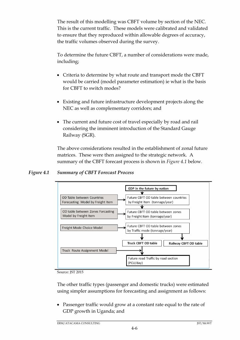
ERM/ATACAMA CONSULTING JST/MOWT
4-6
The result of this modelling was CBFT volume by section of the NEC.
This is the current traffic. These models were calibrated and validated
to ensure that they reproduced within allowable degrees of accuracy,
the traffic volumes observed during the survey.
To determine the future CBFT, a number of considerations were made,
including;
Criteria to determine by what route and transport mode the CBFT
would be carried (model parameter estimation) ie what is the basis
for CBFT to switch modes?
Existing and future infrastructure development projects along the
NEC as well as complementary corridors; and
The current and future cost of travel especially by road and rail
considering the imminent introduction of the Standard Gauge
Railway (SGR).
The above considerations resulted in the establishment of zonal future
matrices. These were then assigned to the strategic network. A
summary of the CBFT forecast process is shown in Figure 4.1 below.
Figure 4.1 Summary of CBFT Forecast Process
Source: JST 2015
The other traffic types (passenger and domestic trucks) were estimated
using simpler assumptions for forecasting and assignment as follows:
Passenger traffic would grow at a constant rate equal to the rate of
GDP growth in Uganda; and
ERM/ATACAMA CONSULTING JST/MOWT
4-7
Domestic truck traffic would grow in line with both the rates of
population and GDP growth.
Although the above assumptions seem reasonable for the more rural
sections of the NEC, the growth rates for types of traffic are
significantly less at and near Kampala and other major towns.
4.2.7 Matrices
Matrices were used to examine the significance of the impacts likely to
arise from the implementation of the Master Plan. This was done by
evaluating the relationship between the magnitude of the impacts and
the sensitivity of the environmental and social receptors.
ASSESSMENT APPROACH 4.3
Although there are a number of approaches for conducting SEA, an
Environmental Impact Assessment (EIA)-based approach was adopted
for this assessment. EIA-based SEA approaches share three main
common characteristics (Partidário, 2012):
They are related to the preparation of an approvable document;
Their main aim is to provide information on the environmental
effects or consequences of proposed PPPs; and
Their standard methodological approach follows the typical EIA
process steps of screening, scoping, assessment, mitigation, decision
making and monitoring
Equally of importance was the model that was chosen for linking the
SEA process with the NEC Logistics Master Plan formulation process.
A parallel model which entailed the SEA process being conducted in
parallel with the Master Plan formulation process was chosen (see
Figure 4.2).

ERM/ATACAMA CONSULTING JST/MOWT
4-8
Figure 4.2 Parallel SEA Model
Source: Partidário, 2007
4.3.1 Potential Impact Identification
Impact identification entailed the use of a combination of methods that
can be applied to that stage of the SEA process and they included:
Literature surveys;
Expert judgment;
Stakeholder engagement; and
Matrices.
4.3.2 Assessing the Significance of Environmental Impacts
The significance of the impact was formulated as a function of the
environmental or social receptor (sensitivity) (see Table 4.2) and the
magnitude of the impact (change) (see Table 4.3).
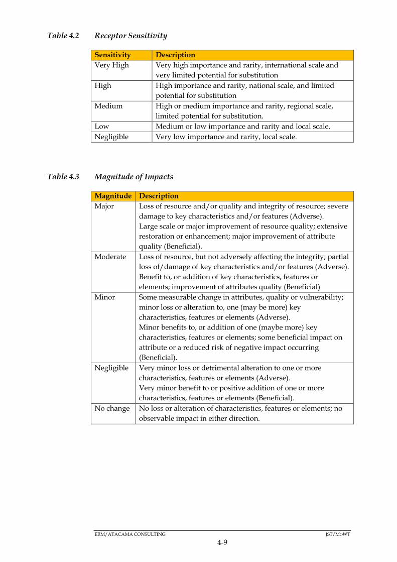
ERM/ATACAMA CONSULTING JST/MOWT
4-9
Table 4.2 Receptor Sensitivity
Sensitivity Description
Very High Very high importance and rarity, international scale and
very limited potential for substitution
High High importance and rarity, national scale, and limited
potential for substitution
Medium High or medium importance and rarity, regional scale,
limited potential for substitution.
Low Medium or low importance and rarity and local scale.
Negligible Very low importance and rarity, local scale.
Table 4.3 Magnitude of Impacts
Magnitude Description
Major Loss of resource and/or quality and integrity of resource; severe
damage to key characteristics and/or features (Adverse).
Large scale or major improvement of resource quality; extensive
restoration or enhancement; major improvement of attribute
quality (Beneficial).
Moderate Loss of resource, but not adversely affecting the integrity; partial
loss of/damage of key characteristics and/or features (Adverse).
Benefit to, or addition of key characteristics, features or
elements; improvement of attributes quality (Beneficial)
Minor Some measurable change in attributes, quality or vulnerability;
minor loss or alteration to, one (may be more) key
characteristics, features or elements (Adverse).
Minor benefits to, or addition of one (maybe more) key
characteristics, features or elements; some beneficial impact on
attribute or a reduced risk of negative impact occurring
(Beneficial).
Negligible Very minor loss or detrimental alteration to one or more
characteristics, features or elements (Adverse).
Very minor benefit to or positive addition of one or more
characteristics, features or elements (Beneficial).
No change No loss or alteration of characteristics, features or elements; no
observable impact in either direction.

ERM/ATACAMA CONSULTING JST/MOWT
4-10
4.3.3 Impact significance
The impact significance was determined by evaluating the magnitude
of the impact and the sensitivity of the environmental and social
receptors. The five significance categories gave rise to eight potential
outcomes. The greater the environmental sensitivity of the receptor,
and the greater the magnitude of impact, the more significant the effect
as presented in Table 4.4.
Table 4.4 Significance of Impact Categories
Magnitude of impact
No
change
Negligible Minor Moderate Major
Environmental
Sensitivity
Very high Neutral Slight Moderate
or Large
Large or
very large
Very large
High Neutral Slight Slight or
Moderate
Moderate
or Large
Large or
very large
Medium Neutral Neutral or
slight
Slight Moderate Moderate
or Large
Low Neutral Neutral or
slight
Neutral or
slight
Slight Slight or
Moderate
Negligible Neutral Neutral Neutral or
slight
Neutral or
slight
Slight
GAPS AND UNCERTAINTIES 4.4
In any SEA process it is inevitable gaps remain. This Section
summarises the gaps and uncertainties which were considered when
undertaking the SEA.
4.4.1 Environmental Baseline Gaps and Uncertainties
Several data gaps and uncertainties have been identified through the
preparation of the environmental baseline. There is limited data on the
following, which will make future detection of change difficult within
the NEC:
Ambient air quality;
Ambient noise levels; and
Biodiversity inventories, especially within wetlands and outside
protected areas.
Also the draft regulations which are the basis of this assessment could
be finalised within the lifetime of the Master Plan, therefore any
changes therein may modify the implementation of the Master Plan
ERM/ATACAMA CONSULTING JST/MOWT
4-11
4.4.2 Social Baseline Gaps and Uncertainties
Up to date socioeconomic information was preferred during the
assessment. Where up to date information was not readily available,
the most recent information available was used in the assessment
ERM/ATACAMA CONSULTING JST/MOWT
5-1
5 ENVIRONMENTAL BASELINE
This section presents a description of the physical and biological
baseline environment of the NEC. It is essential that the baseline
conditions of an environment are characterised in order to accurately
predict the potential effects the PPP may have on the environment. The
collection of baseline data also focuses on providing information to
support the assessment of any potential impacts.
PHYSICAL ENVIRONMENT5.1
5.1.1 Climate
Overview
Climate is an important baseline consideration as part of the SEA for
the Master plan on logistics in the NEC given that transport, agriculture
and energy are the leading contributors of Greenhouse gases (GHGs) in
Uganda.
Overall, Uganda’s climate is classified as humid-equatorial with two
rainy seasons, specifically the “long rains” of March to May and the
“short rains” of October to November (1) and broadly, the climate can
be divided into three categories as described below:
Highland: These include areas such as Mt. Elgon and the Rwenzori
mountain area, the latter of which has a permanent snow cap. These
areas experience temperatures as low as 4oC and moderate mean
annual rainfall in the region of 900mm.
Savanna tropical: Including the Lake Victoria Basin, experiences
moderate temperatures of around 28oC with mean annual rainfall of
1200mm in the region. This is where the country’s wetlands and
tropical forests occur.
Semi-arid: These areas cover a broad swathe across the middle of the
country from the south-west to the north-east being most extensive
in the latter. Temperatures are generally high, in the range of 26oC to
28oC but temperatures as high as 35.6oC have been recorded and
rainfall is low, typically 800mm per year in the region, but can be as
low as 400mm or less when severe drought strikes these zones.
(1) NEMA 2006/07

ERM/ATACAMA CONSULTING JST/MOWT
5-2
Rainfall
Seasonal rainfall in Uganda is driven mainly by the migration of the
Inter Tropical Convergence Zone (ITCZ), a relatively narrow belt of
very low pressure and heavy precipitation that forms near the
equator (1). Extreme rainfall events are among the issues that are
predicted to become more pronounced as a result of climate change.
The exact position of the ITCZ changes over the course of the year,
migrating southwards through Uganda from October to December, and
returning northwards in March, April and May. This causes Uganda to
experience two distinct rainfall seasons – the ‘short’ rains in August to
December, and the ‘long’ rains in March to May. These gradually
merge into one long rainy season the further north one moves from the
equator. Uganda’s rainfall varies from as little as 400mm per annum in
the more arid zones to over 2000mm per annum in the Lake Victoria
region (Figure 5.1)
Temperature
Temperatures in Uganda vary little throughout the year, with average
temperatures increasing in the north of the country as the elevation
decreases towards the Sudanese plain (Figure 5.2). The country's
temperature ranges between 16oC and 34oC, but the situation
countrywide indicates great disparities. Mean annual temperatures
range from about 16°C in the south-western highlands to 25°C in the
north-west and in the north-east, the climate becomes more arid with
temperatures exceeding 30°C for 254 days of the year. The temperature
in Uganda just like the rest of the world is expected to rise over the next
few decades with the average temperature increase over the next 50
years predicted to be in the range of 1.5 to 2oC. On the extreme end
(with little climate change mitigation), the temperature rise over the
same period could be in the range of 2 to 3oC.
(1) NEMA 2006/07

5-3
Figure 5.1 Rainfall Patterns within the NEC
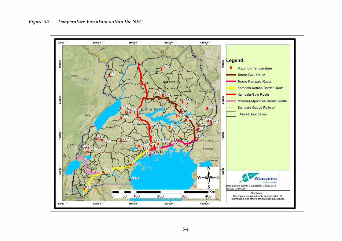
5-4
Figure 5.2 Temperature Variation within the NEC

ERM/ATACAMA CONSULTING JST/MOWT
5-5
5.1.2 Air Quality
Sources of particulate air pollution described in the studies of African
cities are typically emissions from vehicles, re-suspended dust from
unpaved roads, smoke from indoor biomass fuel use and garbage
burning, and industrial sites.
Available literature for a pilot cross – sectional spatial assessment of the
state of ambient air quality in two Ugandan urban centres (Kampala
and Jinja, also within the NEC) conducted in 2014 has been considered
in this assessment. This pilot study demonstrated presence of high
Particulate Matter (PM) concentrations and low gas phase air pollutant
levels (NO2, SO2 and O3) in Kampala and Jinja between 30 June and 17
July, 2014 – dry season (Bruce et.al 2015). The observed mean PM2.5
concentration of 132.1 μg/m3 was 5.3 fold above the limit defined by
World Health Organisation (WHO). As expected, particulate air
pollution levels were found to be greatest in areas with high
commercial/industrial land use and unpaved roads.
Although Uganda has the National Environment (Draft Air Quality)
Standards for Uganda (2006) in place, as indicated in Table 3.1, the
Country launched her National GHG inventory system on 21st October
2016. The leading sectors of greenhouse gas emissions identified
include; transport, agriculture and energy. Uganda has already ratified
the Paris Agreement on Climate Change and is committed to reducing
GHG emissions by 22 percent by 2030 under the country’s Nationally
Determined Contributions (NDC).

ERM/ATACAMA CONSULTING JST/MOWT
5-6
Table 5.1 Regulatory Air Quality Standards for Selected Gases (1)
Pollutant Averaging time for
ambient air
Standard for ambient air
Carbon dioxide (CO2) 8hr 9.0ppm
Carbon monoxide (CO) 8hr 9.0ppm
Hydrocarbons 24hr 5mgm-3
Nitrogen dioxides (NO2) 24hr 0.10ppm
Smoke Not to exceed 5 minutes
in any 1hr
Ringlemann scale No.2
or 40 percent observed at
6m or more
Soot 24hr 500µg/Nm-3
Sulphur dioxide (SO2) 24hr 0.15ppm-3
Sulphur trioxide (SO3) 24hr 200µg/Nm-3
Source: Draft National Air Quality Standards (2006).
Transport related emissions within the NEC tend to be high largely as a
result of the large stock of used vehicles that are imported into the
country including those that ply the routes along the corridor. The fuel
efficiency of such vehicle tends to be poor which in turn leads to the
high emission of Greenhouse gases that affect the air quality.
5.1.3 Hydrology and Water Resources
Surface Water
The surface drainage system of Uganda is highly complex and
interconnected (Figure 5.3). It is mainly influenced by landscape
structure as a result of the initial uplift of the African surface in the
eastern part of the continent, and the tectonic and volcanic activities
that took place during the later geological times (Uganda Atlas, 2009).
Most of Uganda lies within the upper part of the White Nile Basin and
is nearly wholly drained by the White Nile, save for a small portion to
the north-east, that drains into the Lake Turkana basin in Kenya (UN
Water, 20052). The Nile has its source at the point where Lake Victoria
spills over Ripon Falls.
Uganda’s Department of Water Resources Management (DWRM) has
categorised the surface water resources of Uganda into eight main
drainage sub-basins (Francis et.al 2014).
(1) ppm= parts per million; “N” in µg/Nm-3 standards for normal atmospheric conditions of pressure and temperature
(25oC and 1 atmosphere).
2UN-WATER/WWAP, 2005.Uganda National Water Development Report.

ERM/ATACAMA CONSULTING JST/MOWT
5-7
These include; Lake Victoria, Lake Kyoga, River Kafu, Lake Edward,
Lake Albert, River Aswa, Albert Nile and Kidepo valley. The yield
from these sub-basins, although small compared with the total Nile
flow, dominates the water resources potential within Uganda.
The NEC traverses the Lake Victoria Basin, Lake Edward Basin, Lake
Kyoga Basin, Victoria Nile Basin and the Albert Nile Basin (Figure 5.4).
Due to the interconnected nature of the surface water resources of
Uganda, the Corridor traverses some of the country’s major wetlands
(of social and ecological importance) in the Lake Kyoga basin (Tororo -
Gulu route) and Lake Victoria basin (Kampala - Mbarara route) (Figure
5.3). Also important to consider is the transboundary River Nile
crossing along the Tororo - Kampala route as well as the Kazinga
channel crossing along the Mbarara - Mpondwe route. This channel is
amongst the most important features of the Queen Elizabeth National
Park, supporting a vast array of wildlife and important for tourism in
this region.
Water quality
The key player in regular water quality monitoring is the Water
Resources Management Department of the Directorate of Water
Development, which falls under the Ministry of Water, Lands and
Environment
Available water quality data for point sources, non-point sources,
rivers, streams, and lakes, have some extreme values, indicating some
surface waters are threatened by pollution. The major sources of
pollution include sewerage and municipal or urban effluents, industrial
effluents, domestic effluents, agricultural run-off and changes in
landuse, leading to soil erosion and eutrophication of surface water
resources1.
Forested areas and wetlands perform water purification functions in
Uganda. However increasing population density and demand for land
for agriculture, settlements and industrial establishments have led to
their widespread clearance. The resulting landscape is poor at retaining
and purifying water, leading to rapid water runoff and soil erosion.
This, coupled with little or no access to improved sanitation,
inappropriate land and wetland uses, and poor quality discharges from
industry and municipalities and other urban areas, undermines the
quality of surface water in the respective water catchments.
1 Otim., M (20005). Baseline Study of the Status of Water Quality Monitoring In Uganda. The Nile Basin Transboundary
Environmental Action Project
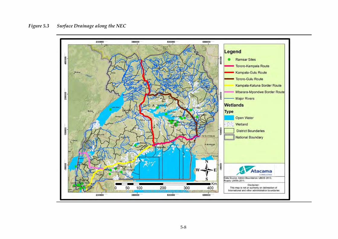
5-8
Figure 5.3 Surface Drainage along the NEC
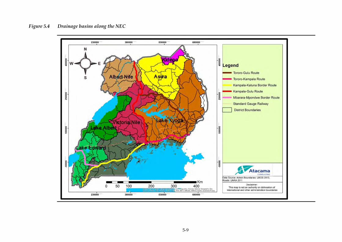
5-9
Figure 5.4 Drainage basins along the NEC
ERM/ATACAMA CONSULTING JST/MOWT
5-10
5.1.4 Flooding
An area’s risk to flooding is a combination of the topography, nature of
soils and amount of rainfall received. For example flat lands are at a
higher risk of flooding than uplands/ hill slopes. Similarly, compacted
soils provide favorable conditions for flooding due to their low water
infiltration rates and areas that receive high amounts of rainfall can
easily be flooded compared to those that receive low amounts of
rainfall. Furthermore, it is important to note that change in land use
practices has an effect on the soil properties and can thus alter the level
of proneness of an area to flooding.
Using the above approach, the flood areas of Uganda were determined
(Kitutu 2013) and the results in relation to the NEC are as presented
below. Of the 39 districts traversed by the NEC, 23 of them are prone to
flooding. More so, floods had already occurred (2013) in 14 of the 23
flood prone districts (Figure 5.5, Table 5.2). Half of the districts where
floods had occurred are along the Tororo – Gulu route.
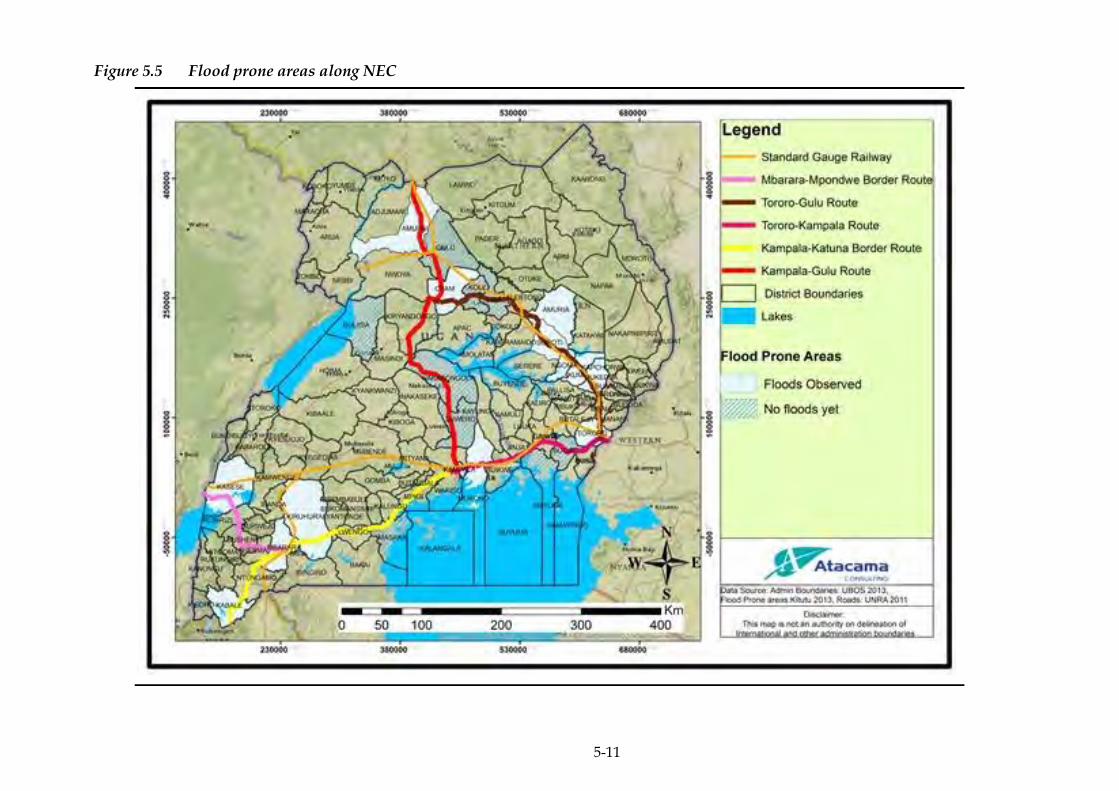
5-11
Figure 5.5 Flood prone areas along NEC
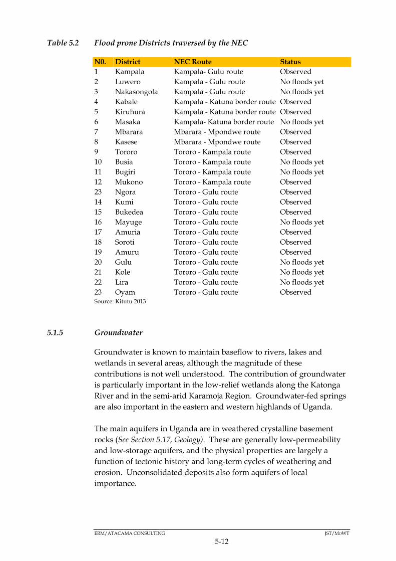
ERM/ATACAMA CONSULTING JST/MOWT
5-12
Table 5.2 Flood prone Districts traversed by the NEC
N0. District NEC Route Status
1 Kampala Kampala- Gulu route Observed
2 Luwero Kampala - Gulu route No floods yet
3 Nakasongola Kampala - Gulu route No floods yet
4 Kabale Kampala - Katuna border route Observed
5 Kiruhura Kampala - Katuna border route Observed
6 Masaka Kampala- Katuna border route No floods yet
7 Mbarara Mbarara - Mpondwe route Observed
8 Kasese Mbarara - Mpondwe route Observed
9 Tororo Tororo - Kampala route Observed
10 Busia Tororo - Kampala route No floods yet
11 Bugiri Tororo - Kampala route No floods yet
12 Mukono Tororo - Kampala route Observed
23 Ngora Tororo - Gulu route Observed
14 Kumi Tororo - Gulu route Observed
15 Bukedea Tororo - Gulu route Observed
16 Mayuge Tororo - Gulu route No floods yet
17 Amuria Tororo - Gulu route Observed
18 Soroti Tororo - Gulu route Observed
19 Amuru Tororo - Gulu route Observed
20 Gulu Tororo - Gulu route No floods yet
21 Kole Tororo - Gulu route No floods yet
22 Lira Tororo - Gulu route No floods yet
23 Oyam Tororo - Gulu route Observed Source: Kitutu 2013
5.1.5 Groundwater
Groundwater is known to maintain baseflow to rivers, lakes and
wetlands in several areas, although the magnitude of these
contributions is not well understood. The contribution of groundwater
is particularly important in the low-relief wetlands along the Katonga
River and in the semi-arid Karamoja Region. Groundwater-fed springs
are also important in the eastern and western highlands of Uganda.
The main aquifers in Uganda are in weathered crystalline basement
rocks (See Section 5.17, Geology). These are generally low-permeability
and low-storage aquifers, and the physical properties are largely a
function of tectonic history and long-term cycles of weathering and
erosion. Unconsolidated deposits also form aquifers of local
importance.

ERM/ATACAMA CONSULTING JST/MOWT
5-13
Igneous, sedimentary and metasedimentary rocks are not widely used
as aquifers and little is therefore known about their aquifer properties.
There are currently no widespread issues with groundwater quantity,
although localised groundwater depletion may be an issue where the
low permeability basement aquifers are exploited by high yielding
electric pumps.
Groundwater quality in Uganda is generally good, although high
concentrations of iron and manganese are common in the crystalline
basement aquifers, and microbial contamination related to faecal waste
has been observed in shallow urban aquifers. High fluoride
concentrations are often observed in igneous groundwater, for example
at Kisoro and Mbale (Tororo – Kampala – Katuna border route).
5.1.6 Topography
Topography is a key factor worth considering when planning for
infrastructure (residential buildings, non-residential private buildings,
public infrastructure, roads, railways and bridges) related
interventions.
Uganda can be divided into four relief regions:-
(i) Above 2000 metres – 2 percent of the land area;
(ii) 1500 – 2000 metres – 5 percent of the land area;
(iii) 900 – 1500 metres – 84 percent of the land area; and
(iv) Below 900 metres – 9 percent of the land area.
Areas in the western and south-western parts of the country
predominantly range from 750m to 2250m above sea level; those areas
closer to Mount Rwenzori reach an altitude of 4655m above sea level;
areas in the northern and north-eastern parts range from 750m to 1500m
above sea level; while those in the north-western parts predominantly
range from 750m to 1000m above sea level. Areas in the eastern parts of
the country range from 1000m to 4855m above sea level. This is majorly
because of the existence of Mount Elgon in the eastern region.
The lowest elevation within the NEC, is 52m above sea level in Amuru
District, and the highest elevation is 1462m above sea level in different
sections of the corridor as indicated in Figure 5.6. The topography along
the other routes that make up the corridor is indicated below.
ERM/ATACAMA CONSULTING JST/MOWT
5-14
Tororo - Kampala - Mbarara route
This section of the Corridor lies within an attitude range of 1163m to
1462m above sea level.
Mbarara – Katuna border route
The section of the Corridor lies largely within an altitude range of
1462m to 1804m above sea level.
Mbarara – Mpondwe border route
From Mbarara, the section lies within an altitude range of 1462m to
1804m above sea level and the altitude drops to between 864m to 1163m
above sea level in the later sections.
Tororo - Gulu route
This section of the Corridor lies within an attitude range of 864m to
1163m above sea level.
Kampala – Gulu route
This section of the Corridor lies largely within an attitude range of
864m to 1163m above sea level but the altitude drops to between 52m
and 864m above sea level in Amuru district.

5-15
Figure 5.6 Generalised Topography along NEC
ERM/ATACAMA CONSULTING JST/MOWT
5-16
5.1.7 Geology
Uganda lies in the eastern part of the African Continental crust. The
geology of the country is comprised of crystalline Precambrian
basement rocks, Proterozoic metavolcanic and metasedimentary
formations, Paleozoic Karoo formation and Mesozoic to Cainozoic
volcanic rocks and sediments (Figure 5.7). Major structures across
Uganda include the rift system of the western flank and the Aswa shear
zone (~ 300 km long).
According to geological studies (Kisolo and Barifaij, 2008), two-thirds of
Uganda is underlined with Precambrian rocks. Archean rocks are
exposed in the south-east of the country and are part of the extensive
granite-greenstone terrane of the Tanzania Craton. Three major
Proterozoic belts underlie central and western Uganda: the
Paleoproterozoic Buganda-Toro metasediments, the Mesoproterozoic
Karagwe-Ankolean (Kibaran) belt in the south-west of the country, and
Neoproterozoic Pan-African rocks (Gabert 1984). The Neoproterozoic
includes; the Bunyoro Series with tillites and argillites (Bjorlykke 1973),
and the under-formed shallow water sediments of the Bukoban Super
group. Tertiary to recent sediments have filled parts of the down-
faulted Western Rift. Tertiary carbonatites and Cenozoic volcanics are
related to rift activities and occur along the eastern and western borders
of the country.
The NEC is underlain by the following geological formations (Figure
5.7):
The Nyanzanian complex is comprised principally of mafic volcanic
rocks and sediments. It forms the gold-bearing greenstone belt, which is
part of the famous Lake Victoria gold field of northern Tanzania and
western Kenya. Gold mineralisation is confined to quartz veins within
the basic metavolcanics, within banded-iron formations (BIF) or in the
rocks adjacent to the BIF units.
The Buganda-Toro system is composed of argillaceous rocks together
with quartzites and stretches from the southwest of the country
through Rwenzori Mountains swinging eastward to the north of Lake
Victoria. In some areas in central and southern parts within this belt,
the rocks are metamorphosed to a higher degree reaching the
almandine-amphibolite facies. The system is a host to gold, base metals
such as copper, cobalt, nickel, columbite-tantalite and tungsten.

ERM/ATACAMA CONSULTING JST/MOWT
5-17
Basement Complex is of predominantly granitic metamorphic rocks of
Archaean shield in central and northern areas of the country. Little
mapping has been undertaken to differentiate the rock units. This
domain has a variety of minerals which include asbestos, graphite,
kyanite, garnet, talc, feldspar, kaolin, clays and stone for aggregate.
The Karagwe-Ankolean system extends from the southwest of the
country for over 2000 kilometres to Katanga in the Democratic Republic
of Congo. The rocks are similar to those of the Buganda -Toro System
but are usually less metamorphosed. Intrusive porphyritic granites
within the cores of anticlines are a common feature. The system is a
major host of gold, tin, tungsten, beryl, lithium, columbite, tantalite,
bismuth and iron ore. Most gold workings in the belt have been largely
by artisans.
The geology along the respective routes of the corridor is as indicated
below:
Tororo - Kampala route
The route is underlain by the Nyanzanian Basement complex in Tororo
district and the Buganda -Toro Proterozoic rocks in the Busoga region
districts.
Tororo - Gulu route
The route is generally underlain by undifferentiated basement complex.
Kampala - Katuna Border route
The route is mainly underlain by Proterozoic rocks and undifferentiated
basement complex.
Kampala - Gulu route
Similar to the Tororo - Gulu route, the Kampala – Gulu route is
underlain by undifferentiated basement complex. In addition, a section
of the route, specifically in Masindi district, is underlain by the
Bukoban Proterozoic rocks.
Mbarara - Mpondwe border route
Within Mbarara district, the route is overlain by the Karagwe-Ankolean
Proterozoic rocks but proceeds further into undifferentiated basement
complex and meso/Cenozoic sediments and meso/Cenozoic volcanics
to the Mpondwe border.
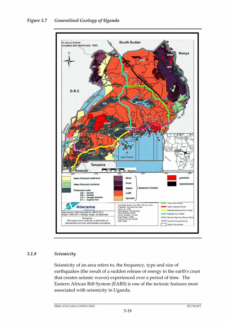
ERM/ATACAMA CONSULTING JST/MOWT
5-18
Figure 5.7 Generalised Geology of Uganda
5.1.8 Seismicity
Seismicity of an area refers to, the frequency, type and size of
earthquakes (the result of a sudden release of energy in the earth's crust
that creates seismic waves) experienced over a period of time. The
Eastern African Rift System (EARS) is one of the tectonic features most
associated with seismicity in Uganda.

ERM/ATACAMA CONSULTING JST/MOWT
5-19
The others are the Katonga fault break which starts from the foot hills of
the Rwenzori Block Mountains, traverses Lake Victoria and connects to
the Kavirondo Gulf in south-western Kenya and the Speke Gulf south
of Lake Victoria in Tanzania; and, the Aswa shear zone that starts from
Nimule at the South Sudan-Uganda border and joins Mt. Elgon on the
Eastern border (Figure 5.8)
Figure 5.8 Seismicity of Uganda
Source: Kitutu, 2013

ERM/ATACAMA CONSULTING JST/MOWT
5-20
Uganda lies in an earthquake zone but the earthquakes that have
occurred in the region have all been relatively weak in the past two
decades. In 1994 an earthquake (6.2 on the Richter scale) struck near
Fort Portal, and affected about 50,000 people in the region leaving
extensive damage but a limited number of casualties.
5.1.9 Soils
The NEC in Uganda traverses several soil types as indicated in Figure
5.9. Soil is particularly important in the Ugandan context given that the
country’s economy is largely subsistence driven with agriculture
accounting for the largest workforce. The respective soil types in the
NEC are discussed below:
Luvisols
These soils are moderately weathered with favourable physical
characteristics. The mixed mineralogy, high nutrient content, and good
drainage of these soils make them suitable for a wide range of
agriculture, from grains to orchards to vineyards. Luvisols form on flat
or gently sloping landscapes under climatic regimes that range from
cool temperate to warm Mediterranean. Luvisols are technically
characterized by a surface accumulation of humus overlying an
extensively leached layer that is nearly devoid of clay and iron-bearing
minerals (http://www.britannica.com/science/Luvisol).
Leptosols
Leptosols are soils with a very shallow profile depth (indicating little
influence of soil-forming processes), and they often contain large
amounts of gravel. They typically remain under natural vegetation,
being especially susceptible to erosion, desiccation, or waterlogging,
depending on climate and topography
(http://www.britannica.com/science/Leptosol).
Planosols
Planosols are characterised by a subsurface layer of clay accumulation.
They occur typically in wet low-lying areas that can support either
grass or open forest vegetation. They are poor in plant nutrients,
however, and their clay content leads to both seasonal waterlogging
and drought stress (http://www.britannica.com/science/Planosol).
ERM/ATACAMA CONSULTING JST/MOWT
5-21
Andosols
Andosols are highly porous, dark-coloured soils developed from parent
material of volcanic origin, such as volcanic ash, tuff, and pumice
(http://www.britannica.com/science/Andosol).
Nitisols
Nitisols are strongly influenced by biological activity, resulting in a
homogenization of the upper portion of the soil profile. They are
perhaps the most inherently fertile of the tropical soils because of their
high nutrient content and deep, permeable structure. They are
exploited widely for plantation agriculture.
Regosols
Regosols are characterised by shallow, medium-to fine-textured,
unconsolidated parent material that may be of alluvial origin and by
the lack of a significant soil horizon (layer) formation because of dry or
cold climatic conditions
(http://www.britannica.com/science/Regosol).
Plinthosols
Plinthosols form under a variety of climatic and topographic
conditions. They are defined by a subsurface layer containing an iron-
rich mixture of clay minerals (chiefly kaolinite) and silica that hardens
on exposure into ironstone concretions known as plinthite. The
impenetrability of the hardened plinthite layer, as well as the
fluctuating water table that produces it, restrict the use of these soils to
grazing or forestry, although the hardened plinthite has value as
subgrade material for roads or even as iron ore
(http://www.britannica.com/science/Plinthosol).
The soil types along the respective routes of the corridor are as
indicated below:
Tororo - Kampala route
The sub-route is underlain by soil types including; Petric Plinthosols,
Nitisols, Luvisols and Acric Ferrasols.
ERM/ATACAMA CONSULTING JST/MOWT
5-22
Tororo - Gulu route
The route is mainly underlain by Petric Plinthosols, Acric Ferrasols,
Leptosols, Luvisols and Melanic Andosols.
Kampala - Katuna Border route
The route is mainly underlain by Luvisols, Planosols, Acric Ferrasols,
and Dystric Regsols.
Kampala - Gulu route
The route is underlain by Luvisols, Acric Ferrasols, Petric Plinthosols
and Leptosols
Mbarara - Mpondwe Border Route
The route is overlain by Luvisols, Acric Ferrasols, Nitisols and Luvic
Andosols.
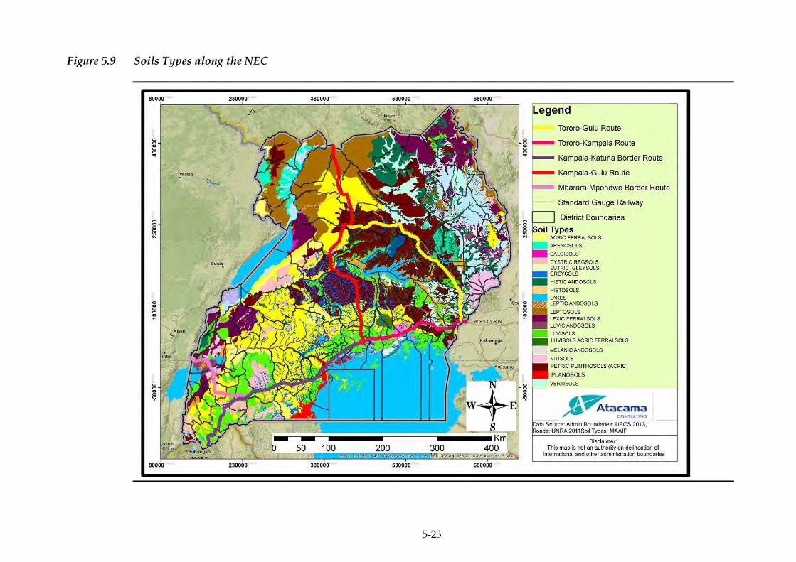
5-23
Figure 5.9 Soils Types along the NEC

ERM/ATACAMA CONSULTING JST/MOWT
5-24
Physical Constraints Identified within the NEC.
The physical constraints identified are presented in Figure 5.10.
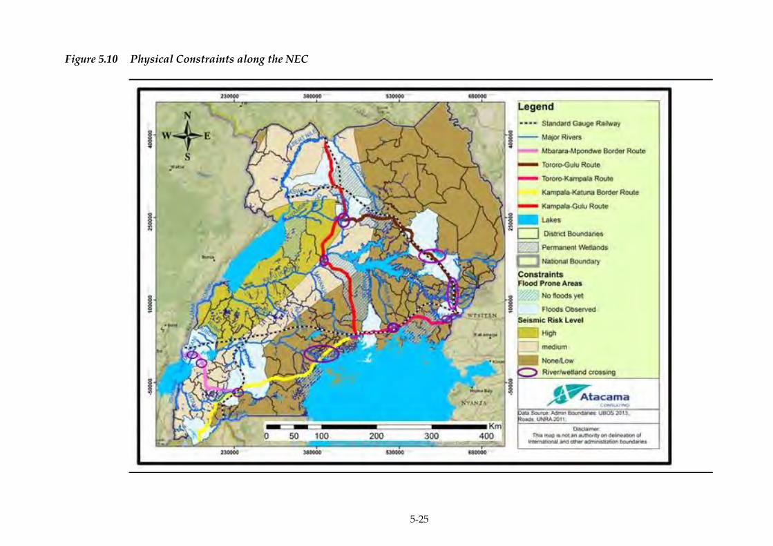
5-25
Figure 5.10 Physical Constraints along the NEC
ERM/ATACAMA CONSULTING JST/MOWT
5-26
BIOLOGICAL ENVIRONMENT 5.2
5.2.1 Description of the biological environment
Biodiversity is essentially defined as the abundance and diversity of
living things, or the assortment, variation and array of flora and fauna.
In this context biodiversity is herein taken to refer to flora and fauna
(species diversity) and their associated habitats (ecological diversity).
Uganda is rich in biodiversity, and relatively richer than many African
countries for its small size 241,000 km2. The country is rich in terms of
species richness and abundance; has species of high conservation
value(s), and a rich and varied landscape with many ecosystems
(National Biodiversity Data Bank, 2012).
The biological environment described in this section includes the
biodiversity along the NEC at ecosystem level. Protected and sensitive
ecosystems within the NEC are described in Table 5.5 and depicted in
Figure 5.11.
5.2.2 Flora
The natural vegetation of an area is that type of plant cover that grows
naturally following climatic conditions. Due to a variety of climatic
conditions, soil and altitude, a wide range of natural vegetation grows
in Uganda ranging from high montane moorland and through various
types of forests, forest-savanna mosaics, savannas, thickets, grasslands,
wetlands and cultivated forest, grassland and swamps. The two major
ecosystems in Uganda are the forests and wetlands.
Forests
Uganda’s natural forests vary in structure and composition in different
parts of the country covering a wide range of habitats and terrestrial
biodiversity. It is in these forests that most of Uganda’s biodiversity
can be found (NEMA and MoWE, 2009).
The major forests in Uganda with respect to the NEC include:
West Bugwe (Busitema) CFR;
South Busoga CFR;
Mabira CFR;
Kasagala CFR;
Katugo CFR;
Nyamakere CFR;
Opit CFR;

ERM/ATACAMA CONSULTING JST/MOWT
5-27
Kilak CFR;
Kibeka CFR;
Mpigi group CFRs;
Kalinzu and Maramagambo CFRs;
Kashyoha-Kitomi CFR;
Jubiya CFR;
Bukabaleba CFR;
Igwe Luvunya CFR;
Kijanebalola CFR; and
Kyalwamuka CFR.
Wetlands
For its size, Uganda's wetlands are complex and extensive, being found
in almost all areas of the country. The country's wetlands ecosystems
can be classified into two broad categories: wetlands associated with
lakes, and wetlands associated with rivers and flood plains. Prominent
wetland flora is comprised of emergent, floating and submerged
categories of macrophytes plus the microscopic, mostly epiphytic algae.
The most common vegetation in Uganda's wetlands is papyrus but
other wetlands include flood plains and swamp forests. The road
infrastructure along the NEC traverses some of Uganda’s permanent
wetland systems listed below:
Lake Mburo wetland system;
Lake Victoria wetland system;
Lake Kyoga wetland system;
River Kagera wetland system; and the
Victoria Nile wetland system.
5.2.3 Fauna
Uganda is home to species of world-wide importance and contains
globally recognised biodiversity of species and habitats that are
distributed throughout the country’s vast wetlands, lakes, protected
forests, and savannah grasslands. Despite its small size, Uganda has an
extraordinary amount of diversity in both terrestrial and aquatic
habitats occurring within and outside protected areas (NEMA and
MoWE, 2009).
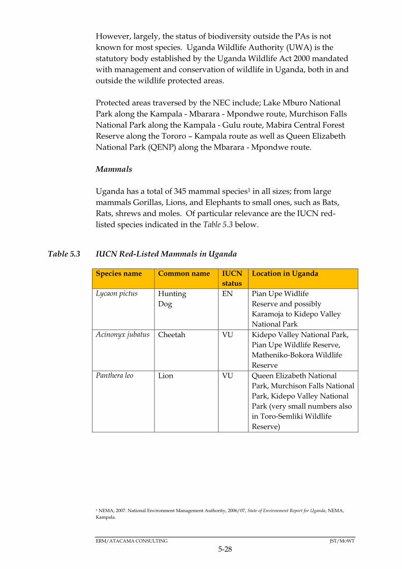
ERM/ATACAMA CONSULTING JST/MOWT
5-28
However, largely, the status of biodiversity outside the PAs is not
known for most species. Uganda Wildlife Authority (UWA) is the
statutory body established by the Uganda Wildlife Act 2000 mandated
with management and conservation of wildlife in Uganda, both in and
outside the wildlife protected areas.
Protected areas traversed by the NEC include; Lake Mburo National
Park along the Kampala - Mbarara - Mpondwe route, Murchison Falls
National Park along the Kampala - Gulu route, Mabira Central Forest
Reserve along the Tororo – Kampala route as well as Queen Elizabeth
National Park (QENP) along the Mbarara - Mpondwe route.
Mammals
Uganda has a total of 345 mammal species1 in all sizes; from large
mammals Gorillas, Lions, and Elephants to small ones, such as Bats,
Rats, shrews and moles. Of particular relevance are the IUCN red-
listed species indicated in the Table 5.3 below.
Table 5.3 IUCN Red-Listed Mammals in Uganda
Species name Common name IUCN
status
Location in Uganda
Lycaon pictus Hunting
Dog
EN Pian Upe Widlife
Reserve and possibly
Karamoja to Kidepo Valley
National Park
Acinonyx jubatus Cheetah VU Kidepo Valley National Park,
Pian Upe Wildlife Reserve,
Matheniko‐Bokora Wildlife
Reserve
Panthera leo Lion VU Queen Elizabeth National
Park, Murchison Falls National
Park, Kidepo Valley National
Park (very small numbers also
in Toro‐Semliki Wildlife
Reserve)
1 NEMA, 2007. National Environment Management Authority, 2006/07, State of Environment Report for Uganda, NEMA,
Kampala.
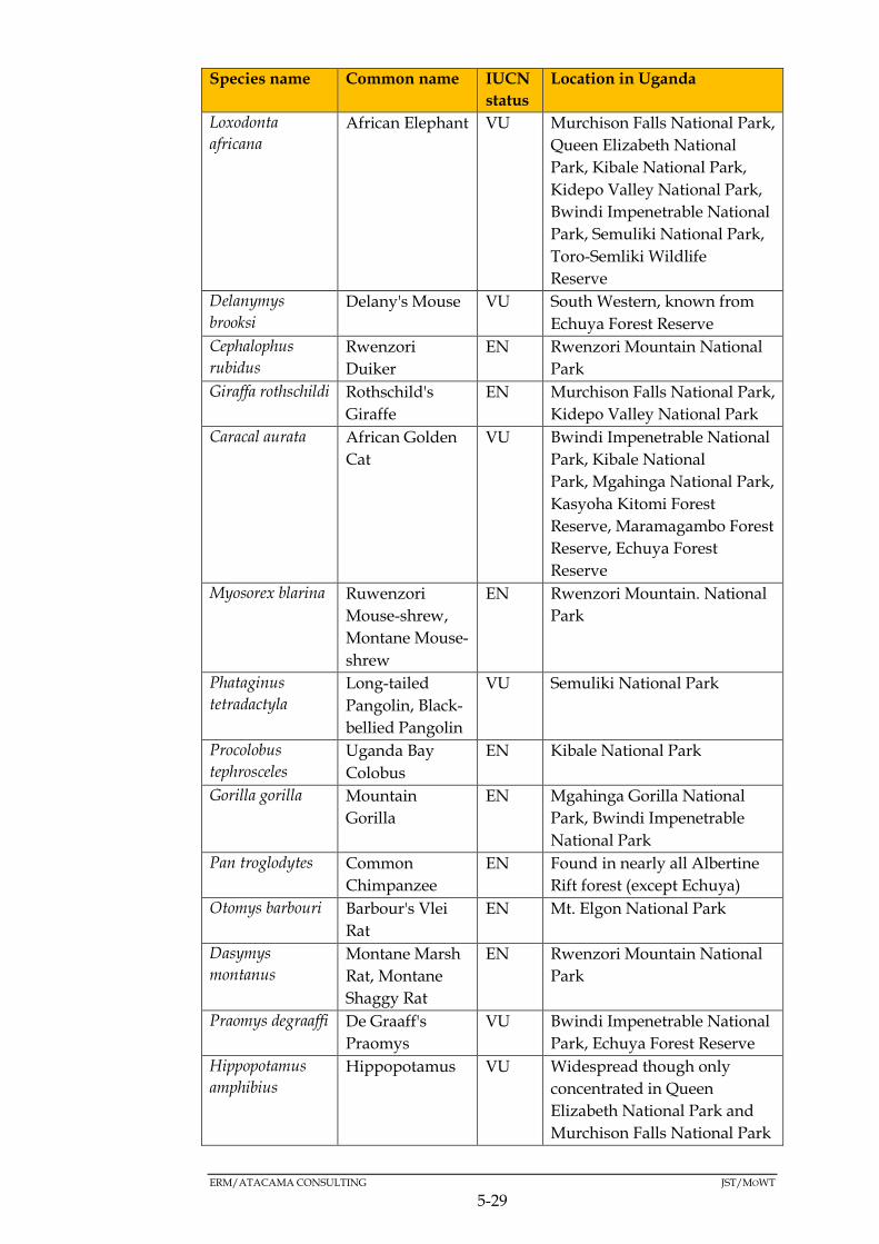
ERM/ATACAMA CONSULTING JST/MOWT
5-29
Species name Common name IUCN
status
Location in Uganda
Loxodonta
africana
African Elephant VU Murchison Falls National Park,
Queen Elizabeth National
Park, Kibale National Park,
Kidepo Valley National Park,
Bwindi Impenetrable National
Park, Semuliki National Park,
Toro-Semliki Wildlife
Reserve
Delanymys
brooksi
Delany's Mouse VU South Western, known from
Echuya Forest Reserve
Cephalophus
rubidus
Rwenzori
Duiker
EN Rwenzori Mountain National
Park
Giraffa rothschildi Rothschild's
Giraffe
EN Murchison Falls National Park,
Kidepo Valley National Park
Caracal aurata African Golden
Cat
VU Bwindi Impenetrable National
Park, Kibale National
Park, Mgahinga National Park,
Kasyoha Kitomi Forest
Reserve, Maramagambo Forest
Reserve, Echuya Forest
Reserve
Myosorex blarina Ruwenzori
Mouse-shrew,
Montane Mouse-
shrew
EN Rwenzori Mountain. National
Park
Phataginus
tetradactyla
Long-tailed
Pangolin, Black-
bellied Pangolin
VU Semuliki National Park
Procolobus
tephrosceles
Uganda Bay
Colobus
EN Kibale National Park
Gorilla gorilla Mountain
Gorilla
EN Mgahinga Gorilla National
Park, Bwindi Impenetrable
National Park
Pan troglodytes Common
Chimpanzee
EN Found in nearly all Albertine
Rift forest (except Echuya)
Otomys barbouri Barbour's Vlei
Rat
EN Mt. Elgon National Park
Dasymys
montanus
Montane Marsh
Rat, Montane
Shaggy Rat
EN Rwenzori Mountain National
Park
Praomys degraaffi De Graaff's
Praomys
VU Bwindi Impenetrable National
Park, Echuya Forest Reserve
Hippopotamus
amphibius
Hippopotamus VU Widespread though only
concentrated in Queen
Elizabeth National Park and
Murchison Falls National Park

ERM/ATACAMA CONSULTING JST/MOWT
5-30
Species name Common name IUCN
status
Location in Uganda
Ruwenzorisorex
suncoides
Osgood's
Montane Shrew,
Rwenzori Shrew
VU Rwenzori Mountain National
Park, possibly Bwindi
Impenetrable National Park
Sylvisorex lunaris Long-tailed
Forest Shrew,
Moon Forest
Shrew
VU Rwenzori Mountain National
Park, Bwindi Impenetrable
National Park, Mgahinga
National Park
Phataginus
tricuspis
Tree Pangolin,
White-bellied
Pangolin
VU Bwindi Impenetrable National
Park, Queen Elizabeth
National Park, Mabira Forest
Reserve, Budongo Forest
Reserve, Kibale National Park
Smutsia gigantea Giant Pangolin,
Giant Ground
Pangolin
VU Murchison Falls National Park,
Queen Elizabeth National
Park, Lake Mburo National
Park, Lake Albert, Migadde
(Gayaza District), Kibale
National Park, Budongo Forest
Reser
Smutsia
temminckii
Ground
Pangolin,
Temminck's
Ground
Pangolin
VU Murchison Falls National Park,
Kidepo Valley National Park
Hybomys lunaris Ruwenzori
Striped Mouse
VU Rwenzori Mountain National
Park Source: Wildlife Conservation Society, 2016
Key
EN: Endangered
VU: Vulnerable
Avifauna
The avifauna of Uganda includes a total of 1012 species1. Of these, the
IUCN redlisted species are indicated in the Table 5.4 below. The birds
occur in nearly all habitats although some areas such as the Lake
Victoria Basin present rare opportunities for bird watching. The key
avifauna habitats traversed by the corridor include R. Nile and Mabira
Central Forest Reserve along the Tororo - Kampala route, Lake Mburo
National Park along the Kampala - Katuna border route and Queen
Elizabeth National park along the Mbarara - Mpondwe route. These are
major tourist destinations for bird watchers in Uganda.

ERM/ATACAMA CONSULTING JST/MOWT
5-31
Table 5.4 IUCN Red Listed Birds in Uganda
Species name Common name IUCN
status
Location in Uganda
Neophron
percnopterus
Egyptian
Vulture
EN Queen Elizabeth National
Park, Lake Mburo National
Park, Pian Upe Wildlife
Reserve, Kidepo Valley
National Park, Karamoja
sub‐region (Mt Elgon)
Torgos tracheliotus Lappet‐faced
Vulture
EN Queen Elizabeth National
Park, Lake Mburo National
Park, Murchison Falls
National Park, Semliki
Wildlife Reserve
Trigonoceps
occipitalis
White‐headed
Vulture
CR Kidepo Valley National Park,
Lake Mburo National Park,
Queen Elizabeth National
Park, Semliki Wildlife
Reserve, Murchison Falls
National Park
Balearica pavonina Black-crowned
Crane
VU West Nile Region
Ardeola idae Madagascar
Pond-heron,
Madagascar
Squacco Heron
EN Queen Elizabeth National
Park, Lake Mburo National
Park, Lake Victoria, Lake
Albert, Lake Kyoga
Balaeniceps rex Shoebill VU Lake Victoria, Lake Albert,
Lake Kyoga, River Nile,
Queen Elizabeth National
Park, Lake Mburo National
Park, Murchison Falls
National Park
Necrosyrtes
monachus
Hooded Vulture CR Throughout Uganda
Gyps africanus African White-
backed Vulture
CR Significant populations in
Queen Elizabeth National
Park, Murchison Falls
National Park
Gyps rueppelli Ruppell's
Griffon Vulture
CR Queen Elizabeth National
Park, Murchison Falls
National park, Lake Mburo
National Park
Balearica regulorum Grey Crowned
Crane
EN Widespread in moist non-‐
forest areas
Pseudocalyptomena
graueri
African Green
Broadbill
VU Bwindi Impenetrable
National Park (Ruhiza)
Hirundo Blue Swallow VU Lake Victoria, Tororo

ERM/ATACAMA CONSULTING JST/MOWT
5-32
Species name Common name IUCN
status
Location in Uganda
atrocaerulea District, Kidepo Valley
National Park (Napori Hills),
Maramagambo
Forest Reserve Queen
Elizabeth National Park
Apalis karamojae Karamoja Apalis VU Karamoja sub-‐region,
Kidepo Valley National Park
Muscicapa lendu Chapin's
Flycatcher
VU Bwindi Impenetrable
National Park
Cryptospiza shelleyi Shelley's
Crimson-wing
VU Rwenzori Mountains
National Park, Bwindi
Impenetrable National Park
Ciconia microscelis African
Woollyneck,
Woolly-necked
Stork
VU Murchison Falls National
Park, Queen Elizabeth
National Park, Lake Mburo
National Park, Lake Victoria,
Lake Albert, Lake Kyoga,
West Nile region
Sagittarius
serpentarius
Secretary Bird VU Queen Elizabeth National
Park, Murchison Falls
National Park, Kidepo Valley
National Park
Ptilopachus nahani Nahan's
Francolin
EN Budongo Forest Reserve,
Bugoma Forest Reserve,
Mabira Forest Reserve
Psittacus erithacus Grey Parrot VU Bwindi Impenetrable
National Park, Mabira Forest
Reserve, Maramagambo
Forest Reserve, Lake Victoria
(including Islands), Western
Forests
Bradypterus graueri Grauer's
Swamp-
Warbler,
Grauer's Rush
Warbler
EN Muchuya wetland,
Mubwindi wetland, Lake
Bunyonyi
Chloropeta
gracilirostris
Papyrus Yellow
Warbler
VU Lake Mburo National Park,
Lake Albert, Nyamuriro
Swamp IBA, Lake Bunyonyi,
Lake George (Muhokya
Wetland), Lake Mutanda Source: Wildlife Conservation Society, 2016
Key
EN: Endangered
VU: Vulnerable
CR: Critically Endangered
ERM/ATACAMA CONSULTING JST/MOWT
5-33
Fish
The fish diversity in Uganda includes 501 species1. Lake Victoria, which
is the second largest fresh-water lake in the world, is also known to
have high fish diversity. The Lates Niloticus (Nile perch) is the basis for
L. Victoria's most important industry (fishing) and underpinning
subsistence lifestyle in rural portions in the riparian districts of Lake
Victoria. The other species include Alestes, Barbus, Labeo, Synodontis,
Schilbe, Protopterus, Clarius, Mormyrus and Haplochromis. These fishes
are of extreme high value and are sold as niche fishes in the domestic
markets. (http://www.afipek.org/lakevictoriafisheries.html)
Amphibians
Amphibians have not been comprehensively studied in Uganda.
However, a total of 86 species of amphibians have so far been recorded
in the country, 14 of which are listed as vulnerable according to the
IUCN Red List1. Of the 86 species recorded, 38 are Albertine Rift
Endemics.
Forty eight (48) species of amphibians are supported by Uganda’s
wetlands, with the rest existing under forest or savannah/grassland
ecosystems.
Reptiles
Uganda has a total of 142 species of reptiles1Two species of crocodile
are known to occur in Uganda; the Nile crocodile (Crocodylus niloticus)
and the dwarf crocodile (Osteolaemus tetraspis). There is very little
information about the status of other reptiles such as snakes, which
comprise 103 species of the total number of reptile species.
Wetlands support 19 species of reptiles2 while many reptile species
occur under the forest and savannah/grassland ecosystems.
The ecosystems/fauna habitats of particular relevance to the NEC are
presented in Table 5.5. Figure 5.11 is indicative of the biological
constraints associated with the Master Plan.
1 (USAID, 2006)
2 (Uganda National Water Development Report, 2005)
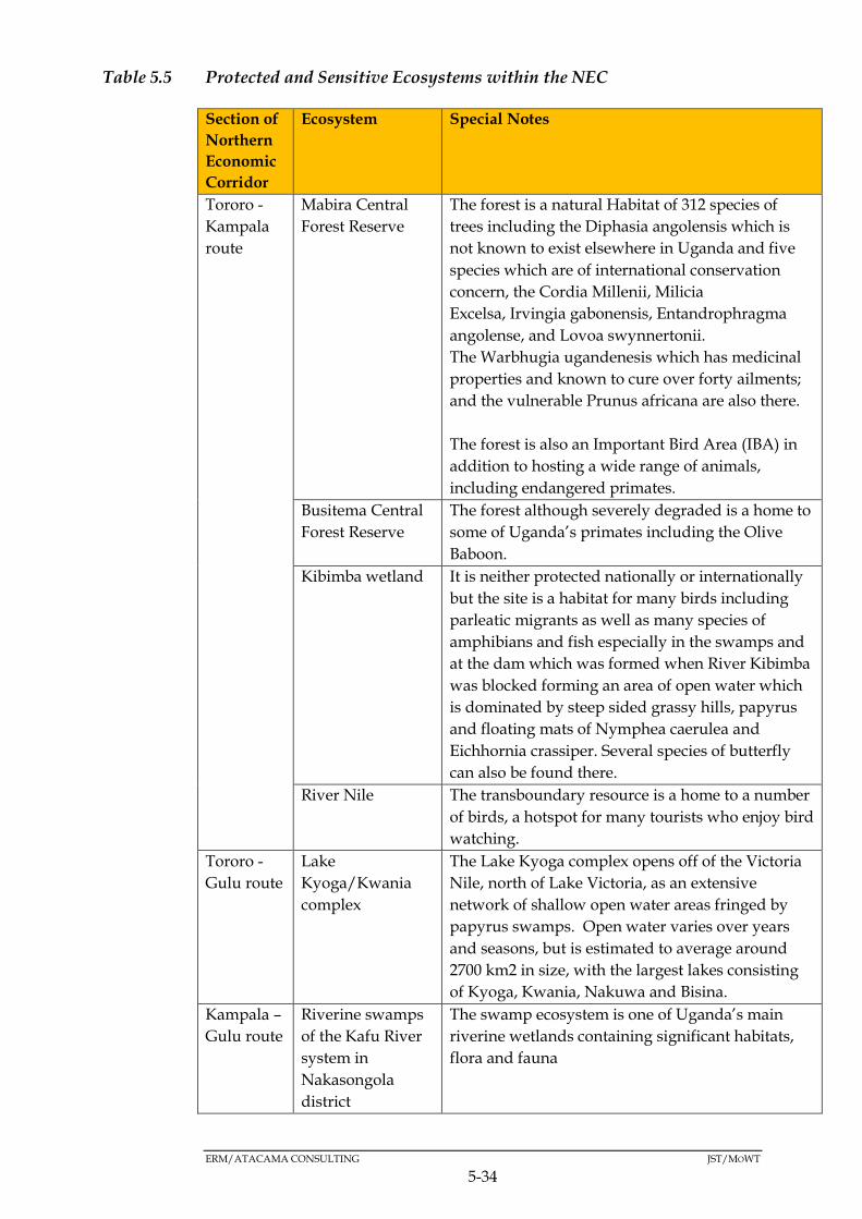
ERM/ATACAMA CONSULTING JST/MOWT
5-34
Table 5.5 Protected and Sensitive Ecosystems within the NEC
Section of
Northern
Economic
Corridor
Ecosystem Special Notes
Tororo -
Kampala
route
Mabira Central
Forest Reserve
The forest is a natural Habitat of 312 species of
trees including the Diphasia angolensis which is
not known to exist elsewhere in Uganda and five
species which are of international conservation
concern, the Cordia Millenii, Milicia
Excelsa, Irvingia gabonensis, Entandrophragma
angolense, and Lovoa swynnertonii.
The Warbhugia ugandenesis which has medicinal
properties and known to cure over forty ailments;
and the vulnerable Prunus africana are also there.
The forest is also an Important Bird Area (IBA) in
addition to hosting a wide range of animals,
including endangered primates.
Busitema Central
Forest Reserve
The forest although severely degraded is a home to
some of Uganda’s primates including the Olive
Baboon.
Kibimba wetland It is neither protected nationally or internationally
but the site is a habitat for many birds including
parleatic migrants as well as many species of
amphibians and fish especially in the swamps and
at the dam which was formed when River Kibimba
was blocked forming an area of open water which
is dominated by steep sided grassy hills, papyrus
and floating mats of Nymphea caerulea and
Eichhornia crassiper. Several species of butterfly
can also be found there.
River Nile The transboundary resource is a home to a number
of birds, a hotspot for many tourists who enjoy bird
watching.
Tororo -
Gulu route
Lake
Kyoga/Kwania
complex
The Lake Kyoga complex opens off of the Victoria
Nile, north of Lake Victoria, as an extensive
network of shallow open water areas fringed by
papyrus swamps. Open water varies over years
and seasons, but is estimated to average around
2700 km2 in size, with the largest lakes consisting
of Kyoga, Kwania, Nakuwa and Bisina.
Kampala –
Gulu route
Riverine swamps
of the Kafu River
system in
Nakasongola
district
The swamp ecosystem is one of Uganda’s main
riverine wetlands containing significant habitats,
flora and fauna
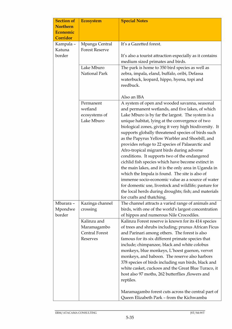
ERM/ATACAMA CONSULTING JST/MOWT
5-35
Section of
Northern
Economic
Corridor
Ecosystem Special Notes
Kampala –
Katuna
border
Mpanga Central
Forest Reserve
It’s a Gazetted forest.
It’s also a tourist attraction especially as it contains
medium sized primates and birds.
Lake Mburo
National Park
The park is home to 350 bird species as well as
zebra, impala, eland, buffalo, oribi, Defassa
waterbuck, leopard, hippo, hyena, topi and
reedbuck.
Also an IBA
Permanent
wetland
ecosystems of
Lake Mburo
A system of open and wooded savanna, seasonal
and permanent wetlands, and five lakes, of which
Lake Mburo is by far the largest. The system is a
unique habitat, lying at the convergence of two
biological zones, giving it very high biodiversity. It
supports globally threatened species of birds such
as the Papyrus Yellow Warbler and Shoebill, and
provides refuge to 22 species of Palaearctic and
Afro-tropical migrant birds during adverse
conditions. It supports two of the endangered
cichlid fish species which have become extinct in
the main lakes, and it is the only area in Uganda in
which the Impala is found. The site is also of
immense socio-economic value as a source of water
for domestic use, livestock and wildlife; pasture for
the local herds during droughts; fish; and materials
for crafts and thatching.
Mbarara –
Mpondwe
border
Kazinga channel
crossing
The channel attracts a varied range of animals and
birds, with one of the world's largest concentration
of hippos and numerous Nile Crocodiles.
Kalinzu and
Maramagambo
Central Forest
Reserves
Kalinzu Forest reserve is known for its 414 species
of trees and shrubs including; prunus African Ficus
and Parinari among others. The forest is also
famous for its six different primate species that
include; chimpanzee, black and white colobus
monkeys, blue monkeys, L’hoest guenon, vervet
monkeys, and baboon. The reserve also harbors
378 species of birds including sun birds, black and
white casket, cuckoos and the Great Blue Turaco, it
host also 97 moths, 262 butterflies ,flowers and
reptiles.
Maramagambo forest cuts across the central part of
Queen Elizabeth Park – from the Kichwamba

ERM/ATACAMA CONSULTING JST/MOWT
5-36
Section of
Northern
Economic
Corridor
Ecosystem Special Notes
escarpment to Lake Edward. The forest is
bordered by two crater lakes; Lake Kyasanduka
and Lake Nyamasingiri. The forest has has 242 tree
species of plants and is a home to primates,
including L’Hoest’s, red-tailed, vervet and black
and white colobus monkeys, chimpanzees and
baboons, as well as bird species including the rare
Forest Flycatcher, White-naped Pigeon and the
striking Rwenzori Turaco.
Queen Elizabeth
National Park
The Queen Elizabeth National Park has been
designated a Biosphere Reserve for Humanity
under the auspices of UNESCO. The park,
includes a remarkable variety of ecosystems, from
semi-deciduous tropical forest to green meadows,
savannah and swamps. It is the home of the
famous tree climbing lion as well as the Uganda
Kob, other antelope species, elephant, baboons,
hippos, buffalo and chimpanzees. Over 600 species
of birds have been recorded, making the park a
magnet for bird watchers.
It’s also an IBA.
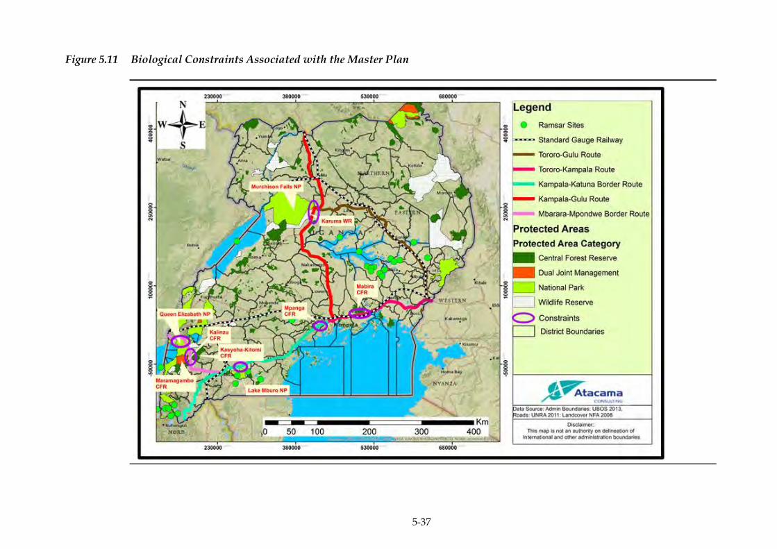
5-37
Figure 5.11 Biological Constraints Associated with the Master Plan

ERM/ATACAMA CONSULTING JST/MOWT
6-1
6 SOCIO-ECONOMIC BASELINE
PHYSICAL PLANNING IN UGANDA 6.1
6.1.1 District and County Headquarters
Uganda is divided into 111 districts and the Kampala Capital City. The
districts are further sub-divided into Counties, Sub-counties, Parishes
and Villages/Local Council 1 (LC 1) Zones. The districts and county
headquarters along the NEC are highlighted along the respective routes
in Figure 6.1.
According to the Local Government Act of 1997, the system of local
government in Uganda is based on the district as a unit under which
there shall be lower local governments and administrative units. The
local governments in a district located in a rural area include (a) the
district council; and (b) the sub-county councils; while the local
governments in a city1 (subject to the Kampala City Council Authority
(KCCA) Act, 2010) are (a) the city council; and (b) the city division
councils. A local government has legislative, administrative and
executive powers exercised in accordance with the National
Constitution of 1995 and Local Governments Act.
There are a number of administrative units in rural areas which include:
(i) the county; (ii) the parish; and (iii) the village, whilst in urban areas
there is, (i) the parish or ward; and (ii) the village/zone. These
administrative units do not have legislative and executive powers.
There are local councils (LCs) established at the village level (LC I),
parish level (LC II), sub-county level (LC III), county level (LC IV) and
district or city level (LC V). The sub-county (LCIII) and district (LC V)
are local governments, while LCI, LCII and LC IV are administrative
units, not local governments.
In Uganda, the definition of urban areas has been changing over time.
The 2002 and 2014 Censuses defined urban areas to include only the
gazetted urban centres. Uganda’s urban portfolio is dominated by
Kampala.
1 For purposes of the Local Government Act, 1997; a city is equivalent to a district, and a city council exercises all functions and powers conferred upon a district council within its area of jurisdiction (Part II Section 4 Sub-section a-b)
ERM/ATACAMA CONSULTING JST/MOWT
6-2
Kampala’s primacy is not an outlier when compared with other
countries in Africa (or low income countries in general). There are 202
urban centres (22 Municipalities and 174 Town Councils with a total of
six(6) million persons) and seven secondary towns in Uganda with a
population ranging between 100,000 to 250,000 people making a total
population of 926,831 (12.5 percent). The size of the urban centres
varies widely, from Kampala City with 1.5 million persons to small
Town Councils with less than 5,000 persons (The National Population
and Housing Census, 2014)
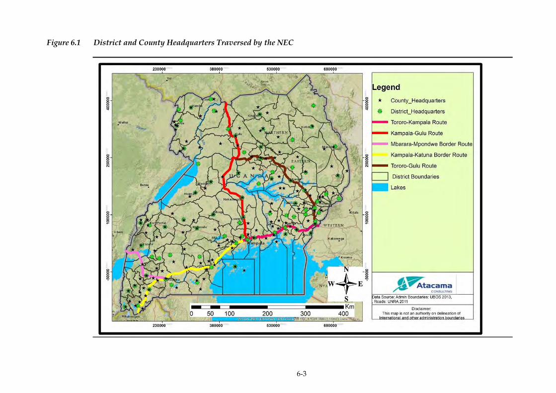
6-3
Figure 6.1 District and County Headquarters Traversed by the NEC
ERM/ATACAMA CONSULTING JST/MOWT
6-4
PHYSICAL PLANNING WITHIN THE NEC 6.2
The planning powers of local authorities are stipulated in the Physical
Planning Act, 2010. The Act states that the local authority shall be the
local planning authority for the area of the local authority, thus,
conferring a primary physical planning responsibility at the local level,
and plan approvals. To carry out this function, the local authority shall
prepare a physical development plan and detailed lay out plan for the
purpose of organising, controlling and planning the development and
use of land and buildings in their area.
There is an obligation on the Urban/Municipal Physical Planning
Committee to ensure that permissions granted under the Planning Acts
are consistent with the policies and objectives set out in the Physical
Development Plan, and the proper planning and sustainable
development of the area.
Most of the major towns (Tororo, Jinja, Mbale, Soroti, Lira, Gulu,
Masindi, Kampala, Masaka, and Mbarara) within the NEC have
physical development plans but are not consistent with aspects such as
multi modal transport, amongst other things.
The extensive ‘Physical Plans’, such as Town and Municipality
Structure Plans and Detailed Plans which were prepared under the
Local Government Development Programme in 2008 (Mukono, Jinja,
Tororo, Mbale, Soroti, Lira, Gulu, Masaka, Mbarara) were for a 10 year
period (2008-2018). These were prepared without Physical Planners at
local government level having the institutional structures or the tools
for adapting and implementing them, and as such they have remained
largely ignored, and the settlements have already outgrown them.
There are other physical planning projects ongoing in the urban realm
which are aimed at upgrading of slums (in Mbale, Jinja, Mbarara and
Gulu; where 60 percent of the urban population reside), provision of
infrastructure and regional and other plans which could contribute to
the strategy to build an effective physical planning system.
ERM/ATACAMA CONSULTING JST/MOWT
6-5
There are eight criteria for planning of the existing and new urban areas
within the NEC; comprehensively covering plans for utilising land and
transportation, developing the economy and infrastructure, evaluation
of the environment, and urban development; preparation for future-
oriented public plans from short-term, middle-term, and long-term
perspectives; making regulations for developing nationally significant
infrastructure; reflecting on nationally important policy issues;
enhancing networks among local governments, and countries;
supplying lands with on-plans, phases, and evidences, and keep a
balance between developed and underdeveloped lands; setting the
priority of investment and suggesting plans of attracting private
investment; and creating world-class urban planning and construction.
However, almost all the major urban towns within the NEC
conurbation have spread de facto beyond the Municipality’s boundaries
and are rapidly impacting on the peri- urban areas as they sprawling
without any development control guidance from the relevant
authorities.
6.2.1 Green Belts
The main objectives of the green belts are to protect the land around
larger urban centres from urban sprawl, and maintain the designated
area for recreational, public land reserves, wetlands, forestry and
agriculture as well as to provide habitat to wildlife. Urban population,
on the other hand, is provided an access to an open space which offers
opportunities for outdoor activities and access to clean air. By
preventing the urban sprawl, it helps protect agricultural activities and
the unique character of rural communities.
Uganda’s urban towns do not have distinctive green belts between the
urban and rural settlements. The physical plans within the corridor of
the urban centres in Uganda have reserved some areas as green belts in
form of public spaces but are very limited and most of them have been
encroached upon.
The green belts which were mostly created as parks and open spaces in
many major towns within the corridor ie Malukhu wetland in Mbale,
Kauda grounds and Pece wetland in Gulu, that are within the corridor
have been encroached upon and have been built upon.

ERM/ATACAMA CONSULTING JST/MOWT
6-6
The few developed and maintained gardens in Kampala city for
example are concentrated in the city centre and generally closed off
from the public. (Table 6.1). While the wetland areas are used for
recreation, landfilling for playfields contributes to their further
degradation.
Most residential neighbourhoods lack public open space, gardens,
parks and playgrounds that allow them to escape from the congestion
and density of urban life.
Table 6.1 Sample of Protected and Public Open Spaces in Kampala
Public Spaces of
Kampala
Historic Use Current Usage and
Status
Jubilee Park (next to
Sheraton Hotel)
Public park and garden Park and garden closed
to public
Mayor’s garden (now
closed to public)
Public park and garden Park and garden closed
to public
Kololo – used to be a
children’s park
Public park and
playground
Developed for a
shopping plaza
Shoprite Game – Public park Developed for a
Shopping
plaza/convention center
Namanve Forest
Lands
Protected Forest
Reserve (appx 2,200
ha)
Appx 1,000 ha remain,
but have been
significantly encroached
upon
Centenary Park Public park (Recreational developed
with bars)
Jinja Road linear Park Cemetery
KCCA Gardens Public park (Offices for KCCA use)
Source: KCCA Strategic Plan, 2014
TRANSPORT 6.3
The transport infrastructure in Uganda includes road, water, air and
railway. However, road transport, as is common in other East African
countries, is the most common means of movement for goods, with
over 95 percent of cargo and passenger traffic using road transport.
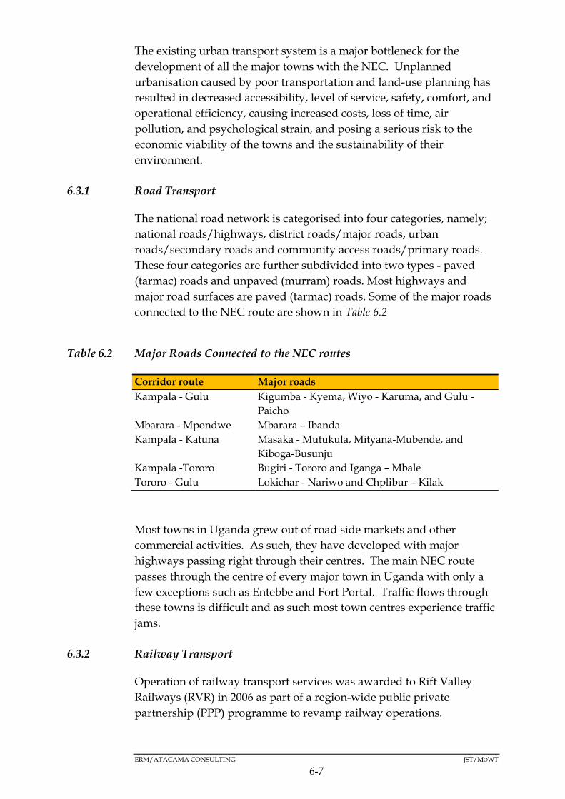
ERM/ATACAMA CONSULTING JST/MOWT
6-7
The existing urban transport system is a major bottleneck for the
development of all the major towns with the NEC. Unplanned
urbanisation caused by poor transportation and land-use planning has
resulted in decreased accessibility, level of service, safety, comfort, and
operational efficiency, causing increased costs, loss of time, air
pollution, and psychological strain, and posing a serious risk to the
economic viability of the towns and the sustainability of their
environment.
6.3.1 Road Transport
The national road network is categorised into four categories, namely;
national roads/highways, district roads/major roads, urban
roads/secondary roads and community access roads/primary roads.
These four categories are further subdivided into two types - paved
(tarmac) roads and unpaved (murram) roads. Most highways and
major road surfaces are paved (tarmac) roads. Some of the major roads
connected to the NEC route are shown in Table 6.2
Table 6.2 Major Roads Connected to the NEC routes
Corridor route Major roads
Kampala - Gulu Kigumba - Kyema, Wiyo - Karuma, and Gulu -
Paicho
Mbarara - Mpondwe Mbarara – Ibanda
Kampala - Katuna Masaka - Mutukula, Mityana-Mubende, and
Kiboga-Busunju
Kampala -Tororo Bugiri - Tororo and Iganga – Mbale
Tororo - Gulu Lokichar - Nariwo and Chplibur – Kilak
Most towns in Uganda grew out of road side markets and other
commercial activities. As such, they have developed with major
highways passing right through their centres. The main NEC route
passes through the centre of every major town in Uganda with only a
few exceptions such as Entebbe and Fort Portal. Traffic flows through
these towns is difficult and as such most town centres experience traffic
jams.
6.3.2 Railway Transport
Operation of railway transport services was awarded to Rift Valley
Railways (RVR) in 2006 as part of a region-wide public private
partnership (PPP) programme to revamp railway operations.

ERM/ATACAMA CONSULTING JST/MOWT
6-8
There is still a low usage of the railway system generally. Railway share
of cargo transport for example is less than 5 percent and its share of
passenger transport even much less. Low-level passenger transport has
returned for short trips from Namanve to Kampala city at peak times
(as part of pilot scheme to ease on congestion on the roads leading in
and out of the city at those times) but inadequate frequency renders it
uncompetitive compared to road transport.
6.3.3 Air Transport
Entebbe Airport is the second busiest airport in terms of cargo handling
in East Africa. In 2012, it handled 81,000 tonnes of cargo but that is still
very small fraction compared to what is transported by road.
6.3.4 Water Transport
There is currently very little use of water transport in the NEC. Uganda
Railways Corporation has only one commercial ferry still operational.
Railway connection to Port Bell is out of service currently and ferries
are not operated as rail-wagon ferries.
The movement of goods in Uganda relies heavily on road transport.
The primary NEC route is highly congested especially from Kampala
towards the east to Tororo. The corridor sections west of Kampala are
less busy. Figure 6.2 below summarises the observed Annual Average
Daily Traffic (AADT) figures by section of the corridor from Katuna
(Rwanda border) to Busia (Kenya border). The analysis is based on
2012 traffic data and 2015 data. Both sets of data were recast to 2012.

ERM/ATACAMA CONSULTING JST/MOWT
6-9
Figure 6.2 Summary of AADT by Section along Northern Corridor
Currently the transport infrastructure in the corridor (highways,
railway, waterways) supports and is supported by national policies.
However, the integration of these modes is at a low level. Integration of
waterways with rail is minimal and integration of road and rail for
example at rail terminals in Kampala is faced with severe congestion
and lack of clarity.
Integration of public transport modes is also currently poor. For
example, integration of rail and road public transport is low, while
integration of air and road faces significant bottlenecks on the existing
Entebbe Road.
6.3.5 Road Safety
Uganda has the highest accident rates in the Great Lakes region.
Although available official data (below) suggests fatalities are
decreasing, general anecdotal evidence suggests that accidents (and
hence fatalities) increase with increase in traffic. This is expected to be
the position on the NEC and in the country as a whole.
Table 6.3 presents available road accident data. Logical and consistent
traffic data is notoriously difficult to obtain in Uganda and there are
questions on the completeness of the data presented here. Nonetheless,
it provides some useful insights on the criticality of this element of the
transport system.
78
5
6,4
93
60
,76
8
38
,99
3
35
,68
7
34
,33
2
28
,83
7
23
,73
3
11
,60
0
11
,64
1
17
,13
7
11
,57
8
3,0
82
-
10,000
20,000
30,000
40,000
50,000
60,000
70,000
Kab
ale
- K
atu
na
Mas
aka
- K
amp
ala
Nak
awa
- Sp
ear
Spea
r -
Ban
da
Ban
da
- K
irek
a
Kir
eka
- B
wey
oge
rere
Bw
eyo
gere
re -
Se
eta
Seet
a -
Mu
kon
o
Mu
kon
o -
Lu
gazi
Luga
zi -
Nje
ru
Nje
ru -
Jin
ja
Igan
ga -
To
roro
Bu
sia
AA
DT
(20
12
)
AADT by Northern Corridor section
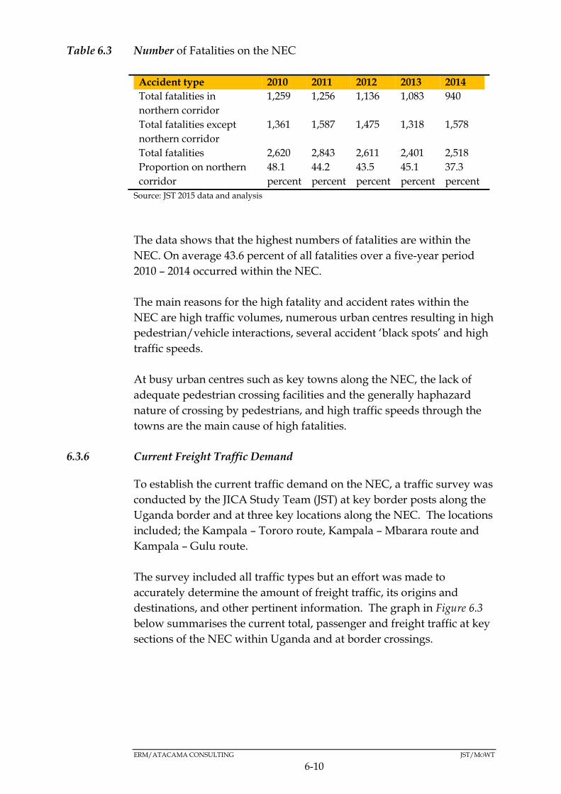
ERM/ATACAMA CONSULTING JST/MOWT
6-10
Table 6.3 Number of Fatalities on the NEC
Accident type 2010 2011 2012 2013 2014
Total fatalities in
northern corridor
1,259 1,256 1,136 1,083 940
Total fatalities except
northern corridor
1,361 1,587 1,475 1,318 1,578
Total fatalities 2,620 2,843 2,611 2,401 2,518
Proportion on northern
corridor
48.1
percent
44.2
percent
43.5
percent
45.1
percent
37.3
percent
Source: JST 2015 data and analysis
The data shows that the highest numbers of fatalities are within the
NEC. On average 43.6 percent of all fatalities over a five-year period
2010 – 2014 occurred within the NEC.
The main reasons for the high fatality and accident rates within the
NEC are high traffic volumes, numerous urban centres resulting in high
pedestrian/vehicle interactions, several accident ‘black spots’ and high
traffic speeds.
At busy urban centres such as key towns along the NEC, the lack of
adequate pedestrian crossing facilities and the generally haphazard
nature of crossing by pedestrians, and high traffic speeds through the
towns are the main cause of high fatalities.
6.3.6 Current Freight Traffic Demand
To establish the current traffic demand on the NEC, a traffic survey was
conducted by the JICA Study Team (JST) at key border posts along the
Uganda border and at three key locations along the NEC. The locations
included; the Kampala – Tororo route, Kampala – Mbarara route and
Kampala – Gulu route.
The survey included all traffic types but an effort was made to
accurately determine the amount of freight traffic, its origins and
destinations, and other pertinent information. The graph in Figure 6.3
below summarises the current total, passenger and freight traffic at key
sections of the NEC within Uganda and at border crossings.

6-11
Figure 6.3 Summary of Total, Passenger and Freight Traffic
Source: JST 2015 traffic data, Atacama analysis
Kla -Tororo
Kla -Mbarar
a
Kla -Gulu
EbbAirport
Kla RailTermina
l
PortBell
NimuleBorder
OrabaBorder
GoliBorder
Mpondwe
Border
Bunagana
Border
KatunaBorder
MiramaHills
Border
Mutukula
Border
BusiaBorder
MalabaBorder
Freight Traffic (Veh/Day) 6573 1425 1067 289 75 4 307 93 114 199 119 297 73 207 883 899
Passenger Traffic (Veh/Day) 6987 1742 2307 2965 52 47 204 301 131 650 68 313 83 385 1373 254
0
2000
4000
6000
8000
10000
12000
14000
16000
Traf
fic
(Veh
/day
)
Current Demand; Passenger Traffic v Freight Traffic (vehicles/day)
Passenger Traffic (Veh/Day) Freight Traffic (Veh/Day)
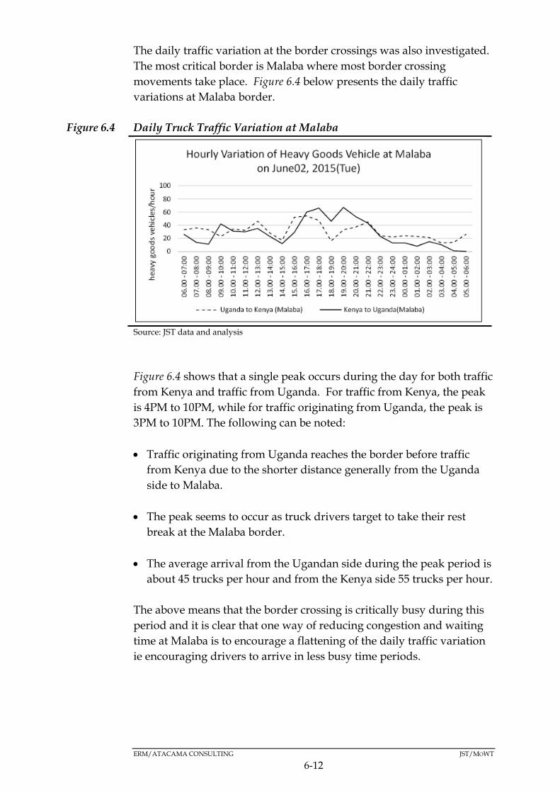
ERM/ATACAMA CONSULTING JST/MOWT
6-12
The daily traffic variation at the border crossings was also investigated.
The most critical border is Malaba where most border crossing
movements take place. Figure 6.4 below presents the daily traffic
variations at Malaba border.
Figure 6.4 Daily Truck Traffic Variation at Malaba
Source: JST data and analysis
Figure 6.4 shows that a single peak occurs during the day for both traffic
from Kenya and traffic from Uganda. For traffic from Kenya, the peak
is 4PM to 10PM, while for traffic originating from Uganda, the peak is
3PM to 10PM. The following can be noted:
Traffic originating from Uganda reaches the border before traffic
from Kenya due to the shorter distance generally from the Uganda
side to Malaba.
The peak seems to occur as truck drivers target to take their rest
break at the Malaba border.
The average arrival from the Ugandan side during the peak period is
about 45 trucks per hour and from the Kenya side 55 trucks per hour.
The above means that the border crossing is critically busy during this
period and it is clear that one way of reducing congestion and waiting
time at Malaba is to encourage a flattening of the daily traffic variation
ie encouraging drivers to arrive in less busy time periods.
ERM/ATACAMA CONSULTING JST/MOWT
6-13
SOCIO-CULTURAL AND SOCIO ECONOMIC CONDITIONS 6.4
This section mainly focuses on the districts traversed by the NEC. A
summary of some of the social aspects within the NEC is shown in Table
6.4 and also further described in the subsequent Sections 6.4.1 to 6.4.14.
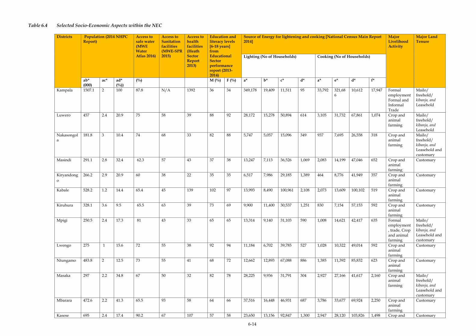
6-14
Table 6.4 Selected Socio-Economic Aspects within the NEC
Districts Population (2014 NHPC Report)
Access to safe water (MWE Water Atlas 2016)
Access to Sanitation facilities (MWE-SPR 2015)
Access to health facilities (Heath Sector Report 2013)
Education and literacy levels [6-18 years] from Educational Sector performance report (2013-2014)
Source of Energy for lightening and cooking [National Census Main Report 2014]
Major Livelihood Activity
Major Land Tenure
Lighting (No of Households) Cooking (No of Households)
ab* (000)
ac* ad* (%))
(%) M (%) F (%) a* b* c* d* a* e* d* f*
Kampala 1507.1 2 100 87.8 N/A 1392 36 34 349,178 19,409 11,511 95 33,792 321,686
10,612 17,947 Formal employmentFormal and Informal Trade
Mailo/ freehold/ kibanja, and Leasehold
Luwero 457 2.4 20.9 75 58 39 88 92 28,172 15,278 50,894 614 3,105 31,732 67,861 1,074 Crop and animal farming
Mailo/ freehold/ kibanja, and Leasehold
Nakasongola
181.8 3 10.4 74 68 33 82 88 5,747 5,057 15,096 349 937 7,695 26,558 318 Crop and animal farming
Mailo/ freehold/ kibanja, and Leasehold and customary
Masindi 291.1 2.8 32.4 62.3 57 43 37 38 13,247 7,113 36,526 1,069 2,083 14,199 47,046 652 Crop and animal farming
Customary
Kiryandong
o
266.2 2.9 20.9 60 38 22 35 35 6,517 7,986 29,185 1,389 464 8,776 41,949 357 Crop and animal farming
Customary
Kabale 528.2 1.2 14.4 65.4 45 139 102 97 13,993 8,490 100,961 2,108 2,073 13,609 100,102 519 Crop and animal farming
Customary
Kiruhura 328.1 3.6 9.5 65.5 63 39 73 69 9,900 11,400 30,537 1,251 830 7,154 57,153 592 Crop and animal farming
Customary
Mpigi 250.5 2.4 17.3 81 43 33 65 65 13,314 9,140 31,103 590 1,008 14,621 42,417 635 Formal employment, trade, Crop and animal farming
Mailo/ freehold/ kibanja, and Leasehold and customary
Lwengo 275 1 15.6 72 55 38 92 94 11,184 6,702 39,785 527 1,028 10,322 49,014 592 Crop and animal farming
Customary
Ntungamo 483.8 2 12.5 73 55 41 68 72 12,662 12,893 67,088 886 1,385 11,392 85,832 623 Crop and animal farming
Customary
Masaka 297 2.2 34.8 67 50 32 82 78 28,225 9,936 31,791 304 2,927 27,166 41,617 2,160 Crop and animal farming
Mailo/ freehold/ kibanja, and Leasehold and customary
Mbarara 472.6 2.2 41.3 65.5 93 58 64 66 37,516 16,448 46,931 687 3,786 33,677 69,924 2,250 Crop and animal farming
Customary
Kasese 695 2.4 17.4 90.2 67 107 57 58 23,650 13,156 92,847 1,300 2,947 28,120 103,826 1,498 Crop and Customary

6-15
Districts Population (2014 NHPC Report)
Access to safe water (MWE Water Atlas 2016)
Access to Sanitation facilities (MWE-SPR 2015)
Access to health facilities (Heath Sector Report 2013)
Education and literacy levels [6-18 years] from Educational Sector performance report (2013-2014)
Source of Energy for lightening and cooking [National Census Main Report 2014]
Major Livelihood Activity
Major Land Tenure
animal farming
Tororo 517.1 2.6 14 39.2 60 74 81 79 10,863 8,229 73,581 1,370 1,518 11,816 83,963 868 Crop and animal farming
Customary
Busia 323.7 3 16.9 70 80 34 94 92 7,941 8,331 45,370 350 226 1,420 21,246 100 Crop and animal farming
Customary
Bugiri 382.9 3 16.8 63 60 50 63 66 6,213 5,817 55,951 604 720 10,383 61,870 293 Crop and animal farming
Customary
Mukono 596.8 2.9 27.3 76 55 45 45 48 47,918 21,597 59,521 959 3,349 59,563 76,018 1,940 Formal employment, trade, Crop and animal farming
Mailo/ freehold/ kibanja, and Leasehold and customary
Wakiso 1997.4 6.6 59.2 43 58 103 38 38 309,133 63,304 70,528 1,994 22,292 342,921
99,136 13,714 Formal employment, trade, Crop and animal farming
Mailo/ freehold/ kibanja, and Leasehold and customary
Mayuge 473.2 3.1 7.1 53 30 42 58 57 9,092 5,012 67,036 1,419 1,358 16,609 73,675 471 Crop and animal farming
Customary
Ngora 141.9 2.8 10.7 68 68 12 62 65 1,516 1,333 6,092 446 226 1,420 21,246 100 Crop and animal farming
Customary
Kumi 239.3 3.1 15.3 66 75 24 80 84 3,208 4,014 14,319 644 460 3,668 35,767 213 Crop and animal farming
Customary
Bukedea 203.6 4.3 5.4 72 70 20 83 91 2,098 3,165 22,814 508 242 2,150 33,346 149 Crop and animal farming
Customary
Amuria 473.2 3.1 7.1 82 30 42 58 57 9,092 5,012 67,036 1,419 1,358 16,609 73,675 471 Crop and animal farming
Customary
Soroti 270.9 3.4 6.4 79 70 38 46 44 3,448 2,751 18,140 1,985 323 2,584 44,826 124 Crop and animal farming
Customary
Amuru 296.8 3.6 16.7 25.7 66 31 57 59 8,123 5,663 23,212 1,476 883 13,023 39,591 382 Crop and animal farming
Customary
Gulu 186.7 2.7 5 82 55 55 36 36 2,352 7,156 22,281 1,272 475 3,382 31,585 284 Crop and animal farming
Customary
Kole 436.3 3.2 34.3 80.9 73 73 56 58 13,384 16,382 49,511 1,038 966 29,118 54,839 685 Crop and animal farming
Customary
Lira 239.3 3.1 3.7 94 55 55 45 44 2,817 9,202 26,387 930 447 1,169 45,907 292 Crop and animal farming
Customary
Oyam 408 2.8 24.8 40.8 30 29 43 47 14,047 16,947 39,360 902 1,208 28,611 56,352 710 Crop and animal farming
Customary
Amolatar 383.6 3 4.8 70 55 55 48 48 5,268 14,572 41,544 1,806 668 2,962 70,437 561 Crop and Customary
6-16
Districts Population (2014 NHPC Report)
Access to safe water (MWE Water Atlas 2016)
Access to Sanitation facilities (MWE-SPR 2015)
Access to health facilities (Heath Sector Report 2013)
Education and literacy levels [6-18 years] from Educational Sector performance report (2013-2014)
Source of Energy for lightening and cooking [National Census Main Report 2014]
Major Livelihood Activity
Major Land Tenure
animal farming
Adjuman 225.3 0.9 17.9 90 40 10 10 3,640 3,918 9,800 2,131 348 8,284 31,238 211 Crop and animal farming
Customary
Sheema 207.3 1.2 13.3 78 68 35 79 79 8,320 9,867 24,307 266 732 4,914 38,583 512 Crop and animal farming
Customary
Bushenyi 234.4 1.1 20.4 83 73 36 66 66 10,060 12,650 24,187 365 1,088 6,827 41,827 747 Crop and animal farming
Customary
Rubirizi 129.1 2 13.3 60 43 16 54 56 3,280 2,789 20,437 231 395 3,090 24,618 265 Crop and animal farming
Customary
Kalungu 183.2 1.1 4.4 88 65 24 110 128 8,166 5,233 25,672 274 742 6,868 32,432 635 Crop and animal farming
Customary
Lyantonde 93.8 2.9 14.7 51 43 28 111 111 4,300 3,058 10,565 275 284 4,941 14,641 337 Crop and animal farming
Customary
Iganga 504.2 2.9 18.4 71 48 57 52 54 17,450 9,532 64,430 596 1,322 29,707 69,284 587 Crop and animal farming
Customary
Jinja 471.2 1.6 36.6 66 45 113 32 32 34,172 9,039 52,793 374 3,965 48,848 49,229 877 Crop and animal farming
Customary
Budaka 207.6 3.5 11.5 80 30 19 82 91 2,176 2,486 29,929 228 326 2,205 34,145 117 Crop and animal farming
Customary
Mbale 489 3.2 25.2 69 45 47 75 75 25,585 16,061 55,337 1,486 2,771 35,249 63,931 1,342 Crop and animal farming
Customary
Alebtong 227.5 2.8 2.9 88 60 18 56 56 1,862 4,885 28,847 809 378 1,346 43,828 222 Crop and animal farming
Customary
KEY
ab* Population
ac* Population growth
ad* Level of urbanisation
a* Electricity
b* Paraffin (Lantern)
c* Paraffin (Tadooba)
d* Firewood
e* Charcoal
f* Paraffin (stove)
M Male
F Female
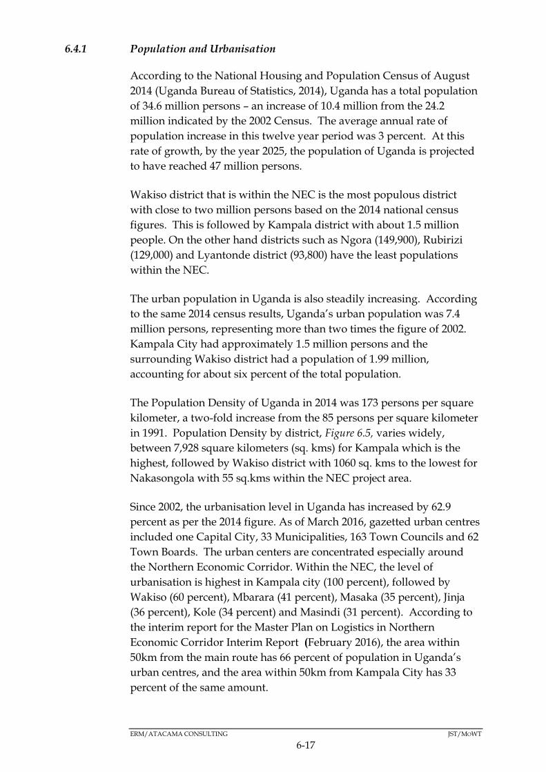
ERM/ATACAMA CONSULTING JST/MOWT
6-17
6.4.1 Population and Urbanisation
According to the National Housing and Population Census of August
2014 (Uganda Bureau of Statistics, 2014), Uganda has a total population
of 34.6 million persons – an increase of 10.4 million from the 24.2
million indicated by the 2002 Census. The average annual rate of
population increase in this twelve year period was 3 percent. At this
rate of growth, by the year 2025, the population of Uganda is projected
to have reached 47 million persons.
Wakiso district that is within the NEC is the most populous district
with close to two million persons based on the 2014 national census
figures. This is followed by Kampala district with about 1.5 million
people. On the other hand districts such as Ngora (149,900), Rubirizi
(129,000) and Lyantonde district (93,800) have the least populations
within the NEC.
The urban population in Uganda is also steadily increasing. According
to the same 2014 census results, Uganda’s urban population was 7.4
million persons, representing more than two times the figure of 2002.
Kampala City had approximately 1.5 million persons and the
surrounding Wakiso district had a population of 1.99 million,
accounting for about six percent of the total population.
The Population Density of Uganda in 2014 was 173 persons per square
kilometer, a two-fold increase from the 85 persons per square kilometer
in 1991. Population Density by district, Figure 6.5, varies widely,
between 7,928 square kilometers (sq. kms) for Kampala which is the
highest, followed by Wakiso district with 1060 sq. kms to the lowest for
Nakasongola with 55 sq.kms within the NEC project area.
Since 2002, the urbanisation level in Uganda has increased by 62.9
percent as per the 2014 figure. As of March 2016, gazetted urban centres
included one Capital City, 33 Municipalities, 163 Town Councils and 62
Town Boards. The urban centers are concentrated especially around
the Northern Economic Corridor. Within the NEC, the level of
urbanisation is highest in Kampala city (100 percent), followed by
Wakiso (60 percent), Mbarara (41 percent), Masaka (35 percent), Jinja
(36 percent), Kole (34 percent) and Masindi (31 percent). According to
the interim report for the Master Plan on Logistics in Northern
Economic Corridor Interim Report (February 2016), the area within
50km from the main route has 66 percent of population in Uganda’s
urban centres, and the area within 50km from Kampala City has 33
percent of the same amount.
6-18
Figure 6.5 Population Density along the NEC
ERM/ATACAMA CONSULTING JST/MOWT
6-19
6.4.2 Education
The second National Development Plan recognises education as an
engine for empowerment, economic growth and social transformation.
In line with the National development Plan, Uganda has been running
an education for all policy commonly known as Universal Primary
Education (UPE) with three overarching goals: Expanding and
improving comprehensive Early Childhood Care and Education
especially for the most vulnerable and the disadvantaged children;
Ensuring that by 2015, all children, particularly girls , children in
difficult circumstances and those belonging to ethnic minorities, have
access to and complete free and compulsory primary education of good
quality; and Ensuring that the learning needs of all young people and
adults are met through equitable access to appropriate learning and life
skills programs (Uganda Education Sector Report, 2013).
At National level, about 72 percent of the population are literate, higher
than about 70 percent in 2002. Literacy among females is lower (68
percent) than for males (77 percent). Literacy rates are higher in urban
areas than rural areas (2014 Uganda National Census Main Report).
The skills being generated by the education sector are not aligned with
the human resource needs of the productive sectors of the economy.
The current education system gives an incentive for students and
teachers/lecturers to focus on examinations, instead of learning and or
imparting essential skills which are required by industry/productive
sectors. As a result, even though the enrolment in tertiary education
has increased, very few university graduates are self-employed or can
find jobs (The State of Uganda Population Report, 2015).
Therefore, to reach its national aspiration of becoming a middle-income
country as articulated in the country’s Vision 2040, Uganda needs to
make a concerted effort to improve the quality of public education
services, so that the current generation can grow into a healthy and
educated work force.
6.4.3 Livelihoods
Most Ugandans are engaged in farming at the subsistence level. Nearly
two thirds (64 percent) of the working population is engaged in
subsistence agriculture according the 2014 National Housing and
Population Census report. In respect to the districts along NEC, formal
paid employment is more pronounced around Kampala, Mukono,
Wakiso and Jinja.

ERM/ATACAMA CONSULTING JST/MOWT
6-20
The major activities along the NEC are; agriculture, fisheries (mainly
carried out in the open water bodies of Lakes Victoria, Edward, and
George), business (mainly carried out in all major towns) and
industrialisation which is mainly concentrated in Kampala, Wakiso,
Tororo and Kasese districts. It is important to note that most livelihood
activities are land based
Agriculture is mainly in form of food production and animal rearing
while fisheries also play a very important role as a foundation of
subsistence and commercial livelihood. Lake Victoria is by far the
largest and economically most significant of the national fisheries.
However, other large lakes, within the corridor including George,
Edward, and Kyoga, along with the River Nile and a great variety of
minor lakes around each of the large lakes (usually referred to as
‘satellite lakes’), swamps and streams, also contribute substantially to
the annual national catch
(http://www.fao.org/fi/oldsite/FCP/en/uga/body.htm).
Key sources of livelihood along the respective routes of the NEC are as
indicated below:
Kampala - Gulu route
The crops grown include; sorghum, bananas, peas, groundnuts, soya
beans, finger millet, simsim, and cassava. Livestock farming comprises
of cattle and goat rearing. However, there is less crop farming activities
in Kampala which is highly urbanised with less land available for
farming activities.
Mbarara - Mpondwe border route
Crops grown include; bananas, beans and coffee. Livestock farming
entails; cattle, goat and sheep rearing.
Due to the presence of industries in Kasese district ( eg, Hima cement
factory that is part of the Lafarge group, Kasese Cobalt Company and
the Kilembe copper mines) industrialisation supplements the
agricultural activities within the area.
There are also fishing activities from Lakes George, Edward and the
Kazinga channel (that joins the two lakes).

ERM/ATACAMA CONSULTING JST/MOWT
6-21
Kampala - Katuna boarder route
Crops grown include; bananas, beans, cassava, sweet potatoes, maize
and Irish potatoes, and coffee. Livestock farming includes; cattle and
goat rearing. In addition, fishing activities are carried out in Masaka
district on Lake Victoria. Other activities include business and mining
industries.
Kampala - Tororo route
Crops grown include; maize, rice, sweet potatoes, cassava, bananas,
sugar cane, and coffee. Livestock activities include cattle and goat
rearing. In addition to crop and livestock farming, fishing activities are
carried out on Lake Victoria in the districts of Jinja, Bugiri, Mukono and
Busia. Other activities include; business and mining industries in
Tororo, and factories in Jinja.
Tororo - Gulu route
Crops grown include: finger millet, maize, rice, sorghum, peas, ground
nuts, simsim, sweet potatoes and cassava. Livestock farming mainly
includes; cattle and goat rearing. Fishing is carried out in Lake Kyoga
in Soroti district. Other livelihood activities along this route include;
business in the major towns of Mbale and Soroti, and mining industries
in Tororo district.
6.4.4 Mining
Uganda is endowed with a considerable degree of mineral wealth
which is hoped will contribute towards the country’s socio-economic
transformation. Unfortunately, for a long time, the exploitation of the
mineral wealth was on an artisanal basis and often with very little value
addition. However, the value of mineral exports has been on the
increase, with a 20 percent increase being registered between 2012 and
2013. Some of Uganda’s mineral reserves are located in the NEC as
shown in Figure 6.6 and described in the sections below: Please note
that the discovered oil reserves in the Albertine Rift region are not
indicated on the map since the drilling has not commenced.
Tororo – Kampala route
All districts along the Tororo - Kampala route have no mining
industries except Tororo, Bugiri and Mukono districts.

ERM/ATACAMA CONSULTING JST/MOWT
6-22
Tororo – Gulu route
Apart from Tororo district, all other districts along the Tororo – Gulu
route have no mining industries.
Kampala - Katuna border route
Apart from Ntungamo and Kabale districts, all other districts along the
Kampala – Katuna border route do not have mining industries.
Mbarara – Mpondwe border route
Unlike other routes with no or few mining industries, all districts along
the Mbarara – Mpondwe border route have mining industries.
Kampala – Gulu route
Unlike the Mbarara – Mpondwe border route where mining industries
are located in all districts, the Kampala – Gulu route has no mining
industries.

6-23
Figure 6.6 Mining Industries along the NEC

ERM/ATACAMA CONSULTING JST/MOWT
6-24
6.4.5 Income Levels
Based on the 2012/13 survey data (UBOS, 2014), 19.7 percent (6.7
million) of Ugandans are poor. The incidence of poverty remains
higher in rural areas than in urban areas - 22.8 percent of the rural
population was poor, while only 9.3 percent of the urban population
was categorised as poor. The rural areas with about 77 percent of the
total population, account for 89 percent of national poverty. On the
other hand, the urban areas represent 22.6 percent of the population
and account for 11 percent of national poverty.
According to statistical abstract UBOS 2015, the incidence of poverty
remains highest in the Northern region (43.7 percent) and least in the
Central region (4.7 percent). Clearly, the incidence of poverty in the
Northern and Eastern regions is much higher than the national average
of 19.7 percent.
The chronically poor reside in rural areas (20.6 percent) and 32.8
percent of their household heads lack formal education. Majority (26.3
percent) of the chronically poor were residing in the Northern region of
Uganda as per the census. On the other hand, people who experienced
mobility into poverty between 2011/12 and 2013/14 were mainly from
the Eastern followed by Northern regions. However, overall, more
than half of the households remained non-poor (51.0 percent) over the
two panel survey periods. The majority of those households that
remained non-poor had post-secondary education.
As indicated in Figure 6.7, poverty levels are low in the central and
western regions of Uganda, and high in the northern and eastern
regions. The Kampala - Katuna border route, the Mbarara - Mpondwe
route as well as a section of the Kampala - Gulu route (central Uganda
region) fall primarily within areas of low poverty. On the other hand,
the Tororo - Gulu route as well as a section of the Kampala - Gulu route
(northern Uganda region) falls within a zone of high poverty.

6-25
Figure 6.7 Poverty levels along the NEC
ERM/ATACAMA CONSULTING JST/MOWT
6-26
6.4.6 Land tenure and Land Use
Land Tenure
The Land Act (1998) identifies four forms of land tenure systems in
Uganda which include Customary, Leasehold, Freehold and Mailo.
Customary land is governed by customary laws while other forms of
tenure are registered and the owner is entitled to a land title.
Registered land is common around urban centres and in the districts in
central Buganda sub-region (Kayunga, Mukono, Mpigi, Kampala,
Wakiso, Lwengo and Masaka). Other than the Buganda sub-region
within the NEC, most districts enjoy a customary land tenure system.
Land Use
Land use refers to the management activities on the natural
environment such as farming, protected areas, settlements, and
industrialisation among others. The land use patterns in the different
regions of Uganda along the NEC are depicted in Figure 6.8 and as
described below (for the respective routes).
Kampala - Gulu route
The main land use pattern along this route is agriculture (farming and
rearing of animals on a subsistence scale and pastoralism). Other land
uses include; settlements and provision of commercial services.
Masindi district is particularly important due to the presence of
protected areas (Murchison Falls National Park and Budongo Central
Forest Reserve (CFR)).
Mbarara - Mpondwe border route
The land use pattern along this route is mainly crop farming and
animal rearing. The other land use activities include
settlement/housing and economic activities in major towns along the
sub-route as well as protected areas (Queen Elizabeth National Park,
Kalinzu and Maramagabo CFRs).
Kampala - Katuna border route
The land use pattern is similar to that of Mbarara - Mpondwe border
route and Kampala - Gulu route where most land is under crop cover
and animal farming followed by settlement and social economic
activities. Mpigi district is of particular importance due to the
presence of Mpanga CFR along this sub-route.

ERM/ATACAMA CONSULTING JST/MOWT
6-27
Kampala - Tororo route
Most of the land along this route is used for agriculture with majority of
the people engaged in subsistence agriculture (arable farming and
animal husbandry). Other land use activities are settlement, and trade
mainly in urban areas as well as protected areas (Mabira CFR).
Industrial activities are carried out mainly in Wakiso, Jinja and Tororo
districts. Some districts such as, Mukono, Jinja, and Bugiri are partially
surrounded by Lake Victoria where fishing is carried out.
Tororo - Gulu route
As with other routes, the land use pattern along this route is mainly
agriculture (crop farming and rearing of animals on a subsistence scale).
Other land use practices include settlement and commercial services.

6-28
Figure 6.8 Land use Practices along the NEC

ERM/ATACAMA CONSULTING JST/MOWT
6-29
6.4.7 Tourism
Tourism is a major part of Uganda’s economy contributing 9 percent of
the country’s Gross Domestic Product (GDP) or $1.7 billion per annum.
It is a major driver of employment, investment and foreign exchange.
The New York Times Travel Section Annual Guide ranked Uganda
among the top 33 places to visit in the world in 2012 (MTWA, 2012b).
Vision 2040 is conceptualised on harnessing strategic opportunities by
strengthening the relevant fundamentals capable of maximizing returns
to the economy and tourism is one of the identified opportunities.
Tourism in Uganda is focused on Uganda’s diverse culture, landscape,
flora, and fauna (natural resources attract most of the tourists). Tourists
Arrivals in the country include those visiting friends and, those who
come to attend business and professional conferences and then those
who come for leisure, recreation and holidays.
Uganda has twelve National parks offering a wide variety of tourism
products. Table 6.5 presents the details of tourists’ destination as per the
respective National Parks. Visitors to Lake Mburo, Kibale, Kidepo
Valley, Rwenzori Mountains and Mount Elgon have increased in recent
years, though these are still not the major destinations like Murchison
Falls or Queens Elizabeth National Parks.
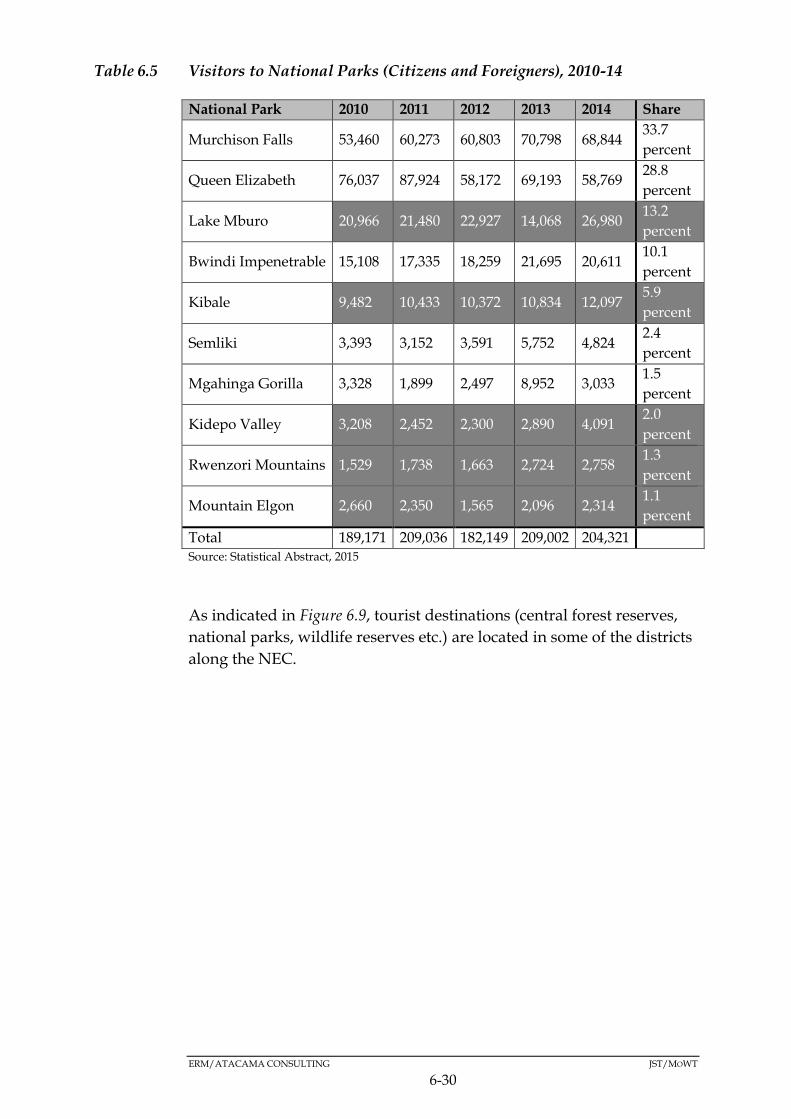
ERM/ATACAMA CONSULTING JST/MOWT
6-30
Table 6.5 Visitors to National Parks (Citizens and Foreigners), 2010-14
National Park 2010 2011 2012 2013 2014 Share
Murchison Falls 53,460 60,273 60,803 70,798 68,844 33.7
percent
Queen Elizabeth 76,037 87,924 58,172 69,193 58,769 28.8
percent
Lake Mburo 20,966 21,480 22,927 14,068 26,980 13.2
percent
Bwindi Impenetrable 15,108 17,335 18,259 21,695 20,611 10.1
percent
Kibale 9,482 10,433 10,372 10,834 12,097 5.9
percent
Semliki 3,393 3,152 3,591 5,752 4,824 2.4
percent
Mgahinga Gorilla 3,328 1,899 2,497 8,952 3,033 1.5
percent
Kidepo Valley 3,208 2,452 2,300 2,890 4,091 2.0
percent
Rwenzori Mountains 1,529 1,738 1,663 2,724 2,758 1.3
percent
Mountain Elgon 2,660 2,350 1,565 2,096 2,314 1.1
percent
Total 189,171 209,036 182,149 209,002 204,321 Source: Statistical Abstract, 2015
As indicated in Figure 6.9, tourist destinations (central forest reserves,
national parks, wildlife reserves etc.) are located in some of the districts
along the NEC.
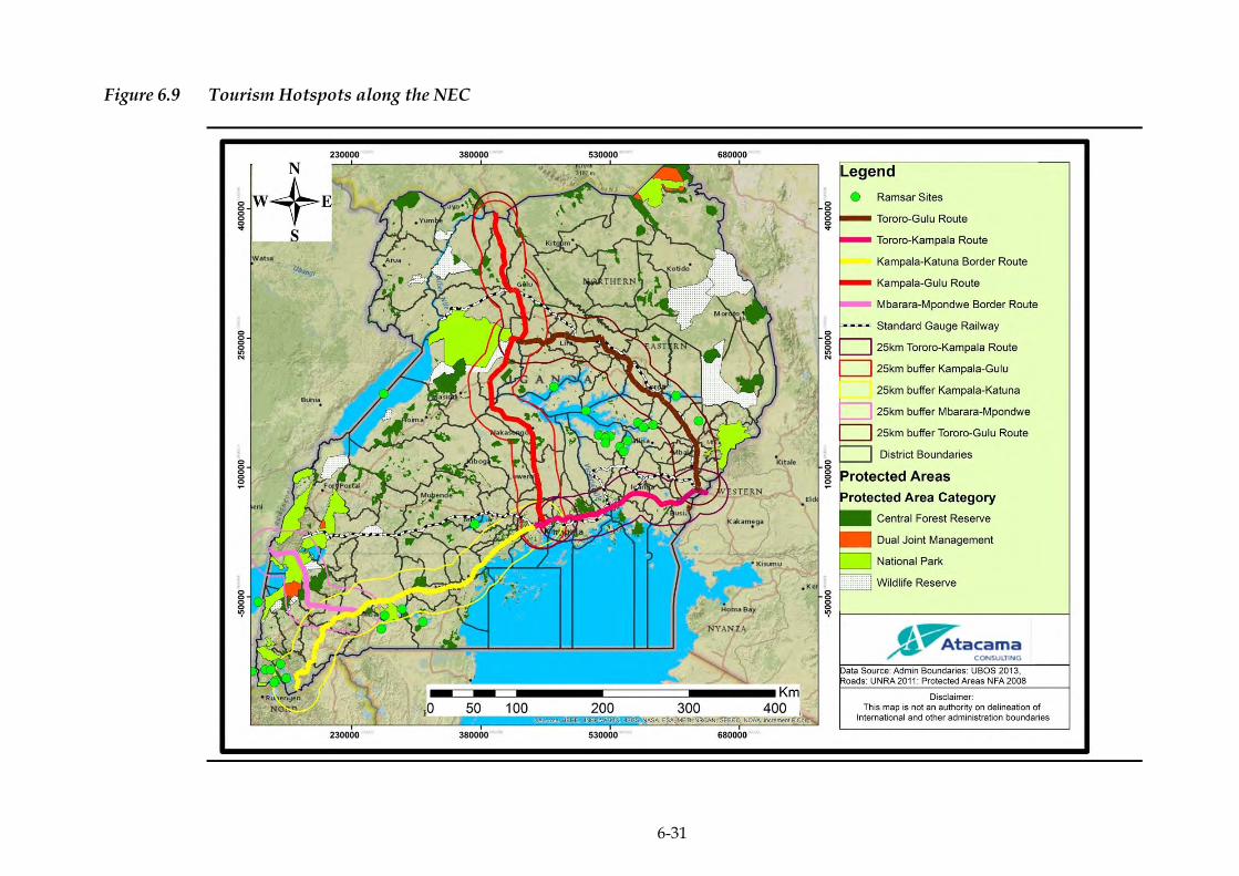
6-31
Figure 6.9 Tourism Hotspots along the NEC
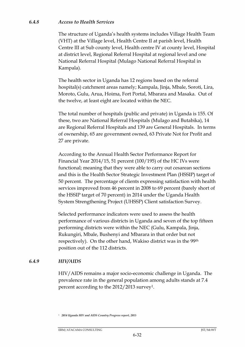
ERM/ATACAMA CONSULTING JST/MOWT
6-32
6.4.8 Access to Health Services
The structure of Uganda’s health systems includes Village Health Team
(VHT) at the Village level, Health Centre II at parish level, Health
Centre III at Sub county level, Health centre IV at county level, Hospital
at district level, Regional Referral Hospital at regional level and one
National Referral Hospital (Mulago National Referral Hospital in
Kampala).
The health sector in Uganda has 12 regions based on the referral
hospital(s) catchment areas namely; Kampala, Jinja, Mbale, Soroti, Lira,
Moroto, Gulu, Arua, Hoima, Fort Portal, Mbarara and Masaka. Out of
the twelve, at least eight are located within the NEC.
The total number of hospitals (public and private) in Uganda is 155. Of
these, two are National Referral Hospitals (Mulago and Butabika), 14
are Regional Referral Hospitals and 139 are General Hospitals. In terms
of ownership, 65 are government owned, 63 Private Not for Profit and
27 are private.
According to the Annual Health Sector Performance Report for
Financial Year 2014/15, 51 percent (100/195) of the HC IVs were
functional; meaning that they were able to carry out cesarean sections
and this is the Health Sector Strategic Investment Plan (HSSIP) target of
50 percent. The percentage of clients expressing satisfaction with health
services improved from 46 percent in 2008 to 69 percent (barely short of
the HSSIP target of 70 percent) in 2014 under the Uganda Health
System Strengthening Project (UHSSP) Client satisfaction Survey.
Selected performance indicators were used to assess the health
performance of various districts in Uganda and seven of the top fifteen
performing districts were within the NEC (Gulu, Kampala, Jinja,
Rukungiri, Mbale, Bushenyi and Mbarara in that order but not
respectively). On the other hand, Wakiso district was in the 99th
position out of the 112 districts.
6.4.9 HIV/AIDS
HIV/AIDS remains a major socio-economic challenge in Uganda. The
prevalence rate in the general population among adults stands at 7.4
percent according to the 2012/2013 survey1.
1 2014 Uganda HIV and AIDS Country Progress report, 2015

ERM/ATACAMA CONSULTING JST/MOWT
6-33
According to the International Organisation for Migration (IOM) report,
2009, mobility has been identified as one of the key factors behind the
spread of HIV/AIDS in East Africa due to the high risk environments
associated with transport corridors (Figure 6.10), which often facilitate
multiple concurrent sexual partnerships.
The country has the National AIDS Policy (2007) in place, a tool with
guidelines that include HIV Counselling and Testing (HCT), Anti-
Retroviral Therapy (ART), Orphans and Other Vulnerable Children
(OVC) and several others that directly or indirectly respond to impacts
created by HIV&AIDS.
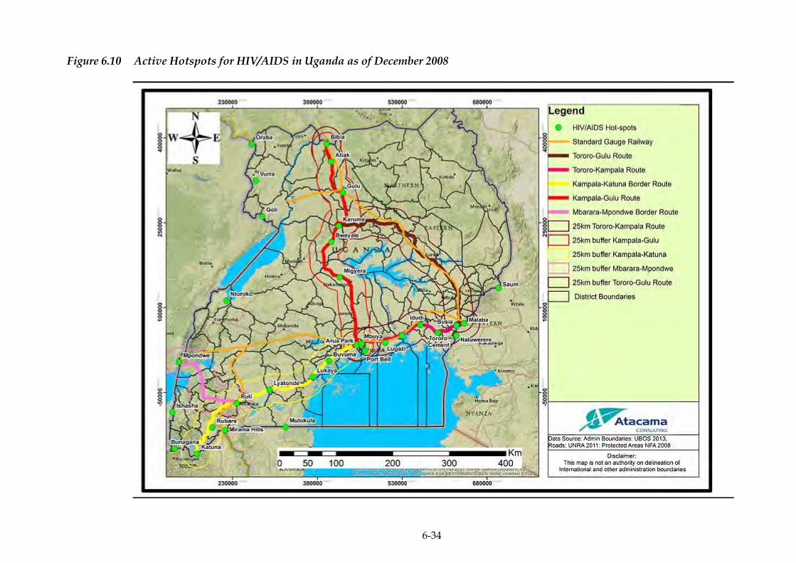
6-34
Figure 6.10 Active Hotspots for HIV/AIDS in Uganda as of December 2008
ERM/ATACAMA CONSULTING JST/MOWT
6-35
6.4.10 Gender
The Government of Uganda adopted a National Gender Policy (1997),
whose main objective is to mainstream gender concerns in national
development processes through guiding resource allocation in all
sectors to address gender inequality. It is pertinent that both women
and men are involved at all levels across the different development
sectors such that women's as well as men's concerns and experiences
become an integral dimension of the policies and programmes so that
women and men benefit equally and inequality is not perpetuated. In
line with this is the gender mainstreaming policy in the road sector
which is relevant to the implications of the Master Plan. During the
second round of stakeholder consultations, the stakeholders expressed
the need for the deliberate inclusion of gender mainstreaming issues in
the SEA for consideration during the Master Plan formulation.
6.4.11 Vulnerable Groups
Vulnerability refers to the conditions determined by physical, social,
economic and environmental factors or processes, which increase the
susceptibility of a community to the impact of hazards. A vulnerable
group is therefore a population that has some specific characteristics
that make it at higher risk of falling into poverty than others living in
areas targeted by a project (World Bank, 2015), in this case the Master
Plan. Results from the opinion survey conducted during the
stakeholder consultation meetings indicate that groups identified as
vulnerable by the respondents include slum dwellers, people in
traditional housed, the disabled, poor as well as the Karamajong.
6.4.12 Sanitation
The national goal of Uganda’s water supply and sanitation sector is to
increase access to water supply and sanitation services from 65 percent
and 70 percent respectively in 2010 to 100 percent by 2035. Sanitary
facilities are an indicator of the health of the population. Where
sanitary facilities are deemed few, the population is at a higher risk of
suffering from sanitation related diseases/disorders such as cholera,
typhoid and diarrhoea.
As indicated in Figure 6.11, the highest record of sanitation facilities in
Uganda is found in the western region (greater than 80 percent)
followed by the central region. The eastern and northern regions have
the lowest coverage of sanitary facilities (less than 25 percent).

ERM/ATACAMA CONSULTING JST/MOWT
6-36
The Kampala - Katuna border route, the Mbarara - Mpondwe route as
well as a section of the Kampala - Gulu route of the NEC (central
Uganda region) fall primarily within areas with a high record of
sanitation facilities. On the other hand, the Tororo - Gulu route as well
as a section of the Kampala - Gulu route (northern Uganda region) falls
within a low record of sanitation facilities.
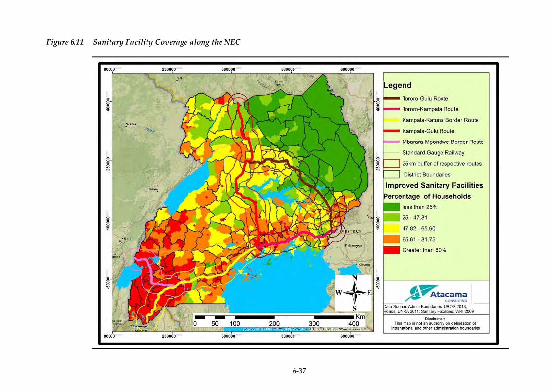
6-37
Figure 6.11 Sanitary Facility Coverage along the NEC
ERM/ATACAMA CONSULTING JST/MOWT
6-38
6.4.13 Energy
The energy sector is one of the key sectors of the Ugandan economy.
Uganda has a total primary energy consumption of 0.0593 quadrillion
Btu. About 90 percent of the total primary energy consumption is
generated through biomass, namely; firewood (78.6 percent), charcoal
(5.6 percent) and crop residues (4.7 percent). Electricity is contributes
only 1.4 percent to the national energy balance while oil products,
which are mainly used for vehicles and thermal power plants, account
for the remaining 9.7 percent. The electricity demand has been growing
at an average of 10 percent per annum
(https://energypedia.info/wiki/Uganda_Energy_Situation).
Currently, Uganda has stable electricity supply which is provided from
large and mini hydropower resources as well as cogeneration plants.
The existing supply from renewable energy sources is sufficient to meet
the current demand. The total system demand in 2015 was about
560MW. The Generation mix by 2015 stood at 873.34MW, of which
695MW were from hydro, 118.84MW from petroleum-based thermal
and 59.5MW from biomass co-generation sources. Total energy
generated in 2014 was 3,257,710MWh, slightly higher than the previous
year’s generation by 7.2 percent. Most of this energy came from large
hydropower plants (78.6 percent), while small proportions of 16.1
percent, 4.2 percent and 1 percent came from embedded generators,
thermal generators and imports, respectively. Energy exports were
125,064MWh while imports stood at 32,696MWh.
The total installed capacity of electricity power plants in Uganda
increased by 15.2 percent from 718.4 MW in 2012 to 827.5 MW in 2013.
This was due to a 125 percent increase in the installed capacity of
Bagasse electricity from 16 MW in 2012, to 36 MW in 2013 and an 18.7
percent increase in the installed capacity of hydroelectric power from
582.4 MW in 2012, to 691.5 MW in 2013.
Similarly, according to UBOS 2015 statistical abstract, the total installed
capacity of electricity power plants increased by 4.4 percent from 827.5
MW in 2013 to 867.0 MW in 2014 and the total number of UMEME (the
electricity utility) customers increased by 13.0 percent from 574,465
customers in 2013 to 650,573 customers in 2014.
However, results from the National Population and Housing Census
report for 2014 indicate that majority of the Ugandan households (52
percent) used Tadooba (local paraffin candle) as the main source of
energy for lighting while about 20 percent used electricity.

ERM/ATACAMA CONSULTING JST/MOWT
6-39
Electricity use has more than doubled and use of Tadooba has reduced
by about 20 percent. The Tadooba was predominantly used in the rural
areas (60 percent) compared to the urban areas. This is in line with the
government programme on rural electrification that has increased
coverage of electricity in rural and urban areas. The residence divide in
2014, shows that the use of electricity for lighting in the rural areas has
increased from 3 percent in 2002 to 10 percent in 2014. This trend is
similar in most of the districts along the NEC where most households
are using biomass for cooking.
6.4.14 Archaeological and Cultural Heritage Sites
Uganda does not possess human archaeological remains of great
antiquity value. However, the country has a very strong cultural
heritage
(http://www.aboutuganda.com/uganda/arts_and_culture/culture)
and possesses 100 heritage sites illustrating the rich culture of Uganda
little known by Ugandans and the world
(http://irdl.info.yorku.ca/uganda/). A wide range of archaeological
remains have been discovered in Uganda, ranging from early stone
tools ranging from stone axes, pottery, earthworks, rock-paintings to
trade goods brought from the coast by nineteenth century traders and
explorers (http://www.africa.upenn.edu/NEH/uarchaeology.htm).
The archaeological and historic sites of national importance include
royal tombs, shrines and forts (Langlands 1975, Uganda Museum, 2008)
as well as the unique physical resources of the Rift Valley, Rwenzori
Mountains, National Parks and lakes.
As indicated in Figure 6.12, various archaeological and cultural heritage
sites exist in several districts within the NEC.

6-40
Figure 6.12 Archaeological Sites along the NEC
ERM/ATACAMA CONSULTING JST/MOWT
6-41
6.4.15 Political Environment
Uganda has enjoyed relative peace for more than decade despite the
war in Northern Uganda led by the Lord’s Resistance Army that was
brought to an end in 2005, when peace fully returned to the country.
Despite the restoration of peace to the entire country, there are a
number of internal threats to Uganda’s security which mainly stem
from public protests, strikes, demonstrations, and political violence.
Externally, the country is generally viewed as safe, secure, and
politically stable, although its extensive and porous borders could allow
for instability. The Rebel groups operating in the eastern Democratic
Republic of Congo (DRC), pose a potential risk along Uganda’s western
border region while the northern border with South Sudan is faced with
security challenges due to the conflict in South Sudan.
Additionally, threats from terrorism raise security concerns. Potential
target areas include airports and government establishments in Entebbe
and Kampala, churches, schools, business centres and congested areas.
ERM/ATACAMA CONSULTING JST/MOWT
7-1
7 STAKEHOLDER ENGAGEMENT
OVERVIEW 7.1
Stakeholder engagement is an important element of any planned
intervention as it goes a long way in shaping decisions related to such
interventions. It is a continuous process that needs to be understood as
running throughout the lifecycle of the intervention and beyond.
Certain levels of stakeholder engagement will be pertinent even at the
level of detailed ESIA for the NEC projects, including their
implementation and operation.
This Chapter therefore presents a summary of the stakeholder
engagement undertaken as part of the SEA. It also serves as a summary
of a more detailed Stakeholder Engagement Plan (SEP), which presents
the engagement approach and identifies stakeholders and the
mechanisms through which stakeholders have been engaged. The
complete SEP is included in Annex A.
The engagement process has been designed to meet both Ugandan legal
requirements for stakeholder engagement and international
requirements for engagement as outlined in the JICA Guidelines for
Environmental and Social Considerations, 2010.
OBJECTIVES OF STAKEHOLDER ENGAGEMENT 7.2
The objectives of engaging stakeholders during the SEA process and
beyond are to:
Introduce the Master Plan and SEA, specifically to inform the
stakeholders about the proposed Master Plan strategies, and
potential impacts;
Obtain stakeholder views, and concerns regarding the proposed
Master Plan and potential impacts; and
Integrate stakeholder views and recommendations into measures to
minimise and/or mitigate negative impacts and enhance positive
impacts as well as improve the Master Plan formulation process.
ERM/ATACAMA CONSULTING JST/MOWT
7-2
In order to achieve the above objectives, the SEA team undertook a
highly participatory and consultative approach at the regional level that
included participants from the Central region, Western region as well
as Eastern and Northern regions of Uganda.
OUTCOMES OF STAKEHOLDER ENGAGEMENT7.3
One of the key outcomes of engagement should be free, prior and
informed consultation of stakeholders, where this can be understood to
be:
Free: engagement free of external manipulation or coercion and
intimidation;
Prior: engagement undertaken in a timely way, for example the
timely disclosure of information; and
Informed: engagement enabled by relevant, understandable and
accessible information.
Stakeholder engagement was carried as part of the preparation process
leading up to and throughout the assessment stage of this SEA.
STAKEHOLDER IDENTIFICATION AND MAPPING 7.4
7.4.1 Stakeholder Identification
In order to develop an effective SEP, it was necessary to determine
exactly who the stakeholders are and understand their priorities and
objectives in relation to the Master Plan. By classifying and analysing
the stance, influence, and interests of stakeholders, it was possible to
develop an engagement approach for each stakeholder group which
was tailored to meet their needs.
Stakeholders were, and will continue to be identified on an on-going
basis by:
i. Identifying the different categories of stakeholders who may be
affected by or interested in the Master Plan; and
ii. Identifying specific individuals or organisations within each of these
categories taking into account:
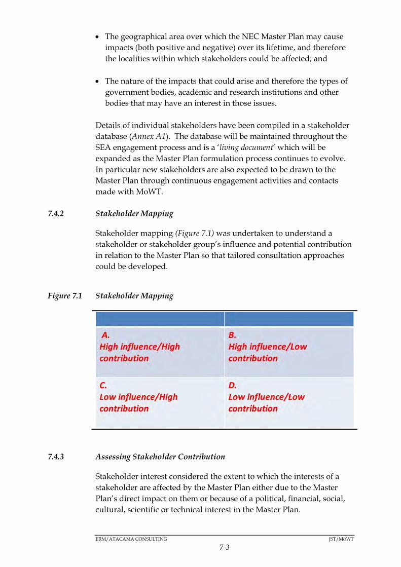
ERM/ATACAMA CONSULTING JST/MOWT
7-3
The geographical area over which the NEC Master Plan may cause
impacts (both positive and negative) over its lifetime, and therefore
the localities within which stakeholders could be affected; and
The nature of the impacts that could arise and therefore the types of
government bodies, academic and research institutions and other
bodies that may have an interest in those issues.
Details of individual stakeholders have been compiled in a stakeholder
database (Annex A1). The database will be maintained throughout the
SEA engagement process and is a ‘living document’ which will be
expanded as the Master Plan formulation process continues to evolve.
In particular new stakeholders are also expected to be drawn to the
Master Plan through continuous engagement activities and contacts
made with MoWT.
7.4.2 Stakeholder Mapping
Stakeholder mapping (Figure 7.1) was undertaken to understand a
stakeholder or stakeholder group’s influence and potential contribution
in relation to the Master Plan so that tailored consultation approaches
could be developed.
Figure 7.1 Stakeholder Mapping
7.4.3 Assessing Stakeholder Contribution
Stakeholder interest considered the extent to which the interests of a
stakeholder are affected by the Master Plan either due to the Master
Plan’s direct impact on them or because of a political, financial, social,
cultural, scientific or technical interest in the Master Plan.

ERM/ATACAMA CONSULTING JST/MOWT
7-4
These interests can be either positive or negative and can lead to either
an improvement or deterioration in a stakeholder’s baseline conditions.
Stakeholder interest was therefore assessed using the criteria shown in
Table 7.1.
Table 7.1 Stakeholder Contribution
Contribution Level
Definition
High The Master Plan potentially has a significant positive or negative impact on the interests of the stakeholder. The impact is considered to be significant and the stakeholders are highly sensitive to the impact.
Medium The Master Plan potentially has a moderate positive or negative impact on the interests of the stakeholder. The impact is considered to be medium and stakeholders are moderately sensitive to the impact.
Low The Master Plan potentially has a minor positive or negative impact on the interests of the stakeholder. The impact is considered to be minor and stakeholders are not considered sensitive to the impact.
7.4.4 Assessing Stakeholder Influence
Stakeholder influence refers to the power that a stakeholder has over
the Master Plan’s implementation/outcomes. Influence can be direct or
indirect. Indirect influence derives, for example, from a stakeholder’s
ability to influence others or their access to important information.
Formal influence may derive from their ability to directly affect
decision making through, for example, the issue of government
approval and permitting decisions. The assessment of stakeholder
influence was qualitative and based on the criteria presented in Table
7.2 below.
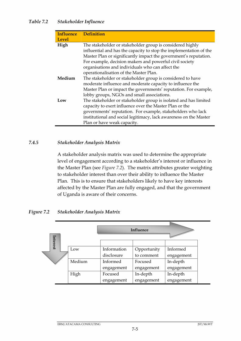
ERM/ATACAMA CONSULTING JST/MOWT
7-5
Table 7.2 Stakeholder Influence
Influence Level
Definition
High The stakeholder or stakeholder group is considered highly influential and has the capacity to stop the implementation of the Master Plan or significantly impact the government’s reputation. For example, decision makers and powerful civil society organisations and individuals who can affect the operationalisation of the Master Plan.
Medium The stakeholder or stakeholder group is considered to have moderate influence and moderate capacity to influence the Master Plan or impact the governments’ reputation. For example, lobby groups, NGOs and small associations.
Low The stakeholder or stakeholder group is isolated and has limited capacity to exert influence over the Master Plan or the governments’ reputation. For example, stakeholders who lack institutional and social legitimacy, lack awareness on the Master Plan or have weak capacity.
7.4.5 Stakeholder Analysis Matrix
A stakeholder analysis matrix was used to determine the appropriate
level of engagement according to a stakeholder’s interest or influence in
the Master Plan (see Figure 7.2). The matrix attributes greater weighting
to stakeholder interest than over their ability to influence the Master
Plan. This is to ensure that stakeholders likely to have key interests
affected by the Master Plan are fully engaged, and that the government
of Uganda is aware of their concerns.
Figure 7.2 Stakeholder Analysis Matrix
Low Medium High
Low Information
disclosure
Opportunity
to comment
Informed
engagement
Medium Informed
engagement
Focused
engagement
In-depth
engagement
High Focused
engagement
In-depth
engagement
In-depth
engagement
Inte
rest
Influence
ERM/ATACAMA CONSULTING JST/MOWT
7-6
The stakeholder analysis matrix outlines five levels of engagement, in
ascending order:
Information disclosure:
Opportunity to comment:
Informed engagement.
Focused engagement.
In-depth engagement.
Higher levels of disclosure and consultation correspond to the
provision of more detailed Master Plan information and more in-depth
discussion in relation to the Master Plan’s impacts. Lower levels of
disclosure and consultation represent more limited Master Plan
information and discussion, and are generally less technical and less
specific in nature.
Stakeholders that have both high influence and high impact will be
continuously engaged and kept fully informed throughout the
SEA/Master Plan formulation process. Those with high influence
include both ‘key government ministries’ and ‘local government
authorities’. Stakeholders that have low influence but high interest will
also be kept well informed and involved in a process of informed
consultation and participation, which ensures their views are taken into
account in during the SEA/Master Plan formulation process.
Preliminary stakeholder mapping was undertaken of the stakeholders
identified to date using the stakeholder mapping matrix. The results of
the exercise are summarised in Table 7.3.
Table 7.3 Modalities of Engagement per Stakeholder Group
Engagement
Type
Stakeholders
In-Depth Ministry of Works and Transport (MoWT)
Ministry of Health (MoH)
Ministry of East African Community Affairs (MEACA)
Ministry of Energy and Mineral Development (MoEMD)
Ministry of Water and Environment (MoWE)
Ministry of Finance, Planning and Economic Development
(MoFPED)
Ministry of Trade Industry and Cooperatives (MoTIC)
Ministry of Gender, Labour and Social Development
(MGLSD)
Ministry of Local Government (MoLG)
Ministry of Tourism, Wildlife and Antiquities
ERM/ATACAMA CONSULTING JST/MOWT
7-7
Uganda National Roads Authority (UNRA)
Uganda Revenue Authority (URA)
Uganda Police Force
Uganda Investment Authority (UIA)
Uganda National Bureau of Standards (UNBS)
National Environment Management Authority (NEMA)
National Planning Authority (NPA)
Uganda National Meteorology Authority (UNMA)
National Forestry Authority (NFA)
Directorate of Citizenship and Immigration Control
Uganda Road Fund (URF)
Uganda Railways Corporation (URC)
Uganda Road Sector Support Initiatiave (URSSI)
Rift Valley Railways (RVR)
Uganda Bureau of Statistics (UBoS)
Uganda Export Promotions Board (UEPB)
Focused Chief Administrative Officers and District Natural Resource
Officers (DNRO) for the following districts: Tororo,
Mbale, Bukedea, Kumi, Ngora, Soroti, Mayuge, Amuria,
Alebtong, Lira, Kole, Oyam, Gulu, Amuru, Busia, Bugiri,
Iganga, Jinja, Buikwe, Mukono, Wakiso, Kampala, Mpigi,
Kalungu, Masaka, Lwengo, Lyantonde, Kiruhura,
Mbarara, Ntungamo, Kabale, Kisoro, Sheema, Bushenyi,
Rubirizi, Kasese, Kampala, Luwero, Nakasongola,
Masindi, and Kiryandongo
Informed Kampala City Traders Association (KACITA)
Uganda Small Scale Industries Association (USSIA)
Uganda National Chamber of Commerce and Industry
(UNCCI)
Uganda Freight Forwarders Association (UFFA)
Uganda Manufacturers Association (UMA)
Uganda Importers & Exporters Association (UGIETA)
TradeMark East Africa
Economic Policy Research Centre
Ministry of Agriculture
Makerere University Business school
Department of Urban Planning
Opportunity
to comment
National Association of Professional Environmentalists
(NAPE)
Uganda Association of Impact Assessment (UAIA)
Engineers’ Registration Board (ERB)
JICA Uganda
Information
disclosure
Private Sector Foundation Uganda (PSFU)
Safe Way Right Way Uganda
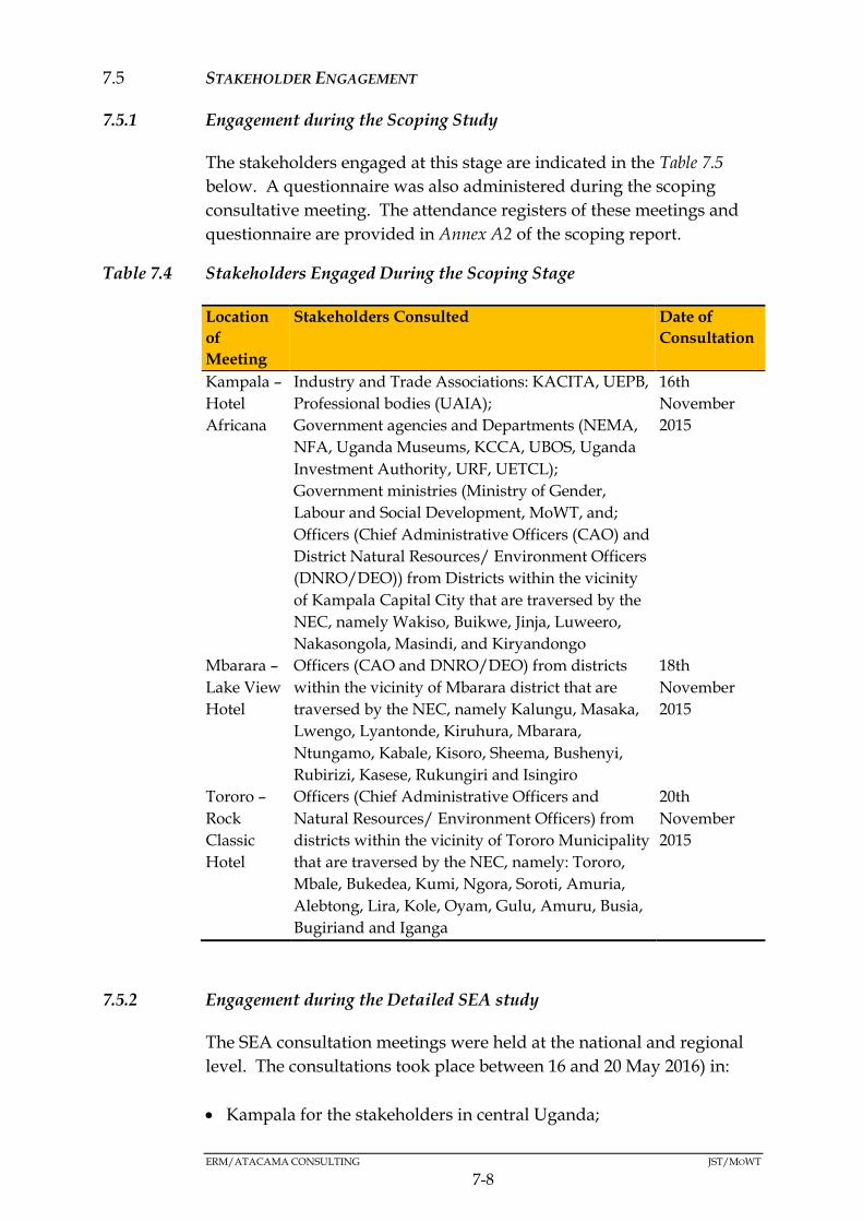
ERM/ATACAMA CONSULTING JST/MOWT
7-8
STAKEHOLDER ENGAGEMENT7.5
7.5.1 Engagement during the Scoping Study
The stakeholders engaged at this stage are indicated in the Table 7.5
below. A questionnaire was also administered during the scoping
consultative meeting. The attendance registers of these meetings and
questionnaire are provided in Annex A2 of the scoping report.
Table 7.4 Stakeholders Engaged During the Scoping Stage
Location
of
Meeting
Stakeholders Consulted Date of
Consultation
Kampala –
Hotel
Africana
Industry and Trade Associations: KACITA, UEPB,
Professional bodies (UAIA);
Government agencies and Departments (NEMA,
NFA, Uganda Museums, KCCA, UBOS, Uganda
Investment Authority, URF, UETCL);
Government ministries (Ministry of Gender,
Labour and Social Development, MoWT, and;
Officers (Chief Administrative Officers (CAO) and
District Natural Resources/ Environment Officers
(DNRO/DEO)) from Districts within the vicinity
of Kampala Capital City that are traversed by the
NEC, namely Wakiso, Buikwe, Jinja, Luweero,
Nakasongola, Masindi, and Kiryandongo
16th
November
2015
Mbarara –
Lake View
Hotel
Officers (CAO and DNRO/DEO) from districts
within the vicinity of Mbarara district that are
traversed by the NEC, namely Kalungu, Masaka,
Lwengo, Lyantonde, Kiruhura, Mbarara,
Ntungamo, Kabale, Kisoro, Sheema, Bushenyi,
Rubirizi, Kasese, Rukungiri and Isingiro
18th
November
2015
Tororo –
Rock
Classic
Hotel
Officers (Chief Administrative Officers and
Natural Resources/ Environment Officers) from
districts within the vicinity of Tororo Municipality
that are traversed by the NEC, namely: Tororo,
Mbale, Bukedea, Kumi, Ngora, Soroti, Amuria,
Alebtong, Lira, Kole, Oyam, Gulu, Amuru, Busia,
Bugiriand and Iganga
20th
November
2015
7.5.2 Engagement during the Detailed SEA study
The SEA consultation meetings were held at the national and regional
level. The consultations took place between 16 and 20 May 2016) in:
Kampala for the stakeholders in central Uganda;
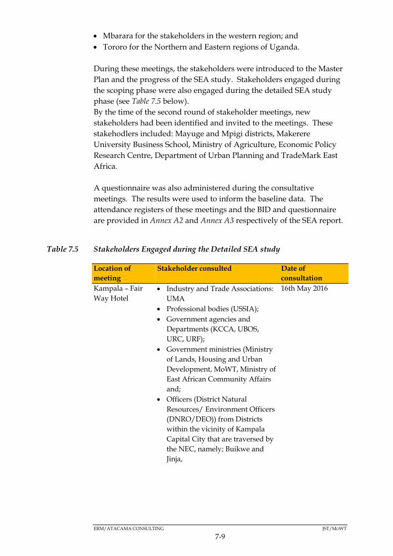
ERM/ATACAMA CONSULTING JST/MOWT
7-9
Mbarara for the stakeholders in the western region; and
Tororo for the Northern and Eastern regions of Uganda.
During these meetings, the stakeholders were introduced to the Master
Plan and the progress of the SEA study. Stakeholders engaged during
the scoping phase were also engaged during the detailed SEA study
phase (see Table 7.5 below).
By the time of the second round of stakeholder meetings, new
stakeholders had been identified and invited to the meetings. These
stakehodlers included: Mayuge and Mpigi districts, Makerere
University Business School, Ministry of Agriculture, Economic Policy
Research Centre, Department of Urban Planning and TradeMark East
Africa.
A questionnaire was also administered during the consultative
meetings. The results were used to inform the baseline data. The
attendance registers of these meetings and the BID and questionnaire
are provided in Annex A2 and Annex A3 respectively of the SEA report.
Table 7.5 Stakeholders Engaged during the Detailed SEA study
Location of
meeting
Stakeholder consulted Date of
consultation
Kampala – Fair
Way Hotel
Industry and Trade Associations:
UMA
Professional bodies (USSIA);
Government agencies and
Departments (KCCA, UBOS,
URC, URF);
Government ministries (Ministry
of Lands, Housing and Urban
Development, MoWT, Ministry of
East African Community Affairs
and;
Officers (District Natural
Resources/ Environment Officers
(DNRO/DEO)) from Districts
within the vicinity of Kampala
Capital City that are traversed by
the NEC, namely; Buikwe and
Jinja,
16th May 2016
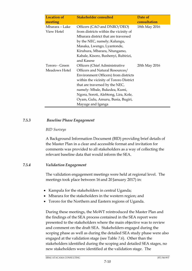
ERM/ATACAMA CONSULTING JST/MOWT
7-10
Location of
meeting
Stakeholder consulted Date of
consultation
Mbarara – Lake
View Hotel
Officers (CAO and DNRO/DEO)
from districts within the vicinity of
Mbarara district that are traversed
by the NEC, namely; Kalungu,
Masaka, Lwengo, Lyantonde,
Kiruhura, Mbarara, Ntungamo,
Kabale, Kisoro, Bushenyi, Rubirizi,
and Kasese
18th May 2016
Tororo - Green
Meadows Hotel
Officers (Chief Administrative
Officers and Natural Resources/
Environment Officers) from districts
within the vicinity of Tororo District
that are traversed by the NEC,
namely: Mbale, Bukedea, Kumi,
Ngora, Soroti, Alebtong, Lira, Kole,
Oyam, Gulu, Amuru, Busia, Bugiri,
Mayuge and Iganga
20th May 2016
7.5.3 Baseline Phase Engagement
BID Surveys
A Background Information Document (BID) providing brief details of
the Master Plan in a clear and accessible format and invitation for
comments was provided to all stakeholders as a way of collecting the
relevant baseline data that would inform the SEA.
7.5.4 Validation Engagement
The validation engagement meetings were held at regional level. The
meetings took place between 16 and 20 January 2017) in:
Kampala for the stakeholders in central Uganda;
Mbarara for the stakeholders in the western region; and
Tororo for the Northern and Eastern regions of Uganda.
During these meetings, the MoWT reintroduced the Master Plan and
the findings of the SEA process contained in the SEA report were
presented to the stakeholders where the main objective was to review
and comment on the draft SEA. Stakeholders engaged during the
scoping phase as well as during the detailed SEA study phase were also
engaged at the validation stage (see Table 7.6). Other than the
stakeholders identified during the scoping and detailed SEA stages, no
new stakeholders were identified at the validation stage. The
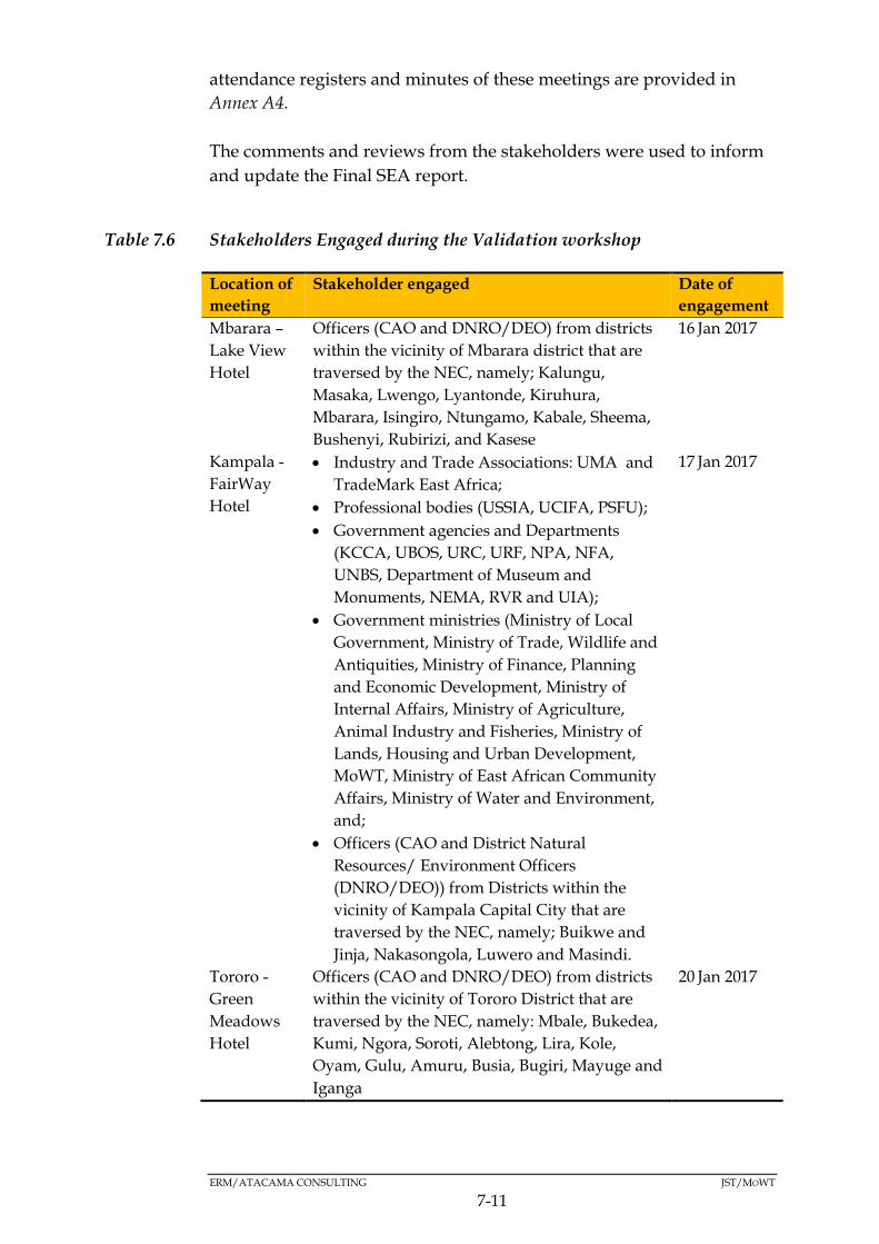
ERM/ATACAMA CONSULTING JST/MOWT
7-11
attendance registers and minutes of these meetings are provided in
Annex A4.
The comments and reviews from the stakeholders were used to inform
and update the Final SEA report.
Table 7.6 Stakeholders Engaged during the Validation workshop
Location of
meeting
Stakeholder engaged Date of
engagement
Mbarara –
Lake View
Hotel
Officers (CAO and DNRO/DEO) from districts
within the vicinity of Mbarara district that are
traversed by the NEC, namely; Kalungu,
Masaka, Lwengo, Lyantonde, Kiruhura,
Mbarara, Isingiro, Ntungamo, Kabale, Sheema,
Bushenyi, Rubirizi, and Kasese
16 Jan 2017
Kampala -
FairWay
Hotel
Industry and Trade Associations: UMA and
TradeMark East Africa;
Professional bodies (USSIA, UCIFA, PSFU);
Government agencies and Departments
(KCCA, UBOS, URC, URF, NPA, NFA,
UNBS, Department of Museum and
Monuments, NEMA, RVR and UIA);
Government ministries (Ministry of Local
Government, Ministry of Trade, Wildlife and
Antiquities, Ministry of Finance, Planning
and Economic Development, Ministry of
Internal Affairs, Ministry of Agriculture,
Animal Industry and Fisheries, Ministry of
Lands, Housing and Urban Development,
MoWT, Ministry of East African Community
Affairs, Ministry of Water and Environment,
and;
Officers (CAO and District Natural
Resources/ Environment Officers
(DNRO/DEO)) from Districts within the
vicinity of Kampala Capital City that are
traversed by the NEC, namely; Buikwe and
Jinja, Nakasongola, Luwero and Masindi.
17 Jan 2017
Tororo -
Green
Meadows
Hotel
Officers (CAO and DNRO/DEO) from districts
within the vicinity of Tororo District that are
traversed by the NEC, namely: Mbale, Bukedea,
Kumi, Ngora, Soroti, Alebtong, Lira, Kole,
Oyam, Gulu, Amuru, Busia, Bugiri, Mayuge and
Iganga
20 Jan 2017
ERM/ATACAMA CONSULTING JST/MOWT
7-12
OUTCOMES OF STAKEHOLDER ENGAGEMENT7.6
7.6.1 Key Outcomes
Table 7.7 that follows present a summary of key attitudes, concerns and
expectations raised during the detailed SEA phase round of stakeholder
consultation meetings (refer to Annex A2 for detailed minutes,
attendance registers and photos taken during stakeholder
consultations).
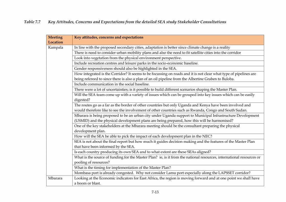
7-13
Table 7.7 Key Attitudes, Concerns and Expectations from the detailed SEA study Stakeholder Consultations
Meeting
Location
Key attitudes, concerns and expectations
Kampala In line with the proposed secondary cities, adaptation is better since climate change is a reality
There is need to consider urban mobility plans and also the need to fit satellite cities into the corridor
Look into vegetation from the physical environment perspective.
Include recreation centres and leisure parks in the socio-economic baseline.
Gender responsiveness should also be highlighted in the SEA.
How integrated is the Corridor? It seems to be focussing on roads and it is not clear what type of pipelines are
being refereed to since there is also a plan of an oil pipeline from the Albertine Graben to Buloba.
Include communication in the social baseline.
There were a lot of uncertainties; is it possible to build different scenarios shaping the Master Plan.
Will the SEA team come up with a variety of issues which can be grouped into key issues which can be easily
digested?
The routes go as a far as the border of other countries but only Uganda and Kenya have been involved and
would therefore like to see the involvement of other countries such as Rwanda, Congo and South Sudan.
Mbarara is being proposed to be an urban city under Uganda support to Municipal Infrastructure Development
(USMID) and the physical development plans are being prepared, how this will be harmonised?
One of the key stakeholders at the Mbarara meeting should be the consultant preparing the physical
development plan.
How will the SEA be able to pick the impact of each development plan in the NEC?
SEA is not about the final report but how much it guides decision making and the features of the Master Plan
that have been informed by the SEA.
Is each country producing its own SEA and to what extent are these SEAs aligned?
What is the source of funding for the Master Plan? ie, is it from the national resources, international resources or
pooling of resources?
What is the timing for implementation of the Master Plan?
Mombasa port is already congested. Why not consider Lamu port especially along the LAPSSET corridor?
Mbarara Looking at the Economic indicators for East Africa, the region is moving forward and at one point we shall have
a boom or blast.
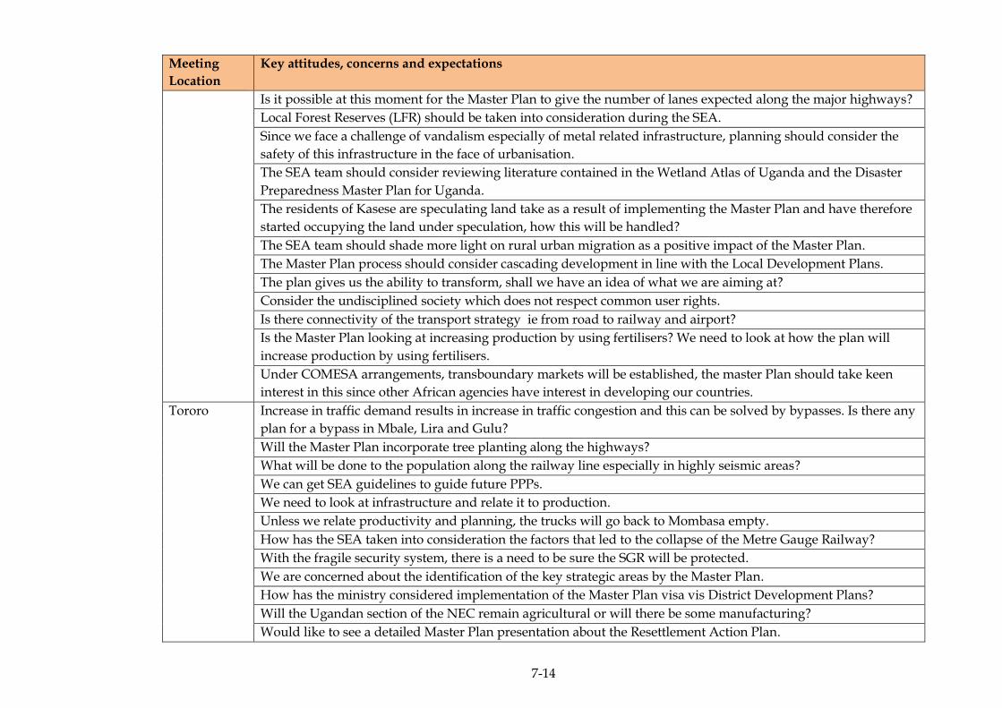
7-14
Meeting
Location
Key attitudes, concerns and expectations
Is it possible at this moment for the Master Plan to give the number of lanes expected along the major highways?
Local Forest Reserves (LFR) should be taken into consideration during the SEA.
Since we face a challenge of vandalism especially of metal related infrastructure, planning should consider the
safety of this infrastructure in the face of urbanisation.
The SEA team should consider reviewing literature contained in the Wetland Atlas of Uganda and the Disaster
Preparedness Master Plan for Uganda.
The residents of Kasese are speculating land take as a result of implementing the Master Plan and have therefore
started occupying the land under speculation, how this will be handled?
The SEA team should shade more light on rural urban migration as a positive impact of the Master Plan.
The Master Plan process should consider cascading development in line with the Local Development Plans.
The plan gives us the ability to transform, shall we have an idea of what we are aiming at?
Consider the undisciplined society which does not respect common user rights.
Is there connectivity of the transport strategy ie from road to railway and airport?
Is the Master Plan looking at increasing production by using fertilisers? We need to look at how the plan will
increase production by using fertilisers.
Under COMESA arrangements, transboundary markets will be established, the master Plan should take keen
interest in this since other African agencies have interest in developing our countries.
Tororo Increase in traffic demand results in increase in traffic congestion and this can be solved by bypasses. Is there any
plan for a bypass in Mbale, Lira and Gulu?
Will the Master Plan incorporate tree planting along the highways?
What will be done to the population along the railway line especially in highly seismic areas?
We can get SEA guidelines to guide future PPPs.
We need to look at infrastructure and relate it to production.
Unless we relate productivity and planning, the trucks will go back to Mombasa empty.
How has the SEA taken into consideration the factors that led to the collapse of the Metre Gauge Railway?
With the fragile security system, there is a need to be sure the SGR will be protected.
We are concerned about the identification of the key strategic areas by the Master Plan.
How has the ministry considered implementation of the Master Plan visa vis District Development Plans?
Will the Ugandan section of the NEC remain agricultural or will there be some manufacturing?
Would like to see a detailed Master Plan presentation about the Resettlement Action Plan.

7-15
Meeting
Location
Key attitudes, concerns and expectations
Cross cutting issues like Gender, HIV/AIDS, the elderly etc. should be incorporated in the SEA.
The ministry should design the SEA communication strategies.
The study is deliberately ignoring the political dimension which is led by increasing income division and thus the
potential for conflict is high. Marginalised groups should be looked into.
Myths should be considered.
vulnerabilities are left open
Beyond GIS, ground truthing should be done.
Several plans are being implemented. This should be shown for us to internalise.
In regards to flooding, the Master Plan should improve the drainage system such that this water can be tapped
for productivity.
Registered land is presented as a constraint yet un registered land is more challenging as a constraint due to
insecurity.
Regional production centres such as Karamoja region have been left out. This area has National parks but there
was no deliberate effort to improve the region.
What are the strategies for popularising the Master Plan?
The Master Plan and SEA have timelines and therefore there may be no time for internalising both reports. The
two should be merged into one report.
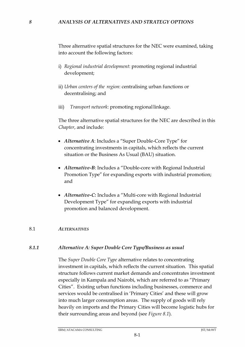
ERM/ATACAMA CONSULTING JST/MOWT
8-1
8 ANALYSIS OF ALTERNATIVES AND STRATEGY OPTIONS
Three alternative spatial structures for the NEC were examined, taking
into account the following factors:
i) Regional industrial development: promoting regional industrial
development;
ii) Urban centers of the region: centralising urban functions or
decentralising; and
iii) Transport network: promoting regional linkage.
The three alternative spatial structures for the NEC are described in this
Chapter, and include:
Alternative A: Includes a “Super Double-Core Type” for
concentrating investments in capitals, which reflects the current
situation or the Business As Usual (BAU) situation.
Alternative-B: Includes a “Double-core with Regional Industrial
Promotion Type” for expanding exports with industrial promotion;
and
Alternative-C: Includes a “Multi-core with Regional Industrial
Development Type” for expanding exports with industrial
promotion and balanced development.
ALTERNATIVES8.1
8.1.1 Alternative A: Super Double Core Type/Business as usual
The Super Double Core Type alternative relates to concentrating
investment in capitals, which reflects the current situation. This spatial
structure follows current market demands and concentrates investment
especially in Kampala and Nairobi, which are referred to as “Primary
Cities”. Existing urban functions including businesses, commerce and
services would be centralised in ‘Primary Cities’ and these will grow
into much larger consumption areas. The supply of goods will rely
heavily on imports and the Primary Cities will become logistic hubs for
their surrounding areas and beyond (see Figure 8.1).
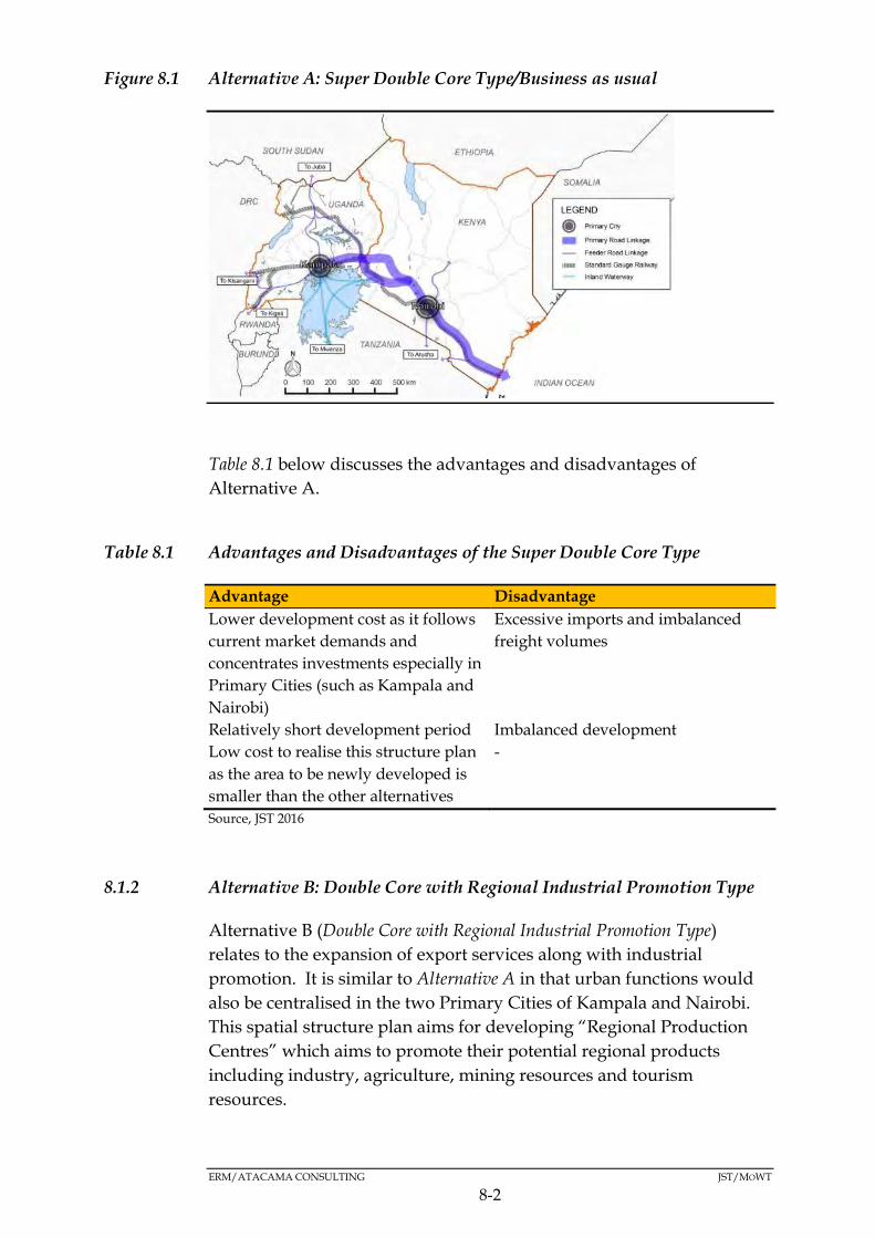
ERM/ATACAMA CONSULTING JST/MOWT
8-2
Figure 8.1 Alternative A: Super Double Core Type/Business as usual
Table 8.1 below discusses the advantages and disadvantages of
Alternative A.
Table 8.1 Advantages and Disadvantages of the Super Double Core Type
Advantage Disadvantage
Lower development cost as it follows
current market demands and
concentrates investments especially in
Primary Cities (such as Kampala and
Nairobi)
Excessive imports and imbalanced
freight volumes
Relatively short development period Imbalanced development
Low cost to realise this structure plan
as the area to be newly developed is
smaller than the other alternatives
-
Source, JST 2016
8.1.2 Alternative B: Double Core with Regional Industrial Promotion Type
Alternative B (Double Core with Regional Industrial Promotion Type)
relates to the expansion of export services along with industrial
promotion. It is similar to Alternative A in that urban functions would
also be centralised in the two Primary Cities of Kampala and Nairobi.
This spatial structure plan aims for developing “Regional Production
Centres” which aims to promote their potential regional products
including industry, agriculture, mining resources and tourism
resources.
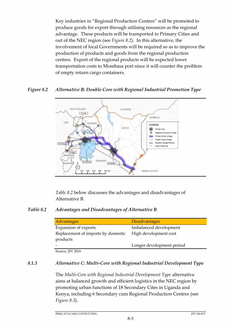
ERM/ATACAMA CONSULTING JST/MOWT
8-3
Key industries in “Regional Production Centres” will be promoted to
produce goods for export through utilising resources as the regional
advantage. These products will be transported to Primary Cities and
out of the NEC region (see Figure 8.2). In this alternative, the
involvement of local Governments will be required so as to improve the
production of products and goods from the regional production
centres. Export of the regional products will be expected lower
transportation costs to Mombasa port since it will counter the problem
of empty return cargo containers.
Figure 8.2 Alternative B: Double Core with Regional Industrial Promotion Type
Table 8.2 below discusses the advantages and disadvantages of
Alternative B.
Table 8.2 Advantages and Disadvantages of Alternative B
Advantages Disadvantages
Expansion of exports Imbalanced development
Replacement of imports by domestic
products
High development cost
- Longer development period
Source, JST 2016
8.1.3 Alternative C: Multi-Core with Regional Industrial Development Type
The Multi-Core with Regional Industrial Development Type alternative
aims at balanced growth and efficient logistics in the NEC region by
promoting urban functions of 18 Secondary Cites in Uganda and
Kenya, including 6 Secondary cum Regional Production Centres (see
Figure 8.3).
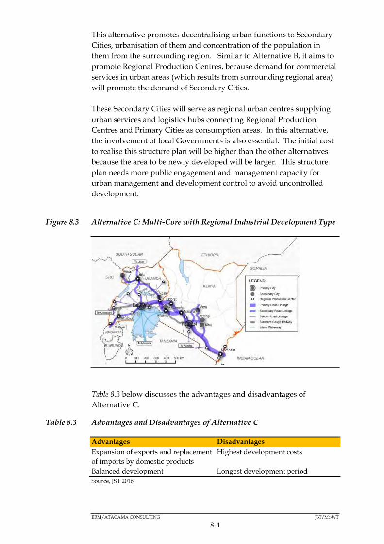
ERM/ATACAMA CONSULTING JST/MOWT
8-4
This alternative promotes decentralising urban functions to Secondary
Cities, urbanisation of them and concentration of the population in
them from the surrounding region. Similar to Alternative B, it aims to
promote Regional Production Centres, because demand for commercial
services in urban areas (which results from surrounding regional area)
will promote the demand of Secondary Cities.
These Secondary Cities will serve as regional urban centres supplying
urban services and logistics hubs connecting Regional Production
Centres and Primary Cities as consumption areas. In this alternative,
the involvement of local Governments is also essential. The initial cost
to realise this structure plan will be higher than the other alternatives
because the area to be newly developed will be larger. This structure
plan needs more public engagement and management capacity for
urban management and development control to avoid uncontrolled
development.
Figure 8.3 Alternative C: Multi-Core with Regional Industrial Development Type
Table 8.3 below discusses the advantages and disadvantages of
Alternative C.
Table 8.3 Advantages and Disadvantages of Alternative C
Advantages Disadvantages
Expansion of exports and replacement
of imports by domestic products
Highest development costs
Balanced development Longest development period
Source, JST 2016
ERM/ATACAMA CONSULTING JST/MOWT
8-5
This is the preferred alternative because it is consistent with Vision 2040 and
the goals of the NEC Master Plan, which are to improve logistics for the NEC
as well as provide an integrated regional development strategy consistent with
sub-regional development plans and national development plans. This
alternative is therefore the basis of this SEA.
PREFERRED ALTERNATIVE 8.2
The merits and demerits of the three development alternatives
presented above were largely based on economic evaluation of the
different alternatives by the JICA Study Team. .
However, from an SEA perspective, it was also prudent that the
alternatives are appraised further based on an objectives led approach.
Therefore, a set of environmental and social objectives (SEA objectives)
that were shaped by the SEA stakeholder engagement process were
used to ascertain the environmental and social soundness of the
alternatives. The appraisal process took into account the aspirations of
the NEC Master Plan. The outcome of the appraisal is as presented in
Table 8.4 Alternatives Assessment
Following the appraisal of the alternatives, alternative ‘C’ was deemed
to be the preferred alternative because it is consistent with Vision 2040
and the goals of the NEC Master Plan, which are to improve logistics
for the NEC as well as provide an integrated regional development
strategy consistent with sub-regional development plans and national
development plans. This alternative is therefore the basis of this SEA.
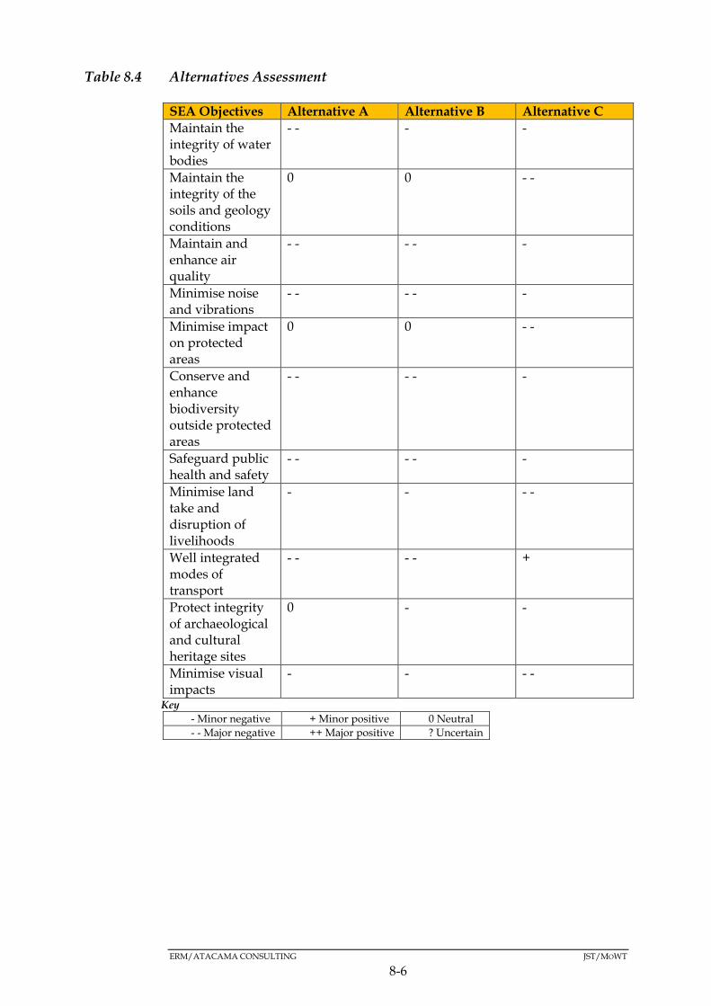
ERM/ATACAMA CONSULTING JST/MOWT
8-6
Table 8.4 Alternatives Assessment
SEA Objectives Alternative A Alternative B Alternative C
Maintain the integrity of water bodies
- - - -
Maintain the integrity of the soils and geology conditions
0 0 - -
Maintain and enhance air quality
- - - - -
Minimise noise and vibrations
- - - - -
Minimise impact on protected areas
0 0 - -
Conserve and enhance biodiversity outside protected areas
- - - - -
Safeguard public health and safety
- - - - -
Minimise land take and disruption of livelihoods
- - - -
Well integrated modes of transport
- - - - +
Protect integrity of archaeological and cultural heritage sites
0 - -
Minimise visual impacts
- - - -
Key
- Minor negative + Minor positive 0 Neutral
- - Major negative ++ Major positive ? Uncertain

ERM/ATACAMA CONSULTING JST/MOWT
9-1
9 KEY IMPACTS
INTRODUCTION 9.1
Following on from the identification of the preferred development
alternative for the Master Plan, the respective options of the strategies
(Table 9.1) that will make up the Master Plan were subjected to a
detailed impact assessment.

9-2
Table 9.1: Master Plan Strategic Options that were subjected to the Detailed Assessment
Transport strategy Regional strategy Industrial strategy
Strategic options
Modal shift
from truck to
rail
Reduction of
bottlenecks
Enhancement
of
infrastructure
Linking
agricultural
productive
areas and
mineral
resources
through
development
of secondary
cities
Linking
with
LAPSSET,
Central
Corridor,
and
Kampala-
Juba-Addis
Ababa-
Djibouti
Corridor
Promotion of
growth drivers
to increase
exports,
reduce
imports, and
develop local
economy
Connecting
industrial
areas to
logistic hubs
through Cargo
Oriented
Development
(COD)
Establishment
of logistic hubs
with Inland
Container
Depot and
Logistic Centre
The expected
impact is to
realise a
multimodal
transport
system
including
railway,
truck, and
pipeline for
NEC.
In Kampala
and Nairobi, it
is necessary to
expand the
capacity of
road networks
through
widening of the
roads,
bypasses, ring
roads,
over/under
passes.
One Stop
Border Post in
Malaba:
Shorten to
Existing
transport
infrastructure
such as Metre
Gauge Railway
(MGR),
Mombasa port,
waterway in
Lake Victoria,
and
international
airports should
be enhanced.
Major cities
and economic
activities have
been
developed
along the
NEC, and it is
essential to
link potential
agricultural
productive
areas and
mineral
resources
through feeder
roads.
The proposed
spatial
Inland
waterway
on Lake
Victoria
would be a
centre for
regional
trade due to
its
geographical
location, and
the Ring
Road
around the
Lake
Victoria
would serve
as an
34 growth
drivers
consisting of
manufacturing,
agriculture and
livestock, and
energy and
mining
products etc.
are has been
considered.
JICA Study
Team deduced
that growth
drivers have
large potentials
for: i)
increasing
Harmonisation
with industrial
plans, mineral
resource
development,
and
agricultural
development
can be key for
transport and
logistics
planning. Such
developments
can be referred
to as Cargo-
Oriented
Development
(COD).
A potential
logistic hub
could have
multi-modal
facilities such as
ICD that
connect railway
to road, inland
water, and
airport. In
addition to
multi-modal
facilities, a
logistic hub
provides a
logistic centre
with facilities
and services
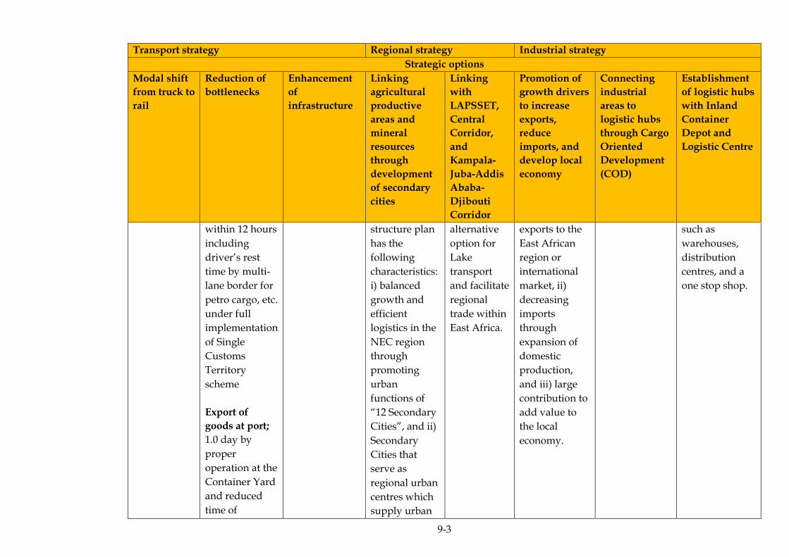
9-3
Transport strategy Regional strategy Industrial strategy
Strategic options
Modal shift
from truck to
rail
Reduction of
bottlenecks
Enhancement
of
infrastructure
Linking
agricultural
productive
areas and
mineral
resources
through
development
of secondary
cities
Linking
with
LAPSSET,
Central
Corridor,
and
Kampala-
Juba-Addis
Ababa-
Djibouti
Corridor
Promotion of
growth drivers
to increase
exports,
reduce
imports, and
develop local
economy
Connecting
industrial
areas to
logistic hubs
through Cargo
Oriented
Development
(COD)
Establishment
of logistic hubs
with Inland
Container
Depot and
Logistic Centre
within 12 hours
including
driver’s rest
time by multi-
lane border for
petro cargo, etc.
under full
implementation
of Single
Customs
Territory
scheme
Export of
goods at port;
1.0 day by
proper
operation at the
Container Yard
and reduced
time of
structure plan
has the
following
characteristics:
i) balanced
growth and
efficient
logistics in the
NEC region
through
promoting
urban
functions of
“12 Secondary
Cities”, and ii)
Secondary
Cities that
serve as
regional urban
centres which
supply urban
alternative
option for
Lake
transport
and facilitate
regional
trade within
East Africa.
exports to the
East African
region or
international
market, ii)
decreasing
imports
through
expansion of
domestic
production,
and iii) large
contribution to
add value to
the local
economy.
such as
warehouses,
distribution
centres, and a
one stop shop.

9-4
Transport strategy Regional strategy Industrial strategy
Strategic options
Modal shift
from truck to
rail
Reduction of
bottlenecks
Enhancement
of
infrastructure
Linking
agricultural
productive
areas and
mineral
resources
through
development
of secondary
cities
Linking
with
LAPSSET,
Central
Corridor,
and
Kampala-
Juba-Addis
Ababa-
Djibouti
Corridor
Promotion of
growth drivers
to increase
exports,
reduce
imports, and
develop local
economy
Connecting
industrial
areas to
logistic hubs
through Cargo
Oriented
Development
(COD)
Establishment
of logistic hubs
with Inland
Container
Depot and
Logistic Centre
scanning, etc.
Road danger
spots;
Improved road
traffic safety
and reduction
of traffic jam
caused by
accidents.
services and
logistic hubs
which connect
Regional
Production
Centres and
Primary Cities
as
consumption
areas.

ERM/ATACAMA CONSULTING JST/MOWT
9-5
The assessment process was preceded by screening and scoping and it
focused on the identification and evaluation of potentially significant
environmental and social effects that are likely to be attributed to the
implementation of the Master Plan, since it’s the significant issues that
are the focus of any SEA. A matrix coupled with expert judgments
were used in the identification of potentially significant environmental
and social aspects of the Master Plan that warranted a detailed
assessment. The impact on a set of SEA objectives that were framed
largely on feedback from the scoping process, were used as the basis of
the assessment. The levels of significance were assigned as below (see
also Section 9.2 for a description of the terminologies):
Minor negative (-);
Minor positive (+);
Neutral (0);
Major negative (- -);
Major positive (++); and
Uncertain (?).
It’s only the options that were deemed to be negative and major in
scope that were taken forward for the detailed impact assessment.
Those aspects that were likely to be majorly positive could only be
enhanced as part of the implementation of the Master Plan.
Table 9.2, Table 9.3, and Table 9.4 indicate the levels of significance for
each of the strategy options (see Section 4.2.2 as well as Section 9.2 for
derivation of impact significance). It’s worth noting that the organisational
and policy strategy, and financial strategy were not evaluated since the
two strategies are policy related and are aiming at supporting the first
three strategies (regional strategy, industrial strategy and transport
strategy). Their indirect impacts are therefore the direct impacts of
implementing the three strategies.
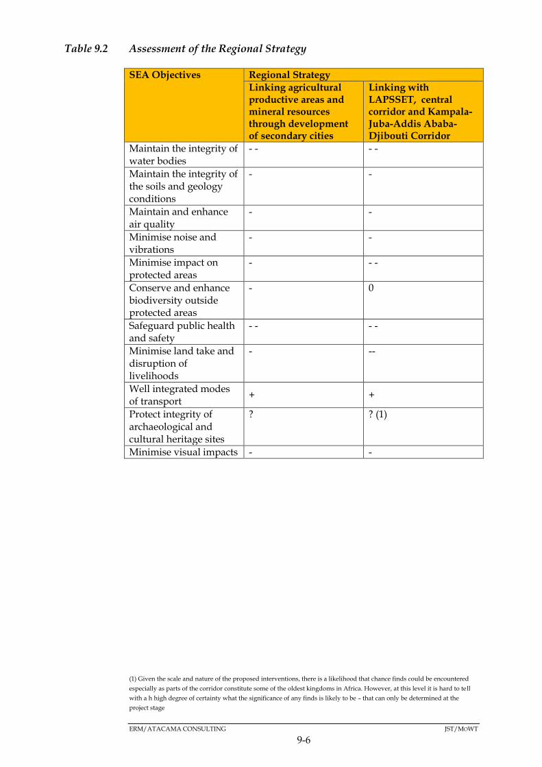
ERM/ATACAMA CONSULTING JST/MOWT
9-6
Table 9.2 Assessment of the Regional Strategy
SEA Objectives Regional Strategy
Linking agricultural productive areas and mineral resources through development of secondary cities
Linking with LAPSSET, central corridor and Kampala-Juba-Addis Ababa- Djibouti Corridor
Maintain the integrity of water bodies
- - - -
Maintain the integrity of the soils and geology conditions
- -
Maintain and enhance air quality
- -
Minimise noise and vibrations
- -
Minimise impact on protected areas
- - -
Conserve and enhance biodiversity outside protected areas
- 0
Safeguard public health and safety
- - - -
Minimise land take and disruption of livelihoods
- --
Well integrated modes of transport
+ +
Protect integrity of archaeological and cultural heritage sites
? ? (1)
Minimise visual impacts - -
(1) Given the scale and nature of the proposed interventions, there is a likelihood that chance finds could be encountered
especially as parts of the corridor constitute some of the oldest kingdoms in Africa. However, at this level it is hard to tell
with a h high degree of certainty what the significance of any finds is likely to be – that can only be determined at the
project stage
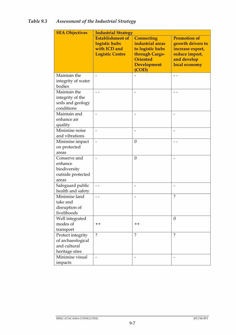
ERM/ATACAMA CONSULTING JST/MOWT
9-7
Table 9.3 Assessment of the Industrial Strategy
SEA Objectives Industrial Strategy
Establishment of logistic hubs with ICD and Logistic Centre
Connecting industrial areas to logistic hubs through Cargo-Oriented Development (COD)
Promotion of growth drivers to increase export, reduce import, and develop local economy
Maintain the integrity of water bodies
- - - -
Maintain the integrity of the soils and geology conditions
- - - - -
Maintain and enhance air quality
- - -
Minimise noise and vibrations
- - -
Minimise impact on protected areas
- 0 - -
Conserve and enhance biodiversity outside protected areas
- 0 -
Safeguard public health and safety
- - - -
Minimise land take and disruption of livelihoods
- - - ?
Well integrated modes of transport
++ ++ 0
Protect integrity of archaeological and cultural heritage sites
? ? ?
Minimise visual impacts
- - -
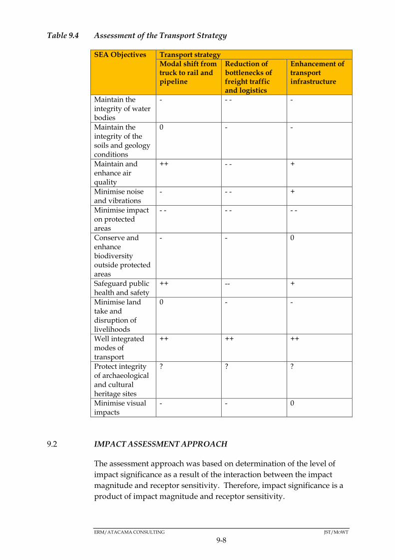
ERM/ATACAMA CONSULTING JST/MOWT
9-8
Table 9.4 Assessment of the Transport Strategy
SEA Objectives Transport strategy
Modal shift from truck to rail and pipeline
Reduction of bottlenecks of freight traffic and logistics
Enhancement of transport infrastructure
Maintain the integrity of water bodies
- - - -
Maintain the integrity of the soils and geology conditions
0 - -
Maintain and enhance air quality
++ - - +
Minimise noise and vibrations
- - - +
Minimise impact on protected areas
- - - - - -
Conserve and enhance biodiversity outside protected areas
- - 0
Safeguard public health and safety
++ -- +
Minimise land take and disruption of livelihoods
0 - -
Well integrated modes of transport
++ ++ ++
Protect integrity of archaeological and cultural heritage sites
? ? ?
Minimise visual impacts
- - 0
IMPACT ASSESSMENT APPROACH 9.2
The assessment approach was based on determination of the level of
impact significance as a result of the interaction between the impact
magnitude and receptor sensitivity. Therefore, impact significance is a
product of impact magnitude and receptor sensitivity.
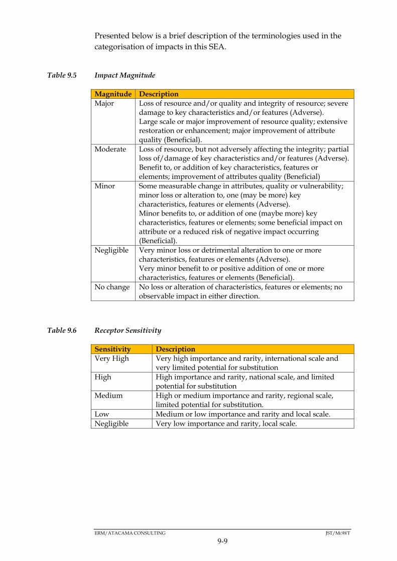
ERM/ATACAMA CONSULTING JST/MOWT
9-9
Presented below is a brief description of the terminologies used in the
categorisation of impacts in this SEA.
Table 9.5 Impact Magnitude
Magnitude Description
Major Loss of resource and/or quality and integrity of resource; severe damage to key characteristics and/or features (Adverse). Large scale or major improvement of resource quality; extensive restoration or enhancement; major improvement of attribute quality (Beneficial).
Moderate Loss of resource, but not adversely affecting the integrity; partial loss of/damage of key characteristics and/or features (Adverse). Benefit to, or addition of key characteristics, features or elements; improvement of attributes quality (Beneficial)
Minor Some measurable change in attributes, quality or vulnerability; minor loss or alteration to, one (may be more) key characteristics, features or elements (Adverse). Minor benefits to, or addition of one (maybe more) key characteristics, features or elements; some beneficial impact on attribute or a reduced risk of negative impact occurring (Beneficial).
Negligible Very minor loss or detrimental alteration to one or more characteristics, features or elements (Adverse). Very minor benefit to or positive addition of one or more characteristics, features or elements (Beneficial).
No change No loss or alteration of characteristics, features or elements; no observable impact in either direction.
Table 9.6 Receptor Sensitivity
Sensitivity Description
Very High Very high importance and rarity, international scale and very limited potential for substitution
High High importance and rarity, national scale, and limited potential for substitution
Medium High or medium importance and rarity, regional scale, limited potential for substitution.
Low Medium or low importance and rarity and local scale.
Negligible Very low importance and rarity, local scale.

ERM/ATACAMA CONSULTING JST/MOWT
9-10
Table 9.7 Impact Significance
Impact magnitude
No
change Negligible Minor Moderate Major
Receptor
sensitivity
Negligible Neutral Neutral Slight Moderate Moderate
Low Neutral Slight Slight Moderate Large
Medium Neutral Slight Moderate Large Large
High Neutral Moderate Moderate Large Very
large
Very high Neutral Moderate Large Very
large
Very
large
Table 9.8 Description of the Categories of Impact Significance
Significance Category
Typical descriptor of effects
Very large
Only adverse effects are normally assigned this level of significance. They represent key factors in the decision making process. These effects are generally but not exclusively, associated with sites or features of international, national or regional importance that are likely to suffer a most damaging impact and loss of resources integrity. However, a major change in a site or feature of local importance may also enter this category.
Large These beneficial or adverse effects are considered to be very important considerations and are likely to be material in the decision-making process.
Moderate
These beneficial or adverse effects may be important, but are not likely to be key decision-making if they lead to an increase in the overall adverse effects on a particular resource or receptor.
Slight
These beneficial or adverse effects may be raised as local factors. They are unlikely to be critical in the decision-making process, but are important in enhancing the subsequent design of the project.
Neutral No effect or those that are beneath levels of perception, within normal bounds of variation or within the margin of forecasting error.
Presented in Sections 9.3 to 9.5 respectively is the assessment of the
physical, biological and social impacts likely to arise as a result of
implementation of the Master Plan.

ERM/ATACAMA CONSULTING JST/MOWT
9-11
ASSESSMENT OF THE PHYSICAL IMPACTS 9.3
9.3.1 Regional Strategy
Linking agricultural productive areas and mineral resource areas through
development of secondary cities.
Impacts on the Integrity of Water Bodies
Water is a key resource in the sustenance of livelihoods and operations
of any city as well as for any related production systems. The proposed
development of secondary cities (Arua, Gulu, Mbale and Mbarara) and
the agricultural (Gulu and Mbarara) and mineral resource areas
(Moroto, Hoima, Kasese and Kabale) will exert pressure on that
resource not only through its abstraction but more critically through the
discharge of municipal and industrial waste waters (including process
waters from agricultural and mineral resource areas) into the various
water ecosystems (such as Lake Albert and Lake Kyoga) as indicated in
Figure 9.1. The magnitude of the impact cannot be established at this
level due to uncertainty that would be associated with the degree of
pollution of such events but the sensitivity of the receiving water bodies
(receptors) is high and therefore the significance of the impact could be
very large.
Box 9.1 Constraints
Lake Victoria
R. Nile, River Ruizi, R. Muzizi, R.Kagera, R. Mayanja, R.Katonga,
R.Kafu
Kazinga channel
Lake Kyoga wetland system
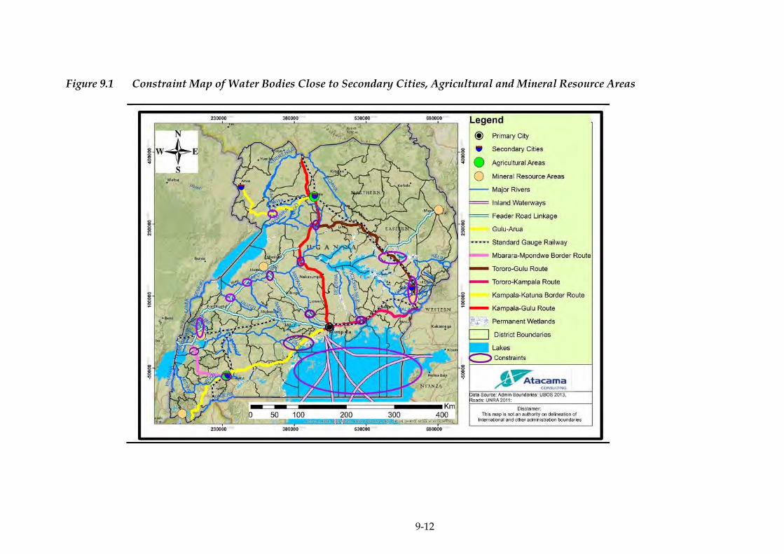
9-12
Figure 9.1 Constraint Map of Water Bodies Close to Secondary Cities, Agricultural and Mineral Resource Areas

ERM/ATACAMA CONSULTING JST/MOWT
9-13
Linking with LAPSSET, central corridor and Kampala-Juba-Addis Ababa-
Djibouti Corridor
Impacts on the Integrity of Water Bodies
The Master Plan proposes promotion of inland waterway transport on
Lake Victoria which will also link the NEC with the Central Corridor
(Figure 9.1). Seven inland waterway linkage routes have been identified
and when fully operational and utilised, will cover a great part of the
lake (Lake Victoria). More so, three to six ports on the lake will be
rehabilitated in the short term.
Marine traffic in particular along Lake Victoria could potentially affect
the integrity of that water resource through marine traffic related
leakages, spillage of hazardous cargo, and overboard waste disposal.
This impact will further be exacerbated if marine vessel accidents occur.
The magnitude of this impact will therefore be major.
Lake Victoria is the largest freshwater lake in East Africa and Africa in
general and shared by the three East African countries (Uganda, Kenya
and Tanzania) and is also the source of River Nile, the longest river in
Africa. Therefore, reduction in the water quality of this lake will be of
local, national, regional and international concern. Therefore, the
sensitivity of the receptor is very high.
Based on the impact magnitude and receptor sensitivity presented
above, the significance of the impact is considered to be very large and
will occur in the short, medium and long term due to the phased
approach since the utilisation of the inland waterway of Lake Victoria
will need to be sustained throughout the implementation of the Master
Plan.
9.3.2 Industrial Strategy
Establishment of logistic hubs with Inland Container Depots (ICD) and
Logistic Centre
Impacts on Soils and Geology
Infrastructural activities related to the establishment of pertinent
facilities like ICDs, warehouses, distribution centres, and one stop
shops will negatively affect this aspect of the physical environment.
Levelling and compaction of soil is important to ensure stability of the
infrastructure. Five potential locations for the logistic hubs have been
identified in Uganda. These are:
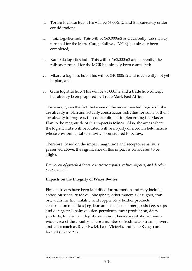
ERM/ATACAMA CONSULTING JST/MOWT
9-14
i. Tororo logistics hub: This will be 56,000m2 and it is currently under
consideration;
ii. Jinja logistics hub: This will be 163,000m2 and currently, the railway
terminal for the Metre Gauge Railway (MGR) has already been
completed;
iii. Kampala logistics hub: This will be 163,000m2 and currently, the
railway terminal for the MGR has already been completed;
iv. Mbarara logistics hub: This will be 340,000m2 and is currently not yet
in plan; and
v. Gulu logistics hub: This will be 95,000m2 and a trade hub concept
has already been proposed by Trade Mark East Africa.
Therefore, given the fact that some of the recommended logistics hubs
are already in plan and actually construction activities for some of them
are already in progress, the contribution of implementing the Master
Plan to the magnitude of this impact is Minor. Also, the areas where
the logistic hubs will be located will be majorly of a brown field nature
whose environmental sensitivity is considered to be low.
Therefore, based on the impact magnitude and receptor sensitivity
presented above, the significance of this impact is considered to be
slight.
Promotion of growth drivers to increase exports, reduce imports, and develop
local economy
Impacts on the Integrity of Water Bodies
Fifteen drivers have been identified for promotion and they include;
coffee, oil seeds, crude oil, phosphate, other minerals ( eg, gold, iron
ore, wolfram, tin, tantalite, and copper etc.), leather products,
construction materials ( eg, iron and steel), consumer goods ( eg, soaps
and detergents), palm oil, rice, petroleum, meat production, dairy
products, tourism and logistic services. These are distributed over a
wider area of the country where a number of freshwater streams, rivers
and lakes (such as River Rwizi, Lake Victoria, and Lake Kyoga) are
located (Figure 9.2).

ERM/ATACAMA CONSULTING JST/MOWT
9-15
In addition, the promotion of the growth drivers is likely to be
associated with a high water footprint given their high water
requirements by way of water for production and not forgetting the
inputs (hazardous chemicals that may include pesticides, weed killers,
fertilisers etc.) associated with those processes could affect the integrity
of the receiving water bodies.
A phased approach is to be used for promoting the growth drivers to
cover the short term (three industrial, five agricultural and three
manufacturing growth drivers); medium term (one industrial and three
agricultural growth drivers) and long term (one agricultural growth
driver). However, it is important to note that some of the identified
growth drivers like the petroleum industry are already being
implemented and their impacts would occur with or without the Master
Plan. Nevertheless, the magnitude of this impact will be major.
There are a number of freshwater streams, rivers and lakes (Figure 9.2)
located within the different parts of the country where promotion of
growth drivers will be undertaken and any contamination will
potentially affect their integrity. The sensitivity of the receptors is
therefore high.
Therefore, based on the impact magnitude and receptor sensitivity
presented above, the significance of this impact is considered to be very
large and will occur in the short, medium and long term duration of the
Master Plan
Box 9.2 Constraints
Impacts on Soils and Geology
The promotion of the growth drivers will call for mechanisation. In the
case of agriculture, this will call for intensive agricultural practices
aimed at bumping up exports although this could result in the
reduction of soil quality due to over-cultivation.
Therefore, the magnitude of this impact will be major. The sensitivity
of the receptor (soils) will be high given the productive nature of soils
in the areas (Figure 9.2) where drivers are to be rolled out.
Lake Victoria, L.Kyoga
R. Nile, R. Rwizi, R. Mayanja, R.Kafu, R. Mubuku

ERM/ATACAMA CONSULTING JST/MOWT
9-16
Based on the impact magnitude and receptor sensitivity presented
above, the significance of this impact is considered to be very large and
will occur in the short, medium and long term due to the phased
approach of this intervention.
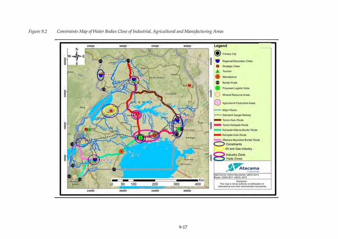
9-17
Figure 9.2 Constraints Map of Water Bodies Close of Industrial, Agricultural and Manufacturing Areas

ERM/ATACAMA CONSULTING JST/MOWT
9-18
9.3.3 Transport Strategy
Reduction of bottlenecks of freight traffic and logistics
Impacts on the Integrity of Water Bodies
The cause of this impact will be from the construction of the proposed
express highways and widening of some of the sections of the main
route of the NEC. The Master Plan proposes the following
interventions in Uganda:
Table 9.9 Interventions
S/N Project Brief description Status Term
1 Kampala-Jinja
Expressway
Project
The 77km Expressway
section will comprise of
4+4 lanes for the first
3km, 3+3 lanes for the
next 14km and 2+2
lanes for the last 57km.
It is currently at the
planning stage
Planning Medium
2 New Nile Bridge New Jinja bridge will
carry a four-lane dual
highway with
pedestrian sidewalks
Under
Construction.
10 percent of
works
completed.
The works
include
construction
of a 6km
access road
Short
3 Kampala-Mpigi
Expressway
Project
Widening of the current
two-lane road to a four-
lane
highway(approximately
30km)
Planning Medium/
long
4 Construction of
Roadside Service
Stations in
Uganda
Installation of 2
roadside service
stations in Uganda
(Bugiri and Masaka)
Planning Medium
5 Logistics
Highway Project
(Masaka -
Mbarara,
L=136km)
Widening from 2 lanes
to 4 lanes of existing
Northern Corridor in
Uganda
Planning After
2030
6 Logistics
Highway Project
Widening from 2 lane s
to 4 lanes of existing
Planning After
2030
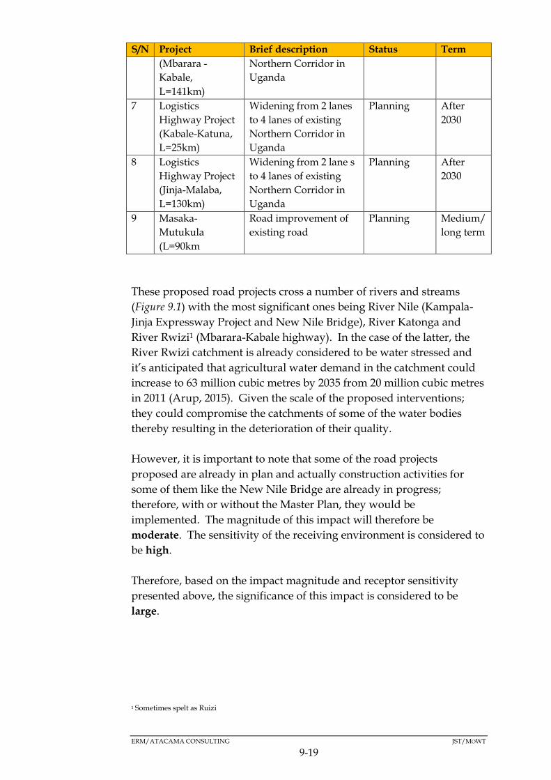
ERM/ATACAMA CONSULTING JST/MOWT
9-19
S/N Project Brief description Status Term
(Mbarara -
Kabale,
L=141km)
Northern Corridor in
Uganda
7 Logistics
Highway Project
(Kabale-Katuna,
L=25km)
Widening from 2 lanes
to 4 lanes of existing
Northern Corridor in
Uganda
Planning After
2030
8 Logistics
Highway Project
(Jinja-Malaba,
L=130km)
Widening from 2 lane s
to 4 lanes of existing
Northern Corridor in
Uganda
Planning After
2030
9 Masaka-
Mutukula
(L=90km
Road improvement of
existing road
Planning Medium/
long term
These proposed road projects cross a number of rivers and streams
(Figure 9.1) with the most significant ones being River Nile (Kampala-
Jinja Expressway Project and New Nile Bridge), River Katonga and
River Rwizi1 (Mbarara-Kabale highway). In the case of the latter, the
River Rwizi catchment is already considered to be water stressed and
it’s anticipated that agricultural water demand in the catchment could
increase to 63 million cubic metres by 2035 from 20 million cubic metres
in 2011 (Arup, 2015). Given the scale of the proposed interventions;
they could compromise the catchments of some of the water bodies
thereby resulting in the deterioration of their quality.
However, it is important to note that some of the road projects
proposed are already in plan and actually construction activities for
some of them like the New Nile Bridge are already in progress;
therefore, with or without the Master Plan, they would be
implemented. The magnitude of this impact will therefore be
moderate. The sensitivity of the receiving environment is considered to
be high.
Therefore, based on the impact magnitude and receptor sensitivity
presented above, the significance of this impact is considered to be
large.
1 Sometimes spelt as Ruizi

ERM/ATACAMA CONSULTING JST/MOWT
9-20
Box 9.3 Constraints
Impacts on Air Quality
Greenhouse Gas Emissions
The rolling out of initiatives that are aimed at reducing bottlenecks of
freight traffic and logistics could result in a spike in traffic volumes,
especially road traffic that is currently constrained by the bottlenecks.
The increase in traffic will go hand-in-hand with an increase in
emissions from such traffic and this will affect the ambient air quality
within the corridor especially along the roads, a situation made worse
by the aging stock or fleet of vehicles that are characteristic of the
corridor traffic. Given the fact that the construction activities will be
undertaken in a phased approach (short, medium, long term and
beyond the implementation period of this Master Plan), the magnitude
of this impact will be moderate.
Based on the results of a pilot cross – sectional spatial assessment of the
state of ambient air quality in two Ugandan urban centres (Kampala
and Jinja, also within the NEC) conducted in 2014, the ambient
concentrations of gas phase air pollutant levels (NO2, SO2 and O3) was
low. Therefore, it can be concluded that the sensitivity of the receiving
environment is low.
Therefore, based on the impact magnitude and receptor sensitivity
presented above, the significance of this impact is considered to be
moderate and will occur in the short, medium, long term and beyond
the implementation period of this Master Plan.
Dust Emissions
The main cause of this impact will be from the construction activities of
the proposed road infrastructure projects already described above.
Construction activities like the ones that will be undertaken for the
proposed road projects are associated with fugitive dust. Given the
number of road projects proposed (9 road projects) and their spatial
distribution; the magnitude of the dust levels will be moderate.
R. Nile
R. Rwizi
R. Katonga

ERM/ATACAMA CONSULTING JST/MOWT
9-21
Based on the results of a pilot cross – sectional spatial assessment of the
state of ambient air quality in two Ugandan urban centres (Kampala
and Jinja, also within the NEC) conducted in 2014, the ambient
concentrations of Particulate Matter (PM) was high.
Given the large concentration of populations along the NEC by way of
settlements/small urban centres especially along the roads where
construction activities are proposed, increased dust emissions will be a
nuisance to the local community members. Therefore, it can be
concluded that the sensitivity of the receiving environment is high.
Therefore, based on the impact magnitude and receptor sensitivity
presented above, the significance of this impact is considered to be
large and will occur in the short, medium, and long term based on the
phasing of projects although its effects will largely be felt during the
construction phase of those projects.
Overall, the impact on air quality is likely to be very large in the long
term on the balance of increased freight traffic within the corridor
coupled with cumulative effects from non-freight/transport related
emissions within the NEC.
Noise and Vibration Impacts
The main source of this impact will be from the construction activities
of the proposed road projects.
Construction activities are usually associated with high levels of noise
and vibrations that are associated with the operation of the associated
machinery and equipment. Given the wide spatial distribution of the
proposed road projects, although a phased approached will be adopted
during the implementation of the Master Plan, the magnitude of the
noise levels that will be emitted will be moderate.
The noise will mainly be localised and the impacts will be more
pronounced near social/communal facilities like places of worship,
schools and hospitals where receptor sensitivity is high.
Therefore, based on the impact magnitude and receptor sensitivity
presented above, the significance of this impact is considered to be
large and will occur in the short, medium, long term and beyond the
implementation period of this Master Plan due to the phased approach
of its activities
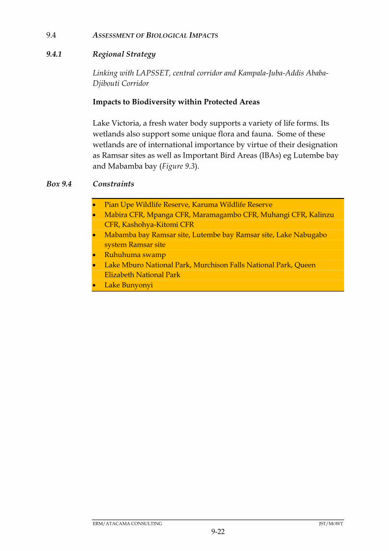
ERM/ATACAMA CONSULTING JST/MOWT
9-22
ASSESSMENT OF BIOLOGICAL IMPACTS 9.4
9.4.1 Regional Strategy
Linking with LAPSSET, central corridor and Kampala-Juba-Addis Ababa-
Djibouti Corridor
Impacts to Biodiversity within Protected Areas
Lake Victoria, a fresh water body supports a variety of life forms. Its
wetlands also support some unique flora and fauna. Some of these
wetlands are of international importance by virtue of their designation
as Ramsar sites as well as Important Bird Areas (IBAs) eg Lutembe bay
and Mabamba bay (Figure 9.3).
Box 9.4 Constraints
Pian Upe Wildlife Reserve, Karuma Wildlife Reserve
Mabira CFR, Mpanga CFR, Maramagambo CFR, Muhangi CFR, Kalinzu
CFR, Kashohya-Kitomi CFR
Mabamba bay Ramsar site, Lutembe bay Ramsar site, Lake Nabugabo
system Ramsar site
Ruhuhuma swamp
Lake Mburo National Park, Murchison Falls National Park, Queen
Elizabeth National Park
Lake Bunyonyi
9-23
Figure 9.3 Constraints Map Highlighting Key Biodiversity Features around Lake Victoria
ERM/ATACAMA CONSULTING JST/MOWT
9-24
Turning Lake Victoria into a centre for regional trade will significantly
increase marine operations on the water body. Increased activity on the
water body could also affect fish breeding grounds on the lake which
are key to the sustainability of the economies of the riparian countries
(Uganda, Kenya and Tanzania) and also interfere with the breeding
patterns of migratory and other birds that use the Lake Victoria
wetlands as a sanctuary.
In addition, major water accidents involving pollutants could easily and
quickly spread to the entire surface of the water body and depending
on the quantities, this could go as far as the Ramsar sites and IBAs
whose role in biodiversity protection is recognised internationally. In
addition, besides Lake Victoria being the source of R. Nile, it is a
transboundary resource, where impacts on it are not localized but could
spread to other countries which share the resource.
Based on the anticipated sudden increase in the number of routes as
well as water vessels plying those routes coupled with the uncertainty
of pollution events, the impact magnitude cannot be assessed with a
high degree of certainty although it is likely to be moderate. The
sensitivity of the receptor is considered very high given its international
importance.
The overall impact significance is considered to be very large.
ERM/ATACAMA CONSULTING JST/MOWT
9-25
9.4.2 Industrial Strategy
Promotion of growth drivers to increase exports, reduce imports, and develop
local economy
Impacts to Biodiversity Within Protected Areas
Fifteen drivers have been identified for promotion and they include;
coffee, oil seeds, crude oil, phosphate, other minerals ( eg, gold, iron
ore, wolfram, tin, tantalite, and copper etc.), leather products,
construction materials ( eg, iron and steel), consumer goods ( eg, soaps
and detergents), palm oil, rice, petroleum, meat production, dairy
products, tourism and logistic services.
Promotion of the above growth drivers in some of the selected
production areas has the potential to compromise the integrity of some
of the protected areas within their catchment area (Figure 9.4). The
identified mineral resource areas such as Kasese, Hoima, Moroto and
Kabale are all located in areas where protected sites such as National
Parks, Forest Reserves as well as Ramsar sites are located. Protected
areas tend to be resource rich and so the promotion of growth drivers
could result in pressure being exerted on the resources contained in
such areas (raw materials (such as mineral ores) and related inputs
(such as water) that are central to the functioning of ecosystems in the
protected areas. The potential for these production areas to expand is
high given the scale of the proposed activities that will be taking place,
and therefore the magnitude of their impact is major.
Protected areas are by virtue of the status warrant a high level of
protection and by virtue of that, the sensitivity of the receptor is
considered very high.
Based on the assessment, the significance of this impact is rated as very
large in the short, medium and long tern duration of the Master Plan.
Box 9.5 Constraints
Karuma Wildlife Reserve
Mabira CFR, Moroto CFR
Lutembe bay Ramsar site
Kibale National Park, Queen Elizabeth National Park, Murchison Falls
National Park
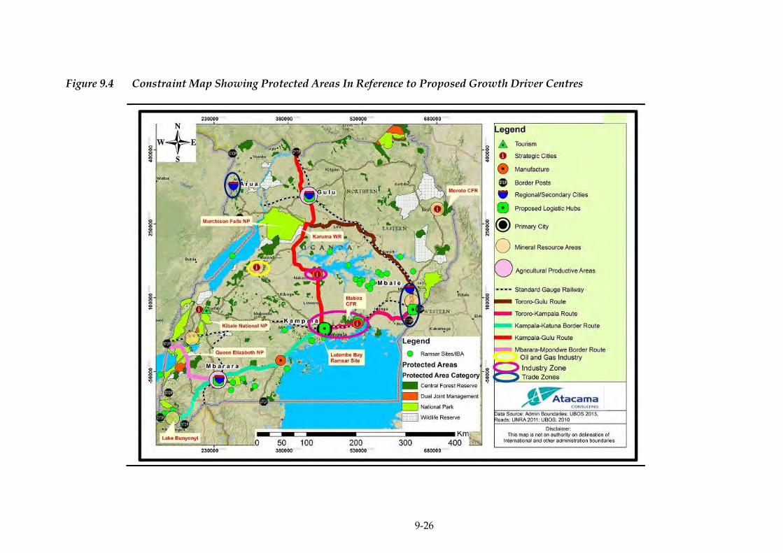
9-26
Figure 9.4 Constraint Map Showing Protected Areas In Reference to Proposed Growth Driver Centres

ERM/ATACAMA CONSULTING JST/MOWT
9-27
9.4.3 Transport Strategy
Modal shift from truck to rail and pipeline
Impacts on Biodiversity in Protected Areas
The assessment of impacts to biodiversity in Protected Areas attributed
to the modal shift is related to the possibility that during the movement
of cargo through protected areas, uncertain events such as accidents
could occur and in the event that such cargo was hazardous, the
integrity of such protected areas would be compromised. The oil
pipeline is proposed to dissect through a section of Mabira CFR, and at
the same time the SGR will dissect through Kibale National Park, both
of which are highly sensitive ecosystems and also habitats to IUCN
threatened species (Figure 9.5). However, the relevant proposed
infrastructure (oil pipeline and SGR) are part of the Northern Corridor
Infrastructure Projects and thus the impacts of cargo movement as a
result of the Master Plan would still happen without the
implementation of the Master Plan. The SGR will traverse Mabira
forest for 14km, measuring approximately 60m wide and relevant
studies have so far been undertaken to ensure that the project does not
compromise the forest biodiversity (Saturday Monitor, 2016).
The magnitude of the impact cannot be established at this level due to
uncertainty that would be associated with the degree of pollution of
such events but the sensitivity of the receiving Protected Areas
(receptors) is high and therefore the significance of the impact could be
very large.
Reduction of bottlenecks of freight traffic and logistics
Impacts on Biodiversity in Protected Areas
Biodiversity impacts in Protected Areas (Figure 9.6) related with
reduction of bottlenecks will potentially result from the roads projects
within the Protected Areas and this is especially true for Mabira CFR in
the medium term and Mpanga CFR in the medium/long term duration
of the Master Plan. As indicated in the baseline, the Mabira CFR is of
national importance as well as of international importance (IBA as well
as containing internationally protected species of flora). Similarly
Mpanga CFR on top of being gazetted is also a tourist attraction
especially as it contains medium sized primates and birds. Activities
within Protected Areas should be in line with the values for which it
was set aside and should also maintain the integrity of the protected
area.

ERM/ATACAMA CONSULTING JST/MOWT
9-28
Vegetation clearance undermines the integrity of the aforementioned
protected areas. Road widening will necessitate both temporary and
permanent clearance of flora further impacting on the already severed
habitat for the fauna as well as destroying the associated flora.
Permanent losses may occur in areas occupied by infrastructure while
temporary losses of habitat will potentially occur during construction of
the proposed infrastructure. The project footprint for both projects is
considered small compared to the area of the forests and therefore the
impact is considered minor.
However, in both cases, the protected areas have already been severed
by major highways. The sensitivity of the receptor is therefore
considered medium.
The overall significance of the impact is therefore considered to be
moderate.
Box 9.6 Constraints
Enhancement of transport infrastructure
Impacts on Biodiversity in Protected Areas
The enhancement of infrastructure will involve the rehabilitation of 3-6
ports on Lake Victoria in the short term duration of the Master Plan.
The ecosystem of relevance to this strategic option is Lake Victoria and
the impact will be realised in the short term duration of the Master
Plan. Lake Victoria is a shared resource/habitat (which is
transboundary in nature) and the possibility of the negative effects
associated with the enhancement of its infrastructure being registered
beyond the international boundary is very likely.
Port rehabilitation could involve establishment of new/additional
infrastructure potentially reducing the size of habitat available for the
fauna. Such sites often provide refuge against predators and improved
infrastructure could potentially expose prey to predators.
Mabira CFR, Mpanga CFR
Lake Mburo National Park

ERM/ATACAMA CONSULTING JST/MOWT
9-29
During construction, there is a potential that undesirable (hazardous in
nature) construction materials could end up into the water resource
thereby reducing its quality. Such impacts could easily spread due to
the transboundary nature of Lake Victoria.
Since the option will involve enhancement of existing infrastructure, the
magnitude of the impact is considered moderate and the sensitivity of
the receptor is also medium. The impact severity is thus large.
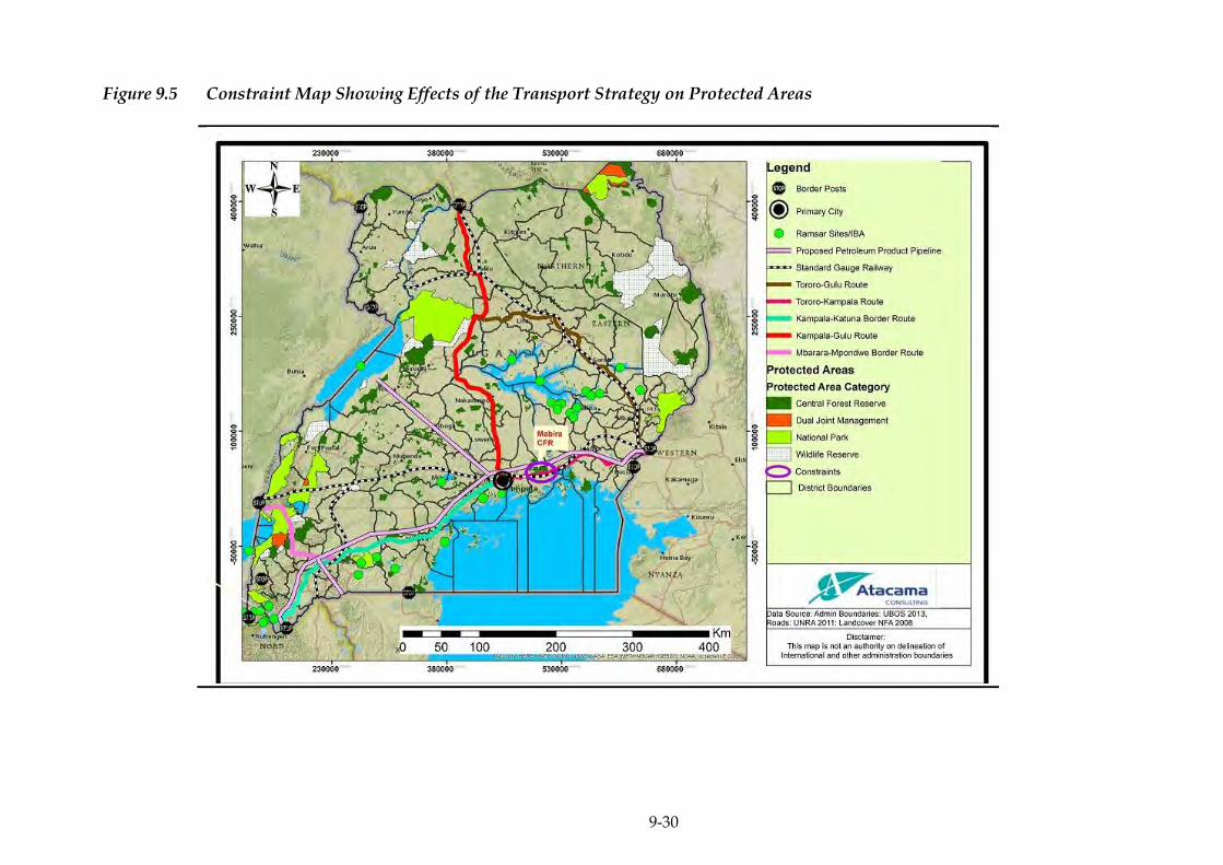
9-30
Figure 9.5 Constraint Map Showing Effects of the Transport Strategy on Protected Areas

9-31
Figure 9.6 Constraint Map Showing Protected Areas in Reference to Proposed Reduction of Bottlenecks
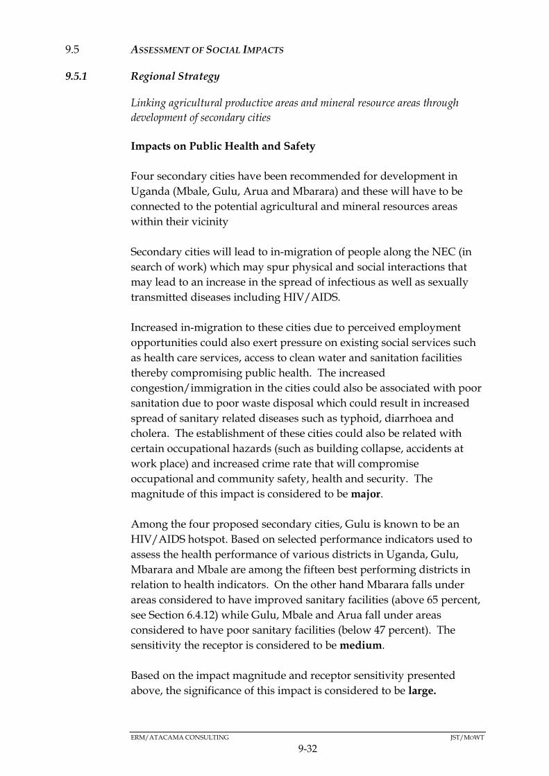
ERM/ATACAMA CONSULTING JST/MOWT
9-32
ASSESSMENT OF SOCIAL IMPACTS 9.5
9.5.1 Regional Strategy
Linking agricultural productive areas and mineral resource areas through
development of secondary cities
Impacts on Public Health and Safety
Four secondary cities have been recommended for development in
Uganda (Mbale, Gulu, Arua and Mbarara) and these will have to be
connected to the potential agricultural and mineral resources areas
within their vicinity
Secondary cities will lead to in-migration of people along the NEC (in
search of work) which may spur physical and social interactions that
may lead to an increase in the spread of infectious as well as sexually
transmitted diseases including HIV/AIDS.
Increased in-migration to these cities due to perceived employment
opportunities could also exert pressure on existing social services such
as health care services, access to clean water and sanitation facilities
thereby compromising public health. The increased
congestion/immigration in the cities could also be associated with poor
sanitation due to poor waste disposal which could result in increased
spread of sanitary related diseases such as typhoid, diarrhoea and
cholera. The establishment of these cities could also be related with
certain occupational hazards (such as building collapse, accidents at
work place) and increased crime rate that will compromise
occupational and community safety, health and security. The
magnitude of this impact is considered to be major.
Among the four proposed secondary cities, Gulu is known to be an
HIV/AIDS hotspot. Based on selected performance indicators used to
assess the health performance of various districts in Uganda, Gulu,
Mbarara and Mbale are among the fifteen best performing districts in
relation to health indicators. On the other hand Mbarara falls under
areas considered to have improved sanitary facilities (above 65 percent,
see Section 6.4.12) while Gulu, Mbale and Arua fall under areas
considered to have poor sanitary facilities (below 47 percent). The
sensitivity the receptor is considered to be medium.
Based on the impact magnitude and receptor sensitivity presented
above, the significance of this impact is considered to be large.
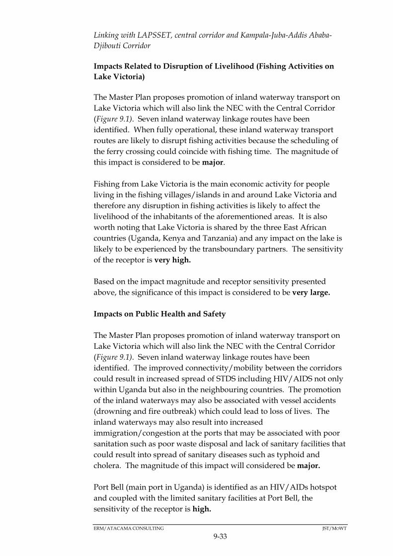
ERM/ATACAMA CONSULTING JST/MOWT
9-33
Linking with LAPSSET, central corridor and Kampala-Juba-Addis Ababa-
Djibouti Corridor
Impacts Related to Disruption of Livelihood (Fishing Activities on
Lake Victoria)
The Master Plan proposes promotion of inland waterway transport on
Lake Victoria which will also link the NEC with the Central Corridor
(Figure 9.1). Seven inland waterway linkage routes have been
identified. When fully operational, these inland waterway transport
routes are likely to disrupt fishing activities because the scheduling of
the ferry crossing could coincide with fishing time. The magnitude of
this impact is considered to be major.
Fishing from Lake Victoria is the main economic activity for people
living in the fishing villages/islands in and around Lake Victoria and
therefore any disruption in fishing activities is likely to affect the
livelihood of the inhabitants of the aforementioned areas. It is also
worth noting that Lake Victoria is shared by the three East African
countries (Uganda, Kenya and Tanzania) and any impact on the lake is
likely to be experienced by the transboundary partners. The sensitivity
of the receptor is very high.
Based on the impact magnitude and receptor sensitivity presented
above, the significance of this impact is considered to be very large.
Impacts on Public Health and Safety
The Master Plan proposes promotion of inland waterway transport on
Lake Victoria which will also link the NEC with the Central Corridor
(Figure 9.1). Seven inland waterway linkage routes have been
identified. The improved connectivity/mobility between the corridors
could result in increased spread of STDS including HIV/AIDS not only
within Uganda but also in the neighbouring countries. The promotion
of the inland waterways may also be associated with vessel accidents
(drowning and fire outbreak) which could lead to loss of lives. The
inland waterways may also result into increased
immigration/congestion at the ports that may be associated with poor
sanitation such as poor waste disposal and lack of sanitary facilities that
could result into spread of sanitary diseases such as typhoid and
cholera. The magnitude of this impact will considered be major.
Port Bell (main port in Uganda) is identified as an HIV/AIDs hotspot
and coupled with the limited sanitary facilities at Port Bell, the
sensitivity of the receptor is high.

ERM/ATACAMA CONSULTING JST/MOWT
9-34
Based on the impact magnitude and receptor sensitivity presented
above, the significance of this impact is considered to be very large.
9.5.2 Industrial Strategy
Establishment of logistic hubs with Inland Container Depots (ICD) and
Logistics Centre
Impacts Related to Land Take and Disruption of Livelihoods
Five potential locations for logistics hubs have been recommended for
development. These are:
i. Tororo logistics hub: This will be 56,000m2 and it is currently under
consideration;
ii. Jinja logistics hub: This will be 163,000m2 and currently, the railway
terminal for the Metre Gauge Railway (MGR) has already been
completed;
iii. Kampala logistics hub: This will be 163,000m2 and currently, the
railway terminal for the MGR has already been completed;
iv. Mbarara logistics hub: This will be 340,000m2 and is currently not yet
in plan; and
v. Gulu logistics hub: This will be 95,000m2 and a trade hub concept
has already been proposed by Trade Mark East Africa.
The establishment of the logistics hubs in Tororo, Mbarara and Gulu
will result in the loss of land to the proposed project interventions but it
is not likely to adversely affect livelihood given the proportion of land
that is to be taken. The magnitude of this impact is therefore
considered to be moderate. The areas for which the proposed
interventions have been earmarked are already recognised as key
centres of commerce in Uganda and as such, the proposed activities are
not likely to be inconsistent and so the sensitivity of the receiving
environment is therefore low.
Based on the impact magnitude and receptor sensitivity presented
above, the significance of this impact is considered to be moderate.

ERM/ATACAMA CONSULTING JST/MOWT
9-35
Impacts on Public Health and Safety
As discussed above five potential locations for logistics hubs have been
recommended for development Kampala, Jinja, Tororo, Mbarara and
Gulu.
Establishment of logistic hubs will lead to immigration of people
(especially sex workers and truck drivers that are often associated with
such transport related logistic hubs) into the logistic centres which may
spur physical and social interactions with the local community. This
may lead to an increase in the spread of infectious as well as Sexually
Transmitted Diseases including HIV/AIDS.
The increased in-migration to the logistic hubs as a result of
employment opportunities created by the logistic hubs could
additionally exert pressure on social services such as health care
services, access to clean water and sanitary facilities thereby
compromising public health. Hazardous materials such as fuel,
explosives, hazardous chemicals etc. could be stored in these logistic
hubs. In the event that the integrity of these hazardous substances is
compromised, they could pose a health and safety hazard to
communities living around these logistic hubs. Also, the establishment
of logistic hubs will be related with certain occupational hazards (such
as accidents when undertaking work activities) that have the ability to
compromise workers’ health and safety. The magnitude of this impact
is considered major.
All the towns proposed for location of logistic hubs (Tororo, Kampala,
Mbarara, Jinja and Gulu) are identified as HIV/AIDS hotspot (Section
6.4.9). All the five potential sites for establishment of logistic hubs
(Kampala, Jinja, Tororo, Mbarara and Gulu) were among the top fifteen
best performing districts based on selected performance indicators that
were used to assess the health performance of various districts in
Uganda. Additionally, with regards to access to sanitary facilities,
Mbarara, Kampala, Jinja, have good access to sanitary facilities while,
Mbale and Tororo have moderate access to sanitary facilities while Gulu
has poor access to sanitary facilities. The sensitivity of the receptor is
therefore considered to be medium.
Based on the impact magnitude and receptor sensitivity presented
above, the significance of this impact is considered to be large.
ERM/ATACAMA CONSULTING JST/MOWT
9-36
9.5.3 Transport Strategy
Reduction of bottlenecks of freight traffic and logistics
Impacts on Public Health and Safety
The Master Plan proposes a number of interventions to reduce
bottlenecks of freight traffic along the NEC (see details in Section 9.2.3
above). Although there will be improved traffic flow along the routes,
it could result in high speeding vehicles/trucks along the routes which
could pose a danger of traffic accidents to both the motorists and the
non-motorists.
Additionally, reduction of the bottlenecks will result into increased
mobility (especially of cargo), more job opportunities and in-migration
of people along the NEC (in search of work), which increased in-
migration in search for work is a catalyst for social interactions that
boost prostitution and increase the spread of Sexually Transmitted
Diseases including HIV/AIDS. There are several HIV/AIDS hotspots
along the NEC (Figure 6.10) and hence activities (especially construction
activities) undertaken as part of reduction of bottlenecks of freight
traffic and logistics are likely to increase the spread of HIV/AIDs. Due
to increased mobility, there is a likelihood of increased pressure on
social services such as health services and sanitary facilities and which
increased pressure has the potential of compromising public health.
The magnitude of the impact is considered to be major.
Kampala, Jinja, Mbarara, Mpigi, Masaka, Kabale, Malaba Bugiri, and
Mutukula (which are some of the areas where the projects that will
involve reduction of bottlenecks will be undertaken) are major
HIV/AIDs hotspots (Figure 6.10 in Section 6.4.9).
Additionally, the districts along the Kampala-Katuna border route
(Kampala, Mbarara, Mpigi, and Kabale) fall primarily within areas with
a high record of sanitation facilities. On the other hand, the Tororo-
Gulu (Bugiri and Malaba) fall within a low record of sanitation
facilities. Therefore, the sensitivity of the receptor is considered to be
high.
Based on the impact magnitude and receptor sensitivity presented
above, the significance of this impact is considered to be very large.
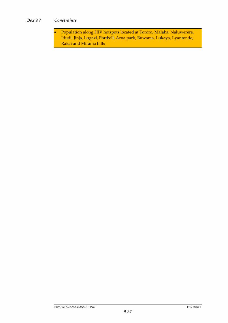
ERM/ATACAMA CONSULTING JST/MOWT
9-37
Box 9.7 Constraints
Population along HIV hotspots located at Tororo, Malaba, Naluwerere,
Idudi, Jinja, Lugazi, Portbell, Arua park, Buwama, Lukaya, Lyantonde,
Rakai and Mirama hills
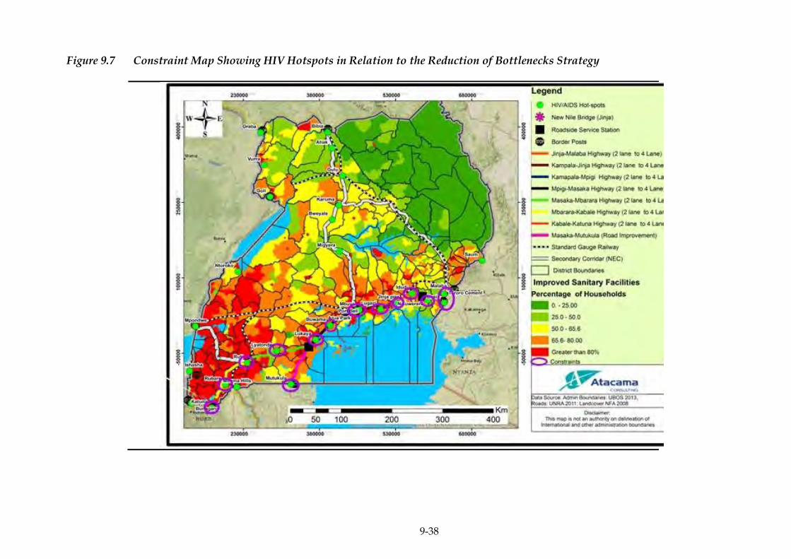
9-38
Figure 9.7 Constraint Map Showing HIV Hotspots in Relation to the Reduction of Bottlenecks Strategy
ERM/ATACAMA CONSULTING JST/MOWT
9-39
CUMULATIVE IMPACTS 9.6
Cumulative impacts are changes to the environment that are caused by
an action in combination with other past, present and future human
actions.
Cumulative Impact Assessment is a systematic procedure for
identifying and evaluating the significance of impacts from multiple
activities.
Specifically, Cumulative Impact Assessments (CIA) are typically
expected to:
Assess impacts over a larger ( ie “regional") area that may cross
jurisdictional boundaries (includes impacts due to natural
perturbations affecting environmental components and human
actions);
Assess impacts during a longer period of time into the past and
future;
Consider impacts on Valued Ecosystem Components (VECs) due to
interactions with other actions, and not just the impacts of the single
action under review;
Include other past, existing and future ( eg, reasonably foreseeable)
actions; and
Evaluate significance in consideration of other, than just local, direct
impacts.
Cumulative impacts are not necessarily that much different from the
impacts of a single plan/programme/project, in fact, they may be the
same.
Cumulative impacts therefore do not necessarily require mitigation
measures different from the ones required to reduce the impact of a
single plan/programme/project.
ERM/ATACAMA CONSULTING JST/MOWT
9-40
9.6.1 CIA Approach and Methodology
There are many definitions for cumulative impacts as well as
Cumulative Impact Assessment and management (CIA); however, the
one used in the guidelines for Cumulative Effects Assessment in SEA of
Plans (Cooper, 2004)1 has been adopted in this assessment.
According to these guidelines, cumulative impacts2 are “the net result of
environmental impact from a number of projects and activities”. On the other
hand, Cumulative impact assessment is “a systematic procedure for
identifying and evaluating the significance of impacts from multiple
activities.” The analysis of the causes, pathways and consequences of
these impacts is an essential part of the process.
With reference to development plans, cumulative impacts can occur
from the combined impacts of policies and proposals on specific areas
or sensitive receptors.
Cumulative impacts of the NEC Logistics Master Plan can be
considered based on the following perspectives:
Cumulative impacts from the combined actions of a wider range of
interventions on the Master Plan; and
Cumulative impacts from different interventions or actions within
the Master Plan.
Please note the following, about the current cumulative impacts
assessment:-
* Determination of impact magnitude for the cumulative impacts:
For impacts whose significance had been preliminarily determined to
be major negative (see Section 9.1 above) and which impacts were
therefore, further assessed under Sections 9.2 to 9.4, their individual
magnitude as indicated under each strategy option in the cumulative
impacts tables was similar to that already determined under the afore-
mentioned sections.
1 Cooper, L. M. (2004), Guidelines for Cumulative Effects Assessment in SEA of Plans, EPMG
Occasional Paper 04/LMC/CEA, Imperial College London 2 In the the guidelines for Cumulative Effects Assessment in SEA of plans (Cooper, 2004), the
word effects is used instead of impacts.
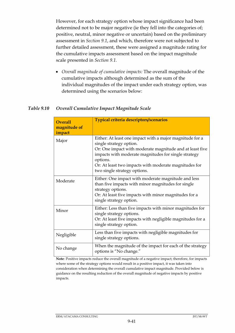
ERM/ATACAMA CONSULTING JST/MOWT
9-41
However, for each strategy option whose impact significance had been
determined not to be major negative (ie they fell into the categories of;
positive, neutral, minor negative or uncertain) based on the preliminary
assessment in Section 9.1, and which, therefore were not subjected to
further detailed assessment, these were assigned a magnitude rating for
the cumulative impacts assessment based on the impact magnitude
scale presented in Section 9.1.
Overall magnitude of cumulative impacts: The overall magnitude of the
cumulative impacts although determined as the sum of the
individual magnitudes of the impact under each strategy option, was
determined using the scenarios below:
Table 9.10 Overall Cumulative Impact Magnitude Scale
Overall magnitude of impact
Typical criteria descriptors/scenarios
Major Either: At least one impact with a major magnitude for a single strategy option. Or: One impact with moderate magnitude and at least five impacts with moderate magnitudes for single strategy options. Or: At least two impacts with moderate magnitudes for two single strategy options.
Moderate Either: One impact with moderate magnitude and less than five impacts with minor magnitudes for single strategy options. Or: At least five impacts with minor magnitudes for a single strategy option.
Minor Either: Less than five impacts with minor magnitudes for single strategy options. Or: At least five impacts with negligible magnitudes for a single strategy option.
Negligible Less than five impacts with negligible magnitudes for single strategy options.
No change When the magnitude of the impact for each of the strategy options is “No change.”
Note: Positive impacts reduce the overall magnitude of a negative impact; therefore, for impacts
where some of the strategy options would result in a positive impact, it was taken into
consideration when determining the overall cumulative impact magnitude. Provided below is
guidance on the resulting reduction of the overall magnitude of negative impacts by positive
impacts.
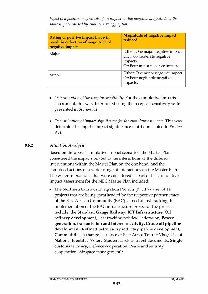
ERM/ATACAMA CONSULTING JST/MOWT
9-42
Effect of a positive magnitude of an impact on the negative magnitude of the
same impact caused by another strategy option
Rating of positive impact that will result in reduction of magnitude of negative impact
Magnitude of negative impact reduced
Major Either: One major negative impact. Or: Two moderate negative impacts. Or: Four minor negative impacts.
Minor Either: One minor negative impact. Or: Four negligible negative impacts.
Determination of the receptor sensitivity: For the cumulative impacts
assessment, this was determined using the receptor sensitivity scale
presented in Section 9.1.
Determination of impact significance for the cumulative impacts: This was
determined using the impact significance matrix presented in Section
9.1).
9.6.2 Situation Analysis
Based on the above cumulative impact scenarios, the Master Plan
considered the impacts related to the interactions of the different
interventions within the Master Plan on the one hand, and the
combined actions of a wider range of interactions on the Master Plan.
The wider interactions that were considered as part of the cumulative
impact assessment for the NEC Master Plan included:
The Northern Corridor Integration Projects (NCIP) - a set of 14
projects that are being spearheaded by the respective partner states
of the East African Community (EAC) aimed at fast tracking the
implementation of the EAC infrastructure projects. The projects
include; the Standard Gauge Railway, ICT Infrastructure, Oil
refinery development, Fast tracking political Federation, Power
generation, transmission and interconnectivity, Crude oil pipeline
development, Refined petroleum products pipeline development,
Commodities exchange, Issuance of East Africa Tourist Visa/ Use of
National Identity/ Voter/ Student cards as travel documents, Single
customs territory, Defence cooperation, Peace and security
cooperation, Airspace management);

ERM/ATACAMA CONSULTING JST/MOWT
9-43
The Vision 2040 - conceptualised around strengthening the
fundamentals of the Ugandan economy to harness the abundant
opportunities around the country. The opportunities include; oil
and gas, tourism, minerals, ICT business, abundant labour force,
geographical location and trade, water resources, industrialisation,
and agriculture, and, the fundamentals include: infrastructure for
(energy, transport, water, oil and gas and ICT); Science, Technology,
Engineering and Innovation (STEI); land; urban development;
human resource; and peace, security and defence; and
The second National Development Plan (NDP II) - designed to
propel Uganda towards middle income status by 2020, in line with
the aspirations of Uganda’s Vision 2040. This Plan aims at
strengthening Uganda’s competitiveness for sustainable wealth
creation, employment and inclusive growth. It prioritises investment
in five (5) areas with the greatest multiplier effect on the economy;
Agriculture, Tourism, Minerals, oil and gas, Infrastructure
development, and Human capital development.
N.B: Please note that in each of the PPPs outlined above, the projects/
PPPs indicated in bold are also included in the NEC Master Plan ie
these actions are aimed at promoting developments within the
Northern Corridor and are already also an integral part of the NEC
Master Plan’s interventions. Therefore, even if the NEC Master Plan is
not implemented but the PPPs indicated in bold above, are
implemented, for example the NCIP or Vision 2040, the impacts
associated with these PPPs would still be manifested. However, even if
the Master Plan is implemented in addition to the implementation of
the other PPPs, the impacts associated with the projects indicated in
bold would still be manifested, but only once, as there would be no
cumulative impacts associated with the implementation of these since
they are essentially the same projects referred to by the PPPs under
consideration. In other words, the NEC Master Plan complements
other existing PPPs (in particular NCIP and Vision 2040) and its full
implementation will result in implementation/realisation of some of
the other projects (indicated in bold) under already existing PPPs.
9.6.3 Cumulative Impact assessment
Based on the above, the following cumulative impacts were identified.
(a) Impacts due to interactions of different interventions within the Master Plan
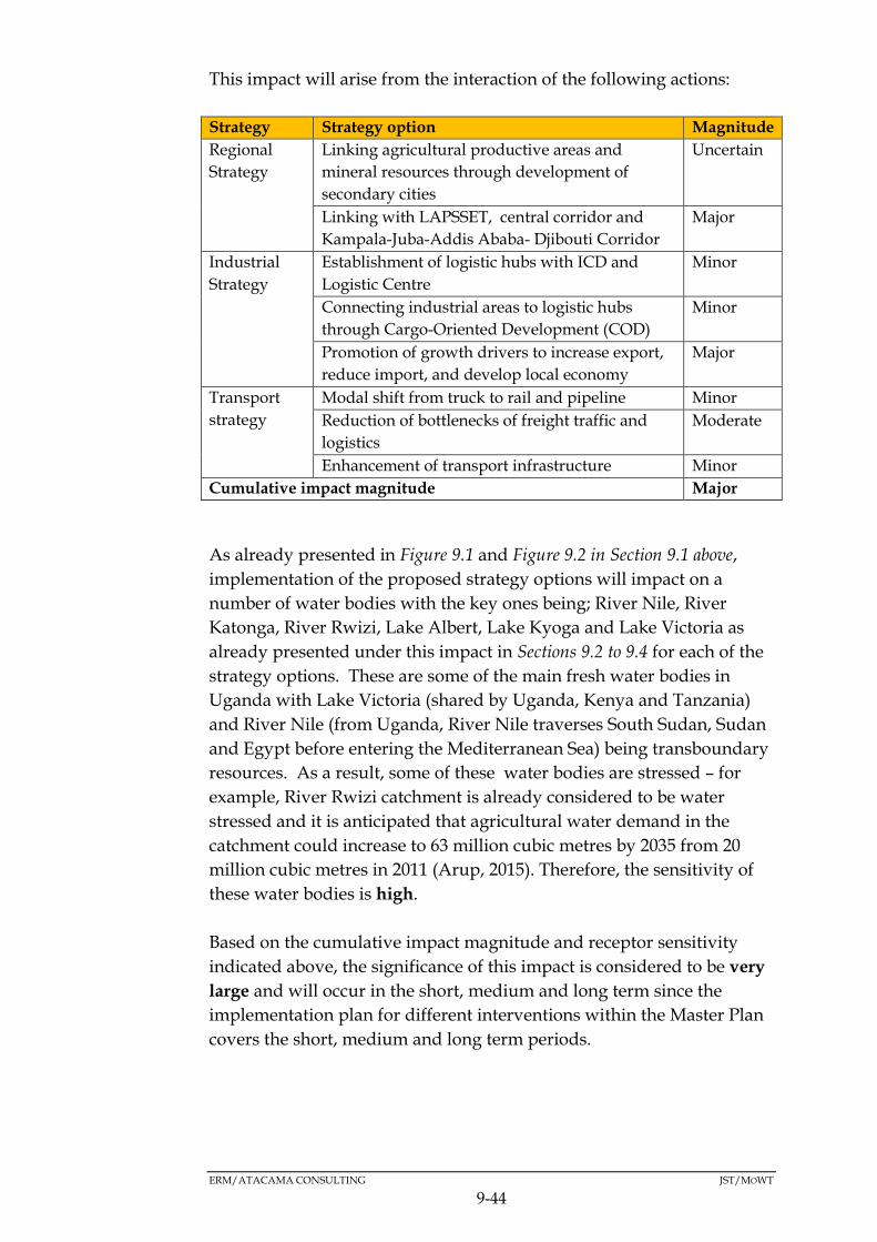
ERM/ATACAMA CONSULTING JST/MOWT
9-44
This impact will arise from the interaction of the following actions:
Strategy Strategy option Magnitude
Regional
Strategy
Linking agricultural productive areas and
mineral resources through development of
secondary cities
Uncertain
Linking with LAPSSET, central corridor and
Kampala-Juba-Addis Ababa- Djibouti Corridor
Major
Industrial
Strategy
Establishment of logistic hubs with ICD and
Logistic Centre
Minor
Connecting industrial areas to logistic hubs
through Cargo-Oriented Development (COD)
Minor
Promotion of growth drivers to increase export,
reduce import, and develop local economy
Major
Transport
strategy
Modal shift from truck to rail and pipeline Minor
Reduction of bottlenecks of freight traffic and
logistics
Moderate
Enhancement of transport infrastructure Minor
Cumulative impact magnitude Major
As already presented in Figure 9.1 and Figure 9.2 in Section 9.1 above,
implementation of the proposed strategy options will impact on a
number of water bodies with the key ones being; River Nile, River
Katonga, River Rwizi, Lake Albert, Lake Kyoga and Lake Victoria as
already presented under this impact in Sections 9.2 to 9.4 for each of the
strategy options. These are some of the main fresh water bodies in
Uganda with Lake Victoria (shared by Uganda, Kenya and Tanzania)
and River Nile (from Uganda, River Nile traverses South Sudan, Sudan
and Egypt before entering the Mediterranean Sea) being transboundary
resources. As a result, some of these water bodies are stressed – for
example, River Rwizi catchment is already considered to be water
stressed and it is anticipated that agricultural water demand in the
catchment could increase to 63 million cubic metres by 2035 from 20
million cubic metres in 2011 (Arup, 2015). Therefore, the sensitivity of
these water bodies is high.
Based on the cumulative impact magnitude and receptor sensitivity
indicated above, the significance of this impact is considered to be very
large and will occur in the short, medium and long term since the
implementation plan for different interventions within the Master Plan
covers the short, medium and long term periods.
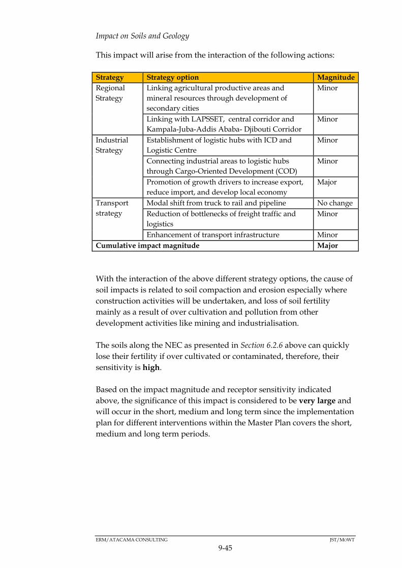
ERM/ATACAMA CONSULTING JST/MOWT
9-45
Impact on Soils and Geology
This impact will arise from the interaction of the following actions:
Strategy Strategy option Magnitude
Regional
Strategy
Linking agricultural productive areas and
mineral resources through development of
secondary cities
Minor
Linking with LAPSSET, central corridor and
Kampala-Juba-Addis Ababa- Djibouti Corridor
Minor
Industrial
Strategy
Establishment of logistic hubs with ICD and
Logistic Centre
Minor
Connecting industrial areas to logistic hubs
through Cargo-Oriented Development (COD)
Minor
Promotion of growth drivers to increase export,
reduce import, and develop local economy
Major
Transport
strategy
Modal shift from truck to rail and pipeline No change
Reduction of bottlenecks of freight traffic and
logistics
Minor
Enhancement of transport infrastructure Minor
Cumulative impact magnitude Major
With the interaction of the above different strategy options, the cause of
soil impacts is related to soil compaction and erosion especially where
construction activities will be undertaken, and loss of soil fertility
mainly as a result of over cultivation and pollution from other
development activities like mining and industrialisation.
The soils along the NEC as presented in Section 6.2.6 above can quickly
lose their fertility if over cultivated or contaminated, therefore, their
sensitivity is high.
Based on the impact magnitude and receptor sensitivity indicated
above, the significance of this impact is considered to be very large and
will occur in the short, medium and long term since the implementation
plan for different interventions within the Master Plan covers the short,
medium and long term periods.
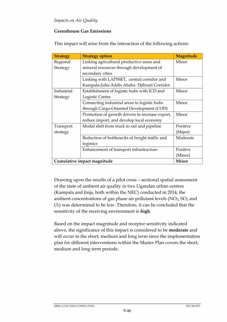
ERM/ATACAMA CONSULTING JST/MOWT
9-46
Impacts on Air Quality
Greenhouse Gas Emissions
This impact will arise from the interaction of the following actions:
Strategy Strategy option Magnitude
Regional
Strategy
Linking agricultural productive areas and
mineral resources through development of
secondary cities
Minor
Linking with LAPSSET, central corridor and
Kampala-Juba-Addis Ababa- Djibouti Corridor
Minor
Industrial
Strategy
Establishment of logistic hubs with ICD and
Logistic Centre
Minor
Connecting industrial areas to logistic hubs
through Cargo-Oriented Development (COD)
Minor
Promotion of growth drivers to increase export,
reduce import, and develop local economy
Minor
Transport
strategy
Modal shift from truck to rail and pipeline Positive
(Major)
Reduction of bottlenecks of freight traffic and
logistics
Moderate
Enhancement of transport infrastructure Positive
(Minor)
Cumulative impact magnitude Minor
Drawing upon the results of a pilot cross – sectional spatial assessment
of the state of ambient air quality in two Ugandan urban centres
(Kampala and Jinja, both within the NEC) conducted in 2014, the
ambient concentrations of gas phase air pollutant levels (NO2, SO2 and
O3) was determined to be low. Therefore, it can be concluded that the
sensitivity of the receiving environment is high.
Based on the impact magnitude and receptor sensitivity indicated
above, the significance of this impact is considered to be moderate and
will occur in the short, medium and long term since the implementation
plan for different interventions within the Master Plan covers the short,
medium and long term periods.

ERM/ATACAMA CONSULTING JST/MOWT
9-47
Dust Emissions
This impact will arise from the interaction of the following actions:
Strategy Strategy option Magnitude
Regional
Strategy
Linking agricultural productive areas and
mineral resources through development of
secondary cities
Minor
Linking with LAPSSET, central corridor and
Kampala-Juba-Addis Ababa- Djibouti Corridor
Minor
Industrial
Strategy
Establishment of logistic hubs with ICD and
Logistic Centre
Minor
Connecting industrial areas to logistic hubs
through Cargo-Oriented Development (COD)
Minor
Promotion of growth drivers to increase export,
reduce import, and develop local economy
Minor
Transport
strategy
Modal shift from truck to rail and pipeline Positive
(Major)
Reduction of bottlenecks of freight traffic and
logistics
Moderate
Enhancement of transport infrastructure Positive
(Minor)
Cumulative impact magnitude Minor
Drawing on the results of a pilot cross – sectional spatial assessment of
the state of ambient air quality in two Ugandan urban centres (Kampala
and Jinja, both within the NEC) conducted in 2014, the ambient
concentrations of Particulate Matter (PM) was determined to be high.
Given the large concentration of populations along the NEC by way of
settlements/small urban centres especially along roads where
construction activities are proposed, increased dust emissions may pose
a nuisance to the local community members. Therefore, it can be
concluded that the sensitivity of the receiving environment is high.
Based on the impact magnitude and receptor sensitivity indicated
above, the significance of this impact is considered to be moderate and
will occur in the short, medium and long term since the implementation
plan for different interventions within the Master Plan covers the short,
medium and long term periods

ERM/ATACAMA CONSULTING JST/MOWT
9-48
Noise and Vibration Impact
This impact will arise from the interaction of the following actions:
Strategy Strategy option Magnitude
Regional
Strategy
Linking agricultural productive areas and
mineral resources through development of
secondary cities
Minor
Linking with LAPSSET, central corridor and
Kampala-Juba-Addis Ababa- Djibouti Corridor
Minor
Industrial
Strategy
Establishment of logistic hubs with ICD and
Logistic Centre
Minor
Connecting industrial areas to logistic hubs
through Cargo-Oriented Development (COD)
Minor
Promotion of growth drivers to increase export,
reduce import, and develop local economy
Minor
Transport
strategy
Modal shift from truck to rail and pipeline Minor
Reduction of bottlenecks of freight traffic and
logistics
Moderate
Enhancement of transport infrastructure Positive
(Minor)
Cumulative impact magnitude Moderate
Noise emissions interfere with people’s communication in addition to
being a nuisance. Noise emissions will further be of great concern if
activities are taking place near social/communal facilities like places of
worship, schools and hospitals where the sensitivity of the receptor is
high.
Based on the impact magnitude and receptor sensitivity indicated
above, the significance of this impact is considered to be large and will
occur in the short, medium and long term since the implementation
plan for different interventions within the Master Plan covers the short,
medium and long term periods.
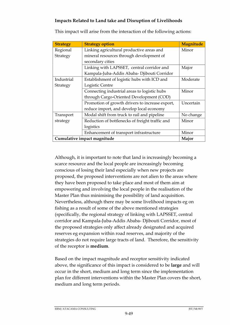
ERM/ATACAMA CONSULTING JST/MOWT
9-49
Impacts Related to Land take and Disruption of Livelihoods
This impact will arise from the interaction of the following actions:
Strategy Strategy option Magnitude
Regional
Strategy
Linking agricultural productive areas and
mineral resources through development of
secondary cities
Minor
Linking with LAPSSET, central corridor and
Kampala-Juba-Addis Ababa- Djibouti Corridor
Major
Industrial
Strategy
Establishment of logistic hubs with ICD and
Logistic Centre
Moderate
Connecting industrial areas to logistic hubs
through Cargo-Oriented Development (COD)
Minor
Promotion of growth drivers to increase export,
reduce import, and develop local economy
Uncertain
Transport
strategy
Modal shift from truck to rail and pipeline No change
Reduction of bottlenecks of freight traffic and
logistics
Minor
Enhancement of transport infrastructure Minor
Cumulative impact magnitude Major
Although, it is important to note that land is increasingly becoming a
scarce resource and the local people are increasingly becoming
conscious of losing their land especially when new projects are
proposed, the proposed interventions are not alien to the areas where
they have been proposed to take place and most of them aim at
empowering and involving the local people in the realisation of the
Master Plan thus minimising the possibility of land acquisition.
Nevertheless, although there may be some livelihood impacts eg on
fishing as a result of some of the above mentioned strategies
(specifically, the regional strategy of linking with LAPSSET, central
corridor and Kampala-Juba-Addis Ababa- Djibouti Corridor, most of
the proposed strategies only affect already designated and acquired
reserves eg expansion within road reserves, and majority of the
strategies do not require large tracts of land. Therefore, the sensitivity
of the receptor is medium.
Based on the impact magnitude and receptor sensitivity indicated
above, the significance of this impact is considered to be large and will
occur in the short, medium and long term since the implementation
plan for different interventions within the Master Plan covers the short,
medium and long term periods.

ERM/ATACAMA CONSULTING JST/MOWT
9-50
Impacts on Public Health and Safety
This impact will arise from the interaction of the following actions:
Strategy Strategy option Magnitude
Regional
Strategy
Linking agricultural productive areas and
mineral resources through development of
secondary cities
Major
Linking with LAPSSET, central corridor and
Kampala-Juba-Addis Ababa- Djibouti Corridor
Major
Industrial
Strategy
Establishment of logistic hubs with ICD and
Logistic Centre
Major
Connecting industrial areas to logistic hubs
through Cargo-Oriented Development (COD)
Minor
Promotion of growth drivers to increase export,
reduce import, and develop local economy
Minor
Transport
strategy
Modal shift from truck to rail and pipeline Positive
(Major)
Reduction of bottlenecks of freight traffic and
logistics
Major
Enhancement of transport infrastructure Positive
(Minor)
Cumulative impact magnitude Moderate
Health issues and in particular HIV/AIDS are of concern along the
NEC. For example, Kampala, Jinja, Mbarara, Mpigi, Masaka, Kabale,
Malaba, Bugiri, and Mutukula (which are all along the NEC) are major
HIV/AIDS hotspots (refer to Figure 6.10 in Section 6.4.9 above).
Additionally, the districts along Tororo-Gulu route fall within an area
with a low record of sanitation facilities. Therefore, the sensitivity of the
receptor is considered to be high.
Based on the impact magnitude and receptor sensitivity indicated
above, the significance of this impact is considered to be large and will
occur in the short, medium and long term since the implementation
plan for different interventions within the Master Plan covers the short,
medium and long term periods.
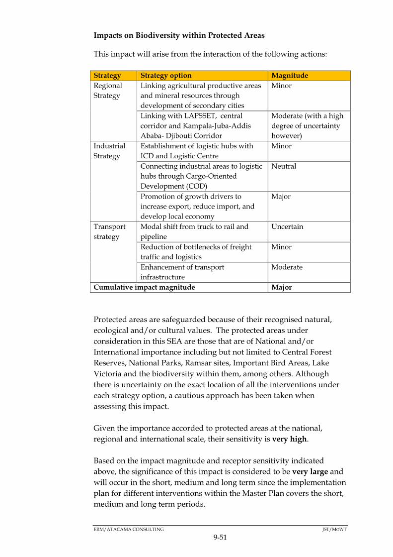
ERM/ATACAMA CONSULTING JST/MOWT
9-51
Impacts on Biodiversity within Protected Areas
This impact will arise from the interaction of the following actions:
Strategy Strategy option Magnitude
Regional
Strategy
Linking agricultural productive areas
and mineral resources through
development of secondary cities
Minor
Linking with LAPSSET, central
corridor and Kampala-Juba-Addis
Ababa- Djibouti Corridor
Moderate (with a high
degree of uncertainty
however)
Industrial
Strategy
Establishment of logistic hubs with
ICD and Logistic Centre
Minor
Connecting industrial areas to logistic
hubs through Cargo-Oriented
Development (COD)
Neutral
Promotion of growth drivers to
increase export, reduce import, and
develop local economy
Major
Transport
strategy
Modal shift from truck to rail and
pipeline
Uncertain
Reduction of bottlenecks of freight
traffic and logistics
Minor
Enhancement of transport
infrastructure
Moderate
Cumulative impact magnitude Major
Protected areas are safeguarded because of their recognised natural,
ecological and/or cultural values. The protected areas under
consideration in this SEA are those that are of National and/or
International importance including but not limited to Central Forest
Reserves, National Parks, Ramsar sites, Important Bird Areas, Lake
Victoria and the biodiversity within them, among others. Although
there is uncertainty on the exact location of all the interventions under
each strategy option, a cautious approach has been taken when
assessing this impact.
Given the importance accorded to protected areas at the national,
regional and international scale, their sensitivity is very high.
Based on the impact magnitude and receptor sensitivity indicated
above, the significance of this impact is considered to be very large and
will occur in the short, medium and long term since the implementation
plan for different interventions within the Master Plan covers the short,
medium and long term periods.

ERM/ATACAMA CONSULTING JST/MOWT
9-52
Visual Intrusion
This impact will arise from the interaction of the following actions:
Strategy Strategy option Magnitude
Regional
Strategy
Linking agricultural productive areas and
mineral resources through development of
secondary cities
Minor
Linking with LAPSSET, central corridor and
Kampala-Juba-Addis Ababa- Djibouti Corridor
Minor
Industrial
Strategy
Establishment of logistic hubs with ICD and
Logistic Centre
Minor
Connecting industrial areas to logistic hubs
through Cargo-Oriented Development (COD)
Minor
Promotion of growth drivers to increase export,
reduce import, and develop local economy
Minor
Transport
strategy
Modal shift from truck to rail and pipeline Minor
Reduction of bottlenecks of freight traffic and
logistics
Minor
Enhancement of transport infrastructure Uncertain
Cumulative impact magnitude Minor
The cause of this impact will be from the establishment of development
infrastructure associated with implementation of the Master Plan due to
each of the above strategy options. However, with the exception of a
few transport routes which will traverse protected areas where the
current land use (mainly tourism activities) is largely dependent on
visual aesthetics, most of the proposed infrastructure will be in areas
where the current land use does not largely depend on visual aesthetics.
Therefore, the overall sensitivity of the receptor is low.
Based on the impact magnitude and receptor sensitivity indicated
above, the significance of this impact is considered to be slight and will
occur in the short, medium and long term since the implementation
plan for different interventions within the Master Plan covers the short,
medium and long term periods.
Impact Due to Combined Actions of a Wider Range Of Interventions
Generally, as described in Section 9.5.2 above, all the proposed projects in
Uganda’s Vision 2040 and the Northern Corridor Integrated Projects
(NCIP) that have the potential to cause environmental and social
impacts are also included in the Master Plan.
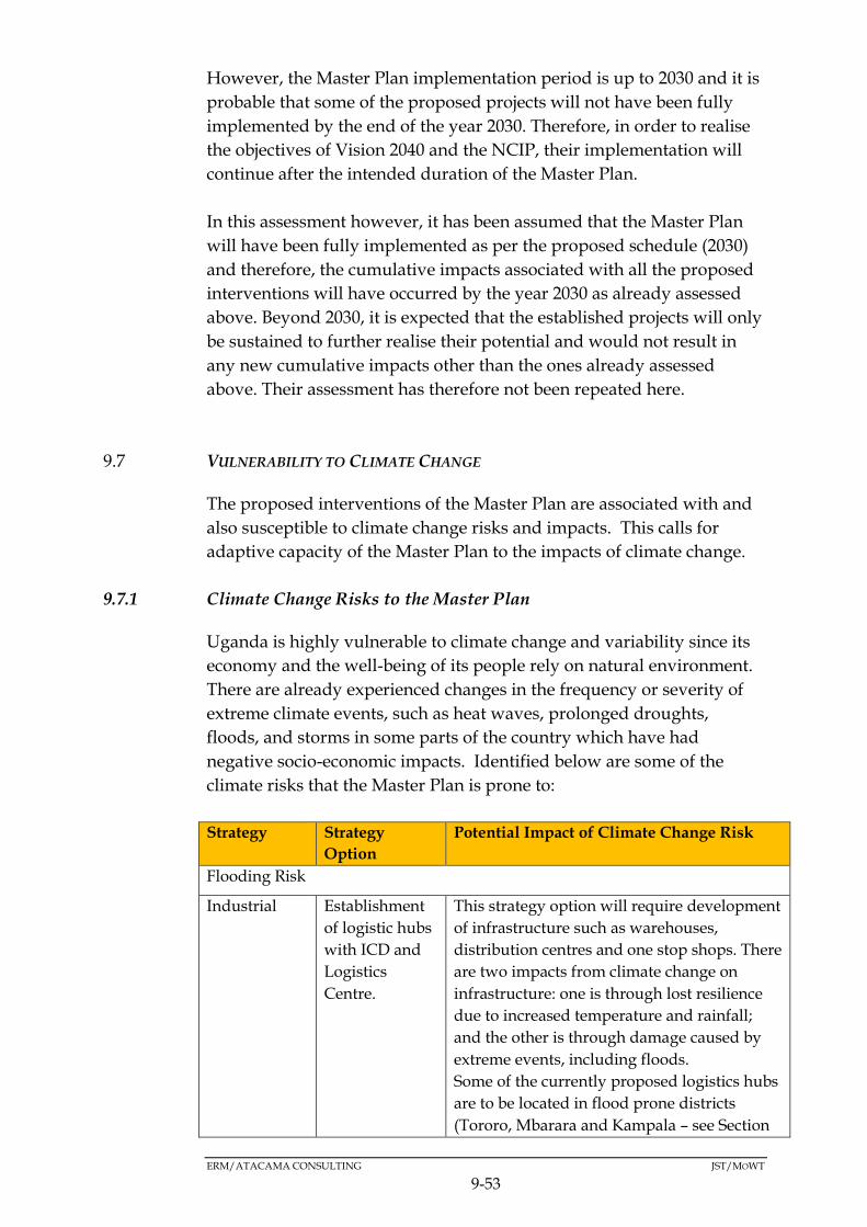
ERM/ATACAMA CONSULTING JST/MOWT
9-53
However, the Master Plan implementation period is up to 2030 and it is
probable that some of the proposed projects will not have been fully
implemented by the end of the year 2030. Therefore, in order to realise
the objectives of Vision 2040 and the NCIP, their implementation will
continue after the intended duration of the Master Plan.
In this assessment however, it has been assumed that the Master Plan
will have been fully implemented as per the proposed schedule (2030)
and therefore, the cumulative impacts associated with all the proposed
interventions will have occurred by the year 2030 as already assessed
above. Beyond 2030, it is expected that the established projects will only
be sustained to further realise their potential and would not result in
any new cumulative impacts other than the ones already assessed
above. Their assessment has therefore not been repeated here.
VULNERABILITY TO CLIMATE CHANGE 9.7
The proposed interventions of the Master Plan are associated with and
also susceptible to climate change risks and impacts. This calls for
adaptive capacity of the Master Plan to the impacts of climate change.
9.7.1 Climate Change Risks to the Master Plan
Uganda is highly vulnerable to climate change and variability since its
economy and the well-being of its people rely on natural environment.
There are already experienced changes in the frequency or severity of
extreme climate events, such as heat waves, prolonged droughts,
floods, and storms in some parts of the country which have had
negative socio-economic impacts. Identified below are some of the
climate risks that the Master Plan is prone to:
Strategy Strategy
Option
Potential Impact of Climate Change Risk
Flooding Risk
Industrial Establishment
of logistic hubs
with ICD and
Logistics
Centre.
This strategy option will require development
of infrastructure such as warehouses,
distribution centres and one stop shops. There
are two impacts from climate change on
infrastructure: one is through lost resilience
due to increased temperature and rainfall;
and the other is through damage caused by
extreme events, including floods.
Some of the currently proposed logistics hubs
are to be located in flood prone districts
(Tororo, Mbarara and Kampala – see Section

ERM/ATACAMA CONSULTING JST/MOWT
9-54
Strategy Strategy
Option
Potential Impact of Climate Change Risk
5.1.4 and Figure 5.9 in above). For Kampala in
particular, scientific projections of future
climate in the city are imprecise, but suggest
there will be a higher incidence of rainfall,
putting Kampala at risk of flooding.
In addition to the above, since the year 2000,
extreme rainfall conditions have been
regularly experienced in Eastern Uganda
(Tororo, Busia, Bugiri and Mayuge) where
there has been an increase of approximately
1500mm of precipitation during the
December to January rainy season. El Niño–
Southern Oscillation events have also become
shorter and more irregular.
Promotion of
growth drivers
to increase
exports, reduce
imports, and
develop the
local economy.
Necessitates the development of industrial
and mineral resource areas. Agricultural
production areas such as Mbarara and Gulu,
as well as mineral resource areas such as
Kabale and Kasese are located within flood
prone areas.
Transport
strategy
Enhancement
of
infrastructure
These transport options will involve
development of infrastructure such as roads.
Some of these developments will be
undertaken in some of the flood prone areas
such as Kasese, Kampala, Gulu, and Tororo
districts. This renders the development of
infrastructure in such districts vulnerable to
flooding
Reduction of
bottlenecks of
freight traffic
and logistics
Regional
strategy
Linking
agricultural
productive
areas and
mineral
resources
through
development of
secondary cities
The proposed secondary cities include Mbale,
Mbarara, Gulu and Arua. Floods have been
experienced particularly in Mbarara district
and there is a likelihood that they could be
experienced in Gulu. This could present
constraints to the proposed development.
High temperatures and droughts
Industrial Promotion of
growth drivers
to increase
exports, reduce
imports, and
develop the
local economy.
Coffee is identified as one of the products
selected for promotion to increase exports. A
research study conducted by Oxfam (2013)
determined that, climate change will have an
impact on the suitability of Arabica coffee
growing areas in Uganda, including the
Rwenzori Mountains, with most areas
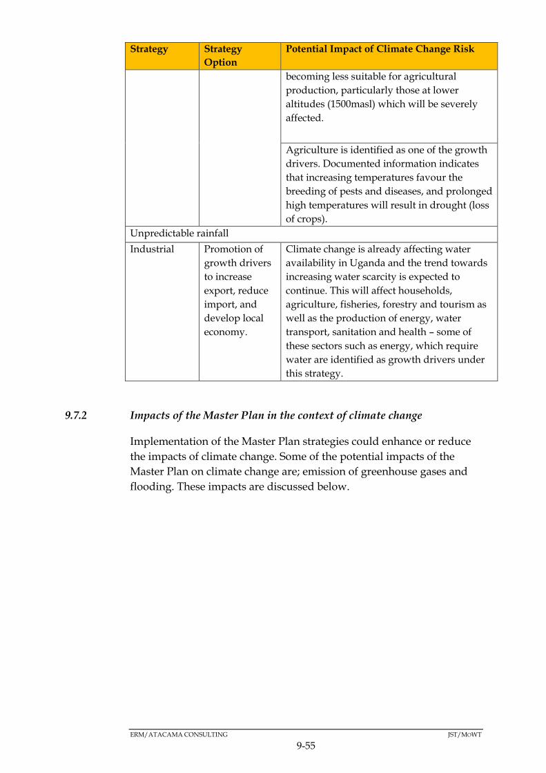
ERM/ATACAMA CONSULTING JST/MOWT
9-55
Strategy Strategy
Option
Potential Impact of Climate Change Risk
becoming less suitable for agricultural
production, particularly those at lower
altitudes (1500masl) which will be severely
affected.
Agriculture is identified as one of the growth
drivers. Documented information indicates
that increasing temperatures favour the
breeding of pests and diseases, and prolonged
high temperatures will result in drought (loss
of crops).
Unpredictable rainfall
Industrial Promotion of
growth drivers
to increase
export, reduce
import, and
develop local
economy.
Climate change is already affecting water
availability in Uganda and the trend towards
increasing water scarcity is expected to
continue. This will affect households,
agriculture, fisheries, forestry and tourism as
well as the production of energy, water
transport, sanitation and health – some of
these sectors such as energy, which require
water are identified as growth drivers under
this strategy.
9.7.2 Impacts of the Master Plan in the context of climate change
Implementation of the Master Plan strategies could enhance or reduce
the impacts of climate change. Some of the potential impacts of the
Master Plan on climate change are; emission of greenhouse gases and
flooding. These impacts are discussed below.

ERM/ATACAMA CONSULTING JST/MOWT
9-56
Greenhouse Gas Emissions
Strategy Option Potential Impact on Climate Change
Transport Modal shift from
truck to rail and
pipeline.
This strategy option will reduce greenhouse
gas emissions in the long term. The trains to
be run on the proposed SGR will be electric
and transportation of oil via pipeline is likely
to require significantly less energy than
trucking or using rail – hence reduced
emissions.
Reduction of
bottlenecks of
freight traffic and
logistics.
This strategy option will increase greenhouse
gas emissions. Removal of bottlenecks will
most likely result in a spike in traffic
volumes, especially road traffic that is
currently constrained by these bottlenecks
which will result in a corresponding increase
in emissions from the increased traffic.
Industrial Promotion of
growth drivers to
increase exports,
reduce imports,
and develop the
local economy.
This strategy option will increase greenhouse
gas emissions as this option is likely to
intensify the supply side of the economy.
Processes associated with the development
and operation of mineral and agricultural
production industries, where GHGs are
emitted, may result in the release of these
emissions into the atmosphere.

ERM/ATACAMA CONSULTING JST/MOWT
9-57
Flooding
Strategy Options Potential Impact on Climate Change
Transport Enhancement
of transport
infrastructure
Development of Paved or impervious
infrastructure is likely to result in increased surface
water runoff, which may lead to flooding in flood
prone areas if the drainage systems associated with
the infrastructures are not properly developed to
contain surface runoff, and prevent flooding.
Reduction of
bottlenecks of
freight traffic
and logistics
Regional Linking
agricultural
productive
areas and
mineral
resources
through
development
of secondary
cities
Development of secondary cities (currently
planned for Mbarara, Gulu, Arua and Mbale) will
result in major infrastructural development that
increase paved surfaces areas – resulting in
increased surface water runoff, which is
exacerbated if drainage systems are not properly
designed, constructed and maintained.
Additionally, development of secondary cities
could encroach on green field sites such as
wetlands which are supposed to regulate water
flow thereby exacerbating the flooding situation.
This is particularly important for Mbarara and
Gulu districts – which are prone to flooding.
Industrial Establishment
of logistic
hubs with
ICD and
Logistic
Centre
Establishment of logistic hubs is likely to result in
an increase in the pave surface area which can also
have an effect on runoff speeds/flooding potential.
9.7.3 Sector Objectives for Climate Change Adaptation Relevant for the
Master Plan
A number of sectors in Uganda have established objectives for climate
change adaptation. These sectors according to Uganda’s Intended
Nationally Determined Contribution (2015) and Uganda’s Climate
Change Policy (2012), are; transport, industry, agriculture, energy, and
water.
Provided below is a summary of the identified sector objectives for
climate change adaptation deemed relevant for the NEC Master Plan.
Please note, that the adaptation measures included below have been
tailored to the currently identified projects under the NEC Master Plan.
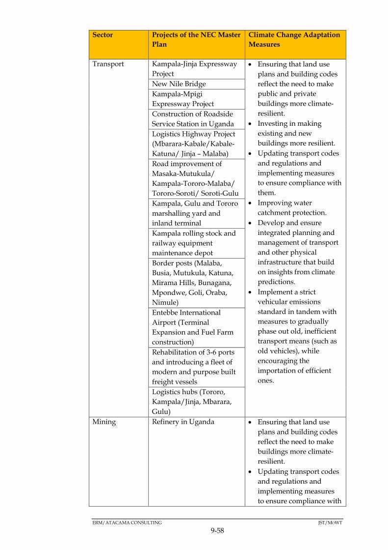
ERM/ATACAMA CONSULTING JST/MOWT
9-58
Sector Projects of the NEC Master
Plan
Climate Change Adaptation
Measures
Transport
Kampala-Jinja Expressway
Project
Ensuring that land use
plans and building codes
reflect the need to make
public and private
buildings more climate-
resilient.
Investing in making
existing and new
buildings more resilient.
Updating transport codes
and regulations and
implementing measures
to ensure compliance with
them.
Improving water
catchment protection.
Develop and ensure
integrated planning and
management of transport
and other physical
infrastructure that build
on insights from climate
predictions.
Implement a strict
vehicular emissions
standard in tandem with
measures to gradually
phase out old, inefficient
transport means (such as
old vehicles), while
encouraging the
importation of efficient
ones.
New Nile Bridge
Kampala-Mpigi
Expressway Project
Construction of Roadside
Service Station in Uganda
Logistics Highway Project
(Mbarara-Kabale/Kabale-
Katuna/ Jinja – Malaba)
Road improvement of
Masaka-Mutukula/
Kampala-Tororo-Malaba/
Tororo-Soroti/ Soroti-Gulu
Kampala, Gulu and Tororo
marshalling yard and
inland terminal
Kampala rolling stock and
railway equipment
maintenance depot
Border posts (Malaba,
Busia, Mutukula, Katuna,
Mirama Hills, Bunagana,
Mpondwe, Goli, Oraba,
Nimule)
Entebbe International
Airport (Terminal
Expansion and Fuel Farm
construction)
Rehabilitation of 3-6 ports
and introducing a fleet of
modern and purpose built
freight vessels
Logistics hubs (Tororo,
Kampala/Jinja, Mbarara,
Gulu)
Mining Refinery in Uganda Ensuring that land use
plans and building codes
reflect the need to make
buildings more climate-
resilient.
Updating transport codes
and regulations and
implementing measures
to ensure compliance with

ERM/ATACAMA CONSULTING JST/MOWT
9-59
Sector Projects of the NEC Master
Plan
Climate Change Adaptation
Measures
them.
Agriculture Agricultural union
commercialization support
program
Expanding Climate Smart
Agriculture (CSA).
Expanding small scale
water infrastructure.
Expanding research on
climate resilient crops and
animal breeds
Expanding extension
services.
Irrigation Scheme
Development project
Fertiliser Promotion
program
Superior seed production
enhancement projects for
small sesame farmers
support
Maize promotion support
program
Specialty coffee export
promotion project
Agriculture
Livestock processed
products promotion
program
Kalangala PPP project
Textile industry promotion
and market diversification
project
Manufacturing Industrial Operational Base
Development Project
Promote new technologies
in manufacturing
industries.
Improve the efficiency of
and alternative fuels used
in manufacturing
industries.
Promote cleaner
production.
Review and enforce
emission regulations in
the sector.
Upgrading of Leather
Industry Supply Chain
Project
ERM/ATACAMA CONSULTING JST/MOWT
9-60
9.7.4 Projections of Climate Change Variability and the Predicted Impacts
Between 2010 and 2050, the demand for water is expected to increase
almost ten-fold (Economic assessment of the impacts of climate change in
Uganda, November 2013).
Droughts are set to become more frequent in the decades ahead. These will
cause water scarcity (each drought lasts for around three years) and the
most hit watersheds will be Lake Victoria, Albert Nile and Lake Kyoga.
Climate change will have a major impact on the production of Uganda’s
leading export crops. In particular, production of Arabica and Robusta
coffee may fall by 50 percent by 2050 due to contraction of the area that can
support its production.
By contrast, climate change impacts on food crops and livestock are
projected to be relatively small – although the specific impacts will vary
from crop to crop.
There will also probably be less potential for hydropower development due
to a reduction in rainfall and water availability. The country will need to
develop alternative energy sources to meet future demand and there is a
major opportunity to develop low-carbon and climate-resilient energy.
Uganda’s infrastructure needs to become more resilient to the effects of the
weather and climate, both current and future. Residential buildings are
most at risk, but transport systems are also likely to be affected.
9.7.5 Impacts of Climate Change on the Feasibility of the Master Plan
Based on the information presented above, climate change is inevitable and
has a potential of affecting the integrity of any development intervention. The
main effect will be prolonged droughts which will ultimately impact on
watersheds including Lake Victoria.
It is therefore pertinent that the following key issue are considered as part of
efforts aimed at ensuring the Master Plans strategies are climate proof:
Construct climate change resilient infrastructure to withstand the effects of
climate change;
Water transport along Lake Victoria should be maximised in the short to
medium term to avoid the predicted consequences of climate change on
this watershed; and

ERM/ATACAMA CONSULTING JST/MOWT
9-61
Climate resilient agriculture should be practiced in the long run since it is
predicted that climate change will affect the productivity of most cash
crops.

9-62
9.7.6 Summary of Impacts
Table 9.11 below provides a summary of the environmental impacts that may occur as a result of the Master Plan
Table 9.11 Summary of the impacts associated with implementation of the Master Plan
Impact Regional Strategy Industrial Strategy Transport Strategy Applicable
constraints Strategy Options
Linking
agricultural
productive
areas and
mineral
resources
areas
through
development
secondary
cities
Linking
with
LAPSSET,
central
corridor
and
Kampala-
Juba-
Addis
Ababa-
Djibouti
Corridor
Establishment
of logistic
hubs with
Inland
Container
Depots (ICD)
and Logistic
Centre
Connecting
industrial
areas to
logistic hubs
through
Cargo-
Oriented
Development
(COD)
Promotion
of growth
drivers to
increase
export,
reduce
import,
and
develop
local
economy
Modal
shift
from
truck to
rail and
pipeline
Reduction
of
bottlenecks
of freight
traffic and
logistics
Enhancement
of transport
infrastructure
Impacts on
the integrity
of water
bodies
Very large Very large Very large Large Rivers; Nile
Katonga,
Rwizi
Lakes; Kyoga,
Victoria,
Albert
Wetlands;
Kibimba,
Northern
shores of Lake
Victoria, Lake
Kyoga
wetlands, Lake
Mburo
wetlands.
Impacts on
soils and
Slight Very large Agricultural
areas
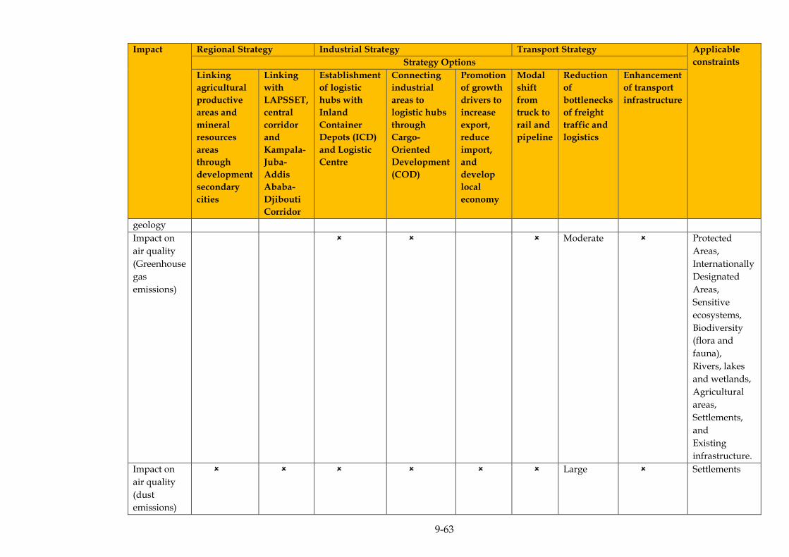
9-63
Impact Regional Strategy Industrial Strategy Transport Strategy Applicable
constraints Strategy Options
Linking
agricultural
productive
areas and
mineral
resources
areas
through
development
secondary
cities
Linking
with
LAPSSET,
central
corridor
and
Kampala-
Juba-
Addis
Ababa-
Djibouti
Corridor
Establishment
of logistic
hubs with
Inland
Container
Depots (ICD)
and Logistic
Centre
Connecting
industrial
areas to
logistic hubs
through
Cargo-
Oriented
Development
(COD)
Promotion
of growth
drivers to
increase
export,
reduce
import,
and
develop
local
economy
Modal
shift
from
truck to
rail and
pipeline
Reduction
of
bottlenecks
of freight
traffic and
logistics
Enhancement
of transport
infrastructure
geology
Impact on
air quality
(Greenhouse
gas
emissions)
Moderate Protected
Areas,
Internationally
Designated
Areas,
Sensitive
ecosystems,
Biodiversity
(flora and
fauna),
Rivers, lakes
and wetlands,
Agricultural
areas,
Settlements,
and
Existing
infrastructure.
Impact on
air quality
(dust
emissions)
Large Settlements

9-64
Impact Regional Strategy Industrial Strategy Transport Strategy Applicable
constraints Strategy Options
Linking
agricultural
productive
areas and
mineral
resources
areas
through
development
secondary
cities
Linking
with
LAPSSET,
central
corridor
and
Kampala-
Juba-
Addis
Ababa-
Djibouti
Corridor
Establishment
of logistic
hubs with
Inland
Container
Depots (ICD)
and Logistic
Centre
Connecting
industrial
areas to
logistic hubs
through
Cargo-
Oriented
Development
(COD)
Promotion
of growth
drivers to
increase
export,
reduce
import,
and
develop
local
economy
Modal
shift
from
truck to
rail and
pipeline
Reduction
of
bottlenecks
of freight
traffic and
logistics
Enhancement
of transport
infrastructure
Noise and
vibration
impacts
Large Settlements
Impacts to
Biodiversity
in Protected
Areas
Very large Very large Very
large
Moderate Large Mabira CFR,
Mpanga CFR,
Moroto CFR,
Murchison
Falls National
Park, Lake
Mburo
National Park,
Kibale
National Park,
Queen
Elizabeth
National park,
Lake Victoria,
IBAs, Ramsar
sites.
Impacts on
public
Health and
Safety
Moderate Very large Large Dense
settlements,
Border points,
and

9-65
Impact Regional Strategy Industrial Strategy Transport Strategy Applicable
constraints Strategy Options
Linking
agricultural
productive
areas and
mineral
resources
areas
through
development
secondary
cities
Linking
with
LAPSSET,
central
corridor
and
Kampala-
Juba-
Addis
Ababa-
Djibouti
Corridor
Establishment
of logistic
hubs with
Inland
Container
Depots (ICD)
and Logistic
Centre
Connecting
industrial
areas to
logistic hubs
through
Cargo-
Oriented
Development
(COD)
Promotion
of growth
drivers to
increase
export,
reduce
import,
and
develop
local
economy
Modal
shift
from
truck to
rail and
pipeline
Reduction
of
bottlenecks
of freight
traffic and
logistics
Enhancement
of transport
infrastructure
Existing
HIV/AIDS
hotspots
Impacts
related to
Land take
and
disruption
of
livelihoods
Very large Moderate Mailo land
owners, and
Customary
land owners.

ERM/ATACAMA CONSULTING JST/MOWT
10-1
10 MITIGATION AND MANAGEMENT
DESCRIPTION OF MITIGATION MEASURES 10.1
Following on from the assessment of environmental and social impacts
attributed to the respective strategies of the Master Plan, it was
paramount that the impacts that were identified as likely to be negative
and significant are mitigated accordingly.
The process of identification of mitigation measures sought to
incorporate measures to avoid or reduce the significant environmental
and social impacts following a hierarchical system, where avoidance is
always the first mitigation measure or preferred option to be
considered as outlined in the various elements of the mitigation
hierarchy below:
a) Avoidance – consider and incorporate measures to prevent the
impact.
b) Reduction – where avoidance is not possible, then methods to lessen
the impact should be considered and incorporated into the Master
Plan design.
c) Remediation – where it is not possible to avoid or reduce a significant
impact, then measures to offset the impact should be considered.
Other factors that were considered in devising the mitigation measures
included potential for changes to the Master Plan by modifying its
strategies and the policies informing them where appropriate coupled
with changes to the modalities for implementing the Master Plan,
among other things.
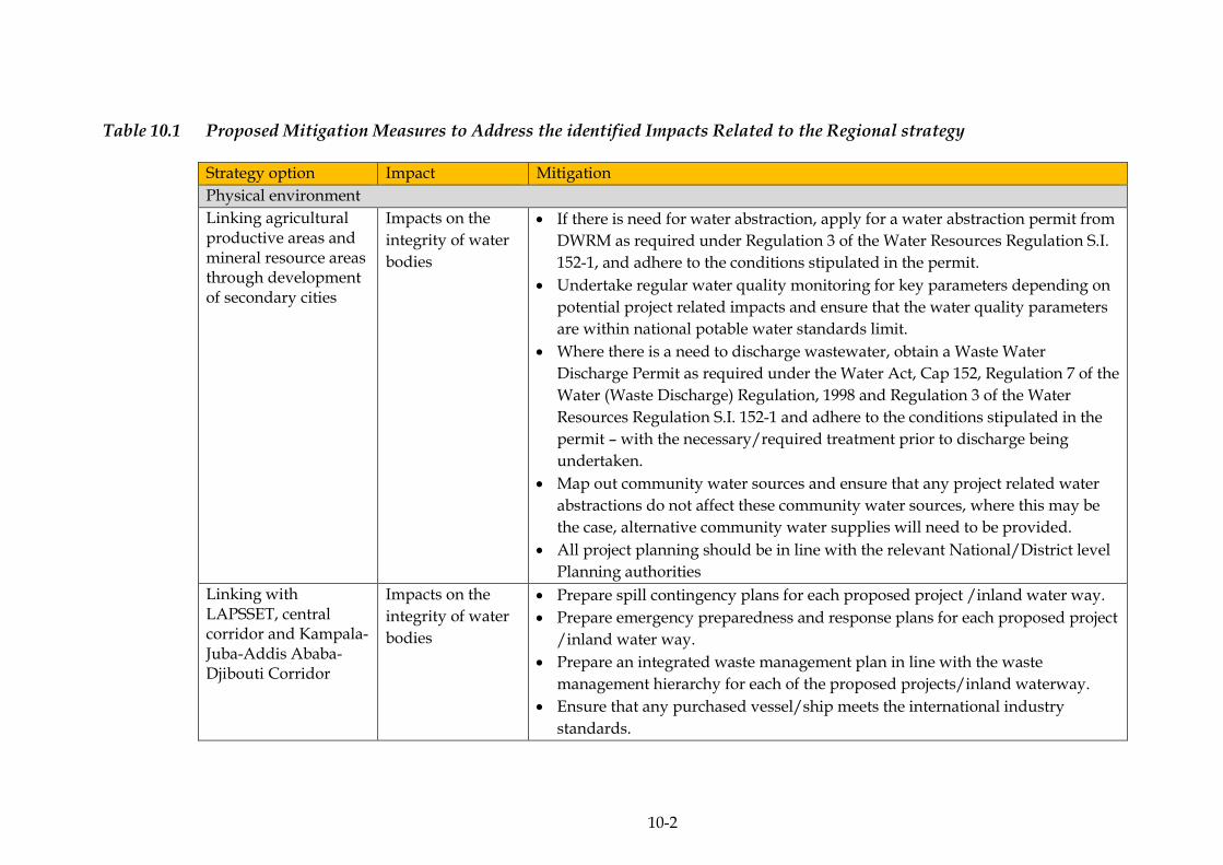
10-2
Table 10.1 Proposed Mitigation Measures to Address the identified Impacts Related to the Regional strategy
Strategy option Impact Mitigation
Physical environment
Linking agricultural productive areas and mineral resource areas through development of secondary cities
Impacts on the
integrity of water
bodies
If there is need for water abstraction, apply for a water abstraction permit from
DWRM as required under Regulation 3 of the Water Resources Regulation S.I.
152-1, and adhere to the conditions stipulated in the permit.
Undertake regular water quality monitoring for key parameters depending on
potential project related impacts and ensure that the water quality parameters
are within national potable water standards limit.
Where there is a need to discharge wastewater, obtain a Waste Water
Discharge Permit as required under the Water Act, Cap 152, Regulation 7 of the
Water (Waste Discharge) Regulation, 1998 and Regulation 3 of the Water
Resources Regulation S.I. 152-1 and adhere to the conditions stipulated in the
permit – with the necessary/required treatment prior to discharge being
undertaken.
Map out community water sources and ensure that any project related water
abstractions do not affect these community water sources, where this may be
the case, alternative community water supplies will need to be provided.
All project planning should be in line with the relevant National/District level
Planning authorities
Linking with LAPSSET, central corridor and Kampala-Juba-Addis Ababa- Djibouti Corridor
Impacts on the
integrity of water
bodies
Prepare spill contingency plans for each proposed project /inland water way.
Prepare emergency preparedness and response plans for each proposed project
/inland water way.
Prepare an integrated waste management plan in line with the waste
management hierarchy for each of the proposed projects/inland waterway.
Ensure that any purchased vessel/ship meets the international industry
standards.
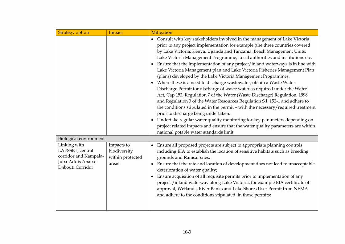
10-3
Strategy option Impact Mitigation
Consult with key stakeholders involved in the management of Lake Victoria
prior to any project implementation for example (the three countries covered
by Lake Victoria: Kenya, Uganda and Tanzania, Beach Management Units,
Lake Victoria Management Programme, Local authorities and institutions etc.
Ensure that the implementation of any project/inland waterways is in line with
Lake Victoria Management plan and Lake Victoria Fisheries Management Plan
(plans) developed by the Lake Victoria Management Programmes.
Where these is a need to discharge wastewater, obtain a Waste Water
Discharge Permit for discharge of waste water as required under the Water
Act, Cap 152, Regulation 7 of the Water (Waste Discharge) Regulation, 1998
and Regulation 3 of the Water Resources Regulation S.I. 152-1 and adhere to
the conditions stipulated in the permit – with the necessary/required treatment
prior to discharge being undertaken.
Undertake regular water quality monitoring for key parameters depending on
project related impacts and ensure that the water quality parameters are within
national potable water standards limit.
Biological environment
Linking with LAPSSET, central corridor and Kampala-Juba-Addis Ababa- Djibouti Corridor
Impacts to
biodiversity
within protected
areas
Ensure all proposed projects are subject to appropriate planning controls
including EIA to establish the location of sensitive habitats such as breeding
grounds and Ramsar sites;
Ensure that the rate and location of development does not lead to unacceptable
deterioration of water quality;
Ensure acquisition of all requisite permits prior to implementation of any
project /inland waterway along Lake Victoria, for example EIA certificate of
approval, Wetlands, River Banks and Lake Shores User Permit from NEMA
and adhere to the conditions stipulated in those permits;

10-4
Strategy option Impact Mitigation
Engage in stakeholder consultations with environmental organisations that
have vested interests in the sustainable use of Lake Victoria such as Nile Basin
Initiative and Lake Victoria Basin Commission;
Enforce any environmental conditionality attached to each development
project;
Develop biodiversity offsets to enhance, restore and support habitats that may
be degraded during project implementation;
All project activities should be in line with the Protected Area Management
Plan;
All water vessels should meet the International Industry Standards; to
minimise, accidents and pollution leaks;
Incorporate the polluter pays principle or other appropriate mechanisms in
relation to damage to protected areas;
Undertake regular water quality monitoring for key parameters depending on
project related impacts and ensure that the water quality parameters are within
national potable water standards limit;
Develop an action plan for biodiversity conservation, including a detailed list
of strategies for abating key threats, a timeline, responsible actors, costs, and
indicators for success; and
Have in place a hazardous materials spill contingency plan as a safeguard
against accidental large spillages.
All project planning should be in line with the relevant District Development
Plan
Socio-economic environment
Linking agricultural productive areas and mineral resource areas through development
Impacts on public
Health and safety
Undertake awareness and sensitisation campaigns on public health and safety
(especially issues to do with HIV/AIDS, water and sanitation management);
Engage the local governments (especially at district and sub-county level) to
prepare community members for any influx of in-migrants (for example, by
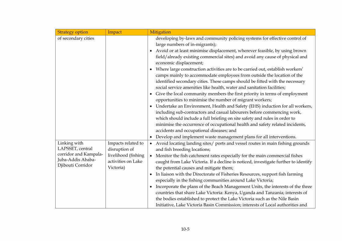
10-5
Strategy option Impact Mitigation
of secondary cities developing by-laws and community policing systems for effective control of
large numbers of in-migrants);
Avoid or at least minimise displacement, wherever feasible, by using brown
field/already existing commercial sites) and avoid any cause of physical and
economic displacement;
Where large construction activities are to be carried out, establish workers’
camps mainly to accommodate employees from outside the location of the
identified secondary cities. These camps should be fitted with the necessary
social service amenities like health, water and sanitation facilities;
Give the local community members the first priority in terms of employment
opportunities to minimise the number of migrant workers;
Undertake an Environment, Health and Safety (EHS) induction for all workers,
including sub-contractors and casual labourers before commencing work,
which should include a full briefing on site safety and rules in order to
minimise the occurrence of occupational health and safety related incidents,
accidents and occupational diseases; and
Develop and implement waste management plans for all interventions.
Linking with LAPSSET, central corridor and Kampala-Juba-Addis Ababa- Djibouti Corridor
Impacts related to
disruption of
livelihood (fishing
activities on Lake
Victoria)
Avoid locating landing sites/ ports and vessel routes in main fishing grounds
and fish breeding locations;
Monitor the fish catchment rates especially for the main commercial fishes
caught from Lake Victoria. If a decline is noticed, investigate further to identify
the potential causes and mitigate them;
In liaison with the Directorate of Fisheries Resources, support fish farming
especially in the fishing communities around Lake Victoria;
Incorporate the plans of the Beach Management Units, the interests of the three
countries that share Lake Victoria: Kenya, Uganda and Tanzania; interests of
the bodies established to protect the Lake Victoria such as the Nile Basin
Initiative, Lake Victoria Basin Commission; interests of Local authorities and
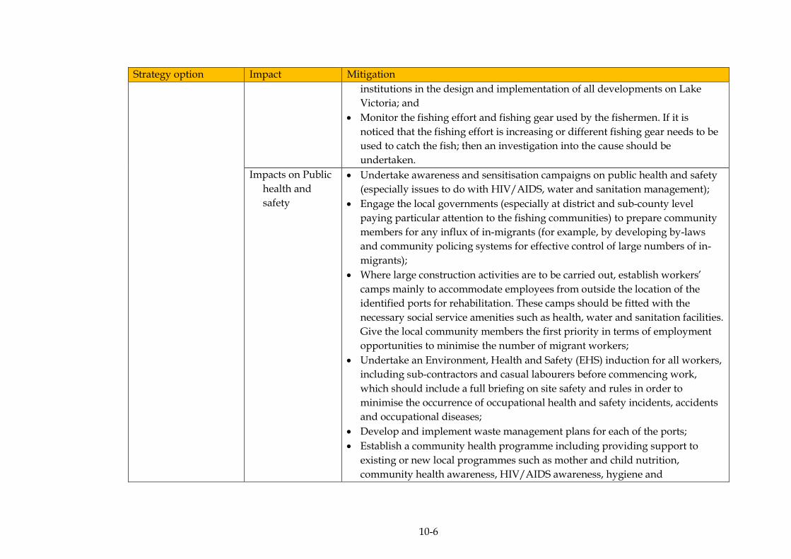
10-6
Strategy option Impact Mitigation
institutions in the design and implementation of all developments on Lake
Victoria; and
Monitor the fishing effort and fishing gear used by the fishermen. If it is
noticed that the fishing effort is increasing or different fishing gear needs to be
used to catch the fish; then an investigation into the cause should be
undertaken.
Impacts on Public
health and
safety
Undertake awareness and sensitisation campaigns on public health and safety
(especially issues to do with HIV/AIDS, water and sanitation management);
Engage the local governments (especially at district and sub-county level
paying particular attention to the fishing communities) to prepare community
members for any influx of in-migrants (for example, by developing by-laws
and community policing systems for effective control of large numbers of in-
migrants);
Where large construction activities are to be carried out, establish workers’
camps mainly to accommodate employees from outside the location of the
identified ports for rehabilitation. These camps should be fitted with the
necessary social service amenities such as health, water and sanitation facilities.
Give the local community members the first priority in terms of employment
opportunities to minimise the number of migrant workers;
Undertake an Environment, Health and Safety (EHS) induction for all workers,
including sub-contractors and casual labourers before commencing work,
which should include a full briefing on site safety and rules in order to
minimise the occurrence of occupational health and safety incidents, accidents
and occupational diseases;
Develop and implement waste management plans for each of the ports;
Establish a community health programme including providing support to
existing or new local programmes such as mother and child nutrition,
community health awareness, HIV/AIDS awareness, hygiene and
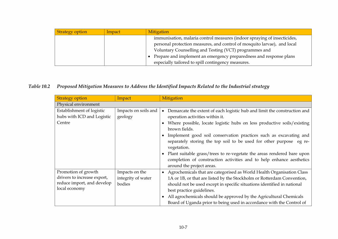
10-7
Strategy option Impact Mitigation
immunisation, malaria control measures (indoor spraying of insecticides,
personal protection measures, and control of mosquito larvae), and local
Voluntary Counselling and Testing (VCT) programmes and
Prepare and implement an emergency preparedness and response plans
especially tailored to spill contingency measures.
Table 10.2 Proposed Mitigation Measures to Address the Identified Impacts Related to the Industrial strategy
Strategy option Impact Mitigation
Physical environment
Establishment of logistic
hubs with ICD and Logistic
Centre
Impacts on soils and
geology
Demarcate the extent of each logistic hub and limit the construction and
operation activities within it.
Where possible, locate logistic hubs on less productive soils/existing
brown fields.
Implement good soil conservation practices such as excavating and
separately storing the top soil to be used for other purpose eg re-
vegetation.
Plant suitable grass/trees to re-vegetate the areas rendered bare upon
completion of construction activities and to help enhance aesthetics
around the project areas.
Promotion of growth drivers to increase export, reduce import, and develop local economy
Impacts on the
integrity of water
bodies
Agrochemicals that are categorised as World Health Organisation Class
1A or 1B, or that are listed by the Stockholm or Rotterdam Convention,
should not be used except in specific situations identified in national
best practice guidelines.
All agrochemicals should be approved by the Agricultural Chemicals
Board of Uganda prior to being used in accordance with the Control of
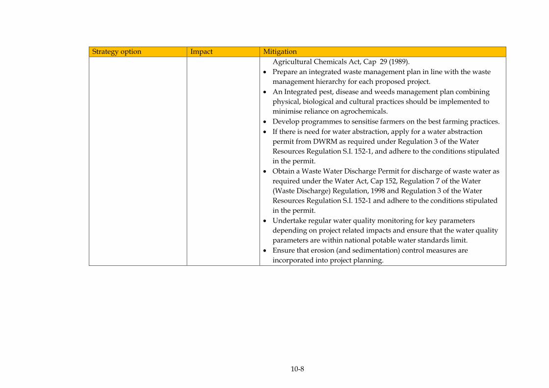
10-8
Strategy option Impact Mitigation
Agricultural Chemicals Act, Cap 29 (1989).
Prepare an integrated waste management plan in line with the waste
management hierarchy for each proposed project.
An Integrated pest, disease and weeds management plan combining
physical, biological and cultural practices should be implemented to
minimise reliance on agrochemicals.
Develop programmes to sensitise farmers on the best farming practices.
If there is need for water abstraction, apply for a water abstraction
permit from DWRM as required under Regulation 3 of the Water
Resources Regulation S.I. 152-1, and adhere to the conditions stipulated
in the permit.
Obtain a Waste Water Discharge Permit for discharge of waste water as
required under the Water Act, Cap 152, Regulation 7 of the Water
(Waste Discharge) Regulation, 1998 and Regulation 3 of the Water
Resources Regulation S.I. 152-1 and adhere to the conditions stipulated
in the permit.
Undertake regular water quality monitoring for key parameters
depending on project related impacts and ensure that the water quality
parameters are within national potable water standards limit.
Ensure that erosion (and sedimentation) control measures are
incorporated into project planning.
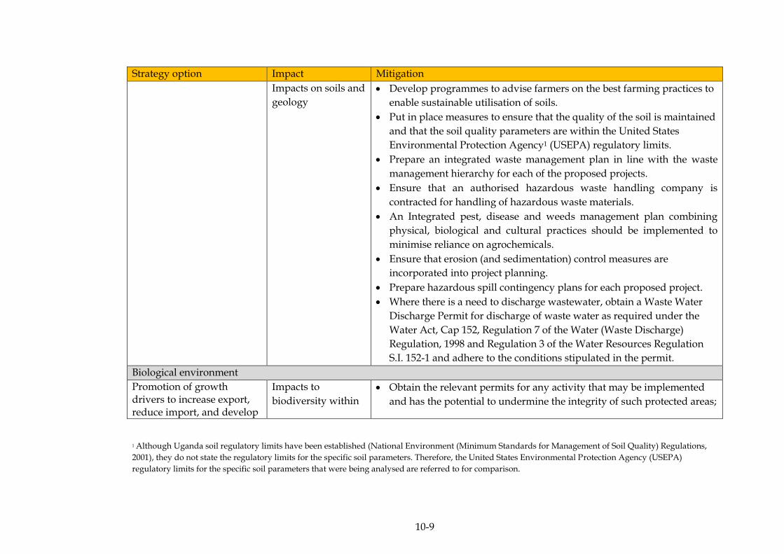
10-9
Strategy option Impact Mitigation
Impacts on soils and
geology
Develop programmes to advise farmers on the best farming practices to
enable sustainable utilisation of soils.
Put in place measures to ensure that the quality of the soil is maintained
and that the soil quality parameters are within the United States
Environmental Protection Agency1 (USEPA) regulatory limits.
Prepare an integrated waste management plan in line with the waste
management hierarchy for each of the proposed projects.
Ensure that an authorised hazardous waste handling company is
contracted for handling of hazardous waste materials.
An Integrated pest, disease and weeds management plan combining
physical, biological and cultural practices should be implemented to
minimise reliance on agrochemicals.
Ensure that erosion (and sedimentation) control measures are
incorporated into project planning.
Prepare hazardous spill contingency plans for each proposed project.
Where there is a need to discharge wastewater, obtain a Waste Water
Discharge Permit for discharge of waste water as required under the
Water Act, Cap 152, Regulation 7 of the Water (Waste Discharge)
Regulation, 1998 and Regulation 3 of the Water Resources Regulation
S.I. 152-1 and adhere to the conditions stipulated in the permit.
Biological environment
Promotion of growth drivers to increase export, reduce import, and develop
Impacts to
biodiversity within
Obtain the relevant permits for any activity that may be implemented
and has the potential to undermine the integrity of such protected areas;
1 Although Uganda soil regulatory limits have been established (National Environment (Minimum Standards for Management of Soil Quality) Regulations,
2001), they do not state the regulatory limits for the specific soil parameters. Therefore, the United States Environmental Protection Agency (USEPA)
regulatory limits for the specific soil parameters that were being analysed are referred to for comparison.
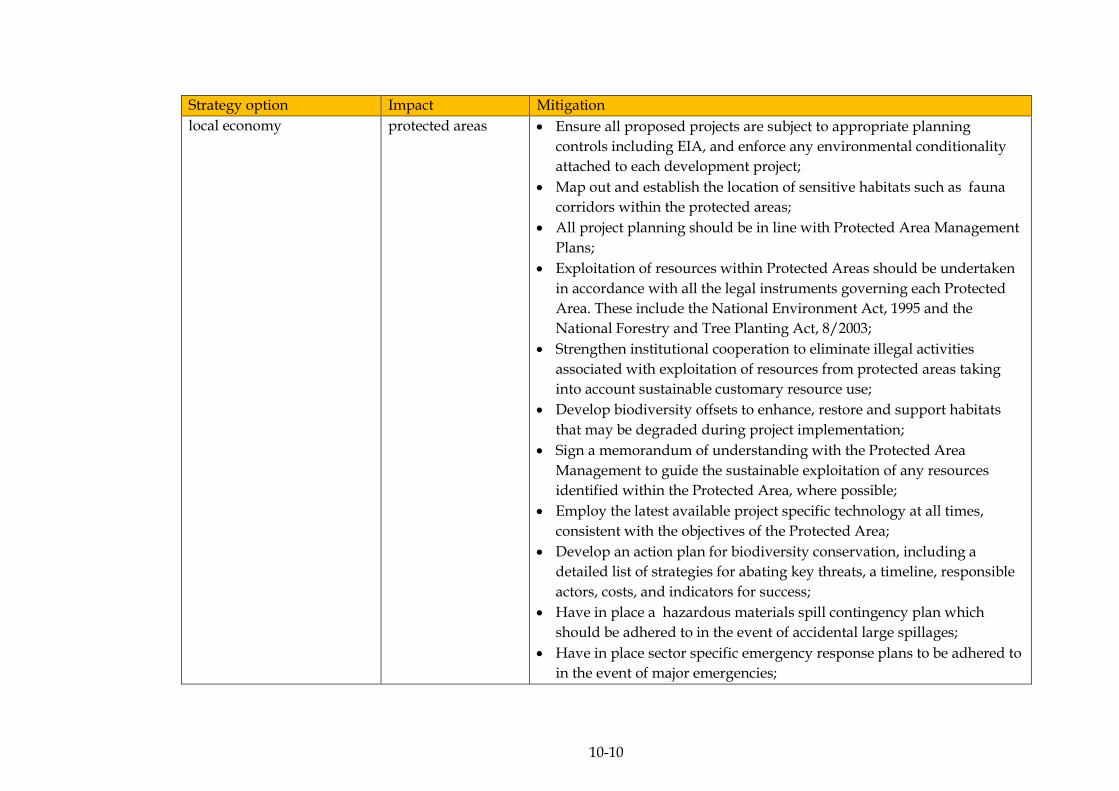
10-10
Strategy option Impact Mitigation
local economy protected areas Ensure all proposed projects are subject to appropriate planning
controls including EIA, and enforce any environmental conditionality
attached to each development project;
Map out and establish the location of sensitive habitats such as fauna
corridors within the protected areas;
All project planning should be in line with Protected Area Management
Plans;
Exploitation of resources within Protected Areas should be undertaken
in accordance with all the legal instruments governing each Protected
Area. These include the National Environment Act, 1995 and the
National Forestry and Tree Planting Act, 8/2003;
Strengthen institutional cooperation to eliminate illegal activities
associated with exploitation of resources from protected areas taking
into account sustainable customary resource use;
Develop biodiversity offsets to enhance, restore and support habitats
that may be degraded during project implementation;
Sign a memorandum of understanding with the Protected Area
Management to guide the sustainable exploitation of any resources
identified within the Protected Area, where possible;
Employ the latest available project specific technology at all times,
consistent with the objectives of the Protected Area;
Develop an action plan for biodiversity conservation, including a
detailed list of strategies for abating key threats, a timeline, responsible
actors, costs, and indicators for success;
Have in place a hazardous materials spill contingency plan which
should be adhered to in the event of accidental large spillages;
Have in place sector specific emergency response plans to be adhered to
in the event of major emergencies;
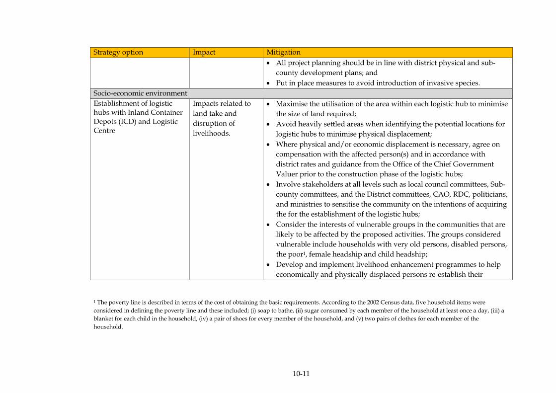
10-11
Strategy option Impact Mitigation
All project planning should be in line with district physical and sub-
county development plans; and
Put in place measures to avoid introduction of invasive species.
Socio-economic environment
Establishment of logistic hubs with Inland Container Depots (ICD) and Logistic Centre
Impacts related to
land take and
disruption of
livelihoods.
Maximise the utilisation of the area within each logistic hub to minimise
the size of land required;
Avoid heavily settled areas when identifying the potential locations for
logistic hubs to minimise physical displacement;
Where physical and/or economic displacement is necessary, agree on
compensation with the affected person(s) and in accordance with
district rates and guidance from the Office of the Chief Government
Valuer prior to the construction phase of the logistic hubs;
Involve stakeholders at all levels such as local council committees, Sub-
county committees, and the District committees, CAO, RDC, politicians,
and ministries to sensitise the community on the intentions of acquiring
the for the establishment of the logistic hubs;
Consider the interests of vulnerable groups in the communities that are
likely to be affected by the proposed activities. The groups considered
vulnerable include households with very old persons, disabled persons,
the poor1, female headship and child headship;
Develop and implement livelihood enhancement programmes to help
economically and physically displaced persons re-establish their
1 The poverty line is described in terms of the cost of obtaining the basic requirements. According to the 2002 Census data, five household items were
considered in defining the poverty line and these included; (i) soap to bathe, (ii) sugar consumed by each member of the household at least once a day, (iii) a
blanket for each child in the household, (iv) a pair of shoes for every member of the household, and (v) two pairs of clothes for each member of the
household.
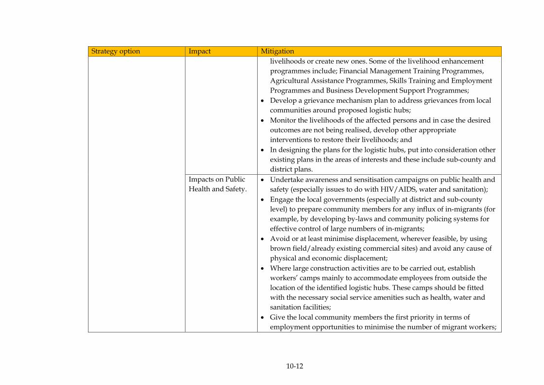
10-12
Strategy option Impact Mitigation
livelihoods or create new ones. Some of the livelihood enhancement
programmes include; Financial Management Training Programmes,
Agricultural Assistance Programmes, Skills Training and Employment
Programmes and Business Development Support Programmes;
Develop a grievance mechanism plan to address grievances from local
communities around proposed logistic hubs;
Monitor the livelihoods of the affected persons and in case the desired
outcomes are not being realised, develop other appropriate
interventions to restore their livelihoods; and
In designing the plans for the logistic hubs, put into consideration other
existing plans in the areas of interests and these include sub-county and
district plans.
Impacts on Public
Health and Safety.
Undertake awareness and sensitisation campaigns on public health and
safety (especially issues to do with HIV/AIDS, water and sanitation);
Engage the local governments (especially at district and sub-county
level) to prepare community members for any influx of in-migrants (for
example, by developing by-laws and community policing systems for
effective control of large numbers of in-migrants;
Avoid or at least minimise displacement, wherever feasible, by using
brown field/already existing commercial sites) and avoid any cause of
physical and economic displacement;
Where large construction activities are to be carried out, establish
workers’ camps mainly to accommodate employees from outside the
location of the identified logistic hubs. These camps should be fitted
with the necessary social service amenities such as health, water and
sanitation facilities;
Give the local community members the first priority in terms of
employment opportunities to minimise the number of migrant workers;

10-13
Strategy option Impact Mitigation
Undertake an Environment, Health and Safety (EHS) induction for all
workers, including sub-contractors and casual labourers before
commencing work, which should include a full briefing on site safety
and rules in order to minimise the occurrence of occupational health
and safety related incidents, accidents and l diseases;
Develop and implement waste management plans for each of the
logistic hubs;
Isolate hazardous materials such as fuel, explosives and hazardous
chemicals and appropriate safeguards in place for dealing with any
eventualities related to them;
Undertake community awareness and sensitisation about the logistic
hubs prior to the establishment so that community members become
more vigilant and are aware of what to expect in terms of potential
nuisances;
Develop a grievance mechanism plan to address grievances from local
communities around proposed logistic hubs.

10-14
Table 10.3 Proposed Mitigation Measures to Address the Identified Impacts Related to the Transport strategy
Strategy option Impact Mitigation
Physical environment
Reduction of bottlenecks of freight traffic and logistics
Impacts on the
integrity of water
bodies
Design and implement good construction management practices including, but
not limited to, erosion and sediment control measures, appropriate drainage
system and waste management practices.
Prepare hazardous spill contingency plans for each proposed project
If there is need for water abstraction ( eg water for suppression of dust during
road construction), apply for a water abstraction permit from DWRM as
required under Regulation 3 of the Water Resources Regulation S.I. 152-1, and
adhere to the conditions stipulated in the permit.
Prepare an integrated waste management plan in line with the waste
management hierarchy for each of the proposed projects.
Obtain a Waste Water Discharge Permit for discharge of waste water as required
under the Water Act, Cap 152, Regulation 7 of the Water (Waste Discharge)
Regulation, 1998 and Regulation 3 of the Water Resources Regulation S.I. 152-1
and adhere to the conditions stipulated in the permit.
Noise and
vibration impacts
Put in place measures to minimise noise and ensure that the noise levels
generated are within limits as stipulated in the National Environment (Noise
Standard and Control) Regulations, 2003.
Ensure that sound acoustics is factored into infrastructure design.
Impact on air
quality
(Greenhouse gas
emissions)
Encourage planting of trees along the highways to act as carbon sinks;
Encourage use of fuel-efficient vehicles to reduce emissions of greenhouse gases;
Put in place measures to ensure that greenhouse gas emissions from any
machinery and vehicles are minimised and that gas emissions are within limits
as stipulated in National Environment (Draft Air Quality) Standards 2006;
Undertake regular air quality monitoring of key air pollutants along busy
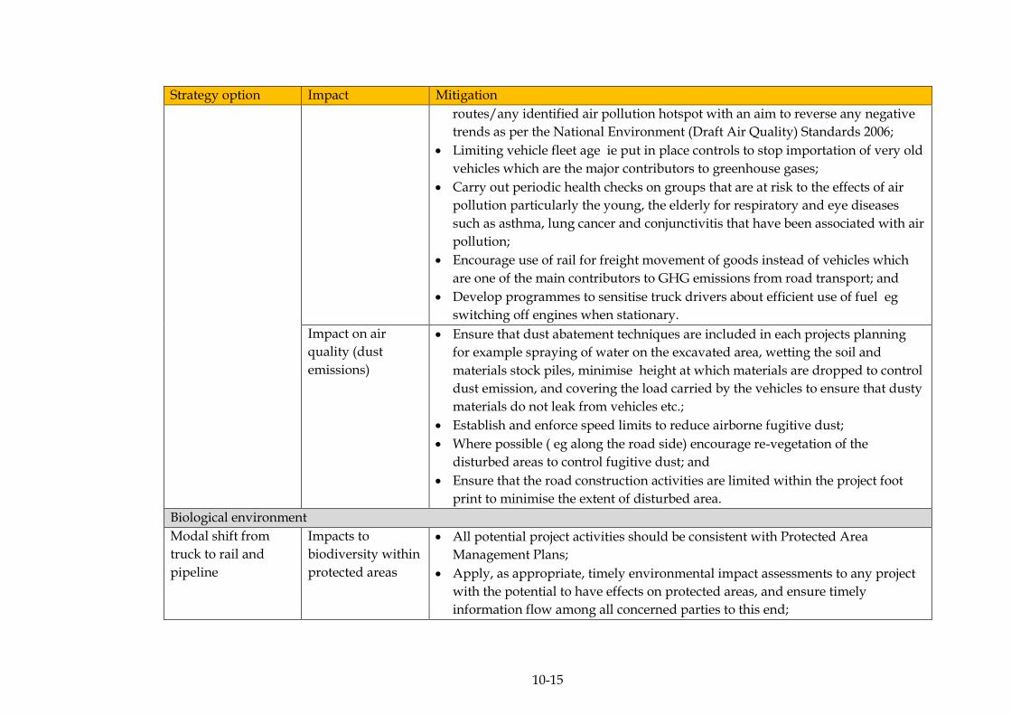
10-15
Strategy option Impact Mitigation
routes/any identified air pollution hotspot with an aim to reverse any negative
trends as per the National Environment (Draft Air Quality) Standards 2006;
Limiting vehicle fleet age ie put in place controls to stop importation of very old
vehicles which are the major contributors to greenhouse gases;
Carry out periodic health checks on groups that are at risk to the effects of air
pollution particularly the young, the elderly for respiratory and eye diseases
such as asthma, lung cancer and conjunctivitis that have been associated with air
pollution;
Encourage use of rail for freight movement of goods instead of vehicles which
are one of the main contributors to GHG emissions from road transport; and
Develop programmes to sensitise truck drivers about efficient use of fuel eg
switching off engines when stationary.
Impact on air
quality (dust
emissions)
Ensure that dust abatement techniques are included in each projects planning
for example spraying of water on the excavated area, wetting the soil and
materials stock piles, minimise height at which materials are dropped to control
dust emission, and covering the load carried by the vehicles to ensure that dusty
materials do not leak from vehicles etc.;
Establish and enforce speed limits to reduce airborne fugitive dust;
Where possible ( eg along the road side) encourage re-vegetation of the
disturbed areas to control fugitive dust; and
Ensure that the road construction activities are limited within the project foot
print to minimise the extent of disturbed area.
Biological environment
Modal shift from
truck to rail and
pipeline
Impacts to
biodiversity within
protected areas
All potential project activities should be consistent with Protected Area
Management Plans;
Apply, as appropriate, timely environmental impact assessments to any project
with the potential to have effects on protected areas, and ensure timely
information flow among all concerned parties to this end;
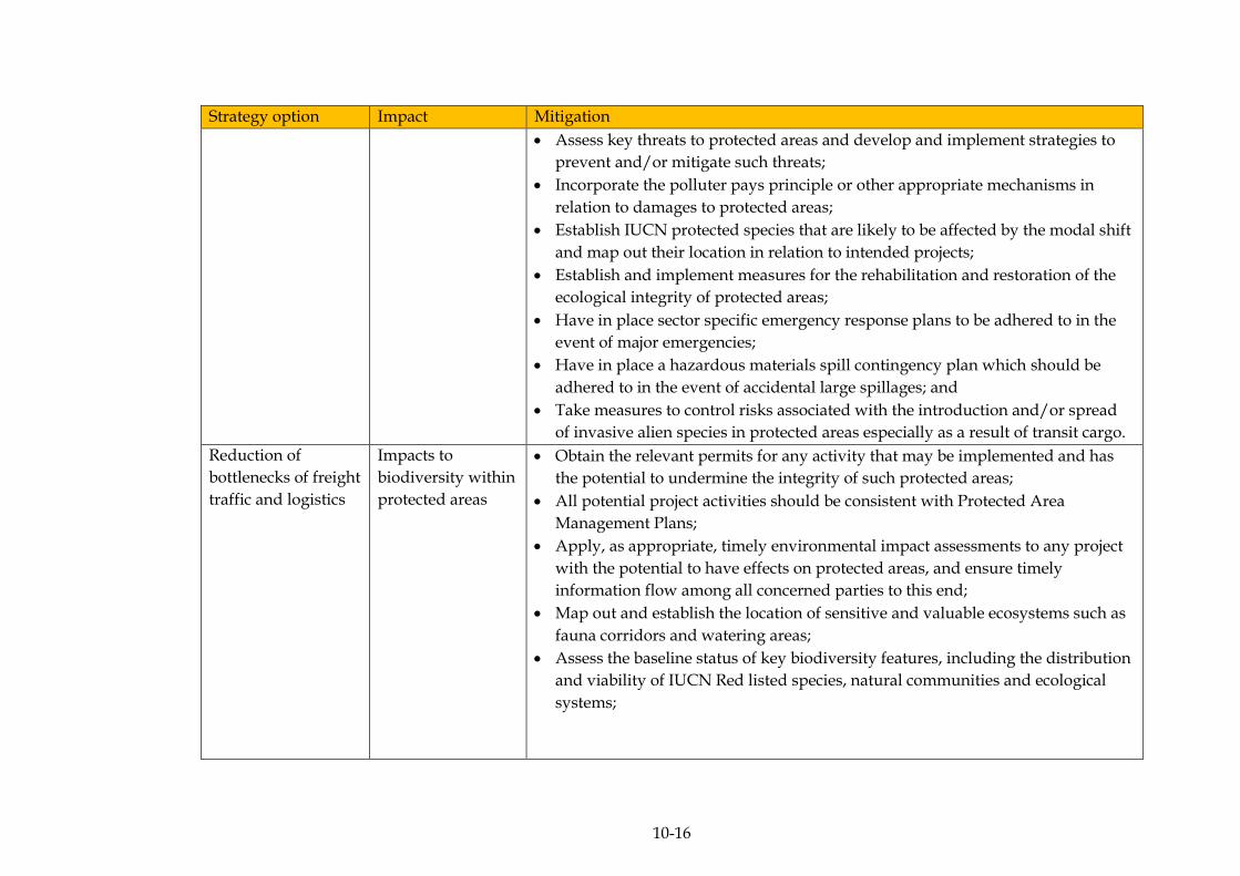
10-16
Strategy option Impact Mitigation
Assess key threats to protected areas and develop and implement strategies to
prevent and/or mitigate such threats;
Incorporate the polluter pays principle or other appropriate mechanisms in
relation to damages to protected areas;
Establish IUCN protected species that are likely to be affected by the modal shift
and map out their location in relation to intended projects;
Establish and implement measures for the rehabilitation and restoration of the
ecological integrity of protected areas;
Have in place sector specific emergency response plans to be adhered to in the
event of major emergencies;
Have in place a hazardous materials spill contingency plan which should be
adhered to in the event of accidental large spillages; and
Take measures to control risks associated with the introduction and/or spread
of invasive alien species in protected areas especially as a result of transit cargo.
Reduction of
bottlenecks of freight
traffic and logistics
Impacts to
biodiversity within
protected areas
Obtain the relevant permits for any activity that may be implemented and has
the potential to undermine the integrity of such protected areas;
All potential project activities should be consistent with Protected Area
Management Plans;
Apply, as appropriate, timely environmental impact assessments to any project
with the potential to have effects on protected areas, and ensure timely
information flow among all concerned parties to this end;
Map out and establish the location of sensitive and valuable ecosystems such as
fauna corridors and watering areas;
Assess the baseline status of key biodiversity features, including the distribution
and viability of IUCN Red listed species, natural communities and ecological
systems;
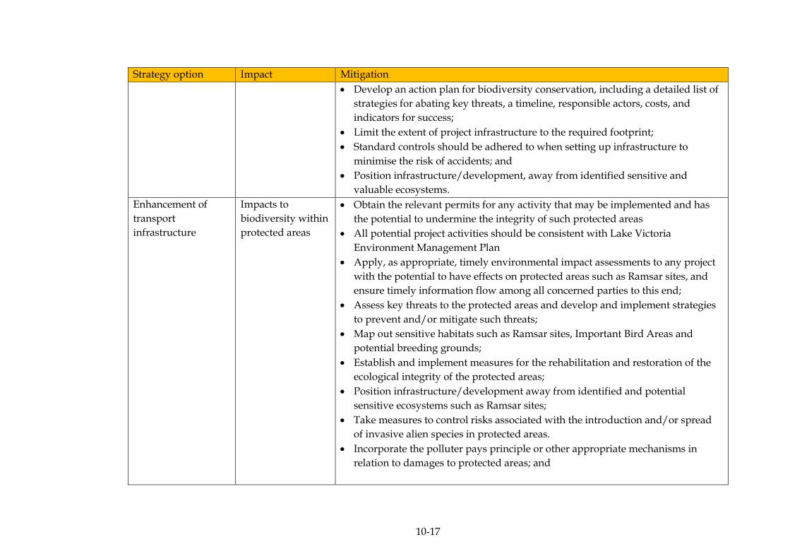
10-17
Strategy option Impact Mitigation
Develop an action plan for biodiversity conservation, including a detailed list of
strategies for abating key threats, a timeline, responsible actors, costs, and
indicators for success;
Limit the extent of project infrastructure to the required footprint;
Standard controls should be adhered to when setting up infrastructure to
minimise the risk of accidents; and
Position infrastructure/development, away from identified sensitive and
valuable ecosystems.
Enhancement of
transport
infrastructure
Impacts to
biodiversity within
protected areas
Obtain the relevant permits for any activity that may be implemented and has
the potential to undermine the integrity of such protected areas
All potential project activities should be consistent with Lake Victoria
Environment Management Plan
Apply, as appropriate, timely environmental impact assessments to any project
with the potential to have effects on protected areas such as Ramsar sites, and
ensure timely information flow among all concerned parties to this end;
Assess key threats to the protected areas and develop and implement strategies
to prevent and/or mitigate such threats;
Map out sensitive habitats such as Ramsar sites, Important Bird Areas and
potential breeding grounds;
Establish and implement measures for the rehabilitation and restoration of the
ecological integrity of the protected areas;
Position infrastructure/development away from identified and potential
sensitive ecosystems such as Ramsar sites;
Take measures to control risks associated with the introduction and/or spread
of invasive alien species in protected areas.
Incorporate the polluter pays principle or other appropriate mechanisms in
relation to damages to protected areas; and

10-18
Strategy option Impact Mitigation
Standard controls should be adhered to when setting up infrastructure to
minimise the risk of accidents; and
Have in place a hazardous material spill contingency plan which should be
adhered to in the event of accidental large spillages.
Socio-economic environment
Reduction of
bottlenecks of freight
traffic and logistics
Impacts on Public
Health and Safety
Undertake awareness and sensitisation campaigns on public health and safety
(especially to do with issues of HIV/AIDS, water and sanitation);
Engage the local governments (especially at district and sub-county level) to
prepare community members for any influx of in-migrants (for example, by
developing by-laws and community policing systems for effective control of
large numbers of in-migrants);
Where large construction activities are to be carried out, establish workers’
camps mainly to accommodate employees from outside the location of the
identified roads. These camps should be fitted with the necessary social service
amenities like health, water and sanitation facilities;
Give the local community members the first priority in terms of employment
opportunities to minimise the number of migrant workers;
Undertake Environment, Health and Safety (EHS) induction for all workers,
including sub-contractors and casual labourers before commencing work, which
should include a full briefing on site safety and rules in order to minimise the
occurrence of occupational health and safety related accidents and diseases;
Develop and implement waste management plans for each of the proposed
infrastructure under this strategy; and
Install clear and visible signage on all roads especially in community areas,
around schools and hospitals to minimise the risk of accidents.
ERM/ATACAMA CONSULTING JST/MOWT
10-19
10.1.1 Mitigation Measures for Cumulative Impacts Associated With
Implementation of the Master Plan
Implementation of the all the proposed interventions proposed under
each of the Master Plan strategic options will cause a number of
cumulative impacts. Therefore, to ensure that their significance is
considerably reduced, mitigation measures must be devised and
implemented. Outlined below are the mitigation measures deemed
necessary for effective implementation of the Master Plan whilst
keeping the negative environmental and social impacts as low as
possible.
Align Proposed Projects with the Existing National Planning Framework
Implementation should be in line with the existing national planning
framework. Agriculture related plans/programmes/projects for
example, should be implemented in areas set aside for agriculture while
infrastructural developments should be in line with the overall national
physical development plan. By implementing
plans/programmes/projects in areas designated for such activities, the
cumulative impact is likely to be reduced. For example, if logistic hubs
under the industrial strategy are established on brown field sites (land
not ideally suitable for agriculture), the cumulative impact of soil
compaction will be reduced since the productivity of such soils will not
be compromised but instead put to better use, as these soils were never
suitable for agriculture in the first place.
Interagency Coordination
Different aspects of the biological and physical environments will be
subjected to impacts as a result of implementation of the Master Plan.
However, during specific project development under the Master Plan,
with the proper coordination among regulatory bodies, the cumulative
impacts of the proposed projects could be further minimised.
ERM/ATACAMA CONSULTING JST/MOWT
10-20
For example, Lake Victoria, a transboundary resource with more than
one organisation overseeing specific aspects of it, could benefit from
interagency coordination, whereby, the integrity of this water resource
can further be maintained, for example in Uganda, with guidance from
MAAIF – to manage use of agrochemicals which would otherwise
compromise the quality of the resource, minimise impacts on fisheries
and similarly, the Lake Victoria Basin Commission could advise on the
location and number of navigation routes to be developed on the same
resource based on research previously carried out in a bid to protect the
resource – with more than one basin state meeting set objectives under
a single/similar projects. This should hold true for other publically
shared natural resources such as forests.
Project Scheduling
The scheduling of the proposed projects should ensure that the
implementation is undertaken sequentially rather than being
undertaken concurrently. For example the cumulative impact of
reduction in air quality due to dust emissions could be reduced by
phasing the construction of the logistics hubs after or before the
construction of the access roads to connect to the same. That way, the
extended construction period will result in a reduced amount of
construction related dust exposure on respective receptors.
Project Designs
The current assessment of cumulative impacts is based on the
assumption of using the currently available technology. However,
proposed plans/programmes/projects should embrace green economic
development or low carbon development models In addition, since the
Master Plan will be implemented over an extended period of time up to
2030, it is necessary that project designs are futuristic in scope to match
with evolving changes in technology so as to minimise the cumulative
impacts associated with technology overhauls that may not be cost
effective from an environmental point of view.
MONITORING OF IMPLEMENTATION OF THE MASTER PLAN 10.2
Monitoring will be carried out as part of the implementation phase of
the Master Plan to specifically address significant environmental effects
on certain environmental components. Monitoring will be the
responsibility to the Ministry of Works and Transport who are the
proponents of the Master Plan although they may not necessarily
undertake the monitoring themselves.
ERM/ATACAMA CONSULTING JST/MOWT
10-21
Key to the monitoring exercise will be the use of indicators as these are
able to show the changes to the certain specific aspects of the
environment over time based on a cause – effect relationship.
The SEA monitoring programme for the implementation of the Master
Plan is presented in the tables (Table 10.4, Table 10.5 and Table 10.6)
below that represent the respective components of the Master Plan -
Regional strategy, Industrial strategy and the Transport strategy
respectively
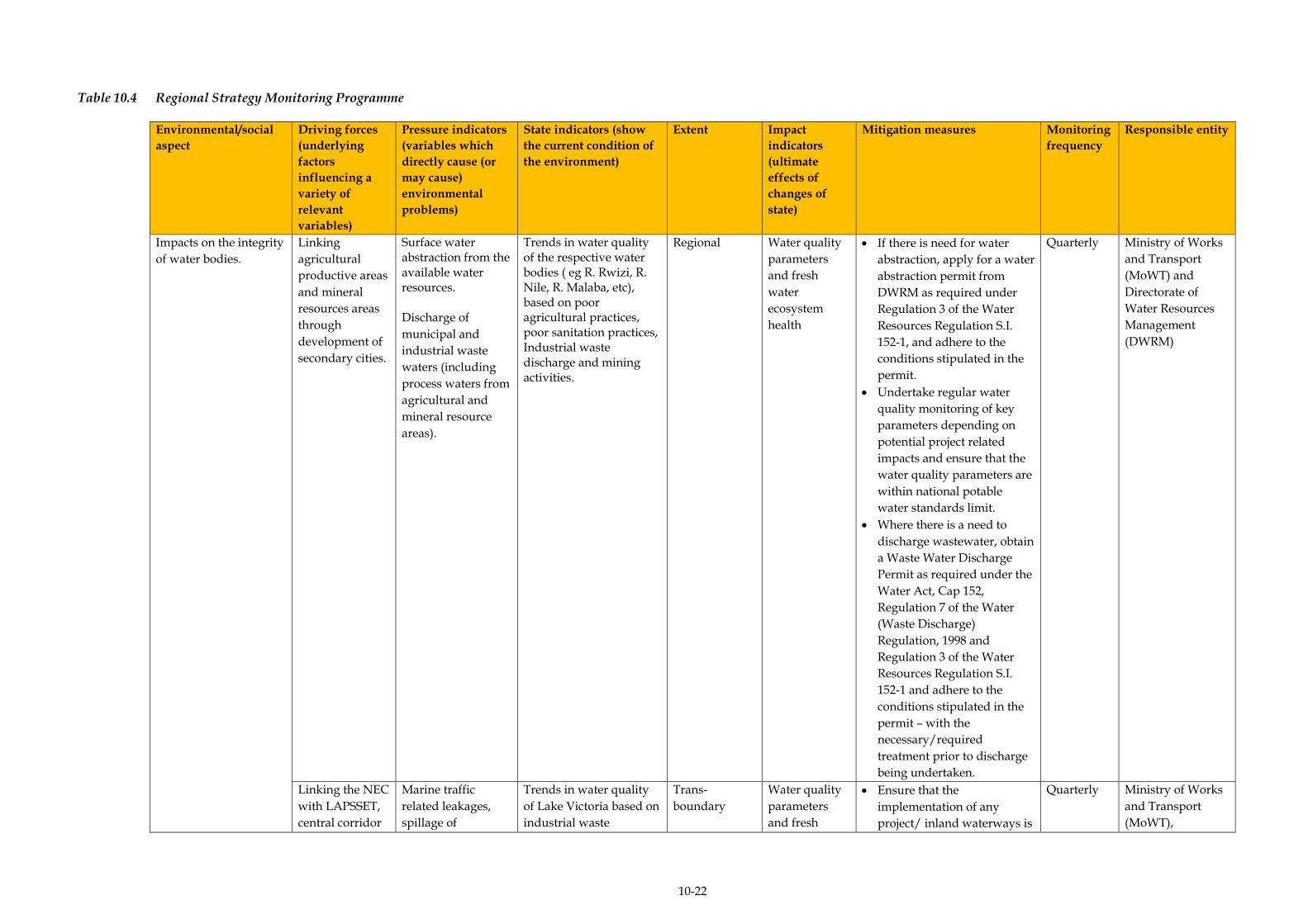
10-22
Table 10.4 Regional Strategy Monitoring Programme
Environmental/social
aspect
Driving forces
(underlying
factors
influencing a
variety of
relevant
variables)
Pressure indicators
(variables which
directly cause (or
may cause)
environmental
problems)
State indicators (show
the current condition of
the environment)
Extent Impact
indicators
(ultimate
effects of
changes of
state)
Mitigation measures Monitoring
frequency
Responsible entity
Impacts on the integrity
of water bodies.
Linking
agricultural
productive areas
and mineral
resources areas
through
development of
secondary cities.
Surface water abstraction from the available water resources. Discharge of
municipal and
industrial waste
waters (including
process waters from
agricultural and
mineral resource
areas).
Trends in water quality of the respective water bodies ( eg R. Rwizi, R. Nile, R. Malaba, etc), based on poor agricultural practices, poor sanitation practices, Industrial waste discharge and mining activities.
Regional
Water quality
parameters
and fresh
water
ecosystem
health
If there is need for water
abstraction, apply for a water
abstraction permit from
DWRM as required under
Regulation 3 of the Water
Resources Regulation S.I.
152-1, and adhere to the
conditions stipulated in the
permit.
Undertake regular water
quality monitoring of key
parameters depending on
potential project related
impacts and ensure that the
water quality parameters are
within national potable
water standards limit.
Where there is a need to
discharge wastewater, obtain
a Waste Water Discharge
Permit as required under the
Water Act, Cap 152,
Regulation 7 of the Water
(Waste Discharge)
Regulation, 1998 and
Regulation 3 of the Water
Resources Regulation S.I.
152-1 and adhere to the
conditions stipulated in the
permit – with the
necessary/required
treatment prior to discharge
being undertaken.
Quarterly
Ministry of Works
and Transport
(MoWT) and
Directorate of
Water Resources
Management
(DWRM)
Linking the NEC
with LAPSSET,
central corridor
Marine traffic
related leakages,
spillage of
Trends in water quality
of Lake Victoria based on
industrial waste
Trans-
boundary
Water quality
parameters
and fresh
Ensure that the
implementation of any
project/ inland waterways is
Quarterly Ministry of Works
and Transport
(MoWT),
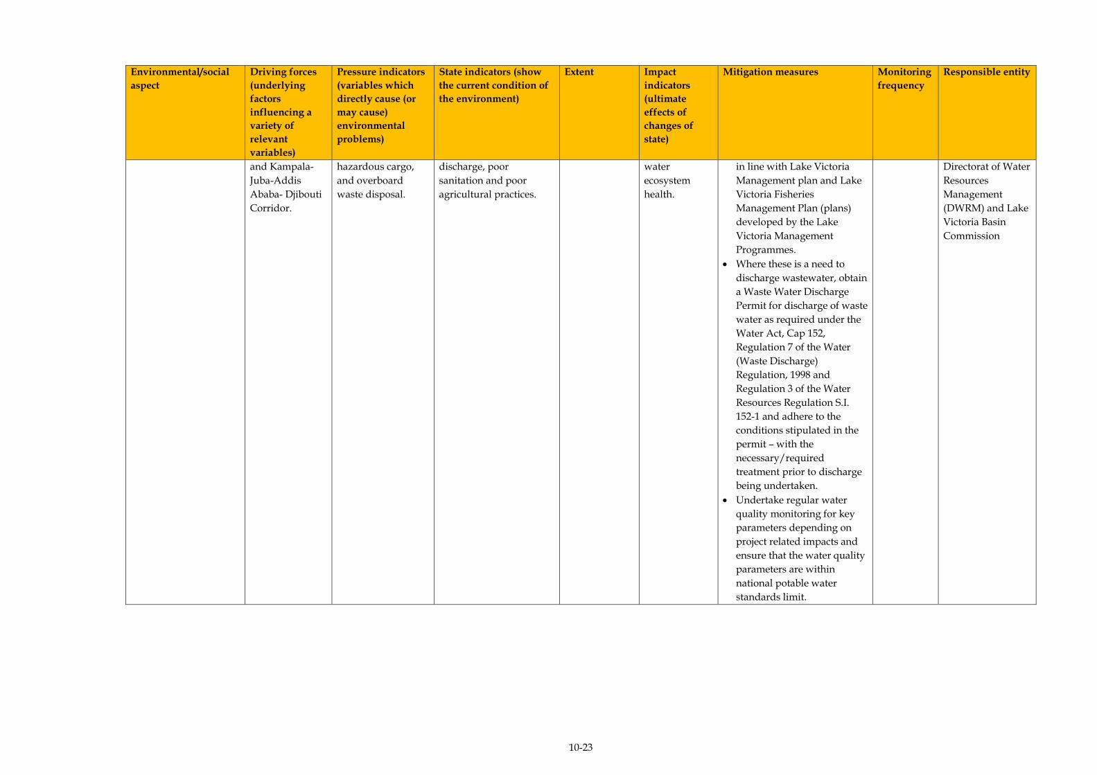
10-23
Environmental/social
aspect
Driving forces
(underlying
factors
influencing a
variety of
relevant
variables)
Pressure indicators
(variables which
directly cause (or
may cause)
environmental
problems)
State indicators (show
the current condition of
the environment)
Extent Impact
indicators
(ultimate
effects of
changes of
state)
Mitigation measures Monitoring
frequency
Responsible entity
and Kampala-
Juba-Addis
Ababa- Djibouti
Corridor.
hazardous cargo,
and overboard
waste disposal.
discharge, poor
sanitation and poor
agricultural practices.
water
ecosystem
health.
in line with Lake Victoria
Management plan and Lake
Victoria Fisheries
Management Plan (plans)
developed by the Lake
Victoria Management
Programmes.
Where these is a need to
discharge wastewater, obtain
a Waste Water Discharge
Permit for discharge of waste
water as required under the
Water Act, Cap 152,
Regulation 7 of the Water
(Waste Discharge)
Regulation, 1998 and
Regulation 3 of the Water
Resources Regulation S.I.
152-1 and adhere to the
conditions stipulated in the
permit – with the
necessary/required
treatment prior to discharge
being undertaken.
Undertake regular water
quality monitoring for key
parameters depending on
project related impacts and
ensure that the water quality
parameters are within
national potable water
standards limit.
Directorat of Water
Resources
Management
(DWRM) and Lake
Victoria Basin
Commission
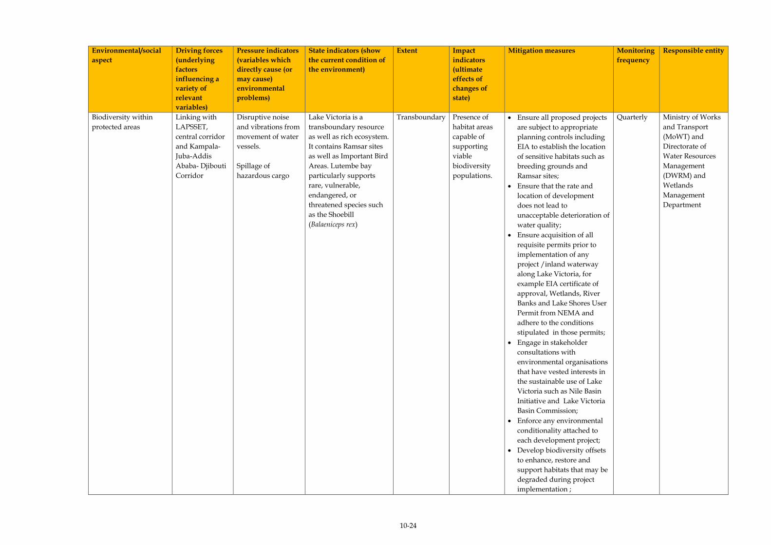
10-24
Environmental/social
aspect
Driving forces
(underlying
factors
influencing a
variety of
relevant
variables)
Pressure indicators
(variables which
directly cause (or
may cause)
environmental
problems)
State indicators (show
the current condition of
the environment)
Extent Impact
indicators
(ultimate
effects of
changes of
state)
Mitigation measures Monitoring
frequency
Responsible entity
Biodiversity within
protected areas
Linking with
LAPSSET,
central corridor
and Kampala-
Juba-Addis
Ababa- Djibouti
Corridor
Disruptive noise
and vibrations from
movement of water
vessels.
Spillage of
hazardous cargo
Lake Victoria is a
transboundary resource
as well as rich ecosystem.
It contains Ramsar sites
as well as Important Bird
Areas. Lutembe bay
particularly supports
rare, vulnerable,
endangered, or
threatened species such
as the Shoebill
(Balaeniceps rex)
Transboundary Presence of
habitat areas
capable of
supporting
viable
biodiversity
populations.
Ensure all proposed projects
are subject to appropriate
planning controls including
EIA to establish the location
of sensitive habitats such as
breeding grounds and
Ramsar sites;
Ensure that the rate and
location of development
does not lead to
unacceptable deterioration of
water quality;
Ensure acquisition of all
requisite permits prior to
implementation of any
project /inland waterway
along Lake Victoria, for
example EIA certificate of
approval, Wetlands, River
Banks and Lake Shores User
Permit from NEMA and
adhere to the conditions
stipulated in those permits;
Engage in stakeholder
consultations with
environmental organisations
that have vested interests in
the sustainable use of Lake
Victoria such as Nile Basin
Initiative and Lake Victoria
Basin Commission;
Enforce any environmental
conditionality attached to
each development project;
Develop biodiversity offsets
to enhance, restore and
support habitats that may be
degraded during project
implementation ;
Quarterly Ministry of Works
and Transport
(MoWT) and
Directorate of
Water Resources
Management
(DWRM) and
Wetlands
Management
Department
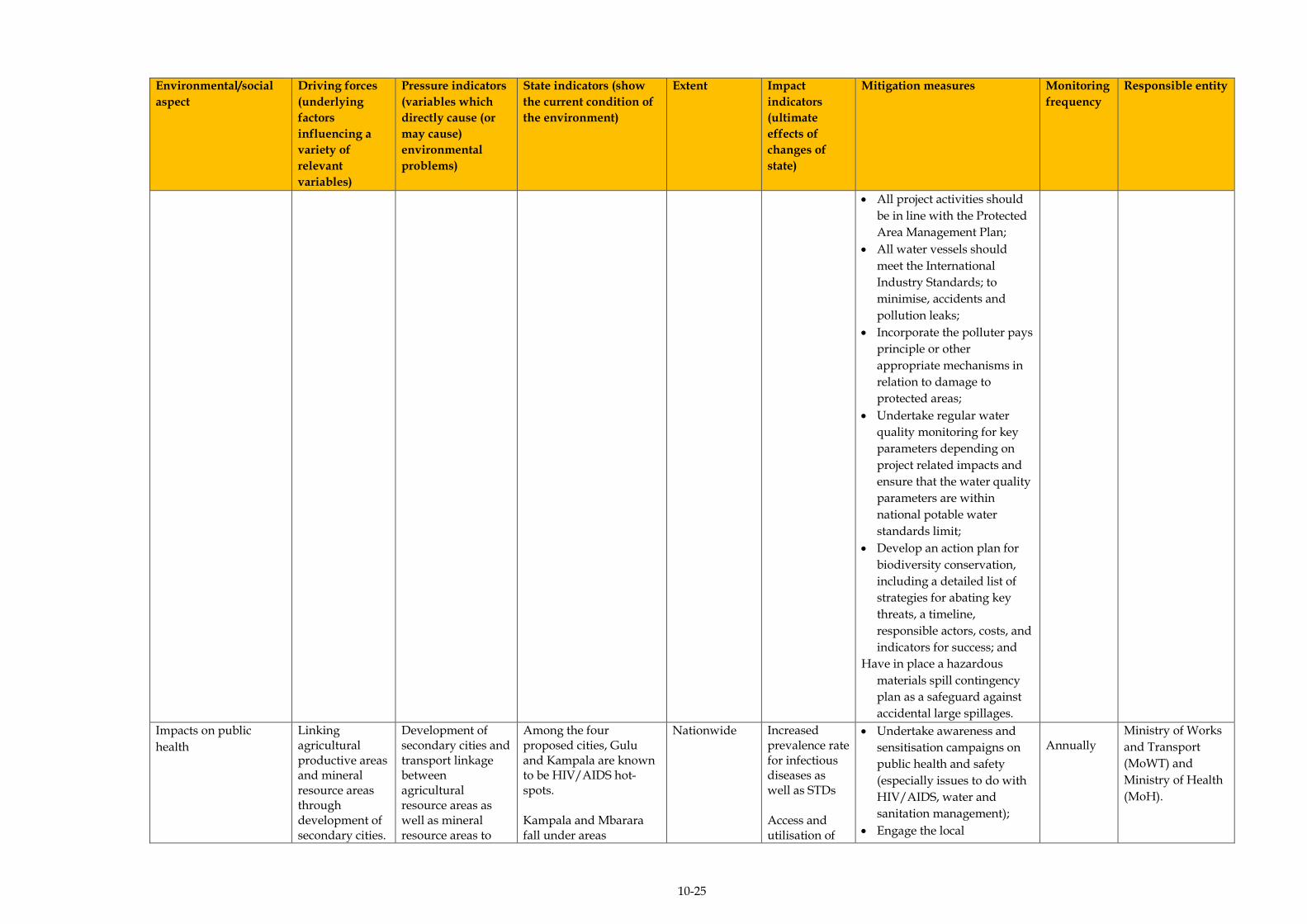
10-25
Environmental/social
aspect
Driving forces
(underlying
factors
influencing a
variety of
relevant
variables)
Pressure indicators
(variables which
directly cause (or
may cause)
environmental
problems)
State indicators (show
the current condition of
the environment)
Extent Impact
indicators
(ultimate
effects of
changes of
state)
Mitigation measures Monitoring
frequency
Responsible entity
All project activities should
be in line with the Protected
Area Management Plan;
All water vessels should
meet the International
Industry Standards; to
minimise, accidents and
pollution leaks;
Incorporate the polluter pays
principle or other
appropriate mechanisms in
relation to damage to
protected areas;
Undertake regular water
quality monitoring for key
parameters depending on
project related impacts and
ensure that the water quality
parameters are within
national potable water
standards limit;
Develop an action plan for
biodiversity conservation,
including a detailed list of
strategies for abating key
threats, a timeline,
responsible actors, costs, and
indicators for success; and
Have in place a hazardous
materials spill contingency
plan as a safeguard against
accidental large spillages.
Impacts on public
health
Linking agricultural productive areas and mineral resource areas through development of secondary cities.
Development of secondary cities and transport linkage between agricultural resource areas as well as mineral resource areas to
Among the four proposed cities, Gulu and Kampala are known to be HIV/AIDS hot-spots. Kampala and Mbarara fall under areas
Nationwide Increased prevalence rate for infectious diseases as well as STDs Access and utilisation of
Undertake awareness and
sensitisation campaigns on
public health and safety
(especially issues to do with
HIV/AIDS, water and
sanitation management);
Engage the local
Annually
Ministry of Works
and Transport
(MoWT) and
Ministry of Health
(MoH).
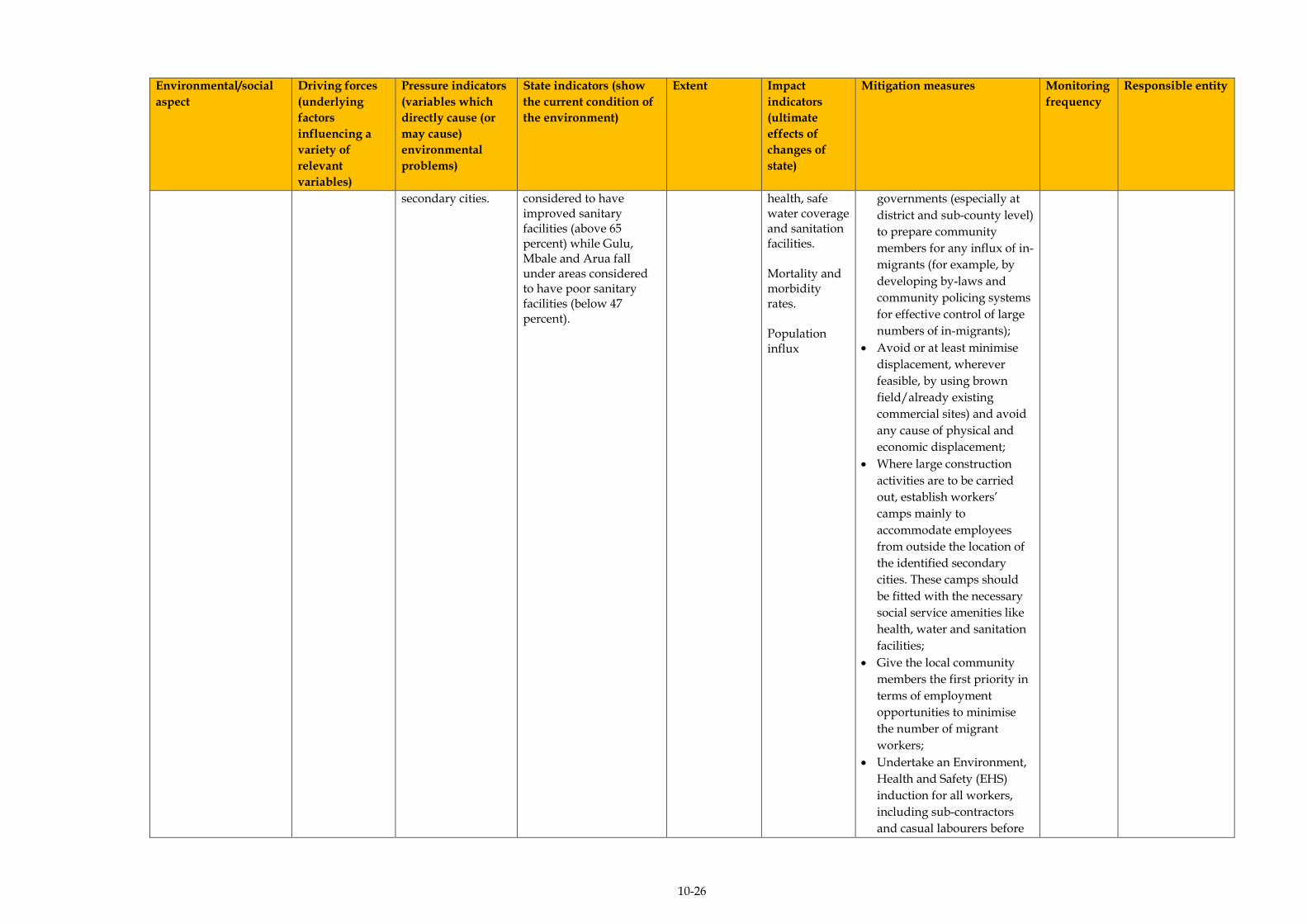
10-26
Environmental/social
aspect
Driving forces
(underlying
factors
influencing a
variety of
relevant
variables)
Pressure indicators
(variables which
directly cause (or
may cause)
environmental
problems)
State indicators (show
the current condition of
the environment)
Extent Impact
indicators
(ultimate
effects of
changes of
state)
Mitigation measures Monitoring
frequency
Responsible entity
secondary cities.
considered to have improved sanitary facilities (above 65 percent) while Gulu, Mbale and Arua fall under areas considered to have poor sanitary facilities (below 47 percent).
health, safe water coverage and sanitation facilities. Mortality and morbidity rates. Population influx
governments (especially at
district and sub-county level)
to prepare community
members for any influx of in-
migrants (for example, by
developing by-laws and
community policing systems
for effective control of large
numbers of in-migrants);
Avoid or at least minimise
displacement, wherever
feasible, by using brown
field/already existing
commercial sites) and avoid
any cause of physical and
economic displacement;
Where large construction
activities are to be carried
out, establish workers’
camps mainly to
accommodate employees
from outside the location of
the identified secondary
cities. These camps should
be fitted with the necessary
social service amenities like
health, water and sanitation
facilities;
Give the local community
members the first priority in
terms of employment
opportunities to minimise
the number of migrant
workers;
Undertake an Environment,
Health and Safety (EHS)
induction for all workers,
including sub-contractors
and casual labourers before
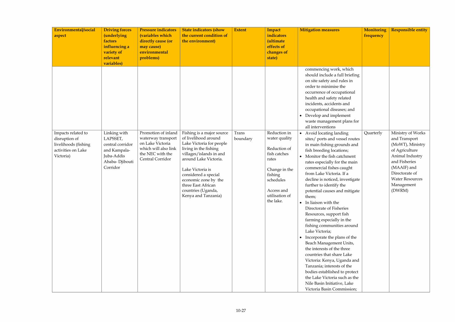
10-27
Environmental/social
aspect
Driving forces
(underlying
factors
influencing a
variety of
relevant
variables)
Pressure indicators
(variables which
directly cause (or
may cause)
environmental
problems)
State indicators (show
the current condition of
the environment)
Extent Impact
indicators
(ultimate
effects of
changes of
state)
Mitigation measures Monitoring
frequency
Responsible entity
commencing work, which
should include a full briefing
on site safety and rules in
order to minimise the
occurrence of occupational
health and safety related
incidents, accidents and
occupational diseases; and
Develop and implement
waste management plans for
all interventions
Impacts related to
disruption of
livelihoods (fishing
activities on Lake
Victoria)
Linking with
LAPSSET,
central corridor
and Kampala-
Juba-Addis
Ababa- Djibouti
Corridor
Promotion of inland waterway transport on Lake Victoria which will also link the NEC with the Central Corridor
Fishing is a major source of livelihood around Lake Victoria for people living in the fishing villages/islands in and around Lake Victoria. Lake Victoria is considered a special economic zone by the three East African countries (Uganda, Kenya and Tanzania)
Trans
boundary
Reduction in water quality Reduction of fish catches rates Change in the fishing schedules Access and utilisation of the lake.
Avoid locating landing
sites/ ports and vessel routes
in main fishing grounds and
fish breeding locations;
Monitor the fish catchment
rates especially for the main
commercial fishes caught
from Lake Victoria. If a
decline is noticed, investigate
further to identify the
potential causes and mitigate
them;
In liaison with the
Directorate of Fisheries
Resources, support fish
farming especially in the
fishing communities around
Lake Victoria;
Incorporate the plans of the
Beach Management Units,
the interests of the three
countries that share Lake
Victoria: Kenya, Uganda and
Tanzania; interests of the
bodies established to protect
the Lake Victoria such as the
Nile Basin Initiative, Lake
Victoria Basin Commission;
Quarterly Ministry of Works
and Transport
(MoWT), Ministry
of Agriculture
Animal Industry
and Fisheries
(MAAIF) and
Directorate of
Water Resources
Management
(DWRM)

10-28
Environmental/social
aspect
Driving forces
(underlying
factors
influencing a
variety of
relevant
variables)
Pressure indicators
(variables which
directly cause (or
may cause)
environmental
problems)
State indicators (show
the current condition of
the environment)
Extent Impact
indicators
(ultimate
effects of
changes of
state)
Mitigation measures Monitoring
frequency
Responsible entity
interests of Local authorities
and institutions in the design
and implementation of all
developments on Lake
Victoria; and
Monitor the fishing effort
and fishing gear used by the
fishermen. If it is noticed that
the fishing effort is
increasing or different
fishing gear needs to be used
to catch the fish; then an
investigation into the cause
should be undertaken.
Impacts on Public
health and safety
Port Bell (main port in Uganda) is as an HIV/AIDS hot-spot. The port area is characterised by poor sanitation due to inadequate sanitary facilities Kampala district (where Port Bell is located) is one of the top 15 districts in line with health performance.
Regional Increased prevalence rate for STDs and other diseases. Access and utilisation of health and sanitation facilities. Morbidity and Mortality rates. Incident and accident rates Population influx.
Undertake awareness and
sensitisation campaigns on
public health and safety
(especially issues to do with
HIV/AIDS, water and
sanitation management);
Engage the local
governments (especially at
district and sub-county level
paying particular attention
to the fishing communities)
to prepare community
members for any influx of in-
migrants (for example, by
developing by-laws and
community policing systems
for effective control of large
numbers of in-migrants);
Where large construction
activities are to be carried
out, establish workers’
camps mainly to
accommodate employees
from outside the location of
the identified ports for
Quarterly Ministry of Works
and Transport
(MoWT) and
Ministry of Health
(MoH)

10-29
Environmental/social
aspect
Driving forces
(underlying
factors
influencing a
variety of
relevant
variables)
Pressure indicators
(variables which
directly cause (or
may cause)
environmental
problems)
State indicators (show
the current condition of
the environment)
Extent Impact
indicators
(ultimate
effects of
changes of
state)
Mitigation measures Monitoring
frequency
Responsible entity
rehabilitation. These camps
should be fitted with the
necessary social service
amenities such as health,
water and sanitation
facilities. Give the local
community members the
first priority in terms of
employment opportunities
to minimise the number of
migrant workers;
Undertake an Environment,
Health and Safety (EHS)
induction for all workers,
including sub-contractors
and casual labourers before
commencing work, which
should include a full briefing
on site safety and rules in
order to minimise the
occurrence of occupational
health and safety incidents,
accidents and occupational
diseases;
Develop and implement
waste management plans for
each of the ports;
Establish a community
health programme including
providing support to
existing or new local
programmes such as mother
and child nutrition,
community health
awareness, HIV/AIDS
awareness, hygiene and
immunisation, malaria
control measures (indoor
spraying of insecticides,
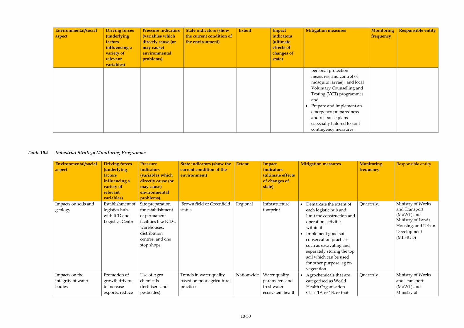
10-30
Environmental/social
aspect
Driving forces
(underlying
factors
influencing a
variety of
relevant
variables)
Pressure indicators
(variables which
directly cause (or
may cause)
environmental
problems)
State indicators (show
the current condition of
the environment)
Extent Impact
indicators
(ultimate
effects of
changes of
state)
Mitigation measures Monitoring
frequency
Responsible entity
personal protection
measures, and control of
mosquito larvae), and local
Voluntary Counselling and
Testing (VCT) programmes
and
Prepare and implement an
emergency preparedness
and response plans
especially tailored to spill
contingency measures..
Table 10.5 Industrial Strategy Monitoring Programme
Environmental/social
aspect
Driving forces
(underlying
factors
influencing a
variety of
relevant
variables)
Pressure
indicators
(variables which
directly cause (or
may cause)
environmental
problems)
State indicators (show the
current condition of the
environment)
Extent Impact
indicators
(ultimate effects
of changes of
state)
Mitigation measures Monitoring
frequency
Responsible entity
Impacts on soils and
geology
Establishment of
logistics hubs
with ICD and
Logistics Centre
Site preparation
for establishment
of permanent
facilities like ICDs,
warehouses,
distribution
centres, and one
stop shops.
Brown field or Greenfield
status
Regional Infrastructure
footprint
Demarcate the extent of
each logistic hub and
limit the construction and
operation activities
within it.
Implement good soil
conservation practices
such as excavating and
separately storing the top
soil which can be used
for other purpose eg re-
vegetation.
Quarterly. Ministry of Works and Transport (MoWT) and Ministry of Lands
Housing, and Urban
Development
(MLHUD)
Impacts on the
integrity of water
bodies
Promotion of
growth drivers
to increase
exports, reduce
Use of Agro
chemicals
(fertilisers and
pesticides).
Trends in water quality
based on poor agricultural
practices
Nationwide Water quality
parameters and
freshwater
ecosystem health
Agrochemicals that are
categorised as World
Health Organisation
Class 1A or 1B, or that
Quarterly Ministry of Works
and Transport
(MoWT) and
Ministry of
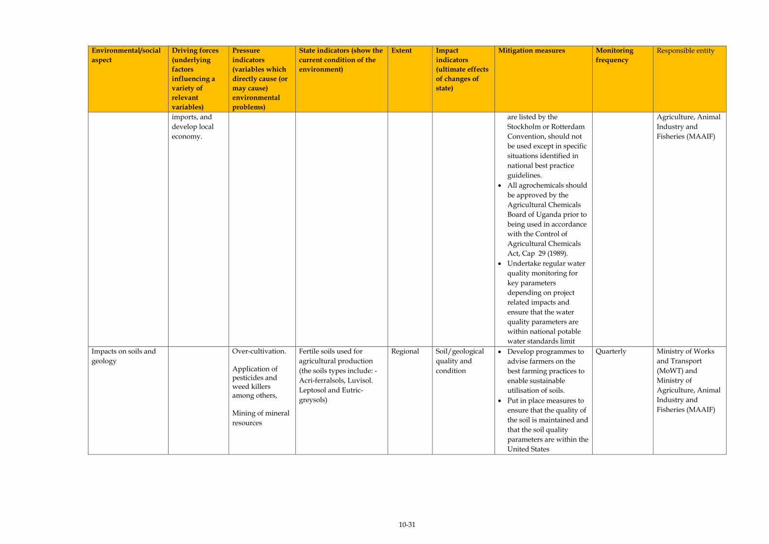
10-31
Environmental/social
aspect
Driving forces
(underlying
factors
influencing a
variety of
relevant
variables)
Pressure
indicators
(variables which
directly cause (or
may cause)
environmental
problems)
State indicators (show the
current condition of the
environment)
Extent Impact
indicators
(ultimate effects
of changes of
state)
Mitigation measures Monitoring
frequency
Responsible entity
imports, and
develop local
economy.
are listed by the
Stockholm or Rotterdam
Convention, should not
be used except in specific
situations identified in
national best practice
guidelines.
All agrochemicals should
be approved by the
Agricultural Chemicals
Board of Uganda prior to
being used in accordance
with the Control of
Agricultural Chemicals
Act, Cap 29 (1989).
Undertake regular water
quality monitoring for
key parameters
depending on project
related impacts and
ensure that the water
quality parameters are
within national potable
water standards limit
Agriculture, Animal
Industry and
Fisheries (MAAIF)
Impacts on soils and
geology
Over-cultivation. Application of pesticides and weed killers among others, Mining of mineral
resources
Fertile soils used for
agricultural production
(the soils types include: -
Acri-ferralsols, Luvisol.
Leptosol and Eutric-
greysols)
Regional Soil/geological
quality and
condition
Develop programmes to
advise farmers on the
best farming practices to
enable sustainable
utilisation of soils.
Put in place measures to
ensure that the quality of
the soil is maintained and
that the soil quality
parameters are within the
United States
Quarterly Ministry of Works
and Transport
(MoWT) and
Ministry of
Agriculture, Animal
Industry and
Fisheries (MAAIF)
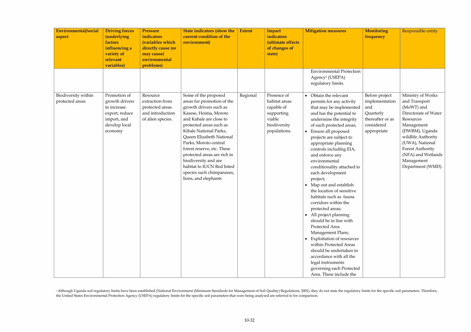
10-32
Environmental/social
aspect
Driving forces
(underlying
factors
influencing a
variety of
relevant
variables)
Pressure
indicators
(variables which
directly cause (or
may cause)
environmental
problems)
State indicators (show the
current condition of the
environment)
Extent Impact
indicators
(ultimate effects
of changes of
state)
Mitigation measures Monitoring
frequency
Responsible entity
Environmental Protection
Agency1 (USEPA)
regulatory limits.
Biodiversity within
protected areas
Promotion of
growth drivers
to increase
export, reduce
import, and
develop local
economy
Resource
extraction from
protected areas
and introduction
of alien species.
Some of the proposed
areas for promotion of the
growth drivers such as
Kasese, Hoima, Moroto
and Kabale are close to
protected areas such as
Kibale National Parks,
Queen Elizabeth National
Parks, Moroto central
forest reserve, etc. These
protected areas are rich in
biodiversity and are
habitat to IUCN Red listed
species such chimpanzees,
lions, and elephants
Regional Presence of
habitat areas
capable of
supporting
viable
biodiversity
populations.
Obtain the relevant
permits for any activity
that may be implemented
and has the potential to
undermine the integrity
of such protected areas;
Ensure all proposed
projects are subject to
appropriate planning
controls including EIA,
and enforce any
environmental
conditionality attached to
each development
project;
Map out and establish
the location of sensitive
habitats such as fauna
corridors within the
protected areas;
All project planning
should be in line with
Protected Area
Management Plans;
Exploitation of resources
within Protected Areas
should be undertaken in
accordance with all the
legal instruments
governing each Protected
Area. These include the
Before project
implementation
and
Quarterly
thereafter or as
considered
appropriate
Ministry of Works
and Transport
(MoWT) and
Directorate of Water
Resources
Management
(DWRM), Uganda
wildlife Authority
(UWA), National
Forest Authority
(NFA) and Wetlands
Management
Department (WMD).
1 Although Uganda soil regulatory limits have been established (National Environment (Minimum Standards for Management of Soil Quality) Regulations, 2001), they do not state the regulatory limits for the specific soil parameters. Therefore,
the United States Environmental Protection Agency (USEPA) regulatory limits for the specific soil parameters that were being analysed are referred to for comparison.
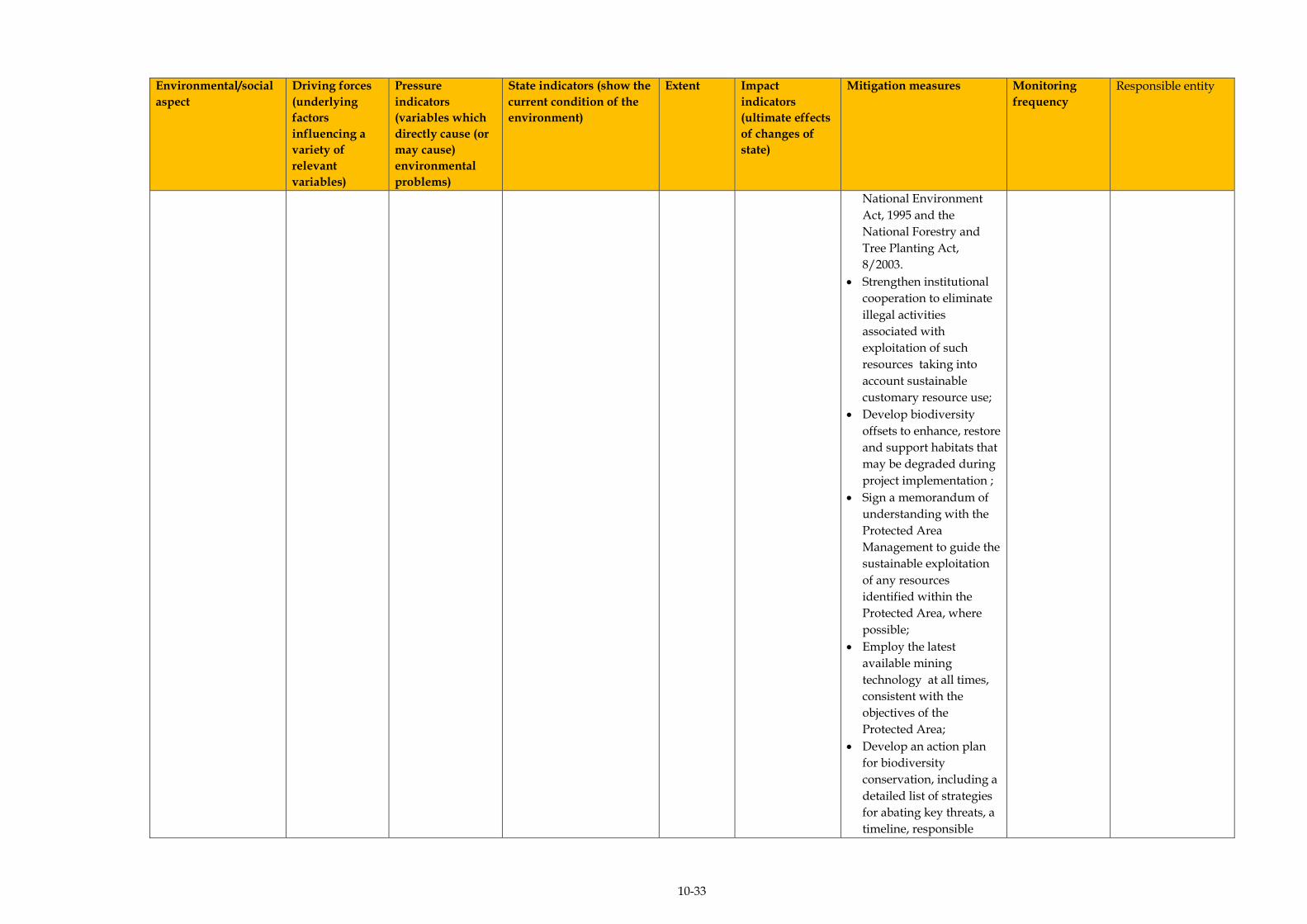
10-33
Environmental/social
aspect
Driving forces
(underlying
factors
influencing a
variety of
relevant
variables)
Pressure
indicators
(variables which
directly cause (or
may cause)
environmental
problems)
State indicators (show the
current condition of the
environment)
Extent Impact
indicators
(ultimate effects
of changes of
state)
Mitigation measures Monitoring
frequency
Responsible entity
National Environment
Act, 1995 and the
National Forestry and
Tree Planting Act,
8/2003.
Strengthen institutional
cooperation to eliminate
illegal activities
associated with
exploitation of such
resources taking into
account sustainable
customary resource use;
Develop biodiversity
offsets to enhance, restore
and support habitats that
may be degraded during
project implementation ;
Sign a memorandum of
understanding with the
Protected Area
Management to guide the
sustainable exploitation
of any resources
identified within the
Protected Area, where
possible;
Employ the latest
available mining
technology at all times,
consistent with the
objectives of the
Protected Area;
Develop an action plan
for biodiversity
conservation, including a
detailed list of strategies
for abating key threats, a
timeline, responsible
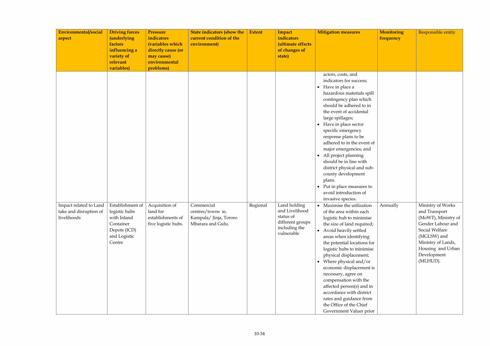
10-34
Environmental/social
aspect
Driving forces
(underlying
factors
influencing a
variety of
relevant
variables)
Pressure
indicators
(variables which
directly cause (or
may cause)
environmental
problems)
State indicators (show the
current condition of the
environment)
Extent Impact
indicators
(ultimate effects
of changes of
state)
Mitigation measures Monitoring
frequency
Responsible entity
actors, costs, and
indicators for success;
Have in place a
hazardous materials spill
contingency plan which
should be adhered to in
the event of accidental
large spillages;
Have in place sector
specific emergency
response plans to be
adhered to in the event of
major emergencies; and
All project planning
should be in line with
district physical and sub-
county development
plans.
Put in place measures to
avoid introduction of
invasive species.
Impact related to Land
take and disruption of
livelihoods
Establishment of
logistic hubs
with Inland
Container
Depots (ICD)
and Logistic
Centre
Acquisition of
land for
establishments of
five logistic hubs.
Commercial
centres/towns ie,
Kampala/ Jinja, Tororo
Mbarara and Gulu.
Regional Land holding and Livelihood status of different groups including the vulnerable
Maximise the utilisation
of the area within each
logistic hub to minimise
the size of land required;
Avoid heavily settled
areas when identifying
the potential locations for
logistic hubs to minimise
physical displacement;
Where physical and/or
economic displacement is
necessary, agree on
compensation with the
affected person(s) and in
accordance with district
rates and guidance from
the Office of the Chief
Government Valuer prior
Annually
Ministry of Works
and Transport
(MoWT), Ministry of
Gender Labour and
Social Welfare
(MGLSW) and
Ministry of Lands,
Housing and Urban
Development
(MLHUD).

10-35
Environmental/social
aspect
Driving forces
(underlying
factors
influencing a
variety of
relevant
variables)
Pressure
indicators
(variables which
directly cause (or
may cause)
environmental
problems)
State indicators (show the
current condition of the
environment)
Extent Impact
indicators
(ultimate effects
of changes of
state)
Mitigation measures Monitoring
frequency
Responsible entity
to the construction phase
of the logistic hubs;
Involve stakeholders at
all levels such as local
council committees, Sub-
county committees, and
the District committees,
CAO, RDC, politicians,
and ministries to sensitise
the community on the
intentions of acquiring
the for the establishment
of the logistic hubs;
Consider the interests of
vulnerable groups in the
communities that are
likely to be affected by
the proposed activities.
The groups considered
vulnerable include
households with very old
persons, disabled
persons, the poor1,
female headship and
child headship;
Develop and implement
livelihood enhancement
programmes to help
economically and
physically displaced
persons re-establish their
livelihoods or create new
ones. Some of the
livelihood enhancement
1 The poverty line is described in terms of the cost of obtaining the basic requirements. According to the 2002 Census data, five household items were considered in defining the poverty line and these included; (i) soap to bathe, (ii) sugar
consumed by each member of the household at least once a day, (iii) a blanket for each child in the household, (iv) a pair of shoes for every member of the household, and (v) two pairs of clothes for each member of the household.
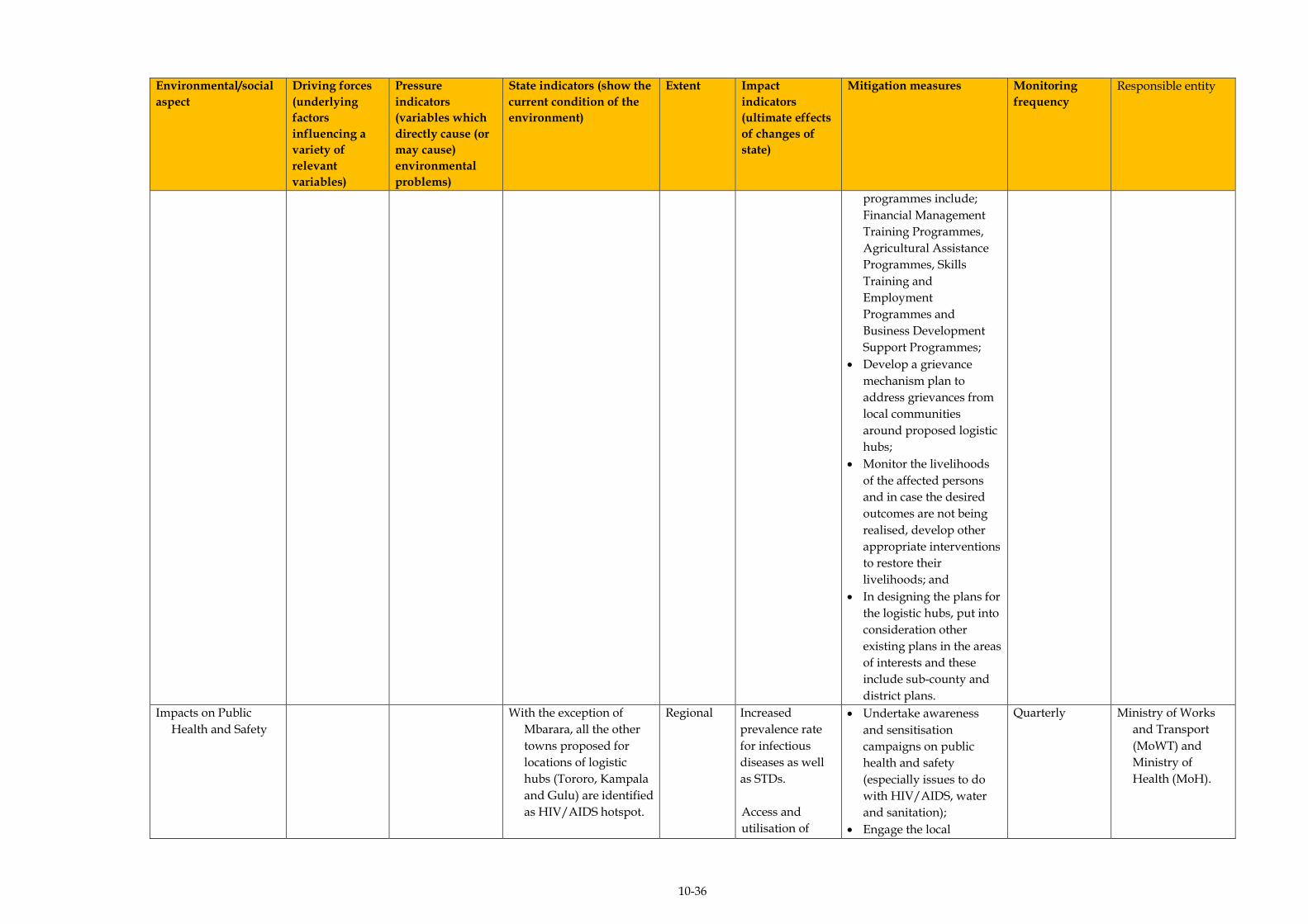
10-36
Environmental/social
aspect
Driving forces
(underlying
factors
influencing a
variety of
relevant
variables)
Pressure
indicators
(variables which
directly cause (or
may cause)
environmental
problems)
State indicators (show the
current condition of the
environment)
Extent Impact
indicators
(ultimate effects
of changes of
state)
Mitigation measures Monitoring
frequency
Responsible entity
programmes include;
Financial Management
Training Programmes,
Agricultural Assistance
Programmes, Skills
Training and
Employment
Programmes and
Business Development
Support Programmes;
Develop a grievance
mechanism plan to
address grievances from
local communities
around proposed logistic
hubs;
Monitor the livelihoods
of the affected persons
and in case the desired
outcomes are not being
realised, develop other
appropriate interventions
to restore their
livelihoods; and
In designing the plans for
the logistic hubs, put into
consideration other
existing plans in the areas
of interests and these
include sub-county and
district plans.
Impacts on Public
Health and Safety
With the exception of
Mbarara, all the other
towns proposed for
locations of logistic
hubs (Tororo, Kampala
and Gulu) are identified
as HIV/AIDS hotspot.
Regional Increased
prevalence rate
for infectious
diseases as well
as STDs.
Access and
utilisation of
Undertake awareness
and sensitisation
campaigns on public
health and safety
(especially issues to do
with HIV/AIDS, water
and sanitation);
Engage the local
Quarterly Ministry of Works
and Transport
(MoWT) and
Ministry of
Health (MoH).

10-37
Environmental/social
aspect
Driving forces
(underlying
factors
influencing a
variety of
relevant
variables)
Pressure
indicators
(variables which
directly cause (or
may cause)
environmental
problems)
State indicators (show the
current condition of the
environment)
Extent Impact
indicators
(ultimate effects
of changes of
state)
Mitigation measures Monitoring
frequency
Responsible entity
All the five potential sites
for establishment of
logistic hubs
(Kampala/Jinja, Tororo,
Mbarara and Gulu) are
among the top fifteen
performing districts
based on selected
performance indicators
that were used to assess
the health performance
of various districts in
Uganda.
health and
sanitation
facilities.
Mortality rate.
Population
influx.
Number of
households
displaced.
governments (especially
at district and sub-county
level) to prepare
community members for
any influx of in-migrants
(for example, by
developing by-laws and
community policing
systems for effective
control of large numbers
of in-migrants;
Avoid or at least
minimise displacement,
wherever feasible, by
using brown
field/already existing
commercial sites) and
avoid any cause of
physical and economic
displacement;
Where large construction
activities are to be carried
out, establish workers’
camps mainly to
accommodate employees
from outside the location
of the identified logistic
hubs. These camps
should be fitted with the
necessary social service
amenities such as health,
water and sanitation
facilities;
Give the local community
members the first priority
in terms of employment
opportunities to
minimise the number of
migrant workers;

10-38
Environmental/social
aspect
Driving forces
(underlying
factors
influencing a
variety of
relevant
variables)
Pressure
indicators
(variables which
directly cause (or
may cause)
environmental
problems)
State indicators (show the
current condition of the
environment)
Extent Impact
indicators
(ultimate effects
of changes of
state)
Mitigation measures Monitoring
frequency
Responsible entity
Undertake an
Environment, Health and
Safety (EHS) induction
for all workers, including
sub-contractors and
casual labourers before
commencing work,
which should include a
full briefing on site safety
and rules in order to
minimise the occurrence
of occupational health
and safety related
incidents, accidents and l
diseases;
Develop and implement
waste management plans
for each of the logistic
hubs;
Isolate hazardous
materials such as fuel,
explosives and
hazardous chemicals and
appropriate safeguards in
place for dealing with
any eventualities related
to them;
Undertake community
awareness and
sensitisation about the
logistic hubs prior to the
establishment so that
community members
become more vigilant
and are aware of what to
expect in terms of
potential nuisances;
Develop a grievance
mechanism plan to
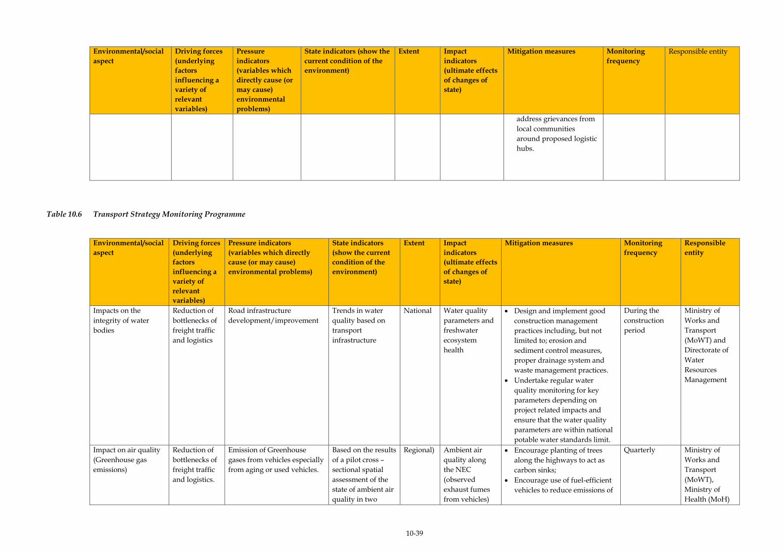
10-39
Environmental/social
aspect
Driving forces
(underlying
factors
influencing a
variety of
relevant
variables)
Pressure
indicators
(variables which
directly cause (or
may cause)
environmental
problems)
State indicators (show the
current condition of the
environment)
Extent Impact
indicators
(ultimate effects
of changes of
state)
Mitigation measures Monitoring
frequency
Responsible entity
address grievances from
local communities
around proposed logistic
hubs.
Table 10.6 Transport Strategy Monitoring Programme
Environmental/social
aspect
Driving forces
(underlying
factors
influencing a
variety of
relevant
variables)
Pressure indicators
(variables which directly
cause (or may cause)
environmental problems)
State indicators
(show the current
condition of the
environment)
Extent Impact
indicators
(ultimate effects
of changes of
state)
Mitigation measures Monitoring
frequency
Responsible
entity
Impacts on the
integrity of water
bodies
Reduction of
bottlenecks of
freight traffic
and logistics
Road infrastructure
development/improvement
Trends in water
quality based on
transport
infrastructure
National Water quality
parameters and
freshwater
ecosystem
health
Design and implement good
construction management
practices including, but not
limited to; erosion and
sediment control measures,
proper drainage system and
waste management practices.
Undertake regular water
quality monitoring for key
parameters depending on
project related impacts and
ensure that the water quality
parameters are within national
potable water standards limit.
During the
construction
period
Ministry of
Works and
Transport
(MoWT) and
Directorate of
Water
Resources
Management
Impact on air quality
(Greenhouse gas
emissions)
Reduction of
bottlenecks of
freight traffic
and logistics.
Emission of Greenhouse
gases from vehicles especially
from aging or used vehicles.
Based on the results
of a pilot cross –
sectional spatial
assessment of the
state of ambient air
quality in two
Regional) Ambient air
quality along
the NEC
(observed
exhaust fumes
from vehicles)
Encourage planting of trees
along the highways to act as
carbon sinks;
Encourage use of fuel-efficient
vehicles to reduce emissions of
Quarterly
Ministry of
Works and
Transport
(MoWT),
Ministry of
Health (MoH)

10-40
Environmental/social
aspect
Driving forces
(underlying
factors
influencing a
variety of
relevant
variables)
Pressure indicators
(variables which directly
cause (or may cause)
environmental problems)
State indicators
(show the current
condition of the
environment)
Extent Impact
indicators
(ultimate effects
of changes of
state)
Mitigation measures Monitoring
frequency
Responsible
entity
Ugandan urban
centres (Kampala
and Jinja, also
within the NEC)
conducted in 2014,
the ambient
concentrations of
gas phase air
pollutant levels
(NO2, SO2 and O3)
was low.
Air pollution
related
infections.
greenhouse gases;
Put in place measures to
ensure that greenhouse gas
emissions from any machinery
and vehicles are minimised and
that gas emissions are within
limits as stipulated in National
Environment (Draft Air
Quality) Standards 2006;
Undertake regular air quality
monitoring of key air pollutants
along busy routes/any
identified air pollution hotspot
with an aim to reverse any
negative trends as per the
National Environment (Draft
Air Quality) Standards 2006;
Limiting vehicle fleet age ie
put in place controls to stop
importation of very old vehicles
which are the major
contributors to greenhouse
gases;
Carry out periodic health
checks on groups that are at
risk to the effects of air
pollution particularly the
young, the elderly for
respiratory and eye diseases
such as asthma, lung cancer
and conjunctivitis that have
been associated with air
pollution;
Encourage use of rail for freight
movement of goods instead of
vehicles which are one of the
main contributors to GHG
emissions from road transport;
and.
and National
Environment
Management
Authority
(NEMA)
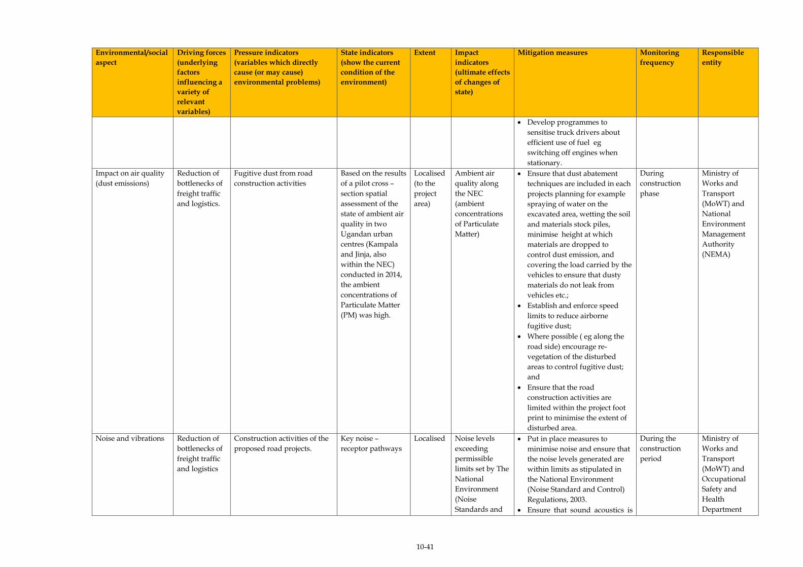
10-41
Environmental/social
aspect
Driving forces
(underlying
factors
influencing a
variety of
relevant
variables)
Pressure indicators
(variables which directly
cause (or may cause)
environmental problems)
State indicators
(show the current
condition of the
environment)
Extent Impact
indicators
(ultimate effects
of changes of
state)
Mitigation measures Monitoring
frequency
Responsible
entity
Develop programmes to
sensitise truck drivers about
efficient use of fuel eg
switching off engines when
stationary.
Impact on air quality
(dust emissions)
Reduction of
bottlenecks of
freight traffic
and logistics.
Fugitive dust from road
construction activities
Based on the results
of a pilot cross –
section spatial
assessment of the
state of ambient air
quality in two
Ugandan urban
centres (Kampala
and Jinja, also
within the NEC)
conducted in 2014,
the ambient
concentrations of
Particulate Matter
(PM) was high.
Localised
(to the
project
area)
Ambient air
quality along
the NEC
(ambient
concentrations
of Particulate
Matter)
Ensure that dust abatement
techniques are included in each
projects planning for example
spraying of water on the
excavated area, wetting the soil
and materials stock piles,
minimise height at which
materials are dropped to
control dust emission, and
covering the load carried by the
vehicles to ensure that dusty
materials do not leak from
vehicles etc.;
Establish and enforce speed
limits to reduce airborne
fugitive dust;
Where possible ( eg along the
road side) encourage re-
vegetation of the disturbed
areas to control fugitive dust;
and
Ensure that the road
construction activities are
limited within the project foot
print to minimise the extent of
disturbed area.
During
construction
phase
Ministry of
Works and
Transport
(MoWT) and
National
Environment
Management
Authority
(NEMA)
Noise and vibrations
Reduction of
bottlenecks of
freight traffic
and logistics
Construction activities of the
proposed road projects.
Key noise –
receptor pathways
Localised Noise levels
exceeding
permissible
limits set by The
National
Environment
(Noise
Standards and
Put in place measures to
minimise noise and ensure that
the noise levels generated are
within limits as stipulated in
the National Environment
(Noise Standard and Control)
Regulations, 2003.
Ensure that sound acoustics is
During the
construction
period
Ministry of
Works and
Transport
(MoWT) and
Occupational
Safety and
Health
Department
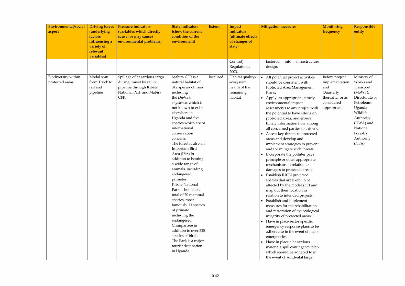
10-42
Environmental/social
aspect
Driving forces
(underlying
factors
influencing a
variety of
relevant
variables)
Pressure indicators
(variables which directly
cause (or may cause)
environmental problems)
State indicators
(show the current
condition of the
environment)
Extent Impact
indicators
(ultimate effects
of changes of
state)
Mitigation measures Monitoring
frequency
Responsible
entity
Control)
Regulations,
2003.
factored into infrastructure
design.
Biodiversity within
protected areas
Modal shift
from Truck to
rail and
pipeline
Spillage of hazardous cargo
during transit by rail or
pipeline through Kibale
National Park and Mabira
CFR.
Mabira CFR is a
natural habitat of
312 species of trees
including
the Diphasia
angolensis which is
not known to exist
elsewhere in
Uganda and five
species which are of
international
conservation
concern.
The forest is also an
Important Bird
Area (IBA) in
addition to hosting
a wide range of
animals, including
endangered
primates.
localised
Habitat quality/
ecosystem
health of the
remaining
habitat
All potential project activities
should be consistent with
Protected Area Management
Plans;
Apply, as appropriate, timely
environmental impact
assessments to any project with
the potential to have effects on
protected areas, and ensure
timely information flow among
all concerned parties to this end
Assess key threats to protected
areas and develop and
implement strategies to prevent
and/or mitigate such threats
Incorporate the polluter pays
principle or other appropriate
mechanisms in relation to
damages to protected areas;
Establish IUCN protected
species that are likely to be
affected by the modal shift and
map out their location in
relation to intended projects;
Establish and implement
measures for the rehabilitation
and restoration of the ecological
integrity of protected areas;
Have in place sector specific
emergency response plans to be
adhered to in the event of major
emergencies;
Have in place a hazardous
materials spill contingency plan
which should be adhered to in
the event of accidental large
Before project
implementation
and
Quarterly
thereafter or as
considered
appropriate
Ministry of
Works and
Transport
(MoWT),
Directorate of
Petroleum,
Uganda
Wildlife
Authority
(UWA) and
National
Forestry
Authority
(NFA).
Kibale National
Park is home to a
total of 70 mammal
species, most
famously 13 species
of primate
including the
endangered
Chimpanzee in
addition to over 325
species of birds.
The Park is a major
tourist destination
in Uganda

10-43
Environmental/social
aspect
Driving forces
(underlying
factors
influencing a
variety of
relevant
variables)
Pressure indicators
(variables which directly
cause (or may cause)
environmental problems)
State indicators
(show the current
condition of the
environment)
Extent Impact
indicators
(ultimate effects
of changes of
state)
Mitigation measures Monitoring
frequency
Responsible
entity
spillages; and
Take measures to control risks
associated with the
introduction and/or spread of
invasive alien species in
protected areas.
Reduction of
bottlenecks of
freight traffic
and logistics.
Increase in the footprint of
linear infrastructure
Mabira CFR is as
described above for
the modal shift
Localised Extent of habitat
destruction
(health of the
existing habitat)
Obtain the relevant permits for
any activity that may be
implemented and has the
potential to undermine the
integrity of such protected
areas;
All potential project activities
should be consistent with
Protected Area Management
Plans;
Apply, as appropriate, timely
environmental impact
assessments to any project with
the potential to have effects on
protected areas, and ensure
timely information flow among
all concerned parties to this
end;
Map out and establish the
location of sensitive and
valuable ecosystems such as
fauna corridors and watering
areas;
Assess the baseline status of
key biodiversity features,
including the distribution and
viability of IUCN Red listed
species, natural communities
and ecological systems;
Before project
implementation
and
Quarterly
thereafter or as
considered
appropriate
Ministry of
Works and
Transport
(MoWT) and
National
Forestry
Authority
(NFA)
Mpanga CFR
contains medium
sized primates and
birds and is also a
tourist attraction.

10-44
Environmental/social
aspect
Driving forces
(underlying
factors
influencing a
variety of
relevant
variables)
Pressure indicators
(variables which directly
cause (or may cause)
environmental problems)
State indicators
(show the current
condition of the
environment)
Extent Impact
indicators
(ultimate effects
of changes of
state)
Mitigation measures Monitoring
frequency
Responsible
entity
Develop an action plan for
biodiversity conservation,
including a detailed list of
strategies for abating key
threats, a timeline, responsible
actors, costs, and indicators for
success;
Limit the extent of project
infrastructure to the required
footprint;
Standard controls should be
adhered to when setting up
infrastructure to minimise the
risk of accidents; and
Position
infrastructure/development,
away from identified sensitive
and valuable ecosystems.
Enhancement
of transport
infrastructure
Dredging works along the
shores of Lake Victoria
(destruction of wetland and
potential breeding ground for
fish at the shores)
There is already an
existing
infrastructure at
port bell (main port
in Uganda) which
will be
enhancement. Port
bell is aligned with
a permanent
wetland and it is
close to Lutembe
Bay Ramsar site an
important bird area
and thus migratory
and local birds
frequent the site.
Trans-
boundary
Extent of habitat
destruction
(health of the
existing habitat)
Obtain the relevant permits for
any activity that may be
implemented and has the
potential to undermine the
integrity of such protected
areas;
All potential project activities
should be consistent with Lake
Victoria Environment
Management Plan;
Apply, as appropriate, timely
environmental impact
assessments to any project with
the potential to have effects on
protected areas such as Ramsar
sites, and ensure timely
information flow among all
concerned parties to this end;
Assess key threats to the
protected areas and develop
and implement strategies to
Before project
implementation
and
Quarterly
thereafter or as
considered
appropriate
Ministry of
Works and
Transport
(MoWT),
Wetlands
Management
Department
(WMD),
NEMA, and
Lake Victoria
Basin
Commission
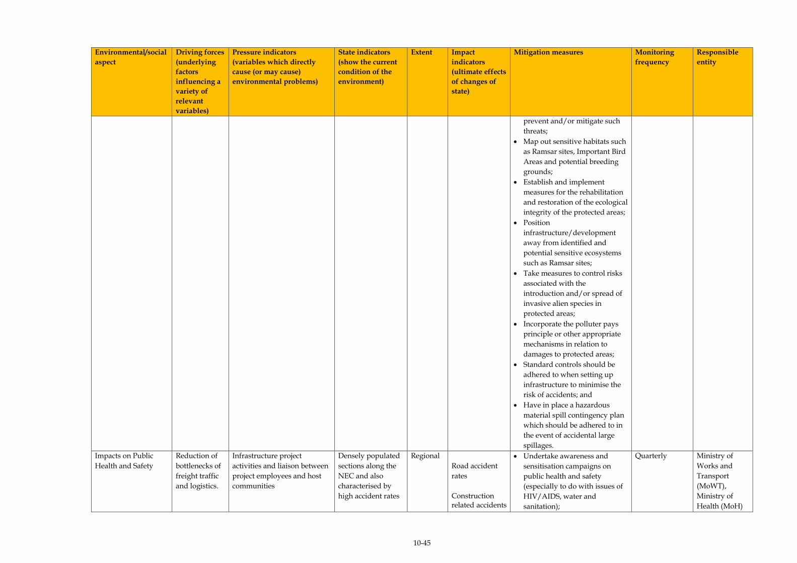
10-45
Environmental/social
aspect
Driving forces
(underlying
factors
influencing a
variety of
relevant
variables)
Pressure indicators
(variables which directly
cause (or may cause)
environmental problems)
State indicators
(show the current
condition of the
environment)
Extent Impact
indicators
(ultimate effects
of changes of
state)
Mitigation measures Monitoring
frequency
Responsible
entity
prevent and/or mitigate such
threats;
Map out sensitive habitats such
as Ramsar sites, Important Bird
Areas and potential breeding
grounds;
Establish and implement
measures for the rehabilitation
and restoration of the ecological
integrity of the protected areas;
Position
infrastructure/development
away from identified and
potential sensitive ecosystems
such as Ramsar sites;
Take measures to control risks
associated with the
introduction and/or spread of
invasive alien species in
protected areas;
Incorporate the polluter pays
principle or other appropriate
mechanisms in relation to
damages to protected areas;
Standard controls should be
adhered to when setting up
infrastructure to minimise the
risk of accidents; and
Have in place a hazardous
material spill contingency plan
which should be adhered to in
the event of accidental large
spillages.
Impacts on Public
Health and Safety
Reduction of
bottlenecks of
freight traffic
and logistics.
Infrastructure project
activities and liaison between
project employees and host
communities
Densely populated
sections along the
NEC and also
characterised by
high accident rates
Regional
Road accident
rates
Construction related accidents
Undertake awareness and
sensitisation campaigns on
public health and safety
(especially to do with issues of
HIV/AIDS, water and
sanitation);
Quarterly
Ministry of
Works and
Transport
(MoWT),
Ministry of
Health (MoH)
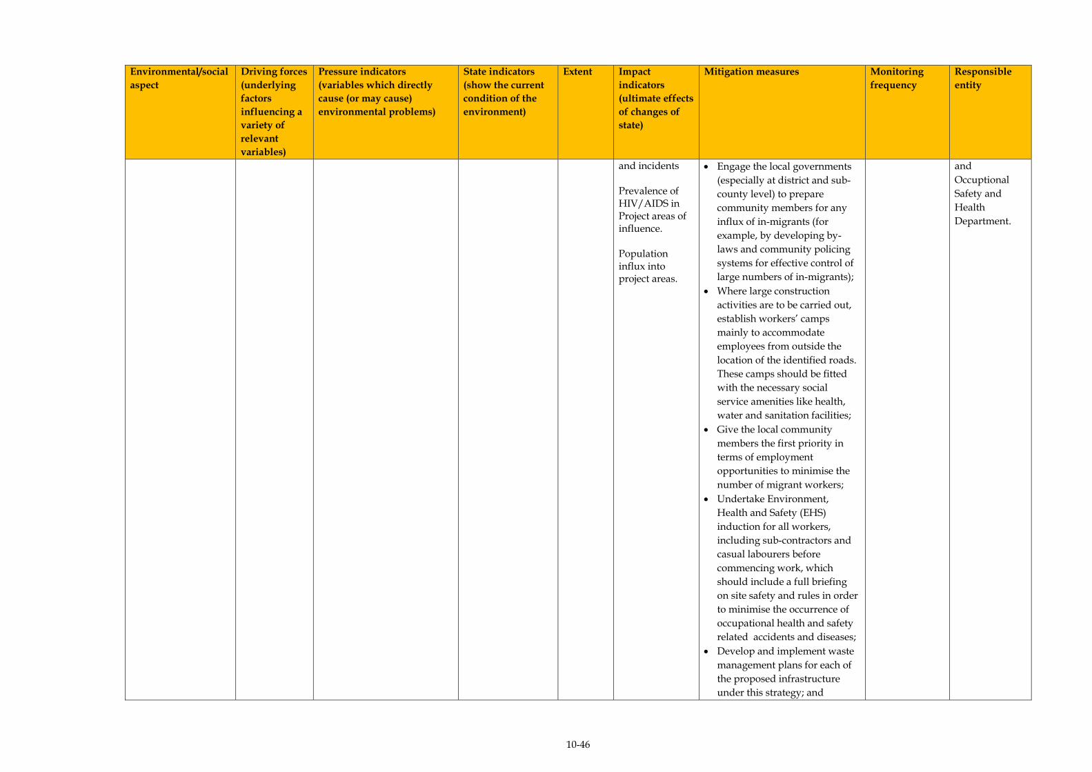
10-46
Environmental/social
aspect
Driving forces
(underlying
factors
influencing a
variety of
relevant
variables)
Pressure indicators
(variables which directly
cause (or may cause)
environmental problems)
State indicators
(show the current
condition of the
environment)
Extent Impact
indicators
(ultimate effects
of changes of
state)
Mitigation measures Monitoring
frequency
Responsible
entity
and incidents Prevalence of HIV/AIDS in Project areas of influence. Population influx into project areas.
Engage the local governments
(especially at district and sub-
county level) to prepare
community members for any
influx of in-migrants (for
example, by developing by-
laws and community policing
systems for effective control of
large numbers of in-migrants);
Where large construction
activities are to be carried out,
establish workers’ camps
mainly to accommodate
employees from outside the
location of the identified roads.
These camps should be fitted
with the necessary social
service amenities like health,
water and sanitation facilities;
Give the local community
members the first priority in
terms of employment
opportunities to minimise the
number of migrant workers;
Undertake Environment,
Health and Safety (EHS)
induction for all workers,
including sub-contractors and
casual labourers before
commencing work, which
should include a full briefing
on site safety and rules in order
to minimise the occurrence of
occupational health and safety
related accidents and diseases;
Develop and implement waste
management plans for each of
the proposed infrastructure
under this strategy; and
and
Occuptional
Safety and
Health
Department.

10-47
Environmental/social
aspect
Driving forces
(underlying
factors
influencing a
variety of
relevant
variables)
Pressure indicators
(variables which directly
cause (or may cause)
environmental problems)
State indicators
(show the current
condition of the
environment)
Extent Impact
indicators
(ultimate effects
of changes of
state)
Mitigation measures Monitoring
frequency
Responsible
entity
Install clear and visible signage
on all roads especially in
community areas, around
schools and hospitals to
minimise the risk of accidents.
Undertake an Environment,
Health and Safety (EHS)
induction for all workers,
including sub-contractors and
casual labourers before
commencing work, which
should include a full briefing
on site safety and rules in order
to minimise the occurrence of
accidents and occupational
diseases.
Develop and implement waste
management plans for each of
the proposed road.
Install clear and visible signage
to all roads especially in
community areas, around
schools and hospitals to
minimise the risk of accidents.
Monitor and direct traffic flow
by installing traffic controller or
signal person.

ERM/ATACAMA CONSULTING JST/MOWT
11-1
11 CONCLUSIONS AND RECOMMENDATIONS
Based on the Strategic Environmental Assessment (SEA) of the Master
Plan on Logistics in the Northern Economic Corridor, the following
conclusions are made:-
(a) Similar to the findings of the JST, who established that, based on
three main criteria (Public Benefit, Public Intervention and Vision), of
the combination of alternatives considered as possible development
options (A (“Super Double-Core Type” - for concentrating
investments on capitals as usual), B (“Double-core with Regional
Industrial Promotion Type” - for expanding exports with industrial
promotion) and C (“Multi-core with Regional Industrial
Development Type” - for expanding exports with industrial
promotion and balanced development)) during the Master Plan
formulation process, Alternative C was the preferred alternative for
the Master Plan, based on the balance of its implications on a set of
environmental and social/SEA objectives (specifically: maintain the
integrity of water bodies, maintain the integrity of soils and geology
conditions, maintain and enhance air quality, minimise noise and
vibrations, minimise impact on protected areas, conserve and
enhance biodiversity outside protected areas, safeguard public health
and safety, minimise land take and disruption of livelihoods, well
integrated modes of transport, protect integrity of archaeological and
cultural heritage sites and minimise visual impacts), the same
alternative was preferred. Alternative C includes strategies for:-
Expanding exports with industrial promotion and balanced
development through the promotion of “Regional Production
Centres”;
Promotion of urban and logistics functions of “Secondary Cities”
into hubs of business, commerce, service and logistics for
surrounding regions with local government involvement; and
Establishment and enhancement of an efficient transport network.
(b) In line with the SEA appraisal as indicated in (a) above, the impact
identification/analysis was therefore based on the preferred
Alternative “C”, particularly its strategies and respective options.
ERM/ATACAMA CONSULTING JST/MOWT
11-2
Only the aspects that were deemed to be negative and ‘major’ in
scope were taken forward for the detailed impact assessment (1)-
those aspects that were likely to be majorly positive could only be
enhanced as part of the implementation of the Master Plan.
Following assessment of the SEA objectives where major negative
impacts will potentially occur during the implementation of the NEC
Master Plan, bearing in mind the uncertainties surrounding: the
protection of the integrity of archaeological and cultural heritage
sites for the regional strategy, industrial strategy and transport
strategy, and, minimising land take and disruption of livelihoods for
the industrial strategy alternative associated with the promotion of
growth drivers to increase exports, reduce imports, and develop local
economy, the following findings were made (Table 11.1):-
Despite the strategy to be implemented, the impacts of very large
significance are: (i) impacts on the integrity of water bodies and,
(ii) impacts on biodiversity in protected areas. This is because:-
The NEC traverses the Lake Victoria Basin, Lake Edward Basin,
Lake Kyoga Basin, Victoria Nile Basin and the Albert Nile Basin.
Additionally, due to the interconnected nature of the surface
water resources of Uganda, the Corridor (specifically, the road
infrastructure associated with it) traverses some of the country’s
major wetlands (of social and ecological importance) including but
not limited to permanent wetlands such as; the Lake Kyoga
wetland (Tororo - Gulu –Elegu route) Kibimba wetland in Bugiri
along the main Tororo – Kampala – Katuna route and, Lake
Mburo wetland along the Kampala – Mbarara route. Also
important to consider is the River Nile crossing along the Tororo -
Kampala route as well as the Kazinga channel crossing along the
Mbarara - Mpondwe route.
(1) As outlined in Section 9 above, the assessment process was preceded by the identification and evaluation of potentially
significant environmental impacts likely to be attributed to the implementation of the Master Plan. However, only the
significant issues are the focus of any SEA, and the reference point for the level of significance of potential impacts in the
current study were the SEA objectives.
ERM/ATACAMA CONSULTING JST/MOWT
11-3
The NEC traverses a number of protected areas including: Lake
Mburo National Park along the Kampala - Mbarara - Mpondwe
route, Murchison Falls National Park along the Kampala - Gulu
route, Central Forest Reserves (Mabira CFR and Busitema CFR
along the Tororo – Kampala route, Mpanga CFR along the
Kampala-Katuna border, Kalinzu and Maramagambo CFRs along
the Mbarara-Mpondwe border) as well as Queen Elizabeth
National Park (QENP) along the Mbarara - Mpondwe route. Key
avifauna habitats (Important Bird Areas – IBAs) traversed include:
R. Nile and Mabira CFR along the Tororo - Kampala route, Lake
Mburo National Park along the Kampala - Katuna border route
and Queen Elizabeth National park along the Mbarara - Mpondwe
route.
The regional strategy of linking with LAPSSET, Central Corridor
and Kampala-Juba-Addis-Ababa-Djibouti Corridor has the highest
number of impacts with very large significance (4 impacts),
followed by the industrial strategy of promotion of growth drivers
to increase export, reduce import and develop local economy (3
impacts), and the transport strategy of reduction of bottlenecks of
freight traffic and logistics (2 impacts). This is the case since the
proposed projects associated with these options will most likely be
implemented in protected areas such as Lake Victoria and CFRs.
The strategies with the least number of impacts were; the
transport strategies of enhancement of transport infrastructure,
and, modal shift from truck to rail and pipeline (with 1 impact
each), and, the industrial strategy of connecting industrial areas to
logistic hubs through Cargo Oriented Development (COD) which
had no impacts. This is the case since the shift of cargo to either
pipeline or rail transport does not involve direct physical
disturbance of the biophysical and social environment other than
making use of available infrastructure. The industrial strategy of
connecting industrial areas to logistic hubs through Cargo
Oriented Development (COD) had no impacts since by its nature it
was supporting the establishment of logistics hub strategy.
(c) It is important to note however that, certain strategies within the
Master Plan are highly interdependent and one cannot be
implemented or realised without the other.
ERM/ATACAMA CONSULTING JST/MOWT
11-4
For example, the regional strategy option of linking with LAPSSET,
Central Corridor and Kampala-Juba-Addis-Ababa-Djibouti Corridor,
cannot be implemented without the transport strategy option of
enhancement of transport infrastructure because, establishment of
the inland waterway linkage routes is to some extent, largely
dependent on rehabilitation of the ports on the lake, and therefore,
the impacts of both these strategies would need to be considered.
(d) The Cumulative Impact Assessment (CIA) - systematic procedure
for identifying and evaluating the significance of impacts from
multiple activities - as guided by the guidelines for Cumulative
Effects Assessment in SEA of Plans (Cooper, 2004) undertaken
during this SEA, indicated the following:-
Cumulative impacts will not be realised in some instances because
other actions aimed at promoting developments within the
Northern Corridor are already an integral part of the Master Plan
interventions.
For example, the following:- under the NCIP (designed to
generate sustainable political will to fast track the implementation
of the projects identified in the Northern Corridor) - Standard
Gauge Railway, ICT Infrastructure, Oil refinery development,
Power generation, transmission and interconnectivity, Crude oil
pipeline development, Refined petroleum products pipeline
development, Commodities exchange, Single customs territory;
under Vision 2040 (conceptualised around strengthening the
fundamentals of the economy to harness the abundant
opportunities around the country) - oil and gas, tourism,
minerals, ICT business, trade, water resources, industrialisation,
and agriculture. On the other hand, the fundamentals include:
infrastructure for (energy, transport, water, oil and gas and ICT),
and, under the second National Development Plan (NDPII)
(designed to propel Uganda towards middle income status by
2020, in line with the aspirations of Uganda’s Vision 2040) –
Agriculture, Tourism, Minerals, oil and gas, Infrastructure
development.
Therefore, even without implementation of the NEC Master Plan,
if these other PPPs are implemented, these impacts will still be
realised.
ERM/ATACAMA CONSULTING JST/MOWT
11-5
As indicated in Section 9 above however, there are other PPPs,
which if implemented, even within the Master Plan itself alone (
eg a combination of different industrial, transport and regional
strategy options), will result in cumulative impacts (particularly
those affecting the same receptor, or that would need to be
implemented at the same time/within a short time period of the
other).
This is particularly true for the cumulative impacts arising from
the interactions between the following interventions, which would
result in the significance ratings indicated in (Table 11.2):-
Linking agricultural productive areas and mineral resources
areas through development of secondary cities;
Linking with LAPSSET, central corridor and Kampala-Juba-
Addis Ababa- Djibouti Corridor;
Establishment of logistic hubs with ICD and Logistics Centre;
Connecting industrial areas to logistic hubs through Cargo-
Oriented Development (COD);
Promotion of growth drivers to increase exports, reduce
imports, and develop the local economy; and
Reduction of bottlenecks of freight traffic and logistics; and
As is evident from Table 11.2 the cumulative impacts of very
large significance are: impacts on the integrity of water
bodies, impacts on soils and geology and impacts on
biodiversity within protected areas, mainly as a result of the
different strategy options being implemented on the same
resource/receptor.
(e) Following the identification of the key environmental and social
impacts associated with the implementation of the Master Plan (Table
11.1) a number of key recommendations for the minimisation of
negative impacts have been identified.
ERM/ATACAMA CONSULTING JST/MOWT
11-6
Key among these, based on the components of the environment
likely to be most affected by the proposed Master Plan (despite the
strategy(ies) chosen for implementation), are the mitigation measures
and monitoring recommendations linked to the management of
impacts on water resources and biodiversity within protected areas
traversed by the NEC.
(f) Linked to (e) above, a number of government Ministries,
Departments and Agencies (MDAs) will need to be involved in the
monitoring of impacts associated with the implementation of the
Master Plan, with the MoWT taking the lead by virtue of its being the
proponent of the Master Plan. The monitoring of the implementation
of the Master Plan can leverage on the existing monitoring
mechanisms (and their associated indicators) of the respective
MDAs. It is therefore essential that the SEA capacity is built or
strengthened in these institutions, with the same being done with the
District Technical Planning Committees (DTPCs) of the NEC
districts, so as to allow them to duly undertake their responsibilities
during implementation of the Master Plan.
(g) Furthermore, based on a climate change vulnerability assessment,
the risks associated with the implementation of the Master Plan
were found to include:
Table 11.1 A. Greenhouse Gas Emissions
Strategy Option Potential Impact on Climate Change
Transport Modal shift from
truck to rail and
pipeline.
This strategy option will reduce greenhouse
gas emissions in the long term. The trains to
be run on the proposed SGR will be electric
and transportation of oil via pipeline is likely
to require significantly less energy than
trucking or using rail – hence reduced
emissions.
Reduction of
bottlenecks of
freight traffic and
logistics.
This strategy option will increase greenhouse
gas emissions. Removal of bottlenecks will
most likely result in a spike in traffic
volumes, especially road traffic that is
currently constrained by these bottlenecks
which will result in a corresponding increase
in emissions from the increased traffic.
ERM/ATACAMA CONSULTING JST/MOWT
11-7
Strategy Option Potential Impact on Climate Change
Industrial Promotion of
growth drivers to
increase exports,
reduce imports,
and develop the
local economy.
This strategy option will increase greenhouse
gas emissions as this option is likely to
intensify the supply side of the economy.
Processes associated with the development
and operation of mineral and agricultural
production industries, where GHGs are
emitted, may result in the release of these
emissions into the atmosphere.
Table 11.2 B. Flooding
Strategy Options Potential Impact on Climate Change
Transport Enhancement
of transport
infrastructure
Development of Paved or impervious
infrastructure is likely to result in increased surface
water runoff, which may lead to flooding in flood
prone areas if the drainage systems associated with
the infrastructures are not properly developed to
contain surface runoff, and prevent flooding.
Reduction of
bottlenecks of
freight traffic
and logistics
Regional Linking
agricultural
productive
areas and
mineral
resources
through
development
of secondary
cities
Development of secondary cities (currently
planned for Mbarara, Gulu, Arua and Mbale) will
result in major infrastructural development that
increase paved surfaces areas – resulting in
increased surface water runoff, which is
exacerbated if drainage systems are not properly
designed, constructed and maintained.
Additionally, development of secondary cities
could encroach on green field sites such as
wetlands which are supposed to regulate water
flow thereby exacerbating the flooding situation.
This is particularly important for Mbarara and
Gulu districts – which are prone to flooding.
Industrial Establishment
of logistic
hubs with
ICD and
Logistic
Centre
Establishment of logistic hubs is likely to result in
an increase in the pave surface area which can also
have an effect on runoff speeds/flooding potential.

ERM/ATACAMA CONSULTING JST/MOWT
11-8
In light of the above, climate change adaptation strategies such as
Sustainable development goal 9 - “Build resilient infrastructure, promote
inclusive and sustainable industrialization and foster innovation” (SDG,
2015), integration of climate into existing infrastructure risk assessments
and, climate proof building need to be considered.
With regards to agricultural production areas - promote agricultural
best practices, sustainable utilisation of agricultural products and, new
technologies in processing and industry to enhance cleaner production.
Traffic management in secondary cities to reduce traffic congestion and
emissions and promoting investment in low-carbon emissions, should
also be considered.
(h) With regards to the issues raised during stakeholder
engagement/consultations – specifically, the questionnaire survey,
the following are highlighted, and should therefore be considered
during implementation of the Master Plan (issues presented below
are applicable to all regions ie along the entire Ugandan section of
the NEC):-
Concerns, Issues and Stakeholders Opinion
All meetings (Kampala, Mbarara and Tororo)
Selected socio-economic concerns.
Unemployment and social infrastructure are poor.
How the NEC MP can address the formulation of plans to curb the socio-economic concerns?
Engaging the stakeholders, Physical Planning, Development of infrastructure.
Proposals to address the socio-economic concerns raised.
Stakeholder engagements, Increased funding/mobilisation of funds.
Selected environmental concerns
Soil erosion (moderate), Noise (low).
How can the Master Plan influence formulation of plans to curb environmental concerns?
Through stakeholder consultations.
Selected land use issues. Industrial accessibility, housing quality, and recreation accessibility are poor.
Proposals to address the identified land use issues.
Majority of the respondents consented to having proposals to address land issues.
Measures being implemented to address the land use issues.
Majority of the respondents were not satisfied with the measures being undertaken to address land issues.
How the Master Plan can address the formulation of plans to curb the land use
Physical planning.

ERM/ATACAMA CONSULTING JST/MOWT
11-9
Concerns, Issues and Stakeholders Opinion
All meetings (Kampala, Mbarara and Tororo)
issues.
Minority groups Slum dwellers and people with traditional houses, disabled and the poor, Minority groups, specifically the Karamojong.
Preferred mode for cargo transport.
Road transport is the most preferred mode of cargo transport followed by rail transport.
How to improve transport mode efficiencies?
By considering other modes of transport, construction of better roads.
How the NEC MP can influence the formulation of plans to curb the transport mode inefficiencies?
Physical planning, planning to include other modes of transport, and Stakeholder engagement.
Support for the objectives of the Master Plan.
Majority of the respondents consented to supporting the objectives of the NEC MP.
Expectations Improved infrastructure, Transport, trade, address environmental issues/Climate change, Proper implementation and Physical Planning.
(i) It is evident from the current report, the key characteristic of SEA is
a shifting of focus away from individual projects with local
environmental and social impacts to the strategic plans, policies and
programmes, with regional and global environmental impacts.
Key Recommendations
In light of the conclusions presented above, it is important to consider
the following recommendations as part of the Master Plan
interventions:
i. Establishing linkages between agricultural interventions and
agricultural research institutions (such as the Public Agricultural
Research Institutes (PARIs) that are under the National Agricultural
Research Organisation (NARO)) in the areas that have been
earmarked for agricultural interventions. That will foster the transfer
of agricultural skills.
ii. Taking stock of lessons learned from the JICA funded “One Village
One Product (OVOP)” programme that was implemented by the
Ministry of Trade and Industry, so as to inform the promotion of
growth driver’s intervention of the Master Plan.
ERM/ATACAMA CONSULTING JST/MOWT
11-10
iii. Factoring some of the mitigation measures in the supporting
strategies (policy strategies) of the Master Plan.
iv. Ensuring the performance indicators of the Master Plan have
environmental and social considerations factored into them in line
with the SEA.
v. Any uncertainties related to the impact assessment should be ironed
out at project EIA level or related downstream environmental
assessment for projects that will emanate from the Master Plan.
vi. In light of the finalisation of SEA guidelines for Uganda, sectoral SEA
guidelines should be considered building on some of the sector EIA
guidelines as a way of contributing to informed environmental
decision making at sectoral level.
vii. The monitoring framework for the SEA and the Master Plan should
be harmonised where possible as changes in one could affect the
other.
viii. A multi-agency monitoring committee should be formed so as to
ensure efficient monitoring of the Implementation of the Master Plan
based on the SEA monitoring programme.
ix. For agricultural interventions, it would also be useful to take stock of
lessons learned from the Community Agricultural Infrastructure
Improvement Programmes and form synergies with the recently
launched CAIIP-3 that will be focusing on some of the NEC
programme districts of Mbarara and Kasese, among others.
x. Green logistics or green freight programmes such as that promoted
by the Global Logistics Emissions Council (GLEC) should be
promoted as a way of not only selecting more fuel-efficient modes,
routes and carriers but also for identifying modalities of increasing
efficiency and reducing costs.
Finally, SEAs are designed to complement, not replace EIAs within the
planning process therefore, it is imperative that EIAs for specific
infrastructure projects are undertaken and that, these follow the SEA of
the NEC Master Plan to ensure that local/project-specific issues are
evaluated in detail, and the ‘broader’ mitigation measures under this
Master Plan considered

ANNEX A STAKEHOLDER ENGAGEMENT PLAN (SEP)

CONTENTS
1 INTRODUCTION 1
1.1 THE NORTHERN ECONOMIC CORRIDOR 1 1.2 PURPOSE OF THE STAKEHOLDER ENGAGEMENT PLAN (SEP) 2 1.3 STRUCTURE OF THE SEP 3 1.4 OBJECTIVES OF THE STAKEHOLDER ENGAGEMENT 3
2 KEY STANDARDS AND LEGISLATION GUIDING STAKEHOLDER ENGAGEMENT 5
2.1 INTRODUCTION 5 2.2 UGANDAN LEGISLATIVE REQUIREMENTS 5 2.2.1 The Constitution of the Republic of Uganda, 1995 5 2.2.2 The National Environment Act, Cap 153 5 2.3 INTERNATIONAL REQUIREMENTS 6 2.3.1 Japan International Cooperation Agency (JICA) Guidelines for Environmental
and Social Considerations, 2010 6 2.4 INTERNATIONAL GUIDELINES 7 2.4.1 Organisation for Economic Co-operation and Development (OECD), 2006,
Applying Strategic Environmental Assessment 7
3 THE STAKEHOLDER ENGAGEMENT PROCESS 8
3.1 ON-GOING ENGAGEMENT AND POST SEA ENGAGEMENT 10 3.1.1 On-Going Engagement 10 3.1.2 Post SEA Engagement 12
4 MASTER PLAN STAKEHOLDERS 13
4.1 INTRODUCTION 13 4.2 STAKEHOLDER IDENTIFICATION AND MAPPING 13 4.3 STAKEHOLDERS IDENTIFIED TO DATE 14
5 SEA ENGAGEMENT CONDUCTED TO DATE 18
5.1 ENGAGEMENT ACTIVITIES 18 5.2 SCOPING AND DETAILED SEA CONSULTATION 19 5.3 KEY OUTCOMES 20 5.4 VALIDATION ENGAGEMENT 26 5.5 KEY OUTCOMES 26
6 MONITORING AND REPORTING 31
1 INTRODUCTION
1.1 THE NORTHERN ECONOMIC CORRIDOR
The Northern Corridor is defined as all the transport infrastructures and facilities providing a gateway through Kenya to the landlocked economies of Uganda, Rwanda, Burundi and Eastern DR Congo. It also serves South Sudan since it broke away from Khartoum. The Corridor is multi-modal: consisting of road, rail, pipeline, and inland waterways transport, and is recognised as a significant corridor for logistics in East Africa. The main road network runs from Mombasa Sea Port through Kenya and Uganda to Rwanda and Burundi, and to the Democratic Republic of Congo (DRC). The road network also links Kenya and Uganda to Juba in South Sudan. The importance of the Northern Corridor is increasing, as the current combined transit and trans-shipment traffic through the Corridor has been growing at a rate of 20 percent annually. However, there are some obstacles in the Northern Corridor such as, inadequate infrastructure, poor interconnectivity of transport modes, long delays (stagnation) of cargo at the port and broad post, and lack of goods to transport for the return trip from the inland area to Mombasa port. These obstacles raise the transport cost within the Corridor, which accounts for about 30 percent of the value of the goods. The high transport cost is one of the major obstructive factors that hinders economic development of the region, especially the inland area. In addition, a new Standard Gauge Railway Line and Oil Pipeline from Uganda to Kenya are projects that will significantly have a positive impact on the logistics in the Corridor, and accordingly all the projections of freight movement should be updated in a timely manner. It is in this context that the Government of Kenya (GoK) and Government of Uganda (GoU) requested the Government of Japan (GOJ) to implement a project to formulate a Master Plan on logistics in the Northern Corridor in order to promote regional development. Concurrently, the GoK and GoU also requested the GOJ for a project on the Northern Corridor which shares the same goal and outputs.
ERM/ATACAMA CONSULTING JST/MOWT
1

In response to the requests of the GoU and GoK, on behalf of the GoJ, JICA in October and November 2014, dispatched a “Detail Design Formulation Team for the Project”. The team proposed the application of the project concept known as the as the Northern Economic Corridor (NEC) since the Project should cover not only logistics, but also regional development along the Northern Corridor. The GoU and GoK agreed with this concept and signed the Record of Discussion with JICA for implementation of the Project. The objective of the Project therefore, is to formulate a Master Plan on Logistics for the NEC, along with an integrated regional development strategy consistent with sub-regional development plans and national development plans. The target year of the Master Plan is 2030 and the Target areas for the Master Plan will cover the following routes which are part of NEC and its surrounding areas: • Main Route
• Mombasa – Nairobi – Tororo – Kampala – Katuna – Kigali (Rwanda)
• Sub-routes
• Eldoret - Nadapal – Juba (South Sudan) • Tororo - Gulu – Elegu – Juba • Kampala- Gulu – Elegu – Juba • Mbarara- Mpondwe– Kisangani (DRC)
1.2 PURPOSE OF THE STAKEHOLDER ENGAGEMENT PLAN (SEP)
The purpose of the SEP is to ensure that a consistent, comprehensive, coordinated and culturally appropriate approach to consultation is undertaken for the SEA that fulfils all of the relevant legal and regulatory commitments. To this end, the SEP: • Outlines the approach and plans to be adopted and implemented for
engagement, showing how the engagement process will integrate into the rest of the SEA process;
• Identifies stakeholders and mechanisms through which they will be
included in the process;
• Serves as a way to document the process; and
ERM/ATACAMA CONSULTING JST/MOWT
2
• Identifies where there will be requirements for the Ministry of Works and Transport (MoWT) and their engagement process.
This SEP is intended to be a ‘live’ document and will be updated throughout the SEA process. Following completion of the SEA it is expected that this document will be updated by the MoWT for subsequent phases based on the principles outlined within this Document.
1.3 STRUCTURE OF THE SEP
The remainder of the document is structured as follows: • Section 2 outlines the key standards and legislation guiding
engagement. • Section 3 outlines the approach to the engagement process • Section 4 presents stakeholders identified to date • Section 5 details the engagement activities undertaken to date • Section 6 presents an overview of how records of the process will be
kept and monitored
1.4 OBJECTIVES OF THE STAKEHOLDER ENGAGEMENT
The objectives of engaging stakeholders during the SEA process and beyond include:
• Ensuring understanding: An open, inclusive and transparent
process of appropriate engagement and communication will be undertaken to ensure that stakeholders are well informed about the proposed Master Plan as it develops. Information will be disclosed as early and as comprehensively as possible and appropriate.
• Involving stakeholders in the assessment: Stakeholders will be
included in the scoping of issues, the assessment of impacts, the generation of mitigation and management measures and the finalisation of the SEA report. They will also play an important role in providing local knowledge and information for the baseline to inform the impact assessment.
ERM/ATACAMA CONSULTING JST/MOWT
3
• Building relationships: Through supporting open dialogue, engagements will help establish and maintain a productive relationship between the Master Plan and stakeholders. This will support not only an effective SEA, but will also strengthen the existing relationships and build new relationships between the MoWT and stakeholders.
• Ensuring compliance: The process is designed to ensure compliance
with both local regulatory requirements and international best practice.
One of the key outcomes of engagement should be free, prior and informed consultation of stakeholders, where this can be understood to be: • Free: engagement free of external manipulation or coercion and
intimidation; • Prior: engagement undertaken in a timely way, for example the
timely disclosure of information; and • Informed: engagement enabled by relevant, understandable and
accessible information.
ERM/ATACAMA CONSULTING JST/MOWT
4
2 KEY STANDARDS AND LEGISLATION GUIDING STAKEHOLDER ENGAGEMENT
2.1 INTRODUCTION
The stakeholder engagement process has been designed to ensure compliance with Ugandan legislative requirements. This section therefore presents the relevant standards and legislation identifying the key Ugandan and international requirements for engagement.
2.2 UGANDAN LEGISLATIVE REQUIREMENTS
In Uganda, there is no binding guideline for SEA at the moment. According to the National Environment Management Authority (NEMA) “the National Environment Act” is under review and will include a mandatory provision for SEA and it will probably be enacted in 2016, and NEMA is in the process of hiring a consultant to finalize the draft SEA guidelines (as of July 2015). Environmental legislation pertinent to stakeholder engagement includes; the Constitution of the Republic of Uganda, 1995 and the National Environment Act, Cap 153.
2.2.1 The Constitution of the Republic of Uganda, 1995
This is the supreme law in the country and it among other things calls on the Government of Uganda to promote sustainable development and public awareness of the need to manage, promote and protect the rational use of natural resources in a balanced and sustainable manner for present and future generations.
2.2.2 The National Environment Act, Cap 153
This is the most significant legislation pertaining to environmental management in the Uganda. The Act sets out the general legal framework and policy objectives for the sustainable management of Uganda’s environment. Although the Act is silent about SEA, Section 2(b) under the principles of environment management that are addressed in the Act, encourages the maximum participation by the people of Uganda in the development of policies, plans and processes for the management of the environment.
ERM/ATACAMA CONSULTING JST/MOWT
5

2.3 INTERNATIONAL REQUIREMENTS
In addition to aligning to national standards, the SEA will be in line with the JICA guidelines (2010).
2.3.1 Japan International Cooperation Agency (JICA) Guidelines for Environmental and Social Considerations, 2010
Section 2.4, Consultation with Local Stakeholders, states that: • In principle, project proponents etc. consult with local stakeholders
through means that induce broad public participation to a reasonable extent, in order to take into consideration the environmental and social factors in a way that is most suitable to local situations, and in order to reach an appropriate consensus. JICA assists project proponents etc. by implementing cooperation projects as needed.
• In an early stage of cooperation projects, JICA holds discussions with
project proponents etc. and the two parties reach a consensus on frameworks for consultation with local stakeholders. . In order to have meaningful meetings, JICA encourages project proponents etc. to publicize in advance that they plan to consult with local stakeholders, with particular attention to directly affected people.
• In the case of Category A projects, JICA encourages project
proponents etc. to consult with local stakeholders about their understanding of development needs, the likely adverse impacts on the environment and society, and the analysis of alternatives at an early stage of the project, and assists project proponents as needed.
• In the case of Category B projects, JICA encourages project
proponents etc. to consult with local stakeholders when necessary. • JICA encourages project proponents etc. to prepare minutes of their
meetings after such consultations occur.
ERM/ATACAMA CONSULTING JST/MOWT
6

2.4 INTERNATIONAL GUIDELINES
2.4.1 Organisation for Economic Co-operation and Development (OECD), 2006, Applying Strategic Environmental Assessment
The Organisation for Economic Co-operation and Development is a unique forum where the governments of 34 democracies with market economies work with each other, as well as with more than 70 non-member economies to promote economic growth, prosperity, and sustainable development. The OECD Guidelines for Multinational Enterprises are far reaching recommendations for responsible business conduct that 44 adhering governments – representing all regions of the world and accounting for 85percent of foreign direct investment – encourage their enterprises to observe wherever they operate. In line with OECD, (2006), effective and sustained public engagement is vital for policy-level SEA. All relevant stakeholders should be given an opportunity to engage in the SEA process and to identify potential impacts and management measures. The generic questions for SEAs in relation to stakeholder engagement are: • Have all relevant stakeholders had an opportunity to engage in the
SEA process and to identify potential impacts and management measures?
• In particular, have the views of civil society, particularly affected
communities, been included? What has been their influence in the development of the proposed PPP?
ERM/ATACAMA CONSULTING JST/MOWT
7
3 THE STAKEHOLDER ENGAGEMENT PROCESS This section presents the approach to engagement that has been designed to comply with the national and international standards described in Chapter 2. The SEA engagement process involves four key phases, namely: • Scoping consultation; • Baseline data gathering; • SEA Study; and • Disclosure A summary of the objectives and activities for each phase is listed in Table 3.1 below:
ERM/ATACAMA CONSULTING JST/MOWT
8

Table 3.1 Phases of Engagement Phase Objective Key Activities Key Outputs Scoping Engagement
• To meet key stakeholders and inform them about the Master Plan and SEA.
• To generate feedback on the SEA Report being developed, including the scope, approach and key issues to be investigated further as part of the SEA.
• To consult key stakeholders on the next steps in the SEA process.
• Notification and communication on the Master Plan and associated SEA through: o meetings and workshops with key
stakeholders
• Engagement tools. • Record of engagement
undertaken to date.
Baseline Data Gathering
• To collect baseline data through a variety of methods.
• Engagement for the purposes of baseline data gathering through: o Dissemination of a Background Information
Document (BID) and presentation describing the Master Plan.
• Records of engagement activities undertaken to date.
• Socio-economic baseline chapter of SEA.
SEA Engagement • To provide stakeholders with
updated Master Plan information. • To discuss the identified impacts
and proposed mitigation measures with stakeholders.
• Meetings with key stakeholder groups including:
o Local government authorities/ districts traversed by the NEC;
o Industry and Trade Associations; o NGOs and CSOs; o Ministries, Departments and Agencies
(MDAs); and o Development Partners,
Regional/International bodies.
• Draft SEA Report. • Engagement tools. • Record of engagement
undertaken to date.
Disclosure • To notify stakeholders of the submission of the final report to the JICA Study Team and MoWT
• Provide the Final SEA Report to stakeholders.
• Final SEA Report.
9
3.1 ON-GOING ENGAGEMENT AND POST SEA ENGAGEMENT
3.1.1 On-Going Engagement
The engagement activities with all stakeholders are necessary for: • Securing the necessary stakeholder buy-in for the planned
interventions; • Understanding the socio-economic dynamics of the operating
environment; • Shaping the decision making process through inclusivity; • Establishment of robust communication channels; • Laying a foundation for sustainable results; and • Providing the requisite information. During the scoping phase, detailed SEA phase as well as the validation stage, the stakeholders identified (Table 3.2) were grouped into three clusters and a joint stakeholder consultation meeting held for each cluster for both phases respectively. The grouping was based on the physical location of the stakeholders mainly aimed at easing transport to the respective meeting venues.
ERM/ATACAMA CONSULTING JST/MOWT
10

Table 3.2: Stakeholder Groups Identified to Date Group Stakeholder group
Consulted Date and venue of Consultation (scoping)
Date and venue of Consultation (Detailed SEA)
Date and venue of Consultation (Validation stage)
Kampala • Industry and Trade associations;
• NGOs and CSOs; • Government
Ministries, Departments and Agencies (MDAs);
• Development Partners;
• Professional Bodies; • Chief Administrative
Officers (CAOs) and District Natural Resources Officers (DNROs) for districts that are traversed by the NEC (Kampala, Wakiso, Mukono, Buikwe, Jinja, Luwero, Nakasongola, Masindi, Mpigi and Kiryandongo) that are close to Kampala.
16th November 2015 at Hotel Africana
16th May 2016 at Fairway Hotel
17th Jan 2017 at Fairway Hotel
Mbarara CAOs and DNROs for districts near Mbarara, traversed by the NEC, specifically Kalungu, Masaka, Lwengo, Lyantonde, Kiruhura, Mbarara, Ntungamo, Kabale, Kisoro, Sheema, Bushenyi, Rubirizi, Kasese, Rukungiri and Isingiro
18th November 2015 at Lake View Hotel
18th May, 2016 at Lake View Hotel
16th Jan 2017 at Lake View Hotel
Tororo CAOs and DNROs from Districts nearby Tororo Municipality and are traversed by the NEC, namely Tororo, Mbale, Bukedea, Kumi, Ngora, Soroti, Amuria, Alebtong, Lira, Kole, Oyam, Gulu, Amuru, Busia, Bugiri, Mayuge and Iganga.
20th November 2015 at Rock Classic Hotel
20th May, 2016 at Green Meadows Hotel
20th Jan 2017 at Green Meadows Hotel
ERM/ATACAMA CONSULTING JST/MOWT
11

3.1.2 Post SEA Engagement
MoWT as the PPP Owner is committed to continue engaging actively with stakeholders throughout the life of the Master Plan, from the stages of planning, through implementation. Plans and activities implemented during the SEP will therefore feed into and inform on-going stakeholder engagement, ensuring that two-way dialogue with those affected, both positively and negatively by the NEC is maintained. The aim will be to ensure that MoWT remains in contact with all interested parties and cognisant of their concerns, and that these are addressed in an effective and timely manner. At each stage a detailed schedule of activities and events will be developed and disseminated so that people know how to interact with and participate in the Master Plan process.
ERM/ATACAMA CONSULTING JST/MOWT
12

4 MASTER PLAN STAKEHOLDERS
4.1 INTRODUCTION According to the JICA guidelines 2010, “stakeholders” are individuals or groups who have views about cooperation projects, including local stakeholders (affected individuals or groups (including illegal dwellers) and local NGOs). For the purposes of this plan, a stakeholder is defined as any individual or group who is potentially affected by the Master Plan, or who has an interest in the Plan and its potential impacts. It is therefore important to establish which organisations, groups and individuals may be directly or indirectly affected (positively and negatively) by the Master Plan and which might have an interest in the plan. It should be noted that stakeholder identification is an on-going process, requiring regular review and updating as the Master Plan progresses.
4.2 STAKEHOLDER IDENTIFICATION AND MAPPING
In order to develop an effective SEP it is necessary to determine exactly who the stakeholders are and understand their priorities and objectives in relation to the Master Plan. By classifying and analysing the stance, influence, and interests of stakeholders it will be possible to develop an engagement approach for each stakeholder group which is tailored to meet their needs. For the Master Plan, stakeholders have been, and will continue to be identified on an on-going basis by: 1. Identifying the different categories of stakeholders who may be
affected by or interested in the Master Plan; and 2. Identifying specific individuals or organisations within each of these
categories taking into account: • The geographical area over which the Master Plan may cause
impacts (both positive and negative) over its lifetime, and therefore the localities within which stakeholders could be affected; and
ERM/ATACAMA CONSULTING JST/MOWT
13

• The nature of the impacts that could arise and therefore the types of government bodies, academic and research institutions and other bodies who may have an interest in these issues.
Details of individual stakeholders have been compiled in a stakeholder database (Annex A1). The database will be maintained throughout the SEA engagement process and is a ‘living document’ which will be expanded as the Master Plan formulation process continues to evolve. In particular new stakeholders are also expected to be drawn to the Master Plan through continuous engagement activities and unsolicited contacts made with the Master Plan formulation team (JICA Study Team).
4.3 STAKEHOLDERS IDENTIFIED TO DATE
This section describes the stakeholder identified to date (Table 4.1), and reflects information captured in the stakeholder database.
ERM/ATACAMA CONSULTING JST/MOWT
14

Table 4.1: Stakeholders Identified to Date Stakeholder Category
Stakeholder Group Connection to the Master Plan Stakeholders
Government MDAs National Government is of primary importance in terms of establishing policies, plans and programmes
Ministry of Works and Transport Ministry of Health Ministry of East African Community Affairs Ministry of Energy and Mineral Development Ministry of Water and Environment Ministry of Finance, Planning and Economic Development Ministry of Trade and Industry Ministry of Gender, Labour and Social Development (MGLSD) Ministry of Local Government Ministry of Tourism, Wildlife and Antiquities Ministry of Agriculture, Animal Industry and Fisheries Uganda National Roads Authority (UNRA) Uganda Revenue Authority (URA) Uganda Police Force Uganda Investment Authority (UIA) Uganda National Bureau of Standards (UNBS) National Environment Management Authority (NEMA) National Planning Authority (NPA) National Forestry Authority (NFA) Directorate of Uganda Immigration Department of Urban Planning Uganda Road Fund (URF) Uganda Railways Corporation (URC) Rift Valley Railways (RVR) Uganda Bureau of Statistics (UBoS) Uganda Export Promotions Board
15
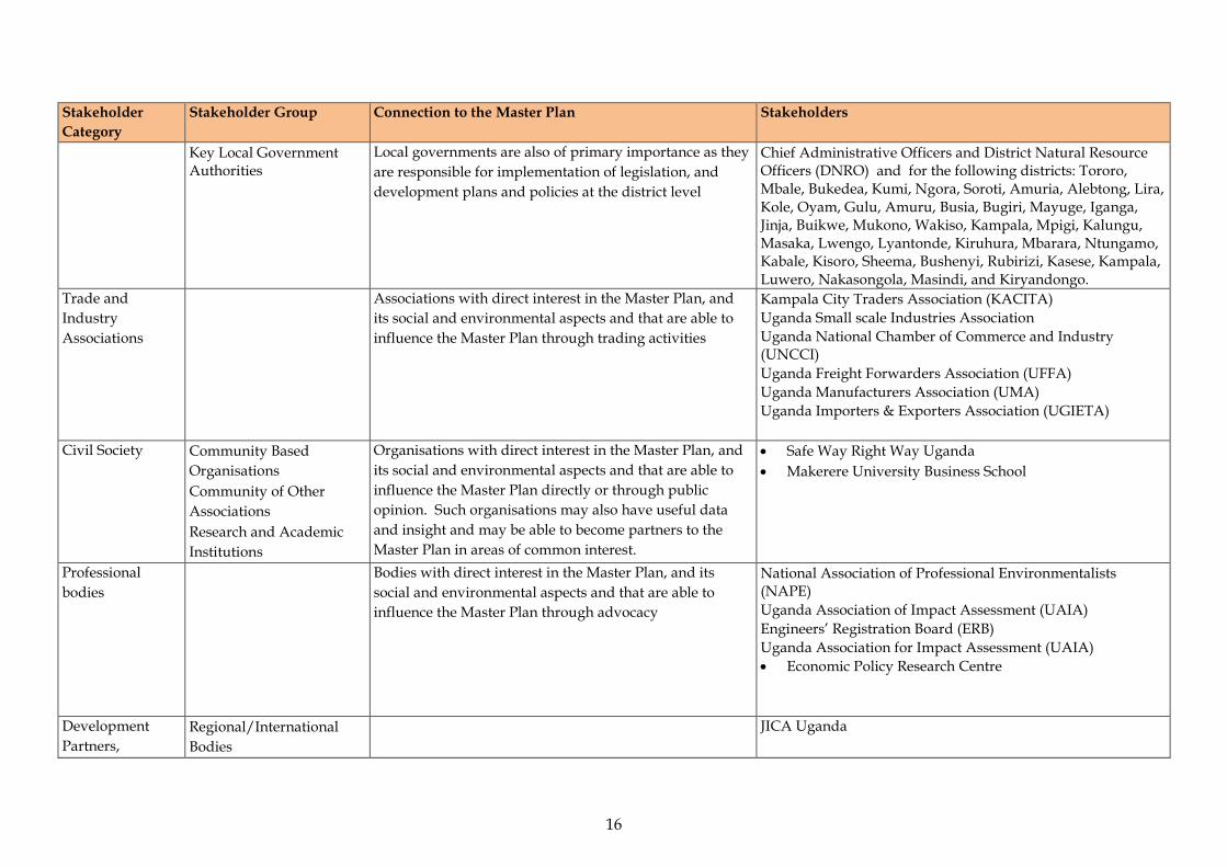
Stakeholder Category
Stakeholder Group Connection to the Master Plan Stakeholders
Key Local Government Authorities
Local governments are also of primary importance as they are responsible for implementation of legislation, and development plans and policies at the district level
Chief Administrative Officers and District Natural Resource Officers (DNRO) and for the following districts: Tororo, Mbale, Bukedea, Kumi, Ngora, Soroti, Amuria, Alebtong, Lira, Kole, Oyam, Gulu, Amuru, Busia, Bugiri, Mayuge, Iganga, Jinja, Buikwe, Mukono, Wakiso, Kampala, Mpigi, Kalungu, Masaka, Lwengo, Lyantonde, Kiruhura, Mbarara, Ntungamo, Kabale, Kisoro, Sheema, Bushenyi, Rubirizi, Kasese, Kampala, Luwero, Nakasongola, Masindi, and Kiryandongo.
Trade and Industry Associations
Associations with direct interest in the Master Plan, and its social and environmental aspects and that are able to influence the Master Plan through trading activities
Kampala City Traders Association (KACITA) Uganda Small scale Industries Association Uganda National Chamber of Commerce and Industry
(UNCCI) Uganda Freight Forwarders Association (UFFA) Uganda Manufacturers Association (UMA) Uganda Importers & Exporters Association (UGIETA)
Civil Society Community Based Organisations
Community of Other Associations
Research and Academic Institutions
Organisations with direct interest in the Master Plan, and its social and environmental aspects and that are able to influence the Master Plan directly or through public opinion. Such organisations may also have useful data and insight and may be able to become partners to the Master Plan in areas of common interest.
• Safe Way Right Way Uganda • Makerere University Business School
Professional bodies
Bodies with direct interest in the Master Plan, and its social and environmental aspects and that are able to influence the Master Plan through advocacy
National Association of Professional Environmentalists (NAPE)
Uganda Association of Impact Assessment (UAIA) Engineers’ Registration Board (ERB) Uganda Association for Impact Assessment (UAIA)
• Economic Policy Research Centre
Development Partners,
Regional/International Bodies
JICA Uganda
16

Stakeholder Category
Stakeholder Group Connection to the Master Plan Stakeholders
Non-Governmental Organisations (NGOs)
National Local
NGOs with direct interest in the Master Plan, and its social and environmental aspects and that are able to influence the Master Plan directly or through public opinion.
Trademark East Africa Private Sector Foundation Uganda (PSFU)
17
5 SEA ENGAGEMENT CONDUCTED TO DATE This section provides a review of the engagement activities conducted during the Scoping and detailed SEA engagement phases, as well as a summary of the key outcomes. The objective of engagement was to: a) Scoping • introduce the Master Plan and PPP Owner; • introduce the SEA including the stakeholder engagement team and
outline the objectives of the SEA and stakeholder engagement process;
• consult stakeholders on the next steps in the SEA process; and • understand stakeholders concerns regarding the Master Plan as well
as opportunities for stakeholders to engage with the Master Plan formulation process.
b) Detailed SEA • To re-introduce the Master Plan as well as the SEA and inform the
stakeholders about the proposed Master Plan strategies, subcomponents and potential impacts.
• To obtain stakeholder views, and concerns regarding the proposed Master Plan and potential impacts.
• To integrate stakeholder views and recommendations into measures to minimise and/or mitigate negative impacts and enhance positive impacts as well as improve the Master Plan formulation process.
5.1 ENGAGEMENT ACTIVITIES
The stakeholders interested in the Project are: • Government ministries that are concerned with the Project or
involved in the approval processes; • Government Departments and Agencies that play a regulatory role
among other things;
ERM/ATACAMA CONSULTING JST/MOWT
18
• Civil society organisations or Non-Governmental Organisations; • Professional bodies; • Trade and Industry Associations; • Local government authorities/ districts traversed by the NEC; and • Development Partners and Regional/International bodies/
institutions. As earlier mentioned in Table 3.1, the SEA engagement activities involve four key phases, namely: • scoping consultation; • baseline data gathering; • SEA Study; and • Disclosure.
5.2 SCOPING AND DETAILED SEA CONSULTATION
The Scoping and detailed SEA study meetings were held with key stakeholders at the national and regional level (refer to Annex A2 for detailed minutes, attendance registers and photos taken during stakeholder consultations). The consultations took place between 16th and 20th November 2015 (scoping) and 16th and 20th May 2016 (detailed SEA study) (Table 3.2) in: • Kampala for the stakeholders in central Uganda, • Mbarara for the stakeholders in the western region, and • Tororo for the Northern and Eastern regions of Uganda. During these meetings, the stakeholders were introduced to the Master Plan and the SEA. A questionnaire was also administered during the consultative meetings. A Background Information Document (BID) providing brief details of the Master Plan in a clear and accessible format and invitation for comments was also provided to all stakeholders as a way of collecting the relevant baseline data that would inform the SEA (refer to Annex A3 for the questionnaire and BID). The Key outcomes are summarised in Section 5.3.
ERM/ATACAMA CONSULTING JST/MOWT
19

5.3 KEY OUTCOMES
Table 5.1 and Table 5.2 below that follow present a summary of key attitudes, concerns and expectations raised during the scoping phase and detailed SEA study rounds of stakeholder consultation meetings All the issues raised will inform the conduct of detailed studies for the SEA as well as development of the NEC Master Plan.
ERM/ATACAMA CONSULTING JST/MOWT
20

Table 5.1 Key Attitudes, Concerns and Expectations Raised During the Scoping Stakeholder Consultations
Meeting Key attitudes, concerns and expectations All There is a need to present a detailed description of the NEC including:
• The transport options being considered (road, railway etc.); • Details of each option; for example, will the Standard gauge railway be electrical? • Contents of the Master Plan; for example, does it include design of roads? Engagement with local community members is not included, when will it be considered? The local communities will be directly affected and therefore need to be considered. Share project related documents (including presentations) with all key stakeholders There is need to consider alternative logistics sub-routes in the assessment; an example is the Kampala – Mpondwe route via Mubende and Fort Portal. Need to show how the SEA will be finalised and implemented when Uganda’s SEA guidelines are still in draft form.
Kampala Relevant literature should be reviewed and used to inform the study. Some truck drivers use alternative routes to dodge the weigh bridges; these routes are not designed to handle heavy vehicles like trucks and as a result, the roads get spoilt quickly. Confirm all the districts traversed by the corridor. Highlight the importance of the NEC Master Plan to the stakeholders. The use of a parallel model SEA process will be expensive, explore other models. At what stage will NEMA get involved in the SEA? The Parallel model SEA approach is good. Need to present details of the information that the SEA study team will be collecting. The scope of work is not very clear; however, it is better to incorporate in climate change issues. Some of the vehicles used on these roads are not in good mechanical condition; this should be considered. You need to engage political leaders.
Mbarara Identification of strategies to ensure that population growth linked with increased number of NEC users is sustainable. There is need to periodically review the SEA; possibly during the implementation of the Master Plan. It is important to bring all key stakeholders on board. It is important to investigate and consider the linkage between electricity infrastructure and the NEC Master Plan. It is important to incorporate the railway (standard gauge railway) in the Master Plan. How was the name, Northern Economic Corridor arrived at? There is need to devise means of addressing trans-boundary issues to ensure successful implementation of the NEC Master Plan. There is need to harmonise driving rules in all the countries within the NEC. Will the Master Plan/ SEA address the issue of Green House Gas (GHG) emissions? There is need to support local governments in the development and implementation of the respective District Development Plans
21

Meeting Key attitudes, concerns and expectations which are consistent with the contents of the NEC Master Plan.
Tororo There is a need to present a detailed overview/ history of the NEC to enable people relate it with past developments, for example, the great north road from Mombasa to Juba via Tororo. It is important to include sanitary facilities along the NEC in the Master Plan; currently, some people ease themselves in open places along the roads. There is need to clearly define the timeframe for the implementation of the Master Plan. There is need to clearly present the differences between SEA and EIA to ensure that stakeholders do not confuse the two. Clearly define the scope of the SEA; for example, does it cover all the routes? The NEC concept is good. Consider the ecosystems that will be impacted when carrying out the SEA. Consider the requirements of international treaties and conventions that Uganda has ratified when conducting the SEA. Investigate the consequences of oil spills. Present assumptions for the study, if any. Need to assure stakeholders that their views will be considered and influence the design of the Master Plan. The issue of drainage should be considered when designing the Master Plan; it is becoming a major issue. Other stakeholders like the Bishops and cultural leaders also need to be consulted. The linkage between the NEC and African Union (AU) related corridors/networks is not clear. Socio-economic issues especially in towns along the NEC should be considered. Other key socio-economic issues include prostitution, local people’s attitudes, compensation & resettlement and land ownership. The Geopolitical situation in neighbouring countries should be considered as part of the SEA as this could affect the implementation of the Master Plan. Many management plans for EIAs have not been implemented; how will the SEA be implemented? Expand the scope of the Master Plan to other roads; this will help in achievement of the overall objective of triggering economic growth. How will the issue of increased traffic as a result of increased traffic volumes be addressed? Impact mitigation needs to be incorporated in the SEA; this did not come out clearly in the presentation. Make reference to well-planned towns when designing the Master Plan; for example, Iganga town is well planned. The issue of climate change should be considered. Environmental interventions like tree planting along the highways need to be considered. It is important to harmonise the legal requirements within the countries traversed by the NEC.
22
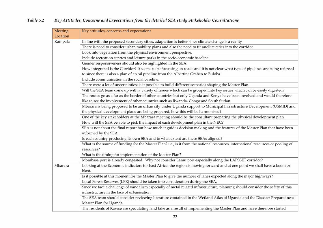
Table 5.2 Key Attitudes, Concerns and Expectations from the detailed SEA study Stakeholder Consultations
Meeting Location
Key attitudes, concerns and expectations
Kampala In line with the proposed secondary cities, adaptation is better since climate change is a reality There is need to consider urban mobility plans and also the need to fit satellite cities into the corridor Look into vegetation from the physical environment perspective. Include recreation centres and leisure parks in the socio-economic baseline. Gender responsiveness should also be highlighted in the SEA. How integrated is the Corridor? It seems to be focussing on roads and it is not clear what type of pipelines are being refereed to since there is also a plan of an oil pipeline from the Albertine Graben to Buloba. Include communication in the social baseline. There were a lot of uncertainties; is it possible to build different scenarios shaping the Master Plan. Will the SEA team come up with a variety of issues which can be grouped into key issues which can be easily digested? The routes go as a far as the border of other countries but only Uganda and Kenya have been involved and would therefore like to see the involvement of other countries such as Rwanda, Congo and South Sudan. Mbarara is being proposed to be an urban city under Uganda support to Municipal Infrastructure Development (USMID) and the physical development plans are being prepared, how this will be harmonised? One of the key stakeholders at the Mbarara meeting should be the consultant preparing the physical development plan. How will the SEA be able to pick the impact of each development plan in the NEC? SEA is not about the final report but how much it guides decision making and the features of the Master Plan that have been informed by the SEA. Is each country producing its own SEA and to what extent are these SEAs aligned? What is the source of funding for the Master Plan? i.e., is it from the national resources, international resources or pooling of resources? What is the timing for implementation of the Master Plan? Mombasa port is already congested. Why not consider Lamu port especially along the LAPSSET corridor?
Mbarara Looking at the Economic indicators for East Africa, the region is moving forward and at one point we shall have a boom or blast. Is it possible at this moment for the Master Plan to give the number of lanes expected along the major highways? Local Forest Reserves (LFR) should be taken into consideration during the SEA. Since we face a challenge of vandalism especially of metal related infrastructure, planning should consider the safety of this infrastructure in the face of urbanisation. The SEA team should consider reviewing literature contained in the Wetland Atlas of Uganda and the Disaster Preparedness Master Plan for Uganda. The residents of Kasese are speculating land take as a result of implementing the Master Plan and have therefore started
23
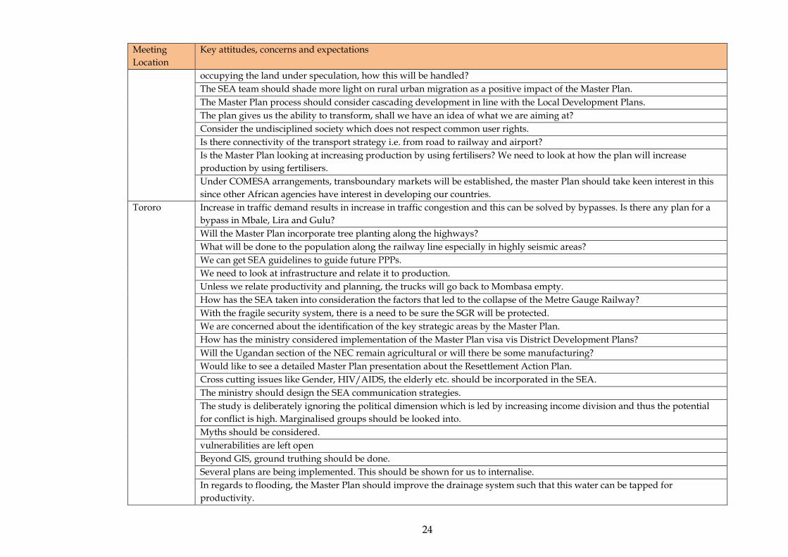
Meeting Location
Key attitudes, concerns and expectations
occupying the land under speculation, how this will be handled? The SEA team should shade more light on rural urban migration as a positive impact of the Master Plan. The Master Plan process should consider cascading development in line with the Local Development Plans. The plan gives us the ability to transform, shall we have an idea of what we are aiming at? Consider the undisciplined society which does not respect common user rights. Is there connectivity of the transport strategy i.e. from road to railway and airport? Is the Master Plan looking at increasing production by using fertilisers? We need to look at how the plan will increase production by using fertilisers. Under COMESA arrangements, transboundary markets will be established, the master Plan should take keen interest in this since other African agencies have interest in developing our countries.
Tororo Increase in traffic demand results in increase in traffic congestion and this can be solved by bypasses. Is there any plan for a bypass in Mbale, Lira and Gulu? Will the Master Plan incorporate tree planting along the highways? What will be done to the population along the railway line especially in highly seismic areas? We can get SEA guidelines to guide future PPPs. We need to look at infrastructure and relate it to production. Unless we relate productivity and planning, the trucks will go back to Mombasa empty. How has the SEA taken into consideration the factors that led to the collapse of the Metre Gauge Railway? With the fragile security system, there is a need to be sure the SGR will be protected. We are concerned about the identification of the key strategic areas by the Master Plan. How has the ministry considered implementation of the Master Plan visa vis District Development Plans? Will the Ugandan section of the NEC remain agricultural or will there be some manufacturing? Would like to see a detailed Master Plan presentation about the Resettlement Action Plan. Cross cutting issues like Gender, HIV/AIDS, the elderly etc. should be incorporated in the SEA. The ministry should design the SEA communication strategies. The study is deliberately ignoring the political dimension which is led by increasing income division and thus the potential for conflict is high. Marginalised groups should be looked into. Myths should be considered. vulnerabilities are left open Beyond GIS, ground truthing should be done. Several plans are being implemented. This should be shown for us to internalise. In regards to flooding, the Master Plan should improve the drainage system such that this water can be tapped for productivity.
24
Meeting Location
Key attitudes, concerns and expectations
Registered land is presented as a constraint yet un registered land is more challenging as a constraint due to insecurity. Regional production centres such as Karamoja region have been left out. This area has National parks but there was no deliberate effort to improve the region. What are the strategies for popularising the Master Plan? The Master Plan and SEA have timelines and therefore there may be no time for internalising both reports. The two should be merged into one report.
25
5.4 VALIDATION ENGAGEMENT
The validation meetings were held with key stakeholders at the national and regional level. The workshops took place between 16th and 20th Jan 2017 (Table 3.2) in: • Kampala for the stakeholders in central Uganda, • Mbarara for the stakeholders in the western region, and • Tororo for the Northern and Eastern regions of Uganda. During these meetings, the MoWT reintroduced the Master Plan and the findings of the SEA process contained in the SEA report were presented to the stakeholders where the main objective was to review the draft SEA and comments and reviews from the stakeholders at the validation stage are summarised in Section 5.5.
5.5 KEY OUTCOMES
Table 5.3 below that follows present a summary of key concerns and expectations raised at the validation stage of stakeholder consultation meetings (refer to Annex A4 for detailed minutes, attendance registers and photos taken during stakeholder consultations). The comments and reviews from the stakeholders were used to inform and update the Final SEA report.
ERM/ATACAMA CONSULTING JST/MOWT
26
Table 5.1 Key Attitudes, Concerns and Expectations from the Validation Consultations
Meeting Location
Key attitudes, concerns and expectations
Kampala Different Ministries and agencies will be responsible for the implementation of specific projects. Has the Master Plan considered integrating the other stakeholders? When shall we have the updated Master Plan available to us? The content of National Development Plan II and the Master Plan are similar. Is cabinet not yet aware since the NDP is already implemented? Has the plan taken into consideration the improvement of transport within the cities? In planning, strategic stop-overs for Lorries and cargo cars should be identified and developed. Stop-over nodes are not emphasised for the comfort of travellers. Note that the desired tourist is the high end traveller but for Uganda, we do not feel their dollar simply because their money is left in the hands of multinationals who own the high end hotels. The desirable traveller is an 18-35 year old who has a tendency to stay with the local people and can buy personal effects from the local people. Can you put in place strategies to attract these people The NEC initiative is for three countries i.e. Rwanda, Kenya and Uganda, however, the emphasis in the presentation was on Kenya and Uganda. Most of the projects stop in Kampala. How can we bring on board a partner whom we don’t see any immediate benefit in terms of projects? By 2022, the projects will be in Kampala without an extension to Kigali which is part of the NEC. This could force the Rwandese government to look at other options. How can we keep other partners on board? The Master Plan should explore more on how to incorporate and take advantage of governance issues for the various heads of state. The SGR is set up to promote imports and evacuate as much as possible from the Mombasa Port. Most of the exports come from areas outside Kampala. SGR will take a long time to get to areas outside Kampala. If we are to promote these exports we need a network to do this along with the MGR. I would wish to see the plans for MGR for Kasese. There is need to align the SGR construction timelines for different countries so that the service is used as soon as soon as construction is done rather than wait for other areas to be completed which will leave the resource redundant. The Master Plan is silent on the current situation. The MGR has a lot of bottlenecks and the Plan is silent about it. What is RVR doing? We expect a big volume of goods with the construction of SGR. The Master Plan should provide a linkage between what volume of goods to expect and the type of ICDs to be built. How will the Master Plan be harmonised with other physical development plans such as the existing local government plans and the Regional physical development for the Northern Corridor? How will SGR be used? Various companies own many tracks and will be in competition thus rendering the SGR a white elephant project? What is the plan for single Vs Dual carriage for the SGR? Is there a plan to connect to the LAPSSET Is it possible to attach monetary value to the alternative options and the mitigation measures?
27

Meeting Location
Key attitudes, concerns and expectations
Is there a section in the SEA that provides for rehabilitation of the environmental effects that could accrue as a result of implementation of the suggested projects I could not identify a clear linkage between the findings and national and international regulation to include bridging the gap so that they satisfy the international donor performance standards to secure project funding. The Master Plan and the SEA were done concurrently. How can the SEA inform the Master Plan to integrate these environment and management plans at that level? The analysis of the alternatives was biased towards expert judgement basing on available literature or theory yet there are some other kinds of tools and Applications like Multi-criteria Evaluation tools as decision support tools in collaboration with GIS which could be very powerful in coming up with the best option. Some references in the document were made to Kenya. Kenyan laws and international frameworks should be considered and included for reference especially where there are issues of shared resources like water bodies. Concerning GHG emission, Agriculture was not mentioned in the report and yet it is one of the sectors that contribute to GHG emissions according the Climate Change Department. This should be considered due to proposed commercialised agriculture. Technology, equipment and materials for implementing the projects should not be sourced from outside and yet they are available in Uganda which is important for the growth of Uganda’s industries as well as creating employment. There is need to reflect on the due diligence requirements/guidelines for each funding of the funding bodies like World Bank, IFC, African Development Bank, and Arab development Bank to improve on the SEA report. The is need to improve the document to include a section on Environment and Social Management Framework as an appendix or a section in the documents. Some archaeological/cultural sites are the hindrances to development so should be given paramount priority in documentation.
Mbarara Within the Master Plan framework, is there planned activity for urban growth in the northern corridor? The import export ratio for Uganda is affecting the balance of trade and this is worrying. Have you done a cost benefit analysis of the routes to determine which is the most viable? Previously, the routes were not definite and land speculation was raised as an issue especially in Kasese were people are targeting resettlement compensation. What are the timelines for the Master Plan? The Corridor spans more than one country. Is the Master Plan considered as one single project or each country is responsible for a specific part? Can’t problems in one country derail the whole process? Our economy is characterised by low production levels, dwindling fish stocks, degraded ecosystems, redundant labour e.t.c. Do you envisage the possibility of good returns on the investment into the northern corridor? The physical planning process is very weak. We have no smart towns in Uganda since the roads and the physical layout of buildings is wanting. There is need for proper physical planning so that the policy is followed during town development. No go zone areas should be established. How will the resources be distributed? We as government want the community to come up, can we define means to improve
28
Meeting Location
Key attitudes, concerns and expectations
the west and central? The planning of the urban centres should consider the increased production and population increase. The Government should identify and make projections before the problem occurs. Do we have a better plan of water transport within Lake Victoria and other Lakes e.g. Albert and Edward? The recommendations should improve transport between Uganda and the neighbouring countries and improve the minor cities. That way, trade between Congo and Uganda will improve. Have you done a deeper analysis of reduced truck along the road since the tracks are owned by a few individuals who are also politicians? Has the Master Plan looked at developing Solar energy as an alternative? How will the public be protected from the impacts of construction and projects along the corridor? The roads in Uganda are narrow, increasing the cost of transport. We are experiencing a challenge of encroachment on road reserve in Uganda which makes future road expansion difficult. Road reserves need to be protected for easy expansion of the road where need be. What is the M0WT planning to secure the reserves? With regard to public health and safety, transport has an impact on air emissions and health related problems. Why can’t we make it a policy that for every kilometre of tarmac constructed, a number of trees should be planted along the road? Has the SEA identified the different industrial activities and analysed the demand for water resources and biodiversity. Are the proposals sustainable? Include Ramsar sites in your assessment of protected areas. There is exclusion of biodiversity outside the protected areas- the document should be guiding the EIAs to come. Recommendation should be given that the EIA should look at biodiversity outside protected areas as well as underground biodiversity. Why isn’t the vision of the NEC linked to the National Planning Authority objectives instead?
Tororo By harmonising the construction phase of the SGR for completion by 2021, does it mean Kenya should slow down? Other sectors that feed into the Master Plan should be fast tracked, for example rice production is impossible with such severe drought and in that case we need to think of irrigation. You make mention of regional coordination, but the emphasis is on Kenya and Uganda, going to DRC and Rwanda. Why is Tanzania left out? Are they failing to cooperate? What is the cost of Master Plan and what is the share of each country? What is the progress of SGR in Uganda? The LAPSSET bypasses Uganda. If it is to benefit the East African countries, it should penetrate Uganda. Industrialisation will result into higher demand for power by the industries and so a strategic plan needs to be put in place to boost power supply in the Northern Corridor. Why hasn’t the Master Plan been polularised in Uganda? What happened to the Tororo- Gulu Meter Guage Railway rehabilitation Plan? This is an approach that is looking at policy and yet we do not have guidelines? How safe is this from the legal perspective? Where there are movement of vehicles, accidents are bound to occur. Can I assume that has been captured under public health
29
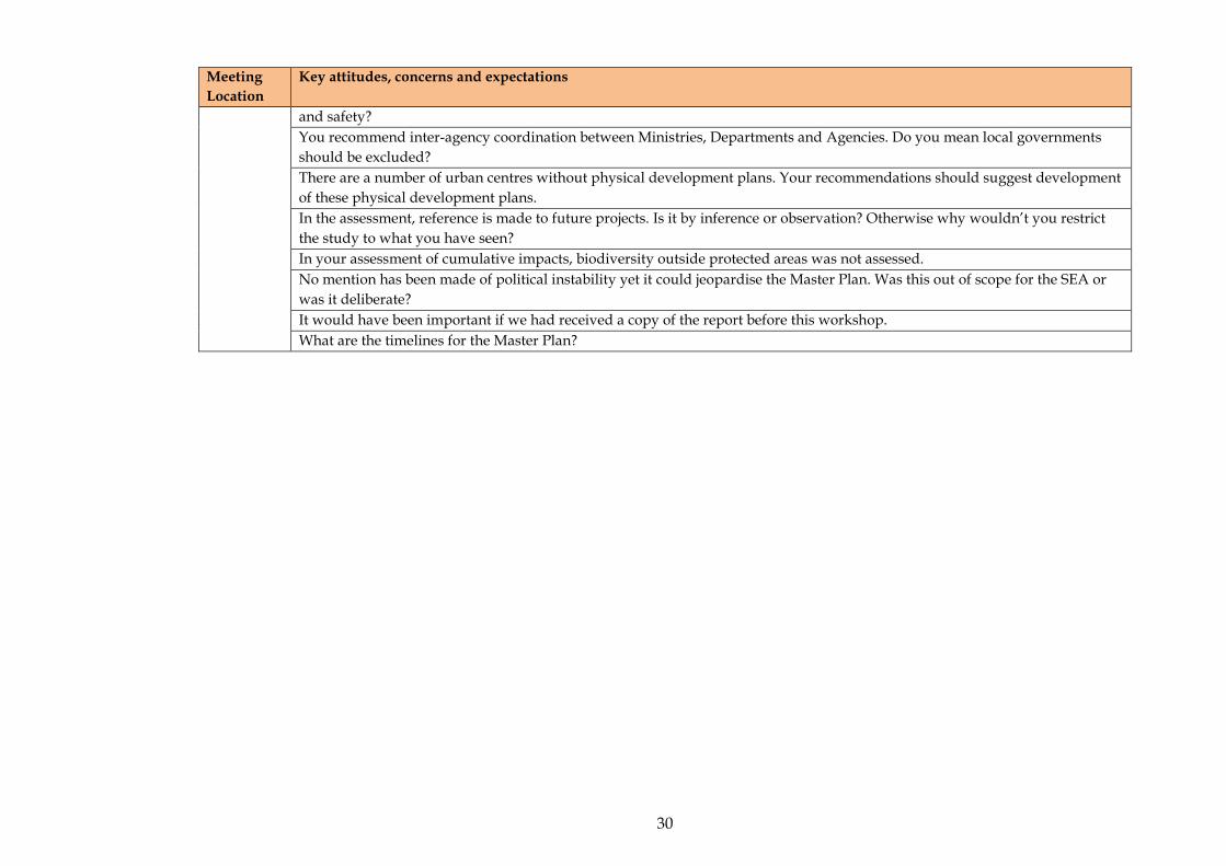
Meeting Location
Key attitudes, concerns and expectations
and safety? You recommend inter-agency coordination between Ministries, Departments and Agencies. Do you mean local governments should be excluded? There are a number of urban centres without physical development plans. Your recommendations should suggest development of these physical development plans. In the assessment, reference is made to future projects. Is it by inference or observation? Otherwise why wouldn’t you restrict the study to what you have seen? In your assessment of cumulative impacts, biodiversity outside protected areas was not assessed. No mention has been made of political instability yet it could jeopardise the Master Plan. Was this out of scope for the SEA or was it deliberate? It would have been important if we had received a copy of the report before this workshop. What are the timelines for the Master Plan?
30
6 MONITORING AND REPORTING
It will be important to monitor and report on the ongoing stakeholder engagement efforts to ensure that the desired outcomes are being achieved, and to maintain a comprehensive record of engagement activities and issues raised. As part of the SEP the following has been recorded: • the stakeholder database; and • records of all consultations held. These records and outputs are appended to the SEA report and will be updated as the Master Plan progresses and further phases of engagement are undertaken.
ERM/ATACAMA CONSULTING JST/MOWT
31

ANNEX A1 STAKEHOLDER DATABASE
Annex A1: Stakeholder Database
ERM/ATACAMA CONSULTING JST/MOW
1
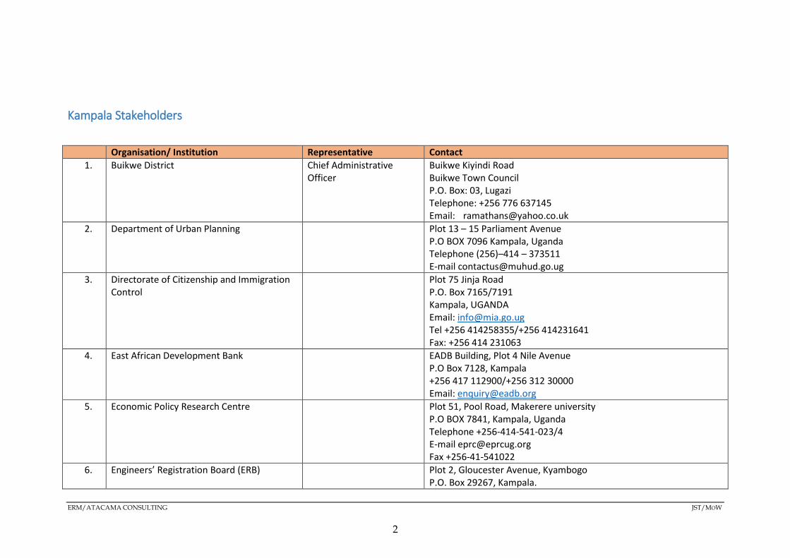
Kampala Stakeholders
Organisation/ Institution Representative Contact 1. Buikwe District Chief Administrative
Officer Buikwe Kiyindi Road Buikwe Town Council P.O. Box: 03, Lugazi Telephone: +256 776 637145 Email: [email protected]
2. Department of Urban Planning Plot 13 – 15 Parliament Avenue P.O BOX 7096 Kampala, Uganda Telephone (256)–414 – 373511 E-mail [email protected]
3. Directorate of Citizenship and Immigration Control
Plot 75 Jinja Road P.O. Box 7165/7191 Kampala, UGANDA Email: [email protected] Tel +256 414258355/+256 414231641 Fax: +256 414 231063
4. East African Development Bank EADB Building, Plot 4 Nile Avenue P.O Box 7128, Kampala +256 417 112900/+256 312 30000 Email: [email protected]
5. Economic Policy Research Centre Plot 51, Pool Road, Makerere university P.O BOX 7841, Kampala, Uganda Telephone +256-414-541-023/4 E-mail [email protected] Fax +256-41-541022
6. Engineers’ Registration Board (ERB) Plot 2, Gloucester Avenue, Kyambogo P.O. Box 29267, Kampala.
ERM/ATACAMA CONSULTING JST/MOW
2

Email: [email protected] Web site: www.erb.go.ug
7. European Union (EU), Uganda office Crested Towers Building 15th Floor-20th Floor Plot 17-23 Hannington Road P.O.BOX 5244 Kampala Tel: +256414701000, +256752756911 Telfax: +256(0) 414 233 708 Email: [email protected] Website: www.deluga.ec.europa.eu
8. Japanese International Corporation Agency (JICA) Uganda
JICA Uganda Office 4th Floor, Course View Towers Plot 21 Yusuf Lule Road, Nakasero, Kampala UGANDA Mailing Address : P.O. Box 12162, Kampala, Uganda Tel : +256-41-4254326 , 4340186 Fax : +256-41-434631
9. Jinja district Chief Administrative Officer
Plot No: 1, Busoga Square P.O. Box: 1551, Jinja Telephone: +256 752 891166 Email: [email protected]
10. Kampala City Traders Association (KACITA) P. O. Box 30794 3rd Floor Royal Complex, Plot 16B, Market Street/Burton Street Kampala, Uganda Landline: +256 (0)414 297 594 Email; [email protected] Website: http://www.kacita.org
11. Kampala district Chief Administrative Officer
Plot No: 1-3 Floor/Suite No: B114 SIDEA- City Hall Sir Appollo Kagwa Road Telephone: +256-414-231446 P.O. Box: 7010 Email: [email protected]
ERM/ATACAMA CONSULTING JST/MOW
3
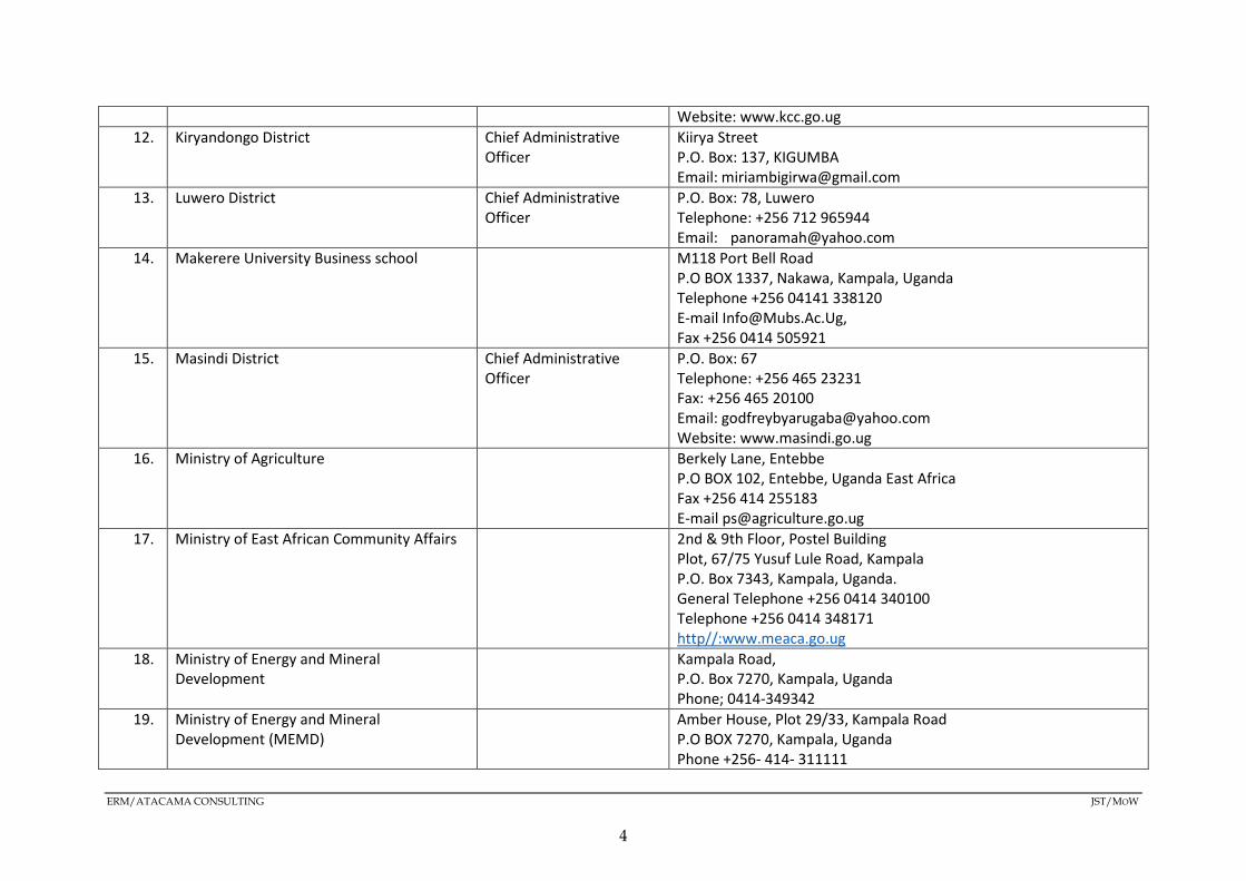
Website: www.kcc.go.ug 12. Kiryandongo District Chief Administrative
Officer Kiirya Street P.O. Box: 137, KIGUMBA Email: [email protected]
13. Luwero District Chief Administrative Officer
P.O. Box: 78, Luwero Telephone: +256 712 965944 Email: [email protected]
14. Makerere University Business school M118 Port Bell Road P.O BOX 1337, Nakawa, Kampala, Uganda Telephone +256 04141 338120 E-mail [email protected], Fax +256 0414 505921
15. Masindi District Chief Administrative Officer
P.O. Box: 67 Telephone: +256 465 23231 Fax: +256 465 20100 Email: [email protected] Website: www.masindi.go.ug
16. Ministry of Agriculture Berkely Lane, Entebbe P.O BOX 102, Entebbe, Uganda East Africa Fax +256 414 255183 E-mail [email protected]
17. Ministry of East African Community Affairs 2nd & 9th Floor, Postel Building Plot, 67/75 Yusuf Lule Road, Kampala P.O. Box 7343, Kampala, Uganda. General Telephone +256 0414 340100 Telephone +256 0414 348171 http//:www.meaca.go.ug
18. Ministry of Energy and Mineral Development
Kampala Road, P.O. Box 7270, Kampala, Uganda Phone; 0414-349342
19. Ministry of Energy and Mineral Development (MEMD)
Amber House, Plot 29/33, Kampala Road P.O BOX 7270, Kampala, Uganda Phone +256- 414- 311111
ERM/ATACAMA CONSULTING JST/MOW
4

Fax +256 414 234 732 Email [email protected]
20. Ministry of Finance, Planning and Economic Development
Ministry of Finance, Planning & Economic Development Plot 2/12 Apollo Kaggwa Road P.O. Box 8147 Kampala TEL: (256)-414-707000 FAX: (256)-414-230163
21. Ministry of Gender, Labour and Social Development (MGLSD)
Plot 2, Simbamanyo House P.O. Box 7136 George St, Kampala, Uganda +256 256414347854 [email protected]
22. Ministry of Health P.O. Box 7272 Kampala Uganda Plot 6 Lourdel Road, Wandegeya
23. Ministry of Local Government Postal Address: P.O Box 7037 Kampala, Uganda. Phone: +256-414-341224 Fax: +256-414-258127/347339 E-mail: [email protected]
24. Ministry of Tourism, Wildlife and Antiquities Ministry of Tourism, Wildlife and Antiquities P. O. Box 4241 Kampala Rwenzori Towers 2nd Floor, Plot 6 Nakasero Road. Kampala, Uganda.
25. Ministry of Trade and Industry Ministry of Trade, Industry and Cooperatives Plot 6/8, Parliamentary Avenue P.O. Box 7103 Kampala, Tel: 256-41-314000 Uganda +256-414 314 268/0414 314 000
26. Ministry of Water and Environment (MoWE)
Ministry of Water and Environment P.O BOX 20026, Kampala, Uganda Telephone +256 414 505942 Email [email protected]
ERM/ATACAMA CONSULTING JST/MOW
5

27. Ministry of Works and Transport Off Jinja Road/ Old Port Bell Rd, P.O. Box 10, Entebbe Kampala, Uganda Phone: +256 256414320101/9 Email: [email protected]
28. Mpigi District Chief Administrative Officer
Mpigi District Local Government P.O BOX 172, Mpigi, Uganda Fax 0392 715 397 Email [email protected]
29. Mukono District Chief Administrative Officer
Mukono District Local Government P. O. Box 110 Mukono Uganda email Address: [email protected]
30. Nakasongola District Chief Administrative Officer
P.O. Box: 1 Telephone: 0392735604 Fax: 0392254604 Email: [email protected]
31. National Association of Professional Environmentalists (NAPE)
Plot 7138 Entebbe Road, Block 256, Zana P. O. Box 29909 Kampala, Uganda Phone +256 414 530181/ +256 772 492362
32. National Environment Management Authority (NEMA)
Plot 17/19/21, Jinja Road, NEMA House P.O BOX 22255, Jinja Road Kampala Uganda Telephone 256-414-251064 Fax 256-414-257521 Email [email protected]
33. National Forestry Authority Address: Plot 10/20, Spring Road/P.O. Box 70863, Kampala Spring Rd, Kampala, Uganda Phone:+256 31 2264035
34. National Planning Authority (NPA) Plot 17, Hannington Road, 4th Floor, Short Tower, Crested Towers Building P.O. Box 21434, Kampala Kintu Road (Siad Barre) Avenue, Kampala, Uganda Phone: +256 41 4250212
35. Private Sector Foundation Uganda (PSFU) 43 Nakasero Hill Road
ERM/ATACAMA CONSULTING JST/MOW
6
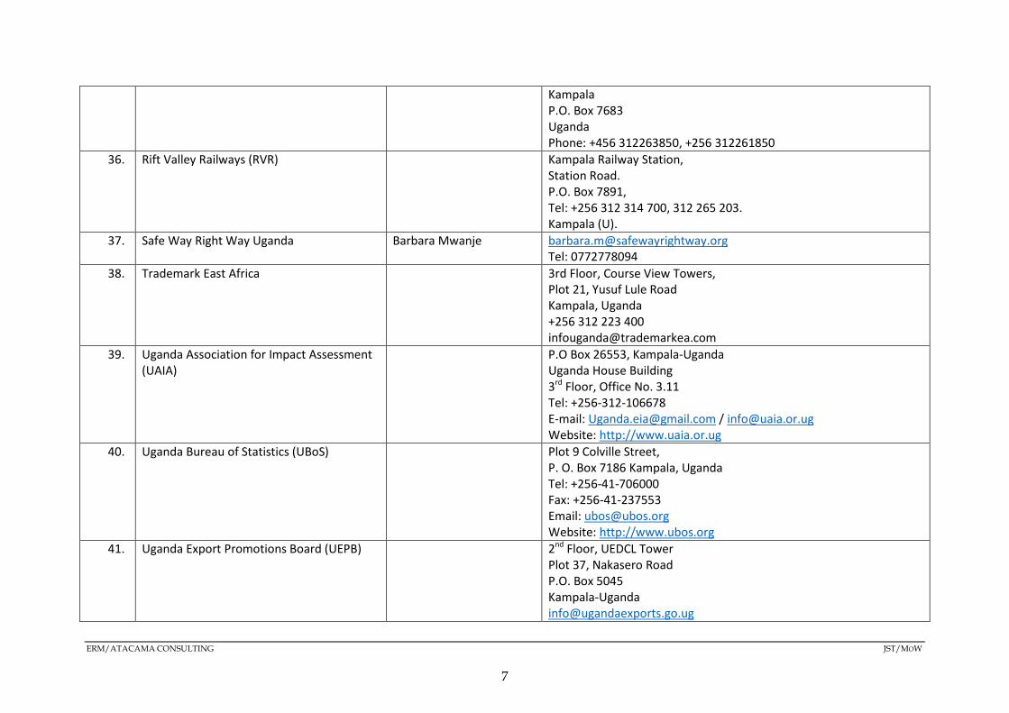
Kampala P.O. Box 7683 Uganda Phone: +456 312263850, +256 312261850
36. Rift Valley Railways (RVR) Kampala Railway Station, Station Road. P.O. Box 7891, Tel: +256 312 314 700, 312 265 203. Kampala (U).
37. Safe Way Right Way Uganda Barbara Mwanje [email protected] Tel: 0772778094
38. Trademark East Africa 3rd Floor, Course View Towers, Plot 21, Yusuf Lule Road Kampala, Uganda +256 312 223 400 [email protected]
39. Uganda Association for Impact Assessment (UAIA)
P.O Box 26553, Kampala-Uganda Uganda House Building 3rd Floor, Office No. 3.11 Tel: +256-312-106678 E-mail: [email protected] / [email protected] Website: http://www.uaia.or.ug
40. Uganda Bureau of Statistics (UBoS) Plot 9 Colville Street, P. O. Box 7186 Kampala, Uganda Tel: +256-41-706000 Fax: +256-41-237553 Email: [email protected] Website: http://www.ubos.org
41. Uganda Export Promotions Board (UEPB) 2nd Floor, UEDCL Tower Plot 37, Nakasero Road P.O. Box 5045 Kampala-Uganda [email protected]
ERM/ATACAMA CONSULTING JST/MOW
7

Phone: +256 414230250 42. Uganda Freight Forwarders Association
(UFFA) Kanjokya House, Second Floor, Suite 11
Plot 90 & 92 Kanjokya Street, Kamwokya P.O. Box 28904 Kampala, Uganda tel; (+256) 0-414-531670 Mail: [email protected], [email protected]
43. Uganda Importers and Exporters Association (UGIETA)
William St P.O. Box 23579 Kampala, Uganda Phone:+256 41 4347398
44. Uganda Investment Authority (UIA) Plot 22B Lumumba Avenue, TWED Plaza P O Box 7418 Kampala, Uganda Tel: +256-414-301 000 Fax: +256-414-342 903 Email: [email protected] Web: www.ugandainvest.go.ug
45. Uganda Manufacturers Association (UMA) 28/34 Coronation Avenue UMA Show Ground - Lugogo, Kampala 6966, Uganda
46. Uganda National Bureau of Standards (UNBS)
Plot M217 Nakawa Industrial Area Bypass Link, Bweyogerere Industrial & Business Park, Kyaliwajala Road, Bweyogerere-Buto P.O Box 6329 Kampala, Uganda Tel: 0414-505995/0414-222369 Toll free: 0800133133 E-mail: [email protected] / [email protected]
47. Uganda National Chamber of Commerce and Industry (UNCCI)
Plot 1A, Kira Road, P.O. Box 3809, Kampala, Uganda Phone:+256 31 2266323
48. Uganda National Meteorology Authority (UNMA)
Head office, 3rd and 10th Floor Postel Building Plot 67-75 Clement Hill Road, Kampala, Uganda Telephone +256 414 251 798
ERM/ATACAMA CONSULTING JST/MOW
8
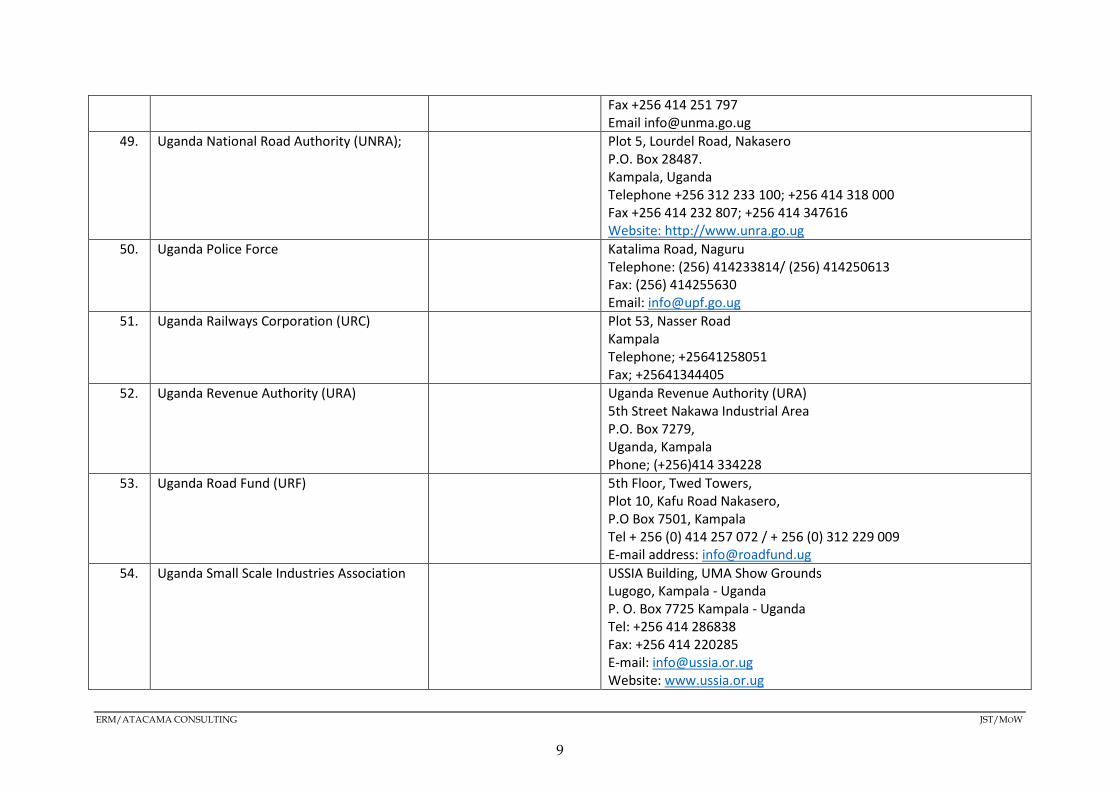
Fax +256 414 251 797 Email [email protected]
49. Uganda National Road Authority (UNRA); Plot 5, Lourdel Road, Nakasero P.O. Box 28487. Kampala, Uganda Telephone +256 312 233 100; +256 414 318 000 Fax +256 414 232 807; +256 414 347616 Website: http://www.unra.go.ug
50. Uganda Police Force Katalima Road, Naguru Telephone: (256) 414233814/ (256) 414250613 Fax: (256) 414255630 Email: [email protected]
51. Uganda Railways Corporation (URC) Plot 53, Nasser Road Kampala Telephone; +25641258051 Fax; +25641344405
52. Uganda Revenue Authority (URA) Uganda Revenue Authority (URA) 5th Street Nakawa Industrial Area P.O. Box 7279, Uganda, Kampala Phone; (+256)414 334228
53. Uganda Road Fund (URF) 5th Floor, Twed Towers, Plot 10, Kafu Road Nakasero, P.O Box 7501, Kampala Tel + 256 (0) 414 257 072 / + 256 (0) 312 229 009 E-mail address: [email protected]
54. Uganda Small Scale Industries Association USSIA Building, UMA Show Grounds Lugogo, Kampala - Uganda P. O. Box 7725 Kampala - Uganda Tel: +256 414 286838 Fax: +256 414 220285 E-mail: [email protected] Website: www.ussia.or.ug
ERM/ATACAMA CONSULTING JST/MOW
9

55. Wakiso District Chief Administrative Officer
Wakiso District Local Government P.O Box 7218, Wakiso-Uganda
56. World Bank, Uganda Office Rwenzori House 1 Lumumba Avenue P.O. Box 4463 Kampala, Uganda Contact +256-414-230-094/ +256-414-302-248
Tororo Stakeholders Organisation/ Institution Representative Contact
1. Tororo District Chief Administrative Officer
Tororo District Local Government P.O. Box 1 Tororo
2. Mbale District Chief Administrative Officer
Plot No: 17-35 Lyada Road P.O. Box: 931, Mbale Telephone: 0454 437369 Email: [email protected]
3. Bukedea District Chief Administrative Officer
P.O. Box: 5026, Bukedea Telephone: +256 772 067077 Email: [email protected]
4. Kumi District Chief Administrative Officer
Kumi District Local Government P.O. Box 1, Kumi [email protected]
5. Ngora District Chief Administrative Officer
P.O. Box 31 Ngora
6. Soroti District Chief Administrative Officer
Plot No 5, Gweri Road P.O. Box: 61 Telephone: +256-454-461004 Fax: +256-454-461030
ERM/ATACAMA CONSULTING JST/MOW
10

Email: [email protected] 7. Amuria District Chief Administrative
Officer Amuria District P.O.Box 1 Amuria
8. Alebtong District Chief Administrative Officer
Alebtong District Local Government Office Of The Chief Administrative Officer, P.O. Box 316, Lira. Tel 0772464193
9. Lira District Chief Administrative Officer
P.O. Box 49, Lira Telephone: +256(0473) 420219 Fax: 256 (0473) 420219 Uganda, East Africa
10. Kole District Chief Administrative Officer
P.O. Box: 419, Lira Telephone: +256 772 520557 Email: [email protected]
11. Oyam District Chief Administrative Officer
P.O Box 30 Loro, Oyam. Phone: +256-772-086600 Email: [email protected] , [email protected], [email protected]
12. Gulu District Chief Administrative Officer
Gulu District Local Government P.O Box 2, Gulu Plot 4-8 Air Field Road
13. Amuru District Chief Administrative Officer
P.O. Box: 1074, Amuru Telephone: +256 392859508 Email: [email protected]
14. Busia District Chief Administrative Officer
District headquarters, P.O Box 124, Busia.
15. Bugiri District Chief Administrative Officer
P.O Box 37, Bugiri-Uganda
16. Iganga District Chief Administrative Officer
P.O. Box: 358, Iganga Telephone: +256 782 868692 Email: [email protected]
17. Mayuge District Chief Administrative Officer
ERM/ATACAMA CONSULTING JST/MOW
11

Mbarara Stakeholders Organisation/ Institution Representative Contact
1. Bushenyi District Chief Administrative Officer
P.O. Box: 195 Telephone: +256 701 867866 Email: [email protected]
2. Kabale District Chief Administrative Officer
P.O. Box: 5, Kabale Telephone: +256 782 770370 Email: [email protected]
3. Kalungu District Chief Administrative Officer
Kalungu District Local Government P.O.Box 1350 Kalungu Uganda
4. Kasese District Chief Administrative Officer
Kasese District Local Government P.O Box 250, Rukooki, Kasese, Uganda Tel: 256 392888974 Mob: +256 772 424623/ +256 705 199116/ +256 753 273 329 Email: [email protected] / [email protected]
5. Kiruhura District Chief Administrative Officer
P.O. Box: 5, Rushere Telephone: +256 782 178800 Email: [email protected]
6. Kisoro District Chief Administrative Officer
District Administration HQRS P.O. Box: 123 Telephone: 0486430107 Fax: 048630147 Email: [email protected]
7. Lwengo District Chief Administrative Officer
Lwengo District Headquarters P.O. Box 1396, Masaka Uganda Tel: +256 787 923964 Email: [email protected]
8. Lyantonde District Chief Administrative Officer
P.O. Box: 10 Telephone: +256 712 613296 Email: [email protected]
ERM/ATACAMA CONSULTING JST/MOW
12
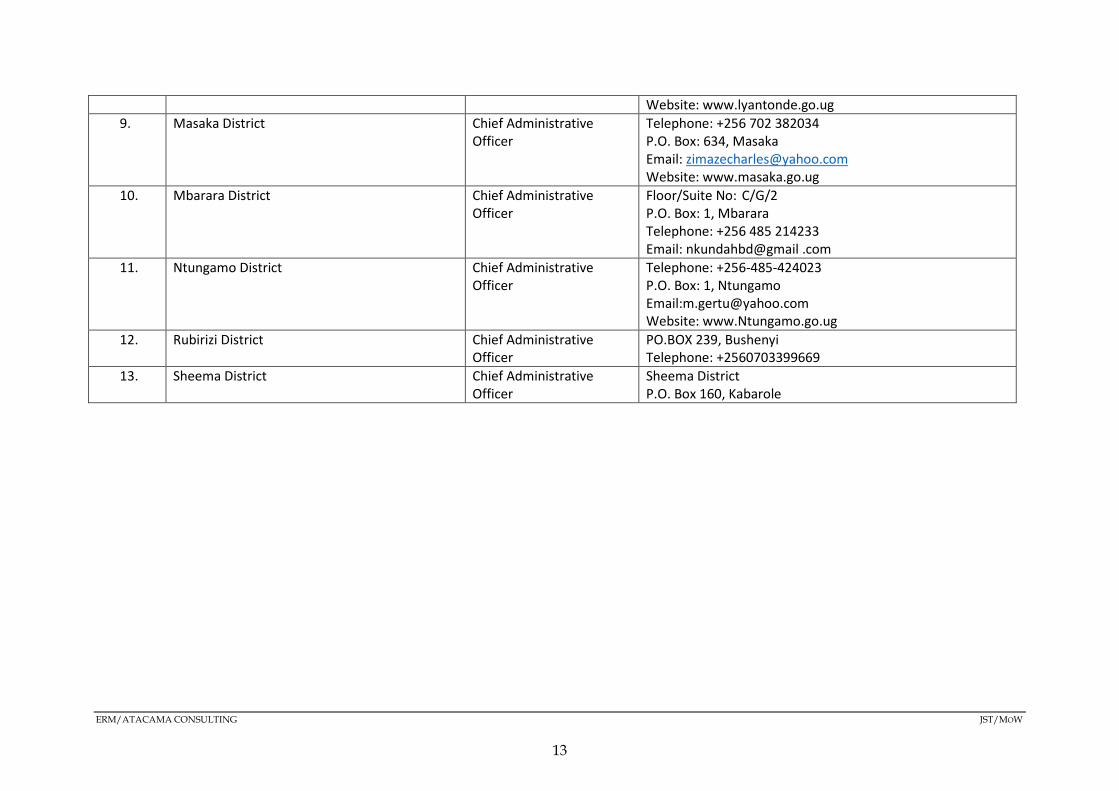
Website: www.lyantonde.go.ug 9. Masaka District Chief Administrative
Officer Telephone: +256 702 382034 P.O. Box: 634, Masaka Email: [email protected] Website: www.masaka.go.ug
10. Mbarara District Chief Administrative Officer
Floor/Suite No: C/G/2 P.O. Box: 1, Mbarara Telephone: +256 485 214233 Email: nkundahbd@gmail .com
11. Ntungamo District Chief Administrative Officer
Telephone: +256-485-424023 P.O. Box: 1, Ntungamo Email:[email protected] Website: www.Ntungamo.go.ug
12. Rubirizi District Chief Administrative Officer
PO.BOX 239, Bushenyi Telephone: +2560703399669
13. Sheema District Chief Administrative Officer
Sheema District P.O. Box 160, Kabarole
ERM/ATACAMA CONSULTING JST/MOW
13

ANNEX A2 MINUTES OF THE STAKEHOLDER MEETING

Annex A2: Stakeholder Meetings Minutes, attendance register and photos
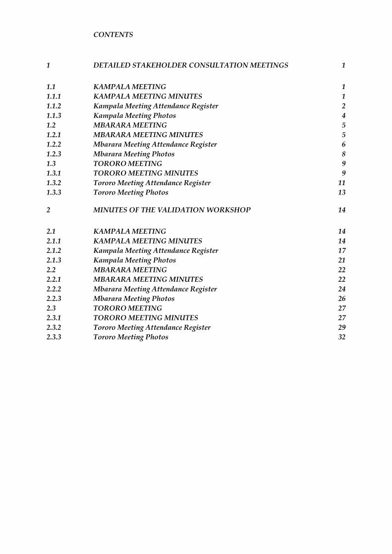
CONTENTS
1 DETAILED STAKEHOLDER CONSULTATION MEETINGS 1
1.1 KAMPALA MEETING 1 1.1.1 KAMPALA MEETING MINUTES 1 1.1.2 Kampala Meeting Attendance Register 2 1.1.3 Kampala Meeting Photos 4 1.2 MBARARA MEETING 5 1.2.1 MBARARA MEETING MINUTES 5 1.2.2 Mbarara Meeting Attendance Register 6 1.2.3 Mbarara Meeting Photos 8 1.3 TORORO MEETING 9 1.3.1 TORORO MEETING MINUTES 9 1.3.2 Tororo Meeting Attendance Register 11 1.3.3 Tororo Meeting Photos 13
2 MINUTES OF THE VALIDATION WORKSHOP 14
2.1 KAMPALA MEETING 14 2.1.1 KAMPALA MEETING MINUTES 14 2.1.2 Kampala Meeting Attendance Register 17 2.1.3 Kampala Meeting Photos 21 2.2 MBARARA MEETING 22 2.2.1 MBARARA MEETING MINUTES 22 2.2.2 Mbarara Meeting Attendance Register 24 2.2.3 Mbarara Meeting Photos 26 2.3 TORORO MEETING 27 2.3.1 TORORO MEETING MINUTES 27 2.3.2 Tororo Meeting Attendance Register 29 2.3.3 Tororo Meeting Photos 32

1 DETAILED STAKEHOLDER CONSULTATION MEETINGS
1.1 KAMPALA MEETING
1.1.1 KAMPALA MEETING MINUTES
S/N DETAILS OF THE PERSON RAISING THE QUESTION
QUESTION/COMMENT ANSWER/RESPONSE
1 Gerald Harry Ekinu, Transport Officer, Ministry of Works
In line with the proposed secondary cities, adaptation is better since climate change is a reality
This was noted as a compliment
2 Consider urban mobility plans and also the need to fit satellite cities into the corridor This was noted 3 JulietAtino, Senior Environment Officer
at the MoWT The SEA consultants should to look into vegetation from the physical environment perspective.
Vegetation from the physical point of view, i.e. green belts will be looked into.
4 Include recreation centres and leisure parks in the socio-economic baseline. This was noted 5 Gender responsiveness should also be highlighted in the SEA Gender responsiveness will also be looked into. 6 Joseph Kobusheshe, Acting Principal
Environment Officer at the Ministry of Energy and Mineral Development
How integrated is the Corridor? It seems to be focussing on roads; it is not clear what type of pipelines are being refereed to since there is also a plan of a pipeline from the Albertine Graben to Buloba.
Ryosuke Ogawa explained that the pipeline being referred to the oil pipeline for importation.
7 He also inquired of the possibility of including communication in the social baseline. This was noted 8 There are a lot of uncertainties; from the Terms of Reference, is it possible to build
different scenarios shaping the Master Plan. Different alternatives have been considered for the Master Plan
9 Will the SEA team come up with a variety of issues which can be grouped into key issues which can be easily digested
Key issues were presented
10 William Tayebwa, Environmental Officer Ministry of East African Affairs
The routes go as a far as the border of other countries but only Uganda and Kenya have been involved. I would like to see the involvement of other countries such as Rwanda, Congo and South Sudan.
Ryosuke Ogawa explained that it is the Government of Uganda and Government of Kenya that requested for the Master Plan. In addition, one of the consultees is the Northern Corridor Transit Transport Authority. There is also a proposal that at the time of validation, different countries have different people involved/present
11 JacquelyneNassuna, Sociologist Ministry of Lands, Housing and Urban development
Mbarara is being proposed to be an urban city under USMID and the physical development plans are being prepared. How this will be harmonised?
The SEA team will get in touch with the physical planner for Mbarara district for enlightenment
12 One of the key stakeholders at the Mbarara meeting should be the consultant preparing the physical development plan
Edgar Mugisha responded that it will be good to interface with the consultant.
13 AbubakerNamaraOchali Concession Manager, Uganda Railways Corporation
How will the SEA be able to pick the impact of each development plan in the NEC? Edgar explained that the SEA team is looking at the impacts of each strategic option
14 Aidan J Asekenye, Environmental Officer, Kampala Capital City Authority
SEA is not about the final report but how much it guides decision making. What features of the Master Plan have been informed by the SEA?
Edgar responded that once the Master Plan is completed, projects will come up and before September, it will be clear which projects will come up and the SEA will inform the Master Plan then.
15 Is each country producing its own SEA and to what extent tare theses SEAs are aligned?
Every country is producing its own SEA but we are working closely with each other.
16 GodfreySsali, Policy analyst, Uganda Manufacturers Association
What are the source of funding for the Master Plan? i.e., is it from the national resources, international resources or pooling of resources?
Ryosuke Ogawa explained that funding of the Master Plan is a Public Private Partnership.
17 What is the timing for implementation of the Master Plan? The target year for the Mater Plan is 2030 18 We are going back to Mombasa which is already congested, why not consider Lamu
port especially along the LAPSSET corridor? Ryosuke Ogawa explained that the current study focusses on how to improve the NEC although linkage with other countries is important
19 One of the concerns that was highlighted in the previous meeting was the lack of political will. Does this still hold?
Edgar Mugisha responded that the lack of political will was raised specifically by the Tororo stakeholders during the first round of stakeholder meetings and could just not be overlooked at this time
ERM/ATACAMA CONSULTING JST/MOWT
1

1.1.3 Kampala Meeting Photos
ERM/ATACAMA CONSULTING JST/MOWT
4

1.2 MBARARA MEETING
1.2.1 MBARARA MEETING MINUTES
S/N DETAILS OF THE PERSON RAISING
THE QUESTION
QUESTION/COMMENT ANSWER/RESPONSE
1 Turyatunga Patrick, the DNRO for Sheema District
Looking at the Economic indicators for East Africa, the region is moving forward and at one point we shall have a boom blast.
Ryosuke Ogawa explained that the traffic predictions are based on Vision 2040.
2 Is it possible at this moment for the Master Plan to give the number of lanes expected?
3 Local Forest Reserves (LFR) should be taken care of during the SEA. Edgar Mugisha responded that areas such as Local Forest Reserves which may not be of special scientific interest but play a critical ecological or physical role such as green belts which control development will be considered.
4 Since we face a challenge of vandalism especially of metal related infrastructure, planning should consider the safety of this infrastructure in the face of urbanisation.
One of the participants responded that the society needs to check itself to avoid vandalising communal property.
5 The District Natural Resources Officer for Mbarara
The SEA team considers reviewing literature contained in the Wetland Atlas of Uganda and the Disaster Preparedness Master Plan for Uganda.
Edgar welcomed the suggestion.
6 Kanyesigye William, the Chief Administrative officer for Kasese District
The residents of Kasese are speculating land take as a result of implementing the Master Plan and have therefore started occupying the land under speculation, how this will be handled?
Edgar Mugisha explained that the issue of land compensation is clearly understood and at the time of implementing the various projects, this will be considered
7 The SEA team should shade more light on rural urban migration as a positive impact of the Master Plan.
Edgar Mugisha explained that depending on the perspective, rural urban migration can be a positive or negative impact of the Master plan but development of urban centres such as secondary cities will draw people from rural areas and strain the planned social services.
8 CAO Lwengo District The Master Planning process should consider cascading development in line with the local Development Plans.
Ryosuke Ogawa explained that the Master Plan process is in line with the planning at National level
9 Consider the undisciplined society which does not respect common user rights.
10 The plan gives us the ability to transform and but what are we aiming at? The Master Plan is aimed at improving logistics in the Northern Economic.
11 Was there connectivity of the transport strategy i.e. from road to railway and airport? Ryosuke Ogawa explained that in as much as a modal shift is being planned, roads will still be connected to the
railway.
12 Is the Master Plan looking at increasing production by using fertilisers? We need to look at how the plan will increase production by using fertilisers.
Ryosuke Ogawa explained that Master Plan implementation is at the national level
13 The CAO Kisoro District
Under COMESA arrangements, transboundary markets will be established, the master Plan should take keen interest in this since other African agencies have interest in developing our countries.
This has been noted.
ERM/ATACAMA CONSULTING JST/MOWT
5

1.2.3 Mbarara Meeting Photos
ERM/ATACAMA CONSULTING JST/MOWT
8

1.3 TORORO MEETING
1.3.1 TORORO MEETING MINUTES
S/N DETAILS OF THE PERSON RAISING THE QUESTION
QUESTION/COMMENT ANSWER/RESPONSE
1 Joyce Namboozo the CAO Mayuge CAO was transferred as earlier stated, the DNRO who attended last time have not been transferred and the CAOs who are attending for the first time are policy makers who studied Geography.
Edgar Mugisha responded that it is good to see the engagement. Additionally, CAOs are technocrats and if you still remember Geography, it is a bonus.
2 The Natural Resources Officer for Soroti District.
The Master Plan and SEA are a new phenomenon so the PowerPoint presentations should be shared with the workshop participants.
Edgar Mugisha informed participants that soft copies of the presentation will be sent by email.
3 Increase in traffic demand results in increase in traffic congestion and this can be solved by bypasses. Is there any plan for a bypass in Mbale, Lira and Gulu?
Ryosuke Ogawa explained that several locations were considered as bottlenecks and bypasses will be considered at certain locations especially at the border point
4 Loss of habitat is an issue. In January I was in Rwanda and observed that virtually all roads are aligned with trees but it’s the opposite in Uganda. The only trees are in Kakira which were planted by Indians. Will the Master Plan incorporate tree planting?
Edgar Mugisha requested that loss of habitat should be handled at district level by enacting such bylaws and also requested the participant to apply the lessons learnt from Rwanda while taking advantage of the Wildlife Clubs programmes.
5 Teso is particularly prone to flooding which was rear in the 1960s since valley dams which accommodate water were present. The absence of valley dams could be the cause of the current flooding. Could this be explored to keep the water under custody?
Ryosuke Ogawa clarified that the Master Plan is being synchronised with Vision 2040.
6 Peter Henry Wotunya the CAO Kumi District
What will be done to the population along the railway line especially in highly seismic areas?
Edgar Mugisha explained that the NEA Cap 153 is being revised and may be the SEA guidelines will be finalised
7 We can get SEA guidelines to guide future PPPs. 8 Stephen Ouma the CAO Oyam
District Government has said let people produce exports and enough for themselves. However much we improve, the lorries will go back empty to Mombasa. In Oyam, we produce Maize, beans, simsime e.t.c. but cannot even sustain Mukwano. Other areas produce rice but it’s not enough for home consumption because of low productivity. We need to look at infrastructure and relate it to production.
Edgar Mugisha advised that the challenge is guaranteed sustainable supply. How much is being produced? In Kanungu for example, Mr. Garuga has advised homesteads to use tea as a hedge to sustain production
9 Almost everyone survives on Mangoes. There is no food, not even cassava. The productivity is low because we are lazy. Back then everybody had to produce food, had a granary and the Chief would authorise the opening of the granary unlike now. Unless we relate productivity and planning, the lorries will go back empty.
Ryosuke Ogawa also explained that if the logistics become better, local people will be able to produce more.
10 Moses Chuna Apoloni the CAO Soroti District
How has the SEA taken into consideration the factors that led to the collapse of the Meter Guage Railway?
Eng. Tony Kavuma explained that the MGR is a standalone project in the ministry and recruitment of capacity is going on. JST in contact with Uganda Railways corporation as the railways expert. The MGR will be rehabilitated.
11 With the fragile security system, there is a need to be sure the SGR will be protected.
Security concerns will be addressed by the SEA.
12 Peter James Malinga, the CAO Bukedea
We are concerned about the identification of the key strategic areas by the Master Plan.
Ryosuke Ogawa explained that Regional productivity is synchronised with Vision 2040. JST also conducted a project on productivity in Northern Uganda giving a benefit for improving productivity.
13 How has the ministry considered implementation of the Master Plan visa vie District development plans?
Eng. Tony Kavuma explained that government is giving more autonomy to the agencies to improve operational efficiency.
14 Simon Peter Achuu, the DNRO for Ngora District
The Ugandan section of the NEC will remain agricultural or there will be some manufacturing?
Ryosuke Ogawa clarified that the Master Plan is being synchronised with Vision 2040.
15 Bernadette Kawuma, the DNRO for Bugiri
Would like to see a detailed MP presentation about the RAP. Ryosuke Ogawa explained that the RAP is mainly at project level EIA although its necessity was raised at this stage. Recommendations will be given in the Master Plan.
ERM/ATACAMA CONSULTING JST/MOWT
9

S/N DETAILS OF THE PERSON RAISING THE QUESTION
QUESTION/COMMENT ANSWER/RESPONSE
16 Cross cutting issues like Gender, HIV/AIDS, the elderly e.t.c. should be incorporated in the SEA.
Edgar Mugisha responded that the cross cutting issues will be addressed.
17 Elias Byamungu Among the stakeholders, three parties were not represented i.e. the donors, private sector and civil society. If these members could feature but also the ministry should design communication strategies.
Rhoda Nankabirwa clarified that the donors, private sector and civil society as well as other lead agencies were consulted in the Kampala meeting. Eng. Tony Kavuma also explained that a communication strategy is as important as is in the civil aviation industry and this should be communicated to our people.
18 The study is deliberately ignoring the political dimension which is led by increasing income division and thus the potential for conflict is high. Marginalised groups should be looked into.
The socio-economic section of the SEA addresses income levels for consideration by the Master Plan.
19 There is a clear distinction and commonalities in Tanzania, Uganda and Kenya. One of the commonalities is the low level of production. In addition, in Tanzania, there is total government control using ICT so corruption can be eliminated. This should be incorporated into government planning.
This was noted
20 In Fort Portal, a road was diverted four times thinking of ‘an old woman who was passing’ until engineers did a geotechnical survey to reveal a hot spring. Myths should be considered.
This was noted
21 Pabious Otike The proposed that vulnerabilities are left open Edgar Mugisha explained that vulnerabilities may not stand alone but will be considered within.
22 In the methodology I want to propose that beyond GIS, ground trothing should be done
Edgar Mugisha explained that the stakeholders are in a better position to do ground truthing especially at such times although this will be supplemented at project level.
23 Several plans are being implemented. This should be shown for us to internalise.
Ryosuke Ogawa explained that SGR is being implemented by the European Union and this is integrated in the NEC Master Plan.
24 The Master Plan should improve the drainage system such that this water can be tapped for productivity.
Edgar supported the idea that flooding constraints can be turned into opportunities. The Ministry of Water and environment has pointed out the use of underground water. Drainage had not been considered earlier on until in this meeting. This will be added to the final report
25 Musa Lubanga, the DNRO for Mayuge District
In regards to flooding, the Master Plan should improve the drainage system such that this water can be tapped for productivity.
Rhoda Nankabirwa responded that security issues will be considered. However registered land still presents constraints in the form of acquisition due to inflated costs.
26 Monitoring of the SEA should be part of it The SEA will inform the Master Plan the implementation of which will in turn be monitored.
27 Emmanuel Okalang, the DNRO Kumi District.
Regional production centres such as Karamoja region have been left out. This area has National parks but there was no deliberate effort to improve the region.
Ryosuke Ogawa explained that production centres will be added to the report.
28 What are the strategies for popularising the Master Plan? 29 James Awula representing the CAO
for Alebtong District The Master Plan and SEA have timelines and therefore there may be no time for internalising both reports. He requested that the two should be merged into one report.
Edgar Mugisha explained that as the Master Plan is being developed, the Master Plan team uses the SEA issues to refine the Master Plan.
ERM/ATACAMA CONSULTING JST/MOWT
10

1.3.3 Tororo Meeting Photos
ERM/ATACAMA CONSULTING JST/MOWT
13

2 MINUTES OF THE VALIDATION WORKSHOP
2.1 KAMPALA MEETING
2.1.1 KAMPALA MEETING MINUTES
S/N DETAILS OF THE PERSON RAISING THE QUESTION
QUESTION/COMMENT ANSWER/RESPONSE
1. Diana Karimba, National Logistics and Planning coordinator, Private Sector Foundation
Different Ministries and agencies will be responsible for the implementation of specific projects. Has the Master Plan considered integrating the other stakeholders?
The development of this Master Plan was multi-sectorial and there was representation from all the twelve key sectors including the private sector. We had delivery structures, that is, technical working groups, i.e. technical staff from the various ministries. We had a steering committee and a joint steering committee between countries working on this Master Plan as well as vigorous inter-ministry and inter agency consultations with technical staff as well as holding international seminars to disseminate the Master Plan to potential investors.
2. Mark Tivu, CAO Masindi
The presentation was largely in line with the Master Plan interim report for April 2016. When shall we have the updated Master Plan available to us?
The summary report will be emailed to you. It will also be uploaded on the NEC website.
3. You say the Master Plan will be forwarded to cabinet. I am aware that Uganda has a development Plan. The content of National Development Plan II and the Master Plan are similar. Is cabinet not yet aware because the NDP is already implemented.
4. Has the plan taken into consideration the improvement of transport within the cities? In planning, strategic resting places for Lorries and cargo cars should be identified and developed
5. Rosemary Kobutagi, Tourism Expert, Ministry of Tourism, Wildlife and Antiquities
Stop over nodes are not emphasised for the comfort of travellers. Note that the desired tourist is the high end traveller but for Uganda, we do not feel their dollar simply because their money is left in the hands of multinationals who own the high end hotels. The desirable traveller is an 18-35 year old who has a tendency to stay with the local people and can buy personal effects from the local people. Can you put in place strategies to attract these people
6. Balaam. M. Asiimwe Ministry of Local Government
The NEC initiative is for three countries i.e. Rwanda, Kenya and Uganda, However, the emphasis in the presentation was on Kenya and Uganda. Most of the projects stop in Kampala. How can we bring on board a partner whom we don’t see any immediate benefit in terms of projects? By 2022, the projects will be in Kampala without an extension to Kigali which is part of the NEC. This could force the Rwandese government to look at other options. How can we keep other partners on board? The Master Plan should explore more on how to incorporate and take advantage of governance issues for the various heads of state.
The request was between the Government of Uganda and Kenya to the Government of Japan
7. The SGR is set up to promote imports and evacuate as much as possible from the Mombasa Port. Most of the exports come from areas outside Kampala. SGR will take a long time to get to areas outside Kampala. If we are to promote these exports we need a network to do this along with the MGR. I would wish to see the plans for MGR for Kasese.
Feasibility Studies are ongoing along the route. The European Union is undertaking a study to rehabilitate the MGR up to Gulu.
8. There is need to align the SGR construction timelines for different countries so that the service is used as soon as soon as construction is done rather than wait for other areas to be completed which will leave the resource redundant.
There is an engagement with Kenya to try to harmonise the timelines.
9. MGR should supplement SGR This was noted. That is why it has not been abandoned completely 10. The Master Plan is silent on the current situation. The MGR has a lot of bottlenecks and the Plan
is silent about it. What is RVR doing? Uganda railways was conceded to RVR in 2006. RVR has not made profit. The performance has not been very good. The GoU has issued a notice of termination of concession but the Government of Kenya has to agree. The Lenders to RVR are not in favour of the termination.
11. We expect a big volume of goods with the construction of SGR. The Master Plan should provide Traffic volume surveys were done and it is out of this that the Master Plan came about
ERM/ATACAMA CONSULTING JST/MOWT
14

a linkage between what volume of goods to expect and the type of ICDs to be built. 12. Network problems at the order posts should be embedded in the Master Plan. The issue has been noted and will be taken up 13. Julius Muyizzi, National
Environment Management Authority
I expected to see environmental and social considerations that being taken into account. The Master Plan video presentation was meant to make the participants understand what the Plan is about prepare the stakeholders for the next (SEA) presentation
14. Paul Buyerah Musumba, National Forestry Authority
How will the proposed infrastructure be maintained/sustained? Can the risks be factored into the Master Plan?
Risk Management will be done at project level
15. Jackeline Nassuuna, Ministry of Lands, Housing and Urban Development
How will the Master Plan be harmonised with other physical development plans such as the existing local government plans and the Regional physical development for the Northern Corridor?
The study team consulted the Ministry of Lands and they had an input into this for consideration and harmonisation
16. Godfrey Ssali, Policy Analyst, Uganda Manufacturers Association
Are we looking at an electric train or gasoline train? SGR will be electrified 17. How will SGR be used? Various companies own many tracks and will be in competition thus
rendering the SGR a white elephant project? With a liberal economy, you may not necessarily give directives on which mode to use
18. What is the plan for single Vs Dual carriage for the SGR? 19. Is there a plan to connect to the LAPSSET We are looking at possibilities of connecting to the LAPSSET through Kenya 20. Private Sector
Foundation, National logistics coordinator
Were secondary cities mapped out in the SEA report? Yes, these were mapped out in the SEA report
21. Aaron Werikhe, Planner Environment and Natural resources at National Planning Authority
Is it possible to attach monetary value to the alternative options and the mitigation measures? All the strategies and suggested projects have an economic cost attached to them. The cost of the mitigation measures will be looked into in line with the economic presentation of the same strategies when updating the report
22. If the SEA is undertaken after a plan is approved, can’t this affect the implementation? If a Plan is in place, an SEA can be done in line with the review cycle, at review stage. Secondly, SEA does not have to stand alone. You can have a document that meets the requirements of an SEA without an independent SEA being carried out. If the entry points for the environmental and social aspects are known and are addressed, an independent SEA does not have to be commissioned for such studies
23. Is it possible for an SEA to be undertaken for the National Development Plan? It is possible to do an SEA for the NDP as much it is up and running 24. Kassim Omar, Uganda
Clearing Industry and Forwarding Association
Is there a section in the SEA that provides for rehabilitation of the environmental effects that could accrue as a result of implementation of the suggested projects
Biodiversity offsets can be used to compensate for what has been lost as part the mitigation hierarchy.
25. Julius, National Environment Management Authority
I could not identify a clear linkage between the findings and national and international regulation to include bridging the gap so that they satisfy the international donor performance standards to secure project funding.
The SEA report goes as far as including AU Agenda 2063, Sustainable Development Goals e.t.c. The key thing is to focus on things that are relevant to inform the decision maker. But there are opportunities for such considerations of various laws and policies at the EIA level.
26. The Master Plan and the SEA were done concurrently. How can the SEA inform the Master Plan to integrate these environment and management plans at that level?
The SEA was done as the Master Plan was being prepared. The Master Plan that is coming out has to refer to the mitigation measures in the SEA report to refine the strategies in line with what the mitigation measures have pointed out. The Master Plan in that way will have addressed the findings of the SEA
27. The analysis of the alternatives was biased towards expert judgement basing on available literature or theory yet there are some other kinds of tools and Applications like Multicriteria Evaluation tools as decision support tools in collaboration with GIS which could be very powerful in coming up with the best option.
Usually, with SEA, you look at the budget at hand. Some tools can be used but the budget dictates that you might not be able to use them. However, at EIA level, such tools can be used to rank the various options.
28. Juliet Atino, Senior Environment Officer, Ministry of Works and Transport
The baseline just gave a general view of environmental properties but did not bring out the specific existing aspects. Vegetation cover wasn’t captured in the report. These aspects should also be captured in the SEA report.
SEA only provides information important to the decision maker. However, the point taken into account and we shall see which refinements to make to the document.
29. Some social aspects like gender did not come out well and yet women are affected during land acquisition; people’s livelihoods are also affected.
30. Some references in the document were made to Kenya. Kenyan laws and international The legal framework for Kenya was included in the Kenya SEA report. The Legal
ERM/ATACAMA CONSULTING JST/MOWT
15
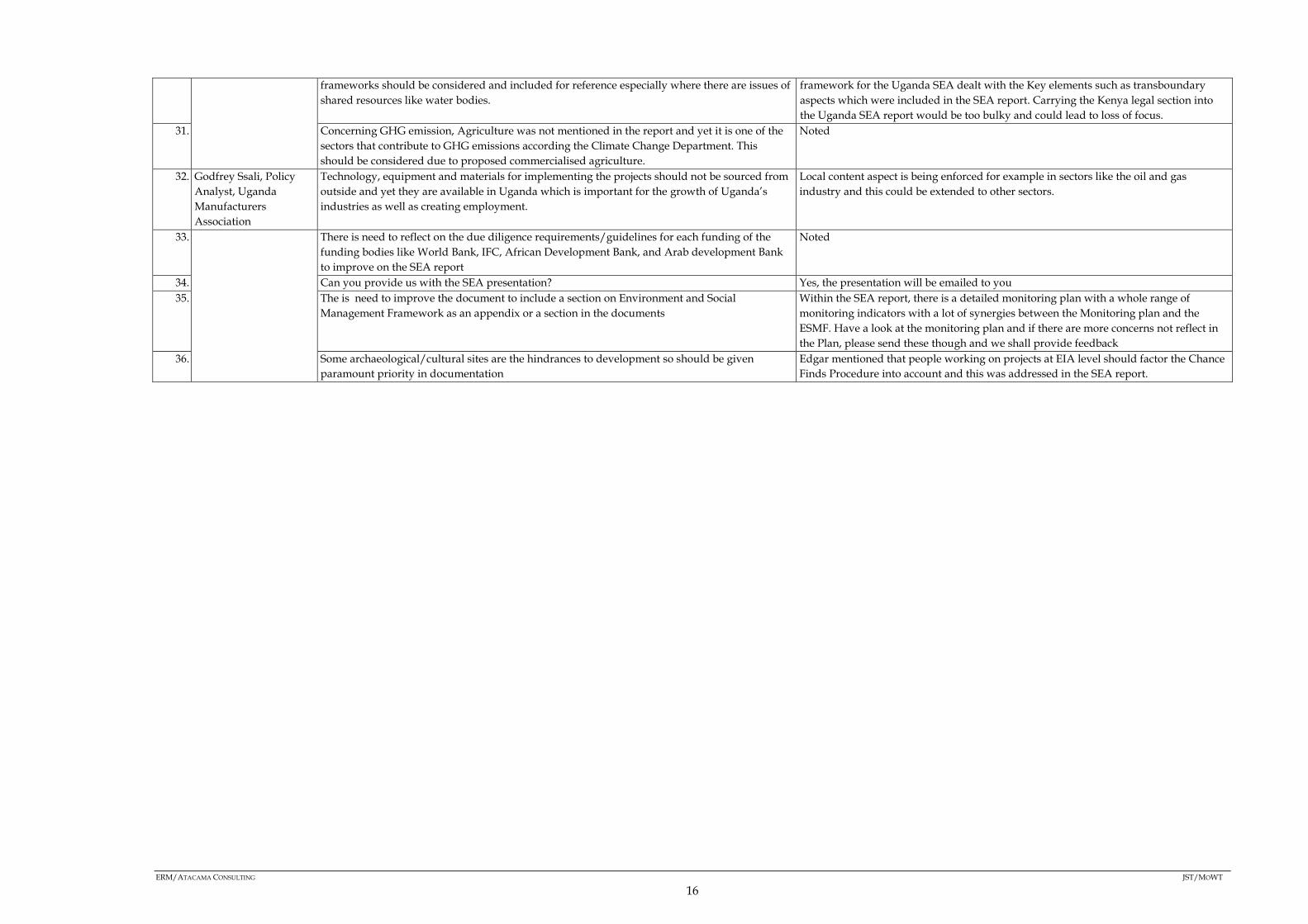
frameworks should be considered and included for reference especially where there are issues of shared resources like water bodies.
framework for the Uganda SEA dealt with the Key elements such as transboundary aspects which were included in the SEA report. Carrying the Kenya legal section into the Uganda SEA report would be too bulky and could lead to loss of focus.
31. Concerning GHG emission, Agriculture was not mentioned in the report and yet it is one of the sectors that contribute to GHG emissions according the Climate Change Department. This should be considered due to proposed commercialised agriculture.
Noted
32. Godfrey Ssali, Policy Analyst, Uganda Manufacturers Association
Technology, equipment and materials for implementing the projects should not be sourced from outside and yet they are available in Uganda which is important for the growth of Uganda’s industries as well as creating employment.
Local content aspect is being enforced for example in sectors like the oil and gas industry and this could be extended to other sectors.
33. There is need to reflect on the due diligence requirements/guidelines for each funding of the funding bodies like World Bank, IFC, African Development Bank, and Arab development Bank to improve on the SEA report
Noted
34. Can you provide us with the SEA presentation? Yes, the presentation will be emailed to you 35. The is need to improve the document to include a section on Environment and Social
Management Framework as an appendix or a section in the documents Within the SEA report, there is a detailed monitoring plan with a whole range of monitoring indicators with a lot of synergies between the Monitoring plan and the ESMF. Have a look at the monitoring plan and if there are more concerns not reflect in the Plan, please send these though and we shall provide feedback
36. Some archaeological/cultural sites are the hindrances to development so should be given paramount priority in documentation
Edgar mentioned that people working on projects at EIA level should factor the Chance Finds Procedure into account and this was addressed in the SEA report.
ERM/ATACAMA CONSULTING JST/MOWT
16

2.1.3 Kampala Meeting Photos
ERM/ATACAMA CONSULTING JST/MOWT
21

2.2 MBARARA MEETING
2.2.1 MBARARA MEETING MINUTES
S/N DETAILS OF THE PERSON
RAISING THE QUESTION
QUESTION/COMMENT ANSWER/RESPONSE
1. Within the Master Plan framework, is there planned activity for urban growth in the northern corridor?
The regional strategy identifies unbalanced development, thus the approach is to spread out the development through the various options. The negative externalities should be mitigated and this is covered in the SEA
2. The import export ratio for Uganda is affecting the balance of trade and this is worrying
The Master Plan has a strategy to deal with the problem by way of import substitution so as to export more products, also looking at export expansion in form of minerals and other products so as to balance the trade. Value addition to the local products will also help enhance our exports.
3. Have you done a cost benefit analysis of the routes to determine which is the most viable?
The corridor is defined with reference to the Sub-Saharan line, i.e. transport routes under the Sahara. Routes were not defined in terms of viability, thus no cost benefit analysis was done.
4. Previously, the routes were not definite and land speculation was raised as an issue especially in Kasese were people are targeting resettlement compensation.
This is noted and quite unavoidable. This makes the distribution of reports such as the Master Plan a challenge since people get a chance to position themselves
5. What are the timelines for the Master Plan? The time horizon for the Master Plan is between 2015 and 2030.
6. The Corridor spans more than one country. Is the Master Plan considered as one single project or each country is responsible for a specific part? Can’t problems in one country derail the whole process?
The project is currently focussing on Uganda and Kenya. Other countries may request for their portion. Some of the projects are to be done jointly for example the Standard Guage Project and the oil pipeline but each country is responsible for its portion. Conflicts may have an effect but not necessarily stop the process.
7. Monday Lwanga, DNRO Rubirizi
Our economy is characterised by low production levels, dwindling fish stocks, degraded ecosystems redundant labour e.t.c. Do you envisage the possibility of good returns on the investment into the northern corridor?
This is a broad plan that incorporates so many projects to stimulate growth and development and attract foreign investment to address the imbalances affecting us. Some projects will be public financed, others will be taken in partnership with the private sector while others will be a hybrid between and the government and the private sector
8. The physical planning process is very weak. We have no smart towns in Uganda since the roads and the physical layout of buildings is wanting. There is need for proper physical planning so that the policy is followed during town development. No go zone areas should be established
This was noted and thus one of the reasons for the extensive stakeholder consultation with key stakeholders such as the Ministry of Lands, Housing and Urban Development. In addition, the National physical plan will incorporate all other plans so as to harmonize the required development in any locality and will be made available online hence will act as a guiding document.
9. Mathias Ndifuna, CAO Kasese
How will the resources be distributed? We as government want the community to come up, can we define means to improve the west and central?
The Master Plan has planned the resources from all areas in Uganda. The SEA has provided the study of different income levels and limitations within different income levels in different areas. Different strategies look at the various issues you have raised, such as growth of small and medium towns.
10. Mbarara also experiences traffic jams- the planning of the urban centres should consider the increased production and population increase. The Government should identify and make projections before the problem occurs.
The comment is noted. The SEA is looking at the wide issues including congestion in the towns along the corridor.
11. Do we have a better plan of water transport within Lake Victoria and other Lakes e.g. Albert and Edward? The recommendations should improve transport between the neighbouring countries and improve the minor cities. That way, trade between Congo and
The plan for improving water transport is at National Level by the Ministry of Works and Transport, outside the scope of the Master Plan
ERM/ATACAMA CONSULTING JST/MOWT
22
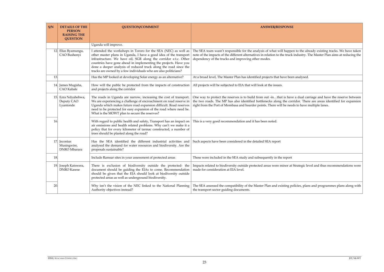
S/N DETAILS OF THE PERSON
RAISING THE QUESTION
QUESTION/COMMENT ANSWER/RESPONSE
Uganda will improve.
12. Elias Byamungu, CAO Bushenyi
I attended the workshops in Tororo for the SEA (NEC) as well as other master plans in Uganda, I have a good idea of the transport infrastructure. We have oil, SGR along the corridor e.t.c. Other countries have gone ahead in implementing the projects. Have you done a deeper analysis of reduced truck along the road since the tracks are owned by a few individuals who are also politicians?
The SEA team wasn’t responsible for the analysis of what will happen to the already existing tracks. We have taken note of the impacts of the different alternatives in relation to the truck industry. The Master Plan aims at reducing the dependency of the trucks and improving other modes.
13. Has the MP looked at developing Solar energy as an alternative? At a broad level, The Master Plan has identified projects that have been analysed.
14. James Mugisha, CAO Kabale
How will the public be protected from the impacts of construction and projects along the corridor
All projects will be subjected to EIA that will look at the issues.
15. Ezra Ndyahebwa, Deputy CAO Lyantonde
The roads in Uganda are narrow, increasing the cost of transport. We are experiencing a challenge of encroachment on road reserve in Uganda which makes future road expansion difficult. Road reserves need to be protected for easy expansion of the road where need be. What is the MOWT plan to secure the reserves?
One way to protect the reserves is to build from out -in…that is have a dual carriage and have the reserve between the two roads. The MP has also identified bottlenecks along the corridor. There are areas identified for expansion right from the Port of Mombasa and boarder points. There will be needs to have multiple lanes.
16. With regard to public health and safety, Transport has an impact on air emissions and health related problems. Why can’t we make it a policy that for every kilometer of tarmac constructed, a number of trees should be planted along the road?
This is a very good recommendation and it has been noted.
17. Jeconius Musingwire, DNRO Mbarara
Has the SEA identified the different industrial activities and analysed the demand for water resources and biodiversity. Are the proposals sustainable?
Such aspects have been considered in the detailed SEA report
18. Include Ramsar sites in your assessment of protected areas These were included in the SEA study and subsequently in the report
19. Joseph Katswera, DNRO Kasese
There is exclusion of biodiversity outside the protected- the document should be guiding the EIAs to come. Recommendation should be given that the EIA should look at biodiversity outside protected areas as well as underground biodiversity.
Impacts related to biodiversity outside protected areas were minor at Strategic level and thus recommendations were made for consideration at EIA level.
20. Why isn’t the vision of the NEC linked to the National Planning Authority objectives instead?
The SEA assessed the compatibility of the Master Plan and existing policies, plans and programmes plans along with the transport sector guiding documents.
ERM/ATACAMA CONSULTING JST/MOWT
23
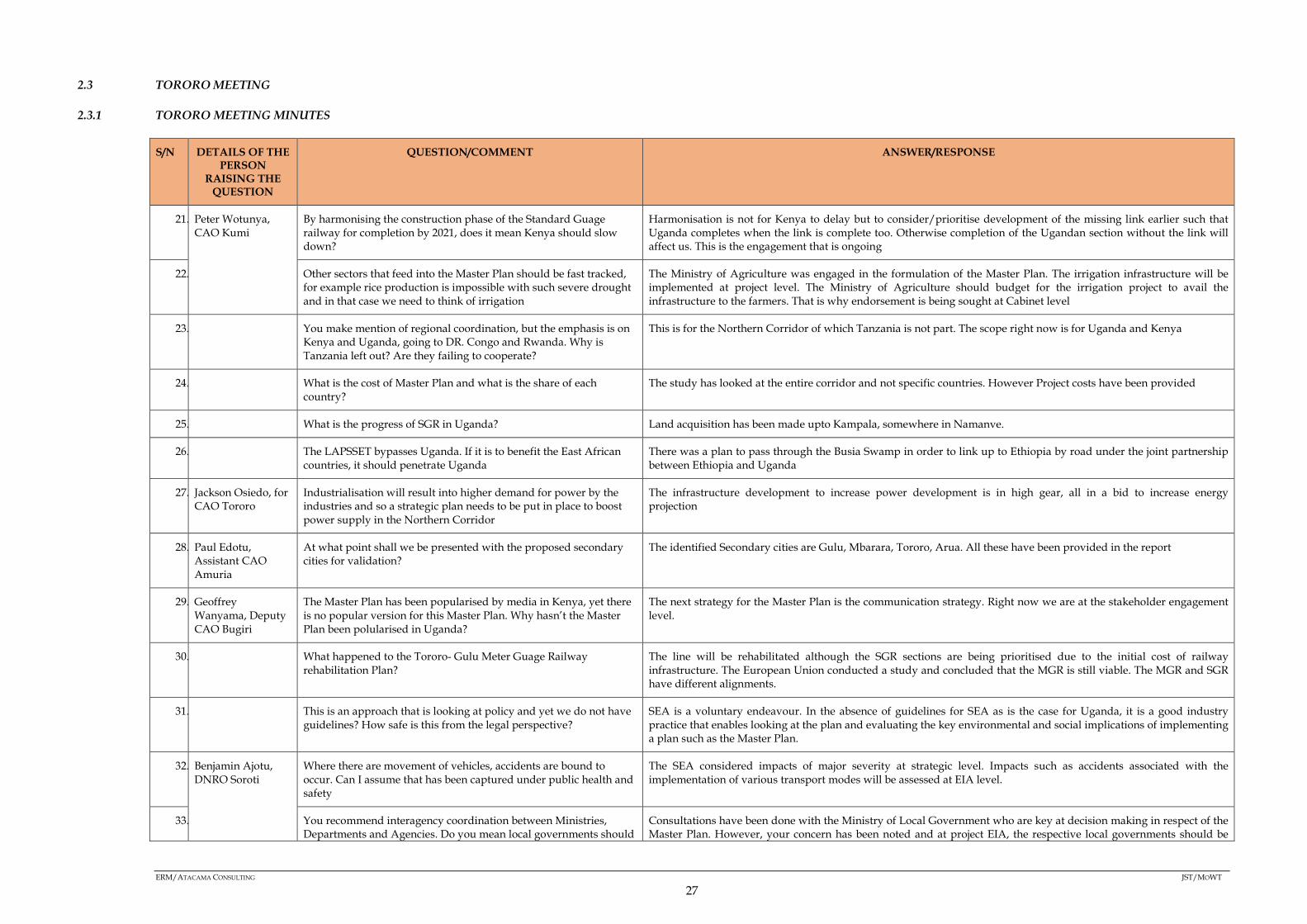
2.3 TORORO MEETING
2.3.1 TORORO MEETING MINUTES
S/N DETAILS OF THE PERSON
RAISING THE QUESTION
QUESTION/COMMENT ANSWER/RESPONSE
21. Peter Wotunya, CAO Kumi
By harmonising the construction phase of the Standard Guage railway for completion by 2021, does it mean Kenya should slow down?
Harmonisation is not for Kenya to delay but to consider/prioritise development of the missing link earlier such that Uganda completes when the link is complete too. Otherwise completion of the Ugandan section without the link will affect us. This is the engagement that is ongoing
22. Other sectors that feed into the Master Plan should be fast tracked, for example rice production is impossible with such severe drought and in that case we need to think of irrigation
The Ministry of Agriculture was engaged in the formulation of the Master Plan. The irrigation infrastructure will be implemented at project level. The Ministry of Agriculture should budget for the irrigation project to avail the infrastructure to the farmers. That is why endorsement is being sought at Cabinet level
23. You make mention of regional coordination, but the emphasis is on Kenya and Uganda, going to DR. Congo and Rwanda. Why is Tanzania left out? Are they failing to cooperate?
This is for the Northern Corridor of which Tanzania is not part. The scope right now is for Uganda and Kenya
24. What is the cost of Master Plan and what is the share of each country?
The study has looked at the entire corridor and not specific countries. However Project costs have been provided
25. What is the progress of SGR in Uganda? Land acquisition has been made upto Kampala, somewhere in Namanve.
26. The LAPSSET bypasses Uganda. If it is to benefit the East African countries, it should penetrate Uganda
There was a plan to pass through the Busia Swamp in order to link up to Ethiopia by road under the joint partnership between Ethiopia and Uganda
27. Jackson Osiedo, for CAO Tororo
Industrialisation will result into higher demand for power by the industries and so a strategic plan needs to be put in place to boost power supply in the Northern Corridor
The infrastructure development to increase power development is in high gear, all in a bid to increase energy projection
28. Paul Edotu, Assistant CAO Amuria
At what point shall we be presented with the proposed secondary cities for validation?
The identified Secondary cities are Gulu, Mbarara, Tororo, Arua. All these have been provided in the report
29. Geoffrey Wanyama, Deputy CAO Bugiri
The Master Plan has been popularised by media in Kenya, yet there is no popular version for this Master Plan. Why hasn’t the Master Plan been polularised in Uganda?
The next strategy for the Master Plan is the communication strategy. Right now we are at the stakeholder engagement level.
30. What happened to the Tororo- Gulu Meter Guage Railway rehabilitation Plan?
The line will be rehabilitated although the SGR sections are being prioritised due to the initial cost of railway infrastructure. The European Union conducted a study and concluded that the MGR is still viable. The MGR and SGR have different alignments.
31. This is an approach that is looking at policy and yet we do not have guidelines? How safe is this from the legal perspective?
SEA is a voluntary endeavour. In the absence of guidelines for SEA as is the case for Uganda, it is a good industry practice that enables looking at the plan and evaluating the key environmental and social implications of implementing a plan such as the Master Plan.
32. Benjamin Ajotu, DNRO Soroti
Where there are movement of vehicles, accidents are bound to occur. Can I assume that has been captured under public health and safety
The SEA considered impacts of major severity at strategic level. Impacts such as accidents associated with the implementation of various transport modes will be assessed at EIA level.
33. You recommend interagency coordination between Ministries, Departments and Agencies. Do you mean local governments should
Consultations have been done with the Ministry of Local Government who are key at decision making in respect of the Master Plan. However, your concern has been noted and at project EIA, the respective local governments should be
ERM/ATACAMA CONSULTING JST/MOWT
27

S/N DETAILS OF THE PERSON
RAISING THE QUESTION
QUESTION/COMMENT ANSWER/RESPONSE
be excluded? consulted.
34. There are a number of urban centres without physical development plans. Your recommendations should suggest development of these physical development plans
Noted
35. Since the SEA is being done for the first time, these studies should be disseminated.
This is not the first time an SEA is being carried out in Uganda, take for example the SEA that was carried out for the Oil and Gas Activities in the Albertine Graben.
36. In the assessment, reference is made to future projects. Is it by inference or observation? Otherwise why wouldn’t you restrict the study to what you have seen?
The different projects have been enumerated from the literature review of documents such as the NDPII, Vision 2040 and others.
37. Abdul Samanya, DNRO Iganga
In your assessment of cumulative impacts, biodiversity outside protected areas was not assessed.
One of the SEA objectives was to conserve and maintain biodiversity outside protected areas. The impacts to biodiversity outside protected areas at strategic level was assessed as minor. Recommendations were given to assess the impact at project EIA level
38. SEA is new in Uganda with no laws for it and during the execution of this plan, emerging issues may come up calling for a precautionary approach. This has not been presented.
The SEA draft guidelines for Uganda are in place.
During the assessment, a precautionary approach on how projects should be rolled out was considered and this is reflected especially in the assessment of cumulative impacts bearing in mind what could possibly happen.
39. No mention has been made of political instability yet it could jeopardise the Master Plan. Was this out of scope for the SEA or was it deliberate?
Political instability was discussed in the main report as one of the issues for consideration during the formulation of the Master Plan
40. It would have been important if we had received a copy of the report before this workshop
Unfortunately, the report was uploaded onto the Ministry of Works and Transport Website but not the Northern Economic Corridor Website. However, this is currently being worked upon and very soon the document will be available
41. Loyce J. Namboozo, CAO Mayuge
What are the timelines for the Master Plan? The time horizon for the Master Plan is 2015-2025. The short term is from 2015-2020, medium term from 2020-2025 and the long term from 2015-2030
42. You mentioned fast tracking of SEA guidelines in Uganda. I don’t see it captured well.
The general SEA guidelines for Uganda are being fast tracked and could possibly be ready by Dec 2017. This is not part of the scope of the SEA for the Master Plan
43. By the time of the baseline survey, this type of climate change had not happened. How are you going to factor this in? And don’t you think this may call for a change in policy such as water abstraction policies?
Climate change has been an issue for such a long time. It is unfortunate however, that we are experiencing severe drought currently. Otherwise climate change was considered during the assessment. About the policy change, this is out of scope for the SEA but since interagency coordination was recommended, projects arising out of the Master Plan could be aligned with such water needs and any changes that could possibly be made
ERM/ATACAMA CONSULTING JST/MOWT
28
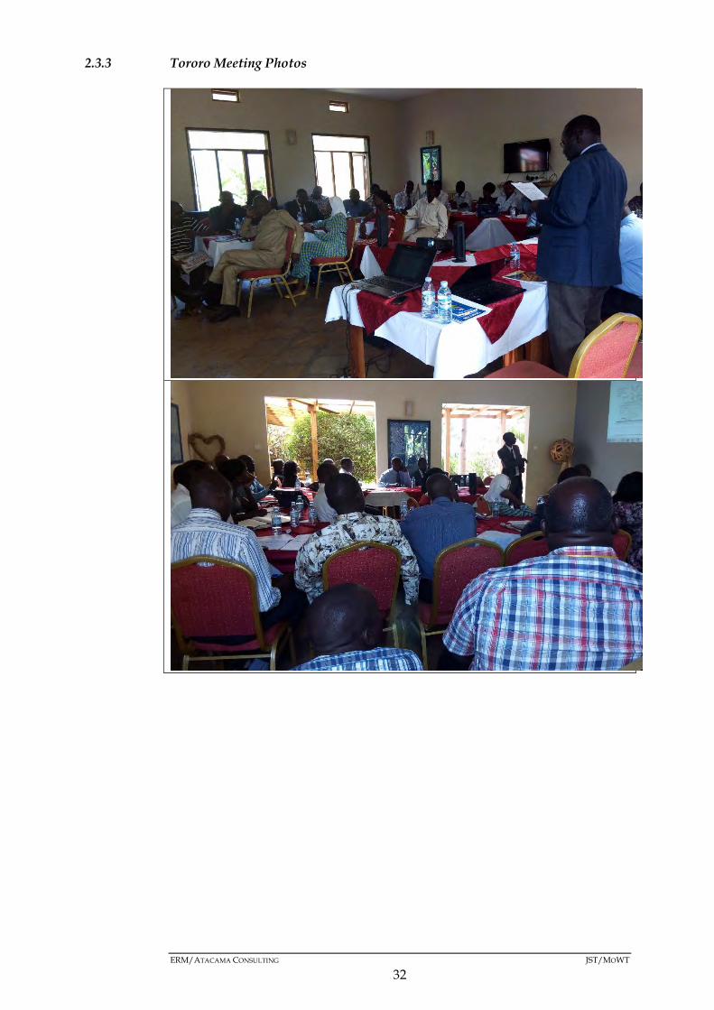
2.3.3 Tororo Meeting Photos
ERM/ATACAMA CONSULTING JST/MOWT
32

ANNEX A3 -SEA OPINION SURVEY SHEET AND BID

Logistics in the Northern Economic Corridor Mater Plan Opinion Survey
SEA-Related Survey
Republic of Uganda Master Plan on Logistics in the Northern Economic Corridor (Master Plan)
Objectives Within the SEA (Strategic Environmental Assessment) of the Logistics in the Northern Economic Corridor Master Plan Study, stakeholder participation from relevant agencies as well as communities plays an important role for the development of integrated urban development strategies. It is essential to examine a variety of aspects of the proposed Master Plan study based on the current needs or priorities of relevant agencies and communities. A questionnaire-based stakeholder analysis is to be carried out in order to grasp the opinions about the Logistics in the Northern Economic Corridor Master Plan process, as well as current concerns therein.
A. BACKGROUND INFORMATION 1. Name (Optional): 2. E-mail (Optional): 3. Occupation: 4. Mobile (Optional): 5. Age: 6. Sex: Male / Female 7. Residence/District: 8. Education level: i) Primary ii) Secondary iii) College iv) University 9. a) Have you attended any previous meetings on this Master Plan? Yes / No
b) If yes, how many times (this stakeholder meeting excluded)? times
B. SOCIO-ECONOMIC CONCERNS IN YOUR DISTRICT 10. What are the key socio-economic issues in your area of residence?
(Please rank them in order of severity.)
a) Education Standards b) Public Health and Sanitation c) Unemployment/Job Opportunities d) Crime and Insecurity e) Social Values and systems f) Social infrastructure (community centres, playgrounds, etc.) g) Housing h) Other (Please specify.):
11. What are your proposals for addressing the issues identified above?
(Please Turn Over)
V.Poor Fair V.Good 1 2 3 4 5 1 2 3 4 5 1 2 3 4 5 1 2 3 4 5 1 2 3 4 5 1 2 3 4 5 1 2 3 4 5
Your response will inform the Master Plan process and will be treated as confidential.
Logistics in the Northern Economic Corridor Mater Plan Opinion Survey
C. ENVIRONMENTAL CONCERNS IN YOUR DISTRICT 12. What are the current local environmental concerns in your area?
(Please rank the environmental concern according to its impact in your area of residence.)
a) Environmental Pollution a. Water Quality b. Air Quality c. Noise d. Soil Erosion
b) Degradation of natural and environmental resources (encroachment)
c) Solid waste management
d) Wastewaters management
e) Others (Please specify.):
D)LAND USE ISSUES IN YOUR DISTRICT
13. What are the key Land use issues in your center/town? a. Industrial area accessibility b. Housing quality c. Educational availability d. Recreational accessibility e. Road connectivity f. Commercial development g. Others (Please specify)
14. Are there proposals for addressing the above identified issues (yes or no)? ………………. 15. Are you satisfied with the measures being undertaken yes or no ………………….. 16. If no please specify …………………………………………………………….
(Please Turn Over)
Low High 1 2 3 4 5 1 2 3 4 5 1 2 3 4 5 1 2 3 4 5 1 2 3 4 5 1 2 3 4 5 1 2 3 4 5
V.Poor Fair V.Good 1 2 3 4 5 1 2 3 4 5 1 2 3 4 5 1 2 3 4 5 1 2 3 4 5 1 2 3 4 5
Your response will inform the Master Plan process and will be treated as confidential.
Logistics in the Northern Economic Corridor Mater Plan Opinion Survey
E). EVALUATION 1. How did you learn of this meeting?:
i) Letter ii) Email vii) Other (please specify)
2. How do you evaluate the following? (Please circle according to level of satisfaction.)
a) Preparation for the meeting b) Quality of Presentation c) Understanding of MP and SEA d) Overall evaluation
3. a) Is this Master Plan Process familiar to you? Yes / No
b) If “No” above, please specify reasons:
4. What are your expectations in this Master Plan Process? (Please specify.)
5. a) Do you wish to contribute to this Master Plan development process? Yes / No
b) If yes above, in what way? (Please specify.)
c) If no above, please specify reasons.
THANK YOU FOR YOUR COOPERATION
V.Poor Fair V.Good 1 2 3 4 5 1 2 3 4 5 1 2 3 4 5 1 2 3 4 5
Your response will inform the Master Plan process and will be treated as confidential.
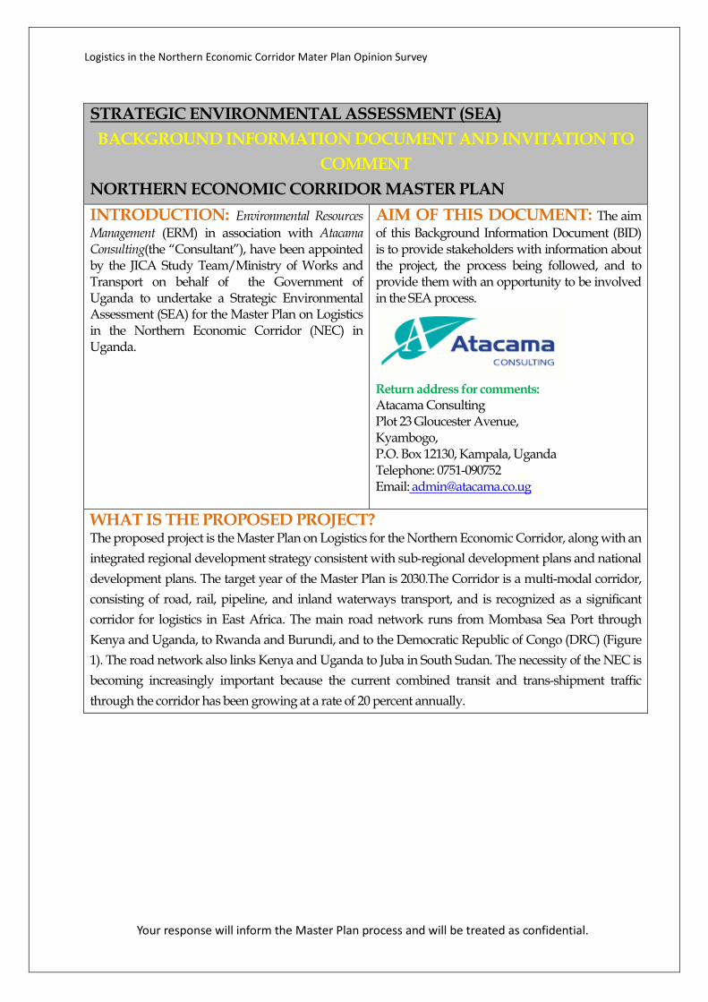
Logistics in the Northern Economic Corridor Mater Plan Opinion Survey
STRATEGIC ENVIRONMENTAL ASSESSMENT (SEA) BACKGROUND INFORMATION DOCUMENT AND INVITATION TO
COMMENT NORTHERN ECONOMIC CORRIDOR MASTER PLAN
INTRODUCTION: Environmental Resources Management (ERM) in association with Atacama Consulting(the “Consultant”), have been appointed by the JICA Study Team/Ministry of Works and Transport on behalf of the Government of Uganda to undertake a Strategic Environmental Assessment (SEA) for the Master Plan on Logistics in the Northern Economic Corridor (NEC) in Uganda.
AIM OF THIS DOCUMENT: The aim of this Background Information Document (BID) is to provide stakeholders with information about the project, the process being followed, and to provide them with an opportunity to be involved in the SEA process.
Return address for comments: Atacama Consulting Plot 23 Gloucester Avenue, Kyambogo, P.O. Box 12130, Kampala, Uganda Telephone: 0751-090752 Email: [email protected]
WHAT IS THE PROPOSED PROJECT? The proposed project is the Master Plan on Logistics for the Northern Economic Corridor, along with an integrated regional development strategy consistent with sub-regional development plans and national development plans. The target year of the Master Plan is 2030.The Corridor is a multi-modal corridor, consisting of road, rail, pipeline, and inland waterways transport, and is recognized as a significant corridor for logistics in East Africa. The main road network runs from Mombasa Sea Port through Kenya and Uganda, to Rwanda and Burundi, and to the Democratic Republic of Congo (DRC) (Figure 1). The road network also links Kenya and Uganda to Juba in South Sudan. The necessity of the NEC is becoming increasingly important because the current combined transit and trans-shipment traffic through the corridor has been growing at a rate of 20 percent annually.
Your response will inform the Master Plan process and will be treated as confidential.

Logistics in the Northern Economic Corridor Mater Plan Opinion Survey
Figure 1: Locality map indicating the Northern Economic Corridor
WHY IS THE PROJECT BEING PROPOSED? The project is being proposed in order to improve the efficiency of logistics in the NEC thereby spurring economic growth in the NEC region. The NEC is currently faced with a number of logistical bottle necks that include; inadequate infrastructure, poor interconnectivity of various transport modes, long delays (stagnation) of cargo at Mombasa port and border posts, and lack of goods to transport for the return trip from the inland area to Mombasa port. This increases transport costs within the Corridor, accounting for approximately 30 percent of the value of the goods. High transport costs, are one of the major obstructive factors hindering economic development in the region, especially of the inland area. Additionally, the new proposed Standard Gauge Railway Line and Oil Pipeline from Uganda to Kenya projects, will further significantly impact the logistics in the Corridor. In light of the above, the Government of Uganda (GOU) requested the Government of Japan (GOJ) to implement a project to formulate a master plan on logistics in the Northern Corridor in order to promote regional development. Concurrently, the Government of Kenya (GOK) also requested the GOJ for a project within the Northern Corridor which shares the same goals and outputs. In response to the requests of the GOU and GOK, the Japan International Cooperation Agency (JICA) dispatched a “Detail Design Formulation Team for the Project” in October and November, 2014. The team proposed application of the project concept as the Northern Economic Corridor, since the project should not only cover logistics, but regional development along the Northern Corridor as well. The GOU and GOK agreed with this concept and signed the Record of Discussion with JICA for the implementation of the Project for Formulation of the Master Plan on Logistics in the Northern Economic Corridor.
Your response will inform the Master Plan process and will be treated as confidential.

Logistics in the Northern Economic Corridor Mater Plan Opinion Survey
THE STRATEGIC ENVIRONMENTAL ASSESSMENT (SEA) What is an SEA? Strategic Environmental Assessment (SEA) is an assessment that is implemented at the policy, planning, and program levels, but not a project-level EIA. Figure 2 indicates the general phases involved in an SEA. Figure 2: Phases in an SEA
Why is an SEA needed for the proposed project? In Uganda, there is no binding guideline for SEA at the moment. According to National Environment Management Authority (NEMA) “the National Environment Act” is under review to include a mandatory provision for SEA and it will probably be enacted next year, and NEMA is in the process of hiring a consultant to finalize the draft SEA guideline as of July 2015. Since there is no binding guideline for SEA, no legal framework exists at the moment for SEA. However, in order to formulate an Environmentally- Friendly Master Plan, consideration of potential environmental and social impacts for the Master Plan will be evaluated through the SEA process. What is the purpose of this SEA? The purpose of the SEA is to integrate the environmental and social considerations into the Master Plan on Logistics in the Northern Economic Corridor. The integration process will entail the SEA being undertaken in parallel (Figure 3) with the Master Plan formulation process. This way, environmental and social considerations will be addressed in a proactive manner so as to better inform the decision making processes.
Screening
Scoping
Detailed SEA study
Stakeholder Consultation
SEA Validation
Your response will inform the Master Plan process and will be treated as confidential.

Logistics in the Northern Economic Corridor Mater Plan Opinion Survey
Figure 3: Parallel SEA Model Planning process SEA process
Source: Partidário, 2007
WHY IS STAKEHOLDER ENGAGEMENT AND CONSULTATION IMPORTANT IN THE SEA PROCESS? Stakeholder consultation with all the identified stakeholders is necessary in order to:
• Secure the necessary stakeholder buy-in for the planned interventions; • Understand the socio-economic dynamics of the operating environment; • Shape the decision making process through inclusivity; • Establish robust communication channels; • Lay a foundation for sustainable results, and; • Provide the requisite information
AT WHAT STAGES OF THE SEA PROCESS CAN YOU GET INVOLVED?
Screening
Scoping
Detailed SEA study
Stakeholder Consultation
SEA Validation
Your response will inform the Master Plan process and will be treated as confidential.

Logistics in the Northern Economic Corridor Mater Plan Opinion Survey
HOW CAN YOU GET INVOLVED?
• By responding to our invitation for your involvement and participation in the stakeholder consultation meetings that will be held (Specific meeting dates to be communicated);
• By emailing and/or telephoning the consultant using the details provided on Page 1 of this BID;
• By reviewing the project SEA report that will be generated.
We would highly appreciate it if you could please complete the Consultation Proforma attached herewith and return it, with your comments, via email to Atacama Consulting ([email protected]) by 02nd May 2016. Alternatively, have the completed proforma ready for collection by an Atacama Consulting Employee by 2:00pm on 02nd May 2016. Please inform us either by phone and/or e-mail by Friday 29th April 2016 if you need for us to collect your completed proforma so that we can organise accordingly and pick it up in time.
Your response will inform the Master Plan process and will be treated as confidential.

Logistics in the Northern Economic Corridor Mater Plan Opinion Survey
Atacama Consulting Plot 23,Gloucester Avenue, Kyambogo P.O. Box 12130, Kampala, UGANDA Tel: +256 751090752; Email: [email protected]
SEA: DETAILED STUDY CONSULATION REPLY SLIP This reply is provided to assist consultee responses. Please complete it and return it with your comments via email to Atacama Consulting ([email protected]) by 02nd May 2016. Alternatively, have the completed proforma ready for collection by an Atacama Consulting Employee by 2:00pm on Monday 02nd May 2016. Please inform us either by phone and/or e-mail by Friday 29th April 2016 if you need for us to collect your completed proforma so that we can organize accordingly and pick it up in time. It will assist the process if comments are received by then. Please note that this Background Information Document will not be re-issued following receipt of comments.
NAME OF PROJECT: PROJECT FOR FORMULATION OF MASTER PLAN ON LOGISTICS IN THE NORTHERN ECONOMIC CORRIDOR Name of respondent Title: First Name: Initial: Surname: Organisation Name: Address: Telephone Number: Email: Postal address: Address of the respondent(Leave blank if same as for the organisation above): Address: Telephone Number: Email: Postal address: What are your major interests and concerns with respect to the proposed project? What would be the five major current and potential environmental/social problems in relation to the Master Plan? Are there other Alternatives that you would like considered?
Your response will inform the Master Plan process and will be treated as confidential.

Logistics in the Northern Economic Corridor Mater Plan Opinion Survey
What opportunities and constraints does the natural environment provide which should be taken into consideration during formulation of the master plan? Are there any omissions in the Background Information Document for which you require more information? Are there additional stakeholders whom you feel should be consulted with regards to the proposed project? If yes, please list their names and if available, provide their contact details. Do you hold any data / information which you consider to be of relevance to this study? If so, what type of information is it? Are there any other comments you would like to make?
THANK YOU FOR YOUR INPUT
Your response will inform the Master Plan process and will be treated as confidential.

ERM consulting services worldwide www.erm.com
/ERM has 140 offices across the following countries worldwide Argentina Australia Belgium Brazil Canada China Colombia France Germany Hong Kong Hungary India Indonesia Ireland Italy Japan Kazakhstan Kenya Malaysia Mexico Mozambique ERM’s Nairobi Office
4th Floor, Landmark Office Suites Laiboni Centre, Lenana Road, Kilimani PO Box 100798-00101 Nairobi, Kenya T: +254 20 493 8113/4 M: +254 71 265 0516 ERM’s Cape Town Office
2nd Floor Great Westerford 240 Main Road, Rondebosch, 7700 Cape Town, South Africa T:+27 (0) 21 681 5400 F:+27 (0) 21 686 0736 ERM’s Durban Office
Unit 6, St Helier Office Park, Cnr St Helier & Forbes Drive Gillitts, 3610 Durban, South Africa T:+27 (0) 31 767 2080 F:+27 (0) 31 764 3643 ERM’s Johannesburg Office
Building 32, The Woodlands Office Park, Woodlands Drive, Woodmead, 2148 Johannesburg, South Africa T:+27 (0) 11 798 4300 F:+27 (0) 11 804 2289 www.erm.com
The Netherlands New Zealand Panama Peru Poland Portugal Puerto Rico Romania Russia Singapore South Africa South Korea Spain Sweden Taiiwan Thailand United Arab Emirates United Kingdom United States of America Vietnam

Data 7:
List of Data Source
in the Master Plan

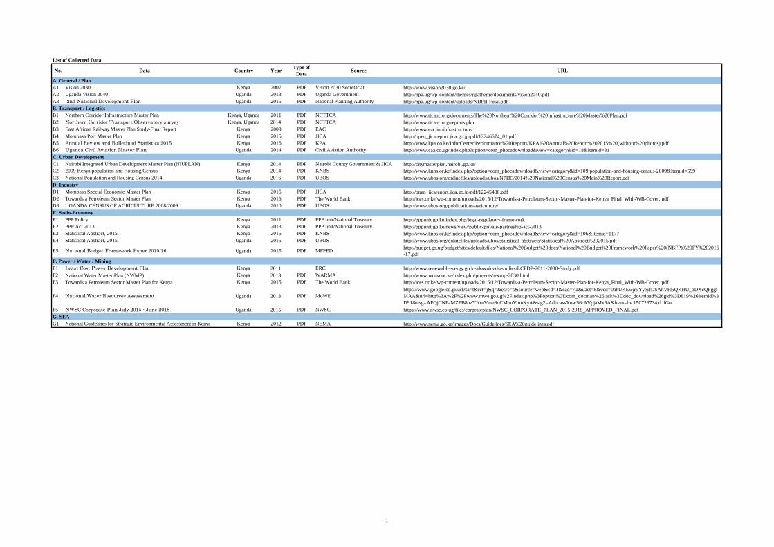
List of Collected Data
No. Data Country Year Type ofData Source URL
A. General / PlanA1 Vision 2030 Kenya 2007 PDF Vision 2030 Secretariat http://www.vision2030.go.ke/
A2 Uganda Vision 2040 Uganda 2013 PDF Uganda Government http://npa.ug/wp-content/themes/npatheme/documents/vision2040.pdf
A3 2nd National Development Plan Uganda 2015 PDF National Planning Authority http://npa.ug/wp-content/uploads/NDPII-Final.pdf
B. Transport / LogisticsB1 Northern Corridor Infrastructure Master Plan Kenya, Uganda 2011 PDF NCTTCA http://www.ttcanc.org/documents/The%20Northern%20Corridor%20Infrastructure%20Master%20Plan.pdf
B2 Northern Corridor Transport Observatory survey Kenya, Uganda 2014 PDF NCTTCA http://www.ttcanc.org/reports.php
B3 East African Railway Master Plan Study-Final Report Kenya 2009 PDF EAC http://www.eac.int/infrastructure/
B4 Mombasa Port Master Plan Kenya 2015 PDF JICA http://open_jicareport.jica.go.jp/pdf/12246674_01.pdf
B5 Annual Review and Bulletin of Statistics 2015 Kenya 2016 PDF KPA http://www.kpa.co.ke/InforCenter/Performance%20Reports/KPA%20Annual%20Report%202015%20(without%20photos).pdf
B6 Uganda Civil Aviation Master Plan Uganda 2014 PDF Civil Aviation Authority http://www.caa.co.ug/index.php?option=com_phocadownload&view=category&id=18&Itemid=81
C. Urban DevelopmentC1 Nairobi Integrated Urban Development Master Plan (NIUPLAN) Kenya 2014 PDF Nairobi County Government & JICA http://citymasterplan.nairobi.go.ke/
C2 2009 Kenya population and Housing Census Kenya 2014 PDF KNBS http://www.knbs.or.ke/index.php?option=com_phocadownload&view=category&id=109:population-and-housing-census-2009&Itemid=599
C3 National Population and Housing Census 2014 Uganda 2016 PDF UBOS http://www.ubos.org/onlinefiles/uploads/ubos/NPHC/2014%20National%20Census%20Main%20Report.pdf
D. IndustryD1 Mombasa Special Economic Master Plan Kenya 2015 PDF JICA http://open_jicareport.jica.go.jp/pdf/12245486.pdf
D2 Towards a Petroleum Sector Master Plan Kenya 2015 PDF The World Bank http://ices.or.ke/wp-content/uploads/2015/12/Towards-a-Petroleum-Sector-Master-Plan-for-Kenya_Final_With-WB-Cover..pdf
D3 UGANDA CENSUS OF AGRICULTURE 2008/2009 Uganda 2010 PDF UBOS http://www.ubos.org/publications/agriculture/
E. Socio-EconomyE1 PPP Policy Kenya 2011 PDF PPP unit/National Treasury http://pppunit.go.ke/index.php/legal-regulatory-framework
E2 PPP Act 2013 Kenya 2013 PDF PPP unit/National Treasury http://pppunit.go.ke/news/view/public-private-partneship-act-2013
E3 Statistical Abstract, 2015 Kenya 2015 PDF KNBS http://www.knbs.or.ke/index.php?option=com_phocadownload&view=category&id=106&Itemid=1177
E4 Statistical Abstract, 2015 Uganda 2015 PDF UBOS http://www.ubos.org/onlinefiles/uploads/ubos/statistical_abstracts/Statistical%20Abstract%202015.pdf
E5 National Budget Framework Paper 2015/16 Uganda 2015 PDF MFPEDhttp://budget.go.ug/budget/sites/default/files/National%20Budget%20docs/National%20Budget%20Framework%20Paper%20(NBFP)%20FY%202016
-17.pdf
F. Power / Water / MiningF1 Least Cost Power Development Plan Kenya 2011 ERC http://www.renewableenergy.go.ke/downloads/studies/LCPDP-2011-2030-Study.pdf
F2 National Water Master Plan (NWMP) Kenya 2013 PDF WARMA http://www.wrma.or.ke/index.php/projects/nwmp-2030.html
F3 Towards a Petroleum Sector Master Plan for Kenya Kenya 2015 PDF The World Bank http://ices.or.ke/wp-content/uploads/2015/12/Towards-a-Petroleum-Sector-Master-Plan-for-Kenya_Final_With-WB-Cover..pdf
F4 National Water Resources Assessment Uganda 2013 PDF MoWE
https://www.google.co.jp/url?sa=t&rct=j&q=&esrc=s&source=web&cd=1&cad=rja&uact=8&ved=0ahUKEwjr9YyeyfDSAhVFl5QKHU_oDXcQFggf
MAA&url=http%3A%2F%2Fwww.mwe.go.ug%2Findex.php%3Foption%3Dcom_docman%26task%3Ddoc_download%26gid%3D819%26Itemid%3
D91&usg=AFQjCNFaMZFB8hzYNrnVmn8qCMunVmnKyA&sig2=AdbcassXowS6rAVpjaMx6A&bvm=bv.150729734,d.dGo
F5 NWSC Corporate Plan July 2015 - June 2018 Uganda 2015 PDF NWSC https://www.nwsc.co.ug/files/corprateplan/NWSC_CORPORATE_PLAN_2015-2018_APPROVED_FINAL.pdf
G. SEAG1 National Guidelines for Strategic Environmental Assessment in Kenya Kenya 2012 PDF NEMA http://www.nema.go.ke/images/Docs/Guidelines/SEA%20guidelines.pdf
1
Related Documents