Processes & Procedures for Data QA/QC GIS & DM 2008 Conference How Accurate is your Boundary… ask Lands Jean Olson Richard Easterbrook Jeannie Whitler

Processes & Procedures for Data QA/QC GIS & DM 2008 Conference How Accurate is your Boundary… ask Lands Jean Olson Richard Easterbrook Jeannie Whitler.
Jan 02, 2016
Welcome message from author
This document is posted to help you gain knowledge. Please leave a comment to let me know what you think about it! Share it to your friends and learn new things together.
Transcript

Processes & Procedures for Data QA/QCGIS & DM 2008 Conference
How Accurate is your Boundary… ask Lands
Jean OlsonRichard EasterbrookJeannie Whitler

Processes & Procedures for Data QA/QCGIS & DM 2008 Conference
The Land Resources Division (LRD) is responsible for the Official Boundary, Legislative Maps, Acreage Calculations and Land Status Maps for all NPS park units.
May 4th 2004 Director of the National Park Service, Fran Mainella

►Quality Assurance:Quality Assurance:Activities designed to ensure the development and maintenance process Activities designed to ensure the development and maintenance process
is adequate to ensure a system will meet its needs.is adequate to ensure a system will meet its needs.
Processes & Procedures for Data QA/QCGIS & DM 2008 Conference
Land Acquisition Procedures (LAPS) Chapter 5 - Land Status Mapping StandardsLand Acquisition Procedures (LAPS) Chapter 5 - Land Status Mapping Standards► Data Sources (e.g., BLM, USGS, NPS, State & Local Gov.)Data Sources (e.g., BLM, USGS, NPS, State & Local Gov.)► Computer Software PlatformsComputer Software Platforms► Map Content (e.g., boundary, tracts, drawing number)Map Content (e.g., boundary, tracts, drawing number)► CAD Drawing Requirements (e.g. layer organization, topology)CAD Drawing Requirements (e.g. layer organization, topology)
Digital Map Conversion Standard Operating Procedures (SOP)Digital Map Conversion Standard Operating Procedures (SOP)
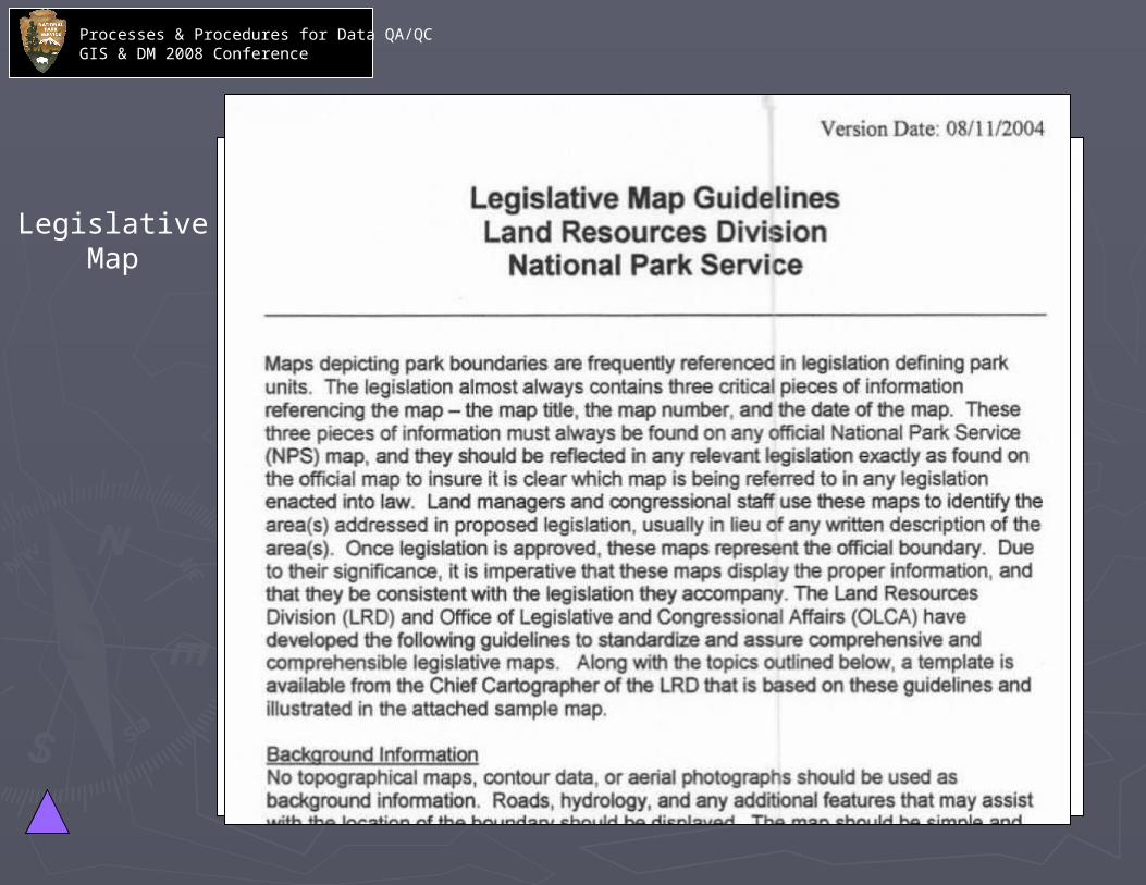
Legislative Map Guidelines & Template – Congressional & Legislative AffairsLegislative Map Guidelines & Template – Congressional & Legislative Affairs
Metadata Template & FGDC GuidelinesMetadata Template & FGDC Guidelines
► Land Status Map (Segment Map) Templates (e.g., Symbology)Land Status Map (Segment Map) Templates (e.g., Symbology)
► Distribution of Final Product (TIC, WASO, GIS Coord., SuperintendentsDistribution of Final Product (TIC, WASO, GIS Coord., Superintendents))

Processes & Procedures for Data QA/QCGIS & DM 2008 Conference
► Quality Control:Quality Control:Activities designed to evaluate a developed work product.Activities designed to evaluate a developed work product.
Database IntegrityDatabase Integrity► Check all attributes from the Master Deed List (MDL) to Check all attributes from the Master Deed List (MDL) to
ensure they match the GIS file and final segment map.ensure they match the GIS file and final segment map.
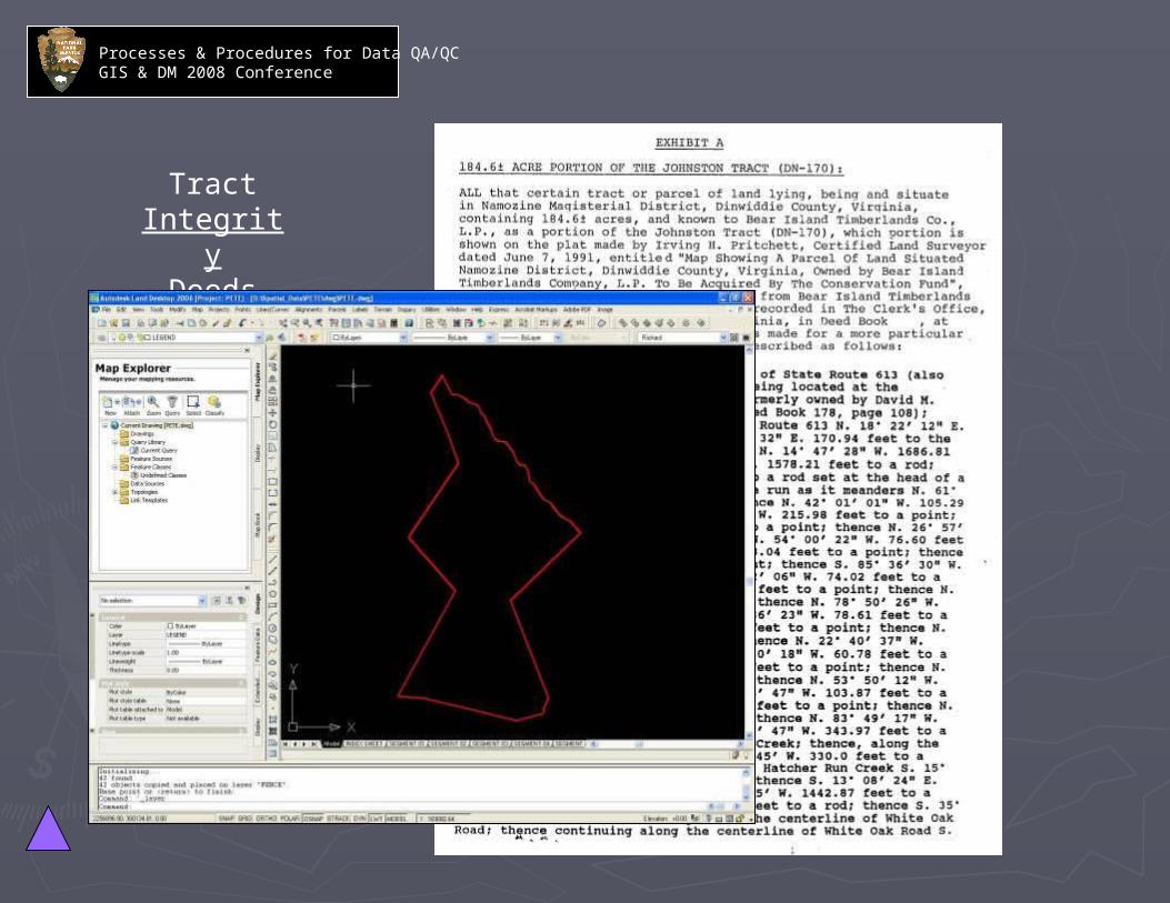
Tract IntegrityTract Integrity► Check coordinate geometry against deeds, legal descriptions, Check coordinate geometry against deeds, legal descriptions,
legislation/legislative maps, survey and historic maps.legislation/legislative maps, survey and historic maps.
Spatial IntegritySpatial Integrity► Check control sources (e.g. monumentation), surveys, ortho-Check control sources (e.g. monumentation), surveys, ortho-
photography, topographic maps and misc. GIS data. photography, topographic maps and misc. GIS data.
Attribute Integrity Attribute Integrity ► Verify proper layering and symbology and check attributes with Verify proper layering and symbology and check attributes with
ownership database.ownership database.
22ndnd Review Process Review Process► All above checks are performed by an additional Lands All above checks are performed by an additional Lands
cartographer.cartographer.► Review the final shapefile in ArcGIS for spatial and attribute Review the final shapefile in ArcGIS for spatial and attribute
integrity. Check projection.integrity. Check projection.
► Build and verify topology.Build and verify topology.

Processes & Procedures for Data QA/QCGIS & DM 2008 Conference
Cogo Deed Boundary
Accretion of Land

Processes & Procedures for Data QA/QCGIS & DM 2008 Conference
Processes & Procedures for Data QA/QCGIS & DM 2008 Conference
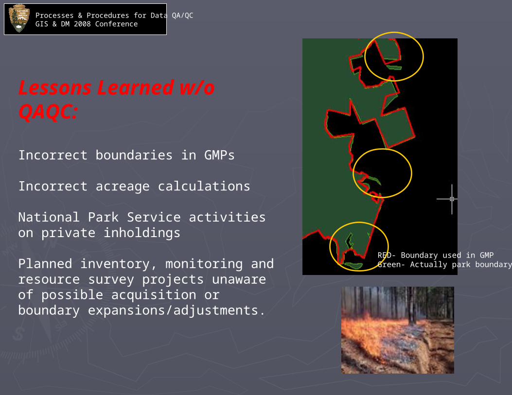
Lessons Learned w/o QAQC:
Incorrect boundaries in GMPs
Incorrect acreage calculations
National Park Service activities on private inholdings
Planned inventory, monitoring and resource survey projects unaware of possible acquisition or boundary expansions/adjustments.
RED- Boundary used in GMPGreen- Actually park boundary

Processes & Procedures for Data QA/QCGIS & DM 2008 Conference
Having a central boundary conversion provides the opportunity to resolve shared boundaries.

Processes & Procedures for Data QA/QCGIS & DM 2008 Conference
Processes & Procedures for Data QA/QCGIS & DM 2008 Conference
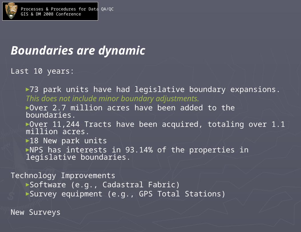
Boundaries are dynamic
Last 10 years:
►73 park units have had legislative boundary expansions.This does not include minor boundary adjustments.►Over 2.7 million acres have been added to the boundaries.►Over 11,244 Tracts have been acquired, totaling over 1.1 million acres.►18 New park units►NPS has interests in 93.14% of the properties in legislative boundaries.
Technology Improvements►Software (e.g., Cadastral Fabric)►Survey equipment (e.g., GPS Total Stations)
New Surveys
Processes & Procedures for Data QA/QCGIS & DM 2008 Conference
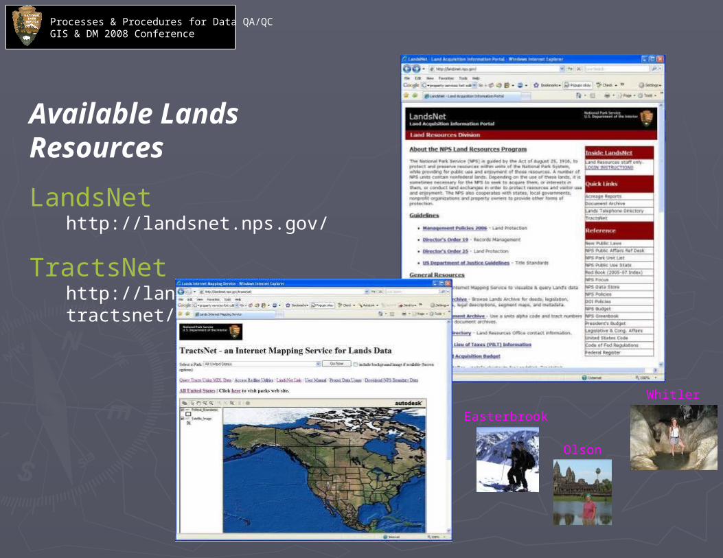
Available Lands Resources
LandsNethttp://landsnet.nps.gov/
TractsNethttp://landsnet.nps.gov/tractsnet/
Whitler
Easterbrook
Olson

Processes & Procedures for Data QA/QCGIS & DM 2008 Conference
CADStandard Layers

Processes & Procedures for Data QA/QCGIS & DM 2008 Conference
Segment Map
TractRegister
Change Order
Revision Block
Drawing Number

CADDrawing
GISShapefile
Processes & Procedures for Data QA/QCGIS & DM 2008 Conference
SurveyPlat
Processes & Procedures for Data QA/QCGIS & DM 2008 Conference
LegislativeMap

Processes & Procedures for Data QA/QCGIS & DM 2008 Conference
LandsMetadataTemplate

Processes & Procedures for Data QA/QCGIS & DM 2008 Conference
DatabaseIntegrityMasterDeedList
Processes & Procedures for Data QA/QCGIS & DM 2008 Conference
Tract IntegrityDeeds

Processes & Procedures for Data QA/QCGIS & DM 2008 Conference
SpatialIntegrity

BuildTopology
Processes & Procedures for Data QA/QCGIS & DM 2008 Conference
TopologyErrors

Processes & Procedures for Data QA/QCGIS & DM 2008 Conference
Attribute Integrity
Related Documents