Effects of Fire on Invasion and Community Structure of a Southern Indiana Cedar Barrens Kimberly A. Wade and Eric S. Menges Holcomb Research Institute Butler University Indianapolis, Indiana 46208 Introduction Cedar barrens and glades are floristically related forest openings that occur on shallow soil over bedrock (often limestone) and support species adapted to extremes of light, temperature, and moisture (12). These areas are significant floristically and ecologically because they support species (some rare) of varying geographical distributions in unusual combinations. In Indiana both glades and barrens occur on south-, southwest-, or west-facing slopes (1,4). When underlain by very shallow, azonal soils these areas are usually termed glades (9). They are generally incapable of supporting woody vegetation except in bedrock crevices where eastern redcedar {Juniperus virginiana) establishes (5). Although cedar is the most abundant woody species, prairie grasses and forbs dominate the openings. Areas with soil deep enough to allow substantial establishment of cedar are termed barrens (7) and often require fire to prevent tree invasion. Fire -suppression and cultivation have reduced Indiana barrens and glades to rem- nants (4), thereby causing some species to form small, disjunct populations. Continued fire suppression and subsequent forest encroachment could cause Indiana barrens and glades to disappear, resulting in extirpation of many species with restricted distributions. Little, however, is known about how forest closure is affecting glade species distribu- tion and abundance, or how to manage and preserve the glade and barrens habitat. Barrens and glades are distributed throughout the Central Basin of Tennessee (12, 34), the Big Barrens region of Kentucky (8), the east-central and southwestern Missouri Ozarks (11, 22), and northward across the Ohio River into the southern portions of Il- linois (23, 26), Indiana (1, 4, 19, 21), and Ohio (40). Extensive presettlement grasslands, related to Indiana barrens, existed on limestone karst topography in the Big Barrens region of Kentucky (8). After settlement there, fire suppression caused a rapid shift to forest vegetation. Although little is known about Indiana barrens relative to their southern counterparts, it is thought that presettlement barrens in Indiana were also widespread, and that the same process of forest invasion occurred here (4). Deam (10), although aware of barrens in southern Indiana, appeared to underrepresent their flora when collecting species and constructing range maps. Recently increased attention has focused on recognizing barrens and glades of biological significance, determining the flora they support, and preserving and manag- ing the best remnants (1, 4, 19, 21). Quantitative studies are needed to characterize pro- cesses causing barrens closure and to determine how to best manage for glade-like habitat. Specifically, the optimal fire frequency for discouraging woody vegetation encroachment and encouraging the more restricted glade species needs to be determined. This paper describes a study on the effects of forest encroachment and fire on Leavenworth Bar- rens Nature Preserve, a limestone cedar barrens in Crawford County, with recommen- dations for intermittent controlled burns to maintain the site for barrens habitat. Objectives In response to the need for quantitative ecological work in Indiana cedar barrens and glade communities, Holcomb Research Institute (with partial support from the Divi- 273

Welcome message from author
This document is posted to help you gain knowledge. Please leave a comment to let me know what you think about it! Share it to your friends and learn new things together.
Transcript
Effects of Fire on Invasion and Community Structure of a Southern
Indiana Cedar Barrens
Kimberly A. Wade and Eric S. Menges
Holcomb Research Institute
Butler University
Indianapolis, Indiana 46208
Introduction
Cedar barrens and glades are floristically related forest openings that occur on shallow
soil over bedrock (often limestone) and support species adapted to extremes of light,
temperature, and moisture (12). These areas are significant floristically and ecologically
because they support species (some rare) of varying geographical distributions in unusual
combinations.
In Indiana both glades and barrens occur on south-, southwest-, or west-facing slopes
(1,4). When underlain by very shallow, azonal soils these areas are usually termed glades
(9). They are generally incapable of supporting woody vegetation except in bedrock crevices
where eastern redcedar {Juniperus virginiana) establishes (5). Although cedar is the most
abundant woody species, prairie grasses and forbs dominate the openings. Areas with
soil deep enough to allow substantial establishment of cedar are termed barrens (7) and
often require fire to prevent tree invasion.
Fire -suppression and cultivation have reduced Indiana barrens and glades to rem-
nants (4), thereby causing some species to form small, disjunct populations. Continued
fire suppression and subsequent forest encroachment could cause Indiana barrens and
glades to disappear, resulting in extirpation of many species with restricted distributions.
Little, however, is known about how forest closure is affecting glade species distribu-
tion and abundance, or how to manage and preserve the glade and barrens habitat.
Barrens and glades are distributed throughout the Central Basin of Tennessee (12,
34), the Big Barrens region of Kentucky (8), the east-central and southwestern Missouri
Ozarks (11, 22), and northward across the Ohio River into the southern portions of Il-
linois (23, 26), Indiana (1, 4, 19, 21), and Ohio (40). Extensive presettlement grasslands,
related to Indiana barrens, existed on limestone karst topography in the Big Barrens region
of Kentucky (8). After settlement there, fire suppression caused a rapid shift to forest
vegetation. Although little is known about Indiana barrens relative to their southern
counterparts, it is thought that presettlement barrens in Indiana were also widespread,
and that the same process of forest invasion occurred here (4). Deam (10), although aware
of barrens in southern Indiana, appeared to underrepresent their flora when collecting
species and constructing range maps.
Recently increased attention has focused on recognizing barrens and glades of
biological significance, determining the flora they support, and preserving and manag-
ing the best remnants (1, 4, 19, 21). Quantitative studies are needed to characterize pro-
cesses causing barrens closure and to determine how to best manage for glade-like habitat.
Specifically, the optimal fire frequency for discouraging woody vegetation encroachment
and encouraging the more restricted glade species needs to be determined. This paper
describes a study on the effects of forest encroachment and fire on Leavenworth Bar-
rens Nature Preserve, a limestone cedar barrens in Crawford County, with recommen-
dations for intermittent controlled burns to maintain the site for barrens habitat.
Objectives
In response to the need for quantitative ecological work in Indiana cedar barrens
and glade communities, Holcomb Research Institute (with partial support from the Divi-
273
274 Indiana Academy of Science Vol. 96 (1987)
sion of Nature Preserves, Indiana Department of Natural Resources) initiated a monitoring
study in 1985 at Leavenworth Barrens Nature Preserve (LBNP). The purpose of this study
was to determine management practices that will (1) maintain openness of the barrens
and (2) encourage persistence of glade species. Specific objectives included:
(1) determining the effects of a spring 1985 burn on LBNP plant communities,
and formulating recommendations on use of fire for preserving the integrity
of cedar barrens;
(2) describing the cedar barrens community by means of multivariate analyses and
by relating environmental conditions, tree species structure, and herb-layer data
to each other;
(3) relating the cedar barrens at LBNP to other high-quality cedar barrens and
glades in the Midwest and southeast; and
(4) establishing a permanent grid system for future monitoring studies.
Study Site
Leavenworth Barrens Nature Preserve (LBNP), in Crawford County, Indiana, is
a patchwork of four units (Figure 1). The 60-acre North Unit, located about one mile
north of Leavenworth (T3S, R2E, S31) in the Harrison-Crawford State Forest, was the
study site for this project. The site is floristically valuable, containing several rare species
including the state-endangered glade endemic Hypericum dolabriforme, until recently
thought to be extirpated from Indiana (1,3).
Boundaries of units
X Location of glades in North Unit
Figure 1 . Location of Leavenworth Barrens Nature Preserve (LBNP) in Crawford County
near the Ohio River in southern Indiana. This report details research in and around two
glade-like openings (marked by x's) in the North Unit.
Ecology 275
LBNP is one of a few Indiana barrens found in the Crawford Upland Physiographic
Province (4); most presettlement barrens in the state are farther east in the Mitchell Plain
(21). The LBNP substrate is Wellston silt loam (6-18 percent slopes), a well-drained soil
formed from sandstone and siltstone and underlain by alternating layers of Mississippian
shale, sandstone, and limestone (25,39). Wellston silt loams often support oak-hickory
forest (24). At LBNP, outcroppings of limestone and shallow soil favor communities
dominated by herbaceous plants. Soils of the Wellston series are usually about 130 cmdeep (39); soil depth at LBNP was generally greater than 30 cm.
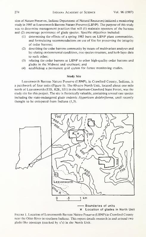
The North unit contains two openings (termed "glades" in this paper), located on
and either side of an old logging road on a southwest-sloping ridge, that grade to closed
glade, open woods, and closed woods (Figure 1). The east and west glades—currently
a little over 1 ha and 2 ha, respectively—have decreased in size because of woody en-
croachment (4). To prevent further closure of the openings and encourage persistence
of glade flora, the Indiana Department of Natural Resources burned portions of both
openings in March 1985.
Methods
Surveying
We constructed a 25 m x 25 m grid system in the North Unit of LBNP in 1985
using a transit, stadia rod, and measuring tape. Permanent metal rebars and associated
wooden stakes marked the 75 grid points (Figure 2). The grid is rectilinear on a plane
D Open glade
A Closed glade
O Open woods
CO Closed woods
<^^>Old roadbed
Eroded area
Dark symbols are burned quads
|-50m-J|
Figure 2. LBNP grid map showing eroded area, old logging road, and cover types at
each grid point.
276 Indiana Academy of Science Vol. 96 (1987)
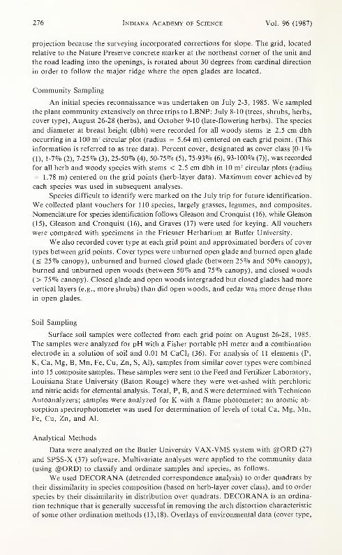
projection because the surveying incorporated corrections for slope. The grid, located
relative to the Nature Preserve concrete marker at the northeast corner of the unit and
the road leading into the openings, is rotated about 30 degrees from cardinal direction
in order to follow the major ridge where the open glades are located.
Community Sampling
An initial species reconnaissance was undertaken on July 2-3, 1985. We sampled
the plant community extensively on three trips to LBNP: July 8-10 (trees, shrubs, herbs,
cover type), August 26-28 (herbs), and October 9-10 (late-flowering herbs). The species
and diameter at breast height (dbh) were recorded for all woody stems > 2.5 cm dbh
occurring in a 100 m 2circular plot (radius = 5.64 m) centered on each grid point. (This
information is referred to as tree data). Percent cover, designated as cover class [0-1 %(1), 1-7% (2), 7-25% (3), 25-50% (4), 50-75% (5), 75-93% (6), 93-100% (7)], was recorded
for all herb and woody species with stems < 2.5 cm dbh in 10 m 2 circular plots (radius
= 1.78 m) centered on the grid points (herb-layer data). Maximum cover achieved by
each species was used in subsequent analyses.
Species difficult to identify were marked on the July trip for future identification.
We collected plant vouchers for 110 species, largely grasses, legumes, and composites.
Nomenclature for species identification follows Gleason and Cronquist (16), while Gleason
(15), Gleason and Cronquist (16), and Graves (17) were used for keying. All vouchers
were compared with specimens in the Friesner Herbarium at Butler University.
We also recorded cover type at each grid point and approximated borders of cover
types between grid points. Cover types were unburned open glade and burned open glade
(< 25% canopy), unburned and burned closed glade (between 25% and 50% canopy),
burned and unburned open woods (between 50% and 75% canopy), and closed woods
( > 75% canopy). Closed glade and open woods intergraded but closed glades had more
vertical layers (e.g., more shrubs) than did open woods, and cedar was more dense than
in open glades.
Soil Sampling
Surface soil samples were collected from each grid point on August 26-28, 1985.
The samples were analyzed for pH with a Fisher portable pH meter and a combination
electrode in a solution of soil and 0.01 M CaCl 2 (36). For analysis of 11 elements (P,
K, Ca, Mg, B, Mn, Fe, Cu, Zn, S, Al), samples from similar cover types were combined
into 15 composite samples. These samples were sent to the Feed and Fertilizer Laboratory,
Louisiana State University (Baton Rouge) where they were wet-ashed with perchloric
and nitric acids for elemental analysis. Total, P, B, and S were determined with Technicon
Autoanalyzers; samples were analyzed for K with a flame photometer; an atomic ab-
sorption spectrophotometer was used for determination of levels of total Ca, Mg, Mn,
Fe, Cu, Zn, and Al.
Analytical Methods
Data were analyzed on the Butler University VAX-VMS system with @ORD (27)
and SPSS-X (37) software. Multivariate analyses were applied to the community data
(using @ORD) to classify and ordinate samples and species, as follows.
We used DECORANA (detrended correspondence analysis) to order quadrats by
their dissimilarity in species composition (based on herb-layer cover class), and to order
species by their dissimilarity in distribution over quadrats. DECORANA is an ordina-
tion technique that is generally successful in removing the arch distortion characteristic
of some other ordination methods (13,18). Overlays of environmental data (cover type,
Ecology 277
soil data, tree basal area, tree density, and elevation) and correlations of environmental
data with ordination axis scores facilitated interpretation of ordination results.
TWINSPAN (two-way indicator species analysis), a polythetic divisive technique
(13,14), classified quadrats into various groups according to indicator species (species
that best separate groups of quadrats). Further divisions on each subgroup produced
smaller subgroups.
Discriminant analysis distinguished burned and unburned glades according to linear
combinations of species abundance (38), thus maximizing distances between these two
discrete cover types. Diversity was measured by species richness and evenness (33).
Results and Discussion
Flora of Leavenworth Barrens Nature Preserve
Two striking floristic features of LBNP are its diversity and its high proportion
of native species. With 162 vascular species sampled (plus three fruticose lichens), LBNPhas more species than are reported from most other glades and barrens. For example,
Baskin and Baskin (7) reported 148 herbaceous vascular plants from five cedar glades
in the Big Barrens region of Kentucky; however, the largest number in any single glade
was 79 compared to the 107 herbaceous species at LBNP. Out of 313 plots in 10 cedar
glades of central Tennessee, Pearsall et al. (32) found 140 taxa. Quarterman (34) found
a comparable number of species (166) when she sampled 22 glades. (She also found 191
species in glade woods.) Although our rather large species list may reflect inclusion of
several cover types and sampling of a large total area (750 m 2
) at one site, high diversity
may also be an inherent property of LBNP and one indication of its value as a natural
area. Of the 107 herbs at LBNP, over 80% are native perennials. Only 4-6 species (depend-
ing on interpretation) have been introduced, or only about 3% of the flora, confirming
LBNP as a high-quality site. Blue Licks, a cedar glade in Battlefield State Park, Ken-
tucky, is comparable to LBNP, having six introduced taxa (9). Other representations
of introduced taxa in Kentucky glades are somewhat higher, ranging from 13% to 25%(5,7,20).
The 162 vascular plant taxa represent 101 genera and 48 families. Compositae have
the greatest number of representatives (34 species), followed by Gramineae (15 species),
Leguminosae (15 species), and Rosaceae (10 species). Over two-thirds of the flora are
herbaceous (107 taxa), representing 31 families. Most characteristic glade species were
found largely in open and closed glade cover types.
LBNP vegetation has distinct affinities to cedar glades outside Indiana. Of 155 taxa
that appeared in sampling quadrats at LBNP, 67 species (43.2%) were listed as consti-
tuents of two or more cedar glades in Missouri (11,22), Illinois (23,26), Tennessee (6,31,32),
and Kentucky (5,7,9,20); and 36 species (23.2%) were listed in four or more of these
studies. Hypericum dolabrifortne represents the only cedar glade endemic found at LBNP(6) and is one of 10 species rare to Indiana that may be found at LBNP (Table 1).
Herb species quadrats supported between 6 and 38 species, averaging 20.4 species
per 10 m 2area. Species richness was greater in glades (11-38 species, mean 24.5) than
in woods (6-26 species, mean 15.2); this difference was highly significant (t = 7.16, p
< 0.001). However, evenness was similar among glades and woods. Among glades, closed
glades had greater species richness (28.3 vs. 21.4, t = 3.83, p < 0.001) and greater even-
ness (p < 0.001) than open glades. In comparisons of burned vs. unburned open glades
and open vs. closed woods, no differences were evident in either diversity measure.
278 Indiana Academy of Science
Table 1. Rare species at LBNP.
Vol. 96 (1987)
Species Status in Indiana*
Aster oblongifolius Endangered
Galactia volubilis var. mississippiensis Endangered
Hypericum dolabriforme Endangered t
Liatris squarrosa Rare
Linum sulcatum Endangered**
Pinus virginiana Rarett
Rudbeckia fulgida Endangered**
Sisyrinchium angustifolium Endangered**
Spiranthes tuberosa Endangered
Zizia aptera Endangered**
* After Bacone and Hedge (3), updated by Indiana Division of Nature Preserves.
** Not seen or sampled in 1986.
X Status changed from extirpated to endangered after rediscovery (1).
XX Probably planted at LBNP.
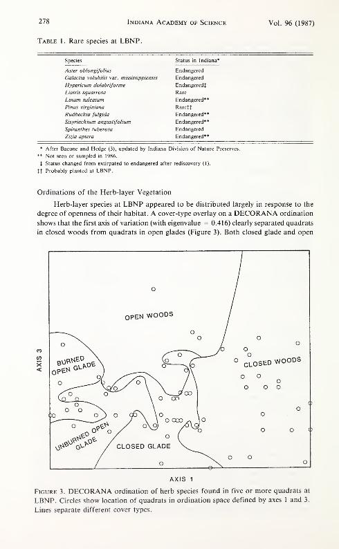
Ordinations of the Herb-layer Vegetation
Herb-layer species at LBNP appeared to be distributed largely in response to the
degree of openness of their habitat. A cover-type overlay on a DECORANA ordination
shows that the first axis of variation (with eigenvalue = 0.416) clearly separated quadrats
in closed woods from quadrats in open glades (Figure 3). Both closed glade and open
V^ ©V> / CLOSED GLADE
° CLOSED WOODS
o o
AXIS 1
Figure 3. DECORANA ordination of herb species found in five or more quadrats at
LBNP. Circles show location of quadrats in ordination space defined by axes 1 and 3.
Lines separate different cover types.
Ecology 279
woods cover types occupied intermediate locations on the first and second axes, but were
clearly distinct on axis 3 (Figure 3).
Herb species composition was influenced primarily by the amount of woody cover
and the relative dominance of Juniperus virginiana. Tree basal area varied strongly and
monotonically along axis 1 of the herb ordination (r = 0.74, p < 0.001). J. virginiana
relative dominance varied inversely (r = 0.68, p < 0.001) so that all areas with greater
than 80% J. virginiana dominance were placed on the left 60% of this ordination.
Closed woods appeared to form an especially distinct group clearly differing from
open woods and all types of glades. Species placement on DECORANA ordinations sug-
gests that at LBNP a few woody species were characteristic of the herbaceous stratum
in closed woods, as compared to glade species. Particularly associated with closed woods
were the understory shrub Symphoricarpos orbiculatus, the understory herb Polygonatum
biflorum, the vines Rhus radicans, Dioscorea quaternata, and Parthenocissus quinquefolia,
and several tree species present in the herb layer of closed forests (Celtis occidentalism
Cercis canadensis, Acer saccharum , Ostrya virginiana, Carya glabra, and Prunus serotina).
All species listed above were placed on the right 30% of the DECORANA first axis.
Herb species composition differed between glade areas burned in the spring of 1985
and unburned areas. Quadrats separated partially along the first axis of DECORANAordinations, with some additional distinctions along subsequent axes (Figure 3). Burned
quadrats were less similar to other areas of LBNP than were unburned areas, which oc-
cupied an intermediate position on axis 1 , suggesting that burning has favored open con-
ditions. Species on the extreme left of axis 1, suggesting an association with burning,
included Sorghastrum nutans, Solidago rigida, Liatris spicata, Polygala ambigua, and
Desmodium rigidum. L. spicata does not appear harmed by fire, which increases its suc-
cess in burned areas (28,30).
In terms of herb species composition, quadrats typed as closed glade and open woods
represented intermediates. Ordinations did not separate these two cover types until the
third axis (eigenvalue = 0.168) (Figure 3), suggesting fairly subtle differences between
them. Open woods were characterized by Lespedeza intermedia, L. procumbens, Stylosan-
thes biflora, and Helianthus divaricatus, while closed glades included Geum virginianum,
Scutellaria incana, and Oxalis stricta.
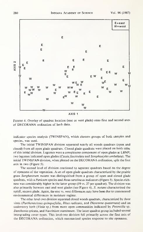
Quadrat location was closely related to scores on the second DECORANA axis (eigen-
value = 0.201). Quadrats located in the eastern part of the gridded area tended to be
located above the western quadrats on axis 2 (Figure 4). The separation was clearer in
glades (open and closed) and open woods than in closed woods. Eastern quadrats were
located farther uphill; elevation, therefore, showed a strong relationship with axis 2 (r
= 0.51, p < 0.001).
These ordination patterns may also reflect environmental variables other than woody
vegetation cover and burning (29). Other ordinations revealed that surface soil pH varied
significantly with axis 2 (r = 0.32, p < 0.001) as did the concentrations of seven elements
(P, Fe, Ca, K, Mg, B, and S). The heterogeneity of east and west glades may therefore
be exerting some influence on soil chemistry. The third axis pattern of closed glade vs.
open woods also reflects soil pH (r = - 0.50, p < 0.001); from closed glade to open woods,
pH changes from over 7 to less than 4.5. Lower soil pH can be expected in open woods
areas where tannins from oak leaves tend to acidify the soil. The relationship of other
environmental variables (aspect, slope angle, soil texture, and other drainage factors)
to ordination patterns may be significant enough to merit further exploration.
Classifications of the Herb-layer Vegetation
Classification of herbaceous communities at LBNP confirms ordination results and
provides additional insights into environmental influences and species groups. Two-way
280 Indiana Academy of Science Vol. 96 (1987)
E = east
W = west
W
W
E EE
EE
W
www WWW W
E Ww w
E www
WE WW WE
W WWE WW
WE
WW E E
:W WW
w w
w
w
ww w
-w-w
AXIS 1
Figure 4. Overlay of quadrat location (east or west glade) onto first and second axes
of DECORANA ordination of herb data.
indicator species analysis (TWINSPAN), which clusters groups of both samples and
species, was used.
The initial TWINSPAN division separated nearly all woods quadrats (open and
closed) from all open glade quadrats. Closed glade quadrats were placed on both sides
of this initial division. Legumes were a conspicuous component of open glades at LBNP;two legumes indicated open glades {Cassia fasciculata and Strophostyles umbellata). The
initial TWINSPAN division, when plotted on the DECORANA ordination, split the first
axis in two (Figure 5).
The second level of division continued to separate quadrats based on the degree
of openness of the vegetation. A set of open glade quadrats characterized by the prairie
grass Sorghastrum nutans was distinguished from a group of open and closed glade
quadrats, with a Panicum species and Rosa Carolina as indicators (Figure 5). Species rich-
ness was considerably higher in the latter group (19 vs. 27 per quadrat). The division was
also primarily between east and west glades (see Figure 4). 5. nutans characterized the
uphill, eastern glade. Again, the east vs. west differences may have been due to unmeasured
environmental differences in moisture regime.
The other level-two division separated closed woods quadrats, characterized by three
vines {Parthenocissus quinquefolia, Rhus radicans, and Dioscorea quaternata) and an
understory herb {Viola sp.) from more open communities indicated by Potentilla sp.
Danthoniaspicata, and Vaccinium stamineum. The latter quadrat group included several
intergrading cover types. This level-two division fell primarily across the first axis of
the DECORANA ordination, which summarized species response to site openness.
Ecology 281
Single Quadrat
Dioscoreaquaternata
Cassia fasciculata
Strophostyles ombellata
Figure 5. Plot of major TWINSPAN classification groups onto first two axes of
DECORANA ordination of herb samples. The first division is shown at the bottom of
the graph and second divisions within the ordination by arrows. Indicator species for
each division are shown.
At the third level of TWINSPAN division (Figure 6), burning became an impor-
tant criterion for separation of open glades. Open glade quadrats divided into burned
open glade (group A, indicator: Liatris spicata) and unburned open glade (group B, in-
dicators: Cornus florida, Helianthus divaricatus), both with 19 species per quadrat. ATWINSPAN analysis on glade quadrats only (not shown) demonstrated burning effects
to be second only to the degree of openness. In this second analysis, L. spicata and Panicum
sp. characterized burned areas while Sassafras albidum, Smilax glauca, and Acer rubrum
characterized unburned areas.
Another level-three division separated the mixed open glade/closed glade group into
open glade (group C: Liatris spicata, Lespedeza virginica, 24 species per quadrat) vs.
more diverse closed glade (group D: Rhamnus caroliniana, Cornusflorida, Rhus copallina,
29 species per quadrat) (Figure 6). C. florida was the key indicator of closed glade in
analyses excluding woods quadrats also (not shown). The significance of woody species
in the herb layer suggests that woody plant invasion, turning open glade into closed glade,
has important effects on herb species composition in general.
Woody species were also important indicators of an herb species division within
closed woods (Figure 6). Acer saccharum indicated a group of quadrats (G) with low
species richness (15 per quadrat), while Fagus grandifolia and three other species
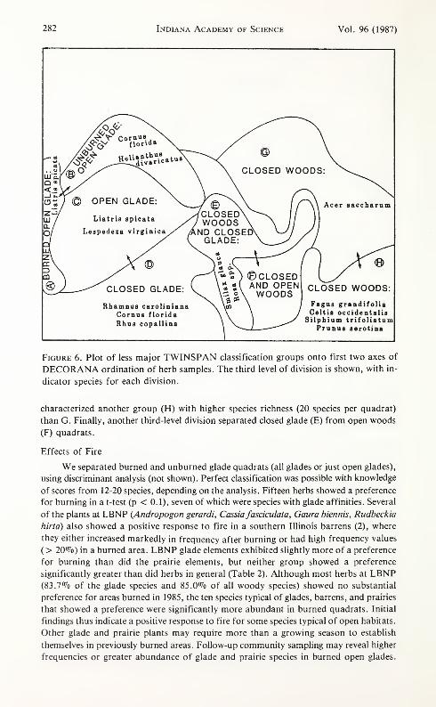
282 Indiana Academy of Science Vol. 96 (1987)
Figure 6. Plot of less major TWINSPAN classification groups onto first two axes of
DECORANA ordination of herb samples. The third level of division is shown, with in-
dicator species for each division.
characterized another group (H) with higher species richness (20 species per quadrat)
than G. Finally, another third-level division separated closed glade (E) from open woods
(F) quadrats.
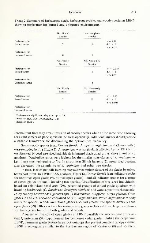
Effects of Fire
We separated burned and unburned glade quadrats (all glades or just open glades),
using discriminant analysis (not shown). Perfect classification was possible with knowledge
of scores from 12-20 species, depending on the analysis. Fifteen herbs showed a preference
for burning in a t-test (p < 0. 1), seven of which were species with glade affinities. Several
of the plants at LBNP (Andropogon gerardi, Cassia fasciculata, Gaura biennis, Rudbeckia
hirtd) also showed a positive response to fire in a southern Illinois barrens (2), where
they either increased markedly in frequency after burning or had high frequency values
( > 20%) in a burned area. LBNP glade elements exhibited slightly more of a preference
for burning than did the prairie elements, but neither group showed a preference
significantly greater than did herbs in general (Table 2). Although most herbs at LBNP(83.7% of the glade species and 85.0% of all woody species) showed no substantial
preference for areas burned in 1985, the ten species typical of glades, barrens, and prairies
that showed a preference were significantly more abundant in burned quadrats. Initial
findings thus indicate a positive response to fire for some species typical of open habitats.
Other glade and prairie plants may require more than a growing season to establish
themselves in previously burned areas. Follow-up community sampling may reveal higher
frequencies or greater abundance of glade and prairie species in burned open glades.
Ecology 283
Table 2. Summary of herbaceous glade, herbaceous prairie, and woody species at LBNP,
showing preference for burned and unburned environments. 1
Preference for
Burned Areas
Preference for
Unburned Areas
Preference for
Burned Areas
Preference for
Unburned Areas
Preference for
Burned Areas
Preference for
Unburned Areas
No. Glade 2 No. Nonglade
Species Species
x 2 = 2.02
7 6 d.f. = 1
p < 0.25
2
No. Prairie' No. Nonprairie
Species Species
x 2 = 0.010
7 6 d.f. = 1
p > 0.9
1
No. Woody
1
No. Nonwoody
Species Species
x 2 = 9.97
2 13 d.f. = 1
p < 0.005
Preference is significant using t-test, p < 0.1
Based on (5,6,7,9,11,20,22,23,26,31,32).
Based on (8,35).
Intermittent fires may arrest invasion of woody species while at the same time allowing
for establishment of glade species in the areas opened up. Additional studies should provide
a suitable framework for determining the optimal fire frequency.
Some woody species (e.g., Comusflorida, Juniperus virginiana, and Quercus alba)
were excluded by fire (Table 2). /. virginiana was particularly affected by the 1985 burn;
we observed 14 dead tree-sized individuals in burned glade quadrats vs. three in unburned
quadrats. Dead/alive ratios were highest for the smallest size classes of /. virginiana—i.e., those most vulnerable to fire. In a southern Illinois barrens (2), prescribed burning
also decreased the abundance of J. virginiana and other tree species.
In time, lack of periodic burning may allow complete closure of the glades by mixed
hardwood forest. In TWINSPAN analyses (Figure 6), Comusflorida is an indicator species
for unburned open glades (vs. burned open glades)—and all indicator species for a group
of closed glades are small, invading tree species. Classification of tree-sized individuals,
based on relativized basal area (29), generated groups of closed glade quadrats with
invading hardwoods (C. florida and Sassafras albidum) and woods quadrats characteriz-
ed by canopy hardwoods (Quercus spp., Liriodendron tulipifera, Carya glabra). Open
glades in this classification contained only J. virginiana and Pinus virginiana as woody
indicator species. Woods and closed glades also had greater tree species diversity than
open glades (29). Other evidence for invasion into glades includes shifts to larger size classes
for tree species found in both glades and woods.
Progressive invasion of open glades at LBNP parallels the successional processes
that Quarterman (34) hypothesized for Tennessee cedar glades. Unlike the deeper-soil
LBNP, Tennessee glades feature large rock outcrops that prevent complete canopy closure.
LBNP is ecologically similar to the Big Barrens region of Kentucky (8) and southern
284 Indiana Academy of Science Vol. 96 (1987)
Illinois barrens (2), both of which contained large open areas only during a history of
repeated burning. In the absence of controlled burning, these characteristics may makeLBNP vulnerable to rapid and complete forest closure.
Summary
A floristic and community summary of Leavenworth Barrens Nature Preserve, a
northern example of a limestone cedar barrens, shows high floristic diversity including
rare species with high affinities to more southerly limestone glades. Comparisons with
other cedar glades support the assessment of LBNP as a high-quality natural area.
Ordination and classification of one-year herb-layer abundance values reveal that
composition of the herbaceous community is strongly related to the degree of shading
by woody species. Plants most typical of glades, barrens, and prairies occur in the most
open habitat. While forested portions of LBNP add to its overall diversity, woody en-
croachment into open glade-like areas excludes species most typical of cedar glades.
Initial findings indicate that controlled burning is a useful tool for maintaining bar-
rens habitat. At least ten herbaceous glade and prairie species were significantly more
abundant in burned quadrats than in unburned areas, while fire discouraged or excluded
some woody species. Without controlled burns, progressive forest invasion may com-
pletely close the glade-like openings of LBNP. While fire is important to the integrity
of the site, the optimal frequency and timing necessary to favor particular elements re-
main to be investigated.
Acknowledgments
We thank Stacia Yoon, Tom Armentano, Carol Cloonan, Jeannette Daniel, Julie
Alexander, and Bruce McCune for field assistance. Bruce McCune and Tom Armen-
tano helped with identification of lichens and vascular plants, respectively. George Yat-
skievych and Lewis Johnson at the Deam Herbarium verified some of our specimens.
Soil analyses were carried out by the Louisiana State University Feed and Fertilizer Laband by Brad Carter at Butler University. Stacia Yoon and Dave Shelton assisted with
data handling; Ginger Williams typed this report, Colleen Baker drafted the figures, and
Jim Rogers provided editorial assistance. Tom Armentano supplied useful comments
on the manuscript. Special thanks to Jim Aldrich, for advice. This study was supported
by the Division of Nature Preserves, Indiana Department of Natural Resources, and
Holcomb Research Institute.
Literature Cited
1
.
Aldrich, J.R., J.A. Bacone, and M.D. Hutchison. 1982. Limestone glades of Har-
rison County, Indiana. Proc. Ind. Acad. Sci. 91:480-485.
2. Anderson, R.C., and J. Schwegman. 1971. The response of southern Illinois bar-
ren vegetation to prescribed burning. Trans. 111. Acad. Sci. 64:287-291.
3. Bacone, J.A., and C.L. Hedge. 1980. A preliminary list of endangered and threatened
vascular plants in Indiana. Proc. Ind. Acad. Sci. 89:359-371.
4. Bacone, J.A., L.A. Casebere, and M.D. Hutchison. 1983. Glades and barrens of
Crawford and Perry Counties, Indiana. Proc. Ind. Acad. Sci. 92:367-373.
5. Baskin, C.C., and J.M. Baskin. 1975. The cedar glade flora of Bullitt County, Ken-
tucky. Castanea 40:184-190.
6. Baskin, J.M., and C.C. Baskin. 1977. An undescribed cedar glade community in
Middle Tennessee. Castanea 42:140-145.
7. . 1978. Plant ecology of cedar glades in the Big Barren region of Kentucky.
Rhodora 80:545-557.
8. . 1981. The Big Barrens of Kentucky not a part of Transeau's Prairie Penin-
Ecology 285
sula. In The Prairie Peninsula— In the "Shadow" of Transeau: Proceedings of the
Sixth North American Prairie Conference (edited by R.L. Stuckey and K.J. Reese).
Ohio Biol. Surv. Biol. Notes No. 15, Ohio State University, Columbus, Ohio, pp.
43-48.
9. . 1985. A floristic study of a cedar glade in Blue Licks Battlefield State Park,
Kentucky. Castanea 50:19-25.
10. Deam, C.A. 1940. Flora of Indiana. Department of Conservation, Division of
Forestry, Indianapolis, Ind. 1236 p.
11. Erickson, R.O., L.G. Brenner, and J. Wraight. 1942. Dolomitic glades of east-
central Missouri. Ann. Mo. Bot. Gard. 29:89-101.
12. Freeman, C.P. 1933. Ecology of the cedar glade vegetation near Nashville, Ten-
nessee. J. Tenn. Acad. Sci. 8:141-228.
13. Gauch, H.G. 1982. Multivariate Analysis in Community Ecology. Cambridge Univer-
sity Press, New York, N.Y. 298 p.
14. Gauch, H.G., and R.H. Whittaker. 1981. Hierarchical classification of commun-ity data. J. Ecol. 69:135-152.
15. Gleason, H.A. 1968. The New Britton and Brown Illustrated Flora of the North-
eastern United States and Adjacent Canada. Vols. 1-3. Hafner Publishing Com-pany, Inc., New York, N.Y.
16. Gleason, H.A., and A. Cronquist. 1963. Manual of Vascular Plants of Northeastern
United States and Adjacent Canada. D. van Nostrand Company, New York, N.Y.
810 p.
17. Graves, A.H. 1956. Illustrated Guide to Trees and Shrubs. Harper and Row, NewYork, N.Y. 271 p.
18. Hill, M.O., and H.G. Gauch. 1980. Detrended correspondence analysis, an im-
proved ordination technique. Vegetatio 42:47-58.
19. Homoya, M.A. 1987. A floristic survey of a limestone glade in Versailles State Park,
Ripley County, Indiana. Proc. Ind. Acad. Sci. 96: (in press).
20. Johnson, G.P. 1981 . An unreported cedar glade in Warren County, Kentucky. Trans.
Ky. Acad. Sci. 42:101-105.
21. Keith, J.H. 1980. Presettlement barrens of Harrison and Washington Counties,
Indiana. Proc. Ind. Acad. Sci. 89:147.
22. Kucera, C.L., and S.C. Martin. 1957. Vegetation and soil relationships in the glade
region of the southwestern Missouri Ozarks. Ecology 38:285-291.
23. Kurz, D.R. 1981 . Flora of limestone glades in Illinois. In The Prairie Peninsula
—
In the "Shadow" of Transeau: Proceedings of the Sixth North American Prairie
Conference (edited by R.L. Stuckey and K.J. Reese). Ohio Biol. Surv. Biol. Notes
No. 15, Ohio State University, Columbus, Ohio, pp. 183-186.
24. Lindsey, A.A., W.B. Crankshaw, and S.A. Quadir. 1965. Soil relations and distribu-
tion map of the vegetation of presettlement Indiana. Bot. Gaz. 126:155-163.
25. Lindsey, A.A., D.V. Schmelz, and S.A. Nichols. 1969. Natural Areas in Indiana
and Their Preservation. Indiana Natural Areas Survey, Department of Biological
Sciences, Purdue University, Lafayette, Ind. 594 p.
26. Madany, M.H. 1981. A floristic survey of savannas in Illinois. In The Prairie
Peninsula—In the "Shadow" of Transeau: Proceedings of the Sixth North American
Prairie Conference (edited by R.L. Stuckey and K.J. Reese). Ohio Biol. Surv. Biol.
Notes No. 15, Ohio State University, Columbus, Ohio, pp. 177-181.
27. McCune B. 1983. Multivariate Analysis on the @ORD System. University of Wiscon-
sin, Departments of Botany and Zoology, Madison, Wis. Unpublished manuscript.
28. Medve, R.J. 1985. The effect of fire on the root hairs and mycorrhizae of Liatris
spicata. Ohio J. Sci. 85:151-154.
29. Menges, E.S., and K.A. Wade. 1986. Community Analysis of Leavenworth Bar-
286 Indiana Academy of Science Vol. 96 (1987)
rens Nature Preserve (A Northern Example of a Cedar Barrens Ecosystem). Report
to the Division of Nature Preserves, Indiana Department of Natural Resources.
Report No. 76, Holcomb Research Institute, Butler University, Indianapolis, Ind.
65 p.
30. Menhusen, B.R. 1973. Ecology of the prairie species of the genus Liatris. In Third
Midwest Prairie Conference Proceedings, Kansas State University, Manhattan, Kan.,
pp. 60-62.
31. Patrick, T. 1985. Flora of Crowder Cemetery Cedar Barren, Oak Ridge National
Environmental Research Park, Roane County, Tennessee. Unpublished species list.
32. Pearsall, S., D. Eagar, E. Bridges, D. Durham, P. Hamel, L. Smith, and P. Somers.
1985. Developing a Community Based Natural Area Survey Technique in the Central
Basin of Tennessee. Tennessee Department of Conservation, Nashville, Tennessee.
Unpublished report.
33. Peet, R.K. 1974. The measurement of diversity. Ann. Rev. Ecol. Syst. 5:285-307.
34. Quarterman, E. 1950. Major plant communities of Tennessee cedar glades. Ecology
31:234-254.
35. Rock, H.W. 1974. Prairie Propogation Handbook (Sixth Edition). Wehr Nature
Center, Whitnall Park, Wis. 74 p.
36. Schofield, R.K., and A.W. Taylor. 1955. The measurement of soil pH. Soil Sci.
Soc. Am. Proc. 19:164-167.
37. SPSS Inc. 1986. SPSSX User's Guide. Second edition. McGraw-Hill Book Com-pany, New York, N.Y. 988 p.
38. Williams, B.K. 1983. Some observations on the use of discriminant analysis in
ecology. Ecology 64:1283-1291.
39. Wingard, R.C. 1975. Soil Survey of Crawford County, Indiana. USDA, Soil Con-
servation Service and Forest Service, and Purdue University Agricultural Experi-
ment Station. 60 p + maps.
40. Wistendahl, W.A. 1975. Buffalo Beats, a relief prairie within a southeastern Ohio
forest. Bull. Torrey Bot. Club 102:178-186.
Related Documents