LAND C ONSULT . DE Dr. Markus Weidenbach Öhinghaltweg 3 D 77815 Bühl Tel.: +49-7223-9158030 Mobil: +49-170-8988393 Fax: +49-321-21252410 E.mail: [email protected] Internet: http://landconsult.de Büro für Geographische Informationsverarbeitung, Umweltplanung und Beratung Date July. 2013 Privatwaldkartierung in Luxembourg auf Grundlage von Luftbildstereomodellen und Digitalen Geländemodellen Mapping of Private Forest Land by means of Aerial Sterophotomodells and Digital Elevation Modells Digital Terrain Modell of Luxembourg and Project Area (yellow polygons) 1 / 4 landConsult.de - Privatwaldkartierung Luxembourg 2013

Welcome message from author
This document is posted to help you gain knowledge. Please leave a comment to let me know what you think about it! Share it to your friends and learn new things together.
Transcript

L A N D C O N S U L T . D E
Dr. Markus WeidenbachÖhinghaltweg 3 D 77815 Bühl
Tel.: +49-7223-9158030Mobil: +49-170-8988393Fax: +49-321-21252410
E.mail: [email protected]: http://landconsult.de
Büro für Geographische Informationsverarbeitung, Umweltplanung und Beratung
Date July. 2013
Privatwaldkartierung in Luxembourg auf Grundlage von Luftbildstereomodellen und Digitalen Geländemodellen
Mapping of Private Forest Land by means of Aerial Sterophotomodells and Digital Elevation Modells
Digital Terrain Modell of Luxembourg and Project Area (yellow polygons)
1 / 4landConsult.de - Privatwaldkartierung Luxembourg 2013

Aerial Flight Trajectories from 2012 with photogrammetrically processed Elevation Modells
Processed 16bit NIR Orthophoto with Polygons
2 / 4landConsult.de - Privatwaldkartierung Luxembourg 2013
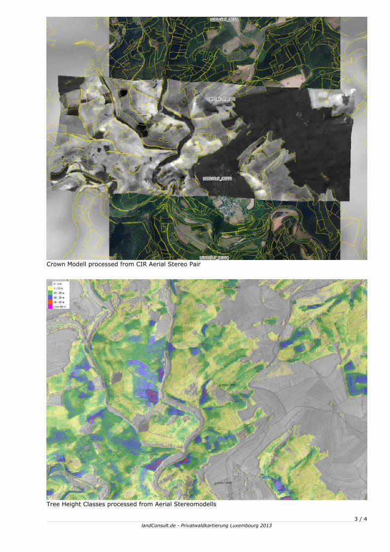
Crown Modell processed from CIR Aerial Stereo Pair
Tree Height Classes processed from Aerial Stereomodells
3 / 4landConsult.de - Privatwaldkartierung Luxembourg 2013

Crown Modell with colored Tree Heights and Digitizing Comments on 16bit NIR Ortho
Treetops_with_RGBI-OrthoInfo-for-SpeciesClassificatiion
4 / 4landConsult.de - Privatwaldkartierung Luxembourg 2013
Related Documents