211 Preservation of McVicker Family Cemetery Tarver and Bigman INTRODUCTION On September 14, 2011, the authors con- ducted a series of geophysical prospection surveys at the McVicker Family Cemetery (9CN184) lo- cated south of Jonesboro, Georgia (Figure 1). The survey was undertaken as part of a comprehensive preservation program designed for the cemetery at the request of the property owners, the Clayton County Water Authority (CCWA). This testing was performed for partial fulfillment of the McVicker Cemetery Preservation Plan outlined by South- eastern Archeological Services for the Clayton County Water Authority in the Fall of 2010. This step was taken in anticipation of restoration of the cemetery to its state when the most recent fencing was installed (circa 1930s). The restoration project involved repair of the four family box tombs, and repairing and resetting the fence around the plot, as well as providing for future protection and main- tenance. As the Preservation Plan states “While vis- ual inspection…indicated that graves are restricted to the fenced area of the cemetery, the possibility of outlying graves must be considered… In par- ticular, it would be important to know how many unmarked graves exist in the fenced area, and if any graves exist outside of the fenced area” (Tarver 2010:2-3). The primary importance of identifying possible unmarked burials outside the fenced area of the cemetery was to inform how the preservation project would proceed. Specifically, the presence PRESERVATION OF MCVICKER FAMILY CEMETERY, JONESBORO, GEORGIA by Gail Tarver (Southeastern Archeological Services) and Daniel P. Bigman (Georgia State University) Supplemental material for this article is available: http://thesga.org/category/publications/early-georgia-publications/supplementary-material/ or absence of additional graves would influence the final extent of the fenced and possibly warrant some type of marker. The potential for unmarked graves was greater in this area because many graves before and during the nineteenth century were marked as means allowed. Some may have even gone unmarked or the marker was susceptible to weathering over time. In addition, casualties of the Civil War activity in the area could have been bur- ied in the vicinity of an established burial ground. This project highlights the role of geophysi- cal survey in a larger historic preservation plan. We used four different methods of geophysical survey (electromagnetic induction, electrical resistivity, ground penetrating radar, and magnetometry) to provide a detailed “view” into the subsurface of the cemetery and surrounding area. We identified anomalies outside the boundaries of the historic fence, but the multiple method approach allowed us to reject many of these as potential burials. Two anomalies located north of the historic fence con- formed to the expected geophysical signatures of burials. One of the pit anomalies reflected metal along the bottom. However, the north-south orien- tation of these anomalies is not congruent with the traditional burial custom of digging the grave in an east-west manner. This paper first details the history of ac- tivity around the McVicker Family Cemetery and then presents the methods and results of the geo- physical surveys. We de-emphasize the technical

Welcome message from author
This document is posted to help you gain knowledge. Please leave a comment to let me know what you think about it! Share it to your friends and learn new things together.
Transcript
211Preservation of McVicker Family Cemetery Tarver and Bigman
INTRODUCTION
On September 14, 2011, the authors con-ducted a series of geophysical prospection surveys at the McVicker Family Cemetery (9CN184) lo-cated south of Jonesboro, Georgia (Figure 1). The survey was undertaken as part of a comprehensive preservation program designed for the cemetery at the request of the property owners, the Clayton County Water Authority (CCWA). This testing was performed for partial fulfillment of the McVicker Cemetery Preservation Plan outlined by South-eastern Archeological Services for the Clayton County Water Authority in the Fall of 2010. This step was taken in anticipation of restoration of the cemetery to its state when the most recent fencing was installed (circa 1930s). The restoration project involved repair of the four family box tombs, and repairing and resetting the fence around the plot, as well as providing for future protection and main-tenance.
As the Preservation Plan states “While vis-ual inspection…indicated that graves are restricted to the fenced area of the cemetery, the possibility of outlying graves must be considered… In par-ticular, it would be important to know how many unmarked graves exist in the fenced area, and if any graves exist outside of the fenced area” (Tarver 2010:2-3). The primary importance of identifying possible unmarked burials outside the fenced area of the cemetery was to inform how the preservation project would proceed. Specifically, the presence
PRESERVATION OF MCVICKER FAMILY CEMETERY, JONESBORO, GEORGIA
by Gail Tarver (Southeastern Archeological Services) and Daniel P. Bigman (Georgia State University)
Supplemental material for this article is available:http://thesga.org/category/publications/early-georgia-publications/supplementary-material/
or absence of additional graves would influence the final extent of the fenced and possibly warrant some type of marker. The potential for unmarked graves was greater in this area because many graves before and during the nineteenth century were marked as means allowed. Some may have even gone unmarked or the marker was susceptible to weathering over time. In addition, casualties of the Civil War activity in the area could have been bur-ied in the vicinity of an established burial ground.
This project highlights the role of geophysi-cal survey in a larger historic preservation plan. We used four different methods of geophysical survey (electromagnetic induction, electrical resistivity, ground penetrating radar, and magnetometry) to provide a detailed “view” into the subsurface of the cemetery and surrounding area. We identified anomalies outside the boundaries of the historic fence, but the multiple method approach allowed us to reject many of these as potential burials. Two anomalies located north of the historic fence con-formed to the expected geophysical signatures of burials. One of the pit anomalies reflected metal along the bottom. However, the north-south orien-tation of these anomalies is not congruent with the traditional burial custom of digging the grave in an east-west manner.
This paper first details the history of ac-tivity around the McVicker Family Cemetery and then presents the methods and results of the geo-physical surveys. We de-emphasize the technical

212 Early Georgia volume 41, number 2
Figure 1.USGS Topographic map of the project area (USGS 7.5’ Hampton Quadrangle) showing the location of McVicker Family Cemetery.

213Preservation of McVicker Family Cemetery Tarver and Bigman
aspects of the geophysics and focus on situating the importance of rapid, non-invasive surveys in driving heritage protection. Finally, we review the restoration process in light of our survey results.
BACKGROUND
McVicker FamilyThe land on which the McVicker Fam-
ily Cemetery was purchased by James Alexander McVicker from William Segur on October 27, 1836 (Land Lot No. 99, 202 ½ acres) (Henry County Superior Court Deeds 1822-1857:395). At the time of purchase, this land and many of the subsequent land lots purchased by the McVickers in the surrounding area were located within Henry County. Henry County was established in May of 1821 following the Treaty of Indian Springs in Jan-uary of the same year and the land was distributed by land lottery (Ranier 1988:1-4,11). The McVicker name is listed among the “First Families” of Henry County (Moore 1993). Portions of Henry County were partitioned off to form Clayton County on November 30, 1858 by an act of the Georgia Gen-eral Assembly (Georgia Legislative Documents 1858:26). The land the McVicker family house and cemetery are located on were subsumed within the boundaries of Clayton County.
James A. McVicker and Mary Nash McVick-er were recorded as co-domesticating in Greenville, South Carolina in the 1830 United States Federal Census. Mary Nash McVicker was the first born daughter to John Nesbitt Nash (b. 1786, North Carolina) and his wife, Hannah Harriet Abercrom-bie (b. 1800, South Carolina), both of whom are associated with the historic Nash Farm Battlefield property located near the county lines of Clayton and Henry Counties. The McVickers and the Nash-es migrated from Laurens County, South Caroli-na, to the Henry County area in the 1830’s. Mary Nash McVicker’s relationship to the Nash family likely would have elevated the McVicker family’s influence within the community. Several of her relatives lived in the area and most were relatively wealthy landowners. Her brother, Thompson Ed-ward Nash, was one of the wealthiest land owners in the area. In the 1860 Census (Curry 1978:78),
James McVicker was listed as a farmer with $3,500 in real estate and $3,500 in personal property. By comparison, (Reverend) Thompson Edward Nash, also listed as a farmer, had $5,000 in real estate and $20,575 in personal property (Curry 1978:28).
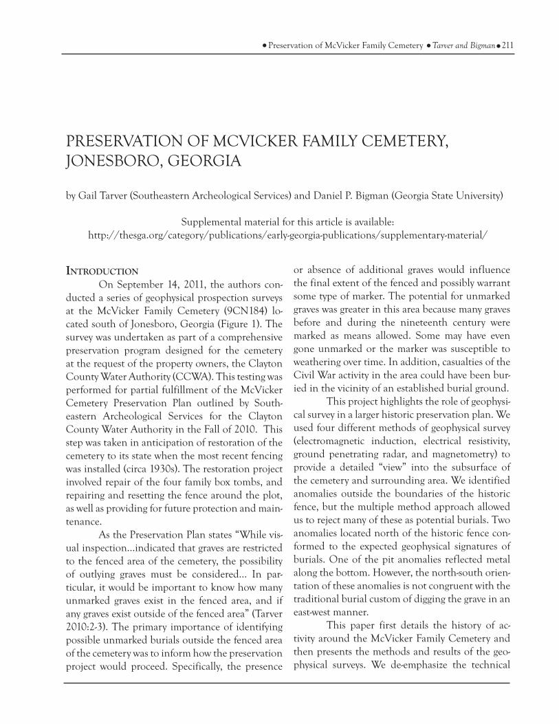
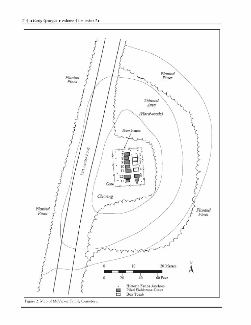
James A. McVicker and Mary Jane “Polly” Nash McVicker had 9 children according to census records and ancestry documentation. The family is recorded as living on the property in the 1850 cen-sus. There are 13 clearly marked graves within the McVicker Family Cemetery (Figure 2); of these only the four box tombs are marked with inscriptions bearing the individuals’ names (Figure 3). These include James A. McVicker (patriarch), Mary Jane “Polly” Nash McVicker (matriarch), and two sons of the family who were casualties of the Civil War, David T. McVicker and William Harrison McVick-er. One additional grave of comparatively smaller dimensions is also marked in close proximity to the sons’ graves. In contrast to the other eight graves, which are piled with rocks and no other adorn-ments, this grave is marked by one small flat rectan-gular marble headstone and a narrower flat rectan-gular foot stone lying at either end of a rock piled grave (Figure 4a). At the beginning of this project, both marble markers had fallen down, the head-stone was clearly broken, and neither had inscrip-tions of any sort. The authors suspected this grave as the burial place of Peggy Melinda McVicker, a daughter who died at just under 2 and a half years of age. In 1971, a legible inscription was recorded from one of the graves in this cemetery (no indi-cation of location) marked “Peggy Melinda Infant Daughter of James and Mary Mcvicker Born June 10, 1841 Died Oct. 22, 1843 Age 2 Years 4 Months and 12 Days” (Ancestors Unlimited 1986:147). No such marker was found in the cleanup and survey of the cemetery, but the exact headstone with this inscription, and with the corresponding cross-mend to the break in the remaining portion at this small grave, was remarkably located and reported to one of the authors (Tarver) who had updated the McVicker Family Tree on Ancestry.com. See-ing these recent online posts, Investigator Nick Schindler (Ellis County Sheriff’s Office, Texas), contacted Tarver via email and phone, reporting
214 Early Georgia volume 41, number 2
Figure 2. Map of McVicker Family Cemetery.

215Preservation of McVicker Family Cemetery Tarver and Bigman
the boundaries of the family cemetery (Bigman 2013). This may be the case at McVicker Cemetery.
Civil War ActivityThe cities of Jonesboro and Lovejoy are
known to have been loci for a significant amount of activity associated with the Civil War, particular-ly in the last days of Sherman’s Atlanta Campaign during the months of August and September of 1864 (Figure 5). Extensive coverage of the Atlanta Campaign and its progression through the area has been recorded in numerous publications (e.g. Cas-tel 1992), and is traceable throughout public docu-ments detailing the correspondence between mili-tary officials during the Civil War (United States War Department 1891). More recently the Georgia Department of Transportation and the Nash Farm Battlefield undertook archaeological surveys near
that the stone was anonymously left lying against a local resident’s mailbox and was being kept in their evidence room. The stone has since been returned and will be rejoined by Chicora in the near future. The remaining children of the McVicker Family are known to be buried elsewhere.
The individuals buried beneath the rock piled graves may never be definitively identified (for examples see Figures 4a and 4b). Two hints we have to possible identification include the sale of a slave named “Jinney” to James McVicker from the estate of James C. Christian on February 1, 1848 (Turner 2000:84), and the 1860 census of Clay-ton County, Georgia, in which James McVicker(s) was recorded as owning 3 slaves (Kilgore et al. 1983:619). While owners often buried slaves away from the family cemetery (Brooks 2011), some slave owning families buried slaves adjacent to or within
Figure 3. Photograph showing four box tombs before restoration (looking southwest).
216 Early Georgia volume 41, number 2
Figure 4. Photographs of (a) eastern and (b) western rows of marked graves following restoration (looking north).

217Preservation of McVicker Family Cemetery Tarver and Bigman
led by Major General William Tecumseh Sher-man, and Brigadier Generals Schofield, Thomas, and Howard followed the retreat and continued to actively destroy the railroad, the final “lifeline” for supplies into the city of Atlanta (Figure 5). After rendering the railroad line impassable, Sherman directed his three subordinates to spread their par-ties to the east, west, and down the middle of the railroad line as they approached the Confederate pickets. Several of the military maps depict the two lines as they faced off at that time, but most nota-ble is the inclusion of the name McVicker and vari-ations thereof, indicated on almost every military map regarding this stage of the campaign. A letter was recently discovered among family heirlooms by Gunter’s descendants documenting Sherman headquartering at the Gunter House for four days during the Battle of Lovejoy’s Station (Pollard n.d.).
the project area, mostly concentrated along Jones-boro Road at the south edge of CCWA property. These surveys provided tactile support of the his-toric and military activity documented in the area. The reports generated from these surveys may also be consulted regarding the Civil War activity lead-ing up to the Battle of Lovejoy and the close of the Atlanta Campaign (Gresham et al. 2012, Elliott and Dean 2007:97-101).
During the last few days of this chapter of the Civil War, military activity occurred in the immediate area around the McVicker house and Family Cemetery, and evidence suggests activity specifically at these locations. Following devastat-ing losses to both Union and Confederate sides at the violent Battle of Jonesborough, the Confeder-ates retreated to a strong position just north of the hamlet of Lovejoy’s Station. The Union troops,
Figure 5. Civil War map dating to 1877 which includes “J. McVicker”, Dorsey, Nash. The locations of Howard, Thomas, and Schofield's positions have been added (after United States War Department 1877).

218 Early Georgia volume 41, number 2
The Gunter House was located a half mile north of the McVicker House following the railroad line and is recorded in the 1850 census four residences (in order of visitation) before the McVicker’s. It was customary for superior officers to be located fur-ther back from the battlefield lines. The McVicker House would have likely marked the location for General Thomas’ headquarters.
Sherman’s proximity to Generals Thomas and Stanley is established by Eben P. Sturges, an officer to Thomas’ staff, who states in his diary for September 2, 1864, “at midafternoon Sherman and Thomas rode forward about a half mile to a home on the left side of the railroad and stayed there until dark.” Sherman reportedly heard Hood blowing up the reserves in Atlanta from this loca-tion. This is also the location from which he would have written by telegraph to Washington, “Atlanta is ours, and fairly won” (United States War Depart-ment 1891:777).
No evidence regarding the remainder of the McVicker family’s whereabouts has been found for this time period. By the date of the Battle of Love-joy (September 2, 1864), the family had already lost several of their sons to the War. According to Union reports, soldiers of the 4th US Army Corps noticed two freshly dug graves belonging to the McVicker brothers on September 3, 1864 (Mark Pollard, personal communication, 2011).
Following the close of the Civil War, James McVicker placed a claim with the South-ern Claims Commission for compensation of real property loss (Figure 6) (National Archives and Re-cords Administration 1872). His claim was denied. This claim offers some of our only insight into the McVicker homestead and their social status. The McVicker House is documented in Georgia artist and historian Wilbur Kurtz’ notebooks. On April 23, 1932, he was touring the area with some local citizens of Jonesboro, when the McVicker house was pointed out and indicated that it marked the “Fed(eral) Line.” Unfortunately, the notes do not specifically indicate whether the house was still standing (Kurtz 1956:261,264).
In an attempt to verify the location of the McVicker house on the ground using the Civil
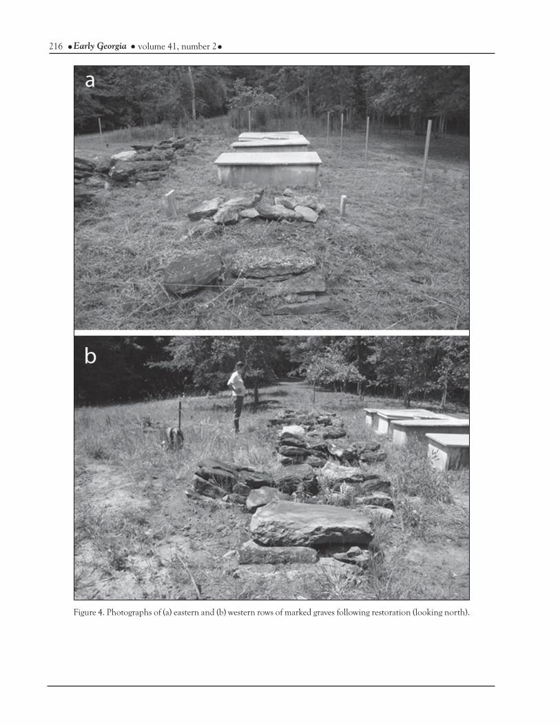
War Atlas maps as a guide, archaeologists Gail Tarver and Jerald Ledbetter, and local historians Mark Pollard and William “Bill” Dodd conducted a brief metal detecting survey. The location of the house within a hundred meters of the cemetery is congruent with traditional practice for the time period (Daniel Elliott and Thomas Gresham, per-sonal communication, 2011). The distribution of metal artifacts in the immediate area of where the house should have been (Figures 7 and 8), was concentrated on the crest of the ridge just before the access road cut along the railroad tracks and along Clayton County Water Authority land. The locations of the metal detected artifacts allowed archaeologists Tarver and Ledbetter to roughly delineate the area of nails that would have been associated with the house. In addition, the metal detecting survey group recovered a small number of military camping artifacts (Figure 8) which cor-responds with the documented location of the Union line running east to west along the ridge of the McVicker house and beyond (Figure 9). Unfor-tunately, the distribution of artifacts and probable foundation stones seem to have been plowed and pushed around by farming and spray line installa-tion activity. While the evidence the metal detect-ing survey gathered may not substantiate a defini-tive relocation of the house, the site seems a likely candidate for its location. For future research and preservation purposes, the site should be consid-ered for intensive shovel testing, geophysical work, and directed excavation.
E.L. “Ed” Huie Jr. Natural Treatment SystemsThe CCWA acquired the McVicker Fam-
ily Cemetery and surrounding property in the mid to late 1970s to construct a Land Applica-tion System (spray fields), a novel form of water reclamation at that time (Clayton County Water Authority 2005:25,27). The McVicker and Gunter homesteads are also both located on the CCWA property. The E.L. “Ed” Huie Jr. Land Application Site was constructed in 1980 and began operations in 1981 (CCWA 2005:27). The site was named after Edward L. “Ed” Huie Jr., the CCWA’s first official General Manager hired in 1960 (CCWA

219Preservation of McVicker Family Cemetery Tarver and Bigman
Figure 6. Disallowed claim of James McVicker (NARA 1872) (Note – The remarks state “The claimant had four sons in the rebel army…”).
2005:3-4). Huie retired in 1983 and was replaced by Melvin Newman who held that position until 1996. Newman reportedly metal detected across the property as a system of water lines were run through the property (Gresham et al. 2012:311). Newman has said he predominantly collected bul-lets, most of which have since been sold, while a small sample of his collection was donated for dis-play to the Morrow Visitor’s Center.
General knowledge of the Civil War activ-ity in the area has fostered continued interest in historic research, metal detection, and occasional site preservation near the Huie Land Application Site (i.e. Nash Farm Battlefield). More recently a large tract of land which includes Nash Farm Battlefield, running along Jonesboro Road, and continuing north-northwest along the railroad, has been officially recognized by the American Battlefield Protection Program under the author-ity of the National Park Service (Figure 10). His-torian Mark Pollard pointed out that half of the infantry Battle of Lovejoy (September 2–5, 1864) is within the boundaries of the CCWA, and that by
preserving the property, CCWA is preserving the last infantry battlefield and other cavalry battles associated with the Atlanta Campaign (Mark Pol-lard, personal communication, 2012). In Pollard’s opinion, which is supported by numerous historic documents, the CCWA property is the last stop-ping place during Sherman’s Atlanta Campaign.
GEOPHYSICAL SURVEY
Given the complicated history and land use patterns in the project area, we expected the subsurface to be equally as complex. As such, we developed a survey strategy that included multiple geophysical sensors in hopes to best characterize each anomaly and give us the strength to reject anomalies as possible burials based on conflicting responses. The geophysical investigations employed at McVicker Cemetery include electromagnetic in-duction (conductivity), electrical resistivity, mag-netometry, and ground penetrating radar (GPR). To increase our chances of locating possible un-marked graves, the survey grid was oriented per-pendicular (north-south) to the visible graves. This assumes any unmarked graves are oriented in the same direction (Goodman et al. 2009). The visible graves were approximately 1 m x 2 m in dimen-sion and the geophysical survey transect intervals ranged from 0.5 m to 1 m. Our hope was to pro-vide a resolution that was smaller than the long axis of the known graves.
The total size of the survey grid was 25 m north-south by 20 m east-west (Figure 11), but we only collected data over the entire survey grid with one technique (conductivity). Resistivity and GPR could not be collected over areas with observable graves. This was due to the fact that GPR could not be physically pulled over the sizable grave markers and the resistivity meter could not be nulled in close proximity to the presumed cemetery limits (so no variation could be seen in apparent resis-tivity values). A single day was allotted to survey McVicker Cemetery so the goal was to maximize that time by using a number of techniques and fo-cus, where possible, outside of the presumed cem-etery limits to identify possible unmarked graves not currently protected by the historic fence. The

220 Early Georgia volume 41, number 2
following discussion provides basic principles of each technique along with our survey methodol-ogy and results of investigation.
Electromagnetic Induction (Conductivity)A conductivity meter is made up of two
coils, one at each end. An electric current is passed through the transmitter coil which produces a pri-mary magnetic field perpendicular to the plane of that coil. This magnetic field induces an electric current in the subsurface that flows in a circu-lar pattern. This induced current then produces its own secondary magnetic field. The secondary magnetic field finally induces a current in the re-ceiver coil at the other end of the conductivity me-
ter. The strength of current induced in the receiver coil is what the conductivity meter measures (Sum-marized from Witten 2006). The ease or difficulty in inducing an electric current in the subsurface is primarily based on porosity and the material those pores are filled with (Bevan 1983). Electric currents are more easily induced in soils with high-er concentrations of water compared with loosely packed, porous soils that are filled with air. Burial pits and grave shafts should produce lower appar-ent conductivity values because the fill dirt tends to be more porous and water drains quickly.
We collected conductivity data using a GEM-300 manufactured by GSSI, Inc. This is a multi-frequency instrument that allows for rapid,
Figure 7. Map of McVicker house site.

221Preservation of McVicker Family Cemetery Tarver and Bigman
Figure 8. Artifacts recovered during the metal detecting survey in the vicinity of the potential McVicker house site.
222 Early Georgia volume 41, number 2
Figure 9. Aerial photograph depicting locations of Civil War campsites and earthworks discovered by relic hunters (Nash Farm Battlefield 2007). Note the close proximity of U.S. campsites to the McVicker Family Cemetery and house site.

223Preservation of McVicker Family Cemetery Tarver and Bigman
Figure 10. Map of important areas recognized by the National Park Service American Battlefield Protection Program (NPS 2010:87).

224 Early Georgia volume 41, number 2
Figure 11. Survey boundaries for each geophysical mapping technique.
continuous data collection of several frequencies at once. We collected two passes over the entire grid with a sampling rate of 4 readings per second and a transect spacing of 1 m. The surveyor at-tempted to walk at a constant pace of 1 m per sec-ond, but actual data density ranged between 3 and 4 readings per meter (between 60 to 70 readings per 20 m transect). Two frequencies were collected during each pass for a total of 4 separate frequency data sets (2010 Hz, 8010 Hz, 12030 Hz, and 15030 Hz). Both in-phase and quadrature phase were re-corded but the in-phase data was more interpret-able in this survey setting. Our lowest frequency (2010 Hz) appears to have averaged too much of the subsurface and rendered a background of low conductivity. This background provided little con-trast to identify possible grave anomalies. The data collected at 12030 Hz appears to have been cor-rupted half way through the survey. Some correc-
tive measures were employed to make this data set useful, but it still contained a sharp linear contrast in the center of the data set and provided no addi-tional understanding of the subsurface. For these reasons we present the in- phase data collected at 8010 Hz and 15030 Hz.
Conductivity data were downloaded and readjusted for locational accuracy using MagMap 2000 software. The data were plotted in Surfer 9.0 using the kriging algorithm and interpolated to 0.25 m x 0.25 m. We processed conductivity data in Archaeosurveyor 2.0. Each frequency was filtered using a zero-median traverse (ZMT) filter to remove background variation and then clipped to two standard deviations (STD). There are numer-ous anomalies of lower conductivity in the 8010 Hz (Figure 12) and 15030 Hz (Figure 13). These reflect the expected signature of grave shafts. Sev-eral of these anomalies are located in both data

225Preservation of McVicker Family Cemetery Tarver and Bigman
Figure 12. In-phase electromagnetic induction data taken at 8010 Hz (black arrows indicate anomalies of low conduct-ance).

226 Early Georgia volume 41, number 2
Figure 13. In-phase electromagnetic induction data taken at 15030 Hz (black arrows indicate shallow anomalies of low conductance).

227Preservation of McVicker Family Cemetery Tarver and Bigman
sets suggesting the contrast is identified in two dif-ferent depths. Anomalies seen in both data sets are more likely to reflect possible burials than those only seen at a frequency of 15030 Hz. The instru-ment identified two additional anomalies of lower conductivity just inside the northern boundary of the grid at 15030 Hz (Figure 13), but not at 8010 Hz. This suggests the variation may be extremely shallow. Trees were located just beyond the survey grid at these two locations and the anomalies may reflect influence from these trees.
Electrical ResistivityElectrical resistivity is based on the princi-
ples of electrical circuitry. Two current electrodes, which are connected to a battery, are inserted into the ground surface. An electrical current flows out of one of these electrodes, through the subsurface, and into the other electrode to form a closed loop. The flow path that the current takes depends on certain physical characteristics of the subsurface material. Current flow lines will take the path of least resistance; so if the subsurface is generally re-sistive then the current flow lines will be pushed toward the ground surface. On the other hand, if the subsurface is generally conductive, then the current flow lines will travel deeper into the subsur-face. Two additional electrodes called the potential probes are inserted into the ground surface and at-tached to a volt meter to measure the current den-sity at or just below the ground surface. The more resistive the sub-surface is, the greater the current density is just below the ground surface and the higher the voltage reading (or potential difference) is between these two potential probes. The more conductive the sub-surface is, the lower the current density will be just below the ground surface and the lower the voltage reading. Similar to electro-magnetic induction, porosity and compaction are the most important physical characteristics effect-ing current flow (summarized from Witten 2006 and Burger 1992).
We used the Wenner array for its ease of op-eration and processing. The Wenner configuration places each electrode equidistant from each other, with the two current electrodes on the ends and
the potential electrodes in the center. We choose a probe spacing of 2 m because the ground was dry and resistive (we had to use a 10x multiplier to record any variation). The wider spacing allowed us to use deeper, more saturated soils. Smaller spacing would have most likely yielded high re-sistive values that could not be nulled out. The 2 m spacing reduced our overall resolution for this technique, but should still provide a high enough resolution to locate our proposed targets. It may be difficult to delineate individual graves in a cluster of graves at this spacing, but anomalous areas of higher resistivity may be an important indicator of burial activity.
Two survey blocks were collected using the resistivity meter, one on the eastern side of the fenced-in cemetery, and the other on the western side. Our sample spacing was 2 m and our transect spacing was 1 m. We moved all four probes 2 m at a time, up from the baseline during the initial tran-sect and snake-lined back toward the baseline every other transect. We processed data by first removing artificial anomalies resulting from tree root inter-ference, a fence anchor, and overlap with the road. These were replaced with the median value from the survey block. The tree root, anchor, and road values were not included in the median count to avoid artificially raising the median value. We plot-ted resistivity data in Surfer 9.0 and applied a linear filter to remove background variation and enhance anomalies of interest. The resistivity survey identi-fied several areas of higher resistance (Figure 14). These anomalies conform to the expected values of grave shafts and wooden caskets, but the size of several resistivity anomalies are smaller than typical graves.
MagnetometerA variety of enhancement processes exist
including burning (Le Borgne 1960), bacterial mag-netite (Fassbinder et al. 1990), and mineralogical changes from decomposition of organic material (Linford 2004) such as decaying bodies or wooden caskets. Graves filled with magnetically enhanced organic soils should produce a “mono-polar” posi-tive magnetic value (Aspinall et al. 2008). While

228 Early Georgia volume 41, number 2
Figure 14. Electrical resistivity data taken with 2 m probe spacing (black arrows indicate areas of high resistance).
229Preservation of McVicker Family Cemetery Tarver and Bigman
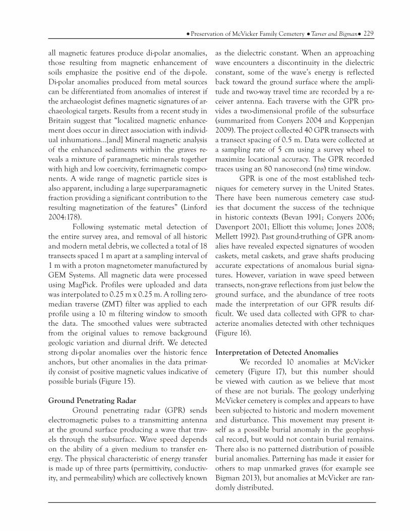
all magnetic features produce di-polar anomalies, those resulting from magnetic enhancement of soils emphasize the positive end of the di-pole. Di-polar anomalies produced from metal sources can be differentiated from anomalies of interest if the archaeologist defines magnetic signatures of ar-chaeological targets. Results from a recent study in Britain suggest that “localized magnetic enhance-ment does occur in direct association with individ-ual inhumations...[and] Mineral magnetic analysis of the enhanced sediments within the graves re-veals a mixture of paramagnetic minerals together with high and low coercivity, ferrimagnetic compo-nents. A wide range of magnetic particle sizes is also apparent, including a large superparamagnetic fraction providing a significant contribution to the resulting magnetization of the features” (Linford 2004:178).
Following systematic metal detection of the entire survey area, and removal of all historic and modern metal debris, we collected a total of 18 transects spaced 1 m apart at a sampling interval of 1 m with a proton magnetometer manufactured by GEM Systems. All magnetic data were processed using MagPick. Profiles were uploaded and data was interpolated to 0.25 m x 0.25 m. A rolling zero- median traverse (ZMT) filter was applied to each profile using a 10 m filtering window to smooth the data. The smoothed values were subtracted from the original values to remove background geologic variation and diurnal drift. We detected strong di-polar anomalies over the historic fence anchors, but other anomalies in the data primar-ily consist of positive magnetic values indicative of possible burials (Figure 15).
Ground Penetrating RadarGround penetrating radar (GPR) sends
electromagnetic pulses to a transmitting antenna at the ground surface producing a wave that trav-els through the subsurface. Wave speed depends on the ability of a given medium to transfer en-ergy. The physical characteristic of energy transfer is made up of three parts (permittivity, conductiv-ity, and permeability) which are collectively known
as the dielectric constant. When an approaching wave encounters a discontinuity in the dielectric constant, some of the wave’s energy is reflected back toward the ground surface where the ampli-tude and two-way travel time are recorded by a re-ceiver antenna. Each traverse with the GPR pro-vides a two-dimensional profile of the subsurface (summarized from Conyers 2004 and Koppenjan 2009). The project collected 40 GPR transects with a transect spacing of 0.5 m. Data were collected at a sampling rate of 5 cm using a survey wheel to maximize locational accuracy. The GPR recorded traces using an 80 nanosecond (ns) time window.
GPR is one of the most established tech-niques for cemetery survey in the United States. There have been numerous cemetery case stud-ies that document the success of the technique in historic contexts (Bevan 1991; Conyers 2006; Davenport 2001; Elliott this volume; Jones 2008; Mellett 1992). Past ground-truthing of GPR anom-alies have revealed expected signatures of wooden caskets, metal caskets, and grave shafts producing accurate expectations of anomalous burial signa-tures. However, variation in wave speed between transects, non-grave reflections from just below the ground surface, and the abundance of tree roots made the interpretation of our GPR results dif-ficult. We used data collected with GPR to char-acterize anomalies detected with other techniques (Figure 16).
Interpretation of Detected AnomaliesWe recorded 10 anomalies at McVicker
cemetery (Figure 17), but this number should be viewed with caution as we believe that most of these are not burials. The geology underlying McVicker cemetery is complex and appears to have been subjected to historic and modern movement and disturbance. This movement may present it-self as a possible burial anomaly in the geophysi-cal record, but would not contain burial remains. There also is no patterned distribution of possible burial anomalies. Patterning has made it easier for others to map unmarked graves (for example see Bigman 2013), but anomalies at McVicker are ran-domly distributed.
230 Early Georgia volume 41, number 2
Figure 15. Total-field magnetometer data (black arrows indicate areas of enhanced magnetism).

231Preservation of McVicker Family Cemetery Tarver and Bigman
Figure 16. GPR radargrams indicating the diversity of anomalies identified at McVicker Family Cemetery. These 2D vertical profiles highlight the use of GPR as a survey method that helps characterize anomalies identified with other geophysical survey techniques.
The anomalies detected at McVicker were identified using a diversified set of geophysical sur-vey methods. While these types of surveys can of-ten be affected by natural phenomena, the number of techniques that characterize a possible burial anomaly may be used as a proxy to assess the likeli-hood that a particular anomaly actually reflects a burial (Nobes 1999). Most anomalies we recorded had contrasting properties and could be rejected as possible burials (Table 1). Anomalies 2 and 9 (Figure 17) conformed to the expected signatures of burials (Table 1) and were less conductive, more resistive, contained enhanced (positive) magnetic soils and revealed hyperbolic reflections with GPR. However, these anomalies did not conform to the size of expected burials. While the distribution of higher resistive values was larger over these areas,
we believe this is an artifact of our 2 m probe spac-ing. The higher resolution data we collected with electromagnetic induction indicates these anoma-lies were small (Figures 12 and 13). Furthermore, electromagnetic induction survey only recorded anomaly 9 at 15030 Hz but not with 8010 Hz indi-cating the variation is extremely shallow.
Of 10 identified anomalies, only two (anomalies 3 and 4 in Table 1 and Figure 17) have dimensions resembling the size of possible burials and have complimentary geophysical signatures. Anomaly 4 exhibits a signature representing several small pieces of buried metal (Figure 16a). Anomaly 3 is also large and may have been a pit used during battle opposed to a burial, or may simply reflect a large tree fall. Neither of these anomalies is ori-ented in line with or located close to the graves

232 Early Georgia volume 41, number 2
Figure 17. Map showing the distribution of possible burial anomalies.

233Preservation of McVicker Family Cemetery Tarver and Bigman
within the family cemetery bounded by the fence. These anomalies are notably oriented north-south. We conclude anomalies 3 and 4 are not directly related to the activity at the family cemetery, and should not be included in the restoration work fol-lowing this survey. These anomalies would merit further investigation if the area was to be disturbed by development. They may potentially be related to the Civil War activity in this area. During and after the Civil War, states faced the task of burying Confederate and Union soldiers who died within their boundaries. The magnitude of burying so many casualties often led to opportunistic burial locations. These included mass burials in trenches and pits, and also beside preexisting cemeteries, such as McVicker. Many of the burials were later exhumed and returned to their native states to be reburied in either existing cemeteries or new ones specifically dedicated to Civil War soldiers.
The locations of all possible anomalies are presented in Figure 17, and the geophysical prospection techniques that identified each are presented in Table 1. We believe that sites of all anomalies representing possible burials should be conserved until subsurface confirmation can take place.
CEMETERY RESTORATION
Clean-upThe CCWA has undertaken a number of
steps to clean up the immediate area of McVicker Cemetery and its surroundings to prevent damage from falling debris. Generally the greatest threat to
cemeteries is from unchecked vegetation, mainly large, old and dying trees. Thus, an important preservation measure is to remove or reduce the threat of trees and large limbs falling onto graves and fencing and to prevent trees from growing up through graves or anywhere in the cemetery. CCWA has been proactive about mowing the area surrounding the cemetery since the project began, and they have implemented selective pulling, spray-ing, or mechanical trimming to control vegetation growth near the tombs. The new, replica fence has only recently been installed, but the style of fenc-ing should facilitate maintenance efforts.
On August 27, 2011, one of the authors (Tarver) and her husband performed a thorough cleaning of the weedy vegetation within the cem-etery. The surrounding area was mowed and the weeds around the box tombs and rock piled graves were hand pulled. The historic fencing was care-fully removed in an orderly fashion and relocated across the dirt road to the west of the cemetery. Some metal detecting was performed by the author to remove larger pieces of remaining fencing which had broken off. In the week preceding and on the day of this cleanup visit, a tree removal company had cut down all of the pine trees within 50 feet of the cemetery, along with most of the weedy or weak hardwoods, and was in the process of grind-ing down the remaining stumps on the day of the visit. On May 19, 2012, Tarver returned to perform infilling around the box tombs and reset rock piled graves. Then the locations for the posts of the new fence were laid out using wooden stakes.
# Electromagnetic Induction
(Conductivity) 15030
Electromagnetic Induction
(Conductivity) 8010
Electrical Resistivity
Magnetometry Ground Penetrating Radar
1 X X X n/a n/a2 X X X X X3 X X n/a — X4 X — n/a X X5 — X X X —6 X X X n/a n/a7 X X n/a n/a n/a8 X — n/a — X9 — X X X X10 — X X X —
Table 1. Techniques each anomaly was identified with (X = identified; — = not identified; n/a =not covered with that survey
technique).

234 Early Georgia volume 41, number 2
Repairing TombstonesThe repairs to preserve the four marble box
tombs were contracted out to Chicora Founda-tion, Inc., based out of Columbia, South Carolina. In overview, Chicora reset the side panels of the box tombs, re-enforcing them with stainless steel dogs and fiberglass pins. Then they repaired the ledgers (long marble slabs inscribed on top of the box tombs), re-enforcing these with either internal brick piers or in one case another slab of Georgia marble (Figure 18). The ledger fragments were re-set with epoxy and cleaned using a biological wash. Finally, the fragments were infilled with marble mortar to replace the missing fabric of the mar-ble ledgers (Figures 19 and 20). Chicora suggested infilling around the box tombs with soil to even out the ground surface and prevent water collec-tion around the stones. This was performed at a later date.
Fence ReconstructionReconstructing the fencing surrounding
the McVicker Family Cemetery was the most time consuming part of this project. Using the Secre-tary of Interior’s Standards as guidelines (National Park Service Preservation Brief No. 27), the fence was approached piece by piece to deduce the best course of action for repair or replacement. The goal was to reuse as much of the original fabric as possi-ble, while choosing the most suitable replacement parts for maintaining period appropriateness.
The fencing itself was likely installed some-time between 1900 and 1930 (Figure 21). Some of the elements, such as the tightening ratchets, sug-gest the earlier part of that range. The fencing ma-terials can be found in a few historic mail-order catalogs (see Enterprise Foundry and Fence Com-pany Catalog, http://archive.org/details/orna-mentalwrough00ente) (Figure 22). Only a few ele-ments could be salvaged from the original fencing for reuse. These include the decorative and func-tional finials, which topped the posts around the cemetery, as well as the spring latch used on the original gate for entry to the cemetery. One of the most important factors to consider in reconstruct-ing the fence involved ensuring that the old and
the new parts would fit together. Unsalvageable parts left across the dirt road from the cemetery were measured to obtain diameter and gauge.
Treatment of the latch involved wire brush-ing, application of a rust neutralizer, and coating with Rustoleum® primer. The treatment of the finials was a much more involved process, requiring initial separation from the original posts and top rail (decades of rust had created a steadfast bond between the cast iron finials and steel rail). Follow-ing failed attempts at soaking the finials in WD-40, spraying them with a variety of liquid wrench and rust loosening products, as well as electrolysis, it was clear that the finials needed treatment by a blacksmith who could heat up the parts enough to break the bond between the two metals. The finials were forge-heated to cherry-red, clamped tightly in a vise, and separated from the pipe by careful ham-mering (Nathan Tarver, personal communication, 2012). Astonishingly, not one finial was damaged in this process. Next, the finials were lightly sand-blasted with a fine sand followed by the applica-tion of a rust neutralizer. The finials were sprayed with Rustoleum® primer. In addition, the holes for the original bolts tightening the finials to the posts were tamped out and sprayed. The original bolts were also treated with the same sandblast, rust neutralizer, and primer. The original fence posts and rails were galvanized steel, often referred to as “bessemer” steel in historic catalogs. These were easily replaced with new piping of the same diameter.
The original upright posts were secured to the ground by clamping them to sizable cast iron anchors, which were installed in the ground so that only the top five to eight centimeters were vis-ible above the ground surface. Many of the original clamps and tops of the anchors had either cracked or were unsalvageable from rust. The design of these original anchors encouraged pooling of wa-ter at the base of the posts leading to an ideal en-vironment for rust. New anchors called Oz-Posts® were chosen for the new fence posts. These are made of galvanized steel and are better designed to discourage rust. To minimize ground disturbance and leave a footprint of the original fence, the orig-

235Preservation of McVicker Family Cemetery Tarver and Bigman
Figure 18. Photograph taken during restoration of box tombs.
Figure 19. Photograph of James McVicker's restored box tomb.

236 Early Georgia volume 41, number 2
Figure 20. Photograph of engraved ledger reset with epoxy, cleaned using a biological wash, and in-filled with marble mortar to replace missing fabric.
Figure 21. Photograph of original fencing.
inal anchors were left in the ground, lying about one and a half feet inside the replacement fence. The original fence was installed during an era in which a much larger selection of decorative woven wire fencing was fashionable and available. Today, the selection of styles of woven wire is extremely limited because it is not often in demand. Two 100-foot rolls of three foot high woven wire fenc-ing were obtained to fence in the cemetery. The original wrought iron ratchets used to tighten the woven wire fencing were unsalvageable but fasci-nating historic engineering materials. New clamps on the corner posts were used in their stead, and wire threading was used to attach the woven wire to internal posts. New connectors were also used to attach the top rail to the corner posts.
CONCLUSION
The geophysical surveys at McVicker Cem-etery were an integral part of the preservation pro-cess. To thoroughly assess the components of the

237Preservation of McVicker Family Cemetery Tarver and Bigman
Figure 22. One of many examples of fencing similar in style and construction to that used originally in the McVicker Fam-ily Cemetery (Enterprise Foundry and Fence Company Catalog, http://archive.org/details/ornamentalwrough00ente).
site and consider how to proceed, we needed to define possible unmarked graves. Two potential anomalies for burial status lying outside of the fence perimeter were determined to be question-able features. Their position did not indicate a di-rect association with the McVicker Family. There-fore, the original orientation of the fencing was kept without expanding it to include these anoma-lies (Figures 23a and 23b). However, in the event of foreseeable disturbance to the cemetery in the future, these anomalies should be investigated.
The proper methodology for the preser-vation of historic cemeteries is an evolving field. The combination of cultural and physical remains within a dynamic out-of-doors context presents a unique set of challenges for the preservation-ist. Care must be taken to preserve the associated materials and the tone of the periods represented
without imposing modern ideals upon them. The best approach to proper preservation of an historic cemetery includes a thorough examination of its cultural history, a detailed account of its materi-als including identification of potential graves, and a carefully outlined and documented process of procedures necessary to rehabilitate and maintain these invaluable cultural sites.
REFERENCES CITED Ancestors Unlimited, Inc.1986 All Known Cemeteries of Clayton County,
Georgia. Ancestors Unlimited, College Park.
Aspinall, Arnold, Chris Gaffney, and Armin Schmidt2008 Magnetometry for Archaeologists. Alta Mira
Press, Lanham.

238 Early Georgia volume 41, number 2
Figure 23. Photographs of McVicker Family Cemetery (a) before and (b) after restoration.
239Preservation of McVicker Family Cemetery Tarver and Bigman
Bevan, Bruce W.1983 Electromagnetics for Mapping Buried
Earth Features. Journal of Field Archaeology 10:47– 54.
1991 The search for graves. Geophysics 56(9):1310–1319.
Bigman, Daniel P.2013 Mapping Social Relationships: Geophysi-
cal Survey of a 19th Century American Slave Cemetery. Archaeological and Anthro-pological Sciences. DOI:10.1007/s12520-013-0119-6.
Brooks, C.2011 Enclosing Their Immortal Souls: A Survey
of Two African American Cemeteries in Georgetown, South Carolina. Southeastern Archaeology 30:176-186.
Burger, H. Robert1992 Exploration Geophysics of the Shallow Subsur-
face. Prentice Hall, Englewood Cliffs.
Castel, Albert E.1992 Decision in the West: The Atlanta Campaign
of 1864. University Press of Kansas, Law-rence.
Clayton County Water Authority (CCWA)2005 50 Years of Foresight: The Story of the Clayton
County Water Authority (1955-2005). Clay-ton County Water Authority, Jonesboro, Georgia.
Conyers, Lawrence B.2004 Ground-Penetrating Radar for Archaeology.
Alta Mira Press, Lanham.2006 Ground-penetrating Radar Techniques to
Discover and Map Historic Graves. Histori-cal Archaeology 40(3):64-73.
Curry, Doris F.1978 Clayton County, Georgia, 1870 census. Ab-
stracted by Doris F. Curry. Curry, Riverd-ale.
Davenport, G. C.2001 Remote Sensing Applications in Forensic
Investigations. Historical Archaeology 35(1): 87-100.
Elliott, Daniel T. and Tracy M. Dean2007 The Nash Farm Battlefield. History and
Archaeology. LAMAR Institute Research Publication Report Number 123. http://lamarinstitute.org/reports.htm/. LAMAR Institute, Savannah, Georgia.
Enterprise Foundry and Fence Companyca. 1910 Enterprise Foundry and Fence Company Cat-
alog. Indianapolis, Indiana. Electronic document, http://archive.org/details/or-namentalwrough00ente, accessed April 12, 2012.
Fassbinder, J.W.E., H. Stanjek, and J. Vali1990 Occurrence of Magnetic Bacteria in Soil.
Nature 343:161-163.
Georgia Legislative Documents1858 Acts of the General Assembly of the State of
Georgia, Passed in Milledgeville, at an An-nual Session in November and December, 1858. Volume 1, Part 1, Title 8, Law No. 17, An act to lay off and organize a new county out of the counties of Henry and Fayette to be called Clayton county... p.26-28. Electronic docu-ment from the Digital Library of Georgia, http://metis.galib.uga.edu/ssp/cgi-bin/le-gis-idx.pl?sessionid=203911bf-ce04164123-9092&type=law&byte=32704085, ac-cessed June 16, 2012.
Goodman, Dean, Salvatore Piro, Yasushi Nishimu-ra, Kent Schneider, Hiromichi Hongo, Noriaki Hi-gashi, John Steinberg, and Brian Damiata2009 GPR Archaeometry. In Ground Penetrating
Radar: Theory and Applications, edited by Harry M. Jol, pp. 479-508. Elsevier, Am-sterdam.

240 Early Georgia volume 41, number 2
Mellett, James S.1992 Location of Human Remains with Ground-
penetrating Radar. In Forth International Con- ference on Ground Penetrating Radar June 8-13, 1992, edited by Pauli Hanninen and Sini Autio, pp. 359-365. Geological Survey of Finland, Special Paper 16; Rovaniemi.
Moore, Joseph Henry Hightower (editor)1993 First families of Henry County, Georgia. Com-
piled by The Genealogical Society of Hen-ry and Clayton Counties, Georgia, Inc. Ge-nealogical Society of Henry and Clayton Counties, Georgia, Inc., McDonough.
Nash Farm Battlefield2007 Aerial Maps with Overlays: Discovered
Campsites & Earthworks by Relic Hunt-ers. Electronic document, http://www.henrycountybattlefield.com/maps/aerial_maps_overlays.htm, accessed online Sep-tember 20, 2012.
National Archives and Records Administration1872 Disallowed Claims of the Southern Claims
Commission. National Archives and Re-cords Administration, Washington D.C. pg. 95.
National Park Service1991 National Park Service Preservation Brief No.
27, The Maintenance and Repair of Architec-tural Cast Iron. Washington, D.C.
2010 Updates to the Civil War Sites Advisory Commission Report on the Nation’s Civil War Battlefields – State of Georgia – Love-joy’s Station (GA021). U.S. Department of the Interior, National Park Service, Ameri-can Battlefield Protection Program. Wash-ington, D.C. pg. 85-87.
Nobes, David C.1999 Geophysical Surveys of Burial Sites: A case
study of the Oaro urupa. Geophysics 64(2): 357-367.
Gresham, Thomas H., Daniel T. Elliott, Jerald Ledbetter, and Joel Jones2012 Archeological Phase I/II Survey of Proposed
Improvements to Jonesboro Road, Clayton and Henry Counties, Georgia. Southeastern Ar-cheological Services, Inc. Athens, Geor-gia. Prepared for Georgia Department of Transportation, Atlanta, Georgia.
Henry County Superior Court DeedsVolume 7, 1822-1857, p. 395. Georgia Archives.
Jones, Gregory2008 Geophysical Mapping of Historic Cemeter-
ies. Technical Briefs in Historical Archaeology 3:25-38.
Kilgore, Alice Copeland, Edith Hanes Smith, and Frances Partridge Tuck (editors)1983 History of Clayton County, Georgia, 1821-
1983. Ancestors Unlimited, Inc., Genea-logical Society, College Park, Georgia.
Koppenjan, Steven2009 Ground Penetrating Radar Systems and
Designs. In Ground Penetrating Radar: Theo-ry and Applications, edited by Harry M. Jol, pp. 73-97. Elsevier, Amsterdam.
Kurtz, Wilbur1956 Wilbur Kurtz’ comments transcribed from
April 23, 1932 into his notebooks on June 30,
1956. Wilbur Kurtz’ Notebooks V 1015:264. At-lanta History Center, Atlanta, Georgia.
Le Borgne, E.1960 Influence du feu sur les proprieties magne-
tiques du sol et sur celles du schist et du granite. Annales de Geophysique 16:159-196.
Linford, N.T.2004 Magnetic Ghosts: Mineral Magnetic Meas-
urements on Roman and Anglo-Saxon Graves. Archaeological Prospection 11:167-180.
241Preservation of McVicker Family Cemetery Tarver and Bigman
Pollard, Markn.d. Mark Pollard’s notes. Letter from Ira Law-
son Gunter to his wife Anne Williamson Gunter dated Sept. 30, 1864. Original let-ter in possession of Asa Colvin Moseley; transcribed from the original letter by great great grandson Jim W. Latimer, March, 2010. It includes a description of his fa-ther’s experience with Sherman using his house as headquarters.
United States War Department (Official Records (OR))1891 The War of the Rebellion: A Compilation of the
Official Records of the Union and Confeder-ate Armies. Series I, Vol. XXXVIII, Part V, Correspondence, Etc., p.777. U.S. Govern-ment Printing Office, Washington, D.C.
United States War Department, Chief of Engi-neers1877 Map V illustrating the Military Operations
of the Atlanta Campaign. 1864. Compiled by Authority of the The Secretary Of War. Surveys made by J.T. Dodge & Edward Ruger under the direction of Brigadier General Orlando M. Poe. American Photo-Lithographic Co., New York.
Ranier, Vessie Thrasher1988 Henry County, Georgia: The Mother of Coun-
ties. Dr. Robert A. Rainer, Jr., McDonough.
Tarver, Gail T.2010 McVicker Cemetery Preservation Plan, Jones-
boro, Georgia. Southeastern Archeological Services, Inc. Athens, Georgia. Prepared for the Clayton County Water Authority.
Turner, Freda Reid2000 Henry County, Georgia 1821-1894: Marriage,
Colored/Freedmen, Record of Sales, Inventory and Wills. Wolfe Publishing, Fernandina Beach.
Witten, Alan J.2006 Handbook of Geophysics and Archaeology.
Equinox Publishing Ltd., London.

242 Early Georgia volume 41, number 2
Related Documents