GROUP 2 LEADER : JODY AHMAD NUGRAHA MEMBERS: 1. JEFFRI A. SAPULETTE 2. MIRANDA P. M. PARAPAGA 3. SUSANTRI 4. M. RIZKY FIRDIANSYAH 5. SASKIA INTAN

Presentation : Spatiotemporal Urban Land Use Changes in the Changzhutan Region of Hunan Province in China
Jul 29, 2015
Welcome message from author
This document is posted to help you gain knowledge. Please leave a comment to let me know what you think about it! Share it to your friends and learn new things together.
Transcript

GROUP 2LEADER : JODY AHMAD NUGRAHAMEMBERS: 1. JEFFRI A. SAPULETTE
2. MIRANDA P. M. PARAPAGA 3. SUSANTRI 4. M. RIZKY FIRDIANSYAH 5. SASKIA INTAN

RESEARCH REPORT
Spatiotemporal Urban Land Use Changes in the Changzhutan Region of
Hunan Province in China

Bin Quan Zhikun Xiao
M. J. M. Römkens Yijun Bai
Shi Lei1. Hunan Province Engineering Laboratory of
Geospatial Information, Hunan University of Science and Technology, Xiangtan, China
2. USDA/ARS, National Sedimentation Laboratory, Oxford, USA
3. TIANDITU Science and Technology Development Limited Company, Tianjin, China

The research, focus of this article will be on quantifying the spatial pattern of urban land use change which not only can provide an assessments and predictions of future environmental effects, but also will serve as a scientific basis for the development of urban sustainability. This paper integrates historical Landsat TM imagery, geographical information system (GIS) and socioeconomic data to de- termine the spatiotemporal urban land use dynamics and conversion of land use in response to the rapid urbanization of a select group of cities in China from 1990 to 2007.
ABSTRACT

According to the Hunan Province Statistical Yearbook 1990-2007, the population in the Changzhutan region increased from 11,647,800 persons in 1990 to 13,099,600 persons in 2007. The non-agricul- ture population increased from 2.723 million persons in 1990 to 7.743 million persons in 2007.
The increase in the population growth rate was higher than that of crop- land so that the cropland per capita declined from 0.074 ha in 1990 to 0.064 ha in 2007. The urbanization rate in 2007 for this region was close to 60%. The GDP for this region increased more than 16 times from 2.0344 × 10¹⁰ RMB yuan in 1990 to 3.46832 × 10¹¹ RMB yuan in 2007.
INTRODUCTION

STUDY AREAThe Changzhutan region (27°50'N - 28°11'N,
112°54'E - 113°10'E) is located in the northeast part of Hunan Province, China, has an area of 28,100 km2, and consists of the cities of Changsha, Zhuzhou, and Xiangtan. The mean annual temperature fluctuates between 16°C and 18°C and the mean annual precipitation is about 1400 mm.
DATA SOURCE AND LAND USE CLASSIFICATION SYSTEM
The data was mainly obtained from the Chinese Re- source and Environment Database, in which land use maps with scale of 1:100,000 were interpreted from Landsat Thematic Mapper (TM/ETM) images of 1989/ 1990, 1995/1996, 1999/2000 and 2007. These images are in this paper denoted as 1990, 1995, 2000 and 2007, re- spectively.
The classification accuracy of the three for- mer data sets was 92.92%, 98.40%, and 97.45%, respec- tively and the 2007 data set was interpreted based on image and corrected according to land use map and Google Earth maps so its classification accuracy is close to 90%. Also, other data sets were included such as DEMs and the boundaries of the administrative regions.

MODELS
Land use changes can be described by the land use dynamic degree relationship that is given by the following mathematically expression.
The land use degree change parameter (ΔIb −a) repre- sents the change in the land use intensity index and is given by:
PRINCIPAL COMPONENT ANALYSIS OR DRIVING FORCES
Principal component analysis is a multivariate statistical analysis method based on the minimum original data loss and dimension reduction, making less integrated variable reflecting its multi-dimensional variable information. Sixteen indicators were chosen in this analysis as independent variables to arrive at possible driving forces of land use change in the Changzhutan region.
The original data of these 16 indicators were used to calculate a standardized index for processing with the SPSS 17.0 program. The equation is:

TEMPORAL CHANGES OF LAND USE
Table 1. Land use changes in the Changzhutan region between 1990 and 2007.
Figure 2. Net changes of land use in the Changzhutan region of Hunan Province.

Figure 3. Urban expansion in Changsha, Zhuzhou and Xiangtan Cities in the Changzhutan region
between 1990 and 2007. Not all study region are shown.

CONVERSIONS OF DIFFERENT LAND USE TYPES
Table 2. Land use conversions between 1990 and 2000.
Table 3. Land use conversions between 2000 and 2007.
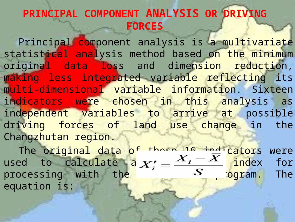
DYNAMICS OF LAND USEIn general, the sequence of land use dynamic
degree for cities in the Changzhutan region between 1990-2007 is Changsha > Xiangtan > Zhuzhou.
Figure 4. Land use dynamic degrees of three cities of Changzhutan region from 1990 to 2007.

REGIONAL DIFFERENCES IN CHANGE OF LAND USE DEGREE
Table 4 summarizes the land use intensity index I and its changes ΔI for different cities in the study area between 1990-2007.
Table 4. Land use intensity index (I) and its change (ΔI) for cities in the Changzhutan region from 1990 to 2007.

DRIVING FORCE MODEL OF URBAN LAND USE CHANGE
Table 5. Correlation coefficient matrix for driving forces of rural-urban industrial land in the Changzhutan region.
Table 5 indicates that there was a strong posi- tive correlation between all factors except for cropland (X16) which was negatively correlated with all other factors. Only one principal component was identified. The eigenvalue of this principal component was 15.232 and its effect accounted for 95% of the variation.
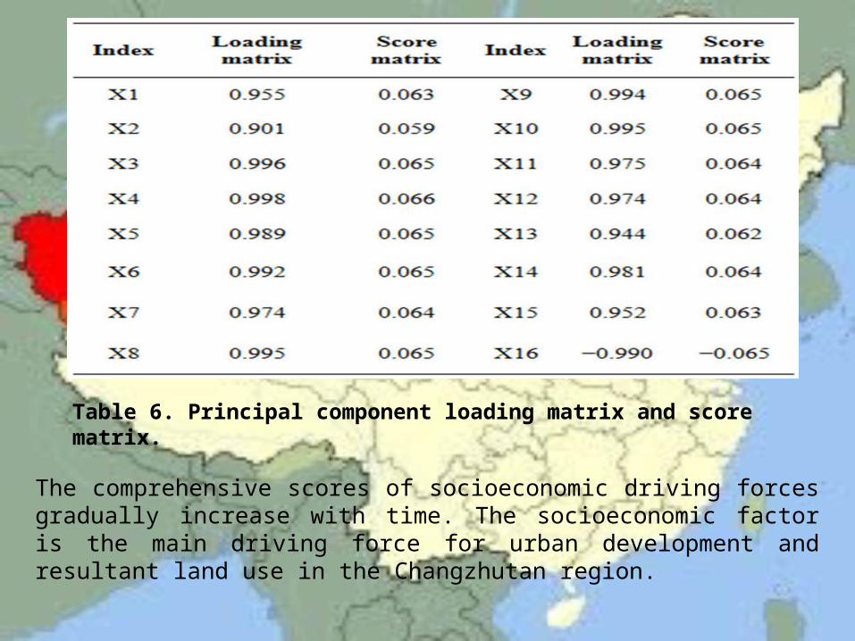
The comprehensive scores of socioeconomic driving forces gradually increase with time. The socioeconomic factor is the main driving force for urban development and resultant land use in the Changzhutan region.
Table 6. Principal component loading matrix and score matrix.

CONCLUSION
The Changzhutan region was found to have had rapid changes in land use. Urban land use increased by 46,297 ha between 1990-2007 to a total of 104,120 ha in 2007, which led to an appreciable reduction in other land uses primarily cropland (21,808 ha or 2.53%), forestland (22,580 ha or 1.26%), and grassland (5618 ha or 12.66%). Land use conversions were very common in the Chang- zhutan region in those years. The ecology of the cropland, forestland, and grassland that were converted into urban land use was adversely impacted because of environ- mental degradation due to drought, storm and flood, re- duced water quality, and soil erosion.

THE END
Related Documents