Preparation of Action Plan for Conservation of Heritage Precincts in MMR Deulwadi Precinct DETAILED CONDITION ASSESSMENT August, 2010 Submitted To Mumbai Metropolitan Regional Heritage Conservation Society Submitted By Urban Management Centre (UMC) Contact Details: Ms. Manvita Baradi Director, UMC III Floor, AUDA Building, Usmanpura Ashram Road, Ahmedabad, Gujarat Tel: 91-79- 27546403/ 5303 Email:[email protected] Web: www.umcasia.org

Welcome message from author
This document is posted to help you gain knowledge. Please leave a comment to let me know what you think about it! Share it to your friends and learn new things together.
Transcript
Preparation of Action Plan for
Conservation of Heritage Precincts in MMR Deulwadi Precinct
DETAILED CONDITION ASSESSMENT
August, 2010
Submitted To Mumbai Metropolitan Regional Heritage
Conservation Society
Submitted By Urban Management Centre (UMC)
Contact Details: Ms. Manvita Baradi
Director, UMC III Floor, AUDA Building, Usmanpura Ashram Road, Ahmedabad, Gujarat
Tel: 91-79- 27546403/ 5303 Email:[email protected]
Web: www.umcasia.org
Preparation of Action Plan for Conservation of Heritage Precincts in MMR
Deulwadi Precinct
DETAILED CONDITION ASSESSMENT August, 2010
Submitted To Mumbai Metropolitan Regional Heritage Conservation Society
Submitted By Urban Management Centre (UMC)
Contact Details: Ms. Manvita Baradi
Director, UMC III Floor, AUDA Building, Usmanpura Ashram Road, Ahmedabad, Gujarat
Tel: 91-79- 27546403/ 5303 Email: [email protected]
Web: www.umcasia.org
Preparation of Action Plan for Conservation of Heritage Precincts in the MMR-Deulwadi Precinct, Uran
Urban Management Centre; 3rd
Floor, AUDA Building, Usmanpura, Ahmedabad www.umcasia.org; [email protected]
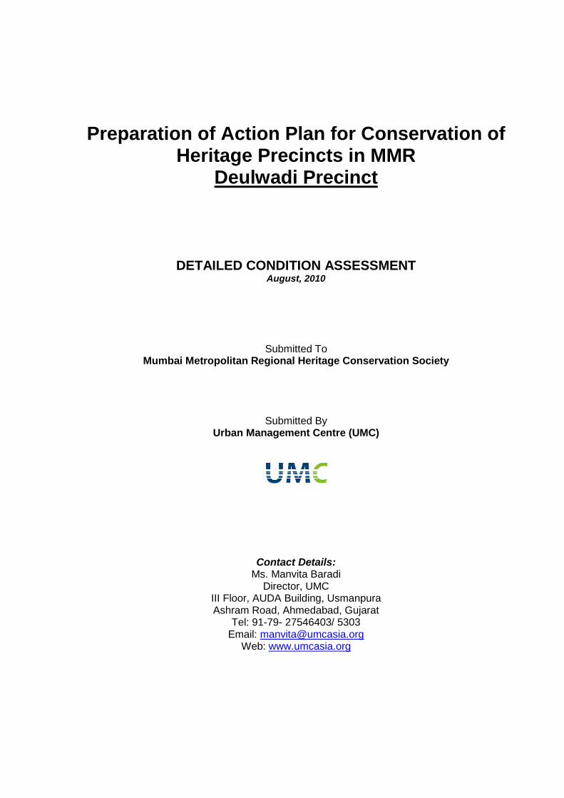
Table of Contents Chapter 1 Introduction to Deulwadi precinct and Work Undertaken Pg
1.1 Need for Heritage Management 1
1.2 Uran 2
1.3 The Objectives of this Assignment 2 1.4 Regional Setting of Uran 3 1.5 Deulwadi Precinct and Work Undertaken 4 1.6 Inventory of architectural buildings 5 1.6.a Architectural Documentation 5 1.6.b Total Station Survey 6 1.6.c Pictographic Documentation 6 1.6.d Public Consultation 6
Chapter 2 Condition Assessment of the Deulwadi Precinct
2.1 Introduction to the Deulwadi Precinct 9 2.2 Preparation of Base Map 10 2.3 Demographic characteristics 14 2.4 Transformations 15 2.5 Development Plan Analysis 18 2.6 Building Use Analysis of the Precinct 21 2.7 Ownership Analysis of the Precincts 21 2.8 Status of Building Use of the Precinct 22 2.9 Building Height of the Precinct 22 2.10 Governance & Management of Deulwadi Sansthan 22 2.11 Activity Mapping at Precinct Level 24 2.12 Street sections 24 2.13 Existing Infrastructure 25
Chapter 3 Streets of Deulwadi Precinct
3.1 Introduction 28 3.2 Deulwadi internal street 28
Plan
Section
Elevation
3.3 Talav Street
Elevations
Sections Chapter 4 Nodes in Deulwadi Precinct
4.1 Identification of Nodes in the Precinct 29 4.2 Details of Nodes 30 4.2.1 Surface Texture of Nodes 47 4.3 Neighbourhood Landmarks, Cultural and Religious Elements 49 4.4 Cultural Practices 54
Preparation of Action Plan for Conservation of Heritage Precincts in the MMR-Deulwadi Precinct, Uran
Urban Management Centre; 3rd
Floor, AUDA Building, Usmanpura, Ahmedabad www.umcasia.org; [email protected]
Chapter 5 Architecture Details of listed heritage Buildings 56
Chapter 6 Household Survey in the Deulwadi Precinct
6.1 Ownership of Deulwadi Precinct 75
6.2 Ownership & Multiple Tenants of Deulwadi Precinct 76
6.3 Building Heights of the Deulwadi Precinct 76 6.4 Structural Stability of the Deulwadi Precinct 76 6.5 Significance of the Deulwadi Precinct 77 References Annexure I Stakeholders Contacted II Household Survey Form III Household Survey Data Entry of Listed Heritage Buildings IV Household Survey of Documented 61 buildings of Deulwadi precinct V Property Tax Information of Deulwadi Precinct (Uran Municipal Council)
List of Maps for Deulwadi precinct M1 Map of Building Use of Deulwadi Precinct M2 Map of Ownership of the Deulwadi Precinct M3 Map of Building height of the Deulwadi Precinct M4 Map of morning activity of Deulwadi precinct M5 Map of Evening activity of the Deulwadi Precinct M6 Map shows infrastructure and services of the Deulwadi Precinct
List of Maps for Core Area of Precinct M7 Map for Ownership of listed buildings M8 Map for Occupation of listed buildings M9 Map for Ownership & Multiple tenants of listed buildings M10 Map for Building heights of listed buildings M11 Map for Structural Stability of listed buildings M112 Map for Values System of listed buildings
List of Drawings for Deulwadi Precinct D1 Section from Deulwadi Temple Street D2 Elevation D3 Section from talao side D4 Elevation from talao side Documentation for Listed buildings of Deulwadi Precinct D5 Vitthal Mandir – Plan, Elevation and Sections D6 Sanghmeshwar Mahadev Mandir- Plan, Elevation and Sections D7 Uranavati (Shitla) Devi temple- Plan, Elevation and Sections D8 Vitthal Rukmani temple - Plan, Elevation, Sections and wall section D9 Dutt temple- Plan, Elevation and Sections
Preparation of Action Plan for Conservation of Heritage Precincts in the MMR-Deulwadi Precinct, Uran
Urban Management Centre; 3rd
Floor, AUDA Building, Usmanpura, Ahmedabad www.umcasia.org; [email protected]
D10 Ganpati Mandir - Plan, Elevation, Sections, wall section and reflected roof plan D11 Ram Mandir- Plan, Elevation and Sections D12 Dispensary- Plan, Elevation and Sections D13 Hanuman Temple- Plan, Elevation and Sections D14 Laxminarayan temple- Plan, Elevation and Sections D15 Balaji Temple - Plan, Elevation and Sections D16 Residence 1(Shankar Chawl) - Plan, Elevation and Sections D17 Residence 2 - Plan, Elevation and Sections D18 Residence 3 - Plan, Elevation and Sections D19 Residence 4 - Plan, Elevation and Sections D20 Residence 5 (Commando Building) - Plan, Elevation and Sections D21 Chabutara - Plan, Elevation and Sections
Preparation of Action Plan for Conservation of Heritage Precincts in the MMR-Deulwadi Precinct, Uran
Urban Management Centre; 3rd
Floor, AUDA Building, Usmanpura, Ahmedabad 1 www.umcasia.org; [email protected]
Chapter 1
Introduction to the Deulwadi Precinct and Work Undertaken
1.1 Need for Heritage Management
Several hundred years of existence under various rulers and their changing influences have, on the one hand given an enormous richness to our cultural heritage and on the other, led us to question constantly what constitutes our roots. The process of inquiry into our roots will gradually unfold the various links that the heritage has had with the socio economic fabric of society of any era, and continues to do so even today1. Cultural heritage comprises not only of manmade elements but also in the natural elements of the region. They are so inter-woven with each other in a complex manner that they constitute the heritage fabric of the settlement. Natural heritage, which has survived thousands of years and the onslaught of human development particularly in the past century, is one of the most precious inheritance of mankind. It comprises the land and its terrain, the hills, the natural water bodies, the flora and the fauna of the region, the minerals and other finite resources in the region and its wonderful scenic views. The range of manmade elements is extremely wide as well as complex and they encompass all aspects of the built environment including their planning principles, the lakes, tankas, kunds, & the monuments, the fortification & the gates, the pols, chowks & streets, the gardens & open spaces, the streets & street façades, all the traditions of arts, crafts, literature and music. Each one of these is not only related to some of the other manmade elements, but is also a direct consequence of the elements of natural heritage Today majority of the old city centres in Asia are decaying for several reasons. Striking a balance between twin forces of globalization and localism is a challenge for heritage policy and regulatory decision-makers in all jurisdictions. The massive rural-urban migration in many Asian countries has exacerbated pressure for the development of heritage conservation policies which address comprehensive planning and heritage issues at both urban and regional levels. The personality and character of a city are not formed in a day or even in a decade. These in fact are the result of centuries of growth in the course of which new elements are constantly juxtaposed with older ones. Old buildings and older areas of the city should be looked upon as assets rather than as liabilities because they represent the history of communities, embodying their tradition, heritage and culture through architecture and the urban form. Every city has its own heritage that should be understood and preserved. This involves understanding of its history, urban character and its development over the time, building typology and the built environment, architectural styles and elements. With passing time, this architectural and cultural heritage has decayed due to lack of policy, management and technical knowledge of preservation/restoration/conservation. There is also a need for improved heritage area based planning and building the required capacities in urban local bodies. Additionally, there is a need to monitor heritage structures and undertake a condition mapping to understand the deterioration so as to lead to strategies for conservation. As part of the current assignment, the objective of the condition assessment process is to understand and recognize heritage as an important asset of people’s day to day life.
1 Source: Nimish Patel and Parul Zaveri; Note on deliberations on conservation of heritage of historic settlements
of Gujarat; 2005

Preparation of Action Plan for Conservation of Heritage Precincts in the MMR-Deulwadi Precinct, Uran
Urban Management Centre; 3rd
Floor, AUDA Building, Usmanpura, Ahmedabad 2 www.umcasia.org; [email protected]
The condition assessment process comprises documentation of buildings and its evaluation. The process also includes an intricate understanding of buildings from a micro level -design of the buildings, its craftsmanship, embodied knowledge of structures and materials. This assessment helps analyse the changes that have occurred from zone level to buildings level. The series of changes in accordance to time line can be seen through these studies. 1.2 Uran Uran is part of the Navi Mumbai city in the Raigarh district near Panvel and Karjat . It is situated east of Mumbai across the Dharamtar Creek. Uran has developed over time and has grown steadily owing to its proximity to Mumbai. It is facing increasing urbanisation pressure. This pressure of urbanization is tearing apart the versatility and culture of the area. The old is giving way to new, which lacks any visual or cultural connection with the context it is placed in. This calls for an urgent need of an action plan to conserve the tangible and non tangible heritage of Uran. 1.3 The objectives of this
assignment:
To evaluate current status and condition of the precinct through detailed documentation and analysis of key issues.
To identify schematic projects, programmes for conservation of precincts through participation of local communicates and stakeholders.
To formulate financial, institutional and regulatory strategies for project implementation, phasing, operation and maintenance.
To prepare draft guidelines for conservation of the heritage precinct. To evaluate the ground reality by survey and other documentation tools To understand the various components of planning and urban design for further
identification of segment designing projects. To identify the importance of regional architectural elements and its design for further
establish regulatory mechanism for area.

Preparation of Action Plan for Conservation of Heritage Precincts in the MMR-Deulwadi Precinct, Uran
Urban Management Centre; 3rd
Floor, AUDA Building, Usmanpura, Ahmedabad 3 www.umcasia.org; [email protected]
1.4 Regional Setting of Uran
Bombay, India "Plan de Bombay et de ses Environs Tire de Thornton Hyd.
Ang." engraved after Bellin, published in about 17512.
Antique map published in Partis in 1760 Fine map of Bombay & Salsette Island. Caronja
(present day Uran) depicted as a separate Island3,
2 Source: http://stock-images.antiqueprints.com/images/sm0016-Bombay
3 Source: http://stock-images.antiqueprints.com/images/sm0016-Bombay
Preparation of Action Plan for Conservation of Heritage Precincts in the MMR-Deulwadi Precinct, Uran
Urban Management Centre; 3rd
Floor, AUDA Building, Usmanpura, Ahmedabad 4 www.umcasia.org; [email protected]
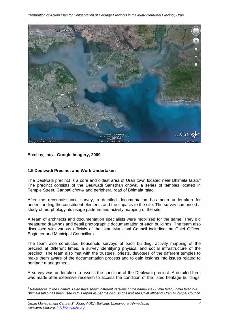
Bombay, India, Google Imagery, 2009
1.5 Deulwadi Precinct and Work Undertaken The Deulwadi precinct is a core and oldest area of Uran town located near Bhimala talao.4
The precinct consists of the Deulwadi Sansthan chowk, a series of temples located in Temple Street, Ganpati chowk and peripheral road of Bhimala talao. After the reconnaissance survey, a detailed documentation has been undertaken for understanding the constituent elements and the impacts to the site. The survey comprised a study of morphology, its usage patterns and activity mapping of the site. A team of architects and documentation specialists were mobilized for the same. They did measured drawings and detail photographic documentation of each buildings. The team also discussed with various officials of the Uran Municipal Council including the Chief Officer, Engineer and Municipal Councillors. The team also conducted household surveys of each building, activity mapping of the precinct at different times, a survey identifying physical and social infrastructure of the precinct. The team also met with the trustees, priests, devotees of the different temples to make them aware of the documentation process and to gain insights into issues related to heritage management. A survey was undertaken to assess the condition of the Deulwadi precinct. A detailed form was made after extensive research to access the condition of the listed heritage buildings.
4 References to the Bhimala Talao have shown different versions of the name- viz.- Bimla talao, Vimla talao but
Bhimala talao has been used in this report as per the discussions with the Chief officer of Uran Municipal Council.
Preparation of Action Plan for Conservation of Heritage Precincts in the MMR-Deulwadi Precinct, Uran
Urban Management Centre; 3rd
Floor, AUDA Building, Usmanpura, Ahmedabad 5 www.umcasia.org; [email protected]
Several visits were made to understand the usage of the different architectural and cultural elements of the precinct like neighbourhood landmarks, nodes and its activity, street shrines, public spaces, open spaces, existing infrastructure etc. Special emphasis was laid to understand the cultural practices, demographic characteristics and major activities of the local people in the precinct. Transformations in built form on a macro, micro and occupational level were observed and noted from secondary and oral sources. Architectural documentation was undertaken for the listed heritage buildings and the precinct. The special architectural features, common characteristics, and elements were paid special attention. 1.6 Inventory of architectural buildings
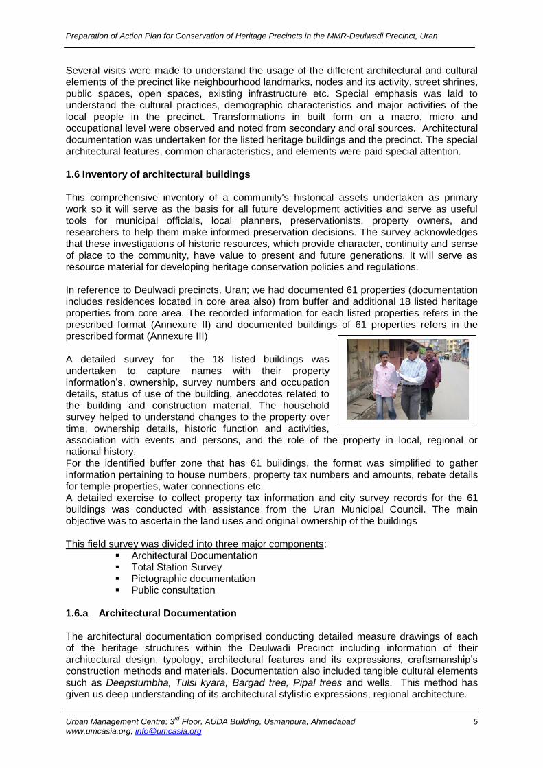
This comprehensive inventory of a community's historical assets undertaken as primary work so it will serve as the basis for all future development activities and serve as useful tools for municipal officials, local planners, preservationists, property owners, and researchers to help them make informed preservation decisions. The survey acknowledges that these investigations of historic resources, which provide character, continuity and sense of place to the community, have value to present and future generations. It will serve as resource material for developing heritage conservation policies and regulations. In reference to Deulwadi precincts, Uran; we had documented 61 properties (documentation includes residences located in core area also) from buffer and additional 18 listed heritage properties from core area. The recorded information for each listed properties refers in the prescribed format (Annexure II) and documented buildings of 61 properties refers in the prescribed format (Annexure III) A detailed survey for the 18 listed buildings was undertaken to capture names with their property information‟s, ownership, survey numbers and occupation details, status of use of the building, anecdotes related to the building and construction material. The household survey helped to understand changes to the property over time, ownership details, historic function and activities, association with events and persons, and the role of the property in local, regional or national history. For the identified buffer zone that has 61 buildings, the format was simplified to gather information pertaining to house numbers, property tax numbers and amounts, rebate details for temple properties, water connections etc. A detailed exercise to collect property tax information and city survey records for the 61 buildings was conducted with assistance from the Uran Municipal Council. The main objective was to ascertain the land uses and original ownership of the buildings This field survey was divided into three major components;
Architectural Documentation Total Station Survey Pictographic documentation Public consultation
1.6.a Architectural Documentation The architectural documentation comprised conducting detailed measure drawings of each of the heritage structures within the Deulwadi Precinct including information of their architectural design, typology, architectural features and its expressions, craftsmanship‟s construction methods and materials. Documentation also included tangible cultural elements such as Deepstumbha, Tulsi kyara, Bargad tree, Pipal trees and wells. This method has given us deep understanding of its architectural stylistic expressions, regional architecture.
Preparation of Action Plan for Conservation of Heritage Precincts in the MMR-Deulwadi Precinct, Uran
Urban Management Centre; 3rd
Floor, AUDA Building, Usmanpura, Ahmedabad 6 www.umcasia.org; [email protected]
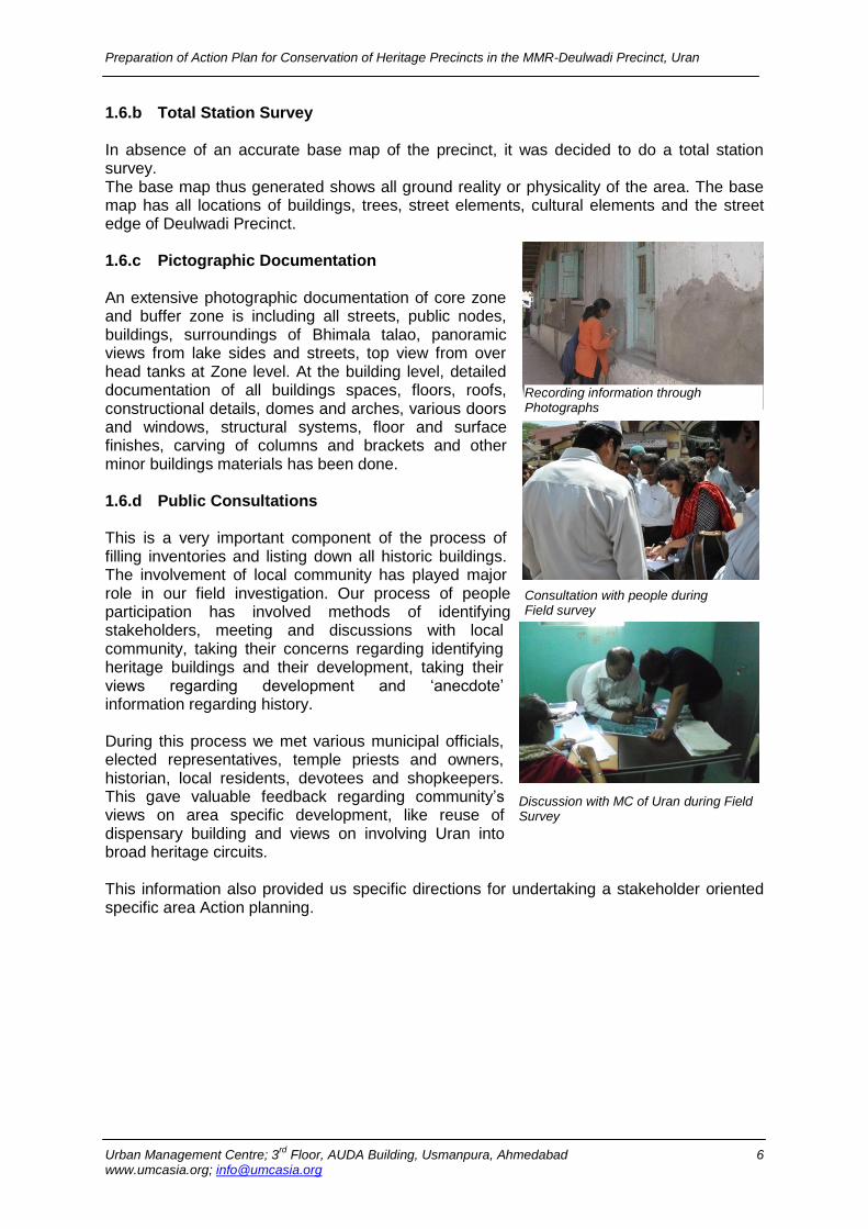
1.6.b Total Station Survey In absence of an accurate base map of the precinct, it was decided to do a total station survey. The base map thus generated shows all ground reality or physicality of the area. The base map has all locations of buildings, trees, street elements, cultural elements and the street edge of Deulwadi Precinct. 1.6.c Pictographic Documentation An extensive photographic documentation of core zone and buffer zone is including all streets, public nodes, buildings, surroundings of Bhimala talao, panoramic views from lake sides and streets, top view from over head tanks at Zone level. At the building level, detailed documentation of all buildings spaces, floors, roofs, constructional details, domes and arches, various doors and windows, structural systems, floor and surface finishes, carving of columns and brackets and other minor buildings materials has been done. 1.6.d Public Consultations
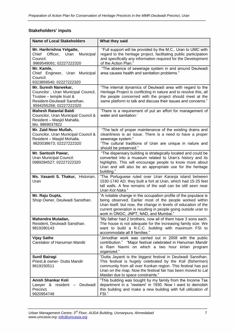
This is a very important component of the process of filling inventories and listing down all historic buildings. The involvement of local community has played major role in our field investigation. Our process of people participation has involved methods of identifying stakeholders, meeting and discussions with local community, taking their concerns regarding identifying heritage buildings and their development, taking their views regarding development and „anecdote‟ information regarding history. During this process we met various municipal officials, elected representatives, temple priests and owners, historian, local residents, devotees and shopkeepers. This gave valuable feedback regarding community‟s views on area specific development, like reuse of dispensary building and views on involving Uran into broad heritage circuits. This information also provided us specific directions for undertaking a stakeholder oriented specific area Action planning.
Recording information through Photographs
Consultation with people during Field survey
Discussion with MC of Uran during Field Survey
Preparation of Action Plan for Conservation of Heritage Precincts in the MMR-Deulwadi Precinct, Uran
Urban Management Centre; 3rd
Floor, AUDA Building, Usmanpura, Ahmedabad 7 www.umcasia.org; [email protected]
Stakeholders’ inputs
Name of Local Stakeholders What they said
Mr. Harikrishna Yelgatte, Chief Officer, Uran Municipal Council. 9969549091; 02227222320
“Full support will be provided by the M.C., Uran to UMC with regard to the heritage project, facilitating public participation and specifically any information required for the Development of the Action Plan.”
Mr. Kamle, Chief Engineer, Uran Municipal Council. 9323859540; 02227222320
“The absence of sewerage system in and around Deulwadi area causes health and sanitation problems.”
Mr. Suresh Narwekar, Councilor , Uran Municipal Council, Trustee – temple trust & Resident-Deulwadi Sansthan. 9594255258; 02227222320
“The internal dynamics of Deulwadi area with regard to the Heritage Project is conflicting in nature and to resolve this, all the people concerned with the project should meet at the same platform to talk and discuss their issues and concerns.”
Mahesh Ratanlal Baldi Councilor, Uran Municipal Council & Resident – Masjid Mahalla. Mo. 9869037822
„There is a requirement of put an effort for management of water and sanitation.‟
Mr. Zaid Noor Mullah, Councilor, Uran Municipal Council & Resident – Masjid Mohalla. 9820038673; 02227222320
“The lack of proper maintenance of the existing drains and cleanliness is an issue. There is a need to have a proper sewerage system.” “The cultural traditions of Uran are unique in nature and should be preserved.”
Mr. Santosh Pawar, Uran Municipal Council. 0989284527; 02227222320
“The dispensary building is strategically located and could be converted into a museum related to Uran‟s history and its highlights. This will encourage people to know more about Uran and will also be an appropriate use for the heritage building.”
Ms. Vasanti S. Thakur, Historian, Uran
“The Portuguese ruled over Uran Karanja island between 1530-1740 AD; they built a fort at Uran, which had 15-25 feet tall walls. A few remains of the wall can be still seen near Uran Kot Naka.”
Mr. Raju Gupta, Shop Owner, Deulwadi Sansthan.
“A notable change in the occupation profile of the populace is being observed. Earlier most of the people worked within Uran itself, but now, the change in levels of education of the current generation is resulting in people going outside uran to work in ONGC, JNPT, NAD, and Mumbai.”
Mahendra Muladan, Resident, Deulwadi Sansthan. 9819280143
“My father had 2 brothers, now all of them have 3 sons each. The house is not adequate for the increasing family size. We want to build a R.C.C. building with maximum FSI to accommodate all 9 families.”
Vijay Sathe Caretaker of Hanuman Mandir
“Jirnodhar work was carried out in 2008 with the public contribution.” “Major festival celebrated in Hanuman Mandir is Ram Navmi on which a two hour kirtan program organized.”
Sunil Bairagi Priest.& owner- Dutta Mandir 9619150511
“Dutta Jayanti is the biggest festival in Deulwadi Sansthan. This festival is hugely celebrated by the Koli (fishermen) community from all over Konkan region. This festival has put Uran on the map. Now the festival fair has been moved to Lal Maidan due to space constraints.”
Anish Shankar Koli Lawyer & resident – Deulwadi Precinct. 9920954749
“This building was bought by my family from the Income Tax department in a “neelami‟ in 1930. Now I want to demolish this building and make a new building with full utilization of FSI.”
Preparation of Action Plan for Conservation of Heritage Precincts in the MMR-Deulwadi Precinct, Uran
Urban Management Centre; 3rd
Floor, AUDA Building, Usmanpura, Ahmedabad 8 www.umcasia.org; [email protected]
Name of Local Stakeholders What they said
Nalini Suthar Priest – Shiv Mandir, & Resident, Deulwadi Sansthan
“The Shiv Mandir is first temple in Deulwadi area which was renovated or “jirnodhar” in 1986.”
Harichandra Y. Juvekar Owner – house 1010A
“Heritage is a complicated concept for a simple person. What will happen here? Everyone here has the same question to ask. I hope all planning is done after consulting all local people involved.”
Pradeep Shroff, Trustee, Balaji temple trust 9326654083
“I am happy that our temples are being given importance. I would be interested in attending public consultation meetings.”
Dhananjay Dinkar Rao Bhagwat Priest, Ganpati Mandir
“In 1960‟s the level of the road was such that one had to climb up three steps to come into the temple. Now with time and re-laying of the road over and over again, the temple level is two steps below the street, causing huge drainage problems for us. Drains are choked all year round but during the 4 months of rain our problems are compounded. Black waste water mixed with rain water and garbage flow into the Mandir. The sanctity of the place is disrupted. We have preserved our temple well, but now we are forced to think of “jirnnodhar” to raise the floor of the temple”
Bharat Rawat Priest – Ram Mandir & Resident Deulwadi Precinct 09920038388
“We are staying here because it is convenient to stay in the heart of the city with all amenities nearby. We would like to renovate the building to have better living standards.”
Preparation of Action Plan for Conservation of Heritage Precincts in the MMR-Deulwadi Precinct, Uran
Urban Management Centre; 3rd
Floor, AUDA Building, Usmanpura, Ahmedabad 9 www.umcasia.org; [email protected]
Chapter 2
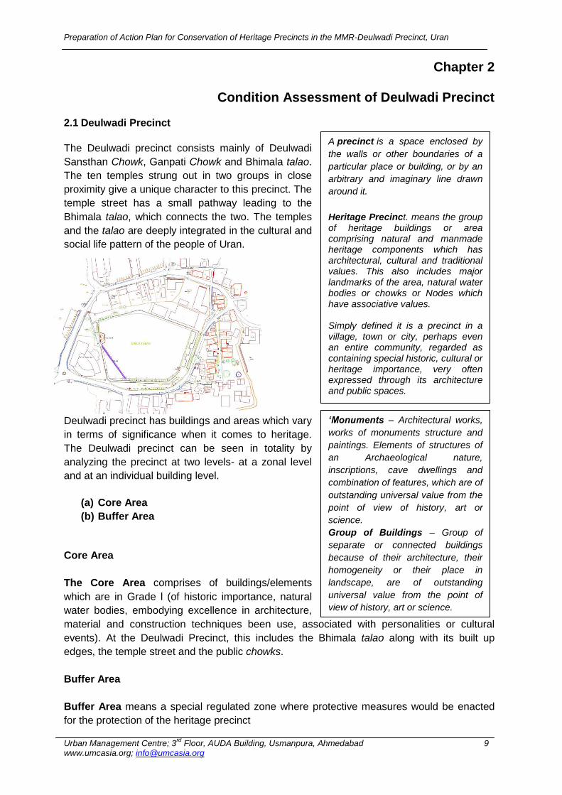
Condition Assessment of Deulwadi Precinct 2.1 Deulwadi Precinct
The Deulwadi precinct consists mainly of Deulwadi
Sansthan Chowk, Ganpati Chowk and Bhimala talao.
The ten temples strung out in two groups in close
proximity give a unique character to this precinct. The
temple street has a small pathway leading to the
Bhimala talao, which connects the two. The temples
and the talao are deeply integrated in the cultural and
social life pattern of the people of Uran.
Deulwadi precinct has buildings and areas which vary
in terms of significance when it comes to heritage.
The Deulwadi precinct can be seen in totality by
analyzing the precinct at two levels- at a zonal level
and at an individual building level.
(a) Core Area
(b) Buffer Area
Core Area
The Core Area comprises of buildings/elements
which are in Grade l (of historic importance, natural
water bodies, embodying excellence in architecture,
material and construction techniques been use, associated with personalities or cultural
events). At the Deulwadi Precinct, this includes the Bhimala talao along with its built up
edges, the temple street and the public chowks.
Buffer Area
Buffer Area means a special regulated zone where protective measures would be enacted
for the protection of the heritage precinct
A precinct is a space enclosed by
the walls or other boundaries of a
particular place or building, or by an
arbitrary and imaginary line drawn
around it.
Heritage Precinct. means the group of heritage buildings or area comprising natural and manmade heritage components which has architectural, cultural and traditional values. This also includes major landmarks of the area, natural water bodies or chowks or Nodes which have associative values. Simply defined it is a precinct in a village, town or city, perhaps even an entire community, regarded as containing special historic, cultural or heritage importance, very often expressed through its architecture and public spaces.
‘Monuments – Architectural works,
works of monuments structure and
paintings. Elements of structures of
an Archaeological nature,
inscriptions, cave dwellings and
combination of features, which are of
outstanding universal value from the
point of view of history, art or
science.
Group of Buildings – Group of
separate or connected buildings
because of their architecture, their
homogeneity or their place in
landscape, are of outstanding
universal value from the point of
view of history, art or science.
Preparation of Action Plan for Conservation of Heritage Precincts in the MMR-Deulwadi Precinct, Uran
Urban Management Centre; 3rd
Floor, AUDA Building, Usmanpura, Ahmedabad 10 www.umcasia.org; [email protected]
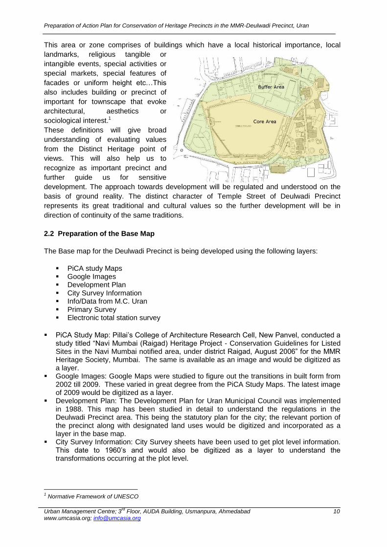
This area or zone comprises of buildings which have a local historical importance, local
landmarks, religious tangible or
intangible events, special activities or
special markets, special features of
facades or uniform height etc…This
also includes building or precinct of
important for townscape that evoke
architectural, aesthetics or
sociological interest.1
These definitions will give broad
understanding of evaluating values
from the Distinct Heritage point of
views. This will also help us to
recognize as important precinct and
further guide us for sensitive
development. The approach towards development will be regulated and understood on the
basis of ground reality. The distinct character of Temple Street of Deulwadi Precinct
represents its great traditional and cultural values so the further development will be in
direction of continuity of the same traditions.
2.2 Preparation of the Base Map
The Base map for the Deulwadi Precinct is being developed using the following layers:
PiCA study Maps Google Images Development Plan City Survey Information Info/Data from M.C. Uran Primary Survey Electronic total station survey
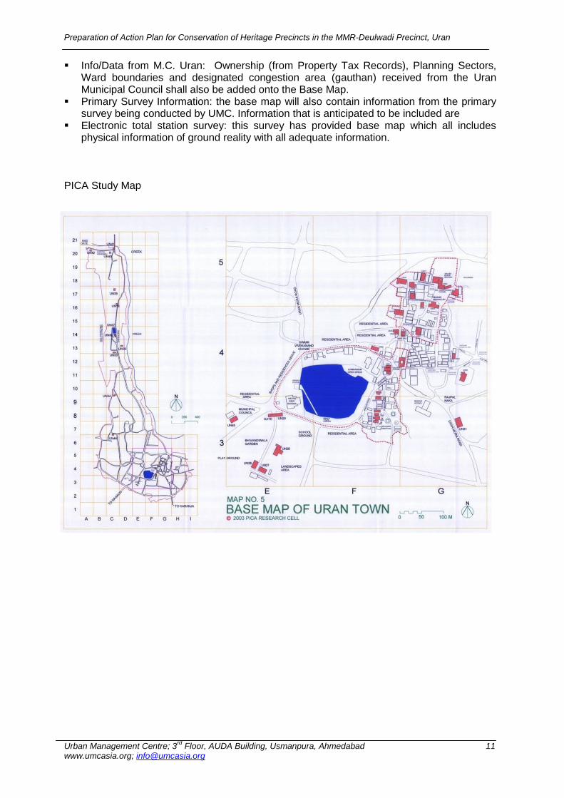
PiCA Study Map: Pillai‟s College of Architecture Research Cell, New Panvel, conducted a study titled “Navi Mumbai (Raigad) Heritage Project - Conservation Guidelines for Listed Sites in the Navi Mumbai notified area, under district Raigad, August 2006” for the MMR Heritage Society, Mumbai. The same is available as an image and would be digitized as a layer.
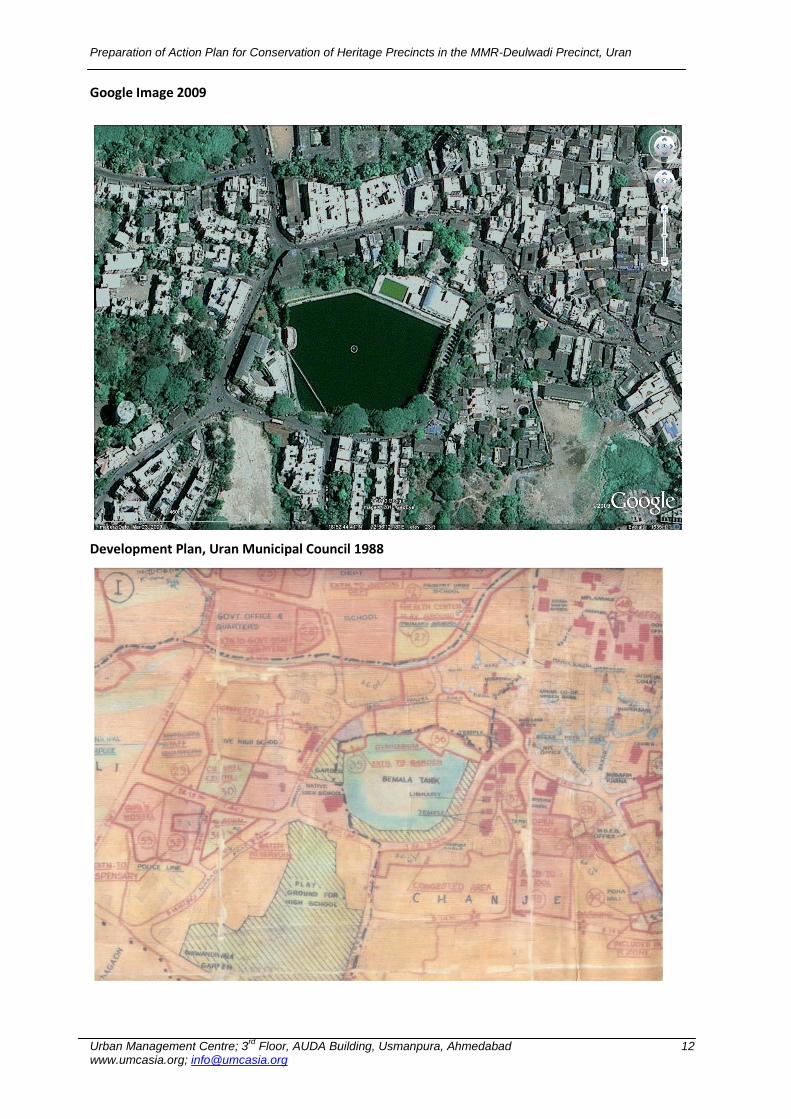
Google Images: Google Maps were studied to figure out the transitions in built form from 2002 till 2009. These varied in great degree from the PiCA Study Maps. The latest image of 2009 would be digitized as a layer.
Development Plan: The Development Plan for Uran Municipal Council was implemented in 1988. This map has been studied in detail to understand the regulations in the Deulwadi Precinct area. This being the statutory plan for the city; the relevant portion of the precinct along with designated land uses would be digitized and incorporated as a layer in the base map.
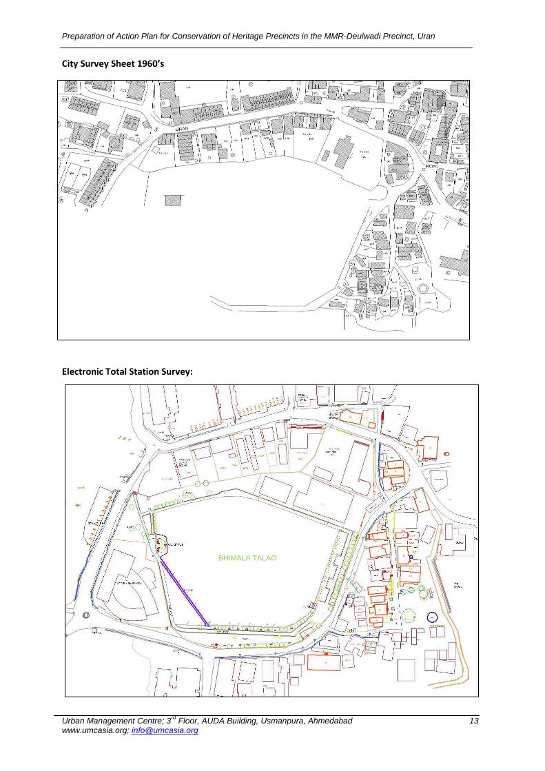
City Survey Information: City Survey sheets have been used to get plot level information. This date to 1960‟s and would also be digitized as a layer to understand the transformations occurring at the plot level.
1 Normative Framework of UNESCO
Preparation of Action Plan for Conservation of Heritage Precincts in the MMR-Deulwadi Precinct, Uran
Urban Management Centre; 3rd
Floor, AUDA Building, Usmanpura, Ahmedabad 11 www.umcasia.org; [email protected]
Info/Data from M.C. Uran: Ownership (from Property Tax Records), Planning Sectors, Ward boundaries and designated congestion area (gauthan) received from the Uran Municipal Council shall also be added onto the Base Map.
Primary Survey Information: the base map will also contain information from the primary survey being conducted by UMC. Information that is anticipated to be included are
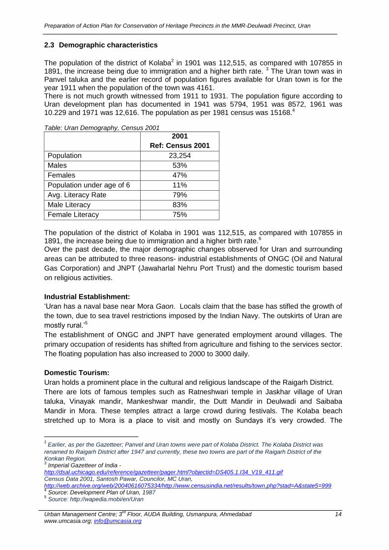
Electronic total station survey: this survey has provided base map which all includes physical information of ground reality with all adequate information.
PICA Study Map
Preparation of Action Plan for Conservation of Heritage Precincts in the MMR-Deulwadi Precinct, Uran
Urban Management Centre; 3rd
Floor, AUDA Building, Usmanpura, Ahmedabad 12 www.umcasia.org; [email protected]
Google Image 2009
Development Plan, Uran Municipal Council 1988
Preparation of Action Plan for Conservation of Heritage Precincts in the MMR-Deulwadi Precinct, Uran
Urban Management Centre; 3rd
Floor, AUDA Building, Usmanpura, Ahmedabad 13 www.umcasia.org; [email protected]
City Survey Sheet 1960’s
Electronic Total Station Survey:
BHIMALA TALAO
Preparation of Action Plan for Conservation of Heritage Precincts in the MMR-Deulwadi Precinct, Uran
Urban Management Centre; 3rd
Floor, AUDA Building, Usmanpura, Ahmedabad 14 www.umcasia.org; [email protected]
2.3 Demographic characteristics
The population of the district of Kolaba2 in 1901 was 112,515, as compared with 107855 in 1891, the increase being due to immigration and a higher birth rate. 3 The Uran town was in Panvel taluka and the earlier record of population figures available for Uran town is for the year 1911 when the population of the town was 4161. There is not much growth witnessed from 1911 to 1931. The population figure according to Uran development plan has documented in 1941 was 5794, 1951 was 8572, 1961 was 10.229 and 1971 was 12,616. The population as per 1981 census was 15168.4 Table: Uran Demography, Census 2001
2001
Ref: Census 2001
Population 23,254
Males 53%
Females 47%
Population under age of 6 11%
Avg. Literacy Rate 79%
Male Literacy 83%
Female Literacy 75%
The population of the district of Kolaba in 1901 was 112,515, as compared with 107855 in 1891, the increase being due to immigration and a higher birth rate.6 Over the past decade, the major demographic changes observed for Uran and surrounding
areas can be attributed to three reasons- industrial establishments of ONGC (Oil and Natural
Gas Corporation) and JNPT (Jawaharlal Nehru Port Trust) and the domestic tourism based
on religious activities.
Industrial Establishment:
„Uran has a naval base near Mora Gaon. Locals claim that the base has stifled the growth of
the town, due to sea travel restrictions imposed by the Indian Navy. The outskirts of Uran are
mostly rural.‟5
The establishment of ONGC and JNPT have generated employment around villages. The
primary occupation of residents has shifted from agriculture and fishing to the services sector.
The floating population has also increased to 2000 to 3000 daily.
Domestic Tourism:
Uran holds a prominent place in the cultural and religious landscape of the Raigarh District.
There are lots of famous temples such as Ratneshwari temple in Jaskhar village of Uran
taluka, Vinayak mandir, Mankeshwar mandir, the Dutt Mandir in Deulwadi and Saibaba
Mandir in Mora. These temples attract a large crowd during festivals. The Kolaba beach
stretched up to Mora is a place to visit and mostly on Sundays it‟s very crowded. The
2 Earlier, as per the Gazetteer; Panvel and Uran towns were part of Kolaba District. The Kolaba District was
renamed to Raigarh District after 1947 and currently, these two towns are part of the Raigarh District of the Konkan Region. 3 Imperial Gazetteer of India -
http://dsal.uchicago.edu/reference/gazetteer/pager.html?objectid=DS405.1.I34_V19_411.gif Census Data 2001, Santosh Pawar, Councilor, MC Uran, http://web.archive.org/web/20040616075334/http://www.censusindia.net/results/town.php?stad=A&state5=999 4 Source: Development Plan of Uran, 1987
5 Source: http://wapedia.mobi/en/Uran
Preparation of Action Plan for Conservation of Heritage Precincts in the MMR-Deulwadi Precinct, Uran
Urban Management Centre; 3rd
Floor, AUDA Building, Usmanpura, Ahmedabad 15 www.umcasia.org; [email protected]
Elephanta caves are in close proximity to Uran. The city sees a huge crowd during the Dutt
Jayanti Festival.
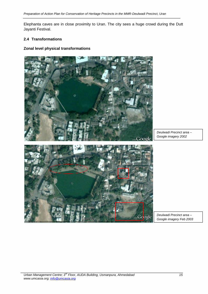
2.4 Transformations
Zonal level physical transformations
Deulwadi Precinct area –
Google imagery 2002
Deulwadi Precinct area –
Google imagery Feb 2003
Preparation of Action Plan for Conservation of Heritage Precincts in the MMR-Deulwadi Precinct, Uran
Urban Management Centre; 3rd
Floor, AUDA Building, Usmanpura, Ahmedabad 16 www.umcasia.org; [email protected]
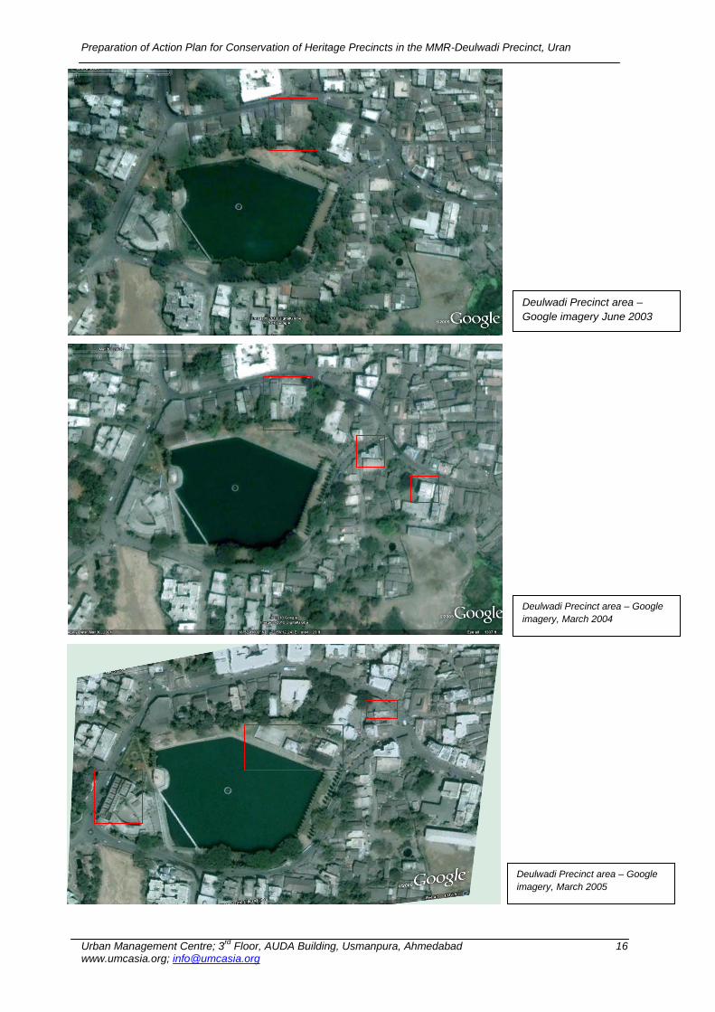
Deulwadi Precinct area –
Google imagery June 2003
Deulwadi Precinct area – Google
imagery, March 2004
Deulwadi Precinct area – Google
imagery, March 2005
Preparation of Action Plan for Conservation of Heritage Precincts in the MMR-Deulwadi Precinct, Uran
Urban Management Centre; 3rd
Floor, AUDA Building, Usmanpura, Ahmedabad 17 www.umcasia.org; [email protected]
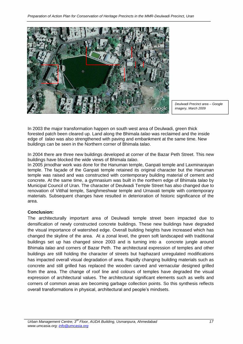
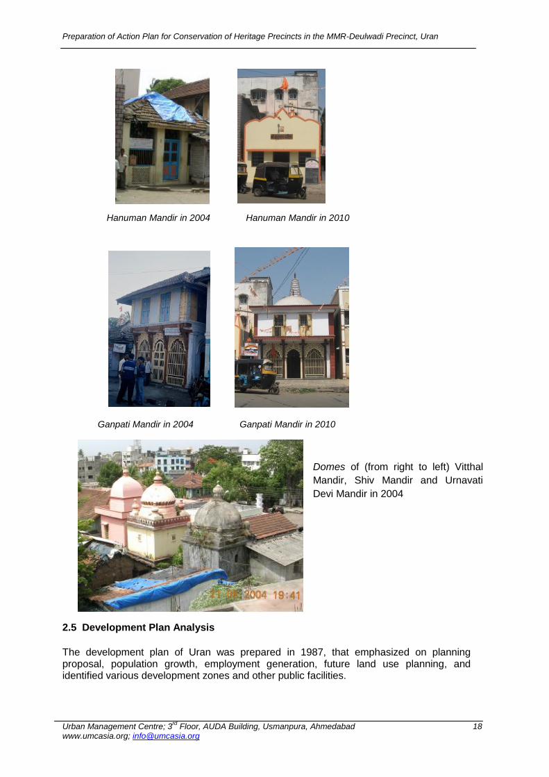
In 2003 the major transformation happen on south west area of Deulwadi, green thick forested patch been cleared up. Land along the Bhimala talao was reclaimed and the inside edge of talao was also strengthened with paving and embankment at the same time. New buildings can be seen in the Northern corner of Bhimala talao. In 2004 there are three new buildings developed at corner of the Bazar Peth Street. This new buildings have blocked the wide views of Bhimala talao. In 2005 jirnodhar work was done for the Hanuman temple, Ganpati temple and Laxminarayan temple. The façade of the Ganpati temple retained its original character but the Hanuman temple was raised and was constructed with contemporary building material of cement and concrete. At the same time, a gymnasium was built in the northern edge of Bhimala talao by Municipal Council of Uran. The character of Deulwadi Temple Street has also changed due to renovation of Vitthal temple, Sanghmeshwar temple and Urnavati temple with contemporary materials. Subsequent changes have resulted in deterioration of historic significance of the area.
Conclusion:
The architecturally important area of Deulwadi temple street been impacted due to
densification of newly constructed concrete buildings. These new buildings have degraded
the visual importance of watershed edge. Overall building heights have increased which has
changed the skyline of the area. At a zonal level, the green soft landscaped with traditional
buildings set up has changed since 2003 and is turning into a concrete jungle around
Bhimala talao and corners of Bazar Peth. The architectural expression of temples and other
buildings are still holding the character of streets but haphazard unregulated modifications
has impacted overall visual degradation of area. Rapidly changing building materials such as
concrete and still grilled has replaced the wooden carved and vernacular designed grilled
from the area. The change of roof line and colours of temples have degraded the visual
expression of architectural values. The architectural significant elements such as wells and
corners of common areas are becoming garbage collection points. So this synthesis reflects
overall transformations in physical, architectural and people‟s mindsets.
Deulwadi Precinct area – Google
imagery, March 2009
Preparation of Action Plan for Conservation of Heritage Precincts in the MMR-Deulwadi Precinct, Uran
Urban Management Centre; 3rd
Floor, AUDA Building, Usmanpura, Ahmedabad 18 www.umcasia.org; [email protected]
Domes of (from right to left) Vitthal
Mandir, Shiv Mandir and Urnavati
Devi Mandir in 2004
2.5 Development Plan Analysis
The development plan of Uran was prepared in 1987, that emphasized on planning proposal, population growth, employment generation, future land use planning, and identified various development zones and other public facilities.
Hanuman Mandir in 2004 Hanuman Mandir in 2010
Ganpati Mandir in 2004
Ganpati Mandir in 2010
Preparation of Action Plan for Conservation of Heritage Precincts in the MMR-Deulwadi Precinct, Uran
Urban Management Centre; 3rd
Floor, AUDA Building, Usmanpura, Ahmedabad 19 www.umcasia.org; [email protected]
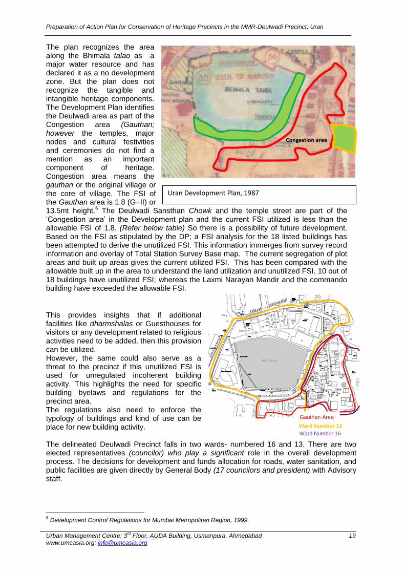
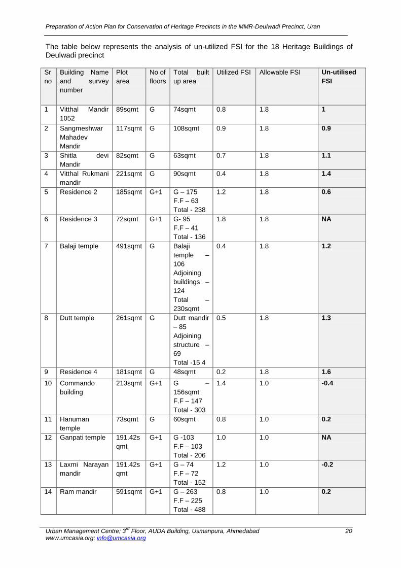
The plan recognizes the area along the Bhimala talao as a major water resource and has declared it as a no development zone. But the plan does not recognize the tangible and intangible heritage components. The Development Plan identifies the Deulwadi area as part of the Congestion area (Gauthan; however the temples, major nodes and cultural festivities and ceremonies do not find a mention as an important component of heritage. Congestion area means the gauthan or the original village or the core of village. The FSI of the Gauthan area is 1.8 (G+II) or 13.5mt height.6 The Deulwadi Sansthan Chowk and the temple street are part of the „Congestion area‟ in the Development plan and the current FSI utilized is less than the allowable FSI of 1.8. (Refer below table) So there is a possibility of future development. Based on the FSI as stipulated by the DP; a FSI analysis for the 18 listed buildings has been attempted to derive the unutilized FSI. This information immerges from survey record information and overlay of Total Station Survey Base map. The current segregation of plot areas and built up areas gives the current utilized FSI. This has been compared with the allowable built up in the area to understand the land utilization and unutilized FSI. 10 out of 18 buildings have unutilized FSI; whereas the Laxmi Narayan Mandir and the commando building have exceeded the allowable FSI.
This provides insights that if additional facilities like dharmshalas or Guesthouses for visitors or any development related to religious activities need to be added, then this provision can be utilized. However, the same could also serve as a threat to the precinct if this unutilized FSI is used for unregulated incoherent building activity. This highlights the need for specific building byelaws and regulations for the precinct area. The regulations also need to enforce the typology of buildings and kind of use can be place for new building activity. The delineated Deulwadi Precinct falls in two wards- numbered 16 and 13. There are two elected representatives (councilor) who play a significant role in the overall development process. The decisions for development and funds allocation for roads, water sanitation, and public facilities are given directly by General Body (17 councilors and president) with Advisory staff.
6 Development Control Regulations for Mumbai Metropolitan Region, 1999.
Congestion area
Ward Number 13
Ward Number 16
Gauthan Area
Uran Development Plan, 1987
Preparation of Action Plan for Conservation of Heritage Precincts in the MMR-Deulwadi Precinct, Uran
Urban Management Centre; 3rd
Floor, AUDA Building, Usmanpura, Ahmedabad 20 www.umcasia.org; [email protected]
The table below represents the analysis of un-utilized FSI for the 18 Heritage Buildings of Deulwadi precinct Sr
no
Building Name
and survey
number
Plot
area
No of
floors
Total built
up area
Utilized FSI Allowable FSI Un-utilised
FSI
1 Vitthal Mandir
1052
89sqmt G 74sqmt 0.8 1.8 1
2 Sangmeshwar
Mahadev
Mandir
117sqmt G 108sqmt 0.9 1.8 0.9
3 Shitla devi
Mandir
82sqmt G 63sqmt 0.7 1.8 1.1
4 Vitthal Rukmani
mandir
221sqmt G 90sqmt 0.4 1.8 1.4
5 Residence 2 185sqmt G+1 G – 175
F.F – 63
Total - 238
1.2 1.8 0.6
6 Residence 3 72sqmt G+1 G- 95
F.F – 41
Total - 136
1.8 1.8 NA
7 Balaji temple 491sqmt G Balaji
temple –
106
Adjoining
buildings –
124
Total –
230sqmt
0.4 1.8 1.2
8 Dutt temple 261sqmt G Dutt mandir
– 85
Adjoining
structure –
69
Total -15 4
0.5 1.8 1.3
9 Residence 4 181sqmt G 48sqmt 0.2 1.8 1.6
10 Commando
building
213sqmt G+1 G –
156sqmt
F.F – 147
Total - 303
1.4 1.0 -0.4
11 Hanuman
temple
73sqmt G 60sqmt 0.8 1.0 0.2
12 Ganpati temple 191.42s
qmt
G+1 G -103
F.F – 103
Total - 206
1.0 1.0 NA
13 Laxmi Narayan
mandir
191.42s
qmt
G+1 G – 74
F.F – 72
Total - 152
1.2 1.0 -0.2
14 Ram mandir 591sqmt G+1 G – 263
F.F – 225
Total - 488
0.8 1.0 0.2

Preparation of Action Plan for Conservation of Heritage Precincts in the MMR-Deulwadi Precinct, Uran
Urban Management Centre; 3rd
Floor, AUDA Building, Usmanpura, Ahmedabad 21 www.umcasia.org; [email protected]
Sr
no
Building Name
and survey
number
Plot
area
No of
floors
Total built
up area
Utilized FSI Allowable FSI Un-utilised
FSI
15 Bird feeder
16 Dispensary 625sqmt G Dispensary
– 156.71
Store –
23.11
Total –
279.81
0.4 1.0 0.4
17 Residence 175 sq
mt
G+1 NA NA NA NA
18 Shankar chawl NA G+1 G –
347sqmt
F.F –
285sqmt
NA NA NA
2.6 Building Use Analysis of the Precinct This analysis is based on the household survey conducted by the UMC team; building uses of each of the 79 buildings comprising the precinct (core and buffer zone). Refer Annex III and IV for the household survey questionnaire. The building use depicted in this zone in the Development Plan is predominantly of religious and residential nature; however, there are various uses observed on the ground. The Residential building use comprises of 45% of the buildings followed by 22% commercial, 15% mixed land use and 13% religious buildings. The core zone buildings are predominantly religious and residential while there is a concentration of commercial use in the buffer zone (refer Building Use map, Chapter 6 and activity mapping for more details. This increase of commercial use in the buffer area is becoming a threat to the Core are. The Deulwadi Temple Street still retains its historic use but needs guidelines and a regulatory framework to continue the same use. (Refer Map for Building Use Number – M1) 2.7 Ownership Analysis of the Precinct
Most of the buildings (39%) in the Deulwadi precinct consist are owned by Private Single. This is followed by 26% properties under private multiple ownership; 18% of properties under Public Trusts ownership, 13% properties under Private Trust and 4% under the ownership of the Uran Municipal Council. (Refer Map for Ownership Number – M2)
Preparation of Action Plan for Conservation of Heritage Precincts in the MMR-Deulwadi Precinct, Uran
Urban Management Centre; 3rd
Floor, AUDA Building, Usmanpura, Ahmedabad 22 www.umcasia.org; [email protected]
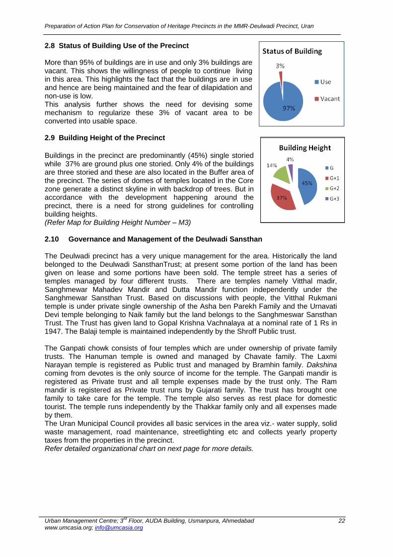
2.8 Status of Building Use of the Precinct More than 95% of buildings are in use and only 3% buildings are vacant. This shows the willingness of people to continue living in this area. This highlights the fact that the buildings are in use and hence are being maintained and the fear of dilapidation and non-use is low. This analysis further shows the need for devising some mechanism to regularize these 3% of vacant area to be converted into usable space. 2.9 Building Height of the Precinct
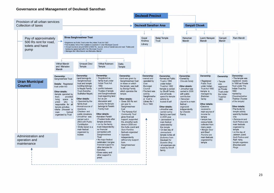
Buildings in the precinct are predominantly (45%) single storied while 37% are ground plus one storied. Only 4% of the buildings are three storied and these are also located in the Buffer area of the precinct. The series of domes of temples located in the Core zone generate a distinct skyline in with backdrop of trees. But in accordance with the development happening around the precinct, there is a need for strong guidelines for controlling building heights. (Refer Map for Building Height Number – M3) 2.10 Governance and Management of the Deulwadi Sansthan The Deulwadi precinct has a very unique management for the area. Historically the land belonged to the Deulwadi SansthanTrust; at present some portion of the land has been given on lease and some portions have been sold. The temple street has a series of temples managed by four different trusts. There are temples namely Vitthal madir, Sanghmewar Mahadev Mandir and Dutta Mandir function independently under the Sanghmewar Sansthan Trust. Based on discussions with people, the Vitthal Rukmani temple is under private single ownership of the Asha ben Parekh Family and the Urnavati Devi temple belonging to Naik family but the land belongs to the Sanghmeswar Sansthan Trust. The Trust has given land to Gopal Krishna Vachnalaya at a nominal rate of 1 Rs in 1947. The Balaji temple is maintained independently by the Shroff Public trust. The Ganpati chowk consists of four temples which are under ownership of private family trusts. The Hanuman temple is owned and managed by Chavate family. The Laxmi Narayan temple is registered as Public trust and managed by Bramhin family. Dakshina coming from devotes is the only source of income for the temple. The Ganpati mandir is registered as Private trust and all temple expenses made by the trust only. The Ram mandir is registered as Private trust runs by Gujarati family. The trust has brought one family to take care for the temple. The temple also serves as rest place for domestic tourist. The temple runs independently by the Thakkar family only and all expenses made by them. The Uran Municipal Council provides all basic services in the area viz.- water supply, solid waste management, road maintenance, streetlighting etc and collects yearly property taxes from the properties in the precinct. Refer detailed organizational chart on next page for more details.
23
Governance and Management of Deulwadi Sansthan
Uran Municipal Council
Administration and operation and maintenance
Provision of all urban services Collection of taxes
Pay of approximately 500 Rs rent for road, toilets and hand pump
Preparation of Action Plan for Conservation of Heritage Precincts in the MMR-Deulwadi Precinct, Uran
Urban Management Centre; 3rd
Floor, AUDA Building, Usmanpura, Ahmedabad 24 www.umcasia.org; [email protected]
2.11 Activity Mapping at Precinct Level The Deulwadi precinct comprises of temple, residences and commercial building use. The concentration of morning activity is mainly focused around the temples with people coming from all over the Uran town to the temple street to pray and around the Bhimala talao garden for exercise. There is also activity in the morning to buy flowers near the Ganpati chowk. There are some large shops which are involved in the business of supplying flowers to Bombay and Pune cities. The chowk witnesses multiple activities during different times of the day. The Deulwadi Sansthan chowk is primarily utilized by people relaxing and resting around the Bargad tree platform, children playing in the chowk and bathing and washing activity near the well. The Deulwadi Street is more oriented about religious and relaxation activity. The Deulwadi precinct (Mora Road) consists of mainly commercial activity. Most of the shops selling food and flowers open at 8:00 am and other retail shops selling clothes, toys, hardware and hotels open from 9:00 am in morning. In the mornings, the main vehicular traffic movement is observed between 10:00 am to 12:00 pm. There is a heavy vehicular movement again after 5:00 pm with citizens heading back home from their work places and due to the shift change of the staff working in JNPT and ONGC. There is again a concentration of movement in the evenings in the Temple Street and at the Ganpati chowk. After 6:30 pm, some of the temples organize bhajans and vyakhyans (religious discourses) that add cultural significance to the area. (Refer map of Activity mapping for Morning and evening number – M4 & M5). Detailed activity mapping of the identified nodes is presented in chapter 5.
2.12 Street sections There are two sections cut it from Deulwadi Temple Street and from Bhimala talao side. These sections show activity happening at the talao edges. The one facing the Bhimala talao is opaque with all backyards of temples opening on the road side and green open spaces on the other side. Here, people are come to exercise, meet and talk to each other during the day. These sections also represent the scale or the height of buildings on periphery of Temple Street. The Bhimala talao is one of the major open and green spaces at the city level. This street having domes on one side and large open space on then other creates a comfortable human scale. (Refer street sections, drawing numbers –D1 & D3 in chapter number 3)
Preparation of Action Plan for Conservation of Heritage Precincts in the MMR-Deulwadi Precinct, Uran
Urban Management Centre; 3rd
Floor, AUDA Building, Usmanpura, Ahmedabad 25 www.umcasia.org; [email protected]
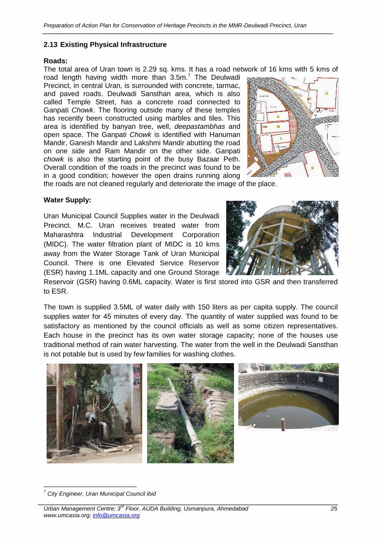
2.13 Existing Physical Infrastructure Roads: The total area of Uran town is 2.29 sq. kms. It has a road network of 16 kms with 5 kms of road length having width more than 3.5m.7 The Deulwadi Precinct, in central Uran, is surrounded with concrete, tarmac, and paved roads. Deulwadi Sansthan area, which is also called Temple Street, has a concrete road connected to Ganpati Chowk. The flooring outside many of these temples has recently been constructed using marbles and tiles. This area is identified by banyan tree, well, deepastambhas and open space. The Ganpati Chowk is identified with Hanuman Mandir, Ganesh Mandir and Lakshmi Mandir abutting the road on one side and Ram Mandir on the other side. Ganpati chowk is also the starting point of the busy Bazaar Peth. Overall condition of the roads in the precinct was found to be in a good condition; however the open drains running along the roads are not cleaned regularly and deteriorate the image of the place. Water Supply:
Uran Municipal Council Supplies water in the Deulwadi
Precinct. M.C. Uran receives treated water from
Maharashtra Industrial Development Corporation
(MIDC). The water filtration plant of MIDC is 10 kms
away from the Water Storage Tank of Uran Municipal
Council. There is one Elevated Service Reservoir
(ESR) having 1.1ML capacity and one Ground Storage
Reservoir (GSR) having 0.6ML capacity. Water is first stored into GSR and then transferred
to ESR.
The town is supplied 3.5ML of water daily with 150 liters as per capita supply. The council
supplies water for 45 minutes of every day. The quantity of water supplied was found to be
satisfactory as mentioned by the council officials as well as some citizen representatives.
Each house in the precinct has its own water storage capacity; none of the houses use
traditional method of rain water harvesting. The water from the well in the Deulwadi Sansthan
is not potable but is used by few families for washing clothes.
7 City Engineer, Uran Municipal Council ibid
Preparation of Action Plan for Conservation of Heritage Precincts in the MMR-Deulwadi Precinct, Uran
Urban Management Centre; 3rd
Floor, AUDA Building, Usmanpura, Ahmedabad 26 www.umcasia.org; [email protected]
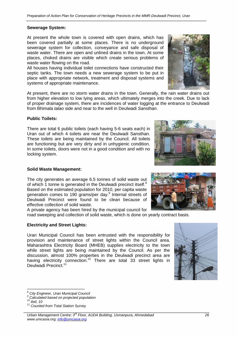
Sewerage System:
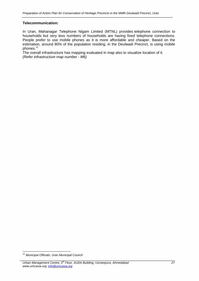
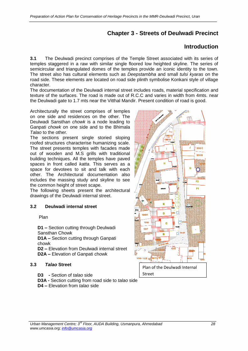
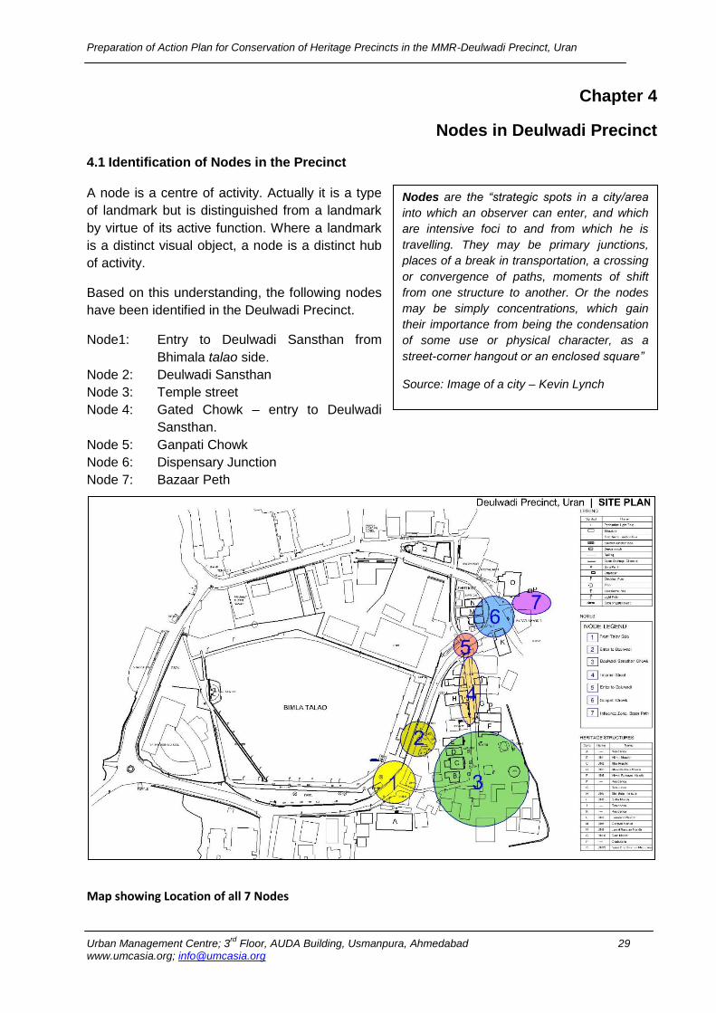
At present the whole town is covered with open drains, which has been covered partially at some places. There is no underground sewerage system for collection, conveyance and safe disposal of waste water. There are open and unlined drains in the town. At some places, choked drains are visible which create serious problems of waste water flowing on the road. All houses having individual toilet connections have constructed their septic tanks. The town needs a new sewerage system to be put in place with appropriate network, treatment and disposal systems and systems of appropriate maintenance. At present, there are no storm water drains in the town. Generally, the rain water drains out from higher elevation to low lying areas, which ultimately merges into the creek. Due to lack of proper drainage system, there are incidences of water logging at the entrance to Deulwadi from Bhimala talao side and near to the well in Deulwadi Sansthan. Public Toilets: There are total 6 public toilets (each having 5-6 seats each) in Uran out of which 4 toilets are near the Deulwadi Sansthan. These toilets are being maintained by the Council. All toilets are functioning but are very dirty and in unhygienic condition. In some toilets, doors were not in a good condition and with no locking system. Solid Waste Management: The city generates an average 6.5 tonnes of solid waste out of which 1 tonne is generated in the Deulwadi precinct itself.8 Based on the estimated population for 2010, per capita waste generation comes to 190 grams/per day.9 Internal streets of Deulwadi Precinct were found to be clean because of effective collection of solid waste. A private agency has been hired by the municipal council for road sweeping and collection of solid waste, which is done on yearly contract basis. Electricity and Street Lights: Uran Municipal Council has been entrusted with the responsibility for provision and maintenance of street lights within the Council area. Maharashtra Electricity Board (MHEB) supplies electricity to the town while street lights are being maintained by the Council. As per the discussion, almost 100% properties in the Deulwadi precinct area are having electricity connection.10 There are total 33 street lights in Deulwadi Precinct.11
8 City Engineer, Uran Municipal Council
9 Calculated based on projected population
10 ibid, 10
11 Counted from Total Station Survey
Preparation of Action Plan for Conservation of Heritage Precincts in the MMR-Deulwadi Precinct, Uran
Urban Management Centre; 3rd
Floor, AUDA Building, Usmanpura, Ahmedabad 27 www.umcasia.org; [email protected]
Telecommunication: In Uran, Mahanagar Telephone Nigam Limited (MTNL) provides telephone connection to households but very less numbers of households are having fixed telephone connections. People prefer to use mobile phones as it is more affordable and cheaper. Based on the estimation, around 80% of the population residing, in the Deulwadi Precinct, is using mobile phones.12 The overall infrastructure has mapping evaluated in map also to visualize location of it. (Refer infrastructure map number - M6)
12
Municipal Officials, Uran Municipal Council
Preparation of Action Plan for Conservation of Heritage Precincts in the MMR-Deulwadi Precinct, Uran
Urban Management Centre; 3rd
Floor, AUDA Building, Usmanpura, Ahmedabad 28 www.umcasia.org; [email protected]
Chapter 3 - Streets of Deulwadi Precinct
Introduction
3.1 The Deulwadi precinct comprises of the Temple Street associated with its series of temples staggered in a raw with similar single floored low heighted skyline. The series of semicircular and triangulated domes of the temples provide an iconic identity to the town. The street also has cultural elements such as Deepstambha and small tulsi kyaras on the road side. These elements are located on road side plinth symbolise Konkani style of village character. The documentation of the Deulwadi internal street includes roads, material specification and texture of the surfaces. The road is made out of R.C.C and varies in width from 4mts. near the Deulwadi gate to 1.7 mts near the Vitthal Mandir. Present condition of road is good. Architecturally the street comprises of temples on one side and residences on the other. The Deulwadi Sansthan chowk is a node leading to Ganpati chowk on one side and to the Bhimala Talao to the other. The sections present single storied sloping roofed structures characterise humanizing scale. The street presents temples with facades made out of wooden and M.S grills with traditional building techniques. All the temples have paved spaces in front called katta. This serves as a space for devotees to sit and talk with each other. The Architectural documentation also includes the massing study and skyline to see the common height of street scape. The following sheets present the architectural drawings of the Deulwadi internal street. 3.2 Deulwadi internal street
Plan D1 – Section cutting through Deulwadi Sansthan Chowk D1A – Section cutting through Ganpati chowk D2 – Elevation from Deulwadi internal street D2A – Elevation of Ganpati chowk
3.3 Talao Street D3 - Section of talao side D3A - Section cutting from road side to talao side D4 – Elevation from talao side
Plan of the Deulwadi Internal
Street
Preparation of Action Plan for Conservation of Heritage Precincts in the MMR-Deulwadi Precinct, Uran
Urban Management Centre; 3rd
Floor, AUDA Building, Usmanpura, Ahmedabad 29 www.umcasia.org; [email protected]
Chapter 4
Nodes in Deulwadi Precinct
4.1 Identification of Nodes in the Precinct
A node is a centre of activity. Actually it is a type
of landmark but is distinguished from a landmark
by virtue of its active function. Where a landmark
is a distinct visual object, a node is a distinct hub
of activity.
Based on this understanding, the following nodes
have been identified in the Deulwadi Precinct.
Node1: Entry to Deulwadi Sansthan from
Bhimala talao side.
Node 2: Deulwadi Sansthan
Node 3: Temple street
Node 4: Gated Chowk – entry to Deulwadi
Sansthan.
Node 5: Ganpati Chowk
Node 6: Dispensary Junction
Node 7: Bazaar Peth
Map showing Location of all 7 Nodes
Nodes are the “strategic spots in a city/area
into which an observer can enter, and which
are intensive foci to and from which he is
travelling. They may be primary junctions,
places of a break in transportation, a crossing
or convergence of paths, moments of shift
from one structure to another. Or the nodes
may be simply concentrations, which gain
their importance from being the condensation
of some use or physical character, as a
street-corner hangout or an enclosed square”
Source: Image of a city – Kevin Lynch
Preparation of Action Plan for Conservation of Heritage Precincts in the MMR-Deulwadi Precinct, Uran
Urban Management Centre; 3rd
Floor, AUDA Building, Usmanpura, Ahmedabad 30 www.umcasia.org; [email protected]
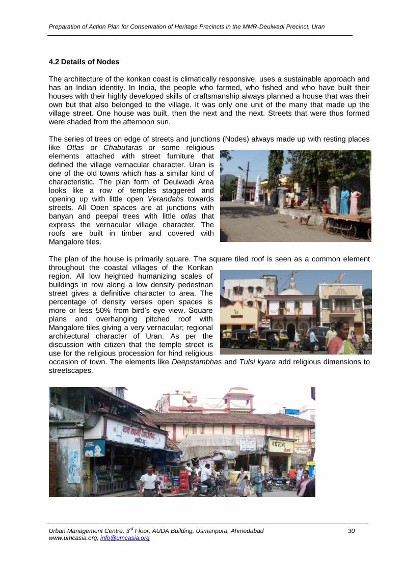
4.2 Details of Nodes
The architecture of the konkan coast is climatically responsive, uses a sustainable approach and has an Indian identity. In India, the people who farmed, who fished and who have built their houses with their highly developed skills of craftsmanship always planned a house that was their own but that also belonged to the village. It was only one unit of the many that made up the village street. One house was built, then the next and the next. Streets that were thus formed were shaded from the afternoon sun. The series of trees on edge of streets and junctions (Nodes) always made up with resting places like Otlas or Chabutaras or some religious elements attached with street furniture that defined the village vernacular character. Uran is one of the old towns which has a similar kind of characteristic. The plan form of Deulwadi Area looks like a row of temples staggered and opening up with little open Verandahs towards streets. All Open spaces are at junctions with banyan and peepal trees with little otlas that express the vernacular village character. The roofs are built in timber and covered with Mangalore tiles. The plan of the house is primarily square. The square tiled roof is seen as a common element throughout the coastal villages of the Konkan region. All low heighted humanizing scales of buildings in row along a low density pedestrian street gives a definitive character to area. The percentage of density verses open spaces is more or less 50% from bird’s eye view. Square plans and overhanging pitched roof with Mangalore tiles giving a very vernacular; regional architectural character of Uran. As per the discussion with citizen that the temple street is use for the religious procession for hind religious occasion of town. The elements like Deepstambhas and Tulsi kyara add religious dimensions to streetscapes.
Preparation of Action Plan for Conservation of Heritage Precincts in the MMR-Deulwadi Precinct, Uran
Urban Management Centre; 3rd
Floor, AUDA Building, Usmanpura, Ahmedabad 31 www.umcasia.org; [email protected]
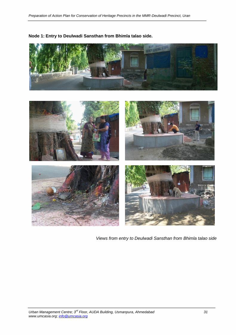
Node 1: Entry to Deulwadi Sansthan from Bhimla talao side.
Views from entry to Deulwadi Sansthan from Bhimla talao side
Preparation of Action Plan for Conservation of Heritage Precincts in the MMR-Deulwadi Precinct, Uran
Urban Management Centre; 3rd
Floor, AUDA Building, Usmanpura, Ahmedabad 32 www.umcasia.org; [email protected]
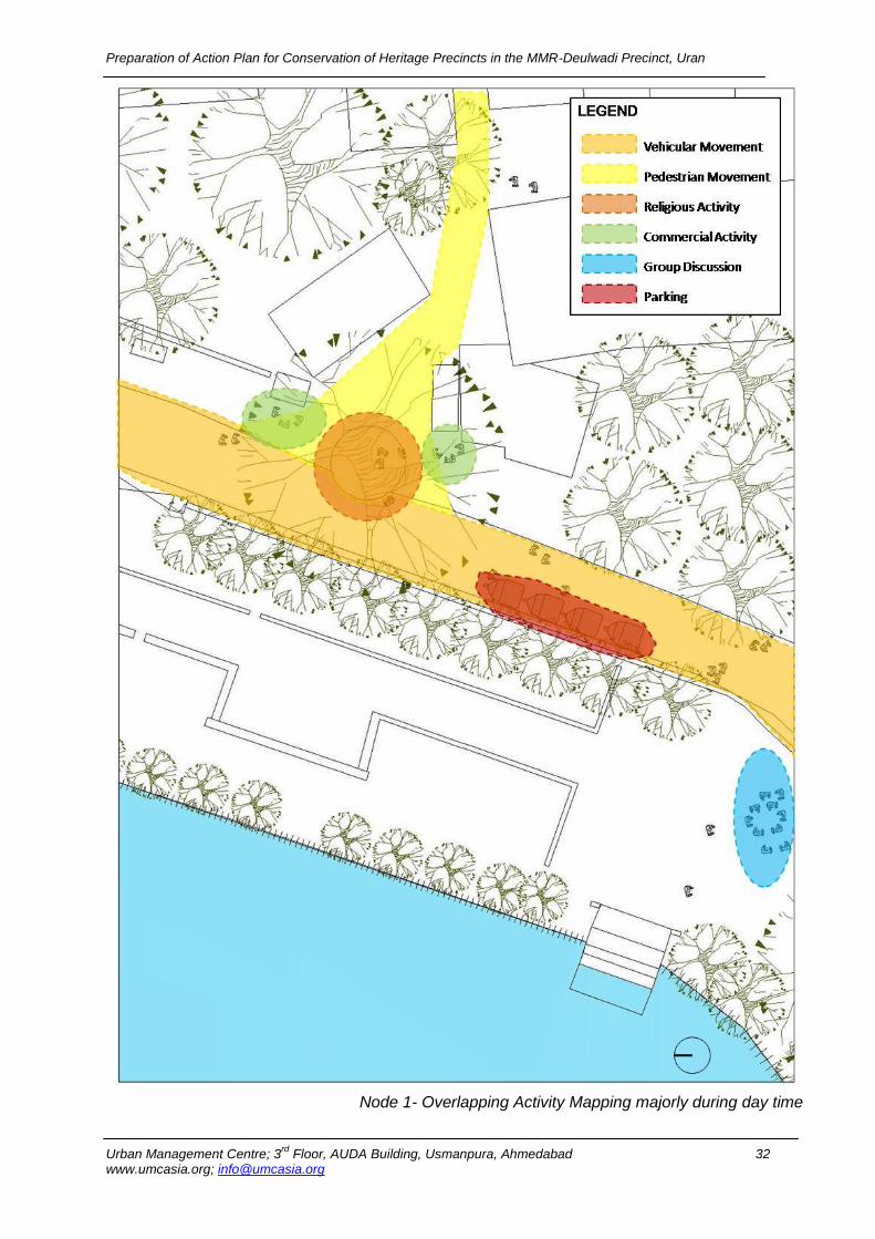
Node 1- Overlapping Activity Mapping majorly during day time
Preparation of Action Plan for Conservation of Heritage Precincts in the MMR-Deulwadi Precinct, Uran
Urban Management Centre; 3rd
Floor, AUDA Building, Usmanpura, Ahmedabad 33 www.umcasia.org; [email protected]
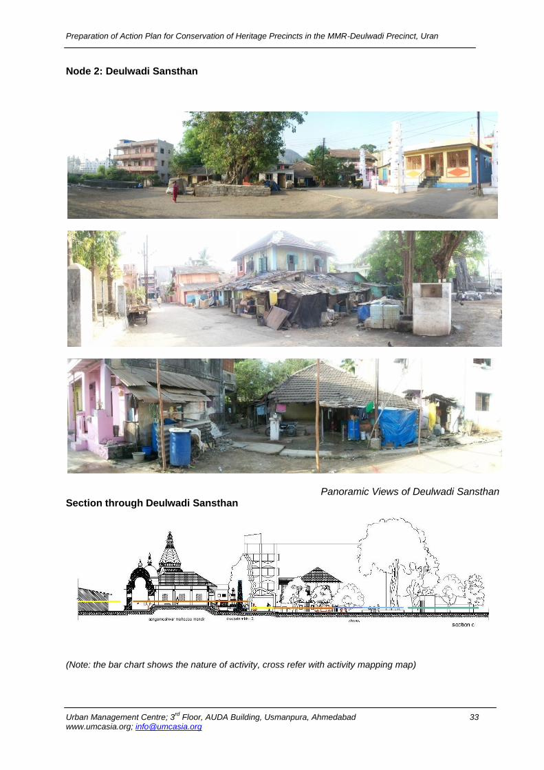
Node 2: Deulwadi Sansthan
Panoramic Views of Deulwadi Sansthan Section through Deulwadi Sansthan
(Note: the bar chart shows the nature of activity, cross refer with activity mapping map)
Preparation of Action Plan for Conservation of Heritage Precincts in the MMR-Deulwadi Precinct, Uran
Urban Management Centre; 3rd
Floor, AUDA Building, Usmanpura, Ahmedabad 34 www.umcasia.org; [email protected]
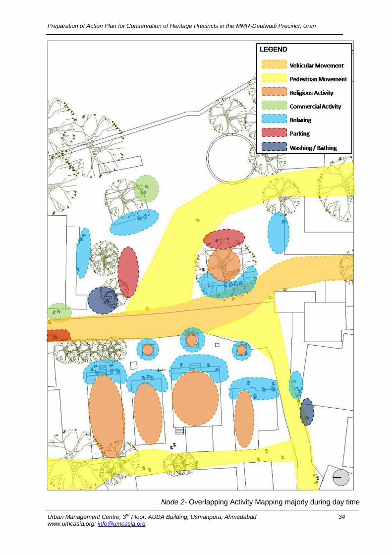
Node 2- Overlapping Activity Mapping majorly during day time
Preparation of Action Plan for Conservation of Heritage Precincts in the MMR-Deulwadi Precinct, Uran
Urban Management Centre; 3rd
Floor, AUDA Building, Usmanpura, Ahmedabad 35 www.umcasia.org; [email protected]
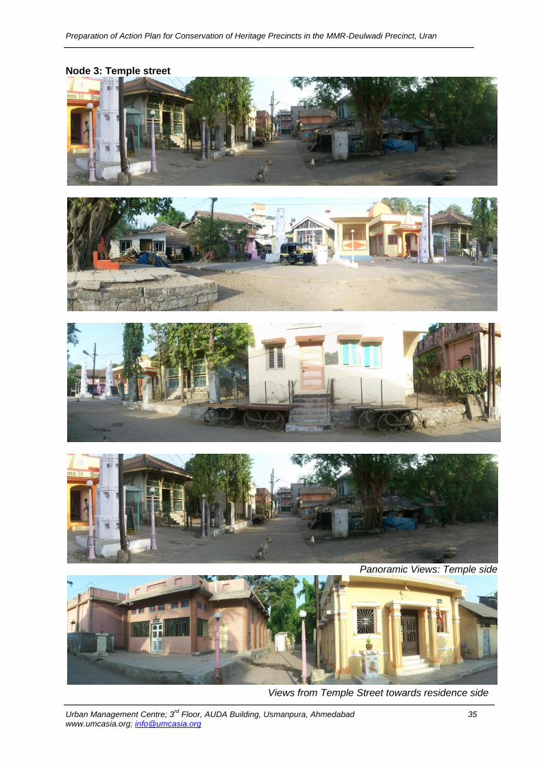
Node 3: Temple street
Panoramic Views: Temple side
Views from Temple Street towards residence side
Preparation of Action Plan for Conservation of Heritage Precincts in the MMR-Deulwadi Precinct, Uran
Urban Management Centre; 3rd
Floor, AUDA Building, Usmanpura, Ahmedabad 36 www.umcasia.org; [email protected]
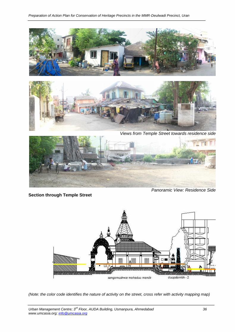
Views from Temple Street towards residence side
Panoramic View: Residence Side
Section through Temple Street
(Note: the color code identifies the nature of activity on the street, cross refer with activity mapping map)
Preparation of Action Plan for Conservation of Heritage Precincts in the MMR-Deulwadi Precinct, Uran
Urban Management Centre; 3rd
Floor, AUDA Building, Usmanpura, Ahmedabad 37 www.umcasia.org; [email protected]
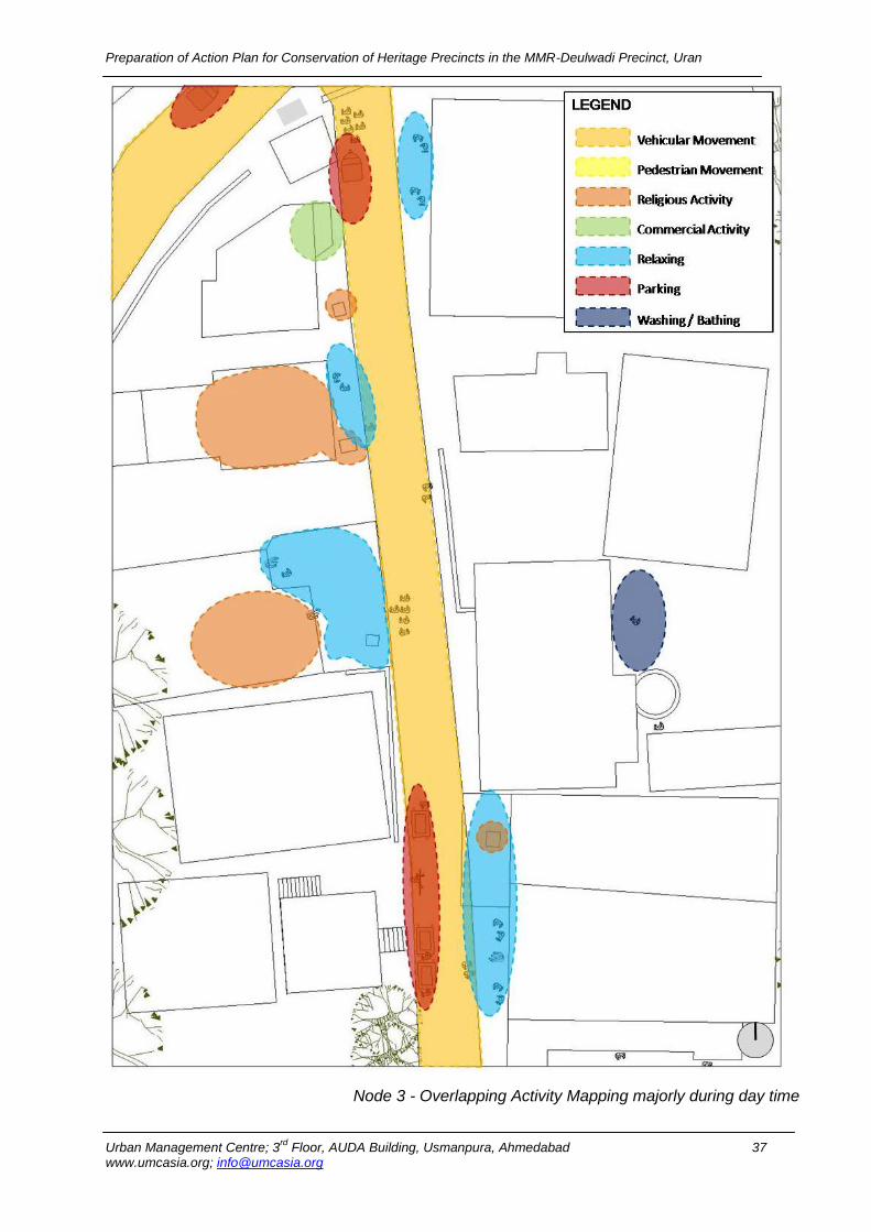
Node 3 - Overlapping Activity Mapping majorly during day time
Preparation of Action Plan for Conservation of Heritage Precincts in the MMR-Deulwadi Precinct, Uran
Urban Management Centre; 3rd
Floor, AUDA Building, Usmanpura, Ahmedabad 38 www.umcasia.org; [email protected]
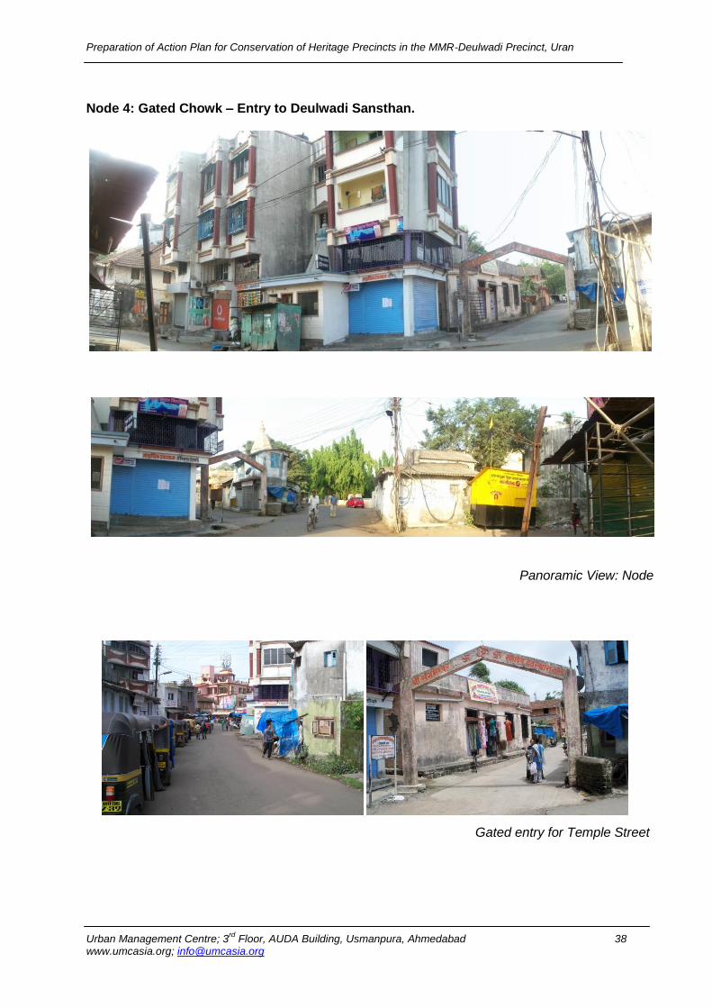
Node 4: Gated Chowk – Entry to Deulwadi Sansthan.
Panoramic View: Node
Gated entry for Temple Street
Preparation of Action Plan for Conservation of Heritage Precincts in the MMR-Deulwadi Precinct, Uran
Urban Management Centre; 3rd
Floor, AUDA Building, Usmanpura, Ahmedabad 39 www.umcasia.org; [email protected]
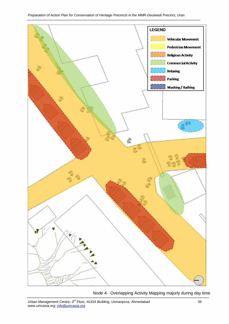
Node 4- Overlapping Activity Mapping majorly during day time
Preparation of Action Plan for Conservation of Heritage Precincts in the MMR-Deulwadi Precinct, Uran
Urban Management Centre; 3rd
Floor, AUDA Building, Usmanpura, Ahmedabad 40 www.umcasia.org; [email protected]
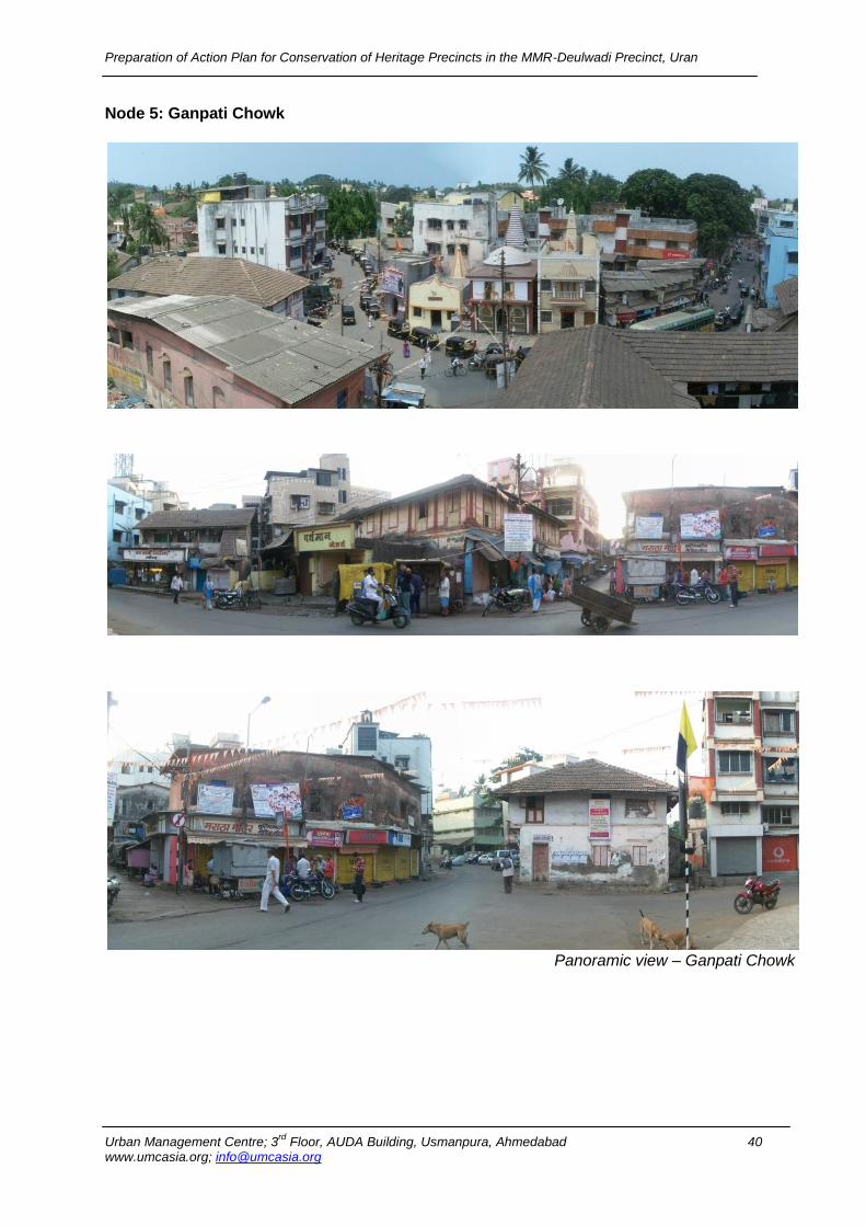
Node 5: Ganpati Chowk
Panoramic view – Ganpati Chowk
Preparation of Action Plan for Conservation of Heritage Precincts in the MMR-Deulwadi Precinct, Uran
Urban Management Centre; 3rd
Floor, AUDA Building, Usmanpura, Ahmedabad 41 www.umcasia.org; [email protected]
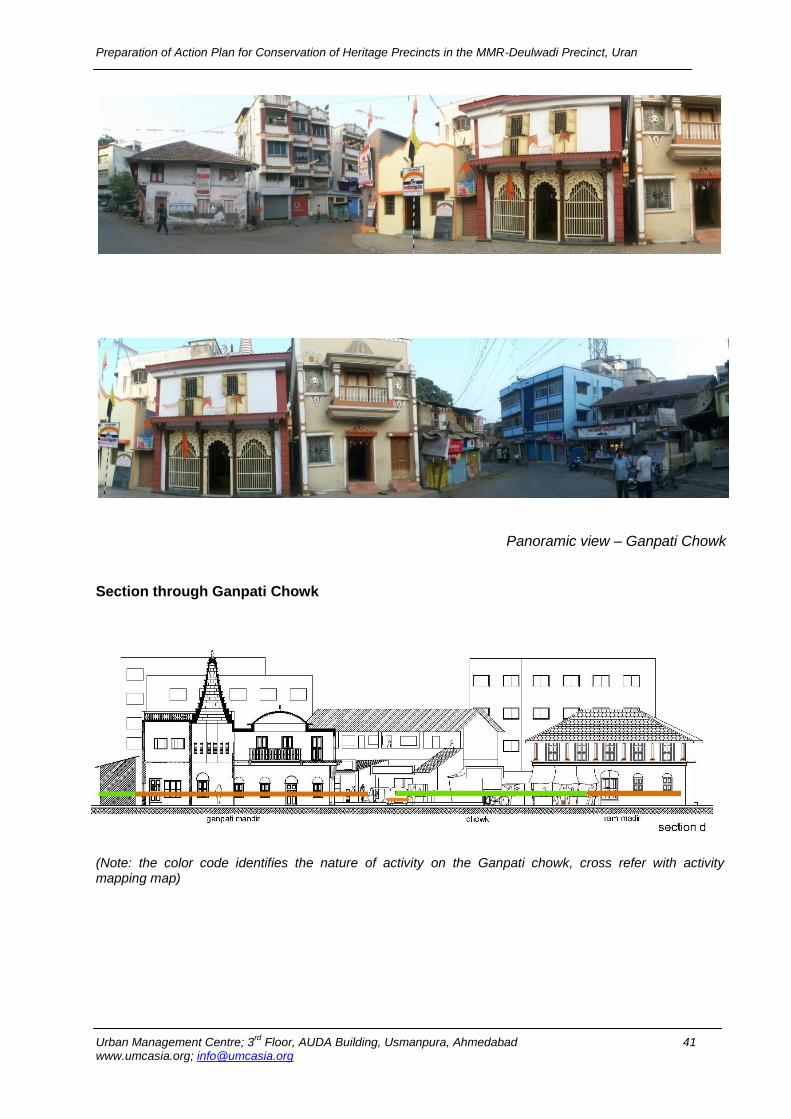
Panoramic view – Ganpati Chowk
Section through Ganpati Chowk
(Note: the color code identifies the nature of activity on the Ganpati chowk, cross refer with activity mapping map)
Preparation of Action Plan for Conservation of Heritage Precincts in the MMR-Deulwadi Precinct, Uran
Urban Management Centre; 3rd
Floor, AUDA Building, Usmanpura, Ahmedabad 42 www.umcasia.org; [email protected]
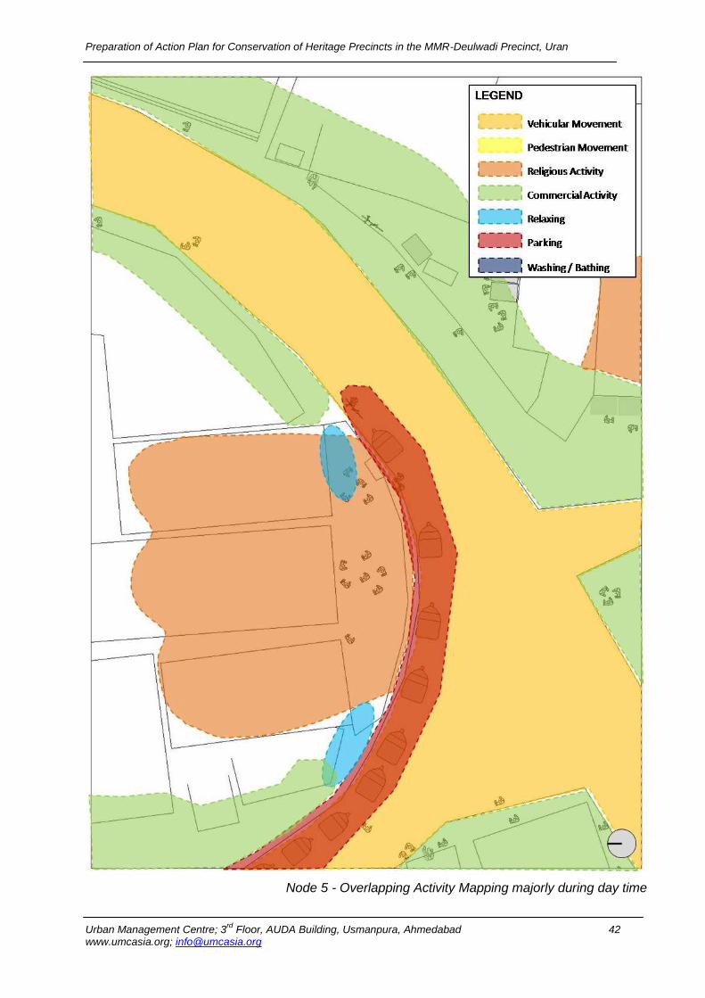
Node 5 - Overlapping Activity Mapping majorly during day time
Preparation of Action Plan for Conservation of Heritage Precincts in the MMR-Deulwadi Precinct, Uran
Urban Management Centre; 3rd
Floor, AUDA Building, Usmanpura, Ahmedabad 43 www.umcasia.org; [email protected]
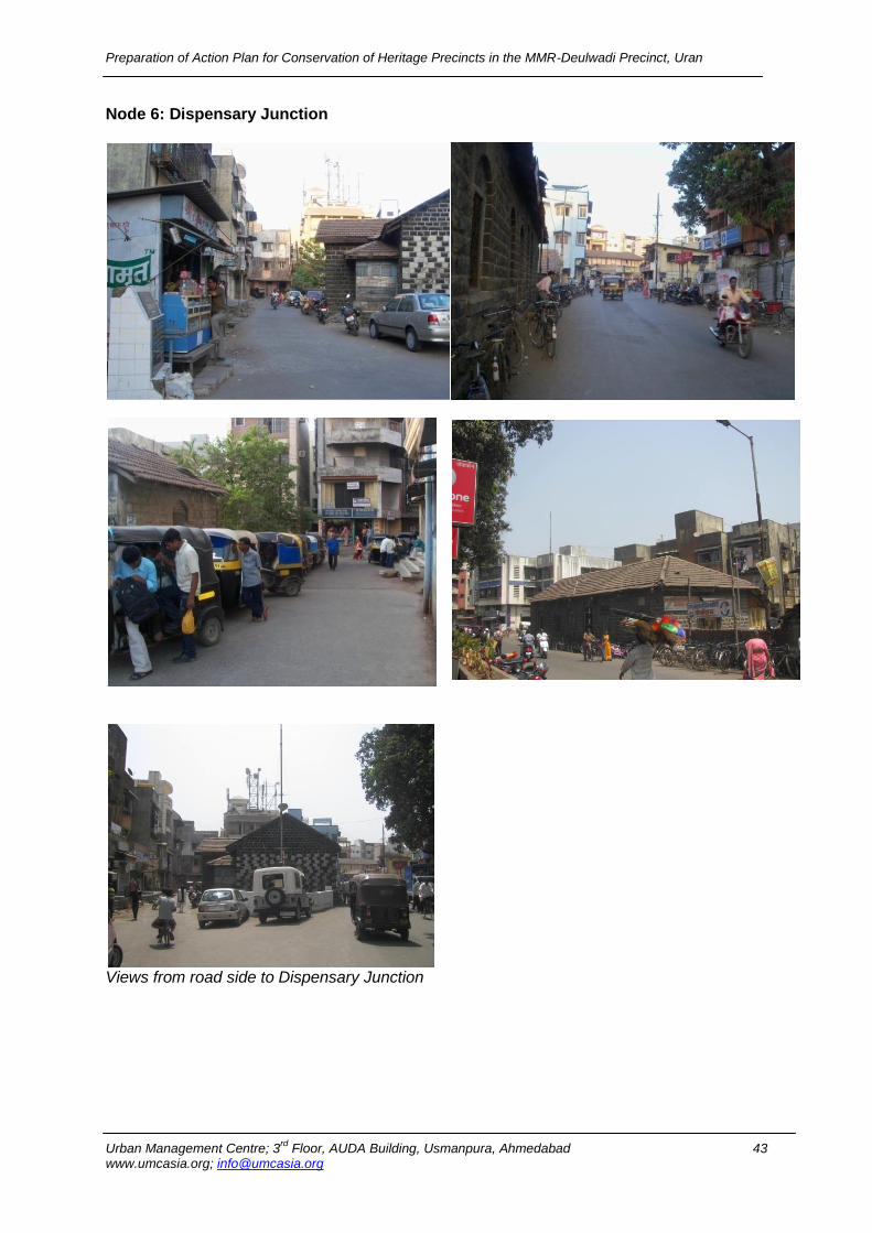
Node 6: Dispensary Junction
Views from road side to Dispensary Junction
Preparation of Action Plan for Conservation of Heritage Precincts in the MMR-Deulwadi Precinct, Uran
Urban Management Centre; 3rd
Floor, AUDA Building, Usmanpura, Ahmedabad 44 www.umcasia.org; [email protected]
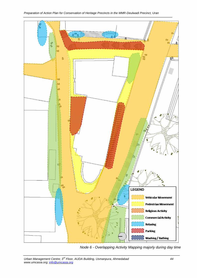
Node 6 - Overlapping Activity Mapping majorly during day time

Preparation of Action Plan for Conservation of Heritage Precincts in the MMR-Deulwadi Precinct, Uran
Urban Management Centre; 3rd
Floor, AUDA Building, Usmanpura, Ahmedabad 45 www.umcasia.org; [email protected]
Node 7: Bazaar Peth
Views towards Bazaar Peth
Preparation of Action Plan for Conservation of Heritage Precincts in the MMR-Deulwadi Precinct, Uran
Urban Management Centre; 3rd
Floor, AUDA Building, Usmanpura, Ahmedabad 46 www.umcasia.org; [email protected]
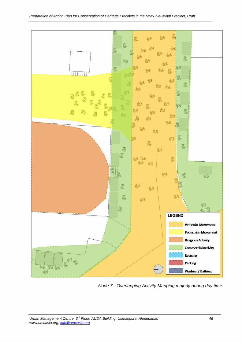
Node 7 - Overlapping Activity Mapping majorly during day time
Preparation of Action Plan for Conservation of Heritage Precincts in the MMR-Deulwadi Precinct, Uran
Urban Management Centre; 3rd
Floor, AUDA Building, Usmanpura, Ahmedabad 47 www.umcasia.org; [email protected]
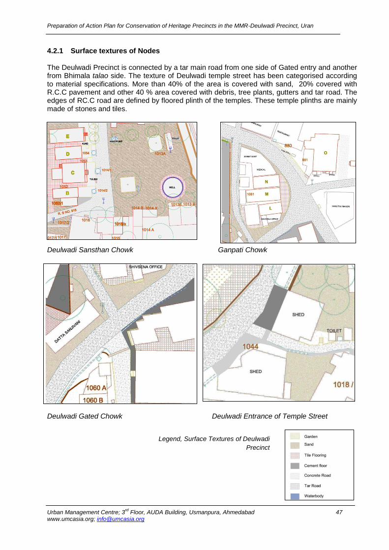
4.2.1 Surface textures of Nodes The Deulwadi Precinct is connected by a tar main road from one side of Gated entry and another from Bhimala talao side. The texture of Deulwadi temple street has been categorised according to material specifications. More than 40% of the area is covered with sand, 20% covered with R.C.C pavement and other 40 % area covered with debris, tree plants, gutters and tar road. The edges of RC.C road are defined by floored plinth of the temples. These temple plinths are mainly made of stones and tiles.
Deulwadi Sansthan Chowk Ganpati Chowk
Deulwadi Gated Chowk Deulwadi Entrance of Temple Street Legend, Surface Textures of Deulwadi
Precinct
Preparation of Action Plan for Conservation of Heritage Precincts in the MMR-Deulwadi Precinct, Uran
Urban Management Centre; 3rd
Floor, AUDA Building, Usmanpura, Ahmedabad 48 www.umcasia.org; [email protected]
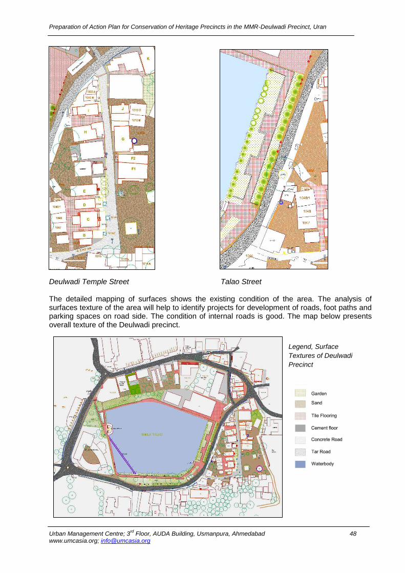
Deulwadi Temple Street Talao Street The detailed mapping of surfaces shows the existing condition of the area. The analysis of surfaces texture of the area will help to identify projects for development of roads, foot paths and parking spaces on road side. The condition of internal roads is good. The map below presents overall texture of the Deulwadi precinct.
Legend, Surface
Textures of Deulwadi
Precinct
Preparation of Action Plan for Conservation of Heritage Precincts in the MMR-Deulwadi Precinct, Uran
Urban Management Centre; 3rd
Floor, AUDA Building, Usmanpura, Ahmedabad 49 www.umcasia.org; [email protected]
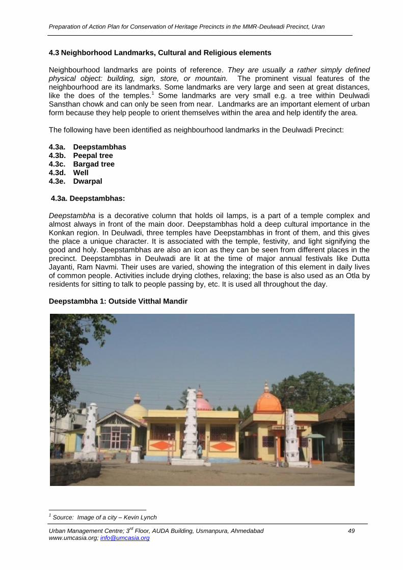
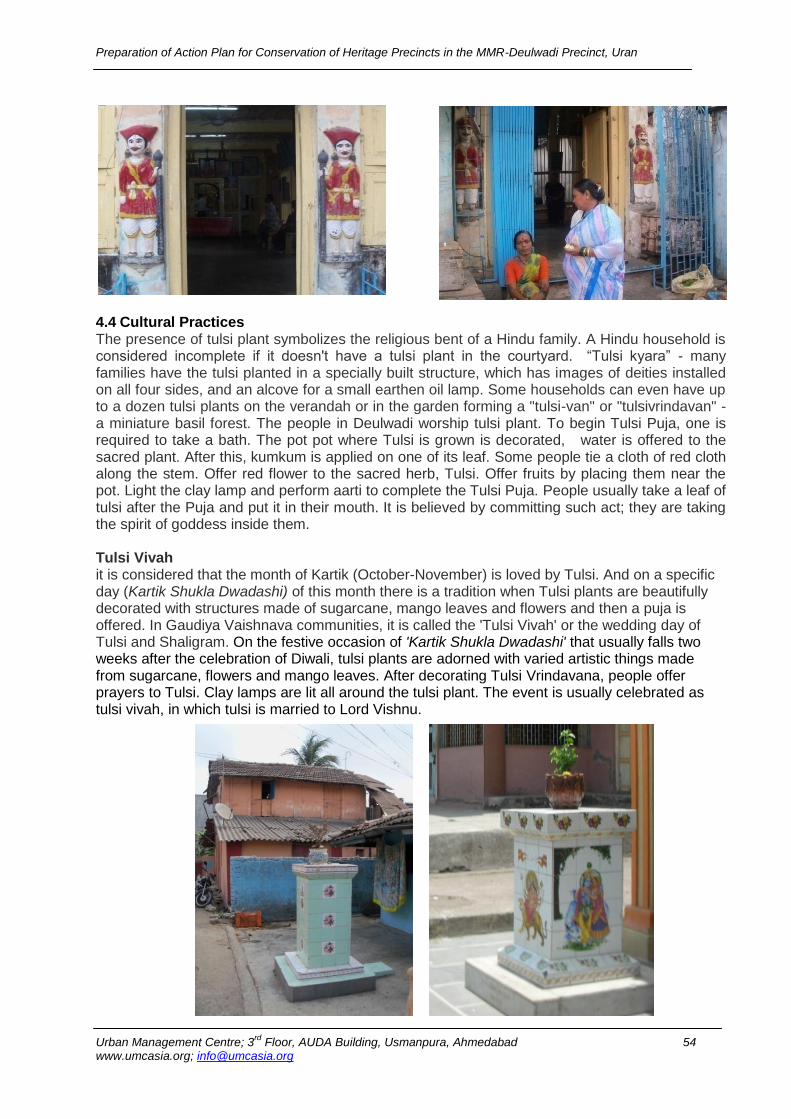
4.3 Neighborhood Landmarks, Cultural and Religious elements
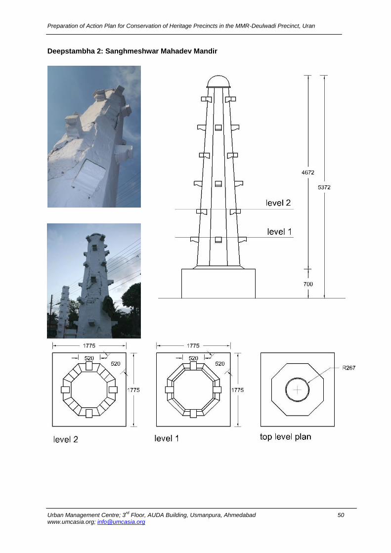
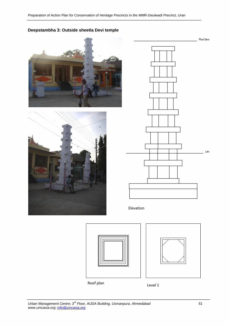
Neighbourhood landmarks are points of reference. They are usually a rather simply defined physical object: building, sign, store, or mountain. The prominent visual features of the neighbourhood are its landmarks. Some landmarks are very large and seen at great distances, like the does of the temples.1 Some landmarks are very small e.g. a tree within Deulwadi Sansthan chowk and can only be seen from near. Landmarks are an important element of urban form because they help people to orient themselves within the area and help identify the area. The following have been identified as neighbourhood landmarks in the Deulwadi Precinct: 4.3a. Deepstambhas 4.3b. Peepal tree 4.3c. Bargad tree 4.3d. Well 4.3e. Dwarpal 4.3a. Deepstambhas: Deepstambha is a decorative column that holds oil lamps, is a part of a temple complex and almost always in front of the main door. Deepstambhas hold a deep cultural importance in the Konkan region. In Deulwadi, three temples have Deepstambhas in front of them, and this gives the place a unique character. It is associated with the temple, festivity, and light signifying the good and holy. Deepstambhas are also an icon as they can be seen from different places in the precinct. Deepstambhas in Deulwadi are lit at the time of major annual festivals like Dutta Jayanti, Ram Navmi. Their uses are varied, showing the integration of this element in daily lives of common people. Activities include drying clothes, relaxing; the base is also used as an Otla by residents for sitting to talk to people passing by, etc. It is used all throughout the day. Deepstambha 1: Outside Vitthal Mandir
1 Source: Image of a city – Kevin Lynch
Preparation of Action Plan for Conservation of Heritage Precincts in the MMR-Deulwadi Precinct, Uran
Urban Management Centre; 3rd
Floor, AUDA Building, Usmanpura, Ahmedabad 50 www.umcasia.org; [email protected]
Deepstambha 2: Sanghmeshwar Mahadev Mandir Deepstambha 2 : Outside Shiv Mandir
Preparation of Action Plan for Conservation of Heritage Precincts in the MMR-Deulwadi Precinct, Uran
Urban Management Centre; 3rd
Floor, AUDA Building, Usmanpura, Ahmedabad 51 www.umcasia.org; [email protected]
Deepstambha 3: Outside sheetla Devi temple
Elevation
Roof plan Level 1
Preparation of Action Plan for Conservation of Heritage Precincts in the MMR-Deulwadi Precinct, Uran
Urban Management Centre; 3rd
Floor, AUDA Building, Usmanpura, Ahmedabad 52 www.umcasia.org; [email protected]
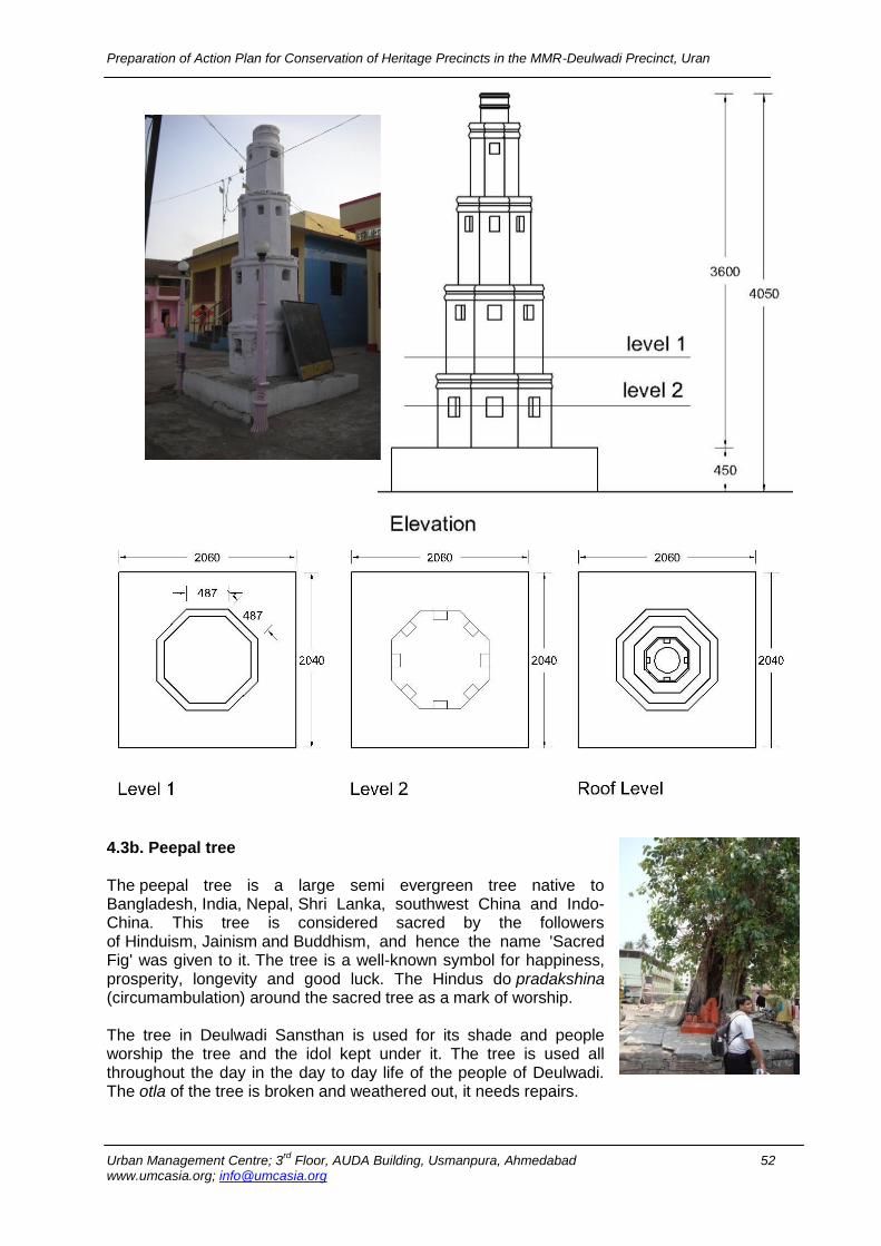
4.3b. Peepal tree The peepal tree is a large semi evergreen tree native to Bangladesh, India, Nepal, Shri Lanka, southwest China and Indo-China. This tree is considered sacred by the followers of Hinduism, Jainism and Buddhism, and hence the name 'Sacred Fig' was given to it. The tree is a well-known symbol for happiness, prosperity, longevity and good luck. The Hindus do pradakshina (circumambulation) around the sacred tree as a mark of worship. The tree in Deulwadi Sansthan is used for its shade and people worship the tree and the idol kept under it. The tree is used all throughout the day in the day to day life of the people of Deulwadi. The otla of the tree is broken and weathered out, it needs repairs.

Preparation of Action Plan for Conservation of Heritage Precincts in the MMR-Deulwadi Precinct, Uran
Urban Management Centre; 3rd
Floor, AUDA Building, Usmanpura, Ahmedabad 53 www.umcasia.org; [email protected]
4.3c. Bargad tree The Banyan tree grows over a large area. The roots then give rise to more trunks and branches. Because of this characteristic & longevity, the Banyan tree is considered immortal & sacred and is an integral part of the myths and legends in India. Even today, the banyan tree is the focal point of village life and the village council meetings under the shade of this huge shade-giving tree. In Hinduism, the banyan tree is considered sacred and is called Vat Vriksha. God Shiva as Dakshinamurthy is nearly always depicted sitting in silence under the banyan with rishis at his feet. It is thought of as perfectly symbolizing eternal life due to its seemingly unending expansion. Also in Hindu culture, the banyan tree is alsocalled kalpavriksha meaning 'wish fulfilling divine tree'. In modern parlance in the Hindi language, it is known as Bargad, Vatavriksh, and Barh. In Buddhism's Pali canon, the banyan (Pali: nigrodha) is
referenced numerous times. Typical metaphors allude to the banyan's epiphytic nature, likening the banyan's supplanting of a host tree as comparable to the way sensual desire (kāma) overcomes humans. The tree in Deulwadi Sansthan is used for its shade and people worship the tree. There are some old religious sculptures kept under the tree. The tree is used all throughout the day in the day to day life of the people of Deulwadi. The otla of the tree is broken and weathered out, it needs repairs. 4.3d. Well In Deulwadi, there is a main well in the Deulwadi Sansthan which is hand dug, and water is drawn by containers, such as buckets, that are raised by hand. Earlier, the water of the well was the primary source of drinking water, however the water is not potable, so it is used for washing only.
4.3e. Dwarpal Dwarpal loosely translated means gatekeeper or protector. Hindu mythology mentions two Dwarpal outside Vishnu’s abode. Lord Ram is considered to be an avatar of Shri Vishnu, hence the Dwarpal on the door of the temple. These are very important markers in the cognitive memory of the people of the area.
Preparation of Action Plan for Conservation of Heritage Precincts in the MMR-Deulwadi Precinct, Uran
Urban Management Centre; 3rd
Floor, AUDA Building, Usmanpura, Ahmedabad 54 www.umcasia.org; [email protected]
4.4 Cultural Practices The presence of tulsi plant symbolizes the religious bent of a Hindu family. A Hindu household is considered incomplete if it doesn't have a tulsi plant in the courtyard. “Tulsi kyara” - many families have the tulsi planted in a specially built structure, which has images of deities installed on all four sides, and an alcove for a small earthen oil lamp. Some households can even have up to a dozen tulsi plants on the verandah or in the garden forming a "tulsi-van" or "tulsivrindavan" - a miniature basil forest. The people in Deulwadi worship tulsi plant. To begin Tulsi Puja, one is required to take a bath. The pot pot where Tulsi is grown is decorated, water is offered to the sacred plant. After this, kumkum is applied on one of its leaf. Some people tie a cloth of red cloth along the stem. Offer red flower to the sacred herb, Tulsi. Offer fruits by placing them near the pot. Light the clay lamp and perform aarti to complete the Tulsi Puja. People usually take a leaf of tulsi after the Puja and put it in their mouth. It is believed by committing such act; they are taking the spirit of goddess inside them. Tulsi Vivah it is considered that the month of Kartik (October-November) is loved by Tulsi. And on a specific day (Kartik Shukla Dwadashi) of this month there is a tradition when Tulsi plants are beautifully decorated with structures made of sugarcane, mango leaves and flowers and then a puja is offered. In Gaudiya Vaishnava communities, it is called the 'Tulsi Vivah' or the wedding day of Tulsi and Shaligram. On the festive occasion of 'Kartik Shukla Dwadashi' that usually falls two weeks after the celebration of Diwali, tulsi plants are adorned with varied artistic things made from sugarcane, flowers and mango leaves. After decorating Tulsi Vrindavana, people offer prayers to Tulsi. Clay lamps are lit all around the tulsi plant. The event is usually celebrated as tulsi vivah, in which tulsi is married to Lord Vishnu.
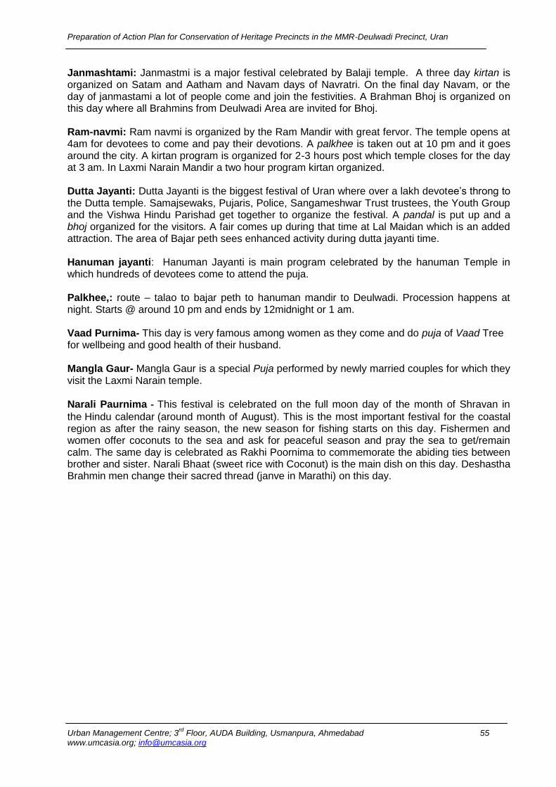
Preparation of Action Plan for Conservation of Heritage Precincts in the MMR-Deulwadi Precinct, Uran
Urban Management Centre; 3rd
Floor, AUDA Building, Usmanpura, Ahmedabad 55 www.umcasia.org; [email protected]
Janmashtami: Janmastmi is a major festival celebrated by Balaji temple. A three day kirtan is organized on Satam and Aatham and Navam days of Navratri. On the final day Navam, or the day of janmastami a lot of people come and join the festivities. A Brahman Bhoj is organized on this day where all Brahmins from Deulwadi Area are invited for Bhoj. Ram-navmi: Ram navmi is organized by the Ram Mandir with great fervor. The temple opens at 4am for devotees to come and pay their devotions. A palkhee is taken out at 10 pm and it goes around the city. A kirtan program is organized for 2-3 hours post which temple closes for the day at 3 am. In Laxmi Narain Mandir a two hour program kirtan organized. Dutta Jayanti: Dutta Jayanti is the biggest festival of Uran where over a lakh devotee’s throng to the Dutta temple. Samajsewaks, Pujaris, Police, Sangameshwar Trust trustees, the Youth Group and the Vishwa Hindu Parishad get together to organize the festival. A pandal is put up and a bhoj organized for the visitors. A fair comes up during that time at Lal Maidan which is an added attraction. The area of Bajar peth sees enhanced activity during dutta jayanti time. Hanuman jayanti: Hanuman Jayanti is main program celebrated by the hanuman Temple in which hundreds of devotees come to attend the puja. Palkhee,: route – talao to bajar peth to hanuman mandir to Deulwadi. Procession happens at night. Starts @ around 10 pm and ends by 12midnight or 1 am. Vaad Purnima- This day is very famous among women as they come and do puja of Vaad Tree for wellbeing and good health of their husband. Mangla Gaur- Mangla Gaur is a special Puja performed by newly married couples for which they visit the Laxmi Narain temple. Narali Paurnima - This festival is celebrated on the full moon day of the month of Shravan in
the Hindu calendar (around month of August). This is the most important festival for the coastal region as after the rainy season, the new season for fishing starts on this day. Fishermen and women offer coconuts to the sea and ask for peaceful season and pray the sea to get/remain calm. The same day is celebrated as Rakhi Poornima to commemorate the abiding ties between brother and sister. Narali Bhaat (sweet rice with Coconut) is the main dish on this day. Deshastha Brahmin men change their sacred thread (janve in Marathi) on this day.
Preparation of Action Plan for Conservation of Heritage Precincts in the MMR-Deulwadi Precinct, Uran
Urban Management Centre; 3rd
Floor, AUDA Building, Usmanpura, Ahmedabad 56 www.umcasia.org; [email protected]
Chapter 5 Architecture Details of Special Buildings (a) Vitthal Mandir Design: Vitthal temple was built in 1850. Rectangular plan consists of two major space; Hall and Garbhgriha. Vitthal Mandir is the one of the string of temples in Deulwadi sansthan. Temple has a Deepstambha; significant cultural elements for their festivities. Plinth and walls: The plinth of the structure is raised on black basalt stone. The walls are made with stone and surfaces plastered with lime. Entrance: The entrance of the temple is made out of wooden frames with inserted MS grills in vernacular styles. Dome: The dome of Garbhgriha is built on an octagonal elevated drum. The dome is semicircular in shape with decorative leaves; this local design expresses local craftsmanship. The Core material of dome is built with stones and outer surface finished with cement plaster Roof: Roof is made up of wooden rafters and covered with Mangalore tiles Finishes: Interior surfaces painted with plastic paints and exterior temple paint with cement paint Door window: Wooden double shuttered door and wooden framed M.S grilled window Condition: Condition of temple is fair, inside hall plaster has deteriorated by seepage. Walls have darkened due to water seepage coming from roof
View of Garbh-griha Dome Building setting
Stone plinth
Elevated drummed dome Vernacular wooden screen
Internal Dome finish Wooden rafters and ridge beam
Seepage on wall
Preparation of Action Plan for Conservation of Heritage Precincts in the MMR-Deulwadi Precinct, Uran
Urban Management Centre; 3rd
Floor, AUDA Building, Usmanpura, Ahmedabad 57 www.umcasia.org; [email protected]
(b) Sangmeshwar Mahadev Mandir:
Design and its setting: Sangmeshwar Mahadev Mandir was built in 1860 and modified in 1986.. The plan form of front Hall is rectangular with R.C.C frame structure. Plan form: The plan of front hall is rectangular in form with R.C.C frame structure. Girbhgriha has a square plan with solid walls. It is a single storied structure. Plinth and walls: The temple structure is built on a stone carved plinth. Primarily core material used is stones for Girbhgriha and bricks with cement plaster for outer hall Flooring and wall finishes: White marble used for flooring and walls with tile cladding. Outer wall of hall is plastered in cement and coated with cement paint. Roof: Flat slab made with R.C.C. stone has been used for the core material of Dome. Dome: Semicircular in shape. Dome of the temple sits on an octagonal elevated drum surrounded by small carved decorative pillars. Entrance: Doorway of Garbhgriha is framed with carved spend rail and chain. Colour: There is a a unique colour combination of natural Geru and dark blue. Elevation of temple is painted with cement based paint. Condition: Condition of structure is good. Later additions like tiles on inside wall and oil paints color and additions like electrical wires on Garbhgriha entrance has deteriorated its aesthetic value.
View of Urnavati devi temple
Decorative stone plinth
Entrance of Girbhgriha
R.C.C roof
Elevated drum dome Entrance of Girbhgriha temple
Colour of Temple
Preparation of Action Plan for Conservation of Heritage Precincts in the MMR-Deulwadi Precinct, Uran
Urban Management Centre; 3rd
Floor, AUDA Building, Usmanpura, Ahmedabad 58 www.umcasia.org; [email protected]
(c) Uranavati Devi temple:
Design and setting: Urnavati devi temple was built in
1860 and modified in 2002. The temple is located on
Deulwadi sansthan chowk. This temple is a rectangular
in plan and spaces are divided in two parts- Hall and
Garbhgriha.
Plinth and wall: Temple plinth is made up of stone and
the upper structure is built up with cement and brick wall.
The structure is built up in circular series of column.
Flooring and finishes: Kota stone and marble has been
used for flooring material. Front yard otla is made up of
P.C.C. Garbhgriha wall has tile cladding and surface
plastered with cement. Inner surface of Garbhgriha is
coloured with oil paints and outer façade with cement
based paint.
Roof: R.C.C slab on Hall is supported on column and
beam
Dome: the dome sits on square elevated drum. Brick and
stone is used as core material for dome structure.
Entrance: There is a small portico framing entrance
space which is utilized as resting place before entering
into the temple; stylistic feature of konkan architecture.
Door window: metal windows
Condition: Condition of temple is good, Newly renovated
in 2002
Wall and R.C.C column
Skeleton of the Structure
Portico
Side view of Dome

Preparation of Action Plan for Conservation of Heritage Precincts in the MMR-Deulwadi Precinct, Uran
Urban Management Centre; 3rd
Floor, AUDA Building, Usmanpura, Ahmedabad 59 www.umcasia.org; [email protected]
(D) Vitthal Rukmani temple:
Design and setting: The building was built in 1900
It has retained its original form and structure. The
buildings consists of rectangular plan form and space
divided into three parts; a hall, Garbhgriha and two
rooms for priest. It depicts a unique composition made of
various materials giving an evidence of very skillful
craftsman.
Plinth and walls: temple sits on a stone plinth and walls
are made of bricks and plastered with cement
Roofing system: There is a four way sloping roof made
with basic wood. Wooden ridge beams and rafters run
through the structure and transfer the load to ground.
Structure is covered with Mangalore tiles.
Wooden columns and brackets are in front supporting
overhanging structure.
Flooring and finishes: - Basic material of wood has been
used for upper floor and stone is used for ground floor
with rough finishes on surface. Outer surface on east and
west facing walls are plastered with cement.
Column and beam: all wooden columns are based on
carved pyramidical stone pedestal. Wooden beams and
rafters connect through small bracket called ‘Sharu and
bharot.’
Wooden joinery: Tongue and groove joinery is used to
join beams with columns and are finally overlapped with
rafters. Wooden trusses are also joined with Tongue and
groove joinery.
Temple front façade with it setting
Stone plinth Stone plinth
Overhanging roof with wooden joints
Wooden slab supported on beams and column
Wooden front screen with decorative MS grill
Stone flooring
Wooden bharot and Sharu
detail provinding structural
support to wooden slab
Stone pedestal
Preparation of Action Plan for Conservation of Heritage Precincts in the MMR-Deulwadi Precinct, Uran
Urban Management Centre; 3rd
Floor, AUDA Building, Usmanpura, Ahmedabad 60 www.umcasia.org; [email protected]
Entrance: The front façade of temple structure has
wooden carved columns with carved brackets holding
overhanging roof and wooden framed MS grilled jali that
depicts the vernacular architecture. The lower part of the
front screen is made out of cast iron designed grilled.
Doors and windows: Double shuttered wooden doors
and window framed with 6 x 8cm thick wooden members
and M.S jali inserted into frame.
Condition: structural stability is quite good,
Later additions like cement plastering, electrical conduits
on wall, deteriorating originality of stone and wood
structure.
Seepage can be seen at rear side of wall. Surface cracks
have developed in inside hall window. Flaking of cement
plaster on plinth.
Vernacular character of the facade
Double shuttered wooden door and window
Plaster crack on interior surface
Bad use of cement plaster
External wooden wiring running on carved wooden member
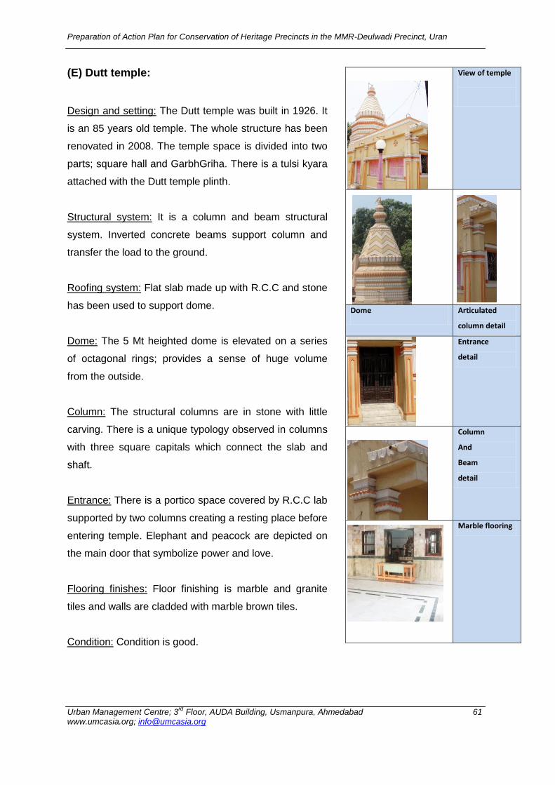
Preparation of Action Plan for Conservation of Heritage Precincts in the MMR-Deulwadi Precinct, Uran
Urban Management Centre; 3rd
Floor, AUDA Building, Usmanpura, Ahmedabad 61 www.umcasia.org; [email protected]
(E) Dutt temple:
Design and setting: The Dutt temple was built in 1926. It
is an 85 years old temple. The whole structure has been
renovated in 2008. The temple space is divided into two
parts; square hall and GarbhGriha. There is a tulsi kyara
attached with the Dutt temple plinth.
Structural system: It is a column and beam structural
system. Inverted concrete beams support column and
transfer the load to the ground.
Roofing system: Flat slab made up with R.C.C and stone
has been used to support dome.
Dome: The 5 Mt heighted dome is elevated on a series
of octagonal rings; provides a sense of huge volume
from the outside.
Column: The structural columns are in stone with little
carving. There is a unique typology observed in columns
with three square capitals which connect the slab and
shaft.
Entrance: There is a portico space covered by R.C.C lab
supported by two columns creating a resting place before
entering temple. Elephant and peacock are depicted on
the main door that symbolize power and love.
Flooring finishes: Floor finishing is marble and granite
tiles and walls are cladded with marble brown tiles.
Condition: Condition is good.
View of temple
Dome Articulated
column detail
Entrance
detail
Column
And
Beam
detail
Marble flooring
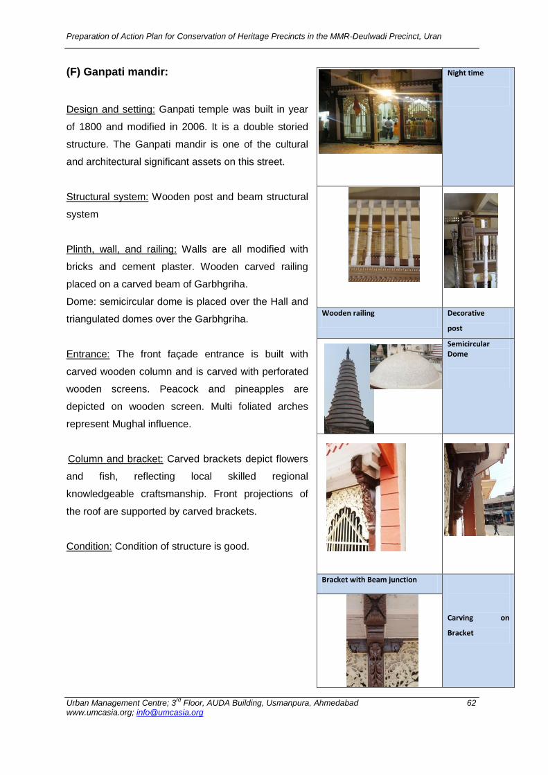
Preparation of Action Plan for Conservation of Heritage Precincts in the MMR-Deulwadi Precinct, Uran
Urban Management Centre; 3rd
Floor, AUDA Building, Usmanpura, Ahmedabad 62 www.umcasia.org; [email protected]
(F) Ganpati mandir:
Design and setting: Ganpati temple was built in year
of 1800 and modified in 2006. It is a double storied
structure. The Ganpati mandir is one of the cultural
and architectural significant assets on this street.
Structural system: Wooden post and beam structural
system
Plinth, wall, and railing: Walls are all modified with
bricks and cement plaster. Wooden carved railing
placed on a carved beam of Garbhgriha.
Dome: semicircular dome is placed over the Hall and
triangulated domes over the Garbhgriha.
Entrance: The front façade entrance is built with
carved wooden column and is carved with perforated
wooden screens. Peacock and pineapples are
depicted on wooden screen. Multi foliated arches
represent Mughal influence.
Column and bracket: Carved brackets depict flowers
and fish, reflecting local skilled regional
knowledgeable craftsmanship. Front projections of
the roof are supported by carved brackets.
Condition: Condition of structure is good.
Night time
Wooden railing Decorative
post
Semicircular Dome
Bracket with Beam junction
Carving on
Bracket

Preparation of Action Plan for Conservation of Heritage Precincts in the MMR-Deulwadi Precinct, Uran
Urban Management Centre; 3rd
Floor, AUDA Building, Usmanpura, Ahmedabad 63 www.umcasia.org; [email protected]
(G) Ram mandir:
Design: Ram mandir was built in 1910. It is one of the
unique Haveli temples. The typology of temple comprises
of a central courtyard with rooms all around used as
residences.
Structural system: The ground floor has wooden
columns supporting overhanging balconies on the upper
floor. The basic structural system is beam and post and
are made of brick, wood and stone. Part of upper floor is
supported by triangulated trusses giving support to
horizontal secondary beam
Roofing system: it’s a two way triangulated slopping roof
covered with Mangalore tiles. Overhanging slopping roof
is supported by columns and brackets protecting direct
rain and sunlight coming to balcony
Plinth and wall: plinth is originally on stones; Brick and
lime plaster has been used as core material for walls and
the skeleton is independent structure built in wood.
Courtyard: Courtyard typology is climatically responsive
architectural asset in Indian architecture. Courtyard is
surrounded by residential quarters and supports
interaction between various families and gives secure
open space where women can work freely. Wooden
framed M.S grills with simple railing reflects vernacular
features of articulation.
Central courtyard
Wooden Structural member Junction
Wooden rafters and beam joints
Mangalore Tiled roof
Stone plinth Brick Wall
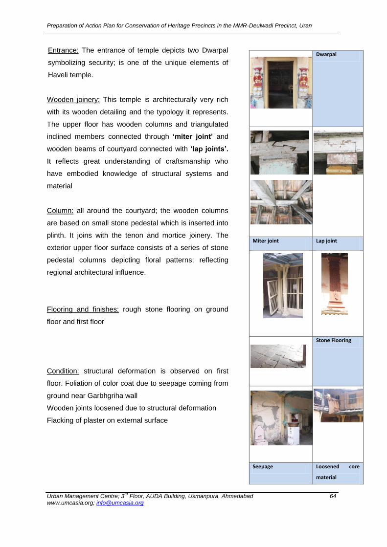
Preparation of Action Plan for Conservation of Heritage Precincts in the MMR-Deulwadi Precinct, Uran
Urban Management Centre; 3rd
Floor, AUDA Building, Usmanpura, Ahmedabad 64 www.umcasia.org; [email protected]
Entrance: The entrance of temple depicts two Dwarpal
symbolizing security; is one of the unique elements of
Haveli temple.
Wooden joinery: This temple is architecturally very rich
with its wooden detailing and the typology it represents.
The upper floor has wooden columns and triangulated
inclined members connected through ‘miter joint’ and
wooden beams of courtyard connected with ‘lap joints’.
It reflects great understanding of craftsmanship who
have embodied knowledge of structural systems and
material
Column: all around the courtyard; the wooden columns
are based on small stone pedestal which is inserted into
plinth. It joins with the tenon and mortice joinery. The
exterior upper floor surface consists of a series of stone
pedestal columns depicting floral patterns; reflecting
regional architectural influence.
Flooring and finishes: rough stone flooring on ground
floor and first floor
Condition: structural deformation is observed on first
floor. Foliation of color coat due to seepage coming from
ground near Garbhgriha wall
Wooden joints loosened due to structural deformation
Flacking of plaster on external surface
Dwarpal
Miter joint Lap joint
Stone Flooring
Seepage Loosened core
material

Preparation of Action Plan for Conservation of Heritage Precincts in the MMR-Deulwadi Precinct, Uran
Urban Management Centre; 3rd
Floor, AUDA Building, Usmanpura, Ahmedabad 65 www.umcasia.org; [email protected]
(H) Dispensary:
Design: The dispensary building was built in 1910 under
the British period. Building is longitudinal in plan with six
rooms and a large verandah attached with front yard. It is
a single storied building with sloping roof.
Structural system: It is a load bearing structure built of
dressed stones. There are some elements such as lap
joined corner wall, no vertical joints, arch system used to
protect from structural failure during earthquake.
Roofing system: Two ways sloping wooden rafters and
trussed roof covered with Mangalore tiles.
Construction system: Building consists of fine
semicircular and segmental arches built in stone with
intricate details of wooden joineries. Stone segmental
and semicircular arches with overlapping joinery at
corner junctions represent good construction techniques
of British era. Black basalt dressed stone with neat ‘C’
pointing on surface.
Plinths and wall: Plinth and walls originally built in stones
Floors and finishes: corridor consists of IPS flooring with
yellow, green and red colour.
Doors and window: Wooden double shuttered door with
M.S grills and glass inserted with frames
Explored articulation towards cast iron and M.S design
with some geometric patterns
Condition: condition of structure is good
Flacking plaster from inside room wall
View of Structure
Corner junction
Semicircular
stone arch
Basalt Plinth
Stained glass window Foliation of
Lime Plaster
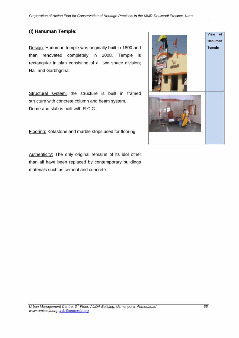
Preparation of Action Plan for Conservation of Heritage Precincts in the MMR-Deulwadi Precinct, Uran
Urban Management Centre; 3rd
Floor, AUDA Building, Usmanpura, Ahmedabad 66 www.umcasia.org; [email protected]
(I) Hanuman Temple:
Design: Hanuman temple was originally built in 1800 and
than renovated completely in 2008. Temple is
rectangular in plan consisting of a two space division;
Hall and Garbhgriha.
Structural system: the structure is built in framed
structure with concrete column and beam system.
Dome and slab is built with R.C.C
Flooring: Kotastone and marble strips used for flooring
Authenticity: The only original remains of its idol other
than all have been replaced by contemporary buildings
materials such as cement and concrete.
View of
Hanuman
Temple
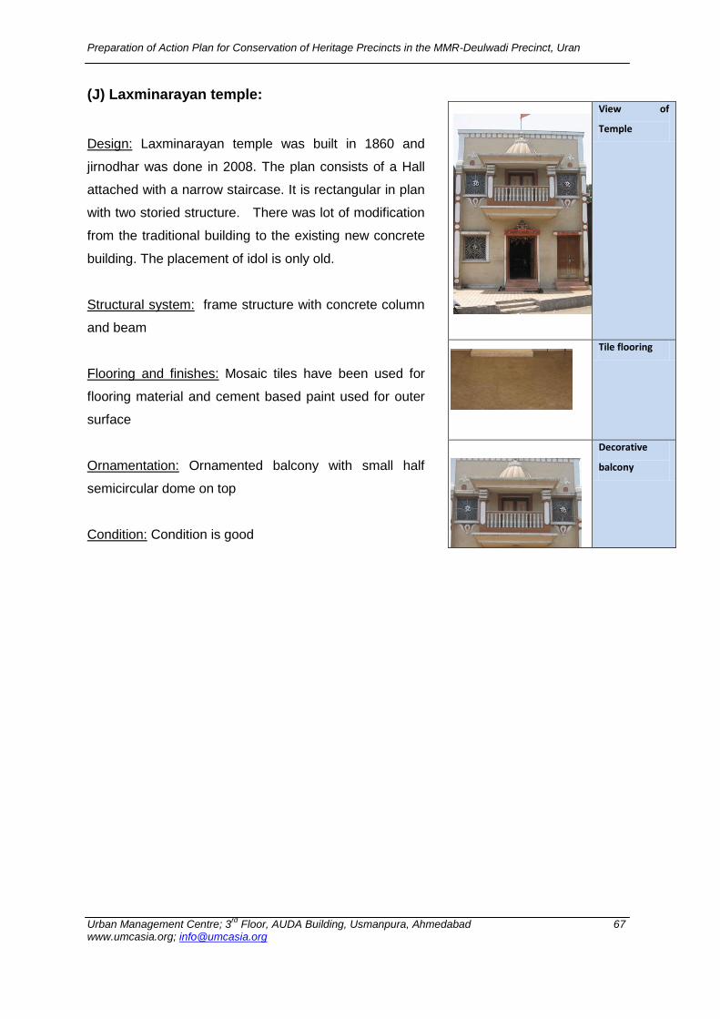
Preparation of Action Plan for Conservation of Heritage Precincts in the MMR-Deulwadi Precinct, Uran
Urban Management Centre; 3rd
Floor, AUDA Building, Usmanpura, Ahmedabad 67 www.umcasia.org; [email protected]
(J) Laxminarayan temple:
Design: Laxminarayan temple was built in 1860 and
jirnodhar was done in 2008. The plan consists of a Hall
attached with a narrow staircase. It is rectangular in plan
with two storied structure. There was lot of modification
from the traditional building to the existing new concrete
building. The placement of idol is only old.
Structural system: frame structure with concrete column
and beam
Flooring and finishes: Mosaic tiles have been used for
flooring material and cement based paint used for outer
surface
Ornamentation: Ornamented balcony with small half
semicircular dome on top
Condition: Condition is good
View of
Temple
Tile flooring
Decorative
balcony
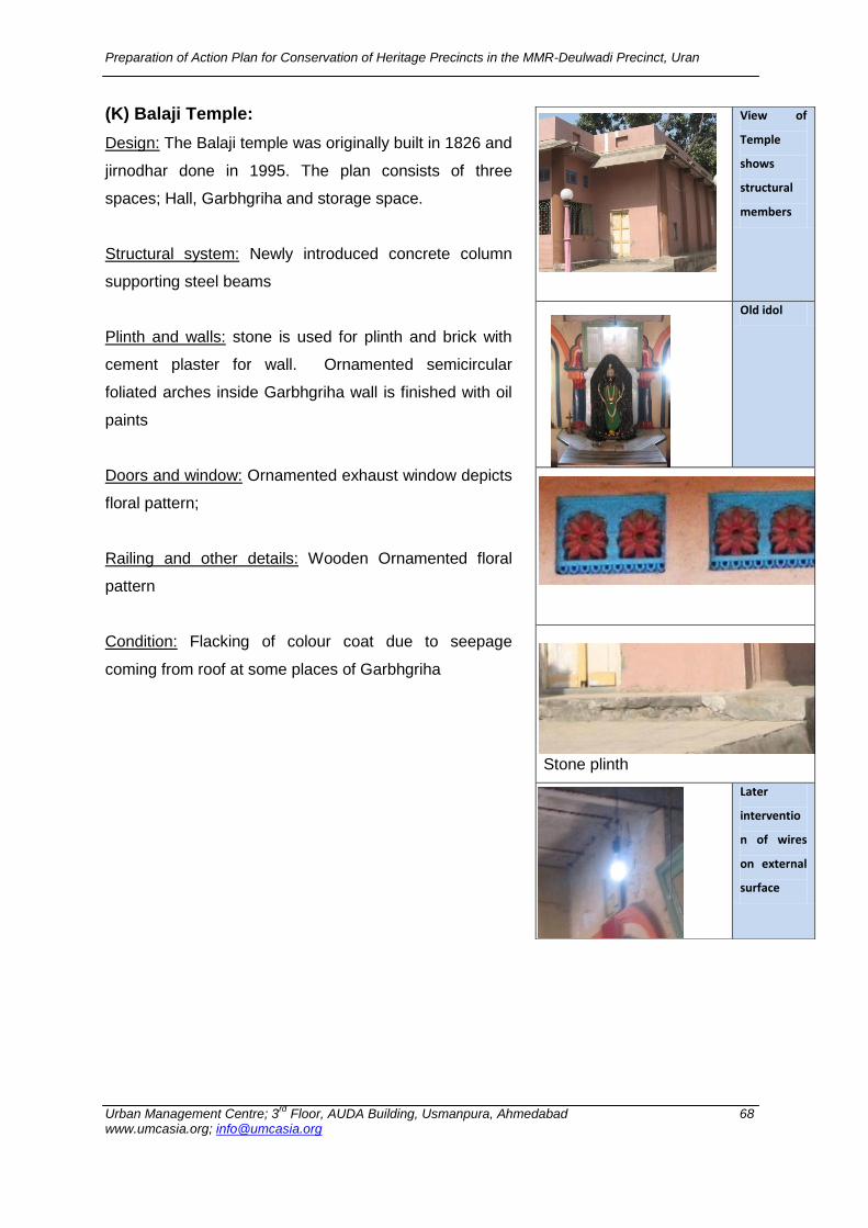
Preparation of Action Plan for Conservation of Heritage Precincts in the MMR-Deulwadi Precinct, Uran
Urban Management Centre; 3rd
Floor, AUDA Building, Usmanpura, Ahmedabad 68 www.umcasia.org; [email protected]
(K) Balaji Temple:
Design: The Balaji temple was originally built in 1826 and
jirnodhar done in 1995. The plan consists of three
spaces; Hall, Garbhgriha and storage space.
Structural system: Newly introduced concrete column
supporting steel beams
Plinth and walls: stone is used for plinth and brick with
cement plaster for wall. Ornamented semicircular
foliated arches inside Garbhgriha wall is finished with oil
paints
Doors and window: Ornamented exhaust window depicts
floral pattern;
Railing and other details: Wooden Ornamented floral
pattern
Condition: Flacking of colour coat due to seepage
coming from roof at some places of Garbhgriha
View of
Temple
shows
structural
members
Old idol
Stone plinth
Later
interventio
n of wires
on external
surface
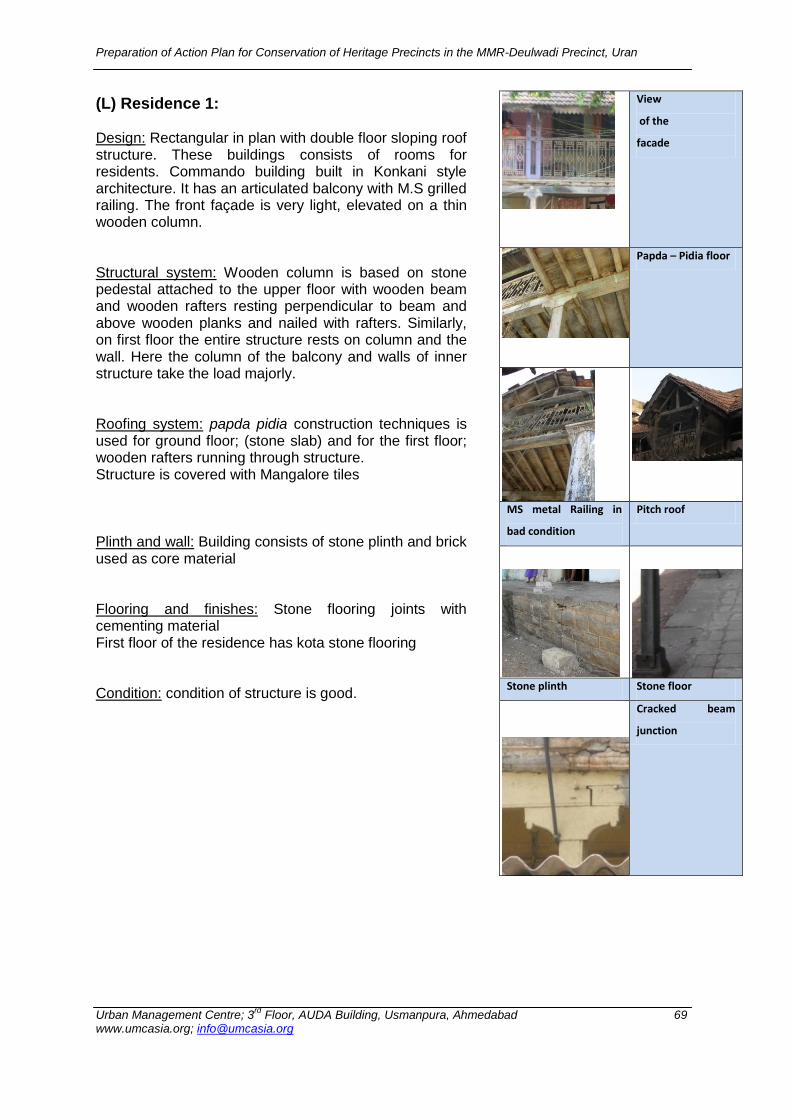
Preparation of Action Plan for Conservation of Heritage Precincts in the MMR-Deulwadi Precinct, Uran
Urban Management Centre; 3rd
Floor, AUDA Building, Usmanpura, Ahmedabad 69 www.umcasia.org; [email protected]
(L) Residence 1: Design: Rectangular in plan with double floor sloping roof structure. These buildings consists of rooms for residents. Commando building built in Konkani style architecture. It has an articulated balcony with M.S grilled railing. The front façade is very light, elevated on a thin wooden column. Structural system: Wooden column is based on stone pedestal attached to the upper floor with wooden beam and wooden rafters resting perpendicular to beam and above wooden planks and nailed with rafters. Similarly, on first floor the entire structure rests on column and the wall. Here the column of the balcony and walls of inner structure take the load majorly. Roofing system: papda pidia construction techniques is used for ground floor; (stone slab) and for the first floor; wooden rafters running through structure. Structure is covered with Mangalore tiles Plinth and wall: Building consists of stone plinth and brick used as core material Flooring and finishes: Stone flooring joints with cementing material First floor of the residence has kota stone flooring Condition: condition of structure is good.
View
of the
facade
Papda – Pidia floor
MS metal Railing in
bad condition
Pitch roof
Stone plinth Stone floor
Cracked beam
junction
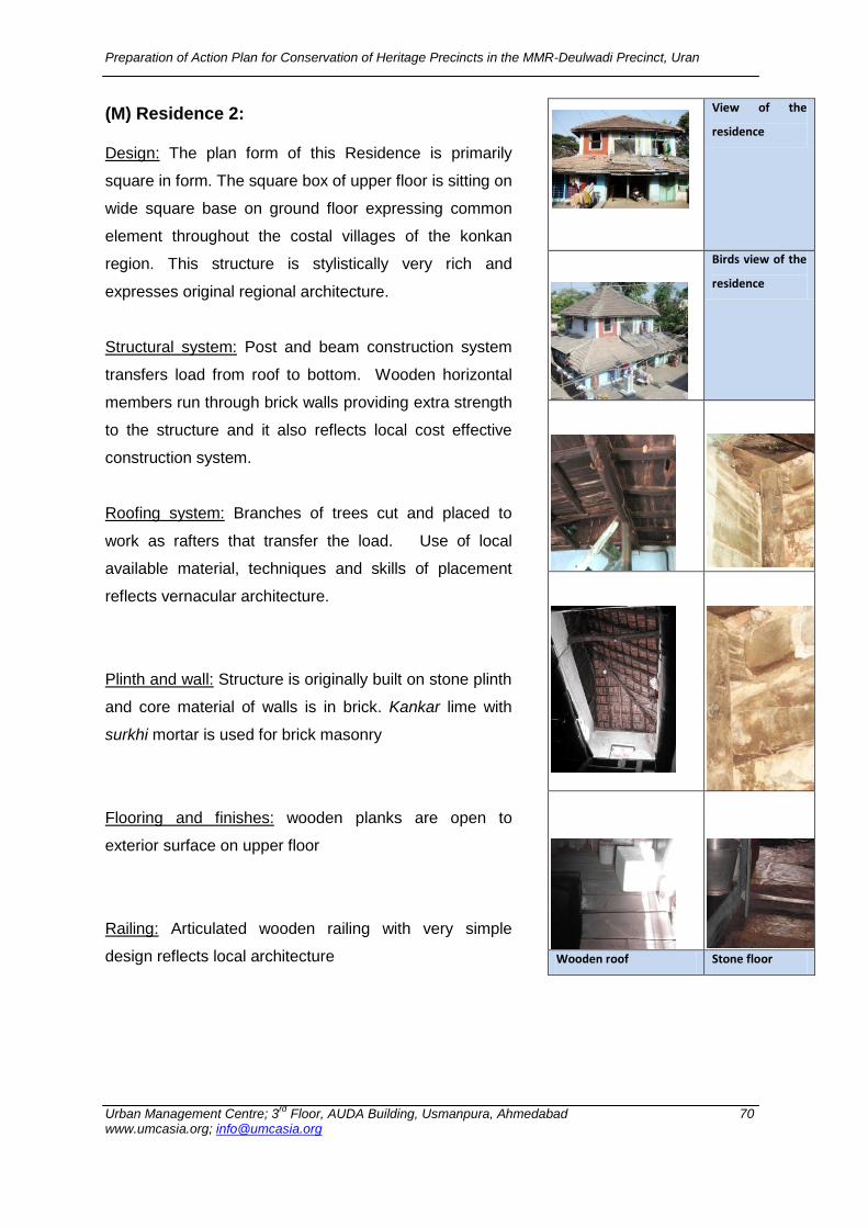
Preparation of Action Plan for Conservation of Heritage Precincts in the MMR-Deulwadi Precinct, Uran
Urban Management Centre; 3rd
Floor, AUDA Building, Usmanpura, Ahmedabad 70 www.umcasia.org; [email protected]
(M) Residence 2: Design: The plan form of this Residence is primarily
square in form. The square box of upper floor is sitting on
wide square base on ground floor expressing common
element throughout the costal villages of the konkan
region. This structure is stylistically very rich and
expresses original regional architecture.
Structural system: Post and beam construction system
transfers load from roof to bottom. Wooden horizontal
members run through brick walls providing extra strength
to the structure and it also reflects local cost effective
construction system.
Roofing system: Branches of trees cut and placed to
work as rafters that transfer the load. Use of local
available material, techniques and skills of placement
reflects vernacular architecture.
Plinth and wall: Structure is originally built on stone plinth
and core material of walls is in brick. Kankar lime with
surkhi mortar is used for brick masonry
Flooring and finishes: wooden planks are open to
exterior surface on upper floor
Railing: Articulated wooden railing with very simple
design reflects local architecture
View of the
residence
Birds view of the
residence
Wooden roof Stone floor

Preparation of Action Plan for Conservation of Heritage Precincts in the MMR-Deulwadi Precinct, Uran
Urban Management Centre; 3rd
Floor, AUDA Building, Usmanpura, Ahmedabad 71 www.umcasia.org; [email protected]
(N) Residence 3:
Design: The plan form of this Residence is primarily in
rectangular form. The square box of upper floor is sitting
on wide base on ground floor expressing common
element throughout the coastal villages of the konkan
region. This structure stylistically expresses the original
regional architecture.
Structural system: Post and beam construction system
transferring load from roof to ground. The building
stands on simple rectangular column grid and upper floor
is built typically.
Roofing system: Branches of trees cut and placed to
work as rafters transferring the load. Use of local
available material, techniques and skills of placement
reflects vernacular architecture. The roof of this house is
covered with traditional Mangalore tiles supported on
wooden rafters
Plinth and wall: Structure is originally built on stone plinth
and core material of walls is in brick. The structure was
originally plastered with lime mortar but later was
renovated with cement plaster.
Flooring and finishes: the rooms are floored in tiles and
outer plinth plastered with cement. The walls are
plastered in cement. The outer façade is finished with
cement paint and inner walls are finished in plastic paint.
Condition: condition of building is fair
Exfoliation of paint from outer surfaces due to heat is
visible, Roofing material deteriored due to water seepage
from roof
View of the
Residence
expressing regional
style
Wooden rafter Roof covered
with manglore
tiles
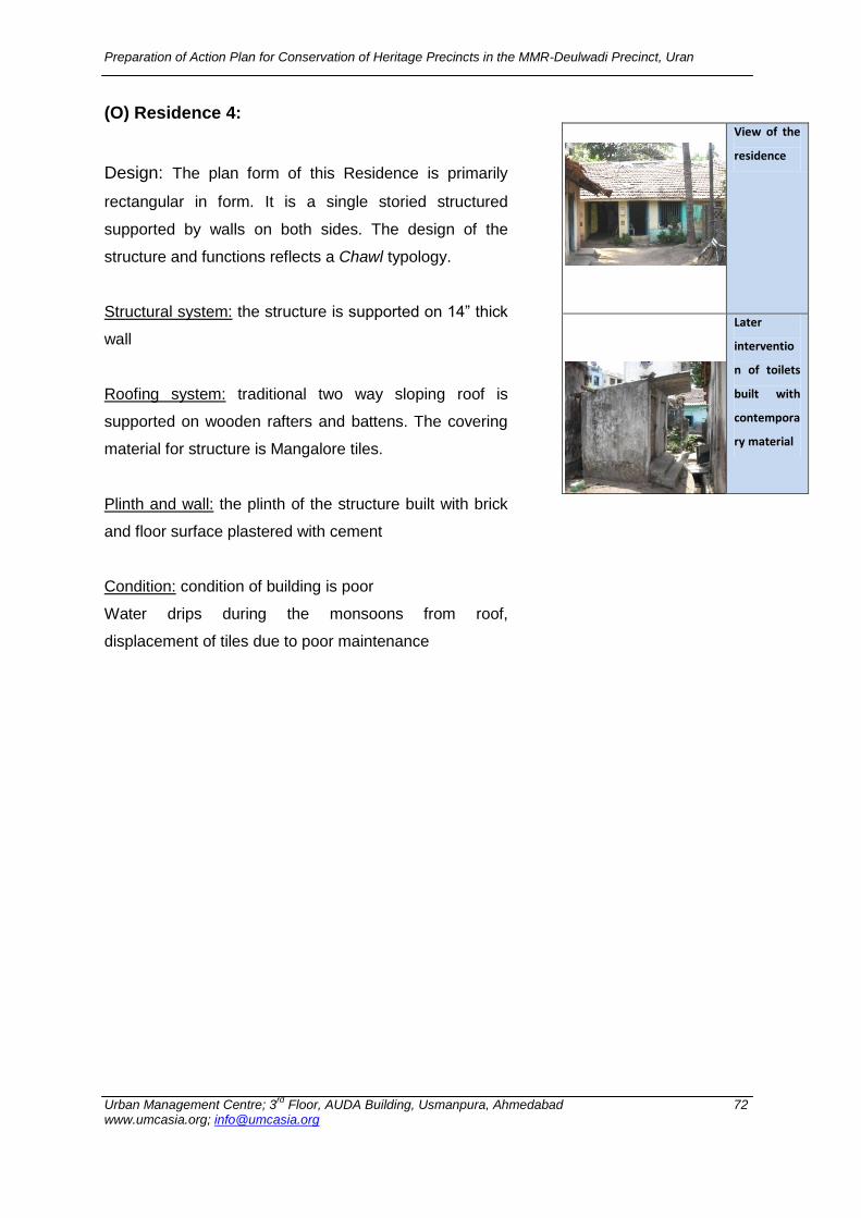
Preparation of Action Plan for Conservation of Heritage Precincts in the MMR-Deulwadi Precinct, Uran
Urban Management Centre; 3rd
Floor, AUDA Building, Usmanpura, Ahmedabad 72 www.umcasia.org; [email protected]
(O) Residence 4:
Design: The plan form of this Residence is primarily
rectangular in form. It is a single storied structured
supported by walls on both sides. The design of the
structure and functions reflects a Chawl typology.
Structural system: the structure is supported on 14” thick
wall
Roofing system: traditional two way sloping roof is
supported on wooden rafters and battens. The covering
material for structure is Mangalore tiles.
Plinth and wall: the plinth of the structure built with brick
and floor surface plastered with cement
Condition: condition of building is poor
Water drips during the monsoons from roof,
displacement of tiles due to poor maintenance
View of the
residence
Later
interventio
n of toilets
built with
contempora
ry material
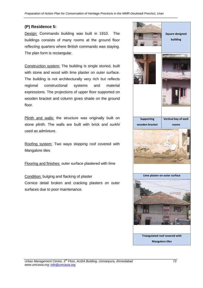
Preparation of Action Plan for Conservation of Heritage Precincts in the MMR-Deulwadi Precinct, Uran
Urban Management Centre; 3rd
Floor, AUDA Building, Usmanpura, Ahmedabad 73 www.umcasia.org; [email protected]
(P) Residence 5:
Design: Commando building was built in 1910. The
buildings consists of many rooms at the ground floor
reflecting quarters where British commando was staying.
The plan form is rectangular.
Construction system: The building is single storied, built
with stone and wood with lime plaster on outer surface.
The building is not architecturally very rich but reflects
regional constructional systems and material
expressions. The projections of upper floor supported on
wooden bracket and column gives shade on the ground
floor.
Plinth and walls: the structure was originally built on
stone plinth. The walls are built with brick and surkhi
used as admixture.
Roofing system: Two ways slopping roof covered with
Mangalore tiles
Flooring and finishes: outer surface plastered with lime
Condition: bulging and flacking of plaster
Cornice detail broken and cracking plasters on outer
surfaces due to poor maintenance.
Square designed
building
Supporting
wooden bracket
Vertical bay of each
rooms
Lime plaster on outer surface
Triangulated roof covered with
Mangalore tiles
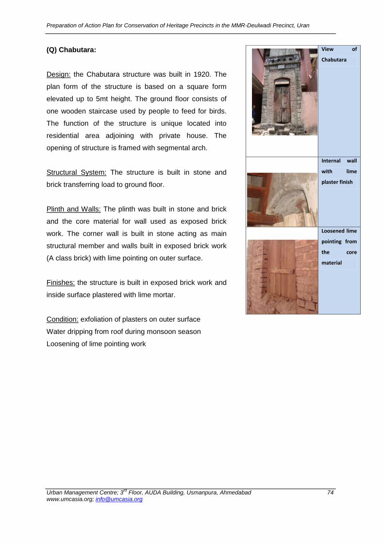
Preparation of Action Plan for Conservation of Heritage Precincts in the MMR-Deulwadi Precinct, Uran
Urban Management Centre; 3rd
Floor, AUDA Building, Usmanpura, Ahmedabad 74 www.umcasia.org; [email protected]
(Q) Chabutara:
Design: the Chabutara structure was built in 1920. The
plan form of the structure is based on a square form
elevated up to 5mt height. The ground floor consists of
one wooden staircase used by people to feed for birds.
The function of the structure is unique located into
residential area adjoining with private house. The
opening of structure is framed with segmental arch.
Structural System: The structure is built in stone and
brick transferring load to ground floor.
Plinth and Walls: The plinth was built in stone and brick
and the core material for wall used as exposed brick
work. The corner wall is built in stone acting as main
structural member and walls built in exposed brick work
(A class brick) with lime pointing on outer surface.
Finishes: the structure is built in exposed brick work and
inside surface plastered with lime mortar.
Condition: exfoliation of plasters on outer surface
Water dripping from roof during monsoon season
Loosening of lime pointing work
View of
Chabutara
Internal wall
with lime
plaster finish
Loosened lime
pointing from
the core
material
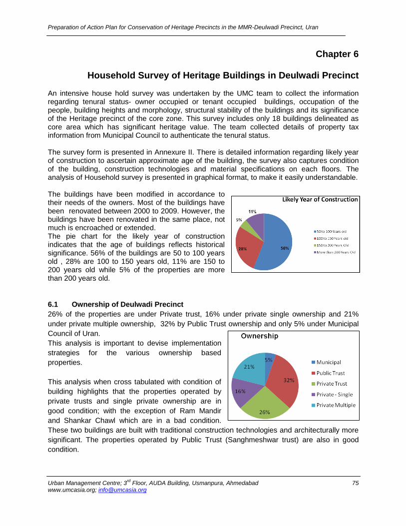
Preparation of Action Plan for Conservation of Heritage Precincts in the MMR-Deulwadi Precinct, Uran
Urban Management Centre; 3rd
Floor, AUDA Building, Usmanpura, Ahmedabad 75 www.umcasia.org; [email protected]
Chapter 6
Household Survey of Heritage Buildings in Deulwadi Precinct An intensive house hold survey was undertaken by the UMC team to collect the information regarding tenural status- owner occupied or tenant occupied buildings, occupation of the people, building heights and morphology, structural stability of the buildings and its significance of the Heritage precinct of the core zone. This survey includes only 18 buildings delineated as core area which has significant heritage value. The team collected details of property tax information from Municipal Council to authenticate the tenural status. The survey form is presented in Annexure II. There is detailed information regarding likely year of construction to ascertain approximate age of the building, the survey also captures condition of the building, construction technologies and material specifications on each floors. The analysis of Household survey is presented in graphical format, to make it easily understandable. The buildings have been modified in accordance to their needs of the owners. Most of the buildings have been renovated between 2000 to 2009. However, the buildings have been renovated in the same place, not much is encroached or extended. The pie chart for the likely year of construction indicates that the age of buildings reflects historical significance. 56% of the buildings are 50 to 100 years old , 28% are 100 to 150 years old, 11% are 150 to 200 years old while 5% of the properties are more than 200 years old. 6.1 Ownership of Deulwadi Precinct
26% of the properties are under Private trust, 16% under private single ownership and 21%
under private multiple ownership, 32% by Public Trust ownership and only 5% under Municipal
Council of Uran.
This analysis is important to devise implementation
strategies for the various ownership based
properties.
This analysis when cross tabulated with condition of
building highlights that the properties operated by
private trusts and single private ownership are in
good condition; with the exception of Ram Mandir
and Shankar Chawl which are in a bad condition.
These two buildings are built with traditional construction technologies and architecturally more
significant. The properties operated by Public Trust (Sanghmeshwar trust) are also in good
condition.
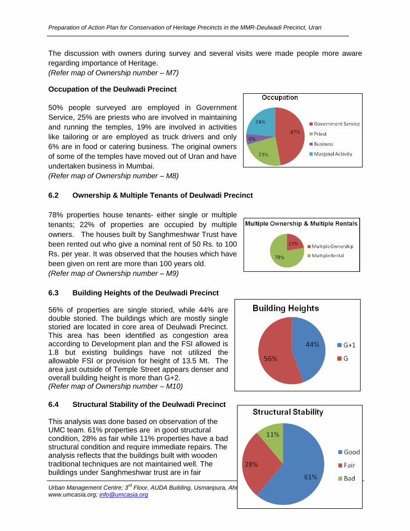
Preparation of Action Plan for Conservation of Heritage Precincts in the MMR-Deulwadi Precinct, Uran
Urban Management Centre; 3rd
Floor, AUDA Building, Usmanpura, Ahmedabad 76 www.umcasia.org; [email protected]
The discussion with owners during survey and several visits were made people more aware
regarding importance of Heritage.
(Refer map of Ownership number – M7)
Occupation of the Deulwadi Precinct
50% people surveyed are employed in Government
Service, 25% are priests who are involved in maintaining
and running the temples, 19% are involved in activities
like tailoring or are employed as truck drivers and only
6% are in food or catering business. The original owners
of some of the temples have moved out of Uran and have
undertaken business in Mumbai.
(Refer map of Ownership number – M8)
6.2 Ownership & Multiple Tenants of Deulwadi Precinct
78% properties house tenants- either single or multiple
tenants; 22% of properties are occupied by multiple
owners. The houses built by Sanghmeshwar Trust have
been rented out who give a nominal rent of 50 Rs. to 100
Rs. per year. It was observed that the houses which have
been given on rent are more than 100 years old.
(Refer map of Ownership number – M9)
6.3 Building Heights of the Deulwadi Precinct 56% of properties are single storied, while 44% are double storied. The buildings which are mostly single storied are located in core area of Deulwadi Precinct. This area has been identified as congestion area according to Development plan and the FSI allowed is 1.8 but existing buildings have not utilized the allowable FSI or provision for height of 13.5 Mt. The area just outside of Temple Street appears denser and overall building height is more than G+2. (Refer map of Ownership number – M10)
6.4 Structural Stability of the Deulwadi Precinct This analysis was done based on observation of the UMC team. 61% properties are in good structural condition, 28% as fair while 11% properties have a bad structural condition and require immediate repairs. The analysis reflects that the buildings built with wooden traditional techniques are not maintained well. The buildings under Sanghmeshwar trust are in fair
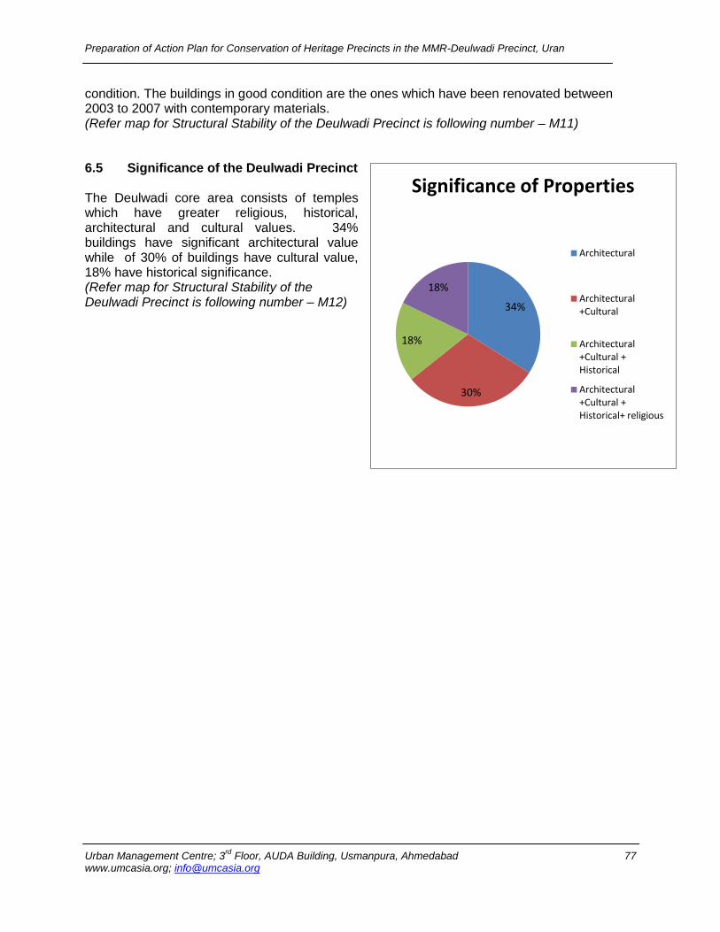
Preparation of Action Plan for Conservation of Heritage Precincts in the MMR-Deulwadi Precinct, Uran
Urban Management Centre; 3rd
Floor, AUDA Building, Usmanpura, Ahmedabad 77 www.umcasia.org; [email protected]
condition. The buildings in good condition are the ones which have been renovated between 2003 to 2007 with contemporary materials. (Refer map for Structural Stability of the Deulwadi Precinct is following number – M11) 6.5 Significance of the Deulwadi Precinct The Deulwadi core area consists of temples which have greater religious, historical, architectural and cultural values. 34% buildings have significant architectural value while of 30% of buildings have cultural value, 18% have historical significance. (Refer map for Structural Stability of the Deulwadi Precinct is following number – M12)
34%
30%
18%
18%
Significance of Properties
Architectural
Architectural +Cultural
Architectural +Cultural + Historical
Architectural +Cultural + Historical+ religious

Preparation of Action Plan for Conservation of Heritage Precincts in the MMR-Deulwadi Precinct, Uran
Urban Management Centre; 3rd
Floor, AUDA Building, Usmanpura, Ahmedabad 78 www.umcasia.org; [email protected]
References:
1. Nimish Patel & Parul Zaveri; Note on Deliberations on Conservation of Heritage Settlements of Gujarat ; 2005
2. Kokan Vibhagiya Nagarparishad- Adhikari-karamchari Kreeda Spardha – Samarnika 2006 3. Wikipedia - http://en.wikipedia.org/wiki/Uran 4. CIDCO website - http://cidcoindia.com/cidco/Navi_mumbai.aspx 5. Maps of India - http://www.mapsofindia.com/ 6. Landuse Plan – Regional Plan Mumbai Metropolitan Region 1996-2011 - MMRDA 7. Google Earth Timeline Images 8. Smita Dalvi & Mustansir Dalvi; Dismantling cosmopolitanism: Transformations in the sacred
heritage of the non-monumental in the Konkan
10. PiCA Research Cell; Navi Mumbai (Raigad) Heritage Project - Conservation Guidelines for Listed Sites in the Navi Mumbai notified area, under district Raigad; August 2006
11. Draft Development Plan of Uran (revised), 1987. 12. Websites referred:
http://dsal.uchicago.edu/reference/gazetteer/toc.html?volume=8 Page 358 http://dsal.uchicago.edu/reference/gazetteer/pager.html?objectid=DS405.1.I34_V15_028.gif http://dsal.uchicago.edu/reference/gazetteer/pager.html?objectid=DS405.1.I34_V15_372.gif http://dsal.uchicago.edu/reference/gazetteer/pager.html?objectid=DS405.1.I34_V19_411.gif Maharashtra State Gazetteers Greater Bombay District.mht
Mora, महाराष्ट्र - विकिपीडिया, मुक्त विश्ििोश.mht
http://ca.wikipedia.org/wiki/Districte_de_Raigad The Gazetteers Department - KOLABA.mht 1.mht Imperial Gazetteer of India, v. 15
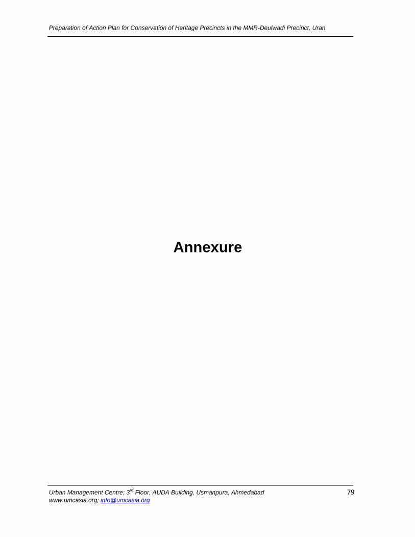
Preparation of Action Plan for Conservation of Heritage Precincts in the MMR-Deulwadi Precinct, Uran
Urban Management Centre; 3rd
Floor, AUDA Building, Usmanpura, Ahmedabad 79 www.umcasia.org; [email protected]
Annexure
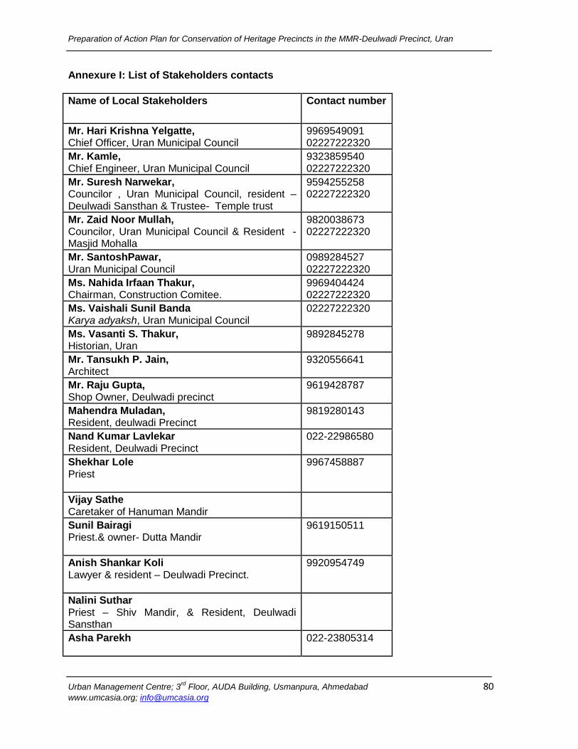
Preparation of Action Plan for Conservation of Heritage Precincts in the MMR-Deulwadi Precinct, Uran
Urban Management Centre; 3rd
Floor, AUDA Building, Usmanpura, Ahmedabad 80 www.umcasia.org; [email protected]
Annexure I: List of Stakeholders contacts
Name of Local Stakeholders Contact number
Mr. Hari Krishna Yelgatte, Chief Officer, Uran Municipal Council
9969549091 02227222320
Mr. Kamle, Chief Engineer, Uran Municipal Council
9323859540 02227222320
Mr. Suresh Narwekar, Councilor , Uran Municipal Council, resident – Deulwadi Sansthan & Trustee- Temple trust
9594255258 02227222320
Mr. Zaid Noor Mullah, Councilor, Uran Municipal Council & Resident - Masjid Mohalla
9820038673 02227222320
Mr. SantoshPawar, Uran Municipal Council
0989284527 02227222320
Ms. Nahida Irfaan Thakur, Chairman, Construction Comitee.
9969404424 02227222320
Ms. Vaishali Sunil Banda Karya adyaksh, Uran Municipal Council
02227222320
Ms. Vasanti S. Thakur, Historian, Uran
9892845278
Mr. Tansukh P. Jain, Architect
9320556641
Mr. Raju Gupta, Shop Owner, Deulwadi precinct
9619428787
Mahendra Muladan, Resident, deulwadi Precinct
9819280143
Nand Kumar Lavlekar Resident, Deulwadi Precinct
022-22986580
Shekhar Lole Priest
9967458887
Vijay Sathe Caretaker of Hanuman Mandir
Sunil Bairagi Priest.& owner- Dutta Mandir
9619150511
Anish Shankar Koli Lawyer & resident – Deulwadi Precinct.
9920954749
Nalini Suthar Priest – Shiv Mandir, & Resident, Deulwadi Sansthan
Asha Parekh
022-23805314
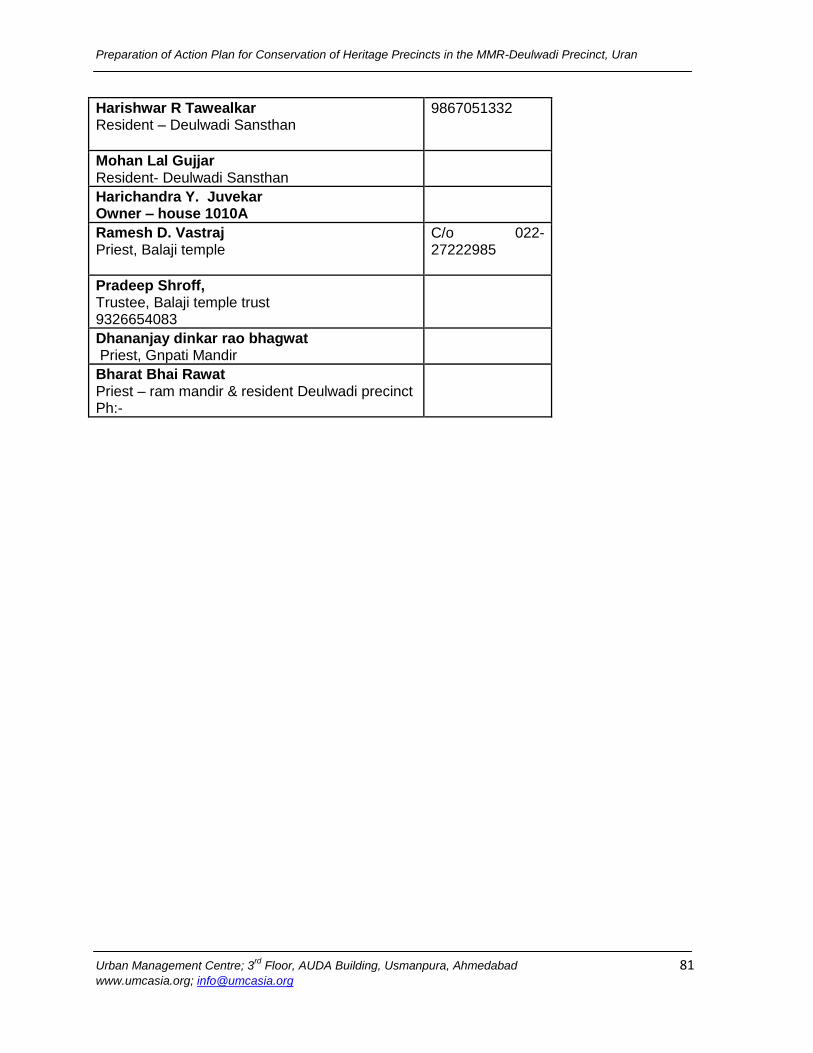
Preparation of Action Plan for Conservation of Heritage Precincts in the MMR-Deulwadi Precinct, Uran
Urban Management Centre; 3rd
Floor, AUDA Building, Usmanpura, Ahmedabad 81 www.umcasia.org; [email protected]
Harishwar R Tawealkar Resident – Deulwadi Sansthan
9867051332
Mohan Lal Gujjar Resident- Deulwadi Sansthan
Harichandra Y. Juvekar Owner – house 1010A
Ramesh D. Vastraj Priest, Balaji temple
C/o 022-27222985
Pradeep Shroff, Trustee, Balaji temple trust 9326654083
Dhananjay dinkar rao bhagwat Priest, Gnpati Mandir
Bharat Bhai Rawat Priest – ram mandir & resident Deulwadi precinct Ph:-

Preparation of Action Plan for Conservation of Heritage Precincts in the MMR-Deulwadi Precinct, Uran
Urban Management Centre; 3rd
Floor, AUDA Building, Usmanpura, Ahmedabad 82 www.umcasia.org; [email protected]
Annexure II : Household Survey Forms
URAN - Heritage Buildings Inventory Ward Name: ____________________
I. Location of the building: 1. Name of the building: _______________________ 2. Street name: _______________________________ II. Ownership: 4. Type of Ownership:
i. Government
ii. Municipal
iii. Public trust
iv. Private trust
v. Private –Single
vi. Private –Multiple
5. Name of the Owner or Organization: ____________________________________________ 6. Phone Number: ____________________________ III. Original Owner: 8. Is the current owner the original owner?
I.Yes ii. No 9. Relationship to the original owner: _______________ 10. Staying since how many years? ________________ 11. Contact details of the Original Owner _Address _________________________________________________________________________________________________ Ph no: ___________________________________________ IV.Occupant: 12. Name of the Occupant: _____________________ 13. Occupation: ______________________________
V.Multiple Owners & Tenants
Sr. Number
i (Multiple) Owner
ii (Multiple) Rentals
VI.Building Information: 14. Likely year of construction:___________________ 15. Name of the constructer: ____________________ 16. Designed Use of Building: ___________________
Form No:
Name of the respondent:_________________________
Relation to the property: _________________________
City Survey No:
17. Floor Wise Details of the Building
Sr. Floors Use Status of Building
Structural Stability
i Basement
ii Ground Floor
iii I Floor
iv II Floor
v III Floor
vi IV Floor
Use: R. Residential, C. Commercial, M.Mixed, H.Household industry, P. Place of worship I. Institutional, V-Vacant
Status of Building: U. Use, PU. Partly used, V.Vacant Structural Stability: Good, Fair, Bad
VII.Modifications
18. Has the building been modified? i.Yes ii. No 19. Chronology of modification:
Sl.no Type of Modification Year of modification
20. Reason for modification:
i.Structural failure
ii.Natural calamities
iii.Vandalism
iv.Change of use
v.Aesthetics
vi.Comfort
viii.Larger family size,
ix.sub-dividision of family,
x.tenants,
xi.Comfort
xii.Others (specify)__________________________________
VIII.significance of the building: 21. Significance of the building
Sr. i Architectural Value
ii Cultural value
iii. Historical value
iv Religious value
Comments on Historical/ Cultural/ Religious Value:_______________________________________
Name of the surveyor: _____________________
Date: ____________________________________
Photograph of the building for identity:
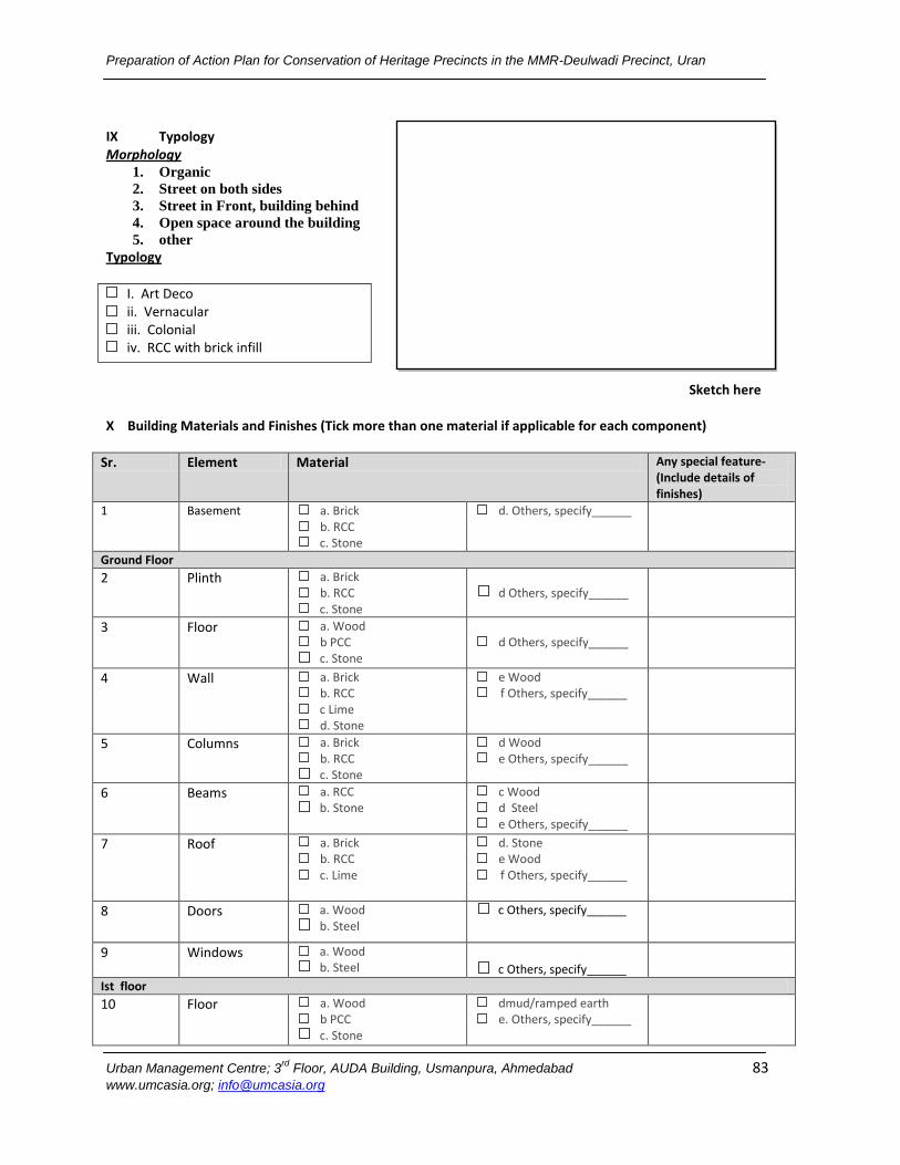
Preparation of Action Plan for Conservation of Heritage Precincts in the MMR-Deulwadi Precinct, Uran
Urban Management Centre; 3rd
Floor, AUDA Building, Usmanpura, Ahmedabad 83 www.umcasia.org; [email protected]
IX Typology Morphology
1. Organic
2. Street on both sides
3. Street in Front, building behind
4. Open space around the building
5. other
Typology
I. Art Deco
ii. Vernacular
iii. Colonial
iv. RCC with brick infill
Sketch here X Building Materials and Finishes (Tick more than one material if applicable for each component)
Sr. Element Material Any special feature-(Include details of finishes)
1 Basement a. Brick
b. RCC
c. Stone
d. Others, specify______
Ground Floor
2 Plinth a. Brick
b. RCC
c. Stone
d Others, specify______
3 Floor a. Wood
b PCC
c. Stone
d Others, specify______
4 Wall a. Brick
b. RCC
c Lime
d. Stone
e Wood
f Others, specify______
5 Columns a. Brick
b. RCC
c. Stone
d Wood
e Others, specify______
6 Beams a. RCC
b. Stone
c Wood
d Steel
e Others, specify______
7 Roof a. Brick
b. RCC
c. Lime
d. Stone
e Wood
f Others, specify______
8 Doors a. Wood
b. Steel c Others, specify______
9 Windows a. Wood
b. Steel c Others, specify______
Ist floor
10 Floor a. Wood
b PCC
c. Stone
dmud/ramped earth
e. Others, specify______
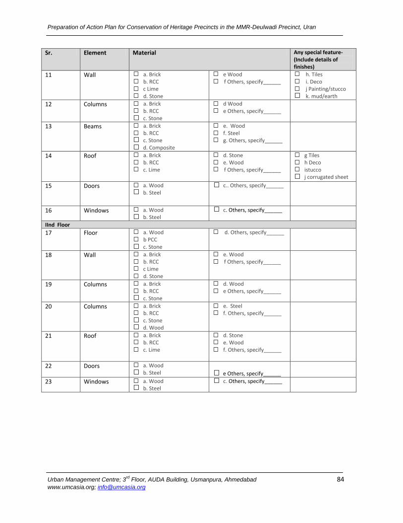
Preparation of Action Plan for Conservation of Heritage Precincts in the MMR-Deulwadi Precinct, Uran
Urban Management Centre; 3rd
Floor, AUDA Building, Usmanpura, Ahmedabad 84 www.umcasia.org; [email protected]
Sr. Element Material Any special feature-(Include details of finishes)
11 Wall a. Brick
b. RCC
c Lime
d. Stone
e Wood
f Others, specify______ h. Tiles
i. Deco
j Painting/stucco
k. mud/earth 12 Columns a. Brick
b. RCC
c. Stone
d Wood
e Others, specify______
13 Beams a. Brick
b. RCC
c. Stone d. Composite
e. Wood
f. Steel
g. Others, specify______
14 Roof a. Brick
b. RCC
c. Lime
d. Stone
e. Wood
f Others, specify______
g Tiles
h Deco
istucco
j corrugated sheet
15 Doors a. Wood
b. Steel c.. Others, specify______
16 Windows a. Wood
b. Steel c. Others, specify______
IInd Floor
17 Floor a. Wood
b PCC
c. Stone
d. Others, specify______
18 Wall a. Brick
b. RCC
c Lime
d. Stone
e. Wood
f Others, specify______
19 Columns a. Brick
b. RCC
c. Stone
d. Wood
e Others, specify______
20 Columns a. Brick
b. RCC
c. Stone d. Wood
e. Steel
f. Others, specify______
21 Roof a. Brick
b. RCC
c. Lime
d. Stone
e. Wood
f. Others, specify______
22 Doors a. Wood
b. Steel e Others, specify______
23 Windows a. Wood
b. Steel c. Others, specify______
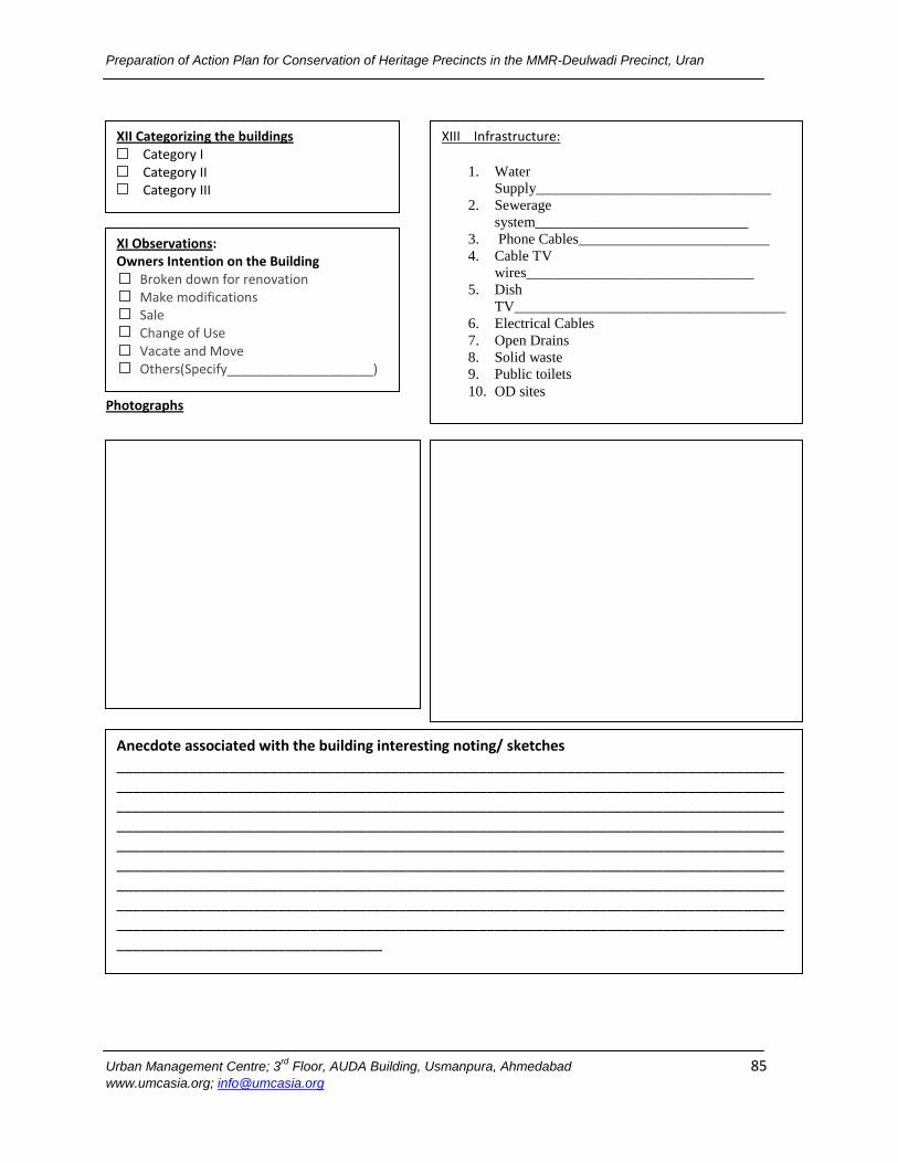
Preparation of Action Plan for Conservation of Heritage Precincts in the MMR-Deulwadi Precinct, Uran
Urban Management Centre; 3rd
Floor, AUDA Building, Usmanpura, Ahmedabad 85 www.umcasia.org; [email protected]
Photographs
XI Observations: Owners Intention on the Building
Broken down for renovation
Make modifications
Sale
Change of Use
Vacate and Move
Others(Specify____________________)
XII Categorizing the buildings
Category I
Category II
Category III
XIII Infrastructure:
1. Water
Supply________________________________
2. Sewerage
system_____________________________
3. Phone Cables__________________________
4. Cable TV
wires_______________________________
5. Dish
TV_____________________________________
6. Electrical Cables
7. Open Drains
8. Solid waste
9. Public toilets
10. OD sites
Anecdote associated with the building interesting noting/ sketches ____________________________________________________________________________________________________________________________________________________________________________________________________________________________________________________________________________________________________________________________________________________________________________________________________________________________________________________________________________________________________________________________________________________________________________________________________________________________________________________________________________________________________________________________________________________________________________________________________________
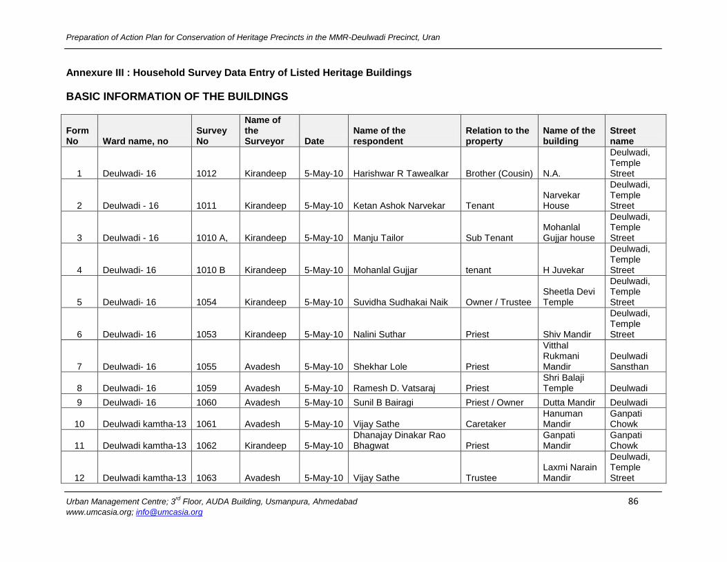
Preparation of Action Plan for Conservation of Heritage Precincts in the MMR-Deulwadi Precinct, Uran
Urban Management Centre; 3rd
Floor, AUDA Building, Usmanpura, Ahmedabad 86 www.umcasia.org; [email protected]
Annexure III : Household Survey Data Entry of Listed Heritage Buildings
BASIC INFORMATION OF THE BUILDINGS
Form No Ward name, no
Survey No
Name of the Surveyor Date
Name of the respondent
Relation to the property
Name of the building
Street name
1 Deulwadi- 16 1012 Kirandeep 5-May-10 Harishwar R Tawealkar Brother (Cousin) N.A.
Deulwadi, Temple Street
2 Deulwadi - 16 1011 Kirandeep 5-May-10 Ketan Ashok Narvekar Tenant Narvekar House
Deulwadi, Temple Street
3 Deulwadi - 16 1010 A, Kirandeep 5-May-10 Manju Tailor Sub Tenant Mohanlal Gujjar house
Deulwadi, Temple Street
4 Deulwadi- 16 1010 B Kirandeep 5-May-10 Mohanlal Gujjar tenant H Juvekar
Deulwadi, Temple Street
5 Deulwadi- 16 1054 Kirandeep 5-May-10 Suvidha Sudhakai Naik Owner / Trustee Sheetla Devi Temple
Deulwadi, Temple Street
6 Deulwadi- 16 1053 Kirandeep 5-May-10 Nalini Suthar Priest Shiv Mandir
Deulwadi, Temple Street
7 Deulwadi- 16 1055 Avadesh 5-May-10 Shekhar Lole Priest
Vitthal Rukmani Mandir
Deulwadi Sansthan
8 Deulwadi- 16 1059 Avadesh 5-May-10 Ramesh D. Vatsaraj Priest Shri Balaji Temple Deulwadi
9 Deulwadi- 16 1060 Avadesh 5-May-10 Sunil B Bairagi Priest / Owner Dutta Mandir Deulwadi
10 Deulwadi kamtha-13 1061 Avadesh 5-May-10 Vijay Sathe Caretaker Hanuman Mandir
Ganpati Chowk
11 Deulwadi kamtha-13 1062 Kirandeep 5-May-10 Dhanajay Dinakar Rao Bhagwat Priest
Ganpati Mandir
Ganpati Chowk
12 Deulwadi kamtha-13 1063 Avadesh 5-May-10 Vijay Sathe Trustee Laxmi Narain Mandir
Deulwadi, Temple Street
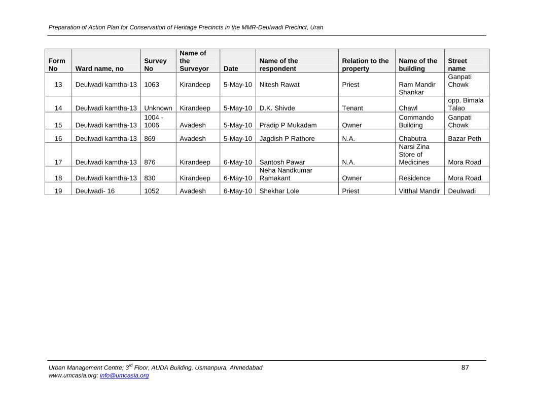
Preparation of Action Plan for Conservation of Heritage Precincts in the MMR-Deulwadi Precinct, Uran
Urban Management Centre; 3rd
Floor, AUDA Building, Usmanpura, Ahmedabad 87 www.umcasia.org; [email protected]
Form No Ward name, no
Survey No
Name of the Surveyor Date
Name of the respondent
Relation to the property
Name of the building
Street name
13 Deulwadi kamtha-13 1063 Kirandeep 5-May-10 Nitesh Rawat Priest Ram Mandir Ganpati Chowk
Shankar
14 Deulwadi kamtha-13 Unknown Kirandeep 5-May-10 D.K. Shivde Tenant Chawl opp. Bimala Talao
15 Deulwadi kamtha-13 1004 - 1006 Avadesh 5-May-10 Pradip P Mukadam Owner
Commando Building
Ganpati Chowk
16 Deulwadi kamtha-13 869 Avadesh 5-May-10 Jagdish P Rathore N.A. Chabutra Bazar Peth
17 Deulwadi kamtha-13 876 Kirandeep 6-May-10 Santosh Pawar N.A.
Narsi Zina Store of Medicines Mora Road
18 Deulwadi kamtha-13 830 Kirandeep 6-May-10 Neha Nandkumar Ramakant Owner Residence Mora Road
19 Deulwadi- 16 1052 Avadesh 6-May-10 Shekhar Lole Priest Vitthal Mandir Deulwadi

Preparation of Action Plan for Conservation of Heritage Precincts in the MMR-Deulwadi Precinct, Uran
Urban Management Centre; 3rd
Floor, AUDA Building, Usmanpura, Ahmedabad 88 www.umcasia.org; [email protected]
OCCUPANTS AND MULTIPLE OWNERS & RENTALS
Form No
Occupant
Multiple Owners & Rentals
1.Owners, 2.Rentals
12.Name of the occupant 13.Occupation
14.Presence of multiple Owners or rentals (column2)
15.Number of owners (column3)
16.Number of rentals (column3)
1 Harishwar R Tawralkar driver (truck) yes, na 6
2 Councillar (M C) government service na na 1
3 Manju tailor tailor (business) yes na 2
4 Mohanlal Gujjar private service na na 1
5 Suvidhas nai priest na na na
6 Suresh narvekar government service na na na
7 Shekhar lole government service na na na
8 Romesh D Vatsaroy government service na 6 na
9 Sunil B Bairagi priest na 1 na
10 Nitin chavate business na na na
11 Dhananjay dinkar bhagvat priest na na na
12 Vijay sathe restaurant (business) na na na
13 Bharat bhai rawat priest na na na
14 D.K.shivde government service na na 14
15 Pradip P Mukadam indian navy (g.s) yes na 3
16 Jagdish p rathore tailor (business) na na na
17 vacant dispensary na na na
18 Nandkumar Ramakant Lavekar naval dockgard na na 1
19 Shekhar lole government service na na na
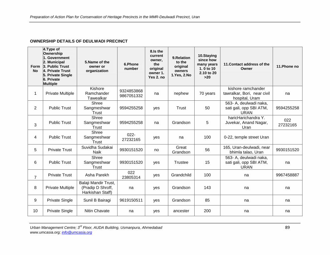
Preparation of Action Plan for Conservation of Heritage Precincts in the MMR-Deulwadi Precinct, Uran
Urban Management Centre; 3rd
Floor, AUDA Building, Usmanpura, Ahmedabad 89 www.umcasia.org; [email protected]
OWNERSHIP DETAILS OF DEULWADI PRECINCT
Form
No
4.Type of Ownership 1. Government 2. Municipal 3. Public Trust 4. Private Trust 5. Private Single 6. Private Multiple
5.Name of the owner or
organization
6.Phone number
8.Is the current owner,
the original owner 1. Yes 2. no
9.Relation to the
original owners
1.Yes, 2.No
10.Staying since how
many years 1. 0 to 10 2.10 to 20
>20
11.Contact address of the Owner
11.Phone no
1 Private Multiple Kishore
Ramchander Tawealkar
9324853868 9867051332
na nephew 70 years kishore ramchander
tawralkar, Bori, near civil hospital, Uram
na
2 Public Trust Shree
Sangmeshwar Trust
9594255258 yes Trust 50 563- A, deulwadi naka, sati gali, opp SBI ATM,
URAN 9594255258
3
Public Trust Shree
Sangmeshwar Trust
9594255258 na Grandson 5 haricHarichandra Y.
Juvekar, Anand Nagar, Uran
022 27232165
4 Public Trust Shree
Sangmeshwar Trust
022-27232165
yes na 100 0-22, temple street Uran
5 Private Trust Suvidha Sudakai
Naik 9930151520 no
Great Grandson
56 165, Uran-deulwadi, near
bhimla talao, Uran 9930151520
6 Public Trust Shree
Sangmeshwar Trust
9930151520 yes Trustee 15 563- A, deulwadi naka, sati gali, opp SBI ATM,
URAN na
7
Private Trust Asha Parekh 022
23805314 yes Grandchild 100 na 9967458887
8 Private Multiple Balaji Mandir Trust,
(Pradip D Shroff, Harkishan Staff)
na yes Grandson 143 na na
9 Private Single Sunil B Bairagi 9619150511 yes Grandson 85 na na
10 Private Single Nitin Chavate na yes ancester 200 na na
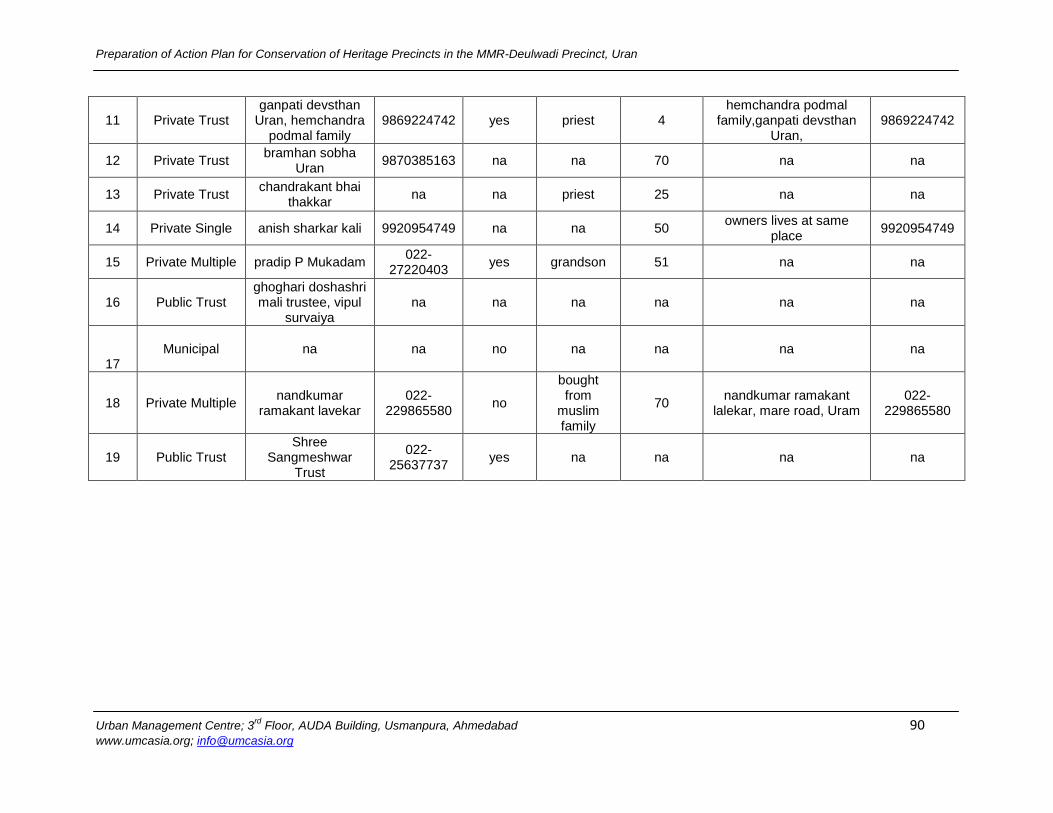
Preparation of Action Plan for Conservation of Heritage Precincts in the MMR-Deulwadi Precinct, Uran
Urban Management Centre; 3rd
Floor, AUDA Building, Usmanpura, Ahmedabad 90 www.umcasia.org; [email protected]
11 Private Trust ganpati devsthan
Uran, hemchandra podmal family
9869224742 yes priest 4 hemchandra podmal
family,ganpati devsthan Uran,
9869224742
12 Private Trust bramhan sobha
Uran 9870385163 na na 70 na na
13 Private Trust chandrakant bhai
thakkar na na priest 25 na na
14 Private Single anish sharkar kali 9920954749 na na 50 owners lives at same
place 9920954749
15 Private Multiple pradip P Mukadam 022-
27220403 yes grandson 51 na na
16 Public Trust ghoghari doshashri mali trustee, vipul
survaiya na na na na na na
17 Municipal na na no na na na na
18 Private Multiple nandkumar
ramakant lavekar 022-
229865580 no
bought from
muslim family
70 nandkumar ramakant
lalekar, mare road, Uram 022-
229865580
19 Public Trust Shree
Sangmeshwar Trust
022-25637737
yes na na na na
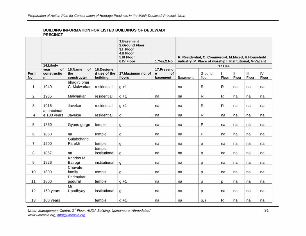
Preparation of Action Plan for Conservation of Heritage Precincts in the MMR-Deulwadi Precinct, Uran
Urban Management Centre; 3rd
Floor, AUDA Building, Usmanpura, Ahmedabad 91 www.umcasia.org; [email protected]
BUILDING INFORMATION FOR LISTED BUILDINGS OF DEULWADI PRECINCT
Form No
1.Basement 2.Ground Floor 3.I Floor 4.II Floor 5.III Floor 6.IV Floor 1.Yes,2.No
R. Residential, C. Commercial, M.Mixed, H.Household industry, P. Place of worship I. Institutional, V-Vacant
14.Likely year of construction
15.Name of the constructer
16.Designed use of the building
17.Maximum no. of floors
17.Presence of basement
17.Use
Basement Ground floor
I Floor
II Floor
III Floor
IV Floor
1 1940 bhagirti bhai C. Malwarkar residential g +1 na R R na na na
2 1935 Malwarkar residential g +1 na na R R na na na
3 1916 Javekar residential g +1 na na R R na na na
4 approximate 100 years Javekar residential g na na R na na na na
5 1860 Gyano gurge temple g na na P na na na na
6 1860 na temple g na na P na na na na
7 1900 Gulabchand Parekh temple g na na p na na na na
8 1867 na temple, institutional g na na p na na na na
9 1926 Kondos M Bairogi institutional g na na p na na na na
10 1800 Chavate family temple g na na p na na na na
11 1800 Padmakar podural temple g +1 na na p p na na na
12 150 years Mr. Upadhyay institutional g na na p na na na na
13 100 years temple g +1 na na p, r R na na na
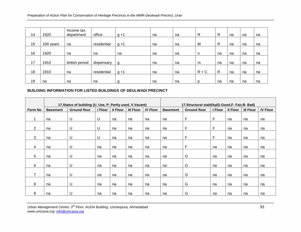
Preparation of Action Plan for Conservation of Heritage Precincts in the MMR-Deulwadi Precinct, Uran
Urban Management Centre; 3rd
Floor, AUDA Building, Usmanpura, Ahmedabad 92 www.umcasia.org; [email protected]
14 1920 Income tax department office g +1 na na R R na na na
15 100 years na residential g +1 na na M R na na na
16 1920 na na na na na n na na na na
17 1910 british period dispensary g na na m na na na na
18 1910 na residential g +1 na na R + C R na na na
19 na na na g na na p na na na na
BUILDING INFORMATION FOR LISTED BUILDINGS OF DEULWADI PRECINCT
Form No
17.Status of building (U. Use, P. Partly used, V.Vacant) 17.Structural stability(G-Good,F- Fair,B- Bad)
Basement Ground floor I Floor II Floor III Floor IV Floor Basement Ground floor I Floor II Floor III Floor IV Floor
1 na U U na na na na F F na na na
2 na U U na na na na F F na na na
3 na U U na na na na F F na na na
4 na U na na na na na F na na na na
5 na U na na na na na G na na na na
6 na U na na na na na G na na na na
7 na U na na na na na G na na na na
8 na U na na na na na G na na na na
9 na U na na na na na G na na na na
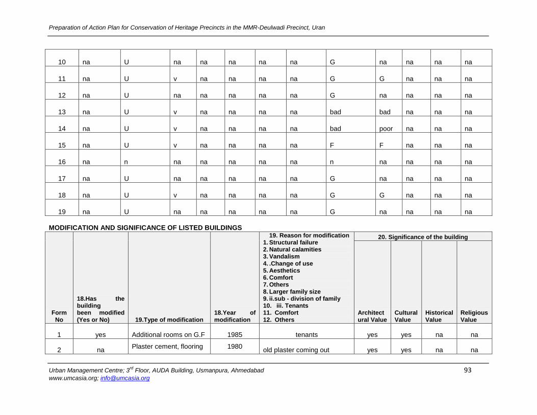
Preparation of Action Plan for Conservation of Heritage Precincts in the MMR-Deulwadi Precinct, Uran
Urban Management Centre; 3rd
Floor, AUDA Building, Usmanpura, Ahmedabad 93 www.umcasia.org; [email protected]
10 na U na na na na na G na na na na
11 na U v na na na na G G na na na
12 na U na na na na na G na na na na
13 na U v na na na na bad bad na na na
14 na U v na na na na bad poor na na na
15 na U v na na na na F F na na na
16 na n na na na na na n na na na na
17 na U na na na na na G na na na na
18 na U v na na na na G G na na na
19 na U na na na na na G na na na na
MODIFICATION AND SIGNIFICANCE OF LISTED BUILDINGS
Form No
18.Has the building been modified (Yes or No) 19.Type of modification
18.Year of modification
19. Reason for modification 1. Structural failure 2. Natural calamities 3. Vandalism 4. .Change of use 5. Aesthetics 6. Comfort 7. Others 8. Larger family size 9. ii.sub - division of family 10. iii. Tenants 11. Comfort 12. Others
20. Significance of the building
Architectural Value
Cultural Value
Historical Value
Religious Value
1 yes Additional rooms on G.F 1985 tenants yes yes na na
2 na Plaster cement, flooring 1980
old plaster coming out yes yes na na
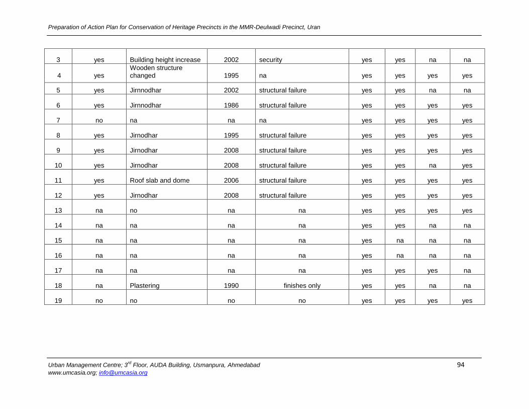
Preparation of Action Plan for Conservation of Heritage Precincts in the MMR-Deulwadi Precinct, Uran
Urban Management Centre; 3rd
Floor, AUDA Building, Usmanpura, Ahmedabad 94 www.umcasia.org; [email protected]
3 yes Building height increase 2002 security yes yes na na
4 yes Wooden structure changed 1995 na yes yes yes yes
5 yes Jirnnodhar 2002 structural failure yes yes na na
6 yes Jirnnodhar 1986 structural failure yes yes yes yes
7 no na na na yes yes yes yes
8 yes Jirnodhar 1995 structural failure yes yes yes yes
9 yes Jirnodhar 2008 structural failure yes yes yes yes
10 yes Jirnodhar 2008 structural failure yes yes na yes
11 yes Roof slab and dome 2006 structural failure yes yes yes yes
12 yes Jirnodhar 2008 structural failure yes yes yes yes
13 na no na na yes yes yes yes
14 na na na na yes yes na na
15 na na na na yes na na na
16 na na na na yes na na na
17 na na na na yes yes yes na
18 na Plastering 1990 finishes only yes yes na na
19 no no no no yes yes yes yes
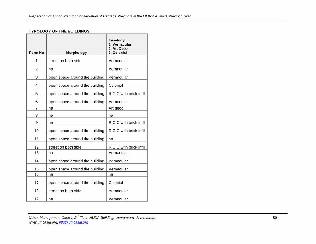
Preparation of Action Plan for Conservation of Heritage Precincts in the MMR-Deulwadi Precinct, Uran
Urban Management Centre; 3rd
Floor, AUDA Building, Usmanpura, Ahmedabad 95 www.umcasia.org; [email protected]
TYPOLOGY OF THE BUILDINGS
Form No Morphology
Typology 1. Vernacular 2. Art Deco 3. Colonial
1 street on both side Vernacular
2 na Vernacular
3 open space around the building Vernacular
4 open space around the building Colonial
5 open space around the building R.C.C with brick infill
6 open space around the building Vernacular
7 na Art deco
8 na na
9 na R.C.C with brick infill
10 open space around the building R.C.C with brick infill
11 open space around the building na
12 street on both side R.C.C with brick infill
13 na Vernacular
14 open space around the building Vernacular
15 open space around the building Vernacular
16 na na
17 open space around the building Colonial
18 street on both side Vernacular
19 na Vernacular
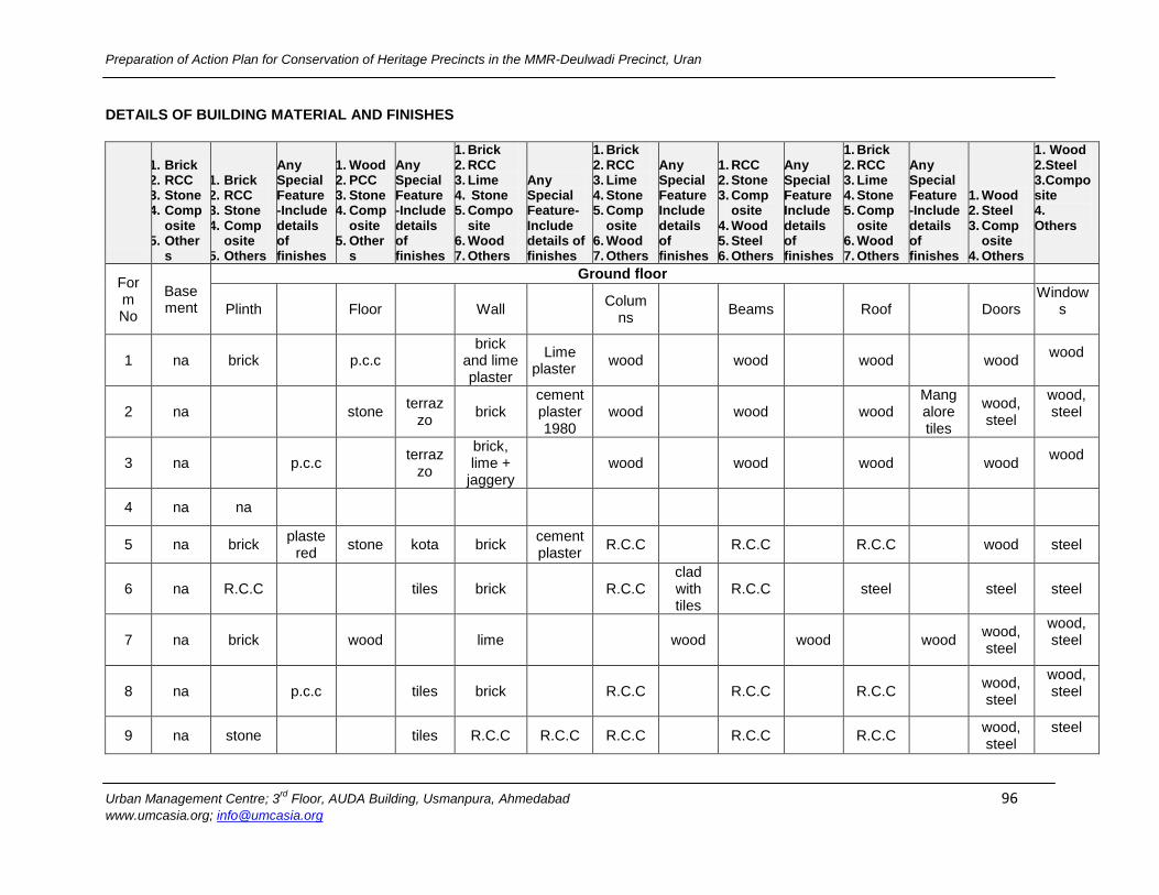
Preparation of Action Plan for Conservation of Heritage Precincts in the MMR-Deulwadi Precinct, Uran
Urban Management Centre; 3rd
Floor, AUDA Building, Usmanpura, Ahmedabad 96 www.umcasia.org; [email protected]
DETAILS OF BUILDING MATERIAL AND FINISHES
1. Brick 2. RCC 3. Stone 4. Comp
osite 5. Other
s
1. Brick 2. RCC 3. Stone 4. Comp
osite 5. Others
Any Special Feature -Include details of finishes
1. Wood 2. PCC 3. Stone 4. Comp
osite 5. Other
s
Any Special Feature -Include details of finishes
1. Brick 2. RCC 3. Lime 4. Stone 5. Compo
site 6. Wood 7. Others
Any Special Feature-Include details of finishes
1. Brick 2. RCC 3. Lime 4. Stone 5. Comp
osite 6. Wood 7. Others
Any Special Feature Include details of finishes
1. RCC 2. Stone 3. Comp
osite 4. Wood 5. Steel 6. Others
Any Special Feature Include details of finishes
1. Brick 2. RCC 3. Lime 4. Stone 5. Comp
osite 6. Wood 7. Others
Any Special Feature -Include details of finishes
1. Wood 2. Steel 3. Comp
osite 4. Others
1 . Wood 2.Steel 3.Composite 4. Others
Form No
Basement
Ground floor
Plinth
Floor
Wall
Columns
Beams
Roof
Doors Window
s
1 na brick
p.c.c
brick and lime plaster
Lime plaster
wood
wood
wood
wood wood
2 na
stone terraz
zo brick
cement plaster 1980
wood
wood
wood Mangalore tiles
wood, steel
wood, steel
3 na
p.c.c
terrazzo
brick, lime +
jaggery
wood
wood
wood
wood wood
4 na na
5 na brick plaste
red stone kota brick
cement plaster
R.C.C
R.C.C
R.C.C
wood steel
6 na R.C.C
tiles brick
R.C.C clad with tiles
R.C.C
steel
steel steel
7 na brick
wood
lime
wood
wood
wood wood, steel
wood, steel
8 na
p.c.c
tiles brick
R.C.C
R.C.C
R.C.C
wood, steel
wood, steel
9 na stone
tiles R.C.C R.C.C R.C.C
R.C.C
R.C.C
wood, steel
steel

Preparation of Action Plan for Conservation of Heritage Precincts in the MMR-Deulwadi Precinct, Uran
Urban Management Centre; 3rd
Floor, AUDA Building, Usmanpura, Ahmedabad 97 www.umcasia.org; [email protected]
10 na
p.c.c
tiles brick
brick
R.C.C
R.C.C
wood,steel
wood, steel
11 na stone
stone marbl
e brick
cement plaster
wood
wood
wood
wood wood
12 na brick plaste
r tiles brick
plastered
R.C.C
R.C.C
R.C.C
wood, steel
Wood steel
13 na na
stone
brick tile clad wood
wood
wood
wood, steel
wood steel
14 na stone
stone rubble stone
brick cement plaster
wood
wood
wood wood
15 na stone
tiles brick
wood
wood
wood
wood wood
16 na stone
P.C.C
brick
plastered
plastered
R.C.C
wood wood
17
stone
stone dress
ed stone
stone plaster
ed inside
wood
wood
Mangalore tiles
wood wood steel
18 na brick lime
mortar stone kota brick
cement plaster
ed wood
wood
wood
wood
wood
19 na brick plaste
red P.C.C
brick
wood
wood
wood, asbest
os
wood wood
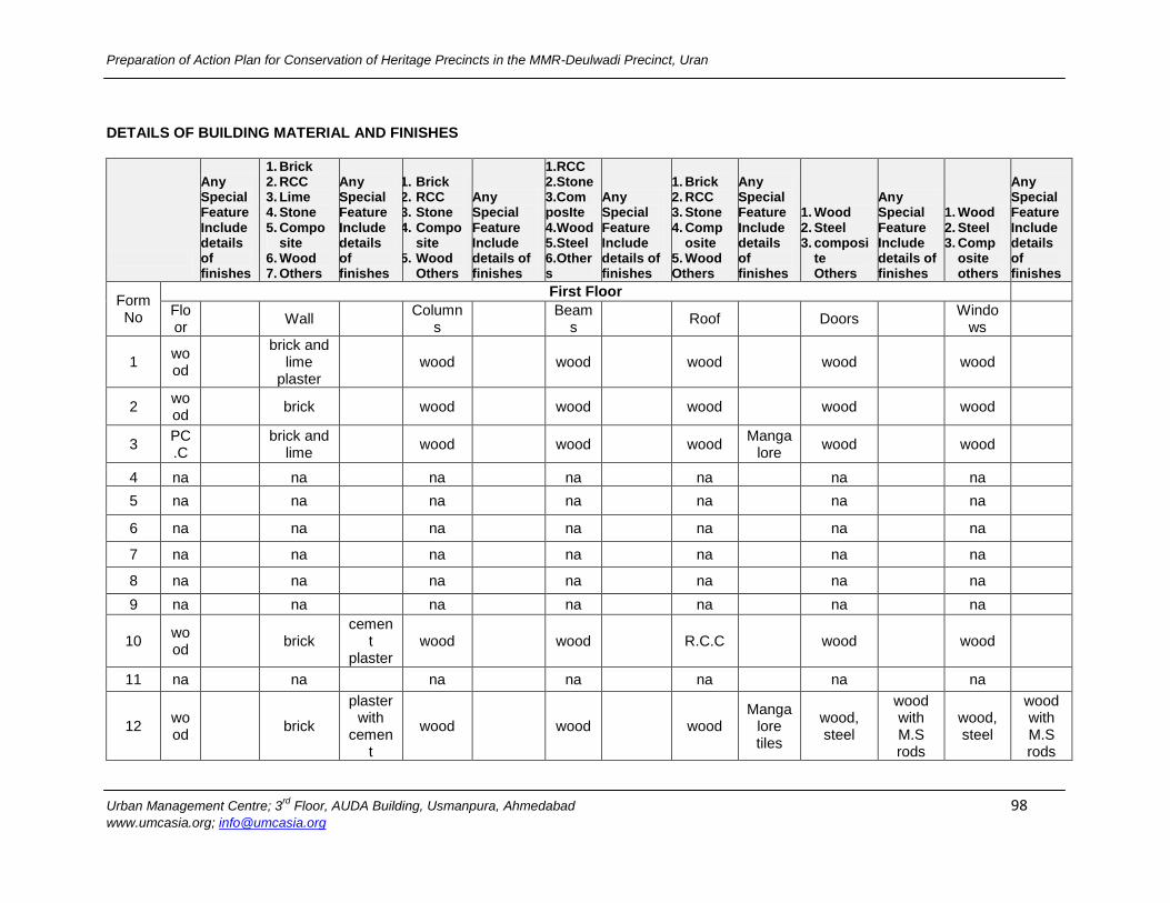
Preparation of Action Plan for Conservation of Heritage Precincts in the MMR-Deulwadi Precinct, Uran
Urban Management Centre; 3rd
Floor, AUDA Building, Usmanpura, Ahmedabad 98 www.umcasia.org; [email protected]
DETAILS OF BUILDING MATERIAL AND FINISHES
Any Special Feature Include details of finishes
1. Brick 2. RCC 3. Lime 4. Stone 5. Compo
site 6. Wood 7. Others
Any Special Feature Include details of finishes
1. Brick 2. RCC 3. Stone 4. Compo
site 5. Wood
Others
Any Special Feature Include details of finishes
1.RCC 2.Stone 3.ComposIte 4.Wood 5.Steel 6.Others
Any Special Feature Include details of finishes
1. Brick 2. RCC 3. Stone 4. Comp
osite 5. Wood Others
Any Special Feature Include details of finishes
1. Wood 2. Steel 3. composi
te Others
Any Special Feature Include details of finishes
1. Wood 2. Steel 3. Comp
osite others
Any Special Feature Include details of finishes
Form No
First Floor
Floor
Wall
Columns
Beams
Roof
Doors
Windows
1 wood
brick and lime
plaster
wood
wood
wood
wood
wood
2 wood
brick
wood
wood
wood
wood
wood
3 PC.C
brick and lime
wood
wood
wood Manga
lore wood
wood
4 na
na
na
na
na
na
na
5 na
na
na
na
na
na
na
6 na
na
na
na
na
na
na
7 na
na
na
na
na
na
na
8 na
na
na
na
na
na
na
9 na
na
na
na
na
na
na
10 wood
brick cemen
t plaster
wood
wood
R.C.C
wood
wood
11 na
na
na
na
na
na
na
12 wood
brick
plaster with
cement
wood
wood
wood Manga
lore tiles
wood, steel
wood with M.S rods
wood, steel
wood with M.S rods

Preparation of Action Plan for Conservation of Heritage Precincts in the MMR-Deulwadi Precinct, Uran
Urban Management Centre; 3rd
Floor, AUDA Building, Usmanpura, Ahmedabad 99 www.umcasia.org; [email protected]
13 stone
brick cemen
t plaster
wood
wood
wood, Mangal
ore tiles
wood
wood
14 wood
brick
wood
wood
wood
na
na
15 na
na
na
na
na
na
na
16 na
na
na
na
na
na
na
17 wood
brick
wood
wood
wood Manga
lore tiles
wood
wood
wood with M.S rods
18 na
na
na
na
na
na
na
OBSERVATIONS
Form No
Owners Intention on the building
Infrastructure
1. Broken down for renovation 2.Make modifications 3.Sale 4.Change of Use 5.Vacate and Move 6.Others(Specify)
Water supply
Sewerage system
Phone cables
Dish tv
Electrical cables
Open drains
Solid waste Public toilets
OD sites
1 make modification municipal
tap
bathroom personal,
public toilet
no landlin
e no yes yes
municipal collection van
proximity close to
toilet, small children
2 broken down for
renovation municipal
tap septic tank mobile na yes yes
municipal collection van
na na
3 broken down for
renovation municipal
tap public toilet, dirty water
mobile yes yes yes municipal
collection van na na
4 make modification municipal
tap na yes yes na na
municipal collection van
proximity na
5 reconstructed in 2002 municipal
tap na
no landlin
e na yes na
municipal collection van
public toilets
na
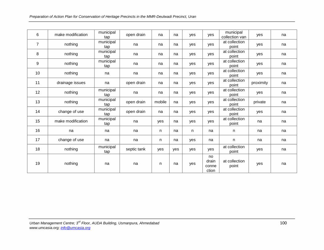
Preparation of Action Plan for Conservation of Heritage Precincts in the MMR-Deulwadi Precinct, Uran
Urban Management Centre; 3rd
Floor, AUDA Building, Usmanpura, Ahmedabad 100 www.umcasia.org; [email protected]
6 make modification municipal
tap open drain na na yes yes
municipal collection van
yes na
7 nothing municipal
tap na na na yes yes
at collection point
yes na
8 nothing municipal
tap na na na yes yes
at collection point
yes na
9 nothing municipal
tap na na na yes yes
at collection point
yes na
10 nothing na na na na yes yes at collection
point yes na
11 drainage issues na open drain na na yes yes at collection
point proximity na
12 nothing municipal
tap na na na yes yes
at collection point
yes na
13 nothing municipal
tap open drain mobile na yes yes
at collection point
private na
14 change of use municipal
tap open drain na na yes yes
at collection point
yes na
15 make modification municipal
tap na yes na yes yes
at collection point
na na
16 na na na n na n na n na na
17 change of use na na n na yes na n na na
18 nothing municipal
tap septic tank yes yes yes yes
at collection point
yes na
19 nothing na na n na yes
no drain connection
at collection point
yes na
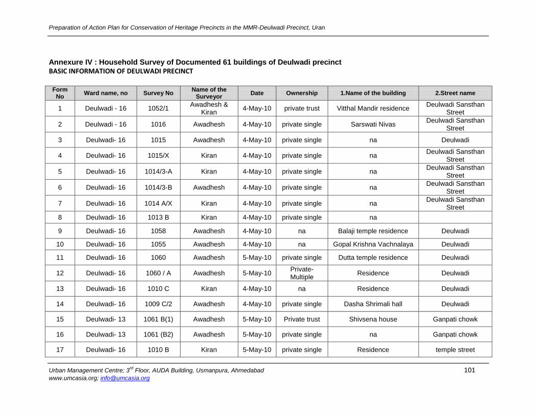
Preparation of Action Plan for Conservation of Heritage Precincts in the MMR-Deulwadi Precinct, Uran
Urban Management Centre; 3rd
Floor, AUDA Building, Usmanpura, Ahmedabad 101 www.umcasia.org; [email protected]
Annexure IV : Household Survey of Documented 61 buildings of Deulwadi precinct
BASIC INFORMATION OF DEULWADI PRECINCT
Form No
Ward name, no Survey No Name of the
Surveyor Date Ownership 1.Name of the building 2.Street name
1 Deulwadi - 16 1052/1 Awadhesh &
Kiran 4-May-10 private trust Vitthal Mandir residence
Deulwadi Sansthan Street
2 Deulwadi - 16 1016 Awadhesh 4-May-10 private single Sarswati Nivas Deulwadi Sansthan
Street
3 Deulwadi- 16 1015 Awadhesh 4-May-10 private single na Deulwadi
4 Deulwadi- 16 1015/X Kiran 4-May-10 private single na Deulwadi Sansthan
Street
5 Deulwadi- 16 1014/3-A Kiran 4-May-10 private single na Deulwadi Sansthan
Street
6 Deulwadi- 16 1014/3-B Awadhesh 4-May-10 private single na Deulwadi Sansthan
Street
7 Deulwadi- 16 1014 A/X Kiran 4-May-10 private single na Deulwadi Sansthan
Street
8 Deulwadi- 16 1013 B Kiran 4-May-10 private single na
9 Deulwadi- 16 1058 Awadhesh 4-May-10 na Balaji temple residence Deulwadi
10 Deulwadi- 16 1055 Awadhesh 4-May-10 na Gopal Krishna Vachnalaya Deulwadi
11 Deulwadi- 16 1060 Awadhesh 5-May-10 private single Dutta temple residence Deulwadi
12 Deulwadi- 16 1060 / A Awadhesh 5-May-10 Private-Multiple
Residence Deulwadi
13 Deulwadi- 16 1010 C Kiran 4-May-10 na Residence Deulwadi
14 Deulwadi- 16 1009 C/2 Awadhesh 4-May-10 private single Dasha Shrimali hall Deulwadi
15 Deulwadi- 13 1061 B(1) Awadhesh 5-May-10 Private trust Shivsena house Ganpati chowk
16 Deulwadi- 13 1061 (B2) Awadhesh 5-May-10 private single na Ganpati chowk
17 Deulwadi- 16 1010 B Kiran 5-May-10 private single Residence temple street
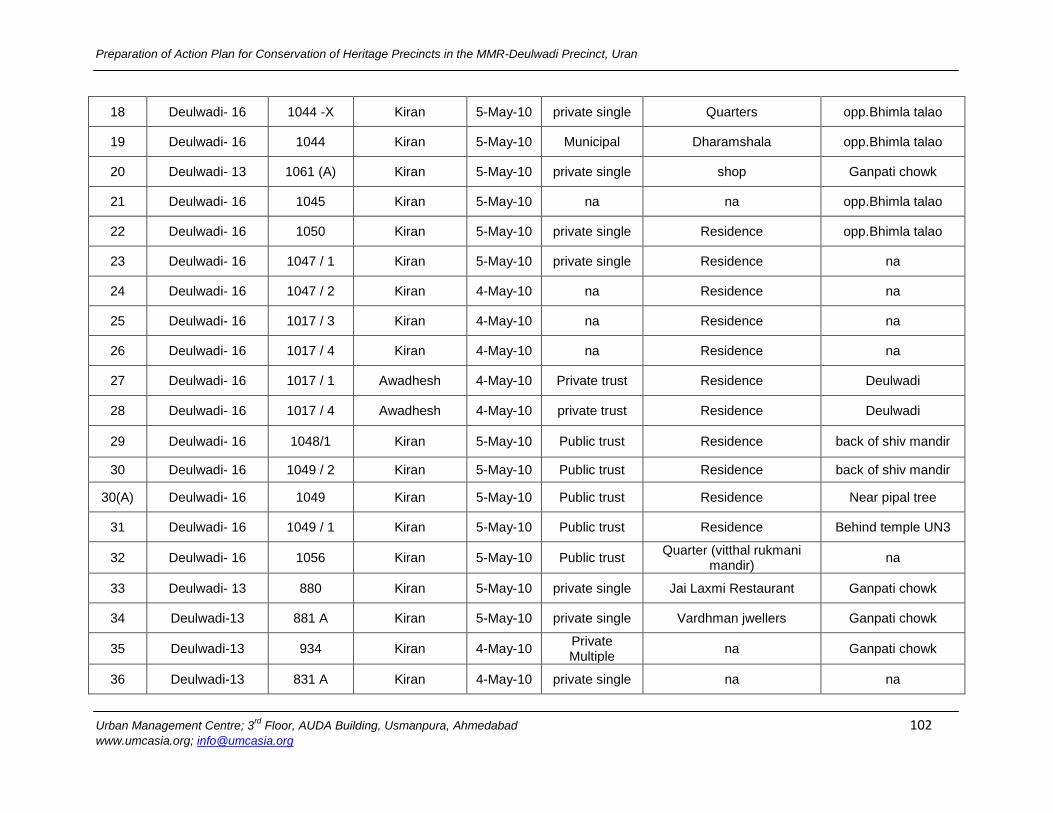
Preparation of Action Plan for Conservation of Heritage Precincts in the MMR-Deulwadi Precinct, Uran
Urban Management Centre; 3rd
Floor, AUDA Building, Usmanpura, Ahmedabad 102 www.umcasia.org; [email protected]
18 Deulwadi- 16 1044 -X Kiran 5-May-10 private single Quarters opp.Bhimla talao
19 Deulwadi- 16 1044 Kiran 5-May-10 Municipal Dharamshala opp.Bhimla talao
20 Deulwadi- 13 1061 (A) Kiran 5-May-10 private single shop Ganpati chowk
21 Deulwadi- 16 1045 Kiran 5-May-10 na na opp.Bhimla talao
22 Deulwadi- 16 1050 Kiran 5-May-10 private single Residence opp.Bhimla talao
23 Deulwadi- 16 1047 / 1 Kiran 5-May-10 private single Residence na
24 Deulwadi- 16 1047 / 2 Kiran 4-May-10 na Residence na
25 Deulwadi- 16 1017 / 3 Kiran 4-May-10 na Residence na
26 Deulwadi- 16 1017 / 4 Kiran 4-May-10 na Residence na
27 Deulwadi- 16 1017 / 1 Awadhesh 4-May-10 Private trust Residence Deulwadi
28 Deulwadi- 16 1017 / 4 Awadhesh 4-May-10 private trust Residence Deulwadi
29 Deulwadi- 16 1048/1 Kiran 5-May-10 Public trust Residence back of shiv mandir
30 Deulwadi- 16 1049 / 2 Kiran 5-May-10 Public trust Residence back of shiv mandir
30(A) Deulwadi- 16 1049 Kiran 5-May-10 Public trust Residence Near pipal tree
31 Deulwadi- 16 1049 / 1 Kiran 5-May-10 Public trust Residence Behind temple UN3
32 Deulwadi- 16 1056 Kiran 5-May-10 Public trust Quarter (vitthal rukmani
mandir) na
33 Deulwadi- 13 880 Kiran 5-May-10 private single Jai Laxmi Restaurant Ganpati chowk
34 Deulwadi-13 881 A Kiran 5-May-10 private single Vardhman jwellers Ganpati chowk
35 Deulwadi-13 934 Kiran 4-May-10 Private Multiple
na Ganpati chowk
36 Deulwadi-13 831 A Kiran 4-May-10 private single na na
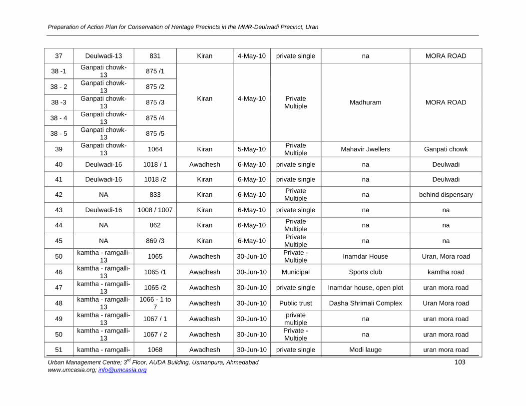
Preparation of Action Plan for Conservation of Heritage Precincts in the MMR-Deulwadi Precinct, Uran
Urban Management Centre; 3rd
Floor, AUDA Building, Usmanpura, Ahmedabad 103 www.umcasia.org; [email protected]
37 Deulwadi-13 831 Kiran 4-May-10 private single na MORA ROAD
38 -1 Ganpati chowk-
13 875 /1
Kiran
4-May-10
Private Multiple
Madhuram MORA ROAD
38 - 2 Ganpati chowk-
13 875 /2
38 -3 Ganpati chowk-
13 875 /3
38 - 4 Ganpati chowk-
13 875 /4
38 - 5 Ganpati chowk-
13 875 /5
39 Ganpati chowk-
13 1064 Kiran 5-May-10
Private Multiple
Mahavir Jwellers Ganpati chowk
40 Deulwadi-16 1018 / 1 Awadhesh 6-May-10 private single na Deulwadi
41 Deulwadi-16 1018 /2 Kiran 6-May-10 private single na Deulwadi
42 NA 833 Kiran 6-May-10 Private Multiple
na behind dispensary
43 Deulwadi-16 1008 / 1007 Kiran 6-May-10 private single na na
44 NA 862 Kiran 6-May-10 Private Multiple
na na
45 NA 869 /3 Kiran 6-May-10 Private Multiple
na na
50 kamtha - ramgalli-
13 1065 Awadhesh 30-Jun-10
Private - Multiple
Inamdar House Uran, Mora road
46 kamtha - ramgalli-
13 1065 /1 Awadhesh 30-Jun-10 Municipal Sports club kamtha road
47 kamtha - ramgalli-
13 1065 /2 Awadhesh 30-Jun-10 private single Inamdar house, open plot uran mora road
48 kamtha - ramgalli-
13 1066 - 1 to
7 Awadhesh 30-Jun-10 Public trust Dasha Shrimali Complex Uran Mora road
49 kamtha - ramgalli-
13 1067 / 1 Awadhesh 30-Jun-10
private multiple
na uran mora road
50 kamtha - ramgalli-
13 1067 / 2 Awadhesh 30-Jun-10
Private - Multiple
na uran mora road
51 kamtha - ramgalli- 1068 Awadhesh 30-Jun-10 private single Modi lauge uran mora road
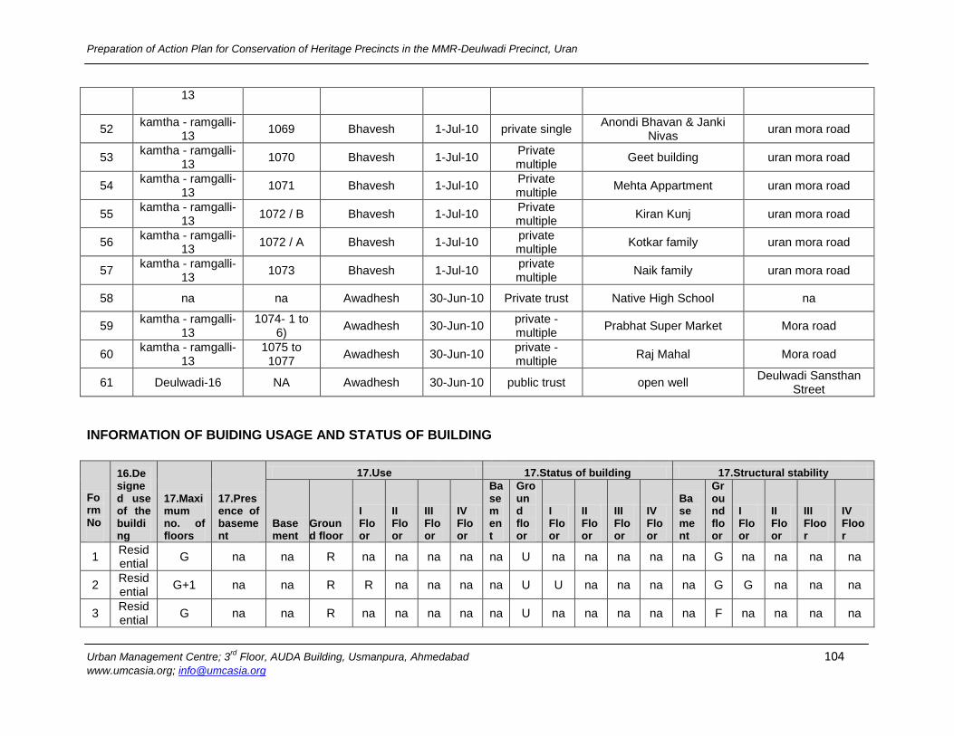
Preparation of Action Plan for Conservation of Heritage Precincts in the MMR-Deulwadi Precinct, Uran
Urban Management Centre; 3rd
Floor, AUDA Building, Usmanpura, Ahmedabad 104 www.umcasia.org; [email protected]
13
52 kamtha - ramgalli-
13 1069 Bhavesh 1-Jul-10 private single
Anondi Bhavan & Janki Nivas
uran mora road
53 kamtha - ramgalli-
13 1070 Bhavesh 1-Jul-10
Private multiple
Geet building uran mora road
54 kamtha - ramgalli-
13 1071 Bhavesh 1-Jul-10
Private multiple
Mehta Appartment uran mora road
55 kamtha - ramgalli-
13 1072 / B Bhavesh 1-Jul-10
Private multiple
Kiran Kunj uran mora road
56 kamtha - ramgalli-
13 1072 / A Bhavesh 1-Jul-10
private multiple
Kotkar family uran mora road
57 kamtha - ramgalli-
13 1073 Bhavesh 1-Jul-10
private multiple
Naik family uran mora road
58 na na Awadhesh 30-Jun-10 Private trust Native High School na
59 kamtha - ramgalli-
13 1074- 1 to
6) Awadhesh 30-Jun-10
private - multiple
Prabhat Super Market Mora road
60 kamtha - ramgalli-
13 1075 to 1077
Awadhesh 30-Jun-10 private - multiple
Raj Mahal Mora road
61 Deulwadi-16 NA Awadhesh 30-Jun-10 public trust open well Deulwadi Sansthan
Street
INFORMATION OF BUIDING USAGE AND STATUS OF BUILDING
Form No
16.Designed use of the building
17.Maximum no. of floors
17.Presence of basement
17.Use 17.Status of building 17.Structural stability
Basement
Ground floor
I Floor
II Floor
III Floor
IV Floor
Basement
Ground floor
I Floor
II Floor
III Floor
IV Floor
Basement
Ground floor
I Floor
II Floor
III Floor
IV Floor
1 Residential
G na na R na na na na na U na na na na na G na na na na
2 Residential
G+1 na na R R na na na na U U na na na na G G na na na
3 Residential
G na na R na na na na na U na na na na na F na na na na
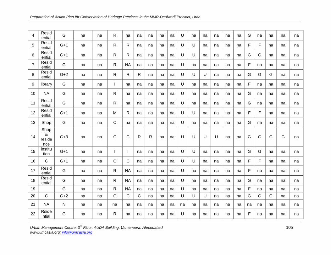
Preparation of Action Plan for Conservation of Heritage Precincts in the MMR-Deulwadi Precinct, Uran
Urban Management Centre; 3rd
Floor, AUDA Building, Usmanpura, Ahmedabad 105 www.umcasia.org; [email protected]
4 Residential
G na na R na na na na na U na na na na na G na na na na
5 Residential
G+1 na na R R na na na na U U na na na na F F na na na
6 Residential
G+1 na na R R na na na na U U na na na na G G na na na
7 Residential
G na na R NA na na na na U na na na na na F na na na na
8 Residential
G+2 na na R R R na na na U U U na na na G G G na na
9 library G na na I na na na na na U na na na na na F na na na na
10 NA G na na R na na na na na U na na na na na G na na na na
11 Residential
G na na R na na na na na U na na na na na G na na na na
12 Residential
G+1 na na M R na na na na U U na na na na F F na na na
13 Shop G na na C na na na na na U na na na na na G na na na na
14
Shop &
residence
G+3 na na C C R R na na U U U U na na G G G G na
15 institution
G+1 na na I I na na na na U U na na na na G G na na na
16 C G+1 na na C C na na na na U U na na na na F F na na na
17 Residential
G na na R NA na na na na U na na na na na F na na na na
18 Residential
G na na R NA na na na na U na na na na na G na na na na
19
G na na R NA na na na na U na na na na na F na na na na
20 C G+2 na na C C C na na na U U U na na na G G G na na
21 NA N na na na na na na na na na na na na na na na na na na na
22 Rsidential
G na na R na na na na na U na na na na na F na na na na
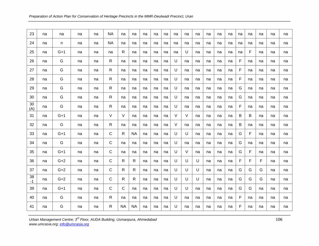
Preparation of Action Plan for Conservation of Heritage Precincts in the MMR-Deulwadi Precinct, Uran
Urban Management Centre; 3rd
Floor, AUDA Building, Usmanpura, Ahmedabad 106 www.umcasia.org; [email protected]
23 na na na na NA na na na na na na na na na na na na na na na na
24 na n na na NA na na na na na na na na na na na na na na na na
25 na G+1 na na na R na na na na na U na na na na na F na na na
26 na G na na R na na na na na U na na na na na F na na na na
27 na G na na R na na na na na U na na na na na F na na na na
28 na G na na R na na na na na U na na na na na F na na na na
29 na G na na R na na na na na U na na na na na G na na na na
30 na G na na R na na na na na U na na na na na G na na na na
30(A)
na G na na R na na na na na U na na na na na F na na na na
31 na G+1 na na V V na na na na V V na na na na B B na na na
32 na G na na R na na na na na V na na na na na B na na na na
33 na G+1 na na C R NA na na na U U na na na na G F na na na
34 na G na na C na na na na na U na na na na na G na na na na
35 na G+1 na na C na na na na na U V na na na na G F na na na
36 na G+2 na na C R R na na na U U U na na na F F F na na
37 na G+2 na na C R R na na na U U U na na na G G G na na
38 -1
na G+2 na na C R R na na na U U U na na na G G G na na
39 na G+1 na na C C na na na na U U na na na na G G na na na
40 na G na na R na na na na na U na na na na na F na na na na
41 na G na na R NA NA na na na U na na na na na F na na na na
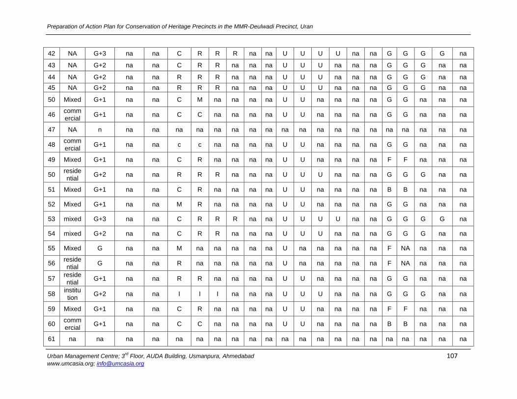
Preparation of Action Plan for Conservation of Heritage Precincts in the MMR-Deulwadi Precinct, Uran
Urban Management Centre; 3rd
Floor, AUDA Building, Usmanpura, Ahmedabad 107 www.umcasia.org; [email protected]
42 NA G+3 na na C R R R na na U U U U na na G G G G na
43 NA G+2 na na C R R na na na U U U na na na G G G na na
44 NA G+2 na na R R R na na na U U U na na na G G G na na
45 NA G+2 na na R R R na na na U U U na na na G G G na na
50 Mixed G+1 na na C M na na na na U U na na na na G G na na na
46 commercial
G+1 na na C C na na na na U U na na na na G G na na na
47 NA n na na na na na na na na na na na na na na na na na na na
48 commercial
G+1 na na c c na na na na U U na na na na G G na na na
49 Mixed G+1 na na C R na na na na U U na na na na F F na na na
50 residential
G+2 na na R R R na na na U U U na na na G G G na na
51 Mixed G+1 na na C R na na na na U U na na na na B B na na na
52 Mixed G+1 na na M R na na na na U U na na na na G G na na na
53 mixed G+3 na na C R R R na na U U U U na na G G G G na
54 mixed G+2 na na C R R na na na U U U na na na G G G na na
55 Mixed G na na M na na na na na U na na na na na F NA na na na
56 residential
G na na R na na na na na U na na na na na F NA na na na
57 residential
G+1 na na R R na na na na U U na na na na G G na na na
58 institution
G+2 na na I I I na na na U U U na na na G G G na na
59 Mixed G+1 na na C R na na na na U U na na na na F F na na na
60 commercial
G+1 na na C C na na na na U U na na na na B B na na na
61 na na na na na na na na na na na na na na na na na na na na na
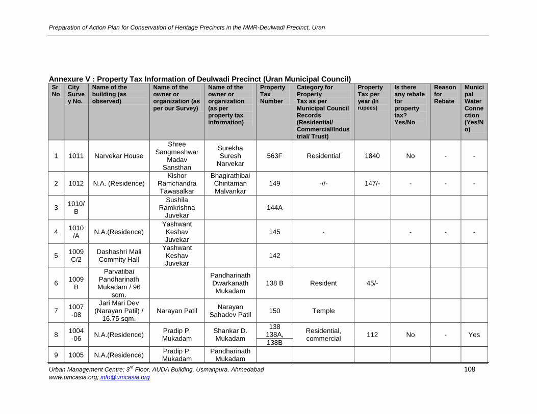
Preparation of Action Plan for Conservation of Heritage Precincts in the MMR-Deulwadi Precinct, Uran
Urban Management Centre; 3rd
Floor, AUDA Building, Usmanpura, Ahmedabad 108 www.umcasia.org; [email protected]
Annexure V : Property Tax Information of Deulwadi Precinct (Uran Municipal Council) Sr No
City Survey No.
Name of the building (as observed)
Name of the owner or organization (as per our Survey)
Name of the owner or organization (as per property tax information)
Property Tax Number
Category for Property Tax as per Municipal Council Records (Residential/ Commercial/Industrial/ Trust)
Property Tax per year (in
rupees)
Is there any rebate for property tax? Yes/No
Reason for Rebate
Municipal Water Connection (Yes/No)
1 1011 Narvekar House
Shree Sangmeshwar
Madav Sansthan
Surekha Suresh
Narvekar 563F Residential 1840 No - -
2 1012 N.A. (Residence) Kishor
Ramchandra Tawasalkar
Bhagirathibai Chintaman Malvankar
149 -//- 147/- - - -
3 1010/
B
Sushila Ramkrishna
Juvekar
144A
4 1010
/A N.A.(Residence)
Yashwant Keshav Juvekar
145 -
- - -
5 1009 C/2
Dashashri Mali Commity Hall
Yashwant Keshav Juvekar
142
6 1009
B
Parvatibai Pandharinath Mukadam / 96
sqm.
Pandharinath Dwarkanath Mukadam
138 B Resident 45/-
7 1007-08
Jari Mari Dev (Narayan Patil) /
16.75 sqm. Narayan Patil
Narayan Sahadev Patil
150 Temple
8 1004-06
N.A.(Residence) Pradip P. Mukadam
Shankar D. Mukadam
138 138A,
Residential, commercial
112 No - Yes 138B
9 1005 N.A.(Residence) Pradip P. Mukadam
Pandharinath Mukadam
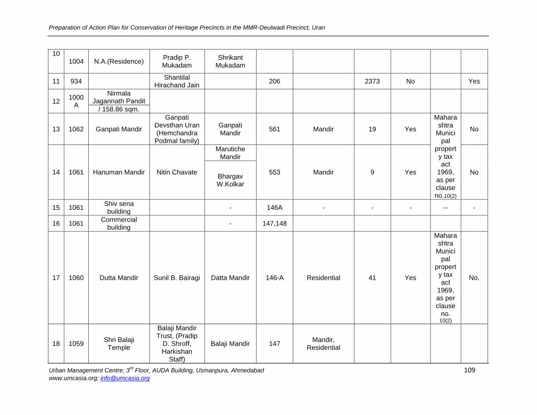
Preparation of Action Plan for Conservation of Heritage Precincts in the MMR-Deulwadi Precinct, Uran
Urban Management Centre; 3rd
Floor, AUDA Building, Usmanpura, Ahmedabad 109 www.umcasia.org; [email protected]
10
1004 N.A.(Residence) Pradip P. Mukadam
Shrikant Mukadam
11 934
Shantilal Hirachand Jain
206
2373 No
Yes
12 1000
A
Nirmala Jagannath Pandit
/ 158.86 sqm.
13 1062 Ganpati Mandir
Ganpati Devsthan Uran (Hemchandra Podmal family)
Ganpati Mandir
561 Mandir 19 Yes
Maharashtra
Municipal
property tax act
1969, as per clause no.10(2)
No
14 1061 Hanuman Mandir Nitin Chavate
Marutiche Mandir
553 Mandir 9 Yes No Bhargav W.Kolkar
15 1061 Shiv sena building
- 146A - - - -- -
16 1061 Commercial
building - 147,148
17 1060 Dutta Mandir Sunil B. Bairagi Datta Mandir 146-A Residential 41 Yes
Maharashtra
Municipal
property tax act
1969, as per clause
no. 10(2)
No.
18 1059 Shri Balaji
Temple
Balaji Mandir Trust, (Pradip
D. Shroff, Harkishan
Staff)
Balaji Mandir 147 Mandir,
Residential
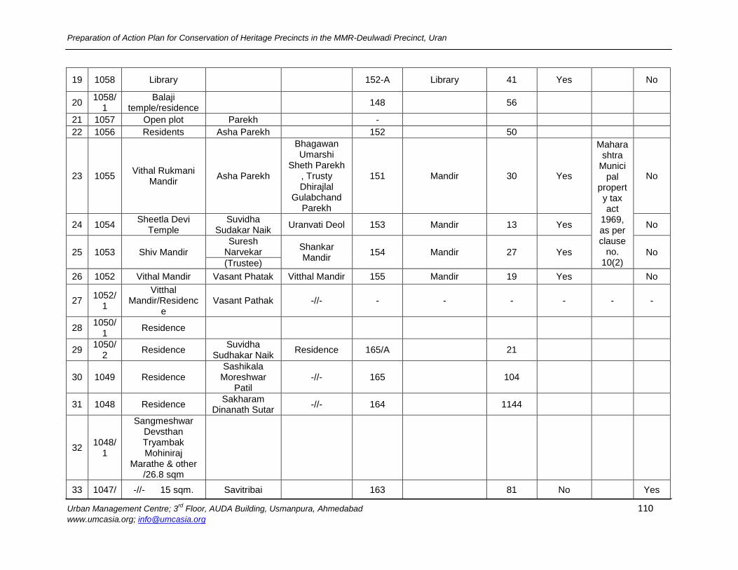
Preparation of Action Plan for Conservation of Heritage Precincts in the MMR-Deulwadi Precinct, Uran
Urban Management Centre; 3rd
Floor, AUDA Building, Usmanpura, Ahmedabad 110 www.umcasia.org; [email protected]
19 1058 Library
152-A Library 41 Yes
No
20 1058/
1 Balaji
temple/residence 148
56
21 1057 Open plot Parekh
-
22 1056 Residents Asha Parekh
152
50
23 1055 Vithal Rukmani
Mandir Asha Parekh
Bhagawan Umarshi
Sheth Parekh , Trusty Dhirajlal
Gulabchand Parekh
151 Mandir 30 Yes
Maharashtra
Municipal
property tax act
1969, as per clause
no. 10(2)
No
24 1054 Sheetla Devi
Temple Suvidha
Sudakar Naik Uranvati Deol 153 Mandir 13 Yes No
25 1053 Shiv Mandir
Suresh Narvekar
Shankar Mandir
154 Mandir 27 Yes No
(Trustee)
26 1052 Vithal Mandir Vasant Phatak Vitthal Mandir 155 Mandir 19 Yes
No
27 1052/
1
Vitthal Mandir/Residenc
e Vasant Pathak -//- - - - - - -
28 1050/
1 Residence
29 1050/
2 Residence
Suvidha Sudhakar Naik
Residence 165/A
21
30 1049 Residence Sashikala
Moreshwar Patil
-//- 165
104
31 1048 Residence Sakharam
Dinanath Sutar -//- 164
1144
32 1048/
1
Sangmeshwar Devsthan Tryambak Mohiniraj
Marathe & other /26.8 sqm
33 1047/ -//- 15 sqm. Savitribai
163
81 No
Yes
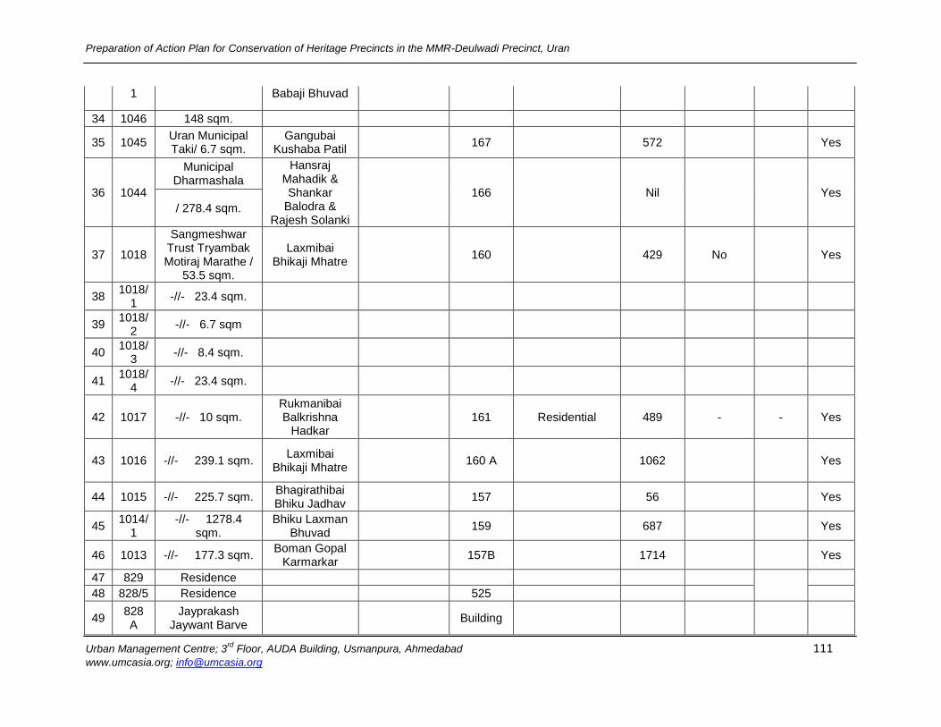
Preparation of Action Plan for Conservation of Heritage Precincts in the MMR-Deulwadi Precinct, Uran
Urban Management Centre; 3rd
Floor, AUDA Building, Usmanpura, Ahmedabad 111 www.umcasia.org; [email protected]
1 Babaji Bhuvad
34 1046 148 sqm.
35 1045 Uran Municipal Taki/ 6.7 sqm.
Gangubai Kushaba Patil
167
572
Yes
36 1044
Municipal Dharmashala
Hansraj Mahadik & Shankar
Balodra & Rajesh Solanki
166
Nil
Yes
/ 278.4 sqm.
37 1018
Sangmeshwar Trust Tryambak Motiraj Marathe /
53.5 sqm.
Laxmibai Bhikaji Mhatre
160
429 No
Yes
38 1018/
1 -//- 23.4 sqm.
39 1018/
2 -//- 6.7 sqm
40 1018/
3 -//- 8.4 sqm.
41 1018/
4 -//- 23.4 sqm.
42 1017 -//- 10 sqm. Rukmanibai Balkrishna
Hadkar
161 Residential 489 - - Yes
43 1016 -//- 239.1 sqm. Laxmibai
Bhikaji Mhatre 160 A
1062
Yes
44 1015 -//- 225.7 sqm. Bhagirathibai Bhiku Jadhav
157
56
Yes
45 1014/
1 -//- 1278.4
sqm. Bhiku Laxman
Bhuvad 159
687
Yes
46 1013 -//- 177.3 sqm. Boman Gopal
Karmarkar 157B
1714
Yes
47 829 Residence
48 828/5 Residence
525
49 828 A
Jayprakash Jaywant Barve
Building
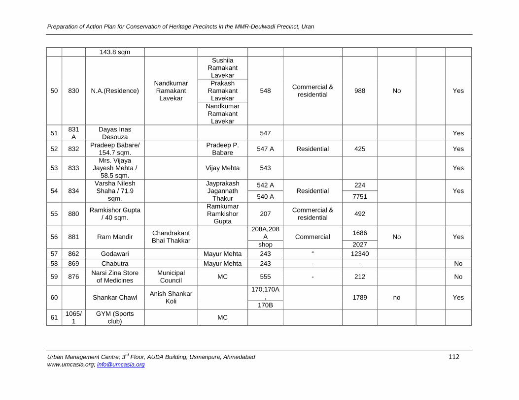
Preparation of Action Plan for Conservation of Heritage Precincts in the MMR-Deulwadi Precinct, Uran
Urban Management Centre; 3rd
Floor, AUDA Building, Usmanpura, Ahmedabad 112 www.umcasia.org; [email protected]
143.8 sqm
50 830 N.A.(Residence) Nandkumar Ramakant Lavekar
Sushila Ramakant Lavekar
548 Commercial &
residential 988 No
Yes
Prakash Ramakant Lavekar
Nandkumar Ramakant Lavekar
51 831 A
Dayas Inas Desouza
547
Yes
52 832 Pradeep Babare/
154.7 sqm. Pradeep P.
Babare 547 A Residential 425
Yes
53 833 Mrs. Vijaya
Jayesh Mehta / 58.5 sqm.
Vijay Mehta 543
Yes
54 834 Varsha Nilesh Shaha / 71.9
sqm.
Jayprakash Jagannath
Thakur
542 A Residential
224
Yes
540 A 7751
55 880 Ramkishor Gupta
/ 40 sqm.
Ramkumar Ramkishor
Gupta 207
Commercial & residential
492
56 881 Ram Mandir Chandrakant Bhai Thakkar
208A,208A Commercial
1686 No
Yes
shop 2027
57 862 Godawari
Mayur Mehta 243 “ 12340
58 869 Chabutra
Mayur Mehta 243 - -
No
59 876 Narsi Zina Store
of Medicines Municipal Council
MC 555 - 212
No
60
Shankar Chawl Anish Shankar
Koli
170,170A,
1789 no
Yes
170B
61 1065/
1 GYM (Sports
club) MC
Related Documents