Preliminary stratigraphic and structural architecture of Bhutan: Implications for the along strike architecture of the Himalayan system Nadine McQuarrie a, ⁎, Delores Robinson b , Sean Long a , Tobgay Tobgay a , Djordje Grujic c , George Gehrels d , Mihai Ducea d a Department of Geosciences, Princeton University, Princeton, NJ, 08544, USA b Department of Geological Sciences, University of Alabama, Tuscaloosa, AL 35487, USA c Department of Earth Sciences, Dalhousie University, Halifax, NS, Canada B3H 4J1 d Department of Geosciences, University of Arizona, Tucson AZ, 85721, USA ABSTRACT ARTICLE INFO Article history: Received 9 November 2007 Received in revised form 4 April 2008 Accepted 16 April 2008 Available online 4 May 2008 Editor: R.D. van der Hilst Keywords: Himalayas Bhutan structural cross-section U–Pb ages zircon Preliminary mapping and stratigraphic correlation of Lesser Himalayan rock in eastern Bhutan using field characteristics, U–Pb detrital zircon dating, and ɛNd geochemistry define the first-order stratigraphic architecture of the Indian passive margin sequence in the eastern Himalaya. We use this new image of the lateral and vertical relationships of the original stratigraphy to determine the structural framework of the eastern Himalayan fold-thrust belt in Bhutan. We propose that Lesser Himalayan rock in Bhutan can be divided into lower Lesser Himalayan rocks with a Paleoproterozoic detrital zircon signal, and upper Lesser Himalayan rocks with detrital zircon signals of ∼ 1000–500 Ma. The ∼ 500 Ma detrital grains are from rocks in the frontal portions of the fold-thrust belt north of the Main Boundary thrust as well as directly in the footwall of the Main Central thrust in the hinterland. Our preliminary stratigraphic study coupled with mapping allows us to construct a composite balanced cross-section through the Kuru Chu valley in eastern Bhutan which provides the first image of the geometry and amount of shortening through Bhutan. The Main Frontal thrust tilts a 6 km of thick section of Neogene foreland basin deposits. These deposits are separated from folded and faulted upper Lesser Himalayan rocks by the Main Boundary thrust. North of the Main Boundary thrust, we propose two duplex systems. The southernmost duplex contains 9 repeated sections of upper Lesser Himalayan units, including the Permian Gondwana Sequence and the Cambrian (or younger) Baxa Group. The northernmost duplex is located in the footwall of the Main Central thrust, and is comprised of two repeated sections of the Proterozoic Shumar and Daling Formations. The southern boundary of this northern duplex is the Shumar thrust which acts as a roof thrust for the southern duplex system and may correlate to the Ramgarh thrust in Nepal and India. We propose that the development of the duplex systems passively folded overlying Tethyan and Greater Himalayan rocks. Minimum shortening for this part of the Himalayan fold-thrust belt is 359 km, all of which has occurred from 22 Ma to present defining a long-term shortening rate of 16 mm/yr. © 2008 Elsevier B.V. All rights reserved. 1. Introduction The Himalayan orogen is the first-order expression of the ongoing collision between India and Asia which began ca. 60–55 Ma (Guillot et al., 2003; Rowley, 1996; LeFort, 1975; Hodges, 2000; Klootwijk et al., 1992; Leech et al., 2005; DeCelles et al., 2004). Throughout Cenozoic time, India has moved northward with respect to Asia. As a result, the sedimentary cover that blanketed the northern Indian craton from early Proterozoic through Paleocene time detached from the under- lying basement in a series of large, south vergent thrust sheets. The telescoping of this Greater Indian stratigraphy records a significant portion of the magnitude convergence between India and Asia. However, much of what is known about the architecture of the Himalayan–Tibetan orogenic system and the original geometry of the Indian passive margin comes from the apex of the Himalaya in Nepal and western India (e.g. Hodges, 2000; Srivastava and Mitra, 1994; Hodges et al., 1996; Vannay and Hodges, 1996; Searle, 1999; DeCelles et al., 2000; Robinson et al., 2001; Robinson et al., 2003; Robinson et al., 2006; Richards et al., 2005; Vannay and Grasemann, 2001). When compared to the central Himalaya, key differences in the structural and stratigraphic architecture have been identified in the western- most portion of the orogen (Pogue et al., 1999; DiPietro and Pogue, 2004) implying the possibility of fundamental variations in the eastern Himalaya as well. Much of the recent work in the eastern part of the orogen has focused on the metamorphic core of the orogen in Bhutan and adjacent Sikkim (Fig. 1) elucidating the metamorphic and deformation Earth and Planetary Science Letters 272 (2008) 105–117 ⁎ Corresponding author. Tel.: +1 609 258 7024; fax: +1 609 258 5275. E-mail address: [email protected] (N. McQuarrie). 0012-821X/$ – see front matter © 2008 Elsevier B.V. All rights reserved. doi:10.1016/j.epsl.2008.04.030 Contents lists available at ScienceDirect Earth and Planetary Science Letters journal homepage: www.elsevier.com/locate/epsl

Welcome message from author
This document is posted to help you gain knowledge. Please leave a comment to let me know what you think about it! Share it to your friends and learn new things together.
Transcript
Earth and Planetary Science Letters 272 (2008) 105–117
Contents lists available at ScienceDirect
Earth and Planetary Science Letters
j ourna l homepage: www.e lsev ie r.com/ locate /eps l
Preliminary stratigraphic and structural architecture of Bhutan: Implications for thealong strike architecture of the Himalayan system
Nadine McQuarrie a,⁎, Delores Robinson b, Sean Long a, Tobgay Tobgay a, Djordje Grujic c,George Gehrels d, Mihai Ducea d
a Department of Geosciences, Princeton University, Princeton, NJ, 08544, USAb Department of Geological Sciences, University of Alabama, Tuscaloosa, AL 35487, USAc Department of Earth Sciences, Dalhousie University, Halifax, NS, Canada B3H 4J1d Department of Geosciences, University of Arizona, Tucson AZ, 85721, USA
⁎ Corresponding author. Tel.: +1 609 258 7024; fax: +E-mail address: [email protected] (N. McQuarrie
0012-821X/$ – see front matter © 2008 Elsevier B.V. Aldoi:10.1016/j.epsl.2008.04.030
A B S T R A C T
A R T I C L E I N F OArticle history:
Preliminary mapping and s Received 9 November 2007Received in revised form 4 April 2008Accepted 16 April 2008Available online 4 May 2008Editor: R.D. van der Hilst
Keywords:HimalayasBhutanstructural cross-sectionU–Pb ageszircon
tratigraphic correlation of Lesser Himalayan rock in eastern Bhutan using fieldcharacteristics, U–Pb detrital zircon dating, and ɛNd geochemistry define the first-order stratigraphicarchitecture of the Indian passive margin sequence in the eastern Himalaya. We use this new image of thelateral and vertical relationships of the original stratigraphy to determine the structural framework of theeastern Himalayan fold-thrust belt in Bhutan. We propose that Lesser Himalayan rock in Bhutan can bedivided into lower Lesser Himalayan rocks with a Paleoproterozoic detrital zircon signal, and upper LesserHimalayan rocks with detrital zircon signals of ∼1000–500 Ma. The ∼500 Ma detrital grains are from rocks inthe frontal portions of the fold-thrust belt north of the Main Boundary thrust as well as directly in thefootwall of the Main Central thrust in the hinterland. Our preliminary stratigraphic study coupled withmapping allows us to construct a composite balanced cross-section through the Kuru Chu valley in easternBhutan which provides the first image of the geometry and amount of shortening through Bhutan. The MainFrontal thrust tilts a 6 km of thick section of Neogene foreland basin deposits. These deposits are separatedfrom folded and faulted upper Lesser Himalayan rocks by the Main Boundary thrust. North of the MainBoundary thrust, we propose two duplex systems. The southernmost duplex contains 9 repeated sections ofupper Lesser Himalayan units, including the Permian Gondwana Sequence and the Cambrian (or younger)Baxa Group. The northernmost duplex is located in the footwall of the Main Central thrust, and is comprisedof two repeated sections of the Proterozoic Shumar and Daling Formations. The southern boundary of thisnorthern duplex is the Shumar thrust which acts as a roof thrust for the southern duplex system and maycorrelate to the Ramgarh thrust in Nepal and India. We propose that the development of the duplex systemspassively folded overlying Tethyan and Greater Himalayan rocks. Minimum shortening for this part of theHimalayan fold-thrust belt is 359 km, all of which has occurred from 22 Ma to present defining a long-termshortening rate of 16 mm/yr.
© 2008 Elsevier B.V. All rights reserved.
1. Introduction
The Himalayan orogen is the first-order expression of the ongoingcollision between India and Asia which began ca. 60–55 Ma (Guillotet al., 2003; Rowley,1996; LeFort, 1975; Hodges, 2000; Klootwijk et al.,1992; Leech et al., 2005; DeCelles et al., 2004). Throughout Cenozoictime, India has moved northward with respect to Asia. As a result, thesedimentary cover that blanketed the northern Indian craton fromearly Proterozoic through Paleocene time detached from the under-lying basement in a series of large, south vergent thrust sheets. Thetelescoping of this Greater Indian stratigraphy records a significantportion of the magnitude convergence between India and Asia.
1 609 258 5275.).
l rights reserved.
However, much of what is known about the architecture of theHimalayan–Tibetan orogenic system and the original geometry of theIndian passive margin comes from the apex of the Himalaya in Nepaland western India (e.g. Hodges, 2000; Srivastava and Mitra, 1994;Hodges et al., 1996; Vannay and Hodges, 1996; Searle, 1999; DeCelleset al., 2000; Robinson et al., 2001; Robinson et al., 2003; Robinson etal., 2006; Richards et al., 2005; Vannay and Grasemann, 2001). Whencompared to the central Himalaya, key differences in the structuraland stratigraphic architecture have been identified in the western-most portion of the orogen (Pogue et al., 1999; DiPietro and Pogue,2004) implying the possibility of fundamental variations in theeastern Himalaya as well.
Much of the recent work in the eastern part of the orogen hasfocused on the metamorphic core of the orogen in Bhutan andadjacent Sikkim (Fig. 1) elucidating themetamorphic and deformation
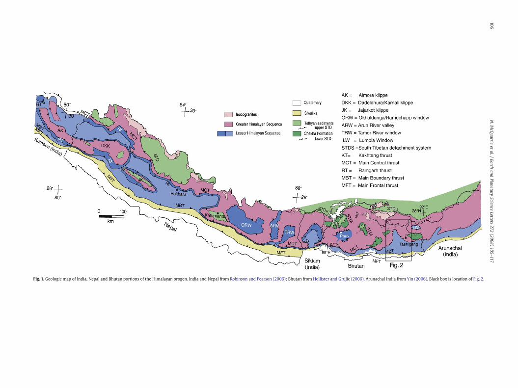
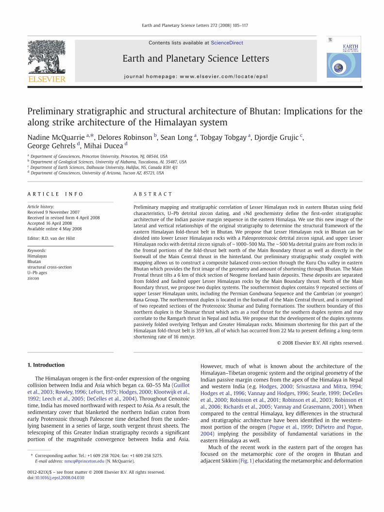
Fig. 1. Geologic map of India, Nepal and Bhutan portions of the Himalayan orogen. India and Nepal from Robinson and Pearson (2006); Bhutan from Hollister and Grujic (2006), Arunachal India from Yin (2006). Black box is location of Fig. 2.
106N.M
cQuarrie
etal./
Earthand
PlanetaryScience
Letters272
(2008)105
–117
107N. McQuarrie et al. / Earth and Planetary Science Letters 272 (2008) 105–117
history in Greater Himalayan rocks (Davidson et al., 1997; Neogi et al.,1998; Ganguly et al., 2000; Grujic et al., 2002; Daniel et al., 2003;Catlos et al., 2004; Dasgupta et al., 2004; Harris et al., 2004; Hollisterand Grujic, 2006; Searle and Szulc, 2005). Only preliminary data existregarding magnitude, timing and style of deformation within theLesser Himalayan portion of the orogen (Ray, 1995; Bhattacharyyaet al., 2006; Yin et al., 2006) or how the sedimentary architectureof the eastern Himalaya relates to that of the central and westernportions (Yin et al., 2006; Richards et al., 2006).
Because research has been concentrated in the central Himalaya,the eastern Himalaya is ripe for investigation to determine whethersimilarities and differences in structure and stratigraphy exist whencompared to Nepal and India. This integrated view is needed in orderto understand the initial stratigraphic architecture of Greater Indiaand the sequence of deformation during the Indo-Asian collision.Shortening variations from west to east across the Himalayan orogencan be used to test hypotheses as varied as: 1) the magnitude ofshortening is directly related to the width of Tibetan Plateau (DeCelleset al., 2002) or 2) variations in shortening magnitude (greater short-ening in the east than thewest) are a function of either the obliquity ofcollision or climate–tectonic interactions (Yin et al., 2006; Guillotet al., 1999; Grujic et al., 2006). We present initial results of ourongoing work in Bhutan. These include a preliminary balanced cross-section through the eastern Himalaya of Bhutan, which illustrates thegeometry of the fold-thrust belt as well as provides critical shorteningestimates for this region. We also present new detrital zircon U–Pbages and ɛNd isotopic signatures in Lesser Himalayan strata. Thesedata help document the first-order stratigraphic framework of theeastern Himalaya in Bhutan.
2. Methods
Our study presents new geologic mapping at a scale of 1:50,000along the upper Kuru Chu valley, and along the road fromTrashigang toSamdrup Jonkhar in eastern Bhutan, a combined distance of ∼130 kmacross strike (Figs. 1 and 2). We have integrated our mapping withprevious mapping (Gansser, 1983; Bhargava, 1995; Gokul, 1983) toinfer along strike changes in stratigraphy and structure from east towest along the Kuru Chu valley (Fig. 2). Cross-section construction andbalancing was based primarily on surface data with a few constraintsfrom teleseismic data (Mitra et al., 2005), well data and the INDEPTH(International deep profiling of Tibet and the Himalaya) data (Haucket al., 1998). Samples were collected and analyzed for both detritalzircon U–Pb ages and whole rock ɛNd signatures. These ages, sig-natures and our lithostratigraphic observations aided in the regionalcorrelation of Lesser Himalayan rocks as well as provided newconstraints on pre-Cenozoic tectonostratigraphic architecture of theregion.
3. Tectonostratigraphy
Rocks that were a part of Greater India prior to the development ofthe Himalayan–Tibetan orogen have traditionally been divided intotectonostratigraphic or structural packages that can be recognizedalong the length of the orogen (LeFort, 1975; Hodges, 2000; Yin, 2006;Gansser, 1964). Each package of rock is bounded bymajor brittle faultsand ductile shear zones and to a first order, displays a characteristicstratigraphy. From south to north, the classic subdivisions and majorbounding faults are the Indo-Gangetic foreland basin, theMain Frontalthrust, Subhimalayan strata, Main Boundary thrust, Lesser Himalayanstrata, Main Central thrust, Greater Himalayan rocks, South Tibetandetachment system, Tethyan Himalayan strata, and the Indus-Yalusuture zone, which marks the northern limit of rocks associated withIndia (Fig. 1).
During Proterozoic and possibly early Paleozoic time, the northernportion of the Indian craton was blanketed with a thick succession
(∼8–12 km) of clastic and carbonate sediments that is referred to asthe Lesser Himalayan sequence (Robinson et al., 2006; Yin, 2006;Gansser, 1964; Gansser, 1964; Upreti, 1996; Upreti, 1999; Schelling andArita, 1991). In Nepal, these rocks are entirely of Paleoproterozoic andMesoproterozoic age (DeCelles et al., 2000; Martin et al., 2005),although in western India the Lesser Himalayan sequence may extendinto the Cambrian (Richards et al., 2005; Myrow et al., 2003).
The protoliths of metasedimentary rocks and orthogneisses of theGreater Himalaya (GH) are Proterozoic to early Paleozoic in age(DeCelles et al., 2000; Yin, 2006; Martin et al., 2005; Parrish andHodges, 1996; Gehrels et al., 2003), and are separated from rocksexposed in the Lesser Himalaya (LH) by the Main Central thrust (MCT).The thrust contact between LH and GH rocks raises questionsregarding the original paleogeography of the two units. GH rocksare interpreted to represent 1) highly metamorphosed equivalents ofuppermost LH strata (Parrish and Hodges, 1996) or Paleozoic Tethyanstrata (Myrow et al., 2003), or 2) an accreted terrane tectonicallyconsolidated with Greater India during early Paleozoic time (DeCelleset al., 2000; Gehrels et al., 2003). DeCelles et al. (2000) proposes thatthe distinctly different U–Pb age spectrum of LH (prominent 1.8 Gapeak) and GH (∼700 Ma to 1.3 Ga) rocks in Nepal require that thepredominantly Neoproterozoic GH rocks could not have been attachedto Greater India prior to the early Paleozoic.
Throughout Paleozoic and Mesozoic time, the northern margin ofIndia was again the locus of passive margin sedimentation (Gaetaniand Garzanti, 1991; Brookfield, 1993; Garzanti, 1999). The resultingstrata are a composite of two superimposed rift to passive marginsequences, the first early Paleozoic to Carboniferous in age and thesecond Permian to Cretaceous in age. This succession of rocks that arecommonly preserved structurally above and geographically north ofthe MCT is referred to as the Tethyan sedimentary sequence (TH). TheSouth Tibetan detachment system (STD, Fig. 1) separates GH rock inthe south from rock in the Tethyan Himalaya (TH) to the north. Moreproximal (with respect to India) time equivalents of Tethyan strata arelocally preserved as the continental Gondwana sequence (included inLH stratigraphy) and range in age from Permian through Paleocene(see summary in Yin (2006)).
Depositionally above the Gondwana sequence are the Tertiaryforeland basin sediments of the Himalayan orogenic system, whichinclude the Siwalik Group. These synorogenic sedimentary rocks wereshed from the growing mountain belt in mid-Miocene–Pliocene time(Quade et al., 1995; DeCelles et al., 1998; Najman et al., 2004).
4. Bhutan stratigraphy
4.1. Subhimalaya
One of the most conspicuous aspects of the Subhimalaya of Bhutanis the discontinuity of the Siwalik Group. Unlike adjacent regions ofthe Himalaya where the Siwalik Group is laterally continuous alongstrike, in Bhutan, the map pattern of synorogenic sediments is patchy,with 20–40 km portions of the belt either covered by Quaternarysediments, overridden by the MBT or apparently never deposited(Gansser, 1983) (Fig. 1). The most complete Siwalik Group section is ineastern Bhutan. It is 4–6 km thick and dips consistently northward at30–40°. Similar to Siwalik Group sections in Nepal and India (Quadeet al.,1995; DeCelles et al.,1998), the entire package generally coarsensupward from clays and silts in the lowest portions of the sectionexposed just north of the MFT, to fluvial siltstone and sandstone in themiddle sections grading to sandstones and gravelly braided riverdeposits in the upper sections.
4.2. Lesser Himalaya
Lesser Himalayan rocks in Bhutan have historically been brokeninto four units (Gansser, 1983; Bhargava, 1995; Gokul, 1983). Although
Fig. 2. Geologic map of the Kuru Chu Valley, Bhutan. Mapping from Gansser (1983), Gokul (1983), Bhargava (1995), Hollister and Grujic (2006), and this study. Dolomite lenses (grey)are from Gansser (1983) and indicate presence of the Baxa Group. Location of Diuri formation to thewest of our transect is from Bhargava (1995). The folded Shumar thrust is inferredfrom Bhargava (1995) and Gokul (1983). Strike and dip symbols indicate our mapping and blue dots are sample locations discussed in text; GHS Greater Himalayan Sequence, MCT,Main Central thrust, MBT, Main Boundary thrust, MFT, Main Frontal thrust. (For interpretation of the references to color in this figure legend, the reader is referred to the web versionof this article.)
108 N. McQuarrie et al. / Earth and Planetary Science Letters 272 (2008) 105–117
lack of fossils and radiometric age dates have led to confusion re-garding the exact stratigraphic order (Gansser, 1983; Bhargava, 1995),our field observations as well as preliminary geochronology and iso-tope geochemistry data allowus to delineate the relative ages of the LHfrom oldest to youngest.
4.2.1. Daling–Shumar GroupThe Daling–Shumar Group was named by Gansser (1983) in an
attempt to link the predominantly phyllitic Daling Formation iden-tified in Sikkim–Darjeeling (Sengupta and Raina, 1978) with thequartzite rich Shumar Formation in eastern Bhutan (Jangpangi, 1974,
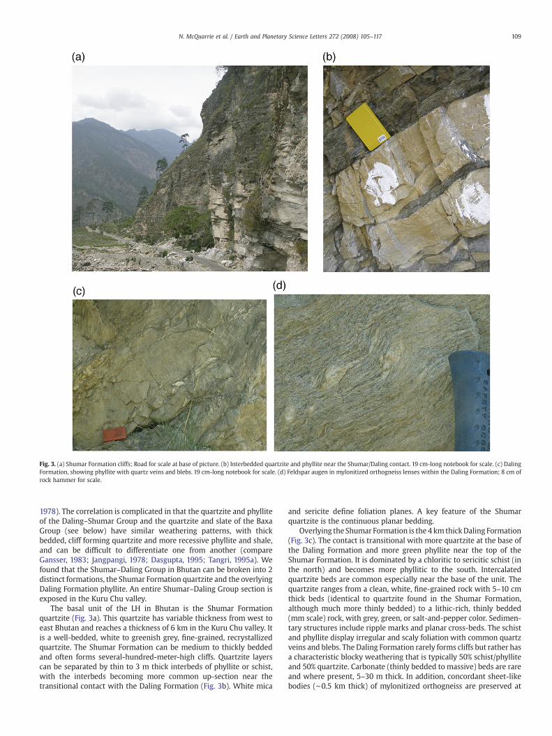
Fig. 3. (a) Shumar Formation cliffs; Road for scale at base of picture. (b) Interbedded quartzite and phyllite near the Shumar/Daling contact. 19 cm-long notebook for scale. (c) DalingFormation, showing phyllite with quartz veins and blebs. 19 cm-long notebook for scale. (d) Feldspar augen in mylonitized orthogneiss lenses within the Daling Formation; 8 cm ofrock hammer for scale.
109N. McQuarrie et al. / Earth and Planetary Science Letters 272 (2008) 105–117
1978). The correlation is complicated in that the quartzite and phylliteof the Daling–Shumar Group and the quartzite and slate of the BaxaGroup (see below) have similar weathering patterns, with thickbedded, cliff forming quartzite and more recessive phyllite and shale,and can be difficult to differentiate one from another (compareGansser, 1983; Jangpangi, 1978; Dasgupta, 1995; Tangri, 1995a). Wefound that the Shumar–Daling Group in Bhutan can be broken into 2distinct formations, the Shumar Formation quartzite and the overlyingDaling Formation phyllite. An entire Shumar–Daling Group section isexposed in the Kuru Chu valley.
The basal unit of the LH in Bhutan is the Shumar Formationquartzite (Fig. 3a). This quartzite has variable thickness from west toeast Bhutan and reaches a thickness of 6 km in the Kuru Chu valley. Itis a well-bedded, white to greenish grey, fine-grained, recrystallizedquartzite. The Shumar Formation can be medium to thickly beddedand often forms several-hundred-meter-high cliffs. Quartzite layerscan be separated by thin to 3 m thick interbeds of phyllite or schist,with the interbeds becoming more common up-section near thetransitional contact with the Daling Formation (Fig. 3b). White mica
and sericite define foliation planes. A key feature of the Shumarquartzite is the continuous planar bedding.
Overlying the Shumar Formation is the 4 km thickDaling Formation(Fig. 3c). The contact is transitional with more quartzite at the base ofthe Daling Formation and more green phyllite near the top of theShumar Formation. It is dominated by a chloritic to sericitic schist (inthe north) and becomes more phyllitic to the south. Intercalatedquartzite beds are common especially near the base of the unit. Thequartzite ranges from a clean, white, fine-grained rock with 5–10 cmthick beds (identical to quartzite found in the Shumar Formation,although much more thinly bedded) to a lithic-rich, thinly bedded(mm scale) rock, with grey, green, or salt-and-pepper color. Sedimen-tary structures include ripple marks and planar cross-beds. The schistand phyllite display irregular and scaly foliation with common quartzveins and blebs. The Daling Formation rarely forms cliffs but rather hasa characteristic blocky weathering that is typically 50% schist/phylliteand 50% quartzite. Carbonate (thinly bedded to massive) beds are rareand where present, 5–30 m thick. In addition, concordant sheet-likebodies (∼0.5 km thick) of mylonitized orthogneiss are preserved at
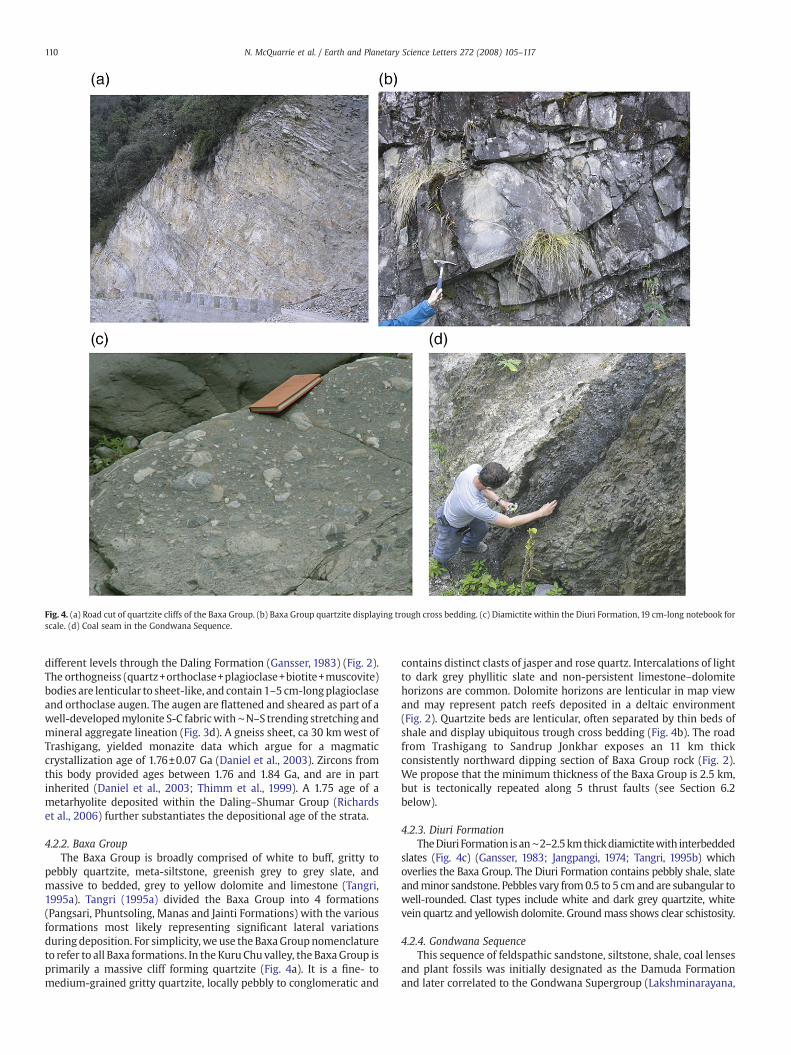
Fig. 4. (a) Road cut of quartzite cliffs of the Baxa Group. (b) Baxa Group quartzite displaying trough cross bedding. (c) Diamictite within the Diuri Formation, 19 cm-long notebook forscale. (d) Coal seam in the Gondwana Sequence.
110 N. McQuarrie et al. / Earth and Planetary Science Letters 272 (2008) 105–117
different levels through the Daling Formation (Gansser, 1983) (Fig. 2).The orthogneiss (quartz+orthoclase+plagioclase+biotite+muscovite)bodies are lenticular to sheet-like, and contain 1–5 cm-longplagioclaseand orthoclase augen. The augen are flattened and sheared as part of awell-developedmylonite S-C fabricwith∼N–S trending stretching andmineral aggregate lineation (Fig. 3d). A gneiss sheet, ca 30 kmwest ofTrashigang, yielded monazite data which argue for a magmaticcrystallization age of 1.76±0.07 Ga (Daniel et al., 2003). Zircons fromthis body provided ages between 1.76 and 1.84 Ga, and are in partinherited (Daniel et al., 2003; Thimm et al., 1999). A 1.75 age of ametarhyolite deposited within the Daling–Shumar Group (Richardset al., 2006) further substantiates the depositional age of the strata.
4.2.2. Baxa GroupThe Baxa Group is broadly comprised of white to buff, gritty to
pebbly quartzite, meta-siltstone, greenish grey to grey slate, andmassive to bedded, grey to yellow dolomite and limestone (Tangri,1995a). Tangri (1995a) divided the Baxa Group into 4 formations(Pangsari, Phuntsoling, Manas and Jainti Formations) with the variousformations most likely representing significant lateral variationsduring deposition. For simplicity,we use the BaxaGroupnomenclatureto refer to all Baxa formations. In the Kuru Chu valley, the BaxaGroup isprimarily a massive cliff forming quartzite (Fig. 4a). It is a fine- tomedium-grained gritty quartzite, locally pebbly to conglomeratic and
contains distinct clasts of jasper and rose quartz. Intercalations of lightto dark grey phyllitic slate and non-persistent limestone–dolomitehorizons are common. Dolomite horizons are lenticular in map viewand may represent patch reefs deposited in a deltaic environment(Fig. 2). Quartzite beds are lenticular, often separated by thin beds ofshale and display ubiquitous trough cross bedding (Fig. 4b). The roadfrom Trashigang to Sandrup Jonkhar exposes an 11 km thickconsistently northward dipping section of Baxa Group rock (Fig. 2).We propose that the minimum thickness of the Baxa Group is 2.5 km,but is tectonically repeated along 5 thrust faults (see Section 6.2below).
4.2.3. Diuri FormationTheDiuri Formation isan∼2–2.5kmthickdiamictitewith interbedded
slates (Fig. 4c) (Gansser, 1983; Jangpangi, 1974; Tangri, 1995b) whichoverlies the Baxa Group. The Diuri Formation contains pebbly shale, slateandminor sandstone. Pebbles vary from0.5 to 5 cmand are subangular towell-rounded. Clast types include white and dark grey quartzite, whitevein quartz and yellowish dolomite. Groundmass shows clear schistosity.
4.2.4. Gondwana SequenceThis sequence of feldspathic sandstone, siltstone, shale, coal lenses
and plant fossils was initially designated as the Damuda Formationand later correlated to the Gondwana Supergroup (Lakshminarayana,
111N. McQuarrie et al. / Earth and Planetary Science Letters 272 (2008) 105–117
1995). In Bhutan both the northern and southern boundaries of theGondwana sequence are faultedmaking its initial relationship to olderunits uncertain. However, the stratigraphic age of the unit is Permian(Lakshminarayana, 1995). Along the road to Samdrup Jonkhar theGondwana Sequence contains finely-laminated, dark, salt-and-peppersandstone and quartzite, coal seams and carbonaceous shale and slate.Sandstone and quartzite have thick- to massive-bedding (Fig. 4d).Total thickness of the Gondwana sequence is ∼2 km.
4.3. Greater Himalaya
Much of Bhutan is dominated by exposed GH rock, which crops outover a north–southwidth of 60–100 km between the STD and theMCT(Fig. 1). GH rocks in Bhutan are composed of paragneiss, orthogneiss,(increasingly migmatitic in the higher structural levels) schist,quartzite, Miocene age leucogranites, and less common marble andamphibolite layers. In the Kuru Chu valley, the MCT places GH augengneiss (with leucosomes) over LH quartzite and pelitic schist (2 mica+quartz+ lithics+/−garnet) in the footwall. Within GH rocks, para-gneiss and quartzite become more common up-section until theKakhtang thrust which places migmatite over garnet-stauroliteschists (Davidson et al., 1997; Grujic et al., 2002; Daniel et al., 2003).
5. Geochronology and regional correlations
Multiple studies using a combination of whole rock Nd isotopesand U–Pb detrital zircon (DZ) spectra have documented the first-ordergeochemical and geochronological signal of LH and GH rocks acrossthe Himalaya (DeCelles et al., 2000; Robinson et al., 2001; Richardset al., 2005; Richards et al., 2006; Martin et al., 2005; Parrish andHodges, 1996;Whittington et al., 1999; Ahmad et al., 2000). Important
Fig. 5. Comparison of detrital zircon age signature of samples from Bhutan (c) with age signa“young” Mesoproterozoic through Cambrian age spectra from Himachal Pradesh (NW Indiacould be equivalent to the “young” LH recognized in Bhutan and India (Martin et al., 2005)
distinctions are young (1.1–0.5 Ga) zircons in GH rocks, combinedwithless negative (∼−17–0) ɛNd values (Richards et al., 2005). Martin et al.(2005) also clarified that young ∼500 Ma GH zircons are commonlyderived from Cambrian–Ordovician orthogneiss, while GH paragneissrarely have zircons younger than 600 Ma. LH rocks typically containolder zircons (1.6–1.8 Ga) and have more negative (∼−25 to −14) ɛNdvalues. This study tests the continuity of the Greater India passivemargin stratigraphy and builds a regional stratigraphic framework forBhutan through field identification and mapping of regional strata, aswell as U–Pb geochronology and ɛNd isotope geochemistry to de-termine the maximum age of strata as well as defining isotopicsignatures.
5.1. Detrital U–Pb geochronology
U–Pb geochronologic analyses were conducted on individual grainsusing laser-ablation multicollector inductively coupled plasma massspectrometry (LA-MC-ICP-MS). 485 U–Pb zircon analyses from our 5samples that yielded less than 10% error for both 206Pb/238U and 206Pb/207Pb ages and less than 30% isotopic discordance are shown in Fig. 5 inrelative age-probability plots, which are a sum of probability distribu-tions for all analyses from a sample. Age peaks on the plots are con-sidered robust if supported by multiple grain analyses, and peaksdefined by one analysis are considered less significant (see Appendix A).The U–Pb data for individual grains are presented in Appendix B, andsample locations are listed in Table 1. In general, 206Pb⁎/238U (asteriskdenotes correction for common Pb; all ages described in the text havehad this correction) ratios are used for ages younger than 1.0 Ga, and207Pb⁎/206Pb⁎ ratios are used for ages older than 1.0 Ga. Instrumenterrors for measuring the Pb, U, and Th ratios are shown in Appendix B.Other possible sources of error that are not factored into shown errors
tures for known TH, GH, LH and Tertiary samples from Nepal (Martin et al., 2005) (a). b.(Myrow et al., 2003)) and Arunachal (NE India (Yin et al., 2006)). d. Nepal Samples that.
Table 1Sample locations for eastern Bhutan
Sample °N (dd.ddddd) °E (dd.ddddd) Analysis Formation Lithology
NBH-2 27.30917 91.15002 εNd Baxa? Phyllitic schistNBH-5 27.60173 91.21473 DZ Baxa? QuartziteNBH-6 27.60173 91.21473 εNd Baxa? SchistNBH-7 27.59659 91.21401 DZ Baxa? QuartziteNBH-9 27.53238 91.18916 DZ Shumar QuartziteNBH-18 27.01200 91.52072 DZ Baxa QuartziteNBH-19 26.95792 91.54864 εNd Diuri DiamictiteNBH-21 27.01961 91.50954 εNd Baxa PhylliteBU07-1 27.50831 90.87008 DZ Chekha Quartzite
Table 2εNd isotopic analyses
Sample Sm(ppm)
Nd(ppm)
143Nd/144Nd(0)
std err % E(Nd)0
NBH-2 5.27 25.28 0.511643 0.0015 −19.41NBH-6 2.95 11.25 0.511540 0.0018 −21.42NBH-19 2.81 15.42 0.511623 0.0014 −19.80NBH-21 5.48 22.39 0.511540 0.0015 −21.42
112 N. McQuarrie et al. / Earth and Planetary Science Letters 272 (2008) 105–117
include uncertainties in U decay constants, common Pb composition,and calibration to the zircon standard used. These errors could shift theage-probability peaks by up to ∼3% (2σ).
We collected 4 samples from LH rock of Bhutan and one samplefrom the TH Chekha Formation. Three of the LH samples were fromoutcrops previously mapped as the Daling–Shumar Group (Gansser,1983; Bhargava, 1995) and one from the Baxa Group. From north tosouth, BU07-1 was collected from quartzite strata at the base of theChekha Fm and has a strong peak at 845 Ma. NBH-5 has DZ agepopulations as young as 485 Ma, which was collected from a mediumto thinly bedded lithic-rich quartzite sample with minor biotiteschist interbeds. NBH-7 was collected ∼1 km south of sample NBH-5from an ∼25 m thick, clean white quartzite interbed in a two-micaschist. NBH-7 has a similar DZ spectrum as NBH-5 (plateau from1.0 Gato 1.8 Ga) but does not contain young Cambrian grains (Figs. 2 and 5).NBH-9, collected at the Daling–Shumar contact, shows a peak at 1.8–1.9 Ga (Figs. 2 and 5). NBH-18 (Figs. 2 and 5) was collected ∼17 kmnorth of theMBT in Baxa Group strata. It has a strong peak at ∼520Mawith smaller peaks between 1.0 and 1.7 Ga.
5.2. Epsilon Neodymium isotope geochemistry
Sm and Nd isotopic ratios were measured using an IsoProbemulticollector inductively coupled plasma mass spectrometer at theUniversity of Arizona. Nd isotopic measurements were normalized to146Nd/144Nd=0.7219. Analytical procedures are outlined in AppendixC. Table 2 contains the data from the samples collected (calculatedat time T=0). We report Nd isotopic data using ɛNd(0) values be-cause both age of deposition as well as age of pre-Tertiary, concurrentmetamorphism are both unknown for LH and GH rocks. ɛNd(0) arecommonly reported values allowing for straight forward comparisonsto previous work.
Four samples were collected from LH rock, two samples fromoutcrops previously mapped as the Daling–Shumar Group (Gansser,1983; Bhargava,1995), one from the Baxa Group and one from the Diuriformation. NBH-2 was collected from a schist 50 m into the footwall oftheMCT from thewestern side of the Kuru Chu valley while NBH-6 wascollected from a schist 1 km into the footwall of the MCT along thenorthern boundary (within a fewmeters of sample NBH-5) (Fig. 2). ɛNd(0) values for these samples are −19 (NBH-2) and −21 (NBH-6) (Table 2).Sample NBH-21 was collected from a shale ∼18 km north of the MBTwithin the Baxa Group (Fig. 2), and has an ɛNd(0) value of −21, identicalto that of NBH-6. Sample NBH-19, collected from a phyllite at the baseof the Diuri Formation ∼10 km north of the MBT, has an ɛNd(0) valueof −20 (Fig. 2, Table 2).
5.3. Preliminary interpretations and regional correlations
BU07-1 was collected from the basal part of the TH ChekhaFormation that is preserved in a fault bounded klippen in easternBhutan (Grujic et al., 2002) (Fig. 2). Previous work on TH strata inBhutan indicates that the TH extend from the Neoproterozoic throughthe Cretaceous (Gansser, 1983; Bhargava, 1995). Initial DZ and
paleontological work on rocks immediately above the Chekha For-mation (Pele La Group) show a strong Cambro-Ordovician DZ peakwith strong fossil evidence that indicates these strata arelatest Cambrian through Ordovician (Myrow et al., 2005; McKenzieet al., 2007). This previous work combined with our data from BU07-1suggests that the maximum age at the base of the Chekha formationis ∼850Ma, and that lower TH strata extends from the Neoproterozoicthrough Ordovician.
NBH-5, 6, and 7were collected from rock previouslymapped as thelower LH Daling–Shumar Group. Thus, the young ages (0.5 and 1.0 Ga,respectively) of NBH-5 and NBH-7 were not expected. The DZ spectrafor these samples are remarkably similar except that NBH-5 has 6grains, which plot between 564 and 485 Ma (Cambrian–Ordovicianperiod). It is possible that NBH-7 also has these young grains but theywere not part of the 100 grains analyzed, allowing the option thatNBH-5 and NBH-7 are age equivalents and possibly part of the sameformation. The younger DZ ages argue strongly that the rock is notlower LH in origin (Daling–Shumar Group). ɛNd(0) values from cor-relative rocks, NBH-2 and NBH6, (NBH-6 was collected within metersof NBH-5) have values of −19 and −21, respectively (Fig. 2). Thesevalues are consistent with values from LH rocks in other parts of theHimalaya as well as in lower Tethyan strata (Robinson et al., 2001;Martin et al., 2005). Richards et al. (2005) and Myrow et al. (2003)both identified Cambrian DZ ages in the outer LH of NW India.However, the DZ spectra for those rocks show most grains clusteringbetween 0.5 and 1.0 Ga (Fig. 5). Martin et al. (2005) documented ayoung 485 Ma peak and a clustering of grains between 0.8 and 1.4 Gafrom a rock in the immediate footwall of theMCT in central Nepal. Oursamples from Bhutan have a peak at 0.5 Ga, however the unique U–Pbsignature in both NBH-5 and NBH-7 is the spectral “plateau” from 1.0to 1.8 Ga. Recent DZ data from Arunachal Pradesh (east of Bhutan)show a similar spectrum for LH rocks (Yin et al., 2006) directly in thefootwall of the MCT (Fig. 5).
Approximately 5 km south of the MCT in the Kuru Chu valley, indefinite Shumar Formation quartzite (NBH-9; Fig. 2), we obtained a DZspectra that are identical to lower LH rocks identified elsewhere in theHimalaya (pronounced peak at ∼1.8 Ga) (DeCelles et al., 2000;Richards et al., 2005; Daniel et al., 2003; Richards et al., 2006; Martinet al., 2005; Kumar, 1997). Thus, even though the rocks which aremapped directly in the footwall of the MCT do not suggest a lower LHorigin, NBH-9 is definitely a lower LH rock.
Our youngest DZ sample is from the Baxa Group (NBH-18) anddisplays similar age spectra to NBH-5 and a Nepal sample (sample502072 (Martin et al., 2005)) (Fig. 5) that must be youngerthan ∼485 Ma. NBH-21, also collected in the Baxa Group, providedan ɛNd value of −21. The similar DZ spectra of NBH-18 and NBH-5, andthe identical ɛNd values of NBH-6 and NBH-21 (Figs. 2 and 5; Tables 1and 2) suggest that the strata NBH-5, 6, and 7 were sampled fromcould be a more northern equivalent to the Baxa Group (NBH-18 andNBH-21). The young LH DZ samples (NBH-5, and 18) showa clear ~500Ma peak similar to TH Cambro-Orodovician strata in Bhutan(McKenzie et al., 2007) indicating that the LH strata may be proximalcontinental shelf deposits contemporaneous with more distal Tethyandeposits. Both TH and LH strata may be sourced from and overlapproposed Cambro-Orodovician deformation (Gehrels et al., 2003;Brookfield, 1993; McKenzie et al., 2007).
113N. McQuarrie et al. / Earth and Planetary Science Letters 272 (2008) 105–117
NBH-19 was collected from a phyllitic diamictite in the DiuriFormation. Age estimates of the Diuri Formation range fromProterozoic through Permian (Gansser, 1983; Jangpangi, 1974; Tangri,1995b). Because ɛNd values for Permian rock do not exist along theHimalayan arc, it is impossible to compare ɛNd values between theDiuri and known Permian strata. Field data show that the Diuri directlyoverlies the Baxa Group, arguing that the maximum age of the Diuri isCambrian. Like the Baxa Group, the ɛNd value for the Diuri Formation(−20) falls within the range of other LH rock and within valuesobtained for Paleozoic Tethyan rock (Robinson et al., 2001).
Correlations in DZ spectra and fossil age control between LH and THrocks have been used to argue for a continuous passive marginsedimentary package for LH (proximal) and TH (distal) in NW Indianot only in the late Cambrian through Devonian, but from theProterozoic on (Myrow et al., 2003). Although our data suggest thatbasal TH and upper LH strata are time equivalent in Bhutan, the data donot suggest that sedimentationwas continuous between lower LH strataand upper LH strata. A significant unconformity could exist between thedefinitive lower LH Shumar–Daling rocks and the rocks near the MCT(NBH-5–7) but it is masked bymetamorphism and deformation. 0.6 kmsouth of sampleNBH-7 is an augengniess body. Correlative augen gneissin Bhutan, Arunachal, and Nepal have been dated at ∼1.8 Ga (DeCelleset al., 2000; Daniel et al., 2003; Kumar, 1997), which supports theinterpretation of an unconformity, or very low sedimentation ratesbetween upper and lower LH rocks. The ∼500 Ma detrital zircons fromBaxa Group rocks as well as Cambro-Ordovician TH were most likelysourced from late Pan-African deformation on the northern and easternedges of Greater India (Gehrels et al., 2003; Brookfield, 1993; McKenzieet al., 2007; Argles et al., 1999; Hoffman, 1991). Combining Indian andBhutan data with that from Nepal, which stands out due to a well-defined lack of lower Paleozoic strata in LH rocks, suggests that Nepaloccupied a region of significant sediment bypass during early Paleozoictime or that the rocks of that age were eroded before Gondwanasequence deposition.
6. Structural geology
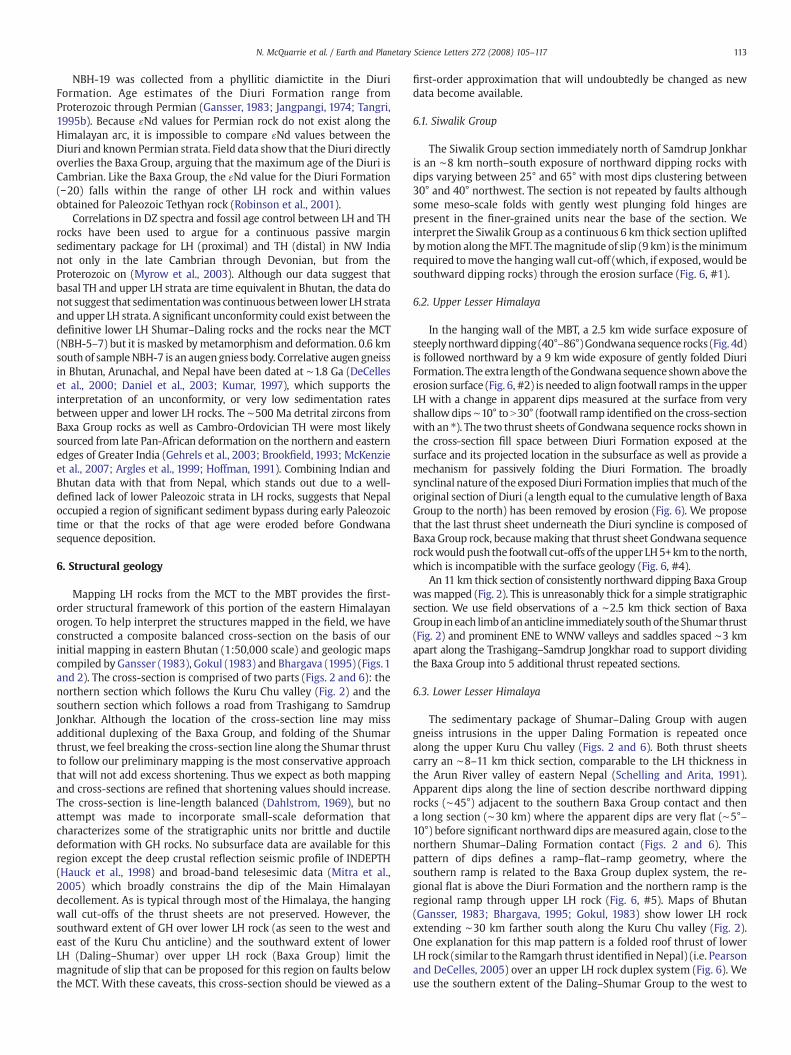
Mapping LH rocks from the MCT to the MBT provides the first-order structural framework of this portion of the eastern Himalayanorogen. To help interpret the structures mapped in the field, we haveconstructed a composite balanced cross-section on the basis of ourinitial mapping in eastern Bhutan (1:50,000 scale) and geologic mapscompiled by Gansser (1983), Gokul (1983) and Bhargava (1995) (Figs.1and 2). The cross-section is comprised of two parts (Figs. 2 and 6): thenorthern section which follows the Kuru Chu valley (Fig. 2) and thesouthern section which follows a road from Trashigang to SamdrupJonkhar. Although the location of the cross-section line may missadditional duplexing of the Baxa Group, and folding of the Shumarthrust, we feel breaking the cross-section line along the Shumar thrustto follow our preliminary mapping is the most conservative approachthat will not add excess shortening. Thus we expect as both mappingand cross-sections are refined that shortening values should increase.The cross-section is line-length balanced (Dahlstrom, 1969), but noattempt was made to incorporate small-scale deformation thatcharacterizes some of the stratigraphic units nor brittle and ductiledeformation with GH rocks. No subsurface data are available for thisregion except the deep crustal reflection seismic profile of INDEPTH(Hauck et al., 1998) and broad-band telesesimic data (Mitra et al.,2005) which broadly constrains the dip of the Main Himalayandecollement. As is typical through most of the Himalaya, the hangingwall cut-offs of the thrust sheets are not preserved. However, thesouthward extent of GH over lower LH rock (as seen to the west andeast of the Kuru Chu anticline) and the southward extent of lowerLH (Daling–Shumar) over upper LH rock (Baxa Group) limit themagnitude of slip that can be proposed for this region on faults belowthe MCT. With these caveats, this cross-section should be viewed as a
first-order approximation that will undoubtedly be changed as newdata become available.
6.1. Siwalik Group
The Siwalik Group section immediately north of Samdrup Jonkharis an ∼8 km north–south exposure of northward dipping rocks withdips varying between 25° and 65° with most dips clustering between30° and 40° northwest. The section is not repeated by faults althoughsome meso-scale folds with gently west plunging fold hinges arepresent in the finer-grained units near the base of the section. Weinterpret the Siwalik Group as a continuous 6 km thick section upliftedbymotion along theMFT. Themagnitude of slip (9 km) is theminimumrequired tomove the hangingwall cut-off (which, if exposed,would besouthward dipping rocks) through the erosion surface (Fig. 6, #1).
6.2. Upper Lesser Himalaya
In the hanging wall of the MBT, a 2.5 km wide surface exposure ofsteeplynorthwarddipping (40°–86°)Gondwana sequence rocks (Fig. 4d)is followed northward by a 9 km wide exposure of gently folded DiuriFormation. The extra length of theGondwana sequence shownabove theerosion surface (Fig. 6, #2) is needed to align footwall ramps in theupperLH with a change in apparent dips measured at the surface from veryshallow dips∼10° to N30° (footwall ramp identified on the cross-sectionwith an ⁎). The two thrust sheets of Gondwana sequence rocks shown inthe cross-section fill space between Diuri Formation exposed at thesurface and its projected location in the subsurface as well as provide amechanism for passively folding the Diuri Formation. The broadlysynclinal nature of the exposedDiuri Formation implies thatmuch of theoriginal section of Diuri (a length equal to the cumulative length of BaxaGroup to the north) has been removed by erosion (Fig. 6). We proposethat the last thrust sheet underneath the Diuri syncline is composed ofBaxa Group rock, becausemaking that thrust sheet Gondwana sequencerockwould push the footwall cut-offs of the upper LH5+kmto thenorth,which is incompatible with the surface geology (Fig. 6, #4).
An 11 km thick section of consistently northward dipping Baxa Groupwas mapped (Fig. 2). This is unreasonably thick for a simple stratigraphicsection. We use field observations of a ∼2.5 km thick section of BaxaGroup ineach limbof ananticline immediatelysouthof theShumar thrust(Fig. 2) and prominent ENE to WNW valleys and saddles spaced ∼3 kmapart along the Trashigang–Samdrup Jongkhar road to support dividingthe Baxa Group into 5 additional thrust repeated sections.
6.3. Lower Lesser Himalaya
The sedimentary package of Shumar–Daling Group with augengneiss intrusions in the upper Daling Formation is repeated oncealong the upper Kuru Chu valley (Figs. 2 and 6). Both thrust sheetscarry an ∼8–11 km thick section, comparable to the LH thickness inthe Arun River valley of eastern Nepal (Schelling and Arita, 1991).Apparent dips along the line of section describe northward dippingrocks (∼45°) adjacent to the southern Baxa Group contact and thena long section (∼30 km) where the apparent dips are very flat (∼5°–10°) before significant northward dips aremeasured again, close to thenorthern Shumar–Daling Formation contact (Figs. 2 and 6). Thispattern of dips defines a ramp–flat–ramp geometry, where thesouthern ramp is related to the Baxa Group duplex system, the re-gional flat is above the Diuri Formation and the northern ramp is theregional ramp through upper LH rock (Fig. 6, #5). Maps of Bhutan(Gansser, 1983; Bhargava, 1995; Gokul, 1983) show lower LH rockextending ∼30 km farther south along the Kuru Chu valley (Fig. 2).One explanation for this map pattern is a folded roof thrust of lowerLH rock (similar to the Ramgarh thrust identified inNepal) (i.e. Pearsonand DeCelles, 2005) over an upper LH rock duplex system (Fig. 6). Weuse the southern extent of the Daling–Shumar Group to the west to
Fig. 6. Balanced cross-section of the Kuru Chu region, Bhutan. Black diamonds are sample locations with sample numbers. DZ is detrital zircon sample location, END is an ɛNd(0) sample location, MFT, Main Frontal thrust, MBT, Main Boundarythrust, MCT, Main Central thrust, STD, South Tibetan Detachment, KT, Kakhtang thrust. See Fig. 2 for location.
114N.M
cQuarrie
etal./
Earthand
PlanetaryScience
Letters272
(2008)105
–117
115N. McQuarrie et al. / Earth and Planetary Science Letters 272 (2008) 105–117
support the extension of the Shumar thrust over the Baxa Groupduplex. Displacements on each of the thrusts in the lower LH rocks are35 km (northern thrust) and 56 km (southern thrust). All of themeasured cross-beds in the Daling–Shumar Group indicate that strataare right side up from immediately in the footwall of the MCT to theShumar thrust. These data combined with structural observationssuggest that there is no large scale, tight to isoclinal folding of LH rocknear theMCT. Based on our DZ and ɛNd data, we suggest that there areupper LH rocks stratigraphically above lower LH rocks in the footwallof the MCT. The thickness of this unit is ∼2 km.
Comparing the stratigraphy of lower LH rock from western Nepal(3–4.5 km (Robinson et al., 2006)) to Eastern Nepal (11 km (Schellingand Arita, 1991)) and Bhutan (∼8–11 km) initially suggests that a first-order change exists in the stratigraphic thickness, which may result inshortening variations between the central and eastern Himalaya.
6.4. Greater Himalaya
Pervasive ductile fabrics through the MCT in conjunction withmineral assemblages, thermobarometric datasets, and the widespreadpresence of migmatite and leucogranite in most exposures of GH rocksare used to support the idea that the rocks may have flowed at mid-crustal depths (Davidson et al., 1997; Ganguly et al., 2000; Daniel et al.,2003; Hollister and Grujic, 2006; Searle and Szulc, 2005; Grujic et al.,1996; Hodges et al., 2001; Searle et al., 2003). The ductile fabricsthroughout GH rocks emphasizes that any estimate of displacement onthe MCT is a bare minimum; however, the southernmost extent of GHrock from east and west of our line of section can be used to determinethe absolute minimum displacement estimate of ∼100 km. On average,throughout Bhutan, themain foliation in GH rocks dips gently (∼20–30°)to the north; however, the foliation is affected by long wavelength, lowamplitude E–Wand N–S trending folds. The interference of the two foldsets produces gentle basin and dome structures seen in themap patternsof the region (Gansser, 1983; Grujic et al., 1996) (Fig. 1). The Kuru Chuvalley is the topographic expression of one of the prominent N–Strending antiforms in Bhutan. Normal fault bounded klippen of the THChekha Formation (Grujic et al., 2002) exposed east andwest of the KuruChu valley, are preserved in the core of a prominent E–W trendingsynform. (Figs. 1 and 2). We propose that many of these map scale foldspreserved in GH rocks are a result of duplexing of LH rock at depth. Thatthe LH strata immediately below theMCTcontains 500Ma zircon grainsand Chekha Formation directly above the GH only contains grains asyoung as∼850 suggests that theMCTmust havefirst been emplaced as athrust over Baxa Group equivalents and that MCT displacement must begreater than STD displacement by ∼100 km. North of the MCT theKakhtang thrust places sillimanite bearing migmatite over lower gradeparagneiss (Grujic et al., 2002; Daniel et al., 2003). It also cuts acrosspenetrative fabrics andmetamorphic isograds (Davidsonet al.,1997). LiketheMCTwe can only estimate theminimummagnitude of displacementon the Kakhtang thrust. Assuming the Kakhtang thrust roots into theMain Himalayan thrust (Nelson et al., 1996), and that the hanging wallcut-off is immediately above the erosion surface, the minimum amountof displacement on the Kakhtang thrust is 33 km (Fig. 6).
7. Shortening and preliminary kinematic history
7.1. Shortening
Total shortening for the composite cross-sectionpresentedhere fromthe MFT to the STD is 359 km or 74%. Motion on the MCT contributes100 km of the shortening due to overlap of GH rock over top of LH rock,while minimum displacement on the Kakhtang thrust contributes33 km (see Fig. 2). The two thrust sheets in lower LH rock accommodate91 km of shortening. Minimum shortening in the upper LH duplex is126km,whileminimumshortening in theSiwalikGroupsection is9 km.Shortening calculated in the upper LH duplex is dependent on our
thickness estimate for the Baxa Group quartzite. If the Baxa quartzite is5 km thick, then shorteningwould be 50 km less than indicated above. Ifthe Baxa quartzite is only 1 km thick, then the shortening estimatewould increase by∼100 km. These shortening estimates are still less (by∼150 to asmuchas 400 km) than shorteningestimates inwesternNepal(485–743 km; Robinson et al., 2006), although the percent shortening isvery similar to values inwestern Nepal and India (Srivastava and Mitra,1994; Robinson et al., 2006; DeCelles et al., 2001). The proposedshortening estimates for Bhutan presented here are greater than the245–280 km estimates proposed for eastern Nepal (Schelling and Arita,1991; Schelling, 1992). DeCelles et al. (2002) predicted that Bhutanshould have shorteningon the order of 350–400 km from theMFT to theSTD and an additional 150–200 km of shortening in TH rock from theSTD northward (DeCelles et al., 2002; Ratschbacher et al., 1994) if themagnitude of shortening is directly related to the width of Tibet. Thisstudy is in agreement with those predicted values. Studies whichsuggest that greater shortening should be found in the easternHimalayabecause of either the obliquity of collision or climate–tectonic interac-tions (Yin et al., 2006; Guillot et al., 1999; Grujic et al., 2006) are notsupported by our preliminary shortening estimates, or require thatshortening is accommodated solely on the MCT pre-16 Ma. These earlycomparisons are qualifiedby thepreliminary nature of our studyandweanticipate that shortening estimates will continue to be refined inconjunction with more detailed mapping of the region.
7.2. Kinematic history
Thekinematic historyof theHimalayan fold-thrust belt inBhutancanonly be broadly defined by available metamorphic, and geochronologicdata. Geothermometry and geobarometry in Bhutan (Grujic et al., 2002;Daniel et al., 2003; Hollister and Grujic, 2006) suggest peak meta-morphic conditions inGH rock at∼22Ma at pressures and temperaturesbetween 10–12 kb and 650–850 °C respectively with highest tempera-tures recorded in the core of the sequence and highest pressures at thebase. Monazite and xenotime inmigmatite proximal to theMCT yield U/Pb ages of 16–18Ma, while growth of metamorphic monazite in LH rockoccurred between 18 and 20 Ma (Daniel et al., 2003). Growth age ofmetamorphic crystals/overgrowths implies that the deformationwithinLH rocks occurred at greenschist facies conditions (over 400 °C) andwasrelated to the south directed thrusting thatwas underway by 22Ma, andcontinued until perhaps 14 Ma or younger (Daniel et al., 2003).
With the above data as support, we suggest the following kinematichistory. Emplacement of GH over LH via ductile shearing along theMCToccurred between 22 and 16 Ma as suggested by crystallization ages inGH migmatite and metamorphic monazite in LH rock (Godin et al.,2006). As currently drawn, the cross-section suggests coeval motion onthe northernmost lower LH thrust and the southern extension of theMCT, with the MCT acting as a roof thrust for a single LH thrust sheet.Thusmotionon this LH thrust probably started∼18Ma, concurrentwithburial of the rocks carried by the southern lower LH thrust sheet(Shumar thrust). We propose that the 10–15 Ma 40Ar/39Ar cooling ageswithin GH rocks proximal to theMCTare not the result ofMCT thrustingbut rather are associated with rock-uplift and erosion during theemplacement of the Shumar thrust (∼16–13 Ma) and the initial growthof the upper LHduplex. Crystallization ages of leucogranite deformed bythe Kakhtang thrust indicate out-of-sequence motion on the thrust at14–15Ma (Grujic et al., 2002;Daniel et al., 2003) or younger. Folding andcooling of GH rock during thrusting and duplex development in thelower LH rock is concurrent with motion on the Kakhtang thrust whichsupports the assertion of Grujic et al. (2002) that folding of theMCT/STDsystem inhibits motion on the frontal faults and promotes out-of-sequence deformation in the hinterland. In our proposed kinematichistory, the folding of the MCT/STD system is a direct result ofemplacementof thrust sheets in the two LHduplexes as they developed.The remaining ∼100 km of shortening within the upper LH and Sub-himalaya most likely occurred post-10 Ma, but a lack of
116 N. McQuarrie et al. / Earth and Planetary Science Letters 272 (2008) 105–117
thermochronologic data in LH rock or sedimentological data from theSiwalik Group prevent us from a more detailed shortening history.
We can combine the above history with the displacement mag-nitudes predicted by the balanced cross-section to get first-orderestimates on rates of deformation. 359 km of shortening in 22 Myrprovides a long-term rate of shortening of 16.3 mm/yr. Active GPSshortening rates across the Himalaya are 15–20 mm/yr (Lave andAvouac, 2000; Banerjee and Bürgmann, 2002; Zhang et al., 2004).
8. Conclusions
Although the data presented here are preliminary, several conclu-sions are derived from this study:
1- Lesser Himalayan strata in Bhutan can be divided into lower LHrocks with a detrital zircon signal of ∼1.8 Ga and younger upper LHrock with a detrital zircon signal as young as ∼500 Ma. Thispartitioning of LH strata is similar to that identified in India, butsignificantly different than LH sequence strata of Nepal, whichhave only Proterozoic detrital zircon ages. The preliminary datapresented here reinforces the suggestions of previous workers thatPaleoproterozoic LH rock is continuous along the entire arc.However, they also highlights an importance of correlating theLH stratigraphy across the arc because of regional variations inMesoproterozoic–Paleozoic stratigraphy.
2- Upper LH strata are time equivalent with Tethyan strata, suggestingboth may represent overlap strata after proposed Cambro-Ordovician deformation along the northern Indian margin.
3- The Bhutanese portion of the eastern Himalayan fold-thrust belthas key similarities with structures exposed in the centralHimalayan fold-thrust belt. These include: A) a significant overlap(100+ km) of GH over LH rock via the MCT; B) a long (56 km +)thrust sheet (Shumar thrust) of lower LH rock emplaced over anupper LH duplex. This geometry is similar to the emplacement ofthe Ramgarh thrust over the LH duplex in Nepal and NorthwesternIndia; C) folding of overlying GH and TH rock as a result of growthin the LH duplex; D) 100s of km of shortening due to thedevelopment of a LH duplex system.
4- Minimum shortening in this part of the Himalayan fold-thrust beltis 359 km. This estimate is significantly less than estimates fartherto the west (∼500–700 km). Although this shortening estimate ispreliminary and based on a composite section, it implies that alongstrike variations in shortening along the Himalayan arc are real andsignificant.
5- The preliminary kinematic history we present emphasizes that thetiming of major tectonic events seems to be the same 100s of kmalong strike of the Himalayan orogen. These include shear displace-ment of the GHover the LH∼20–18Ma, emplacement of a long lowerLH thrust ∼16–14 Ma, and growth of an upper LH duplex system∼10Ma to present. Similar timingof events but significant differencesin slipmagnitudes suggests that the rate of deformation in theeasternHimalaya is considerably less than in the west.
Acknowledgements
Wewould like to thank theGovernment of Bhutan, particularly DorjiWangda, Yeshi Dorji, K.S. Ghalley at the Department of Geology andMines in theMinistry of EconomicAffairs for their help and support. Thiswork was partially supported by NSF grant EAR 0738522 to N.McQuarrie. We are grateful for the constructive comments of reviewersand Editor Rob van der Hilst.
Appendix A. Supplementary data
Supplementary data associated with this article can be found, inthe online version, at doi:10.1016/j.epsl.2008.04.030.
References
Ahmad, T., Harris, N., Bickle, M., Chapman, H., Bunbury, J., Prince, C., 2000. Isotopicconstraints on the structural relationships between the Lesser Himalayan Seriesand the High Himalayan Crystalline Series, Garhwal Himalaya. Geol. Soc. Amer. Bull.112, 467–477.
Argles, T.W., Prince, C.I., Foster, G.L., Vance, D., 1999. New garnets for old? Cautionarytales from young mountain belts. Earth Planet. Sci. Lett. 172, 301–309.
Banerjee, P., Bürgmann, R., 2002. Convergence across the northwest Himalaya from GPSmeasurements. Geophys. Res. Lett.. doi:10.1029/2002GL015184.
Bhargava, O.N., 1995. The Bhutan Himalaya: a Geological Account. Geological Survey ofIndia Special Publication, vol. 39. 245 pp.
Bhattacharyya, K., Mitra, G., Mukul, M., 2006. The geometry and implications of aforeland diping duplex. the Rangit Duplex, Darjeeling–Sikkim Himalayas, India.Abstr. Programs - Geol. Soc. Am. 38, 413.
Brookfield, M.E.,1993. The Himalayan passivemargin from Precambrian to the Cretaceoustimes. Sediment. Geol. 84, 1–35.
Catlos, E.J., Dubey, C.S., Harrison, T.M., Edwards, M.A., 2004. Late Miocene movementwithin the Himalayan Main Central Thrust shear zone, Sikkim, north-east India.J. Metamorph. Geol. 22, 207–226.
Dahlstrom, C.D.A., 1969. Balanced cross-sections. Can. J. Earth Sci. 6, 743–757.Daniel, C.G.,Hollister, L.S., Parrish, R.R.,Grujic,D., 2003. Exhumationof themain central thrust
from lower crustal depths, Eastern Bhutan Himalaya. J. Metamorph. Geol. 21, 317–334.Dasgupta, S., 1995. Shumar Formation. In: Bhargava, O.N. (Ed.), The Bhutan Himalaya: a
Geological Account. Geological Survey of India Special Publication, vol. 39, pp. 59–78.Dasgupta, S., Ganguly, J., Neogi, S., 2004. Inverted metamorphic sequence in the Sikkim
Himalayas: crystallization history, P–T gradient and implications. J. Metamorph.Geol. 22, 395–412.
Davidson, C., Grujic, D.E., Hollister, L.S., Schmid, S.M., 1997. Metamorphic reactionsrelated to decompression and synkinematic intrusion of leucogranite, HighHimalayan Crystallines, Bhutan. J. Metamorph. Geol. 15, 593–612.
DeCelles, P.G., Gehrels, G.E., Quade, J., Ojha, T.P., 1998. Eocene early Miocene forelandbasin development and the history of Himalayan thrusting, western and centralNepal. Tectonics 17, 741–765.
DeCelles, P.G., Gehrels, G.E., Quade, J., LaReau, B., Spurlin, M., 2000. Tectonic implicationsof U–Pb zircon ages of the Himalayan orogenic belt in Nepal. Science 288, 497–499.
DeCelles, P.G., Robinson, D.M., Quade, J., Ojha, T.P., Garzione, C.N., Copeland, P., Upreti,B.N., 2001. Stratigraphy, structure, and tectonic evolution of the Himalayan fold-thrust belt in western Nepal. Tectonics 20, 487–509.
DeCelles, P.G., Robinson, D.M., Zandt, G., 2002. Implications of shortening in theHimalayan fold-thrust belt for uplift of the Tibetan Plateau. Tectonics 21, 1062.doi:10.1029/2001TC001322.
DeCelles, P.G., Gehrels, G.E., Najman, Y., Martin, A.J., Carter, A., Garzanti, E., 2004. Detritalgeochronology and geochemistry of Cretaceous–Early Miocene strata of Nepal:implications for timing and diachroneity of initial Himalayan orogenesis. EarthPlanet. Sci. Lett. 227, 313–330.
DiPietro, J.A., Pogue, K.R., 2004. Tectonostratigraphic subdivisions of the Himalaya: aview from the west. Tectonics 23, TC5001. doi:10.1029/2003TC001554.
Gaetani, M., Garzanti, E., 1991. Multicyclic history of the northern India continental-margin (northwesern Himalaya). AAPG Bull. 75, 1427–1446.
Ganguly, J., Dasgupta, S., Cheng, W., Neogi, S., 2000. Exhumation history of a section ofthe Sikkim Himalayas, India: records in the metamorphic mineral equilibria andcompositional zoning in garnet. Earth Planet. Sci. Lett. 183, 471–486.
Gansser, A., 1964. Geology of the Himalaya. Wiley- Interscience, New York. 289 pp.Gansser, A., 1983. Geology of the Bhutan Himalaya. Birkhäuser Verlag, Basel-Boston-
Stuttgart. 181 pp.Garzanti, E., 1999. Stratigraphy and sedimentary history of the Nepal Tethys Himalaya
passive margin. J. Asian Earth Sci. 17, 805–827.Gehrels, G.E., DeCelles, P., Martin, A.J., Ojha, T., Pinhassi, G., Upreti, B.N., 2003. Initiation
of the Himalayan Orogen as an early Paleozoic thin-skinned thrust belt. GSA Today13, 4–9.
Godin, L., Grujic, D., Searle, M., Law, R.D., 2006. Channel flow, extrusion, and exhumationon continental collision zones: an introduction. In: Law, R.D., Searle, M., Godin, L.(Eds.), Channel Flow, Extrusion and Exhumation of Lower-mid Crust in ContinentalCollision Zones. Geological Society of London Special Publications, vol. 268, pp.1–23.
Gokul, A.R., Geological and Mineral Map of Bhutan: Scale 1:500,000, 1 sheet, GeologicalSurvey of India Map Printing Division, Hyderabad, 1983.
Grujic, D., Casey, M., Davidson, C., Hollister, L.S., Kundig, R., Pavlis, T., Schmid, S., 1996.Ductile extrusion of the Higher Himalayan Crystalline in Bhutan: evidence fromquartz microfabrics. Tectonophysics 260, 21–43.
Grujic, D., Hollister, L.S., Parrish, R.R., 2002. Himalayan metamorphic sequence as anorogenic channel: insight from Bhutan. Earth Planet. Sci. Lett. 198, 177–191.
Grujic, D., Coutand, I., Bookhagen, B., Bonnet, S., Blythe, A., Duncan, C., 2006. Climaticforcing of erosion, landscape, and tectonics in the Bhutan Himalayas. Geology 34,801–804.
Guillot, S., Cosca, M., Allemand, P., Le Fort, P., 1999. Contrasting metamorphic andgeochronologic evolution along the Himalayan belt. In: Macfarlane, A.M., Sorkhabi,R.B., Quade, J. (Eds.), Himalaya and Tibet: Mountain Roots to Mountain Tops.Geological Society of America Special Paper, vol. 328.
Guillot, S., Garzanti, E., Baratoux, D., Marquer, D., Maheo, G., de Sigoyer, J., 2003.Reconstructing the total shortening history of the NW Himalaya. Geochem.,Geophys, Geosyst. 4. doi:10.1029/2002GC000484.
Harris, N.B.W., Caddick, M., Kosler, J., Goswami, S., Vance, D., Tindle, A.G., 2004. Thepressure–temperature–time path of migmatites from the Sikkim Himalaya.J. Metamorph. Geol. 22, 249–264.
117/E.P.S.L.272(2008)105--117
Hauck, M.L., Nelson, K.D., Brown, L.D., Zhao,W.J., Ross, A.R., 1998. Crustal structure of theHimalayan orogen at similar to 90 degrees east longitude from Project INDEPTHdeep reflection profiles. Tectonics 17, 481–500.
Hodges, K.V., 2000. Tectonics of the Himalaya and southern Tibet from two perspectives.Geol. Soc. Amer. Bull. 112, 324–350.
Hodges, K.V., Hurtado, J.M., Whipple, K.X., 2001. Southward extrusion of Tibetan crustand its effect on Himalayan tectonics. Tectonics 20, 799–809.
Hodges, K.V., Parrish, R.R., Searle,M.P.,1996. Tectonic evolution of the central AnnapurnaRange, Nepalese Himalayas. Tectonics 15, 1264–1291.
Hoffman, P.F., 1991. Did the breakout of Laurentia turn Rodinia inside-out. Science 252,1409–1412.
Hollister, L.S., Grujic, D., 2006. Pulsed channelflow in Bhutan. In: Law, R.D., Searle,M., Godin,L. (Eds.), Channel Flow, Extrusion and Exhumation of Lower-mid Crust in ContinentalCollisionZones.Geological Societyof LondonSpecial Publications, vol. 268, pp. 415–423.
Jangpangi, B.S., 1978. Stratigraphy and structure of the Bhutan Himalaya. In: Saklani, P.S.(Ed.), Tectonic Geology of the Himalaya. Today's and Tomorrow's Publications, NewDelhi, pp. 221–242.
Jangpangi, B.S., 1974. Stratigraphy and tectonics of parts of eastern Bhutan. Himal. Geol.4, 117–136.
Klootwijk, C.T., Gee, J.S., Peirce, J.W., Smith, G.M., McFadden, P.L., 1992. An early India–Asia contact: paleomagnetic constraints from Ninetyeast Ridge, ODP Leg 121.Geology 20, 395–398.
Kumar, G., 1997. Geology of Arunachal Pradesh. Geological Society of India, Bangalore.Lakshminarayana, G., 1995. Damuda Supergroup. In: Bhargava, O.N. (Ed.), The Bhutan
Himalaya: a Geological Account. Spec. Publ. Geol. Surv. India, 39, pp. 29–33.Lave, J., Avouac, J.P., 2000. Active folding of fluvial terraces across the Siwaliks Hills,
Himalayas of central Nepal. J. Geophys. Res. -Solid Earth 105, 5735–5770.Leech, M.L., Singh, S., Jain, A.K., Klemperer, S.L., Manickavasagam, R.M., 2005. The onset
of India–Asia continental collision: early, steep subduction required by the timingof UHP metamorphism in the western Himalaya. Earth Planet. Sci. Lett. 234, 83–97.
LeFort, P., 1975. Himalayas: the collided range, present knowledge of the continental arc.Am. J. Sci. A275, 1–44.
Martin, A.J., DeCelles, P.G., Gehrels, G.E., Patchett, P.J., Isachsen, C., 2005. Isotopic andstructural constraints on the location of the Main Central thrust in the AnnapurnaRange, central Nepal Himalaya. Geol. Soc. Amer. Bull. 117, 926–944.
McKenzie, R.N., Hughes, N.C., Myrow, P.M., Bhargava, O.N., Tangri, S.K., Ghalley, K.S.,2007. Fossil and chronostratigraphic constraints on the Quartzite member. BlackMountain region, Bhutan and its geological significance. Abstr. Programs - Geol. Soc.Am. 39, 416.
Mitra, S., Priestley, K., Bhattacharyya, A.K., Gaur, V.K., 2005. Crustal structure andearthquake focal depths beneath northeasteern India and southern Tibet. Geophys.J. Int. 160, 227–248.
Myrow, P.M., Hughes, N.C., Paulsen, T.S., Willlams, I.S., Parcha, S.K., Thompson, K.R.,Bowring, S.A., Peng, S.C., Ahluwalia, A.D., 2003. Integrated tectonostratigraphicanalysis of the Himalaya and implications for its tectonic reconstruction. EarthPlanet. Sci. Lett. 212, 433–441.
Myrow, P.M., Hughes, N.C., Fanning, M., Bhargava, O.N., Tangri, S.K., 2005. Newstratigraphy and geochronologic data for the Tethyan of Bhutan. Abstr. Programs -Geol. Soc. Am. 37, 57.
Najman, Y., Johnson, K., White, N., Oliver, G., 2004. Evolution of the Himalayan forelandbasin, NW India. Basin Research 16, 1–24.
Nelson, K.D., Zhao, W., Brown, L.D., Kuo, J., Che, J., Liu, X., Klemperer, S.L., Makovsky, Y.,Meissner, R.,Mechie, J., Kind, R.,Wenzel, F., Ni, J., Nabelek, J., Chen, L., Tan, H.,Wei,W.,Jones, A.G., Booker, J., Unsworth, M., Kidd, W.S.F., Hauck, M., Alsdorf, D., Ross, A.,Cogan, M., Wu, C., Sandvol, E., Edwards, M., 1996. Partially molten middle crustbeneath southern Tibet: a synthesis of Project INDEPTH results. Science 274,1684–1688.
Neogi, S., Dasgupta, S., Fukuoka, M., 1998. High PT polymetamorphism, dehydrationmelting, and generation of migmatites and granites in the Higher Himalayancrystalline complex, Sikkim, India. J. Petrol. 39, 61–99.
Parrish, R., Hodges, K., 1996. Isotopic constraints on the age and provenance of theLesser and Greater Himalayan sequence, Nepalese Himalaya. Geol. Soc. Amer. Bull.108, 904–911.
Pearson, O.N., DeCelles, P.G., 2005. Structural geology and regional tectonic significanceof the Ramgarh thrust, Himalayan fold-thrust belt of Nepal. Tectonics 24.
Pogue, K.R., Hylland, M.D., Yeats, R.S., Khattak, W.U., Hussain, A., 1999. Stratigraphic andstructural framework of Himalayan foothills, northern Pakistan. In: Macfarlane, A.M., Sorkhabi, R.B., Quade, J. (Eds.), Himalaya and Tibet: Mountain Roots toMountainTops. Geological Society of America Special Paper, vol. 328.
Quade, J., Cater, J.M.L., Ojha, T., Adam, J., Harrison, T.M., 1995. Late Miocene environmentalchange in Nepal and northern Indian subcontinent: stable isotopic evidence fromPaleosols. Geol. Soc. Amer. Bull. 107, 1381–1397.
Ratschbacher, L., Frisch, W., Liu, G.H., Chen, C.S., 1994. Distributed deformation insouthern and western Tibet during and after the India–Asia collision. J. Geophys.Res.-Solid Earth 99, 19917–19945.
Ray, S.K., 1995. Lateral variations in geometry of thrust planes and its significance, asstudies in the Shumar allochthon, Lesser Himalayas, eastern Bhutan. Tectonophy-sics 249, 125–139.
Richards, A., Argles, T., Harris, N., Parrish, R., Ahmad, T., Darbyshire, F., Draganits, E.,2005. Himalayan architecture constrained by isotopic tracers from clasticsediments. Earth Planet. Sci. Lett. 236, 773–796.
Richards, A., Parrish, R., Harris, N., Argles, T., Zhang, L., 2006. Correlation of lithotectonicunits across the eastern Himalaya, Bhutan. Geology 34, 341–344.
Robinson, D.M., Pearson, O.N., 2006. Exhumation of Greater Himalaya rock along the MainCentral Thrust in Nepal: implications for channel flow. In: Law, R.D., Searle, M., Godin, L.(Eds.), Channel Flow, Extrusion and Exhumation of Lower-mid Crust in ContinentalCollisionZones.Geological Societyof LondonSpecial Publications, vol. 268, pp. 255–268.
Robinson, D.M., DeCelles, P.G., Patchett, P.J., Garzione, C.N., 2001. The kinematicevolution of the Nepalese Himalaya interpreted from Nd isotopes. Earth Planet. Sci.Lett. 192, 507–521.
Robinson, D.M., DeCelles, P.G., Garzione, C.N., Pearson, O.N., Harrison, T.M., Catlos, E.J.,2003. Kinematic model for the Main Central thrust in Nepal. Geology 31, 359–362.
Robinson, D.M., DeCelles, P.G., Copeland, P., 2006. Tectonic evolution of the Himalayanthrust belt inwestern Nepal: implications for channel flowmodels. Geol. Soc. Amer.Bull. 118, 865–885.
Rowley, D.B., 1996. Age of initiation of collision between India and Asia: a review ofstratigraphic data. Earth Planet. Sci. Lett. 145, 1–13.
Schelling, D., 1992. The tectonostratigraphy and structure of the eastern NepalHimalaya. Tectonics 11, 925–943.
Schelling, D., Arita, K., 1991. Thrust tectonics, crustal shortening, and the structure of thefar-eastern Nepal Himalaya. Tectonics 10, 851–862.
Searle, M.P., 1999. Extensional and compressional faults in the Everest–Lhotse massif,Khumbu Himalaya, Nepal. J. Geol. Soc. 156, 227–240.
Searle, M.P., Szulc, A.G., 2005. Channel flow and ductile extrusion of the high Himalayanslab — the Kangchenjunga–Darjeeling profile, Sikkim Himalaya. J. Asian Earth Sci.25, 173–185.
Searle, M., Simpson, R.L., Law, R.D., Parrish, R., Waters, D.J., 2003. The structural geometry,metamorphic andmagmatic evolution of the EverestMassif, High Himalaya of Nepal–South Tibet. J. Geol. Soc. London 106, 345–366.
Sengupta, S., Raina, P.L., 1978. Geology of parts of Bhutan foothills adjacent to theDarjeeling District. Indian J. Earth Sci. 5, 20–33.
Srivastava, P., Mitra, G., 1994. Thrust geometries and deep structure of the outer andlesser Himalaya, Kumaon and Garwal (India): implications for evolution of theHimalayan fold-and-thrust belt. Tectonics 13, 89–109.
Tangri, S.K.,1995a. Baxa Group. In: Bhargava, O.N. (Ed.), The BhutanHimalaya: a GeologicalAccount. Geological Survey of India Special Publication, vol. 39, pp. 38–58.
Tangri, S.K., 1995b. Diuri Formation. In: Bhargava, O.N. (Ed.), The Bhutan Himalaya: aGeological Account. Geological Survey of India Special Publication, vol. 39, pp. 59–63.
Thimm, K.A., Parrish, R., Hollister, L.S., Grujic, D., Klepeis, K., Dorji, T., 1999. New U–Pbdata from the MCT and lesser and Greater Himalaya sequences in Bhutan. Eur.Union Geosci. Conf. Abstr. 10, 57.
Upreti, B.N., 1996. Stratigraphy of the western Nepal Lesser Himalaya: a synthesis.J Nepal Geol. Soc. 13, 11–28.
Upreti, B.N., 1999. An overview of the stratigraphy and tectonics of the Nepal Himalaya.J. Asian Earth Sci. 17, 577–606.
Vannay, J.C., Grasemann, B., 2001. Himalayan inverted metamorphism and syn-convergence extension as a consequence of a general shear extrusion. Geol. Mag.138, 253–276.
Vannay, J.C., Hodges, K., 1996. Tectonometamorphic evolution of the Himalayanmetamorphic core between Annapurna and Dhaulagiri, central Nepal. J. Metamorph.Geol. 14, 635–656.
Whittington, A., Foster, G., Harris, N., Vance, D., Ayers, M., 1999. Lithostratigraphiccorrelations in the western Himalaya—an isotopic approach. Geology 27, 585–588.
Yin, A., 2006. Cenozoic tectonic evolution of the Himalayan orogen as constrained byalong-strike variation of structural geometry, exhumation history, and forelandsedimentation. Earth-Sci. Rev. 76, 1–131.
Yin, A., Dubey, C.S., Kelty, T.K., Gehres, G.E., Chou, C.Y., Grove, M., Lovera, O., 2006.Structural evolution of the Arunachal Himalaya and implications for asymmetricdevelopment of the Himalayan orogen. Curr. Sci. 90, 195–206.
Zhang, P.Z., Shen, Z., Wang, M., Gan, W., Bürgmann, R., Molnar, P., Wang, Q., Niu, Z., Sun,J., Wu, J., Hanrong, S., Xinzhao, Y., 2004. Continuous deformation of the TibetanPlateau from global positioning system data. Geology 32, 809–812.
Related Documents


