Preliminary Site Investigation (PSI) Eastbourne Reserve, Geraldton, WA CW1018900_Report01.1 Prepared for City of Greater Geraldton 11 January 2018 GEOSCIENCES & ENVIRONMENT

Welcome message from author
This document is posted to help you gain knowledge. Please leave a comment to let me know what you think about it! Share it to your friends and learn new things together.
Transcript

Preliminary Site Investigation (PSI)
Eastbourne Reserve, Geraldton, WA
CW1018900_Report01.1
Prepared for City of Greater Geraldton
11 January 2018
GEOSCIENCES & ENVIRONMENT

Preliminary Site Investigation Eastbourne Reserve, Geraldton, WA
City of Greater Geraldton
January 2018 CW1018900_Report01.1.docx 2
Contact Information
© Copyright 2018 Cardno (WA) Pty Ltd
(ABN 77 009 119 000)
Geosciences & Environment Business Unit 11 Harvest Terrace, West Perth WA 6005
Australia
Tel: +61 8 9273 3888 Fax: +61 8 9486
8664 www.cardno.com
Document Information
Prepared for City of Greater Geraldton
Project Name Preliminary Site Investigation
(PSI)
Eastbourne Reserve,
Geraldton, WA
File Reference CW1018900_Report01.1
Date 11 January 2018
Document History
Version Effective Date Description Prepared by: Reviewed by:
1.0 10 January 2018 Internal Draft DJ GPM
1.1 11 January 2018 Final DJ GPM
© Cardno. Copyright in the whole and every part of this document belongs to Cardno and may not be used, sold, transferred, copied or reproduced in whole or in part in any manner or form or in or on any media to any person other than by agreement with Cardno.
This document is produced by Cardno solely for the benefit and use by the client in accordance with the terms of the engagement. Cardno does not and shall not assume any responsibility or liability whatsoever to any third party arising out of any use or reliance by any third party on the content of this document.

Preliminary Site Investigation Eastbourne Reserve, Geraldton, WA
City of Greater Geraldton
January 2018 CW1018900_Report01.1.docx 3
Preliminary Site Investigation (PSI)
Eastbourne Reserve, Geraldton, WA
Table of Contents
1 Introduction ....................................................................................................................................... 6 1.1 Background ............................................................................................................................... 6 1.2 Purpose & Objectives ................................................................................................................ 6 1.3 Scope of Assessment ............................................................................................................... 6
1.3.1 Desktop Review ........................................................................................................... 6 1.3.2 Site Inspection ............................................................................................................. 7 1.3.3 PSI Report ................................................................................................................... 7
1.4 Standard of Assessment ........................................................................................................... 7 1.5 Limitations ................................................................................................................................. 8
2 Site Description & Setting ................................................................................................................ 9 2.1 Site Definition and Description .................................................................................................. 9 2.2 Surrounding Land Uses ............................................................................................................ 9 2.3 Environmental Setting ............................................................................................................... 9
3 Site History & Potential for Contamination .................................................................................. 12 3.1 Historical Aerial Photograph Review ....................................................................................... 12 3.2 Cultural Heritage ..................................................................................................................... 12
3.2.1 Aboriginal Heritage .................................................................................................... 12 3.2.2 European Heritage ..................................................................................................... 12
3.3 Government Freedom of Information Searches ..................................................................... 13 3.3.1 DWER Contaminated Sites Database ....................................................................... 13 3.3.2 DWER Contaminated Sites Register ......................................................................... 13
4 Site Inspection ................................................................................................................................ 14 4.1 Site Observations .................................................................................................................... 14
5 Preliminary Conceptual Site Model ............................................................................................... 16 5.1 Potential Contamination Sources ............................................................................................ 16
5.1.1 Contaminates of Potential Concern (CoPC) .............................................................. 16 5.2 Potential Receptors ................................................................................................................. 17
5.2.1 Potential Contamination Pathways ............................................................................ 17 5.2.2 Potential Linkages ..................................................................................................... 17
6 Conclusions and Recommendations ............................................................................................ 19 6.1 Purpose & Objectives .............................................................................................................. 19 6.2 Summary of Conclusions ........................................................................................................ 19 6.3 Recommendations .................................................................................................................. 20
7 References ....................................................................................................................................... 22
Text Tables
Table 2-1: Site Identification Details ........................................................................................................... 9 Table 2-2: Site Coordinates ........................................................................................................................ 9 Table 2-3: Surrounding Land Uses ............................................................................................................ 9 Table 2-4: Key Site Details ....................................................................................................................... 10 Table 3-1: Historic Aerial Photograph Summary ...................................................................................... 12 Table 4-1: Site Observations .................................................................................................................... 14 Table 4-2: Laboratory Analysis Summary ................................................................................................ 15 Table 5-1: Potential Pathways and Exposure Routes .............................................................................. 17 Table 5-2: Preliminary Conceptual Site Model 'Potential Linkages' ......................................................... 18

Preliminary Site Investigation Eastbourne Reserve, Geraldton, WA
City of Greater Geraldton
January 2018 CW1018900_Report01.1.docx 4
Appendices
....................................................................................................... 4 Pages Figures Figure 1: Site Location Figure 2: Geology Figure 3: DoW Registered Groundwater Bores Figure 4: Site Layout
....................................................................................................... 3 Pages Certificate of Title and Desk based Research
....................................................................................................... 6 Pages Aerial Photographs (Historical) & Site Photographs
......................................................................................................... 1 Page Laboratory Certificates
....................................................................................................... 3 Pages Information About Environmental Reports

Preliminary Site Investigation Eastbourne Reserve, Geraldton, WA
City of Greater Geraldton
January 2018 CW1018900_Report01.1.docx 5
List of Abbreviations and Units
Technical Terms
ACM Asbestos Containing Material
AHD Australian Height Datum
AMG Australian Map Grid
AS Australian Standard
ASS Acid Sulfate Soil
BGL Below Ground Level
CSM Conceptual Site Model
DWER Department of Water and Environmental and Regulation
DQI Data Quality Indicator
DQO Data Quality Objective
FA Fibrous Asbestos
HIL Health Investigation Level
HSL Health Screening Level
LOR Limit of Reporting
MGA Map Grid of Australia
N/A Not Applicable
NATA National Association of Testing Authorities
NEPC National Environment Protection Council
NEPM National Environmental Protection Measure
PSI Preliminary Site Investigation
QA Quality Assurance
QC Quality Control
RPD Relative Percentage Difference
SAQP Sampling and Analysis Quality Plan
Units
Ha Hectares
mbgl Metres Below Ground Level

Preliminary Site Investigation Eastbourne Reserve, Geraldton, WA
City of Greater Geraldton
January 2018 CW1018900_Report01.1.docx 6
Preliminary Site Investigation (PSI)
Eastbourne Reserve, Geraldton, WA
1 Introduction
1.1 Background
Cardno (WA) Pty Ltd (Cardno) was engaged by the City of Greater Geraldton (the ‘City’ or ‘Client’) to undertake a Preliminary Site Investigation (PSI or the Assessment) at Eastbourne Reserve, Geraldton, WA (Lot 2872 on Deposited Plan 216566) (“the site”). The site is situated approximately 5.8 km north of Geraldton town centre and covers an area of 3.4 hectares (ha). The site location is presented on Figure 1, Appendix A.
It is understood that the City has been approached by a community group that has expressed interest in undertaking some work at the site and the City needs to understand if there are any contamination issues prior to progressing with discussions.
This PSI has been carried out in accordance with the scope and limitations presented in Cardno’s proposal of 6 December 2017 (Our Ref: CW41707027_ENV_Proposal01.2). The PSI commenced following approval of the proposed works by the Client.
1.2 Purpose & Objectives
The specific objectives of the Assessment, subject to the limitations stated in Section 1.5, are to:
Identify site and surround landholding characteristics and current conditions.
Assess the potential for current and past activities to impact the environment, health and safety
conditions, or result in liability upon review of all reasonably available desk-based information.
Assess potential source-pathway-receptor linkages at the site (from all potential sources identified in
the PSI).
Prepare a report including a basic site condition assessment based on site inspection and interview.
In the event that significant contamination and/or risk is found, provide recommendations for further
investigation, assessment, management and/or remediation as necessary.
1.3 Scope of Assessment
The following scope of works was undertaken as part of the PSI:
1.3.1 Desktop Review
A review of background information and data through government agency database searches
requests and other publically available information sources, including:
- Site identification details, including street address, certificate of title (CoT) and co-ordinates of the site boundary (easting’s and northing’s);
- A review of historical aerial photographs and site plans to ascertain historical land use and determine the timeline of historical development;
- A search of the Department of Water and Environmental Regulation (DWER) Contaminated Sites Database (online and basic summary search only);
Preliminary Site Investigation Eastbourne Reserve, Geraldton, WA
City of Greater Geraldton
January 2018 CW1018900_Report01.1.docx 7
Department of Water (DoW) and Water Information Network (WIN) database and summary records
as applicable (data pertaining to the water table);
Review of information pertaining to the environmental setting of the site, including (but not limited to):
- Geological, hydrogeological and hydrological setting, including surface and groundwater drainage conditions;
- Site land forms, topography and morphology, including the location and description of any known imported fill;
- Acid Sulfate Soils (ASS) risk mapping and desktop investigation;
- Relevant environmental values of the site and its surrounds [Environmental Sensitive Area (ESAs)];
- Determine the environmental value of the site and surrounding environment, including the location, use and installation data of all registered groundwater bores within a 500m radius of the site.
Review of information pertaining to potential contamination sources at the site, including:
- Evidence of chemical storage and potential for leaks, spills and discharges; and
Review of information pertaining to the social and cultural setting of the site, including (not limited to):
- Aboriginal heritage; and
- European heritage.
1.3.2 Site Inspection
A detailed site inspection was conducted with the aid of information obtained from the desktop investigation and the Cardno site inspection checklist. The site inspection was completed with a view to identifying potential sources of contamination or visible evidence of contamination and areas of environmental significance. The work included the following:
Preparation of a Job Safety Assessment / Health Environment Safety Plan (HESP).
Recording the site conditions and relevant observations with notes and photographs.
Noting of soil types, including evidence of disturbance.
Looking for evidence of groundwater and surface water occurrence, groundwater seepage, surface
water bodies, and water movement (drainage ditches).
Identifying potential areas of concern e.g. disturbed or affected vegetation, visual indications of
spills/soil contamination, obvious odours, corrosion of infrastructure.
Identifying site infrastructure and equipment with potential to cause contamination (such as fuel
storage infrastructure).
Looking for nearby (less than 200 m) potentially contaminating sites.
1.3.3 PSI Report
Preparation of a succinct report (this report) outlining the scope of work, results obtained and any findings in relation to the specific objectives of the assessment and development of a preliminary Conceptual Site Model (CSM) and recommendations for further assessment and/or management (as required).
1.4 Standard of Assessment
This PSI has been prepared in general accordance with the applicable industry standards and guidelines to the extent relevant to a PSI of this type. The investigation, assessment, management and remediation of potentially contaminated sites in Western Australia is directed by the Contaminated Sites Act 2003 (CS Act), aided by associated industry standards and guidelines. The DWER is responsible for

Preliminary Site Investigation Eastbourne Reserve, Geraldton, WA
City of Greater Geraldton
January 2018 CW1018900_Report01.1.docx 8
the enforcement of the CS Act. Key industry standards and guidelines applicable to this PSI include (but are not limited to) the following:
> Department of Environment and Regulation (DER) (2014) Assessment and Management of Contaminated Sites.
> National Environment Protection Council (NEPC) (1999) National Environment Protection (Assessment of Site Contamination) Measure, as amended (registered on 15 May 2013). This is referred to from here on as “the NEPM” or “NEPM (2013)”.
> Department of Health (DoH), 2009, Guidelines for the Assessment, Management and Remediation
of Asbestos Contaminated Sites in Western Australia.
> Code of Practice for the Management and Control of Asbestos in Workplaces [NOHSC: 2018
(2005)].
1.5 Limitations
The agreed scope of this assessment has been limited for the current purposes of the Client. The assessment may not identify contamination occurring in all areas of the site. Conclusions and recommendations presented in this report are derived from available desk-based information, anecdotal evidence, the site inspection undertaken on 11 December 2017. This assessment report is not any of the following:
A Mandatory Audit Report as defined under the Contaminated Sites Act 2003.
A Detailed Site Investigation (DSI).
> An Asbestos Site Management Plan (SMP) or an Asbestos Materials Register (AMR).
> A total assessment to assess suitability of the entire parcel of land at the Site for one or more of the
beneficial uses of land.
Furthermore, this PSI may not be sufficient for a Contaminated Sites Auditor to be able to conclude a
Contaminated Sites Audit.
An overview of site environmental assessments is included in Appendix E.

Preliminary Site Investigation Eastbourne Reserve, Geraldton, WA
City of Greater Geraldton
January 2018 CW1018900_Report01.1.docx 9
2 Site Description & Setting
2.1 Site Definition and Description
The Site is located at Eastbourne Reserve, Geraldton, WA (Lot 2872 on Deposited Plan 216566), Table 2-1 summarises the key details defining the site. The location of the site is shown on Figure 1, Appendix A.
Table 2-1: Site Identification Details
Site Identification Details
Site Area 3.4 ha
Title Details Lot 2872 on Deposited Plan 216566
Site Address No Address (Bounded by Bosely St, Barker Rd, Eastbourne Rd and Chapman Rd)
Municipality City of Greater Geraldton-
Current Site Owner City of Greater Geraldton
Planning Zone Reserve 19556 under the City of Greater Geraldton Local Planning Scheme No.1
Land Use Public Open Space (POS)
A summary of the approximate site boundaries as determined by Cardno is presented in Table 2-2.
Table 2-2: Site Coordinates
Site Boundary Easting (mE) Northing (mS)
North-East 266,187 6,820,345
North-West 267,848 6,820,355
South-East 268,195 6,820,248
South-West 267,849 6,820,244
Note: Map Grid Area (MGA) 94, Zone 50
2.2 Surrounding Land Uses
The surrounding land uses are outlined in Table 2-3.
Table 2-3: Surrounding Land Uses
Direction Zoning Land Use or Activity
North Residential Residential
West Commercial/residential Vacant/Holiday park
East Residential Residential
South Residential Residential
2.3 Environmental Setting
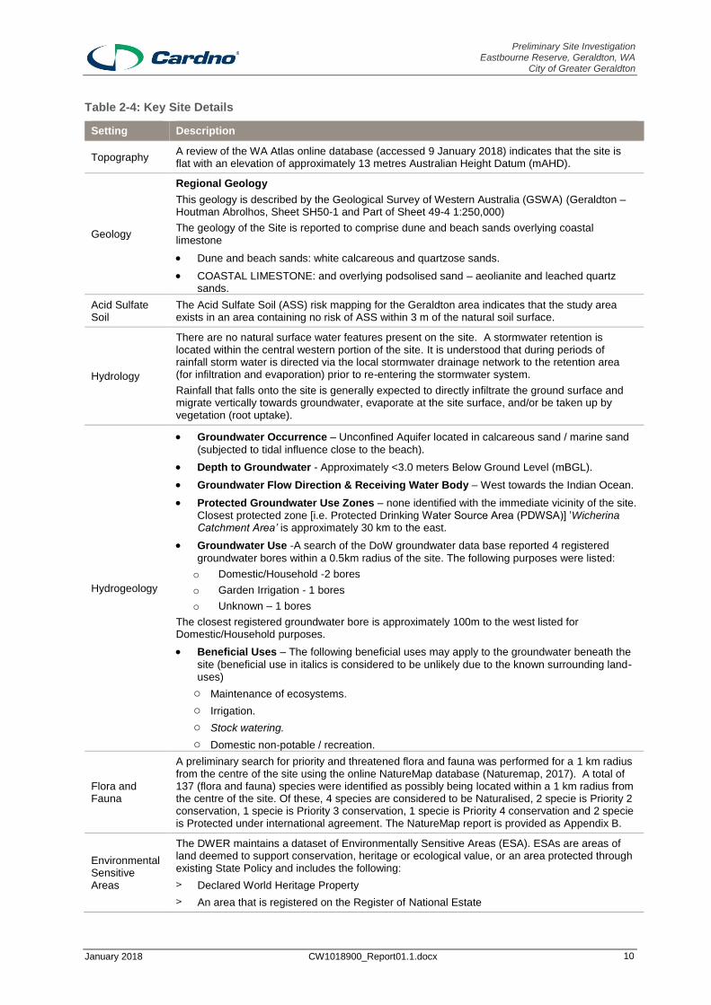
Key details defining the site are summarised in Table 2-4.
Preliminary Site Investigation Eastbourne Reserve, Geraldton, WA
City of Greater Geraldton
January 2018 CW1018900_Report01.1.docx 10
Table 2-4: Key Site Details
Setting Description
Topography A review of the WA Atlas online database (accessed 9 January 2018) indicates that the site is flat with an elevation of approximately 13 metres Australian Height Datum (mAHD).
Geology
Regional Geology
This geology is described by the Geological Survey of Western Australia (GSWA) (Geraldton – Houtman Abrolhos, Sheet SH50-1 and Part of Sheet 49-4 1:250,000)
The geology of the Site is reported to comprise dune and beach sands overlying coastal limestone
Dune and beach sands: white calcareous and quartzose sands.
COASTAL LIMESTONE: and overlying podsolised sand – aeolianite and leached quartz sands.
Acid Sulfate Soil
The Acid Sulfate Soil (ASS) risk mapping for the Geraldton area indicates that the study area exists in an area containing no risk of ASS within 3 m of the natural soil surface.
Hydrology
There are no natural surface water features present on the site. A stormwater retention is located within the central western portion of the site. It is understood that during periods of rainfall storm water is directed via the local stormwater drainage network to the retention area (for infiltration and evaporation) prior to re-entering the stormwater system.
Rainfall that falls onto the site is generally expected to directly infiltrate the ground surface and migrate vertically towards groundwater, evaporate at the site surface, and/or be taken up by vegetation (root uptake).
Hydrogeology
Groundwater Occurrence – Unconfined Aquifer located in calcareous sand / marine sand
(subjected to tidal influence close to the beach).
Depth to Groundwater - Approximately <3.0 meters Below Ground Level (mBGL).
Groundwater Flow Direction & Receiving Water Body – West towards the Indian Ocean.
Protected Groundwater Use Zones – none identified with the immediate vicinity of the site. Closest protected zone [i.e. Protected Drinking Water Source Area (PDWSA)] ’Wicherina Catchment Area’ is approximately 30 km to the east.
Groundwater Use -A search of the DoW groundwater data base reported 4 registered
groundwater bores within a 0.5km radius of the site. The following purposes were listed:
o Domestic/Household -2 bores
o Garden Irrigation - 1 bores
o Unknown – 1 bores
The closest registered groundwater bore is approximately 100m to the west listed for Domestic/Household purposes.
Beneficial Uses – The following beneficial uses may apply to the groundwater beneath the
site (beneficial use in italics is considered to be unlikely due to the known surrounding land-uses)
o Maintenance of ecosystems.
o Irrigation.
o Stock watering.
o Domestic non-potable / recreation.
Flora and Fauna
A preliminary search for priority and threatened flora and fauna was performed for a 1 km radius from the centre of the site using the online NatureMap database (Naturemap, 2017). A total of 137 (flora and fauna) species were identified as possibly being located within a 1 km radius from the centre of the site. Of these, 4 species are considered to be Naturalised, 2 specie is Priority 2 conservation, 1 specie is Priority 3 conservation, 1 specie is Priority 4 conservation and 2 specie is Protected under international agreement. The NatureMap report is provided as Appendix B.
Environmental Sensitive Areas
The DWER maintains a dataset of Environmentally Sensitive Areas (ESA). ESAs are areas of land deemed to support conservation, heritage or ecological value, or an area protected through existing State Policy and includes the following:
> Declared World Heritage Property
> An area that is registered on the Register of National Estate

Preliminary Site Investigation Eastbourne Reserve, Geraldton, WA
City of Greater Geraldton
January 2018 CW1018900_Report01.1.docx 11
Setting Description
> Within 50 m of a defined wetland
> The area covered by vegetation within 50 m of flora declared as Rare under the Wildlife Conservation Act 1950
> An area covered by a Threatened Ecological Community
The site is not located within an Environmentally Sensitive Area.
Wetlands A review of the WA Atlas online database indicates that there are no wetlands within the boundary of the Site or located within 1 km of the Site.

Preliminary Site Investigation Eastbourne Reserve, Geraldton, WA
City of Greater Geraldton
January 2018 CW1018900_Report01.1.docx 12
3 Site History & Potential for Contamination
3.1 Historical Aerial Photograph Review
A review of selected aerial photography for the site and surrounds between 1952 (earliest available) to 2016 (latest available) is provided within Appendix C and observations are summarised in Table 3-1.
Table 3-1: Historic Aerial Photograph Summary
3.2 Cultural Heritage
3.2.1 Aboriginal Heritage
An online search of the Department of Aboriginal Affairs (DAA) (via Nation Map) Aboriginal Heritage was undertaken. The search identified that the site is not located in a registered area, however the following site were identified within 1km of the site:
Site ID 5961, Chapman River Mouth ‘Skeletal Material /Burial’ (Registered).
Site ID 4390, North Bank ‘Artefacts/Scatter’ (Lodged).
Site ID 27321 Aboriginal Lands Trust (ALT) – Reserve ‘Swan Drive/Chapman River’.
3.2.2 European Heritage
The presence of historical or current European Heritage sites was investigated using Heritage Council WA State Register (via National Map) Database.
Date Key Developments
Plate 1
October 1952
Site Specific:
The site appears to be predominately vacant (cleared). Evidence of market garden activities is visible in the western portion of the site, whilst a small dwelling/infrastructure is present in the eastern portion of the site.
Site Surrounds:
The immediate surrounds are mainly undeveloped vacant land. Isolated dwelling/infrastructure are present along with market garden activities.
Plate 2
February 2000
Site Specific:
The site appears to be predominately vacant (cleared) park lands with a scattering of trees. Site boundary is clearing visible define by roads.
Site Surrounds:
Surrounding land has been redeveloped for residential purposes
Plate 3
March 2003
Site Specific:
The site appears unchanged, with exception to some infrastructure in the south-western corner of the site.
Site Surrounds:
The surrounds appear unchanged.
Plate 4
July 2010
Site Specific:
The site appears unchanged . Infrastructure in the south-western corner of the site has been removed.
Site Surrounds:
The surrounds appear unchanged, with exception to some localised redevelopment.
Plate 5
December 2016
Site Specific:
• The site appears unchanged.
Site Surrounds:
The surrounds appear unchanged, with exception to some localised redevelopment.

Preliminary Site Investigation Eastbourne Reserve, Geraldton, WA
City of Greater Geraldton
January 2018 CW1018900_Report01.1.docx 13
The search did not identify any registered sites at the site. The closest registered site is Nazareth House (state registered place, No. 1055) located approximately 500m south of the site.
3.3 Government Freedom of Information Searches
3.3.1 DWER Contaminated Sites Database
The State Government, through the DWER, has the overall responsibility for developing, administering and enforcing the CS Act and its associated procedures. Part of this responsibility includes maintenance of the Contaminated Sites Database. The Contaminated Sites Database holds information on known contaminated sites that have been classified by the DWER as:
Contaminated – remediation required.
Contaminated – restricted use.
Remediated for restricted use.
A search of the DWER Contaminated Sites Database (accessed 9 January 2018) did not indicate that
the site has been assigned any of the above classifications. There are no sites located within 5 km of
the site that have been assigned the above classifications.
3.3.2 DWER Contaminated Sites Register
In addition to the Contaminated Sites Database, the DWER maintains the Contaminated Sites Register, which holds information regarding sites that have been reported to the DWER and classified as:
Report not substantiated.
Possibly contaminated – investigation required.
Not contaminated – unrestricted use.
Decontaminated.
Cardno submitted a freedom of information request (FOI) to the DWER regarding the site. As of 10/1/2018 no response has been received.

Preliminary Site Investigation Eastbourne Reserve, Geraldton, WA
City of Greater Geraldton
January 2018 CW1018900_Report01.1.docx 14
4 Site Inspection
Cardno undertook an inspection of the site and surrounds on 11 December 2017. Observations at the time of the site inspection are summarised in the following section.
4.1 Site Observations
The site is currently a vacant reserve, situated between Bosley Street and Eastbourne Rd, there are no permanent above ground structure on-site. The site observations at the time of the site inspection are summarised in Table 4-1 below. Observation are also present on Figure 4 (Appendix A).
Table 4-1: Site Observations
Item Observations & Descriptions
Surface coverings Sand and grasses cover majority of the site, with a number of established native trees and bushes.
Site slope & drainage features
The site slopes from West to the East with a stormwater retention depression within the central western portion of the site. It is understood that during periods of rainfall storm water is directed via the local stormwater drainage network to the retention area (for infiltration and evaporation) prior to re-entering the stormwater system.
Nearby water bodies Indian Ocean to the west.
Buildings None observed.
Manufacturing or chemical processes & infrastructure
None observed.
Surface soil Surface soils are typically SAND, some areas of gravel.
Surface soil stability Surface soils appeared stable.
Site cut & filling
No evidence of significant filling was observed. Evidence of minor gravel fill was observed in isolated areas throughout the site.
Minor amounts of stockpiled soil (approximately 15 m3) were observed at the site, which appeared to be a composite of gravel and sand with some anthropogenic material (i.e. brick, cement and metal) consistent with building rubble [including suspect Asbestos Containing Material (ACM) cement fragments].
Fuel storage tanks None observed.
Dangerous goods None observed.
Solid waste deposition None observed.
Liquid waste disposal features None observed.
Evidence of previous site contamination investigations
None observed.
Evidence of land contamination (staining or odours)
None observed.
Evidence of suspect asbestos or ACM
Suspect ACM fragments were observed in isolated area of the site, predominately in areas where gravel fill was observed.
Suspect ACM was also identified at the surface of stockpiled soil observed at the site.
ACM was noted to be in fragmented form of sound condition.
Potentially contaminating sites (<500 m from the site)
None observed.
Preliminary Site Investigation Eastbourne Reserve, Geraldton, WA
City of Greater Geraldton
January 2018 CW1018900_Report01.1.docx 15
Item Observations & Descriptions
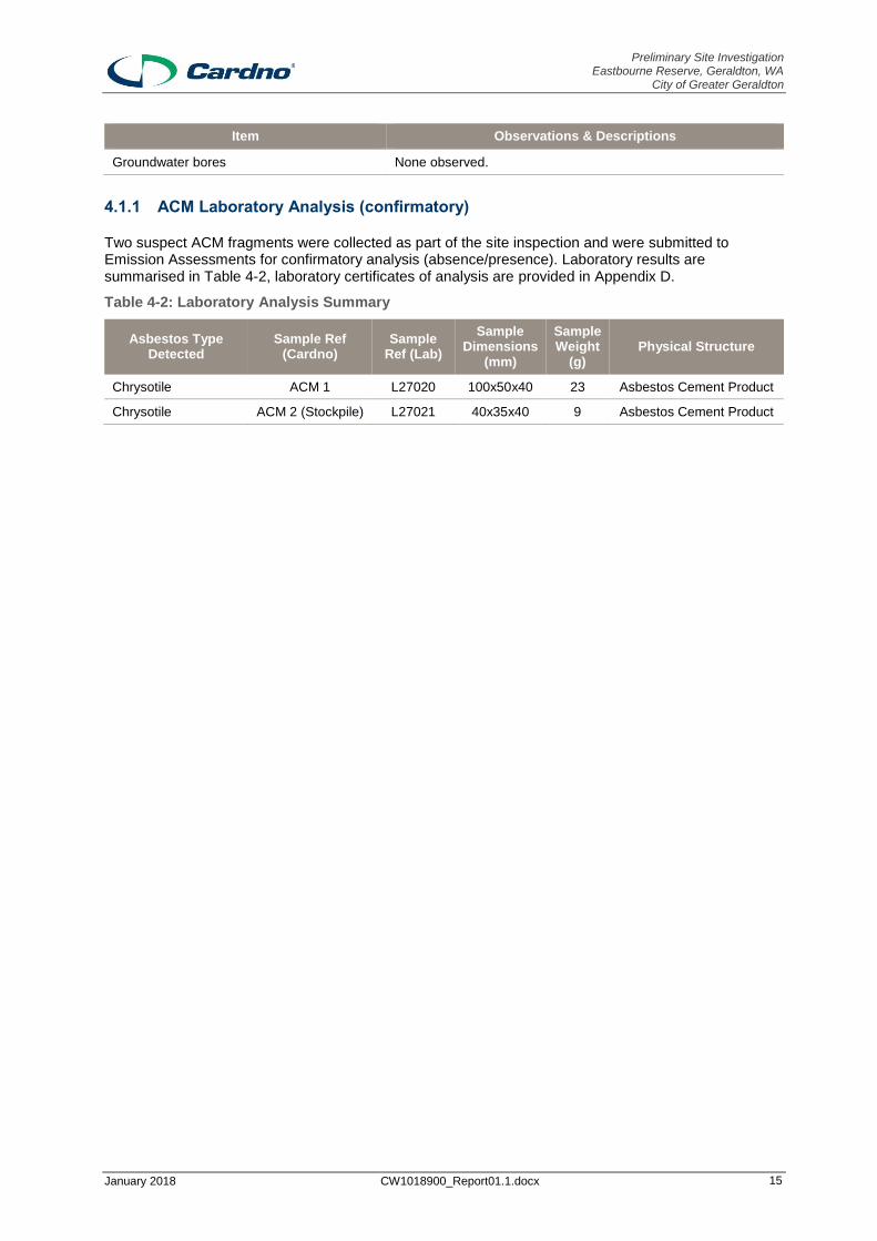
Groundwater bores None observed.
4.1.1 ACM Laboratory Analysis (confirmatory)
Two suspect ACM fragments were collected as part of the site inspection and were submitted to Emission Assessments for confirmatory analysis (absence/presence). Laboratory results are summarised in Table 4-2, laboratory certificates of analysis are provided in Appendix D.
Table 4-2: Laboratory Analysis Summary
Asbestos Type Detected
Sample Ref (Cardno)
Sample Ref (Lab)
Sample Dimensions
(mm)
Sample Weight
(g) Physical Structure
Chrysotile ACM 1 L27020 100x50x40 23 Asbestos Cement Product
Chrysotile ACM 2 (Stockpile) L27021 40x35x40 9 Asbestos Cement Product

Preliminary Site Investigation Eastbourne Reserve, Geraldton, WA
City of Greater Geraldton
January 2018 CW1018900_Report01.1.docx 16
5 Preliminary Conceptual Site Model
Based on the site history review and site inspection, a preliminary Conceptual Site Model (CSM) was developed. These have been summarised in the following sections.
In accordance with NEPM guidelines (NEPM 2013), an assessment must be made identifying the likely presence or absence of the following elements:
Source - a substance that is capable of causing an unacceptable risk to human and/or
environmental health;
Pathway - a mode or route by which the substance/source can migrate to a receptor; and
Receptor - someone and/or something that could be adversely affected by the substance/source.
Where one of these elements is absent, there cannot be an unacceptable risk to human and/or environmental value, and therefore cannot be considered contaminated under the Contaminated Sites Act. Where all of these elements are present, a complete or potentially complete pathway for contamination exists and there is a potential risk to human and/or environmental health that will require further investigation and possible management and/or management. The magnitude of the risk is primarily a function of the concentration of the source, toxicity, chemical mobility, sensitivity of the receptor and the nature of the migration pathway.
The CSM development process is also used to identify data gaps, uncertainty and to define the risk assessment approach. The CSM is a blue print (a working hypothesis) for the understanding of site contamination and are updated as new information is obtained.
5.1 Potential Contamination Sources
The site is currently a reserve for the purpose of Public Open Space (POS), potential contamination sources [or Area of Potential Environmental Concern (AoPEC)] identified at the site are detailed below:
Asbestos (i.e. ACM fragments) impacted soils within isolated areas of the site (predominately in
areas of where gravel fill was identified).
Stockpiled fill material (unknown source, containing anthropogenic material including ACM).
Historic land use as a market garden (western portion of the site).
5.1.1 Contaminates of Potential Concern (CoPC)
Key contaminates of concern associated with potential sources are detailed below:
Metals
Phenols.
Benzene, Toluene, Ethylbenzene & Xylenes (BTEX).
Polycyclic Aromatic Hydrocarbon (PAH).
Organochlorine Pesticide/ Organophosphorus Pesticide (OCP/OPP).
Total petroleum hydrocarbons (TPH).
Asbestos (ACM fragments).

Preliminary Site Investigation Eastbourne Reserve, Geraldton, WA
City of Greater Geraldton
January 2018 CW1018900_Report01.1.docx 17
5.2 Potential Receptors
The potential receptors that may be adversely affected by contamination at the Site include:
On-site visitors.
On-site construction / maintenance workers (associated ongoing maintenance, including
subsurface works).
Off-site users (public and workers at surrounding properties via dust/fibre migration).
Groundwater users (through groundwater extraction from registered bores).
Modified Ecosystems (terrestrial flora and fauna).
5.2.1 Potential Contamination Pathways
The exposure pathways that have the potential to result in a risk to receptors have been summarised in Table 5-1 below in terms of the medium in which exposure could occur.
Table 5-1: Potential Pathways and Exposure Routes
Source Pathway Exposure Route
Fill Material (including approximately 15 m3 stockpile)
Direct and secondary contact
Dermal contact, incidental ingestion or inhalation of surface/near-surface contaminated soils/dust (contaminated soil if present at depth has the potential to impact human receptors if exposure occurs during intrusive earthwork activities).
Uptake by ecological receptors.
Leaching of contaminants into groundwater followed by migration of impacts in groundwater.
Asbestos Secondary contact with contaminated material. Dust/fibre migration through air via wind or mechanical agitation.
Inhalation of asbestos fibres.
Historic land use as a Market Garden (western portion of the site
Direct and secondary contact
Dermal contact, incidental ingestion or inhalation of surface/near-surface contaminated soils/dust (contaminated soil if present at depth has the potential to impact human receptors if exposure occurs during intrusive earthwork activities).
Uptake by ecological receptors.
Leaching of contaminants into groundwater followed by migration of impacts in groundwater.
5.2.2 Potential Linkages
The preliminary CSM is summarised in Table 5-2: and is based on the findings of the desk based research and site inspection.

Preliminary Site Investigation Eastbourne Reserve, Geraldton, WA
City of Greater Geraldton
January 2018 CW1018900_Report01.1.docx 18
Table 5-2: Preliminary Conceptual Site Model 'Potential Linkages'
Source Preferential Pathway Exposure Routes Receptors Likelihood of Pollutant Linkage
Discussion
Fill Material (including stockpile)
Direct and secondary contact
Dermal contact, incidental ingestion or inhalation of surface/near-surface contaminated soils/dust (contaminated soil if present at depth has the potential to impact human receptors if exposure occurs during intrusive earthwork activities).
Uptake by ecological receptors.
Leaching of contaminants into groundwater followed by migration of impacts in groundwater.
Onsite visitors (including intrusive workers)
Future site users
Yes Unknown origin and characteristics of fill material (including approximately 15m3 stockpile).
Asbestos (ACM Fragments)
Secondary contact with contaminated material. Dust/fibre migration through air via wind or mechanical agitation.
Inhalation of asbestos fibres
Onsite visitors (including intrusive workers)
Future site users
Offsite users
Yes
ACM observed at surface and within surface soil. There is a current exposure pathway to receptors (i.e. health risk to site users), which requires management to mitigate risks to potential receptors.
Historic land use as a Market Garden (western portion of the site
Direct and secondary contact
Dermal contact, incidental ingestion or inhalation of surface/near-surface contaminated soils/dust (contaminated soil if present at depth has the potential to impact human receptors if exposure occurs during intrusive earthwork activities).
Uptake by ecological receptors.
Leaching of contaminants into groundwater followed by migration of impacts in groundwater.
Onsite visitors (including intrusive workers)
Future site users.
Groundwater users.
Yes (low)
A historical potential contamination land use (i.e. market garden activates) exists, which requires further assessment to assess level of risk (if any).

Preliminary Site Investigation Eastbourne Reserve, Geraldton, WA
City of Greater Geraldton
January 2018 CW1018900_Report01.1.docx 19
6 Conclusions and Recommendations
6.1 Purpose & Objectives
Cardno has undertaken a Preliminary Site Investigation (PSI) to assess the likelihood that contamination may be present at the site as a result of historical and/or current land use at Eastbourne Reserve, Geraldton.
It is understood that the City has been approached by a community group that has expressed interest in undertaking some work at the site and the City needs to understand if there are any contamination issues prior to progressing with discussions.
The specific objectives of the assessment are to:
Identify site and surround landholding characteristics and current conditions.
Assess the potential for current and past activities to impact the environment, health and
safety conditions, or result in liability upon review of all reasonably available desk-based
information.
Assess potential source-pathway-receptor linkages at the site (from all potential sources
identified in the PSI).
Prepare a report including a basic site condition assessment based on site inspection and
interview.
In the event that significant contamination and/or risk is found, provide recommendations
for further investigation, assessment, management and/or remediation as necessary.
6.2 Summary of Conclusions
Based on desktop investigation, field observation and laboratory analysis (ACM confirmatory analysis), the following conclusions have been drawn from this assessment:
The site is currently a reserve (Reserve 19556 under the City of Greater Geraldton Local
Planning Scheme No.1) currently used for the purpose of Public Open Space. No
aboveground infrastructure is present at the site.
There are no natural surface water features present on the site. A surface water retention
area is located within the central western portion of the site. It is understood that during
periods of rainfall stormwater is directed via the local stormwater drainage network to the
retention area (for infiltration and evaporation) prior to re-entering the stormwater system.
The closest natural surface water feature is the Indian Ocean, (marine environment)
approximately 300 m to the west of the site.
The geology of the site is reported to comprise dune and beach sands overlying coastal
limestone. Field observations reported surface soils are typically SAND with some areas of
gravel. The upper aquifer at the site is expected to occurs within Quaternary Sand and
Limestone [Superficial Aquifer (unconfined)] between 3 m and 4 mBGL.
A Groundwater Bore Database search identified 4 groundwater bores are present within
0.5km of the site and are registered for domestic/household (2 bores), garden irrigation (1
bores) and unknown use (1 bore).
A review of historical aerial images (earliest available 1952) indicated that the site appears
to be predominately vacant open space to present date (December 2017) with little historic
land use. Evidence of market garden activities in the western portion of the site along with

Preliminary Site Investigation Eastbourne Reserve, Geraldton, WA
City of Greater Geraldton
January 2018 CW1018900_Report01.1.docx 20
a small dwelling/infrastructure is present in the eastern portion of the site in the 1952 aerial
photography. It is noted that a lack aerial images between 1952 to 2000 limits the historic
land use assessment.
A site inspection indicated the site is a reserve/ public open space, adjacent land use is
mostly standard residential with limited commercial land use (i.e. shopping centre). Sand
and grasses cover majority of the site, with a number of established native trees and
bushes.
Suspect ACM fragments were observed on surface soil in isolated areas across the site.
Two samples of suspect ACM fragment were collected from site surface, analysed and
confirmed as containing asbestos (i.e. chrysotile asbestos). Where suspect ACM was
encountered, it was noted to be in bonded, fragmented form and of sound condition.
No evidence of significant filling was observed. Evidence of minor gravel fill was observed
in isolated areas throughout the site. Minor amounts of stockpiled fill material
(approximately 15 m3) were observed at the site, which appeared to be a composite of
gravel and sand with some anthropogenic material consistent with building rubble
[including ACM].
The desktop and site inspection identified a number of Areas of Potential Environmental Concern (AoPEC), including the following:
Asbestos (i.e. ACM fragments) impacted soils within isolated areas of the site
(predominately in areas of where gravel fill was observed).
Fill material / stockpile (unknown source, containing anthropogenic material including
ACM).
Historic land use as a Market Garden (western portion of the site).
Following review of AoPEC and potential receptors (on- and off-site) a number of potential linkages (i.e. source – pathway – receptor) were present primarily associated with the potential for:
Exposure to ACM and potential contaminated soil/stockpiled fill material.
6.3 Recommendations
Based on the findings of the PSI, Cardno offers the following recommendations:
> Given the presence of ACM at surface and within surface soil, there is a current exposure
pathway to receptors (i.e. health risk to site users). It is recommended that further
assessment and targeted ACM surface remediation (removal of visible ACM fragments) is
undertaken to characterise the nature and extent of ACM impact and mitigate the risk of
human exposure1.
Further assessment works should be undertaken in reference to Department of Health
(DoH) (2009) ‘Guidelines for the Assessment, Remediation and Management of Asbestos-
Contaminated Sites in Western Australia’.
> Undertake a stockpile classification assessment (i.e. sampling and analysis) to determine
fill material characteristics (suitability for reuse and/or classification status for offsite
disposal). Assessment should be undertaken in reference to DER (2014) ‘Assessment
and Management of Contaminated Site’s and DEC (2009) ‘Landfill Waste Classification
and Waste Definitions 1996 (As amended December 2009’) guidelines.
> Given the presence of historic market garden activities (DWER listed potential
contaminating land use) in the western portion of the site, further assessment should be
1 Top 10cm of soil should be made free of visible asbestos or ACM (DoH, 2009).

Preliminary Site Investigation Eastbourne Reserve, Geraldton, WA
City of Greater Geraldton
January 2018 CW1018900_Report01.1.docx 21
considered. This is likely to include additional desktop assessment and a targeted
intrusive investigation (i.e. soil sampling).

Preliminary Site Investigation Eastbourne Reserve, Geraldton, WA
City of Greater Geraldton
January 2018 CW1018900_Report01.1.docx 22
7 References
Legislation and Guidelines
1. Contaminated Sites Act, 2003, Western Australia.
2. Department of Environment and Regulation (DER) (2014), Assessment and Management of Contaminated Sites.
3. Department of Health (DoH), 2009, Guidelines for the Assessment, Management and Remediation of Asbestos Contaminated Sites in Western Australia.
4. Department of Indigenous Affairs, 2015, Aboriginal Heritage Inquiry System. (http://maps.dia.wa.gov.au/AHIS2/)
5. Department of Mines and Petroleum (DMP), 2015, Geological Map (http://warims.dmp.wa.gov.au/GeoView/Viewer.html?Viewer=GeoVIEW)
6. Department of Environment Regulation (DER) 2014. ‘Assessment and management of contaminated sites – Contaminated sites guidelines’.
7. Geological Survey of Western Australia (1971) Geraldton – Houtman Abrolhos. Sheet SH
50-1 and Part of Sheet SH 49-4. Perth: GSWA.
8. Heritage Council 2015, State Heritage Register (http://inherit.stateheritage.wa.gov.au/public).
9. Landgate, 2014, WA Atlas Online Database, (https://www2.landgate.wa.gov.au/bmvf/app/waatlas/#,).
10. National Environmental Protection (Assessment of Site Contamination) Measure (NEPM,
1999 as amended 2013).

Preliminary Site Investigation Eastbourne Reserve, Geraldton, WA
City of Greater Geraldton
January 2018 CW1018900_Report01.1.docx Appendix A
4 Pages
Figures
Figure 1: Site Location
Figure 2: Geology
Figure 3: DoW Registered Groundwater Bores
Figure 4: Site Layout

CHAP
MAN
RD
VOLUTE ST
CHARON RD
BALE
R RD
EASTBOURNE RD
CARABAN RDD CHAPMAN VALLEY RD
GORG
ON R
D
COWR
IE PL
PINNA
WY
BOSLEY ST
AMAL
DA PL
DUCL
AS PL
KOOL
AMA R
D
CENT
AUR
RD
±Map Produced by Cardno Geosciences and Environment Perth
Date: 2018-01-09Coordinate System: GDA 1994 MGA Zone 50
Project: CW1018900Map: CW1018900-GS-001-Figure1_Site_Layout.mxd 01
Aerial Imagey Supplied by Nearmap November, 2017)
LegendStudy AreaCadastre (MDS, 2015)
PRELIMINARY SITE INVESTIGATIONS (PSI)CITY OF GREATER GERALDTON
FIGURE 1
Site LocationScale at A31:2,000
0 60 12030Metres
GERALDTON
1:45,000

±Map Produced by Cardno Geosciences and Environment Perth
Date: 2018-01-09Coordinate System: GDA 1994 MGA Zone 50
Project: CW1018900Map: CW1018900-GS-001-Figure3_Geology.mxd 01Aerial Imagey Supplied by Nearmap November, 2017)
LegendStudy Area
Surface Geology (Geoscience Australia, 2014)Tamala LimestoneCoastal Dunes
GeologyPRELIMINARY SITE INVESTIGATIONS (PSI)
CITY OF GREATER GERALDTONFIGURE 2
Scale at A31:2,5000 80 16040 Metres
Geology Description (Geoscience Australia, 2014)Tamala Limestone: Unconsolidated to strongly lithified calcarenite with calcrete/kankar soils; aeolian. Locallyquartzose, feldspathic, or heavy-mineral-bearing.Coastal Dunes: Beach sand, sand dunes, coastal dunes, beaches, and beach ridges; calcareous and siliceous,locally shelly and/or cemented (beach rock); locally reworked
Coastal Dunes

@A
@A
@A
@A
@A
@A
@A
70114546
70111172
7014008970140083
70111141
70111171
±Map Produced by Cardno Geosciences and Environment Perth
Date: 2018-01-09Coordinate System: GDA 1994 MGA Zone 50
Project: CW1018900Map: CW1018900-GS-001-Figure2_Topography_Groundwater.mxd 01
Aerial Imagey Supplied by Nearmap November, 2017)
LegendStudy Area500m Buffer
@A Groundwater Bores (DWER, 2016)
DoW Registered Groundwater Bores PRELIMINARY SITE INVESTIGATIONS (PSI)
CITY OF GREATER GERALDTONFIGURE 3
Scale at A31:5,0000 170 34085
Meters
AWRC Reference Owner Usage70140089 Private Unknown70111172 Private Domestic/Household70111171 Private Domestic/Household70114546 Private Garden Irrigation
Groundwater Bores within 500m Radius

Concrete Path
Sewer Access Point
StockpileInfiltration Area
Stormwater Grate
Stormwater Pipe
±Map Produced by Cardno Geosciences and Environment Perth
Date: 2018-01-09Coordinate System: GDA 1994 MGA Zone 50
Project: CW1018900Map: CW1018900-GS-001-Figure4_Site_Layout.mxd 01
Aerial Imagey Supplied by Nearmap November, 2017)
LegendStudy AreaACM Impacts
PRELIMINARY SITE INVESTIGATIONS (PSI)CITY OF GREATER GERALDTON
FIGURE 4
Site LayoutScale at A31:1,000
0 30 6015 Metres

Preliminary Site Investigation Eastbourne Reserve, Geraldton, WA
City of Greater Geraldton
January 2018 CW1018900_Report01.1.docx Appendix B
3 Pages
Certificate of Title and Desk based Research

LANDGATE COPY OF ORIGINAL NOT TO SCALE
www.landgate.wa.gov.au
JOB 55714982Tue Jan 9 09:07:08 2018

Page 1
NatureMap Species Report
Created By Guest user on 09/01/2018
Current Names Only Core Datasets Only
Method Centre Buffer
Yes Yes 'By Circle' 114° 37' 29'' E,28° 43' 27'' S 1km
Name ID Species Name Naturalised Conservation Code 1Endemic To QueryArea
1. 3376 Acacia idiomorpha
2. 30033 Acacia saligna subsp. lindleyi
3. 3532 Acacia scirpifolia
4. 3549 Acacia spathulifolia
5. 3604 Acacia xanthina (White-stemmed Wattle)
6. 24261 Acanthiza chrysorrhoa (Yellow-rumped Thornbill)
7. 1208 Acanthocarpus preissii
8. 20797 Acanthocarpus sp. Ajana (C.A. Gardner 8596)
9. 25536 Accipiter fasciatus (Brown Goshawk)
10. 41323 Actitis hypoleucos (Common Sandpiper) IA
11. 1721 Allocasuarina campestris
12. 4905 Alyogyne hakeifolia
13. 6565 Alyxia buxifolia (Dysentery Bush)
14. 24315 Anas rhynchotis (Australasian Shoveler)
15. 24316 Anas superciliosa (Pacific Black Duck)
16. 47414 Anhinga novaehollandiae (Australasian Darter)
17. 3180 Aphanopetalum clematideum
18. 41324 Ardea modesta (great egret, white egret) IA
19. 24319 Biziura lobata (Musk Duck)
20. 11274 Boronia coerulescens subsp. spinescens
21. 1273 Borya sphaerocephala (Pincushions)
22. 3719 Bossiaea spinescens
23. 42307 Cacomantis pallidus (Pallid Cuckoo)
24. 29439 Caesia sp. Wongan (K.F. Kenneally 8820)
25. 15349 Caladenia flava subsp. maculata
26. 35856 Calothamnus glaber
27. 35756 Calothamnus quadrifidus subsp. angustifolius
28. 2796 Carpobrotus modestus (Inland Pigface)
29. 258 Cenchrus ciliaris (Buffel Grass) Y
30. 43380 Chelodina colliei (South-western Snake-necked Turtle)
31. 25339 Chelodina steindachneri (Flat-shelled Turtle)
32. Chroicocephalus novaehollandiae
33. 24774 Cladorhynchus leucocephalus (Banded Stilt)
34. 25675 Colluricincla harmonica (Grey Shrike-thrush)
35. 4561 Comesperma scoparium (Broom Milkwort)
36. 40872 Commersonia borealis
37. 1446 Conostylis prolifera (Mat Cottonheads)
38. 25568 Coracina novaehollandiae (Black-faced Cuckoo-shrike)
39. 25592 Corvus coronoides (Australian Raven)
40. 25596 Cracticus torquatus (Grey Butcherbird)
41. Craterocephalus cuneiceps
42. 16018 Cryptandra arbutiflora var. borealis
43. 31614 Cryptandra multispina
44. 4811 Cryptandra spyridioides
45. 24322 Cygnus atratus (Black Swan)
46. 5522 Darwinia pauciflora
47. 11636 Dianella revoluta var. divaricata
48. 18542 Diplopeltis huegelii subsp. subintegra
49. 4748 Diplopeltis petiolaris
50. 14298 Drosera macrantha subsp. macrantha
51. Egretta novaehollandiae
52. Elanus axillaris
53. 47937 Elseyornis melanops (Black-fronted Dotterel)
NatureMap is a collaborative project of the Department of Parks and Wildlife and the Western Australian Museum.

Page 2
Name ID Species Name Naturalised Conservation Code 1Endemic To QueryArea
54. Eolophus roseicapillus
55. 24652 Eopsaltria georgiana (White-breasted Robin)
56. 7185 Eremophila brevifolia (Spotted Eremophila) P2
57. 25622 Falco cenchroides (Australian Kestrel, Nankeen Kestrel)
58. 25727 Fulica atra (Eurasian Coot)
59. 38241 Geleznowia sp. Binnu (K.A. Shepherd & J. Wege KS 1301) P3
60. 3938 Glycine canescens (Silky Glycine)
61. 3957 Gompholobium tomentosum (Hairy Yellow Pea)
62. 24443 Grallina cyanoleuca (Magpie-lark)
63. 1956 Grevillea argyrophylla (Silvery-leaved Grevillea)
64. 15763 Grevillea biformis subsp. biformis
65. 1973 Grevillea candelabroides
66. 2032 Grevillea leucopteris (White Plume Grevillea)
67. 2054 Grevillea olivacea (Olive Grevillea) P4
68. 17416 Guichenotia angustifolia
69. 5011 Guichenotia ledifolia
70. 5012 Guichenotia macrantha (Large-flowered Guichenotia)
71. 6696 Halgania sericiflora
72. 24295 Haliastur sphenurus (Whistling Kite)
73. 5135 Hibbertia hypericoides (Yellow Buttercups)
74. 5171 Hibbertia spicata
75. 4927 Hibiscus drummondii (Drummond's Hibiscus)
76. 25734 Himantopus himantopus (Black-winged Stilt)
77. 24491 Hirundo neoxena (Welcome Swallow)
78. 12741 Hyalosperma cotula
79. Hydroprogne caspia
80. 34022 Hypseleotris aurea (Golden Gudgeon) P2
81. Hypseleotris compressa
82. 19700 Isotropis cuneifolia subsp. cuneifolia
83. 4015 Jacksonia hakeoides
84. 11289 Labichea lanceolata subsp. lanceolata
85. 6733 Lantana camara (Common Lantana) Y
86. 25638 Larus pacificus (Pacific Gull)
87. 9099 Lasiopetalum angustifolium (Narrow Leaved Lasiopetalum)
88. 15428 Leptosema aphyllum
89. 25661 Lichmera indistincta (Brown Honeyeater)
90. 34736 Lysinema pentapetalum
91. 24583 Manorina flavigula (Yellow-throated Miner)
92. 25758 Megalurus gramineus (Little Grassbird)
93. 5887 Melaleuca cardiophylla (Tangling Melaleuca)
94. 5904 Melaleuca depressa
95. 5936 Melaleuca megacephala
96. 5958 Melaleuca radula (Graceful Honeymyrtle)
97. 5959 Melaleuca rhaphiophylla (Swamp Paperbark)
98. Microcarbo melanoleucos
99. 4100 Mirbelia spinosa
100. 24407 Ocyphaps lophotes (Crested Pigeon)
101. 5227 Opuntia stricta (Common Prickly Pear) Y
102. 25680 Pachycephala rufiventris (Rufous Whistler)
103. Pandion cristatus
104. 25682 Pardalotus striatus (Striated Pardalote)
105. 24648 Pelecanus conspicillatus (Australian Pelican)
106. 24667 Phalacrocorax sulcirostris (Little Black Cormorant)
107. 25699 Phalacrocorax varius (Pied Cormorant)
108. 4675 Phyllanthus calycinus (False Boronia)
109. 8182 Podotheca angustifolia (Sticky Longheads)
110. 8184 Podotheca gnaphalioides (Golden Long-heads)
111. 24681 Poliocephalus poliocephalus (Hoary-headed Grebe)
112. 24683 Pomatostomus superciliosus (White-browed Babbler)
113. 1671 Prasophyllum elatum (Tall Leek Orchid)
114. 1674 Prasophyllum giganteum (Bronze Leek Orchid)
115. 42416 Pseudonaja mengdeni (Western Brown Snake)
116. 16367 Pyrorchis nigricans (Red beaks, Elephants ears)
117. 41041 Quoya atriplicina
118. 41063 Quoya loxocarpa
119. 48096 Rhipidura albiscapa (Grey Fantail)
120. 25614 Rhipidura leucophrys (Willie Wagtail)
121. 7614 Scaevola globulifera
122. 6030 Scholtzia ciliata
123. 25534 Sericornis frontalis (White-browed Scrubwren)
NatureMap is a collaborative project of the Department of Parks and Wildlife and the Western Australian Museum.

Page 3
Name ID Species Name Naturalised Conservation Code 1Endemic To QueryArea
124. 30948 Smicrornis brevirostris (Weebill)
125. 7025 Solanum oldfieldii
126. 625 Spinifex longifolius (Beach Spinifex)
127. 4828 Spyridium globulosum (Basket Bush)
128. 25597 Strepera versicolor (Grey Currawong)
129. 25590 Streptopelia senegalensis (Laughing Turtle-Dove) Y
130. 3182 Stylobasium spathulatum (Pebble Bush)
131. 25705 Tachybaptus novaehollandiae (Australasian Grebe, Black-throated Grebe)
132. Thalasseus bergii
133. 6064 Thryptomene racemulosa
134. 25549 Todiramphus sanctus (Sacred Kingfisher)
135. 6073 Verticordia chrysantha
136. 7389 Wahlenbergia preissii
137. 25765 Zosterops lateralis (Grey-breasted White-eye, Silvereye)
Conservation CodesT - Rare or likely to become extinctX - Presumed extinctIA - Protected under international agreementS - Other specially protected fauna1 - Priority 12 - Priority 23 - Priority 34 - Priority 45 - Priority 5
1 For NatureMap's purposes, species flagged as endemic are those whose records are wholely contained within the search area. Note that only those records complying with the search criterion are included in the
calculation. For example, if you limit records to those from a specific datasource, only records from that datasource are used to determine if a species is restricted to the query area.
NatureMap is a collaborative project of the Department of Parks and Wildlife and the Western Australian Museum.

Preliminary Site Investigation Eastbourne Reserve, Geraldton, WA
City of Greater Geraldton
January 2018 CW1018900_Report01.1.docx Appendix C
6 Pages
Aerial Photographs (Historical) & Site Photographs

Preliminary Site Investigation Eastbourne Reserve, Geraldton, WA
City of Greater Geraldton
Appendix C
PLATE 1: Aerial Photograph 04/10/1952
PLATE 2: Aerial Photograph 02/02/2000

Preliminary Site Investigation Eastbourne Reserve, Geraldton, WA
City of Greater Geraldton
Appendix C
PLATE 3: Aerial Photograph 12/03/2003
PLATE 4: Aerial Photograph 04/07/2010

Preliminary Site Investigation Eastbourne Reserve, Geraldton, WA
City of Greater Geraldton
Appendix C
PLATE 5: Aerial Photograph 09/12/2017

Preliminary Site Investigation Eastbourne Reserve, Geraldton, WA
City of Greater Geraldton
Page 1
PLATE 1 - Site view looking West. PLATE 2 - Site view looking South.
PLATE 3 - Site view looking North. PLATE 4 - Site view looking East and Stockpiled Fill Material.
PLATE 5 - Stockpiled Fill Material with ACM fragments.
PLATE 6 - Stormwater drainage line/retention area.

Preliminary Site Investigation Eastbourne Reserve, Geraldton, WA
City of Greater Geraldton
Page 2
PLATE 7 – Stormwater infiltration area (grate with retention depression).
PLATE 8 Sewer inspection pit/lid.
PLATE 9 - ACM fragments on surface. PLATE 10 - ACM fragments on surface.
PLATE 11 - ACM fragments on surface. PLATE 12 - ACM fragments on surface.

Preliminary Site Investigation Eastbourne Reserve, Geraldton, WA
City of Greater Geraldton
Page 3
PLATE 13 - ACM Fragments within soil. PLATE 14 - Site view looking North.

Preliminary Site Investigation Eastbourne Reserve, Geraldton, WA
City of Greater Geraldton
January 2018 CW1018900_Report01.1.docx Appendix D
1 Page
Laboratory Certificates

Cardno
HL1718-382
Version Number: 1.0
U6 35 Sustainable Ave Bibra Lake WA 6163 Final
p: 9494 2958 f: 9494 2959
Accreditation Number: 17108 Accredited for compliance with ISO/IEC 17025 - Testing. The results of the tests, calibrations and/or measurements included in this document are traceable to Australian and national standards.
HL1718-382 Page 1 of 2
C E R T I F I C A T E O F A N A L Y S I S F I B R E I D E N T I F I C A T I O N
Job No.: HL1718-382 Date of Report: 10/01/2018 Samples Taken by: Client Samples Received: 10/01/2018
Client: Cardno Attention: David James Email: [email protected]
Client Reference CW 1018900 – Geraldton
METHODOLOGY SUMMARY
Test Specification Employed e:: In-House Test Procedure LPH-01 based on AS 4964-2004
Samples of material are examined to determine the presence of asbestos fibres using AS4964 (2004) & In-House Procedure LPH-01 i.e. Qualitative identification of chrysotile, amosite and crocidolite in bulk samples by Polarised Light Microscopy (PLM) in conjunction with Dispersion Staining (DS). Unequivocal identification of asbestos minerals present is made by assessing fibre properties to see whether the values are typical and consistent with published data. This provides a reasonable degree of certainty to determine whether a fibre under investigation is asbestiform or not. Careful application of the test procedure provides sufficient diagnostic clues to allow unequivocal identification of asbestos types, and so, to determine whether a sample contains asbestos or not. If sufficient diagnostic clues are absent, then positive identification of fibrous asbestos is not possible.
Sample No.
Client Ref. Location/
Description Physical Structure
Weight/ Dimensions
Analysis of Fibrous Content
L27020 ACM1 Asbestos Cement Product 23g/100x50x40mm Chrysotile Asbestos Detected
L27021 ACM2 (Stockpile) Asbestos Cement Product 9g/40x35x4mm Chrysotile Asbestos Detected
Number of Samples: 2
Analyst Details Name Signature
Approved Identifier Monika Bürger
Approved Signatory Monika Bürger

C E R T I F I C A T E O F A N A L Y S I S A S B E S T O S F I B R E I D E N T I F I C A T I O N
Accreditation Number: 17108 Accredited for compliance with ISO/IEC 17025 - Testing. The results of the tests, calibrations and/or measurements included in this document are traceable to Australian and national standards.
HL1718-382 Page 2 of 2
CLIENT SUPPLIED SAMPLES
Emission Assessments is not responsible for the accuracy or competence of sampling carried by third parties. Sample location(s) and/or sample type(s) of third party samples delivered to the laboratory are given by the client at the time of delivery. Under these circumstances, Emission Assessments cannot be held responsible for the interpretation of the results shown. Emission Assessments takes responsibility of information reported only when a staff member takes the sample(s).
REPORTING OF RESULTS 'Asbestos Detected': Asbestos detected by Polarised Light Microscopy (PLM), including Dispersion Staining (DS) 'No Asbestos Detected': No Asbestos detected by Polarised Light Microscopy (PLM), including Dispersion Staining (DS) 'UMF Detected': Mineral fibres of unknown type detected by Polarised Light Microscopy (PLM), including Dispersion Staining (DS). Confirmation by another independent analytical technique may be necessary. “Hand-picked” refers to small discrete amounts of asbestos unevenly distributed in a large body of non-asbestos material.
Limit of Detection (LOD) & Limit of Report (LOR) Known limitations of the test procedure using Polarised Light Microscopy (PLM) are:
PLM is a qualitative technique only;
It does not cover identification of airborne or water-borne asbestos;
The less encountered asbestos mineral fibres actinolite, anthophyllite and tremolite exhibit a wide range of optical properties that preclude unequivocal identification by PLM and Dispersion Staining (DS). Thus, the method is used to positively identify the three major asbestos minerals: amosite (“brown”), chrysotile (“white”) and crocidolite (“blue”);
Valid identification requires that the sample material contains a sufficient quantity of the unknown fibres in excess of the practical detection limit used (in this case, PLM and Dispersion Staining, which has a calculated practical detection limit of 0.01 - 0.1% w/w equivalent to 0.1 - 1g/kg (AS4964-2004:App.A4).
Results relate only to the sample(s) submitted for testing. Test report must not be reproduced except in full.

Preliminary Site Investigation Eastbourne Reserve, Geraldton, WA
City of Greater Geraldton
January 2018 CW1018900_Report01.1.docx Appendix E
3 Pages
Information About Environmental Reports

QT6.01 About ESA Reports
About Site Environmental Assessment Reports
1. Introduction This document explains the Environmental Site Assessment (ESA) process and the context that applies to the use of Environmental Reports issued by Cardno Lane Piper.
2. What is an ESA? Environmental Site Assessments (ESA) are undertaken for a range of purposes, specific to the brief issued by the client in each case. The scope may include one or a combination of any of the following:
A factual report of the condition of a portion of the site or one aspect of an entire site.
Assessment of the contamination levels in soil to be removed from a site – a waste classification assessment.
Validation of the success of remediation of a site or a portion of a site.
Provision of a professional opinion about the suitability of a site for one or more uses, in terms of its contamination status.
The scope of any ESA needs to be defined at the outset.
An ESA is not an Environmental Audit. Such audits are undertaken in accordance with the provisions of regulations enacted in various states of Australia, and are referred to as Site Audits in some jurisdictions. Statutory audits provide certification by EPA accredited auditors that a site is suitable for one or more uses. An ESA may provide similar advice but cannot be used in place of an audit if the latter is required by regulation in any instance. However in some circumstances and jurisdictions an ESA is sufficient to provide “environmental sign-off” of a site.
An ESA may be undertaken for due diligence purposes, to establish whether the site has been impacted to the extent that some beneficial uses of the site may be precluded. Due diligence audits in many cases may be completed as non-statutory Audits, although in some jurisdictions they can also be statutory audits, if defined as such at the outset.
3. The ESA Process The Client generally initiates the ESA process by specifying a brief which identifies the specific objectives of the assessment. If not, it is the consultants’ duty to so specify the ESA
In the case of an ESA to provide an opinion about the suitability of the site for use, it would be conducted in accordance with NEPM (Site Assessment). Such ESA would not commence until a thorough site history assessment (Phase 1 Assessment: to identify the potential for significant contamination at a site) is conducted. However, where the history is unclear, a broad screening of chemical parameters can be used to test environmental media. This normally includes a broad range of organic and inorganic compounds and elements, often referred to as an Environmental Screen.
(In the case of an ESA for a purpose other than to provide an opinion about the suitability of the site for use, it is not always necessary to undertake a Phase 1 assessment.)
The ESA requires sampling of soil at representative locations across the site. A NATA accredited laboratory performs the analysis of soil. It is impractical for all of the soil to be assessed. The ESA is often based on a statistical method of grid or random sampling, augmented by targeted sampling at locations known or suspected to be contaminated. Guidance on sampling strategy and density is provided in Australian Standard AS4482.1–2005. However, some considerable degree of judgement is still required in the application of any sampling and testing strategy. For example the blanket application of the “hot spot” method presented in this standard is often inappropriate given its limitations.
The field program also investigates the likelihood of contamination below the site surface. Field investigations must sample and test fill as well as the natural soils. If contamination is found then it is common for further work to be undertaken to characterise, to the extent practical, its vertical and horizontal extent. However, where fill is encountered and testing shows it to be uncontaminated, it must be realised that the heterogeneous nature of the material might mean that not all pockets of contaminated material can be detected using normal sampling regimes.

QT6.01 About ESA Reports
EPA guidelines for auditors, that may be relevant for an ESA, indicate the need in all cases to consider the potential for groundwater contamination in any site. This does not mean all sites need to be drilled to sample groundwater, but it is most often the case. Most hydrogeological settings and groundwater conditions are complex and vary in space and time. The condition of groundwater is investigated to identify if any beneficial use or environmental value of groundwater is precluded due to contamination.
As previously stated for soil, all groundwater at the site cannot be tested. The environmental investigations are conducted in accordance with industry standards and guidelines (e.g. EPA Vic Pub 668). This provides a level of confidence that a sufficiently comprehensive assessment of the groundwater at the site is achieved.
Where an investigation shows that groundwater is polluted, consideration should be given to assessing the risks and the need for and practicality of any clean up.
4. Environmental Assessment Report The ESA Report details the findings of the ESA. It provides summary information on the site definition, the reasons for the assessment and other relevant facts. It reviews the scope and quality of the site investigations, laboratory testing and data analyses undertaken. These reports also present a review of the contamination status of the site, the need for any further clean up, and an opinion on the suitability of the site for a range of beneficial uses and land uses such as “residential – low density”, “commercial” etc, as appropriate.
However, as noted above, some ESA have a narrow scope such as for classification of waste soil for removal from site, and do not make conclusions on suitability of site for use.
The ESA Report generally includes copies of other documents and reports, necessary to support the assessment findings, presented as appendices. These can contain more detailed information than the body of the ESA Report. Care should be taken to also read the appended documents and the ESA report in full.
Cardno Lane Piper generally issues reports in electronic form (e-Report) on CD ROM. ESA Reports are issued in this format as Adobe Acrobat
TM PDF files. However, a paper copy of
the executive summary of the ESA Report is generally issued to the client, and others as required by the brief or by regulation.
5. Limitations of Environmental Assessment Report
The ESA Report is prepared in a manner that can be easily read by a lay person with a legitimate interest in the contamination status of the site, such as the site owner or occupier, EPA and Local Planning Authority. The ESA report is not intended for use by other parties or for other purposes. Anyone who uses the assessment report for purposes other than specified in the report, does so at their own risk.
The site should only be used for one or more of the beneficial uses and land uses identified in the ESA as suitable.
The conditions and qualifications may apply to the suitability of the site for use, and it is the responsibility of the Client to be cognizant of and accept these in accepting the report. Cardno Lane Piper are only responsible for the issuing of the ESA report but accepts no liability for the costs incurred in the implementation of ESA findings.
The ESA provides a “snapshot” of the site conditions at the time of the site investigation. Consequently, the report may not be valid at a later time if there has been any change to the contamination status of the site in that time. Verification of the status of the site may be required in cases where a significant time has elapsed, or site conditions have changed since the assessment and audit.
The ESA is necessarily limited by constraints such as time, cost and available information; although normal professional practice at the time has been applied with all due care to prepare the report. A necessary requirement of this process is the horizontal and vertical interpolation of data from discrete locations. However, site conditions are generally not homogenous and some discrepancies will occur between the actual and predicted results at locations not directly sampled. There is a risk that contamination may occur at the site and not be identified by a competent investigation and assessment. The approach adopted in sampling (a combination of statistically based grid and judgmental sampling) seeks to reduce, but cannot eliminate, this risk.
Where unexpected occurrences of contamination arise, subsequent to the issue of the ESA Report, Cardno Lane Piper should be permitted to make an interpretation of these facts in relation to the ESA Report findings. Consequently, the Client should inform Cardno Lane Piper and seek their opinion. Cardno Lane Piper accepts no liability for costs incurred due to such unexpected

QT6.01 About ESA Reports
occurrences, given the inherent uncertainties in the assessment process.
Cardno Lane Piper uses information provided by other parties as the basis for the ESA, and reliance on this information is at the discretion of Cardno Lane Piper. However, however Cardno Lane Piper cannot guarantee any of the facts, findings or conclusions presented by other parties. Cardno Lane piper will not be liable for the use of information, provided by others that is subsequently found to be intentionally misleading.
The ESA Report is not and does not purport to be anything other than a contaminated land ESA. It is not a geotechnical report and bore logs reproduced are for interpretation of the likely distribution of contamination. They are not intended for geotechnical interpretations and may not be adequate for this purpose.
The ESA Report is not intended to be a comprehensive analysis of the presence and associated risk of asbestos in buildings and services. Where asbestos in buildings and services is known or likely, the report may only caution that an appropriately qualified person be engaged to undertake demolition to avoid contamination of the site.
Cardno Lane Piper
25 February 2013
Related Documents