Prepared in cooperation with the Idaho Geological Survey, Idaho State University, and the University of Idaho Preliminary Report on the Geology and Mineral Deposits of the Atlanta Hill Area, Elmore County, Idaho By T.H. Kiilsgaard and L.D. Bacon Open-File Report 2004–1205 U.S. Department of the Interior U.S. Geological Survey

Welcome message from author
This document is posted to help you gain knowledge. Please leave a comment to let me know what you think about it! Share it to your friends and learn new things together.
Transcript

Prepared in cooperation with the Idaho Geological Survey, Idaho State University, and the University of Idaho
Preliminary Report on the Geology and Mineral
Deposits of the Atlanta Hill Area, Elmore County,
Idaho
By T.H. Kiilsgaard and L.D. Bacon
Open-File Report 2004–1205
U.S. Department of the Interior U.S. Geological Survey

CONTENTS Introduction 1 Acknowledgments 2 Geology 2 Igneous rocks of the Cretaceous Idaho batholith 3
Biotite granodiorite 3 Leucocratic granite 4 Pegmatite and aplite dikes 4
Tertiary igneous rocks 4 Eocene plutonic rocks 4 Tertiary dikes 5
Rhyolite 5 Andesite and dacite 5 Basalt 6
Unconsolidated sediments 6 Glacial till 6 High gravel 6 Terrace gravel 7 Alluvium 7
Faults 7 Northeast faults 7
Queens River fault 7 Basque Creek fault 7 Flint Creek fault 8 Atlanta lode fault zone 8 Atlanta shear zone 8
Northwest faults 9 Montezuma fault 9
Mineral deposits 10 Atlanta lode 11 Gash veins 13 Hydrothermal alteration associated with mineralized veins 13 Mineralogy 14
Introduction 14 Minerals of the Atlanta lode 15
Fluid inclusions 16 Genesis of Atlanta lode and associated gash veins 16
Atlanta Hill history and production 17 Atlanta lode 17
Monarch mine 17 Buffalo mine 18 General Pettit mine 18 Idaho Gold mine 19 St. Joseph Lead Mining Company 19 Talache Mines Incorporated 20
ii

Gash veins 22 Minerva mine 22 Last Chance mine 23 No. 1 North vein 23 Tahoma mine 24 Jessie Benton mine 25 Anna (Hazel Queen) property 25 Other gash veins 25
Other mineral deposits 26 Bascom vein zone 26 Lucky Strike (Frank May) property 27 Golden Stringer property 27 Rippen prospect 27 Flint Creek quartz lode 28 Decker mine 28
Summary of gold-silver production from Atlanta Hill 29 Mineral exploration on Atlanta Hill, 1985-1995 30
Surface Drilling program 31 Interpretation of drill-hole data 32 Geochemical evaluation of drill-hole samples from proposed East pit 33 Reserves 33
Underground exploration 35 Tahoma vein zone exploration 35
Minerva mine exploration 36 Outlook for the Atlanta Hill area 36
References 38
iii
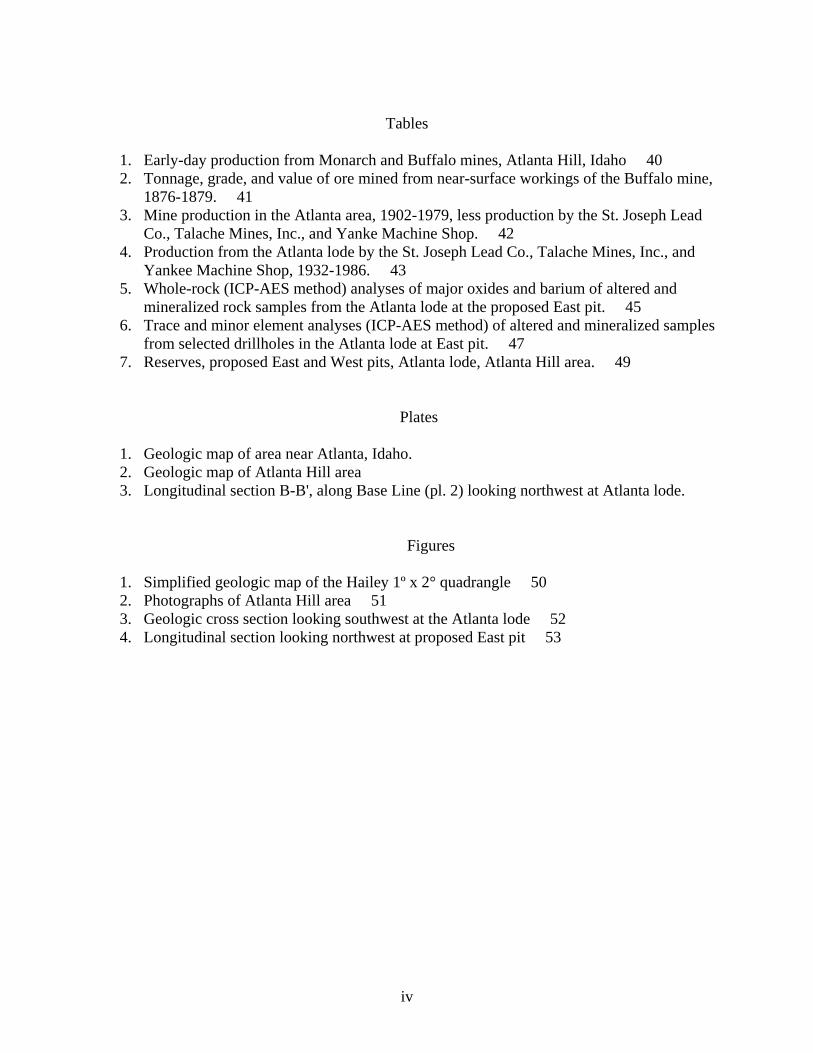
Tables
1. Early-day production from Monarch and Buffalo mines, Atlanta Hill, Idaho 40 2. Tonnage, grade, and value of ore mined from near-surface workings of the Buffalo mine,
1876-1879. 41 3. Mine production in the Atlanta area, 1902-1979, less production by the St. Joseph Lead
Co., Talache Mines, Inc., and Yanke Machine Shop. 42 4. Production from the Atlanta lode by the St. Joseph Lead Co., Talache Mines, Inc., and
Yankee Machine Shop, 1932-1986. 43 5. Whole-rock (ICP-AES method) analyses of major oxides and barium of altered and
mineralized rock samples from the Atlanta lode at the proposed East pit. 45 6. Trace and minor element analyses (ICP-AES method) of altered and mineralized samples
from selected drillholes in the Atlanta lode at East pit. 47 7. Reserves, proposed East and West pits, Atlanta lode, Atlanta Hill area. 49
Plates
1. Geologic map of area near Atlanta, Idaho. 2. Geologic map of Atlanta Hill area 3. Longitudinal section B-B', along Base Line (pl. 2) looking northwest at Atlanta lode.
Figures
1. Simplified geologic map of the Hailey 1º x 2° quadrangle 50 2. Photographs of Atlanta Hill area 51 3. Geologic cross section looking southwest at the Atlanta lode 52 4. Longitudinal section looking northwest at proposed East pit 53
iv

GEOLOGY AND MINERAL DEPOSITS OF THE ATLANTA HILL AREA ELMORE COUNTY, IDAHO
By T.H. Kiilsgaard and L. D. Bacon
Introduction
Gold was discovered in the vicinity of Atlanta, Elmore County, Idaho, in 1863. Placer
mining along the nearby Yuba River started in 1864, and in November of that year major northeast-trending outcrops of quartz were discovered on the hill east of the Yuba River. Initially called the Eagle of the Light (Wells, 1983), the quartz discovery came to be known as the Atlanta lode, a name selected by local southern sympathizers in honor of the Civil War battle at Atlanta, Georgia, which was fought in 1864. Many claims were staked along the Atlanta lode, which was traceable at the outcrop for almost 2 mi. Discovery of the Atlanta lode led to intensive prospecting of the area, which, in turn, led to other mineral discoveries such as the Minerva, Tahoma, Last Chance, and Big lodes, all of the discovered veins offshoots from and near the Atlanta lode.
The discoveries led to development of the Buffalo, Monarch, General Pettit, and other mines along the Atlanta lode and to establishment of the town of Atlanta, about 1.5 miles north of the Atlanta lode, at the mouth of Quartz Gulch.
Metal production from mines on Atlanta Hill has been sporadic. In part, this has been influenced by the inaccessibility of the region, but it also has been affected by such problems as gold-silver recovery from ore mined, low metal prices, and changes in mine ownership. There was a period of intensive mining activity in the area from the date of initial discovery to 1885, followed by a lull until the interval 1902-1917, when mining again was active. The most productive period of mining was from 1932-1957, when the eastern part of the Atlanta lode was mined first by the St. Joseph Lead Company and later by Talache Mines, Inc. Information on geology and mining activity during these periods is presented by Clayton (1877), Hasting (1895), Eldridge (1895), Bell (1908), Ballard (1928), Campbell (1932), Anderson (1939), and Wells (1983).
The present report deals with mining activity, mineral exploration, and geological research on Atlanta Hill and nearby vicinity from 1936 to 1995. It represents an attempt to update and expand on Anderson’s (1939) informative report on the Atlanta area. Principal mine operators in the Atlanta area during the reporting period have been the St. Joseph Lead Company, Talache Mines, Inc., various lessors who leased mineralized blocks of ground from Talache Mines, Inc., and the Yanke Machine Shop, of Boise, Idaho. At the end of 1994, Atlanta Gold Corporation of America, in a co-venture effort with Ramrod Gold, Inc., was continuing an intensive underground exploration program of drilling reverse-circulation and diamond-drill holes to test the Atlanta lode from near and approximately at the same elevation of the old Talache (Boise-Rochester) mine.
Drilling of the Atlanta lode from the surface, by Atlanta Gold Corp., began in 1985, with the objective of exploring for and defining sizable mineralized blocks of the Atlanta lode in which the tonnage and gold content was sufficient to permit open-pit mining and gold recovery by heap leaching. The program has been successful in this respect and, in addition, has penetrated open pits, where drill findings indicate the presence of mineralized material that may be minable by underground mining methods.
1

Atlanta is along the upper reaches of the Middle Fork of the Boise River, about 58 mi (airline) northeast of Boise. A small town, it has a year-round population of 20-30 people, swelling during the summer months to a population of as many as 100 people. During early days of mining, material could be transported to or from Atlanta only by pack horse. By 1878, a wagon road had been constructed from Rocky Bar to Atlanta. The road reached an altitude of 7,727 ft on the high ridge north of Rocky Bar, and, for about 8 months of the year, was snow covered and inaccessible. Not until 1938 was a watergrade road completed along the Middle Fork Boise River, connecting Atlanta to Boise. This unsurfaced, rough, and narrow road is kept open during the winter months. Road distance along the Boise River, between Boise and Atlanta, is about 86 mi and a driving time of about 3 hours is needed normally to make the trip. Atlanta essentially is at the end of the road because the western boundary of the Sawtooth Wilderness crosses the Middle Fork Boise River about 3 mi east of Atlanta, and vehicle traffic is not allowed in the wilderness.
Atlanta is on the north side and at the foot of Atlanta Hill, which rises about 1,900 ft above the town in a distance of 1.5 mi. Mine roads from the town ascend the hill to various mines and prospects. The principal road starts about 0.5 mi east of the center of Atlanta and goes up Montezuma Creek to the divide at the head of the stream. From there, mine roads extend west to various mine workings. Another road from Atlanta extends up Quartz Gulch to and beyond the old Monarch mine. The southern side of Atlanta Hill may be reached by either of the above-described roads or by a road that extends up the Yuba River to the mouth of Decker Creek, then up Decker Creek to the Minerva mine and to other mines and prospects on the hill.
Acknowledgments
We are grateful to Atlanta Gold Corporation for permission to publish the mineral
exploration information on the Atlanta lode that is presented in this paper. In particular we thank Douglas Glaspey, Manager, Atlanta project, Atlanta Gold Corp., for his assistance in gathering much of the data for the manuscript. George Starr, Boise Ranger District, U.S. Forest Service, was very helpful to the senior author in providing living quarters at Dutch Creek and at Atlanta while fieldwork was in progress. We thank Sonny Hornbaker, formerly of Boise Assayers and Metallurgy, for saving and storing many Talache Mines, Inc., maps and reports that deal with the Atlanta lode and for making this information available to the authors. Pamela Dunlap Derkey helped prepare plate 2. Last but not least, the senior author thanks his former field assistant, David Stewart, then a graduate student at Idaho State University, for help given during the course of fieldwork in the Atlanta area.
Geology
The town of Atlanta is underlain by glacial moraine, but Atlanta Hill, immediately south
of the town, is composed of biotite granodiorite of Cretaceous age, part of the vast expanse of biotite granodiorite unit Kgd, that makes up a major part of the Idaho batholith in this part of Idaho. North of Atlanta, biotite granite (commonly called pink granite) of the Sawtooth batholith of Eocene age, (unit Tg, fig. 1) has been intruded into the older biotite granodiorite. West of Atlanta, from the vicinity of Steel Mountain to the western side of Hailey 1° x 2° quadrangle (fig. 1), Cretaceous biotite granodiorite also has been intruded by northeast-trending plutonic rocks of Eocene age. The most extensively exposed of these northeast-trending plutonic units is
2

the Sheep Creek batholith (Kiilsgaard, Lewis, and Bennett, 2001), which is chiefly biotite granite and comparable in physical respects and chemical content to the biotite granite of the Sawtooth batholith. Flanking the Sheep Creek batholith are undifferentiated dioritic rocks (unit Td, fig 1), the principal unit of which is quartz monzodiorite, but which also include hornblende-biotite granodiorite, diorite, and gabbro.
Trending northeast, more or less in line with the northeast-trending belt of Eocene plutonic rocks, are swarms of Tertiary dikes, the most common rock type being rhyolite. The general location of the dikes and Eocene plutonic rocks probably is controlled by major northeast trending faults (Kiilsgaard and others, 2001; Worl and others, 1991). Cutting across all of the rocks are regional northwest-trending faults, of which the Montezuma fault, a major fault, passes along the eastern side of the town of Atlanta and continues southeast up Montezuma Creek, for which the fault is named.
Igneous rocks of the Cretaceous Idaho batholith
Biotite granodiorite
Biotite granodiorite of Cretaceous age (unit Kgd) is the common country rock in the
vicinity of Atlanta (pl. 1). It is light gray, medium to coarse grained, and equigranular to porphyritic phenocrysts, where present, are feldspar, chiefly potassium feldspar. Microscopic study of 49 stained slabs of biotite granodiorite, collected in the area from the vicinity of Atlanta to the western side of the Hailey 1° x 2° quadrangle (fig. 1), shows the rock to have a normalized content of 28 percent quartz, 21 percent potassium feldspar (orthoclase), and 51 percent plagioclase (chiefly oligoclase). Quartz in the rock tends to be darkened and to occur as clumps of crystals that commonly give the rock a porphyritic appearance. The biotite content of the rock ranges from 2 to 12 percent, and the biotite is partially altered to chlorite. Primary muscovite was not found in the rock.
Hornblende was not found in the biotite granodiorite west of the Atlanta area; however, as geologic mapping progressed from west to east, hornblende was found in the rock on the west side of Yuba River, locally in such abundance that a hornblende-enriched unit, biotite-hornblende granodiorite (unit Khgd), was identified and the more conspicuous exposures mapped (pl. 1). Hornblende continues to be present in the biotite granodiorite in exposures east of Atlanta.
Mineralogical and chemical changes of the biotite grandodiorite in the vicinity of Atlanta are described by Kiilsgaard and others (2001). West of a poorly constrained northerly trending zone that extends through the vicinity of Atlanta, the biotite granodiorite is enriched in silica and sodium but depleted in magnesium and calcium with respect to the biotite granodiorite east of the northerly trending zone. East of the zone, the biotite granodiorite is enriched in magnesium and calcium but depleted in silica and sodium.
Locally, particularly near large faults, the biotite granodiorite is intensely altered. Feldspar minerals have been altered to clay minerals and to sericite, the biotite and hornblende to chlorite. At some faulted locations, intensive alteration makes identification of the original rock difficult.
3

Leucocratic granite
Several dikes of leucocratic granite (unit Klg) crop out in Atlanta area (pl. 1). The rock is light gray to almost white and fine to medium grained and has a distinctive anhedral texture. It consists of roughly equal amounts of quartz, potassium feldspar, and plagioclase. Fine-grained biotite makes up as much as 2 percent of the rock. Other accessory minerals include garnet, magnetite, sphene, and allanite. The fine-grained rock is resistant to erosion and tends to form knobs or high points on ridges. It weathers to a rubbly scree that commonly is widely scattered on hillsides below outcrops, where it gives the impression of having been derived from a much larger original mass than actually exposed.
Pegmatite and aplite dikes
Pegmatite and aplite dikes are common on Atlanta Hill and nearby vicinity, but most are
small, only a few inches thick and a few feet long, and thus are not shown on plate 1. Larger pegmatite dikes (unit Kp, pl. 1) crops out on the ridge west of the Yuba River. The dike rock is light gray and consists of coarse-grained quartz, potassium feldspar crystals of the rock, as is graphically intergrown quartz and feldspars, which, locally, gives the rock a graphic texture.
The aplite dikes are similar in mineralogic content and composition to the above-described leucocratic granite, but they are small, stringerlike bodies that rarely are more than 2 or 3 in. thick and only a few feet long.
Tertiary igneous rocks
Eocene plutonic rocks
Plutonic rocks of Eocene age are not exposed in the area near Atlanta. The nearest
exposure of Eocene biotite granite (unit Tg, fig 1; pink granite) is 2.8 mi north of Atlanta, immediately east of Montezuma fault, on the ridge crest that separates Queens River drainage from the Middle Fork Boise River. The ridge exposure marks the western extent of the Sawtooth batholith, a large mass of Eocene plutonic rock that underlies most of the Sawtooth Range (Kiilsgaard and others, 1970). West of Atlanta, from the Deer Park fault that extends northwest along the eastern side of Steel Mountain, the Sheep Creek batholith, a large exposure of Eocene biotite granite of the Sawtooth batholith, extends for many miles to the southwest (fig. 1); (Worl and others, 1991). This exposure is part of the Sheep Creek batholith, and along with flanking intrusive rocks of the dioritic suite (Lewis and Kiilsgaard, 1991), is part of a large northeast-trending belt of Eocene plutonic rocks that are intrusive into the older Cretaceous biotite granodiorite. Geologic evidence suggests that the northeast-trending belt of younger intrusive rocks should extend through the Atlanta area. The fact that these younger plutonic rocks are not exposed near Atlanta may be due to displacement along the Montezuma fault. Rocks west of the Montezuma are believed to have been down dropped about 2,000 ft with respect to rocks east of the fault. Erosion of Atlanta Hill west of the Montezuma fault has not advanced far enough to expose the Eocene plutonic rocks that may be buried beneath the surface.
4

Tertiary dikes
Countless porphyritic dikes are exposed in the Hailey and Challis 1º x 2º quadrangles. They are present both as individual dikes and as swarms of closely spaced dikes. For field-mapping purposes, dikes are classified into two general families: light-colored, silicic, rhyolitic dikes and darker, more mafic dacitic dikes. The dikes can be no older than Eocene because both types intrude plutonic rocks that have been dated as Eocene in age. Study of the dikes at many locations indicates a genetic relationship between the rhyolitic dikes and the Eocene biotite (pink) granite (Bennett and Knowles, 1985). Rhyolitic dikes are compositionally similar to the biotite granite and are more numerous in or near it. Similarly, mafic dikes, chiefly andesite to dacite, tend to be more compositionally equivalent to the dioritic suite of plutonic rocks and to be more numerous in or near exposures of the dioritic rocks.
Rhyolite
Swarms of rhyolite dikes (unit Tr, plate 1) crop out west of Atlanta in the canyon walls of
Middle Fork Boise River and James Creek. These siliceous rocks are resistant to erosion and commonly stand several feet above the ground surface of the more easily weathered biotite granodiorite. The dike rock weathers buff but has a pinkish tint on freshly broken surfaces. It consists chiefly of rounded or embayed quartz crystals and phenocrysts in a microcrystaline matrix of quartz and potassium feldspar. X-ray fluorescence spectroscopy of a representative sample taken from a dike near the mouth of James Creek shows a SiO2 content of 76.8 percent and a combined Na2O and K2O content of 8.38 percent, a total alkali-silica (TAS) content that plots as rhyolite (LeBas and others, 1986). The Tertiary rhyolite dikes are similar in composition to the biotite (pink) granite and may represent differentiates of the magma that crystallized to form the biotite granite in the contiguous Challis 1° x 2° quadrangle as reviewed by Bennett and Knowles (1985) and Kiilsgaard and Lewis (1985).
West of Atlanta, extensive swarms of rhyolite dikes are bounded on the south side by the Basque Creek fault (pl. 1), and only a few individual dikes are exposed on the north side of Atlanta Hill. No rhyolite dikes have been found in the vicinity of the Atlanta lode, but a conspicuous northeast-striking rhyolite dike is exposed on the ridge west of Quartz Gulch. The dike (pl. 1) can be traced for more than 2,500 ft and probably cuts across the Tahoma vein near its western end.
Andesite and dacite
Several dark-green to grayish, andesitic to dacitic (units Ta and Tda, pl. 1) dikes are
exposed southeast of Atlanta Hill. The dike rock weathers to a reddish soil. Fresh surfaces of the rock commonly show a felted arrangement of lathlike plagioclase crystals, green hornblende, biotite usually somewhat altered to chlorite, and variable amounts of quartz. Some of the dikes are porphyritic, although not porphyritic as similar dikes in the vicinity of Eocene plutonic rocks farther to the west.
A dark, fine-grained, post-mineralization dike along the Atlanta lode previously was classified as lamprophyre (Anderson, 1939). The same dike or a similar dike crops out in the Atlanta lode, east of the Monarch shaft. Microscopic study of the rock shows that it consists chiefly of fine, lathlike crystals of labradorite and calcite. Small crystals of magnetite are present,
5

but many of the microscopic-sized matrix minerals were not identified. No biotite, amphibole minerals, or pyroxene or porphyritic texture was seen, and perhaps the former classification of the dike as lamprophyre is inappropriate. Analysis of a sample of the exposed dike and two drillhole samples of similar rock analyzed by inductively coupled plasma-atomic emission spectroscopy (ICP-AES), shows an average SiO2 content of 56 percent and an average combined Na2O and K2O content of 4.56 percent. The chemical content, plotted on a total alkali-silica diagram, shows the rock to be a basaltic andesite; however, the plotted point is near the andesite line, and thus, for purposes of simplicity, we classified the rock as andesite.
Basalt
Dark, fine-grained, greenish-black to black dikes crop out sparsely in the Atlanta area,
chiefly south of Atlanta Hill. We mapped these dikes as basalt because of their dark color, fine-grained nature of contained minerals, scarcity of quartz, and abundance of accessory magnetite. This was a field classification. We did not make petrographic studies of these dike rocks nor did we analyze them chemically; thus it is quite possible that dikes mapped as basalt more correctly might be classed as andesite.
Unconsolidated sediments
Glacial till
The town of Atlanta is underlain by unconsolidated and unsorted glacial debris that is a
heterogeneous mixture of various-sized boulders, gravel, and sand. The till extends along both sides of the Middle Fork Boise River, along Queens River, and along upper reaches of Decker Creek.
The till probably was deposited chiefly as lateral or end moraine from alpine glaciers that scoured the Sawtooth Mountains. Subsequent erosion, as well as deposition of younger colluvium and alluvium, has mostly obliterated the original marginal landform.
High gravel
A deposit of unconsolidated gravel (unit Qhg, pl. 1) caps the northeast-trending ridge that
extends between Queens River and Middle Fort Boise River. The top of the gravel is about 2,100 ft above the level of the Middle Fork Boise River. Its caplike location on the high ridge and the location of similar high deposits of gravel elsewhere has led to the informal name, High gravel.
Boulders, cobbles, pebbles, and sand are the chief components of the gravel, the larger clasts derived chiefly from dikes, primarily rhyolite dikes. There also is much Eocene biotite (pink) granite in the gravel but not many clasts of Cretaceous biotite granodiorite. Content of the gravel indicates that it was derived from erosion of higher ground of the present Sawtooth Mountains. The rounded nature of the cobbles and boulders and the rough sorting suggest deposition from high-energy streams, probably from periglacial streams that flowed away from Pleistocene alpine glaciers. The gravel could, however, be pre-Pleistocene in age. It may exist because it is on the downthrown side of the Montezuma fault, where its lower profile has protected it from the erosion that has stripped the gravel from nearby higher points.
6

Locally, the gravel is auriferous, and at those sites marked by a "P" on plate 1 basal parts of the gravel have been placer-mined.
Terrace gravel
Terraces of fluvial sand, coarse to medium gravel, and well-rounded cobbles (unit Qtg,
pl. 1) extend locally along the Middle Fork Boise River. Most of the cobbles are of resistant rock, rhyolite, aplite, and leucocratic granite being most common. Much of the material probably was eroded from older high gravel and glacial till deposits. The eroded alluvium filled the valley to the top of the present terrace. Subsequent uplift of the area has led to more vigorous erosion that has deepened the river channel in the old valley bottom, leaving remnant terraces along the valley walls.
Alluvium
Alluvium (unit Qal, pl. 1) consists of gravel, sand, silt, and clay deposited in streambeds of currently active streams. It ranges from a few inches to a few feet in thickness and covers the floor of the various stream valleys.
Faults
Two patterns of major faults are conspicuous in the Atlanta area: one pattern strikes
northeast, the other northwest.
Northeast faults
Several major faults in the vicinity of Atlanta strike northeast, including the Queens River fault, the Basque Creek fault, the Flint Creek fault, and the Atlanta lode fault (pl. 1). These are high-angle faults, but the direction of movement and amount of displacement along them is unknown. An exception is the Atlanta lode fault, which is described in more detail in a later section of this report.
Queens River fault
The Queens River fault is exposed in the south bank of the Middle Fork Boise River, at
the mouth of Queens River. It also is exposed in the road bank about 0.5 mi up the Queens River road, where it strikes N. 50° E. and dips 70° NW.
Basque Creek fault
The northeast-striking Basque Creek fault extends along Basque Creek and crosses the
Yuba River road about 300 ft south of the mouth of Basque Creek. The fault limits the southeast continuation of numerous rhyolite dikes that crop out conspicuously on the ridge north of Basque Creek, particularly those dikes that crop out north of the headwaters of Basque Creek. Biotite granodiorite north of Basque Creek is altered, the soil stained a buff color, the surface rough and uneven from protruding rhyolite dikes or from rubble weathered from the dikes. In contrast,
7

biotite granodiorite south of Basque Creek is fresh and unaffected by dikes. The soil is devoid of dike rubble. In addition to the location of Basque Creek, the fault appears to control the location of the small southwest-trending gulch opposite from the mouth of Basque Creek and the saddle in the ridge immediately southwest of Atlanta. In the immediate vicinity of Atlanta, however, the fault is concealed by glacial till, as is the fault intersection with the Montezuma fault (pl. 1). No attempt was made to search for the fault northeast of the Montezuma fault.
Flint Creek fault
The Flint Creek fault is exposed in a bulldozed cut on the south side of Sawmill Creek,
near the mouth of the stream. At that site, the fault zone is at least 4 ft thick, dips steeply, and strikes N. 60° E. Northwest of the lower part of Flint Creek, a sheared zone intersected in holes drilled by the Atlanta Gold Corp. appears to be the northeast extension of the fault. No evidence of the sheared zone was found east of the Montezuma fault, although it is possible that a fault on the northwest or hanging-wall side of the Flint Creek quartz lode could be a silicified continuation of the sheared zone.
Atlanta lode fault zone
The Atlanta lode is essentially a major northeast-striking fault zone, parts of which have
been mineralized. Near horizontal striations on slickensided fault surfaces have been reported from underground workings and the pattern of oblique-trending gash veins, both to the northwest and to the southeast, suggests strike-slip movement along the lode, the northern side having been displaced to the northeast. The northeast end of the lode terminates against the Montezuma fault. The lode is described in greater detail in a later section of this report.
Atlanta shear zone
In 1970, M.D. Kleinkopf called attention to almost linear magnetic gradients on the
northeast and southwest sides of the Sawtooth batholith that correlate with major northwest-striking bounding faults. He also noted a northeast-trending magnetic gradient on the southeast side of the Sawtooth batholith that he postulated might mark a northeast-trending bounding fault (Kiilsgaard and others, 1970). In a more recent and more intensive aeromagnetic study of the Hailey 1° x 2° quadrangle, Kleinkopf and others (1995) directed attention to a high-angle, northeast-trending magnetic gradient that passes near Atlanta and is considered to be a southwest continuation of the gradient identified in 1970 as being on the southeast side of the Sawtooth batholith. Kleinkopf and others consider this magnetic gradient to reflect a northeast-trending, buried shear zone, which they propose be known as the Atlanta shear zone. They note that Bouguer gravity anomaly data along the belt of high magnetic gradient corroborates the interpretation of the buried shear zone. The aeromagnetic interpretations show the broad Atlanta shear zone as continuing southwest through Rocky Bar and passing across the western side of the Hailey 1° x 2° quadrangle about 21 mi northwest of Mountain Home.
The buried Atlanta shear zone is an interesting postulation. It could be, as Kleinkopf and others (1995) noted, related to the Trans-Challis fault system (Kiilsgaard and Lewis, 1985). The northeast-trending Eocene plutons, including the Sheep Creek and the Sawtooth batholiths trend northeast, more or less parallel with the Atlanta shear zone, reflecting the existence of controlling
8

northeast-trending structures. The Atlanta and Rocky Bar mineralized areas are along the structure. The above-described northeast striking faults, particularly the Basque Creek, Atlanta lode, and Flint Creek faults, could very well be components of the broad Atlanta shear zone.
Northwest faults
A pattern of northwest-striking regional faults trends across the western part of the Hailey
1° x 2° quadrangle (fig. 1) (Worl and others, 1991). Of this pattern of faults, the Montezuma fault is the major fault in the vicinity of Atlanta.
Montezuma fault
The Montezuma fault passes immediately east of the town of Atlanta (pl. 1) and
continues southeast up Montezuma Creek and along the front of the Sawtooth Mountains, separating the higher ridges on the northeast from the down-dropped, lower ridges on the southwest. A major regional fault, it has been traced along a strike length of more than 50 mi. The fault was first described by Anderson (1939), who noted that it cut across the Atlanta lode in the bottom of Montezuma Gulch, that vertical displacement along the fault was as much as 2,000 ft, and the horizontal displacement was approximately 4,000 ft, the southwestern or downthrown side having been displaced to the northwest. Anderson based the measurement of horizontal displacement on the concept that the Flint Creek quartz lode represented the faulted, northeast extension of the Atlanta lode.
Geologic maps of the 750-level, and the overlying 750-sublevel of the Atlanta mine (formerly known as the Talache, or Boise-Rochester mine) prepared by staff members of Talache Mines, Inc., in the early 1940’s showed the Atlanta lode to be cut by a fault that strikes N. 16° W., and dips 44°-54° SW. No mineralized vein material is shown northeast of the fault. The fault intersection with the Atlanta lode plots beneath but near the portal the No. 6 mine level (pl. 2, no. 17). The 750-sublevel is approximately 100 ft below the bottom of Montezuma Gulch, near the portal of the No. 6 level, and upward projection of the fault from the 750-sublevel to the surface shows the surface trace of the fault to be located almost exactly along the surface trace of the Montezuma fault (pl. 2). The similarity of attitude and the fault location convinced us that the fault mapped on the 750-level and on the 750-sublevel is the Montezuma fault, which clearly crosscuts and terminates the northeast continuation of the Atlanta lode.
Geologic maps (Talache Mines, Inc., unpub. mapping) of the 900-level, the overlying 750-level and the still higher 750-sublevel show that the strike and dip of the Atlanta lode changes as the lode approaches the Montezuma fault. Northeast from the Monarch shaft, the Atlanta lode strikes about N. 70° E. for about 2,400 ft, but as the Montezuma fault is approached the lode splits into several strands that curve to the north. Strands mapped on the 750-level near the Montezuma fault strike as much as N. 14° E. Approximately 480 ft northeast of the Monarch shaft, a geologic map (Talache Mines, Inc., unpub. mapping) of the Adit level shows the Atlanta lode to dip 77° SE. As the lode approaches the Montezuma fault and as the strike swings more to the north, the dip of the lode reverses to the northwest and flattens. Strands of the lode mapped on the 900-level have dips ranging from 28° to 65° NW.
The northerly curve of the Atlanta lode near the Montezuma fault could be interpreted as a drag effect caused by horizontal displacement of the western or hanging-wall block of the Montezuma fault (pls. 1, 2). Should such be the case, however, the direction of curvature is
9
incompatible with the northwest displacement advocated by Anderson (1939). To the contrary, the northerly curvature of the Atlanta lode near the Montezuma fault would suggest post-mineralization displacement of the hanging-wall block of the fault. There is no reason to assume that the Flint Creek quartz lode represents the northeast continuation of the Atlanta lode. Both the northerly curve of the Atlanta lode and the reversal of dip of the lode to the northwest could be explained by post-mineralization downward displacement, coupled with horizontal displacement to the southeast, of the hanging wall block of the Montezuma fault. Such an interpretation is subject, however, to question because there is no evidence of a vein outcrop that could be interpreted as the northeast continuation of the Atlanta lode in the footwall block of the Montezuma fault northwest of the Atlanta lode-Montezuma fault intersection. The geologic forces that originally created the Atlanta lode prior to displacement by the Montezuma fault could have produced the present northerly curvature and reversal of dip of the lode. East of the present Montezuma fault, any pre-mineralization faults that may have been part of the pattern of Atlanta lode faults subsequently may not have been mineralized. Another possibility is that mineralized bodies that might have formed in the pre-mineralization faults of the Atlanta pattern, northeast of the Montezuma fault, in the topographically higher footwall block of the fault, may have been eroded away. Certainly, the hanging-wall block of the Montezuma fault has been displaced downward, and Anderson’s (1939) estimate of 2,000 ft of vertical displacement seems reasonable. For example, the ridge crest through Graylock Mountain, east of the Montezuma fault, is at an altitude of about 9,300 ft, whereas the high point of the western continuation of the ridge crest, between the Queens River and Middle Fork Boise River west of the Montezuma fault, is at an altitude of 7,438 ft, a difference of 1,862 ft. A similar break in topography occurs between the top of Atlanta Hill, west of the Montezuma fault, and the nearby crest of the high ridge east of the Montezuma fault, between Montezuma and Leggit Creeks. At this location, Atlanta Hill is 2,100 ft lower than the ridge.
Other evidence for the downward displacement of the western or hanging-wall block of the Montezuma fault is the cap of High gravel on the ridge between Queens River and the Middle Fork Boise River (pl. 1). Boulders and cobbles of biotite (pink) granite of Eocene age make up a substantial part of the High gravel. The only rock mass from which these Eocene boulders and cobbles could have been eroded is the Sawtooth batholith, which crops out east of the Montezuma fault (Kiilsgaard and others, 1970). The High gravel cap is a remnant of a much larger cap of gravel that once covered parts of the region, but most of the larger cap since has been eroded away. The part of the cap now exposed on the ridge between Queens River and Middle Fork Boise River is in the down-dropped block of the Montezuma fault, where it has been more protected from erosion than has surface material on higher ridges of the area.
The age of the Montezuma fault is Pleistocene or younger. Boulders of Eocene biotite (pink) granite in the displaced High gravel fix the age of faulting as post-Eocene. South of Queens River and at the east end of the High gravel, glacial moraine of Pleistocene age, which overlies the High gravel unit, has been displaced by the Montezuma fault; thus the age of faulting is no older than Pleistocene.
Mineral deposits
Principal mineral deposits in the Atlanta Hill area are along the walls of the Atlanta lode.
The deposits have been worked for gold and silver, and most are known by the mine name under which they were worked; for example, Buffalo, Monarch, Pettit, Old Chunk. Other deposits also
10

worked for gold and silver are along gash veins that lead obliquely away from the Atlanta lode. Some veins are within the lode but lead diagonally from the North bounding fault to the South bounding fault. A good example of the latter type is the gash vein shown on an unpublished St. Joseph Lead Mining Company mine map of the 600-level of the Atlanta mine. The northwest end of this gash vein is 230 ft east of a point projected vertically beneath U.S. Mineral Monument No. 1 (pl. 2). Similar but smaller interlode gash veins are shown on unpublished maps (Talache Mines, Inc., unpub. mapping) of the 750-1evel. Gash veins extending obliquely away from the Atlanta lode commonly have been referred to in the past as splits from the lode or as laterals. Deposits along the gash veins also are known by the mine name under which the deposits were worked and include the Tahoma, No. 1 North, Paymaster, Last Chance, and Minerva.
Atlanta lode
Atlanta lode is a large shear zone that has been traced for more than 2 mi, approximately
from the Yuba River to Montezuma Creek (pl. 1). For much of this distance the zone is marked by two bounding faults that, east of the Monarch shaft, have been referred to by mine operators as the North wall and the South wall. Mine maps compiled by former operators of the Atlanta mine show many faults in the shear zone, most of which trend more or less parallel with the trend of the lode but some of which extend obliquely from one wall to the other and others of which split from the walls of the lode and extend obliquely for hundreds of feet away from the lode. The lode ranges from 20 to 160 ft in thickness, the thickness varying widely both along strike and dip. Near the southwestern end of the lode outcrop, in the area of the Idaho Gold mine adits (pl. 2), where several gash veins join the lode from the southeast, the overall thickness of the lode and associated altered rock is about 300 ft. Southwest of this area, between the top of Atlanta Hill and the Yuba River, the surface trace of the Atlanta lode is indistinct and appears to consist of a number of splitting (horsetail) faults.
The Atlanta lode strikes northeast but has a somewhat curving trend. Near the southwestern end of the outcrop, southwest of the Idaho Gold mine adits (pl. 2), the lode strikes about N. 45º E., but northeast of the Idaho Gold mine adits the strike swings to the east and for several hundred feet east of the Buffalo shaft it strikes about N. 75° E. At the northeastern end the strike changes back to more northerly N. 15° E. near the intersection of the lode and the Montezuma fault. The dip of the lode also changes, from steeply southeast near the Buffalo shaft, to steeply northwest east of the Monarch shaft (pl. 2). Near its northeastern end, the dip of the lode flattens. Fault strands of the lode on the 750-level of the Atlanta mine near the Montezuma fault dip as little as 30° NW.
The strike and dip of the lode affect both the thickness and the mineralized character of the lode. From a point about 200 ft southwest of the Buffalo shaft, where the strike begins to swing to the east, to about the eastern end of the proposed east pit (p. 2), where the strike again swings to the northeast, the lode maintains a consistent thickness of 100 ft or more. This consistent thickness can be explained by examination of the rock displacement along the Atlanta lode fault zone. As is explained in a later section, wallrock north of the Atlanta fault zone has been displaced to the east with respect to wallrock south of the fault zone (pl. 2). This displacement has caused the walls of the fault zone to pull apart in steeply dipping stretches of the lode that strike more to the east but crowd together where to strike is more to the north. Where the walls have been pulled apart in the easterly trending stretches, there has been a greater
11

development of voids and overall porosity that provided a more porous pathway for migration of subsequent hydrothermal solutions from which were deposited the minerals that now compose the lode. Some of the thickest and most persistent quartz veins and the highest grade ore shoots of gold- and silver-bearing minerals have been mined from the easterly trending stretch of the lode. Many of the northwest-striking gash veins split from the lode in the easterly striking stretch, which adds further to the volume and mineralized character of this part of the Atlanta lode. To the northeast, near the intersection of the Atlanta lobe and the Montezuma fault, the Atlanta lode splits into several subparallel strands, the strikes of which swing sharply to the north and which flatten in dip. Smaller and discontinuous ore shoots have been mined along flatter dipping veins in this curled and broken area in the vicinity of the 750-level. Deep-level exploration of curled and flatter dipping strand of the Atlanta lode, near its termination against the Montezuma fault, could result in discovery of minable amounts of gold ore in that area. The Atlanta lode is terminated at the northeastern end by the Montezuma fault. Extension of the lode to the southwest is more speculative. Extension southwest of the Yuba River is suggested by the Rippen prospect in NW1/4 sec. 20, T. 5 N., R. 11 E., more than 2 mi southwest of mine working on Atlanta Hill (pl. 2), but surface traces of a southwest-trending zone that has Atlanta lode characteristics are not known southwest of the Rippen prospect. Projection of the lode about 8 mi farther to the southwest, using the known trend on Atlanta Hill, would extend the Atlanta shear zone into the Rocky Bar mining district, a location compatible with the location along the Atlanta shear zone as proposed by Kleinkopf and others (1995). Most veins in the Rocky Bar district, however, although similar in mineral content and character to those in the Atlanta district, strike more or less east-west (Anderson, 1943) and because of this strike cannot be projected to the vicinity of Atlanta Hill. They may, however, be components of a regional shear zone that passes through the Atlanta and the Rocky Bar areas.
The lode consists chiefly of sheared and altered biotite granodiorite (unit Kgd). Fine-grained quartz is a common mineral in the lode. Locally, especially along the North and South bounding faults, the quartz is present as veins, some of which were several feet thick and which constituted the silver- and gold-bearing ore shoots that were mined in the past. Elsewhere, the quartz is present as irregular masses or veinlets or as grains disseminated in the granodiorite between the bounding faults. Much of the lode quartz has been brecciated, the fragments cemented together by younger quartz and associated ore minerals. Ore shoots within the lode apparently were in areas of more intense brecciation and associated mineralization (Anderson, 1939).
A conspicuous feature of the lode, shown on unpublished maps of Talache Mines, Inc., is exposures of dark, fine-grained, mafic dike rock that Anderson (1939) identified as lamprophyre but which we, as previously described, believe is basaltic andesite. From the unpublished maps and from Anderson’s (1939) description, there is more than one of these dikes along the Atlanta lode. The dikes cut across the lode and formed after the mineralization. A dike of this type crops out about 400 ft northeast of the Paymaster vein (pl. 2) and strikes northwest, more or less parallel with the Paymaster vein. Drill findings of the Atlanta Gold Corp., in and along the Atlanta lode, indicate the presence of other similar dikes that strike northwest and cut across the lode. These appear to follow the tensional fractures that were followed by the gash (lateral) veins described in following paragraphs. When exposed for examination, they likely will be found to be younger than the gash veins and the Atlanta lode.
12

Gash veins
Gash veins diverge obliquely away from the Atlanta lode. They are fractures formed from tensional adjustment in rock displaced along the Atlanta fault (lode). The gash veins typically are thickest at their junction with the Atlanta lode and progressively diminish in thickness away from the lode. Many of them are too small to show on plate 2. Some, such as the Tahoma, Minerva, Last Chance, and Paymaster, are large and extend several thousand feet away from the Atlanta lode. Theoretically, these larger veins are too extensive to be classed as gash veins; however, they are more or less parallel to smaller gash veins in attitude and are similar in mineral content, and their structural location between the Atlanta lode (fault) and the Basque Creek fault or the Flint Creek fault suggest that, they, like the smaller gash veins, originated from tensional adjustment. Thus, for purposes of this report, the larger veins are considered in the same class as the gash veins. The No. 1 North vein typifies gash veins that were mined. Harold Lanning mined the No. 1 North vein above the 600-level of the Atlanta mine (oral commun., 1989). He stated that the vein, at its junction with the Atlanta lode, was about 18 in. thick but when followed about 150 ft northwest, away from the lode, had diminished in thickness to 1 in. or so. The vein consisted of quartz, silver-bearing sulfide minerals, and native gold. Ore mined was rich in grade and consistent enough to be mined to a distance of 500 ft above the 600-level and along strike to the northwest, to points where an appreciable tonnage of ore could not be obtained from the ever-thinning vein.
Examination of the Atlanta lode and its associated gash veins enable one to determine the direction of wallrock displacement along the lode. If one looks along the trace of the fault (Atlanta lode), the acute angles made by the intersection of the oblique gash veins and the fault point in the direction of displacement along the fault. For example, if one looks northeast along the Atlanta lode, one can interpret the rock on the northwest side of the Atlanta lode has been displaced to the northeast (pl. 2). Conversely, if one looks southwest along the trace of the Atlanta lode, into the acute angles formed by the oblique convergence of No. 1 North and Paymaster veins with the Atlanta lode, one can interpret that rock on the northwest side of the Atlanta lode has been displaced to the northeast (pl. 2). Conversely, if one looks southwest along the trace of the Atlanta lode, into the acute angles formed by oblique convergence of the Last Chance and Minerva veins with the Atlanta lode, one can interpret the rocks southeast of the Atlanta lode have been displaced to the southwest. As for the gash veins, if one looks along the trace of the Atlanta lode (fault), either to the northeast or southwest, the gash veins diverge obliquely to the right.
Hydrothermal alteration associated with mineralized veins
Biotite granodiorite (pl. 2, unit Kgd) along the Atlanta lode and associated gash veins
have been affected to varying degrees by hydrothermal alteration. Fresh biotite granodiorite is a hard, gray rock that has a distinctive granitic texture and contains unaltered biotite, minor hornblende, and little, if any, primary muscovite. Feldspar is clear and white to pinkish, and the plagioclase is readily recognized by its distinctive twinning.
As the lode is approached from either the northwest or southeast, biotite in the granodiorite is increasingly altered to chlorite. The chloritic zone is from only a few feet to as much as 50 ft in thickness and is much more developed on the northwest side of the lode, possibly because of many gash veins on that side of the lode. Near the lode or gash veins, most
13

of the biotite has been altered to chlorite. With increasingly intensive chloritic alteration, feldspar in the rock loses its crystalline appearance and becomes clouded by the beginning stages of argillic alteration to clay minerals and sericite. Biotite granodiorite in the intensely chloritized and increasingly argillized zones tends to be iron stained at the outcrop by secondary iron-bearing minerals, especially along fractures in the rock. Drill cuttings and core from subsurface location of the argillic zone may contain fine-grained pyrite and fine-grained, dark sulfide minerals. The argillic-altered rock may or may not contain gold.
Where the biotite granodiorite has undergone intense argillic alteration, the feldspar in the rock may not be identifiable, having been replaced mostly by chalky-white clay minerals. The granitic texture of the rock ranges from barely visible to indistinguishable. At some locations, green chlorite in the altered plagioclase gives the rock a greenish tint. Sericite is more dominant near the veins.
As the sericite content of the rock increases, so does the abundance of quartz, first as disseminated quartz in the intensely altered rock, then as veinlets of quartz, and finally as large masses of veins of quartz. Most of the gold- and silver-bearing minerals and various other sulfide minerals are within or associated with the more intensely silicified zones. Thus it can be concluded that alteration along the Atlanta lode and associated gash veins ranges from zones of intense alteration at or within the more mineralized parts of the lode to decreasingly altered zones away from the inner core. Aside from the abrupt walls of a quartz vein, there are no lines of demarcation between the different alteration zones. Furthermore, the zones commonly overlap and locally are telescoped on upon the other in rather narrow thicknesses to a point where separation of the individual zones is difficult, if not impossible, to distinguish. The degree of alteration is not consistent. Horses of relatively fresh biotite granodiorite are present in wider parts of the lode. Local areas of moderate to intensely altered rocks are present along the divergent gash veins, but at some exposures fresh biotite granodiorite is within inches of, if not in contact with, the veins.
Alteration of the country rock has resulted from chemical reactions brought about by hydrothermal solutions that flowed along the fracture subsequently filled by vein minerals. The alteration effects displayed on Atlanta Hill are comparable to those commonly present along epithermal gold-silver veins. The outer chloritic (propyplitic) zone represents mild hydrothermal alteration and is followed progressively by more intensive argillic, sericitic, and silicic alteration as the vein is approached.
Mineralogy
Introduction
Mine workings along the Atlanta lode have been inaccessible in recent years, and it was
not possible to collect in-place subsurface samples for mineralogic study. Surface samples and drill cuttings from the lode were considered unsuitable for study of sulfide minerals. Samples of drill core were studied but primarily to determine gold content, to locate gold-bearing zones within or near the Atlanta lode, and to determine the relationship between mineralized zones and altered country rock. For the foregoing reasons, the following summary on mineralogy is primarily based on previous published descriptions of the district, including Clayton (1877), Shannon (1926), and Anderson (1939). Of these reports, that by Anderson (1939) is, by far, the most descriptive.
14

Minerals of the Atlanta lode
In describing the Atlanta lode at the Monarch mine, Clayton (1877) noted that “brittle
silver” or black antimonial silver was the most abundant ore mineral, followed in quantity and value by ruby silver. Free gold constituted 20-40 percent of the total value of ore mined. Much of the quartz of the lode was comparatively barren, but a streak of black antimonial silver and ruby silver in the quartz ranged from 1 to 7 ft in width, and alongside it was a zone of equal width that contained free gold and disseminated silver minerals, making the vein workable for a width of as much as 15 ft.
Shannon (1926) defined Clayton’s (1877) “brittle” or antimonial silver as the mineral stephanite and the ruby silver as pyrargyrite. He noted that argentite, stromeyerite, and native silver were present in lesser quantities.
Anderson (1939) described successive stages of quartz mineralization in the Atlanta lode and repeated recementation of older, brecciated quartz by younger quartz. A late-stage white to colorless, glassy, coarser-grained quartz, most of it in combs or druses, was associated with most of the gold- and silver-bearing minerals of the Atlanta lode. Pyrite and arsenopyrite were the most common sulfide gangue minerals in the lode; the arsenopyrite crystals were minute in size and imparted a gray color to the finely crystalline, chalcedonic quartz in which they were found. Brecciated fragments of arsenopyrite-darkened chalcedonic quartz were recemented by the younger, coarser, comb quartz, and, although the arsenopyrite was known to be auriferous, Anderson concluded that the arsenopyrite was deposited during an earlier period of mineralization than was the gold. He also concluded that arsenopyrite served as an effective precipitant for gold in those parts of the lode where younger gold-bearing solutions had contacted older arsenopyrite-bearing quartz. He described fine-grained pyrite as a minor constituent of lode ore and altered wallrock but noted that coarser grained pyrite associated with other sulfide minerals deposited with the late-stage comb quartz was highly auriferous. Anderson's observations on the gold in pyrite are not compatible with later metallurgical studies by the Atlanta Gold Corp., which tested sulfide concentrations obtained from drill core of deep holes in the Atlanta lobe. Atlanta Gold Corp. found that approximately 50 percent of the gold was locked in the arsenopyrite concentration but did not find significant amounts of gold in pyrite concentrations.
Anderson (1939) noted that gold, although exceeded by silver in weight, has been the most valuable metal produced from Atlanta ore. Much of the gold is microscopic in size. Even in rich ore, the gold commonly is invisible to the unaided eye. During microscopic studies of polished surfaces of ore, Anderson found replacement grains of gold in many different sulfide minerals. He identified and described a long list of primary sulfide minerals. He also identified many secondary minerals that originated through weathering or oxidation of the primary minerals. Secondary minerals probably were not important sources of metal in previous mining operations because most of the minerals mentioned in old reports are of primary origin. Drill findings show that the Atlanta lobe is oxidized to an uneven depth, generally from 100 to 200 ft below the surface. Primary sulfide minerals encapsulated in quartz can, however, be found at the surface. Mining by the Yanke Machine Shop along the No. 1 North gash vein in the 1980’s, at depths of less than 200 ft, was almost certainly in primary sulfide ore.
15

Fluid inclusions
Finely disseminated fluid inclusions are visible in the quartz associated with gold- and silver-bearing minerals of the Atlanta lobe. Efforts were made by the Atlanta Gold Corp. in 1988 to use the fluid inclusions to determine the temperature of the quartz and associated gold- and silver-bearing minerals at the time they were deposited and to gain information on the chemical and physical nature of the depositional environment. Six samples of mineralized drill core were collected from holes 88-302 and sent to T. James Reynolds, Consulting Geologist, Denver, Colorado, for fluid inclusion analysis.
Reynolds studied doubly polished plates prepared from the samples but could not determine definitive homogenization temperatures for any of the six samples. On the basis of his studies, T.J. Reynolds suggested that the quartz formed at a depth of 1.5-3 km at temperatures less than 200° (written commun., 1988). The hypothesized temperature is consistent with temperatures normally associated with epithermal deposits, but the proposed depth is somewhat deeper than commonly associated with epithermal deposits.
Genesis of the Atlanta lode and associated gash veins
Mineralogic, textural, and alteration features of the Atlanta lode and associated gash
veins indicate their derivation from ascending hydrothermal solutions. The various features are typical of epithermal gold-silver deposits associated with Tertiary intrusive rocks in central Idaho, especially those deposits along or near northeast-trending faults (Bennett, 1980; Bennett and Knowles, 1985; Kiilsgaard and Bennett, 1985; Kiilsgaard and others, 1986, 1989). Because of similarities to epithermal veins of Eocene age in mineralized areas described in the previously cited references, we believe that the Atlanta lode and the gash veins are epithermal deposits related to early Tertiary plutonic activity. The deposits could be of Eocene age, although such an age is subject to question.
An epithermal classification is compatible with that of Anderson (1939), who considered the Atlanta lode to be a shallow, bonanza-like epithermal deposit that was younger than and not related to the Cretaceous Idaho batholith. Anderson noted that none of the commercial ore shoots of the Atlanta lode extended through a vertical range of more than 800 ft. Drill-hole findings in 1991 dispute, however, the vertical range of 800 ft proposed by Anderson (1939), and indicate greater range of gold-silver-mineralized rock. In deep hole 91-400, (fig. 3) a vein calculated to be 0.3 ft thick assayed 0.658 ounces of gold per ton. This mineralized intercept is about 1,810 ft below the point of highest outcrop of the Atlanta lode and considerably beneath the mineralized depth visualized by Anderson. Whether the gold at this greater depth is part of a commercial ore shoot remains to be proven. Tertiary plutonic rocks do not crop out on Atlanta Hill; however, the western edge of the Sawtooth batholith is only a short distance northeast of Atlanta Hill and the Sheep Creek batholith only a few miles to the southwest. As explained in a previous part of this report, the large swarm of rhyolite dikes that are so conspicuous northwest of the Basque Creek fault (pl. 1) is believed to be associated with underlying plutonic rocks of Eocene age. Emplacement of these Eocene plutonic rocks could have served as the heating source for the hydrothermal fluids from which was deposited the epithermal mineral suite that makes up the Atlanta lode and associated gash veins.
We wish to point out, however, that our genetic interpretation is subject to question. An epithermal origin for the deposits is not compatible with the depth of mineral deposition
16

proposed by T.J. Reynolds (written commun., 1988), and depth based on his analysis of fluid inclusions in mineralized quarts of the Atlanta lode. An Eocene age for the deposits also is challenged by argon isotopic dates of sericite from veins on Atlanta Hill. Sericite from the Atlanta lode; from a point about 100 ft east of the open cut that extends east of the Monarch shaft, was dated at 69 ma. by L.W. Snee, U.S. Geological Survey (unpublished data, 1993). Snee also dated three samples from the Tahoma vein. One of these samples was potassium feldspar, dated at 74-61 ma., another was coarse-grained muscovite, dated at 69-61 ma., and the third was fine-grained muscovite, dated 70-59 ma. These dates indicate that the Atlanta and Tahoma veins are of Cretaceous rather then Eocene age. The question of age depends on whether the sericite and muscovite that were analyzed originated during pre-mineralization alteration in and along the veins or were deposited concurrently with the gold- and silver-bearing minerals.
A pre-Eocene age for the Tahoma vein is supported by the apparent crosscutting of the vein by an Eocene or younger rhyolite dike (pl. 1). The crosscutting vein-dike relationship could be the same vein-dike relationship reported by Eldridge (1895).
Atlanta Hill history and production
Atlanta lode
Monarch mine
According to J.E. Clayton (unpublished report, May 1879), the Monarch deposit, part of the Atlanta lode near the head of Quartz Gulch, was the first mineral discovery on Atlanta Hill. In 1866, the original claims, aggregating 1,600 ft in length, were organized into a company known as the Monarch Gold and Silver Mining Company. The company built 2 mi of ditch to bring water from the Middle Fork Boise River to the mouth of Quartz Gulch where two small stamp mills were constructed. The mills were ineffective and recovered only part of the precious metals from the processed ore, which was mined from the Nos. 1 and 2 levels that were driven northeast into the Atlanta lode from points near the Monarch shaft (pl. 2, no. 25). The amount of precious metals recovered did not pay mining and milling costs; mining operations were suspended in 1869.
The Monarch property was leased to Lantis & Company in 1874 (Ballard, 1928), which continued on the Nos. 1 and 2 levels and subsequently drove an adit to the lode from a point in Quartz Gulch below the Nos. 1 and 2 workings. Anderson (1939, fig. 3) called this adit the Lamas level (pl. 2, no. 22), 97 ft below the main or Atkins level (pl. 2, no. 24), which is presumed to be the No. 2 level. These mining operations yielded rich ore, some of which was sorted, sacked, and packed by mule from Atlanta. In 1875, 40.5 tons of sorted ore, shipped to Omaha, Nebraska, yielded more than $160,000 in gold and silver (Reigart and Nicolson, 1933, unpublished report). Values received from early production from the mine are shown in table 1. Lower grade or second-class ore that yielded $40-$50 per ton in gold and silver values was treated at the company’s refitted mill (Ballard, 1928), although concentrated recovery at the mill continued to be unsatisfactory (Anderson, 1939). Mining continued, and most of the ore above the Lantas level was extracted. In order to continue mining operations in the Monarch orebody, owners of the property decided to sink the Monarch shaft (pl. 2, no. 25; pl. 3), which, by 1885, had reached a depth of 600 ft. According to Anderson (1939) considerable ore was mined and milled, although the recovery rate of precious metal concentrate by the mill continued to be low.
17

The grade of ore decreased with depth, and mining became unprofitable. Operations at the Monarch mine by the Atlanta Mining Company apparently stopped in 1886.
In 1902, the Monarch mine was purchased by T.N. Barnsdall, principal owner of the Atlanta Mines Company. From 1902 until 1917, Atlanta Mines Company carried on an extensive mine improvement and development program during which the Buffalo mine, the Last Chance mine, and several other mining claims were acquired. A 150-ton mill was completed at the west side of Atlanta in 1907, an aerial tramway was built from the mill to the mine, a hydroelectric plant was constructed on the Middle Fork Boise River about 1.5 mi west of Atlanta to service the mill and mine, and many other improvements were made. Records show that a small tonnage of ore was mined from 1909 to 1911 and that some of the mine dumps were worked from 1915 to 1917 by the Atlanta Leasing Company. The value of metals produced from the mine prior to 1886 is shown in table 1 and from 1902-1937 in table 3.
Buffalo mine
The Buffalo deposit is in the upper part of Quartz Gulch and adjoins the southwest side of
the Monarch mine. Discovered about the same time as the Monarch deposit, the ore, which was rich in silver content, was mined from near-surface adits. The property was acquired by the Buffalo and Idaho Gold and Silver Mining Company in 1875. That company immediately began work on the Buffalo shaft (pl. 2, no. 28; pl. 3), which, by 1883, had been sunk to a depth of 600 ft (Anderson, 1939) and from which six mine levels had been driven. Mining ceased in the mid-1880's, probably because operations on the lower levels are not profitable.
The unusually rich ore mined during the early days (table 2) was sorted, sacked, and packed by mule to Kelton, Utah, 230 mi away, from where it was shipped east by rail for treatment. In 1877, a 10-stamp mill was put in operation to process Buffalo ore. The mill was near the Middle Fork Boise River, about 1 mi west of Atlanta. Anderson (1939) noted that total production from the Buffalo mine is not known. Table 1, a compilation of production statistics from Anderson (1939) and Reigart and Nicolson (unpublished report of 1933), presents an estimate of early production from the Buffalo mine.
General Pettit mine
Adjoining the Monarch mine on the northeast, and extending from the crest of Atlanta
Hill to Montezuma Creek, are several properties that were consolidated into the General Pettit mine. According to Anderson (1939), the mine was worked about 1869, and considerable ore mined from it in the 1870's, all from the Pettit orebody (pl. 3). The ore was mined from a shaft and from the Pettit No. 2 adit (pl. 2, no. 20), and much of it was treated in a 40-ton stamp mill that was below the mine on the east side of Montezuma Creek. Mineral recovery at the mill apparently was unsatisfactory. Information on pre-1900 mine activity is meager, and records of mine production are not known to us.
Anderson (1939) noted that in 1906 the General Pettit mine, then developed to a depth of 500 ft, was sold to the Bagdad Chase Gold Mining Company. Following a shutdown period of several years, production at the mine resumed in 1908 and continued through 1911. In 1910 the mine produced 42,099 tons of ore that contained 4,777 ounces of gold and 3,761 ounces of silver (U.S. Bureau of Mines records). In that year it was the largest mineral producer in the Atlanta Hill area. Production from the mine from 1902 to 1920 is summarized on table 3.
18

The General Pettit mine was taken over by the Boise-Rochester Mining Company in 1914 and for many years thereafter it was known as the Boise-Rochester mine. Under the Boise-Rochester Mining Company, the 600-level adit (pl. 2, no. 17) was driven to explore the northeastern part of the Atlanta lode. The 600-level adit was driven on a bearing of S. 03° W. for 516 ft before intersecting the hanging-wall strand of the Atlanta lode. From a point 35 ft north of the lode intersection, the 600-level adit was driven southwest, mostly in the hanging wall of the Atlanta lode, to the west end line of the General Pettit No. 1 claim, passing about 835 ft beneath the highest outcrop of the Atlanta lode. This exploration program discovered a new orebody, the Old Chunk (pl. 3), which was intersected about 600 ft southwest of the intersection of the 600-level adit and the Atlanta lode. According to Anderson (1939), another orebody, the Central, was intersected by the 600-level drift about midway between the 600-level adit intersection with the Atlanta lode and the west end line of the General Pettit No. 1 claim. During 1915 and 1916 the Old Chunk orebody was mined above the 600-level, and in 1917 it was mined from stopes above the No. 5 (Ellison adit) level (pl. 2, no. 18).
Mining operations of the Boise-Rochester Mining Company at the Boise-Rochester mine ceased in September 1917.
Idaho Gold mine
The Idaho Gold mine is west of the Buffalo shaft, near the western end of the Atlanta
lode, just below the ridge crest of Atlanta Hill, in a widened part of the Atlanta lode referred to by Clayton (1877) as the “blow out.” Little is know about the mine, although it reportedly was worked first through shallow pits and adits (pl. 2, adits 32, 33, and 34; pl. 3). Efforts also were made to reach the deposit through the Yuba adit, the deepest mine entry on Atlanta Hill. The portal of the Yuba adit is about 1,800 ft east of the junction of Decker Creek and the Yuba River (pl. 1). A patented claim plat, dated April 1, 1895, shows the Yuba tunnel (adit) to have been driven N. 20° 30' E. for a distance of 1,460 ft; however, another old unpublished map shows the crosscutting adit to have been driven about 1,280 ft on the N. °20 E. course, at which point drifts were driven about 200 ft to the northeast and about 200 ft to the southwest, presumably on the Atlanta structure. The later map also shows the Yuba adit to have been extended to the north about 250 ft beyond the two drifts. The Yuba adit should have intersected the Atlanta lode about 2,300 ft southwest of the westernmost, upper Idaho Gold adit (pl. 2, no. 34) and about 1,000 ft vertically beneath it. The Yuba adit was long enough to have intersected the projected Atlanta lode, but, there is no record of mineral production from the adit. A stamp mill was constructed about 300 ft west of the Yuba adit portal, and below the mill is a small mill-tailing dump. Anderson (1939) noted that ore from the shallow upper workings was treated at this mill and that by 1899 all ore had been mined above the lowermost of the upper adits (pl. 3). Some gold and silver apparently was mined during the period 1902-1922 (table 3). The small size of the tailings dump below the abandoned mill indicates that only a limited tonnage of ore was processed through the mill.
St. Joseph Lead Mining Company
The St. Joseph Lead Mining Company purchased the Boise-Rochester mine in September
1917. They also acquired the Idaho Gold Mines property and took an option on the Monarch property. A new exploratory adit, the 900 level adit (pl. 2, no 13), was driven from the west side
19

of Montezuma Creek, on a S. 17 E. bearing for 1,600 ft, until it crosscut the Atlanta lode at a depth of 270 ft below the 600-level adit. The period of mining activity was short. The option on the Monarch mine was dropped and the other properties held, but no further work was done on the Atlanta lode until 1929.
Exploration and development work by the St. Joseph Lead Company resumed in 1929 and an option on the Monarch property reacquired. Extensive operations, however, did not begin until 1931, when the 600- and the 900-levels were rehabilitated. The 600-level was advanced to the Monarch shaft and later driven 3,045 ft beyond the shaft to explore the Atlanta lobe beneath the ore shoots previously worked by the Idaho Gold (pl. 3). Ore considered to be minable apparently was not found by this western 600-level exploration. The 900-level was extended southwest to undercut the Pettit orebody, and raises were driven from the 900-level to the 600-level. A 200-ton amalgamation-flotation mill was constructed near the portal of the 900-level adit, west of Montezuma Creek and south of the old Bagdad-Chase mill. The mill was operational by February 1932. Ore was mined from stopes in the Old Chunk, Central, and Pettit orebodies above the 900- and 600-levels. The orebodies ranged from 4 to 12 ft in thickness and from 300 to 1,000 ft in length. The grade of ore varied, but in 1932 mill heads ranged from 0.38 to 0.67 ounces of gold per ton and averaged 1.70 ounces of silver per ton (Campbell, 1932). Mining efforts were made to hold mill heads at a grade no lower than 0.50 ounces of gold per ton. Ore mined above the 600-level was transferred in ore chutes to the 900-level, which was the haulage level from the mine to the mill.
Mining operation by the St. Joseph Lead Company terminated in June 1936, and the mine and mill were dismantled. According to Anderson (1939), mining operations ceased when known commercial ore (ore containing approximately 0.4 ounces of gold per ton or more) had been mined. Production amounts for gold and silver produced by the company and values of these metals are shown in table 4.
Talache mines Incorporated
Mining properties along the Atlanta lode that formerly were held by St. Joseph Mining
Company, except for the Monarch mine, were purchased by the Sawtooth Company in 1936 but were taken over by Talache Mines, Inc. in 1937. A.H. Burroughs was president of both companies. In 1939, Talache Mines, Inc. acquired the Monarch mine and the adjoining Last Chance mine, thereby gaining control of all previously established mining properties along the Atlanta lode.
Talache installed a 150-ton amalgamation-flotation mill at the site of the former St. Joseph Lead mill and expanded the mill to a capacity of 200 tons per day. Mining by Talache Mines, Inc., was confined primarily to the east end of the Atlanta lode, chiefly between the 600-and 900- levels in the Old Chunk, 750 East, 900-270 Split and the 800-900 Split orebodies. Some ore was mined from the Monarch orebody, including some from the open pit east of the Monarch shaft, a pit that was started by the Last Chance Mining Company. The Old Chunk orebody was entirely within the easterly striking Atlanta lode, but other productive ore shoots were in the trough-shaped curl of the Atlanta lode, as it swung from an easterly to a more northerly bearing, or in splits (gash veins) that diverged to the northwest into the hanging wall of the lode. The general nature of the change in strike of the Atlanta lode is shown on plate 2, but far more details of the curling strike and flattening dip are shown on unpublished Talache maps of the 750-level and and 750-sublevel. Judging from unpublished maps of Talache Mines, Inc.,
20

geologic structure in the troughlike hanging-wall block is complex, and individual orebodies within the block cannot be projected to great length either on strikes or dip. The curled, troughlike fractured zone in the hanging-wall block of the Atlanta lode and in the hanging wall of the nearby crosscutting Montezuma fault should be viewed, however, as prime prospecting ground for an unknown distance below the 900-level.
Mining by Talache Mines, Inc. was interrupted by World War II, during which governmental restrictions on gold mining and a shortage of miners forced cutbacks in mine production. Attempts were made in 1942 to offset the loss in gold output, and to help the war effort, by producing tungsten (scheelite) from the mine. A 0.5 mi long surface exposure of the Atlanta lode, west of the Buffalo shaft, was explored for scheelite. Underground workings then being mined at the east end of the Atlanta lode and in the exploration drift then being driven on the South wall of the Buffalo 100-level also were investigated. Extensive alterations were made in the mill to permit recovery of scheelite, which had first been noticed on a Wilfley table in the mill in 1940 in ore being mined from the Monarch orebody.
Exploration of the surface trace of the Atlanta lode west of the Buffalo shaft, both in the overburden and in bulldozed trenches cut into the bedrock, showed varying traces of scheelite in small lens-like pockets along the lode and in small quartz veinlets as thick as 0.25 in. that cut the lode. The best showing of scheelite was about 0.5 mi west of the Buffalo shaft, where a vein sample contained 4 percent WO3. A 12-in. sample in another trench contained 2.02 percent WO3 and another 12-in. sample contained 1.02 percent WO3. Overall, however, showings of scheelite along the lode were intermittent and the grade was low. The U.S. Bureau of Mines Minerals Yearbook for 1942 indicates that Talache Mines, Inc. produced 13,675 tons of ore that averaged 0.15 percent WO3 (scheelite) in that year. Treatment of the ore at the Talache mill produced 118 tons of concentrate that averaged 12.26 percent WO3. A small tonnage of mill concentrate that contained 7.81 percent WO3 was produced at the Talache mill in 1943 and shipped to Salt Lake City, Utah, for further treatment, but there is no record in the 1943 Minerals Yearbook of that material being sold. Tungsten concentrate apparently was not produced by Talache Mines, Inc. after 1943, because no mention is made of such production in subsequent U.S. Bureau of Mines Minerals Yearbooks.
The production of gold ore by Talache Mines, Inc. decreased after World War II and most of the mining effort apparently was devoted to smaller, higher grade ore shoots in the Atlanta lode and to some of the northwest-trending splits (gash veins). Mining operations by the company were discontinued in October 1953; however, parts of the mine were leased to various miners who continued to produce limited amounts of ore until 1963. Ore produced by the various lessors after 1953 was reported to the U.S. Bureau of Mines by Talache Mines, Inc., and is so listed in table 4.
In 1981, the Yanke Machine Shop, Boise, Idaho, leased form Burroughs Trust, a Boise firm that had acquired the holdings and assets of Talache Mines, Inc., all properties along the Atlanta lode formerly held by Talache Mines, Inc. The Yanke Machine Shop mined a small tonnage of high-grade ore from the No. 1 North split vein (see later section on the No. 1 North vein) but in 1985 turned their lease over to Atlanta Gold Corporation of America.
21

Gash veins
Minerva mine
The Minerva mine (pl. 2, adits 35-37) has been the most abundant producer (table 3) of the gash veins. Pre-1900 records of production from the mine are not known to the authors, but by 1905 Minerva veins had been explored by a number of shallow workings and by the upper adits (pl. 2, nos. 35 and 36). Ore from the lower of the two adits, the Main adit (pl. 2, no. 36), was transported by aerial tramway to a stamp mill near Decker Creek. U.S. Bureau of Mines records indicate that the most intense period of mining activity at the mine was from 1905 to 1912. The mine was the largest mineral producer on Atlanta Hill in 1911; 21,373 tons of ore was produced and 4,862 ounces of gold and 12,081 ounces of silver were recovered. Early-day ore, mined near the surface, apparently was richer in gold and silver. Fifty tones of ore mined in 1905 yielded 80 ounces of gold and 166 ounces of silver; however, 64,684 tons of ore mined from 1906 to 1912 yielded only 17,136 ounces of gold and 42,604 ounces of silver. Thus either ore grade or recovery rate decreased. Ballard (1928) described the ore as essentially auriferous pyrite in quartz gangue in which also were small, scattered clots of ruby-silver minerals. Anderson (1939) commented on the similarity between the Minerva ore and ore of the Atlanta lode.
The Minerva mine was inactive from 1912 until 1936, when mining on a small scale was resumed. A small 60-ton flotation mill was built in 1938 at an old mill site near Decker Creek, and about 29,000 tons of ore was mined in the period 1936-1942. The Lower adit (pl. 2, no. 37) was driven to intersect the Minerva vein about 1,200 ft east of the point where the vein had been intersected by the Main adit and about 200 ft lower in elevation (Harold Greenwald, oral commun., 1992). The adit was started prior to World War II and was driven on a bearing of N. 30° W. for a distance of 850 ft, where it intersected a major shear zone northwest for about 100 ft before exploration work was terminated.
In 1951, the Little Queens Mining Company, then holding the Minerva property under lease, resumed development of the Minerva mine. The Lower adit was rehabilitated, and drifting northwest, on the major shear zone that strikes N. 80° W., resumed. Because of unstable ground in the shear zone and consequent difficulty in holding mine timbers in position in the zone, the drift was driven in the wall of the zone, and short crosscuts were driven at intervals to ensure that a proper distance from the shear zone was maintained. The drift was extended northwest for about 1,000 ft, and, near the drift face, a 120-foot near-vertical raise was driven in the shear zone to connect with a 50-foot winze sunk from the Main adit in 1919 (Anderson, 1939); work in the raise stopped, however, before a connection was made. Small, scattered showing of mineralized material were found in the northwest-trending drift and in the raise, but none was sufficient in grade or volume to warrant mining. Exploration by the Little Queens Mining Company terminated in 1956, and apparently no underground development in the mine has been done since. All of the adits were inaccessible in 1992.
Geologic mapping of the Atlanta Hill area as part of the present project and exploratory drilling of the Minerva property by the Atlanta Gold Corporation indicate that four Minerva veins, all more or less parallel and all diverging obliquely from the Atlanta lode and extending to the southeast, crop out on the Minerva property (pl. 2). Of these, the North vein probably was the principal producer above the Upper and Main adits, although ore also was mined from the South vein, above these upper workings (Ballard, 1928). The Main and Upper adits were inaccessible to Ballard in 1925. He had only maps of the mine workings to examine, and from these he
22

reported that the North vein dipped 45° N. This degree of dip is believed to be incorrect because cross sections drawn across the mine workings from old maps, and drillhole intersections of veins, all indicate steeper dips of 72° or more to the north for the North vein.
A limited section of the N. 80° 55' W.-trending shear zone that was followed by the Lower adit (pl. 2, no. 37) is shown on an unpublished Minerva map prepared by Robert A. Lothrop, dated December 31, 1953. According to Harold Greenwald (oral comm., 1992), the Lower adit also intersected a broad zone of sheared and altered rock about midway between the portal and the major northwest-trending shear zone that was followed to the northwest. The down-dip projection of the South vein from the surface (pl. 2) to the level of the Lower adit places the South vein more or less in the locality of the midway shear zone described by Greenwald. If this interpretation is correct, the northwest-trending shear zone shown on Lothrop’s map is the North vein. East of the Lower adit, the North vein also was explored by the Alaska No. 1 adit (pl. 2, no. 38).
Last Chance mine
The Last Chance mine, one of the older mining properties on Atlanta Hill, is immediately
south of the Monarch mine. Mine workings consist of three adits (the Upper tunnel, the Blacksmith tunnel, and the Brick Pomeroy tunnel) and a shaft that was sunk to a depth of 345 ft and from which three levels were driven. Portals of the adits and the collar of the shaft all were inaccessible in 1992; however, locations of the portal of the Blacksmith adit and the collar of the shaft are shown on plate 2 (nos. 26 and 27, respectively). After the three levels were driven off the shaft, the Last Chance vein was further explored by drifting from the 100-level of the nearby Monarch shaft and by a still lower level driven from the Monarch shaft to test the Last Chance vein 140 ft below the lowest level driven from the Last Chance shaft. An old unpublished mine map shows none of the levels to be more than 600 ft long. Rich ore reportedly was mined from the upper workings, but little is known about the amount produced from the mine (Anderson, 1939).
An unpublished Talache Mines, Inc. geologic map of the 100-level of the Monarch mine shows the Last Chance vein diverging southeast from the South wall of the Atlanta lode 230 ft southwest of the Monarch shaft. The divergent vein strikes S. 80° E. and dips 70° SW. Richard Parker (unpublished report, 1899) described the vein as averaging 3 ft in width and made up essentially of quartz in which was free gold, gold associated with pyrite, and occasional small bunches of high-grade silver-bearing minerals.
Activity at the Last Chance mine was resumed in 1935 by the Last Chance Mining Company and continued until the latter part of 1939. A total of 18,727 tons of ore (table 3) was mined during this period, but, although some underground production was reported, most of the ore probably was from an open pit on the Atlanta lode that was excavated a short distance northeast of the Monarch shaft. A small shipment of 35 tons of ore was made from the mine in 1978.
No. 1 North vein
The No. 1 North vein is one of the more productive gash veins. It diverges to the
northwest, from the North wall of the Atlanta lode, about 1,300 ft northeast of the shaft. Talache Mines, Inc. initially mined this split from the 600-level of the Boise-Rochester
23

mine. When Talache Mines ceased operations in 1953, various parts of the mine, including the No. 1 split, were leased to different miners. Harold Lanning and Elmer Smith, Atlanta, Idaho, had a lease on the No. 1 North split and eventually mined the vein to a height of 501 ft above the 600-level and along a strike length of about 150 ft. According to Lanning (oral commun., 1989) the vein ranged in thickness from about 18 in. near the Atlanta lode to an inch or so at points about 150 ft from the lode. It consisted essentially of quartz darkened by silver-bearing sulfide, arsenopyrite. Much of the ore produced from 1953 to 1956 and listed in table 4 under Talache Mines, Inc., was from the No. 1 North vein.
In 1981, the Yanke Machine Shop, Boise, Idaho, obtained a lease on all Atlanta property formerly held by Talache Mines, Inc. An adit, about 630 ft northeast of the Monarch shaft and about 230 ft higher in elevation (pl. 2, no. 23), was driven to explore the No. 1 North vein. The vein was stopped above the adit, in an area approximately 600 ft northwest of the Atlanta lode and about 675 ft above the 600-level. Hand-sorted ore from the stope, some of which was not sold until 1986 and which is listed under Yankee Machine Shop in table 4, brought high values because of the high prices paid for gold and silver.
In 1985, the No. 1 North vein and all other properties along the Atlanta lode formerly held by Talache Mines, Inc. came under control of Atlanta Gold Corporation of America.
Tahoma mine
The Tahoma mine is in the lower part of Quartz Gulch (pl. 2, nos. 1 and 2). Several adits
have been driven along the Tahoma vein zone, most of them on the west side of Quartz Gulch. All of the mine workings were caved and inaccessible in 1994. The Tahoma group of claims, consisting of the Tahoma, West Tahoma, Tahoma No. 2, and the Nettie patented claims, was purchased by the Atlanta Gold Corporation in 1994. The mine is one of the oldest mines on Atlanta Hill. According to a Director of the Mint report of 1882 (U.S. Mint, 1943), the mine had, by 1881, been developed by four tunnels (adits), aggregating 1,150 ft in length, all on the west side of Quartz Gulch.
The quantity of gold and silver produced from the Tahoma mine is not known. The 1882 report of the Director of the Mint (U.S. Mint, 1943) notes that in developing the mine about 1,000 tons of ore was extracted, of which 300 tons of “first class” ore was treated at the Buffalo stamp mill and yielded $100-$150 per ton in gold-silver values. Whether this development ore represented ore produced in 1881 or that produced over a longer period is not known. In 1883, a 20-ton stamp mill was constructed to treat Tahoma ore. In 1885 the mine yielded 67 ounces of gold and 6,615 ounces of silver, the gold valued at $1,381 and the silver at $6,615. Because no tonnage figure is given in the production figures, it is assumed that total ounces of metal produced represents production from the stamp mill. Recorded Tahoma mine production since 1905 (table 3) totals 142 ounces of gold, of which the largest output (78 ounces) was in 1950.
The Tahoma vein zone strikes N. 63° W. and dips 66°-88° NE. The vein zone is flanked on either side by more or less parallel veins, the Nettie on the north and the Baltimore on the south (pl. 2). The Baltimore vein appears to have been explored by at least three adits (pl. 2, nos. 3-5), all caved at the portal in 1994. Development at the Tahoma mine, to 1881, indicated that the Tahoma zone averaged 35 ft in width and contained two pay streaks 2-12 ft thick. Near-surface vein material apparently was notable for its ruby-silver content (Director of the Mint report for 1883 in U.S. Mint, 1943). Drillhole samples from the greater depth, obtained in 1994, indicate that the vein has a mineral content similar to that of the Atlanta lode. Reverse circulation
24

drill samples of mineralized parts of the vein zone show that the quartz is enriched in sulfide minerals, chiefly auriferous arsenopyrite, and finely crystalline silver minerals, usually in rocks moderately to intensely affected by argillic and sericitic alteration. Drillholes also show that the vein zone averages 36 ft in width, a width similar to that determined by the miners of 1881.
Eldridge (1895) noted that the Tahoma vein was cut at an acute angle by a decomposed, white, porphyry dike about 25-50 ft thick. This dike may be the rhyolite dike we mapped (pl. 1) near the western end of the Tahoma vein. That dike strikes N. 60° E. and was traced on the surface for more than 2,500 ft. It appears to cut across the vein, but we could not be certain of the intersection from our observations on the soil-covered hillside. The dike is similar to other Eocene or younger rhyolite dikes that we have mapped in the area, and, should it be post-mineralization in age, it could mean that mineral deposits on Atlanta Hill are older than they appear to be. Large, angular pieces of rhyolite, strewn in a northeast direction, cross the Tahoma zone near its eastern end, but we have not found surface exposure of the rhyolite, which we assume is a dike outcrop on the brushy and densely timbered hillside.
Jessie Benton mine
The Jessie Benton vein crops out on the east side of Quartz Gulch south of the Tahoma
vein but north of the Big Lode (pl. 2). Anderson (1939) mentioned that the vein is exposed on both sides of Quartz Gulch and described the Jessie Benton mine as one of the oldest mines on Atlanta Hill. Little is known about the mine because there has not been any mining activity on it for many years. According to the Director of the Mint report for 1883, the mine, in 1882, produced 100 tons of gold-silver ore valued at $123.50 per ton (U.S. Mint, 1943). Gold and silver production from the mine in 1905 is listed on table 3.
Anna (Hazel Queen)
The Anna (Hazel Queen) property is in the headwater area of Quartz Gulch in sec. 10, T.
5 N., R. 11 E. The Anna unpatented claim was held by Atlanta Gold Corp. in 1994. Mining at the property has been on a small scale and sporadic. Records show activity at the mine in 1921-1923, 1939-1940, and 1956-1958. During the last period, the mine was operated by John Rippen, an Atlanta miner. Gold-silver production from the property is shown on table 3. There are a number of small adits dumps on the Anna claim, and it is not certain which of the adits was productive. Some of the workings appear to have explored the Paymaster or a nearby vein. According to Anderson (1939), the Paymaster vein is a zone of fractured granitic rock as wide as 15 ft in which are lenses of quartz, much of it drusy, seams of black gouge, and scattered arsenopyrite.
Other gash veins
There are many other gash veins that are divergent from the Atlanta lode, many of which
are too small to show on plate 2. Some of these, such as the Big Lode, Baltimore, and Paymaster have been worked from time to time (table 3), but none has been a significant producer. Others, such as the Silver Tide, Greenback, and Hill and Davis, were worked sporadically in former times but have been idle in recent years. Some of the workings were partly open in the early 1990's, but none were considered safe for entry and none were studied. The Atlanta Gold Mines Corporation property is reported by Anderson (1939) to be on the east side of lower Quartz
25

Gulch, about half a mile south of Atlanta, and to contain three or four northwest-striking veins, one of which, the Gold Nugget, was being developed in 1936. The property was not examined during the present study.
In addition to the above named gash veins, there are numerous small, unnamed gash veins along the Atlanta lode, many of which no doubt were mined or explored by previous mining operations. The gash veins have similar features. They are quartz veins that are mineralized locally by pyrite, arsenopyrite, gold, and various silver sulfide minerals. Most are wider near the Atlanta lode than at distances away from the lode. Quartz in most of the veins is frozen to the vein walls, but gouge and slickensides are reported along some of vein walls. All are considered to be pre-mineralization fractures that formed from tensional adjustment brought on by rock movement in the walls of the Atlanta lode. The mineral content of these veins is similar to that of the Atlanta lode and probably originated by the same geologic processes and was deposited at the same time.
Other mineral deposits
Some mineral deposits on or near Atlanta Hill are not part of the Atlanta lode, do not fit
in the gash vein classification, and are described separately.
Bascom vein zone
The Bascom vein zone crops out on the southwest canyon wall of Montezuma Creek, about 2,500 ft northwest of the Atlanta lode; the northeast end of the zone is about 600 ft northwest of the 900-level portal and near the abandoned Talache mill. The vein strikes N. 77° E. near the ridge top at the western end of the vein but swings to a strike of N. 43° E. at the eastern end of the vein. The dip of the zone varies, ranging from 70º N. at the western end to 45° N. at the eastern end. The vein zone is more or less parallel with the Atlanta lode. It can be traced for more than 2,000 ft up the canyon wall to the southwest, almost to the crest of the ridge (pl. 2). Two old dumps near the Talache mill probably are from adits that explored the zone, but the adits were caved at the time of our study. Two other dumps farther up the hill also probably are from caved adits that explored the zone. The uppermost adit (pl. 2, no. 9), which is immediately below an access road that crosses the zone, also was caved in at the time of our study. The entire exposed length of the vein zone appears to have been explored. The name “Bascom” is from a claimant, John Bascom, who held two unpatented claims, the John Bascom no. 1 and the John Bascom no. 2, on a mineralized zone prior to acquisition of the claims by Atlanta Gold Corp. There is no record of mineral production from the Bascom property, and any ore that may have been produced from the old, caved adits probably was recorded under another name.
Other veins, both to the north and south, parallel the Bascom vein; the south vein appears to have been prospected by an adit (pl. 2, no. 12), the portal of which was caved in 1994.
Examination of the Bascom zone shows alteration of the biotite granodiorite country rock that is similar to alteration exposed along the Atlanta lode, particularly to alteration near the eastern end of the lode. Two quartz veins are exposed in the Bascom zone; the quartz is darkened locally by fine-grained sulfides, chief of which is arsenopyrite. Most of the gold of the zone is in the arsenopyrite, which, near the surface, is highly oxidized. Sericitic and silicic alteration is more intense near the quartz veins in the core of the zone, and argillic and chloritic alteration increases away from the core. The southwestern end of the vein is more silicified, and iron-
26

stained, vuggy, quartz is conspicuous at the outcrop. Pyrite and arsenopyrite are the only sulfides identified in the quartz. Exploratory work on the zone by the Atlanta Gold Corp. and Ramrod Gold, Inc. is described in a later part of this report.
Lucky Strike (Frank May) property
The Lucky Strike (Frank May) property is in the southern part of the NWl/4 sec. 15, T. 5
N., R. 11 E., north of Decker Creek (pl. 1). Mine workings consist of a caved adit and some shallow pits. Judging from the size of the adit dump, the adit may have been a hundred or so feet long.
The mineralized zone explored by the adit is exposed at the portal of the caved adit. It strikes N. 65° E., more or less parallel with the Atlanta lode, dips steeply north, is about 10 ft thick, and consists of altered biotite granodiorite in which is a quartz vein as wide as 12 in. Samples 12-18 in. long, across the vein and altered wallrock, yielded as much as 0.50 ounces of gold per ton, according to Harold Greenwald (personal commun., 1992). U.S. Bureau of Mines records show that Frank May and John Bell shipped 7 tons of ore from the adit in 1945, from which was recovered 3 ounces of gold and 2 ounces of silver (table 3).
Golden Stringer property
The Golden Stringer property, probably known as the Yuba Group in 1936, is in the
SWl/4 sec. 16, T. 5 N., R. 11 E., on the west side of the Yuba River, about 1,000 ft south of the junction of Decker Creek and the Yuba River (pl. 1). The property consists, on both sides of the Yuba River, of caved adits that appear to have been driven on a mineralized structure that strikes N. 80° W. and dips steeply northeast. Adits on the east side of the Yuba River are old and inaccessible, and the dumps are covered by thick brush. These adits were not examined. Dumps on the west side of the river are younger, but none is large. There are several caved adits in a rather short vertical section of the hillside, but the most recent work was probably in the lowest adit, which is about 5 ft above the river level.
A clear exposure of the mineralized structure was not seen. Judging from dump material, the structure was chiefly altered and sheared biotite-hornblende granodiorite with veins and bunches of quartz and contained arsenopyrite. A sample of dump material from the lowest dump on the west side of the river contained 2.75 ppm gold.
The Golden Stringer property was mined on a steady but small tonnage basis from 1945 to 1970 by E.T. Seaton of Atlanta, Idaho (table 3). A small mine on the east side of the Yuba River, but near the Golden Stringer property, may have been used to concentrate ore mined by Seaton.
Rippen prospect
A mineralized claim referred to by the claimant, John Rippen, as the Snake, originally
was reported by him to be in sec. 16, T. 5 N., R. 11 E.; however, conversation with Rippen in 1992 disclosed that the Snake prospect is farther to the southwest and higher on the ridge between the Yuba River and South Fork of Camp Gulch, in the east half of sec. 20, T. 5 N., R. 11 E. (pl. 1). Gold production from the Rippen prospect in 1949, 1953, 1964 is summarized in table 3.
27

Mine workings consist of an adit about 70 ft long that was driven on several parallel quartz stringers that strike N. 70° E., and dip 60° NW. The quartz is iron- and manganese-stained and vuggy and, in part, is present as clusters of coxcomb crystals separated from the enclosing biotite granodiorite by slickensided surfaces. No sulfide minerals were seen at the outcrop.
Flint Creek Quartz Lode
The Flint Creek quartz lode crops out on the high ridge east of the Atlanta lode and east
of the Montezuma fault (pl. 1). At its western end, about 200 ft south of Flint Creek and at an altitude of 6,800 ft, the lode consists of quartz veins only a few inches thick that strike N. 45° E. and dip 74° NW.; within a few hundred feet to the northeast, however, the lode thickens and forms a ledge that is more than 30 ft thick and stands more than 10 ft above the surface. The ledge consists of brecciated, angular fragments of biotite granodiorite and quartz that are cemented together by younger quartz. Farther up the mountainside the brecciated lode is even more conspicuous, as wide as about 200 ft and forming knobs 100 ft or more long that stand more than 40 ft above the surface. In thicker sections of the lode, the strike of the lode swings more to the east. Less silicified parts of the lode, between the knobs, suggest that the knobs may be quartz-rich shoots within the lode. A line of small springs and boggy spots parallel with the strike of the quartz lode but 50-100 ft northwest of it may be the surface expression of a faulted zone that represents the northwest or hanging wall of the lode. The lode was traced to the top of the ridge and for a short distance beyond, where it could be seen extending into the headwater area of Grays Creek. Overall length of the lode is more than 1.5 mi, across a range in elevation of at least 2,300 ft.
Much of the brecciated or veined quartz is iron stained to shades of red at the surface, the staining the result of oxidation of sulfide minerals. Freshly broken surfaces of quartz are not iron stained; other than a few, small pyrite crystals, no sulfide minerals were seen at the outcrop. Three chip samples of selected fragments from the dump of the lower of two adits in the NE 1/4 sec. 12, T. 5 N., R. 11 E., were essentially barren, containing less than 50 ppb gold. The richest sample contained only 18 ppm silver. Several samples taken from the lode by Sonny Hombaker (oral commun., 1985) also were barren of gold or silver. The two adits, which were driven beneath the part of the lode that was sampled, were inaccessible, but the adit dumps indicated that neither adit was very long. Quartz fragments on the dumps were not mineralized. No gold or silver appears to have been produced from the adits.
Anderson (1939) proposed that the Flint Creek lode was the faulted extension of the Atlanta lode; however, for reasons presented in previous parts of this report, we do not agree. Instead, we believe that the lode is simply another northeast-trending fault that has been strongly silicified at some locations. It could even be the northeast continuation of the Flint Creek fault (pl. 1).
Decker mine
A group of 42 unpatented claims, part of which are known as the Decker claims, part as
the Grouse Creek group, others as the Silver Lode group, and still others as the Pardner Nos. 1 and 2, are south of Decker Creek, in the south half of sec. 15, T. 5 N., R.11 E. The group of claims also occupies most of sec. 22, T. 5 N., R. 11 E. Altogether, the group is known as the Decker mine. The claims were held by Harold Greenwald, of Caldwell, Idaho, in 1992.
28

Some of the northern claims cover old claims called the PAL group in 1936. At that time an exploratory adit was driven into the hill a few hundred feet south of Decker Creek. Anderson (1939) noted that the adit crosscut a zone of shearing as wide as 25 ft, that strikes N. 60° E., and dips 60° SE. Quartz from narrow veins a few inches thick was being treated at a local 3-ton mill. The output of gold produced from the PAL Group in 1936 and 1937, probably milled concentrate from the exploratory adit, is listed on table 3. The adit and other workings driven in the 1930's were inaccessible in 1987; however, a trench 600 ft south of Decker Creek and 500 ft west of Grouse Creek, bulldozed N. 64° E., dips steeply, and, on the northwestern or footwall side, contains a quartz vein several inches thick containing pyrite, arsenopyrite, and some fine-grained dark sulfide minerals. This zone may be a northeast continuation of the zone tested underground in the 1930's at the PAL mine site. The sheared zone projects northeast into a large zone of shearing tested in drillholes by the Atlanta Gold Corp. in sec 16, T. 5., R. 11 E., a zone we have named the Flint Creek fault (pl. 1).
In 1987, a large altered zone of the Decker mine group, on the ridge in the SW1/4 sec. 15, T. 5 N., R. 11 E., was being explored by backhoe trenches. The altered zone is about 1,200 ft south of Decker Creek, at an altitude of 6,200 ft. Short slickedsided surfaces and quartz stringers in the zone strike N. 40° W. Farther south and higher on the ridge, at an altitude of 6,700 ft, is another broad zone of altered biotite granodiorite, sheared surfaces, and quartz stringers that have been explored by several prospect pits and bulldozed trenches. The zone strikes northwest, more or less parallel with the zone at the altitude of 6,700 ft. On the west side of the ridge, at an altitude of 6,020 ft, Greenwald was driving an adit on a bearing of S. 85° W. and dip of 70° SW. Near the face, 96 ft from the portal, the adit intersected a large fault, consisting of 8 in. of fault gouge, that strikes N. 80° E., and dips 60° SE. In the gouge, and extending parallel with it, was a veinlet of pyrite as much as 0.25 in. thick. No other sulfides and no quartz were seen in the adit. The northeast-striking fault near the adit face could be the footwall of the Flint fault (pl. 1).
Summary of gold-silver production from Atlanta Hill
The total quantity of gold and silver produced from mines on Atlanta Hill will never be
known. Pre-1900 records of the principal producers, the Monarch, Buffalo, and Pettit, are confusing, and some values reported on table 1 may be duplicative. Early records on gold and silver output from the Idaho Gold mine were not found. Few pre-1900 records of the mines (Last Chance, Minerva, Tahoma, Big Lode, and so forth) are known to the authors. Assay values of a few small lots of early ore mined from the Buffalo mine, and dollar values for the lots are shown (table 2) to illustrate the rich nature of the ore mined at that property. Estimates of total gold and silver produced are further complicated in that Monarch and Buffalo mines is reported only in total dollar values received (table 1), from which the ounces of gold and silver produced cannot be calculated with any degree of accuracy. Production figures compiled from the U.S. Bureau of Mines records are reported only in ounces of metal produced (table 3). U.S. Bureau of Mines production figures are accurate; however, mine operators were not obligated to report their production figure to the Bureau of Mines, and there is reason to believe that considerable mined and processed ore was never reported.
Some mine operators, particularly operators of small mines and prospects, reported their production under their own name, not the prospect name, and with little or no description of where their property was located. It is impossible now to determine the location of such properties. Another situation involves mine production reported from an accurately identified
29

property that subsequently was taken over by another party, who renamed the property but did not identify the takeover and reported production under the new name. In looking at old records, one could conclude that two separate properties were involved, when, in fact, ore was produced from only one property. The third situation is one in which an operator reported production from a property, the location of which was accurately described, but a subsequent operator reported production but described the location of the property inaccurately. In this case one could conclude that the two properties have the same name, but, in reality, the two properties are one and the same. These and other situations confuse determinations of mineral output from a mining district or county.
A very rough estimate of the amount of gold and silver produced from Atlanta Hill mines during the period 1865-1886 can be calculated from table 2, from which it can be determined that approximately 20 percent of the values obtained from the Buffalo mine during the period 1876-1879 were in gold and 80 percent of the values in silver. Applying these percentages to the metal values shown in table 1 for early (1865-1886) mine production from the Buffalo and Monarch mines, and using a price of $20.67 per ounce of 1,000 fine gold (the standard price (rounded) in those days) and $1.218 per ounce of silver (the average annual price for silver from 1865-1886 (Kent, 1892)), the ounces of gold and silver that aggregated the value of $2,270,000 shown in table 1 can be calculated as:
$2,270,000 × 20 percent = $454,000 / $20.67 = 21,964 oz gold $2,270,000 × 80 percent = $1,816,00 / $1.218 = 1,490,969 oz silver. Accepting these calculations, total mine production, in ounces of gold and silver from
Atlanta Hill mines, can be estimated as follows:
Mine production Ounces of gold
Ounces of silver
1865-1886 (from table 1)
21,964 1,490,969
1902-1970 (from table 3)
52,738 169,623
1932-1986 (from table 4)
223,162 984,098
Total……………. 297,864 2,644,690
30

The estimate of ounces of gold and silver produced may be contrasted by consideration of metal values obtained. A summary of total metal values identified in tables 1, 3, and 4 (values in table 2 are not used because it is assumed they are included in values shown in table 1), gives a grand total metal value of $12,491,359 (rounded to 12.5 million) for all recorded gold and silver mined from Atlanta Hill. The estimate of $12.5 million is conservative but, considering the limited tonnage of ore produced prior to 1900, ore mined but not reported to the U.S. Bureau of Mines, poor recovery of metals from stamp mills and extensive periods of time when mining was inactive, probably is as accurate as can be determined from available data.
Mineral exploration on Atlanta Hill, 1985-1995
In 1985 the Atlanta Gold Corporation of America obtained control of all mining properties along the Atlanta lode that formerly were held by Talache Mine, Inc.; in 1987 they obtained control of the Minerva property; and in 1994 they purchased the Tahoma property. In 1985 Atlanta Gold Corp. started an extensive mineral exploration program of drilling and trenching across the Atlanta lode aimed at determining whether blocks of the Atlanta lode could be profitably mined using open-pit mining methods. Plans were made to use the heap-leaching extractive process to recover gold and silver from ore found and mined. The drilling program identified two blocks of the Atlanta lode and its associated split or gash veins that appear to be minable under current economic conditions. These blocks are identified on plates 2 and 3 as the proposed East pit and the proposed West pit.
In 1994, the Atlanta Gold Corporation of America entered into a joint venture agreement with Ramrod Gold (USA), Inc., the latter firm functioning as the operator. Ramrod Gold, Inc. drilled the Tahoma and Bascom vein zones in 1994, rehabilitated part of the 900-level adit, and from the end of the rehabilitated part of the 900-level drove a new crosscut into the hanging-wall area of the Atlanta lode. At the end of the year, Ramrod was drilling from the new adit to test the downward extension of the Atlanta lode.
Surface Drilling program
The primary objective of the surface drilling program was to determine whether blocks of
the Atlanta lode and associated gash veins were of sufficient size, grade, continuity, and physical nature to warrant mining by an open-pit method. A base line (pl. 2), the bearing of which is approximately the same as the strike of the greater part of the lode, was surveyed, and transect lines perpendicular to the base line were laid out on 400-foot centers. Drill stations were established along the transect lines. As drilling progressed along the transect lines and as the need for additional information increased in more mineralized parts of the lode, the distance between the transect lines was reduced to 100 ft and, locally, to even lesser distances. Predominantly inclined holes, designed to transect the lode and contiguous hydrothermally altered wall rock, were drilled along the perpendicular lines (fig. 3). Most of the holes were drilled using a reverse-circulation down-the-hole hammer drill. Diamond-drill holes were drilled to obtain core for metallurgical testing, for study and analysis of mineralized rock samples, and to provide information on pit wall stability.
Continuous rock-chip samples were taken from all reverse-circulation holes, the samples generally representing 5- or 10-foot lengths of the hole. The sample for each sampled interval was split; half the sample was analyzed and the other half saved for metallurgical testing. Core
31

samples from diamond drillholes also were analyzed, the sample selection based primarily on visual inspection of the core, with particular attention given to more altered, silicified, and mineralized intervals. All samples were analyzed for gold and silver content by fire assay, using the four assay-ton method, at the assay laboratory of Atlanta Gold Corp. A split of every tenth sample was sent to a commercial assay laboratory for analytical checking.
Sample recovery from reverse-circulation holes near old stopes or haulage ways was moderate to poor during early phases of the drill program but subsequently improved to almost 100 percent by use of a larger air compressor and a tricone drill bit. A rotating cyclone system was used to proportionally split wet samples.
A number of reverse-circulation holes drilled in 1988 and holes drilled later were surveyed by use of a downhole camera to determine deviation in the angle of inclination. Holes drilled at inclination angles of 40° or less deviate (steepen) an average of 3.2ft/100ft of hole, whereas those drilled at inclination angles of 50° or more steepen an average of only 1 ft/100ft of hole. Deviation data from the surveyed holes were entered into the computer and projections adjusted accordingly.
From 1985 through 1992, 541 holes were drilled by the Atlanta Gold Corporation. The total footage aggregated 154,553 ft drilled as reverse-circulation holes and 22,245 ft as diamond drillholes. The aggregate includes 12 deep hole drilled in 1991 as part of a cooperative project with Newmont Exploration Limited. The 12 holes and some others were drilled as reverse-circulation holes down to the intersection with Atlanta lode and as diamond-drill, cored holes through the lode.
Interpretation of drill-hole data
Drillhole cuttings and core were studied lithologically, sampled, and the samples assayed
by fire assay. All drillhole data, including location of hole, deviation of hole, lithologic features, sample locations, and analytical findings, were entered into the Medsystems computer software program developed by Mintec Inc., Tucson, Arizona. The program allowed subsequent drillhole information to be incorporated with that obtained earlier, giving up-to-date information on the grade of material being drilled and thereby influencing geologic interpretations and the location of additional holes needed to adequately explore the target. Particular attention was given to voids encountered in the drillholes. Most voids represent old stopes or other mine workings. Examination of plate 3 indicated extensive stoping of the Atlanta lode east of the Buffalo shaft. Records indicate, however, that most of these stopes were 5-10 ft or so wide and that some stopes were along the North wall of the lode, whereas others were on the South wall, as far as 200 ft distant. The projection of these stoped areas into one longitudinal section (pl. 3) gives a false impression of the volume of material removed by previous mining, which was directed only at higher grade parts of the lode. Only a small part of the overall lode was mined. Furthermore, most of the stopes were backfilled, once mined, using material considered too low grade in gold content to be processed as ore. Drilled samples of the backfilled material show much of it to have higher gold content than material from unmined parts of the lode. Some unfilled stopes have been found by drilling to be squeezed shut, with very little void remaining. Known void areas were excluded in reserve calculations. For voids encountered in drillholes, an area 25 ft vertically and 10 ft perpendicular to the drill hole was excluded from reserve calculations.
Drillhole intersections with gash veins (laterals) away from the Atlanta lode presented interpretive difficulties because these veins are known to vary widely in size and grade. For
32

reserve calculations, such intersections were interpreted as representing an area no longer than 25 ft, measured downdip, and 10 ft thick.
Gouge and sheared rock fragments in drill cuttings from reverse-circulation holes helped identify faults such as the North and South bounding faults of the Atlanta lode, but assay walls commonly were used to mark the limits of mineralized or shoots within the lode. An assay wall was recognized as two contiguous 10-foot samples that averaged 0.20 ounces of gold per ton or more.
Drillhole information indicates that three types of minable material, oxidized, transitional, and sulfide, are present in the proposed East and West pits. Metallurgical tests (24-hour bottle roll tests in which the material was immersed in a cyanide solution) were made on each type of material to determine the amount gold that could be extracted. Oxidized material is readily treated by cyanidation, as is much of the transitional material, whereas efficient extraction of gold from sulfide ore usually requires other extractive techniques. An estimated 50 percent of the gold in the East and West pits is contained in arsenopyrite. Metallurgical tests of pyrite concentrates failed to find significant amounts of gold.
Geochemical evaluation of drill-hole samples from proposed East pit
Rock-chip samples from reverse-circulation holes drilled into the altered and mineralized Atlanta lode at the site of the proposed East pit (fig. 4) were analyzed for chemical content. Major oxides were determined by the inductively coupled plasma (ICP-AES) method (table 5), as were minor and trace elements, except for gold and silver (table 6). ICP-AES determinations were by ACME Analytical Laboratories, Vancouver, British Columbia, Canada. Gold and silver determinations (table 6) were by fire assay (4 assay-ton method) at the mine-site assay laboratory of Atlanta Gold Corp.
Study of surface exposures, drill cuttings, core samples, and analytical findings indicates mineralogic changes in the Atlanta lode with depth. Near-surface quartz is iron stained and contains casts of oxidized sulfides. Historic information indicates that both primary and secondary silver-bearing minerals were common in near-surface areas. Near-surface ore mined by the Yanke Machine Shop from the No. 1 North gash vein was far richer in silver (table 4) than ore mined deeper in the Atlanta lode, even though most of the ore minerals were silver-bearing sulfides and not secondary silver minerals. With depth, quartz from mineralized zones is darkened by fine-grained sulfides, but silver content decreases.
Selected drillhole samples from the part of the Atlanta lode that would be mined in the proposed East pit were analyzed to determine variation in geochemical content (table 5, 6). A factor analysis study of the sample data and other geologic variables by Peter Holland (written commun., 1989) indicated to him that the character of mineralization in the Atlanta lode changes over relatively short distances along strike. He reasoned that lateral changes in geochemical relationships along the Atlanta lode are the result primarily of local structures.
Assay data in table 6 and correlation of the data with drill hole intercepts shown in figure 4 indicate that the Atlanta lode, in the southwestern end and higher part of the proposed East pit, contains more silver than does the lode at other locations in the proposed pit. For example, a sample taken from the interval 125-139 ft in hole 88-330 assayed 9.706 ounces of silver per ton, and another sample from the same hole, from the interval 130-135 ft, assayed 2.692 ounces of silver per ton. A sample from hole 88-353, the intercepts in other parts of the proposed East pit contained less than 1 ounce of silver per ton. The higher silver content indicated by the assays is
33

compatible with historic production data, which indicate that near-surface ore mined from the Buffalo mine was richer in silver than was ore mined from the Atlanta lode farther to the east. The assay data in table 6 indicate that gold values of the lode are scattered in the proposed East pit area and in deeper parts of the lode beneath the old mine workings (pl. 3). There is a faint indication of increased gold content in drillhole samples taken from the Atlanta lode in the western part of the proposed pit and at depth, but sample density is not adequate to confirm or negate that indication. Further, the indication of higher gold content could be caused by the particulate nature of gold in the samples and be of no significance.
Reserves
The term “reserves,” as used in this report, refers to those parts of the Atlanta lode and
associated gash veins, within the limits of the proposed East and West pits (pl. 2), that were considered to be minable at the time of reserve calculations. The volume of mineralized material within constrained limits, using a tonnage factor of 12 ft3/ton, average tonnage grades, economic limitations on mining and milling costs, and a gold price of $400 per ounce were considered in all reserve calculations. Assays of drill hole samples were composited by bench, each bench of the proposed pits having a height of 20 ft, the composite represent the weighted length average of all samples that fall within the bench. Each bench was considered as an aggregate of contiguous blocks, each block having dimensions of 20 ft by 20 ft by 20 ft. Block grades were determined using the following formula: G = (V1/d12) + (V2/d22) +... + (Vk/dk
2)(1/d12) + (1/d22) +... + (1/d2)
where G = estimated grade of block V = grade of sample d = distance of sample from center of block k = number of samples Computer-calculated estimates of indicated reserves in the proposed East and West pits
are shown in table 7. Favorable drillhole findings in the proposed East pit area prompted Atlanta Gold Corp. to
explore the Atlanta lode at sites deeper than those that would be reached by the proposed pit. The purpose of the deeper work was to determine the downdip continuity of the mineralized block tested in the proposed pit area. An intriguing point in the deep-level program was the concept advanced by William Farish in 1908 (unpublished report) that deep-level gold-silver mineral deposits are present in the Atlanta lode. This concept conflicted, however, with opinions formed by subsequent operators of the Boise-Rochester mine, who believed that minable ore shoots terminated at about the 900-level, about 300 ft beneath the bottom of the proposed pit (pl. 3). To obtain information on the mineralized nature of the Atlanta lode, sections of holes in or near the Atlanta lode were core drilled.
The first holes, 87-271 and 87-272 (fig. 3), were drilled on the 1300W transect, which is 1,300 ft west of the zero point of the base line (pl. 2). Both holes intersected separate strands of the Atlanta lode several hundred feet below the bottom of the proposed East pit. The deepest strand was intersected in hole 87-272 at a vertical depth of 825 ft beneath the bottom of the proposed East pit. Both holes yielded encouraging assay results, particularly hole 87-272, which, 1,205 ft down the hole, yielded mineralized core that assayed 1.797 ounces of gold per ton and
34

was from a strand calculated to have a true thickness of 4.6 ft. Hole 87-386 (fig. 3) was drilled to explore the interval of Atlanta lode between holes 87-271 and 87-272, and in 1991 the deepest holeof the deep-level project, hole 91-400, intersected the Atlanta lode at a depth of 980 ft vertically below the bottom of the proposed East pit (fig. 3).
Deep holes drilled in 1991 were part of a joint venture program conducted with Newmont Exploration Limited. Intercepts of these holes are shown on plate 3, as are calculated true thicknesses of the sampled intervals and assay returns in ounces of gold per ton for those samples that contained 0.10 ounces of gold per ton or more.
The deep-level drilling program shows that gold-mineralized rock continues downdip in the Atlanta lode from the point of highest outcrop (about 7,200 ft) to a depth of about 5,400 ft, the approximate elevation of the town of Atlanta (pl. 2). Whether these deeper level mineralized intercepts of the Atlanta lode are minable by underground mining methods can be determined only through further exploration.
Underground exploration
In 1994, Ramrod Gold (USA) Inc., in a joint-venture agreement with Atlanta Gold Corp.,
initiated underground exploration of the Atlanta lode from the 900-level of the Atlanta (Talache, Old Boise-Rochester) mine (pl. 2, no. 13). From the portal of the 900-level, the adit was rehabilitated as a trackless haulage way for 710 ft, at which point it was decided that rehabilitation of the entire 900-level crosscut would be too time consuming and expensive. Consequently, a new, trackless crosscut was turned to the west at a point 630 ft from the portal of the adit extended 1,200 ft south, more or less parallel with the old adit but about 380 ft to the west. At a point approximately 150 ft north of the old 900-level drift, the new adit was diverted into two branches, one driven to the southwest, the other to the northeast. The southwest-trending branch was continued for about 400 ft, the northeast branch for about 300 ft. Both branches of the new adit were driven approximately parallel with the Atlanta lode but about 200 ft north of the old 900-level drift that followed the hanging-wall strand of the Atlanta lode. Diamond-drill stations were established at 100-foot intervals along the southwest and northeast branches of the new 900-level adit, and by December 31, 1994, a total of 5,850 ft of core had been drilled in 24 holes, all below and south from the new adit level. These holes, drilled into the hanging wall of the Atlanta lode, explored a block extending from 1,100 E. to 2,200 E., as measured along the base line (pl. 2), and to a depth of about 400 ft below the 900-level, or to an elevation of 6,070 ft.
Drill holes in the explored block between 1,100 E. and 2,200 E. (pl. 2) show that the Atlanta lode is about the same size and grade as was determined from surface drill holes. At 2,000 E. (pl. 2, base line), the Atlanta lode is 115 ft wide, and at 1,800 E. it is 90 ft wide. Mineralized strands of the lode contained varying amounts of gold. Attempts were made in the exploration venture to determine whether an appreciable tonnage averaging 0.30 ounces of gold per ton could be established, but by the end of the year because an average grade of the drilled lode material had not been determined drilling was still under way.
Some of the more mineralized intercepts in the drill holes showed that vein material of the Atlanta lode is mostly brecciated quartz in a gangue of wet sericite that had a claylike appearance. An X-ray test of the claylike material by John Jackson, U.S. Geological Survey, Reston, Virginia, detected minor amounts of illite, but most of the material is believed to be moist sericite. Another unusual feature in the drill core was a zone of green-tinted plagioclase
35
that extended a few feet into the biotite granodiorite country rock from the hanging wall strand of the Atlanta lode. Thin-section study of the rock showed the plagioclase (oligoclase) to be intensely altered to finely crystalline, shreddy sericite and all of the biotite and hornblende in the rock to be altered to chlorite. The sericite is colorless to pale green. The abundance of green chlorite gives the rock a greenish cast that makes it distinctive in color from fresh, unaltered biotite granodiorite.
Tahoma vein zone exploration
In 1987 the Topaz Exploration Co., of Vancouver, British Columbia, explored the
Tahoma property including the Tahoma, Nettie, and Baltimore veins (pl. 2) in the area west of Quartz Gulch. The work consisted of nine trenches, and 4,552 ft of diamond-core drilling in eight drill holes. Little is known of the findings of this exploration work.
Ramrod Gold, Inc., in a joint-venture agreement with Atlanta Gold Corp., started a drilling program on the Tahoma property in 1994. A total of 17 reverse-circulation holes were drilled along a 3,000-foot strike length of the Tahoma vein zone. Total footage drilled along the zone aggregated 4,552 ft, and the drilled areas were both west and east of Quartz Gulch. Drill results indicate that ore minerals and alteration along the Tahoma zone are similar to those in drill holes through the Atlanta lode. The Tahoma vein zone ranges from 20 to 70 ft in width west of Quartz Gulch and from 20 to 40 ft in width east of the gulch (pl. 2). The average width of mineralized intercepts in 13 holes that intersected mineralized material is 36 ft, and the weighted average grade of the vein material is 0.087 ounces of gold per ton.
Minerva mine exploration
Exploration of the Minerva mine by Atlanta Gold Corp. in 1989 consisted of surface geologic mapping and sampling, bulldozer trenching of known mineralized structures, and reverse-circulation drilling. Six reverse-circulation holes were drilled, all on the Minerva and Minerva No. 2 patented claims and all designed to test downdip projection of mineralized structures exposed at the surface, some of which also were mined from the Main and Upper adit levels. Two additional holes were drilled near the junction of Minerva structures with the Atlanta lode to test any influence the lode might have on Minerva structures. Mineralized intercepts were not found in three of the holes, but those found in the other five holes showed an average thickness of 14.7 ft and a weighted average grade of 0.038 ounces of gold per ton. The weighted grade was far below the grade indicated for ore formerly mined from the Minerva (table 3).
Chip samples taken in a road cut across the Bascom mineralized zone by Atlanta Gold Corporation in 1985 were encouraging and indicated that further exploration was warranted. Three bulldozer trenches were cut across the zone and 11 reverse-circulation holes, aggregating 2,330 ft, were drilled to test the zone. Drill cuttings indicate that quartz and sulfide minerals, similar to those found in the Atlanta lode, are present. The zone has an average width of about 60 ft. Although the grade of gold in the reverse-circulation cuttings was as high as 0.073 ounces per ton, the weighted average grade for holes that penetrated the mineralized zone was 0.037 ounces of gold per ton.
In 1994, Ramrod Gold, Inc. and Atlanta Gold Corp., resumed exploratory drilling in the Bascom vein zone. Thirteen reverse-circulation holes were drilled in a zone extending west about 2,300 ft from the eastern end of the zone, which is near the old Talache Mines flotation mill near
36

Montezuma Creek (pl. 2). Mineralized intercepts in the drilled area show that the Bascom vein zone ranges from 10 to 180 ft in width, the widest area being near the center of the northeast-striking zone. Grades of intersected zone material range from 0.020 to 0.038 ounces of gold per ton. Although free gold was observed in drill cuttings, most of the gold values were in arsenopyrite.
Outlook for the Atlanta Hill area
The outlook for resumption of mining activities on Atlanta Hill is favorable. A significant
tonnage of reserves suitable for mining by open-pit methods has been delineated at the site of the proposed East pit. These reserves were considered to be feasibly minable at 1993 gold prices and economic conditions utilizing existing mining and metal-extractive techniques. Reserves determined for the proposed West pit were more marginal, but even they may be economically minable once the East pit is brought into production.
Underground mining of those parts of the Atlanta lode explored by deep-level diamond drilling is more speculative. Core from the drill holes indicates that gold is present to the deepest level explored, approximately 1,800 ft vertically beneath the highest outcrop. Determining whether the mineralized material is present in sufficient volume and grade to be mined at a profit will require additional exploration and probably mine development.
37

References
Anderson, A.L., 1939, Geology and ore deposits of the Atlanta district, Idaho: Idaho Bureau of Mines and Geology Pamphlet 49, 70 p.
Anderson, A.L., 1943, Geology of the gold-bearing lodes of the Rocky Bar district, Elmore County, Idaho: Idaho Bureau of Mines and Geology Pamphlet 65, 39 p.
Ballard, S.M., 1928, Geology and ore deposits of the Rocky Bar quadrangle: Idaho Bureau of Mines and Geology Pamphlet 26, 41 p.
Bennett, E.H., 1980, Granitic rocks of Tertiary age in the Idaho batholith and their relation to mineralization: Economic Geology, v. 75, p. 278-288.
Bennett, E.H., and Knowles, C.R., 1985, Tertiary plutons and related rocks in central Idaho, in McIntyre, D.H., ed., Symposium on the geology and mineral deposits of Challis 1° x 2° quadrangle, Idaho: U.S. Geological Survey Bulletin 1658-F, p. 81-95.
Bell, R.N., 1908, Atlanta gold district, Idaho: Engineering and Mineral Journal, v. 86, p. 176-177.
Campbell, Stewart, 1932, St. Joseph Lead Company: State Mine Inspector for the Mining Industry of Idaho, Thirty-fourth Annual Report, p. 32-39.
Clayton, J.E., 1877, Atlanta district: Engineering and Mineral Journal, v. 23, p. 374-375. Eldridge, G.H., 1895, A geological reconnaissance across Idaho: Sixteenth Annual Report of the
U.S. Geological Survey, p. 253-257. Hastings, J.B., 1895, The Atlanta lode, Idaho: Engineering and Mineral Journal, v. 59, p. 128. Kent, W., 1892, Gold and silver, in Mineral Resources of the United States: U.S. Geological
Survey. Kiilsgaard, T.H., and Bennett, E.H., 1985, Mineral deposits in the southern part of the Atlanta
lobe of the Idaho batholith and their genetic relation to Tertiary intrusive rocks and to faults, in McIntyre, D.H., ed., Symposium on the geology and mineral deposits of the Challis 1° x 2° quadrangle, Idaho: U.S. Geological Survey Bulletin 1658-M, p. 153-165.
Kiilsgaard, T.H., Fisher, F.S., and Bennett, E.H., 1986, The trans-Challis fault system and associated precious metal deposits, Idaho: Economic Geology, v. 81, p. 721-724.
Kiilsgaard, T.H., Fisher, F.S., and Bennett, E.H., 1989, Gold-silver deposits associated with the trans-Challis fault system, Idaho: U.S. Geological Survey Bulletin 1857-B, p. B22-B44.
Kiilsgaard, T.H., Freeman, V.L., and Coffman, J.S., 1970, Mineral resources of the Sawtooth Primitive Area, Idaho: U.S. Geological Survey Bulletin 1658-B, p. 29-42.
Kiilsgaard, T.H., and Lewis, R.S., 1985, Plutonic rocks of Cretaceous age and faults in the Atlanta lobe of the Idaho batholith, Challis 1° x 2° quadrangle, in McIntyre, D.H., ed., Symposium on the geology and mineral deposits of the Challis 1° x 2° quadrangle, Idaho: U.S. Geological Survey Bulletin 1658-B, p. 29-42.
Kiilsgaard, T.H., Lewis, R.S., and Bennett, E.H., 2001, Plutonic and hypabyssal rocks of the Hailey 1° x 2° quadrangle Idaho: U.S. Geological Survey Bulletin 2064-U, 18 p.
Kleinkopf, M.D., McCafferty, A.E., and Abrams, G.A., 1995, Regional geophysical studies applied to mineral resource assessment of the Hailey 1° x 2° quadrangle and the western part Idaho Falls 1° x 2° quadrangles, south-central Idaho: U.S. Geological Survey Bulletin 2064-R, 12 p.
LeBas, M.J., LeMaitre, R.W., Streckeisen, A., and Zanettin, B., 1986, A chemical classification of volcanic rocks based on the total alkali-silica diagram: Journal of Petrology, v. 27, p. 745-750.
38

Lewis, R.S., and Kiilsgaard, T.H., 1991, Eocene plutonic rocks in south-central Idaho: Journal of Geophysical Research, v. 96, no. B8, p. 13,295-13,311.
Shannon, E.V., 1926, The minerals of Idaho: Smithsonian Institution, United States National Museum, Bulletin 131, 483 p.
U.S. Mint, 1943, An annual report of the Director of the U.S. Mint covering statistics on production of precious metals in the United States--Reports of 1882, 1884, 1885, 1886, covering the years 1881, 1883, 1884, and 1885, contain information on precious-metals production from Atlanta Idaho, in Minerals Yearbook for 1942: U.S. Bureau of Mines, Minerals Yearbook , p. 679.
Wells, M.W., 1983, Gold camps and silver cities, nineteenth century mining in central and southern Idaho: Idaho Department of Lands, Bureau of Mines and Geology, Bulletin 22, 165 p.
Worl, R.G., Kiilsgaard, T.H., Bennett, E.H., Link, P.K., Lewis, KS., Mitchell, V.E., Johnson, K.M., and Snyder, L.D., 1991, Geologic map of Hailey 1° x 2° quadrangle, Idaho: U.S. Geological Survey Open-File Report 91-340, scale 1:250,000.
39

Table 1. Early-day production from the Monarch and Buffalo mines Atlanta Hill, Idaho. Years Tons of ore Dollar value
received Source of information
Monarch mine 1865-1874 Unknown $200,000 Reigart and Nicolson1
1874-1879 Unknown $525,000 Reigart and Nicolson1
1879-1882 Unknown $225,000 Reigart and Nicolson1
1882-1886 Unknown $250,000 Reigart and Nicolson1
Total………. $1,200,000 Buffalo mine 1874 (before) Unknown $250,000 Anderson (1939) 1874-mid 1880s Unknown $120,000 Anderson (1939) 1876-1878 1,000 $700,000 Reigart and Nicolson1
Total………. $1,070,000 Reigart and Nicolson1
Grand total……. $2,270,000 1Unpublished report of the Monarch mine by John R. Reigart and C.W. Nicolson, November 1,1993.
40

Table 2. Tonnage, grade, and value of ore mined from near-surface workings of the Buffalo mine, 1876-1879, sorted and shipped crude to precious-metal processing plants in Omaha, Nebraska and Newark, New Jersey. [Modified from an unpublished report by J.E. Clayton, May 1879. Ore milled from the Buffalo mine, May 1877 to October 1878: 2,110 tons of lower grade ore yielded silver-gold values of 181,408,18, for an average value of $85.97 per ton of ore. Gold values calculated from then-standard gold price of $20.671835 per 1000-fine ounce. Silver values determined from difference between gold and net values]
Lot Ore, in tons Assay
Ag ounces per ton
Values Au ounces per ton
Metal Ag ounces per ton
Values Au ounces per ton
Net value received
Value/ton
Omaha Smelting and Refining Company A 10.2512 533 8.65 $6,082 $1,833 $7,915 $772 BB 0.9420 4,660 8.44 5,300 164 5,464 5,801 B 9.1995 491 9.38 5,022 1,784 6,806 740 C 10.0790 513 8.00 5,699 1,667 7,366 731 D 10.0790 507 5.35 5,558 1,115 6,673 662 E 9.9785 525 5.10 5,608 1,052 6,660 667 F 10.2015 477 5.23 5,350 1,103 6,453 633 G 10.2405 866 7.20 9,802 1,524 11,326 1,106 H 10.3635 807 10.30 9,215 2,207 11,422 1,102 I 10.3690 510 6.45 5,757 1,383 7,140 689 K 10.1640 394 4.90 4,328 1,030 5,358 527 L 9.5720 456 6.00 4,746 1,187 5,933 620 LL 0.4300 6,126 3.30 3,136 29 3,165 7,360
Balbach and Son, Newark, New Jersey 9.5660 196 8.86 $2,121 $1,752 $3,387 $405 28.2485 497 8.09 $14,376 $4,724 $19,100 $676 Sum 149 1562 17.29 $92,100 $22,554 $114,654 (Avg) $766 1Weighted average grade.
41

Table 3. Mine production in the Atlanta area, 1902-1979, less production by the St. Joseph Lead Co., Talache Mines, Inc., and Yanke Machine Shop. [Compiled from U.S. Bureau of Mines sources; values shown have been calculated using ounces of metal produced multiplied by then-current prices of gold and silver]
Years Mine Conc. Or ore, in tons
Ounces Produced Values1 Value per ton
Au-Ag ratio
Gold Silver Gold Silver Total1902-1920 Pettit 101,335 18,969 15,535 $ 392,089 $ 8,894 $ 400,983 3.96 0.8 1902-1937 Monarch 36,409 4,554 27,250 159,390 17,507 176,897 5.98 5.3 1905-1943 Minerva 67,912 17,327 56,490 359,654 25,198 384,852 5.67 2.5 1935-1979 Last Chance Min. Co. 18,727 6,236 58,025 219,837 41,103 260,940 13.93 9.3 1905-1977 Tahoma 181 142 2,577 8,853 2,603 11,456 63.29 18.1 1905-1950 Big Lode 1,078 138 221 2,867 154 3,021 2.80 1.6 1918-1919 Boise-Rochester Co. 14,110 3,885 3,150 80,303 2,865 83,168 5.89 .8 1945-1971 Golden Stringer 427 245 279 8,575 228 8,803 20.61 1.1 1902-1922 Idaho (Atlanta) Gold
Corp. 379 751 5,657 15,523 3,016 18,539 48.92 7.5
1905 Jess Benton 50 77 59 1,592 36 1,628 32.56 .8 1902-1903 Baltimore 131 317 251 6,553 133 6,686 51.03 .8 1921-1958 Anne-Hazel Queen 184 52 107 1,347 98 1,445 7.85 2.1 1936-1937 PAL Group 13 12 2 420 2 422 32.46 .2 1945 Lucky Strike 7 3 2 106 1 106 15.14 .7 1941 Paymaster 2 5 3 175 1 176 88 .6 1949-1965 Rippen Prospect 252 25 15 875 15 890 3.53 6 Total…………………… 241,197 52,738 169,623 $1,258,159 $101,854 $1,360,012 5.64 3.2
1 Only tons of ore or milled concentrate and ounces of gold and silver produced are reported in U.S. Bureau of Mine records.
42

Table 4. Production from the Atlanta lode and associated gash veins by the St. Joseph Lead Company, Talache Mines, Inc., and the Yanke Machine Shop. Year Tons ore Ounces gold Recovered silver (units?) Recovered gold (units?) Dollar values silver Total value Value/ton Ag/Au ratio
St. Joseph Lead Company (data from company records) 1932 51,209 18,929 59,139 $ $ 662,508 $ 53,225 $ 715,733 $ 14 3.1 1933 59,312 17,082 95,615 597,884 86,054 683,939 12 5.6 1934 69,132 28,243 78,520 988,512 70,665 1,059,180 15 2.8 1935 78,036 19,615 62,794 686,529 56,515 743,044 10 3.2 1936 29,242 3,412 20,258 119,433 18,232 137,665 5 6.0 Sum 286,931 87,281 316,326 $3,054,866 $284,694 $3,339,560 1$12 13.6
Talache Mines, Inc. (data from company records) 1937 120 444 1,236 $ 15,555 $ 1,112 $ 16,667 $139 2.8 1938 8,310 2,481 6,312 86,833 5,681 92,514 11 2.6 1939 41,666 10,042 26,351 351,485 23,716 375,201 9 2.6 1940 79,297 18,160 77,902 635,603 70,112 705,715 9 4.3 1941 121,351 22,927 92,171 802,445 62,954 865,399 7 4.0 1942 87,747 23,026 94,621 805,893 85,159 891,052 10 4.1 1943 53,478 13,693 43,582 479,257 39,224 518,481 10 3.2 1944 43,572 4,648 17,407 162,674 1,566 178,340 4 3.7 1945 1,852 626 9,539 21,920 8,535 30,455 16 15.2 1946 14,591 5,620 27,068 196,707 24,361 221,068 15 4.8 1947 27,542 6,674 41,604 233,582 37,444 271,026 10 6.2 1948 10,370 2,563 11,232 89,703 10,109 99,812 10 4.4 1949 11,677 1,947 5,285 68,128 4,757 72,885 60 2.7 1950 9,260 5,325 34,292 186,369 30,863 217,232 23 6.4 1951 8,973 6,302 37,366 220,360 33,629 253,989 28 5.9 1952 6,988 3,475 58,007 121,622 52,207 173,989 25 46.7 Sum 526,794 127,953 583,975 $4,478,136 $505,529 $4,983,665 1$09 14.6
43

Table 4. Production from the Atlanta lode and associated gash veins by the St. Joseph Lead Company, Talache Mines, Inc., and the Yanke Machine Shop--Continued
Mine production by lessees (as reported to the U.S. Bureau of Mines by Talache Mine, Inc.; values calculated Year Tons ore Ounces gold Recovered silver (units?) Recovered gold (units?) Dollar values silver Total value Value/ton Ag/Au ratio 1953 8,072 2,535 27,535 $88,725 $24,782 $113,507 $14 10.9 1954 2,028 539 18,716 18,725 16,844 35,844 18 34.7 1955 3,928 1,092 8,728 38,220 7,855 46,075 12 7.3 1956 3,813 1,333 8,735 46,655 7,862 54,517 14 6.5 1957 1,810 1,235 6,501 43,255 5,851 49,076 27 5.3 1958 900 246 1,076 8,610 968 9,578 11 4.4 1959 650 170 1,118 5,950 1,006 6,956 111 6.6 1960 852 211 378 7,385 344 7,729 9 1.8 1961 686 115 351 4,025 316 4,341 6 3.1 1963 350 88 156 3,080 200 3,280 9 18 Sum 23,089 7,564 73,294 $264,600 $66,028 $330,628 1$14 19.7
Yanke Machine Shop (Data from company record) 1983 13.4 32.2 1,282 $13,874 $14,355 $28,229 $2,107 39.4 1986 110.0 331.1 9,221 129,973 49,292 179,265 1,629 27.8 Sum 123.4 363.6 10,503 $143,847 $63,647 $207,494 1$1,681 128.9
Grand Totals, average value of ore per ton, and average Ag:Au ration 836,937 223,162 984,098 $7,941,449 $919,898 $8,861,347 1$11 14.4
44
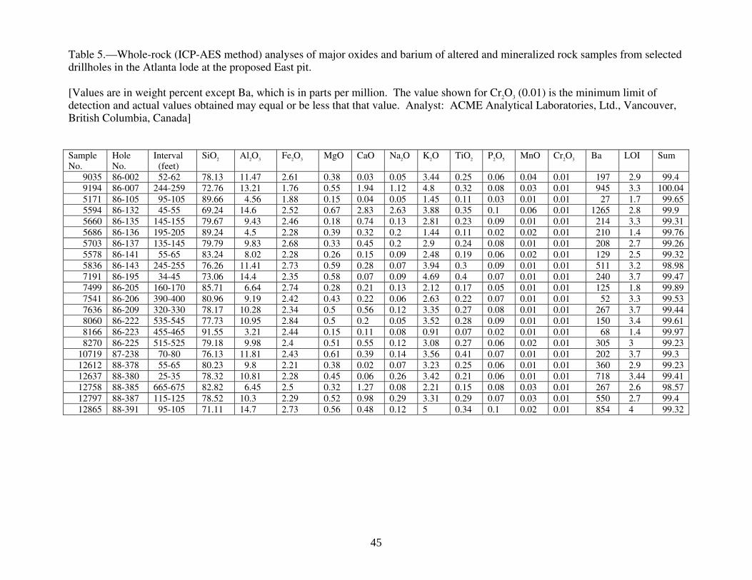
Table 5.—Whole-rock (ICP-AES method) analyses of major oxides and barium of altered and mineralized rock samples from selected drillholes in the Atlanta lode at the proposed East pit. [Values are in weight percent except Ba, which is in parts per million. The value shown for Cr2O3 (0.01) is the minimum limit of detection and actual values obtained may equal or be less that that value. Analyst: ACME Analytical Laboratories, Ltd., Vancouver, British Columbia, Canada] Sample No.
Hole No.
Interval (feet)
SiO2 Al2O3 Fe2O3 MgO CaO Na2O K2O TiO2 P2O5 MnO Cr2O3 Ba LOI Sum
9035 86-002 52-62 78.13 11.47 2.61 0.38 0.03 0.05 3.44 0.25 0.06 0.04 0.01 197 2.9 99.4 9194 86-007 244-259 72.76 13.21 1.76 0.55 1.94 1.12 4.8 0.32 0.08 0.03 0.01 945 3.3 100.04 5171 86-105 95-105 89.66 4.56 1.88 0.15 0.04 0.05 1.45 0.11 0.03 0.01 0.01 27 1.7 99.65 5594 86-132 45-55 69.24 14.6 2.52 0.67 2.83 2.63 3.88 0.35 0.1 0.06 0.01 1265 2.8 99.9 5660 86-135 145-155 79.67 9.43 2.46 0.18 0.74 0.13 2.81 0.23 0.09 0.01 0.01 214 3.3 99.31 5686 86-136 195-205 89.24 4.5 2.28 0.39 0.32 0.2 1.44 0.11 0.02 0.02 0.01 210 1.4 99.76 5703 86-137 135-145 79.79 9.83 2.68 0.33 0.45 0.2 2.9 0.24 0.08 0.01 0.01 208 2.7 99.26 5578 86-141 55-65 83.24 8.02 2.28 0.26 0.15 0.09 2.48 0.19 0.06 0.02 0.01 129 2.5 99.32 5836 86-143 245-255 76.26 11.41 2.73 0.59 0.28 0.07 3.94 0.3 0.09 0.01 0.01 511 3.2 98.98 7191 86-195 34-45 73.06 14.4 2.35 0.58 0.07 0.09 4.69 0.4 0.07 0.01 0.01 240 3.7 99.47 7499 86-205 160-170 85.71 6.64 2.74 0.28 0.21 0.13 2.12 0.17 0.05 0.01 0.01 125 1.8 99.89 7541 86-206 390-400 80.96 9.19 2.42 0.43 0.22 0.06 2.63 0.22 0.07 0.01 0.01 52 3.3 99.53 7636 86-209 320-330 78.17 10.28 2.34 0.5 0.56 0.12 3.35 0.27 0.08 0.01 0.01 267 3.7 99.44 8060 86-222 535-545 77.73 10.95 2.84 0.5 0.2 0.05 3.52 0.28 0.09 0.01 0.01 150 3.4 99.61 8166 86-223 455-465 91.55 3.21 2.44 0.15 0.11 0.08 0.91 0.07 0.02 0.01 0.01 68 1.4 99.97 8270 86-225 515-525 79.18 9.98 2.4 0.51 0.55 0.12 3.08 0.27 0.06 0.02 0.01 305 3 99.23
10719 87-238 70-80 76.13 11.81 2.43 0.61 0.39 0.14 3.56 0.41 0.07 0.01 0.01 202 3.7 99.3 12612 88-378 55-65 80.23 9.8 2.21 0.38 0.02 0.07 3.23 0.25 0.06 0.01 0.01 360 2.9 99.23 12637 88-380 25-35 78.32 10.81 2.28 0.45 0.06 0.26 3.42 0.21 0.06 0.01 0.01 718 3.44 99.41 12758 88-385 665-675 82.82 6.45 2.5 0.32 1.27 0.08 2.21 0.15 0.08 0.03 0.01 267 2.6 98.57 12797 88-387 115-125 78.52 10.3 2.29 0.52 0.98 0.29 3.31 0.29 0.07 0.03 0.01 550 2.7 99.4 12865 88-391 95-105 71.11 14.7 2.73 0.56 0.48 0.12 5 0.34 0.1 0.02 0.01 854 4 99.32
45

Table 5.—Whole-rock (ICP-AES method) analyses of major oxides and barium of altered and mineralized rock samples from selected drillholes in the Atlanta lode at the proposed East pit--Continued Sample No.
Hole No.
Interval (feet)
SiO2 Al2O3 Fe2O3 MgO CaO Na2O K2O TiO2 P2O5 MnO Cr2O3 Ba LOI Sum
13019 88-278 175-185 75.85 13.08 2.11 0.47 0.21 0.05 3.97 0.27 0.07 0.01 0.01 267 3.1 99.25 13577 88-287 605-625 87.61 4.22 2.76 0.21 0.84 0.06 1.02 0.08 0.05 0.02 0.01 57 1.9 98.79 13654 88-289 160-165 70.64 14.43 2.43 0.41 1.83 0.82 4.57 0.45 0.09 0.03 0.01 794 4 99.84 13716 88-291 115-125 72.72 14.57 2.01 0.54 0.22 0.23 5.28 0.33 0.07 0.01 0.01 957 3.2 99.35 13761 88-292 235-240 81.49 8.74 2.01 0.37 0.61 0.14 3.11 0.23 0.06 0.02 0.01 252 2.7 99.53 13798 88-293 245-255 71.55 14.6 2.3 0.59 1.63 3.28 3.77 0.37 0.11 0.05 0.01 1309 1.5 99.98 14116 88-298 560-570 80.06 9.96 2.38 0.38 0.13 0.19 3.33 0.25 0.06 0.02 0.01 402 3 99.84 14127 88-298 670-680 78.87 10.31 2.21 0.37 0.25 0.1 4.09 0.33 0.08 0.01 0.01 600 3 99.73 14150 88-299 185-195 53.48 13.84 5.7 2.3 8.09 1.43 1.74 0.64 0.19 0.19 0.02 1210 11 99.83 14421 88-303 445-455 81.12 9.1 1.94 0.44 0.33 0.13 2.93 0.21 0.06 0.01 0.01 230 3.1 99.42 14909 88-312 365-375 81.47 8.78 2.28 0.37 0.14 0.12 3.37 0.25 0.07 0.01 0.01 489 2.4 99.35 47006 88-313 315-325 79.64 9.75 2.24 0.52 0.81 0.32 3.12 0.23 0.09 0.02 0.01 321 2.8 99.6 47374 88-322 295-305 90.67 4.33 1.49 0.13 0.04 0.08 1.44 0.11 0.02 0.01 0.01 120 1.4 99.75 47423 88-329 385-395 82.31 7.12 2.06 0.3 0.13 0.05 2.21 0.21 0.06 0.01 0.01 129 5.4 99.89 47877 88-330 675-685 74.51 11.59 2.43 0.37 1.21 1.25 4.47 0.29 0.08 0.02 0.01 1202 3.1 99.53 47911 88-330 120-125 85.71 6.34 2.21 0.28 0.17 0.25 2.1 0.14 0.02 0.01 0.01 116 2.6 99.77 47912 88-330 125-130 86.36 7.11 1.81 0.31 0.06 0.07 2.09 0.16 0.05 0.01 0.01 133 1.7 99.76 47913 88-330 130-135 89.66 5.03 1.67 0.19 0.04 0.06 1.48 0.11 0.02 0.01 0.01 111 1.7 100 48538 88-345 565-573 85.56 6.98 1.82 0.32 0.22 0.18 2.26 0.15 0.03 0.01 0.01 180 1.9 99.47 48742 88-352 280-290 89.34 5.09 1.64 0.23 0.1 0.08 1.61 0.12 0.03 0.01 0.01 78 1.8 100.07 48766 88-353 150-160 90.16 4.12 1.78 0.17 0.1 0.15 1.26 0.1 0.04 0.01 0.01 121 1.9 99.82 48833 88-355 205-215 84.03 7.81 2.07 0.25 0.14 0.3 2.15 0.18 0.04 0.01 0.01 249 2.5 99.53 49396 88-370 485-495 87.89 5.12 2.64 0.19 0.39 0.57 1.67 0.1 0.03 0.02 0.01 374 0.9 99.59 49484 88-372 275-285 79.08 10.11 2.29 0.4 0.36 0.18 2.87 0.25 0.07 0.01 0.01 174 3.7 99.36
46
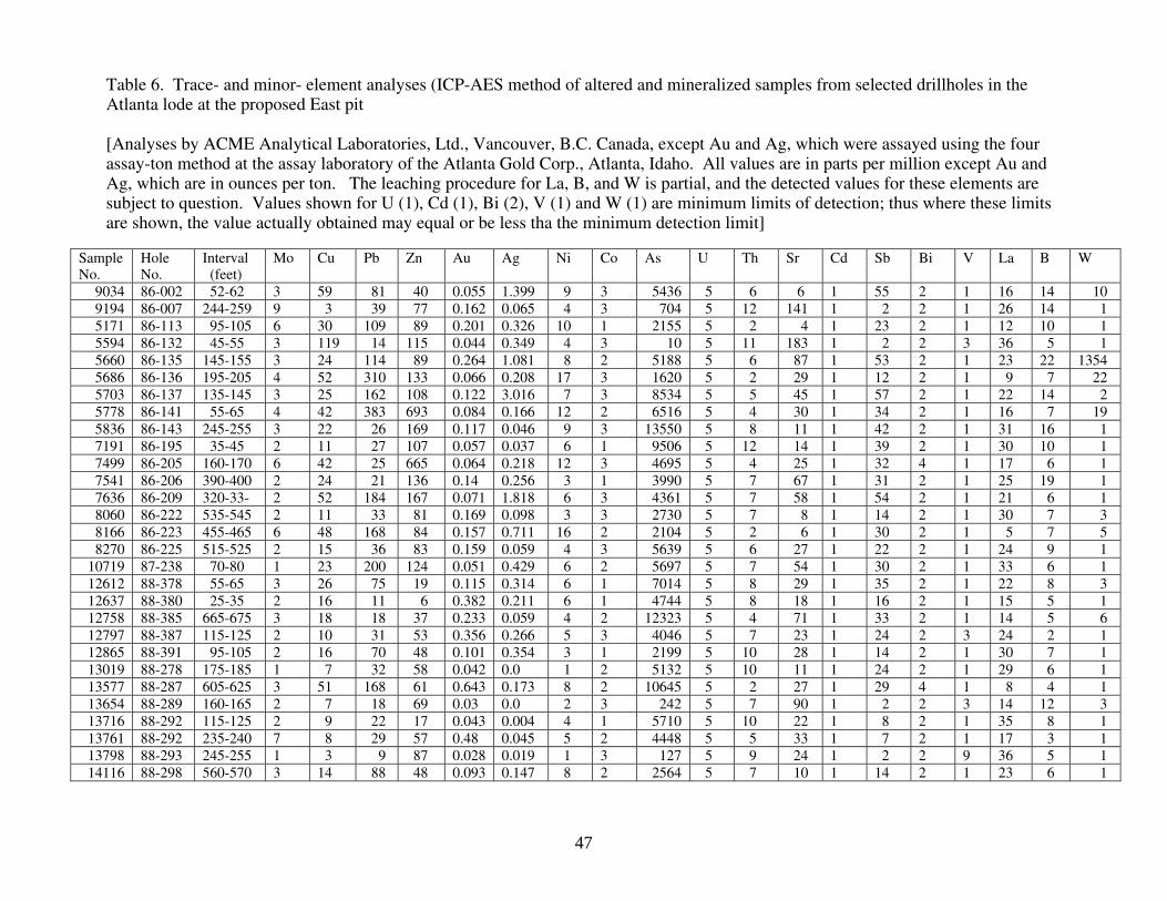
Table 6. Trace- and minor- element analyses (ICP-AES method of altered and mineralized samples from selected drillholes in the Atlanta lode at the proposed East pit [Analyses by ACME Analytical Laboratories, Ltd., Vancouver, B.C. Canada, except Au and Ag, which were assayed using the four assay-ton method at the assay laboratory of the Atlanta Gold Corp., Atlanta, Idaho. All values are in parts per million except Au and Ag, which are in ounces per ton. The leaching procedure for La, B, and W is partial, and the detected values for these elements are subject to question. Values shown for U (1), Cd (1), Bi (2), V (1) and W (1) are minimum limits of detection; thus where these limits are shown, the value actually obtained may equal or be less tha the minimum detection limit]
Sample No.
Hole No.
Interval (feet)
Mo Cu Pb Zn Au Ag Ni Co As U Th Sr Cd Sb Bi V La B W
9034 86-002 52-62 3 59 81 40 0.055 1.399 9 3 5436 5 6 6 1 55 2 1 16 14 10 9194 86-007 244-259 9 3 39 77 0.162 0.065 4 3 704 5 12 141 1 2 2 1 26 14 1 5171 86-113 95-105 6 30 109 89 0.201 0.326 10 1 2155 5 2 4 1 23 2 1 12 10 1 5594 86-132 45-55 3 119 14 115 0.044 0.349 4 3 10 5 11 183 1 2 2 3 36 5 1 5660 86-135 145-155 3 24 114 89 0.264 1.081 8 2 5188 5 6 87 1 53 2 1 23 22 1354 5686 86-136 195-205 4 52 310 133 0.066 0.208 17 3 1620 5 2 29 1 12 2 1 9 7 22 5703 86-137 135-145 3 25 162 108 0.122 3.016 7 3 8534 5 5 45 1 57 2 1 22 14 2 5778 86-141 55-65 4 42 383 693 0.084 0.166 12 2 6516 5 4 30 1 34 2 1 16 7 19 5836 86-143 245-255 3 22 26 169 0.117 0.046 9 3 13550 5 8 11 1 42 2 1 31 16 1 7191 86-195 35-45 2 11 27 107 0.057 0.037 6 1 9506 5 12 14 1 39 2 1 30 10 1 7499 86-205 160-170 6 42 25 665 0.064 0.218 12 3 4695 5 4 25 1 32 4 1 17 6 1 7541 86-206 390-400 2 24 21 136 0.14 0.256 3 1 3990 5 7 67 1 31 2 1 25 19 1 7636 86-209 320-33- 2 52 184 167 0.071 1.818 6 3 4361 5 7 58 1 54 2 1 21 6 1 8060 86-222 535-545 2 11 33 81 0.169 0.098 3 3 2730 5 7 8 1 14 2 1 30 7 3 8166 86-223 455-465 6 48 168 84 0.157 0.711 16 2 2104 5 2 6 1 30 2 1 5 7 5 8270 86-225 515-525 2 15 36 83 0.159 0.059 4 3 5639 5 6 27 1 22 2 1 24 9 1
10719 87-238 70-80 1 23 200 124 0.051 0.429 6 2 5697 5 7 54 1 30 2 1 33 6 1 12612 88-378 55-65 3 26 75 19 0.115 0.314 6 1 7014 5 8 29 1 35 2 1 22 8 3 12637 88-380 25-35 2 16 11 6 0.382 0.211 6 1 4744 5 8 18 1 16 2 1 15 5 1 12758 88-385 665-675 3 18 18 37 0.233 0.059 4 2 12323 5 4 71 1 33 2 1 14 5 6 12797 88-387 115-125 2 10 31 53 0.356 0.266 5 3 4046 5 7 23 1 24 2 3 24 2 1 12865 88-391 95-105 2 16 70 48 0.101 0.354 3 1 2199 5 10 28 1 14 2 1 30 7 1 13019 88-278 175-185 1 7 32 58 0.042 0.0 1 2 5132 5 10 11 1 24 2 1 29 6 1 13577 88-287 605-625 3 51 168 61 0.643 0.173 8 2 10645 5 2 27 1 29 4 1 8 4 1 13654 88-289 160-165 2 7 18 69 0.03 0.0 2 3 242 5 7 90 1 2 2 3 14 12 3 13716 88-292 115-125 2 9 22 17 0.043 0.004 4 1 5710 5 10 22 1 8 2 1 35 8 1 13761 88-292 235-240 7 8 29 57 0.48 0.045 5 2 4448 5 5 33 1 7 2 1 17 3 1 13798 88-293 245-255 1 3 9 87 0.028 0.019 1 3 127 5 9 24 1 2 2 9 36 5 1 14116 88-298 560-570 3 14 88 48 0.093 0.147 8 2 2564 5 7 10 1 14 2 1 23 6 1
47

Table 6. Trace- and minor- element analyses (ICP-AES method of altered and mineralized samples from selected drillholes in the Atlanta lode at the proposed East pit-- Continued
Sample No.
Hole No.
Interval (feet)
Mo Cu Pb Zn Au Ag Ni Co As U Th Sr Cd Sb Bi V La B W
14127 88-298 670-680 2 4 17 56 0.067 0.138 5 2 3850 5 5 21 1 17 2 1 14 5 1 14150 88-299 185-195 1 39 9 71 0.003 0.043 36 14 229 5 4 242 2 2 2 60 26 4 1 14421 88-303 445-455 3 1 22 43 0.093 1.275 1 2 8855 5 5 31 1 18 3 1 22 3 1 14909 88-312 365-375 2 13 13 64 0.089 0.0 11 1 9817 20 9 9 1 37 2 1 28 7 1 47006 88-313 315-325 2 23 33 60 0.169 0.376 9 3 2434 5 5 119 1 21 2 2 19 9 222 47374 88-322 295-305 2 13 15 10 0.03 0.025 7 2 2033 5 1 6 1 13 2 1 6 2 8 47423 88-323 385-395 7 11 37 37 0.007 0.065 6 2 3260 5 4 12 1 22 2 1 12 2 1 47877 88-329 675-685 1 4 36 73 0.119 0.119 2 2 7383 5 7 104 1 13 2 1 33 2 1 47911 88-330 120-125 3 73 257 141 0.364 0.445 10 2 1640 5 3 13 1 15 2 1 9 9 8 47912 88-330 125-130 3 56 143 209 0.502 9.706 11 3 1239 5 4 8 1 60 2 1 15 7 4 47913 88-330 130-135 3 44 127 269 0.335 2.692 6 1 1944 5 2 6 1 32 2 1 8 4 5 48538 88-345 565-573 5 14 15 37 0.072 0.14 8 2 2452 5 3 14 1 2 2 1 12 7 4 48742 88-352 280-290 4 13 18 23 0.03 0.032 1 2 504 5 3 19 1 2 2 1 15 8 5 48766 88-353 150-160 4 24 121 26 0.666 3.218 5 3 2303 5 2 8 1 34 2 1 7 3 11 48806 88-354 290-300 3 18 71 73 0.179 3.24 11 2 2984 5 3 31 1 12 2 1 10 7 1 48833 88-355 205-215 2 20 83 46 0.052 0.041 6 2 1922 5 5 20 1 14 2 1 17 3 1 49396 88-370 485-495 5 45 28 21 0.122 0.39 14 4 1422 5 2 14 1 16 2 2 7 10 1 49484 88-372 275-285 1 54 160 274 0.725 1.435 1 4 4027 5 7 67 1 61 2 1 27 8 1
48

Table 7. Indicated reserves in the proposed East and West pits, Atlanta lode, Atlanta Hill area, Elmore County, Idaho. [Reserve calculations by Atlanta Gold Corporation]
Locality Short tons Grade (in ounces per ton) Gold Silver
East pit 8,900,000 0.082 0.238 West pit 3,500,000 .052 .092
49

E X P L A NAT IO N
B iotite granite
D ioritic suite
Muscovite-biotite granite
B iotite granodiorite (includes pegmatite-rich areas)
H ornblende-biotite tonalite
P otassium-rich hornblende-biotite granodiorite
Q uartz diorite
Fault
T d
K gd
T g
K g
K t
K gdk
K qd
0
0 10
10 20 30 KILOMETERS
20 MILES
Idaho C ity
A tlanta
Fairfield
H ailey
M tHeinen
TrinityM tn
HouseM tn
S m okyDom e
B uttercup M tn
S teelM tn
S wanholmPeak
S heep Creekbatholith
S awtoothbatholith
R ooks Creekstock
Deer Creek stock
Croesusstock
FIGURE 1. Simplified geologic map of the Hailey 1° x 2° quadrangle, Idaho.
50
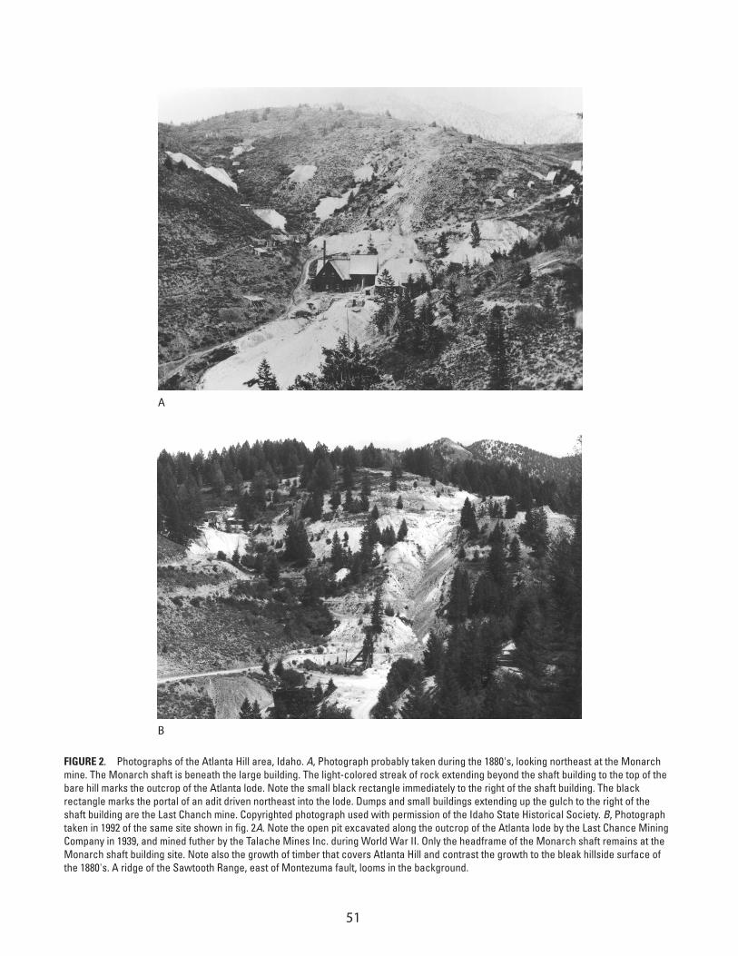
A
B
FIGURE 2. Photographs of the Atlanta Hill area, Idaho. A, Photograph probably taken during the 1880's, looking northeast at the Monarch mine. The Monarch shaft is beneath the large building. The light-colored streak of rock extending beyond the shaft building to the top of the bare hill marks the outcrop of the Atlanta lode. Note the small black rectangle immediately to the right of the shaft building. The black rectangle marks the portal of an adit driven northeast into the lode. Dumps and small buildings extending up the gulch to the right of the shaft building are the Last Chanch mine. Copyrighted photograph used with permission of the Idaho State Historical Society. B, Photograph taken in 1992 of the same site shown in fig. 2A. Note the open pit excavated along the outcrop of the Atlanta lode by the Last Chance Mining Company in 1939, and mined futher by the Talache Mines Inc. during World War II. Only the headframe of the Monarch shaft remains at the Monarch shaft building site. Note also the growth of timber that covers Atlanta Hill and contrast the growth to the bleak hillside surface of the 1880's. A ridge of the Sawtooth Range, east of Montezuma fault, looms in the background.
51

A ndesite dik e
F resh biotite granodior ite
W eak , propylitic a lteration
M oderate, argillic±ser iciticalteration±mineralization
Intense, argillic±ser iciticsilicic alteration±mineralization
E X P L A N A T IO N
A A '
FE E T
Ba
se l
ine
Ba
se l
ine
6,800
6,600
6,400
6,200
6,000
5,800
5,600
5,400
5,200
S am pledinterval
(feet)
A ssay valuefor gold
(ounces per ton)
A pproxim ate bottomof proposed E ast pit
9.0 0.141
4.7 0.227
2.2 0.826
0.7 0.603
4.6 1.797
9.5 0.173
11.0 0.102
1.0 0.510
0.3 0.658
86-13286-133
86-207 88-354
88-38687-271
91-40087-272
FIGURE 3. C ross section A-A', looking southwest at the Atlanta lode at the 1300 West transect of the base line (pl. 2). Sample information shown only below the proposed East pit. Sampled intervals are shown in true widths, in feet. Assay values are in ounces per ton of sampled material. Post-mineral andesite dikes (Ta) were intersected at many localities along the lode.
Kg
d
0 100
T a
T a
T a
200 300 FE E T
52

6,0
00
6,5
00
7,0
00
7,5
00
5,5
00
FE
ET
Cross section A-A'
CC
'
0
05
00
E5
00
W1
,00
0E
1,0
00
W1
,50
0E
1,5
00
W2
,00
0W
20
06
00
40
08
00
FE
ET
Ho
le d
rill
ed
in
19
86
Ho
le d
rill
ed
in
19
87
Ho
le d
rill
ed
in
19
88
EX
PL
AN
AT
ION
Ap
pro
xim
ate
bo
tto
m o
f p
rop
ose
d E
ast
pit
Mo
na
rch
sh
aft
(p
roje
cte
d i
nto
se
ctio
n)
14
1.0
84
13
5.2
64
35
4.1
7900
7.1
62
31
3.1
69
35
5.0
52
23
8.0
51
11
3.2
01
14
3.1
17
37
2.7
25
31
2.0
89
30
3.0
93
29
9.0
03
34
5.0
72
28
7.6
43
29
8.0
67
29
8.0
93
22
5.1
59
38
7.3
56
00
2.0
55 32
3.0
70
22
2.1
69
38
5.2
33
32
9.1
1922
3.1
57
32
2.0
30
27
8.0
42
29
2.0
48
28
9.0
30
29
3.0
28
29
1.0
43
19
5.0
57
38
0.2
11
37
0.1
22
37
8.1
15
20
6.1
40
13
2.0
44
20
5.0
64
13
6.0
66
13
7.1
22
39
1.1
01
33
0.4
00
35
3.6
66
35
2.0
30
20
9.0
71
FIG
URE
4.
Lon
gitu
dina
l sec
tion
C-C'
alo
ng b
ase
line
(pl.
2), l
ooki
ng n
orth
wes
t at p
ropo
sed
East
pit.
Sec
tion
show
s pe
netra
tion
poin
ts o
f sel
ecte
d dr
ill h
oles
, yea
r hol
e w
as d
rille
d, a
bbre
viat
ed d
rill h
ole
num
ber a
bove
and
gol
d va
lue
in o
unce
per
ton
belo
w. C
ompl
eted
hol
e nu
mbe
rs, l
engt
hs o
f sam
pled
inte
rval
, ass
ay v
alue
s of
Au
and
Ag, a
nd v
alue
s of
oth
er a
naly
zed
elem
ents
are
in ta
ble
6. T
wo
pene
tratio
n po
ints
of m
iner
alize
d m
ater
ial i
n th
e lo
be a
re s
how
n fo
r hol
e 88
-298
.
53
Related Documents


